Business
Paper
|
date of meeting:
|
|
Wednesday 14
February 2018
|
|
location:
|
|
Function Room
Port
Macquarie-Hastings Council
17 Burrawan Street
Port Macquarie
|
|
time:
|
|
2:00pm
|
Development
Assessment Panel
CHARTER
1.0 OBJECTIVES
To assist in managing Council's development assessment
function by providing independent and expert determinations of development
applications that fall outside of staff delegations.
2.0 KEY FUNCTIONS
·
To review development application reports and conditions;
·
To determine development
applications outside of staff delegations;
·
To refer development applications
to Council for determination where necessary;
·
To provide a forum for objectors and applicants
to make submissions on applications
before the Development Assessment Panel
(DAP);
·
To maintain transparency in the determination of development
applications.
Delegated Authority of Panel
Pursuant to
Section 377 of the Local Government Act, 1993 delegation to:
·
Determine development applications under Part 4
of the Environmental Planning and Assessment
Act 1979 having
regard to the relevant environmental planning instruments,
development control plans and Council policies.
·
Vary, modify or release restrictions as to use
and/or covenants created by Section 88B instruments under the Conveyancing Act
1919 in relation to development applications for subdivisions being considered
by the panel.
·
Determine Koala Plans of Management under State
Environmental Planning Policy 44 - Koala Habitat Protection associated with
development applications being considered by the Panel.
Noting the trigger to escalate
decision making to Council as highlighted in section 5.2.
3.0
MEMBERSHIP
3.1
Voting
Members
·
Two independent external members. One of the
independent external members to be the Chairperson.
·
Group Manager Development Assessment (alternate
- Director Development & Environment or Development Assessment Planner)
The independent external members shall have expertise in
one or more of the following areas: planning, architecture, heritage, the
environment, urban design, economics, traffic and transport, law, engineering,
government and public administration.
3.2
Non-Voting Members
·
Not applicable
3.3 Obligations
of members
·
Members must act faithfully and diligently and
in accordance with this Charter.
·
Members must comply with Council's Code of Conduct.
·
Except as required to properly perform their
duties, DAP members must not
disclose any confidential information (as advised by Council) obtained in connection with the DAP functions.
·
Members will have read and be familiar with the
documents and information provided by Council prior
to attending a DAP meeting.
·
Members must act in accordance with Council's
Workplace Health and Safety Policies and Procedures
·
External members of the Panel are not authorised
to speak to the media on behalf of Council. Council officers that are members
of the Committee are bound by the
existing operational delegations in relation to speaking to the media.
·
Staff members shall not vote on matters before
the Panel if they have been the principle author of the development assessment report.
3.4
Member Tenure
·
The independent external members will be
appointed for the term of four (4) years
maximum in which the end of the tenure of these members would occur in a
cascading arrangement.
3.5 Appointment
of members
·
The independent external members (including the
Chair) shall be appointed by the General Manager following an external
Expression of Interest process.
·
Staff members of the Panel are in accordance
with this Charter.
4.0 TIMETABLE
OF MEETINGS
·
The Development Assessment Panel will generally
meet on the 1st and 3rd Wednesday each month at 2.00pm at the Port Macquarie
offices of Council.
·
Special Meetings of the Panel may be convened by
the Director Development & Environment Services with three (3) days notice.
5.0
MEETING PRACTICES
5.1
Meeting
Format
·
At all Meetings of the Panel the Chairperson
shall occupy the Chair and preside. The Chair will be responsible for keeping
of order at meetings.
·
Meetings shall be open to the public.
·
The Panel will hear from applicants
and objectors or their r e p r e s e n t a t i v e s .
·
Where considered necessary, the Panel will
conduct site inspections which will
be open to the public.
5.2
Decision Making
·
Decisions are to be made by consensus. Where
consensus is not possible on any item, that item is to be referred to Council
for a decision.
·
All development applications involving a
proposed variation to a development standard
greater than 10% under Clause
4.6 of the Local Environmental Plan will be
considered by the Panel and recommendation made to the Council for a decision.
5.3
Quorum
·
All members (2 independent external members and
1 staff member) must be present at a
meeting to form a quorum.
5.4
Chairperson and Deputy Chairperson
·
Independent Chair (alternate, second independent member)
5.5
Secretariat
·
The Director Development &n Environment is
to be responsible for ensuring that the Panel has adequate secretariat support.
The secretariat will ensure that the business paper and supporting papers are
circulated at least three (3) days prior to
each meeting. Minutes shall be appropriately approved and circulated to each
member within three (3) weeks of a meeting being held.
·
The format of and the preparation and publishing
of the Business Paper and Minutes shall be similar to the format for Ordinary
Council Meetings.
5.6
Recording of decisions
·
Minutes will record decisions and how each
member votes for each item before the Panel.
6.0 CONVENING
OF “OUTCOME SPECIFIC” WORKING GROUPS
Not applicable.
7.0 CONFIDENTIALITY
AND CONFLICT OF INTEREST
·
Members of the Panel must comply with the
applicable provisions of Council’s Code of Conduct. It is the personal
responsibility of members to comply with the standards in the Code of Conduct
and regularly review their personal circumstances with this in mind.
·
Panel members must declare any conflict of
interests at the start of each meeting or before discussion of a relevant item
or topic. Details of any conflicts of interest should be appropriately minuted.
Where members are deemed to have a real or perceived conflict of interest, it
may be appropriate they be excused from deliberations on the issue where the
conflict of interest may exist. A Panel meeting may be postponed where there is
no quorum.
8.0 LOBBYING
·
All members and applicants are to adhere to
Council’s Lobbying policy. Outside of
scheduled Development Assessment Panel meetings, applicants, their
representatives, Councillors, Council staff and the general public are not to
lobby Panel members via meetings, telephone conversations, correspondence and
the like. Adequate opportunity will be provided at Panel inspections or
meetings for applicants, their representatives and the general public to make
verbal submissions in relation to Business Paper items.
Development Assessment Panel
ATTENDANCE
REGISTER
|
Member
|
25/10/17
|
08/11/17
|
22/11/17
|
06/12/17
|
13/12/17
|
|
Paul Drake
|
P
|
P
|
P
|
P
|
P
|
|
Robert Hussey
|
P
|
P
|
P
|
P
|
P
|
|
David Crofts
(alternate member)
|
-
|
|
|
|
|
|
Dan Croft
(Acting Director
Development & Environment)
Clinton Tink
(Acting GM Development
Assessment
(alternates)
- Director Development & Environment
- Development Assessment Planner
|
P
|
P
|
P
P
|
P
P
|
P
P
|
Key: P = Present
A
= Absent With Apology
X
= Absent Without Apology
Development
Assessment Panel Meeting
Wednesday 14 February
2018
Items of Business
01 Acknowledgement
of Country............................................................................ 8
02 Apologies......................................................................................................... 8
03 Confirmation
of Minutes.................................................................................... 8
04 Disclosures
of Interest..................................................................................... 13
05 DA2017
- 355.1 - Demolition Of Dwelling And Construction Of Child Care Centre - Lot 14
DP 262597, 17 Kulai Place, Port Macquarie............................................................ 17
06 DA2017
- 553.1 - Multi Dwelling Housing And Strata Title Subdivision - Lot 2 DP 18127,
34 Chapman Street, Port Macquarie.................................................................... 253
07 DA
2017 - 914.1 Additions To Dwelling - Lot 111, DP 246248, No. 14 Hibbard
Drive, Port Macquarie..................................................................................................... 332
08 DA2017
- 529.1 Alterations To Caravan Park - Lot 2 DP 598227, Bell Street, Dunbogan 364
09 DA2017
- 979.1 Construction Of A New Dwelling (Including Clause 4.6 Variation To
Clause 4.3 (Height Of Buildings) Of The Port Macquarie-Hastings Local
Environmental Plan 2011, Swimming Pool And Spa at Lot 143 DP 1229250, No 62
Surfers Drive, Lake Cathie.......... 462
10 DA2017
- 632.1 Multi Dwelling Housing And Strata Subdivision - Lot 1 DP 596122, 25
Hibbard Drive, Port Macquarie.................................................................................... 506
11 General
Business
AGENDA Development Assessment Panel 14/02/2018
Subject: ACKNOWLEDGEMENT
OF COUNTRY
"I acknowledge that we are
gathered on Birpai Land. I pay respect to the Birpai Elders both past and
present. I also extend that respect to all other Aboriginal and Torres Strait
Islander people present."
RECOMMENDATION
That the apologies received be
accepted.
Subject: CONFIRMATION
OF PREVIOUS MINUTES
Recommendation
That the Minutes of the Development
Assessment Panel Meeting held on 13 December 2017 be confirmed.
MINUTES
Development Assessment Panel Meeting
13/12/2017
PRESENT
Members:
Paul
Drake
Robert Hussey
Clinton Link
Other Attendees:
Dan
Croft
Ben Roberts
Fiona Tierney
|
The meeting opened at 2:05pm.
|
|
01 ACKNOWLEDGEMENT
OF COUNTRY
|
|
The
Acknowledgement of Country was delivered.
|
|
03 CONFIRMATION
OF MINUTES
|
|
CONSENSUS:
That
the Minutes of the Development Assessment Panel Meeting held on 6 December
2017 be confirmed.
|
|
04 DISCLOSURES
OF INTEREST
|
|
There were no disclosures of interest presented.
|
|
05 DA2017 - 336.1
Boundary Adjustment Between Two Torrens Title Lots, Residential Flat Building
And Café With Associated Strata Title Subdivision - Lot 167 Seaside
Drive And Lot 229 Surfers Drive, Lake Cathie
|
|
Speakers:
Neil Beecroft (o)
Steve Bottle (o)
Tricia Moss (o)
Michelle Love (applicant)
Graham Burns (applicant)
Tim Veness (applicant)
CONSENSUS:
That DA2017 – 336.1 for a
boundary adjustment between two existing torrens title lots, residential flat
building and café with associated strata title subdivision including a
Clause 4.6 objection to Clause 4.3 (Height of Buildings) of the Port
Macquarie-Hastings Local Environmental Plan 2011 at Lot 167 DP 1229250 &
Lot 229 DP1235792, Seaside Drive and Surfers Drive, be determined by granting
consent subject to the recommended conditions.
|
|
06 DA2017 - 455.1
Residential Subdivision (10 Lots) Including Clause 4.6 Objection To Clause
4,1 (Minimum Lot Size) Of The Port Macquarie-Hastings Local Environmental
Plan 2011 At Lot 65 DP1226839, Shore Break Crescent, Lake Cathie
|
|
Speakers:
Michael Mowle (applicant)
Kate McKinnon (applicant)
CONSENSUS:
That it be recommended to
Council that DA2017 – 455.1 for a residential subdivision (10 Lots)
including Clause 4.6 Objection to Clause 4.1 (Minimum Lot Size) of the Port
Macquarie-Hastings Local Environmental Plan 2011 at Lot 65, DP 1226839, Shore
Break Crescent, Lake Cathie, be determined by granting consent subject to the
recommended conditions as amended below:
Amend condition B7 to state:
B7 (B029) The
‘laneways’ to lots 401, 402 and 403 shall include:
a)
Extension of driveways, water supply,
telephone and electricity in conduits laid for the full length of the shaft.
b)
Lots 401 and 402 shall be served by a
minimum 4.5m wide sealed (e.g. concrete) driveway while Lot 403 shall be
served by a minimum 4m wide sealed driveway.
c)
The laneways shall be held in
ownership of the lots they benefit, with reciprocal rights of access and
services.
d)
Services shall be contained within
the laneways and not on adjoining Council land as illustrated on the DA
approved plans.
Details shall be provided with
the application for Construction Certificate and constructed prior to release
of Subdivision Certificate.
|
|
07 DA2017 - 877.1
Dwelling - Lot 709 DP 1228141, No 49 Yaluma Drive, Port Macquarie
|
|
CONSENSUS:
That
DA 2017 – 877.1 for a dwelling at Lot 709, DP 1228141, No. 49 Yaluma
Drive, Port Macquarie, be determined by granting consent subject to the
recommended conditions.
|
|
08 DA2017 -
866.1 Alterations And Additions To Dwelling And Construction Of Pool -
Lot 134 DP 246284, No 60 Hibbard Drive, Port Macquarie
|
|
Speakers:
Richard Raab (o)
CONSENSUS:
That
DA 2017 – 866.1 for alterations and additions to dwelling and
construction of pool at Lot 134, DP 246284, No. 60 Hibbard Drive, Port
Macquarie, be determined by granting consent subject to the recommended
conditions.
|
|
09 DA2017 - 966.1
Animal Boarding And Training Establishment (Dogs) - Lot 6 DP 252224, No
406 Pembrooke Road, Redbank
|
|
Speakers:
Graham Wass (o)
Gael Nelson (applicant)
CONSENSUS:
That
DA2017 – 966.1 for an animal boarding and training establishment (dogs)
at Lot 6, DP 252224, No. 406 Pembrooke Rd, Redbank, be determined by granting
consent subject to the recommended conditions as amended below:
Amend condition F2 to state:
F2 (F025) Hours of operation
of the training component of the development are restricted to the following
hours:
-
4 pm to 6.30 pm –
Thursday
-
9 am to 12.30 pm –
Saturdays
-
No work is to be carried
out on Sundays and Public Holidays
Add condition F9 to
state:
F9 (F195) The operator
is to keep a log book and record any complaints received and mitigation
action taken. The log book is to be made available to Council at any time.
|
|
The meeting closed at 4:00pm.
|
AGENDA Development Assessment Panel 14/02/2018
Subject: DISCLOSURES
OF INTEREST
RECOMMENDATION
That Disclosures of Interest be presented
DISCLOSURE OF
INTEREST DECLARATION
Name of Meeting: ………………………………………………………………………..
Meeting Date: ………………………………………………………………………..
Item Number: ………………………………………………………………………..
Subject: ………………………………………………………………………..
…………………………………………………….……………...…..
I,
.....................................................................................
declare the following interest:
 Pecuniary:
Take
no part in the consideration and voting and be out of sight of the meeting.
Non-Pecuniary
- Significant Interest:
Take
no part in the consideration and voting and be out of sight of the meeting.
Non-Pecuniary
- Less than Significant Interest:
May
participate in consideration and voting.
For the reason that:
....................................................................................................
.......................................................................................................................................
Name:
…………………………………………………….
Signed:
.........................................................................
Date: ..................................
 (Further
explanation is provided on the next page)
(Further
explanation is provided on the next page)
Further
Explanation
(Local Government Act and Code of Conduct)
A conflict of interest exists where a reasonable and informed
person would perceive that a Council official could be influenced by a private
interest when carrying out their public duty. Interests can be of two types:
pecuniary or non-pecuniary.
All interests, whether pecuniary or non-pecuniary are required to
be fully disclosed and in writing.
Pecuniary Interest
A pecuniary interest is an interest that a Council official has in
a matter because of a reasonable likelihood or expectation of appreciable
financial gain or loss to the Council official. (section 442)
A Council official will also be taken to have a pecuniary interest
in a matter if that Council official’s spouse or de facto partner or a
relative of the Council official or a partner or employer of the Council
official, or a company or other body of which the Council official, or a
nominee, partner or employer of the Council official is a member, has a
pecuniary interest in the matter. (section 443)
The Council official must not take part in the consideration or
voting on the matter and leave and be out of sight of the meeting. The
Council official must not be present at, or in sight of, the meeting of
the Council at any time during which the matter is being considered or
discussed, or at any time during which the council is voting on any question in
relation to the matter. (section 451)
Non-Pecuniary
A non-pecuniary interest is an interest that is private or
personal that the Council official has that does not amount to a pecuniary
interest as defined in the Act.
Non-pecuniary interests commonly arise out of family, or personal
relationships, or involvement in sporting, social or other cultural groups and
associations and may include an interest of a financial nature.
The political views of a Councillor do not constitute a private
interest.
The management of a non-pecuniary interest will depend on whether
or not it is significant.
Non Pecuniary – Significant Interest
As a general rule, a non-pecuniary conflict of interest will be
significant where a matter does not raise a pecuniary interest, but it
involves:
(a)
A relationship between
a Council official and another person that is particularly close, for example,
parent, grandparent, brother, sister, uncle, aunt, nephew, niece, lineal
descendant or adopted child of the Council official or of the Council official’s
spouse, current or former spouse or partner, de facto or other person living in
the same household.
(b)
Other relationships
that are particularly close, such as friendships and business relationships.
Closeness is defined by the nature of the friendship or business relationship,
the frequency of contact and the duration of the friendship or relationship.
(c)
An affiliation between
a Council official an organisation, sporting body, club, corporation or
association that is particularly strong.
If a Council official declares a non-pecuniary significant
interest it must be managed in one of two ways:
1.
Remove the source of
the conflict, by relinquishing or divesting the interest that creates the
conflict, or reallocating the conflicting duties to another Council official.
2.
Have no involvement in
the matter, by taking no part in the consideration or voting on the matter and
leave and be out of sight of the meeting, as if the provisions in section
451(2) apply.
Non Pecuniary – Less than Significant Interest
If a Council official has declared a non-pecuniary less than
significant interest and it does not require further action, they must provide
an explanation of why they consider that the conflict does not require further
action in the circumstances.
SPECIAL
DISCLOSURE OF PECUNIARY INTEREST DECLARATION
|
By
[insert full name of councillor]
|
|
|
In the
matter of
[insert name of environmental planning instrument]
|
|
|
Which is
to be considered at a meeting of the
[insert name of meeting]
|
|
|
Held on
[insert date of meeting]
|
|
|
PECUNIARY
INTEREST
|
|
Address of land in which councillor or an
associated person, company or body has a proprietary interest (the identified
land)i
|
|
|
Relationship of identified land to councillor
[Tick or cross one box.]
|
Councillor
has interest in the land (e.g. is owner or has other interest arising out of
a mortgage, lease trust, option or contract, or otherwise).
Associated
person of councillor has interest in the land.
Associated
company or body of councillor has interest in the land.
|
|
MATTER
GIVING RISE TO PECUNIARY INTEREST
|
|
Nature of land that is subject to a change
in zone/planning control by proposed
LEP (the subject land iii
[Tick or cross one box]
|
The
identified land.
Land
that adjoins or is adjacent to or is in proximity to the identified land.
|
|
Current zone/planning control
[Insert name of current planning instrument and
identify relevant zone/planning control applying to the subject land]
|
|
|
Proposed change of zone/planning control
[Insert name of proposed LEP and identify proposed
change of zone/planning control applying to the subject land]
|
|
|
Effect of proposed change of zone/planning control
on councillor
[Tick or cross one box]
|
Appreciable
financial gain.
Appreciable
financial loss.
|
|
|
|
Councillor’s
Name: …………………………………………
Councillor’s
Signature:
……………………………….
Date: ………………..
Important Information
This information is being
collected for the purpose of making a special disclosure of pecuniary interests
under sections 451 (4) and (5) of the Local Government Act 1993.
You must not make a special disclosure that you know or ought reasonably to
know is false or misleading in a material particular. Complaints made
about contraventions of these requirements may be referred by the
Director-General to the Local Government Pecuniary Interest and Disciplinary
Tribunal.
This form must be completed by
you before the commencement of the council or council committee meeting in
respect of which the special disclosure is being made. The
completed form must be tabled at the meeting. Everyone is entitled to
inspect it. The special disclosure must be recorded in the minutes of the
meeting.
i.
Section 443 (1) of the Local Government Act 1993 provides that
you may have a pecuniary interest in a matter because of the pecuniary interest
of your spouse or your de facto partner or your relativeiv or
because your business partner or employer has a pecuniary interest. You may
also have a pecuniary interest in a matter because you, your nominee, your
business partner or your employer is a member of a company or other body that
has a pecuniary interest in the matter.
ii.
Section 442 of the Local Government Act 1993 provides that a pecuniary
interest is an interest that a person has in a matter because of a
reasonable likelihood or expectation of appreciable financial gain or loss to
the person. A person does not have a pecuniary interest in a matter if the
interest is so remote or insignificant that it could not reasonably be regarded
as likely to influence any decision the person might make in relation to the
matter or if the interest is of a kind specified in section 448 of that
Act (for example, an interest as an elector or as a ratepayer or person liable
to pay a charge).
iii.
A pecuniary interest may arise by way of a change of permissible use of land
adjoining, adjacent to or in proximity to land in which a councillor or a
person, company or body referred to in section 443 (1) (b) or (c) of the
Local Government Act 1993 has a proprietary interest..
iv.
Relative is defined by the Local Government Act 1993 as
meaning your, your spouse’s or your de facto partner’s parent,
grandparent, brother, sister, uncle, aunt, nephew, niece, lineal descendant or
adopted child and the spouse or de facto partner of any of those persons.
AGENDA Development Assessment Panel 14/02/2018
Item: 05
Subject: DA2017 - 355.1 - Demolition Of Dwelling And
Construction Of Child Care Centre - Lot 14 DP 262597, 17 Kulai Place, Port
Macquarie
Report
Author: Clint Tink
|
Applicant: BDM
Constructions
Owner: Danks
Family Pty Ltd
Estimated Cost: $1,500,000
Alignment with Delivery
Program
4.3.1 Undertake transparent
and efficient development assessment in accordance with relevant legislation.
|
|
RECOMMENDATION
That
DA 2017 – 355.1 for demolition
of a dwelling and construction of a child care centre at Lot 14, DP 262597, No. 17 Kulai
Place, Port Macquarie, be determined by refusing consent for the
following reasons:
1. The
development fails to provide suitable road access as required by Clause 7.13
of the Port Macquarie Hastings Local Environmental Plan 2011.
2. The
development fails to adequately address traffic requirements in Chapter 2.5
of Port Macquarie Hastings Development Control Plan 2013.
3. The
development is not considered suitable for the site. In particular, the
access to the site is not suitable for the type and scale of development with
the narrow access creating adverse traffic and safety issues for the street
and occupants of the development.
|
Executive
Summary
This
report considers a development application for demolition of a dwelling and
construction of a child care centre at the
subject site and provides an assessment of the application in accordance with
the Environmental Planning and Assessment Act 1979.
Following two (2) exhibition
periods of the application, submissions were received from nine (9)
people/groups. It should be noted that one (1) of the submissions was lodged on
behalf of twelve (12) people/groups with some of the people/groups also
choosing to lodge separate individual submissions.
It is recommended that the
application be determined by refusing consent for traffic and access reasons (a
draft set of conditions is provided at the end of this report in the event that
the Panel consider the application should be approved).
1. BACKGROUND
Existing sites features and Surrounding development
The site has an area of approximately
3488m².
The site is zoned R2 Low Density Residential in accordance with the Port Macquarie-Hastings Local
Environmental Plan 2011, as shown in the following zoning plan:
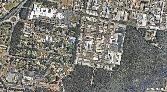
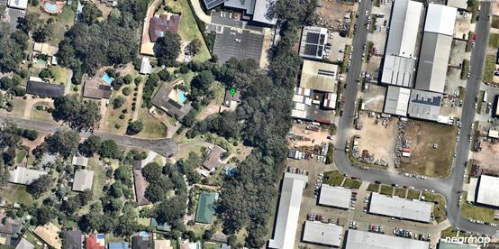
The existing subdivision pattern and location of existing
development within the locality is shown in the following aerial photographs:
Aerial Photo 2012
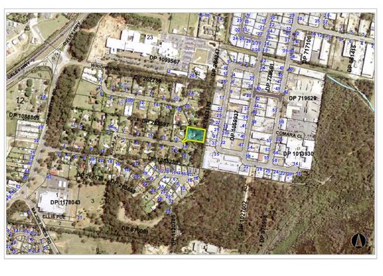
Aerial Photos 2017
2. DESCRIPTION OF
DEVELOPMENT
Key aspects of the proposal include the following:
· Demolition
of existing dwelling and construction of child care centre (71 children).
· The
building is a mixture of single and two storey construction.
· A
20 space car park is proposed, which includes a disabled parking space. Within
the car park is a turning area and delivery zone. There is also two (2) passing
bays proposed to address the single width entry creating a blockage point for
vehicles accessing and egressing the site.
· Approximately
19 trees are to be removed and 16 retained.
· Signage
is provided at the front entry driveway.
· Hours
of operation are nominated as 6:30am to 6:30pm, weekdays.
· Proposal
is for pre-school aged children.
Refer
to attachments at the end of this report.
Application Chronology
· 1/5/2017
– Development Application lodged with Council.
· 9/5/2017
– Council staff requested additional information on the site plan,
signage, fencing, hours and setbacks.
· 11-24/5/2017
– Notification period.
· 11/5/2017
– Applicant provided update on addressing additional information.
· 17/5/2017
– A neighbour requested an extension to notification period.
· 18/5/2017
– Council staff requested more information from the neighbour on the need
for extension.
· 19/5/2017 – Neighbour provided more detail on need
for extension, which was granted.
· 22/5/2017 – Discussion with neighbour and Council
staff regarding Engineering and traffic detail.
· 23/5/2017 – Discussion with neighbour regarding
extension to notification period.
· 5/6/2017 – Email to applicant regarding submissions
and Draft State Environmental Planning Policy (Educational Establishments and
Child Care Facilities) 2017 (ie referenced as SEPP (EECCF) 2017 throughout this
assessment).
· 9-14/6/2017 – Discussion with applicant regarding
submissions received. Redacted copy of submissions provided to applicant upon
request.
· 19/6/2017 – Preliminary email to the applicant
regarding further additional information being drafted in response to issues
raised in submissions.
· 21/6/2017 – Council staff requested additional
information regarding SEPP (EECF) 2017, types of children using the facility,
compliance with zone objectives, noise assessment, cut and fill, tree
retention, engineering and stormwater.
· 25/8/2017 – Applicant provided response to additional
information.
· 14/9/2017 – Council staff advised the additional information
provided on 25/8/2017 was not accepted. Applicant requested to provide clarity
on SEPP (EECCF) 2017, noise assessment, cut and fill, tree retention,
engineering and stormwater issues.
· 26/9/2017 – Email from traffic consultant regarding
Council requirements.
· 5/10/2017 – Follow up email from traffic consultant
to email of 26/9/2017.
· 8/10/2017 – Council staff responded to traffic
consultant.
· 12-17/10/2017 – Discussion and meeting between
Council staff and the applicant regarding traffic issues and access.
· 23/10/2017 – Applicant submitted draft plan to
address additional information. Council staff advised that further detail still
required.
· 27-30/10/2017 – Applicant provided partial response
to additional information requested on 23/10/2017.
· 5-6/11/2017 – Discussion between Council staff and
the traffic consultant regarding report details.
· 6-9/11/2017 – Discussion between Council staff and
the applicant regarding pedestrian access requirements and suitability of the
site.
· 21/11/2017 – Applicant provided partial response to
additional information matters.
· 30/11/2017 – Civil drawings provided by the
applicant.
· 1/12/2017 – Email from Council staff to the applicant
regarding internal circulation of material and re-notification. Confirmation on
hours of operation still sought.
· 7-20/12/2017 – Re-notification period.
· 15-18/12/2017 – Extension to notification period
sought by some neighbours due to Christmas period. Extension granted until
2/1/2018 when Council re-opened.
· 18/12/2017 – Council staff requested additional
information on owners consent for stormwater and clarification on the Traffic
Impact Assessment (TIA).
· 19/12/2017 – Applicant sought clarification on
Development Assessment Panel (DAP) process and confirmed hours of operation.
· 2/1/2018 – Council staff responded to
applicant’s email dated 19/12/2017.
· 3/1/2018 – Council staff requested clarification on
the hours of operation not matching the noise assessment and also how occupants
would access the rear yard.
· 8/1/2018 – Applicant responded to query on TIA dated
18/12/2017.
· 8/1/2018 – Applicant advised revised noise assessment
to be provided.
· 9/1/2018 – Owners consent to stormwater issue
resolved/provided.
· 10-15/1/2018 – Updated noise assessment detail
provided.
· 14/1/2018 – Council staff advised the TIA information
provided on 8/1/2018 was not accepted.
· 15/1/2018 – Applicant responded to TIA issue.
· 16/1/2018 – Council staff advised the TIA information
provided on 15/1/2018 was not accepted.
· 16-17/1/2018 – Discussion with neighbour on DAP
process.
· 23/1/2018 – Applicant responded to TIA issue.
3. STATUTORY ASSESSMENT
Section 79C(1) Matters for Consideration
In determining the application, Council is required to take
into consideration the following matters as are relevant to the development
that apply to the land to which the development application relates:
(a) The provisions (where
applicable) of:
(i) any Environmental
Planning Instrument:
State Environmental Planning Policy No.
44 - Koala Habitat Protection
There is no Koala Plan of
Management on the site. Additionally, the site is less than one hectare in
area. Therefore, no further consideration of the SEPP required.
State
Environmental Planning Policy No.55 – Remediation of Land
Following an inspection of the site and a
search of Council records, the subject land is not identified as being
potentially contaminated and is suitable for the intended use.
State
Environmental Planning Policy No. 62 – Sustainable Aquaculture
Given the nature
of the proposed development and proposed stormwater controls, the proposal will
be unlikely to have any adverse impact on existing aquaculture industries.
State
Environmental Planning Policy No. 64 – Advertising and Signage
The proposed
development includes proposed advertising signage in the form of a business
identification sign.
In accordance
with clause 7, this SEPP prevails over the Port Macquarie-Hastings LEP 2011 in
the event of any inconsistency.
The following
assessment table provides an assessment checklist against the Schedule 1
requirements of this SEPP:
|
Applicable clauses for
consideration
|
Comments
|
Satisfactory
|
|
Clause 8(a) Consistent with objectives of the policy as
set out in Clause 3(1)(a).
|
The proposed sign is nominated
to be 1.8m wide by 1.2m high. The sign is proposed to not be illuminated. The
sign is to be located along the entry driveway. The signage is not excessive
in size, would provide effective communication, is able to comprise a quality
finish and is unlikely to impact on the amenity or visual character of the
area. In this regard, the signage is relatively consistent with the
objectives.
However, the location of the
sign will obstruct views to the street from the people waiting in the
proposed passing bays. This will create a traffic conflict. For this reason,
the sign is not supported.
Should the application be
approved, the applicant can seek consent for alternate signage via a separate
application, unless deemed exempt development.
|
No
|
Schedule 1(1) Character of
the area.
|
The proximity of the
development to other commercial based uses and signage in and around
Kingfisher Road/John Oxley Drive; ensures the development is not out of
character with the area. In addition, the small scale nature of the sign and
location of the sign onsite, further ensures no adverse impact on the
character of the area.
|
Yes
|
|
Schedule 1(2) Special areas.
|
The area is not considered to
comprise a special area.
|
Yes
|
|
Schedule 1(3) Views and vistas.
|
There are no specific views or
vistas that the sign will impact on.
|
Yes
|
|
Schedule 1(4) Streetscape, setting or landscape.
|
The sign is of a scale and
appropriately setback from the road; to ensure no adverse impact on
streetscape.
|
Yes
|
|
Schedule 1(5) Site and building.
|
The sign is not compatible with
the site. In particular, the location of the sign will obscure the views from
the occupants of the vehicles in the passing bays and their ability to
interpret when they can leave the site.
|
No
|
|
Schedule 1(6) Associated devices and logos with
advertisements and advertising structures.
|
None proposed.
|
N/A
|
|
Schedule 1(7) Illumination.
|
Sign is not proposed to be
illuminated.
|
N/A
|
|
Schedule 1(7) Safety.
|
Based on previous comments
above, it is considered that the signage will obscure sight lines from
vehicles using the passing bays. This will reduce safety onsite.
Should the application be
approved, the applicant can seek consent for alternate signage via a separate
application, unless deemed exempt development.
|
No
|
Based on the above, the proposed signage is not supported.
State Environmental Planning Policy (Infrastructure) 2007
The proposed development does not trigger any clauses or
thresholds in the SEPP.
State Environmental Planning Policy (State and
Regional Development) 2011
The proposed development does not trigger any clauses or
thresholds in the SEPP.
State
Environmental Planning Policy (Educational Establishments and Child Care
Facilities) 2017 (SEPP (EECCF) 2017)
It should be
noted that a Draft of the SEPP (EECCF) 2017 was exhibited during the assessment
period of the development application. As a result, the applicant was initially
advised to have regard to the Draft as per 79C(1)(a)(ii) of the Environmental
Planning and Assessment Act 1979. However, the Draft has since been
gazetted. As a result, the following Schedule 5 Savings Provisions apply:
1 Savings provision
(1) This Policy does not apply to or in respect of the
determination of a development application made under Part 4 of the Act, but
not finally determined before the commencement of this Policy.
(2) Despite subclause (1), before determining a development
application referred to in that subclause for development for the purpose of a
centre-based child care facility, the consent authority must take into
consideration the regulatory requirements and the National Quality Framework
Assessment Checklist set out in Part 4 of the Child Care Planning Guideline, in
relation to the proposed development.
As a result of
the above, the table below takes into consideration the National
Quality Framework Assessment Checklist set out in
Part 4 of the Child Care Planning Guideline.
|
Child Care Planning Guideline
– National Regulations (Chapter 4)
|
|
Requirement
|
Proposed
|
Complies
|
|
4.1 Indoor space
· 3.25m² per
child. Areas to exclude outlined in Guideline.
· 71 children x
3.25 = 231m²
· Verandahs can be
included as indoor space with written approval from Department of Education -
see page 24 of Guideline.
· Cannot double up
on use of verandahs in indoor and outdoor space calculations
·
· Minimum 0.3m³ external storage
per child.
· 71 children x
0.3m³ = 21.3m³
·
· Minimum 0.2m³ internal storage
per child.
· 71 children x
0.2m³ = 14.2m³
· Storage of items
such as prams, bikes and scooters should be located adjacent to the building
entrance.
|
Indoor space exceeds 250m².
Room exists onsite to ensure compliant outdoor storage. In
particular, storage can be incorporated into the sub floor area.
Internal storage exceeds 27m³.
Area exists at the front entry of the property for storage
of prams, bikes etc.
|
Yes
|
|
4.2 Laundry and hygiene
facilities
· Must contain
washer(s), dryer, laundry sinks and storage for soiled items.
· If external
laundry to be utilised, the proposal must address requirements on p25 of
Guideline.
|
A laundry is proposed containing relevant requirements.
|
Yes
|
|
4.3 Toilet and hygiene
facilities
· Designed for use
by children.
· Contain
screening but allow supervision.
· Allow for direct
access to activity and outdoor play areas.
· Minimum number outlined
in BCA.
· A sink and hand
washing facilities in all bathrooms for adults.
· External windows
in locations that prevent observation from neighbouring properties or from
side boundaries.
|
The toilet and hygiene facilities can be designed for use
by children, contain screening but allow supervision, allow for direct access
to activity and outdoor play areas, contain sinks for adults and are designed
to prevent observation from neighbours.
|
Yes
|
|
4.4 Ventilation and natural
light
· Good design
using mixture of natural and mechanical ventilation.
· Consideration of
ceiling heights being adequate when depth room exceeds 2.5 times the ceiling
height.
· Minimise
reliance on artificial lighting.
|
Each room is provided with numerous openings to ensure
natural light and minimise reliance on artificial illumination.
|
Yes
|
|
4.5 Administrative Space
· Must provide for
admin functions, consultation with parents, be private, desk and chair areas,
storage and filing area.
|
Administrative areas provided and/or capable of being
designed to meet the requirements of the Guideline.
|
Yes
|
|
4.6 Nappy
change facilities
· Properly
constructed nappy change bench.
· Provide a baby
bath within 1m of nappy change.
· Hand cleaning
facilities for adult within vicinity of nappy change.
· Provide storage
for steps.
· Position nappy
change to allow staff to supervise play area.
|
Sinks may be required if the sinks in adjoining room are
deemed to be not in the vicinity. Overall, nappy area is capable of
complying.
|
Yes
|
|
4.7 Premise
designed to facilitate supervision
· Development
allow supervision but dignity of child.
· Requirements on
p30 of Guideline.
|
Overall design allows supervision of key areas but
suitable protection in bathroom and hygiene areas.
|
Yes
|
|
4.8 Emergency
and evacuation procedures
· Requirements for
multi storey listed on p31.
· Safe haven
provided to count numbers before evacuation.
· Emergency and
evaluation plan submitted with DA in accordance with p31 requirements.
|
An evacuation plan has not been
submitted with the DA.
Due to the proximity of the car
park to the building, it is unlikely that the car park would be deemed a safe
assembly point. As a result, occupants of the child care facility would
likely have to traverse the site to the street (Kulai Place). The confined
driveway width is likely to create a conflict point for occupants, vehicle
users and fire safety personnel.
Considering the above, it is
questionable whether a suitable evacuation plan is possible due to the one
way driveway.
|
No
|
|
4.9 Outdoor
space requirements
· 7m² per
child. Areas to exclude outlined in the Guideline.
· 71 children x 7m²
= 497m²
· Verandahs as
outdoor space see p32 of Guideline.
· Exemptions (ie
including verandah areas, simulated indoor areas etc) allowed and outlined on
p23-25 of Guideline.
|
Factoring in exclusions, the
outdoor area easily exceeds 500m².
|
Yes
|
|
4.10 Natural Environment
· Create a natural
environment using trees, sand, rocks etc.
· Avoid having
unsafe trees/plants.
· Provide a
variety of experiences.
· Avoid elements
that will limit supervision.
· Create an
environment that enhances learning, interaction etc.
|
The site is capable of creating
a suitable natural environment. Vegetation to be retained onsite has been
assessed and deemed suitable.
|
Yes
|
|
4.11 Shade
· Provide solar
access to at least 30% of ground area.
· Provide shade to
at least 30% and evenly distributed.
· Not more than
60% of outdoor space should be shaded.
· Planting for
shade and solar access is enhanced by:
- placing
appropriately scaled trees near the eastern and western elevations
- providing
a balance of evergreen and deciduous trees to give shade in summer and
sunlight access in winter.
· Built structures
should not create safety hazards. Support systems such as upright posts
should be clearly visible with rounded edges or padding. Vertical barriers at
the sides of shade structures should be designed to prevent children using
them for climbing. Shade structures should allow adults to view and access
the children’s play areas, with a recommended head clearance of 2.1
metres. The floor area underneath the structure should be of a sufficient
size and shape to allow children to gather or play actively.
|
Site contains a mixture of
shaded and un-shaded areas that would allow compliance with the solar access
standards.
|
Yes
|
|
4.12 Fencing
· Required around
outdoor areas.
· Design prevent
climbing, going through or under.
· Prevent outside
people gaining access.
· Not create a
sense of enclosure.
· No climbing
points higher than 150mm from the ground.
· No gaps greater
than 100mm between pickets.
· Have
self-closing gates as per AS2890.
· Side and rear
fences must be solid, minimum 1.8m high and be non-climbable.
|
Capable of complying and can be reinforced through
conditions.
|
Yes
|
|
4.13 Soil assessment
· Soil assessment
required - see p38 of Guideline.
|
Has not been provided. Following a site inspection and
given the history of the site as a dwelling, it is unlikely there would be
any adverse soils risks/contamination.
|
No, but acceptable
|
While not
required to be considered, the following aspects of the SEPP (EECCF) 2017
provide an insight into how the suitability of a site will be measured in the
future and is relevant when considering 79C(1)(a)(ii) of the Environmental
Planning and Assessment Act 1979.
|
SEPP (Childcare - Part 3) Assessment Table
|
|
Requirement
|
Proposed
|
Complies
|
|
Clause 24 - Centre based child care in IN1 and IN2 zone.
- Minimise
land use conflicts.
- Consider
safety of occupants.
- Compatible
with surrounding uses.
- Development
should not sterilise surrounding industrial uses.
|
The site adjoins an IN1 zoning. The applicant has
submitted a noise assessment, which has been reviewed by Council’s
Environmental Health Officer. The report concluded that noise from the
industrial area is unlikely to impact on the operation of the centre. Fencing
around the site will provide safety to occupants.
|
Yes
|
|
Clause 25 - Non discretionary standards that if complied
with, prevent the consent authority applying more onerous standards.
a) Location
- the development may be located at any distance to another child care.
b) Indoor/outdoor
spaces comply with Clause 22 above.
c) The
development may be located on a site of any size, over any part of the site
and have any length of street frontage or allotment depth.
d) The
development can use any colour, building materials or shade structures (if
not heritage).
|
Development complies.
In terms of the width of the lot, Council staff are not
refusing the development based on a standard regarding the width of the lot.
Council staff are refusing the development on the inability to provide a
suitable driveway and the subsequent impacts that result (ie evacuation
issues, traffic impacts etc).
|
Yes
|
|
Child Care Planning Guideline – Matters for
Consideration (Chapter 3)
|
|
Matter for Consideration/
Requirement
|
Proposed
|
Complies
|
|
3.1 Site selection and location p9-10
|
|
C1
For proposed developments in or adjacent to a
residential zone, consider:
· the acoustic and
privacy impacts of the proposed development on the residential properties
· the setbacks and
siting of buildings within the residential context
· traffic and parking
impacts of the proposal on residential amenity.
For proposed developments in commercial and industrial
zones, consider:
· potential
impacts on the health, safety and wellbeing of children, staff and visitors
with regard to local environmental or amenity issues such as air or noise
pollution and local traffic conditions
· the potential
impact of the facility on the viability of existing commercial or industrial
uses.
For proposed developments in public or private
recreation zones, consider:
· the compatibly
of the proposal with the operations and nature of the community or private
recreational facilities
· if the existing
premises is licensed for alcohol or gambling
· if the use
requires permanent or casual occupation of the premises or site
· the availability
of on-site parking
· compatibility of
proposed hours of operation with surrounding uses, particularly residential
uses
· the availability
of appropriate and dedicated sanitation facilities for the development.
For proposed developments on school, TAFE or university
sites in Special Purpose zones, consider:
· the compatibly
of the proposal with the operation of the institution and its users
· the proximity of
the proposed facility to other uses on the site, including premises licensed
for alcohol or gambling
· proximity to
sources of noise, such as places of entertainment or mechanical workshops
· proximity to
odours, particularly at agricultural institutions
· previous uses of
a premises such as scientific, medical or chemical laboratories, storage
areas and the like.
|
The applicant has submitted a noise assessment, which has
been reviewed by Council’s Environmental Health Officer. The report
concluded that noise from the development is unlikely to adversely impact on
adjoining residential properties.
Traffic and parking issues will be created as a result of
the single width driveway – discussed later in this report.
|
No
|
|
C2
When selecting a site, ensure that:
· the location and
surrounding uses are compatible with the proposed development or use
· the site is
environmentally safe including risks such as flooding, land slip, bushfires,
coastal hazards
· there are no
potential environmental contaminants on the land, in the building or the
general proximity, and whether hazardous materials remediation is needed
· the
characteristics of the site are suitable for the scale and type of
development proposed having regard to:
- size
of street frontage, lot configuration, dimensions and overall size
- number
of shared boundaries with residential properties
- the
development will not have adverse environmental impacts on the surrounding
area, particularly in sensitive environmental or cultural areas
· where the
proposal is to occupy or retrofit an existing premises, the interior and
exterior spaces are suitable for the proposed use
· there are
suitable drop off and pick up areas, and off and on street parking
· the type of
adjoining road (for example classified, arterial, local road, cul-de-sac) is
appropriate and safe for the proposed use
· it is not
located closely to incompatible social activities and uses such as restricted
premises, injecting rooms, drug clinics and the like, premises licensed for
alcohol or gambling such as hotels, clubs, cellar door premises and sex
services premises.
|
The site is in part considered acceptable. However, the
issue with the subject site is that it is located at the end of an existing
quiet, low density residential cul de sac. Furthermore, access to the site is
via a single driveway entry.
The additional traffic created by the facility, associated
issues and conflicts near the narrow single entry, warrant the site being
unsuitable (Note: traffic issues are discussed later in this report).
|
No
|
|
C3
A child care facility should be located:
· near compatible
social uses such as schools and other educational establishments, parks and
other public open space, community facilities, places of public worship
· near or within
employment areas, town centres, business centres, shops
· with access to
public transport including rail, buses, ferries
· in areas with
pedestrian connectivity to the local community, businesses, shops, services
and the like.
|
Child care facility is located within the vicinity of an
area being developed for commercial, medical, education etc
|
Yes
|
|
C4
A child care facility should be located to avoid risks to
children, staff or visitors and adverse environmental conditions arising
from:
· proximity to:
- heavy
or hazardous industry, waste transfer depots or landfill sites
- LPG
tanks or service stations
- water
cooling and water warming systems - odour (and other air pollutant)
generating uses and sources or sites which, due to prevailing land use
zoning, may in future accommodate noise or odour generating uses
- extractive
industries, intensive agriculture, agricultural spraying activities
· any other
identified environmental hazard or risk relevant to the site and/ or existing
buildings within the site.
|
Acceptable at present.
If approved, future industrial uses would have to consider
the child care facility. Potential sterilisation on industrial area.
|
Questionable.
|
|
3.2 Local Character, streetscape and the public domain
interface p11-12
|
|
C5
The proposed development should:
· contribute to
the local area by being designed in character with the locality and existing
streetscape
· reflect the
predominant form of surrounding land uses, particularly in low density
residential areas • recognise predominant streetscape qualities, such
as building form, scale, materials and colours
· include design
and architectural treatments that respond to and integrate with the existing
streetscape
· use landscaping
to positively contribute to the streetscape and neighbouring amenity
· integrate car
parking into the building and site landscaping design in residential areas.
|
Being a battle axe lot, the child care facility will not
be visible from the street. No adverse impact on streetscape.
|
Yes
|
|
C6
Create a threshold with a clear transition between public
and private realms, including:
· fencing to
ensure safety for children entering and leaving the facility
· windows facing
from the facility towards the public domain to provide passive surveillance
to the street as a safety measure and connection between the facility and the
community
· integrating
existing and proposed landscaping with fencing.
|
Capable of complying.
|
Yes
|
|
C7
On sites with multiple buildings and/or entries,
pedestrian entries and spaces associated with the child care facility should
be differentiated to improve legibility for visitors and children by changes
in materials, plant species and colours.
|
Not relevant.
|
N/A
|
|
C8
Where development adjoins public parks, open space or
bushland, the facility should provide an appealing streetscape frontage by
adopting some of the following design solutions:
· clearly defined
street access, pedestrian paths and building entries
· low fences and
planting which delineate communal/ private open space from adjoining public
open space
· minimal use of
blank walls and high fences.
|
Not relevant.
|
N/A
|
|
C9
Front fences and walls within the front setback should be constructed
of visually permeable materials and treatments. Where the site is listed as a
heritage item, adjacent to a heritage item or within a conservation area
front fencing should be designed in accordance with local heritage
provisions.
|
None proposed (battle axe lot).
|
N/A
|
|
C10
High solid acoustic fencing may be used when shielding the
facility from noise on classified roads. The walls should be setback from the
property boundary with screen landscaping of a similar height between the
wall and the boundary.
|
Development does not front a classified road.
|
N/A
|
|
3.3 Building orientation, envelope and design p12-14
|
|
C11
Orient a development on a site and design the building
layout to:
· ensure visual
privacy and minimise potential noise and overlooking impacts on neighbours
by:
- facing
doors and windows away from private open space, living rooms and bedrooms in
adjoining residential properties
- placing
play equipment away from common boundaries with residential properties
- locating
outdoor play areas away from residential dwellings and other sensitive uses
· optimise solar
access to internal and external play areas
· avoid
overshadowing of adjoining residential properties
· minimise cut and
fill
· ensure buildings
along the street frontage define the street by facing it
· ensure that
where a child care facility is located above ground level, outdoor play areas
are protected from wind and other climatic conditions.
|
Measures such as fencing, screening, opening locations, location
of play areas etc have been put in place to ensure compliance.
|
Yes
|
|
C12
The following matters may be considered to minimise the
impacts of the proposal on local character:
· building height
should be consistent with other buildings in the locality
· building height
should respond to the scale and character of the street
· setbacks should
allow for adequate privacy for neighbours and children at the proposed child
care facility
· setbacks should
provide adequate access for building maintenance • setbacks to the
street should be consistent with the existing character.
|
Being a battle axe lot, the child care facility will not
be readily visible from the street. The use, size and height of the building
are also consistent with others in the locality. As a result, the development
will not impact on the character of the locality.
|
Yes
|
|
C13
Where there are no prevailing setback controls minimum
setback to a classified road should be 10 metres. On other road frontages
where there are existing buildings within 50 metres, the setback should be
the average of the two closest buildings. Where there are no buildings within
50 metres, the same setback is required for the predominant adjoining land
use.
|
Not relevant to battle axe lot.
|
N/A
|
|
C14
On land in a residential zone, side and rear boundary
setbacks should observe the prevailing setbacks required for a dwelling
house.
|
Development exceeds requirements.
|
Yes
|
|
C15
The built form of the development should contribute to the
character of the local area, including how it:
· respects and
responds to its physical context such as adjacent built form, neighbourhood
character, streetscape quality and heritage
· contributes to
the identity of the place
· retains and
reinforces existing built form and vegetation where significant
· considers
heritage within the local neighbourhood including identified heritage items
and conservation areas
· responds to its
natural environment including local landscape setting and climate
· contributes to
the identity of place.
|
Refer to comments on C12.
|
Yes
|
|
C16
Entry to the facility should be limited to one secure
point which is:
· located to allow
ease of access, particularly for pedestrians
· directly
accessible from the street where possible
· directly visible
from the street frontage
· easily monitored
through natural or camera surveillance
· not accessed
through an outdoor play area.
· in a mixed-use
development, clearly defined and separate from entrances to other uses in the
building.
|
Being a battle axe lot, the entry is not readily visible.
|
No
|
|
C17
Accessible design can be achieved by:
· providing
accessibility to and within the building in accordance with all relevant
legislation
· linking all key
areas of the site by level or ramped pathways that are accessible to prams
and wheelchairs, including between all car parking areas and the main
building entry
· providing a
continuous path of travel to and within the building, including access
between the street entry and car parking and main building entrance. Platform
lifts should be avoided where possible
· minimising
ramping by ensuring building entries and ground floors are well located
relative to the level of the footpath. NOTE: The National Construction Code,
the Discrimination Disability Act 1992 and the Disability (Access to Premises
– Buildings) Standards 2010 set out the requirements for access to
buildings for people with disabilities.
|
Capable of complying.
|
Yes
|
|
3.4 Landscaping p15
|
|
C18
Appropriate planting should be provided along the boundary
integrated with fencing. Screen planting should not be included in
calculations of unencumbered outdoor space. Use the existing landscape where
feasible to provide a high quality landscaped area by:
· reflecting and
reinforcing the local context
· incorporating
natural features of the site, such as trees, rocky outcrops and vegetation
communities into landscaping.
|
Capable of complying.
|
Yes
|
|
C19
Incorporate car parking into the landscape design of the
site by:
· planting shade
trees in large car parking areas to create a cool outdoor environment and
reduce summer heat radiating into buildings
· taking into
account streetscape, local character and context when siting car parking
areas within the front setback
· using low level
landscaping to soften and screen parking areas.
|
Capable of complying.
|
Yes
|
|
3.5 Visual and Acoustic Privacy p15-16
|
|
C20
Open balconies in mixed use developments should not overlook
facilities nor overhang outdoor play spaces.
|
Not applicable.
|
N/A
|
|
C21
Minimise direct overlooking of indoor rooms and outdoor
play spaces from public areas through:
· appropriate site
and building layout
· suitably
locating pathways, windows and doors
· permanent
screening and landscape design.
|
Capable of complying.
|
Yes
|
|
C22
Minimise direct overlooking of main internal living areas
and private open spaces in adjoining developments through:
· appropriate site
and building layout
· suitable
location of pathways, windows and doors
· landscape design
and screening.
|
Capable of complying.
|
Yes
|
|
C23
A new development, or development that includes
alterations to more than 50 per cent of the existing floor area, and is
located adjacent to residential accommodation should:
· provide an
acoustic fence along any boundary where the adjoining property contains a
residential use. (An acoustic fence is one that is a solid, gap free fence).
· ensure that
mechanical plant or equipment is screened by solid, gap free material and
constructed to reduce noise levels e.g. acoustic fence, building, or
enclosure.
|
Capable of complying.
|
Yes
|
|
C24
A suitably qualified acoustic professional should prepare
an acoustic report which will cover the following matters:
· identify an
appropriate noise level for a child care facility located in residential and
other zones
· determine an
appropriate background noise level for outdoor play areas during times they
are proposed to be in use
· determine the
appropriate height of any acoustic fence to enable the noise criteria to be
met.
|
Noise report has been submitted for the proposal, reviewed
by Council staff and deemed acceptable.
|
Yes
|
|
3.6 Noise and air pollution p17
|
|
C25
Adopt design solutions to minimise the impacts of noise,
such as:
· creating
physical separation between buildings and the noise source
· orienting the
facility perpendicular to the noise source and where possible buffered by
other uses
· using landscaping
to reduce the perception of noise
· limiting the
number and size of openings facing noise sources
· using double or
acoustic glazing, acoustic louvres or enclosed balconies (wintergardens)
· using materials
with mass and/or sound insulation or absorption properties, such as solid
balcony balustrades, external screens and soffits
· locating cot
rooms, sleeping areas and play areas away from external noise sources.
|
Measures have been incorporated into the design.
|
Yes
|
|
C26
An acoustic report should identify appropriate noise
levels for sleeping areas and other non play areas and examine impacts and
noise attenuation measures where a child care facility is proposed in any of
the following locations:
· on industrial
zoned land
· where the ANEF
contour is between 20 and 25, consistent with AS 2021 – 2000
· along a railway
or mass transit corridor, as defined by State Environmental Planning Policy
(Infrastructure) 2007
· on a major or
busy road
· other land that
is impacted by substantial external noise.
|
Noise report has been submitted for the proposal, reviewed
by Council staff and deemed acceptable.
|
Yes
|
|
C27
Locate child care facilities on sites which avoid or
minimise the potential impact of external sources of air pollution such as
major roads and industrial development.
|
Acceptable at present.
If approved, future industrial uses would have to consider
the child care facility. Potential sterilisation on industrial area.
|
Questionable.
|
|
C28
A suitably qualified air quality professional should
prepare an air quality assessment report to demonstrate that proposed child
care facilities close to major roads or industrial developments can meet air
quality standards in accordance with relevant legislation and guidelines. The
air quality assessment report should evaluate design considerations to
minimise air pollution such as:
· creating an
appropriate separation distance between the facility and the pollution
source. The location of play areas, sleeping areas and outdoor areas should
be as far as practicable from the major source of air pollution
· using
landscaping to act as a filter for air pollution generated by traffic and
industry. Landscaping has the added benefit of improving aesthetics and
minimising visual intrusion from an adjacent roadway
· incorporating
ventilation design into the design of the facility.
|
Not provided but Council’s Environmental Health
Officer has reviewed the proposal. Considered acceptable at present.
|
Yes
|
|
3.7 Hours of operation p18
|
|
C29
Hours of operation within areas where the predominant land
use is residential should be confined to the core hours of 7.00am to 7.00pm
weekdays. The hours of operation of the proposed child care facility may be
extended if it adjoins or is adjacent to non-residential land uses.
|
Proposed hours are 6:30am to 6:30pm, weekdays. A noise
report has been submitted and supports the minor change.
|
Yes
|
|
C30
Within mixed use areas or predominantly commercial areas,
the hours of operation for each child care facility should be assessed with
respect to its compatibility with adjoining and co-located land uses.
|
Refer to above comment.
|
Yes
|
|
3.8 Traffic, parking and pedestrian circulation p18-19
|
|
C31
Off street car parking should be provided at the rates for
child care facilities specified in a Development Control Plan that applies to
the land.
Where a Development Control Plan does not specify car
parking rates, off street car parking should be provided at the following
rates:
Within 400 metres of a metropolitan train station:
· 1 space per 10
children
· 1 space per 2
staff. Staff parking may be stack or tandem parking with no more than 2
spaces in each tandem space.
In other areas:
· 1 space per 4
children.
A reduction in car parking rates may be considered
where:
· the proposal is
an adaptive re-use of a heritage item
· the site is in a
B8 Metropolitan Zone or other high density business or residential zone
· the site is in
proximity to high frequency and well-connected public transport
· the site is
co-located or in proximity to other uses where parking is appropriately
provided (for example business centres, schools, public open space, car
parks)
· there is
sufficient on street parking available at appropriate times within proximity
of the site.
|
Council’s DCP requires 1 space per 4 children. At 71
children, the centre would need 18 spaces. Proposed development provides 20
spaces.
|
Yes
|
|
C32
In commercial or industrial zones and mixed use
developments, on street parking may only be considered where there are no
conflicts with adjoining uses, that is, no high levels of vehicle movement or
potential conflicts with trucks and large vehicles.
|
Not relevant.
|
N/A
|
|
C33
A Traffic and Parking Study should be prepared to support
the proposal to quantify potential impacts on the surrounding land uses and
demonstrate how impacts on amenity will be minimised. The study should also
address any proposed variations to parking rates and demonstrate that:
· the amenity of
the surrounding area will not be affected
· there will be no
impacts on the safe operation of the surrounding road network.
|
A traffic impact assessment was prepared by the applicant
and reviewed by Council staff. The results are discussed later in this report
but show a number of deficiencies and potential conflicts. These deficiencies
result in the site being considered unsuitable.
|
No
|
|
C34
Alternate vehicular access should be provided where child
care facilities are on sites fronting:
· a classified
road
· roads which
carry freight traffic or transport dangerous goods or hazardous materials.
The alternate access must have regard to:
· the prevailing
traffic conditions
· pedestrian and
vehicle safety including bicycle movements
· the likely
impact of the development on traffic.
|
Alternate access not available to address traffic impacts
(discussed later in this report) created by the development.
|
No
|
|
C35
Child care facilities proposed within cul-de-sacs or
narrow lanes or roads should ensure that safe access can be provided to and
from the site, and to and from the wider locality in times of emergency.
|
The development is located in a cul de sac. Information
submitted by the applicant has not sufficiently addressed safe access to the
site in times of emergency.
|
No
|
|
C36
The following design solutions may be incorporated into a
development to help provide a safe pedestrian environment:
· separate
pedestrian access from the car park to the facility
· defined
pedestrian crossings included within large car parking areas
· separate
pedestrian and vehicle entries from the street for parents, children and
visitors
· pedestrian paths
that enable two prams to pass each other
· delivery and
loading areas located away from the main pedestrian access to the building
and in clearly designated, separate facilities
· in commercial or
industrial zones and mixed use developments, the path of travel from the car
parking to the centre entrance physically separated from any truck
circulation or parking areas
· vehicles can
enter and leave the site in a forward direction.
|
Not all elements have been incorporated into the design.
Pedestrian access does not allow sufficient width for prams to pass down the
access handle.
|
No
|
|
C37
Mixed use developments should include:
· driveway access,
manoeuvring areas and parking areas for the facility that are separate to
parking and manoeuvring areas used by trucks
· drop off and
pick up zones that are exclusively available for use during the
facility’s operating hours with spaces clearly marked accordingly,
close to the main entrance and preferably at the same floor level.
Alternatively, direct access should avoid crossing driveways or maneuvering
areas used by vehicles accessing other parts of the site
· parking that is
separate from other uses, located and grouped together and conveniently
located near the entrance or access point to the facility.
|
Not a mixed use development.
|
N/A
|
|
C38
Car parking design should:
· include a child
safe fence to separate car parking areas from the building entrance and play
areas
· provide clearly
marked accessible parking as close as possible to the primary entrance to the
building in accordance with appropriate Australian Standards
· include
wheelchair and pram accessible parking.
|
Capable of complying.
|
Yes
|
|
|
|
|
Port Macquarie-Hastings Local Environmental Plan 2011
The proposal is consistent with the LEP having regard to the
following:
· Clause 2.2, the
subject site is zoned R2 Low Density Residential. In accordance with clause
2.3(1) and the R2 zone landuse table, the proposed development for a child care
centre (now defined as centre based child care facility under SEPP (EECCF) 2017
is a permissible landuse with consent.
The objectives
of the R2 zone are as follows:
o To provide for the housing
needs of the community within a low density residential environment.
o To enable other land uses that
provide facilities or services to meet the day to day needs of residents.
o To provide for low density
housing that does not compromise the environmental, scenic or landscape
qualities of land.
In accordance with Clause
2.3(2), the proposal is consistent with the zone objectives having regard to
the following:
o The proposal is a permissible
landuse.
o The proposal will provide a
facility to meet the day to day child care needs of residents in the area,
along with people working in the nearby University, Shopping complex and
medical precinct.
· Clause 2.7, the
demolition requires consent as it does not fit within the provisions of SEPP
(Exempt and Complying) 2008.
· Clause 4.3, the
maximum overall height of the building above ground level (existing) is 7.6m
which complies with the standard height limit of 8.5m applying to the site.
· Clause 4.4, there
is no floor space ratio applicable to the site.
· Clause 5.9, the
removal of trees has been assessed by Council’s Natural Resources Section
and deemed acceptable subject to conditions.
· Clause 5.10, the
site does not contain or adjoin any known heritage items or sites of
significance.
· Clause
7.5, the site is not identified as a Koala Habitat area.
· Clause
7.13, satisfactory arrangements are in place for provision of essential
services including water supply, electricity supply, sewer infrastructure and
stormwater drainage.
1.
2.
However, suitable road access is not available to match the scale of the
development. Refer to comments on Roads and Traffic etc later in this report.
3.
(ii) Any
draft instruments that apply to the site or are on exhibition:
State
Environmental Planning Policy (Educational Establishments and Child Care
Facilities) 2017 (SEPP (EECCF) 2017)
It should be
noted that a Draft of the SEPP (EECCF) 2017 was exhibited during the assessment
period of the development application. As a result, the applicant was initially
advised to have regard to the Draft as per 79C(1)(a)(ii) of the Environmental
Planning and Assessment Act 1979. However, the Draft has since been
gazetted. As a result the following Schedule 5 Savings Provisions apply:
1 Savings provision
(1) This Policy does not apply to or in respect of the
determination of a development application made under Part 4 of the Act, but
not finally determined before the commencement of this Policy.
(2) Despite subclause (1), before determining a development
application referred to in that subclause for development for the purpose of a
centre-based child care facility, the consent authority must take into
consideration the regulatory requirements and the National Quality Framework
Assessment Checklist set out in Part 4 of the Child Care Planning Guideline, in
relation to the proposed development.
As a result of
the above, consideration the National Quality Framework
Assessment Checklist set out in Part 4 of the Child
Care Planning Guideline is discussed above in this report under State
Environmental Planning Policy (Educational Establishments and Child Care
Facilities) 2017 (SEPP (EECCF) 2017).
(iii) any
Development Control Plan in force:
Port
Macquarie-Hastings Development Control Plan 2013
|
Requirement
|
Proposed
|
Complies
|
|
2.2
Advertising and signage
|
The signage is primarily
intended to identify the business. The signage does not project above or the
side of building facades. The signage does not dominate or impact on
streetscape. No illumination of signage is proposed.
However, refer to comments on
SEPP 64 above in this report, which raises concern over sight distances being
affected and subsequent safety issue.
|
No
|
|
2.3
Environmental Management
|
Cut and fill. The development
proposes 1.8m of cut to construct the car park area. The cut will not impact
on drainage, privacy, streetscape etc and no adverse impacts are foreseen.
Conditions can be imposed to cover structural requirements.
The development will implement
appropriate erosion and sediment control measures during the construction
phase – can be conditioned.
Hollow bearing trees –
the development will not involve the removal of hollow bearing trees.
Four (4) replacement trees can
be required to be conditioned to offset tree loss.
|
Yes
|
|
2.5
Transport, Traffic Management, Access and Car parking
|
Parking is specified at 1
space per 4 children plus set down and pick up area. The proposed development
will have a maximum of 71 child places and will require 18 spaces. 20
off-street parking spaces are proposed.
The requirement for a set down
and pick up area are no longer considered relevant to child care centres. In
particular, most child care centres now require parents to formally sign in
and out their children. This means parents have to physically park their car
and take the child into the centre.
Satisfactory landscaping,
surface material, grades, stormwater control are proposed/capable for the car
parking area.
The development fails to
address 2.5.3.7 in that the access does not provide an easy safe entry for
vehicles and pedestrians. As discussed later in this report, the one way
entry creates a conflict point.
A suitable size
loading/delivery area has been provided but the location conflicts with the
proposed passing bays. In this regard, the loading bay has potential to also
conflict with other users onsite and does not comply with 2.5.3.19.
|
No
|
|
2.7
Social Impact Assessment and Crime Prevention
|
In accordance with the
Council’s Social Impact Assessment Policy, a child care centre catering
for greater than 20 children and within a residential area; requires a social
impact comment. A basic social impact comment has been provided within the
application and is deemed acceptable.
No adverse crime risk
potential identified with design layout of the centre. Adequate boundary
fencing is provided and the centre has been designed to provide surveillance
of outdoor areas.
|
Yes
|
(iiia) any
planning agreement that has been entered into under Section 93f or any draft
planning agreement that a developer has offered to enter into under Section
93f:
None
relevant.
iv) any matters prescribed by the
Regulations:
Demolition
of buildings AS 2601:
Demolition of
the existing building on the site is capable of compliance with this Australian
Standard and is recommended to be conditioned.
v) any coastal
zone management plan (within the meaning of the Coastal Protection Act 1979),
that apply to the land to which the development application relates:
None
relevant.
(b) The
likely impacts of that development, including environmental impacts on both the
natural and built environments, social and economic impacts in the locality:
The site has street frontage to
Kulai Place via a narrow battle axe handle.
Adjoining the site to the north is
a University complex.
Adjoining the site to the east is
industrial land used predominately for storage.
Adjoining the site to the south and
west are larger residential lots with single dwellings.
Further afield, the locality
contains a mixture of uses including medical, commercial, seniors housing and
student accommodation.
The proposal is considered to be
consistent with other development in the locality.
The proposal does not have a
significant adverse impact on existing view sharing.
The proposal does not have
significant adverse lighting impacts.
There are no significant adverse
privacy impacts. Adequate building separation and screening is proposed.
There is no adverse overshadowing
impacts. The proposal does not prevent adjoining properties from receiving 3
hours of sunlight to private open space and primary living areas on 21 June.
Roads
The site is located at the eastern
cul-de-sac end of Kulai Place, a Council-owned and maintained Access Place with
a road width of 8m within a 19m wide reserve. Both sides of Kulai Place are
bordered by layback (SE) type kerb and gutter. There is no existing concrete
footpath within the nature strip. Kulai Place joins with Kingfisher Road and
then with John Oxley Drive (former Oxley Highway).
Traffic
The applicant submitted a Traffic
Impact Assessment (TIA) in support of the proposal. Council staff reviewed the
TIA, along with submissions received and raised the following comments/issues
that would need to be addressed by conditions of consent.
Parts of Kulai Place and its
intersection with Kingfisher Road do not meet current standards. The safe speed
for many of these locations is assessed as a maximum of 50km/h (lower on
bends). The design speed (the 85th percentile speed of traffic) is
assessed as likely to be 60km/h. It is expected that drivers will travel at
these speeds given wide verges, low residential density, infrequent existing traffic,
and the likelihood that traffic will be in a hurry during the peak daily
commuter periods, having been delayed to/from the Oxley Highway and John Oxley
Drive. These locations have also been referred to in submissions received
during the public exhibition period. If the development is to be approved, line
marking and signage are recommended to mitigate the following concerns by
increasing awareness of hazards, calming traffic speed, and discouraging
on-street parking near the point of conflict:
· Inadequate sight
distance at the 90 degree bend in Kulai Place;
· Inadequate sight
distance at the blind crest in Kulai Place;
· Inadequate sight
distance to/from the intersection of Kulai Place and Kingfisher Road, westwards
due to the presence of low-level foliage and a mix of mature and immature Koala
Food Trees. It is believed that removal of immature trees and non-significant
foliage/branches under supervision of a qualified arborist will provide an
acceptable level of safety in line with current standards while balancing the
need to minimise environmental impacts; and
· Inadequate sight
distance to/from the intersection of Kulai Place and Kingfisher Road, eastwards
to the hill crest on Kingfisher.
Regulatory signs such as ‘No
Stopping’, ‘No Parking’ or timed parking are not recommended
in low traffic urban areas such as residential streets so as not to undermine
their effectiveness. It is considered that the Local Traffic Committee would be
unlikely to approve a request for these signs to be installed within Kingfisher
Road or Kulai Place at this point in time.
Council is aware of the need for a
long term strategy for the John Oxley Drive corridor to manage issues at the
Kingfisher Road intersection and more broadly, associated with both the
commuter peaks and also school traffic. Preliminary scoping of that strategy
indicates the potential for a signalised intersection at John Oxley
Drive/Kingfisher being required. While this development will contribute to a
very small proportion of overall delays and congestion, the works remain a
Council responsibility, including equitably funding these through the receipt
of s94 contributions in connection with developments in the area.
While the Kulai Place pavement is
in poor repair, review of proposed traffic loads in accordance with the
AUSTROADS guide has led to the conclusion that the development will not result
in a significant increase in need for pavement maintenance. The existing
potholes are for Council to address as part of its normal operational plans.
Access and Parking
Council’s DCP 2013 requires 1 onsite parking space per
4 children. For 71 children this equates to a requirement of 18 spaces. 20
spaces have been provided onsite.
The TIA acknowledges that AS/NZS
2890.1 requires the driveway access for this type of development to provide a
two-way driveway. The site frontage for access does not allow for this (the
access handle is only 5.40m at the narrowest point). A single vehicular access
lane 3.0m wide and pedestrian pathway are proposed. In addition, to allow for
passing and improve sight lines, two dedicated waiting bays are to be allocated
within the site.
AS 2890.1 stipulates a total
minimum of 6.1m two-way flow width (5.5m lanes plus 300mm clearance each side
to fences) should be provided where 30 or more vehicle movements (in and out
combined) would be likely. Furthermore, a pedestrian pathway measuring 2.1m
minimum is recommended (for a wheelchair and pram to pass, although 2.5m is
desirable) in accordance with AS 1428 Design for Access and Mobility to
allow safe and efficient access to the site and to facilitate evacuation during
an emergency. The development will exceed the 30 or more traffic movement
threshold but provides a lesser standard access width for vehicles and
pedestrian.
As a result of the above, it is
estimated that peaks of up to six cars may be required to queue in each
direction on a daily basis when attempting to enter or exit the site
simultaneously. The provision of onsite turning bays at the end of the blind
traffic aisle allows forwards-only circulation but there is still a significant
risk of onsite grid lock, especially where cars attempting to exit parking
spaces or turn around and exit the site are impeded by cars entering the site
and are unable to clear the congestion. The location of the service truck bay
within the main carpark and towards the front queuing area will also exacerbate
the issue if deliveries arrive during peak periods.
An additional concern is that the
proposed 1.8w x 1.2h advertising signage would block direct line of sight to
cars waiting at either end of the access aisle, impeding efficient
communication and flows. It is recommended the sign not form part of this
approval.
Further to the above, the
restricted nature of the one-way access handle has the potential to create
conflict and be problematic in the event of an emergency on this site
(evacuation/egress etc).
Based on the above, the narrow
access and limited site circulation is considered to render the site unsuitable
for the proposal.
Water Supply Connection
Council records
indicate that the development site has an existing 20mm metered water service
from the 100 PVC water main on the opposite side of Kulai Place.
Final water
service sizing will need to be determined by a hydraulic consultant to suit the
domestic and commercial components of the development. Fire service and
backflow protection requirements must be addressed in accordance with AS 2419.
Detailed plans will be required to
be submitted for assessment with the S.68 application but are considered
achievable.
Sewer Connection
Council records
indicate that the development site is connected to Sewer via junction to the
existing sewer line that runs along the eastern property boundary.
The proposed
development must discharge sewage to an existing or proposed sewer manhole.
Details will be required to be
submitted for assessment with the S.68 application but are considered
achievable.
Stormwater
The site naturally grades towards the east (rear) away from
the street frontage and is currently not serviced by a legal downstream
drainage path or pipe infrastructure. There is an existing Easement to Drain
Water benefitting the site on the downstream properties at 33 and 35 Merrigal
Road within the industrial area. However, this easement on the earlier
subdivision plan DP 1053173 does not touch the boundary of the site.
The applicant has obtained from the
owner of 33 Merrigal Road a signed heads of agreement confirming creation of an
additional easement. A condition of consent can ensure the relevant easement is
created.
The legal point of discharge for
the proposed development is therefore defined as a direct piped connection to
the existing pipe network, by extension of a pipeline from the site to the
downstream inter-allotment drainage on 35 Merrigal Road (within the easement),
which subsequently drains to Council’s. The total extension distance is
approximately 45m to the site boundary.
A detailed site stormwater
management plan will be required to be submitted for assessment with the S.68
application but is considered achievable.
In accordance with Councils AUSPEC
requirements, the following must be incorporated into the stormwater drainage
plan:
· On site stormwater
detention facilities
· Water quality
controls
· Provision of inter-allotment
drainage to allow the proposed development to drain to the nominated point of
discharge
Other Utilities
Telecommunication and electricity services can be made
available to the site. The developer will engage an accredited service provider
to arrange for augmentation of the existing electricity and telecommunications
services if required in accordance with the utilities’ policies.
Other land resources
The site is within an established urban context and will not
sterilise any significant mineral or agricultural resource.
Water cycle
The proposed development will be unlikely to have any
adverse impacts on water resources and the water cycle.
Soils
The proposed development will be unlikely to have any
adverse impacts on soils in terms of quality, erosion, stability and/or
productivity subject to a standard condition requiring erosion and sediment
controls to be in place prior to and during construction.
Air and microclimate
The construction and/or operations of the proposed
development will be unlikely to result in any adverse impacts on the existing
air quality or result in any pollution. Standard precautionary site management
condition recommended.
Flora and fauna
The applicant submitted an ecological assessment and
arborist report, which was subsequently reviewed by Council’s Natural
Resource Section. Overall, the construction of the proposed development will
not require any removal/clearing of any significant vegetation and therefore
will be unlikely to have any significant adverse impacts on biodiversity or
threatened species of flora and fauna.
Appropriate replacement plantings
to be conditioned.
Waste
Based on waste output from child care centres and for hygiene
and odour reasons, waste pickup is likely to occur several times per week. The
waste pick up would most likely require use of a truck-mounted hydraulic lift.
For these reasons, standard kerb pick up is unlikely to be suitable for
development of this type and scale. Conditions have been prepared to require
the operators to maintain a private waste collection service for the life of
the development.
Overall, satisfactory arrangements can be put in place for
proposed storage and collection of waste and recyclables. No adverse impacts
anticipated.
Energy
The proposal includes measures to address energy efficiency
and will be required to comply with the requirements of Section J of the
Building Code of Australia. No adverse impacts anticipated.
Noise and vibration
The applicant submitted a noise report looking at noise
impacts to and from the child care centre. The report was subsequently reviewed
by Council’s Environmental Health Officer and deemed acceptable subject
to conditions on noise barriers, mechanical plant selection at detailed design
stage and a Noise Management Plan.
Conditions also recommended to restrict construction to
standard construction hours.
Bushfire
The site is not identified as being bushfire prone.
Safety, security and crime prevention
The proposed development will be unlikely to create any
concealment/entrapment areas or crime spots that would result in any
identifiable loss of safety or reduction of security in the immediate area.
Fencing will provide security and natural surveillance will be retained within
the area.
Social impacts in the locality
In accordance with the
Council’s Social Impact Assessment Policy, a child care centre catering
for greater than 20 children and within a residential area; requires a social
impact comment. A basic social impact comment has been provided within the
application and is deemed acceptable. In particular, the provision of a child
care centre is considered to provide positive social impacts (ie employment,
important service within the community etc), especially when managed properly.
Economic impact in the locality
No adverse impacts. A likely positive impact is that the
development will maintain employment in the construction and child care
industry, which will lead to flow on impacts such as expenditure in the area.
Site design and internal design
The proposed development design does not satisfactorily
responds to the site attributes. The narrow access is not suitable for a
development of this type and scale. The impact will be traffic conflicts within
and at the entry to the site.
Construction
No potential adverse impacts identified to neighbouring
properties with the construction of the proposal. Standard conditions can be
imposed to manage noise, erosion control etc.
Cumulative impacts
The proposed development is expected to have an adverse
cumulative impact on the built environment of the locality with traffic
conflicts occurring at the entry to the site.
(c) The suitability of the site for
the development:
As discussed
in the Traffic and Access and Parking headings of this report, the site is
considered unsuitable for a development of this type and scale.
(d) Any submissions made in
accordance with this Act or the Regulations:
Following two (2) exhibition
periods of the application, submissions were received from nine (9)
people/groups.
Key issues raised in the
submissions received and comments in response to these issues are provided as
follows:
|
Submission
Issue/Summary
|
Planning
Comment/Response
|
|
The development does not
adequately consider the provisions of SEPP (EECCF) 2017 and Draft SEPP
(EECCF).
Consideration would have
resulted in the site being deemed unsuitable.
|
Council staff agree that the
information provided by the applicant on compliance with the SEPP/Draft SEPP
was limited. Nonetheless, Council staff carried out a review assessment,
which is detailed above in this report.
Council staff also agree that
proper consideration of the SEPP may have helped the applicant identify the
site constraints discussed throughout this report.
Council staff have also
considered the Draft SEPP (EECCF). However, given the SEPP (EECCF) 2017 was
gazetted during the assessment period, changed requirements slightly and
provides Savings provisions for issues to consider; the issues raised in the
Savings provisions were considered more applicable – see assessment
table above in this report.
|
|
The development will create traffic impacts/delays on
several intersections within the area.
|
Council staff agree – refer to comments on Roads,
Traffic, Access and Parking above in the report.
It is considered that measures could be conditioned to
reduce some of these impacts if the application were to be approved.
|
|
Traffic Impact Assessment contains insufficient
information.
|
Council staff agree - refer to comments on Roads,
Traffic, Access and Parking above in the report.
|
|
The development does not attempt to address non-compliant
intersections/roads.
Parking in the street concerns.
Blind spots.
|
Council staff agree - refer to comments on Roads,
Traffic, Access and Parking above in the report.
|
|
The access is not suitable/compliant.
Neighbouring driveways will have cars reversing out near
the access/potential conflict.
Siting in cul de sac undesirable.
Access creates safety issues for children/occupants and
issues during emergency situations.
Emergency/evacuation plan not addressed properly and
should be required.
|
Council staff agree - refer to comments on Roads,
Traffic, Access and Parking, plus comments on 2.5 in the DCP 2013 assessment
above in the report.
|
|
Collection of garbage should be resolved as part of the
design.
|
A private collection is considered possible, subject to
standard condition requiring private agreement.
|
|
Noise impacts from the development (ie from vehicles,
building, open areas)
|
The applicant has submitted a noise assessment, which was
reviewed by Council’s Environmental Health Officer and deemed
acceptable, subject to conditions.
|
|
Inconsistent hours between the application and noise
report.
Validity of noise assessment.
Hours should be 7am to 7pm weekdays.
Hours not acceptable.
Outside noise sources impacting on children (ie
industrial use, hospital helicopter).
|
The noise report and application have been corrected and
reviewed by Council’s Environmental Health Officer along with issues
raised in submissions. The proposal and assessment were deemed acceptable,
subject to conditions.
It should be noted that proposed hours are 6:30am to
6:30pm, weekdays. Considered that drop offs before 7am would be minimal.
|
|
Access from indoor areas to rear play area not clear.
Possible ramps and stairs applied for separately.
|
Applicant has confirmed that access to the rear will be
from the side verandahs. The site contains suitable area to install
stairs/ramp from the verandahs down to ground level/rear open space area,
without creating any adverse impacts.
|
|
Development does not comply with the objectives of the
zone.
|
It is considered that the proposal does comply with the zoning
– refer to comments on zoning in the LEP 2011 section of this report.
|
|
How high can fences be?
|
Side and rear fences should aim to be 1.8m high but can
be conditioned to be higher if addressing noise/privacy concerns.
|
|
Size of the centre is excessive and not suitable for the
low density residential area.
|
The size is considered acceptable but as discussed
throughout this report, the location at the end of a cul de sac and narrow
access, render the site unsuitable. In particular, a child centre of this size
may still be acceptable in a low density residential area depending on the
application detail and site characteristics.
|
|
The parking area is non-compliant.
No set down/pick up area provided.
Loading bay size and location unacceptable.
|
Council staff agree in part - refer to comments on Roads,
Traffic, Access and Parking, plus comments on 2.5 in the DCP 2013 assessment
above in the report.
|
|
Building height not consistent with other buildings in
the area.
|
The building height complies with the height limit and is
deemed acceptable. There are also buildings of similar height (and higher) on
adjoining land to the north and east.
|
|
Site is within 200m of a brewery.
|
Noted. However, there is no direct pedestrian or vehicle
access to the brewery within 200m. There is also fencing and structures
separating the uses. In this regard, suitable separation of uses exist.
|
|
Stacked containers on adjoining industrial site creating
safety issue (ie containers falling into the site).
|
The containers are setback over 10m from the shared
boundary with vegetation (large trees) and fencing in between. The setback,
trees and fencing is considered to provide suitable protection.
|
|
The development will impact on the streetscape.
|
The proposed development is unlikely to impact on streetscape
as it is located at the end of a battle axe lot.
|
|
Outdoor play areas not defined.
Access to sunlight.
|
Noted. The assessment has considered that the whole yard
is capable of being used and fencing would be conditioned in line with the
noise assessment.
The outdoor areas are capable of providing a suitable
mixture of light and shade.
|
|
Impact on koalas, other fauna and habitat.
Suitability of retained trees.
|
Refer to comments on SEPP 44 and Flora and Fauna above in
this report. In particular, the site does not trigger SEPP 44 and is not
listed as koala habitat area in Council’s LEP 2011. Furthermore, the
removal and retention of trees has been assessed by Council’s Natural
Resources staff and deemed acceptable subject to conditions.
|
|
Impact on character and amenity.
|
Noted and agree that aspects of the development are
deemed not suitable and have potential to impact on the amenity of the area.
However, the proposal is not considered to be out of
character with the locality when considering the mixed uses occurring within
a 200m radius of the site (ie medical centres, university, student
accommodation, commercial, industrial, seniors housing etc).
|
|
Market analysis required to justify need for child care
centre.
|
This is not a matter that is required by Council to
assess the application.
|
|
Who will use the facility? Out of school activities?
|
Development is proposed to be restricted to pre-school
aged children, during the nominated hours.
|
|
Odours from industrial impacting on the site.
|
It is considered that there is suitable buffer and
screening to the industrial area to avoid any adverse odour impacts.
|
|
Pollution impacts on neighbours from extra traffic.
|
Considered that the area contains sufficient open area to
dissipate any pollution from the extra traffic.
|
|
Fresh air for children using the facility if rooms are
closed to address noise impacts. Health issue.
|
The overall facility still contains suitable ventilation
and measures that would allow fresh air into the facility.
|
|
Stormwater and ground water impacts.
|
Refer to comments on Stormwater above in this report.
Capable of being managed without increasing pre-development flows onto
adjoining properties.
Ground water unlikely to change.
|
|
Demolition impacts/asbestos.
|
A standard demolition condition can be applied to manage
demolition and any asbestos removal.
|
|
Proposed fence heights not clear.
|
Nominated on the plans, unless varied by the noise
assessment.
|
|
Proposal will restrict future development in the area.
|
Without knowing what future development is proposed (if
any), it is difficult to determine if there will be any restriction of use.
|
|
Liability of future owners if the proposal does not meet
requirements and there are safety impacts for occupants.
|
Issue is noted. The assessment of the application and
associated determination aims to ensure key matters are considered
appropriately and ensure a suitable development occurs. Any future liability
issues arising with the owner would be a legal matter.
|
(e) The Public Interest:
While the
proposed development does not satisfy relevant access requirements for a
development of this type and scale, there is unlikely to be a negative impact
on the wider public interest if the development were approved.
4. DEVELOPMENT
CONTRIBUTIONS APPLICABLE
· Development contributions will be required towards
augmentation of town water supply and sewerage system head works under Section
64 of the Local Government Act 1993.
· Development contributions will be required under Section
94A of the Environmental Planning and Assessment Act 1979.
5. CONCLUSION
The application has been assessed in accordance with
Section 79C of the Environmental Planning and Assessment Act 1979.
Issues raised during assessment and public exhibition of
the application have been considered in the assessment of the application. Due
to the restricted access available to the site it is not considered capable of
supporting the proposed development. It is recommended that the application be
refused.
|
Attachments
1View. DA2017
- 355.1 Plans
2View. DA2017
- 355,1 Arborist Report
3View. DA2017
- 355.1 Acoustic Assessment
4View. DA2017
- 355.1 Flora Fauna
5View. DA2017
- 355.1 Traffic Impact Assessment
6View. DA2017
- 355.1 Recommended Conditions
7View. DA2017
- 355.1 DA Submisssions
|
|
ATTACHMENT
|
Development Assessment Panel
14/02/2018
|
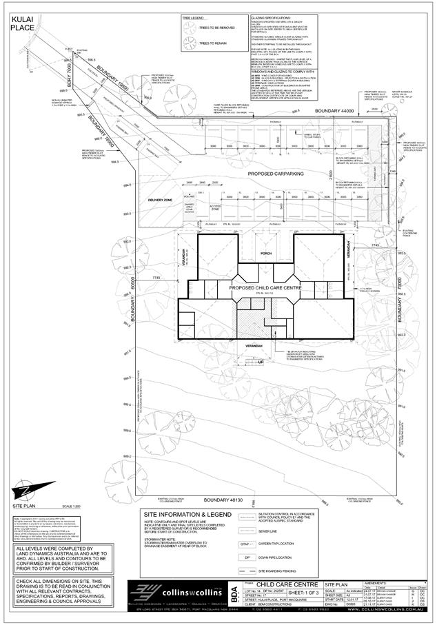
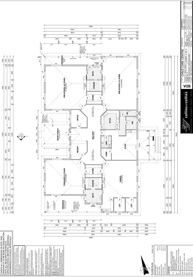
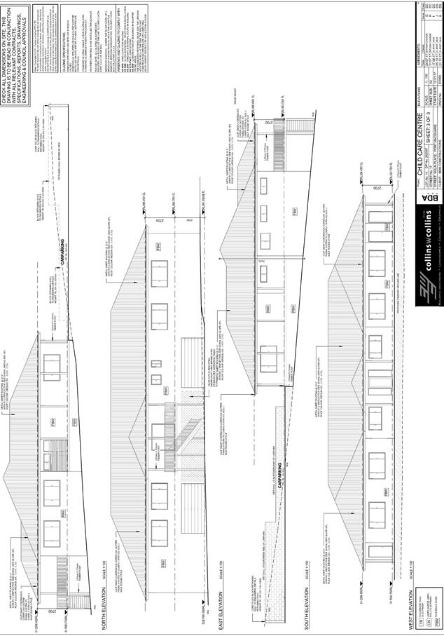
|
ATTACHMENT
|
Development Assessment Panel
14/02/2018
|
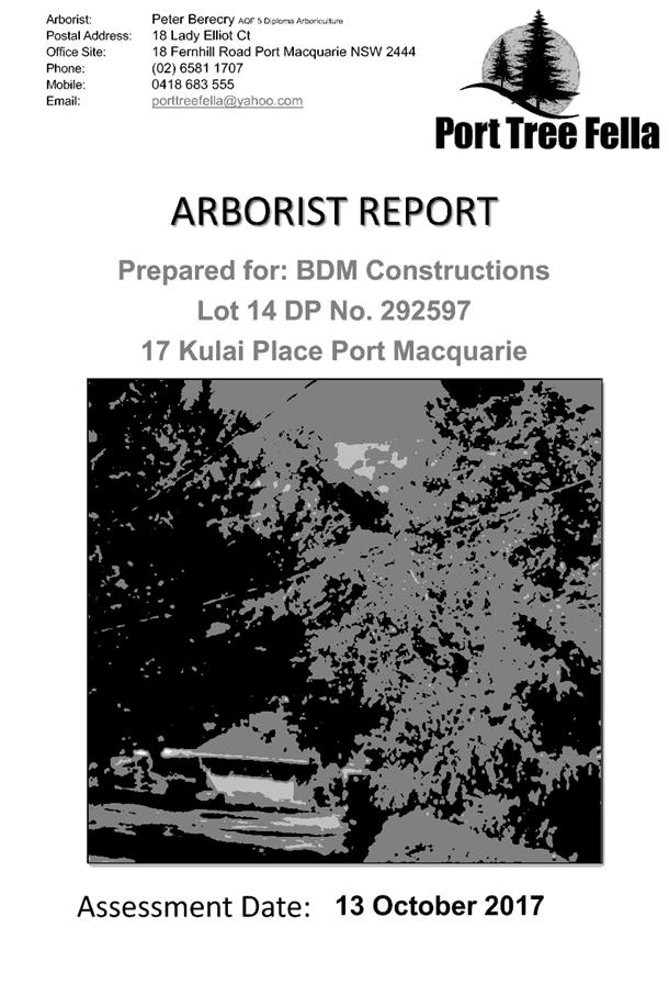
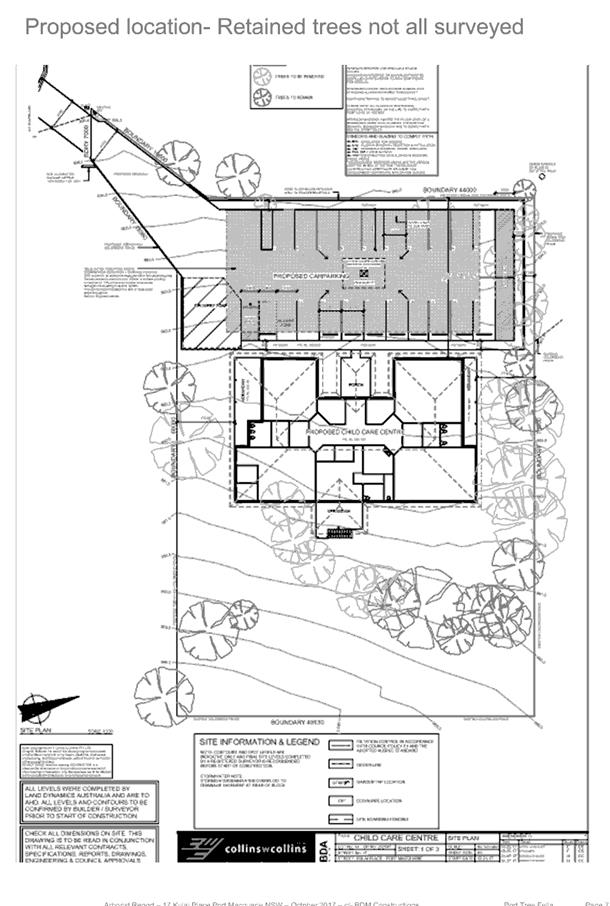
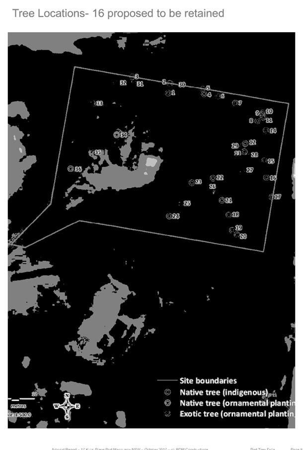
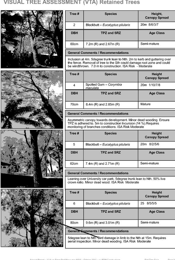
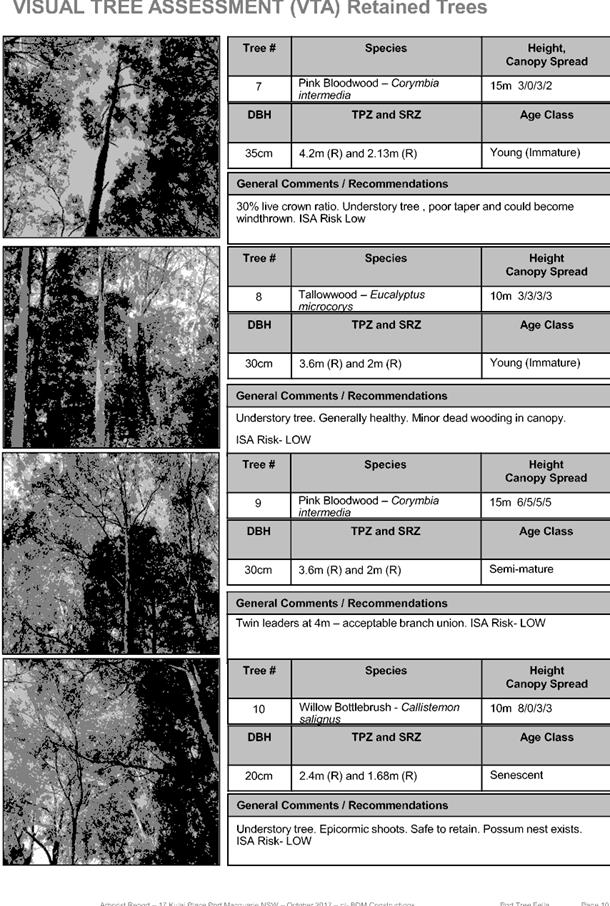
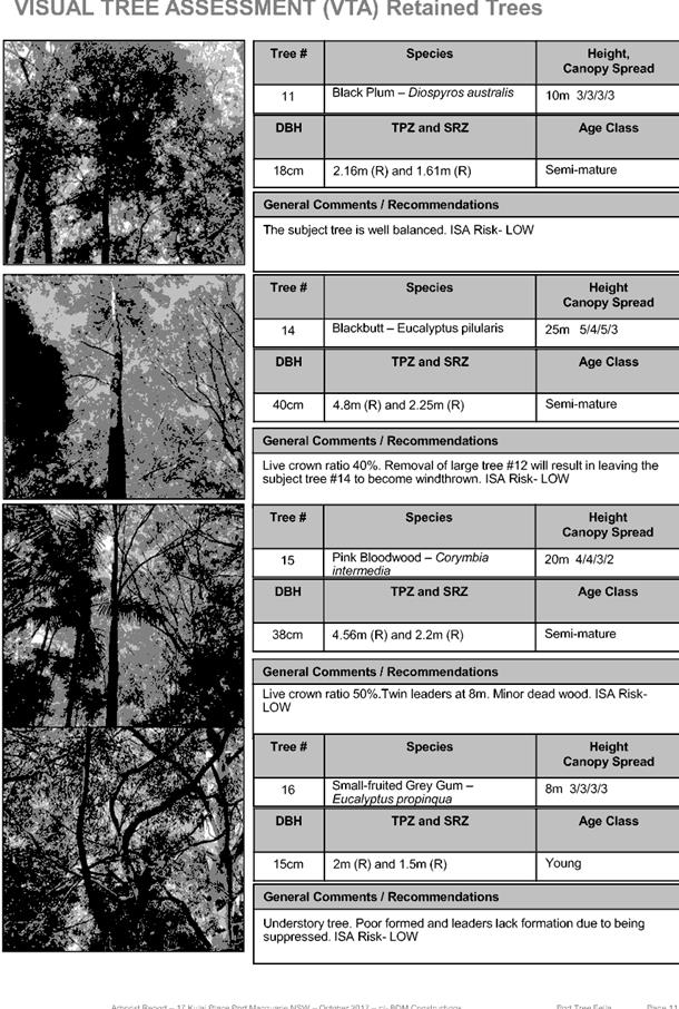
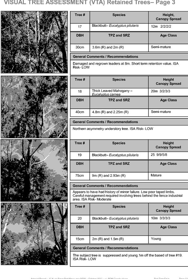
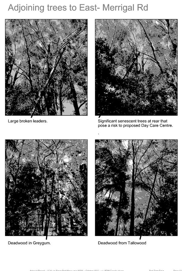
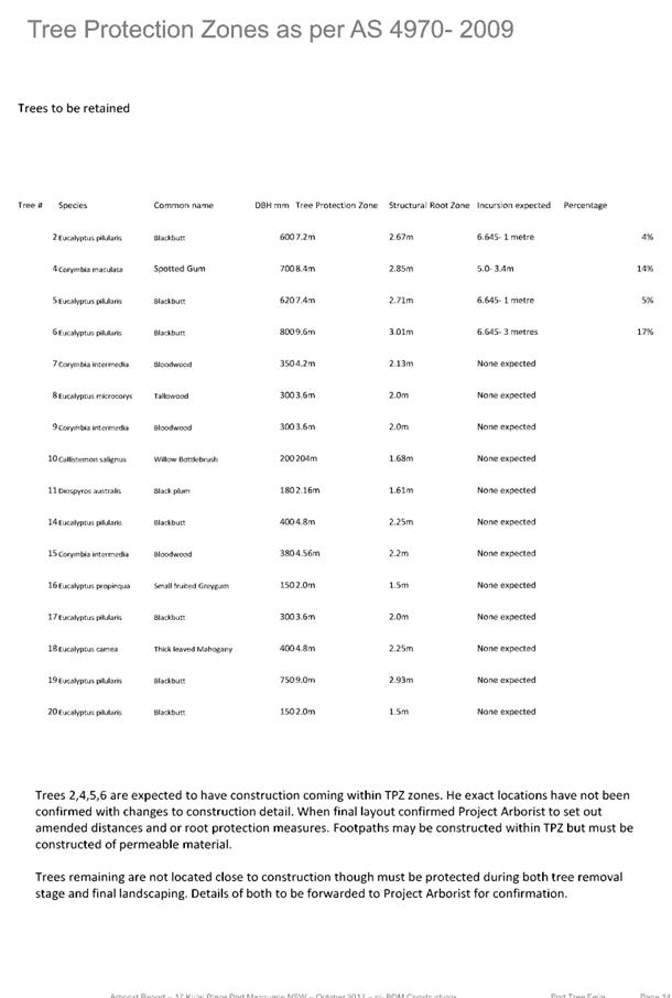
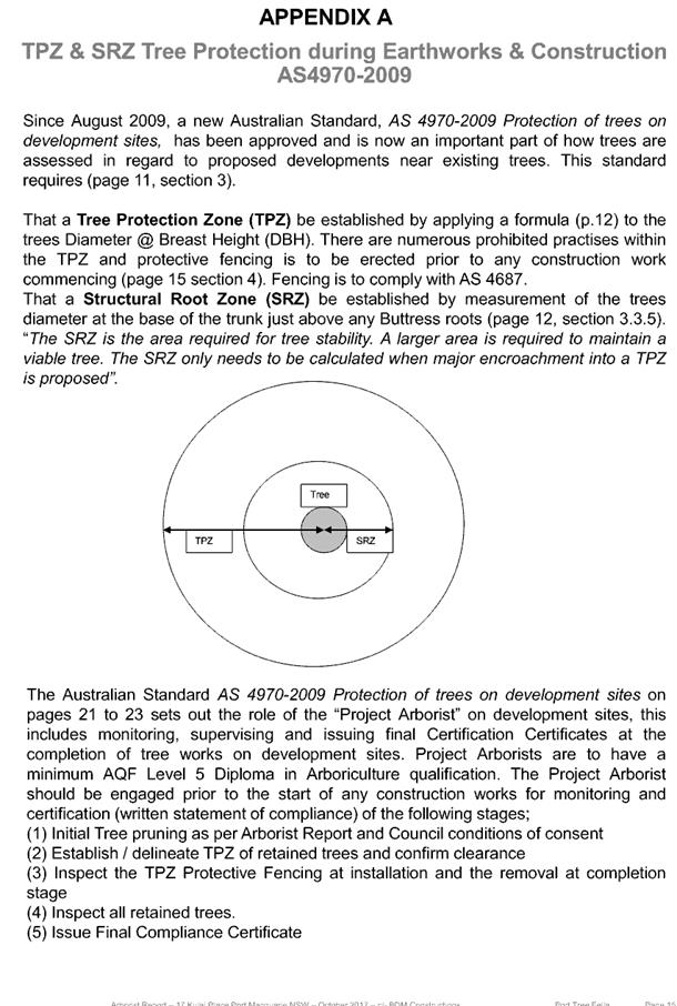
|
ATTACHMENT
|
Development Assessment Panel
14/02/2018
|

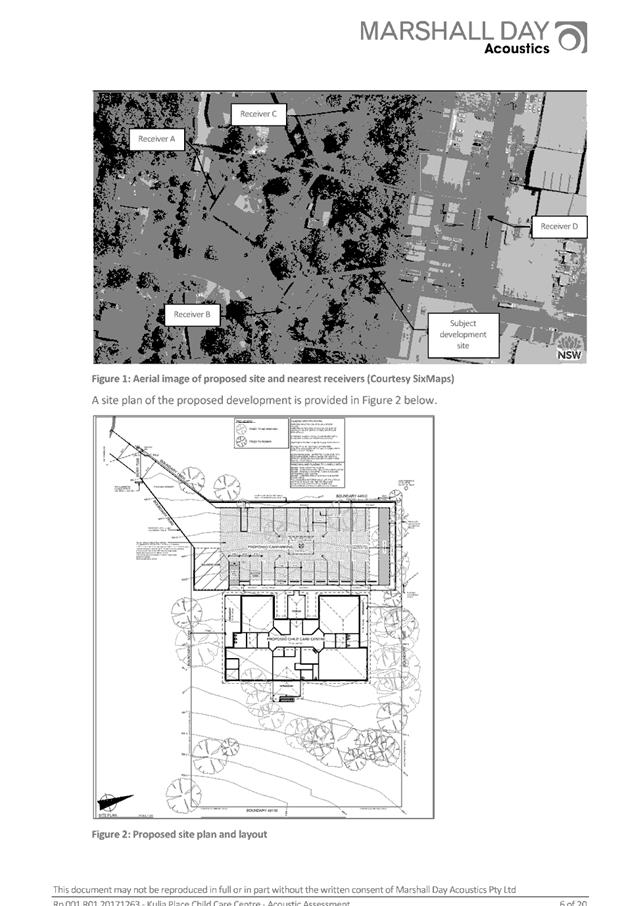
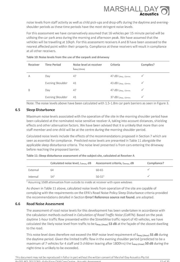
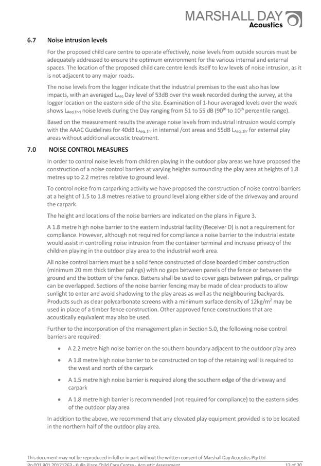
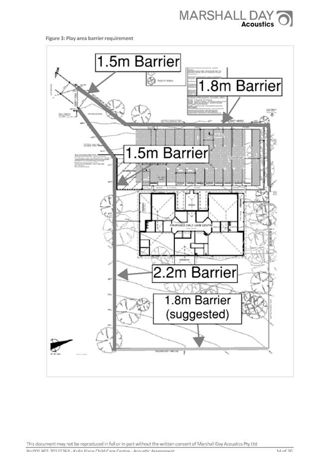
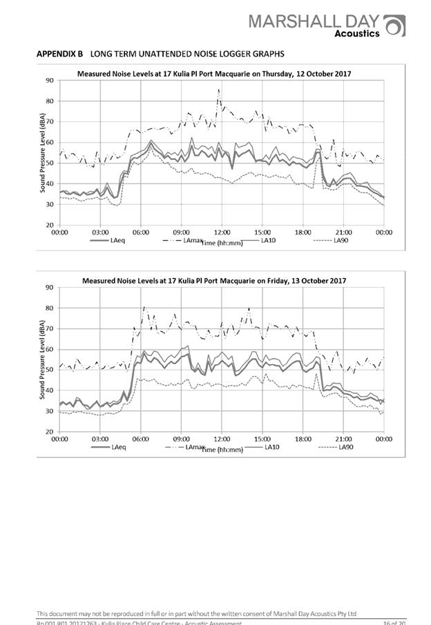
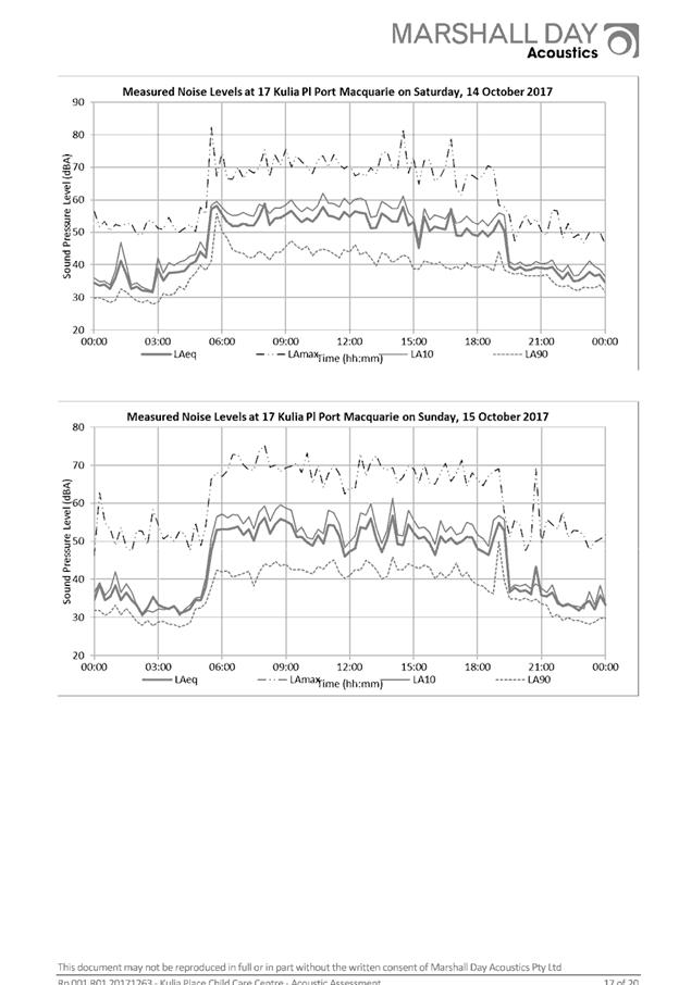
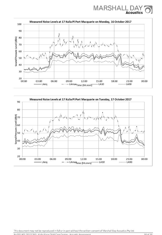

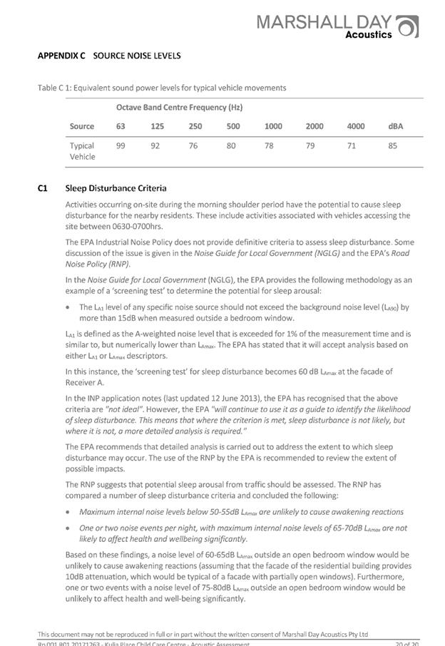
|
ATTACHMENT
|
Development Assessment Panel
14/02/2018
|
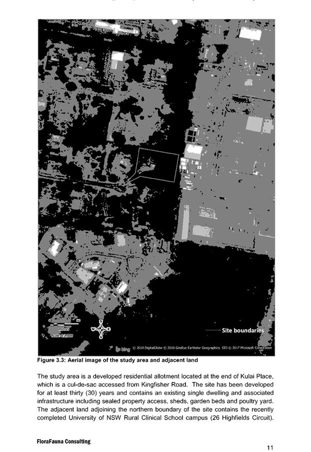
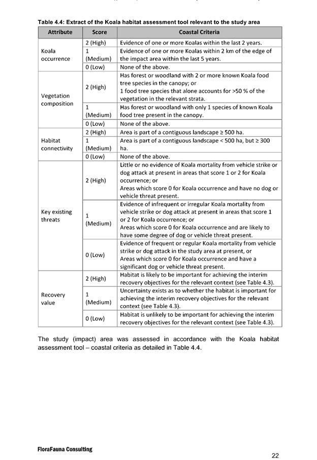
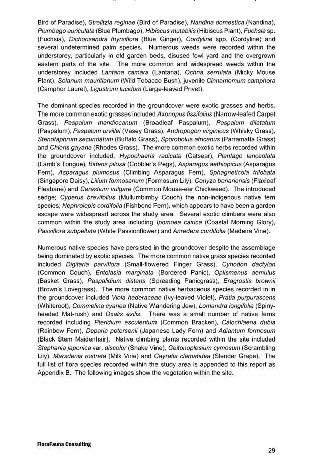
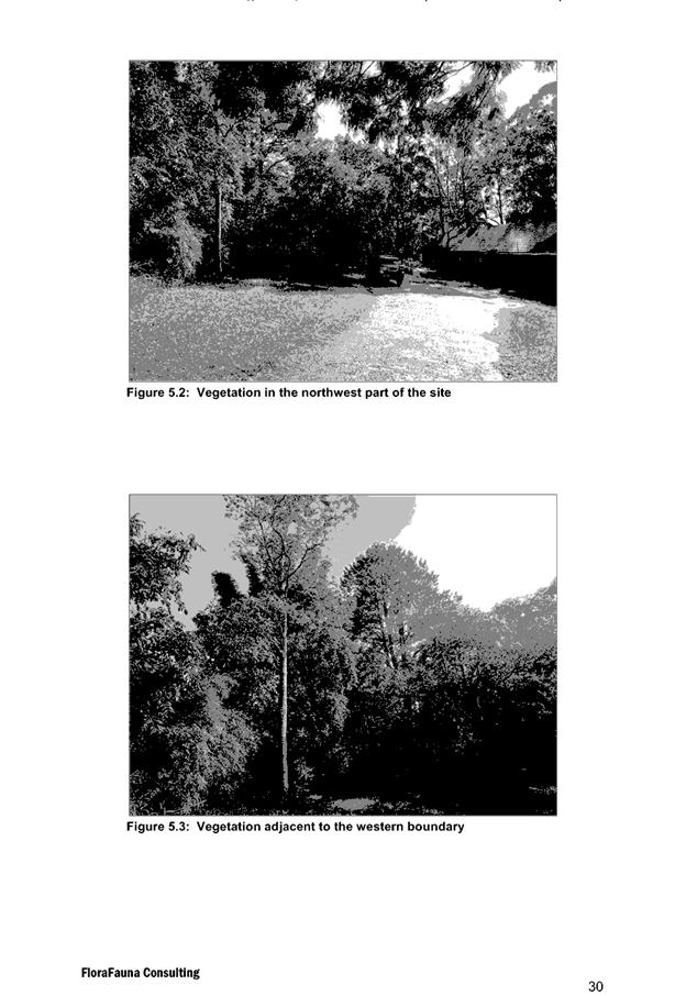
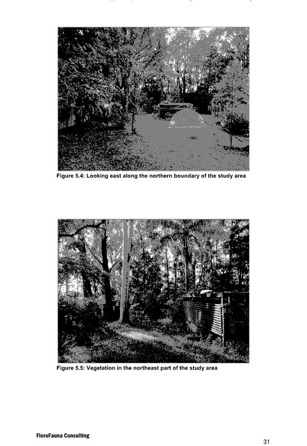
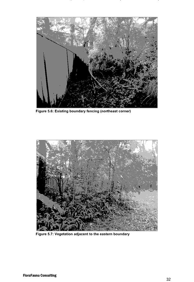
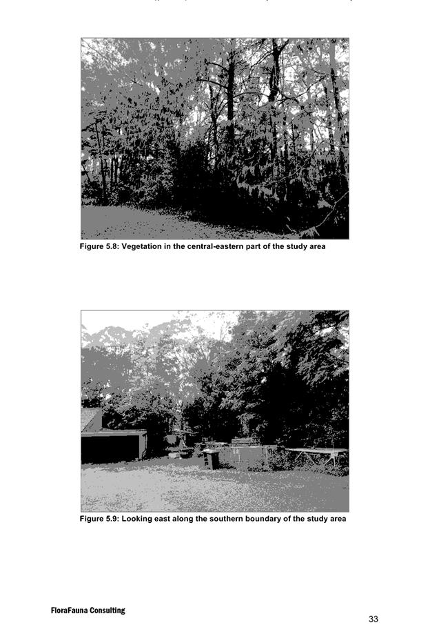
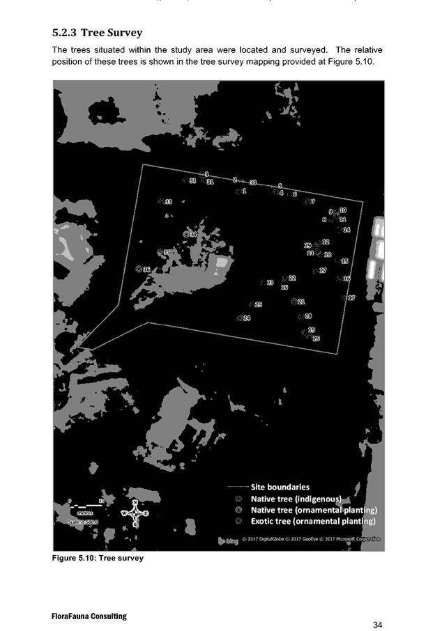
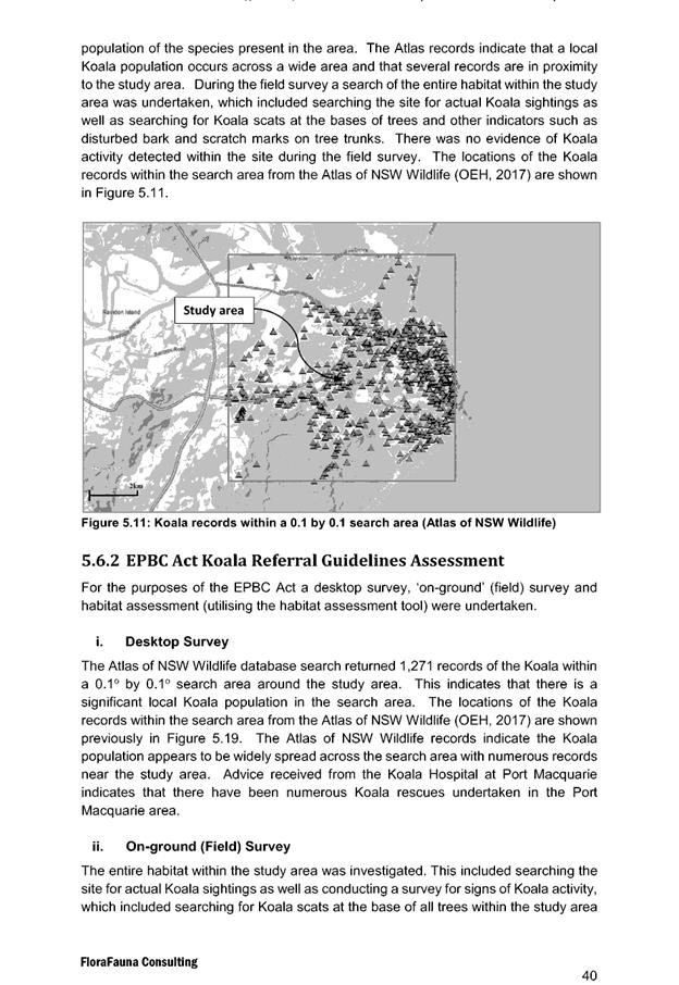
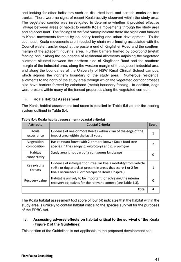
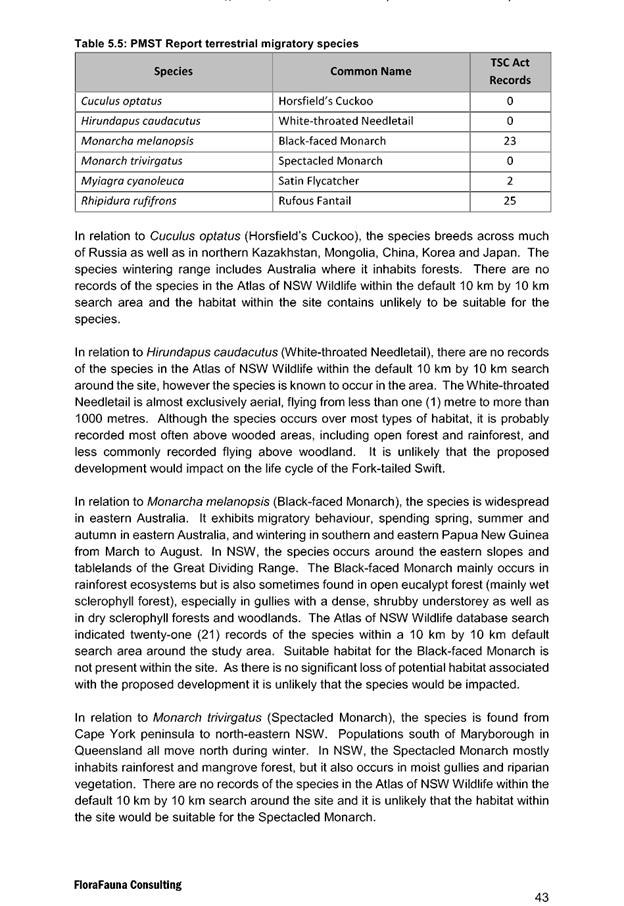
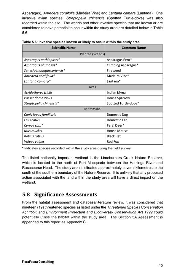
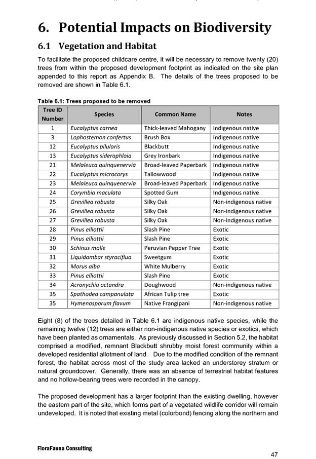

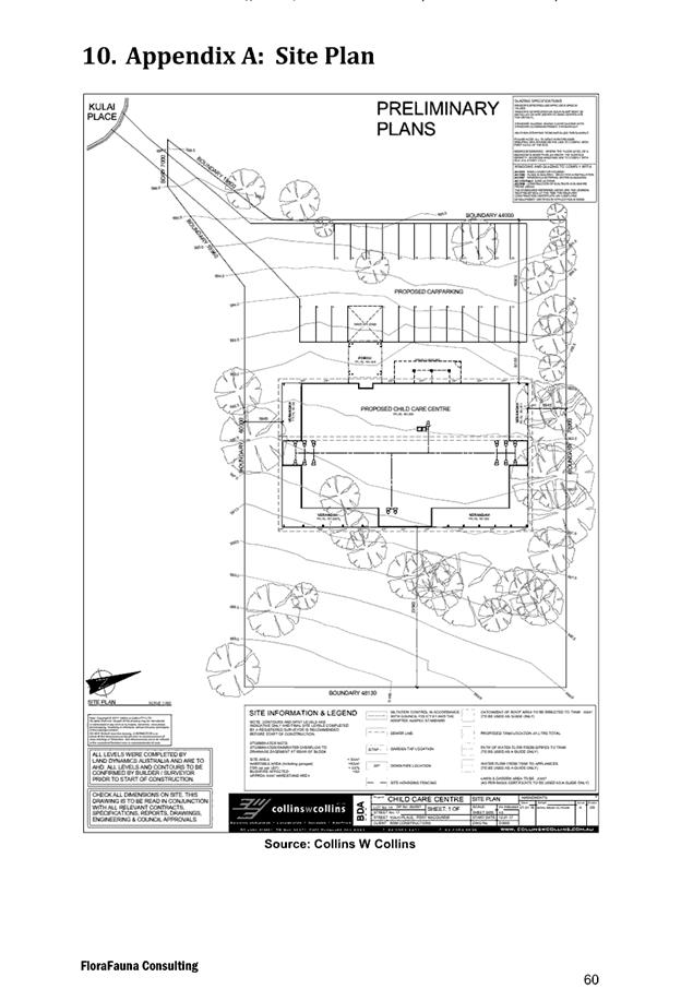
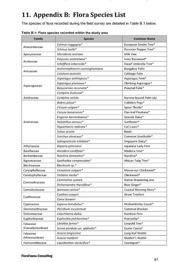
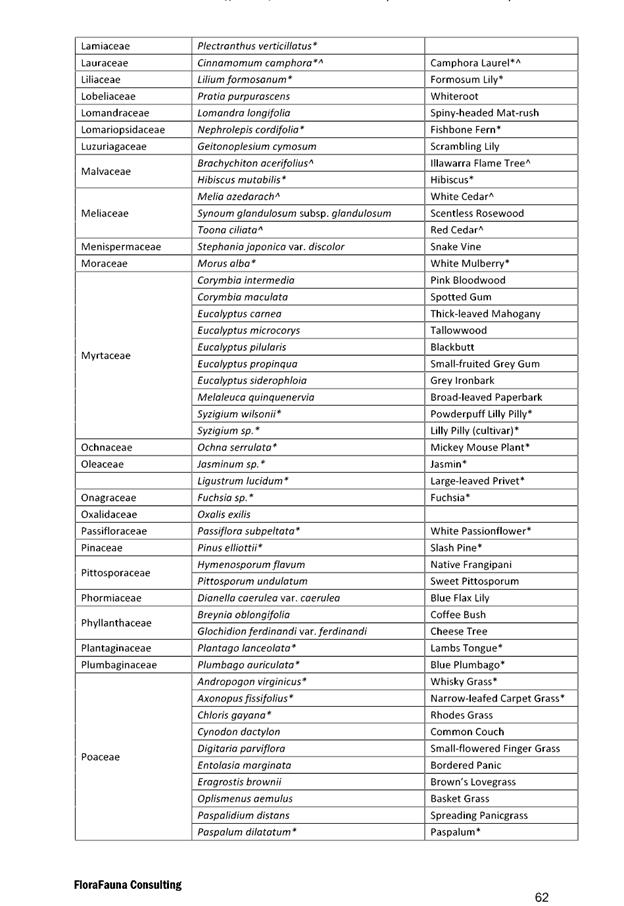
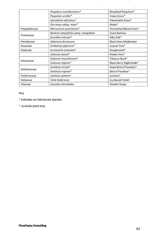
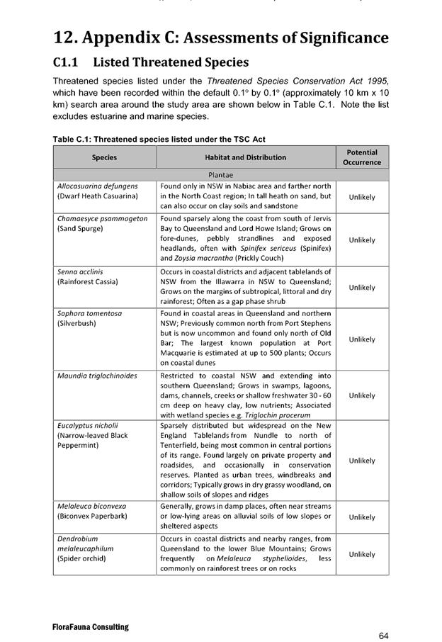
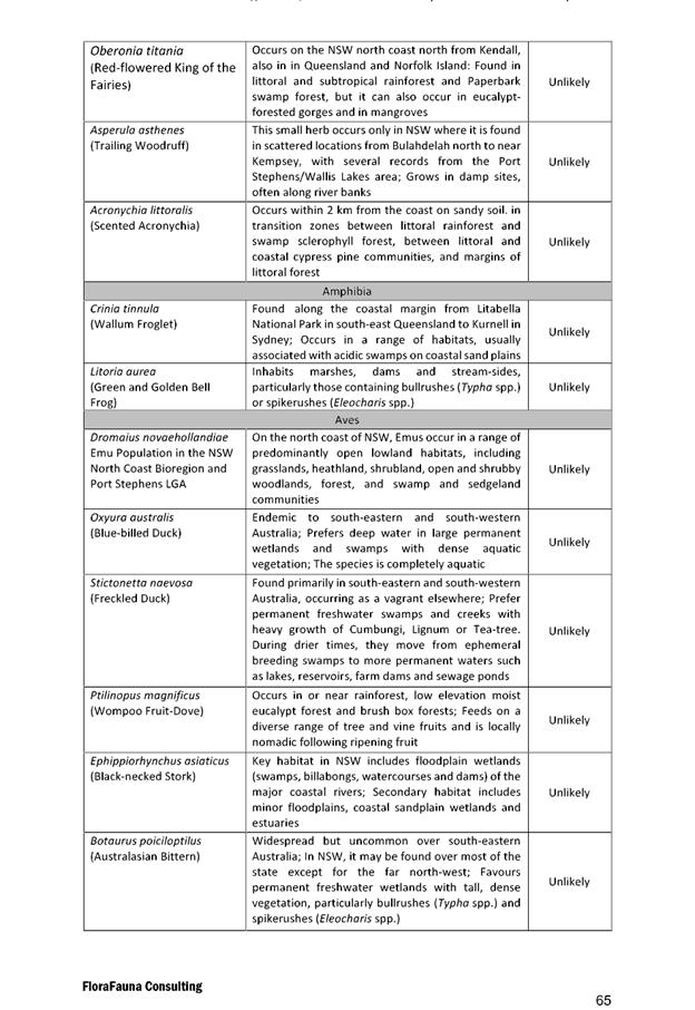
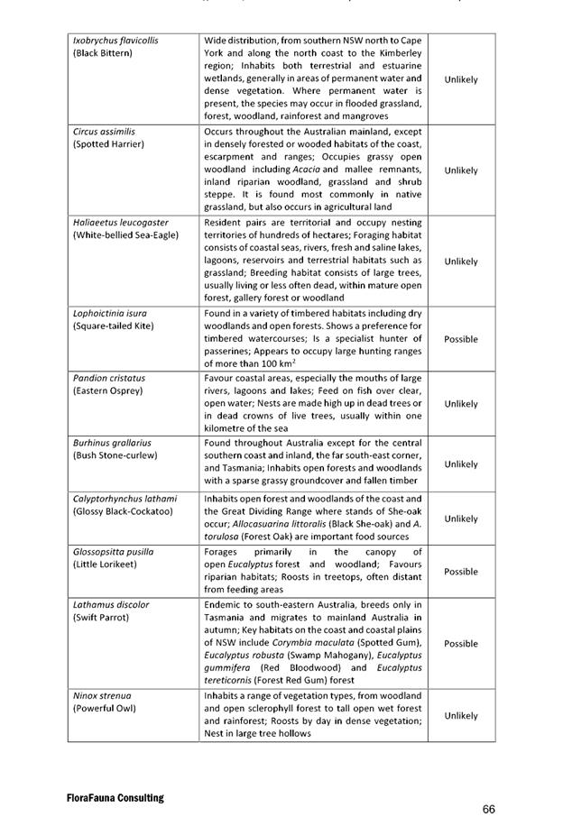
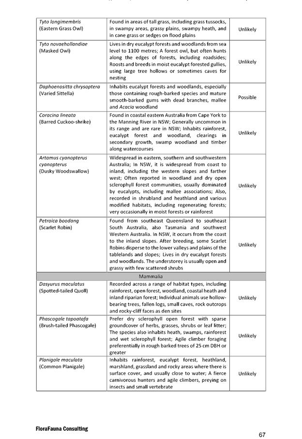
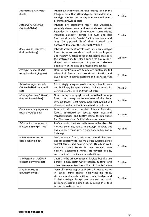
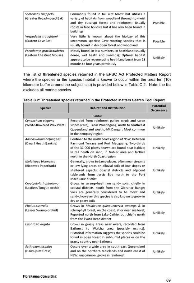
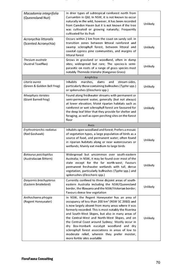
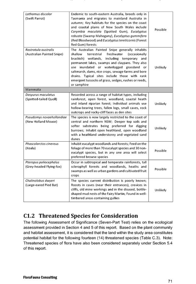
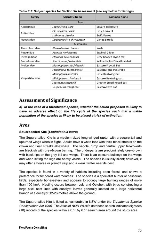
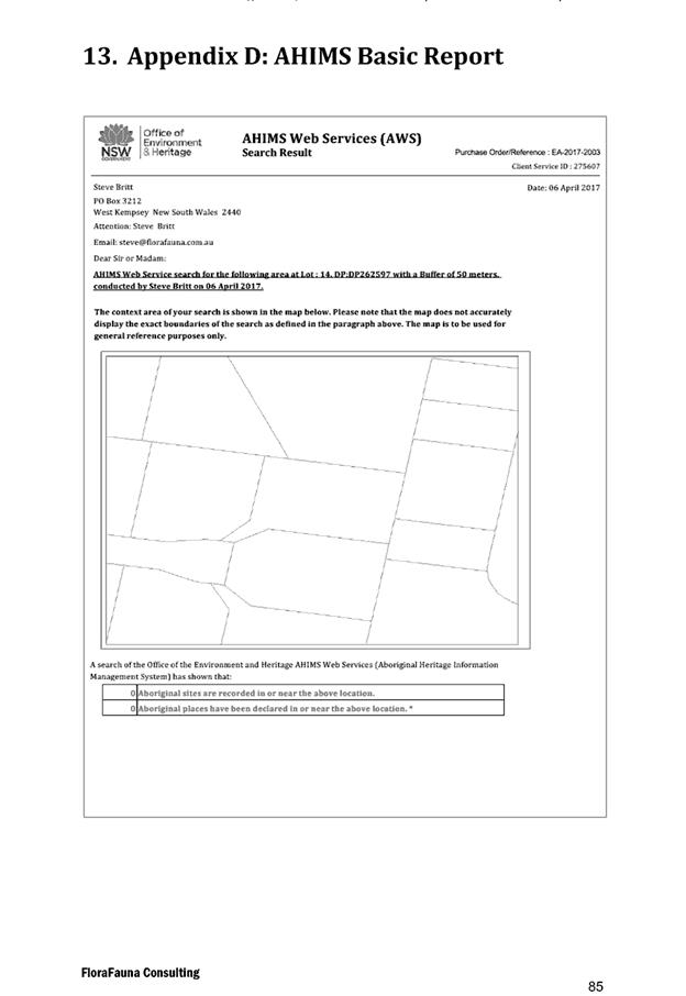
|
ATTACHMENT
|
Development Assessment Panel
14/02/2018
|
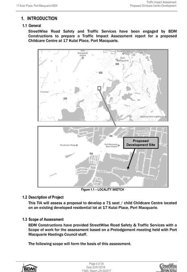
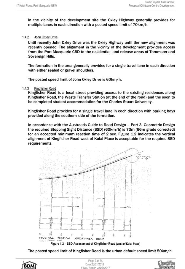
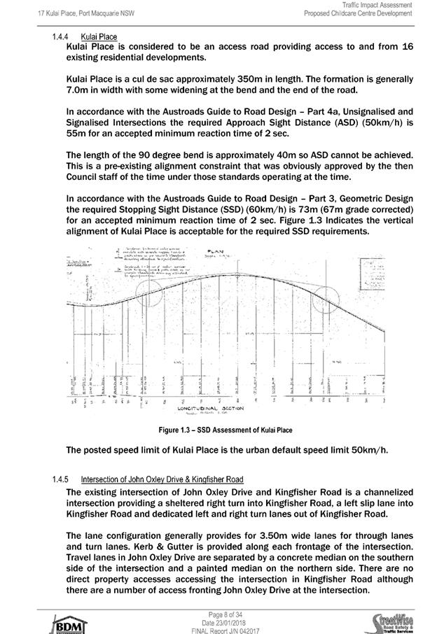
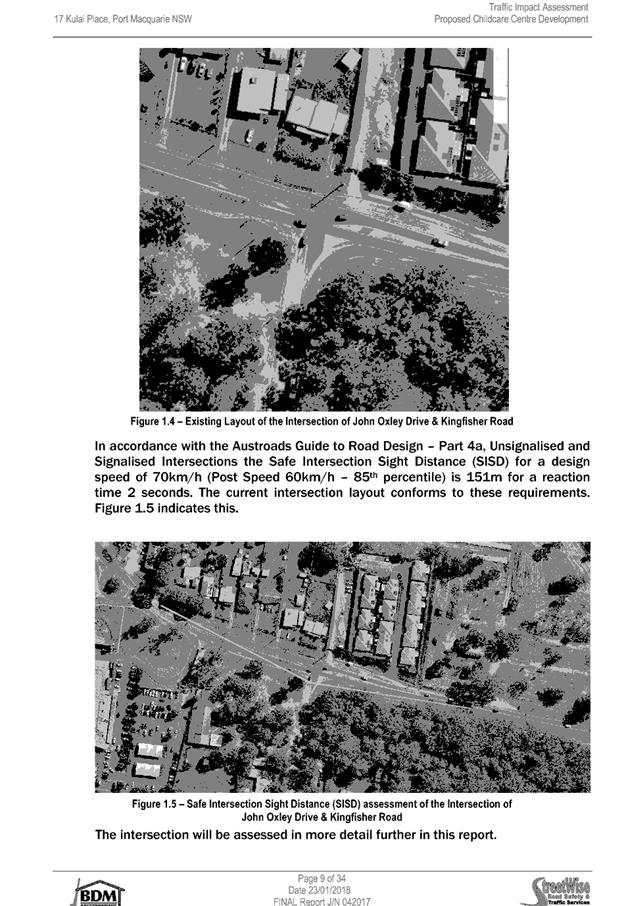
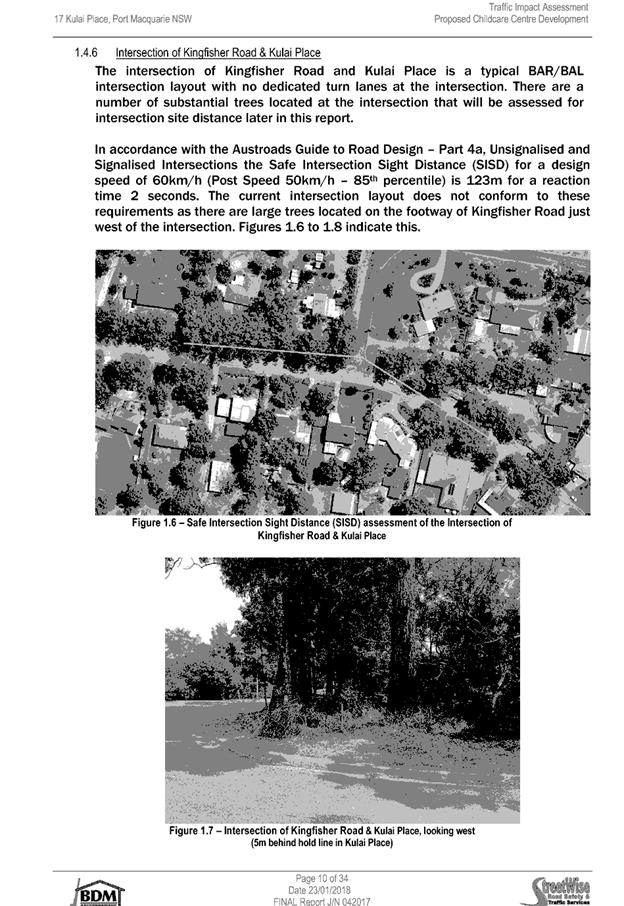
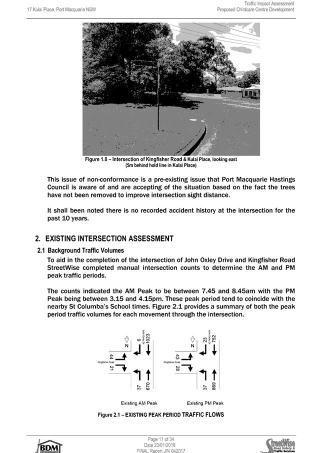
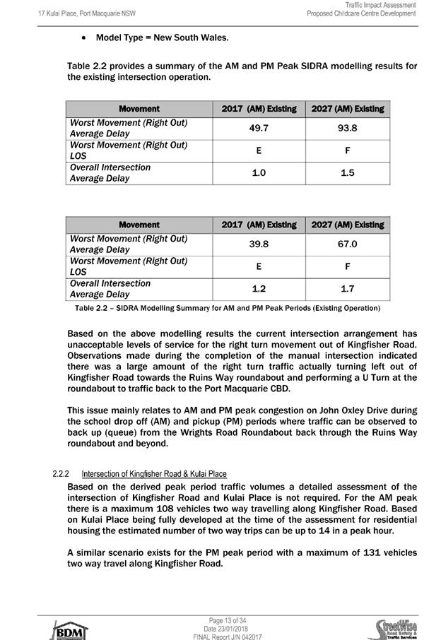
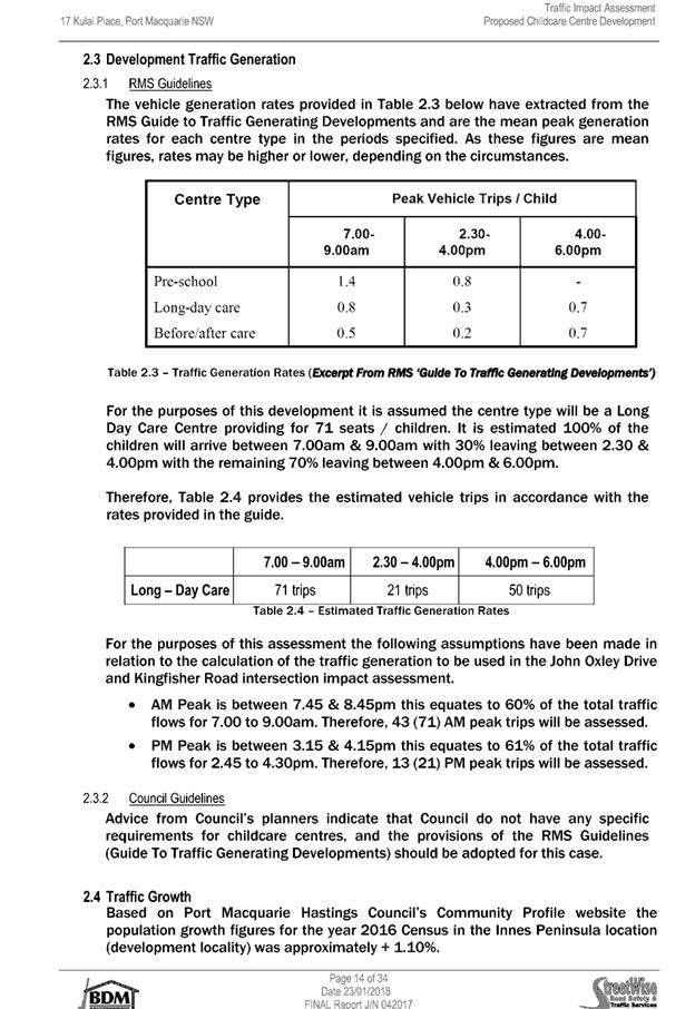
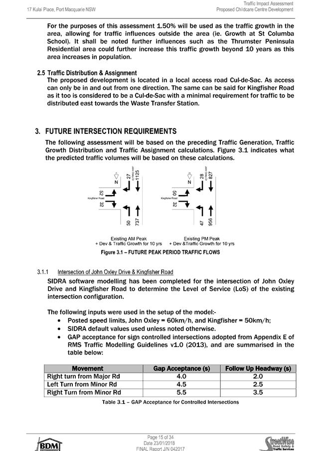
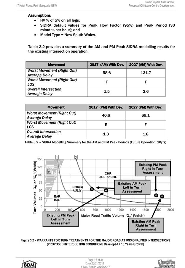
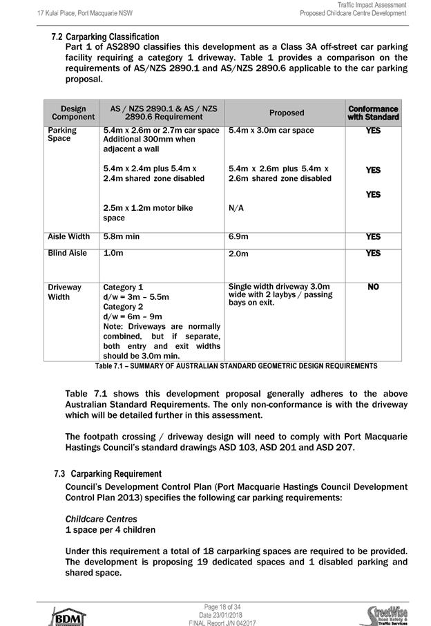
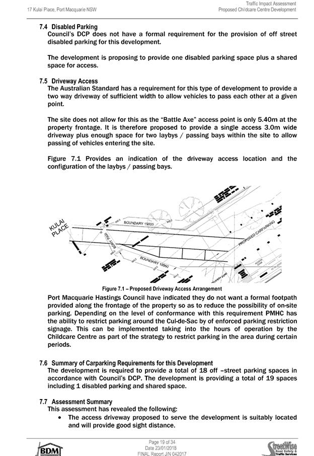

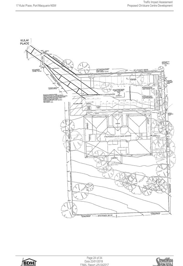

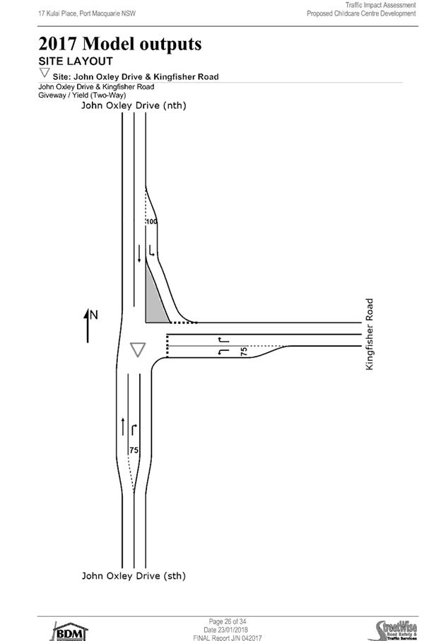

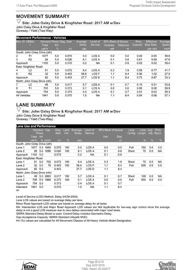
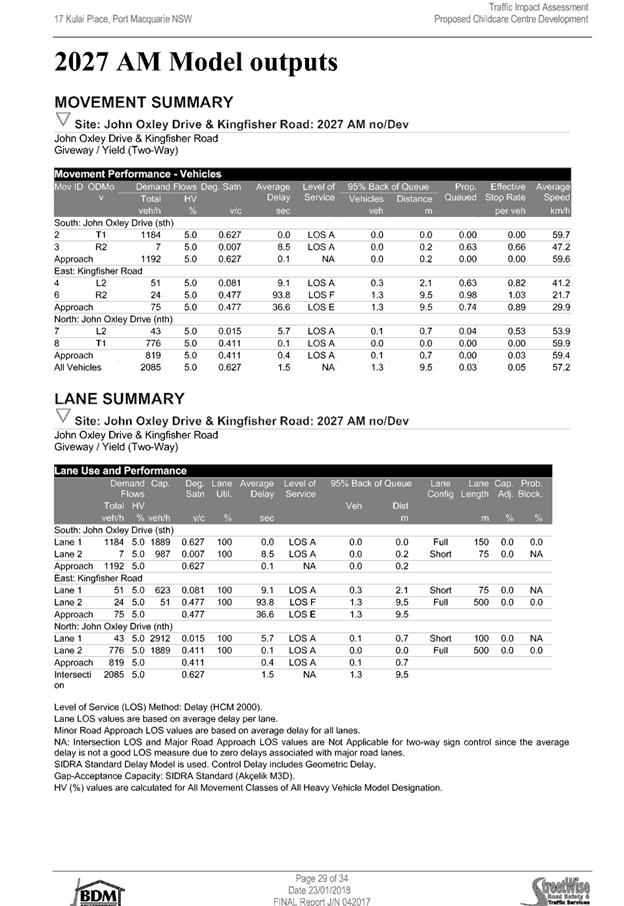

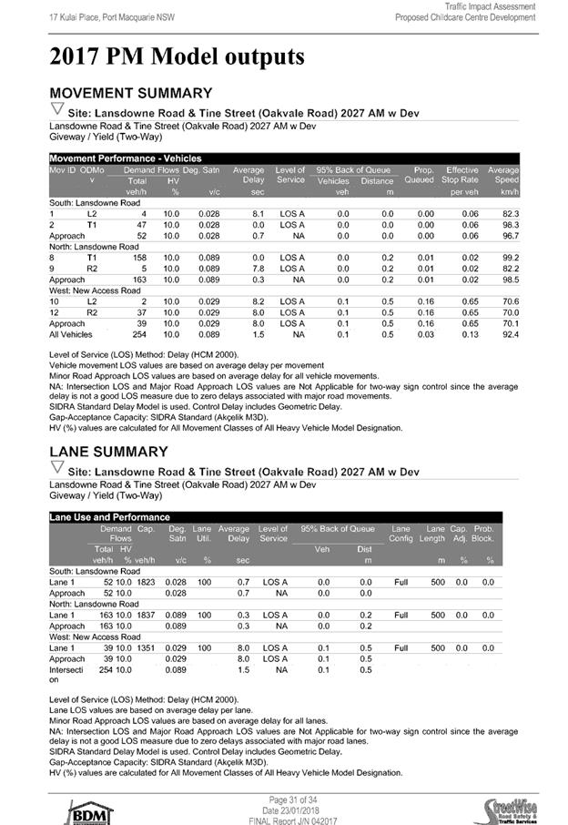

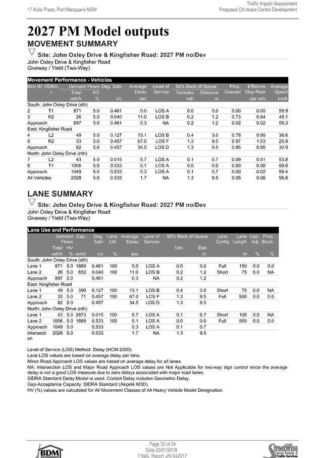
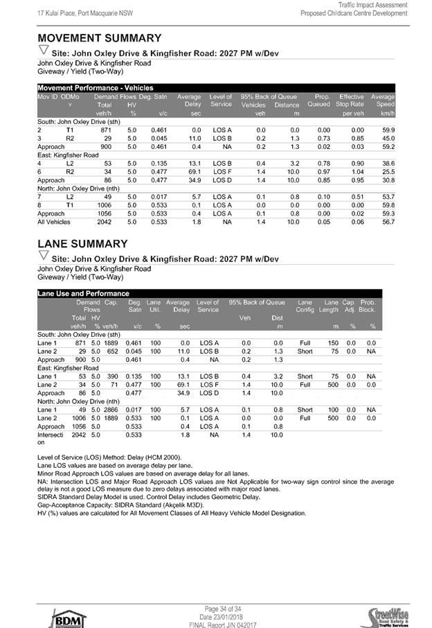
|
ATTACHMENT
|
Development Assessment Panel
14/02/2018
|

|
ATTACHMENT
|
Development Assessment Panel
14/02/2018
|

AGENDA Development Assessment Panel 14/02/2018
Item: 06
Subject: DA2017 - 553.1 - Multi Dwelling Housing And
Strata Title Subdivision - Lot 2 DP 18127, 34 Chapman Street, Port Macquarie
Report
Author: Clint Tink
|
Applicant: J
Gittany
Owner: J
Gittany & A K Mak
Estimated Cost: $1,187,000
Alignment with Delivery
Program
4.3.1 Undertake transparent
and efficient development assessment in accordance with relevant legislation.
|
|
RECOMMENDATION
That
DA 2017 – 553.1 for multi
dwelling housing and strata subdivision at Lot 2, DP 18127, No. 34 Chapman
Street, Port Macquarie, be determined by granting consent subject to the
recommended conditions.
|
Executive
Summary
This
report considers a development application for multi dwelling housing and
strata subdivision at the subject site and
provides an assessment of the application in accordance with the Environmental
Planning and Assessment Act 1979.
Following two (2) exhibition
periods of the application, submissions were received from eight (8)
people/groups.
1. BACKGROUND
Existing sites features and Surrounding development
The site has an area of 1184m².
The site is zoned R1 General Residential in accordance with the Port Macquarie-Hastings Local
Environmental Plan 2011, as shown in the following zoning plan:
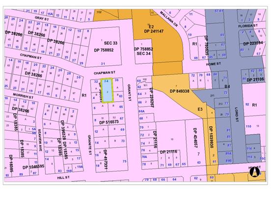
The existing subdivision pattern and location of existing
development within the locality is shown in the following aerial photograph:
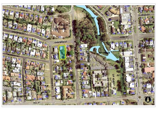
2. DESCRIPTION OF
DEVELOPMENT
Key aspects of the proposal include the following:
· Demolition
of existing dwelling.
· Erection
of five (5), two (2) storey units with each comprising three (3) bedrooms and a
double garage.
· Two
(2) visitor parking spaces will be provided and a turning area.
· The
units will be strata subdivided.
· Submissions
were received from eight (8) people/groups.
Refer
to attachments at the end of this report.
Application Chronology
· 29/6/2017
– Application lodged with Council.
· 10-24/7/2017
– Notification period.
· 14/7/2017
– Council staff requested additional information on issues such as
height, views, State Environmental Planning Policy 71 (SEPP 71), screening,
fence detail, overshadowing, and open space.
· 18/7/2017
– Council staff emailed a neighbour regarding the development.
· 23/7/207
to 4/8/2017 – Council staff emailed a neighbour on water and sewer.
· 27/7/2017
– Council staff emailed the applicant suggesting they review submissions.
Redacted copy of submissions were provided to the applicant upon request.
· 3/8/2017
– Council staff requested additional information on stormwater and
engineering matters.
· 7/8/2017
– Council staff emailed a neighbour regarding the Development Assessment
Panel (DAP) process and submission numbers.
· 8/8/2017
– Update on additional information provided by the applicant.
· 22-30/8/2017
– Discussion with Department of Planning Environment regarding SEPP 71
Masterplan Waiver.
· 6/9/2017 – Update from applicant.
· 18/10/2017 – Council staff provided a neighbour an
update on the development.
· 18/10/2017 – Council staff requested update on
additional information from the applicant.
· 19/10/2017 – Applicant submitted response to
additional information issues.
· 23/10/2017 – Council staff advised the additional
information provided on 19/10/2017 was not acceptable.
· 25-26/10/2017 – Discussion between Council staff and
the applicant on the additional information matters to be addressed.
· 17/11/2017 – Applicant responded to additional
information.
· 20/11/2017 – Council staff sought clarification on
the documents provided by the applicant.
· 21-22/11/2017 – Council staff provided a neighbour an
update on the development.
· 21/11/2017 – Applicant clarified the plans.
· 22/11/2017 to 6/12/2017 – Neighbours who put in a
submission were notified of the changes and allowed time to put in any revised
comments.
· 6/2/2018 – Updated BASIX certificate submitted to
match revised plans submitted dated 20/11/2017. Plan reference changed to match
BASIX.
3. STATUTORY ASSESSMENT
Section 79C(1) Matters for Consideration
In determining the application, Council is required to take
into consideration the following matters as are relevant to the development
that apply to the land to which the development application relates:
(a) The provisions (where
applicable) of:
(i) any Environmental
Planning Instrument:
State Environmental Planning Policy No. 44 - Koala Habitat
Protection
There is no Koala Plan of
Management on the site. Additionally, the site is less than 1ha in area.
Therefore, no further investigations are required.
State Environmental Planning
Policy No.55 – Remediation of Land
Following an inspection of the site and a search of Council
records, the subject land is not identified as being potentially contaminated
and is suitable for the intended use.
Standard conditions of consent will be applied to cover the
removal of any asbestos in the existing dwelling during the demolition process.
State Environmental Planning
Policy No. 62 – Sustainable Aquaculture
Given the nature of the proposed
development and proposed stormwater controls the proposal will be unlikely to
have any adverse impact on existing aquaculture industries.
State Environmental Planning
Policy No. 71 – Coastal Protection and Clause 5.5 of Port
Macquarie-Hastings Local Environmental Plan 2011
The site is located within a
coastal zone as defined in accordance with clause 4 of SEPP 71.
The site is further identified as
being within a sensitive coastal location. In accordance with Clause 18,
subdivision of sensitive coastal land within a residential zone requires a
Masterplan or Masterplan waiver. As a result, the proposal was sent to the
Department of Planning Environment who waived the need for a Masterplan on 30
August 2017.
In accordance with clause 5, this
SEPP prevails over the Port Macquarie-Hastings LEP 2011 in the event of any
inconsistency.
Having regard to clauses 8 and 12
to 16 of SEPP 71 and clause 5.5 of Hastings LEP 2011 inclusive the proposed development
will not result in any of the following:
a) any
restricted access (or opportunities for access) to the coastal foreshore
b) any
identifiable adverse amenity impacts along the coastal foreshore and on the
scenic qualities of the coast;
c) any
identifiable adverse impacts on any known flora and fauna (or their natural
environment);
d) subject to
any identifiable adverse coastal processes or hazards;
e) any
identifiable conflict between water and land based users of the area;
f) any
identifiable adverse impacts on any items of archaeological/heritage; and
g) reduced
quality of the natural water bodies in the locality.
The site is located within an area zoned and already built out
for residential purposes.
State Environmental Planning Policy (Building
Sustainability Index: BASIX) 2004
A BASIX certificate has been
submitted demonstrating that the proposal will comply with the requirements of
the SEPP. It is recommended that a condition be imposed to ensure that
the commitments are incorporated into the development and certified at
Occupation Certificate stage.
Port
Macquarie-Hastings Local Environmental Plan 2011 (LEP 2011)
The proposal is consistent with the LEP having regard to the
following:
· Clause 2.2, the
subject site is zoned R1 General Residential. In accordance with clause 2.3(1)
and the R1 zone landuse table, the proposed multi dwelling housing and strata
subdivision, is a permissible landuse with consent.
The objectives of the R1 zone are as
follows:
o To provide for the housing
needs of the community.
o To provide for a variety of
housing types and densities.
o To enable other land uses
that provide facilities or services to meet the day to day needs of residents.
In accordance with Clause 2.3(2), the
proposal is consistent with the zone objectives as it is a permissible landuse
and consistent with the residential locality.
· Clause 2.7, the
proposed demolition will be covered by conditions of consent.
· Clause 4.1, does
not apply to strata lots associated with a multi dwelling housing development
– see Clause 4.1A below.
· Clause 4.1A allows
an integrated housing application whereby construction and subdivision are
included in the one application. When both construction and subdivision are
included in the one application, Clause 4.1A allows the minimum lot size
standard to be varied/reduced.
The intent of the clause is to encourage
housing diversity without compromising residential amenity. This overall assessment
shows that the development will have limited impact on adjoining properties.
The surrounding area also contains a mixture of low and medium to high density
residential development. This proposal will be consistent with such a density.
· Clause 4.3, the maximum overall height of the
building above ground level (existing) is 8.48m, which complies with the
standard height limit of 8.5m applying to the site.
· Clause 4.4, the
floor space ratio of the proposal is 0.58:1.0, which complies with the maximum
1:1 floor space ratio applying to the site.
· Clause 5.9, there
are several trees to be removed from the site, none of which have any
significant value or need for replacement.
· Clause 5.10, the
site does not contain or adjoin any known heritage items or sites of
significance.
· Clause 7.13,
satisfactory arrangements are in place for provision of essential services.
(ii) Any
draft instruments that apply to the site or are on exhibition:
None relevant
to the proposal.
(iii) any
Development Control Plan in force:
Port
Macquarie-Hastings Development Control Plan 2013 (DCP 2013)
|
DCP 2013: Dwellings, Dual
occupancies, Dwelling houses, Multi dwelling houses & Ancillary
development
|
|
|
Requirements
|
Proposed
|
Complies
|
|
3.2.2.1
|
Ancillary development:
• 4.8m max. height
• Single storey
• 60m2 max. area
• 100m2 for lots
>900m2
• 24 degree max.
roof pitch
• Not located in
front setback
|
Water tank and drying areas are
appropriately located behind the front building line.
Bin area will be screened from
the street.
|
Yes
|
|
3.2.2.2
|
Articulation zone:
• Min. 3m front
setback
• An entry feature
or portico
• A balcony, deck,
patio, pergola, terrace or verandah
• A window box
treatment
• A bay window or
similar feature
• An awning or
other feature over a window
• A sun shading
feature
|
No elements within the
articulation zone.
|
N/A
|
|
Front setback (Residential not R5
zone):
• Min. 6.0m
classified road
• Min. 4.5m local
road or within 20% of adjoining dwelling if on corner lot
• Min. 3.0m
secondary road
• Min. 2.0m Laneway
|
Front building line setback
requirements are complied with. In particular, the development is setback
6.164m.
|
Yes
|
|
3.2.2.3
|
Garage 5.5m min. and 1m behind
front façade.
Garage door recessed behind
building line or eaves/overhangs provided
|
Garage door setback requirements
are complied with.
|
Yes
|
|
6m max. width of garage door/s
and 50% max. width of building
|
Garage doors do not face the
street and therefore the provisions of the DCP do not apply.
|
Yes
|
|
Driveway crossover 1/3 max. of
site frontage and max. 5.0m width
|
While the driveway crossing width
does not exceed 1/3 of the site frontage, it does exceed the 5m requirement.
In particular, the driveway crossover is 5.5m. The variation is considered
minor and will not create any adverse impact on the streetscape, amenity of
the area or significant loss of on street parking.
|
No, but acceptable.
|
|
3.2.2.4
|
4m min. rear setback. Variation
subject to site analysis and provision of private open space
|
The 4m rear setback requirements
are complied with.
|
Yes
|
|
3.2.2.5
|
Side setbacks:
• Ground floor =
min. 0.9m
• First floors
& above = min. 3m setback or where it can be demonstrated that
overshadowing not adverse = 0.9m min.
• Building wall
set in and out every 12m by 0.5m
|
The minimum side setback requirements
are complied with.
The wall articulation is
compliant and satisfies the objectives of the development provision.
|
Yes
|
|
3.2.2.6
|
35m2 min. private open space area
including a useable 4x4m min. area which has 5% max. grade
|
Each occupancy contains 35m²
open space in one area. Units 2-5 do not contain the required 4m x 4m area
off a living room. However, in lieu of the 4m x 4m area, the units still
contain a more than acceptable and useable 3.6m x 8m area.
|
No, but acceptable.
|
|
3.2.2.7
|
Front fences:
• If solid 1.2m
max height and front setback 1.0m with landscaping
• 3x3m min. splay
for corner sites
• Fences >1.2m
to be 1.8m max. height for 50% or 6.0m max. length of street frontage with
25% openings
• 0.9x0.9m splays
adjoining driveway entrances
|
The proposed front fence design is considered to meet the
fencing provisions and objectives of DCP 2013. No adverse impacts will occur.
|
Yes
|
|
3.2.2.8
|
Front fences and walls to have
complimentary materials to context
No chain wire, solid timber,
masonry or solid steel front fences
|
Fencing design complies.
|
Yes
|
|
3.2.2.10
|
Privacy:
• Direct views
between living areas of adjacent dwellings screened when within 9m radius of
any part of window of adjacent dwelling and within 12m of private open space
areas of adjacent dwellings. ie. 1.8m fence or privacy screening which has
25% max. openings and is permanently fixed
• Privacy screen
required if floor level > 1m height, window side/rear setback (other than
bedroom) is less than 3m and sill height less than 1.5m
• Privacy screens
provided to balconies/verandahs etc which have <3m side/rear setback and
floor level height >1m
|
The development will not compromise privacy in the area
due to a combination of lack of windows on side/rear boundaries, having high
sill windows that face side/rear boundaries, limiting living areas that face
adjoining living areas/open space, compliant separation and use of
screening/fencing.
|
Yes
|
|
DCP 2013: General
Provisions
|
|
|
Requirements
|
Proposed
|
Complies
|
|
2.7.2.2
|
Design addresses generic principles of Crime Prevention
Through Environmental Design guideline
|
No concealment or entrapment areas proposed. Adequate
casual surveillance available. Fencing defines property boundaries.
|
Yes
|
|
2.3.3.1
|
Cut and fill 1.0m max. 1m outside the perimeter of the
external building walls
|
There are sections where fill exceeds 1m in height. Refer
to comments at the end of this assessment table for justification to the
variation.
|
No, but acceptable.
|
|
2.3.3.2
|
1m max. height retaining walls along road frontage
|
Retaining walls facing the street do not exceed 1m in
height above existing ground level.
|
Yes
|
|
Any retaining wall >1.0 in height to be certified by
structure engineer
|
Condition recommended to require engineering certification
|
Yes
|
|
Combination of retaining wall and front fence height max
1.8m, max length 6.0m or 30% of frontage, fence component 25% transparent,
and splay at corners and adjacent to driveway
|
No retaining wall front fence combination proposed that
exceeds 1.8m above existing ground level (street side).
|
Yes
|
|
2.3.3.8
|
Removal of hollow bearing trees
|
No significant hollow bearing trees proposed to be removed
|
Yes
|
|
2.6.3.1
|
Tree removal (3m or higher with 100m diameter trunk at 1m
above ground level and 3m from external wall of existing dwelling)
|
Refer to comments on Clause 5.9 in the LEP 2011 section of
this report.
|
Yes
|
|
2.5.3.2
|
New accesses not permitted from arterial or distributor
roads
|
No new access proposed to arterial or distribution road.
|
N/A
|
|
Driveway crossing/s minimal in number and width including
maximising street parking
|
Driveway crossing is minimal in width and retains street
parking.
|
Yes
|
|
2.5.3.3
|
Parking in accordance with Table 2.5.1.
Dwelling/dual occupancies
1 space per dwelling/occupancy (behind building line).
Multi dwelling
1 space per 1 & 2 bedroom occupancies
1.5 spaces per 3+ bedroom occupancies
0.25 spaces per occupancy for visitor parking.
|
Proposal involves 5 x 3 bedroom units. Therefore, 5 x 1.5
spaces + 5 x 0.25 visitor spaces = 8.75 spaces required, which rounds to 9
spaces. The development proposes double garages for each unit (ie 5 x 2
spaces = 10 spaces) and 2 visitor spaces. Total parking provided is 12
spaces, which complies.
|
Yes
|
|
2.5.3.11
|
Section 94 contributions
|
Contributions apply - refer to ET calc and NOP.
|
Yes
|
|
2.5.3.12 and 2.5.3.13
|
Landscaping of parking areas
|
Suitable landscaping areas proposed around
driveway/parking locations.
|
Yes
|
|
2.5.3.14
|
Sealed driveway surfaces unless justified
|
Sealed driveway areas proposed.
|
Yes
|
|
2.5.3.15 and 2.5.3.16
|
Driveway grades first 6m or ‘parking area’
shall be 5% grade with transitions of 2m length
|
Driveway grades capable of satisfying Council standard
driveway crossover requirements. Condition recommended for section 138 Roads
Act permit
|
Yes
|
|
2.5.3.17
|
Parking areas to be designed to avoid concentrations of
water runoff on the surface.
|
Stormwater drainage is capable of being managed.
|
Yes
|
Note: Subdivision provisions of
the DCP (except battleaxe handle width) are aimed at the creation of vacant
lots (i.e. not lots within an integrated housing proposal such as this) and
have therefore been excluded from the above assessment. Servicing requirements
are discussed later in this report.
2.3.3.1 – Cut and fill
variation
The objectives of 2.3.3.1 are as
follows:
2.3.3.1 Objective
To ensure that design of any
building or structure integrates with the topography of the land to:
· Minimise
the extent of site disturbance caused by excessive cut and fill to the site.
· Ensure
there is no damage or instability to adjoining properties caused by excavation
or filling.
· Ensure
that there is no adverse alteration to the drainage of adjoining properties.
· Ensure
the privacy of adjoining dwellings and private open space are protected.
· Ensure
that adequate stormwater drainage is provided around the perimeter of buildings
and that overflow paths are provided.
In response
to the above, the applicant provided the following comments/justification:
The
proposed cut and fill for the subject site is not considered excessive with
only a small portion of the subject site requiring fill with a height greater
than 1m.
There is a
length of 8.265m along the southern boundary and a length of 13.813m along the
eastern boundary that exceeds 1.0m. We note that the maximum height of the
subject retaining walls are 1.624m in the south-eastern corner and both reduce
in height in accordance with the reduction of required fill. The fill required
in the south-eastern corner of the site is to enable stormwater drainage to the
street.
Generally,
the approach to cut and fill which has been taken seeks to minimize the level
of site disturbance in the context of the nature of the development proposal.
We note that the proposed fill for the dwellings and courtyards is less than
1.0m.
All site
filling and excavation will be subject to engineering assessment and design.
Accordingly, there will be no damage or instability to adjoining properties
caused by the proposed excavation or filling.
The
proposed development has been designed and will be constructed so as to comply
with Councils stormwater management requirements. In this regard, the proposed
development will not adversely affect the movement of water from or onto adjoining
properties with the design of the proposed development providing for a
continuation of predevelopment flow conditions.
As
mentioned previously privacy issues have been reflected in the design of the
proposed development with the development concept providing for compliance with
the relevant requirements of DCP 2013.
The
section within the south-eastern corner is a driveway and turning area only and
will have minimal impacts on residential privacy. Refer to section below
“Raised driveway and car turning area” for further details.
Council staff
agree with the comments/justification provided by the applicant. No adverse
impacts will occur from the proposed cut and fill onsite.
(iiia) any
planning agreement that has been entered into under Section 93f or any draft
planning agreement that a developer has offered to enter into under Section
93f:
None
relevant.
iv) any matters prescribed by the
Regulations:
New South Wales Coastal Policy:
The proposed
development is consistent with the objectives and strategic actions of this
policy.
Demolition
of buildings AS 2601:
Demolition of
the existing building on the site is capable of compliance with this Australian
Standard and is recommended to be conditioned.
v) any coastal
zone management plan (within the meaning of the Coastal Protection Act 1979),
that apply to the land to which the development application relates:
None
relevant.
(b) The
likely impacts of that development, including environmental impacts on both the
natural and built environments, social and economic impacts in the locality:
Context
and setting
• The
proposal will be unlikely to have any adverse impacts to existing adjoining
properties and satisfactorily addresses the public domain.
• The
proposal is considered to be consistent with other residential development in
the locality and adequately addresses planning controls for the area.
• There
are no adverse impacts on existing view sharing – see below.
• There
are no adverse privacy impacts.
• There
are no adverse overshadowing impacts. The proposal does not prevent adjoining
properties from receiving 3 hours of sunlight to private open space and primary
living areas on 21 June.
View
Sharing
During the public exhibition period, concern surrounding
view loss was raised.
The overall notion of view sharing is invoked when a
property enjoys existing views and a proposed development would share that view
by taking some of it away for its own enjoyment. Taking all the view away
cannot be called view sharing, although it may, in some circumstances, be quite
reasonable.
Using the principles of NSW Land and
Environment Court case law - Tenacity Consulting v Warringah 2004 NSW LEC
140, the following comments are provided in regards to the view impacts
using the 4 step process to establish whether the view sharing is acceptable.
Step 1
Assessment of views to be affected. Water
views are valued more highly than land views. Iconic views (e.g. of the Opera
House, the Harbour Bridge or North Head) are valued more highly than views
without icons. Whole views are valued more highly than partial views, e.g. a
water view in which the interface between land and water is visible is more
valuable than one in which it is obscured.
Comments: The key view corridor from adjoining
properties is towards the north east and east, predominately across a side
boundary (ie across the subject site). The view appears to be over built up
areas of Port Macquarie with limited water and land water interface views
available. The views to the east would be partially obscured by existing
vegetation on adjoining properties. The view does not contain any iconic or unique
features.
In light of the principles of the case, while
the view offers a degree of appeal (distant town view), it is not considered to
be of high value. In particular, the view is across a side boundary, is more a
neighbourhood street outlook and is reliant on vegetation canopies and areas to
the north east/east not growing/being developed any higher.
Step 2
Consider from what part of the property the
views are obtained. For example the protection of views across side boundaries
is more difficult than the protection of views from front and rear boundaries.
In addition, whether the view is enjoyed from a standing or sitting position
may also be relevant. Sitting views are more difficult to protect than standing
views. The expectation to retain side views and sitting views is often
unrealistic.
Comments: The
views would be predominately across the subject site. The views would be
enjoyed from both standing and sitting positions from various parts of the
adjoining properties.
Step 3
Assess the extent of the impact. This should
be done for the whole of the property, not just for the view that is affected.
The impact on views from living areas is more significant than from bedrooms or
service areas (though views from kitchens are highly valued because people spend
so much time in them). The impact may be assessed quantitatively, but in many
cases this can be meaningless. For example, it is unhelpful to say that the
view loss is 20% if it includes one of the sails of the Opera House. It is
usually more useful to assess the view loss qualitatively as negligible, minor,
moderate, severe or devastating.
Comments: The
extent of the impact upon the views enjoyed from surrounding dwellings are
considered to be acceptable for the following reasons:
- The impacts on view will occur
across a side boundary with front views being retained.
- For the most part, the
proposal complies with relevant planning controls and a greater impact on views
could have occurred from an alternate compliant development.
- Some views to the east
would already be impacted by existing vegetation.
Step 4
Assess the
reasonableness of the proposal that is causing the impact. A development that
complies with all planning controls would be considered more reasonable than
one that breaches them. Where an impact on views arises as a result of
non-compliance with one or more planning controls, even a moderate impact may
be considered unreasonable. With a complying proposal, the question should be
asked whether a more skilful design could provide the applicant with the same
development potential and amenity and reduce the impact on the views of
neighbours. If the answer to that question is no, then the view impact of a
complying development would probably be considered acceptable and the view
sharing reasonable.
Comments: The
proposal contains limited variations to Council’s planning provisions and
a greater impact could have occurred from a more compliant development.
Furthermore, partial views will still be retained from various positions.
Based on the
above, the proposed development is considered to achieve a suitable level of
view sharing to a view that is not considered to have high value in terms of
the planning principles of the court case.
Roads
The site has
road frontage to Chapman Street, an urban ‘Local’ street owned and
maintained by Council. It has a 9m wide roadway within a 27m wide reserve, a
longitudinal gradient averaging about 19%, and barrier kerb (SA type) and
gutter on both sides of the road. The roadway is utilised by existing residents
for on-street informal parallel parking. There is no concrete footpath
currently within Chapman Street and given the proposal will intensify local
pedestrian traffic (comprising five units), 1.2m wide concrete footpath is to
be constructed along the property frontage consistent with Council’s
policies.
Traffic
and Transport
The single
dwelling on the site is likely to generate 7-9 daily vehicular trips on average
per day on the local road network. This development proposes demolition of the
existing and construction of five new dwellings. A low density rate of 7-9
vehicular trips per day may be expected, with medium density dwellings
typically generating less than this (around 5-6 trips per day). The net
increase of 28 to 36 daily trips associated with the development is unlikely to
have any adverse impacts on the existing road network within the immediate
locality given a recent traffic count of 3600 vehicles per day on nearby Grant
Street.
Site
Frontage & Access
Vehicle access
to the site is proposed through a shared driveway. Access shall comply with
Council AUSPEC and Australian Standards for two-way flow widths, and the plans
indicate this will be achieved.
Parking
and Manoeuvring
Ten parking
spaces have been provided on-site within the five residential garages with two
additional visitor parking spaces provided within the driveway. Parking and
driveway widths on site can comply with relevant Australian Standards (AS 2890)
and conditions have been imposed to reflect these requirements.
Due to the
type of development, a dedicated turning area is required to enable vehicles to
enter and exit the site in a forward manner. Site plans show adequate area is
available and conditions have been imposed to reflect these requirements.
Refer to
relevant conditions of consent.
Water
Supply Connection
Council records indicate that the development site has an existing
20mm metered water service. Each proposed unit requires an individual metered
water service with the meters located at the road frontage. An alternate water
metering strategy is to have a master water meter at the road frontage and
individual internal meters located in easily accessible locations. Details are
to be shown on the engineering plans.
Final water service sizing will need to be determined by a hydraulic
consultant to suit the domestic and commercial components of the development,
as well as fire service and backflow protection requirements in accordance with
AS2419 and AS3500.
Detailed
plans will be required to be submitted for assessment with the S.68 application
with water supply considered achievable.
Sewer
Connection
Council
records indicate that the development site is connected to Sewer via junction
to the existing sewer line that runs along the western property boundary.
A sewer
reticulation strategy will need to be submitted to Council’s Sewer
Section addressing the following requirements:
1. The existing sewer line that runs
along the western property boundary must be replaced with PVC pipe
2. The sewer junction for adjacent Lot
B must be moved clear of the building
3. A sewer manhole must be constructed
over the sewer main on the southern boundary (ie where the pipe will change
material).
4. The existing sewer manhole must be
raised to the finish surface level.
The above
detail will be required to be submitted for assessment with the S.68
application but overall sewer connection is considered achievable.
Stormwater
The site is
located on a spur and naturally grades both to the northeast and the southeast.
The proposal includes raising of the south eastern corner of the site
approximately 1.5m to drain back to the north (the street frontage).
There is no
Council stormwater drainage pipe in this section of Chapman Street or within
80m downstream of the site, with the existing and adjoining properties
discharging directly to the kerb or to a point within their yards.
The legal
point of discharge for the proposed development is defined as a direct piped
connection to Council’s kerb and gutter with the use of an approved
adaptor (ie one per lot only). The concept stormwater plan is consistent with
this approach.
A detailed
site stormwater management plan will be required to be submitted for assessment
with the S.68 application and prior to the issue of a Construction Certificate.
In accordance
with Councils AUSPEC requirements, the following must be incorporated into the
stormwater drainage plan:
· On
site stormwater detention facilities. While there is an inconsistency
between the detention tank volumes shown on the concept stormwater design, the
plans sufficiently demonstrate that onsite detention can be accommodated
underneath the driveway, with detailed assessment of the hydraulic details to
occur under the S.68 application.
· The
existing property to the west also sits on the local topographic spur and a
portion of its surface may drain through the site. To protect the proposed
development from overland flows in significant events, the stormwater plan will
need to provide overland flow paths through the site. This can potentially be
achieved either via the southern boundary (ie over the car turning area) or
northwards through the proposed overflow path which is designed to drain each
rainwater tank and backyard during major events (heavy downpours). It is
considered that either or both route can be achieved subject to detailing of
finished surface levels at the Construction Certificate stage.
Overall,
stormwater can be managed onsite via imposition of conditions of consent.
Other
Utilities
Telecommunication
and electricity services are available to the site.
Other land
resources
No adverse
impacts anticipated. The site is within an established urban context and will
not sterilise any significant mineral or agricultural resource.
Water
cycle
The proposed
development will be unlikely to have any adverse impacts on water resources and
the water cycle.
Soils
The proposed
development will be unlikely to have any adverse impacts on soils in terms of
quality, erosion, stability and/or productivity subject to a standard condition
requiring erosion and sediment controls to be in place prior to and during
construction.
Air and
microclimate
The
construction and/or operations of the proposed development will be unlikely to
result in any adverse impacts on the existing air quality or result in any
pollution.
Flora and
fauna
Construction
of the proposed development will not require any removal/clearing of any
significant vegetation and therefore will be unlikely to have any significant
adverse impacts on biodiversity or threatened species of flora and fauna.
Waste
Satisfactory
arrangements are in place for proposed storage and collection of waste and
recyclables. Kerbside pick appears possible based on the number of units and
available kerb. No adverse impacts anticipated.
Energy
The proposal
includes measures to address energy efficiency and will be required to comply
with the requirements of BASIX.
Noise and
vibration
No adverse
impacts anticipated. Condition recommended to restrict construction to standard
construction hours.
Bushfire
The site is
not identified as being bushfire prone.
Safety,
security and crime prevention
The proposed
development will be unlikely to create any concealment/entrapment areas or
crime spots that would result in any identifiable loss of safety or reduction
of security in the immediate area.
A suitable
level of surveillance of the area will be retained by the design.
Social
impacts in the locality
Given the
nature of the proposed development and its’ location the proposal is
unlikely to result in any adverse social impacts.
Economic
impact in the locality
No adverse
impacts. Likely positive impacts can be attributed to the construction of the
development and associated flow on effects (ie maintained employment and
expenditure in the area).
Site
design and internal design
The proposed
development design satisfactorily responds to the site attributes and will fit
into the locality. No adverse impacts likely.
Construction
No potential
adverse impacts identified to neighbouring properties with the construction of
the proposal. Standard conditions will be imposed to control demolition,
erosion, noise etc.
Cumulative Impacts
The proposed development is not expected to have any
adverse cumulative impacts on the natural or built environment or the social
and economic attributes of the locality.
(c) The suitability of the site for
the development:
The proposal
will fit into the locality and the site attributes are conducive to the
proposed development.
Site
constraints have been adequately addressed and appropriate conditions of
consent recommended.
(d) Any submissions made in
accordance with this Act or the Regulations:
Multiple
submissions were received from eight (8) people/groups following public exhibition of the application.
Key issues raised in the submissions received and comments
in response to these issues are provided as follows:
|
Submission
Issue/Summary
|
Planning
Comment/Response
|
|
Type of fill material to be
used?
Impact on stormwater.
|
Any fill will need to be fit
for purpose (ie clean, suitable compaction etc).
The conditioned stormwater
design will be checked by Council Engineering staff to ensure there are no
increased stormwater flows or concentrated flows onto adjoining properties.
Refer to comments on “Stormwater” above in this report.
|
|
South eastern retaining wall material?
|
The retaining wall is shown as masonry block.
|
|
Side and rear fence design to be clarified.
Gaps between existing and proposed fencing –
accumulate rubbish, difficult to maintain.
If one fence is removed, one owner inherits additional
land/legal issue.
How is the 700mm screening to be attached?
How will the developer install retaining walls on/near
existing retaining walls?
|
Fences and retaining walls will occur as per the attached
plans and be conditioned to meet the heights shown (ie to ensure privacy).
Any new fencing/retaining walls or changes to
fencing/retaining walls on boundaries will need to be negotiated with the
relevant neighbour under the Dividing Fences Act 1991 with structural
integrity of any retaining walls over 1m to be demonstrated at the
construction certificate stage.
Gaps between fences can occur as exempt development (ie
where adjoining property owners cannot agree on a fence design and build
fences either side of a boundary). Council cannot control this issue.
In terms of the additional land issue (ie if one fence is
removed), this can occur regardless of the fence. In particular, there are
examples where adjoining properties don’t have a dividing fence in
place. It is therefore up to owners to ensure they stay within their
property.
There are a number of ways the 700mm screening could be
attached and the applicant will need to work this out at the Construction
Certificate stage to ensure it meets the outcome shown on the plans.
|
|
The southern retained area and slatted fence will allow
occupants of 34 Chapman Street to look into the neighbouring yard –
loss of privacy.
The slat fence will allow vehicle light glare. Request a
1.8m high fence and vegetation.
|
The southern retained area is designated as a vehicle
turning area. As a result, it is unlikely to form a high use living area
where significant overlooking (loss of privacy) would occur.
The slatted design of the fence will reduce glare and the
location of the driveway does not face a key living area (ie any glare will
go into a neighbouring rear yard). In terms of the height of the fence, 1.2m
was proposed to reduce overshadowing, which is considered more critical.
|
|
Loss of privacy. Fixed louvers should also be provided to
Units 1-3.
|
Over 12m separation is provided between the rumpus rooms
of Units 1-3 to adjoining dwelling. Screening not required by Council’s
DCP 2013 controls.
|
|
Concrete wall should be added to the raised driveway to
stop a vehicle crashing through the fence.
|
This issue
(ie vehicle crashing through a fence) exists with any residential property
regardless of whether a driveway is raised or not. Furthermore. Australian
Standards will govern whether any further barrier is required and there is
room onsite to cater for such change.
|
|
Height of building needs to be checked.
|
The height has been checked by the assessing officer and
is considered accurate. Conditions will also be applied to the consent to
ensure compliance.
|
|
Initial objection was raised to non-compliant rear
setback.
|
Applicant amended plans to comply.
|
|
Initial objection raised to overshadowing.
|
Applicant amended plans to show overshadowing, which
complies with Council requirements.
|
|
Development does not comply with BASIX.
Solar access to yards.
|
Compliant BASIX certificate has been provided. Applicant
will be conditioned to comply with the requirements of the Certificate.
Units are provided with a rear yard that receives a
mixture of light and shade at various times during the day.
|
|
Development does not comply with the Floor Space Ratio of
LEP 2011.
|
Development complies – refer to comments on Clause
4.4 in the LEP 2011 section of this report.
|
|
Open space requirements not met.
|
Considered acceptable – refer to comments on
3.2.2.6 in DCP 2013 section of this report.
|
|
Impact on privacy as views through the angled louvers on
the rumpus rooms windows to neighbouring properties will still be achievable.
|
The rumpus rooms are a secondary living area (ie not the
key living area). This will limit the use of such a space. In addition,
angled fixed louvers are considered a suitable measure to limit overlooking
of neighbouring properties. A conscious effort would need to be made to
obtain the limited views available through the louvers, which Council
controls are not designed to cover.
|
|
The development is not in keeping with the area, conflict
between land users and social impacts.
|
The planning controls allow for this type of development
and there are numerous examples within a 500m radius of the site, including a
block of units directly to the west. The controls will also allow further
transition of higher density into the area.
|
|
Trees are considered important to neighbours and local
fauna.
|
Importance to neighbours noted. However, the trees are
not considered to have any significant ecological value and are able to be
removed.
|
|
Does the driveway grade comply?
|
The driveway is capable of complying and has been
accepted by Council’s Engineering Section.
|
|
Details need to be provided how the development will cope
with stormwater.
Erosion.
|
Stormwater has been assessed by Council’s
Engineering Section and is considered capable of being managed – refer
to comments on “Stormwater” above in the assessment report.
The above will ensure no erosion post development. During
construction, standard site management conditions will be imposed to manage
erosion.
|
|
Fences do not provide privacy or security.
Existing western units look down into pen space areas.
Loss of privacy.
|
The fencing shown on the plans is considered to meet
Council requirements for privacy and security. For the most part, the fencing
is 1.8m in height (higher in some areas), which is deemed acceptable for
maintaining privacy and security. Where fences are less than 1.8m, suitable
separation or lack of living areas exist.
In terms of the western units looking down into the
proposed units, the decks on the western units are small and would provide minimal
outdoor living space. Furthermore, the view from the decks is more outward
rather than down. Any downward views will be partially screened by the
fencing and the roofing of the proposed units.
|
|
Cut and fill exceeds 1m.
|
Considered acceptable - refer to comments on 2.3.3.1 in
DCP 2013 section of this report.
|
|
Loss of views.
|
Considered acceptable - refer to comments on “View
sharing” above in the assessment report.
|
|
Glare and visual appearance of solar panels.
|
Solar panels/hot water systems are able to be done as
exempt development under State Environmental Planning Policy
(Infrastructure) 2007 and therefore Council staff are unable to give
weight to glare/visual impacts from such systems.
|
|
Impacts on sewer infrastructure.
|
No adverse impacts will occur – see comments on
“Sewer Connection” above in the assessment report.
|
|
Tree on adjoining property not to be cut.
|
The
applicant does not propose any tree removal on adjoining properties.
|
|
Does Council do a pre-assessment of asbestos?
How is asbestos managed?
|
Council has a standard condition that is applied to all
development applications that involve demolition. The condition provides
requirements on the developer in terms of removing asbestos and can be
followed up from a compliance perspective.
|
|
Will compliance with pool fences on adjoining properties
be compromised by the development? Expense to ensure compliance should be on
the developer.
Can the water tanks be moved to ensure there is no
climbing risk?
|
The
developer will be responsible for ensuring the development does not
compromise the swimming pool fence on the adjoining property. Condition
imposed.
|
|
Initial objection about being able to provide two visitor
spaces.
|
Applicant amended plans to comply.
|
|
Initial objection to height of fences on retaining walls
only being 600mm and not providing privacy.
|
Applicant amended plans to comply.
|
|
Increased noise from driveway and units.
|
By their nature driveways and car parking turning areas
are not frequently used infrastructure with any usage being infrequent and of
short duration. Given the low numbers of proposed units, the usage of the
driveways by vehicles and pedestrians would be expected to be minimal.
Furthermore, the provision of separation and screening
within the design will further reduce noise impacts to that in keeping with
the expected residential use and occupation of the subject site.
|
|
Tree removal not clear in the documentation.
Native Frangipani should be retained as it provides
habitat.
|
The applicant has submitted further information on tree
removal, which has been reviewed by Council staff and deemed acceptable.
Overall, the nature of the development will not preserve any trees onsite and
no trees are to be removed from adjoining properties.
While it is not disputed that the Frangipani would be
used by a range of fauna, it would be difficult to argue a case on ecological
grounds to retain the tree.
|
(e) The Public Interest:
The proposed
development will be in the wider public interest with provision of appropriate
additional housing.
The proposed
development satisfies relevant planning controls and is not expected to impact
on the wider public interest.
4. DEVELOPMENT
CONTRIBUTIONS APPLICABLE
· Development contributions will be required towards
augmentation of town water supply and sewerage system head works under Section
64 of the Local Government Act 1993.
· Development contributions will be required under Section 94
of the Environmental Planning and Assessment Act 1979 towards roads, open
space, community cultural services, emergency services and administration
buildings.
5. CONCLUSION
The application has been assessed in accordance with
Section 79C of the Environmental Planning and Assessment Act 1979.
Issues raised during assessment and public exhibition of
the application have been considered in the assessment of the application.
Where relevant, conditions have been recommended to manage the impacts
attributed to these issues.
The site is suitable for the proposed development, is not
contrary to the public's interest and will not have a significant adverse
social, environmental or economic impact. It is recommended that the
application be approved, subject to the recommended conditions of consent
provided in the attachment section of this report.
|
Attachments
1View. DA2017
- 553.1 Plans
2View. DA
2017 - 553.1 Recommended Conditions
3View. DA2017
- 553.1 DA Submissions
|
|
ATTACHMENT
|
Development Assessment Panel
14/02/2018
|
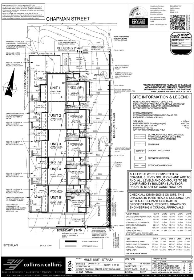
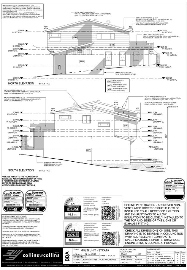
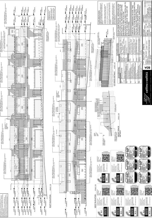
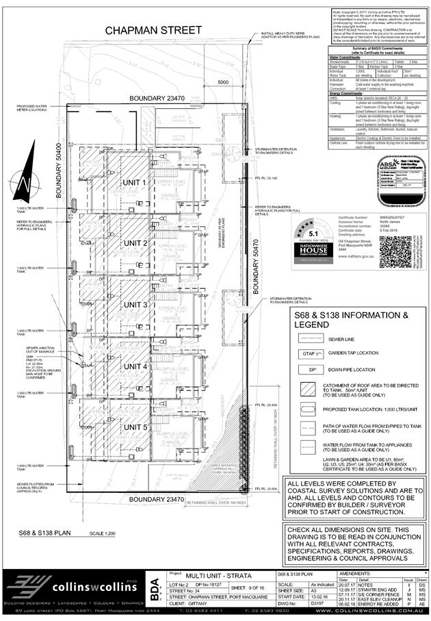
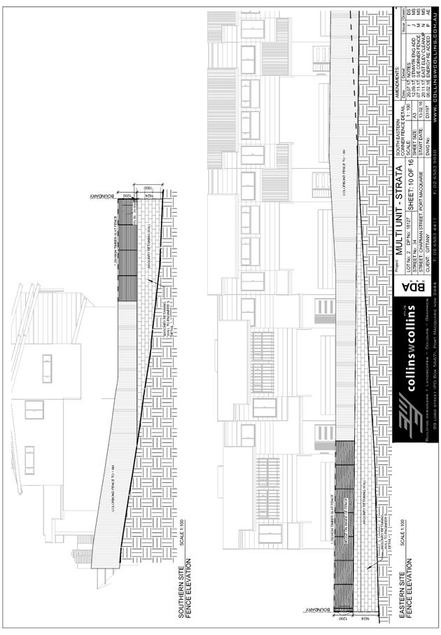
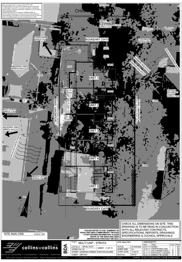
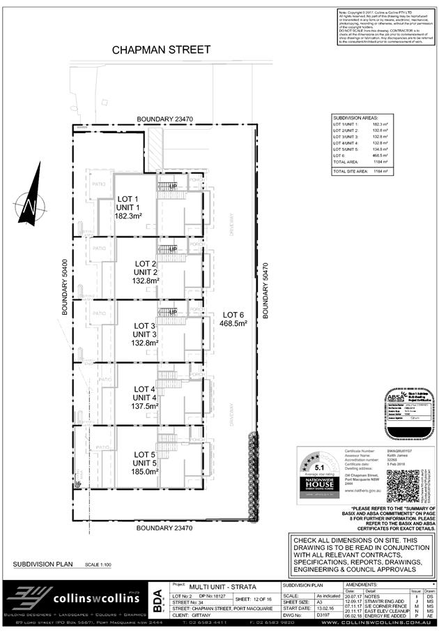
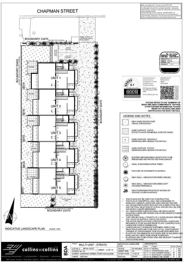
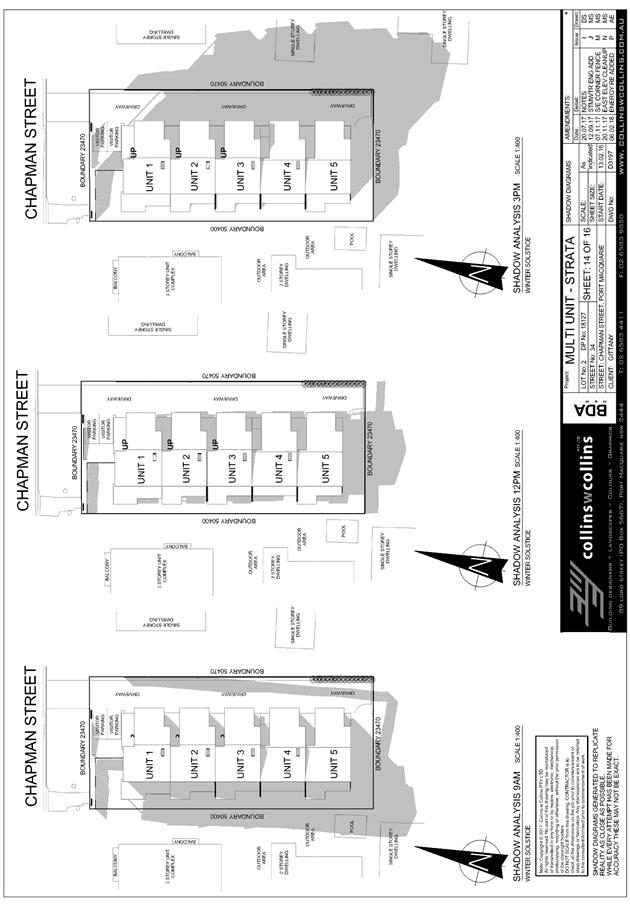
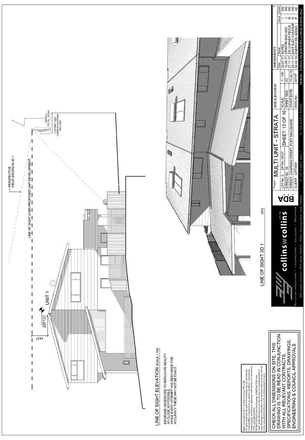
|
ATTACHMENT
|
Development Assessment Panel
14/02/2018
|
|
ATTACHMENT
|
Development Assessment Panel
14/02/2018
|
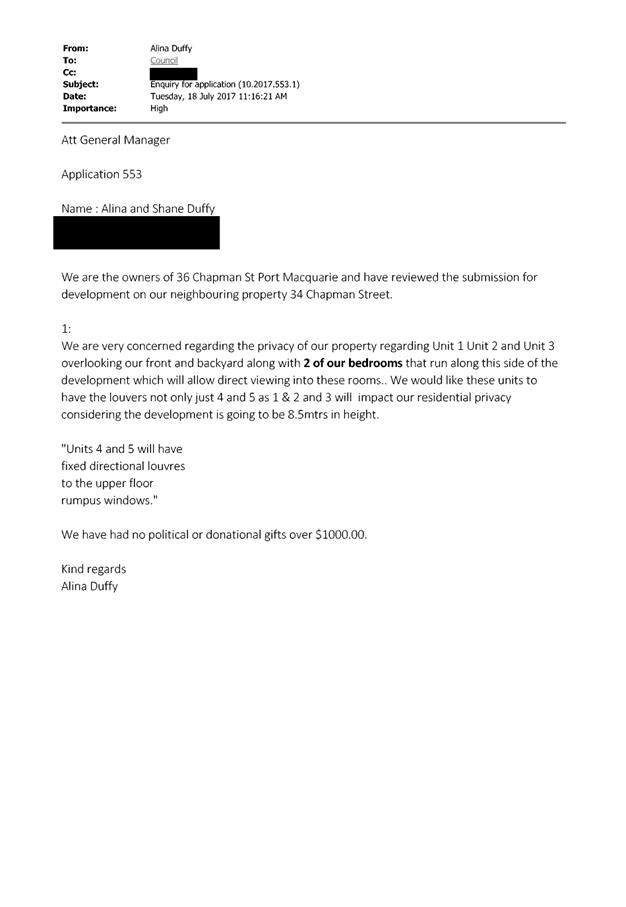
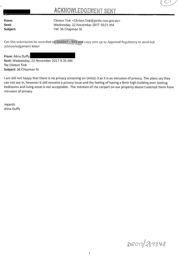
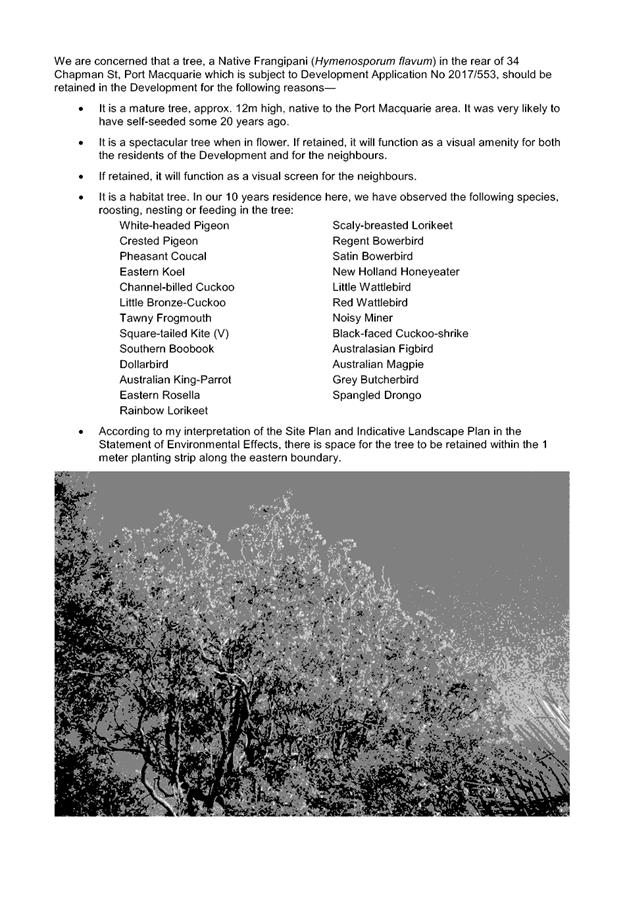
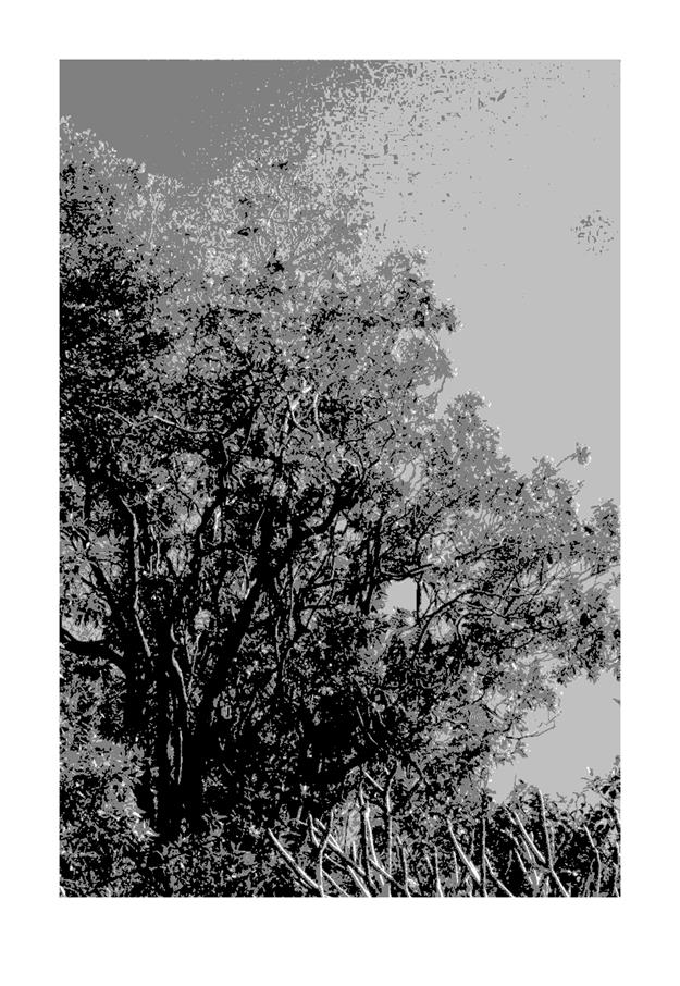
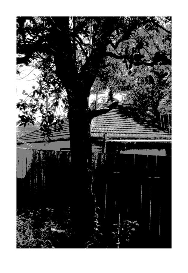
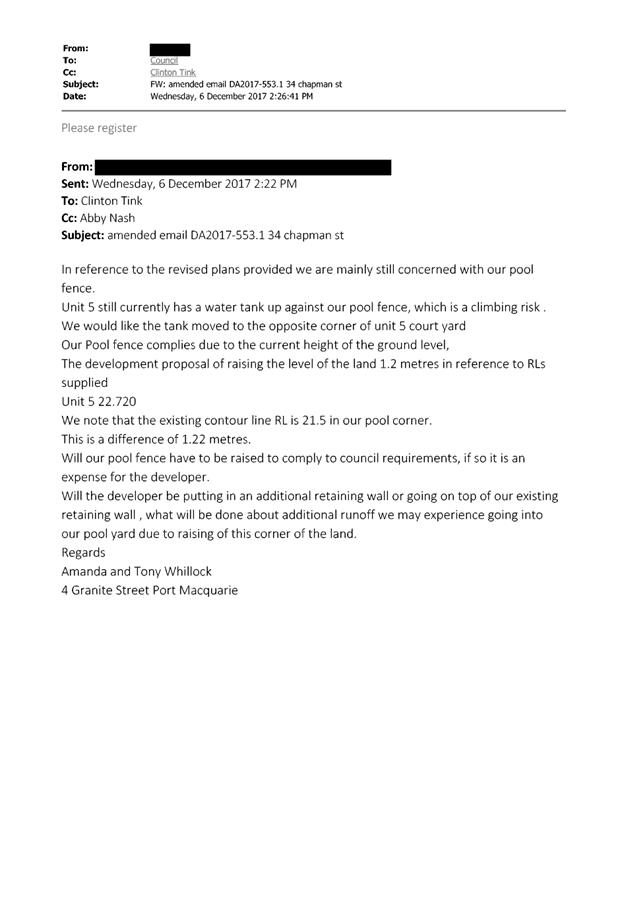
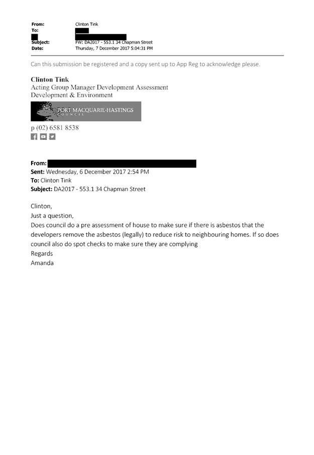
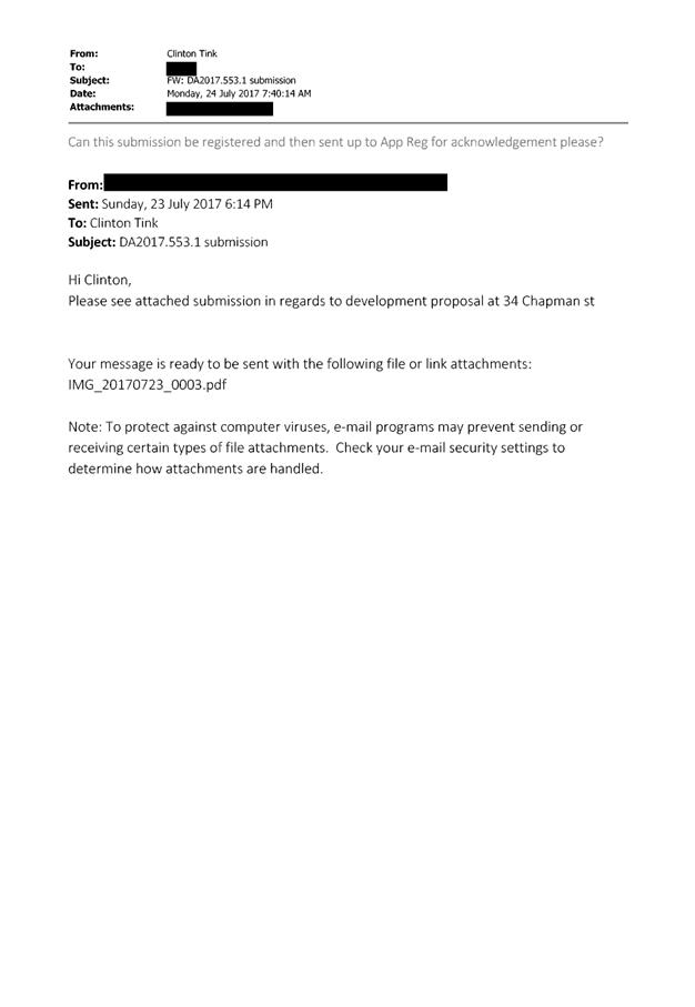
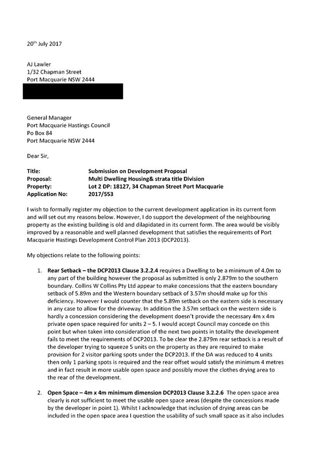
AGENDA Development Assessment Panel 14/02/2018
Item: 07
Subject: DA 2017 - 914.1 Additions To Dwelling - Lot 111, DP 246248,
No. 14 Hibbard Drive, Port Macquarie
Report Author: Keith Smith
|
Applicant: Collins
w Collins
Owner: CJ
Morton & JA Morton
Estimated Cost: $49,992
Alignment with Delivery Program
4.3.1 Undertake transparent and
efficient development assessment in accordance with relevant legislation.
|
|
RECOMMENDATION
That
DA 2017 – 914.1 for additions
to dwelling at Lot 111, DP 246248, No. 14 Hibbard Drive, Port
Macquarie, be determined by granting consent
subject to the recommended conditions.
|
Executive
Summary
This report
considers a development application for additions to a dwelling at the subject site and provides an assessment of the
application in accordance with the Environmental Planning and Assessment Act
1979.
Following exhibition of the
application, one submission was received.
1. BACKGROUND
Existing sites features and Surrounding development
The site has an area of 758.5m².
The site is zoned R1 General Residential in accordance with the Port Macquarie-Hastings Local
Environmental Plan 2011, as shown in the following zoning plan:
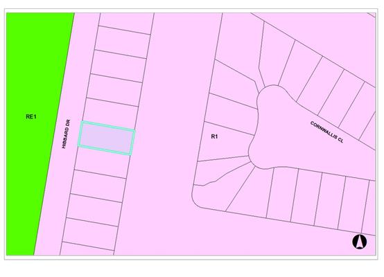
The existing subdivision pattern and location of existing
development within the locality is shown in the following aerial photograph:
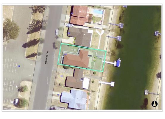
2. DESCRIPTION OF
DEVELOPMENT
Key aspects of the proposal include the following:
· Construction
of a single storey addition to the rear of the existing dwelling
Refer
to attachments at the end of this report.
Application Chronology
· 13
October 2017 - Application Lodged.
· 3
November 2017 –Site and views from applicants property at 14 Hibbard
Drive inspected by Assessing Officer.
· 9
November 2017 – Additional information requested by Assessing Officer.
· 15
November 2017 – Revised plans submitted by Applicant.(dated 15/11/18)
· 21 November 2017 to 04 December 2017 – Neighbour
notification of the proposal.
· 4 December 2017 – One submission received.
· 14 December 2017 – Applicant requested a copy of the
submission.
· 15 December 2017- Redacted copy of submission sent to
applicant via email.
· 15 January 2018 – Request from author of submission
to discuss proposal from 12 Hibbard Drive.
· 17 January 2018 – Assessing Officer viewed proposal
from 12 Hibbard Drive
3. STATUTORY ASSESSMENT
STATUTORY
REQUIREMENTS
Section
79C (1) Matters for Consideration
In determining the application, Council is
required to take into consideration the following matters as are relevant to
the development that apply to the land to which the development application
relates:
(a)The provisions (where
applicable) of:
(i) Any environmental
planning instrument
State Environmental Planning Policy No. 44 - Koala Habitat
Protection
There is no Koala Plan of
Management on the site. Additionally, the site is less than 1ha in area. Therefore
no further investigations are required.
State Environmental Planning Policy
No.55 – Remediation of Land
Following an inspection of the site and a search of Council
records, the subject land is not identified as being potentially contaminated
and is suitable for the intended use.
State Environmental Planning
Policy No. 62 – Sustainable Aquaculture
Given the nature of the proposed
development and proposed stormwater controls the proposal will be unlikely to
have any adverse impact on existing aquaculture industries.
State Environmental Planning
Policy No. 71 – Coastal Protection and Clause 5.5 of Port
Macquarie-Hastings Local Environmental Plan 2011
The site is located within a
coastal zone as defined in accordance with clause 4 of SEPP 71.
In accordance with clause 5, this
SEPP prevails over the Port Macquarie-Hastings LEP 2011 in the event of any
inconsistency.
Having regard to clauses 8 and 12
to 16 of SEPP 71 and clause 5.5 of Hastings LEP 2011 inclusive the proposed
development will not result in any of the following:
a) any
restricted access (or opportunities for access) to the coastal foreshore
b) any
identifiable adverse amenity impacts along the coastal foreshore and on the
scenic qualities of the coast;
c) any
identifiable adverse impacts on any known flora and fauna (or their natural
environment);
d) subject to
any identifiable adverse coastal processes or hazards;
e) any
identifiable conflict between water and land based users of the area;
f) any
identifiable adverse impacts on any items of archaeological/heritage;
g) reduce the
quality of the natural water bodies in the locality.
The site is is located within an area zoned for residential
purposes.
Port
Macquarie-Hastings Local Environmental Plan 2011
The proposal is consistent with the LEP having regard to the
following:
· Clause
2.2, the subject site is zoned R1 General Residential. In accordance with
clause 2.3(1) and the R1 zone landuse table, the additions to a dwelling is a
permissible landuse with consent.
The objectives of the R1 zone are
as follows:
o To
provide for the housing needs of the community.
o To
provide for a variety of housing types and densities.
o To enable other
land uses that provide facilities or services to meet the day to day needs of
residents.
In accordance with Clause 2.3(2),
the proposal is consistent with the zone objectives as it is a permissible
landuse and consistent with the established residential locality.
· Clause
4.3, the maximum overall height of the building above ground level (existing)
is 5.725m which complies with the standard height limit of 8.5m applying to the
site.
· Clause
5.9, no listed trees in Development Control Plan 2013 are proposed to be
removed.
· Clause
5.10, the site does not contain or adjoin any known heritage items or sites of
significance.
· Clause
7.1, the site is mapped as potentially containing class 1 & 3 acid sulfate
soils. The proposed development includes an alfresco and deck area with minimal
excavation extending below the existing surface level proposed. Therefore no
adverse impacts are expected to occur to the acid sulphate soils found on site.
· Clause
7.3, the site is land within a mapped “flood planning area” (Land
subject to flood discharge of 1:100 annual recurrence interval flood event
(plus the applicable climate change allowance and relevant freeboard) In this
regard the following comments are provided which incorporate consideration of
the objectives of Clause 7.3, Council’s Flood Policy (2015); the NSW
Government’s Flood Prone Lands Policy and the NSW
Government’s Floodplain Development Manual (2005):
o The
proposal is compatible with the flood hazard of the land taking into account
projected changes as a result of climate change;
o The
proposal will not result in a significant adverse effect on flood behaviour
that would result in detrimental increases in the potential flood affectation
of other development or properties;
o The
proposal is not likely to significantly adversely affect the environment or
cause avoidable erosion, siltation, destruction of riparian vegetation or a
reduction in the stability of river banks or watercourses;
o The
proposal is not likely to result in unsustainable social and economic costs to
the community as a consequence of flooding;
· Clause
7.13, satisfactory arrangements are in place for provision of essential
services.
(a)(ii) Any proposed
instrument that is or has been placed on exhibition
No draft instruments relevant to
the proposal.
(a)(iii) Any DCP in force
Port Macquarie-Hastings Development Control Plan 2013:
|
DCP 2013: Dwellings, Dual
occupancies, Dwelling houses, Multi dwelling houses & Ancillary
development
|
|
|
Requirements
|
Proposed
|
Complies
|
|
3.2.2.4
|
4m min. rear setback. Variation
subject to site analysis and provision of private open space
|
The rear setback requirements in
DCP 2013 of 4m are complied with.
NB The 7.5m setback in the 88B
instrument is also complied with.
|
Yes
Yes
|
|
3.2.2.5
|
Side setbacks:
• Ground floor =
min. 0.9m
|
The minimum side setback
requirements are complied with.
2.820m to northern boundary.
1.7m to southern boundary.
|
Yes
|
|
3.2.2.6
|
35m² min. private open space
area including a useable 4x4m min. area which has 5% max. grade
|
The dwelling contains 35m²
open space in one area including a useable 4m x 4m space.
|
Yes
|
|
3.2.2.7
|
Front fences:
• If solid 1.2m
max height and front setback 1.0m with landscaping
• 3x3m min. splay
for corner sites
• Fences >1.2m
to be 1.8m max. height for 50% or 6.0m max. length of street frontage with
25% openings
• 0.9x0.9m splays
adjoining driveway entrances
|
No fences proposed
|
N/A
|
|
3.2.2.10
|
Privacy:
• Privacy screens
provided to balconies/verandahs etc which have <3m side/rear setback and
floor level height >1m
|
NB Deck height 1m and less than 3m from the northern
boundary at 2.820m.
Deck height 1m and less than 3m from southern boundary at
1.7m
The proposal indicates a full height wall along the
southern end of the Alfresco area.
The deck being 1m or less above existing ground level does
not require a privacy screen or a full height wall.
|
NA
|
|
DCP 2013: General
Provisions
|
|
|
Requirements
|
Proposed
|
Complies
|
|
2.7.2.2
|
Design addresses generic principles of Crime Prevention
Through Environmental Design guideline
|
No concealment or entrapment areas proposed. Adequate
casual surveillance available.
|
Yes
|
|
2.3.3.1
|
Cut and fill 1.0m max. 1m outside the perimeter of the
external building walls
|
NA
|
NA
|
|
2.3.3.2
|
1m max. height retaining walls along road frontage
|
None proposed
|
N/A
|
|
Any retaining wall >1.0 in height to be certified by
structure engineer
|
No retaining wall likely
|
Yes
|
|
Combination of retaining wall and front fence height max
1.8m, max length 6.0m or 30% of frontage, fence component 25% transparent,
and splay at corners and adjacent to driveway
|
No retaining wall front fence combination proposed.
|
N/A
|
|
2.5.3.3
|
Parking in accordance with Table 2.5.1.
1 space per single dwelling (behind building line)
|
1 or capacity for more than 1 parking space behind the
building line has been provided for - existing.
|
Yes
|
|
2.5.3.14
|
Sealed driveway surfaces unless justified
|
Sealed driveway existing
|
NA
|
|
2.5.3.15 and 2.5.3.16
|
Driveway grades first 6m or ‘parking area’
shall be 5% grade with transitions of 2m length
|
NA - existing
|
NA
|
|
2.5.3.17
|
Parking areas to be designed to avoid concentrations of
water runoff on the surface.
|
Single dwelling only with 1 domestic driveway. existing
|
NA
|
(a)(iii)(a)
Any planning agreement or draft planning agreement
No planning
agreement has been offered or entered into relating to the site.
(a)(iv)
Any matters prescribed by the regulations
NSW Coastal
Policy 1997
The proposed
development is consistent with the objectives and strategic actions of this
policy.
Demolition of
buildings AS 2601 – Clause 66 (b)
Demolition of the existing building
on the site is capable of compliance with this Australian Standard and is
recommended to be conditioned.
(a)(v) Any Coastal Zone
Management Plan
None applicable.
(b) The likely impacts
of that development, including environmental impacts on both the natural and
built environments and the social and economic impacts in the locality
Context and setting
· The site has a
general westerly street frontage orientation to Hibbard Drive.
· Single storey
dwellings adjoin the site to the north and south. The proposal will be unlikely
to have any adverse impacts to existing adjoining properties and satisfactorily
addresses the public domain.
· The proposal is
considered to be compatible with other residential development in the locality
and adequately addresses planning controls for the area.
· The proposal does
not have significant adverse lighting impacts.
· There are no
significant adverse privacy impacts. Privacy has been adequately addressed
through building design.
· The proposal does
not prevent adjoining properties from receiving 3 hours of sunlight to private
open space and primary living areas on 21 June.
View
Sharing
The public
exhibition of the proposal resulted in concerns being raised in relation to
loss of views from the neighbouring property to the south at No. 12 Hibbard
Drive.
The notion of
view sharing is invoked when a property enjoys existing views and a proposed
development would share that view by taking some of it away for its own
enjoyment. Taking it all away cannot be called view sharing, although it may,
in some circumstances, be quite reasonable.
Using the
planning principles of NSW Land and Environment Court in Tenacity Consulting
v Warringah 2004 NSW LEC 140, the following comments are provided in regard
to the view impacts using the 4 step process to establish whether the view
sharing is acceptable.
Step 1
Assessment
of views to be affected. Water views are valued more highly than land views.
Iconic views (e.g. of the Opera House, the Harbour Bridge or North Head) are
valued more highly than views without icons. Whole views are valued more highly
than partial views, e.g. a water view in which the interface between land and
water is visible is more valuable than one in which it is obscured.
Comments: No.
12 Hibbard Drive enjoys drainage canal views across the rear of the developed
property to the north of 14 Hibbard Drive. The views include the interface of
land and water. Views of the drainage canals are not considered to be iconic in
the local context.
Step 2
Consider
from what part of the property the views are obtained. For example the
protection of views across side boundaries is more difficult than the
protection of views from front and rear boundaries. In addition, whether the
view is enjoyed from a standing or sitting position may also be relevant.
Sitting views are more difficult to protect than standing views. The
expectation to retain side views and sitting views is often unrealistic.
Comments: The
existing views from No. 12 Hibbard Drive are obtained from both sitting and
standing positions on the rear patio and ground floor including kitchen and
dining areas of the existing single storey dwelling. The affected views are
obtained across the side property boundary. It is considered unrealistic to
fully retain existing views across the side boundary in this instance.
Step 3
Assess the
extent of the impact. This should be done for the whole of the property, not
just for the view that is affected. The impact on views from living areas is
more significant than from bedrooms or service areas (though views from
kitchens are highly valued because people spend so much time in them). The
impact may be assessed quantitatively, but in many cases this can be
meaningless. For example, it is unhelpful to say that the view loss is 20% if
it includes one of the sails of the Opera House. It is usually more useful to
assess the view loss qualitatively as negligible, minor, moderate, severe or
devastating.
Comments:
Photographs from the objector are included in the submission attached to this
report showing the extent of impact on existing views from the affected property.
The impact on views is summarised as follows from the relevant locations at No.
12 Hibbard Drive:
· Rear
patio - Main water view of drainage canal to the north-east partial loss. Water
views to the south and south-east retained.
· Rear
Patio – Main water view to Hastings River lost.
· Ground
floor area including kitchen and dining areas of existing dwelling - partial
water view lost to north-east.
Overall, the view loss is considered to be minor.
The majority
of views from the ground floor of the existing dwelling and patio areas are
expected to be retained from both sitting and standing positions
Partial views
to the north-east from the ground floor of the existing single storey dwelling
and patio area as well as private open space on 12 Hibbard Drive are expected
to be lost from both sitting and standing positions where the wall and roof of
proposed addition extends beyond the existing rear wall of the dwelling on 14
Hibbard Drive. Current views to the east and south east will be retained from a
sitting and/or standing position.
Step 4
Assess the
reasonableness of the proposal that is causing the impact. A development that complies
with all planning controls would be considered more reasonable than one that
breaches them. Where an impact on views arises as a result of non-compliance
with one or more planning controls, even a moderate impact may be considered
unreasonable. With a complying proposal, the question should be asked whether a
more skilful design could provide the applicant with the same development
potential and amenity and reduce the impact on the views of neighbours. If the
answer to that question is no, then the view impact of a complying development
would probably be considered acceptable and the view sharing reasonable.
Comments: The
proposal complies with the relevant planning controls for building height in
the LEP 8.5m and complies with building setback controls in the DCP 2013 of 4m.
The design of
the building has been amended to comply with the 88B requirements of 7.5m to
the rear boundary in lieu of the DCP 2013 requirement of 4m. The additions are
single storey and the design incorporates privacy requirements above those
required in the DCP. The proposed additions minimise the extent of view loss
from adjoining property.
Overall, the
proposed development is considered to be reasonable having regard to the
planning controls and the view sharing acceptable.
The following
photos are from the objector’s perspective.
Views to the
north
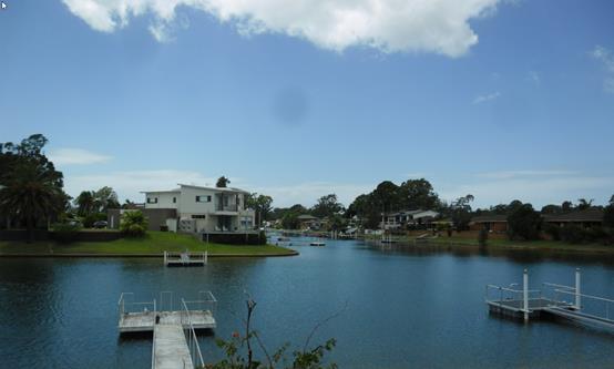
Views to the
east
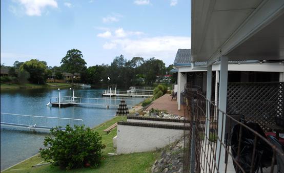
Views to the
south
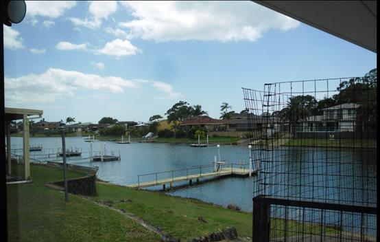
View to the
north-east
Access, transport and traffic
The traffic associated with the development is unlikely to
have any adverse impacts to the existing road network within the immediate
locality.
Stormwater
Service available – details required with S.68
application. Refer to relevant conditions of consent.
Other Utilities
Telecommunication and electricity services are available to
the site.
Heritage
This site does not contain or adjoin any known heritage item
or site of significance.
Other land resources
No adverse impacts anticipated. The site is within an
established urban context and will not sterilise any significant mineral or
agricultural resource.
Water cycle
The proposed development will be unlikely to have any
adverse impacts on water resources and the water cycle.
Soils
The proposed development will be unlikely to have any
adverse impacts on soils in terms of quality, erosion, stability and/or
productivity subject to a standard condition requiring erosion and sediment
controls to be in place prior to and during construction.
Air and microclimate
The construction and/or operations of the proposed
development will be unlikely to result in any adverse impacts on the existing
air quality or result in any pollution.
Flora and fauna
Construction of the proposed development will not require
any removal/clearing of any significant vegetation and therefore will be
unlikely to have any significant adverse impacts on biodiversity or threatened
species of flora and fauna.
Waste
Satisfactory arrangements are in place for proposed storage
and collection of waste and recyclables. No adverse impacts anticipated.
Noise and vibration
No adverse impacts anticipated. Condition recommended to
restrict construction to standard construction hours.
Bushfire
The site is not identified as being bushfire prone.
Safety, security and crime prevention
The proposed development will be unlikely to create any
concealment/entrapment areas or crime spots that would result in any
identifiable loss of safety or reduction of security in the immediate area.
Social impacts in the locality
Given the nature of the proposed development and its’
location the proposal is unlikely to result in any adverse social impacts.
Economic impact in the locality
No adverse impacts. Likely positive impacts can be
attributed to the construction of the development and associated flow on
effects (ie maintained employment and expenditure in the area).
Site design and internal design
The proposed development design satisfactorily responds to
the site attributes and will fit into the locality. No adverse impacts likely.
Construction
No potential adverse impacts identified to neighbouring
properties with the construction of the proposal.
Cumulative impacts
The proposed development is not expected to have any adverse
cumulative impacts on the natural or built environment or the social and
economic attributes of the locality.
(c) The suitability of the
site for the development
The proposal will fit into the
locality and the site attributes are conducive to the proposed development.
Site constraints of flooding have
been adequately addressed and appropriate conditions of consent recommended.
(d) Any submissions made in
accordance with this Act or the regulations
One written submission has been
received following public exhibition of the application.
Key issues raised in the submission
received and comments in response to these issues are provided as follows:
|
Submission
Issue/Summary
|
Planning
Comment/Response
|
|
Loss of Views from 12 Hibbard
Drive.
|
See comments earlier in this
report under ‘View Sharing’.
The proposed development is
considered to be reasonable having regard to the applicable planning
principle.
|
|
Development out of character with the surrounding area.
|
The proposal is considered to be consistent with other
residential development in the locality and adequately addresses planning controls
for the area.
|
|
Development visually prominent
|
The proposed development is single storey and satisfies
the height requirement for the property.
The proposal satisfies the requirements of the 88B
instrument setback from the rear boundary and satisfies the DCP 2013
requirement setback from the rear boundary.
|
|
Environmental impacts from a wood fireplace with flue.
|
Provision under the requirements of the POEO Act 1997
exist for action in the event of non-compliance with emission requirements.
|
|
Access and Social impacts side boundary fencing plans
contrary to existing site conditions.
|
Dividing fences are not part of the planning
considerations for this application and are covered under the Dividing Fences
Act 1991.
|
|
No consultation between owners of 14 Hibbard Drive and
objector to the proposal.
|
There is no requirement for the applicant to discuss the
proposal with the objector.
|
(e) The Public Interest:
The proposed
development satisfies relevant planning controls and is unlikely to impact on
the wider public interest.
4. DEVELOPMENT
CONTRIBUTIONS APPLICABLE
Not applicable
5. CONCLUSION
The application has been assessed in accordance with
Section 79C of the Environmental Planning and Assessment Act 1979.
Issues raised during assessment and public exhibition of
the application have been considered in the assessment of the application.
Where relevant, conditions have been recommended to manage the impacts
attributed to these issues.
The site is suitable for the proposed development, is not
contrary to the public's interest and will not have a significant adverse
social, environmental or economic impact. It is recommended that the
application be approved, subject to the recommended conditions of consent
provided in the attachment section of this report.
|
Attachments
1View. DA2017
- 914.1 DA Plans
2View. DA2017
- 914.1 Line of sight and setbacks to canal development
3View. DA2017
- 914.1 Recommended conditions
4View. DA2017
- 914.1 Submission - Patterson
|
|
ATTACHMENT
|
Development Assessment Panel
14/02/2018
|
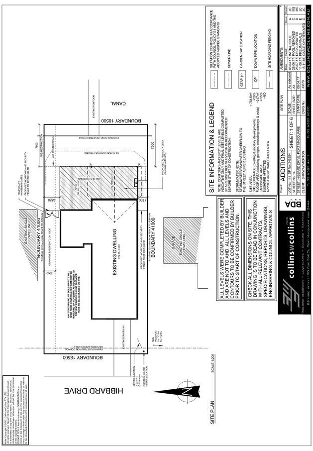
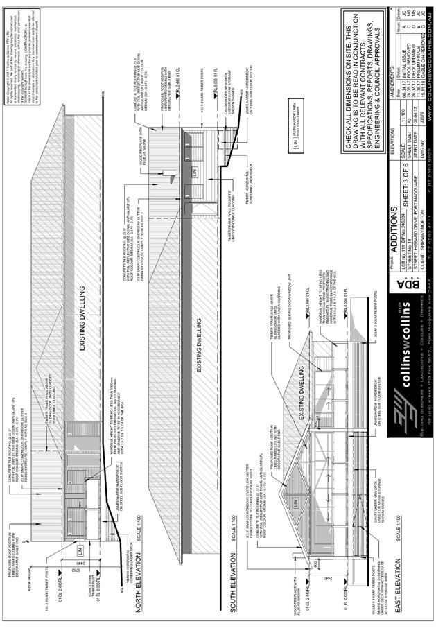

|
ATTACHMENT
|
Development Assessment Panel
14/02/2018
|
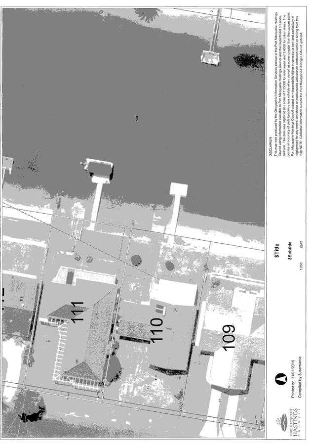
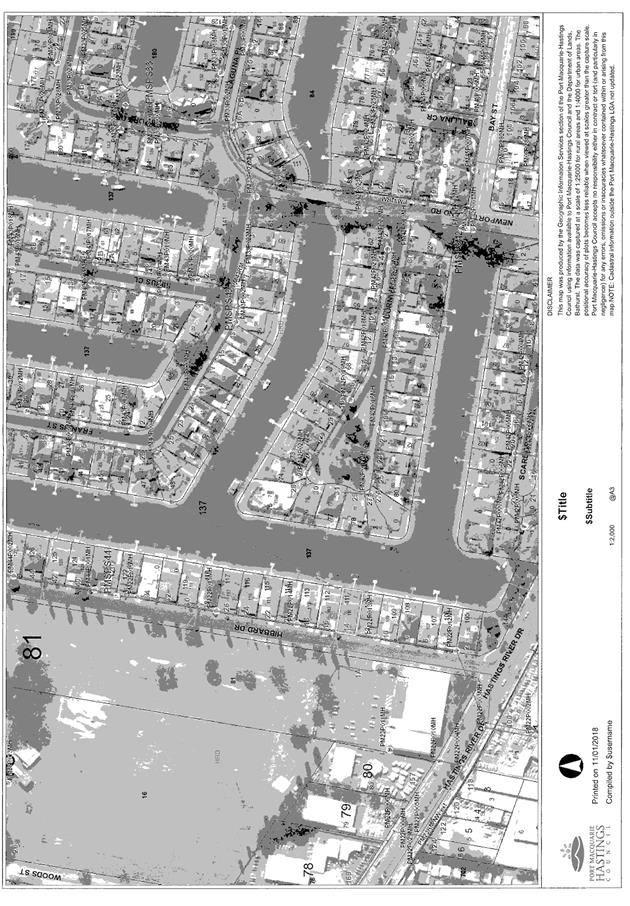
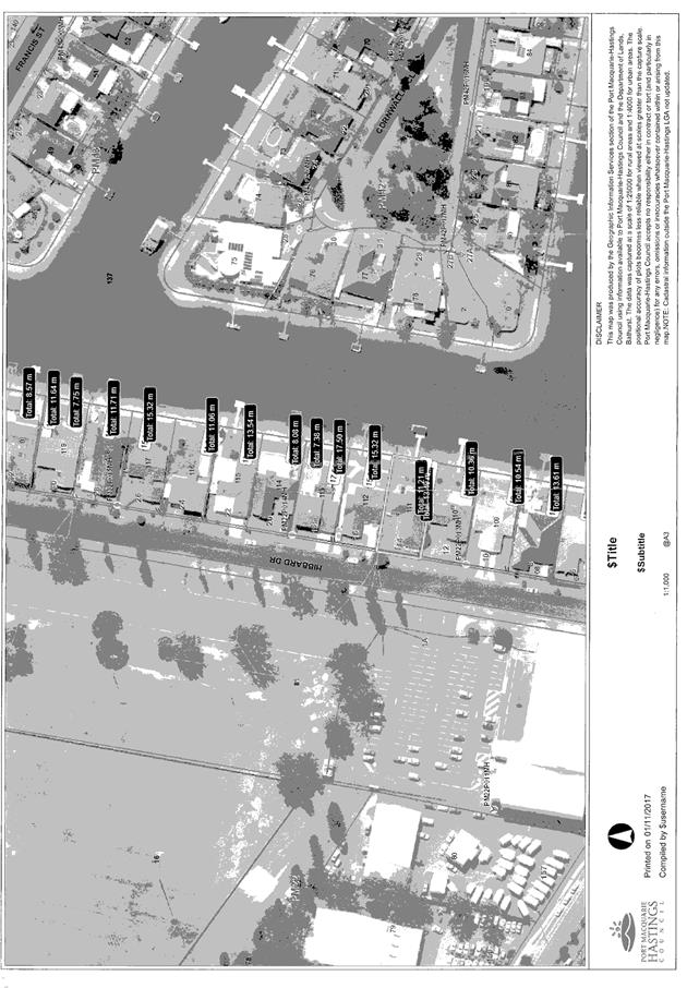
|
ATTACHMENT
|
Development Assessment Panel
14/02/2018
|
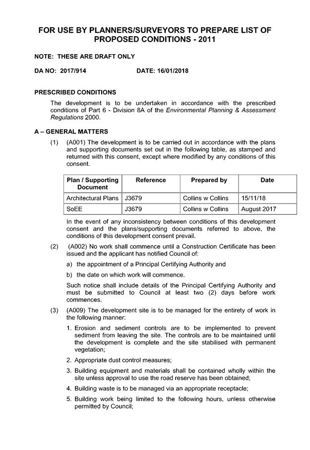

|
ATTACHMENT
|
Development Assessment Panel
14/02/2018
|
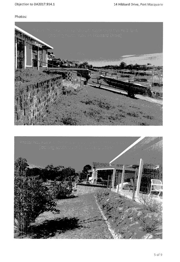
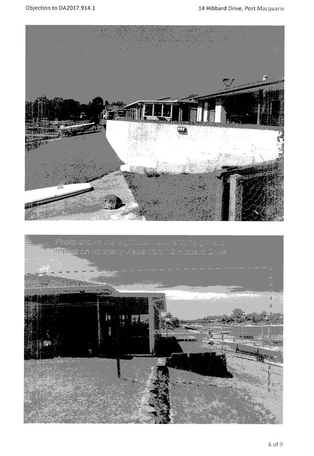
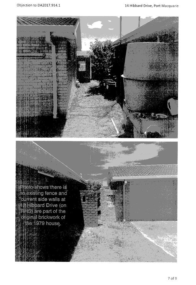
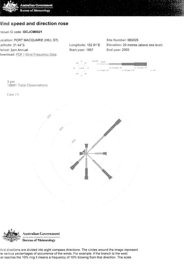
AGENDA Development Assessment Panel 14/02/2018
Item: 08
Subject: DA2017 - 529.1 Alterations To Caravan Park -
Lot 2 DP 598227, Bell Street, Dunbogan
Report
Author: Chris Gardiner
|
Applicant: Land
Dynamics Australia
Owner: Ritchie
Village Property Pty Ltd
Estimated Cost: Nil
Alignment with Delivery
Program
4.3.1 Undertake transparent
and efficient development assessment in accordance with relevant legislation.
|
|
RECOMMENDATION
That
DA2017 – 529.1 for Alterations
to Caravan Park at Lot 2, DP 598227, Bell
Street, Dunbogan, be determined by granting consent subject to the
recommended conditions.
|
Executive
Summary
This
report considers a development application for alterations to a caravan park
at the subject site and provides an assessment of the
application in accordance with the Environmental Planning and Assessment Act
1979.
Following exhibition of the
application, 25 submissions have been
received.
1. BACKGROUND
Existing sites features and surrounding development
The site has an area of 1.649
hectares.
The site is zoned R1 General Residential in accordance with the Port Macquarie-Hastings Local
Environmental Plan 2011, as shown in the following zoning plan:
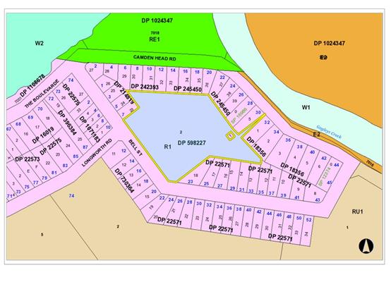
The existing subdivision pattern and location of existing
development within the locality is shown in the following aerial photograph:
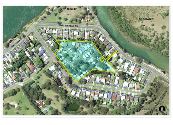
2. DESCRIPTION OF DEVELOPMENT
Key aspects of the proposal include the following:
· Change
of 45 short-term sites within an existing caravan park to long-term sites.
Refer
to attachments at the end of this report.
Application Chronology
· 22
June 2017 – Application lodged.
· 7 July 2017 to 20 July 2017 – Application notified to
neighbours.
· 10 August 2017 – Additional information requested
from Applicant.
· 18 October 2017 and 7 November 2017 – Additional
information submitted by Applicant.
· 17 November 2017 to 30 November 2017 – Application
re-notified with additional information.
3. STATUTORY ASSESSMENT
Section 79C(1) Matters for Consideration
In determining the application, Council is required to take
into consideration the following matters as are relevant to the development
that apply to the land to which the development application relates:
(a) The provisions (where
applicable) of:
(i) any Environmental
Planning Instrument:
State
Environmental Planning Policy No. 21 - Caravan Parks
8 Development
consent required for caravan parks
(1)
Development for the purposes of a caravan park may be carried out only with the
development consent of the Council.
(2)
Before granting development consent to the use of land for the purposes of a
caravan park, a Council must determine:
(a) the
number of sites (if any) within that land that the Council considers are
suitable for long-term residence, within the meaning of the Local Government
(Caravan Parks and Camping Grounds) Transitional Regulation 1993, and
(b) the
number of sites (if any) within that land that the Council considers are not
suitable for long-term residence, but are suitable for short-term residence,
within the meaning of that Regulation.
(3)
A Council must not grant development consent to the use of land for the
purposes of a caravan park unless it imposes as a condition of that consent a
condition specifying the maximum number of sites (if any) within that land that
may be used for long-term residence.
(4)
The holder of an approval under Part 1 of Chapter 7 of the Local Government Act 1993 to operate a caravan park
or camping ground on land must not, without the development consent of the
Council, allow a person to occupy a site within that land:
(a) for
a continuous period of more than 3 months, except as provided by paragraph (b),
or
(b) for
a continuous period longer than the period (if any) for which the person is
allowed to be accommodated within the land by an extension that has been
granted under clause 19 (6) of the Local Government (Caravan Parks and Camping
Grounds) Transitional Regulation 1993, if such a use of that site was not
lawful under the Environmental Planning and Assessment Act 1979 when
this Policy commenced.
(4A)
Except as provided by subclause (4), nothing in this Policy or any other
environmental planning instrument requires separate development consent to be
obtained for the installation or placement of a moveable dwelling on land on
which development for the purposes of a caravan park is being lawfully carried
out.
(5)
This clause does not apply to any land that is authorised to be used for the
purposes of a manufactured home estate by a development consent granted
pursuant to State Environmental Planning Policy No 36—Manufactured
Home Estates or dedicated or reserved under the National Parks and Wildlife Act 1974.
The proposal
seeks consent for 79 long-term sites and no short-term sites. The sites have
been demonstrated to be suitable for long-term residence and a condition of
consent is recommended specifying the maximum number of long term sites.
10 Matters
to be considered by Councils
A Council
may grant a development consent required by this Policy only after it has
considered the following:
(a) whether,
because of its location or character, the land concerned is particularly
suitable for use as a caravan park for tourists or for long-term residence,
Comment: The
land concerned is already used as a caravan park for tourists and for long-term
residence and has generally been acceptable for both uses during its history.
The land is located within a residential area and long-term residence is
considered to be more compatible with surrounding land uses than short-term
tourist accommodation.
(b) whether
there is adequate provision for tourist accommodation in the locality of that
land, and whether existing or potential tourist accommodation will be displaced
by the use of sites for long-term residence,
Comment: The
Camden Haven area has a range of caravan parks and motel/cabin style
accommodation including:
· Diamond
Waters Caravan Park
· The
Haven Caravan Park
· Laurieton
Gardens Caravan Resort
· Brigadoon
Holiday Park
· Haven
Waters Motel & Apartments
· North
Coast Holiday Parks – North Haven
· Gateway
Lifestyle Jacaranda
· Diamond
Head Camping Ground
A number of
the dwellings in the area are also offered for holiday accommodation through
web-based companies such as Stayz and AirBnB.
There would
be some loss of existing and potential tourist accommodation within the park
itself with the proposed change of short-term sites to long-term sites. The
Applicant has indicated that the change to long-term sites is likely to be
transitional over a period of approximately 10 years. The current Section 68
approval to operate with 45 short-term sites runs until 2022.
(c) whether
there is adequate low-cost housing, or land available for low-cost housing, in
that locality,
Comment: The
Applicant has demonstrated that that housing and land currently available for
purchase or rent in the Dunbogan/Camden Head area could not be considered
affordable/low-cost having regard to the ABS data on average weekly income in
the statistical area. More broadly, there is low-cost housing available within
the caravan parks noted in (b) above.
(d) whether
necessary community facilities and services are available within the caravan
park to which the development application relates or in the locality (or both),
and whether those facilities and services are reasonably accessible to the
occupants of the caravan park,
Comment:
Dunbogan Caravan Park has a swimming pool, amenities and laundry block, a small
BBQ area and playground equipment for residents.
Limited local
services are available in the Dunbogan area, but there is a public transport
service running weekdays on Camden Head Road that provides access to Laurieton
and the wider Camden Haven where services including the following are
available.
· Supermarkets,
chemists, and a range of specialty shops;
· Clubs
and a men’s shed;
· An
array of recreational activities;
· Local
doctors and dentists;
· Community
facilities including a library;
· Several
courtesy buses.
A connecting
public transport service is also available to Port Macquarie, where higher
order services are available.
(e) any
relevant guidelines issued by the Director, and
Comment: No
relevant guidelines have been issued.
(f) the
provisions of the Local Government (Caravan Parks and Camping Grounds)
Transitional Regulation 1993.
Comment: The
below table considers the applicable provisions of the Local Government
(Manufactured Home Estates, Caravan Parks, Camping Grounds and Moveable
Dwellings) Regulation 2005.
|
CLAUSE
|
REQUIREMENT
|
COMMENT/COMPLIANCE
|
|
Part 3, Division 1
Operation of caravan parks and camping grounds
|
|
71 Factors for consideration before approval is granted
|
(1) Council must be satisfied that the estate will be
designed in accordance with Division 3; and
(2) Council must have regard to the Floodplain
Development Manual.
|
(1) Yes- refer to comments on Division 3
(2) Site is flood prone. See comments under clauses 7.3
and 7.4 of LEP.
|
|
72 Matters to be specified in approval
|
Any approval must specify the number, size and location
of the dwelling and camping sites.
|
Section 68 approval to operate will need to specify these
matters.
|
|
73 Conditions of approval
|
The consent must be conditioned to ensure the design,
construction, maintenance and operation of the estate is in accordance with
Division 3.
|
Section 68 approval to operate will need to specify these
matters.
|
|
Part 3, Division 3 Caravan parks and camping grounds
|
|
83 Minimum size of caravan park or camping ground
|
Estate must have an area of not less than 1 hectare.
|
Complies - site has an area of 1.683 hectares.
|
|
84 Community amenities
|
Minimum 10% of site area to be reserved for recreation
and other communal activities
|
Complies - more than 10% of site area available for
recreation and communal activities.
|
|
85 Size of dwelling sites and camp sites
|
(1) A long-term site must have an area of at least
80 square metres.
(2) A short-term site must have an area of at least
65 square metres.
(3) A camp site must have an area of at least:
(a) 40 square metres, in the case of a camp
site for which a separate parking space is provided within 30 metres of the
camp site, or
(b) 50 square metres, in any other case.
|
Complies – all proposed long-term sites have an
area greater than 80m2.
|
|
86 Site identification
|
Dwelling sites to be identified and site
boundaries delineated.
|
Capable of complying. Would need to be in place prior to
Section 68 approval to operate.
|
|
87 Dwelling sites to have road frontage
|
A dwelling site must have vehicular
access to an access road.
|
All dwelling sites have existing vehicular access to an
access road.
|
|
88 Setbacks of community buildings
|
(1) A community building must not
be located closer than 10 metres to the boundary of a caravan park or camping
ground, or to the boundary of a dwelling site or camp site, unless the
approval for the caravan park or camping ground so allows.
(2) The approval for a caravan
park or camping ground must not allow a lesser distance than 10 metres unless
the council is satisfied that the community building has been or will be
properly screened, fenced, enclosed or otherwise treated.
(3) A community building must not
in any case be located closer than 3 metres to the boundary of a caravan park
or camping ground or 5 metres to the boundary of a dwelling site or camp
site.
|
N/A. No new community buildings proposed.
|
|
89 Setbacks of dwelling sites and camp sites from road
frontages
|
(1) A dwelling site or camp site
must not be located closer than 10 metres to a public road or 3 metres to any
other boundary of the caravan park or camping ground unless the approval for
the caravan park or camping ground so allows.
(2) The approval for a caravan
park or camping ground must not allow a lesser distance unless the council is
satisfied that the dwelling site or camp site has been or will be properly
screened, fenced, enclosed or otherwise treated.
|
Dwelling sites 18, 20, 28, 29, 38, and 40 located up to
front boundary. However, the existing short-term sites are already approved
in this location. Impacts on the streetscape are not considered to be
adverse.
|
|
90 Use of buffer zones
|
Nothing in this Regulation prevents land
within a buffer zone arising from the setbacks required by this Division from
being used:
(a) for community amenities,
access roads, car parking spaces, footpaths or landscaping, or
(b) for any similar purpose
allowed by the approval for the caravan park or camping ground.
|
n/a
|
|
91 Separation distances
|
(1) A moveable dwelling must not
be installed closer to any other moveable dwelling than:
(a) 3 metres, if it is
situated on a long-term site, or
(b) 2.5 metres, if it is
situated on a short-term site or camp site.
(2) This clause does not prohibit
the installation of semi-detached relocatable homes on adjoining dwelling
sites so long as they are separated by construction conforming to the fire
safety and sound insulation provisions relating to class 1 buildings
contained in Section 3.7.1 and 3.8.6 of Volume Two of the Building
Code of Australia.
|
Some existing moveable dwellings on the proposed
long-term sites would not currently comply with the minimum 3m separation
required. However, the Applicant has indicated that existing moveable
dwellings are likely to be removed prior to changing the sites from
short-term sites to long-term sites.
A condition is recommended requiring all proposed
long-term sites to be provided with compliant separation, or fire safety and
sound insulation in accordance with the BCA, prior to the issue of an
approval to operate.
|
|
92 Entrance and exit roads
|
(1) A road that forms an entrance
to or exit from a caravan park or camping ground must be at least 7 metres
wide.
(2) In the case of a divided road,
the width of the sealed portion of the road on either side of the median
strip must be at least 5 metres.
(3) The arrangement for the width
of an entrance or exit road to taper into or meet the width of the sealed
portion of the access roads leading to the entrance or exit must be as
specified in the approval for the caravan park or camping ground.
|
Site has existing approved entrance and exit roads.
|
|
93 Forecourt
|
A caravan park must have a forecourt,
measuring at least 4 metres by 20 metres, to accommodate incoming vehicles.
|
Existing forecourt.
|
|
94 Width of roads
|
(1) The width of an access road
must be:
(a) at least 6 metres for a
two-way access road, and
(b) at least 4 metres for a
one-way access road.
(2) The direction of travel for a
one-way access road must be indicated by means of conspicuous signs.
|
Existing approved internal road network. The proposed
long-term sites do not require a different standard of road to the existing
approved short-term sites.
|
|
95 Speed limits
|
The speed limit applicable to an access
road:
(a) must not exceed 15
kilometres per hour, and
(b) must be indicated by
means of conspicuous signs.
|
Existing speed limit within the caravan park.
|
|
96 Resident parking
|
(1) A caravan park or camping ground must contain
at least one resident parking space for each dwelling site or camp site.
(2) The parking space for a dwelling site or camp
site may be on-site (that is, forming part of the site) or off-site (that is,
not forming part of the site).
(3) An off-site space must be marked (for example,
by means of line marking, marker pegs or similar means) to identify the
particular dwelling site or camp site to which it relates.
(4) An off-site parking space for a dwelling site
or camp site must be situated in the location specified in the approval for
the caravan park or camping ground.
(5) Each off-site parking space is to have, at
minimum, dimensions of:
(a) 5.4 metres by 2.5 metres, in the case of
angle parking, and
(b) 6.1 metres by 2.5 metres, in any other
case.
|
One space is proposed to be retained on each of the
dwelling sites, consistent with the existing arrangements.
|
|
97 Visitor parking
|
(1) A caravan park or camping ground must contain
no fewer visitor parking spaces than the following:
(a) one visitor parking space for each 10 (and
any remaining fraction of 10) long-term sites in the caravan park or camping
ground,
(b) one visitor parking space for each 20 (and
any remaining fraction of 20) short-term sites in the caravan park or camping
ground,
(c) one visitor parking space for each 40 (and
any remaining fraction of 40) camp sites in the caravan park or camping
ground.
(2) The minimum number of visitor parking spaces to
be provided is 4.
|
The proposed change of 45 sites from short-term sites to
long-term sites would require provision of an additional 2 visitor parking
spaces. The additional spaces are shown on plans.
|
|
98 Visitor parking for people with disabilities
|
(1) A caravan park or camping
ground must contain at least one visitor parking space for people with
disabilities.
(2) A caravan park or camping
ground that contains more than 100 sites must contain at least one visitor
parking space for people with disabilities for each 100 sites or fraction of
100 sites.
(3) Such parking is to be provided
in accordance with AS/NZS 2890.1:2004 Parking
facilities—Off street parking.
(4) Visitor parking spaces for
people with disabilities must be clearly identified as such.
(5) Visitor parking spaces
provided under this clause may be counted for the purposes of clause 97.
|
One of the visitor parking spaces has been shown on the
plans as an accessible space.
|
|
99 Road surfaces
|
All access roads, including all passing
and parking bays, must have an all-weather sealed or other surface finish
specified in the approval for the caravan park or camping ground, and must be
adapted to the topography to allow for adequate drainage and to eliminate
excessive grades.
|
Conditions recommended requiring sealed surface for new
parking areas.
|
|
100 Lighting
|
All access roads must be adequately lit
between sunset and sunrise.
|
Existing lighting of roadways. No changes proposed.
|
|
101 Water supply
|
(1) A caravan park or camping
ground:
(a) must be connected to a
mains water supply, or
(b) must be provided with an
alternative water supply service as specified in the approval for the caravan
park or camping ground.
(2) A dwelling site must be
connected to the water supply service for the caravan park or camping ground.
(5) The water supply service must
comply with:
(a) the Plumbing and Drainage Act 2011 and any regulations under that
Act, and
(b) the requirements of any
relevant statutory body.
|
Connection to water service will be required for each
proposed long-term site. Condition recommended requiring connection prior to
the issue of a Section 68 approval to operate.
|
|
102 Sewerage
|
(1) A caravan park or camping
ground:
(a) must be connected to a
main sewer, or
(b) must be provided with an
alternative sewage disposal system as specified in the approval for the
caravan park or camping ground.
(2) A long-term site must be
provided with a connection to the sewage disposal system for the caravan park
or camping ground.
(3) A caravan park or camping
ground that includes any short-term sites or camp sites must be provided with
at least one common soil waste dump point for the disposal of closet waste
from caravan holding tanks and the like. The common soil waste dump point
must be located so as to permit adequate access by caravans and campervans.
(4) A short-term site must be
provided with a disposal point, as specified in the approval, for the
disposal of sullage (that is, domestic waste from baths, basins, showers,
laundries and kitchens, including floor wastes from those sources) from any
moveable dwelling installed on the site. More than one short-term site may be
provided with the same disposal point.
(5) The sewage disposal system
must comply with:
(a) the Plumbing and Drainage Act 2011 and any regulations under that
Act, and
(b) the requirements of any
relevant statutory body.
|
Connection to sewer will be required for each new long
term site. Condition recommended requiring connection prior to the issue of a
Section 68 approval to operate.
|
|
103 Drainage
|
(1) A caravan park or camping
ground must be provided with a stormwater drainage system.
(2) All dwelling sites and camp
sites must be adequately drained.
|
See comments later in this report under Stormwater.
|
|
104 Electricity Supply
|
(1) A dwelling site must be
supplied with electricity from a reticulated electricity service.
(2) In the case of a long-term
site, the electricity must be supplied by means of an electrical circuit
connected to a separate electricity meter.
|
Existing electricity supply. The supply would need to be
demonstrated to be consistent with these requirements prior to the issue of
an approval to operate the caravan park.
|
|
105 Common trenches
|
A common trench may be used for the
installation of services in accordance with guidelines set out in AMCORD.
|
Noted.
|
|
106 Modification of calculations
|
In calculating the facilities to be
provided in accordance with this Subdivision:
(a) 2 camp sites are taken to
be the equivalent of one dwelling site, and
(b) dwelling sites reserved
for use by self-contained moveable dwellings, and dwelling sites provided
with ensuite facilities, are to be disregarded.
|
Noted. See calculations below under clauses 107-109.
|
|
107 Number of showers and toilets to be provided.
|
Facilities to be provided in accordance
with table.
|
N/A. The number of dwelling sites would not be increased
by the proposal.
|
|
108 Facilities for people with disabilities
|
Minimum one facility required. Can be
disregarded if all sites proposed to be designated for self-contained
moveable dwellings.
|
The Statement of Environmental Effects indicates that all
the proposed long-term sites will be designated for self-contained moveable
dwellings. Therefore no facilities required in accordance with the provisions
of Clause 106.
Condition recommended restricting use of proposed new
long-term sites to self-contained moveable dwellings only.
|
|
109 Other facilities
|
(1) All showers and handbasins
required by this Subdivision must be supplied with hot and cold running
water.
(2) A mirror must be provided:
(a) for each handbasin
provided, or
(b) if 2 or more handbasins
are provided together, for each pair of handbasins.
(3) Means for sanitary napkin
disposal must be provided in each communal facility that contains water
closets for female use and, in a facility containing 10 or more water
closets, must be provided at the rate of one for each 10 (or remaining
fraction of 10) water closets.
|
N/A
|
|
110 Construction of shower blocks and toilet blocks
|
(1) Except as otherwise provided
by the approval for the caravan park or camping ground, the shower and toilet
facilities provided for a caravan park or camping ground must be housed in a
shower block or toilet block:
(a) that is constructed of
brick or concrete masonry block, and
(b) that has a non-slip floor
of tile or other impervious material adequately drained to outlets, and
(c) that has smooth, hard,
durable and water-resistant interior finishes, and
(d) that has shower recesses
with tile or other impervious finishes to a height of at least 1.8 metres,
and
(e) that has tile or other
impervious skirtings around water closet cubicle walls, and
(f) that has tile or other
impervious finish around wash basins, and
(g) that has adequate
lighting (both inside and outside) and adequate ventilation at all times, and
(h) that has all its walls,
ceilings and floors, fixtures, fittings and appliances maintained in a clean
and sanitary condition at all times.
(2) Subject to clause 108 (2) and
(3), if male and female shower or toilet facilities are located in the same
building, that building must be divided for separate use by each sex.
(3) Water closets must be provided
in individual cubicles having a minimum floor area of 1.1 square metres and a
minimum width of 0.8 metre.
|
N/A
|
|
111 Proximity of dwelling sites to shower blocks and
toilet blocks
|
(1) A long-term site must not be
situated more than 75 metres (measured in a straight line) from a shower
block or toilet block.
(2) A short-term site or camp site
must not be situated more than 100 metres (measured in a straight line) from
a shower block or toilet block.
(3) This clause does not apply in
respect of dwelling sites reserved for use by self-contained moveable
dwellings and dwelling sites provided with ensuite facilities.
|
N/A. The Statement of Environmental Effects indicates
that all the proposed long-term sites will be designated for self-contained
moveable dwellings. Therefore no facilities required in accordance with the
provisions of Clause 106.
|
|
113 Washing Machines
|
(1) A caravan park or camping
ground must be provided with:
(a) at least one washing
machine for each 25 (and any remaining fraction of 25 greater than 12)
long-term sites, and
(b) at least one washing
machine for each 30 (and any remaining fraction of 30 greater than 15)
short-term sites.
(2) The minimum number of washing
machines to be provided is 2.
|
Proposal would not increase the number of washing
machines required.
|
|
114 Laundry Tubs
|
(1) A caravan park or camping
ground must be provided with:
(a) at least one laundry tub
for each 50 (and any remaining fraction of 50) long-term sites, and
(b) at least one laundry tub
for each 60 (and any remaining fraction of 60) short-term sites.
(2) The minimum number of laundry
tubs to be provided is one.
|
Proposal would not increase the number of laundry tubs
required.
|
|
115 Clothes dryers
|
(1) A caravan park or camping
ground must be provided with:
(a) at least one mechanical
clothes dryer for each 60 (and any remaining fraction of 60 greater than 30)
long-term sites, and
(b) at least one mechanical
clothes dryer for each 80 (and any remaining fraction of 80 greater than 40)
short-term sites.
(2) The minimum number of
mechanical clothes dryers to be provided is one.
|
Proposal would not increase the number of mechanical
clothes dryers required.
|
|
116 Drying area
|
(1) A caravan park or camping
ground must be provided with clothes line space at the rate of 2 metres of
line for each dwelling site.
(2) The minimum length of clothes
line space to be provided is 50 metres.
|
No increase in number of dwelling sites proposed.
Additional clothes line space not required.
|
|
117 Water supply
|
Washing machines and laundry tubs
required by this Subdivision must be supplied with both hot and cold water.
|
Noted. This would need to be confirmed prior to the issue
of a Section 68 approval to operate.
|
|
118 Ironing facilities
|
A caravan park or camping ground must be
provided with ironing boards, electric irons and power points available for
connection to electric irons at the rate of one for every 60 (or remaining
fraction of 60) short-term sites.
|
None required. No short-term sites proposed.
|
|
119 Construction of laundry blocks
|
Except as otherwise provided by the approval for the
caravan park or camping ground, the laundry facilities provided for a caravan
park or camping ground must be housed in a laundry block:
(a) that is constructed of brick or concrete
masonry block, and
(b) that has a non-slip floor of tile or other
impervious material adequately drained to outlets, and
(c) that has smooth, hard, durable and
water-resistant interior finishes, and
(d) that has adequate lighting (both inside
and outside) and adequate ventilation at all times, and
(e) that has all its walls, ceilings and
floors, fixtures, fittings and appliances maintained in a clean and sanitary
condition at all times.
|
N/A. Existing building.
|
|
120 Maintenance
|
The laundry facilities required by this
Subdivision that are housed in a laundry block must be maintained in a
serviceable and safe condition.
|
Noted. This will be a requirement of the Section 68
approval to operate.
|
|
127 Garbage removal
|
Arrangements specified in the approval
for the caravan park or camping ground must be instituted and maintained for
the removal of garbage and for the maintenance of garbage receptacles in a
clean and sanitary condition.
|
No changes proposed to existing waste management for the
premises.
|
|
128 Fire hydrants
|
(1) No part of a dwelling site,
camp site or community building within a caravan park or camping ground may
be situated more than 90 metres from a fire hydrant.
(2) Any fire hydrant located
within a caravan park or camping ground must:
(a) be a double-headed
pillar-type fire hydrant, and
(b) be maintained to the
standard specified in the approval for the caravan park or camping ground.
|
No changes to existing hydrant coverage of the sites.
|
|
129 Fire hose reels
|
(1) Fire hose reels must be installed
so that each dwelling site or camp site in the caravan park or camping ground
can be reached by a fire hose.
(2) The fire hose reels must be
constructed in accordance with AS/NZS 1221:1997, Fire hose reels and
installed in accordance with AS 2441—1988, Installation of
fire hose reels, as in force on 1 September 2005.
|
No changes to existing fire hose reel coverage of the
sites.
|
|
130 Car washing bay
|
A caravan park must be provided with an
area for use for washing vehicles.
|
No change to existing arrangements.
|
State
Environmental Planning Policy No. 44 - Koala Habitat Protection
With
reference to clauses 6 and 7, the subject land is greater than 1 hectare
(including any adjoining land under same ownership) and therefore the
provisions of SEPP must be considered.
The Applicant
has submitted a report prepared by Naturecall Environmental addressing the
provisions of the SEPP. The site was identified to contain six Schedule 2
primary browse species (all Forest Red Gum) which make up 10% of the total number
of canopy species. The site is therefore not potential koala habitat as defined
in the SEPP and no further consideration is necessary.
State
Environmental Planning Policy No. 55 – Remediation of Land
Following an
inspection of the site and a search of Council records, the subject land is not
identified as being potentially contaminated and is suitable for the intended
use.
State
Environmental Planning Policy No. 62 – Sustainable Aquaculture
Given the
nature of the proposed development and proposed stormwater controls the
proposal will be unlikely to have any adverse impact on existing aquaculture
industries.
State
Environmental Planning Policy No. 71 – Coastal Protection and Clause 5.5
of Port Macquarie-Hastings Local Environmental Plan 2011
The site is
located within a coastal zone noting clause 4 of the SEPP.
In accordance
with clause 5, this SEPP prevails over the Port Macquarie-Hastings LEP 2011 in
the event of any inconsistency.
Having regard
for clauses 2, 8 and 12 to 16 of the SEPP and clause 5.5 of the PMH LEP 2011,
the proposed development will not result in any of the following:
a) any restricted access (or
opportunities for access) to the foreshore
b) any adverse amenity impacts along
the foreshore and on the scenic qualities of the coast;
c) any adverse impacts on flora and
fauna;
d) the development being subject to
any adverse coastal processes or hazards;
e) any significant conflict between
water and land based users of the area;
f) any adverse impacts on any
items of archaeological/heritage;
g) reduction in the quality of the
natural water bodies in the locality (due to effluent & stormwater
disposal, construction impacts, landuse conflicts);
h) adverse cumulative impacts on the
environment;
i) a form of development that is
unsustainable in water and energy demands;
j) development relying on
flexible zone provisions.
The site is
predominately cleared and located within an area zoned for residential
purposes.
Port Macquarie-Hastings Local Environmental Plan 2011
The proposal
is consistent with the LEP having regard to the following:
· Clause
2.2, the subject site is zoned R1 General Residential. In accordance with
clause 2.3(1) and the R1 zone landuse table, the proposed development for a
caravan park is a permissible landuse with consent.
The objectives of the R1 zone are as follows:
o To provide for the housing needs of the community.
o To provide for a variety of housing types and densities.
o To enable other land uses that provide facilities or services to meet
the day to day needs of residents.
In accordance with Clause 2.3(2), the proposal is consistent with the
zone objectives having regard to the following:
o The
proposal is a permissible landuse;
o The
development would provide a form of affordable housing to meet the needs of the
community.
· Clause
5.5 - Development within the coastal zone - relevant objectives of this clause
are addressed by SEPP 71 section (see above). Climate Change & Coastal
Hazard implications addressed under Clause 7.3 below.
· Clause
5.9 - No listed trees in Development Control Plan 2013 are proposed to be
removed.
· Clause
5.10 – Heritage. The site does not contain or adjoin any known heritage
items or sites of significance.
· Clause
7.1, the site is mapped as potentially containing class 3 acid sulphate soils.
The proposed development does not involve and excavation extending 1m below
surface level, and therefore no adverse impacts are expected to occur to the
acid sulphate soils found on site.
· Clause
7.3, the site is land within a mapped “flood planning area” (land
subject to flood discharge of 1:100 annual recurrence interval flood event,
plus the applicable climate change allowance and relevant freeboard). In this
regard the following comments are provided which incorporate consideration of
the objectives of Clause 7.3, Council’s Flood Policy 2015, the NSW
Government’s Flood Prone Lands Policy and the NSW
Government’s Floodplain Development Manual (2005):
o The
proposal is compatible with the flood hazard of the land taking into account
projected changes as a result of climate change;
o The
proposal will not result in a significant adverse affect on flood behaviour
that would result in detrimental increases in the potential flood affectation
of other development or properties;
o The
proposal incorporates measures to minimise & manage the flood risk to life
and property associated with the use of land;
o The
proposal is not likely to significantly adversely affect the environment or
cause avoidable erosion, siltation, destruction of riparian vegetation or a
reduction in the stability of river banks or watercourses;
o The
proposal is not likely to result in unsustainable social and economic costs to
the community as a consequence of flooding;
o The
site is an existing caravan park with approved long and short-term sites. The
proposed development would not increase the number of flood affected sites or
potential for future moveable dwellings.
o Conditions
have been recommended requiring future moveable dwellings to have minimum floor
levels and be constructed of flood compatible materials in accordance with the
Flood Policy.
· Clause
7.4 – Flood risk management – the site is land between the flood
planning area and the line that is shown as the probable maximum flood level on
the Flood Planning Map and the development is for a caravan park. Consent must
not be granted unless the consent authority is satisfied that the
development incorporates appropriate measures to manage risk to life from
flood.
The Applicant has demonstrated that the proposed
development is not likely to result in any significant increase in the number
of persons at the site requiring evacuation in a flood emergency. This is based
on the assumption that long-term sites would be typically occupied by a maximum
of 2 residents, while the existing short term sites typically have higher
maximum numbers.
The proposal includes a formal flood evacuation plan for
residents, which is considered satisfactory subject to an amendment to the
muster points. Long-term residents are also expected to have a higher level of
familiarity with the flood evacuation procedures that short-term visitors.
With the implementation of a flood evacuation plan and the
controls relating to installation of new moveable dwellings noted in Clause 7.3
above, it is considered that the risk to life from flooding would be improved
compared to the current situation.
A condition is recommended restricting the new long-term
sites to a maximum of 2 permanent residents to ensure that the flood risks are
consistent with what has been assessed in this application.
· Clause
7.13, satisfactory arrangements are in place for provision of essential
services including water supply, electricity supply, sewer infrastructure,
stormwater drainage and suitable road access to service the development.
(ii) Any
draft instruments that apply to the site or are on exhibition:
No draft
instruments apply to the site.
(iii) Any
Development Control Plan in force:
Port
Macquarie-Hastings Development Control Plan 2013
|
DCP 2013: General
Provisions
|
|
|
Requirements
|
Proposed
|
Complies
|
|
2.7.2.2
|
Design addresses generic
principles of Crime Prevention Through Environmental Design guideline
|
The proposed development will
be unlikely to create any concealment/entrapment areas or crime spots that
would result in any identifiable loss of safety or reduction of security in
the immediate area.
|
Yes
|
|
2.3.3.8
|
Removal of hollow bearing
trees
|
None proposed to be removed.
|
Yes
|
|
2.6.3.1
|
Tree removal (3m or higher
with 100mm diameter trunk at 1m above ground level and 3m from external wall
of existing dwelling)
|
None proposed to be removed.
|
Yes
|
|
2.4.3
|
Bushfire risk, Acid sulphate
soils, Flooding, Contamination, Airspace protection, Noise and Stormwater
|
Refer to main body of report.
|
|
|
2.5.3.3
|
Parking in accordance with
Table 2.5.1.
1 space per single dwelling
(behind building line)
|
See comments earlier under
SEPP No. 21 regarding parking requirements.
|
|
|
2.5.3.11
|
Section 94 contributions
|
Refer to main body of report.
|
|
(iiia) any
planning agreement that has been entered into under Section 93f or any draft
planning agreement that a developer has offered to enter into under Section
93f:
No planning
agreement has been offered or entered into relating to the site.
iv) any matters prescribed by the
Regulations:
New South Wales Coastal Policy:
The proposed
development is consistent with the objectives and strategic actions of this
policy. See comments earlier under SEPP No. 71 – Coastal Protection.
v) any coastal
zone management plan (within the meaning of the Coastal Protection Act 1979),
that apply to the land to which the development application relates:
No Coastal
Zone Management Plan applies to the subject site.
(b) The
likely impacts of that development, including environmental impacts on both the
natural and built environments, social and economic impacts in the locality:
The site has
a general south-westerly street frontage orientation to Bell Street.
Adjoining the
site is a mix of residential dwellings. A Council sewer pump station is located
within the site near the north-east boundary.
The proposal
will be unlikely to have any adverse impacts to existing adjoining properties
and satisfactorily addresses the public domain.
The proposal
is considered to be compatible with other residential development in the
locality and adequately addresses planning controls for the area.
The proposal
does not have a significant adverse impact on existing view sharing.
The proposal
does not have significant adverse lighting impacts.
There are no
significant adverse privacy impacts. Adequate building separation is achievable
on the proposed lots.
There is no
adverse overshadowing impacts. The proposal does not prevent adjoining
properties from receiving 3 hours of sunlight to private open space and primary
living areas on 21 June.
Roads
The site has
road frontage to Bell Street.
Adjacent to
the site, Bell Street is a sealed public road under the care and control of
Council.
Traffic
and Transport
The traffic
associated with the development is unlikely to have any adverse impacts to the
existing road network within the immediate locality.
Site
Frontage & Access
Vehicle
access to the site is proposed via multiple access driveways to Bell
Street. No changes to the existing access driveways are proposed.
Parking
and Manoeuvring
The proposal
includes retention of one resident parking space on each of the sites proposed
to be changed from short-term sites to long-term sites. An additional two
visitor parking spaces (including one disabled space) are proposed to be
provided on-site in accordance with the Local Government (Manufactured Home
Estates, Caravan Parks, Camping Grounds and Moveable Dwellings) Regulation
2005.
Parking and
driveway widths on site can comply with relevant Australian Standards (AS 2890)
and conditions have been imposed to reflect these requirements.
Water
Supply Connection
Connection to water supply will be required for each new
long term site. Condition recommended requiring connection prior to the issue
of a Section 68 approval to operate.
Sewer
Connection
Connection to sewer will be required for each new long term
site. Condition recommended requiring connection prior to the issue of a
Section 68 approval to operate.
Stormwater
The proposal
does not include any significant change to existing impervious areas, other
than the construction of two additional off-street parking spaces, which will
require appropriate drainage. As the additional impervious area is less than
40m2 it is permitted to connected to the existing drainage system.
Refer to
relevant conditions of consent.
Other
Utilities
Telecommunication
and electricity services are available to the site.
Heritage
No known
items of Aboriginal or European heritage significance exist on the property. No
adverse impacts anticipated.
Other land
resources
The site is
within an established urban context and will not sterilise any significant
mineral or agricultural resource.
Water
cycle
The proposed
development will be unlikely to have any adverse impacts on water resources and
the water cycle.
Soils
The proposed
development will be unlikely to have any adverse impacts on soils in terms of
quality, erosion, stability and/or productivity subject to a standard condition
requiring erosion and sediment controls to be in place prior to and during
construction.
Air and
microclimate
The
construction and/or operations of the proposed development will be unlikely to
result in any adverse impacts on the existing air quality or result in any
pollution. Standard precautionary site management condition recommended.
Flora and
fauna
Construction
of the proposed development will not require any removal/clearing of any
significant vegetation and therefore will be unlikely to have any significant
adverse impacts on biodiversity or threatened species of flora and fauna.
Waste
Satisfactory
arrangements are in place for proposed storage and collection of waste and
recyclables. No adverse impacts anticipated. Standard precautionary site
management condition recommended.
Energy
No adverse
impacts anticipated.
Noise and
vibration
No adverse
impacts anticipated. The proposed change of 45 short-term sites to long-term
sites is no expected to change existing noise from the premises.
Condition
recommended restricting construction to standard construction hours.
Bushfire
The site is
identified as being bushfire prone. In accordance with Section 100B - Rural
Fires Act 1997 - the application proposes development of bushfire prone
land for a Special Fire Protection Purpose.
The applicant
has submitted a bushfire report prepared by David Pensini Building
Certification and Environmental Services and dated 27 May 2017.
The
Commissioner has assessed the development and has issued a Bushfire Safety
Authority dated 17 August 2017. A condition is recommended incorporating the
RFS requirements.
Safety,
security and crime prevention
The proposed
development will be unlikely to create any concealment/entrapment areas or
crime spots that would result in any identifiable loss of safety or reduction
of security in the immediate area. The increase in permanent housing will
improve natural surveillance within the site and to the adjoining public road.
Social
impacts in the locality
A Social
Impact Assessment has been submitted with the Application in accordance with
Council’s Social Impact Assessment Policy.
The
assessment indicates that the future residents of the long-term sites will be
required to be aged 48 years or older and are expected to be people down-sizing
or preparing for retirement, retirees, or those looking for an affordable
lifestyle opportunity.
It is
acknowledged that a proportion of the future residents are likely to be
disadvantaged and there are a range of services accessible from the site that
are likely to be required for such residents. Limited local services are
available in the Dunbogan area, but there is a public transport service running
weekdays on Camden Head Road that provides access to Laurieton and the wider
Camden Haven where services including the following are available.
· Supermarkets,
chemists, and a range of specialty shops;
· Clubs
and a men’s shed;
· An
array of recreational activities;
· Local
doctors and dentists;
· Community
facilities including a library;
· Several
courtesy buses.
A connecting
public transport service is also available to Port Macquarie, where higher
order services are available.
It is noted
that the caravan park has been operating for some time with 34 long-term sites,
with no known significant social impacts.
Economic
impact in the locality
The proposal
is likely to result in some changes to the nature of expenditure in the local
area. The existing short-term sites would likely generate seasonal peaks in
expenditure during holiday period, while permanent residents would contribute
to the local economy more regularly, although less extravagantly. The nature of
services used by permanent residents is also expected to differ from those that
tourists would utilise.
The loss of
tourist accommodation from the site may provide opportunity for other tourism
providers to enter the local market.
While there
is expected to be some economic impact/changes in the locality, the extent of
the impact is not considered to warrant the refusal of the application.
Site
design and internal design
The proposed
development design satisfactorily responds to the site attributes and will fit
into the locality. No adverse impacts likely.
Construction
No potential
adverse impacts identified to neighbouring properties with the construction of
the proposal.
Cumulative
impacts
The proposed
development is not expected to have any adverse cumulative impacts on the
natural or built environment or the social and economic attributes of the
locality.
Natural
Hazards
See comments
earlier in this report regarding flooding, bushfire, and acid sulphate soils.
(c) The suitability of the site for
the development:
The proposal
will fit into the locality and the site attributes are conducive to the
proposed development.
Site
constraints have been adequately addressed and appropriate conditions of
consent recommended.
(d) Any submissions made in
accordance with this Act or the Regulations:
25 written submissions have been received following public
exhibition of the application.
Key issues raised in the submissions received and comments
in response to these issues are provided as follows:
|
Submission
Issue/Summary
|
Planning
Comment/Response
|
|
Changing the sites to long-term
sites will require removal of existing trees to get new buildings onto the
long-term sites.
|
The submitted application does
not proposal the removal of any existing trees and the installation of any
future moveable dwellings on the long-term sites would require separate
approval under Section 68 of the Local Government Act 1993.
Manufactured homes could
potentially be installed on the existing short-term sites with the same risk
of damage to existing trees.
|
|
Loss of tourism income to local
businesses in Dunbogan. Low income permanent residents will not contribute as
much to the local economy.
|
See comments earlier under
‘Economic impacts in the locality’.
|
|
Lack of public transport service
to support low income housing on the site.
|
Busways route 332 operates
weekdays along Camden Head Road/The Boulevarde adjacent to the site and provides
access to Laurieton and the wider Camden Haven. A connecting service is also
available to Port Macquarie.
|
|
Insufficient off-street parking.
|
The proposal will satisfy the
minimum parking requirements in the Local Government (Manufactured Home Estates,
Caravan Parks, Camping Grounds and Moveable Dwellings) Regulation 2005.
|
|
The koala population is a
well-known aspect of the park and would be adversely affected by construction
activities.
|
See comments earlier under SEPP
No 44 – Koala Habitat Protection.
|
|
No employment in the area for
permanent residents. Will increase the risk of crime in the locality.
|
The site is no more isolated
from local employment that other permanent housing in the Dunbogan/Camden
Head area. It is common for people to reside away from their place of
employment.
|
|
The size of the proposed new
long-term sites are too small.
|
All the proposed sites comply
with the minimum area prescribed in the Local Government (Manufactured Home
Estates, Caravan Parks, Camping Grounds and Moveable Dwellings) Regulation
2005.
|
|
The caravan park already has
inadequate power supply.
|
The development will be required
to provide electricity supply to the standards required in the Local
Government (Manufactured Home Estates, Caravan Parks, Camping Grounds and
Moveable Dwellings) Regulation 2005 prior to the issue of an approval to
operate.
|
|
Sewer lines have been laid on
the site over the years without Council approval.
|
This is not a matter of
consideration for the Development Application.
|
|
The land is affected by
flooding. To achieve the required minimum floor levels, existing trees are
expected to be impacted.
|
The installation of any future
moveable dwellings on the long-term sites would require separate approval
under Section 68 of the Local Government Act 1993. Any impacts on existing
trees would need to be considered as part of those applications.
|
|
The size of the proposed new
long-term sites has not accounted for the location of the existing trees,
which reduce the useable area of some sites.
|
The Local Government
(Manufactured Home Estates, Caravan Parks, Camping Grounds and Moveable
Dwellings) Regulation 2005 does not preclude trees within the dwelling sites
and does not require larger sites where such constraints exist. However, the
size of future moveable dwellings capable of being installed on these sites
will be restricted.
|
|
Sites 28, 29, 38, 40 and 52
don’t actually go up to the front boundary as shown on the submitted
plan.
|
It is noted that the existing
buildings on these sites are not up to the front boundary, However, the
approved short-term sites on the most recent approval to operate extend to
the front boundary, as shown on the DA plans.
|
|
Water supply and sewerage works
will be required for the development. There is currently only 1 water service
per 4 sites, and 36 of the sites are not sewered. New drainage work will
damage existing trees.
|
Water supply and sewerage
services will be required to be provided to the new long-term sites in
accordance with the Local Government (Manufactured Home Estates, Caravan
Parks, Camping Grounds and Moveable Dwellings) Regulation 2005.
Section 68 approval will be
required for any new plumbing work and a condition is recommended confirming
this requirement.
|
|
Increased traffic and on-street
parking in Bell Street.
|
Traffic generation is not
expected to be significantly greater than during peak periods of the use of
the existing short-term site. However, the traffic is expected to be more
constant than the seasonal peaks typically experienced for tourist accommodation.
The proposal includes adequate
off-street parking for residents and visitors and is not expected to affect
street parking in the locality.
|
|
The caravan park currently
provides camp sites, contrary to the Statement of Environmental Effects.
|
The current approval to operate
the caravan park does not permit any camp sites.
|
|
There is no other camp sites or
short-term accommodation on the Dunbogan peninsula. Loss of tourist
accommodation will adversely affect tourism business operators.
|
See comments earlier under
‘Economic impacts in the locality’.
|
|
Proposal will displace existing
semi-permanent residents.
|
The implementation of the change
from short-term sites to long-term sites will be a matter for the operator of
the caravan park.
|
|
Current stormwater drainage is
inadequate and additional work will be required for the development.
|
The only additional impervious
area proposed for the development is two additional off-street parking
spaces. Given the minor increase in impervious area the proposal is not
expected to result in any significant stormwater impacts.
Stormwater management for this
work would need to be addressed as part of the Section 68 application.
|
|
Development will increase water
consumption at the site, compared with current tourist use.
|
Council’s Water Section
have reviewed the proposal and are satisfied that the water supply on the
area is adequate for the potential increase in consumption.
|
|
Nearby residents will be
impacted by construction noise.
|
A standard site management
condition has been recommended restricting construction hours and requiring
dust management and erosion and sediment control measures during
construction.
|
|
Future buildings built to the
required flood levels will have an adverse visual impact.
|
Future buildings on the existing
short-term sites would be subject to the same floor level controls and would
have a similar visual impact. The proposal would not increase impacts in this
regard.
|
|
Additional noise would be
generated by permanent residents.
|
Permanent residents are
generally considered to be more respectful of their neighbours than tourists.
|
|
Proposal will create a tourism
monopoly for the Diamond Head Caravan Park, allowing prices to be driven up.
Both caravan parks are owned by the same company.
|
Competition or anti-competition
issues are not a relevant consideration in the assessment of a development
application.
|
|
There is adequate housing supply
in the area and additional low cost housing in the caravan park is not
required.
|
The Applicant has provided an
analysis of existing land and housing supply in the Dunbogan area. While
there is reasonable housing supply in the area it is not considered to be low
cost/affordable housing as proposed in the caravan park.
|
|
Semi-permanent residents were
not informed of the proposal by the owners.
|
Noted.
|
|
The proposal has not
demonstrated that it is consistent with the provisions of clause 10 of SEPP
21 – Caravan Parks.
· Site is not suitable for
long-term sites due to flooding hazard, limited public transport and access
to essential services.
· There will not be adequate
tourist accommodation in the Dunbogan area if the short-term sites at
Dunbogan Caravan Park are lost.
· There is considered to be
adequate low-cost accommodation that is located with better proximity to
services in the Laurieton town centre.
· There are inadequate
community facilities within the caravan park and the locality to meet the
needs of low income long-term tenants.
|
See comments earlier under SEPP
21.
|
|
Loss of short-term sites in the
area would increase the occurrence of ‘free camping’ in nearby
public reserves. If proposal is approved, signage at the intersection of
Diamond Head Road/The Boulevarde should be updated to note that no short-term
accommodation is available in the Dunbogan township and direct tourists to
the Diamond Waters Caravan Park.
|
The experience of
Council’s Regulatory Services staff has been that ‘free
camping’ is not associated with the availability of short-term or camp
sites within local caravan parks. ‘Free camping’ is occurring
even where paid sites are available nearby.
Signage of the nature suggested
is likely to reduce traffic safety at the intersection and would be
inconsistent with SEPP 64.
|
|
The proposed development would
change the caravan park into a manufactured home estate. The provisions of
SEPP No. 36 – Manufactured Home Estates need to be considered.
The proposal does not meet the
locational requirements of SEPP 36.
|
The following definitions apply:
caravan park means land (including a camping ground) on which caravans (or
caravans and other moveable dwellings) are, or are to be, installed or
placed.
manufactured
home estate means land on which manufactured
homes are, or are to be, erected.
This matter has been considered
by the Land and Environment Court in Wakefield Planning Pty Limited v Yass
Valley Council [2014] NSWLEC 1131 at 33-39.
In that case, the experts agreed
that for the development to be characterised as a caravan park (rather than a
manufactured home estate) there needed to be at least one caravan. If only
manufactured homes were to be installed, the development should be
characterised as a manufacture home estate.
The Applicant has proposed to
provide at least one caravan site and a condition is recommended requiring
caravan site/s to be identified on the plans submitted with the application
for a Section 68 approval to operate.
|
|
Long term occupancy of sites
would increase the permanent population of the site and therefore increase
exposure of people to flood risks. Holiday makers are more likely to pack up
and leave or not choose to holiday during weather conditions associated with
extreme flooding.
|
See comments earlier under
Clause 7.4 of the LEP.
|
|
Proposal is inconsistent with
Clause 7.3 of the LEP and Council’s Flood Policy 2015.
|
See comments earlier under
Clause 7.3 of the LEP.
|
|
Tree removal will be required to
achieve the asset protection zone requirements recommended in the bushfire
assessment. Tree removal has not been considered in relation to Section 5A of
the Environmental Planning and Assessment Act 1979 or Council’s DCP.
|
The Applicant’s bushfire
consultant has indicated that the required asset protection zones are
achievable without removal of any of the existing trees.
A condition is recommended
confirming that all existing trees are to be retained.
|
|
The proposal does not adequately
address SEPP No. 44 Koala Habitat Protection.
|
The Applicant has subsequently
provided a report addressing SEPP 44. See comments earlier in this report.
|
|
The proposal has not considered
the impacts on Koala habitat having regard to the Environmental Protection
and Biodiversity Conservation Act 1999.
|
The site is not potential koala
habitat, as defined under SEPP 44, and the proposed development would not
involve the removal of any existing trees. Consideration of the Environmental
Protection and Biodiversity Conservation Act 1999 is not considered necessary.
|
|
Proposal does not adequately
address DCP provision in relation to:
· Koala habitat;
· Hollow bearing
trees;
· Bushfire;
· Social impact
and crime prevention.
|
The proposal does not affect
koala habitat or hollow bearing trees.
Bushfire and social impact are
considered earlier in this report.
|
|
A Social Impact Statement is
required in accordance with Council’s Social Impact Assessment Policy.
|
A Social Impact Assessment has
been submitted and is discussed earlier in this report.
|
|
The proposal will increase the
extent of impervious areas as long-term sites are expected to contain larger
manufactured homes and sealed driveways and parking areas. Consideration of
water quality/quantity control is required, including the location of any
detention/treatment facilities.
|
Manufactured homes could be
installed on the existing short-term sites with similar impervious area to
what would be achievable on the proposed long term sites. The additional two
parking spaces have an area of less than 40m2 and can connect to
the existing drainage system without any requirement for on-site detention or
water quality treatment.
|
|
The precautionary principle
should be applied as there is a lack of evidence that the development will
not have serious and irreversible social and economic impacts.
|
The precautionary principle
relates to threats of serious or irreversible environmental damage where
there is a lack of full scientific certainty. It is not relevant to social
and economic impacts.
|
(e) The Public Interest:
A caravan park
has been operating on the site for a significant period of time. The proposed
development is considered to satisfy relevant planning controls and is unlikely
to impact on the wider public interest. The proposal is considered to
positively contribute to the range of housing options in the locality and
impacts attributed to the use are considered to be manageable.
4. DEVELOPMENT
CONTRIBUTIONS APPLICABLE
· Development contributions will not be required towards
augmentation of town water supply and sewerage system head works under Section
64 of the Local Government Act 1993.
· Development contributions will not be required under
Section 94 of the Environmental Planning and Assessment Act 1979 towards roads,
open space, community cultural services, emergency services and administration
buildings.
5. CONCLUSION
The application has been assessed in accordance with
Section 79C of the Environmental Planning and Assessment Act 1979.
Issues raised during assessment and public exhibition of
the application have been considered in the assessment of the application.
Where relevant, conditions have been recommended to manage the impacts
attributed to these issues.
The site is suitable for the proposed development, is not
contrary to the public's interest and will not have a significant adverse
social, environmental or economic impact. It is recommended that the
application be approved, subject to the recommended conditions of consent
provided in the attachment section of this report.
|
Attachments
1View. DA2017
- 529.1 Plans
2View. DA
2017 - 529.1 Recommended Conditions
3View. DA2017
- 529.1 Bushfire Safety Authority - NSW Rural Fire Service
4View. DA2017
- 529.1 Submissions
|
|
ATTACHMENT
|
Development Assessment Panel
14/02/2018
|

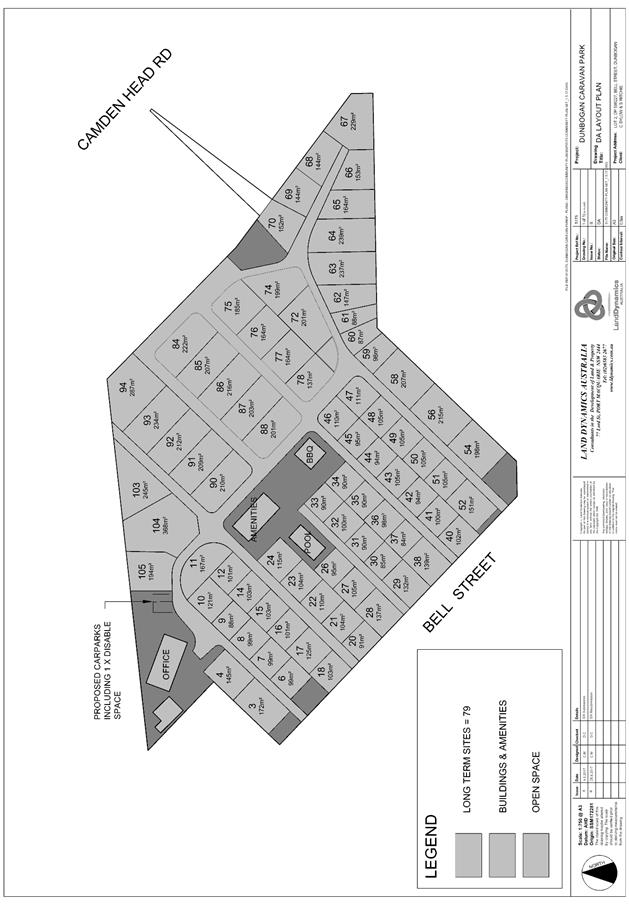
|
ATTACHMENT
|
Development Assessment Panel
14/02/2018
|
|
ATTACHMENT
|
Development Assessment Panel
14/02/2018
|
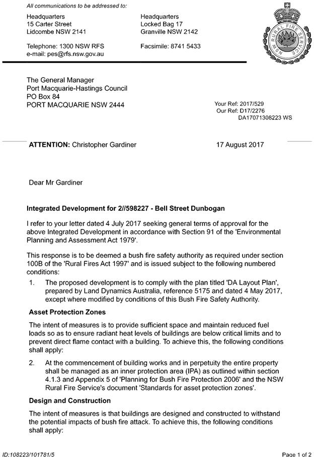
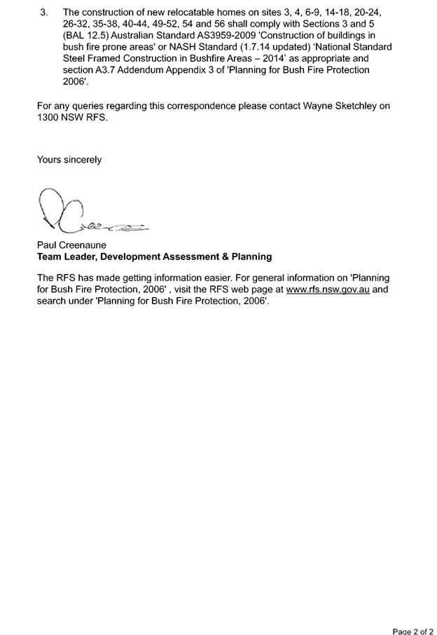
|
ATTACHMENT
|
Development Assessment Panel
14/02/2018
|


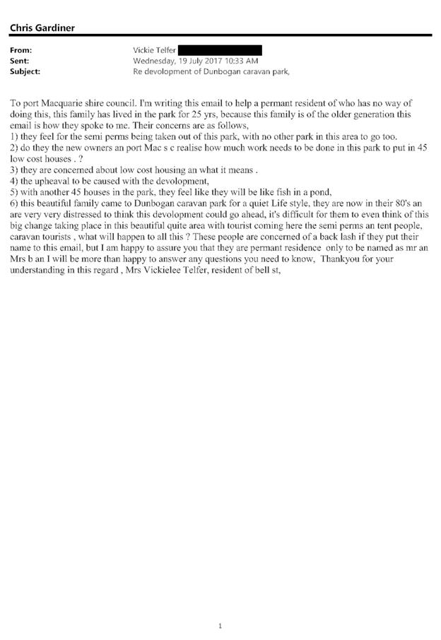
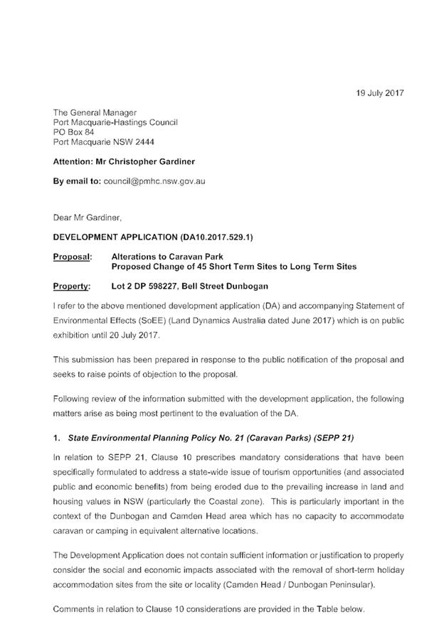
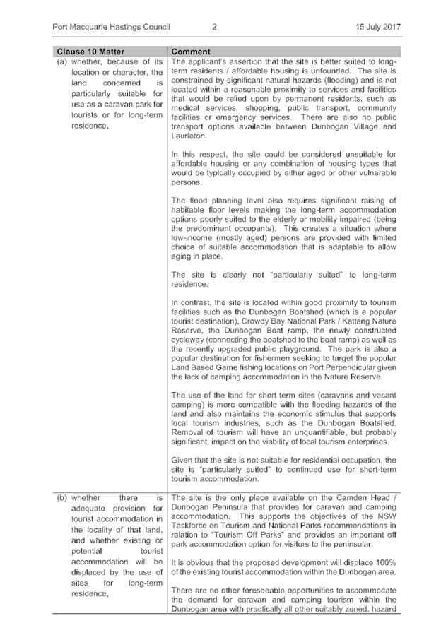
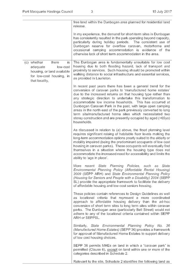
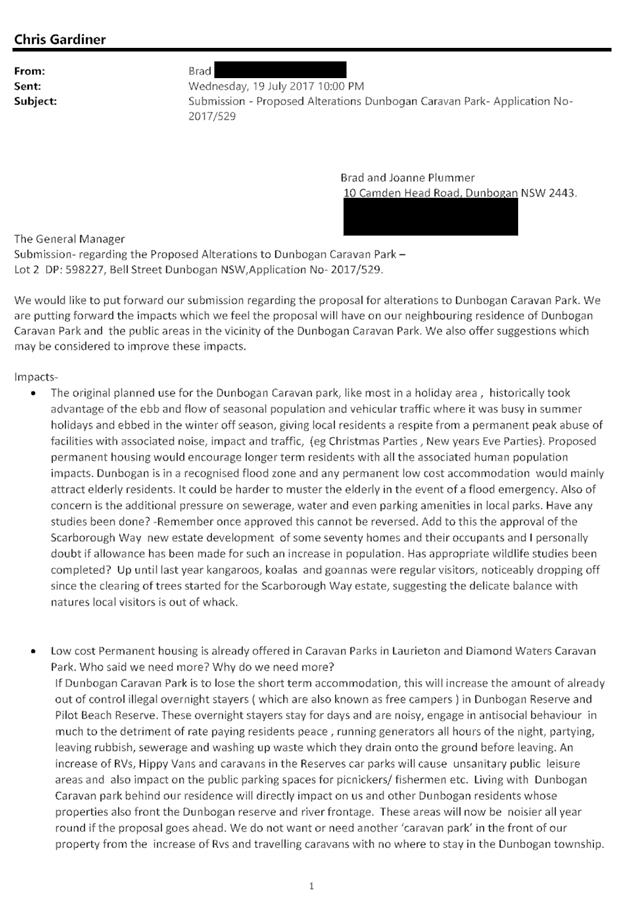
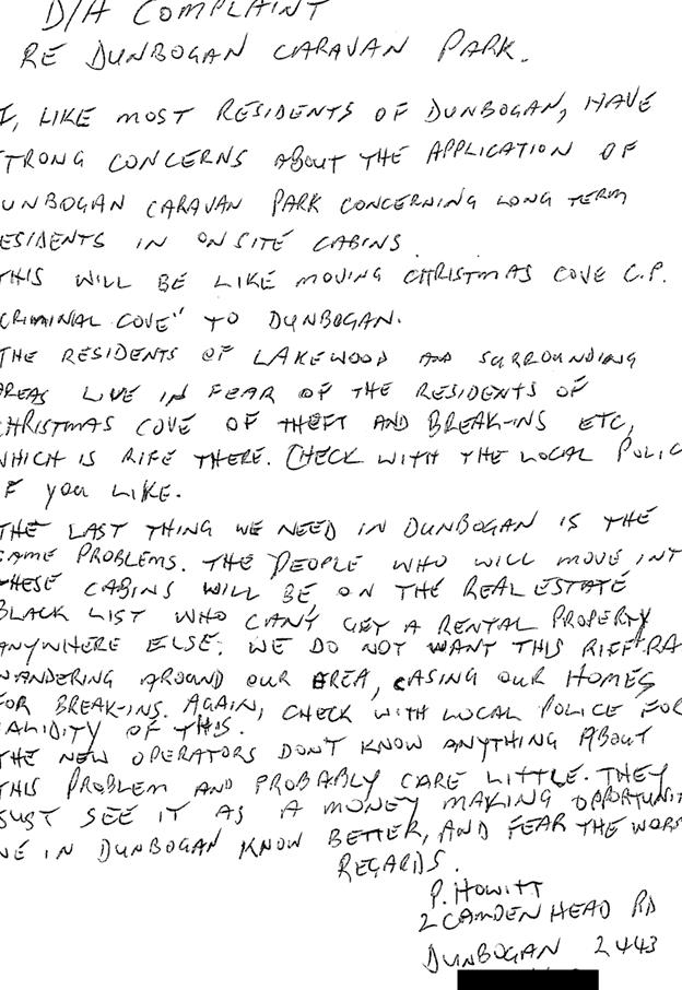

AGENDA Development Assessment Panel 14/02/2018
Item: 09
Subject: DA2017 - 979.1 Construction Of A New Dwelling
(Including Clause 4.6 Variation To Clause 4.3 (Height Of Buildings) Of The Port
Macquarie-Hastings Local Environmental Plan 2011, Swimming Pool And Spa at Lot
143 DP 1229250, No 62 Surfers Drive, Lake Cathie
Report
Author: Deb McKenzie
|
Applicant: Chris
Jenkins Design Architects Pty Ltd
Owner: C
& P Pinson
Estimated Cost: $770,000
Alignment with Delivery
Program
4.3.1 Undertake transparent
and efficient development assessment in accordance with relevant legislation.
|
|
RECOMMENDATION
That
DA 2017 - 979 for the construction of
a new dwelling (including clause 4.6 variation to clause 4.3 (height of
buildings), of the Port Macquarie-Hastings Local Environmental Plan 2011,
swimming pool and spa at Lot 143 DP
1229250, No. 62 Surfers Street, Lake Cathie, be determined by granting consent subject to the
recommended conditions.
|
Executive
Summary
This
report considers a development application for a dwelling, swimming pool and
spa at the subject site and provides an
assessment of the application in accordance with the Environmental Planning and
Assessment Act 1979.
Following exhibition of the
application, two (2) submissions have been
received.
1. BACKGROUND
Existing sites features and Surrounding development
The site has an area of 603.3sqm.
The site is zoned R1 General Residential in accordance with the Port Macquarie-Hastings Local
Environmental Plan 2011, as shown in the following zoning plan:
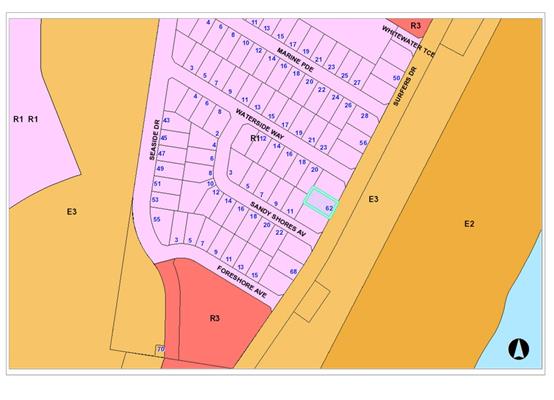
The existing subdivision pattern and location of existing
development within the locality is shown in the following aerial photograph:
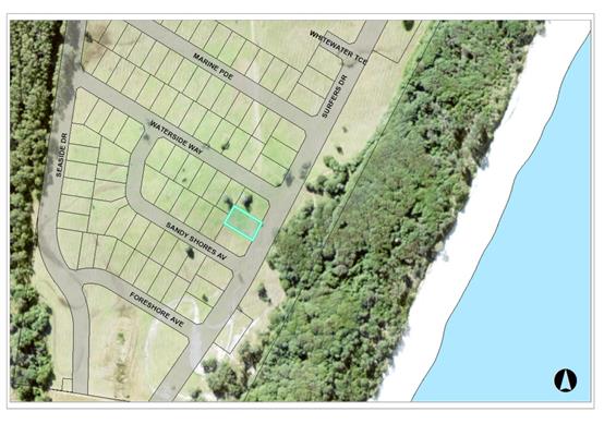
2. DESCRIPTION OF
DEVELOPMENT
Key aspects of the proposal include the following:
· Subject
site is vacant.
· Surrounding
sites are vacant (no current DA’s pending).
· Proposed
dwelling to comprise three bedrooms, two bathrooms, media room, 4 parking
spaces, swimming pool and spa
· Dwelling
to be two storeys on sloping block
· Request
to vary clause 4.3 Height of Building under HLEP 2011 is submitted with the DA.
· Proposed
variation is a maximum of 800mm (up to 9.35m above NGL); a variation of 9.4%.
Refer
to attachments at the end of this report.
Application Chronology
· 1.11.17:
DA lodged
· 4.12.17:
Revised plans and information submitted
· 8.12.17 – 21.12.17: Public notification of
application.
· 14.12.17: Submission received.
· 21.12.17: Copy of redacted submission sent to applicant.
· 11.01.18: Acknowledgement letter to submitter sent.
· 18.01.18 Late submission received (2 emails)
· 29.01.18 Objection – addendum to 14.01.18, 2
received.
3. STATUTORY ASSESSMENT
Section 79C(1) Matters for Consideration
In determining the application, Council is required to take
into consideration the following matters as are relevant to the development
that apply to the land to which the development application relates:
(a) The provisions (where
applicable) of:
(i) any Environmental
Planning Instrument:
State
Environmental Planning Policy No. 44 - Koala Habitat Protection
The site is
less than 1ha in area therefore no further investigations are required.
State
Environmental Planning Policy No.55 – Remediation of Land
Following an
inspection of the site and a search of Council records, the subject land is not
identified as being potentially contaminated and is suitable for the intended
use.
State Environmental
Planning Policy No. 71 – Coastal Protection and Clause 5.5 of Port
Macquarie-Hastings Local Environmental Plan 2011
The site is
located within a coastal zone as defined in accordance with clause 4 of SEPP
71.
In accordance
with clause 5, this SEPP prevails over the Port Macquarie-Hastings LEP 2011 in
the event of any inconsistency.
Having regard
to clauses 8 and 12 to 16 of SEPP 71 and clause 5.5 of Hastings LEP 2011
inclusive the proposed development will not result in any of the following:
a) any restricted access (or
opportunities for access) to the coastal foreshore
b) any identifiable adverse
amenity impacts along the coastal foreshore and on the scenic qualities of the
coast;
c) any identifiable adverse
impacts on any known flora and fauna (or their natural environment);
d) subject to any identifiable
adverse coastal processes or hazards;
e) any identifiable conflict
between water and land based users of the area;
f) any identifiable
adverse impacts on any items of archaeological/heritage;
g) reduce the quality of the
natural water bodies in the locality.
The site is
cleared and located within an area zoned for residential purposes.
State
Environmental Planning Policy (Building Sustainability Index: BASIX) 2004
A BASIX
certificate has been submitted demonstrating that the proposal will comply with
the requirements of the SEPP. It is recommended that a condition be
imposed to ensure that the commitments are incorporated into the development
and certified at Occupation Certificate stage.
Port Macquarie-Hastings Local Environmental Plan 2011
The proposal
is consistent with the LEP having regard to the following:
· Clause
2.2, the subject site is zoned R1 General Residential. In accordance with
clause 2.3(1) and the R1 zone landuse table, the dwelling is a permissible
landuse with consent.
The objectives of the R1 zone are as follows:
o To
provide for the housing needs of the community.
o To
provide for a variety of housing types and densities.
o To
enable other land uses that provide facilities or services to meet the day to
day needs of residents.
In accordance with Clause 2.3(2), the proposal is consistent with the
zone objectives as it is a permissible landuse and consistent with the
establishing residential locality.
· Clause
4.3, the maximum overall height of the building above ground level (existing)
is 9.35m which is non-compliant with the standard height limit of 8.5m applying
to the site.
· Clause
4.4, the floor space ratio of the proposal is 0.49:1 which complies with the
maximum 0.65:1 floor space ratio applying to the site. It is noted that the GFA
includes the garage parking area for two of the four vehicles, equating to
38sqm.
· Clause
4.6 – exceptions to development standards. A request to vary clause 4.3
Height of Building is submitted. Refer to below for assessment of the request.
· Clause
5.10 – Heritage. The site does not contain or adjoin any known heritage
items or sites of significance.
· Clause
7.1 - the site is mapped as potentially containing class 5 acid sulfate soils.
No requirements.
· Clause
7.13 - satisfactory arrangements are in place for provision of essential
services.
Request
for Clause 4.6 variation – Height Limit
Clause 4.3
– Height of Buildings states:
4.3 Height of
buildings
(1) The objectives of this
clause are as follows:
(a) to
ensure that buildings are compatible with the height, bulk and scale of the
existing and desired future character of the locality,
(b) to
minimise visual impact, disruption of views, loss of privacy and loss of solar
access to existing development,
(c) to
minimise the adverse impact of development on heritage conservation areas and
heritage items,
(d) to
nominate heights that will provide a transition in built form and land use
intensity within the area covered by this Plan.
(2) The height of a
building on any land is not to exceed the maximum height shown for the land on
the Height of Buildings Map.
The subject
site has a maximum building height of 8.5m.


By written
submission, the applicant has requested a variation to the maximum height limit
pursuant to clause 4.6 of the LEP – Exceptions to Development Standards.
Clause 4.6 provides:
Objectives:
(a) To
provide an appropriate degree of flexibility in applying certain development
standards to particular development.
(b) To
achieve better outcomes for and from development by allowing flexibility in
particular circumstances.
(2) Development consent may, subject to this clause, be granted
for development even though the development would contravene a development
standard imposed by this or any other environmental planning instrument.
However, this clause does not apply to a development standard that is expressly
excluded from the operation of this clause.
Applicant’s
Submission
The proposed
two storey building has a maximum height of 9.345 metres above existing ground
level, which is a variance of 845mm or 9.9%. The proposed maximum height
variance occurs in the roof parapet in the south east corner of the building.
The following height plane diagrams show the location and extent of the height
limit breach.
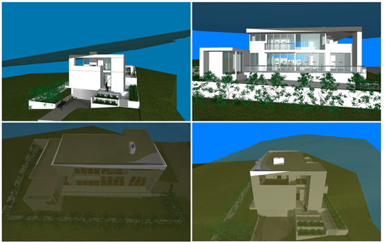
The applicant
submits:
· The
variation in the height limit will not be readily visible from the public
domain or neighbouring properties as it is only minor in nature ie. 9.9% of the
maximum height limit, and only affects a small area of the roof.
· The
variance in the height of a relatively small section of the roof parapet will
have no adverse impact on the amenity of any neighbouring properties as well as
the public domain, including overshadowing or view loss.
· A
conscious effort has been made to keep the majority of the building below the
height limit of 8.5 metres, to minimise any impact on the streetscape and other
buildings in the vicinity.
· The
height of the north and west elevations of the house determine the access to
(ocean) views, from the neighbouring properties to the north and west. Both of
these elevations are well below the 8.5 metre height limit.
· All
roofs have a 2 degree pitch to minimise the height of the roof structure.
· The
floor to ceiling heights are not excessive, in fact the Department of
Planning’s Apartment Design Guide – Part 4C -1 recommends a minimum
ceiling height of 2700mm. for habitable rooms.
· The
public benefit of the standard is not compromised or eroded, by the proposed
minimal variance to the standard.
· There
will be no impact on the public domain.
· The
Shadow diagrams demonstrate that the property immediately to the south of the
subject property receives adequate mid-winter solar access. The proposed height
variation will have negligible effect on shadows cast on the property.
· The
development is consistent in the bulk and scale with other development in the
locality.
· There
a number of precedents for a variance in the height limit in the southern
outskirts of Lake Cathie village.
· Two
such examples occur at 2 Middle Rock Road and 119 Chepana Street.
· Moreover,
there are at least 5 Development Applications where Council has approved a
variance in the height limit during the past 2 calendar years. (see Port
Macquarie Hasting Council website) and there are numerous examples of dwelling
houses in the R1 – General Residential zone in the Port Macquarie
Hastings LGA which exceed the 8.5 metre height limit, due to the topography of
the site, like the subject site.
·
Assessment
|
LEP Clause 4.6
|
Proposal
|
|
(3) Development consent must not be granted for
development that contravenes a development standard unless the consent
authority has considered a written request from the applicant that seeks to
justify the contravention of the development standard by demonstrating:
(a) that compliance with the development
standard is unreasonable or unnecessary in the circumstances of the case, and
(b) that there are sufficient environmental
planning grounds to justify contravening the development standard.
|
1. Written
request received.
2. The
applicants’ submission (as outlined above) serves to demonstrate that
in this case compliance with the 8.5m HOB development standard is
unreasonable and unnecessary in this case. Council agrees that:
· The variation
sort is less than 10% of the maximum height limit and therefore numerically
not a significant variation.
· The extent of
the roof that is non-compliant is not extensive (as shown in the height plane
diagrams above)
· There are no
significant amenity or overshadowing of neighbouring properties that results
solely from the height exceedence.
· Conditions of
consent are proposed to address privacy concerns along the southern boundary.
·
|
|
(4) Development consent must not be granted for
development that contravenes a development standard unless:
(a) the consent authority is satisfied that:
(i) the applicant’s written request has
adequately addressed the matters required to be demonstrated by subclause
(3), and
(ii) the proposed development will be in the
public interest because it is consistent with the objectives of the
particular standard and the objectives for development within the zone in
which the development is proposed to be carried out, and
(b) the concurrence of the Secretary has been
obtained.
|
Council staff are satisfied that:
(a)(i) Council staff are satisfied that the applicant’s written request has adequately
addressed the matters required to be demonstrated by subclause (3).
(ii) the proposed development is
considered to be in the public interest as it is consistent with the objectives
of clause 4.3 and the R1 General Residential zone (see below).
|
|
4.3 Height
of buildings
(1) The
objectives of this clause are as follows:
(a) to
ensure that buildings are compatible with the height, bulk and scale of the
existing and desired future character of the locality,
(b) to
minimise visual impact, disruption of views, loss of privacy and loss of
solar access to existing development,
(c) to
minimise the adverse impact of development on heritage conservation areas and
heritage items,
(d) to
nominate heights that will provide a transition in built form and land use
intensity within the area covered by this Plan.
|
The proposal is considered to be consistent with the
height of buildings objective as:
1. The
major of the dwelling complies with the prescribed height limit, only a small
section of the south-east corner of the front façade is non-compliant.
2. The
area of the non-compliance does not result in any visual impact, disruption
to view or solar access impacts directly as a result of the height
exceedance.
3. No
heritage impacts.
4. The
built form of development along Surfers Drive will step down the street,
providing a transition of building structure and form along the street
frontage.
|
|
Zone R1 General
Residential
1 Objectives of zone
• To provide for the
housing needs of the community.
• To provide for a
variety of housing types and densities.
• To enable other land
uses that provide facilities or services to meet the day to day needs of
residents.
|
The proposal is considered to be consistent with the R1
zone objectives as:
1. The
site has been created for the purposes of residential development,
contributing to meeting the housing needs of the community;
2. The
proposal is a modern, contemporary built form, adding variety to the
anticipated future character of this area;
3.
Not applicable.
To be consistent with the future residential character of
the area the dwelling does not have to be same as the current housing stock
being built in the land release area. The proposal is an architect designed
dwelling, customised for its owners.
|
·
(ii) Any
draft instruments that apply to the site or are on exhibition:
Nil
(iii) any
Development Control Plan in force:
Port
Macquarie-Hastings Development Control Plan 2013
|
DCP 2013: Dwellings, Dual
occupancies, Dwelling houses, Multi dwelling houses & Ancillary
development
|
|
|
Requirements
|
Proposed
|
Complies
|
|
3.2.2.2
|
Articulation zone:
• Min. 3m front
setback
• An entry feature
or portico
• A balcony, deck,
patio, pergola, terrace or verandah
• A window box
treatment
• A bay window or
similar feature
• An awning or
other feature over a window
• A sun shading
feature
|
No elements within the
articulation zone.
|
N/A
|
|
Front setback (Residential not R5
zone):
• Min. 6.0m classified
road
• Min. 4.5m local
road
• Min. 3.0m
secondary road
• Min. 2.0m
Laneway
|
Front building line setback =
4.61 to 5.2m
|
Yes
|
|
3.2.2.3
|
Garage 5.5m min. and 1m behind
front façade.
Garage door recessed behind
building line or eaves/overhangs provided
|
Garage door setback is compliant
with the minimum front setback requirements.
Garage door recessed.
|
Yes
|
|
6m max. width of garage door/s
and 50% max. width of building
|
Width of garage door = 5.8m.
|
Yes
|
|
Driveway crossover 1/3 max. of
site frontage and max. 5.0m width
|
Driveway width proposed = 6m at
site boundary. Condition to apply limiting driveway crossover width to 5m.
|
To be conditioned to ensure
compliance.
|
|
3.2.2.4
|
4m min. rear setback. Variation
subject to site analysis and provision of private open space
|
Rear setback:
Lower & ground = 5.22m.
Upper = 9.31m
Complies.
|
Yes
|
|
3.2.2.5
|
Side setbacks:
• Ground floor =
min. 0.9m
• First floors
& above = min. 3m setback or where it can be demonstrated that
overshadowing not adverse = 0.9m min.
• Building wall
set in and out every 12m by 0.5m
|
Ground floor level:
North: 2.5m to wall of front
stairway; 5.95m to wall of kitchen/dining area; 4.74m to wall of laundry.
South: 5.052m to wall of garage;
1.86m to wall of Bedroom 3.
Upper Floor Level:
North: 2.5m to wall of stairway;
5.95m to WIR wall of Bedroom 1
NB: no overshadowing due to
east-west orientation of the site.
South:
6.232m to wall of Bedroom 1;
5.052m to edge of Bedroom 1 terrace.
Building articulation:
North: façade is stepped
at rear of stairwell, lift and laundry with large side setbacks creating
privacy around the pool and spa area.
South: façade is 17m long
then stepped out for Bedroom 3 at the rear. Large side setback (5m+) provides
ample opportunity for substantial landscaping along southern boundary to
address potential privacy concerns of the adjoining site in the future.
|
Acceptable in this case, subject
to conditions of consent re: landscaping.
|
|
3.2.2.6
|
35m2 min. private open
space area including a useable 4x4m min. area which has 5% max. grade.
|
The rear of the site contains an area of 4m+ x
19m. Northern POS area is also 5m+ x 10m+ around the pool & spa.
Complies.
|
Yes
|
|
3.2.2.7
|
Front fences:
• If solid 1.2m
max height and front setback 1.0m with landscaping
• 3x3m min. splay
for corner sites
• Fences >1.2m
to be 1.8m max. height for 50% or 6.0m max. length of street frontage with
25% openings
• 0.9x0.9m splays
adjoining driveway entrances
|
The site slopes from north to south, requiring cut and
fill. Front fencing is proposed and is to be conditioned to comply with the
provisions of the DCP. Concept plans submitted with the DA demonstrate that
the front fencing, integrated with proposed landscaping is capable of
achieving the DCP controls.
|
To be conditioned to comply with
details provided at the CC stage.
|
|
3.2.2.8
|
Front fences and walls to have
complimentary materials to context
No chain wire, solid timber,
masonry or solid steel front fences
|
Concept plans show solid front
and boundary fences, up to 1.8m high along the boundaries. Pool and spa
fencing to comply with the relevant Australian Standard.
|
Yes.
|
|
3.2.2.10
|
Privacy:
• Direct views
between living areas of adjacent dwellings screened when within 9m radius of
any part of window of adjacent dwelling and within 12m of private open space
areas of adjacent dwellings. ie. 1.8m fence or privacy screening which has
25% max. openings and is permanently fixed
• Privacy screen
required if floor level > 1m height, window side/rear setback (other than
bedroom) is less than 3m and sill height less than 1.5m
• Privacy screens
provided to balconies/verandahs etc which have <3m side/rear setback and
floor level height >1m
|
The proposal has a setback of 4.06m to the southern
terrace and 6.23m to the living/dining room doors and kitchen window with no
privacy screening proposed. The terrace is estimated to be 2.4-2.8m above
ground level and therefore elevated above typical fence height (1.8m).
A submission has been received regarding privacy to the
southern neighbouring property.
The separation does not comply with Council’s
control requiring 9m separation. Any new dwelling on Lot 131 (southern
neighbour) may build to 900mm from their northern boundary; therefore the
maximum separation is approximately 5-7m only.
Combined with the height of the main terrace, it is
reasonable to require some form of privacy for Lot 131.
Either installation of moveable privacy screens along the
main living southern terrace are to be installed (movable along the terrace
and openable to provide transparency and 100% solid when closed) or
landscaping along the southern boundary – to reach a height at maturity
of at least 3m. Details to be included the Construction Certificate
documentation and certified by the selected certification authority prior to issue
of the CC.
|
No. Condition of consent
requiring privacy screening along main living room southern terrace or
substantial landscaping along the southern boundary.
|
(iiia) any
planning agreement that has been entered into under Section 93f or any draft
planning agreement that a developer has offered to enter into under Section
93f:
No
planning agreement has been offered or entered into relating to the site.
iv) any matters prescribed by the
Regulations:
New South Wales Coastal Policy:
The proposed
development is consistent with the objectives and strategic actions of this
policy.
v) any coastal
zone management plan (within the meaning of the Coastal Protection Act 1979),
that apply to the land to which the development application relates:
Nil
(b) The
likely impacts of that development, including environmental impacts on both the
natural and built environments, social and economic impacts in the locality:
Context and setting
The proposal satisfactorily addresses the public domain.
The proposal is considered to be
consistent with the likely future residential character of the locality.
Access, transport and traffic
The proposal will be unlikely to have any adverse impacts in
terms access, transport and traffic. The existing road network will
satisfactorily cater for any increase in traffic generation as a result of the
development.
Water Supply
Service available – details required with S.68
application.
Sewer
Service available – details required with S.68
application.
Stormwater
Service available – details required with S.68
application
Other Utilities
Telecommunication and electricity services are available to
the site.
Heritage
This site does not contain or adjoin any known heritage item
or site of significance.
Other land resources
No adverse impacts anticipated. The site is within an
established urban context and will not sterilise any significant mineral or
agricultural resource.
Water cycle
The proposed development will be unlikely to have any
adverse impacts on water resources and the water cycle.
Soils
The proposed development will be unlikely to have any
adverse impacts on soils in terms of quality, erosion, stability and/or
productivity subject to a standard condition requiring erosion and sediment
controls to be in place prior to and during construction.
Air and microclimate
The construction and/or operations of the proposed
development will be unlikely to result in any adverse impacts on the existing
air quality or result in any pollution.
Flora and fauna
Site is cleared.
Waste
Satisfactory arrangements are in place for proposed storage
and collection of waste and recyclables. No adverse impacts anticipated.
Energy
The proposal includes measures to address energy efficiency
and will be required to comply with the requirements of BASIX.
Noise and vibration
No adverse impacts anticipated. Condition recommended to
restrict construction to standard construction hours.
Bushfire
The site is not identified as being bushfire prone.
Safety, security and crime prevention
The proposed development will be unlikely to create any
concealment/entrapment areas or crime spots that would result in any
identifiable loss of safety or reduction of security in the immediate area.
Social impacts in the locality
Given the nature of the proposed development and its’
location the proposal is unlikely to result in any adverse social impacts.
Economic impact in the locality
No adverse impacts. Likely positive impacts can be
attributed to the construction of the development and associated flow on effects
(ie maintained employment and increased expenditure in the area).
Site design and internal design
The proposed development design satisfactorily responds to
the site attributes and will fit into the locality. No adverse impacts likely.
Construction
No potential adverse impacts identified to neighbouring
properties with the construction of the proposal.
Cumulative Impacts
The proposed development is not expected to have any adverse
cumulative impacts on the natural or built environment or the social and
economic attributes of the locality.
(c) The suitability of the site for
the development:
The proposal will fit into the
locality and the site attributes are conducive to the proposed development.
Site constraints have been
adequately addressed and appropriate conditions of consent recommended.
(d) Any submissions made in
accordance with this Act or the Regulations:
Two written submissions have been received following public
exhibition of the application.
Key issues raised in the submissions received and comments
in response to these issues are provided as follows:
|
Submission
Issue/Summary
|
Planning
Comment/Response
|
|
1. Height of
building. The dwelling exceeds the LEP maximum height of building –
8.5m
|
Acknowledged with clause 4.6 request
for variation submitted by the applicant. Refer to assessment above.
Variation request accepted as reasonable in this case.
|
|
2. Potential overshadowing of Lot 131
(southern neighbour)
|
Shadow diagrams submitted with DA. Lot 131 currently
vacant and no current DA pending. Therefore difficult to access likely future
location of living areas. However, shadows comply with front and rear of Lot
131 morning and afternoon times. Parts of the centre of the lot will be
overshadowed on June 21. The height exceedence in the south-east corner of
the proposed dwelling does not amplify this impact. The building is height
compliant in the central section of the site and setback up to 5-6m,
significantly improving shadow impacts along the southern boundary.
|
|
3. Lack of privacy to Lot 131 & Lot
132 due to height of terraces above ground.
|
Agreed. The main living southern terrace is up to 2.4-2.6
above ground level. A condition of consent to be applied requiring either
movable/openable privacy screens along the terrace or substantial plantings
along the southern boundary (up to 3m high).
Bedroom 1 is a low traffic area and the balcony is only
1m wide. Privacy screen to this room and balcony is not required.
|
|
4. Chimney – size (bulk &
scale) and location of chimney – potential to block views from Lot 144
(northern neighbour).
|
This has been discussed with the submitter and its size
and location clarified. Overall, it is noted that chimneys as not part of the
overall height of the dwelling (by definition of building height in the LEP).
The location of the chimney is towards the centre/front
of the dwelling and its widest side faces the street, not the neighbouring
properties.
|
|
5. The development does not comply with
the purposes of Council’s DCP in relation to Lot 144 (northern
neighbour) and Lot 131 (southern neighbour), particularly the following:
· Not unduly affect the amenity of neighbours;
· Ensure view sharing opportunities from nearby properties
and vantage points are taken into account so that adverse impacts are
minimised.
|
Subject to conditions of consent to address privacy on
the southern elevation, privacy is considered to be adequately addressed.
The north-east corner of the building, while a solid
construction to the full height of the stairwell, is compliant with the
maximum height limit for the dwelling on the subject site.
|
(e) The Public Interest:
The proposed development will be in
the wider public interest with provision of appropriate additional housing.
The proposed
development satisfies relevant planning controls and is not expected to impact
on the wider public interest.
4. DEVELOPMENT
CONTRIBUTIONS APPLICABLE
Nil
5. CONCLUSION
The application has been assessed in accordance with
Section 79C of the Environmental Planning and Assessment Act 1979.
Issues raised during assessment and public exhibition of
the application have been considered in the assessment of the application.
Where relevant, conditions have been recommended to manage the impacts
attributed to these issues.
The site is suitable for the proposed development, is not
contrary to the public's interest and will not have a significant adverse
social, environmental or economic impact. It is recommended that the
application be approved, subject to the recommended conditions of consent
provided in the attachment section of this report.
|
Attachments
1View. DA2017
- 979.1 Plans
2View. DA2017
- 979.1 Recommended DA Conditions
3View. DA2017
- 979.1 Submission - Russo
4View. DA2017
- 979.1 Submission Davis 14122017
5View. DA2017
- 979.1 Submission Davis 30012018
|
|
ATTACHMENT
|
Development Assessment Panel
14/02/2018
|
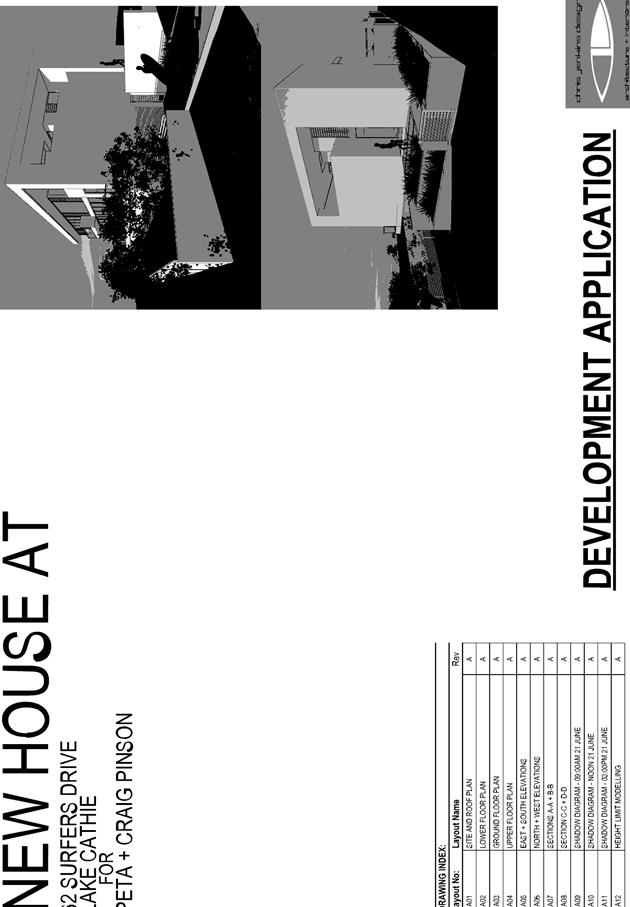
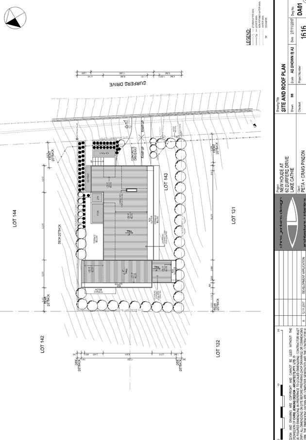
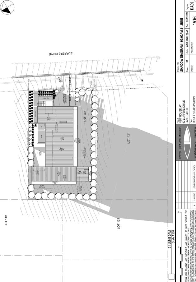
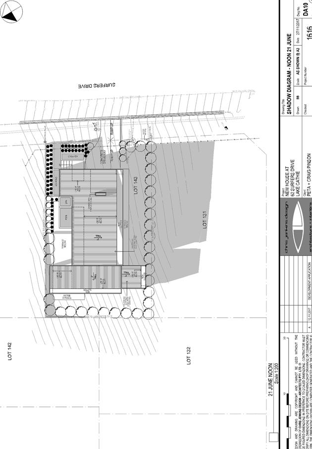
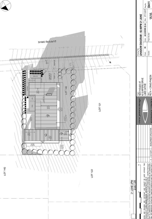
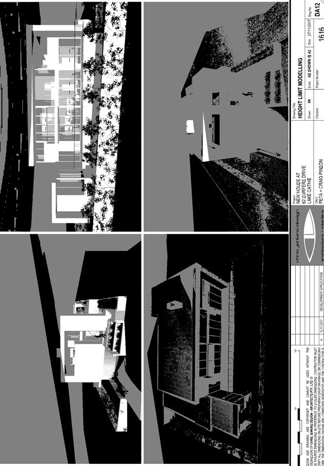

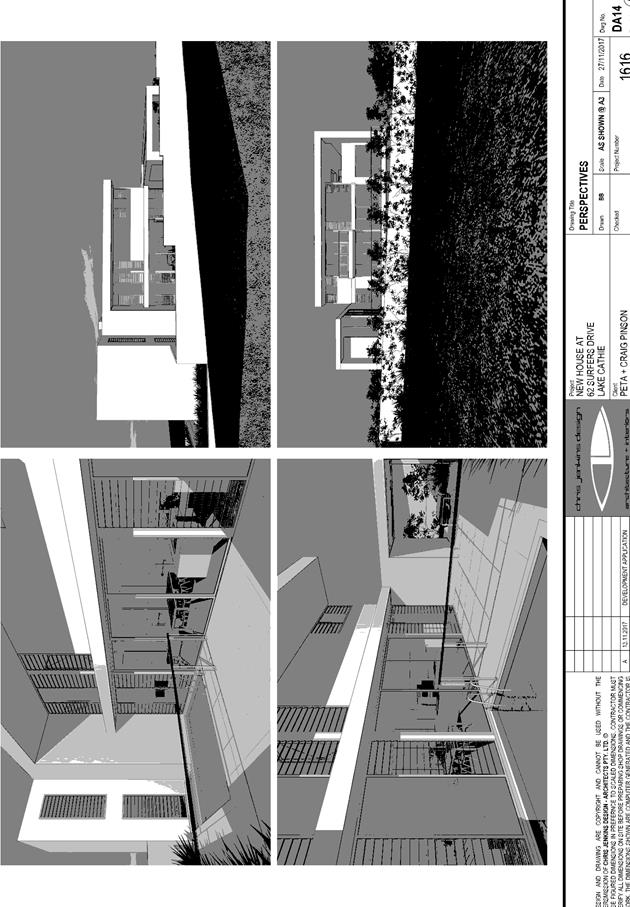
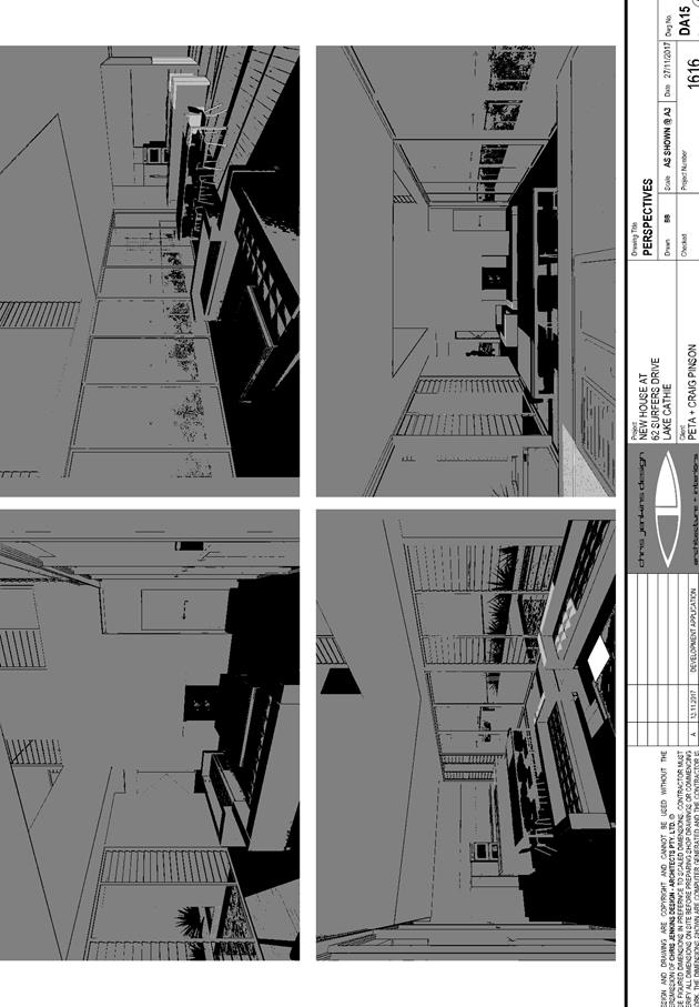
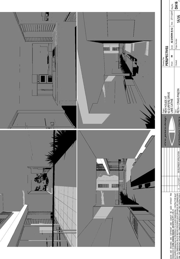
|
ATTACHMENT
|
Development Assessment Panel
14/02/2018
|
|
ATTACHMENT
|
Development Assessment Panel
14/02/2018
|

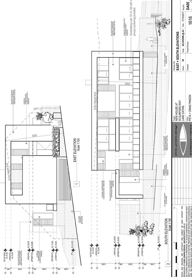
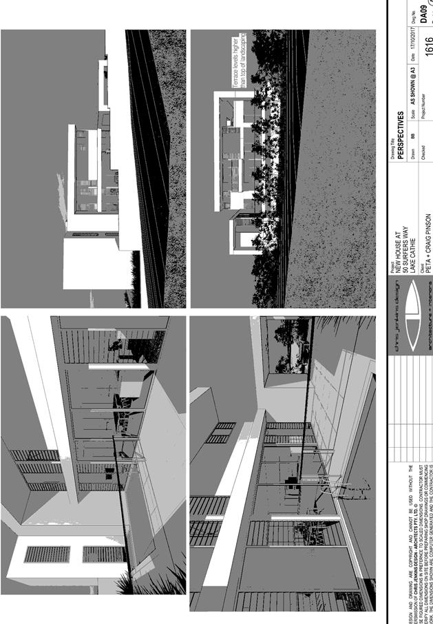
|
ATTACHMENT
|
Development Assessment Panel
14/02/2018
|
|
ATTACHMENT
|
Development Assessment Panel
14/02/2018
|
AGENDA Development Assessment Panel 14/02/2018
Item: 10
Subject: DA2017 - 632.1 Multi Dwelling Housing And
Strata Subdivision - Lot 1 DP 596122, 25 Hibbard Drive, Port Macquarie
Report
Author: Benjamin Roberts
|
Applicant: Collins
W Collins
Owner: D
C Gray
Estimated Cost: $1,333,800
Alignment with Delivery
Program
4.3.1 Undertake transparent
and efficient development assessment in accordance with relevant legislation.
|
|
RECOMMENDATION
That
DA2017 – 632.1 for a multi dwelling housing and strata subdivision
at Lot 2, DP 596122, No. 25 Hibbard Drive,
Port Macquarie, be determined by granting consent subject to the recommended
conditions.
|
Executive
Summary
This
report considers a development application for a multi dwelling housing
comprising six two storey dwellings and strata subdivision at the subject site. This report provides an assessment of
the application in accordance with the Environmental Planning and Assessment
Act 1979.
Following exhibition of the
application, six (6) submissions have been
received.
1. BACKGROUND
Existing sites features and Surrounding development
The site has an area of 1125.3943m2.
The site is zoned R1 General Residential in accordance with the Port Macquarie-Hastings Local Environmental
Plan 2011, as shown in the following zoning plan:
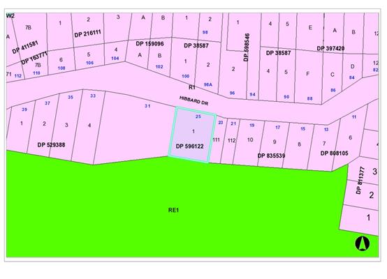
The existing subdivision pattern and location of existing
development within the locality is shown in the following aerial photograph:
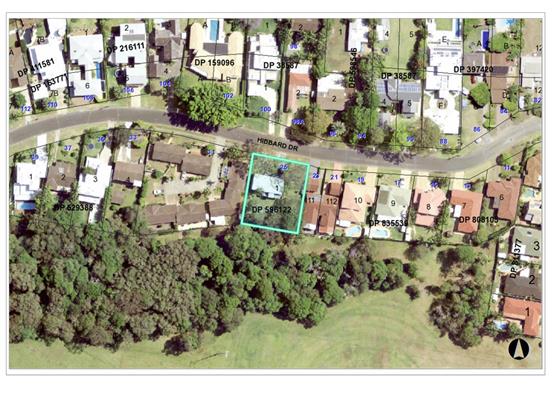
2. DESCRIPTION OF
DEVELOPMENT
Key aspects of the proposal include the following:
· Demolition
of existing dwelling and tree removal.
· Construction
of six (6), two (2) storey dwellings comprising two (2) bedrooms.
· Two
(2) visitor parking spaces and a turnaround bay.
· Strata
subdivision.
Refer
to attachments at the end of this report.
Application Chronology
· 21
July 2017 – Application lodged.
· 8 – 21 August 2017 – Public exhibition via
neighbour notification.
· 8 August 2017 – Request for SEPP 71 master plan
and/or copy of waiver.
· 16 August 2017 – Request for revised flood impact
assessment.
· 4 September 2017 – Revised flood impact assessment
provided.
· 11 September 2017 – Copy of SEPP 71 Master plan
waiver provided.
· 20 October 2017 – Additional information request.
· 14 November – Revised plans and ecological impact
assessment provided.
3. STATUTORY ASSESSMENT
Section 79C(1) Matters for Consideration
In determining the application, Council is required to take
into consideration the following matters as are relevant to the development
that apply to the land to which the development application relates:
(a) The provisions (where
applicable) of:
(i) any Environmental
Planning Instrument:
State Environmental Planning Policy No. 44 - Koala Habitat
Protection
There is no Koala Plan of
Management on the site. Additionally, the site is less than 1ha in area.
Therefore, no further investigations are required.
State Environmental Planning
Policy No.55 – Remediation of Land
Following an inspection of the site and a search of Council
records, the subject land is not identified as being potentially contaminated
and is suitable for the intended use.
Standard conditions of consent will be applied to cover the
removal of any asbestos in the existing dwelling during the demolition process.
State Environmental Planning
Policy No. 62 – Sustainable Aquaculture
Given the nature of the proposed
development and proposed stormwater controls the proposal will be unlikely to
have any adverse impact on existing aquaculture industries.
State Environmental Planning
Policy No. 71 – Coastal Protection and Clause 5.5 of Port
Macquarie-Hastings Local Environmental Plan 2011
The site is located within a
coastal zone as defined in accordance with clause 4 of SEPP 71.
The site is further identified as
being within a sensitive coastal location. In accordance with Clause 18,
subdivision of sensitive coastal land within a residential zone requires a
Masterplan or Masterplan waiver. NSW Planning and Environment issued a waiver
to provide a Master plan dated 6 September 2017.
In accordance with clause 5, this
SEPP prevails over the Port Macquarie-Hastings LEP 2011 in the event of any
inconsistency.
Having regard to clauses 8 and 12
to 16 of SEPP 71 and clause 5.5 of Hastings LEP 2011 inclusive the proposed
development will not result in any of the following:
a) any
restricted access (or opportunities for access) to the coastal foreshore
b) any
identifiable adverse amenity impacts along the coastal foreshore and on the
scenic qualities of the coast;
c) any
identifiable adverse impacts on any known flora and fauna (or their natural
environment);
d) subject to
any identifiable adverse coastal processes or hazards;
e) any
identifiable conflict between water and land based users of the area;
f) any
identifiable adverse impacts on any items of archaeological/heritage; and
g) reduced
quality of the natural water bodies in the locality.
The site is located within an area zoned and already built out
for residential purposes.
State Environmental Planning Policy (Building
Sustainability Index: BASIX) 2004
A BASIX certificate has been
submitted demonstrating that the proposal will comply with the requirements of
the SEPP. It is recommended that a condition be imposed to ensure that the
commitments are incorporated into the development and certified at Occupation
Certificate stage.
Port
Macquarie-Hastings Local Environmental Plan 2011 (LEP 2011)
The proposal is consistent with the LEP having regard to the
following:
· Clause 2.2, the
subject site is zoned R1 General Residential. In accordance with clause 2.3(1)
and the R1 zone landuse table, the proposed multi dwelling housing and strata
subdivision, is a permissible landuse with consent.
The objectives of the R1 zone are as
follows:
o To provide for the housing
needs of the community.
o To provide for a variety of
housing types and densities.
o To enable other land uses
that provide facilities or services to meet the day to day needs of residents.
In accordance with Clause 2.3(2), the
proposal is consistent with the zone objectives as it is a permissible landuse
and consistent with the residential locality.
· Clause 2.7, the
proposed demolition will be covered by conditions of consent.
· Clause 4.1, does
not apply to strata lots associated with a multi dwelling housing development
– see Clause 4.1A below.
· Clause 4.1A allows
an integrated housing application whereby construction and subdivision are
included in the one application. When both construction and subdivision are
included in the one application, Clause 4.1A allows the minimum lot size
standard to be varied/reduced.
The intent of the clause is to encourage
housing diversity without compromising residential amenity. This overall
assessment shows that the development will have limited impact on adjoining
properties. The surrounding area also contains a mixture of low and medium to
high density residential development. This proposal will be consistent with
such a density.
· Clause 4.3, the maximum overall height of the
building above ground level (existing) is 7.7m, which complies with the
standard height limit of 8.5m applying to the site.
· Clause 4.4, the
floor space ratio of the proposal is 0.649:1.0, which complies with the maximum
0.65:1 floor space ratio applying to the site.
· Clause 5.9, there
are thirty (30) trees located on the site. The trees have been identified by a
qualified Arborist. There is one listed Koala food tree identified in Port
Macquarie-Hastings Development Control Plan 2013. The tree is a mature
Tallowwood approximately 25m tall. All thirty (30) trees are proposed to be
removed. The objective of this clause is to preserve the amenity of the area,
including biodiversity values, through the preservation of trees and other
vegetation. The application was supported by an ecological assessment prepared
by Naturecall dated 7 November 2017 which concludes that, subject to providing
two mature Koala offset plantings in the adjoining public reserve, that the
removal of the trees is unlikely to have any significant adverse impacts. Refer
to more detailed comments under flora and fauna heading of this report. The
removal of the thirty (30) trees from the site will impact on the amenity of
the immediate area to some extent. However it is considered that the
established vegetation on the adjoining public reserve provides the dominant
amenity provided to the area in the context of vegetation. The removal of the
vegetation from the site is not considered to significantly impact on the
amenity of the area to a level that would warrant refusal of the
application.
· Clause 5.10, the
site does not contain or adjoin any known heritage items or sites of
significance.
· In accordance with
clause 7.1, the site is mapped as containing class 3 acid sulfate soils. The
proposed development does not include any excavation below 1m of the natural
ground surface and will not expose any potentially occurring acid sulphate
soils that me be found on the site.
· In
accordance with clause 7.3, the site is land within a mapped “flood
planning area”. A flood impact assessment report was prepared by Worley
Parsons Group dated 31 August 2017. The flood report and proposal have been
reviewed by Council’s flooding engineer and specific conditions of
consent recommended. The following comments are provided which incorporate
consideration of Council’s Interim Flood Policy:
- The
site is proposed to be filled to ensure minimum finished floor levels are met.
- The
proposal is compatible with the flood hazard of the land.
- The
proposal will not result in a significant adverse effect on flood behaviour that
would result in detrimental increases in the potential flood affectation of
other development or properties.
- The
proposal is not likely to significantly adversely affect the environment or
cause avoidable erosion, siltation, destruction of riparian vegetation or a
reduction in the stability of river banks or watercourses.
- The
proposal is not likely to result in unsustainable social and economic costs to
the community as a consequence of flooding.
- The
development must consider the effects of sea level rise and allow for an
adaptable approach to be implemented over the life of the development. Final
adopted finished floor levels must allow for sea level rise.
- Conditions
have been recommended confirming the required finished levels for filling of the
site and required finished floor levels consistent with Councils flood policy.
· Clause 7.13,
satisfactory arrangements are in place for provision of essential services.
(ii) Any
draft instruments that apply to the site or are on exhibition:
None relevant
to the proposal.
(iii) any
Development Control Plan in force:
Port
Macquarie-Hastings Development Control Plan 2013
|
DCP 2013: Dwellings, Dual
occupancies, Dwelling houses, Multi dwelling houses & Ancillary
development
|
|
|
Requirements
|
Proposed
|
Complies
|
|
3.2.2.1
|
Ancillary development:
• 4.8m max. height
• Single storey
• 60m2 max. area
• 100m2 for lots
>900m2
• 24 degree max.
roof pitch
• Not located in
front setback
|
Drying areas are appropriately
located behind the front building line.
|
Yes
|
|
3.2.2.2
|
Articulation zone:
• Min. 3m front
setback
• An entry feature
or portico
• A balcony, deck,
patio, pergola, terrace or verandah
• A window box
treatment
• A bay window or
similar feature
• An awning or
other feature over a window
• A sun shading feature
|
The patio to unit 1 is within the
articulation zone but setback >3m.
|
Yes
|
|
Front setback (Residential not R5
zone):
• Min. 6.0m
classified road
• Min. 4.5m local
road or within 20% of adjoining dwelling if on corner lot
• Min. 3.0m
secondary road
• Min. 2.0m
Laneway
|
Front building line setback
requirements are complied with. In particular, the development is setback
4.516m.
|
Yes
|
|
3.2.2.3
|
Garage 5.5m min. and 1m behind
front façade.
Garage door recessed behind
building line or eaves/overhangs provided
|
Garage door setback requirements
are complied with.
|
Yes
|
|
6m max. width of garage door/s
and 50% max. width of building
|
Garage doors do not face the
street and therefore the provisions of the DCP do not apply.
|
Yes
|
|
Driveway crossover 1/3 max. of
site frontage and max. 5.0m width
|
5m crossover proposed which is
less than 1/3 of the site frontage.
|
Yes
|
|
3.2.2.4
|
4m min. rear setback. Variation
subject to site analysis and provision of private open space
|
1.17m rear setback proposed.
|
No*
|
|
3.2.2.5
|
Side setbacks:
• Ground floor =
min. 0.9m
• First floors
& above = min. 3m setback or where it can be demonstrated that
overshadowing not adverse = 0.9m min.
• Building wall
set in and out every 12m by 0.5m
|
Ground floor east side = 900mm.
Ground floor west side = 900mm.
First floor east side = 1.5m.
Fisrt floor west side = 1.5m.
Unarticulated wall length east
side = 16.98m
Unarticulated wall length west
side = 16.98m
|
Yes
Yes
No*
No*
No*
No*
|
|
3.2.2.6
|
35m2 min. private open space area
including a useable 4x4m min. area which has 5% max. grade
|
Each occupancy contains a minimum 35m² open
space in one area with a minimum 4m x 4m area off a living room.
|
Yes
|
|
3.2.2.7
|
Front fences:
• If solid 1.2m
max height and front setback 1.0m with landscaping
• 3x3m min. splay
for corner sites
• Fences >1.2m
to be 1.8m max. height for 50% or 6.0m max. length of street frontage with
25% openings
• 0.9x0.9m splays
adjoining driveway entrances
|
1.8m high front fencing to courtyards proposed. The front
fencing is nominated as containing transparency to meet the fencing
provisions.
No continuous length of front fence exceeds 6m.
Not a corner block and no fencing beside driveway
therefore splays not necessary.
|
Yes
Yes
N/A
|
|
3.2.2.8
|
Front fences and walls to have
complimentary materials to context
No chain wire, solid timber,
masonry or solid steel front fences
|
Fencing design complies.
|
Yes
|
|
3.2.2.10
|
Privacy:
• Direct views
between living areas of adjacent dwellings screened when within 9m radius of
any part of window of adjacent dwelling and within 12m of private open space
areas of adjacent dwellings. ie. 1.8m fence or privacy screening which has
25% max. openings and is permanently fixed
• Privacy screen
required if floor level > 1m height, window side/rear setback (other than
bedroom) is less than 3m and sill height less than 1.5m
• Privacy screens
provided to balconies/verandahs etc which have <3m side/rear setback and
floor level height >1m
|
The development will not compromise privacy in the area
due to a combination of either lack of living room windows and/or providing
highlight windows to living areas facing side boundaries. Specifically the
rumpus room windows on units 3 and 4 are provided with highlight windows. The
ground floor patios areas will be separated by 1.8m boundary fencing. In this
regard the site is to be filled to meet finished floor level requirements and
will result in similar levels to that of adjoining properties. These measures
will protect privacy between adjoining properties.
|
Yes
|
|
DCP 2013: General
Provisions
|
|
|
Requirements
|
Proposed
|
Complies
|
|
2.7.2.2
|
Design addresses generic principles of Crime Prevention
Through Environmental Design guideline
|
No concealment or entrapment areas proposed. Adequate
casual surveillance available. Fencing defines property boundaries.
|
Yes
|
|
2.3.3.1
|
Cut and fill 1.0m max. 1m outside the perimeter of the
external building walls
|
No cut or fill greater than 1m proposed.
|
Yes
|
|
2.3.3.2
|
1m max. height retaining walls along road frontage
|
No retaining walls proposed along street frontage.
|
N/A
|
|
Any retaining wall >1.0 in height to be certified by
structure engineer
|
No retaining wall >1m proposed.
|
Yes
|
|
Combination of retaining wall and front fence height max
1.8m, max length 6.0m or 30% of frontage, fence component 25% transparent,
and splay at corners and adjacent to driveway
|
No combination of retaining wall and front fence proposed.
|
N/A
|
|
2.3.3.8
|
Removal of hollow bearing trees
|
No hollow bearing trees proposed to be removed.
|
Yes
|
|
2.6.3.1
|
Tree removal (3m or higher with 100m diameter trunk at 1m
above ground level and 3m from external wall of existing dwelling)
|
Refer to comments on Clause 5.9 in the LEP 2011 section of
this report.
|
Yes
|
|
2.5.3.2
|
New accesses not permitted from arterial or distributor
roads
|
No new access proposed to arterial or distribution road.
|
N/A
|
|
Driveway crossing/s minimal in number and width including
maximising street parking
|
Single driveway crossover proposed which is minimal in
width and retains available street parking.
|
Yes
|
|
2.5.3.3
|
Parking in accordance with Table 2.5.1.
Multi dwelling
1 space per 1 & 2 bedroom occupancies + 0.25 spaces
per occupancy for visitor parking.
|
Proposal involves 6 x 2 bedroom units. Therefore, 6 x 1
spaces + 6 x 0.25 visitor spaces = 7.5 spaces, which rounds to 8 spaces being
required. The development proposes single garages for each unit (ie 6 x 1
spaces = 6 spaces) and 2 visitor spaces. Total parking proposed is 8 spaces,
which complies.
|
Yes
|
|
2.5.3.11
|
Section 94 contributions
|
Contributions apply - refer to ET calc and NOP.
|
Yes
|
|
2.5.3.12 and 2.5.3.13
|
Landscaping of parking areas
|
Suitable landscaping areas proposed around
driveway/parking locations.
|
Yes
|
|
2.5.3.14
|
Sealed driveway surfaces unless justified
|
Sealed driveway areas proposed.
|
Yes
|
|
2.5.3.15 and 2.5.3.16
|
Driveway grades first 6m or ‘parking area’
shall be 5% grade with transitions of 2m length
|
Driveway grades capable of satisfying Council standard
driveway crossover requirements. Condition recommended for section 138 Roads
Act permit
|
Yes
|
|
2.5.3.17
|
Parking areas to be designed to avoid concentrations of
water runoff on the surface.
|
Stormwater drainage is capable of being managed.
|
Yes
|
Note: Subdivision provisions of
the DCP are aimed at the creation of vacant lots (i.e. not lots within an
integrated housing proposal such as this) and have therefore been excluded from
the above assessment. Servicing requirements are discussed later in this
report.
3.2.2.4 – Rear setback
The objectives of 3.2.2.4 are as
follows:
3.2.2.4 Objective
· To
allow adequate natural light and ventilation between dwellings/buildings and to
private open space areas.
· To
provide useable yard areas and open space.
Development provisions
a) A minimum rear boundary
setback of 4m is to be provided to dwellings (including verandas, patios and
decks). A minimum rear boundary setback of 900mm applies to sheds and swimming
pools subject to achieving minimum required private open space area
b) Council may consider varying
rear setback requirements where it is demonstrated that the private open space
could achieve better solar access between the building and the side setback.
c) In that instance one side
setback should be a minimum 4.0m in width (for an equivalent length of rear
boundary, behind building line) and the rear setback may be reduced to 900mm.
d) A detailed site analysis is to
be provided indicating the impact of the design on adjoining dwellings and open
space areas.
·
In response
to the above objectives and provisions the applicant provided the following
comments/justification:
The proposal provides a rear setback of 1.17m to the southern
boundary. The proposed design has positioned private open spaces along the
eastern and western side boundaries for Units 2 – 5 all of which will
have access to northern sunlight throughout the day. The private open spaces
for Units 1 and 6 are positioned within the front setback.
The proposed private open spaces are all accessible from the internal
living areas and incorporate a covered patio. The orientation of the private
open spaces will encourage natural light and ventilation to penetrate between
the dwellings and to the open space areas.
The subject property has a Council reserve adjacent to the southern
boundary. In this regard, the proposal will have no impacts on the rear
neighbouring property with regards to overshadowing, solar access, ventilation
or view sharing.
Council staff
agree with the comments/justification provided by the applicant. No adverse
impacts will occur from the proposed rear setback proposed.
3.2.2.5 – Side setback
The objectives of 3.2.2.5 are as
follows:
3.2.2.5 Objective
· To
reduce overbearing and perceptions of building bulk on adjoining properties and
to maintain privacy.
· To
provide for visual and acoustic privacy between dwellings.
Development provisions
a) Ground floors should be
setback a minimum of 900mm from side boundaries.
b) First floors and above should
be setback minimum of 3m from the side boundary or reduced down to 900mm where
it can be demonstrated that the adjoining property primary living areas and
primary private open space areas should not be adversely overshadowed for more
than 3hrs between 9am-3pm on 21 June.
c) Building walls are to step in
and out at least every 12m by a minimum of 500mm.
In response
to the above objectives and provisions the applicant provided the following
comments/justification:
The proposal provides a side setback of 1.5m from the upper floors to
the eastern and western side boundaries. In addition, the proposal includes an
unarticulated upper floor wall length of 16.98m on both the eastern and western
side elevations.
The unarticulated wall is to the upper floor of Units 2 and 3 and
Units 4 and 5. The subject wall is setback 4.0m from the side boundary line.
The side elevation incorporates articulation on the ground level and integrates
varying external finishes. In addition, the ground floor roofline creates
articulation elements along the side elevations which will assist in minimising
visual impacts when viewed from neighbouring properties.
The side elevations comprise of single and two-storey sections, with
majority of the upper floor wall being setback 4.0m. The section of wall
encroaching the side setback is to Units 1 and 6 only, has a total length of
8.35m and only contains 1x toilet window. The subject wall is within
permissible height limits, will have no impacts to residential privacy and
given the orientation of north, will have minimal impact on solar access.
The neighbouring property to the east has its garage positioned on the
boundary line and minor windows positioned along the subject boundary, which
currently experience some shading by existing vegetation. The neighbouring
property’s private open space is orientated towards the rear of the site
and as such, the subject wall will not be highly visible.
The neighbouring property to the west is a single storey,
multi-dwelling complex and a site inspection indicates that there are
secondary/service courtyards positioned along the common boundary.
The submitted shadow diagrams demonstrate that both neighbouring
properties will have a minimum of 3 hours of uninterrupted sunlight during the
day on the 21st June.
Council staff agree with the
comments/justification provided by the applicant.
Concerns were expressed from the
neighbour at 23 Hibbard Drive suggesting the development will result in the
outdoor living area at the rear of that dwelling and the west facing living
room windows to receive less than 3 hours of sunlight for the whole day. It is
noted that the rear outdoor living area is south facing and the living room
windows west facing. In this regard the only shadow cast from the proposal over
these area is at 3pm winter solstice. Having regard to the orientation of this
dwelling it is noted that during the 9am and 12pm winter solstice the outdoor
area and windows in question are shadowed from the dwelling itself. The proposal
will not result in the living area or west facing windows of the dwelling at 23
Hibbard drive to be overshadowed for more than 3 hours between 9am-3pm on 21
June.
No adverse impacts will occur
from the proposed first floor side setbacks proposed.
(iiia) any
planning agreement that has been entered into under Section 93f or any draft
planning agreement that a developer has offered to enter into under Section
93f:
No planning
agreement has been offered or entered into for the site.
iv) any matters prescribed by the
Regulations:
New South Wales Coastal Policy:
The proposed
development is consistent with the objectives and strategic actions of this
policy.
Demolition
of buildings AS 2601:
Demolition of
the existing building on the site is capable of compliance with this Australian
Standard and is recommended to be conditioned.
v) any coastal
zone management plan (within the meaning of the Coastal Protection Act 1979),
that apply to the land to which the development application relates:
None
relevant.
(b) The
likely impacts of that development, including environmental impacts on both the
natural and built environments, social and economic impacts in the locality:
Context
and setting
• The
proposal will be unlikely to have any adverse impacts to existing adjoining
properties and satisfactorily addresses the public domain.
• The
proposal is considered to be consistent with other residential development in
the locality and adequately addresses planning controls for the area. There are
a number of multi dwelling developments located in the area with a mixture of
both single and two storey buildings. The site adjoins a single storey unit
complex comprising 6 units.
• There
are no adverse impacts on existing view sharing.
• There
are no adverse privacy impacts.
• There
are no adverse overshadowing impacts. The proposal does not prevent adjoining
properties from receiving 3 hours of sunlight to private open space and primary
living areas on 21 June.
Roads
The site
fronts Hibbard Drive, a Council-owned and maintained ‘Local’ street
with a formation width of approx. 7.5m (adjacent to the site). Hibbard is
bordered by rollover (SE) type kerb and gutter on both sides. An existing
concrete footpath along the south side of Hibbard Drive adjoins the site to its
west. To offset the proposed increase in pedestrian traffic in the local area
proportionally with the five dwellings, in accordance with Council’s
policies the footpath is to be extended along the entire frontage of the site.
Suitable condition recommended.
Traffic
and Transport
The existing
dwelling on the site would be expected to generate 7-9 daily trips on average
based on data in the Roads and Maritime Services Guide to Traffic Generating
Developments 2002. The proposal will demolish the existing dwelling (subtract
7-9 trips) and construct six new attached, two bedroom dwellings. Each dwelling
in this area (due to low frequency of public transport) would be expected to
generate a similar number of trips. Assuming an additional 7-9 trips per
dwelling this equates to an increase of 35 to 45 trips per day on the local
road network, or generally 4 to 5 trips during each of the AM and PM peak
hours. With two alternative routes from the site along Hibbard Drive, the minor
increase in traffic will not significantly affect the safety, efficiency or
maintenance of the road network.
Access and
Manoeuvring
Vehicle
access to the site is proposed through a driveway to Hibbard Drive, held within
the common property of the proposed strata plan. AS 2890.1 clause 3.2.2
requires that reversing movements to public roads shall be prohibited wherever
possible. A dedicated turnaround bay is proposed adjoining the visitor parking
to ensure such movement do not occur.
The onsite
driveway dimensions are adequate for the residential and minor traffic
intensity. Access and manoeuvring shall comply with Council AUSPEC and
Australian Standards, and conditions have been imposed to reflect these
requirements.
Parking
Port
Macquarie-Hastings Development Control Plan 2013 specifies parking at a rate of
1 space per two bedroom unit and 1 visitor space per 4 units. Four (4) units
are proposed which equates to a requirement of 7.5 or 8 spaces (when rounded
up). A total of 8 parking spaces are proposed with a single garage proposed for
each unit and 2 visitor parking spaces nominated adjacent to the driveway.
Water
Supply Connection
Council records indicate that the development site has existing
potable water service from the 150mm diameter water mains on the opposite of
Hibbard Drive. A hydraulic strategy and plans are required from a hydraulic
consultant for the whole of the development on the site stage by stage.
Water service sizing is then to be determined by the hydraulic consultant to
suit the proposed development, as well as addressing fire service requirements
to AS 2419 and backflow protection requirements. Detailed plans will be
required to be submitted for assessment with the S.68 application with water
supply considered achievable.
Sewer
Connection
Council
records indicate that the development site is connected to sewer via a junction
from the manhole located in the north western corner of the site. All units
shall drain to the existing junction from the manhole. The above detail will be
required to be submitted for assessment with the S.68 application but overall
sewer connection is considered achievable.
Stormwater
The site is
naturally quite flat, generally grading towards both the Hibbard Dr (northern)
frontage and the Council reserve at the (southern) rear. There is no public
piped drainage adjacent to the site.
With
reference to Council’s policies and standards given the creation of
significant impervious area, the legal point of discharge for the proposed
development is defined as a direct connection to Council’s stormwater
pit/pipeline within Hibbard Drive. Kerb adapters are not permitted for
developments of this scale. This means that the existing piped network will
need to be extended to serve the site (at the proponent’s cost) from the
nearest Council pit which is approximately 55m west along Hibbard Drive.
A detailed
site stormwater management plan will be required to be submitted for assessment
with the S.68 application and prior to the issue of a CC. The concept
stormwater plan lodged with the DA is consistent with this requirement.
In accordance
with Councils AUSPEC requirements, on site stormwater detention facilities will
also be required to limit post-development peak discharges to less than the
pre-development flows.
Overall,
stormwater can be managed onsite via imposition of conditions of consent.
Other
Utilities
Telecommunication
and electricity services are available to the site.
Other land
resources
No adverse
impacts anticipated. The site is within an established urban context and will
not sterilise any significant mineral or agricultural resource.
Water
cycle
The proposed
development will be unlikely to have any adverse impacts on water resources and
the water cycle.
Soils
The proposed
development will be unlikely to have any adverse impacts on soils in terms of
quality, erosion, stability and/or productivity subject to a standard condition
requiring erosion and sediment controls to be in place prior to and during
construction.
Air and
microclimate
The
construction and/or operations of the proposed development will be unlikely to
result in any adverse impacts on the existing air quality or result in any
pollution.
Flora and
fauna
Construction
of the proposed development will require removal of thirty (30) trees from the
site as identified in the Arborist advice prepared by Woodvale tree services.
The
application was supported by an ecological impact assessment prepared by
Naturecall Environmental dated 7 November 2017. The assessment has regard to
the removal of all thirty (30) trees from the site. The assessment identified
one preferred Koala food tree on the site, being the Tallowwood, which was also
found to be used by Koalas (i.e. scats found at the base and scratches on
trunk).
The report
concludes that the removal of the Koala tree is unlikely to have any
significant adverse impacts on the local Koala population given the extent of
Koala habitat in the area. The report recommends the removal of the Koala food
tree be subject to at least 2 compensatory plantings in the adjoining reserve
to the south of the site. The report also provides tree planting detail in
appendix one to which the compensatory replants should achieve in terms of
maintenance and period of.
Council’s
parks and reserves section are open to allowing two mature Tallowwood trees to
be planted in a suitable location within the adjoining reserve.
Having regard
to the findings of the ecology report, which has been reviewed by
Council’s Natural Resource Section, and the successful implementation of
compensatory plantings it is considered that the proposed development will be unlikely
to have any significant adverse impacts on biodiversity or threatened species
of flora and fauna. Suitable conditions of consent have been recommended
surrounding required compensatory replanting and maintenance.
Waste
Satisfactory
arrangements are in place for proposed storage and collection of waste and
recyclables. Kerbside pick appears possible based on the number of units and
available kerb. No adverse impacts anticipated.
Energy
The proposal
includes measures to address energy efficiency and will be required to comply
with the requirements of BASIX.
Noise and
vibration
No adverse
impacts anticipated. Condition recommended to restrict construction to standard
construction hours.
Bushfire
The site is
not identified as being bushfire prone.
Safety,
security and crime prevention
The proposed
development will be unlikely to create any concealment/entrapment areas or
crime spots that would result in any identifiable loss of safety or reduction
of security in the immediate area.
Social impacts
in the locality
Given the
nature of the proposed development and its’ location the proposal is
unlikely to result in any adverse social impacts.
Economic
impact in the locality
No adverse
impacts. Likely positive impacts can be attributed to the construction of the
development and associated flow on effects (ie maintained employment and
expenditure in the area).
Site
design and internal design
The proposed
development design satisfactorily responds to the site attributes and will fit
into the locality. No adverse impacts likely.
Construction
No potential
adverse impacts identified to neighbouring properties with the construction of
the proposal. Standard conditions will be imposed to control demolition,
erosion, noise etc.
Cumulative Impacts
The proposed development is not expected to have any
adverse cumulative impacts on the natural or built environment or the social
and economic attributes of the locality.
(c) The suitability of the site for
the development:
The proposal
will fit into the locality and the site attributes are conducive to the
proposed development.
Site
constraints have been adequately addressed and appropriate conditions of
consent recommended.
(d) Any submissions made in
accordance with this Act or the Regulations:
Six (6) written submissions have been received following public
exhibition of the application.
Key issues raised in the submissions received and comments
in response to these issues are provided as follows:
|
Submission
Issue/Summary
|
Planning
Comment/Response
|
|
The two storey multi dwelling
development as proposed is out of scale and character for this area.
|
The proposal is considered to be consistent with other
residential development in the area. There are a number of multi dwelling
developments located in the area with a mixture of both single and two storey
buildings. The site adjoins a single storey unit complex comprising 6 units.
|
|
The proposal will result in a loss of privacy to
adjoining residents.
|
Refer to comments in Development Control Plan assessment
table within the report. No adverse privacy impacts to neighbouring
properties will result that would warrant refusal of the application.
|
|
The proposal will result in a loss of sunlight to
adjoining residents.
|
Refer to comments in Development Control Plan assessment
table within the report. No adverse overshadowing impacts to neighbouring
properties will result that would warrant refusal of the application.
|
|
The proposal does not comply with the building
regulations within Council’s Development Control Plan.
|
The proposed variations to the Development Control Plan
standards are discussed in detail under the assessment table within the
report. The variations are considered justified and would not warrant refusal
of the application.
|
|
The trees to be removed are significant contrary to the
statement of environmental effects lodged and Koalas have been observed on
the site.
|
Noted. Refer to comments surrounding tree removal under
flora and fauna headings of this report.
|
|
The proposal is an overdevelopment of the site with the
floor space ratio coming it right on the limit.
|
Noted. The proposal complies with the floor space ratio
control.
|
|
While parking technically complies more vehicle will be
attracted to the site leading to crowded street parking and conflict with vehicular
traffic.
|
Noted. The proposal provides sufficient off-street
parking consistent with Development Control Plan requirements. It also
provides a turnaround bay to ensure vehicles can leave the site in a forward
direction.
|
(e) The Public Interest:
The proposed
development satisfies relevant planning controls and is unlikely to impact on
the wider public interest.
The proposed
development will be in the wider public interest with provision of appropriate
additional housing.
4. DEVELOPMENT
CONTRIBUTIONS APPLICABLE
· Development contributions will be required towards
augmentation of town water supply and sewerage system head works under Section
64 of the Local Government Act 1993.
· Development contributions will be required under Section 94
of the Environmental Planning and Assessment Act 1979 towards roads, open
space, community cultural services, emergency services and administration
buildings.
5. CONCLUSION
The application has been assessed in accordance with
Section 79C of the Environmental Planning and Assessment Act 1979.
Issues raised during assessment and public exhibition of
the application have been considered in the assessment of the application.
Where relevant, conditions have been recommended to manage the impacts
attributed to these issues.
The site is suitable for the proposed development, is not
contrary to the public's interest and will not have a significant adverse
social, environmental or economic impact. It is recommended that the
application be approved, subject to the recommended conditions of consent
provided in the attachment section of this report.
|
Attachments
1View. DA2017
- 632.1 DA Plans
2View. DA2017
- 632.1 Ecology Report
3View. DA2017
- 632.1 SOEE
4View. DA2017
- 632.1 Flood Risk Assessment
5View. DA2017
- 632.1 Tree ID report
6View. DA2017
- 632.1 Recommended Conditions
7View. DA2017
- 632.1 DA Submissions
|
|
ATTACHMENT
|
Development Assessment Panel
14/02/2018
|
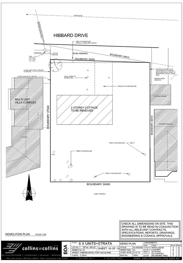
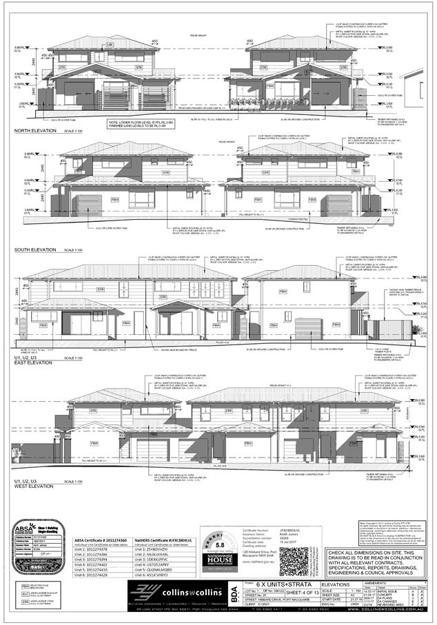
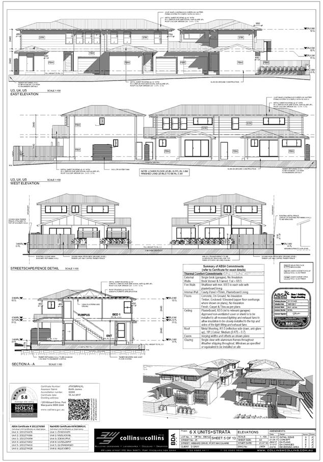
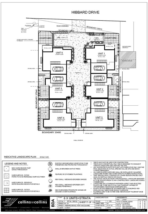

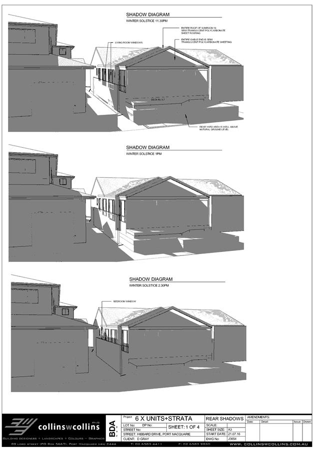
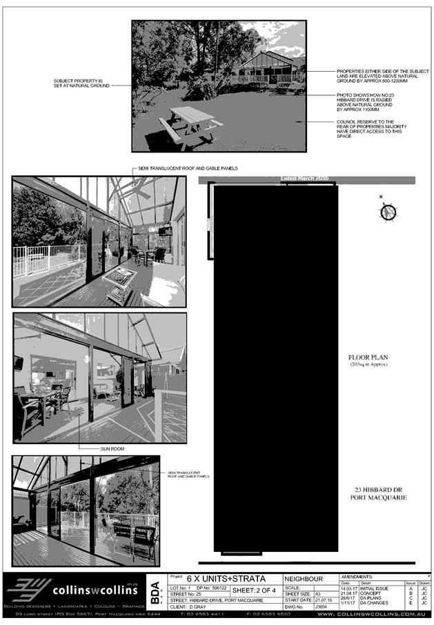
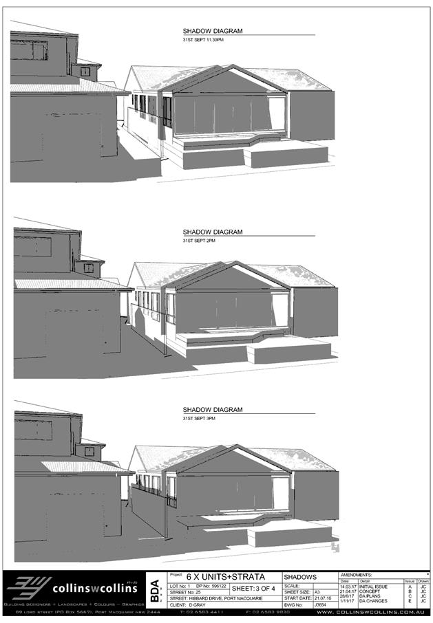
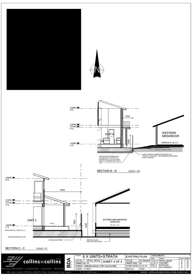
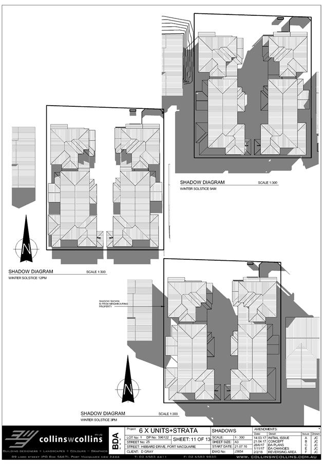
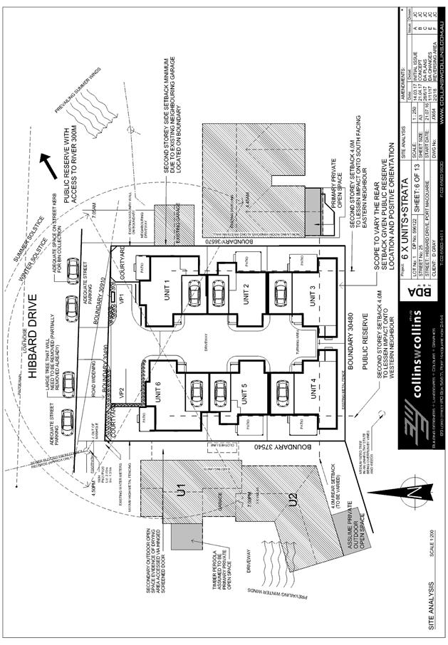
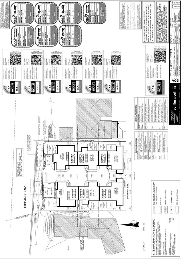
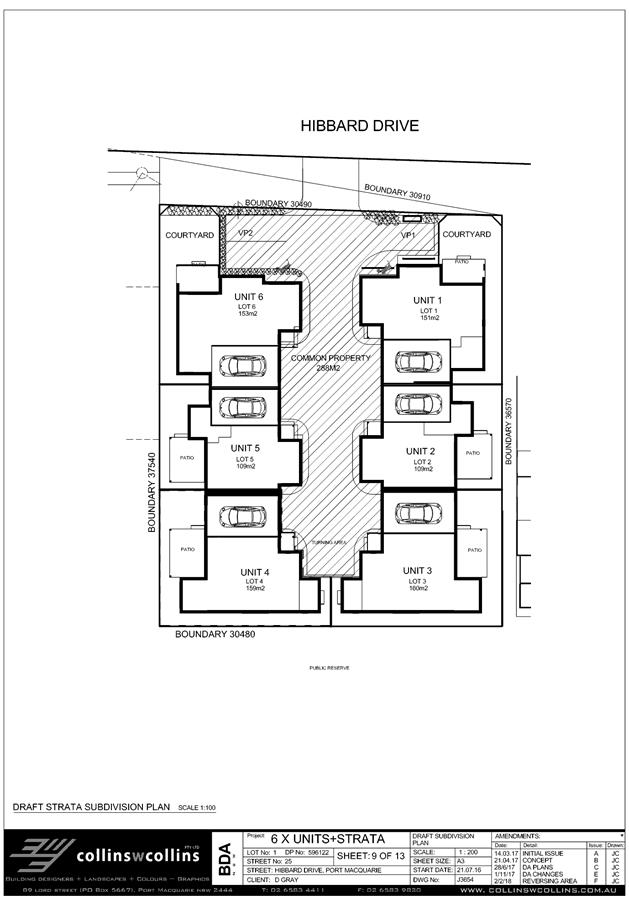
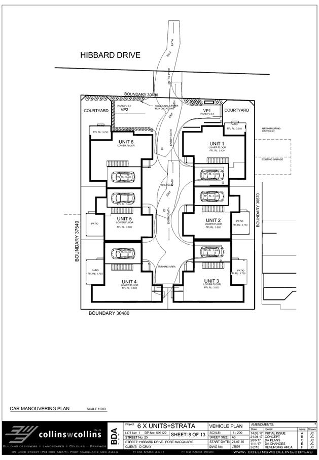
|
ATTACHMENT
|
Development Assessment Panel
14/02/2018
|
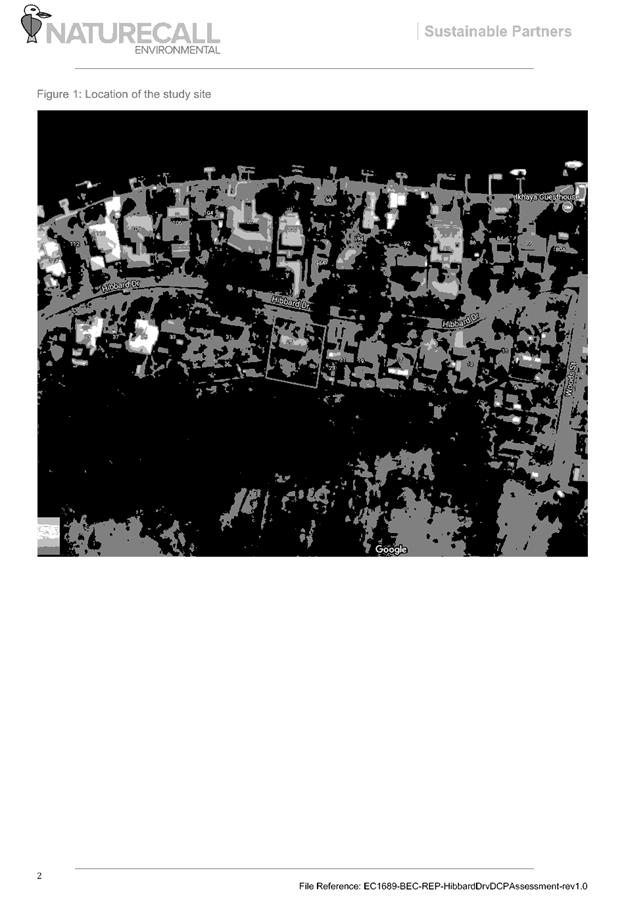

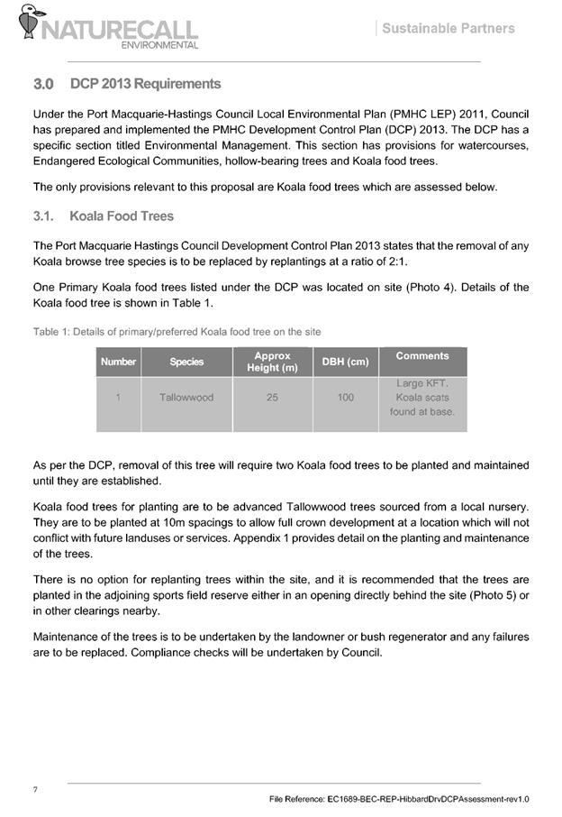
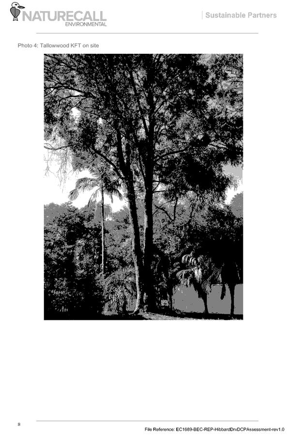
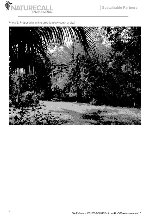
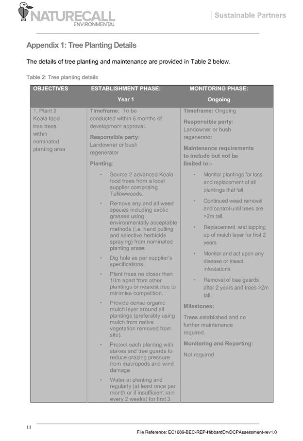
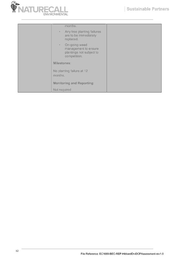
|
ATTACHMENT
|
Development Assessment Panel
14/02/2018
|
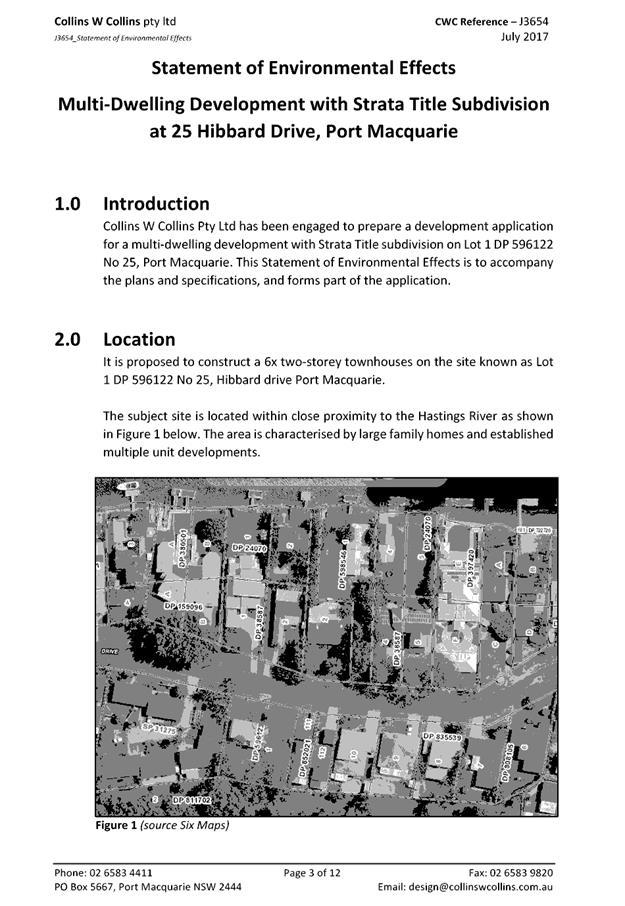
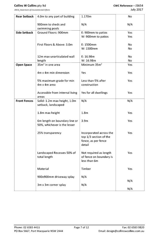
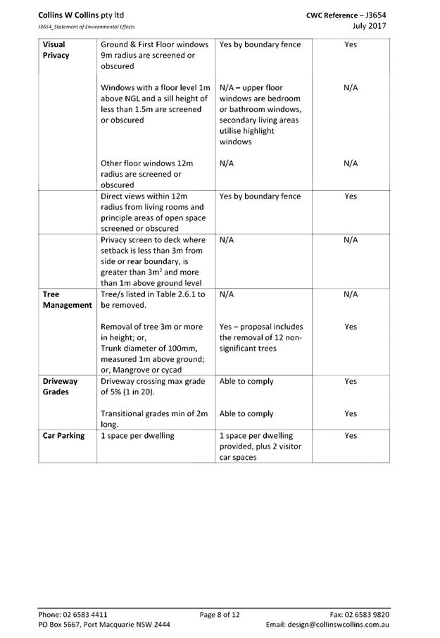
|
ATTACHMENT
|
Development Assessment Panel
14/02/2018
|
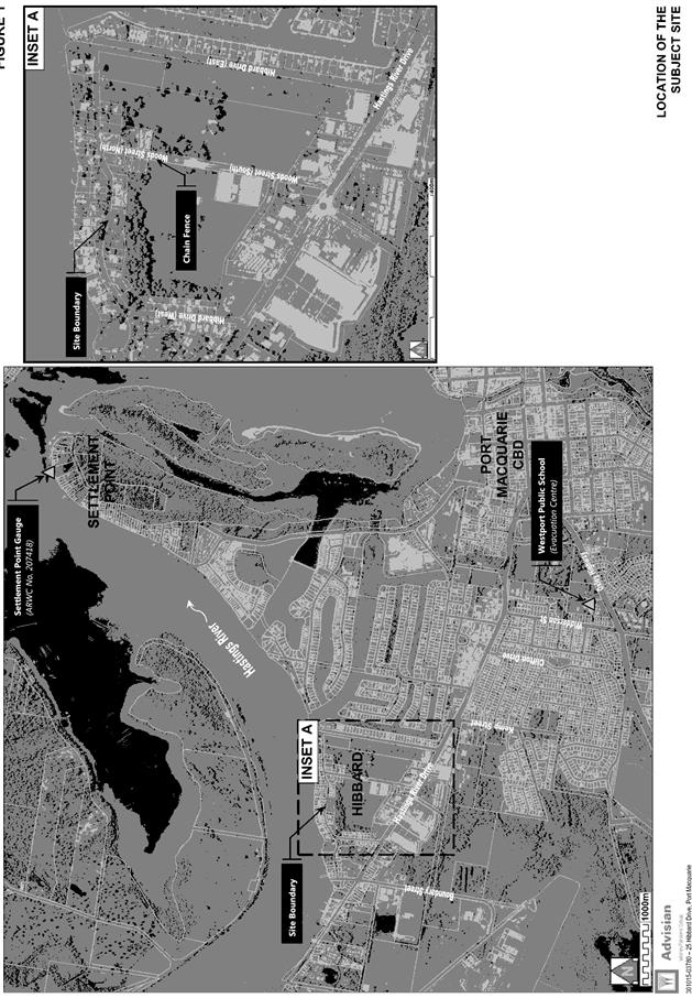
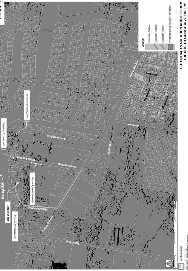
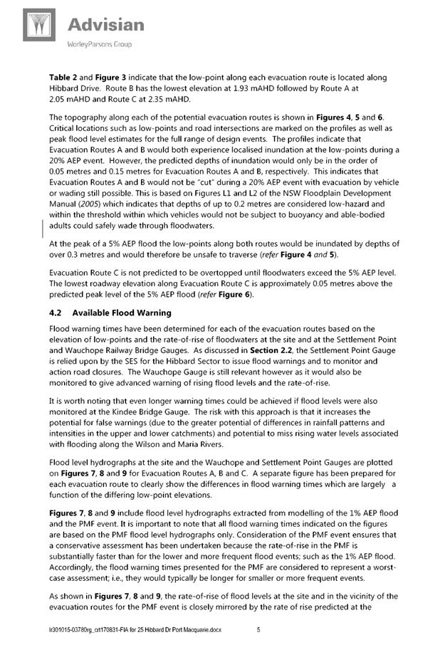
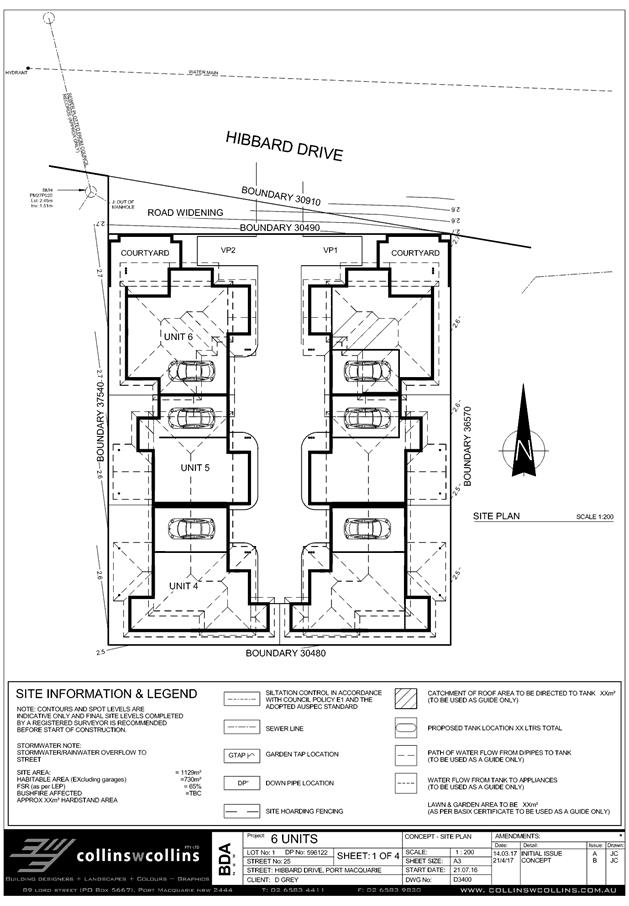
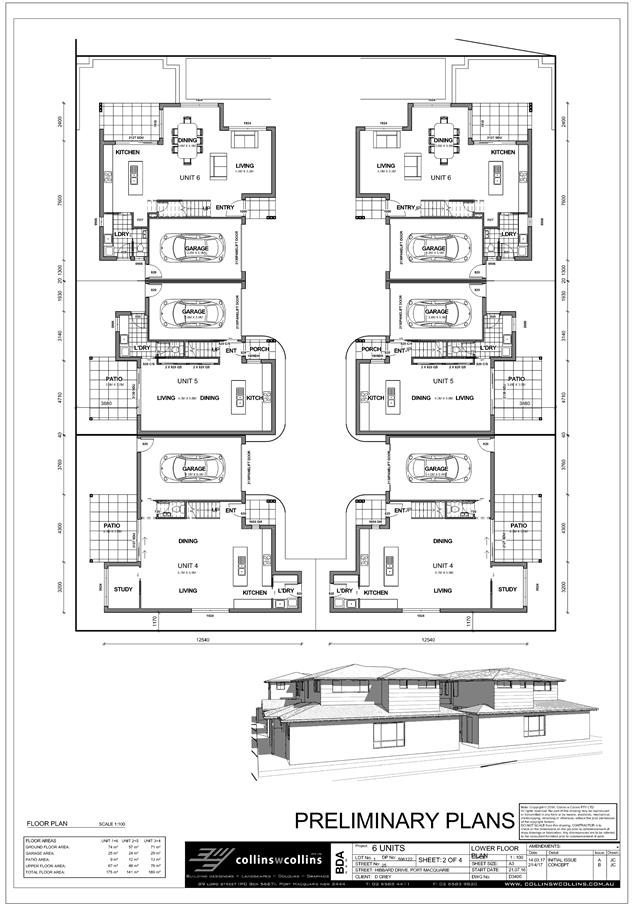
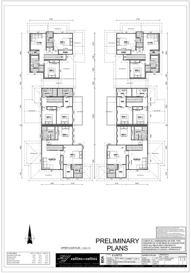
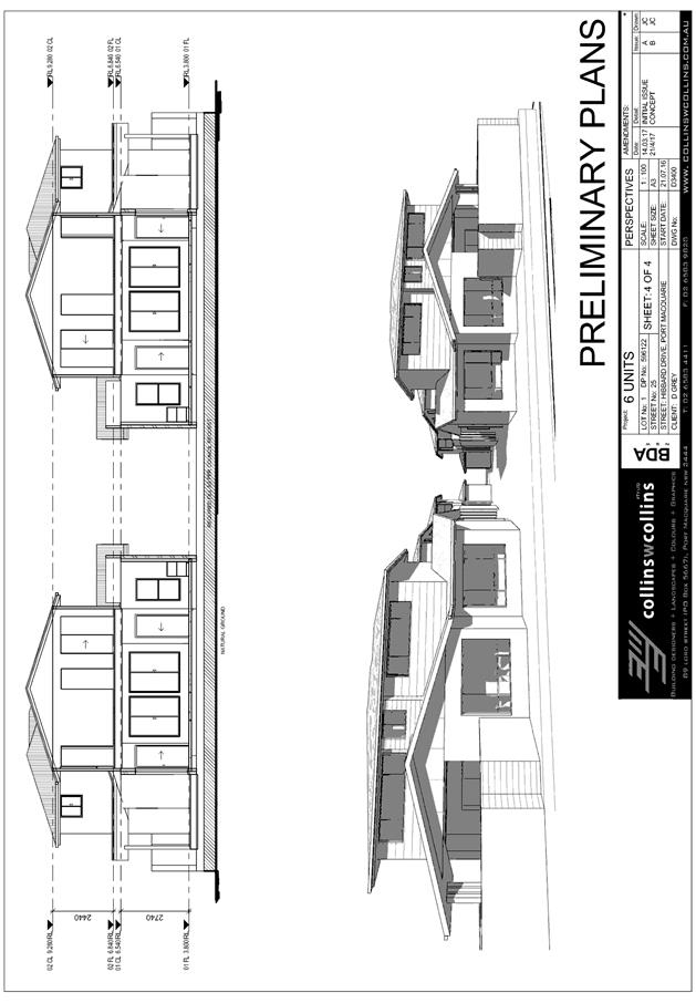
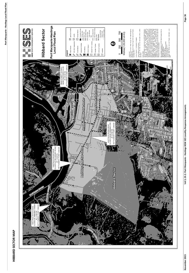
|
ATTACHMENT
|
Development Assessment Panel
14/02/2018
|
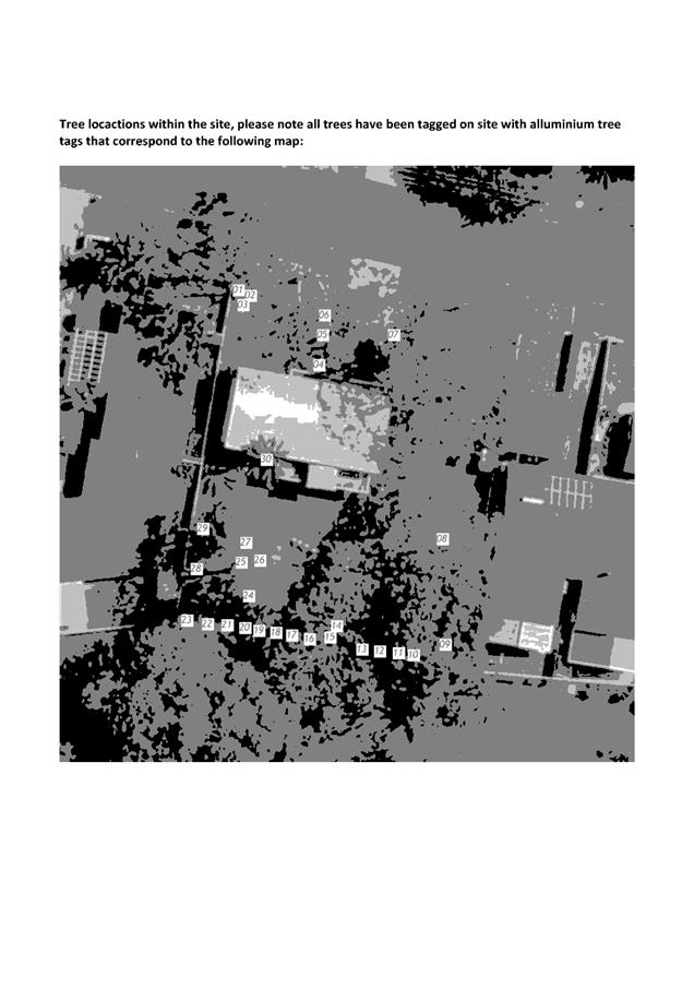
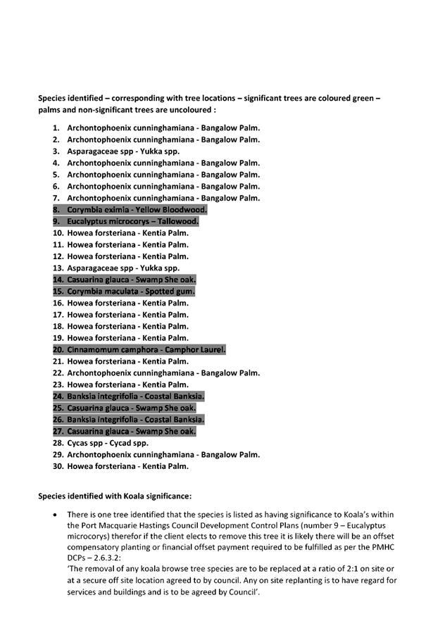

|
ATTACHMENT
|
Development Assessment Panel
14/02/2018
|
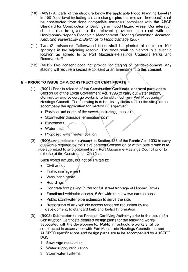
|
ATTACHMENT
|
Development Assessment Panel
14/02/2018
|