Business
Paper
|
date of meeting:
|
|
5/12/2018
|
|
location:
|
|
Function Room
Port
Macquarie-Hastings Council
17 Burrawan Street
Port Macquarie
|
|
time:
|
|
2:00pm
|
Development
Assessment Panel
CHARTER
1.0 OBJECTIVES
To assist in managing Council's development assessment
function by providing independent and expert determinations of development
applications that fall outside of staff delegations.
2.0 KEY FUNCTIONS
·
To review development application reports and conditions;
·
To determine development
applications outside of staff delegations;
·
To refer development applications
to Council for determination where necessary;
·
To provide a forum for objectors and applicants
to make submissions on applications
before the Development Assessment Panel
(DAP);
·
To maintain transparency in the determination of development
applications.
Delegated Authority of Panel
Pursuant to
Section 377 of the Local Government Act, 1993 delegation to:
·
Determine development applications under Part 4
of the Environmental Planning and Assessment
Act 1979 having
regard to the relevant environmental planning instruments,
development control plans and Council policies.
·
Vary, modify or release restrictions as to use
and/or covenants created by Section 88B instruments under the Conveyancing Act
1919 in relation to development applications for subdivisions being considered
by the panel.
·
Determine Koala Plans of Management under State
Environmental Planning Policy 44 - Koala Habitat Protection associated with
development applications being considered by the Panel.
Noting the trigger to escalate
decision making to Council as highlighted in section 5.2.
3.0
MEMBERSHIP
3.1
Voting
Members
·
Two independent external members. One of the
independent external members to be the Chairperson.
·
Group Manager Development Assessment (alternate
- Director Development & Environment or Development Assessment Planner)
The independent external members shall have expertise in
one or more of the following areas: planning, architecture, heritage, the
environment, urban design, economics, traffic and transport, law, engineering,
government and public administration.
3.2
Non-Voting Members
·
Not applicable
3.3 Obligations
of members
·
Members must act faithfully and diligently and
in accordance with this Charter.
·
Members must comply with Council's Code of Conduct.
·
Except as required to properly perform their
duties, DAP members must not
disclose any confidential information (as advised by Council) obtained in connection with the DAP functions.
·
Members will have read and be familiar with the
documents and information provided by Council prior
to attending a DAP meeting.
·
Members must act in accordance with Council's
Workplace Health and Safety Policies and Procedures
·
External members of the Panel are not authorised
to speak to the media on behalf of Council. Council officers that are members
of the Committee are bound by the
existing operational delegations in relation to speaking to the media.
·
Staff members shall not vote on matters before
the Panel if they have been the principle author of the development assessment report.
3.4
Member Tenure
·
The independent external members will be appointed
for the term of four (4) years
maximum in which the end of the tenure of these members would occur in a
cascading arrangement.
3.5 Appointment
of members
·
The independent external members (including the
Chair) shall be appointed by the General Manager following an external
Expression of Interest process.
·
Staff members of the Panel are in accordance
with this Charter.
4.0 TIMETABLE
OF MEETINGS
·
The Development Assessment Panel will generally
meet on the 1st and 3rd Wednesday each month at 2.00pm at the Port Macquarie
offices of Council.
·
Special Meetings of the Panel may be convened by
the Director Development & Environment Services with three (3) days notice.
5.0
MEETING PRACTICES
5.1
Meeting
Format
·
At all Meetings of the Panel the Chairperson
shall occupy the Chair and preside. The Chair will be responsible for keeping
of order at meetings.
·
Meetings shall be open to the public.
·
The Panel will hear from applicants
and objectors or their r e p r e s e n t a t i v e s .
·
Where considered necessary, the Panel will
conduct site inspections which will
be open to the public.
5.2
Decision Making
·
Decisions are to be made by consensus. Where
consensus is not possible on any item, that item is to be referred to Council
for a decision.
·
All development applications involving a
proposed variation to a development standard
greater than 10% under Clause
4.6 of the Local Environmental Plan will be
considered by the Panel and recommendation made to the Council for a decision.
5.3
Quorum
·
All members (2 independent external members and
1 staff member) must be present at a
meeting to form a quorum.
5.4
Chairperson and Deputy Chairperson
·
Independent Chair (alternate, second independent member)
5.5
Secretariat
·
The Director Development &n Environment is
to be responsible for ensuring that the Panel has adequate secretariat support.
The secretariat will ensure that the business paper and supporting papers are
circulated at least three (3) days prior to
each meeting. Minutes shall be appropriately approved and circulated to each
member within three (3) weeks of a meeting being held.
·
The format of and the preparation and publishing
of the Business Paper and Minutes shall be similar to the format for Ordinary
Council Meetings.
5.6
Recording of decisions
·
Minutes will record decisions and how each
member votes for each item before the Panel.
6.0 CONVENING
OF “OUTCOME SPECIFIC” WORKING GROUPS
Not applicable.
7.0 CONFIDENTIALITY
AND CONFLICT OF INTEREST
·
Members of the Panel must comply with the
applicable provisions of Council’s Code of Conduct. It is the personal
responsibility of members to comply with the standards in the Code of Conduct
and regularly review their personal circumstances with this in mind.
·
Panel members must declare any conflict of
interests at the start of each meeting or before discussion of a relevant item
or topic. Details of any conflicts of interest should be appropriately minuted.
Where members are deemed to have a real or perceived conflict of interest, it
may be appropriate they be excused from deliberations on the issue where the
conflict of interest may exist. A Panel meeting may be postponed where there is
no quorum.
8.0 LOBBYING
·
All members and applicants are to adhere to Council’s
Lobbying policy. Outside of
scheduled Development Assessment Panel meetings, applicants, their
representatives, Councillors, Council staff and the general public are not to
lobby Panel members via meetings, telephone conversations, correspondence and
the like. Adequate opportunity will be provided at Panel inspections or
meetings for applicants, their representatives and the general public to make
verbal submissions in relation to Business Paper items.
Development Assessment Panel
ATTENDANCE
REGISTER
|
Member
|
08/08/18
|
26/09/18
|
24/10/18
|
14/11/18
|
28/11/18
|
|
Paul Drake
|
A
|
P
|
P
|
P
|
P
|
|
Robert Hussey
|
P
|
P
|
P
|
P
|
P
|
|
David Crofts
(alternate member)
|
P
|
|
|
|
|
|
Dan Croft
(Acting Director
Development & Environment)
Clinton Tink
(Acting GM Development
Assessment
(alternates)
- Director Development & Environment
- Development Assessment Planner
|
P
|
P
|
P
|
P
P
|
P
|
Key: P = Present
A
= Absent With Apology
X
= Absent Without Apology
Development
Assessment Panel Meeting
5/12/2018
Items of Business
01 Acknowledgement
of Country............................................................................ 8
02 Apologies......................................................................................................... 8
03 Confirmation
of Minutes.................................................................................... 8
04 Disclosures
of Interest..................................................................................... 13
05 DA2018
- 759.1 Replacement Of Revetment Wall And Construction Of Pontoon - Lot 5 DP
217022, No, 10 North Shore Drive, North Shore................................................. 17
06 DA2018
- 735.1 Alterations And Additions To Dwelling - Lot 9 DP 708575, No 32 St
Andrews Avenue, Port Macquarie................................................................................... 34
07 DA2018
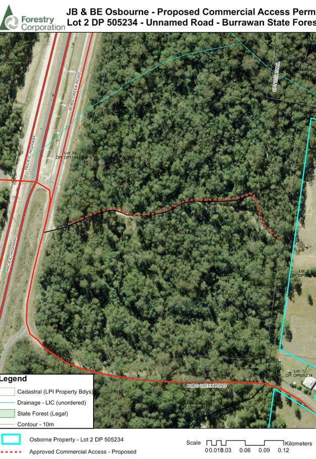
- 528.1 Log Processing Works (Rural Industry) - Lot 2 DP 505234, 75 Bobs Creek
Road, Bobs Creek..................................................................................................... 61
08 General
Business
AGENDA Development Assessment Panel 5/12/2018
Subject: ACKNOWLEDGEMENT
OF COUNTRY
"I acknowledge that we are
gathered on Birpai Land. I pay respect to the Birpai Elders both past and
present. I also extend that respect to all other Aboriginal and Torres Strait
Islander people present."
RECOMMENDATION
That the apologies received be
accepted.
Subject: CONFIRMATION
OF PREVIOUS MINUTES
Recommendation
That the Minutes of the Development
Assessment Panel Meeting held on 28 November 2018 be confirmed.
MINUTES
Development Assessment Panel Meeting
28/11/2018
PRESENT
Members:
Paul
Drake
Robert Hussey
Dan Croft
Other Attendees:
Patrick Galbraith-Robertson
Steven
Ford
Caroline
Horan
|
The meeting opened at 2:00pm.
|
|
01 ACKNOWLEDGEMENT
OF COUNTRY
|
|
The
Acknowledgement of Country was delivered.
|
|
03 CONFIRMATION
OF MINUTES
|
|
CONSENSUS:
That
the Minutes of the Development Assessment Panel Meeting held on 14 November
2018 be confirmed.
|
|
04 DISCLOSURES
OF INTEREST
|
|
There were no disclosures of interest presented.
|
Item - 05 DA2017 - 736.1- Staged
198 Site Manufactured Home Estate With Associated Amenities And Infrastructure,
And Modification To Previous Approved Subdivision (DA2006-57) - 79 Batar Creek
Road, Kendall - has been moved to another part of the document and considered
at 5:30pm.
|
06 DA2018 - 790.1
Additional Dwelling to Create Dual Occupancy and Strata Subdivision
|
|
Speaker:
David Pensini (applicant)
CONSENSUS:
That DA
2018-790 for an Additional Dwelling
to Create a Dual Occupancy and Strata Subdivision at
Lot 130, DP 815514, No. 27 Grassmere
Way, Port Macquarie,
be determined by granting consent subject to the recommended conditions.
|
|
07 DA2018 - 778.1
Alterations And Additions To Dwelling - Lot 18, No. 8 Chepana Street, Lake
Cathie.
|
|
Speaker:
Craig Maltman
Submission from Michelle Chapman
dated 27 November 2018 tabled at the meeting.
CONSENSUS:
That DA2018
– 778.1 for alterations and additions to
dwelling at Lot 18 DP241740 No. 8 Chepana Street, Lake Cathie be determined
by granting consent subject to conditions and as amended below:
- Additional
condition in section B of the consent to read: ‘An application
pursuant to Section 138 of the Roads Act, 1993 to carry out works
required by the Development Consent on or within public road is to be
submitted to and obtained from Port Macquarie-Hastings Council prior to
release of the Construction Certificate.
A.
Such works include, but not be limited to:
Footway and gutter crossing
Functional vehicular access
Removal of redundant driveway crossing and replacement with
upright kerb to match existing.’
- Additional condition in Section B of the consent to
read: ‘The northern elevation of the ground floor garage wall
is to be painted a light colour. Details are to be submitted to Council
for approval prior to release of the Construction Certificate.’
- Additional
condition in Section E of the consent to read: Prior to occupation or
the issuing of the Occupation Certificate provision to the Principal
Certifying Authority of documentation from Port Macquarie-Hastings
Council being the local roads authority certifying that all matters
required by the approval issued pursuant to Section 138 of the Roads Act
have been satisfactorily completed.
|
The Development Assessment Panel
meeting adjourned at 2:17pm and reconvened at 5:30pm.
|
05 DA2017 -
736.1- Staged 198 Site Manufactured Home Estate With Associated Amenities And
Infrastructure, And Modification To Previous Approved Subdivision (DA2006-57)
- 79 Batar Creek Road, Kendall
|
|
Speakers:
David
Adamson (o)
Wendy
Hay (o)
Terry
Parker (o)
Debra
Bennett (o)
Millicent
Jones (o)
Sean
Gleeson (o)
Edwin
Elliot (o)
Roy
Eagleton (o)
Dale
Carr (o)
Donna
Clarke (applicant)
Andy
Davis (applicant)
Michael
Summers (applicant)
CONSENSUS:
That
DA2017 - 736.1 for a two (2) lot subdivision, modification to previous
approved subdivision and a staged 198 site manufactured home estate with
associated amenities and infrastructure at Lot 1 DP 122192, Lot 79 DP 655658,
Lot 23 DP112083 and Lot 1 DP 1142845, Batar Creek Road, Kendall be determined
by granting consent subject to the recommended conditions and as amended
below:
- The Social Impact Assessment
submitted with the application prepared by All About Planning is to be
referenced in the approved plans and documentation outlined in condition
A(1).
|
|
The
meeting closed at 7:15pm.
|
AGENDA Development Assessment Panel 5/12/2018
Subject: DISCLOSURES
OF INTEREST
RECOMMENDATION
That Disclosures of Interest be presented
DISCLOSURE OF
INTEREST DECLARATION
Name of Meeting: ………………………………………………………………………..
Meeting Date: ………………………………………………………………………..
Item Number: ………………………………………………………………………..
Subject: ………………………………………………………………………..
…………………………………………………….……………...…..
I,
.....................................................................................
declare the following interest:
 Pecuniary:
Take
no part in the consideration and voting and be out of sight of the meeting.
Non-Pecuniary
- Significant Interest:
Take
no part in the consideration and voting and be out of sight of the meeting.
Non-Pecuniary
- Less than Significant Interest:
May
participate in consideration and voting.
For the reason that:
....................................................................................................
.......................................................................................................................................
Name:
…………………………………………………….
Signed:
.........................................................................
Date: ..................................
 (Further
explanation is provided on the next page)
(Further
explanation is provided on the next page)
Further
Explanation
(Local Government Act and Code of Conduct)
A conflict of interest exists where a reasonable and informed
person would perceive that a Council official could be influenced by a private
interest when carrying out their public duty. Interests can be of two types:
pecuniary or non-pecuniary.
All interests, whether pecuniary or non-pecuniary are required to
be fully disclosed and in writing.
Pecuniary Interest
A pecuniary interest is an interest that a Council official has in
a matter because of a reasonable likelihood or expectation of appreciable
financial gain or loss to the Council official. (section 442)
A Council official will also be taken to have a pecuniary interest
in a matter if that Council official’s spouse or de facto partner or a
relative of the Council official or a partner or employer of the Council
official, or a company or other body of which the Council official, or a
nominee, partner or employer of the Council official is a member, has a
pecuniary interest in the matter. (section 443)
The Council official must not take part in the consideration or
voting on the matter and leave and be out of sight of the meeting. The
Council official must not be present at, or in sight of, the meeting of
the Council at any time during which the matter is being considered or
discussed, or at any time during which the council is voting on any question in
relation to the matter. (section 451)
Non-Pecuniary
A non-pecuniary interest is an interest that is private or
personal that the Council official has that does not amount to a pecuniary
interest as defined in the Act.
Non-pecuniary interests commonly arise out of family, or personal
relationships, or involvement in sporting, social or other cultural groups and
associations and may include an interest of a financial nature.
The political views of a Councillor do not constitute a private
interest.
The management of a non-pecuniary interest will depend on whether
or not it is significant.
Non Pecuniary – Significant Interest
As a general rule, a non-pecuniary conflict of interest will be
significant where a matter does not raise a pecuniary interest, but it
involves:
(a)
A relationship between
a Council official and another person that is particularly close, for example,
parent, grandparent, brother, sister, uncle, aunt, nephew, niece, lineal
descendant or adopted child of the Council official or of the Council official’s
spouse, current or former spouse or partner, de facto or other person living in
the same household.
(b)
Other relationships
that are particularly close, such as friendships and business relationships.
Closeness is defined by the nature of the friendship or business relationship,
the frequency of contact and the duration of the friendship or relationship.
(c)
An affiliation between
a Council official an organisation, sporting body, club, corporation or
association that is particularly strong.
If a Council official declares a non-pecuniary significant
interest it must be managed in one of two ways:
1.
Remove the source of
the conflict, by relinquishing or divesting the interest that creates the
conflict, or reallocating the conflicting duties to another Council official.
2.
Have no involvement in
the matter, by taking no part in the consideration or voting on the matter and
leave and be out of sight of the meeting, as if the provisions in section
451(2) apply.
Non Pecuniary – Less than Significant Interest
If a Council official has declared a non-pecuniary less than
significant interest and it does not require further action, they must provide
an explanation of why they consider that the conflict does not require further
action in the circumstances.
SPECIAL
DISCLOSURE OF PECUNIARY INTEREST DECLARATION
|
By
[insert full name of councillor]
|
|
|
In the
matter of
[insert name of environmental planning instrument]
|
|
|
Which is
to be considered at a meeting of the
[insert name of meeting]
|
|
|
Held on
[insert date of meeting]
|
|
|
PECUNIARY
INTEREST
|
|
Address of land in which councillor or an
associated person, company or body has a proprietary interest (the identified
land)i
|
|
|
Relationship of identified land to councillor
[Tick or cross one box.]
|
Councillor
has interest in the land (e.g. is owner or has other interest arising out of
a mortgage, lease trust, option or contract, or otherwise).
Associated
person of councillor has interest in the land.
Associated
company or body of councillor has interest in the land.
|
|
MATTER
GIVING RISE TO PECUNIARY INTEREST
|
|
Nature of land that is subject to a change
in zone/planning control by proposed
LEP (the subject land iii
[Tick or cross one box]
|
The
identified land.
Land
that adjoins or is adjacent to or is in proximity to the identified land.
|
|
Current zone/planning control
[Insert name of current planning instrument and
identify relevant zone/planning control applying to the subject land]
|
|
|
Proposed change of zone/planning control
[Insert name of proposed LEP and identify
proposed change of zone/planning control applying to the subject land]
|
|
|
Effect of proposed change of zone/planning control
on councillor
[Tick or cross one box]
|
Appreciable
financial gain.
Appreciable
financial loss.
|
|
|
|
Councillor’s
Name: …………………………………………
Councillor’s
Signature:
……………………………….
Date: ………………..
Important Information
This information is being
collected for the purpose of making a special disclosure of pecuniary interests
under sections 451 (4) and (5) of the Local Government Act 1993.
You must not make a special disclosure that you know or ought reasonably to
know is false or misleading in a material particular. Complaints made
about contraventions of these requirements may be referred by the
Director-General to the Local Government Pecuniary Interest and Disciplinary
Tribunal.
This form must be completed by
you before the commencement of the council or council committee meeting in
respect of which the special disclosure is being made. The
completed form must be tabled at the meeting. Everyone is entitled to
inspect it. The special disclosure must be recorded in the minutes of the
meeting.
i.
Section 443 (1) of the Local Government Act 1993 provides that
you may have a pecuniary interest in a matter because of the pecuniary interest
of your spouse or your de facto partner or your relativeiv or
because your business partner or employer has a pecuniary interest. You may
also have a pecuniary interest in a matter because you, your nominee, your
business partner or your employer is a member of a company or other body that
has a pecuniary interest in the matter.
ii.
Section 442 of the Local Government Act 1993 provides that a pecuniary
interest is an interest that a person has in a matter because of a
reasonable likelihood or expectation of appreciable financial gain or loss to
the person. A person does not have a pecuniary interest in a matter if the
interest is so remote or insignificant that it could not reasonably be regarded
as likely to influence any decision the person might make in relation to the
matter or if the interest is of a kind specified in section 448 of that
Act (for example, an interest as an elector or as a ratepayer or person liable
to pay a charge).
iii.
A pecuniary interest may arise by way of a change of permissible use of land
adjoining, adjacent to or in proximity to land in which a councillor or a
person, company or body referred to in section 443 (1) (b) or (c) of the
Local Government Act 1993 has a proprietary interest..
iv.
Relative is defined by the Local Government Act 1993 as
meaning your, your spouse’s or your de facto partner’s parent,
grandparent, brother, sister, uncle, aunt, nephew, niece, lineal descendant or
adopted child and the spouse or de facto partner of any of those persons.
AGENDA Development Assessment Panel 5/12/2018
Item: 05
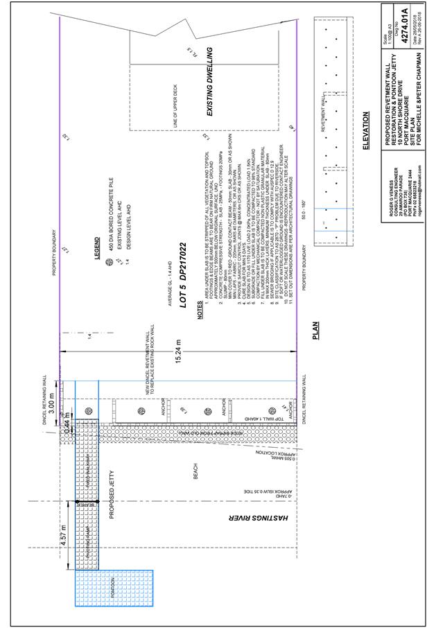
Subject: DA2018 - 759.1 Replacement Of Revetment Wall
And Construction Of Pontoon - Lot 5 DP 217022, No, 10 North Shore Drive, North
Shore.
Report
Author: Stephen Ryan
|
Applicant: M
J & P B Chapman
Owner: M
J & P B Chapman
Estimated Cost: $19,500
Alignment with Delivery
Program
4.3.1 Undertake transparent
and efficient development assessment in accordance with relevant legislation.
|
|
RECOMMENDATION
That
DA2018 – 759.1 for the replacement of revetment wall and construction
of pontoon at Lot 5 DP 217022 No.10 North Shore Drive, North Shore, be
determined by granting consent subject to the recommended conditions.
|
Executive
Summary
This
report considers a development application for a [description of development]
at the subject site and provides an assessment of the
application in accordance with the Environmental Planning and Assessment Act
1979.
Following exhibition of the
application, 3 submissions have been received.
1. BACKGROUND
Existing sites features and surrounding development
The site has an area of 743.13m².
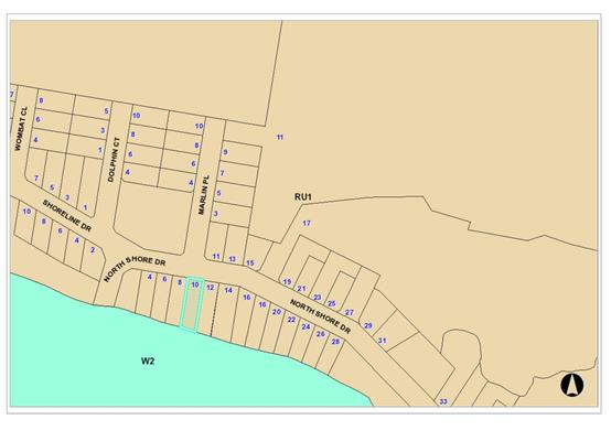
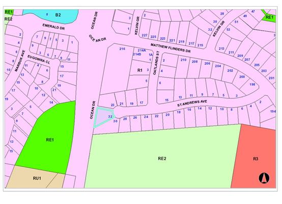
The site is zoned RU1 Primary Production in accordance with the Port Macquarie-Hastings Local
Environmental Plan 2011, as shown in the following zoning plan:
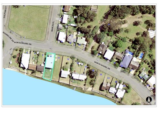
 The existing subdivision pattern and location of existing
development within the locality is shown in the following aerial photograph:
The existing subdivision pattern and location of existing
development within the locality is shown in the following aerial photograph:
2. DESCRIPTION OF
DEVELOPMENT
Key aspects of the proposal include the following:
· Replace
deteriorated revetment wall along the river frontage and install new floating
pontoon & walkway.
Refer
to attachments at the end of this report.
Application Chronology
· 18 September 2018- Application lodged.
· 4 October 2018 - 2 November 2018- Exhibition via neighbour
notification
· 8 October 2018 - Submission received
· 18 October 2018 - Submission received
· 22 October 2018 – Revised submission received
· 7 November 2018 - Site inspection.
3. STATUTORY ASSESSMENT
Section 4.15(1) Matters for Consideration
In determining the application, Council is required to take
into consideration the following matters as are relevant to the development
that apply to the land to which the development application relates:
(a) The provisions (where
applicable) of:
(i) any Environmental
Planning Instrument:
State Environmental Planning Policy No. 44 - Koala Habitat
Protection
There is no Koala Plan of Management on the site.
Additionally, the site is less than 1ha in area therefore no further
investigations are required.
State Environmental Planning Policy No. 55 –
Remediation of Land
Following an inspection of the site and a search of Council
records, the subject land is not identified as being potentially contaminated
and is suitable for the intended use.
State Environmental Planning Policy No. 62 –
Sustainable Aquaculture
The proposal will be unlikely to have any adverse impact on
existing aquaculture industries. Controlled activity approvals will be required
from Department of Primary Industries and Office of Water. These approvals will
need to be followed through the construction process to ensure there is no
significant impact on the Hastings River environment.
State Environmental Planning Policy (Coastal Management)
2018 and Clause 5.5 of Port Macquarie-Hastings Local Environmental Plan 2011
The site is located within a coastal use area / coastal
environment area.
In accordance with clause 7, this SEPP prevails over the
Port Macquarie-Hastings LEP 2011 in the event of any inconsistency.
Having regard to clauses 13 and 14 of the SEPP and clause
5.5 of the Port Macquarie-Hastings LEP 2011 the proposed development is not
considered likely to result in any of the following:
a) any
adverse impact on integrity and resilience of the biophysical,
hydrological (surface and groundwater) and ecological environment;
b) any
adverse impacts coastal environmental values and natural coastal
processes;
c) any
adverse impacts on marine vegetation, native vegetation and fauna
and their habitats, undeveloped headlands and rock platforms;
d) any
adverse impact on marine vegetation, native vegetation and fauna
and their habitats, undeveloped headlands and rock platforms;
e) any
adverse impact on Aboriginal cultural heritage, practices and
places;
f) any
adverse impacts on the cultural and built environment heritage;
g) any
adverse impacts the use of the surf zone;
h) any adverse impact on the visual amenity and scenic qualities of the
coast, including coastal headlands;
i) overshadowing, wind funneling and the loss of views from public places
to foreshores;
The the proposed development is compatible with the
surrounding coastal and built environment. The site is predominately cleared
and located within an existing nresidential area.
State Environmental Planning Policy (Building
Sustainability Index: BASIX) 2004
BASIX is not applicable.
Port Macquarie-Hastings Local Environmental
Plan 2011
The proposal is consistent with the LEP having regard to the
following:
· Clause 2.2, the
subject site is zoned RU1 Primary production General Residential. In accordance
with clause 2.3(1) and the RU1 zone landuse table, the dwelling (or ancillary
structure to a dwelling) is a permissible landuse with consent.
The objectives of the RU1 zone are as
follows:
§ To encourage sustainable primary industry
production by maintaining and enhancing the natural resource base.
§ To encourage diversity in primary industry
enterprises and systems appropriate for the area.
§ To minimise the fragmentation and alienation of
resource lands.
§ To minimise conflict between land uses within this
zone and land uses within adjoining zones.
In accordance with Clause 2.3(2),
the proposal is consistent with the zone objectives as it is a permissible
landuse and consistent with the established residential locality.
· Clause
2.7, the demolition requires consent as it does not fit within the provisions
of SEPP (Exempt and Complying Development Codes) 2008.
· Clause
4.3, there is no maximum overall standard height limit applying to the site.
· Clause
4.4, there is no maximum floor space ratio applying to the site.
· Clause
4.6 – exceptions to development standards.
· Clause
5.5 - Development within the coastal zone - relevant objectives of this clause
are addressed by SEPP (Coastal Management) 2018 section (see above).
· Clause
5.10 – Heritage. The site does not contain or adjoin any known heritage
items or sites of significance.
· Clause
7.1, the site is mapped as potentially containing class 3 acid sulphate soils.
o
Works more than 1 metre below the natural ground surface.
o
Works by which the watertable is likely to be lowered more than 1 metre below
the natural ground surface.
The proposed development includes
4 bored piles to a depth of 1.5m. Works are consistent with Councils Policy Acid
Sulfate Soil Management Plan for Minor Works. No adverse impacts are expected
to occur to the acid sulphate soils found on site.
· Clause
7.3, the site is land within a mapped “flood planning area” (Land
subject to flood discharge of 1:100 annual recurrence interval flood event
(plus the applicable climate change allowance and relevant freeboard) In this
regard the following comments are provided which incorporate consideration of
the objectives of Clause 7.3, Council’s Flood Policy 2015, the NSW
Government’s Flood Prone Lands Policy and the NSW
Government’s Floodplain Development Manual (2005):
o The
proposal is compatible with the flood hazard of the land taking into account
projected changes as a result of climate change;
o The
proposal will not result in a significant adverse effect on flood behaviour
that would result in detrimental increases in the potential flood affectation
of other development or properties;
o The
proposal incorporates measures to minimise & manage the flood risk to life
and property associated with the use of land;
o The
proposal is not likely to significantly adversely affect the environment or
cause avoidable erosion, siltation, destruction of riparian vegetation or a
reduction in the stability of river banks or watercourses;
o The
proposal is not likely to result in unsustainable social and economic costs to
the community as a consequence of flooding.
· Clause
7.5 – Koala Habitat applies to the site. Refer to comments under SEPP 44
heading.
· Clause
7.6 – The land is not identified as a Coastal Erosion Risk on the Coastal
Erosion Map (Lake Cathie/Town Beach).
· Clause
7.13, satisfactory arrangements are in place for provision of essential
services including water supply, electricity supply, sewer infrastructure,
stormwater drainage and suitable road access to service the development
(ii) Any
draft instruments that apply to the site or are on exhibition:
No draft instruments apply to the site.
(iii) any
Development Control Plan in force:
Port
Macquarie-Hastings Development Control Plan 2013
|
DCP 2013: Dwellings, Dual
occupancies, Dwelling houses, Multi dwelling houses & Ancillary
development
|
|
|
Requirements
|
Proposed
|
Complies
|
|
3.2.2.1
|
Ancillary development:
• 4.8m max. height
• Single storey
• 60m2 max. area
• 100m2 for lots
>900m2
• 24 degree max.
roof pitch
• Not located in
front setback
|
Pontoon and walkway
22m²
Rear setback
|
N/A
Yes
Yes
N/A
N/A
Yes
|
|
3.2.2.4
|
4m min. rear setback. Variation
subject to site analysis and provision of private open space
|
The rear setback requirements are
complied with.
|
Yes
|
|
3.2.2.5
|
Side setbacks:
• Ground floor =
min. 0.9m
• First floors
& above = min. 3m setback or where it can be demonstrated that
overshadowing not adverse = 0.9m min.
• Building wall
set in and out every 12m by 0.5m
|
Walkway setback 1.0m from side
boundary.
|
Yes
|
|
3.2.2.13 onwards
|
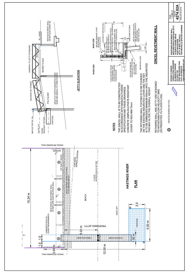
Jetties and boat ramps
|
a)
Mooring piles are to be set at a level no lower than the level which ensures
that the floating structure is retained during the design 1:100 year flood
event.
b)
The width of a jetty walkway not to exceed 1.0m. (1.0m proposed).
c)
The area of a platform should not exceed 10m².
d)
Jetty length measured from the existing revetment wall not to exceed 17m.
(12m
proposed).
e)
Boating ramps should have a maximum overall width of 3.0 metres and a maximum
overall length of 10.0 metres.
f)
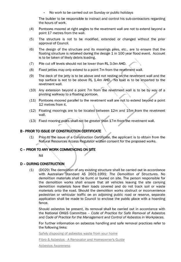
Pontoons moored at right angles to the revetment wall not to extend 17 metres
from the wall.
g)
Pile cut off levels should not be lower than RL3.0m AHD. (3.8m proposed)
h)
Fixed jetties may only extend to a point 7m from the revetment wall.
i)
Any extension beyond a point 7m from the revetment wall is to be by way of a
pivoting walkway to a floating pontoon.
j)
The deck of the jetty is to be above and not resting on the revetment wall
and the top surface is not to be above RL 1.4m AHD.
k)
Pontoons moored parallel to the revetment wall not to extend beyond a point
12 metres. (12m proposed).
l)
Floating moorings should be located between 17m from the revetment wall.
m)
Fixed mooring poles should not be greater than 17m from the revetment wall.
|
Yes
Yes
Yes
Yes
N/A
N/A
Yes
N/A
Yes
Yes
Yes
N/A
Yes
|
|
DCP 2013: General
Provisions
|
|
|
Requirements
|
Proposed
|
Complies
|
|
2.7.2.2
|
Design addresses generic principles of Crime Prevention
Through Environmental Design guideline
|
No concealment or entrapment areas proposed. Adequate
casual surveillance available.
|
Yes
|
|
2.3.3.1
|
Cut and fill 1.0m max. 1m outside the perimeter of the
external building walls
|
Cut and fill <1.0m change 1m outside the perimeter of
the external building walls
|
Yes
|
|
2.3.3.2
|
1m max. height retaining walls along road frontage
|
|
|
|
Any retaining wall >1.0 in height to be certified by
structure engineer
|
Revetment/ retaining wall engineer designed
|
Yes
|
|
Combination of retaining wall and front fence height max
1.8m, max length 6.0m or 30% of frontage, fence component 25% transparent,
and splay at corners and adjacent to driveway
|
No retaining wall front fence combination proposed.
|
N/A
|
|
2.4.3
|
Bushfire risk, Acid sulphate soils, Flooding,
Contamination, Airspace protection, Noise and Stormwater
|
Refer to main body of report.
|
|
(iiia) any
planning agreement that has been entered into under section 7.4, or any draft
planning agreement that a developer has offered to enter into under section
7.4:
No planning agreement has been offered or entered into
relating to the site.
iv) any matters prescribed by the
Regulations:
New South Wales Coastal Policy:
The proposed development is consistent with the objectives
and strategic actions of this policy.
Demolition of buildings AS 2601 – Clause 92
Demolition of the existing building on the site is capable
of compliance with this Australian Standard and is recommended to be
conditioned.
(b) The likely
impacts of that development, including environmental impacts on both the
natural and built environments and the social and economic impacts in the
locality
The proposal will be unlikely to have any adverse impacts to
existing adjoining properties and satisfactorily addresses the public domain.
The proposal is considered to be compatible with other
residential development in the locality and adequately addresses planning
controls for the area.
The proposal does not have a significant adverse impact on
existing view sharing.
The proposal does not have significant adverse lighting
impacts.
There are no significant adverse privacy impacts.
Access, Traffic and Transport
The proposal will be unlikely to have any adverse impacts in
terms access, transport and traffic. The existing road network will
satisfactorily cater for any increase in traffic generation as a result of the
development.
Other Utilities
N/A
(b) The
likely impacts of that development, including environmental impacts on both the
natural and built environments, social and economic impacts in the locality:
Heritage
This site does not contain or adjoin any known heritage item
or site of significance.
Other land resources
The site is within an established urban context and will not
sterilise any significant mineral or agricultural resource.
Water cycle
The proposed development will be unlikely to have any
adverse impacts on water resources and the water cycle.
Soils
The proposed development will be unlikely to have any
adverse impacts on soils in terms of quality, erosion, stability and/or
productivity subject to a standard condition requiring erosion and sediment
controls to be in place prior to and during construction.
Air and microclimate
The construction and/or operations of the proposed
development will be unlikely to result in any adverse impacts on the existing
air quality or result in any pollution. Standard precautionary site management
condition recommended.
Flora and fauna
Construction of the proposed development will not require
any removal/clearing of any significant vegetation and therefore will be
unlikely to have any significant adverse impacts on biodiversity or threatened
species of flora and fauna. Part 7 of the Biodiversity Conservation Act
is considered to be satisfied.
Waste
Satisfactory arrangements are in place for proposed storage
and collection of waste and recyclables. No adverse impacts anticipated.
Standard precautionary site management condition recommended.
Energy
No adverse impact anticipated. Standard construction
methodologies capable for completing the works.
Noise and vibration
No adverse impacts anticipated. Condition recommended to
restrict construction to standard construction hours.
Bushfire
The site is identified as being partially bushfire prone.
No construction requirements under AS3959- 2009 are
applicable to the proposed works.
Safety, security and crime prevention
The proposed development will be unlikely to create any
concealment/entrapment areas or crime spots that would result in any
identifiable loss of safety or reduction of security in the immediate area.
Social impacts in the locality
Given the nature of the proposed development and its
location the proposal is unlikely to result in any adverse social impacts.
Economic impact in the locality
No adverse impacts. A likely positive impact is that the
development will maintain employment in the construction industry, which will
lead to flow impacts such as expenditure in the area.
Site design and internal design
The proposed development design satisfactorily responds to
the site attributes and will fit into the locality. No adverse impacts likely.
Construction
No potential adverse impacts identified to neighbouring
properties with the construction of the proposal.
Cumulative Impacts
The proposed development is not expected to have any adverse
cumulative impacts on the natural or built environment or the social and
economic attributes of the locality.
(c) The suitability of the site for
the development:
The proposal will fit into the locality and the site
attributes are conducive to the proposed development.
Site constraints of bushfire/flooding have been adequately
addressed and appropriate conditions of consent recommended.
(d) Any submissions made in
accordance with this Act or the Regulations:
3 written submissions have been received following public
exhibition of the application.
Key issues raised in the submissions received and comments
in response to these issues are provided as follows:
|
Submission
Issue/Summary
|
Planning
Comment/Response
|
|
Pontoon does not suit the surrounding environment &
will be out of place.
|
The pontoon & walkway is consistent with other
similar structures to the east of the subject lot.
|
|
The length of the walkway is excessive & will be a
hazard at night.
|
The walkway length is consistent with the maximum length
specified in the Development Control Plan.
|
|
The pontoon is not suited to a river especially during
flood times.
|
The pontoon is engineer certified to withstand flood
forces at the 1:100 year flood event.
|
|
The consideration requires more consideration
(environmental reports of water flow, sand build up, effect on weed beds)
|
Further environmental assessments are not considered
necessary. The relevant State Government authorities have granted consent and
imposed conditions of approval.
|
|
This part of the river is for the use of everyone
|
The proposed walkway and pontoon does not restrict the
use of the river.
|
|
During flood & heavy rain, debris, logs, oyster racks
etc. will get caught up on the western part of the pontoon.
|
The pontoon is engineer certified to withstand flood
forces at the 1:100 year flood event.
|
|
Debris will block neigbouring walls & boat ramps.
|
The effect of debris during river flows cannot be
anticipated.
|
(e) The Public Interest:
The proposed
development satisfies relevant planning controls and is unlikely to impact on
the wider public interest.
4. DEVELOPMENT
CONTRIBUTIONS APPLICABLE
N/A
5. CONCLUSION AND
STATEMENT OF REASON
The application has been assessed
in accordance with Section 4.15 of the Environmental Planning and Assessment
Act 1979.
Issues raised during assessment
and public exhibition of the application have been considered in the assessment
of the application. Where relevant, conditions have been recommended to manage
the impacts attributed to these issues.
The site is considered suitable
for the proposed development and the proposal adequately addresses relevant
planning controls. The development is not considered to be contrary to the
public's interest and will not result a significant adverse social,
environmental or economic impact. It is recommended that the application be
approved, subject to the recommended conditions of consent provided in the
attachment section of this report.
|
Attachments
1View. DA2018
- 759.1 Recommended conditions
2View. DA2018
- 759.1 Plans
|
|
ATTACHMENT
|
Development Assessment Panel
5/12/2018 12:00:00
AM
|
|
ATTACHMENT
|
Development Assessment Panel
5/12/2018 12:00:00
AM
|

AGENDA Development Assessment Panel 5/12/2018
Item: 06
Subject: DA2018 - 735.1 Alterations And Additions To
Dwelling - Lot 9 DP 708575, No 32 St Andrews Avenue, Port Macquarie
Report
Author: Andrew Rock
|
Applicant: J
T McKeough
Owner: J
T McKeough
Estimated Cost: $180,000
Alignment with Delivery
Program
4.3.1 Undertake transparent
and efficient development assessment in accordance with relevant legislation.
|
|
RECOMMENDATION
That
DA2018 – 735.1 for alterations and additions to dwelling at Lot 9
DP708575, No. 32 St Andrews Avenue, Port Macquarie be determined by granting
consent subject to the recommended conditions.
|
Executive
Summary
This
report considers a development application for a [description of development]
at the subject site and provides an assessment of the
application in accordance with the Environmental Planning and Assessment Act
1979.
Following exhibition of the
application, four (4) submissions has been
received, from the one objector.
1. BACKGROUND
Existing sites features and surrounding development
St Andrews Ave is a residential
street containing one and two storey dwellings.
The subject site has an area of 990.200m2.
The site is zoned R 1 General Residential in accordance with the Port Macquarie-Hastings Local
Environmental Plan 2011, as shown in the following zoning plan:
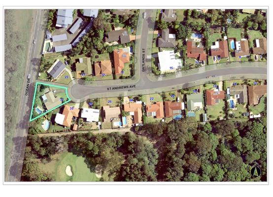
The existing subdivision pattern and location of existing
development within the locality is shown in the following aerial photograph:
2. DESCRIPTION OF
DEVELOPMENT
Key aspects of the proposal include the following:
· An upper floor addition to a rear section of the existing
dwelling, adjacent to the southern lot boundary.
· The removal of a ground floor store room.
· Internal alterations.
Refer
to attachments at the end of this report.
Application Chronology
· 11.9.18
– Application lodged
· 13.9.18 – Notification undertaken (18.9.18 –
2.10.18)
· 2.10.18 – First submission received (email dated
2.10.18)
· 3.10.18 – Second submission received (email dated
3.10.18)
· 11.10.18 – Amended plans received (Rev F)
· 16.10.18 – Additional pans received (Rev H)
· 16.10.18 – Third submission received (email dated
16.10.18)
· 14.11.18 – Site inspection of proposed development
site
· 16.11.18 – Site inspection from objectors property
· 16.11.18 – Fourth submission received (undated)
· 20.11.18 – Final plan set received (Rev I)
3. STATUTORY ASSESSMENT
Section 4.15(1) Matters for Consideration
In determining the application, Council is required to take
into consideration the following matters as are relevant to the development
that apply to the land to which the development application relates:
(a) The provisions (where
applicable) of:
(i) any Environmental
Planning Instrument:
State Environmental Planning Policy No. 44 - Koala
Habitat Protection
There is no Koala Plan of Management on the site.
Additionally, the site is less than 1ha in area therefore no further
investigations are required.
State Environmental Planning Policy No. 55 –
Remediation of Land
Following an inspection of the site and a search of Council
records, the subject land is not identified as being potentially contaminated
and is suitable for the intended use.
State Environmental Planning Policy No. 62 –
Sustainable Aquaculture
Given the nature of the proposed development and proposed
stormwater controls the proposal will be unlikely to have any adverse impact on
existing aquaculture industries.
State Environmental Planning Policy (Coastal Management)
2018 and Clause 5.5 of Port Macquarie-Hastings Local Environmental Plan 2011
The site is located within on land within a proximity area
for coastal wetlands and within a coastal use and coastal environment area.
In accordance with clause 7, this SEPP prevails over the
Port Macquarie-Hastings LEP 2011 in the event of any inconsistency.
In accordance with clause 11, the proposed additions will
not significantly impact on:
(a) the
biophysical, hydrological or ecological integrity of the adjacent coastal
wetland, or
(b) the
quantity and quality of surface and ground water flows to and from the adjacent
coastal wetland.
Having regard to clauses 13 and 14 of the SEPP and clause
5.5 of the Port Macquarie-Hastings LEP 2011 the proposed development is not
considered likely to result in any of the following:
a) any
adverse impact on integrity and resilience of the biophysical,
hydrological (surface and groundwater) and ecological environment;
b) any
adverse impacts coastal environmental values and natural coastal
processes;
c) any
adverse impacts on marine vegetation, native vegetation and fauna
and their habitats, undeveloped headlands and rock platforms;
d) any
adverse impact on marine vegetation, native vegetation and fauna
and their habitats, undeveloped headlands and rock platforms;
e) any
adverse impact on Aboriginal cultural heritage, practices and
places;
f) any
adverse impacts on the cultural and built environment heritage;
g) any
adverse impacts the use of the surf zone;
h) any adverse impact on the visual amenity and scenic qualities of the
coast, including coastal headlands;
i) overshadowing, wind funneling and the loss of views from public places
to foreshores;
The bulk, scale and size of the proposed development is
compatible with the surrounding coastal and built environment. The site is
cleared and located within an area zoned for residential purposes.
State Environmental Planning Policy (Building
Sustainability Index: BASIX) 2004
A BASIX certificate has been submitted demonstrating that
the proposal will comply with the requirements of the SEPP. It is recommended
that a condition be imposed to ensure that the commitments are incorporated
into the development and certified at Occupation Certificate stage.
Port Macquarie-Hastings Local Environmental
Plan 2011
The proposal is consistent with the LEP having regard to the
following:
· Clause
2.2, the subject site is zoned R1 General Residential. In accordance with
clause 2.3(1) and the R1 zone landuse table, the dwelling (or ancillary
structure to a dwelling) is a permissible landuse with consent.
The objectives of the R1 zone are as
follows:
o To provide for the housing
needs of the community.
o To provide for a variety of
housing types and densities.
o To enable other land uses
that provide facilities or services to meet the day to day needs of residents.
In accordance with Clause 2.3(2),
the proposal is consistent with the zone objectives as it is a permissible
landuse and consistent with the established residential locality.
· Clause
2.7, the demolition requires consent as it does not fit within the provisions
of SEPP (Exempt and Complying Development Codes) 2008.
· Clause
4.3, the maximum overall height of the building above ground level (existing)
is 6.861 m which complies with the standard height limit of 11.5 m applying to
the site.
· Clause
4.4, the floor space ratio of the proposal is 26.6:1.0 which complies with the
maximum 1.0:1 floor space ratio applying to the site.
· Clause
5.10 – Heritage. The site does not contain or adjoin any known heritage
items or sites of significance.
· Clause
7.1, the site is not mapped as potentially containing acid sulfate soils.
· Clause
7.3, the site is not land within a mapped “flood planning area”
(Land subject to flood discharge of 1:100 annual recurrence interval flood
event (plus the applicable climate change allowance and relevant freeboard).
· Clause
7.5 – Site is not mapped as containing Koala Habitat.
· Clause
7.8 - Development in areas subject to aircraft noise – site not located
within an ANEF contour of 20 or greater.
· Clause
7.9 - Development subject to acoustic controls – site not identified as
being subject to acoustic controls.
· Clause
7.13, satisfactory arrangements are in place for provision of essential
services including water supply, electricity supply, sewer infrastructure,
stormwater drainage and suitable road access to service the development.
(ii) Any
draft instruments that apply to the site or are on exhibition:
N/A
(iii) any
Development Control Plan in force:
Port
Macquarie-Hastings Development Control Plan 2013
|
DCP 2013: Dwellings, Dual
occupancies, Dwelling houses, Multi dwelling houses & Ancillary
development
|
|
|
Requirements
|
Proposed
|
Complies
|
|
3.2.2.1
|
Ancillary development:
• 4.8m max. height
• Single storey
• 60m2 max. area
• 100m2 for lots
>900m2
• 24 degree max.
roof pitch
• Not located in
front setback
|
Ancillary development
appropriately located.
|
Yes
|
|
3.2.2.2
|
Articulation zone:
• Min. 3m front
setback
• An entry feature
or portico
• A balcony, deck,
patio, pergola, terrace or verandah
• A window box
treatment
• A bay window or
similar feature
• An awning or
other feature over a window
• A sun shading
feature
|
No elements within the
articulation zone.
|
Yes
|
|
Front setback (Residential not R5
zone):
• Min. 6.0m
classified road
• Min. 4.5m local
road
• Min. 3.0m
secondary road
• Min. 2.0m
Laneway
|
All proposed development behind
the building line and greater than 6m from Ocean Drive.
|
Yes
|
|
3.2.2.3
|
Garage 5.5m min. and 1m behind
front façade.
Garage door recessed behind
building line or eaves/overhangs provided
|
No changes to existing proposed.
|
N/A
|
|
6m max. width of garage door/s
and 50% max. width of building
|
No changes to existing proposed.
|
N/A
|
|
Driveway crossover 1/3 max. of
site frontage and max. 5.0m width
|
Existing driveway suitable.
|
Yes
|
|
3.2.2.4
|
4m min. rear setback. Variation
subject to site analysis and provision of private open space
|
The rear setback requirements are
complied with.
|
Yes
|
|
3.2.2.5
|
Side setbacks:
• Ground floor =
min. 0.9m
• First floors
& above = min. 3m setback or where it can be demonstrated that
overshadowing not adverse = 0.9m min.
• Building wall
set in and out every 12m by 0.5m
|
The minimum ground floor side
setback requirements are complied with.
Upper floor addition proposed to
be setback 1.942m from the southern lot boundary (labelled eastern elevation
plan).
The ground floor 3m addition to
the south-west would result in an unarticulated building wall length of
approximately 20m to the southern wall.
|
Yes
No
No
|
|
3.2.2.6
|
35m2 min. private open space area
including a useable 4x4m min. area which has 5% max. grade
|
The dwelling contains 35m²
open space in one area including a useable 4m x 4m space.
|
Yes
|
|
3.2.2.10
|
Privacy:
• Direct views
between living areas of adjacent dwellings screened when within 9m radius of
any part of window of adjacent dwelling and within 12m of private open space
areas of adjacent dwellings. ie. 1.8m fence or privacy screening which has
25% max. openings and is permanently fixed
• Privacy screen
required if floor level > 1m height, window side/rear setback (other than
bedroom) is less than 3m and sill height less than 1.5m
• Privacy screens
provided to balconies/verandahs etc which have <3m side/rear setback and
floor level height >1m
|
The upper floor addition is not proposed to contain
primary indoor living areas.
Windows proposed on the eastern
elevation plan are a high sill 0.6m x 0.9m (height x width) window and 0.9m x
0.6m wet area window.
Upper floor windows proposed on
the northern and southern elevations will not provide direct views (directly
overlook with normal use of the room) to the primary indoor living area or
primary outdoor space of an adjoining property.
|
Yes
|
|
DCP 2013: General Provisions
|
|
|
Requirements
|
Proposed
|
Complies
|
|
2.7.2.2
|
Design addresses generic principles of Crime Prevention
Through Environmental Design guideline
|
No concealment or entrapment areas proposed. Adequate
casual surveillance available.
|
Yes
|
|
2.3.3.1
|
Cut and fill 1.0m max. 1m outside the perimeter of the
external building walls
|
Minimal cut/fill proposed.
|
Yes
|
|
2.4.3
|
Bushfire risk, Acid sulphate soils, Flooding,
Contamination, Airspace protection, Noise and Stormwater
|
Refer to main body of report.
|
|
|
2.5.3.2
|
New accesses not permitted from arterial or distributor
roads
|
No new access proposed to arterial or distribution road.
|
N/A
|
|
Driveway crossing/s minimal in number and width including
maximising street parking
|
Existing driveway crossing considered suitable.
|
Yes
|
|
2.5.3.3
|
Parking in accordance with Table 2.5.1.
1 space per single dwelling (behind building line)
|
Existing double garage on-site.
|
Yes
|
|
2.5.3.11
|
Section 94 contributions
|
Refer to main body of report.
|
|
|
2.5.3.12 and 2.5.3.13
|
Landscaping of parking areas
|
Existing single dwelling only with 1 domestic driveway. No
alterations considered necessary.
|
N/A
|
|
2.5.3.14
|
Sealed driveway surfaces unless justified
|
Existing sealed driveway.
|
Yes
|
|
2.5.3.15 and 2.5.3.16
|
Driveway grades first 6m or ‘parking area’
shall be 5% grade with transitions of 2m length
|
Existing driveway considered suitable.
|
Yes
|
|
2.5.3.17
|
Parking areas to be designed to avoid concentrations of
water runoff on the surface.
|
Existing single dwelling only with 1 domestic driveway.
Stormwater drainage is currently being managed adequately.
|
Yes
|
The proposal seeks to vary
Development Provision 3.2.2.5 relating to ground floor building walls being
unarticulated for greater than 12m (approx. 20m) and the upper floor side
setback of less than 3m (1.942m).
The relevant objectives are:
· To
reduce overbearing and perceptions of building bulk on adjoining properties and
to maintain privacy.
· To provide for
visual and acoustic privacy between dwellings.
With regard to the proposed ground floor building walls
(existing walls + proposed) being unarticulated for approximately 20m (eastern
elevation as shown on plan), the following observations are made:
o The existing wall extends for
approximately 17m without articulation, and a 3m extension of the subject wall
is proposed.
o The site of the proposed
development is significantly lower than the existing dwelling and land to the
south (30 St Andrews Ave).
o There is an existing sheet
metal dividing fence along the subject common boundary.
View to proposed development site from 30 St Andrews Ave
Given the above considerations, it is not considered that
the proposed additions to the ground floor, resulting in an unarticulated wall
of approximately 20m, will create a feeling of overbearing or perceptions of
building bulk from the property to the south (30 St Andrews Ave).
With regard to the proposed upper floor side setback being
1.942m from the southern side boundary, the following observations are made:
o The floor level of the
proposed upper floor addition is of a similar height to that of the primary
outdoor living area of dwelling to the south (no 30 St Andrews Ave). See page
11 of the plan set.
o The proposed addition is to
have a physical separation of 7.8m from the dwelling to the south (30 St
Andrews Ave). See page 11 of the plan set.
o The proposed upper floor
addition is to extend a length of 7.990m along the southern lot boundary.
o Upper floor windows adjoining
the southern lot boundary (labelled as east elevation on plan) are not within
living rooms. One window with dimensions 0.6m x 1.5m (height x width) has a
minimum sill height of 1.5m, and the other window with dimensions of 0.9 x
0.6m, is proposed to be located within a wet
area.
o There will be additional
overshadowing caused to a section of grassed area of the property to the south
(30 St Andrews Ave).
Given the above observations, and the residential context,
it is not considered that the proposed upper floor addition will feel
unacceptably overbearing or unacceptably bulky
when considered from the property to the south. The window placement on the
eastern elevation labelled plans will ensure that visual privacy is maintained
to the primary outdoor living area to the dwelling to the south. The physical
separation between the dwellings, combined with the proposed use of the rooms
adjoining the lot boundary, will maintain an adequate level of acoustic privacy
between dwellings. The upper floor addition, proposed to be setback 1.942m from
the side lot boundary will result in some overshadowing to the land to the
south, which is explored in more detail below.
When considering side setbacks and overshadowing impacts,
Development Provision 3.2.2.5 of Port Macquarie-Hastings Development Control
Plan, point b) states:
“First floors and above should be
setback minimum of 3m from the side boundary or reduced down to 900mm where it
can be demonstrated that the adjoining property primary living areas and
primary private open space areas should not be adversely overshadowed for more
than 3hrs between 9am-3pm on 21 June.”
With regard to the above, the following observations are
made:
o The proposed development will
result in additional overshadowing on the land to the south (30 St Andrews
Ave). The overshadowing will occur in a section of land to the north-west of an
existing covered deck.
o The extent of the
overshadowing is shown in the plans accompanying the application. Page 4 shows
an isometric projection of the existing development only on 21 June. Pages 5 and
12 shows a plan and isometric projection of the proposed development on the 21
June. Page 13 shows an isometric projection on 21 March.
o The plans show that no
adjoining living areas will be over shadowed as a result of the proposed
development.
o The plans show that the deck
area of the dwelling to the south (30 St Andrews Ave) will not be overshadowed
as a result of the development.
o Open space areas located on
the property to the south (30 St Andrews Ave) exist, relative to the covered
deck area, are to the; north, north-west, west area, along the southern lot
boundary and a section along the eastern lot boundary.
o The area which would be
overshadowed as a result of the proposed development is an area to the
north-west of the existing deck at 30 St Andrews Ave. Other areas identified in
the point above will not be overshadowed as a result of the proposed
development.
o It is noted that some of the
areas of open space listed above, at 30 St Andrew Ave, will be overshadowed at
different times of the day from the existing dwelling at 30 St Andrews
Ave.
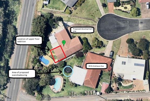
Aerial image of proposed development site, taken 23 October
2018 (nearmap)
The proposed upper floor addition will result in
overshadowing impacts to an area of open space to the north-west of the existing
deck at 30 St Andrews Ave. It is noted that the impacted lot is quite large and
has a number of grassed outdoor areas, most of which directly adjoin a large
covered deck which is considered the principal outdoor living area. These open
space areas are all behind the building line and screened from adjoining
residential land by boundary fencing. Accordingly, given the availability of a
variety of private open space areas available at 30 St Andrew Ave, the period
of time within the year when there will be an overshadowing impact and the
11.5m max building height, it is considered that the overshadowing impact is
not considered unacceptable given the site
circumstances.
Based on the above assessment, the variations proposed to
the provisions of the DCP are considered acceptable and the relevant objectives
have been satisfied. Cumulatively, the variations do not amount to an
unacceptable impact that would justify refusal of the application.
(iiia) any
planning agreement that has been entered into under section 7.4, or any draft
planning agreement that a developer has offered to enter into under section
7.4:
N/A
iv) any matters prescribed by the
Regulations:
Demolition
of buildings AS 2601:
Demolition of the existing building on the site is capable
of compliance with this Australian Standard and is recommended to be
conditioned.
(b) The
likely impacts of that development, including environmental impacts on both the
natural and built environments, social and economic impacts in the locality:
With regard to view impacts,
there will be some interruption to a view of trees along Ocean Drive to the
north-west from the covered deck area of 30 St Andrew Ave. The view proposed to
be interrupted is across a side boundary and will not be for the entirety of
the northern lot boundary. There will no impact to a view of trees along Ocean
Drive over the western rear boundary, or of the Port Macquarie Golf Course over
the rear southern lot boundary. The interruption of a view to the north-west of
the affected property would occur as a result of a non-compliance with a
development provision of the Development Control Plan, however the extent of
the view loss is not considered unreasonable given the site circumstances.
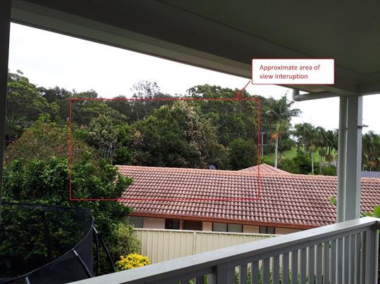
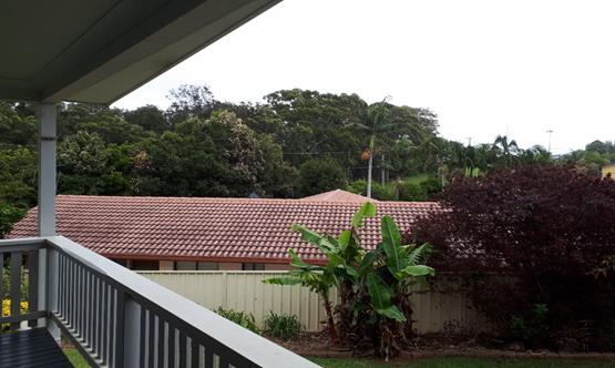
View to the north-west from the deck of 30 St Andrew Ave,
Port Macquarie
The proposal does not have significant adverse lighting
impacts.
There are no significant adverse privacy impacts to primary
living areas or primary private open space areas due to the proposed
orientation of windows, high window sill design to the southern elevation and
proposed use of the rooms containing windows.
There would be some overshadowing impacts resulting from the
proposed development however due to the limited size of the area to be
affected, for a limited period of the year the extent of overshadowing is not
considered unreasonable.
The proposal will be unlikely to have any unacceptable
impacts to the existing adjoining properties and satisfactorily addresses the
public domain.
The proposal is considered to be compatible with other
residential development in the locality and adequately addresses planning
controls for the area.
Access, Traffic and Transport
The proposal will be unlikely to have any adverse impacts in
terms access, transport and traffic. The existing road network will
satisfactorily cater for any increase in traffic generation as a result of the
development.
Water Supply Connection
Service available – details required with S.68
application.
Sewer Connection
Service available – details required with S.68
application.
Stormwater
Service available – details required with S.68
application.
Other Utilities
Telecommunication and electricity services are available to
the site.
Heritage
This site does not contain or adjoin any known heritage item
or site of significance.
Other land resources
The site is within an established urban context and will not
sterilise any significant mineral or agricultural resource.
Water cycle
The proposed development will be unlikely to have any
adverse impacts on water resources and the water cycle.
Soils
The proposed development will be unlikely to have any
adverse impacts on soils in terms of quality, erosion, stability and/or
productivity subject to a standard condition requiring erosion and sediment controls
to be in place prior to and during construction.
Air and microclimate
The construction and/or operations of the proposed
development will be unlikely to result in any adverse impacts on the existing
air quality or result in any pollution. Standard precautionary site management
condition recommended.
Flora and fauna
Construction of the proposed development will not require
any removal/clearing of any significant vegetation and therefore will be
unlikely to have any significant adverse impacts on biodiversity or threatened
species of flora and fauna. Part 7 of the Biodiversity Conservation Act
is considered to be satisfied.
Waste
Satisfactory arrangements are in place for proposed storage
and collection of waste and recyclables. No adverse impacts anticipated.
Standard precautionary site management condition recommended.
Energy
The proposal includes measures to address energy efficiency
and will be required to comply with the requirements of BASIX.
Noise and vibration
No adverse impacts anticipated. Condition recommended to
restrict construction to standard construction hours.
Bushfire
The site is identified as being bushfire prone.
The Applicant has submitted a bushfire report prepared by a
Certified Consultant.
An assessment of bushfire risk having regard to section
4.3.5 of Planning for Bushfire Protection 2006 including vegetation
classification and slope concludes that a Bushfire Attack Level 29 shall be
required and that some upgrading of the existing dwelling is recommended.
Management of bushfire risk is acceptable subject to BAL
construction levels being implemented and APZ being maintained. An appropriate
condition is recommended.
Safety, security and crime prevention
The proposed development will be unlikely to create any
concealment/entrapment areas or crime spots that would result in any
identifiable loss of safety or reduction of security in the immediate area. The
increase in housing density will improve natural surveillance within the
locality and openings from each dwelling overlook common and private areas.
Social impacts in the locality
Given the nature of the proposed development and its’
location the proposal is unlikely to result in any adverse social impacts.
Economic impact in the locality
No adverse impacts. A likely positive impact is that the
development will maintain employment in the construction industry, which will
lead to flow impacts such as expenditure in the area.
Site design and internal design
The proposed development design adequately responds to the
site attributes and will result in a section of the dwelling being double
storey, which will fit into the locality. The internal design, with no primary
living areas proposed on the upper floor, assists to minimise potential
impacts.
Construction
No potential adverse impacts identified to neighbouring
properties with the construction of the proposal.
Cumulative Impacts
The proposed development is not expected to have any adverse
cumulative impacts on the natural or built environment or the social and
economic attributes of the locality.
(c) The suitability of the site for
the development:
The proposal will fit into the locality and the site
attributes are conducive to the proposed development.
Site constraints of bushfire risk
have been adequately addressed and appropriate conditions of consent
recommended.
(d) Any submissions made in
accordance with this Act or the Regulations:
Four (4) submissions have been received following public exhibition
of the application.
Key issues raised in the submissions received and comments
in response to these issues are provided as follows:
|
Submission
Issue/Summary
|
Planning
Comment/Response
|
|
Overshadowing to a section of
the backyard.
|
Proposed development will
result in overshadowing to a section of the backyard of an adjoining
property, particularly during the winter months however the extent of
overshadowing is not considered unacceptable. See assessment earlier in this
report.
|
|
View and ‘atmosphere’ impacts from primary
indoor and outdoor areas.
|
Proposed development will have an impact on a view from
the subject areas however view to be interrupted is not considered
unacceptable given the circumstances. See assessment earlier in this report.
Potential impacts to the ‘atmosphere’ of the
subject areas are not considered significant due to the relative height of
the proposed development, window placement and the proposed use of the rooms
on the upper floor addition.
|
|
Privacy impacts including ‘overlooking’ of a
swimming pool and backyard and ‘direct views’ into primary indoor
living and covered deck area.
|
Upper floor windows proposed on the northern and southern
elevation plans are orientated to the front and rear of the subject lot
respectively. Normal use of the rooms containing these windows is unlikely to
cause unacceptably ‘overlooking’ of the yard and pool areas.
There are two windows proposed on the eastern elevation
which are orientated to the primary indoor living and covered deck area of 30
St Andrews Ave. As identified in the assessment above, neither of the rooms
is proposed to contain primary indoor living areas. One of the windows has a
sill height of a minimum of 1.5m above floor level and the other window is
proposed to contain a wet area. The high sill window is unlikely to result in
adverse privacy impacts and it is proposed to impose a condition that the wet
area window contain obscured glass.
|
(e) The Public Interest:
The proposed
development satisfies relevant planning controls and is unlikely to impact on
the wider public interest.
4. DEVELOPMENT
CONTRIBUTIONS APPLICABLE
N/A
5. CONCLUSION AND
STATEMENT OF REASON
The application has been assessed
in accordance with Section 4.15 of the Environmental Planning and Assessment
Act 1979.
Issues raised during assessment
and public exhibition of the application have been considered in the assessment
of the application. Where relevant, conditions have been recommended to manage
the impacts attributed to these issues.
The site is considered suitable
for the proposed development and the proposal adequately addresses relevant
planning controls. The development is not considered to be contrary to the
public's interest and will not result a significant adverse social,
environmental or economic impact. It is recommended that the application be
approved, subject to the recommended conditions of consent provided in the
attachment section of this report.
|
Attachments
1View. DA2018
- 735.1 Recommended conditions
2View. DA2018
- 735.1 Plans
|
|
ATTACHMENT
|
Development Assessment Panel
5/12/2018 12:00:00
AM
|

|
ATTACHMENT
|
Development Assessment Panel
5/12/2018 12:00:00
AM
|
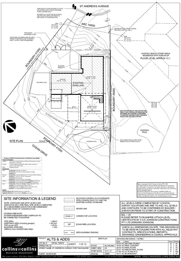
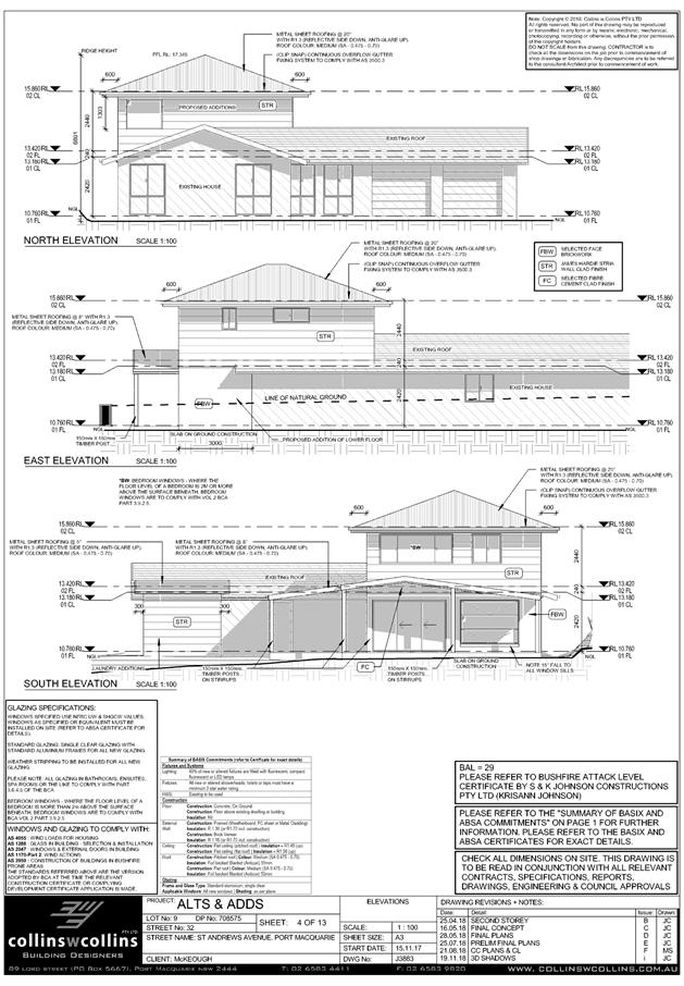
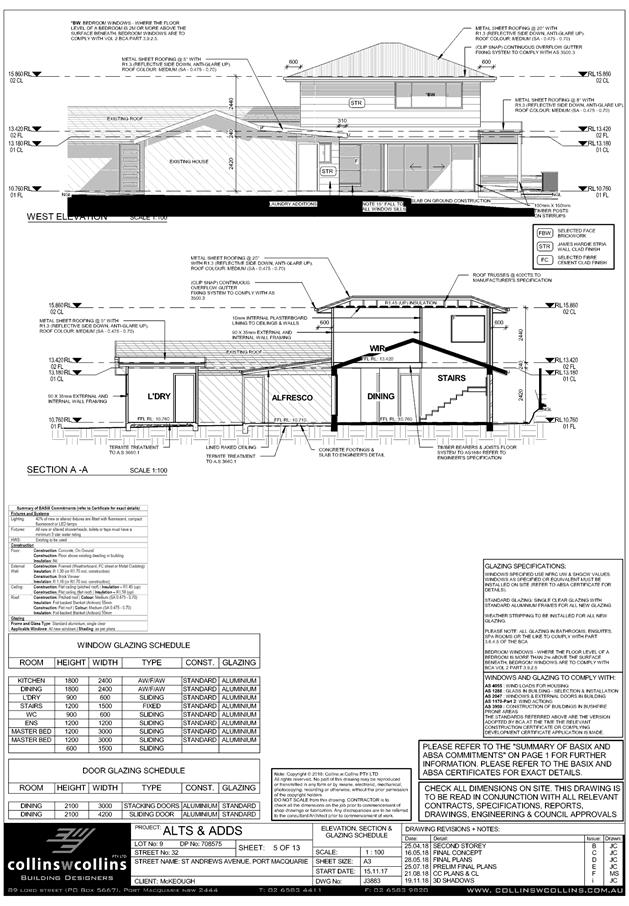
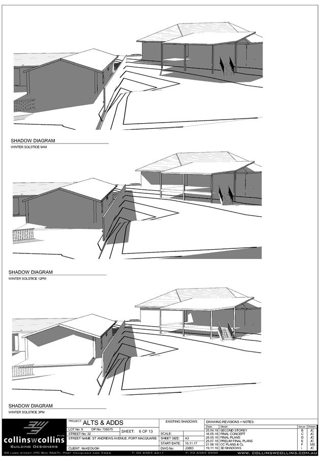
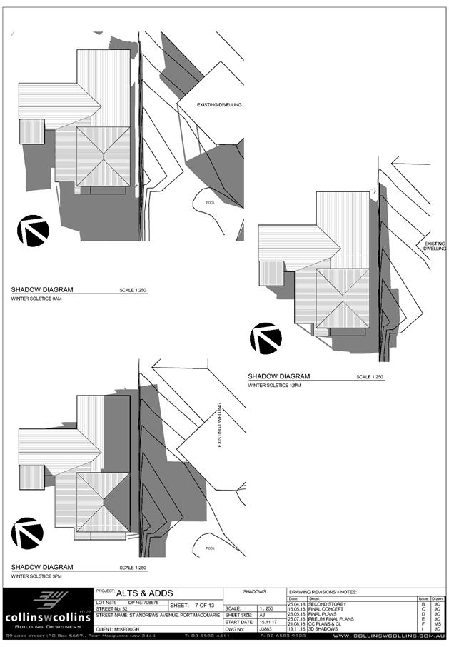
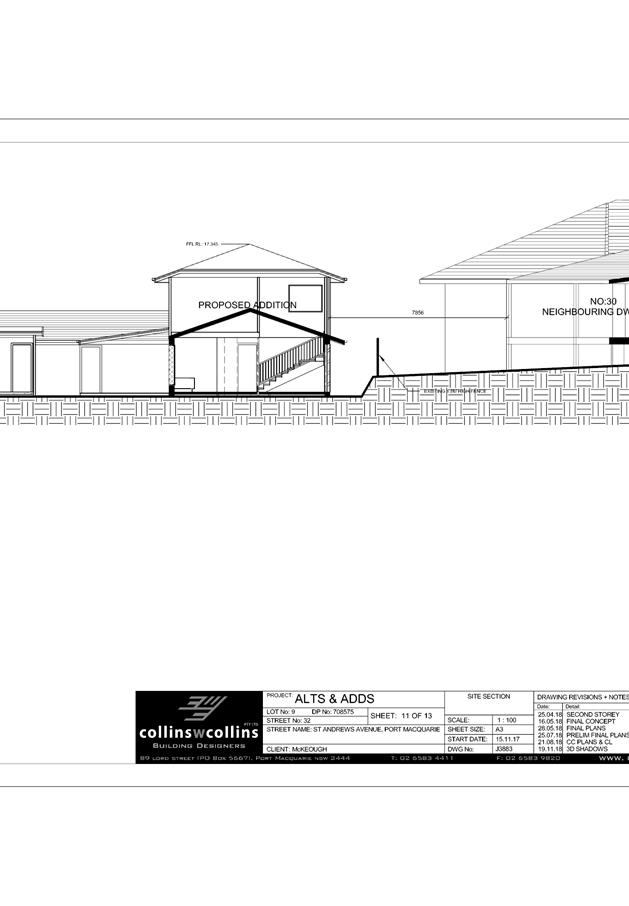
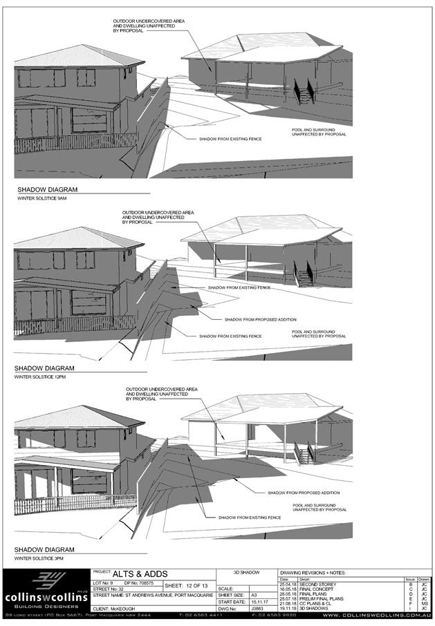
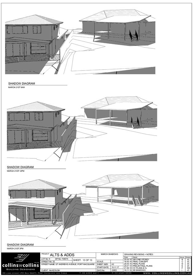
AGENDA Development Assessment Panel 5/12/2018
Item: 07
Subject: DA2018 - 528.1 Log Processing Works (Rural
Industry) - Lot 2 DP 505234, 75 Bobs Creek Road, Bobs Creek
Report
Author: Clint Tink
|
Applicant: B
E & J B Osbourne
Owner: B
E & J B Osbourne
Estimated Cost: N/A
Alignment with Delivery
Program
4.3.1 Undertake transparent
and efficient development assessment in accordance with relevant legislation.
|
|
RECOMMENDATION
That
DA 2018 – 528.1 for a log
processing works (rural industry) at Lot 2, DP 505234, No. 75
Bobs Creek Road, Bobs Creek, be determined by granting consent subject to the
recommended conditions.
|
Executive
Summary
This
report considers a development application for log processing works at the subject site and provides an assessment of the
application in accordance with the Environmental Planning and Assessment Act
1979.
Following exhibition of the
application and prior to finalising this report, ten (10) submissions were received. The submissions comprise two (2)
against the proposal and eight (8) in support of the proposal.
1. BACKGROUND
Existing sites features and Surrounding development
The site has an area of
19.92ha.
The site is zoned RU1 Primary Production in accordance with the Port Macquarie-Hastings Local
Environmental Plan 2011, as shown in the following zoning plan:
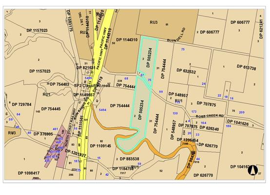
The existing subdivision pattern and location of existing
development within the locality is shown in the following aerial photographs:
Geocortex image 2013
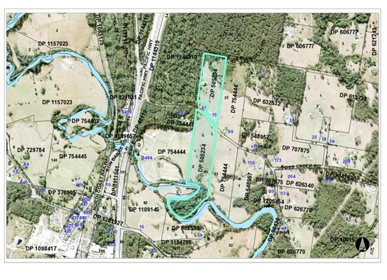
Nearmap image
zoomed in on logging works area 2018

2. DESCRIPTION OF
DEVELOPMENT
Key aspects of the proposal include the following:
· A
log processing mill is to be established for the purposes of processing timber
into firewood and timber fencing.
· Hours
of operation (including vehicles picking up and delivering product) are
proposed to be 7:30am to 4:00pm Monday to Friday and 8:00am to 1:00pm
Saturdays.
· Maximum
of four (4) staff operating the mill.
· 3000-4000
tonnes (approx 4600m³)
to be processed per year with less than 1000 tonnes to be stored onsite at any
one time.
· Approximately
two (2) to three (3) truckloads (28 tonnes per load) of timber will be
delivered per week during the aforementioned hours of operation.
· Timber
to be sold via wholesale market with no retails sales direct to the public
occurring onsite.
· A
noise impact assessment has been undertaken.
· Access
for staff, people doing repairs and friends (light vehicles) will predominately
be obtained via the existing southern private access/driveway off Bobs Creek
Road. Access for trucks delivering and picking up timber will be via the
existing western Forestry Road off Bobs Creek Road. The Forestry access will
ensure the larger timber trucks do not have to pass the neighbouring dwellings
in Bobs Creek Road.
· No
burning of timber will occur onsite with waste timber to be recycled or sent to
a waste management facility.
· No
works are proposed within 40m of the eastern drainage line onsite.
· No
clearing is proposed onsite as part of this application.
· Amenities
facilities are available within the existing dwelling and shed onsite.
· A
twelve (12) month trial period is proposed to be condition to allow the
applicant the opportunity to show compliance with conditions and to align with
the Forest Corporation twelve (12) month access approval. Towards the end of
the twelve (12) month trial, the applicant can modify the consent to extend the
consent.
Refer
to attachments at the end of this report.
Application Chronology
· 18/7/2018
– Development Application lodged with Council.
· 20/7/2018
– Council staff sought clarification from the applicant on noise impacts,
works within 40m of drainage line, truck movements, amount of material to be
processed, waste disposal, location of amenities, owners consent from Forestry
Corporation to use forestry road for access to commercial operation, access and
use of facility. Applicant acknowledged request.
· 25/7/2018 to 7/8/2018 – Development Application
notification period.
· 31/7/2018 – Applicant provided update on additional
information issues and that noise consultant would take approximately five (5)
weeks to complete noise report (based on their workload).
· 26/9/2018 – Update was provided to one of the
objectors on the status of the application. The applicant also provided partial
response to additional information issues.
· 27/9/2018 – Applicant confirmed location of sawdust
stockpile onsite. Update provided to one of the objectors who had requested
status of the application.
· 17/10/2018 – Council staff requested update on owners
consent from Forestry Corporation. Applicant provided response.
· 19/10/2018 – Update was provided to one of the
objectors on status of the application.
· 24/10/2018 – Applicant provide update on owners
consent from Forestry Corporation.
· 26/10/2018 – Forestry Corporation consent provided
for 12 months. Council staff checked with applicant that they were aware
consent was for only 12 months.
· 30/10/2018 – One of the objectors raised concerns
with ongoing operations without consent.
· 6&7/11/2018 – Update on status of the application
provided to objector. Discussion with applicant on Forestry Corporation consent
and Development Assessment Panel (DAP) process. Applicant requested copies of
submissions. Council staff provided redacted copies of submissions to applicant.
Applicant also discussed with Council staff that they would be obtaining
letters of support.
· 8&20/11/2018 – Discussion with applicant about
obtaining pre-development application information.
· 12&20/11/2018 – Discussion with one of the
objectors and the applicant regarding a truck arriving before 7:30am.
· 13&20/11/2018 – Applicant provided response to
submission issues, which was acknowledged by Council staff.
3. STATUTORY ASSESSMENT
Section 4.15(1) Matters for Consideration
In determining the application, Council is required to take
into consideration the following matters as are relevant to the development
that apply to the land to which the development application relates:
(a) The provisions (where
applicable) of:
(i) any Environmental
Planning Instrument:
State Environmental Planning Policy 33 - Hazardous and
Offensive Development
The subject
SEPP was introduced to clarify the definitions for hazardous and offensive
industries and to apply guidelines for the assessment of industries that have
the potential to create hazards or an offence. In this case, the development
has the potential to be an offensive industry by virtue of the noise component.
Having considered the SEPP along with the associated application and imposition
of conditions; the proposed development is not considered to be an offensive
industry and will create no adverse impact. Proposal can be considered a rural
industry.
State Environmental Planning Policy No. 44 - Koala
Habitat Protection
With reference to clauses 6 and 7, the subject land is
greater than one (1) hectare and therefore the provisions of SEPP must be
considered.
In this case, the application has demonstrated that no
habitat will be removed or modified (ie the development will occur within
existing cleared areas). Therefore, no further investigations are required.
State Environmental Planning Policy No. 55 –
Remediation of Land
Following an inspection of the site and a search of Council
records, the subject land is not identified as being potentially contaminated
and is suitable for the intended use.
State Environmental Planning Policy No. 62 –
Sustainable Aquaculture
Given the nature of the proposed development and proposed
stormwater/erosion control that will be in place; the proposal will be unlikely
to have any adverse impact on existing aquaculture industries.
State Environmental Planning Policy No. 64 –
Advertising and Signage
No signage proposed.
State Environmental Planning Policy (Coastal Management)
2018 and Clause 5.5 of Port Macquarie-Hastings Local Environmental Plan 2011
While the lower part of the property (south of Bobs Creek
Road) contains land affected by the SEPP; no development is proposed within
such an area. In particular, the proposed development is located over 300m from
land affected by the SEPP.
As a result of the above, the proposed development is not
considered to result in any of the following:
a) any
adverse impact on integrity and resilience of the biophysical,
hydrological (surface and groundwater) and ecological environment;
b) any
adverse impacts coastal environmental values and natural coastal
processes;
c) any
adverse impacts on marine vegetation, native vegetation and fauna
and their habitats, undeveloped headlands and rock platforms;
d) any
adverse impact on marine vegetation, native vegetation and fauna
and their habitats, undeveloped headlands and rock platforms;
e) any
adverse impact on Aboriginal cultural heritage, practices and
places;
f) any
adverse impacts on the cultural and built environment heritage;
g) any
adverse impacts the use of the surf zone;
h) any adverse impact on the visual amenity and scenic qualities of the
coast, including coastal headlands;
i) overshadowing, wind funnelling and the loss of views from public places
to foreshores;
State Environmental Planning Policy (Infrastructure) 2007
The development does not trigger any of the clauses or
thresholds in the SEPP.
State Environmental Planning Policy (State and Regional
Development) 2011
The development does not trigger any of the clauses or
thresholds in the SEPP.
State Environmental Planning Policy (Rural Lands) 2008
The following assessment table provides an assessment
against specific requirements of this SEPP:
|
SEPP requirement
|
Comment
|
Complies
|
|
Objectives
|
|
|
|
2(a) to facilitate the orderly and economic use and
development of rural lands for rural and related purposes,
|
Log processing is a permissible use in a rural zone. The
use will not impact on the overall rural use of the site or surrounding
areas. In addition, the portable nature of the business ensures no long term
impact on the land.
|
Yes
|
|
2(b) to identify the Rural Planning Principles and
the Rural Subdivision Principles so as to assist in the proper management,
development and protection of rural lands for the purpose of promoting the
social, economic and environmental welfare of the State,
|
Refer to above comment. The rural planning principles are
specifically addressed later in this assessment table.
|
Yes
|
|
2(c) to implement measures designed to reduce land
use conflicts,
|
Conditions are to be imposed to manage conflicts arising
from such issues as noise and visual impact of the development on adjoining properties.
In particular, screening of the site, additional mufflers, enclosure around
engines, restrictions on access/use etc will be utilised.
|
Yes
|
|
2(d) to identify State significant agricultural land
for the purpose of ensuring the ongoing viability of agriculture on that
land, having regard to social, economic and environmental considerations,
|
The development will not affect the viability of any state
significant agricultural land. As mentioned previously, the portable nature
of the business ensures no long term impact on the land.
|
Yes
|
|
2(e) to amend provisions of other environmental planning
instruments relating to concessional lots in rural subdivisions.
|
Local environmental planning provisions have removed
concessional lots.
|
N/A
|
|
Rural Planning Principles
|
|
|
|
7(a) the promotion and protection of opportunities
for current and potential productive and sustainable economic activities in
rural areas,
|
The development will not affect the productivity and
sustainability of surrounding rural areas. Most of the immediate properties
comprise either forestry land or smaller rural farms/hobby farms or rural
residential sized lots.
|
Yes
|
|
7(b) recognition of the importance of rural lands and
agriculture and the changing nature of agriculture and of trends, demands and
issues in agriculture in the area, region or State,
|
Refer to above comment. In addition, the proposed use
comprises rural based elements i.e. processing of a primary product (timber).
|
Yes
|
|
7(c) recognition of the significance of rural land uses to
the State and rural communities, including the social and economic benefits
of rural land use and development,
|
The processing of a primary product for firewood purposes
and typically rural fencing products plays a role in the local community
through maintenance of jobs and expenditure, while also providing a product
(firewood and fencing) to the area, state etc.
|
Yes
|
|
7(d) in planning for rural lands, to balance the social,
economic and environmental interests of the community,
|
The zoning of the site allows for the use with other
issues such as noise, access, servicing etc having been considered in this
assessment report. Impacts are considered manageable through conditions.
|
Yes
|
|
7(e) the identification and protection of natural
resources, having regard to maintaining biodiversity, the protection of
native vegetation, the importance of water resources and avoiding constrained
land,
|
This application deals with the processing of a primary
product. The product (trees) would have already been approved to be removed elsewhere
in supplying this business (ie the trees are approved as a separate process
to this application).
In addition, the processing of timber onsite will occur
within a cleared section of land, clear of any sensitive environment land.
This will also ensure no further adverse impact on flora and fauna onsite.
|
Yes
|
|
7(f) the provision of opportunities for rural lifestyle,
settlement and housing that contribute to the social and economic welfare of
rural communities,
|
The development does not involve subdivision or impact on
rural settlement opportunities.
|
N/A
|
|
7(g) the consideration of impacts on services and
infrastructure and appropriate location when providing for rural housing,
|
No new housing proposed.
|
N/A
|
|
7(h) ensuring consistency with any applicable
regional strategy of the Department of Planning or any applicable local
strategy endorsed by the Director-General.
|
The development is not inconsistent with any strategy.
|
Yes
|
|
Rural Subdivision Principles
|
No subdivision proposed.
|
N/A
|
|
Matters to be considered in determining development
applications for rural subdivisions or rural dwellings
|
No subdivision or dwellings proposed.
|
N/A
|
The requirements
of this SEPP are therefore satisfied.
Port Macquarie-Hastings Local Environmental
Plan 2011
The proposal is consistent with the LEP having regard to the
following:
· Clause
2.2, the subject site is zoned RU1 Primary Production. In accordance with
clause 2.3(1) and the RU1 zone landuse table, the proposed development for a
rural industry (log processing industry) is a permissible landuse with consent.
The objectives of the RU1 zone are as
follows:
o To encourage sustainable
primary industry production by maintaining and enhancing the natural resource
base.
o To encourage diversity in
primary industry enterprises and systems appropriate for the area.
o To minimise the fragmentation
and alienation of resource lands.
o To minimise conflict between
land uses within this zone and land uses within adjoining zones.
In accordance with Clause 2.3(2),
the proposal is consistent with the zone objectives having regard to the
following:
o The proposal is a permissible
landuse.
o The proposal does not impact
on the resource base.
o The proposal encourages
diversity by providing an alternate primary industry.
o The proposal does not fragment
land or alienate a resource base.
o Conditions will be utilised to
reduce conflict with neighbouring properties.
· Clause
5.10, the site does not contain or adjoin any known heritage items or sites of
significance. The area is also disturbed from past agriculture/grazing
purposes.
· Clause
7.3, the lower part of the site (south of Bobs Creek Road) contains land within
a mapped “flood planning area”. However, this development is
located on the northern side of Bobs Creek Road, well clear of the flood prone
area. Flood free access is also retained. As a result of the above, no further
consideration of flooding provisions required.
· Clause
7.13, satisfactory arrangements are in place for provision of essential
services including water supply, electricity supply, on-site sewage management,
stormwater drainage and suitable road access to service the development.
Designated Development
33 Wood or timber milling or processing works
Wood or timber milling or processing works (being works,
other than joineries, builders supply yards or home improvement centres) that
saw, machine, mill, chip, pulp or compress timber or wood:
(a) that
have an intended processing capacity of more than 6,000 cubic metres of timber
per year and:
(i) are
located within 500 metres of a dwelling not associated with the milling works,
or
(ii) are
located within 40 metres of a natural waterbody or wetland, or
(iii) burn
waste (other than as a source of fuel), or
(b) that
have an intended processing capacity of more than 50,000 cubic metres of timber
per year.
The proposed development is not
designated as it does not have an annual processing capacity of 6000 cubic
metres (approximately 4600 cubic metres proposed per annum), will be located
40m from a natural waterbody and will not burn any waste. Conditions will also
be imposed to reinforce compliance.
(ii) Any
draft instruments that apply to the site or are on exhibition:
There are no
relevant draft instruments that are applicable to this site or development.
(iii) any
Development Control Plan in force:
Port
Macquarie-Hastings Development Control Plan 2013
|
DCP 2013: Chapter 3.5 - Industrial Development (used
as guide)
|
|
DCP Objective
|
Development Provisions
|
Proposed
|
Complies
|
|
3.5.3.1
|
Minimum setbacks are provided as follows:
· 10m from a
classified road;
· 7.6m from any
other road boundary;
· 3m from any
secondary road frontage.
|
Development is setback approximately 200m from Bobs Creek
Road.
|
Yes
|
|
3.5.3.2
|
Elevations of building which are visible from a public
road, reserve or adjacent or adjoining residential areas are to be
constructed using:
· brick, masonry,
pre-coloured metal cladding, or
· appropriately
finished ‘tilt-slab’ concrete; or
· a combination of
a number of these materials.
|
No buildings proposed. Milling structures are more
portable/machinery type structures. Nonetheless, the structures are
approximately 200m from Bobs Creek Road and screened via logs and vegetation.
|
Yes
|
|
Large unrelieved expanses of wall or building mass are not
favoured, and as such should be broken up by the use of suitable building
articulation, fenestration or alternative architectural enhancements.
|
Refer to above comment.
|
Yes
|
|
3.5.3.3
|
Material storage/work areas and volumes to be provided
with application.
|
Storage and work areas shown on plans.
|
Yes
|
|
Open work and storage areas to be located at rear of
premises and screen from view by landscaping and/or fencing minimum 2m high.
|
Work areas and storage are located approximately 200m from
Bobs Creek Road and suitably screened via logs and vegetation.
|
Yes
|
|
3.5.3.4
|
Detailed landscaping plan submitted.
|
Considered not applicable to this application given the separation
to roads/adjoining dwellings and existing vegetation. Screening will also be
covered by conditions of consent.
|
N/A
|
|
Landscaped strip 3m wide for 2/3 of each road frontage.
|
Refer to above comment.
|
N/A
|
|
No fencing in front setback unless for display items. High
quality fencing and landscaping.
|
No fencing proposed.
|
N/A
|
|
3.5.3.5
|
An onsite recreation area is provided for staff that:
· Includes
seating, tables and rubbish bin.
· If outside, is
adequately protected from the weather
· Is safely accessible
to all staff.
· Is separate
private from public areas.
· Is located away
from noisy or odorous activities.
|
Area exists onsite for casual amenities/recreation by
staff.
|
Yes
|
|
3.5.3.6
|
Provide onsite facilities for changing, showering and
secure bike storage.
|
Facilities available at the shed/dwelling onsite.
|
Yes
|
|
3.5.3.7
|
Development complies with NSW Industrial Noise Policy.
|
A noise impact assessment was submitted with the
application. The assessment was reviewed by Council’s Environmental
Health Officer and deemed capable of complying, subject to conditions. It
should be noted that noise impacts and associated comments are addressed in
more detail later in this report.
|
Yes
|
|
Building openings located to minimise noise impacts if
within 400m of residential zone.
|
No buildings proposed. Conditions will be imposed to
manage noise.
|
N/A
|
|
External plant such as generators, air conditioning plant
and the like, should be enclosed to minimise noise nuisance and located away
from residences.
|
Conditions are proposed to enclose plant.
|
Yes
|
|
External and security lighting should be directed and
shielded to avoid light spillage to adjoining residential areas.
|
No lighting proposed. Development will not operate outside
of daylight hours.
|
N/A
|
|
Driveways should be arranged or screened to avoid
headlight glare on residential windows.
|
No new driveways proposed. In addition, the development
will only operate during daylight hours, which will negate the use and impact
of headlight glare.
|
N/A
|
|
3.5.3.8
|
Office space ancillary to the industrial use is
permissible with consent, subject to satisfaction of the following matters:
· That the office
component of a proposed development is ancillary to the functions carried out
in the factory, warehouse or other industrial use.
· That the office
area is not leased to a separate company or entity.
· That parking
facilities are adequate to cater for the size of the office development.
|
None proposed.
|
N/A
|
|
3.5.3.10
|
Garbage storage areas are not visible from a public place.
|
To be conditioned.
|
Yes
|
|
DCP 2013: General Provisions
|
|
DCP Objective
|
Development Provisions
|
Proposed
|
Complies
|
|
2.7.2.2
|
Design addresses generic principles of Crime Prevention
Through Environmental Design guideline:
· Casual
surveillance and sightlines
· Land use mix and
activity generators
· Definition of
use and ownership
· Lighting
· Way finding
· Predictable
routes and entrapment locations
|
The subject site has an existing dwelling that can provide
surveillance of the site. CCTV can also be installed to provide further
security when the site is not in use. No other adverse concealment,
entrapment or crime issues foreseen.
|
Yes
|
|
2.3.3.2
|
Any retaining wall >1.0 in height to be certified by
structural engineer
|
Loading ramp exceeds 1m in height and will be conditioned
to require certification from a structural engineer.
|
Yes
|
|
2.3.3.8 onwards
|
Removal of hollow bearing trees
|
No tree removal proposed or required.
|
N/A
|
|
2.6.3.1
|
Tree removal (3m or higher with 100m diameter trunk and 3m
outside dwelling footprint
|
No tree removal proposed or required.
|
N/A
|
|
2.5.3.2
|
New accesses not permitted from arterial or distributor
roads. Existing accesses rationalised or removed where practical
|
No new access proposed, including to an arterial or
distributor road.
|
N/A
|
|
Driveway crossing/s minimal in number and width including
maximising street parking.
|
No new access or driveway proposed.
|
N/A
|
|
2.5.3.3
|
Off-street parking in accordance with Table 2.5.1.
Reduction possible if supported by parking demand study.
|
Being a rural property, the site contains sufficient area
for informal parking associated with the development.
|
Yes
|
|
2.5.3.12 and 2.5.3.13
|
Landscaping of parking areas
|
There is an existing strip of vegetation south of the
operations area, which suitably screens the development and parking from
surrounding areas.
|
Yes
|
|
2.5.3.14
|
Sealed driveway surfaces unless justified
|
Being a rural property, the gravelled driveway is
acceptable. In particular, gravel driveways and roads are common in rural
zoned areas. Conditions will be imposed to manage dust.
|
Yes
|
|
2.5.3.15
|
Driveway grades for first 6m of ‘parking area’
shall be 5% grade
(Note AS/NZS 2890.1 permits steeper grades)
|
Driveway grades are acceptable and easily traversed by two
wheel drive vehicles.
|
Yes
|
|
2.5.3.20
|
Where visible from the public
domain, loading bays are located behind the building.
|
The loading areas are partially
screened by existing vegetation onsite. Conditions will also be imposed to
create stockpile screens.
|
Yes
|
|
Where visible from the public
domain, loading bays are located behind the building.
|
Refer to above comments.
|
Yes
|
|
Where loading bays are located
close to a sensitive land use, adequate visual and acoustic screening is
provided.
|
Refer to above comments.
|
|
|
2.5.3.21
|
Plans to confirm vehicular
access, circulation and manoeuvring in accordance with AUSTROADS and AS 2890.
|
Being a large rural property,
adequate area exists onsite to allow manoeuvring of the vehicles that will
use the facility. Vehicles will also be able to enter and exit the site in a
forward direction with suitable site distances.
|
Yes
|
(iiia) any
planning agreement that has been entered into under section 7.4, or any draft
planning agreement that a developer has offered to enter into under section
7.4:
None
relevant.
iv) any matters prescribed by the
Regulations:
None
relevant.
(b) The
likely impacts of that development, including environmental impacts on both the
natural and built environments, social and economic impacts in the locality:
Context & Setting
The
site has frontage to Bobs Creek Road to the south and also west (via a Forest
Corporation road connection).
The
property is predominately cleared except for some timbered areas in the north
east corner surrounding the proposed log processing site and also a small
section along Bobs Creek on the southern portion of the overall lot.
The
property contains an existing dwelling on the southern portion of the property
(ie south of Bobs Creek Road) and a shed on the northern portion.
Surrounding
the development is a mixture of rural residential sized lots, smaller hobby
farm sized lots and some larger rural properties. There is also Forest
Corporation land to the north and within the overall locality.
Subject to
the imposition of noise control measures, screening and a twelve (12) month
trial; the proposal will be unlikely to have any significant impact on
adjoining properties. The site is considered to be compatible with the area and
adequately addresses planning controls.
Access, Traffic and Transport
The proposal will be unlikely to have any adverse impacts in
terms access, transport and traffic. The volume of vehicles proposed is not
excessive with trucks to be re-directed away from adjoining dwellings via the
use of the forestry road. The existing road network will satisfactorily cater
for the small increase in traffic generation as a result of the development.
Utilities
Utilities are
not specifically required for the development but can be made available at the
applicant’s expense.
Water
Onsite water storage will be utilised.
Sewer
Cleaning and toilet facilities are available within the
existing shed and dwelling onsite.
Stormwater
Capable of
being managed onsite via conditions of consent. There is also substantial
grassed areas between the site and nearby watercourses to act as a natural
filter.
Soils
The proposed development will be unlikely to have any
adverse impacts on soils in terms of quality, erosion, stability and/or
productivity subject to a standard condition requiring erosion and
sediment controls to be in place during operation.
Air & Micro-climate
Potential
exists for sawdust to be generated onsite however given the separation distance
to the neighbouring properties, it is unlikely that there will be any impact on
adjoining residents.
Potential
exists for wood smoke to adversely impact on adjoining residents and local air
quality if wastes are burnt on the premises. It is recommended that the consent
prohibit the burning of any waste products and/or off cuts etc.
Flora & Fauna
The proposed
development will not require any removal/clearing of any significant vegetation
onsite and therefore will be unlikely to have any significant adverse impacts
on biodiversity or threatened species of flora and fauna.
Waste
Satisfactory
arrangements are in place for proposed storage and collection of waste and
recyclables. No adverse impacts anticipated. Standard precautionary site
management condition recommended.
Energy
No adverse
impacts anticipated.
Noise & Vibration
A Noise
Impact Assessment was undertaken by Matrix Thornton for the proposed
development. Background noise levels were taken at the nearest residential
receiver (located 244m south of the active development site) while no
activities were occurring at the site. Results were as follows:
· 36LA90
(background); 41LAeq (Calculated Intrusive Noise Level); 48LAEQ (Calculated
Project Amenity Noise Level)
Background
noise levels were then taken at the nearest residential receiver (located 244m
south of the active development site) while the hardwood mill was operating.
Results were as follows:
· 60LAeq
(including 5dB(A) tonal penalty (52LA90; and 57L10)).
The measured
operational level of 60dB(A) is in excess of the 41dB(A) Project noise trigger
level by 19dB(A). The intrusiveness of an industrial noise source may generally
be considered acceptable if the equivalent continuous noise level (Laeq) of the
source (measured over a 15 minute period) does not exceed the background noise
level by more than 5dB.
Matrix
Thornton suggested a two (2) stage mitigation strategy to reduce noise impacts
to the nearest residential receiver. ‘Stage 1’ of the mitigation
strategy would require the installation of a secondary exhaust silencer or
muffler on the diesel engines involved in the proposed development.
‘Stage 1’ of the mitigation strategy would also involve the
installation of an acoustic barrier surrounding operational machinery. Matrix
Thornton predicts that such measures will reduce noise impacts by approximately
10 dB(a), including reduced tonality of the noise, which will remove the 5dB(A)
tonal penalty.
‘Stage
2’ of the mitigation strategy involves the installation of a second
acoustic barrier between the first acoustic barrier and the property boundary.
The second barrier is noted as being required to be located as close as
possible to the boundary of the nearest residency. The barrier should also be
constructed 4.8 m high, with four 1.2 m wide x 2.4 m long timber panels (form
ply is one possible product) stacked on top of each other. The barrier is to
run the entire length of the exposed northern residential boundary. Matrix
Thornton indicated that the secondary barrier could further reduce the noise
impacts from the proposed development by at least 7 dB(A).
In terms of
the two (2) stages, Matrix Thornton also suggested that Stage 1 could be
implemented first and then further testing done to see whether Stage 2 was
required. However, the applicant has indicated that they are prepared to
implement both Stage 1 and 2 upfront.
Overall,
Matrix Thornton concluded that the combination of the ‘Stage 1’ and
‘Stage 2’ mitigation measures would reduce the operational noise
level to below the 41dB(A) project noise trigger and that ‘the continued
operation of the mill following the required implementation of noise mitigation
would not be considered a source of offensive noise’.
Having
considered the noise report, a concern with the recommendations is the visual
impact of the second barrier next to the neighbouring dwelling. As a result, an
alternate barrier is proposed to be located closer to the mill. In particular,
it is suggested that a wood stack comprising either log storage, offcut
storage, waste timber storage etc be located south of the mill to form a visual
and acoustic barrier. The stack would need to be maintained at all times and be
a minimum of 3m in height. A similar measure was applied by Council to another
log processing facility and proved to be effective in reducing visual and noise
impacts.
Furthermore, as
an occupation certificate is not required for the use and the business has been
operating already; a suitable approach would be to condition the implementation
of Stage 1 and 2 within six (6) weeks of the date of determination. This should
allow suitable time for the measures to be put in place. In addition to the
above, Council will condition the consent be limited to twelve (12) months to
act as a trial for the consent. This will allow noise impacts to be further
monitored.
The above
noise report and proposed measures (including alternate wood stack barrier)
were considered by Council’s Environmental Health Officer and considered
an acceptable approach in managing noise impacts to a compliant level.
Natural Hazards
The site is
mapped as bushfire prone land. No buildings are proposed and it is considered
that the bushfire legislation does not apply to the use.
Similar
sawmill type developments have been referred to the local NSW Rural Fire
Service for comment in the past. However, based on the nature of the operation
and lack of residential structures, the NSW Rural Fire Service provided a
response raising no concerns or issues in relation to bushfire.
In terms of
the wood piles creating a hazard, the site contains a dam that can be used as a
water source to help put out any fires that may occur.
Adjoining
dwellings are also well separated from the woodpile by over 100m. This would
also allow further protection/buffering in the event of a fire.
Based on the
above, bushfire or adverse fire hazards are unlikely to occur as a result of
the development.
Social Impact in the Locality
Given the nature
of the proposed development and its’ location the proposal is unlikely to
result in any adverse social impacts.
Economic Impact in the Locality
No adverse
impacts. Likely positive impacts can be attributed to the operation of the
development through the maintenance of employment in the timber/logging
industry and associated flow on effects such as expenditure in the area.
Site Design and Internal Design
The proposed
development design satisfactorily responds to the site attributes and the
imposition of various conditions will ensure the development fits into the
locality.
Cumulative Impacts
The proposed
development is not expected to have any adverse cumulative impacts on the
natural or built environment or the social and economic attributes of the
locality.
(c) The suitability of the site for
the development:
The proposal
will fit into the locality and site attributes are conducive to the proposed
development. The site is located within a semi-rural setting, is zoned for
primary production activities and it can be reasonably expected that primary
production activities will be conducted in the area.
(d) Any submissions made in
accordance with this Act or the Regulations:
Following exhibition of the
application and prior to finalising this report, ten (10) submissions were received. The submissions comprise two (2)
against the proposal and eight (8) in support of the proposal.
Key issues raised in the submissions received and comments
in response to these issues are provided as follows:
|
Submission
Issue/Summary
|
Planning
Comment/Response
|
|
The proposal operates 24/7.
Staff arrive from 6:30am, heavy machines 7:00am, trucks all day and night.
The proposal operates in
summer out of firewood season.
|
Conditions will be imposed to
control hours of operation (including vehicles picking up and dropping off
product) to 7:30am to 4:00pm Monday to Friday and 8:00am to 1:00pm Saturday.
|
|
Area not used for agriculture but more rural residential.
Not an industrial area.
Recent approval for dwelling was on the basis that the
area is not used for agriculture.
|
While there are lots in the area more conducive to rural
residential, there are still hobby farms and rural activities occurring in
the area. Furthermore, the rural zone allows rural industries, the site is
considered acceptable for the use and conditions of consent will mitigate
impacts.
|
|
Proposal does not comply with RU1 zone objectives in
minimising conflict.
|
The aspects of the site and proposed conditions of
consent are considered to result in the proposal not creating any adverse
conflict.
|
|
The shed onsite is being used as a dwelling.
|
The use of the shed is not the subject of this
application. Council’s Compliance Team has and will continue to monitor
this as a separate issue.
|
|
Forest access not suitable for large vehicles.
|
The forest access is considered of suitable construction
and capable of allowing a range of vehicle types. The applicant will need to
continue to monitor this with the Forest Corporation, especially given no
heavy vehicle access will be allowed from the existing southern light vehicle
access. Being a forestry road, it would need to cater for Forestry
Corporation logging trucks regardless of this application.
|
|
Applicant has failed to comply with the agreed practices.
|
The imposition of a consent and associated conditions
will allow a more certain point of monitoring and compliance. A twelve (12)
month trial is also proposed.
|
|
Bobs Creek Road pavement is failing and not suitable. Mud
and dust problems.
|
Bobs Creek Road and the associated pavement is suitable
for the scale of development. In addition, the heavy vehicles will be
required to use the forestry road, which will further minimise impacts on
Bobs Creek Road.
Standard site management conditions will be imposed to
control dust etc.
|
|
Loss of property values.
|
Loss of property values is not a matter of consideration
under Section 4.15.
|
|
Previous logging applications have not proceeded.
|
Noted.
|
|
Safety of forest users.
|
Forestry roads are designed and expected to cater for
logging trucks - the proposal does not change this. Furthermore, the forest
road will not allow high speeds, which will provide suitable warning to
users.
|
|
The statement of environment effects contains incorrect
information.
|
Noted. Matters in the statement of environmental effects
have been clarified and conditions of consent imposed to provide further
certainty on the use.
|
|
Utes and cars with trailers use the site for private
sales.
|
Moving forward, no private sales will be allowed from the
site and conditions of consent will reflect this.
|
|
Air pollution/smoke and noise/vibration impacts.
|
Fumes from the mill are consistent with other farming
equipment that can occur on a rural property. There is also approximately
200m separation to the nearest dwelling, which will further dissipate any
fumes.
No burning of timber will be conditioned – removes
smoke impact.
Noise impacts are addressed under the Noise and Vibration
heading within this report.
|
|
Was there community consultation?
|
There is no requirement for an applicant to consult with
neighbours, prior to lodging a development application.
Council carried out standard notification as part of the
development application process.
|
|
The tonnage doesn’t stack up with vehicle numbers.
|
This has been clarified and conditions imposed to control
numbers.
|
|
Is the dam permitted?
|
The dam does not form part of this application.
Nonetheless, a preliminary look indicates that it is capable of complying
with exempt dam provisions.
|
|
Heavy vehicles use the light vehicle access.
|
Noted. Moving forward, conditions of consent will be
imposed to stop this practice.
|
|
Machinery compliant with industry standards.
|
This is a matter for the applicant to ensure from an OHS
perspective, RMS road safety perspective etc. Council will impose conditions
to manage noise output.
|
|
Applicant disregards rules.
|
Noted. Conditions of consent will be imposed and
compliance action can be taken if this is the case.
|
|
No screening of the facility.
|
Site inspection revealed that there is existing strands
of vegetation that suitably screen the development from surrounding
viewpoints.
|
|
Letters of support and positive comments for the proposal
have also been received outlining the following:
· Noise from the facility is acceptable.
· There are other noise sources in the area that create an
impact (ie highway).
· Use doesn’t impact on surrounding properties.
· The operator is friendly, helpful, community minded and
hard working.
· Positive contribution to the community.
· Facility provides local employment opportunities.
· Facility provides easy access to the highway.
· The forestry road access will negate a lot of the issues.
· There are other uses that could have a worse visual
impact. For example, large exempt shed.
|
Noted.
|
(e) The Public Interest:
The proposed
development satisfies relevant planning controls and is unlikely to impact on
the wider public interest.
4. DEVELOPMENT
CONTRIBUTIONS APPLICABLE
Not applicable to this application, which does not have any
residential or construction component. There is also no reticulated water or
sewer available to the site.
5. CONCLUSION AND
STATEMENT OF REASON
The application has been assessed
in accordance with Section 4.15 of the Environmental Planning and Assessment
Act 1979.
Issues raised during assessment
and public exhibition of the application have been considered in the assessment
of the application. Where relevant, conditions have been recommended to manage
the impacts attributed to these issues.
The site is considered suitable
for the proposed development and the proposal adequately addresses relevant
planning controls. The development is not considered to be contrary to the
public's interest and will not result a significant adverse social,
environmental or economic impact. It is recommended that the application be
approved, subject to the recommended conditions of consent provided in the attachment
section of this report.
|
Attachments
1View. DA2018
- 528.1 Recomended conditions
2View. DA2018
- 528.1 Plans and documents
3View. DA2018
- 528.1 Noise impact assessment
4View. DA2018
- 528.1 Hardwood site plan
5View. DA2018
- 528.1 Forestry Corporation owners consent.pdf
6View. DA2018
- 528.1 Forestry map owners consent
|
|
ATTACHMENT
|
Development Assessment Panel
5/12/2018 12:00:00
AM
|

|
ATTACHMENT
|
Development Assessment Panel
5/12/2018 12:00:00
AM
|
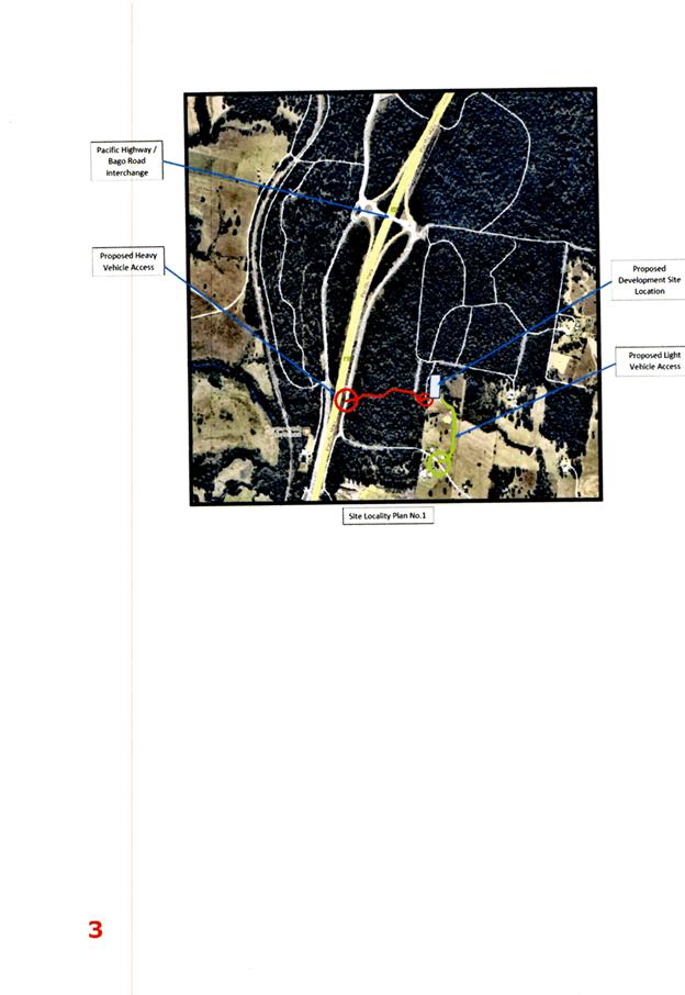
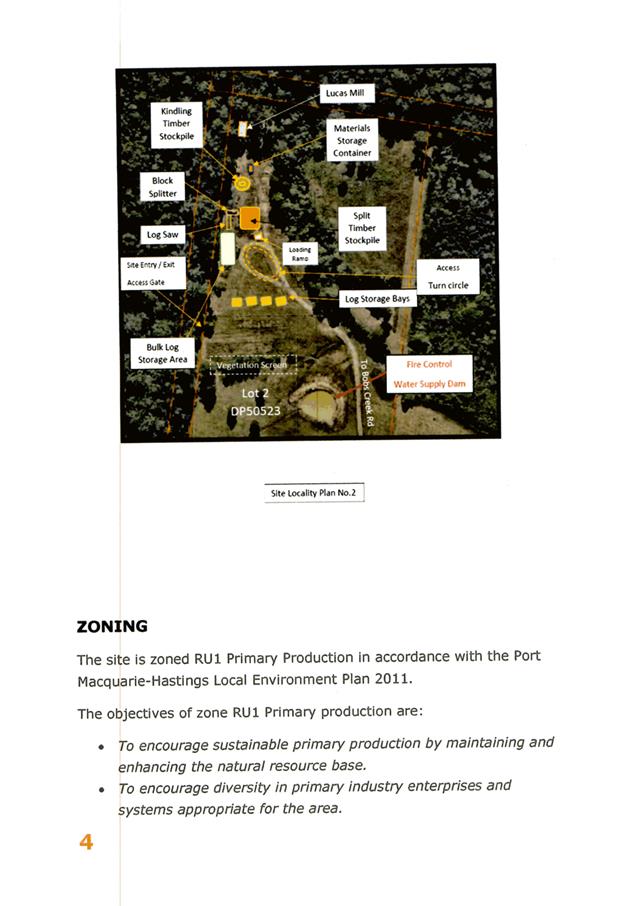
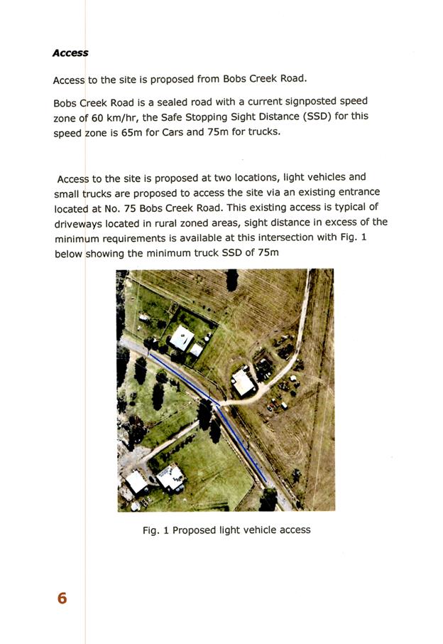
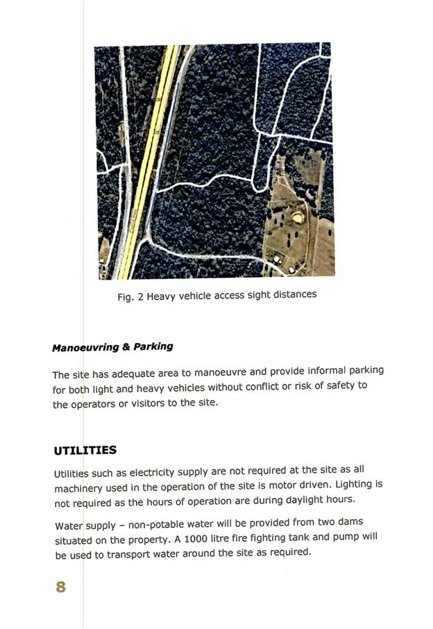
|
ATTACHMENT
|
Development Assessment Panel
5/12/2018 12:00:00
AM
|
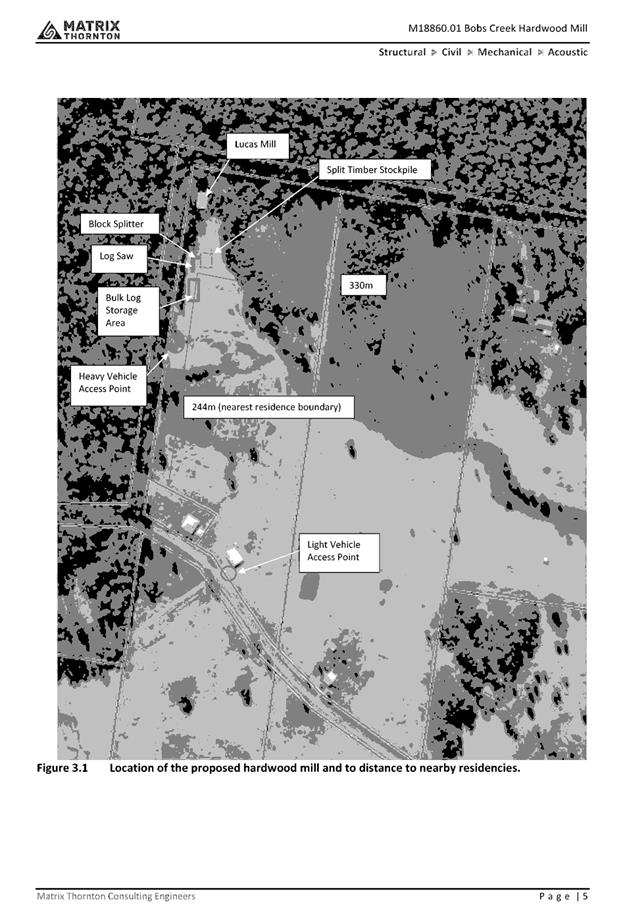
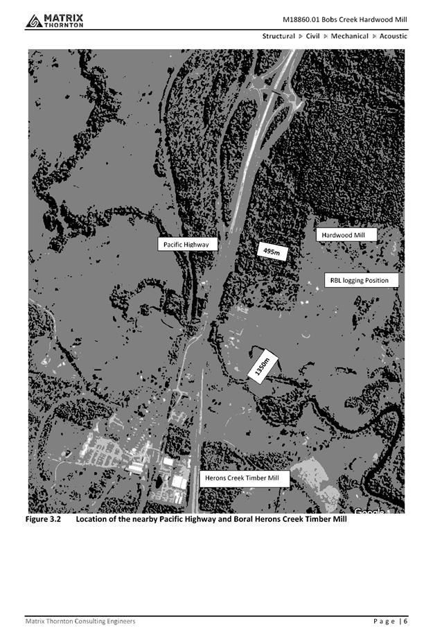

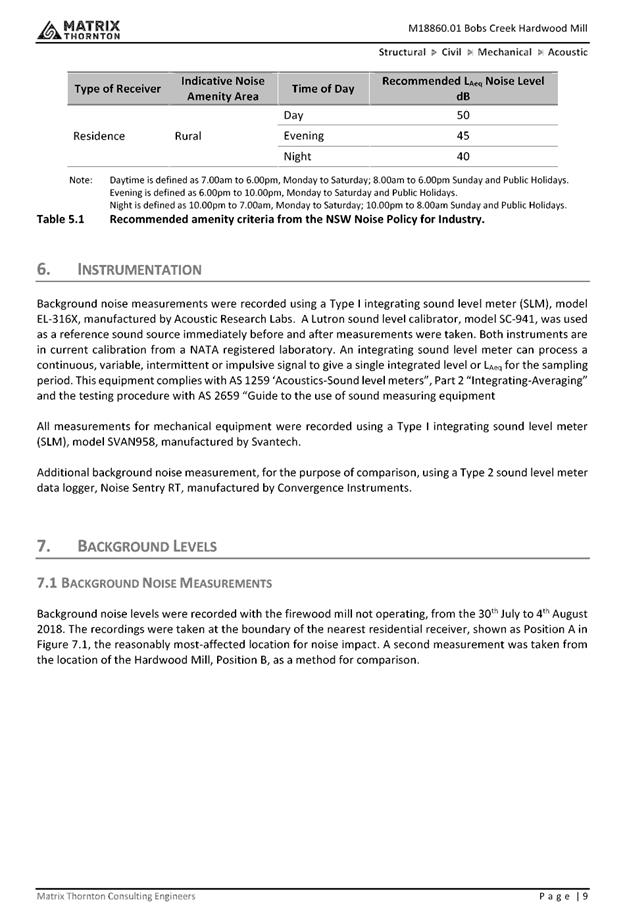
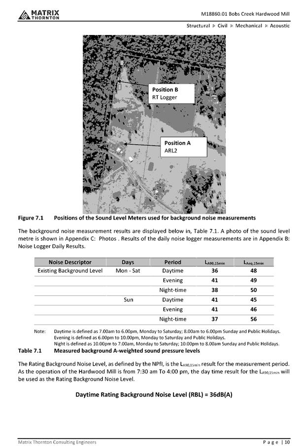
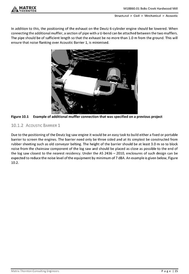
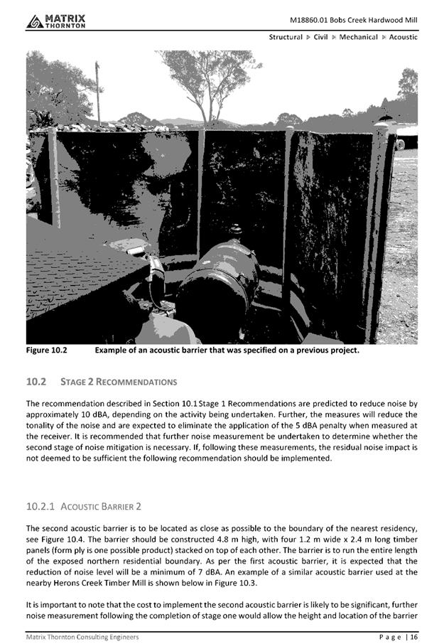
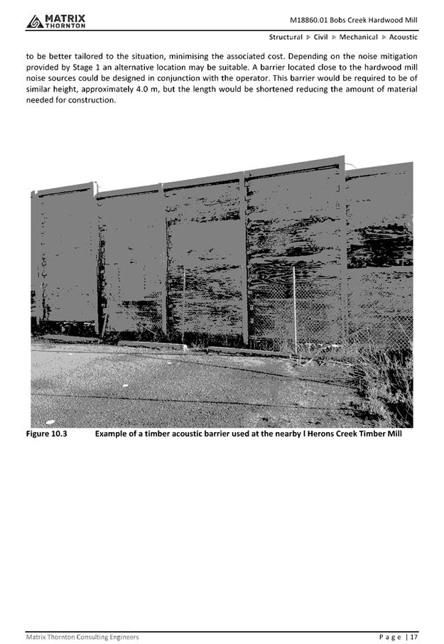
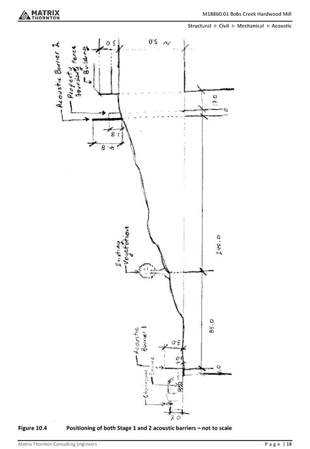
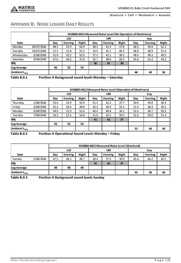
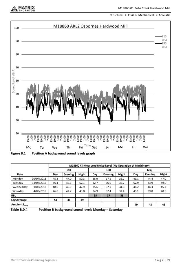
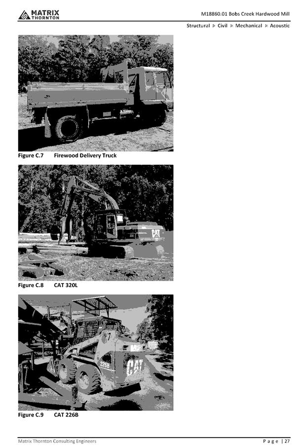
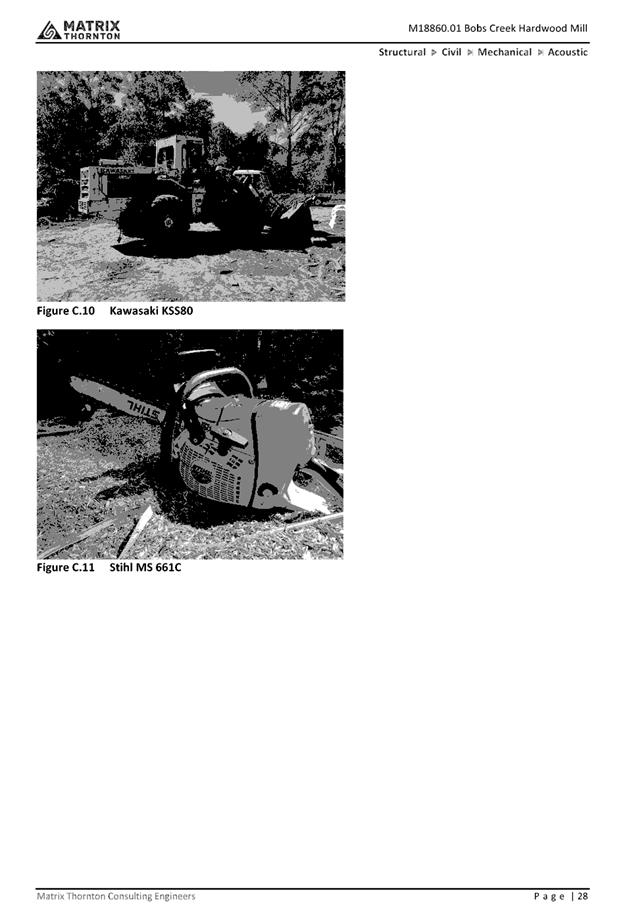
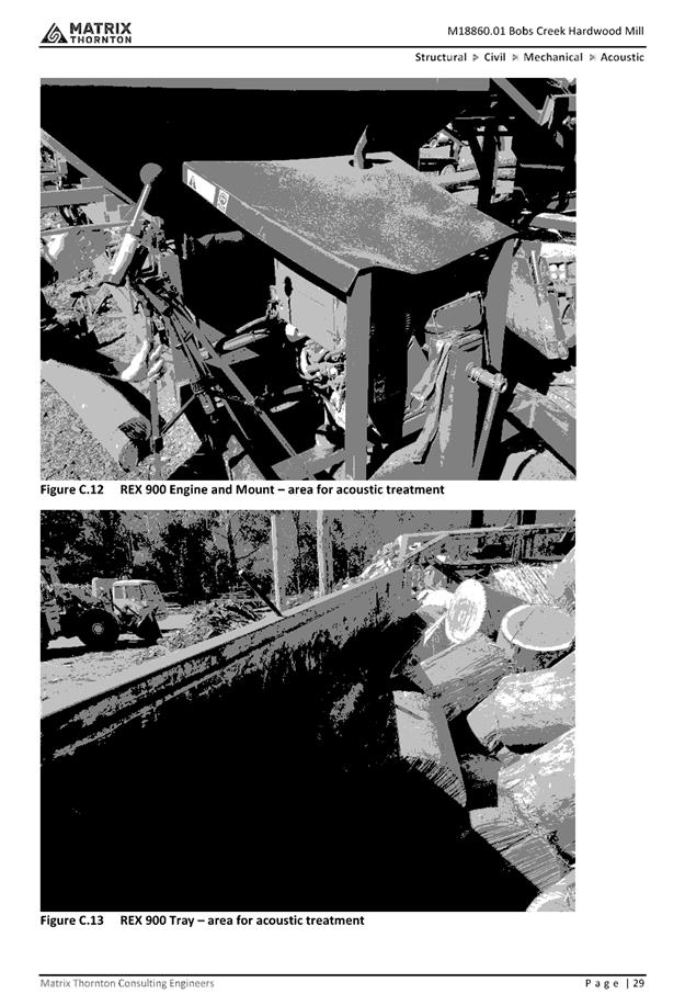
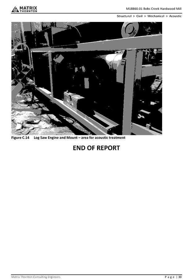
|
ATTACHMENT
|
Development Assessment Panel
5/12/2018 12:00:00
AM
|
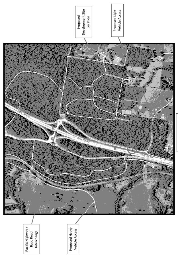
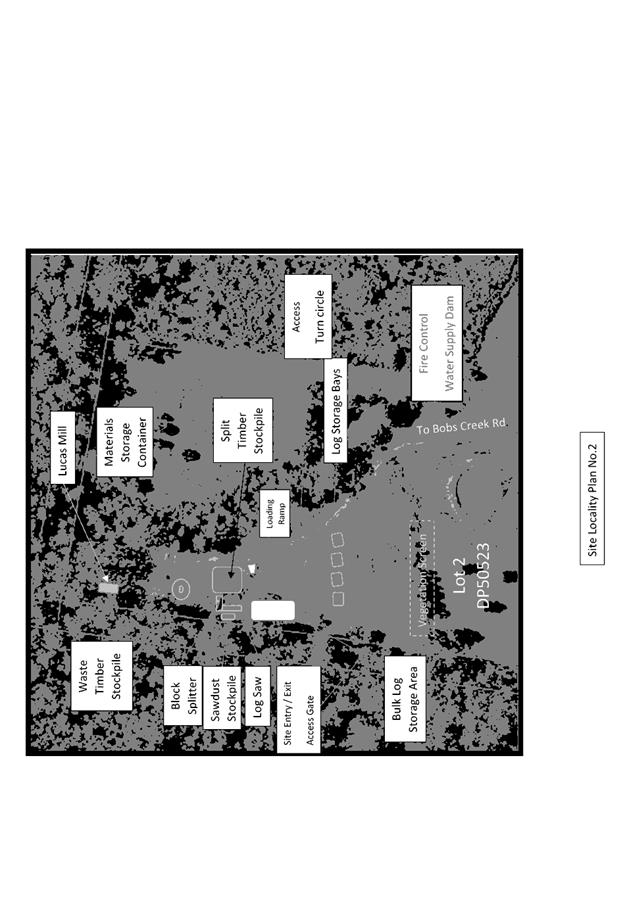
|
ATTACHMENT
|
Development Assessment Panel
5/12/2018 12:00:00
AM
|
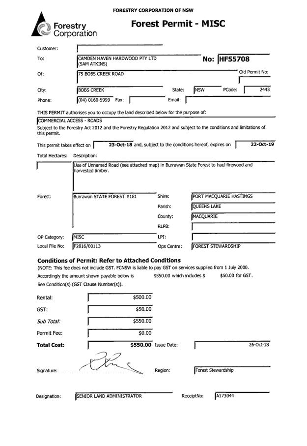
|
ATTACHMENT
|
Development Assessment Panel
5/12/2018 12:00:00
AM
|