Business
Paper
|
date of meeting:
|
|
Wednesday 23 January
2019
|
|
location:
|
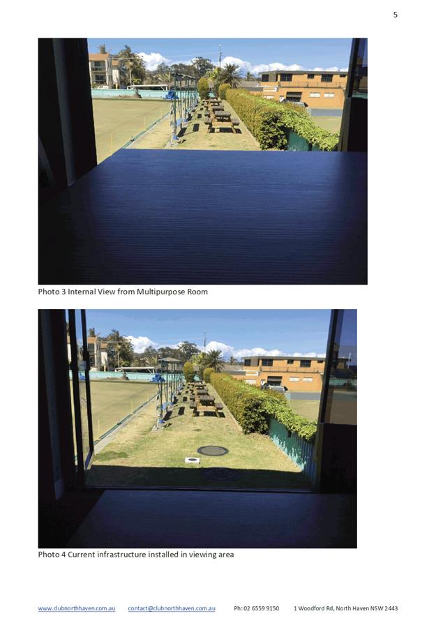
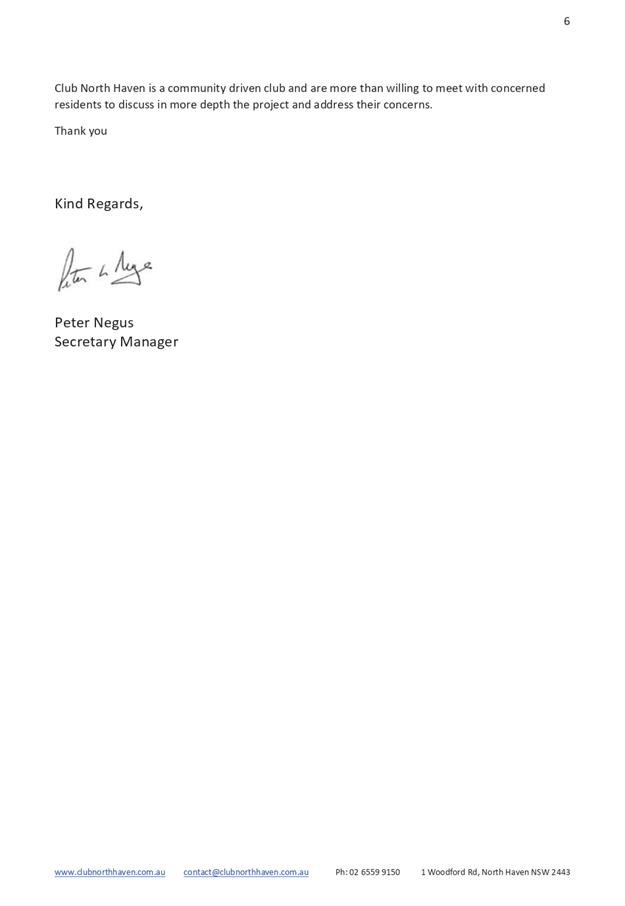
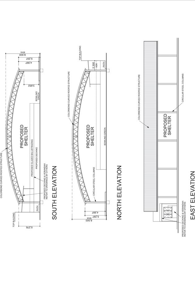
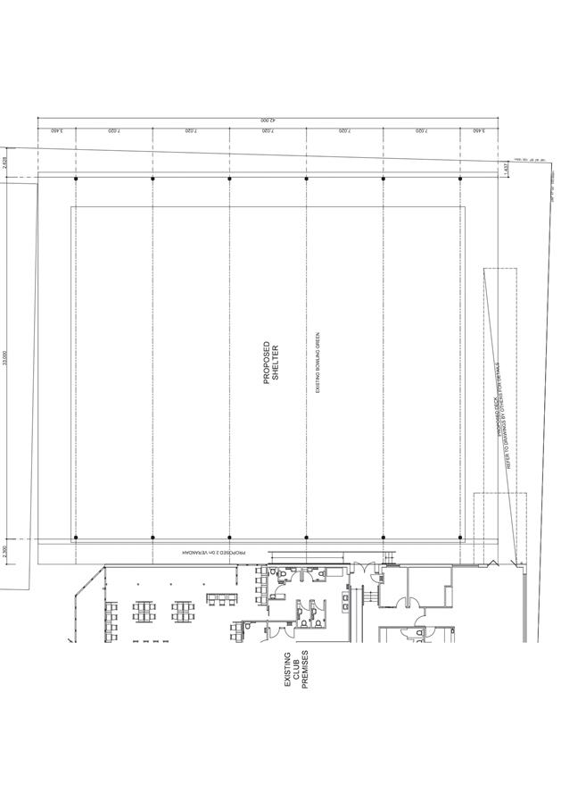
|
Function Room
Port
Macquarie-Hastings Council
17 Burrawan Street
Port Macqarie
|
|
time:
|
|
2:00pm
|
Development
Assessment Panel
CHARTER
1.0 OBJECTIVES
To assist in managing Council's development assessment
function by providing independent and expert determinations of development
applications that fall outside of staff delegations.
2.0 KEY FUNCTIONS
·
To review development application reports and conditions;
·
To determine development
applications outside of staff delegations;
·
To refer development applications
to Council for determination where necessary;
·
To provide a forum for objectors and applicants
to make submissions on applications
before the Development Assessment Panel
(DAP);
·
To maintain transparency in the determination of development
applications.
Delegated Authority of Panel
Pursuant to
Section 377 of the Local Government Act, 1993 delegation to:
·
Determine development applications under Part 4
of the Environmental Planning and Assessment
Act 1979 having
regard to the relevant environmental planning instruments,
development control plans and Council policies.
·
Vary, modify or release restrictions as to use
and/or covenants created by Section 88B instruments under the Conveyancing Act
1919 in relation to development applications for subdivisions being considered
by the panel.
·
Determine Koala Plans of Management under State
Environmental Planning Policy 44 - Koala Habitat Protection associated with
development applications being considered by the Panel.
Noting the trigger to escalate
decision making to Council as highlighted in section 5.2.
3.0
MEMBERSHIP
3.1
Voting
Members
·
Two independent external members. One of the
independent external members to be the Chairperson.
·
Group Manager Development Assessment (alternate
- Director Development & Environment or Development Assessment Planner)
The independent external members shall have expertise in
one or more of the following areas: planning, architecture, heritage, the
environment, urban design, economics, traffic and transport, law, engineering,
government and public administration.
3.2
Non-Voting Members
·
Not applicable
3.3 Obligations
of members
·
Members must act faithfully and diligently and
in accordance with this Charter.
·
Members must comply with Council's Code of Conduct.
·
Except as required to properly perform their
duties, DAP members must not
disclose any confidential information (as advised by Council) obtained in connection with the DAP functions.
·
Members will have read and be familiar with the
documents and information provided by Council prior
to attending a DAP meeting.
·
Members must act in accordance with Council's
Workplace Health and Safety Policies and Procedures
·
External members of the Panel are not authorised
to speak to the media on behalf of Council. Council officers that are members
of the Committee are bound by the
existing operational delegations in relation to speaking to the media.
·
Staff members shall not vote on matters before
the Panel if they have been the principle author of the development assessment report.
3.4
Member Tenure
·
The independent external members will be
appointed for the term of four (4) years
maximum in which the end of the tenure of these members would occur in a
cascading arrangement.
3.5 Appointment
of members
·
The independent external members (including the
Chair) shall be appointed by the General Manager following an external
Expression of Interest process.
·
Staff members of the Panel are in accordance
with this Charter.
4.0 TIMETABLE
OF MEETINGS
·
The Development Assessment Panel will generally
meet on the 1st and 3rd Wednesday each month at 2.00pm at the Port Macquarie
offices of Council.
·
Special Meetings of the Panel may be convened by
the Director Development & Environment Services with three (3) days notice.
5.0
MEETING PRACTICES
5.1
Meeting
Format
·
At all Meetings of the Panel the Chairperson
shall occupy the Chair and preside. The Chair will be responsible for keeping
of order at meetings.
·
Meetings shall be open to the public.
·
The Panel will hear from applicants
and objectors or their r e p r e s e n t a t i v e s .
·
Where considered necessary, the Panel will
conduct site inspections which will
be open to the public.
5.2
Decision Making
·
Decisions are to be made by consensus. Where
consensus is not possible on any item, that item is to be referred to Council
for a decision.
·
All development applications involving a
proposed variation to a development standard
greater than 10% under Clause
4.6 of the Local Environmental Plan will be
considered by the Panel and recommendation made to the Council for a decision.
5.3
Quorum
·
All members (2 independent external members and
1 staff member) must be present at a
meeting to form a quorum.
5.4
Chairperson and Deputy Chairperson
·
Independent Chair (alternate, second independent member)
5.5
Secretariat
·
The Director Development &n Environment is
to be responsible for ensuring that the Panel has adequate secretariat support.
The secretariat will ensure that the business paper and supporting papers are
circulated at least three (3) days prior to
each meeting. Minutes shall be appropriately approved and circulated to each
member within three (3) weeks of a meeting being held.
·
The format of and the preparation and publishing
of the Business Paper and Minutes shall be similar to the format for Ordinary
Council Meetings.
5.6
Recording of decisions
·
Minutes will record decisions and how each
member votes for each item before the Panel.
6.0 CONVENING
OF “OUTCOME SPECIFIC” WORKING GROUPS
Not applicable.
7.0 CONFIDENTIALITY
AND CONFLICT OF INTEREST
·
Members of the Panel must comply with the
applicable provisions of Council’s Code of Conduct. It is the personal
responsibility of members to comply with the standards in the Code of Conduct
and regularly review their personal circumstances with this in mind.
·
Panel members must declare any conflict of
interests at the start of each meeting or before discussion of a relevant item
or topic. Details of any conflicts of interest should be appropriately minuted.
Where members are deemed to have a real or perceived conflict of interest, it
may be appropriate they be excused from deliberations on the issue where the
conflict of interest may exist. A Panel meeting may be postponed where there is
no quorum.
8.0 LOBBYING
·
All members and applicants are to adhere to Council’s
Lobbying policy. Outside of
scheduled Development Assessment Panel meetings, applicants, their
representatives, Councillors, Council staff and the general public are not to
lobby Panel members via meetings, telephone conversations, correspondence and
the like. Adequate opportunity will be provided at Panel inspections or
meetings for applicants, their representatives and the general public to make
verbal submissions in relation to Business Paper items.
Development Assessment Panel
ATTENDANCE
REGISTER
|
Member
|
24/10/18
|
14/11/18
|
28/11/18
|
05/12/18
|
19/12/18
|
|
Paul Drake
|
P
|
P
|
P
|
P
|
P
|
|
Robert Hussey
|
P
|
P
|
P
|
P
|
A
|
|
David Crofts
(alternate member)
|
|
|
|
|
P
|
|
Dan Croft
(Acting Director
Development & Environment)
Clinton Tink
(Acting GM Development
Assessment
(alternates)
- Director Development & Environment
- Development Assessment Planner
|
P
|
P
P
|
P
|
P
|
P
|
Key: P = Present
A
= Absent With Apology
X
= Absent Without Apology
Development
Assessment Panel Meeting
Wednesday 23 January
2019
Items of Business
01 Acknowledgement
of Country............................................................................ 8
02 Apologies......................................................................................................... 8
03 Confirmation
of Minutes.................................................................................... 8
04 Disclosures
of Interest..................................................................................... 12
05 DA2018
- 562.1 Demolition of Existing Buildings, Consolidation and Boundary
Adjustment, and Construction of Seniors Housing at Lots 10 - 13 DP 861177, Lot
1 DP 782560, Lot 1 DP 393967, Lot 1 DP 390610, Lot 1 DP 1053812, Lot 1 DP
121189, Lot 1 DP 795534, Lot 1 DP 151300, Lot 3 and 4 DP 347796, No. 15 - 21
Cameron Street and 3 Young Street, Wauchope... 16
06 DA2018
- 900.1 Dual Occupancy And Strata Subdivision, Lot 342 DP 1237302, No.23
Gunsynd Chase, Port Macquarie..................................................................................... 73
07 DA2017
- 410.2 Modification To Dwelling, Lot 29 DP 1045446, No 12 Loganvale Place,
Logans Crossing ........................................................................................................ 97
08 DA2017
- 667.1 Demolition Of Existing Building And Construction Of Boat Storage
Facility And Public Amenities, Tree Removal And Road Works At Lot 2 DP 535212,
No. 9 McInherney Park, Port Macquarie ............................................................................................. 124
09 DA2018
- 824.1 One Into Three Lot Torrens Title SUbdivision and Two(2) Semi-Detached
Dwellings - Lot A DP 33885816, No. 16 Windmill Street Port Macquarie............ 155
10 DA2018
- 854.1 Two-Semi Detached Dwellings And Strata Title Subdivision - Lot 168 DP
1229414, No. 23 Allport Avenue Thrumster...................................................... 195
11 DA2018
- 292.1 Dual Occupancy With Strata Subdivision, Lot 11 Sec D DP 25923,No 104
Chepana Street, Lake Cathie........................................................................... 195
12 DA2018
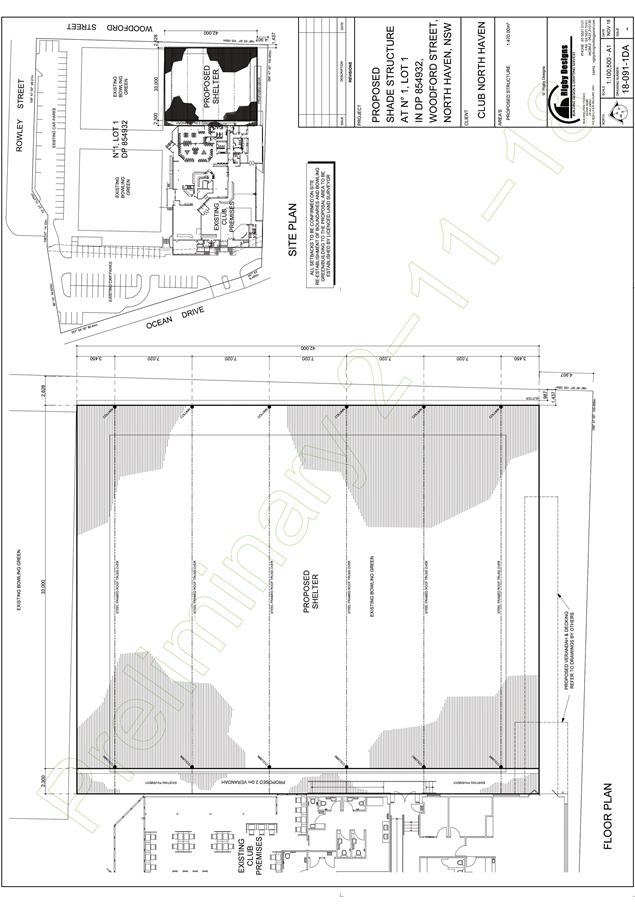
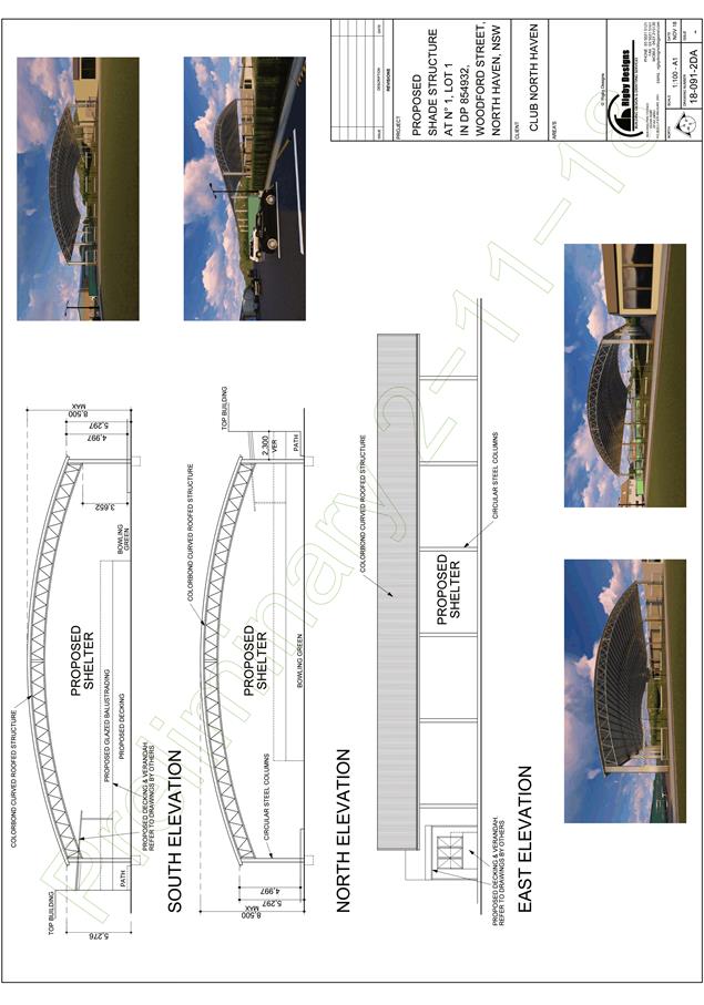
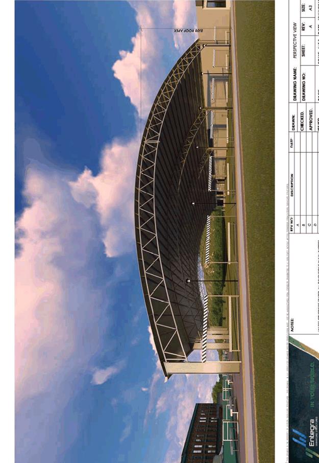
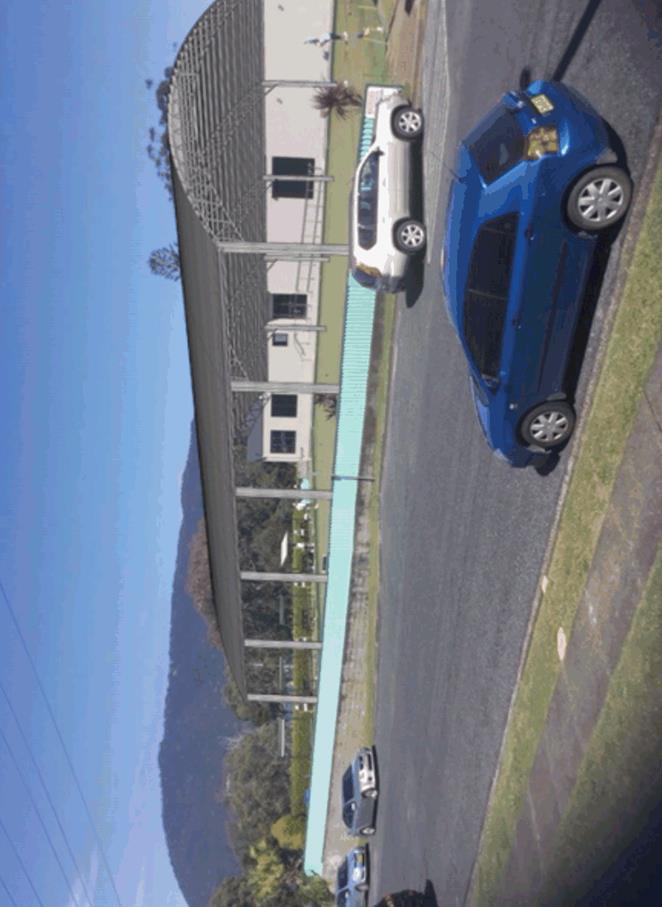
- 761.1 Additions to Existing Club at Lot 1 DP 854932, No. 1 Woodford
Road, North Haven........................................................................................................... 195
13 General
Business
AGENDA Development Assessment Panel 23/01/2019
Subject: ACKNOWLEDGEMENT
OF COUNTRY
"I acknowledge that we are
gathered on Birpai Land. I pay respect to the Birpai Elders both past and
present. I also extend that respect to all other Aboriginal and Torres Strait
Islander people present."
RECOMMENDATION
That the apologies received be accepted.
Subject: CONFIRMATION
OF PREVIOUS MINUTES
Recommendation
That the Minutes of the Development
Assessment Panel Meeting held on 19 December 2018 be confirmed.
MINUTES
Development Assessment Panel Meeting
19/12/2018
PRESENT
Members:
Paul
Drake
David Crofts
Dan Croft
Other Attendees:
Ben Roberts
Caroline
Horan
Mark
Edenborough
David
Troemel
|
The meeting opened at 2:00pm.
|
|
01 ACKNOWLEDGEMENT
OF COUNTRY
|
|
The
Acknowledgement of Country was delivered.
|
|
02 APOLOGIES
|
|
CONSENSUS:
That
the apology received from Robert Hussey be accepted.
|
|
03 CONFIRMATION
OF MINUTES
|
|
CONSENSUS:
That
the Minutes of the Development Assessment Panel Meeting held on 5 December
2018 be confirmed.
|
|
04 DISCLOSURES
OF INTEREST
|
|
There were no disclosures of interest presented.
|
|
05 DA2017 -
1049.1 Staged Residential Community Title Subdivision (35 Lots) at Lot 2 DP
1188545, Livingstone Road, Port Macquarie
|
|
Speakers:
Prudence
Van Coppenhagan (o)
Donna
Clarke (applicant)
Michael
Summers (applicant)
CONSENSUS:
That DA
2017 - 1049 for a Staged Residential
Community Title Subdivision (35 lots) at Lot
2, DP 1188545, Livingstone Road, Port
Macquarie, be determined by granting a deferred
commencement consent subject to the recommended conditions and as amended
below:
- Change the
deferred commencement period from 3 months to 12 months.
- Amend the deferred
commencement requirement D(i) to read ‘Extension of the piped
drainage system to directly connect to the existing upstream outlets
servicing Orr Street, i.e. stormwater piped between Orr Street and
Pacific Drive or a demonstrated alternate solution to the satisfaction
of Council. Appropriate easement shall be created between Orr Street and
Pacific Drive.
|
|
06 DA2018 - 479.1
Change Of Use - Vehicle Repair Station To Light Industry - Lot A DP 395406,
No 187 High Street, Wauchope.
|
|
Speakers
:
Brian Kirkwood (o)
Malcolm Mckenzie (applicant)
CONSENSUS:
That DA
2018 – 479.1 for a change of
use from vehicle repair station to light industry at
Lot A, DP 395406, No. 187 High Street,
Wauchope, be determined by granting consent subject to the recommended
conditions and as amended below:
- Amend
condition E(2) to read: ‘Parking spaces being line marked prior
to occupation or the issue of the Occupation Certificate or commencement
of the approved land use. A minimum of 8 parking spaces are to be
provided on site.
Certification by a suitably
qualified consultant is also to be submitted to the Principal Certifying
Authority (PCA) confirming that the car park complies with Port
Macquarie-Hastings Development Control Plan 2013 and Australian Standard
2890.’
- Amend condition F(12) to read:
‘Hours
of operation of the development are restricted to the following hours, as
amended by the recommendations of the Noise Impact Assessment by Matrix
Thornton (October 2018):
-
5am to 7pm – Mondays
to Fridays
-
7am to 4pm – Saturdays
-
9am to 4pm – Sundays
-
No work is permitted on Public Holidays
It
should be noted that the Noise Impact Assessment requires the operation of
mechanical equipment and truck loading/unloading to only occur between Monday
to Friday 7am to 6pm and Saturday 7am to 4pm.
The
above hours of operation also do not apply to office work, minor emergency
repairs that create no noise or security checks.’
|
|
The meeting closed at 3:05pm.
|
AGENDA Development Assessment Panel 23/01/2019
Subject: DISCLOSURES
OF INTEREST
RECOMMENDATION
That Disclosures of Interest be presented
DISCLOSURE OF
INTEREST DECLARATION
Name of Meeting: ………………………………………………………………………..
Meeting Date: ………………………………………………………………………..
Item Number: ………………………………………………………………………..
Subject: ………………………………………………………………………..
…………………………………………………….……………...…..
I,
.....................................................................................
declare the following interest:
 Pecuniary:
Take
no part in the consideration and voting and be out of sight of the meeting.
Non-Pecuniary
- Significant Interest:
Take
no part in the consideration and voting and be out of sight of the meeting.
Non-Pecuniary
- Less than Significant Interest:
May
participate in consideration and voting.
For the reason that: ....................................................................................................
.......................................................................................................................................
Name: …………………………………………………….
Signed:
.........................................................................
Date: ..................................
 (Further
explanation is provided on the next page)
(Further
explanation is provided on the next page)
Further
Explanation
(Local Government Act and Code of Conduct)
A conflict of interest exists where a reasonable and informed
person would perceive that a Council official could be influenced by a private
interest when carrying out their public duty. Interests can be of two types:
pecuniary or non-pecuniary.
All interests, whether pecuniary or non-pecuniary are required to
be fully disclosed and in writing.
Pecuniary Interest
A pecuniary interest is an interest that a Council official has in
a matter because of a reasonable likelihood or expectation of appreciable
financial gain or loss to the Council official. (section 442)
A Council official will also be taken to have a pecuniary interest
in a matter if that Council official’s spouse or de facto partner or a
relative of the Council official or a partner or employer of the Council
official, or a company or other body of which the Council official, or a
nominee, partner or employer of the Council official is a member, has a
pecuniary interest in the matter. (section 443)
The Council official must not take part in the consideration or
voting on the matter and leave and be out of sight of the meeting. The
Council official must not be present at, or in sight of, the meeting of
the Council at any time during which the matter is being considered or discussed,
or at any time during which the council is voting on any question in relation
to the matter. (section 451)
Non-Pecuniary
A non-pecuniary interest is an interest that is private or
personal that the Council official has that does not amount to a pecuniary
interest as defined in the Act.
Non-pecuniary interests commonly arise out of family, or personal
relationships, or involvement in sporting, social or other cultural groups and
associations and may include an interest of a financial nature.
The political views of a Councillor do not constitute a private
interest.
The management of a non-pecuniary interest will depend on whether
or not it is significant.
Non Pecuniary – Significant Interest
As a general rule, a non-pecuniary conflict of interest will be
significant where a matter does not raise a pecuniary interest, but it
involves:
(a)
A relationship between
a Council official and another person that is particularly close, for example,
parent, grandparent, brother, sister, uncle, aunt, nephew, niece, lineal
descendant or adopted child of the Council official or of the Council official’s
spouse, current or former spouse or partner, de facto or other person living in
the same household.
(b)
Other relationships
that are particularly close, such as friendships and business relationships.
Closeness is defined by the nature of the friendship or business relationship,
the frequency of contact and the duration of the friendship or relationship.
(c)
An affiliation between
a Council official an organisation, sporting body, club, corporation or
association that is particularly strong.
If a Council official declares a non-pecuniary significant
interest it must be managed in one of two ways:
1.
Remove the source of
the conflict, by relinquishing or divesting the interest that creates the
conflict, or reallocating the conflicting duties to another Council official.
2.
Have no involvement in
the matter, by taking no part in the consideration or voting on the matter and
leave and be out of sight of the meeting, as if the provisions in section
451(2) apply.
Non Pecuniary – Less than Significant Interest
If a Council official has declared a non-pecuniary less than
significant interest and it does not require further action, they must provide
an explanation of why they consider that the conflict does not require further
action in the circumstances.
SPECIAL
DISCLOSURE OF PECUNIARY INTEREST DECLARATION
|
By
[insert full name of councillor]
|
|
|
In the
matter of
[insert name of environmental planning instrument]
|
|
|
Which is
to be considered at a meeting of the
[insert name of meeting]
|
|
|
Held on
[insert date of meeting]
|
|
|
PECUNIARY
INTEREST
|
|
Address of land in which councillor or an
associated person, company or body has a proprietary interest (the identified
land)i
|
|
|
Relationship of identified land to councillor
[Tick or cross one box.]
|
Councillor
has interest in the land (e.g. is owner or has other interest arising out of
a mortgage, lease trust, option or contract, or otherwise).
Associated
person of councillor has interest in the land.
Associated
company or body of councillor has interest in the land.
|
|
MATTER
GIVING RISE TO PECUNIARY INTEREST
|
|
Nature of land that is subject to a change
in zone/planning control by proposed
LEP (the subject land iii
[Tick or cross one box]
|
The
identified land.
Land
that adjoins or is adjacent to or is in proximity to the identified land.
|
|
Current zone/planning control
[Insert name of current planning instrument and
identify relevant zone/planning control applying to the subject land]
|
|
|
Proposed change of zone/planning control
[Insert name of proposed LEP and identify
proposed change of zone/planning control applying to the subject land]
|
|
|
Effect of proposed change of zone/planning control
on councillor
[Tick or cross one box]
|
Appreciable
financial gain.
Appreciable
financial loss.
|
|
|
|
Councillor’s
Name: …………………………………………
Councillor’s
Signature:
……………………………….
Date: ………………..
Important Information
This information is being
collected for the purpose of making a special disclosure of pecuniary interests
under sections 451 (4) and (5) of the Local Government Act 1993.
You must not make a special disclosure that you know or ought reasonably to
know is false or misleading in a material particular. Complaints made
about contraventions of these requirements may be referred by the
Director-General to the Local Government Pecuniary Interest and Disciplinary
Tribunal.
This form must be completed by
you before the commencement of the council or council committee meeting in
respect of which the special disclosure is being made. The
completed form must be tabled at the meeting. Everyone is entitled to
inspect it. The special disclosure must be recorded in the minutes of the
meeting.
i.
Section 443 (1) of the Local Government Act 1993 provides that
you may have a pecuniary interest in a matter because of the pecuniary interest
of your spouse or your de facto partner or your relativeiv or
because your business partner or employer has a pecuniary interest. You may
also have a pecuniary interest in a matter because you, your nominee, your
business partner or your employer is a member of a company or other body that
has a pecuniary interest in the matter.
ii.
Section 442 of the Local Government Act 1993 provides that a pecuniary
interest is an interest that a person has in a matter because of a
reasonable likelihood or expectation of appreciable financial gain or loss to
the person. A person does not have a pecuniary interest in a matter if the
interest is so remote or insignificant that it could not reasonably be regarded
as likely to influence any decision the person might make in relation to the
matter or if the interest is of a kind specified in section 448 of that
Act (for example, an interest as an elector or as a ratepayer or person liable
to pay a charge).
iii.
A pecuniary interest may arise by way of a change of permissible use of land
adjoining, adjacent to or in proximity to land in which a councillor or a
person, company or body referred to in section 443 (1) (b) or (c) of the
Local Government Act 1993 has a proprietary interest..
iv.
Relative is defined by the Local Government Act 1993 as
meaning your, your spouse’s or your de facto partner’s parent,
grandparent, brother, sister, uncle, aunt, nephew, niece, lineal descendant or
adopted child and the spouse or de facto partner of any of those persons.
AGENDA Development Assessment Panel 23/01/2019
Item: 05
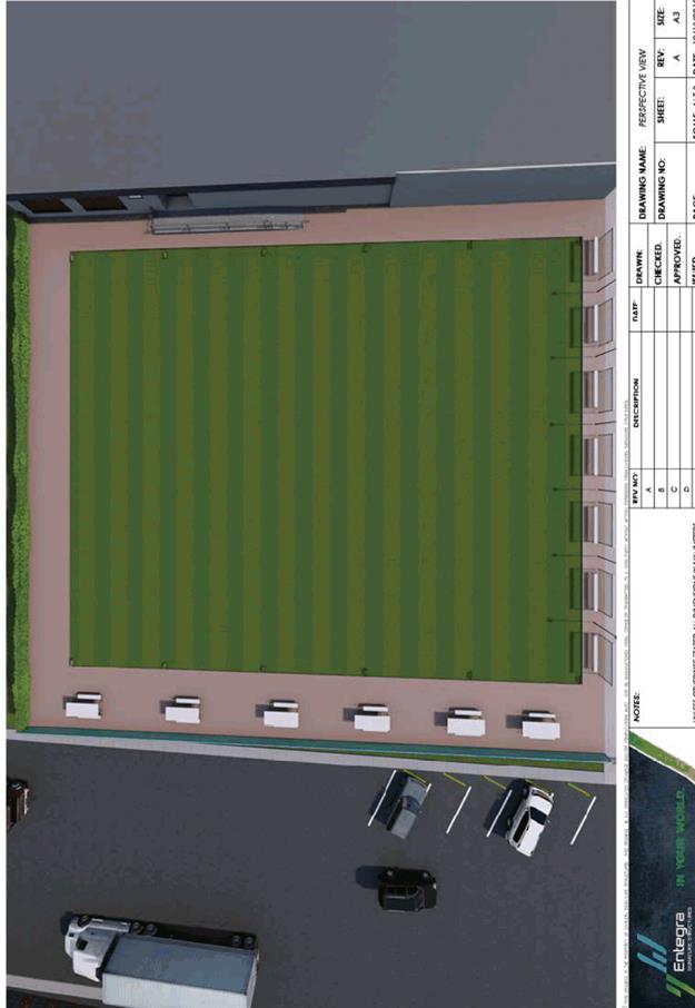
Subject: DA2018 - 562.1 Demolition of Existing
Buildings, Consolidation and Boundary Adjustment, and Construction of Seniors
Housing at Lots 10 - 13 DP 861177, Lot 1 DP 782560, Lot 1 DP 393967, Lot 1 DP
390610, Lot 1 DP 1053812, Lot 1 DP 121189, Lot 1 DP 795534, Lot 1 DP 151300,
Lot 3 and 4 DP 347796, No. 15 - 21 Cameron Street and 3 Young Street, Wauchope
Report
Author: Chris Gardiner
|
Applicant: Wauchope
RSL Club Ltd
Owner: Wauchope
RSL Club Ltd
Estimated Cost: $3,400,000
Parcel no: 48892,
29551, 29550, 29549, 41145, 25876, 29212, 41146, 29214, 3551, 29215, 29210
Alignment with Delivery
Program
4.3.1 Undertake transparent
and efficient development assessment in accordance with relevant legislation.
|
|
RECOMMENDATION
That
DA2018 – 562.1 for Demolition
of Existing Buildings, Consolidation and Boundary Adjustment, and Construction
of Seniors Housing at Lots 10
- 13 DP 861177, Lot 1 DP 782560, Lot 1 DP 393967, Lot 1 DP 390610, Lot 1 DP
1053812, Lot 1 DP 121189, Lot 1 DP 795534, Lot 1 DP 151300, Lot 3 and 4 DP
347796, No. 15 – 21 Cameron
Street and No. 3 Young Street, Wauchope, be determined
by granting consent subject to the recommended conditions.
|
Executive
Summary
This
report considers a development application for demolition of existing
buildings, consolidation and boundary adjustment, and construction of seniors
housing at the subject site and provides an
assessment of the application in accordance with the Environmental Planning and
Assessment Act 1979.
Following exhibition of the
application, one submission has been received.
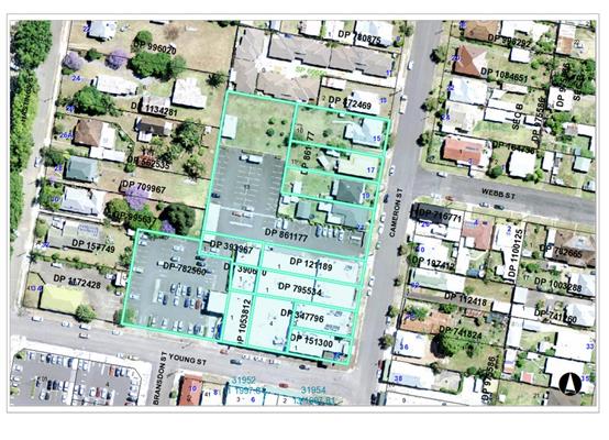
1. BACKGROUND
Existing sites features and surrounding development
The site has an area of approximately
1.1 hectares.
The site is zoned B4 Mixed Use in accordance with the Port Macquarie-Hastings Local
Environmental Plan 2011, as shown in the following zoning plan:
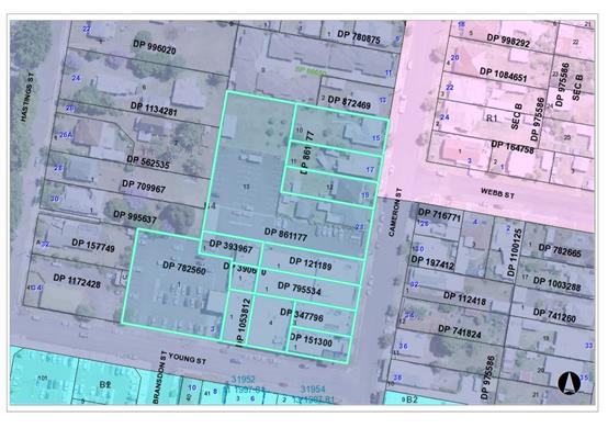
The existing subdivision pattern and location of existing
development within the locality is shown in the following aerial photograph:
2. DESCRIPTION OF
DEVELOPMENT
Key aspects of the proposal include the following:
· Demolition
of existing dwellings and outbuildings;
· Consolidation
and boundary adjustment to create one lot containing the RSL Club, and one lot
containing the seniors housing;
· Construction
of seniors housing comprising 15 single storey self-care units.
Refer
to attachments at the end of this report.
Application Chronology
· 27
July 2018 – Application lodged.
· 3 August 2018 to 16 August 2018 – Neighbour
notification.
· 7 September 2018 – Site inspected by assessing
officer.
· 17 September 2018 – Additional information requested
from Applicant.
· 19 October 2018 – Additional information submitted.
3. STATUTORY ASSESSMENT
Section 4.15(1) Matters for Consideration
In determining the application, Council is required to take
into consideration the following matters as are relevant to the development that
apply to the land to which the development application relates:
(a) The provisions (where
applicable) of:
(i) any Environmental
Planning Instrument:
State Environmental Planning Policy No. 44 - Koala
Habitat Protection
In accordance with Clause 6, the land has an area greater
than 1 hectare and the SEPP applies.
The land does not meet the definition of potential koala
habitat in accordance with Clause 7. Therefore, no further consideration of the
SEPP is required.
State Environmental Planning Policy No. 55 –
Remediation of Land
Lot 1 DP 782560, which comprises the existing car park to
the west of the RSL Club building, is identified as being potentially
contaminated. This lot is included in the development only to the extent that
it is part of the proposed consolidation of the existing lots on which the RSL
Club is located.
The proposed seniors housing development is located well
clear of this lot and is considered to be suitable for the intended use.
State Environmental Planning Policy No. 62 – Sustainable
Aquaculture
Given the nature of the proposed development and proposed
stormwater controls the proposal will be unlikely to have any adverse impact on
existing aquaculture industries.
State Environmental Planning
Policy No. 64 – Advertising and Signage
The proposed development includes proposed signage in the
form of business/building identification.
In accordance with clause 7, this SEPP prevails over the
Port Macquarie-Hastings LEP 2011 in the event of any inconsistency.
The following assessment table provides an assessment
checklist against the Schedule 1 requirements of this SEPP:
|
Applicable clauses for consideration
|
Comments
|
Satisfactory
|
|
Clause 8(a) Consistent with
objectives of the policy as set out in Clause 3(1)(a).
|
Signage consistent with the
objectives of the SEPP.
|
Yes
|
Schedule
1(1) Character of the area.
|
The site is in an area
characterised by a mix of residential and commercial uses. The proposed
signage wall adjacent to the Cameron Street access is compatible with the residential
character of the development as well as nearby commercial uses.
|
Yes
|
|
Schedule 1(2) Special areas.
|
Proposal would not detract from
the character of any special areas.
|
Yes
|
|
Schedule 1(3) Views and vistas.
|
The sign would not obscure any
existing views or vistas.
|
Yes
|
|
Schedule 1(4) Streetscape,
setting or landscape.
|
The scale and proportions of the
signage are appropriate for the existing, and likely future streetscape.
|
Yes
|
|
Schedule 1(5) Site and building.
|
The signage wall is consistent
with the height and scale of the proposed buildings and would not dominate
the streetscape.
|
Yes
|
|
Schedule 1(6) Associated devices
and logos with advertisements and advertising structures.
|
None proposed.
|
N/A
|
|
Schedule 1(7) Illumination.
|
Signage not proposed to be illuminated.
|
Yes
|
|
Schedule 1(7) Safety.
|
The sign is not expected to adversely affect traffic,
cyclist, or pedestrian safety.
|
Yes
|
State Environmental Planning
Policy (Coastal Management) 2018
The site is located within a coastal environment area.
In accordance with clause 7, this SEPP prevails over the
Port Macquarie-Hastings LEP 2011 in the event of any inconsistency.
Having regard to clauses 13 of the SEPP the proposed
development is not considered likely to result in any of the following:
a) any
adverse impact on integrity and resilience of the biophysical,
hydrological (surface and groundwater) and ecological environment;
b) any
adverse impacts coastal environmental values and natural coastal
processes;
c) any
adverse impacts on marine vegetation, native vegetation and fauna
and their habitats, undeveloped headlands and rock platforms;
d) any
adverse impact on marine vegetation, native vegetation and fauna
and their habitats, undeveloped headlands and rock platforms;
e) any
adverse impact on Aboriginal cultural heritage, practices and
places;
f) any
adverse impacts on the cultural and built environment heritage;
g) any
adverse impacts the use of the surf zone;
State Environmental Planning Policy (Building
Sustainability Index: BASIX) 2004
A BASIX certificate has been submitted demonstrating that
the proposal will comply with the requirements of the SEPP. It is recommended
that a condition be imposed to ensure that the commitments are incorporated
into the development and certified at Occupation Certificate stage.
State Environmental Planning Policy (Housing for Seniors
or People with a Disability) 2004
|
Clause
|
Proposed
|
Complies
|
|
4. Land to which Policy applies
|
|
|
|
Policy applies to land within New South Wales that is land
zoned primarily for urban purposes or land that adjoins land zoned primarily
for urban purposes, but only if:
(a) development for the purpose of any of the
following is permitted on the land:
(i) dwelling-houses,
(ii) residential flat buildings,
(iii) hospitals,
(iv) development of a kind identified in
respect of land zoned as special uses, including (but not limited to)
churches, convents, educational establishments, schools and seminaries, or
(b) the land is being used for the purposes of
an existing registered club.
|
The site is zoned B4 within the urban context of Wauchope.
Residential flat buildings are permissible in the zone.
Part of the land subject the application currently
contains a registered club, but the boundary adjustment and consolidation
proposed in the application would ultimately result in the seniors housing
being on a separate lot to the registered club.
|
Yes
|
|
5. Relationship to other environmental planning
instruments
|
|
|
|
If this Policy is inconsistent with any other
environmental planning instrument, made before or after this Policy, this
Policy prevails to the extent of the inconsistency.
|
Consistent with other planning instruments.
|
Yes
|
|
8. Seniors
|
|
|
|
In this Policy, seniors are any of the following:
(a) people aged 55 or more years,
(b) people who are resident at a facility at
which residential care (within the meaning of the Aged
Care Act 1997 of the Commonwealth) is provided,
(c) people who have been assessed as being
eligible to occupy housing for aged persons provided by a social housing
provider.
|
The development is proposed to be occupied by seniors. A
restriction on the occupation of the units in accordance with the SEPP will
be applied in the conditions of approval for the development.
|
Yes
|
|
9. People with a disability
|
|
|
|
In this Policy, people with a disability are people
of any age who have, either permanently or for an extended period, one or
more impairments, limitations or activity restrictions that substantially
affect their capacity to participate in everyday life.
|
The development is proposed to be occupied by seniors. A
restriction on the occupation of the units in accordance with the SEPP has
been included in the recommended conditions of approval for the development.
|
Yes
|
|
10. Seniors housing
|
|
|
|
In this Policy, seniors housing is residential
accommodation that is, or is intended to be, used permanently for seniors or
people with a disability consisting of:
(a) a residential care facility, or
(b) a hostel, or
(c) a group of self-contained dwellings, or
(d) a combination of these,
but does not include a hospital.
Note. The concept of seniors housing is intended to
be a shorthand phrase encompassing both housing for seniors and for people
with a disability. This Policy deals with both kinds of housing.
Accommodation provided by seniors housing does not have to
be limited to seniors or people with a disability. Clause 18 provides that
seniors housing may be used for the accommodation of the following:
(a) seniors or people who have a disability,
(b) people who live within the same household
with seniors or people who have a disability,
(c) staff employed to assist in the
administration of and provision of services to housing provided under this
Policy.
Relevant classifications in the Building Code of
Australia for the different types of residential accommodation are as
follows:
(a) Class 3, 9a or 9c in relation to
residential care facilities,
(b) Class 1b or 3 in relation to hostels,
(c) Class 1a or 2 in relation to self contained
dwellings.
|
The proposal is defined as self-contained dwellings.
|
Yes
|
|
13. Self-contained dwellings
|
|
|
|
1) General term: “self-contained
dwelling”
In this Policy, a self-contained dwelling is a dwelling or part of a
building (other than a hostel), whether attached to another dwelling or not,
housing seniors or people with a disability, where private facilities for
significant cooking, sleeping and washing are included in the dwelling or
part of the building, but where clothes washing facilities or other
facilities for use in connection with the dwelling or part of the building
may be provided on a shared basis.
(2) Example: “in-fill self-care housing”
In this Policy, in-fill self-care housing is seniors housing on land
zoned primarily for urban purposes that consists of 2 or more self-contained
dwellings where none of the following services are provided on site as part
of the development: meals, cleaning services, personal care, nursing care.
(3) Example: “serviced self-care housing”
In this Policy, serviced self-care housing is seniors housing that
consists of self-contained dwellings where the following services are
available on the site: meals, cleaning services, personal care, nursing care.
|
Each unit is provided with its own kitchen, living areas,
laundry, bathroom and bedrooms. Occupants will live independently.
|
Yes
|
|
18. Restrictions on occupation of seniors housing
allowed under this Chapter
|
|
|
|
(1) Development allowed by this Chapter may be
carried out for the accommodation of the following only:
(a) seniors or people who have a disability,
(b) people who live within the same household
with seniors or people who have a disability,
(c) staff employed to assist in the
administration of and provision of services to housing provided under this
Policy.
(2) A consent authority must not consent to a
development application made pursuant to this Chapter unless:
(a) a condition is imposed by the consent
authority to the effect that only the kinds of people referred to in
subclause (1) may occupy any accommodation to which the application relates,
and
(b) the consent authority is satisfied that a
restriction as to user will be registered against the title of the property
on which development is to be carried out, in accordance with section 88E of
the Conveyancing Act 1919,
limiting the use of any accommodation to which the application relates to the
kinds of people referred to in subclause (1).
(3) Subclause (2) does not limit the kinds of
conditions that may be imposed on a development consent, or allow conditions
to be imposed on a development consent otherwise than in accordance with the
Act.
|
A restriction on the occupants in accordance with the SEPP
will be applied as a condition of consent.
|
Yes
|
|
19. Use of seniors housing in commercial zones
|
|
|
|
Development allowed by this chapter for the purposes of
seniors housing does not include the use for residential purposes of any part
of the ground floor of a building that fronts a street if the building is
located on land that is zoned primarily for commercial purposes unless
another environmental planning instrument permits the use of all of the
building for residential purposes.
|
The site is zoned B4 which permits residential flat
buildings. Provision of residential units are permissible on the ground floor
within the zone.
|
Yes
|
|
23. Development on land used for the purposes of an
existing registered club
(1)A consent authority must not consent to a development
application made pursuant to this Chapter to carry out development on land
that is used for the purposes of an existing registered club unless the
consent authority is satisfied that:
(a) the proposed development provides for appropriate
measures to separate the club from the residential areas of the proposed
development in order to avoid land use conflicts, and
(b) an appropriate protocol for managing the relationship
between the proposed development and the gambling facilities on the site of
the club in order to minimise harm associated with the misuse and abuse of
gambling activities by residents of the proposed development.
(2) For the purposes of subclause (1) (a), some of the
measures to which a consent authority may have regard include ( but are not
limited to) the following:
(a)any separate pedestrian access points for the club and
the residential areas of the proposed development,
(b) any design principles underlying the proposed
development aimed at ensuring acceptable noise levels in bedrooms and living
areas in the residential areas of the proposed development.
|
Not applicable. Part of the land subject the application
currently contains a registered club, but the boundary adjustment and
consolidation proposed in the application would ultimately result in the
seniors housing being on a separate lot to the registered club.
Potential landuse conflicts between the RSL club and the
proposed seniors housing are considered elsewhere in this report.
|
Yes
|
|
26. Location and access to facilities
|
|
|
|
(1) A consent authority must not consent to a
development application made pursuant to this Chapter unless the consent
authority is satisfied, by written evidence, that residents of the proposed
development will have access that complies with subclause (2) to:
(a) shops, bank service providers and other
retail and commercial services that residents may reasonably require, and
(b) community services and recreation
facilities, and
(c) the practice of a general medical
practitioner.
(2) Access complies with this clause if:
(a) the facilities and services referred to in
subclause (1) are located at a distance of not more than 400 metres from the
site of the proposed development that is a distance accessible by means of a
suitable access pathway and the overall average gradient for the pathway is
no more than 1:14, although the following gradients along the pathway are
also acceptable:
(i) a gradient of no more than 1:12 for slopes
for a maximum of 15 metres at a time,
(ii) a gradient of no more than 1:10 for a
maximum length of 5 metres at a time,
(iii) a gradient of no more than 1:8 for
distances of no more than 1.5 metres at a time, or
(c) in the case of a proposed development on
land in a local government area that is not within the Sydney Statistical
Division—there is a transport service available to the residents who
will occupy the proposed development:
(i) that is located at a distance of not more
than 400 metres from the site of the proposed development and the distance is
accessible by means of a suitable access pathway, and
(ii) that will take those residents to a place
that is located at a distance of not more than 400 metres from the facilities
and services referred to in subclause (1), and
(iii) that is available both to and from the proposed
development during daylight hours at least once each day from Monday to
Friday (both days inclusive),
and the gradient along the pathway from the site to the
public transport services (and from the transport services to the facilities
and services referred to in subclause (1)) complies with subclause (3).
Note. Part 5 contains special provisions concerning
the granting of consent to development applications made pursuant to this
Chapter to carry out development for the purpose of certain seniors housing
on land adjoining land zoned primarily for urban purposes. These provisions
include provisions relating to transport services.
(3) For the purposes of subclause (2) (b) and (c),
the overall average gradient along a pathway from the site of the proposed
development to the public transport services (and from the transport services
to the facilities and services referred to in subclause (1)) is to be no more
than 1:14, although the following gradients along the pathway are also
acceptable:
(i) a gradient of no more than 1:12 for slopes
for a maximum of 15 metres at a time,
(ii) a gradient of no more than 1:10 for a
maximum length of 5 metres at a time,
(iii) a gradient of no more than 1:8 for
distances of no more than 1.5 metres at a time.
(4) For the purposes of subclause (2):
(a) a suitable access pathway is a path
of travel by means of a sealed footpath or other similar and safe means that
is suitable for access by means of an electric wheelchair, motorised cart or
the like, and
(b) distances that are specified for the
purposes of that subclause are to be measured by reference to the length of
any such pathway.
(5) In this clause:
bank service provider means any bank, credit union
or building society or any post office that provides banking services.
|
The site is located centrally within the Wauchope
township.
Access to a variety of shops, services, community
facilities and medical practitioners is available within short distances.
Footpaths and access within the town centre have
satisfactory grades. Public transport links are available within the town
centre and to adjoining larger centres.
Given the location and transport linkages available no
transport service is required.
|
Yes
|
|
28. Water and sewer
|
|
|
|
(1) A consent authority must not consent to a
development application made pursuant to this Chapter unless the consent
authority is satisfied, by written evidence, that the housing will be
connected to a reticulated water system and have adequate facilities for the
removal or disposal of sewage.
(2) If the water and sewerage services referred to
in subclause (1) will be provided by a person other than the consent
authority, the consent authority must consider the suitability of the site
with regard to the availability of reticulated water and sewerage
infrastructure. In locations where reticulated services cannot be made
available, the consent authority must satisfy all relevant regulators that
the provision of water and sewerage infrastructure, including environmental
and operational considerations, are satisfactory for the proposed
development.
|
See comments under water and sewer sections later in this
report.
|
Yes
|
|
29 Consent authority to
consider certain site compatibility criteria for development applications to
which clause 24 does not apply
|
|
(1) This clause applies to a
development application made pursuant to this Chapter in respect of
development for the purposes of seniors housing (other than dual occupancy)
to which clause 24 does not apply.
Note.
Clause 24 (1) sets out the development
applications to which that clause applies.
(2) A consent authority, in
determining a development application to which this clause applies, must take
into consideration the criteria referred to in clause 25 (5) (b) (i), (iii)
and (v).
(3) Nothing in this clause limits the
matters to which a consent authority may or must have regard (or of which a
consent authority must be satisfied under another provision of this Policy)
in determining a development application to which this clause applies.
|
The relevant considerations in clause 25 (5) are:
(i) the natural environment
(including known significant environmental values, resources or hazards) and
the existing uses and approved uses of land in the vicinity of the proposed
development,
(iii) the services and
infrastructure that are or will be available to meet the demands arising from
the proposed development (particularly, retail, community, medical and
transport services having regard to the location and access requirements set
out in clause 26) and any proposed financial arrangements for infrastructure
provision,
(v) without limiting any other
criteria, the impact that the bulk, scale, built form and character of the
proposed development is likely to have on the existing uses, approved uses
and future uses of land in the vicinity of the development.
The subject site is not identified as having any known
environmental values and the proposal is considered to be compatible with
existing and approved development in the locality.
The site has access to the infrastructure and services
required for the proposal.
The proposed development is single storey and consistent
with the bulk and scale of existing development to the existing development
to the north, east, and west of the site. The existing RSL club to the south
is of a greater bulk and scale than the proposal.
|
Yes
|
|
30. Site analysis
|
|
|
|
(1) A consent authority must not consent to a
development application made pursuant to this Chapter unless the consent
authority is satisfied that the applicant has taken into account a site
analysis prepared by the applicant in accordance with this clause.
|
A satisfactory site analysis has been prepared and forms
part of the architectural plans.
|
Yes
|
|
31. Design of in-fill self-care housing
|
|
|
|
In determining a development application made pursuant to
this Chapter to carry out development for the purpose of in-fill self-care
housing, a consent authority must take into consideration (in addition to any
other matters that are required to be, or may be, taken into consideration)
the provisions of the Seniors Living Policy: Urban Design Guideline for
Infill Development published by the Department of Infrastructure,
Planning and Natural Resources in March 2004.
|
The applicant has demonstrated consideration of the urban
design guidelines. Satisfactory compliance demonstrated.
|
Yes
|
|
32. Design of residential development
|
|
|
|
A consent authority must not consent to a development
application made pursuant to this Chapter unless the consent authority is
satisfied that the proposed development demonstrates that adequate regard has
been given to the principles set out in Division 2.
|
Addressed – See comments under clauses 33-39 below.
|
Yes
|
|
33. Neighbourhood amenity and streetscape
|
|
|
|
The proposed development should:
(a) recognise the desirable elements of the
location’s current character (or, in the case of precincts undergoing a
transition, where described in local planning controls, the desired future
character) so that new buildings contribute to the quality and identity of
the area, and
(b) retain, complement and sensitively
harmonise with any heritage conservation areas in the vicinity and any
relevant heritage items that are identified in a local environmental plan,
and
(c) maintain reasonable neighbourhood amenity
and appropriate residential character by:
(i) providing building setbacks to reduce bulk
and overshadowing, and
(ii) using building form and siting that
relates to the site’s land form, and
(iii) adopting building heights at the street
frontage that are compatible in scale with adjacent development, and
(iv) considering, where buildings are located
on the boundary, the impact of the boundary walls on neighbours, and
(d) be designed so that the front building of the
development is set back in sympathy with, but not necessarily the same as,
the existing building line, and
(e) embody planting that is in sympathy with,
but not necessarily the same as, other planting in the streetscape, and
(f) retain, wherever reasonable, major existing
trees, and
(g) be designed so that no building is
constructed in a riparian zone.
|
The area has been zoned B4 to encourage a higher density
and mix of commercial and residential development within the Wauchope town
centre. The area is the transition point between the existing commercial and
business development and the older smaller scale residential development.
The zoning permits a higher density and it is anticipated
that future development will further define the character of the area.
The development provides a front setback comparable to the
existing dwellings proposed to be demolished and other existing development
to the north of the site. The proposal would sit appropriately within the
existing and likely future streetscape. A lesser front setback would be
expected for street front commercial uses.
Landscaping will be provided in the streetscape along
Cameron Street and also along the shared internal access on the southern side
of the development. The design is complimentary to the character of the area.
No listed heritage items are located adjacent to the site
however a heritage character exists within the precinct.
|
Yes
|
|
34. Visual and acoustic privacy
|
|
|
|
The proposed development should consider the visual and
acoustic privacy of neighbours in the vicinity and residents by:
(a) appropriate site planning, the location and
design of windows and balconies, the use of screening devices and
landscaping, and
(b) ensuring acceptable noise levels in
bedrooms of new dwellings by locating them away from driveways, parking areas
and paths.
Note. The Australian and New Zealand Standard
entitled AS/NZS 2107–2000, Acoustics—Recommended design sound
levels and reverberation times for building interiors and the Australian
Standard entitled AS 3671—1989, Acoustics—Road traffic noise
intrusion—Building siting and construction, published by Standards
Australia, should be referred to in establishing acceptable noise levels.
|
An acoustic report has been submitted as part of the
application and further comments are provided under Noise and Vibration later
in this report.
|
Yes
|
|
35. Solar access and design for climate
|
|
|
|
The proposed development should:
(a) ensure adequate daylight to the main living
areas of neighbours in the vicinity and residents and adequate sunlight to
substantial areas of private open space, and
(b) involve site planning, dwelling design and
landscaping that reduces energy use and makes the best practicable use of
natural ventilation solar heating and lighting by locating the windows of
living and dining areas in a northerly direction.
Note. AMCORD: A National Resource Document for
Residential Development, 1995, may be referred to in establishing adequate
solar access and dwelling orientation appropriate to the climatic conditions.
|
It is considered that adequate solar access is available
to adjoining residential sites as the development is single storey. Main
private open space areas are located on the eastern and northern sides of the
buildings and would receive adequate sunlight.
|
Yes
|
|
36. Stormwater
|
|
|
|
The proposed development should:
(a) control and minimise the disturbance and
impacts of stormwater runoff on adjoining properties and receiving waters by,
for example, finishing driveway surfaces with semi-pervious material,
minimising the width of paths and minimising paved areas, and
(b) include, where practical, on-site
stormwater detention or re-use for second quality water uses.
|
A stormwater management plan has been submitted with this
application. On- site detention is proposed. The application has been
assessed by Council’s stormwater engineers and appropriate conditions
of consent applied.
|
Yes
|
|
37. Crime prevention
|
|
|
|
The proposed development should provide personal property
security for residents and visitors and encourage crime prevention by:
(a) site planning that allows observation of
the approaches to a dwelling entry from inside each dwelling and general
observation of public areas, driveways and streets from a dwelling that
adjoins any such area, driveway or street, and
(b) where shared entries are required,
providing shared entries that serve a small number of dwellings and that are
able to be locked, and
(c) providing dwellings designed to allow
residents to see who approaches their dwellings without the need to open the
front door.
|
The proposed development provides passive surveillance of
Cameron Street from the living and outdoor areas of Units 1-6. The perimeter
of the site is fenced and the vehicular/pedestrian access points from the
internal road and car park are proposed to be gated. Individual access points
are proposed for Units 1-6 from Cameron Street, which would increase
pedestrian use of the public areas.
|
Yes
|
|
38. Accessibility
|
|
|
|
The proposed development should:
(a) have obvious and safe pedestrian links from
the site that provide access to public transport services or local
facilities, and
(b) provide attractive, yet safe, environments
for pedestrians and motorists with convenient access and parking for
residents and visitors.
|
The perimeter of the site is fenced and the pedestrian
access points from the internal road and car park are well defined.
Individual access points are proposed for Units 1-6 from Cameron Street.
|
Yes
|
|
39. Waste management
|
|
|
|
The proposed development should be provided with waste
facilities that maximise recycling by the provision of appropriate
facilities.
|
Common bin storage areas have been nominated adjacent to
each of the vehicular access points.
|
Yes
|
|
40. Development standards—minimum sizes and
building height
|
|
|
|
(1) General
A consent authority must not consent to a development application made
pursuant to this Chapter unless the proposed development complies with the
standards specified in this clause.
(2) Site size
The size of the site must be at least 1,000 square metres.
(3) Site frontage
The site frontage must be at least 20 metres wide measured at the building
line.
(4) Height in zones where residential flat buildings
are not permitted
If the development is proposed in a residential zone where residential flat
buildings are not permitted:
(a) the height of all buildings in the proposed
development must be 8 metres or less, and
Note. Development consent for development for the
purposes of seniors housing cannot be refused on the ground of the height of
the housing if all of the proposed buildings are 8 metres or less in height.
See clauses 48 (a), 49 (a) and 50 (a).
(5) Development applications to which clause does not
apply
Subclauses (2), (3) and (4) (c) do not apply to a development application
made by any of the following:
(a) the Department of Housing,
(b) any other social housing provider.
|
Proposed seniors housing site is approximately 4089m2
Site frontage- 68.17m
Residential flat buildings are permitted in the zone. The
height of the buildings does not exceed 8m.
|
Yes
|
|
41. Standards for hostels and self-contained
dwellings
|
|
|
|
(1) A consent authority must not consent to a
development application made pursuant to this Chapter to carry out
development for the purpose of a hostel or self-contained dwelling unless the
proposed development complies with the standards specified in Schedule 3 for
such development.
(2) Despite the provisions of clauses 2, 7, 8, 9,
10, 11, 12, 13 and 15–20 of Schedule 3, a self-contained dwelling, or
part of such a dwelling, that is located above the ground floor in a
multi-storey building does not have to comply with the requirements of those
provisions if the development application is made by, or by a person jointly
with, a social housing provider.
|
See comments below on relevant Schedule 3 requirements.
|
|
|
50. Standards that cannot be used to refuse development
consent for self-contained dwellings
|
|
|
|
A consent authority must not refuse consent to a
development application made pursuant to this Chapter for the carrying out of
development for the purpose of a self-contained dwelling (including in-fill self-care
housing and serviced self-care housing) on any of the following grounds:
(a) building height: if all proposed buildings
are 8 metres or less in height (and regardless of any other standard
specified by another environmental planning instrument limiting development
to 2 storeys),
(b) density and scale: if the density and scale
of the buildings when expressed as a floor space ratio is 0.5:1 or less,
(c) landscaped area: if:
(i) in the case of a development application
made by a social housing provider—a minimum 35 square metres of
landscaped area per dwelling is provided, or
(ii) in any other case—a minimum of 30%
of the area of the site is to be landscaped,
(d) Deep soil zones: if, in relation to that
part of the site (being the site, not only of that particular development,
but also of any other associated development to which this Policy applies)
that is not built on, paved or otherwise sealed, there is soil of a
sufficient depth to support the growth of trees and shrubs on an area of not
less than 15% of the area of the site (the deep soil zone). Two-thirds
of the deep soil zone should preferably be located at the rear of the site
and each area forming part of the zone should have a minimum dimension of 3
metres,
(e) solar access: if living rooms and private
open spaces for a minimum of 70% of the dwellings of the development receive
a minimum of 3 hours direct sunlight between 9am and 3pm in mid-winter,
(f) private open space for in-fill self-care
housing: if:
(i) in the case of a single storey dwelling or
a dwelling that is located, wholly or in part, on the ground floor of a
multi-storey building, not less than 15 square metres of private open space per
dwelling is provided and, of this open space, one area is not less than 3
metres wide and 3 metres long and is accessible from a living area located on
the ground floor, and
(ii) in the case of any other dwelling, there
is a balcony with an area of not less than 10 square metres (or 6 square
metres for a 1 bedroom dwelling), that is not less than 2 metres in either
length or depth and that is accessible from a living area,
Note. The open space needs to be accessible only by a
continuous accessible path of travel (within the meaning of AS 1428.1) if the
dwelling itself is an accessible one. See Division 4 of Part 4.
(g) (Repealed)
(h) parking: if at least the following is
provided:
(i) 0.5 car spaces for each bedroom where the
development application is made by a person other than a social housing
provider, or
(ii) 1 car space for each 5 dwellings where the
development application is made by, or is made by a person jointly with, a
social housing provider.
Note. The provisions of this clause do not impose any
limitations on the grounds on which a consent authority may grant development
consent.
|
These controls cannot be used for reasons of refusal if
satisfied.
(a) Building height is less than 8m.
(b) Density and scale - proposal has FSR of 0.37:1.
(c) Formal landscaped area provided within the site only
19% of the site area. Landscaping considered adequate to integrate the
development with the existing streetscape and soften visual impact.
Landscaping provides for small canopy trees, which will improve streetscape.
(d) Adequate deep soil zone proposed.
(e) Solar access – 11 of the 15 units (73%) would
receive 3 hours of direct sunlight between 9am and 3pm midwinter. Units 1, 3,
5, and 15 would receive less than 3 hours direct sunlight to living areas and
private open space during this period.
(f) Private open space provided – minimum 15m2
per dwelling including 3m x 3m area off living space.
(h) 15 x 2 bedroom dwellings. 30 x 0.5 spaces = minimum 15
spaces required. Proposed provides 15 parking spaces in garages and an
additional 2 visitor parking spaces in the RSL car park adjacent to the site.
|
No- however considered satisfactory in context of
development - refer to LEP comments in relation to building height.
|
|
Schedule 3 Standards concerning accessibility and
useability for hostels and self-contained dwellings
|
|
|
|
Part 1 – Standards applying to hostels and
self-contained dwellings
1 Application of standards in this
Part
The standards set out in this Part apply to any seniors
housing that consists of hostels or self-contained dwellings.
2 Siting standards
(1) Wheelchair access
If the whole of the site has a gradient of less than 1:10, 100% of the
dwellings must have wheelchair access by a continuous accessible path of
travel (within the meaning of AS 1428.1) to an adjoining public road.
(2) If the whole of the site does not have a
gradient of less than 1:10:
(a) the percentage of dwellings that must have
wheelchair access must equal the proportion of the site that has a gradient
of less than 1:10, or 50%, whichever is the greater, and
(b) the wheelchair access provided must be by a
continuous accessible path of travel (within the meaning of AS 1428.1) to an
adjoining public road or an internal road or a driveway that is accessible to
all residents.
Note. For example, if 70% of the site has a gradient
of less than 1:10, then 70% of the dwellings must have wheelchair access as
required by this subclause. If more than 50% of the site has a gradient
greater than 1:10, development for the purposes of seniors housing is likely
to be unable to meet these requirements.
(3) Common areas
Access must be provided in accordance with AS 1428.1 so that a person using a
wheelchair can use common areas and common facilities associated with the
development.
3 Security
Pathway lighting:
(a) must be designed and located so as to avoid
glare for pedestrians and adjacent dwellings, and
(b) must provide at least 20 lux at ground
level.
4 Letterboxes
Letterboxes:
(a) must be situated on a hard standing area and
have wheelchair access and circulation by a continuous accessible path of
travel (within the meaning of AS 1428.1), and
(b) must be lockable, and
(c) must be located together in a central
location adjacent to the street entry or, in the case of self-contained
dwellings, must be located together in one or more central locations adjacent
to the street entry.
5 Private car accommodation
If car parking (not being car parking for employees) is
provided:
(a) car parking spaces must comply with the
requirements for parking for persons with a disability set out in AS 2890,
and
(b) 5% of the total number of car parking
spaces (or at least one space if there are fewer than 20 spaces) must be
designed to enable the width of the spaces to be increased to 3.8 metres, and
(c) any garage must have a power-operated door,
or there must be a power point and an area for motor or control rods to
enable a power-operated door to be installed at a later date.
6 Accessible entry
Every entry (whether a front entry or not) to a dwelling,
not being an entry for employees, must comply with clauses 4.3.1 and 4.3.2 of
AS 4299.
7 Interior: general
(1) Internal doorways must have a minimum clear
opening that complies with AS 1428.1.
(2) Internal corridors must have a minimum
unobstructed width of 1,000 millimetres.
(3) Circulation space at approaches to internal
doorways must comply with AS 1428.1.
8 Bedroom
At least one bedroom within each dwelling must have:
(a) an area sufficient to accommodate a
wardrobe and a bed sized as follows:
(i) in the case of a dwelling in a
hostel—a single-size bed,
(ii) in the case of a self-contained
dwelling—a queen-size bed, and
(b) a clear area for the bed of at least:
(i) 1,200 millimetres wide at the foot of the
bed, and
(ii) 1,000 millimetres wide beside the bed
between it and the wall, wardrobe or any other obstruction, and
(c) 2 double general power outlets on the wall
where the head of the bed is likely to be, and
(d) at least one general power outlet on the
wall opposite the wall where the head of the bed is likely to be, and
(e) a telephone outlet next to the bed on the
side closest to the door and a general power outlet beside the telephone
outlet, and
(f) wiring to allow a potential illumination
level of at least 300 lux.
9 Bathroom
(1) At least one bathroom within a dwelling must be
on the ground (or main) floor and have the following facilities arranged
within an area that provides for circulation space for sanitary facilities in
accordance with AS 1428.1:
(a) a slip-resistant floor surface,
(b) a washbasin with plumbing that would allow,
either immediately or in the future, clearances that comply with AS 1428.1,
(c) a shower that complies with AS 1428.1,
except that the following must be accommodated either immediately or in the
future:
(i) a grab rail,
(ii) portable shower head,
(iii) folding seat,
(d) a wall cabinet that is sufficiently
illuminated to be able to read the labels of items stored in it,
(e) a double general power outlet beside the
mirror.
(2) Subclause (1) (c) does not prevent the
installation of a shower screen that can easily be removed to facilitate
future accessibility.
10 Toilet
A dwelling must have at least one toilet on the ground (or
main) floor and be a visitable toilet that complies with the requirements for
sanitary facilities of AS 4299.
11 Surface finishes
Balconies and external paved areas must have
slip-resistant surfaces.
Note. Advice regarding finishes may be obtained from
AS 1428.1.
12 Door hardware
Door handles and hardware for all doors (including entry
doors and other external doors) must be provided in accordance with AS 4299.
13 Ancillary items
Switches and power points must be provided in accordance
with AS 4299.
Part 2 – Additional standards for self-contained
dwellings
14 Application of standards in this Part
The standards set out in this Part apply in addition to
the standards set out in Part 1 to any seniors housing consisting of
self-contained dwellings.
15 Living room and dining room
(1) A living room in a self-contained dwelling must
have:
(a) a circulation space in accordance with
clause 4.7.1 of AS 4299, and
(b) a telephone adjacent to a general power
outlet.
(2) A living room and dining room must have wiring
to allow a potential illumination level of at least 300 lux.
16 Kitchen
A kitchen in a self-contained dwelling must have:
(a) a circulation space in accordance with
clause 4.5.2 of AS 4299, and
(b) a circulation space at door approaches that
complies with AS 1428.1, and
(c) the following fittings in accordance with
the relevant subclauses of clause 4.5 of AS 4299:
(i) benches that include at least one work
surface at least 800 millimetres in length that comply with clause 4.5.5 (a),
(ii) a tap set (see clause 4.5.6),
(iii) cooktops (see clause 4.5.7), except that
an isolating switch must be included,
(iv) an oven (see clause 4.5.8), and
(d) “D” pull cupboard handles that
are located towards the top of below-bench cupboards and towards the bottom
of overhead cupboards, and
(e) general power outlets:
(i) at least one of which is a double general
power outlet within 300 millimetres of the front of a work surface, and
(ii) one of which is provided for a
refrigerator in such a position as to be easily accessible after the
refrigerator is installed.
17 Access to kitchen, main bedroom,
bathroom and toilet
In a multi-storey self-contained dwelling, the kitchen,
main bedroom, bathroom and toilet must be located on the entry level.
18 Lifts in multi-storey buildings
In a multi-storey building containing separate
self-contained dwellings on different storeys, lift access must be provided
to dwellings above the ground level of the building by way of a lift
complying with clause E3.6 of the Building Code of Australia.
19 Laundry
A self-contained dwelling must have a laundry that has:
(a) a circulation space at door approaches that
complies with AS 1428.1, and
(b) provision for the installation of an
automatic washing machine and a clothes dryer, and
(c) a clear space in front of appliances of at
least 1,300 millimetres, and
(d) a slip-resistant floor surface, and
(e) an accessible path of travel to any clothes
line provided in relation to the dwelling.
20 Storage for linen
A self-contained dwelling must be provided with a linen storage
in accordance with clause 4.11.5 of AS 4299.
21 Garbage
A garbage storage area must be provided in an accessible
location.
|
The submitted plans demonstrate that the proposal is
capable of complying with these standards. Conditions recommended requiring
the Construction Certificate plans to demonstrate compliance.
|
Yes
|
Port Macquarie-Hastings Local Environmental
Plan 2011
The proposal is consistent with the LEP having regard to the
following:
· Clause
2.2, the subject site is zoned B4 Mixed Use. In accordance with clause 2.3(1)
and the B4 zone landuse table, the proposed development for seniors housing is
a permissible landuse with consent.
The objectives of the B4 zone are as
follows:
o To provide a
mixture of compatible land uses.
o To integrate
suitable business, office, residential, retail and other development in
accessible locations so as to maximise public transport patronage and encourage
walking and cycling.
o To ensure that
new developments make a positive contribution to the public domain and
streetscape.
In accordance with Clause 2.3(2),
the proposal is consistent with the zone objectives having regard to the
following:
o The proposal is a permissible
landuse;
o The
development is associated with the existing RSL club.
o The
development will provide additional variety of housing types in Wauchope that
will be well situated and maximise walking opportunities to surrounding
services.
· Clause
2.7, the demolition requires consent as it does not fit within the provisions
of SEPP (Exempt and Complying Development Codes) 2008.
· Clause
4.1 - No minimum lot size for subdivision applies to the land.
· Clause
4.3, the maximum overall height of the buildings above ground level (existing)
is 4.7m which complies with the standard height limit of 8.5m and 11.5m
applying to the site.
· Clause
4.4, the floor space ratio of the proposal is 0.37:1 which complies with the
maximum 1.5:1 floor space ratio applying to the site.
· Clause
5.10 – Heritage. The site does not contain or adjoin any known heritage
items or sites of significance.
·
·
However, it is noted that given the older style dwellings
proposed to be demolished, a previous application (DA2015 – 230)
involving demolition of the same buildings was referred to Council’s
Heritage advisor who provided the following comments:
·
·
“The proposal necessitates the demolition of 5
residential properties numbered 15 to 21 Cameron Street. The properties are
owned by the RSL Club. Three of the said properties have cultural heritage
value in their streetscape contribution as a record of early 20th century
timber dwellings in the Wauchope town area. They are #21, #17, #15 Cameron
Street appear to have been constructed pre World War 1. #19 is a later 1950-60s
building, # 13 is a 1940 – 50s building and is clad with asbestos. Both
buildings are considered of lesser streetscape contribution value, while
collectively they provide a contiguous form on the street edge.
·
·
There is continuity of streetscape and building character,
form and scale in this area of Cameron Street. Site consolidation will destroy
the historical pattern of subdivision, which is an important element in
defining the character of Wauchope residential areas on the commercial
perimeter. The fact that three residences that have potential Environmental
Heritage Value are proposed to be demolished as a result of this development
again highlights that the Heritage Study is in desperate need for revision and
expansion.
·
·
The heritage value of these buildings should be recognized.
Wauchope representatives have been asking for more attention to be given to
Wauchope and its character and its better promotion and articulation. Time and
funds for the heritage advisor to follow this through have not been available.
There is an urgent need for a heritage DCP for Wauchope and the controls over
the town centre, either in the form of establishment of a heritage conservation
area or character precinct or even individual review and listing of buildings
to avail protection and to articulate the reasons for listing and preservation.
The heritage list in schedule 5 of the LEP should not be static schedule.
·
·
The proponent could be asked to reconsider the redevelopment
in the light of the potential heritage value of the buildings and redesign with
a view to incorporate them, or seek appropriate sites for reuse and relocation
as opposed to demolition.”
·
·
In the assessment of DA2015 – 230 it was considered that in
the absence of a statutory listing of the property under the LEP, there were
insufficient grounds to request a redesign of the proposal to incorporate the
dwellings. It was additionally considered that it would not be possible to
sustain a refusal on heritage grounds given the lack of statutory weight.
Conditions of consent were imposed to require photographic evidence to be
collected prior to demolition and recommending that the dwellings be relocated
if possible.
·
·
The dwellings on No’s 19 and 21 Cameron Street have
subsequently been removed in accordance with that consent, and only the
dwellings on No’s 15 and 17 remain. The dwelling on No. 15 appeared to
have been prepared for relocation at the time of the site inspection.
·
·
As the demolition/removal of the buildings has previously been
granted consent, the current application could not be refused on the basis of
heritage impact. However, conditions similar to those imposed on DA2015 –
230 are recommended.
·
· Clause
7.13, satisfactory arrangements are in place for provision of essential services
including water supply, electricity supply, sewer infrastructure, stormwater
drainage and suitable road access to service the development.
(ii) Any
draft instruments that apply to the site or are on exhibition:
No draft
instruments apply to the site.
(iii) Any
Development Control Plan in force:
Port
Macquarie-Hastings Development Control Plan 2013
|
Requirements
|
Proposed
|
Complies
|
|
Chapter 2.3
Environmental Management
2.3.3.1 Cut
and fill max 1.0m
2.3.3.2 -
Max height retaining wall along road 1m.
- Retaining
wall and fence combination not to exceed 1.8m
|
Cut and
fill <1m change.
No front
fence and retaining wall combination proposed.
|
Yes
N/A
|
|
Chapter 2.4
Hazards Management
|
The site is
not affected by any hazards.
|
N/A
|
|
Chapter 2.5
Traffic, Access, Parking
2.5.3.2
Minimal driveway numbers and width
2.5.3.3
Off-street parking
Residential
1 space per
1 & 2 bed plus 1 visitor space per 4 units
45 x 2 bed
units proposed = 45 spaces for units and 12 visitor spaces, which equates 67
spaces total.
RSL Club
1 per 6m2
of serviced floor area plus 1 per 2 employees.
|
The
proposal would involve removal of the existing crossovers in Cameron Street,
with all vehicular access to the development via the RSL car park. The
development would improve the available street parking.
See
comments regarding parking later in this report.
|
Yes,
subject to parking contribution
|
|
Chapter 2.6
Tree management
|
The
proposal does not involve removal of any Koala food trees or hollow bearing
trees.
|
Yes
|
|
Chapter 2.7
Social Impact and Crime Prevention
|
See
comments later in this report regarding social impact and crime prevention.
|
Yes
|
(iiia) Any
planning agreement that has been entered into under section 7.4, or any draft planning
agreement that a developer has offered to enter into under section 7.4:
No planning
agreement has been offered or entered into relating to the site.
iv) Any matters prescribed by the
Regulations:
Demolition
of buildings AS 2601:
Demolition of
the existing building on the site is capable of compliance with this Australian
Standard and is recommended to be conditioned.
(b) The
likely impacts of that development, including environmental impacts on both the
natural and built environments, social and economic impacts in the locality:
The site has a general easterly street frontage orientation
to Cameron Street.
Adjoining the site to the north, west and east are
residential allotments generally containing single storey dwellings and some
small scale commercial businesses.
Adjoining the site to the south is the existing RSL Club and
other commercial development.
The proposal will be unlikely to have any adverse impacts to
existing adjoining properties and satisfactorily addresses the public domain.
The proposal is considered to be compatible with the mix of
land uses in the locality and adequately addresses planning controls for the
area.
The proposal does not have a significant adverse impact on
existing view sharing.
The proposal does not have significant adverse lighting
impacts.
There are no significant adverse privacy impacts. Privacy
within the development and for existing residential properties adjoining the
site would be adequately protected by building design and fencing.
There is no adverse overshadowing impacts.
Roads
The site is on the corner of
Young Street and Cameron Street with frontage and vehicle / pedestrian access
to both roads. Vehicle access will be to the existing driveways on Young Street
and Cameron Street to the RSL Club.
Adjacent to the site, Cameron Street is a sealed public road
under the care and control of Council. Cameron Street is a local commercial
road with a 14.4 metre carriageway within a 21 metre road reserve.
Adjacent to the site, Young Street is a sealed public road
under the care and control of Council. Young Street is a local commercial road
with a 12.9 metre carriageway within a 20 metre road reserve.
Traffic and Transport
The Statement of Environmental
Effects states:
“The
proposed seniors living housing is not anticipated to be a high traffic
generator. The proposed car parking arrangements and manoeuvring within the
site is acceptable. The residents of the site are well located to walk to
existing shops and services and bus stops which provide service to Port
Macquarie.”
The application also includes a Traffic Impact Assessment
from SECA Solution on 30 March 2015 in support of a similar development on the
same site. Findings of the study determined:
“The
proposed seniors living housing is not anticipated to be a high traffic
generator. The proposed car parking arrangements and manoeuvring within the
site is acceptable. The residents of the site are well located to walk to
existing shops and services and bus stops which provide service to Port
Macquarie.
The site
is ideally situated for this form of development being flat and within easy
walking distance to Wauchope Town Centre. Public transport services which
provide access further afield, including Port Macquarie and the nearby train
station which connects to Sydney and Brisbane. The existing operations of the
Wauchope RSL Club will continue unchanged and remaining parking has been shown
to be sufficient for the club attendances. Wauchope RSL intend to own and
manage the seniors housing with the intent of making it available to RSL club
members.”
Council’s engineers agree with the traffic assessment
in this regard and it is considered that the existing road network is capable
of accommodating the additional traffic generated by the development.
Site Frontage & Access
Vehicle access to the site is proposed via the existing
access driveways in Cameron Street and Young Street.
Parking and Manoeuvring
Existing parking (RSL Club):
The site currently contains 125 off-street parking spaces
associated with the RSL Club use. A further 3 spaces are line marked adjacent
to the Cameron Street access, which are currently not useable due to the
presence of barriers associated with a former LPG tank in this location.
Previous approvals:
DA2004 – 599 assessed the existing parking demand for
the club in accordance with (former) DCP 18 to be 349 spaces. 128 spaces were
available on the site at the time, and the conditions of consent required 128
spaces to be retained on the site for the RSL Club.
DA2015 – 230 – A Traffic Impact Assessment (TIA)
prepared by SECA Solution and dated 30 March 2015 was submitted in support of
this proposal. The TIA provided an existing count of 113 onsite spaces in use
by the RSL. As the proposed reconfiguration of parking resulted in 108 spaces
for the RSL and 4 commercial spaces which can be used by the RSL during the
evenings, the TIA implied that the resulting site shortfall would be only 1
space.
However, the count of existing spaces by Council staff based
on aerial photography at the time was 121 spaces. This discrepancy appears to
have arisen due to 6 spaces under a carport on the western boundary, and 2
spaces with faded line marking nearby. The proposal therefore resulted in a
reduction by 13 spaces within the RSL car park compared to the existing
scenario. A credit for the 4 commercial spaces which were assumed to be
available during the evening, there was a resulting shortfall of 9 spaces,
which would occur at least weekly. The actual number of cars parking within the
public road was considered to be even higher than suggested in the TIA.
Current application:
Parking for the seniors housing component of the development
satisfies the requirements in the SEPP (minimum 15 spaces required). The
proposal provides 15 parking spaces in garages and an additional 2 visitor
parking spaces in the RSL Club car park adjacent to the site.
Available parking for the RSL Club would be reduced with the
loss of parking on the northern side of the internal access road and the
northern end of the current car park. The plans show a total of 40 spaces
retained in the northern parking area (including the 2 visitor spaces for the
seniors housing), with an additional 61 spaces available in the western car
park (total 101 spaces).
The parking provisions for the RSL Club is therefore 24
spaces short of the existing parking that is available on the site, 20 spaces
less than the 121 spaces that were accepted to be existing at the time of
DA2015 – 230, and 27 spaces short of the number of spaces required by the
conditions of DA2004 – 599. Given that the most recent consent accepted
that 121 spaces was appropriate for the RSL Club, it is considered reasonable
to base the parking shortfall on this figure. The 101 spaces proposed to be
provided in the current application is therefore 20 spaces short of the
previously accepted parking demand.
Parking credits can be applied for the additional street
parking that would be created in Cameron Street by the removal of existing
driveway crossovers (equivalent to 2 spaces).
The overall shortfall in parking is therefore considered to
be 18 spaces. The land is located within the area of the Wauchope Town Centre
parking contributions in the Port Macquarie-Hastings Contributions Plan 1993
– Part C – Car Parking. A condition is recommended requiring
Section 7.11 contributions for the shortfall in parking.
The Applicant has also provided a copy of a 20 February 1967
resolution of Hastings Council, as follows:
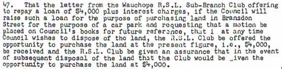
The Applicant has submitted that the above payment for
purchase of land by Council for the purpose of town centre car parking in
Wauchope should be considered as an appropriate contribution for the parking
shortfall in the current application. However, there is insufficient
information on Council’s records as to the background of the land
purchase and whether it was associated with the parking demands of an earlier
development. It is therefore not possible to quantify what credits (if any)
should be applied for the historic purchase of this land. There is also a
substantial historic shortfall in parking for the site (more than 200 spaces at
the rates in the DCP) that would need to be taken into account. The Applicant
could request the parking contributions be reviewed through a Section 4.55
application, if further evidence could be provided in this regard.
Due to the type of development, car park circulation is
required to enable vehicles to enter and exit the site in a forward manner.
Site plans show adequate area is available and conditions have been imposed to
reflect these requirements.
Refer to relevant conditions of consent.
Water Supply Connection
Council records indicate that the development site has
existing 20mm metered water services.
Each dwelling shall be individually metered for water supply
with a master meter installed at the Cameron Street road frontage. Final water
service sizing will need to be determined by a hydraulic consultant to suit the
domestic and commercial components of the development, as well as fire service
and backflow protection requirements in accordance with AS3500.
Detailed plans will be required to be submitted for
assessment with the S.68 application.
Refer to relevant conditions of consent.
Sewer Connection
Council records indicate that the development site has
multiple connections to Council’s sewer system. A sewer reticulation plan
shall be submitted to Sewer Section for approval. Any redundant sewer junctions
shall be capped at the main.
Refer to relevant conditions of consent.
Stormwater
The site naturally grades towards the street frontage and is
currently serviced via a direct connection to the public piped drainage system.
The legal point of discharge for the proposed development is
defined as a direct connection to Council’s stormwater pit. Extension of
Council’s piped drainage in Cameron Street is required to service the
frontage of proposed Lot 2 (containing the seniors housing development).
The design is to make provision for the natural flow of
stormwater runoff from uphill/upstream properties/lands. The design must
include the collection of such waters and discharge to the Council drainage
system. The Stormwater Drainage Strategy prepared by Hopkins Consultants makes
provision for an ultimate interallotment drainage system serving adjoining
properties to the west of the site (No. 22 to 30 Hastings Street). The strategy
relies upon construction of parts of the system by the relevant property
owners. There is no nexus to require the developer to carry out construction of
the full interallotment drainage system for the benefit of these properties.
However, the system will need to have the necessary capacity, and include
creation of the required easements to allow for future connection by upstream
properties.
Flows from the surcharge pit across the northern end of the
RSL car park are considered safe in nature (depth/velocity) and the proposed
easement (B) provides the legal right to drain. The substantial easement serves
a dual purpose, also acting as an incentive to construct the ultimate drainage
arrangement prior to proceeding with any further development within the
easement’s footprint.
A detailed site stormwater management plan will be required
to be submitted for assessment with the S.68 application and prior to the issue
of a Construction Certificate.
In accordance with Councils AUSPEC requirements, the
following must be incorporated into the stormwater drainage plan:
· On
site stormwater detention facilities.
· Water
quality controls.
· Provision
of interallotment drainage to allow the proposed development to drain to the
nominated point of discharge via a single suitably sized conduit.
Refer to relevant conditions of
consent.
Other Utilities
Telecommunication and electricity services are available to
the site.
Heritage
Refer to LEP comments relating to heritage.
Other land resources
The site is within an established urban context and will not
sterilise any significant mineral or agricultural resource.
Water cycle
The proposed development will be unlikely to have any
adverse impacts on water resources and the water cycle.
Soils
The proposed development will be unlikely to have any
adverse impacts on soils in terms of quality, erosion, stability and/or
productivity subject to a standard condition requiring erosion and sediment
controls to be in place prior to and during construction.
Air and microclimate
The construction and/or operations of the proposed
development will be unlikely to result in any adverse impacts on the existing
air quality or result in any pollution. Standard precautionary site management
condition recommended.
Flora and fauna
Construction of the proposed development will not require
any removal/clearing of any significant vegetation and therefore will be
unlikely to have any significant adverse impacts on biodiversity or threatened
species of flora and fauna. Part 7 of the Biodiversity Conservation Act is
considered to be satisfied.
Waste
The proposal includes common waste storage facilities
adjacent to each of the vehicular access points. A condition is recommended
requiring a private waste collection service for the development. The
Construction Certificate plans will need to demonstrate that the swept path of
a waste collection vehicle can be accommodated in accordance with AS 2890. The
western access may need to be altered in this regard.
Standard precautionary site management condition recommended
for construction and demolition waste.
Energy
The proposal includes measures to address energy efficiency
and will be required to comply with the requirements of BASIX. No adverse
impacts anticipated.
Noise and vibration
The application relies on previous acoustic assessment
carried out as part of DA2015 – 230 by Reverb Acoustics, which assessed
the impacts on residential development of noise from the RSL activities and
plant, as well as road traffic noise. The noise criteria required to be
satisfied are detailed below.
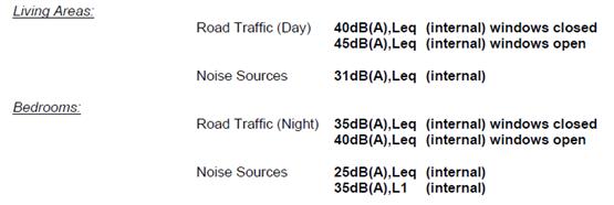
The report provides detailed construction recommendations
that would achieve the above internal noise criteria. However, the
recommendations were specific to the building proposed under the previous
DA2015 – 230 and are not able to be directly applied to this proposal.
A condition is recommended requiring certification from an
appropriately qualified acoustic consultant that the plans submitted with the
application for a Construction Certificate will achieve the relevant noise
criteria.
Condition also recommended to restrict construction to
standard construction hours.
Bushfire
The site is not identified as being bushfire prone.
Safety, security and crime prevention
The proposed development will be unlikely to create any
concealment/entrapment areas or crime spots that would result in any
identifiable loss of safety or reduction of security in the immediate area. The
increase in housing density will improve natural surveillance within the
locality and openings from each dwelling overlook common and private areas.
Social impacts in the locality
Given the nature of the proposed development and its
location the proposal is unlikely to result in any adverse social impacts. The
site is located in proximity to the types of goods and services that are likely
to be needed by future residents of the seniors housing. A public transport route
is available in proximity to the site, which provides access to higher order
services in Port Macquarie.
The provision of additional housing for seniors in an
accessible location is considered to be of social benefit.
Economic impact in the locality
No adverse impacts. A likely positive impact is that the
development will maintain employment in the construction industry, which will
lead to flow impacts such as expenditure in the area.
Site design and internal design
The proposed development design satisfactorily responds to
the site attributes and will fit into the locality. No adverse impacts likely.
Construction
No potential adverse impacts identified to neighbouring
properties with the construction of the proposal.
Cumulative Impacts
The proposed
development is not expected to have any adverse cumulative impacts on the
natural or built environment or the social and economic attributes of the
locality.
(c) The suitability of the site for
the development:
The proposal
will fit into the locality and the site attributes are conducive to the
proposed development. Site constraints have been adequately addressed and
appropriate conditions of consent recommended.
(d) Any submissions made in
accordance with this Act or the Regulations:
One written submission has been received following public
exhibition of the application.
Key issues raised in the submission received and comments
in response to these issues are provided as follows:
|
Submission
Issue/Summary
|
Planning
Comment/Response
|
|
The development will further
block existing surface water runoff from No. 22 Hastings Street, causing
stormwater impacts on adjoining properties.
|
See comments earlier under
Stormwater.
The design is required to make
provision for the natural flow of stormwater runoff from uphill/upstream
properties/lands. The design must include the collection of such waters and
discharge to the Council drainage system. The Stormwater Drainage Strategy
prepared by Hopkins Consultants makes provision for an ultimate interallotment
drainage system serving adjoining properties to the west of the site
(including No. 22 Hastings Street). The strategy relies upon construction of
parts of the system by the relevant property owners. There is no nexus to
require the developer to carry out construction of the full interallotment
drainage system for the benefit of these properties. However, the system will
need to have the necessary capacity, and include creation of the required
easements to allow for future connection by upstream properties.
|
(e) The Public Interest:
The proposed
development satisfies relevant planning controls and is unlikely to impact on
the wider public interest.
4. DEVELOPMENT
CONTRIBUTIONS APPLICABLE
· Development contributions will be required towards augmentation
of town water supply and sewerage system head works under Section 64 of the
Local Government Act 1993.
· Development contributions will be required under Section 94
of the Environmental Planning and Assessment Act 1979 towards roads, open space,
community cultural services, emergency services and administration buildings.
5. CONCLUSION AND
STATEMENT OF REASON
The application has been assessed
in accordance with Section 4.15 of the Environmental Planning and Assessment
Act 1979.
Issues raised during assessment
and public exhibition of the application have been considered in the assessment
of the application. Where relevant, conditions have been recommended to manage
the impacts attributed to these issues.
The site is considered suitable
for the proposed development and the proposal adequately addresses relevant
planning controls. The development is not considered to be contrary to the
public's interest and will not result a significant adverse social,
environmental or economic impact. It is recommended that the application be
approved, subject to the recommended conditions of consent provided in the
attachment section of this report.
|
Attachments
1View. DA2018-
562.1 Recommended Conditions
2View. DA2018
- 562.1 Plans
|
|
ATTACHMENT
|
Development Assessment Panel
23/01/2019
|
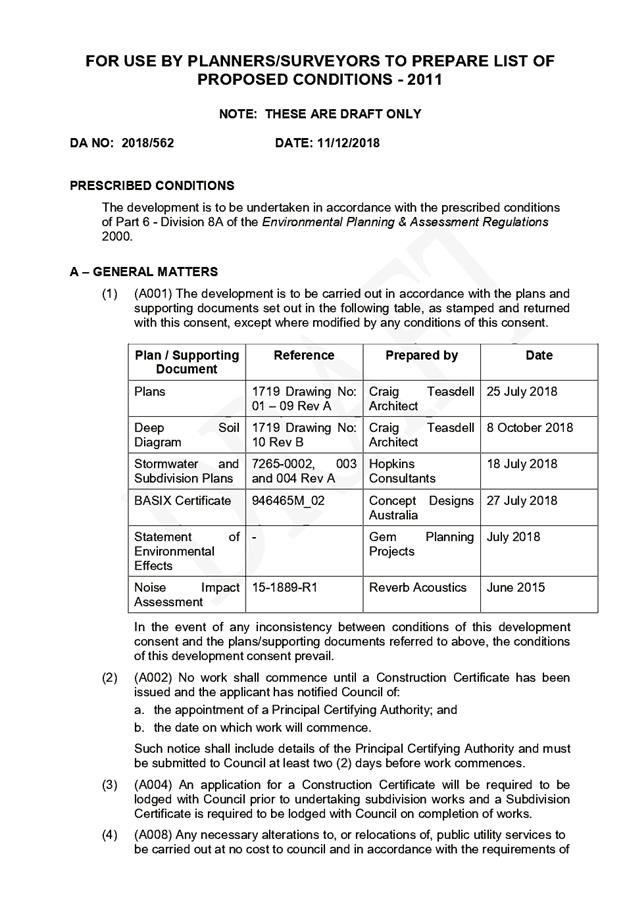
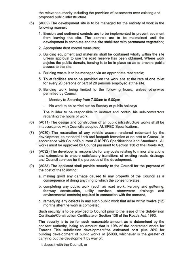
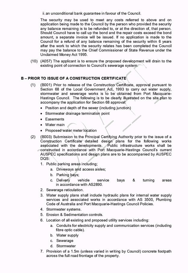
|
ATTACHMENT
|
Development Assessment Panel
23/01/2019
|
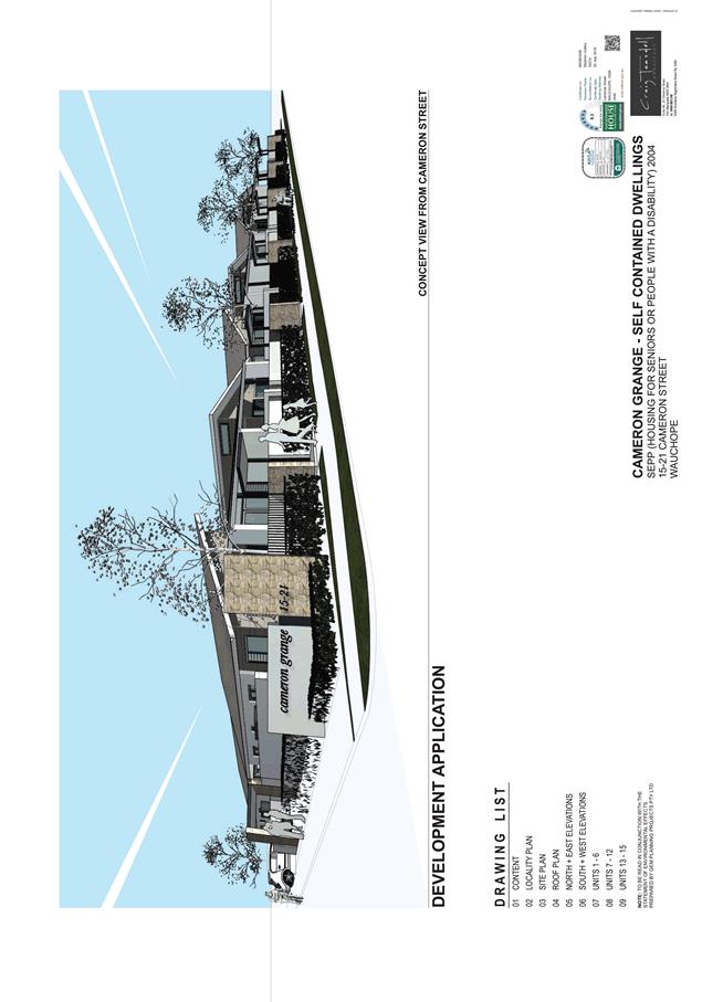
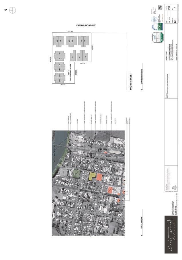

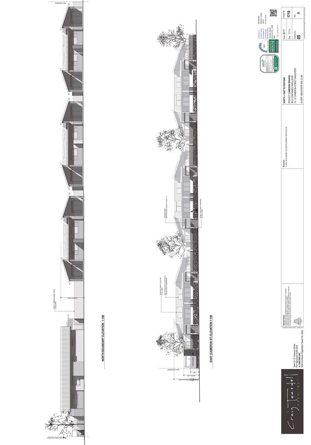
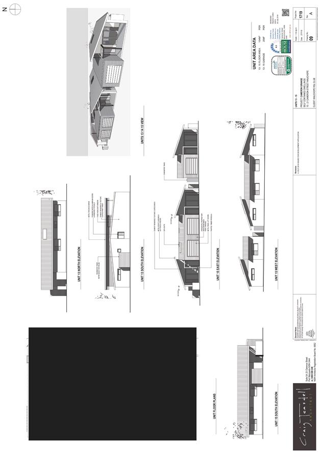
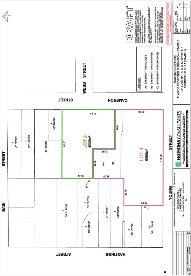
AGENDA Development Assessment Panel 23/01/2019
Item: 06
Subject: DA2018 - 900.1 Dual Occupancy And Strata
Subdivision, Lot 342 DP 1237302, No.23 Gunsynd Chase, Port Macquarie
Report
Author: Chris Gardiner
|
Applicant: B
A King & N J Genders
Owner: B
A King & N J Genders
Estimated Cost: $580,000
Alignment with Delivery
Program
4.3.1 Undertake transparent
and efficient development assessment in accordance with relevant legislation.
|
|
RECOMMENDATION
That
DA2018 – 900.1 for a Dual
Occupancy and Strata Subdivision at Lot 342, DP 1237302, No.
23 Gunsynd Chase, Port Macquarie,
be determined by granting consent subject to the recommended conditions.
|
Executive
Summary
This
report considers a development application for a dual occupancy and
strata subdivision at the subject site and provides
an assessment of the application in accordance with the Environmental Planning
and Assessment Act 1979.
Following exhibition of the
application, one submission has been received.
1. BACKGROUND
Existing sites features and surrounding development
The site has an area of 570.1m2.
The site is zoned R1 General Residential in accordance with the Port Macquarie-Hastings Local
Environmental Plan 2011, as shown in the following zoning plan:
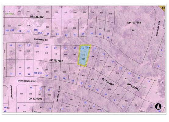
The existing subdivision pattern and location of existing development
within the locality is shown in the following aerial photographs:
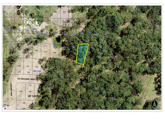
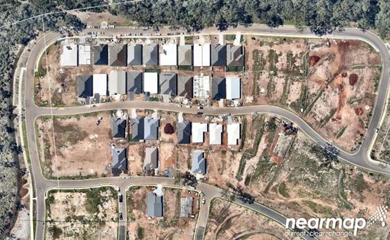
2. DESCRIPTION OF
DEVELOPMENT
Key aspects of the proposal include the following:
· Construction
of a two storey dual occupancy (attached);
· 2
lot strata subdivision.
Refer
to attachments at the end of this report.
Application Chronology
· 25
October 2018 – Application lodged.
· 9 November 2018 to 22 November 2018 – Neighbour
notification.
· 6 December 2018 – Bushfire Safety Authority issued by
NSW Rural Fire Service.
3. STATUTORY ASSESSMENT
Section 4.15(1) Matters for Consideration
In determining the application, Council is required to take
into consideration the following matters as are relevant to the development
that apply to the land to which the development application relates:
(a) The provisions (where
applicable) of:
(i) Any Environmental
Planning Instrument:
State Environmental Planning Policy No. 44 - Koala Habitat
Protection
The site is subject to the adopted Maher’s Headland
Koala Plan of Management. No tree removal is proposed and the proposal is
consistent with the adopted plan of management.
State Environmental Planning Policy No. 55 –
Remediation of Land
Following an inspection of the site and a search of Council
records, the subject land is not identified as being potentially contaminated
and is suitable for the intended use.
State Environmental Planning Policy No. 62 –
Sustainable Aquaculture
Given the nature of the proposed development and proposed
stormwater controls the proposal will be unlikely to have any adverse impact on
existing aquaculture industries.
State Environmental Planning Policy (Building
Sustainability Index: BASIX) 2004
A BASIX certificate has been submitted demonstrating that
the proposal will comply with the requirements of the SEPP. It is recommended
that a condition be imposed to ensure that the commitments are incorporated
into the development and certified at Occupation Certificate stage.
Port Macquarie-Hastings Local Environmental Plan
2011
The proposal is consistent with the LEP having regard to
the following:
· Clause 2.2, the subject site is zoned R1 General
Residential. In accordance with clause 2.3(1) and the R1 zone landuse table,
the proposed development for a dual occupancy (attached) is a permissible landuse
with consent.
The objectives of the R1 zone are as follows:
o To provide for the housing needs of the community.
o To provide for a variety of housing types and
densities.
o To enable other land uses that provide facilities
or services to meet the day to day needs of residents.
In accordance with Clause 2.3(2), the proposal
is consistent with the zone objectives having regard to the following:
o the proposal is a permissible landuse;
o The proposal provides a variety of housing types and
densities and would contribute to meeting the housing needs of the community.
· Clause 4.1(4) – the minimum lot size does not apply
as the proposal is for strata subdivision.
· Clause 4.3, the maximum overall height of the building
above ground level (existing) is 6.0m which complies with the standard height
limit of 8.5m applying to the site.
·
· Clause 4.4, the floor space ratio of the proposal is 0.45:1
which complies with the maximum 0.65:1 floor space ratio applying to the site.
·
· Clause 5.10 – Heritage. The site does not contain or
adjoin any known heritage items or sites of significance.
·
· Clause 7.13, satisfactory arrangements are in place for
provision of essential services including water supply, electricity supply,
sewer infrastructure, stormwater drainage and suitable road access to service
the development.
(ii) Any
draft instruments that apply to the site or are on exhibition:
No draft
instruments apply to the site.
(iii) Any
Development Control Plan in force:
Port
Macquarie-Hastings Development Control Plan 2013
|
DCP 2013: Dwellings, Dual occupancies, Dwelling
houses, Multi dwelling houses & Ancillary development
|
|
|
Requirements
|
Proposed
|
Complies
|
|
3.2.2.1
|
Ancillary development:
• 4.8m
max. height
• Single
storey
• 60m2
max. area
• 100m2
for lots >900m2
• 24
degree max. roof pitch
• Not
located in front setback
|
Water tanks appropriately located
|
Yes
|
|
3.2.2.2
|
Articulation zone:
• Min.
3m front setback
• An
entry feature or portico
• A
balcony, deck, patio, pergola, terrace or verandah
• A
window box treatment
• A
bay window or similar feature
• An
awning or other feature over a window
• A
sun shading feature
|
No elements within the articulation zone.
|
N/A
|
|
Front setback (Residential not R5 zone):
• Min.
6.0m classified road
• Min.
4.5m local road or within 20% of adjoining dwelling if on corner lot
• Min.
3.0m secondary road
• Min.
2.0m Laneway
|
Front building line setback requirements are complied
with.
|
Yes
|
|
3.2.2.3
|
Garage 5.5m min. and 1m behind front façade.
Garage door recessed behind building line or
eaves/overhangs provided
|
Garage door setback requirements are complied with.
|
Yes
|
|
6m max. width of garage door/s and 50% max. width of
building
|
Width of garage door requirements are complied with.
|
Yes
|
|
Driveway crossover 1/3 max. of site frontage and max. 5.0m
width
|
Driveway crossing width requirements are complied with.
|
Yes
|
|
3.2.2.4
|
4m min. rear setback. Variation subject to site analysis
and provision of private open space
|
The rear setback requirements are complied with.
|
Yes
|
|
3.2.2.5
|
Side setbacks:
• Ground
floor = min. 0.9m
• First
floors & above = min. 3m setback or where it can be demonstrated that
overshadowing not adverse = 0.9m min.
• Building
wall set in and out every 12m by 0.5m
|
The minimum side setback requirements are complied with.
The wall articulation is compliant and satisfies the
objectives of the development provision.
|
Yes
|
|
3.2.2.6
|
35m2 min. private open space area including a useable 4x4m
min. area which has 5% max. grade
|
Each occupancy contains 35m² open space in one area
including a useable 4m x 4m area.
|
Yes
|
|
3.2.2.7
|
Front fences:
• If
solid 1.2m max height and front setback 1.0m with landscaping
• 3x3m
min. splay for corner sites
• Fences
>1.2m to be 1.8m max. height for 50% or 6.0m max. length of street frontage
with 25% openings
• 0.9x0.9m
splays adjoining driveway entrances
|
No front fences proposed.
|
N/A
|
|
3.2.2.8
|
Front fences and walls to have complimentary materials to
context
No chain wire, solid timber, masonry or solid steel front
fences
|
No front fences proposed.
|
N/A
|
|
3.2.2.10
|
Privacy:
• Direct
views between living areas of adjacent dwellings screened when within 9m
radius of any part of window of adjacent dwelling and within 12m of private
open space areas of adjacent dwellings. ie. 1.8m fence or privacy screening
which has 25% max. openings and is permanently fixed
• Privacy
screen required if floor level > 1m height, window side/rear setback
(other than bedroom) is less than 3m and sill height less than 1.5m
• Privacy
screens provided to balconies/verandahs etc which have <3m side/rear
setback and floor level height >1m
|
The development will not compromise privacy in the area
due to a combination of having high sill windows that face side boundaries
and use of fencing.
|
Yes
|
|
3.2.2.11
|
Roof terraces
|
N/A
|
|
|
3.2.2.13 onwards
|
Jetties and boat ramps
|
N/A
|
|
|
DCP 2013: General Provisions
|
|
|
Requirements
|
Proposed
|
Complies
|
|
2.7.2.2
|
Design addresses generic principles of Crime Prevention
Through Environmental Design guideline
|
No concealment or entrapment areas proposed. Adequate
casual surveillance available.
|
Yes
|
|
2.3.3.1
|
Cut and fill 1.0m max. 1m outside the perimeter of the
external building walls
|
Cut and fill <1.0m change 1m outside the perimeter of
the external building walls.
|
Yes
|
|
2.3.3.2
|
1m max. height retaining walls along road frontage
|
None proposed
|
N/A
|
|
Any retaining wall >1.0 in height to be certified by
structure engineer
|
No retaining wall likely >1m.
|
Yes
|
|
Combination of retaining wall and front fence height max
1.8m, max length 6.0m or 30% of frontage, fence component 25% transparent,
and splay at corners and adjacent to driveway
|
No retaining wall front fence combination proposed.
|
N/A
|
|
2.3.3.8
|
Removal of hollow bearing trees
|
No trees proposed to be removed
|
N/A
|
|
2.6.3.1
|
Tree removal (3m or higher with 100m diameter trunk at 1m
above ground level and 3m from external wall of existing dwelling)
|
No trees proposed to be removed
|
N/A
|
|
2.4.3
|
Bushfire risk, Acid sulphate soils, Flooding,
Contamination, Airspace protection, Noise and Stormwater
|
Refer to main body of report.
|
|
|
2.5.3.2
|
New accesses not permitted from arterial or distributor
roads
|
No new access proposed to arterial or distributor road.
|
N/A
|
|
Driveway crossing/s minimal in number and width including
maximising street parking
|
Driveway crossings are minimal in width including
maximising street parking.
|
Yes
|
|
2.5.3.3
|
Parking in accordance with Table 2.5.1.
Dwelling/dual occupancies
1 space per dwelling/occupancy (behind building line).
Multi dwelling
1 space per 1 & 2 bedroom occupancies
1.5 spaces per 3+ bedroom occupancies
0.25 spaces per occupancy for visitor parking.
|
Proposal involves 2 x 3 bedroom dwellings and requires a
minimum of 1 parking space per dwelling. The development proposes a single
garage for each dwelling and complies with this requirement.
|
Yes
|
|
2.5.3.11
|
Section 94 contributions
|
Contributions apply - refer to ET calc and NOP.
|
Yes
|
|
2.5.3.12 and 2.5.3.13
|
Landscaping of parking areas
|
Suitable landscaping proposed around driveway/parking
locations.
|
Yes
|
|
2.5.3.14
|
Sealed driveway surfaces unless justified
|
Sealed driveway areas proposed.
|
Yes
|
|
2.5.3.15 and 2.5.3.16
|
Driveway grades first 6m or ‘parking area’
shall be 5% grade with transitions of 2m length
|
Driveway grades capable of satisfying Council standard
driveway crossover requirements. Condition recommended for section 138 Roads
Act permit
|
Yes
|
|
2.5.3.17
|
Parking areas to be designed to avoid concentrations of
water runoff on the surface.
|
Stormwater drainage is capable of being managed as part of
plumbing construction.
|
Yes
|
Note: Subdivision provisions of the DCP (except battleaxe
handle width) are aimed at the creation of vacant lots (i.e. not lots within an
integrated housing proposal such as this) and have therefore been excluded from
the above assessment. Servicing requirements are discussed later in this
report.
(iiia) Any
planning agreement that has been entered into under section 7.4, or any draft
planning agreement that a developer has offered to enter into under section
7.4:
No planning
agreement has been offered or entered into relating to the site.
(iv) Any matters prescribed by the
Regulations:
No matters
prescribed by the regulations are applicable to the proposal.
(b) The
likely impacts of that development, including environmental impacts on both the
natural and built environments, social and economic impacts in the locality:
The proposal is considered to be compatible with other
residential development in the locality and adequately addresses planning
controls for the area.
There are no adverse impacts on existing view sharing.
There are no adverse overshadowing impacts. The proposal
does not prevent adjoining properties from receiving 3 hours of sunlight to
private open space and primary living areas on 21 June.
Roads
The site has road frontage to Gunsynd Chase. Adjacent to
the site, Gunsynd Chase is a sealed public road under the care and control of
Council.
Traffic and Transport
The addition in traffic associated with the development is
unlikely to have any adverse impacts to the existing road network within the
immediate locality. Gunsynd Chase is capable of accommodating the additional
traffic generated by the development.
Site Frontage & Access
Vehicle access to the site is proposed through two
individual driveways with direct frontage to Gunsynd Chase, being a
Council-owned public road. Access shall comply with Council AUSPEC and
Australian Standards, and conditions have been imposed to reflect these
requirements.
Parking and Manoeuvring
A total of 2 parking spaces have been provided on-site
within garages with additional parking provided available within the driveway.
Parking and driveway widths on site can comply with relevant Australian Standards
(AS 2890) and conditions have been imposed to reflect these requirements.
Water Supply Connection
Council records indicate that the development site has an
existing 20mm sealed water service. Each proposed dwelling requires an
individual metered water service. The hydraulic plans submitted with the
Development Application are acceptable for Water and Sewer Section purposes.
Refer to relevant conditions of consent.
Sewer Connection
Council records indicate that the development site is
connected to sewer via a junction to the sewer main that traverses inside the
southern boundary. Both units can drain to the existing point of connection to
Council’s sewer system. The hydraulic plans submitted with the
Development Application are acceptable for Water and Sewer Section purposes.
Refer to relevant conditions of consent.
Stormwater
The site naturally grades towards the street frontage and
is currently serviced via a direct connection to the public piped drainage
system in Gunsynd Chase. The proposed development is capable of being drained
to the existing point of connection.
A detailed site stormwater management plan will be required
to be submitted for assessment with the S.68 application and prior to the issue
of a Construction Certificate.
Refer to relevant conditions of consent.
Other Utilities
Telecommunication and electricity services are available to
the site.
Heritage
No known items of Aboriginal or European heritage
significance exist on the property. No adverse impacts anticipated.
Other land resources
The site is within an established urban context and will
not sterilise any significant mineral or agricultural resource.
Water cycle
The proposed development will be unlikely to have any
adverse impacts on water resources and the water cycle.
Soils
The proposed development will be unlikely to have any
adverse impacts on soils in terms of quality, erosion, stability and/or
productivity subject to a standard condition requiring erosion and sediment
controls to be in place prior to and during construction.
Air and microclimate
The construction and/or operations of the proposed
development will be unlikely to result in any adverse impacts on the existing
air quality or result in any pollution. Standard precautionary site management
condition recommended.
Flora and fauna
Construction of the proposed development will not require
any removal/clearing of any significant vegetation and therefore will be
unlikely to have any significant adverse impacts on biodiversity or threatened
species of flora and fauna. Part 7 of the Biodiversity Conservation Act is
considered to be satisfied.
Waste
Satisfactory arrangements are in place for proposed storage
and collection of waste and recyclables. No adverse impacts anticipated.
Standard precautionary site management condition recommended.
Energy
The proposal includes measures to address energy efficiency
and will be required to comply with the requirements of BASIX.
Noise and vibration
A Road Noise Assessment was carried out as part of the
subdivision that created the lot (DA2005 – 547). The approved Noise Level
Plan prepared by Land Dynamics identifies that Category 2 construction is
required for the development. A condition is recommended confirming this
requirement.
Condition also recommended to restrict construction to
standard construction hours.
Bushfire
The site is identified as being bushfire prone.
In accordance with Section 100B - Rural Fires Act 1997 -
the application proposes subdivision of bush fire prone land that could
lawfully be used for residential purposes. As a result, the applicant has
submitted a bushfire report prepared by a Certified Consultant. The report was
forwarded to the NSW Rural Fire Service who have since issued a Bushfire Safety
Authority, which will be incorporated into the consent.
Safety, security and crime prevention
The proposed development will be unlikely to create any
concealment/entrapment areas or crime spots that would result in any
identifiable loss of safety or reduction of security in the immediate
area. The increase in housing density will improve natural surveillance
within the locality and openings from each dwelling overlook common and private
areas.
Social impacts in the locality
Given the nature of the proposed development and its’
location the proposal is unlikely to result in any adverse social impacts.
Economic impact in the locality
No adverse impacts. A likely positive impact is that the
development will maintain employment in the construction industry, which will
lead to flow impacts such as expenditure in the area.
Site design and internal design
The proposed development design satisfactorily responds to
the site attributes and will fit into the locality. No adverse impacts likely.
Construction
No potential adverse impacts identified to neighbouring
properties with the construction of the proposal.
Cumulative Impacts
The proposed
development is not expected to have any adverse cumulative impacts on the
natural or built environment or the social and economic attributes of the locality.
(c) The suitability of the site for
the development:
The proposal
will fit into the locality and the site attributes are conducive to the
proposed development. Site constraints have been adequately addressed and
appropriate conditions of consent recommended.
(d) Any submissions made in
accordance with this Act or the Regulations:
One written submission has been received following public
exhibition of the application.
Key issues raised in the submissions received and comments
in response to these issues are provided as follows:
|
Submission
Issue/Summary
|
Planning
Comment/Response
|
|
The contract for purchase of
the land included a prohibition on dual occupancies for Stage 3 of Ascot
Park.
|
In accordance with Clause 1.9A
of the Port Macquarie-Hastings Local Environmental Plan 2011 (LEP), any
agreement, covenant or other similar instrument that restricts the carrying
out of development in accordance with the LEP does not apply. In this
instance dual occupancy (attached) is permitted with consent in the R1
General Residential zone.
|
|
Adverse traffic and parking impacts in Gunsynd Chase.
|
The additional traffic likely to be generated by the
development is considered to be minor (1 – 4 vehicle trips per day
according to the RTA Guide to Traffic Generating Development). This traffic
would be within the capacity of Gunsynd Chase.
The development satisfies the minimum off-street parking
requirements in DCP 2013 (one space per dwelling) and the consent authority
cannot impose a more onerous requirement.
|
|
Loss of solar access to living areas and private open
space of No. 25 Gunsynd Chase.
|
The first floor of the proposed development is setback
4.196m from the side boundary, which exceeds the minimum setback requirements
in DCP 2013. Having regard to the orientation of the lot, the proposed
development would not prevent adjoining properties from receiving 3 hours of
sunlight to private open space and primary living areas on 21 June.
|
|
Loss of privacy to living areas and private open space of
No. 25 Gunsynd Chase.
|
The upper floor windows on the western elevation of the
proposed development include a bedroom window with high sill height and a
window to the stairwell which are not expected to create adverse privacy
impacts.
Views from ground floor windows would be adequately
screened by the proposed 1.8m high side and rear boundary fencing.
|
|
Potential glare from metal sheet roofing.
|
There are no specific development controls relating to
external finishes and there are numerous other dwellings in the locality with
light coloured metal sheet roofing. The low pitch of the roof is expected to
reduce the potential for glare to impact on neighbouring property.
|
(e) The Public Interest:
The proposed
development satisfies relevant planning controls and is unlikely to impact on
the wider public interest.
4. DEVELOPMENT
CONTRIBUTIONS APPLICABLE
· Development contributions will be required towards
augmentation of town water supply and sewerage system head works under Section
64 of the Local Government Act 1993.
· Development contributions will be required under Section 94
of the Environmental Planning and Assessment Act 1979 towards roads, open
space, community cultural services, emergency services and administration
buildings.
5. CONCLUSION AND STATEMENT
OF REASON
The application has been assessed
in accordance with Section 4.15 of the Environmental Planning and Assessment
Act 1979.
Issues raised during assessment
and public exhibition of the application have been considered in the assessment
of the application. Where relevant, conditions have been recommended to manage
the impacts attributed to these issues.
The site is considered suitable
for the proposed development and the proposal adequately addresses relevant
planning controls. The development is not considered to be contrary to the
public's interest and will not result a significant adverse social,
environmental or economic impact. It is recommended that the application be
approved, subject to the recommended conditions of consent provided in the
attachment section of this report.
|
Attachments
1View. DA2018
- 900.1 Recommended Conditions
2View. DA2018
- 900.1 Plans
|
|
ATTACHMENT
|
Development Assessment Panel
23/01/2019
|
|
ATTACHMENT
|
Development Assessment Panel
23/01/2019
|
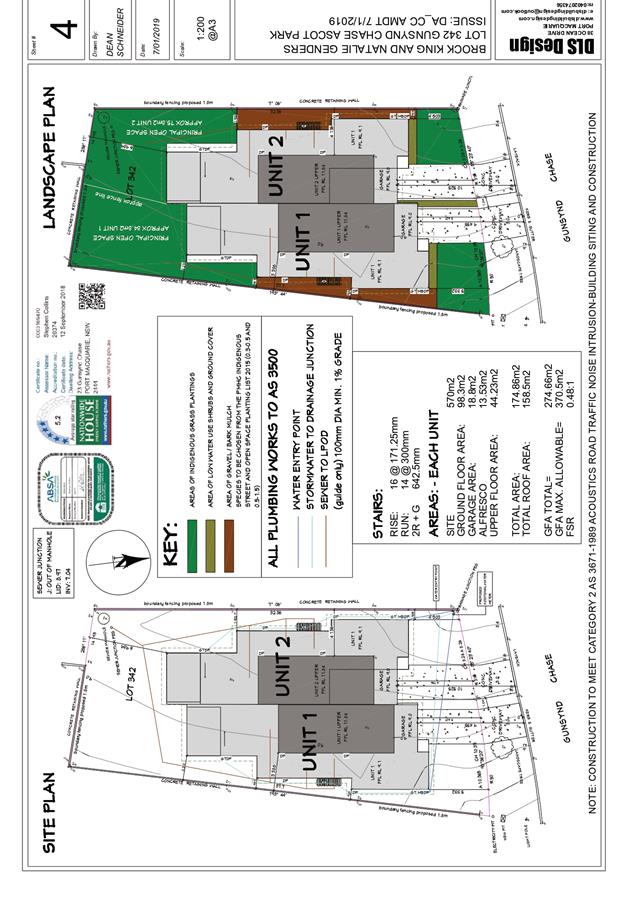
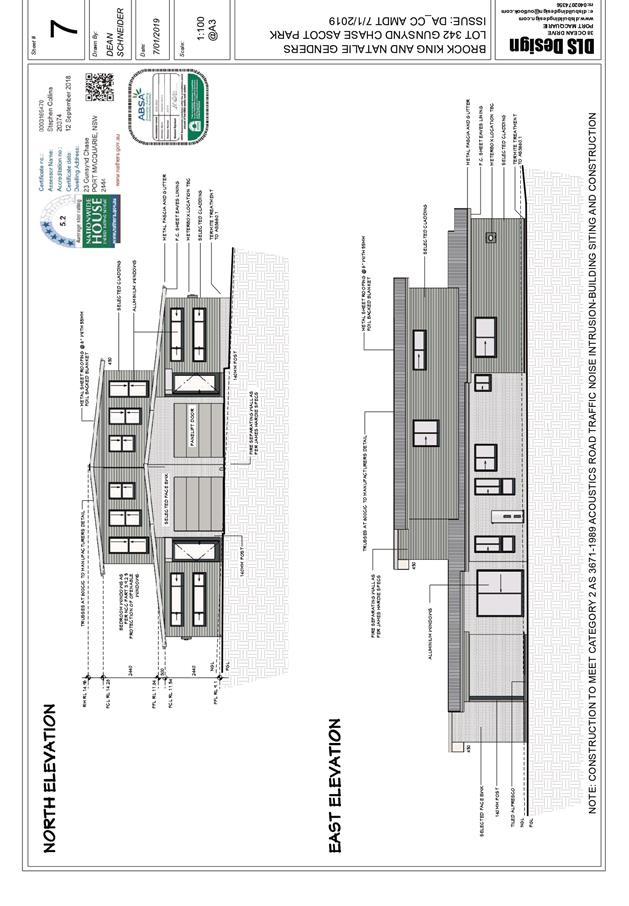
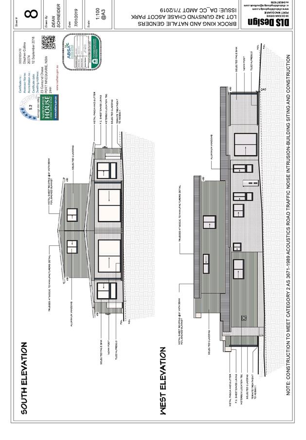
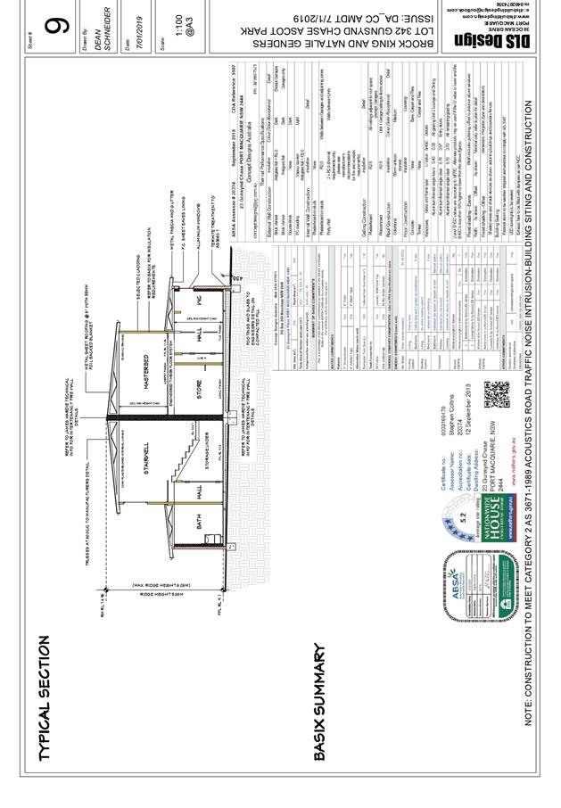
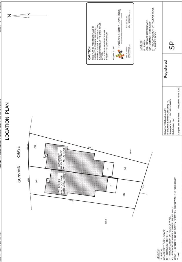
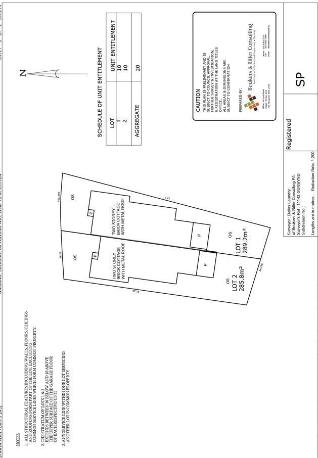
AGENDA Development Assessment Panel 23/01/2019
Item: 07
Subject: DA2017 - 410.2 Modification To Dwelling, Lot
29 DP 1045446, No 12 Loganvale Place, Logans Crossing
Report
Author: Andrew Rock
|
Applicant: C.
Eames and J. Latham
Owner: C.
Eames and J. Latham
Estimated Cost: $289,000
Alignment with Delivery
Program
4.3.1 Undertake transparent and
efficient development assessment in accordance with relevant legislation.
|
|
RECOMMENDATION
That
modification to DA 2017 – 410
to amend the internal layout and the size and location of an external window
for a dwelling at Lot 29, DP 1045443, No. 12 Loganvale Place, Logans Crossing, be determined
by granting consent subject to the recommended conditions.
|
Executive
Summary
This
report considers a Section 4.55(1A) modification of development consent
application at the subject site and provides an assessment in accordance with
the Environmental Planning and Assessment Act 1979.
Following exhibition of the
application, one submission was received.
1. BACKGROUND
History
The original development application was reported to
Council’s Development Assessment Panel (DAP) on 23 August 2017. The
outcome of the meeting was as follows:
CONSENSUS:
That DA 2017 – 410.1
for a dwelling and shed at Lot 29, DP 1045446, Loganvale Place, Logans
Crossing, be determined by granting consent subject to the recommended
conditions.
A Construction Certificate for
the development was issued by Council on 29 August 2017 and the dwelling is
currently under construction.
Existing sites features and surrounding development
The site is zoned R5 Large Lot Residential in accordance with the Port Macquarie-Hastings Local
Environmental Plan 2011, as shown in the following zoning plan:
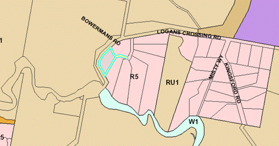
The existing subdivision pattern and location of existing
development within the locality is shown in the following aerial photograph:
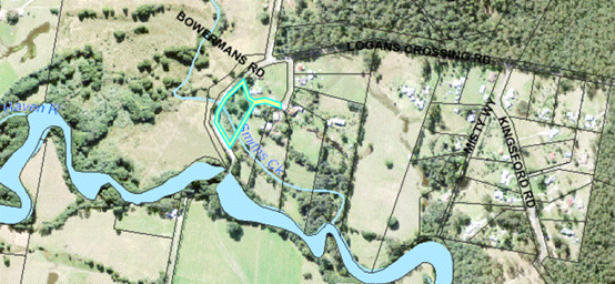
2. DESCRIPTION OF
DEVELOPMENT
Key aspects of the proposed modification include the
following:
· Internal room configuration - fill in the end of approved
garage to create a study.
· Provide a window to the proposed study (labelled window 5
on the floor plan – eastern side of dwelling) with a fixed external
privacy screen covering the window.
Refer
to attachments at the end of this report.
Application Chronology
· 23
November 2018 - Modification application lodged.
· 11 December 2018 – Application notified.
· 9 January 2019 – Submission received.
2. STATUTORY
ASSESSMENT
Section 4.55 of the Environmental
Planning and Assessment Act 1979 enables the modification of consents and
categorises modification into three categories - 4.55(1) for modifications
involving minor error, mis-description or miscalculation; 4.55(1A) for modifications
involving minimal environmental impact; and 4.55(2) for other modifications.
Each type of modification must be considered as being substantially the same to
that which was originally consented to.
Is the
proposal substantially the same?
The subject application is being
considered under the provisions of Section 4.55(1A). The proposal is considered
to be substantially the same development to that which was originally consented
to and will have minimal environmental impact. Having regard to the above
principles, the proposed modification is not considered to alter the
fundamental essence of the original development.
Does the application
require notification/advertising in accordance with the regulations and/or any
Development Control Plan?
Neighbour notification has been
undertaken.
Any
submissions made concerning the modification?
One submission has been received
following completion of the neighbour notification period. The submission is
considered later in this report.
Any
matters referred to in section 4.15(1) relevant to the modification?
Section 4.15(1) Matters for Consideration
In determining the application, Council is required to take
into consideration the following matters as are relevant to the development
that apply to the land to which the development application relates:
(a) The
provisions (where applicable) of:
•
(a)(i) Any
environmental planning instrument
State Environmental Planning Policy
(Building Sustainability Index: BASIX) 2004
A revised BASIX
certificate (number 785574S_03) has been submitted demonstrating that the
modified proposal will comply with the requirements of the SEPP.
(ii) Any
Development Control Plan in force:
Port
Macquarie-Hastings Development Control Plan 2013
The
relevant provisions of this plan are addressed as follows:
|
|
Requirements
|
Proposed
|
Complies
|
|
3.2.2.5
|
Side setbacks:
• Ground floor =
min. 0.9m
|
10m setback to the eastern side
boundary remains unchanged.
|
Yes
|
|
3.2.2.10
|
Privacy:
• Direct views
between living areas of adjacent dwellings screened when within 9m radius of
any part of window of adjacent dwelling and within 12m of private open space
areas of adjacent dwellings. ie. 1.8m fence or privacy screening which has
25% max. openings and is permanently fixed
• Privacy screen
required if floor level > 1m height, window side/rear setback (other than
bedroom) is less than 3m and sill height less than 1.5m
• Privacy screens
provided to balconies/verandahs etc which have <3m side/rear setback and
floor level height >1m
|
No direct views from a living
room to another dwelling.
Privacy screen proposed to the
study window (subject of this modification application).
|
Yes
|
(iiia) Any
planning agreement that has been entered into under section 7.4, or any draft
planning agreement that a developer has offered to enter into under section
7.4:
No planning
agreement has been offered or entered into.
iv) Any matters prescribed by the
Regulations:
No matter prescribed by the regulations apply.
(b) The
likely impacts of that development, including environmental impacts on both the
natural and built environments, social and economic impacts in the locality:
No adverse
impacts will result from development as modified.
(c) The suitability of the site for
the development:
Proposal
consists of the creation of a study within an area previously approved as a
part of the garage and the installation of a window to service the proposed
study. The proposal is suitable for the site.
(d) Any submissions made in
accordance with this Act or the Regulations:
One (1) written submission has been received following public
exhibition of the application.
Key issues raised in the submission received and comments
in response to these issues are provided as follows:
|
Submission
Issue/Summary
|
Planning
Comment/Response
|
|
What does the proposed screen
look like?
|
Horizontal slats as indicated
on the east elevation plan.
|
|
What materials is it made of?
|
Applicant has verbally indicated that it is likely to be
mixed hardwood but it is not proposed to specify a specific type of material,
rather a privacy outcome.
|
|
What are the measurements?
|
The proposed window is 1.1m x 1.2m. The screen is
proposed to cover the entire window.
|
|
What percentage block out does it give?
|
Proposed to include a condition that there be no opening
more than 30mm wide and the total area of all openings be no more than 30% of
the surface area of the privacy screen – in line with complying
development privacy screen requirements.
|
|
How unsightly would it be?
|
It is not considered that the proposed privacy screen
will be unsightly.
|
(e) The Public Interest:
The proposed
development satisfies relevant planning controls and is unlikely to impact on
the wider public interest.
4. DEVELOPMENT CONTRIBUTIONS
APPLICABLE
Not applicable.
5. CONCLUSION AND
STATEMENT OF REASON
The application has been assessed
in accordance with Section 4.55 of the Environmental Planning and Assessment
Act 1979.
Issues raised during assessment
and public exhibition of the application have been considered in the assessment
of the application. Where relevant, conditions have been recommended to manage
the impacts attributed to these issues.
The site is considered suitable
for the proposed development and the proposal as modified adequately addresses
relevant planning controls. The development is not considered to be contrary to
the public's interest and will not result a significant adverse social,
environmental or economic impact. It is recommended that the application be
approved, subject to the recommended conditions of consent as modified provided
in the attachment section of this report.
|
Attachments
1View. DA2017
- 410.2 Recommended Modified Consent Conditions
2View. DA2017
- 410.2 SOEE Document
3View. DA2017
- 410.2 Plans.
4View. DA2017
- 410.1 Stamped Approved Plans
|
|
ATTACHMENT
|
Development Assessment Panel
23/01/2019
|
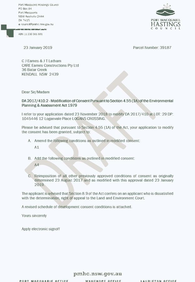
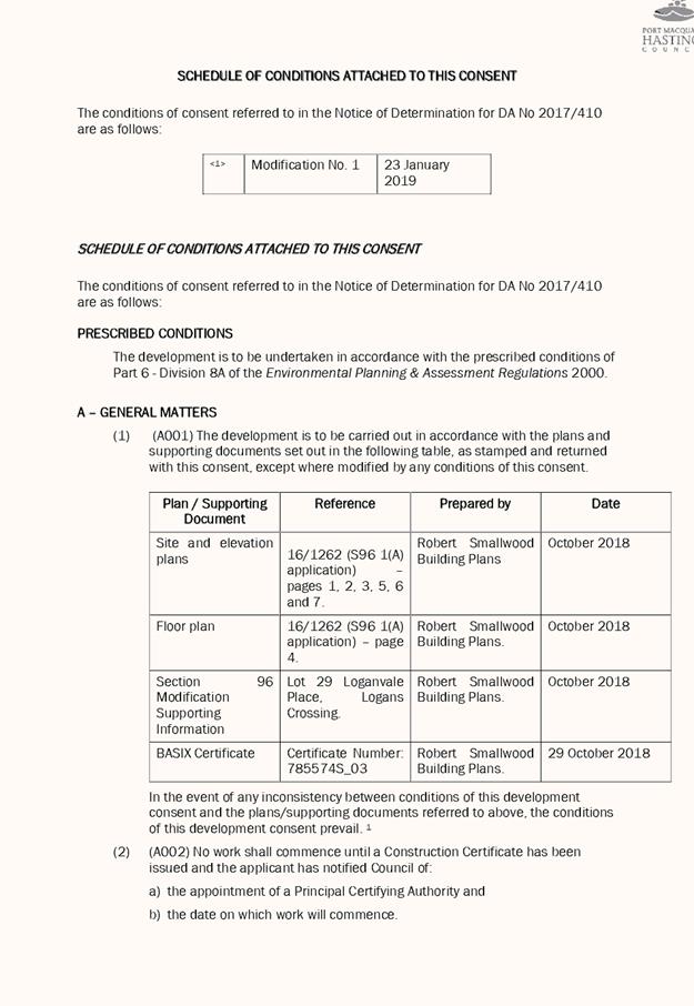

|
ATTACHMENT
|
Development Assessment Panel
23/01/2019
|
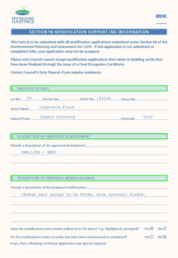
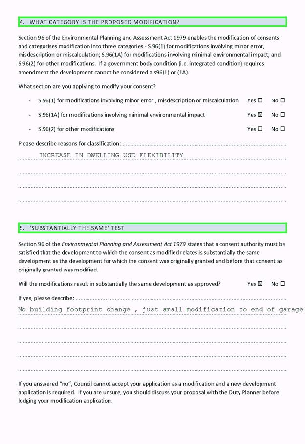
|
ATTACHMENT
|
Development Assessment Panel
23/01/2019
|
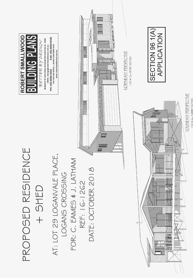
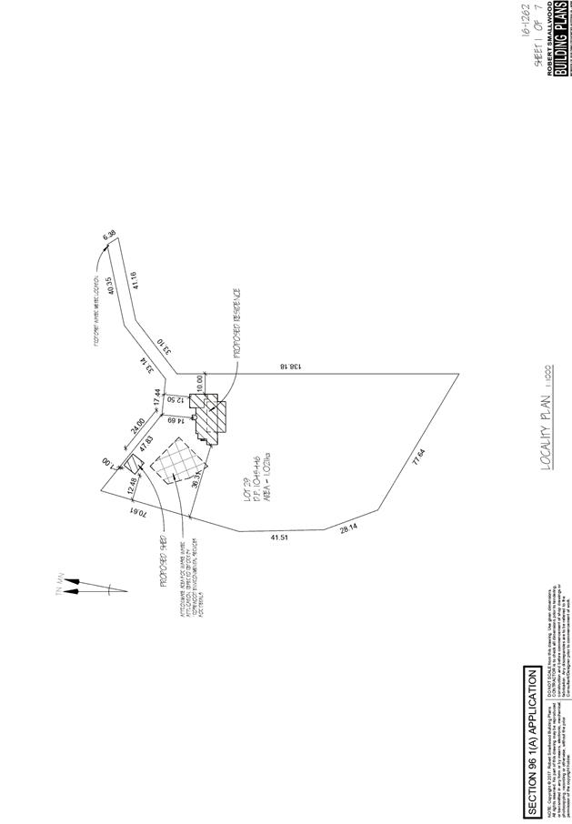
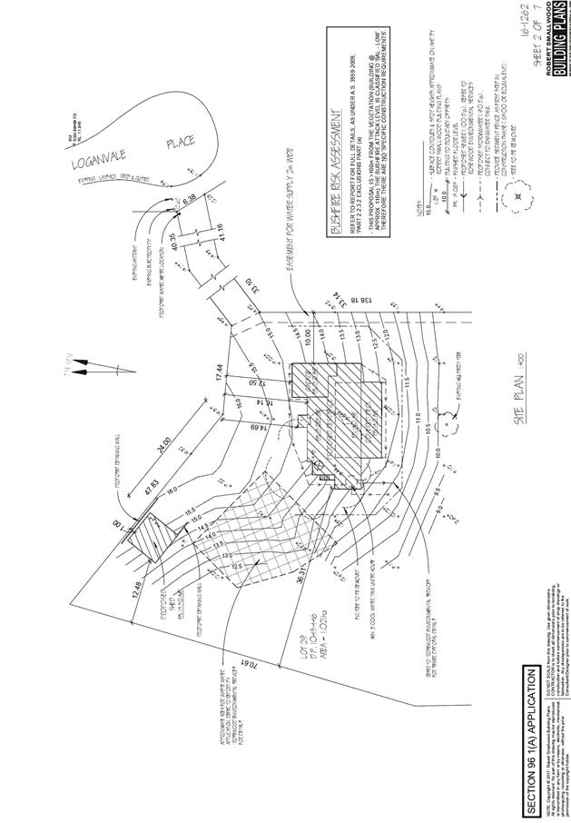
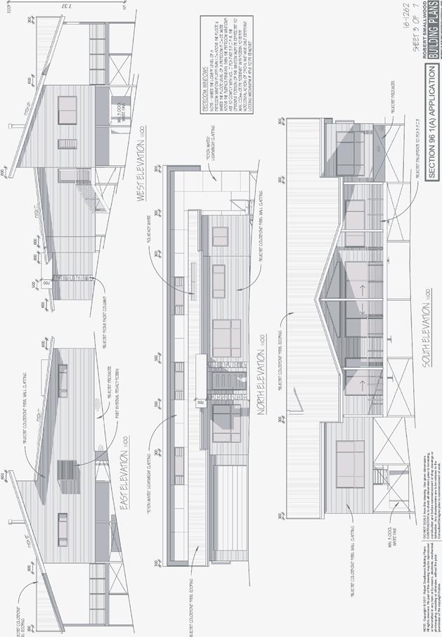
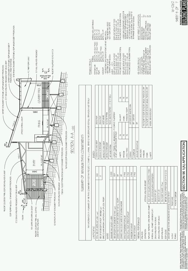
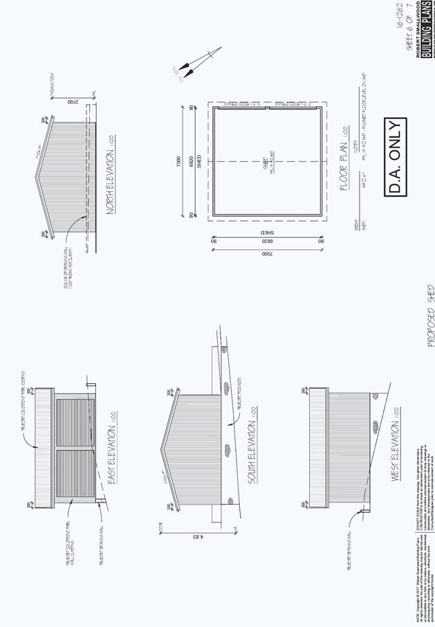
|
ATTACHMENT
|
Development Assessment Panel
23/01/2019
|
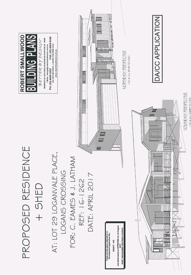
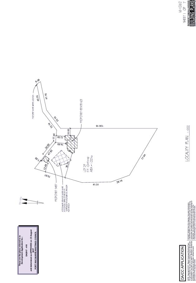
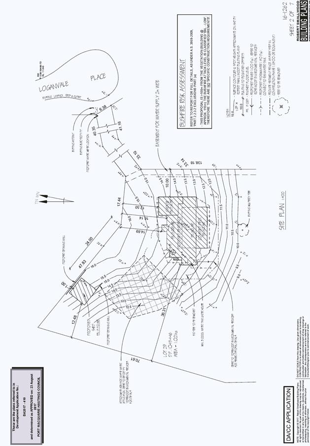
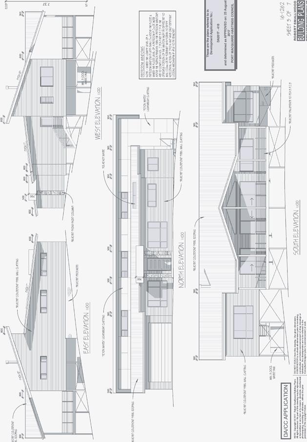
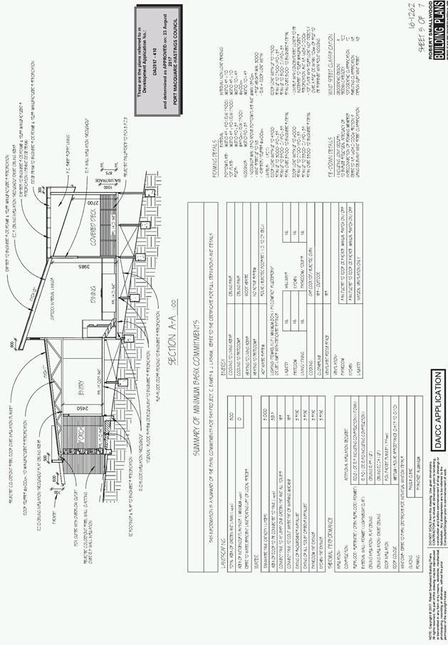
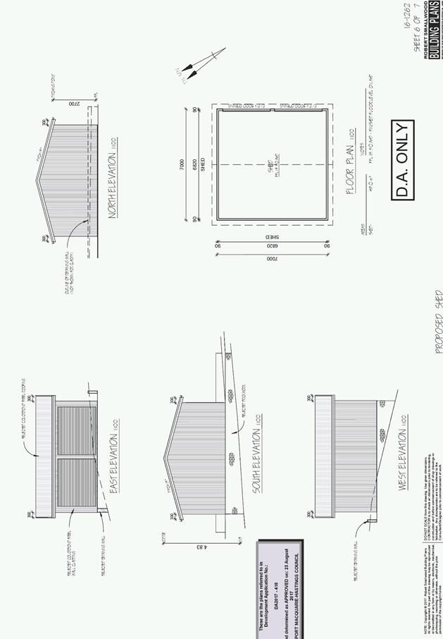
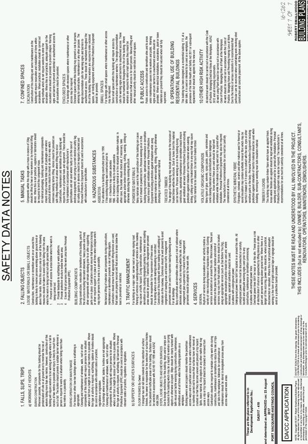
AGENDA Development Assessment Panel 23/01/2019
Item: 08
Subject: DA2017 - 667.1 Demolition Of Existing Building And Construction Of
Boat Storage Facility And Public Amenities, Tree Removal And Road Works At Lot
2 DP 535212, No. 9 McInherney Park, Port Macquarie
Report Author: Benjamin Roberts
|
Applicant: Sailability
Pty Ltd
Owner: Crown
Land under Trust Management of Council
Estimated Cost: $420,000
Alignment with Delivery Program
4.3.1 Undertake transparent
and efficient development assessment in accordance with relevant legislation.
|
|
RECOMMENDATION
That
it be recommended to Council that DA2017 – 667 for demolition of
existing building and construction of boat storage facility and public amenities,
tree removal and road works at Lot 2, DP 535212, McInherney Close, Port Macquarie, be determined by granting consent subject to the
recommended conditions.
|
Executive
Summary
This
report considers a development application for demolition of existing
building and construction of boat storage facility and public amenities, tree
removal and road works at the subject site and provides
an assessment of the application in accordance with the Environmental Planning
and Assessment Act 1979.
Public notification of the application resulted in some
community interest and several submissions from members of the public. The
application was renotified after significant changes were made to the original
design in response to the concerns raised in the initial public consultation
phase.
In accordance with Council’s
conflict of interest - development applications policy the general manager
determined that an external consultant be engaged to report on the application.
Coffs Harbour City Council were engaged to undertake an independent assessment
of the application and provide a recommendation. The assessment and
recommendation is provided as an attachment to this report.
The conflict of interest policy
also requires that all development applications on Council land, which includes
Crown land under trust management of Council, where objections have been received
be considered by the Development Assessment Panel and referred to Council for
determination.
|
Attachments
1View. DA2017
- 667.1 Recommended Conditions
2View. DA2017
- 667.1 Amended GTAs NSW Office of Water
3View. DA2017
- 667.1 Final Assessment Report from Coffs Harbour Council
4View. DA2017
- 667.1 Plans
|
|
ATTACHMENT
|
Development Assessment Panel
23/01/2019
|
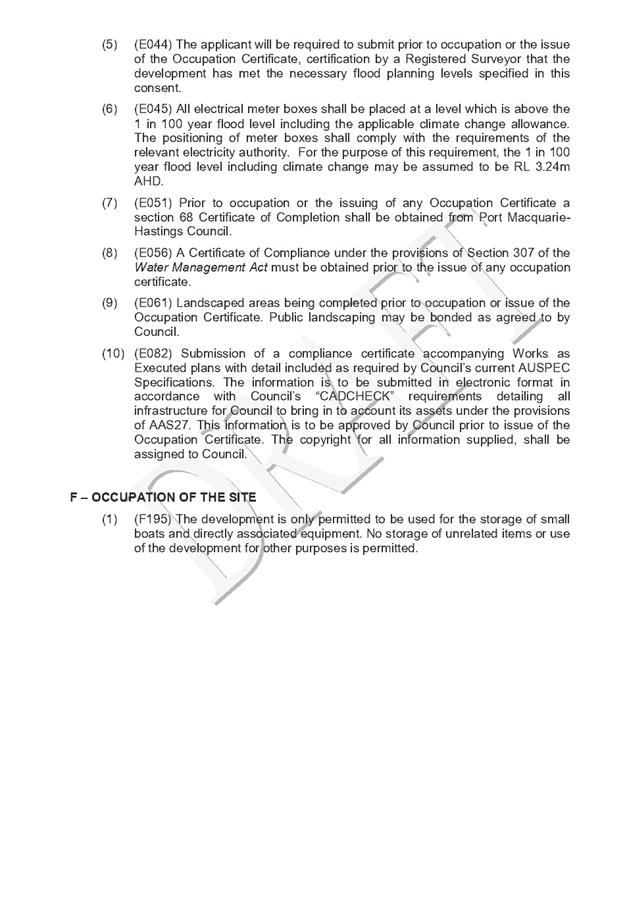
|
ATTACHMENT
|
Development Assessment Panel
23/01/2019
|
|
ATTACHMENT
|
Development Assessment Panel
23/01/2019
|
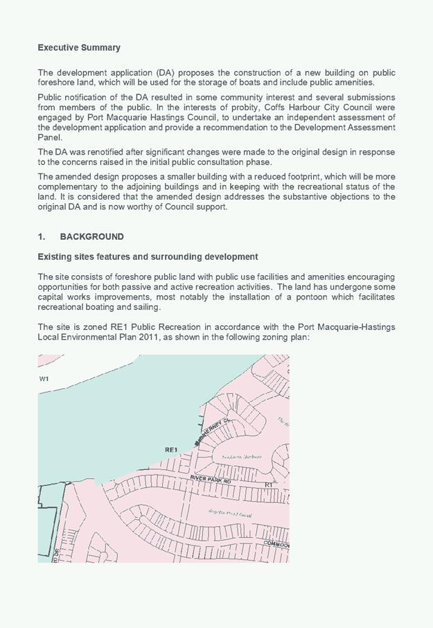
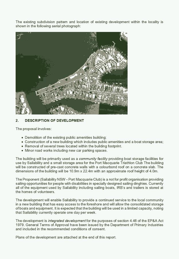
|
ATTACHMENT
|
Development Assessment Panel
23/01/2019
|
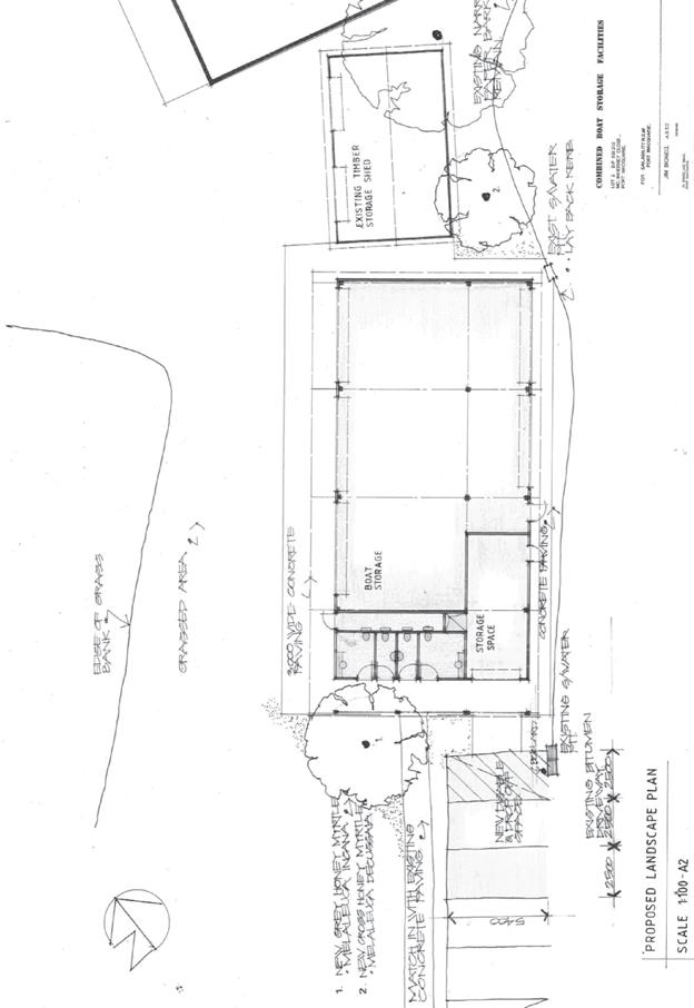
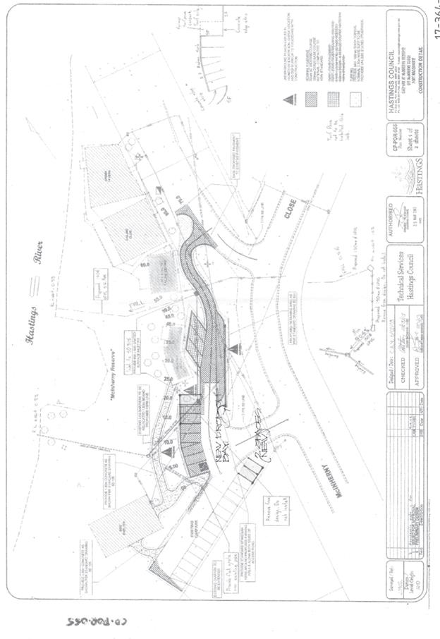
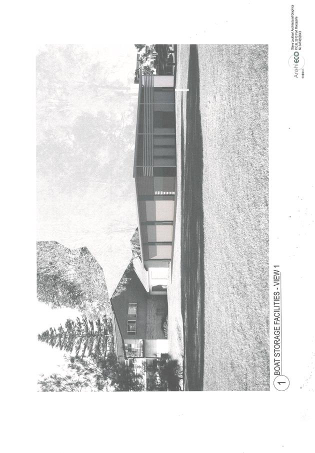
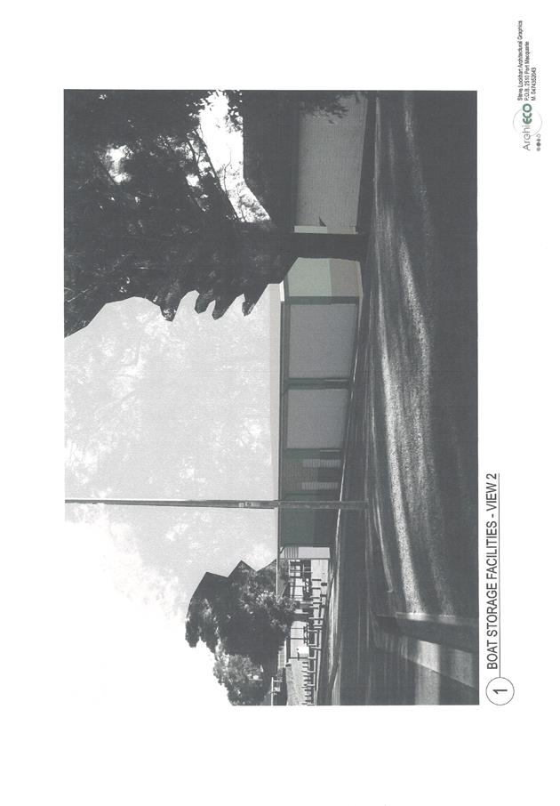
AGENDA Development Assessment Panel 23/01/2019
Item: 09
Subject: DA2018 - 824.1 One Into Three Lot Torrens
Title SUbdivision and Two(2) Semi-Detached Dwellings - Lot A DP 33885816, No.
16 Windmill Street Port Macquarie
Report
Author: Steven Ford
|
Applicant: R
J & C J Shafer
Owner: R
J & C J Shafer, G B & S Kook
Estimated Cost: $461,565
Alignment with Delivery
Program
4.3.1 Undertake transparent
and efficient development assessment in accordance with relevant legislation.
|
|
RECOMMENDATION
That
DA 2018 - 824 for a 1 into 3
Lot Torrens Title Subdivision and Two Semi-Detached Dwellings at Lot A, DP 338858, No. 16 Windmill
Street, Port Macquarie, be determined by granting consent subject to the
recommended conditions.
|
Executive
Summary
This
report considers a development application for a 1 into 3 Lot Torrens
Title Subdivision and Two Semi-Detached Dwellings at
the subject site and provides an assessment of the application in accordance
with the Environmental Planning and Assessment Act 1979.
Following exhibition of the
application, one (1) submission has been
received.
1. BACKGROUND
Existing sites features and surrounding development
The site has an area of 816.9m2.
The site is zoned R1 General residential in accordance with the Port Macquarie-Hastings Local
Environmental Plan 2011, as shown in the following zoning plan:
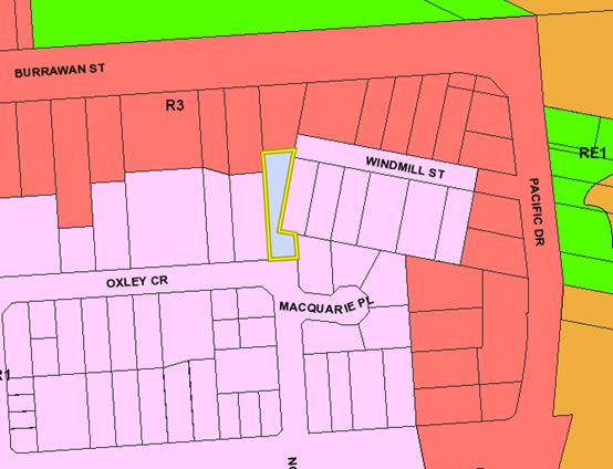
The existing subdivision pattern and location of existing
development within the locality is shown in the following aerial photograph:
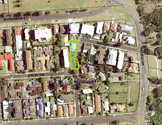
2. DESCRIPTION OF
DEVELOPMENT
Key aspects of the proposal include the following:
· 1
into 3 lot subdivision
· Construction of two semi-detached dwellings
Refer
to attachments at the end of this report.
Application Chronology
· 29 November 2016 – Pre-lodgement Meeting
· 08
October 2018 – Application Lodged
· 16 October to 29 October 2018 – Neighbourhood
Notification
· 8 November 2018 – Additional information and amended
plans submitted
· 12 December 2018 – Revised Plans (relocation of Unit
1 Balcony)
3. STATUTORY ASSESSMENT
Section 4.15(1) Matters for Consideration
In determining the application, Council is required to take
into consideration the following matters as are relevant to the development
that apply to the land to which the development application relates:
(a) The provisions (where
applicable) of:
(i) Any Environmental
Planning Instrument:
State Environmental Planning Policy No. 44 - Koala Habitat Protection
There is no Koala Plan of Management on the site.
Additionally, the site is less than 1ha in area therefore no further
investigations are required.
State Environmental Planning Policy No. 55 –
Remediation of Land
Following an inspection of the site and a search of Council
records, the subject land is not identified as being potentially contaminated
and is suitable for the intended use.
State Environmental Planning Policy No. 62 –
Sustainable Aquaculture
Given the nature of the proposed development and proposed
stormwater controls the proposal will be unlikely to have any adverse impact on
existing aquaculture industries.
State Environmental Planning Policy (Building
Sustainability Index: BASIX) 2004
BASIX certificates (number 961703S and 961811S) have been
submitted demonstrating that the proposal will comply with the requirements of
the SEPP. It is recommended that a condition be imposed to ensure that
the commitments are incorporated into the development and certified at Occupation
Certificate stage.
State Environmental Planning
Policy (Coastal Management) 2018
The site is located within a coastal environment area.
In accordance with clause 7, this SEPP prevails over the
Port Macquarie-Hastings LEP 2011 in the event of any inconsistency.
Having regard to clauses 13 of the SEPP the proposed
development is not considered likely to result in any of the following:
a) any adverse impact on integrity and resilience of the biophysical, hydrological (surface and
groundwater) and ecological environment;
b) any adverse impacts coastal environmental values and natural coastal processes;
c) any adverse impacts on marine vegetation, native vegetation and fauna and their habitats,
undeveloped headlands and rock platforms;
d) any adverse impact on marine vegetation, native vegetation and fauna and their habitats,
undeveloped headlands and rock platforms;
e) any adverse impact on Aboriginal cultural heritage, practices and places;
f) any adverse impacts on the cultural and built environment heritage;
g) any adverse impacts the use of the surf
zone;
Port Macquarie-Hastings Local Environmental Plan
2011
The proposal is consistent with the LEP having regard to
the following:
· Clause 2.2, the subject site is zoned R1 General
Residential.
1. The
objectives of the R1 zone are as follows:
o To provide for the housing needs of the community.
o To provide for a variety of housing types and densities.
o To enable other land uses that provide facilities or
services to meet the day to day needs of residents.
· In accordance with Clause 2.3(2), the proposal is
consistent with the zone objectives as it is a permissible landuse and
consistent with the established residential locality.
· Clause 4.1(4A) , the minimum lot sizes do not apply to the
proposal as it is characterised as semi-detached dwelling or multi dwelling
housing development.
· Clause 4.3, the maximum overall height of the building
above ground level (existing) is 6.8m which complies with the standard height
limit of 11.5m applying to the site.
· Clause 4.4, the floor space ratio of the proposal is
0.50:1.0 which complies with the maximum 0.65:1 floor space ratio applying to
the site.
· Clause 5.5 - Development within the coastal zone (relevant
objectives of this clause are addressed by SEPP (Coastal Management) 2018
section - see above)
· Clause 5.10 – Heritage. The site does not contain or
adjoin any known heritage items or sites of significance.
· Clause 7.13, satisfactory arrangements are in place for
provision of essential services including water supply, electricity supply,
stormwater drainage and suitable road access to service the development.
Provision of electricity will be subject to obtaining satisfactory arrangements
certification prior to the issue of a Subdivision Certificate as recommended by
a condition of consent.
(a)(ii) Any proposed instrument that is or has been placed
on exhibition
No draft instruments apply to the site.
(a)(iii) Any DCP in force
Port Macquarie-Hastings Development Control Plan 2013:
Port Macquarie-Hastings DCP 2013 – Part 4 Greater Port Macquarie – area
based provisions
The Locality of the subject site falls within the Windmill
Hill Precinct of East Port Neighbourhood as identified in 4.3.2 of the DCP. The
Windmill Hill precinct has been identified to continue to evolve as a medium
density residential precinct with a diverse range of housing types. The subject
property is not identified with the northern and eastern edges of the precinct
with higher landform in this area. However, it is directly adjoining the
identified edges. The proposed development is consistent with desired character
statements and objectives identified in the DCP for the Windmill Hill Precinct.
|
DCP 2013: Dwellings, Dual occupancies, Dwelling houses, Multi
dwelling houses & Ancillary development
|
|
|
Requirements
|
Proposed
|
Complies
|
|
3.2.2.1
|
Ancillary
development:
• 4.8m max. height
• Single storey
• 60m2 max. area
• 100m2 for lots >900m2
• 24 degree max. roof pitch
• Not located in front setback
|
Water
tanks are appropriately located
|
Yes
|
|
3.2.2.2
|
Articulation
zone:
• Min. 3m front setback
• An entry feature or portico
• A balcony, deck, patio, pergola, terrace or verandah
• A window box treatment
• A bay window or similar feature
• An awning or other feature over a window
• A sun shading feature
|
The
development contains a balcony and front building line of Unit 1 is within
the articulation zone. Both elements exceed 25% of the articulation zone and
seek variation for being within the 3m front setback. See notes below for
justification.
|
Acceptable
|
|
Front
setback (Residential not R5 zone):
• Min. 6.0m classified road
• Min. 4.5m local road or within 20% of adjoining dwelling
if on corner lot
• Min. 3.0m secondary road
• Min. 2.0m Laneway
|
Application
seeks a variation to the front building line setback requirements by
providing justification considering the wide road reserve, and site
constraints. See justification below
|
Acceptable
|
|
3.2.2.3
|
Garage
5.5m min. and 1m behind front façade.
Garage
door recessed behind building line or eaves/overhangs provided
|
Garage
door setback requirements are complied with.
Unit
1 – 7.9m
Unit
2 – 10m
|
Yes
|
|
6m
max. width of garage door/s and 50% max. width of building
|
Width
of garage door requirements are complied with.
(2x
Single garage adjacent to Oxley Crescent)
|
Yes
|
|
Driveway
crossover 1/3 max. of site frontage and max. 5.0m width
|
Unit
1 & 2: Single crossover, driveway crossing width requirements are
complied with.
|
Yes
|
|
3.2.2.4
|
4m
min. rear setback. Variation subject to site analysis and provision of
private open space
|
Unit
1 – 1m
Unit
2 – 1.2m
Cottage
– 1.8m
Variation
justification noted below
|
Acceptable
|
|
3.2.2.5
|
Side
setbacks:
· Ground floor = min. 0.9m
· First floors & above = min. 3m setback or where it can
be demonstrated that overshadowing not adverse = 0.9m min.
· Building wall set in and out every 12m by 0.5m
|
The
minimum side setback requirements are complied with.
Unit
2
West
– 1.5m
East
– 1.06m
Unit
1
West
5.52m
East
– 0.95m
The
wall articulation satisfies the objectives of the development provision.
See
below for justification.
|
Acceptable
|
|
3.2.2.6
|
35m2
min. private open space area including a useable 4x4m min. area which has 5%
max. grade
|
Unit
1 = 30.3m2 (excluding the first floor balcony = 9.57m2) combined total of
39.87m2.
Unit
2 = 40.3m2
Plans
submitted indicate that each private open space area is directly accessible
from a living area and has achieved a useable 4m x 4m area.
|
Acceptable
|
|
3.2.2.7
|
Front
fences
|
No
fences proposed
|
N/A
|
|
3.2.2.8
|
Front
fences and walls to have complimentary materials to context
No
chain wire, solid timber, masonry or solid steel front fences
|
No
fencing proposed.
|
N/A
|
|
3.2.2.10
|
Privacy:
• Direct
views between living areas of adjacent dwellings screened when within 9m
radius of any part of window of adjacent dwelling and within 12m of private
open space areas of adjacent dwellings. ie. 1.8m fence or privacy screening
which has 25% max. openings and is permanently fixed
• Privacy
screen required if floor level > 1m height, window side/rear setback
(other than bedroom) is less than 3m and sill height less than 1.5m
• Privacy
screens provided to balconies/verandahs etc which have <3m side/rear setback
and floor level height >1m
|
The
development will not compromise privacy in the area due to a combination of
lack of windows on side/rear boundaries, having high sill windows that face
side/rear boundaries, limiting living areas that face adjoining living
areas/open space, compliant separation to adjoining development, use of
screening and boundary fencing.
|
Yes
|
|
DCP 2013: General Provisions
|
|
|
Requirements
|
Proposed
|
Complies
|
|
2.7.2.2
|
Design
addresses generic principles of Crime Prevention Through Environmental Design
guideline
|
No
concealment or entrapment areas proposed. Adequate casual surveillance
available.
|
Yes
|
|
2.3.3.1
|
Cut
and fill 1.0m max. 1m outside the perimeter of the external building walls
|
Maximum
cut of 1.2m, see justification below
|
Acceptable
|
|
2.3.3.2
|
1m
max. height retaining walls along road frontage
|
None
proposed
Note:
existing retaining wall within the road reserve
|
N/A
|
|
Any
retaining wall >1.0 in height to be certified by structure engineer
|
Condition
recommended to require engineering certification (B15)
|
Yes
|
|
Combination
of retaining wall and front fence height max 1.8m, max length 6.0m or 30% of
frontage, fence component 25% transparent, and splay at corners and adjacent
to driveway
|
No
retaining wall front fence combination proposed.
Note
existing retaining wall in road reserve, no fence above proposed
|
N/A
|
|
2.3.3.8
|
Removal
of hollow bearing trees
|
No
trees proposed to be removed
|
N/A
|
|
2.6.3.1
|
Tree
removal (3m or higher with 100m diameter trunk at 1m above ground level and
3m from external wall of existing dwelling)
|
No
significant trees proposed to be removed. One small unidentified species of
tree will be removed due to the proximity to the proposed driveway crossover.
See identified trees marked on site plan.
|
N/A
|
|
2.4.3
|
Bushfire
risk, Acid sulphate soils, Flooding, Contamination, Airspace protection,
Noise and Stormwater
|
Refer
to main body of report.
|
|
|
2.5.3.2
|
New
accesses not permitted from arterial or distributor roads
|
No
new access proposed to arterial or distributor road.
|
N/A
|
|
Driveway
crossing/s minimal in number and width including maximising street parking
|
Driveway
crossing(s) is/are minimal in width including maximising street parking
|
Yes
|
|
2.5.3.3
|
Parking
in accordance with Table 2.5.1.
Dwelling/dual
occupancies
1
space per dwelling/occupancy (behind building line).
Multi
dwelling
1
space per 1 & 2 bedroom occupancies
1.5
spaces per 3+ bedroom occupancies
0.25
spaces per occupancy for visitor parking.
|
Proposal
involves 2 semi-detached dwellings and an existing dwelling. The development
proposes 2 parking spaces for the proposed units and a existing hardstand
space for the existing Cottage.
|
Yes
|
|
2.5.3.11
|
Section
94 contributions
|
Contributions
apply - refer to ET calc and NOP.
|
Yes
|
|
2.5.3.12 and 2.5.3.13
|
Landscaping
of parking areas
|
Suitable
landscaping proposed around driveway/parking locations.
|
Yes
|
|
2.5.3.14
|
Sealed
driveway surfaces unless justified
|
Sealed
driveway areas proposed.
|
Yes
|
|
2.5.3.15 and 2.5.3.16
|
Driveway
grades first 6m or ‘parking area’ shall be 5% grade with
transitions of 2m length
|
Driveway
grades capable of satisfying Council standard driveway crossover
requirements. Condition recommended for section 138 Roads Act permit
|
Yes
|
|
2.5.3.17
|
Parking
areas to be designed to avoid concentrations of water runoff on the surface.
|
Stormwater
drainage is capable of being managed as part of plumbing construction.
|
Yes
|
Note: Subdivision provisions of the DCP (except battleaxe
handle width) are aimed at the creation of vacant lots (i.e. not lots within an
integrated housing proposal such as this) and have therefore been excluded from
the above assessment. Servicing requirements are discussed later in this
report.
The proposal relies on a variation to Development Provision
relating to 3.2.2.2 – Front setback less than 4.5m.
The relevant objective is: Front setbacks should support an
attractive streetscape.
Having regard for the development provisions and relevant
objective, the variation is considered acceptable for the following reasons:
· The front boundary on Oxley Crescent does not run parallel
with the street and angles away from the street adjacent to a wide road reserve
on the corner of Oxley Crescent.
· Visually, the subject verandah and wall appear to be
setback appropriately from the kerb as the wide road reserve with existing
retaining wall and vegetation will appear as private property.
· Visually, with the garages setback 7.8m and 10m with a
single driveway crossing, softens the impact of the variation
· The subject verandah and is angled away from the street,
due to the lots positioning.
· The proposed building does not impact on any privacy,
views, overshadow adjoining primary living areas or line of sight of road
traffic.
The proposal also requires a variation to the Development
Provision relating to 3.2.2.4 – Rear setback less than 4m
The relevant objectives are:
· To allow adequate natural light and ventilation between
dwellings/buildings and to private open space areas.
· To provide useable yard areas and open space
Having regard for the development provisions and relevant
objectives, the variation is considered acceptable for the following reasons:
· The site has two street frontages and has significant site
constraints with its irregular shape, the proposed dwellings have been designed
to limit any adverse effects of bulk and scale to both existing and proposed
developments.
· The proposed rear building lines are well articulated and
will allow for adequate solar access and ventilation between dwellings.
· The proposal provides a useable yard and private open space
for both proposed units and existing cottage. The proposed private open space
does not have adverse impacts to adjoining developments.
The proposal also includes a variation to the Development
Provision relating to 3.2.2.5 – Side setback for Unit 1 upper floor is
less than 3m and Unit 2 has an unarticulated wall length exceeding 12m.
The relevant objectives are:
· To reduce overbearing and perceptions of building bulk on
adjoining properties and to maintain privacy.
· To provide for visual and acoustic privacy between
dwellings.
Having regard for the development provisions and relevant
objectives, the variation is considered acceptable for the following reasons:
· Unit 1 has eastern side setback of 957mm for the upper
floor,
· The subject wall is 6.8m high and under the maximum
building height limit of 11.5m. The subject wall does not overshadow any
adjoining living areas or private open space or affect ventilation between
adjoining neighbours.
· The subject wall is 9.2m in length and is well articulated
with varying external finishes to reduce perceptions of overbearing and bulk.
· The subject wall of Unit 1 has minimal windows which will
limit any privacy impacts to the adjoining property.
· Along the western boundary, Unit 2 has an unarticulated
wall length of 15.85m, which is only single storey and setback 1.5m from the
side boundary.
· The neighbouring property to Unit 2, has a common access
footpath positioned adjacent to the subject property which provides an
increased setback to the common boundary line. The building is also primarily
orientated to the east, away from the proposed development. However, due to the
height of the adjoining residential flat building, and the subject wall being
single storey, it will not impact on any existing view or create perceptions of
bulk or overbearing.
· The side setback of Unit 1 or the unarticulated wall of
Unit 2 variations will not be visible from the street.
The proposal includes a variation to the Development
Provision relating to 2.3.3.1 – development exceeds a maximum cut of 1m.
The relevant objectives are:
· Minimise the extent of site disturbance caused by excessive
cut and fill to the site.
· Ensure there is no damage or instability to adjoining
properties caused by excavation or filling.
· Minimise the extent of site disturbance caused by excessive
cut and fill to the site.
· Ensure there is no damage or instability to adjoining
properties caused by excavation or filling.
Having regard for the development provisions and relevant
objectives, the variation is considered acceptable for the following reasons:
· The highest cut indicated on the plans is 1.2m
· Proposed cuts and retaining walls are not directly adjacent
to adjoining dwellings/structures and will have minimal impacts with regards to
instability, subject to engineering and final height not exceeding 1.2m.
· The proposal will incorporate adequate drainage measures at
the areas of the proposed cut to ensure that overflow paths are provided and to
minimise impacts to existing drainage.
· The proposed development has given due consideration to
maintaining appropriate standards of residential privacy. The proposed site cut
will not impact on adjoining residential privacy.
· Proposed cut has allowed the development to achieve useable
private open space for both dwellings.
Based on the above assessment, the variations proposed to
the provisions of the DCP are considered acceptable and the relevant objectives
have been satisfied.
Cumulatively, the variations do not result in an adverse impact
nor are they of a significance that would justify refusal of the application.
(a)(iii)(a) Any planning agreement or draft planning
agreement
No planning agreement has been offered or entered into
relating to the site.
(a)(iv) The regulations
NSW Coastal Policy 1997
The proposed development is consistent with the objectives
and strategic actions of this policy.
(b) The likely impacts of that development, including
environmental impacts on both the natural and built environments and the social
and economic impacts in the locality
Context and setting
• The
proposal will be unlikely to have any adverse impacts to existing adjoining
properties and satisfactorily addresses the public domain.
• The
proposal is considered to be consistent with other residential development in
the locality and adequately addresses planning controls for the area.
• There
are no adverse impacts on existing view sharing.
• There
are no adverse privacy impacts.
• There
are no adverse overshadowing impacts. The proposal does not prevent adjoining
properties from receiving 3 hours of sunlight to private open space and primary
living areas on 21 June.
Roads
The site has road frontage to Windmill Street and Oxley
Crescent.
Adjacent to the site Windmill Street is a sealed public
road under the care and control of Council. Windmill Street is a local
road with a road formation of 8.5m with a 5.7m radius turning head within a
13.716m road reserve.
Adjacent to the site Oxley Crescent is a sealed public road
under the care and control of Council. Oxley Crescent is a local road
with a road formation of 7.7m within a 15.253m road reserve.
Traffic and Transport
The site is currently approved for residential development
and has a single dwelling located on it which is assumed to create 7 daily
trips to Windmill Street. This development proposes to create two additional
dwellings with access to Oxley Crescent which is assessed as an additional 14
daily trips to Oxley Crescent and maintain the existing single access to
Windmill Street.
The addition in traffic associated with the development is
unlikely to have any adverse impacts to the existing road network within the
immediate locality.
Site Frontage & Access
Vehicle access to the site is proposed though a shared
driveway with direct access to Oxley Crescent, being a Council-owned public
road.
In this regard no driveway long section has been submitted
and engineering assessment has indicated that the garage floor levels will not
be capable of achieving a driveway profile in accordance with Auspec
requirements. This should be achievable without compromising any other aspect
of the development and conditioned prior to Construction Certificate. It is
anticipated that the garage floor levels will need to be lowered by
approximately 210mm to achieve an acceptable profile.
The existing frontage to Windmill Street will require a
formal driveway crossing to be provided. In this regard the crossing should
take into consideration the required driveway on the adjoining property
immediately to the east and align the crossing to not impede the access to 14
Windmill Street. Alternatively a combined crossing within the road reserve
would be acceptable.
Access shall comply with Council AUSPEC and Australian
Standards, and conditions have been imposed to reflect these
requirements.
Parking and Manoeuvring
A total of 2 parking spaces have been provided on-site
within garages with additional parking provided available within the
driveway. Parking and driveway widths on site can comply with relevant
Australian Standards (AS 2890) and conditions have been imposed to reflect
these requirements.
Sewer Connection
Council records indicate that the development site is
currently connected to sewer via a junction to the sewer line that runs across
the middle of Lot A.
Each proposed lot requires an individual connection to
Council’s sewer system. A sewer reticulation plan shall be provided to
Council’s sewer Section for approval.
The existing Asbestos Cement Lined sewer main that
currently traverses through the middle of the development site shall be
replaced with PVC pipe. Details are to be provided to Council’s Sewer
Section for approval.
Refer to relevant conditions of consent.
Stormwater
The site naturally grades towards Oxley Crescent and is
currently unserviced.
The legal point of discharge for the proposed development
is defined as a direct connection to Council’s stormwater pipeline within
Oxley Crescent. This will require an extension of the public stormwater system.
Stormwater from the proposed development is planned to be
disposed via a new pipe and junction pit within Oxley Crescent which is
consistent with the above requirements.
Natural overland flow currently drains onto this site from
the upstream property at 14 Windmill Street. No inter-allotment drainage
easement exists through the site to capture this overland flow. While the
preference is for an inter-allotment easement to be created one has not been
proposed and it is considered that Council cannot impose such requirement as
part of this proposed development. The capture and disposal of the existing
overland flow will need to be incorporated into the private drainage undertaken
as part of this development. Details will be required as part of the section 68
application.
Council currently has an undetermined development
application for a dual occupancy on 14 Windmill Street, being the upstream
property. Should the provision of inter-allotment drainage be required
appropriate arrangements will need to be made between the respective land
owners. If this development is approved Council’s stormwater engineer is
satisfied that a reduced inter-allotment easement width of 900mm could be
provided down the side of proposed unit 1, as the building is setback 957mm
from the side boundary. Again it would be the responsibility of the proponent
of the development for 14 Windmill Street to negotiate and establish any
easement necessary to accommodate the development.
A detailed site stormwater management plan will be required
to be submitted for assessment with the S.68 application and prior to the issue
of a Construction Certificate. In accordance with Councils AUSPEC
requirements, the following must be incorporated into the stormwater drainage
plan:
· On
site stormwater detention facilities.
· Provision
for capture of natural overland flow from uphill/upstream properties/lands.
A suitable condition has been recommended.
Other Utilities
Telecommunication and electricity services are available to
the site. Evidence of satisfactory arrangements with the relevant utility
authorities for provision to each proposed lot will be required prior to
Subdivision Certificate approval.
Heritage
No known items of Aboriginal or European heritage
significance exist on the property. No adverse impacts anticipated.
Other land resources
The site is within an established urban context and will
not sterilise any significant mineral or agricultural resource.
Water cycle
The proposed development will be unlikely to have any
adverse impacts on water resources and the water cycle.
Soils
The proposed development will be unlikely to have any
adverse impacts on soils in terms of quality, erosion, stability and/or
productivity subject to a standard condition requiring erosion and sediment
controls to be in place prior to and during construction.
Air and microclimate
The construction and/or operations of the proposed
development will be unlikely to result in any adverse impacts on the existing
air quality or result in any pollution. Standard precautionary site management
condition recommended.
Flora and fauna
Construction of the proposed development will not require
any removal/clearing of any significant vegetation and therefore will be
unlikely to have any significant adverse impacts on biodiversity or threatened
species of flora and fauna. Part 7 of the Biodiversity Conservation Act
is considered to be satisfied.
Waste
Satisfactory arrangements are in place for proposed storage
and collection of waste and recyclables. No adverse impacts anticipated.
Standard precautionary site management condition recommended.
Energy
The proposal includes measures to address energy efficiency
and will be required to comply with the requirements of BASIX.
Noise and vibration
No adverse impacts anticipated. Condition recommended to
restrict construction to standard construction hours.
Bushfire
The site is not identified as being bushfire prone.
Safety, security and crime prevention
The proposed development will be unlikely to create any
concealment/entrapment areas or crime spots that would result in any
identifiable loss of safety or reduction of security in the immediate
area. The increase in housing density will improve natural surveillance
within the locality and openings from each dwelling overlook common and private
areas.
Social impacts in the locality
Given the nature of the proposed development and its’
location the proposal is unlikely to result in any adverse social impacts.
Economic impact in the locality
No adverse impacts. A likely positive impact is that the
development will maintain employment in the construction industry, which will
lead to flow impacts such as expenditure in the area.
Site design and internal design
The proposed development design satisfactorily responds to
the site attributes and will fit into the locality. No adverse impacts likely.
Construction
No potential adverse impacts identified to neighbouring
properties with the construction of the proposal.
Cumulative impacts
The proposed development is not expected to have any
adverse cumulative impacts on the natural or built environment or the social
and economic attributes of the locality.
(c) The suitability of the site for the development
The proposal will fit into the locality and the site
attributes are conducive to the proposed development.
Site constraints have been adequately addressed and
appropriate conditions of consent recommended.
(d) Any submissions made in accordance with this Act or the
regulations
Following exhibition of the application in accordance with
DCP 2013, one (1) submission was received. Details of the submission and
planning responses are provided below.
|
Submission
Issue/Summary
|
Planning
Comment/Response
|
|
Has there been consideration
that if the proposal were to go ahead, there would be the following addresses
all in a row: 2 (Macquarie Place), 2a, 2b, 2 (Oxley Cres?
|
The subject site has an
existing secondary frontage to Oxley Crescent and Dual Occupancies are
permissible with consent under the Port Macquarie-Hastings Local
Environmental Plan (LEP) in R1 zones. This concern has been noted.
|
|
There is already enough traffic and parking problems in
Oxley Crescent.
|
The development proposes 2 single garages for the
proposed units and an existing hardstand space for the Cottage. This
satisfies the objectives of Port Macquarie-Hastings Council Development
Control Plan (DCP) 2.5.3.3 requirements for off street parking.
Additional Traffic and Manoeuvring has been address in
the report above.
|
|
It’s not suitable to have three separate buildings
on the one site – the plans state there are requirements for minimal
spaces, and there are already several non-compliances on the plan.
|
Under Clause 4.4 of the LEP, providing that the site has
a total area of 816.9m2 and the total proposed living area (Including the
Existing cottage) is 392.7m2, the floor space ratio of the proposal is
0.48:1.0 which complies with the maximum 0.65:1 floor space ratio applying to
the site.
Additionally, Clause 4.1(4A) of the LEP, allows the
minimum lot sizes to not apply to a proposal that is characterised as multi
dwelling housing development.
|
|
People bought existing properties with certain rules in
place regarding future developments. The proposed plans of 16 Windmill Street
creates various non-compliances which would have influenced the purchase of
adjoining properties in the first place.
|
The adjoining developments are characterised by a mix of
low and medium to high density developments, incorporating single dwellings
and a proposed dual occupancy to the east and south, and Residential Flat
buildings consisting 4 and 5 storeys to the North and West. Additionally,
Oxley Crescent is characterised by multi dwelling developments.
The proposed development adjoining Oxley Crescent is
characterised by 1x single and 1x two storey units, designed to the site
constraints of an irregular shaped lot. The proposed development is
consistent with adjoining developments and character of the Windmill Hill
Precinct.
|
|
Concerns regarding sewerage and stormwater – please
update neighbouring properties with further details of the plans as there are
existing draining issues at 2 Oxley Crescent.
|
Preliminary Stormwater Management Plan prepared by David
Johnson, was submitted as part of the Development Application and attached to
this report. Stormwater management has been designed in line with
Council’s Auspec requirements and drains to the legal point of
discharge along Oxley Crescent.
|
|
Existing property – there are already noise
problems. This property has been let out for holidays/weekends which has been
disruptive to neighbours.
|
Concerns regarding noise controls have been noted. Note,
the application does not seek approval for tourist and visitor accommodation.
A condition restricting to use of the proposed development to permanent
residential use has been included in the draft conditions.
|
|
Access via common driveway of Oxley Crescent – this
is impractical and goes against the original street number allotment. There
is already enough traffic in Oxley Crescent and cars have been damaged due to
vehicles parking either side of the street and making it difficult for traffic
to pass through especially on corners.
|
The proposed driveway location to Oxley Crescent is
existing and used as a secondary access. A shared driveway crossover for a
Dual Occupancy is preferable to maximise on street parking opportunity.
Concern regarding street numbering and traffic have been
noted.
|
|
Two storey unit – won’t the west-facing areas
of 16 Windmill Street look straight in to the bathrooms of some residents at
2 Oxley Crescent? This is a major privacy concern. There are bedrooms and
bathrooms along the east side of 2 Oxley Crescent and existing residents have
a right to their privacy and natural light.
|
Unit 2 is single storey, the west elevation only proposes
highlight windows to a hallway, which is not a primary living area.
Additionally, screening will be provided by proposed boundary fence between
adjoining private open space areas.
Unit 1 has no windows along the western elevation and the
proposed balcony is over 12m from the adjacent building at 2 Oxley Crescent.
Submitted shadow diagrams indicate no adverse
overshadowing to adjoining living areas.
|
|
Concerns rear yard area of 16 Windmill Street will take
away privacy of existing residents.
|
The proposed
private open space areas will not compromise privacy in the area due to a
combination of limiting proposed living areas that face adjoining living
areas/open space, compliant separation to adjoining development, use of
screening and boundary fencing.
|
|
Issues raised regarding the Statement of Environmental
Effects
|
Concerns have been noted and are addressed throughout the
report above.
|
|
Natural sunlight
|
On review of the submitted plans and consideration of
adjacent primary living areas. Solar access to the principal living areas of
adjacent properties will not be reduced to less than 3 hours between 9.00am
and 3.00pm on June 22. There are no adverse solar access impacts created by
the proposed dwellings.
|
(e) The public interest
The proposed development will be in the wider public
interest with provision of appropriate additional housing.
The proposed development satisfies relevant planning
controls and is not expected to impact on the wider public interest.
4. DEVELOPMENT
CONTRIBUTIONS APPLICABLE
· Development contributions will be required towards
augmentation of town water supply and sewerage system head works under Section
64 of the Local Government Act 1993.
· Development contributions will be required under Section 94
of the Environmental Planning and Assessment Act 1979 towards roads, open
space, community cultural services, emergency services and administration
buildings.
5. CONCLUSION AND
STATEMENT OF REASON
The application has been assessed
in accordance with Section 4.15 of the Environmental Planning and Assessment
Act 1979.
Issues raised during assessment
and public exhibition of the application have been considered in the assessment
of the application. Where relevant, conditions have been recommended to manage
the impacts attributed to these issues.
The site is considered suitable
for the proposed development and the proposal adequately addresses relevant
planning controls. The development is not considered to be contrary to the
public's interest and will not result a significant adverse social,
environmental or economic impact. It is recommended that the application be
approved, subject to the recommended conditions of consent provided attached to
this report.
|
Attachments
1View. DA2018
- 824.1 Recommended Conditions
2View. DA2018
- 824.1 Plans
3View. DA2018
- 824.1 Hydraulics
|
|
ATTACHMENT
|
Development Assessment Panel
23/01/2019
|
|
ATTACHMENT
|
Development Assessment Panel
23/01/2019
|
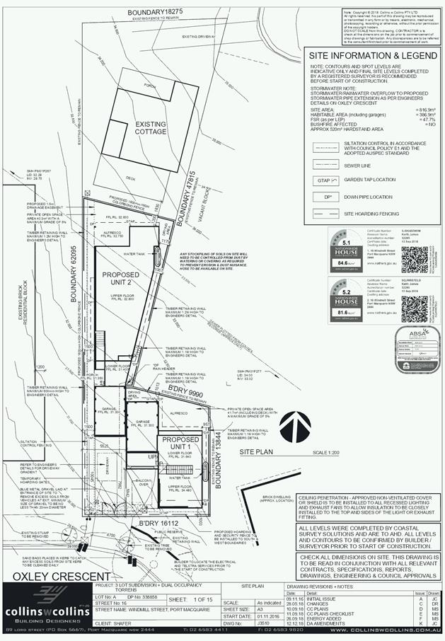
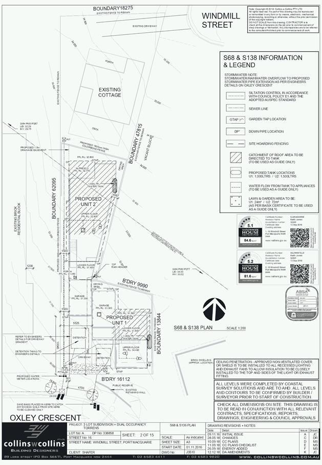
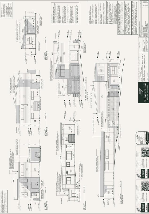
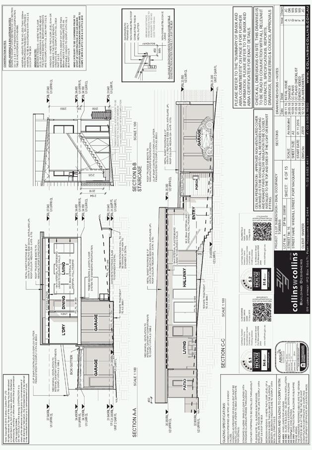
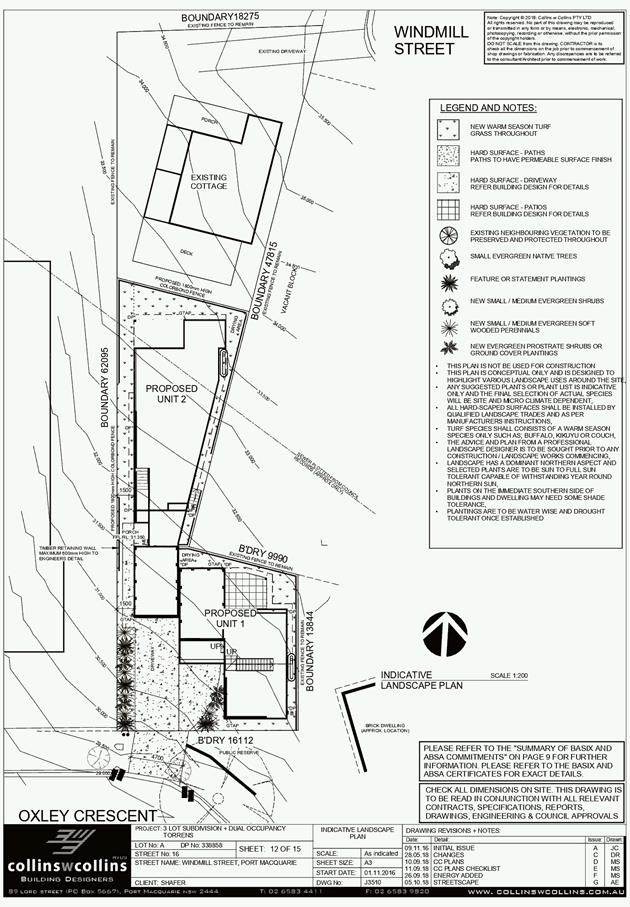
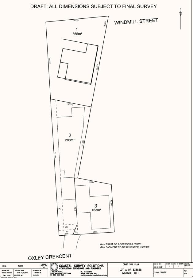
|
ATTACHMENT
|
Development Assessment Panel
23/01/2019
|
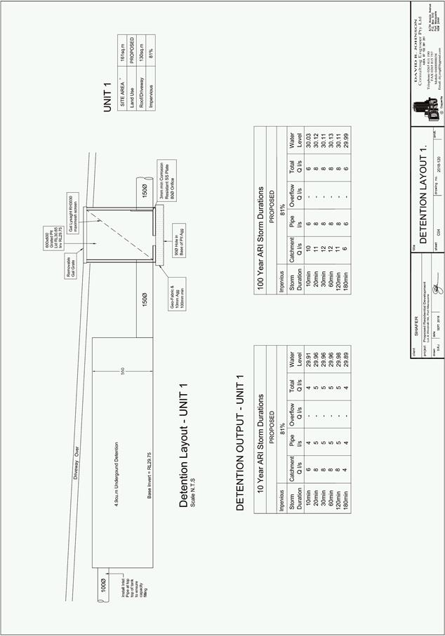
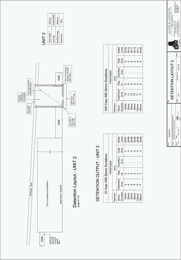
AGENDA Development Assessment Panel 23/01/2019
Item: 10
Subject: DA2018 - 854.1 Two-Semi Detached Dwellings And Strata Title
Subdivision - Lot 168 DP 1229414, No. 23 Allport Avenue Thrumster
Report Author: Steven Ford
|
Applicant: Pycon
Homes & Construction Pty Ltd
Owner: Kingdom
Sales & Development Pty Ltd
Estimated Cost: $430,000
Alignment with Delivery Program
4.3.1 Undertake transparent
and efficient development assessment in accordance with relevant legislation.
|
|
RECOMMENDATION
That
DA 2018 – 824.1 for Two-Semi
Detached Dwellings and Strata Subdivision at
Lot 168, DP 1229414, No. 23 Allport
Avenue, Thrumster, be determined by granting consent subject to the
recommended conditions.
|
Executive
Summary
This
report considers a development application for Two Semi-Detached Dwellings and
Strata Title Subdivision at the subject site
and provides an assessment of the application in accordance with the
Environmental Planning and Assessment Act 1979.
Following exhibition of the
application, one (1) submission has been
received.
1. BACKGROUND
Existing sites features and Surrounding development
The site has an area of 548m2.
The site is zoned R1 General Residential in accordance with the Port Macquarie-Hastings Local
Environmental Plan 2011, as shown in the following zoning plan:
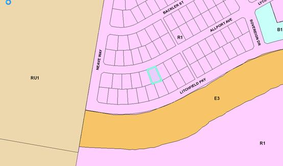
The existing subdivision pattern and location of existing
development within the locality is shown in the following aerial photograph:
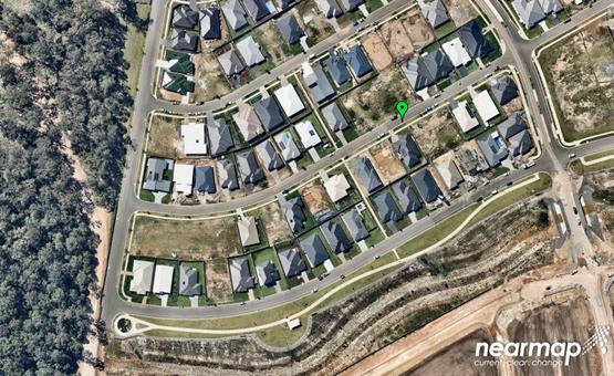
2. DESCRIPTION OF DEVELOPMENT
Key aspects of the proposal include the following:
· Construction
of two semi-detached dwellings
· 2
lot strata title subdivision
Refer
to attachments at the end of this report.
Application Chronology
· 16
October 2018 – Application lodged
· 23 October to 5 November 2018 – Neighbourhood
Notification
· 28 November 2018 – Amended plans submitted
3. STATUTORY ASSESSMENT
Section 4.15(1) Matters for Consideration
In determining the application, Council is required to take
into consideration the following matters as are relevant to the development
that apply to the land to which the development application relates:
(a) The provisions (where
applicable) of:
(i) any Environmental
Planning Instrument:
State Environmental Planning Policy No. 44 - Koala Habitat
Protection
The site is subject to the adopted Area 13 Koala Plan of
Management. No tree removal is proposed and the proposal is consistent with the
adopted plan of management.
State Environmental Planning Policy No. 55 –
Remediation of Land
Following an inspection of the site and a search of Council
records, the subject land is not identified as being potentially contaminated
and is suitable for the intended use.
State Environmental Planning Policy No. 62 –
Sustainable Aquaculture
Given the nature of the proposed development and proposed
stormwater controls the proposal will be unlikely to have any adverse impact on
existing aquaculture industries.
State Environmental Planning Policy (Building
Sustainability Index: BASIX) 2004
A BASIX certificate (number 969269M) has been submitted
demonstrating that the proposal will comply with the requirements of the
SEPP. It is recommended that a condition be imposed to ensure that the
commitments are incorporated into the development and certified at Occupation
Certificate stage.
Port Macquarie-Hastings Local Environmental Plan
2011
The proposal is consistent with the LEP having regard to
the following:
· Clause 2.2, the subject site is zoned R1 General
Residential. In accordance with clause 2.3(1) and the R1 zone landuse table,
the proposed development for two semi-detached dwellings and strata subdivision
is a permissible landuse with consent.
The objectives of the R1 zone are as follows:
o To provide for the housing needs of the community.
o To provide for a variety of housing types and densities.
o To enable other land uses that provide facilities or
services to meet the day to day needs of residents.
In accordance with Clause 2.3(2), the proposal is
consistent with the zone objectives having regard to the following:
o the proposal is a permissible landuse;
· Clause 4.1(4), the minimum lot sizes do not apply as the
proposal is for strata subdivision.
· Clause 4.3, there is no maximum building height control
applicable to the site. The proposal is however single storey in nature and
below the standard 8.5m building height control that would typically apply.
· Clause 4.4, there is no floor space ratio control
applicable to the site. The proposal is however below the standard 0.65:1 that
would typically apply.
· Clause 5.10 – Heritage. The site does not contain or
adjoin any known heritage items or sites of significance.
· Clause 7.13, satisfactory arrangements are in place for
provision of essential services including water supply, electricity supply, sewer
infrastructure, stormwater drainage and suitable road access to service the
development.
(a)(ii) Any proposed instrument that is or has been placed
on exhibition
No draft instruments apply to the site.
(a)(iii) Any DCP in force
Port Macquarie-Hastings Development Control Plan 2013:
|
DCP 2013: Dwellings, Dual occupancies, Dwelling houses,
Multi dwelling houses & Ancillary development
|
|
|
Requirements
|
Proposed
|
Complies
|
|
3.2.2.1
|
Ancillary development:
• 4.8m
max. height
• Single
storey
• 60m2
max. area
• 100m2
for lots >900m2
• 24
degree max. roof pitch
• Not
located in front setback
|
Water
tank is appropriately located
|
Yes
|
|
3.2.2.2
|
Articulation
zone:
• Min. 3m front setback
• An entry feature or portico
• A balcony, deck, patio, pergola, terrace or verandah
• A window box treatment
• A bay window or similar feature
• An awning or other feature over a window
• A sun shading feature
|
No
elements within the articulation zone.
|
N/A
|
|
Front
setback (Residential not R5 zone):
• Min. 6.0m classified road
• Min. 4.5m local road or within 20% of adjoining dwelling
if on corner lot
• Min. 3.0m secondary road
• Min. 2.0m Laneway
|
Front
building line setback requirements are complied with.
|
Yes
|
|
3.2.2.3
|
Garage
5.5m min. and 1m behind front façade.
Garage
door recessed behind building line or eaves/overhangs provided
|
Garage
door setback requirements are complied with.
|
Yes
|
|
6m
max. width of garage door/s and 50% max. width of building
|
Width
of garage door requirements are complied with.
|
Yes
|
|
Driveway
crossover 1/3 max. of site frontage and max. 5.0m width
|
Driveway
crossing width requirements are complied with.
|
Yes
|
|
3.2.2.4
|
4m
min. rear setback. Variation subject to site analysis and provision of
private open space
|
The
rear setback requirements are complied with.
|
Yes
|
|
3.2.2.5
|
Side
setbacks:
• Ground
floor = min. 0.9m
• First
floors & above = min. 3m setback or where it can be demonstrated that
overshadowing not adverse = 0.9m min.
• Building
wall set in and out every 12m by 0.5m
|
The
minimum side setback requirements are complied with.
The
wall articulation satisfies the objectives of the development provision.
|
Yes
|
|
3.2.2.6
|
35m2
min. private open space area including a useable 4x4m min. area which has 5%
max. grade
|
Each
occupancy contains 35m² open space in one area including a useable 4m x
4m area. .
|
Yes
|
|
3.2.2.7
|
Front fences:
• If solid
1.2m max height and front setback 1.0m with landscaping
• 3x3m min.
splay for corner sites
• Fences
>1.2m to be 1.8m max. height for 50% or 6.0m max. length of street
frontage with 25% openings
• 0.9x0.9m
splays adjoining driveway entrances
|
No fences proposed
|
N/A
|
|
3.2.2.8
|
Front
fences and walls to have complimentary materials to context
No
chain wire, solid timber, masonry or solid steel front fences
|
No fencing proposed.
|
N/A
|
|
3.2.2.10
|
Privacy:
• Direct
views between living areas of adjacent dwellings screened when within 9m
radius of any part of window of adjacent dwelling and within 12m of private
open space areas of adjacent dwellings. ie. 1.8m fence or privacy screening
which has 25% max. openings and is permanently fixed
• Privacy
screen required if floor level > 1m height, window side/rear setback
(other than bedroom) is less than 3m and sill height less than 1.5m
• Privacy
screens provided to balconies/verandahs etc which have <3m side/rear setback
and floor level height >1m
|
The
development will not compromise privacy in the area due to a combination of
lack of windows on side/rear boundaries, limiting living areas that face
adjoining living areas/open space, compliant separation and use of fencing.
|
Yes
|
|
DCP 2013: General Provisions
|
|
|
Requirements
|
Proposed
|
Complies
|
|
2.7.2.2
|
Design
addresses generic principles of Crime Prevention Through Environmental Design
guideline
|
No
concealment or entrapment areas proposed. Adequate casual surveillance available.
|
Yes
|
|
2.3.3.1
|
Cut
and fill 1.0m max. 1m outside the perimeter of the external building walls
|
Cut
and fill <1.0m change 1m outside the perimeter of the external building
walls
|
Yes
|
|
2.3.3.2
|
1m
max. height retaining walls along road frontage
|
None
proposed
|
N/A
|
|
Any
retaining wall >1.0 in height to be certified by structure engineer
|
No
retaining wall likely >1m
|
Yes
|
|
Combination
of retaining wall and front fence height max 1.8m, max length 6.0m or 30% of
frontage, fence component 25% transparent, and splay at corners and adjacent
to driveway
|
No
retaining wall front fence combination proposed.
|
N/A
|
|
2.3.3.8
|
Removal
of hollow bearing trees
|
No
trees proposed to be removed
|
N/A
|
|
2.6.3.1
|
Tree
removal (3m or higher with 100m diameter trunk at 1m above ground level and
3m from external wall of existing dwelling)
|
No
trees proposed to be removed
|
N/A
|
|
2.4.3
|
Bushfire
risk, Acid sulphate soils, Flooding, Contamination, Airspace protection,
Noise and Stormwater
|
Refer
to main body of report.
|
Yes
|
|
2.5.3.2
|
New
accesses not permitted from arterial or distributor roads
|
No
new access proposed to arterial or distributor road.
|
N/A
|
|
Driveway
crossing/s minimal in number and width including maximising street parking
|
Driveway
crossing(s) is/are minimal in width including maximising street parking
|
Yes
|
|
2.5.3.3
|
Parking
in accordance with Table 2.5.1.
Dwelling/dual
occupancies
1
space per dwelling/occupancy (behind building line).
|
Proposal
involves 2 dwellings. Each dwelling contains a single garage behind the building
line which meets the objectives of this clause
|
Yes
|
|
2.5.3.11
|
Section
94 contributions
|
Contributions
apply - refer to ET calc and NOP.
|
Yes
|
|
2.5.3.12 and 2.5.3.13
|
Landscaping
of parking areas
|
Suitable
landscaping proposed around driveway/parking locations.
|
Yes
|
|
2.5.3.14
|
Sealed
driveway surfaces unless justified
|
Sealed
driveway areas proposed.
|
Yes
|
|
2.5.3.15 and 2.5.3.16
|
Driveway
grades first 6m or ‘parking area’ shall be 5% grade with
transitions of 2m length
|
Driveway
grades capable of satisfying Council standard driveway crossover
requirements. Condition recommended for section 138 Roads Act permit
|
Yes
|
|
2.5.3.17
|
Parking
areas to be designed to avoid concentrations of water runoff on the surface.
|
Stormwater
drainage is capable of being managed as part of plumbing construction.
|
Yes
|
(a)(iii)(a) Any planning agreement or draft planning
agreement
No planning agreement has been offered or entered into
relating to the site.
(a)(iv) The regulations
No matters prescribed by the regulations apply.
(b) The likely impacts of that development, including
environmental impacts on both the natural and built environments and the social
and economic impacts in the locality
Context and setting
• The
proposal will be unlikely to have any adverse impacts to existing adjoining
properties and satisfactorily addresses the public domain.
• The
proposal is considered to be consistent with other residential development in
the locality and adequately addresses planning controls for the area.
• There
are no adverse impacts on existing view sharing.
• There
are no adverse privacy impacts.
• There
are no adverse overshadowing impacts. The proposal does not prevent adjoining
properties from receiving 3 hours of sunlight to private open space and primary
living areas on 21 June.
Access, Traffic and Transport
The proposal will be unlikely to have any adverse impacts
in terms access, transport and traffic. The existing road network will
satisfactorily cater for any increase in traffic generation as a result of the
development.
Water Supply Connection
Service available – details required with S.68
application.
Sewer Connection
Service available – details required with S.68
application.
Stormwater
Service available – details required with S.68
application.
Other Utilities
Telecommunication and electricity services are available to
the site.
Heritage
No known items of Aboriginal or European heritage
significance exist on the property. No adverse impacts anticipated.
Other land resources
The site is within an established urban context and will
not sterilise any significant mineral or agricultural resource.
Water cycle
The proposed development will be unlikely to have any
adverse impacts on water resources and the water cycle.
Soils
The proposed development will be unlikely to have any
adverse impacts on soils in terms of quality, erosion, stability and/or
productivity subject to a standard condition requiring erosion and sediment
controls to be in place prior to and during construction.
Air and microclimate
The construction and/or operations of the proposed
development will be unlikely to result in any adverse impacts on the existing
air quality or result in any pollution. Standard precautionary site management
condition recommended.
Flora and fauna
Construction of the proposed development will not require
any removal/clearing of any significant vegetation and therefore will be
unlikely to have any significant adverse impacts on biodiversity or threatened
species of flora and fauna. Part 7 of the Biodiversity Conservation Act
is considered to be satisfied.
Waste
Satisfactory arrangements are in place for proposed storage
and collection of waste and recyclables. No adverse impacts anticipated.
Standard precautionary site management condition recommended.
Energy
The proposal includes measures to address energy efficiency
and will be required to comply with the requirements of BASIX.
Noise and vibration
No adverse impacts anticipated. Condition recommended to
restrict construction to standard construction hours.
Bushfire
The site is not mapped as bushfire prone land.
Safety, security and crime prevention
The proposed development will be unlikely to create any
concealment/entrapment areas or crime spots that would result in any
identifiable loss of safety or reduction of security in the immediate area. The
increase in housing density will improve natural surveillance within the
locality and openings from each dwelling overlook common and private areas.
Social impacts in the locality
Given the nature of the proposed development and its’
location the proposal is unlikely to result in any adverse social impacts.
Economic impact in the locality
No adverse impacts. A likely positive impact is that the
development will maintain employment in the construction industry, which will
lead to flow impacts such as expenditure in the area.
Site design and internal design
The proposed development design satisfactorily responds to
the site attributes and will fit into the locality. No adverse impacts likely.
Construction
No potential adverse impacts identified to neighbouring
properties with the construction of the proposal.
Cumulative impacts
The proposed development is not expected to have any
adverse cumulative impacts on the natural or built environment or the social
and economic attributes of the locality.
(d) Any submissions made in
accordance with this Act or the Regulations:
One (1) written submissions has been received following public
exhibition of the application.
Key issues raised in the submission and comments in
response to these issues are provided as follows:
|
Submission
Issue/Summary
|
Planning
Comment/Response
|
|
Loss of Privacy –
impacts use of backyard, entertaining area and living spaces by having two
additional dwellings.
|
The proposed development is
single storey and proposes a minimum 4.8m rear setback, which is under the
maximum height limit and greater than the minimum rear setback set out in the
Port Macquarie Hastings DCP 2013 (DCP). In this instance, a combination of
the above, minimal windows facing the rear boundary, compliant separation and
a 1.8m high boundary fence, will provide adequate privacy screening. No
additional is screening required.
|
|
Water run-off – plans show no retaining wall along
the rear boundary or additional stormwater drainage. This is a concern due to
the current run-off into adjoining properties.
|
During the site inspection a 600mm high timber retaining
wall is existing only the rear boundary, the proposed development does not
propose a change to height of the existing retaining wall.
The development has proposed approximately 33% of the
site as soft landscaping.
All stormwater is to be directed to the south eastern
part of the site connecting to the existing stormwater junction within the
existing 1.5m wide drainage easement.
The combination of rain water tanks, stormwater connection,
soft landscaping and minimal hard surfaces areas in the rear yard will not
result in any adverse stormwater impacts to adjoining properties.
|
|
Is the intention of the developer to fill all the way to
the back boundary or to build a gentle slope, once again this is a concern
due to the run-off into our backyard
|
The development only proposes minimal earthworks to level
the footprint of the proposed development. Stormwater concerns addressed
above.
|
|
Overshadowing impacts
|
The proposed development is single storey and complies
with minimum side and rear setbacks objectives of the DCP. The shadow
diagrams provided indicate the proposal does not prevent adjoining properties
from receiving 3 hours of sunlight to private open space and primary living
areas on 21 June. There are no adverse solar access impacts.
|
|
As we use our entertaining area most days, if the
colourbond sheeting is a light colour this will cause glare.
|
The applicant has confirmed proposed roofing colour as
(Colourbond) Basalt. This is consistent with surrounding roof colours and is
considered a low glare colour choice. The roofing colour is to be clearly
illustrated on the construction plans with any variation to be approved by
Council. A suitable condition is recommended.
|
(e) The Public Interest:
The proposed
development satisfies relevant planning controls and is unlikely to impact on
the wider public interest.
4. DEVELOPMENT
CONTRIBUTIONS APPLICABLE
· Development contributions will be required towards
augmentation of town water supply and sewerage system head works under Section
64 of the Local Government Act 1993.
· Development contributions will be required under Section 94
of the Environmental Planning and Assessment Act 1979 towards roads, open
space, community cultural services, emergency services and administration
buildings.
5. CONCLUSION AND
STATEMENT OF REASON
The application has been assessed
in accordance with Section 4.15 of the Environmental Planning and Assessment
Act 1979.
Issues raised during assessment
and public exhibition of the application have been considered in the assessment
of the application. Where relevant, conditions have been recommended to manage
the impacts attributed to these issues.
The site is considered suitable
for the proposed development and the proposal adequately addresses relevant
planning controls. The development is not considered to be contrary to the
public's interest and will not result a significant adverse social,
environmental or economic impact. It is recommended that the application be
approved, subject to the recommended conditions of consent provided in the
attachment section of this report.
|
Attachments
1View. DA2018
- 854.1 Recommended Conditions
2View. DA2018
- 854.1 Plans
|
|
ATTACHMENT
|
Development Assessment Panel
23/01/2019
|
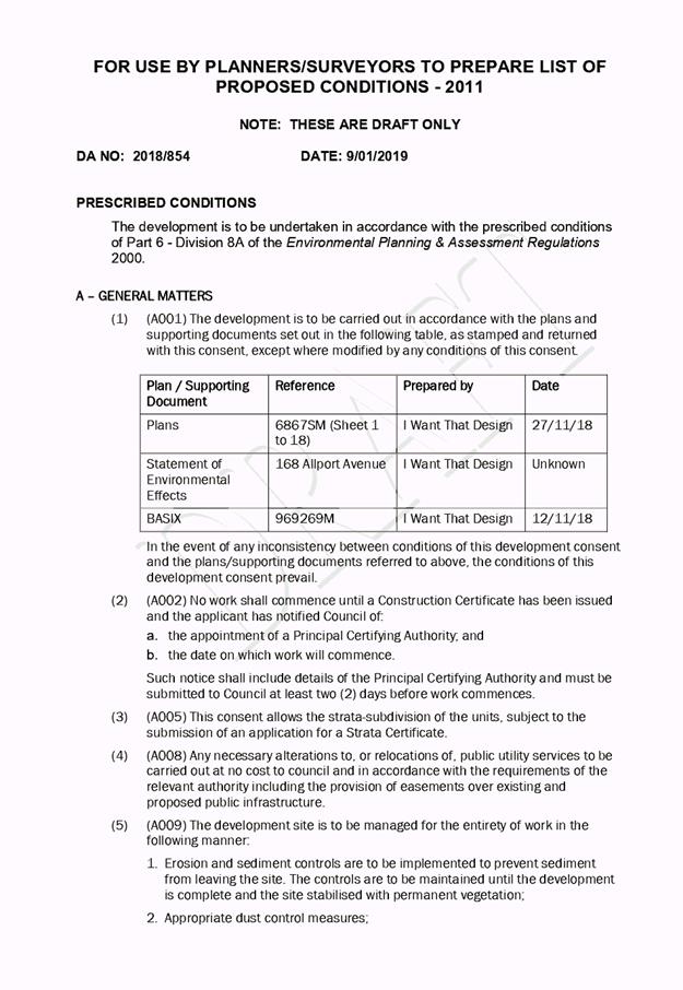
|
ATTACHMENT
|
Development Assessment Panel
23/01/2019
|
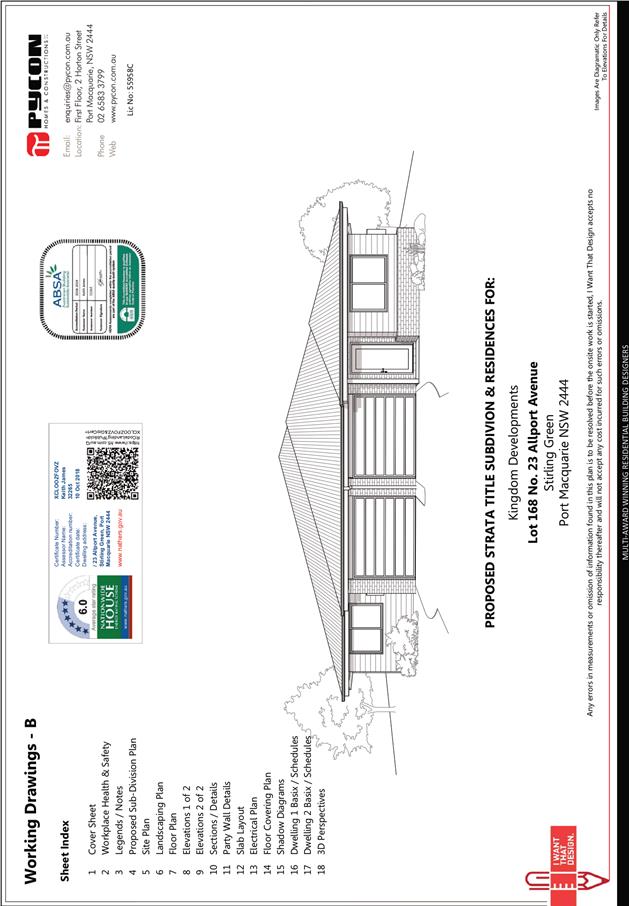
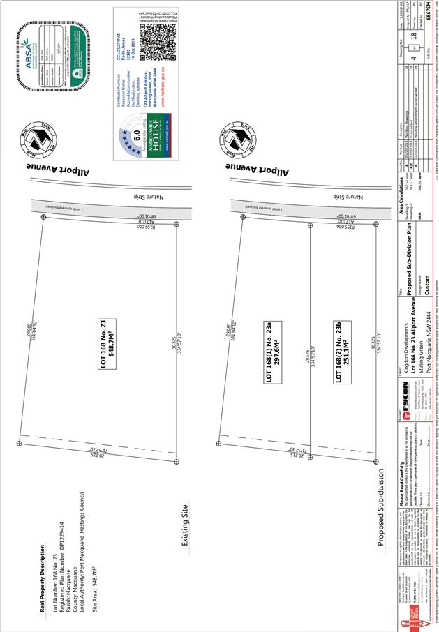
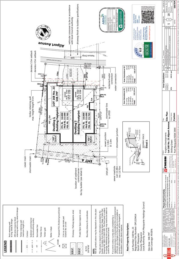
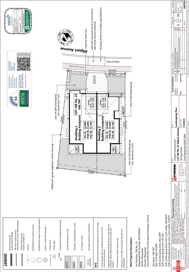
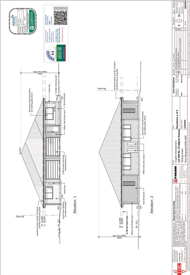
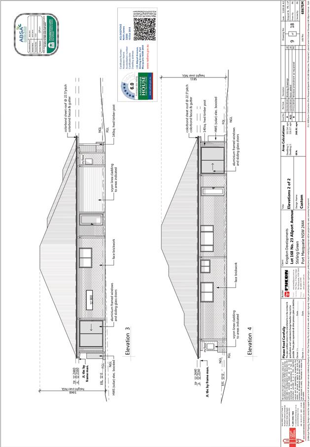
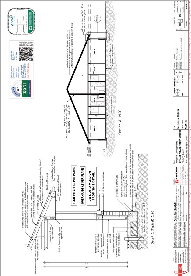

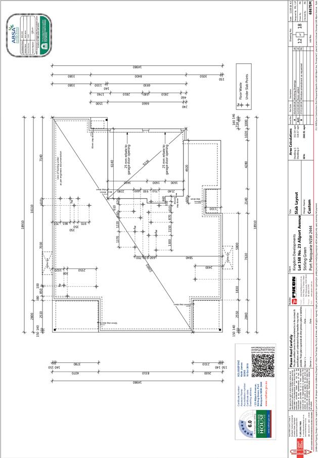
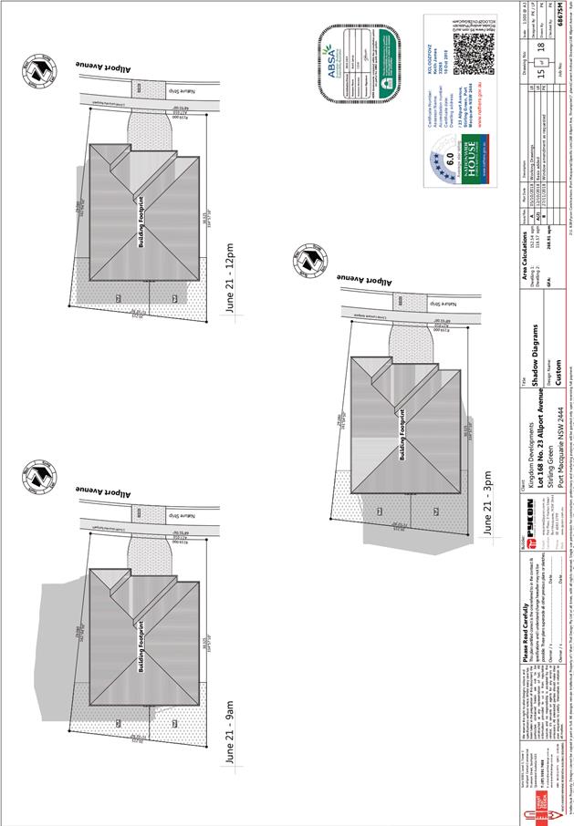
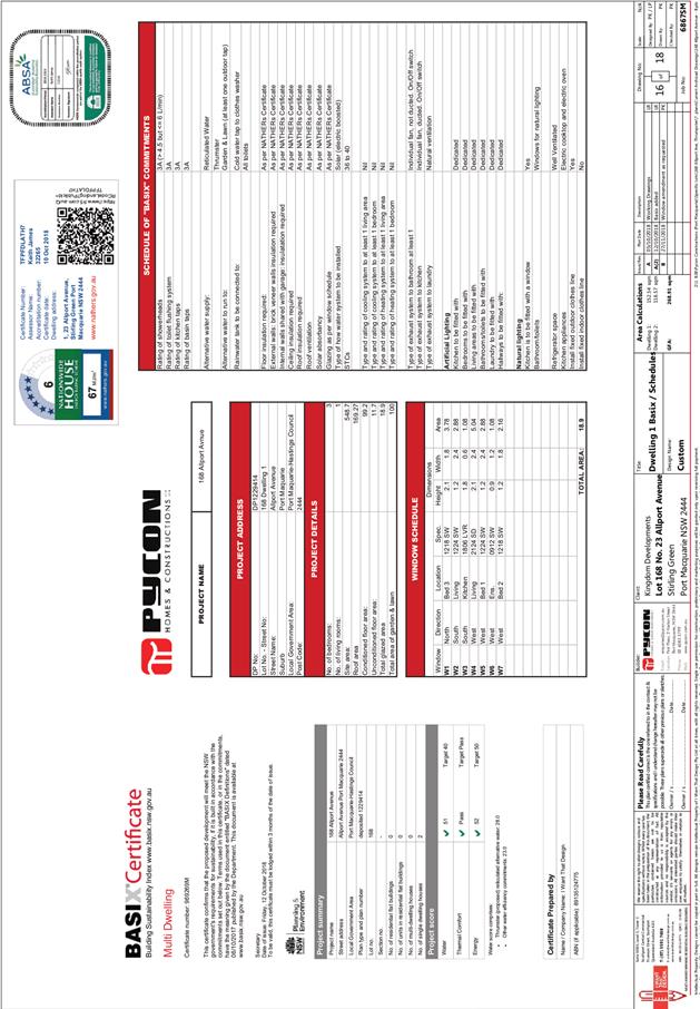
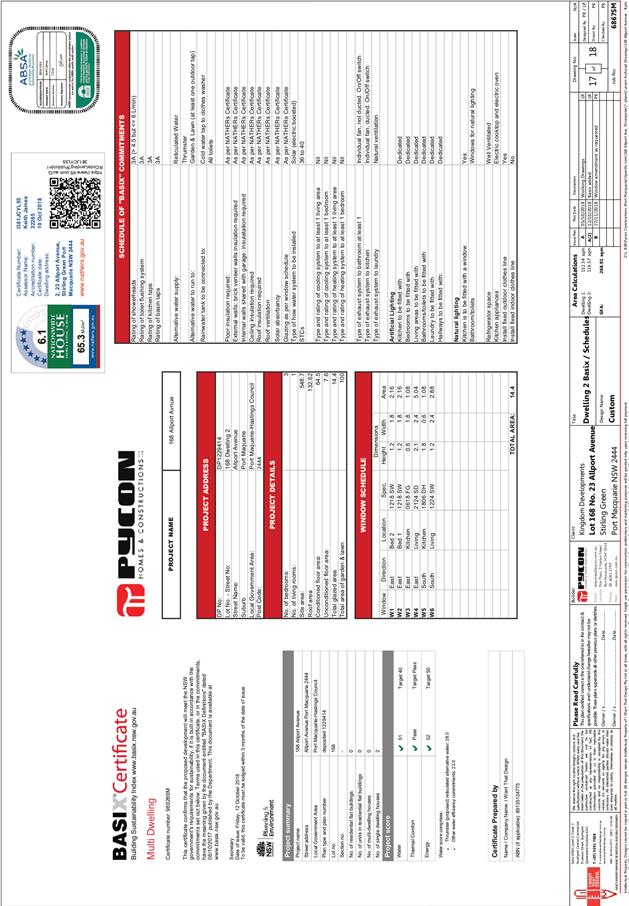
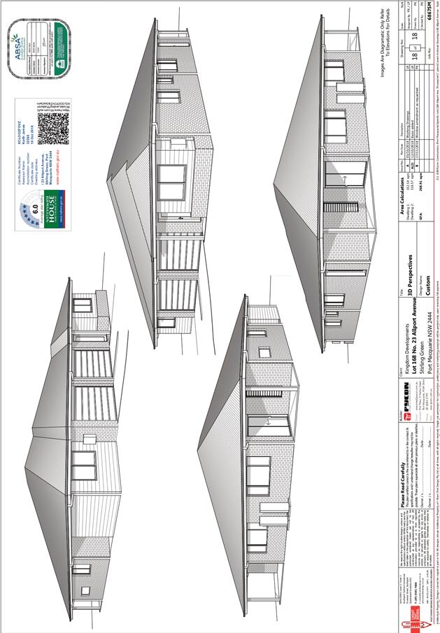
AGENDA Development Assessment Panel 23/01/2019
Item: 11
Subject: DA2018 - 292.1 Dual Occupancy With Strata
Subdivision, Lot 11 Sec D DP 25923,No 104 Chepana Street, Lake Cathie
Report
Author: Fiona Tierney
|
Applicant: Karen
Burke Registered Architect
Owner: M
Bretmaisser
Estimated Cost: $703600
Alignment with Delivery
Program
4.3.1 Undertake transparent
and efficient development assessment in accordance with relevant legislation.
|
|
RECOMMENDATION
That
DA 2018 – 292.1 for a dual
occupancy and strata subdivision at Lot 11, DP 25923, No. 104 Chepana Street, Lake
Cathie, be determined by granting consent
subject to the recommended conditions.
|
Executive
Summary
This
report considers a development application for a dual occupancy and
strata subdivision at the subject site and provides
an assessment of the application in accordance with the Environmental Planning
and Assessment Act 1979.
Following exhibition of the
application, 4 submissions have been received.
The application has been amended
multiple times to attempt address concerns raised in submissions and Rural Fire
Service concerns.
1. BACKGROUND
Existing sites features and Surrounding development
The site has an area of 546.3m2.
The site is zoned R1- General residential; in accordance with the Port Macquarie-Hastings Local
Environmental Plan 2011, as shown in the following zoning plan:
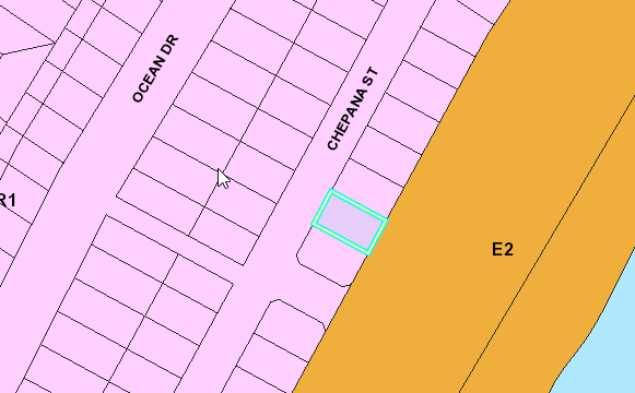
The existing subdivision pattern and location of existing
development within the locality is shown in the following aerial photograph:
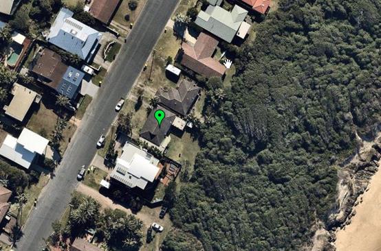
2. DESCRIPTION OF
DEVELOPMENT
Key aspects of the proposal include the following:
· Construction
of two semi-detached dwellings and
· Strata
Subdivision
Refer
to attachments at the end of this report.
Application Chronology
· 20
March 2018 – Application lodged.
· 9
April 2018 to 23 April 2018 – Neighbour notification.
· 15
June 2018 – Additional information requested from Applicant.
· 18
June 2018- View loss and overshadowing assessment submitted
· 20 June 2018 – Amended plans submitted by Applicant.
· 25 June to 9 July 2018- Neighbour notification amended
plans
· 27 June 2018 – Comments provided to Applicant on
amended plans.
· 12 July 2018 – Further amended plans submitted,
including change from Torrens title to strata subdivision.
· 20 August -3 September- Neighbour notification amended
plans
· 13 September 2018- Advice RFS unable to support BAL40 and
Flame contact
· 27 November 2018 Amended plans received- deck attachment
amended to address RFS and referred to RFS.
· 20 December 2018- Bushfire Authority issued RFS
3. STATUTORY ASSESSMENT
Section 4.15(1) Matters for Consideration
In determining the application, Council is required to take
into consideration the following matters as are relevant to the development
that apply to the land to which the development application relates:
(a) The provisions (where
applicable) of:
(i) Any Environmental
Planning Instrument:
State Environmental Planning Policy No. 44 - Koala Habitat
Protection
There is no Koala Plan of Management on the site.
Additionally, the site is less than 1ha in area and requires no vegetation
removal. Therefore, no further investigations are required.
State Environmental Planning Policy No. 55 –
Remediation of Land
Following an inspection of the site and a search of Council
records, the subject land is not identified as being potentially contaminated
and is suitable for the intended use.
State Environmental Planning Policy No. 62 –
Sustainable Aquaculture
Given the nature of the proposed development and proposed
stormwater controls the proposal will be unlikely to have any adverse impact on
existing aquaculture industries.
State Environmental Planning Policy (Coastal Management)
2018 and Clause 5.5 of Port Macquarie-Hastings Local Environmental Plan 2011
The assessment table below considers the relevant provisions of the SEPP.
|
Clause
|
Provision
|
Proposed
|
Complies
|
|
10 Development of
coastal wetlands or littoral rainforest land
(Applies to land mapped as
“coastal wetlands” or “littoral rainforest”)
|
|
10(4)
|
Sufficient measures have
been, or will be, made to protect the biophysical, hydrological and
ecological integrity of the coastal wetland or littoral rainforest.
|
The site contains sections
of mapped littoral rainforest to the east of the existing dwelling. By
removing the proposed eastern deck from the application, no works are
proposed on the mapped littoral rainforest area. Therefore, Clause 10 does
not apply.
|
Yes
|
|
11 Development on land
in proximity to coastal wetlands or littoral rainforest land
(Applies to land mapped as
“proximity area for coastal wetlands” or “proximity area
for littoral rainforest” or both)
|
|
11(1)(a)
|
The
proposed development will not significantly impact on the biophysical,
hydrological or ecological integrity of the adjacent coastal wetland or
littoral rainforest.
|
The alterations and additions will not impact on the
biophysical, hydrological or ecology of the littoral rainforest due to the
already developed nature of the dwelling/site, existing stormwater in place
and the fact no vegetation clearing is required.
|
Yes
|
|
11(1)(b)
|
The
quantity and quality of surface and ground water flows to the adjacent
coastal wetland or littoral rainforest if the development is on land within
the catchment of the coastal wetland or littoral rainforest.
|
No change to water quality or quantity. In particular,
minimal new hard stand areas proposed and the development will continue to
drain to an existing approved stormwater system at pre-development flows.
|
Yes
|
|
12 Development on certain land within the coastal
vulnerability area
(Applies to land mapped as “coastal vulnerability
area”)
|
|
12(a)
|
If the proposed development comprises the erection of a
building or works—the building or works are engineered to withstand
current and projected coastal hazards for the design life of the building or
works.
|
The site is not located within the coastal vulnerability
area.
|
N/A
|
|
12(b)(i)
|
The
proposed development is not likely to
alter coastal processes to the detriment of the natural environment or other
land.
|
The site is not located within the coastal vulnerability
area.
|
N/A
|
|
12(b)(ii)
|
The
proposed development is not likely
to reduce the public amenity, access to and use of any beach, foreshore, rock
platform or headland adjacent to the proposed development.
|
The site is not located within the coastal vulnerability
area.
|
N/A
|
|
12(b)(iii)
|
The
proposed development incorporates
appropriate measures to manage risk to life and public safety from coastal
hazards.
|
The site is not located within the coastal vulnerability
area.
|
N/A
|
|
12(c)
|
Measures are in place to ensure that there are
appropriate responses to, and management of, anticipated coastal processes
and current and future coastal hazards
|
The site is not located within the coastal vulnerability
area.
|
N/A
|
|
13 Development on land within the coastal environment
area
(Applies to land mapped as “coastal environment
area”)
|
|
13(1)(a)
|
Whether the proposed development is likely to cause an
adverse impact on the integrity and resilience of the biophysical,
hydrological (surface and groundwater) and ecological environment.
|
No adverse impact will occur. Proposal is for alterations
and additions to a single dwelling only, well clear of any key coastal
environment. Refer to comments on Clause 11 above, in relation to the
littoral rainforest provisions.
|
Yes
|
|
13(1)(b)
|
Whether the proposed development is likely to cause an
adverse impact on coastal environmental values and natural coastal processes.
|
No adverse impact will occur. Proposal is for alterations
and additions to a single dwelling only and will not impact on values or
processes.
|
Yes
|
|
13(1)(d)
|
Whether the proposed development is likely to cause an
adverse impact on marine vegetation, native vegetation and fauna and their
habitats, undeveloped headlands and rock platforms.
|
No adverse impact will occur. Proposal is for alterations
and additions to a single dwelling only, clear of any key coastal
environment/area.
|
Yes
|
|
13(1)(e)
|
Whether the proposed development is likely to cause an
adverse impact on existing public open space and safe access to and along the
foreshore, beach, headland or rock platform for members of the public,
including persons with a disability.
|
No adverse impact will occur. Proposal is for alterations
and additions to a single dwelling only and will not impact on access to any
key coastal area.
|
Yes
|
|
13(1)(f)
|
Whether the proposed development is likely to cause an
adverse impact on Aboriginal cultural heritage, practices and places.
|
The site is not known to contain any heritage items or
places. The site is also disturbed from past activities.
|
Yes
|
|
13(1)(g)
|
Whether the proposed development is likely to cause an
adverse impact on the use of the surf zone.
|
The site is well clear of the surf zone. As a result, no
adverse impact will occur.
|
Yes
|
|
13(2)
|
(a) the development is
designed, sited and will be managed to avoid an adverse impact referred to in
subclause (1), or
(b) if that impact cannot
be reasonably avoided—the development is designed, sited and will be
managed to minimise that impact, or
(c) if that impact cannot
be minimised—the development will be managed to mitigate that impact.
|
Refer to above comments, which confirm no adverse impact
will occur.
|
Yes
|
|
14 Development on land within the coastal use area
(Applies to land mapped as “coastal use area”)
|
|
14(a)(i)
|
Whether the proposed development is likely to cause an
adverse impact on existing, safe access to and along the foreshore, beach,
headland or rock platform for members of the public, including persons with a
disability.
|
No adverse impact will occur. Proposal is for alterations
and additions to a single dwelling only and will not impact on access to any
key coastal area.
|
Yes
|
|
14(a)(ii)
|
Whether the proposed development is likely to cause an
adverse impact on overshadowing, wind funnelling and the loss of views from
public places to foreshores.
|
No adverse impact will occur. Proposal is for alterations
and additions to a single dwelling only. The proposed changes do not
significantly change the bulk and scale of the dwelling and as a result will
ensure no adverse overshadowing, wind funnelling, loss of views etc. The
walls of the dwelling remain relatively unchanged with the minor change to height
gradually occurring central to the building.
|
Yes
|
|
14(a)(iii)
|
Whether the proposed development is likely to cause an
adverse impact on the visual amenity and scenic qualities of the coast,
including coastal headlands.
|
No adverse impact will occur. Proposal is for alterations
and additions to a single dwelling only within a semi developed residential
area. The bulk, scale and positioning of works will ensure no adverse impacts
on the visual or scenic qualities of the coast.
|
Yes
|
|
14(a)(iv)
|
Whether the proposed development is likely to cause an
adverse impact on Aboriginal cultural heritage, practices and places.
|
The site is not known to contain any heritage items or
places. The site is also disturbed from past activities.
|
Yes
|
|
14(a)(v)
|
Whether the proposed development is likely to cause an
adverse impact on cultural and built environment heritage.
|
The site is not known to contain any cultural/heritage
items or value. The site is also disturbed from past activities.
|
Yes
|
|
14(b)
|
(i) the development is
designed, sited and will be managed to avoid an adverse impact referred to in
paragraph (a), or
(ii) if that impact cannot
be reasonably avoided—the development is designed, sited and will be
managed to minimise that impact, or
(iii) if that impact cannot
be minimised—the development will be managed to mitigate that impact.
|
Refer to above comments, which confirm no adverse impact
will occur.
|
Yes
|
|
14(c)
|
The
consent authority has has taken into
account the surrounding coastal and built environment, and the bulk, scale
and size of the proposed development.
|
The coastal environment has been considered in the
assessment and the development deemed acceptable.
|
Yes
|
|
15 Development in coastal zone
generally—development not to increase risk of coastal hazards
(Applies to all land in the coastal zone other than land
mapped as “coastal vulnerability area”)
|
|
15(1)
|
The
proposed development is not likely to cause increased risk of coastal hazards
on the land or other land.
|
The site is not within a coastal hazard area.
|
N/A
|
|
16 Development in coastal zone generally—coastal
management programs to be considered
|
|
16
|
Development consent must not be granted to development on
land within the coastal zone unless the consent authority has taken into
consideration the relevant provisions of any certified coastal management
program that applies to the land.
|
No coastal zone management program applies to the land.
|
N/A
|
|
20 Flexible zone provisions
|
|
20
|
Flexible
zone provisions not applicable to land to which the SEPP applies.
|
The proposal does not rely upon flexible zone provisions.
|
Yes
|
Overall, the proposed development is not likely to result in
any of the following:
a) any
adverse impact on integrity and resilience of the biophysical,
hydrological (surface and groundwater) and ecological environment;
b) any
adverse impacts coastal environmental values and natural coastal
processes;
c) any
adverse impacts on marine vegetation, native vegetation and fauna
and their habitats, undeveloped headlands and rock platforms;
d) any
adverse impact on marine vegetation, native vegetation and fauna
and their habitats, undeveloped headlands and rock platforms;
e) any
adverse impact on Aboriginal cultural heritage, practices and
places;
f) any
adverse impacts on the cultural and built environment heritage;
g) any
adverse impacts to or from the surf zone;
h) any adverse impact on the visual amenity and scenic qualities of the
coast, including coastal headlands;
i) overshadowing, wind funnelling and the loss of views from public places
to foreshores;
The bulk, scale and size of the proposed development is
compatible with the surrounding coastal and built environment.
State Environmental Planning Policy (Building
Sustainability Index: BASIX) 2004
A BASIX certificate has been submitted demonstrating that
the proposal will comply with the requirements of the SEPP. It is recommended
that a condition be imposed to ensure that the commitments are incorporated
into the development and certified at Occupation Certificate stage.
Port Macquarie-Hastings Local Environmental Plan
2011
The proposal is consistent with the LEP having regard to
the following:
· Clause 2.2, the subject site is zoned R1 General
Residential. In accordance with clause 2.3(1) and the R1 zone landuse table,
the dual occupancy with subdivision is a permissible landuse with consent.
The objectives of the R1 zone are as follows:
o To provide for the housing needs of the community.
o To provide for a variety of housing types and densities.
o To enable other land uses that provide facilities or
services to meet the day to day needs of residents.
In accordance with Clause 2.3(2), the proposal
is consistent with the zone objectives as it is a permissible landuse and
consistent with the established residential locality.
· Clause 4.1(4), the minimum lot size for subdivision is not
applicable as the proposal is for a strata plan of subdivision.
· Clause 4.3, the maximum overall height of the building
above ground level (existing) is 7.3m which complies with the standard height
limit of 8.5m applying to the site.
·
· Clause 4.4, the floor space ratio of the proposal is 0.59:1
which complies with the maximum 0.65:1 floor space ratio applying to the site.
·
· Clause 5.10 – Heritage. The site does not contain or
adjoin any known heritage items or sites of significance.
·
· Clause 7.13, satisfactory arrangements are in place for
provision of essential services.
(ii) Any
draft instruments that apply to the site or are on exhibition:
No draft
instruments apply to the site.
(iii) any
Development Control Plan in force:
Port
Macquarie-Hastings Development Control Plan 2013
|
DCP 2013: Dwellings, Dual
occupancies, Dwelling houses, Multi dwelling houses & Ancillary
development
|
|
|
Requirements
|
Proposed
|
Complies
|
|
3.2.2.1
|
Ancillary development:
• 4.8m max. height
• Single storey
• 60m2 max. area
• 100m2 for lots
>900m2
• 24 degree max.
roof pitch
• Not located in
front setback
|
Water tanks are appropriately
located
|
Yes
|
|
3.2.2.2
|
Articulation zone:
• Min. 3m front
setback
• An entry feature
or portico
• A balcony, deck,
patio, pergola, terrace or verandah
• A window box
treatment
• A bay window or
similar feature
• An awning or
other feature over a window
• A sun shading
feature
|
No elements within the
articulation zone.
|
N/A
|
|
Front setback (Residential not R5
zone):
• Min. 6.0m
classified road
• Min. 4.5m local
road or within 20% of adjoining dwelling if on corner lot
• Min. 3.0m
secondary road
• Min. 2.0m
Laneway
|
Front building line setback
requirements are complied with.
|
Yes
|
|
3.2.2.3
|
Garage 5.5m min. and 1m behind
front façade.
Garage door recessed behind
building line or eaves/overhangs provided
|
Garage door setback requirements
are complied with.
|
Yes
|
|
6m max. width of garage door/s
and 50% max. width of building
|
The proposal includes 3.5m wide
garage doors for both dwellings and a building width of 8.655m for each
dwelling. The garage doors are therefore 40% of the building width.
|
Yes
|
|
Driveway crossover 1/3 max. of
site frontage and max. 5.0m width
|
Driveway crossing width
requirements are complied with.
|
Yes
|
|
3.2.2.4
|
4m min. rear setback. Variation
subject to site analysis and provision of private open space
|
The rear setback requirements are
complied with.
|
Yes
|
|
3.2.2.5
|
Side setbacks:
• Ground floor =
min. 0.9m
• First floors
& above = min. 3m setback or where it can be demonstrated that
overshadowing not adverse = 0.9m min.
• Building wall
set in and out every 12m by 0.5m
|
The minimum side setback
requirements are complied with.
The proposal includes a first floor
side setback of less than 3m and the submitted shadow diagrams demonstrate
that the development would not overshadow adjoining private open space or
living room windows for more than 3 hours between 9.00am and 3.00pm on 21
June.
The wall articulation is
compliant and satisfies the objectives of the development provision.
|
Yes
|
|
3.2.2.6
|
35m2 min. private open space area
including a useable 4x4m min. area which has 5% max. grade
|
Each occupancy contains 35m²
open space in one area.
|
Yes
|
|
3.2.2.7
|
Front fences:
• If solid 1.2m
max height and front setback 1.0m with landscaping
• 3x3m min. splay
for corner sites
• Fences >1.2m
to be 1.8m max. height for 50% or 6.0m max. length of street frontage with
25% openings
• 0.9x0.9m splays
adjoining driveway entrances
|
No front fences proposed.
|
N/A
|
|
3.2.2.10
|
Privacy:
• Direct views
between living areas of adjacent dwellings screened when within 9m radius of
any part of window of adjacent dwelling and within 12m of private open space
areas of adjacent dwellings. ie. 1.8m fence or privacy screening which has
25% max. openings and is permanently fixed
• Privacy screen
required if floor level > 1m height, window side/rear setback (other than
bedroom) is less than 3m and sill height less than 1.5m
• Privacy screens
provided to balconies/verandahs etc which have <3m side/rear setback and
floor level height >1m
|
The development will not compromise privacy in the area
due to a combination of high sill windows that face side boundaries, and use
of screening/fencing.
|
Yes
|
|
DCP 2013: General
Provisions
|
|
|
Requirements
|
Proposed
|
Complies
|
|
2.7.2.2
|
Design addresses generic principles of Crime Prevention
Through Environmental Design guideline
|
The development as proposed does not result in the
creation of concealment or entrapment areas. Appropriate casual surveillance
available.
|
Yes
|
|
2.3.3.1
|
Cut and fill 1.0m max. 1m outside the perimeter of the
external building walls
|
Relative flat site- no significant cut and fill proposed
|
N/A
|
|
2.3.3.2
|
1m max. height retaining walls along road frontage
|
None proposed
|
N/A
|
|
Any retaining wall >1.0 in height to be certified by
structure engineer
|
No retaining wall likely >1m
|
Yes
|
|
Combination of retaining wall and front fence height max
1.8m, max length 6.0m or 30% of frontage, fence component 25% transparent,
and splay at corners and adjacent to driveway
|
No retaining wall front/ fence combination proposed.
|
N/A
|
|
2.3.3.8
|
Removal of hollow bearing trees
|
No Hollow bearing trees proposed to be removed
|
N/A
|
|
2.6.3.1
|
Tree removal (3m or higher with 100m diameter trunk at 1m
above ground level and 3m from external wall of existing dwelling)
|
1x small Melaleuca to be removed from front of property
|
Yes
|
|
2.4.3
|
Bushfire risk, Acid sulphate soils, Flooding,
Contamination, Airspace protection, Noise and Stormwater
|
*Refer to main body of report.
|
|
|
2.5.3.2
|
New accesses not permitted from arterial or distributor
roads
|
No new access proposed to arterial or distributor road.
|
N/A
|
|
Driveway crossing/s minimal in number and width including
maximising street parking
|
Driveway crossing is minimal in width including maximising
street parking
|
Yes
|
|
2.5.3.3
|
Parking in accordance with Table 2.5.1.
Dwelling/dual occupancies
1 space per dwelling/occupancy (behind building line).
Multi dwelling
1 space per 1 & 2 bedroom occupancies
1.5 spaces per 3+ bedroom occupancies
0.25 spaces per occupancy for visitor parking.
|
Proposal complies with minimum parking requirements for
dual occupancy/semi-detached dwellings.
|
Yes
|
|
2.5.3.11
|
Section 94 contributions
|
Contributions apply - refer to ET calc and NOP.
|
Yes
|
|
2.5.3.12 and 2.5.3.13
|
Landscaping of parking areas
|
Suitable landscaping possible around driveway/parking
locations.
|
Yes
|
|
2.5.3.14
|
Sealed driveway surfaces unless justified
|
Sealed driveway areas proposed.
|
Yes
|
|
2.5.3.15 and 2.5.3.16
|
Driveway grades first 6m or ‘parking area’
shall be 5% grade with transitions of 2m length
|
Driveway grades capable of satisfying Council standard
driveway crossover requirements. Condition recommended for section 138 Roads
Act permit
|
Yes
|
|
2.5.3.17
|
Parking areas to be designed to avoid concentrations of
water runoff on the surface.
|
Stormwater drainage is capable of being managed as part of
plumbing construction.
|
Yes
|
·
(iiia) Any
planning agreement that has been entered into under section 7.4, or any draft
planning agreement that a developer has offered to enter into under section
7.4:
No planning
agreement has been offered or entered into relating to the site.
iv) Any matters prescribed by the
Regulations:
New South Wales Coastal Policy:
Consistent
with the Policy.
Demolition
of buildings AS 2601:
Demolition is capable of compliance with the Australian
Standard and is recommended to be conditioned.
(b) The
likely impacts of that development, including environmental impacts on both the
natural and built environments, social and economic impacts in the locality:
Context and setting
The existing dwelling is a small cottage and is typical of
sites that are being redeveloped with modern residential development. It is an
attractive location being close to the beach and close to shops and facilities.
The proposal is unlikely to have any adverse impacts on existing adjoining
properties and satisfactorily addresses the public domain.
The proposal is considered to be compatible with other
residential development in the locality and adequately addresses planning
controls for the area.
Impacts on view sharing, privacy and overshadowing are
addressed below.
There are no adverse overshadowing impacts. The proposal
does not prevent adjoining properties from receiving 3 hours of sunlight to
private open space and primary living areas on 21 June.
View Sharing
The overall notion of view sharing is invoked when a
property enjoys existing views and a proposed development would share that view
by taking some of it away for its own enjoyment. Taking all the view away
cannot be called view sharing, although it may, in some circumstances, be quite
reasonable
Having considered the principles of NSW Land and
Environment Court case law - Tenacity Consulting v Warringah 2004 NSW LEC
140 and following an inspection of the area, the following comments
are provided in regards to the view impacts using the 4 step process to
establish whether the view sharing is acceptable.
Step 1
Assessment of views to be affected. Water views are valued
more highly than land views. Iconic views (e.g. of the Opera House, the Harbour
Bridge or North Head) are valued more highly than views without icons. Whole
views are valued more highly than partial views, e.g. a water view in which the
interface between land and water is visible is more valuable than one in which
it is obscured.
Comments: An initial site inspection flagged the issue of
potential view loss as it was unclear from the information originally submitted
with the application. Concern was raised over potential view loss from
dwellings opposite the proposed development in Chepana Street. The applicant
met with the property owners of the dwellings immediately opposite and did a
view loss assessment clarifying that minor impact on views would occur. The
dwellings were also lowered to minimise view loss. Only part of an ocean view
(with no land/water interface, largely vegetation obscured view, from 101 and
103 Chepana Street would be affected.
See photos below:
Photo 1: View from 103 Chepana St with overlay of proposed
development (Note the heights have been lowered by 500mm after this overlay)
Photo 2: View from 101 Chepana St
As can be seen in the photos/mapping and in light of the
principle of the case; no high value views exist or will be significantly
affected.
Step 2
Consider from what part of the property the views are
obtained. For example the protection of views across side boundaries is more
difficult than the protection of views from front and rear boundaries. In
addition, whether the view is enjoyed from a standing or sitting position may
also be relevant. Sitting views are more difficult to protect than standing
views. The expectation to retain side views and sitting views is often
unrealistic.
Comments: The
limited water views from 101 and 103 Chepana Street are obtained from
living/deck and bedroom areas across the front boundary.
Step 3
Assess the extent of the impact. This should be done for
the whole of the property, not just for the view that is affected. The impact
on views from living areas is more significant than from bedrooms or service
areas (though views from kitchens are highly valued because people spend so
much time in them). The impact may be assessed quantitatively, but in many
cases this can be meaningless. For example, it is unhelpful to say that the
view loss is 20% if it includes one of the sails of the Opera House. It is
usually more useful to assess the view loss qualitatively as negligible, minor,
moderate, severe or devastating.
Comments: The
extent of the impact upon views from 101 & 103 Chepana Street will be minor
and acceptable. Views are largely obscured by vegetation already blocking the majority of the view. Refer to previous photo for
context.
Step 4
Assess the
reasonableness of the proposal that is causing the impact. A development that
complies with all planning controls would be considered more reasonable than
one that breaches them. Where an impact on views arises as a result of non-compliance
with one or more planning controls, even a moderate impact may be considered
unreasonable. With a complying proposal, the question should be asked whether a
more skilful design could provide the applicant with the same development
potential and amenity and reduce the impact on the views of neighbours. If the
answer to that question is no, then the view impact of a complying development
would probably be considered acceptable and the view sharing reasonable.
Comments:
Considering the comments on Clause 4.3 and 4.6 in the LEP 2011 section of this
report, the proposal is considered reasonable and will not significantly change
existing views. The proposed development will still achieve a suitable level of
view sharing in terms of the planning principles of the court case.
It should
also be noted that no submissions were received from adjoining neighbours,
which is normally a sign of the acceptance of the design and that the existing
views will not be impacted.
Overshadowing
Based on the submitted shadow plans, the proposed
development will not significantly overshadow key living areas/open space of
any adjoining property to the point where an adverse impact is created. The
applicant has reduced the height of the building 500mm and moved the dwellings
1.5m towards Chepana Street which will assist in reducing the overshadowing
impacts.
The dwelling and vegetation at 106 Chepana Street does cast
a significant amount of self- shadowing due to the lot orientation.
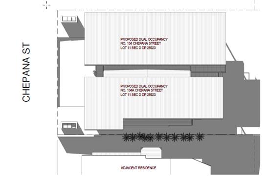
Access, transport and traffic
The proposal will be unlikely to have any adverse impacts
in terms access, transport and traffic. The existing road network will
satisfactorily cater for any increase in traffic generation as a result of the
development.
Water Supply
Council records indicate that the development site has an
existing 20mm sealed water service from the 100 PVC water main on the same side
of Chepana Street. Each proposed unit requires an individual metered water
service. Details are to be shown on the engineering plans.
A Section 68 application will be required for the new
plumbing work. Refer to relevant conditions.
Sewer
Council records indicate that the development site is
connected to sewer via a junction to the existing sewer main located along the
eastern property boundary. The proposed development shall discharge all sewage
to the existing point of connection to Council’s sewer system.
A Section 68 application will be required for the new
plumbing work. Refer to relevant conditions.
Stormwater
A Section 68 application will be required for the new
stormwater drainage work. Refer to relevant conditions.
Other Utilities
Telecommunication and electricity services are available to
the site.
Heritage
This site does not contain or adjoin any known heritage
item or site of significance.
Other land resources
No adverse impacts anticipated. The site is within an
established urban context and will not sterilise any significant mineral or
agricultural resource.
Water cycle
The proposed development will be unlikely to have any
adverse impacts on water resources and the water cycle.
Soils
The proposed development will be unlikely to have any
adverse impacts on soils in terms of quality, erosion, stability and/or
productivity subject to a standard condition requiring erosion and sediment
controls to be in place prior to and during construction.
Air and microclimate
The construction and/or operations of the proposed
development will be unlikely to result in any adverse impacts on the existing
air quality or result in any pollution.
Flora and fauna
Construction of the proposed development will be unlikely
to have any significant adverse impacts on biodiversity or threatened species
of flora and fauna. Part 7 of the Biodiversity Conservation Act 2016 is
considered to be satisfied.
Waste
Satisfactory arrangements are in place for proposed storage
and collection of waste and recyclables. No adverse impacts anticipated.
Energy
The proposal includes measures to address energy efficiency
and will be required to comply with the requirements of BASIX.
Noise and vibration
No adverse impacts anticipated. Condition recommended to
restrict construction to standard construction hours.
Bushfire
The site is identified as being bushfire prone.
In accordance with Section 100B - Rural Fires Act 1997 -
the application proposes subdivision of bush fire prone land that could
lawfully be used for residential purposes. As a result, the applicant has
submitted a bushfire report prepared by a Certified Consultant. The report was forwarded
to the NSW Rural Fire Service who have since issued a Bushfire Safety
Authority, which will be incorporated into the consent.
Safety, security and crime prevention
The proposed development is unlikely to create any
concealment/entrapment areas or crime spots that would result in any
identifiable loss of safety or reduction of security in the immediate area.
Social impacts in the locality
Given the nature of the proposed development and its’
location the proposal is unlikely to result in any adverse social impacts.
Economic impact in the locality
No adverse impacts. Likely positive impacts can be
attributed to the construction of the development and associated flow on
effects (ie maintained employment and increased expenditure in the area).
Site design and internal design
The proposed development design satisfactorily responds to
the site attributes and will fit into the locality. No adverse impacts are
likely.
Construction
No
unreasonable potential adverse impacts identified to neighbouring properties
with the development as proposed outside of normal construction impacts.
Cumulative Impacts
The proposed development is not expected to have any
adverse cumulative impacts on the natural or built environment or the social
and economic attributes of the locality.
(c) The suitability of the site for
the development:
The proposal
will fit into the locality and the site attributes are conducive to the
proposed development. Site constraints have been adequately addressed and
appropriate conditions of consent recommended.
(d) Any submissions made in
accordance with this Act or the Regulations:
Four (4) written submissions have been received following initial
public exhibition of the application. A number of modifications have been made
to address concerns raised by neighbours and the RFS. As such the application
has been readvertised twice. One (1) submission was received in relation to
these subsequent notifications. NOTE-all submissions have been addressed as
formal acceptance has not been received.
Key issues raised in the submissions received and comments
in response to these issues are provided as follows:
|
Submission
Issue/Summary
|
Planning
Comment/Response
|
|
View loss
|
The applicant has lowered the
development to maximise view retention for those dwellings located opposite.
Some view loss is still opposed over side boundary. See view loss assessment within
the report.
|
|
Traffic generation and parking
|
Minor increases in traffic are anticipated from the
construction of the development. Road capacity will adequately cope with the
likely increase in traffic.
Appropriate parking spaces have been provided suitable to
the dwelling size.
|
|
Over shadowing leading to loss of energy efficiency and
mould growth and inaccurate plans
|
The modified plans lowered the height of the building and
pulled the dwelling forward towards the street to improve overshadowing. Amended
shadow diagrams were submitted to address concerns. The applicant has
demonstrated that compliant solar access can be achieved to POS areas.
|
|
Loss of privacy- from decks and windows opposite
|
A 1.5m high privacy screen has been provided to the side
of the deck are and the window sill heights to the southern elevation have
been increased to 1.5m. The deck and upper windows are setback 3m from the
southern boundary providing approximately 7m separation between windows and
vegetation is located on the boundary. It is considered privacy concerns have
been adequately addressed.
|
|
Loss of North Easterly breezes
|
It is considered that the site can be reasonably
developed and loss of breezes will not be significant given the location.
|
|
Asset protection zone
|
The application has been referred to the Rural Fire
service multiple times to address concerns. The RFS are now satisfied the
development can meet their requirements and conditions have been applied to
the consent.
|
(e) The Public Interest:
The proposed development
satisfies relevant planning controls and is unlikely to impact on the wider
public interest.
4. DEVELOPMENT
CONTRIBUTIONS APPLICABLE
· Development contributions will be required towards
augmentation of town water supply and sewerage system head works under Section
64 of the Local Government Act 1993.
· Development contributions will be required under Section 94
of the Environmental Planning and Assessment Act 1979 towards roads, open
space, community cultural services, emergency services and administration
buildings.
5. CONCLUSION AND
STATEMENT OF REASON
The application has been assessed
in accordance with Section 4.15 of the Environmental Planning and Assessment
Act 1979.
Issues raised during assessment
and public exhibition of the application have been considered in the assessment
of the application. Where relevant, conditions have been recommended to manage
the impacts attributed to these issues.
The site is considered suitable
for the proposed development and the proposal adequately addresses relevant
planning controls. The development is not considered to be contrary to the
public's interest and will not result a significant adverse social,
environmental or economic impact. It is recommended that the application be
approved, subject to the recommended conditions of consent provided in the
attachment section of this report.
|
Attachments
1View. DA2018
- 292.1 Recommended Conditions
2View. DA2018
- 292 1 Plans
|
|
ATTACHMENT
|
Development Assessment Panel
23/01/2019
|
|
ATTACHMENT
|
Development Assessment Panel
23/01/2019
|
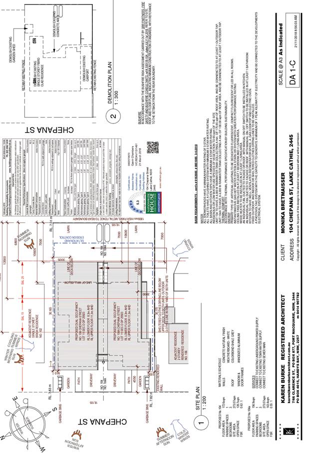
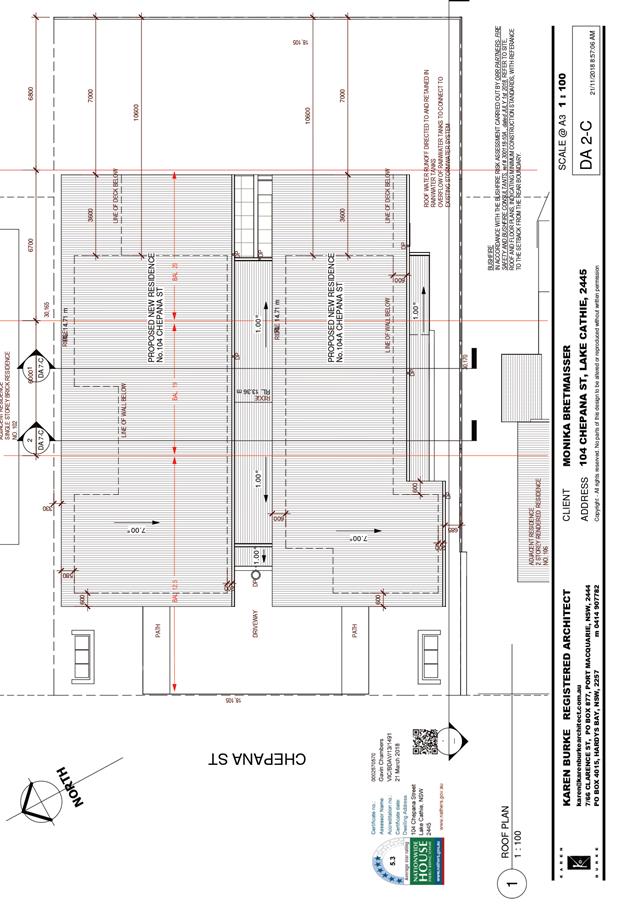
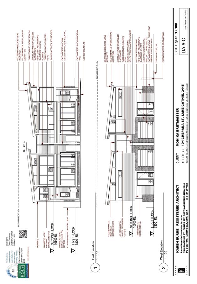
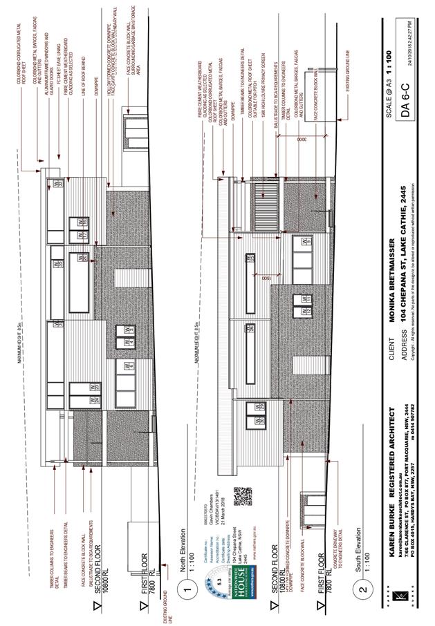
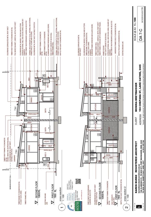
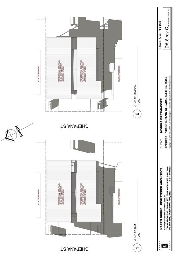
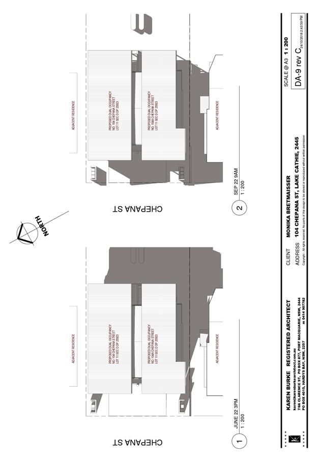
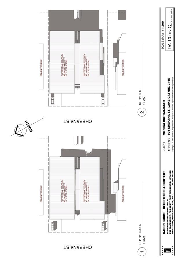
AGENDA Development Assessment Panel 23/01/2019
Item: 12
Subject: DA2018 - 761.1 Additions to Existing Club at Lot 1 DP 854932,
No. 1 Woodford Road, North Haven
Report Author: Fiona Tierney
|
Applicant: WEDGEWOOD
CARPENTRY
Owner: NORTH
HAVEN BOWLING CLUB
Estimated Cost: $91,302
Alignment with Delivery Program
4.3.1 Undertake transparent
and efficient development assessment in accordance with relevant legislation.
|
|
RECOMMENDATION
That
DA 2018 - 761 for additions to
existing club at Lot 1, DP 854932, No. 1 Woodford Road, North
Haven, be determined by granting consent subject
to the recommended conditions.
|
Executive
Summary
This
report considers a development application for additions to existing club at
the subject site and provides an assessment of the application in accordance
with the Environmental Planning and Assessment Act 1979.
Following exhibition of the
application, three (3) submissions have been
received.
1. BACKGROUND
Existing sites features and Surrounding development
The site has an area of 12060m2.
The site is zoned RE2- Private Recreation in accordance with the Port Macquarie-Hastings Local
Environmental Plan 2011, as shown in the following zoning plan:
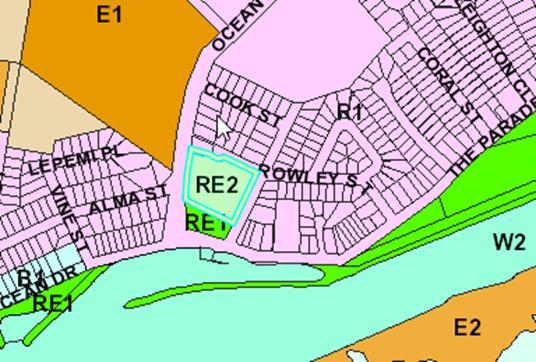
The existing subdivision pattern and location of existing
development within the locality is shown in the following aerial photograph:
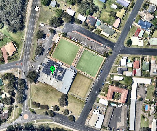
2. DESCRIPTION OF
DEVELOPMENT
Key aspects of the proposal include the following:
· Construction
of a viewing deck (stage 1)
· Construction
of a shade/weather cover over existing bowling green (stage 2)
Refer
to attachments at the end of this report.
Application Chronology
· 19
September 2018 - Application lodged
· 12-26 November 2018 - Neighbour notification of the
proposal
· 20 December 2018 - onsite meeting with objector and
applicant
3. STATUTORY ASSESSMENT
Section
4.15(1) Matters for Consideration
In
determining the application, Council is required to take into consideration the
following matters as are relevant to the development that apply to the land to
which the development application relates:
(a) The provisions (where
applicable) of:
(i) Any
Environmental Planning Instrument
State Environmental Planning Policy No. 44 - Koala
Habitat Protection
The site is in excess of 1Ha in area and so the provisions
of SEPP 44 must be considered. No koala browse trees are proposed to be
removed. The provisions of this SEPP therefore do not require any further
consideration.
State Environmental Planning Policy No. 55 –
Remediation of Land
Following an inspection of the site and a search of Council
records, the subject land is not identified as being potentially contaminated
and is suitable for the intended use.
State Environmental
Planning Policy No. 62 – Sustainable Aquaculture
Given the nature of the
proposed development and likely stormwater controls the proposal will be
unlikely to have any adverse impact on existing aquaculture industries.
State Environmental Planning Policy (Coastal Management)
2018 and Clause 5.5 of Port Macquarie-Hastings Local Environmental Plan 2011
The site is located within a coastal environment area.
In accordance with clause 7, this SEPP prevails over the
Port Macquarie-Hastings LEP 2011 in the event of any inconsistency.
Having regard to clauses 13 and
14 of the SEPP and clause 5.5 of the Port Macquarie-Hastings LEP 2011 the
proposed development is not considered likely to result in any of the
following:
a) any
adverse impact on integrity and resilience of the biophysical,
hydrological (surface and groundwater) and ecological environment;
b) any
adverse impacts coastal environmental values and natural coastal
processes;
c) any
adverse impacts on marine vegetation, native vegetation and fauna
and their habitats, undeveloped headlands and rock platforms;
d) any
adverse impact on marine vegetation, native vegetation and fauna
and their habitats, undeveloped headlands and rock platforms;
e) any
adverse impact on Aboriginal cultural heritage, practices and
places;
f) any
adverse impacts on the cultural and built environment heritage;
g) any
adverse impacts the use of the surf zone;
h) any adverse impact on the visual amenity and scenic qualities of the
coast, including coastal headlands; and
i) overshadowing, wind funneling and the loss of views from public places
to foreshores.
The bulk, scale and size of the proposed development is
compatible with the surrounding coastal and built environment. The site is
predominately cleared and located within proximity to an area zoned for the
purposes of a private recreation, tourist and residential dwellings.
State Environmental Planning Policy (Infrastructure) 2007
The development does not trigger any of the traffic
generating development thresholds of Clause 104. Referral to the Roads and
Maritime Services is not required.
Based on the above, the proposed development addresses
relevant clauses in the SEPP and is unlikely to create any conflict in terms of
traffic or noise.
Port
Macquarie-Hastings Local Environmental Plan 2011
The proposal is consistent
with the LEP having regard to the following:
· Clause
2.2, the subject site is zoned RE2- Private Recreation. In accordance with
clause 2.3(1) and the RE2 zone landuse table, the additions to the existing
club are a permissible landuse with consent.
The objectives of the RE2 zone are as
follows:
o To enable land to be used for private open space or
recreational purposes.
o To provide a range of recreational settings and activities
and compatible land uses.
o To protect and enhance the natural environment for
recreational purposes.
In accordance with Clause 2.3(2), the
proposal is consistent with the zone objectives as it is a permissible landuse
and consistent with the established adjacent residential locality and no
landuse conflicts can be identified.
· Clause
4.3, the maximum overall height of the building above ground level (existing)
is 8.5 m which complies with the standard height limit of 8.5 m applying to the
site.
· Clause
4.4, the floor space ratio of the proposal is 0.31:1 which complies with the
maximum 1.0:1 floor space ratio applying to the site.
· Clause
5.5 - Development within the coastal zone (relevant objectives of this clause
are addressed by SEPP (Coastal Management)
· Clause
5.10 – Heritage. The site does not contain or adjoin any known heritage
items or sites of significance.
· Clause
7.1, the site is mapped as potentially containing class 4 acid sulfate soils.
The proposed development includes footings, however no excavation extending 2m
below the natural surface level is proposed, therefore no adverse impacts are
expected to occur to the acid sulphate soils found on site.
· Clause
7.3, the site is land within a mapped “flood planning area” (Land
subject to flood discharge of 1:100 annual recurrence interval flood event
(plus the applicable climate change allowance and relevant freeboard) In this
regard the following comments are provided which incorporate consideration of
the objectives of Clause 7.3, Council’s Flood Policy 2015, the NSW
Government’s Flood Prone Lands Policy and the NSW
Government’s Floodplain Development Manual (2005):
o The
proposal is compatible with the flood hazard of the land taking into account
projected changes as a result of climate change;
o The
proposal will not result in a significant adverse effect on flood behaviour
that would result in detrimental increases in the potential flood affectation
of other development or properties;
o The
proposal incorporates measures to minimise & manage the flood risk to life
and property associated with the use of land;
o The
proposal is not likely to significantly adversely affect the environment or
cause avoidable erosion, siltation, destruction of riparian vegetation or a
reduction in the stability of river banks or watercourses;
o The
proposal is not likely to result in unsustainable social and economic costs to
the community as a consequence of flooding;
· Clause 7.13,
satisfactory arrangements are in place for provision of essential services
including water supply, electricity supply, sewer infrastructure, stormwater
drainage and suitable road access to service the development..
(ii) Any
draft instruments that apply to the site or are on exhibition
No draft
instruments apply to the site.
(iii) Any
Development Control Plan in force
Port
Macquarie-Hastings Development Control Plan 2013
Development
is to be constructed over an existing bowling green. Site has three frontages
and 1 that adjoins a Reserve. The DCP does not have specific setback
requirements for RE2 and so are assessed on a merits basis. In this case the
structure is proposed at a 1.437m setback to allow the structure supports to
span over the existing bowling green. It is considered appropriate in this
instance as the club is located on its own island block, wide road reserve and
it is an open form structure.
|
DCP 2013: General
Provisions
|
|
|
Requirements
|
Proposed
|
Complies
|
|
2.7.2.2
|
Design addresses generic principles of Crime Prevention
Through Environmental Design guideline
|
No concealment or entrapment areas proposed. Adequate
casual surveillance available.
|
Yes
|
|
2.3.3.1
|
Cut and fill 1.0m max. 1m outside the perimeter of the
external building walls
|
No fill proposed
|
N/A
|
|
2.3.3.2
|
1m max. height retaining walls along road frontage
|
None proposed
|
N/A
|
|
Any retaining wall >1.0 in height to be certified by
structure engineer
|
No retaining walls
|
N/A
|
|
2.3.3.8
|
Removal of hollow bearing trees
|
No trees proposed to be removed.
|
N/A
|
|
2.6.3.1
|
Tree removal (3m or higher with 100m diameter trunk at 1m
above ground level and 3m from external wall of existing dwelling)
|
No trees proposed to be removed.
|
N/A
|
|
2.4.3
|
Bushfire risk, Acid sulphate soils, Flooding,
Contamination, Airspace protection, Noise and Stormwater
|
Refer to main body of report.
|
|
|
2.5.3.2
|
New accesses not permitted from arterial or distributor
roads
|
No new access proposed to arterial or distributor road.
|
N/A
|
|
Driveway crossing/s minimal in number and width including
maximising street parking
|
No change to existing crossover proposed.
|
N/A
|
|
2.5.3.3
|
Parking in accordance with Table 2.5.1.
Dwelling requirements + 1 space for visitors + 1 space per
2 employees.
|
Existing parking. Shade structure is over existing bowling
green and is will not generate additional parking demand.
|
Yes
|
|
2.5.3.11
|
Section 94 contributions
|
Refer to main body of report.
|
N/A
|
(iiia) Any
planning agreement that has been entered into under section 7.4, or any draft
planning agreement that a developer has offered to enter into under section 7.4
No planning
agreement has been offered or entered into.
(iv) Any matters prescribed by the
Regulations
New South Wales Coastal Policy:
The proposed development is
consistent with the objectives and strategic actions of this policy.
(b) The
likely impacts of that development, including environmental impacts on both the
natural and built environments, social and economic impacts in the locality:
The site has street frontages to
Ocean Drive, Woodford Rd and Rowley St. A reserve is located to the south of
the site.
The proposal will be unlikely to
have any adverse impacts to existing adjoining properties and satisfactorily
addresses the public domain.
The proposal is considered to be
consistent with other development in the locality and adequately addresses
planning controls for the area.
The proposal does not have a
significant adverse impact on existing view sharing.
The proposal does not have
significant adverse lighting impacts.
There are no significant adverse
privacy impacts. Adequate building separation and tenancy is
proposed/existing.
There is no adverse overshadowing
impacts. The proposal does not prevent adjoining properties from receiving 3
hours of sunlight to private open space and primary living areas on 21 June.
View Sharing
The overall notion of view sharing is invoked when a property
enjoys existing views and a proposed development would share that view by
taking some of it away for its own enjoyment. Taking all the view away cannot
be called view sharing, although it may, in some circumstances, be quite
reasonable
Having considered the principles of NSW Land and
Environment Court case law - Tenacity Consulting v Warringah 2004 NSW LEC
140 and following an inspection of the area, the following comments
are provided in regards to the view impacts using the 4 step process to
establish whether the view sharing is acceptable.
Step 1
Assessment of views to be affected. Water views are valued
more highly than land views. Iconic views (e.g. of the Opera House, the Harbour
Bridge or North Head) are valued more highly than views without icons. Whole
views are valued more highly than partial views, e.g. a water view in which the
interface between land and water is visible is more valuable than one in which
it is obscured.
Comments: Concerns have been raised by residents opposite
the proposed development that they will lose views to North Brother Mountain
and down to the reserve and water. The topography around the area is relatively
flat and dwellings face the bowling club so outlook is over the bowling club
property and down the street. The applicant has submitted a photo montage to
demonstrate the anticipated view loss. This appears to indicate a minor impact
on views would occur. A small part of the view of North Brother Mountain and
the reserve at the base of the street for the concerned properties would be
affected.
See photos/mapping below:
Photo1: View down street and across to bowling club
Photo 2: Photo montage supplied by applicant- view from 2
Woodford Rd
Photo 3: Aerial Blue line indicating direction of view to
North Brother
Step 2
Consider from what part of the property the views are
obtained. For example the protection of views across side boundaries is more
difficult than the protection of views from front and rear boundaries. In
addition, whether the view is enjoyed from a standing or sitting position may
also be relevant. Sitting views are more difficult to protect than standing
views. The expectation to retain side views and sitting views is often
unrealistic.
Comments: The
North Brother views from 2 Woodford Road are obtained from living/deck areas
across the front boundary. The views from 4 Woodford are obtained from a small
shaded front window set well back from the street.
Step 3
Assess the extent of the impact. This should be done for
the whole of the property, not just for the view that is affected. The impact
on views from living areas is more significant than from bedrooms or service
areas (though views from kitchens are highly valued because people spend so
much time in them). The impact may be assessed quantitatively, but in many
cases this can be meaningless. For example, it is unhelpful to say that the
view loss is 20% if it includes one of the sails of the Opera House. It is
usually more useful to assess the view loss qualitatively as negligible, minor,
moderate, severe or devastating.
Comments: The
extent of the impact upon views from properties in Woodford Rd will be minor
and acceptable. This is on the basis that the views
are largely conserved and fairly difficult to fully maintain given the
relatively flat topography and orientation of houses.
Step 4
Assess the
reasonableness of the proposal that is causing the impact. A development that
complies with all planning controls would be considered more reasonable than
one that breaches them. Where an impact on views arises as a result of
non-compliance with one or more planning controls, even a moderate impact may
be considered unreasonable. With a complying proposal, the question should be
asked whether a more skilful design could provide the applicant with the same
development potential and amenity and reduce the impact on the views of
neighbours. If the answer to that question is no, then the view impact of a
complying development would probably be considered acceptable and the view
sharing reasonable.
Comments: The
proposal is considered to comply with relavent height and setback requirements
and is considered reasonable and will not significantly change existing views.
The proposed development will still achieve a suitable level of view sharing in
terms of the planning principles of the court case.
Roads
The site has road frontage to Woodford Road and Ocean Drive.
Adjacent to the site, Woodford Road is a sealed public road under the
care and control of Council. Woodford Road is a local road with a 10m
road formation within a 20 m road reserve. Ocean Drive is a sealed public road
under the care and control of Council with RMS funding. Ocean Drive is an
arterial road with a 11m road formation within a 30 m road reserve.
Site Frontage & Access
Vehicle access to the site is proposed though one access
driveway to Rowley ST. All accesses shall comply with Council AUSPEC and
Australian Standards, and conditions have been imposed to reflect these
requirements.
Water Supply Connection
Council records
indicate that the development site has an existing 50mm metered water service
from the 200 PVC water main on the same side of Ocean Drive.
No changes to existing
arrangements are necessary.
Sewer Connection
Existing- no changes required.
Stormwater
To be connected to the street. Refer to relevant conditions
of consent.
Other Utilities
Telecommunication and electricity services are available to
the site.
Heritage
Following a site inspection no known items of Aboriginal or
European heritage significance exist on the property. No adverse impacts
anticipated.
Other land resources
The site is within an established urban context and will not
sterilise any significant mineral or agricultural resource.
Water cycle
The proposed development will be unlikely to have any
adverse impacts on water resources and the water cycle.
Soils
The proposed development will be unlikely to have any
adverse impacts on soils in terms of quality, erosion, stability and/or
productivity subject to a standard condition requiring erosion and sediment
controls to be in place prior to and during construction.
Air and microclimate
The construction and/or operations of the proposed
development will be unlikely to result in any adverse impacts on the existing
air quality or result in any pollution. Standard precautionary site management
condition recommended.
Flora and fauna
Construction of the proposed development will not require
any removal/clearing of any significant vegetation and therefore will be
unlikely to have any significant adverse impacts on biodiversity or threatened
species of flora and fauna. Section 5A of the Act is considered to be
satisfied
Waste
Satisfactory arrangements are in place for proposed storage
and collection of waste and recyclables. No adverse impacts anticipated.
Standard precautionary site management condition recommended.
Energy
The proposal includes measures to address energy efficiency
and will be required to comply with the requirements of Section J of the
Building Code of Australia. No adverse impacts anticipated.
Noise and vibration
No adverse impacts anticipated. Condition recommended to
restrict construction to standard construction hours.
Bushfire
The site is identified as being
bushfire prone. The subject structures are not to be habitable and unlikely to
subject to any significant bushfire risk subject to management of an
appropriate Asset Protection Zone within the reserve to the North West. Access
is available from around the entirety of the site in the event of a bushfire
emergency.
Safety, security and crime prevention
The proposed development will be unlikely to create any
concealment/entrapment areas or crime spots that would result in any identifiable
loss of safety or reduction of security in the immediate area. The
increase in housing density will improve natural surveillance within the
locality and openings from each dwelling overlook common and private areas.
Social impacts in the locality
Given the nature of the proposed development and its’
location the proposal is unlikely to result in any adverse social impacts.
Economic impact in the locality
No adverse impacts. A likely positive impact is that the
development will maintain employment in the construction industry, which will
lead to flow impacts such as expenditure in the area.
Site design and internal design
The proposed development design satisfactorily responds to
the site attributes and will fit into the locality. No adverse impacts likely.
Construction
No potential adverse impacts identified to neighbouring
properties with the construction of the proposal.
Cumulative impacts
The proposed development is not expected to have any adverse
cumulative impacts on the natural or built environment or the social and
economic attributes of the locality.
(c) The suitability of the site for
the development:
The proposal will fit into the
locality and the site attributes are conducive to the proposed development.
Site
constraints have been adequately addressed and appropriate conditions of
consent recommended
(d) Any submissions made in
accordance with this Act or the Regulation:
Three (3) written submissions have been received following public
exhibition of the application.
Key issues raised in the submissions received and comments
in response to these issues are provided as follows:
|
Submission
Issue/Summary
|
Planning
Comment/Response
|
|
Visual Impact
|
The structure is quite large
and will have a reasonable visual impact given that the area has been an open
area for a significant amount of time.
It is however proposed to be a
high quality structure that will enhance the visual appearance of the
existing Club which has recently been renovated. It is considered that the
structure is consistent with the desire for many clubs to provide a sun and
weather safe area for their patrons.
The structure is to be painted
in a matching colour to the existing club, is located in excess of 20m from
the nearest residential boundary and was lowered from 12m to below 8.5m to
meet concerns raised at a pre-lodgement meeting.
The applicant has agreed to
paint he existing green low fence along the Woodford Road frontage in a
colour to match the club to create a harmonious visual outcome
|
|
View loss, river, green space, reserves, North Brother
Mountain
|
See view loss assessment above. It is considered that the
principles of view sharing have been satisfied and that the view loss will be
acceptable.
|
|
No aesthetic appeal for residential area
|
The club is a designated public recreation area and the
height is 8.5m from the existing ground level in keeping with the standard
residential height limits for the precinct. It is considered the curved roof
structure provides a coastal aspect to the design and will be complementary
to the club renovations and adds additional features to the simple lines of
the existing club.
|
|
Construction materials will create glare and not age well
|
The applicant has advised that the roof will be a coated
colourbond roofing material in a neutral colour. Given the relative viewing
heights and curve (rather than a flat angle) it is not considered to be a
significant issue.
|
|
Noise created though rain/hail on the roof
|
Noise from natural occurrences is not subject to specific
assessment.
|
|
Noise created though use of the space- amplified music.
|
Applicant has advised that no amplified music is
proposed. Other noise will be consistent with current use as an active
bowling club.
|
|
Conversion of green space to hard surfaces.
|
The green will still be visible and bowling greens are
not deep soil zones- being a relatively thin layer of growing medium that is
well drained to prevent water accumulation on the surface.
|
|
Odour impact from smoking on the deck
|
Deck will be in excess of 25 metres to the nearest residential
boundary
|
|
Request use of deck be restricted to daylight hours and
smoking and alcohol consumption be prohibited on this structure.
|
The club license does permit night time use and the green
areas are licenced under the Liquor Act. All activities would have to be
conducted within noise guidelines. It is not practical to restrict alcohol
consumption, however smoking is to be conducted within the designated smoking
area and not on the deck.
|
|
Request deck be relocated to one of the other greens
|
This has been discussed on site with the club. They
advise various options were considered, however the green is the most
appropriately located in terms of the club layout and is the smallest green
and is therefore the most economically viable option.
|
|
Why does roof need to be domed- could be a lower profile
roof.
|
The applicant has advised that the profile provides a
more aesthetic appearance and provides better airflow under the structure.
The structure has been amended prior to lodgement to reduce the height by 4m.
|
(e) The Public Interest:
The proposed
development satisfies relevant planning controls and is unlikely to impact on
the wider public interest.
4. DEVELOPMENT
CONTRIBUTIONS APPLICABLE
· As the cost of works exceeds $100,000 development contributions
will be required under Section 94A of the Environmental Planning and Assessment
Act 1979. A suitable condition has been recommended.
5. CONCLUSION AND
STATEMENT OF REASON
The application has been assessed
in accordance with Section 4.15 of the Environmental Planning and Assessment
Act 1979.
Issues raised during assessment
and public exhibition of the application have been considered in the assessment
of the application. Where relevant, conditions have been recommended to manage
the impacts attributed to these issues.
The site is considered suitable
for the proposed development and the proposal adequately addresses relevant
planning controls. The development is not considered to be contrary to the
public's interest and will not result a significant adverse social,
environmental or economic impact. It is recommended that the application be
approved, subject to the recommended conditions of consent provided in the
attachment section of this report.
|
Attachments
1View. DA
2018 - 761.1 Recommended Conditions
2View. DA2018
- 761.1 Plans and Documents
|
|
ATTACHMENT
|
Development Assessment Panel
23/01/2019
|
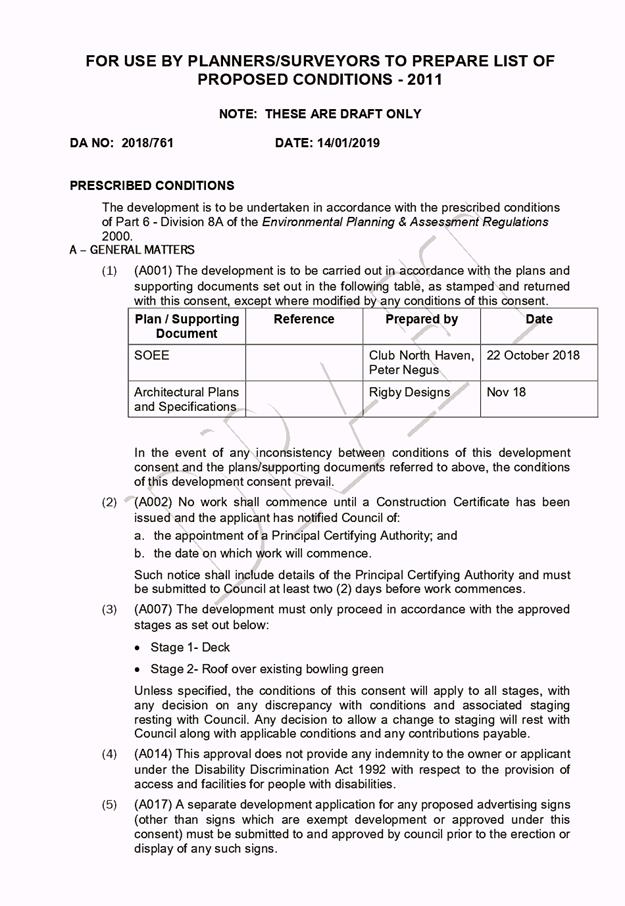
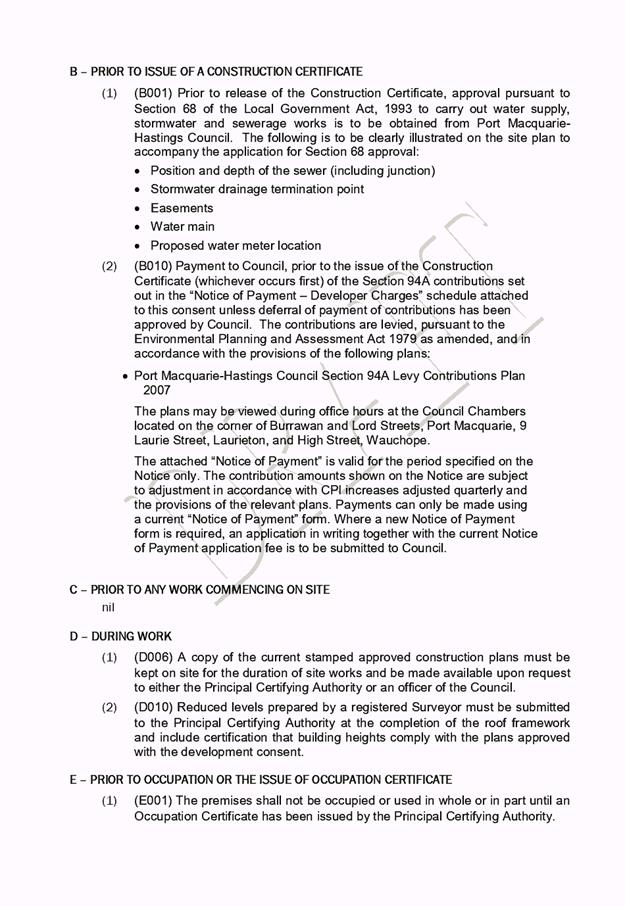
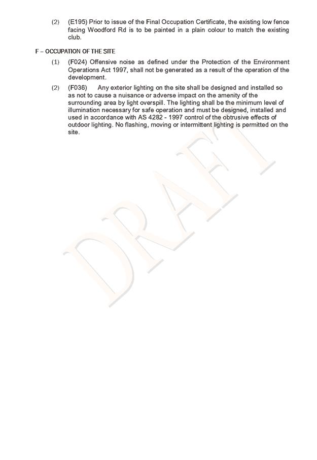
|
ATTACHMENT
|
Development Assessment Panel
23/01/2019
|