Ordinary Council
Business Paper
|
date of meeting: |
|
Wednesday, 20 November 2013 |
|
location: |
|
Council Chambers, 17 Burrawan Street, Port Macquarie |
|
time: |
|
5.30pm |
Ordinary Council
Business Paper
|
date of meeting: |
|
Wednesday, 20 November 2013 |
|
location: |
|
Council Chambers, 17 Burrawan Street, Port Macquarie |
|
time: |
|
5.30pm |
Council’s Vision A sustainable high quality of life for all.
Council’s Mission To provide regional leadership and meet the community’s needs in an equitable and inclusive way that enhances the area’s environmental, social and economic qualities.
Council’s Corporate Values é Sustainability
é Excellence in Service Delivery
é Consultation and Communication
é Openness and Accountability
é Community Advocacy
Council’s Guiding Principles é Ensuring good governance
é Looking after our people
é Helping our community prosper
é Looking after our environment
é Planning & providing our infrastructure
How Members of the Public Can Have Their Say at Council Meetings
Council has a commitment to providing members of the public with an input into Council's decision making. The Council's Code of Meeting Practice provides two (2) avenues for members of the public to address Council on issues of interest or concern at the Ordinary Council Meeting. These are:
Addressing Council on an Agenda Item:
If the matter is listed in the Council Business Paper, you can request to address Council by:
· Completing the Request to Speak on an Agenda Item at a Council Meeting”, which can be obtained from Council’s Offices at Laurieton, Port Macquarie and Wauchope or by downloading it from Council’s website.
· On-line at
Your request to address Council must be received by Council no later than 4:30pm on the day prior to the Council Meeting.
Council's Code of Meeting Practice sets out the following guidelines for addressing Council:
· Addresses will be limited to 5 minutes.
· If you wish any written information, drawings or photos to be distributed to the Council to support the address, two (2) copies should be provided to the Group Manager Governance & Executive Services prior to the commencement of the meeting.
· Where speakers wish to make an audio visual presentation, a copy is to be provided to the Group Manager Governance & Executive Services by 4.30pm on the day prior to the Council Meeting.
· Council will permit only two (2) speakers "Supporting" and two (2) speakers "Opposing" the Recommendation contained in the Business Paper. If there are more than two speakers supporting and opposing, the Mayor will request the speakers to determine who will address Council.
Addressing Council in the Public Forum:
If the matter is not listed in the Council Business Paper, you can request to address Council by:
· Completing the Request to Speak in the Public Forum at Ordinary Council Meeting”, which can be obtained from Council’s Offices at Laurieton, Port Macquarie and Wauchope or by downloading it from Council’s website.
· On-line at
Your request to address Council must be received by Council no later than 4:30pm on the day prior to the Council Meeting.
A maximum of eight (8) speakers will be heard in the Public Forum. Each speaker will be limited to 5 minutes. Council may ask questions of speakers but speakers cannot ask questions of Council.
Council will not determine matters raised in the Public Forum session, however may resolve to call for a further report, when appropriate.
Speakers will be allowed to address Council in the Public Forum on the same issue no more than three (3) times in each calendar year. (Representatives of incorporated community groups may be exempted from this restriction).
Ordinary Council Meeting
Wednesday, 20 November 2013
Item Subject Page
01 Acknowledgement of Country............................................................................ 1
02 Local Government Prayer................................................................................... 1
03 Apologies......................................................................................................... 1
04 Confirmation of Minutes.................................................................................... 1
05 Disclosures of Interest..................................................................................... 18
06 Mayoral Minute
06.01..... 2013 Carols by Candlelight Event Funding.......................................... 22
06.02..... Mayoral Discretionary Fund Allocations.............................................. 23
07 Public Forum................................................................................................... 24
08 Ensuring Good Governance........................................................................... 25
08.01..... Confidential Correspondence to Ordinary Council Meeting................... 26
08.02..... Status of Outstanding Reports to Council - November 2013................. 28
08.03..... Code of Conduct Complaint Statistics................................................ 30
08.04..... Payment of Expenses and Provision of Facilities to Councillors Policy 33
08.05..... Disclosure of Interest Return.............................................................. 37
08.06..... Report on Attendance at the 2013 AAPA International Flexible Pavements Conference 39
08.07..... Annual Financial Statements for the year ended 30 June 2013.............. 42
08.08..... Monthly Review of Financial Position - October 2013........................... 50
08.09..... Investments - October 2013................................................................ 52
08.10..... Phasing of Operational Budgets......................................................... 57
08.11..... Development Activity & Assessment System Performance.................. 60
08.12..... 2012 - 2013 Annual Report................................................................. 65
08.13..... Heritage & Cultural Sub-Committee..................................................... 68
08.14..... Transfer Balance of Funds - Port Macquarie-Handa Sister City Sub-Committee 72
08.15..... Section 355 Community Halls Management Committees Membership 2013 74
09 Looking After Our People............................................................................... 79
09.01..... Annual Reporting of Contracts for Senior Staff................................... 80
09.02..... Notice of Motion - Ban Consumption of Alcohol - Town Beach Skate Park (PIN 263) 83
09.03..... Notice of Motion - Illegal Camping...................................................... 84
09.04..... Bicentenary Planning Sub-Committee Membership.............................. 85
09.05..... Recommendations from the Mayor's Sporting Fund Sub-Committee Meeting held on Thursday 16 October 2013................................................................................ 87
10 Helping Our Community Prosper................................................................... 88
10.01..... Notice of Motion - Tastings on Hastings 2013..................................... 89
10.02..... Question on Notice - Council Owned Land in William Street, Port Macquarie (PIN 34119)........................................................................................................ 90
10.03..... Economic Development Strategy....................................................... 95
11 Looking After Our Environment...................................................................... 99
11.01..... Notice of Motion - Walking Track - Jonathon Dixon Reserve to Middle Rock Road, Lake Cathie (PIN 43834)...................................................................................... 100
11.02..... Notice of Motion - Wall Reserve, North Haven (PIN 15194)................. 101
11.03..... Recommended Item from Hastings LGA Floodplain Management Sub-Committee - Camden Haven River and Lake System Flood Study....................................... 102
11.04..... Recommended Item from Hastings LGA Coast & Estuaries Sub-Committee - Lake Cathie Coastal Zone Management Plan....................................................... 103
11.05..... Exhibtion of Koala Habitat and Vegetation Mapping.......................... 106
11.06..... Question on Notice - Kew Waste Transfer Station (PIN 50972, 57445). 123
11.07..... New Planning Bill............................................................................. 127
11.08..... DA 2013 - 0286 - Earthworks Associated With Recreation Area Lot 16 DP 1122022, 79 Ocean Drive, Port Macquarie (PIN 55276).................................................... 130
11.09..... DA2013 - 0349 - Alterations and Additions to 3 Storey Dwelling-House Including Clause 4.6 Variation to Clause 4.3 (Height of Buildings) Port Macquarie-Hastings Local Environmental Plan 2011 - Lot 3 DP 236279, 105 Matthew Flinders Drive, Port Macquarie (PIN 13336) 134
11.10..... DA2013 - 0481 Alterations and Additions to Two Storey Dwelling House and Construction of a Detached Shed Including Clause 4.6 Variation to Clause 4.3 (Height of Buildings) Port Macquarie Hastings Local Environmental Plan 2011 - Lot 5 DP 22158, 23 Orr Street, Port Macquarie (PIN 15827)..................................................................... 138
11.11..... T-13-25 Kew Waste Management Facility Design and Documentation (PIN 50972-57445)....................................................................................................... 142
12 Planning and Providing Our Infrastructure................................................... 146
12.01..... Wauchope Skate Park...................................................................... 147
12.02..... Local Infrastructure Renewal Scheme Round 3 Applications............... 156
12.03..... Rationalisation of Land Boundaries - Lake Road, Gordon and Munster Streets, Port Macquarie....................................................................................................... 162
12.04..... Status of Port Macquarie-Hastings Bus Route Alterations and Associated Bus Stops 165
12.05..... Tender T-13-33 Supply & Install Traffic Signals Hastings River Drive at Boundary Street intersection, Port Macquarie............................................................. 170
12.06..... Thrumster Neighbourhood DCP Provisions: Partridge Creek and West Lindfield - Public Exhibition Report............................................................................. 174
12.07..... Proposed Variation to draft LEP Height of Building Map - Warlters Street, Settlement City Precinct........................................................................................... 187
12.08..... Growth Constraints - Oxley Highway/Wrights Road Intersection, Port Macquarie [SF13/1207]....................................................................................................... 193
13 Questions for Next Meeting
14 Confidential Matters
Nil
AGENDA Ordinary Council 20/11/2013
Item: 01
Subject: ACKNOWLEDGEMENT OF COUNTRY
"I acknowledge that we are gathered on Birpai Land. I pay respect to the Birpai Elders both past and present. I also extend that respect to all other Aboriginal and Torres Strait Islander people present."
Subject: LOCAL GOVERNMENT PRAYER
A Minister from the Combined Churches of Port Macquarie will be invited to deliver the Local Government Prayer.
Subject: APOLOGIES
RECOMMENDATION
That the apologies received be accepted.
Subject: CONFIRMATION OF PREVIOUS MINUTES
Recommendation
That the Minutes of the Ordinary Council Meeting held on 16 October 2013 be confirmed.
![]() MINUTES Ordinary Council Meeting
MINUTES Ordinary Council Meeting
16/10/2013
PRESENT
Members:
Councillor Peter Besseling (Mayor)
Councillor Rob Turner
Councillor Adam Roberts (Deputy Mayor)
Councillor Lisa Intemann
Councillor Justin Levido
Councillor Geoff Hawkins
Councillor Trevor Sargeant
Councillor Michael Cusato
Councillor Sharon Griffiths
Other Attendees:
General Manager (Tony Hayward)
Director of Infrastructure & Asset Management (Jeffery Sharp)
Director of Commercial Services & Industry Engagement (Craig Swift-McNair)
Director of Development & Environment (Matt Rogers)
Group Manager Governance & Executive Services (Stewart Todd)
Communications Officer (Stuart Carless)
Executive Assistant to the Mayor / Minute Clerk (Linda Kocis)
|
The Meeting opened at 5.38 pm. |
|
01 ACKNOWLEDGEMENT OF COUNTRY |
|
The Mayor opened the Meeting with an Acknowledgement of Country and welcomed all in attendance in the Chamber. |
|
02 LOCAL GOVERNMENT PRAYER |
|
Reverend Scott Donnellan from the Presbyterian Church delivered the Local Government Prayer. |
|
03 APOLOGIES |
|
04 CONFIRMATION OF MINUTES |
|
1. That the Minutes of the Ordinary Council Meeting held on 18 September 2013 be confirmed. 2. That the Minutes of the Extra-Ordinary Council Meeting held on 25 September 2013 be confirmed. carried: 9/0 For: Besseling, Cusato, Griffiths, Hawkins, Intemann, Levido, Roberts, Sargeant and Turner Against: Nil |
|
05 DISCLOSURES OF INTEREST
|
|
Councillor Levido declared a Non-Pecuniary, Significant Interest in Item 11.01 - DA 2013/0349 - 105 Matthew Flinders Drive, Port Macquarie, the reason being he is a partner in the Port Macquarie Law Firm, Donovan Oates Hannaford Lawyers. The firm currently acts for a landowner whose property adjoins the subject property and has caused an objection to be lodged with respect to the proposed development. Councillor Roberts declared a Non-Pecuniary, Significant Interest in Item 11.01 - DA 2013/0349 - 105 Matthew Flinders Drive, Port Macquarie, the reason being the neighbour of the DA site in question ran in the Group C (Team Roberts) election campaign and may be potentially impacted by the outcome of this item. Councillor Cusato declared a Non-Pecuniary, Less than Significant Interest in Item 11.01 - DA 2013/0349 - 105 Matthew Flinders Drive, Port Macquarie, the reason being the direct neighbour of the subject property was a candidate running for Council with him on Group C (Team Roberts). Councillor Griffiths declared a Non-Pecuniary, Less than Significant Interest in Item 12.05 - Wauchope Traffic Management Strategy, the reason being she is a director and business owner in Wauchope. Councillor Griffiths declared a Non-Pecuniary, Less than Significant Interest in Item 12.08 - Tender T-13-26 Port Macquarie Airport - New Carpark for Rental Cars & Staff, the reason being she owns a business and some of tenderers are customers of her business. Councillor Intemann declared a Non-Pecuniary, Less than Significant Interest in Item 12.05 - Wauchope Traffic Management Strategy, the reason being she is a resident of Wauchope and the Director of a Wauchope business. |
|
That the Mayoral Discretionary Fund allocations for the period 6 September to 4 October 2013 be noted.
carried: 9/0 For: Besseling, Cusato, Griffiths, Hawkins, Intemann, Levido, Roberts, Sargeant and Turner Against: Nil |
|
That Standing Orders be suspended to allow Item 08.01 to be brought forward and considered next. carried: 9/0 For: Besseling, Cusato, Griffiths, Hawkins, Intemann, Levido, Roberts, Sargeant and Turner Against: Nil |
|
07 PUBLIC FORUM |
|
The Mayor advised of applications to address Council in the Public Forum from: 1. Ms Jenny Daniels regarding Big 4 Caravan Park, Bonny Hills.
RESOLVED: Roberts/Intemann
That the above requests to speak in the Public Forum be acceded to.
carried: 9/0 For: Besseling, Cusato, Griffiths, Hawkins, Intemann, Levido, Roberts, Sargeant and Turner Against: Nil |
|
Ms Jenny Daniels addressed Council in regard to noise from the swimming pool at the Big 4 Caravan Park, Bonny Hills and answered questions from Councillors. |
|
That Standing Orders be suspended to allow Items 11.01, 12.04 & 12.05 to be brought forward and considered next in the above order. carried: 9/0 For: Besseling, Cusato, Griffiths, Hawkins, Intemann, Levido, Roberts, Sargeant and Turner Against: Nil |
Councillor Levido and Councillor Roberts left the Meeting, the time being 5.59 pm.
Councillor Levido and Councillor Roberts returned to the meeting, the time being 06:46pm.
|
That Standing Orders be suspended to allow Item 10.01 to be brought forward and considered next. carried: 9/0 For: Besseling, Cusato, Griffiths, Hawkins, Intemann, Levido, Roberts, Sargeant and Turner Against: Nil |
|
Mr Alistair Owen, on behalf of Black Duck Brewery, addressed Council in support of the recommendation and answered questions from Councillors.
|
|
That Council: 1. Commence a 12 month trial to allow the deferral of payment of development contributions for building development or other development not involving subdivision of land subject to: a) The deferral period being for a maximum of 2 years from the release of the construction or complying development certificate for building works or from the date of occupation/use commencing where no building works are proposed. b) An application made in writing to defer the payment of contributions. c) Contributions being secured by an irrevocable, non- time limited Bank Guarantee for the amount of the contributions plus a 12 month interest amount calculated at the average rate of Council’s investments performance over the past 12 months plus 1%. d) Contributions to be calculated at the current rate applicable at the time of payment, including contributions paid by instalment during the approved deferral period. 2. That a report on the progress of expanded deferral provisions be provided in 12 months. carried: 9/0 For: Besseling, Cusato, Griffiths, Hawkins, Intemann, Levido, Roberts, Sargeant and Turner Against: Nil |
|
That Council: 1. Note the information in the Disclosure Register for 2012/2013. 2. Determine that the following positions become Designated Persons pursuant to the provisions of section 441 of the Local Government Act 1993: a) Group Manager Water and Sewer b) Group Manager Infrastructure Delivery c) Group Manager Transport and Stormwater Network d) Group Manager Asset Services e) Water and Sewer Planning Manager. carried: 9/0 For: Besseling, Cusato, Griffiths, Hawkins, Intemann, Levido, Roberts, Sargeant and Turner Against: Nil |
|
That Council note the conference report provided by Councillor Roberts on his attendance at the ‘In the Room’ Conference 2013. carried: 9/0 For: Besseling, Cusato, Griffiths, Hawkins, Intemann, Levido, Roberts, Sargeant and Turner Against: Nil |
|
That Council receive and note the Investment Report for the month of September 2013. carried: 9/0 For: Besseling, Cusato, Griffiths, Hawkins, Intemann, Levido, Roberts, Sargeant and Turner Against: Nil |
|
That Council note the information provided in the report. carried: 9/0 For: Besseling, Cusato, Griffiths, Hawkins, Intemann, Levido, Roberts, Sargeant and Turner Against: Nil |
|
That Council adopt changes to the 2013-2014 Operational Plan actions as detailed in this report. carried: 9/0 For: Besseling, Cusato, Griffiths, Hawkins, Intemann, Levido, Roberts, Sargeant and Turner Against: Nil |
|
That Council: 1. Establish a Sub-Committee of Council titled the Glasshouse Sub-Committee. 2. Endorse the Glasshouse Sub-Committee Charter as attached to this Notice of Motion, with the community members increased up to five (5) members. 3. Call for public Expressions of Interest from independent, community members for membership of the Glasshouse Sub-Committee, in line with the Glasshouse Sub-Committee Charter. 4. Request the General Manager to report back to the December 2013 Council Meeting with the results and evaluation of the public Expression of Interest for consideration by Council. carried: 8/1 For: Besseling, Cusato, Griffiths, Hawkins, Intemann, Levido, Roberts and Turner Against: Sargeant |
|
That Council: 1. Accept the tender from HGT Australia Ltd, T/A Novaskill for the Provision of Group Training Services for the period 17 October 2013 to 16 October 2015 with a further twelve (12) month option available. 2. Affix the seal of Council to the necessary documents. carried: 9/0 For: Besseling, Cusato, Griffiths, Hawkins, Intemann, Levido, Roberts, Sargeant and Turner Against: Nil |
|
That Council: 1. Prepare a draft planning proposal as described in this report, pursuant to section 55 of the Environmental Planning and Assessment Act 1979, for the amendment of the provisions of Port Macquarie-Hastings Local Environmental Plan 2011, in relation to 27 issues listed. 2. Forward the draft planning proposal to the Department of Planning and Infrastructure for a Gateway Determination, and exhibit the proposal in accordance with that determination, pursuant to sections 56 - 58 of the Act. 3. Request that the Director General of the Department of Planning & Infrastructure issue a Written Authorisation to Council to Exercise Delegation of the plan making functions under section 59 of the Act in respect of the planning proposal. carried: 9/0 For: Besseling, Cusato, Griffiths, Hawkins, Intemann, Levido, Roberts, Sargeant and Turner Against: Nil |
|
That Council: 1. Prepare a draft planning proposal as described in this report, pursuant to Section 55 of the Environmental Planning and Assessment Act 1979, for the amendment of the provisions of Port Macquarie-Hastings Local Environmental Plan 2011, in relation to: a) Permitting with consent eco-tourist facilities within Zones RU1 Primary Production, RU2 Rural Landscape, R1 General Residential, R5 Large Lot Residential, SP3 Tourist and E4 Environmental Living, and b) Inserting a local clause with the objective of facilitating eco-tourist facilities, as described in this report. 2. Forward the draft planning proposal to the Department of Planning and Infrastructure for a Gateway Determination, and exhibit the proposal in accordance with that determination, pursuant to Sections 56 - 58 of the Act. 3. Request that the Director General of the Department of Planning & Infrastructure issue a Written Authorisation to Council to Exercise Delegation of the plan making functions under Section 59 of the Act in respect of the planning proposal. carried: 9/0 For: Besseling, Cusato, Griffiths, Hawkins, Intemann, Levido, Roberts, Sargeant and Turner Against: Nil |
|
13 QUESTIONS FOR NEXT MEETING
|
|
Question from Councillor Griffiths:
Can the General Manager provide an updated report on the Camden Haven Waste Transfer Station to the November 2013 Council Meeting to address concerns of residents regarding site selection:
1. Detailed costing of each site clarifying rates and volumes including dumping levy. 2. Advise noise, dust, security impact on each site. 3. Frequency of crushing and mulching expected. 4. Area and design of waste transfer station including sketch or photo of existing transfer station. 5. Advise how transfer sites operate. 6. Road entry options for sites, ie. Ocean Drive, left in / left out. 7. How the upgrade of the Dunbogan roadway through flood strategies would alter the cost at this location. 8. Impact on site 2 Herons Creek Road due to wildlife corridor. 9. Expected usage taking into consideration the location of sites and future waste transfer stations. 10. Any other relevant information to inform the community. 11. Further options for community consultation.
Comments by Councillor Griffiths: Residents have stated they were not informed of the waste transfer station site selection being presented to Council for adoption, therefore unable to present to Council various questions which they believe may have altered the resolution. |
|
The Meeting closed at 8.22 pm. |
………………………………………..
Peter Besseling
Mayor
AGENDA Ordinary Council 20/11/2013
Item: 05
Subject: DISCLOSURES OF INTEREST
RECOMMENDATION
That Disclosures of Interest be presented
DISCLOSURE OF INTEREST DECLARATION
Name of Meeting: ………………………………………………………………………..
Meeting Date: ………………………………………………………………………..
Item Number: ………………………………………………………………………..
Subject: ………………………………………………………………………..
…………………………………………………….……………...…..
I, ..................................................................................... declare the following interest:
![]() Pecuniary:
Pecuniary:
Take no part in the consideration and voting and be out of sight of the meeting.
![]() Non-Pecuniary - Significant Interest:
Non-Pecuniary - Significant Interest:
Take no part in the consideration and voting and be out of sight of the meeting.
![]() Non-Pecuniary - Less than Significant
Interest:
Non-Pecuniary - Less than Significant
Interest:
May participate in consideration and voting.
For the reason that: ....................................................................................................
.......................................................................................................................................
Signed: ......................................................................... Date: ..................................
![]() (Further
explanation is provided on the next page)
(Further
explanation is provided on the next page)
Further Explanation
(Local Government Act and Code of Conduct)
A conflict of interest exists where a reasonable and informed person would perceive that a Council official could be influenced by a private interest when carrying out their public duty. Interests can be of two types: pecuniary or non-pecuniary.
All interests, whether pecuniary or non-pecuniary are required to be fully disclosed and in writing.
Pecuniary Interest
A pecuniary interest is an interest that a Council official has in a matter because of a reasonable likelihood or expectation of appreciable financial gain or loss to the Council official. (section 442)
A Council official will also be taken to have a pecuniary interest in a matter if that Council official’s spouse or de facto partner or a relative of the Council official or a partner or employer of the Council official, or a company or other body of which the Council official, or a nominee, partner or employer of the Council official is a member, has a pecuniary interest in the matter. (section 443)
The Council official must not take part in the consideration or voting on the matter and leave and be out of sight of the meeting. (section 451)
Non-Pecuniary
A non-pecuniary interest is an interest that is private or personal that the Council official has that does not amount to a pecuniary interest as defined in the Act.
Non-pecuniary interests commonly arise out of family, or personal relationships, or involvement in sporting, social or other cultural groups and associations and may include an interest of a financial nature.
The political views of a Councillor do not constitute a private interest.
The management of a non-pecuniary interest will depend on whether or not it is significant.
Non Pecuniary – Significant Interest
As a general rule, a non-pecuniary conflict of interest will be significant where a matter does not raise a pecuniary interest, but it involves:
(a) A relationship between a Council official and another person that is particularly close, for example, parent, grandparent, brother, sister, uncle, aunt, nephew, niece, lineal descendant or adopted child of the Council official or of the Council official’s spouse, current or former spouse or partner, de facto or other person living in the same household.
(b) Other relationships that are particularly close, such as friendships and business relationships. Closeness is defined by the nature of the friendship or business relationship, the frequency of contact and the duration of the friendship or relationship.
(c) An affiliation between a Council official an organisation, sporting body, club, corporation or association that is particularly strong.
If a Council official declares a non-pecuniary significant interest it must be managed in one of two ways:
1. Remove the source of the conflict, by relinquishing or divesting the interest that creates the conflict, or reallocating the conflicting duties to another Council official.
2. Have no involvement in the matter, by taking no part in the consideration or voting on the matter and leave and be out of sight of the meeting, as if the provisions in section 451(2) apply.
Non Pecuniary – Less than Significant Interest
If a Council official has declared a non-pecuniary less than
significant interest and it does not require further action, they must provide
an explanation of why they consider that the conflict does not require further
action in the circumstances.
SPECIAL DISCLOSURE OF PECUNIARY INTEREST DECLARATION
|
By [insert full name of councillor] |
|
|
|
In the matter of [insert name of environmental planning instrument] |
|
|
|
Which is to be considered at a meeting of the [insert name of meeting] |
|
|
|
Held on [insert date of meeting] |
|
|
|
PECUNIARY INTEREST
|
||
|
Address of land in which councillor or an associated person, company or body has a proprietary interest (the identified land)i |
|
|
|
Relationship of identified land to councillor [Tick or cross one box.] |
Councillor has interest in the land (e.g. is owner or has other interest arising out of a mortgage, lease trust, option or contract, or otherwise).
Associated person of councillor has interest in the land.
Associated company or body of councillor has interest in the land. |
|
|
MATTER GIVING RISE TO PECUNIARY INTEREST
|
||
|
Nature of land that is subject to a change in zone/planning control by proposed LEP (the subject land iii [Tick or cross one box] |
The identified land.
Land that adjoins or is adjacent to or is in proximity to the identified land. |
|
|
Current zone/planning control [Insert name of current planning instrument and identify relevant zone/planning control applying to the subject land] |
|
|
|
Proposed change of zone/planning control [Insert name of proposed LEP and identify proposed change of zone/planning control applying to the subject land] |
|
|
|
Effect of proposed change of zone/planning control on councillor [Tick or cross one box] |
Appreciable financial gain.
Appreciable financial loss. |
|
Councillor’s Signature: ………………………………. Date: ………………..
Important Information
This information is being collected for the purpose of making a special disclosure of pecuniary interests under sections 451 (4) and (5) of the Local Government Act 1993. You must not make a special disclosure that you know or ought reasonably to know is false or misleading in a material particular. Complaints made about contraventions of these requirements may be referred by the Director-General to the Local Government Pecuniary Interest and Disciplinary Tribunal.
This form must be completed by you before the commencement of the council or council committee meeting in respect of which the special disclosure is being made. The completed form must be tabled at the meeting. Everyone is entitled to inspect it. The special disclosure must be recorded in the minutes of the meeting.
i. Section 443 (1) of the Local Government Act 1993 provides that you may have a pecuniary interest in a matter because of the pecuniary interest of your spouse or your de facto partner or your relativeiv or because your business partner or employer has a pecuniary interest. You may also have a pecuniary interest in a matter because you, your nominee, your business partner or your employer is a member of a company or other body that has a pecuniary interest in the matter.
ii. Section 442 of the Local Government Act 1993 provides that a pecuniary interest is an interest that a person has in a matter because of a reasonable likelihood or expectation of appreciable financial gain or loss to the person. A person does not have a pecuniary interest in a matter if the interest is so remote or insignificant that it could not reasonably be regarded as likely to influence any decision the person might make in relation to the matter or if the interest is of a kind specified in section 448 of that Act (for example, an interest as an elector or as a ratepayer or person liable to pay a charge).
iii. A pecuniary interest may arise by way of a change of permissible use of land adjoining, adjacent to or in proximity to land in which a councillor or a person, company or body referred to in section 443 (1) (b) or (c) of the Local Government Act 1993 has a proprietary interest—see section 448 (g) (ii) of the Local Government Act 1993.
iv. Relative is defined by the Local Government Act 1993 as meaning your, your spouse’s or your de facto partner’s parent, grandparent, brother, sister, uncle, aunt, nephew, niece, lineal descendant or adopted child and the spouse or de facto partner of any of those persons.
AGENDA Ordinary Council 20/11/2013
Item: 06.01
Subject: MAyORAL Minute - 2013 Carols by Candlelight Event Funding
Mayor, Peter Besseling
|
That Council provide $4,800 from the Community Grants Program to the Grace Church to assist in their running the 2013 Christmas Carols by Candlelight planned for 7 December 2013. |
Discussion
Council was recently contacted by a representative of Grace Church, seeking a donation to assist them in the running of the annual Christmas Carols by Candlelight community event to be held on 7 December 2013.
For a number of years, the Ministers’ Fraternal has been running this event and has applied (successfully) to Council for a grant through the annual Community Grants Christmas New Year Events Program. However, this year, the Ministers’ Fraternal decided that they were no longer able to run the event and consequently, the Grace Church offered to take over the management and running of this well attended community event.
Unfortunately, by the time the Grace Church had agreed to take over the running of the event, the Community Grants Christmas New Year Event funding round had closed.
The Ministers’ Fraternal has consistently received $5,000 to cover some of the costs of running this excellent community event.
Whilst it is acknowledged that there is a second round of grants occurring, it should be noted that the new round of Community Grants opens on 18 November 2013 and closes on 13 December 2013, and the event has been planned for 7 December 2013.
|
Attachments
Nil |
AGENDA Ordinary Council 20/11/2013
Item: 06.02
Subject: MAYORAL Minute - Mayoral Discretionary Fund Allocations
Mayor, Peter Besseling
|
That the Mayoral Discretionary Fund allocations for the period 5 October to 7 November 2013 be noted. |
Discussion
Mayoral Discretionary Fund Allocations
The total commitment from the Mayoral Discretionary Fund from 5 October to 7 November 2013 was $750.00.
This included the following:
|
Donation to Rotary Club of PMQ Sunrise - Love Your Sister Fundraiser |
$100.00 |
|
Donation to PMQ-Hastings Legacy Club |
$250.00 |
|
Glasshouse Voucher Donation to Jace Knowles Fundraiser |
$100.00 |
|
Glasshouse Voucher donation to Cordell Family Benefit Night |
$200.00 |
|
Glasshouse Voucher Donation to McHappy Day |
$100.00 |
|
|
$750.00 |
|
Attachments
Nil |
AGENDA Ordinary Council 20/11/2013
Subject: PUBLIC FORUM
Residents are able to address Council in the Public Forum of the Ordinary Council Meeting on any Council-related matter not listed on the agenda.
A maximum of eight speakers can address any one Council Meeting Public Forum and each speaker will be given a maximum of five minutes to address Council. Council may wish to ask questions following an address, but a speaker cannot ask questions of Council.
Once an address in the Public Forum has been completed, the speaker is free to leave the chambers quietly.
If you wish to address Council in the Public Forum, you must apply to address that meeting no later than 4.30pm on the day prior to the meeting by completing the 'Request to Speak in Public Forum at Ordinary Council Meeting Form'. This form is available at Council's offices or online at www.pmhc.nsw.gov.au.
 AGENDA Ordinary Council
20/11/2013
What are
we trying to achieve? A collaborative community that
works together and recognises opportunities for community participation in
decision making that is defined as ethically, socially and environmentally
responsible.
What will the result be?
· A community that has the opportunity to be involved in decision making.
· Open, easy, meaningful, regular and diverse communication between the community and decision makers.
· Partnerships and collaborative projects, that meet the community’s expectations needs and challenges.
· Knowledgeable, skilled and connected community leaders.
· Strong corporate management that is transparent.
How do we get there?
1.1 Engage the community in decision making by using varied communication channels that are relevant to residents.
1.2 Create professional development opportunities and networks to support future community leaders.
1.3 Create strong partnerships between all levels of government and their agencies so that they are effective advocates for the community.
1.4 Demonstrate conscientious and receptive civic leadership.
1.5 Implement innovative, fact based business practices.
AGENDA Ordinary Council
20/11/2013
|
Item: 08.01
Subject: Confidential Correspondence to Ordinary Council Meeting Presented by: Executive Services, Anthony Hayward
Alignment with Delivery Program 1.4.3 Build trust and improve Council’s public reputation through transparency and accountability. |
|
That Council determine that the attachments to Item numbers 09.01, 10.02, 11.11 and 12.05 be considered as confidential, in accordance with Section 11(3) of the Local Government Act. |
Discussion
The following confidential attachment has been submitted to the Ordinary Council Meeting.
Item No.: 09.01
Subject: Annual Reporting of Contracts for Senior Staff
Attachment Description: 2013 Senior Staff Contractual Arrangements
Confidential Reason: Relates to personnel matters concerning particular individuals (other than Councillors). Local Government Act 1993 – Section 10A(2)(a)
Item No.: 10.02
Subject: Question on Notice - Council Owned Land in William Street, Port Macquarie (PIN 34119)
Attachment Description: Confidential - Confidential Reports to Council 2005
Confidential Reason: Relates to information that would, if disclosed, confer a commercial advantage on a person with whom the Council is conducting (or proposes to conduct) business. Local Government Act 1993 - Section 10A(2(c))
Item No.: 11.11
Subject: T-13-25 Kew Waste Management Facility Design and Documentation (PIN 50972-57445)
Attachment Description: T-13-25 Evaluation & Pricing Analysis
Confidential Reason: Relates to information that would, if disclosed, confer a commercial advantage on a person with whom the Council is conducting (or proposes to conduct) business. Local Government Act 1993 – Section 10A(2(c)
Item No.: 12.05
Subject: Tender T-13-33 Supply & Install Traffic Signals Hastings River Drive at Boundary Street intersection, Port Macquarie
Attachment Description: T-13-33 Evaluation Scorecard for Distribution - Hastings River Drive Boundary Street Signals
Confidential Reason: Relates to information that would, if disclosed, confer a commercial advantage on a person with whom the Council is conducting (or proposes to conduct) business. Local Government Act 1993 – Section 10A(2(c)
|
Attachments Nil |
AGENDA Ordinary Council
20/11/2013
|
Item: 08.02
Subject: Status of Outstanding Reports to Council - November 2013 Presented by: General Manager, Anthony Hayward
Alignment with Delivery Program 1.4.3 Build trust and improve Council’s public reputation through transparency and accountability. |
|
That the information in the November 2013 Status of Outstanding Reports to Council be noted. |
Discussion
|
Report |
Status |
Reporting Officer |
Current Anticipated Date for Report |
|
Report on Clr Intemann’s attendance at the 2013 AAPA International Flexible Pavements Conference 22 & 23 September 2013. (Item 08.04 - ORD 21/08/13) |
Reported to this meeting |
GM |
Nov 2013 |
|
Draft Economic Development Strategy - Submissions Received (Item 06.01 - Ex-ORD 25/09/13) |
Reported to this meeting |
DCSIE |
Nov 2013 |
|
QON - Options for Council Owned Land in William Street, Port Macquarie known as “The Hole in the Ground” (Item 13.02 - ORD 18/09/13) |
Reported to this meeting |
DCSIE |
Nov 2013 |
|
Phased Monthly Budgets - Implementation for 2014/15 (Item 08.05 - ORD 16/10/13) |
Reported to this meeting |
DCSIE |
Nov 2013 |
|
Kew Waste Transfer Station (QON 13.01 - ORD 16/10/13) |
Reported to this meeting |
DDE |
Nov 2013 |
|
North Shelly Beach Pedestrian Access (Item 12.01 - ORD 17/07/13) |
|
DIAM |
Dec 2013 |
|
Establishing accounting methodology - “significant” budgetary gains into “transition / holding account” (Item 08.05 - ORD 16/10/13) |
|
DCSIE |
Dec 2013 |
|
Procurement Strategy - Organisational Support (Item 08.10 - ORD 18/09/13) |
|
DCSIE |
Dec 2013 |
|
QON - Safety of the bend east of the intersection of Redbank Road and Stoney Creek Road (Item 13.03 - ORD 18/09/13) |
|
DIAM |
Dec 2013 |
|
Glasshouse Sub-Committee - results of EOI (Item 09.01 - ORD 16/10/13) |
|
DCSIE |
Dec 2013 |
|
Glasshouse Quarterly Financial Report |
|
DCSIE |
Feb 2014 |
|
Pacific Highway Destination and Tourism Signage - LEP Options |
|
DDE |
March 2014 |
|
Impact of Road Openings and Closures on Private Property (Item 12.03 - ORD 18/09/13) |
|
DIAM |
March 2014 |
|
Benefits and future options for engagement of community volunteers (Item 10.02 - ORD 21/08/13) |
Report after three months of operation of volunteer arrangement |
DIAM |
March 2014 |
|
Wauchope Traffic Management Strategy - Exhibition Feedback and Progress Actions (Item 12.05 - ORD 16/10/13) |
|
DIAM |
March 2014 |
|
Glasshouse Quarterly Financial Report |
|
DCSIE |
April 2014 |
|
Tender for the Management & Operation of Council Owned Swimming Pools (Item 12.03 - ORD 19/06/13) |
|
DIAM |
April 2014 |
|
Glasshouse Quarterly Financial Report |
|
DCSIE |
July 2014 |
|
MIDROC Strategic Plan 2013-2017 Outcomes (Item 08.03 - ORD 21/08/13) |
Annually |
GM |
July 2014 |
|
Deferral of Payment of Development Contributions - Progress of Expanded Provisions (Item 10.01 - ORD 16/10/13) |
|
DDE |
October 2014 |
|
Use of McInherney Park Western Man-Made Beach (Item 12.04 - ORD 16/10/13) |
Report within 1 month of adoption of PMH Recreation Plan |
DIAM |
TBA |
|
Attachments Nil |
AGENDA Ordinary Council
20/11/2013
|
Item: 08.03
Subject: Code of Conduct Complaint Statistics Presented by: General Manager, Anthony Hayward
Alignment with Delivery Program
1.4.3 Build trust and improve Council’s public reputation through transparency and accountability. |
|
That Council: 1. Note the Code of Conduct Complaint Statistics (zero complaints) for the period 1 September 2012 to 31 August 2013. 2. Forward the Code of Conduct Complaint Statistics to the Division of Local Government.
|
Executive Summary
Council’s Code of Conduct stipulates that Council’s Complaints Coordinator is to report certain statistics pertaining to Code of Conduct complaints to Council each year.
Council’s Complaints Coordinator, Group Manager Governance and Executive Services, has prepared the required statistics for Council.
The statistics pertain to the period 1 September 2012 to 31 August 2013. There were nil (0) complaints received for the period.
Discussion
Clause 12.1 of Council’s Code of Conduct stipulates that Council’s Complaints Coordinator is to report certain statistics pertaining to Code of Conduct complaints to Council within three (3) months of the end of September each year.
Following, clause 12.2 of Council’s Code of Conduct stipulates that Council is to provide the Division of Local Government a report containing the statistics detailed in clause 12.1 within three (3) months of the end of September each year.
Council’s Complaints Coordinator, Group Manager Governance and Executive Services, has prepared the required statistics for Council.
Code of Conduct Statistics
|
1 |
a) |
The total number of code of conduct complaints made about Councillors and the General Manager under the Code of Conduct |
0 |
|
|
b) |
The number of Code of Conduct complaints referred to a Conduct Reviewer |
0 |
||
|
c) |
The number of Code of Conduct complaints investigated by a Conduct Reviewer |
0 |
||
|
d) |
The number of Code of Conduct complaints investigated by a Conduct Review Committee |
0 |
||
|
e) |
The total cost of dealing with Code of Conduct complaints made about Councillors and the General Manager including staff costs |
$0 |
||
|
2 |
a) |
The number of Code of Conduct complaints finalised by a Conduct Reviewer at the preliminary assessment stage |
0 |
|
|
b) |
The number of those complaints finalised by any of the following recommendations: |
|
||
|
|
To take no action |
0 |
||
|
To resolve the complaint by alternative and appropriate strategies |
0 |
|||
|
To refer the matter back to the General Manager or the Mayor, for resolution by alternative and appropriate strategies |
0 |
|||
|
To refer the matter back to the General Manager or the Mayor, for resolution by alternative and appropriate strategies |
0 |
|||
|
To refer the matter to another agency or body such as, but not limited to, the ICAC, the NSW Ombudsman, the Division of Local Government or the Police |
0 |
|||
|
To investigate the matter |
0 |
|||
|
To recommend that the complaints coordinator convene a conduct review committee to investigate the matter |
0 |
|||
|
3 |
a) |
The number of code of conduct complaints investigated by a conduct reviewer or conduct review committee |
0 |
|
|
b) |
The number of these complaints finalised by any of the following recommendations: |
|
||
|
|
That the council revise any of its policies or procedures |
0 |
||
|
That the subject person undertake any training or other education relevant to the conduct giving rise to the breach |
0 |
|||
|
That the subject person be counselled for their conduct |
0 |
|||
|
That the subject person apologise to any person or organisation affected by the breach |
0 |
|||
|
That findings of inappropriate conduct be made public |
0 |
|||
|
In the case of a breach by the General Manager, that action be taken under the General Manager’s contract for the breach |
0 |
|||
|
In the case of a breach by a Councillor, that the Councillor be formally censured for the breach under section 440G of the Act |
0 |
|||
|
In the case of a breach by a councillor, that the councillor be formally censured for the breach under section 440G of the Act |
0 |
|||
|
In the case of a breach by a councillor, that the matter be referred to the Division for further action |
0 |
|||
|
4 |
Number of matters reviewed by the Division of Local Government |
0 |
||
|
a) |
Outcome: Decision sustained |
0 |
||
|
b) |
Outcome: Decision overturned |
0 |
||
The statistics pertain to the period 1 September 2012 to 31 August 2013.
Options
Nil. This report satisfies the statutory obligations of clauses 12.1 and 12.2 of Council’s Code of Conduct.
Community Engagement & Internal Consultation
Community Engagement
Nil.
Internal Consultation
· Complaints Coordinator (Group Manager Governance and Executive Services).
Planning & Policy Implications
This report satisfies the statutory obligations of clauses 12.1 and 12.2 of Council’s Code of Conduct.
Financial & Economic Implications
Nil.
|
Attachments
Nil |
AGENDA Ordinary Council
20/11/2013
|
Item: 08.04
Subject: Payment of Expenses and Provision of Facilities to Councillors Policy Presented by: General Manager, Anthony Hayward
Alignment with Delivery Program 1.4.3 Build trust and improve Council’s public reputation through transparency and accountability. |
|
That Council: 1. Adopt the Payment of Expenses and Provision of Facilities to Councillors Policy, as attached. 2. Pursuant to section 253 of the Local Government Act 1993, forward to the Division of Local Government: a) A copy of the adopted Payment of Expenses and Provision of Facilities to Councillors Policy. b) A copy of this report. c) A copy of the notice of public exhibition and submission. |
Executive Summary
The objective of the Payment of Expenses and Provision of Facilities to Councillors Policy is to ensure that there is accountability and transparency in the reimbursement of expenses incurred, or to be incurred by the Mayor and Councillors.
The Policy provides for adequate, fair and equitable payment or reimbursement of expenses and provision of facilities to the Mayor and Councillors to enable efficient discharge of the functions of Civic Office.
The annual review of the Payment of Expenses and Provision of Facilities to Councillors Policy has now taken place in line with statutory requirements. The draft Policy was publicly exhibited from 20 September 2013 until 1 November 2013. No submissions where received.
The amended Payment of Expenses and Provision of Facilities to Councillors Policy includes changes to the following provisions:
· The provision of a delegation for the Mayor and General Manager, jointly, to approve attendance to conferences, seminars or similar functions.
· A Councillor appointed to a Committee, organisation or body, by Council, will have standing approval, by way of such appointment, to attend any meetings of the Committee, organisation or body outside the local government area provided the method of transport is by road.
· An Increase for both Councillor and Mayoral maximum monthly limit for home and mobile call costs by $10.00 per month.
· A more efficient method to enable the calculation of the Mayoral Vehicle Private Use Benefit.
It is a statutory requirement that Council adopt a Policy addressing the payment of expenses and provision of facilities to Councillors and submit the adopted Policy to the Division of Local Government by 30 November each year.
Discussion
The objective of this Policy is to ensure that there is accountability and transparency in the reimbursement of expenses incurred, or to be incurred by the Mayor and Councillors. The Policy provides for adequate, fair and equitable payment or reimbursement of expenses and provision of facilities to the Mayor and Councillors to enable efficient discharge of the functions of Civic Office.
The Local Government Act 1993 (“the Act”) requires that councils develop a Policy for the payment of expenses and provision of facilities to councillors. Due to the statutory obligations no additional options are available to Council with respect to this Policy. Council must adopt a Policy in some form.
Background
Section 23A Guideline for payment of expenses and the provision of facilities for Mayors and Councillors in NSW
As part of the previous review conducted in 2012, the Policy was bought into line with the Division of Local Government section 23A Guideline for payment of expenses and the provision of facilities for Mayors and Councillors in NSW, which Council is required to consider prior to the adoption of the Policy.
Policy Clause 2.13 Care and Other Related Expenses
Amendments under clause 2.13 Care and Other Related Expenses have previously been adopted. These changes pertained to submissions received and subsequent research and comparison. The Policy has been previously amended with regard to the annual reimbursable amount for child care being lowered from $3,500.00 to $2,500.00 per financial year.
The current adopted annual limit of the Policy, being $2,500.00 per financial year, is considered reasonable and would provide that a Councillor’s civic duty would not create a personal financial impost.
Review of the Payment of Expenses and Provision of Facilities to Councillors Policy
The current Payment of Expenses and Provision of Facilities to Councillors Policy was adopted at the July 2012 Ordinary Meeting of Council.
A review of the Payment of Expenses and Provision of Facilities to Councillors Policy has now taken place in line with statutory requirements and is now ready for formal adoption.
Consultation has taken place with Councillors, relevant staff and the community to ensure that expenses and facilities provided for under the Policy enable Councillors to efficiently discharge the functions of Civic Office.
Community consultation was undertaken in adherence to Council’s Community Participation Policy. The Act and the Community Participation Policy required Council to both inform and consult with the community on the draft Payment of Expenses and Provision of Facilities to Councillors Policy.
The draft Payment of Expenses and Provision of Facilities to Councillors Policy was publicly exhibited from 20 September 2013 until 1 November 2013. This period was in excess of the statutory requirement of a 28 day period. Council accepted submissions from the public on the draft Policy during that period. No submissions where received.
All feedback from the consultation undertaken has been considered and an amended Payment of Expenses and Provision of Facilities to Councillors Policy is provided as Attachment 1 to this report.
The amended Payment of Expenses and Provision of Facilities to Councillors Policy includes changes to the following provisions:
· The Mayor and the General Manager can jointly approve a Councillor(s) nomination to attend a conference, seminar or similar function, where registration deadlines will not permit a Councillor(s) nomination to be presented to a Council Meeting.
If this delegated authority is exercised, the Policy includes the requirement that all Councillors be notified.
· Travel allowances and incidentals now align with relevant Australian Tax Office taxation determinations.
· A Councillor appointed to a Committee, organisation or body, by Council, will have standing approval, by way of such appointment, to attend any meetings of the Committee, organisation or body outside the local government area provided the method of transport is by road.
· Councillor and Mayoral maximum per month home and mobile call costs have been increased by $10.00 per month, $100.00 to $110.00 for Councillors and $200.00 to $210.00 for the Mayor.
This has occurred to increase the data limit per month from three (3) Gigabytes to four (4) Gigabytes. In addition to the increase in data limits, the ability to pool the individual data allocations together will be available. So should one Councillor exceed their four (4) Gigabyte monthly limit any unused data from the other eight (8) Councillors will be available to the Councillor who has exceeded their monthly limit. Ultimately, this means that a total of 36 Gigabytes per month is available to the Councillors as a pool of data. This ability (to pool) does not currently exist with the current mobile telephone plans.
· The calculation of the Mayoral Vehicle Private Use Benefit has been changed. It will remain as a monthly fee, however the calculation will be based on a log kept for a minimum period of two (2) months, for which a monthly fee will be calculated from extrapolating the log over a 12 month period.
In addition to the above, a number of editorial changes have been made.
During the Policy review, the associated forms (Expense Claim form, Councillor Private Motor Vehicle Use Log form, Mayoral Vehicle Private Use Log form) were also reviewed and updated.
Options
Nil. It is a statutory requirement that Council adopt a Policy addressing the payment of expenses and provision of facilities to Councillors.
Community Engagement & Internal Consultation
Community Engagement
Community consultation was undertaken in adherence to Council’s Community Participation Policy, the community consultation plan was based around Council informing and consulting with the community.
The draft Payment of Expenses and Provision of Facilities to Councillors Policy was publicly exhibited from 20 September 2013 until 1 November 2013.
During the Payment of Expenses and Provision of Facilities to Councillors Policy submission period no submissions were received.
Internal Consultation
· Group Manager Governance and Executive Services.
· Division of Local Government section 23A Guideline for payment of expenses and the provision of facilities for Mayors and Councillors in NSW.
Planning & Policy Implications
The Payment of Expenses and Provision of Facilities to Councillors Policy proposes a number of amendments to the current Policy. The amended Policy is provided as Attachment 1 to this report.
Financial & Economic Implications
Appropriate budget allocations exist in the 2013-2014 budget for the payment of expenses and provision of facilities to Councillors.
Appropriate budget allocations have been made in the draft 2014-2015 budget for the payment of expenses and provision of facilities to Councillors.
|
Attachments 1. Payment of Expenses & Provision of Facilities to Councillors Policy |
AGENDA Ordinary Council
20/11/2013
|
Item: 08.05
Subject: Disclosure of Interest Return Presented by: Executive Services, Anthony Hayward
Alignment with Delivery Program 1.4.3 Build trust and improve Council’s public reputation through transparency and accountability. |
|
That the Disclosure of Interest returns for the Group Manager Transport and Stormwater Network, Development Engineer and the Group Manager Assets and Systems be noted. |
Executive Summary
This report informs Council of the lodgement of a return disclosing the interests of a designated person which are required under Section 445 of the Local Government Act 1993.
Discussion
Section 445 of the Local Government Act 1993, requires Designated Persons to prepare and submit written returns of interests in accordance with section 449.
The positions of Group Manager Transport and Stormwater Network, Development Engineer and Group Manager Assets and Systems have recently been resolved by Council to be designated persons under the Local Government Act.
Section 450A(1) requires the General Manager to keep a Register of Returns and section 450A(2) requires the General Manager to table the Returns at the first Council meeting held after the last date for lodgement.
The Returns are then held in the Governance and Executive Services section of Council and, as required by section 6 of the Government Information (Public Access) Act 2009, are available for public inspection, by appointment
The Return for the positions of Group Manager Transport and Stormwater Network, Development Engineer and Group Manager Assets and Systems will be tabled at this meeting.
Options
Nil. Lodgement of a Return by a Designated Person is a requirement under section 445 of the Local Government Act.
Consultation/Submissions
· Group Manager Governance & Executive Services.
· Group Manager Transport and Stormwater Network.
· Group Manager Assets and Systems.
· Development Engineer.
Planning & Policy Implications
Nil.
Financial & Economic Implications
Nil.
|
Attachments Nil |
AGENDA Ordinary Council
20/11/2013
|
Item: 08.06
Subject: Report on Attendance at the 2013 AAPA International Flexible Pavements Conference Presented by: General Manager, Anthony Hayward
Alignment with Delivery Program
1.4.3 Build trust and improve Council’s public reputation through transparency and accountability. |
|
That Council note the conference report provided by Councillor Intemann on her attendance at the 2013 Australian Asphalt Pavement Association International Flexible Pavements Conference.
|
Executive Summary
At the Ordinary Meeting of Council held 21 August 2013, Council resolved that Councillor Intemann attend the 2013 Australian Asphalt Pavement Association (AAPA) International Flexible Pavements Conference as a Council delegate.
The 2013 AAPA International Flexible Pavements Conference was held in Brisbane from 22-25 September 2013. The Conference focused primarily on technical issues associated with flexible pavements and the industry. The conference was attended by 300 plus delegates.
Councillor Intemann has submitted her conference report as per the requirements of Council’s Payment of Expenses & Provision of Facilities to Councillors Policy.
Discussion
The 2013 Australian Asphalt Pavement Association (AAPA) International Flexible Pavements Conference was held in Brisbane, from 22 to 25 September 2013.
At the Ordinary Meeting of Council held 21 August 2013, Council resolved that Councillor Intemann attend the 2013 AAPA International Flexible Pavements Conference as a Council delegate.
The 2013 AAPA International Flexible Pavements Conference focuses primarily on technical issues associated with flexible pavements and the industry. All facets of flexible pavements were covered, including research, manufacture, construction, maintenance and test methods, with a focus on perpetual pavements (long life pavements).
The Conference speaking program can be accessed via the AAPA Conference website at:
https://custom.cvent.com/644F27099A9141F7BE46F3F34C683883/files/0628f704db6f4ed2b489a8a09100c505.pdf
Councillor Intemann’s Report on the 2013 AAPA International Flexible Pavements Conference
The 15th AAPA International Flexible Pavements Conference was a fabulous opportunity for me as Chair of the Roads and Infrastructure portfolio to learn about road surfacing and make contacts in the industry. Attendance was 300 plus. I came back with a pile of industry brochures and contacts for sharing with senior management, and a head full of information and notes to better inform me on the topic.
I’m not going to try to summarise the wealth of information I gathered there, but have and will continue to have conversations with senior management about it, and I certainly feel better informed from having attended.
I made contact with the President and CEO of the AAPA and the outgoing President, to get an idea of the issues from their perspective. Because of these conversations I became aware that the AAPA was holding a strategic planning breakfast, which I attended and came away much better informed on the political issues from the industry perspective.
I made a very good contact at Brisbane City Council and regional Roads and Maritime Services, I also had numerous conversations with industry representatives about future directions in their view. The organisers commented that I was definitely the only councillor in attendance, and possibly the first councillor ever to attend, which I think says a lot for the portfolio system.
There were two session rooms running concurrently at all times, each with a different theme. Senior management at Council had given me suggestions as to which of the sessions would be best to attend, I mostly followed their advice, with a couple of exceptions. The speakers were mostly very good on their topics, and there was a good proportion from overseas, which was great because there was a strong emphasis on highlighting differences and similarities.
In the technical sense, it seems there is a strong similarity among Australian road surfacing standards as a whole, with speciality niches being developed in the chemical detail of the surfacing compounds.
I can think of no better way to summarise the issues in general than to attach notes from the keynote speaker, Dr Keith Suter, Futurologist.
The notes from the conference keynote speaker, Dr Keith Suter, are attached to this report as Attachment 1.
Options
Nil.
Community Engagement & Internal Consultation
Community Engagement
Nil.
Internal Consultation
· Group Manager Governance and Executive Services.
Planning & Policy Implications
Reporting Requirements for Conferences
As per the Payment of Expenses & Provision of Facilities to Councillors Policy, a Councillor or Councillors attending a conference are required to provide a report in writing to Council on the outcome of the conference.
Relevant Policy extract provided below:
2.8 Reporting Requirements
Councillors will report in writing to an Open session of Council on the outcome of the conference, seminar or similar function. The report will be submitted to the General Manager within one (1) month of the Councillor's attendance at the conference, seminar or similar function.
If a number of Councillors attend the same function, a single report maybe submitted on behalf of all Councillors that attended, however the report must be signed by all Councillors that were in attendance.
The report to Council will be in writing and include the following:
· The purpose/subject matter of the conference, including the reason for the attendance of the delegate(s).
· The agenda of the conference.
· Any items of interest to Council discussed at the conference.
· Recommendations for further areas of action or investigation (if applicable).
Financial & Economic Implications
Nil.
|
Attachments
1. Dr Keith Suter, Futurologist - Notes |
AGENDA Ordinary Council
20/11/2013
|
Item: 08.07
Subject: Annual Financial Statements for the year ended 30 June 2013 Presented by: Commercial Services & Industry Engagement, Craig Swift-McNair
Alignment with Delivery Program
1.4.2 Manage Council’s financial assets, and provide accurate, timely and reliable financial information for management purposes and provide plain English community reporting. |
|
That Council adopts the Annual Financial Statements for the year ended 30 June 2013, as submitted, together with the Auditor’s Report.
|
Executive Summary
The Local Government Act, 1993 requires that Council hold a public meeting for the purpose of considering the Annual Financial Statements, together with the Auditor’s Report. These are now presented for Council’s consideration.
Discussion
Section 418 to 420 of the Local Government Act, 1993 provides that Council must give public notice of its intention to consider the Annual Financial Statements and the Auditor’s Report. This notification has been given by way of advertisements placed in local newspapers.
Section 420 of the Act allows any person to make a written submission on the content of the Annual Financial Statements or the Auditor’s report. At the time of writing this report, no submissions had been received. If any submissions are received, they will be distributed prior to the meeting.
A copy of the 2012/13 Annual Financial Statements is attached to this report for information.
The following information will concentrate on the major items within the financial statements.
Results for the year
The Income Statement discloses that Council’s activities for the 2013 financial year resulted in a net operating result of $36.353 million. This is an increase of $23.759 million over the 2012 result. The variation between the two years is predominantly accounted for by movements in capital grants and contributions which increased by $16.852 million and interest on investments which increased by $4.602 million. Grant funding can be one of the main causes of year-on-year variations as it is recognised when it is received and will often not match the timing of the expenditure of those funds. The increase in interest on investments was largely attributable to the reversal of impairments on two CDO investments.
Statement of Financial Position
Council’s Statement of Financial Position is disclosed in accordance with current accounting standards and reporting requirements of the Local Government Act and its Regulations. Council’s net asset position has improved by $135.964 million over the 2012 financial year. This improvement is primarily due to the increase in infrastructure, property, plant and equipment assets due to revaluations and asset purchases. Included in this figure is the complete revaluation of building and operational land assets along with the indexation of water, sewerage, parks, stormwater and road assets.
Local Government Sustainable Financial Health Check
In April 2002, a colour coding “Traffic Light” system was developed by The NSW Division of Local Government Managers Australia (LGMA) and endorsed by the Minister of Local Government to rate and present the relative position of Council’s performance. Below are the Council’s results for the last 4 years. All figures are shown in thousands:
1. Revenue Sources
|
|
2012/13 $’000 |
2011/12 $’000 |
2010/11 $’000 |
2009/10 $’000 |
|
Rates and Annual Charges – General Purpose |
39,013 |
35,947 |
34,676 |
31,088 |
|
Rates and Annual Charges – Specific Purpose |
36,410 |
34,146 |
32,365 |
31,187 |
|
User Charges and Fees |
26,954 |
24,413 |
22,849 |
25,381 |
|
Interest |
9,156 |
4,554 |
8,248 |
6,893 |
|
Grants Operating – General Purpose |
9,394 |
11,818 |
9,194 |
8,438 |
|
Grants Operating – Specific Purpose |
3,411 |
3,517 |
3,125 |
3,152 |
|
Grants Capital |
13,970 |
11,025 |
3,107 |
7,515 |
|
Contributions Operating |
3,049 |
1,438 |
1,543 |
1,584 |
|
Contributions Capital |
27,008 |
13,101 |
25,806 |
16,329 |
|
Profit on Sale of Assets |
|
|
|
1,866 |
|
Other |
5,290 |
5,370 |
5,603 |
5,027 |
|
Total Income from continuing operations |
173,655 |
145,329 |
146,516 |
138,460 |
Commentary:
The revenue sources table is a measure of the degree of dependency on a particular revenue source. This information is also useful for trend analysis and for considering future sources of revenue. As opposed to general purpose revenue, specific purpose revenue may only be used for the purpose for which it was collected, for example, water and sewer revenue.
Rates and annual charges account for 43.43% of Council’s 2012/13 revenue and as such are a significant and important source of revenue. Rates and annual charges are the primary maintainable source of revenue to service outstanding loans and provide services to the community.
|
Rates and Annual Charges Ratio |
2012/13 |
2011/12 |
2010/11 |
2009/10 |
|
43.43% |
48.23% |
45.76% |
44.98% |
This year’s rates coverage ratio shows a reduction over the prior year. Whilst the rates income has still increased, the proportion of total revenue has reduced due to an increase in grants and contributions in the 2012/13 financial year. In the 2012/13 financial year a number of large one off grants were received, including the airport redevelopment and non cash contributions for bypass roads and subdivisions.
Capital grants are usually one-off but may recur for a fixed period, eg. Roads to Recovery are a capital grant for the renewal of road infrastructure which may have a fixed term. This type of funding is generally specific and variable and therefore would not be relied upon to service any long term debt.
2. Cash/Liquidity Position – not including external restrictions
|
Unrestricted Current Ratio |
2012/13 |
2011/12 |
2010/11 |
2009/10 |
|
2.21:1 |
1.88:1 |
1.89:1 |
1.41:1 |
|
|
|
|
|
|
|
Commentary:
This ratio is a measure of the liquidity of Council and its ability to pay debts when they fall due. It may imply that Council needs to do something else to raise funds or liquidate assets to have cash available to meet debts as they fall due.
Council’s Unrestricted Current Ratio has improved from 2011/12 and is above the benchmark of 1.5:1 though the following is relevant. As with all performance ratios, this figure represents a snapshot in time, which is not necessarily representative of the full position.
Acceptable Measures
Less than 1:1 = Red
1:1 to 1.5:1 = Amber
Over 1.5:1 = Green
Council’s result (2.21:1) = GREEN
3. Operating Result
|
Operating Result from continuing operations (from income statement) |
2012/13 |
2011/12 |
2010/11 |
2009/10 |
|
36,353 |
12,594 |
17,072 |
27,062 |
|
|
Cashflow Surplus (from cashflow statement) |
69,043 |
55,121 |
43,854 |
50,163 |
|
Net operating result for the year before capital grants and contributions |
-4,625 |
-11,532 |
-11,841 |
3,218 |
Commentary:
As shown, Council’s result before capital grants and contributions is again in deficit. This is primarily due to increased depreciation levels based on the major revaluation of water and sewer assets in the previous year.
The cashflow surplus is considered a more pertinent figure for Council. It shows the operating cash surplus from operations excluding all non-cash transactions like depreciation. These cash surpluses are used to repay principal on loans and to undertake capital renewals. Below are the non-cash items that are included in the operating result.
|
Item |
2012/13 |
2011/12 |
2010/11 |
2009/10 |
|
Depreciation & Impairment |
46,143 |
44,740 |
41,032 |
36,798 |
|
Asset Dedication Contributions |
-22,541 |
-7,300 |
-16,656 |
-6,510 |
|
Unrealised (gain)/loss on investments |
-229 |
-675 |
-589 |
-669 |
|
Impairment (gain)/loss on investments |
-2,115 |
2,009 |
-2,489 |
-1,251 |
|
Write-off of Infrastructure Assets |
2,550 |
3,788 |
5,695 |
36 |
|
Total non-cash items |
23,808 |
42,562 |
26,993 |
28,404 |
4. Asset Condition Management (Asset Renewal)
|
Building and Infrastructure Renewal Ratio |
2012/13 |
2011/12 |
2010/11 |
2009/10 |
|
41.50% |
20.40% |
21.73% |
23.21% |
|
|
|
|
|
|
|
Commentary:
This is a longer term indicator of the condition and cost to maintain public infrastructure assets. This ratio is measured by the cost of assets renewals for buildings and infrastructure over the depreciation expense of those assets. The definition of renewals used for the ratio is “Replacement of existing assets with equivalent capacity or performance as opposed to the acquisition of new assets”. Council often upgrades the capacity of an asset as part of the renewal process. Capacity includes widening a road or bridge, or increasing a load capacity on a bridge. As this capacity work is regarded as an improvement and not renewable these costs are not included within this ratio calculation.
Council has embarked on a process of improving its Asset Management Planning processes in line with the State Government’s Integrated Planning & Reporting Framework. Generation 1 Asset Management Plans were completed in 2009 with Generation 2 Plans completed in 2010. These plans provide a strategic framework for assessing and addressing asset management issues (including appropriate Renewals and Maintenance) in future years. Like all Councils, the ability to meet acceptable levels under this benchmark will be limited to the funding available to do so.
Acceptable Measures
100% = Green
Less than 100% = Red
Council’s result (41.50%) = RED
5a. Debt Management (Debt Service Ratio)
|
Debt Service Ratio |
2012/13 |
2011/12 |
2010/11 |
2009/10 |
|
11.15% |
12.12% |
12.37% |
12.18% |
|
|
|
|
|
|
|
Commentary:
This ratio shows the amount of annual revenue necessary to service annual debt obligations (loan repayments). Generally Council only borrows for major capital works such as the Airport or Stingray Creek Bridge. However, in keeping with IPART’s recommendations Council is now borrowing $1m each year for road and stormwater capital works.
Acceptable Measures for Developing Councils
<15% = Green
15 to 20% = Amber
>20% = Red
Council’s result (11.15%) = GREEN
5b. Debtor Management (Rates and Annual Charges Outstanding)
|
Rates and annual charges outstanding percentage |
2012/13 |
2011/12 |
2010/11 |
2009/10 |
|
7.73% |
8.70% |
8.70% |
8.39% |
|
|
|
|
|
|
|
Commentary:
This ratio measures the effectiveness of Council in recovering debts legally owed to it and represents an average of Water, Sewer and General outstanding rates.
Whilst Council’s general fund ratio (including waste management) for 2012/13 was 7.95%, the Water fund recorded the highest ratio at 11.28%. This is due to the fact that accounts are generated constantly and may not be due for payment at year end. Consistent with prescribed methodology, these outstanding amounts must still be included in the ratio as they are outstanding at year end. This means Council will compare unfavourably to council’s with no water infrastructure function.
The overall ratio has improved significantly from last year. This is considered a very positive result as the prevailing economic climate has made it difficult for ratepayers to meet their financial commitments.
Recovery action is constantly underway to ensure that Council’s collection rates are as high as possible.
Acceptable Measures
Rural Councils
<6% = Green;
6 to 9% = Amber;
>9% = Red
Council’s result (7.73%) = AMBER
5. Re-votes of Expenditures (Carry-over of Expenditure)
|
|
2012/13 $’000 |
2011/12 $’000 |
2010/11 $’000 |
2009/10 $’000 |
|
Operating expenditure (Original Budget) |
95,648 |
86,216 |
83,969 |
78,773 |
|
Capital expenditure (Original Budget) |
76,550 |
45,298 |
45,298 |
54,149 |
|
|
172,198 |
131,514 |
131,514 |
132,922 |
|
Carry-over expenditure |
23,090 |
5,866 |
21,634 |
16,084 |
|
Carry-over of expenditure ratio
|
13.40% |
4.46% |
16.44% |
12.10% |
|
|
|
|
|
|
Commentary:
This ratio measures the percentage of carried-over expenditure compared to the original budget for operating and capital expenditure for the year (excluding principal on loans, depreciation and reserve transfers). The ratio indicates that some funded projects/outcomes were not delivered in accordance with the 2012/13 Operational Plan. As shown Council’s carry-overs are above what is considered acceptable. This may theoretically indicate poor budgetary planning or project management and/or misuse of the carry-over (or ‘revote’) process.
It should be noted that included in the ratio are projects that are split over two years due to funding constraints and/or the natural timing of project roll-out. This has a negative effect on the ratio even though the decision as to staging/timing is made in order to complete the project in an efficient manner. The ratio may be improved in some part by a change in process for budgeting of these jobs in the future.
The quantum of carry-over works needs to be monitored closely and further improvement is required in the planning and completion of agreed works. However, it is questionable whether Council may ever meet the “Green” rating for the aforementioned reasons.
Acceptable Measures
<2% = Green;
2% to 5% = Amber;
>5% = Red
Council’s result (13.40%) = RED
Options
Not applicable.
Consultation/Submissions
Extensive consultation has taken place with the Finance Section and with Council’s Auditors. The public have also been notified by way of advertisement.
Planning & Policy Implications
Not applicable.
Financial & Economic Implications
As outlined in the body of this report.
|
Attachments
1. 2012 - 2013 Annual Financial Statements |
AGENDA Ordinary Council
20/11/2013
|
Item: 08.08
Subject: Monthly Review of Financial Position - October 2013 Presented by: Commercial Services & Industry Engagement, Craig Swift-McNair
Alignment with Delivery Program 1.4.2 Manage Council’s financial assets, and provide accurate, timely and reliable financial information for management purposes and provide plain English community reporting. |
|
That Council adopt the adjustments included in the “Financial Implications” section of the Monthly Review of Financial Position report for October 2013. |
Executive Summary
Each month, Council’s budgets are reviewed by Managers and Directors and any required adjustments are reported.
Discussion
The budget result for October 2013 has remained unchanged from the September 2013 result. The forecast for the adjusted 2013/14 financial year is a deficit of $867,149.
This is a deterioration of $61,006 over the original adopted budget deficit, which projected a deficit of $806,143.
Commentary of Key Variance Items
1. Council adopted a funding strategy for The Ruins Way project in August (Item 12.12). The budget has been altered in line with that resolution.
2. The Group Manager Water & Sewer has made a number of adjustments to the sewerage capital budgets with a nil impact on the result of the fund.
3. Council has received grant funding for a storm event project. A budget has been included for the grant funding along with the associated expenditure of those funds.
Options
Council may adopt the recommendations as proposed or amend as required.
Consultation/Submissions
Consultation in this matter has occurred across each Division and Section with input from Directors and Managers
Planning & Policy Implications
Nil.
Financial & Economic Implications
Attached to the report for information is each individual budget adjustment by Division and Section. The net budget movements for the month maintain the current deficit position.
Responsible Accounting Officer Statement
The approved budget deficit for 2013/14 following the September monthly financial report was $867,149. The adjustments included in this report will maintain this deficit. This is considered to be an un-satisfactory result for the year and as such budgets will continue to be monitored closely during the year so that any savings can be applied to this deficit.
|
Attachments 1. 2013-2014 October Budget Review |
AGENDA Ordinary Council
20/11/2013
|
Item: 08.09
Subject: Investments - October 2013 Presented by: Commercial Services & Industry Engagement, Craig Swift-McNair
Alignment with Delivery Program
1.4.2 Manage Council’s financial assets, and provide accurate, timely and reliable financial information for management purposes and provide plain English community reporting. |
|
That Council receive and note the Investment Report for the month of October 2013.
|
Executive Summary
Investment balances and performance for the month of October 2013 are presented in this report.
Discussion
This report provides details of all funds that Council has invested under Section 625 of the Local Government Act, as at 31 October 2013. All investments were made in accordance with the Act, Regulations and Council’s Investment Policy.
Developments
Staff continue to monitor opportunities to switch to allowable alternate investments with a greater forecast investment return to maturity. Council’s independent advisor, Denison Advisory Services is continuing to work with the Finance team in reviewing Council’s portfolio and investment strategy.
The investment portfolio as at 31 October 2013 is as follows:
Other Issues
“Current value in $” in the table above is the estimate of current realisable value for the investment as provided by Denison Advisory Services. It should be noted that this is not necessarily the amount that is expected to be received upon maturity.
Investment Portfolio Summary (Denison Advisory Services)
The following sections relate to Council’s portfolio at October month end. PMHC’s portfolio totals $140.8mm (September $138.3mm) and is represented in the graph below showing each component – note that these amounts use the face value amounts of each investment made.
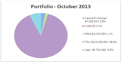
At October month end the market valuation for the portfolio was $140.6mm.
The pricing for the Floating Rate Note was relatively flat as they dropped marginally whilst the Capital Protected Notes were improved. The portfolio continues to retain a very high level of overall liquidity. The cash component totals $9.8mm (down from $17.3mm last month) and both the FRNs and Capital Protected investments can be liquidated – the TD portfolio has a spread of maturities providing the portfolio additional liquidity if required.
Market News - Interest Rates
The RBA left the cash rate to 2.50% following on from no change in September – early November has also seen the rate unchanged.
Bank bill yields were again largely unchanged on a month-on-month basis remaining around 2.60% - the selloff in market expectations for rates as expressed by the futures curve continued steadily across the month.
On the inflation front and as per expectations from last month’s report which viewed the sustained high prices at the petrol pump as likely to flow through to the headline CPI the data did indeed indicate a slightly inflationary environment.
The average yield for the 12 bank bill futures contracts (a 3yr period) is currently at 3.37% a large rise again from September’s end of month level of 3.23% and a full half a per cent higher than July. It is higher than the level of last year at 3.036% but below the 4.17% back in 2011.
Forward expectations for short term rates in Australia were up from the previous month with slightly higher expectations in years 2 and 3. The graph below shows the market view that rates rise slowly in early 2014 before rising more aggressively than previously priced in.
The Australian Dollar
The Australian dollar was again stronger both against the USD and on
the trade weighted index basis adding to the recent upward move in September. The Australian dollar rose by in excess of 1% during October on a trade weighted basis.
The US currency was weaker on the non-taper delay whilst the Aussie again benefitted from improved investor sentiment and risk taking appetite.
Our currency hit a multi month high of USD97.6c mid-month but fell back slightly to settle in the mid 90c range. The strength of our currency is also driven by our relative yield advantage over the US as well as the good data from China which provides support to our outlook.
Options
This is an information report.
Community Engagement & Internal Consultation
Council uses the services of Denison Financial Advisory in relation to the investment portfolio, including advice on the placement of investments, assistance with policy development and general advice.
Planning & Policy Implications
Not applicable.
Financial & Economic Implications
Council’s total investment portfolio performance for October 2013 was 2.38% above the benchmark (4.98% against 2.60%) and year-to-date investment income has reached 53.18% of the total annual budget. Details of investment income performance (Year to Date):
The graph shows YTD investment income has reached $2,212,315 of the total budget of $4,160,000 (53.18%)
|
Attachments
Nil |
AGENDA Ordinary Council
20/11/2013
|
Item: 08.10
Subject: Phasing of Operational Budgets Presented by: Commercial Services & Industry Engagement, Craig Swift-McNair
Alignment with Delivery Program
1.5.2 Provide and maintain efficient and effective information management systems that are accessible, user friendly and meet community and organisational requirements. |
|
That Council: 1. Request that the General Manager implement phased monthly operational budgets from the 2014-2015 financial year. 2. Request that the General Manager implement phased monthly budgets for capital works budgets from the 2015-2016 financial year.
|
Executive Summary
The purpose of this report is to detail information relating to the implementation of phased monthly operational budgets as per the third Council resolution as detailed below.
Discussion
At an Ordinary Meeting of Council held on 16 October 2013, Council resolved the following:
RESOLVED: Hawkins/Roberts
That Council:
1. Note the Quarterly Budget Review Statement for the September Quarter.
2. Adopt the adjustments in the “Financial Implications” section of the report for September 2013.
3. Request the General Manager to report back to the November 2013 Council Meeting how best Council can implement and report phased monthly budgets for all areas of Council to be implemented in the 2014/15 financial year.
4. Request the General Manager to prepare a report for the November 2013 Council Meeting as to the advantages and/or disadvantages of establishing an appropriate accounting methodology which effectively places all “significant” budgetary gains into a special purpose “transition or holding account” before putting forward recommendations to Council as to how budget gains should be best utilised and how this would impact practically on Council’s operations as a service provider.
CARRIED: 9/0
FOR: Besseling, Cusato, Griffiths, Hawkins, Intemann, Levido, Roberts, Sargeant and Turner
AGAINST: Nil
Currently all Group Managers prepare annual budgets for both the operational and capital works programs which are then collated and assessed by relevant Finance staff, for presenting to Councillors and ultimately the community.
This is a multi phase process involving considerable discussion between Finance, Group Managers and the Executive team to ensure that all budgets are realistic and achievable and are within available funding sources.
As stated above, budgets are currently prepared on an annual basis, but are monitored monthly by Management and relevant Finance staff via a straight split of costs and income across the 12 month period. All Group Managers have visibility of the monthly accounts,
The 2014/15 budget process has already commenced with the first drafts of each area’s budget now under review. Whilst it is possible to move to phased monthly budgets for the upcoming 2014/15 year, considerable work will be required to unwind the work already undertaken by Group Managers in order to make modifications to allow for monthly budgeting.
This work will involve:
1. Exporting all first draft 2014/15 budgets out of the financial system into Excel and then;
2. Calculating all 2014/15 budgets to a monthly format using the 2013/14 actuals as the basis for the monthly allocations. A percentage of the total will be calculated and applied to the total 2014/15 budget, based on the previous year’s actual expenditure. This will involve a total of approximately 10,000 separate job numbers.
Using the 2013/14 actuals as the basis for monthly allocations can only be applied to Operational budgets and not the Capital Works budget. As the Capital Works budget is project specific, no historical data can be used to assist with the monthly allocations. A monthly Capital Works budget process will need to be further developed for implementation in the 2015/16 financial year, as this will not be achievable for the 2014/2015 financial year.
Options
Council can resolve to adopt the recommendation as included in this report or not adopt same.
Community Engagement & Internal Consultation
Internal consultation has taken place with the following people:
- General Manager;
- Directors;
- Group Manager Financial Services;
- Manager Corporate & Financial Planning.
Planning & Policy Implications
There are no direct planning & policy implications as a result of this report.
Financial & Economic Implications
The introduction of phased budgeting will provide Management with more accurate and robust reporting against operational budgets and will allow Council to move towards a regime of managing budgets by exception i.e. there will be a greater focus on activities that have occurred or are occurring unexpectedly, or not as expected. This should also result in the Quarterly Budget Review Statement (QBRS) reporting being of more value to the Councillors and the community.
The financial implications for the implementation of the phasing of operational and capital budgets relate to the internal resources to be able to prepare the relevant data and to liaise with management across the organisation to ensure phased budgets that are meaningful into the future. The phasing of budgets requires a re-work of our internal financial systems and processes; however at the time of writing this report, the full resource impact of this re-work is not known. It is anticipated that further analysis of the resource impact will take place in the coming months, with a further report to be tabled at a future meeting of Council if additional resources are required to ensure the phasing of budgets can take place in line with the recommendations included in this report.
|
Attachments
Nil |
AGENDA Ordinary Council
20/11/2013
|
Item: 08.11
Subject: Development Activity & Assessment System Performance Presented by: Development & Environment, Matt Rogers
Alignment with Delivery Program
1.5.3 Ensure ratepayer value for money through continuous improvement in quality, effectiveness and efficiency of delivery of Council services. |
|
That Council note the Development Activity & Assessment System Performance Report for the first quarter of 2013-2014.
|
Executive Summary
This report provides a summary of development assessment and building certification activities for the July to September quarter. Data on the number of applications and processing times, together with relevant commentary on development trends is provided for the information on Council.
Discussion
The table overleaf provides data on the volume of applications received and determined over the quarter relative to the monthly average of the preceding 2 years.
The most notable trend from the data is the increase in development applications (DAs) received and determined. During the quarter the monthly average for DAs determined was 73 compared to the 2011/12 and 2012/13 monthly average of 52/53. The increase in Complying Development Certificates and Construction Certificates received by Council also highlights an increase in building activity and suggests confidence in the sector is improving.
The bulk of applications determined for the quarter relate to alterations and additions to dwellings, new single dwellings and dual occupancies. Other applications of interest include:
- DA2013/148 - UNSW educational facility, Highfields Circuit (determined by Joint Regional Planning Panel).
- DA2013/18 - 14 lot large lot residential subdivision, Logans Crossing Road.
- DA2013/218 - 13 lot subdivision, Lakeside Way.
- DA2013/181 - Primitive Campground, Wauchope Showground.
- DA2013/449 - 12 Aged Care Units, River Park Road
- DA2006/351 (modification) - 5 year extension to Festival of the Sun.
|
Application Type |
2011-12 Monthly average |
2012-13 Monthly average |
Jul 2013 |
Aug 2013 |
Sept 2013 |
2013-14 Average to date |
|
DAs received |
|
52 |
73 |
68 |
77 |
73 |
|
DAs determined |
53 |
53 |
71 |
74 |
59 |
68 |
|
DA Modifications Received |
|
11 |
12 |
15 |
6 |
11 |
|
DA Modifications determined |
11 |
11 |
15 |
12 |
14 |
14 |
|
Complying Development Certificates received by Council |
|
10 |
18 |
13 |
18 |
16 |
|
Complying Development Certificates Determined (inc private certifiers) |
25 |
20 |
31 |
25 |
24 |
26 |
|
Construction Certificates received by Council |
|
35 |
46 |
28 |
50 |
41 |
|
Construction Certificates (building) determined (inc private certifiers) |
49 |
45 |
54 |
50 |
42 |
48 |
|
S.68 Water and Sewer work applications determined |
|
42 |
62 |
48 |
52 |
54 |
The following table outlines the estimated value of works per development type approved for the quarter.
|
Development Category |
Jul 2013 |
Aug 2013 |
Sept 2013 |
|
Ancillary Development |
$1,411,235 |
$507,065 |
$1,869,459 |
|
Residential |
$6,977,939 |
$6,240,360 |
$7,933,533 |
|
Commercial |
$2,724,060 |
$486,500 |
$753,760 |
|
Industrial |
$58,000 |
$754,492 |
$36,000 |
|
Rural |
$108,000 |
$623,000 |
$755,995 |
|
Community |
$0 |
$13,100,000 |
$282,600 |
Residential development continues to consistently be the dominant sector of the development industry. The large value associated with the ‘community’ category above is the $13 million educational facility approved on Highfields Circuit.
The following graph provides an indication of trends in total annual application volumes over the past 3 years. The graph reflects the downward trend in development activity since the GFC. Despite this trend over recent years, increasing development application lodgements discussed above are an encouraging indicator of confidence in the development sector.
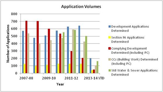
The following table provides data and trends on monthly application processing times.
|
PMHC Application Processing Performance |
|||||||
|
Measure Description |
2011-12 NSW Ave |
2011-12 Ave |
2012-13 Ave |
Jul 2013 Ave |
Aug 2013 Ave |
Sept 2013 Ave |
2013-14 Ave |
|
DA Processing - Net Median Days |
31 |
34 |
32 |
30 |
28 |
28 |
29 |
|
DA Processing - Net Average Days |
46 |
34 |
35 |
35 |
29 |
30 |
31 |
|
DA Processing - Gross Average Days |
71 |
62 |
67 |
86 |
40 |
51 |
59 |
|
Complying Development Processing - Net Average Days |
18 |
6 |
5 |
8 |
6 |
5 |
6 |
|
Construction Certificate Processing - Net Average Days |
- |
16 |
13 |
6 |
9 |
17 |
11 |
Despite the increase in applications received, processing times for the quarter have remained roughly the same as the preceding years and below NSW State average for 2011/12 (12/13 data not yet released by Department of Planning and Infrastructure).
It is noted for the month of July that the gross average DA processing time was 86 days, significantly higher than the Sate average of 71 days. This is a result of a long standing development application (approximately 5 years) that relied on a Local Environmental Plan amendment and a Voluntary Planning Agreement. The particular circumstances prevented a more timely determination. The net median and net average times for July and the gross average times for August and September highlight that this is not reflective of ‘normal’ processing times.
The following graph shows application process time trends over the past several years and indicates improving processing times or steady performance across all application types.
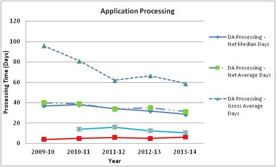
The upward trend in development assessment activity is positive and is being closely monitored by management to ensure sufficient resources are available to respond to the increase in work. While application processing times have not yet increased in the face of recent increases in applications, it is expected that there will be negative implications for processing times should resource levels not be adjusted. Planning staff are currently processing in excess of 20 applications each and this is not a sustainable work load in the long-term.
In this regard, a new development assessment planner has recently been recruited to ensure that sufficient resources are available to maintain acceptable development application processing times.
Options
This is an information report.
Community Engagement & Internal Consultation
Development assessment statistics are discussed internally as the key indicator of system performance. The statistics are provided to and discussed at quarterly Hastings Construction Industry Liaison meetings.
Planning & Policy Implications
Nil
Financial & Economic Implications
This report does not have direct financial or economic implications. However monitoring the performance of the development assessment system is an important undertaking given the role of development regulation in the broader economy and the need to minimise costs to businesses and the community in managing development
|
Attachments
Nil |
AGENDA Ordinary Council
20/11/2013
|
Item: 08.12
Subject: 2012 - 2013 Annual Report Presented by: Community & Organisational Development, Lesley Atkinson
Alignment with Delivery Program
1.4.1 Engage with the community on impacts and changes of operations. |
|
That Council: 1. Adopt the 2012 - 2013 Annual Report, comprising Parts 1, 2 and 3. 2. Submit the adopted 2012 - 2013 Annual Report to the Minister for Local Government by the 30 November 2013. 3. Publish the adopted 2012 - 2013 Annual Report on Council's website and make copies of the report available at all Council Offices and Libraries. 4. Note the Community Report Card 2012 - 2013.
|
Executive Summary
Under Section 428 of the Local Government Act (1993) Council is required to submit its Annual Report to the Division of Local Government no later than the 30 November each year. There are a range of statutory requirements which must be included in this report. Once adopted this report must be published on Council’s website and available at Council’s offices. The purpose of this report is to formally present to Council the 2012 - 2013 Annual Report.
Council has developed a brief overview of the achievements for 2012 - 2013 in a community friendly format and will also publish this for the community.
Discussion
In accordance with Section 428 of the Local Government Act (1993) and Local Government (General) Regulation (2005), Council must, within 5 months after the end of each year, prepare an Annual Report which must include its audited financial statements, a range of statutory requirements and outline achievements in implementing the Delivery Program. This includes the achievements in relation to the Operational Plan.
This report is separated into three parts.
Part 1 includes details to meet a range of statutory requirements including:
· Amount of rates and charges written off during the year.
· Details of overseas visits by Councillors, Council staff or other persons representing Council (including visits sponsored by other organisations).
· Total cost during the year of the payment of expenses of, and the provision of facilities to, Councillors in relation to their civic functions.
· Details of contracts awarded for amounts greater than $150,000.
· Summary of the amounts incurred by the Council in relation to legal proceedings.
· Summary of resolutions made under Section 67 of the Local Government Act concerning work carried out on private land.
· Total amount contributed or otherwise granted under Section 356 (financially assist others).
· Statement of all external bodies that exercised functions delegated by Council.
· Statement of all corporations, partnerships, trusts, joint ventures, syndicates or other bodies in which Council held a controlling interest.
· Statement of all corporations, partnerships, trusts, joint ventures, syndicates or other bodies in which the Council participated.
· Statement of activities to implement its Equal Employment Opportunity management plan.
· Statement of the total remuneration comprised in the remuneration package of the General Manager.
· Statement of the total remuneration comprised in remuneration packages of all senior staff members, expressed as the total (not of the individual members).
· A statement detailing the stormwater management services provided (if levied).
· A statement detailing the coastal protection services provided (if levied).
· Particulars of any environmental upgrade agreement entered into, in accordance with any requirements imposed under Section 54P.
· Report on special variation expenditure if required to do so by the instrument made by the Minister.
· Report on capital works projects.
· Statement on activities relating to enforcing and ensuring compliance with the Companion Animals Act and Regulation
· Information included on Government Information Public Access (GIPA) activity.
· Particulars of compliance with and effect of planning agreements in force during the year under the Environmental Planning and Assessment Act.
· Information included on Public Interest Disclosures.
· Statement relating to Compliance with the Carers (Recognition) Act.
Part 2 of the Annual Report includes Council’s achievements in implementing the Delivery Program objectives through a description of the achievements against the Operational Plan activities framed by the “Towards 2030 Community Strategic Plan” which include, the guiding principle of ensuring good governance and four focus areas, looking after our people, helping our community prosper, looking after our environment and planning and providing our infrastructure.
Part 3 of the Annual Report includes a copy of Council’s audited financial statements.
The development of the Annual Report 2012 - 2013 completes the suite of reporting documents Council is required to deliver under the Integrated Planning and Reporting provisions of the Local Government Act (1993).
Council has also prepared a Community Report Card which is an easy to read snapshot of key achievements delivered during 2012 - 2013. While this is not a legislative requirement it meets the need to provide a plain English summary to our community.
For information the 2011 - 2012 report card achieved a highly commended at the Local Government NSW Communications Awards to acknowledge the documents role in helping the community understand what Council has delivered.
The Community Report Card 2012 - 2013 will be distributed electronically to the Community Reference Group (CRG) and will also be used in future engagement activities. Hard copies will be made available in Council offices and Libraries in Port Macquarie, Wauchope and Laurieton. It will also be loaded onto Council’s website.
Options
Council could seek additional information on the Annual Report.
Community Engagement & Internal Consultation
· General Manager
· Directors
· Group Managers and relevant staff
Planning & Policy Implications
The submission of the Annual Report meets Council’s legislative requirements under the Local Government Act (1993) and Local Government (General) Regulation (2005) .
Financial & Economic Implications
Nil.
|
Attachments
1. Annual Report 2012 - 2013 PART 1 - Statutory Information 2. Annual Report 2012 - 2013 PART 2 - End of year report - Delivery Program Operational Plan 3. Annual Report 2012 - 2013 PART 3 Financial Statements 4. Community Report Card 2012 - 2013 |
AGENDA Ordinary Council
20/11/2013
|
Item: 08.13
Subject: Heritage & Cultural Sub-Committee Presented by: Community & Organisational Development, Lesley Atkinson
Alignment with Delivery Program
2.5.2 Facilitate, support and/or advocate for cultural and heritage education within the community. |
|
That Council: 1. Approve the development of a new overarching Heritage and Cultural Sub-Committee which amalgamates the existing Arts and Cultural Development Committee and the Museums and Heritage Sub-Committee. 2. Call for Expressions of Interest for members from the community. 3. Advise all existing members of the Arts & Cultural Development Committee and Museums & Heritage Sub-Committee of the development of an overarching Sub-Committee.
|
Executive Summary
Since February 2013, a number of meetings have occurred separately with the Arts & Cultural Development Committee (ACDC) and Heritage & Museums Sub-Committee as well as some combined meetings of these 2 committees. The purpose of these meetings has been to consider the development of a new overarching Sub-Committee of Council, which will provide advice to Council on a range of matters associated with culture and heritage in the LGA.
Discussion
The strong Hastings arts and cultural sector was recognised through the greater Port Macquarie region being named New South Wales Fourth City of the Arts in 2001 to 2003. This came with a grant of $150,000 per annum ( for two years) , and a $50,000 contribution from Council. These funds were expended on a variety of projects, many of which are still in place today (predominantly the public art throughout the LGA). Council created a City of the Arts Taskforce and appointed a Project Officer who reported to Council’s Cultural Planner. The Arts and Cultural Development Committee was developed out of the Taskforce and had a key role in the lobbying of Council for the Glasshouse (along with the Gallery Advisory Committee), and the planning of a wide range of projects, three of which still continue - namely AquaSculpture, FreshArt and PlayRites. This Committee worked closely with the Cultural Planner, and since the Cultural Planner was made redundant in 2009, the Committee has been very restricted in its activities due to the lack of a designated Council officer to support the group through the implementation of their ideas and plans.
The Museums and Heritage Committee was originally two separate committees which were combined in 2008. With the Heritage Officer also being made redundant in 2009, this combined Committee found it difficult to action items/plans when there was no dedicated officer in Council support or facilitate the ideas or initiatives. This group has continued to meet regularly, primarily focussed on information sharing, the annual Heritage Festival, and discussions with Council’s contracted Heritage Officer.
Proposal
The following proposal is put forward for consideration:
That the two Committees be amalgamated to form a new Sub-Committee of Council.
This will result in a streamlined approach to heritage and cultural policy for Council and potentially a broader number of community driven groups, organisations and projects being supported by Council than ever before. It is anticipated that the new Sub-Committee will provide advice, ideas and recommendations to Council regarding policy matters that relate to the combined heritage and cultural sectors in the Hastings.
The main Council staffing resource of this Sub Committee will be the Community Development Officer - Heritage & Culture, who will be focussed on supporting the resolutions of Council and the new Sub-Committee, as well as driving some Council initiated projects from time to time in this sector as required.
As a consequence of this change, it is expected that there will be a refreshing of the level of involvement and ideas from the community coming forward to Council, as well as a greater focus on assisting the community cultural and heritage groups to be more self supporting and sustaining.
Membership of the Committee
Council will develop a Charter for the Sub-Committee and call for Expressions of Interest from the community, seeking representatives from the community as well as a wide range of organisations and community groups in the LGA to become members of the Sub-Committee. Half the positions will be spilt every two years to enable new members to join and also to ensure continuity of knowledge can be maintained. A Councillor appointed by way of Council resolution would be the Chairperson of this Sub-Committee with a second Councillor also appointed the same way as an Alternate Chairperson.
Interested applicants will be asked to submit an application, outlining their interest and experience in the Heritage, Cultural and or Arts sector in the LGA, their ability to commit to regular meetings and possible working groups, the reasons for their seeking involvement on the Sub-Committee, what they can contribute, and their level of commitment to representing the whole sector, not just their own area of expertise. The membership would be no greater than 10 community members, with the goal being to have as many art and cultural forms represented as possible within this group. Should the new Sub-Committee be established, Councillors would be appointed to the new Sub-Committee and Councillor representation on the current committees would cease by default when the existing Committees of Council are ceased.
Once Expressions of Interest have been received, a report would be put to Council with recommendations for Sub Committee membership. This process could be carried out during December/January, with the new Sub-Committee to commence meeting in February/March 2014.
Role of Sub-Committee
The Sub-Committee would report to Council, with relevant advice and recommendations pertaining to the heritage, culture, arts and local creative industries.
In the first Term of the Sub-Committee (2 years) the focus will be on working with Council staff to review all current Heritage planning documents, the development of a Cultural Plan for the PMHC LGA , review of the Public Arts Policy/Procedure and have input into Operational Plan development.
It is also proposed that there be discussion with the broader community regarding the possibility of skills development workshops to be provided, with the intended outcome of increasing the sustainability of the heritage and cultural sector.
Sub-Committee Charter
Key components would include:
1. Assist in the assessment of possible heritage and cultural based projects, using a set criteria.
2. Provide input into current heritage and cultural strategic planning and resourcing.
3. Advise Council on the development of comprehensive cultural strategies.
4. Represent community interest and organisations in the formulation of Council Policies relating to arts, culture and heritage.
5. Advise on strategies for fostering community engagement with an active participation in heritage, arts and cultural programs/ projects/ policy.
6. As individual members of the Sub-Committee, facilitate information flow between Port Macquarie-Hastings Council, heritage and cultural organisations and the wider community.
7. As community members, facilitate partnerships and/or links to establish Port Macquarie-Hastings as a major heritage and cultural destination.
8. Promote and support local creative industries and initiatives.
Options
Council could make no change to the two existing Committees - Arts and Cultural Development, and the Heritage and Museums Sub-Committee.
Community Engagement & Internal Consultation
The concept of a combined Sub Committee has been discussed with both the Museums and Heritage Sub Committee and the Arts and Cultural Development Committees, Councillors and internal staff including General Manager, Executive, Group Manager Governance, Group Manager Community Development.
Planning & Policy Implications
The establishment of the Heritage & Cultural Sub-Committee will assist with future planning and policy matters.
Financial & Economic Implications
Nil.
|
Attachments
Nil |
AGENDA Ordinary Council
20/11/2013
|
Item: 08.14
Subject: Transfer Balance of Funds - Port Macquarie-Handa Sister City Sub-Committee Presented by: Community & Organisational Development, Lesley Atkinson
Alignment with Delivery Program
1.4.3 Build trust and improve Council’s public reputation through transparency and accountability. |
|
That Council approve an amount of $5,300 from the Port Macquarie-Handa Sister City Sub-Committee 2013/2014 Budget be transferred into a Port Macquarie-Handa Sister City Reserve.
|
Executive Summary
The Port Macquarie-Handa Sister City Agreement was signed by the then Mayor of Port Macquarie-Hastings Council, Aldermen Robert Woodlands, and Mayor of Handa City - Mr Koichi Yamada on April 14 1990 at a ceremony in the Auditorium of the Central Public Hall in Handa Japan. 2015 marks the 25th Anniversary of this Agreement.
Discussion
Council has received advice that a delegation from Handa City Council will travel to Port Macquarie to celebrate the 25th Anniversary of the two Council’s Sister City officially formed in April 2015. This proposed visit will be in addition to the annual Study Tour Group from Handa Higashi Senior High School which will take place during July/August 2015. The proposed visit by the delegation from Handa City Council will provide an opportunity for Port Macquarie-Hastings Council to enhance and demonstrate its strong commitment to our Sister City Agreement with Handa. The restricted funds from the 2013/2014 allocation would meet the expenses Council could incur during this visit, and therefore reduce the need to identify funding closer to the date.
The amount to be transferred is $5,300.00.
Options
Transfer the remaining funds from the 2013/2014 budget allocation to the 2014/2015 budget as a restricted asset. Not undertake the transfer and identify and allocate funding in the immediate lead up to April 2015.
Community Engagement & Internal Consultation
Port Macquarie-Handa Sister City Sub-Committee.
Planning & Policy Implications
Nil
Financial & Economic Implications
Nil
|
Attachments
Nil |
AGENDA Ordinary Council
20/11/2013
|
Item: 08.15
Subject: Section 355 Community Halls Management Committees Membership 2013 Presented by: Community & Organisational Development, Lesley Atkinson
Alignment with Delivery Program
2.6.2 Create access to community facilities that allow a range of social, health and wellbeing activities. |
|
1. That Council endorse the membership of Bonny Hills Community Hall Management Committee as elected at their 2013 Annual Review Meeting, comprising: · Ms Francis Hoad - President · Ms Ann Drury - Treasurer/Booking Officer · Ms Lorraine Winner - Minutes Secretary · Ms Carmel Power - Correspondence Secretary · Mr Bill Howell - Maintenance Officer · Mr Roger Barlow - Committee Member · Ms Pam Barlow - Committee Member
2. That Council endorse the membership of CC “Mac” Adams Music Centre Management Committee as elected at their 2013 Annual Review Meeting, comprising: · Ms Leanne Howlett - President · Ms Jan Hunter - Vice President · Mr Glen Stanley - Treasurer · Mr Greg Cook - Secretary/Booking Officer · Mr Brian Corrigan - Committee Member · Ms Betty Hobby - Committee Member · Mr Dale Bleasdale - Committee Member · Mr Maurie Griffin - Committee Member
3. That Council endorse the membership of Lorne Recreation Centre Management Committee as elected at their 2013 Annual Review Meeting, comprising: · Mr Brian Alley - President · Ms Janet Lewin - Vice President · Ms Nicola Nosworthy - Secretary · Ms Stephanie Williams - Treasurer · Ms Jenny Higgins - Committee Member · Mr Phil Higgins - Committee Member · Mrs Helen Anderson - Committee Member · Mr Alan Anderson - Committee Member · Ms Gerda Butlin - Committee Member
4. That Council endorse the membership of Pappinbarra Recreation Reserve Management Committee as elected at their 2013 Annual Review Meeting, comprising: · Ms Sue Frost - President · Ms Kelly Benson - Secretary · Ms Emma Frost - Treasurer · Ms Brenda Patrick - Committee Member · Mr Steve Ostler - Committee Member · Mr Rob Frost - Committee Member
5. That Council endorse the membership of Pembrooke Community Hall Management Committee as elected at their 2013 Annual Review Meeting, comprising: · Mr Kirk Byrnes - President · Ms Jeanette Rainbow - Secretary · Ms Margaret Davies - Treasurer · Mr Des Freeman - Committee Member · Mrs Shirley Freeman - Committee Member · Ms Clair Cutler - Committee Member · Ms Jean Moore - Committee Member
6. That Council endorse the membership of Port Macquarie Historic Court House Management Committee as elected at their 2013 Annual Review Meeting, comprising: · Mr Roger Heath - President · Mr Barry Dowse - Vice President · Ms Lyn Stevenson - Secretary · Mrs Veronica Heath - Treasurer · Mrs Brenda Pebedy - Maintenance Officer · Mrs Audrey Dowse - Booking Officer · Mr Ramsey Collins - Committee Member · Mr John Scholz - Committee Member · Ms Carole Neil - Committee Member · Mr David Baird - Committee Member · Mr Ross Pebedy - Committee Member · Mr Glen Dick - Committee Member · Mr David Martin - Committee Member
7. That Council endorse the membership of Port Macquarie Seniors Centre Management Committee as elected at their 2013 Annual Review Meeting, comprising: · Mr Allen Ross - President/Booking Officer · Mrs Lyn Manley - Treasurer · Ms Trish Davis - Secretary · Mrs Di Last - Committee Member · Mr Don Newson - Committee Member · Mr Norm Bodenham - Committee Member · Ms Kathy O’Neale - Committee Member
8. That Council endorse the membership of Wauchope Community (Arts) Hall Management Committee as elected at their 2013 Annual Review Meeting, comprising: · Ms Krissa Wilkinson - President · Ms Julie Muller - Vice President/Maintenance Officer · Ms Deborah Murrell - Treasurer · Ms Lyndall Goetz - Secretary · Ms Lis Tuck - Hall Coordinator · Mr Peter Bower - Assistant Hall Coordinator · Ms Susan Ashton - Committee Member · Ms Mei Ling Yuen - Committee Member · Ms Amy Hubers - Committee Member
9. That Council endorse the membership of Wauchope Rotary Youth Hall Management Committee as elected at their 2013 Annual Review Meeting, comprising: · Mr Paul Froome - President · Mr Kevin Whitbread - Secretary · Mrs Marie Winter - Treasurer/Booking Officer · Ms Helen Clunus - Committee Member · Ms Annie Peel - Committee Member · Mr Stuart Weir - Committee Member · Ms Narelle Stokes - Committee Member · Mr Andy Neal - Committee Member
10. That Council thank in writing, the outgoing committee members.
|
Executive Summary
The following nine section 355 volunteer management committees of community halls have reported their current committee members and office bearers for the 2013-2014 financial year, following their annual review meetings between 1 July and 2 September 2013;
Bonny Hills Community Hall, CC “Mac” Adams Music Centre, Lorne Recreation Centre, Pappinbarra Recreation Reserve, Pembrooke Community Hall, Port Macquarie Historic Court House, Port Macquarie Seniors Centre, Wauchope Community Hall (Arts) Hall, Wauchope Rotary Youth Hall.
Outgoing committee members are;
Ms Sheryl Brough (Bonny Hills Community Hall), Mr Brian Tisdell, Mr John Carter, Ms Glennice Hollis, Mr Max Davis, Mrs Dianne Davis, Mrs Sue Carter (Lorne Recreation Centre), Mr Victor Love, Mr Alan Thomson, Mr Jeff Prigg (Port Macquarie Seniors Centre), Ms Judy Smith (Wauchope Community (Arts) Hall), Ms Patti Berrigan, Mr Neville Parsons and Ms Kirrili Stafford (Wauchope Rotary Youth Hall).
Incoming committee members are;
Ms Janet Lewin, Ms Nicola Nosworthy, Ms Stephanie Williams, Mrs Helen Anderson, Mr Alan Anderson, Ms Gerda Butlin (Lorne Recreation Centre), Mr Paul Froome, Ms Annie Peel and Mr Andy Neale (Wauchope Rotary Youth Hall).
Discussion
Section 355 Volunteer Management Committees of Community Halls
Nine of Council’s 17 community halls are managed by section 355 volunteer management committees. These volunteers greatly assist Council in managing these important community facilities.
The committee ideally consists of six to ten members. Each committee holds regular meetings to manage the operation of the facility. These meetings may be monthly, bi-monthly or quarterly, as deemed appropriate, according to the frequency of bookings of the facility. A quorum of four members is required to open a meeting.
Council’s Building Services manage all maintenance and any capital works to these facilities. This ensures all work complies with Council’s procurement policy, Buildings Assets Management Plan and all relevant policy and legislation.
Each year, usually between 1 July and 31 August, each committee holds an Annual Review Meeting (ARM).
This meeting is conducted in accordance with Council’s Community Facilities Operations Manual, adopted by Council on the 18 April 2012.
The following is a brief description of this process.
Reports from the President, the Treasurer and the Booking officer will be tabled at the ARM. During this meeting the operation of the facility over the previous 12 months is discussed and suggestions may be made to improve the operation for the following period.
At the conclusion of the meeting, the President declares all committee positions open and oversees the election of a new committee.
The Annual Review Meeting is open to the public and is advertised in the local newspapers 21 days prior to this meeting. All residents of the Port-Macquarie-Hastings local government area are eligible to nominate for committee membership. Membership is also sought from regular users of the facility.
When the committee members are decided, the new committee nominate and vote for the positions of office bearers. These are typically;
· President
· Vice President
· Secretary
· Treasurer
· Booking Officer
· Maintenance Officer
Other office bearers may be appointed as agreed by the committee, such as promotions officer, assistant secretary (or assistant to other roles) as deemed necessary by the committee.
Committee members who are not office bearers assist the office bearers as required.
The current members and office bearers of the nine section 355 volunteer management committees, as elected at their ARMs of 2013 are as listed in the recommendations.
Options
Council could seek additional information on this report.
Community Engagement & Internal Consultation
Consultation has occurred with the nine section 355 volunteer management committees of community halls.
Planning & Policy Implications
Nil change required to the 2011-2015 Delivery Program or the 2013/2014 Operational Plan.
Financial & Economic Implications
Nil
|
Attachments
1. S355 Management Committees of Community Halls Membership 2013/2014 2. Community Facilities Operations Manual Adopted by Council 18 April 2012 |
 AGENDA Ordinary Council
 20/11/2013
What are
we trying to achieve? Our social infrastructure and
community programs create a healthy, inclusive and vibrant community.
· Community hubs which provide access to services and social connections.
· Services that support an ageing community to live in a way that they desire.
· Available and accessible preventative health and medical services.
· A safe, caring and connected community.
· A healthy and active community that is supported by recreational infrastructure
· A strong community that is able to identify and address social issues.
· Community participation in events, programs, festivals and activities.
How do we get there?
2.1 Create an environment and culture that allows the Port Macquarie-Hastings community to feel safe.
2.2 Provide young people with a range of leisure activities and opportunities for personal development.
2.3 Provide medical and social services for all members of the community.
2.4 Develop partnerships within the community to build on existing strengths and improve areas of social disadvantage.
2.5 Create events and activities that promote interaction and education.
2.6 Provide social and community infrastructure and services.
2.7 Empower the community to be active and involved in community life.
2.8 Promote cultural and artistic expression.
2.9 Promote a healthy lifestyle through education, support networks and facilities.
AGENDA Ordinary Council
20/11/2013
|
Item: 09.01
Subject: Annual Reporting of Contracts for Senior Staff Presented by: General Manager, Anthony Hayward
Alignment with Delivery Program
1.4.1 Comply with Local Government legislation, policies and agreed standards and communicate the impacts of this to the community. |
|
That Council note the contractual conditions for the following Senior roles in the Organisation: · General Manager · Director Infrastructure and Asset Management · Director Community and Organisational Development · Director Commercial Services and Industry Engagement · Director Development and Environmental |
Executive Summary
The Local Government Act requires the General Manager to report to Council on the contractual conditions of senior staff on an annual basis.
Details are provided in the confidential attachment titled “2013 Senior Staff Contractual Arrangements” which contains information that relates to personnel matters concerning particular individuals (other than Councillors). Local Government Act 1993 – Section 10A(2)(a).
Discussion
Under the NSW Local Government Act 1993, in particular s338, there is a requirement that annually a report is submitted to Council outlining the contractual conditions of senior staff. The Local Government Act outlines under s338 the following:
338 Nature of contracts for senior staff
(1) The general manager and other senior staff of a council are to be employed under contracts that are performance-based.
(2) The term of a contract must not be less than 12 months or more than 5 years (including any option for renewal). A term that is less than 12 months is taken to be for 12 months and a term for more than 5 years is taken to be limited to 5 years.
(3) Contracts may be renewed from time to time.
(4) The Director-General may, by order in writing, approve one or more standard forms of contract for the employment of the general manager or other senior staff of a council.
(5) A standard form of contract approved by the Director-General is not to include provisions relating to the level of remuneration or salary (including employment benefits) of the general manager or other senior staff of a council, performance-based requirements or the duration of the contract.
(6) A council is not to employ a person to a position to which one or more standard forms of contract approved for the time being under this section applies or apply except under such a standard form of contract.
(7) The council may include in an employment contract for the general manager or another member of the senior staff additional provisions to those contained in the standard form of contract but only if those provisions relate to any of the following:
(a) the level of remuneration or salary (including employment benefits) of the person employed under the contract,
(b) subject to subsections (1) and (2), performance-based requirements or the duration of the contract.
(8) Despite subsection (6), the approval, amendment or substitution of a standard form of contract under this section does not affect any employment contract between a council and the general manager of the council or another member of the senior staff of the council if the employment contract was entered into before the approval, amendment or substitution of the standard form of contract.
(9) However, subsection (6) does apply to the renewal of any such employment contract occurring after the standard form of contract is approved, amended or substituted and to all new contracts entered into after the standard form of contract is approved, amended or substituted.
The current requirements of the Director-General are that all officers identified as senior officers are required to be employed under a contract that applies to the Senior Executive Service (SES) of the NSW State Public Sector.
The following employees of council have been identified as Senior Staff:
· General Manager
· Director Infrastructure and Asset Management
· Director Community and Organisational Development
· Director Commercial Services and Industry Engagement
· Director Development and Environmental
Each of these employees are also employed under the standard contract approved by the Director-General. Under this arrangement there are requirements to develop a performance plan and at least annually undertake a performance review. Following successful completion of the performance review, an increase is applied to the salary component of the total remuneration package. The level of increase is set by the SES remuneration tribunal on an annual basis.
Options
Council needs to receive the report on an annual basis.
Consultation
Group Manager Employee Engagement.
Planning & Policy Implications
Nil as this is a legislative reporting requirement.
Financial & Economic Implications
In the annual budget, funds are allocated to not only remunerate the senior staff but all employees of the Council.
|
Attachments
1. 2013 Senior Staff Contractual Arrangements (Confidential) |
AGENDA Ordinary Council
20/11/2013
Item: 09.02
Subject: Notice of Motion - Ban Consumption of Alcohol - Town Beach Skate Park (PIN 263)
Councillor Turner has given notice of his intention to move the following motion:
|
That Council erect notices, pursuant to section 632 of the Local Government Act 1993, to ban the consumption of alcohol at the Town Beach Skate Park at any time.
|
Comments by Councillor (if provided)
Nil.
|
Attachments
Nil |
AGENDA Ordinary Council
20/11/2013
Item: 09.03
Subject: Notice of Motion - Illegal Camping
Councillor Turner has given notice of his intention to move the following motion:
|
That Council: 1. Prioritise compliance action during the 2013-2014 summer in relation to illegal camping and overnight stays in public car parks and reserves. 2. Request the General Manager provide a report to the December 2013 Council Meeting on the implications of erecting notices, pursuant to S.632 of the Local Government Act 1993, to prohibit camping and overnight stays in public car parks and reserves. 3. Make representations to the NSW Government on the inadequacy of the current regulatory framework in relation to this issue.
|
Comments by Councillor (if provided)
Nil
|
Attachments
Nil |
AGENDA Ordinary Council
20/11/2013
|
Item: 09.04
Subject: Bicentenary Planning Sub-Committee Membership Presented by: Community & Organisational Development, Lesley Atkinson
Alignment with Delivery Program
2.5.2 Facilitate, support and/or advocate for cultural and heritage education within the community. |
|
1. That Council endorse the establishment of a Bicentenary Planning Sub-Committee. 2. That 2 Councillors be nominated to become Chairperson and Alternate Chairperson of the Bicentenary Planning Sub-Committee. 3. That all of the Expressions of Interest in participating on the Bicentenary Planning Sub-Committee be accepted.
|
Executive Summary
In March 2013 Mr John Channon from Rotary District 9650 area met with the Mayor to discuss the possibility of establishing and planning for celebrations to mark the bicentenary of European settlement in Port Macquarie.
The matter was referred to the Heritage & Museums Sub-Committee and then to the 17 July 2013 Council meeting.
The matter is now being referred to Council to seek their approval to appoint the community members who submitted an Expression of Interest to participate on the Bicentenary Planning Committee.
Discussion
At the July 2013 Council meeting Council resolved to:
1. Support the creation of a planning committee for the lead-up to the Bicentenary of Port Macquarie by calling Expressions of Interest from community members who would like to be involved.
2. Commit an annual allocation to create a reserve for the Bicentenary celebrations.
3. Seek advice from the committee regarding a schedule of events that will form the basis of the celebrations leading up to the Bicentenary celebrations for Port Macquarie.
4. Determine which dates will be highlighted during the celebrations.
An Expression of Interest (EOI) was advertised on Council’s Website, in the 3 local newspapers, media releases, through the Heritage & Museums Sub-Committee and via Council’s extensive Google group database.
The following community members submitted an EOI to participate as a member on the Committee and a copy of all EOI’s received are attached to this report:
· Mr John Urquhart
· Mr Trevor Doyle
· Mr Keith Uptin
· Mr Brian Bucket
· Mrs Jeanette Rainbow (received after the EOI period closed)
Council now needs to determine whether they will accept all of the EOI’s received (including the one received from Mrs Rainbow after the close date of 13 September 2013), and indicate how they would like this Committee to proceed into the planning phase of the celebrations.
Once we have Council’s resolution of membership, the Director of Community & Organisational Development will arrange the initial meeting of the Committee.
It would be ideal, if Council could nominate one or two Councillors to participate on the Bicentenary Planning Committee to Chair and to steer the direction of the Committee.
Options
Council could accept all or some of the EOI nominees or seek further interest from the community.
Community Engagement & Internal Consultation
Internal consultation has taken place between the Mayor, General Manager, Director of Community & Organisational Development, members of the Heritage & Museums Sub-Committee and with the community via an EOI.
Planning & Policy Implications
Nil.
Financial & Economic Implications
Nil.
|
Attachments
Nil |
AGENDA Ordinary Council
20/11/2013
|
Item: 09.05
Subject: Recommendations from the Mayor's Sporting Fund Sub-Committee Meeting held on Thursday 16 October 2013 Presented by: Community & Organisational Development, Lesley Atkinson
Alignment with Delivery Program
2.9.1 Provide a range of sporting and recreational opportunities. |
|
That Council, pursuant to provisions of Section 356 of the Local Government Act 1993, grant financial assistance from the Mayor’s Sporting Fund to:
1. Mr Patrick Hamilton in the amount of $250.00 (ex GST) to assist with the expenses he would have incurred travelling to and competing at the 2013 National Youth Championships (soccer) held in Coffs Harbour from 30 September to 4 October 2013 inclusive.
|
Executive Summary
The Mayor’s Sporting Fund Sub-Committee at the meeting held on Thursday 24 October 2013, reached consensus on Item 6 (attached) and now submits the above recommendation for Council consideration.
|
Attachments
1. Item 06 Mayors Sporting Fund Sub-Committee Minutes 24102013 |
AGENDA Ordinary Council
 |
What are
we trying to achieve? The Port Macquarie-Hastings
region is able to thrive through access to a range of educational,
employment and business opportunities.
· Greater availability of educational opportunities.
· Key business sectors are able to benefit from our natural and existing attributes.
· Business and industry, training and education facilities sustain our population growth.
· Increased employment opportunities.
· An environmentally harmonious and prosperous tourism industry.
· Widely available communications technology.
How do we get there?
3.1 Create opportunities for lie long learning and skill enhancement with the availability of a broad range of education and training facilities.
3.2 Promote and support an increase in business capacity in order to generate ongoing economic growth.
3.3 Expand tourism business opportunities and benefits through collaborative planning and promotion.
3.4 Maximise innovation and economic competitiveness by providing high quality communication technology throughout the Port Macquarie-Hastings region.
3.5 Target and encourage business enterprise by providing favourable business conditions including infrastructure and transport options.
AGENDA Ordinary Council
 |
Item: 10.01
Subject: Notice of Motion - Tastings on Hastings 2013
Councillor Sargeant has given notice of his intention to move the following motion:
|
That Council: 1. Formally congratulate contractors, staff and volunteers on the success of the 2013 Tastings on Hastings. 2. Request the General Manager report to the February 2014 Council Meeting on the total cost of running the event and the source and application of those funds provided by Council.
|
Comments by Councillor (if provided)
Nil
|
Attachments
Nil |
AGENDA Ordinary Council
|
|
Item: 10.02
Subject: Question on Notice - Council Owned Land in William Street, Port Macquarie (PIN 34119) Presented by: Commercial Services & Industry Engagement, Craig Swift-McNair
Alignment with Delivery Program
3.2.5 Optimise the commercial focus on Council’s property portfolio to deliver improved returns to Council and the community. |
|
That Council: 1. Offer for sale through an Expression of Interest process Council’s land located at 99 William Street, Port Macquarie with a report being presented to Council of the outcome. 2. Remove the Special Condition requiring a purchaser of Council’s land located at 99 William Street, Port Macquarie to provide 180 on site public car parking spaces when the site is developed. 3. Reimburse Section 94 funds initially borrowed from the Section 94 fund when the site was purchased and place the remaining funds into Council’s Property Reserve until a viable alternative project is identified for investment, should Council resolve to sell the land located at 99 William Street.
|
Executive Summary
At the Ordinary Meeting of Council held on 18 September 2013, the following Question was asked from Councillor Roberts:
“Can the General Manager provide the history of and the potential future options for the William St Port Macquarie, 'hole in the ground', land holding including how and when Council will present this asset for any future Expression of Interest noting that current development restrictions on the site have made it an unviable proposition for potential buyers or joint ventures. What are, and how will the current restrictions on the site be relieved to present an attractive opportunity for development?”
Discussion
Background
Council purchased property situated at 99 William Street, Port Macquarie in December 2005 for an amount of $3.866 million (exc GST). Section 94 funds to the amount of $1.071 million were used to assist in funding this purchase.
The 2,400m² vacant site on the corner of Murray Street within the Port Macquarie CBD, includes substantial excavation and retention works as part of the initial construction of a new cinema complex. The confidential reports to Council recommending the acquisition of the site identified the property as a suitable option to provide future car parking within the Port Macquarie CBD. Please see the confidential attachment titled "Confidential - Confidential Reports to Council 2005." (Relates to information that would, if disclosed, confer a commercial advantage on a person with whom the Council is conducting (or proposes to conduct) business. Local Government Act 1993 - Section 10A(2(c)).
1. Sale attempts
Expressions of Interest No 1:
Expressions of Interest offering the site for sale (including a joint venture or lease) were called in March 2006 (outlined in the report to Council 05/12/2005). A condition of the sale included that any future development of the site was to incorporate provision for 180 public car spaces in addition to parking requirements with any new development.
Although several enquiries were made by prospective purchasers no applications were received.
Expression of Interest No 2:
To improve the prospect of selling the land Council called for a fee proposal from Architects to prepare a concept design of the site to maximise potential development and provide public car parking. In September 2006 Council engaged McNeill Architects for this purpose, with the result being that a design concept was prepared including underground car parking in William and Murray Streets with an underground entry from Murray Street, along with a proposed link to a Gordon Street/Lake Road roundabout. Entry was also provided from the Port Central car park.
Using this design concept a second Expression of Interest was called to purchase the site (including a joint venture or lease) in October 2006.
As with the first Expression of Interest enquiries were made, however no applications were received.
Enquiries since 2006
Despite several purchase enquiries having been received in recent years the public car parking condition of 180 on site spaces has resulted in discussions not proceeding, due to this requirement impacting on the financial viability of a development on this site.
Further Concept Plans
In an endeavour to explore alternate designs for this land including provision of public car parking spaces, McNeill Architects prepared a further 2 concept plans in late 2012, taking into account Council’s DCP 2011 that now places different limitations on the development of the site compared to the plans prepared in 2006.
These revised plans considered configurations of:-
· A building over the whole site plus 180 public car spaces and accessing the development from Port Central car park (minus parking under William/Murray Streets)
· A building over half of the site and using the balance of the site for 180 public car spaces with access from Port Central car park.
Cost estimates for all of these designs ranged from between approximately $20 million to in excess of $40 million and were considered to still render the development financially unviable.
Value of the land
A market valuation report has recently been obtained. The valuation is provided on the basis that there is no condition to provide 180 public car spaces in addition to the car parking required with any development on the site.
The site has added value as a consequence of the site excavation works and retaining wall which are anchored under the road. These ground improvements are considered to be attractive to a potential purchaser as they would be a cost saving in any development proposal. The valuation report also notes that the land is a corner site within the main CBD precinct. The market for the type of land has been slow in recent years due to the high costs of development. Since the land was purchased by Council, market instability has resulted from the global financial crisis.
As with any valuation, the valuation indicates a range to determine an upper and lower range for sale purposes. Please refer to the confidential attachment titled "Confidential - Valuation Report." (Relates to information that would, if disclosed, confer a commercial advantage on a person with whom the Council is conducting (or proposes to conduct) business. Local Government Act 1993 - Section 10A(2(c)).
Parking Strategy
In considering the options associated with 99 William Street, Council should continue to consider the need for centralised parking in the Port Macquarie CBD. Parking surveys carried out to inform development of the Parking Strategy 2011, demonstrated that in particular, there is a high demand for all-day parking in Port Macquarie, with up to 94% of these spaces utilised. This demand is primarily because of town centre workers.
Well planned and located parking stations are an effective option to address parking demand. The 2011 Parking Strategy proposes a parking station located within the Port Macquarie CBD (“central parking station”), with preliminary options being parking on the subject site, an upper deck on Port Central Parking Station, Hayward Street (current Coles site) and the Gordon Street old SES headquarters site. Community consultations support provision of additional centralised parking and continuation of investigations for these sites. A site options study is included in the 2013/2014 budget, with infrastructure delivery being identified as a long-term action in the Strategy.
Should 99 William St be sold, opportunities for incorporating some all-day parking into any site redevelopment should still be pursued. However, while Council could enter into negotiations with any successful purchaser to allocate some public parking into future development, there is no guarantee that suitable outcomes would be achieved as evidence by previous attempts to sell the site.
The sale of the site and its potential loss as an option for public parking in the CBD needs to be weighed up against the long-term viability of developing the site with its current 180 parking space requirement. While the sale of the land would return $1.071 million to the S94 car parking reserve (bringing total available funding for parking in Port Macquarie to around $3.9 million), this level of funding is not sufficient (even with projected revenues) to develop a traditional all-day car parking station in the long-term (prior to 2030). This may be a catalyst for Council to look at other options for the provision of all-day parking, such as arrangements with developers to provide the parking in conjunction with commercial developments as mentioned above.
The Proposed Way Forward
The current condition of sale requiring a purchaser to provide 180 on site public car parking spaces on development is currently making the site unviable for development. The removal of this requirement will improve viability and should renew interest from potential developers.
A new Expression of Interest (EOI) could be advertised in relation to the land. The results of this process would provide Council with an indication of current market conditions including the added value (if any) of the excavation and retention works. A further report could then be presented to Council on the outcome of this process.
Subject to the results of the EOI process, should Council resolve to sell the land and to remove the 180 parking space requirement, Section 94 funds would need to be reimbursed from the sale proceeds. The balance of sale proceeds could be placed into the Property Reserve until a viable alternative project is identified for investment.
Options
Council could choose not to seek Expressions of Interest in purchasing the land and/or not to remove the special condition requiring a purchaser to provide 180 on site public car parking spaces on development.
Community Engagement & Internal Consultation
Not applicable
Planning & Policy Implications
Not applicable
Financial & Economic Implications
Should the land be sold, subject to EOI outcomes, and consideration of the valuation range and original purchase price, the proceeds will be used to repay the S94 car parking reserve, and to provide an opportunity for investment into an alternative project.
|
Attachments
1. Confidential - Confidential Reports to Council 2005 (Confidential) 2. Confidential - Valuation Report (Confidential) |
AGENDA Ordinary Council
|
|
Item: 10.03
Subject: Economic Development Strategy Presented by: Commercial Services & Industry Engagement, Craig Swift-McNair
Alignment with Delivery Program
3.2.1 Identify, support and advocate for effective programs that assist the growth of appropriate business and industry. |
|
That Council: 1. Note the submissions and feedback received during the exhibition of the draft Economic Development Strategy 2. Adopt the Port Macquarie Hastings Economic Development Strategy 2013-2016.
|
Executive Summary
Following exhibition of the draft Economic Development Strategy which concluded on 25 October 2013, this report outline the submissions and feedback received during the exhibition period and presents the revised draft Strategy for Council's approval as attached to this report.
Discussion
Following the 2012 review of economic development and tourism services, in early 2013, Council resolved to establish and Economic Development Steering Group (EDSG). Objective 2.1 of the EDSG Terms of Reference states that the EDSG will work with Council to develop an overarching strategy for economic development across the local government area.
A draft of this Strategy was presented to an extraordinary meeting of Council on 25 September and endorsed for public exhibition from 26 September 2013 to 25 October 2013. The Council resolution was as follows:
RESOLVED: Turner/Cusato
1. Place the Draft Economic Development Strategy on public exhibition for a period of 28 days from 26 September 2013 to 25 October 2013 inclusive.
2. Undertake broad consultation during the exhibition period with industry and business groups.
3. Request that the General Manager prepare a report for the November meeting of Council detailing information contained in submissions received during the exhibition period for further consideration by Council.
FOR: Besseling, Cusato, Griffiths, Hawkins, Levido, Roberts, Sargeant and Turner
AGAINST: Nil
As was detailed in the Economic Development Strategy Consultation Plan (Attachment 1), Council conducted wide ranging discussions with local business, industry and stakeholders on the draft in an effort to encourage feedback on the Strategy's direction and content. The feedback received on the draft during the consultation period was overwhelmingly positive.
Approximately 130 people attended discussion forums (held in Port Macquarie, the Camden Haven and Wauchope. The forums comprised an overview of the Strategy development process, an introduction to its content and round table discussions facilitated by members of the EDSG. The views on the draft captured during these discussions are included in an attachment to this report titled ‘Draft Economic Development Strategy Discussion Forum Feedback Summary’ (Attachment 2).
Overall, the forum discussions were constructive and participants saw the draft as a good 'step forward' for Council's approach to economic development. Specific feedback on the strategy was wide-ranging with the most prominent subject of discussion being the Strategy’s first action under Outcome 1: Embracing Business and a Stronger Economy, which is to ‘Ensure a whole-of-organisation/solutions-focused culture and approach to supporting business - countering red tape with solutions focused outcomes and ensuring this approach is reflected in Council policies'. The community sent a very clear message that this action is seen as the most important change which needs to be occurring within Council under the new Strategy.
In addition to the discussion forum feedback, 15 formal submissions, and one on-line comment via the PMHC Listening website were received during the exhibition period. The majority of submissions were complimentary of the work of the EDSG, in developing the Strategy. Indeed, many were accepting of the Strategy and chose to focus their comments on how the Strategy will / should be implemented. In particular, respondents and forum participants were keen to ensure strong collaboration between Council and industry in the development of the Industry Action and Advocacy Plans under the 'Partnering for Success' outcome. Valuable suggestions were made on how the Strategy could be more explicit in outlining what was planned in this regard with the Strategy now having been amended to take on board these views.
Feedback on the performance measures presented in the draft strategy varied, with some stakeholders advocating for very specific measures associated with each action and others suggesting the current strategy approach was more appropriate. In reconsidering the performance measures included in the draft, the EDSG decided higher level measures were most appropriate in terms of resource allocation i.e. they did not want Council staff to be spending too much time on measuring every specific action, when that time could be spent actually implementing the Strategy. However in light of the comments on performance measures, the wording of some measures has been modified to ensure the Strategy clearly identifies what is being measured i.e. real growth. It is also the view of the EDSG that the Strategy document itself should be a ‘living document’, meaning that the strategy itself and the associated performance measures should be reviewed annually to ensure the best possible outcomes are achieved. The requirement for this review has now been included as a specific action (see action number 12), within the final draft.
All feedback received during the exhibition period was considered by the EDSG at its 30 October 2013 meeting. As a result of these discussions, a variety of minor amendments have been made to improve the quality of the draft, in particular ensuring its intent is clear and comprehensive. When considering some individual comments (particularly those relating to Strategy implementation or actions), the EDSG was reluctant to revise the Strategy specifics, but felt that there was scope to consider such suggestions as implementation occurs.
The EDSG are of the opinion that the draft has been well considered and look forward to working with Council staff on the implementation of Strategy actions.
Options
Council has the option of adopting the proposed Strategy as attached to this report or not adopting same, in which case the Strategy would be referred back to the EDSG for further consideration.
Community Engagement & Internal Consultation
Council's Economic Development Steering Group has been integral to the development of this strategy and should be commended for their time and commitment. In addition to business and industry input via this Group, wider community engagement occurred during the 28 day exhibition period. Internally, the draft was also discussed with Councils Group Managers and Executive and information has been provided to all Council staff via our internal newsletter.
Please find attached to this Report the submissions received and Council’s response (Attachment 3).
Planning & Policy Implications
If Council chooses to adopt the Economic Development Strategy, some of the actions identified in the strategy will result in the Council reviewing a range of policies and related documents to ensure that economic development considerations are taken into account.
Financial & Economic Implications
The adoption of this Economic Development Strategy will have resource implications for Council. The resourcing of the Economic Development team will largely be based around the roles that Council will play in undertaking each of the outcomes identified in the Strategy. As the Strategy takes a 'whole of organisation' approach, there are some outcomes and actions that will also require the dedication of resources from other areas of Council. Any anticipated future financial implications for Council as a result of the Strategy implementation, will be reported to Council as appropriate.
It is anticipated that the adoption of the Strategy will result in a more focused and 'whole of Council' approach to economic development across our Local Government Area, with greater collaboration between Council, business and industry. It is difficult to forecast the implications of the Strategy implementation on our local economy, however the performance measures noted in the Strategy outline what the Economic Development Steering Group hope to achieve via the Strategy's implementation.
|
Attachments
1. Economic Development Strategy Consultation Plan 2. Draft Economic Development Strategy Discussion Forum Feedback Summary 3. Draft Economic Development Strategy Responses to Submissions 4. Draft Economic Development Strategy |
AGENDA Ordinary Council
 20/11/2013
What are
we trying to achieve? We understand and manage the
impact that the community has on the natural environment. We protect the
environment now and in the future.
· Accessible and protected waterways, foreshores, beaches and bushlands.
· Renewable energy options.
· Clean waterways.
· An environment that is protected and conserved for future generations.
· Development outcomes that are ecologically sustainable and complement our natural environment.
· Residents that are environmentally aware.
· A community that is prepared for natural events and climate change.
How do we get there?
4.1 Protect and restore natural areas.
4.2 Ensure service infrastructure maximises efficiency and limits environmental impact.
4.3 Implement total water cycle management practices.
4.4 Continue to improve waste collection and recycling practices.
4.5 Provide community access and opportunities to enjoy our natural environment.
4.6 Create a culture that supports and invests in renewable energy.
4.7 Increase awareness of and plan for the preservation of local flora and fauna.
4.8 Plan and take action to minimise impact of natural events and climate change.
4.9 Manage development outcomes to minimise the impact on the natural environment.
AGENDA Ordinary Council
20/11/2013
Item: 11.01
Subject: Notice of Motion - Walking Track - Jonathon Dixon Reserve to Middle Rock Road, Lake Cathie (PIN 43834)
Councillor Sargeant has given notice of his intention to move the following motion:
|
That Council request that the General Manager report to the December Council meeting on the implications of extending the existing walking track from Jonathon Dixon Reserve to Middle Rock Road.
|
Comments by Councillor (if provided)
On 4 November, 2013, Councillors and staff met with members of the Lake Cathie Landcare Group to discuss the Group's interest in extending the length of the existing walking and maintenance track to Middle Rock Road. The residents in attendance at the on-site meeting indicated that they were prepared to undertake this work at their cost as a Landcare activity. It is requested that the report include consideration of impacts relating to track maintenance, feral animal control (particularly deer) and also weed control.
|
Attachments
Nil |
AGENDA Ordinary Council
20/11/2013
Item: 11.02
Subject: Notice of Motion - Wall Reserve, North Haven (PIN 15194)
Councillor Sargeant has given notice of his intention to move the following motion:
|
That Council investigate the options for facilitating the formation of a self-help entity, such as a LandCare Group, aimed at maintaining the current untended section of Wall Reserve, North Haven in accordance with Council’s standards and that a report be provided for consideration by Council at the February 2014 Council Meeting.
|
Comments by Councillor (if provided)
Council has previously resolved to maintain only some parts of the Wall Reserve and to leave the balance in its natural state. Inspection has shown however that the non-maintained sections have become quite unsightly and not in the best interests of local amenity. This Notice of Motion proposes an alternative means of achieving residents', Chamber of Commerce's and tourism industry's desire for a more appealing and visually attractive parkland without impacting on Council's resources, (the intent of the original resolution by Council ). Discussions with the Chamber and residents indicate that there would be a number of people, some experienced in these matters, who would be willing to contribute to the proposed self- help group.
|
Attachments
Nil |
AGENDA Ordinary Council
20/11/2013
|
Item: 11.03
Subject: Recommended Item from Hastings LGA Floodplain Management Sub-Committee - Camden Haven River and Lake System Flood Study Presented by: Development & Environment, Matt Rogers
Alignment with Delivery Program
4.8.1 Carry out relevant studies to determine the likely extent of natural events and the impact of climate change, develop relevant mitigation strategies. |
|
That the Camden Haven River and Lake System Flood Study (2013) be adopted.
|
Executive Summary
The Hastings LGA Floodplain Management Sub-Committee met on 15 August 2013, and reached consensus on Item 08 (attached) and now submits the above recommendation for Council consideration.
Discussion
Following the Hastings LGA Floodplain Management Sub-Committee met on 15 August 2013, minor amendments were undertaken to further clarify small misinterpretations identified by the Committee. This included a clear delineation of the location of the Logans Crossing Stream Gauge and the Logans Crossing Road Bridge.
In addition, a small adjustment to the Floodway, located on the northeast corner of the Dunbogan Bridge, was made due to the receipt of additional detailed survey data.
The amended Camden Haven and Lakes System Flood Study 2013 is attached.
|
Attachments
1. Item 08 Hastings LGA Floodplain Management Sub-Committee 2013 08 15 2. Camden Haven and Lakes System Flood Study 2013 [Final] |
AGENDA Ordinary Council
20/11/2013
|
Item: 11.04
Subject: Recommended Item from Hastings LGA Coast & Estuaries Sub-Committee - Lake Cathie Coastal Zone Management Plan Presented by: Development & Environment, Matt Rogers
Alignment with Delivery Program
4.8.1 Carry out relevant studies to determine the likely extent of natural events and the impact of climate change, develop relevant mitigation strategies. |
|
1. That Council adopt the Lake Cathie Coastal Zone Management Plan (2013). 2. That landowner funding contributions to the revetment wall only be considered as a last resort option in the event that sufficient project funding is not available from NSW State and Federal Governments and Council.
|
Executive Summary
The Hastings LGA Coast & Estuaries Sub-Committee met on 1 November 2013, reached consensus on Item 07 (attached) and submits the above recommendation for Council consideration.
Discussion
The Hastings LGA Coast & Estuaries Sub-Committee met on 1 November 2013, reached consensus on Item 07 (attached). The Sub-Committee submits the above recommendation for Council consideration.
The Sub-Committee also requested the report to Council on this matter include an analysis of the impact of increasing property values on Council’s general rate revenue as a result of the construction of a revetment. It had been suggested that any increase in rate revenue resulting from recovering of land values would be a sufficient contribution by landowners to the construction and maintenance of a revetment. Information about the impact of any increase in rate revenue needs to be considered in context with the cost of the revetment and its maintenance.
In addition, the Hastings LGA Coast & Estuaries Sub-Committee also noted the need to clarify the ability of Council to levy landowners for any contribution to the revetment.
Property Values and Rate Revenues
A basic analysis of the impact of revetment construction on rate revenues has been carried out. The following assumptions were made in relation to that analysis:
- Analysis carried out in today’s dollars.
- 2006 land values were used to estimate the general rate revenue for 2013 (i.e. land values not impacted by the identification of coastal hazards).
- Inclusion of rate increases since 2006.
- No allowance for increase in property values between 2006 & 2013. This is considered a reasonable assumption given the state of the property market and the fact that no costs escalations have been taken into account for the revetment construction and maintenance.
The land values (for the purpose of rating) for properties affected by the immediate coastal hazard risk classification are as follows:
2006 average land value - $394,882
2009 & 2012 average land value - $363,824
The analysis revealed that had general rates been calculated on the basis of 2006 land valuations, that an additional total annual rate revenue of approximately $1,850 would be generated from all 19 properties affected by the immediate coastal hazard risk classification.
This additional revenue is not significant in the context of the $2.94million construction cost for a revetment and ongoing maintenance costs of $103,000 every 5 years.
Even if calculated over the 50 year design life of a revetment, additional rate revenues associated with recovering property values are not considered sufficient as a landowner contribution, should such a funding option be necessary.
Landowner Contributions
The report to the Committee provided a brief commentary on the Coastal Protection Service Charge, a method of levying landowners under the Local Government Act 1993 to enable funding of coastal protection works. This Charge relies on the joint provision of coastal protection works by landowners and the Council. Whilst not a viable proposition at the present time, it is possible that landowners and Council may agree to joint construction of coastal protection works in an environment where funding for such works is scarce and where predicted coastal recession continues to threaten Illaroo Road and residential properties.
In addition the above, the Council has the ability to levy residents for the cost of works and services under the Local Government Act 1993:
495 Making and levying of special rates
(1) A council may make a special rate for or towards meeting the cost of any works, services, facilities or activities provided or undertaken, or proposed to be provided or undertaken, by the council within the whole or any part of the council’s area, other than domestic waste management services.
(2) The special rate is to be levied on such rateable land in the council’s area as, in the council’s opinion:
(a) benefits or will benefit from the works, services, facilities or activities, or
(b) contributes or will contribute to the need for the works, services, facilities or activities, or
(c) has or will have access to the works, services, facilities or activities.
Whilst there are certain procedures that are required for Council to proceed with such a levy (including consultation), applying this type of charge does not rely on coastal protection works being jointly provided by landowners and Council.
Both charging mechanisms are relevant to the consideration of this matter, notwithstanding the preferred funding option outlined in the draft CZMP and the recommendation from the Committee. The Guidelines for the Preparation of Coastal Zone Management Plans require Plans to outline funding arrangements and this is a matter that must be addressed to enable a CZMP to be certified by the Minister.
|
Attachments
1. Item 07 Hastings LGA Coast & Estuaries Sub-Committee 1/11/13. |
AGENDA Ordinary Council
20/11/2013
|
Item: 11.05
Subject: Exhibtion of Koala Habitat and Vegetation
Mapping Presented by: Development & Environment, Matt Rogers
Alignment with Delivery Program
4.7.1 Promote the conservation of key habitats. |
|
That Council: 1. Endorse the Koala Habitat and Vegetation Mapping Datasets. 2. Endorse the process and methodology for revision of these datasets as outlined in the reports as tabled to Council at the 21 August 2013 Ordinary Meeting. 3. Commence review of the vegetation map for specific issues and areas raised in submissions and amend the mapping where required. 4. Consider allocating $55,000 funding in the 2014-15 budget to undertake koala habitat mapping refinement in rural areas west of the Pacific Highway.
|
Executive Summary
At the 21 August 2013 Council meeting, Council resolved as follows;
1. Place the Vegetation Mapping and Koala Habitat and Population Assessment Reports for the Port Macquarie-Hastings Local Government Area on public exhibition for a period of 6 weeks.
2. Prepare Plain English summaries to support the exhibition.
3. Hold a stakeholder information session during the exhibition period.
4. Formally thank the NSW Koala Preservation Society for their contribution to the mapping work.
This report summarises the outcomes of the public exhibition period for these datasets and the submissions received.
Discussion
The vegetation mapping was undertaken in accordance with the NSW Draft Vegetation Standard 2009 which sets out field work and classification standards to derive a vegetation map. Mapping accuracies, in terms of mapping and classification accuracies, have been independently audited by Landmark P/L (independent ecological consultancy) and Council’s Ecologist.
The vegetation mapping is divided into two areas based on intensity of sampling and resultant accuracy. Areas identified for growth in the PMHC Urban Growth Management Strategy (UGMS area) have been mapped to an accuracy of 90% + 5% confidence intervals. The remaining rural areas have been mapped to an accuracy of 75% +5% confidence intervals. This level of accuracy has resulted in the vegetation mapping data being recognised as one of the most accurate board scale vegetation mapping data sets on the east coast of Australia.
Koala habitat mapping was undertaken based on systematic field sampling strategy using Spot Assessment Technique (SAT) methodology at 4000m, 2000m, 1000m and 500m (supplementary) intervals to gather data on koala presence/absence, food tree preferences, density and activity in all land tenures across the LGA. Collectively, 405 field sites were sampled comprising 354 primary and 51 supplementary field sites, the latter focused around areas of significant koala activity within the coastal portion of the LGA.
Data from 10,186 trees collected during the course of the field assessment were augmented by that from other local studies in order to investigate issues associated with utilisation of preferred koala food trees. Over 6,000 historic records were analysed to assess generational persistence (i.e. occupancy of an area over three koala generations; 18-20 years) of the local populations.
Koala field data sites were limited to public reserves in the Port Macquarie urban area due to practicalities of coordinating access to koala habitat in multiple private properties. Historical analysis of records has been used in these areas to overcome the limitations of the field sampling method.
The vegetation mapping identifies endangered ecological communities under the NSW Threatened Species Act 1995 and the Federal Environmental Protection and Biodiversity Conservation Act 1999.
Options
Council has various options in relation to this matter. Options include any or a combination of the following:
- Not endorsing the data sets
- Examining alternative methodologies for revision of the data over time
- Determining various levels of funding to support the refinement of the koala habitat mapping over time.
Given the level of investment made to date on the acquisition of this data and its importance from an operation and future planning perspective, it is considered that the recommendations in this report represent both a reasonable and appropriate response for Council’s consideration.
Community Engagement & Internal Consultation
A 6 week period from 9 September to 18 October 2013 was provided for the exhibition these datasets, with accompanying plain English summaries. During this period, three information sessions were held for stakeholders within governmental agencies, local industry and the general community.
The government agency information session was attended by Forest Corp, Northern River Catchment Management Authority, Office of Environment and Heritage (Private Native Forestry and Biodiversity Planning and Assessment) and Department of Primary Industries - Crown Lands Division.
The industry information session included the following participants:
Darkheart Eco-Consultancy
Port Macquarie Landcare
Koala Preservation Society
King and Campbell
Residents Action Network
Bonny Hills Progress Association
North Coast Environment Council
JKL consultants
Love Project Management
Vilro P/L represented by Jim Charley
St Vincents Foundation P/L
Sancrox Employment Lands; represented by James Dunn
Collins and Collins
Bolwarra Bushland Services
These stakeholders represent the local development industry, volunteer green groups, environmental NGOs, environmental consultancy industry, community advocacy groups and major landholders engaged with Council’s urban growth management strategy.
The community information session was publicised through Council’s rural notice boards, local papers, ABC radio, and in writing to all the progress associations. In addition, all landholders who provided their land for field data collection / verification, purposes were invited, representing 273 specific properties throughout the local government area. Twenty-three (23) people attended the community information session.
Eleven (11) formal submissions were received during the public exhibition period. The issues raised in these submission and staff /consultant responses are provided below.
|
Submission: Vegetation and Habitat Mapping
|
Issue |
|||
|
1. |
Residents Action Group
|
In favour of Council adopting the datasets, expecting that this will strengthen Council’s resolve to proceed with the development of the long awaited Biodiversity Strategy and LGA-wide Koala Plan of Management.
|
||
|
Response/ Comment: |
Noted. Use of data for planning and policy development has yet to be considered by Council.
|
|||
|
Submission: Vegetation and Habitat Mapping
|
Issue |
|||
|
2. |
Bonny Hills Progress Association
|
Urges council to endorse the datasets and encourages Council to proceed with the development of a Biodiversity Strategy and LGA-wide Koala Plan of Management.
|
||
|
Response/ Comment: |
Noted. Use of data for planning and policy development has yet to be considered by Council.
|
|||
|
Submission: PMHC Vegetation Community Mapping and Koala Habitat Mapping |
Issue
|
|||
|
3. |
Darkheart Eco-Consulting |
Strongly urge Council to adopt the information by; 1. Adding the data to PMHC GIS 2. Validated core koala habitat mapping to be added to the LEP. In the interim, consider the information as a ‘yardstick’ requesting specific survey to verify the mapping when a DA is lodged for the relevant land. 3. Use this baseline data for preparation of a Key habitat and Corridors / Biodiversity Management Strategy similar to the Clarence Valley and Coffs City Council. 4. Use this baseline data for the preparation of a Comprehensive Koala Plan of Management as an immediate priority. Support the proposal for ongoing refinement of both datasets. Suggest a simple means to download raw data and to upload data for review for both datasets Establish a webpage allowing public and consultants to map the data over cadastral and LEP information similarly to Coffs Harbour City Council. Suggest further refinement of the koala habitat mapping focusing in the areas of coarser field sampling Suggested reclassification of the ECC status of some vegetation communities as tabled
|
||
|
Response/ Comment: |
Data has been added to Council’s internal GIS. Use of data for planning and policy development has yet to be considered by Council. Upload and download options for data can be explored with users upon endorsement of the datasets. Support the need for ongoing refinements of both datasets as per recommendations 2 and 3 of this report. The provision of online mapping to the community is currently in initial planning phase, however there are currently no timeframes set for the delivery of this service. Refinements of both datasets are proposed as per recommendations 2,3 and 4 of this report. |
|||
|
Submission: Exhibition of Vegetation and Koala Habitat Mapping |
Issue
|
|||
|
4. |
Tierney Property Services |
Council should not adopt the dataset set, rather just remain as a source document for information only. Suggested errors in vegetation and koala habitat mapping in the Area 14 precinct area Where more detailed data exists such as Area 14 then this data have precedence over the mapping.
|
||
|
Response/ Comment: |
Noted. Vegetation Mapping differs to Area 14 as due to the differing vegetation classification systems used. Koala Habitat Mapping differs due to time and scale differences. However, where there are legitimate errors it is recommended that these be amended as per recommendation 2 and 3 of this report. It is also noted that Area 14 and other areas already mastered planned (including Area 13 and 15) on a set of previous environmental data. Any future planning policy based on this data would have no significant implication for Area 14
|
|||
|
Submission: Vegetation and Koala Habitat Submission |
Issue |
|||
|
5. |
Bolwarra Environmental Services |
Council is to be highly commended for initiating both datasets
Encourage Council to develop a Biodiversity Strategy to further build on these mapping outputs.
Differing scales of mapping and accuracy between the urban and rural areas of the LGA make it difficult to compare.
Noted some potential vegetation mapping amendments particularly along Ponsfords road ridge area.
Anomalies are noted between Comboyne Vegetation Mapping and the greater LGA Mapping.
Suggestion to include community surveys to gain more local knowledge of koalas in the western areas of the LGA.
Soil nutrient mapping was not present in the Koala Habitat report and should be. |
||
|
Response/ Comment: |
Council staff response. Noted, however the use of data for planning and policy development has yet to be considered by Council Differing mapping accuracy and minimum mappable units between urban and rural areas of the LGA were necessary to provide a cost effective dataset, tailoring accuracy with intended utility. Individual threatened plants located along Ponsfords road can be added to Council roadside vegetation GIS data. Future data and additional data sources can be assimilated into the dataset with proposed future revisions. Response from Biolink P/L
(Vegetation Study refers): In the process of taking a LGA-wide approach to re-defining vegetation communities and the way they were named, the specific communities referred to in the submission were amalgamated into others.
(Koala Habitat Study refers): Analysis of historical records was undertaken to investigate broad trends in koala distribution and habitat occupancy rates across the PMHLGA as a whole (as opposed to specific areas such as the Comboyne Plateau) and to examine any changes over time frames of relevance to koala conservation and management. The inherent bias that comes in analysing these records was acknowledged on page 16 of the report and the means by which bias was reduced further detailed on page 18.
(Koala Habitat Study refers): The influence of soil landscape on palatability of koala food trees is discussed on page 40 of the study, while the method by which soil landscapes were partitioned for the purposes of informing the Koala Habitat Map is detailed on page 42. It is acknowledged that Volcanic soils were not included as a specific group in the two categories of “Medium to High” and “Low – Medium” respectively; notwithstanding the potential for overlap in such broad categorizations, volcanic soils were generally partitioned on the basis of whether they were represented as either residual or colluvial [slope induced erosion] landscapes respectively. |
|||
|
Submission: A Preliminary Analysis of the Koala Habitat and Vegetation Mapping Reports - Prepared for PMHC by Biolink |
Issue
|
|||
|
6.. |
Charley Brothers P/L |
Reports were verbose, confusing and difficult to read. Funding bodies are unlikely to fund ongoing monitoring and survey for koala habitat management works SAT methodology used is subject to criticism and does not provide a mechanism to determine koala population numbers or activity levels. Anomalies have been identified between using spotlight surveys and SAT methodology for Charley Bros Land. SAT method provides a population estimate 5-10 times higher that actual koala numbers on the Charley Land. SAT methodology mapping in the western portion of the LGA has produced erroneous data, suggesting that the data has underestimated the distribution of koalas in the rural areas of the LGA. SATs sites for State forest and National Parks missing in Appendix 1 Vegetation mapping is contrary of vegetation undertaken on Charley Land Recommends the adoption of the dataset on the proviso further detailed mapping is incorporated into amending the maps. Suggests using the Dique method for further koala habitat refinement.
|
||
|
Response/ Comment: |
Council staff response.
Plain English summaries were provided for both reports during the exhibition period to assist with interpretation.
The NSW Office of Environment and Heritage (OEH) have verbally confirmed funding availability for ongoing refinement of Koala Habitat Assessments, this is consistent with precedents set for previous 2 years.
SAT methodology is recognised as the principle methodology to determine Koala Habitat in Australia. All recent Koala Plans of Management development by NSW Councils and adopted by the NSW Department of Planning use this methodology. The Federal Government mandate the use of SAT field data to determine koala Habitat, when assessing applications under the EPBC Act 1999.
Response from Biolink P/L
Points 1 – 6 on pages 4 – 5 of the submission the following responses are provided:
Point 1 – this comment misses the point of the SAT approach, which is to primarily to provide data on koala presence/absence, and (if koalas have used the site) tree species preference data. Use of an ancillary sampling technique such as a 25m fixed radius census and/or a 1ha line transect search for koalas is an entirely appropriate and scientifically sound means to gather additional information.
Point 2 – the purpose of the grid at whatever scale is to ensure a uniform coverage of study sites and associated survey effort across a given area and to do so in such a way as to virtually eliminate any bias in terms of site selection.
Point 3 – whether or not “activity” is the right word remains a matter of opinion that has no bearing on the outcomes of the study.
Point 4 – this claim is not supported by my experience nor has any data been provided to support the claim in so far as it might apply to the moist forests of the east coast of Australia.
Point 5 – saturation spotlighting has already been demonstrated to be a less than effective technique for cencusing koalas because it consistently under-estimates density. This was most recently demonstrated in the case of the Oxley Highway deviation where SAT-based density data of 0.63 and 0.25 koalas ha-1 derived from the Lake Innes study undertaken for Charley Brothers some years previous were used to estimate the number of koalas likely to be present in the deviation footprint. The estimate (9 – 15 koalas) was subsequently validated by the number of koalas observed and captured during the course of the project.
Point 6 – this comment demonstrates a lack of understanding of the thin-plate splining technique used to model koala population boundaries. The splining technique is one of interpolation whereby information is also gathered by the specialist software program (ESRI’s Spatial Analyst extension) about activity scores in adjoining sites. In this way the modeling responds to activity gradients (i.e. the changes in activity between sites), rather than the precise value at a single point.
To Points 8 & 9 on page 7 of the submission I provide the following responses:
Preamble Scratches on grey gums are made by a variety of species, including possums, gliders, koalas and goannas. Contrary to what is claimed in the submission the identification of koala scratch marks is not a straight forward exercise and indeed has been discounted by most – if not all – koala ecologists because of the uncertainty that exists. Moreover and contrary to the argument presented in the submission, grey gums do not completely decorticate on an annual basis, rather they shed in linear plates which further complicates scratch mark interpretation because some trees exhibit scratch marks which can be up to a decade old.
Points 8 – even if the modeling outcomes were disregarded, there can be no disputing the fact that only a small percentage of sites in the western areas of the LGA contained evidence of koalas.
- It is inappropriate to extrapolate the transect-derived density figure across unoccupied areas of habitat when they were only undertaken in areas that were occupied by koalas.
- The different methods (i.e. SAT and Line transect) are employed so as to enable the very response the submission is concerned with i.e. a) a broad estimate across all habitat areas independently of the presence of koalas and b) a more refined estimate that relates entirely to occupied areas. Accordingly, fixed 25m radial searches are undertaken independently of the presence of koala activity, while line transects are only employed when evidence of koalas is recorded in a field site.
Point 9 – this is an oversimplification of impact that additionally fails to take into account the higher nutrient values and associated koala carrying capacities of the Innes Peninsula when compared to lower koala carrying capacity on lower nutrient soils elsewhere in the LGA. My response in terms of koala numbers (Point 5 above refers).
To Points 3 -20 on page 9 onwards I provide the following responses:
Point 3 – misses the objective about survey design/sampling intensity. Regardless, fact that only 10/72 unbiased primary field sites returned evidence of koalas and that the associated activity levels were also low is a standalone result.
Point 4 – there is no intent to compare results, report emphasizes reliance on primary field sites only and discounts others (for such things as density estimates) because they are inherently biased; they remain useful however for modeling koala activity.
Point 5 – earlier comments (see response to Point 8 above) refer.
Point 6 – is not about mapping core koala habitat but about informing occupancy and population estimates. Survey effort was more than adequate in terms of intent to provide tenure blind baseline data on koala distribution and abundance across PMHLGA.
Point 7 – Appendix contains all primary field sites including those on National Park and State Forests; not included are supplementary sites – these can/will be added in the form of a modified Appendix.
Point 8 – results cannot be explained by survey bias. Yes – there have been koala sightings in State forests over years (Fig 2.1 of KHS refers) and no records were ignored. Study acknowledges (page 63) that 4km grid is too coarse to capture small populations (that was not the intent), but that does not detract from the value of the results in terms of informing occupancy considerations for each of the three land tenure.
Point 9 –no spotlighting surveys were undertaken (response to Point 5 on page 3 of this response refers).
Point 10 – this assertion demonstrates a lack of understanding of koala population dynamics and factors affecting long-term population viability.
Point 11 – intent is to increase probability of encountering a koala and so reduce central tendency measures around density estimate. Data only used to provide derive density estimates in occupied areas. There is no point in trying to count koalas and/or direct resources to do this in areas where there are no koalas.
Point 12 – previous responses regarding survey methodology/design refer.
Point 13 – application of activity level thresholds has been (exquisite accuracy aside) to also include the 10% activity contour in areas where activity cells resulted from the modeling process, in which case if on low nutrient soils significant activity boundaries were identified, if on med –high nutrient soils – not so because higher activity level thresholds were also provided.
Point 14 – attached rebuttal to Woosnam Merchez et al refers – stratification can be undertaken post hoc.
Point 15 – nowhere in the study have koala scats been used to derive population estimates.
Point 16 – this is an example of selective referencing by the authors who in common with Woosnam Merchez deliberately choose to ignore the 3rd criteria for site selection, this being (and I quote) “… any other tree known or considered to be potentially important… or of interest for other assessment purposes” .
Point 17 – semantics
Point 18 – response to Point 5 on page 3 refers.
Point 19 – response to Point 6 on page 3 refers.
Point 20 – point of this is unclear; corresponding sites can be checked.
|
|||
|
Submission: LGA wide Koala Habitat Mapping and Vegetation Mapping |
Issue |
|||
|
7. |
Love Project Management |
Request the Koala Habitat Mapping and Vegetation Mapping be adopted with the proviso that the data be updated on a regular basis as more detailed information is received.
Concern using SAT methodology to update the koala habitat mapping, request Dique methodology be used.
Koala Habitat mapping in the western areas of the LGA is too coarse. Request that the koala habitat data in the western areas be discounted until more detailed field work is conducted.
|
||
|
Response/ Comment: |
Noted as per recommendation 2 and 3 of this report
SAT methodology is recognised as the principle methodology to determine Koala Habitat in Australia. All recent Koala Plans of Management development by NSW Councils and adopted by the NSW Department of Planning use this methodology. The Federal Government mandate the use of SAT field data to determine koala Habitat, when assessing applications under the EPBC Act 1999. Noted as per recommendation 2 and 3 and 4 of this Council report. |
|||
|
Submission: Vegetation and Koala Habitat Mapping |
Issue
|
|||
|
8. |
Sunniva Bolton |
Congratulate Council for proceeding with the provision of both datasets and recommends Council proceed with a Biodiversity Strategy and LGA-wide Koala Plan of Management. |
||
|
Response/ Comment: |
Noted, the use of data for planning and policy development has yet to be considered by Council
|
|||
|
Submission: Comments on the Port Macquarie -Hastings Koala Habitat and Population Assessment |
Issue |
|||
|
9. |
Forest Corporation NSW |
Concerns with some misleading conclusions drawn from the data including 1. Report significantly underestimates koala activity in forest west of the Pacific Highway due to data limitations, particularly in the Cairncross State forest 2. Statements that the local koala populations have occurred in Wauchope, Bago and Laurieton are not supported by contemporary records 3. One estimate of the size of the koala population in the council area in the report is deduced from an observation of a single animal 4. Statement that adverse cumulative impacts on logging are not supported. 5. Development and implementation of a Koala Plan of Management should utlise but not rely on the current data. |
||
|
Response/ Comment: |
Comments from council staff State forest data to be incorporated into koala habitat mapping as per recommendations 2 and 3 of this report. These statements refer to small areas of koala habitat in the rural residential areas of King creek, West Rainbow Beach and Laurieton, in which the current data does indicate a local extinction of koalas. This seems to be linked to the increase in domestic dog populations and urban expansion, rather than any logging operations. Population estimate is based on the all contemporaneous records and estimates of carrying capacity on the various landscapes in which koalas were found. Noted, the set of data for planning and policy development has yet to be considered by Council. Comments from Biolink P/L
The submission from Forests Corp raises a number of issues that primarily relate to interests in timber harvesting more than they do koala conservation. I reiterate that the coarseness of the 4km survey grid is acknowledged in the report and is certainly not capable of detecting small koala populations. Subject to the qualifications below I have noted that there is no dispute regarding the occupancy rate of habitat in State Forest areas. A 95% confidence interval for the 14% SF occupancy estimate is 8% - 20% of available habitat, a value that I do not consider unrealistic given that the intended purpose of these areas is timber harvesting. Unfortunately, the associate Tabs referred to in the correspondence in terms of further partitioning the koala activity data are not defendable in a statistical sense and thus only serve to weaken the underlying argument by broadening the associated confidence intervals to an extent where they become meaningless.
That there has been a decline in the habitat occupancy rate and the general abundance of koalas in State Forests can also be indirectly implied through records of the Koala Preservation Society to which end they have not had a koala admitted to the Hospital from a State Forest for at least the past 5 – 8 years. This observation aside and in the interests of time I am unable to respond in more detail to various issues that have been raised in the Forests Corp submission, save to say that many of the responses I have provided above will be of some relevance. I would also advise that I have held several positive discussions with forestry officers regarding outcomes from the Port Macquarie Koala Habitat Study. I hope that these discussions continue and that we continue to work positively towards more sustainable management of koalas in such areas. |
|||
|
Submission: Vegetation and Koala Habitat Mapping |
Issue |
|||
|
10. |
Simone Lake |
Support of the mapping reports and that they are included in future planning and development policies
Concern over the recent loss of koala habitat in the Ruins Way / Lake Innes locality.
|
||
|
Response/ Comment: |
Noted. Use of data for planning and policy development has yet to be considered by Council. Recent loss of Koala habitat in the Ruins way area has been undertaken under approved Koala Plans of Management and Council conditions which require offset plantings where habitat loss cannot be avoided. Much of this planting is too occur in the next 2-3 months. |
|||
|
Submission: Vegetation and Koala Habitat Mapping for the Port Macquarie Hastings Local Government Area. |
Issue |
|||
|
11. |
King and Campbell |
Suggests the Vegetation mapping accuracy for the Urban Growth Management Strategy Area is below the stated 90% +- 5% confidence intervals as stated in the Council report 21 August 2013. Any accuracy statements should be qualified with the fact that vegetation mapping is dynamic.
Concern over the identification of Endangered Ecological Communities (EEC) as the vegetation mapping does not take into account edaphic [soils], structural and fluvial [influences from flooding and flowing water] characteristics for floodplain EEC. Submit that Council should not be designating EECs without firstly undertaking more detailed investigations.
Support the use of the data in developing a local biodiversity strategy and local offsets. Questioned the use of this data for assessing DA’s
Question the use of this data to assist rural landholders biodiversity investment / funding opportunities as it is not core business of Council.
If data are used to develop a koala plan of management, then it should be prepared in the format that also recognises the importance of the Embracing Business Key Outcome of the Economic Development Strategy.
Specific concern that the adoption of the 9% koala habitat contour as default line to determine significant populations under the EPBC Act 1999 and or core koala habitat under SEPP-44, is too conservative and should not occur as an interim measure to any policy development.
Vegetation mapping data is incompatible with AutoCad which is the main software used by the development industry. Council should provide more accessible mapping
Future policy development based on these data sets should include broad community presentation and have regard to other Council policies.
Submission provides site specific examples of differences to vegetation, including Sancrox Employment, Sanctuary Springs, Pacific Drive, PMHC Crematorium, PMHC Airport Lands.
Should Council adopt the datasets for the purposes of policy development there should be clear direction for the purpose of that policy and board community development. |
||
|
Response/ Comment: |
The vegetation mapping report states on page 35 that “a third verification run in July 2012 based on 72 randomly selected polygons indicated that the overall accuracy estimate of the reworked mapping within the UGMS area was within the required precision bounds (90.47 ± 4. 7%)”
Floodplain EECs determination has taken into account edaphic, structural and fluvial attributes, as the vegetation mapping was informed by peer reviewed soil landscape, Quaternary (last 2.5M years) floodplain soil mapping, slope and aspect. Each mapped vegetation community also as a set of floristics and vegetation structure that can be assessed against any scientific determination for EECs. Notwithstanding this, as per the Council report recommendations 2 and 3 there is a proposal for the vegetation mapping to be amended based on standard revision protocols as stated in the original data documents. This would include any assessment of EECs.
Noted, however, the of data for planning and policy development has yet to be considered by Council
Accuracy of the vegetation mapping in the urban development area is confirmed at 90% ± 4. 7%. Furthermore the minimal mapping unit of vegetated areas in the growth area is 0.25ha (0.1ha for littoral rainforest). Applicants/landowners can submit data to amend the mapping based on the proposed standard protocol and any site specifics. These measures provide a robust dataset for development applications assessment. Refuted, assisting local community to voluntary manage ecological assets is key in Environment Focus Area of Council’s Community Strategic Plan, and the Northern Rivers Catchment Action. Noted, however, use of the data for planning and policy development has yet to be considered by Council. Noted, however, use of the data for planning and policy development has yet to be considered by Council. GIS data can be readily and easily imported into AutoCAD, a daily practice undertaken by Council staff. Suggest local firms undertake GIS / CAD integration training or invest in GIS software to be able to efficiently work with Council strategic planning data. Staff will continue to work with industry in this respect. Noted, however, use of the data for planning and policy development has yet to be considered by Council. Sancrox Employment Lands EEC in question has actually been incorporated into a vegetation community that is not and EEC and it was below the minimum mappable unit. This mapping difference is actually in favour of the developer in this instance. Mapping is based on 2009 aerial photography. Any vegetation cleared since then would not have been picked up as per the case in Sanctuary Springs. The advice given by Peter Parker with reference to Pacific Drive, Shelly Beach, is incorrect as it fails to properly determine the vegetation type (lowland rainforest) based on the EPBC Act listing. Notwithstanding this error, Council Staff have approved the DA based on the correct vegetation on site as the development footprint provided for the adequate conservation of this EEC. Advice to this effect was provided to King and Campbell upon DA approval. The future development of the Crematorium as per the master plan has not been approved and thus will be subject to the environmental constraints that exist on the property and the relevant environmental legislation. This issue really relates to the fact that during the master planning of the crematorium, council failed to take into account of such environmental data. If these data was available to Council at the time of master planning, a more infirmed layout would have been made in the first instance, preventing the need for possible revision. To this end this issue exemplifies the need for Council to endorse these datasets to ensure future strategic planning projects address all environmental legal obligations and constraints. Council will need to make considerations to Koala habitat and EEC in relation to the future airport upgrades, regardless of the data is endorsed or not. Both datasets will provide Council the means to negotiate environmental offsets for the airport upgrade with the state government which is an inevitable need. Preliminary scoping work would suggest that Council has adequate land to offset vegetation and koala habitat loss if required for the Airport expansion. Noted, however, use of the data for planning and policy development has yet to be considered by Council. |
|||
Planning & Policy Implications
These data will be critical to assist Council to meet its own statutory obligations associated with internal operations, planning and capital construction activities. The data will make significant inroads in reducing corporate risk to future environmental litigation.
If Council chooses, these data will also provide the framework for evidence based planning and strategic assessment for future landuse and development decisions in the LGA. This is in-line with the current NSW Government planning reforms and best practice landuse planning.
Financial & Economic Implications
Funding for the development of the datasets was provided through the 2010-11 and 2011-12 budgets. The cost of the community engagement process was met from normal operation budgets in 2013-14.
Any proposed vegetation mapping amendments noted in submissions could be reviewed by Council’s ecologist on a case by case basis within allocated operational budgets. Any future amendments to the vegetation map associated with landuse assessment can be reviewed by Council’s Ecologist upon receipt of standardised field datasheets by the proponent.
Council may consider undertaking additional Koala habitat mapping to refine the coarser sampling in the rural areas. A 2km grid refinement survey and remodelling is estimated to cost $80,000, of which Council’s Environmental Services 2014-15 budget could allocated $27,000 towards this cost. Additional funding may also be available through government grants.
The issue of economic impact, among many other considerations, would be one that is relevant as part of any future policy development processes.
|
Attachments
1. Residents Action Network- Vegetation and koala habitat mapping Submission.pdf 2. Bonny Hills Progress Association - Vegetation and Koala Habitat Mapping submission 3. Jason Berrigan. Vegetation and Koala Habitat Mapping Submission October 2013.pdf 4. Tierny Property Services Vegetation and Koala Habitat Mapping.pdf 5. Bolwarra Vegetation and Koala Habitat Mapping Submission.pdf 6. Charley Brothers submission KPOM and Veg Oct 2013.pdf 7. Love Project Management Koalal Habitat and Vegetation Mapping submission.pdf 8. S Bolton submission Vegetation and Koala Habitat.pdf 9. Forest Corp Submission on Koala Habitat and Population Assessment.pdf 10. Simone Lake - Vegetation & Koala Habitat Mapping Submission .PDF 11. King and Campbell Vegetation and Koala Habitat mapping submission 12. Woosnam-Merchez et al 2012 Paper 13. Biolink response to Woosnam-Merchez et al Paper 14. Biolink PL response to select submissions |
AGENDA Ordinary Council
20/11/2013
Item: 11.06
Subject: Question on Notice - Kew Waste Transfer Station (PIN 50972, 57445)
Presented by: Development & Environment, Matt Rogers
|
That the report be noted.
|
Question from Councillor Griffiths
Can the General Manager provide an updated report on the Camden Haven Waste Transfer Station to the November 2013 Council Meeting to address concerns of residents regarding site selection:
1. Detailed costing of each site clarifying rates and volumes including dumping levy.
2. Advise noise, dust, security impact on each site.
3. Frequency of crushing and mulching expected.
4. Area and design of waste transfer station including sketch or photo of existing transfer station.
5. Advise how transfer sites operate.
6. Road entry options for sites, i.e. Ocean Drive, left in / left out.
7. How the upgrade of the Dunbogan roadway through flood strategies would alter the cost at this location.
8. Impact on site 2 Herons Creek Road due to wildlife corridor.
9. Expected usage taking into consideration the location of sites and future waste transfer stations.
10. Any other relevant information to inform the community.
11. Further options for community consultation.
Comments by Councillor (if provided)
Residents have stated they were not informed of the waste transfer station site selection being presented to Council for adoption, therefore unable to present to Council various questions which they believe may have altered the resolution.
Response
1. At this point in time, detailed costings for each site are not available. The costings for the purpose of the site selection process are based on general site concept drawings with unit rates being drawn from Rawlinsons Construction Cost Guide (2013) and engineering experience with similar projects in the area. Refer to attached concept cost estimates. These estimates have been updated slightly to reflect confirmed waste levy costs and the double counting of sewerage options for the Taylor’s Quarry site.
The EPA have confirmed that only waste deposited in the last two (2) years (in this case approximately 3,350 tonnes) would be exempt from levy payments associated with the transfer of that waste to the Cairncross landfill. Taking into account this exemption and the recent increase in the levy, the estimated cost has increased to $1,362,900. The increase in the levy outweighs any exemption for waste and confirms this cost to be a significant factor.
2. Minimal noise and dust would be expected from the operation of a waste transfer station and general operations would be the same no matter which site is selected. Activities expected to generate noise and dust include greenwaste mulching and concrete crushing. However, these activities will only occur relatively infrequently (refer to point 3 below).
Heavily trafficked areas on all sites including access roads are proposed to be sealed, thus reducing the potential for dust. Bulk waste bins are fitted with lids top prevent windblown litter and particulate matter. Experience with waste transfer stations at Port Macquarie and Wauchope demonstrates that noise and dust issues can be managed effectively.
Security would be expected to be similar for each site. Dunbogan currently has minor issues with the theft of non-ferrous metal. It is possible Herons Creek may experience similar thefts. However, both these sites have passive surveillance from existing roads. Security would be a more significant issue for the Taylors Quarry site given its isolated location and limited surveillance potential. Council has the option of providing security company surveillance of the waste transfer station (if necessary) as it does with many other Council operated utility sites.
3. Concrete crushing is expected to take place once every one to two years, depending upon the volumes of material received (domestic quantities only). Similarly greenwaste mulching is expected to take place quarterly each year.
4. The area proposed for the transfer station is approximately 1.4ha. Refer to attached concept design for the transfer station at Herons Creek Road. Each site would have a similar design footprint. However, the final layout and traffic configuration are subject to detailed design.
Attached are photos of the Wauchope (PMHC) and Bulahdelah (Great Lakes) Waste Transfer Stations for context.
5. Waste transfer stations operate generally as follows.
Customers deliver the waste to the transfer station where the waste is segregated, sorted and stockpiled in relevant areas, bins or containers. General solid waste is regularly transferred to Cairncross Landfill. Greenwaste and inert building materials (e.g. Concrete and brick etc) are stockpiled and then processed before removal from site. Other items such as scrap metals, e-waste (TVs etc), batteries, oils, mattresses, cardboard etc are stored in separate areas for removal from site and future reuse/recycling.
6. For the Taylors Quarry site, a major intersection would be required on Ocean Drive to facilitate all turning movements in/out of the site. The existing Pacific Highway approach and departure lanes would impact the required intersection. Existing transition power lines are also likely to impact the intersection. It is likely the constrains would result in an intersection of significant cost. Design options for such an intersection have not been pursued given the other more favorable site options available
For the Herons Creek Road and Dunbogan sites, only minor intersection adjustments would be required to facilitate all standard traffic movements.
7. No allowance has been included in the costs for the upgrade to the “Tip road” in the Dunbogan Transfer Station option. Tip road upgrading has been identified through the Camden Haven Floodplain Management Plan 2004 as a flood event evacuation response and is funded separately.
8. The impact to flora and fauna will be assessed in detail and documented in a Statement of Environmental Effects as part of the planning requirements for the site. However, a preliminary assessment has been undertaken by Council’s ecologist and it is considered unlikely that significant flora and fauna issues will be encountered. While the site has not been formally recognised as a habitat corridor of significance, this issue would be taken into consideration as part of the design and approval process when an appropriate level of detail is available.
9. It is expected that the Kew Transfer Station will serve the southern portion of the local government area which includes, North Haven, Laurieton, Dunbogan, Kew, Kendall and surrounding rural areas. The Council’s broader strategy for the provision of local waste transfer stations includes a future facility to service the Lake Cathie/Bonny Hills growth area (Area 14). This facility would be constructed when sufficient residential development generates a demand for the service in that local area.
10. The fact sheet which outlines a summary of each site is attached. This information was exhibited during the site selection process. Further information on the waste transfer station on the Heron’s Creek Road site will be available to the community when a detailed design is complete and a development application is publically exhibited.
11. The community will have further opportunity to review the detailed design through the development application exhibition process. It is proposed that residents in the vicinity of the Heron’s Creek Road site and those who made submissions to the site selection process be formally invited to comment on the development application and that the application will be advertised publically to enable community representations to be made.
|
Attachments
1. Cost Estimate - Site 1 - Taylors Quarry 2. Cost Estimate - Site 2 - Herons Creek Road 3. Cost Estimate - Site 3 - Dunbogan 4. Kew Transfer Fact Page 5. Kew WMF - CONCEPT PLAN - SITE 2 6. Bulahdelah Waste Transfer Station 7. Wauchope Transfer Station |
AGENDA Ordinary Council
20/11/2013
|
Item: 11.07
Subject: New Planning Bill Presented by: Development & Environment, Matt Rogers
Alignment with Delivery Program
4.9.1 Strategically and financially plan for the infrastructure that will cater for population growth. |
|
That Council: 1. Proceed with the Draft Major Roads and Open Space Contributions Plans. 2. Make representations to the Minister for Planning & Infrastructure regarding Council's ability to negotiate planning agreements on appropriate infrastructure to cater for the growth in the local government area.
|
Executive Summary
The new Planning Bill has recently been introduced to the NSW Parliament. The Bill clarifies some aspects of how development contributions will be administered under the new legislation. While some aspects of the proposed legislation have been improved since the initial exposure draft, Council should take steps to ensure an orderly transition to the new legislation.
Discussion
The new Planning Bill will restrict Council’s ability to levy local infrastructure contributions to :
(a) local roads,
(b) local drainage works,
(c) open space,
(d) community facilities
A significant exclusion is carparking which is essential for town centres where the lack of ability to provide a contribution may lead to the refusal of development or limit Council’s ability to recover the cost of parking infrastructure.
The new legislation does however provide for 3 years for Council to finalise existing draft contributions plans. Council previously resolved on 5 November 2007 to exhibit draft contributions plans for Major Roads and Open Space. Due to subsequent announcements on government review of contributions guidelines and then the new legislation, the draft plans have been constantly deferred. The provisions of the new legislation provide an opportunity for Council to continue with the draft plans which may allow a simpler transition to the new legislation while also providing updated plans in a more timely manner.
The draft plans will still need to include current costings. The Roads Plan should also incorporate the revised apportionments from a fresh Local Government Area Traffic Study as resolved by Council on 16 October 2013. The Open Space Plan should also reflect the findings of the Open Space and Recreation Needs study currently underway.
Under the new legislation Council will be effectively restricted to negotiating planning agreements on the local infrastructure noted above unless Minister has issued a Ministerial Planning Order. Whilst it may be possible to obtain such an order after the commencement of the new legislation, significant uncertainty surrounds Council’s ability to commence negotiations on a range of issues for which Council has previously entered into planning agreements.
As a minimum the following infrastructure should be included in the ability to Negotiate Planning Agreements:
· Local Infrastructure listed above
· Pedestrian Paths and Facilities
· Bicycle Paths and Facilities
· Traffic Facilities
· Car Parking Facilities
· Town Centre Improvements
· Streetscape works
Options
Council has the option of waiting until the commencement of the new legislation to commence updates to contributions plans.
Community Engagement & Internal Consultation
Community engagement will be undertaken in relation to draft contributions plans including public exhibition as required by legislation.
Planning & Policy Implications
The proposal to continue with the draft Major Roads and Open Space Contributions Plans may provide a simpler method to the updating of the existing contributions plans given the changes in planning legislation. However, Council will still have the option to prepare plans under the new legislation.
Financial & Economic Implications
Up to date contributions plans are necessary to ensure appropriate levels of funding for infrastructure to serve population growth.
In relation to Planning Agreements, if Council’s ability to negotiate on a range of appropriate infrastructure and material public benefit is removed this may impact on the viability and the certainty needed for development to proceed.
|
Attachments
Nil |
AGENDA Ordinary Council
20/11/2013
Item: 11.08
Subject: DA 2013 - 0286 - Earthworks Associated With Recreation Area Lot 16 DP 1122022, 79 Ocean Drive, Port Macquarie (PIN 55276)
Report Author: Matt Rogers
|
Property: Lot 16 DP 1122022, 79 Ocean Drive, Port Macquarie Applicant: Port Macquarie Hastings Council Owner: Port Macquarie Hastings Council Application Date: 13 June 2013 Estimated Cost: $43,000 Location: Port Macquarie File no: DA 2013 - 0286 Parcel no: 55276 Alignment with Delivery Program 4.9.2 Undertake transparent and efficient development assessment in accordance with relevant legislation. |
|
That DA 2013/286 regarding earthworks associated with a recreation area at Lot 16, DP 1122022, No. 79 Ocean Drive, Port Macquarie, be determined by granting consent subject to the recommended conditions.
|
Executive Summary
This report considers a Development Application for earthworks associated with a recreation area at the subject site and provides an assessment of the application in accordance with the requirements of the Environmental Planning and Assessment Act 1979.
Subsequent to exhibition of the application, one (1) submission was received.
Being a Council application on Council land, the proposal is subject to Council’s Conflict of Interest Policy and needs to be determined by Council.
1. BACKGROUND
Existing sites features and Surrounding development
The site has an area of 2.245ha.
The site is zoned RE1 Public Recreation and SP2 Sewerage System in accordance with the Port Macquarie-Hastings Local Environmental Plan 2011, as shown in the following zoning plan:
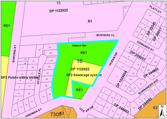
It should be noted that the majority of work will occur within the RE1 zone.
The site of the proposed filling is predominately cleared grassland, while the drainage line to be cleaned comprises sections of a reed based channel.
Adjoining the property to the north is a child care centre, while to the south is Council’s existing reclaimed water treatment building. West of the site is a residential area, while to the east is Ocean Drive road reserve (approx 30m wide) and then further residential development.
The existing subdivision pattern and location of development within the immediate locality is shown in the following aerial photograph:
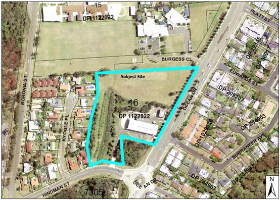
2. DESCRIPTION OF DEVELOPMENT
Key aspects of the application proposal include the following:
· The property was identified by Council in 2012 as a potential site to be used as an Environment and Creativity Centre; consisting of community gardens, Landcare nursery, a creativity centre for local art and craft and a children’s playground. Preliminary studies were carried out and deemed the site to not be viable at present due to costs associated with constructing the building, upgrading infrastructure and dealing with flooding.
· The General Manager has requested that development consent be sought to allow excess fill from other Council works to be placed onsite. This will allow Council to not only deal with the disposal of excess soil from other projects but also improve the flood free nature of the subject site. In addition to the excess fill being deposited on-site, the other aspect of the application is to allow Council machinery to be used to clean out the channel when not in use elsewhere. The overall outcome will be a more useable flood free public recreational area constructed at low cost to the Council and community.
· The application relies on previous flood and flora & fauna studies completed onsite as part of the Environment and Creativity Centre.
· The fill area will be 1500m² and compacted to a level of approx 2m above existing ground level or 4.8m AHD so as to not affect flooding or create impacts on the drainage channel. The fill will be shaped as per Figure D of the Environment and Creativity Centre Flood Study.
· 3737m³ of fill is required to construct the flood free recreation area.
· 1670m³ of fill material will be excavated out of the drainage channel and the remaining 2067m³ will be sourced from other Council projects.
· It is estimated that a truck will carry approx 4m³ and that approx 517 truck movements will be required to transport the 2067m³ fill to the site. Trucks will enter the site via Ocean Drive and the Burgess Close intersection.
· A water cart will be onsite at all times to manage dust.
· Hours of operation would be 7am to 5pm, Monday to Friday and between 7am to 3pm Saturday.
· Erosion and sediment controls will be utilised during filling with the mound to be compacted and vegetated at the end of the project.
· The application was treated as integrated development requiring approval from the Office of Water under the Water Management Act 2000. The Office of Water advised that the works were exempt from requiring an approval under Clause 38 of the Water Management (General) Regulation 2011.
· The application was referred to the Roads and Maritime Services (RMS) as access to the site is proposed via Ocean Drive being a classified road.
Being a Council application on Council land, the proposal is subject to Council’s Conflict of Interest Policy and needs to be determined by Council, following consideration of the application by the Development Assessment Panel.
A copy of the report considered by the Development Assessment Panel on 9 October 2013, is provided in the attachments. Based on the report and Council’s Conflict of Interest Policy requiring the application be determined by Council, the Development Assessment Panel resolved the following:
That it be recommended to Council that DA 2013/286 regarding earthworks associated with a recreation area at Lot 16, DP 1122022, No. 79 Ocean Drive, Port Macquarie, be determined by granting of consent subject to the recommended conditions.
Refer to attachments at the end of this report.
|
Attachments
1. DA2013 - 0286 DAP Report 9 October 2013 |
AGENDA Ordinary Council
20/11/2013
Item: 11.09
Subject: DA2013 - 0349 - Alterations and Additions to 3 Storey Dwelling-House Including Clause 4.6 Variation to Clause 4.3 (Height of Buildings) Port Macquarie-Hastings Local Environmental Plan 2011 - Lot 3 DP 236279, 105 Matthew Flinders Drive, Port Macquarie (PIN 13336)
Report Author: Matt Rogers
|
Property: Lot 3 DP 236279, 105 Matthew Flinders Drive, Port Macquarie Applicant: BJ & BJ Kemmett CARE King and Campbell Owner: BJ & BJ Kemmett Application Date: 27 June 2013 Estimated Cost: $185,000 Location: Port Macquarie File no: DA2013 - 0349 Parcel no: 13336 Alignment with Delivery Program 4.9.2 Undertake transparent and efficient development assessment in accordance with relevant legislation. |
|
That DA 2013 - 0349 for alterations and additions to a 3 storey dwelling-house, including clause 4.6 variation to clause 4.3 (height of buildings) of the Port Macquarie-Hastings Local Environmental Plan 2011, at Lot 3, DP 236279, No. 105 Matthew Flinders Drive, Port Macquarie, be determined by granting consent subject to the recommended conditions.
|
Executive Summary
This report considers a Development Application for alterations and additions to a 3 storey dwelling-house including a clause 4.6 variation to Clause 4.3 (height of building) of the Port Macquarie-Hastings Local Environmental Plan 2011 at the subject site.
This matter was reported to an Ordinary meeting of Council on 16 October 2013. Council resolved:
‘That the application be deferred so as to provide an opportunity for the plans to be amended to enable the existing building height to be maintained’.
The Applicant has subsequently lodged amended plans in response to the Council resolution. The amendments reduce the roofline of the proposed alterations to maintain the existing building height.
As previously reported, this report to Council is required due to the Clause 4.6 variation being greater than 10% variation to the height standard in the Port Macquarie-Hastings Local Environmental Plan 2011 (LEP). The amendments to the roof design have resulted in a reduction of roof height for the sections of the roof above the existing roof line by 630mm. A detailed assessment, as reported to Council’s Development Assessment Panel on 25 September 2013 is provided as an attachment.
1. BACKGROUND
The site has an area of 809.4m2.
The site is zoned R1 General Residential in accordance with the LEP, as shown in the following zoning plan:
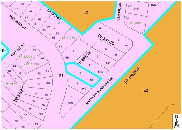
The site is currently occupied by an existing 3 storey dwelling-house with the top floor level setback from the front and eastern sides of the building.
The site has a primary frontage to Matthew Flinders Drive and secondary rear frontage to Watonga Street.
The site has a moderate fall from west to east towards Matthew Flinders Drive.
The existing subdivision pattern and location of existing development within the immediate locality is shown in the following aerial photograph:
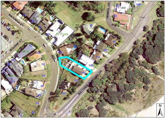
2. DESCRIPTION OF DEVELOPMENT
Key aspects of the application proposal include the following (as amended):
Ground floor (garage level)
· Extension of the southern garage’s eastern walls to provide an additional 10m2 of garage area.
· Inclusion of columns adjacent the existing entry door to accommodate alterations on upper floors.
First floor
· Conversion of the existing kitchen to a wet bar.
· Inclusion of a new wall opening.
Second floor
· Expansion of the gross floor area to include relocation of the living/dining area to this level and expand the floor space including addition of a multipurpose room.
· New bedroom and sitting area within north-western corner, new master bedroom and expansion of outdoor terrace area.
Refer to attachments at the end of this report including new amended plans.
Application Chronology
· 10 to 24 July 2013 - Neighbour notification (original proposal)
· 26 July 2013 - Additional information requested - initial concerns with building height
· 1 August 2013 - Meeting with applicant and follow up additional information requested to address submission issues and clarified assessment concerns.
· 13 August 2013 - Additional information received.
· 23 August to 6 September 2013 - Neighbour notification of amended plans.
· 9 September 2013 - Summary of submission issues forwarded to Applicant.
· 11 September 2013 - Additional information received.
· 29 September 2013 - Report to Council’s Development Assessment Panel.
· 16 October 2013 - Report to Ordinary meeting of Council
· 25 October 2013 - Amended plans submitted.
|
Attachments
1. DA2013 - 0349 Plans 2. DA2013 - 0349 Council Report 16 October 2013 3. DA2013 - 0349 Additional Info Cover Letter |
AGENDA Ordinary Council
20/11/2013
Item: 11.10
Subject: DA2013 - 0481 Alterations and Additions to Two Storey Dwelling House and Construction of a Detached Shed Including Clause 4.6 Variation to Clause 4.3 (Height of Buildings) Port Macquarie Hastings Local Environmental Plan 2011 - Lot 5 DP 22158, 23 Orr Street, Port Macquarie (PIN 15827)
Report Author: Matt Rogers
|
Property: Lot 5 DP 22158, 23 Orr Street, Port Macquarie Applicant: G J Wiggins Owner: G J Wiggins Application Date: 27 August 2013 Estimated Cost: $45,840 Location: Port Macquarie File no: DA2013 - 0481 Parcel no: 15827 Alignment with Delivery Program 4.9.2 Undertake transparent and efficient development assessment in accordance with relevant legislation. |
|
That DA 2013 - 481 for a alterations and additions to a two storey dwelling house and construction of a detached shed, including clause 4.6 variation to clause 4.3 (height of buildings) of the Port Macquarie-Hastings Local Environmental Plan 2011 at Lot 5, DP 22158, No. 23 Orr Street, Port Macquarie, be determined by granting consent subject to the recommended conditions.
|
Executive Summary
This report considers a Development Application for alterations and additions to an existing dwelling and construction of a detached shed at the subject site. The application includes a Clause 4.6 variation to Clause 4.3 (Height of Buildings) of the Port Macquarie-Hastings Council Local Environmental Plan 2011 (LEP).
This report provides an assessment of the application in accordance with the requirements of the Environmental Planning and Assessment Act 1979.
Subsequent to exhibition of the application, 1 submission was received.
The matter was reported to Council’s Development Assessment Panel on 23 October 2013 for prior consideration. The following resolution was made:
That it be a recommendation to Council that DA 2013-481 for a alterations and additions to a two storey dwelling house and construction of a detached shed, including clause 4.6 variation to clause 4.3 (height of buildings) of the Port Macquarie-Hastings Local Environmental Plan 2011 at Lot 5, DP 22158, No. 23 Orr Street, Port Macquarie, be determined by granting consent subject to the recommended conditions.
It was also noted at the DAP meeting, due to confirmation of site levels, that the variation to the height limit was amended to be 1m over the 8.5m height limit at the uppermost point of the building. Given the existing levels on site and minor nature of the works relative to the existing building, the findings of the original assessment are not considered to be compromised by the height clarification. The variation is considered to be justified in this instance.
This report to Council is required due to the Clause 4.6 variation representing more than a 10% variation to the height standard contained in the LEP. A detailed assessment, as reported to Council’s Development Assessment Panel on 23 October 2013, is provided as an attachment.
1. BACKGROUND
Existing sites features and Surrounding development
The site has an area of 1042m2
The site is zoned R1 General Residential in accordance with the Port Macquarie-Hastings Local Environmental Plan 2011, as shown in the following zoning plan:
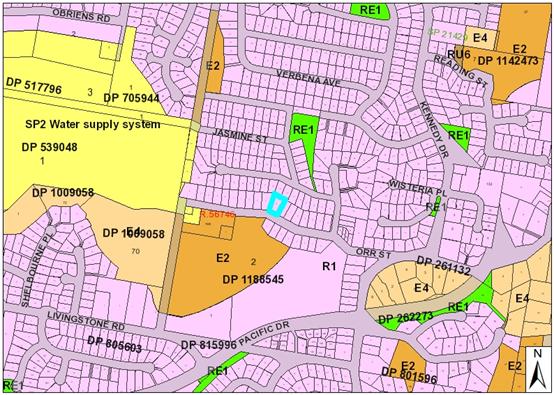
The site is currently has a two storey dwelling on the site with a single storey elevation to Orr Street and two storey to the rear.
The site has a fall of approximately 8 metres from front to rear (South to North).
The existing subdivision pattern and location of existing development within the immediate locality is shown in the following aerial photograph:
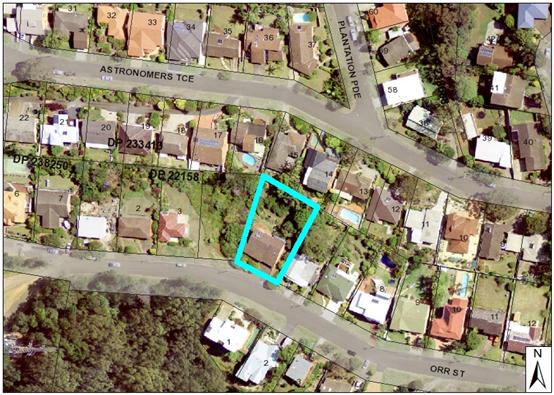
2. DESCRIPTION OF DEVELOPMENT
Key aspects of the application proposal include the following:
· Extension of first floor deck to the rear (including roof over).
· Construction of detached shed.
· Extension of hard stand/driveway area.
· Additional window opening and internal alterations.
Application Chronology
· 11 - 25 September 2013 - Neighbour notification
· 6 September 2013 - Request for additional information - Clause 4.6 variation, reduced driveway width, levels and balcony compliance.
· 17 September 2013 - Request additional information relating to stormwater drainage.
· 23 October - Report to Council’s Development Assessment Panel.
|
Attachments
1. DA2013 - 0481 DAP Report 23 October 2013 |
AGENDA Ordinary Council
20/11/2013
|
Item: 11.11
Subject: T-13-25 Kew Waste Management Facility Design and Documentation (PIN 50972-57445) Presented by: Development & Environment, Matt Rogers
Alignment with Delivery Program
4.4.1 Reduce waste to landfill, utilising appropriate education, facilities and strategies. |
|
That Council: 1. Accept the lump sum tender of $235,173.00 (excl. GST) received from Hyder Consulting Pty Ltd for Design and Documentation of Kew Waste Management Facility. 2. Affix the seal of Council to the necessary documents. 1. |
Executive Summary
The purpose of this report is to advise Council of the results of the recent tender for the Design and Documentation of Kew Waste Management Facility, and to recommend Hyder Consulting Pty Ltd as the successful tenderer to be engaged by Council on the project.
Discussion
Current volume calculations indicate the Dunbogan Waste Landfill has approximately 18 months of remaining life. The development of a new Waste Transfer Station (WTS) to serve the Camden Haven and southern areas of the Port Macquarie-Hastings Council (PMHC) Local Government Area (LGA) will allow the existing Dunbogan Waste Landfill to close in line with EPA timelines.
An investigation of three (3) sites for the Kew Waste Transfer Station was undertaken with a concept design and concept cost estimate developed for each site. Site 2 (Herons Creek Road, 1.4km north of Kew) was identified as the preferred site for the proposed Waste Transfer Station.
At the Ordinary Meeting of Council held 21 August 2013 Council resolved;
That Council adopt the Herons Creek Road site (Site 2) for the location of the Kew Waste Transfer Station.
A Tender for the Design and Documentation of the facility was advertised on 27 August 2013, and closed on Thursday 26 September 2013. During the tender period sixty five (65) individual organisations downloaded the tender documents from the Council’s tendering website.
At the time of closing, seven (7) tender submissions were received from the following
organisations (listed in alphabetical order):
- Alan Taylor & Associates;
- Brewster Murray;
- Enstruct;
- Hyder Consulting;
- King & Campbell;
- SMEC;
- Style Developments.
2.
A Tender Evaluation Panel was formed consisting of:
- Environmental Projects Officer;
- Waste & Environmental Engineer;
- Consulting Environmental Engineer
All Panel members signed tender confidentiality and conflict of interest declarations. One panel member (Consulting Environmental Engineer) previously provided consulting services to one of the tenderers and made a Non-Pecuniary (less than significant interest) declaration. The declaration was considered and the Panel formed the view that it did not present a probity risk to the evaluation of tenders.
The first evaluation meeting was held on 4th October 2013 and an initial compliance check was conducted to identify submissions that were non-conforming with the immediate requirements of the Request for Tender (RFT). This included compliance with contractual requirements and provision of requested information.
Following this preliminary assessment, several clarifications were sought from the tenderers. On the basis of the tenders and clarifications received, the qualitative criteria assessment was carried out individually by the Evaluation Panel Members in the days following, with Panel Members scoring the tenders in accordance with the assessment criteria.
Having requested and received clarifications, a second evaluation meeting was held on 31st October 2013. At this meeting the individual scores were combined and summarised to demonstrate a ranking for priced and non- priced criteria.
The criteria which tender submissions were evaluated are;
· Value for money;
· Proposed methodology and demonstrated understanding of the project and services to be provided, including indicative timing required for delivery of the project as outlined in this Tender Agreement;
· Demonstrated relevant experience and performance on similar projects as provided for in this Tender Agreement (including provision of reference projects and referees);
· Demonstrated qualifications, experience and competency of the personnel to be appointed to the project as provided for in this Tender Agreement
The weighting of the above criteria was not disclosed to any tenderer.
Please refer to the confidential spreadsheet titled “T-13-25 Evaluation & Pricing Analysis” which details the final evaluation scores for the tenders as determined by the Evaluation Panel and lists the tender prices offered by each of the tenderers. This analysis contains information that would, if disclosed, confer a commercial advantage on a person with whom the Council is conducting (or proposes to conduct) business. Local Government Act 1993 – Section 10A(2(c).
Based on this process, the Panel determined that the tender received from Hyder Consulting Pty Ltd represented the most advantageous for Council in consideration of the assessment criteria above. In particular the Panel noted that the submission from Hyder Consulting Pty Ltd provided:
· a detailed and comprehensive methodology which demonstrated a thorough understanding of the brief, in particular the requirements for documenting environmental and planning assessments;
· highly experienced personnel with significant experience in the type and scope of works required including experience with numerous Transfer Station and Resource Recovery development projects;
· a multi-disciplinary team covering all aspects including planning, civil, structural, environmental, geotechnical and servicing aspects of the design;
· a high quality of reporting and documentation necessary to convey and explain the project clearly to the community;
· a fee proposal that was in line with the expected cost for this type of project.
Options
Council has the option of accepting the tender submitted by Hyder Consulting Pty Ltd, or not accepting same, in which case Council would be required to re-tender for this work.
Community Engagement & Internal Consultation
The proposed Kew Waste Transfer Station site options were placed on public exhibition from 3 June 2013 to 5 July 2013. A total of 38 submissions were received.
Council adopted the Herons Creek Road site for the Kew Waste Transfer Station at its Ordinary Meeting on 21 August 2013.
Council provided further information to local residents via written correspondence after the site selection was made. Further information was requested at the October 2013 Council Meeting and a Question on Notice report outlining further clarifications is separately presented to this Council Meeting.
In assessing this tender, consultation has taken place with the:
- Environmental Projects Officer;
- Waste & Environmental Engineer;
- Consulting Environmental Engineer;
- Group Manager Environmental Services
- Director Development and Environment
- Procurement Coordinator
The tender has been conducted in accordance with Section 55 of the Local Government Act 1993 and Part 7 of the Local Government (General) Regulation 2005.
Planning & Policy Implications
The development of the Kew Waste Transfer Station to serve the Camden Haven and southern areas of the PMHC LGA was identified in the Hastings Waste Management Strategy (1999) and was further supported by the 2011-2015 Waste and Resource Management Strategy (2011).
In addition, the remaining capacity at the Dunbogan Waste Landfill is limited and the design and future construction of this site will allow the existing Dunbogan Waste Landfill to close in line with EPA timelines.
The site’s development is an essential element in PMHC’s overall waste service in the southern part of the LGA.
Financial & Economic Implications
The development of the project brief and the tender assessment process have been undertaken in the context of over-arching principles of best value service delivery, which include quality and cost standards, responsiveness to community needs, accessibility and continuous improvement.
Allocations exist in the 2013-14 budget to undertake the design and construction of the new Kew Waste Transfer Station facility.
|
Attachments
1. T-13-25 Evaluation & Pricing Analysis (Confidential) |
 |
20/11/2013
What are
we trying to achieve? Our population growth is
supported through public infrastructure, land use and development
strategies that create a connected, sustainable and accessible community.
· Supported and integrated communities.
· Infrastructure provision and maintenance that respects community expectations and needs.
· A natural environment that can be accessed by a network of footpaths, cycleways, coastal and hinterland walkways.
· Accessible, convenient and affordable public transport.
· Employment and population growth that is clustered within urban centres.
How do we get there?
5.1 Create and maintain integrated transport system that eases access between population centres and services.
5.2 Ensure transport options are safe, functional and meet access needs across the Local Government Area.
5.3 Develop and enhance quality open space and recreational facilities.
5.4 Plan settlements to accommodate a range of compatible land uses and projected population growth.
 |
20/11/2013
|
Item: 12.01
Subject: Wauchope Skate Park Presented by: Infrastructure & Asset Management, Jeffery Sharp
Alignment with Delivery Program
5.3.1 Plan, investigate, design and construct open spaces and recreational facilities. |
|
That Council adopt Landrigan Park as the location for a new skate park at Wauchope and that concept plans for this facility be developed by 30 June 2014.
|
Executive Summary
The aim of this project was to determine an appropriate and community acceptable location for a new skate park at Wauchope. The existing skate park in Wauchope is in poor condition and its location is within the alignment of a proposed heavy vehicle bypass (from the railway to Cameron Street).
The Wauchope Urban Framework Plan 2009 had proposed a new skate park for Wauchope to be located in Bain Park. Although there was community support for the location, a number of groups were opposed to the skate park at that location.
Council has undertaken a community engagement process seeking wider community input on the preferred site for the skate park.
The project considered all Council parkland in the Wauchope town centre and involved:
discussion with community and school groups;
a publicly advertised open community workshop;
and a survey inviting participants to nominate a preferred skate park location.
Several parks were nominated by community members as possible locations for the new skate park. Council staff provided advice on each location regarding park management issues. The advantages and disadvantages of each location were compared and discussed with community members, and the community was asked to nominate their preferred location for the new skate park.
The results from the community have been collated and Landrigan Park is recommended in this report to Council as the proposed skate park location.
Discussion
There is an existing skate park located at High Street, Wauchope (near the road/railway crossing). It is small, its facilities are in poor condition, and it has reached the end of its usable life. In addition, it is located within the footprint of the proposed realignment of the main road entry to Wauchope. Relocation of the skate park and provision of improved facilities was recognised in the Wauchope Urban Framework Plan that was adopted by Council in 2009. At the time, the Framework proposed the new skate park be located in Bain Park.
Following this decision, some community members asked Council to consider alternative sites for the proposed facility. In particular Wauchope Community Progress Association was concerned about Bain Park as the location, due to possible noise impacts and disruption to other park users. They suggested Landrigan Park (north of the indoor stadium in Cameron Street) as an appropriate location.
A number of community members interested in pursuing the skate park project formed ‘Skatewauchope’ - a community group of parents and skaters keen to facilitate the development of the new skate park for Wauchope. The group undertook a community survey at the existing Wauchope skate park on 16 March 2013. The survey asked respondents where they would like to see a new skate park located. Over 150 survey responses were collected and the following sites for a new skate park were nominated (a map of Wauchope and the locations is attached for information):
· Landrigan Park (adjacent to Andrews Park and the indoor stadium);
· Bain Park;
· Old Park (near the swimming pool);
· Lasiandra Park (at the top end of Cameron Street); and
· Fairmont Gardens (near the soccer fields).
· Other respondents didn’t care where the new park was as long as it was close to the town centre.
Council then initiated a wider community engagement process to provide greater opportunity for community involvement in the decision of where the new skate park should be located, and to seek community support for a preferred site.
Monthly meetings were held with Council officers and Skatewauchope representatives and it was determined to hold an open community workshop in Wauchope at which residents could consider the various locations for the skate park, and decide their own preferred location. In addition, direct consultation with school-aged residents was undertaken to involve as many potential users of the new skate park in the decision making process as possible.
As a tool for discussion, a location matrix was developed which compared the advantages and disadvantages of each suggested skate park location against key criteria (such as visibility, park size, site amenities etc.). Advice from Council Recreation & Buildings and Community Development staff regarding maintenance, access, existing facilities, and possible park management issues at each of the locations was incorporated into the location matrix. The location matrix is attached for information.
The location matrix was discussed at an open community workshop held 10 October 2013. The workshop was facilitated by Council staff and attended by 46 community members. Most attendees (50%) were over 45 years of age, with 24% of attendees below 15 years of age, and 6.5% between 16 and 19 years of age. The attendees predominantly identified as either interested residents (41%), or skaters/potential users (35%).
In addition to being a safe place, participants determined that the key elements of an ideal skate park location were that it needs to be:
· Close to toilets;
· Close to shops; and
· Away from houses/schools/businesses.
The key concern of forum attendees regarding skate parks was noise.
The advantages and disadvantages of each suggested skate park location was discussed in groups among the workshop participants. Attendees were also provided opportunity to nominate alternative locations that they considered could be potentially suitable for the new skate park. No new locations were suggested. The results of the workshop discussions are outlined below.
Landrigan Park
Overwhelmingly, participants written comments about Landrigan Park as a skate park location were positive (87%), with 20% of Landrigan Park comments stating that it was an ‘ideal spot’. The key points were:
· Close to toilets;
· Close to shops;
· Not too close to residents; and
· Has good parking.
Although only small in number, there were also negative points raised regarding this location. The key negative points were that it was too small in size (3% of comments received on Landrigan Park) and that it was flood prone (also 3%).
Bain Park
Most of the written comments about Bain Park as a possible location were negative (87.5%). The key negative concerns were:
· Too close to preschool/primary aged children (15% of comments received on Bain Park);
· Too close to houses/residents;
· It’s already an active park used by multiple groups - no room; and
· Young children are in the Park - potential incompatibility issue.
The key positive comment about Bain Park as a location was that it was centrally located to shops/schools etc (7.5% of comments received on Bain Park).
Old Park
Seventy percent of comments written about Old Park were positive; with 6% of Old Park comments stating that it was a ‘good location’. The key points were:
· Next to pool;
· Close to tennis courts/pool/river;
· Close to town; and
· Close to high school.
The key negative concerns about Old Park were whether the expansion of the pool would be an issue (8% of comments received on Old Park), and that there were no toilets (6%) (However, toilets are available on the northern side of the swimming pool entrance). Nearly 5% of comments received on Old Park stated: “leave it alone”.
Lasiandra Park
Comments received regarding Lasiandra Park were overwhelmingly negative (94%).
The key concerns were:
· Too far out of town;
· Too close to residents;
· Too far away from shops; and
· Too many retired residents and pensioners near the area.
Although only small in number, there were some positive comments received for Lasiandra Park. The key positive point was that it was accessible by pedestrians.
Fairmont Gardens
Almost all comments received on Fairmont Gardens as a possible skate park location
were negative, with only one positive comment received. The key negative points
raised were:
· Too far from town;
· Very close to houses; and
· No shops close by.
Prior to leaving the workshop, each attendee completed a survey which asked them to prioritise their concerns and nominate their preferred skate park location. The survey is attached for information. The workshop attendees’ responses to the survey confirmed their ranking for the preferred skate park location as:
1. Landrigan Park;
2. Old Park;
3. Bain Park;
4. Lasiandra Park; and
5. Fairmont Gardens.
The same survey was available online through Council’s “pmhc listening” webpage for residents who were unable to attend the workshop. Thirty-nine community members completed the online survey. The composition of the online respondents was predominantly older: 41% were over 45 years of age and 31% were between 35 and 45. No respondents were under 19 years of age.
The key priorities for a skate park as nominated by the online survey respondents were:
1. A safe place;
2. Close to amenities (toilets); and
3. Close to town.
The online survey respondents’ preferred ranking of skate park locations is:
1. Landrigan Park;
2. Old Park;
3. Bain Park;
4. Fairmont Gardens; and
5. Lasiandra Park.
The survey was also used in discussions with school students from Wauchope High School. Sixty-eight students all under 19 years of age (with 47% being under 15 years of age) completed the survey. Their key priorities for the students for a skate park location were:
· Close to town;
· Close to amenities (toilets); and
· A safe place.
The preferred skate park locations as ranked by the high school students were:
1. Old Park;
2. Bain Park;
3. Landrigan Park;
4. Fairmont Gardens; and
5. Lasiandra Park.
There were also hard-copy surveys completed by an additional 32 residents and students of Wauchope, who either submitted their completed survey at the Council’s Wauchope office or handed it directly to a Council officer following individual discussion about the skate park. Of these additional survey respondents:
· 28% identified as a user or potential user of the skate park;
· Four were under 10 years of age;
· Nearly 41% of all of the respondents were 19 years of age or younger; and
· Nearly 41% were over 45 years of age.
The preferred skate park ranking as selected by this group of survey respondents is:
1. Landrigan Park;
2. Old Park;
3. Lasiandra Park;
4. Fairmont Gardens; and
5. Bain Park.
Collectively, 185 surveys were completed by community members. Considering the total number of survey respondents:
· 47% of respondents were 19 years of age or younger (with 2% aged 10 years or younger; 25% aged between 11 and 15; and 20% between 16 and 19 years); and
· 28% of all respondents were over 45 years of age.
Overall, the preferred ranking of possible locations for the new skate park is:
1. Old Park;
2. Landrigan Park;
3. Bain Park;
4. Fairmont Gardens; and
5. Lasiandra Park.
The survey results indicate that preferences for Old Park and Landrigan Park are very close. In general, younger people prefer Old Park as the new skate park location, while the most strongly preferred park among older residents is Landrigan Park.
In considering these top two preferred locations, additional matters have been taken into account. Each park fulfils the survey respondents’ key skate park location priorities - they are both safe places (that is, they are open spaces visible to the public); close to town; and close to amenities. Therefore each park has been examined in more detail in relation to their available space, proximity to residents, and future development.
Ideally, the new skate park would be setback a minimum of 50m from the nearest residents (this is a desirable target, however, there is no legislated minimum setback); have approximately 400m2 of available space to construct the skate park (again, this is only a desirable target); and be compatible with any future proposals in the vicinity.
If the skate park were located at Old Park and set back 50m from the nearest residents, less than 300m2 of space would be available for the skate park. In addition, a large existing tree is growing within the 300m2 space and it removal would be required to accommodate the skatepark. The limited space available within Old Park is further compromised by possible future development proposals to extend the adjacent swimming pool. The proposed pool extensions will encroach further into Old Park and reduce the available area for a skate park, unless the skate park was constructed closer to residents than 50m.
At Landrigan Park, a minimum 50m setback from the nearest residents can easily be accommodated while providing approximately 800m2 of available space for a skate park to be located.
The development of the skate park at Landrigan Park would impact on existing use of this space by netball. There is adequate space available within Andrews Park to provide an additional turf netball court adjacent to the existing three courts to offset the loss of the Landrigan Park field.
Landrigan Park is therefore recommended is this report to Council as the proposed skate park location:
· It is the second highest preferred location for the skate park (as indicated by overall resident survey responses). However, there was only a narrow margin between first and second preferences.
· It has more available space to construct the skate park;
· The skate park could be more than 50 metres from the nearest residents; and
Options
As mentioned above a number of sites were considered for the location of the new skate park:
· Landrigan Park;
· Bain Park;
· Old Park;
· Lasiandra Park; and
· Fairmont Gardens.
Council can adopt the recommended location as included within this report. Alternatively, Council also has the option of selecting another site as the preferred location.
Community Engagement & Internal Consultation
The level of impact of the project is “Level 2 - High level of impact of a local nature, e.g. a local area, specific community”, as it has a high level of impact to the skating community and park user groups within Wauchope.
The level of community participation required for this project was to “Collaborate - To partner with the public in each aspect of the decision, including the development of alternatives and the identification of the preferred solution”.
A community engagement strategy was prepared for the project. The strategy is attached for information. The engagement process involved:
· Monthly meetings with Skatewauchope representatives;
· Interviews with Council staff;
· Three sessions with Wauchope High School students (including focus group sessions);
· Meeting with Wauchope’s Rotary Youth Group;
· An open public workshop; and
· Community survey (distributed at the workshop and community meetings, and available online).
·
Skatewauchope were an ‘advisory group’ throughout the engagement process. They were encouraged to participate in discussions and decision making as they were an interest group formed especially to progress the new skate park in Wauchope. Monthly meetings were held with Skatewauchope (and are ongoing) to discuss the project and to work toward the desired outcome of determining a suitable new location for a skate park; to ensure a community driven project supported and facilitated by Council to reach the desired outcome for the community.
Skatewauchope helped develop the location matrix used at the community workshop, and the survey that was distributed to the community and available online seeking preferences for a new park location.
The community workshop was held 10 October 2013 and aimed to provide individual members of Wauchope’s skating community with the opportunity to participate in the decision making process, as well as engaging wider community participation. An open invitation to the public to attend the workshop was advertised through Wauchope’s local newspaper, via Council’s website, an announcement at Wauchope High School assembly; and posters were placed around town. It was also advertised via connections with youth groups and Skatewauchope. Additionally adjacent residents of all the sites to be considered at the community meeting were advised of the event via letterbox drop the week preceding the meeting.
Council staff (including Council’s Youth Development Officer, Group Manager Recreation and Buildings, Group Manager Community Development, and Landscape Architect) facilitated the ‘world cafe’ style workshop.
At the workshop, groups of 5-10+ participants gathered around aerial images of each of the suggested skate park locations. Critical aspects of a successful skate park location were discussed, and then each of the nominated skate park locations was considered. The participants were invited to put forward their concerns and completed the survey nominating their preferred location for the skate park.
Two written submissions were received during the community engagement period for this project. These submissions are attached for information and are summarised in the table below:
|
Submission Wauchope Skatepark site selection
|
Issue |
||
|
1. |
LG & JA Brown
|
Concerns about litter and noise associated with skatepark facilities. Also concerned about anti-social behaviour associated with skateparks. Suggested Cowarra Wheeled Precinct as a potential site. Concerned about the loss of greenspace to concrete.
|
|
|
Response/ Comment: |
Skateparks are significant community recreational facilities and there is broad community support for such a facility in Wauchope. The loss of greenspace can be mitigated against by providing landscaping at the site. This community engagement process has confirmed staff thinking that the siting of the skatepark needs to be close to the centre of town. On this basis Cowarra Wheeled Precinct is not considered to be a suitable site.
|
||
|
2. |
Jack & Rosie Pike
|
Strong objection to construction of skatepark in Bain Park due to potential noise impacts, impacts of potential operating hours, lack of supervision, risk concerns, change in nature of park usage, concern about lack of visibility and perceived conflict with the donation of the land as public space.
|
|
|
Response/ Comment: |
The provision of a skatepark within Bain Park is consistent with the Wauchope Framework Plan and Council’s obligations as trust managers for this crown reserve. Supervision of skateparks is enhanced by collocating with other recreational infrastructure and by installing within vision of dwellings and businesses. Facility design can be managed to control use outside of daylight hours. It is acknowledged that provision of a skatepark within Bain Park will change the nature of park usage, however as a recreational activity it is consistent with use of the playground, shared walkway/cycleway, and the turf space which is used for more active recreational activities.
|
||
Planning & Policy Implications
The Wauchope Framework Plan, which was adopted by Council in 2009, includes reference to construction of a new skatepark in Bain Park. During the planning phase of the Wauchope All Abilities Playground it became apparent that there was some community concern about the development of a skatepark in Bain Park. As a result of this concern staff identified the need to more broadly consider the siting of a new skatepark for Wauchope.
If the recommended location is adopted by Council, the next phase of this project will be to prepare a concept design with costs and funding options to see the development of the park over the next few years as outlined in the current capital works program. The concept design would be prepared by a specialist skate park designer/s. This next phase of the project will continue to include community engagement.
Financial & Economic Implications
It is expected that the project to construct the new skate park would cost approximately $250,000.
An allocation of $122,507 for the upgrade of the Wauchope skate park is included in the draft Recreation & Buildings rolling works program for 2014/15. A pre-construction budget of $20,000 is included in the 2013/14 Operational Plan. To ensure a reasonable quality skate park it will be necessary to secure additional funding, possibly through grants and/or fundraising activities. Local community groups have indicated they intend to apply for a grant for the new skate park facilities.
|
Attachments
1. Map of Wauchope - options for new Skate Park location 2. Wauchope Skatepark Location Matrix 3. Wauchope Skatepark Location Survey 4. Wauchope Skatepark Community Engagement Strategy 5. Wauchope Skatepark Submission LG JA Brown 6. Wauchope Skatepark Submission Jack & Rosie Pike 7. Wauchope Skatepark Survey Results |
|
20/11/2013
|
Item: 12.02
Subject: Local Infrastructure Renewal Scheme Round 3 Applications Presented by: General Manager, Anthony Hayward
Alignment with Delivery Program
5.1.1 Plan, investigate, design and construct road and transport assets which include pedestrian, cyclist and vehicular needs. |
|
That Council: 1. Submit an application under Round 3 of the Local Infrastructure Renewal Scheme for construction of Hastings River Drive from Gordon Street to Aston Street at an estimated cost of $5,600,000. 2. Write to the Minister for Local Government expressing concern over the program and the inability to deliver total outcomes if Councils are not in a position to borrow funds for a significant project even when a subsidy is provided for interest on any loan approved.
|
Executive Summary
The State Government is currently providing
a total of $100 million over six years for the implementation of the overall
local infrastructure backlog policy, of which the Local Infrastructure Renewal
Scheme (LIRS) is one component. Investment in infrastructure has the capacity
to stimulate and enhance the productivity of the economy in both the short and
long term. It is an investment that has a multiplier effect throughout the
economy, generating lasting economic, social and environmental benefits.
Traditionally, the focus on infrastructure asset management was the provision
of new assets such as roads, water and sewerage networks, airports and the
like. However it is becoming more and more apparent, that it is no longer
sustainable to focus on meeting infrastructure needs through investment in the
creation of new assets alone, without recognising the long-term lifecycle costs
associated with the ongoing operation, maintenance and renewal of existing
assets. Many councils are struggling to keep up with maintenance and renewal of
their assets to a level that is satisfactory to their community.
In recognising this increasing backlog in infrastructure renewal needs, the NSW
Government has responded by committing significant funding to help councils
meet the cost of borrowing to fund the required works. The Local Infrastructure
Renewal Scheme (LIRS) provides councils with a subsidy towards interest costs
to make it affordable to take out major bank loans to fund their projects. This
investment in debt funding has been proven to be far less expensive than paying
for the long-term recurring maintenance requirements of deteriorating assets.
LIRS Round 3 applications will be called for in August 2013.
Council has previously successfully secured funding under this program for the upgrade of Stingray Creek Bridge. There was another project that also qualified for funding under Round 1 of this program - Hastings River Drive, however T-Corp recommended that Council only proceed with one project.
Discussion
Council Staff have identified two projects that would be greatly assisted by the awarding of LIRS grants being:
Upgrade of Hastings River Drive
The upgrade of Hastings River Drive is needed to maintain the regional road network which is vital to the continued economic development of the Council and Regional communities. The upgrades were planned to be undertaken between 2000 to 2005 and community expectations for these upgrades has been very high in recent years, primarily due to traffic congestion and asset deterioration caused as a result in the deferral of the planned works. Delivery of the upgrades as planned and supported by the community through the development of Council’s Major Roads Improvement Strategy will result in road safety and efficiency improvements that benefit the community.
Council’s Delivery Program identifies the provision of safe and effective Transport Assets (including Roads and Bridges) as the highest priority core service area for the community. The reconstruction of Hastings River Drive is included in the Delivery Program. Council’s Infrastructure delivery staff have advised that the estimate to complete all required works from the Gordon Street intersection to the Boundary Street intersection of Hastings River Drive is in the order of $16-17m. Key sections to be upgraded are:
· Gordon Street to Aston Street
· Newport Island Road Intersection
· Hughes Place to Boundary Street
This work would include dual carriageway as well as other intersection upgrades between Boundary Street and Gordon Street.
Design Status;
·
· Gordon to Parks Sts, concept designs and surveys complete, estimated construction cost $1,600,000
·
· Park to Aston Sts; Designs 100% complete, need to review Aston St intersection treatments, expected completed Sept 2013, estimated construction cost $4,000,000
· Newport Island Road to Kemp St; Final Prelim designs complete, outsource design using Hughes Place design as a template design for this location. Expected design completion Dec 2013, estimated construction cost $2,600,000
· Hughes Pl to Boundary St; designs 75% complete to Hibbard Dr west. Need to investigate Hibbard Dr West intersection options. Expected design completion May 2015, estimated construction cost $5,700,000
· Hibbard Drive East intersection and asphalt overlay of existing sections of Hastings River Drive upgraded to four lanes $2,600,000
__________
Total $16,500,000
Staging:
Currently the upgrades are proposed as follows subject to final design and cost estimate outcomes;
Stage 1 Boundary St Intersection (works have commenced) 2013/14
Stage 2 Park to Aston Streets 2014/15
Stage 3 Gordon to Park Streets 2015/16
Stage 4 Newport Island Road to Kemp St 2015/16
Stage 5 Hughes Place to Boundary St 2016/17
Houston Mitchell Drive Upgrade
Houston Mitchell Drive is in the Top 5 roads within the Local Government Area identified for major upgrade works. With the provision of a new Primary School it will place additional pressure not only on Ocean Drive, but also on Houston Mitchell Drive. This road is also a major link between the Pacific Highway and Ocean Drive.
Council’s Infrastructure delivery staff have advised that approximately 6km of this road (except for the widened section in the middle) requires upgrading to a standard equivalent to the middle section. The estimated cost of these works is in the order of $10m.
Assessment
Based on the current weightings allocated to Council roads to determine a priority, Hastings River Drive is identified as a higher priority than Houston Mitchell Drive.
Options
1. Apply for both projects
2. Apply for the highest priority project
3. Not apply for funding under this round of the program
It is considered that to raise the loan would place further strain on Council’s ability to fund other projects and services. Details are set out in the financial section of the impact of securing either a $10M or $15M subsidised loan.
It is recommended that Council apply for funding for Hastings River Drive. However Council needs to be aware that T-Corp has previously indicated that Council would have difficulty in delivering its range of services if its loan portfolio was too great, therefore we are not applying for the total amount through the LIRS process.
Council could also write to the Minister for Local Government expressing concern over the program and the ability to deliver outcomes if Council’s are not in a position to borrow funds and repay the principle and interest even when a subsidy is provided to partially reduce the interest component on any loan approved.
Community Engagement & Internal Consultation
Identified as part of the Community Strategic Plan, Delivery Program and Operation Plan Community Consultation.
Planning & Policy Implications
Successful completion of these projects will reduce the works identified as requiring funding for upgrade/reconstruction.
Financial & Economic Implications
With any loan Council is required to repay the principle however, through this program Council receives subsidy towards the interest component of the loan.
· Round 1 interest subsidy was 4%
· Round 2 interest subsidy was 3%
· Round 3 interest subsidy is 3%
The following financial modelling quantifies the financial impact on Council of servicing new loans. Tables 1 through to 4 show the net cost to Council of taking out a range of different loans utilising the interest subsidy i.e. $15m, $10m, $5m and $2.5m. The key assumptions that the information below is based on is that the loans are taken over a ten (1) year period (this is the term that State Government will provide the subsidy for) at an estimated interest rate of 5.5% and a LIRS interest subsidy of 3%.
The following tables assume loans are taken over a ten year period (this is the term that State Government will provide the subsidy) at an interest rate of 5.5% and a LIRS interest subsidy of 3%.
Table 1: Loan Principal $15m
|
Year |
Total Debt Service Cost |
Less: LIRS subsidy @3% |
Net Cost to Council |
|
1 |
$1,970,152 |
($440,269) |
$1,529,883 |
|
2 |
$1,970,152 |
($400,763) |
$1,569,389 |
|
3 |
$1,970,152 |
($360,061) |
$1,610,091 |
|
4 |
$1,970,152 |
($318,130) |
$1,652,022 |
|
5 |
$1,970,152 |
($274,931) |
$1,695,221 |
|
6 |
$1,970,152 |
($230,426) |
$1,739,726 |
|
7 |
$1,970,152 |
($184,577) |
$1,785,575 |
|
8 |
$1,970,152 |
($137,341) |
$1,832,811 |
|
9 |
$1,970,152 |
($88,678) |
$1,881,474 |
|
10 |
$1,970,152 |
($38,544) |
$1,931,608 |
|
Total |
$19,701,520 |
($2,473,720) |
$17,227,800 |
Table 2: Loan Principal $10m
|
Year |
Total Debt Service Cost |
Less: LIRS subsidy @3% |
Net Cost to Council |
|
1 |
$1,313,435 |
($293,513) |
$1,019,922 |
|
2 |
$1,313,435 |
($267,175) |
$1,046,260 |
|
3 |
$1,313,435 |
($240,041) |
$1,073,394 |
|
4 |
$1,313,435 |
($212,086) |
$1,101,349 |
|
5 |
$1,313,435 |
($183,287) |
$1,130,148 |
|
6 |
$1,313,435 |
($153,618) |
$1,159,817 |
|
7 |
$1,313,435 |
($123,051) |
$1,190,384 |
|
8 |
$1,313,435 |
($91,561) |
$1,221,874 |
|
9 |
$1,313,435 |
($59,119) |
$1,254,316 |
|
10 |
$1,313,435 |
($25,696) |
$1,287,739 |
|
Total |
$13,134,350 |
($1,649,147) |
$11,485,203 |
Table 3: Loan Principal $5m
|
Year |
Total Debt Service Cost |
Less: LIRS subsidy @3% |
Net Cost to Council |
|
1 |
$656,718 |
($146,757) |
$509,961 |
|
2 |
$656,718 |
($133,588) |
$523,130 |
|
3 |
$656,718 |
($120,020) |
$536,698 |
|
4 |
$656,718 |
($106,043) |
$550,675 |
|
5 |
$656,718 |
($91,644) |
$565,074 |
|
6 |
$656,718 |
($76,809) |
$579,909 |
|
7 |
$656,718 |
($61,526) |
$595,192 |
|
8 |
$656,718 |
($45,780) |
$610,938 |
|
9 |
$656,718 |
($29,559) |
$627,159 |
|
10 |
$656,718 |
($12,848) |
$643,870 |
|
Total |
$6,567,180 |
($824,574) |
$5,742,606 |
Table 4: Loan Principal $2.5m
|
Year |
Total Debt Service Cost |
Less: LIRS subsidy @3% |
Net Cost to Council |
|
1 |
$328,359 |
($73,378) |
$254,981 |
|
2 |
$328,359 |
($66,794) |
$261,565 |
|
3 |
$328,359 |
($60,010) |
$268,349 |
|
4 |
$328,359 |
($53,022) |
$275,337 |
|
5 |
$328,359 |
($45,822) |
$282,537 |
|
6 |
$328,359 |
($38,404) |
$289,955 |
|
7 |
$328,359 |
($30,763) |
$297,596 |
|
8 |
$328,359 |
($22,891) |
$305,468 |
|
9 |
$328,359 |
($14,780) |
$313,579 |
|
10 |
$328,359 |
($6,424) |
$321,935 |
|
Total |
$3,283,590 |
($412,288) |
$2,871,302 |
|
Attachments
Nil |
|
20/11/2013
|
Item: 12.03
Subject: Rationalisation of Land Boundaries - Lake Road, Gordon and Munster Streets, Port Macquarie Presented by: Commercial Services & Industry Engagement, Craig Swift-McNair
Alignment with Delivery Program
5.3.1 Plan, investigate, design and construct open spaces and recreational facilities. |
|
That Council: 1. Advise Crown Lands that it supports the rationalisation of the boundaries of Gordon Street and Lake Road and Crown Reserve 95757. 2. In its capacity as Trust Manager of the Gordon Street Public Recreation Reserve (R87715) Trust, advise Crown Lands that it supports the rationalisation of the boundaries affecting the Reserve and supports the holding over of leases until the boundary rationalisation has been completed. 3. Agrees to closing of part Lake Road as hatched on “Diagram “A” Plan of Part Lake Road to be Closed” as attached to this report. 4. Advise Crown Lands it supports the exchange of part Reserve 87715 for part Lake Road on the basis that the exchange be at nil monetary compensation. 5. Affix the Common Seal to: a) Plan of road closure and first title creation b) Plan of subdivision of road widening/consolidation 6. Pursuant to Section 377 of the Local Government Act 1993, delegate to the General Manager authority to sign the Land and Property Information Transfer forms.
|
Executive Summary
A report to consider the rationalisation of land boundaries being various Crown reserves and Council public road situated in the vicinity of Lake Road, Gordon and Munster Streets, Port Macquarie, to correct some boundary anomalies.
Discussion
The boundary anomalies first came to light when the lease to the Port Macquarie Pre School in Munster St was being renewed. Previously, Crown Lands allowed some flexibility in plans of leased areas that are to be attached to Crown leases. That flexibility has been removed and plans attached to leases generally need to meet specific requirements of Schedule 5 of the Real Property Regulation. In complying with the terms of Schedule 5, the Crown Surveyor noted some anomalies with the area occupied and leased to the Pre School and the surveyor’s investigations beyond the Pre School revealed further anomalies as described further in this report. The Crown now seeks Council’s cooperation in rectifying the anomalies.
Situated south of Gordon Street, east of Lake Road and to the west and south of Munster Street are a number of Crown reserves which have been set aside for purposes including public recreation and a Senior Citizens Centre. Pursuant to the provisions of the Crown Lands Act 1989, Council has previously been appointed as Trust Manager of the public recreation reserves which are leased to community groups including a pre-school and Early Intervention Group. Occupation of the Senior Citizens Centre is by way of lease directly between the Port Macquarie Senior Citizens and Crown Lands.
The leased buildings were constructed in the 1970’s however the building footprints are not entirely consistent with the property boundaries. The attached aerial photograph provides a general overview of the situation, with the black lines representing the property boundaries. Whilst the aerial photograph was only taken in 2012, the software currently available that generates the property boundaries does not fully reflect the inconsistencies. The inconsistencies can be better captured by ground survey and a plan prepared by Crown Lands attached to this report and titled “Crown Plan” more fully depicts the inconsistencies.
The aerial photograph also depicts that a section of Gordon Street and associated footpath have been constructed within Crown Reserve 87715 being a public recreation reserve. The use of the Reserve for road is inconsistent with the reserves purpose and Crown Lands wish to address this anomaly plus the other inconsistencies in the Crown reserve boundaries.
In regard to the construction of part Gordon Street within the Crown reserve, normally Crown Lands would require Council to acquire the land by compulsory process and pay compensation for the acquired land. However, in this instance, one of the lessees of the Crown public recreation reserve have facilities encroaching onto Council land (Lake Road) with another group leasing part of Lake Road from Council pursuant to the provisions of the Roads Act 1993.
The road lease is in addition to the lease held by the community group directly with Crown Lands plus a narrow sliver of unreserved Crown land between Lake Road and Crown public recreation reserve. In essence, the community group occupies part of three parcels of land (two pieces of Crown land and the road reserve being Lake Road) and has two landlords. Under the proposed rationalisation, the group would occupy only one parcel of land and have one landlord - Crown Lands. The proposed rationalisation would also ensure that the Port Macquarie Senior Citizens building and associated car parking are contained within a single Crown reserve.
To resolve the boundary anomalies, subject to Council’s concurrence, it is proposed to enter into a land swap. That is, the Crown will transfer to Council that part of Crown Reserve 87715 occupied for road purposes (488.7m2) and Council will surrender its road lease and transfer this area and area of encroachments to the Crown (220.7m2) as shown hatched in Diagram “A” attached to this report. The proposed land swap will yield a net gain in land to Council of 268m2.
Options
There is the option to:
1. Proceed with a rationalisation of the property boundaries.
2. Remain with the status quo.
Community Engagement & Internal Consultation
There has been consultation with Crown Lands in their capacity as owners of the land. The consultation included a meeting with Council officers on 23 August 2013. On the same day and following the meeting between Crown Lands and Council officers, a meeting was held with the lessees occupying the Crown land. At the meeting, the lessees have provided their support for a rationalisation of the boundaries.
In regard to that part of Lake Road proposed to be closed and transferred to Crown Lands, consultation has occurred with Council’s Infrastructure & Asset Management staff who have advised that the transfer will not impact on future designs for this part of Lake Road.
Planning & Policy Implications
There are no planning and policy impacts.
Financial & Economic Implications
In lieu of monetary compensation being assessed for the land swap and on the basis that the rationalisation will provide benefit to both Council and Crown Lands, a sharing of costs incurred in achieving the boundary rationalisation is appropriate.
The principal activity and cost in accurately surveying the boundary anomalies has already been incurred by Crown Lands. The survey data captured by Crown Lands will need to be converted into a format capable of registration by Land and Property Information as Deposited Plans. It is proposed that Council meet the plan registration costs. There will be two plans of survey required with costs estimated at $2,500. Plan registration fees are exempt from the GST. Funding is available from the 2013-2014 Statutory Property Resumptions budget.
The closure of part Lake Road and its transfer to Crown Lands will result in the termination of the current Roads Act 1993 lease and the income stream will be forfeited. The annual rental is $475 and this lease is now holding over pending the outcome of the rationalisation process. It is recommended that the lease continue to be held over pending completion of the boundary rationalisation.
|
Attachments
1. Aerial Photo 2. Diagram "A" Plan of Part Lake Road to be Closed 3. Crown Plan |
|
20/11/2013
|
Item: 12.04
Subject: Status of Port Macquarie-Hastings Bus Route Alterations and Associated Bus Stops Presented by: Infrastructure & Asset Management, Jeffery Sharp
Alignment with Delivery Program
5.2.1 Plan and implement traffic and road safety programs and activities addressing pedestrian, cyclist and vehicular needs. |
|
That Council: 1. Receive and note the Status of Port Macquarie-Hastings Bus Route Alterations and Associated Bus Stops report. 2. Consider all recently created bus zones as permanent traffic management facilities on the understanding operation of these facilities will continue to be monitored by Council’s traffic management staff in consultation with Busways. 3. Continue to support the installation of approximately 140 new bus stops on the new bus routes.
|
Executive Summary
The status of the implementation of new bus routes and associated bus stops was reported to Council at an extraordinary meeting on 30 May 2013 where Council resolved as follows:
That Council:
1. Commence consultation and engagement for the approximately 170 new or modified bus stops required for the new bus network, particularly focussing on the directly affected residents and businesses.
2. Seek Local Traffic Committee approval for implementing new bus zones in Port Macquarie Town Centre along Short Street between William Street and Hayward Street, and along William Street between Murray Street and Hay Street, as a trial measure for a period of six months, whilst community engagement is undertaken and feedback is sought.
3. During community consultation and engagement engage in discussion with Busways to highlight the lack of suitable sites for bus stops along the new routes within the Port Macquarie CBD and encourage Busways to modify bus routes through the Port Macquarie CBD to enable buses to stop at all the approved bus stops that currently exist.
4. Impress upon Busways the need to consider elderly and disabled community members and the location of nearby toilet facilities in CBD bus routes.
5. During the community consultation and engagement engage in discussion with Busways on the movement of buses throughout the Port Macquarie CBD so that when necessary only bus stops on one side of the road are required.
The purpose of this report is to provide an update in relation to each of these Council resolutions.
Discussion
Responses to each of Council’s resolutions of 30 May 2013 are as follows:
Council Resolution 1 - Commence consultation and engagement for the approximately 170 new or modified bus stops required for the new bus network, particularly focussing on the directly affected residents and businesses.
Specific engagement activities that have been undertaken include:
· Engagement with Busways and Transport for NSW
· Engagement with Local Traffic Committee
· Creation of an Online Engagement Hub
· Written correspondence to affected residents and businesses outlining trial and engagement opportunity
· Advice to stakeholders of decision and implementation actions.
Engagement is continuing with affected residents and businesses for proposed new bus stops.
Council Resolution 2 - Seek Local Traffic Committee approval for implementing new bus zones in Port Macquarie Town Centre along Short Street between William Street and Hayward Street, and along William Street between Murray Street and Hay Street, as a trial measure for a period of six months, whilst community engagement is undertaken and feedback is sought.
Local Traffic Committee approval for implementing new bus zones in Port Macquarie CBD along Short Street between William and Hayward Streets, and along William Street between Murray and Hay Streets, was granted on 5 June 2013. Following a period of community consultation the bus zones were installed and subsequently used by Busways services.
Council Resolution 3 - During community consultation and engagement engage in discussion with Busways to highlight the lack of suitable sites for bus stops along the new routes within the Port Macquarie CBD and encourage Busways to modify bus routes through the Port Macquarie CBD to enable buses to stop at all the approved bus stops that currently exist.
Subsequent to the Council meeting of 30 May 2013 Council continued to engage with Busways in relation to the bus routes through Port Macquarie CBD. On 18 July 2013 an in principle agreement was reached with Busways to re-instate their CBD bus route through Clarence and Short Streets. The agreement was for a two-way route resulting in the need for Council to create additional bus stops on the northern side of Clarence Street, opposite the Glasshouse and on the western side of Short Street, south of Clarence Street.
Local Traffic Committee approval for implementing new bus zones in Port Macquarie CBD along Short Street between Clarence and William Streets, and along Clarence Street between Horton and Hay Streets, was granted on 7 August 2013. The bus zones were subsequently installed following a period of community consultation.
Busways, on 23 September 2013, introduced a revised timetable along a two-way route through Clarence and Short Streets.
The recently created bus zones on Short Street between William and Hayward Streets form part of the new bus routes. The recently created bus zones on William Street between Murray and Hay Streets are not part of the new bus routes. Council, however, plan to retain the William Street bus zones for use by coaches and Busways during events where Clarence Street is closed.
Council staff and Busways have observed that the revised two-way CBD bus route has been operating successfully. The community has also generally been supportive of the revised route.
The six month trial period will shortly be completed and it is proposed that all recently created bus zones be now considered as permanent traffic management facilities.
Council Resolution 4 - Impress upon Busways the need to consider elderly and disabled community members and the location of nearby toilet facilities in CBD bus routes.
Council has been in ongoing discussions with Busways in relation to Port Macquarie CBD bus routes. Council has regularly impressed upon Busways the need to consider elderly and disabled community members and the location of nearby toilet facilities. This was a factor in the reinstatement of the Clarence Street bus stops as described above.
Council Resolution 5 - During the community consultation and engagement engage in discussion with Busways on the movement of buses throughout the Port Macquarie CBD so that when necessary only bus stops on one side of the road are required.
Busways stated that two-way services would result in significantly more efficient bus services than a one-way Port Macquarie CBD loop. Consequently the agreement reached in July 2013 was for a two-way route with stops on both sides of Clarence and Short Streets.
Implementation of Other Bus Stops
Busways originally requested that approximately 170 new bus stops be installed across the LGA to support route network changes. Council has undertaken a feasibility review of these and it was found that approximately 30 cannot be installed due to physical constraints such as lack of available road width.
Council is therefore currently in the process of installing approximately 140 new bus stops in the Port Macquarie and Wauchope areas. Consultation is occurring with directly affected residents and businesses on bus stop locations and facilities.
Busways has received a number of requests, including a community petition, for further changes to bus routes in Wauchope CBD. Busways is currently considering this request. Council will not install new bus stops in Wauchope CBD until route issues are resolved.
Options
Council has the option to support the bus routes and stops recently implemented or resolve an alternative action.
It is recommended that all recently created bus zones be now considered as permanent traffic management facilities on the understanding operation of these facilities will continue to be monitored by Council’s traffic management staff in consultation with Busways.
It is also recommended Council continue to support the current process of installing the new bus stops required for the new bus network across the LGA, including consultation with directly affected residents and businesses on bus stop locations and facilities.
The alternative option is for buses in some locations to continue to operate on a hail-and-ride basis, and/or to have greater spacing been stops. This, however, provides an inferior level of service for bus users than would be provided with the installation of additional bus stops along the new routes.
Community Engagement & Internal Consultation
A summary of community engagement was provided in response to Council Resolution 1.
Planning & Policy Implications
The change to Port Macquarie CBD bus routes has been a positive transport outcome for the community and improvements to local bus services.
The changes to bus stops have no negative planning and policy implications and are also in the interests of positive transport outcomes for the community. The lessons learnt from this round of bus route changes can be taken forward for future planning, particularly the need for stakeholder and community feedback on proposals before any commitments to implementation are made.
Financial & Economic Implications
Council is normally responsible for funding of bus route infrastructure i.e. signs, line marking, footpaths, waiting areas, seats, shelters, streetscape adjustments and occasional bus bay construction. Funding of these works is normally provided as part of Councils’ Operational Budgets - Traffic Facilities or via a specific allocation for a capital work.
The provision of signs to install new bus stops on the new routes is estimated to cost in the vicinity of $30,000 and is expected to be funded from Council’s 2013/14 Operational budgets. In some locations physical works such as the provision of bus bays and road shoulder widening may also be required, resulting in additional delay and cost. Implementation of all bus stops and facilities identified may be delayed due to the limited operational budgets.
|
Attachments
Nil |
|
20/11/2013
|
Item: 12.05
Subject: Tender T-13-33 Supply & Install Traffic Signals Hastings River Drive at Boundary Street intersection, Port Macquarie Presented by: Infrastructure & Asset Management, Jeffery Sharp
Alignment with Delivery Program
5.1.1 Plan, investigate, design and construct road and transport assets which include pedestrian, cyclist and vehicular needs. |
|
That Council: 1. Accept the tender of $ 147,590.00 (excluding GST) from Curran and Curran P/L for the supply and installation of traffic signals on Hastings River Drive at the Boundary Street intersection, Port Macquarie. 2. Affix the seal of Council to the necessary documents.
|
Executive Summary
The purpose of this report is to advise Council of the results of a recent tender for the supply and installation of traffic signals at the intersection of Hastings River Drive and Boundary Streets, Port Macquarie and to recommend a successful tenderer to be appointed for this project.
Discussion
The reconstruction of Hastings River Drive at the Boundary Street intersection has been identified in Council’s Operational Plan for completion in the 2013/2014 financial year. This project forms part of the overall upgrade of Hastings River Drive between Park and Boundary Streets.
The work includes pavement reconstruction and widening, surface and subsurface drainage, extensive service relocations with associated erosion and sedimentation controls.
Part of the overall project includes the specialised supply and installation of traffic signal components at the intersection which is the subject of this tender.
This tender was first advertised on 8 October 2013 and closed on 31 October 2013.
During the tender period, six (6) individual organisations downloaded the tender documents from Council's tendering website.
At the time of closing, only one (1) submission was received from Curran and Curran P/L.
A Tender Evaluation Panel (TEP) was formed which included the following staff:
· Group Manager - Infrastructure Delivery;
· Design Engineer - Technical Services;
· Senior Works Engineer;
An initial compliance check was conducted during the week following the closing of the tender by the Senior Works Engineer to identify conformance of the sole tender with the immediate requirements of the Request for Tender (RFT). This included compliance with contractual requirements and provision of requested information.
The sole tenderer had excluded a project methodology and associated Gant chart and did not provide any evidence of Professional Indemnity (PI) insurance. All other schedules and requirements including other insurances listed in the RFT were met.
In order to further consider the submission the tenderer was requested to provide further supporting information including a project methodology and timeline for the delivery of the project. Further discussion was also had with the tenderer regards the need for PI insurance.
As requested Curran and Curran were able to provide a detailed project methodology and also listed an extensive sequence of activities to complete the works. In addition they provided sample documents from previous similar projects including Inspection & Test Plans (ITP’s) Safe Work Method Statements (SWMS’s) and also included the relevant RTA/RMS Specification for the installation of such infrastructure. The combination of this additional evidence fully satisfied the requirements of the RFT and ensured the submission was conforming.
There was further discussion regards the need for Professional Indemnity as part of the delivery of the work. The need for PI insurance is strictly limited to a provider that is engaged in the technical design aspects of the project. All design has been completed by PMHC and it’s contractors and, as such, it is not anticipated that Curran and Curran will be required to undertake any further design. For this reason the need for PI insurance as part of this engagement is not required.
Despite there being only one tender the qualitative criteria assessment was carried out individually by the Evaluation Panel Members in the days following the closing of the tender with Panel Members scoring the tender in accordance with the Tender Evaluation Management Plan. An evaluation meeting was held on 11 November 2013. At this meeting the individual scores were combined and summarised.
The sole submission was then further discussed in detail. It was agreed that the project lump sum total of $147,590 represented excellent value for money with earlier budget estimates placing the value of the work at $250,000-$350,000. Further to this Curran and Curran have previously been engaged by PMHC in the supply and installation of the traffic signals at the Gordon and Grant Street intersection. Their performance on this project was exceptional.
The criteria included in the tender document were agreed by the TEP and are listed below. It should be noted that the weighting of these criteria were not disclosed to any potential tenderer:
- Conformity with the tender documents;
- Rates tendered;
- Proposed methodology & demonstrated understanding;
- Demonstrated capacity, experience and performance;
- Demonstrated qualifications, experience and competency.
Please refer to the confidential spreadsheet titled “T-13-33 Evaluation Scorecard for Distribution - Hastings River Drive Boundary Street Signals” which details the final evaluation scores for the tender as determined by the Evaluation Panel and lists the tender price offered by the sole tenderer. This analysis contains information that would, if disclosed, confer a commercial advantage on a person with whom the Council is conducting (or proposes to conduct) business. Local Government Act 1993 – Section 10A(2(c)).
Please note, there are four (4) pages to the above-mentioned spreadsheet, three (3) demonstrating the individual panel members scores and one (1) showing the combined scores and the tendered pricing.
Options
Council has the option of accepting the recommended tenderer or not accepting same, in which case Council would be required to re-tender for these services.
Community Engagement & Internal Consultation
The following Council staff have been involved in the documentation and assessment of this tender.
- Group Manager – Infrastructure Delivery;
- Group Manager - Technical Services;
- Group Manager - Environmental Services;
- Group Manager - Strategic Planning;
- Works Engineers;
- Senior Works Engineers;
- Procurement Coordinator (Probity Advisor);
- Director Infrastructure & Asset Management.
Planning & Policy Implications
Nil
Financial & Economic Implications
The funding allocation to undertake the supply and installation of these traffic signals forms part of the total reconstruction of the Hastings River Drive and Boundary Streets intersection.
The present total project budget is $2,798,257.
|
Attachments
1. T-13-33 Evaluation Scorecard for Distribution - Hastings River Drive Boundary Street Signals (Confidential) |
|
20/11/2013
|
Item: 12.06
Subject: Thrumster Neighbourhood DCP Provisions: Partridge Creek and West Lindfield - Public Exhibition Report Presented by: Development & Environment, Matt Rogers
Alignment with Delivery Program
5.4.1 Plan settlements to accommodate a range of compatible land uses that meets projected population growth for new and existing developments. |
|
That Council: 1. Adopt the draft planning provisions for Partridge Creek Residential, Partridge Creek Industrial and West Lindfield neighbourhoods of the Thrumster Urban Release Area as an amendment to the Port Macquarie-Hastings Development Control Plan 2011. 2. Forward a copy of the approved plans to the Director General of the Department of Planning and Infrastructure and publish a public notice of this decision within 28 days. 3. Prepare a planning proposal with a view to carrying out consequential rezoning generally as described in this report, pursuant to section 55 of the Environmental Planning and Assessment Act 1979, for the amendment of the provisions of the Port Macquarie-Hastings Local Environmental Plan 2011. 4. Forward the planning proposal to the Department of Planning and Infrastructure for a Gateway Determination not later than 30 June 2014, and exhibit the proposal in accordance with that determination, pursuant to sections 56-58 of the Act.
|
Executive Summary
The purpose of this report is to advise Council of the matters raised in submissions received during the recent public exhibition of the draft planning provisions for the Thrumster neighbourhoods of Partridge Creek Residential, Partridge Creek Industrial and West Lindfield (draft plans) and seek Council’s approval to adopt the draft plans.
If adopted, the draft plans will constitute an amendment to the Area 13 Thrumster Development Control Plan, adopted by reference in the Port Macquarie-Hastings Development Control Plan 2011.
In accordance with Council’s resolution of 21 August 2013, the draft plans were placed on public exhibition. A total of four submissions were received. Further detail on the submissions is included in the Consultation section of this report.
Council may now:
1. Approve the draft plans in the form in which they were publicly exhibited, or
2. Approve the draft plans with such alterations as Council thinks fit, or
3. Decide not to proceed with the draft plans.
Furthermore, as a result of the more detailed planning for the area several changes to the Port Macquarie-Hastings Local Environmental Plan 2011 have been identified. Should Council agree with the proposed changes as described in this report, staff will prepare a Planning Proposal in consultation with the respective landowners.
Note: Council owns land in the subject area, namely Lot 1 of DP1087368, which comprises part of each of the neighbourhood plan areas in this report. It is important that decisions relating to the draft plans are impartial and based on established planning grounds so that Council does not unfairly gain a material advantage.
Discussion
Submissions
In accordance with Council’s resolution of 21 August 2013, the draft plans (Attachments 1 to 3) were placed on public exhibition. A total of five submissions were received.
· Mr and Mrs John and Fay Cook (Attachment 4)
· Mr Anthony Thorne, King & Campbell, representing landowners in the areas subject to the proposed plans (Attachment 5)
· Xu Qian, Director New Pacific Australia Pty Ltd (Attachment 6)
· Department of Trade & Investment – Crown Lands (Attachment 7)
· Transport, Roads & Maritime Services (Attachment 8)
Further detail on the submissions related to the draft plans is included in the Consultation section of this report.
In addition to the above, Mr Thorne also made several comments with regard to the previous Council report of 21 August 2013. Where directly relevant to the draft plans, these comments have been included in the summary of submissions table in the Consultation section of this report. Of particular note however is Mr Thorne’s comment as follows:
“The Council Report does, not in our view, [sic] accurately present the criticisms made of the [Implementation Report] Review report prepared by Urban Systems. We do however agree that the IR review should not be specifically adopted by Council.”
The Council report referred to above (Item 12.09 of the meeting of Ordinary Council 21/08/2013), alerted Council to the submissions made on the Implementation Report Review as follows:
“The IR Report was made publicly available on Council’s website and two submissions have been received from key landowner representatives, King and Campbell and Lewis Land Group.
King and Campbell offered several criticisms of the assumptions made in the IR Review including that the recommendations did not have sufficient factual basis and that the report was overly biased towards development of Sovereign Hills (Lewis Land Group) properties.”
The King and Campbell submission referred to above was attached to the Council report in full. However, the issues raised in the submission were found to have little bearing on the draft neighbourhood plans under consideration prior to their public exhibition and a specific response was not considered necessary.
Mr Thorne’s most recent submission also makes several comments regarding the status of future development applications. These comments have not been included in the submissions summary as they are not relevant to the matter of adoption of the draft plans the subject of this report. They remain however, in the attached letter.
Consequential Local Environmental Plan changes
As a result of the more detailed planning for the area, several changes to the Port Macquarie-Hastings Local Environmental Plan 2011 (Local Environmental Plan) have been identified as follows.
· Rezone about 2 hectares of the western edge of West Lindfield Area 3 from R1 General Residential to E3 Environmental Management to reflect the constraints to development from Koala habitat (Figure 1).
· Adjust the location and area of the existing B1 Neighbourhood Centre and rezone an area of about 1.5 hectares from R1 General Residential to RE1 Public Recreation to accommodate the proposed road and open space layout and local centre location (Figure 2).
· Rezone about 1 hectare of the northern edge of Partridge Creek Residential Area from R1 General Residential to RE1 Public Recreation to reflect the constraints to development from Koala habitat and other vegetation (Figure 2).
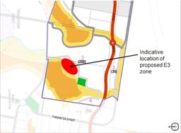
Figure 1: Indicative location of proposed E3 zone
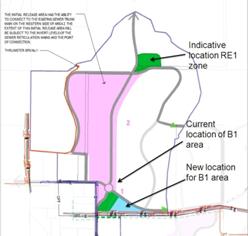
Figure 2: Proposed zone changes to Partridge Creek Residential Neighbourhood
Should Council agree with the proposed changes to the Local Environmental Plan described above, staff will prepare a Planning Proposal in consultation with the relevant landowners. A Planning Proposal is a document that explains the intended effect of proposed changes and sets out the justification for making that plan.
The Planning Proposal will include the following:
· A statement of objectives or intended outcomes
The objective for this Planning Proposal is to amend the Local Environmental Plan to accommodate small adjustments to neighbourhood structure as identified in the neighbourhood plan maps.
· An explanation of the provisions
The proposed changes are as set out above and are self explanatory.
· The justification for the objectives, outcomes and provisions and the process for their implementation
The proposed changes have a low impact and consequently only a low level of justification is required. The changes are justified as they continue to facilitate and implement the planning and development of Thrumster and are in response to neighbourhood-level planning investigations.
· Details of any proposed community consultation.
Given the low level of impact, the minimum public exhibition period of 14 days is considered appropriate; however this will be prescribed in the Gateway Determination.
It is anticipated the Planning Proposal will take six months to prepare given there remains some uncertainty regarding developable areas where subject to vegetation offset agreements and any changes made to the Port Macquarie Airport Obstacle Limitation Surface currently under review. The proposed changes will be prepared in consultation with relevant land owners prior to seeking a Gateway Determination from the State.
Conclusion
The three draft plans have been publicly exhibited for the mandatory period, resulting in several submissions being received. No changes to the draft plans have been identified as a result of the issues raised.
Several consequential amendments to the Local Environmental Plan have been identified and approval to prepare a planning proposal for these is also being sought.
Options
Decision on draft plans
Pursuant to s21 of the Environmental Planning and Assessment Regulation 2000, after considering the submissions set out in the Consultation section of this report, Council may:
1. Approve the draft plans in the form in which they were publicly exhibited, or
2. Approve the draft plans with such alterations as Council thinks fit, or
3. Decide not to proceed with the draft plans.
If adopted, the draft plans will constitute an amendment to the Area 13 Thrumster Development Control Plan, adopted by reference in the Port Macquarie-Hastings Development Control Plan 2011.
Council is legally obliged to give notice of its decision in a local newspaper within 28 days after the decision is made. A notice of a decision not to proceed with the draft plans must include Council’s reasons for the decision.
Should Council approve the draft plans, they will come into effect on the date that public notice of their approval is given in a local newspaper. Council may also specify a later date in the notice.
Consequential Local Environmental Plan changes
Pursuant to s55 of the Environmental Planning and Assessment Act 1979, Council, as the Relevant Planning Authority, may prepare a Planning Proposal as described above and forward it to the Minister for a Gateway Determination.
Should Council decide not to prepare a Planning Proposal, a private party, for example a landowner or developer, may submit a rezoning application at a later date. However, the zoning for the area will remain inconsistent with the guidance provided by the development control plan. Council may also initiate the Planning Proposal at a later date.
Community Engagement & Internal Consultation
The draft plans were placed on public exhibition for a period of four weeks commencing on Friday 6 September 2013 and concluding on Friday 4 October 2013.
During the public exhibition period four written submissions were received. The following table provides a summary of the issues raised in each submission with staff comments.
|
Submission Thrumster Neighbourhood Plans for Partridge Creek and West Lindfield
|
Issue |
|||
|
1. |
John & Fay Cook
|
The [public notice] indicated that landowners in the Thrumster Urban Release Area (Area 13) were consulted. This is not quite correct, at no stage were we contacted for consultation. |
||
|
|
Response/ Comment: |
The public notice stated “The draft plans have been prepared by King and Campbell Pty Ltd, on behalf of, and in consultation with landowners within the Thrumster Release Area.” Mr and Mrs Cook are not part of the landowner client group King & Campbell are acting for as their property does not fall within the boundary of any of the subject draft neighbourhood plans. However, Council records indicate Mr and Mrs Cook have been contacted from time to time on various matters related to the planning for the broader Thrumster area including the Local Environmental Study and Koala Plan of Management in 2006, the Local Environmental Plan in 2008, and the Thrumster Implementation Plan review in 2012. |
||
|
2. |
John & Fay Cook
|
The plans on exhibition indicate that a few of the properties located in Thrumster Street, that were previously zoned R5 in LEP 2011, will now be zoned R1. This change provides the avenue for the three neighbourhood plans on exhibit substantially [sic] more marketable to an investor if Council wishes to market their parcel of land, if they choose. [...] We feel the same re-zoning opportunity should be afforded to The Grange and Thrumster Street. |
||
|
Response/ Comment: |
The draft neighbourhood plans are proposed as an amendment to the Development Control Plan and do not include any rezoning proposals for R5 Rural Residential land. R5 land on the eastern side of Thrumster Street is included within the Partridge Creek Residential neighbourhood, however is not within a Development Area. The draft maps have been reviewed for potentially misleading information and no changes have been identified. Council’s assessment of the area in 2006 concluded that it was too constrained for low density residential development but that limited development potential was possible. As such, the zone changed from Rural to Rural Residential.
|
|||
|
3. |
John & Fay Cook
|
Structure Plan May 2006 clearly indicated “low impact residential density” was to be five dwellings per ha. It is extremely difficult to comprehend why the R5 zoning was extended to one only section of Area 13 in LEP 2011. The Structure Implementation Plan was a prelude to LEP 2011 and displayed at all the public meetings we attended, prior to LEP 2011 consent, contrary to the final density dwellings of one per ha.
|
||
|
Response/ Comment: |
The R5 Rural Residential land east and west of Thrumster Street is significantly constrained, primarily by core Koala habitat. The area west of Thrumster Street was included in the original Thrumster Investigation Area, however it was identified as having limited development potential and not included in subsequent neighbourhood planning areas. The 2006 Structure Plan identifies the area of R5 Rural Residential land adjoining Thrumster St as “Low Impact Residential”. An associated table in the document describes the “Preliminary dwelling and population yields for Thrumster neighbourhood areas” and shows “Low impact/LDR” as having a density of 5 dwellings per hectare. Note that this figure provides the average anticipated dwelling yield for both Low Impact Residential (typically 1 to 2 dwellings per hectare) and Low Density Residential (LDR) (typically 10-12 dwellings per hectare). It is not presented as a specific development standard. The 5 dwellings per hectare figure was, as the title suggests, a preliminary analysis of potential yield to estimate ultimate population capacity as part of the strategic planning for the area. Further refinement to this analysis resulted in Map 4.16 Target Populations in the Thrumster General Development Control Plan (adopted 2009) and associated table showing Population Yields for each development area. The R5 land is not identified in Map 4.16 and therefore has no specific population target. The minimum lot size for this area of R5 is 8,000m2 resulting in a theoretical potential development yield of about 1.25 dwellings per hectare, consistent with the known development constraints.
|
|||
|
4. |
King & Campbell on behalf of landowners in the West Lindfield residential, Partridge Creek Residential and Partridge Creek Industrial neighbourhoods |
[...] having completed the detailed process associated with the preparation of the neighbourhood development control provisions we suggest that a similar and more efficient outcome could have been achieved through relatively minor amendments to the Thrumster General Provisions DCP chapter. [...] we do not support the concept of neighbourhood development control provisions as a principle in urban release areas.
|
||
|
Response/ Comment: |
Noted. The Thrumster General Provisions Development Control Plan and associated neighbourhood provisions are under review with the intent of removing duplication and streamlining the document where possible. |
|||
|
5. |
King & Campbell on behalf of landowners in the West Lindfield residential, Partridge Creek Residential and Partridge Creek Industrial neighbourhoods |
[W]e agree with the comments in the report to the Council meeting on 21 August 2013 (hereafter referred to as Council Report) regarding the proposed amendment to the indicative staging for Thrumster to allow Partridge Creek Residential and South Oxley neighbourhoods to commence development as soon as they are ready.
|
||
|
Response/ Comment: |
Support noted. |
|||
|
6. |
King & Campbell on behalf of landowners in the West Lindfield residential, Partridge Creek Residential and Partridge Creek Industrial neighbourhoods |
We note the comments in the Council Report on 21 August 2013 regarding probity issues for Council as a landowner. As the author of the draft development control provisions we confirm that the process applied to the development of the recommendations with respect to the provisions has been on impartial basis based on established planning grounds that does not given any landowner including Council any material advantage. We agree with the findings and recommendations of the Probity Report prepared by Graham Gardner.
|
||
|
Response/ Comment: |
Support noted.
|
|||
|
7. |
King & Campbell on behalf of landowners in the West Lindfield residential, Partridge Creek Residential and Partridge Creek Industrial neighbourhoods |
Sections 7.3.1 and 9.3.1 – Maps 7.3.1 and 9.3.1 provide indicative locations and widths of bushfire APZs. Wherever possible this will be located within the public road and building setback areas of residential zones. However it is noted that the rezoning process acknowledged that the 30 m wide environmental buffer areas around development zones contained an outer buffer area 15 m wide within the E3 Environmental Management Zone and that this area may be required as part of the outer protection area of a future bushfire APZ. |
||
|
Response/ Comment: |
The relevant draft plans do not alter the bushfire requirements of the Thrumster Development Control Plan. Development Criteria 2 under s4.3.1 states “Council may allow up to 15m width (on the development side) of the 30m buffer contained within the Environmental Management Zone to be managed as an Outer Protection Zone.”
|
|||
|
8. |
King & Campbell on behalf of landowners in the West Lindfield residential, Partridge Creek Residential and Partridge Creek Industrial neighbourhoods |
Section 7.4.3 – Pedestrians And Cycleways – Map 7.4.1 shows the location of roads with off-road shareway. An alternate location for the off-road share way in Development Area 2 exists along the northern edge of the Development Area (i.e. along the northern edge of the residentially zoned part of the Council land holding within West Lindfield Residential neighbourhood)
|
||
|
Response/ Comment: |
Noted.
|
|||
|
9. |
King & Campbell on behalf of landowners in the West Lindfield residential, Partridge Creek Residential and Partridge Creek Industrial neighbourhoods |
Map 7.5.1 Urban Development Plan – the current layout for the Development Area 3 is indicating a yield of 234 residential lots.
|
||
|
Response/ Comment: |
Noted. The relevant Thrumster General Development Control Plan development criteria states: “Development shall achieve not less than the target dwelling yield shown in the table for the development areas shown in Map 4.16, unless varied in the Neighbourhood Development Control Plan provisions.” Development Area 3 is one of the most constrained parts of the Thrumster Release Area. In this case, there are no feasible alternatives to increase development density on other parts of the same property. The yield anticipated for this development area is 268 dwellings calculated from a gross density of 10 dwellings per hectare for land north of John Oxley Drive and 12 dwellings per hectare south of John Oxley Drive. Typically, an average lot size of 600m2 is needed for detached dwellings to achieve a gross density of 10 dwellings per hectare. The draft West Lindfield neighbourhood provisions (Map 7.5.1) propose varying this figure to 235 dwellings given a better understanding of development constraints, particularly Koala habitat, since the original anticipated yield was derived. The revised figure is taken from preliminary subdivision design which found the required average lot size unable to be achieved while responding to the Koala Plan of Management provisions. This results in a shortfall of less than 3% when spread across the West Lindfield neighbourhood or less than 1% against the total Thrumster planning area target of 4,257 dwellings and is considered to remain generally consistent with the objective.
|
|||
|
10. |
King & Campbell on behalf of landowners in the West Lindfield residential, Partridge Creek Residential and Partridge Creek Industrial neighbourhoods |
The following local infrastructure should be considered for inclusion in schedules of works in the relevant contribution plan or development servicing plan: · The intersection of Lindfield Park Road and the new collector road and intersections 3, 4 and 5 on John Oxley Drive. · The upgrade of John Oxley Drive within the West Lindfield neighbourhood. · The upgrade of Thrumster Street. · The extension of Thrumster Street to the west to link with the Sancrox Traffic Arrangement being constructed in conjunction with the development of the Sancrox Employment Precinct and the Fernbank Park Employment Precinct. · The “dead road” linkages across environmental corridors within and between Partridge Creek Residential, West Lindfield Residential and Partridge Creek Industrial neighbourhoods. · The Type 2 koala underpasses at each of the road crossings of environmental corridors. · The construction of Thrumster SPS numbers 2, 3 and 4 and associated rising mains. · The upgrade of the existing 300 mm watermain along John Oxley drive to a 450 mm watermain. · The upgrade of the existing watermains in the North South section of Thrumster Street as part of the local distribution network. · Reclaimed water main distribution network. |
||
|
Response/ Comment: |
Noted. The majority of items listed above are included in the current review of contributions plans and development servicing plans. Items not already included (i.e. the ‘dead road’ sections and the intersection at Lindfield Park Road) have been forwarded to the relevant council sections for their consideration and possible inclusion. A separate report will be prepared for Council on the contribution and servicing plan review.
|
|||
|
11. |
New Pacific Australia Pty Ltd |
Notation be undertaken to indicate that higher density housing may be approved to meet Council and SEPP requirements plus any other State Government initiatives. |
||
|
|
Response/Comment: |
The proposed neighbourhood-level provisions are part of a hierarchy of documents and are intended to be read in conjunction with all other applicable development controls including the Port Macquarie-Hastings Local Environmental Plan 2011 (LEP) and the Port Macquarie-Hastings Development Control Plan 2011. The LEP includes a note on the Land Use Table referring to the State Environmental Planning Policy (Affordable Rental Housing) 2009. Affordable housing is also dealt with by OB47 of the Development Specific Provisions in the DCP. Inclusion of the suggested note would result in unnecessary duplication. The Thrumster DCP contains provisions to ensure minimum, rather than maximum, density targets are achieved. |
||
|
12. |
New Pacific Australia Pty Ltd |
Notation that Flood Plain encroachment to be allowed in accordance with Patterson Britton report Issue 1 2007.
|
||
|
|
Response/Comment: |
The allowed encroachment on floodprone land is shown on Map 4.10 of the Thrumster General Provisions. The neighbourhood plan does not alter these areas. As the neighbourhood-level plan is intended to operate by exception, there is no need to duplicate the encroachment area in the neighbourhood map if it does not alter the boundary.
|
||
|
|
New Pacific Australia Pty Ltd |
That development of 302 John Oxley Drive be allowed as soon as sewer pumping station is commissioned and the collector road passing through the property built. |
||
|
|
Response/Comment: |
302 John Oxley Drive is located within Development Area 2 - West Lindfield Residential. The neighbourhood plan will not prevent a development application being lodged for the site.
|
||
|
13. |
Department of Trade & Investment - Crown Lands |
For any Crown road affected by a development proposal requiring works (including construction, upgrade and/or maintenance) the applicant must obtain Council's concurrence to the ownership of the road being transferred to Council, in terms of Section 151 of the Roads Act, 1993. Council will then be responsible for setting the standards for road construction and any other requirements as the Roads Authority under the Roads Act, 1993 in respect of that road. For example, according to the documentation supplied, the northern half of the Crown road located to the east of Lot 206 DP 754434 is to be used for road, hence Crown Lands requires this Crown road reserve to be transferred to Council.
|
||
|
Response/ Comment: |
Noted. Matters regarding such paper roads will be dealt with at subdivision design stage.
|
|||
|
14. |
Department of Trade & Investment - Crown Lands |
Requirements under Planning for Bushfire Protection 2006 for Asset Protection Zones (APZ) to be entirely within the development and not impact on the adjoining Crown land including Crown road reserves. For example, Partridge Creek Industrial Neighbourhood Development Control Plan Map 10.3.1 Hazards Management: Bush fire indicates an area of Crown road reserve to be used for APZ. If this road was transferred (as discussed above) to council then Crown Lands will no longer have concerns with this area being used for APZ.
|
||
|
Response/ Comment: |
Noted. Matters regarding such paper roads will be dealt with at subdivision design stage. With regard to the Asset Protection Zone, Council has the same standards and an appropriate road layout will be required at subdivision stage.
|
|||
|
15. |
Transport, Roads & Maritime Services |
Adequate capacity needs to be provided along John Oxley Drive from Thrumster to the Oxley Highway. This should be included in contribution arrangements.
|
||
|
Response/ Comment: |
Noted. See comment regarding contributions above. |
|||
|
16. |
Transport, Roads & Maritime Services |
Consideration needs to be given to the impact that this development will have on the Oxley Highway and John Oxley Drive interchange. Especially the eastbound on ramp and the Phillip Charley Drive and John Oxley Drive roundabout where queuing could occur back onto the Oxley Highway.
|
||
|
Response/ Comment: |
The draft plans do not propose any new population areas. The plans add local detail to the already adopted Thrumster General Provisions Development Control Plan (2009). Council’s road planning since the adoption of the 2006 Thrumster Structure Plan has taken the forecast population for Thrumster into account.
|
|||
|
17. |
Transport, Roads & Maritime Services |
The DCP does not identify the type of infrastructure that will be required at the proposed new intersections (3, 4, & 5) with John Oxley Drive. This needs to be done prior to any development occurring so it can be included in contribution arrangements.
|
||
|
Response/ Comment: |
Noted. See comment regarding contributions above.
|
|||
The community consultation requirements for the proposed Local Environmental Plan changes will be prescribed in the Gateway Determination.
Planning & Policy Implications
The draft plans are consistent with the State Government’s Mid North Coast Regional Strategy and Council’s Thrumster General Provisions Development Control Plan. Finalisation of the draft plans is identified in Council’s 2013-14 Operational Plan.
Should the draft plans be adopted, they will allow development to proceed in these neighbourhoods.
On the matter of probity for Council as a landowner, a peer review of the neighbourhood planning process was undertaken prior to public exhibition and included with the previous report to Council. The matters raised in the submissions do not give rise to additional probity issues. The draft plans have not changed since public exhibition.
Financial & Economic Implications
Preparation of the draft plans is funded through existing budgets. Affected landowners have paid some of the cost of their preparation.
Orderly development of the Thrumster urban release area will have positive impacts for the local economy through construction activity during establishment of the areas and through general population increase and accompanying economic activity.
|
Attachments
1. West Lindfield Neighbourhood Plan 2. Partridge Creek Residential Neighbourhood Plan 3. Partridge Creek Industrial Neighbourhood Plan 4. Submission: John & Faye Cook 5. Submission: King & Campbell 6. Submission: New Pacific Australia Pty Ltd 7. Submission: Crown Lands 8. Submission: RMS |
|
20/11/2013
|
Item: 12.07
Subject: Proposed Variation to draft LEP Height of Building Map - Warlters Street, Settlement City Precinct Presented by: Development & Environment, Matt Rogers
Alignment with Delivery Program
5.4.1 Plan settlements to accommodate a range of compatible land uses that meets projected population growth for new and existing developments. |
|
That Council: 1. Endorse the amendment to the exhibited draft Height of Building Map applying to Lot 2 DP1163062 (Kmart site), Lot 1 DP1163062 (St Josephs Primary School) and Lot 3 DP263340 (Council-owned land), as shown in this report, to retain a maximum 11.5m building height for the Warlters Street edge and take into account future road widening. 2. Advise the owners of Lots 1 and 2 DP1163062 of the outcome of this report.
|
Executive Summary
On 12 December 2012 Council resolved to prepare a Planning Proposal to amend Port Macquarie-Hastings Local Environmental Plan (LEP) 2011 to increase the maximum building height on certain land at Warlters, Bay and Park Streets in the Settlement City Precinct to 16m and maximum floor space ratio to 2:1; and to introduce a design excellence provision for land zoned B3 Commercial Core an SP3 Tourist in the locality.
Following evaluation of the written submissions, the outcome of the public exhibition was reported to the 17 July 2013 Ordinary Council Meeting. After consideration of the key issues identified, Council resolved to progress the exhibited Planning Proposal to finalisation subject to an amendment to retain a maximum 11.5m street edge height for the Warlters Street frontage.
In finalising the draft HOB LEP map, it is proposed to make a minor variation to take into account future road widening along the Warlters Street edge. The proposed HOB map amendment is minor only but is needed to achieve the intended outcome of limiting the scale of buildings adjoining the road reserve opposite existing residential dwellings on the southern side of Warlters Street.
The proposed amended HOB controls do not conflict with the height of the proposed Kmart building, as shown in a development application currently with Council.
It is necessary to obtain Council’s endorsement to the proposed draft HOB map variation to ensure due process is followed in preparing the LEP amendment.
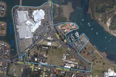
Discussion
At the Ordinary Meeting held on 17 July 2013, Council resolved to progress a Planning Proposal to change the height of building (HOB) and floor space ratio (FSR) controls applying to the Kmart site in the Settlement City Precinct; and to introduce design excellence provisions to apply to Zone B3 Commercial Core and Zone SP3 Tourist land in the precinct. The Planning Proposal also involved a change to the street edge height for properties adjoining the Kmart site to the west (St Josephs Primary School & Council-owned land).
Concerns were raised during the public exhibition that there would be potential adverse overshadowing impacts to adjacent residents on the southern side of Warlters Street and, as a result, Council decided to progress the Planning Proposal subject to retention of a maximum 11.5m street edge height for the Warlters Street frontage, instead of 16m as exhibited.
In finalising the draft HOB map in accordance with Council’s July resolution, it has become apparent that a minor variation to the reported HOB map is required, to take into account future road widening on the Warlters Street frontage consistent with the equivalent adopted development control provision and exhibited Kmart Planning Agreement Offer.
The current, exhibited, Council endorsed and proposed revised HOB map extracts are shown below.
· Current Height of Building Map
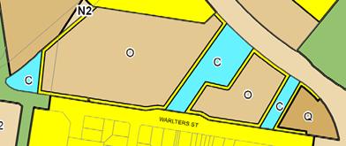

· Exhibited draft Height of Building Map
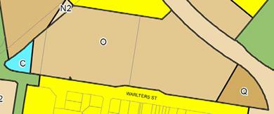
· Council endorsed draft Height of Building Map (17 Jul 2013 Ordinary Meeting)
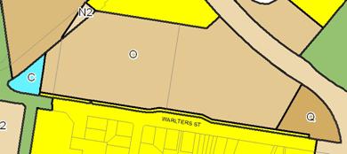
· Proposed amended draft Height of
Building Map
allowing for road widening
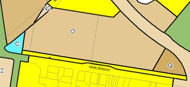
The existing HOB map reflects elements of Council’s adopted Settlement City Precinct Structure Plan 2009 and includes a lower 11.5m street edge height for the majority of the Warlters Street frontage to a depth of 5m.
In finalising the draft HOB map amendment, it became evident that if the HOB map as described in the July 2013 Council report were progressed, road widening would consume the majority of the land to which the 11.5m control would apply.
As such, the proposed revised draft HOB map makes provision for future road widening plus the 11.5m street edge height.
It is considered that the proposed change to the draft HOB LEP map is not a significant change to the HOB map amendment as described in the July 2013 Council report and does not alter the intent of the Planning Proposal. It is also considered that the proposed change is not inconsistent with the authorisation to exercise delegation issued to Council to make the LEP.
Having regard to the minor nature of the proposed modification and because the change is inconsequential to the exhibited Planning Proposal, Council staff are of the view that there is no need to re-exhibit the proposed revised draft HOB map, and that a new Gateway Determination, or Delegation will not be required.
Should Council decide to accept the proposed HOB map amendment to take into account future road widening, it must forward a copy of the revised Planning Proposal to the Minister for Planning. Further community consultation is not required, unless directed in a revised Gateway Determination. The Department of Planning will advise whether a revised Determination is to be issued. Otherwise, the next step towards implementing the Planning Proposal is legal drafting of the LEP.
Options
Council could opt to progress the proposed draft HOB LEP map as adopted at the July 2013 Meeting. This action however would not provide any certainty in limiting the scale of buildings adjoining the road reserve opposite existing residential dwellings on the southern side of Warlters Street.
In light of the circumstances, it is recommended that Council accept the proposed revised draft HOB map to take into account future road widening.
Community Engagement & Internal Consultation
Council has advised Kmart representatives of the proposed change to the HOB map as described in this report and no objection has been received at the time of preparation of this report.
Affected landowners, stakeholder who made submissions to the exhibited LEP amendment and Kmart’s planning consultant, King and Campbell, will be advised of this report to ensure they have an opportunity to address Council on the proposed HOB map amendment.
Planning & Policy Implications
Council has the delegation to make this plan, subject to review of the proposed change by the NSW Department of Planning & Infrastructure.
Financial & Economic Implications
The proposed change to HOB controls will limit development to a height of 11.5m for a 5 metre depth from the expected future property boundary to Warlters Street, once road widening has taken place. It is not expect that this development control will have a significant adverse financial or economic impact.
|
Attachments
Nil |
|
20/11/2013
|
Item: 12.08
Subject: Growth Constraints - Oxley Highway/Wrights Road Intersection, Port Macquarie [SF13/1207] Presented by: Development & Environment, Matt Rogers
Alignment with Delivery Program
5.1.1 Plan, investigate, design and construct road and transport assets which include pedestrian, cyclist and vehicular needs. |
f
|
That Council: 1. Make representations through Leslie Williams, State Member for Port Macquarie, to the Hon Duncan Gay, NSW Minister for Roads and Ports, seeking State Government commitments towards funding and the upgrade of the Wrights Road/Oxley Highway intersection within the next 10 years. 2. Consult NSW Health and continue investigations regarding access arrangements to the Hospital Precinct, including supplementary access via Toorak Court to the Hospital, and that a report come back to Council on the results of these investigations.
|
Executive Summary
Planning for urban development in the Lake Innes Peninsula and John Oxley Drive areas has highlighted that the recently constructed Oxley Highway/Wrights Road intersection has limited capacity to accommodate proposed urban growth. The John Oxley Drive intersection is State infrastructure as part of the Oxley Highway.
Council has undertaken modelling to determine the life of the existing roundabout under a number of development scenarios, in consultation with the RMS. The estimated life of the roundabout is 5-10 years.
The NSW Roads & Maritime Services (RMS) (15-10-2013 - Attachment 1) does not support the proposed strategy to intensify development in the eastern section of John Oxley Dve “without identification of the appropriate road infrastructure necessary to address the impacts of the proposal, and an equitable contributions scheme”. The RMS states that “there would appear little justification for Roads and Maritime Services to be a contributor in any way towards a contribution scheme.”
The following issues exist from Council’s perspective:
· The intersection has been designed and constructed by the State Government as the primary point of access to the Oxley Highway for the Lake Innes release area. No alternative exists for local traffic using the intersection.
· Upgrade options such as full signalisation and/or grade separation of the intersection will involve substantial capital investment (e.g. approximately $10 million), which cannot be funded by Council from existing Development Contributions Plans or from the current proponents.
· Council’s options to secure developer contributions funding for State infrastructure is limited by State legislation and a state Infrastructure Levy has not been applied to the Lake Innes area.
· The current expansion of the Port Macquarie Base Hospital, which was approved by the State Government, has made no contribution to a future intersection upgrade.
· Council will therefore not be able to establish an equitable scheme, as suggested in the RMS letter.
The early resolution of these traffic issues remains a high priority for Council to facilitate decisions regarding the bulky goods and university proposals. The alternatives for Council and the State government are to refuse the additional development or accept the traffic congestion without any planning for an intersection upgrade.
In the circumstances, it is recommended that Council make representations through Leslie Williams, State Member for Port Macquarie, to the Hon Duncan Gay, NSW Minister for Roads and Ports, seeking a commitment from the State government to upgrade the intersection, with limited contributions from local development.
It is also recommended that Council make representations to NSW Health regarding additional access arrangements to the Hospital Precinct via Toorak Court to supplement the primary Wrights Road access to the Hospital.
Discussion
Background
Council commenced investigations for the John Oxley Drive Precinct, focussing on rural land between the existing and former Oxley Highway alignments, in 2011. The investigations were undertaken in accordance with the adopted Port Macquarie-Hastings Urban Growth Management Strategy (2011).
Advice from Roads and Maritime Services (RMS) dated 7/6/2012 on the exhibited draft Structure Plan stated in part that: “It is recommended that Council obtain a detailed Traffic Impact Assessment Report to support any Planning Proposals for the rezoning of sites nominated for Commercial / Bulky Goods. RMS will not support the rezoning of land for commercial purposes where it would substantially impact on the safety and efficiency of the state road network.
Council should investigate further local network connections to the John Oxley Drive Precinct to avoid unnecessary demand on the Oxley Highway. At present the Oxley Highway between Wrights Road and Lake Road is the only connection between the Western growth areas (including the John Oxley Precinct) and inner Port Macquarie. The cumulative impact of recently planned urban growth, including Thrumster, Sancrox, John Oxley Drive Precinct and the Port Macquarie Base Hospital redevelopment, may potentially result in significant traffic management problems on the abovementioned section of the Oxley Highway if alternate local connections are not implemented.”
The Structure Plan was finalised by Council on the basis that further traffic investigations would be undertaken. There are no feasible alternative local road access options to divert traffic away from the Oxley Highway given natural constraints and existing development. Development at Lake Innes and in the John Oxley Drive area remains dependent on access via the Wrights Road intersection.
Following adoption of the John Oxley Drive Precinct Structure Plan, Council considered a request to rezone 18 John Oxley Drive (the former Gateway Park site) to Business Development to permit a major anchor (hardware and building supplies) with ancillary bulky goods premises. The concept design for the site is a Woolworths Masters development with supporting bulky goods retail premises.
Council resolved to commence the process of rezoning the land for such use and has coordinated planning investigations, including traffic modelling, with input from the NSW Roads & Maritime Services (RMS). The traffic modelling has included estimates of projected traffic growth associated with the proposed bulky goods centre and a proposal for a Charles Sturt University campus at Major Innes Rd.
The purpose of this report is to advise Council on the results of the traffic modelling, the response from the RMS and Council’s options in relation to future traffic management and development in the John Oxley Dve area.
The proposed CSU campus is not yet the subject of a
development application, however a development application is being prepared by
CSU for Stage 1 of the University campus.
The proposed bulky goods zone amendment has been publicly exhibited and will be reported separately to Council, including consideration of the issues in this report. A submission in relation the status of the bulky goods proposal has been received from King & Campbell on behalf of the landowner of the proposed bulky goods site (Attachment 2).
King & Campbell request that Council proceed to rezone the proposed site of the Masters bulky goods centre on the basis that the owner is prepared to enter into an agreement with Council, that development will not proceed until such time as there is an equitable contributions scheme in place to fund the future upgrade of the Wrights Road intersection.
Traffic Modelling Results
SMEC Australia Pty Ltd were commissioned by Council to provide a traffic study to determine suitable infrastructure upgrades required to support future development of the John Oxley Drive precinct. SMEC used 2 computer software packages (SIDRA and AIMSUN) to model the intersection and network performance - using both allows for cross-checking.
A copy of the final SMEC report is provided as Attachment 3 to this report, including Appendix A Presentation of Findings and Conclusions, which is a copy of a PowerPoint presentation. The remaining 94 pages of technical appendices are omitted.
Council subsequently reviewed the findings of the SMEC report in more detail for the Wrights Road roundabout.
The traffic modelling considered:
· traffic volumes and directions of traffic movement as at different times of day (usually focussing on times of peak traffic volumes),
· changes in traffic volumes and movements over time, eg, present (“calibrated” to actual traffic counts) and in 10 year’s time, for a number of scenarios,
o “background growth” within existing urban areas, particularly Innes Peninsula,
o increased traffic associated with the expansion of the hospital and the medical precinct developing in Highfields Circuit - both medical centres and tertiary health training facilities,
o a bulky goods development at 18 John Oxley Drive (with access close to the roundabout),
o other development anticipated in the John Oxley Drive Precinct Structure Plan, and
o the proposed staged development of a Charles Sturt University campus on Major Innes Road.
· how road and intersection characteristics affect the capacity and flow patterns of traffic.
Note: Background growth is the growth predicted at the time the Wrights Road intersection was designed and constructed. This includes forecast residential growth in the Lake Innes and Thrumster areas and some expansion of the Base Hospital.
The model tested traffic flows for weekday morning and evening peaks and for late Saturday mornings, from the Wrights Road intersection along John Oxley Drive to The Ruins Way, for 2013 and 2023 - background, and various development options, and testing high and low traffic generation rates.
The traffic modelling shows that the current design of the roundabout favours westbound highway traffic, which is able to enter the roundabout without significant conflict with right turning vehicles. The roundabout functions reasonably well for Highway traffic in the coming 10 years, regardless of whether additional development is approved in the Lake Innes area and in the Hospital precinct.
Local traffic entering the roundabout will experience increasing delays in the next 10 years, irrespective of whether additional development is approved in the John Oxley Drive area. This is particularly true for traffic entering the roundabout from John Oxley Drive as westbound Highway traffic and traffic entering the roundabout from Wrights Road both take precedence.
The key measures of the performance of intersections used by the RMS and Council are described below:
· “Level of Service” (LOS). LOS ratings range between A and F, to represent the delay or waiting time for a vehicle before it can proceed. A and B are excellent, while E and F identify major congestion requiring attention. The LOS is determined for each approach to an intersection, with a composite LOS derived to represent the intersection as a whole.
· Queue Length. A long queue can mainly be a matter of perception - it may not be a problem if the waiting time is brief. But it can also flag problems if the queue extends back into preceding intersections.
· Degree of Saturation. Indicates how close the road segment is to capacity, based on overall traffic volumes in relation to the configuration of the intersection.
The traffic modelling shows a Level of Service rating of “D” and long queue lengths at peak hour for traffic trying to enter the roundabout John Oxley Drive in 2023. The estimated delay for vehicles at these times in 2023 is 54 seconds based on background growth alone. This is clearly unacceptable for local traffic using John Oxley Drive and will be exacerbated if additional development is approved in the interim.
The modelling by SMEC shows that the intersection as a whole has a Degree of Saturation of 0.80 based on background growth alone in 2023. This indicates that the intersection will be operating very close to capacity at that time. The standards used by the RMS suggest that a Degree of Saturation between 0.80 and 0.85 indicate that excessive delays and queuing are likely to be a problem at peak times.
The table below shows the modelled lifespan of the existing roundabout under various development scenarios:
|
Development |
Scenario 2018A |
Scenario 2018B |
Scenario 2023A |
Scenario 2023B |
Scenario 2023C |
|
Background growth |
P |
P |
P |
P |
P |
|
PMBH Expansion |
P |
P |
P |
P |
P |
|
Health Education Campus |
P |
P |
P |
P |
P |
|
Sienna Grange |
P |
P |
P |
P |
P |
|
Shopping Village |
P |
P |
P |
P |
P |
|
Highfields Circuit |
50% of 2023 |
50% of 2023 |
P |
P |
P |
|
Charles Sturt University |
50% of 2023 |
50% of 2023 |
O |
P |
P |
|
John Oxley Dr Precincts |
25% of 2023 |
25% of 2023 |
O |
P |
P |
|
Bulky Goods |
O |
Hardware only |
O |
O |
P |
|
Outcome |
Close to capacity |
Above capacity |
Close to capacity |
Above capacity |
Above capacity |
In summary, the traffic modelling indicates that the Oxley Highway/Wrights Road roundabout has capacity to accommodate peak traffic flows from projected growth in the area for approximately 10 years, if there is no additional development beyond that assumed by the RMS or subsequently approved (Scenario 2023A). This excludes the proposed bulky goods centre and CSU campus proposals and other development anticipated in the John Oxley Drive Precinct Structure Plan.
If the bulky goods centre and CSU campus proceed in stages, in addition to background growth (Scenario 2018B), the modelling indicates that the Oxley Highway roundabout will have capacity for peak traffic flows for less than 5 years.
If only one of the major proposals proceeds (e.g. Staged development of a university campus in addition to background growth - Scenario 2018A), the roundabout will have capacity for peak traffic flows for approximately 5-10 years, depending on the staging of the proposed development.
Based on the above modelling, it is concluded that a full upgrade of the Wrights Road intersection will be required in approximately 10 years if development is limited to that which was assumed as background growth at the time the Wrights Road roundabout was designed plus that which has been approved since 2012. The life of the roundabout will be reduced below 10 years if either or both the proposed bulky goods centre and proposed university campus are approved.
Council has modelled the potential use of metering signals to potentially extend the life of the Wrights Road roundabout by platooning Highway traffic flows into the roundabout to create gaps for local traffic. This modelling, which was undertaken in consultation with the RMS, has shown that the use of metering signals has no significant benefit.
The modelling by SMEC shows that full signalisation of the intersection, with 4 southbound lanes (plus left slip lane), would provide acceptable levels of service under all growth scenarios. The SMEC report suggests that three lanes may be required for the south-west bound Oxley Highway and for northbound John Oxley Drive.
The option of grade separation is not contemplated in the SMEC report. However, it is understood that the existing roundabout has been designed with potential for a future overpass for westbound highway traffic to address future traffic congestion.
RMS Advice
The RMS advice dated 15 October 2013 (Attachment 1) contains a number of key points, most notably that:
1. “The modelling supports previous assessments that, without the John Oxley Drive developments, the roundabout would continue to operate within acceptable ranges of delay and service well into the future”,
2. “Without identification of the appropriate road infrastructure necessary to address the impacts of the proposal, and an equitable contributions scheme determined, Roads and Maritime cannot support the proposed strategy to intensify development in the eastern section of John Oxley Drive,” and
3. “With the recent State Government investments on the Oxley Highway in Port Macquarie, there would appear little justification for Roads and Maritime Services to be a contributor in any way towards a contribution scheme.”
These points are considered in more detail below:
1. “Acceptable ranges of delay and service well into the future”
As described above, the modelling by SMEC indicates that the roundabout will experience a level of service “D” in 2023 for traffic entering the roundabout from John Oxley Drive and that the roundabout will not be functioning satisfactorily at that time.
This outcome is surprising as the roundabout was only became operational in February 2012 and Highway infrastructure is typically designed to have a longer functional lifespan. A 2006 Roadnet traffic study for the RMS in planning for the Highway realignment shows that the limitations of the roundabout, as constructed, were known at the time.
The Roadnet report notes that: “The Wrights Road intersection will attract a considerable volume of traffic because it is the focal point where the old highway, the Deviation and access to the Hospital meet.” “By 2026 the roundabout is shown to operate at level of service ‘F’ unless other traffic management measures are implemented.”
Construction of an overpass is suggested as an option by Roadnet “to separate the westbound Oxley Highway traffic from the old highway traffic. It is possible to provide an overpass to avoid delays at this site however the nearby Lake Road / Oxley Highway intersection would also be expected to experience capacity problems with these volumes. Under these circumstances other measures appear to be more effective.”
Any assessment of the function of the Wrights Road intersection must take into account the level of delay to both Highway and local traffic users. Local traffic is an essential component of the function of the roundabout since it was designed as the primary point of access for a large urban release area and to the Port Macquarie Base Hospital. No alternative route exists for traffic to and from these areas given existing development and environmental constraints.
The existing roundabout at Wrights Road is dominated by Highway traffic because traffic entering the roundabout at Wrights Road and John Oxley Dve must give way to westbound traffic on the Oxley Highway. In peak periods and with growth in traffic volumes, it will become increasingly difficult for local traffic to enter the roundabout.
2. “An equitable contributions scheme”
The RMS advise that Council should implement a contributions scheme to fund future intersection improvements. It is anticipated that this would comprise the full signalisation or grade separation of the intersection, based on the modelling by SMEC and Council engineers in 2013 and on the 2006 Roadnet report for the RMS.
Preliminary estimates suggest that the signalisation of the intersection could cost up to $10 million due to the need to completely reconfigure the existing intersection and that grade separation would cost in excess of $10 million to construct. Both of these cost estimates are subject to detail design.
Council has a developer contributions plan for the Lake Innes Release Area, which has been in place since 2003. This Plan provides for road infrastructure improvements in the Lake Innes area, including dual lane reconstruction of John Oxley Drive. Development and approvals for development in the Lake Innes Release Area are largely completed and it is not possible to retrospectively apply additional contributions to these developments.
More importantly, in terms of the Wrights Road intersection, Council’s contribution plans exclude State infrastructure in accordance with the longstanding approach to development contributions in NSW. This assumption appears to be reinforced in the new Planning Bill for NSW, which limits Council’s ability to levy Infrastructure Contributions to “Local Infrastructure”. Contributions for State infrastructure are typically obtained through a State Infrastructure Levy and none has been applied in the Lake Innes area. It is not possible to apply a levy retrospectively.
It is therefore not possible for Council to levy contributions for the vast majority of existing and proposed development in the Lake Innes area, which was assumed as background growth at the time of construction of the Oxley Highway realignment and it is highly unlikely that significant funding can be secured through a State Infrastructure Levy. No contribution was provided by the State Government in conjunction with the current expansion of the Base Hospital, despite Council and the RMS raising this as an issue during the hospital approval process).
In terms of new development (i.e. land not yet zoned and additional to assumed background growth), there are some limited opportunities to potentially negotiate contributions. For example, Council has received an offer of $300,000 from the proponent of the proposed bulky goods retail centre on John Oxley Drive, towards future intersection improvements at the Wrights Road roundabout.
This provides some scope for Council to coordinate a contribution towards future intersection improvements. However, the opportunities to obtain contributions are limited and the total amount of any contribution is likely to be small in relation to the total cost of full signalisation or grade separation of the intersection.
It is therefore unclear how the RMS envisages that Council could implement an “equitable contributions scheme” without a substantial State contribution.
3. Recent State Government Investments and RMS Contributions
Council has welcomed the recent State government funding commitment to the Oxley Highway road entry to Port Macquarie and it is not intended that this commitment should be devalued or questioned in this report.
The report is instead focussed on the particular issues that are being faced in relation to the upgrade of the Wrights Road intersection, which will be an issue for the proposed bulky goods centre, the expected proposal for a university campus for Charles Sturt University on Major Innes Road and for other proposals for development which generate larger traffic volumes in the Lake Innes area and Hospital precinct.
The RMS objection to the current bulky goods proposal suggests that Council should refuse any such proposals until such time as an equitable contributions plan is in place. Yet Council is not in a position to implement a contributions scheme, particularly as the RMS advise that: “there would appear little justification for Roads and Maritime Services to be a contributor in any way towards a contribution scheme”.
The intersection has been designed and constructed by the State Government as the only point of access to the Oxley Highway for the Lake Innes release area and the modelling undertaken to date by the RMS and Council all points to a problem for local traffic entering the intersection within the next 10 years, sooner if new development is approved. This is a relatively short life span for State infrastructure, which was only constructed in 2012 and it appears that the RMS considered the limitations of the intersection at the time that the Highway realignment was designed.
In the circumstances, it is recommended that Council respectfully request that the State government review its position in relation to the timing and funding of intersection improvements at Wrights Road, to avoid the need to refuse significant local development and/or unacceptable local traffic congestion in the short to medium term.
Options
Assuming that Council is unable to generate the substantial funding to signalise or grade separate the Wrights Road intersection, Council’s options would appear to be limited to the following:
1. Accept the RMS position and refuse any new development (other than assumed background growth) on the basis of traffic impacts until such time as the intersection is upgraded.
2. Ignore the RMS objection and seek State approval for rezoning to allow new development (other than assumed background growth), notwithstanding the expected traffic generation from those developments on the Wrights Road intersection.
3. Defer Council assessment of new development (other than assumed background growth) and urgently make representations through Leslie Williams, State Member for Port Macquarie, to the Hon Duncan Gay, NSW Minister for Roads and Ports, seeking Government commitments to bring forward upgrades to the Wrights Road intersection with the Oxley Highway.
King & Campbell (22-10-2013 - Attachment 2) on behalf of the bulky goods proponent, request that Council: “Proceed with the LEP in conjunction with continued discussions and negotiations with all parties having an interest in resolving the inherent capacity issues associated with the existing intersection”.
This is effectively option 2 above as the rezoning to permit the bulky goods proposal has already been publicly exhibited and the steps immediately following a decision by Council to proceed would be to finalise the LEP amendment. Until there is a substantial commitment from the RMS to upgrade the intersection there is no real basis for a planning agreement as proposed by King & Campbell (Attachment 2).
Option 1 is clearly not favoured by the development proponents, including Charles Sturt University and, in each case Council must be mindful of the negative social and economic consequences that would arise beyond any traffic implications.
In the circumstances, it is proposed that Council urgently make representations through Leslie Williams, State Member for Port Macquarie, to the Hon Duncan Gay, NSW Minister for Roads and Ports, seeking Government commitments to bring forward upgrades to the Wrights Road intersection with the Oxley Highway.
In so doing, Council should emphasise the key points in this report including the significance of local economic development and the limited options for funding available to Council.
It is proposed that Council staff continue to liaise with RMS representatives regarding the design options and likely cost of future intersection upgrades to inform the discussion with Leslie Williams, State Member for Port Macquarie and the Hon Duncan Gay, NSW Minister for Roads and Ports.
Toorak Court provides a potential secondary access point to the hospital in accordance with the long term strategic plan for the hospital precinct. Council has previously consulted NSW Health regarding implementation of this secondary access. To date, it has not been possible to proceed with the proposed Toorak Court access.
Given the feedback from the RMS in relation to Wrights Road, it is proposed that Council make continued representations to NSW Health regarding additional access arrangements to the Hospital Precinct via Toorak Court.
It is not expected that access to the Hospital Precinct via Toorak Court will have a significant bearing on the long term function of the Wrights Road intersection, which will remain the primary access to the Hospital.
Community Engagement & Internal Consultation
Council has consulted directly with RMS representatives during preparation of the Port Macquarie-Hastings Urban Growth Strategy and John Oxley Drive Structure Plan. Council planners and engineers have also consulted directly with RMS representatives during recent traffic modelling related to the Wrights Road intersection.
The modelling has included input from the major development proponents, including King & Campbell for the bulky goods centre proponent and consultants on behalf of Charles Sturt University.
Consultation in relation to the proposed rezoning for the John Oxley Drive Bulky Goods Centre will be reported to Council separately. Council officers participated in a meeting between the applicant for the rezoning, King & Campbell, Leslie Williams, State Member for Port Macquarie, and the Hon Duncan Gay, NSW Minister for Roads and Ports, in July 2013. The outcome of that meeting was that staff from Council and the RMS would proceed with traffic modelling to assess the impact of metering signals. No commitment was provided in relation to funding from RMS beyond the traffic modelling.
Planning & Policy Implications
The planning implications are summarised in the options section of this report.
Depending on the outcomes of the recommended representations to the State government, it is possible that Council may have to refuse applications which generate traffic above assumed background levels or ignore the traffic generation that arises in the absence of an intersection upgrade.
This report not intended to address the merit consideration of any particular proposal in the Lake Innes area, including the current proposal for a bulky goods centre on John Oxley Drive. It is proposed that a separate report be presented to Council on the bulky goods proposal following any representations to the State government arising from this report.
Financial & Economic Implications
The cost of traffic modelling by SMEC and Council has been shared by Council and the RMS. Council’s contribution has been funded from the strategic planning budget.
The potential economic implications of the options before Council include:
1. The potential impact of foregone development activity if development does not proceed on the basis of the RMS objection,
2. The cost of traffic congestion if there are substantial delays for local traffic at the Wrights Road roundabout, and/or
3. The costs of further delays, if decisions are not made as quickly as possible.
The financial implications for Council and for local developers will vary depending on any contributions arrangements proposed. This includes any acquisition costs. This will the subject of future reports to Council.
|
Attachments
1. RMS letter 15 October 2013 2. King & Campbell: Landowner offer, 18 John Oxley Drive 3. SMEC Traffic Report |