Business
Paper
|
date of meeting:
|
|
Wednesday 28 June
2017
|
|
location:
|
|
Function Room
Port
Macquarie-Hastings Council
17 Burrawan Street
Port Macquarie
|
|
time:
|
|
2:00pm
|
Development
Assessment Panel
CHARTER
COMPOSITION:
Independent Chair (alternate, Director Development &
Environment)
Manager Development Assessment (alternate, Director Development & Environment or Development Assessment Planner)
Development Engineering Coordinator (alternate, Development
Engineer)
MISSION:
To assist in managing Council's
development assessment function
by providing independent and expert assessment of development applications
The Development Assessment Panel will make determinations on the basis of established criteria and practice and will not be influenced by "lobbying" and "weight of numbers" in its assessment process.
FUNCTIONS:
1.
To review development application reports and conditions
2.
To determine development applications outside of staff delegations
3.
To refer development applications to Council
for determination where necessary
4.
To provide a forum for objectors and applicants to make submissions on applications before DAP.
5.
To maintain transparency for the determination of development applications.
DELEGATED AUTHORITY:
1.
Pursuant to Section
377 of the Local Government Act, 1993 delegation to:
2.
Determine development applications under Part 4 of the Environmental Planning
and Assessment Act 1979
having regard to the relevant
environmental planning instruments, development control plans and Council
policies.
3.
Vary Modify or release restrictions as to use and/or covenants created
by Section 88B instruments under the Conveyancing Act 1919 in relation to
development applications for subdivisions being considered by the panel.
4.
Determine Koala Plans of Management under State Environmental Planning
Policy 44 - Koala Habitat Protection associated with development applications
being considered by the Panel.
TIMETABLE:
The Development Assessment Panel shall generally meet on the 1st and 3rd Wednesday each month at 2.00pm.
VENUE:
The venue will be
determined according to the likely
number of participants.
BUSINESS PAPER AND MINUTES:
1.
The Business Paper for the meeting shall be published
and distributed on the Friday prior
to the meeting.
2.
Special Meetings of the Panel may be convened by the Director
Development & Environment Services
with three (3) days notice.
3.
The format of the preparation and publishing of the Business
Paper and Minutes
of the Development Assessment Panel meetings shall be similar to the format
for Ordinary Council Meetings, except that the movers
and seconders shall not be recorded and only the actual decisions are shown.
Minutes shall also record how each member votes for each
item before the Panel.
FORMAT OF THE MEETING:
1.
Panel meetings shall be carried
out in accordance with Council's
Code of Meeting Practice for Council Sub-Committees, except where varied
by this Charter.
2.
Meetings shall be "Open" to the public.
3.
The Panel will hear from applicants and objectors or their representatives. Where considered necessary, the Panel will conduct site inspections which will be open to the
public.
INDEPENDENT CHAIR:
The Chair of the Development Assessment Panel shall be an independent person appointed by the General
Manager. The Independent Chair shall have experience and qualifications relevant to planning.
The term of the Independent Chair shall be four
(4) years.
QUORUM:
All members must be present at the Meeting to form a Quorum.
DECISION MAKING:
Decisions are to be made by the Development Assessment
Panel by "consensus". Where "consensus" is not possible,
the matter is to be referred to Council.
All development applications
involving a variation to a development standard greater than 10% under
Clause 4.6 of the Port Macquarie-Hastings Local Environmental Plan 2011 will be
considered by the Panel and recommendation made to the Council for
determination.
Staff Members shall
not vote on matters before the Panel if they have been the principle author of the development assessment report.
LOBBYING:
Outside of scheduled
Development Assessment Panel meetings, applicants, their representatives,
Councillors, Council staff and the general public are not to lobby Panel
members via meetings, telephone conversations, correspondence and the like.
Adequate opportunity will be provided at Panel inspections or meetings for
applicants, their representatives and the general public to make verbal
submissions in relation to Business Paper items.
OBLIGATIONS OF PANEL
MEMBERS:
All DAP members
are required to comply with the following:
1.
Members must perform their Development Assessment Panel obligations faithfully and diligently and in accordance
with the DAP Code.
2.
DAP members must comply with Council's Code of Conduct.
3.
Except as required to properly perform
their duties, DAP members must not disclose
any confidential information (as advised by Council) obtained
in connection with the DAP functions.
4.
DAP members will have read and be familiar with the documents
and information provided
by Council prior to attending a DAP meeting.
5.
DAP members must act in accordance with Council's Occupational Health and Safety Policies and Procedures
6.
DAP members shall not speak to the media on any matter
before the Panel otherwise
than with the express approval
of the Director Development &
Environment Services.
Development Assessment Panel
ATTENDANCE
REGISTER
|
Member
|
22/03/17
|
12/04/17
|
10/05/17
|
24/05/17
|
14/06/17
|
|
Paul Drake
Matt Rogers (alternate)
|
P
|
P
|
P
|
P
|
P
|
|
Dan Croft
Patrick Galbraith-Robertson
Warren Wisemantel
(alternates)
|
P
|
P
|
P
|
P
|
P
|
|
David Troemel
Caroline Horan (alternate)
Bevan Crofts (alternate)
Grant Burge (alternate)
|
P
|
P
|
P
|
P
|
P
|
Key: P = Present
A
= Absent With Apology
X
= Absent Without Apology
Development
Assessment Panel Meeting
Wednesday 28 June
2017
Items of Business
01 Acknowledgement
of Country............................................................................ 7
02 Apologies......................................................................................................... 7
03 Confirmation
of Minutes.................................................................................... 7
04 Disclosures
of Interest..................................................................................... 12
05 DA2017
- 332.1 Shed - Lot 7 DP 1060564, No 13 Riverbreeze Drive Crosslands.. 16
06 DA2017
- 249.1 Part Change of Use to Educational Establishment - Lot 2 DP 610860 - 8
Table Street, Port Macquarie..................................................................................... 33
07 DA
2017 - 287.1 Single Dwelling - Lot 1 DP 1195261 No 7 Denning Place, Port
Macquarie..................................................................................................................... 111
08 General
Business
AGENDA Development Assessment Panel 28/06/2017
Subject: ACKNOWLEDGEMENT
OF COUNTRY
"I acknowledge that we are
gathered on Birpai Land. I pay respect to the Birpai Elders both past and
present. I also extend that respect to all other Aboriginal and Torres Strait
Islander people present."
RECOMMENDATION
That the apologies received be
accepted.
Subject: CONFIRMATION
OF PREVIOUS MINUTES
Recommendation
That the Minutes of the Development
Assessment Panel Meeting held on 14 June 2017 be confirmed.
MINUTES Development Assessment Panel Meeting
14/06/2017
PRESENT
Members:
Paul
Drake
Dan Croft
David Troemel
Other Attendees:
Pat
Galbraith-Robertson
Clinton Tink
|
The meeting opened at 2:00pm
|
|
01 ACKNOWLEDGEMENT
OF COUNTRY
|
|
The
Acknowledgement of Country was delivered.
|
|
03 CONFIRMATION
OF MINUTES
|
|
CONSENSUS:
That
the Minutes of the Development Assessment Panel Meeting held on 24 May 2017
be confirmed.
|
|
04 DISCLOSURES
OF INTEREST
|
|
There were no disclosures of interest presented.
|
|
05 DA2017
- 328 Landfill Gas Infrastructure Associated with Waste Management Facility -
Lot 1 DP 1202080, Pacific Highway, Pembrooke
|
|
CONSENSUS:
That the
Development Assessment Panel recommend to Council that DA 2017 - 328 for landfill
gas infrastructure associated with waste management facility at Lot 1, DP 1202080,
Pacific Highway, Pembrooke be determined by granting consent subject to the
recommended conditions.
|
|
06 DA2017 - 218.1
Alterations And Additions To Dairy (Pasture Based) And Continued Use Of Shade
Structure Shed At Lot 1 DP 1089754, 200 Hewens Road, Brombin
|
|
CONSENSUS:
That DA
2017 - 218.1 for alterations and additions
to dairy (pasture based) and continued use of shade structure shed at Lot 1, DP 1089754, No. 200 Hewens
Road, Brombin, be
determined by granting consent subject to the recommended conditions.
|
|
07 DA2017 - 307 -
Staged Alterations to caravan park and construction of ancillary recreation
facility (outdoor) - Munster Street, Port Macquarie
|
|
A submission from David and
Euginia Hobday dated 15 June 2017 was tabled at the meeting.
Speakers:
Pauline Cooper (o)
Stewart Robertson (o)
Vanessa Kelliher (o)
David Hobday (o)
Euginia Hobday (o)
Kevin Cooper (o)
Jack Leonard (o)
Michelle Love (applicant)
Dawn Marchment (applicant)
The Panel was unable to reach
consensus.
For: Dan Croft and David
Troemel
Against: Paul Drake
For:
That DA2017 - 307 for staged
alterations to caravan park and construction of ancillary recreation facility
(outdoor) at Lot 655, DP 45849, Munster Street, Port Macquarie, be determined
by granting consent subject to the recommended conditions as amended below:
- Amend condition
A(5) to read: ‘No work shall commence, with the exception of the
installation of the pump track, until a Construction Certificate has
been issued and the applicant has notified Council of:
a. the appointment of a Principal Certifying Authority;
and
b. the date on which work will commence.
Such
notice shall include details of the Principal Certifying Authority and must
be submitted to Council at least two (2) days before work commences.’
- Amend condition C(1) to read: ‘With the exception
of the pump track, each stage shall not be occupied or used in whole or
in part until an Occupation Certificate has been issued by the Principal
Certifying Authority.’
- Amend condition C(3) to read: ‘Barrier fencing
between the roadway and recreational facility is to be installed before
commencement of use of each component of the recreational
facility.’
- Amend condition D(2) to read:
‘Hours of operation of the development are restricted to the
following hours daily:
- 8am to 8pm during eastern daylight savings
time and 8am to 6pm outside daylight savings time.
A
sign is to be erected on the fence surrounding the new playground to reflect
these restricted times of use and the play area shall not be
illuminated.’
- Additional condition in section D of the consent to
read: ‘An on-site manager is to be available on site at all times
to manage usage of the recreational facility components and
appropriately manage any noise complaints.’
- Additional condition in section D of the consent to
read: ‘No audio devices, bells, or whistles are to be fitted to
the water play equipment.’
- Additional condition in section D of the consent to
read: ‘Use of the recreational facility and play equipment is to
be restricted to use by overnight guests of the caravan park.’
- Additional condition in section D of the consent to
read: “Development consent is required for any new or replacement
play equipment unless it is classified as exempt under State
Environmental planning Policy (Exempt and Complying Development Codes)
2008.’
Against:
That DA2017 - 307 for staged
alterations to caravan park and construction of ancillary recreation facility
(outdoor) at Lot 655, DP 45849, Munster Street, Port Macquarie, be determined
by refusing consent for the following reason:
- The applicant has failed to demonstrate that the
proposal will not have an adverse acoustic impact on nearby residential
receivers. It is considered that the intensity of the development is not
ancillary to the caravan park and the use is not suitable for the site.
In accordance with the
Development Assessment Charter where "consensus" is not possible, the matter is to be referred to Council.
|
|
The meeting closed at 3:20pm.
|
AGENDA Development Assessment Panel 28/06/2017
Subject: DISCLOSURES
OF INTEREST
RECOMMENDATION
That Disclosures of Interest be presented
DISCLOSURE OF
INTEREST DECLARATION
Name of Meeting: ………………………………………………………………………..
Meeting Date: ………………………………………………………………………..
Item Number: ………………………………………………………………………..
Subject: ………………………………………………………………………..
…………………………………………………….……………...…..
I, .....................................................................................
declare the following interest:
 Pecuniary:
Take
no part in the consideration and voting and be out of sight of the meeting.
Non-Pecuniary
- Significant Interest:
Take
no part in the consideration and voting and be out of sight of the meeting.
Non-Pecuniary
- Less than Significant Interest:
May
participate in consideration and voting.
For the reason that: ....................................................................................................
.......................................................................................................................................
Name: …………………………………………………….
Signed:
.........................................................................
Date: ..................................
 (Further
explanation is provided on the next page)
(Further
explanation is provided on the next page)
Further
Explanation
(Local Government Act and Code of Conduct)
A conflict of interest exists where a reasonable and informed
person would perceive that a Council official could be influenced by a private
interest when carrying out their public duty. Interests can be of two types:
pecuniary or non-pecuniary.
All interests, whether pecuniary or non-pecuniary are required to
be fully disclosed and in writing.
Pecuniary Interest
A pecuniary interest is an interest that a Council official has in
a matter because of a reasonable likelihood or expectation of appreciable
financial gain or loss to the Council official. (section 442)
A Council official will also be taken to have a pecuniary interest
in a matter if that Council official’s spouse or de facto partner or a
relative of the Council official or a partner or employer of the Council
official, or a company or other body of which the Council official, or a
nominee, partner or employer of the Council official is a member, has a
pecuniary interest in the matter. (section 443)
The Council official must not take part in the consideration or
voting on the matter and leave and be out of sight of the meeting. The
Council official must not be present at, or in sight of, the meeting of
the Council at any time during which the matter is being considered or discussed,
or at any time during which the council is voting on any question in relation
to the matter. (section 451)
Non-Pecuniary
A non-pecuniary interest is an interest that is private or
personal that the Council official has that does not amount to a pecuniary
interest as defined in the Act.
Non-pecuniary interests commonly arise out of family, or personal
relationships, or involvement in sporting, social or other cultural groups and
associations and may include an interest of a financial nature.
The political views of a Councillor do not constitute a private
interest.
The management of a non-pecuniary interest will depend on whether
or not it is significant.
Non Pecuniary – Significant Interest
As a general rule, a non-pecuniary conflict of interest will be
significant where a matter does not raise a pecuniary interest, but it
involves:
(a)
A relationship between
a Council official and another person that is particularly close, for example,
parent, grandparent, brother, sister, uncle, aunt, nephew, niece, lineal
descendant or adopted child of the Council official or of the Council official’s
spouse, current or former spouse or partner, de facto or other person living in
the same household.
(b)
Other relationships
that are particularly close, such as friendships and business relationships.
Closeness is defined by the nature of the friendship or business relationship,
the frequency of contact and the duration of the friendship or relationship.
(c)
An affiliation between
a Council official an organisation, sporting body, club, corporation or
association that is particularly strong.
If a Council official declares a non-pecuniary significant
interest it must be managed in one of two ways:
1.
Remove the source of
the conflict, by relinquishing or divesting the interest that creates the
conflict, or reallocating the conflicting duties to another Council official.
2.
Have no involvement in
the matter, by taking no part in the consideration or voting on the matter and
leave and be out of sight of the meeting, as if the provisions in section
451(2) apply.
Non Pecuniary – Less than Significant Interest
If a Council official has declared a non-pecuniary less than
significant interest and it does not require further action, they must provide
an explanation of why they consider that the conflict does not require further
action in the circumstances.
SPECIAL
DISCLOSURE OF PECUNIARY INTEREST DECLARATION
|
By
[insert full name of councillor]
|
|
|
In the
matter of
[insert name of environmental planning instrument]
|
|
|
Which is
to be considered at a meeting of the
[insert name of meeting]
|
|
|
Held on
[insert date of meeting]
|
|
|
PECUNIARY
INTEREST
|
|
Address of land in which councillor or an
associated person, company or body has a proprietary interest (the identified
land)i
|
|
|
Relationship of identified land to councillor
[Tick or cross one box.]
|
Councillor
has interest in the land (e.g. is owner or has other interest arising out of
a mortgage, lease trust, option or contract, or otherwise).
Associated
person of councillor has interest in the land.
Associated
company or body of councillor has interest in the land.
|
|
MATTER
GIVING RISE TO PECUNIARY INTEREST
|
|
Nature of land that is subject to a change
in zone/planning control by proposed
LEP (the subject land iii
[Tick or cross one box]
|
The
identified land.
Land
that adjoins or is adjacent to or is in proximity to the identified land.
|
|
Current zone/planning control
[Insert name of current planning instrument and
identify relevant zone/planning control applying to the subject land]
|
|
|
Proposed change of zone/planning control
[Insert name of proposed LEP and identify
proposed change of zone/planning control applying to the subject land]
|
|
|
Effect of proposed change of zone/planning control
on councillor
[Tick or cross one box]
|
Appreciable
financial gain.
Appreciable
financial loss.
|
|
|
|
Councillor’s
Name: …………………………………………
Councillor’s
Signature:
……………………………….
Date: ………………..
Important Information
This information is being
collected for the purpose of making a special disclosure of pecuniary interests
under sections 451 (4) and (5) of the Local Government Act 1993.
You must not make a special disclosure that you know or ought reasonably to
know is false or misleading in a material particular. Complaints made
about contraventions of these requirements may be referred by the
Director-General to the Local Government Pecuniary Interest and Disciplinary
Tribunal.
This form must be completed by
you before the commencement of the council or council committee meeting in
respect of which the special disclosure is being made. The
completed form must be tabled at the meeting. Everyone is entitled to
inspect it. The special disclosure must be recorded in the minutes of the
meeting.
i.
Section 443 (1) of the Local Government Act 1993 provides that
you may have a pecuniary interest in a matter because of the pecuniary interest
of your spouse or your de facto partner or your relativeiv or
because your business partner or employer has a pecuniary interest. You may
also have a pecuniary interest in a matter because you, your nominee, your
business partner or your employer is a member of a company or other body that
has a pecuniary interest in the matter.
ii.
Section 442 of the Local Government Act 1993 provides that a pecuniary
interest is an interest that a person has in a matter because of a
reasonable likelihood or expectation of appreciable financial gain or loss to
the person. A person does not have a pecuniary interest in a matter if the
interest is so remote or insignificant that it could not reasonably be regarded
as likely to influence any decision the person might make in relation to the
matter or if the interest is of a kind specified in section 448 of that
Act (for example, an interest as an elector or as a ratepayer or person liable
to pay a charge).
iii.
A pecuniary interest may arise by way of a change of permissible use of land
adjoining, adjacent to or in proximity to land in which a councillor or a
person, company or body referred to in section 443 (1) (b) or (c) of the
Local Government Act 1993 has a proprietary interest..
iv.
Relative is defined by the Local Government Act 1993 as
meaning your, your spouse’s or your de facto partner’s parent,
grandparent, brother, sister, uncle, aunt, nephew, niece, lineal descendant or
adopted child and the spouse or de facto partner of any of those persons.
AGENDA Development Assessment Panel 28/06/2017
Item: 05
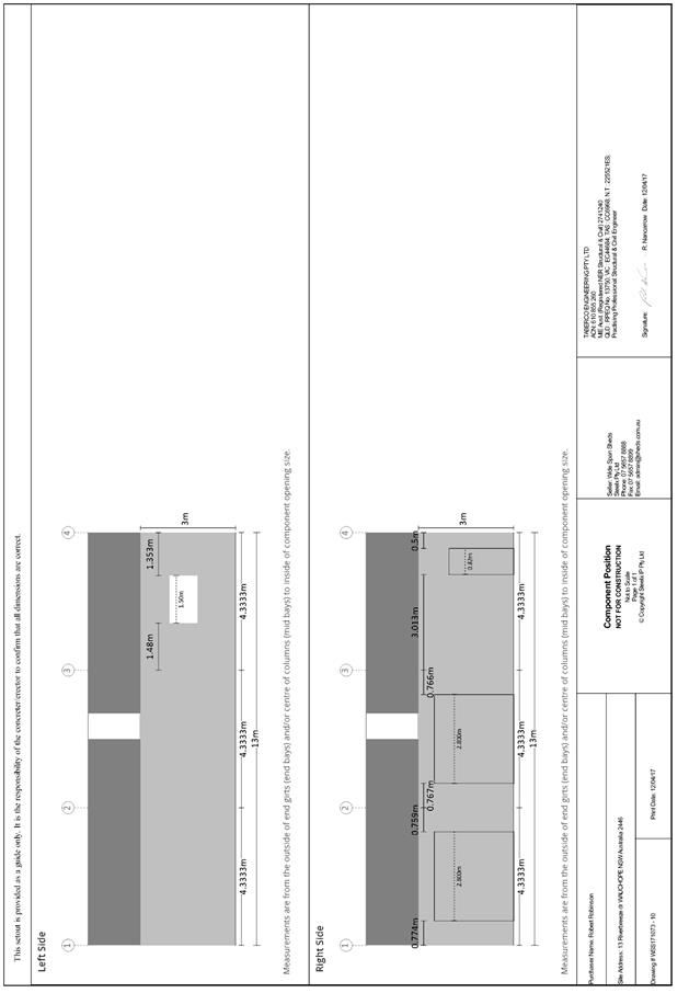
Subject: DA2017 - 332.1 Shed - Lot 7 DP 1060564, No 13
Riverbreeze Drive Crosslands
Report
Author: Warren Wisemantel
|
Applicant: R
M & S I Robinson
Owner: R
M & S I Robinson
Estimated Cost: $18,700
Alignment with Delivery
Program
4.9.2 Undertake transparent and
efficient development assessment in accordance with relevant legislation.
|
|
RECOMMENDATION
That
DA 2017 - 332.1 for an ancillary building (shed) at Lot 7 DP 1060564, No. 13
Riverbreeze Drive Crosslands, be determined by granting consent subject to
the recommended conditions.
|
Executive
Summary
This
report considers a development application for an ancillary building (shed)
at the subject site and provides an assessment of the
application in accordance with the Environmental Planning and Assessment Act
1979.
Following exhibition of the
application, 1 submission has been received.
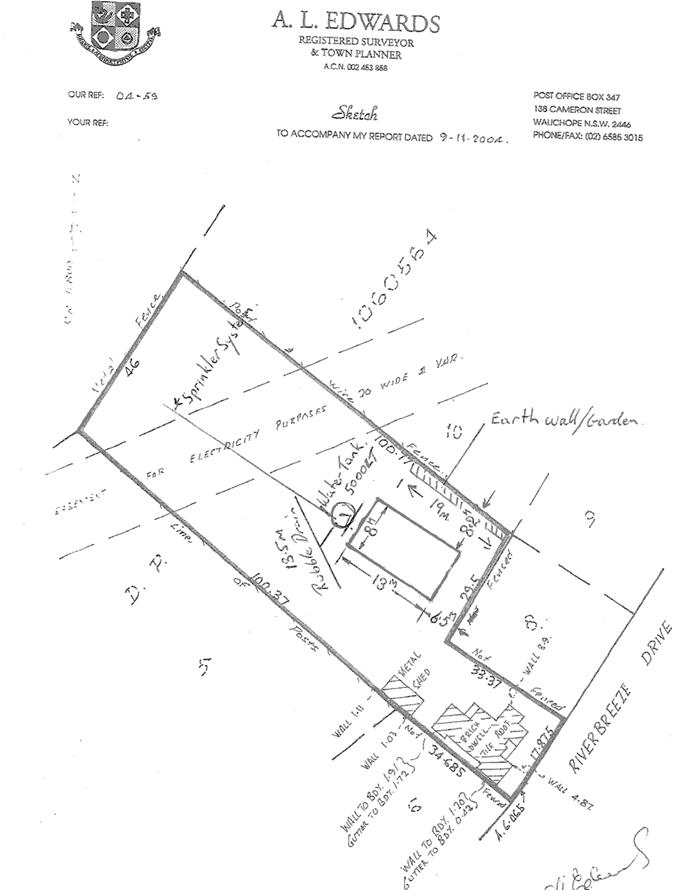
1. BACKGROUND
Existing sites features and surrounding development
The site has an area of
5633m2.
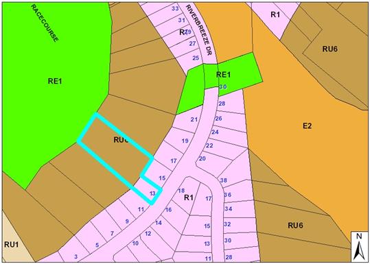
The site is zoned RU6 Transition/R1 General
Residential in accordance with the Port
Macquarie-Hastings Local Environmental Plan 2011, as shown in the following
zoning plan:
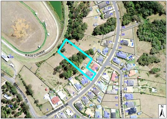
The existing subdivision pattern and location of existing
development within the locality is shown in the following aerial photograph:
2. DESCRIPTION OF
DEVELOPMENT
Key aspects of the proposal include the following:
· The
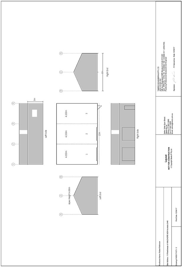
applicant proposes to erect a shed and rainwater tank on the northern side of
the allotment directly behind House No. 15 Riverbreeze Drive Crosslands.
Refer
to attachments at the end of this report.
Application Chronology
· 26
April 2017 - Application lodged
· 9
May 2017 - 22 May 2017 - Exhibition via neighbour notification
· 17
May 2017 - Objection received
· 26
May 2017 - Site inspection carried out with applicant objector discussing
concerns regarding stormwater disposal
· 31 May 2017 - Correspondence sent to both applicant and
objector/s outlining that applicant would provide updated plan indicating
rainwater tank and raised garden bed on northern boundary to slow stormwater
runoff onto objector’s property.
· 31 May 2017 - Updated site plan submitted by applicant
indicating rainwater tank and garden bed on boundary as discussed in site
meeting.
· 31 May 2017 - Correspondence received from objector
requesting size of rainwater tank.
· 31 May 2017 - Correspondence received from applicant
advising 5000 litre water tank would be provided.
· 1 June 2017 - Objector advised 5000 litre water tank would
be installed.
· 1 June 2017 - Correspondence received from objector
requesting applicant consider a 10,000 litre water tank.
· 1 June 2017 - Correspondence received from applicant
advising that they would only be providing a 5000 litre water tank, rubble
drain for stormwater disposal from tank overflow and sprinkler system to
disperse water to rear of allotment.
· 2 June 2017 - Updated site plan provided clearly defining
5000 litre water tank, raised garden bed on northern boundary, rubble drain for
stormwater disposal along with sprinkler system to rear of allotment.
3. STATUTORY ASSESSMENT
Section 79C(1) Matters for Consideration
In determining the application, Council is required to take
into consideration the following matters as are relevant to the development
that apply to the land to which the development application relates:
(a) The provisions (where applicable)
of:
(i) any Environmental
Planning Instrument:
State Environmental Planning Policy No.
44 - Koala Habitat Protection
There is no Koala Plan of
Management on the site. Additionally, the site is less than 1ha in area
therefore no further investigations are required.
State
Environmental Planning Policy No.55 – Remediation of Land
Following an inspection of the site and a
search of Council records, the subject land is not identified as being
potentially contaminated and is suitable for the intended use.
State
Environmental Planning Policy No. 62 – Sustainable Aquaculture
Given the nature
of the proposed development and proposed stormwater controls the proposal will
be unlikely to have any adverse impact on existing aquaculture industries.
State
Environmental Planning Policy No. 71 – Coastal Protection and Clause 5.5
of Port Macquarie-Hastings Local Environmental Plan 2011
The site is not
located within a coastal zone as defined in accordance with clause 4 of SEPP
71.
Port Macquarie-Hastings Local Environmental Plan 2011
The proposal is consistent with the LEP having regard to the
following:
· Clause
2.2, the subject site is zoned R1 General Residential and RU6 Transition. The
proposed shed is to be constructed on the portion of land zoned RU6. In
accordance with clause 2.3(1) and the RU6 zone landuse table, the dwelling (or
ancillary structure to a dwelling) is a permissible landuse with consent.
The objectives
of the RU6 zone are as follows:
o To protect and
maintain land that provides a transition between rural and other land uses of
varying intensities or environmental sensitivities.
o To
minimise conflict between land uses within this zone and land uses with
adjoining zones.
·
In accordance with Clause 2.3(2),
the proposal is consistent with the zone objectives as it is a permissible
landuse and consistent with the established residential locality,
· Clause
4.3, the maximum overall height of the building above ground level (existing)
is 4.66mm which complies with the standard height limit of 8.5m applying to the
site.
· Clause
4.4, there is no maximum floor space ratio applying to the site.
· Clause
5.9 - No listed trees in Development Control Plan 2013 are proposed to be
removed.
· Clause
5.10 – Heritage. The site does not contain or adjoin any known heritage
items or sites of significance.
· Clause
7.1, the site is not land mapped as potentially containing acid sulfate soils.
· Clause
7.3, the site is not land mapped as being in a “flood planning
area”.
· Clause
7.5 – Koala Habitat – The site is not identified as a “Koala
Habitat area” on the Koala Habitat Map.
· Clause7.13,
satisfactory arrangements are in place for provision of essential services.
(ii) Any
draft instruments that apply to the site or are on exhibition:
No draft
instruments apply to the site.
(iii) any
Development Control Plan in force:
Port
Macquarie-Hastings Development Control Plan 2013
|
DCP 2013: Dwellings, Dual
occupancies, Dwelling houses, Multi dwelling houses & Ancillary
development
|
|
|
Requirements
|
Proposed
|
Complies
|
|
3.2.2.1
|
Ancillary development:
• 4.8m max. height
• Single storey
• 60m2 max. area
• 100m2 for lots
>900m2
• 24 degree max.
roof pitch
• Not located in
front setback
|
Proposed storage shed located in
rear yard having an effective height of 4.66m to the ridgeline. The proposed
shed has a total area of 104m2.
|
No. The proposed shed exceeds the
100m2 recommended in councils DCP by 4m2. Exceeding this requirement by 4m2
will have little if any effect on adjoining neighbours. Given the shed cannot
be viewed from Riverbreeze Drive and the overall size of the allotment being
5633m2, it is considered the shed will not detract from the general amenity
of the area or have a detrimental effect on the streetscape.
|
|
3.2.2.2
|
Articulation zone:
• Min. 3m front
setback
• An entry feature
or portico
• A balcony, deck,
patio, pergola, terrace or verandah
• A window box
treatment
• A bay window or
similar feature
• An awning or
other feature over a window
• A sun shading
feature
|
N/A
|
|
|
Front setback (Residential not R5
zone):
• Min. 6.0m
classified road
• Min. 4.5m local
road or within 20% of adjoining dwelling if on corner lot
• Min. 3.0m
secondary road
• Min. 2.0m
Laneway
|
39.5m from front boundary.
Located 6.5m from rear boundary of adjacent neighbour (House No. 15)
|
Y
|
|
3.2.2.3
|
Garage 5.5m min. and 1m behind
front façade.
Garage door recessed behind
building line or eaves/overhangs provided
|
N/A. Storage shed located in rear
yard
|
|
|
6m max width of garage door/s and
50% max. width of building
|
N/A
|
|
|
Driveway crossover 1/3 max of
site frontage and max. 5.0m width
|
Existing driveway access in place
|
Y
|
|
Garage and driveway provided on
each frontage for dual occupancy on corner lot
|
N/A
|
|
|
3.2.2.4
|
4m min. rear setback. Variation
subject to site analysis and provision of private open space
|
Well exceeds 4m minimum rear
setback.
|
Y
|
|
3.2.2.5
|
Side setbacks:
• Ground floor =
min. 0.9m
• First floors
& above = min. 3m setback or where it can be demonstrated that
overshadowing not adverse = 0.9m min.
• Building wall
set in and out every 12m by 0.5m
|
6.5m from eastern boundary and
8.2m from Northern boundary
|
Y
|
|
3.2.2.6
|
35m2 min. private open space area
including a useable 4x4m min. area which has 5% max. grade
|
Existing
|
Y
|
|
3.2.2.10
|
Privacy:
• Direct views
between living areas of adjacent dwellings screened when within 9m radius of
any part of window of adjacent dwelling and within 12m of private open space
areas of adjacent dwellings. ie. 1.8m fence or privacy screening which has
25% max. openings and is permanently fixed
• Privacy screen
required if floor level > 1m height, window side/rear setback (other than
bedroom) is less than 3m and sill height less than 1.5m
• Privacy screens
provided to balconies/verandahs etc which have <3m side/rear setback and
floor level height >1m
|
The proposal does not give rise
to any privacy impacts.
|
Y
|
|
DCP 2013: General
Provisions
|
|
|
Requirements
|
Proposed
|
Complies
|
|
2.7.2.2
|
Design addresses generic principles of Crime Prevention
Through Environmental Design guideline
|
Adequate casual surveillance available
|
Yes
|
|
2.3.3.1
|
Cut and fill 1.0m max. 1m outside the perimeter of the
external building walls
|
Less than 1m
|
Y
|
|
2.3.3.8
|
Removal of hollow bearing trees
|
No hollows identified at site inspection
|
Y
|
|
2.6.3.1
|
Tree removal (3m or higher with 100m diameter trunk at 1m
above ground level and 3m from external wall of existing dwelling)
|
No trees being removed.
|
Y
|
|
2.4.3
|
Bushfire risk, Acid sulphate soils, Flooding,
Contamination, Airspace protection, Noise and Stormwater
|
Refer to main body of report.
|
|
|
2.5.3.2
|
New accesses not permitted from arterial or distributor
roads
|
N/A
|
|
|
Driveway crossing/s minimal in number and width including
maximising street parking
|
Existing driveway in place
|
Y
|
|
2.5.3.3
|
Parking in accordance with Table 2.5.1.
1 space per single dwelling (behind building line)
|
Existing parking in place
|
Y
|
|
2.5.3.11
|
Section 94 contributions
|
Refer to main body of report.
|
|
|
2.5.3.12 and 2.5.3.13
|
Landscaping of parking areas
|
Existing
|
Y
|
|
2.5.3.14
|
Sealed driveway surfaces unless justified
|
Existing
|
Y
|
|
2.5.3.15 and 2.5.3.16
|
Driveway grades first 6m or ‘parking area’
shall be 5% grade with transitions of 2m length
|
Existing
|
Y
|
|
2.5.3.17
|
Parking areas to be designed to avoid concentrations of
water runoff on the surface.
|
Existing
|
Y
|
|
Vehicle washing facilities – grassed area etc
available.
|
Existing
|
Y
|
(iiia) any
planning agreement that has been entered into under Section 93f or any draft
planning agreement that a developer has offered to enter into under Section
93f:
No
planning agreement has been offered or entered into relating to the site.
iv) any matters prescribed by the
Regulations:
New South Wales Coastal Policy:
The proposed
development is consistent with the objectives and strategic actions of this
policy.
Demolition
of buildings AS 2601:
N/A
v) any coastal
zone management plan (within the meaning of the Coastal Protection Act 1979),
that apply to the land to which the development application relates:
None
applicable.
(b) The
likely impacts of that development, including environmental impacts on both the
natural and built environments, social and economic impacts in the locality:
Context and setting
• The
proposal will be unlikely to have any adverse impacts to existing adjoining
properties and satisfactorily addresses the public domain.
• The proposal is considered to be consistent with other
residential development in the locality and adequately addresses planning
controls for the area.
• There
is no adverse impact on existing view sharing.
• There is no adverse privacy impacts.
• There is no adverse overshadowing impacts. The proposal
does not prevent adjoining properties from receiving 3 hours of sunlight to
private open space and primary living areas on 21 June.
Access, transport and traffic
The proposal will be unlikely to have any adverse impacts in
terms access, transport and traffic. The existing road network will
satisfactorily cater for any increase in traffic generation as a result of the
development.
Water Supply
Service available
Sewer
Service available
Stormwater
Service available – details
required with S.68 application. Stormwater being directed to 5000 litre
rainwater tank with overflow being diverted to rubble drain.
Utilities
Telecommunication and electricity
services are available to the site.
Heritage
This site does not contain or
adjoin any known heritage item or site of significance.
Other land resources
No adverse impacts anticipated.
The site is within an established urban context and will not sterilise any
significant mineral or agricultural resource.
Water cycle
The proposed development will be
unlikely to have any adverse impacts on water resources and the water cycle.
Soils
The proposed development will be
unlikely to have any adverse impacts on soils in terms of quality, erosion,
stability and/or productivity subject to a standard condition requiring erosion
and sediment controls to be in place prior to and during construction.
Air and microclimate
The construction and/or
operations of the proposed development will be unlikely to result in any
adverse impacts on the existing air quality or result in any pollution.
Flora and fauna
Construction of the proposed
development will not require any removal/clearing of any significant vegetation
and therefore will be unlikely to have any significant adverse impacts on
biodiversity or threatened species of flora and fauna. Section 5A of the
Act is considered to be satisfied.
Waste
Satisfactory arrangements are in
place for proposed storage and collection of waste and recyclables. No adverse
impacts anticipated.
Noise and vibration
No adverse impacts anticipated.
Condition recommended to restrict construction to standard construction hours.
Bushfire
The site is not identified as
being bushfire prone.
Safety, security and crime
prevention
The proposed development will be
unlikely to create any concealment/entrapment areas or crime spots that would
result in any identifiable loss of safety or reduction of security in the
immediate area.
Social impacts in the locality
Given the nature of the proposed
development and its’ location the proposal is unlikely to result in any
adverse social impacts.
Economic impact in the
locality
No adverse impacts. Likely
positive impacts can be attributed to the construction of the development and
associated flow on effects (ie increased expenditure in the area).
Site design and internal design
The proposed development design
is satisfactorily responds to the site attributes and will fit into the
locality. No adverse impacts likely.
Construction
No potential adverse impacts
identified to neighbouring properties with the construction of the proposal.
Cumulative impacts
The proposed development is not
expected to have any adverse cumulative impacts on the natural or built
environment or the social and economic attributes of the locality.
(c) The suitability of the site for
the development:
The proposal
will fit into the locality and the site attributes are conducive to the
proposed development
(d) Any submissions made in
accordance with this Act or the Regulations:
One written submission has been received following public
exhibition of the application.
Key issues raised in the submission received and comments
in response to these issues are provided as follows:
|
Submission
Issue/Summary
|
Planning
Comment/Response
|
|
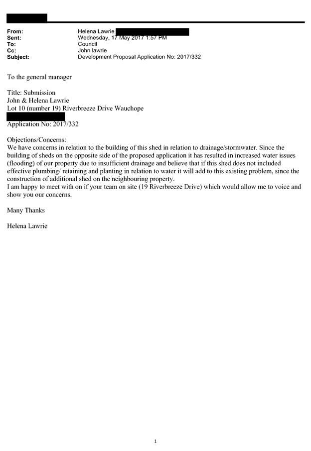
Concerns raised in relation to
stormwater disposal from the proposed shed. Objector experiencing flooding in
periods of wet weather and has raised issues with effective plumbing,
retaining and planting in relation to stormwater.
|
Applicant has provided updated
plan indicating 5000 litre rainwater tank collecting stormwater from proposed
shed. Overflow from the rainwater tank will be diverted to rubble drain
located on applicant’s property well clear of property boundaries and
will adequately manage roof stormwater. Applicant is also constructing
raised/mulched garden bed on northern boundary to slow surface water entering
objector’s property. Applicant is not responsible for containing the
flow of surface water from the natural lay of the land (i.e from the high
side to the low side). If objector is experiencing drainage problems they
should look to have additional drainage installed.
|
(e) The Public Interest:
The proposed
development satisfies relevant planning controls and is unlikely to impact on
the wider public interest.
4. DEVELOPMENT
CONTRIBUTIONS APPLICABLE
Not applicable
5. CONCLUSION
The application has been assessed in accordance with
Section 79C of the Environmental Planning and Assessment Act 1979.
Issues raised during assessment and public exhibition of
the application have been considered in the assessment of the application.
Where relevant, conditions have been recommended to manage the impacts
attributed to these issues.
The site is suitable for the proposed development, is not
contrary to the public's interest and will not have a significant adverse social,
environmental or economic impact. It is recommended that the application be
approved, subject to the recommended conditions of consent provided in the
attachment section of this report.
|
Attachments
1View. DA2017
- 332.1 Plans
2View. DA2017
- 332.1 Recommended Conditions
3View. DA2017
- 332.1 Submission - Lawrie
|
|
ATTACHMENT
|
Development Assessment Panel
28/06/2017
|
|
ATTACHMENT
|
Development Assessment Panel
28/06/2017
|
|
ATTACHMENT
|
Development Assessment Panel
28/06/2017
|
AGENDA Development Assessment Panel 28/06/2017
Item: 06
Subject: DA2017 - 249.1 Part Change of Use to
Educational Establishment - Lot 2 DP 610860 - 8 Table Street, Port Macquarie
Report
Author: Benjamin Roberts
|
Applicant: Port
Macquarie Steiner
Owner: Trustees
of Synod of Eastern Australia
Estimated Cost: $0
Alignment with Delivery
Program
4.9.2 Undertake transparent
and efficient development assessment in accordance with relevant legislation.
|
|
RECOMMENDATION
That
DA2017 - 249 for a part change of use to educational establishment at Lot 2, DP
610860, No. 8 Table Street, Port Macquarie, be determined by granting consent
subject to the recommended conditions.
|
Executive
Summary
This
report considers a development application for a part change of use of
the old church hall building to an educational establishment at the subject site and provides an assessment of the
application in accordance with the Environmental Planning and Assessment Act
1979.
Following exhibition of the
application, one (1) submission has been
received.
1. BACKGROUND
Existing sites features and Surrounding development
The site has an area of 1357m2 and contains an old church hall building. Archival records
indicate development consent was granted by Council on 1 September 1982 to use
the building for the purpose of primary school for a maximum of 25 pupils. It
is unclear how long the building was used for this purpose.
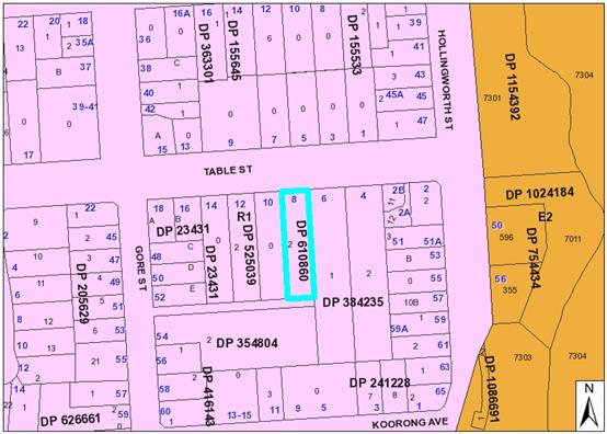
The site is zoned R1 General Residential in accordance with the Port Macquarie-Hastings Local
Environmental Plan 2011, as shown in the following zoning plan:
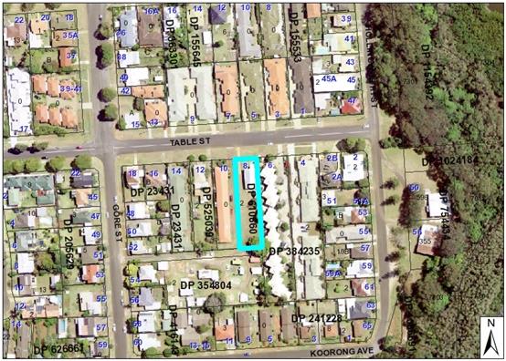
The existing subdivision pattern and location of existing
development within the locality is shown in the following aerial photograph:
2. DESCRIPTION OF
DEVELOPMENT
Key aspects of the proposal include the following:
· Part
change of use of existing church building to educational establishment
Refer
to attachments at the end of this report.
Application Chronology
· 30
March 2017 - Application lodged
· 10 - 28 April 2017 - Public exhibition via neighbour
notification
3. STATUTORY ASSESSMENT
Section 79C(1) Matters for Consideration
In determining the application, Council is required to take
into consideration the following matters as are relevant to the development
that apply to the land to which the development application relates:
(a) The provisions (where
applicable) of:
(i) any Environmental
Planning Instrument:
State
Environmental Planning Policy No. 55 – Remediation of Land
Following an
inspection of the site and a search of Council records, the subject land is not
identified as being potentially contaminated and is suitable for the intended
use.
State
Environmental Planning Policy No. 71 – Coastal Protection and Clause 5.5
of Port Macquarie-Hastings Local Environmental Plan 2011
The site is
located within a coastal zone as defined in accordance with clause 4 of SEPP
71.
In accordance
with clause 5, this SEPP prevails over the Port Macquarie-Hastings LEP 2011 in
the event of any inconsistency.
Having regard to
clauses 8 and 12 to 16 of SEPP 71 and clause 5.5 of Hastings LEP 2011 inclusive
the proposed development will not result in any of the following:
a) any restricted
access (or opportunities for access) to the coastal foreshore
b) any
identifiable adverse amenity impacts along the coastal foreshore and on the
scenic qualities of the coast;
c) any
identifiable adverse impacts on any known flora and fauna (or their natural
environment);
d) subject to any
identifiable adverse coastal processes or hazards;
e) any identifiable
conflict between water and land based users of the area;
f) any
identifiable adverse impacts on any items of archaeological/heritage;
g) reduce the
quality of the natural water bodies in the locality.
The site is predominately cleared and
located within an area zoned for residential purposes.
State
Environmental Planning Policy (Infrastructure) 2007
This policy
provides that development for the purpose of an educational establishment may
be carried out with consent in the R1 Residential zone.
Before
determining a development application for development for the purposes of a school,
the consent authority must take into consideration all relevant standards in
the following State government publications (as in force on the commencement of
this Policy):
(a) School Facilities Standards—Landscape
Standard—Version 22 (March 2002),
(b) Schools Facilities Standards—Design Standard (Version
1/09/2006),
(c) Schools Facilities Standards—Specification Standard
(Version 01/11/2008).
The proposal
is not inconsistent with these standards.
Port Macquarie-Hastings Local Environmental Plan 2011
The proposal
is consistent with the LEP having regard to the following:
· Clause
2.2, the subject site is zoned R1 General Residential. In accordance with
clause 2.3(1) and the R1 zone landuse table, the proposed development for a
part change of use to educational establishment is a permissible landuse with
consent.
The objectives of the R1 zone are as follows:
o To
provide for the housing needs of the community.
o To
provide for a variety of housing types and densities.
o To
enable other land uses that provide facilities or services to meet the day to
day needs of residents.
In accordance with Clause 2.3(2), the proposal is consistent with the
zone objectives having regard to the following:
o The
proposal is a permissible landuse;
o The
development will provide for a facility and service to meet the needs of
residents.
· Clause
5.9 - No listed trees in Development Control Plan 2013 are proposed to be
removed.
· Clause
5.10 – Heritage. The site does not contain or adjoin any known heritage
items or sites of significance.
· Clause
7.13, satisfactory existing arrangements are in place for provision of
essential services including water supply, electricity supply, sewer
infrastructure, stormwater drainage and suitable road access to service the
development.
(ii) Any
draft instruments that apply to the site or are on exhibition:
Draft
State Environmental Planning Policy (Educational Establishments and Child Care
Facilities) 2017
This draft
policy was exhibited from 3 February 2017 to 7 April 2017.
The draft
policy provides that development for the purpose of an educational
establishment may be carried out with consent in the R1 Residential zone.
The draft
policy provides that before determining a development application the consent
authority must take into consideration the design quality of the development
when evaluated in accordance with the design quality principles set out in
Schedule 4 of the policy.
The proposal
is not inconsistent with the design quality principles set out in schedule 4 of
the draft policy.
No other
draft instruments apply.
(iii) any
Development Control Plan in force:
Port
Macquarie-Hastings Development Control Plan 2013
The only
building works proposed are the installation of playground equipment at the
rear of the site. No building works are proposed to the existing building.
Having regard
to the above the relevant general provisions of the plan are addressed in the
following table:
|
Requirement
|
Proposed
|
Complies
|
|
2.2
Advertising and signage
|
No signage is proposed under
this application.
|
N/A
|
|
2.3
Environmental Management
|
No cut and fill is nominated.
However some will be required to construct the car park. The impacts of any
cut and fill required are manageable.
Site
inspection revealed a camphor laurel tree of approximately 2m in height would
require removal to accommodate the playground/community garden. No
significant trees are proposed to be removed.
|
Yes
Yes
|
|
2.5
Transport, Traffic Management, Access and Carparking
|
The plan contains no specific
parking rate for educational establishments/schools.
Council’s previous
development controls historically required parking for schools at a rate of 1
space per 8 students.
Based on previous controls and
the proposed 30 students a total of 3.75 or 4 spaces would be required.
5 parking spaces, inclusive of
one disabled space and one stacked staff space have been nominated on the
plans. The stacked space cannot be relied upon and preliminary comments from
Councils Development Engineering staff suggest the space alongside the
proposed disabled space would be lost in achieving a compliant shared area.
However it is noted in the access appraisal report which accompanied the
application that provision of disabled access to the building is not required
under this proposal (i.e. as no new building works are proposed). Having
regard to this it is considered superfluous to provide a disable parking
space to serve the development.
Accordingly 4 of the spaces
shown on the plan are capable of compliance with the relevant standards and
as such sufficient parking is proposed to serve the development. A condition
has been recommended restricting the number of students to 30.
Satisfactory landscaping is
proposed and conditioned to soften the impact of the at grade car parking
area forward of the building line on the site.
|
Yes
|
|
2.7
Social Impact Assessment and Crime Prevention
|
No adverse crime risk
potential identified with design/layout of the school. To improve safety and
security a condition has been applied requiring inadequate boundary fencing
to be repaired/upgraded.
|
Yes
|
(iiia) any
planning agreement that has been entered into under Section 93f or any draft
planning agreement that a developer has offered to enter into under Section
93f:
No planning
agreement has been offered or entered into relating to the site.
iv) any matters prescribed by the
Regulations:
New South Wales Coastal Policy
Consistent.
Refer to earlier comments under SEPP 71 heading of this report.
Clause 93
- Fire safety considerations
This clause
applies to applications for a change of building use for an existing building
where the applicant does not seek the rebuilding, alteration, enlargement or
extension of a building.
In
determining such applications, the consent authority is to take into
consideration whether the fire protection and structural capacity of the
building will be appropriate to the building’s proposed use.
The
application was supported by a fire safety upgrading report prepared by David
Pensini dated 20 January 2017. The report recommends a number of upgrade
measures to ensure the building is suitable for its intended use.
The
recommended upgrade measures identified in this report are to form part of the
consent conditions and are to be undertaken prior to any occupation certificate
being issued. Refer to recommended consent condition.
v) any coastal
zone management plan (within the meaning of the Coastal Protection Act 1979),
that apply to the land to which the development application relates:
No coastal
zone management plan applies to the site.
(b) The
likely impacts of that development, including environmental impacts on both the
natural and built environments, social and economic impacts in the locality:
Context & Setting
The proposal
will be unlikely to have any adverse impacts to existing adjoining properties
and satisfactorily addresses the public domain.
The proposal
does not have a significant adverse impact on existing view sharing.
The proposal
does not have significant adverse lighting impacts.
There are no
significant adverse privacy impacts. Adequate building separation is proposed/existing.
There is no
adverse overshadowing impacts. The proposal does not prevent adjoining
properties from receiving 3 hours of sunlight to private open space and primary
living areas on 21 June.
The proposal
is considered to be compatible with existing development in the locality and
adequately addresses planning controls for the area.
Roads
The site has road frontage to Table Street, an 11m wide
sealed road (kerb to kerb) within a 30m wide road reserve, which is owned and
maintained by Council.
The road is bordered by upright (SA) type kerb and gutter
and there is no street piped drainage network near the section of road fronting
the site. Parts of Table Street including the direct frontage of the site have
a 1.2m wide concrete footpath, which is progressively being infilled as
developments are completed in the area, but with some sections currently
missing.
Traffic and Transport
The proposed school is planned to cater for 1 staff and 30
students. To limit traffic impacts caused by the development on surrounding
properties and roads, a condition of consent is recommended limiting the use to
no more than 30 students in attendance at any one time.
The RMS’ Guide to Traffic Generating Developments
(2002) has no guidance on traffic generation by schools. The 2014 Schools
Analysis Report commissioned by RMS provides a vehicle trip generation rate in
the AM peak hour of 0.73 per student, and 0.57 per student in the PM peak (on
average, regional schools, primary + secondary), but the values range widely
between 0.11 and 1.35 depending on site characteristics.
Assuming a rate of 1.35 for sensitivity testing, the
development may be expected to generate up to 40 vehicle trips in the AM peak
hour as an absolute worst case. The surrounding road network is not burdened by
similar peaking uses at this time, with the exception of Hollingsworth Street
northbound turning onto Gordon Street, which is used as a regular morning
‘rat-run’ by motorists avoiding the Hastings River Drive traffic
lights. Most of this traffic is expected to use Ackroyd Street to the north
rather than Table Street, so no significant impacts on traffic or the road
network are anticipated as a result of the development.
Site
Frontage & Access
Vehicle
access to the site is proposed through one access driveway to the front carpark
onsite. All accesses shall comply with Council AUSPEC and Australian Standards,
and conditions have been imposed to reflect these requirements.
Parking and Manoeuvring
Refer to parking calculations in Development Control Plan
assessment table earlier within this report. Sufficient parking is proposed.
Parking and driveway widths on site can comply with
relevant Australian Standards (AS 2890) and conditions have been imposed to
reflect these requirements.
Due to the type of development, car park circulation is
required to enable vehicles to enter and exit the site in a forward manner.
Site plans show adequate area is available and conditions have been imposed to
reflect these requirements.
Utilities
Telecommunication
and electricity services are existing to the site.
Stormwater
The site naturally grades towards
the Table Street frontage and is currently not serviced by a site outlet or a
piped drainage network along the road. The legal point of discharge for the
proposed development is defined as a direct connection to Council’s kerb
and gutter with the use of an approved adaptor (one per lot only).
A detailed site stormwater
management plan will be required to be submitted for assessment with the S.68
application.
In accordance with Councils AUSPEC
requirements, on-site stormwater detention facilities must be incorporated into
the stormwater drainage plan.
Refer to
relevant conditions of consent.
Sewer and Water supply
Services are existing and Councils water and sewer supply
section have advised that no additional augmentation or works are necessary for
the proposed development.
Soils
The proposed
development will be unlikely to have any adverse impacts on soils in
terms of
quality, erosion, stability and/or productivity subject to a standard condition
requiring erosion and sediment controls to be in place prior to and during
construction.
Air & Micro-climate
The
construction and/or operations of the proposed development will be unlikely to
result in any
adverse impacts on the existing air quality or result in any pollution.
Standard
precautionary site management condition recommended.
Flora & Fauna
Construction
of the proposed development will not require any removal/clearing of
any
significant vegetation and therefore will be unlikely to have any significant
adverse
impacts on biodiversity or threatened species of flora and fauna.
Waste
Satisfactory
arrangements are available for proposed storage and collection of waste
and
recyclables. No adverse impacts anticipated. Standard precautionary site
management
condition recommended.
Energy
No adverse
impacts anticipated.
Noise
The proposed
hours of operation are 8:30am to 4pm weekdays only. A condition confirming
these operational hours has been recommended. A condition restricting
construction work to standard hours is also recommended.
Similar to a
childcare centres of a similar capacity the nature of the development does have
the potential to result in noise impacts to adjoining residential occupants.
Outdoor play areas experience a high level of activity and are subsequently the
central noise source.
The outdoor
play area is to be located behind the building at the rear of the site along
the southern boundary as illustrated on the plans. An existing dilapidated 1.8m
high timber fence is located along the southern boundary. A 1.8m colour bond
fence is provided along the eastern boundary and a 1.5m high timber paling
fence is located along the western boundary.
As proposed the
outdoor play equipment will be approximately 13m from the adjoining single
storey units to the west of the site and approximately 10m from the adjoining
two storey units to the east of the site.
To provide
for an increase level of amenity between the proposed playground equipment and
adjoining units to the west it is considered appropriate that the existing 1.5m
timber paling fence be increased to 1.8m in height. Condition of consent has
been recommended.
Having regard to the proposed
hours of operation, building separation distances and existing and required
fencing arrangements it is anticipated that no significant adverse noise
impacts would result that could warrant refusal of the application.
Natural Hazards
The site not
mapped as bushfire prone or flood prone land. No adverse impacts anticipated.
Safety, Security & Crime Prevention
The proposed development will be
unlikely to create any concealment/entrapment
areas or crime spots that would
result in any identifiable loss of safety or reduction of
security in
the immediate area.
Social Impact in the Locality
Given the nature of the proposed
development and its’ location the proposal is
unlikely to
result in any adverse social impacts.
Economic Impact in the Locality
No adverse impacts. Likely
positive impacts can be attributed to the construction and
operation of
the development.
Site Design and Internal Design
The proposed development design
satisfactorily responds to the site attributes and
will fit into
the locality. No adverse impacts likely.
Construction
No potential adverse impacts
identified to neighbouring properties with the
construction
of the proposal.
Cumulative Impacts
The proposed
development is not expected to have any adverse cumulative impacts on the
natural or built environment or the social and economic attributes of the
locality.
(c) The suitability of the site for
the development:
The proposal
will fit into the locality and the site attributes are conducive to the
proposed development.
Site
constraints have been adequately addressed and appropriate conditions of
consent recommended.
(d) Any submissions made in
accordance with this Act or the Regulations:
One (1) written submission has been received following public
exhibition of the application.
Key issues raised in the submission received and comments
in response to these issues are provided as follows:
|
Submission
Issue/Summary
|
Planning
Comment/Response
|
|
No indication of whether the Department
of Education have been notified.
|
Approval requirements of the
Department of Education do not form part of the relevant planning
considerations.
|
|
The site is not suitable for a
primary school.
|
The assessment concludes the
site is suitable for the proposed use.
|
|
The Statement of Environmental
Effects (SOEE) submitted is inadequate and response to some questions are
wrong. The application should be rejected or at the very least a
comprehensive SOEE and Environmental Impact Statement (EIS) should be sought
including extensive community consultation.
|
The proposal is not designated
development and no EIS is required. The SOEE provided is acceptable.
Exhibition of the application has been undertaken in accordance with Port
Macquarie-Hastings Council’s Development Control Plan 2013.
|
|
Contrary to the response in
the SOEE the school operation will require deliveries. The lack of parking
facility for deliveries and buses will lead to unacceptable traffic impacts
to other road users.
|
There is sufficient area
onsite to accommodate any anticipated deliveries for the proposal. Refer to
comments under traffic and transport heading of the report. No adverse
impacts are anticipated that would warrant refusal of the application.
|
|
Contrary to the response in
the SOEE a school is not consistent with the residential zone objectives and
the proposal is incompatible with the character of the existing
neighbourhood.
|
The assessment concludes that
the proposal is consistent with the zone objectives and compatible with the locality.
|
|
Contrary to the response in
the SOEE the site is not suitable. The area consists of elderly residents in
townhouses and villas. The noise and business proposed is incompatible.
|
The assessment concludes that
the site is suitable and compatible with the locality. There are no
significant adverse noise impacts that would warrant refusal of the
application. Refer to comments under noise heading within the report.
|
|
Contrary to the response in
the SOEE the proposal will be out of character with the surrounding medium
density residential area consisting of elderly residents.
|
The assessment concludes that
the site is suitable and compatible with the locality.
|
|
Contrary to the response in
the SOEE construction of the car park will require excavation and
filling that may have drainage implications.
|
Agreed. A Construction Certificate is required before
the car park is constructed. The application for the Construction Certificate
will need to demonstrate compliance with relevant drainage standards.
|
|
Contrary to the response in
the SOEE it is expected that signage is proposed.
|
No signage is proposed under
the application. Any future signage will require further consent if not
exempt under State policy. Advisory condition recommended.
|
|
Contrary to the response in
the SOEE the proposal will result in noise impacts to neighbouring
properties.
|
Refer to comments under noise
heading of the report. No adverse impacts anticipated that would warrant
refusal of this application.
|
|
Contrary to the response in
the SOEE the proposal will result in removal of trees.
|
Refer to comments in
Development Control Plan table. No significant trees are to be removed.
|
|
Table Street is not connected
to the NBS which will be of concern to the education department.
|
Approval requirements of the
Department of Education do not form part of the relevant planning
considerations. The site is currently serviced by essential services.
|
|
5 parking spaces are nominated
with reference to DCP 18 which relates to Area 13 Thrumster Development
Control Plan not relevant to the site.
The provision of 1 space per 8
students and lack of pick up and drop off facility is inadequate. Lack of
both turning and loading/unloading facilities.
Unacceptable traffic impacts
to the local road network.
|
DCP 18 is a superseded
Development Control Plan that related to off-street parking requirements.
Refer to comments under traffic and transport heading and parking section of
Development Control Plan table.
Condition recommended
requiring car park to be redesigned to provide dedicated turnaround bay.
|
|
Increased paved area will
result in increased stormwater runoff could impact on residents of 10 Table
Street.
|
A Construction Certificate is required before the car
park is constructed. The application for the Construction Certificate will
need to demonstrate compliance with relevant drainage standards.
|
|
Why has no community
consultation been undertaken by the applicant. The failure to do so is
irresponsible and shows a lack of understanding of how schools work.
|
Noted. There is no legal
planning requirement for the applicants to undertake community consultation.
Exhibition of the application has been undertaken in accordance with Port
Macquarie-Hastings Council’s Development Control Plan 2013.
|
|
No details of proposed waste
management arrangements have been provided. Inconsistent with the Department
of Education’s guidelines.
|
The site is capable of
providing sufficient waste management and storage arrangements whether it be
mobile garbage bins or a private waste collection service. Approval
requirements of the Department of Education do not form part of the relevant
planning considerations.
|
|
Existing fences are totally
inadequate.
|
Noted a condition has been
recommended requiring dilapidated fencing to be upgraded.
|
|
A community garden is proposed
within the site. Access to this garden by members of the public is
unacceptable.
|
The applicant has confirmed
that this garden is not intended for open, broad community access such
as at 'The Lost Plot' on central road. Its
intended to be used primarily for students and educational purposes.
|
|
What is the status of this
facility if converted to an educational facility. Can the school then deny
access to community members, including church members.
|
The proposal is for part
change of use to educational facility during week days only. The church use
is to remain on weekends. The land owner is ultimately responsible for who
uses the site and when.
|
|
The present building is
inadequate as a classroom. The building is old and not up to standards of a
school.
|
Fire safety upgrade works
required. Refer to recommended conditions and fire safety upgrade report.
|
|
Installation of ‘ceiling
vents’ in the rusty roof need new zinc aluminium.
|
Noted.
|
|
There is no room on this site
for the school to grow. Shows a lack of foresight.
|
The proposal is for maximum 30
students. Any future expansion would require further development consent.
|
|
There is no disabled access to
the building even though a disabled parking space is proposed.
|
Noted. Refer to parking
comments in Development Control Plan table. A disabled parking space is not
required.
|
|
Are the two existing toilets
adequate for 30 students and staff. No separate staff toilet is provided.
This is a hygiene issue.
|
Based on the likely occupant
numbers the existing amenities provided are sufficient.
|
|
The plans provide no shade
over the playground, nor does it provide any shelter in inclement weather.
|
Noted. In response to an
additional information request the applicant has provided more detailed
playground plans which indicate a shade structure over the sand pit. Refer to
attached plans.
|
|
In previous years the DEET
required an enrolment of 52 students before establishment of a private
school. There is no indication whether approval has been gained by Department
of Education.
|
Approval requirements of the
Department of Education do not form part of the relevant planning
considerations.
|
|
Residents are concerned about
possible reduction of property values of a school within close proximity.
|
No evidence has been provided
to suggest this claim and this is not a relevant planning consideration.
|
(e) The Public Interest:
The proposed
development satisfies relevant planning controls and is unlikely to impact on
the wider public interest.
4. DEVELOPMENT
CONTRIBUTIONS APPLICABLE
· Development contributions will be required towards
augmentation of town water supply and sewerage system head works under Section
64 of the Local Government Act 1993.
The historic development consent provides for a
contribution credit for 25 pupils. Contributions will be levied on 5 additional
pupils proposed under this application (i.e. total 30 students).
5. CONCLUSION
The application has been assessed in accordance with
Section 79C of the Environmental Planning and Assessment Act 1979.
Issues raised during assessment and public exhibition of
the application have been considered in the assessment of the application.
Where relevant, conditions have been recommended to manage the impacts
attributed to these issues.
The site is suitable for the proposed development, is not
contrary to the public's interest and will not have a significant adverse
social, environmental or economic impact. It is recommended that the
application be approved, subject to the recommended conditions of consent
provided in the attachment section of this report.
|
Attachments
1View. DA2017
- 249.1 Playground Plans
2View. DA2017
- 249.1 Site Plan
3View. DA2017
- 249.1 Fire Safety Upgrade Report
4View. DA2017
- 249.1 Access Appraisal
5View. DA2017
- 249.1 Recommended Conditions
6View. DA2017
- 249.1 SoEE
7View. DA2017
- 249.1 Submission - Nicoll
|
|
ATTACHMENT
|
Development Assessment Panel
28/06/2017
|
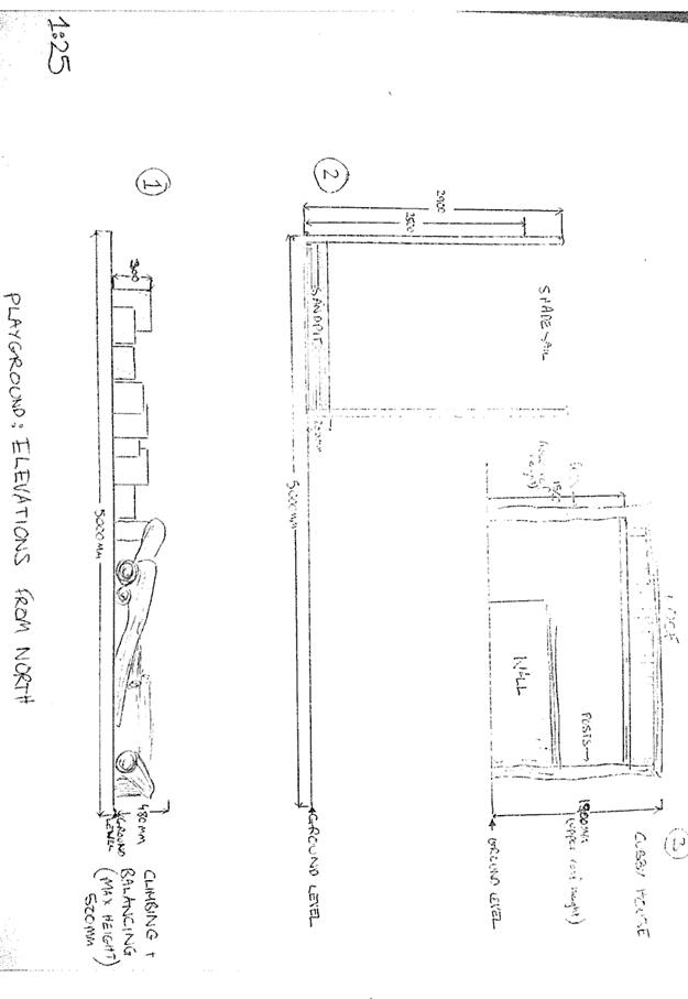
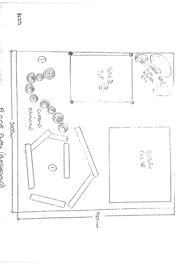
|
ATTACHMENT
|
Development Assessment Panel
28/06/2017
|
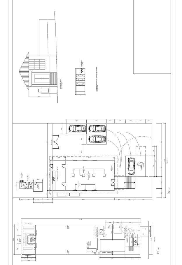
|
ATTACHMENT
|
Development Assessment Panel
28/06/2017
|
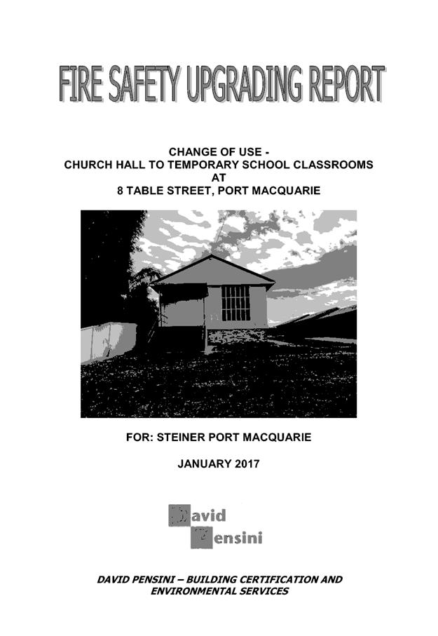
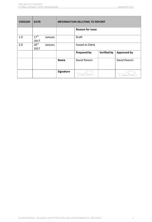
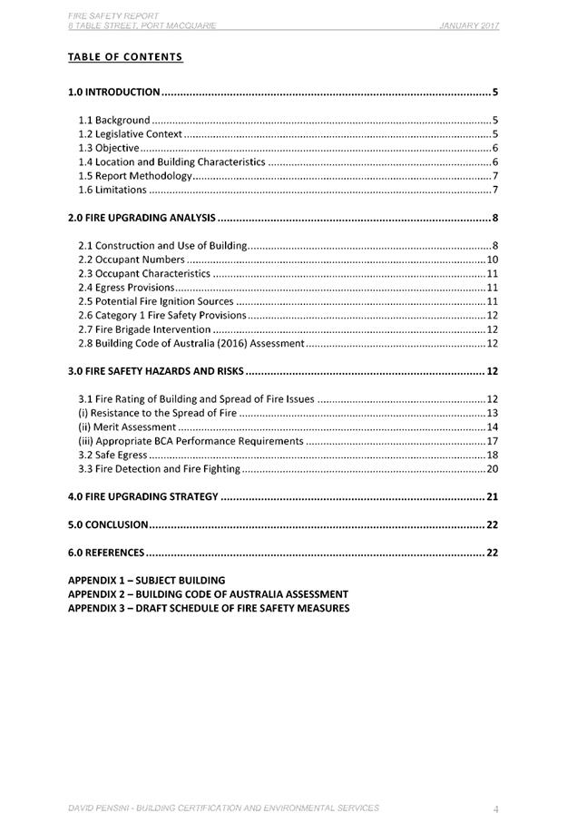
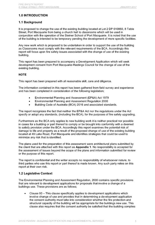
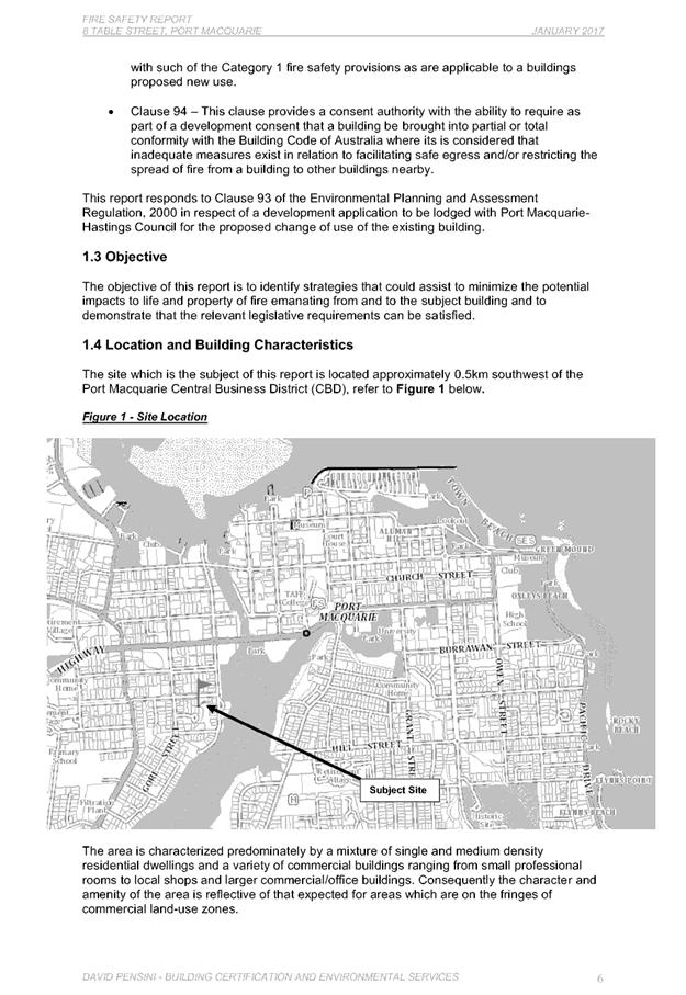
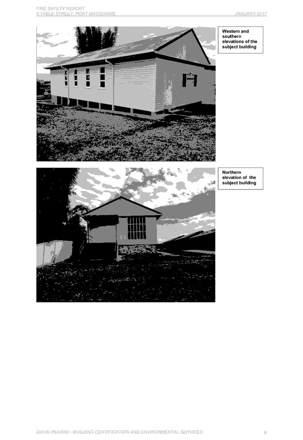
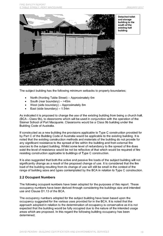
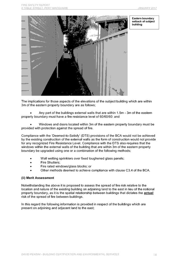
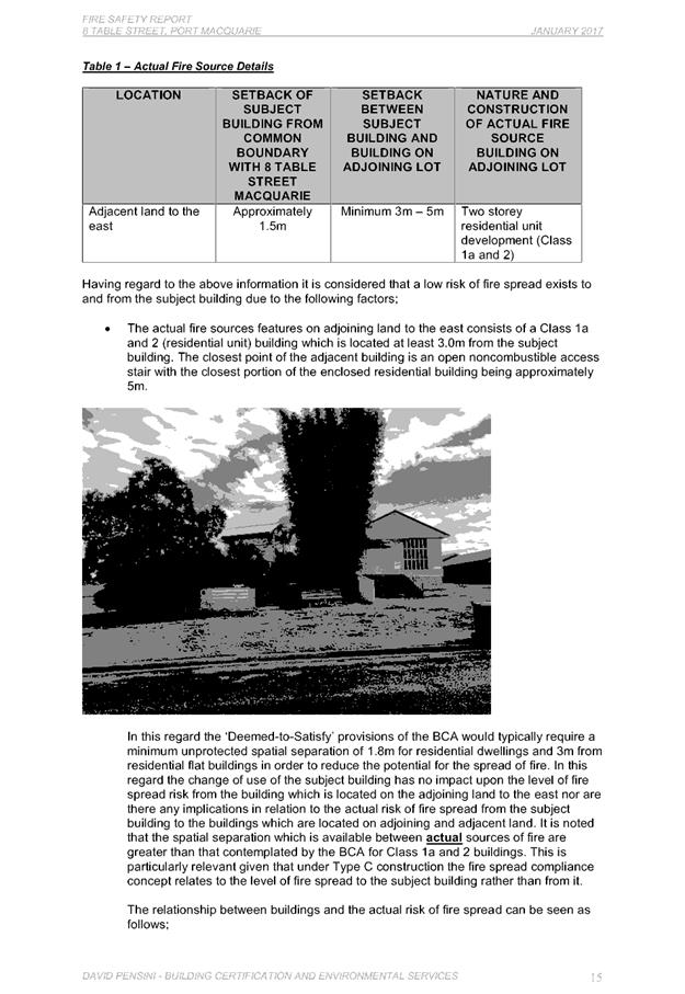
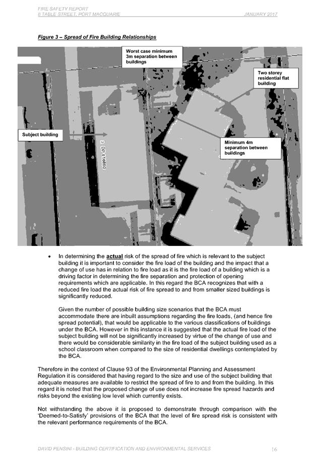
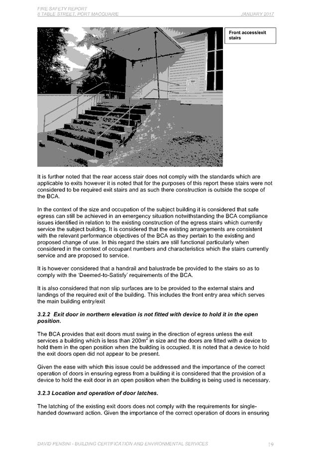


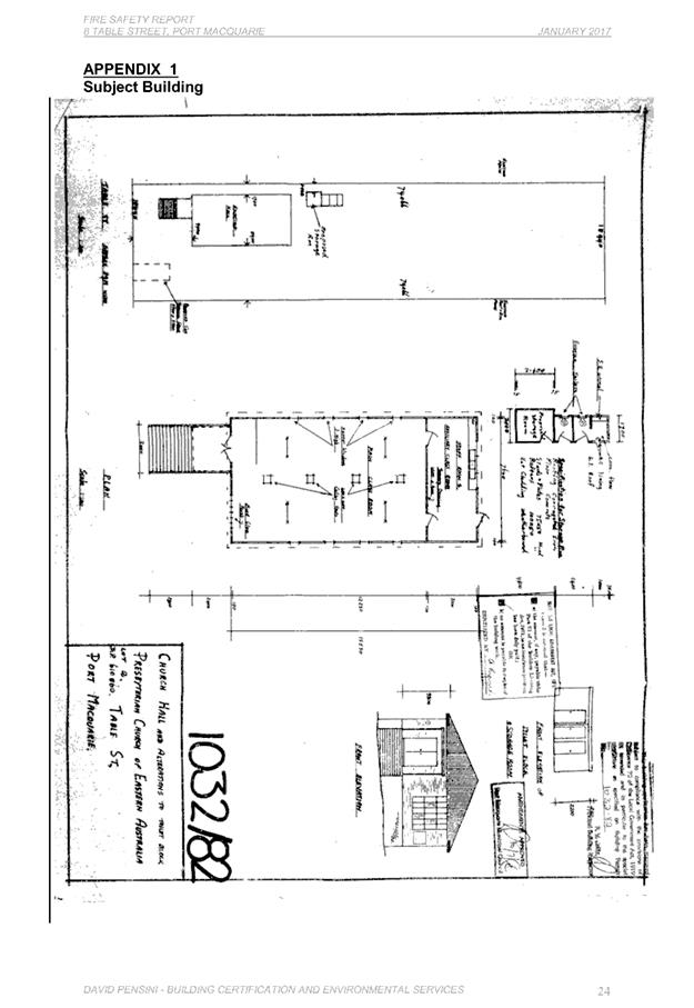
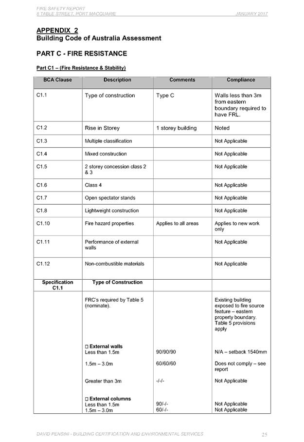
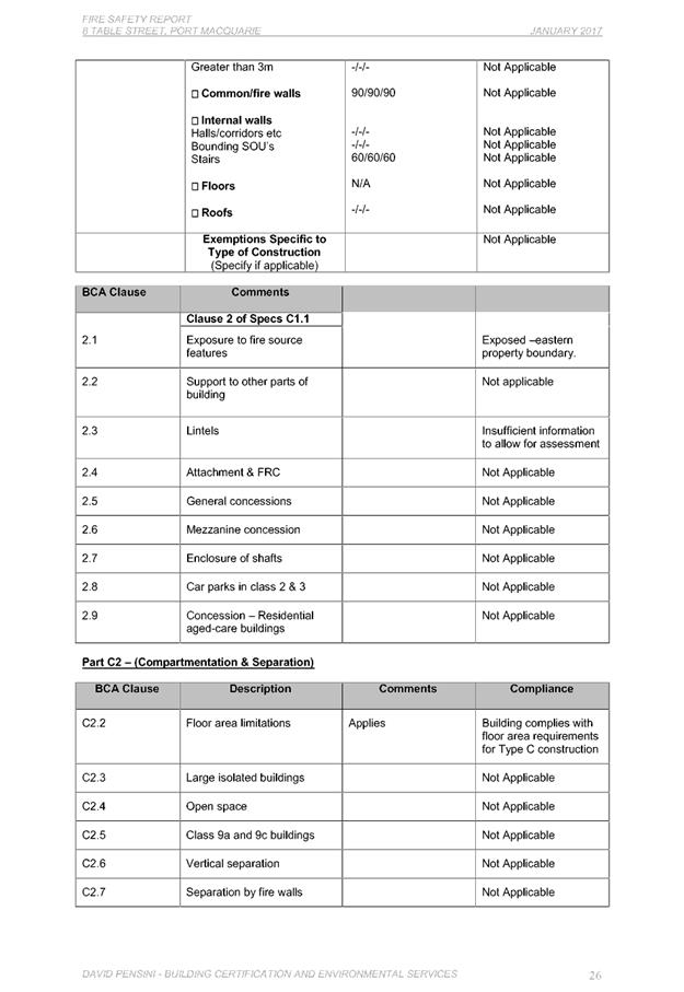
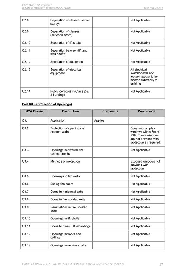
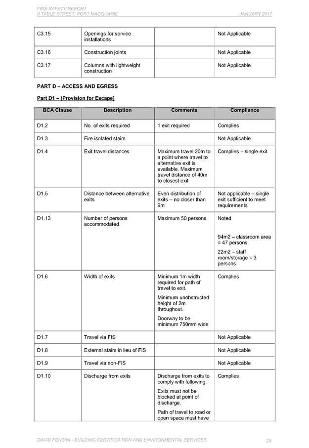
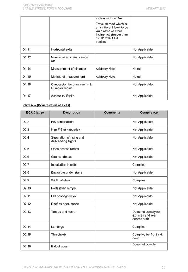
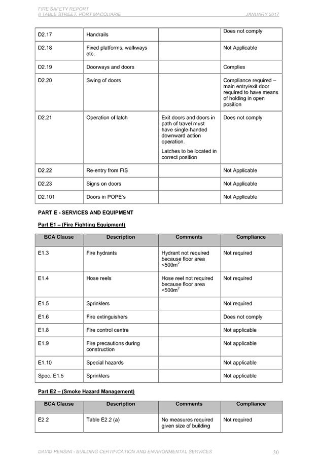
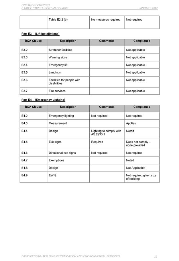
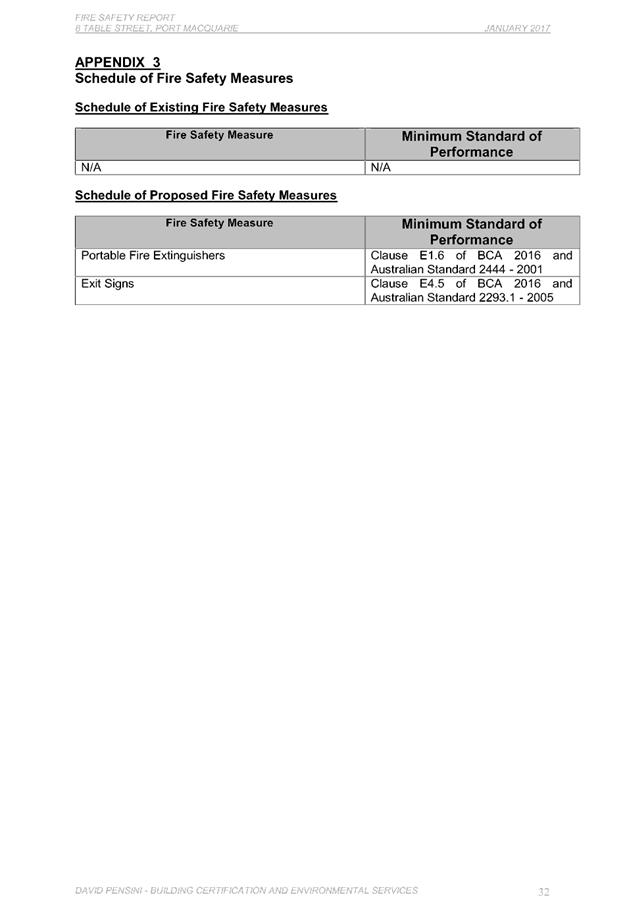
|
ATTACHMENT
|
Development Assessment Panel
28/06/2017
|
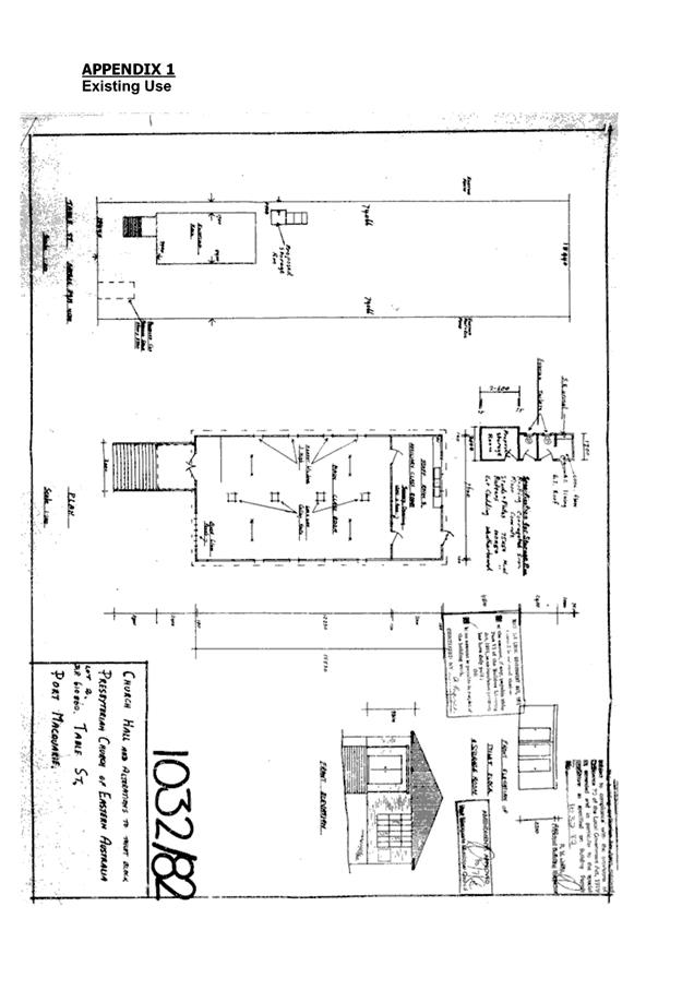
|
ATTACHMENT
|
Development Assessment Panel
28/06/2017
|
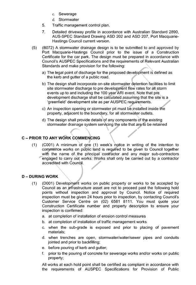
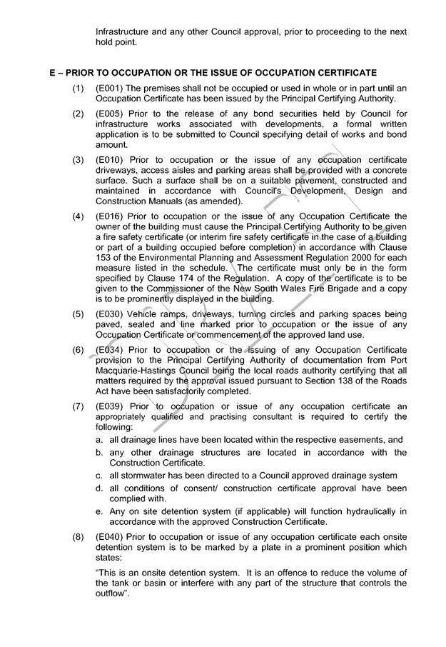
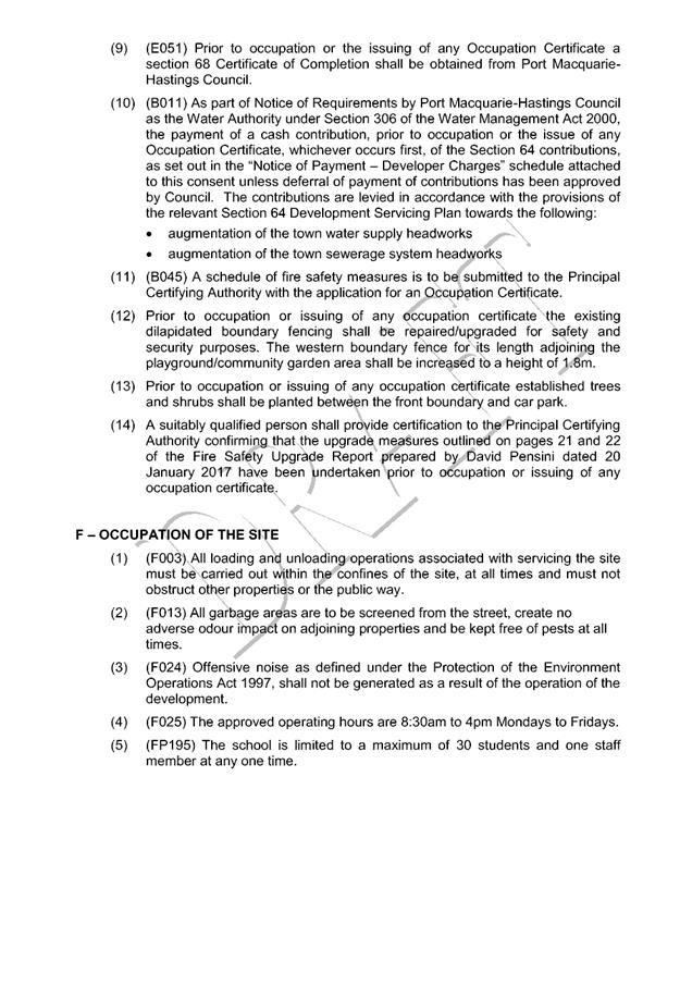
|
ATTACHMENT
|
Development Assessment Panel
28/06/2017
|
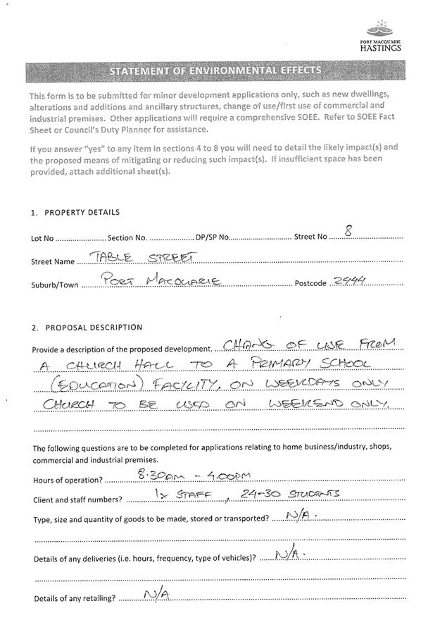
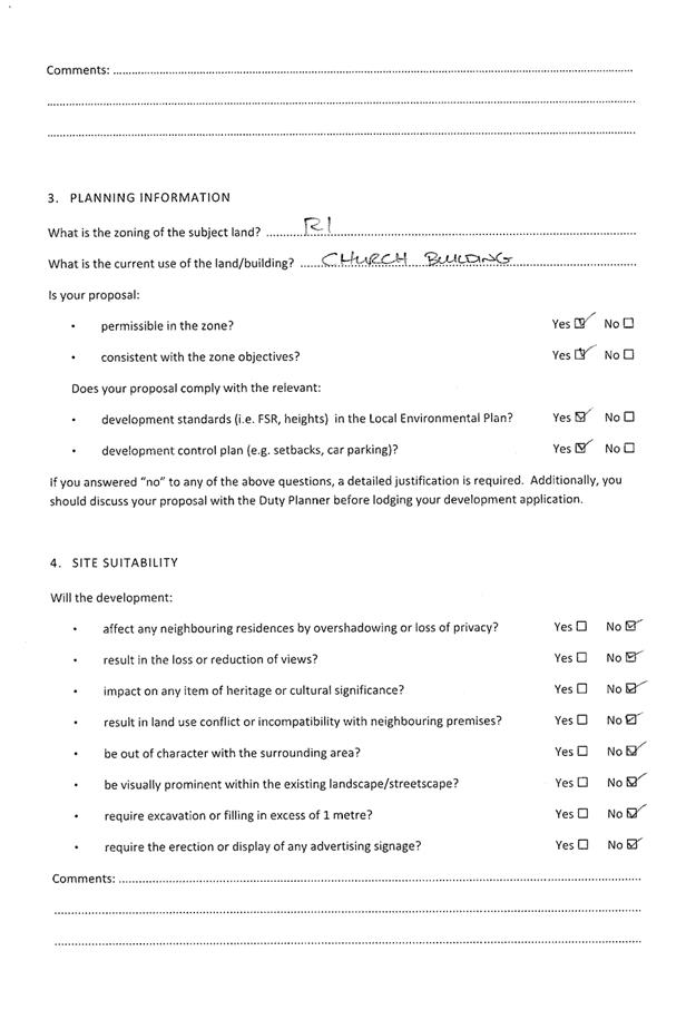
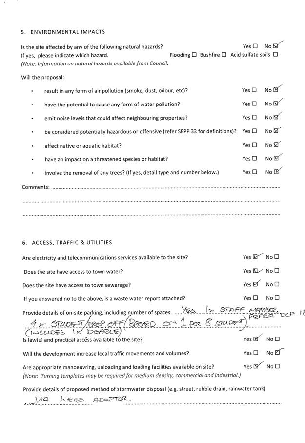
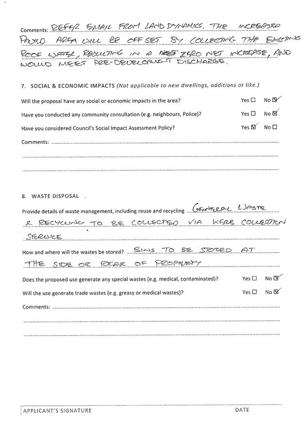
|
ATTACHMENT
|
Development Assessment Panel
28/06/2017
|
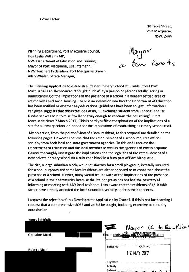
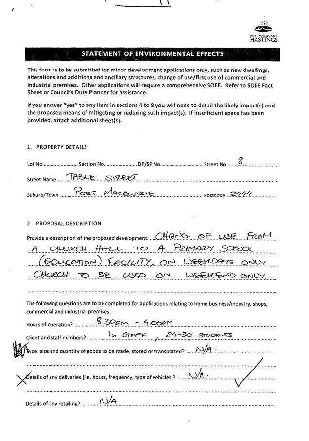
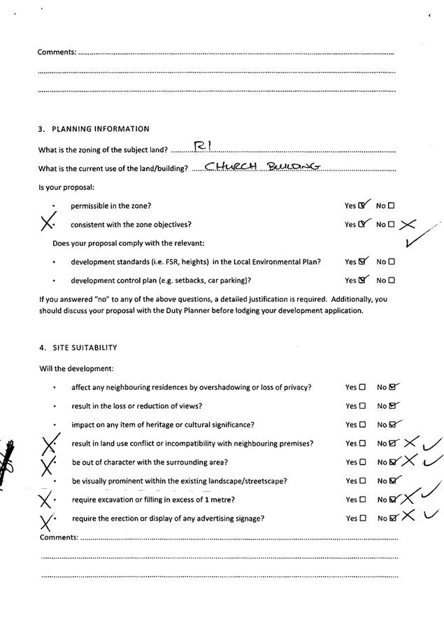
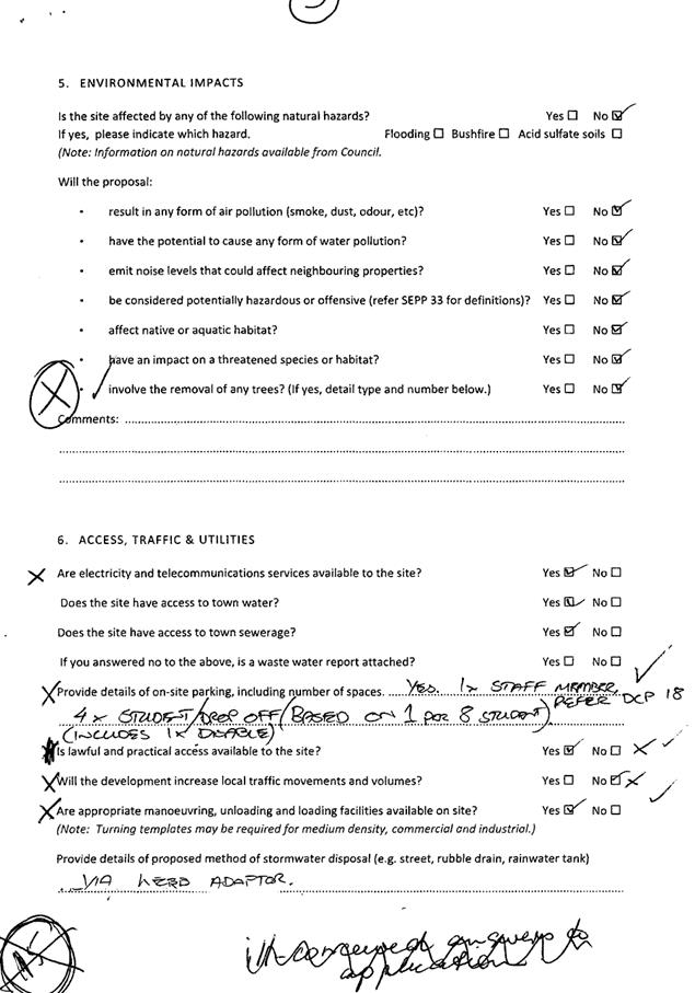
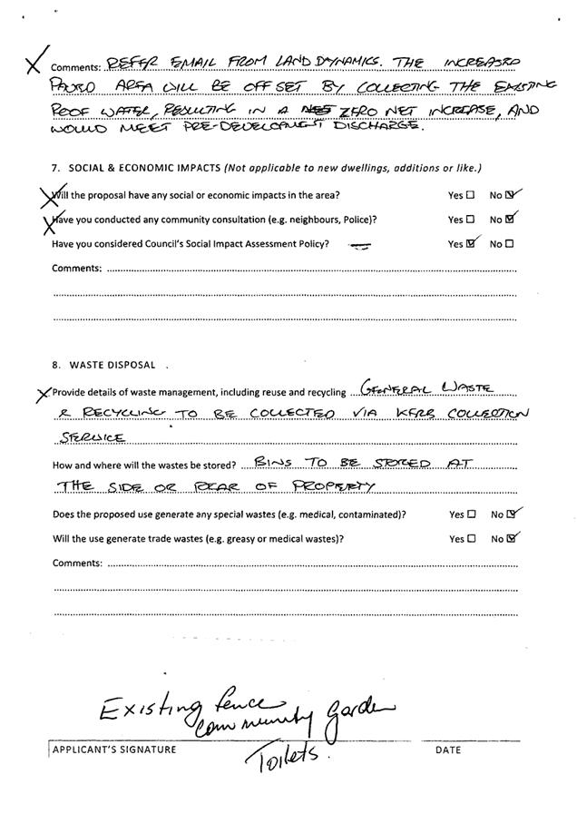
AGENDA Development Assessment Panel 28/06/2017
Item: 07
Subject: DA 2017 - 287.1 Single Dwelling - Lot 1 DP
1195261 No 7 Denning Place, Port Macquarie
Report
Author: Fiona Tierney
|
Applicant: J
R & K L Cowan
Owner: J
R & K L Cowan
Estimated Cost: $543,000
Alignment with Delivery
Program
4.9.2 Undertake transparent
and efficient development assessment in accordance with relevant legislation.
|
|
RECOMMENDATION
That
DA 2017- 287 for a new single
dwelling at Lot 1, DP 1195261, No.
7 Denning Place, Port Macquarie,
be determined by granting consent subject to the recommended conditions.
|
Executive
Summary
This
report considers a development application for a new single dwelling at the subject site and provides an assessment of the
application in accordance with the Environmental Planning and Assessment Act
1979.
Following exhibition of the
application, three submissions have been
received.
1. BACKGROUND
Existing sites features and Surrounding development
The site has an area of 2336.7m2.
The site is zoned R1- General Residential in accordance with the Port Macquarie-Hastings Local
Environmental Plan 2011, as shown in the following zoning plan:
The existing subdivision pattern and location of existing
development within the locality is shown in the following aerial photograph:
2. DESCRIPTION OF
DEVELOPMENT
Key aspects of the proposal include the following:
· Construction of a new two storey dwelling on each lot.
Refer
to attachments at the end of this report.
Application Chronology
· 10
April 2017 - Application lodged.
· 27 April 2017 to 10 May 2017 - Neighbour notification of
the proposal.
· 2 May 2017 - Site and impact to neighbouring properties
inspected assessing officer.
· June 2017 - Site inspected by Council’s stormwater
engineer to confirm levels and for assessment relating to concerns
flooding/drainage. Additional information requested from Applicant.
· June 2017 - Additional information and amended plans submitted
by Applicant.
3. STATUTORY ASSESSMENT
Section 79C(1) Matters for Consideration
In determining the application, Council is required to take
into consideration the following matters as are relevant to the development
that apply to the land to which the development application relates:
(a) The provisions (where
applicable) of:
(i) any Environmental
Planning Instrument:
State
Environmental Planning Policy No. 55 – Remediation of Land
Following an
inspection of the site and a search of Council records, the subject land is not
identified as being potentially contaminated and is suitable for the intended
use.
State
Environmental Planning Policy (Building Sustainability Index: BASIX) 2004
BASIX
certificate (number 807358S) has been submitted demonstrating that the proposal
will comply with the requirements of the SEPP. It is recommended that a
condition be imposed to ensure that the commitments are incorporated into the
development and certified at Occupation Certificate stage.
Port Macquarie-Hastings Local Environmental Plan 2011
The proposal
is consistent with the LEP having regard to the following:
· Clause
2.2, the subject site is zoned R1 General Residential. In accordance with
clause 2.3(1) and the R1 zone landuse table, the proposed development for a
dual occupancy (detached) is a permissible landuse with consent.
The objectives of the R1 zone are as follows:
o To
provide for the housing needs of the community.
o To
provide for a variety of housing types and densities.
o To
enable other land uses that provide facilities or services to meet the day to
day needs of residents.
In accordance with Clause 2.3(2), the proposal is consistent with the
zone objectives having regard to the following:
o The
proposal is a permissible landuse;
o The
development would provide for a variety of housing types and densities to meet
the housing needs of the community.
· Clause
4.3, the maximum overall height of the building above ground level (existing)
is 7.7m which complies with the standard height limit of 8.5m applying to the
site.
· Clause
4.4, the floor space ratio of the proposal is 0.12:1 which complies with the
maximum 0.65:1 floor space ratio applying to the site.
· Clause
5.9 - No listed trees in Development Control Plan 2013 are proposed to be removed.
· Clause
5.10 – Heritage. The site does not contain or adjoin any known heritage
items or sites of significance.
· Clause
7.13, satisfactory arrangements are in place for provision of essential
services including water supply, electricity supply, sewer infrastructure,
stormwater drainage and suitable road access to service the development.
Provision of electricity will be subject to obtaining satisfactory arrangements
certification prior to the issue of a Subdivision Certificate as recommended by
a condition of consent.
(ii) Any
draft instruments that apply to the site or are on exhibition:
No draft
instruments apply to the site.
(iii) any
Development Control Plan in force:
Port
Macquarie-Hastings Development Control Plan 2013
|
DCP 2013: Dwellings, Dual occupancies, Dwelling
houses, Multi dwelling houses & Ancillary development
|
|
DCP Objective
|
Development Provisions
|
Proposed
|
Complies
|
|
3.2.2.3
|
Garage minimum 5.5m front setback and garage door recessed
behind building line at least 1m or eaves/overhangs provided
|
L Shaped block-Located end of ROW
|
N/A
|
|
6m max. width of garage door/s and 50% max. width of
building
|
|
Yes
|
|
Driveway crossover 1/3 max. of site frontage and max. 5.0m
width
|
Existing ROW
|
Yes
|
|
3.2.2.4
|
4m min. rear setback. Variation subject to site analysis
and provision of private open space
|
Minimum 3.813m rear setback.
|
No*
|
|
3.2.2.5
|
Side setbacks:
· Ground floor
min. 0.9m
· First floors
& above min. 3m setback, unless demonstrated that adjoining property
primary living areas & POS unaffected.
· Building wall
set in and out every 12m by 0.5m.
|
Minimum 1.89m first floor side setback to south east
boundary. The Applicant has submitted shadow diagrams demonstrating that the
development would not adversely overshadow neighbouring primary living areas
and private open space for more than 3 hours on 21 June. Therefore, a minimum
0.9m first floor side setback is acceptable.
Building wall articulation satisfactory.
|
Yes
|
|
3.2.2.6
|
35m2 min. private open space area including a
useable 4x4m min. area which has 5% max. grade and is directly accessible
from a ground floor living area.
|
Dwelling has a minimum 35m2 private open space
including 4m x4m area accessible from living room.
|
Yes
|
|
3.2.2.10
|
Privacy:
· Direct views
between living areas of adjacent dwellings screened when within 9m radius of
any part of window of adjacent dwelling and within 12m of private open space
areas of adjacent dwellings. ie. 1.8m fence or privacy screening which has
25% max. openings and is permanently fixed
· Privacy screen
required if floor level > 1m height, window side/rear setback (other than
bedroom) is less than 3m and sill height less than 1.5m
· Privacy screens
provided to balconies/verandas etc which have <3m side/rear setback and
floor level height >1m
|
The rear alfresco area is located approx 3.8 m from the
rear boundary and screen planting is present on the property to the rear. One
objection has been received relating to privacy from the neighbour to the
North east however closest windows are bedroom windows and a privacy screen
is proposed along the western end of the alfresco area. Existing
screening also exists along the fence.
|
Yes
|
|
DCP 2013: General Provisions
|
|
DCP Objective
|
Development Provisions
|
Proposed
|
Complies
|
|
2.7.2.2
|
Design addresses generic principles of Crime Prevention
Through Environmental Design guideline:
· Casual
surveillance and sightlines
· Land use mix and
activity generators
· Definition of
use and ownership
· Lighting
· Way finding
· Predictable
routes and entrapment locations
|
The proposed development will be unlikely to create any
concealment/entrapment areas or crime spots that would result in any
identifiable loss of safety or reduction of security in the immediate area.
The increase in housing density will improve natural surveillance within the
locality and openings from the dwelling overlook common and private areas.
|
Yes
|
|
2.3.3.1
|
Cut and fill 1.0m max. 1m outside the perimeter of the
external building walls
|
Up to 1.65 of cut.
|
No*
|
|
2.3.3.2
|
1m max. height retaining walls along road frontages
|
|
N/A
|
|
Any retaining wall >1.0 in height to be certified by
structural engineer
|
Condition recommended requiring certification of retaining
walls.
|
Yes
|
|
Combination of retaining wall and front fence height
|
|
N/A
|
|
2.3.3.8 onwards
|
Removal of hollow bearing trees
|
None proposed to be removed.
|
Yes
|
|
2.6.3.1
|
Tree removal (3m or higher with 100mm diameter trunk and
3m outside dwelling footprint
|
None proposed to be removed.
|
Yes
|
|
2.4.3
|
Bushfire risk, Acid sulphate soils, Flooding,
Contamination, Airspace protection, Noise and Stormwater
|
Refer to main body of report.
|
|
|
2.5.3.2
|
New accesses not permitted from arterial or distributor
roads. Existing accesses rationalised or removed where practical
|
Access from local road.
|
Yes
|
|
Driveway crossing/s minimal in number and width including
maximising street parking
|
Existing.
|
Yes
|
|
2.5.3.3
|
Off-street parking in accordance with Table 2.5.1:
· 1 space = single
dwelling (behind building line) and dual occupancy
· Medium density
– 1 per 1 or 2 bed dwelling or 1.5 per 3-4 bed dwelling + 1 visitor/4
dwellings
|
Double garage
|
Yes
|
|
2.5.3.11
|
Section 94 contributions
|
Refer to main body of report.
|
|
|
2.5.3.14
|
Sealed driveway surfaces unless justified
|
Concrete.
|
Yes
|
|
2.5.3.15
|
Driveway grades for first 6m of ‘parking area’
shall be 5% grade
(Note AS/NZS 2890.1 permits steeper grades)
|
|
Yes
|
|
2.5.3.16
|
Transitional grades min. 2m length
|
Capable of complying.
|
Yes
|
The proposal
seeks to vary Development Provision 3.2.2.4 in relation to the minimum rear
setback
The relevant
objectives are:
· To
allow adequate natural light and ventilation between dwellings/buildings and to
private open space areas;
· To
provide useable yard areas and open space.
The proposal
is considered to be consistent with the objectives of the provision for the
following reasons:
· The
encroachment into the rear setback is minor (0.185m) and relates to the
alfresco area. The average setback of the wall to the rear boundary exceeds 4m.
The proposal
seeks to vary Development Provision 2.3.3.1 in relation to the maximum cut
outside the perimeter of the development.
The relevant
objectives are:
To ensure that design of any building or structure
integrates with the topography of the land to:
• Minimise the extent of site disturbance caused by
excessive cut and fill to the site.
•
Ensure there is no damage or instability to adjoining properties caused by
excavation or filling.
•
Ensure that there is no adverse alteration to the drainage of adjoining
properties.
•
Ensure the privacy of adjoining dwellings and private open space are protected.
• Ensure that adequate stormwater drainage is
provided around the perimeter of buildings and that overflow paths are
provided.
The proposal
is considered to be consistent with the objectives of the provision for the
following reasons:
- The cut will allow the dwelling
to sit lower in the site and create a more effective and efficient use of the site
and installation of adequate drainage to minimise impacts on adjoining
properties.
(iiia) any
planning agreement that has been entered into under Section 93f or any draft
planning agreement that a developer has offered to enter into under Section 93f:
No planning
agreement has been offered or entered into relating to the site.
iv) any matters prescribed by the
Regulations:
No
provisions of the regulations are applicable to the proposal.
v) any coastal
zone management plan (within the meaning of the Coastal Protection Act 1979),
that apply to the land to which the development application relates:
No Coastal
Zone Management Plan applies to the subject site.
(b) The
likely impacts of that development, including environmental impacts on both the
natural and built environments, social and economic impacts in the locality:
The site has
a general southerly street frontage orientation to Denning Place. The site is
the final lot in an existing subdivision and is located in the rear North
Eastern corner of the site
The dwelling
will present with a generally single storey elevation/ view form the street and
adjoining properties in the subdivision. The proposal will be unlikely to have
any significant adverse impacts to existing adjoining properties and
satisfactorily addresses the public domain.
The proposal
is considered to be compatible with other residential development in the
locality and adequately addresses planning controls for the area.
The proposal
does not have significant adverse lighting impacts.
There are no
significant adverse privacy impacts. Privacy has been adequately addressed
through building design and existing site circumstances.
Overshadowing
There are
limited overshadowing impacts due to the orientation of the subdivision blocks.
The adjoining dwelling to the south has a floor level 1.2 m higher than that of
the proposed dwelling and the elevation adjoining this boundary is single
storey. Setbacks vary from 1.33m to 2.32m. Existing fencing will result in
similar overshadowing to the adjoining dwelling.
Roads
The site has
road frontage to Denning Place which is a public road with an AC sealed
pavement, a layback kerb and gutter, under the care and control of Council.
Traffic
and Transport
The traffic
associated with the development is unlikely to have any adverse impacts to the
existing road network within the immediate locality.
Site Frontage
& Access
Vehicle
access to the site is proposed though a shared ROW with direct access to
Denning Place. Access shall comply with Council AUSPEC and Australian
Standards, and conditions have been imposed to reflect these requirements.
Parking
and Manoeuvring
A total of 4
parking spaces have been provided on-site within the garage with additional
parking provided available within the driveway. Parking and driveway
widths on site can comply with relevant Australian Standards (AS 2890) and
conditions have been imposed to reflect these requirements.
A turning
area has been provided to enable vehicles to enter and exit the site in a
forward manner. Site plans show adequate area is available and conditions have
been imposed to reflect these requirements.
Water
Supply Connection
Council
records indicate that the development site has existing service.
Detailed
plans will be required to be submitted for assessment with the Section 68
application.
Refer to
relevant conditions of consent.
Sewer Connection
Council
records indicate that the development site is connected to Sewer via junction
which can be adopted for use for the site. Details shall be provided as part of
the Section 68 application process.
Detailed
plans will be required to be submitted for assessment with the Section 68
application.
Stormwater
The property contains an existing
public stormwater detention basin which is located within an easement for
drainage located along the length of the western property boundary. This system
was designed and constructed in 2001 as a means of ensuring that the prior
construction and subdivision of Denning Pl did not cause any downstream issues
with respect to flooding.
The proposed
development is located clear of the detention basin and is not considered to
negatively impact council’s ability to maintain the basin.
Conditions have
been added to the development consent conditions to ensure that the proposal
does not include any filling within the detention basin and that no works are
undertaken that impact the capacity of the basin or function of the spillway.
Furthermore, the
architectural plans submitted in support of the application indicate that the
habitable floor levels (lowest habitable floor level of RL19.7m being the home
office) are a minimum 1.05m above the height of the overflow weir (RL18.65)
located at the downstream end of the basin, indicating that the dwelling will
be flood free in the event of system blockage or exceedance of capacity.
During the
exhibition period, two submissions were received from adjoining properties in
Reading Street. Both of which included concerns that the proposal would cause
or exacerbate stormwater flooding of their properties. The origin of this
flooding is twofold:
1. Re-direction
of natural surface runoff into the adjoining land as a consequence of building
works, and
2. Flooding
as a consequence of modifications to the existing detention basin on the site.
In regard to
part 1, provided that suitable perimeter drainage is installed to capture and
convey the natural flow of stormwater runoff from uphill/upstream
properties/lands, the risks associated with flooding to adjoining properties
resulting from the diversion of natural surface runoff can be mitigated. This
has been required by way of a condition of consent.
In relation to
point 2 and as noted above, the proposed dwelling is located above the top
water level within the existing basin and conditions of consent have been added
to the consent template requiring the following:
· That
the CC design demonstrate that the proposal does not alter the capacity or
performance of the existing stormwater detention basin and that the overflow
weir from the detention basin is maintained and functional.
· That
no filling is permitted within the existing stormwater detention basin located
within the site and contained within the existing easement for drainage
benefitting Council. Proposed works must not result in a reduction in capacity
of this basin.
The above
measures are considered suitable to ensure that the risks associated with
flooding to adjoining property are addressed.
The property is
currently serviced via an interallotment drainage system, with an existing
point of connection to the public drainage system available within the site.
Detailed stormwater plans will be required to be submitted with the with S.68
application.
Other
Utilities
Telecommunication
and electricity services are available to the site.
Evidence of
satisfactory arrangements with the relevant utility authorities for provision
to each proposed lot will be required prior to Subdivision Certificate
approval.
Heritage
No known
items of Aboriginal or European heritage significance exist on the property. No
adverse impacts anticipated.
Other land
resources
The site is
within an established urban context and will not sterilise any significant
mineral or agricultural resource.
Water
cycle
The proposed
development will be unlikely to have any adverse impacts on water resources and
the water cycle.
Soils
The proposed
development will be unlikely to have any adverse impacts on soils in terms of
quality, erosion, stability and/or productivity subject to a standard condition
requiring erosion and sediment controls to be in place prior to and during
construction.
Air and
microclimate
The
construction and/or operations of the proposed development will be unlikely to
result in any adverse impacts on the existing air quality or result in any
pollution. Standard precautionary site management condition recommended.
Flora and
fauna
Construction
of the proposed development will not require any removal/clearing of any
significant vegetation and therefore will be unlikely to have any significant
adverse impacts on biodiversity or threatened species of flora and fauna.
Section 5A of the Act is considered to be satisfied.
Waste
Satisfactory
arrangements are in place for proposed storage and collection of waste and
recyclables. No adverse impacts anticipated. Standard precautionary site
management condition recommended.
Energy
The proposal
includes measures to address energy efficiency and will be required to comply
with the requirements of BASIX. No adverse impacts anticipated.
Noise and
vibration
No adverse
impacts anticipated. Condition recommended restricting construction to standard
construction hours.
Bushfire
The site is
not identified as being bushfire prone.
Safety,
security and crime prevention
The proposed
development will be unlikely to create any concealment/entrapment areas or
crime spots that would result in any identifiable loss of safety or reduction
of security in the immediate area. The increase in housing density will improve
natural surveillance within the locality and openings from each dwelling
overlook common and private areas.
Social
impacts in the locality
Given the
nature of the proposed development and its’ location the proposal is
unlikely to result in any adverse social impacts.
Economic
impact in the locality
No adverse
impacts. A likely positive impact is that the development will maintain
employment in the construction industry, which will lead to flow impacts such
as expenditure in the area.
Site
design and internal design
The proposed
development design satisfactorily responds to the site attributes and will fit
into the locality. No adverse impacts likely.
Construction
No potential
adverse impacts identified to neighbouring properties with the construction of
the proposal.
Cumulative Impacts
The proposed
development is not expected to have any adverse cumulative impacts on the
natural or built environment or the social and economic attributes of the
locality.
(c) The suitability of the site for
the development:
The proposal
will fit into the locality and the site attributes are conducive to the
proposed development.
Site constraints
have been adequately addressed and appropriate conditions of consent
recommended.
(d) Any submissions made in
accordance with this Act or the Regulations:
Three written submissions have been received following public
exhibition of the application.
Key issues raised in the submissions received and comments
in response to these issues are provided as follows:
|
Submission
Issue/Summary
|
Planning
Comment/Response
|
|
Stormwater drainage issues
through and around the site
|
See comments under stormwater above. The above
measures are considered suitable to ensure that the risks associated with
flooding to adjoining property are addressed.
|
|
Loss of privacy
|
Windows closest to the rear properties are bedroom
windows which are considered to be the source of a significant privacy
impact. The rear alfresco area is setback from the rear boundary by approx.
3.8m and a combination of privacy screens and vegetation act to adequately
manage privacy impacts.
|
|
Noise
|
General noise associated with
normal occupation of the dwelling is anticipated.
|
|
Tree removal
|
There is no proposal to remove
any vegetation at the site.
|
|
Fence alignment
|
No changes are proposed to any
fencing associated with this development.
|
|
Loss of sunlight
|
The development has been
designed to minimise the loss of light to the adjoining dwelling being single
storey and also cut into the site. No significant increase in loss of light
than would be normally associated with a 1.8m high boundary fence.
|
|
Encroachments
|
The minor rear setback
variation is considered to be justified in the circumstance and does not
result in any significant overshadowing, privacy or bulk and scale impacts.
|
|
House not in keeping with
existing
|
Dwelling is considered
suitably in keeping with existing development.
|
(e) The Public Interest:
The proposed
development satisfies relevant planning controls and is unlikely to impact on
the wider public interest.
4. DEVELOPMENT
CONTRIBUTIONS APPLICABLE
Nil
5. CONCLUSION
The application has been assessed in accordance with
Section 79C of the Environmental Planning and Assessment Act 1979.
Issues raised during assessment and public exhibition of
the application have been considered in the assessment of the application.
Where relevant, conditions have been recommended to manage the impacts
attributed to these issues.
The site is suitable for the proposed development, is not
contrary to the public's interest and will not have a significant adverse
social, environmental or economic impact. It is recommended that the
application be approved, subject to the recommended conditions of consent
provided in the attachment section of this report.
|
Attachments
1View. DA2017
- 287.1 DA Plans
2View. DA
2017 - 287.1 Recommended Conditions
3View. DA2017
- 287.1 Submission - Cook
4View. DA2017
- 287.1 Submission - Mitchell 04052017
5View. DA2017
- 287.1 Submission - Mitchell 28042017
6View. DA2017
- 287.1 Submission - Mundie
|
|
ATTACHMENT
|
Development Assessment Panel
28/06/2017
|
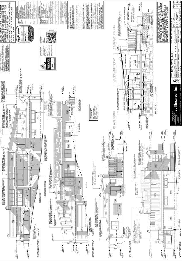
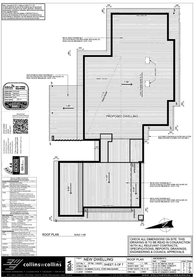
|
ATTACHMENT
|
Development Assessment Panel
28/06/2017
|
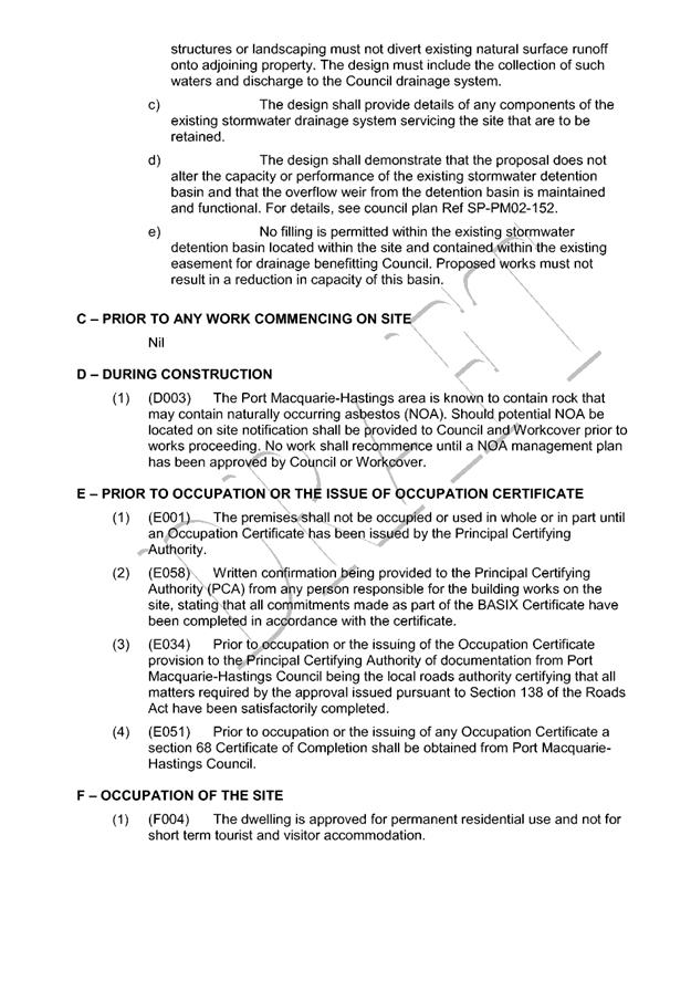
|
ATTACHMENT
|
Development Assessment Panel
28/06/2017
|
|
ATTACHMENT
|
Development Assessment Panel
28/06/2017
|
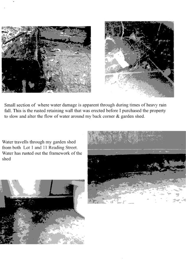
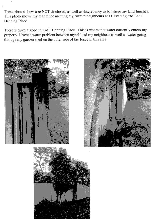
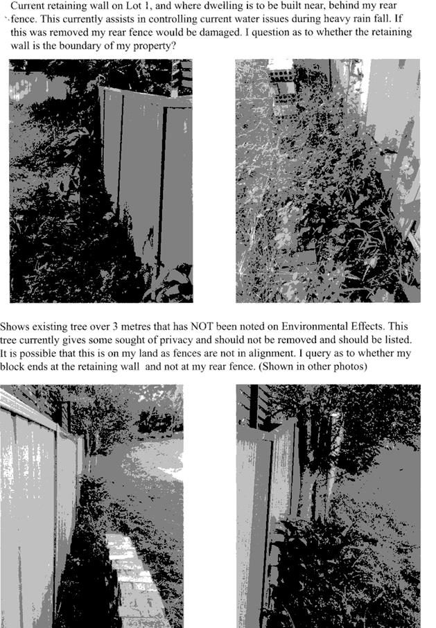
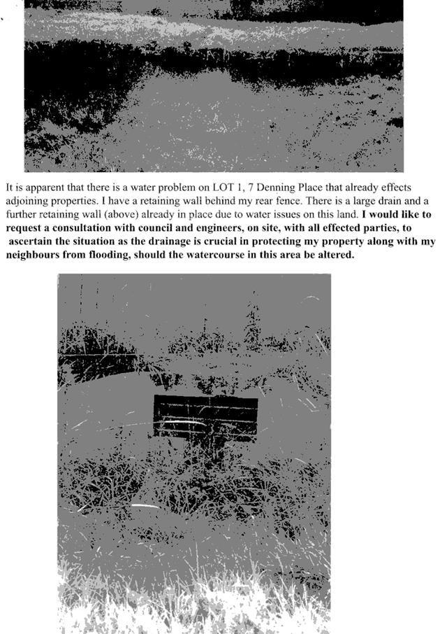
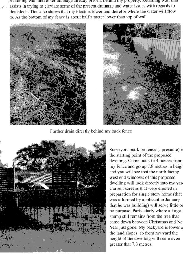
|
ATTACHMENT
|
Development Assessment Panel
28/06/2017
|
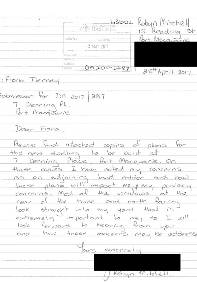
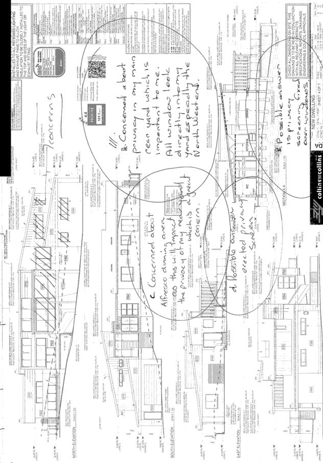
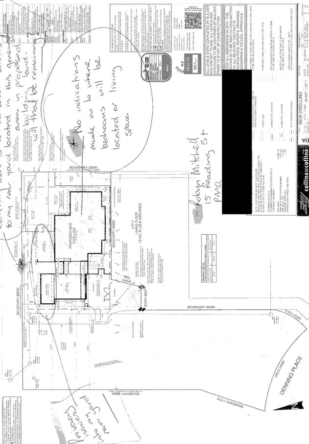
|
ATTACHMENT
|
Development Assessment Panel
28/06/2017
|