Business
Paper
|
date of meeting:
|
|
Wednesday 9 August
2017
|
|
location:
|
|
Function Room
Port
Macquarie-Hastings Council
17 Burrawan Street
Port Macquarie
|
|
time:
|
|
2:00pm
|
Development
Assessment Panel
CHARTER
COMPOSITION:
Independent Chair (alternate, Director Development &
Environment)
Manager Development Assessment (alternate, Director Development & Environment or Development Assessment Planner)
Development Engineering Coordinator (alternate, Development
Engineer)
MISSION:
To assist in managing Council's
development assessment function
by providing independent and expert assessment of development applications
The Development Assessment Panel will make determinations on the basis of established criteria and practice and will not be influenced by "lobbying" and "weight of numbers" in its assessment process.
FUNCTIONS:
1.
To review development application reports and conditions
2.
To determine development applications outside of staff delegations
3.
To refer development applications to Council
for determination where necessary
4.
To provide a forum for objectors and applicants to make submissions on applications before DAP.
5.
To maintain transparency for the determination of development applications.
DELEGATED AUTHORITY:
1.
Pursuant to Section
377 of the Local Government Act, 1993 delegation to:
2.
Determine development applications under Part 4 of the Environmental Planning
and Assessment Act 1979
having regard to the relevant
environmental planning instruments, development control plans and Council
policies.
3.
Vary Modify or release restrictions as to use and/or covenants created
by Section 88B instruments under the Conveyancing Act 1919 in relation to
development applications for subdivisions being considered by the panel.
4.
Determine Koala Plans of Management under State Environmental Planning
Policy 44 - Koala Habitat Protection associated with development applications
being considered by the Panel.
TIMETABLE:
The Development Assessment Panel shall generally meet on the 1st and 3rd Wednesday each month at 2.00pm.
VENUE:
The venue will be
determined according to the likely
number of participants.
BUSINESS PAPER AND MINUTES:
1.
The Business Paper for the meeting shall be published
and distributed on the Friday prior
to the meeting.
2.
Special Meetings of the Panel may be convened by the Director
Development & Environment Services
with three (3) days notice.
3.
The format of the preparation and publishing of the Business
Paper and Minutes
of the Development Assessment Panel meetings shall be similar to the format
for Ordinary Council Meetings, except that the movers
and seconders shall not be recorded and only the actual decisions are shown.
Minutes shall also record how each member votes for each
item before the Panel.
FORMAT OF THE MEETING:
1.
Panel meetings shall be carried
out in accordance with Council's
Code of Meeting Practice for Council Sub-Committees, except where varied
by this Charter.
2.
Meetings shall be "Open" to the public.
3.
The Panel will hear from applicants and objectors or their representatives. Where considered necessary, the Panel will conduct site inspections which will be open to the
public.
INDEPENDENT CHAIR:
The Chair of the Development Assessment Panel shall be an independent person appointed by the General
Manager. The Independent Chair shall have experience and qualifications relevant to planning.
The term of the Independent Chair shall be four
(4) years.
QUORUM:
All members must be present at the Meeting to form a Quorum.
DECISION MAKING:
Decisions are to be made by the Development Assessment
Panel by "consensus". Where "consensus" is not possible,
the matter is to be referred to Council.
All development applications
involving a variation to a development standard greater than 10% under
Clause 4.6 of the Port Macquarie-Hastings Local Environmental Plan 2011 will be
considered by the Panel and recommendation made to the Council for
determination.
Staff Members shall
not vote on matters before the Panel if they have been the principle author of the development assessment report.
LOBBYING:
Outside of scheduled
Development Assessment Panel meetings, applicants, their representatives,
Councillors, Council staff and the general public are not to lobby Panel
members via meetings, telephone conversations, correspondence and the like.
Adequate opportunity will be provided at Panel inspections or meetings for
applicants, their representatives and the general public to make verbal
submissions in relation to Business Paper items.
OBLIGATIONS OF PANEL
MEMBERS:
All DAP members
are required to comply with the following:
1.
Members must perform their Development Assessment Panel obligations faithfully and diligently and in accordance
with the DAP Code.
2.
DAP members must comply with Council's Code of Conduct.
3.
Except as required to properly perform
their duties, DAP members must not disclose
any confidential information (as advised by Council) obtained
in connection with the DAP functions.
4.
DAP members will have read and be familiar with the documents
and information provided
by Council prior to attending a DAP meeting.
5.
DAP members must act in accordance with Council's Occupational Health and Safety Policies and Procedures
6.
DAP members shall not speak to the media on any matter
before the Panel otherwise
than with the express approval
of the Director Development &
Environment Services.
Development Assessment Panel
ATTENDANCE
REGISTER
|
Member
|
24/05/17
|
14/06/17
|
28/06/17
|
12/07/17
|
26/07/17
|
|
Paul Drake
Matt Rogers (alternate)
|
P
|
P
|
P
|
P
|
P
|
|
Dan Croft
Patrick Galbraith-Robertson
Warren Wisemantel
(alternates)
|
P
|
P
|
P
|
P
|
P
|
|
David Troemel
Caroline Horan (alternate)
Bevan Crofts (alternate)
Grant Burge (alternate)
|
P
|
P
|
A
P
|
A
P
|
P
|
Key: P = Present
A
= Absent With Apology
X
= Absent Without Apology
Development
Assessment Panel Meeting
Wednesday 9 August
2017
Items of Business
01 Acknowledgement
of Country............................................................................ 3
02 Apologies......................................................................................................... 3
03 Confirmation
of Minutes.................................................................................... 3
04 Disclosures
of Interest....................................................................................... 3
05 DA2016
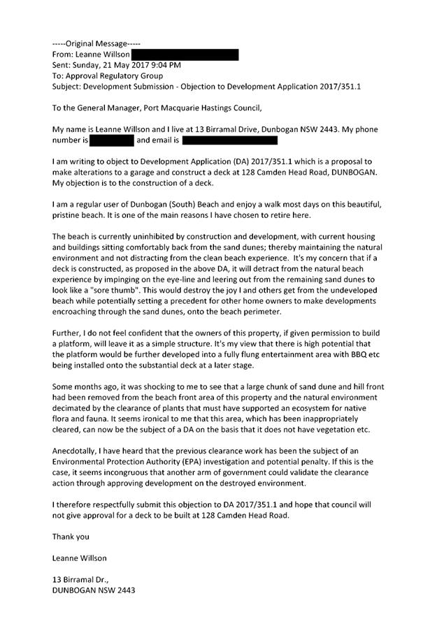
- 53.1 and PP2016 - 3.1 Planning Proposal and 2 into 5 Lot Subdivision, Lot 15
DP 1099742 And Lot 7 DP 1142473, No. 40 Reading Street, Port Macquarie.............. 3
06 DA2017
- 342.1 New Dwelling Including Clause 4.6 Objection To Clause 4.3 (Height Of
Buildings) (Of The Port Macquarie-Hastings Local Environmental Plan 2011 - Lot
271 DP 831575, 14 Coastlands Place, Port Macquarie ..................................................................... 3
07 DA2017
- 351.1 Alterations To Garage And Construction Of Deck - Lot 8 DP 734429 No 128
Camden Head Road, Dunbogan......................................................................... 3
08 General
Business
AGENDA Development Assessment Panel 09/08/2017
Subject: ACKNOWLEDGEMENT
OF COUNTRY
"I acknowledge that we are
gathered on Birpai Land. I pay respect to the Birpai Elders both past and
present. I also extend that respect to all other Aboriginal and Torres Strait
Islander people present."
RECOMMENDATION
That the apologies received be
accepted.
Subject: CONFIRMATION
OF PREVIOUS MINUTES
Recommendation
That the Minutes of the Development
Assessment Panel Meeting held on 26 July 2017 be confirmed.
MINUTES
Development Assessment Panel Meeting
26/07/2017
PRESENT
Members:
Paul
Drake
Dan Croft
David Troemel
Other Attendees:
Fiona
Tierney
|
The meeting opened at 2:00pm.
|
|
01 ACKNOWLEDGEMENT
OF COUNTRY
|
|
The
Acknowledgement of Country was delivered.
|
|
03 CONFIRMATION
OF MINUTES
|
|
CONSENSUS:
That
the Minutes of the Development Assessment Panel Meeting held on 12 July 2017
be confirmed.
|
|
04 DISCLOSURES
OF INTEREST
|
|
There were no disclosures of interest presented.
|
|
05 DA2017
- 415 Alterations and Additions to Dwelling and Construction of Commercial
Premises - Lot 2 DP 776806, No 5 Laurie Street, Laurieton
|
|
Speakers:
Philip Bowman (o)
Mike Dodkin (o)
Malcolm McNeil (applicant)
CONSENSUS:
That DA 2017 - 415 for alterations
and additions to existing dwelling and construction of commercial premises at Lot 2, DP 776806, No. 5 Laurie
Street, Laurieton,
be determined by granting consent subject to the recommended conditions and
as amended below:
- Move
condition C(3) to Section B of the consent.
- Additional
condition in Section B of the consent to read: ‘ Existing
structures to be demolished as part of the proposal and to be recorded
and photographed, with these details to be submitted in a report to
Council prior to release of the construction certificate.’
|
|
The meeting closed at 2:33pm.
|
AGENDA Development Assessment Panel 09/08/2017
Subject: DISCLOSURES
OF INTEREST
RECOMMENDATION
That Disclosures of Interest be presented
DISCLOSURE OF
INTEREST DECLARATION
Name of Meeting: ………………………………………………………………………..
Meeting Date: ………………………………………………………………………..
Item Number: ………………………………………………………………………..
Subject: ………………………………………………………………………..
…………………………………………………….……………...…..
I, .....................................................................................
declare the following interest:
 Pecuniary:
Take
no part in the consideration and voting and be out of sight of the meeting.
Non-Pecuniary
- Significant Interest:
Take
no part in the consideration and voting and be out of sight of the meeting.
Non-Pecuniary
- Less than Significant Interest:
May
participate in consideration and voting.
For the reason that: ....................................................................................................
.......................................................................................................................................
Name: …………………………………………………….
Signed:
.........................................................................
Date: ..................................
 (Further
explanation is provided on the next page)
(Further
explanation is provided on the next page)
Further
Explanation
(Local Government Act and Code of Conduct)
A conflict of interest exists where a reasonable and informed
person would perceive that a Council official could be influenced by a private
interest when carrying out their public duty. Interests can be of two types:
pecuniary or non-pecuniary.
All interests, whether pecuniary or non-pecuniary are required to
be fully disclosed and in writing.
Pecuniary Interest
A pecuniary interest is an interest that a Council official has in
a matter because of a reasonable likelihood or expectation of appreciable
financial gain or loss to the Council official. (section 442)
A Council official will also be taken to have a pecuniary interest
in a matter if that Council official’s spouse or de facto partner or a
relative of the Council official or a partner or employer of the Council
official, or a company or other body of which the Council official, or a
nominee, partner or employer of the Council official is a member, has a
pecuniary interest in the matter. (section 443)
The Council official must not take part in the consideration or
voting on the matter and leave and be out of sight of the meeting. The
Council official must not be present at, or in sight of, the meeting of
the Council at any time during which the matter is being considered or discussed,
or at any time during which the council is voting on any question in relation
to the matter. (section 451)
Non-Pecuniary
A non-pecuniary interest is an interest that is private or
personal that the Council official has that does not amount to a pecuniary
interest as defined in the Act.
Non-pecuniary interests commonly arise out of family, or personal
relationships, or involvement in sporting, social or other cultural groups and
associations and may include an interest of a financial nature.
The political views of a Councillor do not constitute a private
interest.
The management of a non-pecuniary interest will depend on whether
or not it is significant.
Non Pecuniary – Significant Interest
As a general rule, a non-pecuniary conflict of interest will be
significant where a matter does not raise a pecuniary interest, but it
involves:
(a)
A relationship between
a Council official and another person that is particularly close, for example,
parent, grandparent, brother, sister, uncle, aunt, nephew, niece, lineal
descendant or adopted child of the Council official or of the Council official’s
spouse, current or former spouse or partner, de facto or other person living in
the same household.
(b)
Other relationships
that are particularly close, such as friendships and business relationships.
Closeness is defined by the nature of the friendship or business relationship,
the frequency of contact and the duration of the friendship or relationship.
(c)
An affiliation between
a Council official an organisation, sporting body, club, corporation or
association that is particularly strong.
If a Council official declares a non-pecuniary significant
interest it must be managed in one of two ways:
1.
Remove the source of
the conflict, by relinquishing or divesting the interest that creates the
conflict, or reallocating the conflicting duties to another Council official.
2.
Have no involvement in
the matter, by taking no part in the consideration or voting on the matter and
leave and be out of sight of the meeting, as if the provisions in section
451(2) apply.
Non Pecuniary – Less than Significant Interest
If a Council official has declared a non-pecuniary less than
significant interest and it does not require further action, they must provide
an explanation of why they consider that the conflict does not require further
action in the circumstances.
SPECIAL
DISCLOSURE OF PECUNIARY INTEREST DECLARATION
|
By
[insert full name of councillor]
|
|
|
In the
matter of
[insert name of environmental planning instrument]
|
|
|
Which is
to be considered at a meeting of the
[insert name of meeting]
|
|
|
Held on
[insert date of meeting]
|
|
|
PECUNIARY
INTEREST
|
|
Address of land in which councillor or an
associated person, company or body has a proprietary interest (the identified
land)i
|
|
|
Relationship of identified land to councillor
[Tick or cross one box.]
|
Councillor
has interest in the land (e.g. is owner or has other interest arising out of
a mortgage, lease trust, option or contract, or otherwise).
Associated
person of councillor has interest in the land.
Associated
company or body of councillor has interest in the land.
|
|
MATTER
GIVING RISE TO PECUNIARY INTEREST
|
|
Nature of land that is subject to a change
in zone/planning control by proposed
LEP (the subject land iii
[Tick or cross one box]
|
The
identified land.
Land
that adjoins or is adjacent to or is in proximity to the identified land.
|
|
Current zone/planning control
[Insert name of current planning instrument and
identify relevant zone/planning control applying to the subject land]
|
|
|
Proposed change of zone/planning control
[Insert name of proposed LEP and identify
proposed change of zone/planning control applying to the subject land]
|
|
|
Effect of proposed change of zone/planning control
on councillor
[Tick or cross one box]
|
Appreciable
financial gain.
Appreciable
financial loss.
|
|
|
|
Councillor’s
Name: …………………………………………
Councillor’s
Signature:
……………………………….
Date: ………………..
Important Information
This information is being
collected for the purpose of making a special disclosure of pecuniary interests
under sections 451 (4) and (5) of the Local Government Act 1993.
You must not make a special disclosure that you know or ought reasonably to
know is false or misleading in a material particular. Complaints made
about contraventions of these requirements may be referred by the
Director-General to the Local Government Pecuniary Interest and Disciplinary
Tribunal.
This form must be completed by
you before the commencement of the council or council committee meeting in
respect of which the special disclosure is being made. The
completed form must be tabled at the meeting. Everyone is entitled to
inspect it. The special disclosure must be recorded in the minutes of the
meeting.
i.
Section 443 (1) of the Local Government Act 1993 provides that
you may have a pecuniary interest in a matter because of the pecuniary interest
of your spouse or your de facto partner or your relativeiv or
because your business partner or employer has a pecuniary interest. You may
also have a pecuniary interest in a matter because you, your nominee, your
business partner or your employer is a member of a company or other body that
has a pecuniary interest in the matter.
ii.
Section 442 of the Local Government Act 1993 provides that a pecuniary
interest is an interest that a person has in a matter because of a
reasonable likelihood or expectation of appreciable financial gain or loss to
the person. A person does not have a pecuniary interest in a matter if the
interest is so remote or insignificant that it could not reasonably be regarded
as likely to influence any decision the person might make in relation to the
matter or if the interest is of a kind specified in section 448 of that
Act (for example, an interest as an elector or as a ratepayer or person liable
to pay a charge).
iii.
A pecuniary interest may arise by way of a change of permissible use of land
adjoining, adjacent to or in proximity to land in which a councillor or a
person, company or body referred to in section 443 (1) (b) or (c) of the
Local Government Act 1993 has a proprietary interest..
iv.
Relative is defined by the Local Government Act 1993 as
meaning your, your spouse’s or your de facto partner’s parent,
grandparent, brother, sister, uncle, aunt, nephew, niece, lineal descendant or
adopted child and the spouse or de facto partner of any of those persons.
AGENDA Development Assessment Panel 09/08/2017
Item: 05
Subject: DA2016 - 53.1 and PP2016 - 3.1 Planning
Proposal and 2 into 5 Lot Subdivision, Lot 15 DP 1099742 And Lot 7 DP 1142473,
No. 40 Reading Street, Port Macquarie
Report
Author: Chris Gardiner
|
Applicant: R
G Little
Owner: R
G & A L Little, and N M Xavier
Estimated Cost: $70,000
Parcel no: 49486
and 58969
Alignment with Delivery
Program
4.3.1 Undertake transparent
and efficient development assessment in accordance with relevant legislation.
|
|
RECOMMENDATION
That
it be a recommendation to Council that Council:
1. Take the necessary
steps under sections 58 and 59 of the Environmental Planning and
Assessment Act 1979 to finalise Local Environmental Plan 2011
(Amendment No 41) as attached.
2. Enter
into the Reading Street Environmental Land Planning Agreement under Section
93F of the Environmental Planning and Assessment Act 1979 between Port
Macquarie-Hastings Council and Ronald Gordon Little and Adele Lillian
Little.
3. Having
regard to the assessment in this report of DA2017-53, for a subdivision at Lot 7 DP 1142473 and Lot 15 DP 1099742 (No. 40)
Reading Street, Port Macquarie, delegate to
the General Manager the determination of the development application upon the
commencement of Local Environmental Plan 2011 (Amendment No
41).
4. Thank in writing all
those who made a submission for their contribution and provide information on
Council’s decision on the matter.
|
Executive Summary
This report considers:
· proposed amendments to the LEP 2011 mapping for Lot 7
Reading Street,
· an associated Voluntary Planning Agreement relating to the
proposed dedication of environmental management land to Council, and
· an associated development application for a 2 into 5 lot
subdivision at the subject site
and provides an assessment of the applications in
accordance with the Environmental Planning and Assessment Act 1979.
The
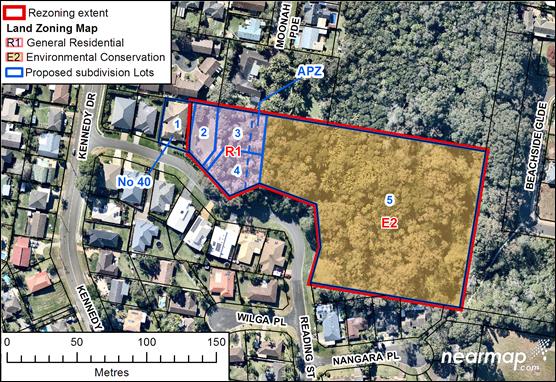
proposed zonings and subdivision layout are shown on the following plan.
The
proposal has been lodged as a joint Planning Proposal and Development
Application in accordance with Part 3, Division 4B of the Environmental
Planning and Assessment Act 1979. The subdivision proposed in the development
application can only be carried out if the Port Macquarie-Hastings Local
Environmental Plan 2011 (LEP) is amended as proposed in the Planning Proposal.
Determination
of the LEP amendments and the Voluntary Planning Agreement require referral to
Council, but it is proposed that the Development Assessment Panel review the
development application in conjunction with those matters and provide any
relevant comments with that referral.
Determination
of the development application will only be possible following the commencement
of the amending LEP.
Following
exhibition of the Development Application, Planning Proposal, and Planning
Agreement, three submissions have been
received.
The key
issues are:
· Protection of the current environmental lands;
· Enhancement of ecological corridors between Sea Acres
National Park and Wrights Creek;
· Consequential provision of
alternate land zoned R1 General Residential.
1. BACKGROUND
Existing sites features and surrounding
development
The
site has an area of 1.84 hectares.
The site is zoned R1 General Residential, RU6
Transition, and E2 Environmental Conservation in
accordance with the Port Macquarie-Hastings Local Environmental Plan 2011, as
shown in the following zoning plan:
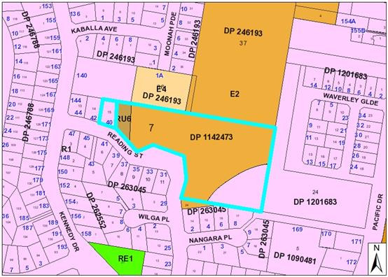
The existing subdivision pattern and location of existing
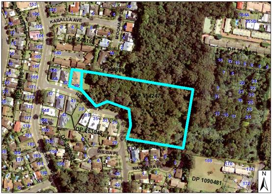
development within the locality is shown in the following aerial photograph:
The eastern Lot 7 is the residue of the staged subdivision
of the northern section of Reading Street, Port Macquarie. It is on the upper
reaches of Wrights Creek, and part of it is vulnerable to local flooding.
When residential zoning was first applied to this portion of
Port Macquarie in 1980, most of what is now Lot 7 was zoned 6(b) Private
Recreation. The area zoned 6(b) is now zoned E2 Environmental Conservation in Port
Macquarie-Hastings Local Environmental Plan 2011.
The western 20m of Lot 7 provides a bushfire asset
protection zone to Lot 15 (No 40), and is cleared and zoned RU6 Transition.
The south-eastern portion of Lot 7 has some flood-free land
and is zoned R1 General Residential, though it does not have easy access to
facilitate residential subdivision.
To the north is the vegetated Wrights Creek corridor, and
to the east is a vegetated linkage to Sea Acres National Park. The vegetation
on the eastern portion of Lot 7 has additional ecological value through the
provision of connectivity between these 2 areas, where at present there is land
zoned R1 General Residential.
The proposal
seeks to preserve the vegetation on Lot 7, other than on the western side,
where three residential lots are proposed.
The combined
application documents are Attachments
1 Volume 1 Main Documents,
including
· Chapter
1 - LEP Amendment
· Chapter
2 - Development Application
· Chapter
3 - Voluntary Planning Agreement
· Appendix
A - (LEP) Gateway Determination
2 Volume 2, containing
· Appendix
B – (LEP) Consistency with applicable State Environmental Planning
Policies
· Appendix
C – (LEP) Consistency with applicable Section 117 Ministerial Directions
· Appendix
D – Voluntary Planning Agreement document
· Appendix
E – Public Authority comments
· Appendix
F – (DA) Statement of Environmental Effects
3 Volume 3 Appendix G - Bush Fire
Assessment
4 Volume 4 Appendix H - Aboriginal
Cultural Heritage Assessment
5 Volume 4 Appendix I - Statutory
Ecological Assessment
2. PROPOSED
AMENDMENTS TO THE LOCAL ENVIRONMENTAL PLAN
The objectives of the LEP amendments are:
· to enhance the value of the environmental conservation land
through long term protection of the ecological corridor between Sea Acres
National Park and Wrights Creek, and
· to provide offset land zoned Residential.
The LEP amendments involve changes to:
· Land Zoning Map (current zoning is shown under Background,
and proposed in Executive Summary)
· Lot Size Map (to align with Land Zoning Map)
· Floor Space Ratio Map (to align with Land Zoning Map).
Additional benefits are:
· a net increase in land zoned E2 Environmental Conservation
of 1200m2;
· a simpler and more affordable subdivision of 3 Residential
lots.
This does involve the removal of an E2 zone over 1850m2
towards the western end of Lot 7, which has been raised in some submissions,
though this is replaced with 3050m2 of E2 zone in the southeast
corner, where it is considered to enhance an ecological corridor.
The ecological assessments have given greater environmental
value to the eastern area, even in a current degraded condition. This is due to
its integrated location within an ecological corridor and conservation with
bushland management will make the whole corridor more robust. The western
area is a side offshoot of the main ecological corridor, and assessment of the
species within it does not identify any grounds to favour this area over the
eastern area.
3. PROPOSED
VOLUNTARY PLANNING AGREEMENT
Council has received an offer to
enter into a Voluntary Planning Agreement (VPA) in connection with the
Development Application.
The Planning Agreement provides for dedication free of cost
to Council of 1.497 hectares of environmental land as a public reserve. The
land is identified as Lot 5 in the proposed plan of subdivision and dedication
of the land would be required to take place on registration of the first plan
of subdivision for the development.
A copy of the draft Planning Agreement is attached to this
report (Attachment 2 Appendix D).
Public notification of the draft Planning Agreement was
carried out jointly with the Planning Proposal and Development Application
between 14 June 2017 and 12 July 2017, including a notice in the local
newspaper. Following exhibition three (3) submissions were received. However,
the submissions related to the Planning Proposal and Development Application
and did not raise any issues in relation to the Draft VPA.
It is recommended that Council proceed to enter into the
Planning Agreement.
4. DESCRIPTION
OF DEVELOPMENT
Key aspects of the proposal include the following:
· 2
into 5 lot subdivision including 4 residential lots and a proposed public
reserve.
Refer to attachments at the end of this report.
Development Application Chronology
· 4
February 2016 – Application lodged as joint Planning Proposal and
Development Application.
· 6
April 2016 – Additional information requested from Applicant.
· 10
April 2016 – Additional information submitted by Applicant.
· 19
April 2016 – Owner’s consent granted for proposed creation of
easement to drain water over Lot 36 DP 246193.
· 19 October 2016 – Site inspected by assessing
officers of Development Application and Planning Proposal with Office of
Environment and Heritage.
· 28 November 2016 – Comments received from NSW Office
of Environment and Heritage.
· 7
December 2016 – Bush Fire Safety Authority issued by the NSW Rural Fire
Service.
· 6 June 2017 – Aboriginal culture heritage assessment
received.
· 14 June 2017 to 12 July 2017 – Public exhibition of Development
Application, Planning Proposal, and Planning Agreement.
5. STATUTORY
ASSESSMENT
Section 79C(1) Matters for Consideration
In determining the application, Council is required to take
into consideration the following matters as are relevant to the development
that apply to the land to which the development application relates:
(a) The provisions
(where applicable) of:
(i) any
Environmental Planning Instrument:
State Environmental Planning Policy No. 44 - Koala Habitat Protection
With
reference to clauses 6 and 7, the subject land has is greater than 1 hectare
(including any adjoining land under same ownership) and therefore the
provisions of SEPP must be considered.
An Ecological
Assessment prepared by Naturecall Environmental has been submitted with the
application. The report includes consideration of SEPP 44 in Part 5.0. The
author identified that only a single primary food tree listed in Schedule 2 of
the SEPP (a Swamp Mahogany) was present on the site. Therefore, the land does
not qualify as potential koala habitat, due to Schedule 2 food trees comprising
less than 15% of canopy trees on the site.
The report
notes that there was a koala reported to have been sighted on the property
approximately 8 months earlier. However, further consideration of the SEPP is
not required in accordance with clause 7(3)(a) despite this sighting.
State Environmental Planning Policy No. 55 – Remediation of Land
Following an
inspection of the site and a search of Council records, the subject land is not
identified as being potentially contaminated and is suitable for the intended
use.
State Environmental Planning Policy No. 71 – Coastal Protection
and Clause 5.5 of Port Macquarie-Hastings Local Environmental Plan 2011
The site is
located within a coastal zone noting clause 4 of the SEPP.
In accordance
with clause 5, this SEPP prevails over the Port Macquarie-Hastings LEP 2011 in
the event of any inconsistency.
Having regard
for clauses 2, 8 and 12 to 16 of the SEPP and clause 5.5 of the PMH LEP 2011,
the proposed development will not result in any of the following:
a) any restricted access (or
opportunities for access) to the foreshore
b) any adverse amenity impacts along
the foreshore and on the scenic qualities of the coast;
c) any adverse impacts on flora and
fauna;
d) the development being subject to
any adverse coastal processes or hazards;
e) any significant conflict between
water and land based users of the area;
f) any adverse impacts on any
items of archaeological/heritage;
g) reduction in the quality of the
natural water bodies in the locality (due to effluent & stormwater
disposal, construction impacts, landuse conflicts);
h) adverse cumulative impacts on the
environment;
i) a form of development that is
unsustainable in water and energy demands;
j) development relying on
flexible zone provisions.
Port Macquarie-Hastings Local Environmental Plan 2011
The proposal
is consistent with the LEP as proposed to be amended having regard to the
following:
· Clause
2.2, the subject site was zoned R1 General Residential, RU6 Transition, and E2
Environmental Conservation at the time of lodgement. The submitted proposal
includes rezoning of the site to R1 on the western side to accommodate 4
residential lots, and E2 for the residue of approximately 1.497 hectares, which
is intended to be dedicated to Council as a public reserve. This application
cannot be determined until the amending LEP commences.
The objectives of the R1 and E2 zones are as follows:
R1 General Residential:
o To
provide for the housing needs of the community.
o To
provide for a variety of housing types and densities.
o To
enable other land uses that provide facilities or services to meet the day to
day needs of residents.
E2 Environmental Conservation:
o To
protect, manage and restore areas of high ecological, scientific, cultural or
aesthetic values.
o To
prevent development that could destroy, damage or otherwise have an adverse
effect on those values.
o To
protect coastal wetlands and littoral rainforests.
o To
protect land affected by coastal processes and environmentally sensitive land.
o To
prevent development that adversely affects, or would be adversely affected by,
coastal processes.
o To
enable development of public works and environmental facilities where such
development would not have an overall detrimental impact on ecological,
scientific, cultural or aesthetic values.
In accordance with Clause 2.3(2), the proposal is consistent with the
zone objectives having regard to the following:
o The
proposal would provide additional residential lots to meet the housing needs of
the community.
o The
development includes a variety of lot sizes that would provide for choice of
housing type and density.
o The
development would conserve and protect ecologically significant land.
o The
proposal would improve long-term links with other habitat to the east of the
site.
· Clause
4.1, the residential lot sizes within the proposed subdivision range from 694m2
to 1096m2. All proposed residential lots comply with the minimum lot
sizes identified in the proposed amended Lot Size Map included with the
Planning Proposal. Lot 5 in the proposed subdivision is intended to be
dedicated to Council as a public reserve in accordance with a Planning
Agreement. It is noted that the area of this lot (1.497 hectares) is slightly
below the proposed 1.5 hectare minimum lot size shown on the proposed Lot Size
Map. However, Clause 2.75(e) of State Environmental Planning Policy (Exempt and
Complying Development Codes) 2008 allows subdivision for the purpose of
creating a public reserve to be carried out as Exempt Development without
having regard to the LEP Lot Size Map.
· Clause
5.5 - Development within the coastal zone - relevant objectives of this clause
are addressed by SEPP 71 section (see above). Climate Change & Coastal
Hazard implications addressed under Clause 7.3 below.
· Clause
5.9 - The proposal includes removal/modification of approximately 1800m2
of modified wet sclerophyll forest vegetation. See comments later in this
report under Development Control Plan 2013 and Flora & Fauna sections.
· Clause
5.10 – Heritage. The site does not contain or adjoin any known heritage
items or sites of significance.
· Clause
7.3, part of the site is land within a mapped “flood planning area”
(land subject to flood discharge of 1:100 annual recurrence interval flood
event, plus the applicable climate change allowance and relevant freeboard). In
this regard the following comments are provided which incorporate consideration
of the objectives of Clause 7.3, Council’s Flood Policy 2015, the NSW
Government’s Flood Prone Lands Policy and the NSW
Government’s Floodplain Development Manual (2005):
o The
proposal is compatible with the flood hazard of the land taking into account
projected changes as a result of climate change;
o The
proposal will not result in a significant adverse effect on flood behaviour
that would result in detrimental increases in the potential flood affectation
of other development or properties;
o The
proposal incorporates measures to minimise & manage the flood risk to life
and property associated with the use of land;
o The
proposal is not likely to significantly adversely affect the environment or
cause avoidable erosion, siltation, destruction of riparian vegetation or a
reduction in the stability of river banks or watercourses;
o The
proposal is not likely to result in unsustainable social and economic costs to
the community as a consequence of flooding;
The flood affected part of the site is proposed to be located within the
E2 land and all the residential allotments would be located above the flood
planning level.
· Clause
7.13, satisfactory arrangements are in place for provision of essential
services including water supply, electricity supply, sewer infrastructure,
stormwater drainage and suitable road access to service the development.
Provision of electricity will be subject to obtaining satisfactory arrangements
certification prior to the issue of a Subdivision Certificate as recommended by
a condition of consent.
(ii) Any
draft instruments that apply to the site or are on exhibition:
Port Macquarie-Hastings Local Environmental Plan 2011
(Amendment No 41)
The Planning
Proposal for LEP Amendment No 41 was publicly exhibited between 14 June 2017
and 12 July 2017.
In relation
to the subject site, the draft instrument proposes the following changes, as
detailed in the Figures 5 - 10 of the Planning Proposal:
· Change
zoning applying to Lots 1 - 4 from RU6 and E2 to R1;
· Change
zoning applying to Lot 5 from E2 and R1 to E2;
· Change
minimum lot size applying to Lots 1 - 4 from 1800m2 to 450m2;
· Change
minimum lot size applying to Lot 5 from part 1800m2 and part 450m2
to 1.5 hectares;
· Change
maximum floor space ratio applying to Lots 1 - 4 from no maximum to 0.65:1;
· Change
maximum floor space ratio applying to Lot 5 from part 0.65:1 to no maximum.
1.
2.
The submitted application is consistent with the draft LEP and relies
upon the proposed amendments to zoning and the Lot Size Map. The Development
Application cannot be determined until commencement of the amending LEP.
(iii) any
Development Control Plan in force:
Port Macquarie-Hastings Development Control Plan 2013
|
DCP 2013: Chapter 3.6 - Subdivision
|
|
DCP Objective
|
Development Provisions
|
Proposed
|
Complies
|
|
3.6.3.2
|
Torrens title lots minimum width of 15m when measured at a
distance of 5.5m from front property boundary.
|
Minimum 18m width for Lots 1, 2, 4, and 5. Lot 3 is a
battleaxe lot and achieves minimum 15m width at distance of 5.5m from the end
of the battleaxe handle.
|
Yes
|
|
Minimum width of 7m when boundaries are extended to kerb
line.
|
Lots 1, 2, 4, and 5 achieve minimum width of 7m. Lot 3 is
a battleaxe lot with a 4.55m width at the kerb line. See further comments
below regarding battleaxe lot.
|
Yes
|
|
Minimum depth of 25m.
|
Lot 4 has a minimum 23.4m depth on one side. All other
lots achieve minimum depth.
|
No*
|
|
3.6.3.3
|
Council may consider permitting Torrens Title battleaxe
allotments for ―infill development where it is demonstrated that;
· a Torrens Title lot, that is
not a battleaxe lot, cannot be achieved; and
· the number of crossovers do
not reduce the amenity of the street or on street parking; and
· the impact of noise, dust
and headlights on the land owners adjoining the driveway is addressed by the
construction of an acoustic fence for the full length of the driveway; and
· addresses privacy between
the rear lot and the rear open space of the front lot by the provision of
adequate screening, larger lot size and setbacks; and
· extends utilities to the end
of the axe handle; and
· there is sufficient space
for garbage collection on the frontage.
|
It is not considered that an alternative lot layout could
avoid a battleaxe lot, give the road geometry and environmental constraints
at the site. The number of future crossovers in the frontage of the
residential lots is considered reasonable and unlikely to significantly
impact on street parking.
Adequate privacy between the front and rear lot for future
dwellings in achievable.
Conditions recommended regarding acoustic fencing and
services along battleaxe handle.
|
Yes
|
|
3.6.3.4
|
Lots are to be designed to allow the construction of a
dwelling, which does not involve more than 1m cut, or fill, measured from
natural ground level, outside the dwellings external walls.
|
The land has minimal slope and future dwelling
construction involving less than 1m of cut or fill is achievable.
|
Yes
|
|
Lot sizes increased for sloping sites in accordance with
Table 3.6.1.
|
The development complies with the minimum lot size and
width requirements of slope Category A.
|
Yes
|
|
Additional information provided for slope categories in accordance
with Table 3.6.2.
|
No retaining walls proposed at subdivision stage.
|
Yes
|
|
3.6.3.6
|
Kerb and guttering, associated street drainage, pavement
construction and foot paving across the
street frontages should be constructed as part of the
subdivision works where these do not exist (may be varied subject to criteria
in this clause)
|
Existing kerb and gutter across street frontage. Condition
recommended requiring concrete footpath for the full frontage of the
residential lots.
|
Yes
|
|
3.6.3.20
|
Water supply to meet Council’s design
specifications.
|
See comments later in this report under Water Supply
Connection.
|
Yes
|
|
3.6.3.21
|
All lots connected to reclaimed water if available.
|
Reclaimed water not currently connected to the site.
|
Yes
|
|
3.6.3.24
|
Separate sewer junction provided for each lot.
|
See comments later in this report under Sewer Connection.
|
Yes
|
|
3.6.3.27
|
Erosion and sediment control plan to be provided.
|
Condition recommended requiring erosion and sediment
control plan as part of infrastructure Construction Certificate.
|
Yes
|
|
3.6.3.34
|
All service infrastructure should be underground unless
otherwise approved by Council.
|
Condition recommended requiring certification of
satisfactory arrangements for provision of utility services.
|
Yes
|
|
All service infrastructure should be installed in a common
trench.
|
|
Conduits for the main technology network system should be
provided in all streets.
|
|
Conduits are to be installed in accordance with the
National Broadband Network Company Limited’s
‘Guidelines for Fibre to the Premises Underground
Deployment’.
|
|
Access pits are to be installed at appropriate intervals
along all streets.
|
|
3.6.3.51
|
Street trees should be provided along all road frontages
generally at a rate of 1 per 20m interval.
|
Condition recommended requiring details of landscaping
(including street trees) on the construction plans.
|
Yes
|
|
Street trees should not affect solar access.
|
Street trees would be located on the southern frontage of
the lots and would not affect solar access.
|
Yes
|
|
3.6.3.52
|
Street trees from Council’s list.
|
Condition recommended requiring details of landscaping
(including street trees) on the construction plans.
|
Yes
|
|
DCP 2013: General Provisions
|
|
DCP Objective
|
Development Provisions
|
Proposed
|
Complies
|
|
2.7.2.2
|
Design addresses generic principles of Crime Prevention
Through Environmental Design guideline:
· Casual surveillance and
sightlines
· Land use mix and activity
generators
· Definition of use and
ownership
· Lighting
· Way finding
· Predictable routes and
entrapment locations
|
Development would create additional residential
allotments, which would contribute to passive surveillance of the street.
|
Yes
|
|
2.3.3.1
|
Cut and fill 1.0m max. 1m outside the perimeter of the
external building walls
|
None proposed.
|
Yes
|
|
2.3.3.6
|
Vegetated buffer for watercourses
|
The site includes first and second order streams. The
streams have existing vegetated buffers, which would be preserved within the
E2 zone.
|
Yes
|
|
2.3.3.8 onwards
|
Removal of hollow bearing trees (HBTs)
|
The ecological assessment prepared by Naturecall
Environmental identifies a total of 11 HBTs on the site, 4 of which are
located on or adjacent to the proposed residential lots. The remainder of the
7 trees are located on the E2 land intended to be dedicated to Council.
The ecological assessment
scored the 4 trees potentially affected by the development 8-12 in accordance
with Council’s HBT assessment protocol. Therefore the trees may be
considered for removal if management measures are ‘impractical to allow
retention’ (determined by an arborist) subject to compensatory
measures.
The report indicates that trees H1 - H4 inclusive are
intended to be retained and offsets are therefore not proposed.
However, advice received from OEH during the agency
consultation for the Planning Proposal, indicated that they considered the
HBT assessment to be incorrect due to the location of the trees within
habitat or linkages. The OEH assessment considers that trees H1-H4 should be
scored between 12.5 and 14.
On this basis the DCP requires that the four trees be
retained and afforded a development exclusion buffer (radius 1.25 times the
height of the tree) or located in environmental lands. The layout of the
proposed subdivision does not provide for a development exclusion buffer and
proposed Lots 3 and 4 would effectively be sterilised if such a buffer was
applied.
Appendix I of the Planning Proposal addresses the
consistency of the proposal with objectives of this control. Variation of the
development provision is considered satisfactory in this instance.
It is noted that OEH have further recommended that the
four HBT’s be offset in accordance with 2.3.3.9 of the DCP. A condition
is recommended requiring the developer to engage an arborist to remove all
hollows from existing HBT’s prior to felling the trees. The removed
hollows are to be installed in suitable locations within the proposed public
reserve in consultation with an ecologist and as agreed by Council.
|
No, but acceptable
|
|
2.6.3.1
|
Tree removal (3m or higher with 100m diameter trunk and 3m
outside dwelling footprint
|
Approximately 1800m2 of vegetation is proposed to
be removed. None of the trees proposed to be removed are koala food trees
listed in Table 2.6.1.
Potential ecological impacts of the tree removal are
addressed later in this report under Flora and Fauna.
|
Yes
|
|
2.4.3
|
Bushfire risk, Acid sulphate soils, Flooding,
Contamination, Airspace protection, Noise and Stormwater
|
Refer to main body of report.
|
|
|
2.5.3.2
|
New accesses not permitted from arterial or distributor
roads. Existing accesses rationalised or removed where practical
|
Access from local road.
|
Yes
|
|
2.5.3.11
|
Section 94 contributions
|
Refer to main body of report.
|
|
The proposal seeks to vary Development Provision 3.6.3.2 in
relation to the minimum lot depth.
The objectives of the provision are:
· To provide a range of lot sizes to suit a variety of
dwelling and household types.
· To ensure the lot layout plan reflects the site’s
opportunities and constraints.
The proposal is considered to be consistent with the
objectives for the following reasons:
· The lot is of irregular shape and essentially has two rear
boundaries. The depth of the lot is variable, but it provides a minimum 15m
wide section with at least 25m depth which would comply with the lot dimension
requirements.
· The minor non-compliance at the side boundary alignment is
not considered to compromise the suitability of the lot to accommodate a
variety of dwelling types.
Based on the above assessment, the variations proposed to
the provisions of the DCP are considered acceptable and the relevant objectives
have been satisfied. Cumulatively, the variations do not amount to an adverse
impact or a significance that would justify refusal of the application.
(iiia) any
planning agreement that has been entered into under Section 93f or any draft
planning agreement that a developer has offered to enter into under Section
93f:
Council has received an offer to enter into a Voluntary
Planning Agreement (VPA) in connection with the Development Application.
The Planning Agreement provides
for dedication free of cost to Council of 1.497 hectares of environmental land
as a public reserve. The land is identified as Lot 5 in the proposed plan of
subdivision and dedication of the land would be required to take place on
registration of the first plan of subdivision for the development.
The submitted proposal is
consistent with the terms of the offer and a condition is recommended
confirming the requirement for the development to comply with the provisions of
the Planning Agreement.
iv) any matters prescribed
by the Regulations:
New South Wales Coastal Policy:
The proposed
development is consistent with the objectives and strategic actions of this
policy. See comments earlier under SEPP No. 71 - Coastal Protection.
v) any
coastal zone management plan (within the meaning of the Coastal Protection Act 1979),
that apply to the land to which the development application relates:
No Coastal
Zone Management Plan applies to the subject site.
(b) The
likely impacts of that development, including environmental impacts on both the
natural and built environments, social and economic impacts in the locality:
The site has
a general southerly street frontage orientation to Reading Street.
Adjoining the
site to the north is residential development and a public reserve. Adjoining
the site to the east is a public reserve. Adjoining the site to the south and
west are residential dwellings.
The proposal
is considered to be compatible with other development in the locality and
adequately addresses planning controls for the area.
The proposal
does not have a significant adverse impact on existing view sharing.
The proposal
does not have significant adverse lighting impacts.
There are no
significant adverse privacy impacts. The proposed lot layout would allow for
future dwellings to be constructed with adequate privacy.
There are no
adverse overshadowing impacts. The proposal does not prevent adjoining
properties from receiving 3 hours of sunlight to private open space and primary
living areas on 21 June.
Roads
The site has
road frontage to Reading Street. Adjacent to the site, Reading Street is a
sealed public road under the care and control of Council.
Traffic and Transport
This
development proposes to create four residential allotments (one of which
contains an existing dwelling) and is expected to generate an additional 27
daily trips. The addition in traffic associated with the development is
unlikely to have any adverse impacts to the existing road network within the
immediate locality.
Site Frontage & Access
Due to the
type and size of development, additional works are required to include concrete
footpath paving (minimum 1.2m wide) along the full frontage. Refer to relevant
conditions of consent.
Water Supply Connection
Council records indicate that the proposed development site has two
existing metered water services from the 100mm PVC water main on the opposite
side of Reading Street. The proposed servicing strategy is acceptable in
principal.
A new metered
water service will be required for each allotment as part of the Torrens Title
Subdivision.
Sewer Connection
Council records indicate that the development site is connected to
Sewer via a junction to a manhole located on the southern property boundary.
The proposed servicing strategy is acceptable in principal. Detailed
engineering plans are to be provided and owners consent is to be provided if
applicable.
A separate
sewer connection to Council’s main is required for each Torrens Title
lot.
Stormwater
The part of
the site proposed for residential development naturally grades towards an
existing stormwater detention basin to the south-east of proposed Lot 4.
A detailed
site stormwater management plan will be required to be submitted for assessment
with the S.68 application and prior to the issue of a CC. In accordance with
Councils AUSPEC requirements, the following must be incorporated into the
stormwater drainage plan:
a) The
legal point of discharge for the proposed development is defined as an
interallotment drainage system.
b) The
design is to be generally in accordance with the stormwater drainage concept
plan on Drawing No 9830 prepared by Frank O’Rourke & Associates Pty
Ltd and dated 28 January 2016.
c) All
allotments must be provided with a direct point of connection to the piped
drainage system. Kerb outlets are not permitted.
d) The
design requires the provision of interallotment drainage in accordance with
AUSPEC D5. In this regard, the proposal to divert the existing interallotment
drainage system around existing landscaping within proposed Lot 2 is an
inefficient solution in that the proposal results in an unnecessary extent of encumbrance
within the yard of that lot and a hydraulically inefficient solution. The
proposed system should be realigned such that it runs parallel to the northern
property boundary of Lot 2.
e) The
design shall incorporate on-site stormwater detention facilities to limit site
stormwater discharge to pre development flow rates for all storm events up to
and including the 100 year ARI event. Note that pre development discharge shall
be calculated assuming that the site is a ‘greenfield’ development
site as per AUSPEC requirements. As an alternative, where a single end of line
solution is not considered feasible, on-site stormwater detention facilities
may be incorporated into the design of the future dwellings to be constructed
on each of the proposed allotments.
In this regard, if OSD facilities are proposed to be
constructed as part of a future dwelling construction, a restriction / covenant
must be placed on the title of each allotment at the time of subdivision
requiring that OSD facilities be constructed as part of any future building
development to achieve site specific targets that comply with the above.
In this instance the CC plans must nominate the maximum
permissible site discharge for each allotment.
f) Where
works are staged, a plan is to be provided which demonstrates which treatment
measure/s is/are to be constructed with which civil works stage. Separate plans
are required for any temporary treatment (where applicable e.g. for building
phase when a staged construction methodology is adopted) and ultimate design.
g) The
design is to make provision for the natural flow of stormwater runoff from
uphill/upstream properties/lands. The design must include the collection of
such waters and discharge to the Council drainage system.
h) The
design shall provide details of any components of the existing stormwater
drainage system servicing the site that are to be retained.
Other Utilities
Telecommunication
and electricity services are available to the site.
Evidence of satisfactory
arrangements with the relevant utility authorities for provision to each
proposed lot will be required prior to Subdivision Certificate approval.
Heritage
No known
items of European heritage significance exist on the property.
An Aboriginal
cultural heritage assessment for the land has been prepared by J P Collins of
Adise Pty Ltd.
The
assessment considered heritage register searches, literature review, and
cultural information disclosed by the senior sites officer of Birpai Local
Aboriginal Land Council (LALC). On the basis of this review the study area does
not contain registered or otherwise reported Aboriginal objects, nor is it
known to contain or impinge upon any specific sites/places of special
traditional, historic or contemporary social/cultural significance. No
Aboriginal sites/objects were detected during the field survey.
The report
concludes that on the basis of Aboriginal consultation, background information
and the nil field survey result, it is concluded that the proposed rezoning and
associated residential development on Lot 7 DP 1142473 should be allowed to
proceed without further Aboriginal cultural heritage constraints, providing the
following management recommendations are fully implemented.
1) As part of the pre-start induction,
all personnel engaged for initial development-related earthworks (including
tree clearing) on proposed lots 2, 3 and 4 should be informed of their legal
obligations with respect to Aboriginal objects, including
‘stop-work’ conditions applicable in the event that any identified
or suspected Aboriginal objects are discovered at any time (Recommendation 3).
2) All personnel (including
volunteers) engaged to undertake vegetation rehabilitation works on proposed
lot 5 should be informed of their legal obligations with respect to Aboriginal
objects, including ‘stop-work’ conditions applicable in the event
that any identified or suspected Aboriginal objects are discovered at any time
(Recommendation 3).
3) In the event that any
identified or suspected Aboriginal objects are detected at any time, all
disturbance works should immediately cease within 20m of the find and temporary
protective fencing erected around this ‘no-go zone’ pending further
management advice from the OEH and the Birpai LALC. If the find consists of or
includes human remains, the NSW Police Department and the OEH Environmental
Line (ph 131 555) should also be notified as soon as practicable.
Works may not recommence within the designated ‘no-go
zone’ until formal written clearance to do so has been provided by the
OEH and the Birpai LALC.
Conditions
are proposed to incorporate the above requirements.
Other land resources
The site is
within an established urban context and will not sterilise any significant
mineral or agricultural resource.
Water cycle
The proposed
development will be unlikely to have any adverse impacts on water resources and
the water cycle.
Soils
The proposed
development will be unlikely to have any adverse impacts on soils in terms of
quality, erosion, stability and/or productivity subject to a standard condition
requiring erosion and sediment controls to be in place prior to and during
construction.
Air and microclimate
The
construction and/or operations of the proposed development will be unlikely to result
in any adverse impacts on the existing air quality or result in any pollution.
Standard precautionary site management condition recommended.
Flora and fauna
The applicant
has submitted an ecological assessment report prepared by Naturecall Environmental
and dated August 2015. The report details the following impact that the
proposal is likely to have:
· Loss/modification
of approximately 1800m2 of vegetation;
· Removal
of threatened Melaleuca biconvexa;
· Direct
mortality via clearing and habitat destruction;
· Erosion
and sedimentation;
· Edge
effects;
· Noise,
vibration and anthropogenic disturbances;
· Fencing;
· Introduction
of feral/introduced species.
The report
addresses the requirements of the ‘7 part test’ under Section 5A of
the Act. The Naturecall Environmental report concludes that the proposal is
unlikely to have any significant adverse impacts on flora and fauna subject to
the following conditions which are recommended to form part of the consent.
· Clear
identification of vegetation to be removed and protection of retained trees
during construction.
· Educational
signage in the APZs of proposed Lots 3 and 4 discouraging new residents from
dumping garden clippings in the APZ area or public reserve.
· Restriction
on access to the residual habitat including dense Lomandra planting and
educational signage.
· Suitable
erosion and sedimentation control measures to be implemented.
· Preparation
of a Vegetation Management Plan.
· Koala
proof fencing for new residential lots.
The
Vegetation Management Plan recommended in the ecological assessment will not be
required in this instance as the proposed public reserve would be subject to
ongoing management by Council’s Bushland Management Team.
Waste
Satisfactory
arrangements are in place for proposed storage and collection of waste and
recyclables. No adverse impacts anticipated. Standard precautionary site
management condition recommended.
Energy
The proposed
lot layout would provide for the construction of energy efficient dwellings.
Noise and vibration
No adverse
impacts anticipated. Condition recommended restricting construction to standard
construction hours.
Bushfire
The site is
identified as being bushfire prone.
In accordance
with Section 100B of the Rural Fires Act 1997 the application proposes subdivision
of bush fire prone land that could lawfully be used for residential or rural
residential purposes.
The applicant
has submitted a bushfire report prepared by Krisann Johnson.
The
Commissioner has assessed the development and has issued a Bushfire Safety
Authority dated 7 December 2016. A condition is recommended incorporating the
RFS requirements.
Safety, security and crime prevention
The proposed
development will be unlikely to create any concealment/entrapment areas or
crime spots that would result in any identifiable loss of safety or reduction
of security in the immediate area. The increase in housing density will improve
natural surveillance within the locality.
Social impacts in the locality
Given the
nature of the proposed development and its’ location the proposal is
unlikely to result in any adverse social impacts.
Economic impact in the locality
No adverse
impacts. A likely positive impact is that the development will maintain
employment in the construction industry, which will lead to flow impacts such
as expenditure in the area.
Site design and internal design
The proposed
development design satisfactorily responds to the site attributes and will fit
into the locality. No adverse impacts likely.
Construction
No potential
adverse impacts identified to neighbouring properties with the construction of
the proposal.
Cumulative impacts
The proposed
development is not expected to have any adverse cumulative impacts on the
natural or built environment or the social and economic attributes of the
locality.
Natural Hazards
See comments
earlier in this report regarding flooding and bushfire hazards.
(c) The suitability
of the site for the development:
The proposal
will fit into the locality and the site attributes are conducive to the
proposed development.
Site
constraints have been adequately addressed and appropriate conditions of
consent recommended.
(d) Any submissions
made in accordance with this Act or the Regulations:
Three written submissions have been received following public
exhibition of the application.
Key issues raised in the submissions received and comments
in response to these issues are provided as follows:
|
Submission Issue/Summary
|
Planning Comment/Response
|
|
The
loss of all biodiversity on the three created residential lots including the
loss of 36% of the hollow bearing trees on the existing Lot 7. Proposed Zone R1 land contains suitable habitat for
threatened species, and shouldn't be lost.
|
The
Statutory Ecological Assessment prepared by Naturecall Environmental includes
a 7 Part Test as required under Section 5A of the Environmental Planning
and Assessment Act 1979 addressing the potential biodiversity impacts of
the development. The assessment concludes that the proposal is not likely to have a significant effect on threatened
species, populations or ecological communities, or their habitats.
The loss of hollow bearing trees is considered earlier in
this report under the DCP provisions. The proposal is considered to be
consistent with the DCP objectives in this instance, and conditions are
recommended to ensure that the loss of habitat is satisfactorily offset.
|
|
Current
Zone R1 land is constrained by poor access, is partial flood liable &
degraded - poor exchange for western area.
|
The
constraints applying to the current R1 land are acknowledged. The current
quality of habitat on this land is also agreed to be lower than that of the
existing RU6 and E2 land on the western side of the site that is proposed to
be developed.
However,
the higher value of the current R1 land is its connectivity to other habitat
in the Sea Acres National Park to the east, which cannot be offered by the
western area. The proposed public reserve is intended to be actively managed
by Council’s Bushland Management Team to restore its biodiversity
values.
Over
time the ecological value of this land would outweigh that of the land
intended to be developed on the eastern side of the site.
|
|
Development
of current Zone R1 land not economic to develop, so zoning change not
necessary. Developer gets a free kick to realise commercial gain.
|
The
limitations of the current R1 land for development are noted. However, the
current R1 zoning also provides opportunity for other types of development
with and without consent, as well as private use and vegetation management
opportunities that would prevent the land from naturally regenerating or
serving any long-term function as a viable habitat corridor.
While
it is acknowledged that there is likely to be a financial benefit to the land
owner from any rezoning and development consent for subdivision of the land
on the eastern side of the site, the overall public benefit of securing an
important environmental corridor is also considered significant.
|
|
Loss
of threatened Flora – Biconvex Paperbark (Melaleuca biconvex)
|
The
Statutory Ecological Assessment prepared by Naturecall Environmental includes
a 7 Part Test for this threatened flora as required under Section 5A of the Environmental
Planning and Assessment Act 1979. The assessment concludes that the
proposed development would not adversely affect the viability of the local
population or place the long-term survival of the local population at risk of
extinction.
|
|
Not
unusual to see koalas in the trees as they travel between habitat areas.
Koala Hospital also releases koalas here. The loss of this vegetation will
result in less refuge from dogs and cats.
|
It
is understood that the Koala Hospital use the land as a release area for
koalas due to its accessibility and connection to koala habitat in the
Wrights Creek corridor. However, the site itself does not qualify as
‘potential koala habitat’ under SEPP 44 due to the type of
vegetation present.
The
vegetation proposed to be removed adjoins residential land uses to the north,
west, and south. It is considered that rehabilitation of the current R1 land
on the eastern side of the site would provide better opportunities for koalas
to take refuge from cats and dogs given the connection on two sides to other
vegetation.
|
|
OEH
found that the Ecological Assessment incorrectly failed to identify 4
Hollow-bearing trees that under Council's DCP should be retained in situ.
|
See
comments under DCP section earlier in this report.
|
|
Council
has not used the Biometric Assessment Tool (BET) as recommended by OEH.
|
Use
of BET is optional, and would simply identify the amount of offset
required. In this case, from experience, the area proposed to be
conserved and managed by Council in perpetuity exceeds what BET would
propose.
|
|
Informed
when purchasing their land that the reserve would never be rezoned for
building blocks.
|
It
is not clear from the submission whether the advice was claimed to be
provided by Council or a real estate agent. Zoning advice can only be provided
based on existing or proposed environmental planning instruments, and it is
noted that these can change over time.
|
|
Area
proposed for development can be extremely damp.
|
See
comments under Stormwater earlier in this report. The developer will be required
to provide a detailed stormwater management plan as part of the Construction
Certificate/Section 68 applications.
|
|
As a
professional ecologist, over 12 years have undertaken detailed assessments of
the importance of this Regional Corridor that represents the last remaining
link between Wrights Creek Bushland Reserve and the Sea Acres National Park.
(Survey data supplied)
• The genetic integrity and
long-term viability of both reserves is integrally linked through the eastern
portion of Lot 7. The LEP amendment will complete and protect the
corridor.
• Can confirm 17 NSW TSC Act
and/or Federally listed EPBC Act species have been recorded using the
corridor.
|
Noted.
The assessment agrees that there is significant value in securing this link.
|
(e) The Public
Interest:
The proposed
development satisfies relevant planning controls and is unlikely to impact on
the wider public interest.
The Planning
Agreement associated with the proposal would secure important environmental
land linking the Wrights Creek corridor and the Sea Acres National Park as a
public reserve, which is considered to be in the wider public interest.
6. DEVELOPMENT
CONTRIBUTIONS APPLICABLE
· Development contributions will be required towards
augmentation of town water supply and sewerage system head works under Section
64 of the Local Government Act 1993.
· Development contributions will be required under Section 94
of the Environmental Planning and Assessment Act 1979 towards roads, open
space, community cultural services, emergency services and administration
buildings.
7. CONCLUSION
The application has been assessed in accordance with
Section 79C of the Environmental Planning and Assessment Act 1979.
Issues raised during assessment and public exhibition of
the application have been considered in the assessment of the application.
Where relevant, conditions have been recommended to manage the impacts
attributed to these issues.
The site is suitable for the proposed development, is not
contrary to the public's interest and will not have a significant adverse
social, environmental or economic impact. It is recommended that the
application be approved, subject to the recommended conditions of consent
provided in the attachment section of this report.
|
Attachments
1View. DA2016
- 53.1 Recommended DA Conditions
2View. DA2016
- 53.1 Submission - Clingeleffer
3View. DA2016
- 53.1 Submission - Glawson
4View. DA2016
- 53.1 Submission Peel
5View. Combined
Application Vol 1 Main Documents (Subdivision Plan on p25)
6View. Combined
Application Vol 2 Appendices B-F Assessments
7View. Combined
Application Vol 3 Bush Fire Assessment
8View. Combined
Application Vol 4 Aboriginal Cultural Heritage Assessment
9View. Combined
Application Vol 5 Statutory Ecological Assessment
|
|
ATTACHMENT
|
Development Assessment Panel
09/08/2017
|
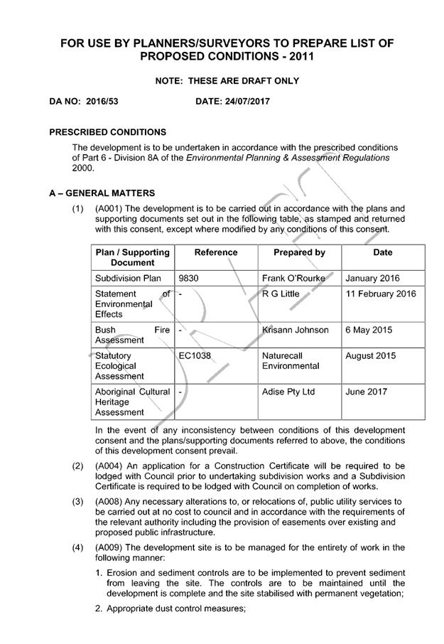
|
ATTACHMENT
|
Development Assessment Panel
09/08/2017
|
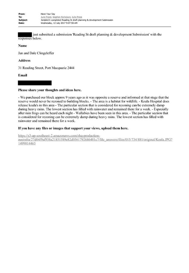

|
ATTACHMENT
|
Development Assessment Panel
09/08/2017
|
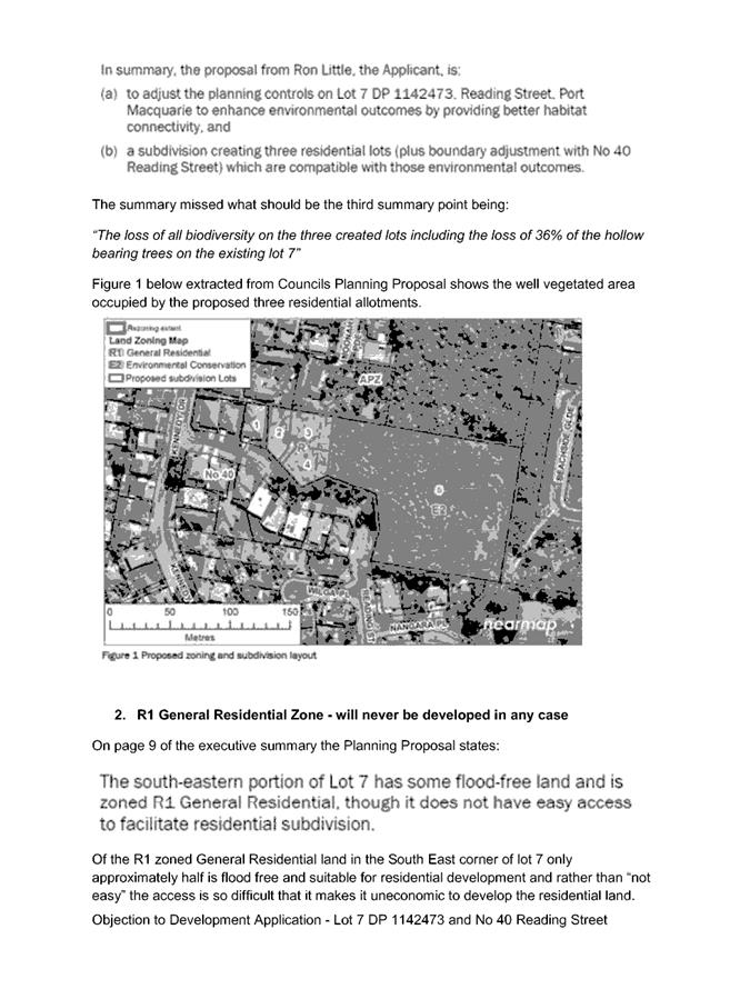
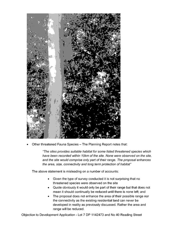
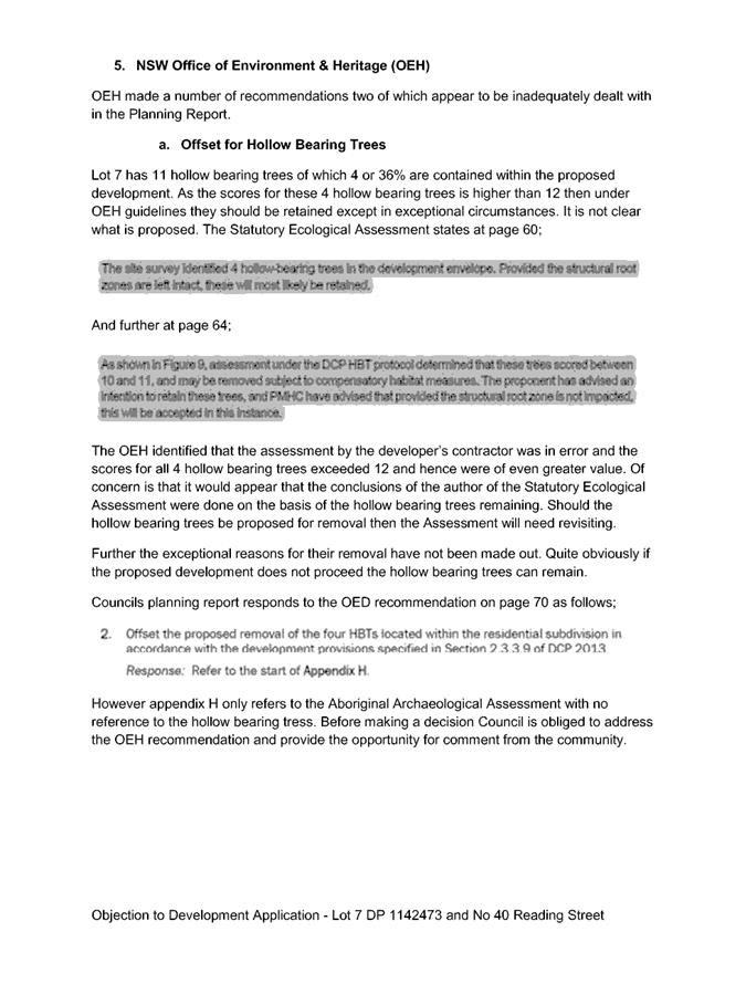

|
ATTACHMENT
|
Development Assessment Panel
09/08/2017
|
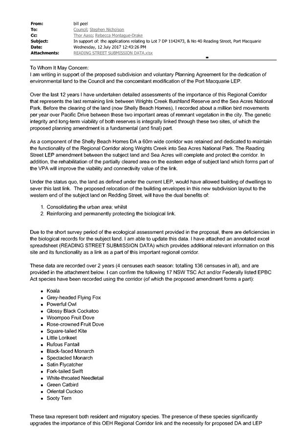

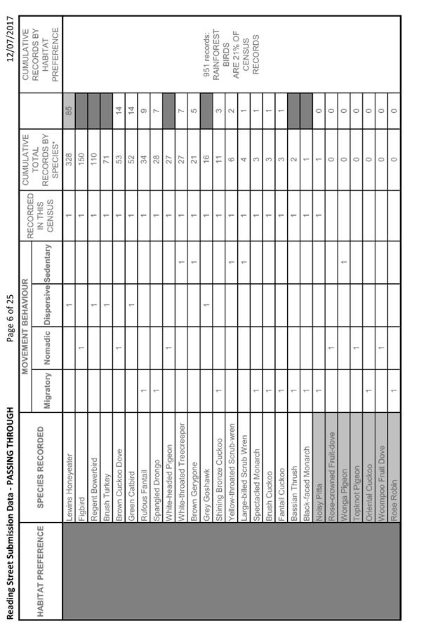
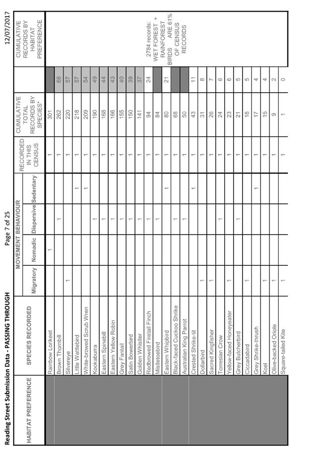
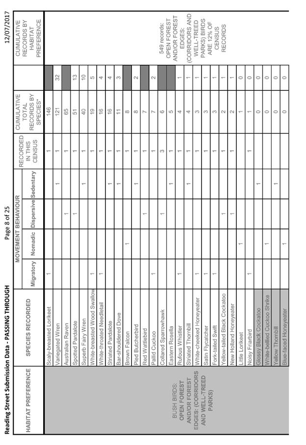
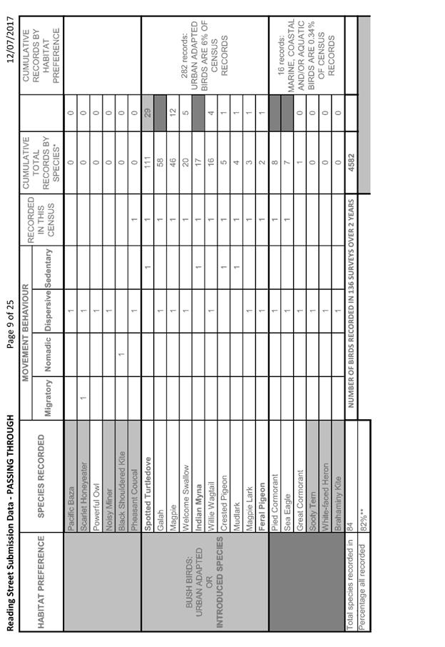
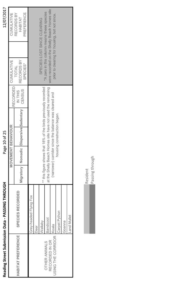
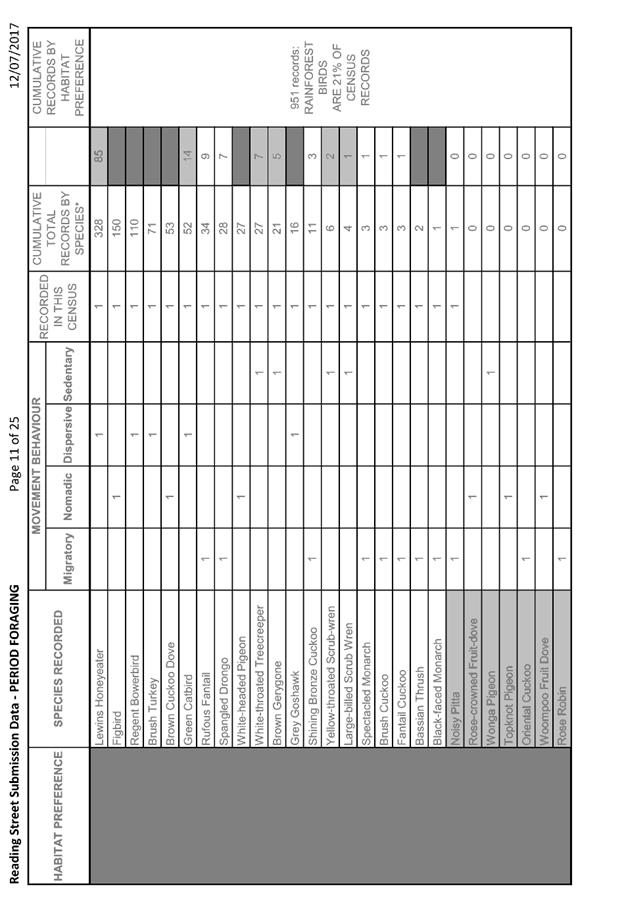
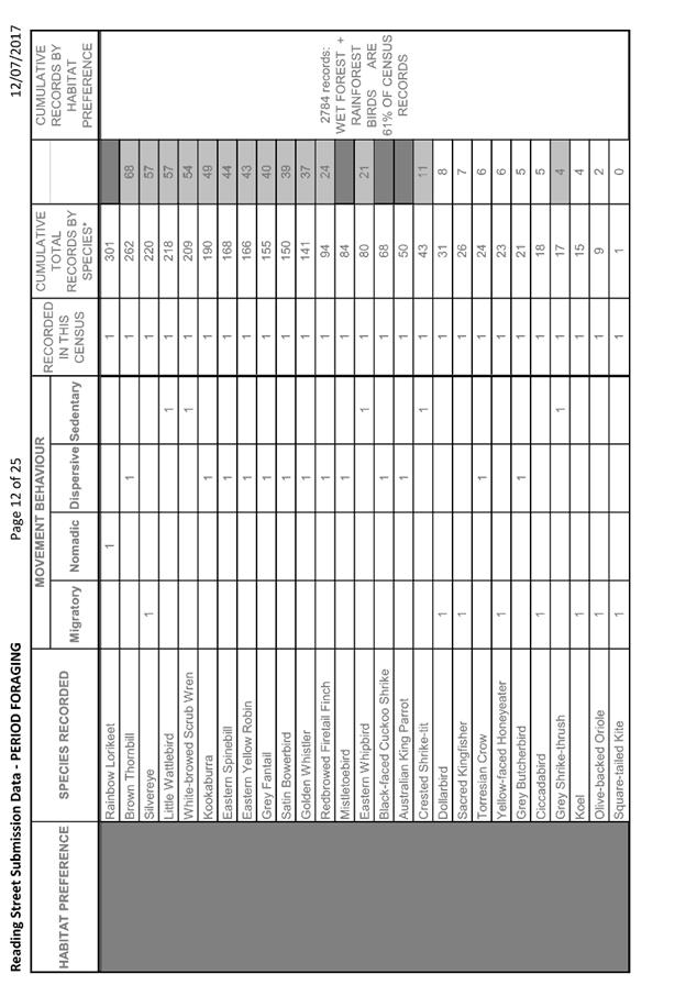
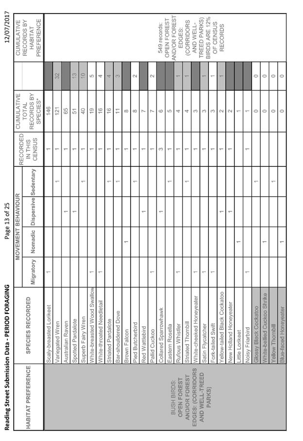
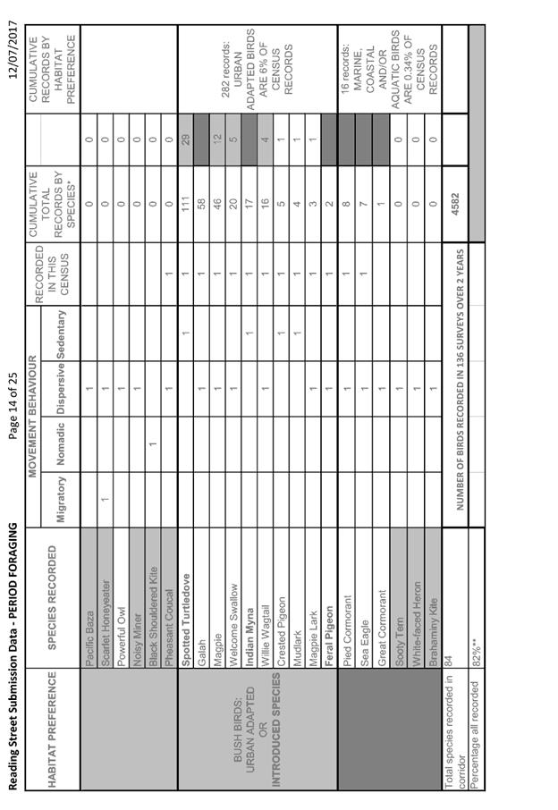
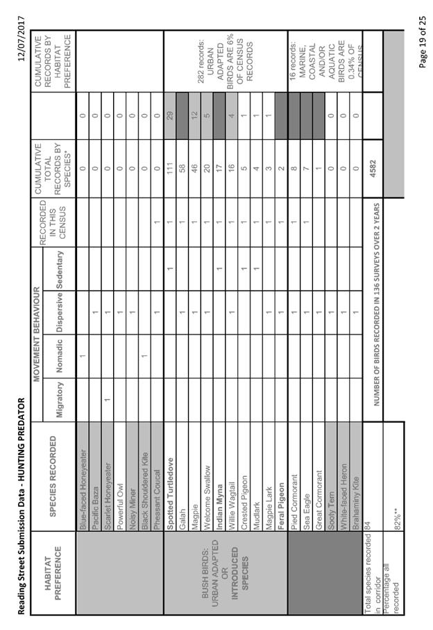
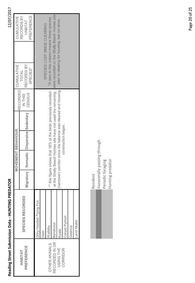
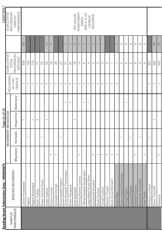
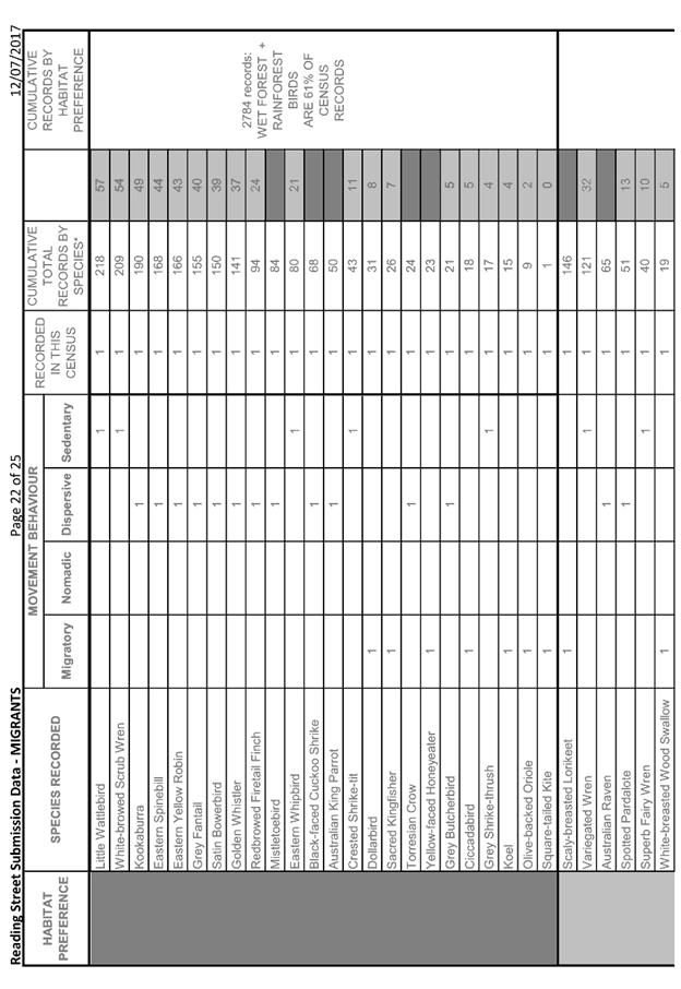
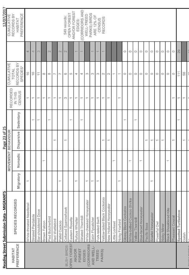
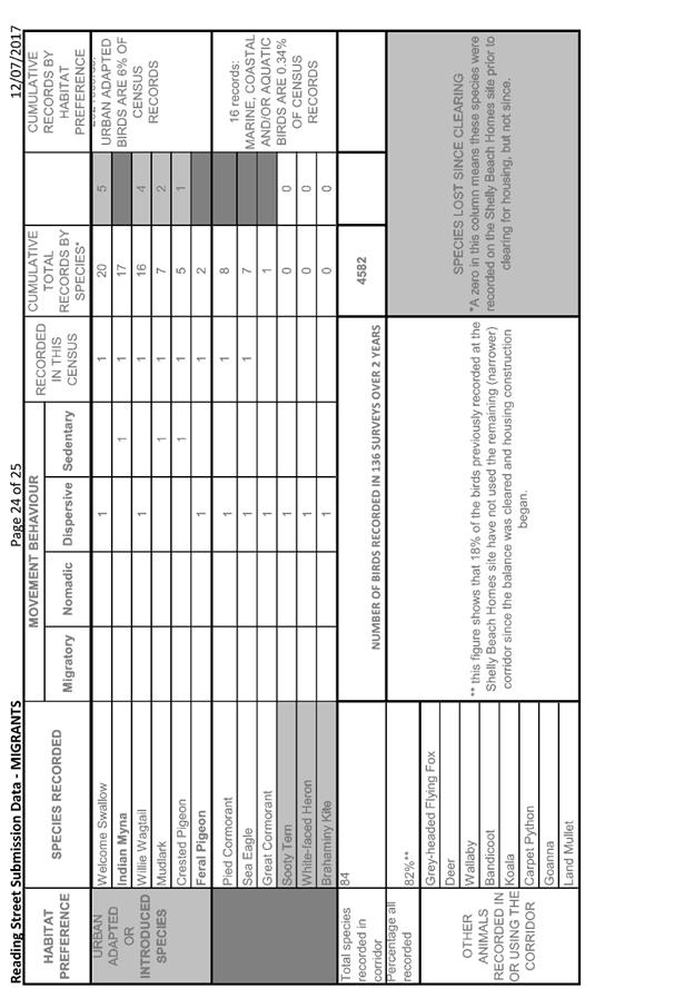
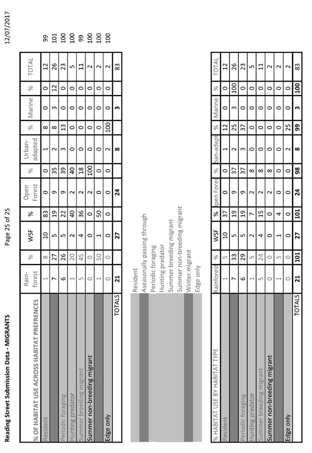
|
ATTACHMENT
|
Development Assessment Panel
09/08/2017
|
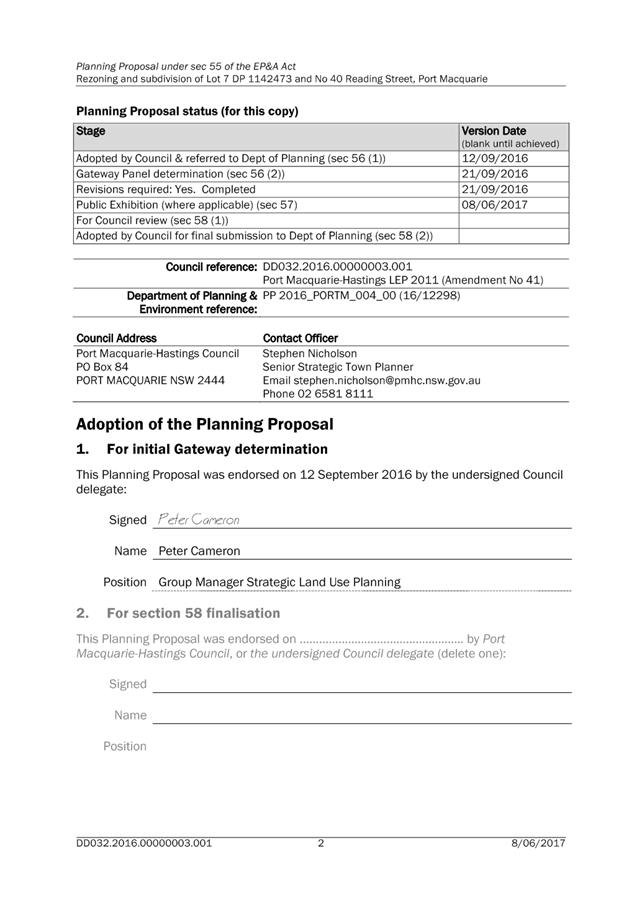
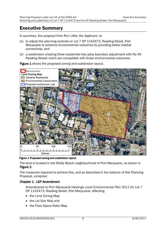
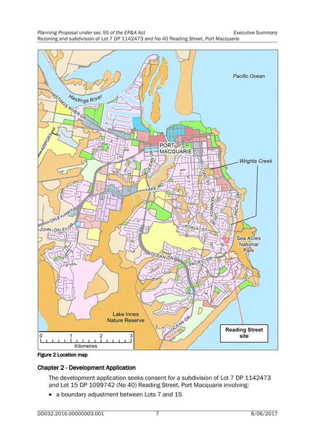
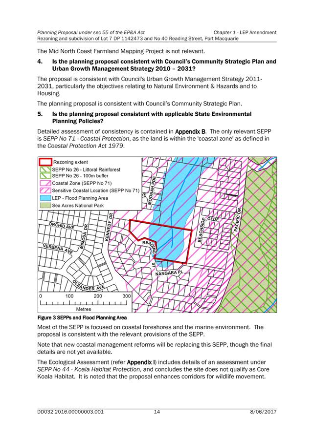
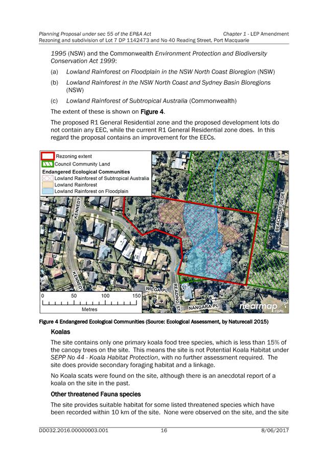
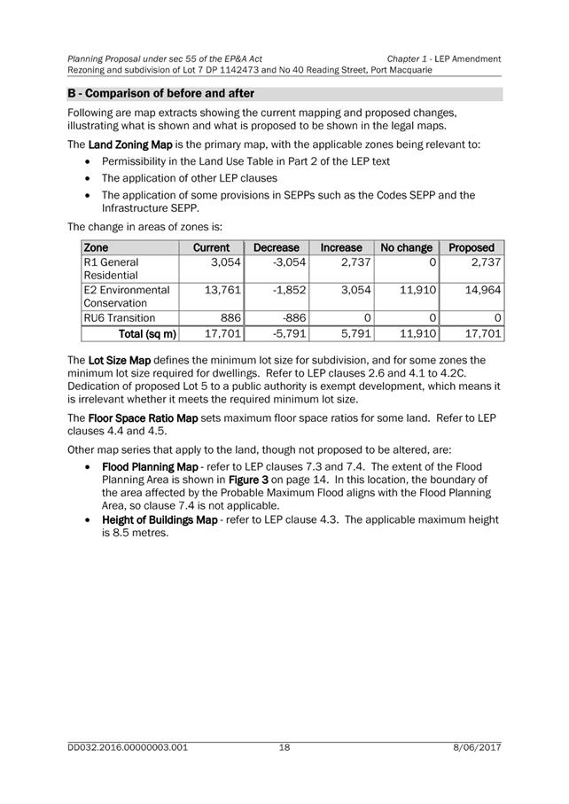
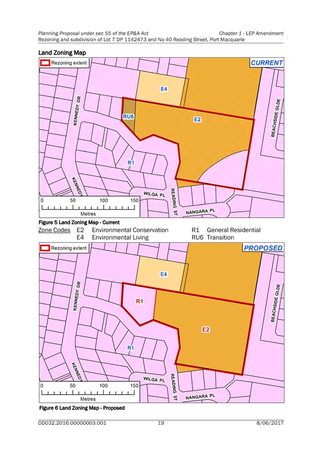
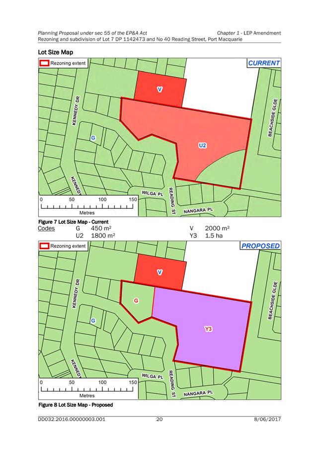
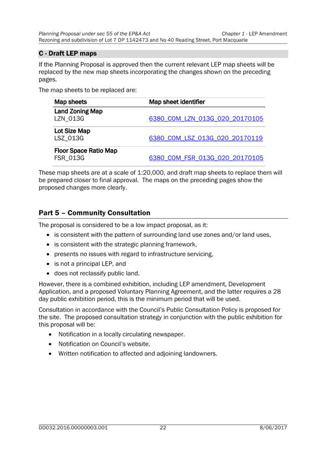
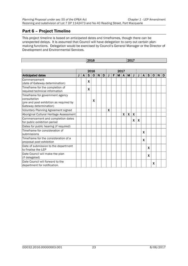
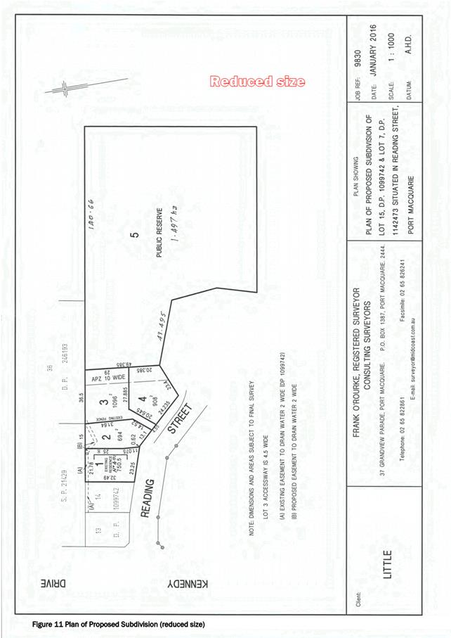
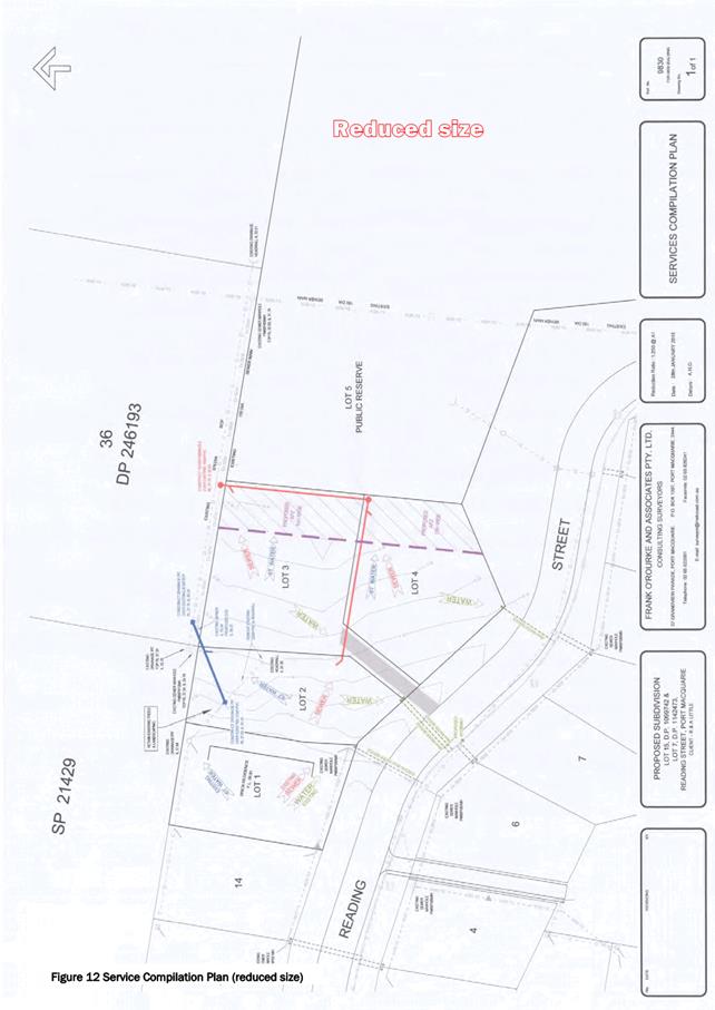
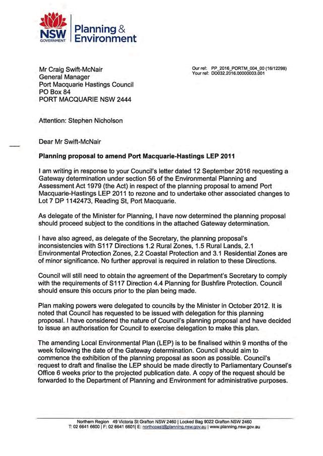
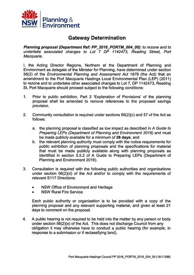
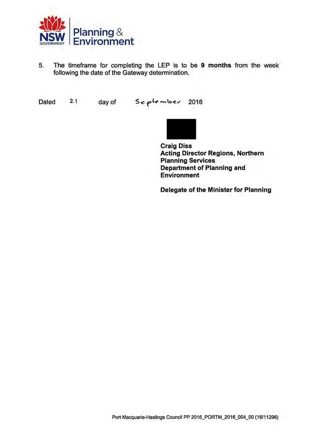
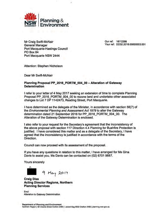
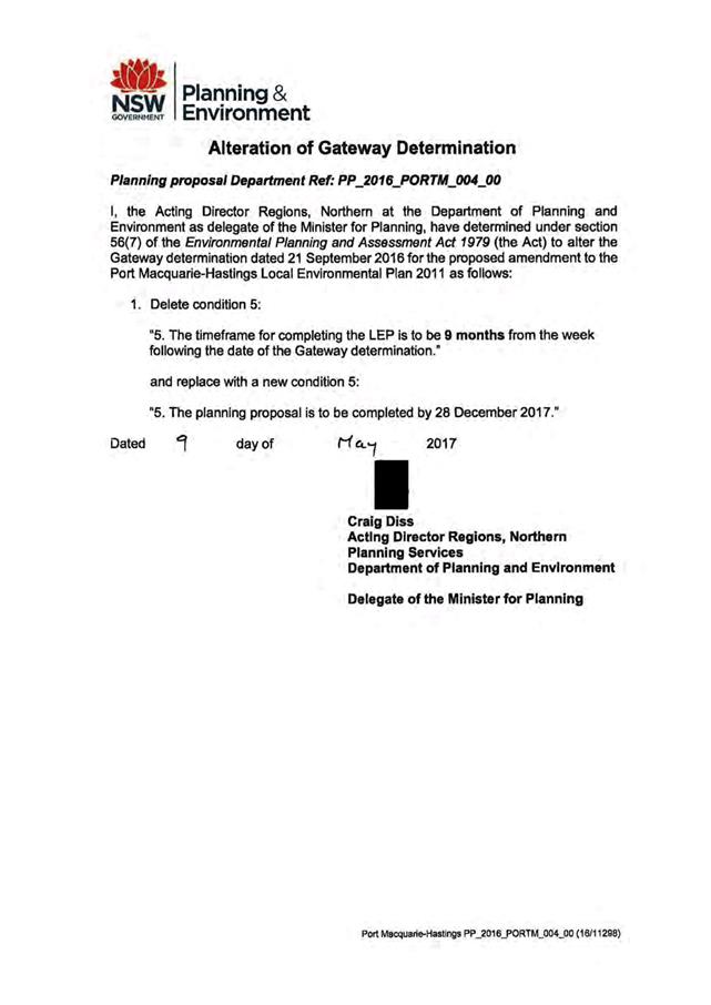
|
ATTACHMENT
|
Development Assessment Panel
09/08/2017
|
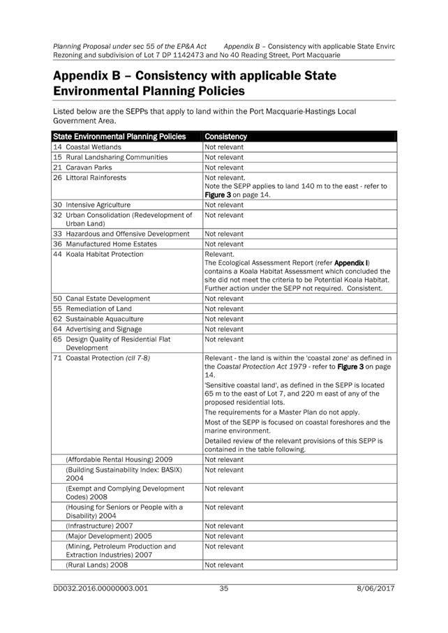
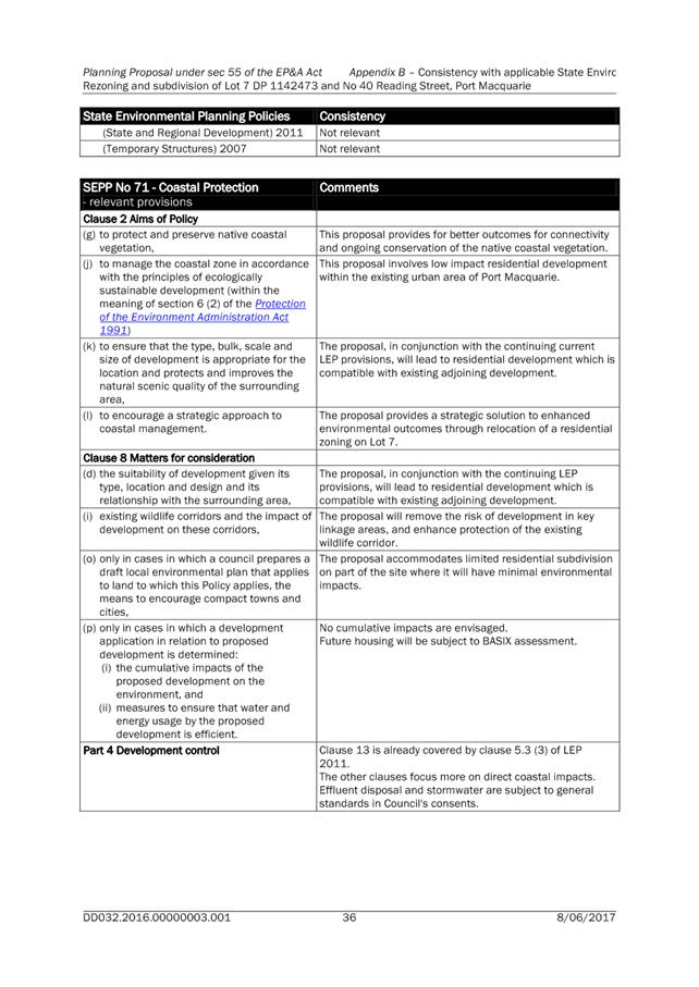
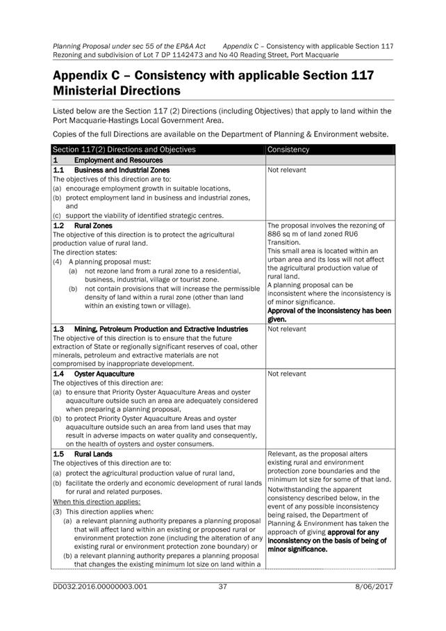
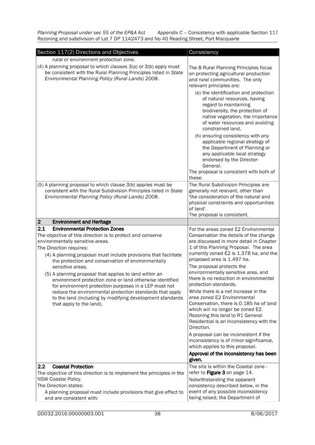
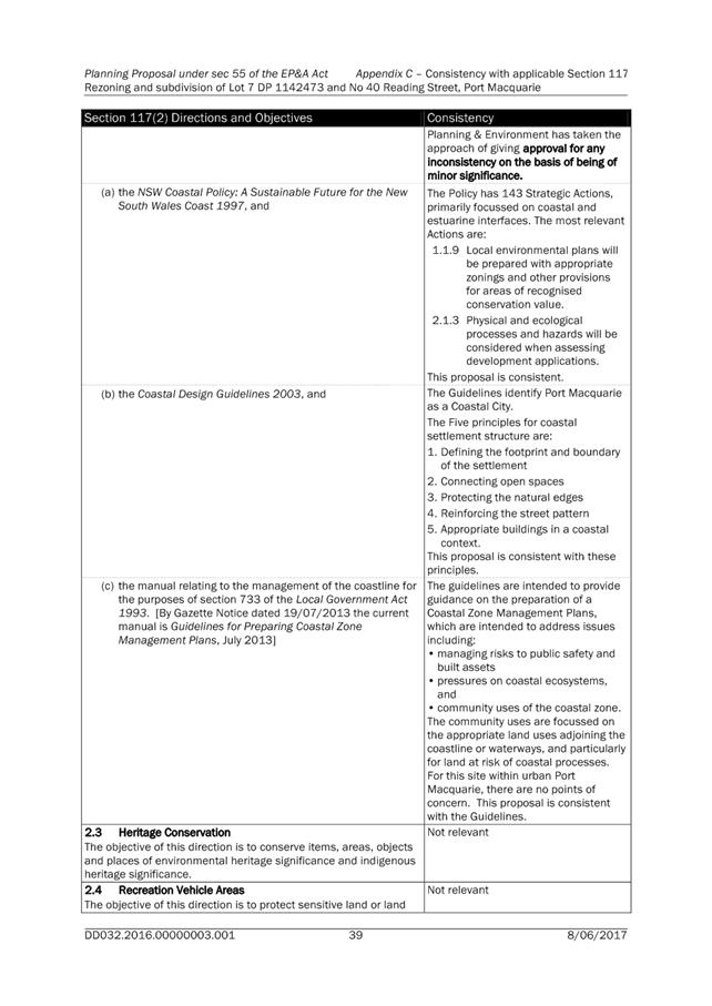
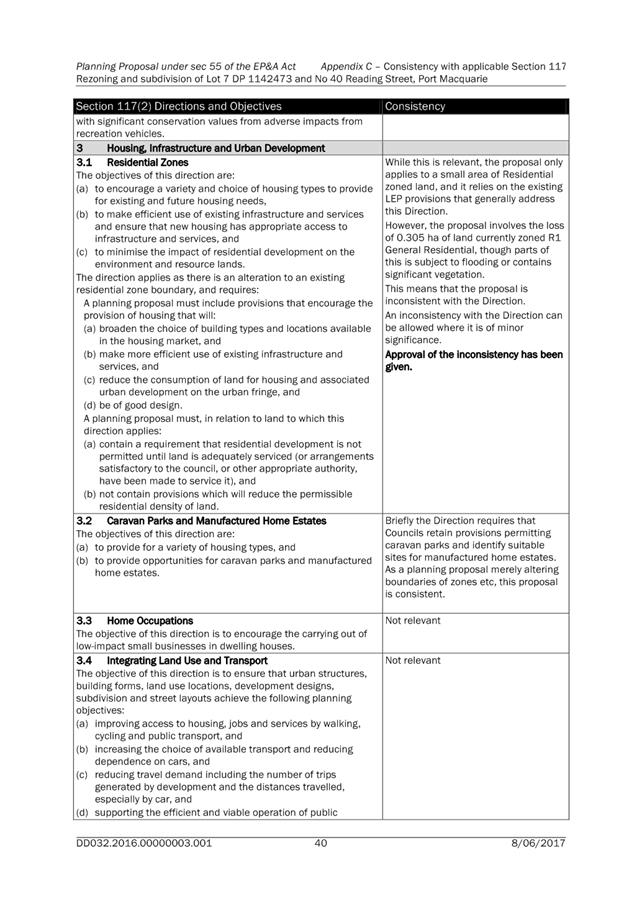
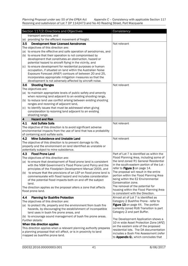
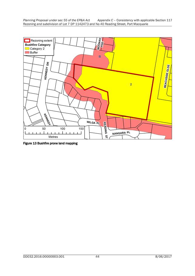
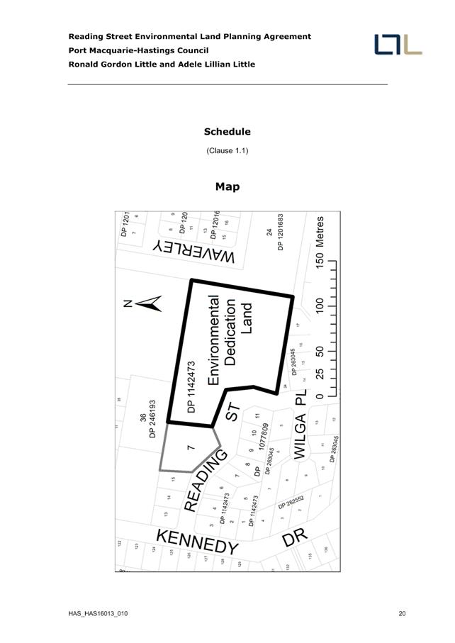
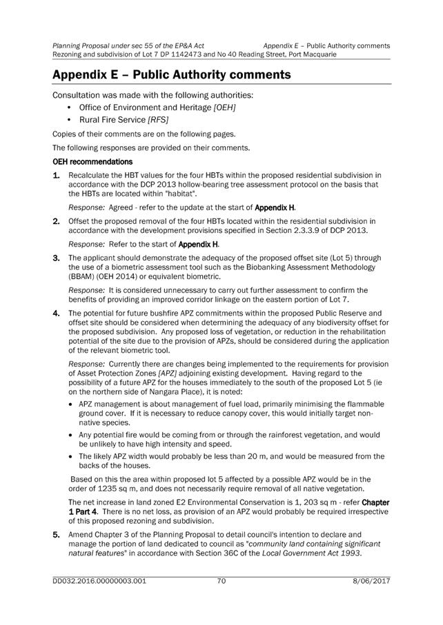
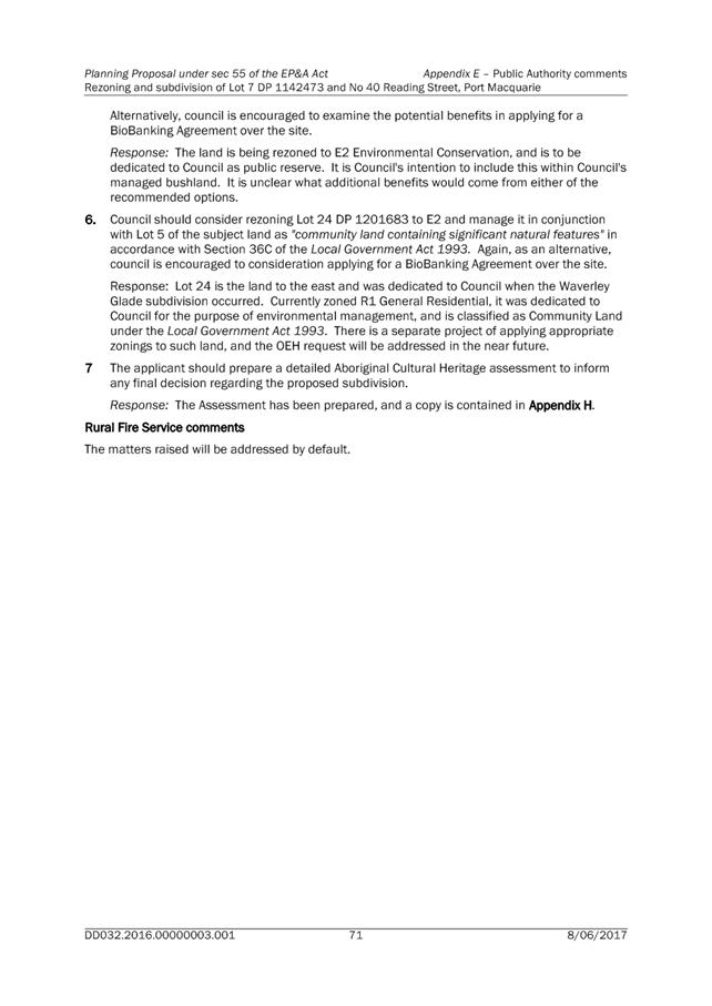
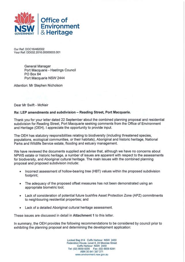
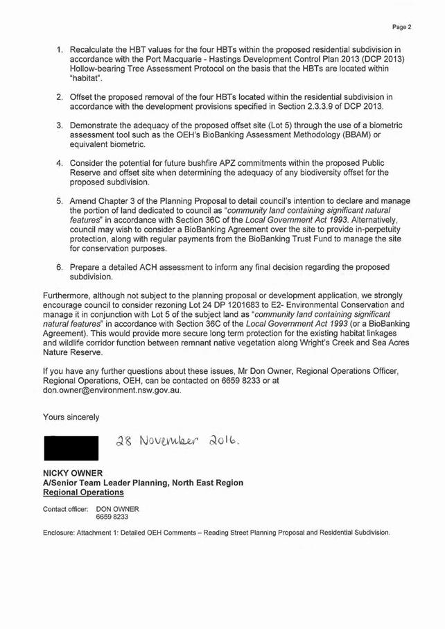
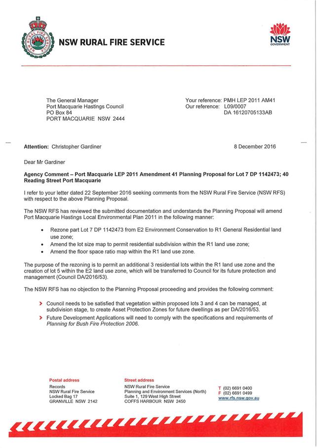
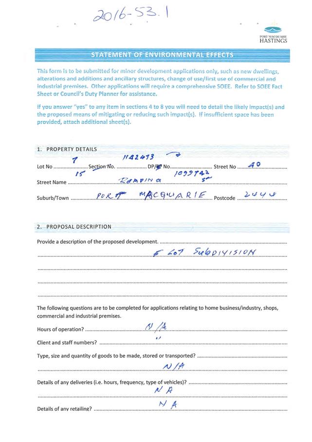
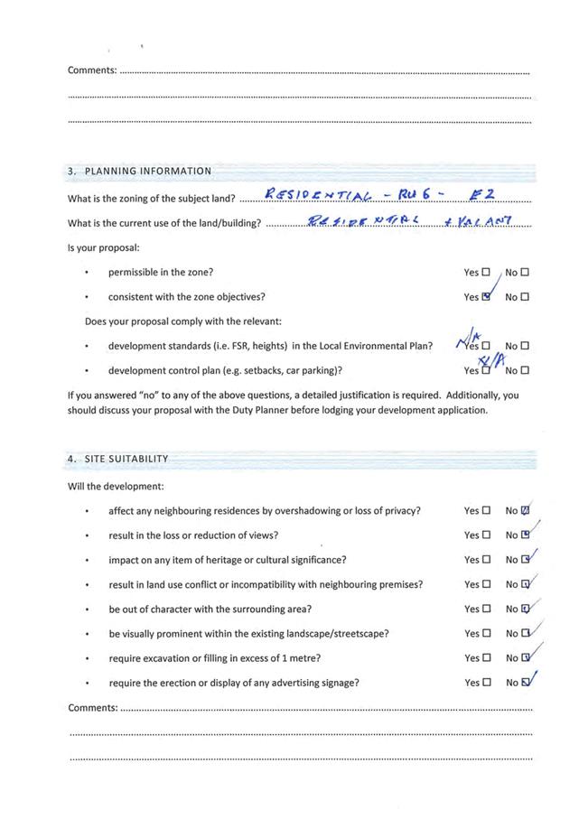
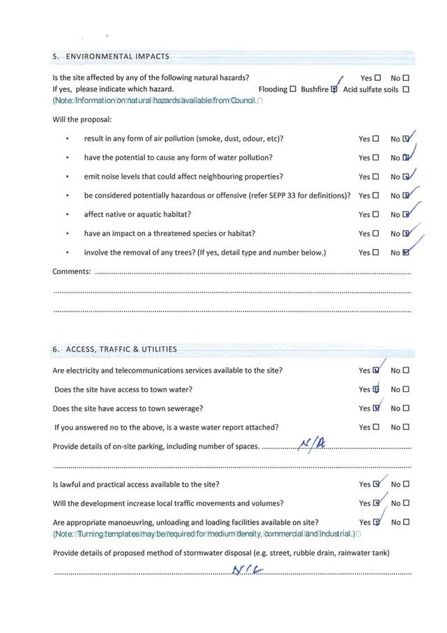
|
ATTACHMENT
|
Development Assessment Panel
09/08/2017
|
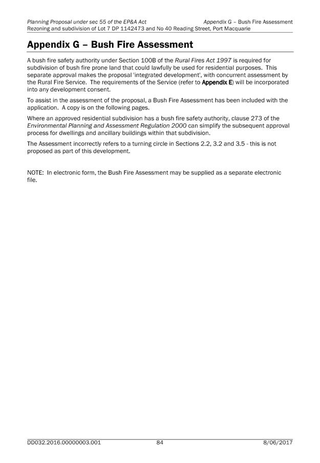
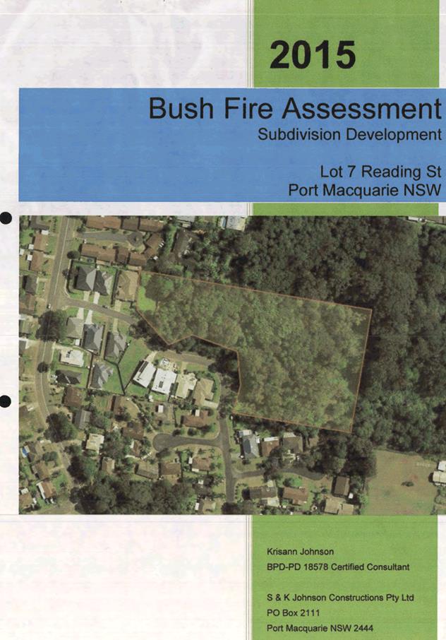
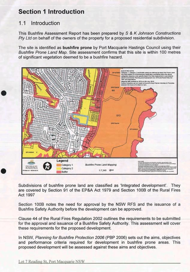
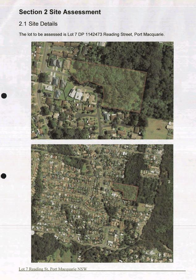
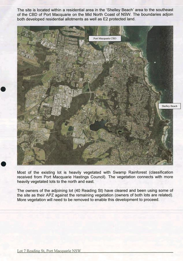
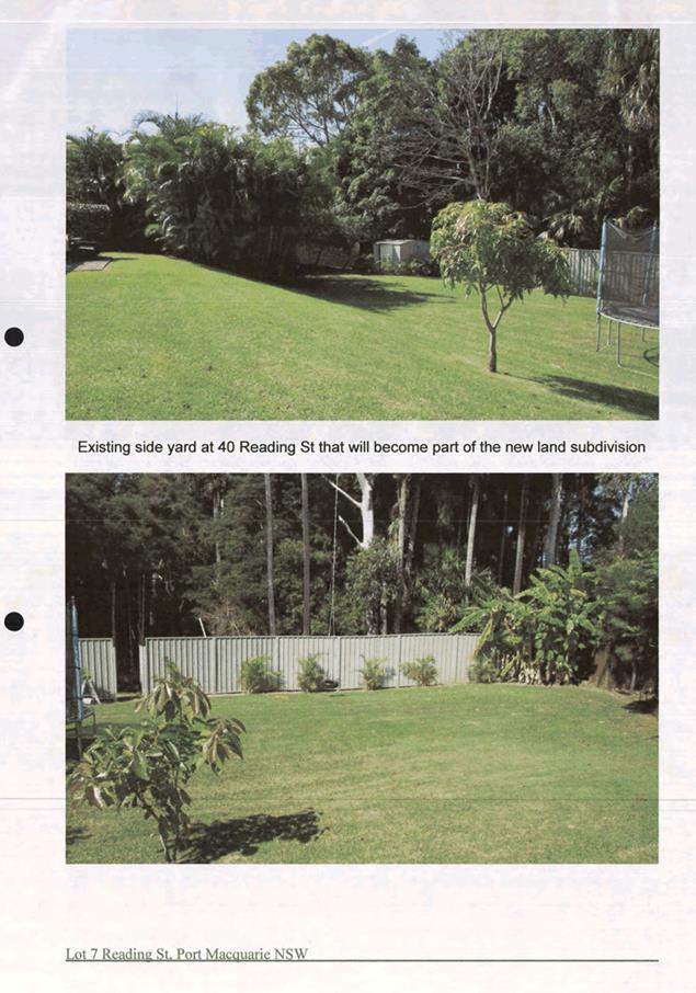
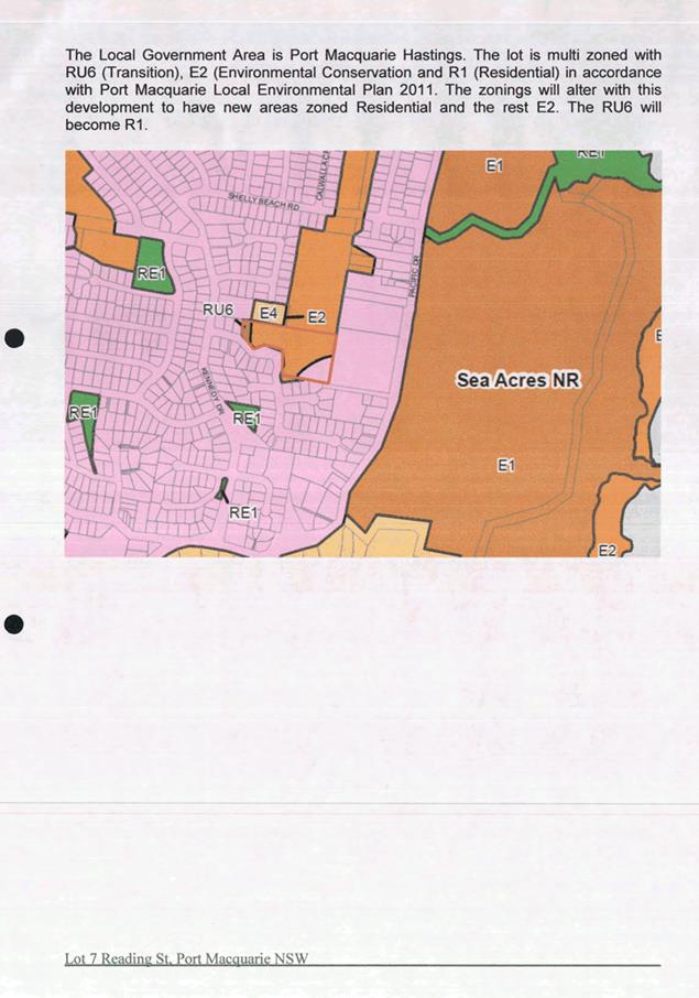
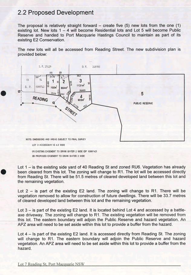
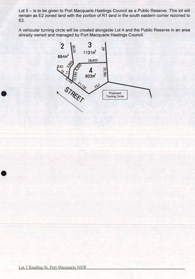
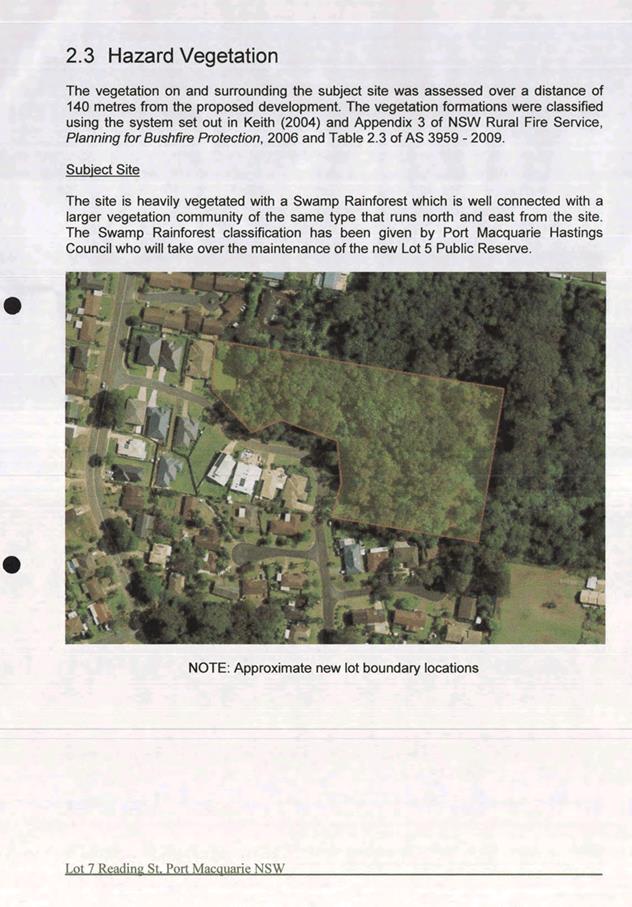
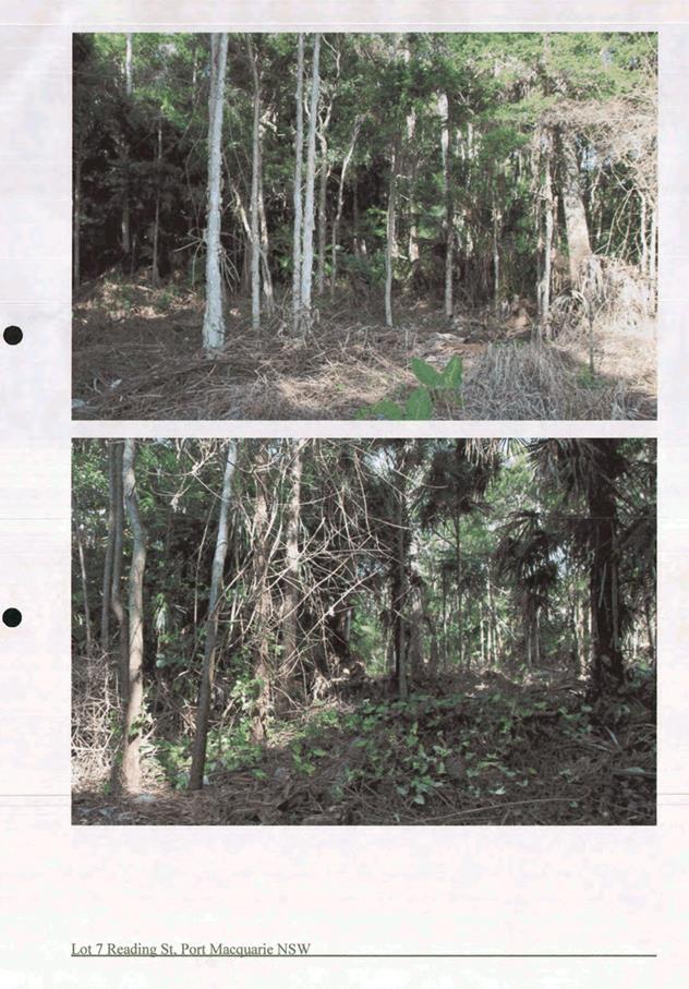
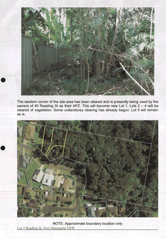
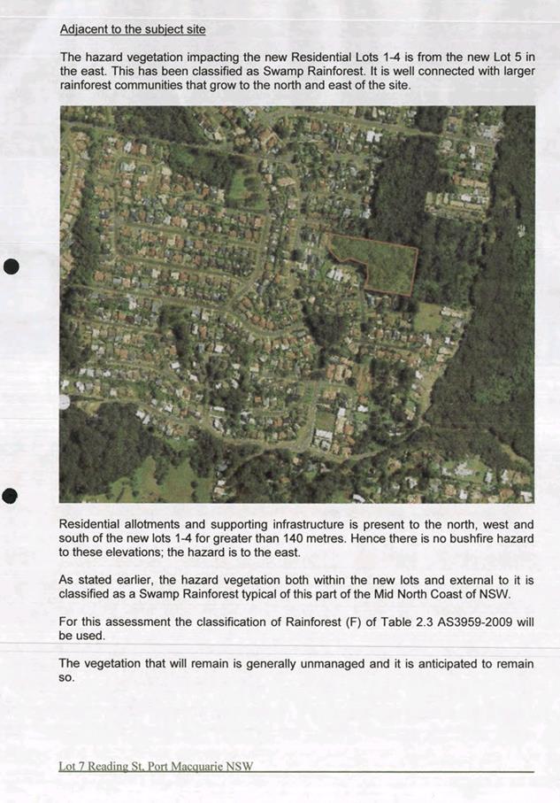
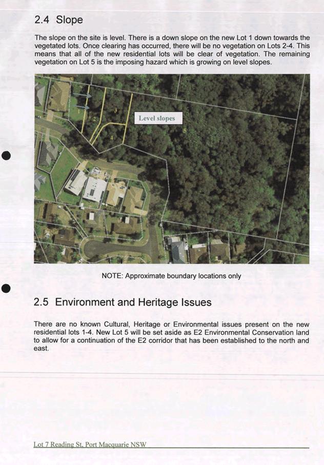
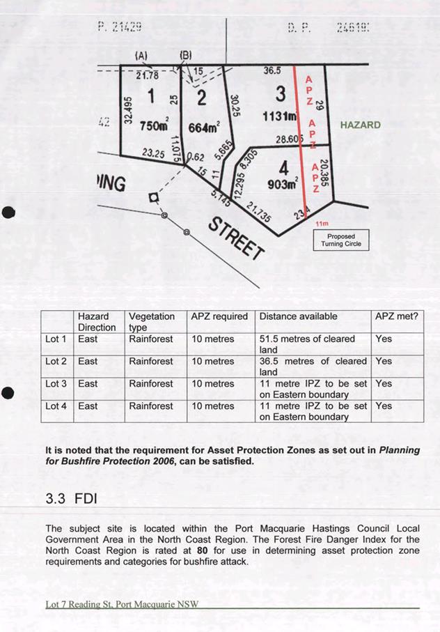
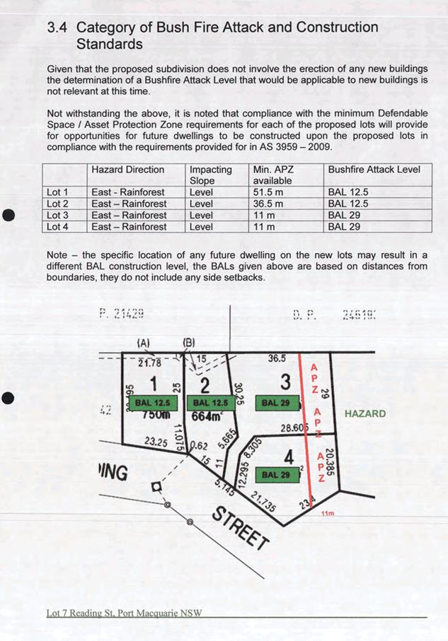
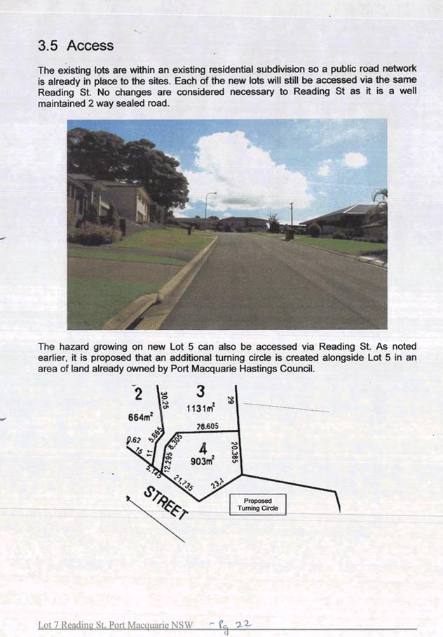
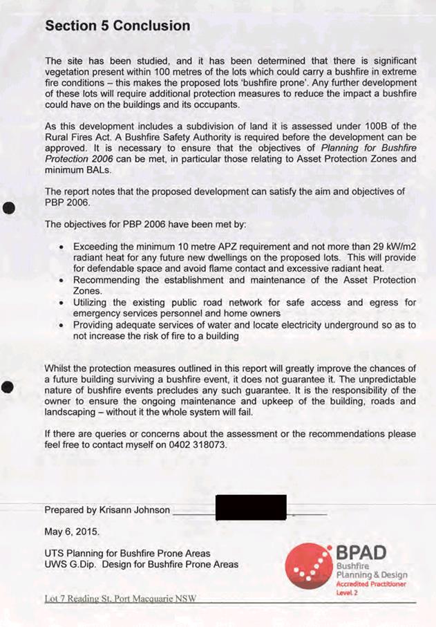
|
ATTACHMENT
|
Development Assessment Panel
09/08/2017
|
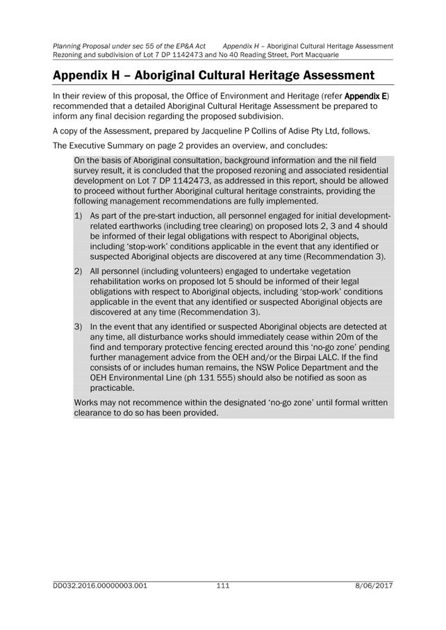
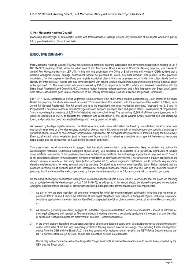
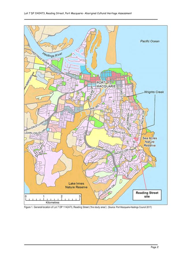
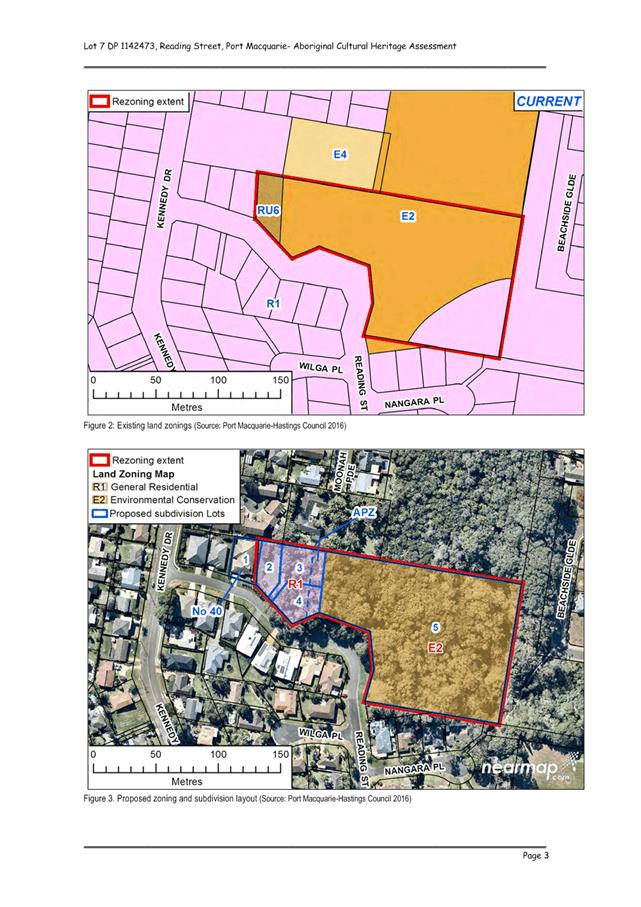
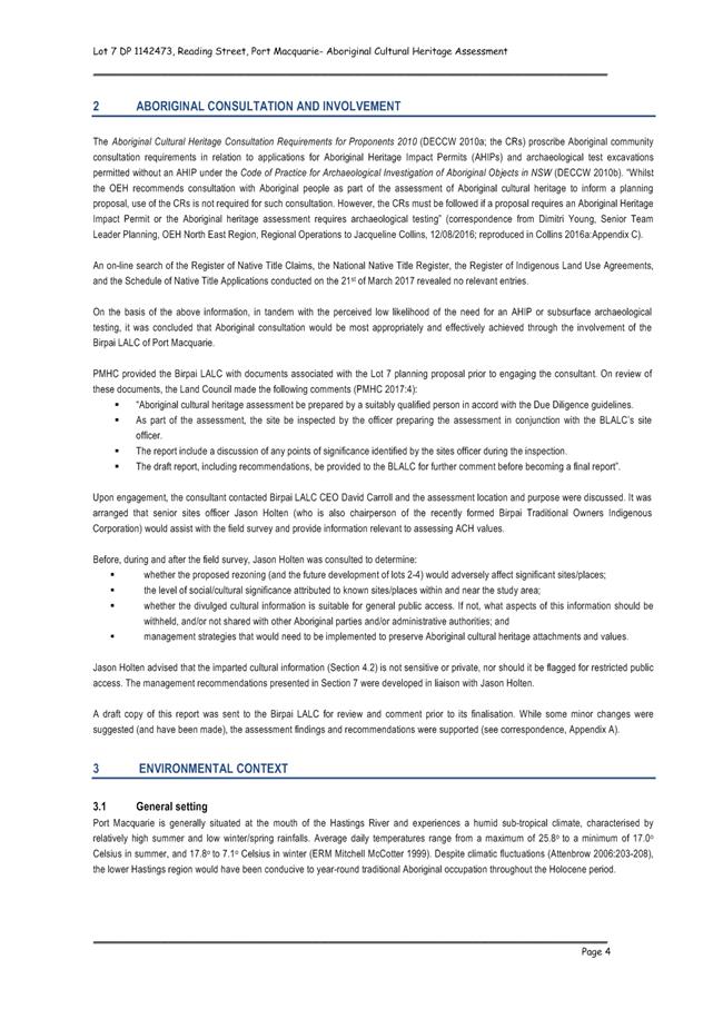
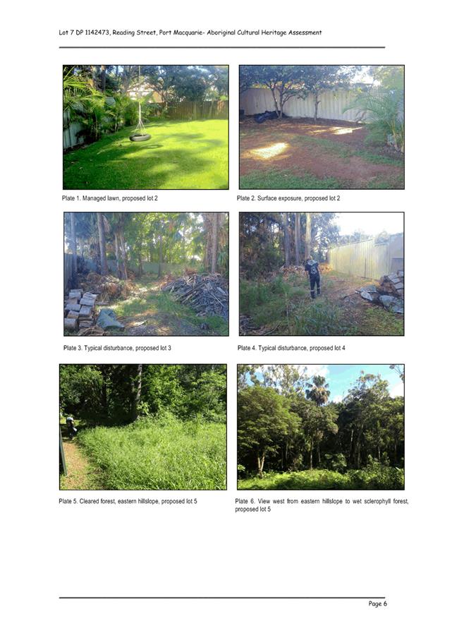

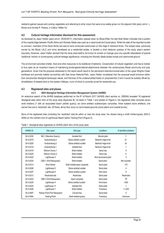
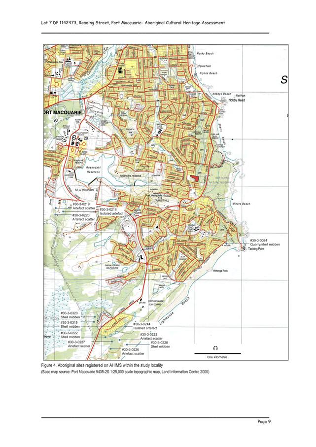
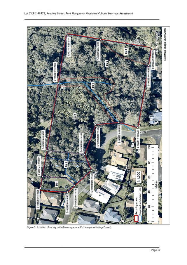
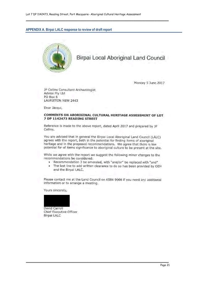
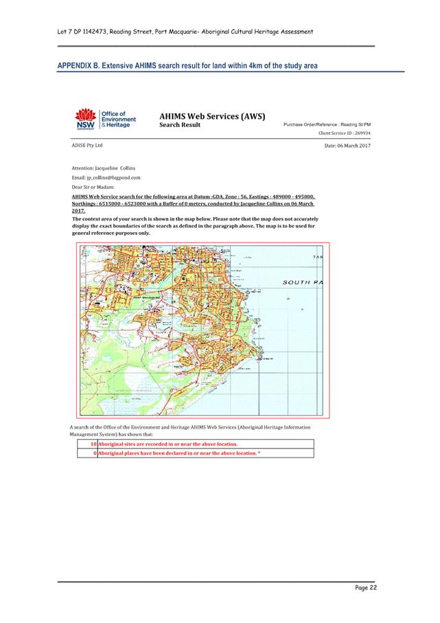
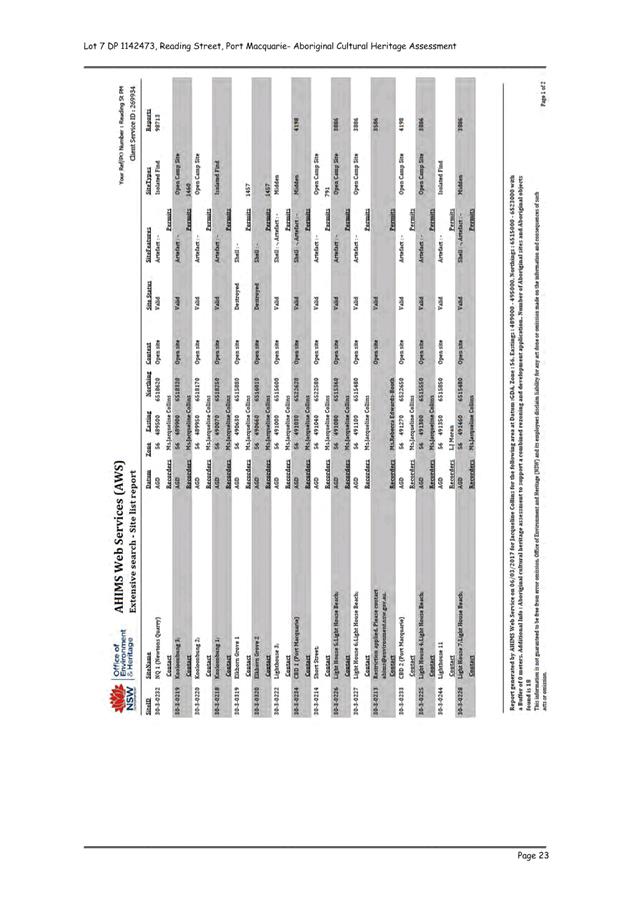
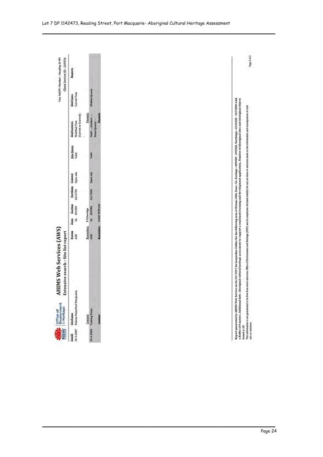
|
ATTACHMENT
|
Development Assessment Panel
09/08/2017
|
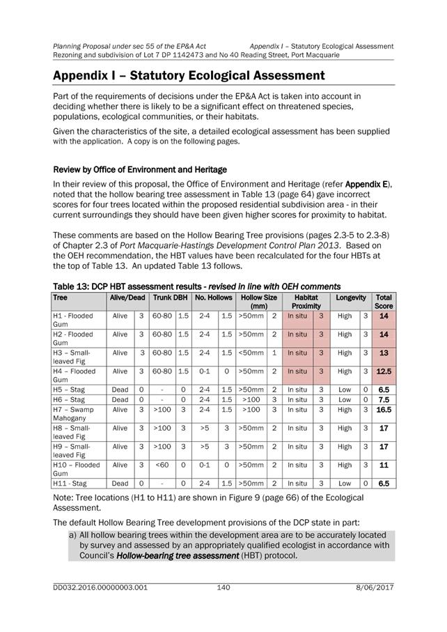
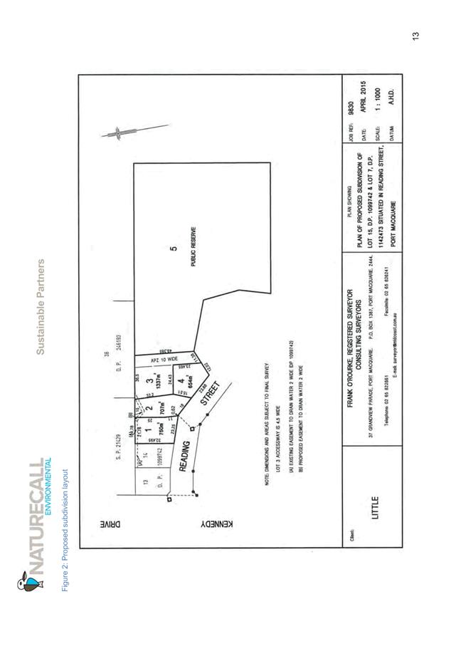
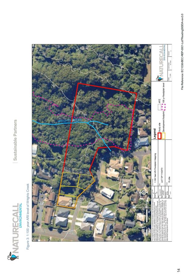
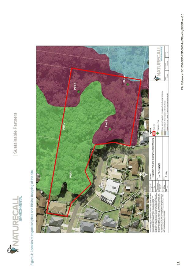
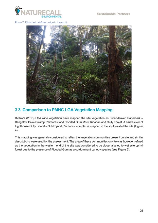
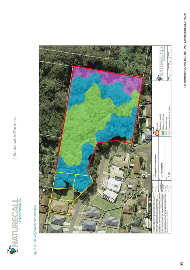
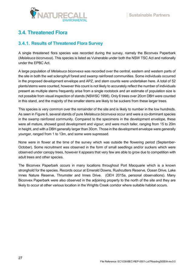
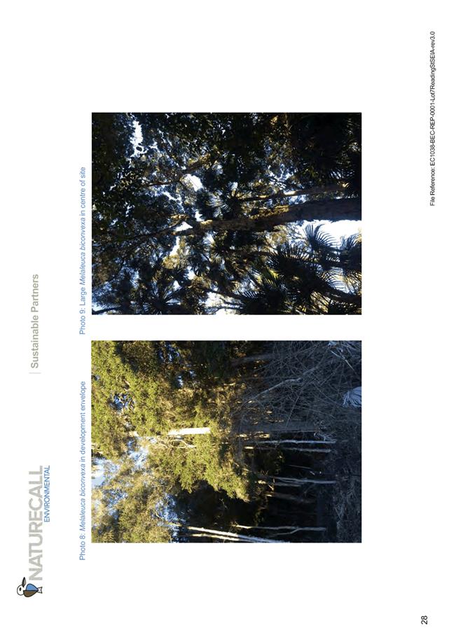
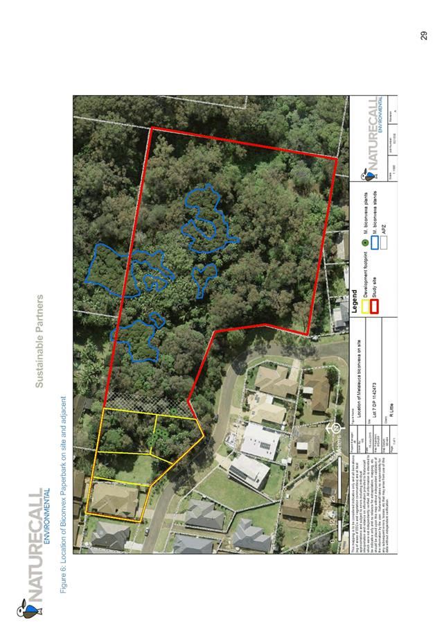
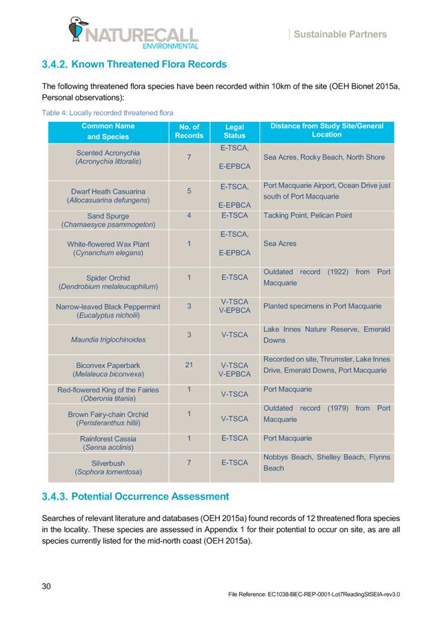
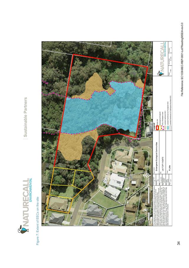
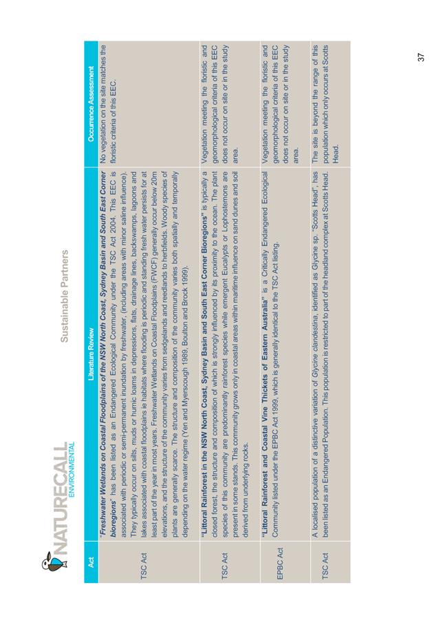
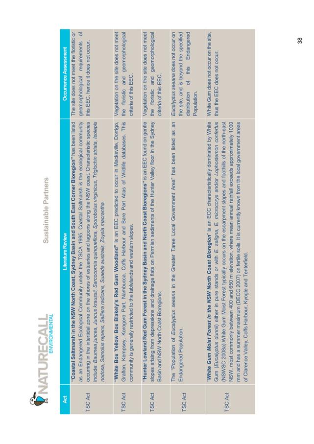
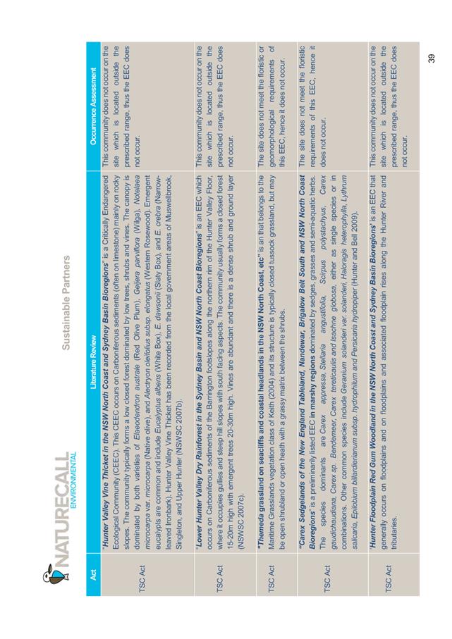
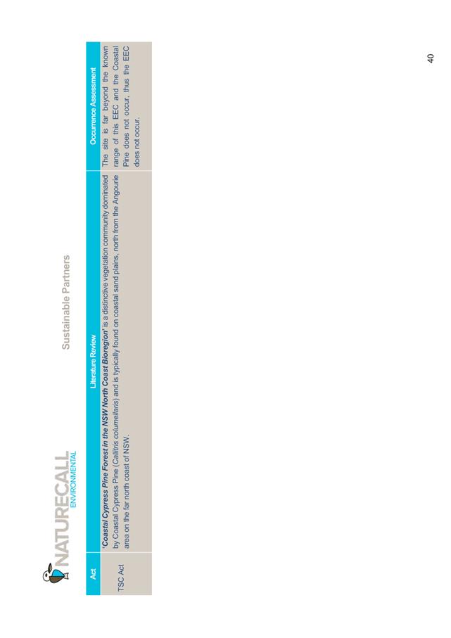
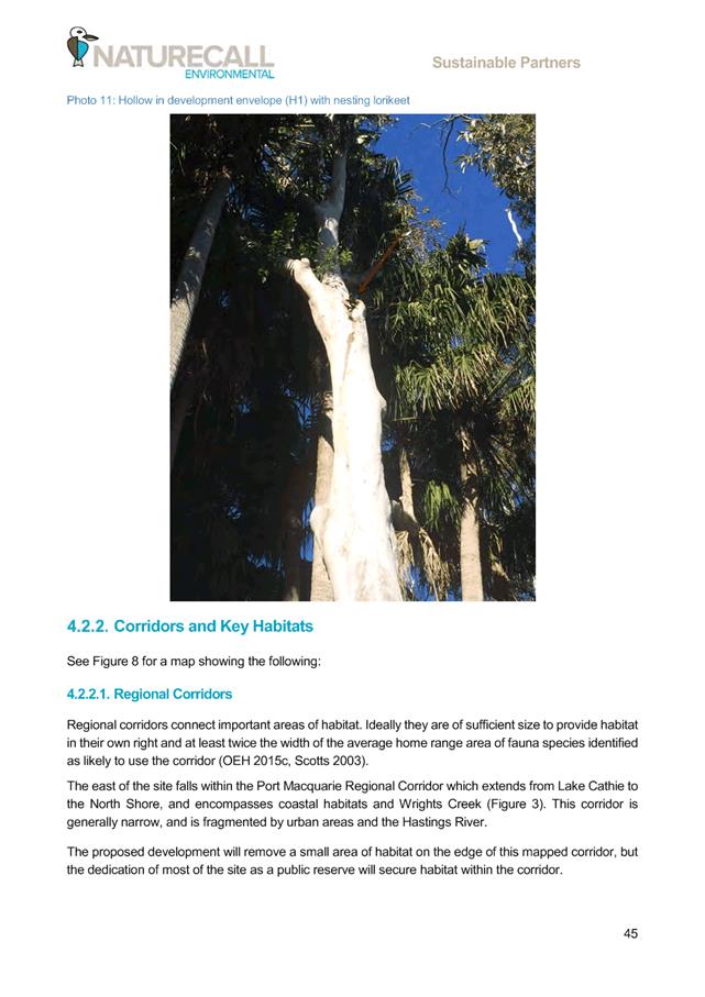
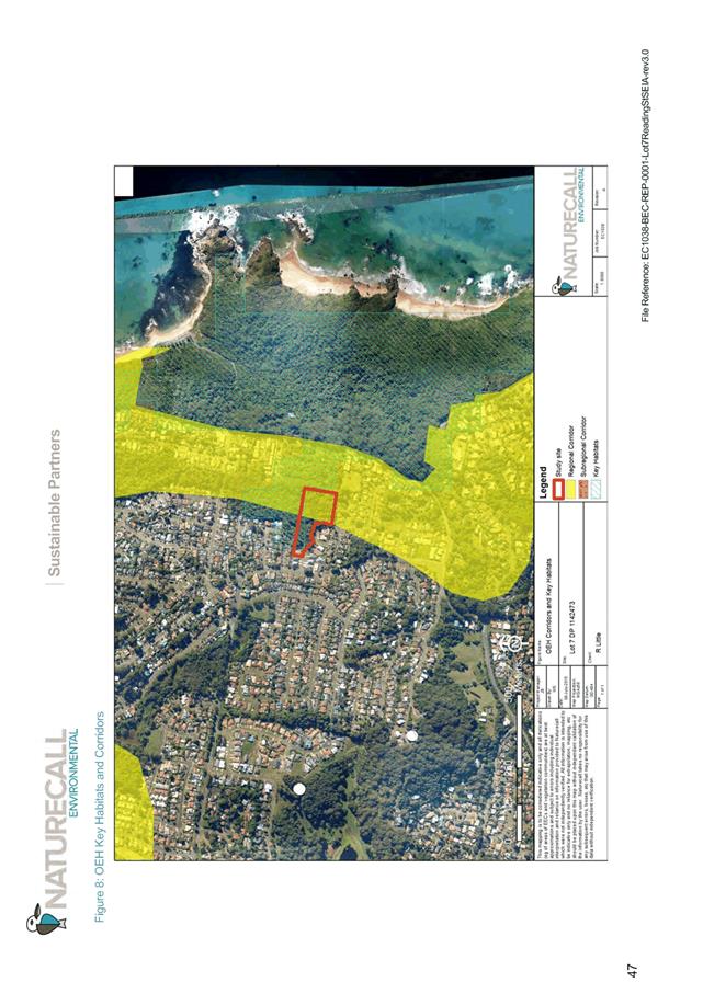
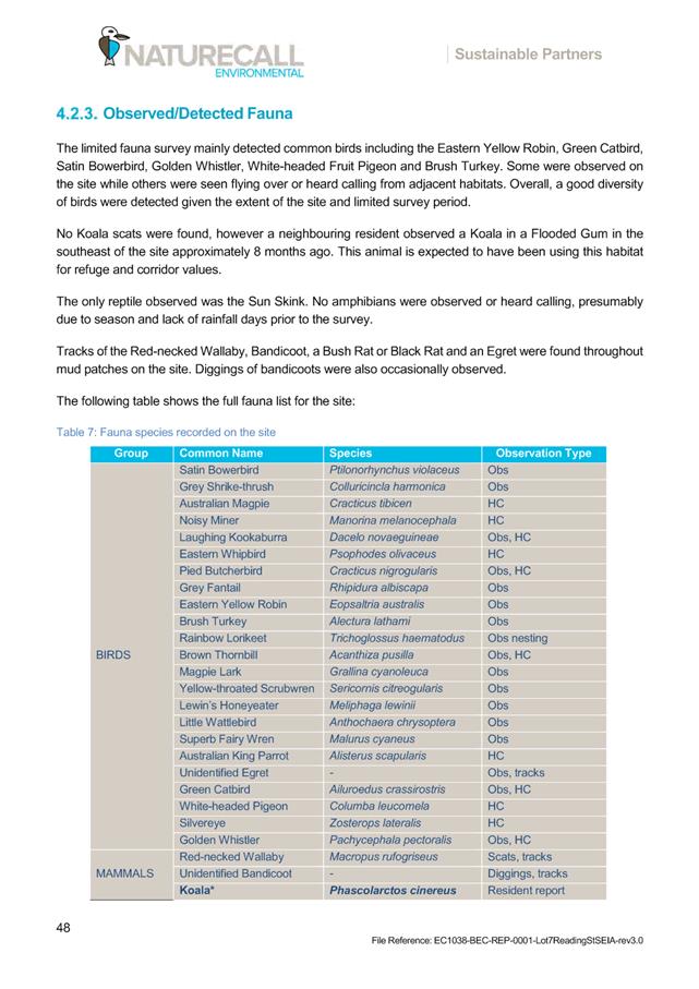
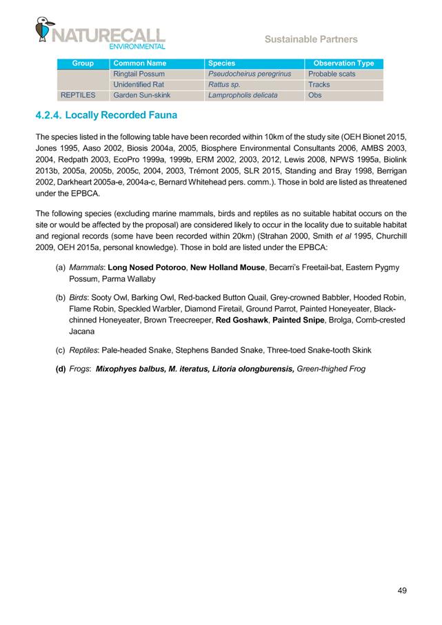
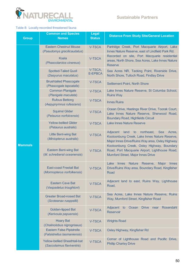
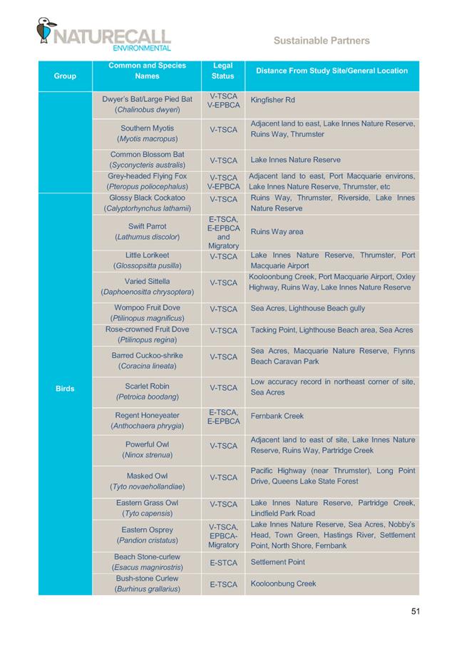
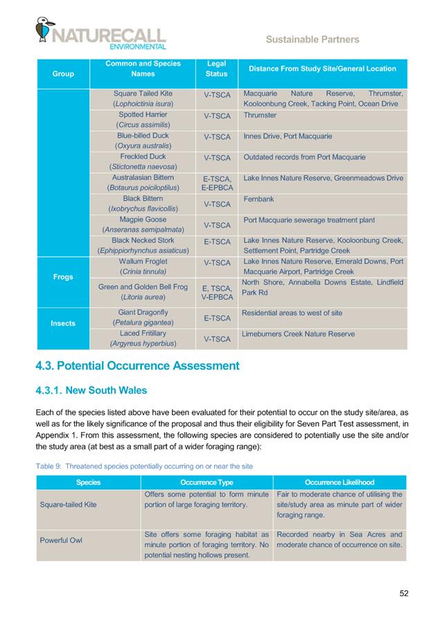
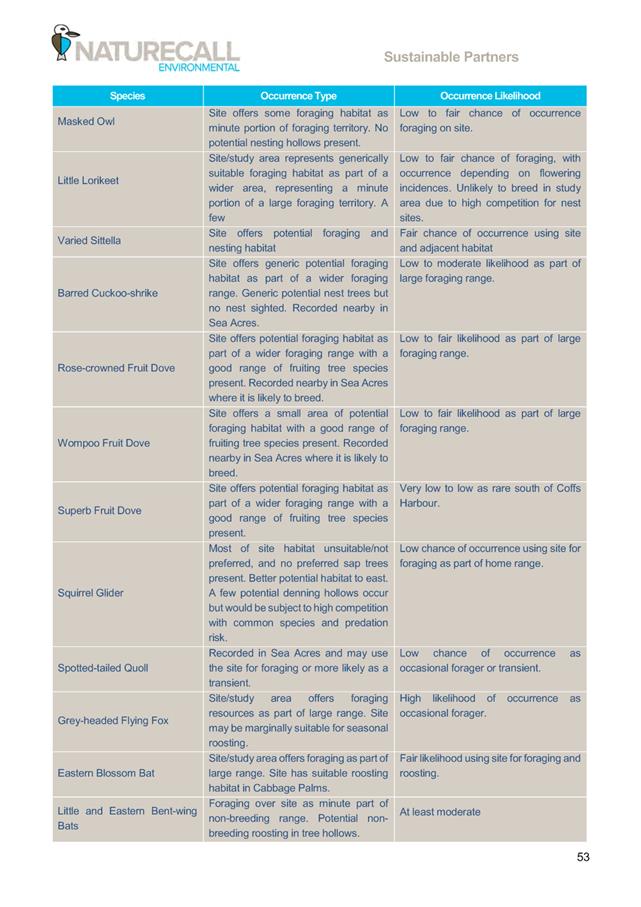
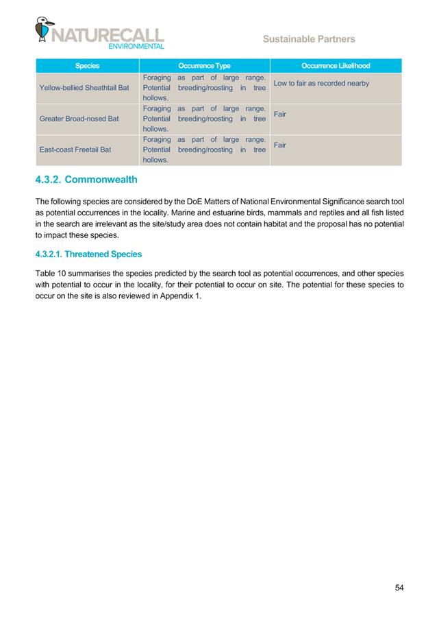
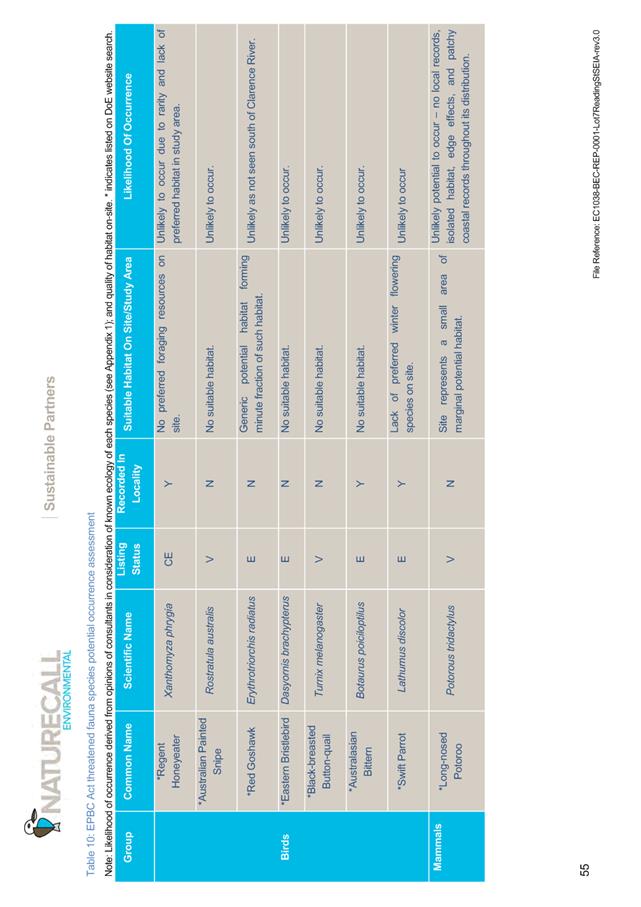
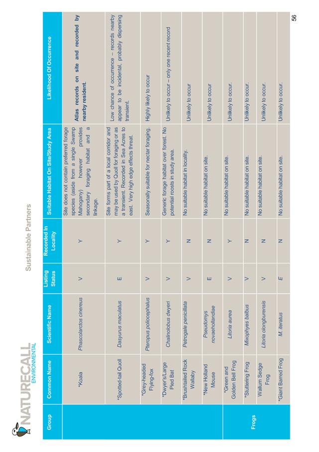
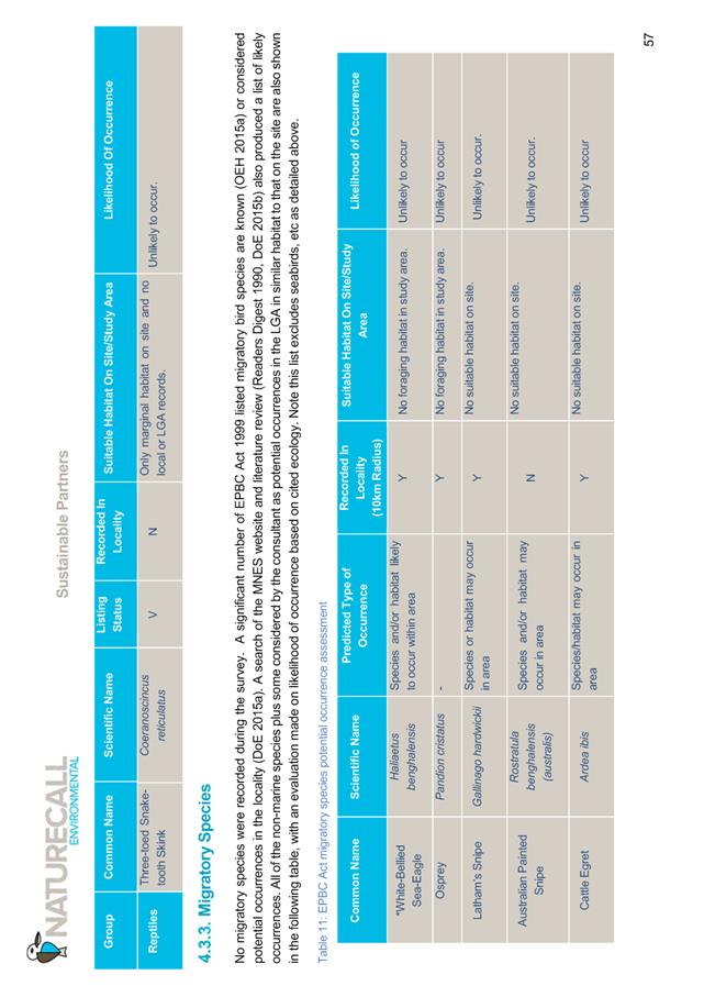
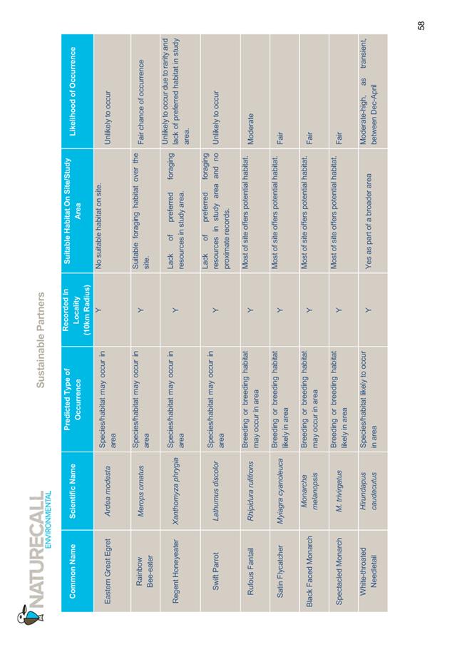
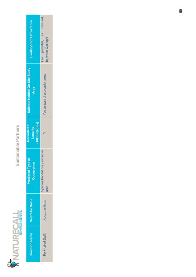
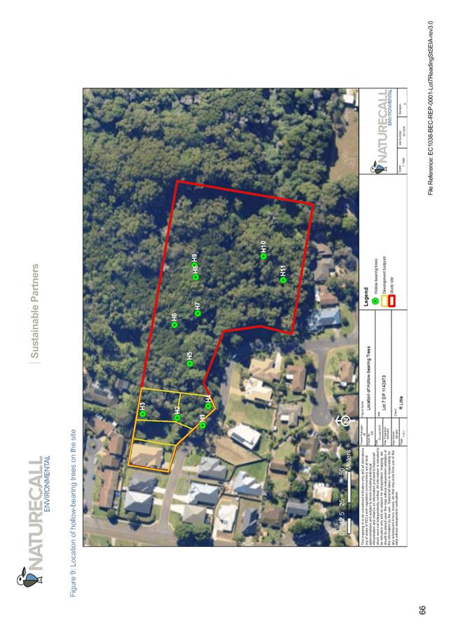
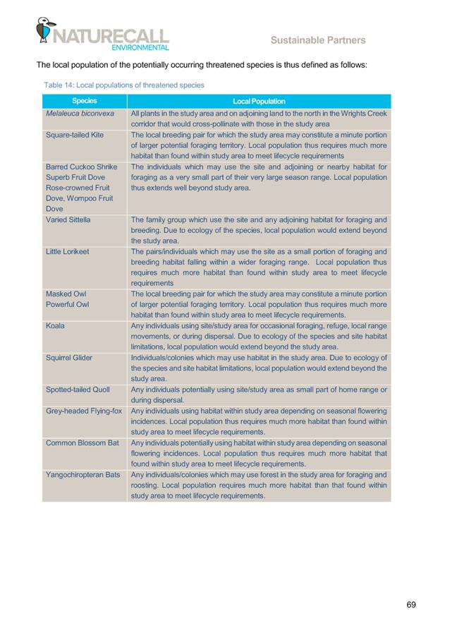

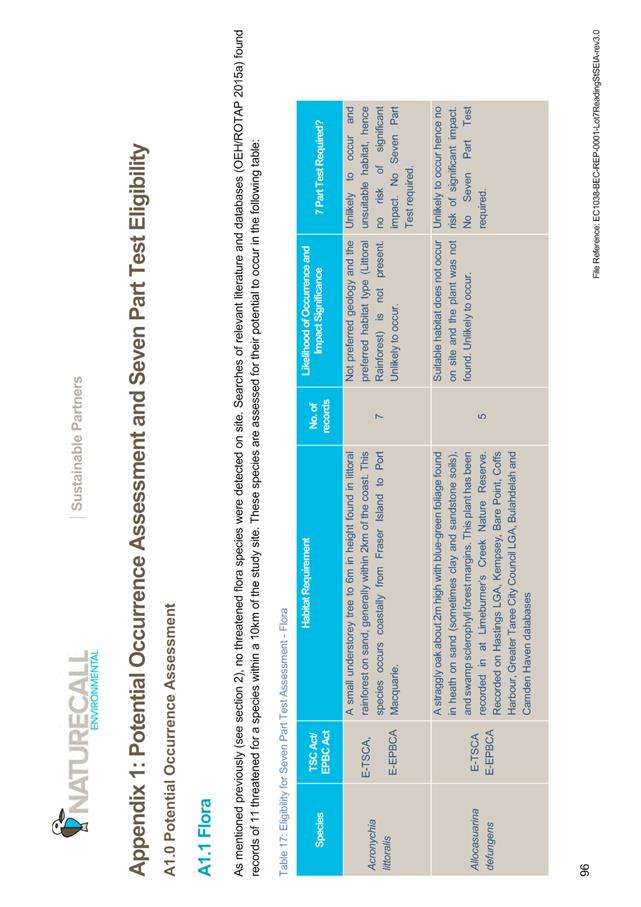
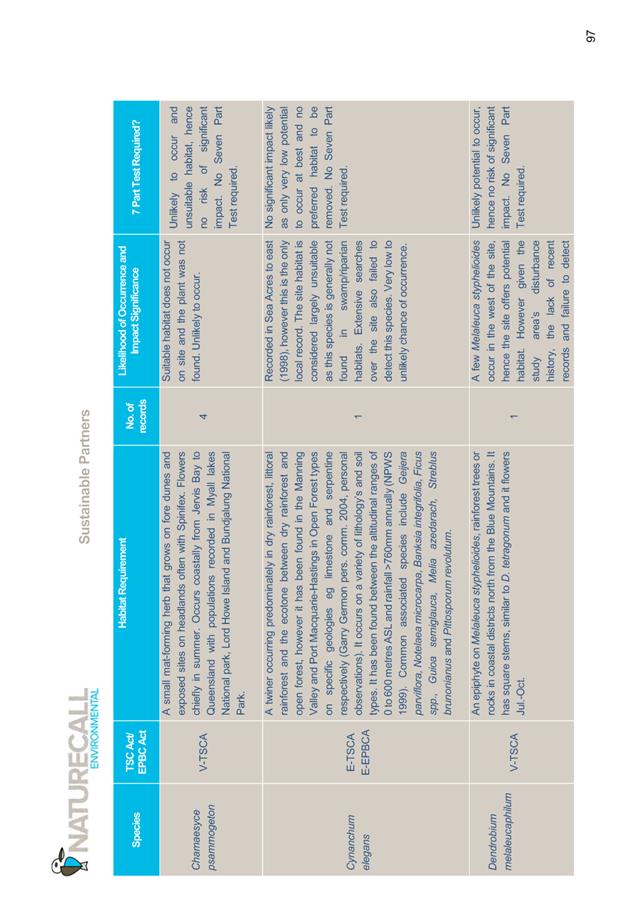
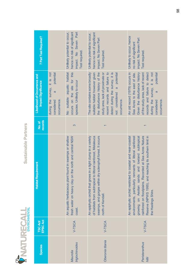
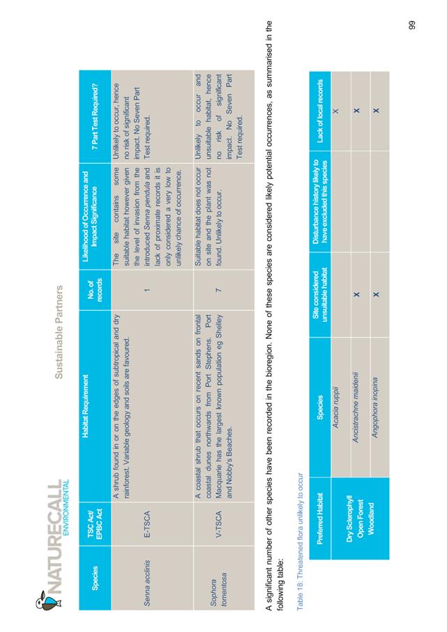

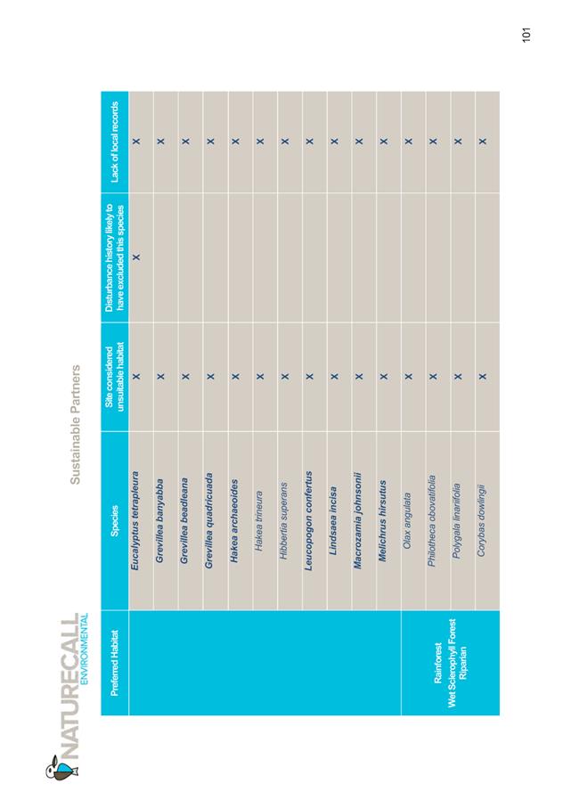
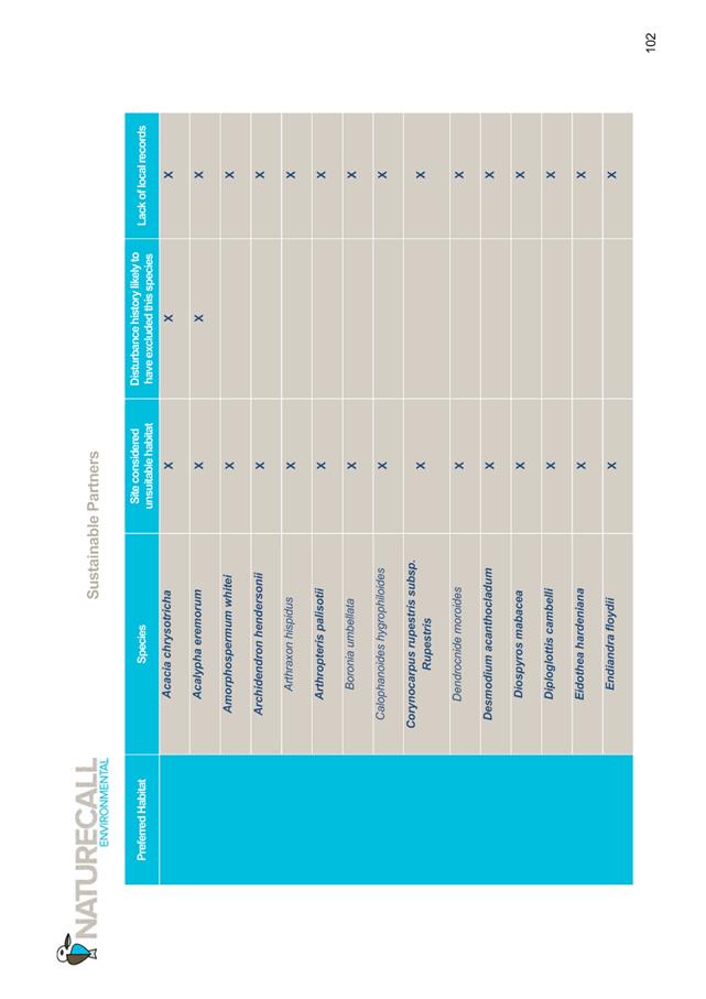
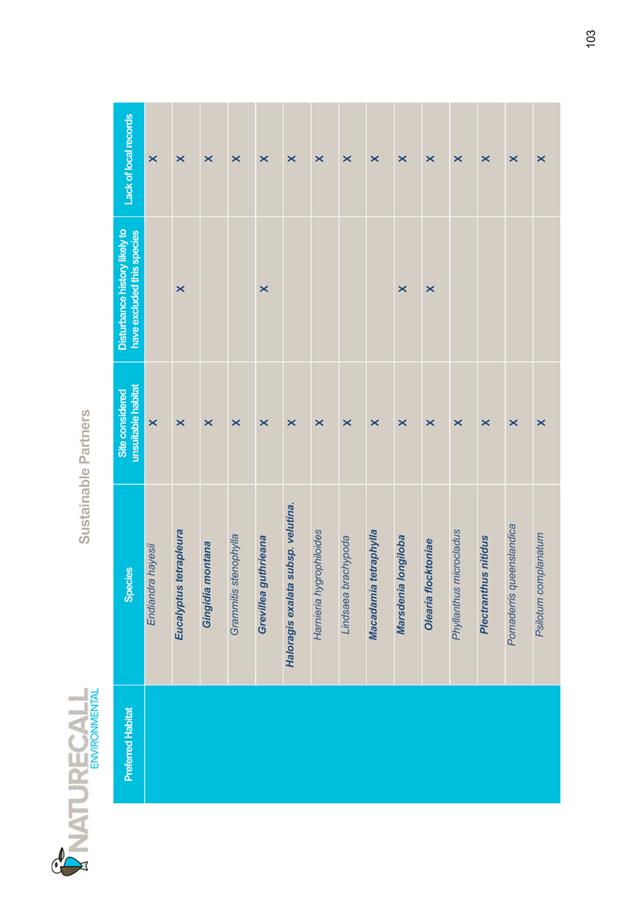
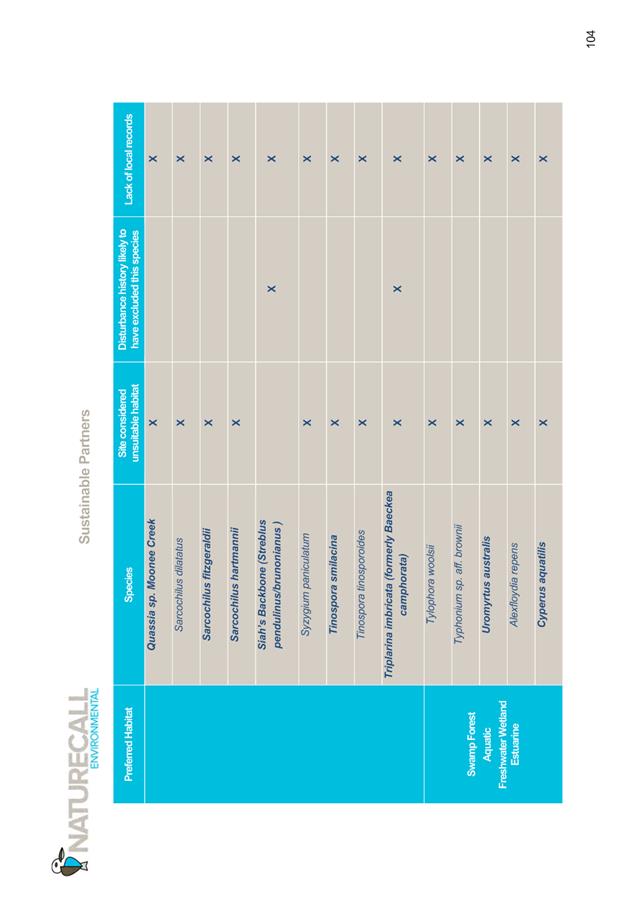
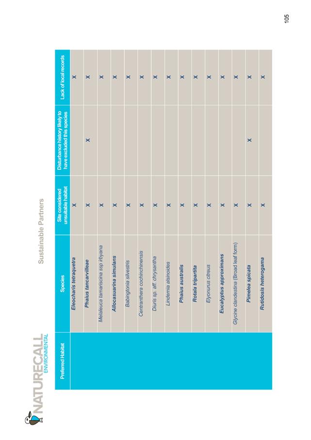
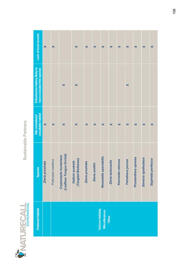
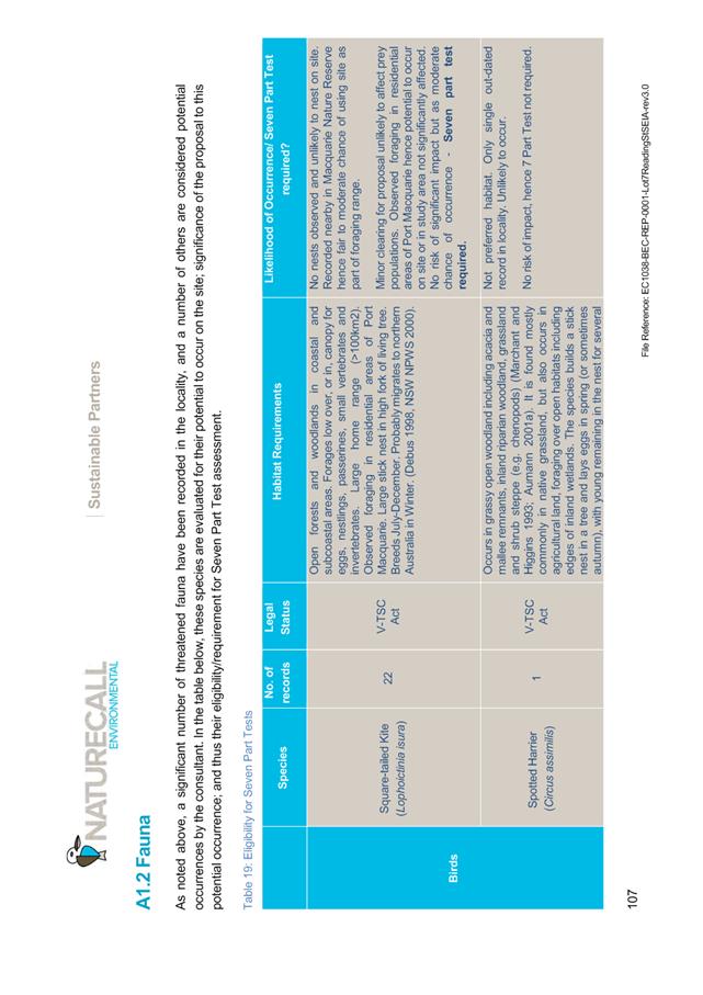
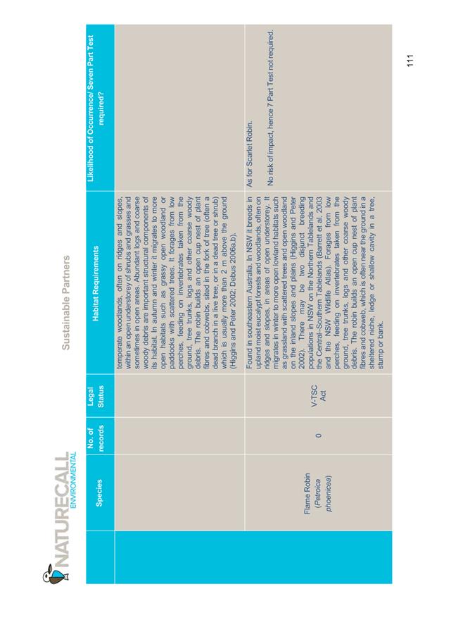
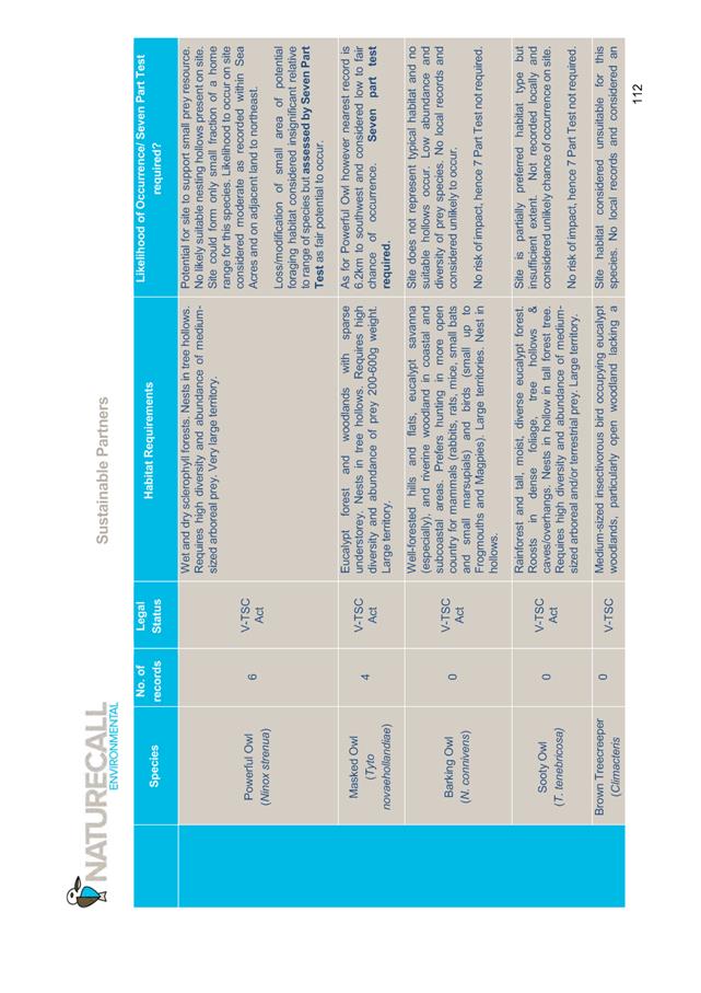
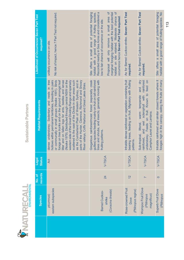
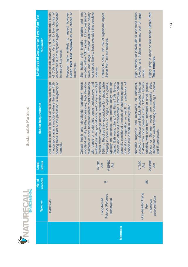
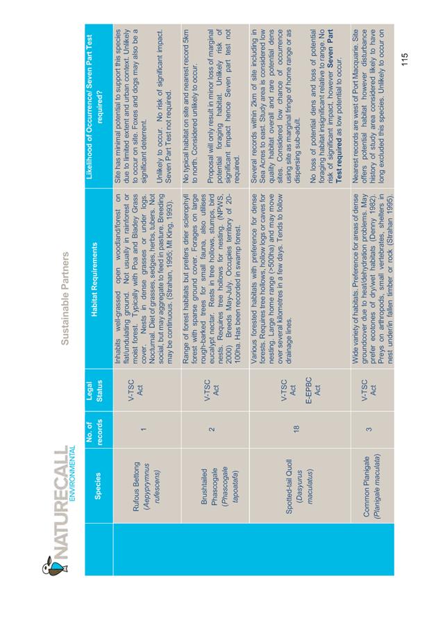
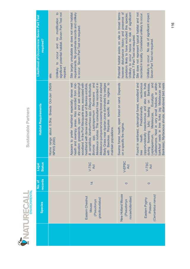
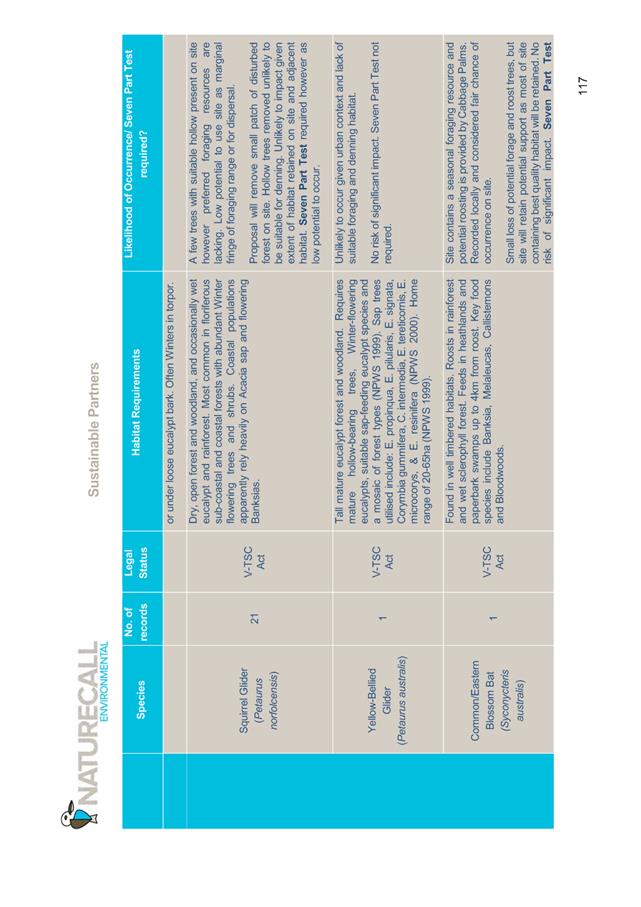
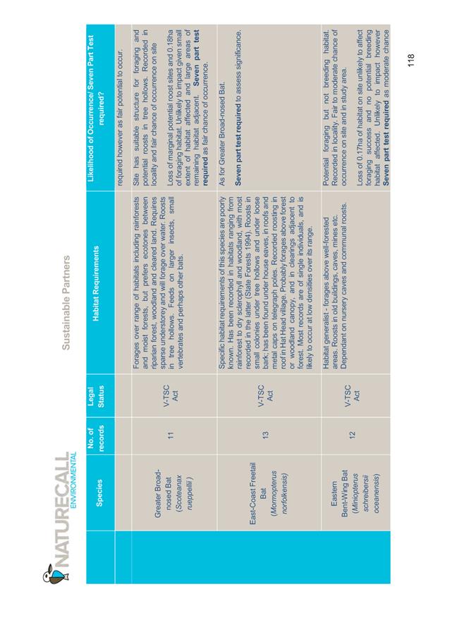
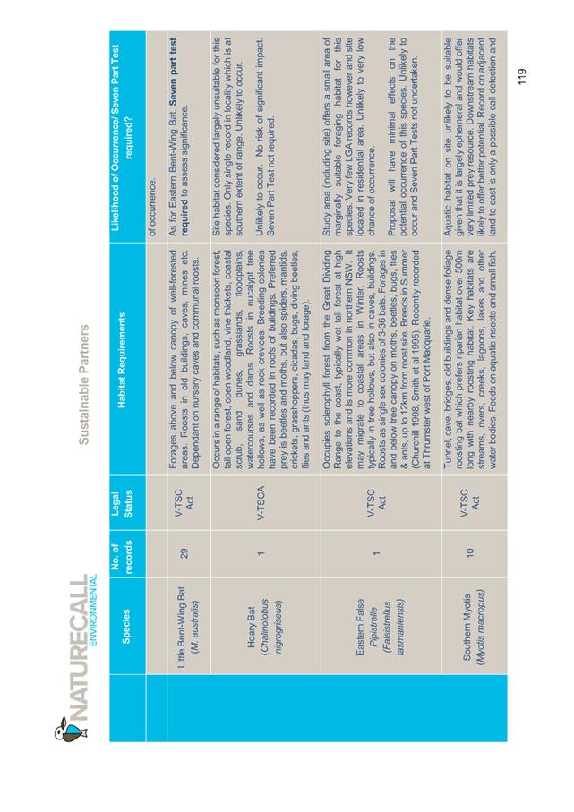
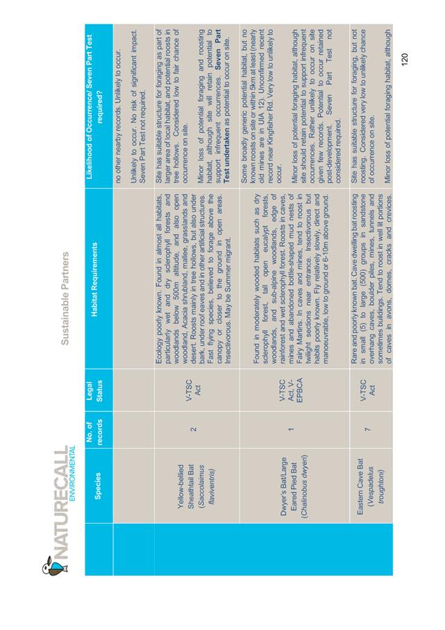
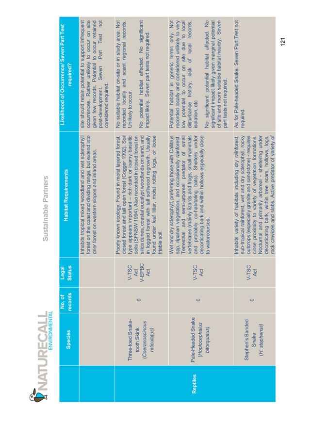
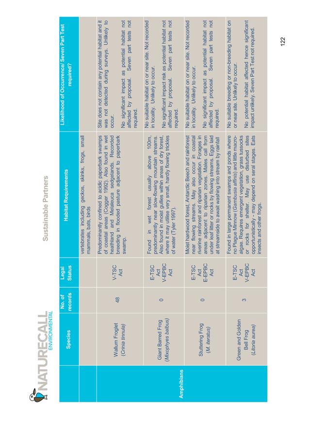
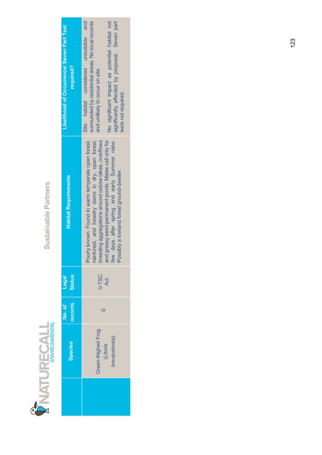
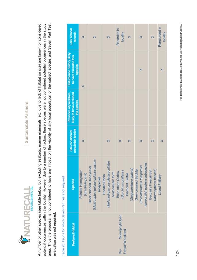
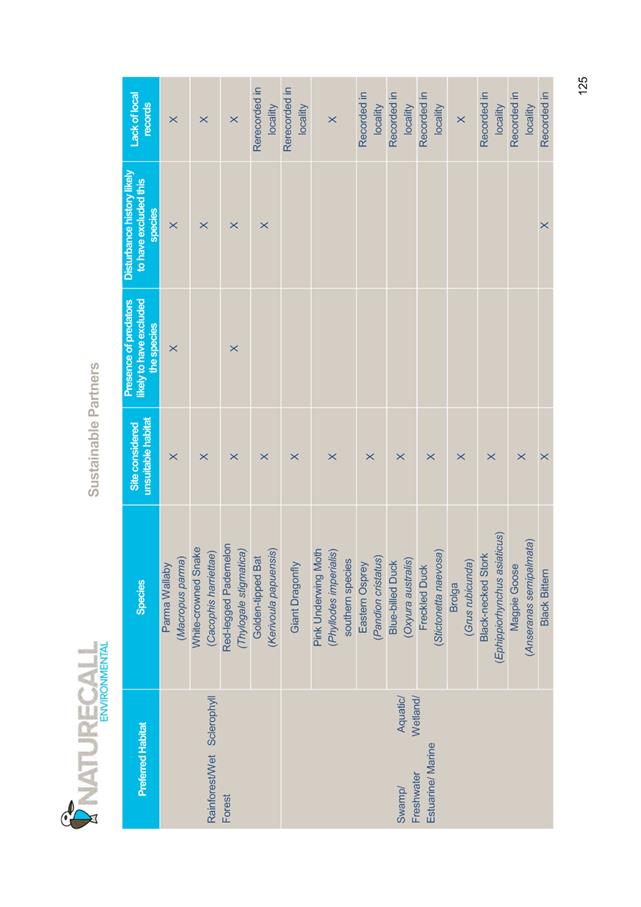
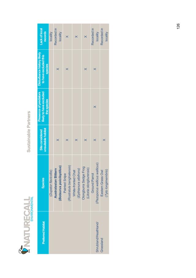
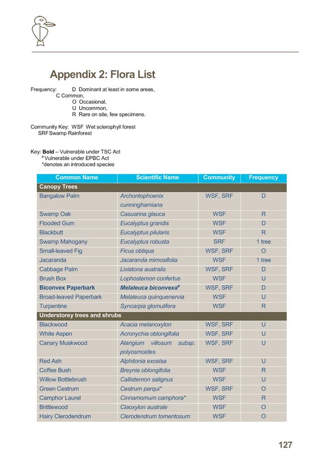
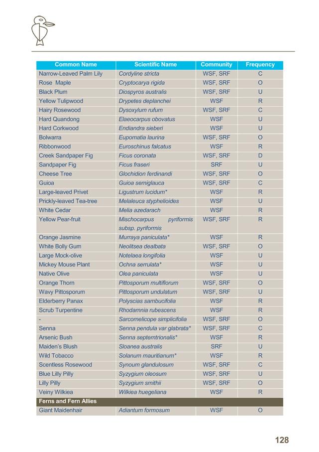
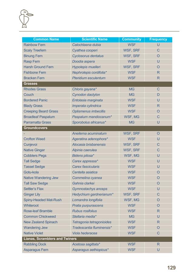
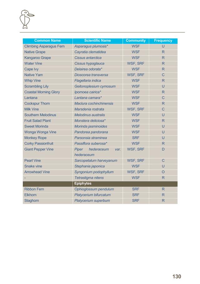
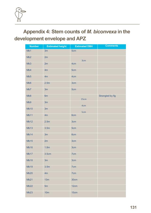
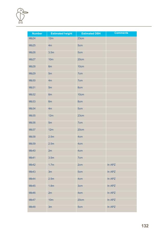
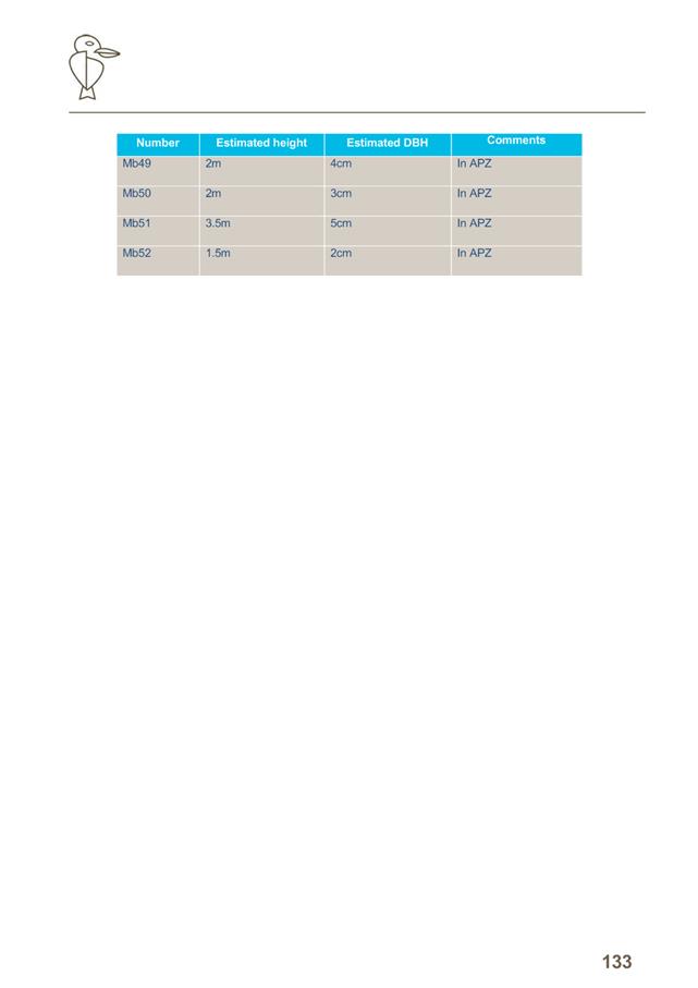
AGENDA Development Assessment Panel 09/08/2017
Item: 06
Subject: DA2017 - 342.1 New Dwelling Including Clause 4.6 Objection To Clause
4.3 (Height Of Buildings) (Of The Port Macquarie-Hastings Local Environmental
Plan 2011 - Lot 271 DP 831575, 14 Coastlands Place, Port Macquarie
Report Author: Benjamin Roberts
|
Applicant: Collins
W Collins
Owner: A
G & K B Shipway
Estimated Cost: $639,000
Alignment with Delivery Program
4.3.1 Undertake transparent
and efficient development assessment in accordance with relevant legislation.
|
|
RECOMMENDATION
That
DA2017 - 342 for a dwelling
including clause 4.6 objection to clause 4.3 (Height of Buildings) of the
Port Macquarie-Hastings Local Environmental Plan 2011 at Lot 271, DP
831575, No. 14 Coastlands Place, Port Macquarie, be determined by granting consent
subject to the recommended conditions.
|
Executive
Summary
This
report considers a development application for construction of a new
dwelling at the subject site with a building height
variation request. The report provides an assessment of the application in
accordance with the Environmental Planning and Assessment Act 1979.
Following exhibition of the
application, one (1) submission has been
received.
As per NSW Department of Planning and Environment Circulars
PS 08-003 and 08-014, Council can assume the Director’s Concurrence for
variations to height limits. Variations such as this deviating less than 10% from
the standard maybe determined under delegation and will reported to full Council
for notation only.
1. BACKGROUND
Existing sites features and Surrounding development
The site has an area of 683.8m2.
The site is zoned R1 General Residential in accordance with the Port Macquarie-Hastings Local
Environmental Plan 2011, as shown in the following zoning plan:
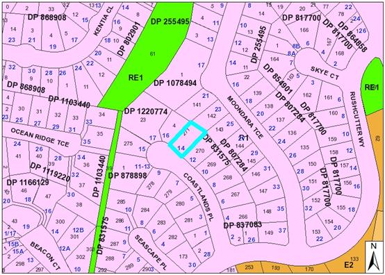
The existing subdivision pattern and location of existing
development within the locality is shown in the following aerial photograph:
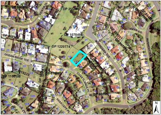
2. DESCRIPTION OF
DEVELOPMENT
Key aspects of the proposal include the following:
· Construction
of a new dwelling
Refer
to attachments at the end of this report.
Application Chronology
· 27
April 2017 - Application lodged
· 10 - 23 May 2017 - Public exhibition via neighbour
notification
3. STATUTORY ASSESSMENT
Section 79C(1) Matters for Consideration
In determining the application, Council is required to take
into consideration the following matters as are relevant to the development
that apply to the land to which the development application relates:
(a) The provisions (where
applicable) of:
(i) any Environmental
Planning Instrument:
State Environmental
Planning Policy No. 55 – Remediation of Land
Following an
inspection of the site and a search of Council records, the subject land is not
identified as being potentially contaminated and is suitable for the intended
use.
State
Environmental Planning Policy (Building Sustainability Index: BASIX) 2004
BASIX
certificate has been submitted demonstrating that the proposal will comply with
the requirements of the SEPP. It is recommended that a condition be imposed to
ensure that the commitments are incorporated into the development and certified
at Occupation Certificate stage.
State
Environmental Planning Policy No. 71 – Coastal Protection and Clause 5.5
of Port Macquarie-Hastings Local Environmental Plan 2011
The site is
located within a coastal zone as defined in accordance with clause 4 of SEPP
71.
In accordance
with clause 5, this SEPP prevails over the Port Macquarie-Hastings LEP 2011 in
the event of any inconsistency.
Having regard to
clauses 8 and 12 to 16 of SEPP 71 and clause 5.5 of Hastings LEP 2011 inclusive
the proposed development will not result in any of the following:
a) any restricted access
(or opportunities for access) to the coastal foreshore
b) any
identifiable adverse amenity impacts along the coastal foreshore and on the
scenic qualities of the coast;
c) any
identifiable adverse impacts on any known flora and fauna (or their natural
environment);
d) subject to any
identifiable adverse coastal processes or hazards;
e) any identifiable
conflict between water and land based users of the area;
f) any identifiable
adverse impacts on any items of archaeological/heritage;
g) reduce the quality of
the natural water bodies in the locality.
Port Macquarie-Hastings Local Environmental Plan 2011
The proposal
is consistent with the LEP having regard to the following:
· Clause
2.2, the subject site is zoned R1 General Residential. In accordance with
clause 2.3(1) and the R1 zone landuse table, the proposed development for a dwelling
is a permissible landuse with consent.
The objectives of the R1 zone are as follows:
o To
provide for the housing needs of the community.
o To
provide for a variety of housing types and densities.
o To
enable other land uses that provide facilities or services to meet the day to
day needs of residents.
In accordance with Clause 2.3(2), the proposal is consistent with the
zone objectives having regard to the following:
o The
proposal is a permissible landuse;
o Consistent
with the established residential locality.
· Clause
4.3, the maximum overall height of the building above ground level (existing)
is 9.3m which does not comply with the
standard height limit of 8.5m applying to the site. The applicant has lodged a
clause 4.6 objection seeking a variation to the applicable building height
standard.
· Clause
4.4, the floor space ratio of the proposal is 0.59:1
which complies with the maximum 0.65:1 floor space ratio applying to the site.
· Clause 4.6 consent
must not be granted for a proposal that contravenes a development standard
unless the consent authority has considered a written request from the applicant
that justifies the variation by showing that the subject standard is
unreasonable or unnecessary and that there are sufficient environmental
planning grounds to justify the contravening of the standard. Additionally, the
proposed development must be shown to be in the public interest because it is
consistent with the objectives of the particular standard and the objectives
for development within the zone in which the development is proposed to be
carried out.
The applicant has submitted a written
request to vary the building height standard based on the following reasons:
- The
topography of the site slopes steeply from north to south requiring split level
multi storey dwellings;
- There
are dwellings in the immediate neighbourhood (and specifically adjoining at 16
Coastlands Place) that are comparable in terms of building height.
- The
bulk and scale of the building is comparable with surrounding dwellings.
- The
proposed floor space ratio of 0.59:1 is below the standard of 0.65:1.
- The
building design incorporates an extended front setback, wall articulation and
various building materials to external facades.
Having considered the application and
clause 4.6 variation, it is agreed the proposal will have minimal impact on the
environment as per the reasons identified by the applicant above. The following
additional points are made to support the variation:
- The
site has a particularly steep slope in the south-east corner, where the
non-compliant part of the building is located. There is approximately 7m of
fall across the current building envelope from north to south making strict
compliance with the standard impractical.
- The
proposal has incorporated a flat skillion roof design and the part of the roof
that exceeds the height limit identified on the Height of Buildings Map is
located at the front (south) of the building and would not contribute to any
significant loss of solar access as the property adjoins Coastlands Place to
the south. The non-compliant part of the building is a small proportion of the
dwelling and will not impact on any privacy to adjoining dwellings.
- The
locality is characterised by dwellings of similar bulk and scale due to
topography. The proposal will result in a building height that is compatible
with the existing character of the area. It is noted the approved building
height of 16 Coastlands Place was 9.34m.
- The
development would not adversely impact on existing views of adjoining
properties to the north-east in Moondara Terrace. Refer to detailed comments
later in the report regarding view sharing.
- The
development is consistent with the zoning and height objectives of Port
Macquarie-Hastings Local Environmental Plan 2011 and is unlikely to have any
implications on State related issues or the broader public interest.
· Clause
5.9 - No listed trees in Development Control Plan 2013 are proposed to be
removed.
· Clause
5.10 – Heritage. The site does not contain or adjoin any known heritage
items or sites of significance.
· Clause
7.13, satisfactory arrangements are in place for provision of essential
services including water supply, electricity supply, sewer infrastructure,
stormwater drainage and suitable road access to service the development.
(ii) Any
draft instruments that apply to the site or are on exhibition:
No draft
instruments apply.
(iii) any
Development Control Plan in force:
Port Macquarie-Hastings
Development Control Plan 2013
|
DCP 2013: Dwellings, Dual occupancies, Dwelling
houses, Multi dwelling houses & Ancillary development
|
|
DCP Objective
|
Development Provisions
|
Proposed
|
Complies
|
|
3.2.2.2
|
Articulation zone:
• Min.
3m front setback
• An
entry feature or portico
• A
balcony, deck, patio, pergola, terrace or verandah
• A
window box treatment
• A
bay window or similar feature
• An
awning or other feature over a window
• A
sun shading feature
|
No building elements within the articulation zone.
|
N/A
|
|
Front setback (Residential not R5 zone):
· Min. 4.5m local
road
|
Minimum 5.242m front setback.
|
Yes
|
|
3.2.2.3
|
Garage minimum 5.5m front setback and garage door recessed
behind building line at least 1m or eaves/overhangs provided
|
Minimum 6.498m setback and more than 1 metre behind the
building line.
|
Yes
|
|
6m max. width of garage door/s and 50% max. width of
building
|
5.5m wide garage door. 33% of building width.
|
Yes
|
|
Driveway crossover 1/3 max. of site frontage and max. 5.0m
width
|
5m wide crossover and 27% of site frontage.
|
Yes
|
|
3.2.2.4
|
4m min. rear setback. Variation subject to site analysis
and provision of private open space
|
Minimum 10.158m rear setback.
|
Yes
|
|
3.2.2.5
|
Side setbacks:
· Ground floor
min. 0.9m
· First floors
& above min. 3m setback, unless demonstrated that adjoining property
primary living areas & POS unaffected.
· Building wall
set in and out every 12m by 0.5m.
|
Ground floor west = 1.088m
Ground floor east = 1.046m
First floor & above west = 1.088m. First floor &
above east = 1.046m. The north south orientation of the lot provides for
minimal overshadowing impact to adjoining properties. The shadow diagrams
supporting the application demonstrate that the adjoining property primary
living areas and primary open space areas will not be adversely overshadowed
for more than 3hrs between 9am-3pm on 21 June.
13.990m unarticulated building wall length on
north-western elevation.
|
Yes
Yes
Yes
No*
|
|
3.2.2.6
|
35m2 min. private open space area including a
useable 4x4m min. area which has 5% max. grade and is directly accessible
from a ground floor living area.
|
Dwelling will have minimum 35m2 private open
space including 4m x4m area accessible from living room.
|
Yes
|
|
3.2.2.7
|
Front fences:
· If solid 1.2m
max height and front setback 1.0m with landscaping
· 3x3m min. splay
for corner sites
· Fences >1.2m
to be 1.8m max. height for 50% or 6.0m max. length of street frontage with
25% openings
· 0.9x0.9m splays
adjoining driveway entrances (Fig 3.3 of AS2890.1 2004 overrides this
standard by requiring a min 2.5x2m splay for driveway entrances) See David
Troemel for info.
|
No front fencing proposed.
|
N/A
|
|
3.2.2.10
|
Privacy:
· Direct views
between living areas of adjacent dwellings screened when within 9m radius of
any part of window of adjacent dwelling and within 12m of private open space
areas of adjacent dwellings. ie. 1.8m fence or privacy screening which has
25% max. openings and is permanently fixed
· Privacy screen
required if floor level > 1m height, window side/rear setback (other than
bedroom) is less than 3m and sill height less than 1.5m
· Privacy screens
provided to balconies/verandas etc which have <3m side/rear setback and
floor level height >1m
|
No windows at garage level. The only living area window on
the first floor is the kitchen window facing south east setback 1.046m from
the side boundary. It has a sill height of 900mm. No living areas proposed on
top floor
The first floor and top floor contain balconies on the
south eastern elevations. No privacy screening is proposed to these
balconies.
|
No*
No*
|
|
DCP 2013: General Provisions
|
|
DCP Objective
|
Development Provisions
|
Proposed
|
Complies
|
|
2.7.2.2
|
Design addresses generic principles of Crime Prevention
Through Environmental Design guideline:
· Casual
surveillance and sightlines
· Land use mix and
activity generators
· Definition of
use and ownership
· Lighting
· Way finding
· Predictable routes
and entrapment locations
|
The proposed development will be unlikely to create any
concealment/entrapment areas or crime spots that would result in any
identifiable loss of safety or reduction of security in the immediate area.
|
Yes
|
|
2.3.3.1
|
Cut and fill 1.0m max. 1m outside the perimeter of the
external building walls
|
Up to 1.7m of cut.
|
No*
|
|
2.3.3.2
|
1m max. height retaining walls along road frontages
|
No retaining proposed along road frontage.
|
N/A
|
|
Any retaining wall >1.0 in height to be certified by structural
engineer
|
Condition recommended requiring certification of retaining
walls.
|
Yes
|
|
Combination of retaining wall and front fence height
|
None proposed.
|
N/A
|
|
2.3.3.8 onwards
|
Removal of hollow bearing trees
|
None proposed to be removed.
|
Yes
|
|
2.6.3.1
|
Tree removal (3m or higher with 100mm diameter trunk and
3m outside dwelling footprint
|
None proposed to be removed.
|
Yes
|
|
2.4.3
|
Bushfire risk, Acid sulphate soils, Flooding,
Contamination, Airspace protection, Noise and Stormwater
|
Refer to main body of report.
|
Yes
|
|
2.5.3.2
|
New accesses not permitted from arterial or distributor
roads. Existing accesses rationalised or removed where practical
|
Access from local road.
|
Yes
|
|
Driveway crossing/s minimal in number and width including
maximising street parking
|
Single driveway crossover of suitable width proposed.
|
Yes
|
|
2.5.3.3
|
Off-street parking in accordance with Table 2.5.1:
· 1 space = single
dwelling (behind building line) and dual occupancy
· Medium density
– 1 per 1 or 2 bed dwelling or 1.5 per 3-4 bed dwelling + 1 visitor/4
dwellings
|
Double garage proposed.
|
Yes
|
|
2.5.3.11
|
Section 94 contributions
|
Refer to main body of report.
|
N/A
|
|
2.5.3.14
|
Sealed driveway surfaces unless justified
|
Concrete.
|
Yes
|
|
2.5.3.15
|
Driveway grades for first 6m of ‘parking area’
shall be 5% grade
(Note AS/NZS 2890.1 permits steeper grades)
|
Capable of complying. Long section will be required with
section 138 application.
|
Yes
|
|
2.5.3.16
|
Transitional grades min. 2m length
|
Capable of complying. Long section will be required with
section 138 application.
|
Yes
|
The proposal
seeks to vary Development Provision 3.2.2.5 which requires building walls to
step in and out at least every 12m by a minimum of 500mm. The proposal
incorporates a 13.990m wall length along the north-western elevation of the
dwelling.
The relevant
objectives are to reduce overbearing and perceptions of building bulk on
adjoining properties and to maintain privacy. To provide for visual and
acoustic privacy between dwellings.
The proposal
is considered to be consistent with the objectives of the provision for the
following reasons:
· The
13.90m unarticulated wall length contains a combination of bathroom and bedroom
windows of varying sizes. The proposal will not result in any significant
adverse overbearing or bulk impacts to the adjoining property.
· The
variation is minor in nature and strict compliance with the numerical standard
will provide a similar outcome.
· The
13.990m unarticulated wall length will not result in any adverse privacy
impacts between dwellings.
The proposal seeks to vary
Development Provision 3.2.2.10 which requires privacy screening for windows in
a habitable room, other than a bedroom, that has a floor level of more than 1m
above ground level (existing) and the wall in which the windows is located has
a setback of less than 3m from a side or rear boundary and the windows has a
sill height of less than 1.5m. The proposal incorporates a first floor kitchen
window facing south east setback 1.046m from the side boundary with sill height
of 900mm.
The relevant objectives are to
protect the visual privacy of on-site and nearby residents.
The proposal
is considered to be consistent with the objectives of the provision for the
following reasons:
· This
kitchen window has been designed to take advantage of the view over and across
the south east corner of the adjoining dwelling at 12 Coastlands Place.
· The
site inspection indicated the primary living and open space areas at 12
Coastlands Place are both located at the rear (i.e. swimming pool and rear
yard) and on the first floor with decks orientated south east taking advantage
of the view.
· The
location of the kitchen window without screening will not result in any adverse
privacy impacts to adjoining residents.
The proposal seeks to vary
Development Provision 3.2.2.10 which requires privacy screening to balconies
with setback of less than 3m from a side or rear boundary, and is greater than
3m2 and more than 1m above ground level. The proposal incorporates
both first floor and top floor balconies greater than 3m2 in area
and setback 1.956m from the eastern side boundary with no privacy screening.
The relevant objectives are to
protect the visual privacy of on-site and nearby residents.
The proposal
is considered to be consistent with the objectives of the provision for the
following reasons:
· This
balconies have been designed to take advantage of the view over and across the
south east corner of the adjoining dwelling at 12 Coastlands Place.
· The
site inspection indicated the primary living and open space areas at 12
Coastlands Place are both located at the rear (i.e. swimming pool and rear
yard) and on the first floor with decks orientated south east taking advantage
of the view.
· The
location of the balconies without screening will not result in any adverse
privacy impacts to adjoining residents.
The proposal seeks to vary
Development Provision 2.3.3.1 which requires development not exceed a maximum
cut of 1m and fill of 1m measured vertically above the ground level (existing)
at a distance of 1m outside the perimeter of the external walls of the building.
The proposal incorporates a 1.7m cut outside the building footprint in the
north eastern corner of the site.
The relevant objectives are to
ensure that design of any building or structure integrates with the topography
of the land to:
· Minimise the
extent of site disturbance caused by excessive cut and fill to the site.
· Ensure there is no
damage or instability to adjoining properties caused by excavation or filling.
· Ensure that there
is no adverse alteration to the drainage of adjoining properties.
· Ensure the privacy
of adjoining dwellings and private open space are protected.
· Ensure that
adequate stormwater drainage is provided around the perimeter of buildings and
that overflow paths are provided.
The proposal
is considered to be consistent with the objectives of the provision for the
following reasons:
· The
topography of the site slopes steeply from north to south. There is
approximately 7m of fall across the current building envelope.
· In
providing a level usable open space area the proposed cut and retaining wall is
considered necessary.
· The
proposed retaining walls will be designed by a professional engineer to ensure
structural stability. Suitable condition recommended.
· The
cut and retaining will not result in any adverse privacy impacts to adjoining
dwellings and private open space areas.
· Adequate
stormwater drainage provisions will form part of the engineer details for the
retaining walls.
(iiia) any
planning agreement that has been entered into under Section 93f or any draft
planning agreement that a developer has offered to enter into under Section
93f:
No planning
agreements has been offered or entered into relating to the site.
iv) any matters prescribed by the
Regulations:
New South
Wales Coastal Policy:
The proposed
development is consistent with the objectives and strategic actions of this
policy.
v) any coastal
zone management plan (within the meaning of the Coastal Protection Act 1979),
that apply to the land to which the development application relates:
No coastal
zone management plan applies to the subject site.
(b) The
likely impacts of that development, including environmental impacts on both the
natural and built environments, social and economic impacts in the locality:
The site has
a general southern street frontage orientation to Coastlands Place.
Three storey
dwellings adjoin the site to the east and west. The proposal will be unlikely
to have any adverse impacts to existing adjoining properties and satisfactorily
addresses the public domain.
The proposal
is considered to be compatible with other residential development in the
locality and adequately addresses planning controls for the area.
The proposal
does not have significant adverse lighting impacts.
There are no
significant adverse privacy impacts. Privacy has been adequately addressed
through building design.
View Sharing
The public exhibition of the
proposal resulted in concerns being raised in relation to loss of views from 23
Moondara Terrace. An inspection of the site indicates that 23 Moondara terrace
would be most impacted by the proposal in terms of potential view impacts. The
dwelling at 21 Moondarra Terrace is higher in elevation again and would enjoy
unobstructed views over the proposed dwelling. An inspection of the dwelling
was undertaken at 23 Moondarra Terrace for the purpose of providing the
comments below in the view impact assessment. Expansive ocean and mountain views
exist from 23 Moondara Terrace to the south and south east over the currently
vacant site.
The notion of
view sharing is invoked when a property enjoys existing views and a proposed
development would share that view by taking some of it away for its own
enjoyment. (Taking it all away cannot be called view sharing, although it may,
in some circumstances, be quite reasonable.)
Using the
planning principles of NSW Land and Environment Court in Tenacity Consulting
v Warringah 2004 NSW LEC 140, the following comments are provided in regard
to the view impacts using the 4 step process to establish whether the view
sharing is acceptable.
Step
1
Assessment of
views to be affected. Water views are valued more highly than land views.
Iconic views (e.g. of the Opera House, the Harbour Bridge or North Head) are
valued more highly than views without icons. Whole views are valued more highly
than partial views, e.g. a water view in which the interface between land and
water is visible is more valuable than one in which it is obscured.
Comments: The
property of 23 Moondara Terrace enjoy views to the south of North Brother
Mountain and the sea through the currently vacant development site. The
interface of land and water is not visible, but the views to North Brother
Mountain are considered to be iconic in the local context.
Step
2
Consider from
what part of the property the views are obtained. For example the protection of
views across side boundaries is more difficult than the protection of views
from front and rear boundaries. In addition, whether the view is enjoyed from a
standing or sitting position may also be relevant. Sitting views are more
difficult to protect than standing views. The expectation to retain side views
and sitting views is often unrealistic.
Comments: From
the property at 23 Moondara Terrace views are obtained over the rear property
boundary from elevated living areas. Sitting and standing views are enjoyed
from the dwelling at 23 Moondara Terrace.
Step 3
Assess the
extent of the impact. This should be done for the whole of the property, not
just for the view that is affected. The impact on views from living areas is
more significant than from bedrooms or service areas (though views from
kitchens are highly valued because people spend so much time in them). The
impact may be assessed quantitatively, but in many cases this can be
meaningless. For example, it is unhelpful to say that the view loss is 20% if
it includes one of the sails of the Opera House. It is usually more useful to
assess the view loss qualitatively as negligible, minor, moderate, severe or
devastating.
Comments: The
extent of the impact is considered to be negligible for the following reasons:
- Ground
floor standing views to the south and southeast will be maintained over the
existing boundary fence and roof of the new dwelling given the elevation
difference between sites.
- Ground
floor sitting views may be slightly compromised if at all when available over
the existing boundary fence.
- The
primary living areas on the first floor are at a significantly higher elevation
and will maintain unobstructed views to the water and North Brother Mountain
would be maintained over the roof of the proposed new dwelling from the main living
area orientated south and south east.
Step 4
Assess the
reasonableness of the proposal that is causing the impact. A development that
complies with all planning controls would be considered more reasonable than
one that breaches them. Where an impact on views arises as a result of
non-compliance with one or more planning controls, even a moderate impact may
be considered unreasonable. With a complying proposal, the question should be
asked whether a more skilful design could provide the applicant with the same
development potential and amenity and reduce the impact on the views of
neighbours. If the answer to that question is no, then the view impact of a
complying development would probably be considered acceptable and the view
sharing reasonable.
Comments: The
proposal includes a variation to the adopted planning controls for the height
of buildings for part of the south-east corner of the building. The extent of
the variation is 0.8m (9.4% of the development standard). However, the
non-compliant part of the building is located at the front of the site and
would not be highly visible from the affected dwellings to the north-east. The
non-compliant part of the building would not contribute to any loss of
significant views from adjoining properties.
The proposed
development is considered to have satisfactory impacts on view sharing and the submitted
proposal reasonable for the site.
Overshadowing
There are no
adverse overshadowing impacts. The applicant has submitted shadow diagrams
demonstrating that the proposal does not prevent adjoining properties from
receiving 3 hours of sunlight to private open space and primary living areas on
21 June.
Roads
The site has
road frontage to Coastlands Place which is a public road with sealed pavement,
a layback kerb and gutter, under the care and control of Council.
Traffic
and Transport
The traffic
associated with the development is unlikely to have any adverse impacts to the
existing road network within the immediate locality.
Site
Frontage & Access
Vehicle access
to the site is proposed though a driveway with direct frontage to Coastlands
Place. Access shall comply with Council AUSPEC and Australian Standards, and
conditions have been imposed to reflect these requirements.
Other
Utilities
Telecommunication
and electricity services are available to the site.
Heritage
No known
items of Aboriginal or European heritage significance exist on the property. No
adverse impacts anticipated.
Other land
resources
The site is
within an established urban context and will not sterilise any significant
mineral or agricultural resource.
Water
cycle
The proposed
development will be unlikely to have any adverse impacts on water resources and
the water cycle.
Soils
The proposed
development will be unlikely to have any adverse impacts on soils in terms of
quality, erosion, stability and/or productivity subject to a standard condition
requiring erosion and sediment controls to be in place prior to and during
construction.
Air and
microclimate
The
construction and/or operations of the proposed development will be unlikely to
result in any adverse impacts on the existing air quality or result in any
pollution. Standard precautionary site management condition recommended.
Flora and
fauna
Construction
of the proposed development will not require any removal/clearing of any
significant vegetation and therefore will be unlikely to have any significant
adverse impacts on biodiversity or threatened species of flora and fauna.
Section 5A of the Act is considered to be satisfied.
Waste
Satisfactory
arrangements are in place for proposed storage and collection of waste and
recyclables. No adverse impacts anticipated. Standard precautionary site
management condition recommended.
Energy
The proposal
includes measures to address energy efficiency and will be required to comply
with the requirements of BASIX. No adverse impacts anticipated.
Noise and
vibration
No adverse
impacts anticipated. Condition recommended restricting construction to standard
construction hours.
Bushfire
The site is
not identified as being bushfire prone.
Safety,
security and crime prevention
The proposed
development will be unlikely to create any concealment/entrapment areas or
crime spots that would result in any identifiable loss of safety or reduction
of security in the immediate area. The increase in housing density will improve
natural surveillance within the locality and openings from each dwelling
overlook common and private areas.
Social
impacts in the locality
Given the
nature of the proposed development and its’ location the proposal is
unlikely to result in any adverse social impacts.
Economic
impact in the locality
No adverse
impacts. A likely positive impact is that the development will maintain
employment in the construction industry, which will lead to flow impacts such
as expenditure in the area.
Site
design and internal design
The proposed
development design satisfactorily responds to the site attributes and will fit
into the locality. No adverse impacts likely.
Construction
No potential
adverse impacts identified to neighbouring properties with the construction of
the proposal.
Cumulative
impacts
The proposed
development is not expected to have any adverse cumulative impacts on the
natural or built environment or the social and economic attributes of the
locality.
(c) The
suitability of the site for the development:
The proposal
will fit into the locality and site constraints have been adequately addressed
and appropriate conditions of consent recommended.
(d) Any submissions made in accordance with this Act or the
Regulations:
One (1) written submission has been received following public
exhibition of the application.
Key issues raised in the submission received and comments
in response to these issues are provided as follows:
|
Submission
Issue/Summary
|
Planning
Comment/Response
|
|
The application purports that
views on the lower level i.e. sight lines are from a standing position and
not from a seated position.
|
Refer to view sharing assessment and comments provided
within report.
|
|
The application does not
consider the variety of additional structures the roof may hold. Such
structures on the roof similar to that next door at 16 Coastlands Place will
further exceed the development guidelines and impacts views from 23 Moondara
Terrace.
|
No roof structures (i.e. solar panels, solar hot water
system, antenna) are proposed under this application.
|
|
Such roof structures represent
an environmental impact on the outlook and general presentation of the
surrounding area.
|
Refer to above.
|
|
Seek that any roof structures
added to the roof fall within the boxed roof structure surrounding the roof.
|
Refer to above.
|
|
Request that Council ensure
the proposed outdoor cinema has sufficient sound deafening structures and
that light from the projection will no impact on the residence at 23 Moondara
Terrace or adjoining neighbours.
|
There is a feature wall proposed above the western side
of the pool to which a projector is intended to display. The outdoor roof
structures over the pool and surrounding outdoor area will obscure views to
these areas and the projection wall. No adverse noise impacts are anticipated
from such equipment that would warrant refusal of the application.
|
|
No details of landscaping is
proposed. This is of interest due to fast growing bamboo planted on the
property at 16 Coastlands Place that will impact on neighbouring properties.
Such plantings would be against Council’s development provisions.
It’s requested that a height limit be placed on such plantings along the
rear boundary fence.
|
No landscaping is proposed or
nominated on plans. Future plantings/landscaping will be at the land
owner’s discretion. View impacts from future landscaping/vegetation is
a civil matter between neighbours.
|
(e) The Public Interest:
The proposed
development satisfies relevant planning controls and is unlikely to impact on
the wider public interest.
4. DEVELOPMENT
CONTRIBUTIONS APPLICABLE
· Not applicable.
5. CONCLUSION
The application has been assessed in accordance with
Section 79C of the Environmental Planning and Assessment Act 1979.
Issues raised during assessment and public exhibition of
the application have been considered in the assessment of the application.
Where relevant, conditions have been recommended to manage the impacts
attributed to these issues.
The site is suitable for the proposed development, is not
contrary to the public's interest and will not have a significant adverse
social, environmental or economic impact. It is recommended that the
application be approved, subject to the recommended conditions of consent
provided in the attachment section of this report.
|
Attachments
1View. DA2017
- 342.1 Plans
2View. DA2017
- 342.1 Recommended Conditions
3View. DA2017
- 342.1 Submission - Eriksson
|
|
ATTACHMENT
|
Development Assessment Panel
09/08/2017
|
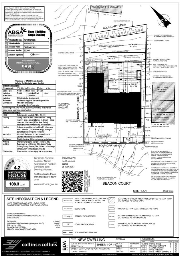
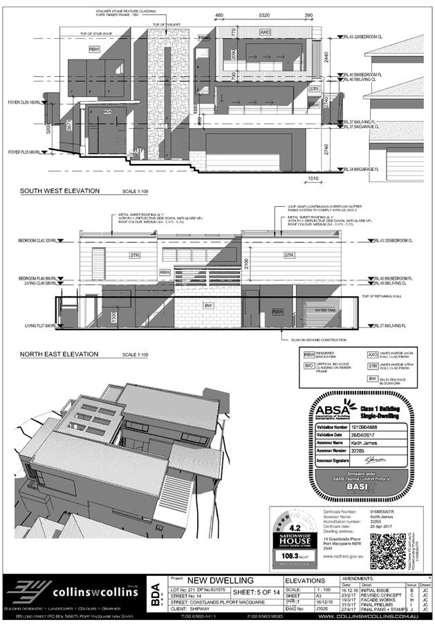
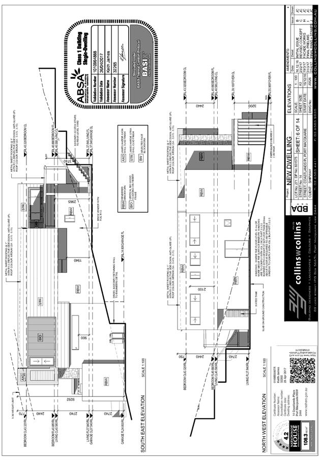
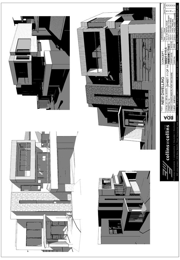
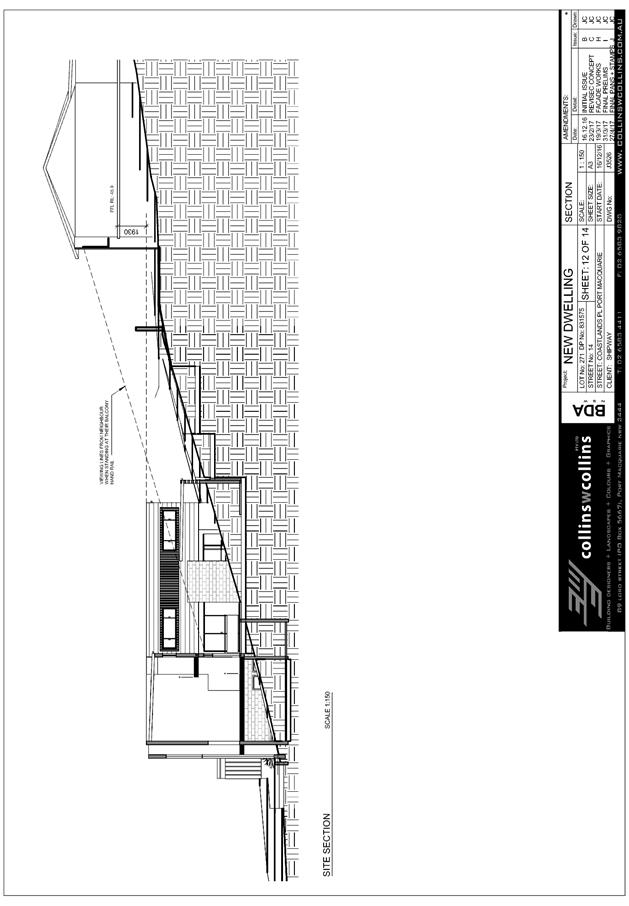
|
ATTACHMENT
|
Development Assessment Panel
09/08/2017
|
|
ATTACHMENT
|
Development Assessment Panel
09/08/2017
|

AGENDA Development Assessment Panel 09/08/2017
Item: 07
Subject: DA2017 - 351.1 Alterations To Garage And Construction Of Deck - Lot
8 DP 734429 No 128 Camden Head Road, Dunbogan
Report Author: Fiona Tierney
|
Applicant: Land
Dynamics Australia
Owner: A
R Wilson
Estimated Cost: $11,000
Alignment with Delivery Program
4.3.1 Undertake transparent
and efficient development assessment in accordance with relevant legislation.
|
|
RECOMMENDATION
That
DA 2017 - 351 for alterations to
garage and construction of deck at
Lot 8, DP 734429, No. 128 Camden
Head Road, Dunbogan, be determined by granting consent subject to the
recommended conditions.
|
Executive
Summary
This
report considers a development application for continued use of alterations to
existing garage and walkway (built without Council approval) and construction
of a walkway and deck at the subject site. The report provides an assessment of
the application in accordance with the Environmental Planning and Assessment
Act 1979.
Following exhibition of the
application, 8 submissions have been received.
1. BACKGROUND
Existing sites features and surrounding development
The site has an area of 2042m2.
The site is zoned R1- General Residential and E3-
Environmental Management in accordance with the Port
Macquarie-Hastings Local Environmental Plan 2011, as shown in the following
zoning plan:
The existing subdivision pattern and location of existing
development within the locality is shown in the following aerial photograph:
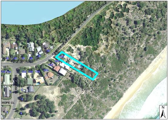
2. DESCRIPTION OF
DEVELOPMENT
Key aspects of the proposal include the following:
· Continued
use of walkway
· Continued
use of garage conversion to gym
· Construction
of partial walkway and 50m2 deck
· Dune
stabilisation and landscaping
Refer
to attachments at the end of this report.
Application Chronology
· 23 March 2017- onsite meeting regarding unauthorised works
and clearing on site.
· 1
May 2017- Application lodged
· 10 May 2017-23 May 2017- Neighbour notification of proposal
· 15 May 2017- Additional information request- ecological
assessment
· 26 June 2017- additional information received- response to
submissions and ecological opinion
3. STATUTORY ASSESSMENT
Section 79C(1) Matters for Consideration
In determining the application, Council is required to take
into consideration the following matters as are relevant to the development
that apply to the land to which the development application relates:
(a) The provisions (where applicable)
of:
(i) any Environmental
Planning Instrument:
State Environmental Planning Policy
No. 44 - Koala Habitat Protection
There
is no Koala Plan of Management on the site. Additionally, the site is less than
1ha in area therefore no further investigations are required.
State
Environmental Planning Policy No.55 – Remediation of Land
Following an inspection of the site and
a search of Council records, the subject land is not identified as being
potentially contaminated and is suitable for the intended use.
State
Environmental Planning Policy No. 71 – Coastal Protection and Clause 5.5
of Port Macquarie-Hastings Local Environmental Plan 2011
The site is
located within a coastal zone as defined in accordance with clause 4 of SEPP 71
and is further located in a Sensitive Coastal location.
In accordance with
clause 5, this SEPP prevails over the Port Macquarie-Hastings LEP 2011 in the
event of any inconsistency.
Having regard to
clauses 8 and 12 to 16 of SEPP 71 and clause 5.5 of Hastings LEP 2011 inclusive
the proposed development will not result in any of the following:
a) any
restricted access (or opportunities for access) to the coastal foreshore. The
proposed work is on private land.
b) any
identifiable adverse amenity impacts along the coastal foreshore and on the
scenic qualities of the coast, noting that a condition of consent has been
recommended to revegetate the disturbed area;
c) any
identifiable adverse impacts on any known flora and fauna (or their natural
environment) – refer to flora and fauna comments;
d) subject
to any identifiable adverse coastal processes or hazards, noting recommended
condition of consent to stabilise the disturbed area;
e) any
identifiable conflict between water and land based users of the area;
f) any
identifiable adverse impacts on any items of archaeological/heritage;
g) reduce
the quality of the natural water bodies in the locality.
The site is has been predominately
cleared and located within an area zoned for residential purposes with an E3
Environmental Management zoning located at the rear half of the property.
History of the site indicates the area has been disturbed through sand mining
activities and residential use. Aerial photography show the vegetation thinning
and thickening through various stages and the proponent’s ecologist has
identified large areas of bitou bush. To the North is reserve and to the South
is another residential property that has been cleared in the past and
revegetated- largely with exotic species. Further south are areas that have
been cleared and have remnant banksias and a large community title subdivision.
The proposal, once completed and
landscaped, will sit low in the environment when viewed form the beach and will
be softened by vegetation. At present the site has been stripped bare and
stands out in the landscape due to the contrasting sand that has been exposed.
Port
Macquarie-Hastings Local Environmental Plan 2011
The land is part zoned R1 General Residential and Part E3
Environmental Management under the Port Macquarie Hastings Local Environmental
Plan 2011. ‘Dwelling houses’ and structures ancillary to dwelling
are permissible with consent in both zones.
The
objectives of the R1 zone are:
· To provide for the housing needs of the community.
· To provide for a variety of housing types and
densities.
· To enable other land uses that provide facilities
or services to meet the day to day needs of residents.
The
proposed continued use of the modified garage for the purpose of a private gym
are not considered to be odds with the R1 zone objectives. The works are
considered to be minor and ancillary to the primary residential use of the
land.
The objectives of the E3
zone are:
· To protect, manage and restore areas with special
ecological, scientific, cultural or aesthetic values.
· To provide for a limited range of development that
does not have an adverse effect on those values.
The bare striping of the site back to sand is a significant
concern and if left in this state would be in direct conflict with the E3 zone
objectives. With appropriate stabilisation and landscaping of the site, the
completed development is considered capable of satisfying the E3 zone
objectives. The proposed walkway and deck are set low in the landscape and will
not be aesthetically/visually obtrusive once the remainder of the site is
revegetated. The submitted ecological opinion has satisfactorily demonstrated
that the site previously did not contain such significant ecological values
that would sustain refusal of the application (notwithstanding the need to stabilise
the site).
· Clause
5.9 - No listed trees in Development Control Plan 2013 are proposed to be
removed.
· Clause
5.10 – Heritage. The site does not contain or adjoin any known heritage
items or sites of significance. The site has been disturbed from past sand
mining and residential uses.
· Clause
7.13, satisfactory arrangements are in place for provision of essential
services to the site.
(ii) Any
draft instruments that apply to the site or are on exhibition:
No draft
instruments apply to the site.
(iii) any
Development Control Plan in force:
Port
Macquarie-Hastings Development Control Plan 2013
|
DCP 2013: Dwellings, Dual
occupancies, Dwelling houses, Multi dwelling houses & Ancillary
development
|
|
|
Requirements
|
Proposed
|
Complies
|
|
3.2.2.1
|
Ancillary development:
• 4.8m max. height
• Single storey
• 60m2 max. area
• 100m2 for lots
>900m2
• 24 degree max.
roof pitch
• Not located in
front setback
|
Walkway and deck located less
than 1m from ground level.
|
Yes
|
|
3.2.2.2
|
Articulation zone:
• Min. 3m front
setback
• An entry feature
or portico
• A balcony, deck,
patio, pergola, terrace or verandah
• A window box
treatment
• A bay window or
similar feature
• An awning or
other feature over a window
• A sun shading
feature
|
N/A
|
N/A
|
|
3.2.2.3
|
Garage 5.5m min. and 1m behind
front façade.
Garage door recessed behind
building line or eaves/overhangs provided
|
Garage is existing. Internal
works to convert one of the 3 bays to a gym.
|
Yes
|
|
6m max. width of garage door/s
and 50% max. width of building
|
Existing
|
Yes
|
|
3.2.2.4
|
4m min. rear setback. Variation
subject to site analysis and provision of private open space
|
Deck located 900mm form rear
boundary. Adjoins beach dunes/vegetation.
|
Yes
|
|
3.2.2.5
|
Side setbacks:
• Ground floor =
min. 0.9m
• First floors
& above = min. 3m setback or where it can be demonstrated that
overshadowing not adverse = 0.9m min.
• Building wall
set in and out every 12m by 0.5m
|
3.2m northern boundary
4.3m southern boundary
|
Yes
|
|
3.2.2.6
|
35m2 min. private open space area
including a useable 4x4m min. area which has 5% max. grade
|
|
Yes
|
|
3.2.2.10
|
Privacy:
• Direct views
between living areas of adjacent dwellings screened when within 9m radius of
any part of window of adjacent dwelling and within 12m of private open space
areas of adjacent dwellings. ie. 1.8m fence or privacy screening which has
25% max. openings and is permanently fixed
• Privacy screen
required if floor level > 1m height, window side/rear setback (other than
bedroom) is less than 3m and sill height less than 1.5m
• Privacy screens
provided to balconies/verandahs etc which have <3m side/rear setback and
floor level height >1m
|
Deck located rear yard- no
specific privacy issues or direct line of sight.
|
Yes
|
|
DCP 2013: General
Provisions
|
|
|
Requirements
|
Proposed
|
Complies
|
|
2.7.2.2
|
Design addresses generic principles of Crime Prevention
Through Environmental Design guideline
|
Adequate casual surveillance available
|
Yes
|
|
2.3.3.1
|
Cut and fill 1.0m max. 1m outside the perimeter of the
external building walls
|
Dune area has been cut. No immediate impact on adjoining
properties. Applicant proposes to retain and stabilise.
|
No- but considered acceptable upon completion of
development.
|
|
2.6.3.1
|
Tree removal (3m or higher with 100m diameter trunk at 1m
above ground level and 3m from external wall of existing dwelling)
|
Scrub and vegetation less than 100mm has been removed- no
additional under this consent
|
Yes
|
|
2.4.3
|
Bushfire risk, Acid sulphate soils, Flooding,
Contamination, Airspace protection, Noise and Stormwater
|
Refer to main body of report.
|
|
(iiia) any
planning agreement that has been entered into under Section 93f or any draft
planning agreement that a developer has offered to enter into under Section
93f:
No planning
agreement has been offered or entered into relating to the site.
iv) any matters prescribed by the
Regulations:
New South Wales Coastal Policy:
The proposed
development is consistent with the objectives and strategic actions of this
policy
v) any coastal
zone management plan (within the meaning of the Coastal Protection Act 1979),
that apply to the land to which the development application relates:
None applicable.
(b) The
likely impacts of that development, including environmental impacts on both the
natural and built environments, social and economic impacts in the locality:
Context and setting
Once completed, the
proposal will be unlikely to have any adverse impacts to existing adjoining
properties and satisfactorily addresses the public domain. Works will be
consistent with the southern neighbour who has landscaped extensively, albeit
that this proposal will have greater structural elements.
The
proposal is considered to be reasonably consistent with other development in
the locality and is considered a reasonable development of the site to take
advantage of the natural attributes of the area.
• There
is no adverse impact on existing view sharing.
• There is no adverse privacy impacts.
Access, transport and traffic
The proposal will not have any
adverse impacts in terms access, transport and traffic.
Heritage
This site does
not contain or adjoin any known heritage item or site of significance.
Other land
resources
No adverse
impacts anticipated. The development will not sterilise any significant mineral
or agricultural resource.
Water cycle
The proposed
development will be unlikely to have any adverse impacts on water resources and
the water cycle.
Soils
The current
work undertaken on the site poses a significant erosion risk. Conditions of
consent have been recommended to require stabilisations and landscaping of the
exposed sand.
Air and
microclimate
The
construction and/or operations of the proposed development will be unlikely to
result in any adverse impacts on the existing air quality or result in any
pollution.
Flora and
fauna
Work already
undertaken on the site has removed all vegetation. An ecological report was
requested to justify that the works undertaken did not represent a significant
adverse impact on ecological values of the site. A report was submitted by JB
Enviro (attached) and it was concluded:
‘The proposal has
overall had only a very low impact on any threatened species directly or
indirectly
as:
· No
critical habitat components such as hollow-bearing trees were removed.
· The
previous site vegetation was evidently disturbed, weed infested, and offered no
significant foraging habitat for any potentially occurring threatened species.
· Connectivity
has not been significantly degraded as the adjoining yards have exotic or
maintained vegetation; and a band of about 80m wide of shrubland and tussock
grassland remain to the east along the dune front.
· No
littoral rainforest was impacted.
· No
threatened flora or potential habitat is likely to have been removed.
· While
the works have lowered the physical buffer to maritime stresses (eg. Prevailing
salt-laden winds), there is no littoral rainforest or other sensitive community
adjacent and at risk of degradation. The nearest littoral rainforest to the
north is protected in a swale, and the next occurrence west of Camden Head Rd
is buffered by the dune north of the dwelling.
· No
significant erosion or sedimentation of adjacent communities has occurred. It
is understood that the face of the dune to the northeast will be held with a
retaining wall and planted with native species to maintain structural support.
· No
new weed occurrence has been established.
The
proposal to landscape the rear yard of 128 Camden Head Rd is not considered to
have had any significant ecological impacts. This is primarily due to the
condition and constitution of the previous vegetation ie. common pioneer
natives formerly with a high weed content subject to high levels of maritime
stresses and formerly high levels of weed invasion. Combined with its previous
landuse for sandmining followed by a rear yard, its ecological values were
limited.
While the
landform has also been modified, it has not significantly altered the
penetration of maritime stresses and hence is not likely to see degradation of
any vegetation community, especially if structures and landscaping re-establish
a similar barrier effect in the short to medium term.
Similarly,
the works have not destabilised the dune system via forming a breach, only cut
the end of what is reported to have been a stockpile from previous sand mining.
Provision of the proposed retaining wall per the DA plus replantings including
along the APZ are expected to restore stability.
The report has been
has been reviewed by Council’s planning and ecological staff who have
concurred with the findings. Whilst concern is raised in the manner in which
the landowner has cleared the land prior to obtaining consent, this in itself
is not a reason to refuse the application. The ecologist has satisfactorily
demonstrated that the site did not contain ecological values of such
significance that would be compromised by the proposal
Rehabilitation and
revegetation of the disturbed area is required and plans are to be submitted to
Council for approval prior to the issue of the Construction certificate.
Noise and
vibration
No adverse
impacts anticipated. Condition recommended to restrict construction to standard
construction hours.
Bushfire
The site is
identified as being bushfire prone- the deck is located greater than 10m from
the existing dwelling and will not pose a significant risk to the dwelling.
Bushfire impacts are considered to be capable of being managed
Safety,
security and crime prevention
The proposed
development will be unlikely to create any concealment/entrapment areas or crime
spots that would result in any identifiable loss of safety or reduction of
security in the immediate area.
Social
impacts in the locality
Given the
nature of the proposed development and its’ location the proposal is
unlikely to result in any adverse social impacts.
Economic impact
in the locality
No adverse impacts.
Likely positive impacts can be attributed to the construction of the
development and associated flow on effects (ie increased expenditure in the
area).
Site design
and internal design
The proposed
development (when completed) satisfactorily responds to the site attributes and
will fit into the locality. No adverse impacts likely.
Construction
No potential
adverse impacts identified to neighbouring properties with the construction of
the proposal.
Cumulative Impacts
The proposed development is not expected to have any adverse cumulative
impacts on the natural or built environment or the social and economic
attributes of the locality.
(c) The suitability of the site for
the development:
The proposal
will fit into the locality and the site attributes are conducive to the
proposed development
(d) Any submissions made in
accordance with this Act or the Regulations:
Eight written submissions have been received following public
exhibition of the application.
Key issues raised in the submissions received and comments
in response to these issues are provided as follows:
|
Submission
Issue/Summary
|
Planning
Comment/Response
|
|
Construction of deck on E3
land that is not in residential area.
|
Works are permitted with
consent on E3 land.
|
|
Council to enforce remediation
and erosion measures.
|
Works are currently the
subject of an ongoing investigation. Conditions of consent will require dune
stabilisation and revegetation. This assessment takes into consideration what
would likely be approved should consent have been obtained beforehand.
|
|
Highly visible and loss of
amenity to adjoining properties has occurred.
|
Deck will be a low unroofed
structure with vegetation to be provided that will assist with the
integration of the structure within the landscape. The site is to be
revegetated and landscaped.
|
|
Significant vegetation has
been removed similar to adjoining Kattang Nature reserve.
|
An ecological opinion has been
submitted and various photos and drone footage examined. The site has been
highly disturbed over time by sand mining activities and residential use.
Whilst some native vegetation existed on site, exotics and pest species also
featured quite predominantly. On-going compliance action is being undertaken
in relation to unauthorised activity.
|
|
The narrow track along the
side has been cleared
|
Applicant has agreed to
revegetate this area and a condition of consent has been applied.
|
|
When dwelling constructed at
122 no construction was permitted closer than 10m from the rear boundary.
|
Current DCP requirements allow
ancillary structures to 900mm from boundaries.
|
|
Bushfire considerations
|
A condition of consent has
been applied requiring compliance with Planning for Bushfire Protection 2013.
|
|
Allowing structures close to
the high tide mark would create issues relating to rising sea levels and
erosion.
|
Dune stabilisation and re-
vegetation of the site is proposed and conditions of consent applied. No
coastal hazard currently applies to the site.
|
|
Land within the coastal zone
and therefore subject to Coastal Management Act. Does not meet the
objectives.
|
Whilst vegetation has been
removed- a large portion was vegetation that is desirable to have removed
within a largely disturbed site. It is anticipated that the works will enable
stabilisation of dunes and rehabilitation with appropriate vegetation in
consultation of a qualified ecologist. It is considered that the objectives
of the Coastal Management Act (once rehabilitation of the site has occurred)
can be met.
|
|
The size of the deck is too
large and should not exceed 25m2
|
The development is not subject to a 25m2 requirement as
it is the subject of a Development Application.
|
|
DA states that no pedestrian
access is proposed to the foreshore, however a stepped walkway is in place,
|
Applicant confirms no access
is proposed and no access is approved as part of the application.
|
(e) The Public Interest:
The proposed
development satisfies relevant planning controls and is unlikely to impact on
the wider public interest.
4. DEVELOPMENT
CONTRIBUTIONS APPLICABLE
Nil
5. CONCLUSION
The application has been assessed in accordance with
Section 79C of the Environmental Planning and Assessment Act 1979.
Issues raised during assessment and public exhibition of
the application have been considered in the assessment of the application.
Where relevant, conditions have been recommended to manage the impacts
attributed to these issues.
The site is suitable for the proposed development, is not
contrary to the public's interest and will not have a significant adverse
social, environmental or economic impact. It is recommended that the
application be approved, subject to the recommended conditions of consent
provided in the attachment section of this report.
It is noted that the matter is subject to a separate
compliance process/investigation.
|
Attachments
1View. DA2017
- 351.1 Plans and SoEE
2View. DA2017
- 351.1 Ecology Opinion
3View. DA2017
- 351.1 Applicants Response to Council 10042017
4View. DA2017
- 351.1 Applicants Response to Council 26062017
5View. DA2017
- 351.1 Recommended Conditions
6View. DA2017
- 351.1 Submission - Baldwin
7View. DA2017
- 351.1 Submission - Donald
8View. DA2017
- 351.1 Submission - Frost
9View. DA2017
- 351.1 Submission - Martin
10View. DA2017
- 351.1 Submission - McCudden
11View. DA2017
- 351.1 Submission - Ross & Wheeler
12View. DA2017
- 351.1 Submission - Thompson
13View. DA2017
- 351.1 Submission - Wilson
|
|
ATTACHMENT
|
Development Assessment Panel
09/08/2017
|
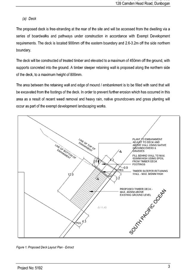
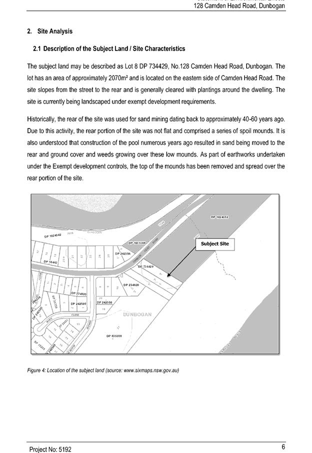
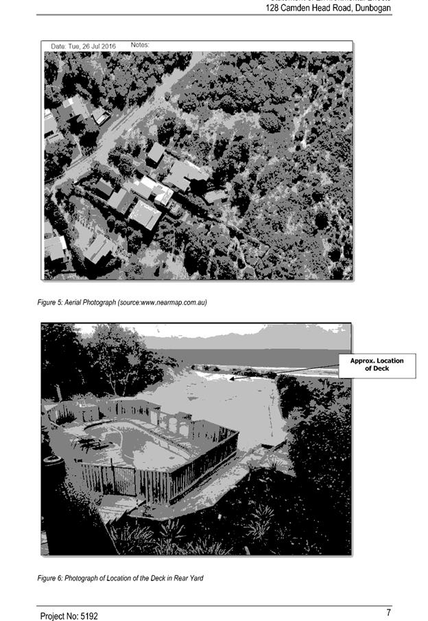
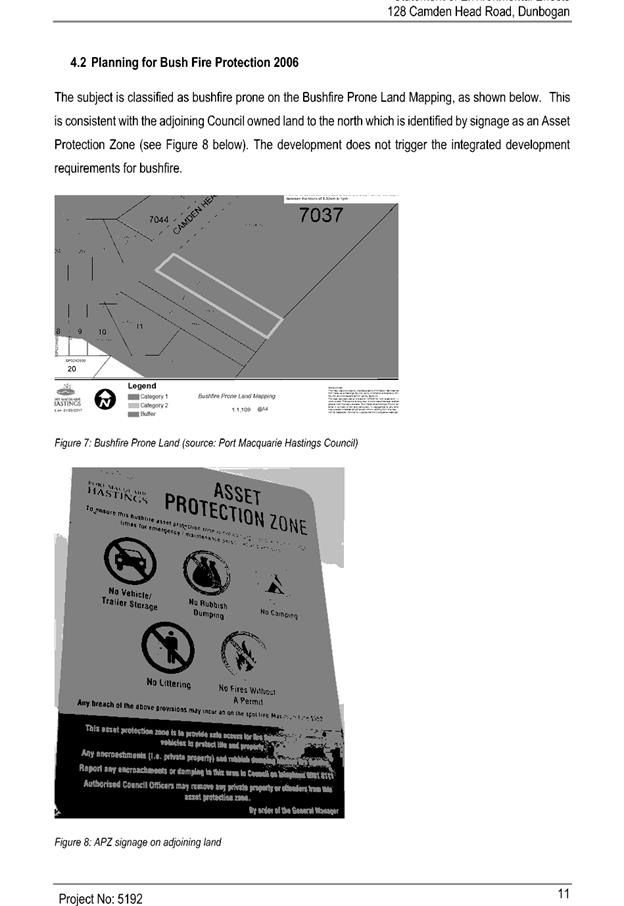
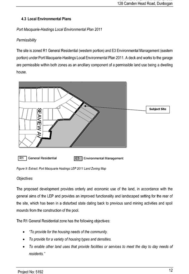
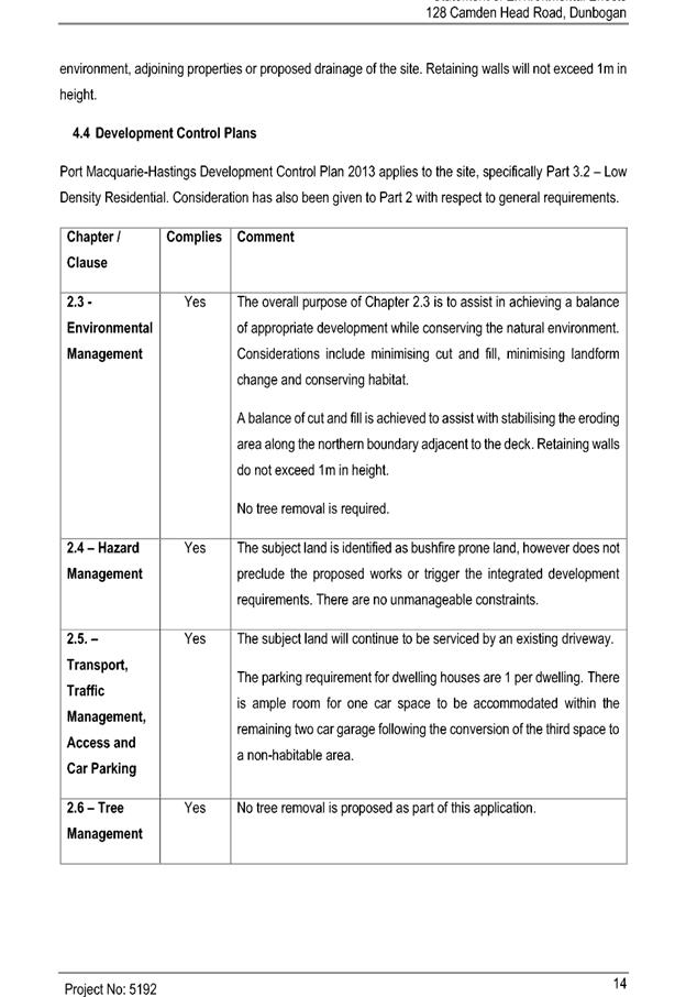
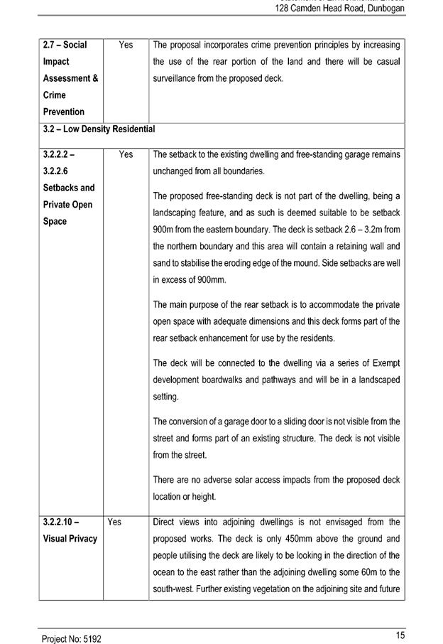
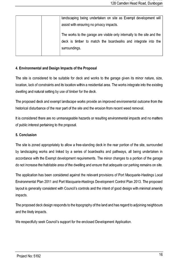
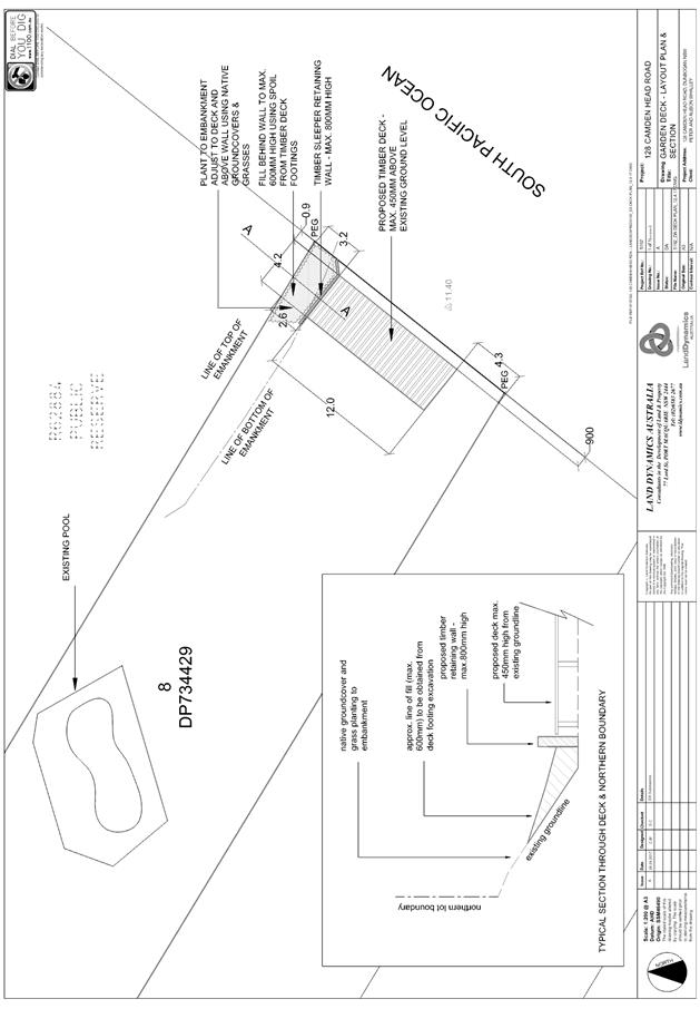
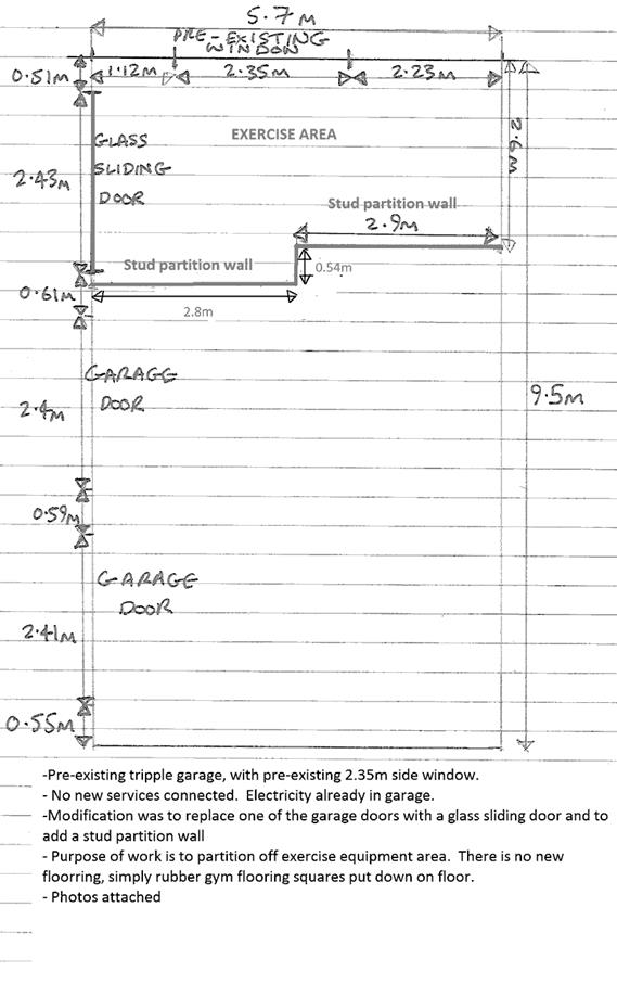


|
ATTACHMENT
|
Development Assessment Panel
09/08/2017
|
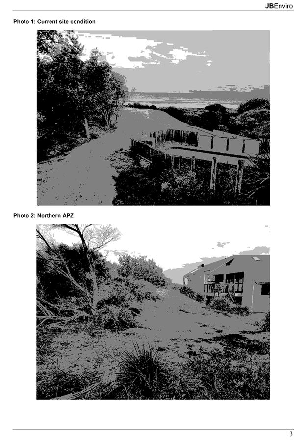
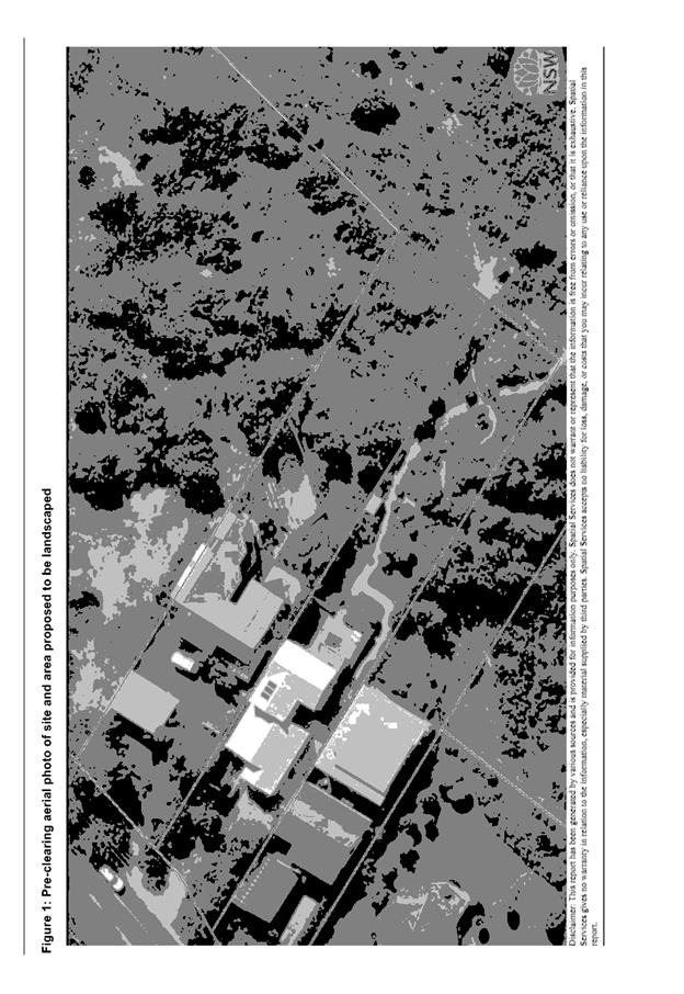
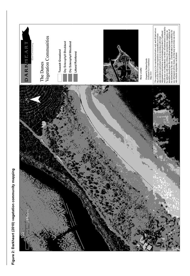
|
ATTACHMENT
|
Development Assessment Panel
09/08/2017
|
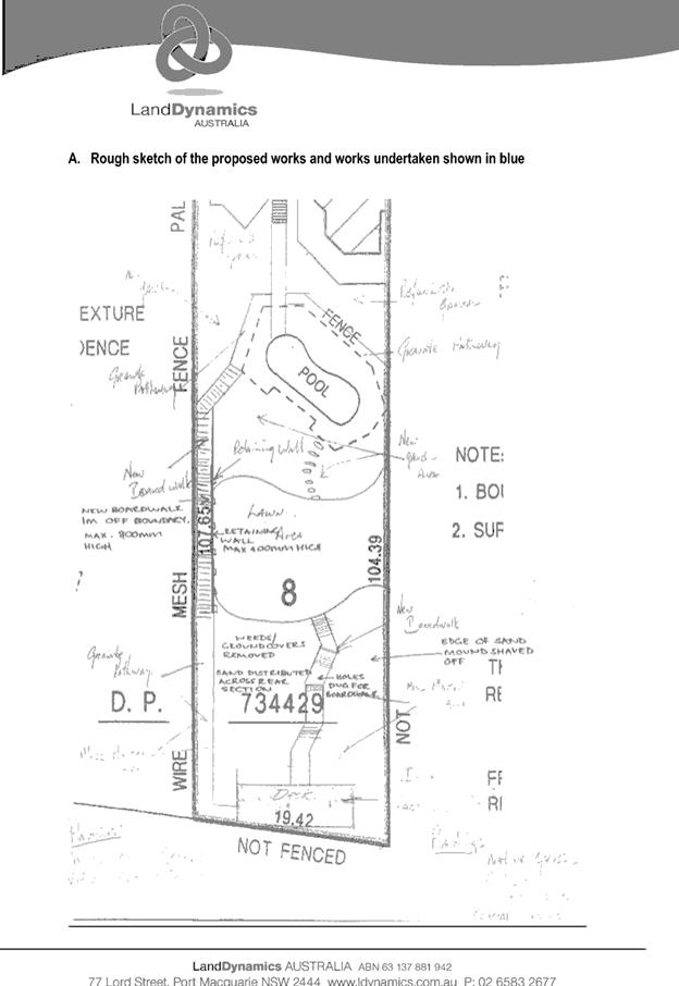
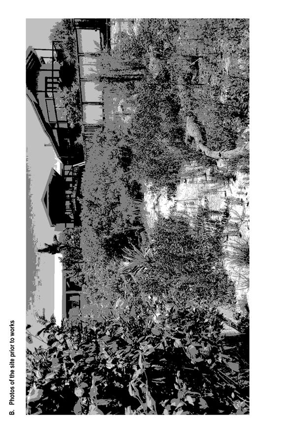
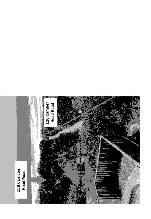
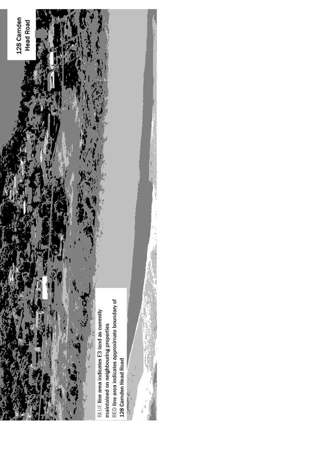
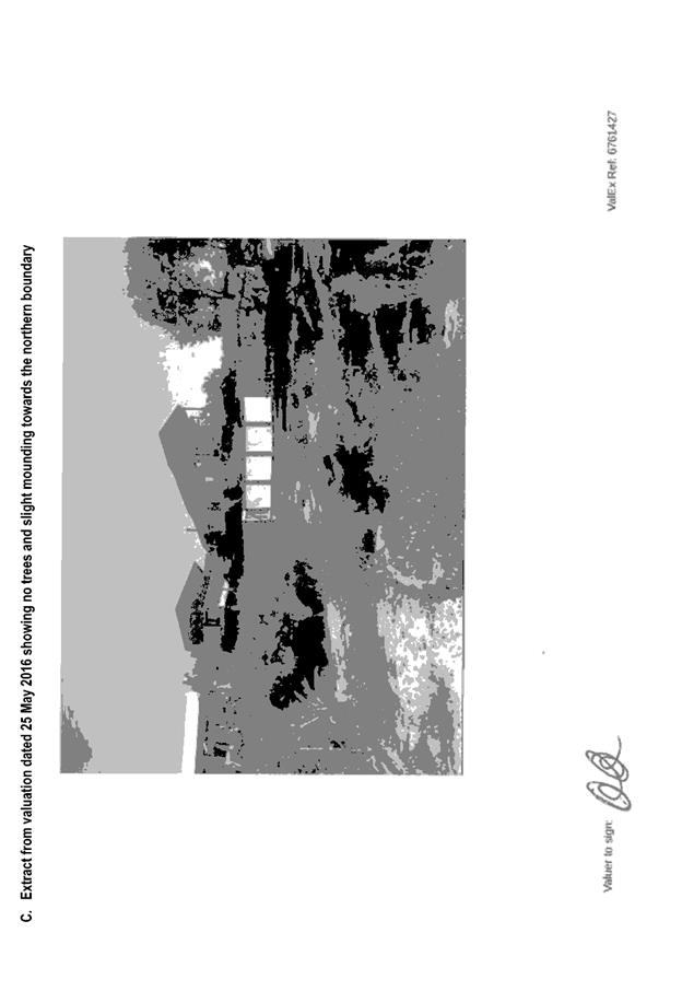
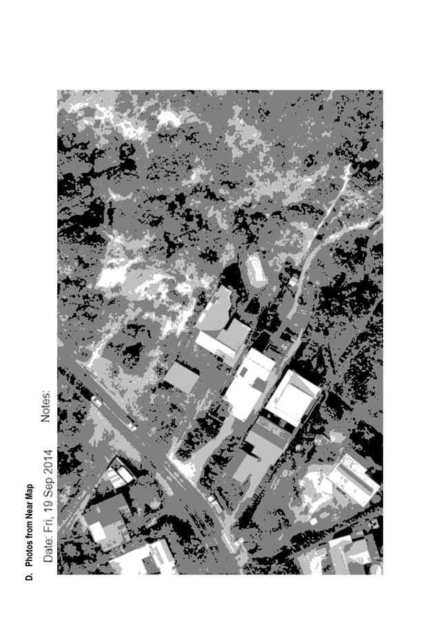
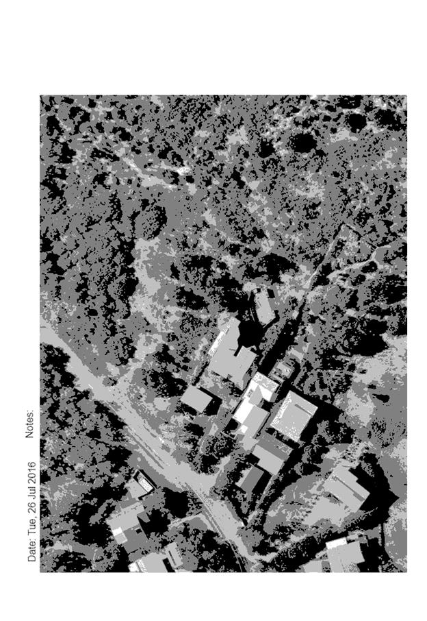
|
ATTACHMENT
|
Development Assessment Panel
09/08/2017
|
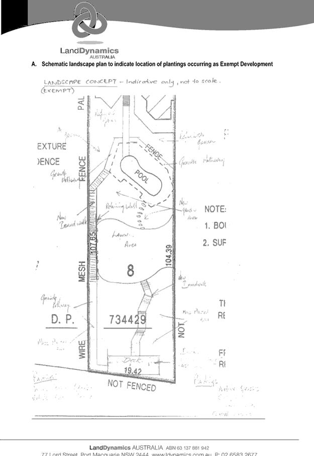
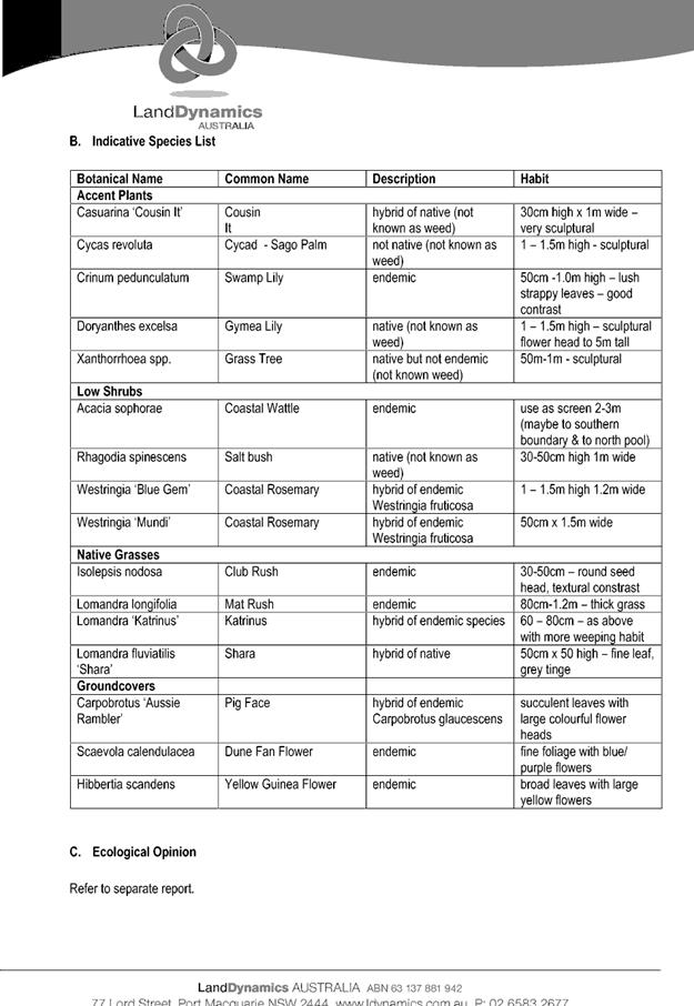
|
ATTACHMENT
|
Development Assessment Panel
09/08/2017
|
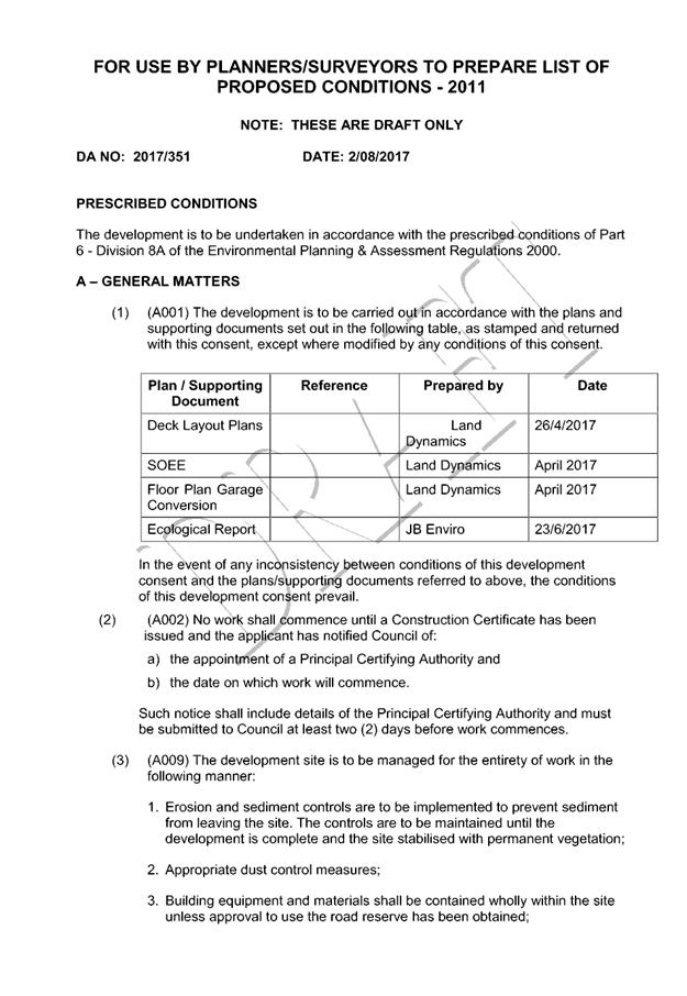
|
ATTACHMENT
|
Development Assessment Panel
09/08/2017
|
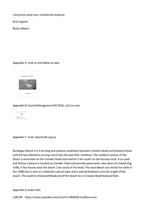
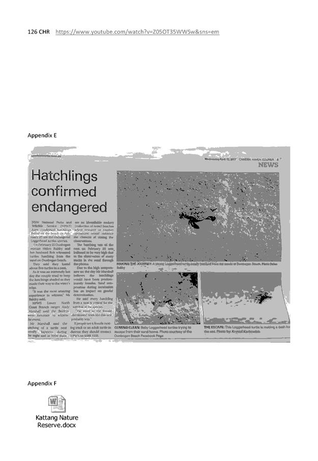
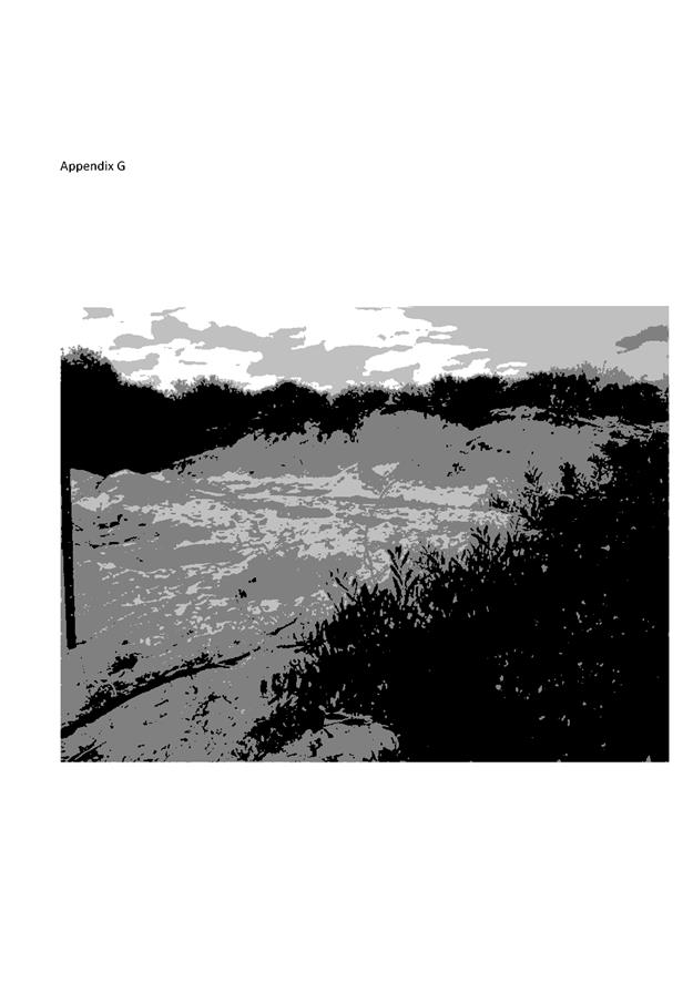
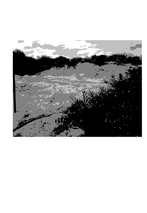
|
ATTACHMENT
|
Development Assessment Panel
09/08/2017
|
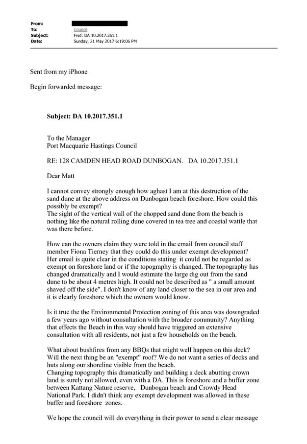

|
ATTACHMENT
|
Development Assessment Panel
09/08/2017
|
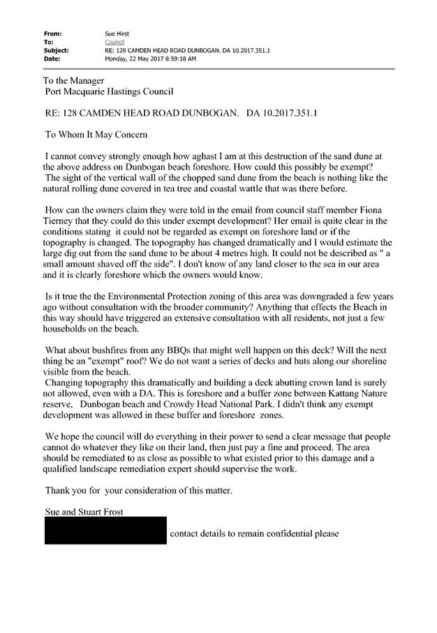
|
ATTACHMENT
|
Development Assessment Panel
09/08/2017
|
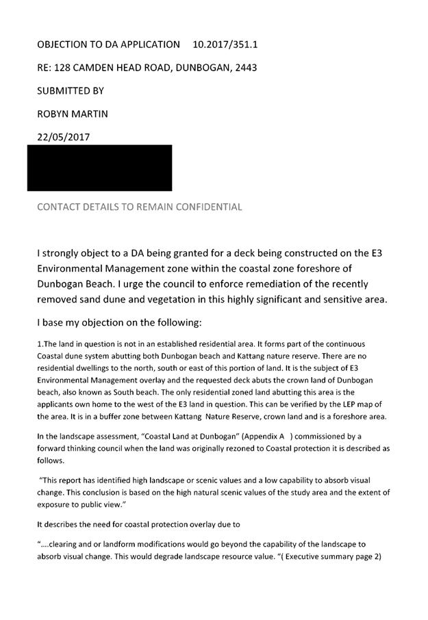
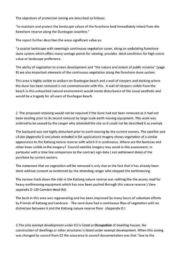
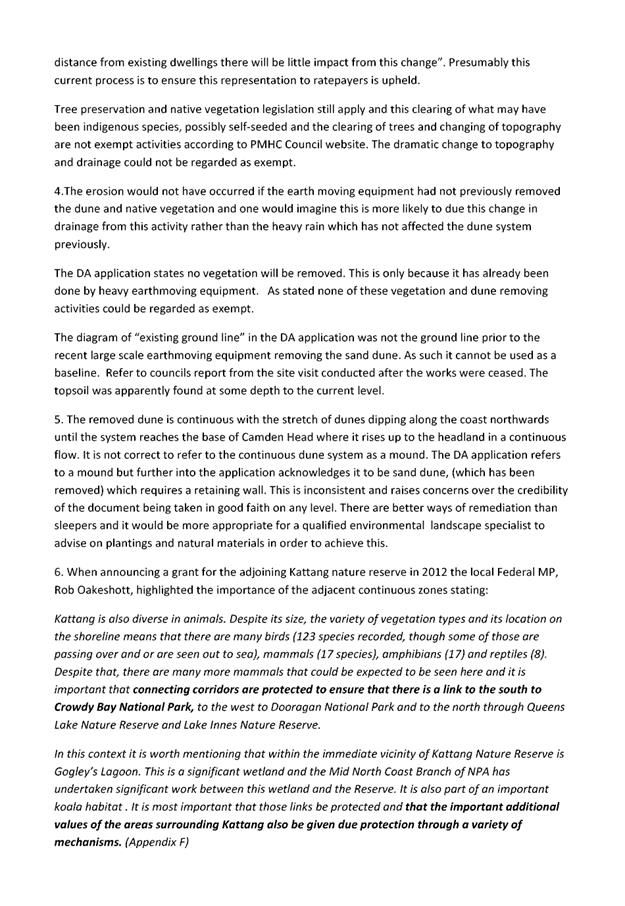

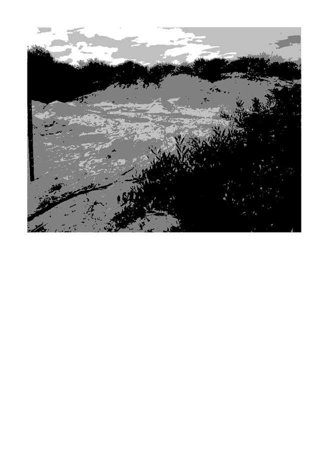
|
ATTACHMENT
|
Development Assessment Panel
09/08/2017
|
|
ATTACHMENT
|
Development Assessment Panel
09/08/2017
|
|
ATTACHMENT
|
Development Assessment Panel
09/08/2017
|
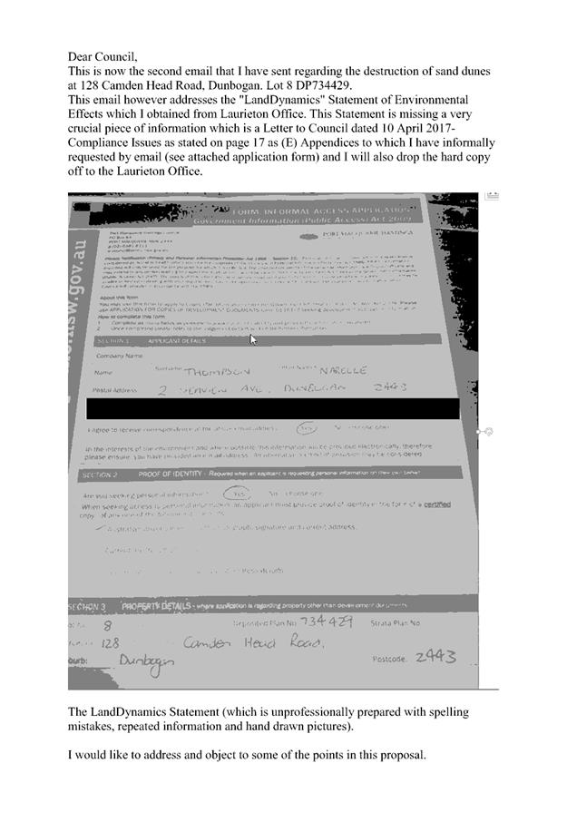
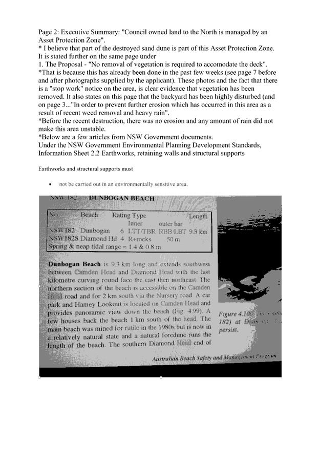
|
ATTACHMENT
|
Development Assessment Panel
09/08/2017
|