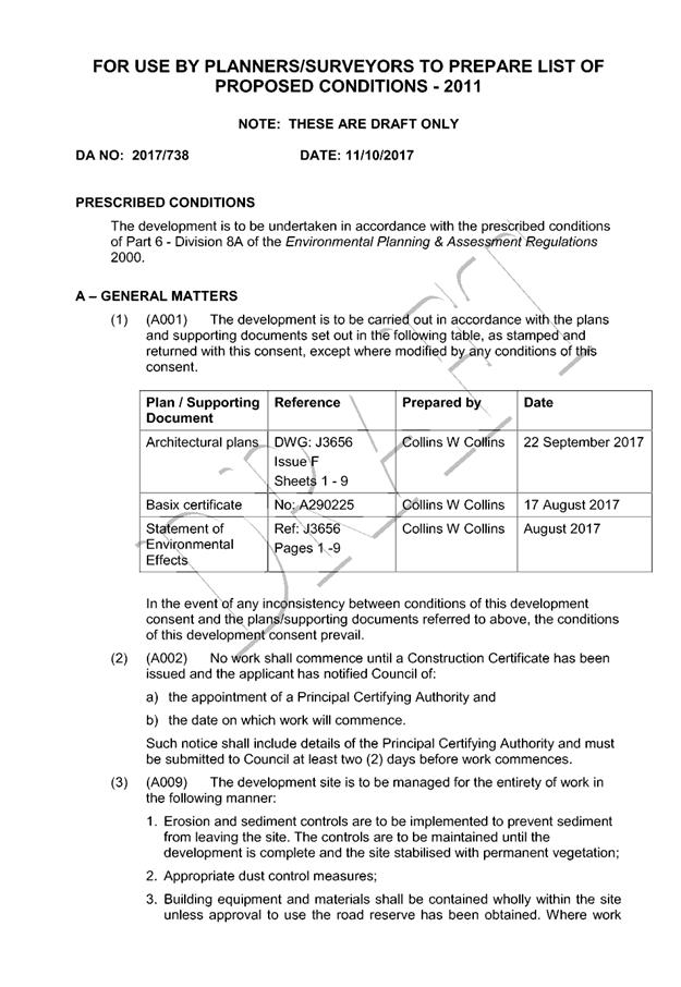
Business
Paper
|
date of meeting:
|
|
Wednesday 25 October
2017
|
|
location:
|
|
Function Room
Port
Macquarie-Hastings Council
17 Burrawan Street
Port Macquarie
|
|
time:
|
|
2:00pm
|
Development
Assessment Panel
CHARTER
1.0 OBJECTIVES
To assist in managing Council's development assessment
function by providing independent and expert determinations of development
applications that fall outside of staff delegations.
2.0 KEY FUNCTIONS
·
To review development application reports and conditions;
·
To determine development
applications outside of staff delegations;
·
To refer development applications
to Council for determination where necessary;
·
To provide a forum for objectors and applicants
to make submissions on applications
before the Development Assessment Panel
(DAP);
·
To maintain transparency in the determination of development
applications.
Delegated Authority of Panel
Pursuant to
Section 377 of the Local Government Act, 1993 delegation to:
·
Determine development applications under Part 4
of the Environmental Planning and Assessment
Act 1979 having
regard to the relevant environmental planning instruments,
development control plans and Council policies.
·
Vary, modify or release restrictions as to use
and/or covenants created by Section 88B instruments under the Conveyancing Act
1919 in relation to development applications for subdivisions being considered
by the panel.
·
Determine Koala Plans of Management under State
Environmental Planning Policy 44 - Koala Habitat Protection associated with
development applications being considered by the Panel.
Noting the trigger to escalate
decision making to Council as highlighted in section 5.2.
3.0
MEMBERSHIP
3.1
Voting
Members
·
Two independent external members. One of the
independent external members to be the Chairperson.
·
Group Manager Development Assessment (alternate
- Director Development & Environment or Development Assessment Planner)
The independent external members shall have expertise in
one or more of the following areas: planning, architecture, heritage, the
environment, urban design, economics, traffic and transport, law, engineering,
government and public administration.
3.2
Non-Voting Members
·
Not applicable
3.3 Obligations
of members
·
Members must act faithfully and diligently and
in accordance with this Charter.
·
Members must comply with Council's Code of Conduct.
·
Except as required to properly perform their
duties, DAP members must not
disclose any confidential information (as advised by Council) obtained in connection with the DAP functions.
·
Members will have read and be familiar with the
documents and information provided by Council prior
to attending a DAP meeting.
·
Members must act in accordance with Council's
Workplace Health and Safety Policies and Procedures
·
External members of the Panel are not authorised
to speak to the media on behalf of Council. Council officers that are members
of the Committee are bound by the
existing operational delegations in relation to speaking to the media.
·
Staff members shall not vote on matters before
the Panel if they have been the principle author of the development assessment report.
3.4
Member Tenure
·
The independent external members will be
appointed for the term of four (4) years
maximum in which the end of the tenure of these members would occur in a
cascading arrangement.
3.5 Appointment
of members
·
The independent external members (including the
Chair) shall be appointed by the General Manager following an external
Expression of Interest process.
·
Staff members of the Panel are in accordance
with this Charter.
4.0 TIMETABLE
OF MEETINGS
·
The Development Assessment Panel will generally
meet on the 1st and 3rd Wednesday each month at 2.00pm at the Port Macquarie
offices of Council.
·
Special Meetings of the Panel may be convened by
the Director Development & Environment Services with three (3) days notice.
5.0
MEETING PRACTICES
5.1
Meeting
Format
·
At all Meetings of the Panel the Chairperson
shall occupy the Chair and preside. The Chair will be responsible for keeping
of order at meetings.
·
Meetings shall be open to the public.
·
The Panel will hear from applicants
and objectors or their r e p r e s e n t a t i v e s .
·
Where considered necessary, the Panel will
conduct site inspections which will
be open to the public.
5.2
Decision Making
·
Decisions are to be made by consensus. Where
consensus is not possible on any item, that item is to be referred to Council
for a decision.
·
All development applications involving a
proposed variation to a development standard
greater than 10% under Clause
4.6 of the Local Environmental Plan will be
considered by the Panel and recommendation made to the Council for a decision.
5.3
Quorum
·
All members (2 independent external members and
1 staff member) must be present at a
meeting to form a quorum.
5.4
Chairperson and Deputy Chairperson
·
Independent Chair (alternate, second independent member)
5.5
Secretariat
·
The Director Development &n Environment is
to be responsible for ensuring that the Panel has adequate secretariat support.
The secretariat will ensure that the business paper and supporting papers are
circulated at least three (3) days prior to
each meeting. Minutes shall be appropriately approved and circulated to each
member within three (3) weeks of a meeting being held.
·
The format of and the preparation and publishing
of the Business Paper and Minutes shall be similar to the format for Ordinary
Council Meetings.
5.6
Recording of decisions
·
Minutes will record decisions and how each
member votes for each item before the Panel.
6.0 CONVENING
OF “OUTCOME SPECIFIC” WORKING GROUPS
Not applicable.
7.0 CONFIDENTIALITY
AND CONFLICT OF INTEREST
·
Members of the Panel must comply with the
applicable provisions of Council’s Code of Conduct. It is the personal
responsibility of members to comply with the standards in the Code of Conduct
and regularly review their personal circumstances with this in mind.
·
Panel members must declare any conflict of
interests at the start of each meeting or before discussion of a relevant item
or topic. Details of any conflicts of interest should be appropriately minuted.
Where members are deemed to have a real or perceived conflict of interest, it
may be appropriate they be excused from deliberations on the issue where the
conflict of interest may exist. A Panel meeting may be postponed where there is
no quorum.
8.0 LOBBYING
·
All members and applicants are to adhere to
Council’s Lobbying policy. Outside of
scheduled Development Assessment Panel meetings, applicants, their
representatives, Councillors, Council staff and the general public are not to
lobby Panel members via meetings, telephone conversations, correspondence and
the like. Adequate opportunity will be provided at Panel inspections or
meetings for applicants, their representatives and the general public to make
verbal submissions in relation to Business Paper items.
Development Assessment Panel
ATTENDANCE
REGISTER
|
Member
|
09/08/17
|
23/08/17
|
13/09/17
|
27/09/17
|
11/10/17
|
|
Paul Drake
|
P
|
P
|
P
|
P
|
P
|
|
Robert Hussey
|
-
|
-
|
P
|
P
|
P
|
|
David Crofts
(alternate member)
|
-
|
-
|
-
|
-
|
|
|
Dan Croft
(Group Manager Development
Assessment)
(alternates)
- Director Development & Environment
- Development Assessment Planner
|
P
|
P
|
P
P
|
P
|
P
|
Key: P = Present
A
= Absent With Apology
X
= Absent Without Apology
Development
Assessment Panel Meeting
Wednesday 25 October
2017
Items of Business
01 Acknowledgement
of Country............................................................................ 2
02 Apologies......................................................................................................... 2
03 Confirmation
of Minutes.................................................................................... 2
04 Disclosures
of Interest....................................................................................... 2
05 DA2017
- 738.1 Alterations And Additions To Dwelling - Lot 3 DP807508, No 31 The
Fairway Port Macquarie......................................................................................................... 2
06 DA2017
- 690.1 Dual Occupancy And Torrens Title Subdivision Lot 6 DP 1233221,
Scarborough Way, Dunbogan................................................................................................ 2
07 DA2015
- 913.1 Multi-Dwelling Housing (6 Dwellings) And Strata Title Subdivision - Lot
27 DP 1213714, No 20 Bluewren Close, Port Macquarie................................................. 2
08 DA2016
- 372.2 Modification To Residential Flat Building - Lot 3 DP 345930, No. 3 Gore
Street, Port Macquarie.................................................................................................. 2
09 DA2017
- 723.1 Alterations And Additions To Food And Drink Premises - Lot 1 DP 364377,
No. 76 William Street, Port Macquarie....................................................................... 2
10 General
Business
AGENDA Development Assessment Panel 25/10/2017
Subject: ACKNOWLEDGEMENT
OF COUNTRY
"I acknowledge that we are
gathered on Birpai Land. I pay respect to the Birpai Elders both past and
present. I also extend that respect to all other Aboriginal and Torres Strait
Islander people present."
RECOMMENDATION
That the apologies received be
accepted.
Subject: CONFIRMATION
OF PREVIOUS MINUTES
Recommendation
That the Minutes of the Development
Assessment Panel Meeting held on 11 October 2017 be confirmed.
MINUTES
Development Assessment Panel Meeting
11/10/2017
PRESENT
Members:
Paul
Drake
Robert Hussey
Dan Croft
Other Attendees:
Pat Galbraith-Robertson
Chris Gardiner
David Troemel
|
The meeting opened at 2:00pm.
|
|
01 ACKNOWLEDGEMENT
OF COUNTRY
|
|
The
Acknowledgement of Country was delivered.
|
|
03 CONFIRMATION
OF MINUTES
|
|
CONSENSUS:
That
the Minutes of the Development Assessment Panel Meeting held on 27 September
2017 be confirmed.
|
|
04 DISCLOSURES
OF INTEREST
|
|
There were no disclosures of interest presented.
|
|
05 Section 96
modification to DA2016 - 544.2 - Modification To Design Of Previous Approved Dwelling
As Part Of A Dual Occupancy And Strata Subdivision - Lot 91 DP 18138, No 28
Arncliffe Avenue, Port Macquarie
|
|
CONSENSUS:
That
the Section 96 modification application to DA 2016 - 544 for a modification to design of previous approved
dwelling and strata subdivision at Lot 91, DP 18138, No. 28
Arncliffe Avenue, Port Macquarie, be determined by granting the modified consent subject
to:
1. Amend condition A(1) to reflect the modified plans and BASIX
Certificate to be approved;
2. Amend condition B (11) to require that the plans submitted with
the application for Construction Certificate include openings no greater than
25% for the 1.8m height privacy screen on the eastern elevation of the deck
associated with the new second dwelling; and
3. Add condition B(12) to ensure compliance with AS 2890.
Condition worded as follows:
B(12)
The design of the carpark and accesses is to be in accordance with Australian
Standard 2890. The access driveway shall be a minimum of 3m wide and located
a minimum of 300mm clear of proposed Strata boundary. Certification of
the design by a suitably qualified consultant is to be provided to the
Principal Certifying Authority prior to release of the Construction
Certificate.
|
|
06 DA2017 - 732.1
- Temporary Events (Long Point Vineyard) - Lot 33 DP 789730 No 6 Cooinda
Place, Lake Cathie
|
|
Speakers:
Elizabeth Smith (o)
Melanie Leitch (applicant)
CONSENSUS:
That DA
2017 - 732 for Temporary Events (Long Point
Vineyard) at Lot 33, DP 789730, No. 6 Cooinda Place, Lake
Cathie, be determined by granting consent subject
to the recommended conditions and as amended below:
·
Amend condition A(3) to read:
‘This consent only permits a maximum of two(2) events in a 12 month
period from the date of this consent. Should more events be proposed after
this time then a new Development Application will be required to be lodged.
·
Amend condition A5
to read: ‘No parking of vehicles shall be permitted within the
public road reserves and/or either side of the internal driveway between the
vineyard plantings. Parking attendants are to be on site for the duration of
the event to ensure this condition is complied with.’
·
Delete condition
A(8)
·
Amend condition A(9)
to read: ‘Prior to each event, a
Traffic and Parking Management Plan shall be submitted to and approved by
Council. Event staff are to be made aware of the approved management plan
requirements.’
·
Amend condition B(2) to read: Hours
of operation of the events are restricted to 12 midday to 7 pm on Saturdays
only (gates are to be closed at 8pm).
·
Additional condition in Section B of the consent to read:
‘Security guards are to be on-site for the duration of the event to
control the behaviour of patrons.’
|
|
07 DA2017 - 466.1
2 Lot Subdivision at Lot 14 Sec B DP 24850, No 19 Regent Street, Port
Mcquarie
|
|
A.
Speakers:
B.
Donna Clarke (applicant)
C.
Claire Mathieson (applicant)
CONSENSUS:
That DA
2017 – 466.1 for a 2 lot
subdivision at Lot 14, Sec B, DP 24850, No. 19 Regent Street, Port
Macquarie, be determined by granting consent
subject to the recommended conditions and as amended below:
- Amend condition B(12) to read:
The unnamed road stub fronting the site is to be extended
as follows:
a) To provide at
least four (4) metres of road frontage to proposed Lot 2(measured parallel to
the lot boundary), to allow any driveway access to Lot 2 to be made at 90
degrees to the road,
b) The end of the
road is to be square, with the sides of the road to be formed with standard
barrier (SA) type kerb and gutter, and the end of the road to be formed with
a 300mm wide concrete edge strip,
c) Drainage
transitions into nearby stormwater pits are required. Pits shall be augmented
or relocated.
d) Details are to be
approved by Council under s138 of the Roads Act prior to or concurrently with
Construction Certificate approval.
D.
- Amend condition
E(12) to read:
The plan of subdivision and Section 88B instrument shall
establish the
following restrictions, easements and/or covenants; with
Council having the
benefit and having the sole authority to release, vary or
modify each
restriction, easement and/or covenant. Wherever possible
the extent of the
land affected by these covenants shall be defined by
bearings and distances
shown on the plan of subdivision. Changes to these
conditions (for example,
as a result of a refined stormwater analysis being
accepted by Council) will
require a DA s96 modification.
a)
Both proposed Lots 1 and 2 shall be
burdened by a positive covenant requiring all waste bins to be placed on
Regent Street at the time of collection by public waste contractors.
b)
Proposed Lot 2 shall be burdened by a
restriction as to user prohibiting the erection of any building with a floor
level less than RL 33.5m AHD.
c)
Provision of an easement to drain
water benefitting Council with a minimum width of 6m (or lessor width where
agreed to by Council to account for required overland stormwater flows)
adjacent to the western boundary of proposed Lot 2 and over the existing
public drainage within the site, or alternatively provision of proof that an
easement exists for this purpose and is 6m wide to contain overland flows.
d)
A restriction as to user burdening
proposed Lot 2 prohibiting vehicular access across the front (southern)
boundary a minimum 4m from the eastern boundary of proposed Lot 2 and where
the public road is formed adjacent to vehicle access.
|
|
08 DA2017 -
726.1 Dwelling - Lot 63 DP 1096722, No 8 Candlebark Court, Lakewood
|
|
E.
F.
A submission from Peter and Katherine
Mooney dated 9/10/17 objecting to the proposal was tabled at the meeting.
G.
H.
Speakers:
Lynn Spillane (o)
I.
Amanda Cahill (o)
CONSENSUS:
That DA
2017 - 726.1 for a dwelling at Lot 63, DP
1096722, No. 8 Candlebark Court, Lakewood be determined by granting consent
subject to the recommended conditions.
|
|
09 DA2017 - 771.1
Dwelling, Pool And Shed - Lot 3 DP 1183709, No 371B Ocean Drive, West Haven
|
|
CONSENSUS:
That DA
2017 – 771.1 for a dwelling, pool and
shed at Lot 3 DP1183709 No. 371B Ocean
Drive, West Haven be determined by granting consent subject to the
recommended conditions.
|
|
The meeting closed at 3:40pm.
|
AGENDA Development Assessment Panel 25/10/2017
Subject: DISCLOSURES
OF INTEREST
RECOMMENDATION
That Disclosures of Interest be presented
DISCLOSURE OF
INTEREST DECLARATION
Name of Meeting: ………………………………………………………………………..
Meeting Date: ………………………………………………………………………..
Item Number: ………………………………………………………………………..
Subject: ………………………………………………………………………..
…………………………………………………….……………...…..
I,
.....................................................................................
declare the following interest:
 Pecuniary:
Take
no part in the consideration and voting and be out of sight of the meeting.
Non-Pecuniary
- Significant Interest:
Take
no part in the consideration and voting and be out of sight of the meeting.
Non-Pecuniary
- Less than Significant Interest:
May
participate in consideration and voting.
For the reason that: ....................................................................................................
.......................................................................................................................................
Name: …………………………………………………….
Signed:
.........................................................................
Date: ..................................
 (Further
explanation is provided on the next page)
(Further
explanation is provided on the next page)
Further
Explanation
(Local Government Act and Code of Conduct)
A conflict of interest exists where a reasonable and informed
person would perceive that a Council official could be influenced by a private
interest when carrying out their public duty. Interests can be of two types:
pecuniary or non-pecuniary.
All interests, whether pecuniary or non-pecuniary are required to
be fully disclosed and in writing.
Pecuniary Interest
A pecuniary interest is an interest that a Council official has in
a matter because of a reasonable likelihood or expectation of appreciable
financial gain or loss to the Council official. (section 442)
A Council official will also be taken to have a pecuniary interest
in a matter if that Council official’s spouse or de facto partner or a
relative of the Council official or a partner or employer of the Council
official, or a company or other body of which the Council official, or a
nominee, partner or employer of the Council official is a member, has a
pecuniary interest in the matter. (section 443)
The Council official must not take part in the consideration or
voting on the matter and leave and be out of sight of the meeting. The
Council official must not be present at, or in sight of, the meeting of
the Council at any time during which the matter is being considered or discussed,
or at any time during which the council is voting on any question in relation
to the matter. (section 451)
Non-Pecuniary
A non-pecuniary interest is an interest that is private or
personal that the Council official has that does not amount to a pecuniary
interest as defined in the Act.
Non-pecuniary interests commonly arise out of family, or personal
relationships, or involvement in sporting, social or other cultural groups and
associations and may include an interest of a financial nature.
The political views of a Councillor do not constitute a private
interest.
The management of a non-pecuniary interest will depend on whether
or not it is significant.
Non Pecuniary – Significant Interest
As a general rule, a non-pecuniary conflict of interest will be
significant where a matter does not raise a pecuniary interest, but it
involves:
(a)
A relationship between
a Council official and another person that is particularly close, for example,
parent, grandparent, brother, sister, uncle, aunt, nephew, niece, lineal
descendant or adopted child of the Council official or of the Council official’s
spouse, current or former spouse or partner, de facto or other person living in
the same household.
(b)
Other relationships
that are particularly close, such as friendships and business relationships.
Closeness is defined by the nature of the friendship or business relationship,
the frequency of contact and the duration of the friendship or relationship.
(c)
An affiliation between
a Council official an organisation, sporting body, club, corporation or
association that is particularly strong.
If a Council official declares a non-pecuniary significant
interest it must be managed in one of two ways:
1.
Remove the source of
the conflict, by relinquishing or divesting the interest that creates the
conflict, or reallocating the conflicting duties to another Council official.
2.
Have no involvement in
the matter, by taking no part in the consideration or voting on the matter and
leave and be out of sight of the meeting, as if the provisions in section
451(2) apply.
Non Pecuniary – Less than Significant Interest
If a Council official has declared a non-pecuniary less than
significant interest and it does not require further action, they must provide
an explanation of why they consider that the conflict does not require further
action in the circumstances.
SPECIAL
DISCLOSURE OF PECUNIARY INTEREST DECLARATION
|
By
[insert full name of councillor]
|
|
|
In the
matter of
[insert name of environmental planning instrument]
|
|
|
Which is
to be considered at a meeting of the
[insert name of meeting]
|
|
|
Held on
[insert date of meeting]
|
|
|
PECUNIARY
INTEREST
|
|
Address of land in which councillor or an
associated person, company or body has a proprietary interest (the identified
land)i
|
|
|
Relationship of identified land to councillor
[Tick or cross one box.]
|
Councillor
has interest in the land (e.g. is owner or has other interest arising out of
a mortgage, lease trust, option or contract, or otherwise).
Associated
person of councillor has interest in the land.
Associated
company or body of councillor has interest in the land.
|
|
MATTER
GIVING RISE TO PECUNIARY INTEREST
|
|
Nature of land that is subject to a change
in zone/planning control by proposed
LEP (the subject land iii
[Tick or cross one box]
|
The
identified land.
Land
that adjoins or is adjacent to or is in proximity to the identified land.
|
|
Current zone/planning control
[Insert name of current planning instrument and
identify relevant zone/planning control applying to the subject land]
|
|
|
Proposed change of zone/planning control
[Insert name of proposed LEP and identify
proposed change of zone/planning control applying to the subject land]
|
|
|
Effect of proposed change of zone/planning control
on councillor
[Tick or cross one box]
|
Appreciable
financial gain.
Appreciable
financial loss.
|
|
|
|
Councillor’s
Name: …………………………………………
Councillor’s
Signature:
……………………………….
Date: ………………..
Important Information
This information is being
collected for the purpose of making a special disclosure of pecuniary interests
under sections 451 (4) and (5) of the Local Government Act 1993.
You must not make a special disclosure that you know or ought reasonably to
know is false or misleading in a material particular. Complaints made
about contraventions of these requirements may be referred by the
Director-General to the Local Government Pecuniary Interest and Disciplinary
Tribunal.
This form must be completed by
you before the commencement of the council or council committee meeting in
respect of which the special disclosure is being made. The
completed form must be tabled at the meeting. Everyone is entitled to
inspect it. The special disclosure must be recorded in the minutes of the
meeting.
i.
Section 443 (1) of the Local Government Act 1993 provides that
you may have a pecuniary interest in a matter because of the pecuniary interest
of your spouse or your de facto partner or your relativeiv or
because your business partner or employer has a pecuniary interest. You may
also have a pecuniary interest in a matter because you, your nominee, your
business partner or your employer is a member of a company or other body that
has a pecuniary interest in the matter.
ii.
Section 442 of the Local Government Act 1993 provides that a pecuniary
interest is an interest that a person has in a matter because of a
reasonable likelihood or expectation of appreciable financial gain or loss to
the person. A person does not have a pecuniary interest in a matter if the
interest is so remote or insignificant that it could not reasonably be regarded
as likely to influence any decision the person might make in relation to the
matter or if the interest is of a kind specified in section 448 of that
Act (for example, an interest as an elector or as a ratepayer or person liable
to pay a charge).
iii.
A pecuniary interest may arise by way of a change of permissible use of land
adjoining, adjacent to or in proximity to land in which a councillor or a
person, company or body referred to in section 443 (1) (b) or (c) of the
Local Government Act 1993 has a proprietary interest..
iv.
Relative is defined by the Local Government Act 1993 as
meaning your, your spouse’s or your de facto partner’s parent,
grandparent, brother, sister, uncle, aunt, nephew, niece, lineal descendant or
adopted child and the spouse or de facto partner of any of those persons.
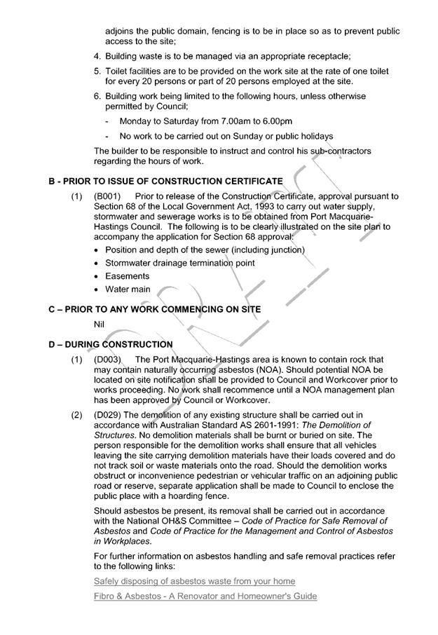
AGENDA Development Assessment Panel 25/10/2017
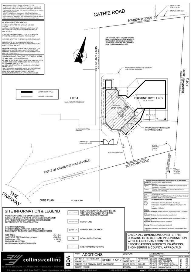
Item: 05
Subject: DA2017 - 738.1 Alterations And Additions To
Dwelling - Lot 3 DP807508, No 31 The Fairway Port Macquarie
Report
Author: Stephen Ryan
|
Dditions to a dwellingant: Graham Wood
c/- Collins W Collins
Owner: G
T Wood
Estimated Cost: $150,000
Alignment with Delivery
Program
4.3.1 Undertake transparent
and efficient development assessment in accordance with relevant legislation.
|
|
RECOMMENDATION
That
DA 2017 – 738.1 for alterations
and additions to a dwelling at Lot 3, DP 807508, No. 31 The Fairway, Port Macquarie, be determined by
granting consent subject to the recommended conditions.
|
Executive
Summary
This
report considers a development application for additions to a dwelling at the subject site and provides an assessment of the
application in accordance with the Environmental Planning and Assessment Act
1979.
Following exhibition of the
application, 3 submissions have been received.
1. BACKGROUND
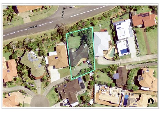
Existing sites features and surrounding development
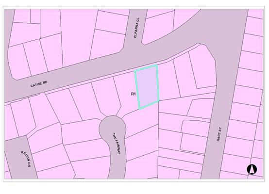
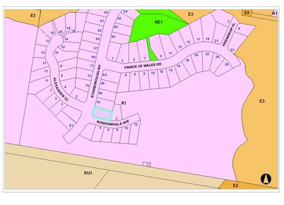
The site has an area of 941.9m².
The site is zoned R1 in
accordance with the Port Macquarie-Hastings Local Environmental Plan 2011, as
shown in the following zoning plan:
The existing subdivision pattern and location of existing
development within the locality is shown in the following aerial photograph:
2. DESCRIPTION OF
DEVELOPMENT
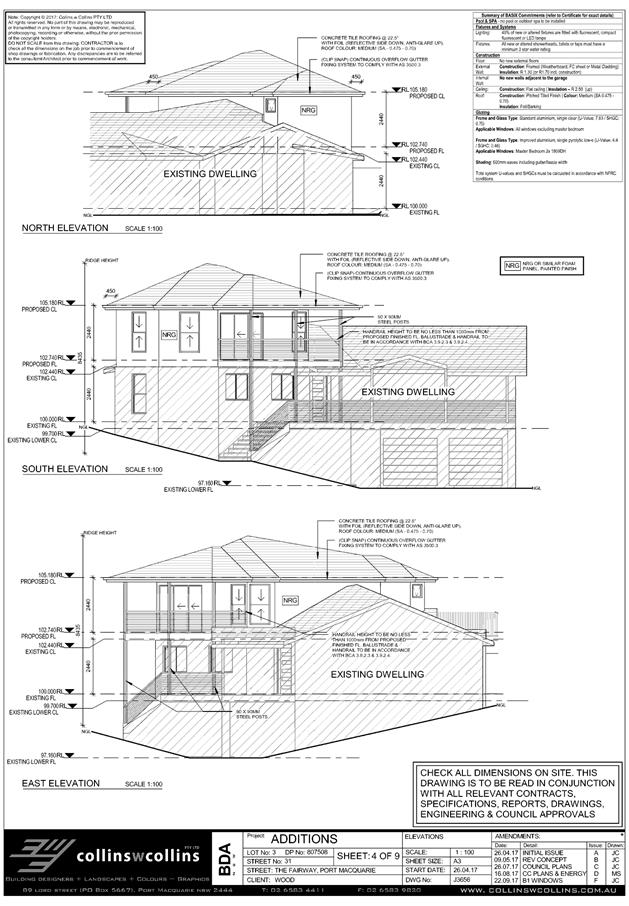
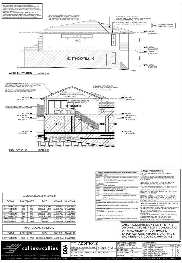
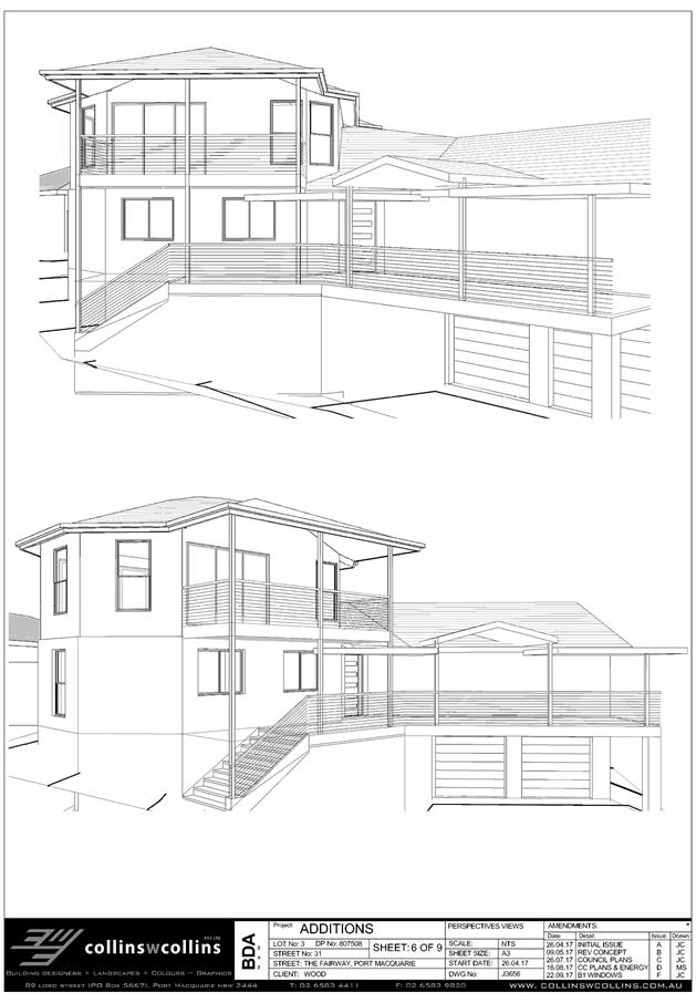
Key aspects of the proposal include the following:
· Additions
to dwelling comprising second storey addition including front upper level deck.
Refer
to attachments at the end of this report.
Application Chronology
· 22 August 2017 - Application lodged
· 1 September 2017 – 14 September 2017 - Exhibition via
neighbour notification
· 11 September 2017- 2 Submissions received.
· 15 September 2017- Email sent to applicant advising of
neighbour concerns.
· 22 September 2017- Revised plans & statement received
addressing neighbour concerns.
· 26 September 2017- 1 Submission received.
3. STATUTORY ASSESSMENT
Section 79C(1) Matters for Consideration
In determining the application, Council is required to take
into consideration the following matters as are relevant to the development
that apply to the land to which the development application relates:
(a) The provisions (where
applicable) of:
(i) any Environmental
Planning Instrument:
State Environmental Planning Policy No.
44 - Koala Habitat Protection
There is no Koala Plan of
Management on the site. Additionally, the site is less than 1ha in area
therefore no further investigations are required.
State
Environmental Planning Policy No.55 – Remediation of Land
Following an inspection of the site and a
search of Council records, the subject land is not identified as being
potentially contaminated and is suitable for the intended use.
State Environmental
Planning Policy No. 71 – Coastal Protection and Clause 5.5 of Port
Macquarie-Hastings Local Environmental Plan 2011
The site is not
located within a coastal zone as defined in accordance with clause 4 of SEPP
71.
State Environmental Planning Policy
(Building Sustainability Index: BASIX) 2004
A BASIX
certificate (number A290225) has been submitted demonstrating that the proposal
will comply with the requirements of the SEPP. It is recommended that a
condition be imposed to ensure that the commitments are incorporated into the
development and certified at Occupation Certificate stage.
Port
Macquarie-Hastings Local Environmental Plan 2011
The proposal is consistent with the LEP having regard to the
following:
· Clause 2.2,
the subject site is zoned R1 General Residential. In accordance with clause
2.3(1) and the R1 zone landuse table, the dwelling additions are a permissible
landuse with consent.
The objectives
of the R1 zone are as follows:
o To
provide for the housing needs of the community.
o To
provide for a variety of housing types and densities.
o To enable
other land uses that provide facilities or services to meet the day to day
needs of residents.
·
In accordance with Clause 2.3(2),
the proposal is consistent with the zone objectives as it is a permissible
landuse, contributes to the range of housing available in the Port
Macquarie-Hastings and is consistent with the established residential locality,
· Clause
2.7, the demolition requires consent as it does not fit within the provisions
of SEPP (Exempt and Complying) 2008.
· Clause
4.3, the maximum overall height of the building above ground level (existing)
is 8.435m which complies with the standard height limit of 8.5m applying to the
site.
· Clause
4.4, the floor space ratio of the proposal is 0.319:1.0 which complies with the
maximum 0.65.0:1 floor space ratio applying to the site.
· Clause7.13,
satisfactory arrangements are in place for provision of essential services.
(ii) Any
draft instruments that apply to the site or are on exhibition:
No draft
instruments apply to the site.
(iii) any
Development Control Plan in force:
Port
Macquarie-Hastings Development Control Plan 2013
|
DCP
2013: Dwellings, Dual occupancies, Dwelling houses, Multi dwelling houses
& Ancillary development
|
|
|
Requirements
|
Proposed
|
Complies
|
|
3.2.2.1
|
Ancillary development:
• 4.8m max. height
• Single storey
• 60m2 max. area
• 24 degree max.
roof pitch
• Not located in
front setback
|
|
N/A
|
|
3.2.2.4
|
4m min. rear setback.
Variation subject to site analysis and provision of private open space
|
18m
|
Yes
|
|
3.2.2.5
|
Side setbacks:
• Ground floor =
min. 0.9m
• First floors
& above = min. 3m setback or where it can be demonstrated that
overshadowing not adverse = 0.9m min.
• Building wall
set in and out every 12m by 0.5m
|
1.5m & 7.990m.
1.5m & 7.990m
(Sunlight
to the principal area of ground-level private open space of adjacent
properties is not reduced to less than 3 hours between 9.00am and 3.00pm on
June 21.)
9.964m
|
Yes
Yes
Yes
|
|
3.2.2.6
|
35m² min. private open
space area including a useable 4x4m min. area which has 5% max. grade
|
Available at rear
|
Yes
|
|
3.2.2.10
|
Privacy:
• Direct views
between living areas of adjacent dwellings screened when within 9m radius of
any part of window of adjacent dwelling and within 12m of private open space
areas of adjacent dwellings. ie. 1.8m fence or privacy screening which has
25% max. openings and is permanently fixed.
• Privacy screen
required if floor level > 1m height, window side/rear setback (other than
bedroom) is less than 3m and sill height less than 1.5m.
• Privacy screens
provided to balconies/verandahs etc which have <3m side/rear setback and
floor level height >1m
|
No direct views between living
areas of adjacent dwellings. Living areas greater than 9m to windows of
adjoining dwellings. High sill windows & screen provided to upper level
windows facing adjoining western dwelling. Windows within 12m of open space
of southern neighbour.
Privacy screen not required
for proposed upper level bedroom windows. (Changed to high sill windows)
Privacy screen proposed for sitting room window on south western side
adjoining boundary.
Deck floor greater than 1m in
height, however proposed setback greater than 3m from adjoining side
boundaries. Privacy screen not required.
|
Yes & No
Yes
Yes
|
|
DCP
2013: General Provisions
|
|
|
Requirements
|
Proposed
|
Complies
|
|
2.7.2.2
|
Design
addresses generic principles of Crime Prevention Through Environmental Design
guideline
|
Adequate casual surveillance
available
|
Yes
|
|
2.3.3.1
|
Cut and
fill 1.0m max. 1m outside the perimeter of the external building walls
|
None proposed
|
N/A
|
|
2.5.3.2
|
New accesses not permitted
from arterial or distributor roads
|
Maintains existing access
|
N/A
|
|
Driveway
crossing/s minimal in number and width including maximising street parking
|
Maintains existing driveway
crossover
|
Yes
|
|
2.5.3.3
|
Parking in accordance with Table 2.5.1.
1 space per
single dwelling (behind building line)
|
No change to existing parking
arrangements
|
N/A
|
|
2.5.3.11
|
Section 94 contributions
|
Refer to main body of report.
|
|
|
2.5.3.14
|
Sealed
driveway surfaces unless justified
|
|
Yes
|
|
2.5.3.17
|
Parking
areas to be designed to avoid concentrations of water runoff on the surface
|
Contained within site
|
Yes
|
|
Vehicle
washing facilities – grassed area etc available.
|
Available
|
Yes
|
The proposal
seeks to vary Development Provision relating to DP:3.2.2.10
The relevant
objectives are:
· To protect the visual privacy of on-site and nearby
residents.
Having regard
for the development provisions and relevant objectives, the variation is
considered acceptable for the following reasons:
· Upper
level windows are within 12m of the rear open space of southern neighbour. A
setback of 9.824m is proposed from the living area & 7.990m to the balcony.
· The
rear yard of the southern property is partially obscured by a tree located on
the subject site and a shade sail on the adjoining property.
· Due
to the elevated nature of the site, the potential for overlooking is considered
to be no greater than what already exists from existing dwelling & front
deck.
Based on the
above assessment, the variation proposed to the provisions of the DCP are
considered acceptable and the relevant objectives have been satisfied. The
variation does not amount to an adverse impact or a significance that would
justify refusal of the application.
(iiia) any
planning agreement that has been entered into under Section 93f or any draft
planning agreement that a developer has offered to enter into under Section
93f:
No planning agreement has been offered or entered into relating to the
site.
iv) any matters
prescribed by the Regulations:
New South Wales Coastal Policy:
The proposed development is consistent with the objectives and strategic
actions of this policy.
Demolition of buildings AS 2601:
N/A
v) any coastal
zone management plan (within the meaning of the Coastal Protection Act 1979),
that apply to the land to which the development application relates:
N/A
(b) The
likely impacts of that development, including environmental impacts on both the
natural and built environments, social and economic impacts in the locality:
Context and setting
Solar access-
· The
proposal will be unlikely to have any adverse impacts
in regard to solar access. (Sunlight to
the principal area of ground-level private open space of adjacent properties is
not reduced to less than 3 hours between 9.00am and 3.00pm on June 22.
·
Public
domain-
• The
proposal will be unlikely to have any adverse impacts to existing adjoining
properties and satisfactorily addresses the public domain.
• The
proposal is considered to be consistent with other residential development in
the locality and adequately addresses planning controls for the area.
·
View sharing-
• There
are no adverse impacts on existing view sharing.
·
Privacy-
· Privacy impacts in regard to the adjoining western property
bathrooms has been addressed from the change to high sill windows.
· Privacy impacts from the proposed works are considered to
be no greater than what already exists on the site.
Access, transport and traffic
The proposal will be unlikely to
have any adverse impacts in terms access, transport and traffic. The existing
road network will satisfactorily cater for any increase in traffic generation
as a result of the development.
Water Supply
Service available.
Sewer
Service available.
Stormwater
Service
available.
Other
Utilities
Telecommunication
and electricity services are available to the site.
Heritage
This site does not contain or adjoin any known heritage
item or site of significance.
Other land
resources
No adverse
impacts anticipated. The site is within an established urban context and will
not sterilise any significant mineral or agricultural resource.
Water
cycle
The proposed development
will be unlikely to have any adverse impacts on water resources and the water
cycle.
Soils
The proposed
development will be unlikely to have any adverse impacts on soils in terms of
quality, erosion, stability and/or productivity subject to a standard condition
requiring erosion and sediment controls to be in place prior to and during
construction.
Air and
microclimate
The
construction and/or operations of the proposed development will be unlikely to
result in any adverse impacts on the existing air quality or result in any
pollution.
Flora and
fauna
Construction
of the proposed development will not require any removal/clearing of any
significant vegetation and therefore will be unlikely to have any significant
adverse impacts on biodiversity or threatened species of flora and fauna.
Waste
Satisfactory
arrangements are in place for proposed storage and collection of waste and
recyclables. No adverse impacts anticipated.
Energy
The proposal includes measures to
address energy efficiency and will be required to comply with the requirements
of BASIX.
Noise and vibration
No adverse impacts anticipated.
Condition recommended to restrict construction to standard construction hours.
Bushfire
The site is not identified as
being bushfire prone.
Safety,
security and crime prevention
The proposed
development will be unlikely to create any concealment/entrapment areas or
crime spots that would result in any identifiable loss of safety or reduction
of security in the immediate area.
Social
impacts in the locality
Given the
nature of the proposed development and its’ location the proposal is
unlikely to result in any adverse social impacts.
Economic impact in the locality
No adverse impacts. Likely positive impacts can be attributed to the
construction of the development and associated flow on effects (i.e. increased
expenditure in the area).
Site design
and internal design
The proposed
development design is satisfactorily responds to the site attributes and will
fit into the locality. No adverse impacts likely.
Construction
No potential
adverse impacts identified to neighbouring properties with the construction of
the proposal.
Cumulative
impacts
The proposed
development is not expected to have any adverse cumulative impacts on the
natural or built environment or the social and economic attributes of the
locality.
(c) The
suitability of the site for the development
The proposal will
fit into the locality and the site attributes are conducive to the proposed
development.
(d) Any submissions made in
accordance with this Act or the Regulations:
Three (3) written submissions have been received following public
exhibition of the application.
Key issues raised in the submissions received and comments
in response to these issues are provided as follows:
|
Submission
Issue/Summary
|
Planning
Comment/Response
|
|
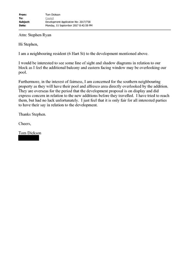
Eastern facing window &
balcony may be overlooking pool at 6 Hart Street.
|
Adequate separation in excess of DCP requirements is
provided between the proposed upper level deck and living areas, and the
adjoining boundary with 6 Hart Street. (12.715m from living areas, 10.9m from
deck.
|
|
Reduced sunlight to ensuite,
master bedroom, main bathroom & toilet of adjoining western property.
|
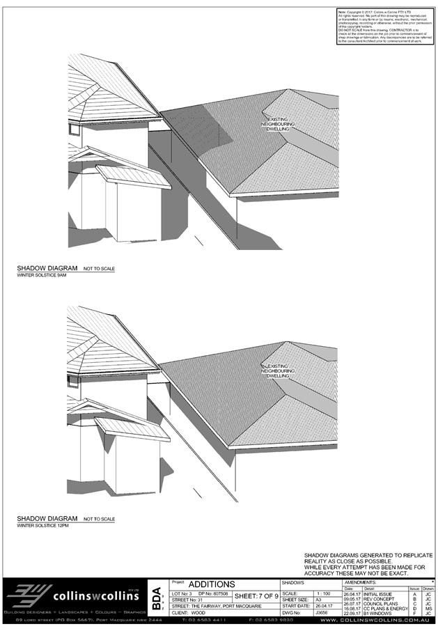
From the shadow diagrams provided, sunlight to the adjoining dwellings primary living
areas will not be reduced to less than 3 hours between 9.00am and 3.00pm on
June 21 (Winter Solstice). Bathrooms, toilet & ensuites are not
considered primary living areas under DCP 2013.
|
|
Reduction in privacy to ensuite,
master bedroom, main bathroom & toilet of adjoining western
property.
|
The concerns over privacy have been addressed by the
applicant by the implementation of high sill windows on the side facing the
western neighbour.
|
|
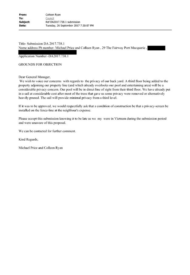
Reduction in privacy to rear yard
of adjoining western property.
|
The implementation of high sill windows on the side
facing the western neighbour has addressed this issue.
There are no other windows orientated toward the
neighbouring properties rear yard.
|
|
Reduction in privacy to rear
yard of adjoining southern property & privacy screen requested to
boundary fence.
|
There is anticipated to be a degree of impact in regard
to privacy from the proposed upper level addition toward the rear yard of the
southern neighbour, due to the elevated nature of the site. The rear yard of
the southern property is partially obscured by a tree located on the subject
site and a shade sail erected on the adjoining property.
It is considered that privacy impacts from the proposed
additions will be only slightly greater than what already exists on site from
the existing front deck. The impact is not considered significant to warrant
refusal of the application. A privacy screen erected on the boundary is not a
requirement of DCP 2013.
|
(e) The Public Interest:
The proposed
development satisfies relevant planning controls and is unlikely to impact on
the wider public interest.
4. DEVELOPMENT
CONTRIBUTIONS APPLICABLE
N/A.
5. CONCLUSION
The application has been assessed in accordance with
Section 79C of the Environmental Planning and Assessment Act 1979.
Issues raised during assessment and public exhibition of
the application have been considered in the assessment of the application.
Where relevant, conditions have been recommended to manage the impacts
attributed to these issues.
The site is suitable for the proposed development, is not
contrary to the public's interest and will not have a significant adverse
social, environmental or economic impact. It is recommended that the
application be approved, subject to the recommended conditions of consent
provided in the attachment section of this report.
|
Attachments
1View. DA2017
- 738.1 Recommended Conditions
2View. DA2017
- 738.1 Plans
3View. DA2017
- 738.1 Submission - Dickson
4View. DA2017
- 738.1 Submission - Price & Ryan
5View. DA2017
- 738.1 Submission - Vincent
|
|
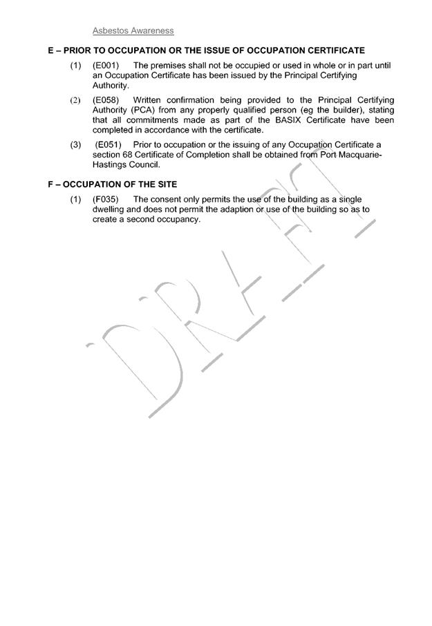
ATTACHMENT
|
Development Assessment Panel
25/10/2017
|
|
ATTACHMENT
|
Development Assessment Panel
25/10/2017
|
|
ATTACHMENT
|
Development Assessment Panel
25/10/2017
|
|
ATTACHMENT
|
Development Assessment Panel
25/10/2017
|
|
ATTACHMENT
|
Development Assessment Panel
25/10/2017
|


AGENDA Development Assessment Panel 25/10/2017
Item: 06
Subject: DA2017 - 690.1 Dual Occupancy And Torrens
Title Subdivision Lot 6 DP 1233221, Scarborough Way, Dunbogan
Report
Author: Deb McKenzie
|
Applicant: Encompass
Drafting
Owner: KC
& DA Dimon
Estimated Cost: $475,000
Alignment with Delivery
Program
4.3.1 Undertake transparent
and efficient development assessment in accordance with relevant legislation.
|
|
RECOMMENDATION
That
DA 2017 - 690 for a dual
occupancy and torrens title subdivision at
Lot 6, DP 1233221, Scarborough
Way, Dunbogan, be determined by granting consent
subject to the recommended conditions.
|
Executive
Summary
This
report considers a development application for a dual occupancy and
torrens title subdivision at the subject site and
provides an assessment of the application in accordance with the Environmental
Planning and Assessment Act 1979.
Following exhibition of the
application, one (1) submission has been
received.
1. BACKGROUND
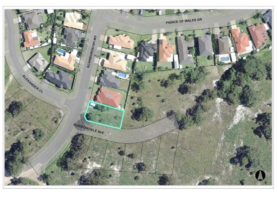
Existing sites features and surrounding development
The site has an area of 771.7sqm.
The site is zoned R1 General Residential in accordance with the Port Macquarie-Hastings Local
Environmental Plan 2011, as shown in the following zoning plan:
The existing subdivision pattern and location of existing
development within the locality is shown in the following aerial photograph:
2. DESCRIPTION OF
DEVELOPMENT
Key aspects of the proposal include the following:
· Proposed
dual occupancy and torrens title subdivision
· Each
dwelling to comprise three (3) bedrooms + media room and double garage
· Access
to both dwelling via domestic crossovers and driveways off Scarborough Way and
Borrowdale Avenue.
Refer
to attachments at the end of this report.
Application Chronology
· 9
August 2017 Application lodged
· 24
August 2017 – 6 September 2017 Pubic notification
· 31
August 2017 Submission received
3. STATUTORY ASSESSMENT
Section 79C(1) Matters for Consideration
In determining the application, Council is required to take
into consideration the following matters as are relevant to the development
that apply to the land to which the development application relates:
(a) The provisions (where
applicable) of:
(i) any Environmental
Planning Instrument:
State
Environmental Planning Policy No. 44 - Koala Habitat Protection
The site is
cleared of vegetation. No impact on any koala food trees. Therefore no further
investigations are required.
State
Environmental Planning Policy No.55 – Remediation of Land
Following an
inspection of the site and a search of Council records, the subject land is not
identified as being potentially contaminated and is suitable for the intended
use.
State
Environmental Planning Policy No. 71 – Coastal Protection and Clause 5.5
of Port Macquarie-Hastings Local Environmental Plan 2011
The site is
located within a coastal zone as defined in accordance with clause 4 of SEPP
71. In accordance with clause 5, this SEPP prevails over the Port
Macquarie-Hastings LEP 2011 in the event of any inconsistency.
Having regard
to clauses 8 and 12 to 16 of SEPP 71 and clause 5.5 of Hastings LEP 2011
inclusive the proposed development will not result in any of the following:
a) any restricted access (or opportunities
for access) to the coastal foreshore
b) any identifiable adverse amenity impacts
along the coastal foreshore and on the scenic qualities of the coast;
c) any identifiable adverse impacts on any
known flora and fauna (or their natural environment);
d) subject to any identifiable adverse
coastal processes or hazards;
e) any identifiable conflict between water
and land based users of the area;
f) any identifiable adverse impacts on any
items of archaeological/heritage;
g) reduce the quality of the natural water
bodies in the locality.
The site is
cleared and located within an area zoned for residential purposes.
State
Environmental Planning Policy (Building Sustainability Index: BASIX) 2004
A BASIX
certificate (number 849877S & 849926S) has been submitted demonstrating
that the proposal will comply with the requirements of the SEPP. It is
recommended that a condition be imposed to ensure that the commitments are
incorporated into the development and certified at Occupation Certificate
stage.
Port
Macquarie-Hastings Local Environmental Plan 2011
The proposal
is consistent with the LEP having regard to the following:
• Clause
2.2, the subject site is zoned R1 General Residential. In accordance with
clause 2.3(1) and the R1 zone landuse table, the dwelling (or ancillary
structure to a dwelling) is a permissible landuse with consent.
The objectives of the R1 zone are as follows:
o To
provide for the housing needs of the community.
o To
provide for a variety of housing types and densities.
o To
enable other land uses that provide facilities or services to meet the day to
day needs of residents.
In accordance with Clause 2.3(2), the proposal is consistent with the
zone objectives as it is a permissible landuse, contributes to the range of
housing options available for the community and consistent with the residential
locality.
• Clause
4.3 Height of buildings – both dwellings are single storey or generally
flat land. Both dwellings are less than the maximum 8.5m height limit and
comply.
• Clause
4.4 Floor space ratio – the proposed FSR is 0.41:1, less than the
allowable 0.65:1. Complies.
• Clause
7.13, satisfactory arrangements are in place for provision of essential
services.
(ii) Any
draft instruments that apply to the site or are on exhibition:
No draft
instruments apply to the site.
(iii) any
Development Control Plan in force:
Port
Macquarie-Hastings Development Control Plan 2013
|
DCP 2013: Dwellings, Dual
occupancies, Dwelling houses, Multi dwelling houses & Ancillary
development
|
|
|
Requirements
|
Proposed
|
Complies
|
|
3.2.2.1
|
Ancillary development:
• 4.8m max. height
• Single storey
• 60m2 max. area
• 100m2 for lots
>900m2
• 24 degree max.
roof pitch
• Not located in
front setback
|
None.
|
Yes
|
|
3.2.2.2
|
Articulation zone:
• Min. 3m front
setback
• An entry feature
or portico
• A balcony, deck,
patio, pergola, terrace or verandah
• A window box
treatment
• A bay window or
similar feature
• An awning or
other feature over a window
• A sun shading
feature
|
Scarborough Way:
– no structures within the articulation zone.
Borrowdale Ave:
– no structures within the articulation zone.
|
None.
|
|
Front setback (Residential not R5
zone):
• Min. 6.0m
classified road
• Min. 4.5m local
road
• Min. 3.0m
secondary road
• Min. 2.0m
Laneway
|
Unit 1:
Scarborough Way – 4.79m setback to media room.
Borrowdale Ave – 4m to ensuite of Bedroom 1.
Unit 2:
Borrowdale Ave – 3.696m to media room wall. Complies
with secondary road setback.
|
Yes
|
|
3.2.2.3
|
Garage 5.5m min. and 1m behind
front façade.
Garage door recessed behind
building line or eaves/overhangs provided
|
Unit 1 – 5.527m
Unit 2 – 5.875m
Both garages are setback from the
main walls of the dwelling. Both doors are compliant.
|
Yes
|
|
6m max. width of garage door/s
and 50% max. width of building
|
Width of both garage doors are
compliant with the maximum width requirements.
Both garages are less than 50% of
the width of the dwellings.
|
Yes
|
|
Driveway crossover 1/3 max. of
site frontage and max. 5.0m width
|
Driveway crossings widths (4.5m)
are compliant with the maximum width requirements.
|
Yes
|
|
3.2.2.4
|
4m min. rear setback. Variation
subject to site analysis and provision of private open space
|
No setback requirement as corner
lot.
|
N/A
|
|
3.2.2.5
|
Side setbacks:
• Ground floor =
min. 0.9m
• First floors
& above = min. 3m setback or where it can be demonstrated that
overshadowing not adverse = 0.9m min.
• Building wall
set in and out every 12m by 0.5m
|
The minimum side setback
requirements are complied with.
The building wall articulation is
satisfactory to address the objective intent of the development provision.
|
Yes
|
|
3.2.2.6
|
35m2 min. private open space area
including a useable 4x4m min. area which has 5% max. grade
|
Unit 1 – POS at front of dwelling.
Unit 2 – POS at rear of dwelling.
Both dwellings comply with area and size requirements.
|
Yes
|
|
3.2.2.7
|
Front fences:
• If solid 1.2m
max height and front setback 1.0m with landscaping
• 3x3m min. splay
for corner sites
• Fences >1.2m
to be 1.8m max. height for 50% or 6.0m max. length of street frontage with
25% openings
• 0.9x0.9m splays
adjoining driveway entrances
|
Unit 1 – front fence required to provide POS area in
front of dwelling. Details provided with DA. Generally compliant with DCP
regarding height and openings.
Unit 2 – none indicated.
|
Yes
|
|
3.2.2.8
|
Front fences and walls to have
complimentary materials to context
No chain wire, solid timber,
masonry or solid steel front fences
|
Unit 1 fencing materials
complements the clad and rendered materials of the dwelling.
|
Yes
|
|
3.2.2.10
|
Privacy:
• Direct views
between living areas of adjacent dwellings screened when within 9m radius of
any part of window of adjacent dwelling and within 12m of private open space
areas of adjacent dwellings. ie. 1.8m fence or privacy screening which has
25% max. openings and is permanently fixed
• Privacy screen
required if floor level > 1m height, window side/rear setback (other than
bedroom) is less than 3m and sill height less than 1.5m
• Privacy screens
provided to balconies/verandahs etc which have <3m side/rear setback and
floor level height >1m
|
Both dwellings are single storey.
The 1.8m high boundary fences will provide sufficient privacy for residents
of the two dwellings and adjoining sites at ground level.
The POS areas of each dwelling
are on the opposite sides of the lots.
|
Yes
|
|
DCP 2013: General
Provisions
|
|
|
Requirements
|
Proposed
|
Complies
|
|
2.7.2.2
|
Design addresses generic principles of Crime Prevention
Through Environmental Design guideline
|
No concealment or entrapment areas proposed. Adequate
casual surveillance available.
|
Yes
|
|
2.3.3.1
|
Cut and fill 1.0m max. 1m outside the perimeter of the
external building walls
|
Site is generally flat. None proposed.
|
N/A
|
|
2.3.3.2
|
1m max. height retaining walls along road frontage
|
None proposed.
|
N/A
|
|
Any retaining wall >1.0 in height to be certified by
structure engineer
|
No retaining walls.
|
Yes
|
|
Combination of retaining wall and front fence height max
1.8m, max length 6.0m or 30% of frontage, fence component 25% transparent,
and splay at corners and adjacent to driveway
|
No retaining wall front fence combination proposed.
|
N/A
|
|
Driveway crossing/s minimal in number and width including
maximising street parking
|
Driveway crossings acceptable allowing space for onstreet
parking.
|
Yes
|
|
2.5.3.3
|
Parking in accordance with Table 2.5.1.
1 space per single dwelling (behind building line)
|
2 spaces per dwelling in double garages.
|
Yes
|
|
2.5.3.11
|
Section 94 contributions
|
Refer to main body of report.
|
Yes
|
|
2.5.3.14
|
Sealed driveway surfaces unless justified
|
Concrete driveways proposed.
|
Yes
|
|
2.5.3.15 and 2.5.3.16
|
Driveway grades first 6m or ‘parking area’
shall be 5% grade with transitions of 2m length
|
Compliant,
Condition recommended for section 138 Roads Act permit.
|
Yes
|
|
2.5.3.17
|
Parking areas to be designed to avoid concentrations of
water runoff on the surface.
|
Single dwelling only with 1 domestic driveway. Stormwater
drainage is capable of being managed as part of plumbing construction.
|
Yes
|
(iiia) any
planning agreement that has been entered into under Section 93f or any draft
planning agreement that a developer has offered to enter into under Section
93f:
No planning
agreement has been offered or entered into relating to the site.
iv) any matters prescribed by the
Regulations:
New South Wales Coastal Policy:
Site is
located within the area covered by the Coastal Policy. The proposed development
will impact on the achievement of the aims and objectives of the policy or SEPP
71.
Demolition
of buildings AS 2601:
Nil
v) any coastal
zone management plan (within the meaning of the Coastal Protection Act 1979),
that apply to the land to which the development application relates:
Nil
(b) The
likely impacts of that development, including environmental impacts on both the
natural and built environments, social and economic impacts in the locality:
Context
and setting
• The
proposal will be unlikely to have any unacceptable impacts to existing
adjoining properties and satisfactorily addresses the public domain.
• The
proposal is considered to be consistent with other residential development in
the locality and adequately addresses planning controls for the area.
• There
is no adverse impact on existing view sharing.
• There
is no unacceptable privacy impacts.
• There
is no adverse overshadowing impacts. The proposal does not prevent adjoining
properties from receiving 3 hours of sunlight to private open space and primary
living areas on 21 June.
Access,
transport and traffic
The
proposal will be unlikely to have any adverse impacts in terms access,
transport and traffic. The existing road network will satisfactorily cater for
any increase in traffic generation as a result of the development.
Water,
Sewer, Stormwater Supply
Service
available – details required with S.68 application.
Other
Utilities
Telecommunication
and electricity services are available to the site.
Heritage
This
site does not contain or adjoin any known heritage item or site of
significance.
Other
land resources
No
adverse impacts anticipated. The site is within an established large lot
residential context and will not sterilise any significant mineral or agricultural
resource.
Water
cycle
The
proposed development will be unlikely to have any adverse impacts on water
resources and the water cycle.
Soils
The
proposed development will be unlikely to have any adverse impacts on soils in
terms of quality, erosion, stability and/or productivity subject to a standard
condition requiring erosion and sediment controls to be in place prior to and
during construction.
Air
and microclimate
The
construction and/or operations of the proposed development will be unlikely to
result in any adverse impacts on the existing air quality or result in any
pollution.
Flora
and fauna
Site
is cleared. No requirements.
Waste
Satisfactory
arrangements are in place for proposed storage and collection of waste and
recyclables. No adverse impacts anticipated.
Energy
The
proposal includes measures to address energy efficiency and will be required to
comply with the requirements of BASIX.
Noise
and vibration
No
adverse impacts anticipated. Condition recommended to restrict construction to
standard construction hours.
Bushfire
The
site is not identified as being bushfire prone.
Safety,
security and crime prevention
The
proposed development will be unlikely to create any concealment/entrapment
areas or crime spots that would result in any identifiable loss of safety or
reduction of security in the immediate area.
Social
impacts in the locality
Given
the nature of the proposed development and its’ location the proposal is
unlikely to result in any adverse social impacts.
Economic
impact in the locality
No
adverse impacts. Likely positive impacts can be attributed to the construction
of the development and associated flow on effects (i.e. increased expenditure
in the area).
Site
design and internal design
The
proposed development design is satisfactorily responds to the site attributes
and will fit into the locality. No adverse impacts likely.
Construction
No
potential adverse impacts identified to neighbouring properties with the
construction of the proposal.
Cumulative
impacts
The
proposed development is not expected to have any adverse cumulative impacts on
the natural or built environment or the social and economic attributes of the
locality.
(c)
The suitability of the site for the development:
The
proposal will fit into the locality and the site attributes are conducive to
the proposed development.
(d)
Any submissions made in accordance with this Act or the Regulations:
One
written submission has been received following public exhibition of the
application.
Key issues
raised in the submissions received and comments in response to these issues are
provided as follows:
|
Submission
Issue/Summary
|
Planning
Comment/Response
|
|
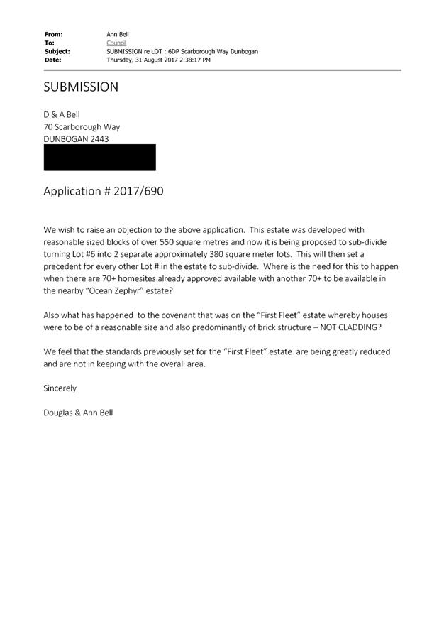
Precedence for every block in
the estate to be subdivided.
|
The site is zoned R1 General
Residential zone. Dual occupancy is permissible with Council’s consent.
Clause 4.1A permits the subdivision of land into 2 lots (or more) and the
erection of a dwelling house on each lot resulting from the subdivision.
The site is a corner lot,
larger than the average lot within the subdivision. Dual occupancy
development of these lots are common place throughout the POr
Macquarie-Hastings. There is a general trend in the market place for this
development typology on corner lots.
The proposal is not a
precedence as it is a permissible landuse with Council consent.
The proposal satisfactorily
addresses relevant planning controls applying to the site.
|
|
Estate covenant – houses to be a reasonable size
and predominantly of brick structure, not cladding.
|
The covenant referred to in the submission would be the
restriction eightly referred in the deposited plan (DP 1233221). It refers to
the building type, materials, garages, fencing etc. The developer, Punusi Pty
Ltd, is specifically empowered to release, vary or modify the restriction.
Council has no part in the application or enforcement of that
restriction.
The imposition of this type of land title restriction is
not a planning consideration and is not reflected in local planning policy.
Councils are obliged to accept and assess development applications based on
local planning policy, not restrictions placed on land by the developer and
property owner.
Clause 1.9A of the LEP provides for the legal mechanism
for Council’s planning controls to override private covenants.
|
|
Standards set for the “First Fleet” estate
are being greatly reduced and not in keeping with the overall area.
|
As above. In this case, the right to strictly impose or
choose to vary the covenants that apply to the estate are to prerogative of
the land developer.
|
(e) The Public Interest:
The proposed
development satisfies relevant planning controls and is unlikely to impact on
the wider public interest.
4. DEVELOPMENT
CONTRIBUTIONS APPLICABLE
· Development contributions will be required towards
augmentation of town water supply and sewerage system head works under Section
64 of the Local Government Act 1993.
· Development contributions will be required under Section 94
of the Environmental Planning and Assessment Act 1979 towards roads, open
space, community cultural services, emergency services and administration
buildings.
5. CONCLUSION
The application has been assessed in accordance with
Section 79C of the Environmental Planning and Assessment Act 1979.
Issues raised during assessment and public exhibition of
the application have been considered in the assessment of the application.
Where relevant, conditions have been recommended to manage the impacts
attributed to these issues.
The site is suitable for the proposed development, is not
contrary to the public's interest and will not have a significant adverse
social, environmental or economic impact. It is recommended that the
application be approved, subject to the recommended conditions of consent
provided in the attachment section of this report.
|
Attachments
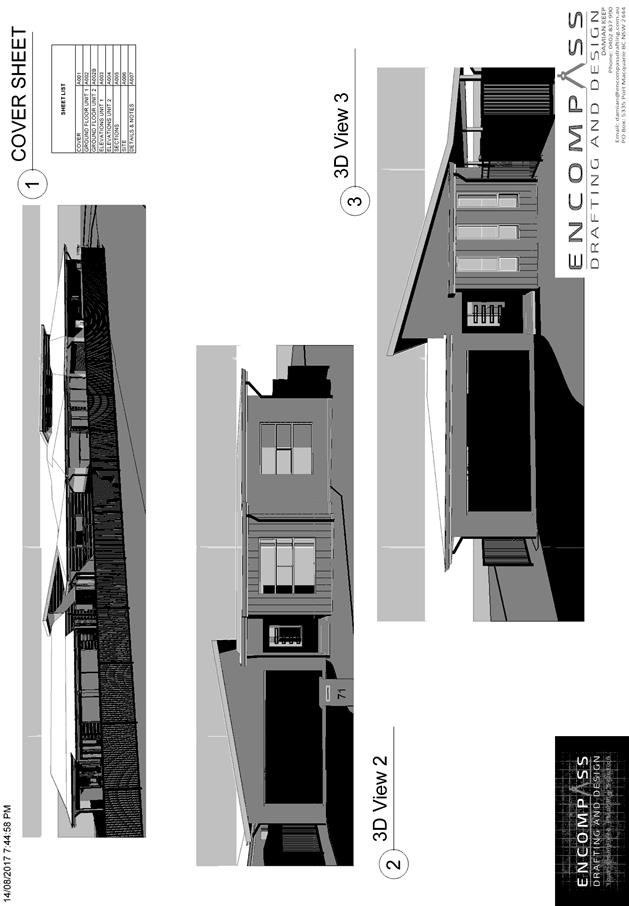
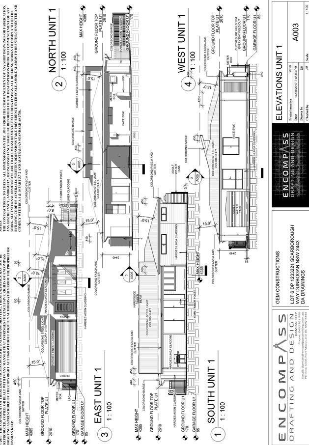
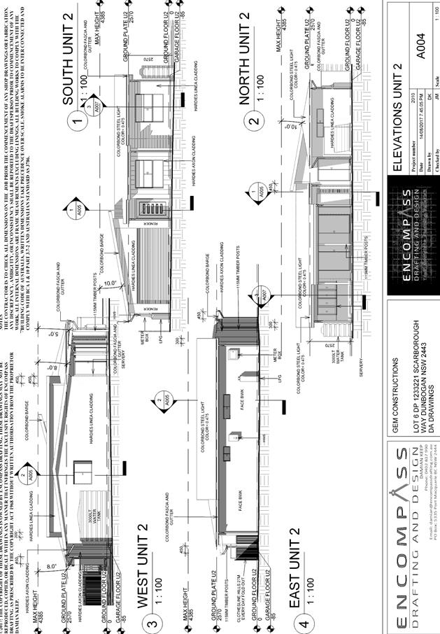
1View. DA2017
- 690.1 Plans
2View. DA2017
- 690.1 Recommended Conditions
3View. DA2017
- 690.1 Submission - Bell
|
|
ATTACHMENT
|
Development Assessment Panel
25/10/2017
|
|
ATTACHMENT
|
Development Assessment Panel
25/10/2017
|
|
ATTACHMENT
|
Development Assessment Panel
25/10/2017
|
AGENDA Development Assessment Panel 25/10/2017
Item: 07
Subject: DA2015 - 913.1 Multi-Dwelling Housing (6
Dwellings) And Strata Title Subdivision - Lot 27 DP 1213714, No 20 Bluewren
Close, Port Macquarie
Report
Author: Patrick Galbraith-Robertson
|
Applicant: J
W Wortley CARE Collins W Collins
Owner: J
W Wortley
Estimated Cost: $1.164M
Alignment with Delivery
Program
4.3.1 Undertake transparent
and efficient development assessment in accordance with relevant legislation.
|
|
RECOMMENDATION
That
DA2015 – 913.1 for a multi-dwelling
housing (6 dwellings) at Lot 241, DP 1227796, No.
20 Bluewren Close, Port Macquarie,
be determined by granting consent subject to the recommended conditions.
|
Executive
Summary
This
report considers a Development Application (DA) for a multi dwelling housing
and strata development at the subject site and
provides an assessment of the application in accordance with the Environmental
Planning and Assessment Act 1979.
Following exhibition of the
application, two (2) submissions have been received.
The proposal has been amended
during the assessment of the DA to address assessment related matters.
1. BACKGROUND
Existing sites features and surrounding development
The site has an area of 1844m2.
The site has a general south street frontage orientation to
Blue Wren Close. The site at time of the lodgement of the DA was a proposed lot
within a subdivision yet to be released. The Lot to create the site has now
been registered and ownership transferred to the new owner during the assessment
the DA. This has led to some significant delays in processing of the
application.
Adjoining the
site to the north is rural zoned
land.
Adjoining the site to the east and west is residential zoned
land.
The site is zoned R1 general residential in accordance with the Port Macquarie-Hastings Local
Environmental Plan 2011, as shown in the following zoning plan:
The existing subdivision pattern and location of existing
development within the locality is shown in the following aerial photograph
(2012 aerial):
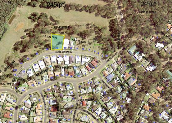
2. DESCRIPTION OF
DEVELOPMENT
Key aspects of the proposal include the following:
· Construction
6 x single storey dwellings. 3 x 1 bedroom, 2 x 2 bedroom and 1 x 3 bedroom
dwellings
· Construction
of common driveway areas including 2 x nominated visitor parking spaces
· Construction of front fence and landscaping
· Strata title subdivision
Refer
to attachments at the end of this report.
Application Chronology
· 10
December 2015 – DA lodged with Council.
· 18 December 2015 to 22 January 2016 – Neighbour
notification of proposal.
· 13 January 2016 – Additional information requested
– Ecological impacts of tree removal to be addressed and Units 1 and 3
internal design concerns.
· 28 January 2016 – Issues raised in submissions
forwarded to Applicant for consideration.
· 1 March 2016 – Additional information requested
– finished floor levels of Unit 4 questioned, internal driveway width
concerns, and driveway long section requested.
· 9 May 2016 – Follow up request for additional
information.
· 5 August 2016 – Additional ecological/tree removal
offset information received from Applicant.
· 30 August 2016 – Initial concerns raised with
Applicant with regard to Lot not being registered and possibly triggering State
Environmental Planning Policy No.44 – Koala Habitat Protection (SEPP 44).
· 19 September 2016 – Applicant advised working on
providing additional information.
· 12 October 2016 – Additional information received
from Owner’s Solicitor that the Applicant for the proposed Lot at the
time (Lot is now registered) to be registered has had exchanged contracts for
purchase.
· 17 October 2016 - Follow up request for additional
information with regard to legal advice on applicability of SEPP 44.
· 31 October and 1 November 2016 – Additional
information received from Applicant with regard to SEPP 44 not applying and
advising that they consider a Koala Plan of Management is not required.
Applicant requests the DA not be determined until the proposed Lot be
registered.
· 1 November 2016 – Additional information requested on
addressing specifics for offset planting locations.
· 10 November 2016 – Offset planting locations plan
received from Applicant.
· 11 November 2016 – Additional information requested
on addressing specifics for offset planting.
· 15 June 2017 – Applicant advised that the proposed
Lot, the subject of the DA, has been registered.
· 15 June 2017 – Specifics on offset planting specified
to Applicant and follow up request for other additional information with regard
to finished floor levels of Unit 4 questioned, internal driveway width
concerns, and driveway long section requested.
· 7 September 2017 – Additional information and amended
plans received. The amended plans have revisited the internal driveway width,
levels of the proposed Unit 4 and internal design of proposed Units 1 and 3
including removal of second kitchen.
3. STATUTORY ASSESSMENT
Section 79C(1) Matters for Consideration
In determining the application, Council is required to take
into consideration the following matters as are relevant to the development
that apply to the land to which the development application relates:
(a) The provisions (where
applicable) of:
(i) any Environmental
Planning Instrument:
State
Environmental Planning Policy No. 44 - Koala Habitat Protection
There is no
Koala Plan of Management on the site. Additionally, the site is less than 1
hectare in area therefore no further investigations are required. It should be
noted that the DA was lodged on a proposed Lot which has been registered during
the assessment of the DA and ownership transferred. This SEPP therefore does
not require consideration. The processing of the DA has been significantly
delayed pending this matter being resolved.
State
Environmental Planning Policy No.55 – Remediation of Land
Following an
inspection of the site and a search of Council records, the subject land is not
identified as being potentially contaminated and is suitable for the intended
use.
State
Environmental Planning Policy No. 62 – Sustainable Aquaculture
Given the
nature of the proposed development and proposed stormwater controls, the
proposal will be unlikely to have any adverse impact on existing aquaculture
industries.
State
Environmental Planning Policy (Building Sustainability Index: BASIX) 2004
A BASIX
certificate has been submitted demonstrating that the proposal will comply with
the requirements of the SEPP. It is recommended that a condition be
imposed to ensure that the commitments are incorporated into the development
and certified at Occupation Certificate stage.
Port Macquarie-Hastings Local Environmental Plan 2011
The proposal
is consistent with the LEP having regard to the following:
· Clause
2.2, the subject site is zoned R1 General Residential. In accordance with
clause 2.3(1) and the R1 zone landuse table, the multi dwelling housing is a
permissible landuse with consent.
The
objectives of the R1 zone are as follows:
o To
provide for the housing needs of the community.
o To
provide for a variety of housing types and densities.
o To
enable other land uses that provide facilities or services to meet the day to
day needs of residents.
In accordance
with Clause 2.3(2), the proposal is consistent with the zone objectives as it
is a permissible landuse and sufficiently consistent with the immediate
residential locality.
· Clause
4.1, the standard minimum lot size requirements do not apply to this proposal
which includes only a strata subdivision.
· Clause
4.3, the maximum overall height of the building above ground level (existing)
is 5.66m which complies with the standard height limit of 8.5m applying to the
site.
· Clause
4.4, the floor space ratio of the proposal is 0.5:1.0 which complies with the
maximum 0.65:1 floor space ratio applying to the site.
· Clause
5.9 – Three(3) listed trees in Development Control Plan 2013 are proposed
to be removed with only two(2) being koala browse species.
· Clause
5.10 – Heritage. The site does not contain or adjoin any known heritage
items or sites of significance.
· Clause
7.13, satisfactory arrangements are in place for provision of essential
services.
(ii) Any
draft instruments that apply to the site or are on exhibition:
No draft
instruments apply to the site.
(iii) any
Development Control Plan in force:
Port
Macquarie-Hastings Development Control Plan 2013:
|
DCP 2013: Dwellings,
Dual occupancies, Dwelling houses, Multi dwelling houses & Ancillary
development
|
|
|
Requirements
|
Proposed
|
Complies
|
|
3.2.2.1
|
Ancillary development:
• 4.8m
max. height
• Single
storey
• 60m2
max. area
• 100m2
for lots >900m2
• 24
degree max. roof pitch
• Not
located in front setback
|
Water tanks are appropriately
located
|
Yes
|
|
3.2.2.2
|
Articulation zone:
• Min.
3m front setback
• An
entry feature or portico
• A
balcony, deck, patio, pergola, terrace or verandah
• A
window box treatment
• A
bay window or similar feature
• An
awning or other feature over a window
• A
sun shading feature
|
The development contains a
patio post and the south-east corner of Unit 6 within the articulation zone.
The patio post and section of Unit 6 building do not exceed 25% of the
articulation zone and is still setback greater than 3m.
|
Yes
|
|
Front setback (Residential not
R5 zone):
• Min.
6.0m classified road
• Min.
4.5m local road or within 20% of adjoining dwelling if on corner lot
• Min.
3.0m secondary road
• Min.
2.0m Laneway
|
Front building line setback is
compliant with the minimum 4.5m front setback requirements. Note some
sections of Unit 6 building within the front setback which can be considered
as part of the articulation zone area and are significantly lower than the
street level pavement.
|
Yes
|
|
3.2.2.3
|
Garage 5.5m min. and 1m behind
front façade.
Garage door recessed behind
building line or eaves/overhangs provided
|
Garage door setback
requirements are complied with.
|
Yes
|
|
6m max. width of garage door/s
and 50% max. width of building
|
Width of garage door
requirements are complied with.
|
Yes
|
|
Driveway crossover 1/3 max. of
site frontage and max. 5.0m width
|
5.5m wide driveway crossover
(at kerb) and proportionally 16% of frontage.
|
Yes and No*
|
|
3.2.2.4
|
4m min. rear setback.
Variation subject to site analysis and provision of private open space
|
Min. 1.7m rear setback to
patio posts and 4.2m to main part of Units 1, 2 and 3
|
No*
|
|
3.2.2.5
|
Side setbacks:
• Ground
floor = min. 0.9m
• First
floors & above = min. 3m setback or where it can be demonstrated that
overshadowing not adverse = 0.9m min.
• Building
wall set in and out every 12m by 0.5m
|
The minimum side setback
requirements are complied with.
The wall articulation is
compliant and satisfies the objectives of the development provision.
|
Yes
|
|
3.2.2.6
|
35m2 min. private open space
area including a useable 4x4m min. area which has 5% max. grade
|
Each occupancy contains
35m² open space in one area including a useable 4m x 4m area.
|
Yes
|
|
3.2.2.7
|
Front fences:
• If
solid 1.2m max height and front setback 1.0m with landscaping
• 3x3m
min. splay for corner sites
• Fences
>1.2m to be 1.8m max. height for 50% or 6.0m max. length of street
frontage with 25% openings
• 0.9x0.9m
splays adjoining driveway entrances
• Front
fences and walls to have complimentary materials to context
|
The proposed front fence
design at height of 1.8m with 25% transparency and landscaped recesses is
considered to meet the fencing provisions and objectives of DCP 2013. No
adverse impacts will occur.
N/A
|
Yes
|
|
3.2.2.8
|
No chain wire, solid timber,
masonry or solid steel front fences
|
|
3.2.2.10
|
Privacy:
• Direct
views between living areas of adjacent dwellings screened when within 9m
radius of any part of window of adjacent dwelling and within 12m of private
open space areas of adjacent dwellings. ie. 1.8m fence or privacy screening
which has 25% max. openings and is permanently fixed
• Privacy
screen required if floor level > 1m height, window side/rear setback
(other than bedroom) is less than 3m and sill height less than 1.5m
• Privacy
screens provided to balconies/verandahs etc which have <3m side/rear setback
and floor level height >1m
|
No direct views between living
areas of adjacent dwellings screened when within 9m radius of any part of
window of adjacent dwelling and within 12m of private open space areas of
adjacent dwellings.
No privacy screens are
recommended.
|
Yes
|
|
3.2.2.11
|
Roof terraces
|
N/A
|
|
|
3.2.2.13 onwards
|
Jetties and boat ramps
|
N/A
|
|
|
DCP 2013: General
Provisions
|
|
|
Requirements
|
Proposed
|
Complies
|
|
2.7.2.2
|
Design addresses generic
principles of Crime Prevention Through Environmental Design guideline
|
No concealment or entrapment
areas proposed. Adequate casual surveillance available.
|
Yes
|
|
2.3.3.1
|
Cut and fill 1.0m max. 1m
outside the perimeter of the external building walls
|
Cut and fill <1.0m change
1m outside the perimeter of the external building walls
|
Yes
|
|
2.3.3.2
|
1m max. height retaining walls
along road frontage
|
None proposed
|
N/A
|
|
Any retaining wall >1.0 in
height to be certified by structure engineer
|
Condition recommended to
require engineering certification for retaining walls within close proximity
to existing property boundaries.
|
Yes
|
|
Combination of retaining wall
and front fence height max 1.8m, max length 6.0m or 30% of frontage, fence
component 25% transparent, and splay at corners and adjacent to driveway
|
No retaining wall front fence
combination proposed.
|
N/A
|
|
2.3.3.8
|
Removal of hollow bearing
trees
|
No hollow bearing trees
proposed to be removed
|
N/A
|
|
2.6.3.1
|
Tree removal (3m or higher
with 100m diameter trunk at 1m above ground level and 3m from external wall
of existing dwelling)
|
Two (2) koala food trees
proposed to be removed. Offset planting proposed of 4 trees on adjoining
property as shown in the attachments section of this report.
|
Yes
|
|
2.4.3
|
Bushfire risk, Acid sulphate
soils, Flooding, Contamination, Airspace protection, Noise and Stormwater
|
Refer to main body of report.
|
|
|
2.5.3.2
|
New accesses not permitted
from arterial or distributor roads
|
No new access proposed to
arterial or distribution road.
|
N/A
|
|
Driveway crossing/s minimal in
number and width including maximising street parking
|
Combined common driveway
crossing is restricted in width which will allow for casual parking on road
verge.
|
Yes
|
|
2.5.3.3
|
Parking in accordance with Table
2.5.1.
Multi dwelling
1 space per 1 & 2 bedroom
occupancies
1.5 spaces per 3+ bedroom
occupancies
0.25 spaces per occupancy for
visitor parking.
|
Proposal involve:
3 x 1 bedroom, 2 x 2 bedroom
and 1 x 3 bedroom dwellings
Therefore requirements are:
5 x 1 space = 5 spaces +
1 x 1.5 spaces = 1.5 spaces (2
spaces rounded up) = 7 spaces +
6 x 0.25 visitor = 2 spaces
(rounded up) = 9 spaces in total
The development proposes: 9
parking spaces as part of the dwellings + 2 nominated visitor parks at the
front of the site. 11 spaces in total are proposed
|
Yes
|
|
2.5.3.11
|
Section 94 contributions
|
Contributions apply.
|
Yes
|
|
2.5.3.12 and 2.5.3.13
|
Landscaping of parking areas
|
Suitable landscaping proposed
around driveway/parking locations.
|
Yes
|
|
2.5.3.14
|
Sealed driveway surfaces
unless justified
|
Sealed driveway areas
proposed.
|
Yes
|
|
2.5.3.15 and 2.5.3.16
|
Driveway grades first 6m or
‘parking area’ shall be 5% grade with transitions of 2m length
|
Driveway grades capable of
satisfying Council standard driveway crossover requirements. Condition
recommended for section 138 Roads Act permit
|
Yes
|
|
2.5.3.17
|
Parking areas to be designed
to avoid concentrations of water runoff on the surface.
|
Stormwater drainage is capable
of being managed as part of plumbing construction.
|
Yes
|
The proposal seeks to vary
Development Provision relating to the recommended 5m width driveway crossing.
The proposal includes a 5.5m wide driveway with a 0.5m variation to width.
The relevant objectives are:
· To minimise the impact of garages and driveways on the
streetscape, on street parking and amenity.
· To
minimise the visual dominance of garages in the streetscape.
Having regard for the
development provisions and relevant objectives, the variation is considered
acceptable for the following reasons:
· The
driveway proportional width to the front boundary is significantly less than
the recommended 1/3 frontage development provision.
· The
variation is minor at only 0.5m of additional driveway width.
· The
5.5m width is necessary for 2 cars to pass each other satisfactorily.
The proposal seeks to vary
Development Provision relating to recommended 4m rear setback. The proposal
includes sections of the rear of the Units 1, 2 and 3 with open patio areas
within the 4m area.
The relevant objectives are:
· To allow adequate natural light and ventilation between
dwellings/buildings and to private open space areas.
· To provide useable yard areas and open space.
Having regard for the
development provisions and relevant objectives, the variation is considered
acceptable for the following reasons:
· There
is no existing residential lot or dwelling to the north and the land is rural
zoned. There are no adverse natural light and ventilation issues to the
northern neighbouring property.
· The
structures within the 4m setback other than the main buildings are only
relating to open patios with posts.
· The
subject Units 1, 2 and 3 have greater than 35m2 of useable private open space
areas.
Based on the above assessment,
the variations proposed to the provisions of the DCP are considered acceptable
and the relevant objectives have been satisfied.
Cumulatively, the variations do
not amount to an adverse impact or a significance that would justify refusal of
the application.
(iiia) any
planning agreement that has been entered into under Section 93f or any draft planning
agreement that a developer has offered to enter into under Section 93f:
No
planning agreement has been offered or entered into relating to the site.
iv) any matters prescribed by the
Regulations:
N/A
v) any coastal
zone management plan (within the meaning of the Coastal
Protection Act 1979), that apply to
the land to which the development application relates:
None
applicable.
(b) The
likely impacts of that development, including environmental impacts on both the
natural and built environments, social and economic impacts in the locality:
Context and setting
• The
proposal will be unlikely to have any adverse impacts to existing adjoining
properties and satisfactorily addresses the public domain.
• The proposal is considered to be consistent with other
residential development in the locality and adequately addresses planning controls
for the area.
• There
are no adverse impacts on existing view sharing.
• There are no adverse privacy impacts.
• There are no adverse overshadowing impacts. The proposal
does not prevent adjoining properties from receiving 3 hours of sunlight to private
open space and primary living areas on 21 June.
Roads
The site has road frontage to Blue Wren Close.
Blue Wren Close is a residential street which is sealed with
kerb and gutter. It is a local road with a 7m road formation within a 17m road reserve.
There is no path paving within Blue Wren Close.
Traffic and Transport
The site is currently vacant land. This development proposes
to generate 35 additional daily trips. The addition in traffic associated with
the development is unlikely to have any adverse impacts to the existing road
network within the immediate locality.
Site Frontage & Access
Vehicle access to the site is proposed though a shared
driveways with direct frontage to Blue Wren Close being a public road. Access
shall comply with Council AUSPEC and Australian Standards, and conditions have
been imposed to reflect these requirements.
Due to the type and size of development, additional works
are required to include:
· concrete
footpath paving (minimum 1.2m wide) along the full frontage
Parking and Manoeuvring
A total of 2 visitor parking spaces and 7 garaged/covered
resident spaces. Parking spaces have been provided on-site within garages with
additional parking provided available within the driveway. Parking and
driveway widths on site can comply with relevant Australian Standards (AS 2890)
and conditions have been imposed to reflect these requirements.
It is noted that the column located on the front corner of
Unit 5’s porch should be removed and the roof should be cantilevered to
allow access and egress from the garage.
Water Supply
Council records indicate that the current development site
has a 20mm/25mm metered water service from the 100mm/150mm AC/PVC water main on
the same/opposite side of street.
A new metered water service will be required for each
allotment as part of the Torrens Title Subdivision.
Final water service sizing will need to be determined by a
hydraulic consultant to suit the development as well as addressing fire service
coverage to AS 2419 and backflow protection.
Detailed plans will be required to be submitted for
assessment with the S.68 application.
Sewer
The plans supplied with the development application indicate
that the proposed building will encroach over the sewer main but the existing manhole
will be within the driveway area. Council permits building over the sewer main,
however not a manhole or junction vertical inspection shaft, provided that
building footing and slab design is engineered to ensure that no load from the
buildings is transferred to the pipeline.
A manhole will also be required
at the high end of the line as it will be more than 40m long.
If the main is subject to future
extension an end of line terminal shaft (poo pit) will be required.
As the dwellings are to be
Strata Titled, a private sewer system can be adopted, connected from a single
manhole junction or each dwelling can be connected directly to Council main
with individual connections.
As the development will exceed
2ET discharge, sewer connection is to be made from a manhole.
If the development is to be
Community Title, the sewer mains are to be vested in Council and are to comply
with Council Auspec D12 design standard.
The hydraulic designer is to confer
with Council sewer section prior to submitting sewer design plans.
Detailed plans will be required to
be submitted for assessment with the S.68 application.
Stormwater
The site naturally grades towards rear and is currently
serviced via an existing easement to drain water.
The legal point of discharge for
the proposed development is defined as the existing easement to drain water at
the rear over lot 245 DP1227796.
Stormwater from the proposed
development is planned to be disposed via this easement which is consistent
with the above requirements.
A detailed site stormwater
management plan will be required to be submitted for assessment with the
Section 68 application and prior to the issue of a Construction Certificate.
In accordance with Councils AUSPEC
requirements, the following must be incorporated into the stormwater drainage
plan:
· On-site
stormwater detention facilities
Other Utilities
Telecommunication and electricity services are available to
the site.
Heritage
This site does not contain or adjoin any known heritage item
or site of significance.
Other land resources
No adverse impacts anticipated. The site is within an
established urban context and will not sterilise any significant mineral or
agricultural resource.
Water cycle
The proposed development will be unlikely to have any
adverse impacts on water resources and the water cycle.
Soils
The proposed development will be unlikely to have any
adverse impacts on soils in terms of quality, erosion, stability and/or
productivity subject to a standard condition requiring erosion and sediment
controls to be in place prior to and during construction.
Air and microclimate
The construction and/or operations of the proposed
development will be unlikely to result in any adverse impacts on the existing
air quality or result in any pollution.
Flora and fauna
Construction of the proposed development will require
removal/clearing of existing trees including two (2) koala browse trees
(Tallowwood trees included). During the assessment of the DA, the Applicant has
offered to carry out offset planting of four (4) trees (2:1 ratio) on the
adjoining neighbouring property with planting of 4 koala food trees. An off-set
planting plan is attached to this report for consideration.
Specific conditions are recommended
for the planting of the four (4) off-set plantings including size and ongoing
management.
Based upon the limited number of
trees proposed to be removed and offset planting proposed the proposal will be
unlikely to have any significant adverse impacts on biodiversity or threatened
species of flora and fauna. Section 5A of the Act (the legislation in
force at the time of the application being received) is considered to be
satisfied.
Waste
Satisfactory arrangements are in place for proposed storage
and collection of waste and recyclables. No adverse impacts anticipated.
Energy
The proposal includes measures to address energy efficiency
and will be required to comply with the requirements of BASIX.
Noise and vibration
No adverse impacts anticipated. Condition recommended to
restrict construction to standard construction hours.
Bushfire
The site is not identified as being bushfire prone.
Safety, security and crime prevention
The proposed development will be unlikely to create any
concealment/entrapment areas or crime spots that would result in any
identifiable loss of safety or reduction of security in the immediate area.
Social impacts in the locality
Given the nature of the proposed development and its’
location the proposal is unlikely to result in any adverse social impacts.
Economic impact in the locality
No adverse impacts. Likely positive impacts can be
attributed to the construction of the development and associated flow on
effects (ie maintained employment and increased expenditure in the area).
Site design and internal design
The proposed development design is satisfactorily responds
to the site attributes and will fit into the locality. No adverse impacts
likely.
Construction
No potential adverse impacts identified to neighbouring
properties with the construction of the proposal.
Cumulative impacts
The proposed development is not expected to have any adverse
cumulative impacts on the natural or built environment or the social and
economic attributes of the locality.
(c) The suitability of the site for
the development:
The proposal will fit into the
locality and the site attributes are conducive to the proposed development.
(d) Any submissions made in
accordance with this Act or the Regulations:
Two (2) written submissions have been received following public
exhibition of the application.
Key issues raised in the submissions received and comments
in response to these issues are provided as follows:
|
Submission
Issue/Summary
|
Planning
Comment/Response
|
|
Neighbour notification being
over the Christmas/New Year period and not giving sufficient time.
|
The proposal was neighbour
notified for an extended period in accordance with Council’s adopted
Notification Policy from 18 December 2015 to 22 January 2016.
|
|
Unhappy that
a development of this nature is even being considered in this small
cul-de-sac, which is full of families with children.
|
The development is permissible in the residential zoning
applying to the site. The density of the dwellings is permissible and
compliant off-street parking is provided.
|
|
Impact 1 block having 6 units is disastrous in regards to
traffic. The road will not cater for the traffic increases and is not a wide
street.
|
Blue Wren
Close a local road with a 7m road formation within a 17m road reserve.
This
development proposes to generate 35 additional daily trips. The addition in
traffic associated with the development is unlikely to have any adverse
impacts to the existing road network within the immediate locality to warrant
refusal of the application.
|
|
When the blocks in the street were first open for
purchasing, this street was sprouted as having golf course frontage.
|
The potential for development of the golf course is not a
matter for consideration under this application.
|
|
Very unlikely that a golf course will be put in because
by building so many units/villas will devalue the land in this street.
|
|
There are
covenants on this land and will pursue class action with other residents from
this area for this lack of consideration for the traffic impacts, environmental
impacts and family living impacts.
|
The development is permissible in the residential zoning
applying to the site. The density of the dwellings is permissible and
compliant off-street parking is provided.
|
|
There has not been any consideration given to existing
residents and it is clearly stated in the application that residents in this
area have not been consulted.
|
The proposal has been neighbour notified in accordance
with Council’s Neighbour Notification policy. The Council’s
planning guidelines and development controls provide protection for amenity
impacts of an area to acceptable standards.
|
|
Council garbage trucks will not be able to manoeuvre due
to forseen congestion from increased vehicles.
|
Council garbage trucks will still be required to enter off
the street.
|
|
Practical
access to all houses will now be impacted.
|
The density of the dwellings is permissible and compliant
off-street parking is provided.
|
|
This is just
one block, which means that if 6 units are to go on this block, what does
that mean for the remaining blocks.
|
Each application is assessed individually against Council
guidelines and on merit. There is potential for similar multi dwelling
proposals on the other lots released in this section of Blue Wren Close
subject to complying with each individual parking, density and other planning
requirements.
|
|
There have
already been 4 houses sold in this street because of proposed changes to the
vacant blocks.
|
Any potential impact on land values is not able to be
considered under the planning assessment of Development Applications. The
proposed development has been permissible on the site for many years and the
property is zoned residential.
|
|
This will
block views from the 'proposed' golf course for many residents as the block
will consistent of nearly all building constructions.
|
The Lots referred to are all zoned residential. No
adverse view sharing impacts can be identified requiring detailed analysis
given all dwellings are single storey and well below the maximum 8.5m
building height restriction applying to the site.
|
|
The
stormwater in this street is inadequate. The blocks flood consistently and
have been reported to Council previously. Question whether existing
facilities are adequate.
|
The site naturally grades
towards rear and is currently serviced via an existing easement to drain
water.
The legal point of discharge for
the proposed development is defined as the existing easement to drain water
at the rear over lot 245 DP1227796.
Stormwater from the proposed
development is planned to be disposed via this easement which is consistent
with the above requirements.
On-site detention facilities will be required.
The proposal will not lead to any identifiable increased
potential stormwater drainage impacts in the locality.
|
|
Concern with
the removal of vegetation. We have seen koalas living in the trees on the
vacant land. Photo proof available.
|
There is no Koala Plan of
Management applying to this particular site.
Construction of the proposed
development will require removal/clearing of existing trees including two (2)
koala browse trees (Tallowwood trees included). During the assessment of the
DA, the Applicant has offered to carry out offset planting of four (4) trees
(2:1 ratio) on the adjoining neighbouring property with planting of 4 koala
food trees. An off-set planting plan is attached to this report for
consideration.
Specific conditions are
recommended for the planting of the four (4) off-set plantings including size
and ongoing management.
There is no Koala Plan of
Management applying to this particular site.
|
|
Parking in the development.
There are only 2 visitor parking spaces in the proposed development. Extra
cars parked on the street will create a bottle neck in our already narrow
road.
Concern with
the amount of noise having 6 neighbours will create. 3 of which will back on
to our house, right near our 3 young children's bedrooms.
|
The parking provision is compliant with the Council
Policy for provision of off-street parking. The development proposes 9
parking spaces as part of the dwellings + 2 nominated visitor parks at the
front of the site.
There are no identifiable adverse privacy impacts
identified to the eastern neighbouring property particularly given the floor
levels adopted for the dwellings.
|
|
Concern with
decrease in property value.
|
Any potential impact on land values is not able to be
considered under the planning assessment of Development Applications.
|
|
Concern with
privacy issues, having 6 neighbours.
|
There are no identifiable adverse privacy impacts
identified to the eastern neighbouring property particularly given the floor
levels adopted for the dwellings.
|
(e) The Public Interest:
The proposed development will be in
the wider public interest with provision of appropriate additional housing.
The proposed development satisfies
relevant planning controls, as justified, and is not expected to adversely
impact on the wider public interest.
4. DEVELOPMENT
CONTRIBUTIONS APPLICABLE
· Development contributions will be required towards
augmentation of town water supply and sewerage system head works under Section
64 of the Local Government Act 1993.
· Development contributions will be required under Section 94
of the Environmental Planning and Assessment Act 1979 towards roads including
Innes Peninsula, open space, community cultural services, emergency services
and administration buildings.
5. CONCLUSION
The application has been assessed in accordance with
Section 79C of the Environmental Planning and Assessment Act 1979.
Issues raised during assessment and public exhibition of
the application have been considered in the assessment of the application.
Where relevant, conditions have been recommended to manage the impacts
attributed to these issues.
The site is suitable for the proposed development, is not
contrary to the public's interest and will not have a significant adverse
social, environmental or economic impact. It is recommended that the
application be approved, subject to the recommended conditions of consent
provided in the attachment section of this report.
|
Attachments
1View. DA2015
- 913.1 Plans
2View. DA2015
- 913.1 Recommended Conditions
3View. DA2015
- 913.1 Submission - Dunn
4View. DA2015
- 913.1 Submission - Moore
|
|
ATTACHMENT
|
Development Assessment Panel
25/10/2017
|
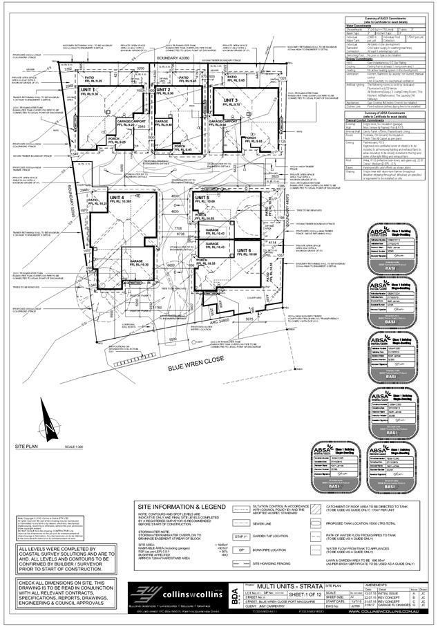
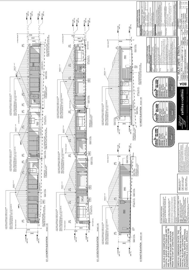
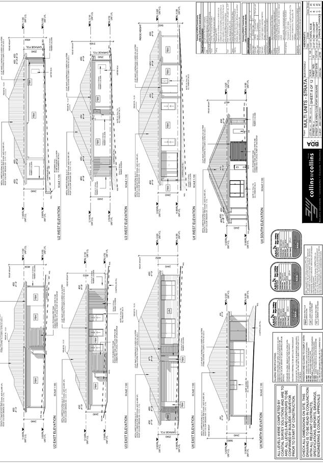
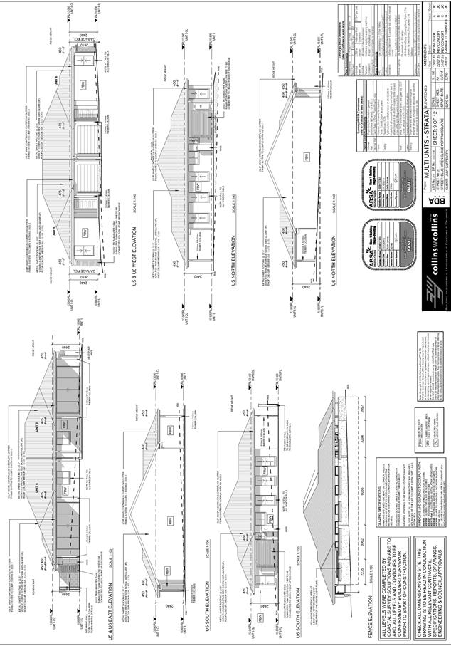
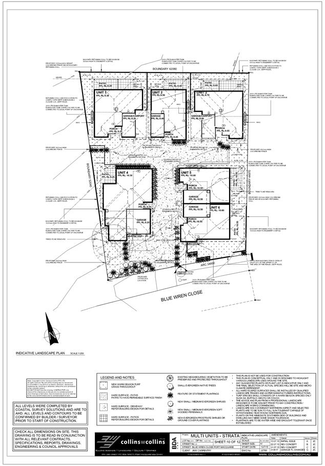
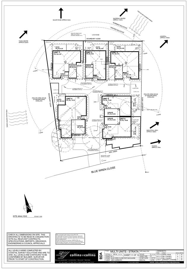
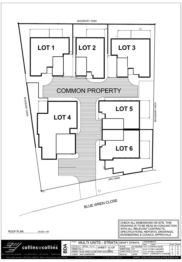
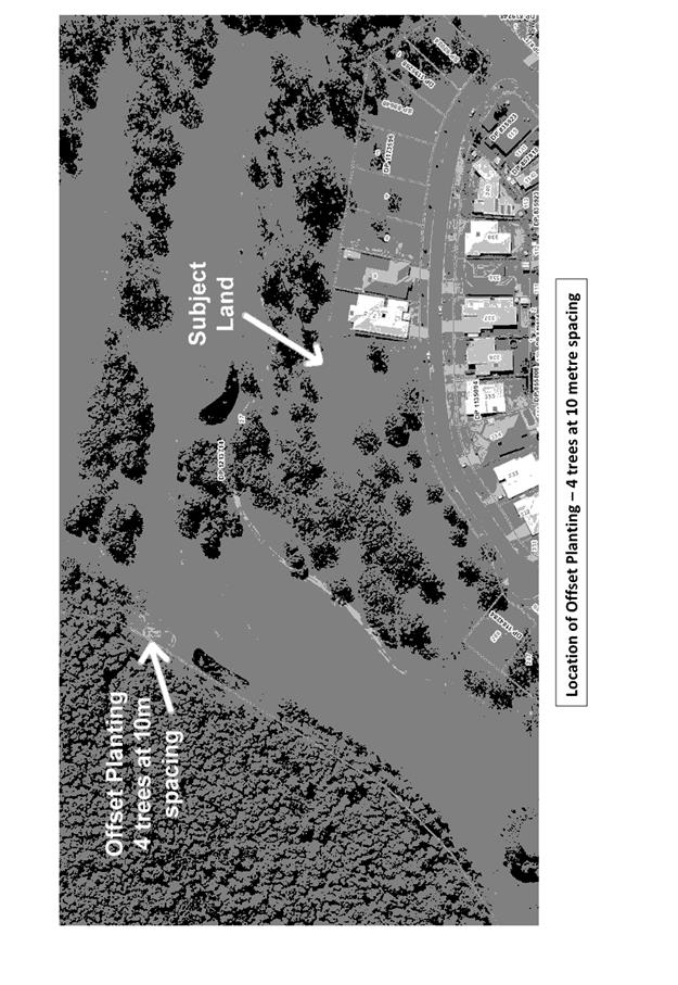
|
ATTACHMENT
|
Development Assessment Panel
25/10/2017
|
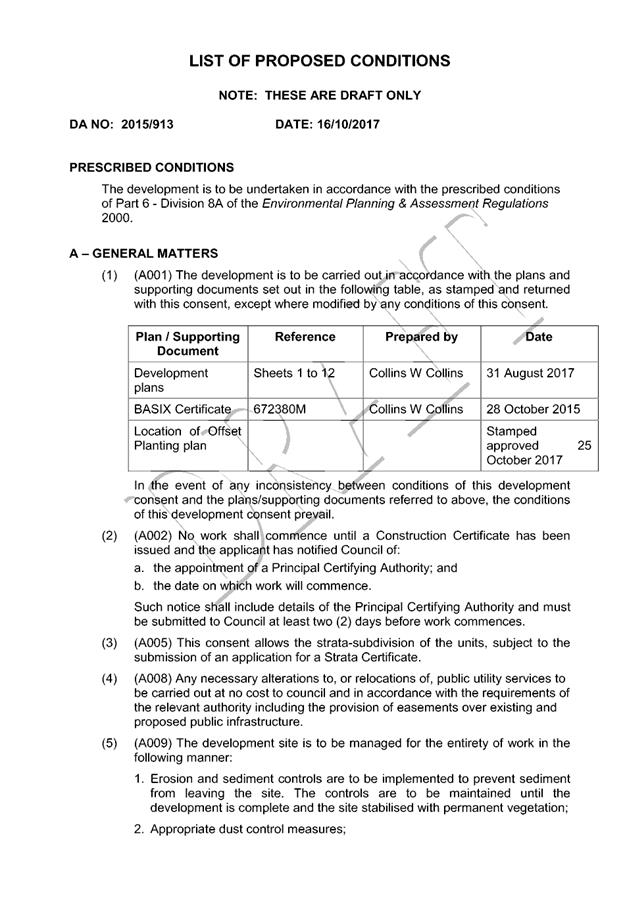
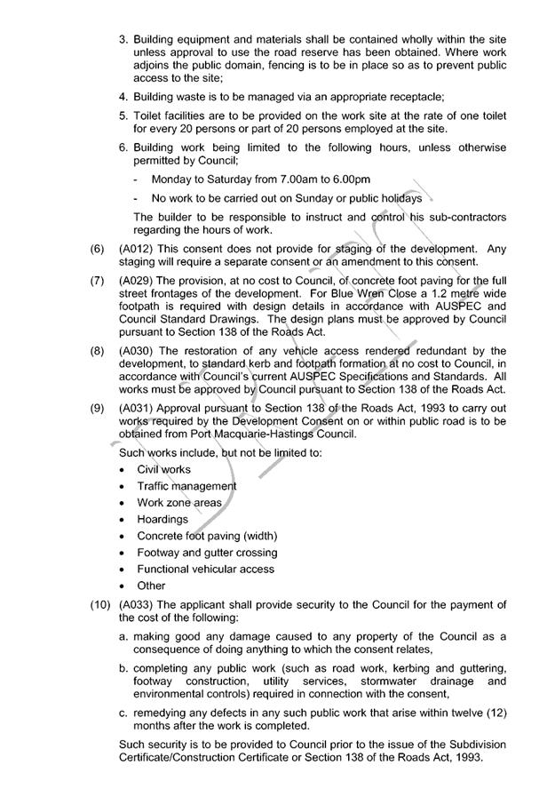
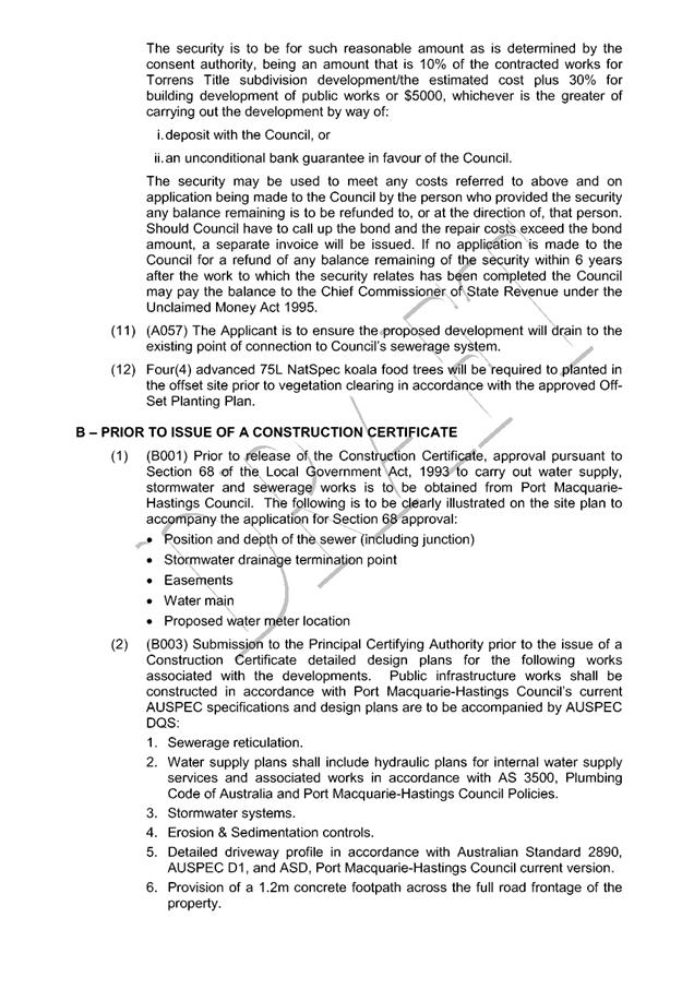
|
ATTACHMENT
|
Development Assessment Panel
25/10/2017
|
|
ATTACHMENT
|
Development Assessment Panel
25/10/2017
|

AGENDA Development Assessment Panel 25/10/2017
Item: 08
Subject: DA2016 - 372.2 Modification To Residential
Flat Building - Lot 3 DP 345930, No. 3 Gore Street, Port Macquarie
Report
Author: Clint Tink
|
Applicant: All
About Planning
Owner: Gotham
Trading Pty Ltd
Estimated Cost: N/A
Alignment with Delivery
Program
4.3.1 Undertake transparent
and efficient development assessment in accordance with relevant legislation.
|
|
RECOMMENDATION
That
DA 2016 - 372.2 for a Section
96 modification to a residential flat building at Lot 3, DP 345930, No. 3
Gore Street, Port Macquarie, be determined by granting consent subject to the
recommended conditions.
|
Executive
Summary
This
report considers a Section 96(1A) modification of consent application at the subject site and provides an assessment of the
application in accordance with the Environmental Planning and Assessment Act
1979.
Being a
s96 modification, the amended proposal has been assessed against the
legislation in place at the time of the original assessment.
Following exhibition of the
application, three (3) submissions were received.
1. BACKGROUND
Existing sites features and Surrounding development
The site has an area of 588.1m².
The site is zoned R4 High Density Residential in accordance with the Port Macquarie-Hastings Local
Environmental Plan 2011, as shown in the following zoning plan:
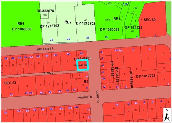
The existing subdivision pattern and location of existing
development within the locality is shown in the following aerial photograph:
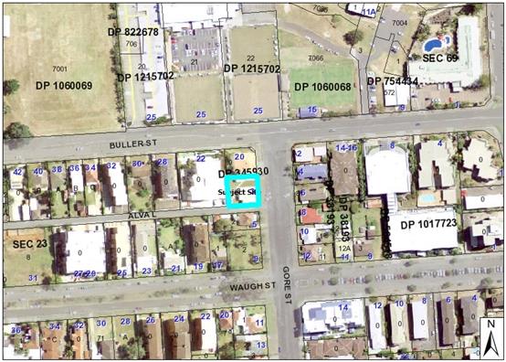
2. DESCRIPTION OF
DEVELOPMENT
Key aspects of the proposal include the following:
· Council’s
Development Assessment Panel (DAP) approved the original development on 9
November 2016. The DAP report and minutes are attached at the end of this
report for context.
· The
proposal is retained as a six (6) storey residential flat building comprising:
- 11 units with 10 units containing 2
bedrooms and 1 unit containing 3 bedrooms.
- A basement
level car park is also retained. However, access to the basement will change
from Gore Street to Alva Lane and will introduce a single car lift for access/egress.
The lift also eliminates the need for the previous approved stacker parking.
- 14 parking
spaces are proposed within the basement, which includes 12 spaces for residents
and 2 visitor parking spaces. Included in the 12 resident spaces is a disabled
space and stacked space for the 3 bedroom unit.
· The majority of the building design and layout remains
unchanged from the first floor up. In particular, the changes centre on the
basement and ground floor in response to the revised driveway entry design.
· The height of the building remains unchanged with the
previous Clause 4.6 variation to Clause 4.3 (height of buildings) in the Port
Macquarie Hastings Local Environmental Plan 2011 still standing.
· The residential flat building has dual frontage to Gore
Street and Alva Lane. Pedestrian access is provided off both frontages.
· The development also involves strata subdivision.
· Three (3) submissions received to the modification.
Refer
to attachments at the end of this report.
Application Chronology
· 9/11/2016
- DA2016 - 372.1 approved by DAP.
· 13/4/2017 – Council staff met with the
applicant/owner to discuss potential changes to the approved development, the
s96 process and issues to be considered.
· 6/7/2017 – s96 modification lodged with Council.
· 20/7/2017 to 2/8/2017 – Notification period.
· 21/7/2017 – Council staff requested additional
information on BASIX, parking, storage, screening, open space and various minor
matters. Applicant acknowledged request.
· 30/8/2017 – Applicant provided response to additional
information request from Council staff.
· 31/8/2017 – Based on the response/revised detail,
Council staff requested further information and clarification on fire doors,
plantings and screening.
· 4/9/2017 – Applicant responded to screening issue.
· 6/9/2017 – Applicant responded to fire door and
planting concerns.
· 26/9/2017 to 4/10/2017 – Discussion between Council
staff and applicant around the height and operations of the car lift.
· 3-4/10/2017 – Discussions between Council staff and
car lift company on noise levels.
· 12/10/2017 – Applicant responded to car lift matters.
A waiting bay was include off Alva Lane, greater setback to the lift entry to
allow potential stacked waiting and reconfigure of basement parking. The
waiting bay relocated a section of deep soil zone area to the north east
corner.
3. STATUTORY ASSESSMENT
Is the proposal substantially the same?
Section
96 of the Environmental Planning and Assessment Act 1979 enables the
modification of consents and categorises modifications into three categories -
S.96(1) for modifications involving minor error, mis-description or
miscalculation; S.96(1A) for modifications involving minimal environmental
impact; and S.96(2) for other modifications. Each type of modification must be
considered as being substantially the same to that which was originally
consented to.
The
subject application is being considered under the provisions of Section 96(1A).
The proposal is considered to be substantially the same development to that
which was originally lodged and consented to and will have minimal
environmental impact. In particular, the main changes occur at the basement and
ground level regarding vehicle access being changed from Gore Street via a
driveway down into the basement to a car lift off Alva Lane. Having regard to
the above, the proposed modification is not considered to alter the fundamental
essence of the original development for the following reasons:
· The building dimensions, design, height, number of units,
footprint etc remain relatively unchanged.
· The revised vehicle basement access provides a suitable
alternate arrangement while ensuring the overall development remains
substantially the same – see above dot point.
Are
there any condition(s) of consent imposed by a Minister, government or public
authority that require modification?
No
changes to any conditions imposed by a Minister, government or public
authority.
Does
the application require notification/advertising in accordance with the
regulations and/or any Development Control Plan?
Neighbour
notification has been undertaken in accordance with the DCP.
Any submissions made concerning the modification?
Three written submissions were received following public
exhibition of the application.
Key issues raised in the submissions received and comments
in response to the issues are provided as follows:
|
Submission
Issue/Summary
|
Planning
Comment/Response
|
|
A lot of cars already use Alva
Lane. Alva Lane is narrow, contains potholes and has no lighting. The change will
cause traffic problems for users of Alva Lane (ie people queuing to use the
car lift/backing out into Alva Lane to allow someone out of the lift). Will
residents resort to parking in Alva Lane or adjoining properties? The Gore
Street vehicle access is the better location.
|
The proposed modification,
design off Alva Lane and future growth occurring in the area have been
considered by Council staff in the assessment process. The design is
considered acceptable for the following reasons:
- Conditions
will be imposed to upgrade the section of Alva Lane that the development
fronts. This will include widening to allow passing traffic if a car chooses
to wait within the road reserve to use the lift.
- Waiting
areas are incorporated into the design to allow occupants of the residential
flat building to also wait onsite for the car lift (rather than in Alva
Lane).
- The
development is within walking distance to key CBD areas, which will reduce
the need for vehicles.
- There
are parking areas in Gore Street that are more likely to be used rather than
people resorting to parking in Alva Lane or adjoining properties.
The above matters, coupled
with the small number of units proposed, will ensure Alva Lane
operates in an acceptable manner.
|
|
Loss of privacy to bedrooms in
the property to the west.
|
It should be noted that the
design of the building from ground level up remains essentially the same to
that which was originally approved. The main change to the western neighbour
is the installation of the car lift, which will reduce openings to the west.
Fencing, separation and screening will further ensure privacy to the western
property is maintained.
The main bedroom openings on
the property to the west are also designed at an angle to face north (ie they
don’t face east). This will further aid in maintaining privacy in an
east west direction.
|
|
Noise from the car lift.
|
The car lift was reviewed by
Council’s Environmental Health Officer and considered unlikely to
create adverse noise. Components for the lift are located within the basement
and the opening faces south. Conditions will also be imposed to further
reinforce that the car lift is designed and operates in accordance with
acceptable noise levels.
|
Any
matters referred to in section 79C (1) relevant to the modification?
Overall,
the proposed development remains consistent with the original s79C assessment.
Areas of the original assessment impacted by the changes or with revised
comments are outlined below. For all other matters, refer to comments provided
in the original DAP assessment attached to this report:
State Environmental Planning
Policy No. 65 – Design Quality of Residential Flat Development (SEPP 65)
Clause 115 of the Environmental
Planning and Assessment Regulation 2000 does not require a revised design
verification for a s96(1A).
|
Principle
3: Density
Good design
achieves a high level of amenity for residents and each apartment, resulting
in a density appropriate to the site and its context.
Appropriate
densities are consistent with the area’s existing or projected
population. Appropriate densities can be sustained by existing or proposed
infrastructure, public transport, access to jobs, community facilities and
the environment.
|
The
original application proposed an FSR of 1.99:1. The modification proposes an
FSR of 1.97:1. The new FSR is a minor reduction and remains compliant with
previous comments.
|
Complies
|
|
Apartment Design Guide (ADG)
Objective
|
Design Guidance/Design
Criteria (Italics)
|
Proposed
|
Complies
|
|
3D Communal and public open
space
|
|
3D - 1 An adequate area of
communal open space is provided to enhance residential amenity and to provide
opportunities for landscaping
|
Design Criteria
1. Communal open space has a
minimum area equal to 25% of the site (see figure 3D.3)
2. Developments achieve a
minimum of 50% direct sunlight to the principal usable part of the communal
open space for a minimum of 2 hours between 9 am and 3 pm on 21 June (mid
winter).
Communal open space should be
consolidated into a well designed, easily identified and usable area.
Communal open space should have a
minimum dimension of 3m, and larger developments should consider greater
dimensions.
Communal open space should be
co-located with deep soil areas.
Direct, equitable access should
be provided to communal open space areas from common circulation areas,
entries and lobbies.
Where communal open space cannot
be provided at ground level, it should be provided on a podium or roof.
Where developments are unable to
achieve the design criteria, such as on small lots, sites within business
zones, or in a dense urban area, they should:
- provide
communal spaces elsewhere such as a landscaped roof top terrace or a common room
- provide
larger balconies or increased private open space for apartments
- demonstrate
good proximity to public open space and facilities and/or provide
contributions to public open space
|
25% of the site (588.1m²)
equates to a communal open space area requirement of 147m². The
original development provided an area of approximately 42m² with an
additional 10m² area being 2.58m in width (just short of the 3m width
requirement).
The modification provides an area
of 37m² with an additional 7m². The width of the areas are less
than 3m but are considered to remain useable. The changes are a minor
decrease from the original approval
As allowed by the ADG, the
shortfall is still justified based on the following:
- The
shortfall has been offset by providing the units with an excess of private
open space above the standard.
- The
site is constrained by size and the lack of opportunities to consolidate with
surrounding sites.
- The
site is well positioned to take advantage of surrounding public open space
for larger communal activities.
In addition to the above, the
communal areas are easily accessible, well defined, useable, co-located with
deep soil areas, located at ground level and contain a mixture of light and
shade areas.
|
Yes
|
|
3E Deep soil zones
|
|
3E - 1 Deep soil zones provide
areas on the site that allow for and support healthy plant and tree growth.
They improve residential amenity and promote management of water and air
quality
|
Design Criteria
1. Deep soil zones are to meet
the following minimum requirements:
a) <
650m²,
no min dimension, 7% site area deep soil zone.
b) 650-1500m²,
3m dimension, 7% site area deep soil zone.
c) >1500m²,
6m dimension, 7% site area deep soil zone.
On some sites it may be possible
to provide larger deep soil zones, depending on the site area and context:
- 10%
of the site as deep soil on sites with an area of 650m² - 1,500m²
- 15%
of the site as deep soil on sites greater than 1,500m².
Deep soil zones should be located
to retain existing significant trees and to allow for the development of
healthy root systems, providing anchorage and stability for mature trees.
Design solutions may include:
- basement
and sub basement car park design that is consolidated beneath building
footprints
- use
of increased front and side setbacks
- adequate
clearance around trees to ensure long term health
- co-location
with other deep soil areas on adjacent sites to create larger contiguous
areas of deep soil.
Achieving the design criteria may
not be possible on some sites including where:
- the
location and building typology have limited or no space for deep soil at
ground level (e.g. central business district, constrained sites, high density
areas, or in centres)
- there
is 100% site coverage or non-residential uses at ground floor level.
Where a proposal does not achieve
deep soil requirements, acceptable stormwater management should be achieved
and alternative forms of planting provided such as on structure.
|
The site is <650m². The
applicant originally proposed 6.7% deep soil zone. The modification proposes
an increase to 7%. Improved outcome.
|
Yes
|
|
3H Vehicle access
|
|
3H - 1 Vehicle access points are
designed and located to achieve safety, minimise conflicts between
pedestrians and vehicles and create high quality streetscapes
|
Car park access should be
integrated with the building’s overall facade. Design solutions may
include:
- the
materials and colour palette to minimise visibility from the street
- security
doors or gates at entries that minimise voids in the facade
- where
doors are not provided, the visible interior reflects the facade design and
the building services, pipes and ducts are concealed.
Car park entries should be
located behind the building line.
Vehicle entries should be located
at the lowest point of the site minimising ramp lengths, excavation and
impacts on the building form and layout.
Car park entry and access should
be located on secondary streets or lanes where available.
Vehicle standing areas that
increase driveway width and encroach into setbacks should be avoided.
Access point locations should
avoid headlight glare to habitable rooms.
Adequate separation distances
should be provided between vehicle entries and street intersections.
The width and number of vehicle
access points should be limited to the minimum.
Visual impact of long driveways
should be minimised through changing alignments and screen planting.
The need for large vehicles to
enter or turn around within the site should be avoided.
Garbage collection, loading and
servicing areas are screened.
Clear sight lines should be
provided at pedestrian and vehicle crossings.
Traffic calming devices such as
changes in paving material or textures should be used where appropriate.
Pedestrian and vehicle access
should be separated and distinguishable. Design solutions may include:
- changes
in surface materials
- level
changes
- the
use of landscaping for separation
|
The proposed development will
change from a driveway entry off Gore Street to a driveway off Alva Lane that
will enter what looks like a single garage. However, the single garage area
will contain a car lift that transports vehicles in and out of the basement
car park.
The revised location has the
benefits of being off a secondary lane and behind the building façade.
The process of a car entering the
lift and going up or down can take 1-2 minutes with an approximate 3 minute
cycle. A waiting area off Alva Lane and driveway length (ie capable of
holding another car) have been provided to ensure no adverse traffic
impacts on Alva Lane. Alva Lane will also be upgraded/widened to allow
passing traffic
Landscaping provided to help
blend in the entry.
Alva Lane is already treated as a
back of house area so headlight glare will create no adverse impact.
|
Yes
|
|
3J Bicycle and car parking
|
|
3J - 1 Car parking is provided
based on proximity to public transport in metropolitan Sydney and centres in
regional areas
Notes
Port Macquarie is a nominated
regional centre.
In terms of using Guide to
Traffic Generating Developments, Port Macquarie is a “sub-regional
centre” as by definition it does not have access to rail.
Medium density is 2 - <20
dwellings.
High Density is 20 or more
dwellings
|
Design Criteria
1. For
development in the following locations:
a) on
sites that are within 800 metres of a railway station or light rail stop in
the Sydney Metropolitan Area; or
b) on
land zoned, and sites within 400 metres of land zoned, B3 Commercial Core, B4
Mixed Use or equivalent in a nominated regional centre
the minimum car parking
requirement for residents and visitors is set out in the Guide to Traffic
Generating Developments, or the car parking requirement prescribed by the
relevant council, whichever is less
The car parking needs for a
development must be provided off street.
Where a car share scheme operates
locally, provide car share parking spaces within the development. Car share
spaces, when provided, should be on site.
Where less car parking is
provided in a development, council should not provide on street resident
parking permits
Guide to Traffic Generating
Developments
Medium density residential flat
buildings require:
- 1
space per unit +
- 1
space for every 5 x 2 bedroom unit +
- 1
space for every 2 x 3 bedroom unit +
- 1
space for 5 units (visitor parking).
High density residential flat
buildings for metropolitan sub-regional centres require:
- 0.6
spaces per 1 bedroom unit
- 0.9
spaces per 2 bedroom unit
- 1.40
spaces per 3 bedroom unit +
- 1
space per 5 units (visitor parking)
|
Site is within 400m of a B3 zone.
Building is medium density.
10 x 2 bed units and 1 x 3 bed
units proposed.
11 x 1 space per unit = 11
spaces
10 x 2 bedroom units/5 = 2 spaces
1 x 3 bedroom unit/2 = 0.5 spaces
11/5 = 2.2 visitor spaces.
Total required is 11 + 2 + 0.5 +
2.2 = 15.7 spaces (rounds to 16)
The original proposal
nominated/had approved, 14 spaces onsite and contributions to cover the 2
space shortfall. The modification does not change this outcome.
|
Yes
|
|
3J - 4 Visual and environmental
impacts of underground car parking are minimised
|
Excavation should be minimised
through efficient car park layouts and ramp design.
Car parking layout should be well
organised, using a logical, efficient structural grid and double loaded
aisles.
Protrusion of car parks should
not exceed 1m above ground level. Design solutions may include stepping car
park levels or using split levels on sloping sites.
Natural ventilation should be
provided to basement and sub basement car parking areas.
Ventilation grills or screening
devices for car parking openings should be integrated into the facade and
landscape design
|
The modification will reduce
excavation by eliminating the need for car stackers.
Layout is well organised. While
car lifts have not been popular to date in Port Macquarie they are a suitable
alternative and used elsewhere.
|
Yes
|
|
4E Private open space and
balconies
|
|
4E - 1 Apartments provide
appropriately sized private open space and balconies to enhance residential
amenity
|
Design Criteria
1. All apartments are required
to have primary balconies as follows:
a) Studio
apartments = 4m²
b) 1
bedroom apartments = 8m²
and 2m min depth.
c) 2
bedroom apartments = 10m²
and 2m min depth.
d) 3+
bedroom apartments = 12m²
and 2.4m min depth.
The minimum balcony depth to
be counted as contributing to the balcony area is 1m.
2. For apartments at ground
level or on a podium or similar structure, a private open space is provided
instead of a balcony. It must have a minimum area of 15m² and a
minimum depth of 3m.
Increased communal open space
should be provided where the number or size of balconies are reduced.
Storage areas on balconies is
additional to the minimum balcony size.
Balcony use may be limited in
some proposals by:
- consistently
high wind speeds at 10 storeys and above
- close
proximity to road, rail or other noise sources
- exposure
to significant levels of aircraft noise
- heritage
and adaptive reuse of existing buildings
In these situations, juliet
balconies, operable walls, enclosed wintergardens or bay windows may be
appropriate, and other amenity benefits for occupants should also be provided
in the apartments or in the development or both. Natural ventilation also
needs to be demonstrated
|
Ground floor apartments have in
excess of the 15m²
and 3m minimum depth. Ground floor open space has increased due to
driveway/entry being moved to the rear.
|
Yes
|
|
4H Acoustic privacy
|
|
4H - 1 Noise transfer is
minimised through the siting of buildings and building layout
|
Adequate building separation is
provided within the development and from neighbouring buildings/adjacent uses
(see also section 2F Building separation and section 3F Visual privacy).
Window and door openings are
generally orientated away from noise sources.
Noisy areas within buildings
including building entries and corridors should be located next to or above
each other and quieter areas next to or above quieter areas.
Storage, circulation areas and
non-habitable rooms should be located to buffer noise from external sources.
The number of party walls (walls
shared with other apartments) are limited and are appropriately insulated.
Noise sources such as garage
doors, driveways, service areas, plant rooms, building services, mechanical
equipment, active communal open spaces and circulation areas should be
located at least 3m away from bedrooms.
|
The revised basement entry faces
a back of house lane and is well separated from other properties.
A screen over the window to
ground floor unit 1, bedroom 2 will help ensure privacy and screening to the
new car lift waiting area. The window will also be conditioned to be high
sill. The waiting area is also unlikely to be used at night (quieter time)
ensuring minimal impact.
Other acoustic provisions of ADG
have been suitably implemented.
|
Yes
|
|
4L Ground floor apartments
|
|
4L - 2 Design of ground floor
apartments delivers amenity and safety for residents
|
Privacy and safety should be
provided without obstructing casual surveillance. Design solutions may
include:
- elevation
of private gardens and terraces above the street level by 1-1.5m (see figure
4L.4)
- landscaping
and private courtyards
- window
sill heights that minimise sight lines into apartments
- integrating
balustrades, safety bars or screens with the exterior design
Solar access should be maximised
through:
- high
ceilings and tall windows
- trees
and shrubs that allow solar access in winter and shade in summer
|
The use of elevation, fencing,
screening and landscaping provides a suitable mixture of privacy and
surveillance.
Solar access will not be
adversely inhibited.
|
Yes
|
|
4O Landscape design
|
|
4O - 1 Landscape design is viable
and sustainable
|
Landscape design should be
environmentally sustainable and can enhance environmental performance by
incorporating:
- diverse
and appropriate planting
- bio-filtration
gardens
- appropriately
planted shading trees
- areas
for residents to plant vegetables and herbs
- composting
- green
roofs or walls
Ongoing maintenance plans should
be prepared.
Microclimate is enhanced by:
- appropriately
scaled trees near the eastern and western elevations for shade
- a
balance of evergreen and deciduous trees to provide shading in summer and
sunlight access in winter
- shade
structures such as pergolas for balconies and courtyards
Tree and shrub selection
considers size at maturity and the potential for roots to compete (see Table
4)
Table 4 requires
- For
site area up to 850m²
= 1 medium tree per 50m²
of deep soil zone
- Between
850 - 1,500m²
= 1 large tree or 2 medium trees per 90m²
of deep soil zone
- Greater
than 1,500m²
= 1 large tree or 2 medium trees per 80m²
of deep soil zone
|
Suitable landscape plan provided
that allows a range of plantings and stormwater detention.
1 medium tree required based on
the size of the property and deep soil zone. At least one medium tree is
considered achievable and has been shown on the plan.
|
Yes
|
|
4P Planting on structures
|
|
4P - 1 Appropriate soil profiles
are provided
|
Structures are reinforced for
additional saturated soil weight
Soil volume is appropriate for
plant growth, considerations include:
- modifying
depths and widths according to the planting mix and irrigation frequency
- free
draining and long soil life span
- tree
anchorage
Minimum soil standards for plant
sizes should be provided in accordance with Table 5.
Table 5 requires
- Large
trees 12-18m high, up to 16m crown spread at maturity = need 150m³ of soil at a depth
of 1,200mm and area of 10m x 10m or equivalent.
- Medium
trees 8-12m high, up to 8m crown spread at maturity = need 35m³ of soil at a depth
of 1,000mm and area of 6m x 6m or equivalent.
-
Small trees 6-8m high, up to 4m crown spread at maturity = need 9m³ of soil at a
depth of 800mm and area of 3.5m x 3.5m or equivalent.
- Shrubs
need soil depth of 500-600mm
- Ground
cover needs soil depth of 300-450mm
- Turf
needs soil depth of 200mm
|
Can be engineered to comply -
condition required.
The north eastern deep soil zone
has suitable dimensions to allow a medium size tree to grow as required by 4O
- 1 above.
Smaller areas contain suitable
depths to allow variations in species size and type.
|
Yes
|
|
4V Water management and
conservation
|
|
4V - 3 Flood management systems
are integrated into site design
|
Detention tanks should be located
under paved areas, driveways or in basement car parks.
On large sites parks or open
spaces are designed to provide temporary on site detention basins.
|
Detention provided via a tank
under the vehicle driveway.
|
Yes
|
|
4W Waste management
|
|
4W - 1 Waste storage facilities
are designed to minimise impacts on the streetscape, building entry and
amenity of residents
|
Adequately sized storage areas
for rubbish bins should be located discreetly away from the front of the
development or in the basement car park.
Waste and recycling storage areas
should be well ventilated.
Circulation design allows bins to
be easily manoeuvred between storage and collection points.
Temporary storage should be
provided for large bulk items such as mattresses.
A waste management plan should be
prepared
|
Suitable sized basement garbage
storage proposed.
Garbage area located in the
basement out of site and accessible to occupants
Private collection required and
to be conditioned.
Ventilation provided.
|
Yes
|
|
4X Building maintenance
|
|
4X - 2 Systems and access enable
ease of maintenance
|
Window design enables cleaning
from the inside of the building.
Building maintenance systems
should be incorporated and integrated into the design of the building form,
roof and façade.
Design solutions do not require
external scaffolding for maintenance access.
Manually operated systems such as
blinds, sunshades and curtains are used in preference to mechanical systems.
Centralised maintenance, services
and storage should be provided for communal open space areas within the
building.
|
New storage area added to
basement area that could be used for maintenance.
|
Yes
|
|
|
|
|
|
State Environmental Planning Policy (Building
Sustainability Index: BASIX) 2004
A revised BASIX certificate (number
716615M_03) has been submitted demonstrating that the revised proposal will
comply with the requirements of the SEPP. It is recommended that a condition
be imposed to ensure that the commitments are incorporated into the development
and certified at Occupation Certificate stage.
Port
Macquarie-Hastings Local Environmental Plan 2011
· Clause 4.4, the floor space ratio (FSR) of the modification
is 1.97:1 a reduction from the original 1.99:1. Modification remains
compliant with the maximum 2:1 floor space ratio
applying to the site.
· Clause 7.3, the site is land within a mapped “flood
planning area”. The modification has been reviewed by Council’s
Flood Officer and accepted, subject to conditions.
(iii) any
Development Control Plan in force:
Port
Macquarie-Hastings Development Control Plan 2013
|
DCP 2013: Residential Flat Development, Tourist and
Visitor Accommodation and Mixed Use Development
|
|
|
DCP Objective
|
Development Provisions
|
Proposed
|
Complies
|
|
|
3.3.2.6
|
Side setbacks comply with Figure 3.3-1:
· Min. Side
setback 1.5m for 75% of building depth.
· Windows on side
walls min. 3m from side boundary.
· 3m minimum where
adjacent to existing strata titled building.
|
The original approved development was setback 3m from side
boundaries. In terms of the modification, part of the ground floor of the
building has been extended to the western boundary to accommodate the entry
point to the car lift structure. The particular section of building does not
contain any windows, habitable use or result in a loss of privacy. In
addition, the single storey height of the new component and southern location
does not create any adverse overshadowing.
Suitable landscaping and open space are retained.
|
Yes
|
|
|
3.3.2.24
|
Solid fences should be:
· Max. 1.2m high,
· Setback 1m,
· Suitably
landscaped,
· Provide 3m x 3m
splay.
|
The modification contains a front fence that is over 1.2m
but not more than 1.8m (to be conditioned). The fence is setback
approximately 2m from the front boundary. The fence will also contain
vegetation screening and transparency in accordance with the DCP. The new
front fence component is considered an acceptable change that will provide
security and privacy to the development, while not impacting on the
streetscape.
|
Yes
|
|
|
3.3.2.29
|
Development complies with AS/NZS2107:2000 Acoustic
– Recommended design sound levels and reverberation times for building
interiors for residential development.
|
As per the original approval, details to be provided at CC
stage.
|
Yes
|
|
|
3.3.2.46
|
Accessible storage provided for tenants in basement car
park or garages.
|
While the modification does not propose storage in the
basement for each unit, proposed storage is compliant with ADG.
|
Yes
|
|
|
DCP 2013: General Provisions
|
|
DCP Objective
|
Development Provisions
|
Proposed
|
Complies
|
|
2.7.2.2
|
Design addresses generic principles of Crime Prevention
Through Environmental Design guideline:
· Casual
surveillance and sightlines
· Land use mix and
activity generators
· Definition of
use and ownership
· Lighting
· Way finding
· Predictable
routes and entrapment locations
|
The proposed modification does create a new concealment
area at the fire exit onto Alva Lane. The western wall to the fire exit
(creating the concealment) will be conditioned to be removed or amended.
|
Yes
|
|
2.5.3.2
|
Driveway crossing/s minimal in number and width including
maximising street parking
|
A suitable driveway has been provided off Alva Lane. The
change in vehicle entry from Gore Street to Alva Lane (as proposed in the
modification) will improve street parking overall. In particular, the removal
of the driveway in Gore Street will create additional street parking, while
the new driveway in Alva Lane does not impact on street parking (ie currently
no street parking in Alva Lane).
|
Yes
|
|
DCP 2013: Westport
Precinct
|
|
|
DCP Objective
|
Development Provisions
|
Proposed
|
Complies
|
|
|
4.2.4.6
|
Side
and rear setbacks to be:
- 3m from side
boundaries.
- 6m from rear
boundary.
- South of Gordon
Street 10m rear setback.
- Party wall not
appropriate.
|
Refer to comments on 3.3.2.6 above in this DCP assessment.
|
Yes.
|
|
|
4.2.4.9
|
Open
space areas are:
- 25% communal open
space. Where 25% not possible due to constraints, 5m² per dwelling required.
- 2 hours sunlight
for communal area between 9am and 3pm.
- Communal areas may
be reduced where development contributes to public area.
- Rooftop communal
setback from edges and not overlook.
|
Refer to comments on 3D –
1 of ADG above in this assessment.
|
No, but acceptable
|
|
|
4.2.4.10
|
Deep
soil to site area provided as follows:
- <650m² =
7%
- 650m² to 1500m² = 10%
- >1500m² = 15%
Min
6m width unless a constrained site - see DCP for what constitutes
constrained. Constrained sites need to be 3m.
10%
paving allowed where tree growth can still occur.
|
Refer to comments on 3E –
1 of ADG above in this assessment.
|
No, but acceptable.
|
|
|
4.2.4.11
|
Fences
and retaining walls to comply with the following:
- Within 1m of front
boundary be max 1.2m high.
- Variations allowed
where ground floor level is higher than ground level.
- Fences greater than
1.2m should be 50% transparent above the 1.2m height.
- Fences should step
down sloping sites.
|
Front fence is setback over 2m
and ground floor level is higher than ground level.
|
Yes
|
|
|
|
|
|
|
|
Other
matters from the original assessment that have been revised due to the
modification are listed below.
Roads
Vehicular access to the on-site car park is now proposed off
Alva Lane, a Council owned and maintained laneway. The Alva Lane road pavement
is variable in condition and width, currently ranging between 3 and 4m and is
missing kerb and piped stormwater drainage in some places, including the
frontage of the site subject to this application. Condition of consent A(14)
exists requiring upgrade of Alva Lane with a design pavement to collector road
standard.
An amendment to this condition is recommended to require
additional laneway widening within the existing 6.2m wide reserve, to provide
additional manoeuvring clearance for cars using the onsite car lift and waiting
bay and potentially allow other vehicles to pass any vehicle that chooses to
wait within Alva Lane instead of onsite.
Traffic and Transport
A Traffic Impact Assessment has not been submitted with the
application. However, the likely traffic generated by residential dwellings is
quantified by research in the RMS’ Guide to Traffic Generating
Developments. For a medium to high density mix of dwellings in a regional
area, around 7 vehicle trips per dwelling per day on average can be expected.
The proposal will shift additional traffic onto Alva Lane.
For 11 proposed units, the increase in traffic using Alva Lane as a result of
the modification is likely to be up to 77 vehicle trips per day, or equating to
8 additional vehicle trips during each peak hour, in the morning and afternoon
peaks (approximately equivalent to 1 car every 7 minutes). Given a lift cycle
time of approximately 3 minutes (ground level to ground level) a waiting bay
has been provided onsite adjacent to the car lift entry to accommodate the
likelihood that multiple cars will want to use the lift simultaneously during
the peak hour.
Multiple other residential flat buildings exist with
principal access to Alva Lane, and those developments have been required to
upgrade the Alva Lane pavement along the frontages of their sites. There are
currently approximately 160 approved dwellings (before approval of the subject
DA proposal) and multiple businesses with principal access along Alva Lane,
including the residential flat buildings. Council’s asset database
indicates that the Alva Lane pavement is in places not constructed to a suitable
standard to cater for the proposed demand. The existing condition A(14) will
ensure this development’s contribution to traffic in the laneway is
offset by improvement works.
Site Frontage & Access
Vehicle access to the site is proposed via a car lift with
frontage to Alva Lane. Sufficient manoeuvring clearances are available to
comply with AS 2890.1 and AS2890.6 and existing conditions of consent act to
ensure compliance.
Parking and Manoeuvring
A total of 14 parking spaces have been provided on-site in
the basement storey, including 1 disabled access space allocated to accessible
Unit 1, and 2 visitor spaces. Parking and driveway widths on site can comply
with relevant Australian Standards (AS 2890) and conditions have been imposed
to reflect these requirements.
Stormwater
Existing stormwater conditions will accommodate the nominal
changes to roof drainage and impervious area. No new risks are identified. Alva
Lane upgrade will need to include augmentation of the existing pit and pipe
network that runs along its northern edge.
Proposed changes to conditions
Refer to attached draft consent illustrating condition
changes.
4. DEVELOPMENT
CONTRIBUTIONS APPLICABLE
As per original application with revised Notice to be
produced (factoring in CPI).
5. CONCLUSION
The application has been assessed in accordance with
Section 96 and 79C of the Environmental Planning and Assessment Act 1979.
Issues raised during assessment and public exhibition of
the application have been considered in the assessment of the application.
Where relevant, conditions have been recommended to manage the impacts
attributed to these issues.
The site is suitable for the proposed development, is not
contrary to the public's interest and will not have a significant adverse
social, environmental or economic impact. It is recommended that the
application be approved, subject to the recommended conditions of consent
provided in the attachment section of this report.
|
Attachments
1View. DA2016
- 372.2 Plans
2View. DA2016
- 372.2 Recommended Conditions
3View. DA2016
- 372.1 Previous DAP Report 9 November 2016
4View. DA2016
- 372.2 Submission - Armstrong
5View. DA2016
- 372.2 Submission - Creighton
6View. DA2016
- 372.2 Submission - Shade
|
|
ATTACHMENT
|
Development Assessment Panel
25/10/2017
|
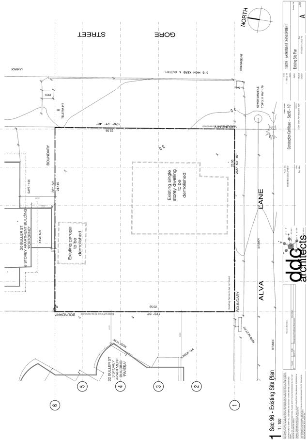
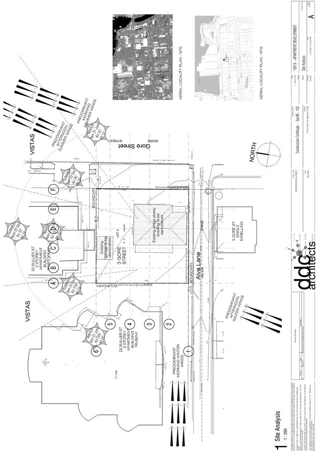
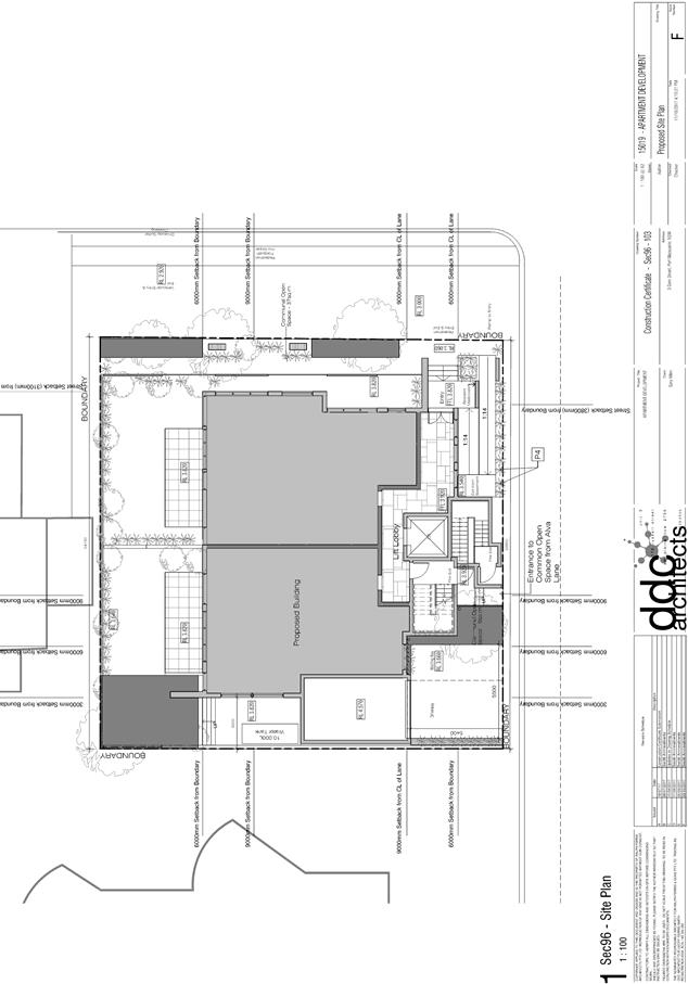
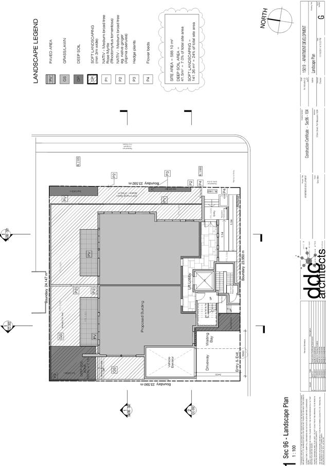
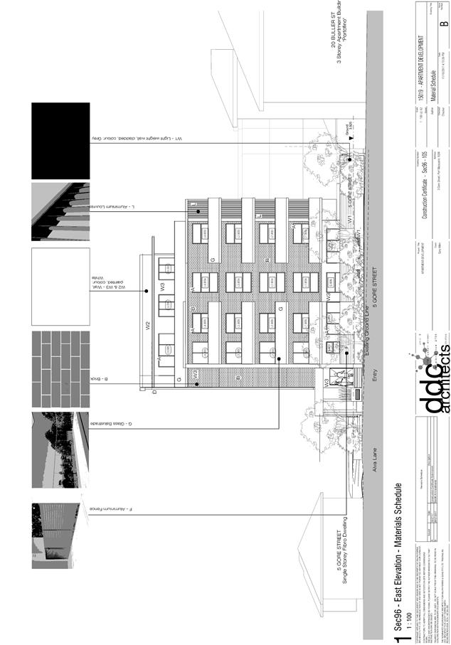
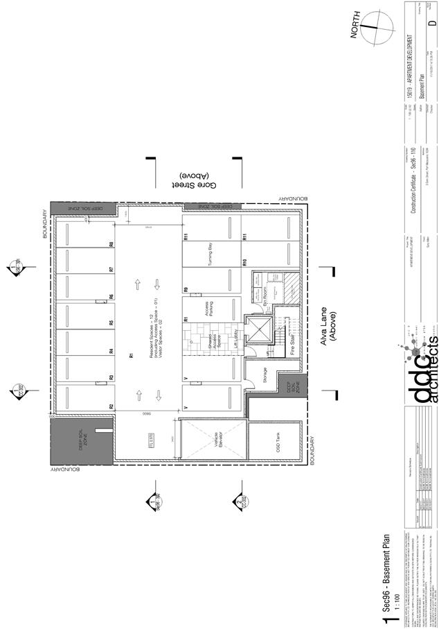
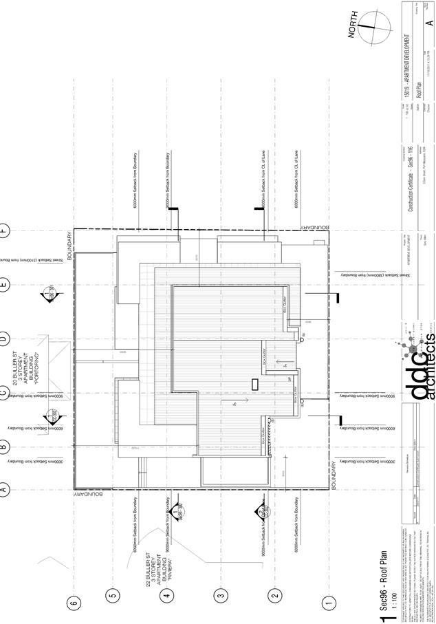
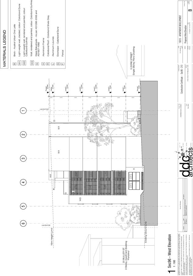
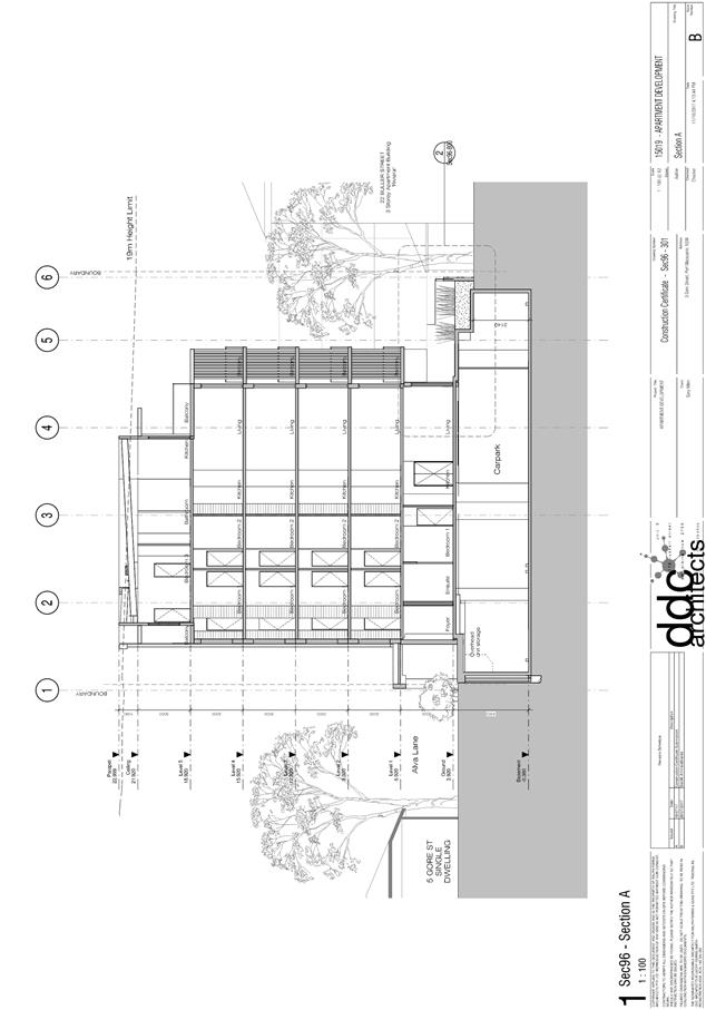
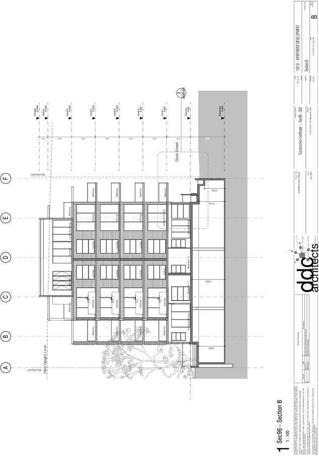
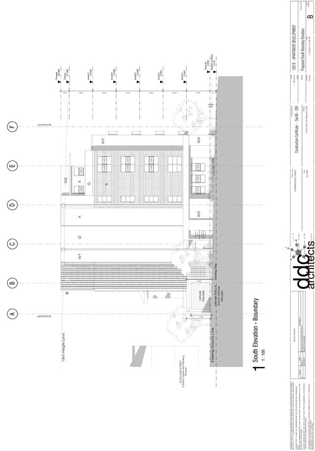
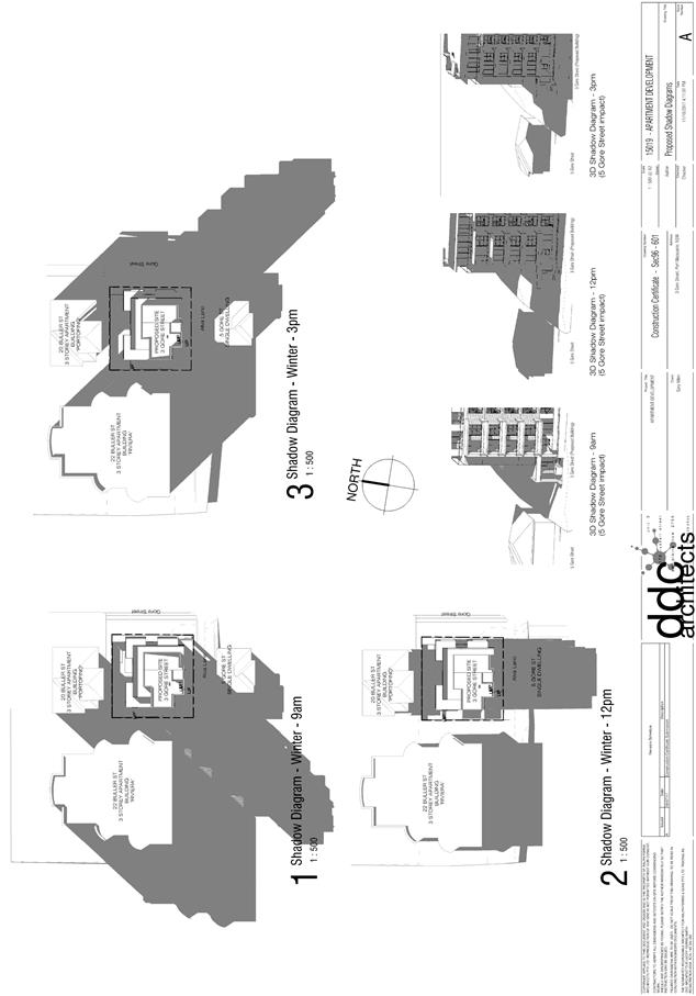
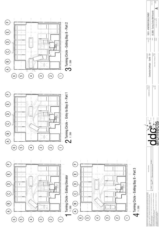
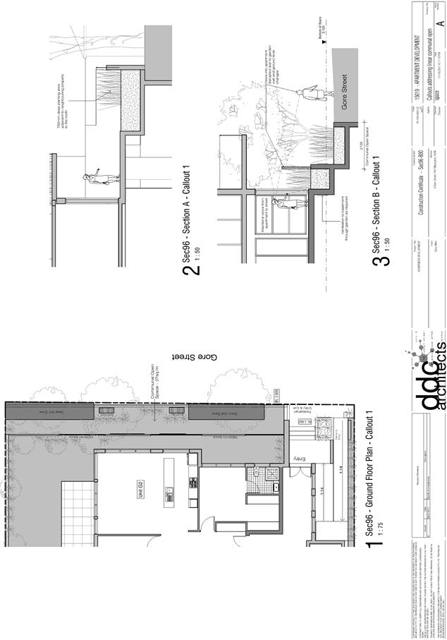
|
ATTACHMENT
|
Development Assessment Panel
25/10/2017
|
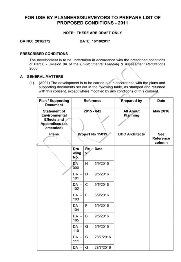
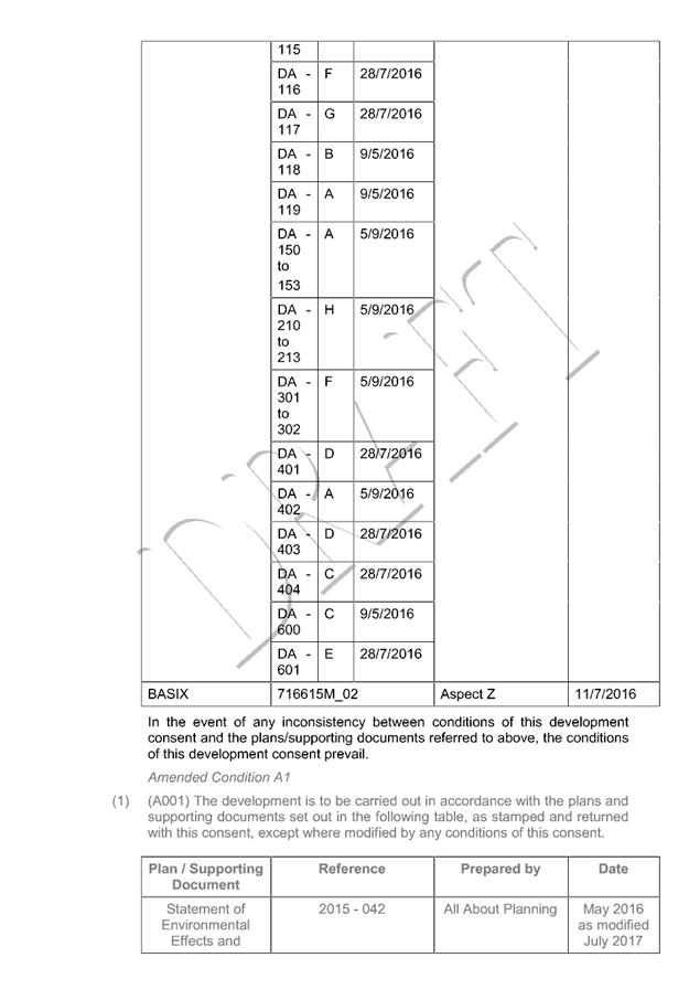
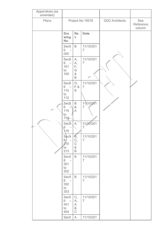
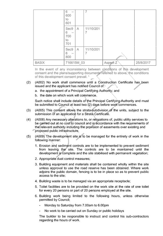
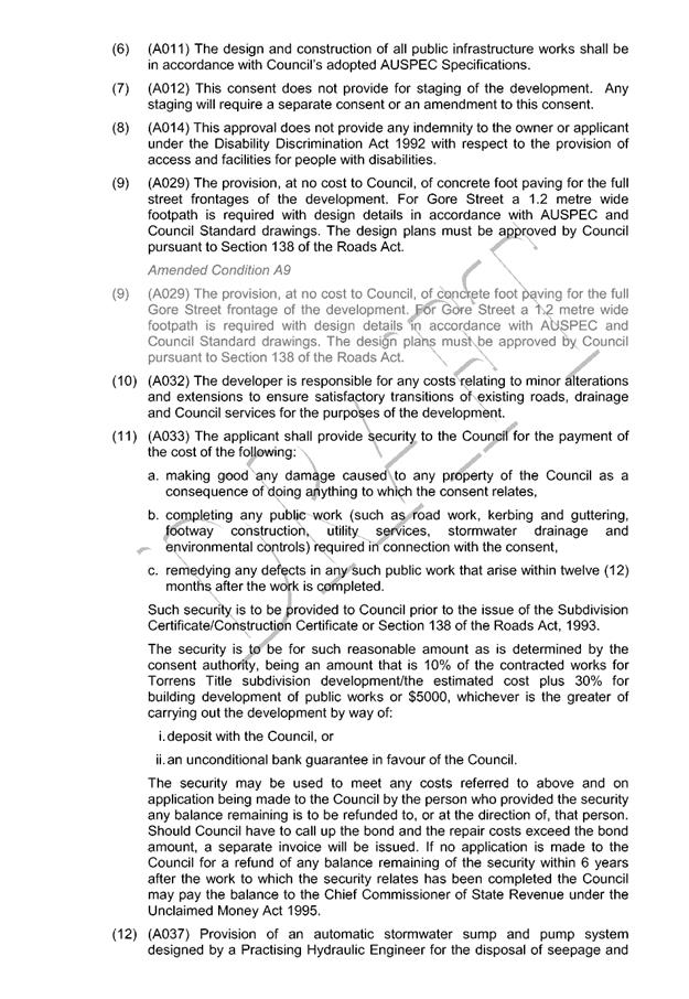

|
ATTACHMENT
|
Development Assessment Panel
25/10/2017
|

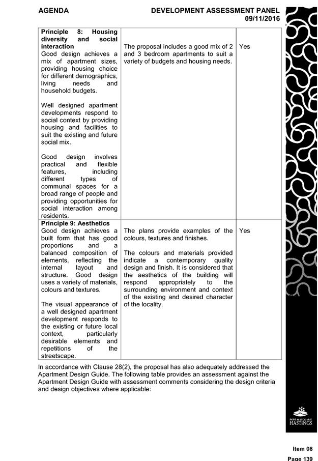
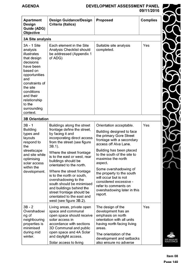
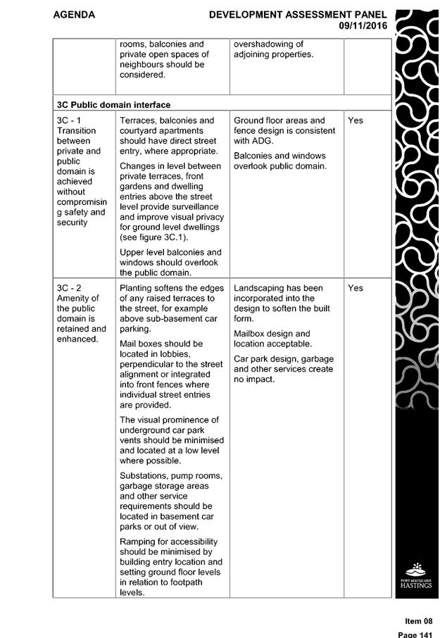
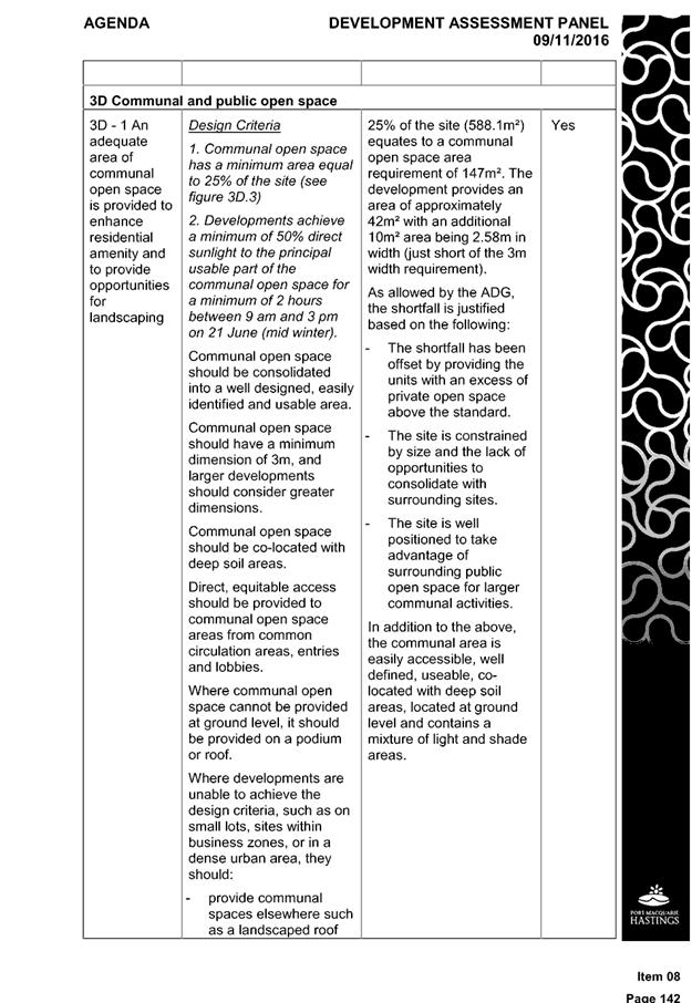
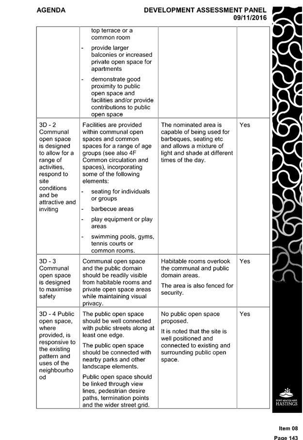
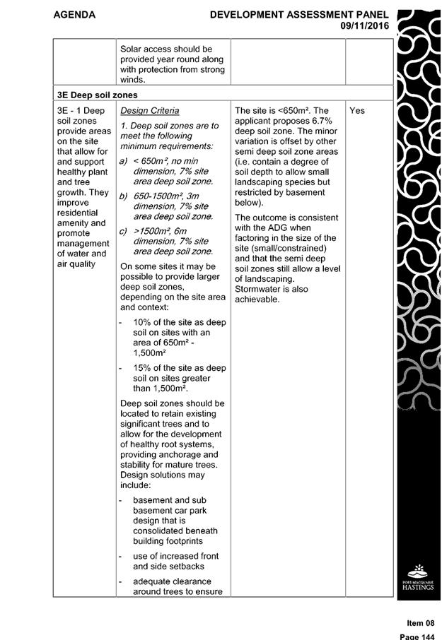
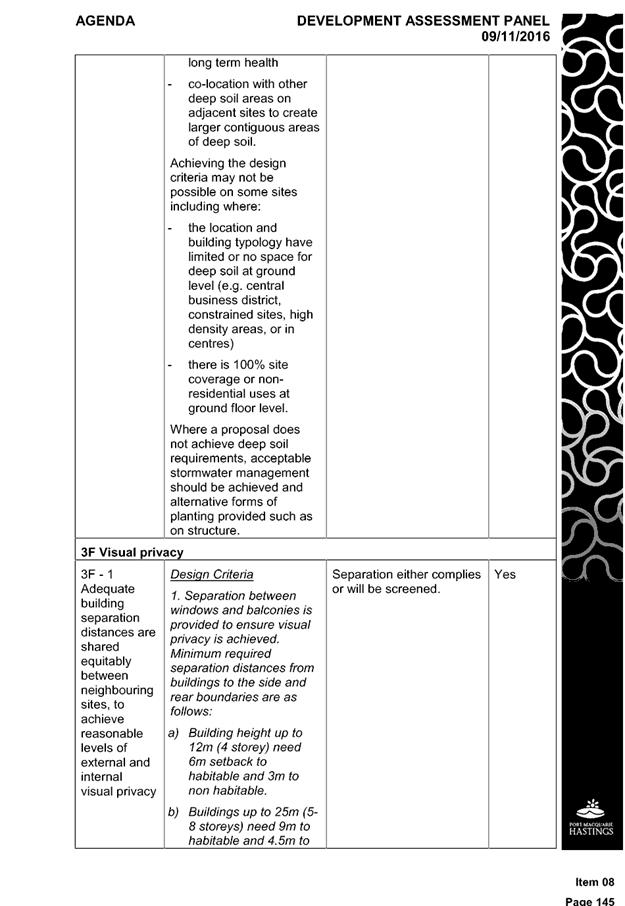
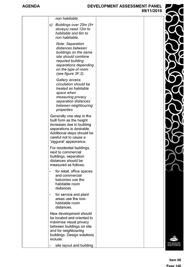
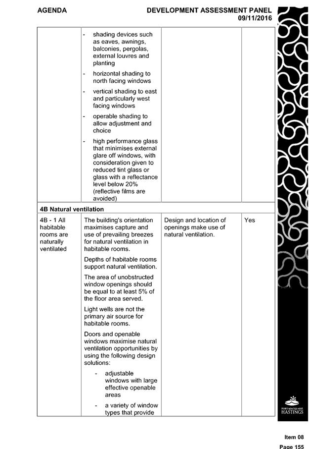
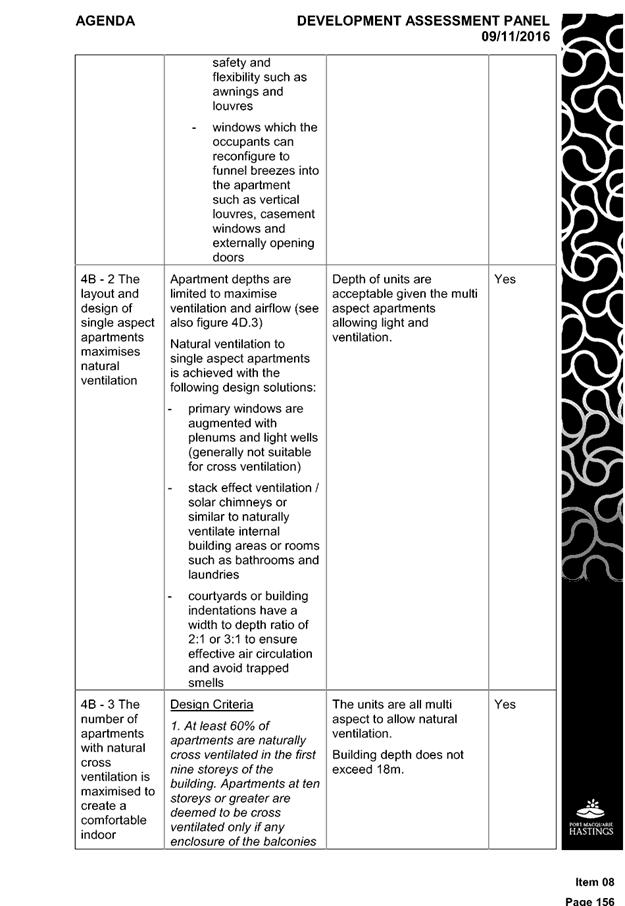
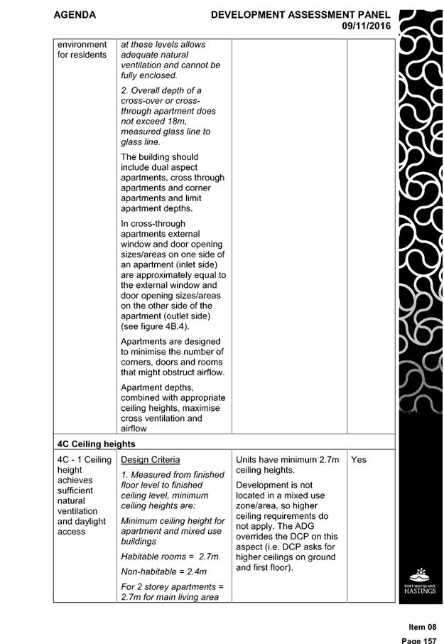
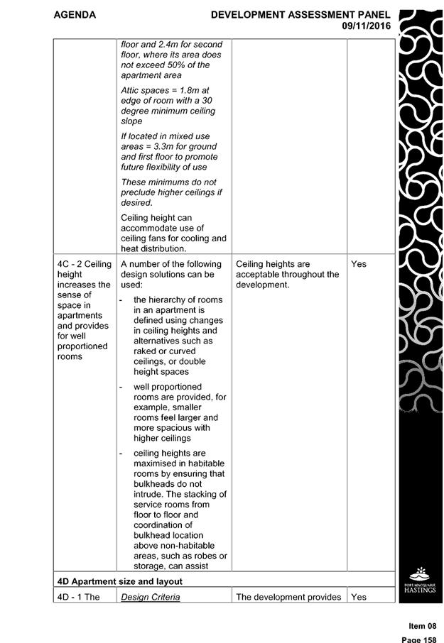
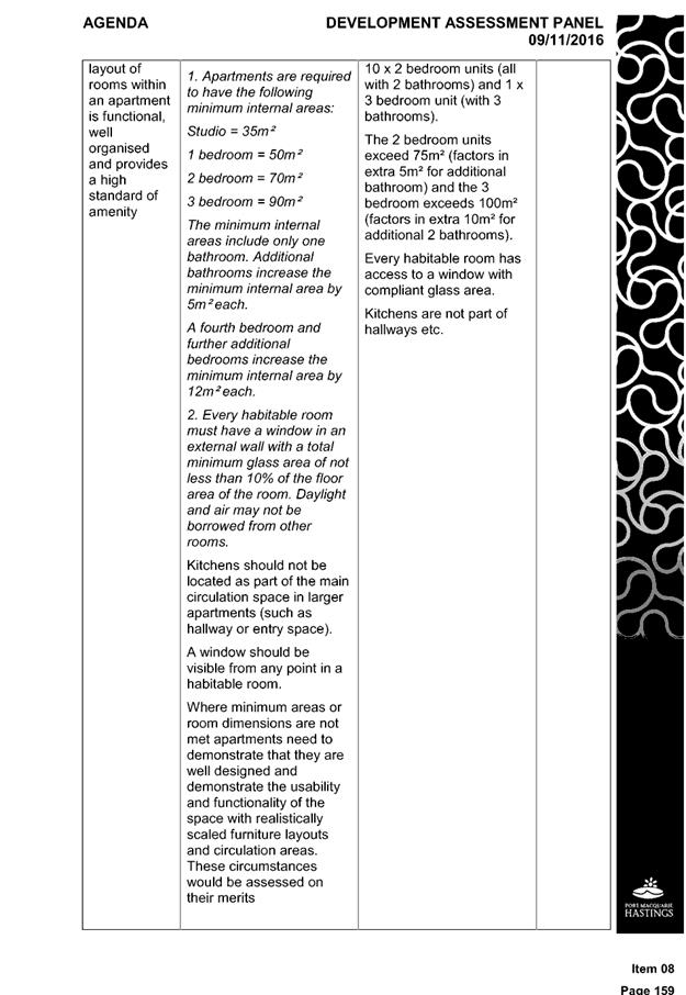
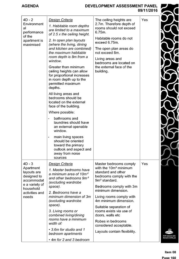


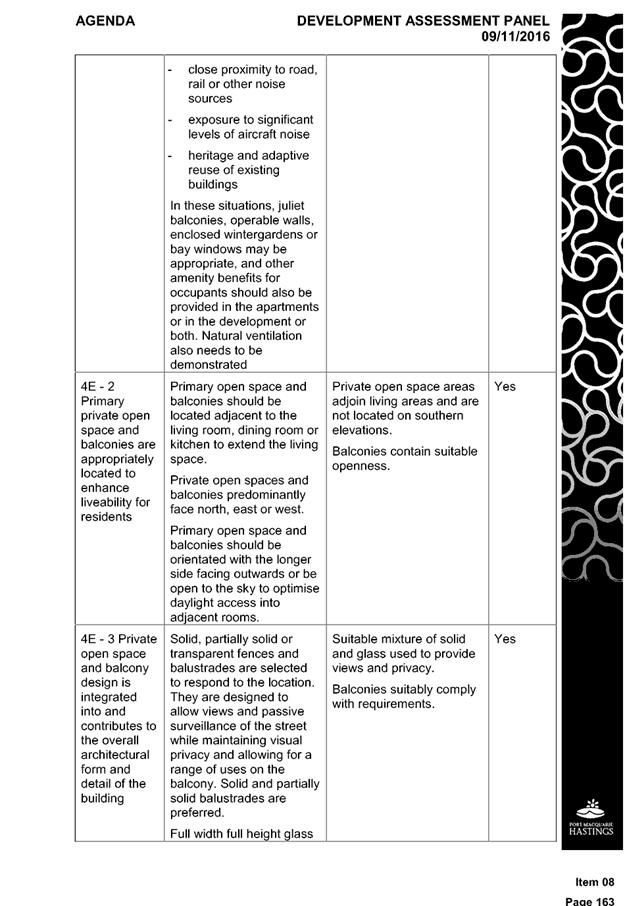
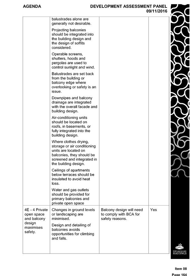
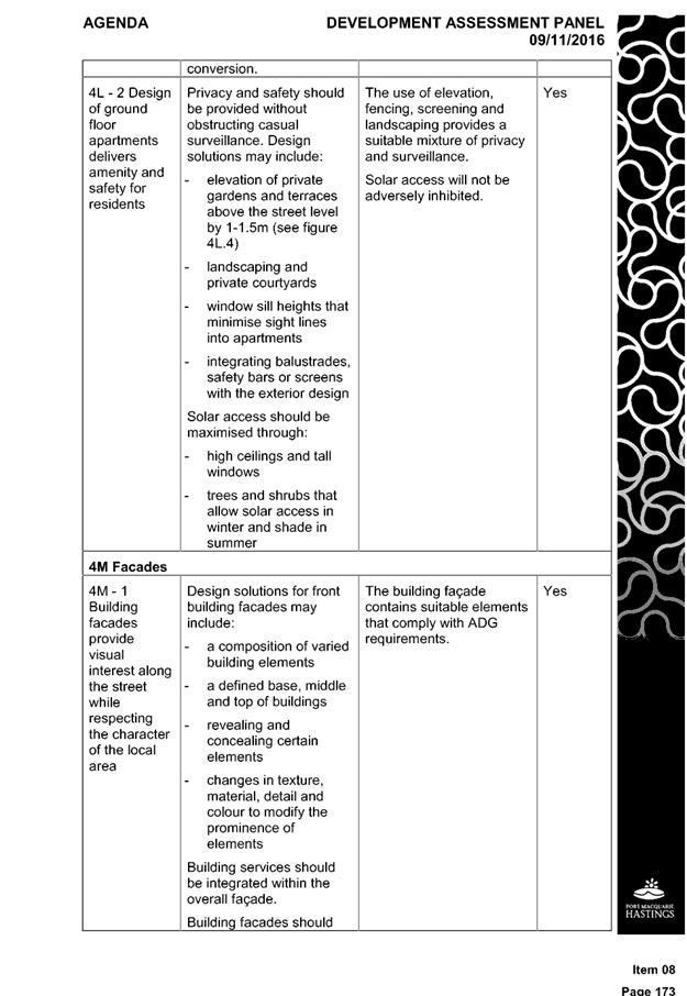
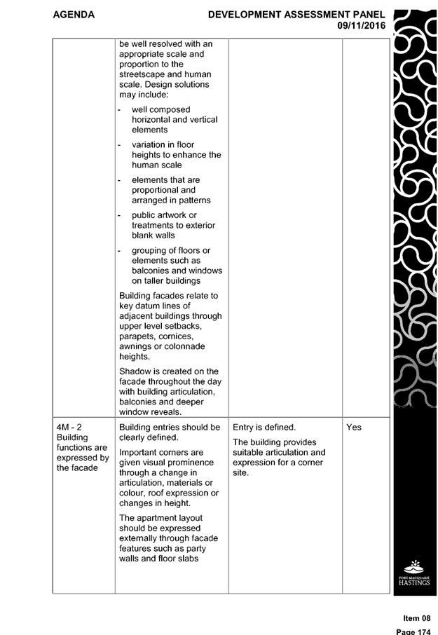
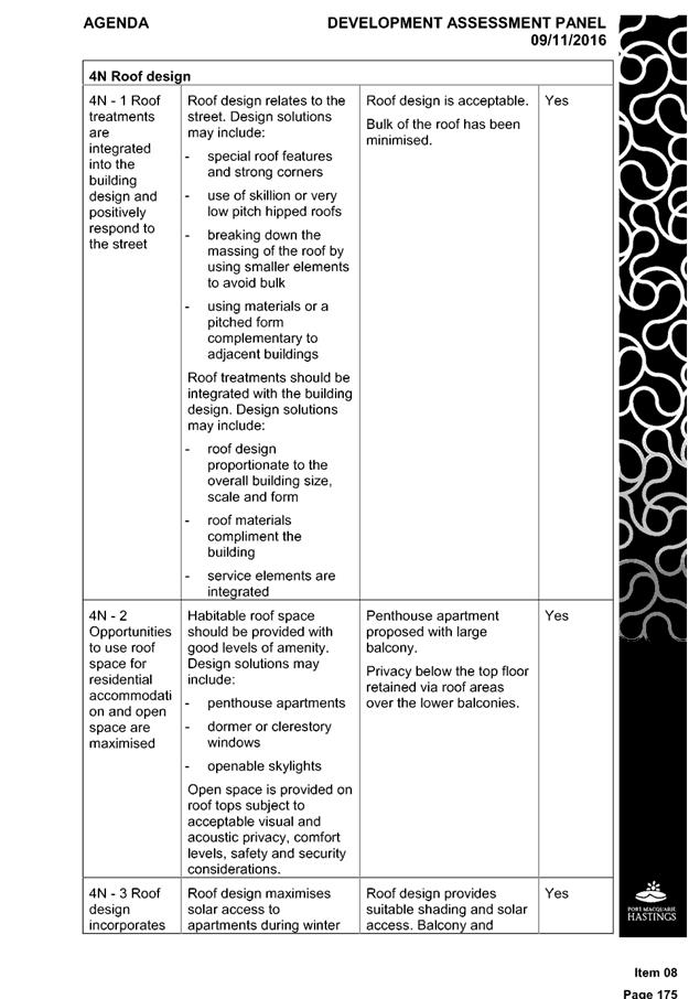
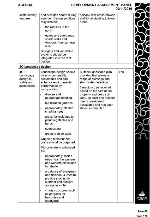
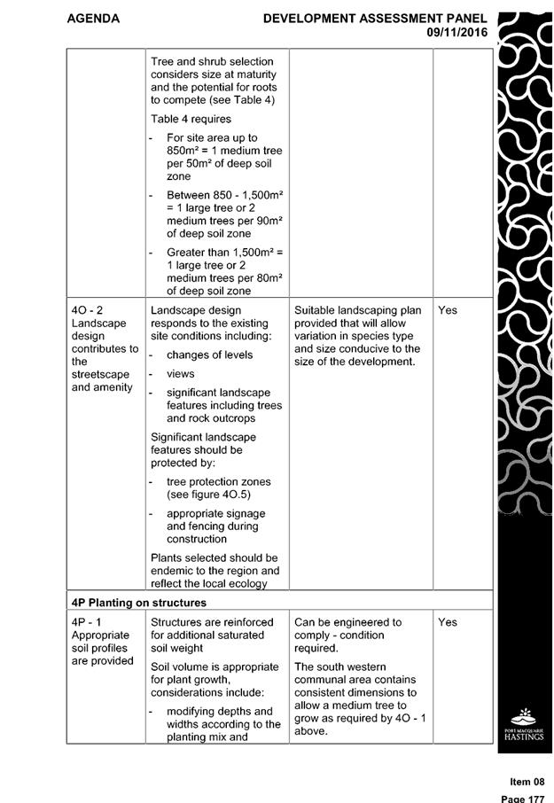
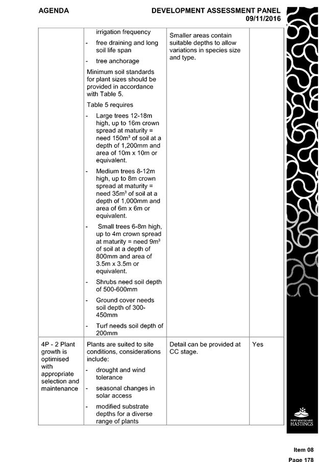
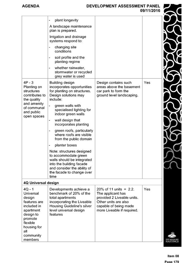
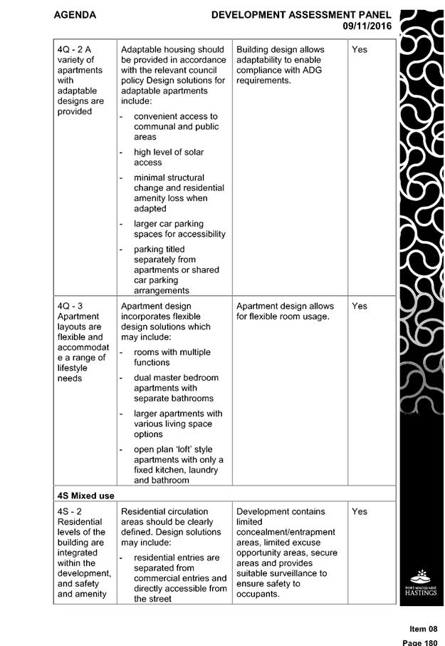
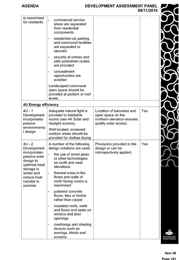
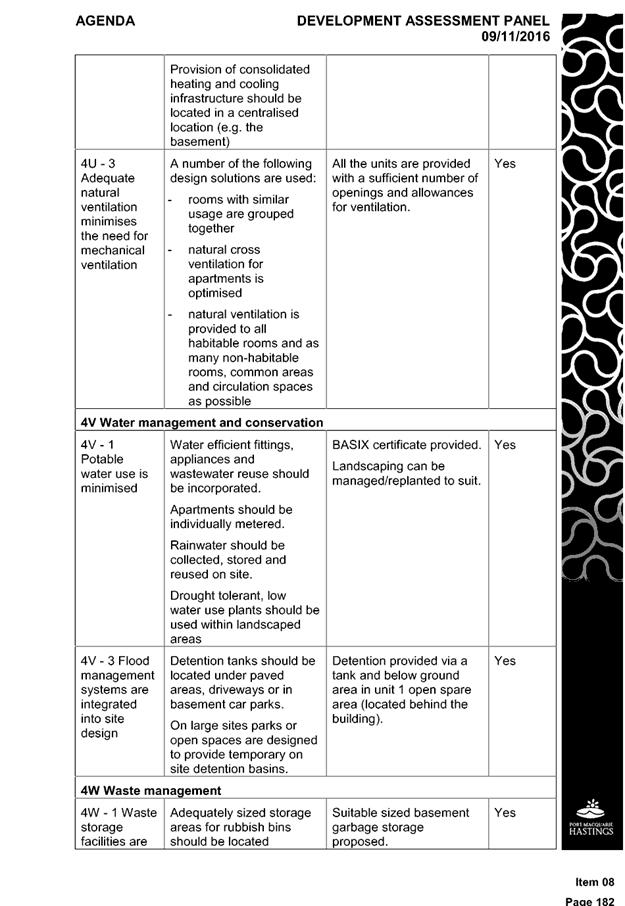
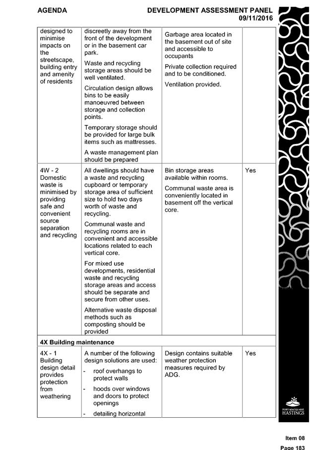
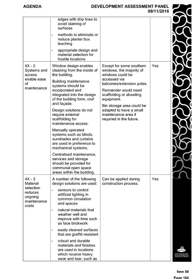

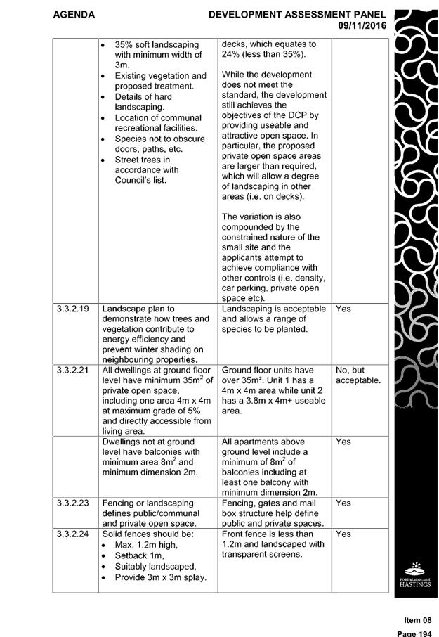
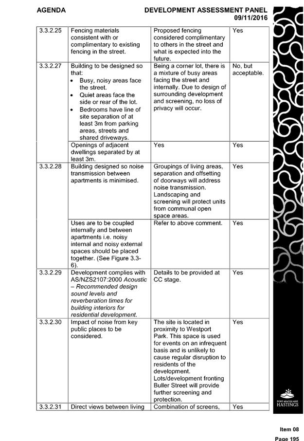
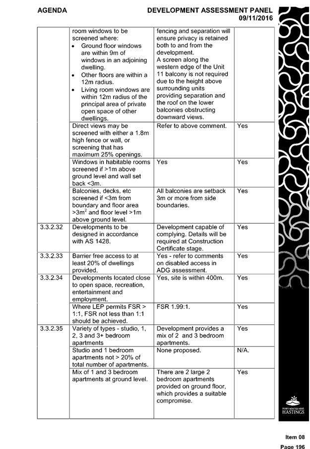
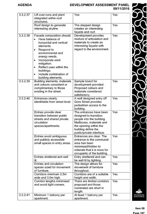
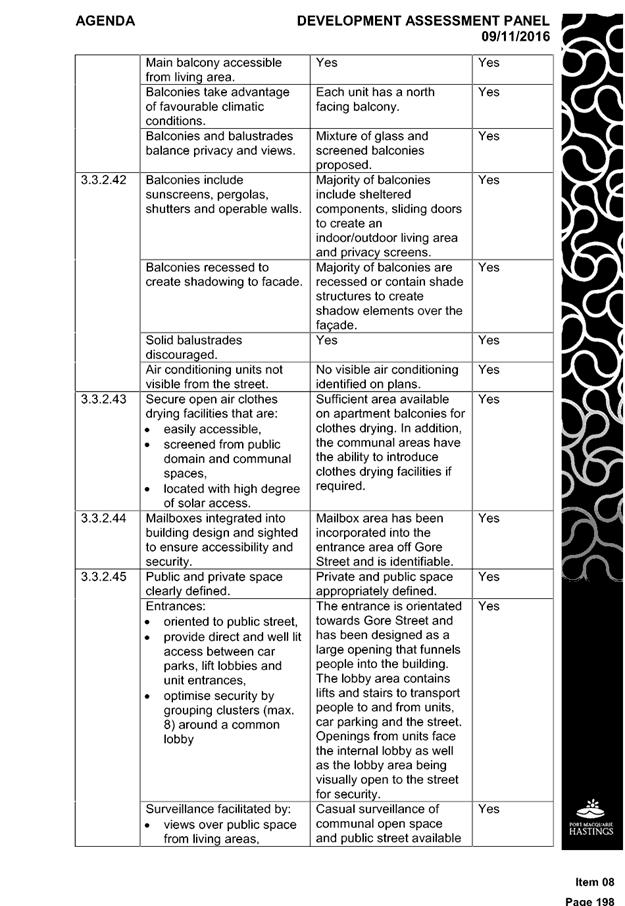
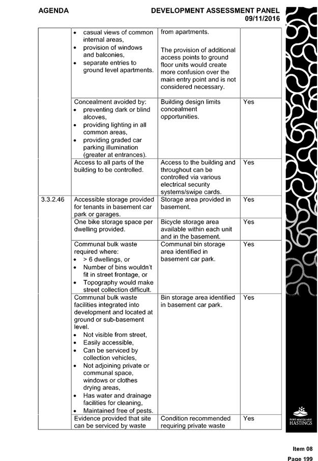
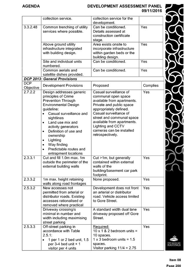
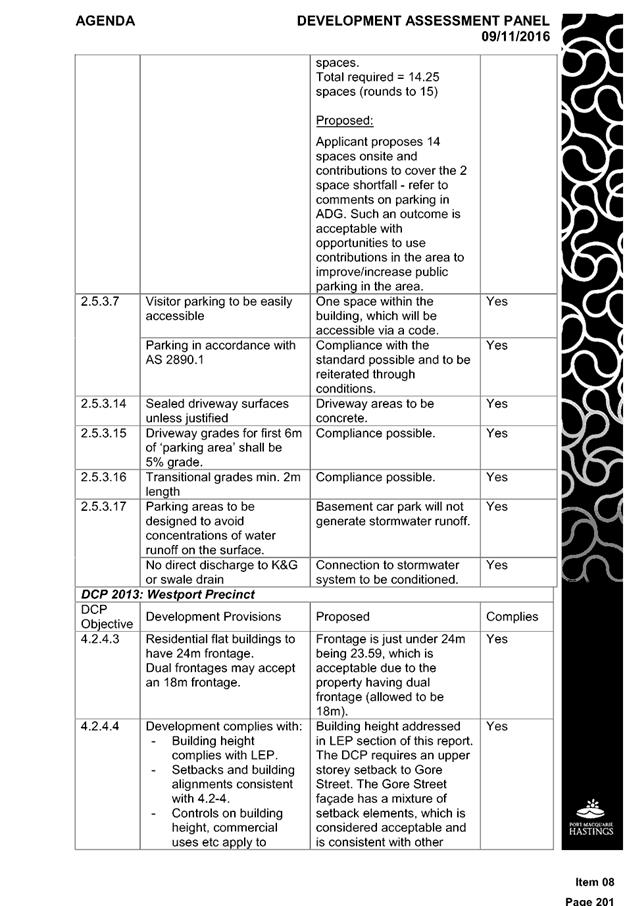
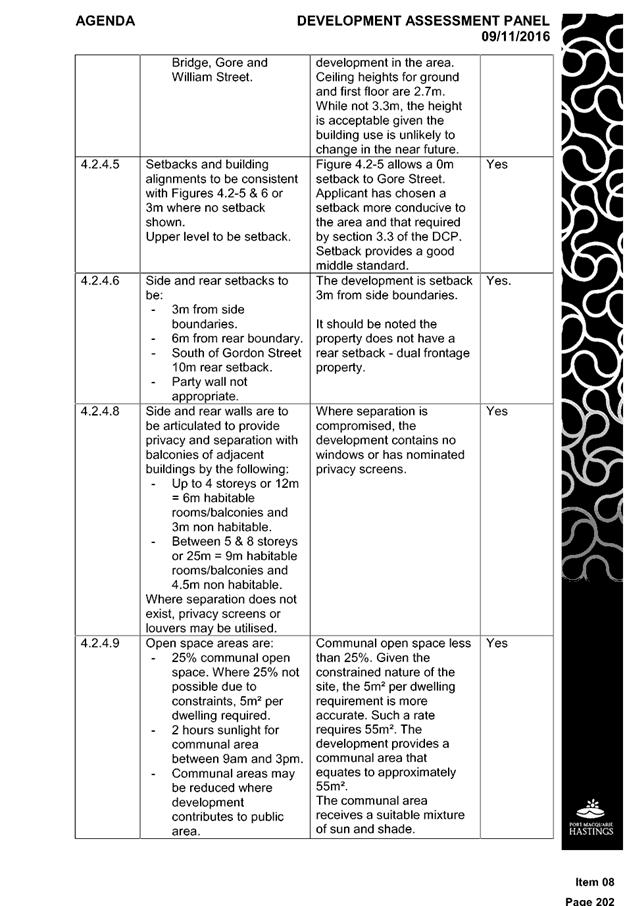
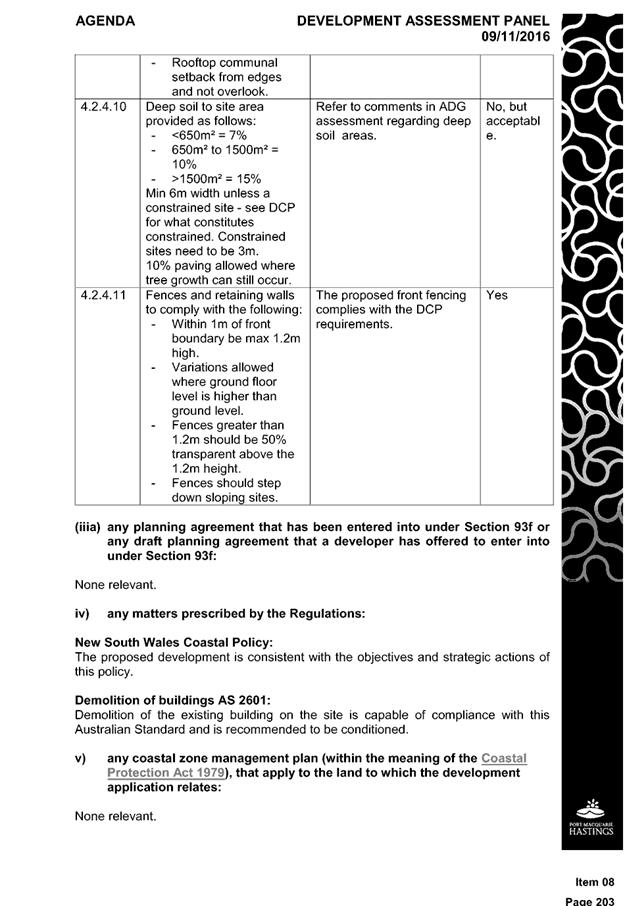
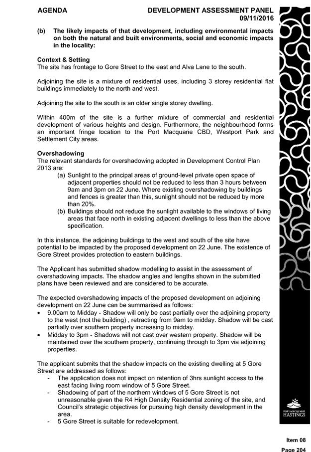
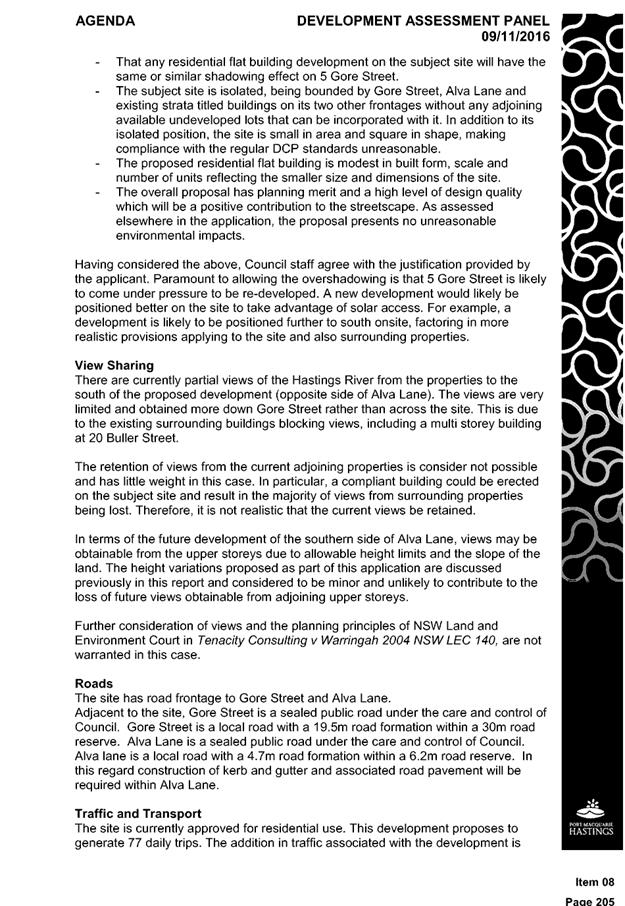

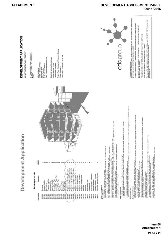
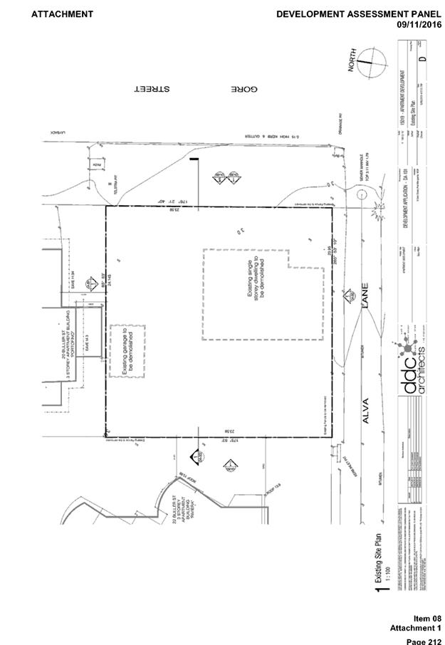
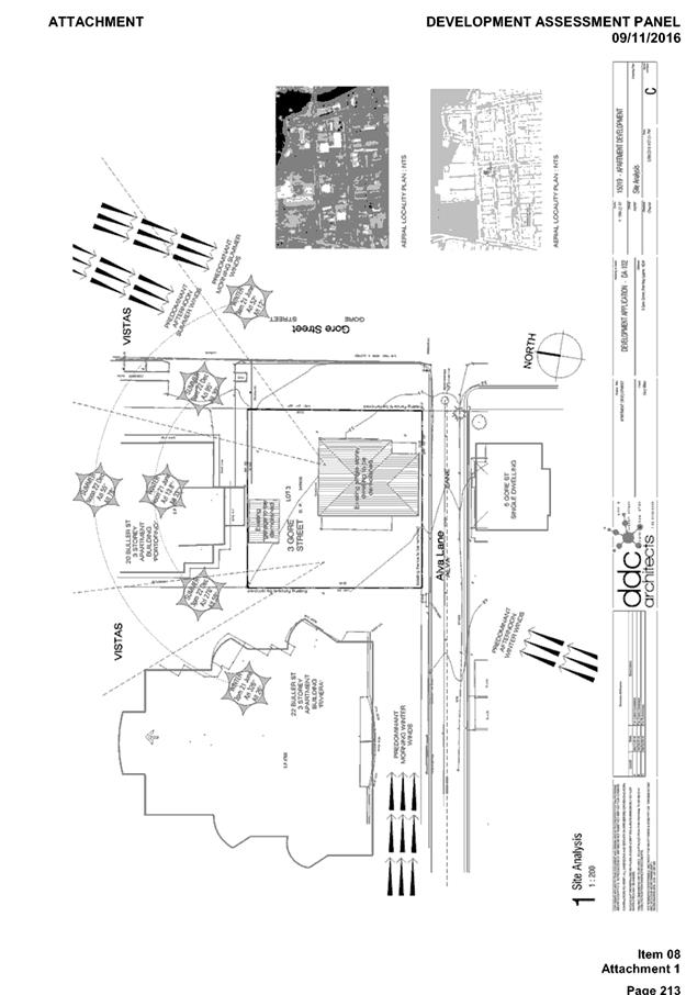
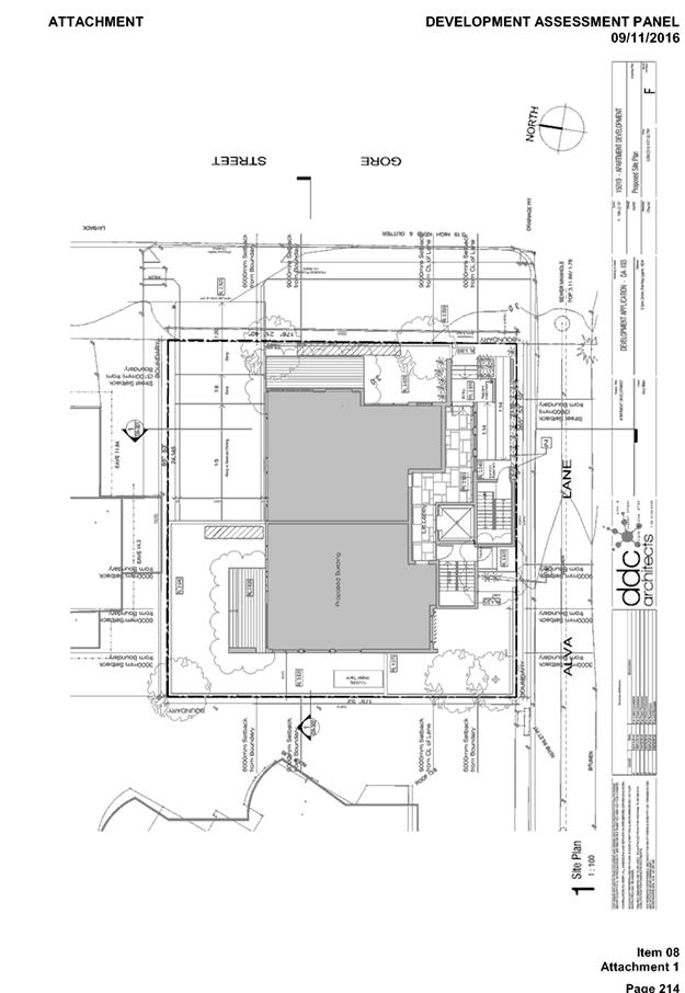
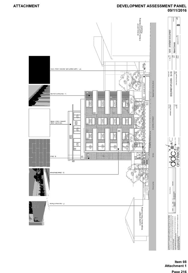
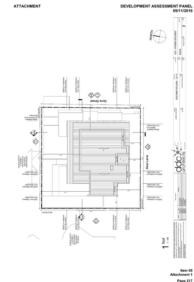
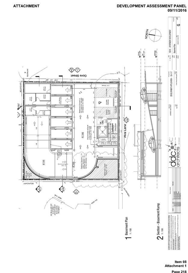
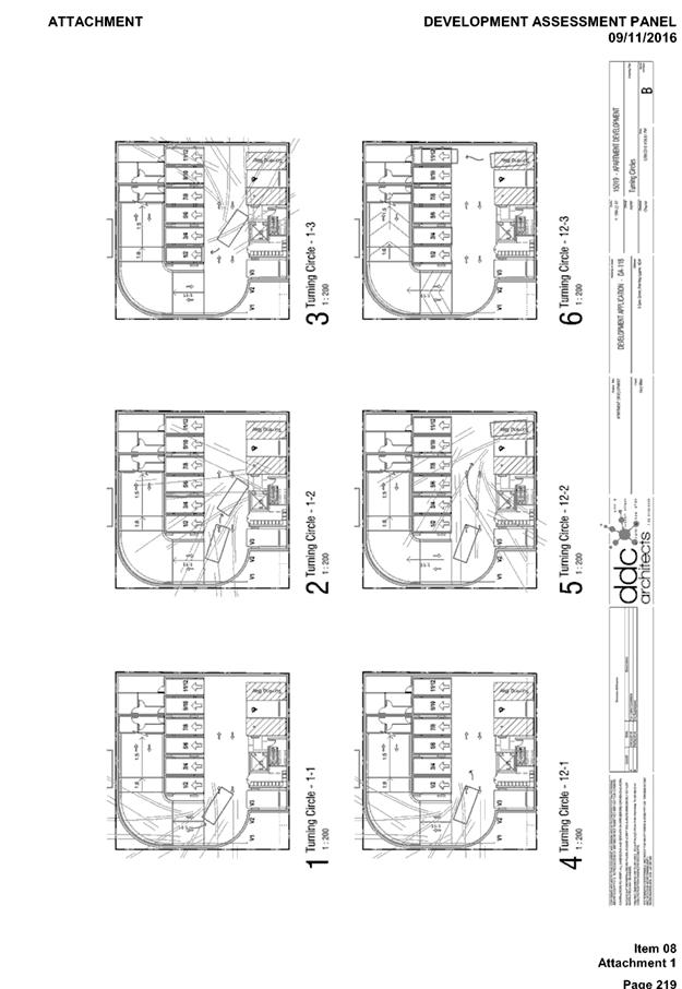
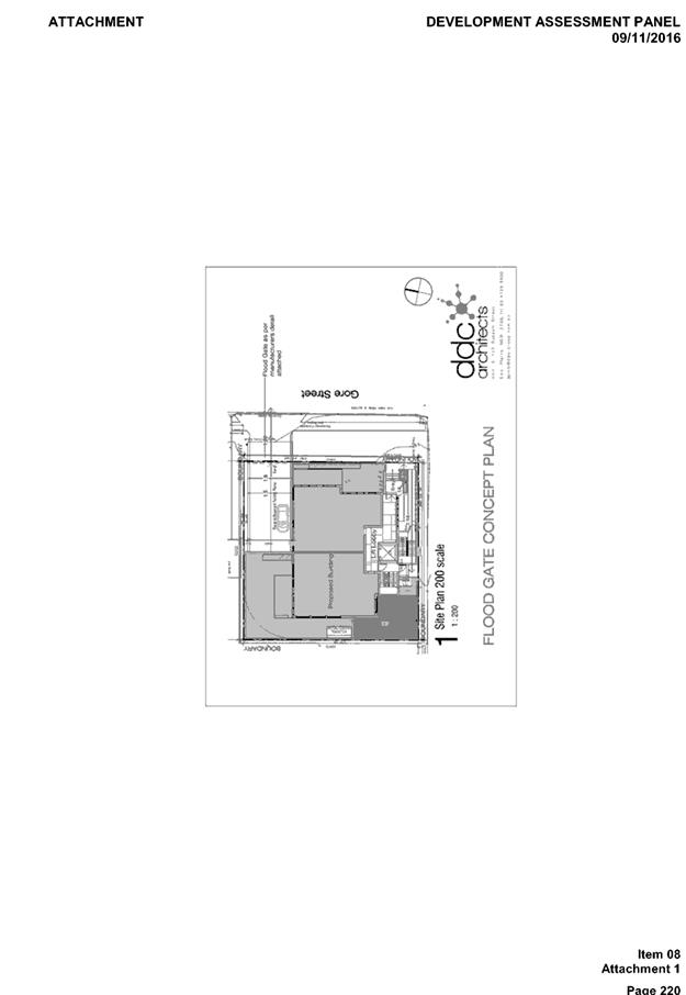
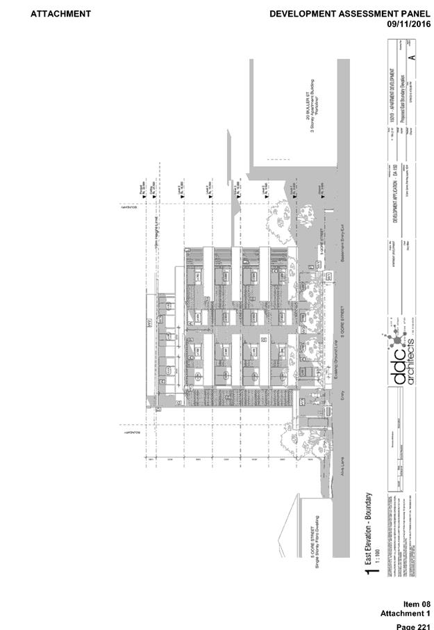
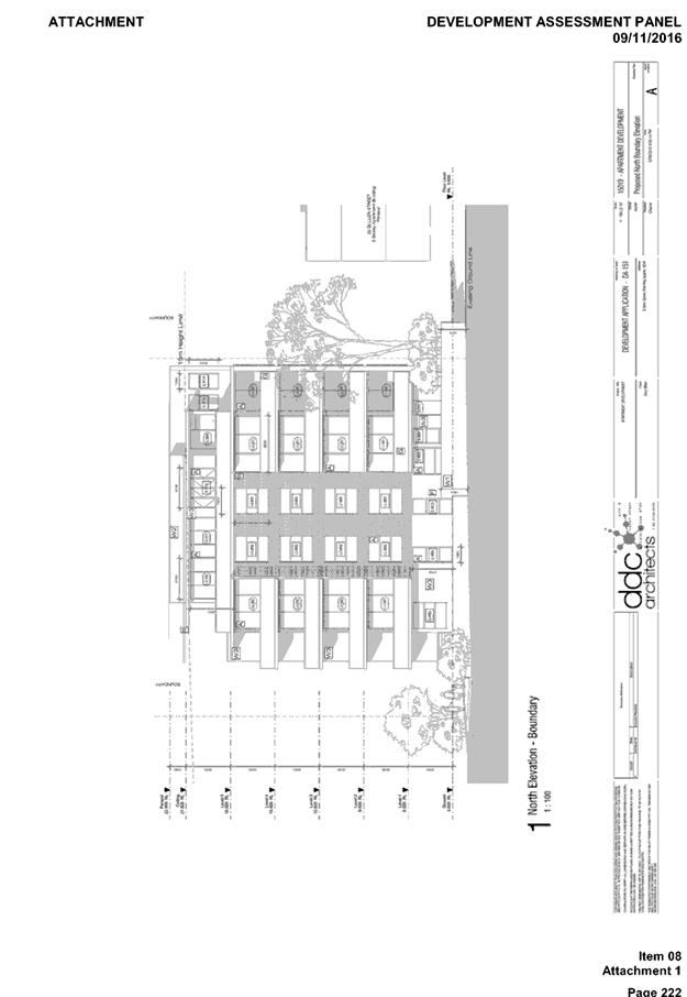
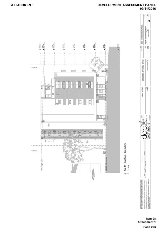
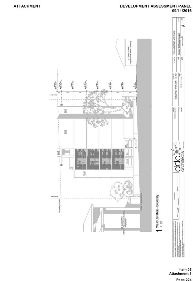
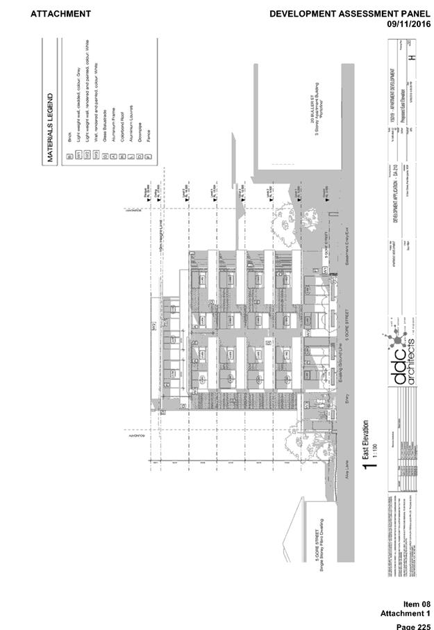
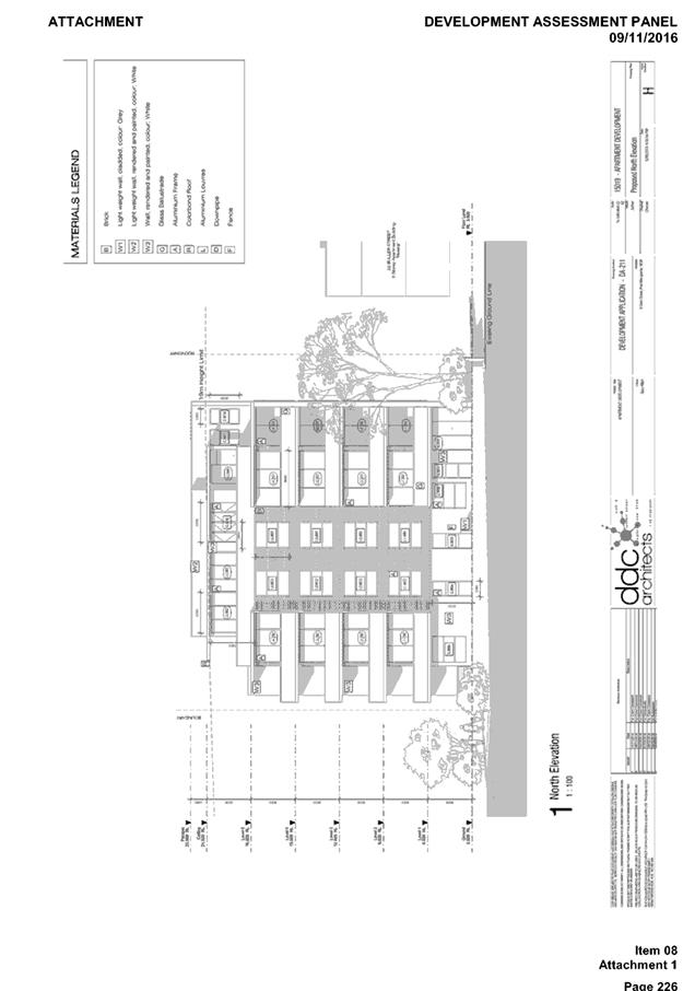
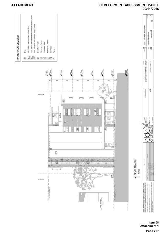
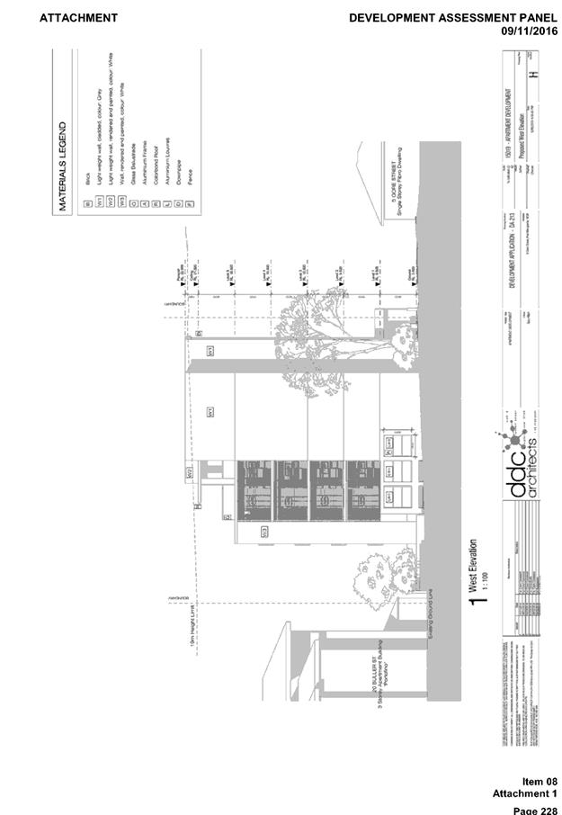
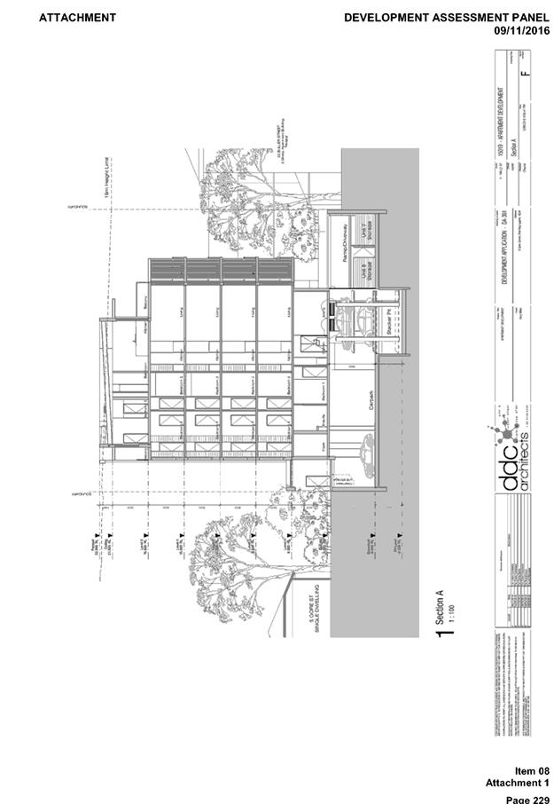
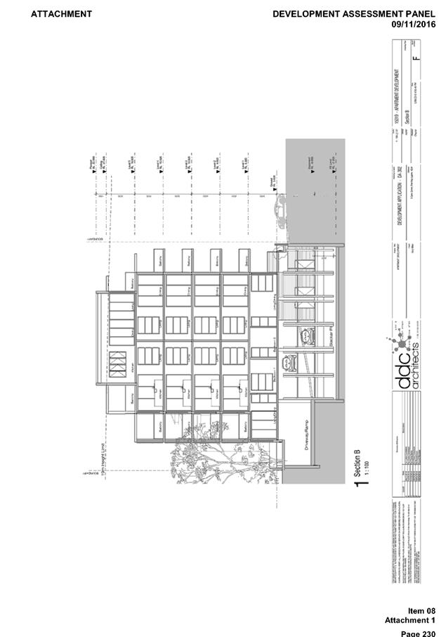
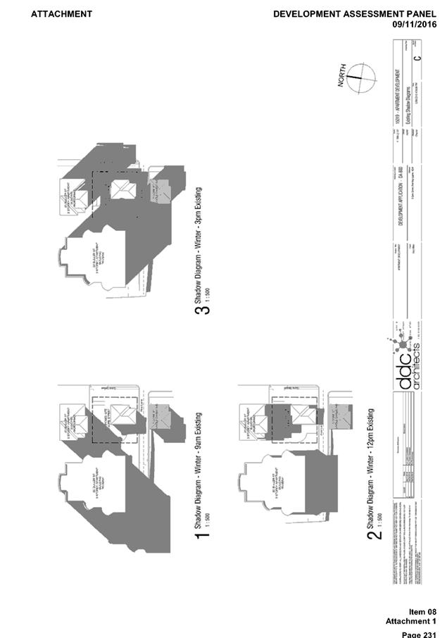
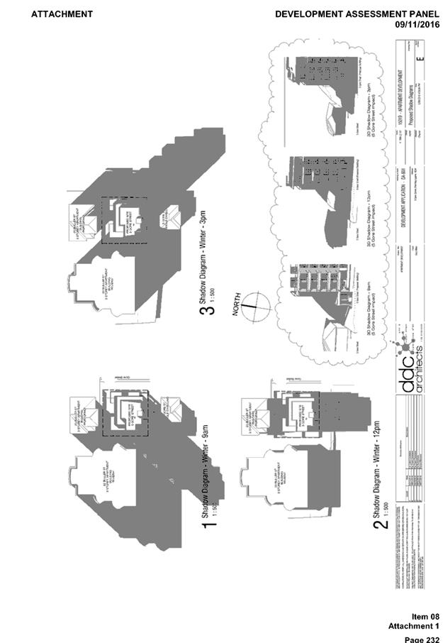
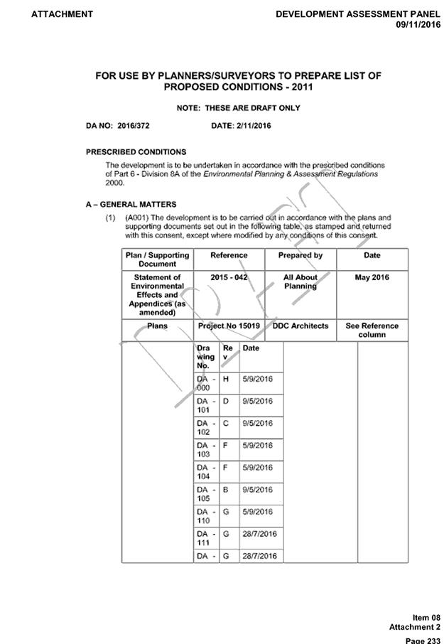
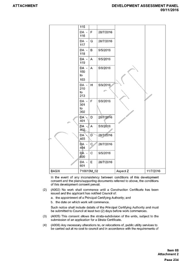
|
ATTACHMENT
|
Development Assessment Panel
25/10/2017
|
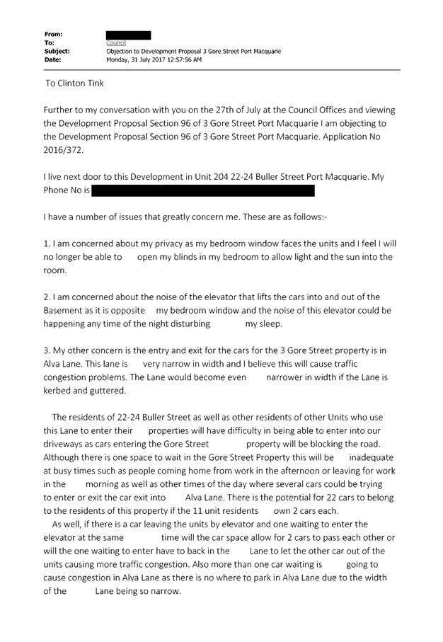
|
ATTACHMENT
|
Development Assessment Panel
25/10/2017
|
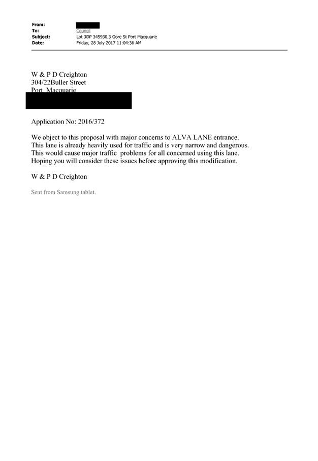
|
ATTACHMENT
|
Development Assessment Panel
25/10/2017
|
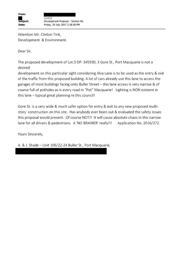
AGENDA Development Assessment Panel 25/10/2017
Item: 09
Subject: DA2017 - 723.1 Alterations And Additions To
Food And Drink Premises - Lot 1 DP 364377, No. 76 William Street, Port
Macquarie
Report
Author: Clint Tink
|
Applicant: R
Clucas
Owner: R
J & K M Clucas and N Olynick
Estimated Cost: $35,000
Alignment with Delivery
Program
4.3.1 Undertake transparent
and efficient development assessment in accordance with relevant legislation.
|
|
RECOMMENDATION
That
DA 2017 – 723.1 for alterations
and additions to a food and drink premises at Lot 1, DP 364377, No. 76 William
Street, Port Macquarie, be determined by granting consent subject to the
recommended conditions.
|
Executive
Summary
This
report considers a development application for alterations and additions to a
food and drink premises at the subject site
and provides an assessment of the application in accordance with the
Environmental Planning and Assessment Act 1979.
Following exhibition of the
application, two (2) submissions were
received. However, one (1) of the submissions was later withdrawn bringing the
total submissions received down to one (1).
1. BACKGROUND
Existing sites features and Surrounding development
The site has an area of 518.7793m².
The site is zoned R4 High Density Residential in accordance with the Port Macquarie-Hastings Local
Environmental Plan 2011, as shown in the following zoning plan:
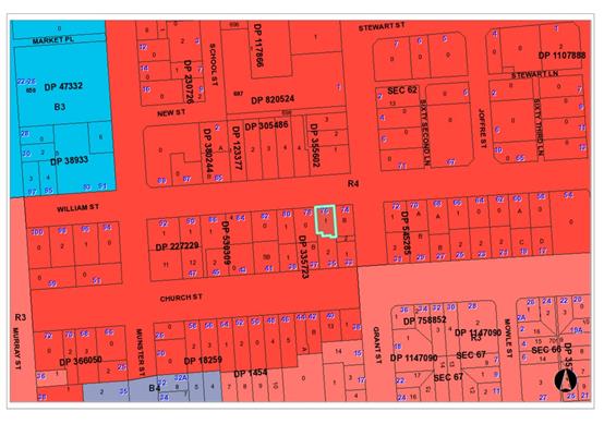
The existing subdivision pattern and location of existing
development within the locality is shown in the following aerial photograph:
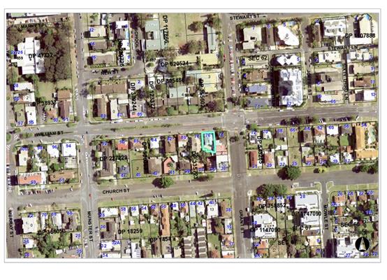
2. DESCRIPTION OF
DEVELOPMENT
Key aspects of the proposal include the following:
History
· DA2007/256
approved the food and drink premises and gallery onsite.
· DA2010/548
approved a deck addition to the food and drink premises.
· DA2007/256
approved hours of 7am to 5pm (daily) and once a month until 11pm.
· DA2010/548
required five (5) parking spaces, comprising three (3) customer and one (1)
staff space at the rear of the property and one (1) disabled space at the
front. The parking areas were approved to be done in gravel construction. It
should be noted that aerial photos suggest that the disabled space has since
been grassed over.
· Parking
for DA2007/256 and DA2010/548 was based on a seat/area rate. In particular, the
food and drink premises was approved to have 24 seats.
DA2017
– 723.1
· Proposes
an extra six (6) seats up from 24 to 30.
· Proposed
hours of 7am to 11pm Thursday to Saturday and 7am to 10pm Sunday to Wednesday.
· Internal
reconfiguration.
· Alterations
to the entry.
· Shutters
on windows.
· New
front sign and pergola/entry feature structure
· No
alcohol is proposed to be served but this could be applied for separately after
or via BYO.
· Applicant
proposing some minor works as exempt development under State Environmental
Planning Policy (Exempt and Complying Development Codes) 2008 and Clause
5.10(3) of Port Macquarie Hastings Local Environmental Plan
Refer
to attachments at the end of this report.
Application Chronology
· 18/8/2017 - Application lodged with Council.
· 24/8/2017
– Council requested owners consent.
· 25/8/2017
– Owners consent provided.
· 30/8/2017
– Application sent to Heritage Council.
· 30/8/2017
to 12/9/2017 – Notification period.
· 1/9/2017
Request for additional information on site plan, shutters, provision of alcohol
and parking.
· 4/9/2017
– Response to additional information received.
· 15
to 18/9/2017 – Discussions with neighbour.
· 9/10/2017
– Heritage Council sign off received.
3. STATUTORY ASSESSMENT
Section 79C(1) Matters for Consideration
In determining the application, Council is required to take
into consideration the following matters as are relevant to the development
that apply to the land to which the development application relates:
(a) The provisions (where
applicable) of:
(i) any Environmental
Planning Instrument:
State
Environmental Planning Policy No.55 – Remediation of Land
Following an inspection of the site and a
search of Council records, the subject land is not identified as being
potentially contaminated and is suitable for the intended use.
State
Environmental Planning Policy No. 62 – Sustainable Aquaculture
Given the nature
of the proposed development and proposed stormwater controls the proposal will
be unlikely to have any adverse impact on existing aquaculture industries.
State
Environmental Planning Policy No. 64 – Advertising and Signage
The proposed
development includes proposed advertising signage in the form of business
identification.
In accordance
with clause 7, this SEPP prevails over the Port Macquarie-Hastings LEP 2011 in
the event of any inconsistency.
The following
assessment table provides an assessment checklist against the Schedule 1
requirements of this SEPP:
|
Applicable clauses for
consideration
|
Comments
|
Satisfactory
|
|
Clause 8(a) Consistent with objectives of the policy as
set out in Clause 3(1)(a).
|
The proposed signage complies with
the subject Clause. In particular, the proposed signage is not excessive in
size, is consistent with surrounding signage and will not impact on
streetscape.
|
Yes
|
Schedule 1(1) Character of
the area.
|
Signage is consistent with
others in the area and will not compromise the character of the locality.
|
Yes
|
|
Schedule 1(2) Special areas.
|
Not a special area.
|
Yes
|
|
Schedule 1(3) Views and vistas.
|
No views or vistas impacted.
|
Yes
|
|
Schedule 1(4) Streetscape, setting or landscape.
|
The proposed signage is not excessive,
is consistent with surrounding signage and will not impact on streetscape.
|
Yes
|
|
Schedule 1(5) Site and building.
|
The proposed signage fits in
with the site and location of buildings.
|
Yes
|
|
Schedule 1(6) Associated devices and logos with advertisements
and advertising structures.
|
None proposed.
|
Yes
|
|
Schedule 1(7) Illumination.
|
Conditions will be imposed to
cover illumination of the sign.
|
Yes
|
|
Schedule 1(7) Safety.
|
The signage will create no
safety impacts.
|
Yes
|
State Environmental Planning
Policy No. 71 – Coastal Protection and Clause 5.5 of Port
Macquarie-Hastings Local Environmental Plan 2011
The site is located within a
coastal zone noting clause 4 of the SEPP.
In accordance with clause 5, this
SEPP prevails over the Port Macquarie-Hastings LEP 2011 in the event of any
inconsistency.
Having regard for clauses 2, 8 and
12 to 16 of the SEPP and clause 5.5 of the PMH LEP 2011, the proposed
development will not result in any of the following:
a) any
restricted access (or opportunities for access) to the foreshore
b) any
adverse amenity impacts along the foreshore and on the scenic qualities of the
coast;
c) any
adverse impacts on flora and fauna;
d) the
development being subject to any adverse coastal processes or hazards;
e) any
significant conflict between water and land based users of the area;
f) any
adverse impacts on any items of archaeological/heritage;
g) reduction
in the quality of the natural water bodies in the locality (due to effluent
& stormwater disposal, construction impacts, landuse conflicts);
h) adverse
cumulative impacts on the environment;
i) a
form of development that is unsustainable in water and energy demands;
j) development
relying on flexible zone provisions. (refer to clause 5.3 of LEP 2011 -
Development near zone boundaries unable to be undertaken when SEPP 71 applies).
The site is located within an area
zoned and already built out for residential/commercial purposes.
Port
Macquarie-Hastings Local Environmental Plan 2011
The proposal is consistent with the LEP having regard to the
following:
· Clause 2.2, the
subject site is zoned R4 High Density Residential. In accordance with clause
2.3(1) and the R4 zone landuse table, the proposed development for alterations
and additions to a food and drink premises is a permissible landuse with
consent.
The objectives
of the R4 zone are as follows:
o To
provide for the housing needs of the community within a high density
residential environment.
o To
provide a variety of housing types within a high density residential
environment.
o To
enable other land uses that provide facilities or services to meet the day to
day needs of residents.
o To
provide for tourist and visitor accommodation in key tourist precincts of urban
areas of the Council area, while also encouraging increased population levels.
o To
encourage development that has regard to the desired future character of
streets and supports active and safe uses at pedestrian level.
In accordance with Clause 2.3(2),
the proposal is consistent with the zone objectives having regard to the
following:
o The proposal is a permissible
landuse;
o The proposal retains a
facility that services the day to day needs of residents in the area and the
greater area.
· Clause 2.7,
certain demolition works require consent as they do not fit within the
provisions of SEPP (Exempt and Complying) 2008.
· Clause 4.3, the
maximum overall height of the building above ground level (existing) remains
unchanged. As a result, the clause does not apply.
· Clause 4.4, the
floor space ratio of the proposal will increase as a result of the north east
semi outdoor deck area being enclosed with the proposed bi fold doors. The
gross floor area will increase from approximately 118m² to 148m² as a
result of the bi fold doors being installed. The FSR will be 0.29:1, which
still complies with the 2:1 FSR applying to the site.
· Clause 5.9, no
listed trees in Development Control Plan 2013 are proposed to be removed.
· Clause 5.10, the
site is not identified as a heritage item but is located within the Port
Macquarie Archaeology site/area of early European settlement. The application
was referred to the Heritage Council who raised no objection subject to
installation of a condition to cover if anything is found during any works (ie
excavation for the pergola/entry feature).
· Clause 7.13,
satisfactory arrangements are in place for provision of essential services.
(ii) Any
draft instruments that apply to the site or are on exhibition:
None
relevant.
(iii) any
Development Control Plan in force:
Port
Macquarie-Hastings Development Control Plan 2013
|
DCP 2013: General Provisions
|
|
DCP Objective
|
Development Provisions
|
Proposed
|
Complies
|
|
2.7.2.2
|
Design addresses generic principles of Crime Prevention
Through Environmental Design guideline:
· Casual
surveillance and sightlines
· Land use mix and
activity generators
· Definition of
use and ownership
· Lighting
· Way finding
· Predictable
routes and entrapment locations
|
The proposed development creates no new concealment or
entrapment areas, has positive territorial cues and retains surveillance of
the street from within.
|
Yes
|
|
2.5.3.3
|
Off-street parking in accordance with Table 2.5.1.
(Provision to consider reduced parking where supported by
parking demand study)
|
The previous applications that approved the food and drink
premises, worked off a per seat rate, with a seat occupying 1m². Overall
24 seats were proposed equating to a dining area of 24m².
Restaurants/cafes outside commercial zones require 1 parking space per
6m². Based on the above (24/6), 4 spaces were required.
The previous applications also had a gallery component,
which was assessed at 1 space per 30m² rate. Based on the gallery areas
at the time, an additional space was required.
In total, previous applications required 5 spaces.
The applicant of DA2017 – 723 proposes to remove the
gallery component and provide a 30 seat food and drink premises. Using the
above assessment approach, 5 parking spaces are required (ie
30m²/6m² per seat). In this regard, given the previous applications
had 5 approved parking spaces, no further changes are required.
While technically the DCP works off serviced floor area
(ie not seats), the above approach was utilised before and is considered
acceptable given the following:
- The
site is located only 200m from the Port Macquarie CBD/commercial zones. To
reiterate this, commercial zones work off a 1 space per 30m² and there
is an argument that such a rate could be utilised for the subject site. Using
a serviced floor area of approximately 70m², only 3 spaces would be required.
- There
is a large number of unused street parking spaces in the area.
4.
It should be noted that a site inspection of the site also
identified that the original approved disabled parking space has been grassed
over. The space will need to be reinstated or contributions levied for any
shortfall.
|
Yes
|
|
2.5.3.4
|
Parking credits to be calculated for redevelopment or
change of use
|
Refer to above comment.
|
Yes
|
|
2.5.3.7
|
Visitor parking to be easily accessible
|
Remains unchanged from previous food and drink approval.
It is considered that the onsite parking is more suited to staff parking and
that guests will likely use on street parking in the area or walk to the
site.
|
Yes
|
|
Stacked parking permitted for medium density where visitor
parking and 5.5m length achieved
|
None proposed.
|
N/A
|
|
Parking layout in accordance with AS/NZS 2890.1 and AS/NZS
2890.2
|
Remains unchanged from previous food and drink approval.
|
Yes
|
|
Parking spaces generally located behind building line
|
Remains unchanged from previous food and drink approval.
|
Yes
|
|
2.5.3.8
|
Accessible parking provided in accordance with AS/NZS
2890.1, AS/NZS 2890.2 and AS 1428
|
Existing approved disabled parking space will need to be
reinstated.
|
Yes
|
|
2.5.3.11
|
Section 94 contributions
|
Refer to main body of report.
|
Noted
|
|
2.5.3.12 and 2.5.3.13
|
Landscaping of parking areas
|
Remains unchanged from previous food and drink approval.
|
Yes
|
|
2.5.3.14
|
Sealed driveway surfaces unless justified
|
Remains unchanged from previous food and drink approval.
|
Yes
|
|
2.5.3.15
|
Driveway grades for first 6m of ‘parking area’
shall be 5% grade (Note AS/NZS 2890.1 allows for steeper grades)
|
Remains unchanged from previous food and drink approval.
|
Yes
|
|
2.5.3.16
|
Transitional grades min. 2m length
|
Remains unchanged from previous food and drink approval.
|
Yes
|
|
2.5.3.17
|
Parking areas to be designed to avoid concentrations of
water runoff on the surface.
|
Remains unchanged from previous food and drink approval.
|
Yes
|
|
Vehicle washing facilities – grassed area etc
available.
|
None proposed or required.
|
N/A
|
|
No direct discharge to K&G or swale drain
|
No new hard stand areas proposed or change to existing
stormwater.
|
N/A
|
|
2.5.3.19
|
Off street commercial vehicles facilities are provided in
accordance with AS/NZS 2890.2
|
Size of development does not warrant the need for a
loading area onsite. Existing parking can be utilised.
|
Yes
|
While the
area is zoned residential, the commercial DCP provisions are deemed more
relevant in this case. In particular, the current use is commercial based,
there are surrounding non-residential uses (ie Telstra complex, Innervision
skate and surf shop, Port Primary School) and the plan for the area encompasses
food and drink premises at ground level as part of shop top housing/residential
flat buildings. Relevant provisions from the DCP are addressed below.
|
DCP 2013: Business & Commercial Development
|
|
DCP Objective
|
Development Provisions
|
Proposed
|
Complies
|
|
3.4.3.1
|
Setbacks:
A zero metre setback to ground floor is preferred in all
business zone developments.
|
The current building is setback 1.2m. A proposed
pergola/entry structure will be erected on the front boundary, consistent
with the DCP.
It is also noted that there are other similar structures
and buildings built on or near the front boundary in the area at 78 and 80
William Street. As a result, the proposal will also not impact on the
streetscape of the area.
|
Yes
|
|
3.4.3.2
|
Where
a zero setback cannot be achieved, such as where parking can only be provided
between the building and the street, a minimum 3.0m pedestrian setback is
provided between the edge of the car park and the building.
· The 3.0m pedestrian setback must be: open and accessible
for pedestrians for its entire length and width;
· clear of columns (other than awning posts where provided)
and other obstructions;
· has a pavement matching the gradient of the adjoining
footpath and connects pedestrian areas on neighbouring sites; and
· connects without any lip or step to adjoining footpaths
or abutting pedestrian areas on neighbouring sites.
|
Disabled car parking space in front of the building is
already approved and will not change. It is noted that the space has been
grassed over. A condition will be imposed to reinstate the space. The wider
disabled space will also provide suitable pedestrian access into the
building.
|
Yes
|
|
3.4.3.3
|
Roof Form
|
No change to the roof proposed. The pergola/entry feature
will add interest.
|
Yes
|
|
3.4.3.5
|
Shopfront widths are to be between 15 and 20 m.
|
Remains unchanged.
|
Yes
|
|
3.4.3.7
|
Infill development or alterations should respect the form,
scale and massing of existing traditional buildings.
|
The alterations to the external part of the building are
considered minor with most of the work occurring inside or as exempt
development.
|
Yes
|
|
Where traditional frontages and facades set the
architectural theme for parts of a Centre, infill buildings or alterations
respect and reflect the architectural qualities and traditional materials of
those buildings, but do not necessarily imitate historical architectural
styles.
|
Refer to above comment.
|
Yes
|
|
3.4.3.8
|
Active Frontages:
(Note: An active street frontage if all premises on the
ground floor of the building facing the street are used for the purposes of
business premises or retail premises.)
Ground floor levels shall not be used for residential
purposes in B1, B2, B3 and B4 zones.
|
The introduction of the bi fold doors will create a more
active frontage.
|
Yes
|
|
3.4.3.9
|
A minimum of 50% of the ground floor level front facade is
to be clear glazed.
|
The bi fold doors will create a min 50% glazed area.
|
Yes
|
|
|
Active frontages must consist of one or more of the
following:
· A shop front.
· Commercial and
residential lobbies.
· Café or
restaurant if accompanied by an entry from the street.
· Public building
if accompanied by an entry from the street.
|
Existing café retained with access from the street.
|
Yes
|
|
|
Active ground floor uses are to be accessible and at the
same level as the footpath.
|
Additional entry will exist via the new bi fold doors and
disabled parking area.
|
Yes
|
|
|
Restaurants, cafés and the like shall provide
openable shop fronts to the footpath but must not encroach into footpath.
|
Bi fold doors create openable frontage without encroaching
the footpath.
|
Yes
|
|
3.4.3.11-14
|
Awnings
|
No change to awning proposed or required. Controls more
relevant to a major or new development onsite.
|
N/A
|
|
3.4.3.15
|
Landscaping:
A
landscape plan shall be submitted with the development application and
include:
· Existing vegetation; and
· Existing vegetation proposed to be removed; and
· Proposed general planting and landscape treatment; and
· Design details of hard landscaping elements and major
earth cuts, fills and any mounding; and
· Street trees; and
· Existing and proposed street furniture including proposed
signage.
|
Suitable landscaping areas will be retained onsite.
|
Yes
|
|
3.4.3.18
|
At
grade car parking incorporate water sensitive urban design principles to
drain pavement areas.
|
No change to parking proposed or required. In particular,
area does not exist onsite for additional parking.
|
Yes
|
|
3.4.3.19
|
Fencing
for security or privacy shall not be erected between the building line and
the front boundary of a site.
|
No new front fencing proposed.
|
N/A
|
|
3.4.3.22
|
Any
ramps are to be integrated into the overall building and landscape design.
|
The existing disabled access ramp on the western side of
the building is to be retained.
|
Yes
|
|
The
development complies with AS1428—Design for Access and Mobility.
|
Capable and to be reinforced via conditions.
|
Yes
|
|
3.4.3.24
|
Waste
management:
A
waste management plan for the construction and/or occupation of the
development is provided that:
· Recycles and reuses demolished materials where possible;
· Integrates waste management processes into all stages of
the project;
· Specifies building materials that can be reused and
recycled at the end of their life;
· Uses standard components and sizes to reduce waste and
facilitate update in the future.
|
Waste management for the existing food and drink premises
will remain in place. A condition will be imposed to keep bins away/screened
from residential receivers.
|
Yes
|
|
3.4.3.27
|
Vehicular
Access Location and Design:
|
No change to access or parking proposed or required. Area
does not exist onsite to create any additional parking spaces.
|
N/A
|
|
3.4.3.30
|
Pedestrian
Entries & Access:
The
development complies with AS1428—Design for Access and Mobility.
|
Existing approved disabled access will be retained.
|
Yes
|
|
3.4.3.31
|
Pedestrian
and vehicle movement areas are separated to minimise conflict.
|
Vehicle parking areas etc remain unchanged. New pedestrian
access is proposed to occur near the disabled access space, which is unlikely
to experience a high turnover/create conflict.
|
Yes
|
|
3.4.3.33
|
Secure
and convenient parking/storing for bicycles is provided close to the entrance
of the development and with good surveillance.
|
Suitable area exists onsite to store bicycles.
|
Yes
|
|
3.4.3.34
|
Outdoor
Dining
|
No footpath dining proposed.
|
N/A
|
|
3.4.3.35
|
Commercial
Development Adjoining Residential Land uses:
The
development is designed so that all vehicle movement areas and servicing
areas are located away from adjoining residential areas.
|
The driveway and parking areas remain unchanged.
The access, services etc are located alongside the Telstra
building (non-residential land use side) or at the rear of the property.
Fencing exists at the rear of the property to help shield the development
from the residential uses to the south. There are residential uses to the west
but openings etc from the development are limited on this frontage to help
reduce conflict. A vegetation screen is also proposed to be conditioned along
this side of the property.
|
Yes
|
|
|
The
building elevation adjoining the residential area must be;
· Articulated, with changes in setback at intervals no
greater than 10m;
· Use a variety of materials and treatments;
· Be setback a minimum of half the height of the wall or a
minimum of 3.0metres whichever is greater.
|
Overall design remains unchanged. However, shutters,
screening and reduced access will be applied.
|
Yes
|
|
|
Waste
areas are located and managed to minimise pests, noise and odour.
|
Remain unchanged.
|
N/A
|
|
DCP 2013: East Port Neighbourhood (relevant
provisions considered below)
|
|
DCP Objective
|
Development Provisions
|
Proposed
|
Complies
|
|
4.3.2.1
|
Development
is generally in accordance with the precinct structure plans
|
Development is consistent with the planned mixed use for
the area.
|
Yes
|
|
4.3.2.4
|
a)
Northern side of Clarence Street, east of Munster Street
• Setback to Clarence
Street is 3 metres.
b)
Southern side of Clarence Street, between Munster and School Streets
• A zero street setback is
provided
c)
Southern side of William Street, between Murray and Grant Streets
• Setback to William Street
is 2 metres.
d)
Development from 2 to 10 Burrawan Street
• For lots with dual
frontage to Burrawan and Windmill Streets, buildings are to address Burrawan
Street as their primary frontage.
e)
Development from 5 to 9 Pacific Drive
• Setback to Pacific Drive
is a minimum of 6 metres.
|
Except for signage and a light weight pergola/entry
feature; the development is setback 2m.
|
Yes
|
(iiia) any
planning agreement that has been entered into under Section 93f or any draft
planning agreement that a developer has offered to enter into under Section
93f:
None
relevant.
iv) any matters prescribed by the
Regulations:
New South Wales Coastal Policy:
The proposed
development is consistent with the objectives and strategic actions of this
policy.
Demolition
of buildings AS 2601:
Demolition of
the parts of the existing building on the site is capable of compliance with
this Australian Standard and is recommended to be conditioned.
Fire
Safety and other considerations
Discussions
with one of Council’s Building Surveyors confirmed that fire safety is
unlikely to be an issue as the development represents less than 50% of the
volume of the building. In addition, the building use remains essentially the
same, has a small footprint, contains suitable setbacks to surrounding
properties and the proposed use will result in reduced fire loads by removing
the gallery/display areas.
v) any coastal
zone management plan (within the meaning of the Coastal Protection Act 1979),
that apply to the land to which the development application relates:
No
Coastal Zone Management Plan applies to the subject site.
(b) The
likely impacts of that development, including environmental impacts on both the
natural and built environments, social and economic impacts in the locality:
Context and setting
The site has a northerly street
frontage to William Street.
Adjoining the site to the north
is a primary school.
Adjoining the
site to the east is a Telstra tower and associated building.
Adjoining the
site to the south and west are residential housing.
Within the
locality, there are other commercial based uses amongst residential housing.
The proposal is
considered to be consistent with the future desired mixed use that is planned
for the area and subject to conditions, addresses relevant planning controls.
However, the
proposal does have the potential to impact on surrounding residential housing
in the interim. In particular, noise impacts from late night operating hours
can adversely impact on occupants of the surrounding housing. To address potential
noise impacts, the requested hours of operation have been reduced and will only
be allowed on a one year trial period. Upon completion of the trial period, the
hours will revert back to that originally approved in DA2007/256, unless a
modification is lodged to keep the new hours. The trial period and modification
process will allow noise impacts to be reviewed.
Access, transport and traffic
The proposal will be unlikely to
have any adverse impacts within the immediate locality in terms access, transport
and traffic. The existing road network will satisfactorily cater for any
increase in traffic generation as a result of the development.
Water Supply Connection
Service available.
Sewer Connection
Service available.
Stormwater
No changes to existing
arrangements.
Other Utilities
Telecommunication and electricity
services are available to the site.
Heritage
Refer to comments on heritage in
the LEP 2011 section of this report.
Other land resources
No adverse impacts anticipated.
The site is within an established urban context and will not sterilise any
significant mineral or agricultural resource.
Water cycle
The proposed development will be
unlikely to have any adverse impacts on water resources and the water cycle.
Soils
The proposed development will be
unlikely to have any adverse impacts on soils in terms of quality, erosion,
stability and/or productivity.
Air and microclimate
The construction and/or
operations of the proposed development will be unlikely to result in any
adverse impacts on the existing air quality or result in any pollution.
Standard precautionary site management condition recommended.
Flora and fauna
Construction of the proposed
development will not require any removal/clearing of any significant vegetation
and therefore will be unlikely to have any significant adverse impacts on
biodiversity or threatened species of flora and fauna. Section 5A of the
Act is considered to be satisfied.
Waste
Satisfactory arrangements are in
place for proposed storage and collection of waste and recyclables. No adverse
impacts anticipated. Standard precautionary site management condition
recommended.
Energy
No adverse impacts anticipated.
Noise and vibration
The existing food and drink
premises has the following approved hours of operation:
· 7am to 5pm daily
with once a month being allowed to trade to 11pm.
The applicant
requested revised hours of operation as follows:
· 7am to 11pm
Thursday to Saturday
· 7am to 10pm Sunday
to Wednesday
The applicant
also proposes to have pedestrian access (excluding for disabled persons) via
the bi fold door area to minimise people walking up the western boundary
adjacent to the residential housing. Shutters are also proposed to eliminate
openings to the west.
A preliminary
review of the hours of operation for a number of similar café type uses
showed that their hours of operation normally ceased at 9pm to 9:30pm. Most
were located within the CBD area.
The proposed
hours of operation were also discussed with Council’s Environmental
Health Officer.
Considering the
above and noting the adjoining residential uses, the following hours of
operation on a 12 month trial period are recommended:
· 7am to 9pm Sunday
to Wednesday
· 7am to 10pm
Thursday to Saturday
Deliveries are
not to occur outside the hours of operation.
Upon cessation
of the 12 month period, the development will revert to the approved hours in
DA2007/256. Should the applicant wish to retain the later hours of operation, a
modification of consent can be lodged and a review of the past 12 months
carried out.
Conditions will
also be applied to:
· Install a
landscape screen along the western boundary to help with perceived impacts (ie
vegetation will not stop noise but will help address views/maintain privacy).
· Have bin storage
areas on the eastern side (away from residential receivers).
· No amplified music
onsite.
Based on the
above, the proposal is considered capable of being managed so as no adverse
noise impacts will occur.
Bushfire
The site is not identified as
being bushfire prone.
Safety, security and crime
prevention
The proposed development will be
unlikely to create any concealment/entrapment areas or crime spots that would
result in any identifiable loss of safety or reduction of security in the
immediate area. The development will maintain natural surveillance within
the locality.
Social impacts in the locality
The applicant has advised that no
alcohol will be served onsite. However, being a food and drink premise, the
applicant could later apply for a liquor licence, including BYO, through the
Office of Liquor and Gaming. Council provides comment on liquor licence but is
not the determining authority – separate process. When liquor is
sold/consumed onsite there is potential for anti-social behaviour, which could
impact on surrounding properties. As the main change with this application from
the existing food and drink premises is the extended hours, it is considered
the 12 month trial on hours will allow this social impact to be assessed
specific to this site.
Based on the above and suggested
conditions of consent, the proposal is unlikely to result in any adverse social
impacts.
Economic impact in the
locality
No adverse impacts. Likely
positive impacts can be attributed to the construction and operation of the
development, which will maintain employment in the construction and hospitality
industry. The employment can lead to flow on expenditure in the area.
Site design and internal
design
Subject to conditions, the
proposed development design satisfactorily responds to the site attributes and
will fit into the locality. No adverse impacts likely.
Construction
No potential adverse impacts
identified to neighbouring properties with the construction of the proposal.
Cumulative impacts
The proposed development is not
expected to have any adverse cumulative impacts on the natural or built
environment or the social and economic attributes of the locality.
(c) The suitability of the site for
the development:
Subject to
conditions, the proposal will continue to fit into the locality and the site
attributes are conducive to the proposed development.
Site
constraints have been adequately addressed and appropriate conditions of
consent recommended.
(d) Any submissions made in
accordance with this Act or the Regulations:
Following exhibition of the
application, two (2) submissions were
received. However, one (1) of the submissions was later withdrawn bringing the
total submissions received down to one (1).
Key issues raised in the submission received and comments
in response to these issues are provided as follows:
|
Submission
Issue/Summary
|
Planning
Comment/Response
|
|
Proposed hours of operation
are not compatible with the surrounding residential area and will lead to
sleep disturbance, noise from music, increased traffic noise, noise from
patrons leaving the site to their cars etc.
Suggested alternate hours of
Sunday to Thursday 7am to 5pm and Friday and Saturday 7am to 9pm.
|
Comments and concerns are
noted. Refer to comments on Noise and Vibration above in this report. While
the suggested hours have not been adopted, Council staff are proposing to
reduce the hours and only allow them on an initial 12 month trial –
refer to recommended conditions of consent.
|
|
Loss of values to surrounding properties.
|
Not a matter for consideration under s79C.
|
(e) The Public Interest:
Subject to
conditions, the proposed development satisfies relevant planning controls and
is unlikely to impact on the wider public interest.
4. DEVELOPMENT
CONTRIBUTIONS APPLICABLE
Development
contributions do not apply.
5. CONCLUSION
The application has been assessed in accordance with
Section 79C of the Environmental Planning and Assessment Act 1979.
Issues raised during assessment and public exhibition of
the application have been considered in the assessment of the application.
Where relevant, conditions have been recommended to manage the impacts
attributed to these issues.
The site is suitable for the proposed development, is not
contrary to the public's interest and will not have a significant adverse
social, environmental or economic impact. It is recommended that the
application be approved, subject to the recommended conditions of consent
provided in the attachment section of this report.
|
Attachments
1View. DA2017
- 723.1 Plans
2View. DA2017
- 723.1 Recommended Conditions
3View. DA2017
- 723.1 Submission - Cunningham
4View. DA2017
- 723.1 Submission - Schofield & Taylor
|
|
ATTACHMENT
|
Development Assessment Panel
25/10/2017
|
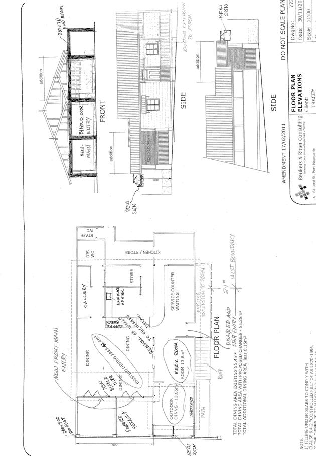
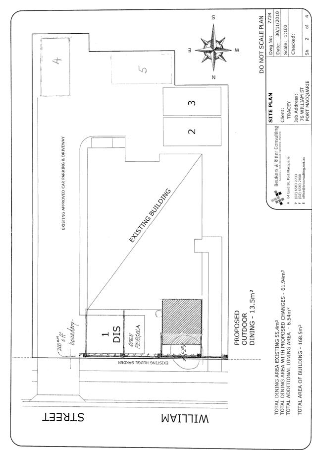
|
ATTACHMENT
|
Development Assessment Panel
25/10/2017
|
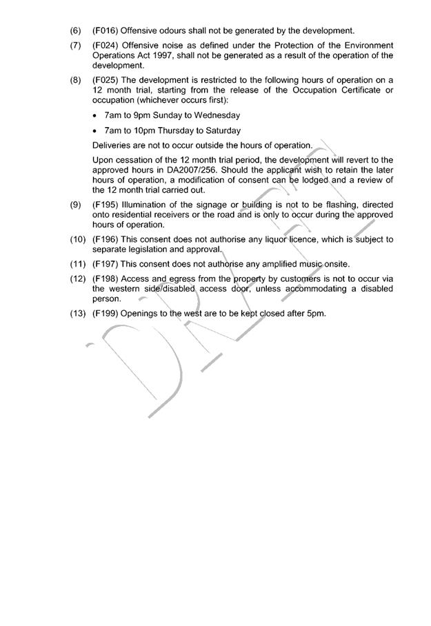
|
ATTACHMENT
|
Development Assessment Panel
25/10/2017
|
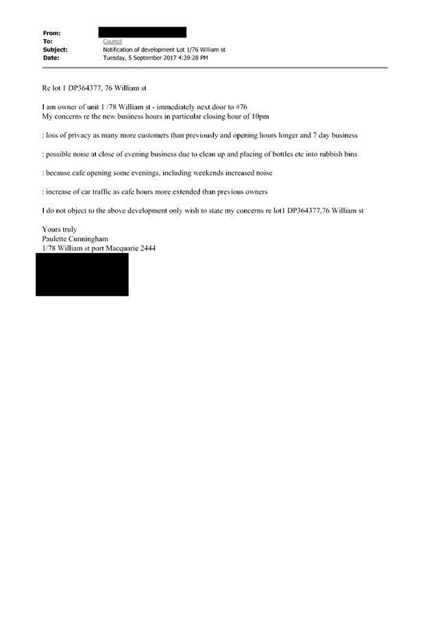
|
ATTACHMENT
|
Development Assessment Panel
25/10/2017
|