Late Reports Ordinary Council
18/04/2018
Item: 12.13
Subject: DA2018 - 48 - Demolition Of Existing
Structures And Erection Of Emergency Services Facility (Ambulance Station) And
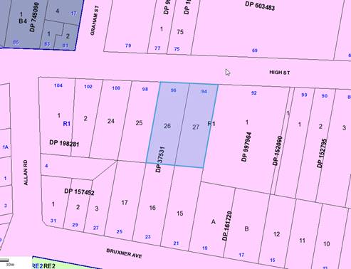
Lot Consolidation - Lots 26 & 27 DP 37531, 94 - 96 High Street, Wauchope
Report Author: Daniel Croft
|
Applicant: Health Infrastructure CARE Lotti Wilkinson, City Plan Strategy and Development Owner: Ambulance Service of New South Wales Estimated Cost: $2.623M Parcel no: 8964 & 8964 Alignment with Delivery Program 4.3.1 Undertake transparent and efficient development assessment in accordance with relevant legislation. |
|
That DA2018 – 48.1 for demolition of existing structures and erection of emergency services facility (ambulance station) and lot consolidation at Lot 26 & 27, DP 37531, No. 94 - 96 High Street, Wauchope, be determined by granting consent subject to the recommended conditions. |
Executive Summary
This report considers a Development Application (DA) for demolition of existing structures and erection of emergency services facility (ambulance station) and lot consolidation at the subject site and provides an assessment of the application in accordance with the Environmental Planning and Assessment Act 1979 (Act).
This DA is being reported to an Ordinary Meeting of Council following consideration of the application by Council’s Development Assessment Panel (DAP) on 11 April 2018. The DAP was unable to reach consensus on the determination of the application noting that the proposal is a Crown Development.
Section 4.33 of the Act sets out the following requirements for Crown Developments:
(1) A consent authority (other than the Minister) must not:
(a) refuse its consent to a Crown development application, except with the approval of the Minister, or
(b) impose a condition on its consent to a Crown development application, except with the approval of the applicant or the Minister.
On the 11 April 2018, the DAP resolved the following:
The panel was unable to reach a consensus.
For: Paul Drake and Clinton Tink
That DA2018 – 48.1 for demolition of existing structures and erection of emergency services facility (ambulance station) and lot consolidation at Lot 26 & 27, DP 37531, No. 94 - 96 High Street, Wauchope, be determined by granting consent subject to the recommended conditions as amended in accordance with the agreement of the applicant:
Add Condition D(10) to state:
D(10) Prior to occupation, a 1.5m high solid screen is to be erected along the outer edge kerb of the western exit driveway, commencing at the edge of the building and ceasing at the point, where the driveway changes and starts to narrow. The screen is to minimise vehicle headlight glare impacting on the adjoining neighbour to the west.
Against: Robert Hussey
The dissenting recommendation was:
That DA2018 – 48.1 for demolition of existing structures and erection of emergency services facility (ambulance station) and lot consolidation at Lot 26 & 27, DP 37531, No. 94 - 96 High Street, Wauchope, be determined by refusing consent for the following reasons:
1. The overall approval is not supported with the inclusion of the charged stormwater and onsite detention (OSD) requiring mechanical pump out to High Street when a more environmentally acceptable system is likely via a gravity discharge system via a drainage easement to Bruxner Street. This outcome would be in the public interest.
2. The visual impact of the bulk and scale of the skillion roof, which could be reduced on the southern elevation.
The Applicant has been forwarded the attached draft conditions to this report (as amended by DAP in regards to the fencing condition D(10)) for concurrence in accordance with these requirements of the Act. At the time of writing this report, the Applicant has agreed to the conditions.
Following exhibition of the application, one (1) submission has been received.
Amended stormwater management plans have also been received during the assessment of the application.
1. BACKGROUND
Existing sites features and Surrounding development
The combined site has an area of 2367.68m2.
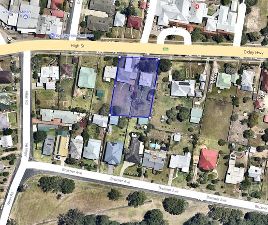
The site fronts High Street, which is the main road extending through Wauchope, and forms part of the Oxley Highway. The immediate locality comprises a mix of land uses, including the Wauchope District Memorial Hospital directly opposite the site, single storey dwellings to the north, east and west of the site and various commercial uses along High Street. The site contains an existing single storey ambulance station at No. 96 High Street and an existing single storey residential dwelling at No. 94 High Street. The existing ambulance station has a capacity of two ambulance vehicles and 5 full time equivalent (FTE) staff.
The site is zoned R1 general residential in accordance with the Port Macquarie-Hastings Local Environmental Plan 2011, as shown in the following zoning plan:
The location of existing development within the locality is shown in the following aerial photograph (source: nearmap December 2017):
2. DESCRIPTION OF DEVELOPMENT
Key aspects of the proposal include the following:
· Demolition of the existing buildings and removal of two trees on the site;
· Construction of a new single storey ambulance station;
· Six (6) internal ambulance parking spaces;
· Six (6) carparking spaces, including one accessible space;
· One (1) external wash bay;
· New flag pole;
· Internal facilities including:
o Administration and storage spaces;
o Amenity facilities including lockers, toilets, relief area, showers, kitchen and dining, lounge area and outdoor area.
· Tree removal;
· Landscape works including tree planting;
· Consolidation of Lots 26 and 27 DP 37531.
Vehicle access to the proposed ambulance station is provided via a two-way entry/exit on the eastern side of the site which is shared by ambulances, staff and service vehicles from High Street and a dedicated exit on the western side.
The ambulance station is expected to employ up to 12 full time equivalent staff and will operate 24 hours a day and 7 days per week. At any one time the maximum number of FTE on site will be six (6).
Refer to attachments at the end of this report.
Application Chronology
· 30 January 2018 – DA lodged with Council
· 2 February 2018 – Additional information requested – clarification of owner’s consent and additional application fees
· 2 February 2018 – Additional information received
· 15 to 28 February 2018 – Neighbour notification and advertising in local newspaper of proposal
· 1 March 2018 – Email correspondence with Applicant
· 6 March 2018 – Copy of submission requested by Applicant
· 6 March 2018 – Copy of submission forwarded to Applicant
· 9 March 2018 – Amended stormwater plans received
· 23 March 2018 – Status update requested from Applicant on assessment and draft conditions
· 3 April 2018 – Draft conditions forwarded to Applicant for concurrence
· 11 April 2018 – Consideration of DA by Council’s DAP
· 11 April 2018 – Agreement received to proposed conditions (as amended by DAP) by the Applicant
3. STATUTORY ASSESSMENT
Section 4.15(1) Matters for Consideration
In determining the application, Council is required to take into consideration the following matters as are relevant to the development that apply to the land to which the development application relates:
(a) The provisions (where applicable) of:
(i) any Environmental Planning Instrument:
State Environmental Planning Policy No. 44 - Koala Habitat Protection
With reference to clauses 6 and 7, the subject land is less than 1 hectare (including any adjoining land under same ownership) and therefore the provisions of SEPP do not require consideration.
State Environmental Planning Policy No.55 – Remediation of Land
Following a search of Council records, the subject land is not identified as being potentially contaminated. The Applicant has however detailed that the existing conditions of the site have been assessed by Regional Geotechnical Solutions (RGS) in the submitted Geotechnical Site Investigation and Phase 1 Environmental Site Assessment. The assessment concludes that asbestos appears to be the only identifiable contaminant on the site and will need to be removed during the demolition of the buildings. Overall the report concludes that provided the recommendations set out in the report are implemented, including the preparation of an asbestos management plan, the land is suitable for the purpose for which the development is proposed to be carried out.
State Environmental Planning Policy No. 62 – Sustainable Aquaculture
Given the nature of the proposed development and proposed stormwater controls the proposal will be unlikely to have any adverse impact on existing aquaculture industries within the nearby Hastings River.
State Environmental Planning Policy No. 64 – Advertising and Signage
The proposed development includes proposed advertising signage in the form of 1 flush wall building identification sign.
In accordance with clause 7, this SEPP prevails over the Port Macquarie-Hastings LEP 2011 in the event of any inconsistency.
The following assessment table provides an assessment checklist against the Schedule 1 requirements of this SEPP:
|
Applicable clauses for consideration |
Comments |
Satisfactory |
|
Clause 8(a) Consistent with objectives of the policy as set out in Clause 3(1)(a). |
The proposed signage is consistent with the objectives of this policy. |
Yes |
|
Schedule 1(1) Character of the area. |
The signage is consistent with the desired future character of the area and locality as it is limited to the building’s purpose and does not protrude above the building. |
Yes |
|
Schedule 1(2) Special areas. |
The signage will not detract from the amenity or visual quality of any special areas. |
Yes |
|
Schedule 1(3) Views and vistas.
|
The signage will not obscure or adversely impact on any views of vistas. |
Yes |
|
Schedule 1(4) Streetscape, setting or landscape.
|
The signage is proportionate to the building proposed and the site to which it will be installed and will not detract from the streetscape. |
Yes |
|
Schedule 1(5) Site and building.
|
The signage is of a suitable scale and proportion to the site which it’s to be located. |
Yes |
|
Schedule 1(6) Associated devices and logos with advertisements and advertising structures. |
A logo is nominated and of an appropriate for the intended identification purpose. |
Yes |
|
Schedule 1(7) Illumination.
|
No illumination proposed. |
Yes |
|
Schedule 1(7) Safety. |
No adverse safety impacts identified from the proposed signage. |
Yes |
State Environmental Planning Policy (Infrastructure) 2007
In accordance with clause 8, this SEPP prevails over the Port Macquarie-Hastings LEP 2011 in the event of any inconsistency.
In accordance with clause 47, the proposed emergency services facility on behalf of the Ambulance Service of New South Wales is identified as being a permissible land use in the R1 general residential zone.
In accordance with clause 101, the following comments are provided:
· Adjacent to the site, High Street/Oxley Highway is a sealed public road under the care and control as a classified road by the Roads and Maritime Services;
· Vehicle access is not practical to be provided from an alternative road other than the classified road;
· The safety, efficiency and ongoing operation of High Street/Oxley Highway will not be adversely affected by the design of the vehicle access points proposed or likely nature and volume of vehicles which will be gaining access to the site from this classified road.
Port Macquarie-Hastings Local Environmental Plan 2011
The proposal is consistent with the LEP having regard to the following:
· Clause 2.2, the subject site is zoned R1 general residential. In accordance with clause 2.3(1) and the R1 zone landuse table, the proposed development for an emergency services facility is a permissible landuse with consent.
The objectives of the R1 General Residential zone are as follows:
o To provide for the housing needs of the community.
o To provide for a variety of housing types and densities.
o To enable other land uses that provide facilities or services to meet the day to day needs of residents.
In accordance with Clause 2.3(2), the proposal is consistent with the zone objectives having regard to the following:
o The proposal is a permissible landuse.
o The proposal will provide for an essential service to meet the day to day needs of residents.
· Clause 2.7, the demolition requires consent as it does not fit within the provisions of SEPP (Exempt and Complying) 2008.
· Clause 4.3, the maximum overall height of the building above ground level (existing) is 8.4m, which complies with the standard height limit of 8.5 m applying to the site.
· Clause 4.4, the floor space ratio of the proposal is 0.29:1.0 which complies with the maximum 0.65:1 floor space ratio applying to the site.
· Clause 5.10 – Heritage. The site does not contain or adjoin any known heritage items or sites of significance.
· Clause 7.13, satisfactory arrangements are in place for provision of essential services including water supply, electricity supply, sewer infrastructure, stormwater drainage (as justified with proposed arrangements) and suitable road access to service the development.
(ii) Any draft instruments that apply to the site or are on exhibition:
No draft instruments apply to the site.
(iii) any Development Control Plan in force:
Port Macquarie-Hastings Development Control Plan 2013
This DCP has limited application to the proposal as there is no specific chapter for emergency service facilities or neighbourhood/precinct specific development control provisions. There are however several general provisions which are addressed below.
The following table provides a checklist against the Development Provisions requirements of this DCP:
|
DCP 2013: General Provisions |
|||
|
|
Requirements |
Proposed |
Complies |
|
2.7.2.2 |
Design addresses generic principles of Crime Prevention Through Environmental Design guideline |
The layout does not create any identifiable crime risk safety issues. The design limits potential concealment areas and allows surveillance of the carpark and street in part. Security fencing is proposed along the front of the premises. Appropriate lighting can be provided to improve safety. |
Yes |
|
2.3.3.1 |
Cut and fill 1.0m max. 1m outside the perimeter of the external building walls |
Cut and fill >1.0m change 1m outside the perimeter of the external building walls. |
No* |
|
2.3.3.2 |
1m max. height retaining walls along road frontage |
None proposed. |
N/A |
|
Any retaining wall >1.0 in height to be certified by structure engineer |
Proposal will require engineering certification. |
Yes |
|
|
Combination of retaining wall and front fence height max 1.8m, max length 6.0m or 30% of frontage, fence component 25% transparent, and splay at corners and adjacent to driveway |
· N/A |
N/A |
|
|
2.3.3.8 |
Removal of hollow bearing trees |
No hollow trees proposed to be removed. |
N/A |
|
2.6.3.1 |
Tree removal (3m or higher with 100m diameter trunk at 1m above ground level and 3m from external wall of existing dwelling) |
Tree removal applied for and addressed later in this report. |
Yes |
|
2.4.3 |
Bushfire risk, Acid sulphate soils, Flooding, Contamination, Airspace protection, Noise and Stormwater |
Refer to main body of report. |
Yes |
|
2.5.3.2 |
New accesses not permitted from arterial or distributor roads |
Existing accesses proposed to be replaced with the replacement emergency services facility. |
N/A |
|
Driveway crossing/s minimal in number and width including maximising street parking |
Driveway crossings minimal in width including maximising potential for street parking. |
Yes |
|
|
2.5.3.3 |
Parking in accordance with Table 2.5.1. No specific parking rates required. |
The proposal provides for adequate parking on the site, with the provision of six (6) onsite car parking spaces, including one accessible space, in addition to the six ambulance bays. The maximum number of staff on site at any one time is six (6). |
N/A |
|
2.5.3.12 and 2.5.3.13 |
Landscaping of parking areas |
· Landscaping of parking areas satisfactory.
|
Yes |
|
2.5.3.14 |
Sealed driveway surfaces unless justified |
Sealed driveways proposed. |
Yes |
|
2.5.3.15 and 2.5.3.16 |
Driveway grades first 6m or ‘parking area’ shall be 5% grade with transitions of 2m length |
Driveway grades capable of satisfying Council standard driveway crossover requirements. Condition recommended for section 138 Roads Act permit. |
Yes |
|
2.5.3.17 |
Parking areas to be designed to avoid concentrations of water runoff on the surface. |
· Proposed stormwater management systems capable of satisfying all relevant standards and requirements. |
Yes |
The proposal seeks to vary the Development Provision relating to the performance based maximum fill regrading levels permitted associated with a new building (outside 1m of the building itself).
The relevant objectives are:
To ensure that design of any building or structure integrates with the topography of the land to:
• Minimise the extent of site disturbance caused by excessive cut and fill to the site.
• Ensure there is no damage or instability to adjoining properties caused by excavation or filling.
• Ensure that there is no adverse alteration to the drainage of adjoining properties.
• Ensure the privacy of adjoining dwellings and private open space are protected.
• Ensure that adequate stormwater drainage is provided around the perimeter of buildings and that overflow paths are provided.
The site slopes towards the rear with a cross fall of approximately 3.5m. The proposal involves filling of the site to a maximum depth of 1700mm on the eastern extent of the site along the boundary of 92 High Street and to a maximum depth of 1500mm on the western extent of the site along the boundary of 96 High Street. The fill is retained by masonry retaining walls on the eastern and western boundaries. At the rear, the landfill is battered to a low retaining wall approximately 0.47m high and 11.36m from the rear boundary.
The Applicant has stated that although the building provides generous setbacks from the adjoining residential properties at No.s 92 and 98 High Street, vehicle manoeuvring areas encroach within 1m on the western boundary and 2.5m on the southern boundary and are elevated according to the landfill. The Applicant has further justified that it is proposed to retain and/or reinstate the colorbond boundary fences and provide landscape screening between the retaining walls and the manoeuvring areas as illustrated in the architectural and landscape plans. Rather than erect a conventional fence along these boundaries, it was decided to construct a blockwork wall, up to 1700mm on the eastern boundary and 1500mm on the western boundary with a 1000mm high metal balustrade fence.
Having regard for the development provisions and relevant objectives, the variation is considered acceptable for the following reasons:
· Due to the existing topography of the land and the need to provide appropriate levels for access to both the proposed emergency services facility and associated carpark, the proposal does not strictly comply.
· Retaining walls are limited to 1.5m to 1.7m in maximum height and not located towards the rear of the site.
· There are no adverse stormwater impacts identified.
· The additional fill heights will be unlikely to result in any identifiable adverse impacts to the neighbouring properties particularly noting the fencing proposed, orientation of the site and existing building locations.
· The fill areas will be required to be stabilized with appropriately designed engineered retaining walls.
(iiia) any planning agreement that has been entered into under Section 93f or any draft planning agreement that a developer has offered to enter into under Section 93f:
No planning agreement has been offered or entered into relating to the site.
iv) any matters prescribed by the Regulations:
Demolition of buildings AS 2601 – Clause 92
Demolition of the existing building on the site is capable of compliance with this Australian Standard and is recommended to be conditioned.
v) any coastal zone management plan (within the meaning of the Coastal Protection Act 1979), that apply to the land to which the development application relates:
· No Coastal Zone Management Plan applies to the subject site.
(b) The likely impacts of that development, including environmental impacts on both the natural and built environments, social and economic impacts in the locality:
Context and setting
· An existing ambulance station operates from part of the site (96 High Street).
The proposal is for a single storey ambulance station. The surrounding built form includes a mix of commercial premises and low rise residential dwellings. Considering the surrounding land uses and built form, the proposal will be compatible within the context and built form character of the existing area.
The proposal provides a 6.2m setback along the site's main frontage along High Street and a setback of 8.6m is provided from the site's western boundary, an 8.3m setback is provided from the site's eastern boundary and an 11.7m setback is provided from the rear boundary.
With regard to the likely impact on the existing streetscape, the proposal is technically not subject to the front setback controls under Development Control Plan 2013. The proposal has however adopted a front setback greater than the typical minimum 6.0m front setback alignment for a residential building fronting a classified road and has provided satisfactory landscaping.
The proposed ambulance station incorporates appropriate setbacks and a relatively modest built form when viewed from the public domain. The proposed scale and mass combined with the appropriate landscape treatment will enhance the appearance of the site and will ensure that the proposed ambulance station is consistent with the character of the immediate locality.
The building placement has also had satisfactory regard to the other existing developments in the locality and therefore the proposal will be unlikely to result in adverse impacts to the streetscape.
The proposal will be unlikely to have any adverse impacts to existing adjoining properties and satisfactorily addresses the public domain.
The proposal is considered to be consistent with other development in the locality and adequately addresses planning controls for the area.
The proposal does not have a significant adverse impact on existing view sharing.
The proposal does not have significant adverse lighting impacts.
There are no significant adverse privacy impacts. Adequate building separation and tenancy is proposed/existing.
There is no adverse overshadowing impacts. The proposal does not prevent adjoining properties from receiving 3 hours of sunlight to private open space and primary living areas on 21 June.
Roads
The site has road frontage to High Street/Oxley Highway, Wauchope.
Adjacent to the site, High Street/Oxley Highway is a sealed public road under the care and control of RMS. High Street/Oxley Highway is an Urban Arterial/RMS State road with a 12.7m carriageway width within a 20m road reserve. The road formation includes parallel parking and (SA) upright kerb on both sides of the street. The site is fronted by a 1.2m wide concrete footpath.
Traffic and Transport
The subject property occupies approximately 2,358m², with a 40m frontage along High Street/Oxley Highway. Currently, the property is occupied by a residential dwelling (94 High Street) and an Ambulance Station (96 High Street).
The Oxley Highway has sufficient capacity to accommodate the development as proposed.
The application includes a Traffic Impact Assessment from PTC Consultants on 18 December 2017. Findings of the study determined:
· The DA seeks to redevelop the existing Wauchope Ambulance Station at 96 High Street, Wauchope, as part of the Health Infrastructures Rural Ambulance Infrastructure Reconfiguration (RAIR) program,
· The existing ambulance station currently has a capacity of two ambulance vehicles. The redevelopment will increase the capacity to four ambulance vehicles, 1 ambulance SUV operational vehicle and one tyre changing facilities, ambulance washing facilities, and an increase from 5 to 12 FTE staff along with improved end-of-trip facilities. 6 external parking spaces are proposed on-site, inclusive of 1 accessible bay. This has been assessed to be adequate to meet the parking demands of the proposal,
· Traffic generations associated with the immediate staff increase under the proposal are found to be negligible (anticipated net increase in 4 hourly trips). Trips associated with emergency responses have been assessed using NSW Ambulance projections from a similar-scale regional Ambulance Station, which is a similar rural station. The projections for the next 20 years, estimates that the hourly trip volumes will increase from 1.8 trips (currently, including return) to 2.6 trips per hour. This growth is driven by the growing regional population, which is the driver for this RAIR ambulance upgrade. In regards to traffic, these volumes are considered minor, and not expected to notably impact the local road conditions.
· Public transportation is limited within the area; therefore, it is anticipated that most staff will drive to the station. However, the bus network connecting the Wauchope Region and Port Macquarie could be a viable alternative to transportation, which should be encouraged by building management,
· Visibility between ambulances leaving the site and pedestrians and vehicles along High Street is compliant with AS2890. In addition to providing adequate visibility, the audio/visual warnings from ambulance sirens will accommodate a good degree of safety between ambulances and public,
· It is understood that waste collection will be conducted on-street, which aligns with the general context of the area,
· The architectural plans have been reviewed in the context of vehicular arrangements (AS2890, NSW Ambulance requirements and industry best practice). This review found that all elements including access, visibility, manoeuvrability and parking to be compliant and safe for vehicles and other road users, both internally and externally,
· Based on the assessment, ptc. endorse this DA in the context of parking and traffic considerations.
· In order to prevent insufficient site distance at the driveway, it is recommended that a “Keep Clear” zone and “No Stopping” signs be installed along the full frontage of the proposed site. This will improve the sight distance of exiting vehicles significantly;
· The close proximity of the Wauchope District Memorial Hospital and the Wauchope Town Centre will lead to a high rate of walking. In order to ensure safety for pedestrians, any fencing or landscaping should be low in height and/or made with permeable materials.
The traffic study has been assessed by Council staff and deemed satisfactory.
Site Frontage & Access
Vehicle access to the site is proposed through multiple access driveways to High Street/Oxley Highway. All accesses shall comply with Council AUSPEC and Australian Standards and conditions have been imposed to reflect these requirements.
High Street/Oxley Highway is a Roads and Maritime Services (RMS) state classified road and will require concurrence from the RMS prior to works on this road. Details shall be provided as part of a Roads Act (Section 138) application to Council.
Parking and Manoeuvring
Parking and driveway widths on site can comply with relevant Australian Standards (AS 2890) and conditions have been imposed to reflect these requirements.
Due to the type of development, car park circulation is required to enable vehicles to enter and exit the site in a forward manner. Site plans show adequate area is available and conditions have been imposed to reflect these requirements.
Refer to relevant recommended conditions of consent.
Water Supply Connection
Council records indicate that the development site has two existing 20mm metered water services. Final water service sizing will need to be determined by a hydraulic consultant to suit the domestic and commercial components of the development, as well as fire service and backflow protection requirements in accordance with AS3500.
Refer to relevant recommended conditions of consent.
Sewer Connection
Council records indicate that the development site is currently has two connections to Council’s sewer system. The development is to discharge all sewage to the junction connected to the existing sewer manhole within the site. The redundant sewer junction must be capped at the main. Engineering plans are required to detail how the building will avoid placing additional loads on the existing sewer infrastructure.
Refer to relevant recommended conditions of consent.
Stormwater
The site naturally grades towards the rear and is currently un-serviced.
There are no easements for drainage available to service the site, however the roof level of the proposed development is sufficiently high to be drained via gravity to the kerb and gutter in High Street.
The nature of the site and topography means that surface water runoff cannot be drained via gravity to High Street. These areas naturally drain overland through the properties to the south.
In seeking an ideal drainage solution for the site, the landowner has sought to create an easement(s) for drainage over those lower downstream lots. Unfortunately, the Applicant has not been successful in gaining consent from the adjoining downstream landowners.
With no easement(s) for drainage available to the site, the applicant has the following options available:
1. Seek to enforce the creation of an easement for drainage over downstream lots via the Land and Environment Court – this options has not been pursued by the applicant
2. Utilise on-site absorption facilities to dispose of runoff on-site – site soil conditions are expected to be unfavourable, rendering such a proposal unlikely to be feasible. This options has not been explored by the applicant.
3. Drain the site to the public drainage system adjacent to the site in High Street. Noting that the site does not naturally drain to High Street, charged and/or pump-out drainage system is required. This option has been utilised and is discussed in more detail below.
Stormwater from the proposed development is planned to be disposed via charged lines from the roof and pump-out system with back-up for the remainder of the site.
The charged roof drainage system will drain all roof areas via gravity to the kerb and gutter in High Street via a rainwater tank and suitably sized on-site detention facilities.
The remainder of the site is proposed to be drained to a pump-out system via a separate on-site stormwater detention system, from where discharge will be pumped up to the kerb and gutter in High Street.
The proposal to discharge to the pump-well via an on-site stormwater detention system results in flows to the pump-well being at a rate equivalent to pre-development flows. Hence, even in the event of a total pump failure (the risk of which is managed via the use of dual pumps and other mechanical safeguards as per AS3500), any overflows from the pump out system will only occur at a rate equivalent to the pre-development discharge rate.
Consequently and subject to the provision of an overflow mechanism that spreads any overflows uniformly along the length of the property, downstream properties will not see an increase in stormwater discharge as a consequence of the development.
A detailed site stormwater management plan will be required to be submitted for assessment with the Section 68 application and prior to the building works commencing.
Refer to relevant conditions of consent.
Other Utilities
Telecommunication and electricity services are available to the site.
Heritage
Following a site inspection (and a search of Council records), no known items of Aboriginal or European heritage significance exist on the property. No adverse impacts anticipated.
Other land resources
The site is within an established urban context and will not sterilise any significant mineral or agricultural resource.
Water cycle
The proposed development will be unlikely to have any adverse impacts on water resources and the water cycle.
Soils
The proposed development will be unlikely to have any adverse impacts on soils in terms of quality, erosion, stability and/or productivity subject to a standard condition requiring erosion and sediment controls to be in place prior to and during construction.
Air and microclimate
The construction and/or operations of the proposed development will be unlikely to result in any adverse impacts on the existing air quality or result in any pollution. Standard precautionary site management condition recommended.
Flora and fauna
The proposal seeks the removal of two (2) trees to accommodate the proposed development. The trees include a Bunya Pine and a Hoop Pine located at the front of the site. Mid North Coast Tree Service completed an assessment on the trees and concluded in their report that each should be removed as they are within the footprint of the proposed ambulance station. There is no significant value identified with retaining the subject trees.
A Landscape Concept Plan prepared by Terras Landscape Architects has been submitted. The proposed landscaping comprising new trees, hedging, turf and planting. Along the site's High Street frontage, two hoop pine trees and two water gum trees are proposed, with turf planting and understorey planting proposed along the frontage of the ambulance station to assist in improving and enhancing the presentation of the site.
Along the eastern and western boundaries of the site, basket grass is proposed to provide a robust edging to the driveway and a narrow callistemon hedge is provided to the rear of the site to assist in appropriately screening the fence line from the adjoining neighbouring properties. To the rear of the site, a row of Backhousia myrtifolia is proposed, as well as two blueberry ash trees, to provide appropriate screening to the rear of the site.
The landscaping proposed is satisfactory.
Construction of the proposed development will not require any removal/clearing of any significant vegetation and therefore will be unlikely to have any significant adverse impacts on biodiversity or threatened species of flora and fauna.
Waste
Demolition and Construction Waste
The Applicant has advised that a waste management plan will be prepared by the builder during construction including site diagrams. The report will include the appropriate methods of disposal or excavated material, construction waste and recycling where appropriate.
Operational Waste
The Applicant has advised during the operations of the ambulance station, the Station Officer will supervise and follow up with the staff to ensure that the Waste Management procedures are followed in accordance with the Policy Directive –Waste Management Guidelines for Health Care Facilities – August 1998, Document Number PD2005_123.
Staff will dispose of waste from the point of generation to the waste holding area located in the site.
Waste will be collected by an external operator from a waste holding area on the Ambulance Station site which is secure and separate from the Plant Room. The Waste Area is a designated area where waste bins are kept. The frequency of general waste and recyclable waste collection will be as per current council arrangements for the local area.
Clinical Waste
Paramedics will dispose of waste, including clinical waste, at hospitals. This will reduce the amount that is returned to the Station.
Standard precautionary site management condition recommended.
Energy
The proposal includes measures to address energy efficiency and will be required to comply with the requirements of Section J of the Building Code of Australia.
No adverse impacts anticipated.
Noise and vibration
The Applicant has submitted details to address potential noise impacts with an Acoustic Assessment submitted prepared by Acoustic Studio. Identified noise impacts likely to result from the ambulance station are related to plant and mechanical equipment (principally the air conditioning plant and a pressure washer) and vehicle movements. It is noted that the external plant and equipment is proposed to be located on the High Street frontage of the site, away from the adjoining residential properties.
The Acoustic Assessment assesses the likely impact against the NSW Industrial Noise Policy Criteria, which Acoustic Studio consider to be the most stringent criteria.
In the absence of a noise survey, Acoustic Studio have applied the recommended background noise levels from Australian Standard 1055.3:1997
The assessment concludes that provided the recommendations detailed in this report are correctly implemented, it is anticipated that the proposed building will have no adverse noise impact at the nearest receivers and recommended internal noise levels within the ambulance station will be met for all areas.
It is noted that one of the recommendations includes a restriction on night time use of the pressure washer. Hours of operation will be restricted to between 7am to 8pm during Monday and Saturday and between 8am to 8pm on Sundays.
With regards to the use of sirens, ambulance drivers can decide whether to use ambulance sirens on a case-by-case basis. It is the practice of paramedics to minimise the use of sirens when it will cause a noise disturbance and the sirens are deemed unnecessary. It is noted that the site provides good sight distances for drivers which minimises the need for sirens.
No identifiable adverse impacts are therefore anticipated. The proposed hours of operation are acceptable and a condition is recommended to restrict construction to standard construction hours.
Bushfire
The site is not identified as being bushfire prone.
Safety, security and crime prevention
The proposed development will be unlikely to create any concealment/entrapment areas or crime spots that would result in any identifiable loss of safety or reduction of security in the immediate area.
Social impacts in the locality
Given the nature of the proposed development and its’ location the proposal is unlikely to result in any adverse social impacts. Improved ambulance facilities is seen as creating a positive social impact for the locality.
Economic impact in the locality
No adverse impacts. A likely positive impact is that the development will maintain employment in the construction and health industry, which will lead to flow impacts such as expenditure in the area.
Site design and internal design
The proposed development design satisfactorily responds to the site attributes and will fit into the locality. No adverse impacts likely.
Construction
No potential adverse impacts identified to neighbouring properties with the construction of the proposal.
Cumulative impacts
The proposed development is not expected to have any adverse cumulative impacts on the natural or built environment or the social and economic attributes of the locality.
(c) The suitability of the site for the development:
The proposal is considered to be an appropriate response to the physical characteristics of the site, its immediate surrounding area and locality and the needs of the surrounding communities. The proposal is a suitable development outcome for this site.
Site constraints, including stormwater drainage disposal, has been adequately addressed by the Applicant during the assessment of the application and appropriate conditions of consent recommended.
(d) Any submissions made in accordance with this Act or the Regulations:
One (1) written submission has been received from a Solicitor on behalf of the owners of 21 Bruxner Avenue to the rear of the site following public exhibition of the application.
Key issues raised in the submission received and comments in response to these issues are provided as follows:
|
Submission Issue/Summary |
Planning Comment/Response |
|
The proposed drainage easement through 21 Bruxner Avenue property along the western boundary is inappropriate. |
In seeking an ideal drainage solution for the site, the landowner sought to create an easement(s) for drainage over those lower downstream lots, however has not been successful in gaining consent from the adjoining downstream landowners.
With no easement(s) for drainage available to the site, the Applicant has chosen the option to drain the site to the public drainage system adjacent to the site in High Street. Noting that the site does not naturally drain to High Street, charged and/or pump-out drainage system is required.
The charged roof drainage system will drain all roof areas via gravity to the kerb and gutter in High Street via a rainwater tank and suitably sized on-site detention facilities.
The remainder of the site is proposed to be drained to a pump-out system, via a separate on-site stormwater detention system, from where discharge will be pumped up to the kerb and gutter in High Street.
Refer to additional specialist comments in stormwater drainage addressed earlier in this report which concludes that this arrangement is acceptable subject to specific conditions of consent. |
|
The creation of the easement would require excavation of 21 Bruxner Avenue’s concrete path and driveway causing disruption and inconvenience. |
|
|
The easement could be more conveniently located adjacent to the rear boundaries of 21 Bruxner Avenue and the neighbouring property to the east at no. 19 Bruxner Avenue and run along the western boundary of 17 Bruxner Avenue exiting to Bruxner Avenue. |
(e) The Public Interest:
The proposed development satisfies relevant planning controls, as justified, and is not expected to adversely impact on the wider public interest.
Ecologically Sustainable Development and Precautionary Principle
Ecologically sustainable development requires the effective integration of economic and environmental considerations in decision-making processes.
The four principles of ecologically sustainable development are:
· the precautionary principle,
· intergenerational equity,
· conservation of biological diversity and ecological integrity,
· improved valuation, pricing and incentive mechanisms.
The principles of ESD require that a balance needs to be struck between the man-made development and the need to retain the natural vegetation. Based on the assessment provided in the report and with recommended conditions of consent, it is considered an appropriate balance has been struck.
4. DEVELOPMENT CONTRIBUTIONS APPLICABLE
· Development contributions are normally required towards augmentation of town water supply and head works and sewer services headworks under Section 64 of the Local Government Act 1993. However, under Clause 2.7 of Council’s Contribution Policy, Council cannot levy contributions for water and sewer on essential facilities. As a result, Section 64 contributions will not apply.
· With regard to S94A Levy Contributions, these normally apply to all land within the Port Macquarie-Hastings LGA. The Contribution Plan enables Council to levy Section 94A developer contributions for new and upgraded road networks, traffic management facilities, car parking and town centre improvement works. However, exercising the discretion afforded under the Act (ie to not impose a condition requiring the payment of a Section 94A levy), Section 94A contributions will not apply for the following reasons:
· An ambulance station is an important public facility in its own right;
· The proposed new ambulance station will not generate any demand for new services; and
· The ambulance facility is a substantial investment in social infrastructure to meet the needs of the local community and is considered to be worthy of an exemption from paying this contribution.
5. CONCLUSION
The application has been assessed in accordance with Section 4.15 of the Environmental Planning and Assessment Act 1979.
Issues raised during assessment and public exhibition of the application have been considered in the assessment of the application. Where relevant, conditions have been recommended to manage the impacts attributed to these issues.
The site is suitable for the proposed development, is not contrary to the public's interest and will not have a significant adverse social, environmental or economic impact. It is recommended that the application be approved, subject to the recommended conditions of consent provided in the attachment section of this report.
|
Attachments
1View. DA2018 - 48.1 Plans 2View. DA2018 - 48.1 Easement Offers 3View. DA2018 - 48.1 Recommended DA Conditions. 4View. DA2018 - 48.1 Submission - Priest for Fowler |