Business
Paper
|
date of meeting:
|
|
Wednesday 19
December 2018
|
|
location:
|
|
Function Room
Port
Macquarie-Hastings Council
17 Burrawan Street
Port Macquarie
|
|
time:
|
|
2:00pm
|
Development
Assessment Panel
CHARTER
1.0 OBJECTIVES
To assist in managing Council's development assessment
function by providing independent and expert determinations of development
applications that fall outside of staff delegations.
2.0 KEY FUNCTIONS
·
To review development application reports and conditions;
·
To determine development
applications outside of staff delegations;
·
To refer development applications
to Council for determination where necessary;
·
To provide a forum for objectors and applicants
to make submissions on applications
before the Development Assessment Panel
(DAP);
·
To maintain transparency in the determination of development
applications.
Delegated Authority of Panel
Pursuant to
Section 377 of the Local Government Act, 1993 delegation to:
·
Determine development applications under Part 4
of the Environmental Planning and Assessment
Act 1979 having
regard to the relevant environmental planning instruments,
development control plans and Council policies.
·
Vary, modify or release restrictions as to use
and/or covenants created by Section 88B instruments under the Conveyancing Act
1919 in relation to development applications for subdivisions being considered
by the panel.
·
Determine Koala Plans of Management under State
Environmental Planning Policy 44 - Koala Habitat Protection associated with
development applications being considered by the Panel.
Noting the trigger to escalate
decision making to Council as highlighted in section 5.2.
3.0
MEMBERSHIP
3.1
Voting
Members
·
Two independent external members. One of the
independent external members to be the Chairperson.
·
Group Manager Development Assessment (alternate
- Director Development & Environment or Development Assessment Planner)
The independent external members shall have expertise in
one or more of the following areas: planning, architecture, heritage, the
environment, urban design, economics, traffic and transport, law, engineering,
government and public administration.
3.2
Non-Voting Members
·
Not applicable
3.3 Obligations
of members
·
Members must act faithfully and diligently and
in accordance with this Charter.
·
Members must comply with Council's Code of Conduct.
·
Except as required to properly perform their
duties, DAP members must not
disclose any confidential information (as advised by Council) obtained in connection with the DAP functions.
·
Members will have read and be familiar with the
documents and information provided by Council prior
to attending a DAP meeting.
·
Members must act in accordance with Council's
Workplace Health and Safety Policies and Procedures
·
External members of the Panel are not authorised
to speak to the media on behalf of Council. Council officers that are members
of the Committee are bound by the
existing operational delegations in relation to speaking to the media.
·
Staff members shall not vote on matters before
the Panel if they have been the principle author of the development assessment report.
3.4
Member Tenure
·
The independent external members will be
appointed for the term of four (4) years
maximum in which the end of the tenure of these members would occur in a
cascading arrangement.
3.5 Appointment
of members
·
The independent external members (including the
Chair) shall be appointed by the General Manager following an external
Expression of Interest process.
·
Staff members of the Panel are in accordance
with this Charter.
4.0 TIMETABLE
OF MEETINGS
·
The Development Assessment Panel will generally
meet on the 1st and 3rd Wednesday each month at 2.00pm at the Port Macquarie
offices of Council.
·
Special Meetings of the Panel may be convened by
the Director Development & Environment Services with three (3) days notice.
5.0
MEETING PRACTICES
5.1
Meeting
Format
·
At all Meetings of the Panel the Chairperson
shall occupy the Chair and preside. The Chair will be responsible for keeping
of order at meetings.
·
Meetings shall be open to the public.
·
The Panel will hear from applicants
and objectors or their r e p r e s e n t a t i v e s .
·
Where considered necessary, the Panel will
conduct site inspections which will
be open to the public.
5.2
Decision Making
·
Decisions are to be made by consensus. Where
consensus is not possible on any item, that item is to be referred to Council
for a decision.
·
All development applications involving a
proposed variation to a development standard
greater than 10% under Clause
4.6 of the Local Environmental Plan will be
considered by the Panel and recommendation made to the Council for a decision.
5.3
Quorum
·
All members (2 independent external members and
1 staff member) must be present at a
meeting to form a quorum.
5.4
Chairperson and Deputy Chairperson
·
Independent Chair (alternate, second independent member)
5.5
Secretariat
·
The Director Development &n Environment is
to be responsible for ensuring that the Panel has adequate secretariat support.
The secretariat will ensure that the business paper and supporting papers are
circulated at least three (3) days prior to
each meeting. Minutes shall be appropriately approved and circulated to each
member within three (3) weeks of a meeting being held.
·
The format of and the preparation and publishing
of the Business Paper and Minutes shall be similar to the format for Ordinary
Council Meetings.
5.6
Recording of decisions
·
Minutes will record decisions and how each
member votes for each item before the Panel.
6.0 CONVENING
OF “OUTCOME SPECIFIC” WORKING GROUPS
Not applicable.
7.0 CONFIDENTIALITY
AND CONFLICT OF INTEREST
·
Members of the Panel must comply with the
applicable provisions of Council’s Code of Conduct. It is the personal
responsibility of members to comply with the standards in the Code of Conduct
and regularly review their personal circumstances with this in mind.
·
Panel members must declare any conflict of
interests at the start of each meeting or before discussion of a relevant item
or topic. Details of any conflicts of interest should be appropriately minuted.
Where members are deemed to have a real or perceived conflict of interest, it
may be appropriate they be excused from deliberations on the issue where the
conflict of interest may exist. A Panel meeting may be postponed where there is
no quorum.
8.0 LOBBYING
·
All members and applicants are to adhere to
Council’s Lobbying policy. Outside of
scheduled Development Assessment Panel meetings, applicants, their
representatives, Councillors, Council staff and the general public are not to
lobby Panel members via meetings, telephone conversations, correspondence and
the like. Adequate opportunity will be provided at Panel inspections or
meetings for applicants, their representatives and the general public to make
verbal submissions in relation to Business Paper items.
Development Assessment Panel
ATTENDANCE
REGISTER
|
Member
|
26/09/18
|
24/10/18
|
14/11/18
|
28/11/18
|
05/12/18
|
|
Paul Drake
|
P
|
P
|
P
|
P
|
P
|
|
Robert Hussey
|
P
|
P
|
P
|
P
|
P
|
|
David Crofts
(alternate member)
|
|
|
|
|
|
|
Dan Croft
(Acting Director
Development & Environment)
Clinton Tink
(Acting GM Development
Assessment
(alternates)
- Director Development & Environment
- Development Assessment Planner
|
P
|
P
|
P
P
|
P
|
P
|
Key: P = Present
A
= Absent With Apology
X
= Absent Without Apology
Development
Assessment Panel Meeting
Wednesday 19 December
2018
Items of Business
01 Acknowledgement
of Country............................................................................ 8
02 Apologies......................................................................................................... 8
03 Confirmation
of Minutes.................................................................................... 8
04 Disclosures
of Interest..................................................................................... 13
05 DA2017
- 1049.1 Staged Residential Community Title Subdivision (35 Lots) at Lot 2 DP
1188545, Livingstone Road, Port Macquarie.................................................................... 17
06 DA2018
- 479.1 Change Of Use - Vehicle Repair Station To Light Industry - Lot A DP
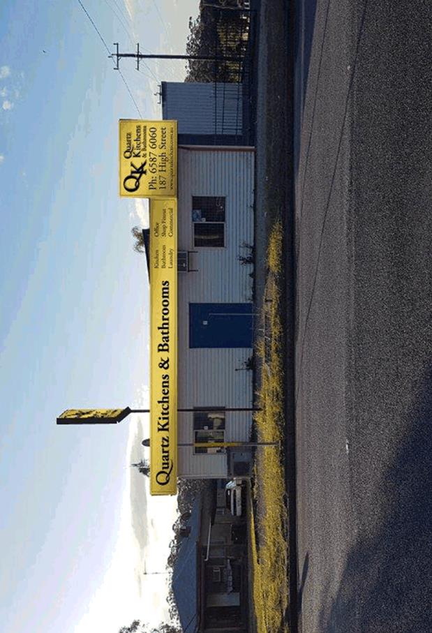
395406, No 187 High Street, Wauchope............................................................................ 286
07 General
Business
AGENDA Development Assessment Panel 19/12/2018
Subject: ACKNOWLEDGEMENT
OF COUNTRY
"I acknowledge that we are
gathered on Birpai Land. I pay respect to the Birpai Elders both past and
present. I also extend that respect to all other Aboriginal and Torres Strait
Islander people present."
RECOMMENDATION
That the apologies received be
accepted.
Subject: CONFIRMATION
OF PREVIOUS MINUTES
Recommendation
That the Minutes of the Development
Assessment Panel Meeting held on 5 December 2018 be confirmed.
MINUTES
Development Assessment Panel Meeting
05/12/2018
PRESENT
Members:
Paul
Drake
Robert Hussey
Dan Croft
Other Attendees:
Steve Ryan
Clinton
Tink
Andrew
Rock
David
Troemel
|
The meeting opened at 2:00pm.
|
|
01 ACKNOWLEDGEMENT
OF COUNTRY
|
|
The
Acknowledgement of Country was delivered.
|
|
03 CONFIRMATION
OF MINUTES
|
|
CONSENSUS:
That
the Minutes of the Development Assessment Panel Meeting held on 28 November
2018 be confirmed.
|
|
04 DISCLOSURES
OF INTEREST
|
|
There were no disclosures of interest presented.
|
|
05 DA2018 - 759.1
Replacement Of Revetment Wall And Construction Of Pontoon - Lot 5 DP 217022,
No, 10 North Shore Drive, North Shore.
|
|
CONSENSUS:
That
DA2018 – 759.1 for the replacement of revetment wall and construction
of pontoon at Lot 5 DP 217022 No.10 North Shore Drive, North Shore, be
determined by granting consent subject to the recommended conditions.
|
|
06 DA2018 - 735.1
Alterations And Additions To Dwelling - Lot 9 DP 708575, No 32 St Andrews
Avenue, Port Macquarie
|
|
Speakers:
Dave Lacey (o),
James Collins (applicant)
CONSENSUS:
That
DA2018 – 735.1 for alterations and additions to dwelling at Lot 9 DP708575,
No. 32 St Andrews Avenue, Port Macquarie be determined by granting consent
subject to the recommended conditions.
|
|
07 DA2018 - 528.1
Log Processing Works (Rural Industry) - Lot 2 DP 505234, 75 Bobs Creek Road,
Bobs Creek
|
|
Speaker:
Alistair Owen (o)
Andy Atkins (applicant)
Rebecca Osbourne (applicant)
CONSENSUS:
That DA
2018 – 528.1 for a log
processing works (rural industry) at Lot 2, DP 505234, No. 75
Bobs Creek Road, Bobs Creek, be determined by granting consent subject to the
recommended conditions and as amended below:
·
Amend condition A(4) to read: ‘By 31 January 2019, a
landscaped screening plan is to be submitted, approved by Council and
completed onsite. The landscape screening should provide a mixture of species
to enable visual screening to adjoining properties.
The
applicant shall also implement a landscape maintenance program for a minimum
period of twelve (12) months to ensure that all landscape screening work
becomes well established by regular maintenance
·
Amend condition A(5) to read: ‘By 31 January 2019,
structural certification of any retained wall, loading area etc in excess of
1m in height is to be provided by a suitably qualified Engineer.’
·
Amend condition A(6) to read: ‘A solid wood pile screen
with a minimum height of 3m and maximum height of 5m, is to be created south
of the proposed log processing facility (but not beyond the existing strand
of trees) for the purposes of creating a visual and noise barrier to the
neighbouring dwelling to the south. The wood pile is to be provided in lieu
of the Stage 2 noise wall within the Noise Impact Assessment by Matrix
Thornton, Report No. M18860.01, dated 17/9/2018. Once in place, timber will
not be allowed to be removed from the wood pile noise barrier until the log
processing use of the site ceases and is being cleaned up (ie completely
removed of stock). It should be noted that excess timber placed into the
barrier can be removed.
Certification is required to be submitted to Council by
31 January 2019, showing that the recommendations made in Section 10 (as
amended above) of the approved Noise Impact Assessment by Matrix Thornton,
Report No. M18860.01, dated 17/9/2018, have been installed onsite. The
certification must be provided by a suitably qualified person. The certification
is to include a revised site plan detailing the location and noise
attenuating requirements of the woodpile screen.’
In addition to the above, noise levels from the operation
of the hardwood timber mill shall be re-tested upon completion of the above
works and confirm that the development does not exceed 41LAeq (15min) at the
boundary of the nearest residential receiver, located at 69 Bobs Creek.
·
Amend condition F(14) to read: ‘After 31 January 2019,
vehicles picking up and delivering timber product must only use the forest
road access.’
·
Additional condition F(20) to read: ‘The proponent is to
keep a complaints register detailing the time and nature of any complaint and
the management/operational response to the complaint. The contact details of
the site manager are to be clearly signposted at the entrance to the property
from Bobs Creek Road on a sign not exceeding 1m2. The complaints register is
to be made available to Council upon request.’
|
|
08.01 Stormwater and Flooding
|
|
Discussion
took place in relation to stormwater and flooding.
|
|
The meeting closed at 3:30pm.
|
AGENDA Development Assessment Panel 19/12/2018
Subject: DISCLOSURES
OF INTEREST
RECOMMENDATION
That Disclosures of Interest be presented
DISCLOSURE OF
INTEREST DECLARATION
Name of Meeting: ………………………………………………………………………..
Meeting Date: ………………………………………………………………………..
Item Number: ………………………………………………………………………..
Subject: ………………………………………………………………………..
…………………………………………………….……………...…..
I, .....................................................................................
declare the following interest:
 Pecuniary:
Take
no part in the consideration and voting and be out of sight of the meeting.
Non-Pecuniary
- Significant Interest:
Take
no part in the consideration and voting and be out of sight of the meeting.
Non-Pecuniary
- Less than Significant Interest:
May
participate in consideration and voting.
For the reason that: ....................................................................................................
.......................................................................................................................................
Name: …………………………………………………….
Signed:
.........................................................................
Date: ..................................
 (Further
explanation is provided on the next page)
(Further
explanation is provided on the next page)
Further
Explanation
(Local Government Act and Code of Conduct)
A conflict of interest exists where a reasonable and informed
person would perceive that a Council official could be influenced by a private
interest when carrying out their public duty. Interests can be of two types:
pecuniary or non-pecuniary.
All interests, whether pecuniary or non-pecuniary are required to
be fully disclosed and in writing.
Pecuniary Interest
A pecuniary interest is an interest that a Council official has in
a matter because of a reasonable likelihood or expectation of appreciable
financial gain or loss to the Council official. (section 442)
A Council official will also be taken to have a pecuniary interest
in a matter if that Council official’s spouse or de facto partner or a
relative of the Council official or a partner or employer of the Council
official, or a company or other body of which the Council official, or a
nominee, partner or employer of the Council official is a member, has a
pecuniary interest in the matter. (section 443)
The Council official must not take part in the consideration or
voting on the matter and leave and be out of sight of the meeting. The
Council official must not be present at, or in sight of, the meeting of
the Council at any time during which the matter is being considered or discussed,
or at any time during which the council is voting on any question in relation
to the matter. (section 451)
Non-Pecuniary
A non-pecuniary interest is an interest that is private or
personal that the Council official has that does not amount to a pecuniary
interest as defined in the Act.
Non-pecuniary interests commonly arise out of family, or personal
relationships, or involvement in sporting, social or other cultural groups and
associations and may include an interest of a financial nature.
The political views of a Councillor do not constitute a private
interest.
The management of a non-pecuniary interest will depend on whether
or not it is significant.
Non Pecuniary – Significant Interest
As a general rule, a non-pecuniary conflict of interest will be
significant where a matter does not raise a pecuniary interest, but it
involves:
(a)
A relationship between
a Council official and another person that is particularly close, for example,
parent, grandparent, brother, sister, uncle, aunt, nephew, niece, lineal
descendant or adopted child of the Council official or of the Council official’s
spouse, current or former spouse or partner, de facto or other person living in
the same household.
(b)
Other relationships
that are particularly close, such as friendships and business relationships.
Closeness is defined by the nature of the friendship or business relationship,
the frequency of contact and the duration of the friendship or relationship.
(c)
An affiliation between
a Council official an organisation, sporting body, club, corporation or
association that is particularly strong.
If a Council official declares a non-pecuniary significant
interest it must be managed in one of two ways:
1.
Remove the source of
the conflict, by relinquishing or divesting the interest that creates the
conflict, or reallocating the conflicting duties to another Council official.
2.
Have no involvement in
the matter, by taking no part in the consideration or voting on the matter and
leave and be out of sight of the meeting, as if the provisions in section
451(2) apply.
Non Pecuniary – Less than Significant Interest
If a Council official has declared a non-pecuniary less than
significant interest and it does not require further action, they must provide
an explanation of why they consider that the conflict does not require further
action in the circumstances.
SPECIAL
DISCLOSURE OF PECUNIARY INTEREST DECLARATION
|
By
[insert full name of councillor]
|
|
|
In the
matter of
[insert name of environmental planning instrument]
|
|
|
Which is
to be considered at a meeting of the
[insert name of meeting]
|
|
|
Held on
[insert date of meeting]
|
|
|
PECUNIARY
INTEREST
|
|
Address of land in which councillor or an
associated person, company or body has a proprietary interest (the identified
land)i
|
|
|
Relationship of identified land to councillor
[Tick or cross one box.]
|
Councillor
has interest in the land (e.g. is owner or has other interest arising out of
a mortgage, lease trust, option or contract, or otherwise).
Associated
person of councillor has interest in the land.
Associated
company or body of councillor has interest in the land.
|
|
MATTER
GIVING RISE TO PECUNIARY INTEREST
|
|
Nature of land that is subject to a change
in zone/planning control by proposed
LEP (the subject land iii
[Tick or cross one box]
|
The
identified land.
Land
that adjoins or is adjacent to or is in proximity to the identified land.
|
|
Current zone/planning control
[Insert name of current planning instrument and
identify relevant zone/planning control applying to the subject land]
|
|
|
Proposed change of zone/planning control
[Insert name of proposed LEP and identify
proposed change of zone/planning control applying to the subject land]
|
|
|
Effect of proposed change of zone/planning control
on councillor
[Tick or cross one box]
|
Appreciable
financial gain.
Appreciable
financial loss.
|
|
|
|
Councillor’s
Name: …………………………………………
Councillor’s
Signature:
……………………………….
Date: ………………..
Important Information
This information is being
collected for the purpose of making a special disclosure of pecuniary interests
under sections 451 (4) and (5) of the Local Government Act 1993.
You must not make a special disclosure that you know or ought reasonably to
know is false or misleading in a material particular. Complaints made
about contraventions of these requirements may be referred by the
Director-General to the Local Government Pecuniary Interest and Disciplinary
Tribunal.
This form must be completed by
you before the commencement of the council or council committee meeting in
respect of which the special disclosure is being made. The
completed form must be tabled at the meeting. Everyone is entitled to
inspect it. The special disclosure must be recorded in the minutes of the
meeting.
i.
Section 443 (1) of the Local Government Act 1993 provides that
you may have a pecuniary interest in a matter because of the pecuniary interest
of your spouse or your de facto partner or your relativeiv or
because your business partner or employer has a pecuniary interest. You may
also have a pecuniary interest in a matter because you, your nominee, your
business partner or your employer is a member of a company or other body that
has a pecuniary interest in the matter.
ii.
Section 442 of the Local Government Act 1993 provides that a pecuniary
interest is an interest that a person has in a matter because of a
reasonable likelihood or expectation of appreciable financial gain or loss to
the person. A person does not have a pecuniary interest in a matter if the
interest is so remote or insignificant that it could not reasonably be regarded
as likely to influence any decision the person might make in relation to the
matter or if the interest is of a kind specified in section 448 of that
Act (for example, an interest as an elector or as a ratepayer or person liable
to pay a charge).
iii.
A pecuniary interest may arise by way of a change of permissible use of land
adjoining, adjacent to or in proximity to land in which a councillor or a
person, company or body referred to in section 443 (1) (b) or (c) of the
Local Government Act 1993 has a proprietary interest..
iv.
Relative is defined by the Local Government Act 1993 as
meaning your, your spouse’s or your de facto partner’s parent,
grandparent, brother, sister, uncle, aunt, nephew, niece, lineal descendant or
adopted child and the spouse or de facto partner of any of those persons.
AGENDA Development Assessment Panel 19/12/2018
Item: 05
Subject: DA2017 - 1049.1 Staged Residential Community
Title Subdivision (35 Lots) at Lot 2 DP 1188545, Livingstone Road, Port
Macquarie
Report
Author: Benjamin Roberts
|
Applicant: Land
Dynamics Australia
Owner: H
D & R E Lundell & M K Hinton
Estimated Cost: $1,500,000
Alignment with Delivery
Program
4.3.1 Undertake transparent
and efficient development assessment in accordance with relevant legislation.
|
|
RECOMMENDATION
That
DA 2017 - 1049 for a Staged
Residential Community Title Subdivision (35 lots) at Lot 2, DP
1188545, Livingstone Road, Port Macquarie, be determined by granting a deferred commencement
consent subject to the recommended conditions.
|
Executive
Summary
This
report considers a development application for a staged residential
community title subdivision to create 35 lots on the
subject land and provides an assessment of the application in accordance with
the Environmental Planning and Assessment Act 1979.
Following exhibition of the
original proposal, nine (9) submissions were
received. The proposal was subsequently amended and re-exhibited. Two (2)
submissions were received following re-exhibition.
1. BACKGROUND
Existing sites features and surrounding development
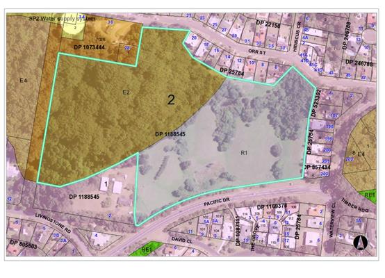
The subject land is described as
Lot 2 DP 1188545, Livingstone Road, Port Macquarie. However the site primarily
fronts Pacific Drive and has an area of 7.688 hectares. The site is
located on the southern aspect of what’s commonly known as ‘Transit
Hill’ and slopes away significantly from north to south.
The site is vacant land (i.e. contains no dwelling or
building structures). The north western portion of the site is heavily
vegetated and the south eastern portion is partly cleared with pockets of rainforest
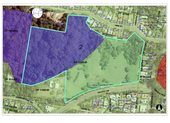
vegetation. These areas of the site are zoned E2
Environmental Conservation and R1 General Residential, respectively, in accordance with the Port Macquarie-Hastings Local
Environmental Plan 2011 as shown in the following zoning plan:
The site is predominantly surrounded by residential
dwelling houses to the south, east and north which are typically two storey in
nature having regard to the slope.
The site adjoins Council road reservation (unconstructed)
to the west and combination of Crown and Council owned land to the north
containing a water supply reservoir and telecommunication infrastructure (i.e.
towers).
The existing subdivision pattern and location of existing
development within the locality is shown in the following aerial photograph:
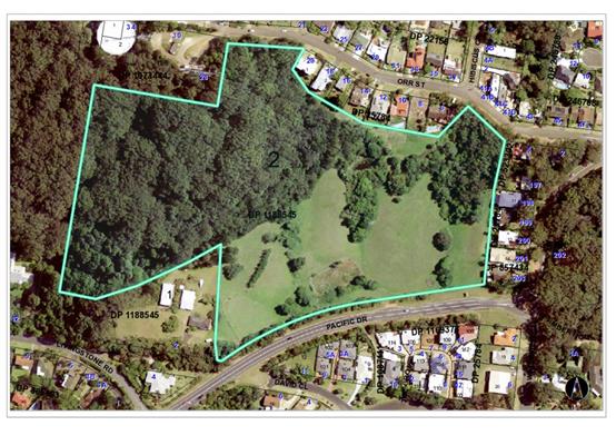
2. DESCRIPTION OF
DEVELOPMENT
Key aspects of the proposal include the following:
· Vegetation
clearing and associated earthworks.
· Staged
provision of associated infrastructure and services
· Vehicular
access from Pacific Drive.
· Retention
and enhancement of remnant rainforest vegetation.
· Community
title subdivision
Refer
to attachments at the end of this report.
Application Chronology
· 23
November 2017 – Application lodged.
· 1
December 2017 – Integrated referral sent to NSW Rural Fire Service.
· 6 to 19 December 2017 – Public exhibition via
neighbour notification.
· 4 January 2018 – Additional information request
(environmental impacts).
· 20 January 2018 – Additional information request from
NSW Rural Fire Service.
· 13 April 2018 – Meeting with applicant to discuss
environmental impacts.
· 27 April 2018 – Additional information request
(engineering issues).
· 10 May 2018 – Meeting with applicant to discuss
engineering issues.
· 1 June 2018 – Letter from NSW Rural Fire Service
advising not supportive of proposal as requested information not received
within timeframe.
· 4 July 2018 – Additional information request
(preliminary Pacific Drive intersection design plan).
· 18 July 2018 – Revised plans and additional
information lodged.
· 19 July 2018 – Integrated referral sent to NSW Rural
Fire Service.
· 24 July to 6 August 2018 – Re-exhibition of the
revised proposal via neighbour notification.
· 3 September 2018 – Additional information request
from NSW Rural Fire Service.
· 7 October 2018 – Additional information for NSW Rural
Fire Service provided.
· 8 October 2018 – Additional information sent to NSW
Rural Fire Service.
· 8 October 2018 – Additional information request
(preliminary Vegetation Management Plan VMP).
· 7 November 2018 – NSW Rural Fire Service General
Terms of Approval received.
· 15 November 2018 – Preliminary Vegetation Management
Plan (VMP) provided.
3. STATUTORY ASSESSMENT
Section 4.15(1) Matters for Consideration
In determining the application, Council is required to take
into consideration the following matters as are relevant to the development
that apply to the land to which the development application relates:
(a) The provisions (where
applicable) of:
(i) any Environmental
Planning Instrument:
State
Environmental Planning Policy No. 44 - Koala Habitat Protection
With
reference to clauses 6 and 7, the subject land is greater than 1 hectare
(including any adjoining land under same ownership) and therefore the
provisions of SEPP must be considered.
The
application was supported by an ecological impact assessment prepared by JB
Enviro, dated 29 June 2018. The assessment included a Koala habitat assessment
consistent with this policy. The assessment identified Tallowoods trees as
being the only schedule 2 species on the site. A total of thirteen (13)
Tallowood trees were identified. The assessment concluded that the site does
not qualify as potential Koala habitat and that no further investigation is
considered necessary.
The
findings of the ecological assessment are considered acceptable and no further
provisions of this SEPP require consideration.
State
Environmental Planning Policy No.55 – Remediation of Land
Following
an inspection of the site and a search of Council records, the subject land is
not identified as being potentially contaminated and is suitable for the
intended residential use.
State
Environmental Planning Policy No. 62 – Sustainable Aquaculture
Given
the nature and location of the proposed development there will be no adverse
impacts on any existing aquaculture industries.
State
Environmental Planning Policy No. 64 – Advertising and Signage
The proposal does not
incorporate any signage.
State
Environmental Planning Policy (Infrastructure) 2007
Consistent with clause 102 and
taking into consideration the guideline titled “Development near rail
corridors and busy roads – Interim Guideline 2008” the daily
traffic volumes along Pacific Drive are not in the vicinity of 40,000 average
daily vehicles, rather approximately 7,000 based on Council traffic data
counts. Having regard to traffic volumes, approximate 10m setback to kerb from
Pacific Drive and the 1.8m high timber fence proposed along the rear of the
lots, the standard LAeq levels expected to be met for residential accommodation
and no adverse impacts are anticipated by road noise or vibration.
Pacific Drive is not a
classified and the proposal is not a traffic generating development identified
in schedule 3 via clause 104 of this policy. Accordingly the application was
not referred to Roads and Maritime Services. Refer roads, transport and traffic
heading later within this report for traffic impacts.
State Environmental Planning
Policy (State and Regional Development) 2011
The proposed development does
not have a capital investment value of more than $30 million and is therefore
not recognised regional development under this policy.
Port Macquarie-Hastings Local Environmental
Plan 2011
The proposal is consistent with the LEP having regard to the
following:
· Clause
2.2, the subject site is zoned R1 General Residential and E2 Environmental
Conservation. The proposed subdivision footprint is contained to the R1 zone
and that proposed lot 209 is to contain all of the E2 zoned land.
In accordance with clause
2.3(2), the objectives of the R1 zone are as follows:
o To provide for the housing needs
of the community.
o To provide for a variety of
housing types and densities.
o To enable other land uses that
provide facilities or services to meet the day to day needs of residents.
The objectives of the E2 Zone
are as follows:
o To protect, manage
and restore areas of high ecological, scientific, cultural or aesthetic values.
o To prevent
development that could destroy, damage or otherwise have an adverse effect on
those values.
o To protect coastal
wetlands and littoral rainforests.
o To protect land
affected by coastal processes and environmentally sensitive land.
o To prevent
development that adversely affects, or would be adversely affected by, coastal
processes.
o To enable development
of public works and environmental facilities where such development would not
have an overall detrimental impact on ecological, scientific, cultural or
aesthetic values.
In accordance with clause 2.3(2), the proposal is consistent
with the zone objectives specifically:
o the proposal is a permissible
landuse;
o the proposal will provide for
housing needs of the community;
o the proposal will protect and
restore areas of high ecological value.
o the proposal is not proposed in the
E2 zone.
· Consistent
with clause 2.6 land to which the LEP applies may be subdivided with
development consent.
· Clause 4.1 does not apply as the proposal is for community
title subdivision only.
· Clause 4.1AA, applies due to the proposed community title
subdivision of the E2 zoned land. This clause requires the size of any
resulting lot from a subdivision of land to be no less than the minimum size
shown on the lot size map (being 3 hectares). Proposed lot (209) comprising the
E2 zone land will be 40,216.5m2 and greater than the 3 hectare
minimum.
The lot size
map identifies a minimum lot size of 450m2 (green shading) and 3
hectares (purple shading) applying to the site as per below:
· Clause
4.1B, minimum subdivision lot sizes for certain split zone applies as the
original lot contains land in a residential zone and land in an E2
Environmental Conservation zone. Consistent with this clause the proposal
incorporates one lot that will contain land in the R1 zone that has an area not
less than the minimum lot size shown on the lot size map (450m2) and
all the land in the E2 zone (proposed lot 209). All other resulting lots will
contain land that has an area that is not less than the minimum size shown on
the lot size map (i.e. 450m2). The standard residential lots
proposed range from 451.2m2 to 782.7m2 in size.
· Clause 5.10 – Heritage. The site does not contain or
adjoin any known heritage items or sites of significance.
o
· Clause
7.13, provides that development consent must not be granted to development
unless the consent authority is satisfied that any of the following services
that are essential for the proposed development are available or that adequate
arrangements have been made to make them available when required:
(a) The supply of water,
Comments: Council’s water
supply section are satisfied that adequate arrangements will be made for the
supply of water expected to be generated from the development. Specifically
Council records indicate that the site does not have a water service. The
existing 200mm AC water main on Pacific Drive (roundabout intersection to the
east of the development site) needs to be extended to the development site.
Each individual community titled lot will require an individual water meter
with a master meter at the boundary.
Specific consent conditions have
been recommended requiring final water service sizing to be determined by a
hydraulic consultant consistent with the requirements of Australian Standard
3500: Plumbing and Drainage with details to be provided as part of the
infrastructure construction certificate application and section 68
application.
(b) The supply of
electricity,
Comments: Electricity supply is
available. Council is satisfied that satisfactory arrangements will be made
with the electricity service provider to accommodate the proposed
development.
(c) The disposal and
management of sewage,
Comments: Council’s sewer
supply section are satisfied that adequate capacity is available and
arrangements will be made for connection and disposal of sewage expected to be generated
from the development. Council records indicate that the development site is
currently connected to sewer via a junction to a manhole on the southern
boundary. The internal sewerage network shall be privately owned and outlined
within a Community Management Statement. The development will be required to
discharge all sewage to a single point of connection to Council’s
sewerage system. Multiple connection points may be permitted subject to the
approval of the Water and Sewer Planning Manager. Specifically consent
conditions have been recommended requiring sewerage reticulation details to be
provided as part of the infrastructure construction certificate application and
section 68 application.
(d) Stormwater drainage or
on-site conservation,
Comments: A preliminary stormwater
management plan has been prepared by Land Dynamics Australia, reference
5222-SW-RPT01, dated 9 July 2018.
Council’s development and
stormwater engineers have reviewed the preliminary stormwater management plan.
Council staff are not satisfied that adequate details have been provided to
confirm acceptable stormwater management and drainage of the proposed
development. As the proposed detention facility is upstream of a number of
existing residential properties and in the particular context there is
considered to be relatively higher level of risk/uncertainty that needs to be
resolved further. Refer to detailed comments under stormwater section of
this report.
Accordingly a deferred
commencement condition is recommended requiring a more detailed stormwater
management plan to be submitted for assessment and approval by Council prior to
commencement of the development consent.
(e) Suitable road access.
Comments: Suitable road access is
capable of being provided directly from Pacific Drive.
With the exception of stormwater
Council staff are satisfied that satisfactory arrangements are available for
the provision of essential services. A deferred commencement condition has been
recommended to address stormwater.
(ii) Any
draft instruments that apply to the site or are on exhibition:
No draft
instruments apply.
(iii) any
Development Control Plan in force:
Port
Macquarie-Hastings Development Control Plan 2013
|
DCP 2013: Chapter 3.6 - Subdivision
|
|
DCP Objective
|
Development Provisions
|
Proposed
|
Complies
|
|
3.6.3.1
|
A site analysis is required for all development and shall
illustrate:
· microclimate;
· lot dimensions;
· north point;
· existing contours and levels to
AHD;
· flood affected areas;
· overland flow patterns, drainage
and services;
· any contaminated soils or filled
areas, or areas of unstable land;
· easements and/or connections for
drainage and utility services;
· identification of any existing
trees and other significant vegetation;
· any existing buildings and other
structures, including their setback distances;
· heritage and archaeological
features;
· fences;
· existing and proposed road
network, including connectivity and access for all adjoining land parcels;
· pedestrian and vehicle access;
· views to and from the site;
· overshadowing by neighbouring
structures; and
· any other notable features or
characteristics of the site.
|
A suitable site plan addressing key requirements was
submitted.
|
Yes
|
|
3.6.3.2
|
Torrens title lots minimum width of 15m when measured at a
distance of 5.5m from front property boundary.
|
No Torrens title lots proposed.
|
N/A
|
|
Minimum width of 7m when boundaries are extended to kerb
line.
|
No Torrens title lots proposed.
|
N/A
|
|
Minimum depth of 25m.
|
No Torrens title lots proposed.
|
N/A
|
|
For lots where average slope of the site is equal to, or
exceeds 16%, indicative road and driveway grades are required demonstrating
satisfactory access.
|
No Torrens title lots proposed.
|
N/A
|
|
Subdivision of dual occupancy development or multi
dwelling housing where permissible in the LEP may create allotments smaller
than 450m2 if:
· Each lot to be created is part of
a community or strata title scheme, or
· Is part of an integrated Torrens
title housing development.
|
No dual occupancy or multi-dwelling housing proposed.
|
N/A
|
|
3.6.3.3
|
Battleaxe lots discouraged in greenfield development.
|
No Torrens title lots are proposed. It is noted that
proposed lots 206 and 116 are battleaxe arrangements accessed via the
internal private road network. Having regard to road ownership and the site
being an ‘infill’ site the arrangement is considered acceptable.
|
No, but acceptable
|
|
Council may consider permitting Torrens Title battleaxe
allotments for ―infill development where it is demonstrated that;
· a Torrens Title lot, that is not
a battleaxe lot, cannot be achieved; and
· the number of crossovers do not
reduce the amenity of the street or on street parking; and
· the impact of noise, dust and
headlights on the land owners adjoining the driveway is addressed by the
construction of an acoustic fence for the full length of the driveway; and
· addresses privacy between the rear
lot and the rear open space of the front lot by the provision of
· adequate screening, larger lot
size and setbacks; and
· extends utilities to the end of
the axe handle; and
· there is sufficient space for
garbage collection on the frontage.
|
Refer to above. No Torrens title lots proposed.
|
Refer to above.
|
|
3.6.3.4
|
Lots are to be designed to allow the construction of a
dwelling, which does not involve more than 1m cut, or fill, measured from
natural ground level, outside the dwellings external walls.
|
The site is quite steep and slopes away to the south. It
is considered the proposed lots are capable of containing dwellings with
minimal cut and fill. Bearer and joists and spilt level construction for
instance on the steeper blocks is envisaged rather than slab on ground.
|
Yes capable.
|
|
Lot sizes increased for sloping sites in accordance with
Table 3.6.1.
|
Having regard to dwelling design options available for
sloping site the lot sizes are acceptable and comply with LEP 2011.
|
No but considered acceptable.
|
|
Additional information provided for slope categories in
accordance with Table 3.6.2.
|
No building footprints or retaining walls have been
nominated. Having regard to dwelling design options available for sloping
sites these details are not considered necessary.
|
No but considered acceptable.
|
|
3.6.3.5
|
Wherever possible orientate streets to maximise the number
of east, west and south facing lots and to minimise the number of narrow
north facing lots.
Residential street blocks should preferably be orientated
north-south with dimensions generally
limited to 60-80m by 120-150m as illustrated in Figure
3.6-2.
|
Proposed lot design is acceptable for maximising solar
orientation.
|
Yes
|
|
Lot size and shape are to reflect orientation to ensure future
dwelling construction has optimal opportunity for passive solar design.
|
Lot size and shape ensures suitable passive solar design
opportunities.
|
Yes
|
|
3.6.3.6
|
Kerb and guttering, associated street drainage, pavement
construction and foot paving across the
street frontages should be constructed as part of the
subdivision works where these do not exist (may be varied subject to criteria
in this clause)
|
Has been required via recommended consent conditions where
necessary.
|
Yes
|
|
3.6.3.7
|
Subdivisions close to urban centres or along arterial
roads serviced by public transport achieve yield of >35 dwellings per
hectare.
|
Development allows suitable density having regard to the
site constraints.
|
Yes
|
|
3.6.3.8
|
All new roads to be dedicated to Council designed in accordance
with AUSPEC.
|
No public roads identified for the site. Community title
arrangement proposed. No road dedication proposed.
|
N/A
|
|
3.6.3.9
|
Roads identified for bus routes to facilitate bus bays and
stops no more than 600m apart.
|
No public roads identified for the site. Relocation of
existing bus stop and bays on Pacific Drive subject to recommended consent
conditions.
|
N/A
|
|
3.6.3.10
|
Road design and construction as per figure 3.6-3 to figure
3.6-11.
Street trees, underground utilities, kerb and guttering
and pedestrian path.
|
No public roads proposed.
|
N/A
|
|
3.6.3.11
|
Perimeter roads adjoining bushland and may be part of APZ.
|
No public perimeter roads proposed.
|
N/A
|
|
3.6.3.12
|
Perimeter roads designed as per figure 3.8-8.
|
No public perimeter roads proposed.
|
N/A
|
|
3.6.3.13
|
Footpaths to be provided on both sides of collector and
arterial roads.
Footpaths on one side for access place and local streets.
Off street share-ways and on road cycle ways should be
provided.
CPTED principles for footpaths and cycle ways.
|
No public collector or arterial roads proposed.
No public access place or local streets proposed.
No public roads proposed.
|
N/A
N/A
N/A
|
|
3.6.3.14
|
Local roads designed for max speed of 50km/hr.
On street parking discouraged along local roads.
Signage illustrating links from local to regional road
network.
|
No public roads proposed.
|
N/A
|
|
3.6.3.15
|
Cycling infrastructure be provided as per cycling plan or
contribution provided.
|
Site identified as existing road shoulder along Pacific
Drive. No proposed route in cycling plan.
|
N/A
|
|
3.6.3.16
|
Integrated Water Cycle Management Strategy to be provided.
|
Strategy provided.
|
Yes
|
|
3.6.3.17
3.6.3.18
3.6.3.19
|
Stormwater Management Strategy be provided.
|
Strategy provided. Refer to detailed comments under stormwater
heading later within this report.
|
Yes
|
|
3.6.3.20
|
Water supply to meet Council’s design
specifications.
|
Capable of complying.
|
Yes
|
|
3.6.3.21
|
All lots connected to reclaimed water if available.
|
Capable of complying.
|
Yes
|
|
3.6.3.22
|
Where reclaimed water available use for certain
activities.
|
Reclaimed not available or planned for the site.
|
N/A
|
|
3.6.3.23
|
Extension of water supply to be at full cost of
proponents.
|
Suitable conditions recommended.
|
Yes
|
|
3.6.3.24
|
Separate sewer junction provided for each lot.
|
Capable of complying. Condition recommended.
|
Yes
|
|
3.6.3.25
|
Extension of sewer supply to be at full cost of
proponents.
|
Suitable conditions recommended.
|
Yes
|
|
3.6.3.26
3.6.3.27
|
Erosion and sediment control plan to be provided.
|
To be conditioned.
|
Yes
|
|
3.6.3.28
|
Saving and re-using of topsoil encouraged.
|
Noted.
|
Yes
|
|
3.6.3.29
|
Public open space. Neighbourhood parks provided as
indicated so that residential areas are within 500m of nearest park.
|
No park is proposed. No public park identified in plan for
the site. Land is already zoned residential.
|
Yes
|
|
3.6.3.30
|
Neighbourhood parks to be dedicated, minimum of 2000m2 and
embellished.
|
No park is proposed or required.
|
N/A
|
|
3.6.3.31
|
Open space management strategy for linkages to drainage
and wildlife corridors.
|
No park is proposed or required.
|
N/A
|
|
3.6.3.32
|
Street tree plantings to be selected from Indigenous
planting list.
|
Capable of complying. Details to be provided within CC
documentation.
|
Yes
|
|
3.6.3.33
|
Lot layout to address open space or public environmental lands.
Public perimeter roads encouraged.
CPTED principles in open space design.
|
No public perimeter roads proposed.
|
N/A
|
|
3.6.3.34
|
All service infrastructure should be underground unless
otherwise approved by Council.
|
To be conditioned.
|
Yes
|
|
All service infrastructure should be installed in a common
trench.
|
Where applicable, to be conditioned.
|
Yes
|
|
Conduits for the main technology network system should be
provided in all streets.
|
Where applicable, to be conditioned.
|
Yes
|
|
Conduits are to be installed in accordance with the
National Broadband Network Company Limited’s
‘Guidelines for Fibre to the Premises Underground
Deployment’.
|
Where applicable, to be conditioned.
|
Yes
|
|
Access pits are to be installed at appropriate intervals
along all streets.
|
Where applicable, to be conditioned.
|
Yes
|
|
3.6.3.36
|
Roads to be designed per AUSPEC for access by waste
collection vehicles.
|
No public roads proposed. It’s expected that a
private waste collection will be required having regard to the site
constraints. Condition has been recommended.
|
Yes
|
|
3.6.3.45
3.6.3.46
3.6.3.47
|
Street lighting to be provided per Australian Standards.
Energy efficient. Along pathways, cycle ways etc.
|
Capable and conditions applied.
|
Yes
|
|
3.6.3.48
|
Street naming to be shown on plans.
|
Capable and conditions applied.
|
Yes
|
|
3.6.3.49
3.6.3.50
|
Strata / Community Title Subdivision may be applied for.
Concept plan to be provided.
|
Community title subdivision applied for. Concept plan
provided.
|
Yes
|
|
3.6.3.51
|
Street trees should be provided along all road frontages
generally at a rate of 1 per 20m interval.
|
Capable and conditions applied.
|
Yes
|
|
Street trees should not affect solar access.
|
Capable and conditions applied.
|
Yes
|
|
3.6.3.52
|
Street trees from Council’s list.
|
Capable and conditions applied.
|
Yes
|
|
3.6.3.53
|
Street tree species and plantings have regard to CPTED
principles.
|
Capable and conditions applied.
|
Yes
|
|
DCP 2013: General Provisions
|
|
DCP Objective
|
Development Provisions
|
Proposed
|
Complies
|
|
2.3.3.3
|
Significant land reforming proposals to identify impacts.
High earthwork batters avoided.
Preliminary final landform plans to be provided.
|
Preliminary landform engineering plans provided.
|
Yes
|
|
2.3.3.4
|
Fully vegetated 50m buffer to be provided to
non-floodplain or wetland Endangered Ecological Communities (EEC).
|
Having regard to the location of the identified EEC and
its current residential zoning and that the proposal includes protection and
enhancement of the majority of the identified high quality rainforest EEC it
is considered appropriate in this instance to relax the 50m buffer to
approximately 9m and 12m respectively as per the required bushfire Asset
Protection Zones (APZs). The APZs will provide a suitable buffer to the
EEC and the Vegetation Management Plan (VMP) provides appropriate management
for protection and enhancement of the EEC.
|
No but considered acceptable.
|
|
2.3.3.5
|
Habitat/vegetation to be lost is to be offset through
dedication of suitable land based on expert ecological knowledge based on
principle of ‘improve and maintain’.
Improvement and maintenance of existing habitat and
corridors first preference for offset.
Vegetation Management Plan to be prepared for any
environmental land to be retained or used for offset.
|
Preliminary VMP provided based on expert ecological
advice. Improvement and maintenance of identified quality EEC proposed. It is
considered appropriate in this instance that the retention of the high
quality EEC identified in the R1 zone provides a suitable offset for the
component of vegetation and trees to be removed from the site.
|
Yes
|
|
2.3.3.6
|
Vegetated buffers to be provided to watercourses.
|
No defined natural water courses identified onsite.
|
N/A
|
|
2.3.3.8
|
Removal of hollow bearing trees
|
No hollow bearing trees to be removed.
|
N/A
|
|
2.4.3
|
Asset Protection Zones to be located outside environmental
protection zones.
Perimeter roads to all urban areas adjoining environmental
lands and buffers.
|
APZs are located outside of environmental protection
zones. Community title only with no public perimeter roads proposed.
|
Yes
|
|
2.4.3.6
|
All stormwater to be designed in accordance with AUSPEC.
|
Capable of compliance. Conditions applied. Refer to
comments under stormwater heading within the report.
|
Yes
|
|
2.5.3
|
Transport, traffic and access
|
Refer to detailed comments under roads, transport and
traffic heading later within this report.
|
Yes
|
|
2.5.3.11
|
Section 94 contributions
|
Contributions apply.
|
Yes
|
|
2.6.3.1
|
Tree removal (3m or higher with 100m diameter trunk and 3m
outside dwelling footprint
|
Tree removal proposed and assessed by ecological
assessment.
|
Yes
|
|
2.7.2.2
|
Design addresses generic principles of Crime Prevention
Through Environmental Design guideline:
· Casual surveillance and sightlines
· Land use mix and activity
generators
· Definition of use and ownership
· Lighting
· Way finding
· Predictable routes and entrapment
locations
|
The layout does not create any crime safety issues. The
design allows separation from habitat/concealment areas and allows
surveillance of the street.
|
Yes
|
(iiia) any
planning agreement that has been entered into under section 7.4, or any draft
planning agreement that a developer has offered to enter into under section
7.4:
No planning
agreement has been offered or entered into.
iv) any matters prescribed by the
Regulations:
New South Wales Coastal Policy:
The proposed development is
consistent with the objectives and strategic actions of this policy.
v) Any coastal
zone management plan (within the meaning of the Coastal Protection Act 1979),
that apply to the land to which the development application relates:
No Coastal Zone Management Plan
applies to the subject site.
(b) The
likely impacts of that development, including environmental impacts on both the
natural and built environments, social and economic impacts in the locality:
Context and setting
The site primarily fronts Pacific
Drive and has an area of 7.688 hectares. The site is located on the
southern aspect of what’s commonly known as ‘Transit Hill’
and slopes away significantly from north to south.
The site is vacant land (i.e.
contains no dwelling or building structures). The north western portion of the
site is heavily vegetated and the south eastern portion is partly cleared with
pockets of rainforest vegetation.
The site is predominantly surrounded by residential
dwelling houses to the south, east and north which are typically two storey in
nature having regard to the slope.
The
site adjoins Council road reservation (unconstructed) to the west and
combination of Crown and Council owned land to the north containing a water
supply reservoir and telecommunication infrastructure (i.e. towers).
Having regard to existing
development within the locality the proposal is considered to be consistent
with the locality and adequately addresses planning controls for the area.
Site Frontage & Access
Vehicle access to the site is proposed though an individual
driveway to internal private roads. The accessway shall be provided in concrete
and compliant with Council’s heavy duty standard crossover. Access shall
comply with Council AUSPEC and Australian Standards, and conditions have been
recommended to reflect these requirements.
Due to the type and size of
development, additional works are required to include:
· Road widening to
accommodate turning lanes and maintain the existing sealed shoulders
· concrete footpath
paving (minimum 1.5m wide) along the full frontage and including a refuge to
the existing network on Boonamin Rd.
Roads, Transport and Traffic
Pacific Drive is a two-coat sealed public road under the
care and control of Council. It has a 2m wide sealed shoulder for the frontage
of the site.
The application was supported by a
Traffic Impact Assessment prepared by StreetWise Road Safety & Traffic
Services Pty Ltd, dated 15 November 2017.
The development has proposed an
access to the site from Pacific Drive in the vicinity of the sag point along
Pacific Drive. A channelised right turn into the development only is proposed.
Review of the traffic impact assessment indicates that an auxiliary left turn
is also required, given the downward grade of the approach and the sight
distances from the crest of the road. The traffic assessment has defined
Pacific Drive as a Collector Road, which is incorrect. Pacific Drive is classified
as Urban Distributor. The design of the intersection will be required to comply
with AustRoads. Road widening shall be required to facilitate the additional
lane widths to accommodate the turning lanes whilst maintaining the 2m sealed
shoulders. All additional road works deemed necessary to accommodate the
proposal have been recommended as consent conditions.
The traffic impact assessment noted
that although the traffic generated from the development is low, the daily and
peak hour volumes on the Pacific Drive are high, requiring the intersection to
have a small channelised intersection in order to provide safe access to and
from the site. The report has recognised the crest in Pacific Drive
approximately 160m west of the proposed entry to the site, but has not has not
made any reference to the downhill grade as you approach the entry to the
development. Recognising that the design speed is 60km/h or 16m/s, there is
concern that with a reaction time of approximately 2 seconds a vehicle heading
towards the Central Business District will be accelerating downhill towards the
entry and will traverse a minimum of 42m before they react to a decelerating
vehicle attempting to enter the development. This has the potential for vehicle
collision. Council has recommended that an auxiliary left hand turn is provided
in order to protect the safety of road users. The intersection shall be
designed in accordance with Aust-Roads. Refer to relevant recommended
conditions of consent.
The required upgrades will ensure
that the proposed increase in traffic will be safely and efficiently catered
for within the local road network.
Stormwater
The site naturally grades towards Pacific Drive and is
traversed by three natural gullies which convey runoff from the upstream
catchment thorough the site.
The site frontage to Pacific Drive
contains a local sag (depression) which is currently subject to occasional
flooding across Pacific Drive as a consequence of stormwater blockages and / or
an undersized piped drainage system (council does not have a model of this
system at present).
This existing situation results in
overland flows being directed into a defined overland flow path located to the
south of the site between Pacific Drive and Boonamin Road. This flow path
contains a grassed channel and stormwater detention system with dwellings
adjacent.
The design for this downstream
system (prepared as part of an application for residential subdivision in circa
2004), indicates that the adjoining dwellings are provided with 500 freeboard
above the top water level in the overland flow path.
In order to ensure that the
proposed development does not increase discharge to this system or exacerbate
any existing issues (and where possible remedy any existing issues), it is
critical that the stormwater drainage system designed to convey flows generated
within and traversing the current development site be designed to ensure that
the existing drainage system between Pacific Dr and Boonamin Road comply with
the requirements of AUS-SPEC D5 and that the existing overland flow path
functions in accordance with the original design intent. In this regard, the
stormwater management plan lacks detailed modelling of not only the internal
site drainage, but also of the existing drainage system downstream of the site
(into Boonamin Road).
It is understood that from a
vehicular access perspective, that the development will necessitate a local
upgrade and widening of Pacific Drive within the site frontage in order to
facilitate safe access/egress to and from the site. This will necessitate the
provision of an upgraded local stormwater drainage system in Pacific Drive to
suit the new road and kerb alignment.
It needs to be demonstrated via
modelling and design that the upgraded Pacific Drive local drainage system can
comply with the abovementioned targets.
In relation to the development
proposal itself, stormwater from the proposed development is planned to be
disposed to Pacific Drive via a combination of on-site stormwater detention and
water quality control facilities, which have been conceptually designed by the
applicant to meet AUS-SPEC requirements regarding quality and quantity of
runoff.
The above-mentioned downstream
overland flood related risks may necessitate a revision to the sites onsite
detention strategy and overall volume. It is considered that the preliminary stormwater
management plan has not adequately demonstrated that the necessary water
quality and detention controls can be incorporated into the proposed
development. Further details are considered necessary.
The proposal includes a large open
on-site stormwater deletion basin within the site frontage to Pacific Drive
containing a nominal 740m3 of storage at a depth of approximately
1.8m. Should detention volumes need to be increased following the detailed
design phase, the basin could be conceivably expanded into proposed adjoining
lot 201 in order to provide additional area for detention. Having regard to the
slope constraints of this site it is considered that these detailed designs and
modelling need to be undertaken as part of the development application.
Pending confirmation of volumes,
this basin system will also require rigorous structural design and review by
the NSW Dam Safety Committee on the basis that it will result in the temporary
storage of substantial volumes of water above downstream residential
development. The risks associated with failure or lack of maintenance of this
structure must be assessed and addressed in detail. It is considered that
detailed design and review by Council and the NSW Dam Safety Committee is
necessary prior to any development consent being issued.
The site is also traversed by three
existing gullies, which drain significant upstream catchments. The proposal
includes the construction of three separate piped drainage systems to capture
and convey flows from these gullies through the site. Whilst no objections are
raised towards this approach in concept, more detailed design works is
necessary and needs to demonstrate the following:
· Provision of
suitable inlet protection – the three gullies originate in upstream
bushland. It is expected that major event flows would likely be carrying large
debris loadings and as such it is crucial that the inlets be designed with an
appropriate blockage factor.
· Provision of safe
overland flow paths.
· Detailed modelling
which demonstrates that the capture and conveyance of these existing flows does
not alter the function or capacity of the downstream drainage system. In
particular, without treatment, it would be expected that piping such overland
flows would result in a reduction in the time of concentration for the
catchment as a result of the ‘speeding up’ of flows that would
results from introducing a low roughness piped drainage system.
In relation to water quality, the
proposal includes a combination of systems and further detail is considered
necessary on how these systems will achieve long term compliance with water
quality control targets within AUSPEC. In this regard maintenance plans that
demonstrate how the basin and all water quality control measures are to be
maintained long term. These maintenance plans need to have regard to ultimate
land ownership and ongoing responsibilities.
In summary Council’s development and stormwater
engineers have reviewed the proposed development and preliminary stormwater
management plan and are not satisfied that adequate details and arrangements
have been provided for effective stormwater management and drainage of the
proposed development.
A deferred commencement condition
is recommended specifying evidence/details necessary to be incorporated into an
amended stormwater management to Councils satisfaction prior to commencement of
the development consent.
Water Supply Connection
Council records indicate that the development site does not
have a water service.
The existing 200mm AC water main on
Pacific Drive (roundabout intersection to the east of the development site)
shall be extended to the development site at no cost to Council.
Each individual community titled
lot must have an individual water meter with a master meter at the boundary.
Final water service sizing will
need to be determined by a hydraulic consultant to suit the domestic and
commercial components of the development, as well as fire service and backflow
protection requirements in accordance with AS3500.
Refer to recommended conditions of
consent.
Sewer Connection
Council records indicate that the development site is
currently connected to sewer via a junction to a manhole on the southern
boundary.
The internal sewerage network shall
be privately owned and outlined within the Community Management Statement. The
development shall discharge all sewage to a single point of connection to
Council’s sewer system. Multiple connection points may be permitted
subject to the approval of the Water and Sewer Planning Manager.
Refer to recommended conditions of
consent.
Other Utilities
Telecommunication and electricity services can be made
available to the site.
Evidence of satisfactory
arrangements with the relevant utility authorities for provision to each
proposed lot will be required prior to Subdivision Certificate approval.
Heritage
No known items of Aboriginal or European heritage
significance exist on the property. No adverse impacts anticipated.
Other land resources
The site is within an established urban context and will not
sterilise any significant mineral or agricultural resource.
Water cycle
The proposed development will be unlikely to have any
adverse impacts on water resources and the water cycle.
Soils
The proposed development will be unlikely to have any
adverse impacts on soils in terms of quality, erosion, stability and/or
productivity subject to a standard condition requiring erosion and sediment
controls to be in place prior to and during construction.
Air and microclimate
The construction and/or operations of the proposed
development will be unlikely to result in any adverse impacts on the existing
air quality or result in any pollution. Standard precautionary site management
condition recommended.
Flora and fauna
Construction of the proposed development will require
removal/clearing of vegetation on the site in order facilitate the subdivision.
The protection and enhancement of rainforest vegetation identified as
Endangered Ecological Community in the R1 zone also forms part of the proposal.
It is noted that the application
was lodged on 23 November 2017 and is subject to the Biodiversity
Conservation (Savings and Transitional) Amendment Regulation 2017 under
which the former planning provisions continue to apply to the determination of
a pending planning application. i.e. the Biodiversity Conservation Act 2016
does not apply.
Having regard to the vegetation
removal proposed to facilitate the development (inclusive of services, bushfire
protection measures and dam removal) the application was supported by a statutory
ecological impact assessment prepared by JB Enviro, dated 29 June 2018. The
report addresses the requirements of the ‘7 part test’ under
Section 5A of the Act. The report concluded that the proposal is unlikely to
have a significant impact on any threatened species and that a Species Impact
Statement is not required.
A preliminary Vegetation Management
Plan (VMP) also supports the application which clarifies the extent of land
subject to plantings, weed control and management (i.e subject to the VMP). It
is noted that the VMP land will form part of community land and be managed by
the respective community association.
The E2 zoned land proposed to form part of proposed lot 209
does not form part of the VMP lands and the intent is to use this area as a future
Biodiversity Stewardship site under the Biodiversity Conservation Act 2016
to which management of that land will be subject to separate agreement under
that legislation.
The ecological assessment
identified that, even though the land has been subject to a history of
disturbance, much of the regrowth in the R1 zone qualifies (on a precautionary
basis) as an Endangered Ecological Community (EEC) and that this vegetation has
important value as a local linkage albeit with limitations posed by island
biogeographic limitations and the dominance of the landscape by residential
development. To this end the majority of the rainforest regrowth (EEC) is to be
retained and enhanced via infill planting and weed control (i.e. subject to the
VMP).
The ecological assessment concludes
that the proposal is unlikely to have any significant adverse impacts on flora
and fauna subject to ameliorative measures. In summary the below ameliorative
measures were recommended and should consent be granted they would form part of
consent conditions:
· Bush regeneration
· Asset Protection
Zone selective habitat retention
· Mytrle rust
hygiene
· Quarantine
· Construction
hygiene
· Operation hygiene
· Clearing
management
· Erosion and
sediment control
· Artificial
lighting
In summary and consistent with the
findings of the ecological assessment it is considered that given the limited
extent of rather low value habitat affected; the ecology of the species
affected; that the majority of vegetation and the EEC will remain; and the
balance of impacts and ameliorative measures: the impacts are considered
unlikely to be of sufficient magnitude to result in the loss of viability of a
local population of any threatened species or EEC.
Conditions of consent have been
recommended specifying further commitments to be detailed and provided in a
revised VMP to which is be approved by Council prior to the issue of any
Construction Certificate.
Waste
Satisfactory arrangements can be made for proposed storage
and collection of waste and recyclables. A private waste collection service
will be necessary and conditions have been recommended to reinforce this. No
adverse impacts anticipated. Standard precautionary site management condition
recommended.
Energy
No adverse impacts anticipated.
Noise and vibration
No adverse impacts anticipated. Condition recommended to
restrict construction to standard construction hours.
Bushfire
The site is identified as being bushfire prone. The
applicant has submitted a bushfire assessment report prepared by Building Code
& Bushfire Hazard Solutions Pty Ltd, dated 9 July 2018. In accordance with
Section 100B of the Rural Fires Act, 1997, the application proposes development
for a Special Fire Protection Purpose.
The Commissioner has assessed the
development and has issued a Bushfire Safety Authority consisting of General
Terms of Approval which form part of the recommended conditions of consent.
Safety, security and crime prevention
The proposed development will be unlikely to create any concealment/entrapment
areas or crime spots that would result in any identifiable loss of safety or
reduction of security in the immediate area. The increase in housing density
will improve natural surveillance within the locality and openings from each dwelling
overlook common and private areas.
Social impacts in the locality
Given the nature of the proposed
development and its’ location the proposal is unlikely to result in any
adverse social impacts.
Economic impact in the locality
No adverse impacts. A likely
positive impact is that the development will maintain employment in the
construction industry, which will lead to flow impacts such as expenditure in
the area.
Site design and internal design
The proposed development design
satisfactorily responds to the site attributes and will fit into the locality.
No adverse impacts likely.
Construction
No potential adverse impacts
identified to neighbouring properties with the construction of the proposal.
Cumulative Impacts
The proposed development is not expected
to have any adverse cumulative impacts on the natural or built environment or
the social and economic attributes of the locality.
(c) The suitability of the site for
the development:
The proposal will fit into the
locality and the site attributes are conducive to the proposed development.
Site constraints have been
adequately addressed and appropriate conditions of consent recommended.
(d) Any submissions made in
accordance with this Act or the Regulations:
Following exhibition of the
original proposal, nine (9) submissions were
received. The proposal was subsequently amended and re-exhibited. Two (2)
submissions were received following re-exhibition.
Key issues raised in the submissions received and comments
in response to these issues are provided as follows:
|
Submission
Issue/Summary
|
Planning
Comment/Response
|
|
It’s a shame to see the land being developed as the
original owner wanted it kept in its original state.
|
The development site is zoned residential and development
of the land is anticipated.
|
|
There is a considerable lack of detail in the
application. It’s unclear as to what interface will occur between the
existing lots along Pacific Drive and those proposed to adjoin them. i.e.
retaining, fencing, plantings?
|
The plans were subsequently revised with screen planting
now proposed at the interface with the existing lots along Pacific Drive. No
retaining or new fencing is proposed as part of the application.
|
|
What’s planned for the area marked as stage 1?
|
It’s assumed this reference is made to the area
north of the proposed lots or the E2 zone in the western portion of the site.
This area north of the lots has been identified as containing significant
vegetation and will be retained and managed under a vegetation management
plan. Refer to plan in the preliminary VMP which identifies the land. No
development is proposed on the E2 zone in the western portion of the site.
|
|
There is little mention of Koala habitat, tree removal
and impact upon Koalas known to exist on the site.
|
Refer to comments under SEPP 44 Koala Habitat Protection
provided earlier within this report.
|
|
There is no discussion about impact upon fauna from the
vegetation and tree removal proposed.
|
Refer to comments under flora and fauna heading earlier
within this report for assessment and findings.
|
|
Bushfire appears to be a serious problem.
|
Bushfire protection measures are proposed and an
assessment under taken by a suitably qualified professional. The proposal and
assessment has been reviewed by NSW Rural Fire Service. Generals Terms of
Approval have been issued which will form part of the consent.
|
|
The time frame given to object is considered inadequate.
|
The application was exhibited in accordance with the
consultation requirements and 14 day period specified in Development Control
Plan (DCP) 2013. It should also be noted that following amendment the revised
proposal was re-exhibited in accordance with the DCP.
|
|
The fire trail proposed from Orr Street will impact on
vegetation and fauna within this area.
|
Amendments to the application included removal of lots
and associated fire trail behind properties in Orr Street. It is still
proposed to continue management of a 5m wide area behind the back of these
properties. The impacts of such have been considered in the ecological
assessment. Refer to comments under flora and fauna heading of this report.
|
|
It is requested that not just weeds but all non-native
vegetation be removed from the vegetated gullies and Orr Street frontage.
|
The preliminary VMP includes management practices,
including weed removal and control, to allow the natural progression of these
vegetated areas to a rainforest state.
|
|
Who will own the large area marked as environmental
conservation in stage 1? And is the zoning of this likely to change in
future?
|
The large western portion of heavily vegetated land zoned
E2 Environmental Conservation is proposed to form part of proposed lot 209
and will be retained in private ownership. The E2 land zoning is unlikely to
change in the future.
|
|
Does Council enforce environmental restrictions if the
property is Community Title?
|
Irrespective of the land titling arrangements the
management of the environmental lands will remain the responsibility of the
respective land owner consistent with the obligations outlined in the
approved Vegetation Management Plan.
|
|
Concern is expressed surrounding the future height of
buildings on the lots and potential loss of views and overshadowing that will
decrease land values.
|
No buildings are proposed under this application. Being
subdivision only no view or solar access impacts have been identified. By the
same token the standard 8.5m building height restriction applies to the land.
Impact on land value is not a planning consideration.
|
|
What is meant by the “buffer zone/screening
required” shown behind the properties along Pacific Drive
|
Revised plans including a landscape plan propose
vegetation plantings at this interface to assist with privacy between
neighbours. The applicant has indicated that planting species and height will
be nominated at construction stage.
|
|
What type of fencing will be placed behind the back of
the properties along Pacific Drive? And how will this affected existing
retaining walls?
|
No new fencing is nominated on the plans or proposed as
part of this application. A condition has been recommended requiring new boundary
fencing at 1.8m in height. The type of fencing is expected to be agreed upon
between the respective land owners. No change to existing retaining walls is
proposed.
|
|
Concerns about construction noise.
|
Recommended standard consent conditions would limit any
construction activities to between 7am to 6pm Monday to Saturday with no work
on Sunday or public holidays. These permitted construction work hours are
consistent for all developments.
|
|
The increased traffic to be generated will create traffic
problems to a road that is already in a terrible condition. The existing
properties fronting Pacific Drive lack kerb and guttering.
|
Refer to comments under roads and traffic heading of this
report. The existing condition of the road and lack of kerb and gutter to
existing houses is a matter for Council and unrelated to this development
application.
|
|
The clearing of Lowland Subtropical Rainforest Endangered
Ecological Communities (EEC) and other indirect impacts on this EEC is to
legislation and Council’s DCP.
|
Subsequent to the original proposal and detailed
ecological assessment was undertaken and the proposal amended to retain the
majority of the identified EEC and enhance via a Vegetation Management Plan
(VMP). Refer to comments within the DCP table within this report regarding
EEC and reduced buffer requirements.
|
|
Failure to provided Vegetation Management Plan (VMP) for
retained vegetation and EEC as per DCP.
|
A preliminary VMP has subsequently been provided
following revision of the proposal.
|
|
Failure to comply with SEPP 44 – Koala Habitat
Protection, Threatened Species Conservation and Biodiversity Conservation
Acts.
|
Refer to comments under SEPP 44 heading and flora and
fauna heading of this report.
|
|
The ecological assessment prepared by Envirotech, dated 2
November 2017, is lacking in detail, fails to address relevant legislation
and DCP provisions and is considered deficient.
|
A new ecological assessment was undertaken and the
proposal was subsequently revised having regard to the findings. Refer to
comments under flora and fauna, SEPP 44 and DCP table headings within this
report.
|
|
The cleared area behind the properties fronting Orr
Street should be maintained and allow vehicular access to reduce bushfire
risk to these properties.
|
No change to any existing informal access and management
arrangements are proposed in this area. It is noted that no APZ restriction
applies to the title of the land.
|
(e) The Public Interest:
The proposed
development satisfies relevant planning controls and is unlikely to impact on
the wider public interest.
4. DEVELOPMENT
CONTRIBUTIONS APPLICABLE
· Development contributions will be required towards
augmentation of town water supply and sewerage system head works under Section
64 of the Local Government Act 1993.
· Development contributions will be required under Section 94
of the Environmental Planning and Assessment Act 1979 towards roads, open
space, community cultural services, emergency services and administration
buildings.
5. CONCLUSION AND
STATEMENT OF REASON
The application has been assessed
in accordance with Section 4.15 of the Environmental Planning and Assessment
Act 1979.
Issues raised during assessment
and public exhibition of the application have been considered in the assessment
of the application. Where relevant, conditions have been recommended to manage
the impacts attributed to these issues.
The site is considered suitable
for the proposed development and the proposal adequately addresses relevant
planning controls. The development is not considered to be contrary to the
public's interest and will not result a significant adverse social,
environmental or economic impact. It is recommended that the application be
approved, subject to a deferred commencement consent and the recommended
conditions of consent provided in the attachment section of this report.
|
Attachments
1View. DA2017
-1049.1 Draft Deferred Commencement Consent Recommended Conditions
2View. DA2017
- 1049.1 Bushfire Safety Authority conditions NSW RFS
3View. DA2017
- 1049.1 Amended Bushfire Report 180718
4View. DA2017
- 1049.1 Amended New Ecological Report 180718
5View. DA2017
- 1049.1 Amended Updated Stormwater Management Plan 180718
6View. DA2017
- 1049.1 Preliminary Vegetation Management Plan (VMP)
7View. DA2017
- 1049.1 Plans.pdf
|
|
ATTACHMENT
|
Development Assessment Panel
19/12/2018
|
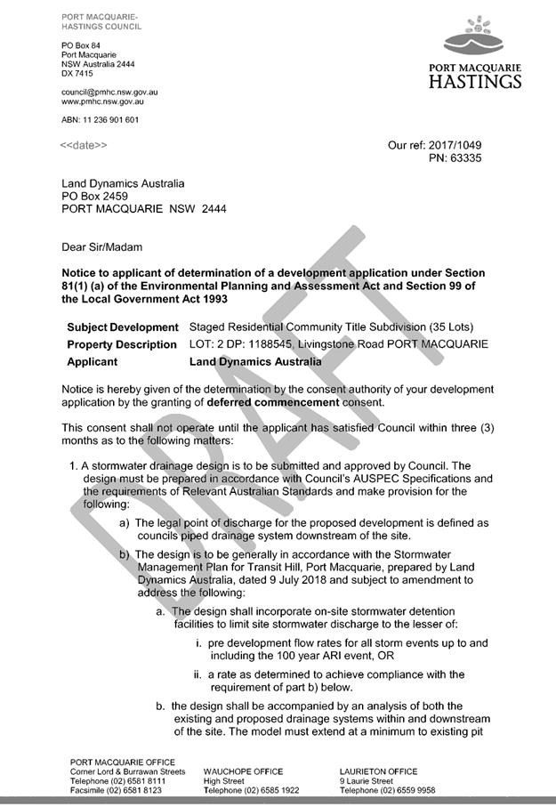
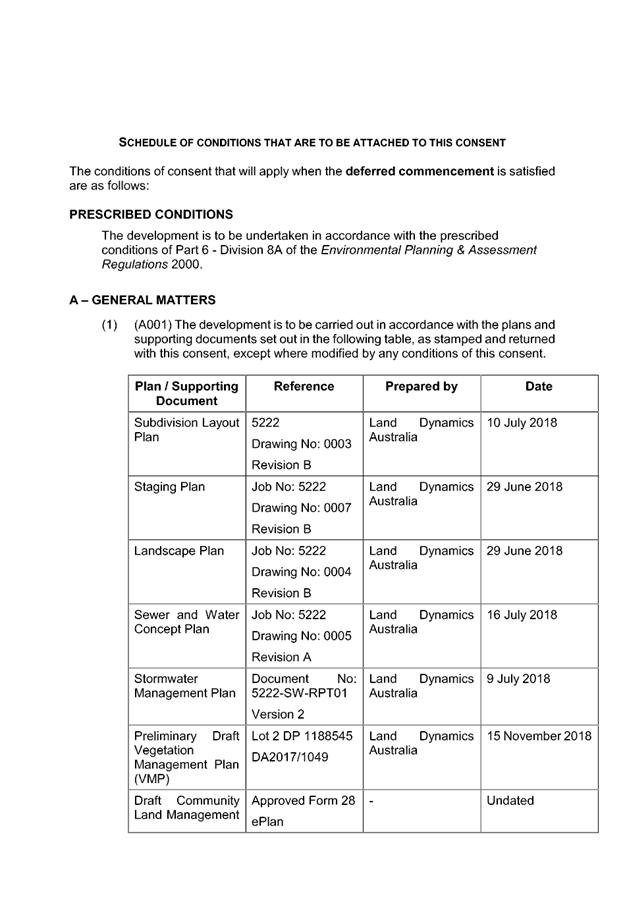
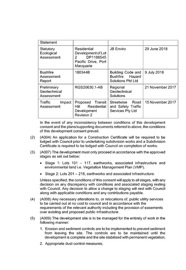

|
ATTACHMENT
|
Development Assessment Panel
19/12/2018
|


|
ATTACHMENT
|
Development Assessment Panel
19/12/2018
|

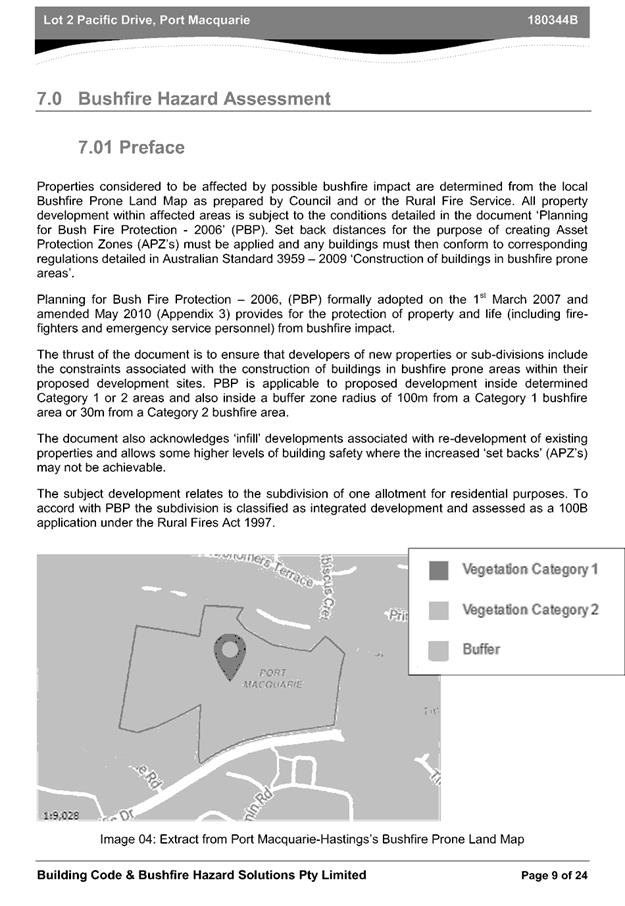
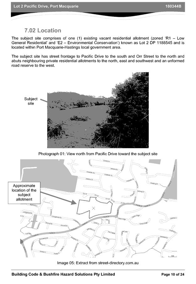
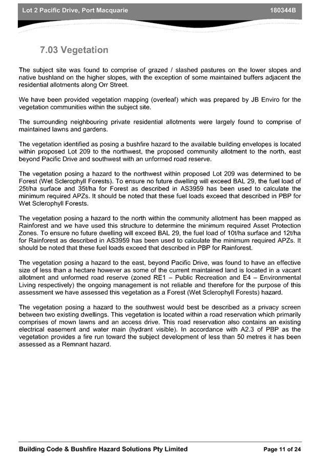
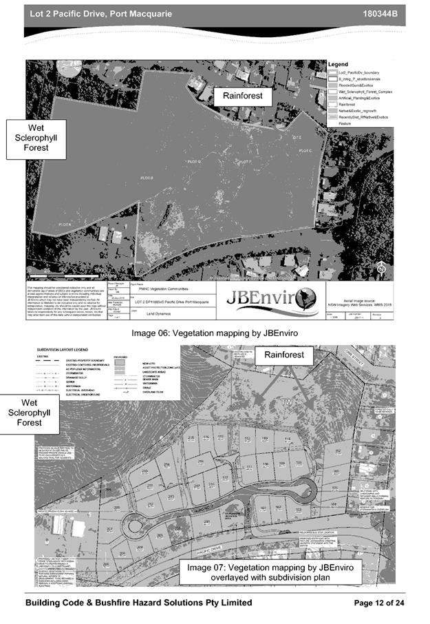
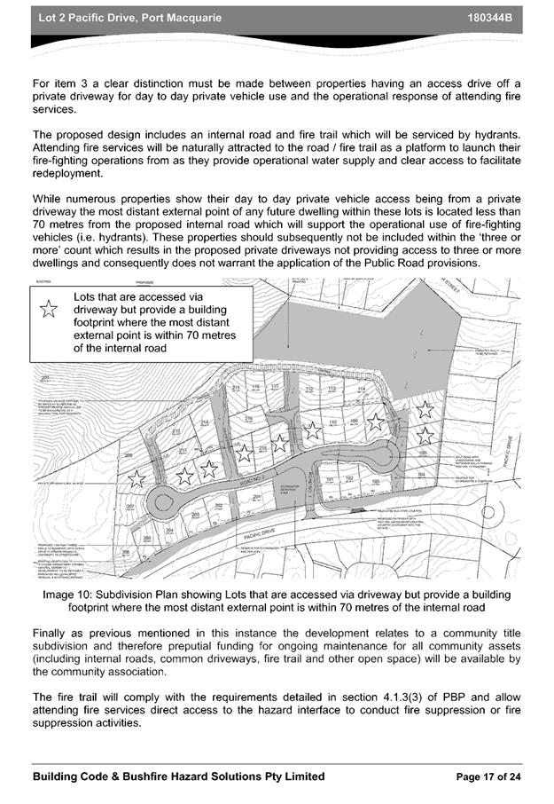
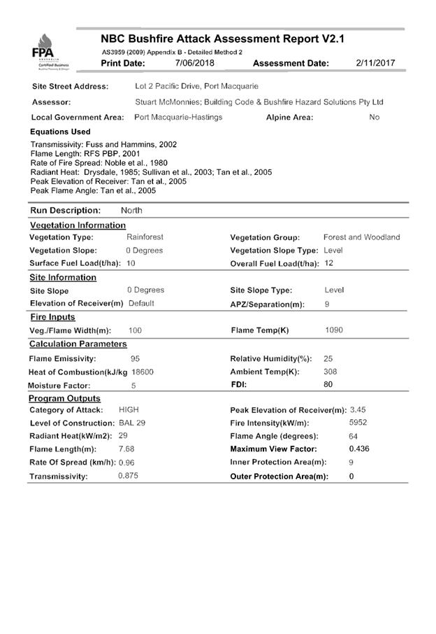
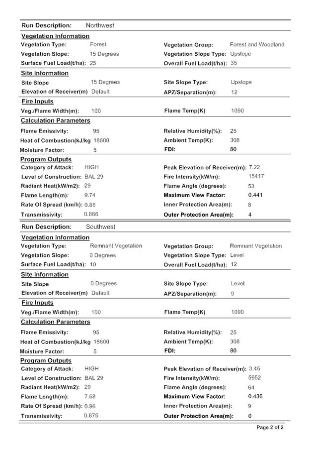
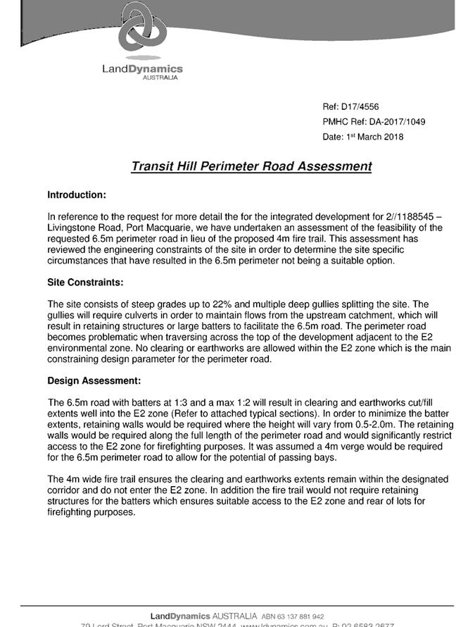
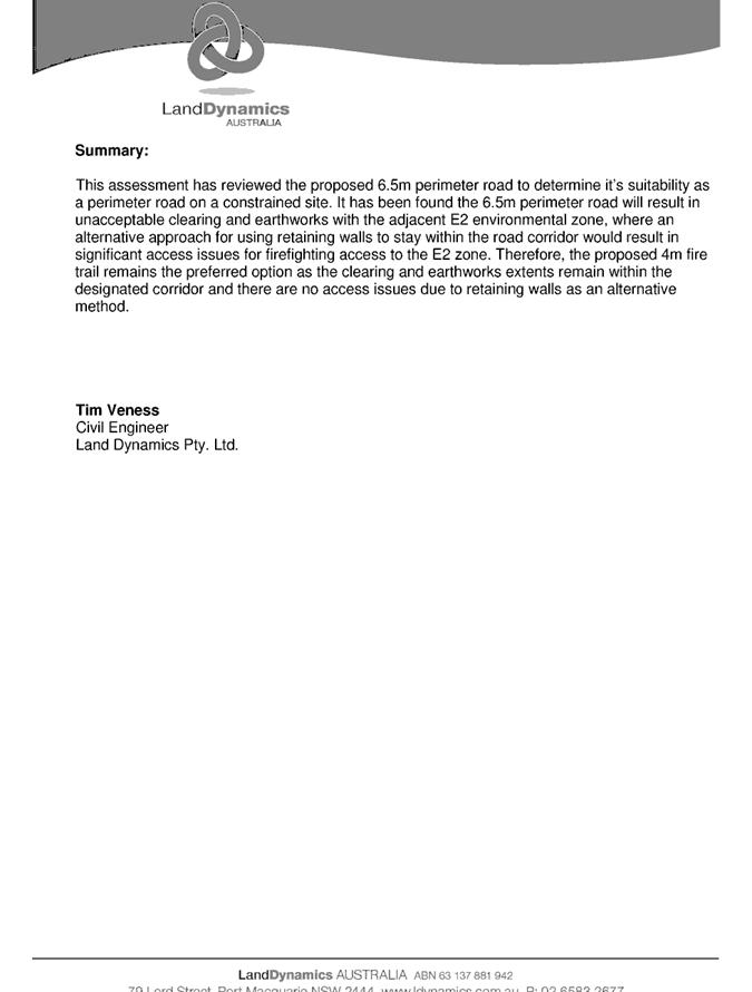
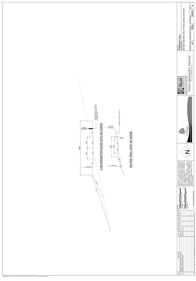
|
ATTACHMENT
|
Development Assessment Panel
19/12/2018
|
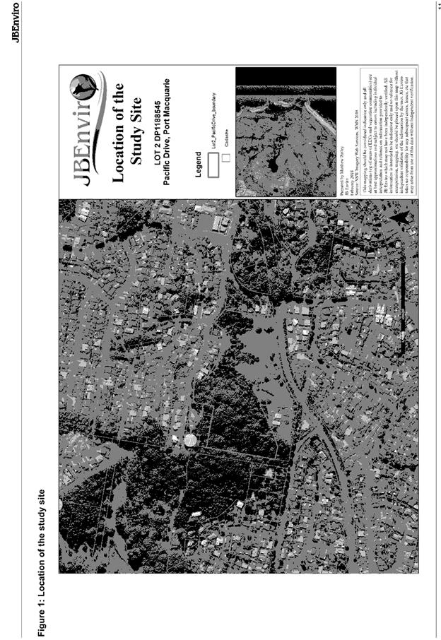
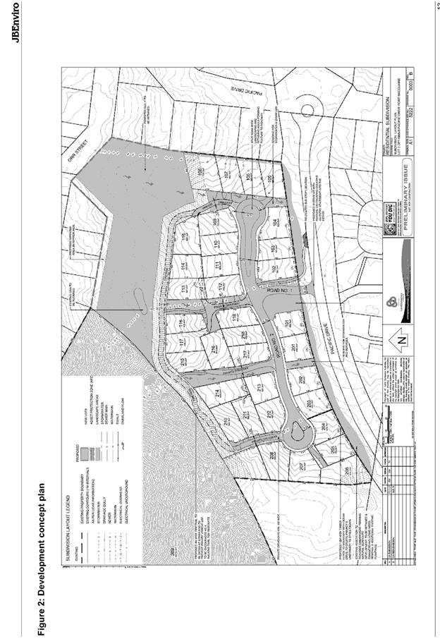
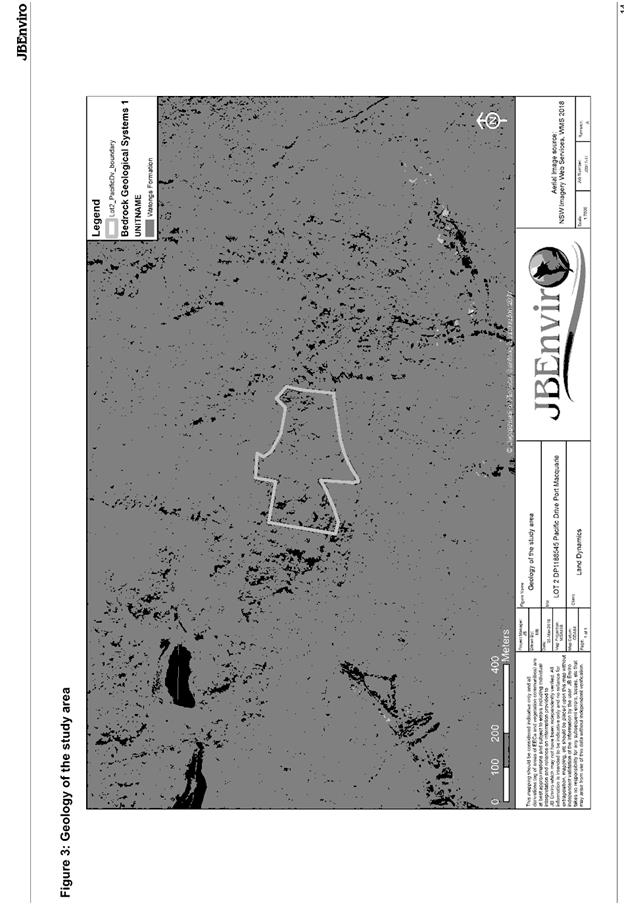
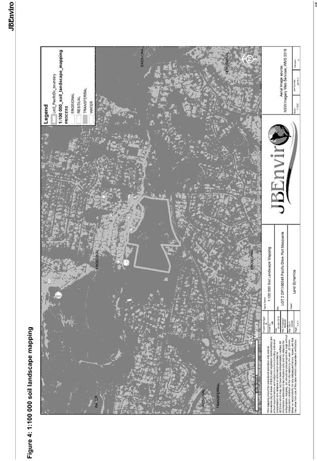
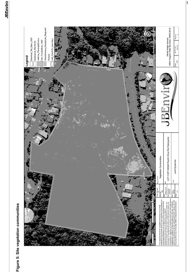
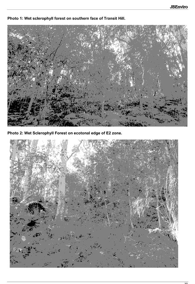
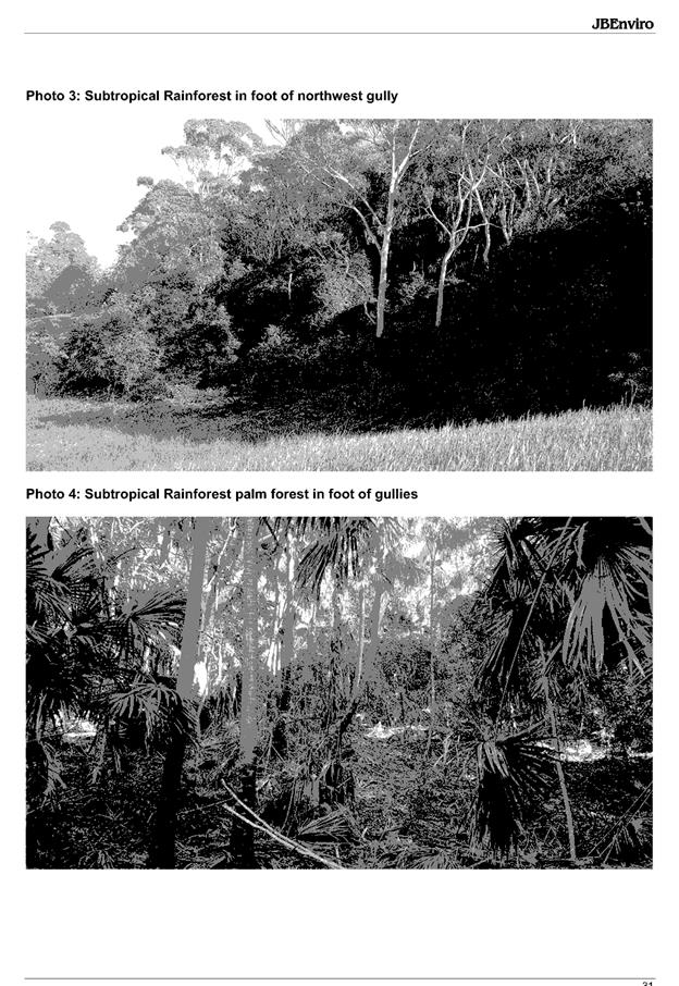
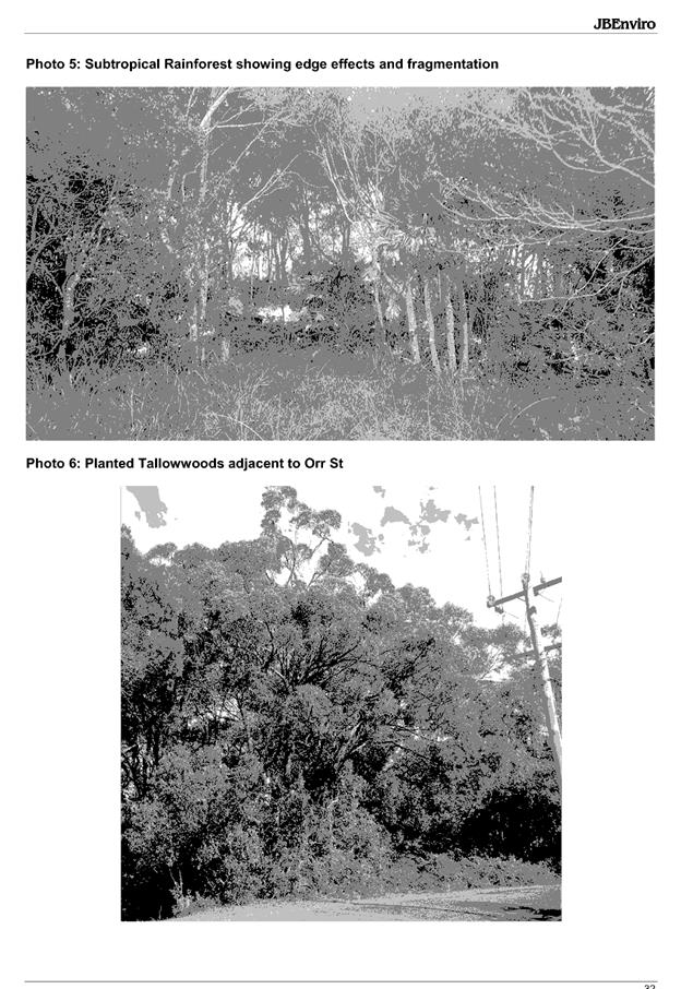
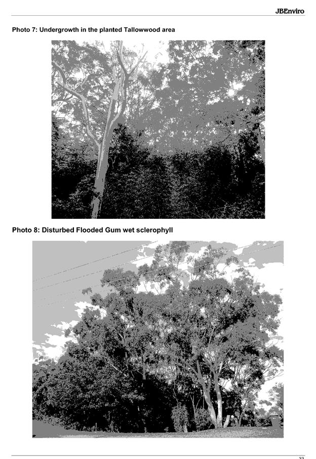
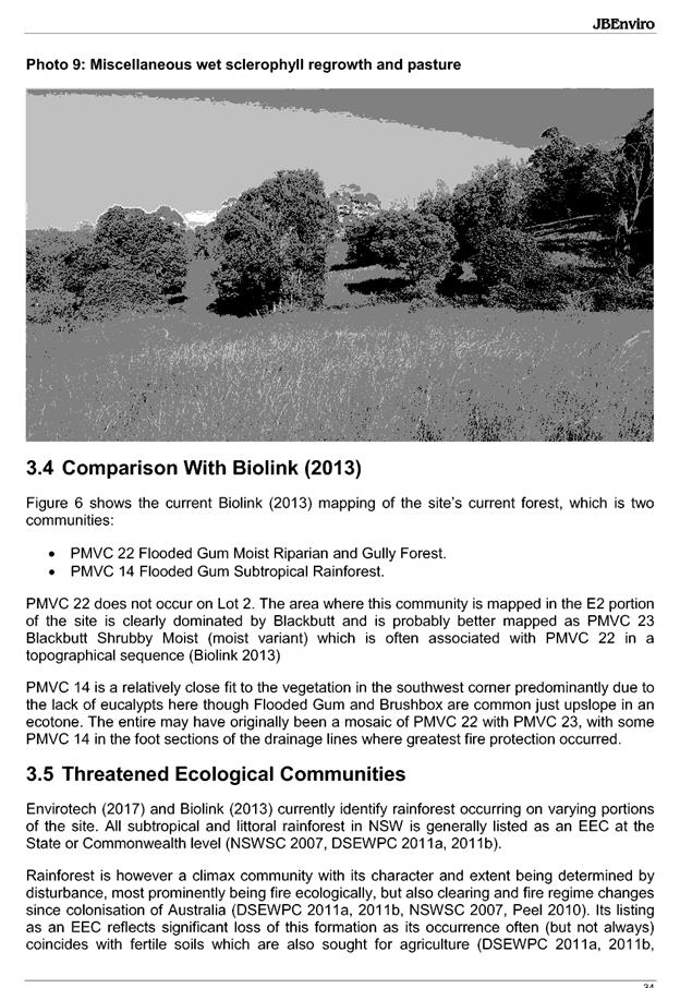
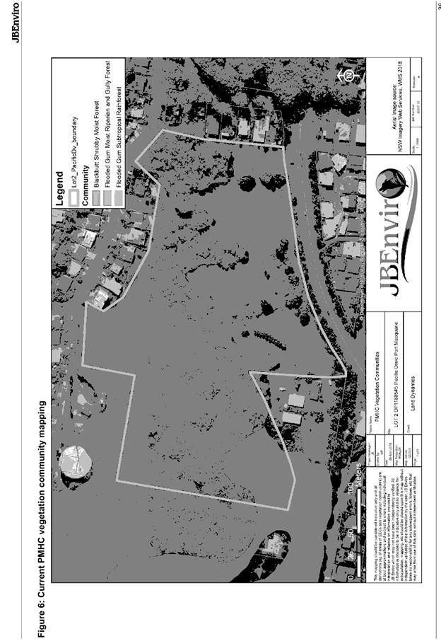
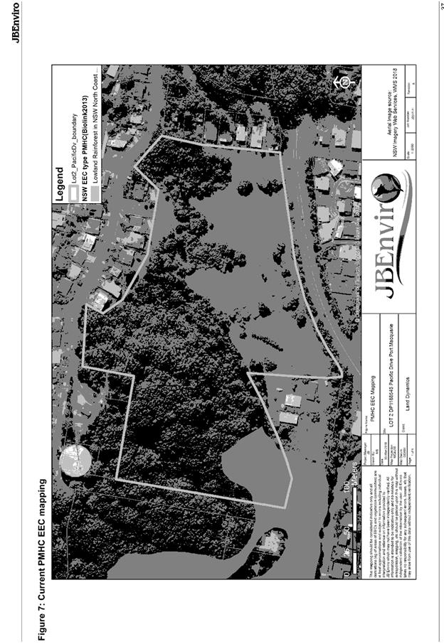
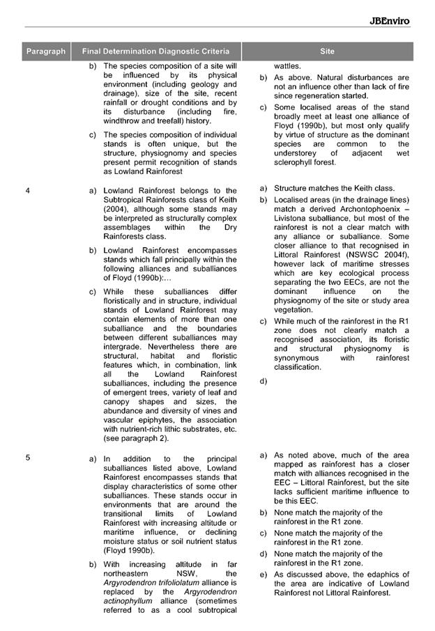
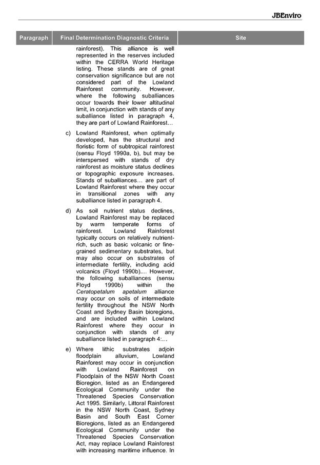
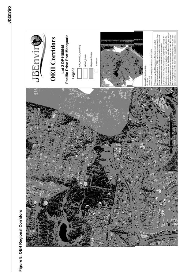
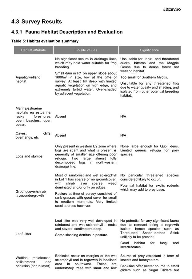
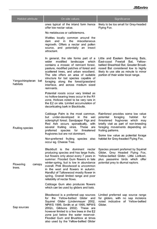
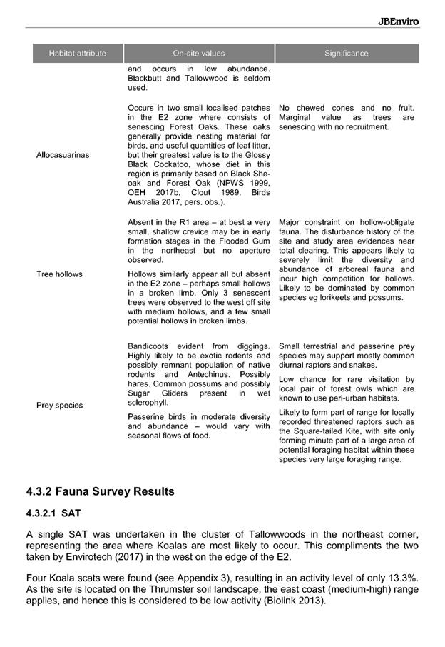
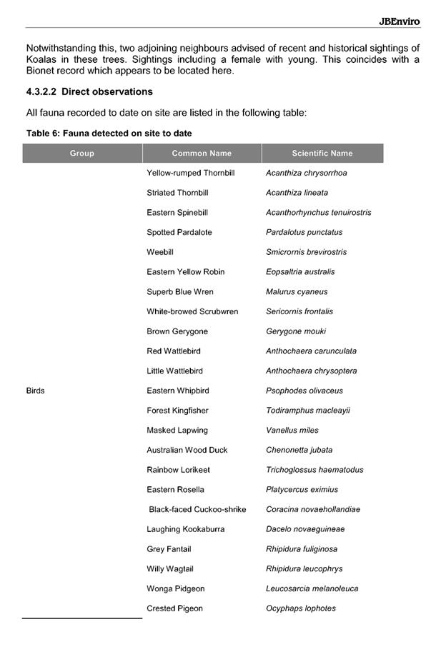
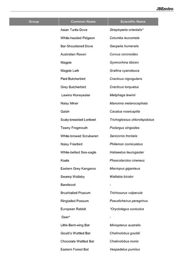
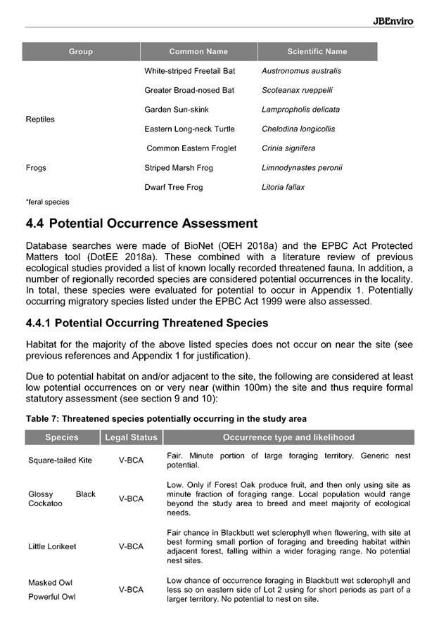
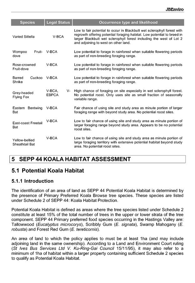
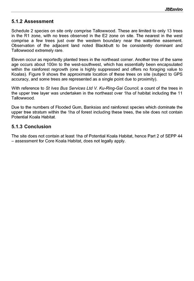
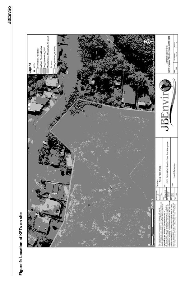
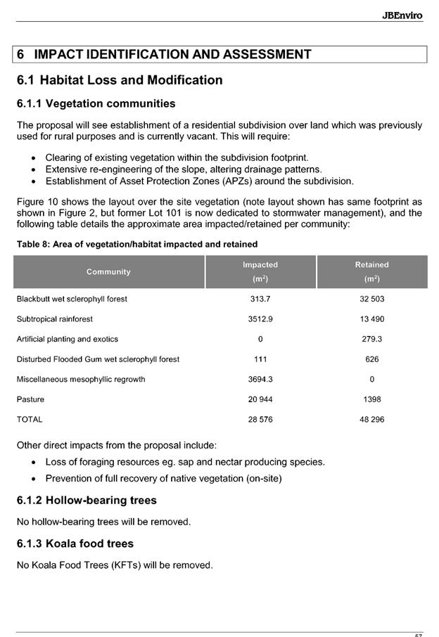
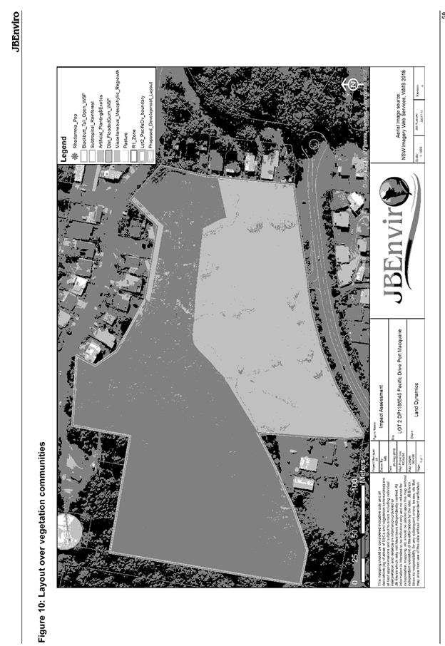
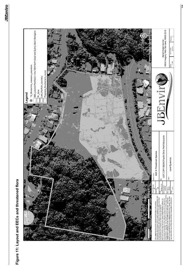
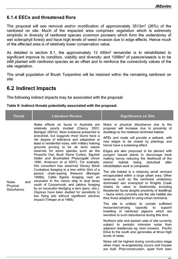
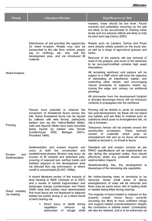
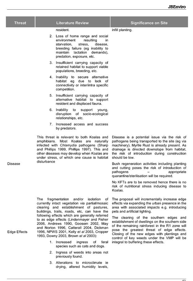
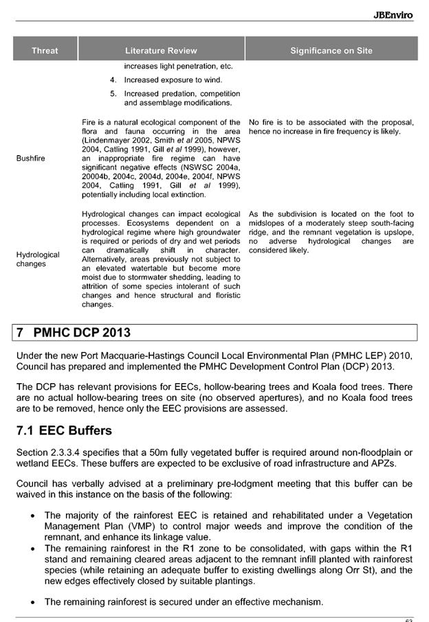


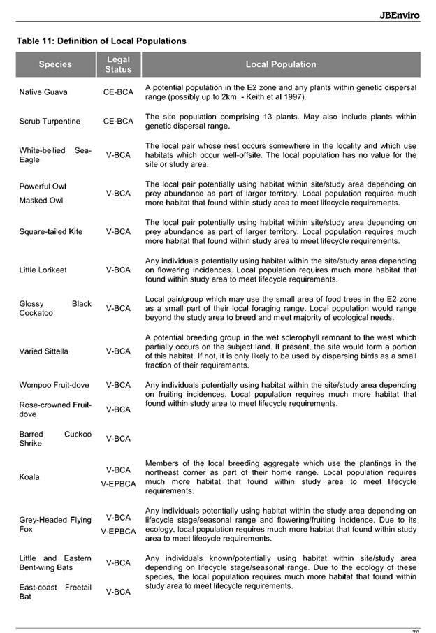
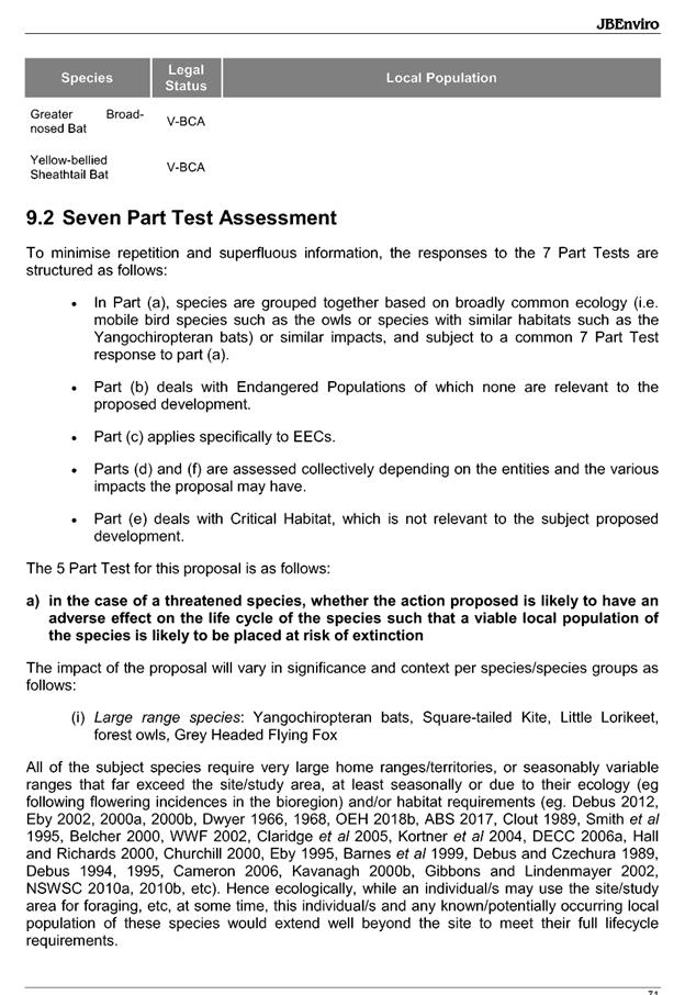
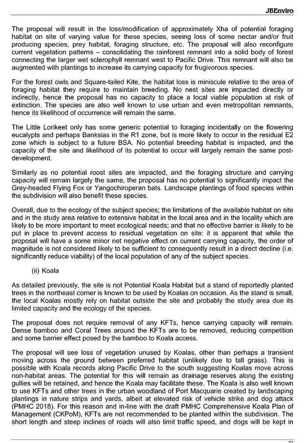
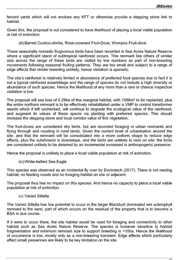
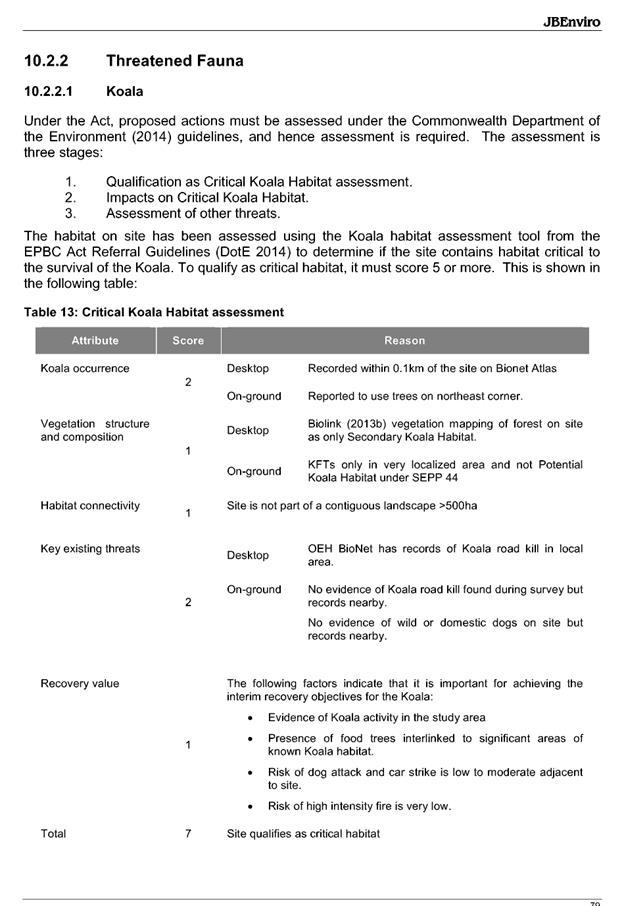
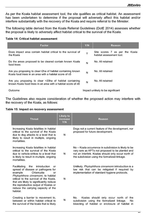
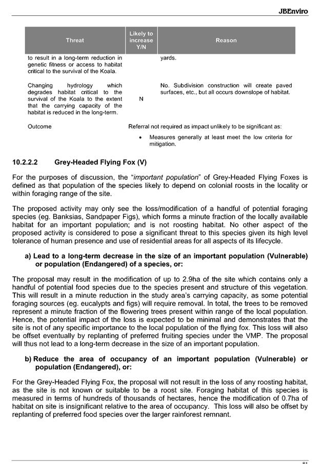
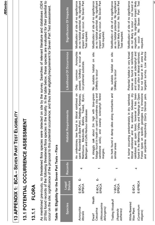

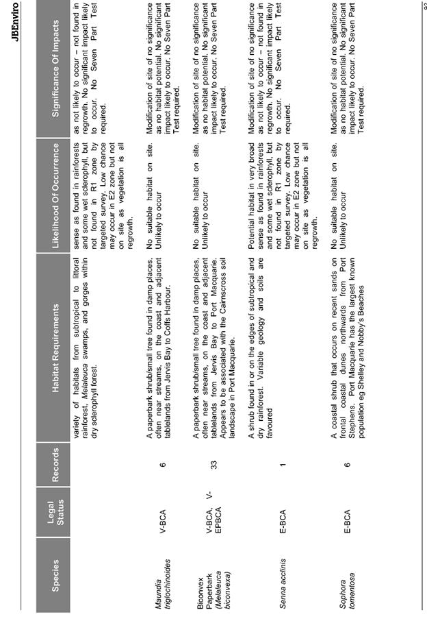
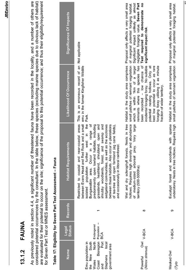
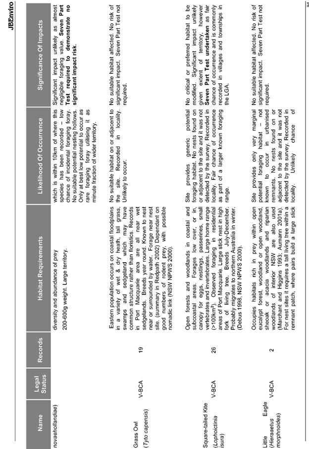
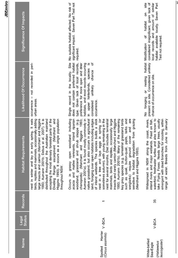
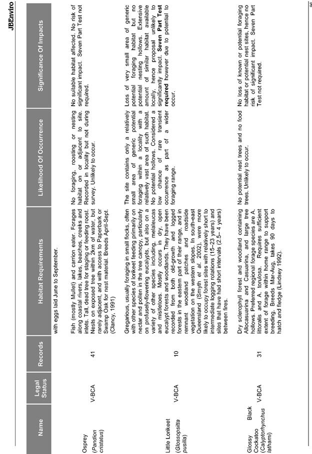
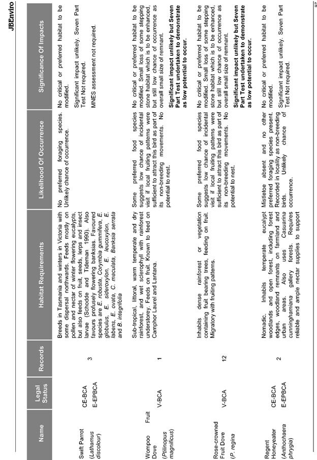
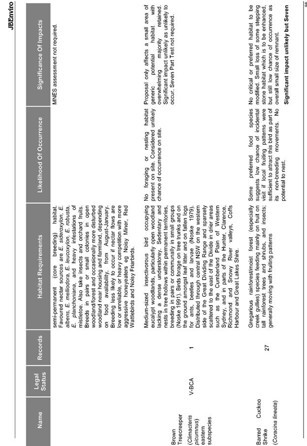
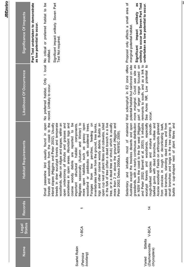
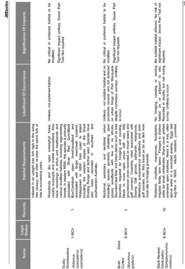
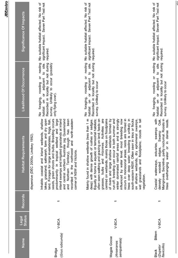
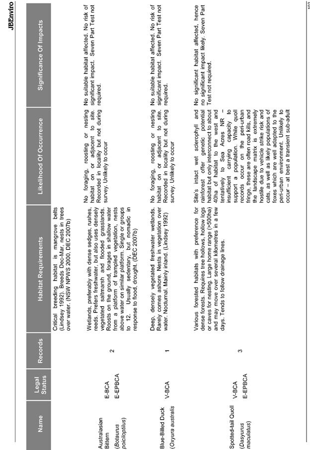

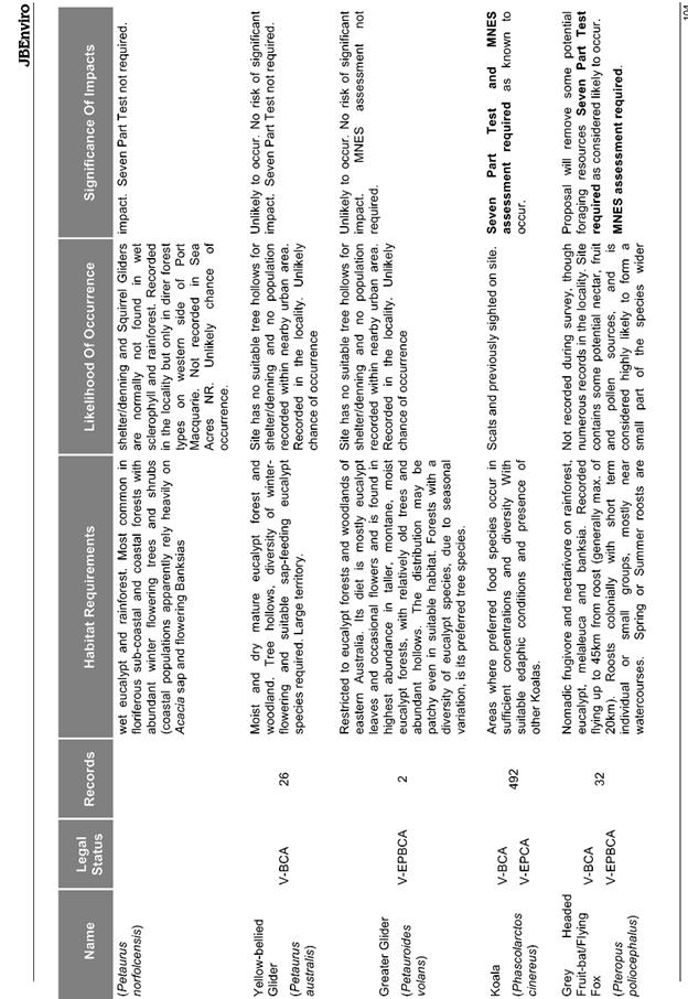
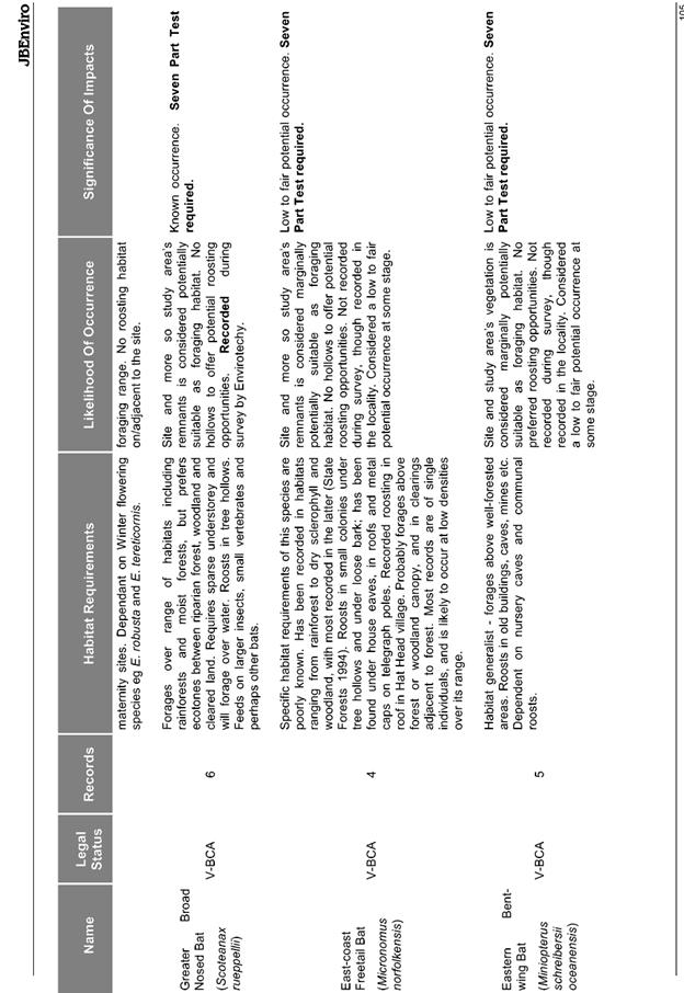
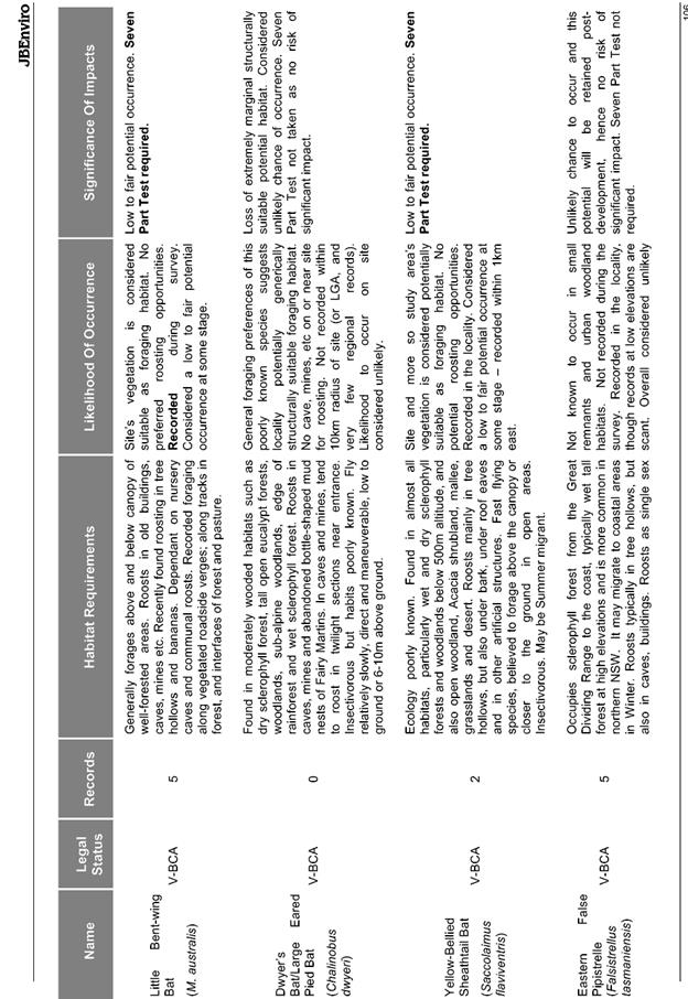
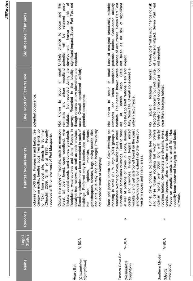
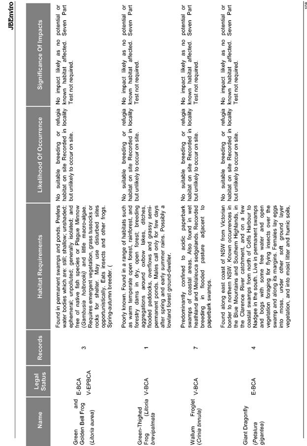
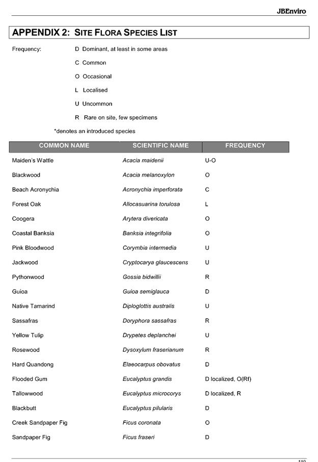
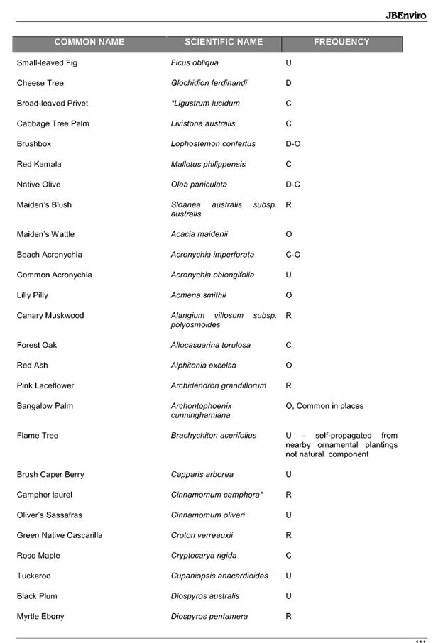
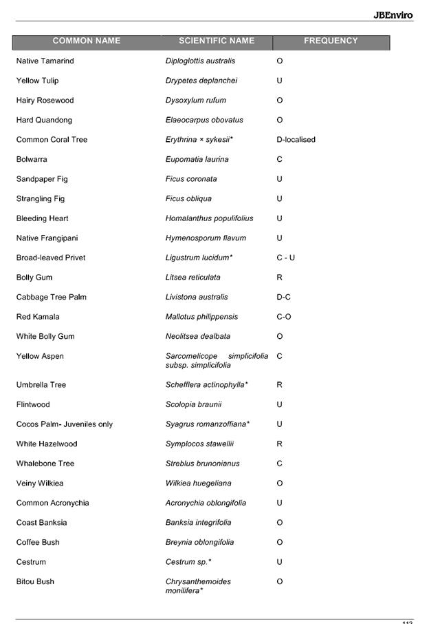
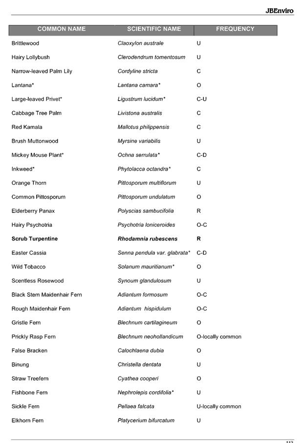
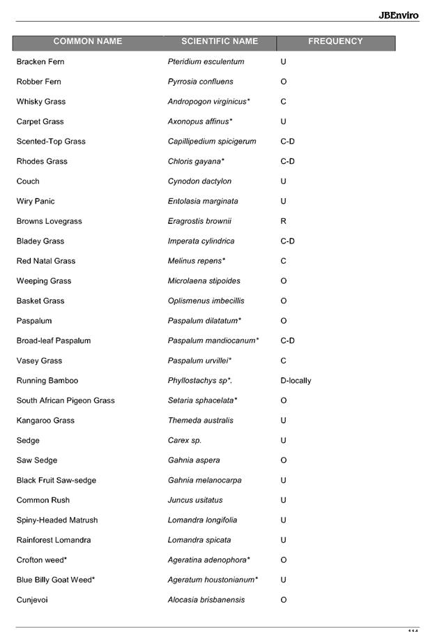
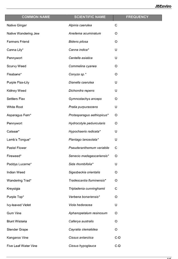

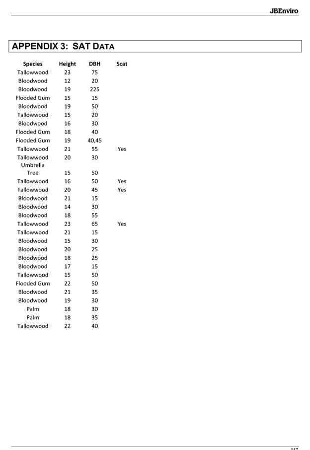
|
ATTACHMENT
|
Development Assessment Panel
19/12/2018
|
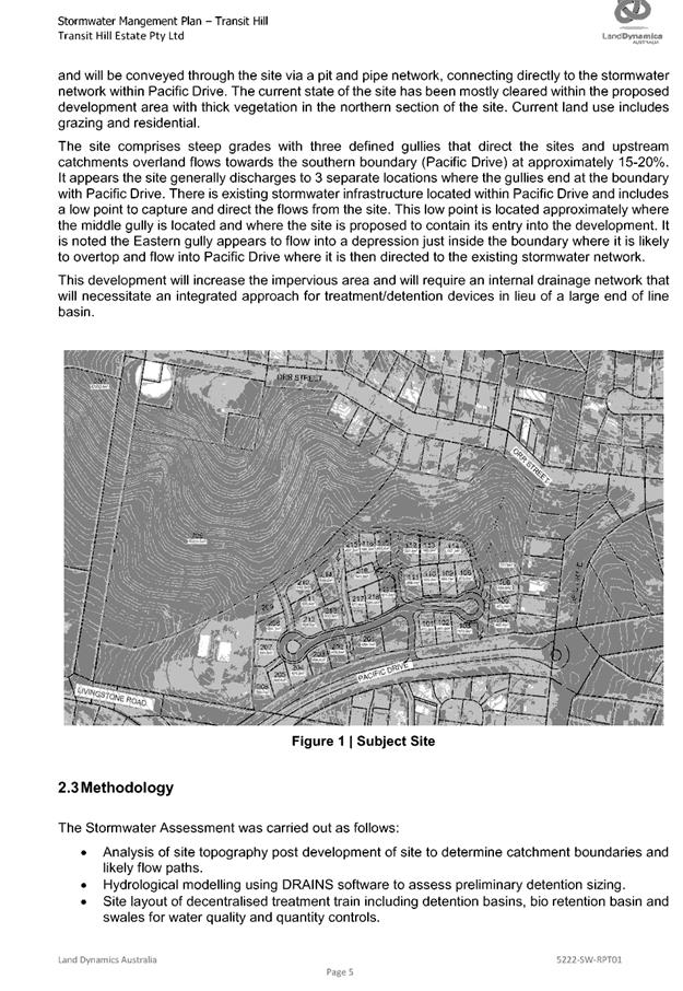
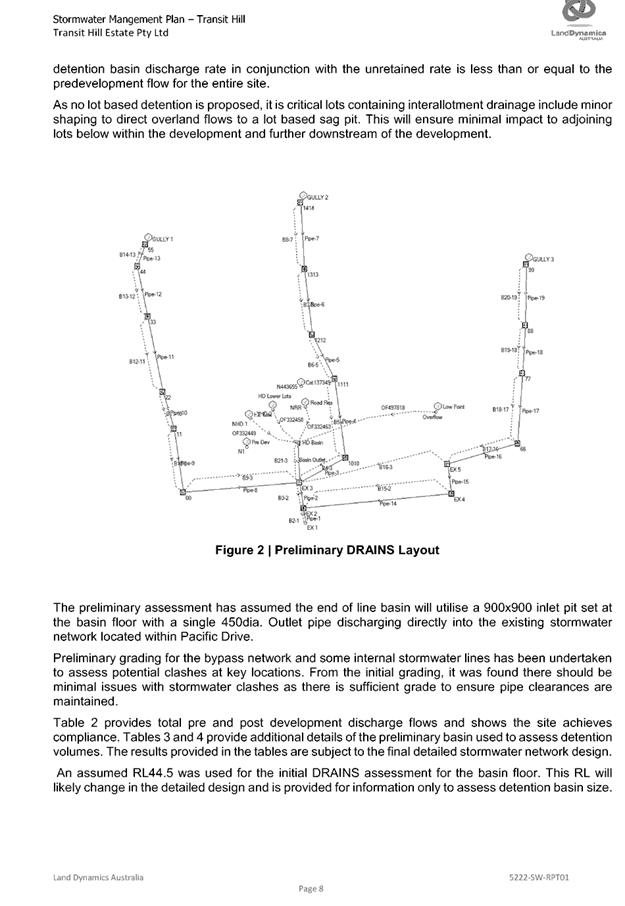
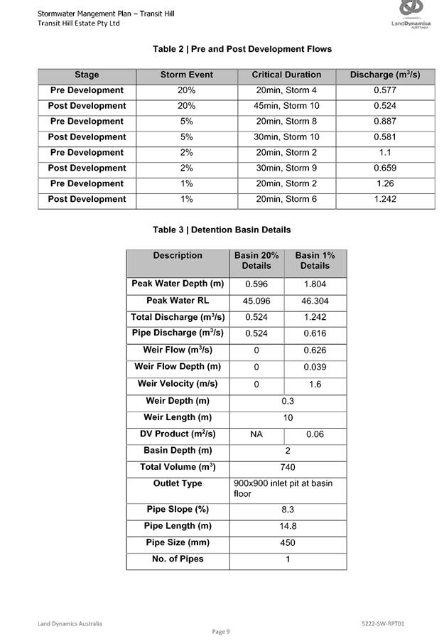
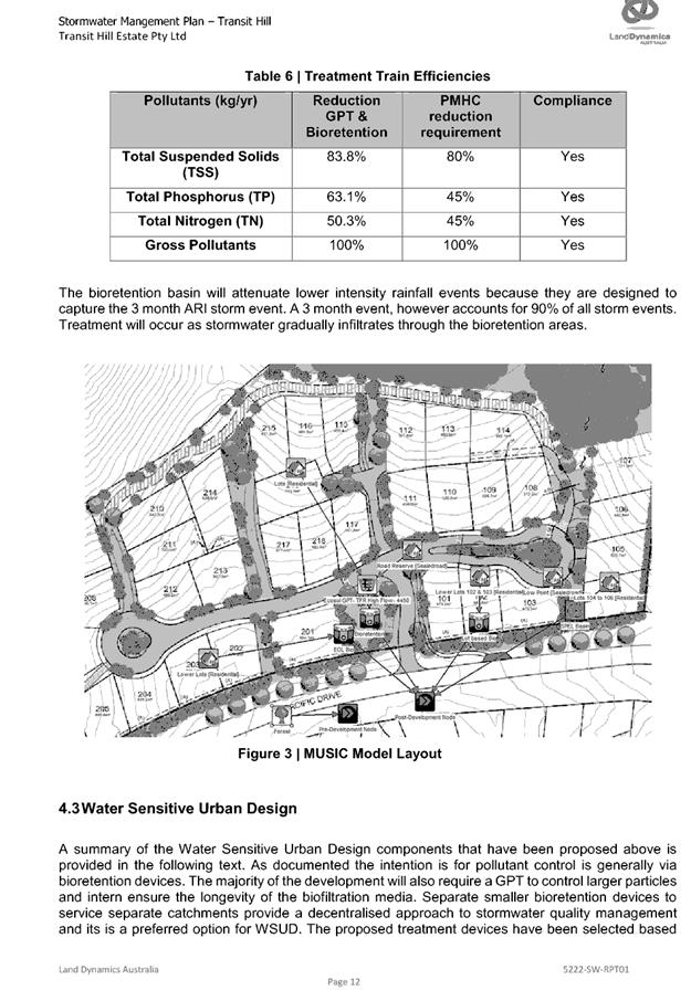

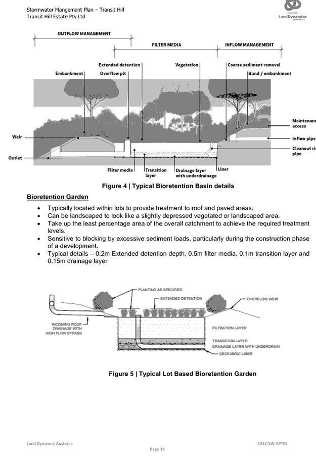
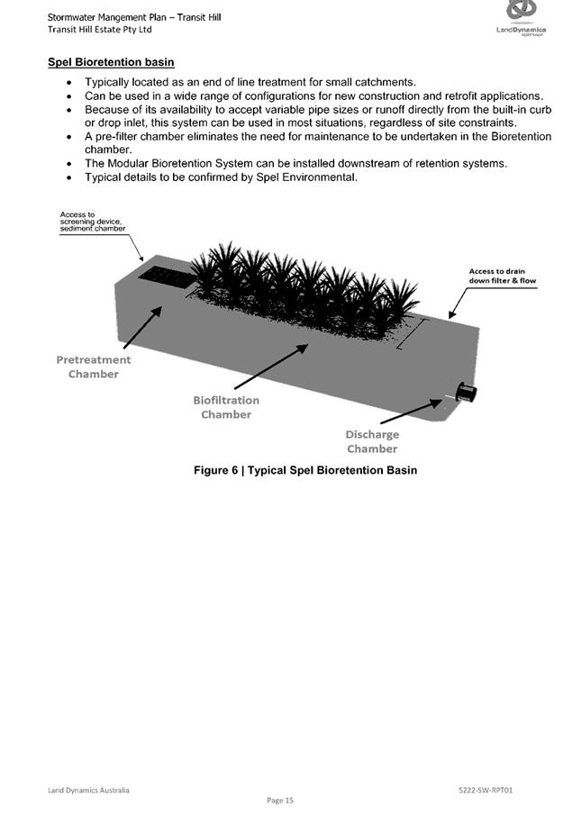
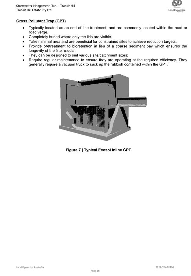


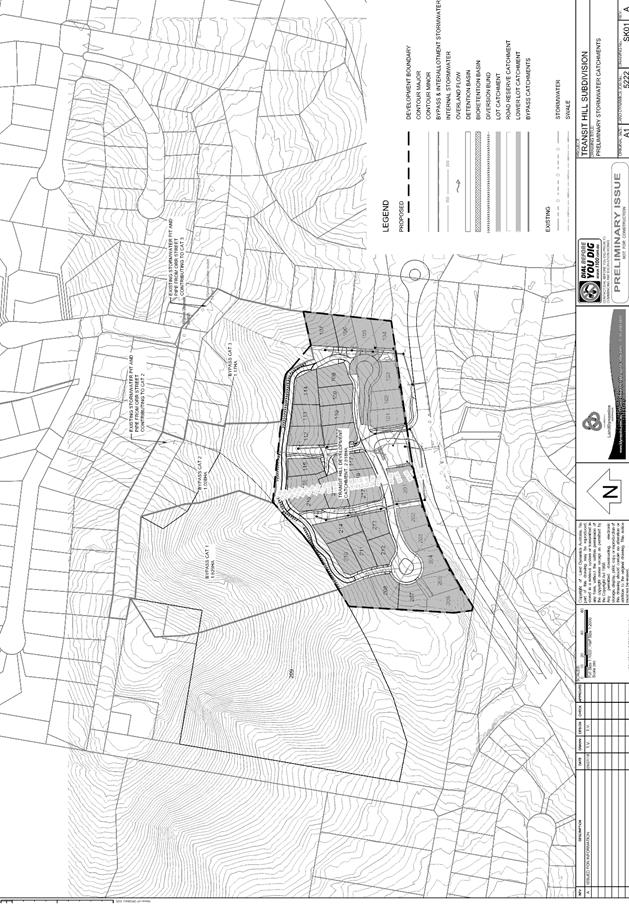
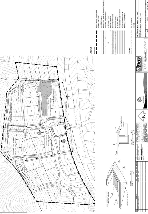
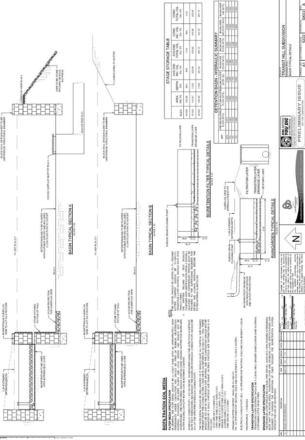
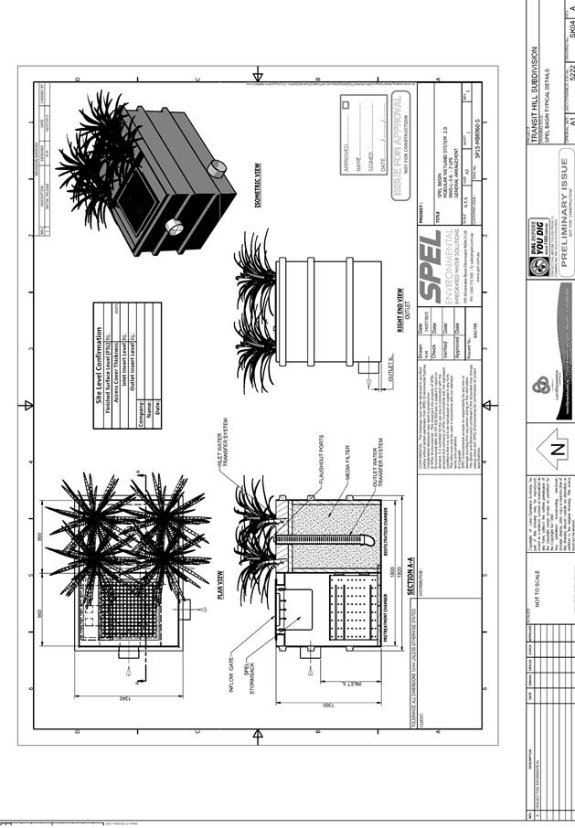
|
ATTACHMENT
|
Development Assessment Panel
19/12/2018
|
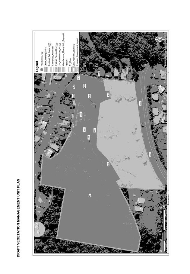


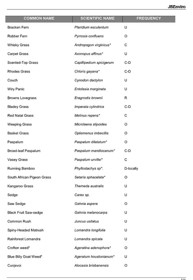
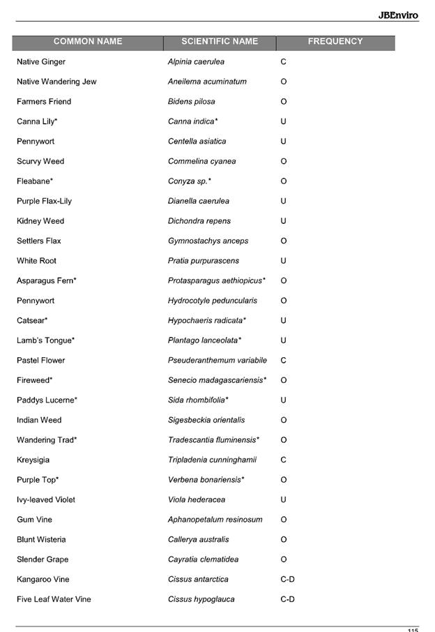
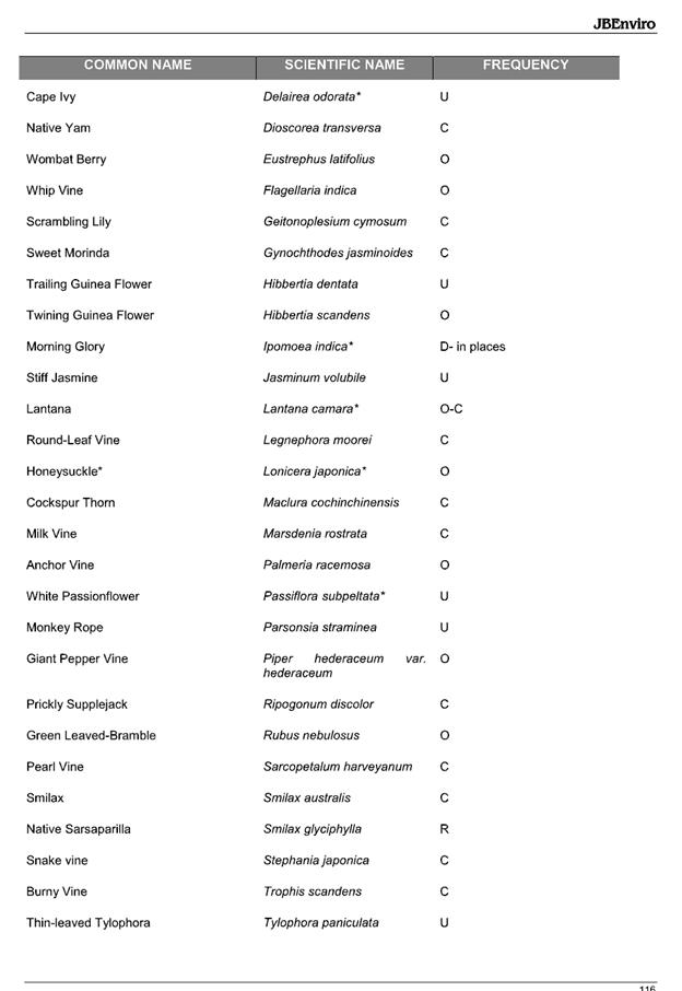

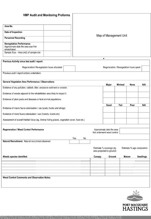
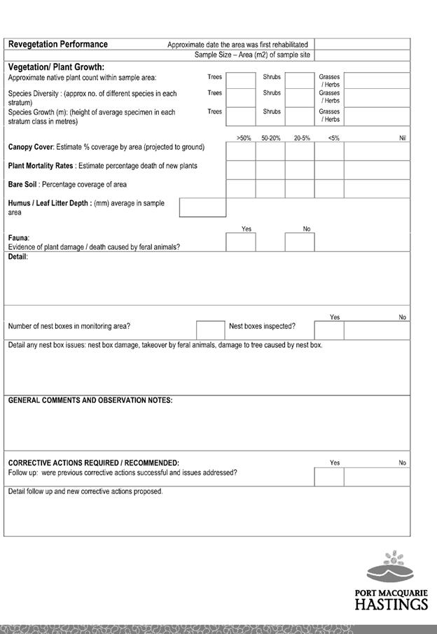
|
ATTACHMENT
|
Development Assessment Panel
19/12/2018
|
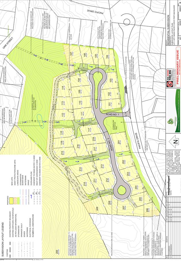
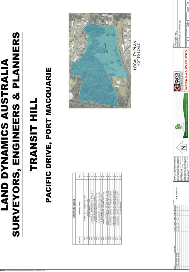
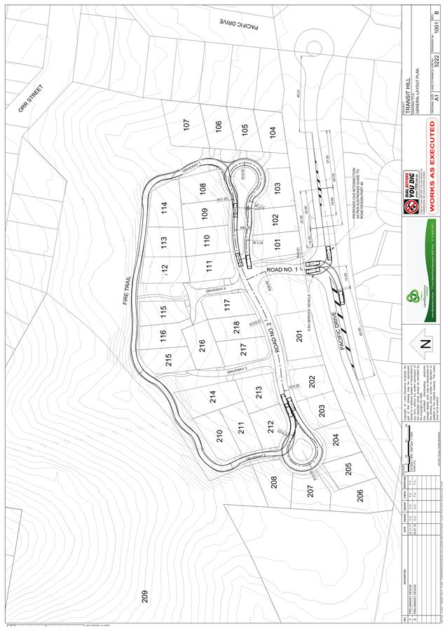
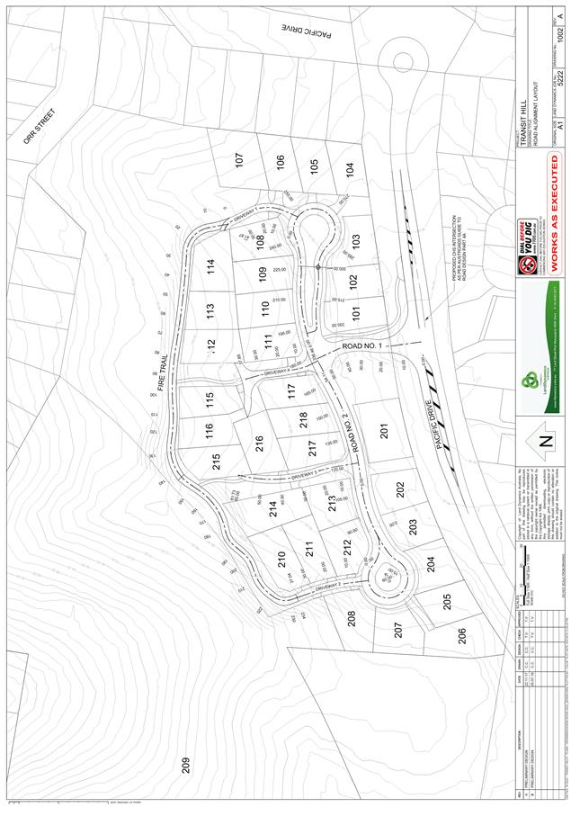
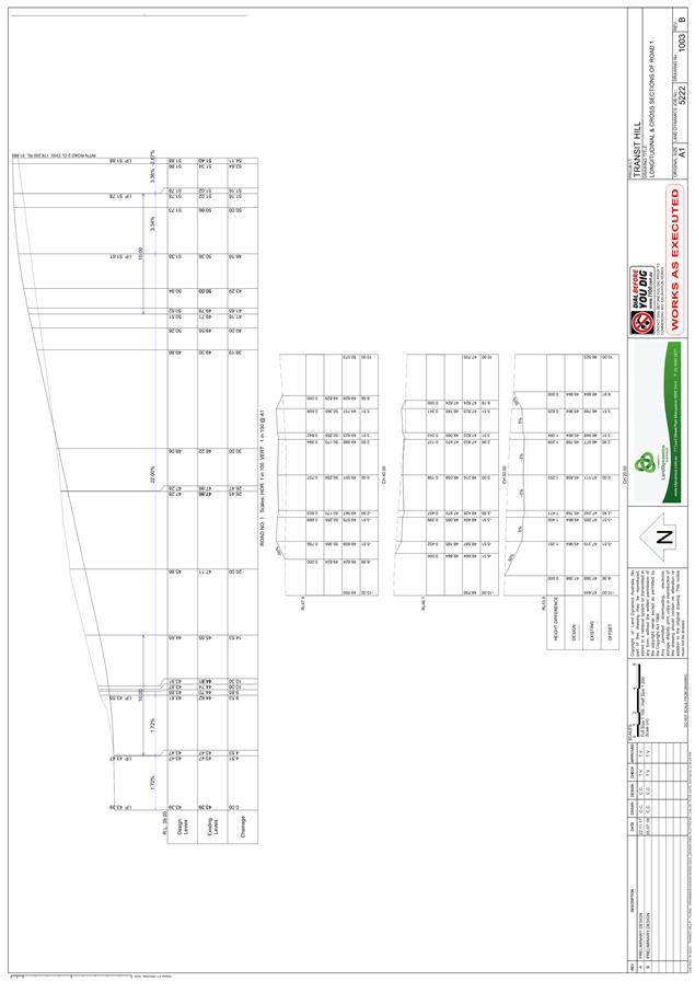
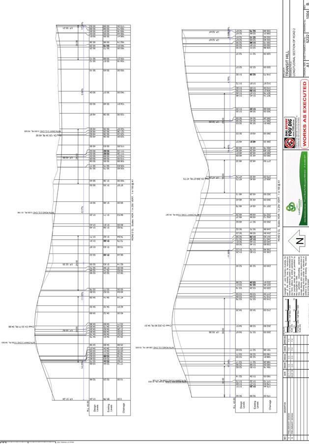
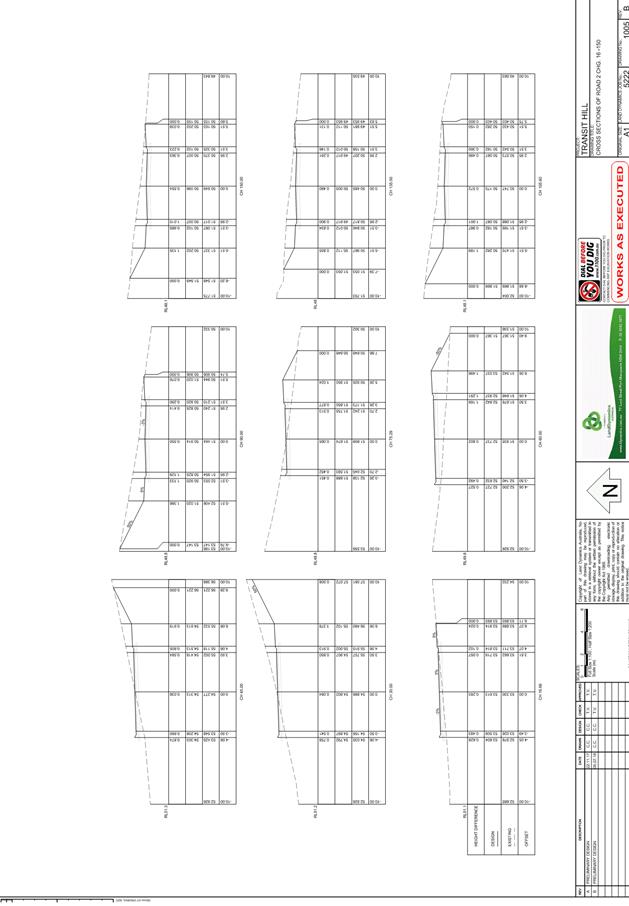
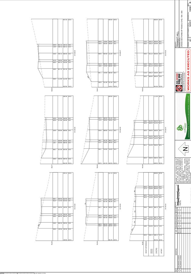
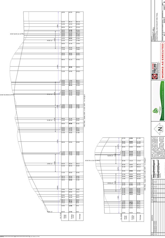
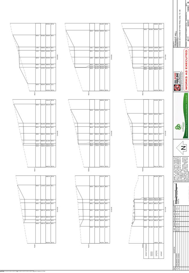
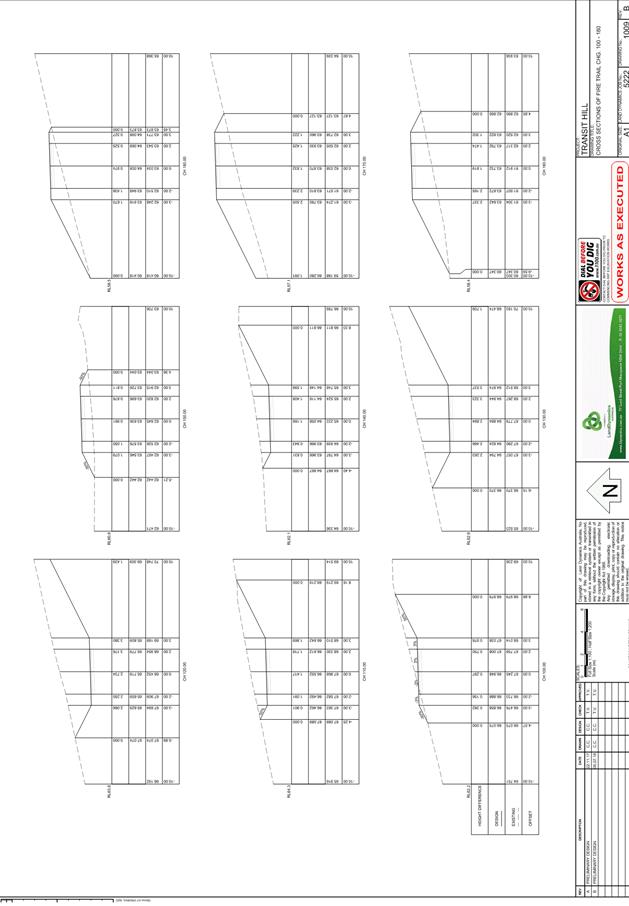
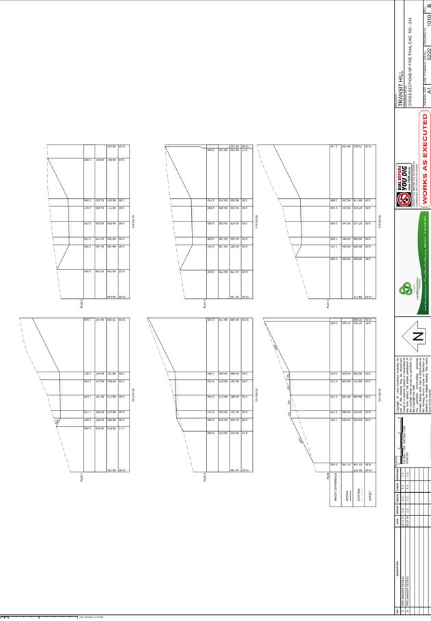
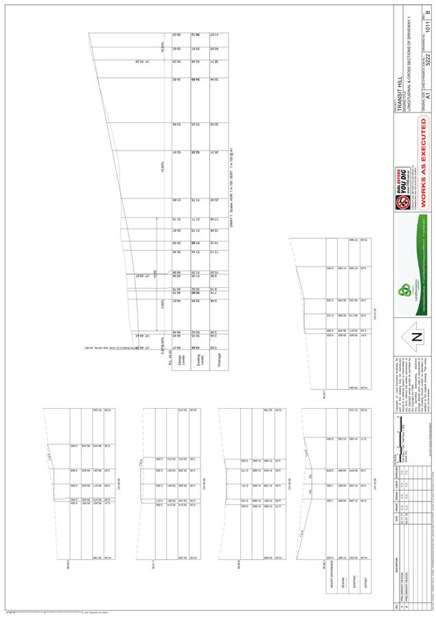
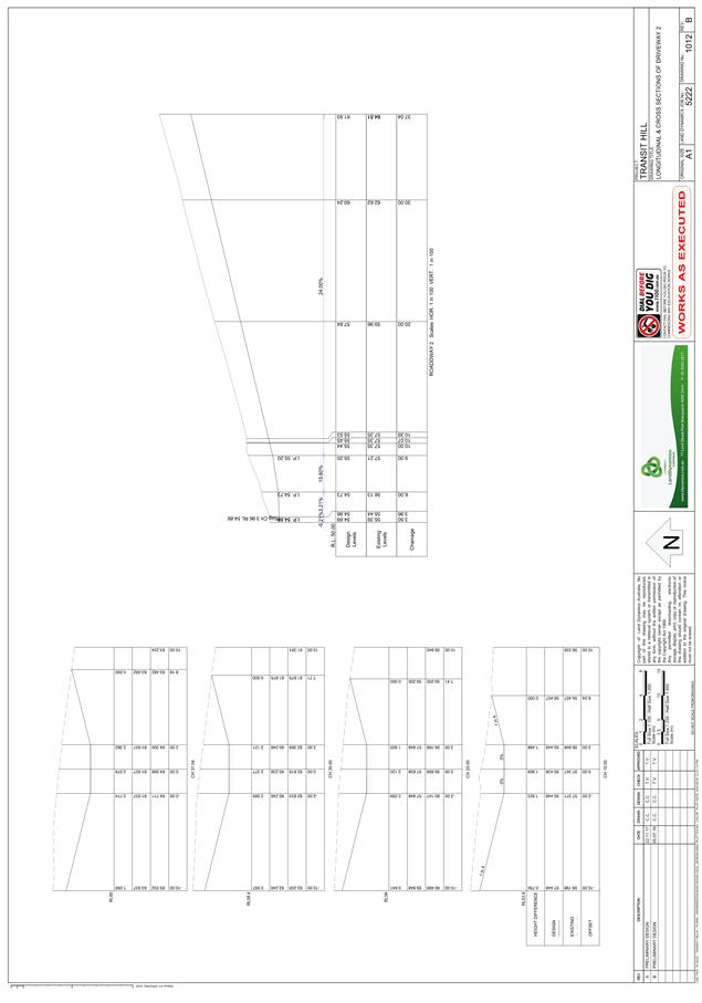
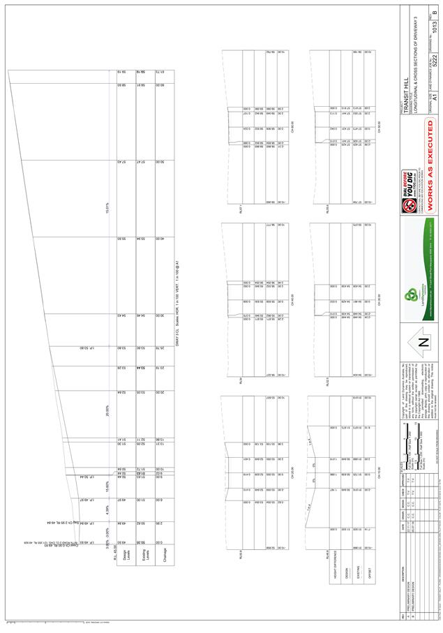
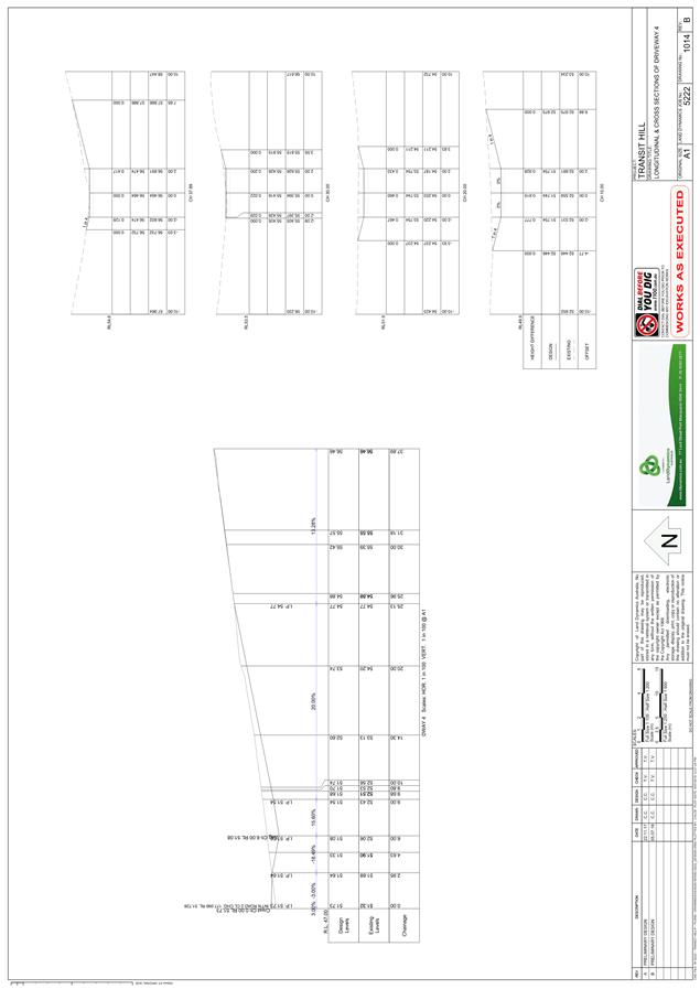
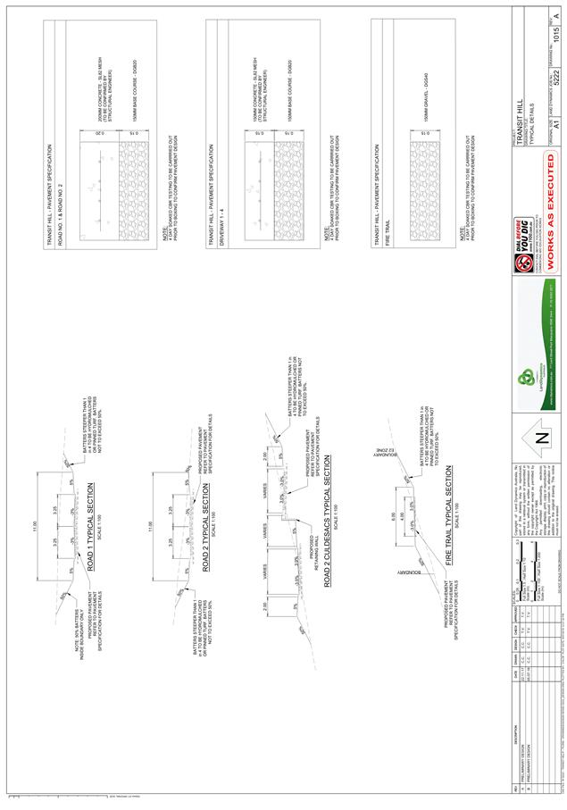
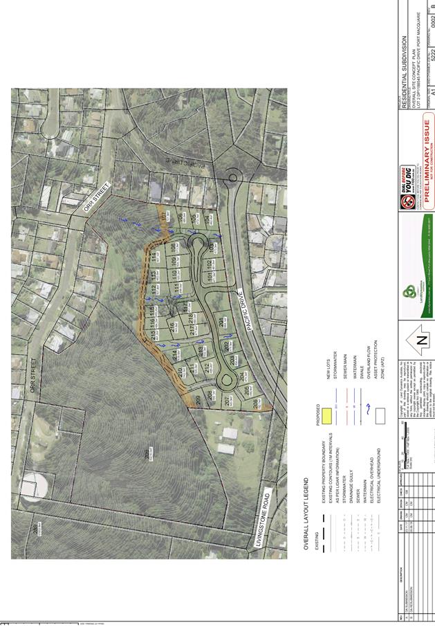
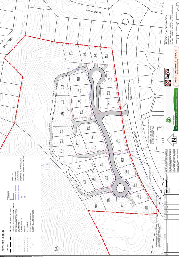
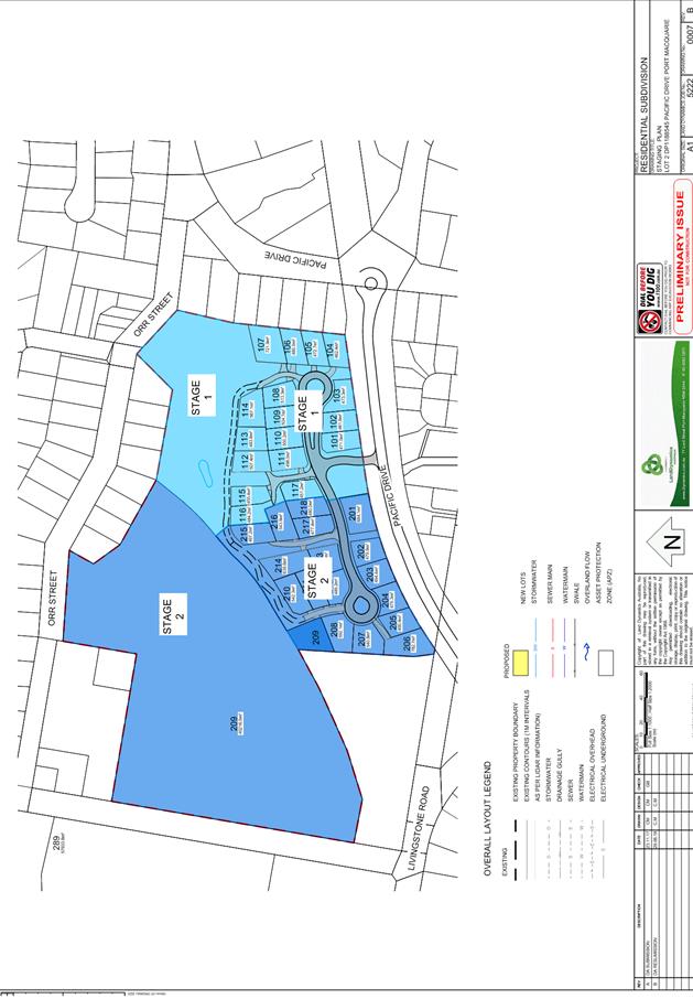
AGENDA Development Assessment Panel 19/12/2018
Item: 06
Subject: DA2018 - 479.1 Change Of Use - Vehicle Repair
Station To Light Industry - Lot A DP 395406, No 187 High Street, Wauchope.
Report
Author: Clint Tink
|
Applicant: H
M R McKenzie
Owner: M
G & J Binskin
Estimated Cost: N/A
Alignment with Delivery
Program
4.3.1 Undertake transparent
and efficient development assessment in accordance with relevant legislation.
|
|
RECOMMENDATION
That
DA 2018 – 479.1 for a change
of use from vehicle repair station to light industry at Lot A, DP 395406, No. 187 High Street, Wauchope, be determined by granting consent subject to
the recommended conditions.
|
Executive
Summary
This
report considers a development application for a change of use from
vehicle repair station to light industry at the
subject site and provides an assessment of the application in accordance with
the Environmental Planning and Assessment Act 1979.
Following exhibition of the
application and prior to finalising this report, eight (8) submissions were received. The submissions comprise one (1)
against the proposal and seven (7) in support of the proposal.
1. BACKGROUND
Existing sites features and surrounding development
The site has an area of 790.4m².
The site is zoned IN2 Light Industrial in accordance with the Port Macquarie-Hastings Local
Environmental Plan 2011, as shown in the following zoning plan:
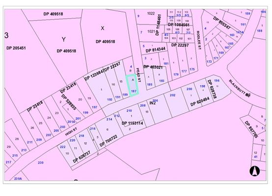
The existing subdivision pattern and location of existing
development within the locality is shown in the following aerial photograph:
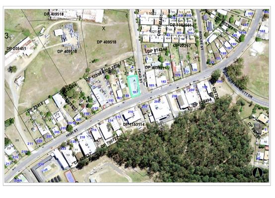
2. DESCRIPTION OF
DEVELOPMENT
Key aspects of the proposal include the following:
· DA1997/142
approved the use of the property for vehicle repairs, fabrication and sales
with hours of operation being 7am to 6pm Monday to Friday and 8am to 4pm
Saturday.
· The
light industry will comprise kitchen joinery and fabrication with
ancillary/related sales.
· The existing three (3) signs onsite will be updated to
reflect the new use/business.
· The development will utilise equipment on site such as
forklift, panel saw, edge bender, hinge drill press, CNC router, drills, welder
lathe, dust extractor, vacuums and hand tools. As a result, typical activities
occurring onsite would be sawing, cutting, drilling, laminating, assembly and
joining of products along with cleaning, sales and maintenance.
· The sales component will be ancillary to the
joinery/fabrication. Typical sales would be for kitchens, bathroom and office
designs, cabinetry and parts such as handles, hinges etc.
· The applicant originally proposed hours of operation as
follows:
- 24/7 for vehicle
and personal access associated with any security or emergency issues.
- 4am to 11pm, 7
days for doing office work such as sales and cleaning/vacuuming.
- 5am to 7pm
Monday to Friday and 8am to 4pm Saturday for loading vehicles.
- 7am to 7pm
Monday to Friday, 7am to 4pm Saturday and 9am to 4pm Sunday for general work
associated with the industry.
However, a Noise Impact Assessment has since
made recommendations on activities and hours – see Noise and vibration
section of this report.
Refer
to attachments at the end of this report.
Application Chronology
· 3/7/2018
– Application lodged with Council.
· 9/7/2018
– Applicant requested details on contributions. Preliminary response was
provided by Council staff on 10/7/2018.
· 11/7/2018
– Council staff requested additional information on plans, signage,
details on sales, equipment and activities carried out onsite.
· 13/7/2018 – Applicant provided partial response to
issues raised on 11/7/2018.
· 16/7/2018 – Council staff requested clarification on
plans and signage. Further discussion was held with the applicant on
requirements.
· 18/7/2018 – Applicant submitted revised plans and
clarification on signage.
· 23/7/2018 – Council staff requested notification
fees. Applicant paid the same day.
· 26/7/2018 to 8/8/2018 – Notification period.
· 20-25/7/2018 – Discussions with the applicant
regarding site inspection.
· 1/8/2018 – Applicant sought clarification on hours of
operation.
· 2/8/2018 – Council staff responded to hours of
operation inquiry.
· 20/8/2018 to 7/9/2018 – Council provided options for
addressing potential noise impacts. Various emails between the applicant and
Council staff on noise assessment requirements/approach.
· 6/9/2018 – Emails between Council staff and the
applicant on additional submissions.
· 30/10/2018 – Applicant submitted noise report.
· 7/11/2018 – Details provided to applicant on the
Development Assessment Panel (DAP) process/timing.
· 23/11/2018 – Update provided to applicant on DAP
process/timing.
3. STATUTORY ASSESSMENT
Section 4.15(1) Matters for Consideration
In determining the application, Council is required to take
into consideration the following matters as are relevant to the development
that apply to the land to which the development application relates:
(a) The provisions (where
applicable) of:
(i) any Environmental
Planning Instrument:
State Environmental Planning Policy No. 33 - Hazardous
and Offensive Development
The subject SEPP was introduced to clarify the definitions
for hazardous and offensive industries and to apply guidelines for the
assessment of industries that have the potential to create hazards or an offence.
In this case, the development has the potential to be offensive given the
manufacturing components and the provisions of the SEPP apply. Having
considered the SEPP and with the imposition of conditions regarding hours of
operation, noise mitigation etc, the proposed development is not considered to
be hazardous or offensive industry and will create no significant risk. The
development can continue to be assessed as a light industry.
State Environmental Planning Policy No. 44 - Koala
Habitat Protection
With reference to clauses 6 and 7, the subject land is not
one hectare in size and does not involve any tree removal. Therefore, the
provisions of the SEPP do not apply.
State Environmental Planning Policy No. 55 –
Remediation of Land
Following an inspection of the site and a search of Council
records, the subject land is not identified as being potentially contaminated
and is suitable for the intended use. In particular, no sensitive residential
type use is proposed and no major disturbance to site conditions required.
State Environmental Planning Policy No. 62 –
Sustainable Aquaculture
Given the nature of the proposed development and proposed
stormwater controls the proposal will be unlikely to have any adverse impact on
existing aquaculture industries.
State Environmental Planning Policy No. 64 –
Advertising and Signage
The proposed development includes proposed replacement
advertising signage in the form of business identification signage.
In accordance with clause 7, this SEPP prevails over the
Port Macquarie-Hastings LEP 2011 in the event of any inconsistency.
The following assessment table provides an assessment
checklist against the Schedule 1 requirements of this SEPP:
|
Applicable clauses for consideration
|
Comments
|
Satisfactory
|
|
Clause 8(a) Consistent with
objectives of the policy as set out in Clause 3(1)(a).
|
The proposed signage complies
with the subject Clause. In particular, the proposed signage is not excessive
for an industrial area, is consistent with surrounding signage and will not
impact on streetscape.
|
Yes
|
Schedule
1(1) Character of the area.
|
Signage is consistent with
others in the area and will not compromise the character of the locality.
|
Yes
|
|
Schedule 1(2) Special areas.
|
Not a special area.
|
Yes
|
|
Schedule 1(3) Views and vistas.
|
No views or vistas impacted.
|
Yes
|
|
Schedule 1(4) Streetscape,
setting or landscape.
|
The proposed signage is not
excessive for an industrial area, is consistent with surrounding signage and
will not impact on streetscape.
|
Yes
|
|
Schedule 1(5) Site and building.
|
The proposed signage fits in
with the site and location of buildings.
|
Yes
|
|
Schedule 1(6) Associated devices
and logos with advertisements and advertising structures.
|
None proposed.
|
Yes
|
|
Schedule 1(7) Illumination.
|
To be controlled via conditions.
|
Yes
|
|
Schedule 1(7) Safety.
|
The signage will create no
safety impacts.
|
Yes
|
State Environmental Planning Policy (Infrastructure) 2007
Pursuant to Division 17, Subdivision 2, the subject site has
frontage to High Street, which is a classified road. Having considered the
provisions of the SEPP, the proposed development will utilise existing access
points (ie no new access proposed) and the volume of traffic associated with
the development is likely to be minor/consistent with the current vehicle
repairs use.
The scale of the development does not trigger the need for
referral to the Roads and Maritime Services and the type of development (non-residential
use) is unlikely to be impacted by any road noise or vibration.
Based on the above, no adverse impact on the operation of
the classified road will occur and the development complies with the
requirements of the SEPP.
Port Macquarie-Hastings Local Environmental
Plan 2011
The proposal is consistent with the LEP having regard to the
following:
· Clause
2.2, the subject site is zoned IN2 Light Industry. In accordance with clause
2.3(1) and the IN2 zone landuse table, the proposed development for a light
industry and ancillary industrial retail outlet (kitchen joinery and sales) is
a permissible landuse with consent.
The objectives of the IN2 zone
are as follows:
o To provide a wide range of
light industrial, warehouse and related land uses.
o To encourage employment
opportunities and to support the viability of centres.
o To minimise any adverse effect
of industry on other land uses.
o To enable other land uses that
provide facilities or services to meet the day to day needs of workers in the
area.
o To support and protect
industrial land for industrial uses.
In accordance with Clause 2.3(2), the
proposal is consistent with the zone objectives having regard to the following:
o The proposal is a permissible
landuse.
o The proposal adds to and
complements the mix of uses in the area.
o The proposal will maintain
employment within the industrial workforce and create associated flow on
impacts within the area.
o Through the use of conditions,
the proposal will create no adverse impact or conflict with adjoining uses.
o The proposed use is consistent
with and potentially less invasive than the current approved vehicle repair use
for the site.
o The proposal continues with
the industrial theme in the surrounding area.
· Clause 4.3
and 4.4, the height and floor space ratio of the building remain unchanged.
· Clause 5.4,
the proposed ancillary industrial retail outlet area does not exceed 43% of the
industrial floor area or 400m².
· Clause 5.10,
the site does not contain or adjoin any known heritage items or sites of
significance. Site is also disturbed from past activities.
· Clause 7.13,
satisfactory arrangements are in place for provision of essential services
including water supply, electricity supply, sewer infrastructure, stormwater
drainage and suitable road access to service the development.
(ii) Any
draft instruments that apply to the site or are on exhibition:
None relevant
to the proposal.
(iii) any
Development Control Plan in force:
Port
Macquarie-Hastings Development Control Plan 2013
|
DCP 2013: Chapter 3.5 - Industrial Development
|
|
DCP Objective
|
Development Provisions
|
Proposed
|
Complies
|
|
3.5.3.1
|
Minimum setbacks are provided as follows:
· 10m from a
classified road;
· 7.6m from any
other road boundary;
· 3m from any
secondary road frontage.
|
The building is existing with no changes proposed to front
setbacks.
|
N/A
|
|
3.5.3.2
|
Elevations of building which are visible from a public
road, reserve or adjacent or adjoining residential areas are to be
constructed using:
· brick, masonry, pre-coloured
metal cladding, or
· appropriately
finished ‘tilt-slab’ concrete; or
· a combination of
a number of these materials.
|
The building is existing with no changes proposed to
elevations.
|
N/A
|
|
Large unrelieved expanses of wall or building mass are not
favoured, and as such should be broken up by the use of suitable building
articulation, fenestration or alternative architectural enhancements.
|
The building is existing with no changes proposed to
elevations.
|
N/A
|
|
3.5.3.3
|
Material storage/work areas and volumes to be provided
with application.
|
Except for temporary storage of materials during
loading/unloading of vehicles and some waste bins; all storage/work areas
will be conditioned to be contained within the building.
|
Yes
|
|
Open work and storage areas to be located at rear of
premises and screen from view by landscaping and/or fencing minimum 2m high.
|
Refer to above comment.
|
Yes
|
|
3.5.3.4
|
Detailed landscaping plan submitted.
|
No change to external areas/landscaping proposed or
required.
|
N/A
|
|
|
Landscaped strip 3m wide for 2/3 of each road frontage.
|
No change to external areas/landscaping proposed or
required.
|
N/A
|
|
|
No fencing in front setback unless for display items. High
quality fencing and landscaping.
|
None proposed.
|
N/A
|
|
3.5.3.5
|
An onsite recreation area is provided for staff that:
· Includes
seating, tables and rubbish bin.
· If outside, is
adequately protected from the weather
· Is safely
accessible to all staff.
· Is separate
private from public areas.
· Is located away
from noisy or odorous activities.
|
Site contains suitable area onsite for a staff recreation
areas.
|
Yes
|
|
3.5.3.6
|
Provide onsite facilities for changing, showering and
secure bike storage.
|
Facilities/area exist within the site/development.
|
Yes
|
|
3.5.3.7
|
Development complies with NSW Industrial Noise Policy.
|
Refer to comments on Noise and vibration later in this
assessment report.
|
Yes
|
|
Building openings located to minimise noise impacts if
within 400m of residential zone.
|
Refer to comments on Noise and vibration later in this assessment
report.
|
Yes
|
|
External plant such as generators, air conditioning plant
and the like, should be enclosed to minimise noise nuisance and located away
from residences.
|
Refer to comments on Noise and vibration later in this
assessment report.
|
Yes
|
|
External and security lighting should be directed and
shielded to avoid light spillage to adjoining residential areas.
|
To be conditioned.
|
Yes
|
|
Driveways should be arranged or screened to avoid
headlight glare on residential windows.
|
Driveways do not exit toward residential windows.
|
Yes
|
|
3.5.3.8
|
Office space ancillary to the industrial use is
permissible with consent, subject to satisfaction of the following matters:
· That the office
component of a proposed development is ancillary to the functions carried out
in the factory, warehouse or other industrial use.
· That the office
area is not leased to a separate company or entity.
· That parking
facilities are adequate to cater for the size of the office development.
|
The proposal includes ancillary office areas and
conditions of consent will manage their use to ensure consistency with the
DCP.
|
Yes
|
|
3.5.3.9
|
The site should be serviced by reticulated water (and dual
reticulation where this is available), sewer and telecommunications.
|
The development will remain connected to available
services.
|
Yes
|
|
3.5.3.10
|
Garbage storage areas are not visible from a public place.
|
To be conditioned.
|
Yes
|
|
3.5.3.11
|
Stormwater management strategy prepared.
|
Hard stand areas and stormwater management remain
unchanged.
|
N/A
|
|
DCP 2013: General Provisions
|
|
DCP Objective
|
Development Provisions
|
Proposed
|
Complies
|
|
2.7.2.2
|
Design addresses generic principles of Crime Prevention
Through Environmental Design guideline:
· Casual
surveillance and sightlines
· Land use mix and
activity generators
· Definition of
use and ownership
· Lighting
· Way finding
· Predictable
routes and entrapment locations
|
The proposed development does not create any adverse
concealment or entrapment areas. Surveillance is provided from the building.
In addition to the above, CCTV and lighting can be used to
further protect the building and staff.
|
Yes
|
|
2.3.3.1
|
Cut and fill 1.0m max. 1m outside the perimeter of the
external building walls
|
No major cut or fill proposed.
|
N/A
|
|
2.3.3.2
|
1m max. height retaining walls along road frontages
|
None proposed.
|
N/A
|
|
Any retaining wall >1.0 in height to be certified by
structural engineer
|
None proposed.
|
N/A
|
|
Combination of retaining wall and front fence height
|
No front fence retaining wall combination proposed.
|
N/A
|
|
2.3.3.8 onwards
|
Removal of hollow bearing trees
|
No tree removal proposed or required.
|
Yes
|
|
2.6.3.1
|
Tree removal (3m or higher with 100m diameter trunk and 3m
outside dwelling footprint
|
No tree removal proposed or required.
|
Yes
|
|
2.4.3
|
Bushfire risk, Acid sulphate soils, Flooding,
Contamination, Airspace protection, Noise and Stormwater
|
Refer to main body of report.
|
Noted
|
|
2.5.3.2
|
New accesses not permitted from arterial or distributor
roads. Existing accesses rationalised or removed where practical
|
No new access proposed from High Street/Oxley Highway.
|
Yes
|
|
Driveway crossing/s minimal in number and width including
maximising street parking.
|
Existing crossovers to be utilised.
|
Yes
|
|
2.5.3.3
|
Off-street parking in accordance with Table 2.5.1.
Reduction possible if supported by parking demand study.
Industrial/retail bulky goods require 1 space per 70m².
Office
1 space per 30m² or 1.5 spaces per office (whichever is the greater).
|
The development proposes approximately 400m²
industrial area (includes mezzanine areas) and 53m² showroom/retail
bulky goods. 400 + 53 = 453/70m² = 6.5 spaces.
The two office areas will require 3 spaces, although there
is likely to be some crossover with the industrial area (ie the same staff
occupy both areas).
6.5 + 3 = 9.5, rounded up to 10 spaces.
The development contains area onsite capable of
accommodating at least 8 unobstructed spaces, plus at least other stacked
parking areas.
Given the crossover in areas (ie a person working in the
industrial component is also likely to be involved in use of the office and
sales areas), maximum 4 employees and the past use of the site as a vehicle
repair station (higher parking demand), no adverse parking issues are
foreseen.
|
No, considered acceptable given only 4 employees,
crossover use of office space with factory area and past vehicle repair
station use
|
|
2.5.3.4
|
Changes of use or redevelopment of existing buildings
provide parking required for new use, less any credits.
|
Refer to comments above.
|
Yes
|
|
2.5.3.5
|
On-street parking permitted subject to justification.
|
None proposed.
|
N/A
|
|
2.5.3.6
|
On-street parking includes streetscape improvements.
|
None proposed.
|
N/A
|
|
2.5.3.7
|
Customer parking to be easily accessible.
|
Customer parking visible from the street.
|
Yes
|
|
Way finding signs provided for parking areas.
|
Not required. Site easy to interpret.
|
N/A
|
|
Parking in accordance with AS 2890.1.
|
Capable of complying. To be conditioned.
|
Yes
|
|
2.5.3.8
|
Aged and disabled persons and persons wheeling prams or
trolleys are provided with suitable access and parking in accordance with AS
2890.1 and AS 2890.2.
|
A disabled parking space is capable of being provided.
|
Yes
|
|
2.5.3.9
|
Bicycle and motorcycle parking considered and designed
generally in accordance with the principles of AS 2890.3
|
Site contains sufficient room/areas capable of having
bicycle and motorcycle parking.
|
Yes
|
|
2.5.3.10
|
Parking concessions possible for conservation of heritage
items
|
Not relevant.
|
N/A
|
|
2.5.3.11
|
Section 94 contributions
|
Contributions do not apply – credit exists from past
approved use.
|
N/A
|
|
2.5.3.12 and 2.5.3.13
|
Landscaping of parking areas
|
No change to parking areas proposed or required.
|
N/A
|
|
2.5.3.14
|
Sealed driveway surfaces unless justified
|
Driveways already sealed.
|
Yes
|
|
2.5.3.15
|
Driveway grades for first 6m of ‘parking area’
shall be 5% grade
(Note AS/NZS 2890.1 permits steeper grades)
|
Driveways existing and deemed acceptable.
|
Yes
|
|
2.5.3.17
|
Parking areas to be designed to avoid concentrations of
water runoff on the surface.
|
No change to parking areas proposed. Therefore, no change
to stormwater.
|
N/A
|
|
Vehicle washing facilities – grassed area etc
available.
|
Not required for industrial use.
|
N/A
|
|
No direct discharge to K&G or swale drain
|
No change to existing stormwater conditions will occur.
|
N/A
|
|
2.5.3.18
|
Car parking areas drained to swales, bio retention, rain
gardens and infiltration areas
|
No change to parking areas proposed.
|
N/A
|
|
2.5.3.19
|
Off street commercial vehicles
facilities are provided in accordance with AS/NZS 2890.2
|
Site includes suitable loading
areas.
|
Yes
|
|
Loading bays will be provided
in accordance with the following requirements;
· Minimum
dimensions to be 3.5m wide x 6m long. (This may increase according to the
size and type of vehicle).
· Vertical
clearance shall be a minimum of 5m.
· Adequate
provision shall be made on-site for the loading, unloading and manoeuvring of
delivery vehicles in an area separate from any customer car parking area.
· A limited
number of ‘employee only’ car parking spaces may be combined with
loading facilities.
· Loading areas
shall be designed to accommodate appropriate turning paths for the maximum
design vehicle using the site.
· Vehicles are
to be capable of manoeuvring in and out of docks without causing conflict
with other street or on-site traffic.
· Vehicles are
to stand wholly within the site during such operations.
|
Site contains a mixture of
existing suitably sized covered and uncovered loading areas that are
accessible without causing conflict on road users.
|
Yes
|
|
For external bays, one bay is
required for 500m² of floor space or 1000m² of site area.
|
Existing onsite loading areas
to be utilised.
|
Yes
|
|
Commercial development having a
floor space less than 500m² need not provide a loading bay.
|
Not relevant.
|
N/A
|
|
Other commercial development
shall provide one loading bay for the first 1,000m² floor space and one
additional bay for each additional 2,000m².
|
Not commercial.
|
N/A
|
|
If parcel pickup facilities are
provided on-site they shall be located so as to avoid conflict with general
traffic flow within parking areas. Parcel pickup lanes shall be separate from
through traffic lanes in major shopping developments.
|
Not provided.
|
N/A
|
|
2.5.3.20
|
The location and design of
loading bays should integrate into the overall design of the building and car
parking areas.
|
The existing loading areas are
either located behind part of the front of the building, blend into the
design or match surrounding buildings.
|
Yes
|
|
Where visible from the public
domain, loading bays are located behind the building.
|
Refer to above.
|
Yes
|
|
Where loading bays are located
close to a sensitive land use, adequate visual and acoustic screening is
provided.
|
No change to existing loading
areas proposed. Refer to comments on Noise and vibration later in this report
for further context.
|
Yes
|
|
2.5.3.21
|
Manoeuvring requirements
|
Existing site manoeuvring
conditions remain unchanged.
|
Yes
|
|
|
|
|
|
(iiia) any
planning agreement that has been entered into under section 7.4, or any draft
planning agreement that a developer has offered to enter into under section
7.4:
None
relevant.
iv) any matters prescribed by the
Regulations:
Fire
Safety and other considerations
Pursuant to
clause 93 of the Environmental Planning and Assessment Regulation 2000, the
existing building shall be provided and upgraded with Category 1 Fire Safety
Provisions as are applicable to the building’s proposed use.
A Building
Code of Australia Fire Safety Report prepared by a suitably qualified person is
to be submitted to the Principal Certifying Authority prior to issuing the
first Construction Certificate. This report is to outline all recommendations
and requirements to bring the building into compliance for Fire Resistance and
Stability as per Part C1 of the Building Code of Australia.
The submitted
plans for the first Construction Certificate are to indicate all necessary fire
rated upgrading works and are to be clearly indicated on the plans.
(b) The
likely impacts of that development, including environmental impacts on both the
natural and built environments, social and economic impacts in the locality:
Context and setting
The site has
street frontage orientation to High Street/Oxley Highway to the south and Pead
Street to the east.
Adjoining the
site directly to the north and west are residential dwellings. Further north is
additional residential land while further west reverts to industrial
uses.
Adjoining the
site to the east and south are other similar industrial uses.
Through the
use of conditions, the proposal will be unlikely to have any adverse impacts to
existing adjoining properties and satisfactorily addresses the public domain.
The proposal
is considered to be consistent with other development in the locality and
adequately addresses planning controls for the area.
Access, transport and traffic
The proposal will be unlikely to have any adverse impacts in
terms access, transport and traffic. The existing road network will
satisfactorily cater for any increase in traffic generation as a result of the
development.
Water Supply Connection
No changes proposed or required.
Sewer Connection
No changes proposed or required.
Stormwater
No changes proposed or required.
Other Utilities
No changes proposed or required.
Heritage
Refer to comments on heritage in the LEP 2011 section of
this report.
Other land resources
The site is within an established industrial/urban context
and will not sterilise any significant mineral or agricultural resource.
Water cycle
Potential exists for sawdust and shavings to enter the
stormwater system if:
- the
proposed open work area were to be used for manufacturing/industrial
activities;
- there
were no proper controls in place, and
- the
area wasn’t operated and/or tidied up immediately.
As a result, conditions will be imposed to restrict the type
of work that can be carried out in the open work area to activities such as
standard temporary storage (associated with deliveries) and parking. Any bins
stored in the open work storage area will be conditioned to be covered.
Soils
The proposed development will be unlikely to have any
adverse impacts on soils in terms of quality, erosion, stability and/or
productivity.
Air and microclimate
The application was referred to Council’s
Environmental Health Officer who advised the following:
There may be potential for sawdust and fumes from paints
and adhesives etc to impact local air quality, particularly from the area shown
on the plans as an ‘open work and parking area’. Dust
extraction system(s) are proposed to be installed and used (refer to the SOEE)
but obviously the system won’t work in the ‘open space area’.
Any extraction system requires regular and ongoing
maintenance, and eventual replacement when necessary and the design, location
and type needs to also consider noise emission.
Based on the above, the open work storage area will be
restricted to activities such as standard temporary storage (associated with
deliveries) and parking. Any bins stored in the open work storage area will be
conditioned to be screened from the street and create no adverse odour.
Flora and fauna
Construction of the proposed development will not require
any removal/clearing of any significant vegetation and therefore will be
unlikely to have any significant adverse impacts on biodiversity or threatened
species of flora and fauna.
Waste
Satisfactory arrangements are in place for proposed storage
and collection of waste and recyclables. No adverse impacts anticipated.
Standard precautionary site management condition recommended.
Noise and vibration
The local area is a mixture of uses including light industry
with the closest residence being immediately to the north.
The application seeks approval to operate seven (7) days per
week.
A Noise Impact Assessment (NIA) was prepared by Matrix
Thornton and stated the following proposed general work hours:
· 7am - 7pm Mon -
Fri;
· 7am – 4pm
Sat; and
· 9am – 4pm
Sun.
While the NIA quoted the above hours, the assessment was
done on the business operating 24/7. Based on all mechanical equipment being
located within the building and two large roller doors being open for
ventilation, the impact on the northern residence (A) was determined to be
significant for all operational phases - Day, Evening, Shoulder and Night. The
NIA makes various recommendations to limit the above noise impacts, including
restricting noisy operations from 7am-6pm.
With the modifications made, the NIA indicates that
appropriate noise levels can be achieved.
Based on the above, the recommendations of the noise report
are proposed to form conditions of consent.
Bushfire
The site is identified as being bushfire prone. However, no
residential or special use proposed. As a result, no further report or
assessment required.
Safety, security and crime prevention
The proposed development does not create any adverse
concealment or entrapment areas. Surveillance is provided from the building.
In addition to the above, CCTV and lighting can be used to
further protect the building and staff.
Social impacts in the locality
Given the nature of the proposed development and its’
location the proposal is unlikely to result in any adverse social impacts.
Economic impact in the locality
No adverse impacts. A likely positive impact is that the
development will maintain employment in the industrial sector, which will lead
to flow impacts such as expenditure in the area.
Site design and internal design
The proposed development design satisfactorily responds to
the site attributes and will fit into the locality. No adverse impacts likely.
Cumulative impacts
The proposed development is not expected to have any adverse
cumulative impacts on the natural or built environment or the social and
economic attributes of the locality.
(c) The suitability of the site for
the development:
The proposal will fit into the locality and the site
attributes are conducive to the proposed development.
Site constraints have been adequately addressed and
appropriate conditions of consent recommended.
(d) Any submissions made in
accordance with this Act or the Regulations:
Following exhibition of the
application and prior to finalising this report, eight (8) submissions were received. The submissions comprise one (1)
against the proposal and seven (7) in support of the proposal.
Key issues raised in the submissions received and comments
in response to these issues are provided as follows:
|
Submission
Issue/Summary
|
Planning
Comment/Response
|
|
The shed is not approved and
has been gradually extended. Some conditions that were never complied with
included:
· Goods etc being stored within the property.
· Sign erected to show visitor parking area.
· The outside north area used for car parking only.
· No panel beating type work.
· Noise not to exceed 5dBA.
· Voids in the western and northern wall not sealed.
· No discharge to the sewer.
· The air compressor relocated away from the northern and
western wall.
|
There was an approval for a
vehicle repair use for the site under DA1997/142. It is noted that compliance
with all the conditions of that consent may not have been fully realised.
Some of the issues raised and conditioned as part of that development
application are proposed to be implemented as part of this assessment/consent
(ie where relevant to this new use).
|
|
Noise impacts from equipment on adjoining residential.
There is no wall sheeting or sound proofing.
When the doors are open, the noise reverberates and
rebounds off the adjoining shed across the road in Pead Street.
|
Refer to comments on Noise and vibration above in this
report, which addresses noise impacts associated with the new use.
|
|
Adjoining residential will be impacted by fumes and
odour.
Impact on health and lifestyle.
|
Fume and odour issues are addressed in Air and
microclimate section of this report.
Conditions are proposed to cover use of the site to
ensure no adverse disruption or health impacts.
There is also unlikely to be any new disruption to that
which can occur at present by the approved vehicle repair use.
|
|
Traffic impacts.
|
The new use is likely to generate less traffic to that of
the approved vehicle repair station. No adverse impacts are foreseen.
|
|
Proposal should be located in an industrial area.
|
The proposed development is located within an industrial
area and it is noted that there are other similar existing industrial uses in
the area.
|
|
The open areas and doors could result in injuries to
someone walking past.
|
There is no change proposed to these aspects of the site
to that which can occur at present under the current vehicle repair use. This
is also more a civil matter for the applicant/operator to manage and ensure
there site is safe.
|
|
The development creates a visual impact.
|
No changes are proposed to the buildings onsite.
Therefore, no new visual impact issues will be created.
|
|
Loading and unloading will be dangerous.
|
Area exists onsite and at the front of the property to
allow suitable loading and unloading. This is unlikely to change from the current
vehicle repair use.
|
|
Further residential development is proposed in the area.
|
Noted. No new residential development proposed next to
the building. Building will remain screened from the new areas. Furthermore,
refer to comments on Noise and vibration, which addresses noise impacts.
|
|
The hours of operation are not acceptable. Hours should
be restricted to 8am-5pm Mon- Fri and 8am-12pm Sat
|
Hours of operation have been considered and will align
with the Noise Impact Assessment recommendations.
|
|
The building is subject to an upgrade as per the Building
Code of Australia and DA1997/142.
|
Noted. Conditions have been imposed to address this
aspect.
|
|
The area will benefit from another business in the area.
Brings people to the area. Healthy, mixed marketplace for Wauchope. Creates
positive flow on impacts.
|
Noted.
|
|
The development will create employment.
|
Noted.
|
|
The development will help retain business in the area.
|
Noted.
|
|
Small businesses often get involved in the community (ie
sponsorship).
|
Noted.
|
|
The development will not create any more noise than
traffic on High Street/Oxley Highway, which comes to life from 4:30am each
day with delivery trucks and commuters.
|
Noted.
|
(e) The Public Interest:
The proposed
development satisfies relevant planning controls and is unlikely to impact on
the wider public interest.
4. DEVELOPMENT
CONTRIBUTIONS APPLICABLE
Development contributions do not apply. In particular, no
residential component proposed, cost of works do not exceed $100,000 and credit
exists from the vehicle repair use to cover the change of use.
5. CONCLUSION AND
STATEMENT OF REASON
The application has been assessed
in accordance with Section 4.15 of the Environmental Planning and Assessment
Act 1979.
Issues raised during assessment
and public exhibition of the application have been considered in the assessment
of the application. Where relevant, conditions have been recommended to manage
the impacts attributed to these issues.
The site is considered suitable
for the proposed development and the proposal adequately addresses relevant
planning controls. The development is not considered to be contrary to the
public's interest and will not result a significant adverse social,
environmental or economic impact. It is recommended that the application be
approved, subject to the recommended conditions of consent provided in the
attachment section of this report.
|
Attachments
1View. DA2018
- 479.1 Recommend Conditions
2View. DA2018
- 479.1 Noise Impact Assessment
3View. DA2018
- 479.1 Plans
4View. DA2018
- 479.1 Signage
|
|
ATTACHMENT
|
Development Assessment Panel
19/12/2018
|

|
ATTACHMENT
|
Development Assessment Panel
19/12/2018
|
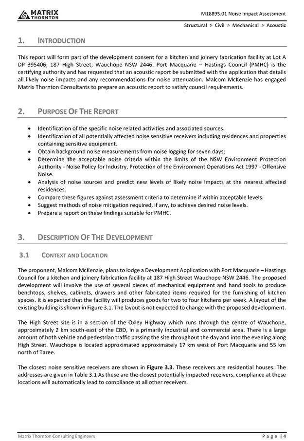
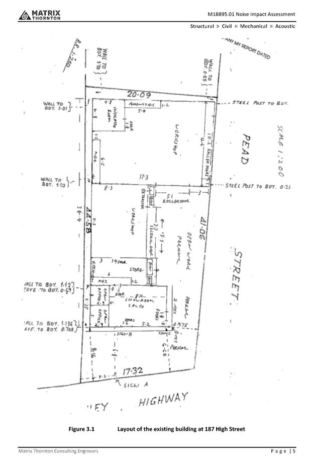
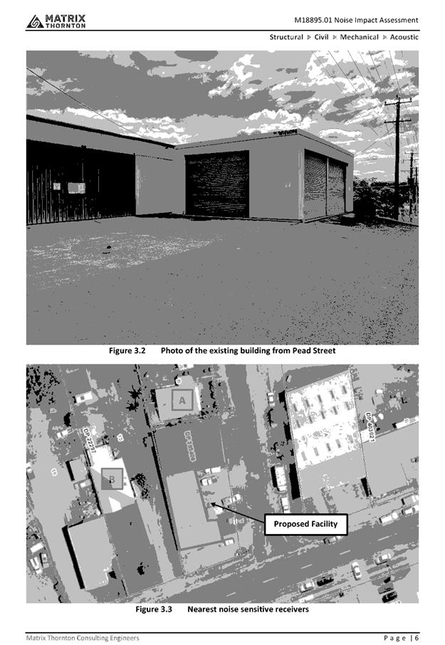
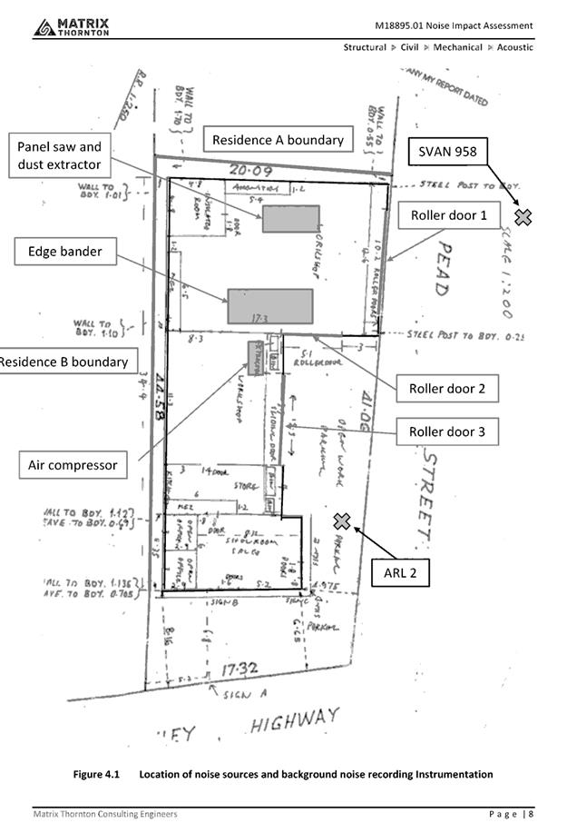
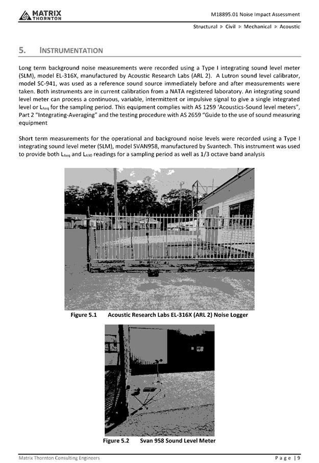
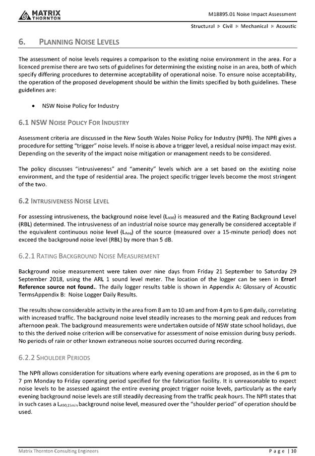
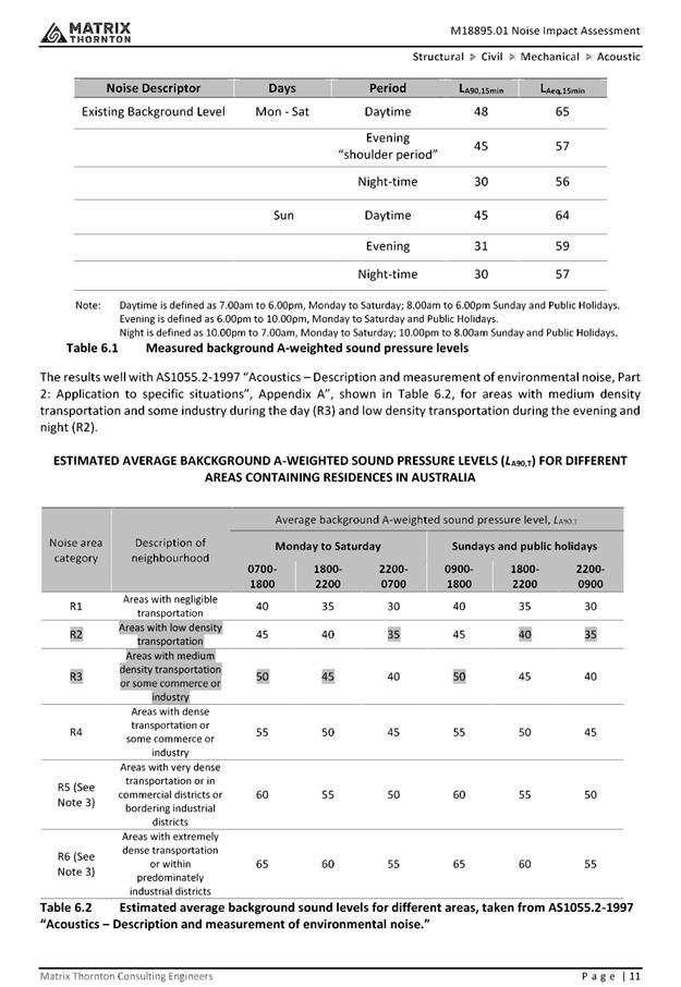
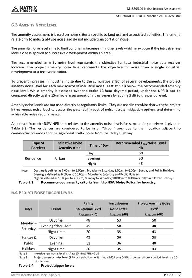
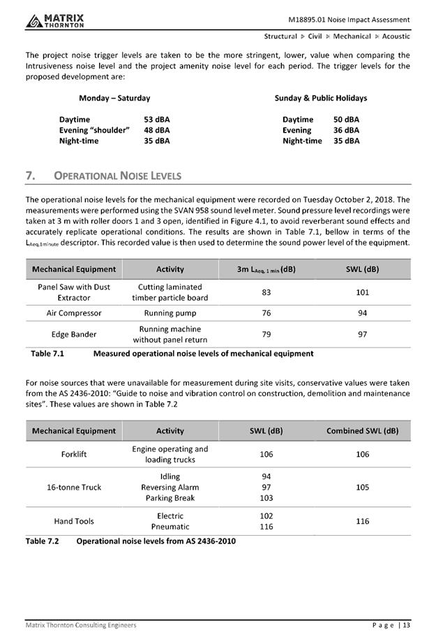
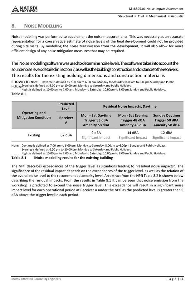
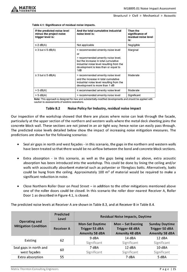
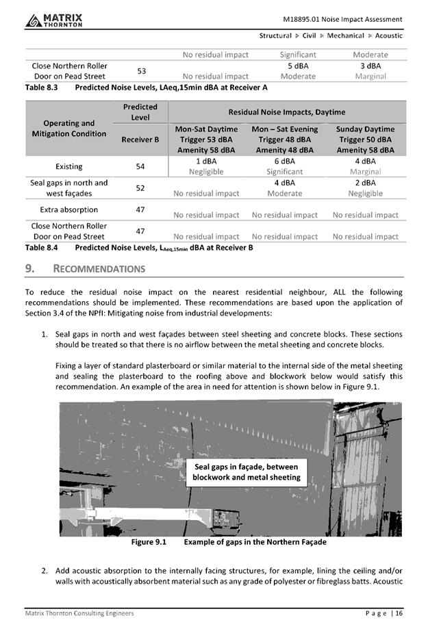
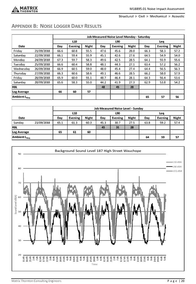
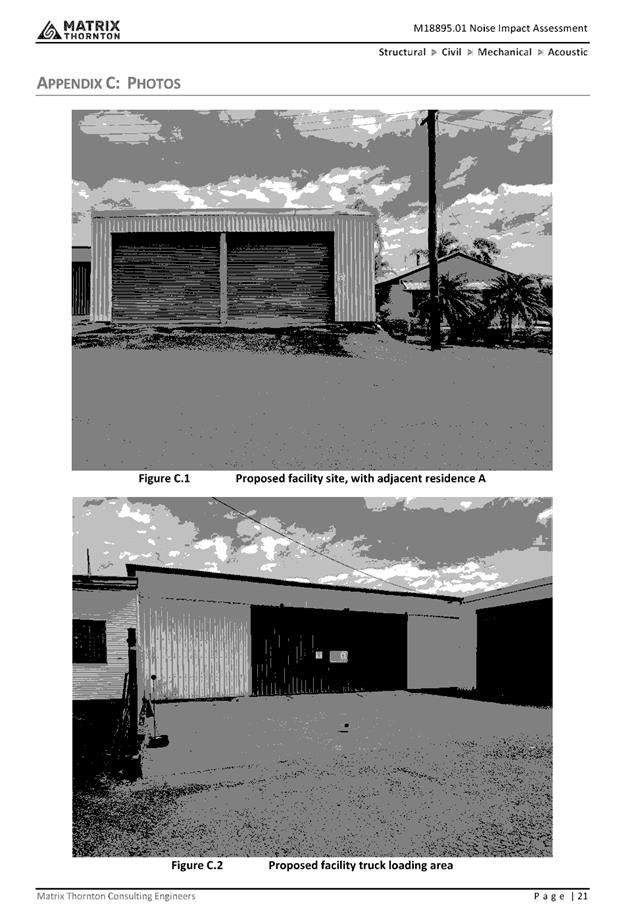
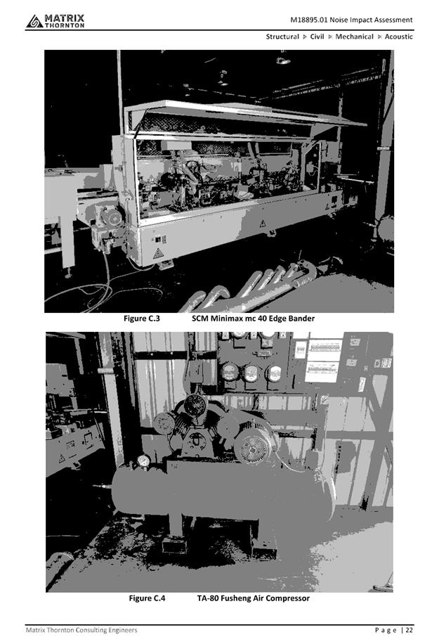
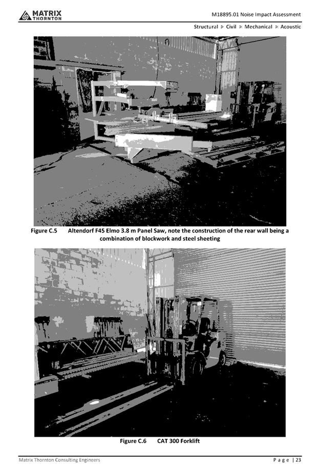
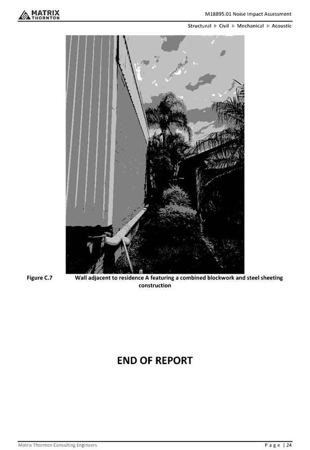
|
ATTACHMENT
|
Development Assessment Panel
19/12/2018
|
|
ATTACHMENT
|
Development Assessment Panel
19/12/2018
|