Business
Paper
|
date of meeting:
|
|
Wednesday 12 June
2019
|
|
location:
|
|
Function Room
Port
Macquarie-Hastings Council
17 Burrawan Street
Port Macquarie
|
|
time:
|
|
2:00pm
|
Development
Assessment Panel
CHARTER
1.0 OBJECTIVES
To assist in managing Council's development assessment
function by providing independent and expert determinations of development
applications that fall outside of staff delegations.
2.0 KEY FUNCTIONS
·
To review development application reports and conditions;
·
To determine development
applications outside of staff delegations;
·
To refer development applications
to Council for determination where necessary;
·
To provide a forum for objectors and applicants
to make submissions on applications
before the Development Assessment Panel
(DAP);
·
To maintain transparency in the determination of development
applications.
Delegated Authority of Panel
Pursuant to
Section 377 of the Local Government Act, 1993 delegation to:
·
Determine development applications under Part 4
of the Environmental Planning and Assessment
Act 1979 having
regard to the relevant environmental planning instruments,
development control plans and Council policies.
·
Vary, modify or release restrictions as to use
and/or covenants created by Section 88B instruments under the Conveyancing Act
1919 in relation to development applications for subdivisions being considered
by the panel.
·
Determine Koala Plans of Management under State
Environmental Planning Policy 44 - Koala Habitat Protection associated with
development applications being considered by the Panel.
Noting the trigger to escalate
decision making to Council as highlighted in section 5.2.
3.0
MEMBERSHIP
3.1
Voting
Members
·
Two independent external members. One of the
independent external members to be the Chairperson.
·
Group Manager Development Assessment (alternate
- Director Development & Environment or Development Assessment Planner)
The independent external members shall have expertise in
one or more of the following areas: planning, architecture, heritage, the
environment, urban design, economics, traffic and transport, law, engineering,
government and public administration.
3.2
Non-Voting Members
·
Not applicable
3.3 Obligations
of members
·
Members must act faithfully and diligently and
in accordance with this Charter.
·
Members must comply with Council's Code of Conduct.
·
Except as required to properly perform their
duties, DAP members must not
disclose any confidential information (as advised by Council) obtained in connection with the DAP functions.
·
Members will have read and be familiar with the
documents and information provided by Council prior
to attending a DAP meeting.
·
Members must act in accordance with Council's
Workplace Health and Safety Policies and Procedures
·
External members of the Panel are not authorised
to speak to the media on behalf of Council. Council officers that are members
of the Committee are bound by the
existing operational delegations in relation to speaking to the media.
·
Staff members shall not vote on matters before
the Panel if they have been the principle author of the development assessment report.
3.4
Member Tenure
·
The independent external members will be
appointed for the term of four (4) years
maximum in which the end of the tenure of these members would occur in a
cascading arrangement.
3.5 Appointment
of members
·
The independent external members (including the
Chair) shall be appointed by the General Manager following an external
Expression of Interest process.
·
Staff members of the Panel are in accordance
with this Charter.
4.0 TIMETABLE
OF MEETINGS
·
The Development Assessment Panel will generally
meet on the 1st and 3rd Wednesday each month at 2.00pm at the Port Macquarie
offices of Council.
·
Special Meetings of the Panel may be convened by
the Director Development & Environment Services with three (3) days notice.
5.0
MEETING PRACTICES
5.1
Meeting
Format
·
At all Meetings of the Panel the Chairperson
shall occupy the Chair and preside. The Chair will be responsible for keeping
of order at meetings.
·
Meetings shall be open to the public.
·
The Panel will hear from applicants
and objectors or their r e p r e s e n t a t i v e s .
·
Where considered necessary, the Panel will
conduct site inspections which will
be open to the public.
5.2
Decision Making
·
Decisions are to be made by consensus. Where
consensus is not possible on any item, that item is to be referred to Council
for a decision.
·
All development applications involving a
proposed variation to a development standard
greater than 10% under Clause
4.6 of the Local Environmental Plan will be
considered by the Panel and recommendation made to the Council for a decision.
5.3
Quorum
·
All members (2 independent external members and
1 staff member) must be present at a
meeting to form a quorum.
5.4
Chairperson and Deputy Chairperson
·
Independent Chair (alternate, second independent member)
5.5
Secretariat
·
The Director Development &n Environment is
to be responsible for ensuring that the Panel has adequate secretariat support.
The secretariat will ensure that the business paper and supporting papers are
circulated at least three (3) days prior to
each meeting. Minutes shall be appropriately approved and circulated to each
member within three (3) weeks of a meeting being held.
·
The format of and the preparation and publishing
of the Business Paper and Minutes shall be similar to the format for Ordinary
Council Meetings.
5.6
Recording of decisions
·
Minutes will record decisions and how each
member votes for each item before the Panel.
6.0 CONVENING
OF “OUTCOME SPECIFIC” WORKING GROUPS
Not applicable.
7.0 CONFIDENTIALITY
AND CONFLICT OF INTEREST
·
Members of the Panel must comply with the
applicable provisions of Council’s Code of Conduct. It is the personal
responsibility of members to comply with the standards in the Code of Conduct
and regularly review their personal circumstances with this in mind.
·
Panel members must declare any conflict of
interests at the start of each meeting or before discussion of a relevant item
or topic. Details of any conflicts of interest should be appropriately minuted.
Where members are deemed to have a real or perceived conflict of interest, it
may be appropriate they be excused from deliberations on the issue where the
conflict of interest may exist. A Panel meeting may be postponed where there is
no quorum.
8.0 LOBBYING
·
All members and applicants are to adhere to Council’s
Lobbying policy. Outside of
scheduled Development Assessment Panel meetings, applicants, their
representatives, Councillors, Council staff and the general public are not to
lobby Panel members via meetings, telephone conversations, correspondence and
the like. Adequate opportunity will be provided at Panel inspections or
meetings for applicants, their representatives and the general public to make
verbal submissions in relation to Business Paper items.
Development Assessment Panel
ATTENDANCE
REGISTER
|
Member
|
13/03/19
|
27/03/19
|
10/04/19
|
24/04/19
|
22/05/19
|
|
Paul Drake
|
P
|
P
|
P
|
P
|
P
|
|
Robert Hussey
|
|
P
|
A
|
P
|
P
|
|
David Crofts
(alternate member)
|
P
|
|
P
|
|
|
|
Dan Croft
(Group Manager Development
Assessment)
(alternates)
- Director Development & Environment
- Development Assessment Planner
|
P
|
P
|
P
|
P
|
P
|
Key: P = Present
A
= Absent With Apology
X
= Absent Without Apology
Development
Assessment Panel Meeting
Wednesday 12 June
2019
Items of Business
01 Acknowledgement
of Country............................................................................. 8
02 Apologies.......................................................................................................... 8
03 Confirmation
of Minutes..................................................................................... 8
04 Disclosures
of Interest..................................................................................... 13
05 DA2018
- 85.1 Deck and Swimming Pool at Lot 377 DP 236950, No 31 Vendul Crescent, Port
Macquarie....................................................................................................... 17
06 DA2018
- 131.1 - Staged 2 into 4 Lot Torrens Title Rural Subdivision - Lot 1 DP
1009991, Sancrox Road and Lot 14 DP 1043738, Oxley Highway, Sancrox....................... 37
07 General
Business
AGENDA Development Assessment Panel 12/06/2019
Subject: ACKNOWLEDGEMENT
OF COUNTRY
"I acknowledge that we are
gathered on Birpai Land. I pay respect to the Birpai Elders both past and
present. I also extend that respect to all other Aboriginal and Torres Strait
Islander people present."
RECOMMENDATION
That the apologies received be
accepted.
Subject: CONFIRMATION
OF PREVIOUS MINUTES
Recommendation
That the Minutes of the Development
Assessment Panel Meeting held on 22 May 2019 be confirmed.
MINUTES
Development Assessment Panel Meeting
22/05/2019
PRESENT
Members:
Paul Drake
Robert Hussey
Dan Croft
Other Attendees:
Ben Roberts
Chris Gardiner
|
The meeting opened at 2.00pm
|
|
01 ACKNOWLEDGEMENT
OF COUNTRY
|
|
The Acknowledgement of Country was
delivered.
|
|
03 CONFIRMATION
OF MINUTES
|
|
CONCENSUS
That the Minutes of the
Development Assessment Panel Meeting held on 24 April 2019 be confirmed.
|
|
04 DISCLOSURES OF
INTEREST
|
|
There were no
disclosures of interest presented.
|
|
05 DA2019
- 213.1 Dwelling Lot 144 DP 1230897, No. 4 Shore Break Crescent, Lake Cathie
|
|
CONSENSUS
That DA 2019 - 213.1 for a
dwelling at Lot 144, DP 1230897, No. 4 Shore Break Crescent, Lake Cathie, be
determined by granting consent subject to the recommended conditions.
|
|
|
|
06 DA2018
- 353.1 Commercial Premises and Tourist and Visitor Accommodation with Clause
4.6 Variation to Clause 4.3 (Height of Buildings) and Clause 4.4 (Floor Space
Ratio) of the Port Macquarie-Hastings Local Environmental Plan 2011 at Lot
123 DP 1219042, No. 17 Clarence Street, Port Macquarie
|
|
Mr David Pensini (applicant)
spoke on the item.
The following motion was put
to the panel:
That it be recommended to
Council that DA2018 - 353.1 for a commercial premises and tourist and visitor
accommodation with clause 4.6 variation to clause 4.3 (Height of Buildings)
and clause 4.4 (Floor Space Ratio) of the Port Macquarie-Hastings Local
Environmental Plan 2011 at Lot 123, DP 1219042, No. 17 Clarence Street, Port
Macquarie, be determined by granting consent subject to the recommended
conditions.
The Panel was unable to reach
consensus
For: Paul Drake and Dan Croft
Against: Robert Hussey
The dissenting recommendation
from Robert Hussey was put:
That DA2018 - 353.1 for a
commercial premises and tourist and visitor accommodation with clause 4.6
variation to clause 4.3 (Height of Buildings) and clause 4.4 (Floor Space
Ratio) of the Port Macquarie-Hastings Local Environmental Plan 2011 at Lot
123, DP 1219042, No. 17 Clarence Street, Port Macquarie, be determined by
refusing consent for the following reason:
1. Insufficient car parking is provided on site. To vary the
Development Control Plan (DCP) car parking provisions by 18% has significant
implications on parking in the CBD, will lead to an undesirable precedent and
undermine the DCP. Council should consider amending the DCP if such
variations are to be considered acceptable.
|
|
|
|
07 DA2018 - 427.1 Dual Occupancy
and Torrens Title Subdivision, Boat Ramps and Jetty at Lot 7 DP 246284, No.
14 Sirius Close, Port Macquarie
|
|
Mr Lex
Wilke (applicant) spoke on the item.
Resolution as per
recommendation subject to the following changes to conditions of consent:
CONSENSUS
That DA2018
- 427.1 for a Dual Occupancy and Torrens Title Subdivision, Boat Ramps and
Jetty at Lot 7, DP 246284, No. 14 Sirius Close, Port Macquarie, be determined
by granting consent subject to the recommended conditions.
·
Amend condition A(9) to read:
The
street tree impacted by the driveway shall be removed and replaced with 2
suitable amenity trees of a minimum 100 litre size in accordance with the specifications
of Council’s Arborist in a position agreed to by Port
Macquarie-Hastings Council. The position of the replacement tree shall be
clearly shown on the plans accompanying the section 138 application. The new
tree shall be cared for and maintained for a period of at least 12 months. If
establishment is unsuccessful a new tree of the same species and size shall
be planted in a suitable location in front of the property.
·
Amend condition B13 to read:
Prior to the issue of a Construction Certificate, a
detailed planting plan for the provision One (1) Schedule 2 Koala food tree
shall be submitted for the approval of Council’s Environmental Services
Section. The Plan shall include:
a) Location of plantings (to be confirmed with
Council);
b) Details of planting and
appropriate tree protection;
c) A schedule of care and
maintenance for a minimum period of 12 months.
All
work shall be carried out by a Council approved contractor at the
developer’s cost.
|
|
|
|
08 DA2019
- 27.1 Permanent Group Home - Lot 31 DP 1190016, No. 5 McGilvray Road, Bonny
Hills
|
|
Mr David Govers (applicant) spoke
on the item.
CONSENSUS
That DA 2019 - 27.1 for a Permanent
Group Home at Lot 31, DP 1190016, No. 5 McGilvray Road, Bonny Hills, be
determined by granting consent subject to the recommended conditions.
|
|
|
|
09 DA2018
- 641.1 Additions to Existing Building and Change of Use to Commercial
Premises - Lots 1 & 2 DP 3749 No.150 Nancy Bird Walton Drive, Kew
|
|
Mr Jurie Beukes (o) and Mr David
Pensini (applicant) spoke on the item.
CONSENSUS
That DA 2018 - 641 for additions to existing building and
change of use to commercial premises at Lot 1 & 2, DP 3749, No. 150 Nancy
Bird Walton Drive, Kew, be determined by granting a deferred commencement
with the following deferred commencement requirement being satisfied within
six (6) months of the date of determination:
·
The design of the carpark and
accesses is to be in accordance with Australian Standard 2890 (including AS
2890.1, AS 2890.2 and AS 2890.6). Certification of the design by a suitably
qualified consultant is to be provided to the Principal Certifying Authority
prior to release of the Construction Certificate. A total of 17 spaces are to
be provided and the following matters are to be addressed and detailed on the
plan:
o
Awning post locations.
o
Redesign entry and exist to
provide for a designated ingress at the north of the site and a dedicated
egress at the south of the site. The driveway widths are to be of a minimum
size permitted by the standard so as to provide maximum opportunity for off
street parking.
o
Ampol sign to be removed.
o
Planter boxes to be extended at
the northern and southern driveways for the length of adjoining car parking
spaces.
o
Northern access driveway to Bay
5 be extended to rear boundary to provide improved access and manoeuvring for
Bay 5.
o
Traffic Management Plan be
provided for use of the Southern driveway to reflect intermittent usage.
That following the above deferred commencement requirement
being satisfied, the consent be operative as recommended with the following
change:
·
Replace condition F5 with
the following:
‘Hours of operation of
the development are to be restricted as follows:
o Bays 1 and 2 - Monday to Sunday 8am to 6pm.
o Bay 4 - Monday to Saturday 8am to 6pm.’
|
|
|
|
The meeting closed at 3.23pm.
|
AGENDA Development Assessment Panel 12/06/2019
Subject: DISCLOSURES
OF INTEREST
RECOMMENDATION
That Disclosures of Interest be presented
DISCLOSURE OF
INTEREST DECLARATION
|
Name of Meeting:
|
|
Meeting
Date:
|
|
Item
Number:
|
|
Subject:
|
|
I,
the undersigned, hereby declare the following interest:
Pecuniary:
 Take no part
in the consideration and voting and be out of sight of the meeting. Take no part
in the consideration and voting and be out of sight of the meeting.
Non-Pecuniary
– Significant Interest:
Take no part
in the consideration and voting and be out of sight of the meeting.
Non-Pecuniary
– Less than Significant Interest:
May
participate in consideration and voting.
|
|
For
the reason that:
|
|
Name:
Signed:
|
Date:
|
|
Please submit to the
Governance Support Officer at the Council Meeting.
|
 (Refer
to next page and the Code of Conduct)
(Refer
to next page and the Code of Conduct)
Pecuniary Interest
4.1
A pecuniary interest is an interest
that you have in a matter because of a reasonable likelihood or expectation of
appreciable financial gain or loss to you or a person referred to in clause
4.3.
4.2
You will not have a pecuniary
interest in a matter if the interest is so remote or insignificant that it
could not reasonably be regarded as likely to influence any decision you might
make in relation to the matter, or if the interest is of a kind specified in
clause 4.6.
4.3
For the purposes of this Part, you
will have a pecuniary interest in a matter if the pecuniary interest is:
(a)
your interest, or
(b)
the interest of your spouse or de
facto partner, your relative, or your partner or employer, or
(c)
a company or other body of which
you, or your nominee, partner or employer, is a shareholder or member.
4.4
For the purposes of clause 4.3:
(a)
Your “relative” is any
of the following:
(b)
“de facto partner” has
the same meaning as defined in section 21C of the Interpretation Act 1987.
4.5
You will not have a pecuniary
interest in relation to a person referred to in subclauses 4.3(b) or (c)
(a)
if you are unaware of the relevant
pecuniary interest of your spouse, de facto partner, relative, partner,
employer or company or other body, or
(b)
just because the person is a member
of, or is employed by, a council or a statutory body, or is employed by the
Crown, or
(c)
just because the person is a member
of, or a delegate of a council to, a company or other body that has a pecuniary
interest in the matter, so long as the person has no beneficial interest in any
shares of the company or body.
Non-Pecuniary
5.1
Non-pecuniary interests are private
or personal interests a council official has that do not amount to a pecuniary
interest as defined in clause 4.1 of this code. These commonly arise out of
family or personal relationships, or out of involvement in sporting, social,
religious or other cultural groups and associations, and may include an interest
of a financial nature.
5.2
A non-pecuniary conflict of
interest exists where a reasonable and informed person would perceive that you
could be influenced by a private interest when carrying out your official
functions in relation to a matter.
5.3
The personal or political views of
a council official do not constitute a private interest for the purposes of
clause 5.2.
5.4
Non-pecuniary conflicts of interest
must be identified and appropriately managed to uphold community confidence in
the probity of council decision-making. The onus is on you to identify any
non-pecuniary conflict of interest you may have in matters that you deal with,
to disclose the interest fully and in writing, and to take appropriate action
to manage the conflict in accordance with this code.
5.5
When considering whether or not you
have a non-pecuniary conflict of interest in a matter you are dealing with, it
is always important to think about how others would view your situation.
Managing non-pecuniary conflicts of interest
5.6
Where you have a non-pecuniary
conflict of interest in a matter for the purposes of clause 5.2, you must
disclose the relevant private interest you have in relation to the matter fully
and in writing as soon as practicable after becoming aware of the non-pecuniary
conflict of interest and on each occasion on which the non-pecuniary conflict
of interest arises in relation to the matter. In the case of members of council
staff other than the general manager, such a disclosure is to be made to the
staff member’s manager. In the case of the general manager, such a
disclosure is to be made to the mayor.
5.7
If a disclosure is made at a
council or committee meeting, both the disclosure and the nature of the
interest must be recorded in the minutes on each occasion on which the non-pecuniary
conflict of interest arises. This disclosure constitutes disclosure in writing
for the purposes of clause 5.6.
5.8
How you manage a non-pecuniary
conflict of interest will depend on whether or not it is significant.
5.9
As a general rule, a non-pecuniary
conflict of interest will be significant where it does not involve a pecuniary
interest for the purposes of clause 4.1, but it involves:
a)
a relationship between a council
official and another person who is affected by a decision or a matter under
consideration that is particularly close, such as a current or former spouse or
de facto partner, a relative for the purposes of clause 4.4 or another person
from the council official’s extended family that the council official has
a close personal relationship with, or another person living in the same
household
b)
other relationships with persons
who are affected by a decision or a matter under consideration that are
particularly close, such as friendships and business relationships. Closeness
is defined by the nature of the friendship or business relationship, the
frequency of contact and the duration of the friendship or relationship.
c)
an affiliation between the council
official and an organisation (such as a sporting body, club, religious,
cultural or charitable organisation, corporation or association) that is
affected by a decision or a matter under consideration that is particularly
strong. The strength of a council official’s affiliation with an
organisation is to be determined by the extent to which they actively
participate in the management, administration or other activities of the
organisation.
d)
membership, as the council’s
representative, of the board or management committee of an organisation that is
affected by a decision or a matter under consideration, in circumstances where
the interests of the council and the organisation are potentially in conflict
in relation to the particular matter
e)
a financial interest (other than an
interest of a type referred to in clause 4.6) that is not a pecuniary interest
for the purposes of clause 4.1
f)
the conferral or loss of a personal
benefit other than one conferred or lost as a member of the community or a
broader class of people affected by a decision.
5.10
Significant non-pecuniary conflicts
of interest must be managed in one of two ways:
a)
by not participating in
consideration of, or decision making in relation to, the matter in which you
have the significant non-pecuniary conflict of interest and the matter being
allocated to another person for consideration or determination, or
b)
if the significant non-pecuniary
conflict of interest arises in relation to a matter under consideration at a
council or committee meeting, by managing the conflict of interest as if you
had a pecuniary interest in the matter by complying with clauses 4.28 and 4.29.
5.11
If you determine that you have a
non-pecuniary conflict of interest in a matter that is not significant and does
not require further action, when disclosing the interest you must also explain
in writing why you consider that the non-pecuniary conflict of interest is not
significant and does not require further action in the circumstances.
5.12
If you are a member of staff of
council other than the general manager, the decision on which option should be
taken to manage a non-pecuniary conflict of interest must be made in
consultation with and at the direction of your manager. In the case of the
general manager, the decision on which option should be taken to manage a
non-pecuniary conflict of interest must be made in consultation with and at the
direction of the mayor.
5.13
Despite clause 5.10(b), a
councillor who has a significant non-pecuniary conflict of interest in a
matter, may participate in a decision to delegate consideration of the matter
in question to another body or person.
5.14 Council committee members are not required to declare
and manage a non-pecuniary conflict of interest in accordance with the
requirements of this Part where it arises from an interest they have as a
person chosen to represent the community, or as a member of a non-profit organisation
or other community or special interest group, if they have been appointed to
represent the organisation or group on the council committee.
SPECIAL
DISCLOSURE OF PECUNIARY INTEREST DECLARATION
This
form must be completed using block letters or typed.
If
there is insufficient space for all the information you are required to
disclose,
you
must attach an appendix which is to be properly identified and signed by you.
|
By
[insert full name of councillor]
|
|
|
In the
matter of
[insert name of environmental planning instrument]
|
|
|
Which is
to be considered at a meeting of the
[insert name of meeting]
|
|
|
Held on
[insert date of meeting]
|
|
|
PECUNIARY
INTEREST
|
|
Address of
the affected principal place of residence of the councillor or an associated
person, company or body (the identified land)
|
|
|
Relationship
of identified land to councillor
[Tick or cross one box.]
|
The councillor has interest in the land (e.g. is owner or has other
interest arising out of a mortgage, lease, trust, option or contract, or otherwise).
An associated person of the councillor has an interest in the land.
An associated company or body of the councillor has interest in the land.
|
|
MATTER
GIVING RISE TO PECUNIARY INTEREST
|
|
Nature of
land that is subject to a change
in zone/planning
control by proposed
LEP (the
subject land
[Tick or cross one box]
|
The identified land.
Land that adjoins or is adjacent to or is in proximity to the identified
land.
|
|
Current
zone/planning control
[Insert name of current planning instrument and
identify relevant zone/planning control applying to the subject land]
|
|
|
Proposed
change of zone/planning control
[Insert name of proposed LEP and identify proposed
change of zone/planning control applying to the subject land]
|
|
|
Effect of
proposed change of zone/planning control on councillor or associated person
[Tick or cross one box]
|
Appreciable financial gain.
Appreciable financial loss.
|
|
|
|
[If more than one pecuniary interest is to be
declared, reprint the above box and fill in for each additional interest]
Councillor’s Signature:
……………………………….
Date: ………………..
This form is to be retained
by the council’s general manager and included in full in the minutes of
the meeting
Last Updated: 3 June 2019
Important Information
This information is being collected for the purpose of
making a special disclosure of pecuniary interests under clause 4.36(c) of the
Model Code of Conduct for Local Councils in NSW (the Model Code of Conduct).
The special disclosure must relate only to a pecuniary
interest that a councillor has in the councillor’s principal place of
residence, or an interest another person (whose interests are relevant under
clause 4.3 of the Model Code of Conduct) has in that person’s principal
place of residence.
Clause 4.3 of the Model Code of Conduct states that you
will have a pecuniary interest in a matter because of the pecuniary interest of
your spouse or your de facto partner or your relative or because your business
partner or employer has a pecuniary interest. You will also have a pecuniary
interest in a matter because you, your nominee, your business partner or your
employer is a member of a company or other body that has a pecuniary interest
in the matter.
“Relative” is defined by clause 4.4 of the Model
Code of Conduct as meaning your, your spouse’s or your de facto
partner’s parent, grandparent, brother, sister, uncle, aunt, nephew,
niece, lineal descendant or adopted child and the spouse or de facto partner of
any of those persons.
You
must not make a special disclosure that you know or ought reasonably to know is
false or misleading in a material particular. Complaints about breaches
of these requirements are to be referred to the Office of Local Government and
may result in disciplinary action by the Chief Executive of the Office of Local
Government or the NSW Civil and Administrative Tribunal.
This form must be completed by you before the commencement
of the council or council committee meeting at which the special disclosure is
being made. The completed form must be tabled at the meeting. Everyone is
entitled to inspect it. The special disclosure must be recorded in the minutes
of the meeting.
A pecuniary interest may arise by way of a change of
permissible use of land adjoining, adjacent to or in proximity to land in which
a councillor or a person, company or body referred to in clause 4.3 of the
Model Code of Conduct has a proprietary interest
AGENDA Development Assessment Panel 12/06/2019
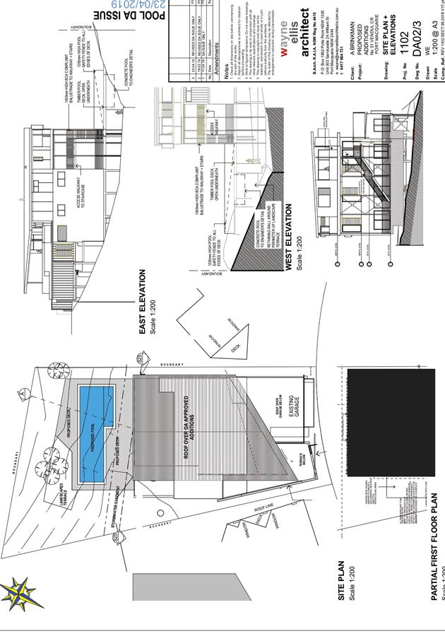
Item: 05
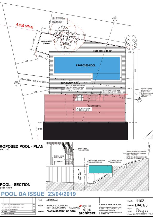
Subject: DA2018 - 85.1 Deck and Swimming Pool at Lot
377 DP 236950, No 31 Vendul Crescent, Port Macquarie
Report
Author: Development Assessment Planner, Chris Gardiner
|
Applicant: Wayne
Ellis Architect
Owner: A
J Brinkman
Estimated Cost: $50,000
Alignment with Delivery
Program
4.3.1 Undertake transparent
and efficient development assessment in accordance with relevant legislation.
|
|
RECOMMENDATION
That
DA2018 - 85.1 for a Deck and
Swimming Pool at Lot 377, DP 236950, No. 31 Vendul Crescent,
Port Macquarie, be determined by
granting consent subject to the recommended conditions.
|
Executive
Summary
This
report considers a development application for a deck and swimming pool at the subject site and provides an assessment of the
application in accordance with the Environmental Planning and Assessment Act
1979.
Following exhibition of the
application, 8 submissions have been received.
1. BACKGROUND
Existing sites features and Surrounding development
The site has an area of 733.5m2.
The site is zoned R1 General Residential in accordance with the Port Macquarie-Hastings Local
Environmental Plan 2011, as shown in the following zoning plan:
The existing subdivision pattern and location of existing
development within the locality is shown in the following aerial photograph:
2. DESCRIPTION OF
DEVELOPMENT
Key aspects of the proposal include the following:
· Construction
of a swimming pool and deck addition at the rear of existing dwelling.
Refer
to attachments at the end of this report.
Application Chronology
· 13
February 2018 - Application lodged.
· 23
February 2018 - Additional information requested from Applicant.
· 2
May 2018 - Additional information submitted.
· 8 May 2018 to 21 May 2018 - Neighbour notification.
· 28 May 2018 - Further additional information requested from
Applicant.
· 5 June 2018 - Response and recommendations received from
NSW Rural Fire Service.
· 18 February 2019 - Additional information submitted.
· 24 April 2019 - Amended Plans and Tree Protection Report
submitted.
· 1 May 2019 to 14 May 2019 - Application re-notified.
3. STATUTORY ASSESSMENT
Section 4.15(1) Matters for Consideration
In determining the application, Council is required to take
into consideration the following matters as are relevant to the development
that apply to the land to which the development application relates:
(a) The provisions (where
applicable) of:
(i) Any Environmental Planning
Instrument:
State Environmental Planning Policy No. 44 - Koala Habitat
Protection
There is no Koala Plan of Management on the site.
Additionally, the site is less than 1ha in area therefore no further
investigations are required.
State Environmental Planning Policy No. 55 –
Remediation of Land
Following an inspection of the site and a search of Council
records, the subject land is not identified as being potentially contaminated
and is suitable for the intended use.
State Environmental Planning Policy (Coastal Management)
2018
The site is located within a coastal use area. The rear of
the site is mapped as Littoral Rainforest, with the balance of the site also
being within the proximity area for Littoral Rainforest.
In accordance with clause 7, this SEPP prevails over the
Port Macquarie-Hastings LEP 2011 in the event of any inconsistency.
Having regard to clause 14 of the SEPP the proposed
development is not considered likely to result in any of the following:
a) any
adverse impact on Aboriginal cultural heritage, practices and
places;
b) any
adverse impacts on the cultural and built environment heritage;
c) any adverse impact on the visual amenity and scenic qualities of the
coast, including coastal headlands;
d) overshadowing, wind funnelling and the loss of views from public places
to foreshores;
e) any
adverse impacts on existing public open space and safe access to
and along the foreshore, beach, headland or rock platform for members of the
public, including persons with a disability;
The bulk, scale and size of the proposed development is
compatible with the surrounding coastal and built environment. The site is
predominately cleared and located within an area zoned for residential
purposes.
In accordance with Clause 21(1) (1) the
former planning provisions (SEPP 26) continue to apply (and this Policy does
not apply) to a development application lodged, but not finally determined,
immediately before the commencement of this Policy in relation to land to which
this Policy applies. The Application was lodged prior to the commencement of
the SEPP on 3 April 2018.
Under SEPP 26, the land was not mapped as
Littoral Rainforest or within the relevant buffer area and no further
consideration is required.
State Environmental Planning Policy (Building
Sustainability Index: BASIX) 2004
A BASIX certificate has been submitted demonstrating that
the proposal will comply with the requirements of the SEPP. It is recommended
that a condition be imposed to ensure that the commitments are incorporated
into the development and certified at Occupation Certificate stage.
Port Macquarie-Hastings Local Environmental Plan
2011
The proposal is consistent with the LEP having regard to
the following:
· Clause 2.2 -The subject site is zoned R1 General
Residential. In accordance with clause 2.3(1) and the R1 zone landuse table,
the ancillary structure to a dwelling is a permissible landuse with consent.
The objectives of the R1 zone are as follows:
o To provide for the housing needs of the community.
o To provide for a variety of housing types and densities.
o To enable other land uses that provide facilities or
services to meet the day to day needs of residents.
· Clause 2.3(2) - The proposal is consistent with the zone
objectives as it is a permissible landuse and consistent with the established
residential locality.
· Clause 4.3 - The maximum overall height of the building
additions above ground level (existing) is 7.5m which complies with the standard
height limit of 8.5m applying to the site.
· Clause 4.4 - The floor space ratio would not be increased
as a result of the proposal, as the new works are outside the external walls of
the building. The previous additions to the dwelling under DA2015 – 30
(as amended) were assessed to have an FSR of 0.55:1, which complies with the
maximum 0.65:1 floor space ratio applying to the site.
· Clause 5.10 – Heritage. The site does not contain or
adjoin any known heritage items or sites of significance.
· Clause 7.13 - Satisfactory arrangements are in place for
provision of essential services.
(ii) Any
draft instruments that apply to the site or are on exhibition:
No draft
instruments apply to the site.
(iii) Any
Development Control Plan in force:
Port
Macquarie-Hastings Development Control Plan 2013
|
DCP 2013: Dwellings, Dual
occupancies, Dwelling houses, Multi dwelling houses & Ancillary
development
|
|
|
Requirements
|
Proposed
|
Complies
|
|
3.2.2.4
|
4m min. rear setback. Variation
subject to site analysis and provision of private open space
|
The rear setback requirements are
complied with.
|
Yes
|
|
3.2.2.5
|
Side setbacks:
• Ground floor =
min. 0.9m
• First floors &
above = min. 3m setback or where it can be demonstrated that overshadowing
not adverse = 0.9m min.
• Building wall set
in and out every 12m by 0.5m
|
The minimum side setback
requirements are complied with.
|
Yes
|
|
3.2.2.6
|
35m2 min. private open space area
including a useable 4x4m min. area which has 5% max. grade
|
The dwelling contains 35m²
open space in one area including a useable 4m x 4m space.
|
Yes
|
|
3.2.2.7
|
Front fences:
• If solid 1.2m max
height and front setback 1.0m with landscaping
• 3x3m min. splay
for corner sites
• Fences >1.2m to
be 1.8m max. height for 50% or 6.0m max. length of street frontage with 25%
openings
• 0.9x0.9m splays
adjoining driveway entrances
|
No front fences proposed.
|
N/A
|
|
3.2.2.8
|
Front fences and walls to have
complimentary materials to context
No chain wire, solid timber,
masonry or solid steel front fences
|
N/A
|
|
|
3.2.2.10
|
Privacy:
• Direct views
between living areas of adjacent dwellings screened when within 9m radius of
any part of window of adjacent dwelling and within 12m of private open space
areas of adjacent dwellings. ie. 1.8m fence or privacy screening which has
25% max. openings and is permanently fixed
• Privacy screen
required if floor level > 1m height, window side/rear setback (other than
bedroom) is less than 3m and sill height less than 1.5m
• Privacy screens
provided to balconies/verandahs etc which have <3m side/rear setback and
floor level height >1m
|
The proposed deck addition is located within 3m of the
eastern side boundary and is predominantly more than 1m above ground level.
Condition recommended requiring privacy screen for the part of the deck with
finished level greater than 1m above ground level.
|
Yes
|
|
DCP 2013: General
Provisions
|
|
|
Requirements
|
Proposed
|
Complies
|
|
2.7.2.2
|
Design addresses generic principles of Crime Prevention
Through Environmental Design guideline
|
No concealment or entrapment areas proposed. Adequate
casual surveillance available.
|
Yes
|
|
2.3.3.1
|
Cut and fill 1.0m max. 1m outside the perimeter of the
external building walls
|
Cut and fill <1.0m change 1m outside the perimeter of
the external building walls
|
Yes
|
|
2.3.3.2
|
1m max. height retaining walls along road frontage
|
None proposed
|
N/A
|
|
Any retaining wall >1.0 in height to be certified by
structure engineer
|
Condition recommended to require engineering certification
of retaining walls
|
Yes
|
|
Combination of retaining wall and front fence height max
1.8m, max length 6.0m or 30% of frontage, fence component 25% transparent,
and splay at corners and adjacent to driveway
|
No retaining wall front fence combination proposed.
|
N/A
|
|
2.6.3.1
|
Tree removal (3m or higher with 100m diameter trunk at 1m
above ground level and 3m from external wall of existing dwelling)
|
No trees proposed to be removed. The application includes
a Tree Protection Report prepared by an Arborist for the 3 Cheese Trees
located north-west of the pool within a landscaped terrace. The report
demonstrates that the trees can be retained and protected subject to the
recommendation in the report.
|
Yes
|
|
2.4.3
|
Bushfire risk, Acid sulphate soils, Flooding,
Contamination, Airspace protection, Noise and Stormwater
|
Refer to main body of report.
|
|
(iiia) Any
planning agreement that has been entered into under section 7.4, or any draft
planning agreement that a developer has offered to enter into under section
7.4:
No planning
agreement has been offered or entered into relating to the site.
iv) Any matters prescribed by the
Regulations:
No matters
prescribed by the regulations are applicable to the proposal.
(b) The
likely impacts of that development, including environmental impacts on both the
natural and built environments, social and economic impacts in the locality:
Context and setting
• The
proposal will be unlikely to have any adverse impacts to existing adjoining
properties and satisfactorily addresses the public domain.
• The
proposal is considered to be consistent with other residential development in
the locality and adequately addresses planning controls for the area.
• There
are no adverse impacts on existing view sharing.
• There
are no adverse privacy impacts.
• There
are no adverse overshadowing impacts. The proposal does not prevent adjoining
properties from receiving 3 hours of sunlight to private open space and primary
living areas on 21 June.
Access, transport and traffic
The proposal will be unlikely to have any adverse impacts
in terms access, transport and traffic. The existing road network will
satisfactorily cater for any increase in traffic generation as a result of the
development.
Water Supply
Water supply connection not required for the proposal.
Sewer
The sewer main is located beneath the existing deck at the
rear of the dwelling. The deck addition and swimming pool are not expected to
place any additional load on the sewer main.
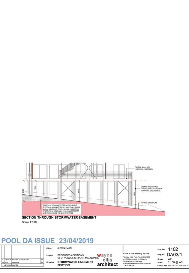
Stormwater
The proposed deck addition is located over an easement to
drain water 6 feet (1.8m) wide in favour of Council. To ensure that future
access is available for maintenance of the stormwater infrastructure, the deck
will need to maintain a minimum 3m vertical clearance and all posts supporting
the deck will need to be located clear of this easement. The deck will need to
be designed to ensure that it does not place any load on the stormwater pipe
and is capable of withstanding forces associated with overland flows.
The submitted plans indicate that up to 700mm of excavation
would be required at the eastern end of the deck to achieve the required 3m
vertical clearance. Detailed survey information is not available to confirm the
depth of the stormwater pipe in this location, but it is estimated from contour
information that the existing pipe has approximately 1.2m of cover.
The detailed stormwater design will need to determine the
depth of the existing stormwater pipe and confirm that adequate cover can be
retained in accordance with AUSPEC requirements. If a 3m vertical clearance to
the deck is not achievable due to inadequate cover of the stormwater pipe, the
relevant part of the deck will need to be designed to be easily removable in
the event that future maintenance of the stormwater infrastructure is required.
Conditions are recommended confirming the above
requirements.
Other Utilities
Telecommunication and electricity services are available to
the site.
Heritage
This site does not contain or adjoin any known heritage
item or site of significance.
Other land resources
No adverse impacts anticipated. The site is within an
established urban context and will not sterilise any significant mineral or
agricultural resource.
Water cycle
The proposed development will be unlikely to have any
adverse impacts on water resources and the water cycle.
Soils
The proposed development will be unlikely to have any
adverse impacts on soils in terms of quality, erosion, stability and/or
productivity subject to a standard condition requiring erosion and sediment
controls to be in place prior to and during construction.
Air and microclimate
The construction and/or operations of the proposed
development will be unlikely to result in any adverse impacts on the existing
air quality or result in any pollution.
Flora and fauna
Construction of the proposed development will not require
any removal/clearing of any significant vegetation and therefore will be
unlikely to have any significant adverse impacts on biodiversity or threatened
species of flora and fauna.
A Tree Protection Report prepared by Port Tree Fella has
been submitted with the application and demonstrates that the existing trees
adjacent to the new work are capable of being retained without significant
damage from the development. The report includes the following recommendations,
which are included in the proposed conditions.
1. Arborist to
determine Structural Root Zone (SRZ) and Tree Protection Zone (TPZ) of retained
trees. AQF 5 Arborist to set out on site as per Report.
2. Design of
structure/footings to be outside SRZ and to be advised where it encroaches into
TPZ. Accurate survey of tree location and location of footing required. AQF 5
Arborist to supervise excavation of pier footing.
3. Tree Protection
fencing to be installed by AQF 5 Arborist prior to works commencing.
4. Minor pruning
undertaken as per survey on Tree #4 by an AQF 5 Arborist.
5. Supervision and
documentation of works and compliance to AS 4970-2009 by an AQF 5 Arborist.
Waste
Satisfactory arrangements are in place for proposed storage
and collection of waste and recyclables. No adverse impacts anticipated.
Energy
The proposal includes measures to address energy efficiency
and will be required to comply with the requirements of BASIX.
Noise and vibration
No adverse impacts anticipated. Condition recommended to
restrict construction to standard construction hours.
Bushfire
The site is identified as being bushfire prone.
The Applicant has submitted a bushfire report prepared by a
Certified Consultant.
An assessment of bushfire risk having regard to section
4.3.5 of Planning for Bushfire Protection 2006 including vegetation
classification and slope concludes that a Bushfire Attack Level 29 shall be
required.
As the assessment has determined that asset protection
zones do not comply with Planning for Bush Fire Protection 2006, the
application has been referred to the RFS in accordance with Section 4.14 of the
EP&A Act. The RFS have reviewed the proposal and made recommendations which
will be required to be imposed via conditions of consent.
Management of bushfire risk is acceptable subject to BAL
construction levels being implemented and APZ being maintained. An appropriate
condition is recommended.
Safety, security and crime prevention
The proposed development will be unlikely to create any
concealment/entrapment areas or crime spots that would result in any
identifiable loss of safety or reduction of security in the immediate area.
Social impacts in the locality
Given the nature of the proposed development and its’
location the proposal is unlikely to result in any adverse social impacts.
Economic impact in the locality
No adverse impacts. Likely positive impacts can be
attributed to the construction of the development and associated flow on
effects (ie maintained employment and increased expenditure in the area).
Site design and internal design
The proposed development design satisfactorily responds to
the site attributes and will fit into the locality. No adverse impacts likely.
Construction
No potential adverse impacts identified to neighbouring
properties with the construction of the proposal.
Cumulative impacts
The proposed development is not expected to have any
adverse cumulative impacts on the natural or built environment or the social
and economic attributes of the locality.
(c) The suitability of the site for
the development:
The proposal
will fit into the locality and the site attributes are conducive to the
proposed development.
Site
constraints have been adequately addressed and appropriate conditions of
consent recommended.
(d) Any submissions made in
accordance with this Act or the Regulations:
8 written submissions have been received following public
exhibition of the application.
Key issues raised in the submissions received and comments
in response to these issues are provided as follows:
|
Submission
Issue/Summary
|
Planning
Comment/Response
|
|
Proposal will increase the FSR
above that allowable under Council’s planning schemes.
|
The proposed deck addition and
swimming pool are located outside the external walls of the dwelling and
would not increase the FSR of the development.
|
|
The proposal will cause further impact on Littoral
Rainforest species within the property. Many large trees have previously been
removed within the footprint of the proposed development earlier in 2018.
|
The proposal has been amended to retain all existing
trees, and advice has been provided by an Arborist on measures required to
achieve their protection and ongoing survival.
It is understood that previous clearing at the site was
carried out under the NSW Rural Fire Service’s 10/50 Clearing
legislation. Council’s Compliance staff investigated a complaint in
this regard in March 2018 and no further action was considered necessary.
|
|
The development, including swimming pool overflow, should
be connected to the stormwater system to prevent overland flow into adjoining
property.
|
The proposed deck is not roofed and will not be required
to be connected to the stormwater drainage system.
Swimming pool overflow is required to be connected to
sewer, rather than the stormwater system.
|
|
Object to the removal of large established trees, which
contribute to amenity, biodiversity values and privacy.
|
The proposal has been amended to retain all existing
trees.
|
|
Cannot understand why someone would want to build a pool
in a location that will be largely devoid of sunlight. If the pool is
approved it is likely that additional tree removal will be carried out in the
future.
|
The future useability of the pool in terms of solar
access is a matter for the Applicant to considered in deciding whether to
proceed with the proposal.
The application is supported by a Tree Protection Report,
which includes recommendations on measures to ensure the retention of
existing trees adjacent to the proposed works. Conditions of consent have
been recommended requiring retention of the relevant trees.
It is also noted that since the lodgement of this
application, State Environmental Planning Policy (Coastal Management) 2018
has commenced and the rear of the site is now mapped as Littoral Rainforest.
Any future proposal for works or tree removal would be designated
development, which will provide additional protection for the retained trees.
|
|
Amenity impacts on neighbours from late night parties in
this location.
|
The site is located within an urban area and the deck and
swimming pool are proposed to be used in connection with an existing dwelling
house, which considered to be reasonable in a residential zone. Nuisance
noise is controlled through separate legislation and is not a matter that can
be managed through the planning process. The consent authority cannot assume
that residents will behave in a manner that causes nuisance to neighbours.
|
|
Adverse noise impacts from children running on wooden
decks and creating pool noise.
|
The site is located within an urban area and the deck and
swimming pool are proposed to be used in connection with an existing dwelling
house, which considered to be reasonable in a residential zone. Nuisance
noise is controlled through separate legislation and is not a matter that can
be managed through the planning process. The consent authority cannot assume
that residents will behave in a manner that causes nuisance to neighbours.
|
|
Concerns about loss of stability and impacts on the
health of vegetation on adjoining property from excavation into the existing
steep slope.
|
Engineering will be required for the proposed swimming
pool, deck and associated retaining walls to ensure that stability is
maintained. The closest part of the swimming pool to the rear boundary is
approximately 5.7m and the excavation is not expected to impact on the health
of vegetation on adjoining property.
|
|
Potential damage to neighbouring vegetation during tree
removal.
|
The proposal has been amended to retain all existing
trees and no tree removal is now proposed.
|
|
Loss of privacy to northern neighbours due to proposed
tree removal. No compensatory planting or alternative screening proposed.
|
The proposal has been amended to retain all existing
trees.
|
|
Potential noise from pool pumps and filters. Location of
equipment is not shown on plans. Request that the equipment be located out of
sight under the deck.
|
A condition is recommended restricting the hours that the
filtration equipment can operate. Should noise levels exceed 5dBA above the
ambient noise level measured at the boundary, the pool filtration motor will
be required to be enclosed with an effective soundproof unit.
|
|
Loss of privacy to rear yard and rear decks of No. 29
Vendul Crescent.
|
As noted in the DCP section, a privacy screen has been
recommended along the eastern end of the elevated deck and pool area where
the finished level is more than 1m above ground level. This would effectively
screen views into the rear yard of No. 29 Vendul Crescent.
The views between the rear decks at 29 Vendul Crescent
and the proposed swimming pool and deck additions would be largely
unobstructed, even with the privacy screen noted above, due to the topography
of the site. A structure of substantial height would be required to entirely
screen the swimming pool and deck from view from the neighbouring property.
The DCP recognises that a 12m separation distance is
sufficient to achieve adequate privacy in an urban context (without any
additional screening). Sufficient separation distance is available in this
instance to satisfy the DCP requirements.
|
|
The proposal appears subjectively and objectively to be
an overdevelopment of the area and is out of character with adjacent
properties.
|
The proposal is within the allowable floor space ratio
for the area and complies with the applicable height and setback controls.
The addition is at the rear of the existing dwelling and would not alter the
streetscape character.
|
(e) The Public Interest:
The proposed
development satisfies relevant planning controls and is unlikely to impact on
the wider public interest.
4. DEVELOPMENT
CONTRIBUTIONS APPLICABLE
No applicable.
5. CONCLUSION AND
STATEMENT OF REASON
The application has been assessed
in accordance with Section 4.15 of the Environmental Planning and Assessment
Act 1979.
Issues raised during assessment
and public exhibition of the application have been considered in the assessment
of the application. Where relevant, conditions have been recommended to manage
the impacts attributed to these issues.
The site is considered suitable
for the proposed development and the proposal adequately addresses relevant
planning controls. The development is not considered to be contrary to the
public's interest and will not result a significant adverse social,
environmental or economic impact. It is recommended that the application be
approved, subject to the recommended conditions of consent provided in the
attachment section of this report.
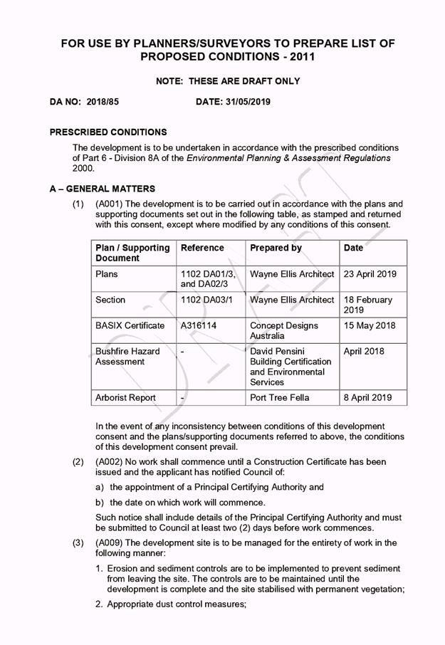
|
Attachments
1View. DA2018
- 85.1 Recommended Conditions
2View. DA2018
- 85.1 Plans.
|
|
ATTACHMENT
|
Development Assessment Panel
12/06/2019
|
|
ATTACHMENT
|
Development Assessment Panel
12/06/2019
|
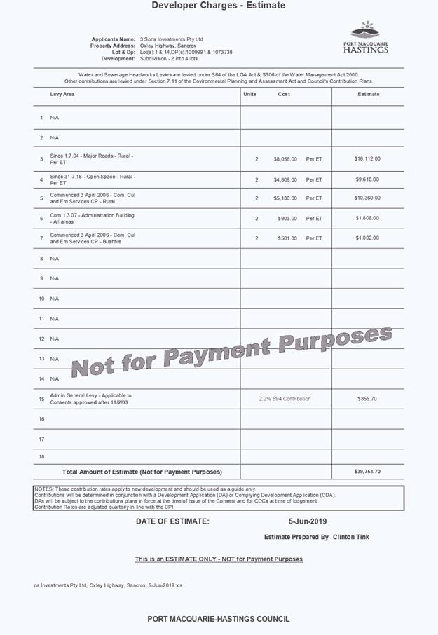
AGENDA Development Assessment Panel 12/06/2019
Item: 06
Subject: DA2018 - 131.1 - Staged 2 into 4 Lot Torrens
Title Rural Subdivision - Lot 1 DP 1009991, Sancrox Road and Lot 14 DP 1043738,
Oxley Highway, Sancrox
Report
Author: Development Assessment Planning Coordinator, Patrick
Galbraith-Robertson
|
Applicant: 3
Sons Investments Pty Ltd CARE King and Campbell Pty Ltd
Owner: 3
Sons Investments Pty Ltd
Estimated Cost: N/A
Alignment with Delivery
Program
4.3.1 Undertake transparent
and efficient development assessment in accordance with relevant legislation.
|
|
RECOMMENDATION
That
DA2018 - 131.1 for a Staged 2 into 4 lot Torrens Title rural subdivision at
Lot 1 DP 1009991, Sancrox Road and Lot 14 DP 1043738, Oxley Highway,
Sancrox be determined by granting consent subject to the recommended
conditions.
|
Executive
Summary
This
report considers a Development Application for a Staged 2 into 4 lot
rural subdivision at the subject site and provides an
assessment of the application in accordance with the Environmental Planning and
Assessment Act 1979.
Following exhibition of the application,
1 submission has been received.
This report recommends that the
development application be approved subject to conditions.
1. BACKGROUND
Existing
sites features and Surrounding development
The subject site consists of the
following lots:
· Lot 14
in DP1073738, being a vacant lot 18.77ha in size with frontage to the Oxley
Highway; and
· Lot
1 in DP1009991, being a vacant lot 143.8ha in size with frontage to both Le
Clos Sancrox Road and Sancrox Road.
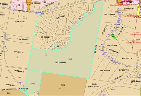
The
site has a total combined area of 162.57 hectares and both existing lots are
vacant.
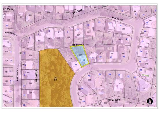
The
site is zoned RU1 Primary Production in
accordance with the Port Macquarie-Hastings Local Environmental Plan 2011, as
shown in the following zoning plan:
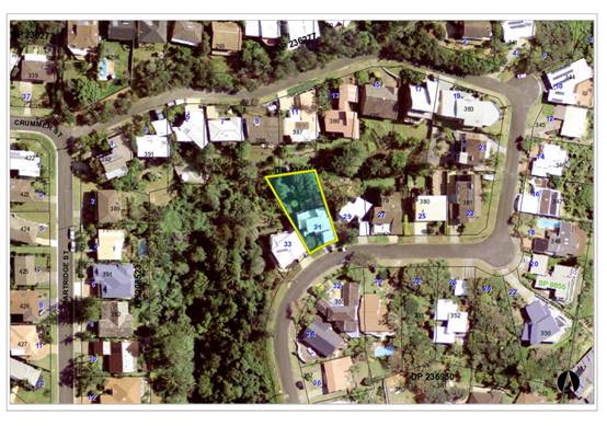
The
existing subdivision pattern and location of existing development within the
locality is shown in the following aerial photograph:
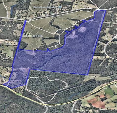
The subject site has previously
been utilised for cattle grazing and has been subject to logging activities
under Private Native Forestry (PNF) Agreements 02738 (November 2011) and 05998
(November 2017).
Existing gravel access tracks
formed as a part of the logging and fire management activities afford access to
all of the proposed building envelopes.
Application
Chronology
· 23
February 2018 - DA lodged with Council.
· 8
March 2018 - Referral of proposal to the NSW Rural Fire Service.
· 14 to 27 March 2018 - Neighbour notification of proposal.
· 4 April 2018 - Additional information requested - address
submission issues, initial ecological concerns including whether additional
tree removal proposed, and clarify likely building envelopes and extent of
bushfire risk Asset Protection Zones.
· 4 April 2018 - Site visit by assessing officer.
· 17 April 2018 - Request for further information by the NSW
Rural Fire Service.
· 20 April 2018 - Request for further information by the NSW
Rural Fire Service forwarded to the Applicant to respond to.
· 15 May 2018 - Update provided from Applicant on providing
additional information.
· 26 July 2018 - Advice received from NSW Rural Fire Service
that proposal initially determined to not support as additional information not
provided within statutory timeframe.
· 5 September 2018 - Applicant requested to provide an update
on additional information requests.
· 7 September 2018 - Applicant provided advice that they are
working on providing additional information.
· 12 November 2018 - Follow up with Applicant to provide
update on additional information requests.
· 12 November 2018 - Applicant provided advice that they are
working on providing additional information.
· 18 March 2019 - Additional information received from
Applicant including request to not charge water contributions, response to
submission issues, updated building envelopes including Asset Protection Zones,
and response to initial ecological assessment concerns raised.
· 19 March 2019 - Additional Bushfire Risk information
forwarded to the NSW Rural Fire Service to review Bushfire Safety Authority.
· 9 April 2019 - Update on assessment of additional
information provided to Applicant.
· 2 May 2019 - Update on assessment of additional information
provided to Applicant.
· 28 May 2019 - Bushfire Safety Authority received from the
NSW Rural Fire Service.
2. DESCRIPTION
OF DEVELOPMENT
Key
aspects of the proposal include the following:
· 2 into 4 lot Torrens Title subdivision
· The existing Lots comprise Lot 1 DP1009991 and Lot 14
DP1073738 which have a combined area of 162.57ha. Each of the proposed lots
shall have an area in excess of the minimum lots size (40ha) as detailed below:
Proposed Lot 1 –
42.2ha;
Proposed Lot 2 –
40ha;
Proposed Lot 3 –
40.3ha; and
Proposed Lot 4 –
40ha.
· The building envelopes and access tracks will be located in
the existing cleared areas previously utilised as log dumps and logging trails.
The existing access gate to the Oxley Highway will be maintained and utilised
to service Proposed Lot 1. Proposed Lots 2, 3 and 4 each have existing access
connections to Le Clos Sancrox Road (private road).
· This
application is proposed to be undertaken in the following stages:
Stage 1
– Boundary adjustment to create Proposed Lot 1 and Residue Lot; and
Stage 2
– Subdivision of the residue lot to create Proposed Lots 2, 3 and 4.
Refer
to attachments at the end of this report.
3. STATUTORY
ASSESSMENT
Section
4.15(1) Matters for Consideration
In
determining the application, Council is required to take into consideration the
following matters as are relevant to the development that apply to the land to
which the development application relates:
(a) The
provisions (where applicable) of:
(i) Any
Environmental Planning Instrument:
State
Environmental Planning Policy No. 44 - Koala Habitat Protection
With
reference to clauses 6 and 7, the subject land is greater than 1 hectare
(including any adjoining land under same ownership) and therefore the
provisions of SEPP must be considered.
The
Applicant has submitted a SEPP 44 Koala Habitat Protection Assessment prepared
by Naturecall Environmental. The Naturecall Environmental report concludes the
following:
· The subject site has Potential Koala Habitat due to the
co-dominance of Tallowwood over parts of the site.
· A dedicated Koala survey was carried out over the property
which consisted of standard Koala survey techniques comprising spotlighting,
call playback, diurnal searches and 23 SAT surveys.
· The spotlighting and call playback surveys carried out over
4 nights did not detect any Koalas. The diurnal searches did not observe any
Koalas.
· Koala scats were found at 5 of the 23 SAT survey sites. In
terms of activity levels, two sites scored 3.3% and three scored 6.6%.
· Based on the survey results and literature review, this
assessment has concluded that the SEPP 44 criteria to indicate that the
property currently supports a resident Koala population have not been met, and
the site therefore does not contain Core Koala Habitat. A Koala Plan of Management
is therefore not required to accompany the Development Application.
· Upon
completion of the assessment it was determined that there is insufficient
evidence to determine that the site is Core Koala Habitat as evidence of
breeding was not found, and no historical records of a koala population
associated with the site are known to exist, low numbers of koala scats were
found and there were no koalas spotted at the time of surveying.
The
Applicant has also provided additional information during the assessment of the
DA to respond to initial assessment queries with regard to the potential for
impacts of tree removal and determination as to whether the site is potential
or core koala habitat. The information submitted has been reviewed as being
satisfactory noting the following:
· It
is recognised that detection or observation of breeding females is only one
attribute to identifying the site as Core Koala habitat. As noted above,
Naturecall did not observe a ‘resident’ population of Koalas.
Evidence was detected which supports the site as being part of a home range for
potentially a single transient Koala.
· Naturecall’s
assessment included an extensive literature review of publicly available
documents and previous ecological assessments carried out over the site and
surrounding lands. This included historical and recent sightings.
· 4
nights of spotlighting (over 2 hour periods by 2 observers) as well as field
survey, diurnal searches, call playback and SAT survey were all carried out by
Naturecall as a part of the preparation of their SEPP 44 Koala habitat
assessment. The searches carried out by Naturecall were undertaken in
accordance with the accepted standards and are considered appropriate for the
site.
An
assessment of the submitted information by Council’s natural resources
staff has concluded that the site is not Core Koala Habitat. It has been
satisfactorily demonstrated that no habitat will be removed or modified. No
further investigations are required.
State
Environmental Planning Policy No.55 – Remediation of Land
Following
an inspection of the site and a search of Council records, the subject land is
not identified as being potentially contaminated and is suitable for the
intended use.
State
Environmental Planning Policy No. 62 – Sustainable Aquaculture
Given
the nature of the proposed development, the proposal will be unlikely to have
any adverse impact on existing aquaculture industries within the Hastings River
approximately 5 kilometres from the site.
State
Environmental Planning Policy (Infrastructure) 2007
The
proposed development is not considered to trigger any of the size or capacity
requirements outlined within Schedule 3 of this policy.
The
southern portion of the development site, including proposed Lot 1, has
frontage to the existing Oxley Highway which is a classified road. There is an
existing driveway access available connecting to this Highway which also
services an existing dwelling to the west.
Clause 101
of this policy aims to ensure that new development with frontage to a
classified road, such as the Oxley Highway, does not compromise the effective
or ongoing operation and function of the classified road whilst also reducing
the potential impact of traffic noise and vehicle emission on development.
In this
regard, the proposed use of the existing driveway connection to the Oxley
Highway and location of a building envelope on proposed Lot 1 is acceptable for
the following reasons:
· The
use of the existing driveway by vehicles associated with any future additional
dwelling are considered unlikely to significantly increase vehicular movements
to or from the Oxley Highway;
· The
proposed dwelling envelope for proposed Lot 1 is located on top of a ridge line
and is estimated to be elevated approximately 50 metres above the Oxley
Highway. The proposed dwelling envelope is approximately 550 metres north of
the Oxley Highway and is therefore considered to be suitably separated so as
not to be adversely affected by road or traffic noise; and
· Proposed
Lots 2, 3 and 4 are located on the northern side of the existing ridge line in
close proximity to the existing Right of Way over DP776681. Each of these lots
are therefore proposed to be accessed via the existing Right of Way before
entering Sancrox Road (local road). Lots 2, 3 and 4 will also be provided
Rights of Way over the existing internal tracks including connecting back to
the existing driveway access to the Oxley Highway in use so that they can
utilise the alternate access options in the event of an emergency such as a
Bushfire.
State
Environmental Planning Policy (Rural Lands) 2008
The following assessment table provides an assessment
against specific requirements of this SEPP:
|
Matters to be considered in determining development
applications for rural subdivisions or rural dwellings
|
|
Requirement
|
Proposed
|
Complies
|
|
10(1) This clause applies to land in a rural
zone, a rural residential zone or an environment protection zone.
10(2) A consent authority must take into account the
matters specified in subclause (3) when considering whether to grant consent
to development on land to which this clause applies for any of the following
purposes:
(a) subdivision of
land proposed to be used for the purposes of a dwelling,
(b) erection of a dwelling.
10(3) The following matters are
to be taken into account:
(a) the existing uses and
approved uses of land in the vicinity of the development,
(b) whether or not the
development is likely to have a significant impact on land uses that, in the
opinion of the consent authority, are likely to be preferred and the
predominant land uses in the vicinity of the development,
(c) whether or not the
development is likely to be incompatible with a use referred to in paragraph
(a) or (b),
(d) if the land is not
situated within a rural residential zone, whether or not the development is
likely to be incompatible with a use on land within an adjoining rural
residential zone,
(e) any measures proposed by the
applicant to avoid or minimise any incompatibility referred to in paragraph
(c) or (d).
|
· The
proposed subdivision will result in four (4) separate Torrens Title
allotments each in excess of the minimum 40-hectare allotment size. The
proposed lot sizes will ensure the protection of opportunities for potential
productive and sustainable rural activities notwithstanding the current
vegetation constraints on the site;
· The
subject site is not identified as state significant farmland (mapped as
‘other rural land’);
· The
proposed subdivision is considered unlikely to have any identifiable adverse
impacts on services or infrastructure; and
· The
proposed subdivision including proposed dwelling locations will be unlikely
to result in any identifiable landuse conflicts.
|
Yes - satisfactory
|
Port Macquarie-Hastings Local Environmental Plan 2011
The
proposal is consistent with the LEP having regard to the following:
· Clause 2.2, the subject site is zoned RU1 primary
production.
The objectives of the RU1 zone are as follows:
o To encourage sustainable primary industry
production by maintaining and enhancing the natural resource base.
o To encourage diversity in primary industry
enterprises and systems appropriate for the area.
o To minimise the fragmentation and alienation of
resource lands.
o To minimise conflict between land uses within this
zone and land uses within adjoining zones.
· Clause 2.3(2) - The proposal is consistent with the
zone objectives having regard to the following:
o the proposal is a permissible landuse;
o the proposed
subdivision will result in four (4) separate Torrens title allotments each in
excess of the minimum 40-hectare allotment size. The proposed Lot sizes will
ensure the protection of opportunities for
potential productive and sustainable rural activities notwithstanding the
current vegetation constraints on the site.
· Clause 4.1 - The lot sizes within the proposed subdivision
range from 40 hectares to 42.2 hectares. All proposed lots comply with the
minimum lot sizes identified in the Lot Size Map relating to the site.
· Clause 5.10 – Heritage. The site does not contain or
adjoin any known heritage items or sites of significance.
· Clause 7.13 - Satisfactory arrangements are in place for
provision of essential services including water supply (only if required by
future residents), electricity supply, on-site sewage management, stormwater
drainage and suitable road access to service the development. Provision of
electricity and telecommunications will be subject to obtaining satisfactory
arrangements certification prior to the issue of a Subdivision Certificate as
recommended by a condition of consent.
(ii) Any draft
instruments that apply to the site or are on exhibition:
No draft instruments apply to
the site.
(iii) Any Development
Control Plan in force:
Port
Macquarie-Hastings Development Control Plan 2013
The
proposal complies with all applicable requirements of the DCP as detailed in
the following tables:
|
DCP 2013: Chapter 3.6 - Subdivision
|
|
DCP Objective
|
Development Provisions
|
Proposed
|
Complies
|
|
3.6.3.20
|
Reticulated
water supply required to all subdivision except rural zoned areas greater
than 40 hectares.
|
Each of the proposed Lots are zoned RU1 Primary Production
and have an area of 40ha or greater. The Applicant has requested that the
subdivision not be required to be to be connected to the reticulated water
supply. This is considered acceptable noting that any future owners of the
proposed lots can still potentially connect to existing water mains in the
future subject to payment of appropriate development contributions.
|
Yes
|
|
3.6.3.41
|
A
minimum gate width of 3.6m should be provided to any property.
|
No changes to the existing gate access off the Oxley
Highway are proposed. The existing gate is 3.6 metres
wide and will service proposed Lot 1. Proposed Lots 2, 3
and 4 will be accessed by existing frontage to Le Clos
Sancrox Road.
|
Yes
|
|
Land
with a slope greater than 15 degrees is not to be proposed for house
construction or effluent disposal.
|
The proposed building envelopes do not contain slopes
greater than 15 degrees. It is considered that each of the proposed building
envelopes is large enough to contain any necessary on-site effluent disposal
system.
|
Yes
|
|
Unless
created under clause 4.2 of LEP 2011 or clause 9 of SEPP (Rural Lands) 2008,
lots in rural areas should:
• have an identified building
platform for a dwelling house.
• have appropriate area and
dimensions for the siting and construction of a dwelling and any ancillary
outbuildings.
• have a gate installed for the
driveway.
• demonstrate that an
environmentally sensitive, 2-wheel drive standard access can be located
between the driveway (referred to above) and the nominated building platform
on each lot and in accordance with Council’s adopted design
specifications.
• have a sealed driveway,
constructed from the road to 3m inside the property boundary.
• have access to a public road that is
readily upgraded to all weather two-wheel drive standard;
• comply with bushfire guidelines;
• be above Q100 flood level and has
high level road and/or pedestrian access to land above probable maximum flood
level;
• have adequate solar access;
• not impact on rural activities on
nearby land.
|
- The proposed subdivision identifies a building envelope
(platform) for each of the proposed allotments;
- The proposed building envelopes are considered
suitable for the purposes of containing a dwelling house
and any ancillary outbuildings;
- No changes to the existing gate to the Oxley Highway is
proposed as a part of this
application;
- The existing gate access to the Oxley Highway is
proposed to be maintained and contains a gravel surface to the building
envelope on
Proposed Lot 1. It is noted that the existing gravel
tracks throughout the site have been
utilised as a part of the Private Native Forestry
agreement.
- The proposed subdivision is considered to comply with
the bushfire guidelines
- The subject site is not identified as flood prone
land;
- Each of the proposed allotments exceed 40
hectares and are considered to allow suitable
solar access to each of the proposed building
envelopes.
|
Yes
|
|
Where
access is on a right of way over another property, the maximum number of
allotments that may share in the above right of way access arrangements is 2.
|
The land has frontage to the Oxley Highway, Sancrox
Road and Le Clos Sancrox Road (private road). Access over
Le Clos Sancrox Road (also identified as Lot 51 in DP776681) is via a RoW 20
and 30 wide and variable widths.
This RoW was established to accommodate a large
number of allotments within the Le Clos Sancrox estate,
including the subject land. It is therefore considered
that
access over the RoW is appropriate for the proposed
subdivision and is consistent with the intention for which
the RoW was created.
|
Yes
|
|
3.6.3.42
|
Lot
boundaries should be suitably located taking into the relevant criteria slope
of the land:
• natural boundaries;
• existing fencing and paddock
structure;
• protection of natural or
cultural features;
• site environmental constraints;
• retention of special features such as
trees and scenic topographical features.
|
The proposed boundaries ensure that each allotment
contains areas are consistent with the minimum 40ha lot
size whilst also acknowledging existing features,
including ridgelines, depressions and creeks/gullies. The
proposed subdivision is therefore considered able to be
suitably fenced (in locations where fencing does not currently exist) without
adversely impacting any natural features.
|
Yes
|
|
DCP 2013: General Provisions
|
|
DCP Objective
|
Development Provisions
|
Proposed
|
Complies
|
|
2.7.2.2
|
Design addresses generic principles of Crime Prevention
Through Environmental Design guideline:
§ Casual surveillance and
sightlines
§ Land use mix and activity
generators
§ Definition of use and ownership
§ Lighting
§ Way finding
§ Predictable routes and entrapment
locations
|
No adverse crime risk potential identified noting the
proposed lots are large rural lots.
|
Yes
|
|
2.3.3.8 onwards
|
Removal of hollow bearing trees
|
No tree removal proposed
|
N/A
|
|
2.6.3.1
|
Tree removal (3m or higher with 100mm diameter trunk and
3m outside dwelling footprint
|
No tree removal proposed
|
N/A
|
|
2.4.3
|
Bushfire risk, Acid sulphate soils, Flooding,
Contamination, Airspace protection, Noise and Stormwater
|
Refer to main body of report.
|
|
|
2.5.3.2
|
New accesses not permitted from arterial or distributor
roads. Existing accesses rationalised or removed where practical
|
No changes to the existing gate access off the Oxley
Highway are proposed.
|
Yes
|
|
2.5.3.11
|
Section 94 contributions
|
Refer to main body of report.
|
|
(iiia) Any planning agreement that has
been entered into under section 7.4, or any draft planning agreement that a
developer has offered to enter into under section 7.4:
No planning agreement has been
offered or entered into relating to the site.
(iv) Any
matters prescribed by the Regulations:
N/A
(a)(v) Any Coastal Zone
Management Plan
No Coastal Zone Management Plan
applies to the subject site.
(b) The likely
impacts of that development, including environmental impacts on both the
natural and built environments, social and economic impacts in the locality:
Context
and Setting
The
proposal will be unlikely to have any adverse impacts to existing adjoining
properties or the public domain.
The
proposal is considered to be consistent with other existing development in the
locality and adequately addresses planning controls for the area.
Roads
The
site has road frontage to Sancrox Road, Le Clos Sancrox Road and the Oxley
Highway.
The Oxley Highway and Sancrox
Road are all-weather, bitumen sealed two-wheel drive public roads which service
as main connecting roads within the locality.
Adjacent
to the site, Le Clos Sancrox Road is a sealed private road under the care and
control of the owners. Le Clos Sancrox Road is a local road with a 5m
road formation within a 20m road reserve.
Traffic
and Transport
The
site is currently vacant land. This development is unlikely to have any adverse
impacts to the existing road network within the immediate locality.
Site
Frontage & Access
Vehicle
access to the site for proposed Lot 2, 3 and 4 is proposed through individual
handles to the Le Clos Sancrox private road. Vehicle access to proposed Lot 1
is proposed via the existing gated access connecting to the Oxley Highway.
Access shall comply with Council AUSPEC and Australian Standards, and
conditions have been imposed to reflect these requirements.
The
existing access connection to the Oxley Highway is proposed to be maintained
and utilised as the primary access point for proposed Lot 1. It will also act
as the emergency access point for proposed Lots 2, 3 and 4. The gravel access
driveway to the building envelope of Proposed Lot 1 has recently been utilised
by logging trucks to remove logs and is therefore of a width and grade suitable
for vehicular access.
Proposed
Lots 2, 3 and 4 have existing vehicular connection to Le Clos Sancrox Road
which is identified as Lot 51 DP776681. Lot 1 DP1009991 maintains a Right of
Way over Lot 51 thereby providing access to Sancrox Road.
No vegetation
is therefore required to be removed in order to access the proposed building
envelopes.
It is
also proposed to provide reciprocal rights of access over the existing tracks
in use internally to ensure that the future dwellings within the proposed
building envelopes will be afforded with legal egress options in the case of
emergencies.
Water
Supply Connection
Council’s records indicate
that the development site does not currently have a water meter. There is an
existing 100mm PVC water main that runs along the western side of lots 2, 3
& 4. There is a 300mm PVC water main on the southern side of Lot 1.
The Applicant has requested that
the subdivision not be required to be to be connected to the reticulated water
supply. This is considered acceptable noting that any future owners of the
proposed lots can still potentially connect to existing water mains in the
future. Any application for a water meter will
include the costs associated with a water service and water meter in addition
to applicable Section 64 contributions. An appropriate restriction as to user
is recommended to be imposed on the proposed Lots to identify this for future
landowners.
Stormwater
The
site naturally grades towards the Le Clos Sancrox Road, Oxley Highway and
Sancrox Road street frontages and is currently serviced via an existing rural
road drainage.
The
legal point of discharge for the proposed development is defined as the Le Clos
Sancrox Rd and Sancrox Rd.
Other
Utilities
Telecommunication
and electricity services are capable of being provided to the site subject to
satisfactory arrangements certifications being obtained from appropriate
providers prior to issue of a Subdivision Certificate. A standard condition is
recommended in this regard.
Heritage
Following
a site inspection (and a search of Council records), no known items of
Aboriginal or European heritage significance exist on the property. No adverse
impacts anticipated.
Other
land resources
The
proposed subdivision will not sterilise any significant mineral or agricultural
resource.
Water
cycle
The
proposed development will be unlikely to have any adverse impacts on water
resources and the water cycle.
Soils
The
proposed development will be unlikely to have any adverse impacts on soils in
terms of quality, erosion, stability and/or productivity.
Air
and microclimate
The
construction and/or operations of the proposed development will be unlikely to
result in any adverse impacts on the existing air quality or result in any
pollution. Standard precautionary site management condition recommended.
Flora
and fauna
This Development Application has
been lodged under the transitional arrangements outlined within the Biodiversity
Conservation (Savings and Transitional) Regulation 2017. The application
shall be assessed with respect to the provisions of the Threatened Species
Conservation Act 1995.
Construction
of the proposed development will not require any removal/clearing of any
significant vegetation and therefore will be unlikely to have any significant
adverse impacts on biodiversity or threatened species of flora and fauna.
Section 5A of the Act is considered to be satisfied.
Waste
Satisfactory
arrangements are in place for proposed storage and collection of waste and
recyclables noting that the proposed lots are rural lots. No adverse impacts
anticipated.
Energy
No
adverse energy impacts anticipated.
Bushfire
The
site is identified as being bushfire prone.
Since the
lodgement of the application the Applicant has undertaken a detailed survey of
the proposed building envelopes. The attached sketch plans to this report
detail the location of the cleared envelopes as well as the surveyed edge of
vegetation. Sufficient cleared areas are available to accommodate a building
envelope for future dwellings and required Asset Protection Zones (APZs)
without requiring vegetation removal.
In
accordance with Section 100B - Rural Fires Act 1997 - the application
proposes: subdivision of bush fire prone land that could lawfully be used for
residential or rural residential purposes.
The
Applicant has submitted a bushfire report prepared by a David Pensini -
Building Certification and Environmental Services. The report assumes that
proposed subdivision will occur and has carried out an assessment under Section
100B requirements.
In
this regard the proposal has been referred to the NSW Rural Fire Service and a
Bushfire Safety Authority has been granted subject to conditions. The
conditions will be recommended to be complied with as part of the recommended
conditions of consent.
Social impacts in the locality
Given the nature of the proposed development and its’
location the proposal is unlikely to result in any adverse social impacts.
Economic impact in the locality
No adverse economic impacts identified.
Site design and internal design
The proposed subdivision design satisfactorily responds to
the site attributes and will fit into the locality. No adverse impacts likely.
Cumulative impacts
The proposed development is not expected to have any adverse
cumulative impacts on the natural or built environment or the social and
economic attributes of the locality.
(c) The
suitability of the site for the development:
The proposal will fit into the
locality and the site attributes are conducive to the proposed development.
Site constraints of bushfire
risk has been adequately addressed and appropriate conditions of consent
recommended.
(d) Any
submissions made in accordance with this Act or the Regulations:
One (1) written
submission has been received following public exhibition of the application.
Key
issues raised in the submission received and comments in response to these
issues are provided as follows:
|
Submission Issue/Summary
|
Planning Comment/Response
|
|
The proposal is relying upon emergency exits from
proposed Lots 2, 3 and 4 to a private road between house lots within the Le
Clos Sancrox locality and via an existing right of way along that private
road to Sancrox Road.
|
The
Applicant has detailed and confirmed that the existing access connection to
the Oxley Highway is proposed to be maintained and utilised as the primary
access point for proposed Lot 1. It will also act as the emergency access
point for proposed Lots 2, 3 and 4. The gravel access driveway to the
building envelope of Proposed Lot 1 has recently been utilised by logging
trucks to remove logs and is therefore of a width and grade suitable for
vehicular access.
Proposed
Lots 2, 3 and 4 have existing vehicular connection to Le Clos Sancrox Road
which is identified as Lot 51 DP776681. Lot 1 DP1009991 maintains a Right of
Way over Lot 51 thereby providing access to Sancrox Road. No vegetation is
therefore required to be removed in order to access the proposed building
envelopes.
It is
also proposed to provide reciprocal rights of access over the existing tracks
in use internally to ensure that the future dwellings within the proposed
building envelopes will be afforded with legal egress options in the case of
emergencies.
Use of
the existing access private road is permitted and unable to be used as a
reason for refusal to the application.
|
|
Ongoing
maintenance of the private road to Sancrox Road is no longer certain.
|
|
The
long term status of the private road to Sancrox Road is dependent upon the
outcome of the Le Clos Sancrox land being considered in the Council’s
Urban Growth Management Strategy 2036.
|
(e) The
Public Interest:
The proposed development
satisfies relevant planning controls and is unlikely to impact on the wider
public interest.
4. DEVELOPMENT
CONTRIBUTIONS APPLICABLE
· The
Applicant has requested that the subdivision not be required to be to be
connected to the reticulated water supply. This is considered acceptable noting
that any future owners of the proposed lots can still potentially connect to
existing water mains in the future subject to payment of Development contributions towards augmentation of town
water supply head works under Section 64 of the Local Government Act 1993.
· Development contributions will be required for two (2) of
the four (4) proposed lots under Section 7.11 of the Environmental Planning and
Assessment Act 1979 towards roads, open space, community cultural services,
emergency services and administration buildings.
· It should be noted that following a detailed assessment of
the DA it has been identified that both of the two (2) existing Lots - Lot 1 DP
1009991 and Lot 14 DP 1073738 enjoy dwelling entitlements under the Port
Macquarie-Hastings Local Environmental Plan 2011. In this regard contributions
credits apply to these existing lots which can be transferred to two (2) of the
four (4) lots:
- Section 7.11 contributions
credit only for existing Lot 14 DP 1073738
- Section 7.11 and Section
64 water supply contributions credit apply to Lot 1 DP 1009991.
A
contributions estimate has been prepared and attached to this report.
5. CONCLUSION
AND STATEMENT OF REASON
The application has been assessed in accordance with Section
4.15 of the Environmental Planning and Assessment Act 1979.
Issues raised during assessment and public exhibition of the
application have been considered in the assessment of the application. Where
relevant, conditions have been recommended to manage the impacts attributed to
these issues.
The site is considered suitable for the proposed development
and the proposal adequately addresses relevant planning controls. The
development is not considered to be contrary to the public's interest and will
not result a significant adverse social, environmental or economic impact. It
is recommended that the application be approved, subject to the recommended
conditions of consent provided in the attachment section of this report.
|
Attachments
1View. DA
2018 - 131.1 Recommended Conditions
2View. DA2018 - 131.1 Building
Envelopes (Excluded from Agenda)
3View. DA2018
- 131.1 Draft DP
4View. DA2018
- 131.1 Bushfire Safety Authority
5View. DA2018
- 131.1 Contributions Estimate
|
|
ATTACHMENT
|
Development Assessment Panel
12/06/2019
|
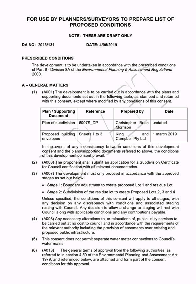
|
ATTACHMENT
|
Development Assessment Panel
12/06/2019
|
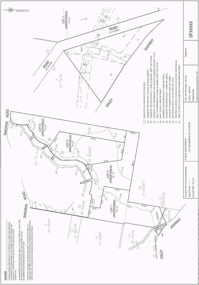
|
ATTACHMENT
|
Development Assessment Panel
12/06/2019
|
|
ATTACHMENT
|
Development Assessment Panel
12/06/2019
|