Development
Assessment Panel
Business
Paper
|
date of meeting:
|
|
Wednesday 19 April
2023
|
|
location:
|
|
Port
Macquarie-Hastings Council
17 Burrawan Street,
Port Macquarie
Function Room
|
|
time:
|
|
2:00pm
|
 DEVELOPMENT ASSESSMENT PANEL SUB COMMITTEE CHARTER
Adopted: Ordinary
Council 2022 09 15
1.0
OBJECTIVES
To assist in managing
Council's development assessment function by providing independent, transparent and expert determinations of development applications that fall outside
of staff delegations.
2.0
KEY FUNCTIONS
·
To review development application reports and conditions. The focus of the Panel’s review is to be on those issues raised in submissions received following exhibition of development applications;
·
To determine
development applications
where there are 3 or more unique
submissions or where an
application is outside of staff delegations;
·
To refer development applications to Council for determination where
necessary;
·
To provide a forum for objectors
and applicants to make submissions on applications before the
Development Assessment Panel(DAP);
·
To maintain transparency in the determination of development applications.
Delegated Authority of Panel
Pursuant to Section 377 of the Local Government Act, 1993 delegation to:
·
Determine (approve
or refuse) development applications under Part 4 of the Environmental Planning and Assessment Act 1979 having regard to the relevant
environmental planning instruments, development control plans and Council
policies.
·
Vary, modify or release
restrictions as to use and/or covenants created
by Section 88B instruments under the Conveyancing Act 1919 in relation to development applications being considered by the panel.
·
Determine Koala Plans of Management under State Environmental Planning Policy (Biodiversity and Conservation) 2021 associated with development applications being considered by the
Panel.
Noting the trigger to escalate decision
making to Council
as highlighted in section 5.2.
3.0 MEMBERSHIP
3.1 Voting Members
·
3 independent
external members will be selected for each scheduled DAP meeting from an
appointed pool of members. One of the independent external
members to be the
Chairperson. Independent members will be rostered onto meeting on a rotational
basis where possible.
·
Group Manager
Development Services (alternate - Director Community, Planning and Environment or Development Assessment Planning Coordinator).
The independent external
members shall have expertise in one or more of the following areas: planning,
architecture, heritage, the environment, urban
design, economics, traffic
and transport, law, engineering,
government and public administration.
3.2 Non-Voting Members Not applicable.
3.3 Obligations of members
·
Members must act faithfully and diligently and in accordance with this Charter.
·
Members must comply with Council's Code of Conduct.
·
Except as required to properly perform
their duties, DAP members must not disclose
any confidential information
(as advised by Council) obtained in connection with the DAP functions.
·
Members will have read and be familiar with the documents
and information provided
by Council prior to attending
a DAP meeting.
·
Members must act in accordance with Council's Workplace Health and Safety
Policies and Procedures
·
External members
of the Panel are not authorised to speak to the media on behalf of Council. Council officers that are members
of the Committee are bound by the
existing operational delegations in relation to speaking to media.
3.4 Member Tenure
The independent external
members will be appointed for the term of 4 years or until such time as an
expression of interest process to source panel members is completed for the proceeding 4 year term.
3.5 Appointment of members
·
A pool of independent external
members (including the Chair) shall be appointed by the Chief Executive Officer
following an external
Expression of Interest
process. Previous Panel members are eligible to be reappointed on the
Panel following this expression of interest process.
·
Independent members will be rostered on to Panel meetings on a rotational basis where possible
to suit Panel member availability and Panel operational needs.
·
Staff members on the Panel shall be appointed
by the Chief Executive Officer.
4.0
TIMETABLE OF MEETINGS
·
The Development Assessment Panel will generally meet on the 1st and 3rd Wednesday each month at 2.00pm
at the Port Macquarie offices of Council.
Meetings may be conducted on-line or a combination of in person and on-line.
·
Special Meetings
of the Panel may be convened by the Director
Community, Planning and Environment Services with 3 days
notice.
5.0 MEETING
PRACTICES
5.1 Meeting Format
·
At all Meetings of the Panel the Chairperson shall occupy the Chair and preside. The Chair will be
responsible for keeping order at meetings.
·
Meetings shall be open to the public.
·
The Panel will hear from an applicant and objectors or their representatives. Speakers are required to register to speak by close of
business on the day prior to the Panel meeting.
·
The Panel shall have the discretion to ask the applicant and objectors questions
relating to the proposal and their submission. There
is no ‘right of reply’ for an objector or applicant.
·
Where there are a
large number of persons making submissions with common interests, the Panel
shall have the discretion to hear a representative of those persons
rather than multiple
persons with the same interest.
Council assessment staff will be available at Panel meetings
to provide technical
assessment advice and
assistance to the Panel.
·
Where considered necessary, the Panel will conduct site inspections prior to the meeting.
5.2 Decision Making
·
Decisions are to be made by consensus. Where consensus is not possible
on any item, that item is
to be referred to Council for a decision.
·
All development applications involving a proposed variation to a development standard greater than 10% under Clause 4.6 of the Local
Environmental Plan will be
considered by the Panel and recommendation made to the Council for a decision.
5.3 Quorum
3 members
must be present
at a meeting to form a quorum.
5.4 Chairperson and Deputy Chairperson Independent Chair (alternate - independent member).
5.5 Secretariat
·
The Director
Community, Planning and Environment is to be responsible for ensuring that the
Panel has adequate secretariat support. The secretariat will ensure that the
business paper and supporting papers
are circulated at least
3 days prior to each meeting. Minutes
shall be appropriately approved and circulated to
each member within 3 weeks of a meeting being held.
·
The format
of and the preparation and publishing of the Business
Paper and Minutes
shall be similar to the format for Ordinary Council
Meetings.
5.6 Recording of decisions
Minutes will be limited
to the recording of decisions
of the DAP and how each member
votes for each item
before the Panel. Meetings may be recorded via an on-line platform where
practical.
6.0
CONVENING OF “OUTCOME SPECIFIC” WORKING GROUPS
Not applicable.
7.0
CONFIDENTIALITY AND CONFLICT
OF INTEREST
·
Members of the
Panel must comply with Council’s Code of Conduct. It is the personal
responsibility of members to comply with the standards in the Code of Conduct
and regularly review their
personal circumstances with this in mind.
8.0
Panel members
must declare any conflict of interest at the start of each meeting or before
discussion of a relevant item or topic. Details of any conflicts of interest
are to be appropriately minuted. Where members are deemed to have a real or
perceived conflict of interest, it may be appropriate they be excused
from deliberations on the issue where the conflict of interest may exist.
A Panel meeting may be postponed where there is no quorum. LOBBYING
All members and applicants are to adhere
to Council’s Lobbying
policy. Outside of scheduled Development Assessment Panel meetings,
applicants, their representatives, Councillors, Council staff and the general
public are not to lobby Panel members via meetings, telephone conversations,
correspondence and the like. Adequate opportunity will be provided at Panel
inspections or meetings for applicants, their representatives and the general
public to make verbal submissions in relation to Business Paper items.
9.0
CONDUCT AT MEETINGS
All parties in attendance at a DAP meeting shall conduct
themselves respectfully i.e. not disrupt the conduct of the meeting, interject,
act courteously and with compassion and empathy and sensitivity and will not insult, denigrate
or make defamatory or personal
reflections on or impute improper
motives to the DAP, Council staff or other members of
the public.
Development Assessment Panel
ATTENDANCE
REGISTER
|
Member
|
18/01/23
|
15/02/23
|
01/03/23
|
15/03/23
|
05/04/23
|
|
David Crofts
(Independent Chair)
|
P
|
P
|
P
|
|
P
|
|
Chris Gee
(Independent Member)
|
P
|
P
|
P
|
P
|
P
|
|
Michael Mason
(Independent Member)
|
|
|
P
|
P
|
P
|
|
Dan Croft
(Group Manager
Development Services)
|
|
P
|
P
|
P
|
P
|
|
Tony McNamara
(Independent Member)
|
|
P
|
|
P
|
|
|
Other attendees
|
|
|
|
|
|
|
Mayor Peta Pinson
|
|
|
|
P
|
P
|
|
Grant Burge
(Development Engineering
Coordinator)
|
P
|
|
P
|
P
|
P
|
|
Kerrod Franklin
(Acting Development
Engineering Coordinator)
|
|
|
|
|
|
|
Patrick
Galbraith-Robertson
(Development Planning
Coordinator)
|
P
|
|
P
|
|
|
|
Steven Ford
(Development Assessment
Planner)
|
P
|
|
|
P
|
P
|
|
Chris Gardiner
(Development Assessment
Planner)
|
|
|
|
|
P
|
|
Vanessa Penfold
(Development Assessment Planner)
|
|
|
|
P
|
|
|
Clinton Tink
(Development Assessment
Planner)
|
|
|
|
|
P
|
|
Jon Power
(Act Development Engineer
Coordinator)
|
|
|
|
|
|
|
Beau Spry
(Development Assessment
Planner)
|
|
|
|
|
|
|
Ben Roberts
(Development Assessment
Planner)
|
|
P
|
|
|
|
|
Councillor Josh Slade
|
|
|
|
|
|
|
Councillor Sharon
Griffiths
|
|
|
|
|
|
|
Kate Kennedy
(Building Surveyor)
|
|
|
|
|
|
|
Warren Wisemantel
|
|
|
|
|
|
|
Deputy Mayor Adam Roberts
|
|
|
|
|
|
|
Bob Slater
(Development Assessment
Planner)
|
|
|
|
|
|
|
Alton Dick
(Stormwater Engineer)
|
|
|
|
|
|
Key: P = Present, A
= Absent With Apology X = Absent Without Apology
Development
Assessment Panel
Meeting Dates for
2023
|
18/01/2023
|
Function Room
|
2.00pm
|
|
01/02/2023
|
Function Room
|
2.00pm
|
|
15/02/2023
|
Function Room
|
2.00pm
|
|
01/03/2023
|
Function Room
|
2.00pm
|
|
15/03/2023
|
Function Room
|
2.00pm
|
|
05/04/2023
|
Function Room
|
2.00pm
|
|
19/04/2023
|
Function Room
|
2.00pm
|
|
03/05/2023
|
Function Room
|
2.00pm
|
|
17/05/2023
|
Function Room
|
2.00pm
|
|
07/06/2023
|
Function Room
|
2.00pm
|
|
21/06/2023
|
Function Room
|
2.00pm
|
|
05/07/2023
|
Function Room
|
2.00pm
|
|
19/07/2023
|
Function Room
|
2.00pm
|
|
02/08/2023
|
Function Room
|
2.00pm
|
|
16/08/2023
|
Function Room
|
2.00pm
|
|
06/09/2023
|
Function Room
|
2.00pm
|
|
20/09/2023
|
Function Room
|
2.00pm
|
|
04/10/2023
|
Function Room
|
2.00pm
|
|
18/10/2023
|
Function Room
|
2.00pm
|
|
01/11/2023
|
Function Room
|
2.00pm
|
|
15/11/2023
|
Function Room
|
2.00pm
|
|
06/12/2023
|
Function Room
|
2.00pm
|
Development
Assessment Panel Meeting
Wednesday 19 April
2023
Items of Business
01 Acknowledgement
of Country........................................................................... 10
02 Apologies........................................................................................................ 10
03 Confirmation
of Minutes................................................................................... 10
04 Disclosures
of Interest..................................................................................... 15
05 DA2022
- 774.1 48 Lot Industrial Subdivision and Associated Infrastructure including
Clause 4.6 Variation to Clause 4.1 (Minimum Subdivision Lot Size) of the Port
Macquarie-Hastings Local Environmental Plan 2011, Lot 36 DP 1292179, Waapangal
Road Thrumster....... 20
06 DA2022
- 1071.1 Secondary Dwelling at Lot 73 DP 814922, No.18 Coucal Close, Port
Macquarie...................................................................................................................... 71
07 DA2022
- 933.1 Centre-based child care facility at Lot 13 DP 262597, No. 15 Kulai
Place, Port Macquarie..................................................................................................... 105
08 General
Business
Development Assessment Panel
19/04/2023
Subject: ACKNOWLEDGEMENT
OF COUNTRY
"I acknowledge that we are
gathered on Birpai Land. I pay respect to the Birpai Elders both past and
present. I also extend that respect to all other Aboriginal and Torres Strait
Islander people present."
RECOMMENDATION
That the apologies received be
accepted.
Subject: CONFIRMATION
OF PREVIOUS MINUTES
Recommendation
That the Minutes of the Development Assessment Panel Meeting
held on 5 April 2023 be confirmed.
MINUTES
Development Assessment Panel Meeting
05/04/2023
PRESENT
Members:
David Crofts (Independent Chair)
Chris Gee (Independent Member)
Michael Mason (Independent Member)
Dan Croft Group Manager
Development Services
Other Attendees:
Mayor Peta Pinson
Grant Burge (Development
Engineering Coordinator)
Steven Ford (Development
Assessment Planner)
Chris Gardiner (Development
Assessment Planner)
Clinton Tink (Development
Assessment Planner)
|
The meeting opened at 2.00pm.
|
|
01 ACKNOWLEDGEMENT
OF COUNTRY
|
|
The
Acknowledgement of Country was delivered.
|
|
03 CONFIRMATION
OF MINUTES
|
|
CONSENSUS:
That the Minutes of the
Development Assessment Panel Meeting held on 15 March 2023 be confirmed.
|
|
04 DISCLOSURES
OF INTEREST
|
|
There were no disclosures of interest presented.
|
|
05 DA2021 - 894.1
Staged Additions to Racecourse Comprising Horse Stables and Walkers at Lot
653 DP 43940, No.15 Tulloch Road, Port Macquarie
|
|
Speakers:
Maxine Godbolt (opposing the
application)
Darren McCudden (opposing the
application)
Brad Maggs (opposing the
application)
Andrew Lister (applicant)
Wayne Evans (applicant)
George Jenner (applicant)
CONSENSUS
That DA2021 - 894.1 for staged additions to racecourse comprising horse
stables and walker yards at Lot 653, DP 43940,
15 Tulloch Road, Port Macquarie, be
determined by granting consent subject to the
following changes to conditions of consent:
·
Delete condition E(12)
·
Additional condition in Section B of the consent to read:
‘Prior to the issue of a Construction Certificate for Stage 3 and
onwards, an updated acoustic assessment is to be undertaken by a suitably
qualified consultant, be submitted to and approved by Council. The assessment
is to demonstrate that the facility is operating in compliance with the
findings of the original acoustic assessment criteria and is to confirm that
future stages are still capable of complying. Where compliance is not
achieved or not capable of being achieved for future stages, a modification
application is required to be submitted to Council to determine and implement
appropriate acoustic treatments, including possible acoustic fencing.’
|
|
06 DA2022 - 364.1
Demolition of Dwelling and Construction of Residential Flat Building
including Clause 4.6 Variation to Clause 4.3 (Height of Building) &
Strata Subdivision, Lot 200 DP 1289768, No. 30 Waugh Street, Port Macquarie
|
|
Speakers:
Ann
Blythe (opposing the application)
Jonathon
Phillips (applicant)
CONSENSUS:
That DA 2022 - 364.1 for Demolition of Dwelling and Construction of
Residential Flat Building including Clause 4.6 variation to Clause 4.3
(Height of Building) under Port Macquarie Local Environmental Plan 2011 &
Strata Subdivision at Lot 200, DP 1289768, No. 30 Waugh Street, Port
Macquarie, be determined by granting consent
subject to the following changes to
conditions of consent:
·
Additional condition in Section B of the consent to read:
‘Prior to the issue of Construction Certificate, the plans are to be
amended and submitted to Council for approval to provide for the following:
1. Bicycle
rack at the frontage of the development.
2. More
substantial trees in the landscaping plans along the frontage of the
development.
3. Improved
security to the building entry.
4. Electrical
infrastructure in the basement to enable the installation of electric vehicle
charging points.’
|
|
07 DA2019 - 934.1
Caravan Park at Lot 5 DP 524972 Parklands Close, Port Macquarie
|
|
Speakers:
Kimberley
McKenna (opposing the application)
Mark
Robertson (opposing the application)
Samantha
Johnston (opposing the application)
Jan
Stone (opposing the application)
Ian
Stone (opposing the application)
Susan
Blake (applicant)
Karl
Robertson (applicant)
A submission from Maria Paola
Torti was tabled at the meeting.
CONSENSUS:
That DA2019 - 934.1 for a Caravan Park at
Lot 5, DP 524972, Parklands Close, Port
Macquarie, be determined by granting deferred
commencement consent subject to the recommended conditions and the following
being satisfied within 2 years of the date of the consent:
1. The
proponent shall submit to Council evidence that the extension of Wandella
Drive and internal access road approved under development consent DA2019 -
227 have been completed to the satisfaction of the roads authority (for works
in Wandella Drive) and the Principal Certifying Authority (for works within
the site).
Be determined by granting deferred commencement consent
subject to the following
changes to conditions of consent
1. Amend
condition G4 to read: ‘Any exterior lighting
on the site shall be designed and installed so as not to cause a nuisance or
adverse impact on the amenity of the surrounding
area by light overspill. The lighting shall be the minimum level of
illumination necessary for safe operation and must be designed, installed and
used in accordance with AS 4282 control of the obtrusive effects of outdoor
lighting. No flashing, moving or intermittent
lighting is permitted on the site. Within 3 months of operating the caravan
park, certification is to be provided to Council by a suitably qualified
consultant confirming that lighting on the site complies with AS4282.’
2. Additional
condition in Section G to read: ‘Use of the community building is to be
restricted to be between the hours of 7am to 10pm daily.’
|
|
The meeting closed at 4.40pm.
|
Development Assessment Panel
19/04/2023
Subject: DISCLOSURES
OF INTEREST
RECOMMENDATION
That Disclosures of Interest be presented
DISCLOSURE OF INTEREST
DECLARATION
|
Name of Meeting:
|
|
Meeting
Date:
|
|
Item
Number:
|
|
Subject:
|
|
I,
the undersigned, hereby declare the following interest:
Pecuniary:
 Take no part
in the consideration and voting and be out of sight of the meeting. Take no part
in the consideration and voting and be out of sight of the meeting.
Non-Pecuniary
– Significant Interest:
Take no part
in the consideration and voting and be out of sight of the meeting.
Non-Pecuniary
– Less than Significant Interest:
May
participate in consideration and voting.
|
|
For
the reason that:
|
|
Name:
Signed:
|
Date:
|
|
Please submit to the
Governance Support Officer at the Council Meeting.
|
 (Refer
to next page and the Code of Conduct)
(Refer
to next page and the Code of Conduct)
Pecuniary Interest
4.1
A pecuniary interest is an interest
that you have in a matter because of a reasonable likelihood or expectation of
appreciable financial gain or loss to you or a person referred to in clause
4.3.
4.2
You will not have a pecuniary
interest in a matter if the interest is so remote or insignificant that it
could not reasonably be regarded as likely to influence any decision you might
make in relation to the matter, or if the interest is of a kind specified in
clause 4.6.
4.3
For the purposes of this Part, you
will have a pecuniary interest in a matter if the pecuniary interest is:
(a)
your interest, or
(b)
the interest of your spouse or de
facto partner, your relative, or your partner or employer, or
(c)
a company or other body of which
you, or your nominee, partner or employer, is a shareholder or member.
4.4
For the purposes of clause 4.3:
(a)
Your “relative” is any
of the following:
(b)
“de facto partner” has
the same meaning as defined in section 21C of the Interpretation Act 1987.
4.5
You will not have a pecuniary
interest in relation to a person referred to in subclauses 4.3(b) or (c)
(a)
if you are unaware of the relevant
pecuniary interest of your spouse, de facto partner, relative, partner,
employer or company or other body, or
(b)
just because the person is a member
of, or is employed by, a council or a statutory body, or is employed by the
Crown, or
(c)
just because the person is a member
of, or a delegate of a council to, a company or other body that has a pecuniary
interest in the matter, so long as the person has no beneficial interest in any
shares of the company or body.
Non-Pecuniary
5.1
Non-pecuniary interests are private
or personal interests a council official has that do not amount to a pecuniary
interest as defined in clause 4.1 of this code. These commonly arise out of
family or personal relationships, or out of involvement in sporting, social,
religious or other cultural groups and associations, and may include an
interest of a financial nature.
5.2
A non-pecuniary conflict of
interest exists where a reasonable and informed person would perceive that you
could be influenced by a private interest when carrying out your official
functions in relation to a matter.
5.3
The personal or political views of
a council official do not constitute a private interest for the purposes of
clause 5.2.
5.4
Non-pecuniary conflicts of interest
must be identified and appropriately managed to uphold community confidence in
the probity of council decision-making. The onus is on you to identify any
non-pecuniary conflict of interest you may have in matters that you deal with,
to disclose the interest fully and in writing, and to take appropriate action
to manage the conflict in accordance with this code.
5.5
When considering whether or not you
have a non-pecuniary conflict of interest in a matter you are dealing with, it
is always important to think about how others would view your situation.
Managing non-pecuniary conflicts of interest
5.6
Where you have a non-pecuniary
conflict of interest in a matter for the purposes of clause 5.2, you must
disclose the relevant private interest you have in relation to the matter fully
and in writing as soon as practicable after becoming aware of the non-pecuniary
conflict of interest and on each occasion on which the non-pecuniary conflict
of interest arises in relation to the matter. In the case of members of council
staff other than the Chief Executive Officer, such a disclosure is to be made
to the staff member’s manager. In the case of the Chief Executive Officer,
such a disclosure is to be made to the mayor.
5.7
If a disclosure is made at a
council or committee meeting, both the disclosure and the nature of the
interest must be recorded in the minutes on each occasion on which the
non-pecuniary conflict of interest arises. This disclosure constitutes
disclosure in writing for the purposes of clause 5.6.
5.8
How you manage a non-pecuniary
conflict of interest will depend on whether or not it is significant.
5.9
As a general rule, a non-pecuniary
conflict of interest will be significant where it does not involve a pecuniary
interest for the purposes of clause 4.1, but it involves:
a)
a relationship between a council
official and another person who is affected by a decision or a matter under
consideration that is particularly close, such as a current or former spouse or
de facto partner, a relative for the purposes of clause 4.4 or another person
from the council official’s extended family that the council official has
a close personal relationship with, or another person living in the same
household
b)
other relationships with persons
who are affected by a decision or a matter under consideration that are
particularly close, such as friendships and business relationships. Closeness
is defined by the nature of the friendship or business relationship, the
frequency of contact and the duration of the friendship or relationship.
c)
an affiliation between the council
official and an organisation (such as a sporting body, club, religious,
cultural or charitable organisation, corporation or association) that is
affected by a decision or a matter under consideration that is particularly
strong. The strength of a council official’s affiliation with an
organisation is to be determined by the extent to which they actively
participate in the management, administration or other activities of the
organisation.
d)
membership, as the council’s
representative, of the board or management committee of an organisation that is
affected by a decision or a matter under consideration, in circumstances where
the interests of the council and the organisation are potentially in conflict
in relation to the particular matter
e)
a financial interest (other than an
interest of a type referred to in clause 4.6) that is not a pecuniary interest
for the purposes of clause 4.1
f)
the conferral or loss of a personal
benefit other than one conferred or lost as a member of the community or a
broader class of people affected by a decision.
5.10
Significant non-pecuniary conflicts
of interest must be managed in one of two ways:
a)
by not participating in
consideration of, or decision making in relation to, the matter in which you
have the significant non-pecuniary conflict of interest and the matter being
allocated to another person for consideration or determination, or
b)
if the significant non-pecuniary
conflict of interest arises in relation to a matter under consideration at a
council or committee meeting, by managing the conflict of interest as if you
had a pecuniary interest in the matter by complying with clauses 4.28 and 4.29.
5.11
If you determine that you have a
non-pecuniary conflict of interest in a matter that is not significant and does
not require further action, when disclosing the interest you must also explain
in writing why you consider that the non-pecuniary conflict of interest is not
significant and does not require further action in the circumstances.
5.12
If you are a member of staff of council
other than the Chief Executive Officer, the decision on which option should be
taken to manage a non-pecuniary conflict of interest must be made in
consultation with and at the direction of your manager. In the case of the Chief
Executive Officer, the decision on which option should be taken to manage a
non-pecuniary conflict of interest must be made in consultation with and at the
direction of the mayor.
5.13
Despite clause 5.10(b), a
councillor who has a significant non-pecuniary conflict of interest in a
matter, may participate in a decision to delegate consideration of the matter
in question to another body or person.
5.14 Council committee members are not required to declare
and manage a non-pecuniary conflict of interest in accordance with the requirements
of this Part where it arises from an interest they have as a person chosen to
represent the community, or as a member of a non-profit organisation or other
community or special interest group, if they have been appointed to represent
the organisation or group on the council committee.
SPECIAL
DISCLOSURE OF PECUNIARY INTEREST DECLARATION
This
form must be completed using block letters or typed.
If
there is insufficient space for all the information you are required to
disclose,
you
must attach an appendix which is to be properly identified and signed by you.
|
By
[insert full name of councillor]
|
|
|
In the
matter of
[insert name of environmental planning instrument]
|
|
|
Which is
to be considered at a meeting of the
[insert name of meeting]
|
|
|
Held on
[insert date of meeting]
|
|
|
PECUNIARY
INTEREST
|
|
Address of
the affected principal place of residence of the councillor or an associated
person, company or body (the identified land)
|
|
|
Relationship
of identified land to councillor
[Tick or cross one box.]
|
The councillor has interest in the land (e.g. is owner or has other
interest arising out of a mortgage, lease, trust, option or contract, or
otherwise).
An associated person of the councillor has an interest in the land.
An associated company or body of the councillor has interest in the land.
|
|
MATTER
GIVING RISE TO PECUNIARY INTEREST
|
|
Nature of
land that is subject to a change
in
zone/planning control by proposed
LEP (the
subject land
[Tick or cross one box]
|
The identified land.
Land that adjoins or is adjacent to or is in proximity to the identified
land.
|
|
Current
zone/planning control
[Insert name of current planning instrument and
identify relevant zone/planning control applying to the subject land]
|
|
|
Proposed
change of zone/planning control
[Insert name of proposed LEP and identify proposed
change of zone/planning control applying to the subject land]
|
|
|
Effect of
proposed change of zone/planning control on councillor or associated person
[Tick or cross one box]
|
Appreciable financial gain.
Appreciable financial loss.
|
|
|
|
[If more than one pecuniary interest is to be
declared, reprint the above box and fill in for each additional interest]
Councillor’s Signature:
……………………………….
Date: ………………..
This form is to be retained
by the council’s Chief Executive Officer and included in full in the
minutes of the meeting
Last Updated: 3 June 2019
Important Information
This information is being collected for the purpose of
making a special disclosure of pecuniary interests under clause 4.36(c) of the
Model Code of Conduct for Local Councils in NSW (the Model Code of Conduct).
The special disclosure must relate only to a pecuniary
interest that a councillor has in the councillor’s principal place of residence,
or an interest another person (whose interests are relevant under clause 4.3 of
the Model Code of Conduct) has in that person’s principal place of
residence.
Clause 4.3 of the Model Code of Conduct states that you
will have a pecuniary interest in a matter because of the pecuniary interest of
your spouse or your de facto partner or your relative or because your business
partner or employer has a pecuniary interest. You will also have a pecuniary
interest in a matter because you, your nominee, your business partner or your
employer is a member of a company or other body that has a pecuniary interest
in the matter.
“Relative” is defined by clause 4.4 of the Model
Code of Conduct as meaning your, your spouse’s or your de facto
partner’s parent, grandparent, brother, sister, uncle, aunt, nephew,
niece, lineal descendant or adopted child and the spouse or de facto partner of
any of those persons.
You
must not make a special disclosure that you know or ought reasonably to know is
false or misleading in a material particular. Complaints about breaches
of these requirements are to be referred to the Office of Local Government and
may result in disciplinary action by the Chief Executive of the Office of Local
Government or the NSW Civil and Administrative Tribunal.
This form must be completed by you before the commencement
of the council or council committee meeting at which the special disclosure is
being made. The completed form must be tabled at the meeting. Everyone is
entitled to inspect it. The special disclosure must be recorded in the minutes
of the meeting.
A pecuniary interest may arise by way of a change of
permissible use of land adjoining, adjacent to or in proximity to land in which
a councillor or a person, company or body referred to in clause 4.3 of the
Model Code of Conduct has a proprietary interest
Development Assessment Panel
19/04/2023
Item: 05
Subject: DA2022 - 774.1 48 Lot Industrial Subdivision
and Associated Infrastructure including Clause 4.6 Variation to Clause 4.1
(Minimum Subdivision Lot Size) of the Port Macquarie-Hastings Local
Environmental Plan 2011, Lot 36 DP 1292179, Waapangal Road Thrumster
Report
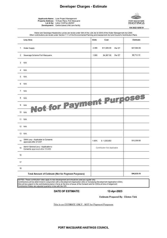
Author: Development Assessment Planner, Steven Ford
|
Applicant: Hopkins
Consultants Pty Ltd
Owner: Fernbank
Investments (NSW) Pty Ltd
Estimated Cost: $3,153,832
Alignment with Delivery
Program
4.3.1 Undertake transparent
and efficient development assessment in accordance with relevant legislation.
|
RECOMMENDATION
That
DA2022 - 774.1 for a 48 lot Industrial Subdivision and Associated
Infrastructure including a Clause 4.6 variation to Clause 4.1 (Minimum
Subdivision Lot Size) of the Port Macquarie-Hastings Local Environmental Plan
2011 at Lot 36 DP 1292179, Waapangal Road, Thrumster, be
determined by granting consent subject to the recommended conditions.
Executive
Summary
This
report considers a development application for a 48 Lot Industrial
Subdivision and associated Infrastructure at the
subject site and provides an assessment of the application in accordance with
the Environmental Planning and Assessment Act 1979.
Following
exhibition of the application, no submissions
were received.
The
application includes a variation to the minimum lot size development standard
in the Port Macquarie-Hastings Local Environmental Plan 2011 by more than 10%
and the application is required to be determined by Council following
consideration by the Development Assessment Panel.
The site is considered suitable for the proposed development
and the proposal adequately addresses relevant planning controls. The
development is not considered to be contrary to the public's interest and will
not result a significant adverse social, environmental or economic impact.
This report recommends that the
development application be approved subject to the attached conditions.
(Attachment 1)
The reason for the application being referred to
Council’s Development Assessment Panel (DAP) is because the application
includes a Clause 4.6 exception to a development standard under the Port
Macquarie-Hastings Local Environmental Plan 2011. A copy of the DAP
Charter outlining the delegations and functions of the DAP is available on
Council’s website.
1. BACKGROUND
Existing
Sites Features and Surrounding Development
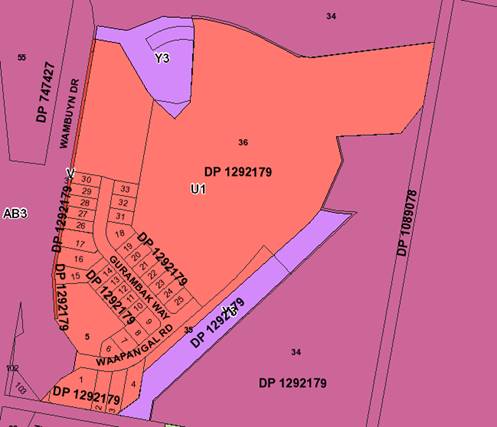
The total site has an area of
approximately 49ha. The cleared area of the site has an area of approximately
27ha. Stages 4 and 5 have an area of approximately 14ha.
The
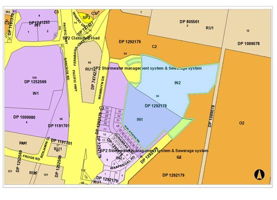
site is zoned IN1 General Industrial, IN2 Light Industrial and SP2
Infrastructure in accordance with the Port
Macquarie-Hastings Local Environmental Plan 2011, as shown in the following
zoning plan:
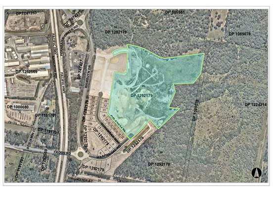
The
existing subdivision pattern and location of existing development within the
locality is shown in the following aerial photograph:
2. DESCRIPTION
OF DEVELOPMENT
Key
aspects of the proposal include the following:
· Torrens
Title subdivision to create 48 industrial development lots, plus residue lot.
· Proposal constitutes Stages 4 and 5 of Fernbank Park.
· Note: Stages 1A, 1B, 2A, 2B and 3 of Fernbank Park have all
been approved previously under two separate DAs and currently under
construction.
· Construct water, sewer, stormwater and all infrastructure
to service all lots.
· Earthworks including retaining walls.
Refer
to plans of the proposed development at the end of this report. (Attachment 2)
Application
Chronology
· 26/02/2015
- DA2014/533 approved stage 30 Lot Industrial Subdivision and Residue Lots, as
modified 23 September 2021.
· 22/09/2016 - DA2016/606 approved 14 Lot Industrial
Subdivision, as modified 24 September 2021.
· 06/09/2022 - Application Lodged for Stage 4 and 5, 48 Lots
Industrial Subdivison
· 20/09/2022 to 03/10/2022 - Public notification period.
· 07/10/2022 - Essential Energy comments received.
· 09/03/2023 - Stage 1 works completed and Lots released.
· 30/03/2023 - Additional information received, revised
staging.
3. STATUTORY
ASSESSMENT
Section
4.15(1) Matters for Consideration
In
determining the application, Council is required to take into consideration the
following matters as are relevant to the development that apply to the land to
which the development application relates:
(a) The
provisions (where applicable) of:
(i) Any
Environmental Planning Instrument
State Environmental Planning Policy (Biodiversity and
Conservation) 2021
Chapter 4 Koala Habitat Protection 2021
Clause 4.4 - This SEPP applies to all non-rural zoned land
within the Port Macquarie-Hastings Local Government Area.
Clause 4.9 - The property is over 1ha in size
(including adjoining land in the same ownership) and does not have a KPOM in
place.
Before consent is granted, Council is required
to assess whether the development is likely to have any impact on koalas or
koala habitat.
In accordance with Clause 4.9(3), Council is
satisfied that the development is likely to have low or no impact on koalas or
koala habitat as the site is already cleared of any vegetation.
State Environmental Planning Policy (Resilience and
Hazards) 2021
Chapter 4 Remediation of Land
Clause 4.6 - Following an inspection of the site and a
search of Council records, the subject land is not identified as being
potentially contaminated and is suitable for the intended use.
Port Macquarie-Hastings Local Environmental
Plan 2011
The proposal is consistent with the LEP having regard to the
following:
· Clause
2.2 - The subject site is zoned IN1 General Industrial, IN2 Light Industrial
and SP2 Infrastructure.
· Clause
2.3(1) The proposed development for a 48 Lot Torrens Title Industrial
Subdivision and associated infrastructure is a permissible with consent.
The objectives of
the IN1 zone are as follows:
•
To
provide a wide range of industrial and warehouse land uses.
•
To
encourage employment opportunities.
•
To
minimise any adverse effect of industry on other land uses.
•
To
support and protect industrial land for industrial uses.
•
To
enable other land uses that provide facilities or services to meet the day to day
needs of workers in the area.
The objectives of the IN2 zone are as follows:
•
To
provide a wide range of light industrial, warehouse and related land uses.
•
To
encourage employment opportunities and to support the viability of centres.
•
To
minimise any adverse effect of industry on other land uses.
•
To
enable other land uses that provide facilities or services to meet the day to day
needs of workers in the area.
•
To
support and protect industrial land for industrial uses.
•
The
objectives of the SP2 zone are as follows:
•
To
provide for infrastructure and related uses.
•
To
prevent development that is not compatible with or that may detract from the provision
of infrastructure.
·
Clause 2.3(2) - The proposal is consistent with the zone objectives
having regard to the following:
•
The proposal is a permissible landuse;
•
The proposal will encourage employment and additional
opportunities to the industrial zoned area.
·
Clause 4.1 - The lot sizes within the proposed subdivision range
from 1009m2 to 26027m2. The site has a minimum subdivision lot size of 1,000m2
and 1.5ha pursuant to LEP 2011 as shown in
below.
The proposal
includes a variation to Clause 4.1 Minimum Subdivision Lot Size. Proposed Lot
92 has a dual minimum lot size of 1,000m2 and 1.5ha, and just over half of Lot
92 is mapped as a minimum 1,000m2. The proposed lot size of Lot 92 is 1,218m2
which is a variation to the minimum lot size.


·
Clause 4.1B - (Minimum Lot Size for Certain Split Zones) cannot
be utilised as it does not apply to SP2 zoned land.
·
Clause 4.6 - Exceptions to development standards. A clause 4.6
variation is
submitted
requesting a variation to the minimum lot size (1.5Ha) to allow the with a minor
variation. Refer to assessment below.
The applicant
has submitted a Clause 4.6 variation request to allow proposed Lot 92 to be
less than the prescribed minimum lot size of 1Ha (IN1) and 1.5Ha (SP2) pursuant
to Clause 4.1 of PMHLEP 2011. (Attachment 3)
Clause 4.6 (6) states that development consent must not be
granted under this clause for a subdivision of land in Zone RU1 Primary
Production, Zone RU2 Rural Landscape, Zone RU3 Forestry, Zone RU4 Primary
Production Small Lots, Zone RU6 Transition, Zone RU5 Large Lot Residential,
Zone E2 Environmental Conservation, Zone E3 Environmental Management or Zone E4
Environmental Living if:
(a) The
subdivision will result in 2 or more lots of less than the minimum area
specified for such lots by a development standard, or
(b) The
subdivision will result in at least one lot that is less than 90% of the
minimum area specified for such a lot by a development standard.
Comment:
The proposal will not result in
contravention of either of these standards.
Proposed Lot 92 has an area of 1,218m2. Approximately 55% of
the lot has a minimum lot size of 1,000m2 and that portion complies.
Approximately 45% of the lot has a minimum lot size of 1.5ha and does not
achieve the minimum lot standard.
The SP2 zoned area will primarily contain a stormwater
detention basin. The basin has been designed and substantially commenced as
part of the subdivision works certificate for the earlier stages of Fernbank
Park. The extent and design of the required stormwater detention has been
analysed and engineered in detail which doesn’t require the whole footprint
of the SP2 zoning. In this regard the lot size for proposed Lot 92 and design
layout is appropriate to the site constraints and it is determined that it is
appropriate to recommend that an administrative rezoning be undertaken to
adjust the lot size mapping and zoning. It should be noted that this can occur
in the last Stage 6 and should not be an impediment to supporting the proposal
on planning grounds.
It is considered that the lot size variation is a minor
variation and will not result in any significant adverse planning impacts.
The proposal does not result in any identifiable adverse
impact on public amenity, infrastructure or density. The proposed lots are
capable of accommodating industrial development and are suitable for the
location, topography and context of the subject site.
Clause 4.6(3) requires Council to be satisfied that the
written request justifies the contravention of the development standard by
demonstrating:
(a) that
compliance with the development standard is unreasonable or unnecessary in the
circumstances of the case, and
(b) that
there are sufficient environmental planning grounds to justify contravening the
development standard.
The applicant submits that:
· Compliance
with the development standard is unreasonable and unnecessary in this instance
and there are sufficient environmental planning grounds to justify contravening
the minimum lot size standard.
· Compliance
with the 1.5ha minimum lot size would be unreasonable and unnecessary in the
circumstances. The 1.5ha minimum lot size was imposed on the SP2 land for the
provision of infrastructure. The stormwater basin infrastructure can now be
provided in a smaller area than what was approved. The SP2 land is excess to
requirements and is proposed to be reduced by a minor amount. The creation of
one undersize lot will not materially impact the amenity of the surrounding
area.
· It
is unnecessary to preserve the SP2 land, which would result in an inefficient
use of industrial zoned land and an inefficient use of SP2 zoned land.
· All
other proposed lots comply with the minimum lot size standard.
The applicant’s submission establishes that there is a
case to consider the development standard as unreasonable and unnecessary for
the proposal.
Wehbe v Pittwater Council [2007] NSWLEC 827 outlined
acceptable justifications for contravention of development standards. In this
instance the proposed variation is considered acceptable because the objectives
of the minimum subdivision lot size development standard are achieved notwithstanding
non-compliance with the standard in Clause 4.1 of LEP 2011.
Clause 4.6(4) states that development consent must not be
granted for development that contravenes a development standard unless:
(a) the consent authority is satisfied that:
(i)
the applicant’s written request has adequately addressed the matters
required to be demonstrated by subclause (3), and
(ii) the
proposed development will be in the public interest because it is consistent
with the objectives of the particular standard and the objectives for
development within the zone in which the development is proposed to be carried
out, and
The applicant’s submission has adequately addressed
the matters in subclause 4 above.
Comment:
The proposed development is sufficiently consistent with the
objectives of the SP2 zone noting the required minimum stormwater
infrastructure has been adequately provided for in the SP2 zone as designed.
The minimum lot size standard for the industrial component of proposed Lot 92
has planning merit to use part of that land to create a functional industrial
lot would comply with the objectives.
The proposed creation of an industrial lot will not create
development that is not compatible with the infrastructure use and the creation
of the lot will not detract from the provision of infrastructure.
Therefore, the proposal achieves the zone objectives.
The minimum lot size objectives are as follows:
(a) to
ensure that lot sizes are compatible with local environmental values and
constraints,
Comment:
The minor variation does not impact on the local
environmental values of the area.
(b) to
facilitate efficient use of land resources for residential and other human
purposes,
Comment:
The minor variation better utilisation of the land.
(c) to
minimise the fragmentation of rural land suitable for sustainable primary
production,
Comment:
The proposed subdivision does not impact rural land.
(d) to
protect high ecological, scientific, cultural or aesthetic values of land in
environment protection zones.
Comment:
There are no adverse impacts identifiable, the variation is
considered minor and there will no unreasonable impact on the amenity of the
locality.
Summary:
The applicant has established that strict compliance with
the minimum lot size in this case is unreasonable and unnecessary in the
circumstances and merits of the site.
The creation of Lot 92 will form part of stage 6, to allow
timing of intended back zoning of the land and not impact the stages 4 or 5. An
appropriate condition is recommended in this regard.
· Clause
5.10 - The site does not contain or adjoin any known heritage items or sites of
significance.
· Clause
7.13 - Satisfactory arrangements are in place for provision of essential
services including water supply, electricity supply, sewer infrastructure,
stormwater drainage and suitable road access to service the development.
Provision of electricity will be subject to obtaining satisfactory arrangements
certification prior to the issue of a Subdivision Certificate as recommended by
a condition of consent.
(ii) Any draft
instruments that apply to the site or are on exhibition
No draft instruments apply to the site.
(iii) Any Development
Control Plan in force
Port
Macquarie-Hastings Development Control Plan 2013
|
DCP 2013: Part B - General
Provisions - B2: Environmental Management
|
|
DCP Objective
|
Development Provisions
|
Proposed
|
Complies
|
|
3
|
a) Development must comply with
Council’s Developments, Public Place & Events - Waste Minimisation
and Management Policy.
|
All lots will have direct road
frontage. There are no adverse concerns identifiable.
|
Yes
|
|
Cut and Fill Regrading
|
|
4
|
a) Development shall not exceed
a maximum cut of 1.0m and fill of 1.0m measured vertically above the ground
level (existing) at a distance of 1.0m outside the perimeter of the external
walls of the building (This does not apply to buildings where such cut and
fill is fully retained within or by the external walls of the building).
|
No buildings proposed.
|
Yes
|
|
5
|
a) A certified practicing structural
engineer must certify any retaining wall greater than 1.0m.
|
Retaining walls up to 1.5m are
proposed and will be certified by a structural engineer where they exceed 1m
in height. This is consistent with the previous stages to provide adequate
drainage and level sites for future development.
|
Yes
|
|
b) Where a combination of a
fence and a wall is proposed to be greater than 1.2m high:
- be a maximum combined height of 1.8m above existing
property boundary level;
- be constructed up to the front boundary for a maximum
length of 6.0m or 30% of the street frontage, whichever is less;
− the fence component has openings which make it not less
than 25% transparent; and
− provide a 3m x 3m splay for corner sites, and
- provide a 900mm x 900mm splay for vehicle driveway
entrances.
|
N/A - No retaining walls or
fences proposed along street frontages.
|
N/A
|
|
6
|
Cut and Fill Regrading
a) Significant land reforming
proposals where >10% gross site area or >1.0ha is to have
surface levels changed by more
than 5m or where earthworks exceed an average of
10,000m3 per ha shall:
− identify the impact of
the proposed land reforming on the environment, landscape,
visual character and amenity,
natural watercourses, riparian vegetation, topographical
features of the environment and public infrastructure;
− demonstrate compliance
with the provisions of Council’s AUS-SPEC design
specification;
− assess the impacts and
benefits of the proposal to all impacted persons and the
general public;
− provide measures to
compensate for and minimise any net adverse impacts.
b) The use of high earthworks
batters should be avoided.
c) Preliminary plans indicating
the final landform are required to be submitted with any master plan or
subdivision application.
d) The subdivision should be
designed to fit the topography rather than altering the topography to fit
the subdivision.
|
The surface levels will not be
altered by more
than 5m or 10,000m3 per ha.
The site has previously been
cleared and will
not materially impact the
environment or landscape of the site. The existing natural
features of the site are basic
and without
habitat.
The benefit of earthworks on the
site is to provide level building sites as required in industrial areas.
The proposed earth batters are
approximately
2-3m high at the northern end of
the site and up
to 7m at the southern end of the
site.
The batters are generally
located between the
perimeter road and adjoining
bush land and
slope down from the road.
The earth batters are required
as a result of the existing topography of the site and do not result in an
inhospitable or inappropriate landform.
|
Yes
|
|
DCP 2013: Part B- General
Provisions- B4: Transport, Traffic Management, Access and Car Parking
|
|
DCP Objective
|
Development Provisions
|
Proposed
|
Complies
|
|
Road Hierarchy
|
|
23
|
a) New direct accesses from a
development to arterial and distributor roads is not permitted. Routes should
differ in alignment and design standard according to the volume and type of
traffic they are intended to carry, the desirable traffic speed, and other
factors.
|
No new direct accesses.
|
N/A
|
|
b) Existing direct accesses from
a development to arterial and distributor roads are rationalised or removed
where practical.
|
N/A
|
N/A
|
|
c) Vehicle driveway crossings
are minimal in number and width (while being adequate for the nature of the
development), and positioned:
− to avoid driveways near intersections and road bends, and
− to minimise streetscapes dominated by driveways and
garage doors, and
− to maximise on-street parking.
|
Industrial subdivision proposed
only.
Individual driveways will be
proposed with development of lots.
|
N/A
|
|
|
|
|
|
|
DCP 2013: Part B - General
Provisions - B5: Social Impact Assessment and Crime Prevention
|
|
DCP Objective
|
Development Provisions
|
Proposed
|
Complies
|
|
Social Impact Assessment
|
|
42
|
a) A social impact assessment
shall be submitted in accordance with the Council’s Social Impact
Assessment Policy.
|
The
proposal will have a positive impact on the employment opportunities in the
area. A social impact assessment was undertaken when the site was zoned for
industrial and no further SIA is required.
|
Yes
|
|
Crime Prevention
|
|
43
|
a) The development addresses the
generic principles of crime prevention:
- Casual surveillance and sightlines;
- Land use mix and activity generators;
- Definition of use and ownership;
- Basic exterior building design;
- Lighting;
- Way-finding; and
- Predictable routes and entrapment locations;
- as described in the Crime Prevention Through
Environmental Design (CPTED) principles.
|
The proposal addresses general
principles of crime prevention, with casual surveillance of public areas,
each site will generate activity and will be defined by fences and buildings.
Streetlights will also be provided.
|
Yes
|
|
DCP 2013: PART C - Development Specific Provisions -
C5: Subdivision
|
|
DCP Objective
|
Development Provisions
|
Proposed
|
Complies
|
|
Site Analysis
|
|
139
|
a) A site analysis is required for all development and
should illustrate:
- microclimate including
the movement of the sun and prevailing winds;
- lot dimensions;
- north point;
- existing contours and
levels to AHD;
- flood affected areas;
- overland flow patterns,
drainage and services;
- any contaminated soils
or filled areas, or areas of unstable land;
- easements and/or
connections for drainage and utility services;
- identification of any
existing trees and other significant vegetation;
- any existing buildings
and other structures, including their setback distances;
- heritage and
archaeological features;
- fences, boundaries and
easements;
- existing and proposed
road network, including connectivity and access for all adjoining land
parcels;
- pedestrian and vehicle
access;
- views to and from the
site;
- overshadowing by
neighbouring structures; and
- any other notable
features or characteristics of the site.
|
Adequate site analysis provided.
|
Yes
|
|
Urban Structure and Lot Layout
|
|
140
|
a) Any residential allotments created by Torrens title
subdivision should satisfy the following standards:
- A minimum width of 15
metres when measured at a distance of 5.5 metres from the front property
boundary;
- A minimum width of 7
metres measured when side boundaries are extended to the kerb line; A minimum
depth of 25 metres;
- For lots where the
average slope of the development site is equal to, or exceeds 16%, indicative
road and driveway grades are required demonstrating satisfactory access.
|
N/A
|
N/A
|
|
141
|
a) Battleaxe allotments are discouraged in greenfield
development.
|
None proposed.
|
N/A
|
|
b) Council may consider permitting Torrens Title battleaxe
allotments for “infill” development where it is demonstrated
that:
- A Torrens Title lot,
that is not a battleaxe lot, cannot be achieved; and
- the number of
crossovers do not reduce the amenity of the street or on street parking; and
- the impact of noise,
dust and headlights on the land owners adjoining the driveway is addressed by
the construction of an acoustic fence for the full length of the driveway;
and
- addresses privacy
between the rear lot and the rear open space of the front lot by the
provision of adequate screening, larger lot size and setbacks; and
- extends utilities to
the end of the axe handle; and
- There is sufficient
space for garbage collection on the frontage.
|
None proposed.
|
N/A
|
|
142
|
a) The subdivision of land with slopes exceeding 25% is
generally discouraged.
|
N/A
|
N/A
|
|
Infrastructure - Pedestrians and Cycleways
|
|
147
|
1. a) Development
for the subdivision for land or major residential development should provide
footpaths on both sides of all collector and arterial roads. A
shareway/cycleway may be permitted on one side of collector roads in lieu of
footpath on both sides, provided it has a width of 2.5m or greater, has paved
footpath connections to bus stops on both sides, and is located along natural
edges (e.g. perimeter roads, vegetative corridors, or drainage reserves).
|
The area is unlikely to be affected by speeding or
encourage ‘rat runs”.
On street parking will not be encouraged, each
site is adequate size to provide their own parking.
The circular and compact nature of the development negates
the need for internal directional signage to Wambuyn Drive and the Pacific
Highway.
|
Yes
|
|
2. b) Footpaths
should be provided on one side of the street for access places and local
streets in accordance with Council’s adopted AUS-SPEC design
specification documents.
|
All
proposed roads are in accordance with AUS-SPEC.
|
Yes
|
|
150
|
a)
An application for subdivision should include a WSUD prepared by a certified
practicing engineer and in accordance with Council’s adopted design
specification documents.
|
WSUD
has been considered for the site and is provided for the entire site in
Stages 1-3. Stages
4
and 5 will connect to the approved infrastructure.
|
Yes
|
|
151
|
a)
An application for subdivision should be accompanied by a Stormwater
Management Strategy prepared by a certified practicing engineer and in
accordance with Council’s adopted AUS-SPEC design specification
documents.
b)
The Designer should adopt the ‘major/minor’ approach to urban
drainage systems as outlined in the current version of Australian Rainfall
and Runoff utilising local parameters and factors where necessary and as
defined in AUS-SPEC.
|
Stormwater
is shown on the submitted plans
and
connects to infrastructure already approved
in
Stages 1-3. The approved basins are adequate to accommodate stormwater from
Stages
4 and 5.
|
Yes
|
|
152
|
a)
All Council owned stormwater infrastructure is designed in accordance with
the Council’s
|
All
proposed stormwater infrastructure will be in accordance with AUS-SPEC.
|
Yes
|
|
162
|
a)
Any industrial allotment created by Torrens title subdivision should satisfy
the following standards:
−
Comply with minimum subdivision requirements of clause 4.1 of LEP 2011.
−
Minimum width of 20m.
−
Minimum depth of 40m.
−
The depth to width ratio should not exceed 3 to 1.
b)
Lots are to be generally rectangular in shape and lot boundaries should have
regard to the landform and the character of the site.
c)
Battleaxe allotments should not be permitted.
d)
Industrial subdivision should not be supported on land with slope greater
than 15%.
|
The
minimum lot width proposed is 21m. Lots 55, 56 and 57 propose small
non-compliances at the street frontage due to the bend in Road 3, but widens
to the rear.
All
proposed sites are wide enough to provide adequate access and are large
enough to accommodate industrial uses.
Lots
58, 59 and 68 propose a variation to the minimum depth. Lot 58 and 59 propose
a minor variation of 37m and 36.705m respectively. These variations are minor
and within 10% of the control and are considered acceptable.
Lot
67 proposes a variable depth between 31.61m and 32.5m. The lot width is
46.535m and the lot size is 1474m2. The proposed lot is
considered
to be acceptable as it is capable of accommodating an industrial use and
meets Council’s minimum dimensions except lot orientation requirements.
Proposed
lots are generally rectangular in shape. Where they are irregular it is due
only to topography of the site.
|
No, but acceptable on merit.
|
|
DCP 2013: Part D - Locality Specific Provisions - D7
- Highway Employment Lands: D7.1 Fernbank Park Employment Lands
|
|
DCP Objective
|
Development Provisions
|
Proposed
|
Complies
|
|
Visual and Environmental Amenity
|
|
294
|
a) Development of land at the intersection of the highway
overpass service road and entry to Fernbank Park should be designed to create
a distinctive, recognisable gateway entry to the site. Plans for subdivision
should include landscaping of the public domain entry and plans for
co-ordinated estate signage.
|
Development
of land at the intersection is not proposed.
|
Yes
|
|
295
|
a) Industrial development is to be screened from the
highway overpass service road and Thrumster Street road reserve through
landscaped buffers to a minimum depth of 5.0 metres and to include mounding
and canopy trees to limit the visual impact of development.
|
Proposed Stages 4 and 5 are located on the eastern side of
the site and not adjacent to the
highway.
|
N/A
|
|
b) Trees are to be selected from those that are indigenous
to the area and are to be planted at the time of subdividing the land.
|
N/A
|
N/A
|
|
c) Design details to be provided with the DA for approval
at the time of subdividing the site, or land use, whichever occurs first.
|
N/A
|
N/A
|
|
Native Vegetation and Habitat Areas
|
|
296
|
a) A Vegetation Management Plan (VMP) is required for all
environmental lands for approval prior to issue of a Construction Certificate
for earthworks, subdivision and/or building works, whichever occurs first.
|
There is no vegetation removal or revegetation proposed on
this site. The site was previously cleared.
|
N/A
|
|
b) Approved VMP works are to be completed to Council’s
satisfaction prior to the issue of the subdivision or building construction
certificate.
|
N/A
|
N/A
|
|
Roads,
Access and Transport
|
|
297
|
a) The subdivision design is to reflect the road hierarchy
in and cater for an efficient bus route and a combination of on- road and
off-road pedestrian and cycleways.
|
The proposed subdivision design includes the final stage
of the perimeter road shown in
Figure 193 of the Area based provisions of the DCP.
|
Yes
|
|
b) Industrial lots are to be designed to obtain access
from the internal road network. Direct lot access to the overpass
service road and the Thrumster Street road reserve will not be permitted.
|
All proposed lots have access from the proposed internal
road.
|
Yes
|
|
298
|
The perimeter road between the industrial footprint and
environmental lands is to be designed to control the industrial interface to
manage potential conflicts of bushfire hazard, stormwater quality and
environmental conservation.
|
The proposal completes the perimeter road around the industrial
park. The perimeter road is a 13m carriageway and 23m reserve. The proposed
road provides a suitable barrier between the industrial interface with
environmental lands. The perimeter road assists in the management of
stormwater, bushfire and conservation.
|
Yes
|
|
Stormwater
Management
|
|
299
|
a) Industrial development is to incorporate water
sensitive urban design (WSUD) elements in the treatment train including:
- Source control via rain
gardens and permeable pavements at a minimum size of 2.5% of the gross lot
area,
- Conveyance treatment
via vegetated swales and bio-retention trenches,
- End of line treatment
via gross pollutant traps and bio-retention systems,
- Precinct-scale
stormwater treatment systems within SP2 zoned lands to treat runoff from public
roads.
|
Each lot is of adequate size to comply with the
requirements.
|
Yes
|
|
b) Detailed design of the WSUD elements is to be
undertaken in accordance Council's Design Development Specification for
Stormwater Drainage D5 and D7 and Hopkins, Water Sensitive Urban
Design Strategy, Nov 2012.
|
Proposal has been reviewed by Council’s Engineers
and is considered to comply. No adverse impacts identifiable,
|
Yes
|
|
Bushfire
Hazard
|
|
300
|
a) A perimeter road is to be provided generally in
accordance with the location in Figure 192 and outside of Zones E2
Environmental Conservation and E3 Environmental Management. Internal road
layout to provide for evacuation routes in major bushfire events.
|
The proposed perimeter road is to be completed by this DA
generally in accordance with Figure 192 of the
Area based provisions of the DCP.
The road is not within the C2 or C3 zone.
The internal road network provides straightforward
perimeter loop road which connects to both exit points to Wambuyn Drive.
|
Yes
|
|
301
|
a) Prior to any earthworks, clearing works, or excavation
works, an inspection of the proposed development site is to be undertaken by
an Aboriginal Cultural Sites Officer from the local Aboriginal Land Council
and a report on the site inspection is to be obtained.
|
The site has been completely cleared in the past.
An Aboriginal Site Investigation was completed by Birpai
Local Aboriginal Land Council in 2019.
No evidence of Aboriginal Heritage was found on the site.
|
Yes
|
|
Industrial
Land Adjoining Sensitive Land Uses
|
|
302
|
a) DAs for industrial development adjoining the southern
site boundary are to be accompanied by noise impact assessment carried out by
a suitably qualified person to:
- Determine the noise
reduction required to achieve suitable levels for the proposed industry (if
any);
- Design and incorporate
any necessary noise mitigation measures to demonstrate achievement of
acceptable noise levels at sensitive receivers, including visual detail of
how the proposal integrates into the existing locality;
- Provide justification
for any proposed acoustic treatment(s), based on site characteristics and the
nature and intensity of the proposed use; an
- Demonstrate
consideration of attenuation strategies of like industries with similar sites
and requirements for noise reduction.
|
The proposed lots do not adjoin the southern site
boundary. Acoustic justification is not required for the proposed lots.
Individual industrial uses proposed on the site may require their own
separate acoustic assessments.
|
N/A
|
|
Electricity
and Telecommunications
|
|
303
|
a) Arrangements are to be
made with local service authorities for the provision of underground power
and telecommunications to all industrial lots prior to release of the first
subdivision construction certification for development of Lot 101 DP1106752.
|
Underground power and telecommunications
will be provided for all lots.
|
Yes
|
(iiia) Any planning agreement that has
been entered into under section 7.4, or any draft planning agreement that a
developer has offered to enter into under section 7.4
A planning agreement has been
entered into under Section 7.4 of the Act that relates to development on the
site. The provisions of the agreement will not be impacted as a result of the
proposal.
(iv) Any
matters prescribed by the Regulations
Nil
(b) The likely
impacts of that development, including environmental impacts on both the
natural and built environments, social and economic impacts in the locality
Context and Setting
The site has frontage orientation to the Pacific
Highway/Sancrox interchange service road and the new road system to be built as
part of DA2014 - 533.
Adjoining the site is a mixture of industrial uses, rural
and environmental land.
The proposal will not have any significant adverse impacts
to existing adjoining properties and satisfactorily addresses the public
domain.
The proposal is considered to be compatible with other
development in the locality and adequately addresses planning controls for the
area.
Access, Traffic and Transport
The proposal will not have any significant adverse impacts
in terms access, transport and traffic. The existing road network will
satisfactorily cater for any increase in traffic generation as a result of the
development.
Water Supply Connection
Council records indicate that
the proposed development site is not connected to Council’s Water Supply
Network. An extension of Council’s Water Supply Network to the proposed
development site has been approved as part of DA2014 - 533. The proposed
development may extend from the 150mm water mains approved as part of DA2014 -
533. Any extension to Council’s Water Supply network is to be designed in
accordance with Council’s AUSPEC design and construction requirements.
A water supply strategy shall be
provided that details any subdivision staging and the corresponding water
supply work (including augmentation) necessary to support each stage. The
strategy is to incorporate the latest changes in water supply design
requirements as well as being modelled on software compatible with that used by
Council. The water mains shall loop within the subdivision where possible as
well as providing connections for any possible subdivision of proposed Lot 71.
Detailed engineering plans complying with Auspec are to be submitted with the application
for a construction certificate and approved prior to issue of the CC.
The completion of all works
required under Council's consent to DA2014 - 533 prior to the issue of a
Subdivision Certificate or the registration of a satisfactory 88B Instrument
which restricts the development of each allotment to that approved under that
consent.
No building is to be connected
to Council's future water main until Council has accepted such main.
Appropriate conditions are recommended in this regard.
Sewer Connection
Council records indicate that
the development site is not connected to Council’s Sewerage System. An
extension of Council’s Sewerage System has been approved as part of
DA2014 - 533. The proposed development may extend from the sewer infrastructure
approved as part of DA2014 - 533. Any extension to Council’s Sewer
network is to be designed in accordance with Council’s AUSPEC design and
construction requirements.
A sewer strategy shall be
provided that details any subdivision staging and the corresponding sewer work
(including augmentation) necessary to support each stage. The strategy is to
incorporate the latest changes in water supply design requirements as well as
being modelled on software compatible with that used by Council. The design
shall take into consideration any possible subdivision of proposed Lot 71.
Detailed engineering plans complying with Auspec are to be submitted with the
application for a construction certificate and approved prior to issue of the
CC.
The completion of all works required
under Council's consent to DA2014 - 533 prior to the issue of a Subdivision
Certificate or the registration of a satisfactory 88B Instrument which
restricts the development of each allotment to that approved under that
consent.
No building is to be connected
to Council's future sewer main until Council has accepted such main.
Appropriate conditions are recommended in this regard.
Stormwater
The development will connect in with the stormwater system
to be built as part of DA2014 - 533. Refer to relevant conditions of consent.
Other Utilities
Telecommunication and electricity services are available to
the site.
Heritage
Following a site inspection (and a search of Council/AHIMS
records), no known items of Aboriginal or European heritage significance exist
on the property. No adverse impacts anticipated.
Other land resources
The site is within an established and developing urban
context and will not sterilise any significant mineral or agricultural
resource.
Water cycle
The proposed development will not have any significant
adverse impacts on water resources and the water cycle.
Soils
The proposed development will not have any significant
adverse impacts on soils in terms of quality, erosion, stability and/or
productivity subject to a standard condition requiring erosion and sediment
controls to be in place prior to and during construction.
Air and microclimate
The construction and/or operations of the proposed
development will not result in any significant adverse impacts on the existing
air quality or result in any pollution. Standard precautionary site management
condition recommended.
Flora and fauna
Construction of the proposed development will not require
any removal/clearing of any significant vegetation and therefore will be
unlikely to have any significant adverse impacts on biodiversity or threatened
species of flora and fauna. In particular, impacts of the overall subdivision
footprint were considered as part of DA2014 - 533 with this application being
for infill lots only. Section 5A of the Act is considered to be satisfied.
Waste
No adverse impacts anticipated. Standard precautionary site
management condition recommended.
Energy
No adverse impacts anticipated.
Noise and vibration
The proposed development will not result in any significant
adverse impacts on the existing air quality or result in any pollution.
Standard precautionary site management condition recommended.
Bushfire
The site is identified as being bushfire prone.
Industrial subdivisions are excluded from s100B pursuant to
Clause 45 of the Rural Fires Regulation 2013. Regardless, it is considered that
the use of perimeter roads and materials used to construct industrial buildings
(normally non-combustible), will ensure suitable protection.
Safety, security and crime prevention
The proposed development will be unlikely to create any
concealment/entrapment areas or crime spots that would result in any
identifiable loss of safety or reduction of security in the immediate
area. Adequate casual surveillance is available.
Social impacts in the locality
Given the nature of the proposed development and its
location the proposal is not considered to have any significant adverse social
impacts.
Economic impact in the locality
The proposal is not considered to have any significant
adverse economic impacts on the locality. A likely positive impact is that the
development will maintain employment in the construction industry, which will
lead to flow impacts such as expenditure in the area.
Site design and internal design
The proposed development design satisfactorily responds to
the site attributes and will fit into the locality.
Construction
Construction impacts are considered capable of being
managed, standard construction and site management conditions have been
recommended.
Cumulative impacts
The proposed development is not considered to have any
significant adverse cumulative impacts on the natural or built environment or
the social and economic attributes of the locality.
(c) The suitability
of the site for the development
The proposal will fit into the
locality and the site attributes are conducive to the proposed development.
(d) Any submissions
made in accordance with this Act or the Regulations
No written
submissions were received following public exhibition of the application.
Copies of the written submissions have been provided separately to members of
the DAP.
(e) The Public Interest
The proposed development
satisfies relevant planning controls with the exception of the clause 4.6
variation recommended for minimum lot size for one(1) lot and will overall
adversely impact on the wider public interest.
Ecologically Sustainable Development and Precautionary
Principle
Ecologically sustainable development requires the effective
integration of economic and environmental considerations in decision-making
processes.
The four principles of ecologically sustainable development
are:
· the
precautionary principle,
· intergenerational
equity,
· conservation
of biological diversity and ecological integrity,
· improved
valuation, pricing and incentive mechanisms.
The principles of ESD require that a balance needs to be
struck between the man-made development and the need to retain the natural
vegetation. Based on the assessment provided in the report and with recommended
conditions of consent, it is considered an appropriate balance has been struck.
Climate change
The proposal is not considered to be vulnerable to any risks
associated with climate change.
4. DEVELOPMENT
CONTRIBUTIONS APPLICABLE
Development contributions will be
required in accordance with Section 7.12 of the Environmental Planning and
Assessment Act 1979 towards roads, open space, community cultural services,
emergency services and administration buildings.
The applicant is to comply with the planning agreement
under section 93F of the Environmental Planning and Assessment Act 1979, known
as the Fernbank Park Planning Agreement dated 17 December 2013.
Appropriate conditions have been recommended.
5. CONCLUSION AND
STATEMENT OF REASON
The application has been assessed in accordance with Section
4.15 of the Environmental Planning and Assessment Act 1979.
Issues raised during assessment of the application have been
considered in the assessment of the application. Where relevant, conditions
have been recommended to manage the impacts attributed to these issues.
The proposed development does
not raise any significant general public interest issues beyond matters already
addressed in this report. Overall, the proposed development is consistent with
the provisions and objectives of the relevant planning controls and will have
an acceptable impact on the surrounding natural and built environment. Approval
of the application is considered to be in the public interest as it achieves
the LEP objectives for development in the zone. No significant adverse
environmental, social or economic impacts on the locality have been identified.
Accordingly, the proposal is considered to be in the public interest.
|
Attachments
1⇩. DA2022 - 774.1
Recommended Conditions DA2022 - 774.1
Recommended Conditions
2⇩. DA2022 - 774.1 Plans
3⇩. DA2022 - 774.1
Clause 4.6 Variation
|
|
ATTACHMENT
|
Development Assessment Panel
19/04/2023
|
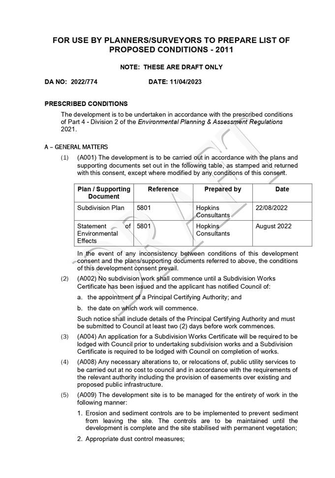
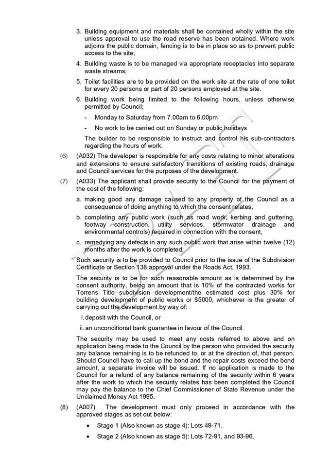
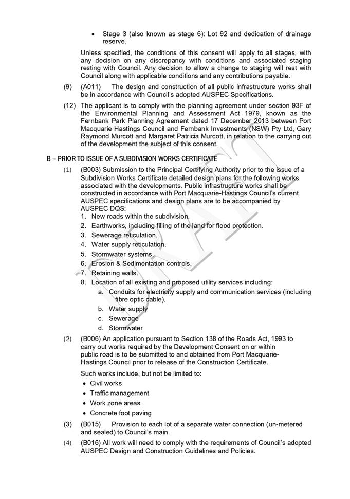
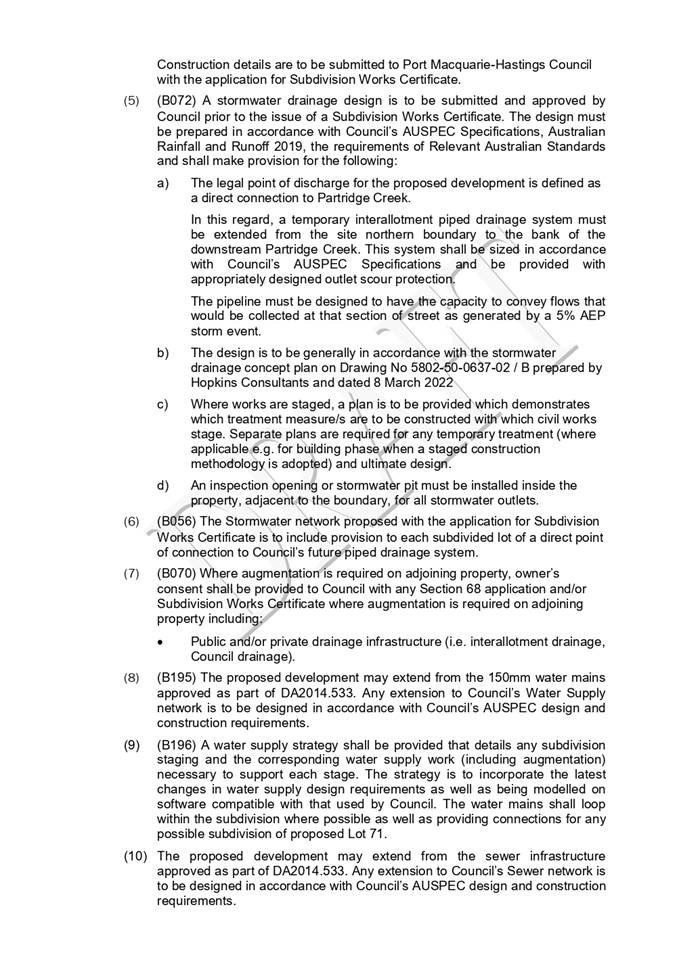

|
ATTACHMENT
|
Development Assessment Panel
19/04/2023
|
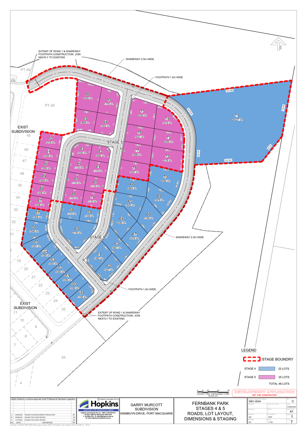
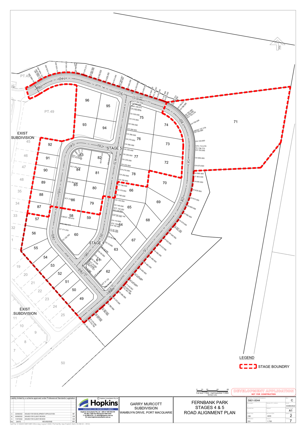
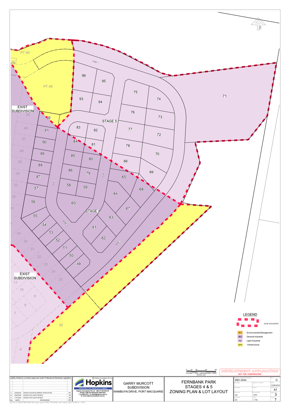
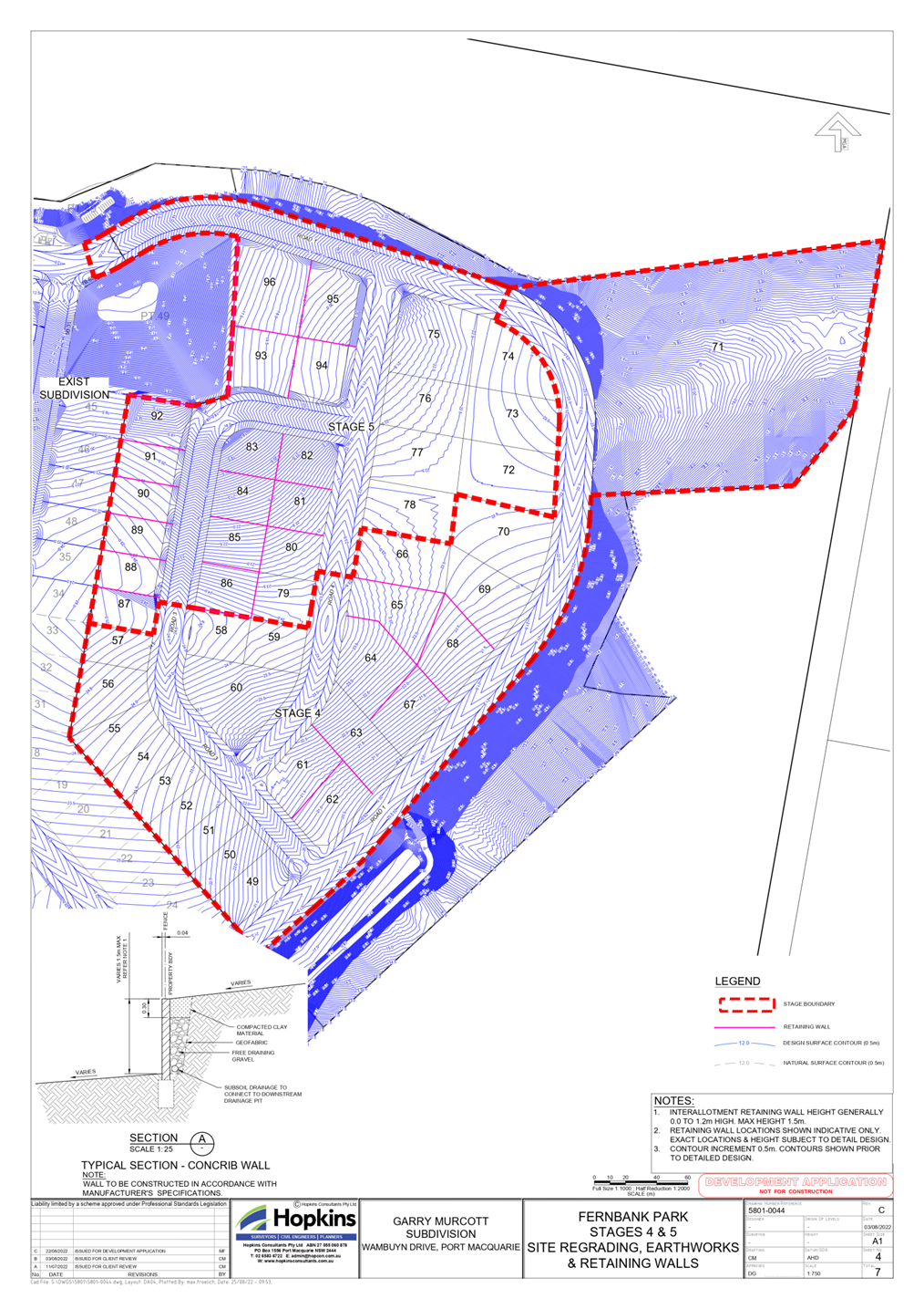
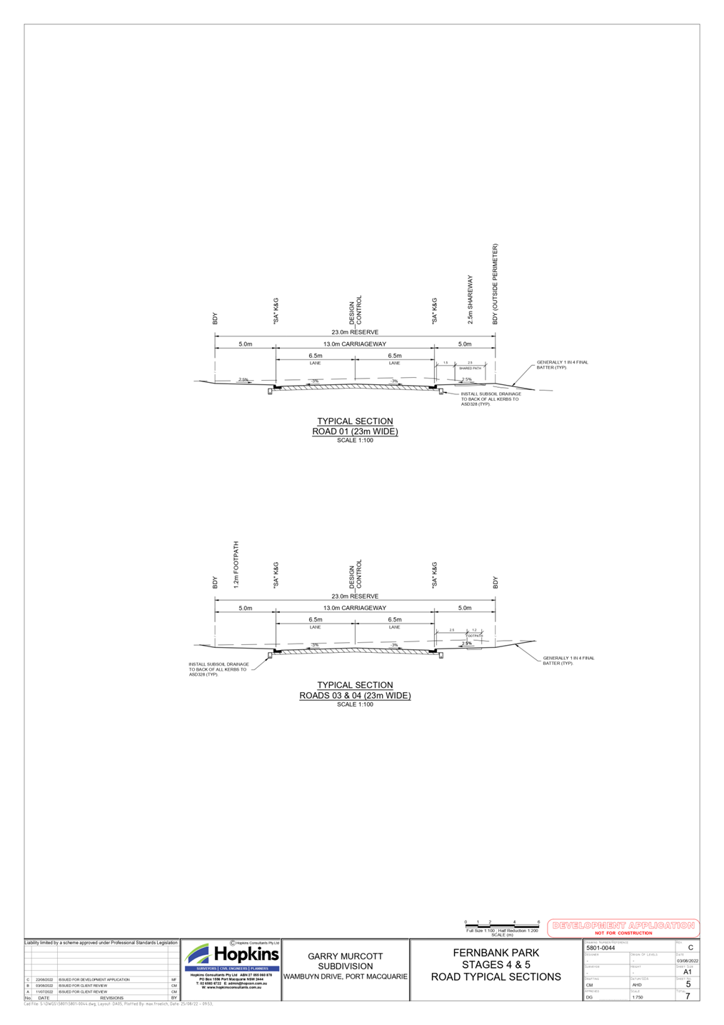
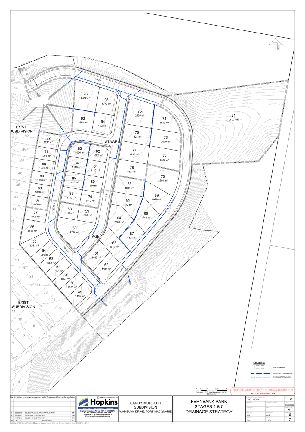
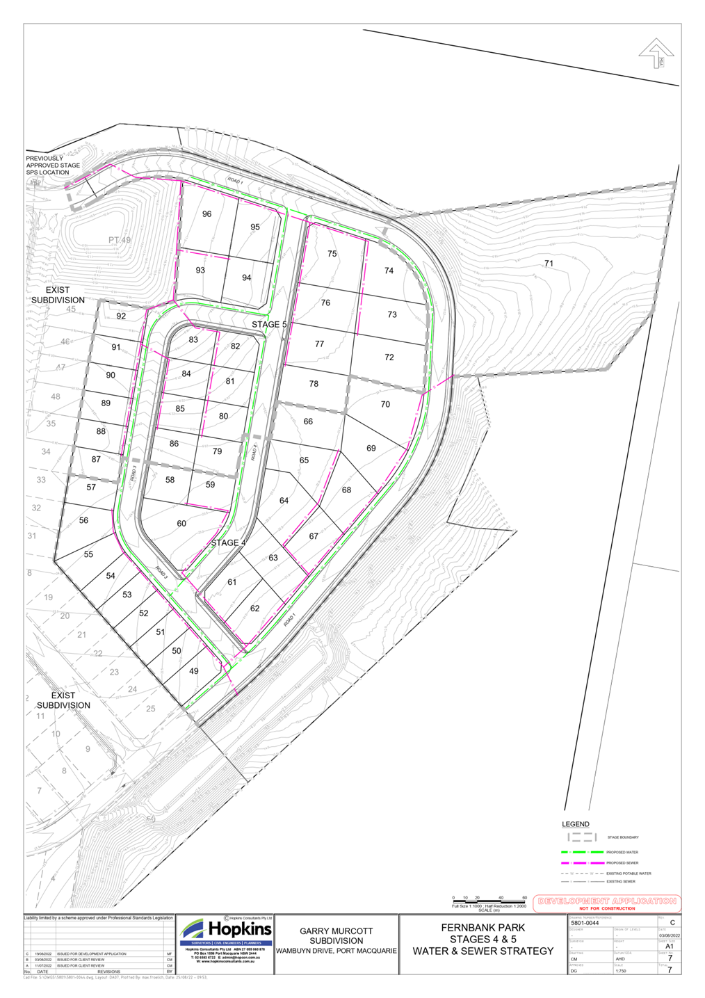
|
ATTACHMENT
|
Development Assessment Panel
19/04/2023
|
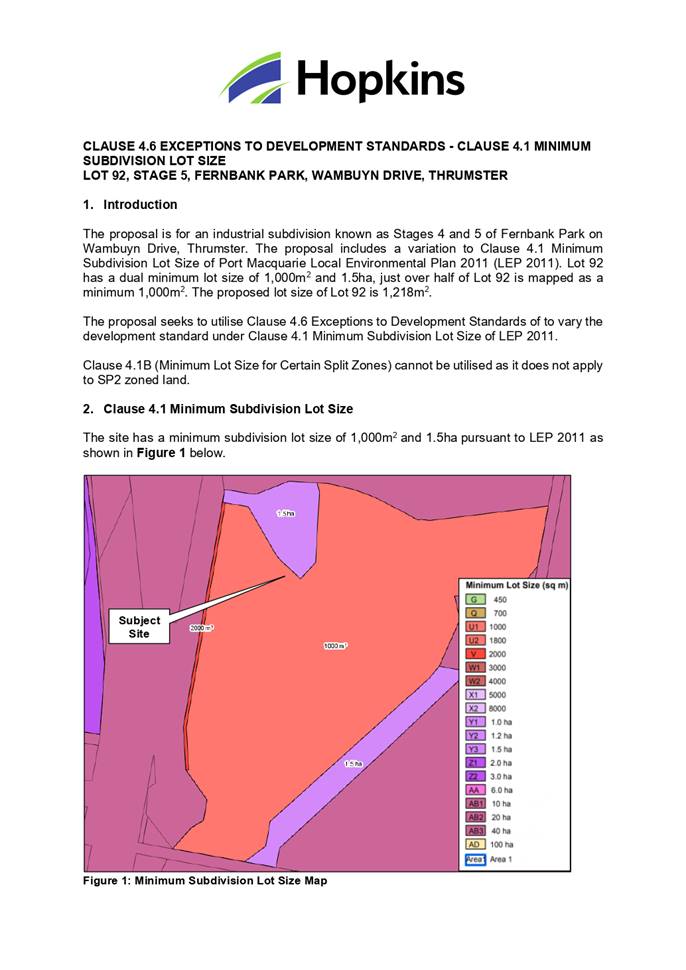
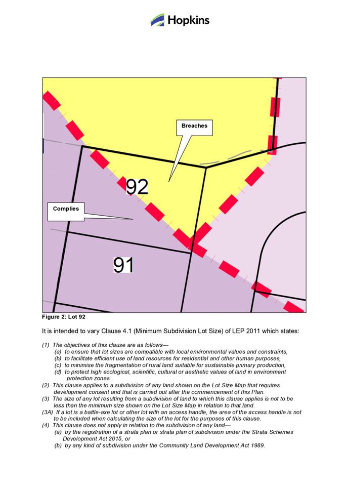
Development Assessment Panel
19/04/2023
Item: 06
Subject: DA2022 - 1071.1 Secondary Dwelling at Lot 73
DP 814922, No.18 Coucal Close, Port Macquarie
Report
Author: Development Assessment Planner, Steven Ford
|
Applicant: T
& E Boyagi
Owner: T
& E Boyagi
Estimated Cost: $120,000
Alignment with Delivery
Program
4.3.1 Undertake transparent
and efficient development assessment in accordance with relevant legislation.
|
RECOMMENDATION
That
DA2022 - 1071 for a Secondary
Dwelling at Lot 73, DP 814922, No. 18 Coucal Close, Port
Macquarie, be determined by granting consent
subject to the recommended conditions.
Executive
Summary
This
report considers a development application for a Secondary Dwelling at the subject site and provides an assessment of the
application in accordance with the Environmental Planning and Assessment Act
1979.
Following exhibition of the
application, 3 submissions were received.
The site is considered suitable for the proposed development
and the proposal adequately addresses relevant planning controls. The development
is not considered to be contrary to the public's interest and will not result a
significant adverse social, environmental or economic impact.
This report recommends that the
development application be approved subject to the attached conditions.
(Attachment 1)
The reason for the application being referred to
Council’s Development Assessment Panel (DAP) is because three (3) or more
objections to the proposal have been received. A copy of the DAP Charter
outlining the delegations and functions of the DAP is available on
Council’s website.
1. BACKGROUND
Existing
Sites Features and Surrounding Development
The site has an area of 1106m2.
The
site is zoned R1 General Residential in
accordance with the Port Macquarie-Hastings Local Environmental Plan 2011, as
shown in the following zoning plan:
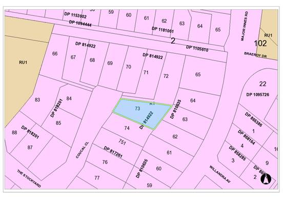 The existing subdivision pattern and location of existing
development within the locality is shown in the following aerial photograph:
The existing subdivision pattern and location of existing
development within the locality is shown in the following aerial photograph:
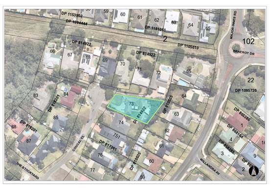
2. DESCRIPTION
OF DEVELOPMENT
Key
aspects of the proposal include the following:
· Demolition
of existing shed
· Proposed
Secondary Dwelling with off street car parking
· Tree
removal, as shown on site plan
· Existing
driveway from right of carriage way over Lot 71 and 72 DP814922
Refer
to plans of the proposed development at the end of this report. (Attachment 2)
Application
Chronology
· 06/12/2022
- Application Received
· 16/12/2022 to 04/01/2023 Public notification, 3 submissions
received
· 09/01/2023 - Essential Energy comments received.
3. STATUTORY
ASSESSMENT
Section
4.15(1) Matters for Consideration
In
determining the application, Council is required to take into consideration the
following matters as are relevant to the development that apply to the land to
which the development application relates:
(a) The
provisions (where applicable) of:
(i) Any
Environmental Planning Instrument
State Environmental Planning Policy (Housing) 2021
Chapter 3 Diverse Housing
Part 1 - Secondary Dwellings
Clause 50 - The site is in a prescribed residential zone and
secondary dwellings are permissible with consent pursuant to the SEPP and Port
Macquarie-Hastings Local Environmental Plan 2011 (LEP).
Clause 51 - It is noted that the consent authority must not
consent to a development application that would result in any subdivision of a
lot on which development for the purposes of a secondary dwelling has been
carried out.
Clause 52(2)(a) - Only a principal dwelling and secondary
dwelling will result from the development on the land.
Clause 52(2)(b) - The total floor area does not exceed the
maximum floor space ratio under the LEP.
Clause 52(2)(c) - The proposed secondary dwelling would not
have a floor area exceeding 60m2 and/or the combined floor area of
the primary and secondary dwelling would not exceed the maximum permitted under
the Port Macquarie-Hastings Local Environmental Plan 2011 (see comments below
under LEP).
Clause 53(2)(a) - It is noted that consent cannot be refused
on the grounds of site area.
Clause 53(2)(b) - The number of parking spaces on the site
is proposed to be the same as the number of parking spaces provided on the land
with the principal dwelling immediately before the secondary dwelling is to be
constructed/completed. The secondary dwelling is unable to be constructed
without the principal dwelling and this provision overrides parking provision
requirements in Council’s Development Control Plan.
The requirements of this SEPP are therefore satisfied.
State Environmental Planning Policy (Biodiversity and
Conservation) 2021
Chapter 4 Koala Habitat Protection 2021
Clause 4.4 - This SEPP applies to
all non-rural zoned land within the Port Macquarie-Hastings Local Government
Area.
Clause 4.10 (other
land - not subject to Clause 4.8 or 4.9) - Having considered the SEPP, the
application and on completion of a site inspection, Council is not prevented
from granting consent in this case for the following reasons:
1. The
property is not subject to a KPOM,
2. The site not considered to be core koala habitat.
State Environmental Planning Policy (Resilience and
Hazards) 2021
Chapter 2 Coastal Management
Clause 2.5 - This SEPP prevails over the Port
Macquarie-Hastings LEP 2011 in the event of any inconsistency.
Clause 2.12 - The proposal is not likely to cause increased
risk of coastal hazards on the land or other land.
Chapter 4 Remediation of Land
Clause 4.6 - Following an
inspection of the site and a search of Council records, the subject land is not
identified as being potentially contaminated and is suitable for the intended
use.
State Environmental Planning Policy (Building
Sustainability Index: BASIX) 2004
A BASIX certificate has been submitted demonstrating that
the proposal will comply with the requirements of the SEPP. It is
recommended that a condition be imposed to ensure that the commitments are
incorporated into the development and certified at Occupation Certificate
stage.
State Environmental Planning Policy (Transport and
Infrastructure) 2021
Clause 2.48 - Development in proximity to electricity
infrastructure - referral to Essential Energy has been completed having regard
for any of the following:
(a) the
penetration of ground within 2m of an underground electricity power line or an
electricity distribution pole or within 10m of any part of an electricity
tower,
(b) development
carried out:
(i) within
or immediately adjacent to an easement for electricity purposes (whether or not
the electricity infrastructure exists), or
(ii) immediately
adjacent to an electricity substation, or
(iii) within
5m of an exposed overhead electricity power line,
(c) installation
of a swimming pool any part of which is:
(i) within
30m of a structure supporting an overhead electricity transmission line,
measured horizontally from the top of the pool to the bottom of the structure
at ground level, or
(ii) within 5m of an overhead electricity power line, measured vertically
upwards from the top of the pool.
Essential Energy have no specific concerns regarding the
development, but have provided some general advice. The advice received from Essential
Energy has been forwarded to the Applicant for consideration.
Port
Macquarie-Hastings Local Environmental Plan
2011
The proposal is consistent with the LEP having regard to the
following:
· Clause
2.2 - The subject site is zoned R1 General Residential.
· Clause
2.3(1) and the R1 zone landuse table - The dwelling and secondary dwelling is a
permissible landuse with consent.
The objectives of the R1 zone are as
follows:
•
To provide for the housing needs of the community.
•
To provide for a variety of housing types and densities.
•
To enable other land uses that provide facilities or services to
meet the day to day needs of residents.
· Clause
2.3(2) - The proposal is consistent with the zone objectives as it is
consistent with the established residential locality. The additional dwelling
will provide a variety of housing types.
· Clause
4.3 - The maximum overall height of the building above ground level (existing)
is 3.73m which complies with the standard height limit of 8.5m applying to the
site.
· Clause
4.4 - The floor space ratio of the proposal complies with the maximum 0.65:1
floor space ratio applying to the site.
· Clause
5.4 - Total floor area of secondary dwelling is 59.7m2, which complies with
this clause.
· Clause
5.10 - The site does not contain or adjoin any known heritage items or sites of
significance.
· Clause
7.13 - Satisfactory arrangements are in place for provision of essential
services including water supply, electricity supply, on-site sewage
management/sewer infrastructure, stormwater drainage and suitable road access
to service the development.
(ii) Any draft instruments that apply to the site or are
on exhibition
No draft instruments apply to the site.
(iii) Any Development Control
Plan in force
Port Macquarie-Hastings Development
Control Plan 2013
|
DCP 2013: Part B - General Provisions - B2:
Environmental Management
|
|
DCP Objective
|
Development Provisions
|
Proposed
|
Complies
|
|
3
|
a) Development must comply
with Council’s Developments, Public Place & Events - Waste Minimisation
and Management Policy.
|
Satisfactory arrangements
can be put in place for storage and collection of waste.
Standard condition
recommended for construction waste management.
|
Yes
|
|
Cut and Fill Regrading
|
|
4
|
a) Development shall not
exceed a maximum cut of 1.0m and fill of 1.0m measured vertically above the
ground level (existing) at a distance of 1.0m outside the perimeter of the
external walls of the building (This does not apply to buildings where such
cut and fill is fully retained within or by the external walls of the
building).
|
NA
|
NA
|
|
5
|
a) A certified practicing
structural engineer must certify any retaining wall greater than 1.0m.
|
NA
|
NA
|
|
b) Where a combination of a
fence and a wall is proposed to be greater than 1.2m high:
- be a maximum
combined height of 1.8m above existing property boundary level;
- be
constructed up to the front boundary for a maximum length of 6.0m or 30% of
the street frontage, whichever is less;
− the fence
component has openings which make it not less than 25% transparent; and
− provide a 3m x
3m splay for corner sites, and
- provide a
900mm x 900mm splay for vehicle driveway entrances.
|
NA
|
NA
|
|
DCP 2013: Part B- General Provisions- B4: Transport,
Traffic Management, Access and Car Parking
|
|
DCP Objective
|
Development Provisions
|
Proposed
|
Complies
|
|
Parking Provision
|
|
24
|
a) Off-street Parking is
provided in accordance with Table 3:
- 1 parking space per each
dwelling for dwelling-house.
|
Existing dwelling complies.
Proposed secondary dwelling
provided with 1 hardstand space.
|
Yes
|
|
Parking Layout
|
|
28
|
c) Parking spaces shall
generally be behind the building line but may be located between the building
line and the street when:
− it is stacked
parking in the driveway; or
− it can be
demonstrated that improvements to the open space provided will result; and
− the spaces are
screened (densely landscaped or similar) from the street by a landscaping
with a minimum width of 3.0m for the entire length of the parking area.
|
Proposed parking suitably
located.
|
Yes
|
|
d) Parking design and layout
is provided in accordance with AS/NZS 2890.1 - Parking facilities -
Off-street car parking.
|
Capable of complying.
Turning swept path provided and demonstrates vehicles can enter and exit in a
forward direction.
|
Yes
|
|
34
|
a) All parking and manoeuvring
spaces must be designed to avoid concentrations of water runoff on the
surface.
|
Capable of being managed.
|
Yes
|
|
b) Council will not permit the
discharge of stormwater directly into kerbing and guttering or table drains
for any development other than that of a minor nature.
|
Capable of being managed.
|
Yes
|
|
|
|
|
|
|
DCP 2013: Part B -
General Provisions - B5: Social Impact Assessment and Crime Prevention
|
|
DCP Objective
|
Development Provisions
|
Proposed
|
Complies
|
|
Crime Prevention
|
|
43
|
a) The development addresses
the generic principles of crime prevention:
− Casual surveillance and
sightlines;
− Land use mix and activity
generators;
− Definition of use and
ownership;
− Basic exterior building
design;
− Lighting;
− Way-finding; and
− Predictable routes and
entrapment locations;
− as described in the Crime
Prevention Through Environmental Design (CPTED) principles.
|
No concealment or entrapment areas proposed. Adequate
casual surveillance available.
|
Yes
|
|
DCP 2013: Part C - Development Specific Provisions -
C1: Low Density Residential Development
|
|
DCP Objective
|
Development Provisions
|
Proposed
|
Complies
|
|
Front Setbacks
|
|
44
|
a) Dwellings may incorporate an articulation zone to a
street frontage at no less than 3m from property boundary. The
following building elements are permitted within the articulation zone:
− an entry feature or
portico;
− a balcony, deck, patio, pergola,
terrace or verandah;
− a window box treatment;
− a bay window or similar
feature;
− an awning or other feature
over a window;
− a sun shading feature.
b) These building elements should not extend above the
eave gutter line, other than a pitched roof to an entry feature or portico
that has the same pitch as the roof on the dwelling house.
|
No elements within articulation zone.
|
NA
|
|
c) The primary road front setback shall be:
Classified road = any frontage 6.0m
Primary frontage = 4.5m
Secondary frontage = 3.0m
Ancillary Lane = 2.0m
Large lot residential and rural zones = 10.0m
|
No change proposed to front setback.
|
NA
|
|
45
|
a) A garage, carport or car parking space should:
− be at least 1m behind the
building line, where the dwelling(s) has a setback from a front boundary of
4.5m or more, or
− be at least 5.5m from a front
boundary, where the dwelling(s) has a setback of less than 4.5m.
|
Proposed hardstand space is located behind the primary
dwelling.
|
Yes
|
|
b) The total width of the garage/carport openings should
not be more than 6m and not more than 50 per cent of the width of the
building.
|
NA
|
NA
|
|
c) Driveway crossovers are no greater than 5.0m in width.
|
No new crossover proposed.
|
NA
|
|
d) Where a dual occupancy or attached dwelling is proposed
on a corner lot a garage and driveway is provided on each road frontage.
|
NA
|
NA
|
|
Side and Rear Setbacks
|
|
46
|
a) A minimum rear boundary setback of 4m is to be provided
to dwellings (including verandahs, patios and decks).
|
3.23m rear setback proposed. See justification below.
|
No, but considered acceptable
|
|
b) A minimum rear boundary setback of 900mm applies to
sheds and swimming pools subject to achieving minimum required private open
space area.
|
NA
|
NA
|
|
c) Council may consider varying rear setback requirements
where it is demonstrated that the private open space could achieve better
solar access between the building and the side setback. In that instance, one
side setback should be a minimum 4m in width (for an equivalent length of
rear boundary, behind building line) and the rear setback may be reduced to
900mm.
|
Site plans indicate a minimum side setback to the northern
boundary of 6.53m and a minimum 6.19m setback orientated to the western
boundary.
The site plan indicates satisfactory private open space
with solar access for more than the equivalent length of the rear building
line has been achieved and satisfies this clause.
|
Yes
|
|
47
|
a) Ground floors (being <1m above existing ground
level) should be setback a minimum of 900mm from side boundaries.
|
North - 6.53m
South/West - 6.19m
|
Yes
|
|
b) First floors and above (including single storey with
floor level >1m) should be setback a minimum of 3m from the side boundary,
or reduced down to 900mm where it can be demonstrated that the adjoining
property’s primary living rooms and principal private open space areas
are not adversely overshadowed for more than 3hrs between 9am - 3pm on 21
June.
|
NA
|
NA
|
|
c) First floors and above should have building walls that
step in and out at least every 12m by a minimum of 500mm articulation. Where
first floors and above are setback >3m, wall articulation is not required.
|
NA
|
NA
|
|
Private Open Space
|
|
48.
|
a) All dwellings should have a minimum area of private
open space of 35m2, which includes a principal private open space area
with:
− a minimum dimension of 4m x
4m, and
− a maximum grade of 5% for
minimum 4m x 4m of the total open space requirement, and
− direct accessibility from a
ground floor living area and orientated to maximise use.
|
155m2 of private open space indicated on site plan,
including minimum dimensions.
There are no concerns that the existing dwelling cannot
comply with this minimum private open space development provisions.
|
Yes
|
|
|
b) Private open space may include clothes drying areas and
garbage storage.
|
Noted on site plans
|
Yes
|
|
Bulk and Scale
|
|
51
|
a) Direct views between indoor living rooms and principal
private open space of adjacent dwellings, including proposed dwellings
approved on adjoining lots, including possible dwellings on future lots,
should be obscured or screened where:
− Ground and first floor (and
above) indoor living room windows are within a 9m radius.
− Direct views between
principal private open space areas where within a 12m radius.
− Direct views between indoor
living rooms of dwellings into the principal area of private open space of
other dwellings within a 12m radius.
|
Single storey dwelling proposed that does not have an
elevated floor level. There are no direct views from indoor living areas to
principle living areas within 9m or principle private open space within 12m.
|
Yes
|
|
b) A balcony, deck, patio, pergola, terrace or verandah
should have a privacy screen where there are direct views of:
− Indoor living room windows
of adjacent dwellings, including proposed dwellings approved on adjoining
lots within 9m radius; or
− Principal areas of private
open space of adjacent dwellings, including proposed dwellings approved on
adjoining lots within a 12m radius.
|
No privacy screening required as single storey dwelling
which is not elevated.
|
Yes
|
|
c) Privacy protection is
not required for:
− Any Indoor living room
windows with a sill height of greater than 1.5m above the finished floor
level of that room or where fixed non-openable translucent glass is installed
to the same height.
|
No additional screening required from proposed living
areas.
|
Yes
|
|
d) Direct views described above may be reduced or obscured
by one of the following measures (details to be submitted with the
development application):
− 1.8m high fence or wall
between ground-floor level windows or between a dwelling and principal
private open space
− Screening of minimum 1.7m
height, that has 25% openings (max), with no individual opening more than
30mm wide, is permanently fixed and is made of durable materials.
− A window, the
whole of which has translucent glass and is not able to be opened.
|
There are no adverse privacy concerns to principle living
areas that require additional privacy screening. Exempt boundary fencing and
existing privacy screening provides adequate privacy.
|
Yes
|
|
Ancillary Development
|
|
56
|
a) For ancillary development in R1 General Residential, R2
Low Density Residential, R3 Medium Density Residential, R4 High Density
Residential, R5 Large Lot Residential and RU5 Village zones:
− The height of an
outbuilding or the alterations and additions to an existing outbuilding on a
lot should not be more than 4.8m above ground level (existing).
− The building should be
single storey construction with a maximum roof pitch of 24 degrees.
− The maximum area of the
building should be 60m2 for lots less than 900m² and maximum of
100m² for larger lots.
− Ancillary development that
is a garage, or an outbuilding, or a rainwater tank should not be located in
front of the main building line with the exception of swimming pools.
|
Ancillary development appropriately located including
water tank. Proposed fence and clothes drying area behind the building line
of the principle dwelling.
|
Yes
|
The proposal seeks to vary Development Provision relating to
the building line encroaching the assumed 4m rear setback on the eastern side
of the site.
The relevant objectives are:
· To ensure no
adverse overshadowing or privacy impacts to neighbouring properties.
· To allow adequate
natural light and ventilation between dwellings/buildings and to private
· open space areas.
· To provide useable
yard areas and open space.
Having regard for the development provisions and relevant
objectives, the variation is considered acceptable for the following reasons:
· The secondary
dwelling will have a 3.24m rear setback, encroaching the rear setback zone of
4m.
· The secondary
dwelling is utilising the location and floor slab of the existing shed.
· The rear building
line and rear setback is established by the existing shed.
· The secondary
dwelling will have a minimum north and south/west side setback of 6.19m and
6.53m.
· There are no
identifiable concerns regarding overshadowing, privacy that could support
refusal.
· There are no
identifiable concerns regarding ventilation impacting adjoining developments.
· The proposed
property is 1106m2 and suitable private open space has been demonstrated on the
proposed site plan for the existing dwelling and the secondary dwelling.
· The DCP 2013
permits transfer of rear setbacks.
Based on the above assessment, the variations proposed to
the provisions of the DCP are considered acceptable and the relevant objectives
have been satisfied. Cumulatively, the variations do not amount to an adverse
impact of a significance that would justify refusal of the application.
(iiia) Any planning agreement
that has been entered into under section 7.4, or
any draft planning agreement
that a developer has offered to enter into under section 7.4
No planning agreement has been offered or entered into
relating to the site.
(iv) Any matters prescribed by the Regulations
Demolition of buildings AS 2601 - Clause 61
Demolition work on the site is capable of compliance with
this Australian Standard and is recommended to be conditioned.
(b) The likely impacts of that
development, including environmental impacts on both the natural and built
environments, social and economic impacts in the locality
Context and Setting
The proposal will not have any significant adverse impacts
on existing adjoining properties or the public domain.
The proposal is considered to be sufficiently compatible
with other residential development in the locality and adequately addresses
planning controls for the area.
The proposal does not have a significant adverse impact on
existing view sharing.
The proposal does not have significant adverse lighting
impacts.
There are no significant adverse privacy impacts.
There are no significant adverse overshadowing impacts. The
proposal does not prevent adjoining properties from receiving 3 hours of
sunlight to private open space and primary living areas on 21 June.
Access, Traffic and Transport
The proposal will not have any significant adverse impacts
in terms of access, transport and traffic. The existing road network will
satisfactorily cater for any increase in traffic generation as a result of the
development. In addition, the site has existing access from a right of carriage
way to the rear of the site, no additional crossovers are proposed or on street
car parking impacted.
Water Supply Connection
Council records indicate that
the development site has an existing 20mm metered water service from the 100mm
water main on the near side of Coucal Close, the meter being located on the
front RHS. The ancillary dwelling shall be provided with a water service from
the same meter as the principal dwelling unless otherwise approved.
An appropriate standard condition is recommended in this
regard.
Sewer Connection
Council records indicate that
the development site is connected to Council’s 150mm diameter UPVC sewer
via an existing junction to the sewer main, which traverses under the existing
shed inside of the eastern boundary of the development site. The proposed
development may discharge all sewage to the existing point of connection to
Council’s sewer system.
The proposal requires
construction works over the top of Councils 150mm UPVC Sewer main as described
above.
Stormwater
Service available - details required with Section 68
application.
An appropriate standard condition is recommended in this
regard.
Other Utilities
Telecommunication and electricity services are available to
the site.
Heritage
This site does not contain or adjoin any known heritage item
or site of significance. The site is considered to be disturbed land.
Other land resources
The site is within an established urban context and will not
sterilise any significant mineral or agricultural resource.
Water cycle
The proposed development will not have any significant
adverse impacts on water resources and the water cycle.
Soils
The proposed development will not have any adverse impacts
on soils in terms of quality, erosion, stability and/or productivity subject to
a standard condition requiring erosion and sediment controls to be in place
prior to and during construction.
Air and microclimate
The construction and/or operations of the proposed
development will not result in any significant adverse impacts on the existing
air quality or result in any pollution. Standard precautionary site management
condition recommended.
Flora and fauna
Construction of the proposed development will not require
any removal/clearing of any native vegetation and therefore does not trigger
the biodiversity offsets scheme. Part 7 of the Biodiversity Conservation
Act 2016 is considered to be satisfied.
Tree removal has already been approved via a separate tree
removal permit process.
Waste
Satisfactory arrangements are in place for proposed storage
and collection of waste and recyclables. No adverse impacts anticipated.
Standard precautionary site management condition recommended.
Energy
The proposal includes measures to address energy efficiency
and will be required to comply with the requirements of BASIX.
Noise and vibration
The construction of the proposed development will not result
in any significant adverse impacts on the existing air quality or result in any
pollution. Standard precautionary site management condition recommended.
Bushfire
The site is identified as being bushfire prone.
The Applicant has submitted a bushfire report prepared by a
Certified Consultant.
An assessment of bushfire risk having regard to section
4.3.5 of Planning for Bushfire Protection 2019 including vegetation
classification and slope concludes that a Bushfire Attack Level 12.5 shall be
required.
The Asset Protection Zone (APZ) is proposed within the
property as shown the plans submitted.
Safety, security and crime prevention
The proposed development will be unlikely to create any
concealment/entrapment areas or crime spots that would result in any
identifiable loss of safety or reduction of security in the immediate area.
Adequate casual surveillance is available.
Social impacts in the locality
Given the nature of the proposed development and its
location the proposal is not considered to have any significant adverse social
impacts.
Economic impact in the locality
The proposal is not considered to have any significant adverse
economic impacts on the locality. A likely positive impact is that the
development will maintain employment in the construction industry, which will
lead to flow impacts such as expenditure in the area.
Site design and internal design
The proposed development design satisfactorily responds to
the site attributes and will fit into the locality. No adverse impacts likely.
Construction
Construction impacts are considered capable of being
managed, standard construction and site management conditions have been
recommended.
Cumulative impacts
The proposed development is not considered to have any
significant adverse cumulative impacts on the natural or built environment or
the social and economic attributes of the locality.
(c) The
suitability of the site for the development
The proposal will fit into the
locality and the site attributes are conducive to the proposed development.
Site constraints of bushfire
risk have been adequately addressed and appropriate conditions of consent
recommended.
(d) Any
submissions made in accordance with this Act or the Regulations
Three (3) written submissions were received following public
exhibition of the application. Copies of the written submissions have been
provided separately to members of the DAP.
Key issues
raised in the submissions received and comments are provided as follows:
|
Submission
Issue/Summary
|
Planning
Comment/Response
|
|
Deceptive description of
proposed development. The proposed development better described as a Dual
Occupancy than a “Granny Flat”
|
Under the Port Macquarie
Hastings Local Environmental Plan 2011 (LEP 2011), Secondary Dwellings are
type of residential accommodation. Specifically defined as;
secondary dwelling means
a self-contained dwelling that—
(a) is
established in conjunction with another dwelling (the principal
dwelling), and
(b) is on the
same lot of land as the principal dwelling, and
(c) is located
within, or is attached to, or is separate from, the principal dwelling.
The proposed development is
consistent with this definition for landuse characterised and clause 5.4 of
the LEP 2011 for controls relating to the total floor area of secondary
dwellings.
Secondary dwellings are
permitted in residential zones (R1, R2, R3, R4, and R5). They may also be
permitted in other zones under a council’s local environmental plan.
A lot on which a secondary
dwelling is constructed cannot be subdivided. The development of a secondary
dwelling can only result in there being one principal dwelling and one
secondary dwelling on the site.
|
|
Section 88b, specifies no more than one main dwelling per
lot and states no subdivision of burden lots. This development contradicts
these covenant.
|
Council’s planning
provisions specifically set aside private covenants. It is noted that Council
is not party to any of the s88B matters raised in Items 1 3, and therefore
these private covenant matters are not part of Council’s assessment
under the provisions 4.15. The relevant provision of the Port Macquarie
– Hastings Local Environmental Plan 2011 is set out as follows:
1.9A Suspension of
covenants, agreements and instruments
(1) For
the purpose of enabling development on land in any zone to be carried out in
accordance with this Plan or with a consent granted under the Act, any
agreement, covenant or other similar instrument that restricts the carrying
out of that development does not apply to the extent necessary to serve that
purpose.
The Port
Macquarie Hastings Local Environmental Plan 2011, allows for Secondary
dwellings within the R1 General Residential land zoning.
Also prevailing over the Section 88b instrument, planning
provisions for secondary dwellings were recently transferred from the State
Environmental Planning Policy (Affordable Rental Housing) 2009, to the State
Environmental Planning Policy (Housing) 2021 (Housing SEPP). The proposed
development is also considered consistent with the Housing SEPP.
|
|
Privacy will be disrupted.
|
Privacy impacts have been summarised earlier in this
report. It is considered that the proposed development satisfies the
provisions and objectives of the Port Macquarie Hastings Development Control
Plan 2013. The adjoining balcony at 16 Coucal Close, is elevated and
partially screened by a trellis. The proposed alfresco area of the secondary
dwelling is a minimum 6.1m from the south/west side boundary and
approximately 13.5m from the north east corner of the balcony of 16 Coucal
Close.
|
|
Proposed development will not have street frontage and
relies on access from the right of carriageway over adjoining Lots 71 and 72.
|
The development land Lot 73 is nominated in the DP814922
as a lot benefited from the right of carriageway over lots 71 and 72.
There is no restriction as to the location along the
adjoining boundary or how many driveways. Noted that the proposal is
utilising the existing crossover.
|
|
Further development of the land
|
Note that there is no subdivision or further development
proposed as part of this assessment. The assessment is based on the merit of
the current development proposal for a secondary dwelling only.
|
|
Traffic, off street parking and repair to the right of
carriageway.
|
The Housing SEPP does not require any additional parking
for a secondary dwelling, however a separate additional park is provided.
The proposal does not remove or impact the existing
on-site car parking for the principle dwelling.
The development exceeds the minimum off street car
parking requirements.
With this type of development, it would be unusual to
require a dilapidation report to be done for the shared driveway within the
right of carriageway. The repair and ongoing maintenance of this driveway is
considered a civil matter between the landowners and lots benefited.
|
(e) The Public Interest
The proposed development
satisfies relevant planning controls and will not adversely impact on the wider
public interest.
Ecologically Sustainable Development and Precautionary
Principle
Ecologically sustainable development requires the effective
integration of economic and environmental considerations in decision-making
processes.
The four principles of ecologically sustainable development
are:
· the
precautionary principle,
· intergenerational
equity,
· conservation
of biological diversity and ecological integrity,
· improved
valuation, pricing and incentive mechanisms.
The principles of ESD require that a balance needs to be
struck between the man-made development and the need to retain the natural
vegetation. Based on the assessment provided in the report and with recommended
conditions of consent, it is considered an appropriate balance has been struck.
Climate change
The proposal is not considered to be vulnerable to any risks
associated with climate change.
4. DEVELOPMENT
CONTRIBUTIONS APPLICABLE
Development contributions will not
be required under S64/S7.11 for the following reasons, as the Development
Contributions Assessment Policy exempts payment of developer charges for
secondary dwellings under 60m2.
5. CONCLUSION AND
STATEMENT OF REASON
The application has been assessed in accordance with Section
4.15 of the Environmental Planning and Assessment Act 1979.
Issues raised during assessment and public exhibition of the
application have been considered in the assessment of the application. Where
relevant, conditions have been recommended to manage the impacts attributed to
these issues.
The proposed development does
not raise any significant general public interest issues beyond matters already
addressed in this report. Overall, the proposed development is consistent with
the provisions and objectives of the relevant planning controls and will have
an acceptable impact on the surrounding natural and built environment. Approval
of the application is considered to be in the public interest as it achieves
the LEP objectives for development in the zone. No significant adverse
environmental, social or economic impacts on the locality have been identified.
Accordingly, the proposal is considered to be in the public interest.
|
Attachments
1⇩. DA2022 - 1071.1
Recommended Conditions DA2022 - 1071.1
Recommended Conditions
2⇩. DA2022 - 1071.1
Plans DA2022 - 1071.1
Plans
|
|
ATTACHMENT
|
Development Assessment Panel
19/04/2023
|
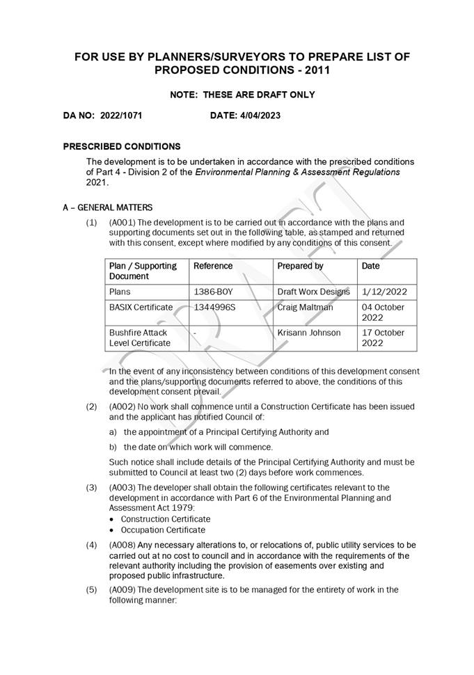
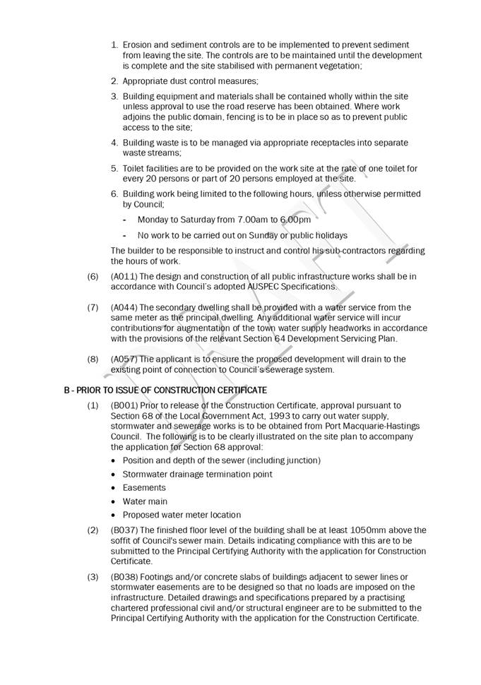
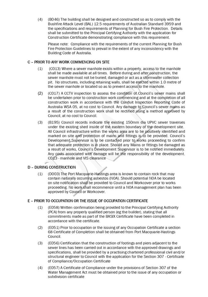

|
ATTACHMENT
|
Development Assessment Panel
19/04/2023
|
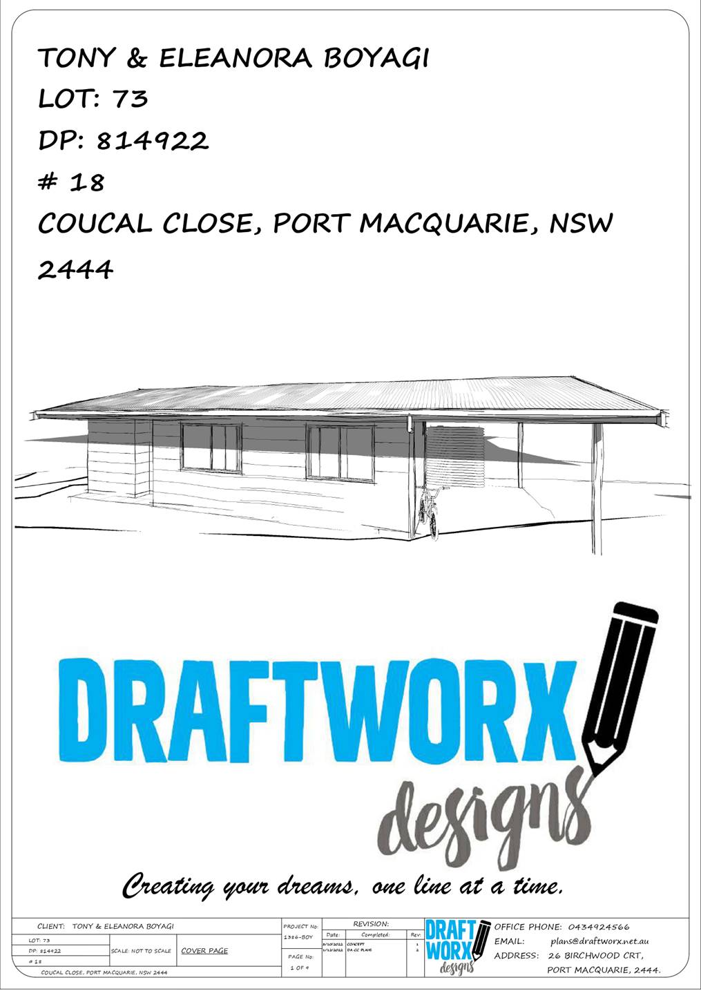
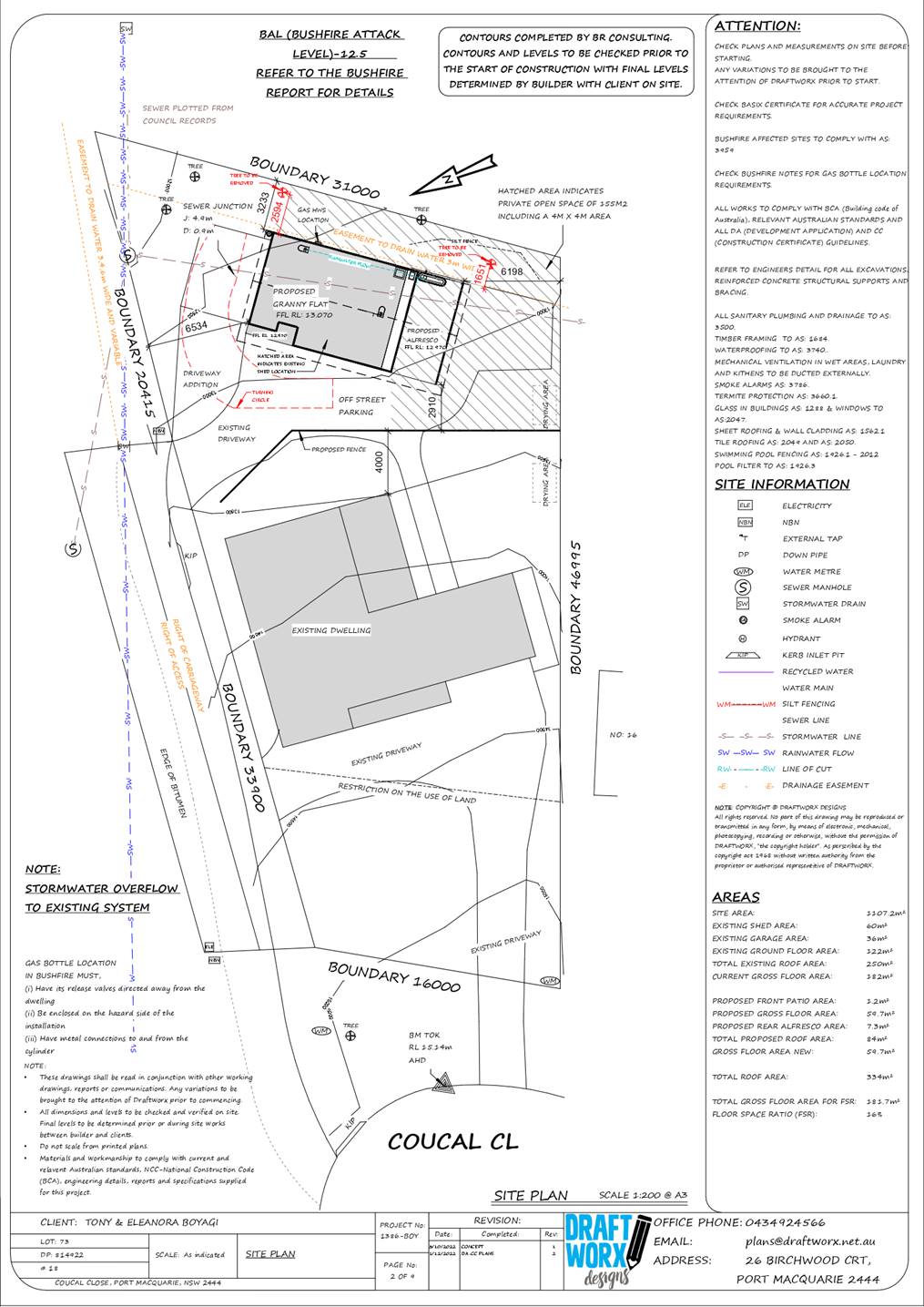
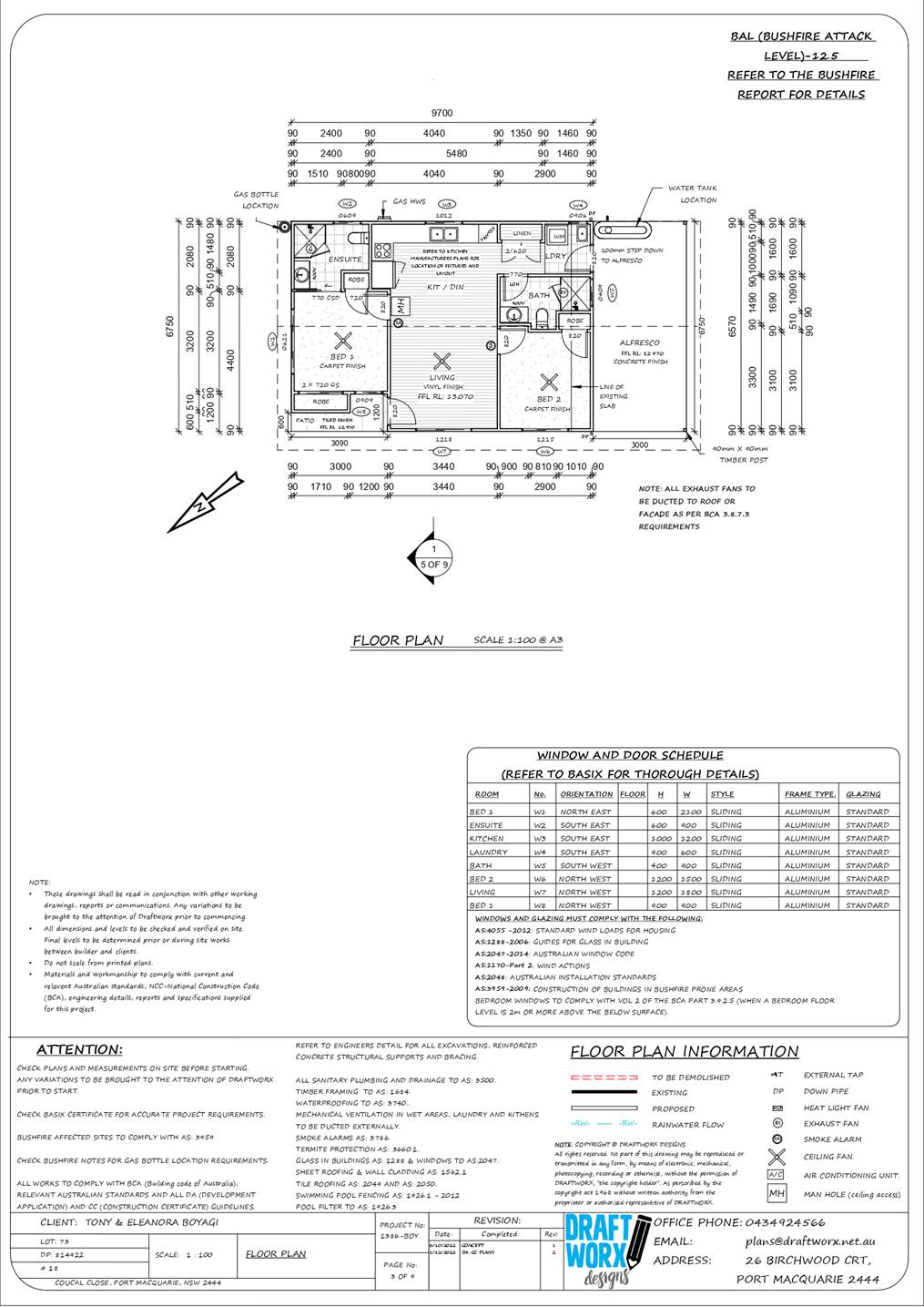
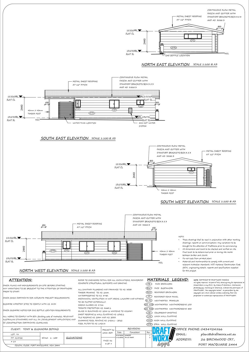
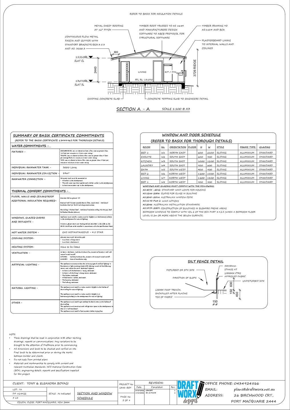
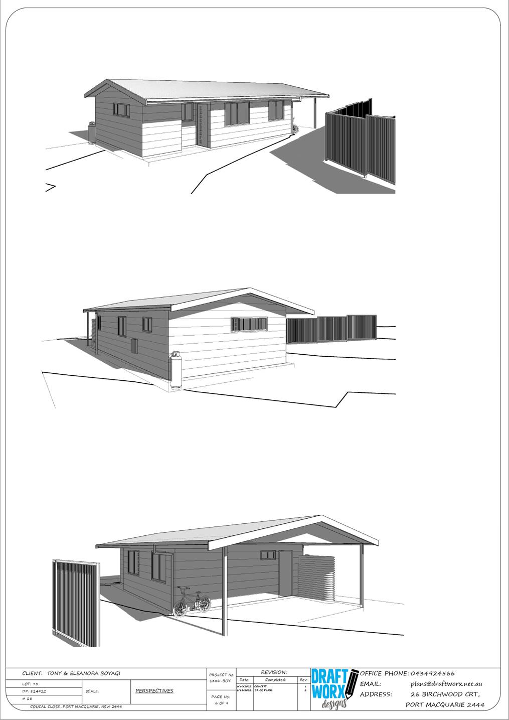
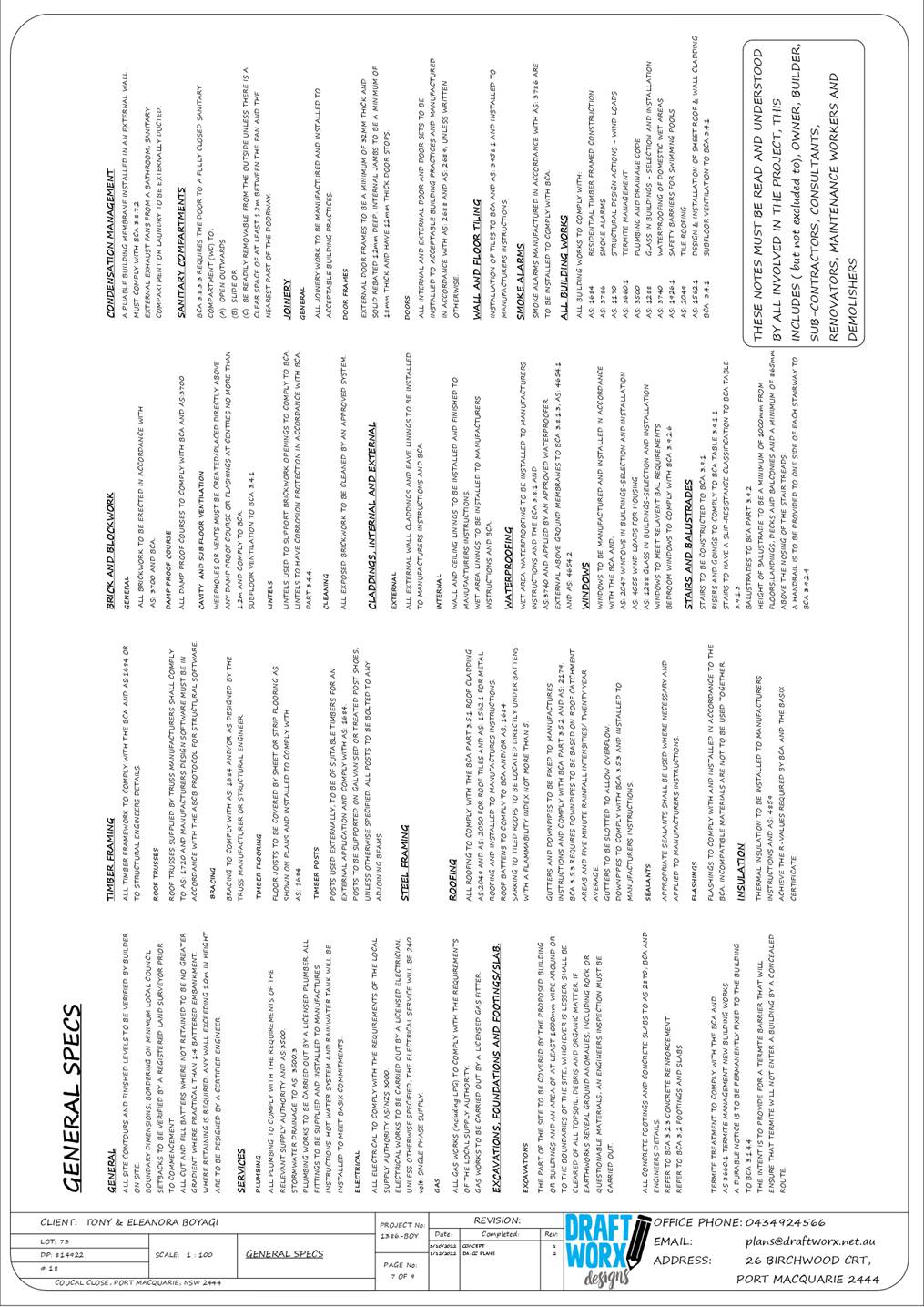
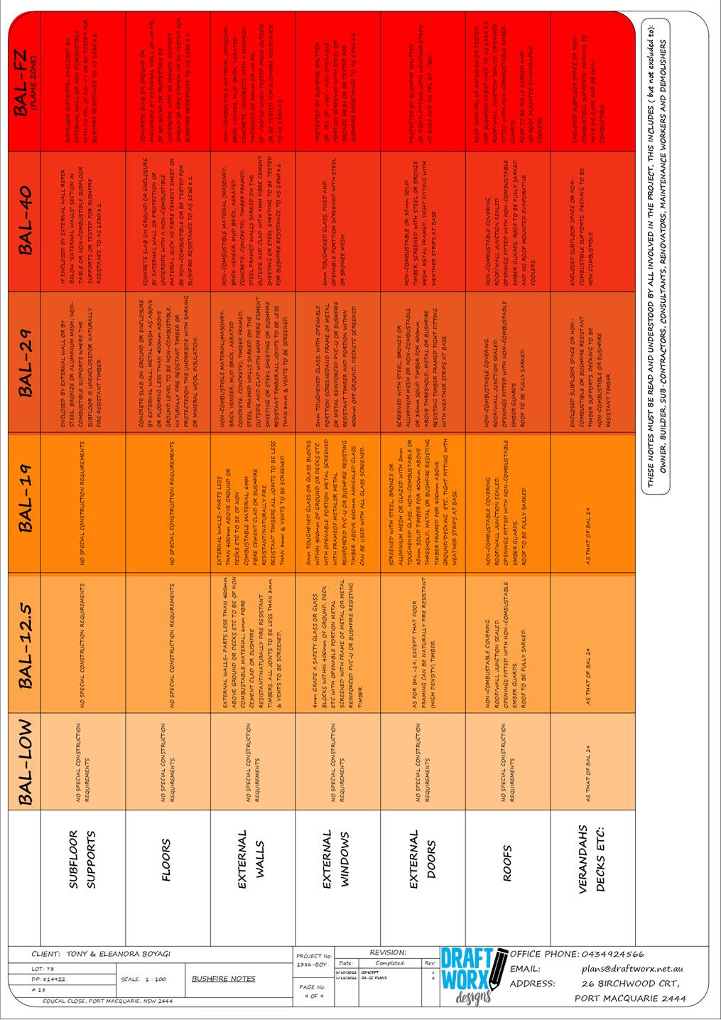
Development Assessment Panel
19/04/2023
Item: 07
Subject: DA2022 - 933.1 Centre-based child care
facility at Lot 13 DP 262597, No. 15 Kulai Place, Port Macquarie
Report
Author: Development Assessment Planner, Clint Tink
|
Applicant: Love
Project Management
Owner: R
& C Fagan Superannuation Fund Pty Ltd
Estimated Cost: $994,800.00
Alignment with Delivery
Program
4.3.1 Undertake transparent
and efficient development assessment in accordance with relevant legislation.
|
RECOMMENDATION
That
DA2022 - 933.1 for a centre-based child care facility at Lot 13, DP 262597, No.
15 Kulai Place, Port Macquarie, be determined by granting consent subject to
the recommended conditions.
Executive
Summary
This
report considers a development application for a centre-based child care
facility at the subject site and provides an assessment of the application in
accordance with the Environmental Planning and Assessment Act 1979.
Following exhibition of the
application, six (6) submissions were
received.
On balance, the site is considered suitable for the proposed
development and the proposal adequately addresses relevant planning controls.
The development is not considered to be contrary to the public's interest and
will not result a significant adverse social, environmental or economic impact.
This report recommends that the
development application be approved subject to the attached conditions.
(Attachment 1)
The reason for the application being referred to
Council’s Development Assessment Panel (DAP) is because three (3) or more
objections to the proposal have been received. A copy of the DAP Charter
outlining the delegations and functions of the DAP is available on
Council’s website.
1. BACKGROUND
Existing
Sites Features and Surrounding Development
The site has an area of 3,380m².
The
site is zoned R2 Low Density Residential in accordance
with the Port Macquarie-Hastings Local Environmental Plan 2011, as shown in the
following zoning map:
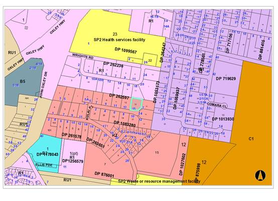 The existing subdivision pattern and location of existing
development within the locality is shown in the following aerial photographs:
The existing subdivision pattern and location of existing
development within the locality is shown in the following aerial photographs:
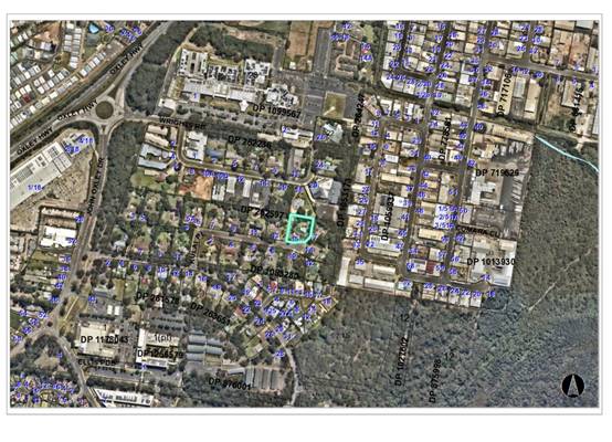
2. DESCRIPTION
OF DEVELOPMENT
Key
aspects of the proposal include the following:
· The
centre-based child care facility will cater for 94 children.
· The
development will retain the existing building onsite with alterations and
additions creating the centre-based child care facility.
· Hours
of operation for the child care centre are proposed to be 7am to 6pm Monday to
Friday. It should be noted that staff may be onsite outside these times for
cleaning, meetings etc.
· A
car park comprising 24 spaces is proposed to cater for the centre.
· Six
(6) submissions have been received objecting to the proposal.
· One
(1) juvenile tallowwood tree to be removed.
Refer
to plans of the proposed development at the end of this report. (Attachment 2)
Application
Chronology
· 12/04/2022
- Applicant had a pre-lodgement meeting with Council staff regarding the
proposal.
· 25/10/2022
- Application lodged with Council.
· 1/11/2022
- Referrals done.
· 4-17/11/2022
- Exhibition period.
· 9/11/2022
- Council staff requested additional information.
· 21/11/2022
- Feedback from Essential Energy received and passed onto the applicant.
· 14/12/2022
- Applicant requested copies of any submissions. Council staff provided
redacted copies.
· 15/12/2022
- Applicant provided response to additional information request from 9/11/2022.
· 3/1/2023
- Council staff sought clarification from the applicant on the additional
information provided on 15/12/2022. Council staff also advised that additional
submissions were received and redacted copies would be provided.
· 4/1/2023 - Applicant clarified information provided on
15/12/2022.
· 9/1/2023 - Objector requested an update on the application.
Response provided by Council staff.
· 12/1/2023 - Site inspection done.
· 18/1/2023 - Bushfire Safety Authority received from NSW
Rural Fire Service.
· 20/1/2023 - Council staff requested additional information
following a review of the responses to previous additional information requests
and having subsequently carried out the site inspection.
· 24/1/2023 - Applicant acknowledged the request.
· 27/2/2023 - Applicant provided response to additional
information request from 20/1/2023.
· 1/3/2023 - Council staff sought clarification from
the applicant on the additional information provided on 27/2/2023. Applicant clarified the information provided on 27/2/2023.
The additional information was re-referred to relevant internal sections of
Council.
· 17/3/2023 - Objector requested an update on the
application. Response provided by Council staff on 20/3/2023.
· 27/3/2023 - Applicant requested an update. Response
provided by Council staff and again on 28/3/2023.
3. STATUTORY
ASSESSMENT
Section
4.15(1) Matters for Consideration
In
determining the application, Council is required to take into consideration the
following matters as are relevant to the development that apply to the land to
which the development application relates:
(a) The
provisions (where applicable) of:
(i) Any
Environmental Planning Instrument
State Environmental Planning Policy (Biodiversity and
Conservation) 2021
Chapter 4 Koala Habitat Protection 2021
Clause 4.4 - This SEPP applies to all non-rural zoned land
within the Port Macquarie-Hastings Local Government Area. The
site is zoned R2 Low Density Residential so the SEPP requires consideration.
Clause 4.9 - The property is not over 1ha in
size (including adjoining land in the same ownership) and does not have a KPOM
in place. Therefore, Clause 4.9 does not apply.
Clause 4.10 - Having considered the SEPP, the
application, the arborist report, on completion of a site inspection and having
received feedback from Council’s Natural Resource Management Team -
Council is not prevented from granting consent in this case for the following
reasons:
1. The property is not subject to a KPOM.
2. The site is not considered to be core koala habitat.
3. The
vegetation removal is not considered to be significant or involve any
substantial koala feed trees.
State Environmental Planning Policy (Industry and
Employment) 2021
Chapter 3 Advertising and Signage
The proposed development includes proposed advertising
signage in the form of business/building identification signage on the front
façade of the Centre.
Clause 3.6 - The following assessment table provides an
assessment checklist against the Schedule 5 requirements of this SEPP:
|
Applicable clauses for consideration
|
Comments
|
Satisfactory
|
|
Clause 3.6(a) Consistent with
objectives of the policy as set out in Clause 3(1)(a).
|
The proposal includes a standard
sized business/building identification sign on the front façade of the
Centre.
The sign is compatible with other child care centre signs
and allowable non-residential uses, provides effective communication, is of
quality design, has been kept to a minimum and will not impact on the amenity
of the area. Overall, the proposed signage is consistent with the aims and
objectives of the SEPP.
|
Yes
|
Schedule
5(1) Character of the area.
|
The character of the street is
currently defined by residential housing with various other non-residential
uses being found within the surrounding area. It is noted that planning
legislation does allow various non-residential uses with consent in the area,
home occupations/businesses without consent and subsequent signage without
consent. Whilst these non-residential uses/signage may be limited at present
within the area, development pressures and the adoption of home
occupations/businesses will likely see some non-residential development occur
in the future (as has occurred in other areas throughout the Local Government
Area). The signage is also not excessive in number or size and is required to
identify the non-residential use.
Based on the above, the signage
is considered to be consistent with that allowed in the area and the likely
future character of the space.
|
Yes
|
|
Schedule 5(2) Special areas.
|
The signage will not detract from
the amenity and visual quality of the immediate residential locality noting
it’s limited scale and placement.
|
Yes
|
|
Schedule 5(3) Views and vistas.
|
The signage will not impact on
any views or vistas.
|
Yes
|
|
Schedule 5(4) Streetscape,
setting or landscape.
|
The signage is not excessive in
number or size and creates no adverse impact on streetscape, setting or
landscaping principles.
|
Yes
|
|
Schedule 5(5) Site and building.
|
The signage is compatible with
the site and building scale.
|
Yes
|
|
Schedule 5(6) Associated devices
and logos with advertisements and advertising structures.
|
None proposed.
|
Yes
|
|
Schedule 5(7) Illumination.
|
None proposed.
|
Yes
|
|
Schedule 5(8) Safety.
|
The signage does not create any safety issues.
|
Yes
|
State Environmental Planning Policy (Resilience and
Hazards) 2021
Chapter 4 Remediation of Land
Clause 4.6 - Following an inspection of the site, review of
the application by one of Council’s Environmental Health Officers and a
search of Council records - the subject land is not identified as being
potentially contaminated and is considered suitable for the intended use.
State Environmental Planning Policy (Planning Systems)
2021
The development does not trigger any of the clauses or
thresholds under the SEPP.
State Environmental Planning Policy (Primary Production)
2021
Part 2.5 Division 4 - The proposed development will create
no adverse impact on any oyster aquaculture development or priority oyster
aquaculture area.
State Environmental Planning Policy (Transport and
Infrastructure) 2021
Chapter 2 Infrastructure
Clause 2.48 - Referral to Essential Energy is required for
any of the following:
(a) the
penetration of ground within 2m of an underground electricity power line or an
electricity distribution pole or within 10m of any part of an electricity
tower,
(b) development
carried out:
(i) within
or immediately adjacent to an easement for electricity purposes (whether or not
the electricity infrastructure exists), or
(ii) immediately
adjacent to an electricity substation, or
(iii) within
5m of an exposed overhead electricity power line,
(c) installation
of a swimming pool any part of which is:
(i) within
30m of a structure supporting an overhead electricity transmission line,
measured horizontally from the top of the pool to the bottom of the structure
at ground level, or
(ii) within 5m of an overhead electricity power line, measured vertically
upwards from the top of the pool.
A referral to Essential Energy was carried out with no
objection received. Standard advice about Dial Before You Dig etc was provided,
which was forwarded to the applicant.
Clause 2.122 - The development does not trigger any of the
traffic generating development thresholds.
Chapter 3 Educational establishments and child care
facilities
|
SEPP (Transport and Infrastructure) 2021 - Childcare,
Chapter 3, Assessment Table
|
|
Requirement
|
Proposed
|
Complies
|
|
Clause 3.22 - Development complies with indoor and outdoor
areas.
3.25m²
per child (indoor)
7m²
per child (outdoor)
Note: Concurrence from Department of Education required if
indoor/outdoor area requirements not achieved.
|
Refer to Child Care Planning Guideline assessment
below.
94 children proposed.
306m² indoor required with 337m² provided.
658m² outdoor required with 879m² provided.
|
Yes
|
|
Clause 3.23 - Development consider Child Care Planning
Guideline
|
Refer to Child Care Planning Guideline assessment
below.
|
Yes
|
|
Clause 3.24 - Centre based child care in IN1 and IN2 zone.
- Minimise
land use conflicts.
- Consider
safety of occupants.
- Compatible
with surrounding uses.
- Development
should not sterilise surrounding industrial uses.
|
Not located in IN1 or IN2 zone.
|
N/A
|
|
Clause 3.25 - Development consent must not be granted for
the purposes of a centre-based child care facility in the R2 zone if the FSR
for the building exceeds 0.5:1. The section does not apply if another environmental
planning instrument or DCP sets a maximum FSR for centre-based child care
facility.
|
The subject land is zoned R2 Low Density Residential and
the clause applies. The proposed floor space ratio is approximately 0.2:1 and
does not exceed the 0.5:1 standard.
There is no FSR stipulated in another environmental
planning instrument or DCP.
|
Yes
|
|
Clause 3.26 - Non discretionary standards, that if
complied with, prevent the consent authority applying more onerous standards.
a) Location
- the development may be located at any distance to another child care.
b) Indoor/outdoor
spaces comply with Clause 22 above.
c) The
development may be located on a site of any size, over any part of the site
and have any length of street frontage or allotment depth.
d) The
development can use any colour, building materials or shade structures (if
not heritage).
|
Standards noted and not being challenged or more onerous
condition applied.
|
Yes
|
|
Clause 3.27 - Lists DCP provisions that do not apply
(covered by Child Care Planning Guideline)
|
Clause noted and not being challenged by a DCP provision.
|
Yes
|
|
Child Care Planning Guideline – Matters for
Consideration (Chapter 3)
|
|
Matter for Consideration/
Requirement
|
Proposed
|
Complies
|
|
3.1 Site selection and location p9-10
|
|
C1
For proposed developments in or adjacent to a
residential zone, consider:
· the acoustic and
privacy impacts of the proposed development on the residential properties
· the setbacks and
siting of buildings within the residential context
· traffic and parking
impacts of the proposal on residential amenity.
For proposed developments in commercial and industrial
zones, consider:
· potential
impacts on the health, safety and wellbeing of children, staff and visitors
with regard to local environmental or amenity issues such as air or noise
pollution and local traffic conditions
· the potential
impact of the facility on the viability of existing commercial or industrial
uses.
For proposed developments in public or private
recreation zones, consider:
· the compatibly
of the proposal with the operations and nature of the community or private
recreational facilities
· if the existing
premises is licensed for alcohol or gambling
· if the use
requires permanent or casual occupation of the premises or site
· the availability
of onsite parking
· compatibility of
proposed hours of operation with surrounding uses, particularly residential
uses
· the availability
of appropriate and dedicated sanitation facilities for the development.
For proposed developments on school, TAFE or university
sites in Special Purpose zones, consider:
· the compatibly
of the proposal with the operation of the institution and its users
· the proximity of
the proposed facility to other uses on the site, including premises licensed
for alcohol or gambling
· proximity to
sources of noise, such as places of entertainment or mechanical workshops
· proximity to
odours, particularly at agricultural institutions
· previous uses of
a premises such as scientific, medical or chemical laboratories, storage
areas and the like.
|
The applicant submitted noise and traffic reports, which
were reviewed and accepted by specialist Council staff.
The retention of the majority of the existing dwelling
built form will ensure the development does not adversely impact on character
or streetscape.
Fencing, separation and landscaping will be used to
maintain privacy.
Overall, the provisions in the Guideline were considered
and the development/design was deemed acceptable and compliant. In
particular, no significant adverse conflicts between the development and
adjoining areas to occur.
|
Yes
|
|
C2
When selecting a site, ensure that:
· the location and
surrounding uses are compatible with the proposed development or use
· the site is
environmentally safe including risks such as flooding, land slip, bushfires,
coastal hazards
· there are no
potential environmental contaminants on the land, in the building or the
general proximity, and whether hazardous materials remediation is needed
· the
characteristics of the site are suitable for the scale and type of
development proposed having regard to:
- size
of street frontage, lot configuration, dimensions and overall size
- number
of shared boundaries with residential properties
- the
development will not have adverse environmental impacts on the surrounding
area, particularly in sensitive environmental or cultural areas
· where the
proposal is to occupy or retrofit an existing premises, the interior and
exterior spaces are suitable for the proposed use
· there are
suitable drop off and pick up areas, and off and on street parking
· the type of
adjoining road (for example classified, arterial, local road, cul-de-sac) is
appropriate and safe for the proposed use
· it is not located
closely to incompatible social activities and uses such as restricted
premises, injecting rooms, drug clinics and the like, premises licensed for
alcohol or gambling such as hotels, clubs, cellar door premises and sex
services premises.
|
Development is permissible and compatible with the site
characteristics and surrounding/future desired uses. In particular, it is
common to see child care centres positioned within residential zones and
there are also a range on non-residential uses within the nearby area.
The building and site design create a compliant child care
design whilst creating no significant adverse impact on the area.
The site also contains a suitable 70m setback to the
nearby industrial area with housing, vegetation, fencing etc located in
between. This ensures no hazardous impacts/conflict will occur.
Furthermore, specialist traffic, bushfire, noise etc
assessments have been submitted and reviewed by Council staff/NSW Rural Fire
Service and deemed acceptable, subject to conditions.
|
Yes
|
|
C3
A child care facility should be located:
· near compatible
social uses such as schools and other educational establishments, parks and
other public open space, community facilities, places of public worship
· near or within
employment areas, town centres, business centres, shops
· with access to
public transport including rail, buses, ferries
· in areas with
pedestrian connectivity to the local community, businesses, shops, services
and the like.
|
The development is located within close proximity (less
than 1km) to schools/education, employment areas, pedestrian linkages and
public transport. The centre is also likely to draw from the local
residential population/estates within the surrounding area.
On balance, the child care centre location is considered
acceptable.
|
Yes
|
|
C4
A child care facility should be located to avoid risks to
children, staff or visitors and adverse environmental conditions arising
from:
· proximity to:
- heavy
or hazardous industry, waste transfer depots or landfill sites
- LPG
tanks or service stations
- water
cooling and water warming systems - odour (and other air pollutant)
generating uses and sources or sites which, due to prevailing land use
zoning, may in future accommodate noise or odour generating uses
- extractive
industries, intensive agriculture, agricultural spraying activities
· any other
identified environmental hazard or risk relevant to the site and/ or existing
buildings within the site.
-
|
Refer to comments on C2 above. There are no hazardous
elements within close proximity to the centre.
|
Yes
|
|
3.2 Local Character, streetscape and the public domain
interface p11-12
|
|
C5
The proposed development should:
· contribute to
the local area by being designed in character with the locality and existing
streetscape
· reflect the
predominant form of surrounding land uses, particularly in low density
residential areas
· recognise
predominant streetscape qualities, such as building form, scale, materials
and colours
· include design
and architectural treatments that respond to and integrate with the existing
streetscape
· use landscaping
to positively contribute to the streetscape and neighbouring amenity
· integrate car
parking into the building and site landscaping design in residential areas.
-
|
The development will compliment other existing non-residential
uses within 100-500m of the site while the associated built form will remain
similar to that of a residential dwelling. There is a car park at the front
of the premises, which will largely be screened by landscaping to offset any
visual impact.
|
Yes
|
|
C6
Create a threshold with a clear transition between public
and private realms, including:
· fencing to
ensure safety for children entering and leaving the facility
· windows facing
from the facility towards the public domain to provide passive surveillance
to the street as a safety measure and connection between the facility and the
community
· integrating
existing and proposed landscaping with fencing.
|
Clear transition area provided with suitable fencing,
window placement and landscaping.
|
Yes
|
|
C7
On sites with multiple buildings and/or entries,
pedestrian entries and spaces associated with the child care facility should
be differentiated to improve legibility for visitors and children by changes
in materials, plant species and colours.
|
Whilst there are multiple entry points, the main entry is
emphasized in the design. Signage will also be required to clarify entry
procedures.
|
Yes
|
|
C8
Where development adjoins public parks, open space or
bushland, the facility should provide an appealing streetscape frontage by
adopting some of the following design solutions:
· clearly defined
street access, pedestrian paths and building entries
· low fences and
planting which delineate communal/ private open space from adjoining public
open space
· minimal use of
blank walls and high fences.
|
Development does not adjoin such areas.
|
N/A
|
|
C9
Front fences and walls within the front setback should be
constructed of visually permeable materials and treatments. Where the site is
listed as a heritage item, adjacent to a heritage item or within a
conservation area front fencing should be designed in accordance with local
heritage provisions.
|
The front fences allow an acceptable permeable frontage
and comprise only short runs. The fence is also well setback from the front
boundary to ensure no impact on streetscape.
|
Yes
|
|
C10
High solid acoustic fencing may be used when shielding the
facility from noise on classified roads. The walls should be setback from the
property boundary with screen landscaping of a similar height between the
wall and the boundary.
|
High solid acoustic fencing (1.8m) is limited to side and
rear fencing and does not impact frontage design.
|
Yes
|
|
3.3 Building orientation, envelope and design p12-14
|
|
C11
Orient a development on a site and design the building
layout to:
· ensure visual
privacy and minimise potential noise and overlooking impacts on neighbours
by:
- facing
doors and windows away from private open space, living rooms and bedrooms in
adjoining residential properties
- placing
play equipment away from common boundaries with residential properties
- locating
outdoor play areas away from residential dwellings and other sensitive uses
· optimise solar
access to internal and external play areas
· avoid
overshadowing of adjoining residential properties
· minimise cut and
fill
· ensure buildings
along the street frontage define the street by facing it
· ensure that
where a child care facility is located above ground level, outdoor play areas
are protected from wind and other climatic conditions.
|
Development has been suitably designed to comply or will
implement requirements to ensure compliance.
Fencing, landscaping, high sill windows, setbacks and
suitable room type/window placement utilised.
|
Yes
|
|
C12
The following matters may be considered to minimise the
impacts of the proposal on local character:
· building height
should be consistent with other buildings in the locality
· building height
should respond to the scale and character of the street
· setbacks should
allow for adequate privacy for neighbours and children at the proposed child
care facility
· setbacks should
provide adequate access for building maintenance
· setbacks to the
street should be consistent with the existing character.
|
Development has been suitably designed to comply or will
implement requirements to ensure compliance. Overall, the built form of the
premises retains dwelling elements, bulk and scale that are consistent with
surrounding development.
|
Yes
|
|
C13
Where there are no prevailing setback controls minimum
setback to a classified road should be 10 metres. On other road frontages
where there are existing buildings within 50 metres, the setback should be
the average of the two closest buildings. Where there are no buildings within
50 metres, the same setback is required for the predominant adjoining land
use.
|
Setback remains relatively unchanged and consistent with
surrounding front setbacks.
The closest point of the existing dwelling/building to the
road does not change after the alterations and additions.
|
Yes
|
|
C14
On land in a residential zone, side and rear boundary setbacks
should observe the prevailing setbacks required for a dwelling house.
|
Design consistent with residential setbacks of 4m to rear
and 900mm to side.
|
Yes
|
|
C15
The built form of the development should contribute to the
character of the local area, including how it:
· respects and
responds to its physical context such as adjacent built form, neighbourhood
character, streetscape quality and heritage
· contributes to
the identity of the place
· retains and
reinforces existing built form and vegetation where significant
· considers
heritage within the local neighbourhood including identified heritage items
and conservation areas
· responds to its
natural environment including local landscape setting and climate
· contributes to
the identity of place.
|
Development has been suitably designed to comply with
requirements. Overall, the built form of the premises retains dwelling
elements, bulk and scale that are consistent with surrounding development.
|
Yes
|
|
C16
Entry to the facility should be limited to one secure
point which is:
· located to allow
ease of access, particularly for pedestrians
· directly
accessible from the street where possible • directly visible from the
street frontage
· easily monitored
through natural or camera surveillance
· not accessed
through an outdoor play area.
· in a mixed-use
development, clearly defined and separate from entrances to other uses in the
building.
|
The access has been suitably designed to comply with
requirements. In particular, a main access point has been provided for
parents/children. Separate ancillary rear/side access points are also
available for staff (to be reinforced by conditions).
|
Yes
|
|
C17
Accessible design can be achieved by:
· providing
accessibility to and within the building in accordance with all relevant
legislation
· linking all key
areas of the site by level or ramped pathways that are accessible to prams
and wheelchairs, including between all car parking areas and the main building
entry
· providing a
continuous path of travel to and within the building, including access
between the street entry and car parking and main building entrance. Platform
lifts should be avoided where possible
· minimising
ramping by ensuring building entries and ground floors are well located
relative to the level of the footpath. NOTE: The National Construction Code,
the Discrimination Disability Act 1992 and the Disability (Access to Premises
– Buildings) Standards 2010 set out the requirements for access to
buildings for people with disabilities.
|
Development has been suitably designed to comply or will
implement requirements to ensure compliance.
|
Yes
|
|
3.4 Landscaping p15
|
|
C18
Appropriate planting should be provided along the boundary
integrated with fencing. Screen planting should not be included in
calculations of unencumbered outdoor space. Use the existing landscape where
feasible to provide a high quality landscaped area by:
· reflecting and
reinforcing the local context
· incorporating
natural features of the site, such as trees, rocky outcrops and vegetation
communities into landscaping.
|
Landscaping has been suitably designed to comply or will
implement requirements to ensure compliance.
Area also exists onsite for future plantings.
|
Yes
|
|
C19
Incorporate car parking into the landscape design of the
site by:
· planting shade
trees in large car parking areas to create a cool outdoor environment and
reduce summer heat radiating into buildings
· taking into
account streetscape, local character and context when siting car parking
areas within the front setback
· using low level
landscaping to soften and screen parking areas.
-
|
Landscaping has been suitably designed to comply with
requirements. In particular, the car park is not considered large and
proposed landscaping creates a suitable balance of creating a visual and
aesthetic environment whilst not impacting the safety and operation of the
site.
|
Yes
|
|
3.5 Visual and Acoustic Privacy p15-16
|
|
C20
Open balconies in mixed use developments should not
overlook facilities nor overhang outdoor play spaces.
|
Use of fencing, landscaping and separation - ensure no
adverse overlooking issues created.
|
Yes
|
|
C21
Minimise direct overlooking of indoor rooms and outdoor
play spaces from public areas through:
· appropriate site
and building layout
· suitably
locating pathways, windows and doors
· permanent
screening and landscape design.
|
Development has been suitably designed to comply with
requirements.
Fencing, landscaping, high sill windows, setbacks and
suitable room placement utilised to avoid overlooking.
|
Yes
|
|
C22
Minimise direct overlooking of main internal living areas
and private open spaces in adjoining developments through:
· appropriate site
and building layout
· suitable
location of pathways, windows and doors
· landscape design
and screening.
|
Development has been suitably designed to comply with
requirements.
Fencing, landscaping, high sill windows, setbacks and
suitable room placement utilised to avoid overlooking.
|
Yes
|
|
C23
A new development, or development that includes
alterations to more than 50 per cent of the existing floor area, and is
located adjacent to residential accommodation should:
· provide an
acoustic fence along any boundary where the adjoining property contains a
residential use. (An acoustic fence is one that is a solid, gap free fence).
· ensure that
mechanical plant or equipment is screened by solid, gap free material and
constructed to reduce noise levels e.g. acoustic fence, building, or
enclosure.
|
The applicant submitted a noise report, which was reviewed
by Council’s Environmental Health Officer. Overall, the provisions in
the Guideline were considered and the development/design was deemed
acceptable and compliant. In particular, no significant adverse conflicts
between the development and adjoining areas to occur via use of
fencing/screening and conditions of operation.
|
Yes
|
|
C24
A suitably qualified acoustic professional should prepare
an acoustic report which will cover the following matters:
· identify an
appropriate noise level for a child care facility located in residential and
other zones
· determine an
appropriate background noise level for outdoor play areas during times they
are proposed to be in use
· determine the
appropriate height of any acoustic fence to enable the noise criteria to be
met.
|
The applicant submitted a noise report, which was reviewed
by Council’s Environmental Health Officer. Overall, the provisions in
the Guideline were considered and the development/design was deemed
acceptable and compliant. In particular, no significant adverse conflicts
between the development and adjoining areas to occur via use of
fencing/screening and conditions of operation.
|
Yes
|
|
3.6 Noise and air pollution p17
|
|
C25
Adopt design solutions to minimise the impacts of noise,
such as:
· creating
physical separation between buildings and the noise source
· orienting the
facility perpendicular to the noise source and where possible buffered by
other uses
· using
landscaping to reduce the perception of noise
· limiting the
number and size of openings facing noise sources
· using double or
acoustic glazing, acoustic louvres or enclosed balconies (wintergardens)
· using materials
with mass and/or sound insulation or absorption properties, such as solid
balcony balustrades, external screens and soffits
· locating cot
rooms, sleeping areas and play areas away from external noise sources.
|
Development has been suitably designed to comply with
requirements.
Fencing, landscaping, setbacks, suitable room placement
and conditions of operation utilised.
|
Yes
|
|
C26
An acoustic report should identify appropriate noise
levels for sleeping areas and other non-play areas and examine impacts and
noise attenuation measures where a child care facility is proposed in any of
the following locations:
· on industrial
zoned land
· where the ANEF
contour is between 20 and 25, consistent with AS 2021 – 2000
· along a railway
or mass transit corridor, as defined by State Environmental Planning Policy
(Infrastructure) 2007
· on a major or
busy road
· other land that
is impacted by substantial external noise.
|
Development does not adjoin such a noise source.
|
N/A
|
|
C27
Locate child care facilities on sites which avoid or
minimise the potential impact of external sources of air pollution such as
major roads and industrial development.
|
Facility location is acceptable and designed to minimise
impacts from outside sources.
|
Yes
|
|
C28
A suitably qualified air quality professional should
prepare an air quality assessment report to demonstrate that proposed child
care facilities close to major roads or industrial developments can meet air
quality standards in accordance with relevant legislation and guidelines. The
air quality assessment report should evaluate design considerations to
minimise air pollution such as:
· creating an
appropriate separation distance between the facility and the pollution
source. The location of play areas, sleeping areas and outdoor areas should
be as far as practicable from the major source of air pollution
· using
landscaping to act as a filter for air pollution generated by traffic and
industry. Landscaping has the added benefit of improving aesthetics and minimising
visual intrusion from an adjacent roadway
· incorporating
ventilation design into the design of the facility.
|
Development contains a suitable setback to busy
roads/industrial type uses.
|
Yes
|
|
3.7 Hours of operation p18
|
|
C29
Hours of operation within areas where the predominant land
use is residential should be confined to the core hours of 7.00am to 7.00pm
weekdays. The hours of operation of the proposed child care facility may be
extended if it adjoins or is adjacent to non-residential land uses.
|
7:00am to 6:00pm proposed, which complies.
Some after-hours ancillary cleaning, office work etc may
occur from time to time but is not expected to create adverse noise impacts
to that which could occur in a residential setting.
|
Yes
|
|
C30
Within mixed use areas or predominantly commercial areas,
the hours of operation for each child care facility should be assessed with
respect to its compatibility with adjoining and co-located land uses.
|
Location and hours acceptable.
|
Yes
|
|
3.8 Traffic, parking and pedestrian circulation p18-19
|
|
C31
Off street car parking should be provided at the rates for
child care facilities specified in a Development Control Plan that applies to
the land.
Where a Development Control Plan does not specify car
parking rates, off street car parking should be provided at the following
rates:
Within 400 metres of a metropolitan train station:
· 1 space per 10
children
· 1 space per 2
staff. Staff parking may be stack or tandem parking with no more than 2
spaces in each tandem space.
In other areas:
· 1 space per 4
children.
A reduction in car parking rates may be considered
where:
· the proposal is
an adaptive re-use of a heritage item
· the site is in a
B8 Metropolitan Zone or other high density business or residential zone
· the site is in
proximity to high frequency and well connected public transport
· the site is
co-located or in proximity to other uses where parking is appropriately
provided (for example business centres, schools, public open space, car
parks)
· there is sufficient
on street parking available at appropriate times within proximity of the
site.
|
DCP 2013 requires 1 space per 4 children and a set
down/pick up area.
It should be noted that the set down/pickup area is not
enforced by Council as modern child care centres require parents to park,
take the child into the facility and sign them in.
94 children/4 = 23.5 spaces, which rounds to 24 spaces.
24 spaces provided.
|
Yes
|
|
C32
In commercial or industrial zones and mixed use
developments, on street parking may only be considered where there are no
conflicts with adjoining uses, that is, no high levels of vehicle movement or
potential conflicts with trucks and large vehicles.
|
No on street parking proposed.
|
N/A
|
|
C33
A Traffic and Parking Study should be prepared to support
the proposal to quantify potential impacts on the surrounding land uses and
demonstrate how impacts on amenity will be minimised. The study should also
address any proposed variations to parking rates and demonstrate that:
· the amenity of
the surrounding area will not be affected
· there will be no
impacts on the safe operation of the surrounding road network.
|
Traffic report has been done and reviewed by specialist
Council staff as being acceptable. No significant adverse impacts to occur.
|
Yes
|
|
C34
Alternate vehicular access should be provided where child
care facilities are on sites fronting:
· a classified
road
· roads which
carry freight traffic or transport dangerous goods or hazardous materials.
The alternate access must have regard to:
· the prevailing
traffic conditions
· pedestrian and
vehicle safety including bicycle movements
· the likely
impact of the development on traffic.
|
Development does not front a classified road etc.
|
N/A
|
|
C35
Child care facilities proposed within cul-de-sacs or
narrow lanes or roads should ensure that safe access can be provided to and
from the site, and to and from the wider locality in times of emergency.
|
Council Engineering staff have reviewed and accepted the
proposal on road design/conditions.
|
Yes
|
|
C36
The following design solutions may be incorporated into a
development to help provide a safe pedestrian environment:
· separate
pedestrian access from the car park to the facility
· defined
pedestrian crossings included within large car parking areas
· separate
pedestrian and vehicle entries from the street for parents, children and
visitors
· pedestrian paths
that enable two prams to pass each other
· delivery and
loading areas located away from the main pedestrian access to the building and
in clearly designated, separate facilities
· in commercial or
industrial zones and mixed use developments, the path of travel from the car
parking to the centre entrance physically separated from any truck
circulation or parking areas
· vehicles can enter
and leave the site in a forward direction.
|
Design allows sufficient room for informal pedestrian
paths and provides a slow speed environment.
The car park design has also been reviewed and accepted by
Council Engineering staff.
|
Yes
|
|
C37
Mixed use developments should include:
· driveway access,
manoeuvring areas and parking areas for the facility that are separate to
parking and manoeuvring areas used by trucks
· drop off and
pick up zones that are exclusively available for use during the
facility’s operating hours with spaces clearly marked accordingly,
close to the main entrance and preferably at the same floor level.
Alternatively, direct access should avoid crossing driveways or maneuvering
areas used by vehicles accessing other parts of the site
· parking that is
separate from other uses, located and grouped together and conveniently
located near the entrance or access point to the facility.
|
Development is not a mixed use development.
|
N/A
|
|
C38
Car parking design should:
· include a child
safe fence to separate car parking areas from the building entrance and play
areas
· provide clearly
marked accessible parking as close as possible to the primary entrance to the
building in accordance with appropriate Australian Standards
· include wheelchair
and pram accessible parking.
|
The development incorporates such measures.
The car park has also been reviewed and accepted by
Council Engineering staff.
|
Yes
|
|
Child Care Planning Guideline – National
Regulations (Chapter 4)
|
|
Requirement
|
Proposed
|
Complies
|
|
4.1 Indoor space
· 3.25m² per
child. Areas to exclude outlined in Guideline.
· Verandahs can be
included as indoor space with written approval from Department of Education -
see page 24 of Guideline.
· Cannot double up
on use of verandahs in indoor and outdoor space calculations
· Minimum 0.3m³ external storage per
child.
· Minimum 0.2m³ internal storage per
child.
· Storage of items
such as prams, bikes and scooters should be located adjacent to the building
entrance.
-
|
306m² indoor required with 337m² provided.
External storage exceeds 94 x 0.3m³ = 28.2m³
(over 115m³ provided in shed).
Internal storage exceeds 94 x 0.2m³ = 18.8m³
(over 50m³ provided).
Overall, the development has been suitably designed to
comply with requirements.
|
Yes
|
|
4.2 Laundry and hygiene facilities
· Must contain
washer(s), dryer, laundry sinks and storage for soiled items.
· If external
laundry to be utilised, the proposal must address requirements on p25 of
Guideline.
|
Development has been suitably designed and provides such
facilities.
|
Yes
|
|
4.3 Toilet and hygiene facilities
· Designed for use
by children.
· Contain
screening but allow supervision.
· Allow for direct
access to activity and outdoor play areas.
· Minimum number
outlined in BCA.
· A sink and
handwashing facilities in all bathrooms for adults.
· External windows
in locations that prevent observation from neighbouring properties or from
side boundaries.
|
Development has been suitably designed and provides such
facilities or can be easily modified to comply at the construction stage.
Internal and external bathroom provided.
|
Yes
|
|
4.4 Ventilation and natural light
· Good design
using mixture of natural and mechanical ventilation.
· Consideration of
ceiling heights being adequate when room depth exceeds 2.5 times the ceiling
height.
· Minimise
reliance on artificial lighting.
|
Development has been suitably designed and complies with
such requirements.
|
Yes
|
|
4.5 Administrative Space
· Must provide for
admin functions, consultation with parents, be private, desk and chair areas,
storage and filing area.
|
Development has been suitably designed and complies with
such requirements.
|
Yes
|
|
4.6 Nappy
change facilities
· Properly
constructed nappy change bench.
· Provide a baby
bath within 1m of nappy change.
· Hand cleaning
facilities for adult within vicinity of nappy change.
· Provide storage
for steps.
· Position nappy
change to allow staff to supervise play area.
|
Development has been suitably designed or can be easily
modified to comply at the construction stage.
|
Yes
|
|
4.7 Premise
designed to facilitate supervision
· Development
allow supervision but dignity of child.
· Requirements on
p30 of Guideline.
|
Development has been suitably designed or can be easily
modified to comply at the construction stage.
|
Yes
|
|
4.8 Emergency
and evacuation procedures
· Requirements for
multi storey listed on p31.
· Safe haven
provided to count numbers before evacuation.
· Emergency and
evacuation plan should be submitted with DA in accordance with p31
requirements.
|
The design and site contains suitable areas to manage
emergency situations.
Conditions will reinforce the need for an emergency and
evacuation plan.
|
Yes
|
|
4.9 Outdoor
space requirements
· 7m² per
child. Areas to exclude outlined in the Guideline.
· Verandahs as
outdoor space see p32 of Guideline.
· Exemptions (ie
including verandah areas, simulated indoor areas etc) allowed and outlined on
p23-25 of Guideline.
|
658m² outdoor required with 879m² provided.
|
Yes
|
|
4.10 Natural Environment
· Create a natural
environment using trees, sand, rocks etc.
· Avoid having
unsafe trees/plants.
· Provide a
variety of experiences.
· Avoid elements
that will limit supervision.
· Create an
environment that enhances learning, interaction etc.
|
Development has been suitably designed and complies with
such requirements.
Site also allows for future site specific treatments.
|
Yes
|
|
4.11 Shade
· Provide solar
access to at least 30% of ground area.
· Provide shade to
at least 30% and evenly distributed.
· Not more than
60% of outdoor space should be shaded.
· Planting for
shade and solar access is enhanced by:
- placing
appropriately scaled trees near the eastern and western elevations
- providing
a balance of evergreen and deciduous trees to give shade in summer and
sunlight access in winter.
· Built structures
should not create safety hazards. Support systems such as upright posts
should be clearly visible with rounded edges or padding. Vertical barriers at
the sides of shade structures should be designed to prevent children using
them for climbing. Shade structures should allow adults to view and access
the children’s play areas, with a recommended head clearance of 2.1
metres. The floor area underneath the structure should be of a sufficient
size and shape to allow children to gather or play actively.
|
Development has been suitably designed and complies or is
capable of complying with such requirements.
Site also allows for future site specific treatments.
|
Yes
|
|
4.12 Fencing
· Required around
outdoor areas.
· Design prevent
climbing, going through or under.
· Prevent outside
people gaining access.
· Not create a
sense of enclosure.
· No climbing
points higher than 150mm from the ground.
· No gaps greater
than 100mm between pickets.
· Have
self-closing gates as per AS2890.
· Side and rear
fences must be solid, minimum 1.8m high and be non-climbable.
|
Development has been suitably designed or is capable of
complying with such requirements.
|
Yes
|
|
4.13 Soil assessment
-
|
The application has been reviewed by Council’s
Environmental Health Officer. Given the past use of the site for standard
residential purposes, a soil assessment is not required in this case.
|
N/A
|
Port Macquarie-Hastings Local Environmental
Plan 2011
The proposal is consistent with the LEP having regard to the
following:
· Clause
2.2 - The subject site is zoned R2 Low Density Residential. In accordance with
Clause 2.3(1) and the R2 zone landuse table, a centre-based child care facility
is permissible with consent.
The objectives of the R2 zone are
as follows:
•
To
provide for the housing needs of the community within a low density
•
residential
environment.
•
To
enable other land uses that provide facilities or services to meet the day to day
needs of residents.
•
To
provide for low density housing that does not compromise the
•
environmental,
scenic or landscape qualities of land.
Clause 2.3(2) - The proposal is
consistent with the zone objectives having regard to the following:
•
The
proposal is a permissible landuse;
•
The
development will allow a land use that serves the day to day child care needs
of residents in the area.
· Clause
2.7 - The demolition requires consent as it does not fit within the provisions
of SEPP (Exempt and Complying) 2008.
· Clause
4.3 - The maximum overall height of the building above ground level (existing)
is approx. 6.5m, which complies with the standard height limit of 8.5m applying
to the site. It should be noted that the highest part of the building is existing
with new sections to be located below such a level.
· Clause
4.4 - There is no floor space ratio applicable to the site. Nonetheless, the
floor space ratio of the proposal is approximately 0.2:1 and presents a
building consistent with the surrounding area.
· Clause
5.10 - The site does not contain or adjoin any known heritage items or sites of
significance. The site is also disturbed from past residential activities
onsite.
· Clause
7.13 - Satisfactory arrangements are in place for provision of essential
services including water supply, electricity supply, sewer infrastructure,
stormwater drainage and suitable road access to service the development.
(ii) Any draft
instruments that apply to the site or are on exhibition
None relevant.
(iii) Any Development
Control Plan in force
Port
Macquarie-Hastings Development Control Plan 2013
|
DCP 2013: Part B - General Provisions - B1:
Advertising and Signage
|
|
DCP Objective
|
Development Provisions
|
Proposed
|
Complies
|
|
1
|
a) Signs primarily identifying
products or services are not acceptable, even where relating to products or
services available on that site.
|
Only business
identification signage and minor ancillary directional/usage signage
proposed/required.
|
Yes
|
|
b) Signage is not permitted
outside property boundaries except where mounted upon buildings and clear of
pedestrians and road traffic. No signage is permitted upon light or power
poles or upon the nature strip (the area between the property boundary and
constructed roadway). Limited directional signage and “A” frame
signage may separately be approved by Council under the Roads Act 1993 or
section 68 of the Local Government Act 1993.
|
No such signage proposed.
|
Yes
|
|
c) An on-building 'chalkboard'
sign, for the purpose of describing services or goods for sale which vary on
a regular basis generally should not be any larger than 1.5m2, and should
contain a sign written heading indicating the premises to which it refers.
|
No such signage proposed.
|
Yes
|
|
d) On-premise signs should not
project above or to the side of building facades
|
Signage does not project
above or to the side of the building facade.
|
Yes
|
|
2
|
a) Where there is potential
for light spill from signage in a non-residential zone adjoining or adjacent
to residential development, illuminated signage is to be fitted with a time
switch to dim by 50% or turn off the light by 11pm each night, depending on
the nature of the development.
|
Signage is not proposed to
be illuminated and will be reinforced via conditions of consent.
|
Yes
|
|
DCP 2013: Part B - General Provisions - B2:
Environmental Management
|
|
DCP Objective
|
Development Provisions
|
Proposed
|
Complies
|
|
3
|
a) Development must comply
with Council’s Developments, Public Place & Events - Waste
Minimisation and Management Policy.
|
Standard conditions will control
waste during construction and operation. Area exits onsite to cater for
operational waste storage in conjunction with a private collection
arrangement.
|
Yes
|
|
Cut and Fill Regrading
|
|
4
|
a) Development shall not
exceed a maximum cut of 1.0m and fill of 1.0m measured vertically above the
ground level (existing) at a distance of 1.0m outside the perimeter of the
external walls of the building (This does not apply to buildings where such
cut and fill is fully retained within or by the external walls of the
building).
|
Cut and fill will exceed 1m
in certain parts of the site. Where such an exceedance occurs, a structural
engineer will need to certify the retaining wall design. The locations where
the exceedances occur do not create any adverse impacts on neighbours or the
area.
|
No, but acceptable.
|
|
5
|
a) A certified practicing
structural engineer must certify any retaining wall greater than 1.0m.
|
To be conditioned.
|
Yes
|
|
b) Where a combination of a
fence and a wall is proposed to be greater than 1.2m high:
- be a
maximum combined height of 1.8m above existing property boundary level;
- be
constructed up to the front boundary for a maximum length of 6.0m or 30% of
the street frontage, whichever is less;
− the fence
component has openings which make it not less than 25% transparent; and
− provide a 3m x
3m splay for corner sites, and
- provide a
900mm x 900mm splay for vehicle driveway entrances.
|
The development includes
retaining wall fence combinations exceeding 1.8m in height. The combinations
are either located in areas that do not impact on neighbours (ie are located
next to a driveway) or so that the cut occurs within the site (ie combination
will present as a standard 1.8m fence when viewed from the neighbouring
property). Therefore, any imposing bulk of such a combination does not face a
public area or key neighbouring property area. Development is considered to
comply with the objectives of the DCP.
|
No, but acceptable.
|
|
6
|
a) Significant land reforming
proposals where >10% gross site area or >1.0ha is to have surface
levels changed by more than 5m or where earthworks exceed an average of
10,000m3 per ha shall:
− identify the
impact of the proposed land reforming on the environment, landscape,
- visual
character and amenity, natural watercourses, riparian vegetation,
topographical features of the environment and public infrastructure;
− demonstrate
compliance with the provisions of Council’s AUS-SPEC design
specification;
− assess the
impacts and benefits of the proposal to all impacted persons and the general
public;
- provide
measures to compensate for and minimise any net adverse impacts.
|
Proposed earthworks do not
trigger the clause.
|
N/A
|
|
b) The use of high earthworks
batters should be avoided.
|
An approx. 1.5m high batter
is proposed to the north eastern corner of the site. The batter occurs over a
5m span and is to be suitably landscaped. The battered section will also be
fenced off.
|
N/A
|
|
c) Preliminary plans
indicating the final landform are required to be submitted with any master
plan or subdivision application.
|
Provision applies more to a
major subdivision.
|
N/A
|
|
d) The subdivision should be
designed to fit the topography rather than altering the topography to fit the
subdivision.
|
Provision applies more to a
major subdivision.
|
N/A
|
|
Environmental Management
Areas, Buffers and Tree Management
|
|
7-14
|
Environmental management,
buffer and tree management provisions.
|
The site does not adjoin
any environmental management areas or Endangered Ecological Communities
(EECs).
No buffer requirements
triggered.
No significant tree removal
proposed (ie the main vegetation removal relates to planted backyard
species). The tree removal has also been reviewed and accepted by
Council’s Natural Resource Management Section, subject to the small
tallowwood onsite being replaced 2:1.
Based on the above, the
proposal is consistent with the relevant provisions/objectives of the DCP.
|
Yes
|
|
DCP 2013: Part B -
General Provision - B3: Hazards Management
|
|
DCP Objective
|
Development Provisions
|
Proposed
|
Complies
|
|
Bushfire Hazard Management
|
|
18
|
a) APZs are to be located
outside of environmental protection zones and wholly provided within private
land. Note perimeter roads provided as part of a residential subdivision are
classified as being part of the subdivision and not a separate permissible
land use within environment protection zones.
|
The site does not contain
or adjoin any environmental protection zones and APZs are capable of being
managed onsite within private land.
|
Yes
|
|
b) Perimeter roads are to be
provided to all urban areas adjoining environmental management areas and
their buffers. Refer to Figure 2.
|
The site does not adjoin
any significant sized environmental management area or require the need for a
perimeter road.
|
N/A
|
|
DCP 2013: Part B- General Provisions- B4: Transport,
Traffic Management, Access and Car Parking
|
|
DCP Objective
|
Development Provisions
|
Proposed
|
Complies
|
|
23
|
a) New direct accesses from a
development to arterial and distributor roads is not permitted. Routes should
differ in alignment and design standard according to the volume and type of
traffic they are intended to carry, the desirable traffic speed, and other
factors.
|
No new direct access to an
arterial or distributor road proposed.
|
Yes
|
|
b) Existing direct accesses
from a development to arterial and distributor roads are rationalised or
removed where practical.
|
No new direct access to an
arterial or distributor road proposed.
|
Yes
|
|
c) Vehicle driveway crossings
are minimal in number and width (while being adequate for the nature of the development),
and positioned:
− to avoid
driveways near intersections and road bends, and
− to minimise
streetscapes dominated by driveways and garage doors, and
− to maximise
on-street parking.
|
Whilst a new access is
proposed, the applicant has submitted a traffic report in support of the
proposal. The report has also been reviewed and accepted by Council
Engineering staff.
Furthermore, the access and
egress locations are considered to contain suitably separation to ensure no
adverse impact on streetscape or on street parking.
|
Yes
|
|
Parking Provision
|
|
24
|
a) Off-street Parking is
provided in accordance with Table 3.
1 space per 4 children and set
down/pick up area.
|
DCP 2013 requires 1 space per 4 children and a set
down/pick up area. It should be noted that the set down/pickup area is not
enforced by Council as modern child care centres require parents to park,
take the child into the facility and sign them in.
94 children/4 = 23.5 spaces, which rounds to 24 spaces.
24 spaces proposed.
|
Yes
|
|
b) Where a proposed
development does not fall within any of the listed definitions, the provision
of on-site parking shall be supported by a parking demand study.
|
Provision not applicable to
proposal.
|
N/A
|
|
c) Where a proposed
development falls within more than one category Council will require the
total parking provision for each category.
|
Provision not applicable to
proposal.
|
N/A
|
|
25
|
a) A development proposal to
alter, enlarge, convert or redevelop an existing building, whether or not
demolition is involved, shall provide the total number of parking spaces
calculated from the schedule for the proposed use, subject to a credit for
any existing deficiency, including any contributions previously accepted in
lieu of parking provision.
|
Provision not applicable to
proposal.
|
N/A
|
|
26
|
a) On street parking, for the
purposes of car parking calculations will not be included unless it can be
demonstrated that:
− there is
adequate on street space to accommodate peak and acute parking demands of the
area;
− parking can be
provided without compromising road safety or garbage collection
accessibility;
− parking can be
provided without jeopardising road function; and
− that
streetscape improvement works, such as landscaped bays and street trees are
provided to contribute to the streetscape.
|
Provision not applicable to
proposal.
|
N/A
|
|
b) On street parking is
provided in accordance with AS2890.5.
|
Provision not applicable to
proposal.
|
N/A
|
|
27
|
a) On street parking will not
be permitted unless it can be demonstrated that:
− parking does
not detract from the streetscape; and
− that
streetscape improvement works, such as landscaped bays and street trees are
provided.
|
Provision not applicable to
proposal.
|
N/A
|
|
Parking Layout
|
|
28
|
a) Visitor and customer
parking shall be located so that it is easily accessible from the street.
|
Development has been suitably designed and complies with
such requirements.
|
Yes
|
|
b) Internal signage (including
pavement markings) should assist customers and visitors to find parking and
circulate efficiently and safely through a car park.
|
Development has been suitably designed and complies or is
capable of complying with such requirements. Conditions to reinforce.
|
Yes
|
|
c) Parking spaces shall
generally be behind the building line but may be located between the building
line and the street when:
− it is stacked
parking in the driveway; or
− it can be
demonstrated that improvements to the open space provided will result; and
− the spaces are
screened (densely landscaped or similar) from the street by a landscaping
with a minimum width of 3.0m for the entire length of the parking area.
|
The nature of the use
warrants that some of the parking spaces be located in front of the building.
Regardless, the parking design remains safe, easy to use, creates no adverse
conflicts and was accepted by Council Engineering staff.
Screening will also be
utilised to minimise any streetscape impacts.
Based on the above, the
objectives of the DCP are not compromised.
|
No, but acceptable.
|
|
d) Parking design and layout
is provided in accordance with AS/NZS 2890.1 - Parking facilities -
Off-street car parking and AS 2890.6 - Off-street parking for individuals
with a disability and AS/NZS 2890.2 - Parking facilities - Off-street
commercial vehicle facilities.
|
Development has been suitably designed and complies or is
capable of complying with such requirements.
Conditions have been proposed to reinforce this.
|
Yes
|
|
e) Stack or tandem parking
spaces will not be included in assessment of parking provision
except where:
− the spaces are
surplus to that required;
− in motor
showrooms;
− for home
business;
− for exhibition
homes;
− in car repair
stations;
− staff parking
spaces are separately identified and delineated;
− it is visitor
parking associated with a dual occupancy multi dwelling and/or terrace
housing, directly in front of the garage with a minimum depth of 5.5m.
|
None proposed.
|
N/A
|
|
29
|
a) Parking is provided in
accordance with AS/NZS 2890.1 - Parking facilities - Off-street car parking,
AS/NZS 2890.2 - Parking facilities - Off-street commercial vehicle
facilities, AS 1428 - Design for access and mobility and AS 2890.6 -
Off-street parking for individuals with a disability.
|
Development has been suitably designed and complies or is
capable of complying with such requirements.
Conditions have been proposed to reinforce this.
|
Yes
|
|
30
|
a) Bicycle and motorcycle
parking shall be considered for all developments.
|
Development has been suitably designed and is capable of
catering for bicycle/motorcycle parking.
|
Yes
|
|
b) Bicycle parking areas shall
be designed generally in accordance with the principles of AS2890.3 - Parking
facilities - Bicycle parking facilities.
|
Development has been suitably designed and is capable of
catering for bicycle/motorcycle parking.
|
Yes
|
|
c) Motorcycle parking areas
shall be 1.2m (wide) x 2.5m (long).
|
Development has been suitably designed and is capable of
catering for bicycle/motorcycle parking.
|
Yes
|
|
Landscaping of Parking Areas
|
|
33
|
a) Landscaping areas shall be
provided in the form of large tree planting, understorey plantings, mulch
areas, mounding, lawns and the like
|
Site is capable of
providing a range of landscaping features/species.
|
Yes
|
|
b) Landscaping areas shall be
used throughout the car park and on the perimeters of the property where it
addresses the public domain.
|
Development has been suitably designed to provide adequate
landscaping, including on the perimeter of key public domain areas (ie the
street).
|
Yes
|
|
c) Garden beds shall be a
minimum of 3m in width between car parking areas and street boundaries.
|
Development has been suitably designed to provide adequate
landscaping. Whilst the front garden bed is not consistently 3m, it remains
large enough to provide suitable screening.
|
No, but acceptable.
|
|
34
|
a) All plantings on public
lands are to be selected from Council’s Indigenous Street and Open
Space Planting List from the relevant vegetation community adjacent to the
Development.
|
None proposed.
|
N/A
|
|
b) Trees are to be grown and
installed in accordance with AS 2303:2015 Tree Stock for Landscape Use and
Council’s AUS-SPEC design specifications.
|
No street trees proposed or
required.
|
N/A
|
|
|
Surface Finishes
|
|
|
|
35
|
a) All parking and manoeuvring
areas shall be constructed with a coarse base of sufficient depth to suit the
amount of traffic generated by the development, as determined by Council. It
shall be sealed with either bitumen, asphaltic concrete, concrete or
interlocking pavers.
Preliminary details of
construction materials for access and car parking areas shall be submitted
with the development application. Detailed plans shall be prepared for the
construction certificate by a practising qualified Civil Engineer.
|
Surface finish to be
conditioned to comply.
|
Yes
|
|
b) In special cases (e.g.
where traffic volumes are very low) Council may consider the use of
consolidated unsealed gravel pavement for car parks. However, this should not
be assumed and will need to be justified by the applicant at the Development
Application stage.
|
Provision not utilised.
|
N/A
|
|
|
Drainage
|
|
|
|
36
|
a) All parking and manoeuvring
spaces must be designed to avoid concentrations of water runoff on the
surface.
|
Council’s Stormwater
Engineer has reviewed and accepted the development from a stormwater
perspective. In this regard, no adverse stormwater conditions will be created
as a result of the development.
|
Yes
|
|
b) Council will not permit the
discharge of stormwater directly into kerbing and guttering or table drains
for any development other than that of a minor nature.
|
Council’s Stormwater
Engineer has reviewed and accepted the development from a stormwater
perspective.
|
Yes
|
|
37
|
a) Car parking areas should be drained to swales, bio
retention, rain gardens and infiltration areas.
|
Council’s Stormwater
Engineer has reviewed and accepted the development from a stormwater
perspective. In this regard, no adverse stormwater conditions will be created
as a result of the development.
|
Yes
|
|
|
Loading Bays
|
|
|
|
38
|
a) Off street commercial
vehicle facilities are provided in accordance with AS/NZS 2890.2 - Parking
facilities - Off-street commercial vehicle facilities.
|
Standard car parking has
been provided near the entry to the facility, which will cater for the
loading requirements of the development.
|
Yes
|
|
b) Loading bays should be provided in accordance with the
following requirements;
- Minimum dimensions to
be 3.5m wide x 6m long. (This may increase according to the size and type of
vehicle).
- Vertical clearance
shall be a minimum of 5m.
- Adequate provision
shall be made on-site for the loading, unloading and manoeuvring of delivery
vehicles in an area separate from any customer car parking area.
- A limited number of
‘employee only’ car parking spaces may be combined with loading
facilities.
- Loading areas shall be
designed to accommodate appropriate turning paths for the maximum design
vehicle using the site.
- Vehicles are to be
capable of manoeuvring in and out of docks without causing conflict with
other street or on-site traffic.
- Vehicles are to stand
wholly within the site during such operations.
|
Standard car parking has
been provided near the entry to the facility, which will cater for the minor
loading requirements of the development.
|
Yes
|
|
c) Industrial development
shall provide adequate heavy vehicle access to building entries, or
alternatively, external bays located appropriately for goods distribution.
|
Proposal is not an
industrial development. Therefore, the provision does not apply.
|
N/A
|
|
d) For external bays, one bay
is required for 500m² of floor space or 1000m² of site area.
|
Standard car parking has
been provided near the entry to the facility, which will cater for the minor
loading requirements of the development.
|
Yes
|
|
e) Commercial development having
a floor space less than 500m² need not provide a loading bay.
|
Proposal is not a
commercial development. Therefore, the provision does not apply.
|
N/A
|
|
f) Other commercial
development shall provide one loading bay for the first 1,000m² floor
space and one additional bay for each additional 2,000m².
|
Proposal is not a
commercial development. Therefore, the provision does not apply.
|
N/A
|
|
g) If parcel pickup facilities
are provided on-site they shall be located so as to avoid conflict with
general traffic flow within parking areas. Parcel pickup lanes shall be
separate from through traffic lanes in major shopping developments.
|
Proposal is not a
commercial development with parcel pick up. Therefore, the provision does not
apply.
|
N/A
|
|
39
|
a) The location and design of
loading bays should integrate into the overall design of the building and car
parking areas.
|
Standard car parking has
been provided near the entry to the facility, which will cater for the minor
loading requirements of the development and integrate with the building
design.
|
Yes
|
|
b) Where visible from the
public domain, loading bays are located behind the building.
|
Standard car parking has
been provided, which will cater for the minor loading requirements of the
development. Furthermore, the subject parking area is well setback from the
street and unlikely to be heavily utilised. This negates any specific loading
area having to be located behind the building.
|
Yes
|
|
c) Where loading bays are
located close to a sensitive land use, adequate visual and acoustic screening
is provided.
|
The use of the premises for
loading and unloading vehicles in a typical loading bay scenario is likely to
be minor. Furthermore, there is fencing and vegetation to screen such an
activity and conditions will manage the time such aspects can occur.
It should be noted that
this Clause and the comments provided relate more to standard loading bays
and associated activities and not the process of picking up and dropping off
children.
|
Yes
|
|
|
|
|
|
|
DCP 2013: Part B -
General Provisions - B5: Social Impact Assessment and Crime Prevention
|
|
DCP Objective
|
Development Provisions
|
Proposed
|
Complies
|
|
Social Impact Assessment
|
|
42
|
a) A social impact assessment
shall be submitted in accordance with the Council’s Social Impact Assessment
Policy.
|
Council’s Social
Impact Assessment Policy requires a social impact comment for the subject
development. The applicant subsequently provided a comment, which outlined
the positive impact the development would have. In particular, the centre
will provide employment, a service in a location where people live and work
(ie industrial area, hospital, commercial, education premises are all located
within 1km of the site) and a mechanism to attract and retains staff.
Potential negative impacts from
the centre are noise and traffic. However, assessments by qualified
consultants and review by specialist Council staff, conclude that such
negative impacts will be acceptable/manageable.
On balance, the development
is considered acceptable on social impact grounds.
|
Yes
|
|
Crime Prevention
|
|
43
|
a) The development addresses
the generic principles of crime prevention:
- Casual surveillance and
sightlines;
- Land use mix and
activity generators;
- Definition of use and
ownership;
- Basic exterior building
design;
- Lighting;
- Way-finding; and
- Predictable routes and
entrapment locations;
- as described in the
Crime Prevention Through Environmental Design (CPTED) principles.
|
The proposed development will be unlikely to create any
adverse concealment/entrapment areas or crime spots that would result in any
identifiable loss of safety or reduction of security in the immediate area.
The development will also provide a level of natural surveillance over the
site and street.
Lighting and CCTV can be installed retrospectively by the
owner, should they wish to have further security in the future.
|
|
Whilst there are no specific controls for child care centres
in the DCP like there are for commercial, industrial and residential uses; the
setbacks, siting, bulk and scale of the development are considered acceptable
and consistent with the surrounding residential zone and future desired
development.
Based on the above assessment, the variations proposed to
the provisions of the DCP are considered acceptable and the relevant objectives
have been satisfied. Cumulatively, the variations do not amount to an
adverse impact of a significance that would justify refusal of the application.
(iiia) Any planning agreement that has
been entered into under section 7.4, or any draft planning agreement that a
developer has offered to enter into under section 7.4
No planning agreement has been
offered or entered into relating to the site.
(iv) Any
matters prescribed by the Regulations
Demolition of buildings AS 2601 - Clause 61
Demolition work on the site is capable of compliance with
this Australian Standard and is recommended to be conditioned.
Fire Safety
Fire Safety and other considerations – Clause 62
This clause applies to a development
application for a change of building use for an existing building where the
applicant does not seek the rebuilding, alteration, enlargement or extension of
a building. In determining the development application, the consent authority
is to take into consideration whether the fire protection and structural
capacity of the building will be appropriate to the building’s proposed
use. Consent to the change of building use sought by a development application
to which this clause applies must not be granted unless the consent authority
is satisfied that the building complies (or will, when completed, comply) with
the relevant fire safety provisions as are applicable to the building’s
proposed use.
Having considered the above, the proposal
involves alterations and additions. As a result, the clause does not apply.
Consent authority may require buildings to be upgraded
– Clause 64
This clause applies to a development
application for development involving the rebuilding or alteration of an
existing building where:
(a) the proposed
building work, together with any other building work completed, represents more
than half the total volume of the building, as it was before any such work was
commenced, measured over its roof and external walls, or
(b) the
measures contained in the building are inadequate.
In determining a development application to
which this clause applies, a consent authority is to take into consideration
whether it would be appropriate to require the existing building to be brought
into total or partial conformity with the Building Code of Australia.
In this case, it is considered that the
building work is significant to require relevant fire safety provisions to be
upgraded/conditioned.
(b) The likely
impacts of that development, including environmental impacts on both the
natural and built environments, social and economic impacts in the locality
Context and Setting
The site has frontage to Kulai Place.
Adjoining the site to the north is a medical
centre.
Adjoining the site to the east, south and west is
residential housing.
Further afield, there are additional medical based uses to
the north and industrial zoned land to the east.
The proposal will not have any significant adverse impacts
to existing adjoining properties and satisfactorily addresses the public
domain.
The proposal is considered to be compatible with other
development in the locality and adequately addresses planning controls for the
area.
The proposal does not have significant adverse lighting
impacts.
There are no significant adverse privacy impacts. Adequate
building separation and screening is proposed/existing.
There are no significant adverse overshadowing impacts. The
proposal does not prevent adjoining properties from receiving 3 hours of
sunlight to private open space and primary living areas on 21 June between the
hours of 9am and 3pm.
Roads
The site is located at the eastern cul-de-sac end of Kulai
Place, a Council-owned and maintained access place approximately 350m long with
a road width of 8m within a 19m wide reserve. Both sides of the road are
bordered by layback (SE) type kerb and gutter without concrete footpath. Kulai
Place intersects with Kingfisher Road.
Traffic
As child care centres are typically high turnover, high peak
demand facilities, Council advised the applicant that a Traffic Impact
Assessment (TIA) would be required. Streetwise Road Safety and Traffic Services
were engaged by the applicant to complete a TIA.
General findings of this assessment determined:
· The
development is expected to generate approximately 75 am peak hour trips and 46
pm peak hour trips
· On-site
car parking numbers comply with Council’s Development Control Plan (DCP)
· Existing
vegetation at the Kingfisher Road & Kulai Place limits Safe Intersection
Sight Distance (SISD) at this intersection
· Kulai
Place has an Approach Sight Distance (ASD) at the bend of approximately 40
metres, which does not meet the minimum Austroads design specification of 55m
· The
proposed driveway and carpark meets or exceeds minimum Australian standards
· Significant
delays are currently experienced for the eastbound right-turn movement at the
intersection of John Oxley Drive & Kingfisher Road. Field observations
revealed some vehicles turned left at the intersection and conducted a U-turn
movement at the John Oxley Drive & Major Innes Road roundabout rather than
attempting to turn right at the intersection
Council staff generally agree with the findings of the TIA
and through site inspections and its own rudimentary assessment, also found the
following:
· Inadequate
sight distance at the 90-degree bend in Kulai Place
· Inadequate
sight distance at the intersection of Kulai Place and Kingfisher Road,
westwards due to the presence of low-level foliage and a mix of mature and
immature Koala Food Trees
· Parts
of the Kulai Place road pavement are in a poor condition
· Council
is also aware of a low level of service for traffic entering the intersection
of Kingfisher Road/John Oxley Drive particularly during the commuter peaks.
While it is acknowledged that this development will increase
traffic to the area, Council does not believe it will unreasonably exacerbate
the current situation. The sight distance issues on the bend and at the
intersection of Kulai Place and Kingfisher Road are issues that currently exist
and it is not believed they are grounds that can affect this development.
Final designs have been prepared for signalisation of the
Kingfisher Road/John Oxley Drive intersection, however, works are currently
unfunded and a construction date is unknown. While this development will
contribute to a small proportion of overall delays and congestion at the
intersection, the works remain a Council responsibility, including equitably
funding these through the reciept developer contributions in connection with
developments in the area.
Although the Kulai Place pavement is in poor condition, a
review of proposed traffic loads being predominantly cars has led to the
opinion that the development will not result in a significant increase in need
for pavement maintenance. The existing poor condition is more likely to be a
symptom of the seal and/or road pavement approaching its end of life and/or
moisture compromising parts of the pavement, which are for Council to address
as part of its operational plan.
Based on the above and acknowledging some of deficiencies in
the area, the development is unlikley to create any significant adverse impact
on traffic in the area.
Access and Parking
Parking numbers are addressed in the DCP 2013 section of
this report.
The design of the carparking layout meets AS/NZS 2890.1
design specifications and is considered suitable for purpose. Due to the type
of development, car park circulation is required to enable vehicles to enter
and exit the site in a forward manner. Site plans show adequate area is
available and conditions have been recommended to reflect these
requirements.
The Traffic Impact Assessment recommends that a no parking
area be signposted at the end of the cul-de-sac to ensure parking on site is
utilised at all times. Regulatory signs such as ‘No Stopping’,
‘No Parking’ or timed parking are typically not recommended in low
traffic urban areas such as residential streets so as not to undermine their
effectiveness. Any recommendation to approve regulatory signs would require
Local Traffic Committee (LTC) approval and be addressed outside the merits of
this application.
Due to the type and size of development, additional works
are required to include concrete footpath paving (minimum 1.5m wide)
along the full frontage.
Water Supply Connection
Council records indicate that the development site has an
existing 20mm metered water service. Final water service sizing will need to be
determined by a hydraulic consultant to suit the domestic and commercial
components of the development, as well as fire service and backflow protection
requirements in accordance with AS3500.
Sewer Connection
Council records indicate that the development site is
connected to sewer via junction to the existing sewer main, which runs outside
of the northern boundary of the development site. Details of sewer loading to
be provided by a hydraulic engineer. Should the sewer load exceed 4ET, it will
be necessary to discharge all sewage to a new or existing manhole. Owners
consent may be required where any works are proposed within a neighbouring lot.
Any abandoned sewer junctions are to be capped off at Council’s sewer
main and Council notified to carry out an inspection prior to backfilling of
this work.
Stormwater
A stormwater drainage plan submitted in support of the proposal
demonstrates how the development can be drained to the existing piped drainage
system in Kulai Place via a minor pipeline extension.
This approach is generally consistent with Council’s
AUSPEC requirements for a development of this type. The plan does not include
on-site stormwater detention facilities, which are generally required for
commercial developments that result in the creation of >40m² of new
impervious area. A review of the site layout illustrates that there is scope to
incorporate such facilities and as such it is proposed to address this omission
by way of a condition of consent.
Other Utilities
Telecommunication and electricity services are available to
the site. Evidence of satisfactory arrangements with the relevant utility will
be required prior to release of the Occupation Certificate.
Heritage
Refer to comments on heritage in the LEP 2011 section of
this report.
Other land resources
The site is within an established urban context and will not
sterilise any significant mineral or agricultural resource.
Water cycle
The proposed development will not have any significant
adverse impacts on water resources and the water cycle.
Soils
The proposed development will not have any significant
adverse impacts on soils in terms of quality, erosion, stability and/or
productivity subject to a standard condition requiring erosion and sediment
controls to be in place prior to and during construction.
Air and microclimate
The construction and/or operations of the proposed
development will not result in any significant adverse impacts on the existing
air quality or result in any pollution. Standard precautionary site management
condition recommended.
Flora and fauna
Construction of the proposed development will not require
any removal/clearing of any substantial native vegetation, does not trigger any
thresholds and is also not located within a mapped Biodiversity Values area.
The site comprises predominately introduced garden species and is heavily
disturbed from past activities onsite. As a result, the site is also unlikely
to contain or impact on any threatened species. Development is considered to be
compliant with the Biodiversity Conservation Act 2016.
The vegetation removal was also reviewed by Council’s
Natural Resource Management staff and deemed acceptable, subject to the small
Tallowwood being replaced at 2:1. The site contains sufficient open landscape
areas to enable such a request and will be reinforced via conditions.
Waste
Satisfactory arrangements are in place for proposed storage
and collection of waste and recyclables. No adverse impacts anticipated.
Standard precautionary site management condition recommended.
Energy
The proposal includes measures to address energy efficiency
and will be required to comply with the requirements Section J of the Building
Code of Australia/NCC. No adverse impacts anticipated.
Noise and vibration
The applicant submitted a noise report to accompany the
proposed development. Subject to conditions, the report was subsequently
reviewed and accepted by one of Council’s Environmental Health Officers.
Overall, the construction and operations of the proposed development will not
result in any significant adverse noise impacts.
It should be noted that conditions will be imposed to
manage:
•
Restricted operational hours.
•
Restricted hours for ancillary cleaning, garbage collection etc
activities.
•
Certification of glazing, mechanical plant etc
Bushfire
The site is identified as being bushfire prone.
In accordance with Section 100B - Rural Fires Act 1997 - the
application proposes a special fire protection purpose (child care centre). As
a result, the applicant submitted a bushfire report prepared by a Certified
Consultant. The report was forwarded to the NSW Rural Fire Service who
reviewed, accepted the proposal on bushfire grounds and issued the required
Bushfire Safety Authority (which will be incorporated into the consent).
Safety, security and crime prevention
The proposed development will be unlikely to create any
adverse concealment/entrapment areas or crime spots that would result in any
identifiable loss of safety or reduction of security in the immediate area. The
development will also provide a level of natural surveillance within the
locality.
Lighting and CCTV can be installed retrospectively by the
owner, should they wish to have further security in the future.
Social impacts in the locality
Refer to comments on social impacts in the DCP 2013
assessment table component of this report.
Economic impact in the locality
The proposal is not considered to have any significant
adverse economic impacts on the locality. A likely positive impact is that the
development will maintain employment in the construction and child care
industries, which will lead to flow on impacts such as expenditure in the area.
Site design and internal design
The proposed development design satisfactorily responds to
the site attributes and will fit into the locality.
Construction
Construction impacts are considered capable of being
managed, standard construction and site management conditions have been
recommended.
Cumulative Impacts
The proposed development is not considered to have any
significant adverse cumulative impacts on the natural or built environment or
the social and economic attributes of the locality.
(c) The
suitability of the site for the development
The proposal will fit into the locality and the site
attributes are conducive to the proposed development.
Site constraints have been adequately addressed and
appropriate conditions of consent recommended.
(d) Any
submissions made in accordance with this Act or the Regulations
Six (6) written
submissions were received following public exhibition of the application.
Copies of the written submissions have been provided separately to members of
the DAP.
Key
issues raised in the submissions received and comments are provided as follows:
|
Submission
Issue/Summary
|
Planning
Comment/Response
|
|
Traffic increase with large
number of children.
Traffic impact issues will
increase.
Child care pick up/drop off
will coincide with the busy school pick up/drop off time and likely increase
in traffic congestion.
|
The applicant submitted a
Traffic Impact Assessment in support of the application. The Assessment was
subsequently reviewed by Council’s Engineering staff. Overall, the road
network and area were considered capable of supporting the development and
associated traffic without creating a significant adverse impact.
|
|
Traffic Impact Assessment shows a decrease in traffic,
which seems unrealistic.
|
Comment is noted. The Assessment was also reviewed by
Council’s Engineering staff. Overall, the road network and area were
considered capable of supporting the development and associated traffic
without creating a significant adverse impact.
|
|
Most traffic turning into Kingfisher Road will occur
during peak traffic.
|
Comment is noted. The Traffic Impact Assessment was also
reviewed by Council’s Engineering staff. Overall, the road network and
area were considered capable of supporting the development and associated
traffic without creating a significant adverse impact.
It is also likely that the people using the child care
centre would be those living/working in the area and that there movements are
already in the network.
|
|
Kulai Place contains a number of unsafe/non-compliant
elements such as the crest, bend and intersection with Kingfisher Road. Some
referenced in the Traffic Impact Assessment.
Safety to all users.
Suggest removing trees at the Kulai Place/Kingfisher Road
intersection, change speed limit to 40km/h and parking bays in Kulai Place.
|
The road network and conditions were reviewed by
Council’s Engineering staff. Overall, the road network and conditions
were considered capable of supporting the development.
Suggestions are noted but were not deemed necessary by
Council Engineering staff.
|
|
Lack of footpath for pedestrians.
|
The applicant will be required to provide a footpath in
front of their premises. Overtime, further connections will be completed as
the need arises and/or development occurs in the area. It is noted that there
are also generous road reserves in the area to allow informal pedestrian
traffic.
|
|
Lack of parking.
Lack of parking for staff.
Disabled parking will not be used and subsequently reduce
the number of available spaces.
What if everyone turns up at once.
|
The development complies with the parking requirements of
Council’s DCP 2013 and the Child Care
Planning Guideline. Staff parking is also factored into the rates.
Parking rates for all development types are derived to
cover the most common scenarios. It is not practical to require developments
to provide excessive parking for rare events.
|
|
Quality of road pavement.
|
Although the Kulai Place
pavement is in poor condition, review of proposed traffic loads being
predominantly cars, has led to the opinion that the development will not
result in a significant increase in need for pavement maintenance. The
existing poor condition is more likely to be a symptom of the seal and/or
road pavement approaching its end of life and/or moisture compromising parts
of the pavement, which are for Council to address as part of its operational
plan.
|
|
The development should have fewer child numbers until
traffic and parking has been demonstrated.
|
Comment is noted. However, it is considered that this
assessment shows the child numbers and subsequent traffic/parking impacts are
acceptable.
|
|
How does the DA link in with master planning for Kingfisher
Road and Kulai Place. Improved pedestrian linkages to the Hospital/Highfields
Circuit etc would possibly minimise traffic.
|
The development is not inconsistent with the Health and
Education Precinct Master Plan.
The applicant will be required to provide a footpath in
front of their premises. Overtime, further connections will be completed as
the need arises and/or development occurs in the area. It is noted that there
are also generous road reserves in the area to allow informal pedestrian
traffic in the interim.
|
|
The proposed child care centre is not a good fit for
Kulai Place/area due to the scale of the development (number of child places
- 94), surrounding residential housing, traffic, lack of parking and cul de
sac road.
|
Comment is noted. However, it is considered that this
assessment shows the development is acceptable from a scale, location, road
network, parking and compatibility with surrounding development perspective.
In particular, child care centres are allowed and commonly located within
residential areas, Engineers have confirmed the road network/cul de sac can
cater for the development, suitable parking is provided onsite, noise impacts
can be managed, the development still presents as a dwelling to the street
etc.
|
|
No parking signs at the end of the cul de sac will create
visual amenity via introduction of signs, loss of resident parking,
enforcement issues.
|
Council Engineering staff have considered the Traffic
Impact Assessment. Regulatory signs such as ‘No Stopping’,
‘No Parking’ or timed parking are typically not recommended in
low traffic urban areas such as residential streets so as not to undermine
their effectiveness.
At this point, Council staff believe that no parking
signage is not required. Any recommendation to approve regulatory signs in
the future would require Local Traffic Committee (LTC) approval and be
addressed outside the merits of this application.
|
|
Is there sufficient width between the centre and
adjoining properties at the kerb.
|
The separation at the kerb/between driveways will not
change significantly to the eastern neighbour (ie the eastern driveway will
be updated to marry in with the new footpath but is envisaged to still leave
a gap to the neighbour’s driveway). The new driveway to the west will
retain approximately 5m separate to the boundary. Both widths are acceptable.
|
|
Traffic noise impacts.
Impact on lifestyle of surrounding residents.
|
The application was reviewed by Council’s
Environmental Health Officer and deemed acceptable on noise grounds, subject
to conditions.
The limited hours and days of operation (ie development
isn’t open early, late or on weekends) further limits adverse traffic noise
or impacts on lifestyle.
|
|
Parking along the cul de sac will occur and is not safe.
|
Compliant parking numbers have been provided on site to
reduce the likelihood of on street parking. However, occupants may still
choose to park on the street. Council Engineering staff have factored this
into their assessment of the application and deemed the development and area
as being suitable for the intended use. The cul de sac and parking area are
also low speed environments, which further supports the child care use.
|
|
Development should be designed to retain koala habitat.
Koalas are seen and heard around the area.
Are there koala feed trees onsite? Consider retaining
koala food trees and/or planting natives.
Potential ecological impacts and impacts on vegetation
structural root zones/tree protection zones not clear.
Impact on northern vegetation due to incorrect boundary
fence location.
|
Comments are noted. The application and a subsequent
Arborist Report were reviewed by Council’s Natural Resource Management
staff and no objection raised on koala or ecological impact grounds. The
majority of vegetation being removed is planted/introduced garden species.
One juvenile Tallowwood was identified and it is proposed to be replaced by
koala food trees at 2:1 onsite.
|
|
The proposed development does not meet the Child Care
Planning Guideline.
|
The development is considered to comply or capable of
complying - refer to comments on the Child Care Planning Guideline above in
this assessment.
|
|
The Health and Education Precinct planning is on hold.
|
Comment is noted. Key to this development is that it is
currently permissible (does not rely on strategic planning changes) and is
not inconsistent with the overall Precinct planning.
|
|
Child care centre in Kulai Place would be better located
within the boundary of the Health and Education Precinct.
|
Comment is noted. The assessment considers the current
site, which has been deemed acceptable by Council staff.
|
|
Negative social impact.
|
Refer to comments on Social impacts in the locality.
Development is considered acceptable on social impact grounds.
|
|
A moratorium should be placed on this application and any
others, until such time as the future of the Health and Education Precinct is
clearer.
|
Comment is noted. Key to this development is that it is
currently permissible (does not rely on strategic planning changes) and is
not inconsistent with the overall Precinct planning.
The status of the Precinct planning can also be pursued
as a separate matter with Council’s Strategic Planning Section.
|
|
Development should be rejected as occurred with another
child care centre application within the street.
|
Comment is noted. Applications are assessed on site
specific matters and the merits of the individual application. The previous
application that was not supported had differing site conditions whereas this
application has been shown to be acceptable.
|
|
Conflict of interest for the consultant preparing the
Traffic Impact Assessment for the applicant.
|
The process of engaging a separate consultant to assess a
specific aspect of a development application (ie traffic) is common practice.
The application and any accompanying assessments are then independently
assessed by Council staff as to whether they are acceptable or not. In some
cases, what the applicant or their consultant states/recommends, can also
differ to Council staff, who also have expertise in such matters. In this
case, a further independent arm to the assessment process is that the application
will also be assessed and a decision made by Council’s Development
Assessment Panel. This process ensures accountability in the development
application process.
|
|
Timeframe for upgrade to John Oxley Drive and Kingfisher
Road is conceptual and not known. Upgrade should not be relied upon.
Impact of development in the interim.
|
Comment is noted. While the upgrade will improve traffic,
Council Engineers have advised that the development and associated traffic is
acceptable/does not rely on the upgrade occurring now.
|
|
Comment that occupants of the centre will be from
surrounding areas is not true. Residents choose child care providers based on
reputation and whether they can get in.
|
Council staff note and agree that some people will choose
a child care centre based on reputation and/or availability of a space.
However, it is also considered that people will also choose a child care
centre that is conveniently close to home and/or located on their drive to
work.
|
|
Construction impacts - parking on the street, road
reserve etc.
|
The construction process is normally a short term impact.
Furthermore, construction workers/processes will be subject to normal
offensive noise, odours, traffic/parking rules to ensure they create no
adverse impact.
|
|
Who will check to see that not more than 50% of children
are using the outdoor space as per the noise assessment?
|
Conditions of consent will be imposed on the operator to
ensure they monitor and comply with such a requirement.
Being a condition, Council’s Compliance staff can
also investigate the matter if there are suggestions of non-compliance.
|
|
The development is not in the interests of residents.
|
Whilst the development is not a residential use, it is
permissible with consent and a relatively common use that is found within a
residential zone/area. The assessment also shows that the development will
create no significant adverse impact on the area, whilst providing additional
child care facilities to the wider community.
|
|
Cost of works is not realistic.
|
Cost of works is acceptable, noting that parts of the
existing dual occupancy will be retained.
|
|
The catchment is oversupplied with child care spaces and
there is a lack of staff.
|
Comment is noted. Whether there is a demand/staffing for
a use is not a matter for consideration. In most cases, an applicant
won’t go to the time and expense of proposing and building a particular
development, unless there is a demand or that it can work financially. In
circumstances where a proposal fails, opportunity still exists for the site
to be re-converted/developed via another development application.
|
|
Traffic Impact Assessment relies on out of date
information. Current analysis/modelling should be undertaken.
|
The Traffic Impact Assessment, road network and traffic
conditions etc were reviewed by Council’s Engineering staff. Overall,
the road network was considered capable of supporting the development.
|
|
The Noise Impact Assessment recommends the installation
of an acoustic barrier. Based on finished levels, the barrier (in part) sits
below the outdoor play area. Effectiveness of the barrier questionable.
|
Comment is noted. The applicant has since moved the
barrier to coincide with the outdoor play area finished level. The revised
location was supported by the noise consultant and also Council’s
Environmental Health Officer as providing effective noise attenuation.
|
|
Plans indicate a 2m difference between the car park and
building. A timber retaining wall is shown and is not considered suitable for
such a wall height.
|
Comment is noted. A condition is proposed on the consent
to cover retaining wall design being signed off by a suitably qualified
engineer. This is standard practice.
|
|
The fence type proposed along the retained car park edge
is unlikely to stop a car going over the edge.
|
The car park will be conditioned to comply with the
relevant Australian Standard. The detailed design and any car proofing of the
edge/fence requirements can be addressed at the Construction Certificate
stage.
|
|
How is privacy to the north to be addressed?
|
The northern property is a non-residential medical use
with a car park directly adjoining the child care centre boundary. As a
result, there is unlikely to be any privacy issues. Nonetheless, fencing and
landscaping are also proposed to the north, which will further ensure privacy
is maintained between the uses.
|
|
Child care centres in bushfire prone areas require
specific assessment and measures. The SOEE notes a bushfire hazard assessment
was done but such a document was not available on DA tracker. Unclear whether
an assessment etc has been done.
|
Refer to comments above in this report under the Bushfire
heading.
|
(e) The Public Interest
The proposed development
satisfies relevant planning controls and will not adversely impact on the wider
public interest.
Ecologically Sustainable Development and Precautionary
Principle
Ecologically sustainable development requires the effective
integration of economic and environmental considerations in decision-making
processes.
The four principles of ecologically sustainable development
are:
· the
precautionary principle,
· intergenerational
equity,
· conservation
of biological diversity and ecological integrity,
· improved
valuation, pricing and incentive mechanisms.
The principles of ESD require that a balance needs to be
struck between the man-made development and the need to retain the natural
vegetation. Based on the assessment provided in the report and with recommended
conditions of consent, it is considered an appropriate balance has been struck.
Climate change
The proposal is not considered to be vulnerable to any risks
associated with climate change.
Additional Comments
Health and Education Precinct Master Plan
Council has adopted a Health and Education Precinct Master
Plan, which applies to the subject site. In particular, the Health and
Education Precinct is located in an area bounded by John Oxley Drive to the
west, Lake Road to the north, the industrial area and Lake Innes Nature Reserve
to the east, and the southern boundary of St Columba Anglican School. A key
outcome for the Masterplan is to provide a vibrant and well connected health
and education precinct via creation of a pedestrian spine, bus loop, road
connections, balance of facilities/services etc.
Having considered the Masterplan, the site and proposed
development are not inconsistent with the strategic vision for the area and do
not create any obstacles for future strategic work (ie the development is not
located within the pedestrian spine, bus loop, road connection areas etc).
4. DEVELOPMENT
CONTRIBUTIONS APPLICABLE
Section 7.11 Contributions
In assessing s7.11 contributions, Council staff have
reviewed the development in accordance with the Port Macquarie-Hastings Council
Development Contributions Assessment Policy (DCAP) and applicable Contribution
Plans.
The proposed development will comprise a 94 child
centre-based child care facility (non-residential use) so 7.11 contributions do
not apply.
Section 7.12 Contributions
In assessing s7.12 contributions, Council staff have
reviewed the development in accordance with the Port Macquarie-Hastings Council
Development Contributions Assessment Policy (DCAP) and the Port
Macquarie-Hastings Council Section 94A Levy Contributions Plan 2007.
The proposed development will comprise a centre-based child
care facility. The value of works exceeds $100,000 and contains a
non-residential component. Noting s7.11 contributions are not being levied and
there is deemed to be an increase in demand for public amenities/services,
s7.12 contributions apply.
Section 64 Water and Sewer Contributions
In assessing s64 water and sewer contributions, Council
staff have reviewed the development in accordance with the Port
Macquarie-Hastings Council Development Contributions Assessment Policy (DCAP)
and applicable Development Servicing Plans.
The site has been provided contribution credit based on the
existing approved dual occupancy (2 x 3 bedroom dwellings).
The proposed development will comprise a centre-based child
care facility and contributions have been charged accordingly.
Having considered the above, the proposed development will
increase the demand on water and sewer services.
As a result, s64 contributions apply and a condition of consent
has been imposed to ensure payment.
An estimate for contributions is provided. (Attachment 3)
5. CONCLUSION AND
STATEMENT OF REASON
The application has been assessed in accordance with Section
4.15 of the Environmental Planning and Assessment Act 1979.
Issues raised during assessment and public exhibition of the
application have been considered in the assessment of the application. Where
relevant, conditions have been recommended to manage the impacts attributed to
these issues.
The proposed development does
not raise any significant general public interest issues beyond matters already
addressed in this report. Overall, the proposed development is consistent with
the provisions and objectives of the relevant planning controls and will have an
acceptable impact on the surrounding natural and built environment. Approval of
the application is considered to be in the public interest as it achieves the
LEP objectives for development in the zone. No significant adverse
environmental, social or economic impacts on the locality have been identified.
Accordingly, the proposal is considered to be in the public interest.
|
Attachments
1⇩. DA2022 - 933.1
Recommended Conditions DA2022 - 933.1
Recommended Conditions
2⇩. DA2022 - 933.1 Plans
3⇩. DA2022 - 933.1
Contribution Estimate
|
|
ATTACHMENT
|
Development Assessment Panel
19/04/2023
|
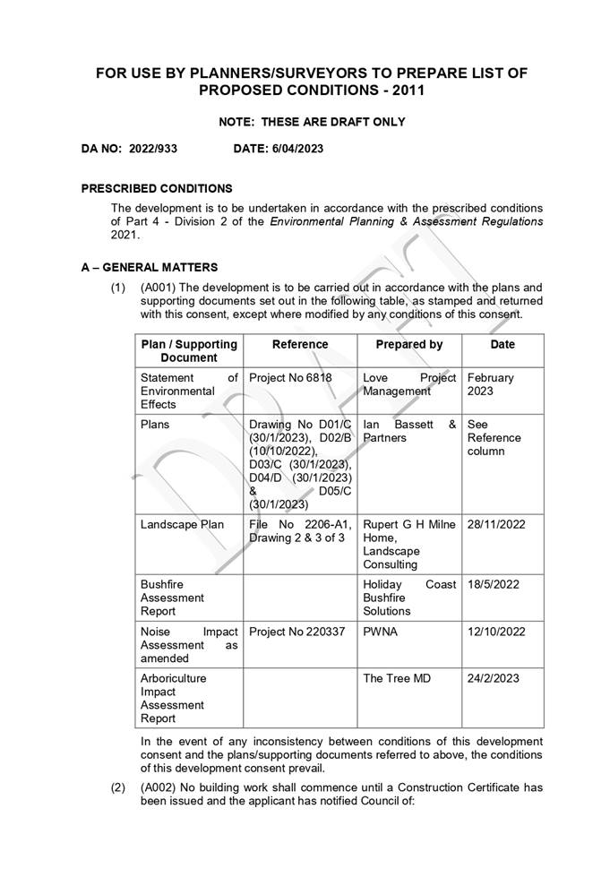
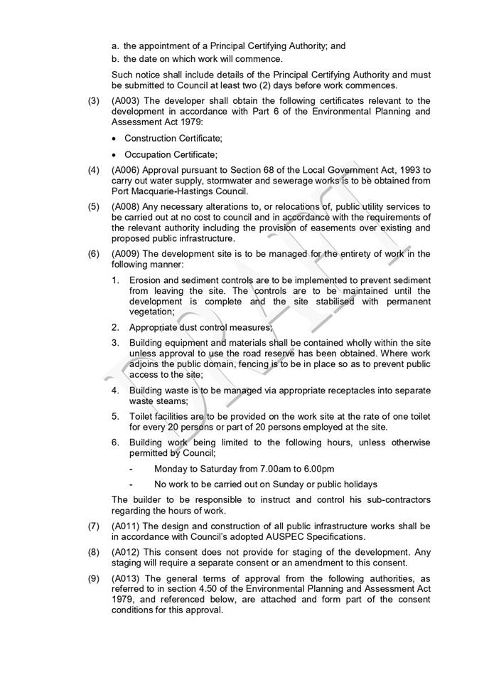
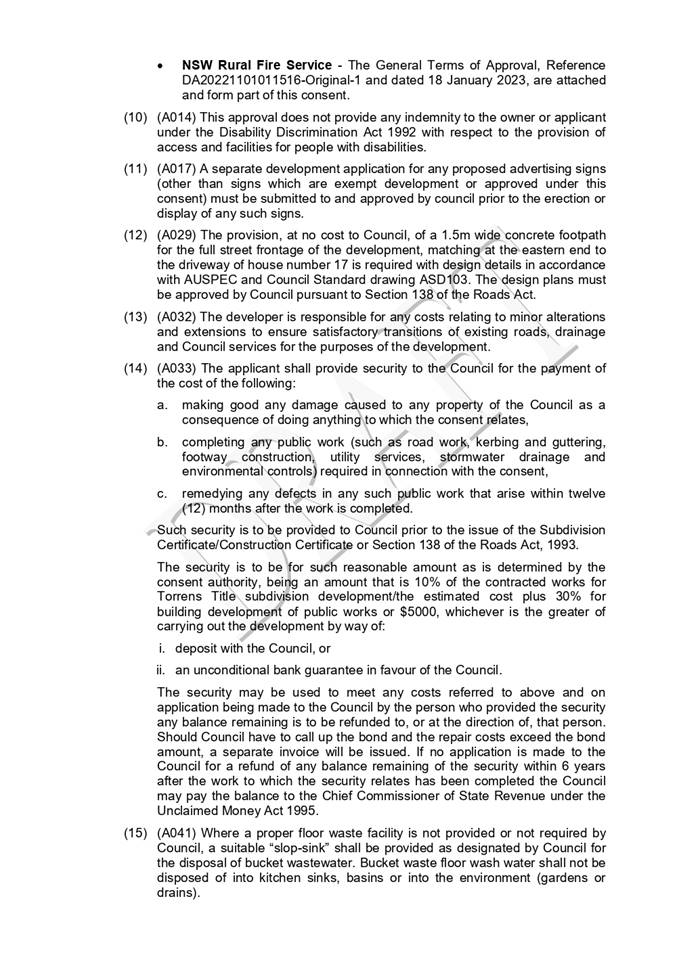
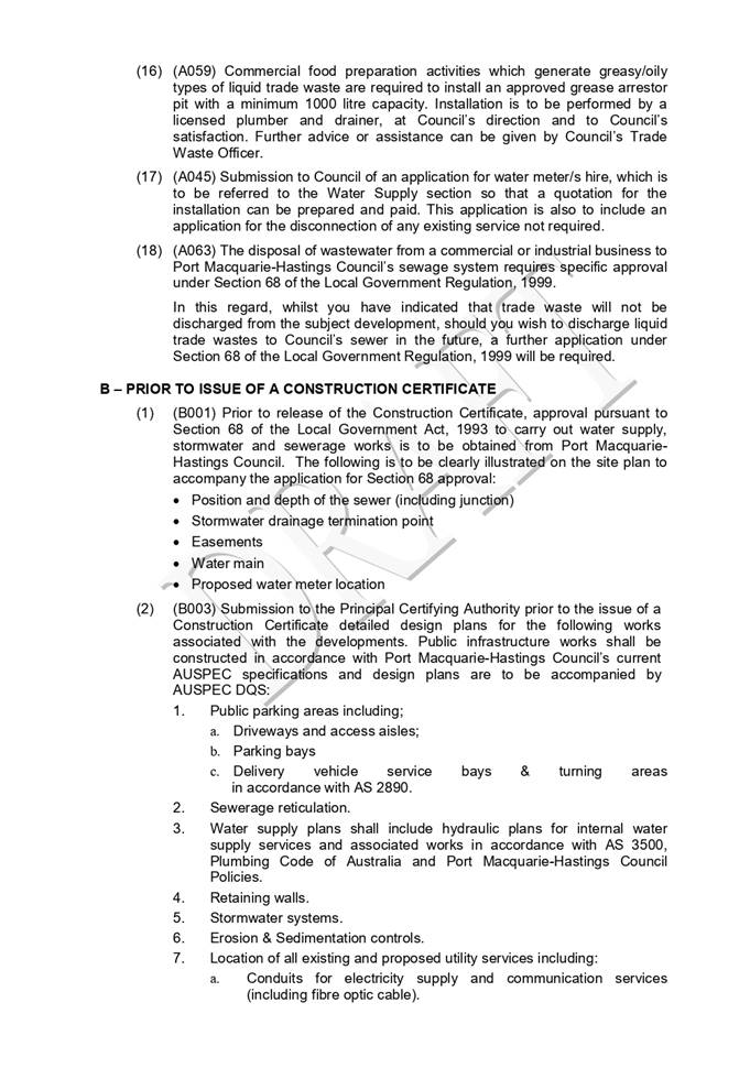
|
ATTACHMENT
|
Development Assessment Panel
19/04/2023
|
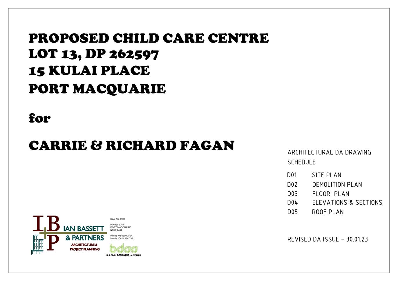
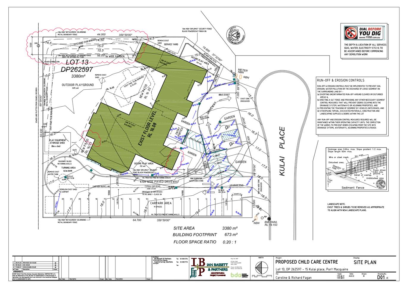
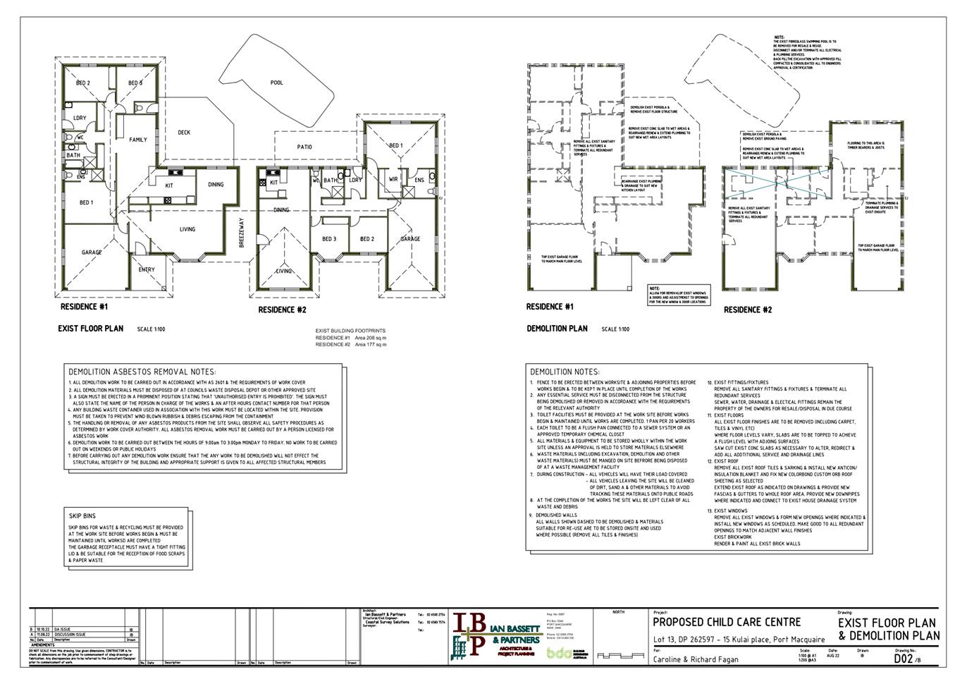
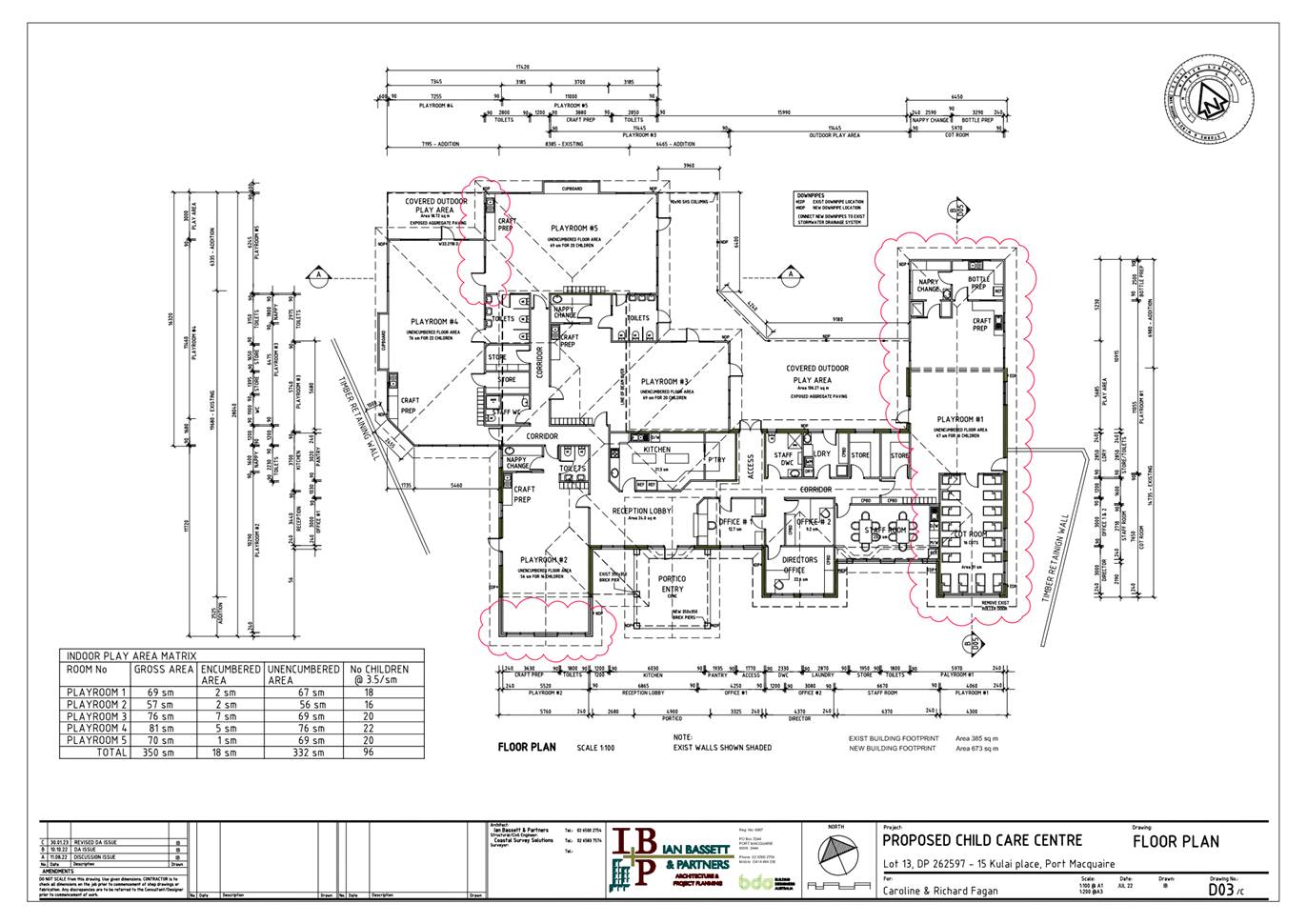
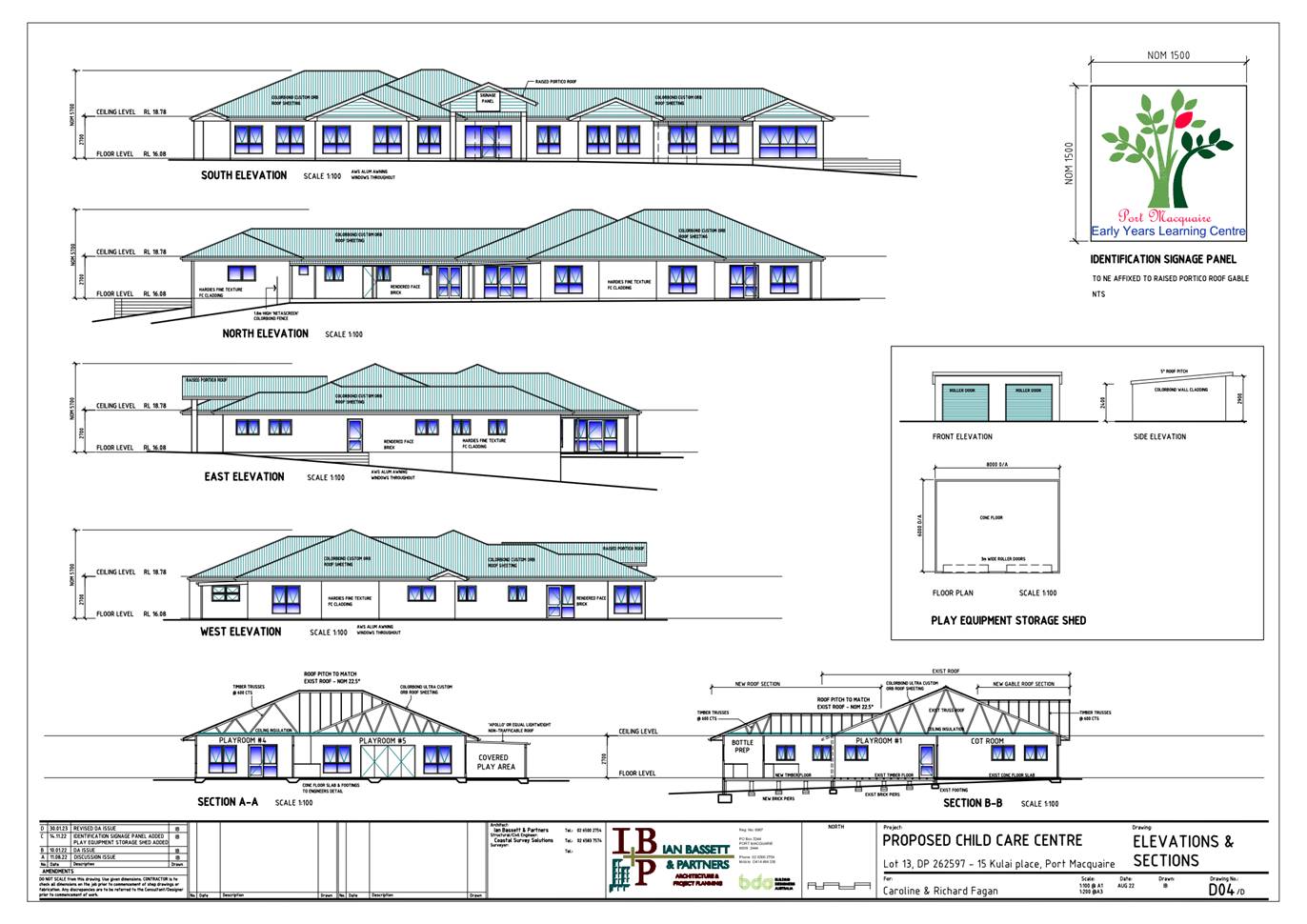
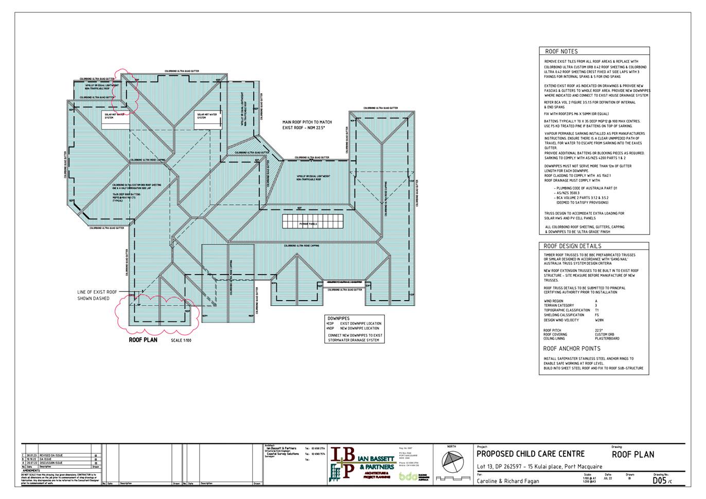
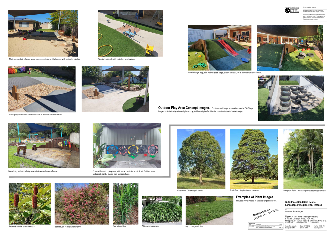
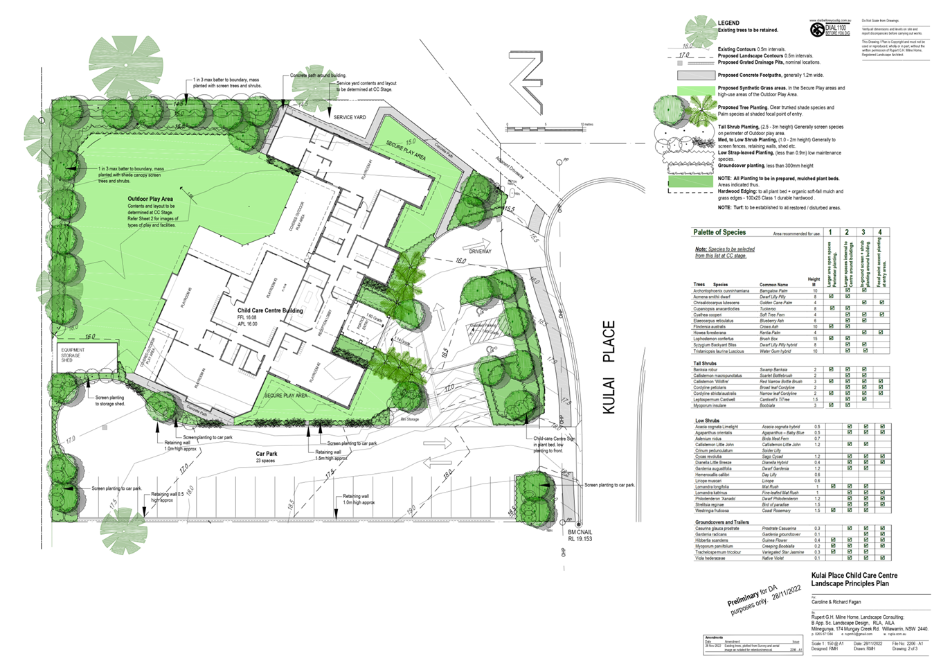
|
ATTACHMENT
|
Development Assessment Panel
19/04/2023
|