Business
Paper
|
date of meeting:
|
|
Wednesday 22 March
2017
|
|
location:
|
|
Function Room
Port
Macquarie-Hastings Council
17 Burrawan Street
Port Macquarie
|
|
time:
|
|
2:00pm
|
Development
Assessment Panel
CHARTER
COMPOSITION:
Independent Chair (alternate, Director Development &
Environment)
Manager Development Assessment (alternate, Director Development & Environment or Development Assessment Planner)
Development Engineering Coordinator (alternate, Development
Engineer)
MISSION:
To assist in managing Council's
development assessment function
by providing independent and expert assessment of development applications
The Development Assessment Panel will make determinations on the basis of established criteria and practice and will not be influenced by "lobbying" and "weight of numbers" in its assessment process.
FUNCTIONS:
1.
To review development application reports and conditions
2.
To determine development applications outside of staff delegations
3.
To refer development applications to Council
for determination where necessary
4.
To provide a forum for objectors and applicants to make submissions on applications before DAP.
5.
To maintain transparency for the determination of development applications.
DELEGATED AUTHORITY:
1.
Pursuant to Section
377 of the Local Government Act, 1993 delegation to:
2.
Determine development applications under Part 4 of the Environmental Planning
and Assessment Act 1979
having regard to the relevant
environmental planning instruments, development control plans and Council
policies.
3.
Vary Modify or release restrictions as to use and/or covenants created
by Section 88B instruments under the Conveyancing Act 1919 in relation to
development applications for subdivisions being considered by the panel.
4.
Determine Koala Plans of Management under State Environmental Planning
Policy 44 - Koala Habitat Protection associated with development applications
being considered by the Panel.
TIMETABLE:
The Development Assessment Panel shall generally meet on the 1st and 3rd Wednesday each month at 2.00pm.
VENUE:
The venue will be
determined according to the likely
number of participants.
BUSINESS PAPER AND MINUTES:
1.
The Business Paper for the meeting shall be published
and distributed on the Friday prior
to the meeting.
2.
Special Meetings of the Panel may be convened by the Director
Development & Environment Services
with three (3) days notice.
3.
The format of the preparation and publishing of the Business
Paper and Minutes
of the Development Assessment Panel meetings shall be similar to the format
for Ordinary Council Meetings, except that the movers
and seconders shall not be recorded and only the actual decisions are shown.
Minutes shall also record how each member votes for each
item before the Panel.
FORMAT OF THE MEETING:
1.
Panel meetings shall be carried
out in accordance with Council's
Code of Meeting Practice for Council Sub-Committees, except where varied
by this Charter.
2.
Meetings shall be "Open" to the public.
3.
The Panel will hear from applicants and objectors or their representatives. Where considered necessary, the Panel will conduct site inspections which will be open to the
public.
INDEPENDENT CHAIR:
The Chair of the Development Assessment Panel shall be an independent person appointed by the General
Manager. The Independent Chair shall have experience and qualifications relevant to planning.
The term of the Independent Chair shall be four
(4) years.
QUORUM:
All members must be present at the Meeting to form a Quorum.
DECISION MAKING:
Decisions are to be made by the Development Assessment
Panel by "consensus". Where "consensus" is not possible,
the matter is to be referred to Council.
All development applications
involving a variation to a development standard greater than 10% under
Clause 4.6 of the Port Macquarie-Hastings Local Environmental Plan 2011 will be
considered by the Panel and recommendation made to the Council for
determination.
Staff Members shall
not vote on matters before the Panel if they have been the principle author of the development assessment report.
LOBBYING:
Outside of scheduled
Development Assessment Panel meetings, applicants, their representatives,
Councillors, Council staff and the general public are not to lobby Panel
members via meetings, telephone conversations, correspondence and the like.
Adequate opportunity will be provided at Panel inspections or meetings for
applicants, their representatives and the general public to make verbal
submissions in relation to Business Paper items.
OBLIGATIONS OF PANEL
MEMBERS:
All DAP members
are required to comply with the following:
1.
Members must perform their Development Assessment Panel obligations faithfully and diligently and in accordance
with the DAP Code.
2.
DAP members must comply with Council's Code of Conduct.
3.
Except as required to properly perform
their duties, DAP members must not disclose
any confidential information (as advised by Council) obtained
in connection with the DAP functions.
4.
DAP members will have read and be familiar with the documents
and information provided
by Council prior to attending a DAP meeting.
5.
DAP members must act in accordance with Council's Occupational Health and Safety Policies and Procedures
6.
DAP members shall not speak to the media on any matter
before the Panel otherwise
than with the express approval
of the Director Development &
Environment Services.
Development Assessment Panel
ATTENDANCE
REGISTER
|
Member
|
14/12/16/16
|
18/01/17
|
08/02/17
|
22/02/17
|
8/3/17
|
|
Paul Drake
Matt Rogers (alternate)
|
P
|
P
|
P
|
P
|
P
|
|
Dan Croft
Patrick Galbraith-Robertson
Warren Wisemantel
(alternates)
|
P
|
P
|
P
|
P
|
P
|
|
David Troemel
Caroline Horan (alternate)
Bevan Crofts (alternate)
|
P
|
P
|
P
|
P
|
A
P
|
Key: P = Present
A
= Absent With Apology
X
= Absent Without Apology
Development
Assessment Panel Meeting
Wednesday 22 March
2017
Items of Business
01 Acknowledgement
of Country............................................................................ 7
02 Apologies......................................................................................................... 7
03 Confirmation
of Minutes.................................................................................... 7
04 Disclosures
of Interest..................................................................................... 10
05 DA2016
- 997.1 Medical Centre And Signage At Lot 7 DP 628535, No. 83 Savoy Street,
Port Macquarie...................................................................................................................... 14
06 DA2017
- 35.1 Shed - Lot 61 DP1081580, 8 Yippenvale Circuit, Crosslands........ 44
07 DA2017
- 49.1 Additions To Existing Dwelling Including Clause 4.6 Objection To Clause
4.3 (Height Of Buildings) Of The Port Macquarie-Hastings Local Environmental
Plan 2011 - Lot 390 DP 236950, 5 Vendul Crescent, Port Macquarie...................................................................... 70
08 DA2017
- 21.1 Primitive Campground - Increase In Number Of Sites (Wauchope Showground)
- Lot 22 DP 1147833, 93A High Street, Wauchope......................................................... 88
09 General
Business
AGENDA Development Assessment Panel 22/03/2017
Subject: ACKNOWLEDGEMENT
OF COUNTRY
"I acknowledge that we are
gathered on Birpai Land. I pay respect to the Birpai Elders both past and
present. I also extend that respect to all other Aboriginal and Torres Strait
Islander people present."
RECOMMENDATION
That the apologies received be
accepted.
Subject: CONFIRMATION
OF PREVIOUS MINUTES
Recommendation
That the Minutes of the Development
Assessment Panel Meeting held on 8 March 2017 be confirmed.
MINUTES Development Assessment
Panel
Meeting
08/03/2017
PRESENT
Members:
Paul
Drake
Dan Croft
Caroline Horan
Other Attendees:
Ben
Roberts
Clinton Tink
|
The meeting opened at 2:00pm.
|
|
01 ACKNOWLEDGEMENT
OF COUNTRY
|
|
The
Acknowledgement of Country was delivered.
|
|
02 APOLOGIES
|
|
CONSENSUS:
That
the apology received from David Troemel be accepted.
|
|
03 CONFIRMATION
OF MINUTES
|
|
CONSENSUS:
That
the Minutes of the Development Assessment Panel Meeting held on 22 February
2017 be confirmed.
|
|
04 DISCLOSURES
OF INTEREST
|
|
There were no disclosures of interest presented.
|
|
05 DA2016 - 956.1
Jetty - Lot 9 DP 217022, 20 North Shore Drive, North Shore
|
|
CONSENSUS:
That DA
2016 - 956.1 for a jetty at Lot 9, DP 217022, No.
10 North Shore Drive, North Shore, be determined by granting consent subject
to the recommended conditions and as amended below:
- Amend the numbering of the condition after A(8) to be
A(9) as opposed to A(1)
- New condition in Section A of the consent to read:
‘Application shall be made to the NSW Roads and Maritime
(Waterways) Services for a waterways navigation assessment.’
- New condition in Section B of
the consent to read: ‘Prior to the issuing of a Construction
Certificate approval from the NSW Roads and Maritime Services
(Waterways) shall be obtained. A copy of the approval shall be provided
to the certifying authority.’
|
|
06 DA2017 - 52.1
- Dwelling - Lot 711 DP 1228141, 53 Yaluma Drive, Port Macquarie
|
|
An
error was identified in the attachments to the report and an amended plan was
tabled noting that the rear setback of the dwelling had been increased to
4.093m.
CONSENSUS:
That DA
2017 - 52.1 for a dwelling at Lot 711, DP 1228141, No. 53 Yaluma Drive, Port
Macquarie, be determined by granting consent
subject to the recommended conditions.
|
|
The meeting closed at 2:10pm.
|
AGENDA Development Assessment Panel 22/03/2017
Subject: DISCLOSURES
OF INTEREST
RECOMMENDATION
That Disclosures of Interest be presented
DISCLOSURE OF
INTEREST DECLARATION
Name of Meeting: ………………………………………………………………………..
Meeting Date: ………………………………………………………………………..
Item Number: ………………………………………………………………………..
Subject: ………………………………………………………………………..
…………………………………………………….……………...…..
I,
.....................................................................................
declare the following interest:
 Pecuniary:
Take
no part in the consideration and voting and be out of sight of the meeting.
Non-Pecuniary
- Significant Interest:
Take
no part in the consideration and voting and be out of sight of the meeting.
Non-Pecuniary
- Less than Significant Interest:
May
participate in consideration and voting.
For the reason that:
....................................................................................................
.......................................................................................................................................
Name:
…………………………………………………….
Signed:
.........................................................................
Date: ..................................
 (Further
explanation is provided on the next page)
(Further
explanation is provided on the next page)
Further
Explanation
(Local Government Act and Code of Conduct)
A conflict of interest exists where a reasonable and informed
person would perceive that a Council official could be influenced by a private
interest when carrying out their public duty. Interests can be of two types:
pecuniary or non-pecuniary.
All interests, whether pecuniary or non-pecuniary are required to
be fully disclosed and in writing.
Pecuniary Interest
A pecuniary interest is an interest that a Council official has in
a matter because of a reasonable likelihood or expectation of appreciable
financial gain or loss to the Council official. (section 442)
A Council official will also be taken to have a pecuniary interest
in a matter if that Council official’s spouse or de facto partner or a
relative of the Council official or a partner or employer of the Council
official, or a company or other body of which the Council official, or a
nominee, partner or employer of the Council official is a member, has a
pecuniary interest in the matter. (section 443)
The Council official must not take part in the consideration or
voting on the matter and leave and be out of sight of the meeting. The
Council official must not be present at, or in sight of, the meeting of
the Council at any time during which the matter is being considered or
discussed, or at any time during which the council is voting on any question in
relation to the matter. (section 451)
Non-Pecuniary
A non-pecuniary interest is an interest that is private or
personal that the Council official has that does not amount to a pecuniary
interest as defined in the Act.
Non-pecuniary interests commonly arise out of family, or personal
relationships, or involvement in sporting, social or other cultural groups and
associations and may include an interest of a financial nature.
The political views of a Councillor do not constitute a private
interest.
The management of a non-pecuniary interest will depend on whether
or not it is significant.
Non Pecuniary – Significant Interest
As a general rule, a non-pecuniary conflict of interest will be
significant where a matter does not raise a pecuniary interest, but it
involves:
(a)
A relationship between
a Council official and another person that is particularly close, for example,
parent, grandparent, brother, sister, uncle, aunt, nephew, niece, lineal
descendant or adopted child of the Council official or of the Council official’s
spouse, current or former spouse or partner, de facto or other person living in
the same household.
(b)
Other relationships
that are particularly close, such as friendships and business relationships.
Closeness is defined by the nature of the friendship or business relationship,
the frequency of contact and the duration of the friendship or relationship.
(c)
An affiliation between
a Council official an organisation, sporting body, club, corporation or
association that is particularly strong.
If a Council official declares a non-pecuniary significant
interest it must be managed in one of two ways:
1.
Remove the source of
the conflict, by relinquishing or divesting the interest that creates the
conflict, or reallocating the conflicting duties to another Council official.
2.
Have no involvement in
the matter, by taking no part in the consideration or voting on the matter and
leave and be out of sight of the meeting, as if the provisions in section
451(2) apply.
Non Pecuniary – Less than Significant Interest
If a Council official has declared a non-pecuniary less than
significant interest and it does not require further action, they must provide
an explanation of why they consider that the conflict does not require further
action in the circumstances.
SPECIAL
DISCLOSURE OF PECUNIARY INTEREST DECLARATION
|
By
[insert full name of councillor]
|
|
|
In the
matter of
[insert name of environmental planning instrument]
|
|
|
Which is
to be considered at a meeting of the
[insert name of meeting]
|
|
|
Held on
[insert date of meeting]
|
|
|
PECUNIARY
INTEREST
|
|
Address of land in which councillor or an
associated person, company or body has a proprietary interest (the identified
land)i
|
|
|
Relationship of identified land to councillor
[Tick or cross one box.]
|
Councillor
has interest in the land (e.g. is owner or has other interest arising out of
a mortgage, lease trust, option or contract, or otherwise).
Associated
person of councillor has interest in the land.
Associated
company or body of councillor has interest in the land.
|
|
MATTER GIVING
RISE TO PECUNIARY INTEREST
|
|
Nature of land that is subject to a change
in zone/planning control by proposed
LEP (the subject land iii
[Tick or cross one box]
|
The
identified land.
Land
that adjoins or is adjacent to or is in proximity to the identified land.
|
|
Current zone/planning control
[Insert name of current planning instrument and
identify relevant zone/planning control applying to the subject land]
|
|
|
Proposed change of zone/planning control
[Insert name of proposed LEP and identify proposed
change of zone/planning control applying to the subject land]
|
|
|
Effect of proposed change of zone/planning control
on councillor
[Tick or cross one box]
|
Appreciable
financial gain.
Appreciable
financial loss.
|
|
|
|
Councillor’s
Name: …………………………………………
Councillor’s
Signature:
……………………………….
Date: ………………..
Important Information
This information is being
collected for the purpose of making a special disclosure of pecuniary interests
under sections 451 (4) and (5) of the Local Government Act 1993.
You must not make a special disclosure that you know or ought reasonably to
know is false or misleading in a material particular. Complaints made
about contraventions of these requirements may be referred by the
Director-General to the Local Government Pecuniary Interest and Disciplinary
Tribunal.
This form must be completed by
you before the commencement of the council or council committee meeting in
respect of which the special disclosure is being made. The
completed form must be tabled at the meeting. Everyone is entitled to
inspect it. The special disclosure must be recorded in the minutes of the
meeting.
i.
Section 443 (1) of the Local Government Act 1993 provides that
you may have a pecuniary interest in a matter because of the pecuniary interest
of your spouse or your de facto partner or your relativeiv or
because your business partner or employer has a pecuniary interest. You may
also have a pecuniary interest in a matter because you, your nominee, your
business partner or your employer is a member of a company or other body that
has a pecuniary interest in the matter.
ii.
Section 442 of the Local Government Act 1993 provides that a pecuniary
interest is an interest that a person has in a matter because of a
reasonable likelihood or expectation of appreciable financial gain or loss to
the person. A person does not have a pecuniary interest in a matter if the
interest is so remote or insignificant that it could not reasonably be regarded
as likely to influence any decision the person might make in relation to the
matter or if the interest is of a kind specified in section 448 of that
Act (for example, an interest as an elector or as a ratepayer or person liable
to pay a charge).
iii.
A pecuniary interest may arise by way of a change of permissible use of land
adjoining, adjacent to or in proximity to land in which a councillor or a
person, company or body referred to in section 443 (1) (b) or (c) of the
Local Government Act 1993 has a proprietary interest..
iv.
Relative is defined by the Local Government Act 1993 as
meaning your, your spouse’s or your de facto partner’s parent,
grandparent, brother, sister, uncle, aunt, nephew, niece, lineal descendant or
adopted child and the spouse or de facto partner of any of those persons.
AGENDA Development Assessment Panel 22/03/2017
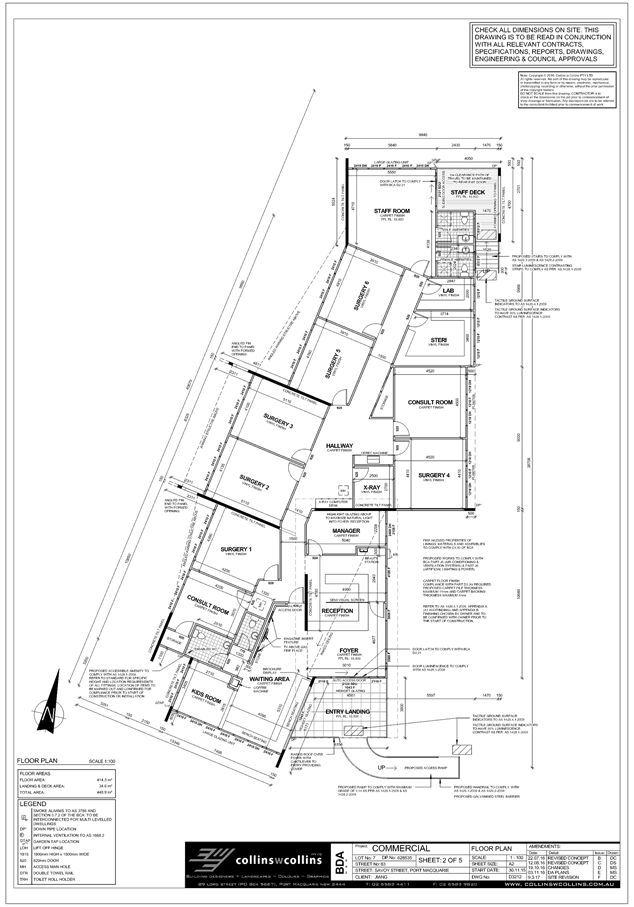
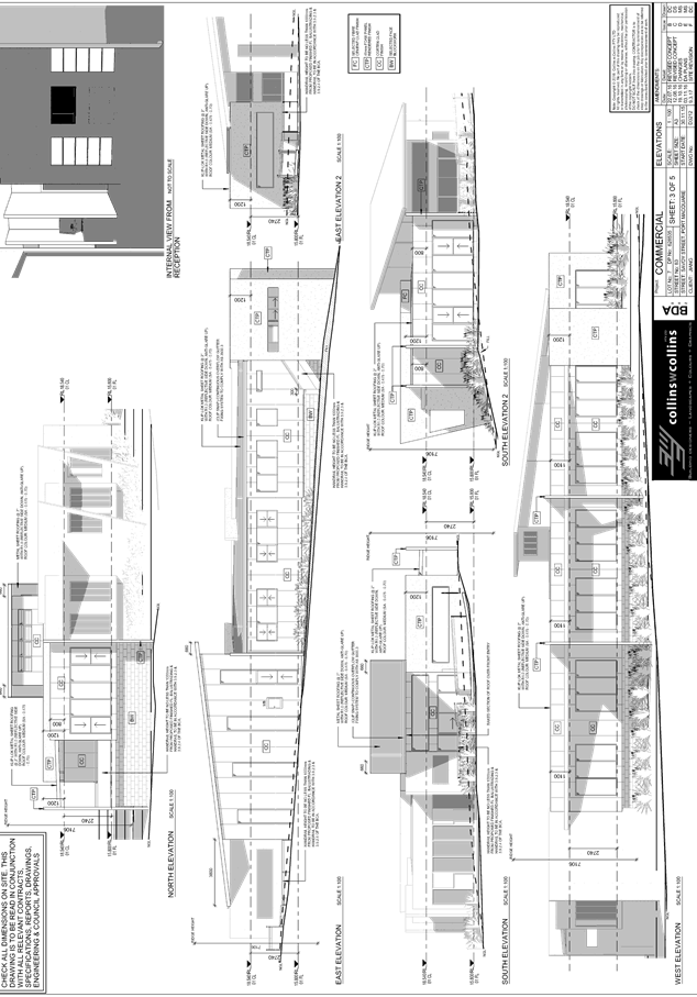
Item: 05
Subject: DA2016 - 997.1 Medical Centre And Signage At
Lot 7 DP 628535, No. 83 Savoy Street, Port Macquarie
Report
Author: Chris Gardiner
|
Applicant: L
Jiang
Owner: TL
Investments (NSW) Pty Ltd
Estimated Cost: $800,000
Alignment with Delivery
Program
4.9.2 Undertake transparent
and efficient development assessment in accordance with relevant legislation.
|
|
RECOMMENDATION
That
DA 2016 - 997.1 for a Medical
Centre and Signage at Lot 7, DP 628535, No. 83 Savoy Street, Port
Macquarie, be determined by granting consent
subject to the recommended conditions.
|
Executive
Summary
This
report considers a development application for a medical centre and
signage at the subject site and provides an
assessment of the application in accordance with the Environmental Planning and
Assessment Act 1979.
Following exhibition of the
application, one submission has been received.
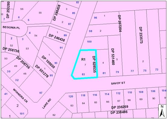
1. BACKGROUND
Existing sites features and surrounding development
The site has an area of 1398m2.
The site is zoned R1 General Residential in accordance with the Port Macquarie-Hastings Local
Environmental Plan 2011, as shown in the following zoning plan:
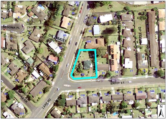
The existing subdivision pattern and location of existing
development within the locality is shown in the following aerial photograph:
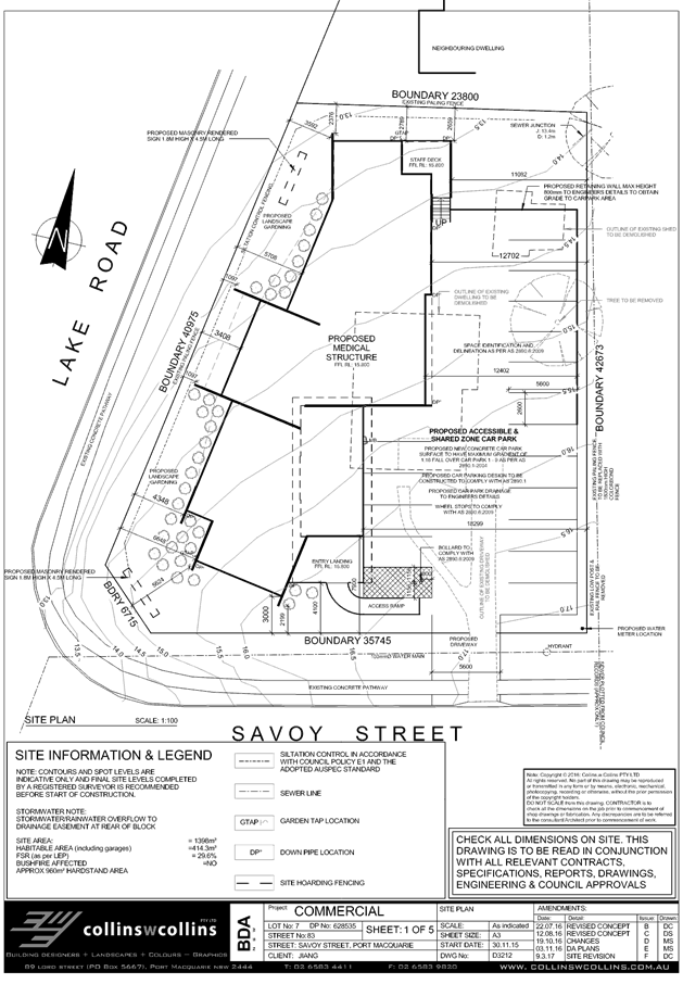
2. DESCRIPTION OF DEVELOPMENT
Key aspects of the proposal include the following:
· Demolition
of the existing dwelling and outbuildings;
· Removal
of existing trees and vegetation; and
· Construction
of a medical centre, including signage and off-street car parking.
Refer
to attachments at the end of this report.
Application Chronology
· 21
December 2016 - Application lodged.
· 10 January 2017 to 23 January 2017 - Application notified
to neighbours.
· 8 March 2017 - Additional information requested from
Applicant.
· 9 March 2017 - Additional information submitted to Council
by Applicant.
3. STATUTORY ASSESSMENT
Section 79C(1) Matters for Consideration
In determining the application, Council is required to take
into consideration the following matters as are relevant to the development
that apply to the land to which the development application relates:
(a) The provisions (where
applicable) of:
(i) any Environmental
Planning Instrument:
State Environmental Planning
Policy No. 55 – Remediation of Land
Following an inspection of the
site and a search of Council records, the subject land is not identified as
being potentially contaminated and is suitable for the intended use.
State Environmental Planning
Policy No. 62 – Sustainable Aquaculture
Given the nature of the proposed
development and proposed stormwater controls the proposal will be unlikely to
have any adverse impact on existing aquaculture industries within the Hastings
River.
State Environmental Planning
Policy No. 64 – Advertising and Signage
The proposed development includes
proposed advertising signage in the form of two business/building
identification signs.
In accordance with clause 7, this
SEPP prevails over the Port Macquarie-Hastings LEP 2011 in the event of any
inconsistency.
The following assessment table
provides an assessment checklist against the Schedule 1 requirements of this
SEPP:
|
Applicable clauses for
consideration
|
Comments
|
Satisfactory
|
|
Clause 8(a) Consistent with objectives of the policy as
set out in Clause 3(1)(a).
|
Proposal is compatible with
desired amenity of the area and provides effective communication in suitable
locations. The Applicant has indicated that the sign would be of high quality
design and finish.
|
Yes
|
Schedule 1(1) Character of
the area.
|
The site is in an area with a
residential character. The proposed 1.8m high x 4.5m long signage structures
for the development are considered to be of an excessive scale and out of
character in the area.
Other medical uses are located
nearby to the north along Lake Road generally have smaller scale business
identification signs that are more compatible with the residential zoning.
A condition is recommended
requiring an amended signage design prior to the issue of a Construction
Certificate with a maximum height of 1.8m and maximum display area of 2.5m2.
This is consistent with the provisions for wall signs in residential zones
under SEPP (Exempt and Complying Development Codes).
|
Yes, subject to condition
|
|
Schedule 1(2) Special areas.
|
The site is not in a special
area.
|
n/a
|
|
Schedule 1(3) Views and vistas.
|
The proposed signage would not
obstruct any views or vistas or dominate the skyline.
|
Yes
|
|
Schedule 1(4) Streetscape, setting or landscape.
|
The appropriateness of the
signage in terms of scale and character of the area is discussed under
Schedule 1(1) above.
The signage would not protrude
above buildings, structures, or the tree canopy. No ongoing vegetation
management would be required.
|
Yes
|
|
Schedule 1(5) Site and building.
|
The signage is compatible with
the scale of the building and would not cover or obscure any important
architectural features.
|
Yes
|
|
Schedule 1(6) Associated devices and logos with
advertisements and advertising structures.
|
None proposed.
|
n/a
|
|
Schedule 1(7) Illumination.
|
The proposed development is
located in a residential area and it is considered that illuminated signage
has the potential to affect the amenity of nearby residents. A condition is
recommended requiring all illuminated signage to be
fitted with a timer to switch off illumination between the hours of 7.00pm
and 7.00am Monday to Saturday. No illumination is permitted on Sundays.
|
Yes
|
|
Schedule 1(8) Safety.
|
The signage is not expected to
adversely affect vehicular, cyclist or pedestrian safety.
|
Yes
|
State Environmental Planning
Policy No. 71 – Coastal Protection and Clause 5.5 of Port
Macquarie-Hastings Local Environmental Plan 2011
The site is located within a
coastal zone noting clause 4 of the SEPP.
In accordance with clause 5, this
SEPP prevails over the Port Macquarie-Hastings LEP 2011 in the event of any
inconsistency.
Having regard for clauses 2, 8
and 12 to 16 of the SEPP and clause 5.5 of the PMH LEP 2011, the proposed
development will not result in any of the following:
a) any restricted access (or opportunities for
access) to the foreshore
b) any adverse amenity impacts along the foreshore
and on the scenic qualities of the coast;
c) any adverse impacts on flora and fauna;
d) the development being subject to any adverse
coastal processes or hazards;
e) any significant conflict between water and land
based users of the area;
f) any adverse impacts on any items of
archaeological/heritage;
g) reduction in the quality of the natural water
bodies in the locality (due to effluent & stormwater disposal, construction
impacts, landuse conflicts);
h) adverse cumulative impacts on the environment;
i) a form of development that is
unsustainable in water and energy demands;
j) development relying on flexible zone
provisions.
The site is predominately cleared
and located within an area zoned for residential purposes.
State Environmental Planning
Policy (Infrastructure) 2007
Clause 57 - Health services
facilities are permissible with consent as the land is within a prescribed
zone.
Port
Macquarie-Hastings Local Environmental Plan 2011
The proposal is consistent with
the LEP having regard to the following:
· Clause
2.2, the subject site is zoned R1 General Residential. In accordance with
clause 2.3(1) and the R1 zone landuse table, the proposed development for a
medical centre is a permissible landuse with consent.
The objectives of the R1 zone are as follows:
o To provide for the housing needs of the
community.
o To provide for a variety of housing types
and densities.
o To enable other land uses that provide
facilities or services to meet the day to day needs of residents.
In accordance
with Clause 2.3(2), the proposal is consistent with the zone objectives having
regard to the following:
o The proposal is
a permissible landuse;
o The development
would provide medical services to meet the needs of residents.
· Clause
2.7, the demolition requires consent as it does not fit within the provisions
of SEPP (Exempt and Complying Development Codes) 2008.
·
· Clause
4.3, the maximum overall height of the building above ground level (existing)
is 7.1m which complies with the standard height limit of 8.5m applying to the
site.
·
· Clause
4.4, the floor space ratio of the proposal is 0.30:1 which complies with the
maximum 0.65:1 floor space ratio applying to the site.
·
· Clause
5.5 - Development within the coastal zone - relevant objectives of this clause
are addressed by SEPP 71 section (see above).
·
· Clause
5.9 - Several listed trees in Development Control Plan 2013 are proposed to be
removed. See comments under DCP section below.
·
· Clause
5.10 – Heritage. The site does not contain or adjoin any known heritage
items or sites of significance.
·
· Clause
7.13, satisfactory arrangements are in place for provision of essential
services including water supply, electricity supply, sewer infrastructure, stormwater
drainage and suitable road access to service the development.
(ii) Any
draft instruments that apply to the site or are on exhibition:
No draft
instruments apply to the site.
(iii) any
Development Control Plan in force:
Port
Macquarie-Hastings Development Control Plan 2013
|
DCP 2013: General Provisions
|
|
DCP Objective
|
Development Provisions
|
Proposed
|
Complies
|
|
2.2.2.1
|
Signs primarily identifying products or services are not
acceptable, even where relating to products or services available on that site.
|
Signage is business identification signs only.
|
Yes
|
|
Signage is not permitted outside property boundaries
except where mounted upon buildings and clear of pedestrians and road
traffic. No signage is permitted upon light or power poles or upon the nature
strip (the area between the property boundary and constructed roadway).
Limited directional
signage and “A” frame signage may separately
be approved by Council under the Roads Act 1993 or section 68 of the Local
Government Act 1993.
|
Signage is within lot boundaries.
|
Yes
|
|
On-premise signs should not project above or to the side
of building facades
|
Proposal includes only free-standing signs.
|
n/a
|
|
2.2.2.2
|
Where there is potential for light spill from signage in a
non residential zone adjoining or adjacent to residential development,
illuminated signage is to be fitted with a time switch to dim by 50% or turn
off the light by 11pm each night, depending on the nature of the development.
|
The proposed development is located in a residential area
and it is considered that illuminated signage has the potential to affect the
amenity of nearby residents. A condition is recommended requiring all illuminated signage to be fitted with a timer to
switch off illumination between the hours of 7.00pm and 7.00am Monday to
Saturday. No illumination is permitted on Sundays.
|
Yes
|
|
2.7.2.2
|
Design addresses generic principles of Crime Prevention
Through Environmental Design guideline:
· Casual surveillance
and sightlines
· Land use mix and
activity generators
· Definition of use and
ownership
· Lighting
· Way finding
· Predictable routes and
entrapment locations
|
The proposed development will be unlikely to create any
concealment/entrapment areas or crime spots that would result in any
identifiable loss of safety or reduction of security in the immediate area.
|
Yes
|
|
2.3.3.1
|
Cut and fill 1.0m max. 1m outside the perimeter of the
external building walls
|
Less than 1m of cut or fill proposed outside building
walls.
|
Yes
|
|
2.3.3.8 onwards
|
Removal of hollow bearing trees
|
None proposed to be removed.
|
Yes
|
|
2.6.3.1
|
Tree removal (3m or higher with 100mm diameter trunk and
3m outside dwelling footprint
|
The proposal includes the removal of several existing
trees. The trees are within the footprint of the development and are not practical
to retain. The trees are not listed in Table 2.6.1 as Koala food trees, and
offset planting is not required.
|
Yes
|
|
2.4.3
|
Bushfire risk, Acid sulphate soils, Flooding,
Contamination, Airspace protection, Noise and Stormwater
|
Refer to main body of report.
|
|
|
2.5.3.2
|
New accesses not permitted from arterial or distributor
roads. Existing accesses rationalised or removed where practical
|
Access from local road.
|
Yes
|
|
Driveway crossing/s minimal in number and width including
maximising street parking
|
Single driveway crossing of acceptable width.
|
Yes
|
|
2.5.3.3
|
Off-street parking in accordance with Table 2.5.1.
(Provision to consider reduced parking where supported by
parking demand study)
|
Table 2.5.1 requires 3 spaces per consultant, plus 1 space
per 2 employees for medical centres.
The Applicant has indicated that the development will have
4 consultants and 6 employees. Therefore, 15 spaces are required for the
development.
A total of 17 off-street parking spaces are proposed,
which exceeds the minimum requirement.
A condition is recommended allowing some flexibility in
staff numbers, providing that it is still within the parking available on the
site.
|
Yes
|
|
2.5.3.7
|
Parking layout in accordance with AS/NZS 2890.1 and AS/NZS
2890.2
|
Parking layout capable of complying. Conditions
recommended requiring certification at Construction Certificate and
Occupation Certificate stage.
|
Yes
|
|
Parking spaces generally located behind building line
|
Parking area located behind building line to the Lake Road
frontage. It is slightly forward of the building line to Savoy Street, but
the majority of the parking area is also behind the building line to the
secondary road frontage. Adequate area is available to provide landscaping
between the parking area and Savoy Street frontage.
|
No, but acceptable
|
|
2.5.3.8
|
Accessible parking provided in accordance with AS/NZS
2890.1, AS/NZS 2890.2 and AS 1428
|
One accessible space proposed.
|
Yes
|
|
2.5.3.11
|
Section 94 contributions
|
Refer to main body of report.
|
|
|
2.5.3.12 and 2.5.3.13
|
Landscaping of parking areas
|
Perimeter landscaping of the parking area is possible with
the layout. Internal tree planting not considered necessary for the scale of
the parking area.
Condition recommended requiring landscaping plan
consistent with these provisions prior to the issue of a Construction
Certificate.
|
Yes
|
|
2.5.3.14
|
Sealed driveway surfaces unless justified
|
Concrete.
|
Yes
|
|
2.5.3.15
|
Driveway grades for first 6m of ‘parking area’
shall be 5% grade (Note AS/NZS 2890.1 allows for steeper grades)
|
Capable of complying. Condition recommended requiring
details with Construction Certificate application.
|
Yes
|
|
2.5.3.16
|
Transitional grades min. 2m length
|
Capable of complying. Condition recommended requiring
details with Construction Certificate application.
|
Yes
|
|
2.5.3.17
|
Parking areas to be designed to avoid concentrations of
water runoff on the surface.
|
Parking area proposed to be drained to underground
detention tank and connected to extension of piped drainage in Lake Road.
|
Yes
|
|
No direct discharge to K&G or swale drain
|
The development is proposed to be connected to an
extension of the piped drainage in Lake Road.
|
Yes
|
Based on the
above assessment, the variations proposed to the provisions of the DCP are
considered acceptable and the relevant objectives have been satisfied.
Cumulatively, the variations do not amount to an adverse impact or a
significance that would justify refusal of the application.
(iiia) any
planning agreement that has been entered into under Section 93f or any draft
planning agreement that a developer has offered to enter into under Section
93f:
No planning
agreement has been offered or entered into relating to the site.
iv) any matters prescribed by the
Regulations:
New South Wales Coastal Policy:
The proposed
development is consistent with the objectives and strategic actions of this
policy. See comments under SEPP No. 71 earlier in this report.
Demolition
of buildings AS 2601:
Demolition of
the existing buildings on the site is capable of compliance with this
Australian Standard and is recommended to be conditioned.
v) any coastal
zone management plan (within the meaning of the Coastal Protection Act 1979),
that apply to the land to which the development application relates:
No Coastal
Zone Management Plan applies to the subject site.
(b) The
likely impacts of that development, including environmental impacts on both the
natural and built environments, social and economic impacts in the locality:
The site has
a general westerly street frontage orientation to Lake Road and a southerly
orientation to Savoy Street.
Adjoining the
site to the north is a single storey dual occupancy. Adjoining the site to the
east is a single storey dwelling. Adjoining the site to the south are one and
two storey dwellings on the southern side of Savoy Street. Adjoining the site
to the west are single storey dwellings on the western side of Lake Road.
The broader
locality includes a substantial number of medical uses, including the Private
Hospital. The proposal is considered to be compatible with other residential
and medical development in the locality and adequately addresses planning
controls for the area.
The
development includes building setbacks to Lake Road and Savoy Street that are
less than would be permitted for residential development on the site under
Chapter 3.2 of Development Control Plan 2013. The parts of the building that
are located within the setback area that would be applicable to a residential
development are predominantly fin walls that contribute to the architectural
design and articulation of the building. The proposal will be unlikely to have
any adverse impacts to existing adjoining properties and satisfactorily
addresses the public domain.
The proposal
does not have a significant adverse impact on existing view sharing.
The proposal
does not have significant adverse lighting impacts.
There are no
significant adverse privacy impacts.
There are no
adverse overshadowing impacts. The proposal does not prevent adjoining
properties from receiving 3 hours of sunlight to private open space and primary
living areas on 21 June.
Roads
The site has
road frontage to Savoy Street and Lake Road.
Adjacent to
the site, both roads are public roads under the care and control of Council.
Both roads are local streets with SA kerb and gutter and AC pavement. There is
an existing footpath along the full frontage of the site.
Traffic and
Transport
The addition
in traffic associated with the development is unlikely to have any adverse
impacts to the existing road network within the immediate locality.
Site
Frontage & Access
Vehicle
access to the site is proposed though an individual driveway. The driveway
access shall comply with Council AUSPEC and Australian Standards, and
conditions have been imposed to reflect these requirements.
Due to the
type and size of development, additional works are required to include the
reconstruction of the existing road reserve/footway along Lake Road and Savoy
Street at a suitable grade. Retaining or battering within the property may also
be required as a result of this work. Details will be required to be submitted
with the Section 138 application.
A 5m wide
easement for batter adjacent to the splay corner is registered on the title of
Lot 7 DP 628535 in favour of Council. A 1.8m high x 4.5m long masonry sign is
proposed within this easement as part of the development. It is expected that
the development would establish a satisfactory batter within the easement and
it is unlikely that Council would need to access the site to carry out works in
the future.
A condition
is recommended requiring the developer to obtain written agreement from Council
that the sign is permitted to be erected within the easement prior to the issue
of a Construction Certificate.
Refer to
relevant conditions of consent.
Parking
and Manoeuvring
A total of 17
parking spaces (including 1 disabled space) have been provided on-site.
Parking and driveway widths on site can comply with relevant Australian
Standards (AS 2890) and conditions have been imposed to reflect these
requirements.
Due to the
type of development, car park circulation is required to enable vehicles to enter
and exit the site in a forward manner. Site plans show adequate area is
available and conditions have been imposed to reflect these requirements.
Refer to
relevant conditions of consent.
Water
Supply Connection
Council
records indicate that the existing development site has a 20mm metered water
service which requires disconnection. The proposed development shall require a
25mm metered water service with RPZ backflow protection at the boundary. Final
water service sizing will need to be determined by a hydraulic consultant to
suit the domestic and commercial components of the development, as well as fire
service and backflow protection requirements.
A sectional
detail of the proposed driveway is required detailing the exact location of the
water main and the depth of the water main. The details shall include the cover
provided to the water main in relation to the heavy duty pavement. The existing
water main is asbestos cement and shall require replacement along the proposed
driveway section in accordance with Aus-Spec subject to the cover requirements.
Design details shall be provided as part of the Section 68 and Section 138
applications.
Detailed
plans will be required to be submitted for assessment with the Section 68
application.
Refer to
relevant conditions of consent.
Sewer
Connection
Council
records indicate that the development site will be connected to sewer via a
junction connection to the sewer main located in the north eastern corner of
the lot.
Detailed
plans will be required to be submitted for assessment with the S.68
application.
Refer to
relevant conditions of consent.
Stormwater
The site
naturally grades towards the Lake Road street frontage and is currently
serviced via a kerb outlet.
The legal
point of discharge for the proposed development is defined as a direct
connection to Council’s stormwater pit/pipeline within Lake Road.
Extension of the existing piped drainage in Lake Road will be required to
service the development.
A detailed
site stormwater management plan will be required to be submitted for assessment
with the S.68 application and prior to the issue of a CC.
In accordance
with Councils AUSPEC requirements, the following must be incorporated into the
stormwater drainage plan:
· On
site stormwater detention facilities.
· Upsizing
of the proposed 225mm pipe in Lake Road to a minimum 375mm pipe and kerb inlet
pit.
Refer to
relevant conditions of consent.
Other
Utilities
Telecommunication
and electricity services are available to the site.
Heritage
No known items
of Aboriginal or European heritage significance exist on the property. No
adverse impacts anticipated.
Other land
resources
The site is
within an established urban context and will not sterilise any significant
mineral or agricultural resource.
Water cycle
The proposed
development will be unlikely to have any adverse impacts on water resources and
the water cycle.
Soils
The proposed
development will be unlikely to have any adverse impacts on soils in terms of
quality, erosion, stability and/or productivity subject to a standard condition
requiring erosion and sediment controls to be in place prior to and during
construction.
Air and
microclimate
The
construction and/or operations of the proposed development will be unlikely to
result in any adverse impacts on the existing air quality or result in any
pollution. Standard precautionary site management condition recommended.
Flora and
fauna
Construction
of the proposed development will not require any removal/clearing of any
significant vegetation and therefore will be unlikely to have any significant
adverse impacts on biodiversity or threatened species of flora and fauna.
Section 5A of the Act is considered to be satisfied.
Waste
Satisfactory
arrangements are in place for proposed storage and collection of waste and
recyclables. No adverse impacts anticipated. Standard precautionary site
management condition recommended.
Energy
The proposal
includes measures to address energy efficiency and will be required to comply
with the requirements of Section J of the Building Code of Australia. No
adverse impacts anticipated.
Noise and
vibration
The Statement
of Environmental Effects indicates that the proposed hours of operation for the
development will be 8.00am to 6.00pm Monday to Friday and 8.00am to 4.00pm on
Saturdays. These hours are considered acceptable in a residential context and a
condition is recommended restricting hours of operation to those proposed in
the application.
Condition
also recommended restricting construction to standard construction hours.
Bushfire
The site is
not identified as being bushfire prone.
Safety,
security and crime prevention
The proposed
development will be unlikely to create any concealment/entrapment areas or
crime spots that would result in any identifiable loss of safety or reduction
of security in the immediate area.
Social
impacts in the locality
Given the
nature of the proposed development and its’ location the proposal is
unlikely to result in any adverse social impacts.
Economic
impact in the locality
No adverse
impacts. A likely positive impact is that the development will maintain
employment in the construction industry, which will lead to flow impacts such
as expenditure in the area.
Site
design and internal design
The proposed
development design satisfactorily responds to the site attributes and will fit
into the locality. No adverse impacts likely.
Construction
No potential
adverse impacts identified to neighbouring properties with the construction of
the proposal.
Cumulative
impacts
The proposed
development is not expected to have any adverse cumulative impacts on the
natural or built environment or the social and economic attributes of the
locality.
Natural
Hazards
No natural
hazards identified that would affect the proposal.
(c) The suitability of the site for
the development:
The proposal
will fit into the locality and the site attributes are conducive to the
proposed development. Site constraints have been adequately addressed and
appropriate conditions of consent recommended.
(d) Any submissions made in
accordance with this Act or the Regulations:
One written submission has been received following public
exhibition of the application.
Key issues raised in the submissions received and comments
in response to these issues are provided as follows:
|
Submission
Issue/Summary
|
Planning
Comment/Response
|
|
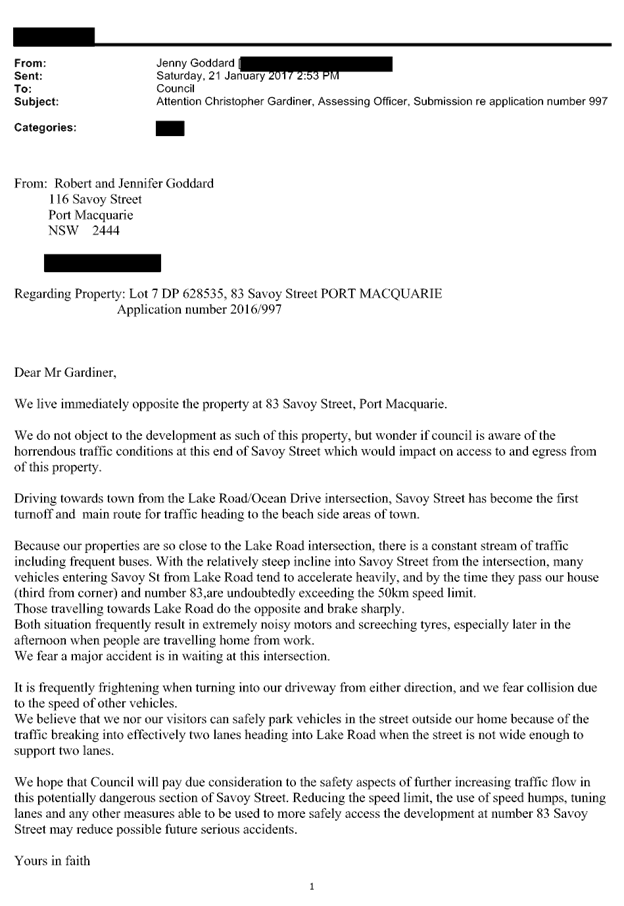
Traffic safety concerns at the
intersection of Savoy Street and Lake Road. Concerns regarding potential for
a major accident.
|
Concerns noted. However, this
is a broader issue that is beyond the scope of the development proposal.
|
|
Council needs to give
consideration to traffic safety impacts of further increasing traffic in a
dangerous section of Savoy Street.
|
Traffic generation and safety
have been considered in the assessment of the application. The proposal is
considered satisfactory for the following reasons:
· The access location provides adequate separation from the
intersection of Savoy Street and Lake Road.
· The access location has adequate safe sight distance.
· The car park design will allow all vehicles to enter and
exit the site driving forwards.
· The traffic generated by the development is within the
capacity of the existing road.
|
(e) The Public Interest:
The proposed
development satisfies relevant planning controls and is unlikely to impact on
the wider public interest.
4. DEVELOPMENT
CONTRIBUTIONS APPLICABLE
· Development contributions will be required towards
augmentation of town water supply and sewerage system head works under Section
64 of the Local Government Act 1993.
· Development contributions will be required under Section
94A of the Environmental Planning and Assessment Act 1979 towards public
facilities that will be or have been provided within the commercial and
industrial areas of the LGA.
5. CONCLUSION
The application has been assessed in accordance with
Section 79C of the Environmental Planning and Assessment Act 1979.
Issues raised during assessment and public exhibition of
the application have been considered in the assessment of the application.
Where relevant, conditions have been recommended to manage the impacts
attributed to these issues.
The site is suitable for the proposed development, is not
contrary to the public's interest and will not have a significant adverse
social, environmental or economic impact. It is recommended that the
application be approved, subject to the recommended conditions of consent
provided in the attachment section of this report.
|
Attachments
1View. DA2016
- 997.1 Plans
2View. DA2016
- 997.1 Recommended Conditions
3View. DA2016
- 997.1 Submission - Goddard
|
|
ATTACHMENT
|
Development Assessment Panel
22/03/2017
|
|
ATTACHMENT
|
Development Assessment Panel
22/03/2017
|
|
ATTACHMENT
|
Development Assessment Panel
22/03/2017
|

AGENDA Development Assessment Panel 22/03/2017
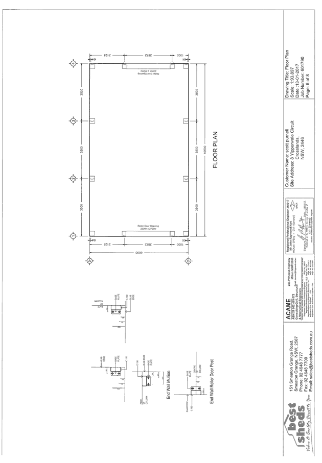
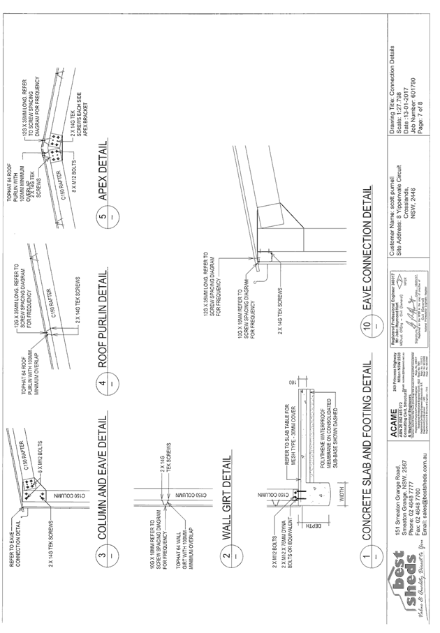
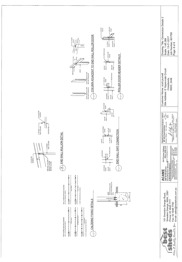
Item: 06
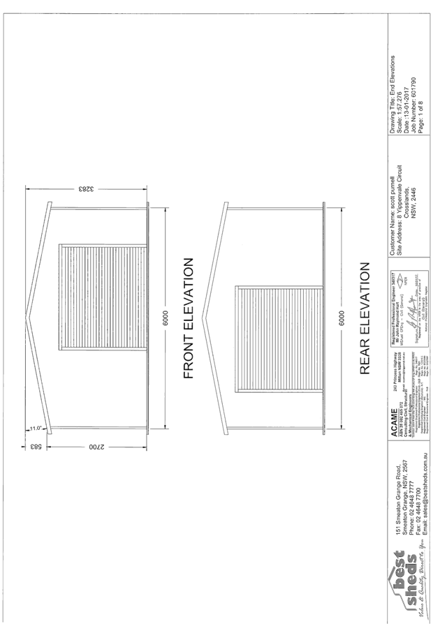
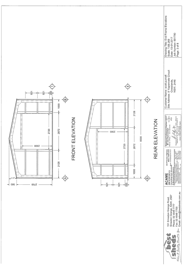
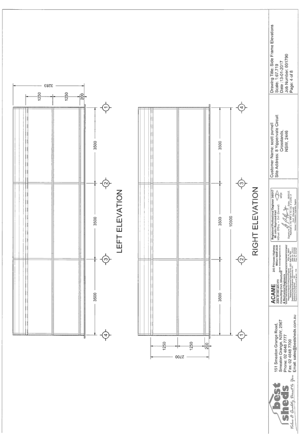
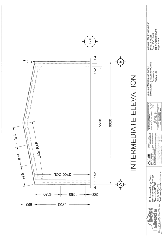
Subject: DA2017 - 35.1 Shed - Lot 61 DP1081580, 8
Yippenvale Circuit, Crosslands
Report
Author: Benjamin Roberts
|
Applicant: S
E & A M Purnell
Owner: S
E & A M Purnell
Estimated Cost: $9000
Alignment with Delivery
Program
4.9.2 Undertake transparent
and efficient development assessment in accordance with relevant legislation.
|
|
RECOMMENDATION
That
DA2017 - 35 for a shed at Lot 61, DP
1081580, No. 8 Yippenvale Circuit, Crosslands, be determined by granting
consent subject to the recommended conditions.
|
Executive
Summary
This
report considers a development application for a shed at the subject site and provides an assessment of the
application in accordance with the Environmental Planning and Assessment Act
1979.
Following exhibition of the
application, one (1) submission has been
received.
1. BACKGROUND
Existing sites features and Surrounding development
The site has an area of
1.053 hectares.
The site is zoned R1 General Residential and RU6 Transition
in accordance with the Port Macquarie-Hastings Local
Environmental Plan 2011, as shown in the following zoning plan. The location of
the proposed shed is within the RU6 zone:
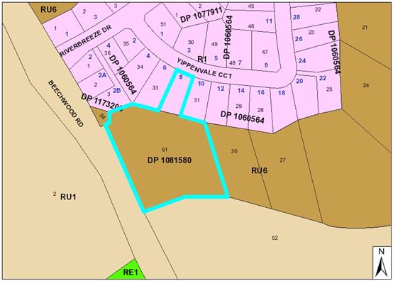
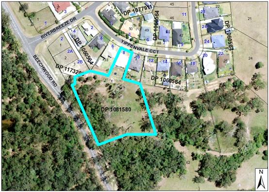
The existing subdivision pattern and location of existing
development within the locality is shown in the following aerial photograph:
2. DESCRIPTION OF
DEVELOPMENT
Key aspects of the proposal include the following:
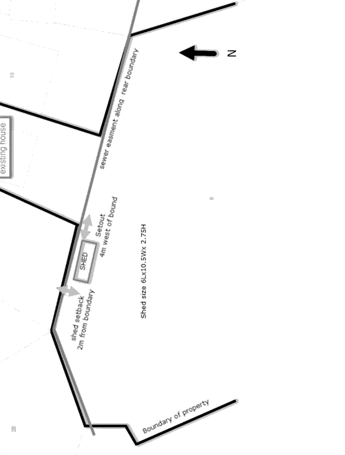
· Construction of a shed
Refer
to attachments at the end of this report.
Application Chronology
· 20
January 2017 - Application lodged
· 30
January 2017 - Submission received
· 24
February 2017 - Site inspection
· 8
March 2017 - Revised site plan received
3. STATUTORY ASSESSMENT
Section 79C(1) Matters for Consideration
In determining the application, Council is required to take
into consideration the following matters as are relevant to the development
that apply to the land to which the development application relates:
(a) The provisions (where
applicable) of:
(i) any Environmental
Planning Instrument:
State
Environmental Planning Policy No 44 - Koala Habitat Protection
The site is
greater than 1 hectare in area and therefore this policy applies. There is no
Koala Plan of Management adopted for the site. The application has nominated
that no tree removal is proposed. The site inspection revealed three small
eucalypt trees down slope of the shed site which are adequately setback from
the shed site to be retained. As the application involves no tree removal no
further investigations are required under this policy.
State
Environmental Planning Policy No.55 – Remediation of Land
Following an
inspection of the site and a search of Council records, the subject land is not
identified as being potentially contaminated and is suitable for the intended
use.
State
Environmental Planning Policy No. 62 – Sustainable Aquaculture
Given the
nature of the proposed development and proposed stormwater controls the
proposal will be unlikely to have any adverse impact on existing aquaculture
industries.
Port Macquarie-Hastings Local Environmental Plan 2011
The proposal
is consistent with the LEP having regard to the following:
· Clause
2.2, the subject site is zoned R1 General Residential and RU6 Transition. The
location of the proposed shed is within the RU6 zone. In accordance with clause
2.3(1) and the RU6 zone landuse table, the shed being an ancillary structure to
a dwelling is a permissible landuse with consent.
The
objectives of the RU6 zone are as follows:
o To
protect and maintain land that provides a transition between rural and other
land uses of varying intensities or environmental sensitivities.
o To
minimise conflict between land uses within this zone and land uses within
adjoining zones..
In accordance with Clause 2.3(2), the proposal is consistent with the
zone objectives as it is a permissible land use and consistent with the
established locality.
Clause 4.3,
the maximum overall height of the shed above ground level (existing) is 3.283m,
which complies with the standard height limit of 8.5m applying to the
site.
Clause 5.9,
no listed trees in Development Control Plan 2013 are proposed to be removed.
Clause 5.10,
the site does not contain or adjoin any known heritage items or sites of
significance and is disturbed from past subdivision activities.
Clause 7.3,
the southern portion of the site mapped as within the flood planning area. The
proposed shed site is located outside the mapped flood planning area.
Clause 7.13,
satisfactory arrangements are in place for provision of essential services.
(ii) Any
draft instruments that apply to the site or are on exhibition:
No draft
instruments apply to the site.
(iii) any
Development Control Plan in force:
Port
Macquarie-Hastings Development Control Plan 2013
|
DCP 2013: Dwellings, Dual
occupancies, Dwelling houses, Multi dwelling houses & Ancillary
development
|
|
|
Requirements
|
Proposed
|
Complies
|
|
3.2.2.2
|
Articulation zone:
• Min. 3m front
setback
• An entry feature
or portico
• A balcony, deck,
patio, pergola, terrace or verandah
• A window box
treatment
• A bay window or
similar feature
• An awning or
other feature over a window
• A sun shading
feature
|
No elements within articulation
zone proposed.
|
N/A
|
|
Front setback (Residential not R5
zone):
• Min. 6.0m
classified road
• Min. 4.5m local
road or within 20% of adjoining dwelling if on corner lot
• Min. 3.0m
secondary road
• Min. 2.0m
Laneway
|
Shed located behind dwelling.
|
Yes
|
|
3.2.2.3
|
Garage 5.5m min. and 1m behind
front façade.
Garage door recessed behind
building line or eaves/overhangs provided
|
Shed located behind dwelling.
|
Yes
|
|
6m max. width of garage door/s
and 50% max. width of building
|
N/A
|
N/A
|
|
Driveway crossover 1/3 max. of
site frontage and max. 5.0m width
|
Existing no change.
|
N/A
|
|
Garage and driveway provided on
each frontage for dual occupancy on corner lot
|
Not a dual occupancy or corner
lot.
|
Yes
|
|
3.2.2.4
|
4m min. rear setback. Variation
subject to site analysis and provision of private open space
|
> 4m setback to rear boundary.
|
Yes
|
|
3.2.2.5
|
Side setbacks:
• Ground floor =
min. 0.9m
• First floors
& above = min. 3m setback or where it can be demonstrated that
overshadowing not adverse = 0.9m min.
• Building wall
set in and out every 12m by 0.5m
|
Shed setback >900mm from
boundaries.
|
Yes
|
|
3.2.2.10
|
Privacy:
• Direct views
between living areas of adjacent dwellings screened when within 9m radius of
any part of window of adjacent dwelling and within 12m of private open space
areas of adjacent dwellings. ie. 1.8m fence or privacy screening which has
25% max. openings and is permanently fixed
• Privacy screen
required if floor level > 1m height, window side/rear setback (other than
bedroom) is less than 3m and sill height less than 1.5m
• Privacy screens
provided to balconies/verandahs etc which have <3m side/rear setback and
floor level height >1m
|
No adverse privacy impacts
identified.
|
Yes
|
|
DCP 2013: General
Provisions
|
|
|
Requirements
|
Proposed
|
Complies
|
|
2.7.2.2
|
Design addresses generic principles of Crime Prevention
Through Environmental Design guideline
|
Adequate casual surveillance of private and public space
available.
|
Yes
|
|
2.3.3.1
|
Cut and fill 1.0m max. 1m outside the perimeter of the
external building walls
|
No cut and fill details have been provided. However given
the setbacks from boundaries any excavation can be adequately managed on site
without adversely impacting adjoining properties. Suitable conditions have
been applied regarding required retaining structures.
|
Not clear but considered acceptable.
|
|
2.4.3
|
Bushfire risk, Acid sulphate soils, Flooding,
Contamination, Airspace protection, Noise and Stormwater
|
Refer to main body of report.
|
Noted
|
|
|
|
|
|
(iiia) any
planning agreement that has been entered into under Section 93f or any draft
planning agreement that a developer has offered to enter into under Section
93f:
No planning
agreement has been offered or entered into.
iv) any matters prescribed by the
Regulations:
No matters
prescribed by the regulations apply.
v) any coastal
zone management plan (within the meaning of the Coastal Protection Act 1979),
that apply to the land to which the development application relates:
No coastal
zone management plan applies to the site.
(b) The
likely impacts of that development, including environmental impacts on both the
natural and built environments, social and economic impacts in the locality:
Context and setting
• The
proposal will be unlikely to have any adverse impacts to existing adjoining
properties and satisfactorily addresses the public domain.
• The proposal is considered to be consistent with other
residential development in the locality and adequately addresses planning
controls for the area.
• There
is no adverse impact on existing view sharing.
• There is no adverse privacy impacts.
• There is no adverse overshadowing impacts. The proposal
does not prevent adjoining properties from receiving 3 hours of sunlight to
private open space and primary living areas on 21 June.
Access, transport and traffic
The proposal will be unlikely to have any adverse impacts in
terms access, transport and traffic. The existing road network will
satisfactorily cater for any increase in traffic generation as a result of the
development.
Water Supply
Service existing. No facilities proposed within shed.
Sewer
Service existing. No facilities proposed within shed.
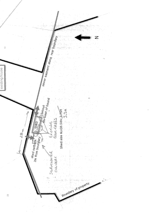
Stormwater
Sufficient area available for
onsite stormwater disposal from the shed.
A stormwater easement, associated
pipe network and headwall is located within proximity of the shed site. The
easement and stormwater pipe and outlet serves a number of private residences
upstream. The site inspection revealed an approximate setback from the outlet
and headwall of 4-5m to the shed site. Discussion with Council’s
stormwater engineer indicate a preference for a minimum of 3m clearance around
the headwall to ensure suitable access is available for future maintenance by
benefiting parties. The shed is to be setback >3m from the easement and
headwall. Sufficient details have been provided on a revised site plan for
clarification.
Other Utilities
Telecommunication and electricity
services are existing to the site.
Heritage
Refer to comments on heritage in
the LEP 2011 section of this report.
Other land resources
No adverse impacts anticipated.
The site is within an established urban context and will not sterilise any
significant mineral or agricultural resource.
Water cycle
The proposed development will be
unlikely to have any adverse impacts on water resources and the water cycle.
Soils
The proposed development will be
unlikely to have any adverse impacts on soils in terms of quality, erosion,
stability and/or productivity subject to a standard condition requiring erosion
and sediment controls to be in place prior to and during construction.
Air and microclimate
The construction and/or
operations of the proposed development will be unlikely to result in any
adverse impacts on the existing air quality or result in any pollution.
Flora and fauna
Construction of the proposed
development will not require any removal/clearing of any significant vegetation
and therefore will be unlikely to have any significant adverse impacts on
biodiversity or threatened species of flora and fauna. Section 5A of the
Act is considered to be satisfied.
Waste
Satisfactory arrangements are in
place for proposed storage and collection of waste and recyclables. No adverse
impacts anticipated.
Energy
No adverse impacts anticipated.
Noise and vibration
No adverse impacts anticipated.
Condition recommended to restrict construction to standard construction hours.
Bushfire
The site is identified as being
bushfire prone. The proposed shed is to be constructed of bushfire resistance
material and located >10m from any dwelling. There is no increased bushfire
risk from the proposed development.
Safety, security and crime
prevention
The proposed development will be
unlikely to create any concealment/entrapment areas or crime spots that would
result in any identifiable loss of safety or reduction of security in the
immediate area.
Social impacts in the locality
Given the nature of the proposed
development and its’ location the proposal is unlikely to result in any
adverse social impacts.
Economic impact in the
locality
No adverse impacts. Likely
positive impacts can be attributed to the construction of the development and
associated flow on effects (ie maintained employment/expenditure in the
construction industry).
Site design and internal
design
The proposed development design
satisfactorily responds to the site attributes and will fit into the locality.
No adverse impacts likely.
Construction
No potential adverse impacts
identified to neighbouring properties with the construction of the proposal.
Cumulative impacts
The proposed development is not
expected to have any adverse cumulative impacts on the natural or built
environment or the social and economic attributes of the locality.
(c) The suitability of the site for the development:
The proposal
will fit into the locality and the site attributes are conducive to the proposed
development.
Site
constraints have been adequately addressed and appropriate conditions of
consent recommended.
(d) Any submissions made in
accordance with this Act or the Regulations:
One (1) written submission has been received following public exhibition
of the application.
Key issues raised in the submission received and comments
in response to these issues are provided as follows:
|
Submission
Issue/Summary
|
Planning
Comment/Response
|
|
The application does not
include correct information.
|
Sufficient details have been
provided for complete assessment of the application.
|
|
The site would require more
than 1m excavation to accommodate the shed.
|
No cut and fill details have been provided. However
given the setbacks from boundaries any excavation can be adequately managed
on site without adversely impacting adjoining properties. Suitable conditions
have been applied regarding required retaining structures.
|
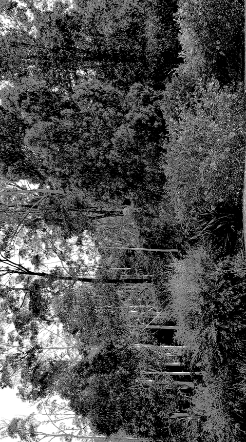
|
A number of mature gum trees
would need to be removed to accommodate the shed in the nominated location.
|
A site inspection confirmed
that no tree removal would be required for the proposed development.
|
|
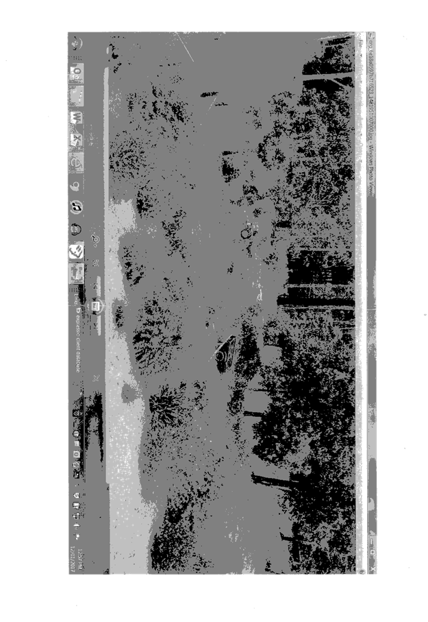
There is a stormwater easement
and culvert on site which is not shown on the plans.
|
Refer to comments under
stormwater heading within the report.
|
|
The owner has previously
undertaken earthworks without Council approval within and around the
stormwater culvert.
|
Noted.
|
(e) The Public Interest:
The proposed
development satisfies relevant planning controls and is unlikely to impact on
the wider public interest.
4. DEVELOPMENT
CONTRIBUTIONS APPLICABLE
· Not applicable.
5. CONCLUSION
The application has been assessed in accordance with
Section 79C of the Environmental Planning and Assessment Act 1979.
Issues raised during assessment and public exhibition of
the application have been considered in the assessment of the application.
Where relevant, conditions have been recommended to manage the impacts
attributed to these issues.
The site is suitable for the proposed development, is not
contrary to the public's interest and will not have a significant adverse
social, environmental or economic impact. It is recommended that the
application be approved, subject to the recommended conditions of consent
provided in the attachment section of this report.
|
Attachments
1View. DA2017
- 35.1 Plans
2View. DA2017
- 35.1 Recommended Conditions
3View. DA2017
- 35.1 Submission - Mackay
|
|
ATTACHMENT
|
Development Assessment Panel
22/03/2017
|

|
ATTACHMENT
|
Development Assessment Panel
22/03/2017
|

|
ATTACHMENT
|
Development Assessment Panel
22/03/2017
|
AGENDA Development Assessment Panel 22/03/2017
Item: 07
Subject: DA2017 - 49.1 Additions To Existing Dwelling
Including Clause 4.6 Objection To Clause 4.3 (Height Of Buildings) Of The Port
Macquarie-Hastings Local Environmental Plan 2011 - Lot 390 DP 236950, 5 Vendul
Crescent, Port Macquarie
Report
Author: Patrick Galbraith-Robertson
|
Applicant: Beukers
& Ritter Consulting Pty Ltd
Owner: H
Venter
Estimated Cost: $9,000
Alignment with Delivery
Program
4.9.2 Undertake transparent
and efficient development assessment in accordance with relevant legislation.
|
|
RECOMMENDATION
That it be a recommendation
to Council that DA 2017 – 49.1
for additions to dwelling, including Clause 4.6 Objection to Clause
4.3 (Height Of Buildings) of the Port Macquarie-Hastings Local Environmental
Plan 2011 at Lot 390, DP 236950, No. 5 Vendul Crescent,
Port Macquarie, be determined by
granting consent subject to the recommended conditions.
|
Executive
Summary
This
report considers a Development Application for additions to an existing
dwelling at the subject site and provides an
assessment of the application in accordance with the Environmental Planning and
Assessment Act 1979.
Following exhibition of the
application, no submissions have been
received.
This DA is required to be reported
to Council as the proposal includes a height variation greater than 10% to the
8.5m building height standard under the Port Macquarie-Hastings Local
Environmental Plan 2011.
1. BACKGROUND
Existing sites features and Surrounding development
The site has an area of 689.20
m2.
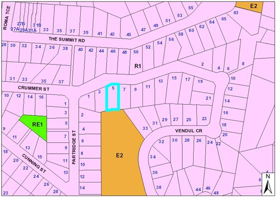
The site is zoned R1 General Residential in accordance with the Port Macquarie-Hastings Local
Environmental Plan 2011, as shown in the following zoning plan:
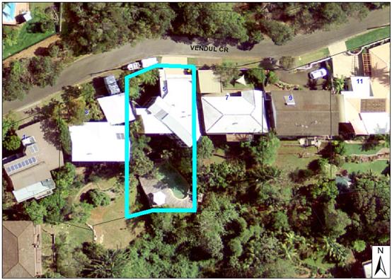
The existing subdivision pattern and location of existing
development within the locality is shown in the following aerial photograph:
2. DESCRIPTION OF
DEVELOPMENT
Key aspects of the proposal include the following:
· Additions
to the existing dwelling of an elevated deck and service platform attached to a
steel support structure.
· Installation
of glass sliding doors to replace existing windows.
· Installation
of 1.8m high privacy screen.
Refer
to attachments at the end of this report.
Application Chronology
· 25
January 2017 - Development Application lodged with Council.
· 9 to 22 February 2017 - Neighbour notification of the
proposal.
· 14 February 2017 - More information requested on reasons
for seeking height variation and privacy screen details.
· 7 March 2017 - Additional information received and amended
plans.
3. STATUTORY ASSESSMENT
Section 79C(1) Matters for Consideration
In determining the application, Council is required to take
into consideration the following matters as are relevant to the development
that apply to the land to which the development application relates:
(a) The provisions (where
applicable) of:
(i) any Environmental
Planning Instrument:
State Environmental Planning Policy No.
44 - Koala Habitat Protection
There is no Koala Plan of
Management on the site. Additionally, the site is less than 1ha in area
therefore no further investigations are required.
State
Environmental Planning Policy No.55 – Remediation of Land
Following an inspection of the site and a search
of Council records, the subject land is not identified as being potentially
contaminated and is suitable for the intended use.
State
Environmental Planning Policy No. 62 – Sustainable Aquaculture
Given the nature
of the proposed development, the proposal will be unlikely to have any adverse
impact on existing aquaculture industries within the Hastings River
approximately 5 kilometres from the site.
State
Environmental Planning Policy No. 71 – Coastal Protection and Clause 5.5
of Port Macquarie-Hastings Local Environmental Plan 2011
The site is
located within a coastal zone as defined in accordance with clause 4 of SEPP
71.
In accordance
with clause 5, this SEPP prevails over the Port Macquarie-Hastings LEP 2011 in
the event of any inconsistency.
Having regard to
clauses 8 and 12 to 16 of SEPP 71 and clause 5.5 of Hastings LEP 2011 inclusive
the proposed development will not result in any of the following:
a) any restricted access
(or opportunities for access) to the coastal foreshore
b) any
identifiable adverse amenity impacts along the coastal foreshore and on the
scenic qualities of the coast;
c) any
identifiable adverse impacts on any known flora and fauna (or their natural
environment);
d) subject to any
identifiable adverse coastal processes or hazards;
e) any identifiable
conflict between water and land based users of the area;
f) any identifiable
adverse impacts on any items of archaeological/heritage;
g) reduce the quality of
the natural water bodies in the locality.
Port Macquarie-Hastings Local Environmental Plan 2011
The proposal is consistent with the LEP having regard to the
following:
· Clause 2.2,
the subject site is zoned R1 General Residential. In accordance with clause
2.3(1) and the R1 zone landuse table, the additions to dwelling are a
permissible landuse with consent.
The objectives of the R1 zone are as
follows:
o To provide
for the housing needs of the community.
o To provide
for a variety of housing types and densities.
o To enable
other land uses that provide facilities or services to meet the day to day
needs of residents.
-
In accordance with Clause 2.3(2),
the proposal is consistent with the zone objectives as it is a permissible
landuse and is sufficiently consistent with the established residential
locality,
· Clause
4.3, the maximum overall height of the additions above ground level (existing)
is 10.9m (including the 1.8m height privacy screen attached to the deck) which
is unable to comply with the standard height limit of 8.5 m applying to the
site. note the existing dwelling is higher than 10.9m.
· Clause
4.4, the floor space ratio of the proposal is not proposed to change with the
additions.
· Clause
4.6, consent must not be granted for a proposal that contravenes a development
standard unless the consent authority has considered a written request from the
Applicant that justifies the variation by showing that the subject standard is
unreasonable or unnecessary and that there are sufficient environmental
planning grounds to justify the contravening of the standard.
The Applicant has submitted a Clause
4.6 variation to the standard based on the following reasons:
- The
proposed deck addition is to service the top floor of the existing approved
dwelling, which is constructed well over 8.5m (approximately 12.8m) at the rear
of the dwelling;
- The
privacy screen is 1.8m above the deck and approximately 1.9m below the existing
roof;
- The
location of the deck is positioned where it will not impact on the immediate
western neighbour’s amenity and privacy. The neighbouring dwelling is
constructed at a similar height to this dwelling, as are most in Vendul
Crescent;
- There
are numerous dwellings in the immediate neighbourhood which are constructed
over 8.5m, as the topography does not allow for much else.
Having considered the application and
Clause 4.6 variation, it is agreed the proposal will have minimal impact on the
environment as per the reasons identified by the applicant above. The following
additional points are made to support the variation:
- The
proposal will result is a building height that is compatible with the existing
character of the area.
- There
is approximately 8m of fall across the current building envelope from north to
south making strict compliance with the standard impractcal.
- No
adverse view sharing impacts to any neighbouring properties can be identified.
- No
submissions have been received.
- The
development is consistent with the zoning and height objectives of the LEP 2011
and is unlikely to have any implications on State related issues or the broader
public interest.
As per NSW Department of Planning and Environment Circulars PS 08-003 and
08-014, Council can assume the Director’s Concurrence for variations to
height limits. In addition, the variation is greater than 10% and therefore
required to be determined at an Ordinary meeting of full Council.
· Clause
5.9 - one(1) Bangalow Palm is proposed to be removed which is a listed tree in
Development Control Plan 2013 which requires development consent for its
removal.
· Clause
5.10 – Heritage. The site does not contain or adjoin any known heritage
items or sites of significance.
· Clause 7.13,
satisfactory arrangements are in place for provision of essential services.
(ii) Any
draft instruments that apply to the site or are on exhibition:
No draft
instruments apply.
(iii) any
Development Control Plan in force:
Port
Macquarie-Hastings Development Control Plan 2013:
|
DCP 2013: Dwellings, Dual
occupancies, Dwelling houses, Multi dwelling houses & Ancillary
development
|
|
|
Requirements
|
Proposed
|
Complies
|
|
|
Driveway crossover 1/3 max. of
site frontage and max. 5.0m width
|
n/a
|
|
|
3.2.2.4
|
4m min. rear setback. Variation
subject to site analysis and provision of private open space
|
>10m
|
Yes
|
|
3.2.2.5
|
Side setbacks:
• Ground floor =
min. 0.9m
• First floors
& above = min. 3m setback or where it can be demonstrated that
overshadowing not adverse = 0.9m min.
• Building wall
set in and out every 12m by 0.5m
|
0.9m west side setback
No adverse overshadowing impacts
identified
|
|
|
3.2.2.6
|
35m2 min. private open space area
including a useable 4x4m min. area which has 5% max. grade
|
Increased useable private open
space to existing. >35m2 useable area in total
|
yes
|
|
3.2.2.8
|
No chain wire, solid timber,
masonry or solid steel front fences
|
n/a
|
|
|
3.2.2.10
|
Privacy:
• Direct views
between living areas of adjacent dwellings screened when within 9m radius of
any part of window of adjacent dwelling and within 12m of private open space
areas of adjacent dwellings. ie. 1.8m fence or privacy screening which has
25% max. openings and is permanently fixed
• Privacy screen
required if floor level > 1m height, window side/rear setback (other than
bedroom) is less than 3m and sill height less than 1.5m
• Privacy screens
provided to balconies/verandahs etc which have <3m side/rear setback and
floor level height >1m
|
No direct views between living
areas of adjacent dwellings screened when within 9m radius of any part of
window of adjacent dwelling and within 12m of private open space areas of
adjacent dwellings.
1.8m privacy screen proposed with
maximum 25% transparency on the west side.
|
Yes
|
|
DCP 2013: General
Provisions
|
|
|
Requirements
|
Proposed
|
Complies
|
|
2.7.2.2
|
Design addresses generic principles of Crime Prevention
Through Environmental Design guideline
|
Adequate casual surveillance available
|
Yes
|
|
2.3.3.1
|
Cut and fill 1.0m max. 1m outside the perimeter of the
external building walls
|
No change
|
|
|
2.6.3.1
|
Tree removal (3m or higher with 100m diameter trunk at 1m
above ground level and 3m from external wall of existing dwelling)
|
One(1) Bangalow Palm tree proposed to be removed. No
adverse flora impacts identified.
|
Yes
|
|
2.4.3
|
Bushfire risk, Acid sulphate soils, Flooding,
Contamination, Airspace protection, Noise and Stormwater
|
Refer to main body of report.
|
|
(iiia) any
planning agreement that has been entered into under Section 93f or any draft
planning agreement that a developer has offered to enter into under Section
93f:
No planning
agreements have been entered into.
iv) any matters prescribed by the
Regulations:
New South Wales Coastal Policy:
The proposed
development is consistent with the objectives and strategic actions of this
policy.
v) any coastal zone
management plan (within the meaning of the Coastal
Protection Act 1979), that apply to
the land to which the development application relates:
No coastal zone management plan applies.
(b) The
likely impacts of that development, including environmental impacts on both the
natural and built environments, social and economic impacts in the locality:
Context and setting
• The
proposal will be unlikely to have any adverse impacts to existing adjoining
properties or the public domain.
• The proposal is considered to be consistent with other
residential development in the locality and adequately addresses planning
controls (including height variation as justified) for the area.
• There
are no identifiable adverse impacts on existing view
sharing.
• There are no adverse privacy impacts.
• There are no adverse overshadowing impacts. The proposal
does not prevent adjoining properties from receiving 3 hours of sunlight to
private open space and primary living areas on 21 June.
Access, transport and traffic
The proposal will be unlikely to have any adverse impacts in
terms access, transport and traffic.
Stormwater
No additional roofed area. No
adverse impacts identified.
Other Utilities
Telecommunication and electricity
services are available to the site.
Heritage
This site does not contain or
adjoin any known heritage item or site of significance.
Other land resources
No adverse impacts anticipated.
The site is within an established urban context and will not sterilise any
significant mineral or agricultural resource.
Water cycle
The proposed development will be
unlikely to have any adverse impacts on water resources and the water cycle.
Soils
The proposed development will be
unlikely to have any adverse impacts on soils in terms of quality, erosion,
stability and/or productivity subject to a standard condition requiring erosion
and sediment controls to be in place prior to and during construction.
Air and microclimate
The construction and/or
operations of the proposed development will be unlikely to result in any
adverse impacts on the existing air quality or result in any pollution.
Flora and fauna
Construction of the proposed
development will not require any removal/clearing of any significant vegetation
and therefore will be unlikely to have any significant adverse impacts on
biodiversity or threatened species of flora and fauna. Section 5A of the
Act is considered to be satisfied.
Waste
Satisfactory arrangements are in
place for proposed storage and collection of waste and recyclables. No adverse
impacts anticipated.
Noise and vibration
No adverse impacts anticipated.
Condition recommended to restrict construction to standard construction hours.
Bushfire
The site is identified as being
bushfire prone.
The Applicant has submitted a
self assessment bushfire report. BAL 29 construction is recommended.
The following comments are
provided having regard to section 4.3.5 of Planning for Bushfire Protection
2006:
|
Asset Protection Zones
|
APZ to be determined in accordance with AS3959
|
No change to existing APZ.
|
|
Siting and building design
|
Siting and design principles considered section 4.3.5
|
Concrete and steel addition.
|
|
Construction standards
|
Construction in accordance with AS3959.
|
FDI rating 80
Effective slope = 10-15 degrees within hazard
Distance to hazard = 19m
BAL 29 construction
|
|
Access requirements
|
4.1.3 public road access
4.2.7 for internal road access
|
No change to existing
|
|
Water and utility services
|
4.1.3 services - water and electricity.
|
No change to existing
|
|
Landscaping
|
Appendix 5 landscaping
|
No change to existing
|
The above
assessment concludes that the bushfire risk is acceptable subject to BAL
construction levels being implemented - condition recommended.
Safety, security and crime
prevention
The proposed development will be
unlikely to create any concealment/entrapment areas or crime spots that would
result in any identifiable loss of safety or reduction of security in the immediate
area.
Social impacts in the locality
Given the nature of the proposed
development and its’ location the proposal is unlikely to result in any
adverse social impacts.
Economic impact in the
locality
No adverse impacts. Likely
positive impacts can be attributed to the construction of the development and
associated flow on effects (ie increased expenditure in the area).
Site design and internal
design
The proposed development design
is satisfactorily responds to the site attributes and will fit into the
locality. No adverse impacts likely.
Construction
No potential adverse impacts
identified to neighbouring properties with the construction of the proposal.
Cumulative impacts
The proposed development is not
expected to have any adverse cumulative impacts on the natural or built
environment or the social and economic attributes of the locality.
(c) The suitability of the site for
the development:
The proposal
will fit into the locality and the site attributes are conducive to the proposed
development.
Site constraints
of bushfire risk and slope have been adequately addressed and appropriate
conditions of consent recommended.
(d) Any submissions made in
accordance with this Act or the Regulations:
Following
neighbour notification in accordance with DCP 2013, no submissions have been
received.
(e) The Public Interest:
The proposed
development satisfies relevant planning controls (including the height
variation as justified) and is unlikely to impact on the wider public interest.
4. DEVELOPMENT
CONTRIBUTIONS APPLICABLE
No development contributions are applicable.
5. CONCLUSION
The application has been assessed in accordance with
Section 79C of the Environmental Planning and Assessment Act 1979.
Issues raised during assessment and public exhibition of
the application have been considered in the assessment of the application.
Where relevant, conditions have been recommended to manage the impacts
attributed to these issues.
The site is suitable for the proposed development, is not
contrary to the public's interest and will not have a significant adverse
social, environmental or economic impact. It is recommended that the
application be approved, subject to the recommended conditions of consent
provided in the attachment section of this report.
|
Attachments
1View. DA2017
- 49.1 Plans
2View. DA2017
- 49.1 Recommended Conditions
|
|
ATTACHMENT
|
Development Assessment Panel
22/03/2017
|
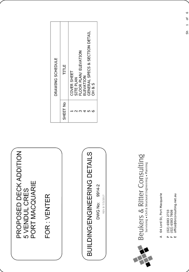
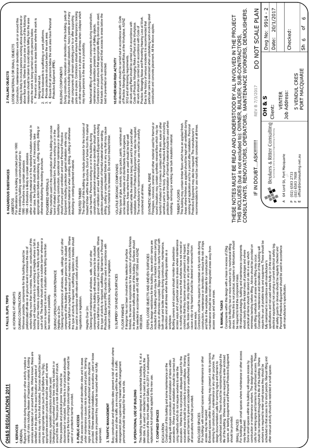
|
ATTACHMENT
|
Development Assessment Panel
22/03/2017
|
AGENDA Development Assessment Panel 22/03/2017
Item: 08
Subject: DA2017 - 21.1 Primitive Campground - Increase
In Number Of Sites (Wauchope Showground) - Lot 22 DP 1147833, 93A High Street,
Wauchope
Report
Author: Patrick Galbraith-Robertson
|
Applicant: Wauchope
Show Society
Owner: Wauchope
Show Society
Estimated Cost: $0
Alignment with Delivery
Program
4.9.2 Undertake transparent
and efficient development assessment in accordance with relevant legislation.
|
|
RECOMMENDATION
That
DA 2017 – 21 for an Increase in the number of sites associated with a Primitive
Campground (Wauchope Showground) at Lot 22, DP 1147833, No. 93A High Street, Wauchope, be determined by granting consent subject to the recommended
conditions.
|
Executive
Summary
This
report considers a Development Application for alterations to a current
approved primitive campground to increase the number of sites at the subject site and provides an assessment of the
application in accordance with the Environmental Planning and Assessment Act
1979.
Following exhibition of the
application, 2 submissions have been received.
The proposal is an Integrated
Development which requires Bushfire Safety Authority under the Rural Fires Act
1997.
1. BACKGROUND
Existing sites features and Surrounding development
The site has an area of 10.52
hectares.
The site is zoned RE2 Private Recreation in accordance with the Port Macquarie-Hastings Local
Environmental Plan 2011, as shown in the following zoning plan:
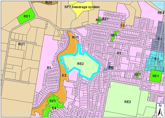
The site is the existing Wauchope Showground. The
showground has existing powered campsites which are currently only permitted to
be used for camping associated with showground events and/or 16 specific sites
for primitive camping (outside of normal showground activities).
The showground has frontage to Beechwood Road
and High Street.
Adjoining the site to the north-east,
north-west and east are existing residential lots occupied by dwelling-houses.
Adjoining the site to the west is Yippin Creek.
Adjoining the
site to the south are residential zoned lots occupied by a bus depot, a
residential lot occupied by a dwelling and an approved commercial storage
premises.
The existing subdivision pattern and location
of existing development within the locality is shown in the following aerial
photograph:
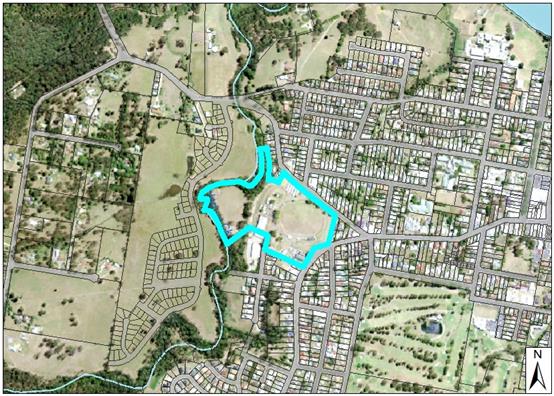
2. DESCRIPTION OF
DEVELOPMENT
Key aspects of the proposal include the following:
· Increase
in the number of short term primitive campsites on the ground from 16 to 21
sites. The 5 extra sites are located within the southern and eastern sections
of the Showground.
Refer to attachments at the end of this report.
Application Chronology
· 10 July 2013 - Current DA 2013 - 181 granted development
consent for a primitive campground limited to 16 sites.
· 13 January 2017 - DA lodged.
· 1
to 14 February 2017 - Neighbour notification of proposal.
· 6
February 2017 - Referral to NSW Rural Fire Service
· 6
March 2017 - Advice received from NSW Rural Fire Service including Bushfire
Safety Authority
3. STATUTORY ASSESSMENT
Section 79C(1) Matters for Consideration
In determining the application, Council is required to take
into consideration the following matters as are relevant to the development
that apply to the land to which the development application relates:
(a) The provisions (where
applicable) of:
(i) any Environmental
Planning Instrument:
State Environmental Planning Policy 21 -
Caravan Parks
In accordance with clause 6, caravan park includes by definition a
camping ground.
In accordance with clause 8 (1), a camping
ground is a permissible land use.
In accordance with clause 8 (2)(b), the number of primitive
camping ground sites (21 total proposed) is permitted under the Local
Government (Manufactured Home Estates, Caravan Parks, Camping Grounds and
Moveable Dwellings) Regulation 2005. There is no minimum size of land area
for a camping ground however there is a maximum restriction of 2 camp sites (2
tents or 1 caravan per site) per hectare (total area of site) in accordance
with the regulations (clause 132). In this regard, the site (entire showground)
comprises an area of 10.52 hectares which therefore can permit 21 camp sites.
The proposal is capable of compliance with the remainder of the requirements of
this regulation and relevant conditions are recommended accordingly.
In accordance with clause 8(3), a condition is
recommended to restrict the total number of sites to twenty one (21).
In accordance with clause 10, the proposal
meets the services and facilities requirements.
State Environmental Planning Policy No.
44 - Koala Habitat Protection
With reference to clauses 6 and 7, the
subject land has is greater than 1 hectare (including any adjoining land under
same ownership) and therefore the provisions of SEPP must be considered.
No habitat will
be removed or modified therefore no further investigations are required.
State
Environmental Planning Policy No.55 – Remediation of Land
Following a search of Council records, the
subject land is not identified as being potentially contaminated and is
suitable for the intended use.
State Environmental Planning Policy No.
64 – Advertising and Signage
Standard condition recommended requiring
development consent to be obtained for any advertising signage other than
signage which is exempt development.
Port
Macquarie-Hastings Local Environmental Plan 2011
The proposal is consistent with the LEP having regard to the
following:
· Clause
2.2, the subject site is zoned RE2 private recreation. In accordance with
clause 2.3(1) and the RE2 zone landuse table, the proposed development for a
camping ground is a permissible landuse with consent.
The objectives of the RE2 zone
are as follows:
1 Objectives
of zone
• To
enable land to be used for private open space or recreational purposes.
• To
provide a range of recreational settings and activities and compatible land
uses.
• To
protect and enhance the natural environment for recreational purposes.
In accordance with clause 2.3(2), the
proposal is consistent with the zone objectives having regard to the following:
· the proposal is a
permissible landuse;
· the use is located
within an existing showground which can be used for multiple purposes to
encourage alternate recreational opportunities
In accordance with clause 7.13,
satisfactory arrangements are in place for provision of essential public
utility infrastructure including water and sewer infrastructure to service the
development. Provision of electricity and telecommunications are capable of
being provided.
(ii) Any
draft instruments that apply to the site or are on exhibition:
No draft instruments apply to the site.
(iii) any
Development Control Plan in force:
Port
Macquarie-Hastings Development Control Plan 2013
|
Requirement
|
Proposed
|
Complies
|
|
Part 2 DP 2.5.3.3 - Off street
parking requirements
|
No specific parking rate - area
based requirements under Local Government regulations - as primitive camping.
Sufficient overflow area available within Showground to accommodate parking
as required for use of sites.
|
N/A
|
|
Part 2 DP 2.5.3.14 - parking and
manoeuvring surfaces shall be constructed with a coarse base of sufficient
depth to suit the amount of traffic generated by the development, as
determined by Council. It shall be sealed with either bitumen, asphaltic
concrete or interlocking pavers.
Council may give special
consideration on merit to the use of consolidated unsealed gravel pavement
for car parks.
|
The site has a bitumen sealed entry
from High Street.
The proposal is for primitive
camping only for 21 camping sites. No additional works are proposed to
upgrade existing facilities within the Showground.
|
Yes - acceptable
|
|
Part 2 DP 2.7.2 Crime prevention
|
The siting and orientation of the
camping ground sites are within an existing showground which has good casual
surveillance and lighting throughout the grounds.
No adverse crime risk identified.
|
Yes
|
(iiia) any planning
agreement that has been entered into under Section 93f or any draft planning
agreement that a developer has offered to enter into under Section 93f:
No planning agreement has been
offered or entered into relating to the site.
iv) any matters
prescribed by the Regulations:
No additional matters specified under regulations require consideration.
v) any
coastal zone management plan (within the meaning of the Coastal
Protection Act 1979), that apply to
the land to which the development application relates:
No Coastal Zone Management Plan applies to the subject site.
(b) The
likely impacts of that development, including environmental impacts on both the
natural and built environments, social and economic impacts in the locality:
The site has street frontage to
Beechwood Road and High Street, Wauchope.
The site is the existing Wauchope
Showground.
There is an existing development
consent applying to the Showground permitting 16 sites to be used for primitive
camping.
The proposal will be unlikely to
have any adverse impacts to existing adjoining properties or the public domain.
The proposal adequately addresses
planning controls for the area.
The proposal will not have any
identifiable significant adverse impact on existing view sharing.
The proposal will not have any
identifiable significant adverse lighting impacts.
There are no identifiable
significant adverse privacy impacts.
There are no adverse overshadowing impacts. The proposal does
not prevent adjoining properties from receiving 3 hours of sunlight to private
open space and primary living areas on 21 June.
Access, Transport & Traffic
The proposal will be unlikely to
have any adverse impacts within the immediate locality in terms access,
transport and traffic.
The site has a bitumen sealed
entry from High Street into the site within showground.
The proposal is for primitive
camping only for 16 camping sites.
The existing road network will
satisfactorily cater for any increase in traffic generation as a result of the
development.
Utilities
Telecommunication and electricity
service the showground’s site.
Stormwater
No change to existing. Camp sites
on existing grounds only.
Sewer
Sewer is available and connected to the site. An existing
dump point is provided for the purpose of campers.
Water supply
Previous
comments under DA2013 - 181 were that Council records indicate that Wauchope
Showground has five metered water services. A 100 mm PVC water main from High
Street extends into the showground land with two fire hydrants provided. There
is also a 200mm AC water main across the showground area from Thatcher Street
to Beechwood Road with two hydrants within the showground area. These fire
hydrants appear to be able to provide fire service coverage to AS 2419 for the
proposed development, but this is to be confirmed by the hydraulic consultant.
The normal
requirements of caravan and camping ground fire hose reel and fire hydrant
protection will be required. Details will be fully assessed as part of the
Local Government Act approval for the operation of the camp site.
Heritage
Following a site inspection (and
a search of Council records), no known items of Aboriginal or European heritage
significance exist on the property. No adverse impacts anticipated.
Other land resources
No adverse impacts anticipated.
The site is within an established urban context and will not sterilise any
significant mineral or agricultural resource.
Water cycle
The proposed development will be
unlikely to have any adverse impacts on water resources and the water cycle.
Soils
The proposed development will be
unlikely to have any adverse impacts on soils in terms of quality, erosion,
stability and/or productivity subject to a standard condition requiring erosion
and sediment controls to be in place prior to and during construction.
Air and microclimate
The operations of the proposed
development will be unlikely to result in any adverse impacts on the existing
air quality or result in any pollution.
Flora and fauna
The proposed development will not
require any removal/clearing of any significant vegetation and therefore will
be unlikely to have any significant adverse impacts on biodiversity or
threatened species of flora and fauna. Section 5A of the Act is
considered to be satisfied.
Waste
Satisfactory arrangements are in
place for proposed storage and collection of waste and recyclables. No adverse
impacts anticipated.
Energy
No adverse impacts anticipated.
Noise and vibration
No adverse impacts anticipated. A
precautionary condition is however recommended that offensive noise as defined
under the Protection of the Environment Operations Act 1997, shall not be
generated as a result of the operation of the development.
Bushfire
The site is identified as being bushfire prone.
In accordance with Section 100B - Rural
Fires Act 1997 - the application proposes development of bushfire prone
land for a Special Fire Protection Purpose.
The NSW Rural Fire Service has
assessed the development and issued a Bushfire Safety Authority subject to
conditions. These conditions are recommended to form part of the development
consent. The conditions are attached to this report.
Safety, security and crime
prevention
The
proposed development will be unlikely to create any concealment/entrapment
areas or crime spots that would result in any identifiable loss of safety or
reduction of security in the immediate area.
The
facility is an existing established showground.
Social impacts in the locality
Given the nature of the proposed
development and its location the proposal is unlikely to result in any adverse
social impacts.
Economic impact in the
locality
No adverse impacts. Likely
positive impacts can be attributed to the development.
Site design and internal
design
The
camp sites will satisfactorily fit into the locality. No adverse impacts likely.
Construction
No potential adverse impacts
identified to neighbouring properties with the construction of the proposal.
Cumulative impacts
The proposed
development is not expected to have any adverse cumulative impacts on the
natural or built environment or the social and economic attributes of the
locality.
(c) The suitability of the site for
the development:
The proposal will fit into the
locality and the site attributes are conducive to the proposed development.
Site constraints of bushfire risk have
been adequately addressed and appropriate conditions of consent recommended.
(d) Any submissions
made in accordance with this Act or the Regulations:
Two(2) written submissions have been received following neighbour
notification of the application.
Key issues raised in the submissions received
and comments in response to these issues are provided as follows:
|
Submission
Issue/Summary
|
Planning
Comment/Response
|
|
10 Beechwood Road
|
|
No neighbour notification
received of previous DA. Would of opposed previous DA.
|
Council’s records
indicate that neighbour notification letters were sent out as part of the
assessment process of DA2013 - 181 in May 2013. It is also noted that a
submission was received from the owner of this address at this time. The
issues raised in the submission received were taken into consideration as
part of the assessment and approval of the DA.
|
|
A caravan with a permanent
resident is located approximately 6 feet from side boundary fence.
|
An inspection of the
showground during the assessment of this Development Application revealed
that no permanent resident is occupying the site referred to adjacent to 10
Beechwood Road. It is also noted that the power supply is located 22m from
the eastern property common boundary fence.
|
|
Noticed Showground doing work
approximately 6 to 10 months ago putting in underground power for sites.
Expected notification from Council.
|
The Development Application
2013 - 181 was approved subject to conditions following neighbour
notification and detailed assessment in accordance with applicable planning
legislative requirements. Provision of power to each camp site is permitted
as part of a primitive campground.
|
|
93 High Street
|
|
|
Concerned about the impact of
further campers on the traffic flow in and out of the Showground. There has
been many near misses with vans and cars entering and exiting the grounds.
|
The increase in traffic
associated with 5 additional camp sites is not considered significant to
warrant a detailed traffic assessment being carried out or changes to the
existing access arrangements. It is noted that the camp sites are part of the
larger showground which could have much larger traffic generation. No
upgrades to the existing access arrangements are recommended.
|
|
How will development affect
land value. Did not buy house to live next door to a caravan park.
|
The Planning legislation does
not require any consideration to be given to any claimed impacts on land
values.
|
|
Lack of privacy is a concern
as I already get a van parked right against fence.
|
Given the number of sites
being limited as shown on the submitted site plan within proximity to this
property no adverse impacts can be identified to warrant recommending refusal
of the application.
|
|
|
|
(e) The Public Interest:
The proposed
development satisfies relevant planning controls and is unlikely to impact on
the wider public interest.
4. DEVELOPMENT
CONTRIBUTIONS APPLICABLE
No development contributions previously applied to the
primitive campground due to Council resolution of 14 November 2012 that waived
development contributions for Show Societies for up to 16 sites.
This proposal increases the sites by five(5), therefore
development contributions will be required towards augmentation of town water
supply and sewerage system head works under Section 64 of the Local Government
Act 1993. Development contributions will be required under Section 94 of the
Environmental Planning and Assessment Act 1979 towards roads, open space,
community cultural services, emergency services and administration buildings.
5. CONCLUSION
The application has been assessed in accordance with
Section 79C of the Environmental Planning and Assessment Act 1979.
Issues raised during assessment and public exhibition of
the application have been considered in the assessment of the application.
Where relevant, conditions have been recommended to manage the impacts
attributed to these issues.
The site is suitable for the proposed development, is not
contrary to the public's interest and will not have a significant adverse
social, environmental or economic impact. It is recommended that the
application be approved, subject to the recommended conditions of consent
provided in the attachment section of this report.
|
Attachments
1View. DA2017
- 21.1 Plan
2View. DA2017
- 21.1 Recommended DA Conditions
3View. DA2017
- 21.1 Submission - Dahl
4View. DA2017
- 21.1 Submission - Ostler
|
|
ATTACHMENT
|
Development Assessment Panel
22/03/2017
|
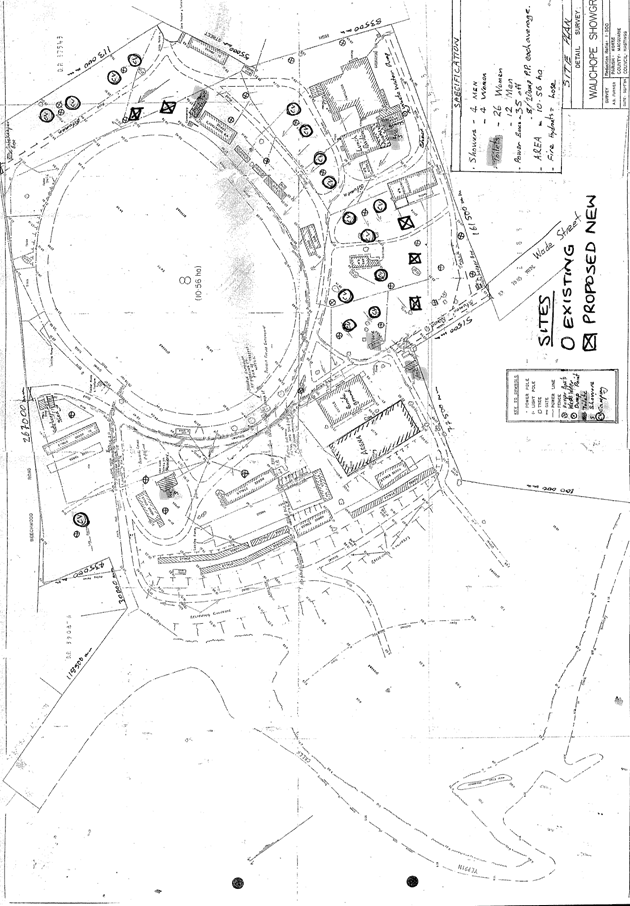
|
ATTACHMENT
|
Development Assessment Panel
22/03/2017
|
|
ATTACHMENT
|
Development Assessment Panel
22/03/2017
|
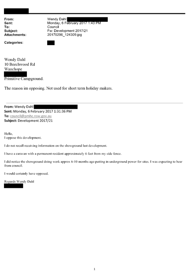
|
ATTACHMENT
|
Development Assessment Panel
22/03/2017
|