Business
Paper
|
date of meeting:
|
|
Wednesday 12 April
2017
|
|
location:
|
|
Function Room
Port
Macquarie-Hastings Council
17 Burrawan Street
Port Macquarie
|
|
time:
|
|
2:00pm
|
Development
Assessment Panel
CHARTER
COMPOSITION:
Independent Chair (alternate, Director Development &
Environment)
Manager Development Assessment (alternate, Director Development & Environment or Development Assessment Planner)
Development Engineering Coordinator (alternate, Development
Engineer)
MISSION:
To assist in managing Council's
development assessment function
by providing independent and expert assessment of development applications
The Development Assessment Panel will make determinations on the basis of established criteria and practice and will not be influenced by "lobbying" and "weight of numbers" in its assessment process.
FUNCTIONS:
1.
To review development application reports and conditions
2.
To determine development applications outside of staff delegations
3.
To refer development applications to Council
for determination where necessary
4.
To provide a forum for objectors and applicants to make submissions on applications before DAP.
5.
To maintain transparency for the determination of development applications.
DELEGATED AUTHORITY:
1.
Pursuant to Section
377 of the Local Government Act, 1993 delegation to:
2.
Determine development applications under Part 4 of the Environmental Planning
and Assessment Act 1979
having regard to the relevant
environmental planning instruments, development control plans and Council
policies.
3.
Vary Modify or release restrictions as to use and/or covenants created
by Section 88B instruments under the Conveyancing Act 1919 in relation to
development applications for subdivisions being considered by the panel.
4.
Determine Koala Plans of Management under State Environmental Planning
Policy 44 - Koala Habitat Protection associated with development applications
being considered by the Panel.
TIMETABLE:
The Development Assessment Panel shall generally meet on the 1st and 3rd Wednesday each month at 2.00pm.
VENUE:
The venue will be
determined according to the likely
number of participants.
BUSINESS PAPER AND MINUTES:
1.
The Business Paper for the meeting shall be published
and distributed on the Friday prior
to the meeting.
2.
Special Meetings of the Panel may be convened by the Director
Development & Environment Services
with three (3) days notice.
3.
The format of the preparation and publishing of the Business
Paper and Minutes
of the Development Assessment Panel meetings shall be similar to the format
for Ordinary Council Meetings, except that the movers
and seconders shall not be recorded and only the actual decisions are shown.
Minutes shall also record how each member votes for each
item before the Panel.
FORMAT OF THE MEETING:
1.
Panel meetings shall be carried
out in accordance with Council's
Code of Meeting Practice for Council Sub-Committees, except where varied
by this Charter.
2.
Meetings shall be "Open" to the public.
3.
The Panel will hear from applicants and objectors or their representatives. Where considered necessary, the Panel will conduct site inspections which will be open to the
public.
INDEPENDENT CHAIR:
The Chair of the Development Assessment Panel shall be an independent person appointed by the General
Manager. The Independent Chair shall have experience and qualifications relevant to planning.
The term of the Independent Chair shall be four
(4) years.
QUORUM:
All members must be present at the Meeting to form a Quorum.
DECISION MAKING:
Decisions are to be made by the Development Assessment
Panel by "consensus". Where "consensus" is not possible,
the matter is to be referred to Council.
All development applications
involving a variation to a development standard greater than 10% under
Clause 4.6 of the Port Macquarie-Hastings Local Environmental Plan 2011 will be
considered by the Panel and recommendation made to the Council for
determination.
Staff Members shall
not vote on matters before the Panel if they have been the principle author of the development assessment report.
LOBBYING:
Outside of scheduled
Development Assessment Panel meetings, applicants, their representatives,
Councillors, Council staff and the general public are not to lobby Panel
members via meetings, telephone conversations, correspondence and the like.
Adequate opportunity will be provided at Panel inspections or meetings for
applicants, their representatives and the general public to make verbal
submissions in relation to Business Paper items.
OBLIGATIONS OF PANEL
MEMBERS:
All DAP members
are required to comply with the following:
1.
Members must perform their Development Assessment Panel obligations faithfully and diligently and in accordance
with the DAP Code.
2.
DAP members must comply with Council's Code of Conduct.
3.
Except as required to properly perform
their duties, DAP members must not disclose
any confidential information (as advised by Council) obtained
in connection with the DAP functions.
4.
DAP members will have read and be familiar with the documents
and information provided
by Council prior to attending a DAP meeting.
5.
DAP members must act in accordance with Council's Occupational Health and Safety Policies and Procedures
6.
DAP members shall not speak to the media on any matter
before the Panel otherwise
than with the express approval
of the Director Development &
Environment Services.
Development Assessment Panel
ATTENDANCE
REGISTER
|
Member
|
18/01/17
|
08/02/17
|
22/02/17
|
8/3/17
|
22/03/17
|
|
Paul Drake
Matt Rogers (alternate)
|
P
|
P
|
P
|
P
|
P
|
|
Dan Croft
Patrick Galbraith-Robertson
Warren Wisemantel
(alternates)
|
P
|
P
|
P
|
P
|
P
|
|
David Troemel
Caroline Horan (alternate)
Bevan Crofts (alternate)
|
P
|
P
|
P
|
A
P
|
P
|
Key: P = Present
A
= Absent With Apology
X
= Absent Without Apology
Development
Assessment Panel Meeting
Wednesday 12 April
2017
Items of Business
01 Acknowledgement
of Country............................................................................ 7
02 Apologies......................................................................................................... 7
03 Confirmation
of Minutes.................................................................................... 7
04 Disclosures
of Interest..................................................................................... 11
05 DA2002
- 169.2 & DA2016 - 939.1 Modification To Design Of Previous Approved
Residential Subdivision And 6 Additional New Lots - Lot 505 DP 1192771,
Greenmeadows Drive, Port Macquarie ...................................................................................................... 15
06 DA2016
- 942.1 Retail Premises at Lot 4 Sec A DP 975586, No. 52 Cameron Street,
Wauchope Street.............................................................................................................. 73
07 DA2016
- 984.1 Staged construction Of Multi Dwelling Housing With Torrens Title
Subdivision - Lots 10 & 11Sec F, DP 24850, No 54 Kalinda Drive, Port
Macquarie................. 127
08 DA2017
- 32.1 - Addition Of Floating Pontoon And Storage Shed For Jet Skis Associated
With an emergency services facility (Marine Rescue) - Lot 1 DP 1064060, Buller
Street, Port Macquarie..................................................................................................................... 155
09 DA2017
- 67.1 Additions To Dwellng - Lot 5 DP 257282, No 8 Unique Close Camden
Head..................................................................................................................... 181
10 DA2017
- 109.1 Part Use Of Existing Dwelling For Bed And Breakfast Establishment - Lot
84 DP 1063863,No 20 Admirals Circle, Lakewood...................................................... 219
11 General
Business
AGENDA Development Assessment Panel 12/04/2017
Subject: ACKNOWLEDGEMENT
OF COUNTRY
"I acknowledge that we are
gathered on Birpai Land. I pay respect to the Birpai Elders both past and
present. I also extend that respect to all other Aboriginal and Torres Strait
Islander people present."
RECOMMENDATION
That the apologies received be
accepted.
Subject: CONFIRMATION
OF PREVIOUS MINUTES
Recommendation
That the Minutes of the Development
Assessment Panel Meeting held on 22 March 2017 be confirmed.
MINUTES Development Assessment
Panel
Meeting
22/03/2017
PRESENT
Members:
Paul
Drake
Dan Croft
David Troemel
Other Attendees:
Pat
Galbraith-Robertson
Chris Gardiner
|
The meeting opened at 2:00pm.
|
|
01 ACKNOWLEDGEMENT
OF COUNTRY
|
|
The
Acknowledgement of Country was delivered.
|
|
03 CONFIRMATION
OF MINUTES
|
|
CONSENSUS:
That
the Minutes of the Development Assessment Panel Meeting held on 8 March 2017
be confirmed.
|
|
04 DISCLOSURES
OF INTEREST
|
|
There were no disclosures of interest presented.
|
|
05 DA2016
- 997.1 Medical Centre And Signage At Lot 7 DP 628535, No. 83 Savoy Street,
Port Macquarie
|
|
Speaker:
Derek
Collins (applicant)
CONSENSUS:
That DA 2016 - 997.1 for
a Medical Centre and Signage at Lot 7, DP 628535, No. 83 Savoy Street, Port
Macquarie, be determined by granting consent
subject to the recommended conditions.
|
|
06 DA2017 - 35.1
Shed - Lot 61 DP1081580, 8 Yippenvale Circuit, Crosslands
|
|
An
error was identified in the attachments to the report and an amended plan was
tabled noting that the shed is to be setback 3m from centre of stormwater
headwall and 2m from boundary.
Speakers:
Craig MacKay (o)
Scott Purnell (applicant)
CONSENSUS:
That DA2017
- 35 for a shed at
Lot 61, DP 1081580, No. 8 Yippenvale
Circuit, Crosslands, be determined by granting consent subject to the
recommended conditions.
|
|
07 DA2017 - 49.1
Additions To Existing Dwelling Including Clause 4.6 Objection To Clause 4.3
(Height Of Buildings) Of The Port Macquarie-Hastings Local Environmental Plan
2011 - Lot 390 DP 236950, 5 Vendul Crescent, Port Macquarie
|
|
CONSENSUS:
That
it be a recommendation to Council that DA 2017 – 49.1 for additions to dwelling, including Clause 4.6
Objection to Clause 4.3 (Height Of Buildings) of the Port Macquarie-Hastings
Local Environmental Plan 2011 at Lot 390, DP 236950, No. 5 Vendul Crescent, Port
Macquarie, be determined by granting consent
subject to the recommended conditions.
|
|
08 DA2017
- 21.1 Primitive Campground - Increase In Number Of Sites (Wauchope
Showground) - Lot 22 DP 1147833, 93A High Street, Wauchope
|
|
Speaker:
Bob
Kennett (applicant)
CONSENSUS:
That DA 2017 – 21 for an Increase in the number of
sites associated with a Primitive Campground (Wauchope Showground) at Lot 22, DP 1147833,
No. 93A High Street, Wauchope, be
determined by granting consent subject to the recommended conditions.
|
|
The meeting closed at 2:30pm.
|
AGENDA Development Assessment Panel 12/04/2017
Subject: DISCLOSURES
OF INTEREST
RECOMMENDATION
That Disclosures of Interest be presented
DISCLOSURE OF
INTEREST DECLARATION
Name of Meeting: ………………………………………………………………………..
Meeting Date: ………………………………………………………………………..
Item Number: ………………………………………………………………………..
Subject: ………………………………………………………………………..
…………………………………………………….……………...…..
I,
.....................................................................................
declare the following interest:
 Pecuniary:
Take
no part in the consideration and voting and be out of sight of the meeting.
Non-Pecuniary
- Significant Interest:
Take
no part in the consideration and voting and be out of sight of the meeting.
Non-Pecuniary
- Less than Significant Interest:
May
participate in consideration and voting.
For the reason that:
....................................................................................................
.......................................................................................................................................
Name:
…………………………………………………….
Signed:
.........................................................................
Date: ..................................
 (Further
explanation is provided on the next page)
(Further
explanation is provided on the next page)
Further
Explanation
(Local Government Act and Code of Conduct)
A conflict of interest exists where a reasonable and informed
person would perceive that a Council official could be influenced by a private
interest when carrying out their public duty. Interests can be of two types:
pecuniary or non-pecuniary.
All interests, whether pecuniary or non-pecuniary are required to
be fully disclosed and in writing.
Pecuniary Interest
A pecuniary interest is an interest that a Council official has in
a matter because of a reasonable likelihood or expectation of appreciable
financial gain or loss to the Council official. (section 442)
A Council official will also be taken to have a pecuniary interest
in a matter if that Council official’s spouse or de facto partner or a
relative of the Council official or a partner or employer of the Council
official, or a company or other body of which the Council official, or a
nominee, partner or employer of the Council official is a member, has a
pecuniary interest in the matter. (section 443)
The Council official must not take part in the consideration or
voting on the matter and leave and be out of sight of the meeting. The
Council official must not be present at, or in sight of, the meeting of
the Council at any time during which the matter is being considered or
discussed, or at any time during which the council is voting on any question in
relation to the matter. (section 451)
Non-Pecuniary
A non-pecuniary interest is an interest that is private or
personal that the Council official has that does not amount to a pecuniary
interest as defined in the Act.
Non-pecuniary interests commonly arise out of family, or personal
relationships, or involvement in sporting, social or other cultural groups and
associations and may include an interest of a financial nature.
The political views of a Councillor do not constitute a private
interest.
The management of a non-pecuniary interest will depend on whether
or not it is significant.
Non Pecuniary – Significant Interest
As a general rule, a non-pecuniary conflict of interest will be
significant where a matter does not raise a pecuniary interest, but it
involves:
(a)
A relationship between
a Council official and another person that is particularly close, for example,
parent, grandparent, brother, sister, uncle, aunt, nephew, niece, lineal
descendant or adopted child of the Council official or of the Council official’s
spouse, current or former spouse or partner, de facto or other person living in
the same household.
(b)
Other relationships
that are particularly close, such as friendships and business relationships.
Closeness is defined by the nature of the friendship or business relationship,
the frequency of contact and the duration of the friendship or relationship.
(c)
An affiliation between
a Council official an organisation, sporting body, club, corporation or
association that is particularly strong.
If a Council official declares a non-pecuniary significant
interest it must be managed in one of two ways:
1.
Remove the source of
the conflict, by relinquishing or divesting the interest that creates the
conflict, or reallocating the conflicting duties to another Council official.
2.
Have no involvement in
the matter, by taking no part in the consideration or voting on the matter and
leave and be out of sight of the meeting, as if the provisions in section
451(2) apply.
Non Pecuniary – Less than Significant Interest
If a Council official has declared a non-pecuniary less than
significant interest and it does not require further action, they must provide
an explanation of why they consider that the conflict does not require further
action in the circumstances.
SPECIAL
DISCLOSURE OF PECUNIARY INTEREST DECLARATION
|
By
[insert full name of councillor]
|
|
|
In the
matter of
[insert name of environmental planning instrument]
|
|
|
Which is
to be considered at a meeting of the
[insert name of meeting]
|
|
|
Held on
[insert date of meeting]
|
|
|
PECUNIARY
INTEREST
|
|
Address of land in which councillor or an
associated person, company or body has a proprietary interest (the identified
land)i
|
|
|
Relationship of identified land to councillor
[Tick or cross one box.]
|
Councillor
has interest in the land (e.g. is owner or has other interest arising out of
a mortgage, lease trust, option or contract, or otherwise).
Associated
person of councillor has interest in the land.
Associated
company or body of councillor has interest in the land.
|
|
MATTER
GIVING RISE TO PECUNIARY INTEREST
|
|
Nature of land that is subject to a change
in zone/planning control by proposed
LEP (the subject land iii
[Tick or cross one box]
|
The
identified land.
Land
that adjoins or is adjacent to or is in proximity to the identified land.
|
|
Current zone/planning control
[Insert name of current planning instrument and
identify relevant zone/planning control applying to the subject land]
|
|
|
Proposed change of zone/planning control
[Insert name of proposed LEP and identify
proposed change of zone/planning control applying to the subject land]
|
|
|
Effect of proposed change of zone/planning control
on councillor
[Tick or cross one box]
|
Appreciable
financial gain.
Appreciable
financial loss.
|
|
|
|
Councillor’s
Name: …………………………………………
Councillor’s
Signature:
……………………………….
Date: ………………..
Important Information
This information is being
collected for the purpose of making a special disclosure of pecuniary interests
under sections 451 (4) and (5) of the Local Government Act 1993.
You must not make a special disclosure that you know or ought reasonably to
know is false or misleading in a material particular. Complaints made
about contraventions of these requirements may be referred by the
Director-General to the Local Government Pecuniary Interest and Disciplinary
Tribunal.
This form must be completed by
you before the commencement of the council or council committee meeting in
respect of which the special disclosure is being made. The
completed form must be tabled at the meeting. Everyone is entitled to
inspect it. The special disclosure must be recorded in the minutes of the
meeting.
i.
Section 443 (1) of the Local Government Act 1993 provides that
you may have a pecuniary interest in a matter because of the pecuniary interest
of your spouse or your de facto partner or your relativeiv or
because your business partner or employer has a pecuniary interest. You may
also have a pecuniary interest in a matter because you, your nominee, your
business partner or your employer is a member of a company or other body that
has a pecuniary interest in the matter.
ii.
Section 442 of the Local Government Act 1993 provides that a pecuniary
interest is an interest that a person has in a matter because of a
reasonable likelihood or expectation of appreciable financial gain or loss to
the person. A person does not have a pecuniary interest in a matter if the
interest is so remote or insignificant that it could not reasonably be regarded
as likely to influence any decision the person might make in relation to the
matter or if the interest is of a kind specified in section 448 of that
Act (for example, an interest as an elector or as a ratepayer or person liable
to pay a charge).
iii.
A pecuniary interest may arise by way of a change of permissible use of land
adjoining, adjacent to or in proximity to land in which a councillor or a
person, company or body referred to in section 443 (1) (b) or (c) of the
Local Government Act 1993 has a proprietary interest..
iv.
Relative is defined by the Local Government Act 1993 as
meaning your, your spouse’s or your de facto partner’s parent,
grandparent, brother, sister, uncle, aunt, nephew, niece, lineal descendant or
adopted child and the spouse or de facto partner of any of those persons.
AGENDA Development Assessment Panel 12/04/2017
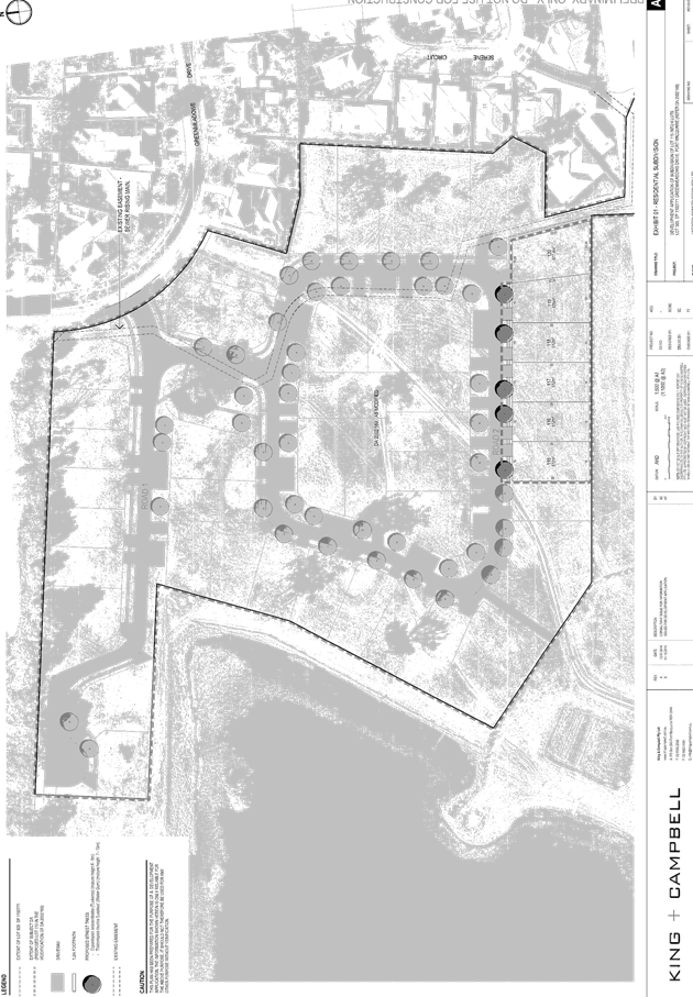
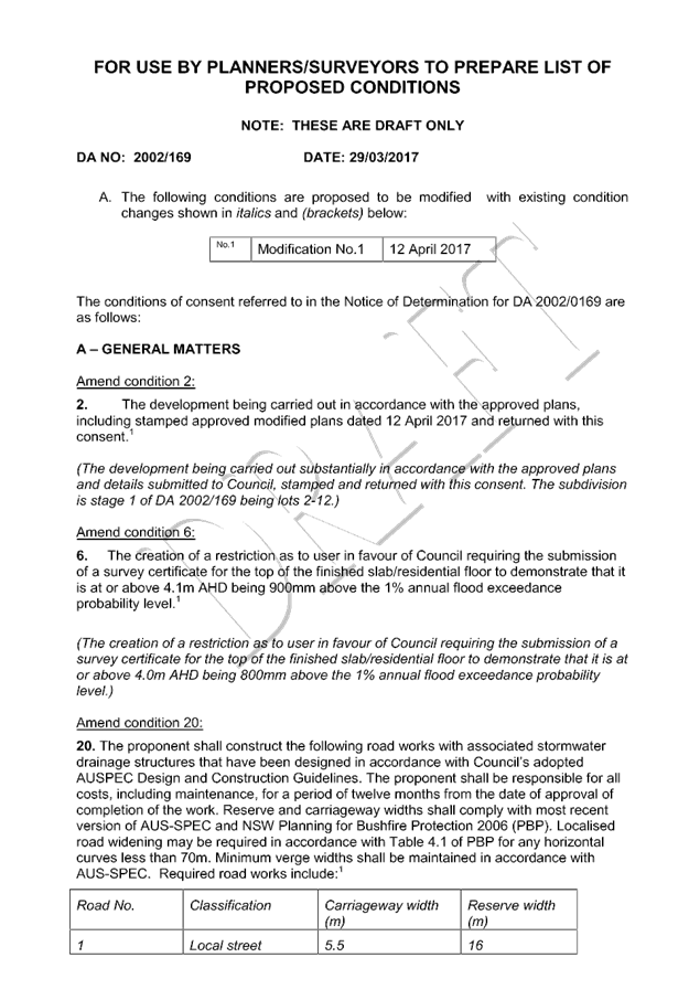
Item: 05
Subject: DA2002 - 169.2 & DA2016 - 939.1
Modification To Design Of Previous Approved Residential Subdivision And 6
Additional New Lots - Lot 505 DP 1192771, Greenmeadows Drive, Port Macquarie
Report
Author: Patrick Galbraith-Robertson
|
Applicant: J
Newton Constructions Pty Ltd CARE King and Campbell
Owner: J
Newton Constructions Pty Ltd
Estimated Cost: N/A
Alignment with Delivery
Program
4.9.2 Undertake transparent
and efficient development assessment in accordance with relevant legislation.
|
|
RECOMMENDATION
1. That
Section 96 modification application DA2002 - 169 for a alterations to design
of residential subdivision at Lot 505,
DP 1192771, Greenmeadows Drive, Port
Macquarie, be determined by granting
consent subject to the recommended modified conditions.
·
2. That
DA2016 - 939 for a subdivision involving an additional 6 torrens title lots
at Lot 505, DP 1192771,
Greenmeadows Drive, Port Macquarie,
be determined by granting consent subject to the recommended conditions.
|
Executive
Summary
This
report considers a Section 96 modification and Development Application for a
modification to design, title type and number of lots within a previous
approved subdivision and 6 additional new torrens title lots at the subject site. This report provides an assessment of
the application in accordance with the Environmental Planning and Assessment
Act 1979.
Following exhibition of the
applications, two (2) submissions have been
received.
Both applications are being
reported together for consideration as they relate to the same
site/development.
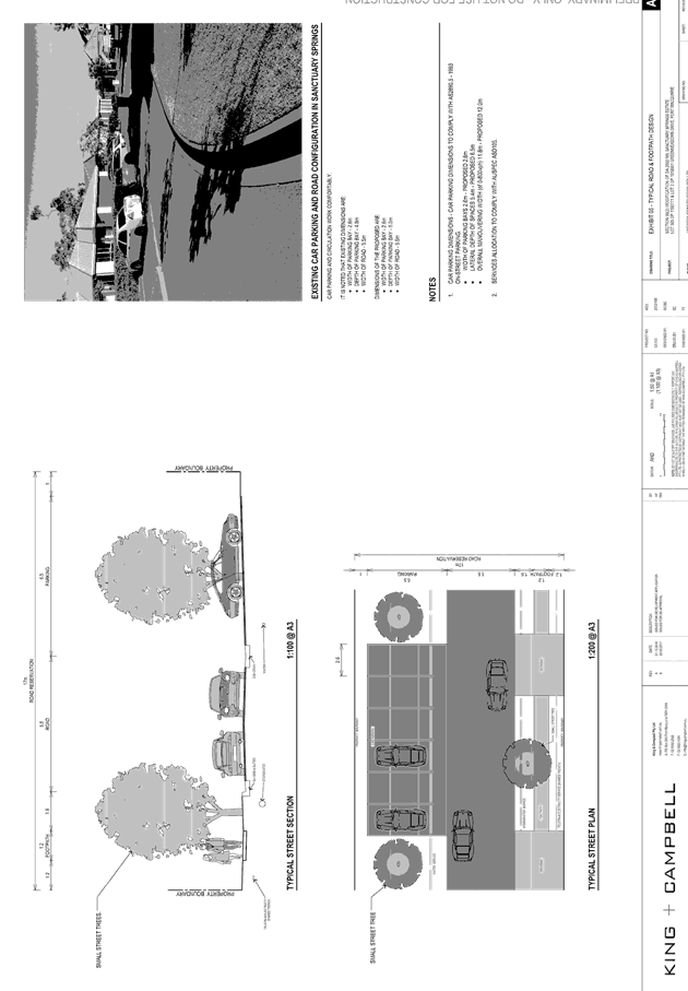
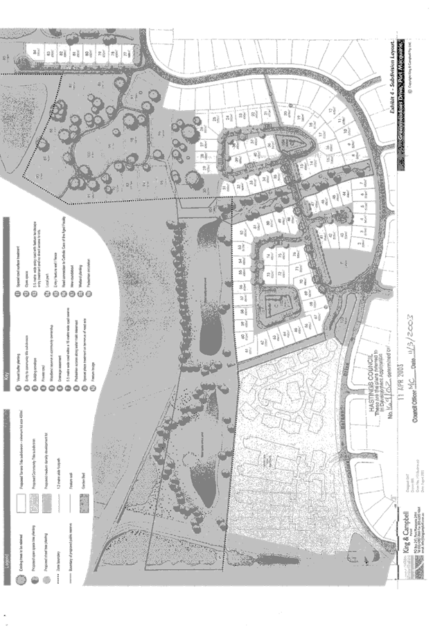
1. BACKGROUND
Existing sites features and Surrounding development
The site has a total area of 8.223
hectares.
The subject section of the site is currently zoned R1
General Residential and part RU1 Primary Production in
accordance with the Port Macquarie-Hastings Local Environmental Plan 2011, as
shown in the following zoning plan:
At the time of the original determination under DA2002 -
169 (proposed to be modified) the site was zoned 2(a1) Residential under Hastings
Local Environmental Plan 2001, as shown in the following zoning plan:
The existing subdivision pattern and location of existing
development within the locality is shown in the following aerial photograph
(2012):
The
site comprises approximately 4.1 hectares of R1 zoned lands, being the land
occupied by Stages 4 and 5 of Sanctuary Springs Estate and approximately 4.12
hectares of part R1 and part RU1 zoned lands, being the land predominantly
occupied by the stormwater quality ponds that the Sanctuary Springs Estate
drains to.
The
proposed changes relate to Stage 4 and 5 under DA 2002/169 which is the final
development stage of the Sanctuary Springs Estate and is the only
portion of the development approved under DA2002/169 to have not been
constructed.
2. DESCRIPTION OF
DEVELOPMENT
On 11 April 2003 Council issued DA 2002/169 for a residential
subdivision subject to conditions. In summary, the approval provided for
a staged 100 lot residential subdivision comprising;
- 85
Torrens Title lots;
- 15
Community Title lots; and
- 5
lots to be dedicated to Council as public reserves.
Key aspects of the community title subdivision component of
the development to be changed include retaining existing mature eucalypts on
the property, creating large lots, having a narrow private road and providing a
community property reserve.
Details
submitted with the applications state that the majority of the mature eucalypts
that existed at the time development consent DA2002 -169 have subsequently died
as a result of the fungal root disease phytophthora cinnamomi.
As a result of the changed circumstance and the absence now
of the overriding design criteria for the community title subdivision approach,
the Applicant has advised that subject modification has been prepared to
provide for a residential outcome similar to the previous stages of Sanctuary
Springs Estate.
Key aspects of the modification proposals (under two
applications) include the following:
· Section
96 modification to DA2002 - 169:
- Tree removal to facilitate a Torrens Title subdivision in lieu of the
approved Community Title subdivision (approved Lots 86 to 100);
- Retention of one (1) feature tree, incorporating an elevated platform
within a public reserve;
- A realignment to approved road no.5 (cul-de-sac) to comply with the
current bushfire legislation, including a minor modification to the areas of
approved Lots 77 to 85;
- An increase in the total number of lots from 100 to 115, through a
reduction in the allotment sizes to be consistent with the existing lots within
Stages 1 to 4 of Sanctuary Springs Estate;
- A minor modification to the approved loop road and on-road parking
provision;
- The proposed increase in lot numbers from 100 to 115 represents a
numeric increase of 15%, this being a minor numeric departure from the consent;
- Staged construction and completion of the subdivision (as amended).
· New
DA 2016 - 939 - 6 lot subdivision within (and reliant upon) the modified
subdivision under DA2002 - 169
Refer
to attachments at the end of this report.
Application
Chronology
· 11
April 2013 - Original DA approved. The current approved DA is attached to this
report.
Section 96 DA2002 - 169
· 2 December 2016 - Section 96 modification lodged.
· 12 December to 13 January 2017 - neighbour notification of
proposal
· 16 December 2016 - Additional information requested -
ecological assessment justification queried and recommend offset planting area
be proposed.
· 20 January 2017 - Proposed plan of offset planting area
received.
· 23 January 2017 - Advice provided with regard to offset
planting location and requested Vegetation Management Plan be submitted.
· 3 March 2017 - Copies of redacted submissions provided to
Applicant.
· 10 March 2017 - Amended plans and draft Vegetation Management
Plan received.
· 16 March 2017 - Amendments requested to the draft
Vegetation Management Plan.
· 22 March 2017 - Additional information requested -
clarification of staging, access to existing residence on 71 Greenmeadows Drive
to be private back public road, queried park to be a stormwater basin and
whether the existing right of carriageway is to be extinguished.
· 30 March 2017 - Additional information and amended plans
received.
Development
Application
· 2 December 2016 - DA lodged.
· 8 December 2016 - Referral to NSW Rural Fire Service
· 13 December to 13 January 2017 - neighbour notification of
proposal
· 16 January 2017 - Advice received from the NSW Rural Fire
Service with Bushfire Safety Authority.
3. STATUTORY ASSESSMENT
SECTION 96 DA2002 - 169
Is the proposal substantially the same?
Section 96 of the Environmental
Planning and Assessment Act 1979 enables the modification of consents and
categorises modification into three categories - S.96 (1) for modifications
involving minor error, mis-description or miscalculation; S.96 (1A) for
modifications involving minimal environmental impact; and S.96 (2) for other
modifications. Each type of modification must be considered as being
substantially the same to that which was originally consented to.
The
subject application is being considered under the provisions of Section 96(2).
Having regard to the above principles, the Applicant has submitted that the
proposal is substantially the same development for the following reasons:
- From both a qualitative and quantitative perspective, the
proposed modified development will remain essentially and materially the same
development as was approved;
- The proposed modified layout includes a single access
connection to Greenmeadows Drive, in the same location as originally approved;
- The internal road maintains a looped network substantially
the same as that originally approved;
- The proposed modified lot layout will maintain a
development pattern similar to that provided within Stages 1 to 3 of Sanctuary
Springs Estate, including the provision of designated on-street parking spaces;
- The footprint of the development remains unchanged; and
- The proposed increase in lot numbers from 100 to 115
represents a numeric increase of 15%, this being a minor numeric departure from
the consent.
The
reasoning provided from the Applicant with regard to justifying that the
development is substantially the same development is considered acceptable and
recommended to be supported.
Are there any condition(s)
of consent imposed by a Minister, government or public authority that require
modification?
N/A
Does the application require
notification/advertising in accordance with the regulations and/or any
Development Control Plan?
Neighbour
notification has been undertaken in accordance with DCP 2013.
In determining an application for modification of a consent
under this section, the consent authority must take into consideration such of
the matters referred to in section 79C (1) as are of relevance to the
development the subject of the application.
(a) The
provisions (where applicable) of:
(i) any
Environmental Planning Instrument:
Hastings
Local Environmental Plan 2001
The
original assessment report stated in 19 August 2002 that all proposed lots were
to be contained within the 2(a1) Residential zone that applied at the time with
one exception. This related to the large 2849m2 development lot proposed which
was part zoned 1(a1) Rural. This particular lot has already been created.
With
regard to the modified subdivision proposed, the subdivision remains
permissible in the 2(a1) Residential zone that applied to the site at the time
of original determination of this DA.
(iii) any Development
Control Plan in force:
Development
Control Plan No.17 - Subdivision Code.
This
DCP was considered as part of the assessment of the original approved
subdivision.
The
comments with the original assessment report stated the following:
DCP 17 permits consideration
of narrower roads than specified each case to be considered on merit. The
applicants submit a reduction of Road No.1 carriageway width from 7.0 to 5.5m primarily
on the grounds that there is to be no on-street parking along this road. It is
highly unlikely that on-street parking will occur on this road as no direct
access from individual properties will be permitted.
Assuming this will be the
case a 5.5m carriageway is sufficient to allow two large vehicles to safely
pass. Furthermore, the numerical standard calculated for road No.4 would also
require a higher standard than proposed. The layout of the proposed subdivision
identifies this road as a loop and can readily allow traffic to access
allotments in either direction from road No.1. It could therefore be considered
appropriate to account for a 50% split in traffic generation, and as such
permit the 5.5m carriageway width proposed by the applicant. The variation
requested for road No.4 could also therefore be supported.
With regard to the modified subdivision proposed, the
following comments are made:
· The
size and shape of all modified lots are of satisfactory size (also noting lots
already approved below 600m2) to accommodate likely future dwellings and their
private open space;
· There
are no identifiable slope or orientation issues arising from the modified lot
design;
· One
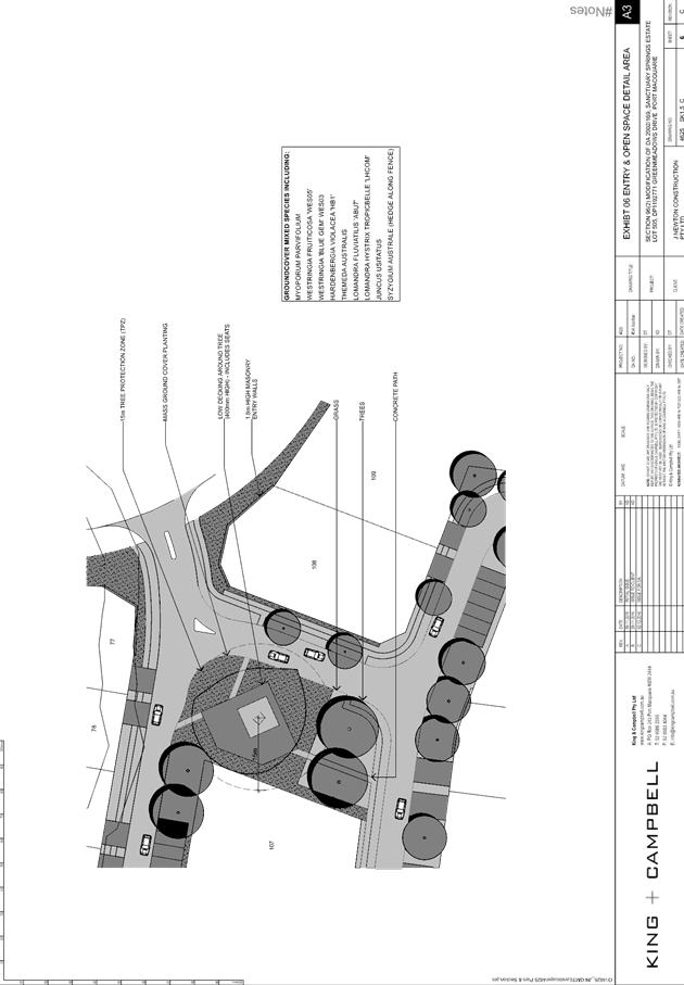
existing tree is to be retained and included into a proposed park.
· Lots, roads
and parking: The increase in number of lots is relatively minor (15%) and will
not substantially increase traffic from the development. Future development as
an extension of the subject roads is not foreseeable and proposed road design
is sufficient to accommodate traffic generated in accordance with Aus-Spec
access place road category. Lot sizes currently proposed and provision of
on-street perpendicular parking is in keeping with the previously completed
stages of Sanctuary Springs Estate. Realignment of approved Road No. 5 provides
a better solution from a bushfire protection access standpoint and allows an
increase in lot size again in keeping with the remainder of lots in Stages 4
and 5.
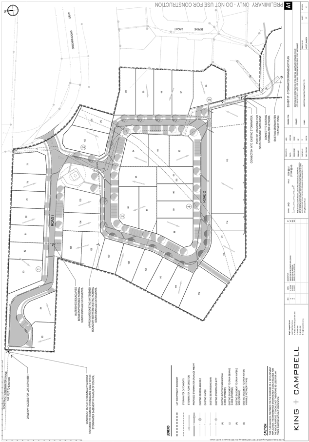
· Stormwater:
The majority of stormwater from the site is proposed to be directed to existing
water quality and detentions ponds constructed previously which will achieve
AUSPEC water attenuation/quality targets and provide adequate freeboard to
proposed residences during major storm event recurrences. The remaining
stormwater will be directed to an existing swale which will satisfy AUSPEC D5
and D7 requirements. In accordance with AUSPEC, all lots will be provided with
a direct connection to Council’s piped stormwater network.
(b) The likely
impacts of that development, including environmental impacts on both the
natural and built environments, social and economic impacts in the locality:
An
ecological assessment prepared by FloraFauna Consulting has been submitted with
the modification application to DA 2002 - 169. Within the residential zoned
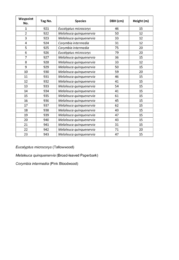
portion of Lot 505, sixteen (16) remnant trees were recorded, including one (1)
stag. The remnant trees generally occur as isolated individuals and range from
the mature growth stage, with some trees recorded in the late-mature growth
stage. Of the 15 trees to be removed, four (4) are hollow-bearing and twelve
(12) are preferred Koala food trees.
The
FloraFauna Assessment notes that the habitat within the residential area
contains very few terrestrial habitat features due to its cleared condition and
that habitat features such as vegetation strata, leaf litter and fallen timber
are absent.
In
relation to the provisions of SEPP 44, four (4) species listed in Schedule 2
were recorded within the study area, which included the adjacent land in the
same ownership, including Eucalyptus microcorys (Tallowwood), Eucalyptus
robusta (Swamp Mahogany), Eucalyptus tereticornis (Forest Red Gum)
and Eucalyptus signata (Scribbly Gum).
The
FloraFauna report concludes that although Koala food trees constitute greater
than 15% of the remnant tree component, the habitat is unlikely to be Core
Koala Habitat and is not considered to be important to the long-term viability
of the local Koala population.
During
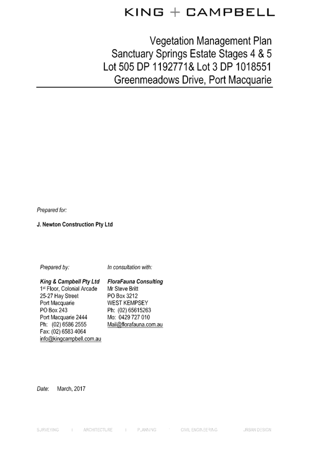
the assessment of the application, in addition to the FloraFauna report, a
suitable offset planting area and terms for revegetation and management under a
Vegetation Management Plan have been negotiated with the Applicant. A copy of
the Vegetation Management Plan (VMP) recommended to be approved with the
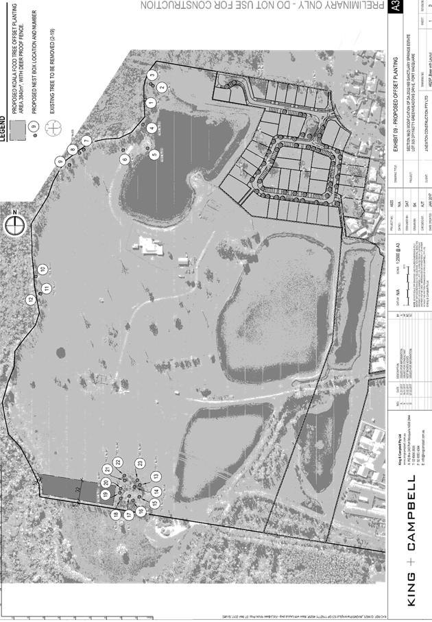
modified DA is attached to this report.
The modified proposal also
includes retention of a single feature tree and inclusion of an adjacent
elevated platform. This component of the proposal has been reviewed an Aborist
assessment carried out by Woodvale Tree Services. The retained tree is
identified as Eucalyptus rossii (Inland Scribbly Gum) and notated as T1
on the attached plans and Woodvale Tree Services Report. The report makes a
number of recommendations to improve the health of the tree and to ensure its
protection during the construction phase of the elevated platform, including
its on-going viability post construction. A condition is recommended in this
regard to require compliance with the requirements of the Aborist Report.
NEW DA 2016 - 939
Section
79C(1) Matters for Consideration
In
determining the application, Council is required to take into consideration the
following matters as are relevant to the development that apply to the land to which
the development application relates:
(a) The
provisions (where applicable) of:
(i) any
Environmental Planning Instrument:
State Environmental Planning Policy No. 44 - Koala Habitat
Protection
With reference to clauses 6 and 7, the subject land has is
greater than 1 hectare (including any adjoining land under same ownership) and
therefore the provisions of SEPP must be considered.
The application has demonstrated
that no habitat will be removed or modified therefore no further investigations
are required.
State Environmental Planning
Policy No.55 – Remediation of Land
Following an inspection of the site and a search of Council
records, the subject land is not identified as being potentially contaminated
and is suitable for the intended use.
State Environmental Planning
Policy No. 62 – Sustainable Aquaculture
Given the nature of the proposed
development and proposed stormwater controls the proposal will be unlikely to
have any adverse impact on existing aquaculture industries within the Hastings
River approximately 3.5 kilometres from the site.
Port Macquarie-Hastings Local Environmental Plan 2011
The proposal is consistent with
the LEP having regard to the following:
· Clause
2.2, the subject site (within section of site to proposal only) is zoned R1
General Residential.
The
objectives of the R1 zone are as follows:
o To provide for the housing needs of the community.
o To provide for a variety of housing types and densities.
o To enable other land uses that provide facilities or
services to meet the day to day needs of residents.
In
accordance with Clause 2.3(2), the proposal is consistent with the zone
objectives having regard to the following:
o the proposal is a
permissible landuse;
o the lots will provide
for future housing
· Clause
4.1, the lot sizes within the proposed subdivision range from 512m2 to 677.4m2.
All proposed lots comply with the minimum lot sizes identified in the Lot Size
Map relating to the site.
· Clause
5.9 - several listed trees in Development Control Plan 2013 are proposed to be
removed.
· Clause
5.10 – Heritage. The site does not contain or adjoin any known heritage
items or sites of significance.
· Clause
7.1, the site is mapped as potentially containing class 3 acid sulfate soils.
The subject proposed subdivision of 6 lots are within a previous approved
subdivision which is to be modified. No additional new matters require
consideration to that currently approved.
· Clause
7.3, the site is within the proposed modified subdivision (proposed Lot 115)
and is not identified as being within a Flood Planning Area.
· Clause
7.5 – Koala Habitat – No Plan of Management/ mapped koala habitat
applies to the site.
· Clause
7.13, satisfactory arrangements are in place for provision of essential
services including water supply, electricity supply, sewer infrastructure,
stormwater drainage and suitable road access to service the development.
Provision of electricity will be subject to obtaining satisfactory arrangements
certification prior to the issue of a Subdivision Certificate as recommended by
a condition of consent.
(ii) Any draft
instruments that apply to the site or are on exhibition:
No draft instruments apply to
the site.
(iii) any Development
Control Plan in force:
Port Macquarie-Hastings Development Control Plan 2013:
|
DCP 2013: Chapter 3.6 - Subdivision
|
|
DCP Objective
|
Development Provisions
|
Proposed
|
Complies
|
|
3.6.3.1
|
A site analysis is required for all development and shall
illustrate:
· microclimate;
· lot dimensions;
· north point;
· existing contours and levels to
AHD;
· flood affected areas;
· overland flow patterns, drainage
and services;
· any contaminated soils or filled
areas, or areas of unstable land;
· easements and/or connections for
drainage and utility services;
· identification of any existing
trees and other significant vegetation;
· any existing buildings and other
structures, including their setback distances;
· heritage and archaeological
features;
· fences;
· existing and proposed road
network, including connectivity and access for all adjoining land parcels;
· pedestrian and vehicle access;
· views to and from the site;
· overshadowing by neighbouring
structures; and
· any other notable features or
characteristics of the site.
|
A suitable site plan addressing key requirements has been
submitted.
|
Yes
|
|
3.6.3.2
|
Torrens title lots minimum width of 15m when measured at a
distance of 5.5m from front property boundary.
|
The proposed subdivision is consistent with the relevant
development provisions for urban structure and lot layout,
as each proposed Torrens Title lot has:
A minimum width of 15m at a distance of 5.5m
from
the front boundary;
A minimum width of 7m at the kerb line;
A minimum depth of 25m; and
A slope that does not exceed 16%.
In addition:
No battle-axe allotments are proposed;
The proposed building envelopes will allow the
construction of a dwelling which does not involve
more than 1m in cut or fill outside the dwellings
external walls; and
The orientation of the lots will allow
opportunities for
passive solar design.
|
Yes
|
|
Minimum width of 7m when boundaries are extended to kerb
line.
|
|
Minimum depth of 25m.
|
|
For lots where average slope of the site is equal to, or
exceeds 16%, indicative road and driveway grades are required demonstrating
satisfactory access.
|
|
3.6.3.4
|
Lots are to be designed to allow the construction of a
dwelling, which does not involve more than 1m cut, or fill, measured from
natural ground level, outside the dwellings external walls.
|
|
Lot sizes increased for sloping sites in accordance with
Table 3.6.1.
|
|
Additional information provided for slope categories in
accordance with Table 3.6.2.
|
|
3.6.3.5
|
Wherever possible orientate streets to maximise the number
of east, west and south facing lots and to minimise the number of narrow
north facing lots.
Residential street blocks should preferably be orientated
north-south with dimensions generally
limited to 60-80m by 120-150m as illustrated in Figure
3.6-2.
|
|
Lot size and shape are to reflect orientation to ensure
future dwelling construction has optimal opportunity for passive solar
design.
|
|
3.6.3.6
|
Kerb and guttering, associated street drainage, pavement
construction and foot paving across the
street frontages should be constructed as part of the
subdivision works where these do not exist (may be varied subject to criteria
in this clause)
|
Public frontage works to be completed under DA2002 - 169,
as proposed to be modified.
|
Yes
|
|
3.6.3.7
|
Subdivisions close to urban centres or along arterial roads
serviced by public transport achieve yield of >35 dwellings per hectare.
|
Development allows suitable density as an increase to
previous approval DA2002 - 169 which is proposed to be modified.
|
Yes
|
|
3.6.3.8 - 3.6.3.15
|
Infrastructure – road
design and
construction
|
The proposed roads are included in the concurrent
modification submission and are generally consistent with
the relevant development provisions for road design and
construction, noting that the existing special rate
variation
with Council that funds the on-going maintenance of the
open space, drainage system and Estate landscaping
(within roads)
|
Yes
|
|
3.6.3.17
|
Infrastructure -
stormwater
management
|
Stormwater management acceptable subject to conditions
|
Yes
|
|
3.6.3.20
|
Water supply to meet Council’s design
specifications.
|
Capable of complying.
|
Yes
|
|
3.6.3.21
|
All lots connected to reclaimed water if available.
|
Capable of complying.
|
Yes
|
|
3.6.3.24
|
Separate sewer junction provided for each lot.
|
Capable of complying.
|
Yes
|
|
3.6.3.27
|
Erosion and sediment control plan to be provided.
|
To be conditioned.
|
Yes
|
|
3.6.3.34
|
All service infrastructure should be underground unless
otherwise approved by Council.
|
To be conditioned.
|
Yes
|
|
All service infrastructure should be installed in a common
trench.
|
Where applicable, to be conditioned.
|
Yes
|
|
Conduits for the main technology network system should be
provided in all streets.
|
Where applicable, to be conditioned.
|
Yes
|
|
Conduits are to be installed in accordance with the
National Broadband Network Company Limited’s
‘Guidelines for Fibre to the Premises Underground
Deployment’.
|
Where applicable, to be conditioned.
|
Yes
|
|
Access pits are to be installed at appropriate intervals
along all streets.
|
Where applicable, to be conditioned.
|
Yes
|
|
3.6.3.51
|
Street trees should be provided along all road frontages
generally at a rate of 1 per 20m interval.
|
Street trees are proposed.
|
Yes
|
|
Street trees should not affect solar access.
|
Street trees will not create any adverse impact on solar
access.
|
Yes
|
|
3.6.3.52
|
Street trees from Council’s list.
|
Street trees are covered by the VMP at types/rates
accepted by Council’s Parks Section.
|
Yes
|
|
DCP 2013: General Provisions
|
|
DCP Objective
|
Development Provisions
|
Proposed
|
Complies
|
|
2.7.2.2
|
Design addresses generic principles of Crime Prevention
Through Environmental Design guideline:
· Casual surveillance
and sightlines
· Land use mix and
activity generators
· Definition of use and
ownership
· Lighting
· Way finding
· Predictable routes and
entrapment locations
|
The infill layout does not create any crime safety issues.
The design allows separation from habitat/concealment areas and allows
surveillance of the street.
|
Yes
|
|
2.3.3.1
|
Cut and fill 1.0m max. 1m outside the perimeter of the
external building walls
|
No adverse cut or fill proposed.
|
Yes
|
|
2.3.3.8 onwards
|
Removal of hollow bearing trees
|
Tree removal (including hollow bearing) covered by
Ecological Assessment and Vegetation Management Plan.
|
Yes
|
|
2.6.3.1
|
Tree removal (3m or higher with 100m diameter trunk and 3m
outside dwelling footprint
|
Tree removal covered by Vegetation Management Plan.
|
Yes
|
|
2.4.3
|
Bushfire risk, Acid sulphate soils, Flooding,
Contamination, Airspace protection, Noise and Stormwater
|
Refer to main body of report.
|
Noted
|
|
2.5.3.2
|
New accesses not permitted from arterial or distributor
roads. Existing accesses rationalised or removed where practical
|
No new access proposed off an arterial or distributor
road.
|
Yes
|
|
2.5.3.11
|
Section 94 contributions
|
Contributions apply.
|
Yes
|
|
|
|
|
|
|
(iiia) any planning agreement that has been entered
into under Section 93f or any draft planning agreement that a developer has
offered to enter into under Section 93f:
No planning agreement has been
offered or entered into relating to the site.
iv) any
matters prescribed by the Regulations:
N/A
v) any coastal
zone management plan (within the meaning of the Coastal
Protection Act 1979), that apply to
the land to which the development application relates:
No Coastal Zone Management Plan
applies to the subject site.
(b) The likely
impacts of that development, including environmental impacts on both the
natural and built environments, social and economic impacts in the locality:
Context and setting
The proposal will be unlikely to
have any adverse impacts to existing adjoining properties or the public domain.
The proposal is considered to be
sufficiently consistent with other residential development in the locality and
adequately addresses planning controls for the area.
Roads
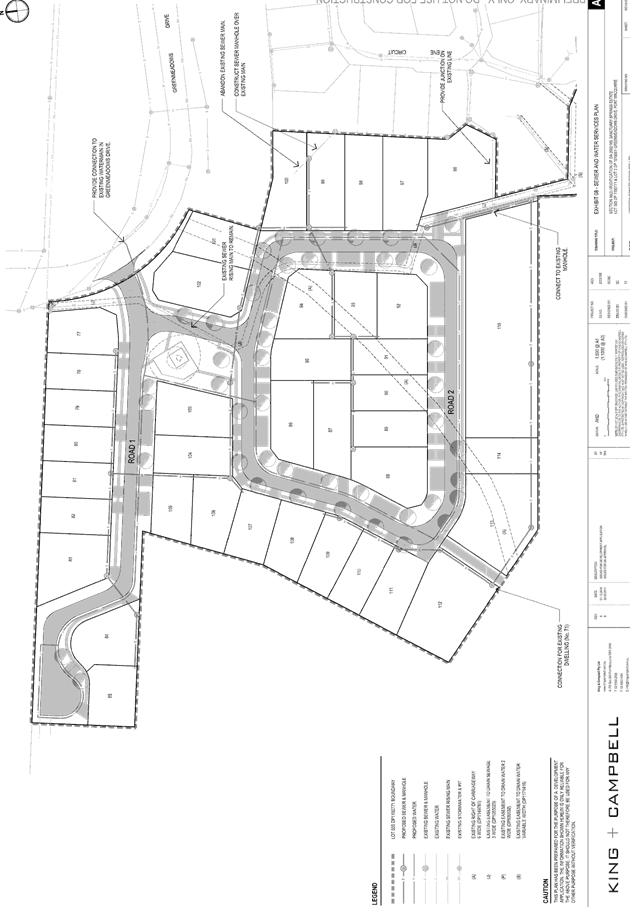
The site has road frontage to Proposed Road 2, within the
subdivision proposed to be modified under DA2002 - 169.
Adjacent to the site, proposed Road 2 will be a sealed
public road under the care and control of Council. Proposed Road 2 is a Local
Road Formation Width (5.5m) within a 17m Road reserve. Proposed Road 2
features SE kerb, footpath and perpendicular on street parking.
Traffic
and Transport
The site is currently approved for residential use. The
addition in traffic associated with the development is unlikely to have any
adverse impacts to the existing road network within the immediate locality.
Water Supply Connection
Records indicate that the
proposed development site does not currently have a water service. The proposed
100mm PVC water main to be provided with DA2002 - 169 on the same side of Road
No. 2 will able to service the proposed development. Details are to be provided
on the engineering plans to be submitted with the application for Construction
Certificate.
Sewer Connection
Sewer will be available from the
proposed 150mm PVC sewer main to be provided with DA2002 - 169 along the
southern boundary of this lot. Details are to be provided on the engineering
plans to be submitted with the application for Construction Certificate.
Stormwater
The site naturally grades towards
the street frontage and is to be serviced by interallotment works associated
with DA2002/169.
The legal point of discharge for
the proposed development is defined as a direct connection to the existing
interallotment drainage system servicing the site.
Stormwater from the proposed
development is planned to be disposed via Council’s piped stormwater
network which is consistent with the above requirements.
A detailed site stormwater
management plan will be required to be submitted for assessment with the
Section 68 Local Government Act application and prior to the issue of a
Construction Certificate.
In accordance with Councils AUSPEC
requirements, the following must be incorporated into the stormwater drainage
plan:
· On
site stormwater detention facilities
· Water
quality controls
Other Utilities
Telecommunication and
electricity services are available to the site.
Evidence of satisfactory
arrangements with the relevant utility authorities for provision to each
proposed lot will be required prior to Subdivision Certificate approval.
Heritage
Following a site inspection (and
a search of Council records), no known items of Aboriginal or European heritage
significance exist on the property. No adverse impacts anticipated.
Other land resources
The site is within an
established urban context and will not sterilise any significant mineral or
agricultural resource.
Water cycle
The proposed development will be
unlikely to have any adverse impacts on water resources and the water cycle.
Soils
The proposed development will be
unlikely to have any adverse impacts on soils in terms of quality, erosion,
stability and/or productivity subject to a standard condition requiring erosion
and sediment controls to be in place prior to and during construction.
Air and microclimate
The construction of the proposed
development will be unlikely to result in any adverse impacts on the existing
air quality or result in any pollution. Standard precautionary site management
condition recommended.
Flora and fauna
The construction of the proposed
development (noting the 6 lots are within the proposed modified subdivision
DA2002 - 169) will not require any removal/clearing of any significant
vegetation and therefore will be unlikely to have any significant adverse
impacts on biodiversity or threatened species of flora and fauna. Section
5A of the Act is considered to be satisfied.
Waste
No adverse impacts anticipated.
Energy
No adverse impacts anticipated.
Noise and vibration
No adverse impacts anticipated.
Condition recommended to restrict construction to standard construction hours.
Bushfire
The site is identified as being
bushfire prone. In accordance with Section 100B - Rural Fires Act 1997 - the
application proposes: subdivision of bush fire prone land that could lawfully
be used for residential purposes.
The Applicant has submitted a
bushfire report prepared by David Pensini Building Certification. The report
assumes that proposed subdivision will occur and has carried out an assessment
under Section 100B requirements. The DA has been referred to the NSW Rural Fire
Service. The RFS have assessed the development and issued a Bushfire Safety
Authority subject to conditions. These conditions are recommended to be
incorporated into the development consent.
Safety, security and crime
prevention
The proposed development will be
unlikely to create any concealment/entrapment areas or crime spots that would
result in any identifiable loss of safety or reduction of security in the immediate
area.
Social impacts in the
locality
Given the nature of the proposed
development and its’ location the proposal is unlikely to result in any
adverse social impacts.
Economic impact in the
locality
No adverse impacts. A likely
positive impact is that the development will maintain employment in the
construction industry, which will lead to flow impacts such as expenditure in
the area.
Site design and internal
design
The proposed development design
satisfactorily responds to the site attributes and will fit into the locality.
No adverse impacts likely.
Construction
No potential adverse impacts
identified to neighbouring properties with the construction of the proposal.
Cumulative impacts
The proposed development is not
expected to have any adverse cumulative impacts on the natural or built
environment or the social and economic attributes of the locality.
(c) The
suitability of the site for the development:
The proposal will fit into the
locality and the site attributes are conducive to the proposed development.
Site constraints of bushfire
risk have been adequately addressed and appropriate conditions of consent
recommended.
(d) Any
submissions made in accordance with this Act or the Regulations:
Two (2) written
submissions have been received following public exhibition of the applications.
Key
issues raised in the submissions received and comments in response to these
issues are provided as follows:
|
Submission
Issue/Summary
|
Planning
Comment/Response
|
|
11A Serene Circuit
|
A public footpath has been
previously approved under DA2002 - 169. An extract of the location of the
footpath is shown in the first image below this table. The second image below
shows that part of the approved pathway network has been constructed to the
east of Lots 401, 402 and 403. This constructed pathway links to the existing
public pathway network. The Applicant has advised that this was designed as
an integral component of the Sanctuary Springs Estate. The subject
modification application does not seek to modify this component of the
consent.
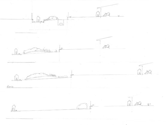
The Applicant has however
reconsidered the matter and proposed to bias the approved pathway to the
western edge of the easement. It is advised that it is intended to provide a
horizontal and vertical separation between the existing dwellings and the
public footpath. The third and forth images below show a sketch of the path
with cross sections to provide additional detail.
|
|
Concern that the adjoining
property at the rear of Lot 403 will be developed for buildings, road and
footpaths.
|
|
Object to a footpath being
constructed to the rear of the property and wouldn’t have built a new
house on Lot 403.
|
|
11B Serene Circuit
|
|
Concern that the adjoining
property at the rear of Lot 403 will be developed for buildings, road and
footpaths.
|
|
Concern with the detrimental
effect on the outlook at the rear of property and security problem along with
element of noise pollution.
|
IMAGE 1
 IMAGE
2
IMAGE
2
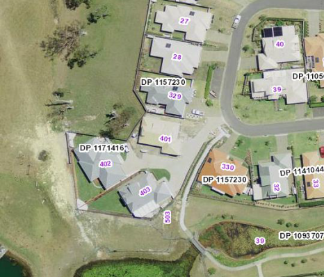
IMAGE 3
IMAGE 4
(e) The Public Interest:
The proposed
development satisfies relevant planning controls and is unlikely to impact on
the wider public interest.
4. DEVELOPMENT
CONTRIBUTIONS APPLICABLE
· No changes to existing conditions are recommended to the
current consent conditions for DA2002 - 169.
· Development contributions will be required towards
augmentation of town water supply and sewerage system head works under Section
64 of the Local Government Act 1993.
· Development contributions will be required under Section 94
of the Environmental Planning and Assessment Act 1979 towards roads, open
space, community cultural services, emergency services and administration
buildings.
5. CONCLUSION
The
applications have been assessed in accordance with Section 96 and 79C of the
Environmental Planning and Assessment Act 1979.
Issues
raised during assessment and public exhibition of the application have been
considered in the assessment of the application.
The
site is suitable for the proposed developments, are not contrary to the
public's interest and will not have a significant adverse social, environmental
or economic impact. It is recommended that the application be approved, subject
to the recommended conditions of consent provided in the attachment section of
this report.
|
Attachments
1View. DA2002
- 169.2 & DA2016 - 939.1 Plans
2View. DA2002
- 169.2 Subdivision Layout
3View. DA2016
- 939.1 Plan Of Proposed Subdivision
4View. DA2002
- 169.2 & DA2016 - 939.1Stormwater Management Plan
5View. DA2002
- 169.2 & DA2016 - 939.1Sanctuary Springs VMP Approved
6View. DA2002
- 169.2 Recommended Amended Conditions
7View. DA2016
- 939.1 Recommended Conditions
8View. DA2002
- 169.2 & DA2016 - 939.1 NSW Rural Fire Service General Terms of Approval
9View. DA2002
- 169.2 & DA2016 - 939.1 Submission - Macdonald & Lindo
10View. DA2002
- 169.2 & DA2016 - 939.1 Submission - Sato
|
|
ATTACHMENT
|
Development Assessment Panel
12/04/2017
|
|
ATTACHMENT
|
Development Assessment Panel
12/04/2017
|
|
ATTACHMENT
|
Development Assessment Panel
12/04/2017
|
|
ATTACHMENT
|
Development Assessment Panel
12/04/2017
|
|
ATTACHMENT
|
Development Assessment Panel
12/04/2017
|


|
ATTACHMENT
|
Development Assessment Panel
12/04/2017
|

|
ATTACHMENT
|
Development Assessment Panel
12/04/2017
|
|
ATTACHMENT
|
Development Assessment Panel
12/04/2017
|
|
ATTACHMENT
|
Development Assessment Panel
12/04/2017
|
|
ATTACHMENT
|
Development Assessment Panel
12/04/2017
|
AGENDA Development Assessment Panel 12/04/2017
Item: 06
Subject: DA2016 - 942.1 Retail Premises at Lot 4 Sec A
DP 975586, No. 52 Cameron Street, Wauchope Street
Report
Author: Chris Gardiner
|
Applicant: D
A Hore
Owner: D
A & T L Hore
Estimated Cost: $300,000
Alignment with Delivery
Program
4.9.2 Undertake transparent
and efficient development assessment in accordance with relevant legislation.
|
|
RECOMMENDATION
That
DA 2016 - 942.1 for a Retail
Premises at Lot 4, Sec A DP 975586,
No. 52 Cameron Street, Wauchope, be
determined by granting consent subject to the recommended conditions.
|
Executive
Summary
This
report considers a development application for a retail premises at the subject site and provides an assessment of the
application in accordance with the Environmental Planning and Assessment Act
1979.
Following exhibition of the
application, 3 submissions have been received.
1. BACKGROUND
Existing sites features and Surrounding development
The site has an area of 811.5m2.
The site is zoned B2 Local Centre in accordance with the Port Macquarie-Hastings Local
Environmental Plan 2011, as shown in the following zoning plan:
The existing subdivision pattern and location of existing
development within the locality is shown in the following aerial photograph:
2. DESCRIPTION OF
DEVELOPMENT
Key aspects of the proposal include the following:
· Construction
of a new retail premises and associated car parking area.
Refer
to attachments at the end of this report.
Application Chronology
· 2
December 2016 - Application lodged.
· 13 December 2016 to 13 January 2017 - Neighbour
notification.
· 2 March 2017 - Additional information requested from
Applicant.
· 6 March 2017 - Additional information submitted by
Applicant.
· 13 March 2017 - Further additional information requested
from and submitted by Applicant.
· 29 March 2017 - Shadow diagrams submitted by Applicant.
3. STATUTORY ASSESSMENT
Section 79C(1) Matters for Consideration
In determining the application, Council is required to take
into consideration the following matters as are relevant to the development
that apply to the land to which the development application relates:
(a) The provisions (where
applicable) of:
(i) any Environmental
Planning Instrument:
State
Environmental Planning Policy No. 55 – Remediation of Land
Following an
inspection of the site and a search of Council records, the subject land is not
identified as being potentially contaminated and is suitable for the intended
use.
State
Environmental Planning Policy No. 62 – Sustainable Aquaculture
Given the
nature of the proposed development and proposed stormwater controls the
proposal will be unlikely to have any adverse impact on existing aquaculture
industries within the Hastings River.
State
Environmental Planning Policy No. 64 – Advertising and Signage
The proposed
development includes proposed advertising signage in the form of business
identification.
In accordance
with clause 7, this SEPP prevails over the Port Macquarie-Hastings LEP 2011 in
the event of any inconsistency.
The following
assessment table provides an assessment checklist against the Schedule 1 requirements
of this SEPP:
|
Applicable clauses for
consideration
|
Comments
|
Satisfactory
|
|
Clause 8(a) Consistent with objectives of the policy as
set out in Clause 3(1)(a).
|
The proposal is compatible with
the desired character of the area and would provide effective communication
in suitable locations.
|
Yes
|
Schedule 1(1) Character of
the area.
|
The proposal is consistent with
the existing and desired future character of the area. There is no particular
theme for advertising in the locality.
|
Yes
|
|
Schedule 1(2) Special areas.
|
The site is not located in a
special area.
|
n/a
|
|
Schedule 1(3) Views and vistas.
|
The proposal would not obscure
or obstruct important views or dominate the skyline.
|
Yes
|
|
Schedule 1(4) Streetscape, setting or landscape.
|
The scale and proportions of
the signage are appropriate for the streetscape. The signage would not
protrude above buildings or require ongoing landscape maintenance.
|
Yes
|
|
Schedule 1(5) Site and building.
|
The signage is compatible with
the scale and proportions of the proposed building.
|
Yes
|
|
Schedule 1(6) Associated devices and logos with
advertisements and advertising structures.
|
None proposed.
|
n/a
|
|
Schedule 1(7) Illumination.
|
Plans do not identify any
illumination for the signage.
|
n/a
|
|
Schedule 1(7) Safety.
|
Bottom of under awning sign
achieves the required minimum 2.6m above footpath level and is not expected
to impact on safety.
|
Yes
|
Port Macquarie-Hastings Local Environmental Plan 2011
The proposal
is consistent with the LEP having regard to the following:
· Clause
2.2, the subject site is zoned B2 Local Centre. In accordance with clause
2.3(1) and the B2 zone landuse table, the proposed development for retail
premises is a permissible landuse with consent.
The objectives of the B2 zone are as follows:
o To
provide a range of retail, business, entertainment and community uses that
serve the needs of people who live in, work in and visit the local area.
o To
encourage employment opportunities in accessible locations.
o To
maximise public transport patronage and encourage walking and cycling.
o To
ensure that new developments make a positive contribution to the streetscape
and contribute to a safe public environment.
In accordance with Clause 2.3(2), the proposal is consistent with the
zone objectives having regard to the following:
o The
proposal is a permissible landuse;
o The
development would provide a retail use for people in the local area;
o The
development would provide employment opportunities in an accessible location.
o The
development would make a positive contribution to the streetscape.
· Clause
4.3, the maximum overall height of the building above ground level (existing)
is 6.77m which complies with the standard height limit of 11.5m applying to the
site.
· Clause
4.4, the floor space ratio of the proposal is 0.39:1 which complies with the
maximum 1.5:1 floor space ratio applying to the site.
·
· Clause
5.9 - No listed trees in Development Control Plan 2013 are proposed to be
removed.
·
· Clause
5.10 – Heritage. The site does not contain or adjoin any known heritage
items or sites of significance.
·
· Clause
7.13, satisfactory arrangements are in place for provision of essential
services including water supply, electricity supply, sewer infrastructure,
stormwater drainage and suitable road access to service the development.
(ii) Any
draft instruments that apply to the site or are on exhibition:
No draft
instruments apply to the site.
(iii) Any
Development Control Plan in force:
Port
Macquarie-Hastings Development Control Plan 2013
|
DCP 2013: Business & Commercial Development
|
|
DCP Objective
|
Development Provisions
|
Proposed
|
Complies
|
|
3.4.3.1
|
Setbacks:
A zero metre setback to ground floor is preferred in all
business zone developments.
|
Zero metre front setback.
|
Yes
|
|
3.4.3.3
|
Roof Form:
Variations
in roof form including the use of skillions, gables and hips are to be
provided in the development.
|
Gable roof proposed.
|
Yes
|
|
Variations
in roof materials shall be used.
|
Not considered necessary for scale of the building.
|
No, but acceptable
|
|
Parapets
and flat roofs should be avoided.
|
Gable roof proposed.
|
Yes
|
|
In
an established street, roof form and materials shall be consistent or
complementary to those developments in that street.
|
Metal sheet roofing consistent with existing development in
the street.
|
Yes
|
|
Lift
over-runs and service plant shall be concealed within roof structures. All
roof plant must be represented on plans and elevations.
|
No roof plant proposed.
|
Yes
|
|
Roof design shall generate an interesting skyline and be
visually interesting when viewed from adjoining developments.
|
Roof design considered acceptable.
|
Yes
|
|
3.4.3.4
|
Colours, construction materials and finishes should
respond in a positive manner to the existing built form, character and
architectural qualities of the street.
|
Proposed rendered fibre cement facade of the building
responds positively to existing brick and rendered masonry shop fronts in the
locality. The architectural form of the building would satisfactorily fit
into the streetscape.
|
Yes
|
|
3.4.3.5
|
Shopfront widths are to be between 15 and 20 m.
|
Shopfront width 11.25m.
|
No*
|
|
Widths up to a maximum of 30 may be considered where the
building achieves superior built design and streetscape outcomes.
|
n/a
|
n/a
|
|
The maximum length of any similar façade treatment
is 22m.
|
Maximum length 11.35m.
|
Yes
|
|
Side and rear facades are to be treated with equivalent
materials and finishes to the front façade.
|
|
|
|
3.4.3.6
|
Any security grilles shall be provided inside the building,
behind glazing and designed to ensure transparency to the interior.
|
None proposed.
|
n/a
|
|
3.4.3.7
|
Infill development or alterations should respect the form,
scale and massing of existing traditional buildings.
|
Proposal respects the scale and form of existing
traditional buildings. Articulated parapet has a horizontal form consistent
with the majority of buildings on the eastern side of Cameron Street between
the site and High Street. The awning style is consistent with adjoining
buildings.
|
Yes
|
|
Where traditional frontages and facades set the
architectural theme for parts of a Centre, infill buildings or alterations
respect and reflect the architectural qualities and traditional materials of
those buildings, but do not necessarily imitate historical architectural
styles.
|
Proposed building facade is compatible with existing
traditional buildings in the centre.
|
Yes
|
|
3.4.3.8
|
Active Frontages:
Ground floor levels shall not be used for residential
purposes in B1, B2, B3 and B4 zones.
|
Active frontage - glazed shop front.
|
Yes
|
|
3.4.3.9
|
A minimum of 50% of the ground floor level front facade is
to be clear glazed.
|
Yes
|
Yes
|
|
Active frontages must consist of one or more of the
following:
· A shop front.
· Commercial and residential
lobbies.
· Café or restaurant if
accompanied by an entry from the street.
· Public building if
accompanied by an entry from the street.
|
Shop front.
|
Yes
|
|
Active ground floor uses are to be accessible and at the
same level as the footpath.
|
Yes
|
Yes
|
|
3.4.3.11
|
Awnings:
Continuous shelter from the weather is to be provided for
the full extent of the active street frontage.
|
Yes
|
Yes
|
|
3.4.3.12
|
Any
awnings are to be horizontal or near horizontal (maximum pitch of 10%).
|
8.7% pitch.
|
Yes
|
|
Awnings
are to be between 3.2m and 4.2m from the finished front property boundary
level at the building edge to the underside of the awning.
|
Minimum 3.2m
|
Yes
|
|
A
minimum awning width of 2.5m is required unless this cannot be achieved
because of narrow pavements and street tree planting, traffic signals,
traffic signage or utility poles.
|
2.5m wide.
|
Yes
|
|
New
awnings shall be set back at least 1.0m from the kerb line.
|
1.1m setback from kerb line.
|
Yes
|
|
All
contiguous awnings must be of consistent height and depth and of
complementary design and materials.
|
The awning style is consistent with adjoining buildings.
The depth of the awning is slightly greater than the adjoining building
(approximately 0.25m). However, the depth of the awning is consistent with
existing awnings to the south of No. 54 Cameron Street.
The underside of the awning would be approximately 0.4m
higher than the adjoining awning at No. 54 Cameron Street. The existing
awning for the adjoining building is approximately 2.8m above footpath level,
and continuation of the proposed new awning at the same level would not
provide appropriate footpath clearance for under awning signs. The proposed
3.2m height is considered appropriate in the circumstances.
|
No, but acceptable
|
|
Materials
shall ensure high quality design and amenity in the public domain.
|
Yes
|
Yes
|
|
New
awning fascias must be coordinated with adjacent awning fascias where they
exist. In all other instances fascias are to be solid, flat and between 300mm
and 700mm in height.
|
Awning fascia height 500mm and consistent with adjacent
awning.
|
Yes
|
|
3.4.3.13
|
Skylights
may be provided in the awning for a maximum depth of 1/3 of the total awning
depth.
|
None proposed.
|
n/a
|
|
Under
awning lighting shall comply with AS/NZS1158.
|
Condition recommended confirming this requirement.
|
Yes
|
|
3.4.3.19
|
Fencing
for security or privacy shall not be erected between the building line and
the front boundary of a site.
|
Not proposed.
|
Yes
|
|
3.4.3.21
|
Street
furniture, including seats, bollards, grates, grills, screens and fences,
bicycle racks, flag poles, banners, litter bins, telephone booths and
drinking fountains are coordinated with other elements of the streetscape.
|
None proposed.
|
n/a
|
|
3.4.3.22
|
Any
ramps are to be integrated into the overall building and landscape design.
|
None proposed.
|
Yes
|
|
The
development complies with AS1428—Design for Access and Mobility.
|
Capable of complying. Details would be required to be
confirmed with the CC.
|
Yes
|
|
3.4.3.25
|
Separate
storage bins for collection for organic waste and recyclable waste are
provided in the development.
|
Adequate area available for bin storage at rear of
building or in storage area.
|
Yes
|
|
3.4.3.26
|
Where
waste facilities cannot be collected at the street, evidence that the site
can be serviced by a waste collection service must be provided.
|
Waste collection possible from rear parking area.
|
Yes
|
|
3.4.3.27
|
The
number of vehicular crossovers shall be kept to a minimum and appropriate
sight lines provided to ensure safe integration of pedestrian and vehicular
movement.
|
Single crossover of appropriate width proposed.
|
Yes
|
|
At-grade
/ surface car parking areas adjacent to streets shall be generally avoided or
at least adequately softened by appropriate landscaping.
|
At grade parking located at the rear of the site.
|
Yes
|
|
3.4.3.30
|
Pedestrian
Entries & Access:
The
development complies with AS1428—Design for Access and Mobility.
|
Capable of complying. Details will be required with
Construction Certificate application.
|
Yes
|
|
3.4.3.35
|
Commercial
Development Adjoining Residential Land uses:
The
development is designed so that all vehicle movement areas and servicing
areas are located away from adjoining residential areas.
|
A residential dwelling located in a B4 Mixed Use zone
adjoins the site to the east, and a first floor flat adjoins the site to the
south. The car park for the development would be located adjacent to the rear
boundary of the property adjoining the dwelling and the rear yard of the
property containing the first floor flat. The access to the car park is
located on the northern side of the lot, away from adjoining residential
uses.
|
No (see below)
|
|
Where
this cannot be achieved visual and acoustic treatment of the interface is
required.
|
A 1.8m high fence is proposed along the rear and side
boundaries of the development, which would reduce the potential visual
impacts and traffic noise.
|
Yes
|
|
The
building elevation adjoining the residential area must be;
· Articulated, with changes in setback at intervals no
greater than 10m;
· Use a variety of materials and treatments;
· Be setback a minimum of half the height of the wall or a
minimum of 3.0metres whichever is greater.
|
Setback of 25.47m from rear boundary and wall length
11.35m. Considered acceptable given the significant setback.
|
No, but acceptable
|
|
Waste
areas are located and managed to minimise pests, noise and odour.
|
Adequate area available for bin storage at rear of
building or in storage area.
|
Yes
|
|
DCP 2013: General Provisions
|
|
DCP Objective
|
Development Provisions
|
Proposed
|
Complies
|
|
2.2.2.1
|
Signs primarily identifying products or services are not
acceptable, even where relating to products or services available on that
site.
|
Condition recommended confirming that signage within the
nominated panels is to be business identification signs or building
identification signs, as defined in the LEP.
|
Yes
|
|
Signage is not permitted outside property boundaries
except where mounted upon buildings and clear of pedestrians and road
traffic. No signage is permitted upon light or power poles or upon the nature
strip (the area between the property boundary and constructed roadway).
Limited directional
signage and “A” frame signage may separately
be approved by Council under the Roads Act 1993 or section 68 of the Local
government Act 1993.
|
Under awning sign attached to building.
|
Yes
|
|
On-premise signs should not project above or to the side
of building facades
|
Signage does not project above or to the sides of the
building.
|
Yes
|
|
2.2.2.2
|
Where there is potential for light spill from signage in a
non residential zone adjoining or adjacent to residential development,
illuminated signage is to be fitted with a time switch to dim by 50% or turn
off the light by 11pm each night, depending on the nature of the development.
|
No illumination identified for signage. Precautionary
condition recommended requiring any illuminated signage is to be fitted with
a time switch to dim by 50% or turn off the light by 11pm each night.
|
Yes
|
|
2.7.2.2
|
Design addresses generic principles of Crime Prevention
Through Environmental Design guideline:
· Casual surveillance and
sightlines
· Land use mix and activity
generators
· Definition of use and
ownership
· Lighting
· Way finding
· Predictable routes and
entrapment locations
|
The proposed development will be unlikely to create any
concealment/entrapment areas or crime spots that would result in any
identifiable loss of safety or reduction of security in the immediate area.
|
Yes
|
|
2.3.3.1
|
Cut and fill 1.0m max. 1m outside the perimeter of the
external building walls
|
Less than 1m cut or fill proposed.
|
Yes
|
|
2.3.3.8 onwards
|
Removal of hollow bearing trees
|
None proposed to be removed.
|
Yes
|
|
2.6.3.1
|
Tree removal (3m or higher with 100mm diameter trunk and
3m outside dwelling footprint
|
None proposed to be removed.
|
Yes
|
|
2.4.3
|
Bushfire risk, Acid sulphate soils, Flooding,
Contamination, Airspace protection, Noise and Stormwater
|
Refer to main body of report.
|
|
|
2.5.3.2
|
New accesses not permitted from arterial or distributor
roads. Existing accesses rationalised or removed where practical
|
Access from local road.
|
Yes
|
|
Driveway crossing/s minimal in number and width including
maximising street parking
|
Single driveway of appropriate width proposed.
|
Yes
|
|
2.5.3.3
|
Off-street parking in accordance with Table 2.5.1.
(Provision to consider reduced parking where supported by parking
demand study)
|
Retail premises require 1 space per 30m2 GLFA.
The GLFA of the development is 201.8m2
(excluding storage area and toilet per the definition in former DCP 18).
Therefore a minimum of 7 off-street parking spaces are
required. The proposal provides 7 parking spaces, including one space for
people with a disability, and satisfies the minimum parking requirement.
|
Yes
|
|
2.5.3.7
|
Parking layout in accordance with AS/NZS 2890.1 and AS/NZS
2890.2
|
Capable of complying.
|
Yes
|
|
Parking spaces generally located behind building line
|
Yes
|
Yes
|
|
2.5.3.8
|
Accessible parking provided in accordance with AS/NZS
2890.1, AS/NZS 2890.2 and AS 1428
|
Yes
|
Yes
|
|
2.5.3.11
|
Section 94 contributions
|
Refer to main body of report.
|
|
|
2.5.3.14
|
Sealed driveway surfaces unless justified
|
Condition recommended confirming this requirement.
|
Yes
|
|
2.5.3.19
|
Commercial development having a floor space less than
500m² need not provide a loading bay.
|
The development has a floor area less than 500m2
and a loading bay is not required.
|
Yes
|
|
DCP 2011: Wauchope Town Centre Precinct
|
|
DCP Objective
|
Development Provisions
|
Proposed
|
Complies
|
|
OB2
|
DP2.1
- New development should retain the scale of the main street edge
|
Proposal is consistent in scale existing one and two
storey development in the locality.
|
Yes
|
|
DP2.2
- Shop fronts and the architectural profile of buildings should respond in
width to the predominant narrow lot frontage.
|
Shop front reflects the existing narrow lot width.
|
Yes
|
|
DP2.3
- Shop fronts should be predominantly glass for cafes/ restaurants and
encouraged to open fully to the street
|
Fully glazed shop front proposed.
|
Yes
|
|
DP2.4
- Building facades, including colour pallets, should respond in a positive
manner to the existing historical, cultural and high quality built form
within Wauchope.
|
The building facade responds in a positive manner to the
existing traditional built form in the street. Articulated parapet has a
horizontal form consistent with the majority of buildings on the eastern side
of Cameron Street between the site and High Street. The awning style is
consistent with adjoining buildings.
|
Yes
|
|
DP2.5
- At the street level, building facades, excluding restaurants, cafes and the
like, should present a coordinated edge. Second and third level windows
should complement the building style above the ground floor retail use with
facades terminating by either articulated parapets or over-sailing pitched
roofs.
|
Development would provide coordinated edge at ground floor
level. An articulated parapet is proposed above awning level.
|
Yes
|
|
DP2.6
- All buildings should have continuous, coordinated design and depth of
awnings, which respond to the town’s architectural qualities and
provide shelter for pedestrians and street users. Awnings may be 1-2 storey
verandas with posts for upper balconies where practical.
|
The awning style is consistent with adjoining buildings.
The depth of the awning is slightly greater than the adjoining building
(approximately 0.25m). However, the depth of the awning is consistent with
existing awnings to the south of No. 54 Cameron Street.
The underside of the awning would be approximately 0.4m
higher than the adjoining awning at No. 54 Cameron Street. The existing
awning for the adjoining building is approximately 2.8m above footpath level,
and continuation of the proposed new awning at the same level would not
provide appropriate footpath clearance for under awning signs. The proposed
3.2m height is considered appropriate in the circumstances.
|
Yes
|
|
DP2.7
- Verandah posts are encouraged to be reinstated where possible. Post
positions should be buffered from the carriageway to provide for pedestrian
and vehicle safety.
|
n/a
|
n/a
|
|
DP2.8
- The use of weatherboards or masonry materials is encouraged.
|
Rendered fibre cement proposed for the northern and
western facades of the building. This would give an appearance similar to
existing rendered masonry buildings on the western side of Cameron Street.
|
No, but acceptable
|
The
proposal seeks to vary Development Provision 3.4.3.5 in relation to the
recommended shopfront width.
The
objective of the provision is to avoid bulky and unattractive buildings by
encouraging high quality architectural building facades.
The
proposal is considered to consistent with the objective for the following
reasons:
· The site has an existing frontage of less than 15m and
access to the rear parking area is required;
· The narrow shopfront width is consistent with the existing
fine grain character of the Wauchope Town Centre;
· The building is single storey and the design of the facade
is not considered bulky or unattractive.
Based
on the above assessment, the variations proposed to the provisions of the DCP
are considered acceptable and the relevant objectives have been satisfied.
Cumulatively, the variations do not amount to an adverse impact of a
significance that would justify refusal of the application.
(iiia) any
planning agreement that has been entered into under Section 93f or any draft
planning agreement that a developer has offered to enter into under Section
93f:
No planning
agreement has been offered or entered into relating to the site.
iv) any matters prescribed by the
Regulations:
No provisions
of the regulations are applicable to the proposal.
v) any coastal
zone management plan (within the meaning of the Coastal Protection Act 1979),
that apply to the land to which the development application relates:
No Coastal
Zone Management Plan applies to the subject site.
(b) The
likely impacts of that development, including environmental impacts on both the
natural and built environments, social and economic impacts in the locality:
The site has
a general westerly street frontage orientation to Cameron Street.
Adjoining the
site to the north is a single storey weatherboard building used for residential
purposes.
Adjoining the
site to the east is a single storey residential dwelling.
Adjoining the
site to the south is a two storey brick building with ground floor commercial
premises and shop top housing on the first floor.
Adjoining the
site to the west is a mix of one and two storey commercial buildings.
The proposal
is considered to be compatible with other development in the locality and
adequately addresses planning controls for the area.
The proposal
does not have a significant adverse impact on existing view sharing.
The proposal
does not have significant adverse lighting impacts.
There are no
significant adverse privacy impacts.
Overshadowing
The first
floor flat of the adjoining building at No. 54 Cameron Street contains two
north-facing windows setback approximately 1m from the side boundary. The owner
of the property has indicated that the two windows are associated with living
areas in the flat. The development proposes a wall built to the boundary that
would potentially affect solar access to these windows.
The proposed
development is separated from the first floor wall of No. 54 Cameron Street by
approximately 1.3m and the wall proposed to be constructed at the boundary
would project 1.3m above the ground floor wall of the existing building. The
top of the proposed wall would be up to 1m above the sill height of the two
north-facing living room windows in the adjoining first floor flat.
The Applicant
has submitted shadow diagrams demonstrating that the proposal does not prevent
adjoining properties from receiving 3 hours of sunlight to private open space
and the primary living area windows on 21 June.
Roads
The site has
road frontage to Cameron Street, designated a Commercial Street (using the
AUS-SPEC classification system) in Wauchope’s CBD. Cameron Street is a
Council owned and maintained road with a 16m wide formation within a 20m wide
road reserve. This formation width includes informal angle parking on the far
(western) side and parallel parking spaces on the side closest to the site
(eastern), with upright (SA) type kerb and gutter on both sides. The site is
fronted by a 1.2m wide concrete footpath which will need to be widened to
concrete for the full verge width.
Traffic
and Transport
The site is
currently vacant land. For traffic estimation the proposed commercial use has a
floor space of approximately 316m2 including 105m2 of
storage area. The RMS Guide to Traffic Generating Developments provides various
data due to the high variability of traffic rates for retail floor space. A
rate of 3.8 to 16.3 trips per 100m2 during the Saturday (peak) hour
may occur (using the shopping centre ‘slow trade peak rate’ and the
shopping centre ‘average peak rate’). The daily rate is given as
121 trips per 100 m2. These rates are likely to be higher than the
expected trade for a specialty retail store within Wauchope CBD but are useful
for sensitivity analysis. Applicable trip counts are thus not likely to exceed:
· 12
to 52 trips during the Saturday peak AM period, and
· 380
trips during a peak day.
Cameron
Street is a designated Commercial route and a count to the north of 1340 in
2013 indicates an AADT of approximately 1000-1500 vehicles per day along this
road. The Oxley Highway is less than 100m to the south of the site and conveys
a much higher order of traffic on a daily basis.
The local
road network therefore has sufficient capacity to accommodate the development
as proposed.
Site Frontage
& Access
Vehicle
access to the site is proposed though one access driveway to a car park at the
rear of the building. A two-way driveway is not required for this proposal with
reference to the standards because the driveway is less than 30m long, peak hourly
trips are unlikely to exceed 30, Cameron Street is not an arterial road, and
more than one third of the narrow site frontage would be taken up by a two-way
driveway. All accesses shall comply with Council AUSPEC and Australian
Standards, and conditions have been imposed to reflect these requirements.
Parking
and Manoeuvring
A total of 7
parking spaces are proposed within the site boundary including 1 disabled
space. Parking and driveway widths on site can comply with relevant Australian
Standards (AS 2890) and conditions have been imposed to reflect these
requirements.
Due to the
type of development, car park circulation is required to enable vehicles to
enter and exit the site in a forward manner. Site plans show adequate area is
available with a dedicated turnaround and conditions have been imposed to
reflect these requirements.
Refer to
relevant conditions of consent.
Water
Supply Connection
Council records indicate that the development site has an existing
20mm metered water service from the 150 AC water main on the opposite side of
Cameron Street.
Sewer
Connection
Council
records indicate that the development site is connected to sewer via a junction
to the sewer main that traverses the site.
The proposed
building must be designed so that no additional loads are transferred to the
existing sewer infrastructure. The existing sewer junction must be relocated
clear of the proposed building.
Stormwater
The
surrounding land grades to a natural gully through the centre of the site. A
Council drainage pipe traverses the site (under the proposed car park) draining
adjoining properties from the north to the south. The proposal is compatible
with ensuring that overland flows during extreme storm events do not damage the
proposed or adjoining buildings, by channelling any overflow from the road
reserve through the proposed access handle to the rear car park.
The legal
point of discharge for the proposed development is defined as a direct (piped)
connection to Council’s existing stormwater pipe that traverses the site.
There is no evidence that an easement benefitting Council exists over the
pipeline, and as the proposal is an intensification of development over the
site of the pipe, an easement will need to be formalised prior to the issue of
an Occupation Certificate to protect the future public interest in drainage
across the land. Property fencing and car park levels will need to be designed
so as to not impede large flows as they traverse the gully through the middle
of the site.
A detailed
site stormwater management plan will be required to be submitted for assessment
with the Section 68 application and prior to the issue of a Construction
Certificate.
In accordance
with Councils AUSPEC requirements, the following must be incorporated into the stormwater
drainage plan:
· On
site stormwater detention facilities.
· As
the site is traversed by / located adjacent to an existing stormwater pipeline,
a dilapidation report is required to be undertaken pre and post works to ensure
that the structural integrity of the public stormwater infrastructure is not
impacted upon by the proposed development.
Refer to
relevant conditions of consent.
Other
Utilities
Telecommunication
and electricity services are available to the site and separate application to
those authorities will be needed.
Heritage
No known
items of Aboriginal or European heritage significance exist on the property. No
adverse impacts anticipated.
Other land
resources
The site is
within an established urban context and will not sterilise any significant
mineral or agricultural resource.
Water
cycle
The proposed
development will be unlikely to have any adverse impacts on water resources and
the water cycle.
Soils
The proposed
development will be unlikely to have any adverse impacts on soils in terms of
quality, erosion, stability and/or productivity subject to a standard condition
requiring erosion and sediment controls to be in place prior to and during
construction.
Air and
microclimate
The
construction and/or operations of the proposed development will be unlikely to
result in any adverse impacts on the existing air quality or result in any
pollution. Standard precautionary site management condition recommended.
Flora and
fauna
Construction
of the proposed development will not require any removal/clearing of any
significant vegetation and therefore will be unlikely to have any significant
adverse impacts on biodiversity or threatened species of flora and fauna.
Section 5A of the Act is considered to be satisfied.
Waste
Satisfactory
arrangements are in place for proposed storage and collection of waste and
recyclables. No adverse impacts anticipated. Standard precautionary site
management condition recommended.
Energy
The proposal
includes measures to address energy efficiency and will be required to comply
with the requirements of Section J of the Building Code of Australia. No
adverse impacts anticipated.
Noise and
vibration
The hours of
operation for the proposal are 9.00am to 8.00pm Monday to Friday and 9.00am to
4.00pm Saturdays and Sundays. These hours are considered acceptable in the
context of the Local Centre zoning.
Having regard
to the adjoining residential uses to the east and south of the site, it is
recommended that deliveries to the premises be restricted to between 7.00am and
6.00pm Monday to Saturday.
Conditions
are recommended confirming the above hours.
Condition
also recommended restricting construction to standard construction hours.
Bushfire
The site is
not identified as being bushfire prone.
Safety,
security and crime prevention
The proposed
development will be unlikely to create any concealment/entrapment areas or
crime spots that would result in any identifiable loss of safety or reduction
of security in the immediate area.
Social
impacts in the locality
Given the
nature of the proposed development and its’ location the proposal is
unlikely to result in any adverse social impacts.
Economic
impact in the locality
No adverse
impacts. A likely positive impact is that the development will maintain
employment in the construction industry, which will lead to flow impacts such
as expenditure in the area. The development would also create ongoing
employment opportunities.
Site
design and internal design
The proposed
development design satisfactorily responds to the site attributes and will fit
into the locality. No adverse impacts likely.
Construction
The proposal
includes construction essentially to the side boundary adjacent to the wall of
the existing building at No. 54 Cameron Street to the south. A condition is
recommended requiring a dilapidation report prior to commencing work and
following completion of construction.
Cumulative
impacts
The proposed
development is not expected to have any adverse cumulative impacts on the
natural or built environment or the social and economic attributes of the
locality.
(c) The suitability of the site for
the development:
The proposal
will fit into the locality and the site attributes are conducive to the
proposed development.
Site
constraints have been adequately addressed and appropriate conditions of
consent recommended.
(d) Any submissions made in
accordance with this Act or the Regulations:
Three written submissions have been received following public
exhibition of the application.
Key issues raised in the submissions received and comments
in response to these issues are provided as follows:
|
Submission
Issue/Summary
|
Planning
Comment/Response
|
|
Council notification not
received by owner of No. 54 Cameron Street.
|
Notification letter was sent
to owner’s managing agent on 8 December 2016.
|
|
Overshadowing and loss of
light to northern windows of first floor flat at No. 54 Cameron Street.
|
See comments earlier under
Overshadowing. The Applicant has demonstrated that satisfactory solar access
would be retained to the windows of the existing building.
|
|
Loss of sunlight to clothes
drying facilities in rear yard of No. 54 Cameron Street.
|
The submitted shadow diagrams
demonstrate that adequate sunlight to the clothes drying facilities on the
neighbouring property would be retained between 9.00am and 12.00pm on 21
June.
It is noted that there is no
specific provision in the relevant planning controls that requires solar
access to clothes drying facilities to be retained.
|
|
Fill adjacent to the wall of
No. 54 Cameron Street will cause dampness.
|
No fill is proposed adjacent
to the wall of the neighbouring property.
|
|
Construction commenced on site
without consent.
|
This matter has been addressed
by Council’s Compliance Section.
|
|
No analysis of the impact of
the development on the adjoining property to the south is provided in the
Statement of Environmental Effects. Shadow diagrams have not been provided.
|
Shadow diagrams and a section
plan have subsequently been submitted by the Applicant.
|
|
The proposal is inconsistent
with the objectives of Clause 4.3 (Height of Buildings) of the Port
Macquarie-Hastings Local Environmental Plan 2011.
|
The proposed building is
substantially below the 11.5m height limit for the area and is therefore
deemed to be consistent with the objectives of Clause 4.3 of the LEP.
Consideration of the
objectives of Clause 4.3 would only be necessary if the proposal sought to
vary the maximum height of buildings for the area.
|
|
Inconsistency between the
extent of shadowing shown in plan and elevation on the submitted shadow
diagrams.
|
The shadow diagrams in plan
view show the extent of shadow that would be cast on the neighbouring
property at ground level.
The 3 dimensional diagrams
show the height that the shadow would fall on the first floor wall of the
neighbouring building.
|
|
Detrimental loss of outlook
and reduction of day light to No. 54 Cameron Street.
|
It is acknowledged that the
development would result in a loss of the existing outlook from the first
floor windows. The existing outlook is across a side property boundary in an
area with an 11.5m height limit. It is not considered reasonable for an
outlook to be retained in this context.
The first floor windows of the
adjoining flat would retain direct sunlight in excess of the minimum
requirements of Development Control Plan 2013. It is therefore considered
that the development would not result in an unreasonable loss of daylight.
|
|
The design could be mirror
reversed to locate the driveway on the southern side and reduce the impacts of
the building on the first floor flat at No. 54 Cameron Street.
|
This suggestion has been
provided to the Applicant for consideration and it has been requested that
the proposal be assessed as submitted.
The impacts of the proposal to
construct the building on the southern boundary are not considered to be of a
significance that would warrant requiring the design to be amended.
It is also not considered
desirable to locate the driveway access on the southern side of the site
adjacent to the windows of the residential flat due to the impacts of traffic
noise and emissions. DCP 2013 requires driveways and loading areas to be
located away from residential areas where possible.
|
|
If Council does not support
the proposition to mirror reverse the plan, the roof should be redesigned to
a skillion roof with minimal roof pitch so that at least the outlook of the
windows to the south is maintained.
|
Amendment to the roof form as
suggested would result in limited improvement to the outlook from the windows
of the neighbouring flat. Noting the limitations of preserving outlook across
a side property boundary in an area with an 11.5m height limit, it is not
recommended that the Applicant be required to make this design amendment.
|
|
Adequate conditions need to be
imposed to ensure that the construction on the southern boundary is
consistent with the requirements of the Building Code of Australia.
|
It is a prescribed condition
under Clause 98 of the Environmental Planning and Assessment Regulation 2000
that the work must be carried out in accordance with the requirements of the
Building Code of Australia.
A condition has also been
recommended requiring a dilapidation report, to ensure that the adjoining
structure is adequately protected during construction.
|
(e) The Public Interest:
The proposed
development satisfies relevant planning controls and is unlikely to impact on
the wider public interest.
4. DEVELOPMENT
CONTRIBUTIONS APPLICABLE
· Development contributions will be required towards
augmentation of town water supply and sewerage system head works under Section
64 of the Local Government Act 1993.
· Development contributions will be required under Section
94A of the Environmental Planning and Assessment Act 1979 towards public
facilities that will be or have been provided within the commercial and
industrial areas of the LGA.
5. CONCLUSION
The application has been assessed in accordance with
Section 79C of the Environmental Planning and Assessment Act 1979.
Issues raised during assessment and public exhibition of
the application have been considered in the assessment of the application.
Where relevant, conditions have been recommended to manage the impacts
attributed to these issues.
The site is suitable for the proposed development, is not
contrary to the public's interest and will not have a significant adverse
social, environmental or economic impact. It is recommended that the
application be approved, subject to the recommended conditions of consent
provided in the attachment section of this report.
|
Attachments
1View. DA2016
- 942.1 Plans
2View. DA2016
- 942.1 Recommended Conditons
3View. DA2016
- 942.1 Submission - Hari
4View. DA2016
- 942.1 Submission - Horiatopoulos for Hari 01
5View. DA2016
- 942.1 Submission - Horiatopoulos for Hari 02
|
|
ATTACHMENT
|
Development Assessment Panel
12/04/2017
|
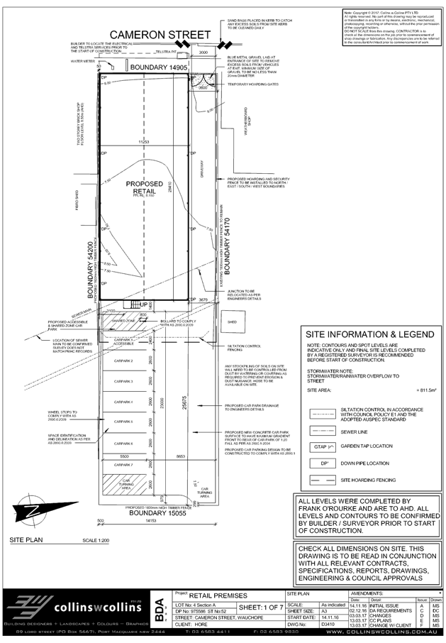
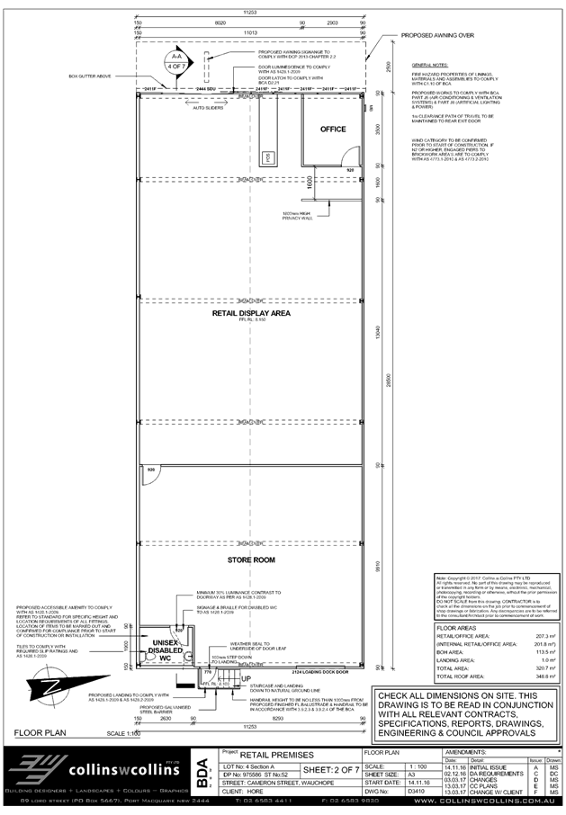
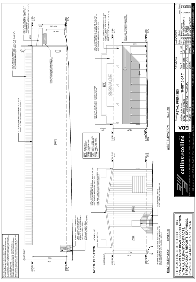
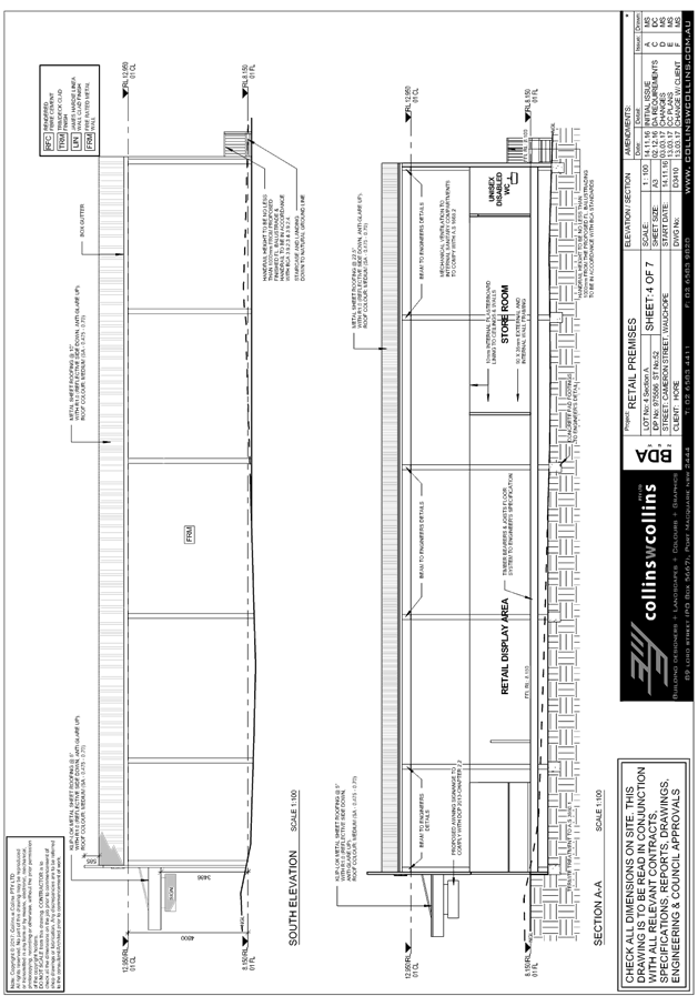
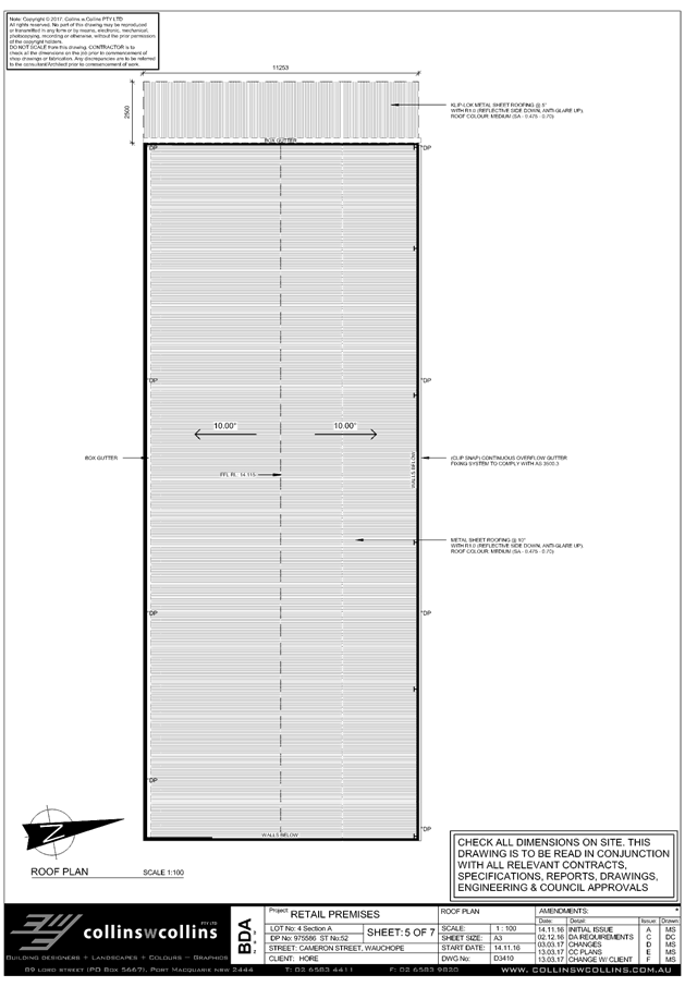
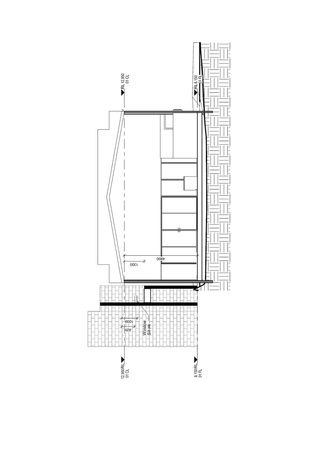
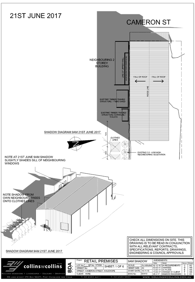
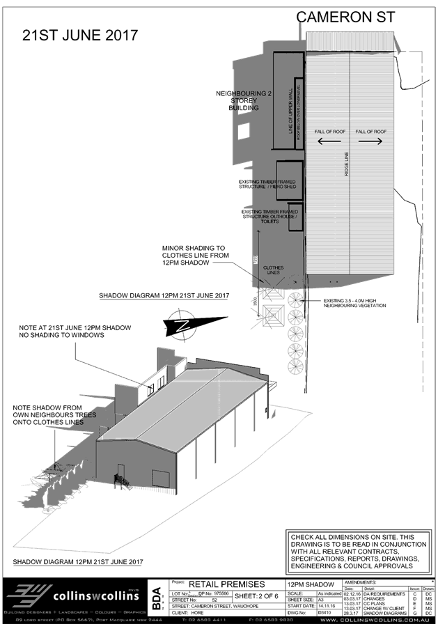
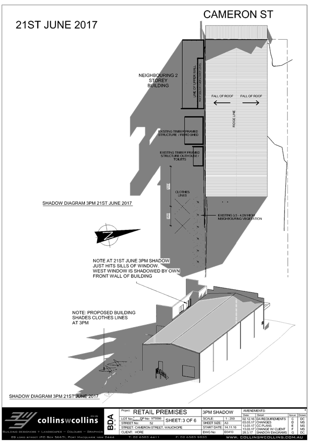
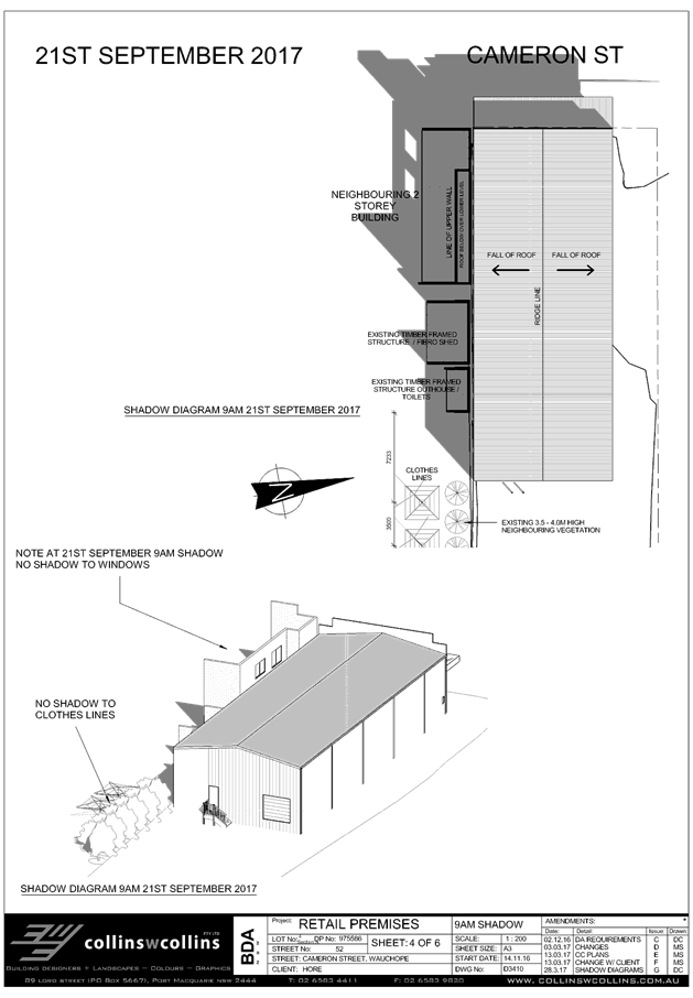
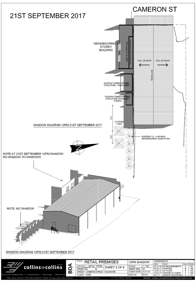
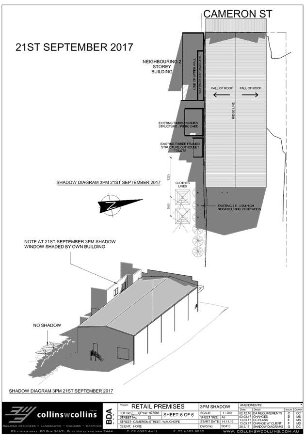
|
ATTACHMENT
|
Development Assessment Panel
12/04/2017
|
|
ATTACHMENT
|
Development Assessment Panel
12/04/2017
|
|
ATTACHMENT
|
Development Assessment Panel
12/04/2017
|
|
ATTACHMENT
|
Development Assessment Panel
12/04/2017
|
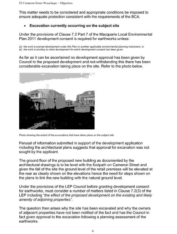
AGENDA Development Assessment Panel 12/04/2017
Item: 07
Subject: DA2016 - 984.1 Staged construction Of
Multi Dwelling Housing With Torrens Title Subdivision - Lots 10 & 11Sec F,
DP 24850, No 54 Kalinda Drive, Port Macquarie
Report
Author: Fiona Tierney
|
Applicant: STOWKIN
PTY LTD
Owner: STOWKIN
PTY LTD
Estimated Cost: $780000
Alignment with Delivery
Program
4.9.2 Undertake transparent
and efficient development assessment in accordance with relevant legislation.
|
|
RECOMMENDATION
That
DA 2016 - 984 for a staged construction
of multi dwelling housing with torrens title subdivision at Lot 10 & 11,
DP 24850, No. 54 Kalinda Drive, Port
Macquarie, be determined by granting consent
subject to the recommended conditions.
|
Executive
Summary
This
report considers a development application for a staged multi dwelling
housing development with torrens title subdivision at
the subject site. The report provides an assessment of the application in
accordance with the Environmental Planning and Assessment Act 1979.
Following exhibition of the
application, one (1) submission has been
received.
1. BACKGROUND
Existing sites features and Surrounding development
The site has an area of 1092.6m2.The site is an existing elevated residential block that
currently has a single dwelling and pool constructed over 2 allotments. The
site is surrounded by existing residential development that is slowly
undergoing renovation and redevelopment.
The site is zoned R1- General Residential in accordance with the Port Macquarie-Hastings Local
Environmental Plan 2011, as shown in the following zoning plan:
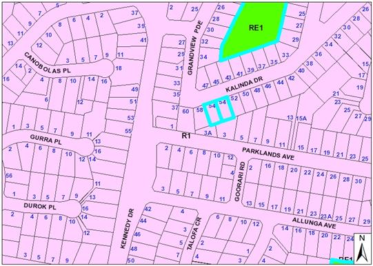
The existing subdivision pattern and location of existing
development within the locality is shown in the following aerial photograph:
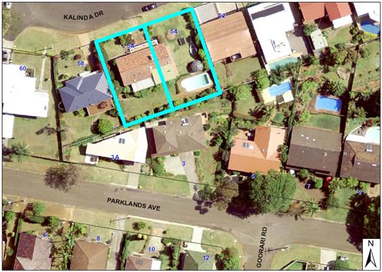
2. DESCRIPTION OF
DEVELOPMENT
Key aspects of the proposal include the following:
· Subdivision to create 3 lots from 2.
· Staged
construction proposed to allow release of each completed dwelling
· Construction
of 3 x 4 bedroom dwellings
· Construction
of associated retaining walls and fencing
· Construction
of new driveways
Refer
to attachments at the end of this report.
Application Chronology
· 16
December 2016 - DA lodged.
· 15 to 23 January 2017 - Neighbour notification of proposal
· 1 March 2017 request by applicant to defer matter to April
12 DAP
3. STATUTORY ASSESSMENT
Section 79C(1) Matters for Consideration
In determining the application, Council is required to take
into consideration the following matters as are relevant to the development
that apply to the land to which the development application relates:
(a) The provisions (where
applicable) of:
(i) any Environmental
Planning Instrument:
State Environmental Planning Policy No.
44 - Koala Habitat Protection
There is no Koala Plan of
Management on the site. Additionally, the site is less than 1ha in area
therefore no further investigations are required.
State
Environmental Planning Policy No.55 – Remediation of Land
Following an inspection of the site and a
search of Council records, the subject land is not identified as being
potentially contaminated and is suitable for the intended use.
State
Environmental Planning Policy No. 71 – Coastal Protection and Clause 5.5
of Port Macquarie-Hastings Local Environmental Plan 2011
The site is
located within a coastal zone as defined in accordance with clause 4 of SEPP
71.
In accordance
with clause 5, this SEPP prevails over the Port Macquarie-Hastings LEP 2011 in
the event of any inconsistency.
Having regard to
clauses 8 and 12 to 16 of SEPP 71 and clause 5.5 of Hastings LEP 2011 inclusive
the proposed development will not result in any of the following:
a) any
restricted access (or opportunities for access) to the coastal foreshore;
b) any
identifiable adverse amenity impacts along the coastal foreshore and on the
scenic qualities of the coast;
c) any
identifiable adverse impacts on any known flora and fauna (or their natural
environment);
d) subject
to any identifiable adverse coastal processes or hazards;
e) any
identifiable conflict between water and land based users of the area;
f) any
identifiable adverse impacts on any items of archaeological/heritage;
g) reduce
the quality of the natural water bodies in the locality.
The site is located within an area zoned
for residential purposes.
State Environmental Planning Policy
(Building Sustainability Index: BASIX) 2004
A BASIX
certificate has been submitted demonstrating that the proposal will comply with
the requirements of the SEPP. A standard condition is recommended to ensure
compliance of works with the BASIX certificate.
Port Macquarie-Hastings Local Environmental Plan 2011
The proposal is consistent with the LEP having regard to the
following:
· Clause 2.2, the subject
site is zoned R1 General Residential. In accordance with clause 2.3(1) and the
R1 zone landuse table, multi dwelling housing is a permissible landuse with
consent.
The objectives
of the R1 zone are as follows:
o To provide for
the housing needs of the community.
o To
provide for a variety of housing types and densities.
o To
enable other land uses that provide facilities or services to meet the day to
day needs of residents.
·
In accordance with Clause 2.3(2),
the proposal is consistent with the zone objectives as it is a permissible
landuse and consistent with the established residential locality,
· Clause
4.3, the maximum overall height of the building above ground level is 7.418m
which complies with the maximum 8.5m standard.
· Clause
4.4, the floor space ratio (FSR) of the proposal is 0.39:1.0 FSR which complies
with the maximum 0.65:1 floor space ratio applying to the site.
· Clause
5.9 - Minor shrubs and small trees only to be removed.
· Clause
5.10 – Heritage. The site does not contain or adjoin any known heritage
items or sites of significance.
· Clause 7.13,
satisfactory arrangements are in place for provision of essential services.
(ii) Any
draft instruments that apply to the site or are on exhibition:
No draft
instruments apply to the site.
(iii) any
Development Control Plan in force:
Port
Macquarie-Hastings Development Control Plan 2013:
|
DCP 2013: Dwellings, Dual
occupancies, Dwelling houses, Multi dwelling houses & Ancillary
development
|
|
|
Requirements
|
Proposed
|
Complies
|
|
3.2.2.2
|
Articulation zone:
• Min. 3m front
setback
• An entry feature
or portico
• A balcony, deck,
patio, pergola, terrace or verandah
• A window box
treatment
• A bay window or
similar feature
• An awning or
other feature over a window
• A sun shading
feature
|
Minor encroachment by 300mm into
articulation zone by upper balcony
|
yes
|
|
Front setback (Residential not R5
zone):
• Min. 4.5m local
|
Minimum 4.5m proposed
|
Yes
|
|
3.2.2.3
|
Garage 5.5m min. and 1m behind
front façade.
Garage door recessed behind
building line or eaves/overhangs provided
|
Minimum 5.8
|
Yes
|
|
6m max. width of garage door/s
and 50% max. width of building
|
|
Yes
|
|
Driveway crossover 1/3 max. of
site frontage and max. 5.0m width
|
|
Yes
|
|
Garage and driveway provided on
each frontage for dual occupancy on corner lot
|
Each dwelling has a single
driveway
|
|
|
3.2.2.4
|
4m min. rear setback. Variation
subject to site analysis and provision of private open space
|
>4m
|
Yes
|
|
3.2.2.5
|
Side setbacks:
• Ground floor =
min. 0.9m
• First floors
& above = min. 3m setback or where it can be demonstrated that
overshadowing not adverse = 0.9m min.
• Building wall
set in and out every 12m by 0.5m
|
Ground floors
Lot 1-West-1.2m
Lot 3- East- 1.398m
First Floor
Lot 1- West- 2.5m
Lot 3- East 1.4m
|
Yes- applicant has demonstrated
that no adverse overshadowing will occur.
|
|
3.2.2.6
|
35m2 min. private open space area
including a useable 4x4m min. area which has 5% max. grade
|
>35m2
|
Yes
|
|
3.2.2.10
|
Privacy:
• Direct views
between living areas of adjacent dwellings screened when within 9m radius of
any part of window of adjacent dwelling and within 12m of private open space
areas of adjacent dwellings. ie. 1.8m fence or privacy screening which has
25% max. openings and is permanently fixed
• Privacy screen
required if floor level > 1m height, window side/rear setback (other than
bedroom) is less than 3m and sill height less than 1.5m
• Privacy screens
provided to balconies/verandahs etc which have <3m side/rear setback and
floor level height >1m
|
The proposed deck
areas on the first floor
requires privacy
screening adjacent to
the side boundary. This
would retain the outlook
over the rear yard, but
maintain privacy. This
is proposed to be addressed
via a
condition of consent.
The small balcony off
the master bedroom is
not considered to
require any privacy
screening due to the
street front location,
small area and not being
located off a primary living area
|
Yes- condition
|
|
DCP 2013: General
Provisions
|
|
|
Requirements
|
Proposed
|
Complies
|
|
2.7.2.2
|
Design addresses generic principles of Crime Prevention
Through Environmental Design guideline
|
Adequate casual surveillance available
|
Yes
|
|
2.3.3.1
|
Cut and fill 1.0m max. 1m outside the perimeter of the
external building walls
|
1m max proposed. Dropped edge beams to be utilised to
minimise fill.
|
Yes
|
|
2.3.3.2
|
1m max. height retaining walls along road frontage
|
|
N/A
|
|
Any retaining wall >1.0 in height to be certified by
structure engineer
|
|
Yes
|
|
Combination of retaining wall and front fence height max
1.8m, max length 6.0m or 30% of frontage, fence component 25% transparent,
and splay at corners and adjacent to driveway
|
|
N/A
|
|
2.4.3
|
Bushfire risk, Acid sulphate soils, Flooding,
Contamination, Airspace protection, Noise and Stormwater
|
Refer to main body of report.
|
|
|
2.5.3.3
|
Parking in accordance with Table 2.5.1.
1 space per single dwelling (behind building line)
|
|
Yes
|
|
2.5.3.11
|
Section 94 contributions
|
Refer to main body of report.
|
|
|
2.5.3.12 and 2.5.3.13
|
Landscaping of parking areas
|
|
Yes
|
|
2.5.3.14
|
Sealed driveway surfaces unless justified
|
|
Yes
|
|
2.5.3.15 and 2.5.3.16
|
Driveway grades first 6m or ‘parking area’
shall be 5% grade with transitions of 2m length
|
|
Yes
|
|
2.5.3.17
|
Parking areas to be designed to avoid concentrations of
water runoff on the surface.
|
|
Yes
|
|
Vehicle washing facilities – grassed area etc
available.
|
|
Available
|
Port
Macquarie-Hastings Development Control Plan 2013
Based on the
above assessment, the variation proposed to the standard privacy provisions of
the DCP is considered acceptable and the relevant objectives have been
satisfied.
Cumulatively,
the variations do not amount to an adverse impact or a significance that would
justify refusal of the application.
(iiia) any
planning agreement that has been entered into under Section 93f or any draft
planning agreement that a developer has offered to enter into under Section
93f:
No planning
agreement has been offered or entered into relating to the site.
iv) any matters prescribed by the
Regulations:
New South Wales Coastal Policy:
The proposed
development is consistent with the objectives and strategic actions of this
policy.
Demolition
of buildings AS 2601:
The existing
dwelling is proposed to be demolished conditions of consent to be applied.
v) any coastal
zone management plan (within the meaning of the Coastal Protection Act 1979),
that apply to the land to which the development application relates:
Nil
(b) The
likely impacts of that development, including environmental impacts on both the
natural and built environments, social and economic impacts in the locality:
Context and setting
• The
proposal will be unlikely to have any adverse impacts to existing adjoining
properties or the public domain.
• The proposal is considered to be sufficiently compatible
with other residential development in the locality and adequately addresses
planning controls for the area.
• There
are no adverse impacts on existing view sharing.
• There are no adverse privacy impacts, as justified earlier
in this report.
• There are no adverse overshadowing impacts.
Water, Sewer and Stormwater
Service available – details
required with S.68 application.
Other Utilities
Telecommunication and electricity
services are available to the site.
Heritage
This site does not contain or
adjoin any known heritage item or site of significance.
Other land resources
No adverse impacts anticipated.
The site is within an established urban context and will not sterilise any
significant mineral or agricultural resource.
Water cycle
The proposed development will be
unlikely to have any adverse impacts on water resources and the water cycle.
Soils
The proposed development will be
unlikely to have any adverse impacts on soils in terms of quality, erosion,
stability and/or productivity subject to a standard condition requiring erosion
and sediment controls to be in place prior to and during construction.
Air and microclimate
The construction and/or
operations of the proposed development will be unlikely to result in any
adverse impacts on the existing air quality or result in any pollution.
Flora and fauna
Construction of the proposed
development will require removal/clearing of two existing trees however these
trees are considered to not be of any significance to warrant retention. The
existing tree in the south-western corner is also noted to be in poor health.
The proposal therefore will be unlikely to have any significant adverse impacts
on biodiversity or threatened species of flora and fauna. Section 5A of
the Act is considered to be satisfied.
Waste
Satisfactory arrangements are in
place for proposed storage and collection of waste and recyclables. No adverse
impacts anticipated.
Energy
No adverse impacts anticipated.
Noise and vibration
No adverse impacts anticipated.
Condition recommended to restrict construction to standard construction hours.
Bushfire
The site is not identified as
being bushfire prone.
Safety,
security and crime prevention
The proposed development will be
unlikely to create any concealment/entrapment areas or crime spots that would
result in any identifiable loss of safety or reduction of security in the
immediate area.
Social impacts in the locality
Given the nature of the proposed
development and its’ location the proposal is unlikely to result in any
adverse social impacts.
Economic impact in the
locality
No adverse impacts. Likely
positive impacts can be attributed to the construction of the development and
associated flow on effects (i.e. increased expenditure in the area).
Site design and internal
design
The proposed development design
is satisfactorily responds to the site attributes and will fit into the
locality. No adverse impacts likely.
Construction
No potential adverse impacts
identified to neighbouring properties with the construction of the proposal.
Cumulative Impacts
The proposed
development is not expected to have any adverse cumulative impacts on the
natural or built environment or the social and economic attributes of the
locality.
(c) The suitability of the site for
the development:
The proposal
will fit into the locality and the site attributes are conducive to the
proposed development.
Site constraints
of bushfire risk have been adequately addressed and appropriate conditions of
consent recommended.
(d) Any submissions made in
accordance with this Act or the Regulations:
One written submission has been received following public
exhibition of the application.
Key issues raised in the submissions received and comments
in response to these issues are provided as follows:
|
Submission
Issue/Summary
|
Planning
Comment/Response
|
|
Fence to be a uniform
colourbond construction and accurately surveyed to ensure it is erected in
the correct location.
|
A survey will be carried out
as part of the proposed subdivision. A condition of consent has been recommended
to require 1.8m solid boundary fencing for side and rear boundaries. The type
and costing of the fencing is a matter for the respective property owners.
|
|
Windows erected on the top
floor will impact on privacy. These to be relocated to front and rear of
dwellings.
|
Windows adjoining the boundary
are service and bedroom windows and are not living areas. It is considered
that no undue privacy impacts will result from the installation of these
windows.
|
|
Do not accept the variation to
upper first floor setbacks to side boundaries.
Location of dwellings will
result in overshadowing of our home.
|
The upper levels are permitted
to be set in to 900mm where it can be demonstrated that overshadowing
complies with the 3hr control guideline.
The blocks are oriented north
south and the applicant has submitted shadow diagrams that indicate the
proposal will not result in adverse overshadowing. It is noted that the
southern facing private open space area of the adjoining dwelling is largely
overshadowed by itself.
|
(e) The Public Interest:
The proposed
development satisfies relevant planning controls and is unlikely to impact on
the wider public interest.
4. DEVELOPMENT
CONTRIBUTIONS APPLICABLE
· Development contributions will be required towards
augmentation of town water supply and sewerage system head works under Section
64 of the Local Government Act 1993.
· Development contributions will be required under Section 94
of the Environmental Planning and Assessment Act 1979 towards roads, open
space, community cultural services, emergency services and administration
buildings.
5. CONCLUSION
The application has been assessed in accordance with
Section 79C of the Environmental Planning and Assessment Act 1979.
Issues raised during assessment and public exhibition of
the application have been considered in the assessment of the application.
Where relevant, conditions have been recommended to manage the impacts
attributed to these issues.
The site is suitable for the proposed development, is not
contrary to the public's interest and will not have a significant adverse
social, environmental or economic impact. It is recommended that the
application be approved, subject to the recommended conditions of consent
provided in the attachment section of this report.
|
Attachments
1View. DA2016
- 984.1 Plans
2View. DA2016
- 984.1 Recommended DA conditions
3View. DA2016
- 984.1 Submission - Hayek
4View. DA2016
- 984.1 Shadow diagram
|
|
ATTACHMENT
|
Development Assessment Panel
12/04/2017
|
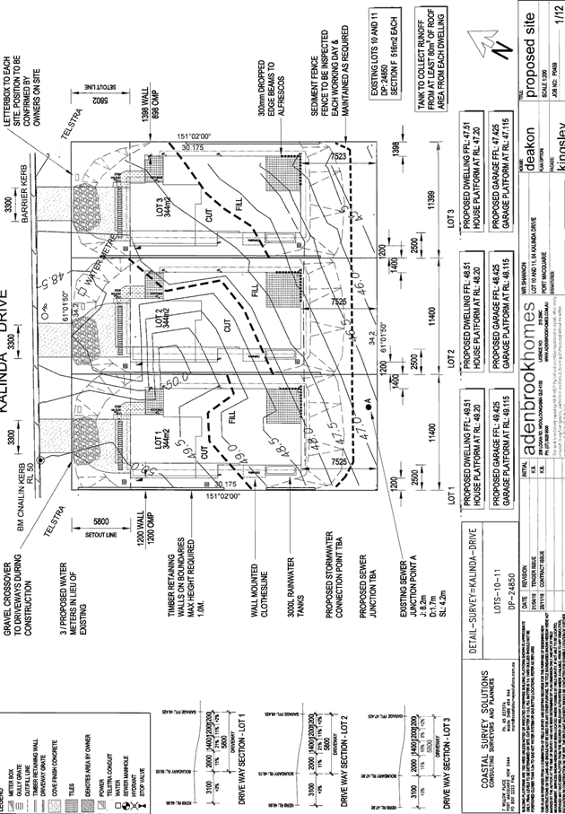
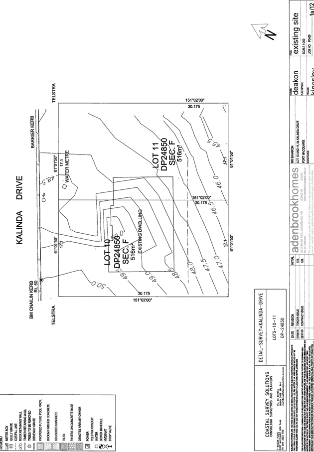
|
ATTACHMENT
|
Development Assessment Panel
12/04/2017
|

|
ATTACHMENT
|
Development Assessment Panel
12/04/2017
|
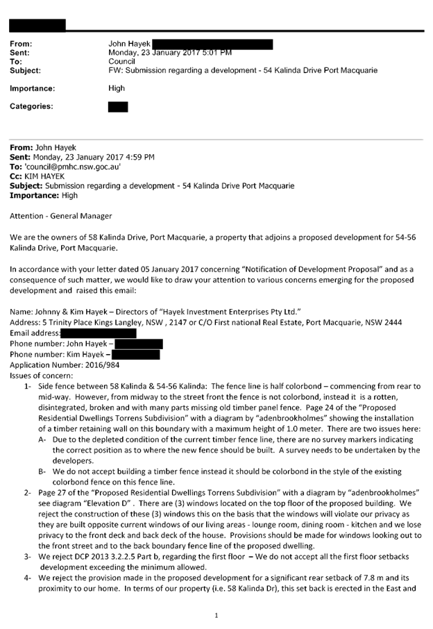

|
ATTACHMENT
|
Development Assessment Panel
12/04/2017
|
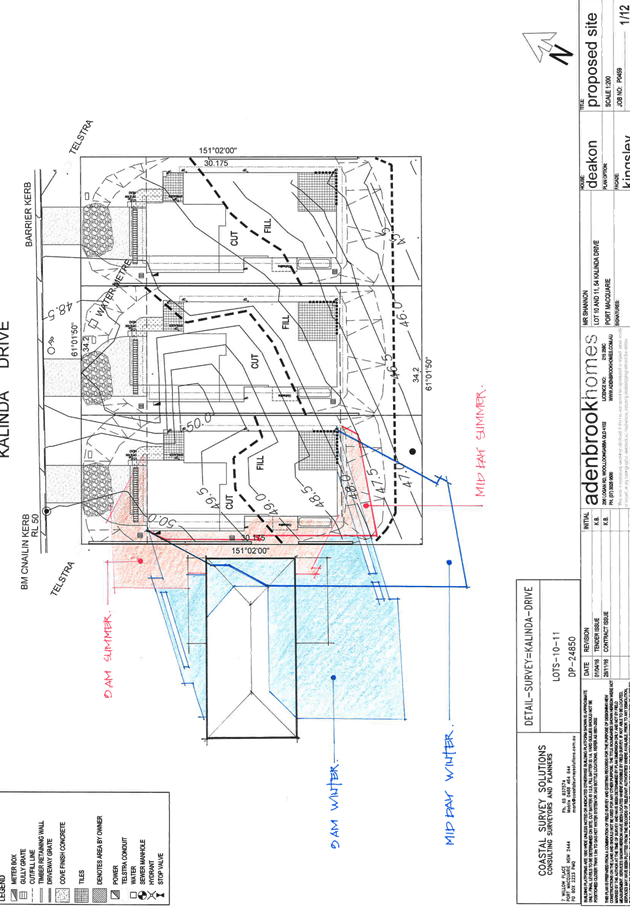
AGENDA Development Assessment Panel 12/04/2017
Item: 08
Subject: DA2017 - 32.1 - Addition Of Floating Pontoon
And Storage Shed For Jet Skis Associated With an emergency services facility
(Marine Rescue) - Lot 1 DP 1064060, Buller Street, Port Macquarie
Report
Author: Patrick Galbraith-Robertson
|
Applicant: Marine
Rescue NSW
Owner: State
of NSW, Department of Industry - Lands
Estimated Cost: $31,000
Alignment with Delivery
Program
4.9.2 Undertake transparent
and efficient development assessment in accordance with relevant legislation.
|
|
RECOMMENDATION
That
the Development Assessment Panel recommend to Council that DA2017 - 32 for an
addition of floating pontoon and storage shed for jet skis associated
with an emergency services facility (Marine Rescue) at Lot 1 and 2,
DP 1064060, No. 11A Buller Street,
Port Macquarie, be determined by granting consent subject to the recommended
conditions.
|
Executive
Summary
This
report considers a Development Application for additions of a floating
pontoon and storage shed for jet skis associated with an emergency services
facility (Marine Rescue). The report provides an
assessment of the application in accordance with the Environmental Planning and
Assessment Act 1979.
Following exhibition of the
application, two(2) submissions have been
received.
The structure is proposed to be
installed in the Hastings River adjoining the existing Marine Rescue building.
Council has an interest with the
role of leasing the adjoining building to the Marine Rescue. As there have been
submissions received, the DA is required to be determined at an Ordinary
Meeting of Council in accordance with Council’s Conflict of Interest -
Development Application Policy.
1. BACKGROUND
Existing sites features and Surrounding development
The site is a section of the
Hastings River adjoining the existing Marine Rescue building located on its own
lots within Westport Park, Port Macquarie.
The
site is zoned W2 Recreational Waterways in
accordance with the Port Macquarie-Hastings Local Environmental Plan 2011, as
shown in the following zoning plan:
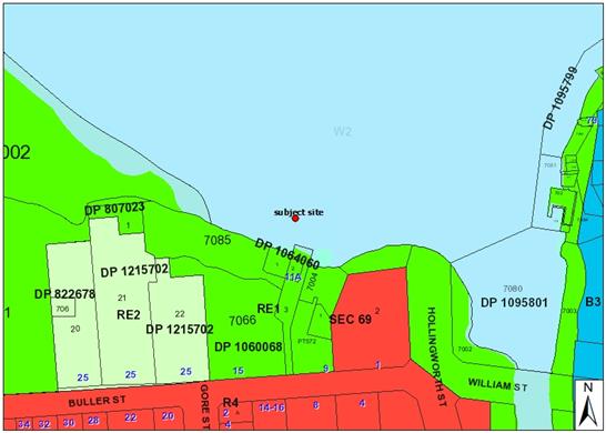
The
existing subdivision pattern and location of existing development within the
locality is shown in the following aerial photograph (July 2016):
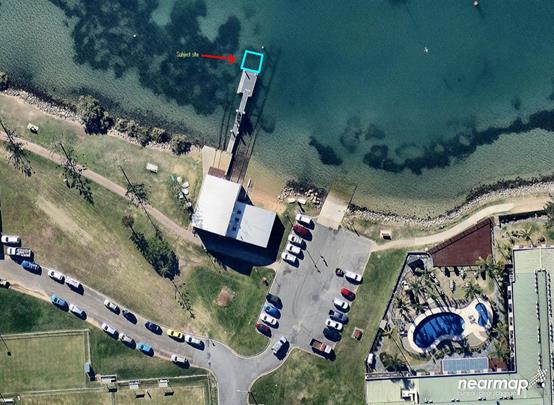
2. DESCRIPTION
OF DEVELOPMENT
Key
aspects of the proposal include the following:
· Install
an additional floating pontoon and enclosed storage shed for two (2) rapid
response water craft (jet skis) and associated emergency equipment for Marine
Rescue.
· The
proposal will be available for use 24/7 however will only be occupied by staff
during daylight hours except for emergency callouts.
· The
storage shed will be constructed of marine grade aluminium framing and marine
colourbond with as close a colour to the existing buildings as possible (see
following image).
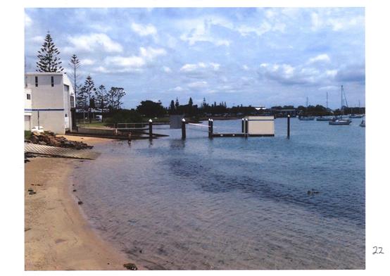
Refer
to attachments at the end of this report for plan details.
Application
Chronology
· 19
January 2017 - DA lodged.
· 7
March 2017 - Advice received from the NSW Office of Water that a Controlled
Activity approval is not required.
· 2 February to 3 March 2017 - Neighbour notification.
3. STATUTORY
ASSESSMENT
Section
79C(1) Matters for Consideration
In
determining the application, Council is required to take into consideration the
following matters as are relevant to the development that apply to the land to
which the development application relates:
The provisions (where applicable) of:
(a)(i) Any environmental
planning instrument
State Environmental Planning
Policy No.55 – Remediation of Land
Following an inspection of the site and a search of Council
records, the subject land is not identified as being potentially contaminated
and is suitable for the intended use.
State Environmental Planning
Policy No. 62 – Sustainable Aquaculture
Given the nature of the proposed
development, the proposal will be unlikely to have any identifiable adverse
impact on existing aquaculture industries within the Hastings River.
State Environmental Planning
Policy No. 64 – Advertising and Signage
No signage is proposed.
State Environmental Planning
Policy No. 71 – Coastal Protection and Clause 5.5 of Port
Macquarie-Hastings Local Environmental Plan 2011
The site is located within a
coastal zone noting clause 4 of the SEPP.
In accordance with clause 5, this
SEPP prevails over the Port Macquarie-Hastings LEP 2011 in the event of any
inconsistency.
Having regard for clauses 2, 8 and
12 to 16 of the SEPP and clause 5.5 of the PMH LEP 2011, the proposed
development will not result in any of the following:
a) any restricted access (or opportunities
for access) to the foreshore
b) any adverse
amenity impacts along the foreshore to warrant refusal of the application. No
impacts to the broader scenic qualities of the coast can be identified;
c) any adverse impacts on flora and fauna;
d) the development being subject to any
adverse coastal processes or hazards;
e) any significant conflict between water
and land based users of the area;
f) any adverse impacts on any items of
archaeological/heritage;
g) reduction in the
quality of the natural water bodies in the locality (due to effluent and
stormwater disposal, construction impacts, landuse conflicts);
h) adverse cumulative impacts on the
environment;
i) a form of development that is
unsustainable in water and energy demands.
Port Macquarie-Hastings Local Environmental
Plan 2011
The proposal is consistent with the LEP having regard to the
following:
· Clause 2.2,
the subject site is zoned W2 Recreational Waterways. In accordance with clause
2.3(1) and the W2 zone landuse table, the proposed development for a wharf
or boating facility and emergency services facility is a permissible
landuse with consent.
The objectives of the W2 zone are as follows:
• To protect the ecological, scenic and
recreation values of recreational waterways.
• To allow for water-based recreation and
related uses.
• To provide for sustainable fishing
industries and recreational fishing.
In accordance with Clause
2.3(2), the proposal is consistent with the zone objectives having regard to
the following:
o the proposal is a permissible
landuse;
o the
scenic value of the Hastings River will not be adversely impacted upon to an
extent that would warrant recommending refusal of the application.
· Clause 5.7
– development below highwater mark – jetties etc. A Development
Application has been lodged for the structure as required by this clause.
· Clause 5.9 -
no listed trees in Development Control Plan 2013 are proposed to be removed.
· Clause 5.10
– Heritage. The site does not contain or adjoin any known heritage items
or sites of significance.
· Clause
7.3, the site is land within a mapped “flood planning area” (Land
subject to flood discharge of 1:100 annual recurrence interval flood event
(plus the applicable climate change allowance and relevant freeboard) In this
regard, the following comments are provided which incorporate consideration of
the objectives of Clause 7.3, Council’s Flood Policy 2015, the NSW
Government’s Flood Prone Lands Policy and the NSW
Government’s Floodplain Development Manual (2005):
o The
proposal is compatible with the flood hazard of the land taking into account
projected changes as a result of climate change;
o The
proposal will not result in a significant adverse affect on flood behaviour
that would result in detrimental increases in the potential flood affectation
of other development or properties;
o The
proposal incorporates measures to minimise and manage the flood risk to life
and property associated with the use of land. Conditions are also recommended
to require specific installation measures;
o The
proposal is not likely to significantly adversely affect the environment or
cause avoidable erosion, siltation, destruction of riparian vegetation or a
reduction in the stability of river banks or watercourses;
o The
proposal is not likely to result in unsustainable social and economic costs to
the community as a consequence of flooding.
· Clause
7.4 – Flood risk management – land between the flood planning area
and the line that is shown as the probable maximum flood level on the Flood
Planning Map and/or land surrounded by the flood planning area. The structure
is capable of complying with flood installation requirements.
· Clause 7.13,
satisfactory arrangements are in place for provision of essential services.
(a)(ii) Any proposed
instrument that is or has been placed on exhibition
No draft instruments apply to the
site.
(a)(iii) Any DCP in force
Port Macquarie-Hastings
Development Control Plan 2013:
The proposal will not contravene
any of the applicable Development Provision requirements of this DCP noting
there is no specific development controls related to this commercial floating
pontoon proposal. The proposed development will be unlikely to create any
concealment/entrapment areas or crime spots that would result in any
identifiable loss of safety or reduction of security in the immediate area. The
structure is restricted to not be open to the general public.
(a)(iii)(a) Any
planning agreement or draft planning agreement
No planning agreement has been
offered or entered into relating to the site.
(a)(iv) Any matters
prescribed by the regulations
NSW Coastal Policy 1997
The proposed development is
consistent with the objectives and strategic actions of this policy. (See
Clause 5.5 of LEP 2011 and Assessment Officers Assessment Table under section
(b) for assessment against Coastal Policy Objectives)
(a)(v) Any Coastal Zone
Management Plan
No plan of management can be
identified which applies within the Hastings River.
(b) The likely impacts
of that development, including environmental impacts on both the natural and
built environments and the social and economic impacts in the locality
Context and setting
The proposed floating pontoon and
storage shed are proposed to be installed in the Hastings River attached to
existing pylons adjoining the existing Marine Rescue building. NSW Land and
Environment Caselaw Rose Bay Marina Pty Limited v Woollahra Municipal
Council and anor (2013) NSWLEC 1046 has been cited during assessment of the
DA which assists in providing guidance for assessment of suitability of the
proposed structure in the Hastings River.
The Hastings River is identified as
a highly desirable waterway. The use of Hastings River as a waterway is
initially regulated by the W2 Recreational Waterways zoning which regulates
permitted landuses within/on the waterway.
A key consideration of the
assessment of this application relates to the general appropriateness of the
structure within the waterway. The process must
account for reasonable development expectations as well as retaining a
satisfactory enjoyment for members of the general public who enjoy outlooks
from such public places.
Unlike carrying out view sharing
impact assessments (which adopts the proposition that sitting views are more
difficult to protect than standing views), the impact on appreciation of a
public domain view should not be subject to any height constraint. Public
domain views are one that is for the enjoyment of the whole population. Of
particularly relevance to consideration of this application is to identify the
intensity of public use of this location where the enjoyment is likely to be
obscured, in whole or part, by the proposed development. A private viewpoint
from a neighbour’s property the Waters Edge Motel has also been taken
into consideration.
The analysis required of the
proposed development’s public domain impact is both quantitative as well
as qualitative.
A photo taken from the existing
view from the public footpath (which is adjoining an objectors premises - the
Waters Edge Motel) to the south-east of the proposed installation is shown as
follows. The pontoon and shed are to be installed in between the last two(2)
pylons at the end of the existing floating pontoon (refer to second image photo
montage plan which shows view from approximate high tide beach level).
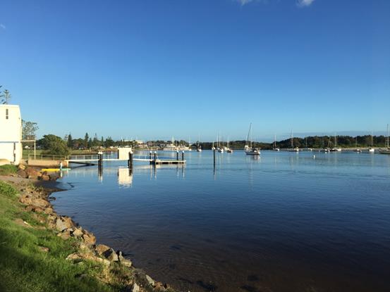
Applicant’s photomontage
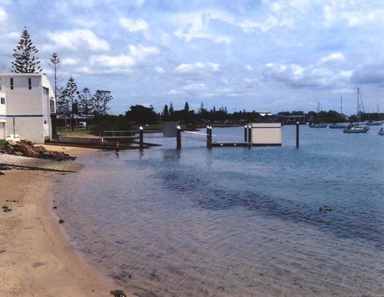
The following comments are provided
having regard to the planning principles steps for assessment impacts on views
from the public domain and the adjoining Waters Edge Motel:
· The
existing jetty structure including pylons and floating pontoon presents an
existing obstruction to the view out into the Hastings River at a number of
viewpoints along the Westport Park foreshore.
· There
are number of boats moored in the River which result in temporary visual change
to the public view.
· There
are no other floating storage sheds of this nature identified in the immediate
area of the Hastings River.
· There
are viewpoints from the public domain along the pathway and foreshore running
east and west where there is a view out into the River which will be partially
interrupted. The photo shown above is one important vantage point identified.
This is also similar viewpoint to the adjoining private property the Waters
Edge Motel.
· The
size of the structure to be installed has a maximum height of 3.25m and width
of 5m x 4.5m length from existing water level (which will fluctuate). The
height and size of the structure is limited and will not extend out past the
last pylon and will be likely not to significantly protrude above the height of
the existing pylon obstruction.
· The
view back to the Central Business District area from the foreshore west of the
Marine Rescue building will also be impacted upon.
· The
pathway and foreshore are considered to be a highly used public domain area.
· The
distant land, buildings and water interface beyond the structure to the east
and west (the CBD and Sails Resort) currently visible beyond the siting for the
structure will be partly obstructed. The public viewpoints from the footpath
along the front of the Waters Edge Motel and from the deck at this motel are
more elevated than the western foreshore section.
· The
colour of the shed will be matched as close as possible to the existing
adjoining Marine Rescue building. An alternate dark or grey colour as an
alternative is considered unnecessary to consider given the small size of the
structure being limited and the structure should be identified as having
purpose.
· It
is considered from a qualitative and quantitative perspective that the proposal
is considered to have a moderate view impact on the public domain.
· It
is recommended that a time limited consent be only granted which restricts
approval for two(2) years only from installation to revisit the suitability of
the proposal at that time. Refer comments later in report also.
No outdoor lighting of the pontoon
and storage shed are proposed.
There are no significant adverse
privacy impacts to neighbouring properties.
There are no adverse overshadowing
impacts to neighbouring properties.
Parking
The nature of proposal is provide a storage shed for jet
skis associated with the existing operations of the Marine Rescue centre on the
adjoining site. No additional parking is proposed to be provided. It is
considered that based upon the information provided that the nature of the
development will not trigger any additional parking demand for the existing
operations of the adjoining Marine Rescue building.
Water Supply Connection
No water supply issues requiring consideration.
Sewer Connection
No sewer issues requiring consideration.
Stormwater
The installation is to be sited within the Hastings River
with no specific requirements with regard to stormwater disposal required.
Other Utilities
Telecommunication and electricity services are available to
the site.
Heritage
Following a site inspection (and a search of Council
records), no known items of Aboriginal or European heritage significance exist
on the property. No adverse impacts anticipated.
Other land resources
The site is within an established urban context and will not
sterilise any significant mineral or agricultural resource.
Water cycle
The proposed development will be unlikely to have any
adverse impacts on water resources and the water cycle.
Air and microclimate
The installation and/or operations of the proposed
development will be unlikely to result in any adverse impacts on the existing
air quality or result in any pollution.
Flora and fauna
Installation of the proposed development will not require
any removal/clearing of any marine vegetation or result in any identifiable
adverse impacts to marine ecology. The proposal will therefore be unlikely to
have any significant adverse impacts on biodiversity or threatened species of
flora and fauna. Section 5A of the Act is considered to be satisfied.
Waste
No adverse impacts anticipated. Standard precautionary site
management condition recommended.
Energy
No adverse impacts anticipated.
Noise and vibration
No adverse impacts anticipated. Condition recommended to
restrict construction /installation to standard construction hours.
Social impacts in the locality
Given the nature of the proposed development and its’
location the proposal is unlikely to result in any adverse social impacts.
The Applicant has stated that the
proposal will provide for the storage of Emergency Service rescue Craft (2 jet
skis), which are involved in saving lives on the water.
Economic impact in the locality
No adverse impacts. A likely positive impact is that the
development will maintain employment in the construction industry, which will
lead to flow impacts such as expenditure in the area.
Site design and internal design
The proposed development design satisfactorily responds to
the site attributes and will fit into the locality. No adverse impacts likely.
Construction
No potential adverse impacts identified to neighbouring
properties with the construction of the proposal.
Cumulative impacts
The proposed development is not expected to have any adverse
cumulative impacts on the natural or built environment or the social and
economic attributes of the locality.
(c) The suitability of the
site for the development
The proposal can fit into the
locality and the site attributes are conducive to the proposed development.
Site constraints of flooding have
been adequately addressed and appropriate conditions of consent recommended.
(d) Any submissions made in
accordance with this Act or the Regulations:
Two(2) written submissions have been received following public
exhibition of the application.
Both submissions are relating to the property identified
below:
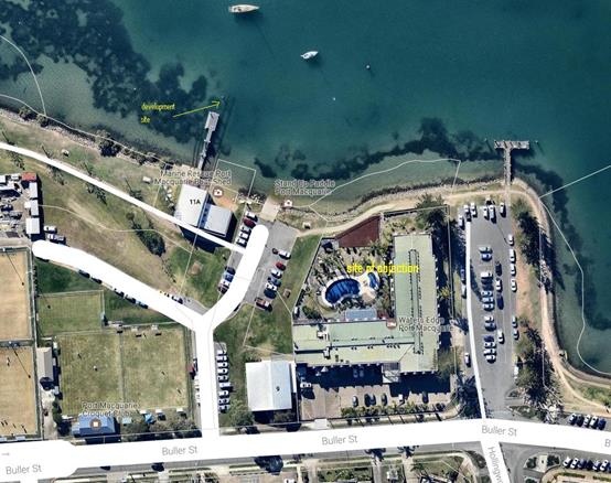
Key
issues raised in the submissions received and comments in response to these
issues are provided as follows:
|
Submission
Issue/Summary
|
Planning
Comment/Response
|
|
Proposal will be visually
prominent in the waterway, intrusive and very unattractive.
|
The proposal
will be likely to have a potential moderate visual impact on public domain
views of the Hastings River.
The storage shed will be constructed of marine grade aluminium framing
and marine colourbond with as close a colour to the existing buildings as
possible.
It is noted
that space in the existing Marine Rescue building is sub let to Surf Clubs
and this has impacted the utility of the building for Marine Rescue purposes.
As stated earlier in this report, a condition is recommended to time limit
the development consent to a limit of two(2) years from installation of the
structure. The matter can be reviewed at that time including any
consideration given to better use of the existing Marine Rescue building
space and to any potential Policy reviews including the Westport Park Plan of
Management.
Given there
is a public interest safety issue as a matter for consideration, the time
limited consent, the size of the structure, its co-location and the proposal
not being for a private developer a precedent is unlikely to occur.
No adverse
impact to navigation within the River can be identified particularly given
the structure is to be located and attached landward of the last pylon
already installed in the River.
The plan
included on additions to the existing Marine Rescue building shown are not
approved or form part of this application. The plans are not to be stamped approved
and not referenced in the development consent conditions.
|
|
Proposal will aesthetically
detract from the beauty on the Hastings River and will be major eyesore to
the community and guests of the motel.
|
|
Proposal will possibly impede
navigation within the Hastings River.
|
|
No mention is made of what
material will be used in construction. The pontoon storage shed will rust and
corrode in time and become a foreshore eyesore.
|
|
A precedent for similar
pontoon structures along the Hastings River frontage will be created.
|
|
The surf club equipment should
be stored elsewhere and the timeframe in actioning a jet ski rescue would be
halved and the waterway remain untouched.
|
|
Question whether in 2015 an
application to extend the existing Marine Rescue building was approved.
|
|
The proposal is out of
character with the surrounding area as there are no floating storage sheds on
this section of water way.
|
|
Disagree that there is no loss
or reduction of views identified in the submitted information.
|
|
The consultation with Waters
Edge Motel has not been extensive enough.
|
The DA has been neighbour
notified to the subject landowner which does not take into any pre-neighbour
consultation undertaken by the Applicant.
|
(e) The Public Interest:
The
Applicant has stated that the proposal will provide for the storage of
Emergency Service rescue Craft (2 jet skis), which are involved in saving lives
on the water. The proponent has advised that Marine Rescue are taking up to
30-35 minutes to deploy a jet ski which is not acceptable from an emergency
service standard.
It is noted that a minor
addition could be proposed to the existing building on the adjoining land to
which the Marine Rescue NSW building is sited. However, It is understood that
the current NSW Government Plan of Management for Westport Park dated 30 July
2012 does not permit any new additions to the existing building.
On balance, it is considered
that the public interest of providing a critical safety service outweighs any
potential moderate negative visual impacts of the structure within the Hastings
River.
As stated earlier in this
report, a condition is recommended to time limit the development consent to a
limit of two(2) years from installation of the structure. The matter can be
reviewed at that time including consideration being given to better use of the
existing Marine Rescue building space and any potential Policy reviews
including the Westport Park Plan of Management.
The proposed development
satisfies relevant planning controls and is unlikely to adversely impact on the
wider public interest.
4. DEVELOPMENT
CONTRIBUTIONS APPLICABLE
N/A
5. CONCLUSION
The
application has been assessed in accordance with Section 79C of the
Environmental Planning and Assessment Act 1979.
Issues
raised during assessment and public exhibition of the application have been
considered in the assessment of the application.
The
site is suitable for the proposed development, is not contrary to the public's
interest and will not have a significant adverse social, environmental or
economic impact. It is recommended that the application be approved, subject to
the recommended conditions of consent provided in the attachment section of
this report.
|
Attachments
1View. DA2017
- 32.1 Plans
2View. DA2017
- 32.1 Marine Rescue Letter
3View. DA2017
- 32.1 Recommended Conditions
4View. DA2017
- 32.1 Submission - McPherson & Hakvoort for Waters Edge
5View. DA2017
- 32.1 Submission - Simmons for Sunbird Investments Pty Ltd
|
|
ATTACHMENT
|
Development Assessment Panel
12/04/2017
|
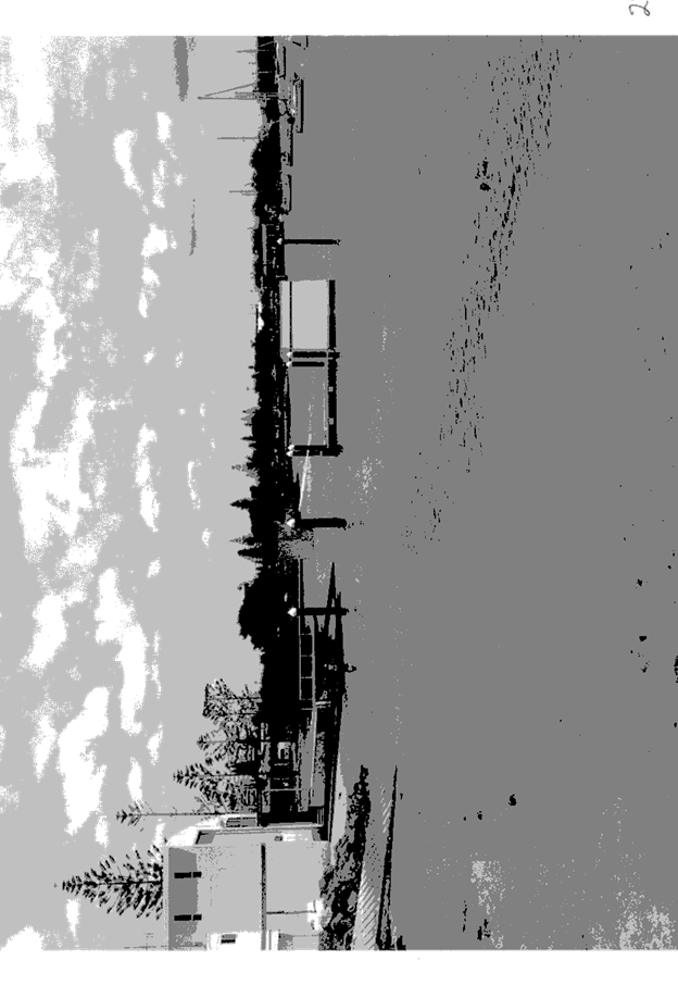
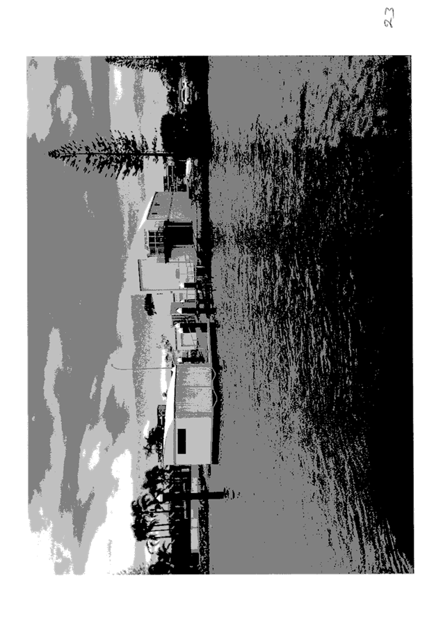
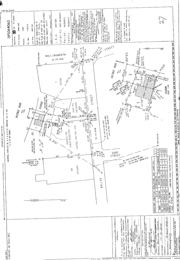
|
ATTACHMENT
|
Development Assessment Panel
12/04/2017
|
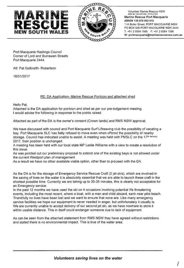
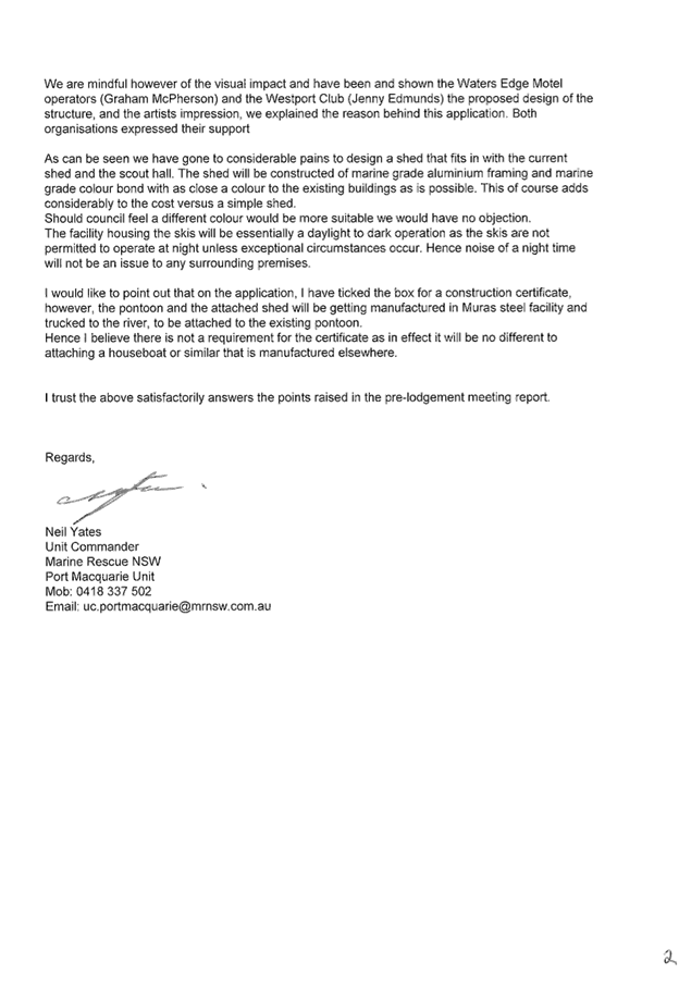
|
ATTACHMENT
|
Development Assessment Panel
12/04/2017
|
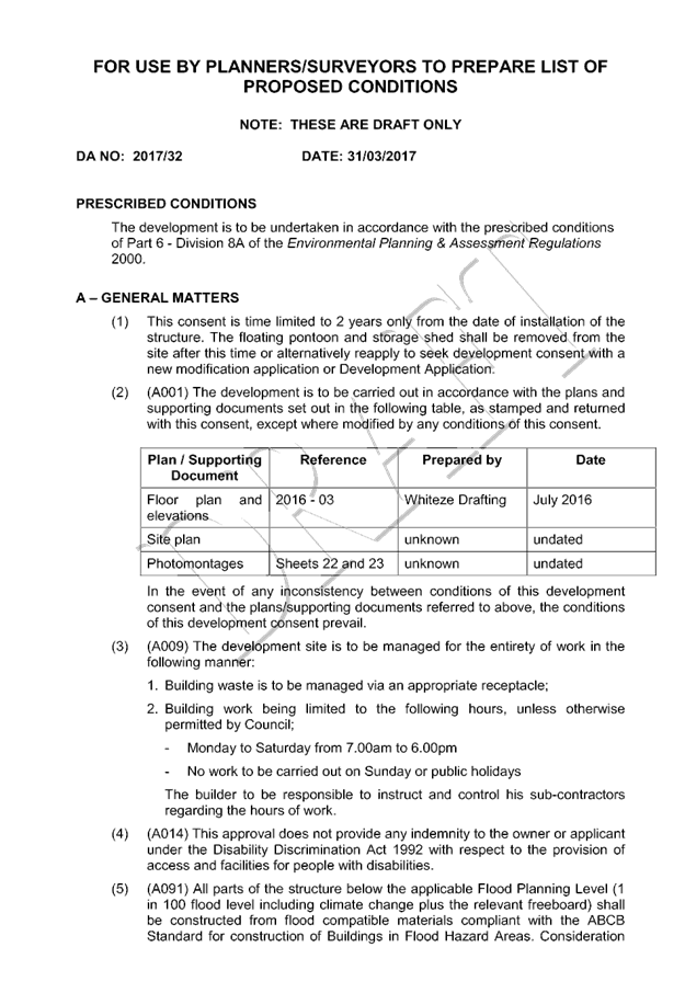
|
ATTACHMENT
|
Development Assessment Panel
12/04/2017
|

|
ATTACHMENT
|
Development Assessment Panel
12/04/2017
|
AGENDA Development Assessment Panel 12/04/2017
Item: 09
Subject: DA2017 - 67.1 Additions To Dwellng - Lot
5 DP 257282, No 8 Unique Close Camden Head
Report
Author: Robert Slater
|
Applicant: ZS
Architects
Owner: M
Trenter
Estimated Cost: $120000
Alignment with Delivery
Program
4.9.2 Undertake transparent
and efficient development assessment in accordance with relevant legislation.
|
|
RECOMMENDATION
That
DA 2017 - 67.1for additions to
dwelling at Lot 5, DP257282, No.8 Unique Close, Camden Head, be determined by
granting consent subject to the recommended conditions.
|
Executive
Summary
This
report considers a development application for internal alterations and
additions to a dwelling at the subject site.
The report provides an assessment of the application in accordance with the
Environmental Planning and Assessment Act 1979.
Subsequent to exhibition of the
application, one (1) submission was received.
1. BACKGROUND
Existing sites features and surrounding development
The site has an area of
661.1m2
The site is zoned R1 General Residential in accordance with the Port Macquarie-Hastings Local
Environmental Plan 2011, as shown in the following zoning plan:
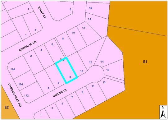
The subject area comprises single dwellings which are
predominately 2 storey in nature.
The existing subdivision pattern and location of existing
development within the locality is shown in the following aerial photograph:
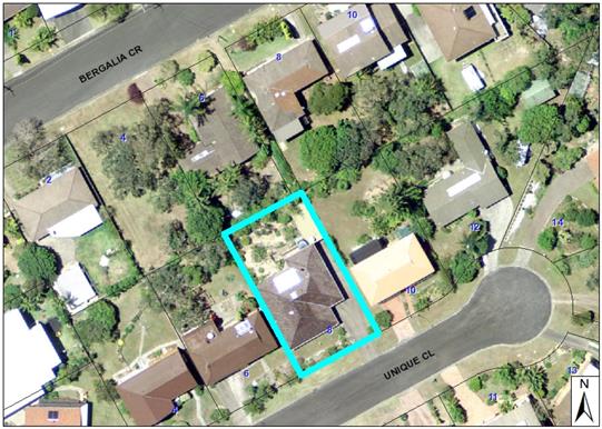
2. DESCRIPTION OF
DEVELOPMENT
Key aspects of the proposal include the following:
· Internal alterations to ground floor
· Second storey addition and covered alfresco area
Refer
to attachments at the end of this report.
Application Chronology
· 08/03/2017
- Application lodged with Council
· 13/03/2017
- Exhibition period expires
· 09/03/2017
- objection letter received
3. STATUTORY ASSESSMENT
Section 79C (1) Matters for Consideration
In determining the application, Council is required to take
into consideration the following matters as are relevant to the development
that apply to the land to which the development application relates:
(a) The provisions (where
applicable) of:
(i) any Environmental
Planning Instrument:
State
Environmental Planning Policy No. 44 - Koala Habitat Protection
There is no Koala Plan of
Management on the site. Additionally, the site is less than 1ha in area
therefore no further investigations are required.
State
Environmental Planning Policy No.55 – Remediation of Land
Following an inspection of the site and a
search of Council records, the subject land is not identified as being
potentially contaminated and is suitable for the intended use.
State
Environmental Planning Policy No. 62 – Sustainable Aquaculture
Given the nature
of the proposed development and proposed stormwater controls the proposal will
be unlikely to have any adverse impact on existing aquaculture industries
within the Camden Haven River Catchment.
State
Environmental Planning Policy No. 71 – Coastal Protection and Clause 5.5
of Port Macquarie-Hastings Local Environmental Plan 2011
The site is
located within a coastal zone as defined in accordance with clause 4 of SEPP
71.
In accordance with
clause 5, this SEPP prevails over the Port Macquarie-Hastings LEP 2011 in the
event of any inconsistency.
Pertaining to
clauses 8 and 12 to 16 of SEPP 71 and clause 5.5 of Hastings LEP 2011 inclusive
the proposed development will not result in any of the following:
any restricted
access (or opportunities for access) to the coastal foreshore
(a) any
identifiable adverse amenity impacts along the coastal foreshore and on the
scenic qualities of the coast;
·
·
any identifiable adverse impacts on any known flora and fauna (or
their natural environment);
(b) subject
to any identifiable adverse coastal processes or hazards;
(c) any
identifiable conflict between water and land based users of the area;
(d) any
identifiable adverse impacts on any items of archaeological/heritage;
(e) reduce
the quality of the natural water bodies in the locality.
·
The site is developed and located within an
area zoned for residential purposes.
State Environmental Planning Policy
(Building Sustainability Index: BASIX) 2004
A BASIX certificate
A271885 has been submitted demonstrating that the proposal will comply with the
requirements of the SEPP. It is recommended that a condition be imposed
to ensure that the commitments are incorporated into the development and
certified at Occupation Certificate stage.
Port Macquarie-Hastings Local Environmental Plan 2011
The proposal is consistent with the LEP having regard to the
following:
· Clause
2.2, the subject site is zoned R1 General Residential. In accordance with
clause 2.3(1) and the R1 zone landuse table, the dwelling (or ancillary
structure to a dwelling) is a permissible landuse with consent.
The
objectives of the R1 zone are as follows:
o To provide for
the housing needs of the community.
o To
provide for a variety of housing types and densities.
o To
enable other land uses that provides facilities or services to meet the day to
day needs of residents.
·
In accordance with Clause 2.3(2),
the proposal is consistent with the zone objectives as it is a permissible
landuse and consistent with the established residential locality,
In accordance with Clause 2.7,
the demolition requires consent as it does not fit within the provisions of
SEPP (Exempt and Complying) 2008.
In accordance with Clause 4.3,
the maximum overall height of the building above ground level (existing) is
7.3m which complies with the standard height limit of 8.5m applying to the
site.
In accordance with Clause 4.4,
the floor space ratio of the proposal is 0.34:1 which complies with the maximum
0.65:1 floor space ratio applying to the site.
In accordance with Clause 5.9 -
No listed trees in Development Control Plan 2013 are proposed to be removed.
In accordance with Clause 5.10 -
the site does not contain or adjoin any known heritage items or sites of
significance
In accordance with Clause7.13 -
satisfactory arrangements are in place for provision of essential services.
(ii) Any
draft instruments that apply to the site or are on exhibition:
None relevant
(iii) any
Development Control Plan in force:
Port
Macquarie-Hastings Development Control Plan 2013
|
DCP 2013: Dwellings, Dual
occupancies, Dwelling houses, Multi dwelling houses & Ancillary
development
|
|
|
Requirements
|
Proposed
|
Complies
|
|
|
Front setback (Residential not R5
zone):
• Min. 4.5m local
road
•
|
The development is setback
approximately 7.0m from Unique Close.
|
Yes
|
|
3.2.2.3
|
Garage 5.5m min. and 1m behind
front façade.
Garage door recessed behind
building line or eaves/overhangs provided
|
No change to the existing
location of the garage.
|
Yes
|
|
6m max. width of garage door/s
and 50% max. width of building
|
No change
|
Yes
|
|
Driveway crossover 1/3 max. of
site frontage and max. 5.0m width
|
No change to existing Crossover.
|
Yes
|
|
3.2.2.4
|
4m min. Rear setback. Variation subject
to site analysis and provision of private open space.
|
No change approx. 10m rear
setback
|
Yes.
|
|
3.2.2.5
|
Side setbacks:
• Ground floor =
min. 0.9m
• First floors
& above = min. 3m setback or where it can be demonstrated that
overshadowing not adverse = 0.9m min.
• Building wall
set in and out every 12m by 0.5m
|
No change to existing
South wall: 1.3m
North wall: 3.0m
The first floor setbacks range
from 4.1m on the NE elevation and 9.5m on the SW elevation
No change ground floor
First floor 9.4m
|
Yes,
Yes
Yes
|
|
3.2.2.6
|
35m²
min. private open space (POS) area including a useable 4x4m min. area which
has 5% max. grade
|
The existing POS exceeds 35m² and
contains a 4m x 4m area directly accessible from a living area. The main open
space areas also have north aspect.
|
Yes
|
|
3.2.2.7
|
Front fences:
• If solid 1.2m
max height and front setback 1.0m with landscaping
• 3x3m min. splay
for corner sites
• Fences >1.2m
to be 1.8m max. height for 50% or 6.0m max. length of street frontage with
25% openings
• 0.9x0.9m splays
adjoining driveway entrances
• Front fences and
walls to have complimentary materials to context
|
No fences proposed
|
Yes.
|
|
3.2.2.10
|
Privacy:
• Direct views
between living areas of adjacent dwellings screened when within 9m radius of
any part of window of adjacent dwelling and within 12m of private open space
areas of adjacent dwellings. i.e.. 1.8m fence or privacy screening which has
25% max. openings and is permanently fixed
• Privacy screens
provided to balconies/verandahs etc which have <3m side/rear setback and
floor level height >1m
|
Ground floor no change.
First floor SW wall contains no
windows to ensure privacy.
The proposed first floor alfresco
area is open on 3 sides; glass balustrades are proposed having the potential
to encroach within potential privacy impact areas. The proposed side setbacks
are 4.1m and 9.5m respectively. However having said that it also
affords a view corridor to the adjoining property.
|
Yes.
Yes
The following will aid in
retaining privacy;
- Inclusion
of side fencing
- Use
of solid or obscure glass balustrading on the sides of the first floor
alfresco area or 1.8m high timber slats.
|
|
DCP 2013: General
Provisions
|
|
|
Requirements
|
Proposed
|
Complies
|
|
2.7.2.2
|
Design addresses generic principles of Crime Prevention
Through Environmental Design guideline
|
The street layout ensures that the development and
surrounding area provide a level of casual surveillance.
|
Yes
|
|
2.3.3.1
|
Cut and fill 1.0m max. 1m outside the perimeter of the
external building walls
|
No cut and fill proposed
|
Yes
|
|
|
Any retaining wall >1.0 in height to be certified by
structure engineer
|
No retaining wall proposed.
|
Yes
|
|
2.6.3.1
|
Tree removal (3m or higher with 100m diameter trunk at 1m
above ground level and 3m from external wall of existing dwelling)
|
No Tree removal has been included in this application.
|
Yes
|
|
2.4.3
|
Bushfire risk, Acid sulphate soils, Flooding,
Contamination, Airspace protection, Noise and Stormwater
|
Refer to main body of report.
|
Noted
|
|
2.5.3.2
|
New accesses not permitted from arterial or distributor
roads
|
No new access is proposed off Unique Close.
|
Yes
|
|
Driveway crossing/s minimal in number and width including
maximising street parking
|
No change to existing driveway crossover.
|
Yes
|
|
2.5.3.3
|
Parking in accordance with Table 2.5.1.
1 space per single dwelling (behind building line)
|
No change to existing vehicle accommodation arrangements.
The existing garage and detached carport is capable of accommodating at least
2 spaces.
|
Yes
|
|
|
|
|
|
|
2.5.3.11
|
Section 94 contributions
|
Contributions are not applicable to this development.
|
Yes
|
|
2.5.3.14
|
Sealed driveway surfaces unless justified
|
No change to existing concrete driveway.
|
Yes
|
|
2.5.3.15 and 2.5.3.16
|
Driveway grades first 6m or ‘parking area’
shall be 5% grade with transitions of 2m length
|
Existing driveway grades are acceptable.
|
Yes
|
|
2.5.3.17
|
Parking areas to be designed to avoid concentrations of
water runoff on the surface.
|
No change to existing parking areas with drainage
connected to internal drainage.
|
Yes
|
|
Vehicle washing facilities – grassed area etc
available.
|
Partial grassed areas exist on Unique Close verge if
vehicle washing occurs at home.
|
Yes
|
(iiia) any
planning agreement that has been entered into under Section 93f or any draft
planning agreement that a developer has offered to enter into under Section 93f:
None relevant
iv) any matters prescribed by the
Regulations:
New South Wales Coastal Policy:
The proposed
development is consistent with the objectives and strategic actions of this
policy.
v) any coastal
zone management plan (within the meaning of the Coastal Protection Act 1979),
that apply to the land to which the development application relates:
None relevant
Demolition
of buildings AS 2601:
The partial
demolition of the existing dwelling to undertake the proposed alteration and
additions is capable on the site is capable of compliance with this Australian
Standard.
(b) The
likely impacts of that development, including environmental impacts on both the
natural and built environments, social and economic impacts in the locality:
Context & Setting
The proposal
will be unlikely to have any significant impact on adjoining properties and
satisfactorily addresses the public domain.
The proposal
is considered to be consistent with other two storey residential development in
the locality, while the design adequately addresses planning controls for the
area.
View Sharing
During the public exhibition period concern surrounding
view loss was raised by an adjoining resident and a number of photographs were
submitted.
An inspection of the site and area from Unique Close
revealed that the property most likely to be directly affected by loss of views
is 10 Unique Close. Council staff subsequently met with the owners/occupiers of
10 Unique Close and assessed views from key areas within the subject property.
Photos from the site visit are included below in this report.
The overall notion of view sharing is invoked when a
property enjoys existing views and a proposed development would share that view
by taking some of it away for its own enjoyment. Taking all the view away
cannot be called view sharing, although it may, in some circumstances, be quite
reasonable.
Using the principles of NSW Land and Environment Court
caselaw - Tenacity Consulting v Warringah 2004 NSW LEC 140, the
following comments are provided in regards to the view impacts using the 4 step
process to establish whether the view sharing is acceptable.
Step 1
Assessment of views to be affected. Water
views are valued more highly than land views. Iconic views (e.g. of the Opera
House, the Harbour Bridge or North Head) are valued more highly than views
without icons. Whole views are valued more highly than partial views, e.g. a
water view in which the interface between land and water is visible is more
valuable than one in which it is obscured.
Comments: The view corridor from the affected
property is orientated to the North West and southwest across Googley’s Lagoon,
and parts of the township of Laurieton and North Brother Mountain in the
distance. The views across the river to North Brother Mountain are not
considered iconic, however the views is considered to be a whole view as there
is a visible interface between land and water.
Step 2
Consider from what part of the property the
views are obtained. For example the protection of views across side boundaries
is more difficult than the protection of views from front and rear boundaries.
In addition, whether the view is enjoyed from a standing or sitting position
may also be relevant. Sitting views are more difficult to protect than standing
views. The expectation to retain side views and sitting views is often
unrealistic.
Comments: The
aforementioned views are enjoyed from the affected property across its side
(SW) boundary. The views are enjoyed from standing positions only from various
parts of the residence. The attached photos are taken from primary living areas
in the standing position (i.e. not bedrooms etc).
Step 3
Assess the extent of the impact. This should
be done for the whole of the property, not just for the view that is affected.
The impact on views from living areas is more significant than from bedrooms or
service areas (though views from kitchens are highly valued because people
spend so much time in them). The impact may be assessed quantitatively, but in
many cases this can be meaningless. For example, it is unhelpful to say that
the view loss is 20% if it includes one of the sails of the Opera House. It is
usually more useful to assess the view loss qualitatively as negligible, minor,
moderate, severe or devastating.
Comments:
The extent of
the impact upon the views enjoyed from 10 Unique Close is considered to be
moderate for the following reasons:
- The existing views will
be impacted from the Lounge room Kitchen and first floor verandah areas from a
standing position across a side boundary.
- The existing views of
the land and water interface will be retained from the rear first floor deck of
no.10 Unique Close via the proposed predominately open alfresco area with glass
balustrading.
Step 4
Assess the
reasonableness of the proposal that is causing the impact. A development that
complies with all planning controls would be considered more reasonable than
one that breaches them. Where an impact on views arises as a result of
non-compliance with one or more planning controls, even a moderate impact may
be considered unreasonable. With a complying proposal, the question should be
asked whether a more skilful design could provide the applicant with the same
development potential and amenity and reduce the impact on the views of
neighbours. If the answer to that question is no, then the view impact of a
complying development would probably be considered acceptable and the view
sharing reasonable.
Comments:
The proposal
complies with all the numerical standards contained in the planning controls.
The loss of views in this particular context is considered to be acceptable
given the above assessment of the view loss against the well established view
sharing planning principles.
Cumulative Impacts
The proposed development is not expected to have any adverse cumulative
impacts on the natural or built environment or the social and economic attributes
of the locality. As detailed in the report above, Unique Close contains mixture
of development styles utilising various types of building materials including
the refurbishment of older housing stock. In particular, there are a number of
2 storey developments with wider street setbacks situated below the street
level due to the immediate topography. It is considered that the proposed
development is unlikely to create a large scale cumulative on development
controls within the Camden Head precinct. Furthermore, individual applications
are still subject to a merit-based assessment.
(c) The suitability of the site for
the development:
In this
regard, the development is considered to satisfy relevant planning controls for
the area and is not expected to impact adversely on the wider public interest.
Site constraints
have been adequately addressed and appropriate conditions of consent
recommended.
(d) Any submissions made in
accordance with this Act or the Regulations:
1 written submission has been received following public
exhibition of the application.
Key issues raised in the submissions received and comments
in response to these issues are provided as follows:
|
Submission
Issue/Summary
|
Planning
Comment/Response
|
|
Insufficient information
contained in the submission to assess over shadowing
|
The site inspection by Council staff noted that number 10
Unique Close has a favourable orientation providing good solar access.
Council staff requested additional information following initial assessment.
The applicant has submitted a shadow diagram. The diagram shows that the POS
on the upper decks and ground level POS areas will have access to a minimum
of three (3) hours of sunlight during the winter solstice between the hours
of 9am -3 pm.
|
|
The submission wrongly states
that the proposed development will result in a loss of privacy
|
The proposed upper level is in excess of 12m from the
windows or decks at No.10 and as such there is no screening requirement in
the DCP, however the applicant is prepared to provide screening battens to
the eastern end of the alfresco area to a height of 1.8m to ameliorate any
loss of privacy, however this action would impinge of the remaining view
corridor that the owner of no.10 Unique Close would enjoy.
|
|
Submission
Issue/Summary
|
Planning
Comment/Response
|
|
The submission wrongly states
that the proposed development will not result in loss of views
|
This issue has been addressed
in detail in the body of the report. However, in summary the view loss in
this situation is considered to be acceptable given that the views in
question are not iconic, and are obtained across the side boundary.
|
|
Perceived reflectivity (glare)
and noise pollution from the proposed metal roof.
|
The use of colourbond roof sheets
meets with the Australian Standards and the BCA, furthermore the use is not
in conflict with the planning provisions contained within Council’s
DCP. The Basix roof specifications show the roofing material to have a medium
(solar absorptance (SA) of 0.475-0.70 where as the reflectivity is the
inverse of SA and expressed as a ratio of 0-1.
Additionally It is Important
to note that all new roofing materials (steel, concrete tiles, glazed
terracotta tiles) have a glossier surface when first installed. Over time the
surface dulls, reducing the resulting glare. This means that once experienced
in the year, the mirrored reflection will return in a year’s time
losing gloss and subsequently reducing the amount of glare. No further
comment or action is considered to be necessary.
|
|
The bar area will result in
nosier behaviour
|
Both the internal layout
and/or room usage is not an issue for consideration under section 79C and no
further comment is provided.
|
|
The proposed development will
result in a devaluation of property.
|
Property values are not a
matter for consideration under section 79C. The proposal is permissible with
consent in the zone and has satisfactorily responded to relevant planning
controls.
|
|
The height of the proposed
development will hinder views of properties further up the street.
|
The plans as submitted show
the ridge height of the existing single storey dwelling situated at No.8
Unique close at RL30.80 degrees, while the ridge height at No. 10 Unique
Close is RL32.74. The subsequent ridge height of the proposed first floor
dwelling addition is given as RL 32.68 with a roof pitch of 15 degrees. The
ridge height and the roof pitch respectively comply with the numerical
standards contained within DCP 2013.
|
(e) The Public Interest:
As detailed
throughout the above report, the proposed development suitably satisfies
relevant planning controls and is unlikely to impact on the wider public
interest.
4. DEVELOPMENT
CONTRIBUTIONS APPLICABLE
Section 64 and 94 contributions are not applicable.
5. CONCLUSION
The application has been assessed in accordance with
Section 79C of the Environmental Planning and Assessment Act 1979.
Issues raised during assessment and public exhibition of
the application have been considered in the assessment of the application.
Where relevant, conditions have been recommended to manage the impacts
attributed to these issues.
The site is suitable for the proposed development, is not
contrary to the public's interest and will not have a significant adverse
social, environmental or economic impact. It is recommended that the
application be approved, subject to the recommended conditions of consent
provided in the attachment section of this report.
|
Attachments
1View. DA2017
- 67.1 Plans.
2View. DA2017
- 67.1 Site Visit Photos
3View. DA2017
- 67.1 Recommended Conditions.
4View. DA2017
- 67.1 Submission - Moran.
|
|
ATTACHMENT
|
Development Assessment Panel
12/04/2017
|
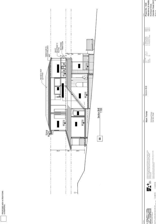
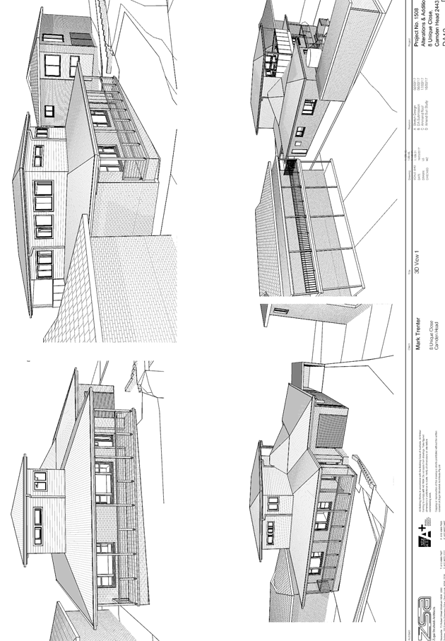
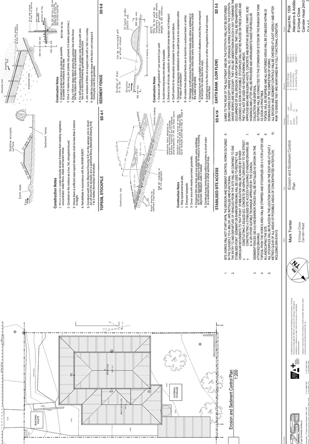
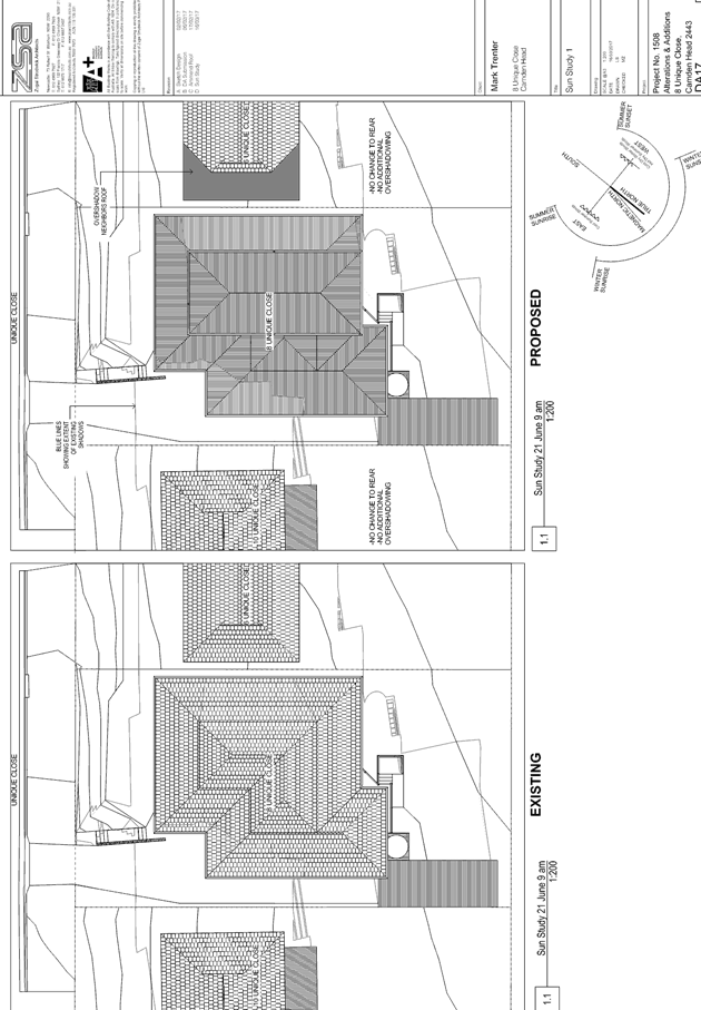
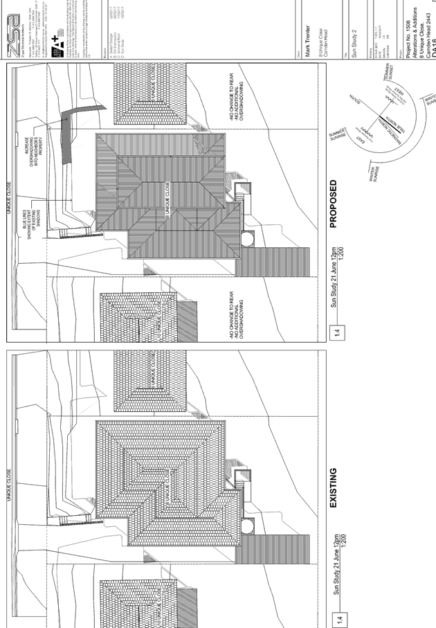
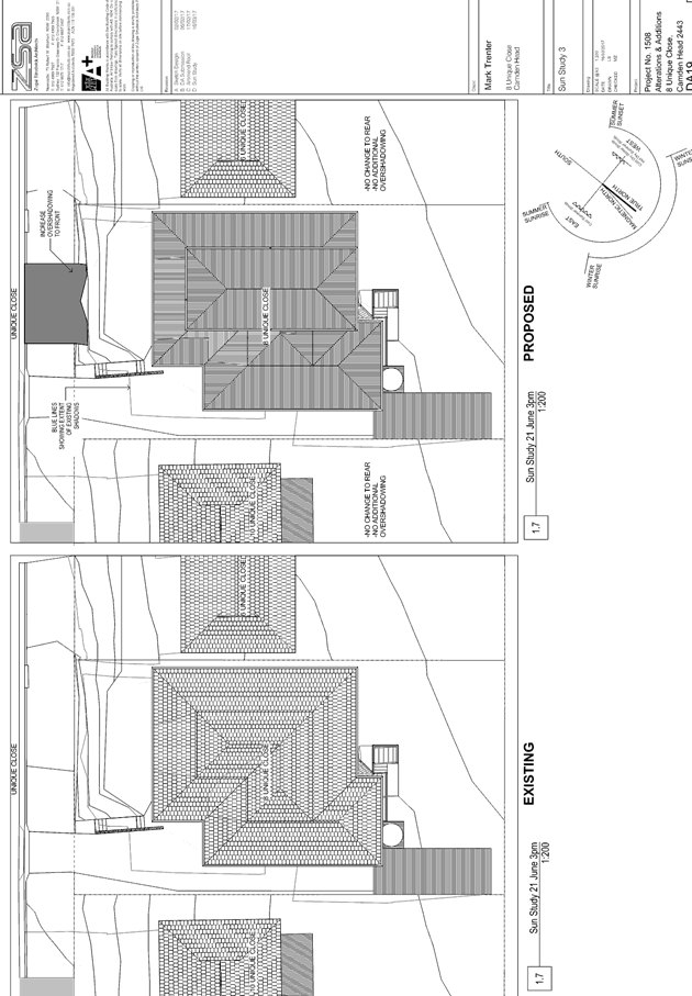
|
ATTACHMENT
|
Development Assessment Panel
12/04/2017
|
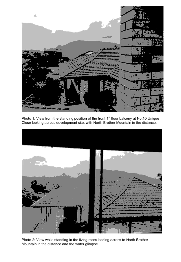
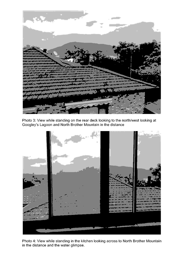
|
ATTACHMENT
|
Development Assessment Panel
12/04/2017
|
|
ATTACHMENT
|
Development Assessment Panel
12/04/2017
|
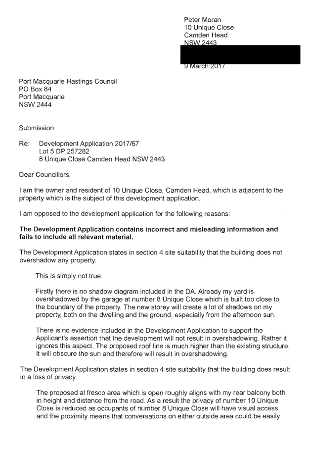
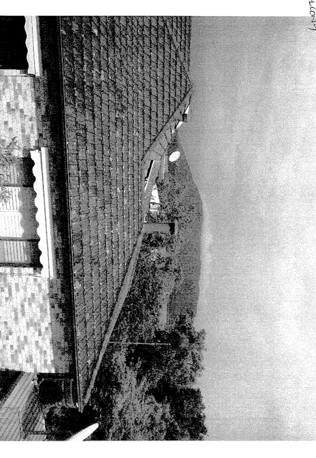
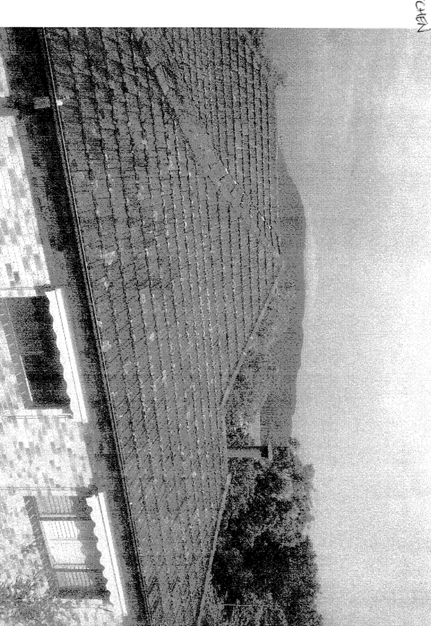

AGENDA Development Assessment Panel 12/04/2017
Item: 10
Subject: DA2017 - 109.1 Part Use Of Existing Dwelling
For Bed And Breakfast Establishment - Lot 84 DP 1063863,No 20 Admirals Circle,
Lakewood
Report
Author: Fiona Tierney
|
Applicant: D
G SELWAY & R M SELWAY
Owner: D
G SELWAY & R M SELWAY
Estimated Cost: NIL
Alignment with Delivery
Program
4.9.2 Undertake transparent
and efficient development assessment in accordance with relevant legislation.
|
|
RECOMMENDATION
That
DA 2017 - 109 for a part use
of existing dwelling for Bed and Breakfast Establishment at Lot 84, DP 1063863, No. 20 Admirals
Circle, Lakewood, be determined by granting consent subject to the
recommended conditions.
|
Executive
Summary
This
report considers a development application for a Bed and Breakfast
Establishment at the subject site and provides an
assessment of the application in accordance with the Environmental Planning and
Assessment Act 1979.
Following exhibition of the
application, one (1) submission has been
received.
1. BACKGROUND
Existing sites features and Surrounding development
The site has an area of 866m2.
The site is zoned R1-General Residential in accordance with the Port Macquarie-Hastings Local
Environmental Plan 2011, as shown in the following zoning plan:
The existing subdivision pattern and location of existing
development within the locality is shown in the following aerial photograph:
2. DESCRIPTION OF
DEVELOPMENT
Key aspects of the proposal include the following:
· Use
of two existing bedrooms, lounge area and bathroom as a Bed and Breakfast
establishment
Refer
to attachments at the end of this report.
Application Chronology
· 17
February 2017 - DA lodged.
· 27 February-13 March 2017 - Neighbour notification of
proposal
3. STATUTORY ASSESSMENT
Section 79C(1) Matters for Consideration
In determining the application, Council is required to take
into consideration the following matters as are relevant to the development
that apply to the land to which the development application relates:
(a) The provisions (where
applicable) of:
(i) any Environmental Planning
Instrument:
State Environmental Planning Policy No.
44 - Koala Habitat Protection
There is no Koala Plan of
Management on the site. Additionally, the site is less than 1ha in area
therefore no further investigations are required.
State
Environmental Planning Policy No.55 – Remediation of Land
Following an inspection of the site and a
search of Council records, the subject land is not identified as being
potentially contaminated and is suitable for the intended use.
State
Environmental Planning Policy No. 71 – Coastal Protection and Clause 5.5
of Port Macquarie-Hastings Local Environmental Plan 2011
The site is
located within a coastal zone as defined in accordance with clause 4 of SEPP
71.
In accordance
with clause 5, this SEPP prevails over the Port Macquarie-Hastings LEP 2011 in
the event of any inconsistency.
Having regard to
clauses 8 and 12 to 16 of SEPP 71 and clause 5.5 of Hastings LEP 2011 inclusive
the proposed development will not result in any of the following:
a) any
restricted access (or opportunities for access) to the coastal foreshore;
b) any
identifiable adverse amenity impacts along the coastal foreshore and on the
scenic qualities of the coast;
c) any
identifiable adverse impacts on any known flora and fauna (or their natural environment);
d) subject
to any identifiable adverse coastal processes or hazards;
e) any
identifiable conflict between water and land based users of the area;
f) any
identifiable adverse impacts on any items of archaeological/heritage;
g) reduce
the quality of the natural water bodies in the locality.
The site is located within an area zoned
for residential purposes.
State Environmental Planning Policy
(Building Sustainability Index: BASIX) 2004
A BASIX
certificate has been submitted with the original dwelling proposal
demonstrating that the building complies with the requirements of the SEPP.
Port Macquarie-Hastings Local Environmental Plan 2011
The proposal is consistent with the LEP having regard to the
following:
· Clause 2.2, the subject
site is zoned R1 General Residential. In accordance with clause 2.3(1) and the
R1 zone landuse table, the dwelling (or ancillary structure to a dwelling) is a
permissible landuse with consent.
The objectives
of the R1 zone are as follows:
o To provide for
the housing needs of the community.
o To
provide for a variety of housing types and densities.
o To
enable other land uses that provide facilities or services to meet the day to
day needs of residents.
·
In accordance with Clause 2.3(2),
the proposal is consistent with the zone objectives as it is a permissible
landuse and consistent with the established residential locality,
· Clause
4.3, the maximum overall height of the building above ground level is existing.
· Clause
4.4, the floor space ratio is existing.
· Clause
5.9 - No listed trees in Development Control Plan 2013 are proposed to be
removed.
· Clause
5.10 – Heritage. The site does not contain or adjoin any known heritage
items or sites of significance.
· Clause 7.13,
satisfactory arrangements are in place for provision of essential services.
(ii) Any
draft instruments that apply to the site or are on exhibition:
No draft
instruments apply to the site.
(iii) any
Development Control Plan in force:
Port
Macquarie-Hastings Development Control Plan 2013
|
DCP 2013: Dwellings, Dual
occupancies, Dwelling houses, Multi dwelling houses & Ancillary
development
|
|
|
Requirements
|
Proposed
|
Complies
|
|
3.2.2.10
|
Privacy:
• Direct views
between living areas of adjacent dwellings screened when within 9m radius of
any part of window of adjacent dwelling and within 12m of private open space
areas of adjacent dwellings. ie. 1.8m fence or privacy screening which has
25% max. openings and is permanently fixed
• Privacy screen
required if floor level > 1m height, window side/rear setback (other than
bedroom) is less than 3m and sill height less than 1.5m
• Privacy screens
provided to balconies/verandahs etc which have <3m side/rear setback and
floor level height >1m
|
No identifiable direct views
between living areas of adjacent dwellings when within 9m radius. No dwelling
located on the adjoining lot.
No privacy screens or changes to
window sill heights recommended.
Deck set in approximately 8m from
side boundary.
|
Yes
|
|
DCP 2013: General
Provisions
|
|
|
Requirements
|
Proposed
|
Complies
|
|
2.7.2.2
|
Design addresses generic principles of Crime Prevention
Through Environmental Design guideline
|
Adequate casual surveillance available
|
Yes
|
|
2.4.3
|
Bushfire risk, Acid sulphate soils, Flooding,
Contamination, Airspace protection, Noise and Stormwater
|
Refer to main body of report.
|
|
|
2.5.3.2
|
New accesses not permitted from arterial or distributor
roads
|
No change to existing single driveway point
|
Yes
|
|
Driveway crossing/s minimal in number and width including
maximising street parking
|
|
2.5.3.3
|
Parking in accordance with Table 2.5.1.
1 space per single dwelling (behind building line)
|
2 parking spaces within garage and 2 available stack
parked in front of garage.
|
Yes
|
(iiia) any
planning agreement that has been entered into under Section 93f or any draft
planning agreement that a developer has offered to enter into under Section
93f:
No planning
agreement has been offered or entered into relating to the site.
iv) any matters prescribed by the
Regulations:
New South Wales Coastal Policy:
The proposed
development is consistent with the objectives and strategic actions of this
policy.
v) any coastal
zone management plan (within the meaning of the Coastal Protection Act 1979),
that apply to the land to which the development application relates:
None
applicable
(b) The
likely impacts of that development, including environmental impacts on both the
natural and built environments, social and economic impacts in the locality:
Context and setting
• The
proposal will be unlikely to have any adverse impacts to existing adjoining
properties or the public domain.
• The proposal is considered to be sufficiently compatible
with other residential development in the locality and adequately addresses
planning controls for the area.
• There
are no adverse impacts on existing view sharing.
• There are no adverse privacy impacts, as justified earlier
in this report.
• There are no adverse overshadowing impacts.
Water, Sewer and Stormwater
Existing services available
Other Utilities
Telecommunication and electricity
services are available to the site.
Heritage
This site does not contain or
adjoin any known heritage item or site of significance.
Other land resources
The development is within an
existing dwelling in an established urban context. The porposal will not
sterilise any significant mineral or agricultural resource.
Water cycle
The proposed development will be
unlikely to have any adverse impacts on water resources and the water cycle.
Soils
No earthworks proposed.
Air and microclimate
The construction and/or
operations of the proposed development will be unlikely to result in any
adverse impacts on the existing air quality or result in any pollution.
Flora and fauna
Construction of the proposed
development will not require removal of any vegetation.
Waste
Satisfactory arrangements are in
place for proposed storage and collection of waste and recyclables. No adverse
impacts anticipated.
Energy
No adverse impacts anticipated.
Noise and vibration
No adverse impacts anticipated.
Any noise from the premises is considered manageable.
Bushfire
The site is identified as being
bushfire prone and the construction has been completed in accordance with the
BAL level for the existing dwelling. Confirmation has also been sought and
received from the RFS confirming that Bed and Breakfast development at the site
is exempt from S100B requirements.
It should also be noted that the
bushfire boundary limits applying to the area are due to be relocated and the
subject site will be clear of bushfire affected designation and a future
proposal for Bed and Breakfast would be permitted to be a “complying
development”.
Safety, security and crime
prevention
The proposed development will be
unlikely to create any concealment/entrapment areas or crime spots that would
result in any identifiable loss of safety or reduction of security in the
immediate area.
Social impacts in the locality
Given the nature of the proposed
development and its’ location the proposal is unlikely to result in any
adverse social impacts.
Economic impact in the
locality
No adverse impacts. Likely
positive impacts can be attributed to the construction of the development and
associated flow on effects (ie increased expenditure in the area).
Site design and internal
design
The proposed development
satisfactorily responds to the existing dwelling and site attributes. No
adverse impacts likely.
Cumulative Impacts
The proposed
development is not expected to have any adverse cumulative impacts on the
natural or built environment or the social and economic attributes of the
locality.
(c) The suitability of the site for
the development:
The proposal
will fit into the locality and the site attributes are conducive to the
proposed development.
Site constraints
of bushfire risk have been adequately addressed and appropriate conditions of
consent recommended.
(d) Any submissions made in
accordance with this Act or the Regulations:
One written submission has been received following public
exhibition of the application.
Key issues raised in the submissions received and comments
in response to these issues are provided as follows:
|
Submission
Issue/Summary
|
Planning
Comment/Response
|
|
Will stays be a maximum of 4
nights per week?
|
B & B stays are unlikely
to have a 100% occupancy rate for this style of accommodation. The applicant
has offered to make a maximum stay per week but it is considered unnecessary
in the circumstances.
|
|
Will guests be permitted to
use whole house or just and exclusive/self contained area with a kitchen?
Fire regulations?
|
Guests will be permitted to
use entry through the upper level of the dwelling and will have exclusive use
of the two lower bedrooms, bathroom and deck area. Conditions will be applied
in relation to fire regulations as is standard to Bed and Breakfast
Establishments. Whilst a small bar fridge and microwave will be available on
this level-no separate kitchen facilities will be provided. A fire
extinguisher and fire blanket were present at the time of inspection.
|
|
Submission
Issue/Summary
|
Planning
Comment/Response
|
|
Access- side or internal- question safety
|
Whilst there is a small access
path down the side of the dwelling- access is generally to be via the
internal stairs.
|
|
Are dogs permitted?
|
Dogs are not proposed to be
permitted to stay with guests however there in no restriction within a
residential area on having pets.
|
|
Hours of operation 2pm-10am
|
Refers check in/check out
times
|
|
Privacy and noise concerns
-driveway, side access, lower deck.
|
The applicant proposes that
guests will utilise the internal entry and as they are retired and live on
site they will also expect guests to be well behaved and considerate.
Noise impacts are considered manageable.
|
|
Site suitability.
|
Site is considered suitable
and is a permitted use in the zone.
|
|
Advertising Signage
|
No signage is proposed-
however a small business sign would be permitted under exempt criteria.
|
|
Bushfire Risk
|
Refer to bushfire comments in
report. A bushfire assessment has been submitted and the existing dwelling
has been constructed to compliant BAL levels. It is noted that the next round
of RFS mapping proposes to remove the dwelling from being designated bushfire
prone land.
|
|
Increase in traffic and
unloading areas- safety
|
It is not expected that an
excessive number of traffic movements will be created through the use of the
site as a B & B. The applicants state they will only have one group at a
time and not take multiple groups at one time.
|
|
Waste disposal and storage
|
The applicant states this will
be managed and will be no more than a fully occupied 4 bedroom house. No
dinner is proposed to be provided.
|
|
Economic disadvantage to
commercial competitors
|
The proposal is permissible
use with consent and provided for a variety of accommodation within the area.
Economic disadvantage is not a consideration of this application.
|
(e) The Public Interest:
The proposed
development satisfies relevant planning controls and is unlikely to impact on
the wider public interest.
4. DEVELOPMENT
CONTRIBUTIONS APPLICABLE
Not applicable
5. CONCLUSION
The application has been assessed in accordance with
Section 79C of the Environmental Planning and Assessment Act 1979.
Issues raised during assessment and public exhibition of
the application have been considered in the assessment of the application.
Where relevant, conditions have been recommended to manage the impacts
attributed to these issues.
The site is suitable for the proposed development, is not
contrary to the public's interest and will not have a significant adverse
social, environmental or economic impact. It is recommended that the
application be approved, subject to the recommended conditions of consent
provided in the attachment section of this report.
|
Attachments
1View. DA2017
- 109.1 Plans
2View. DA2017
- 109.1 Recommended Conditions
3View. DA2017
- 109.1 Submission - Wilson
|
|
ATTACHMENT
|
Development Assessment Panel
12/04/2017
|
|
ATTACHMENT
|
Development Assessment Panel
12/04/2017
|

|
ATTACHMENT
|
Development Assessment Panel
12/04/2017
|