Business
Paper
|
date of meeting:
|
|
Wednesday 10 May
2017
|
|
location:
|
|
Function Room
Port
Macquarie-Hastings Council
17 Burrawan Street
Port Macquarie
|
|
time:
|
|
2:00pm
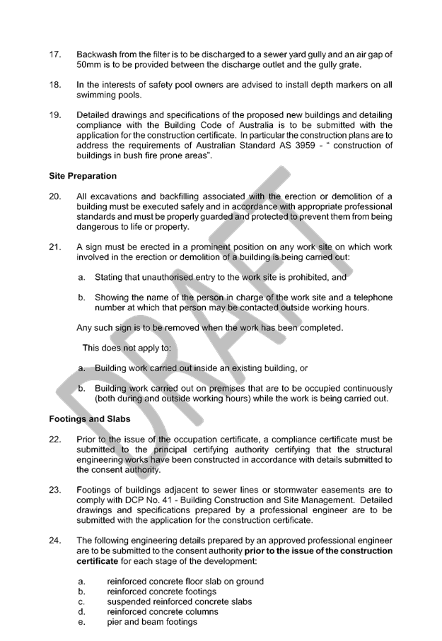
|
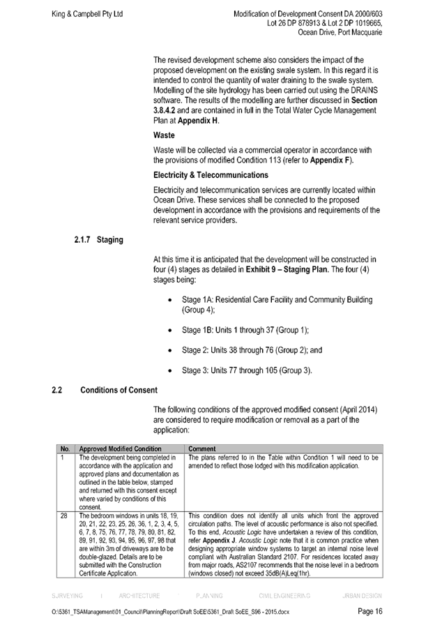
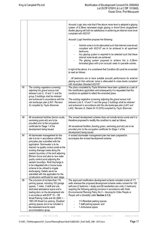
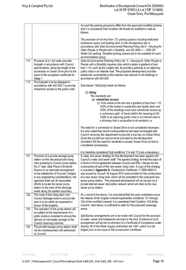
Development
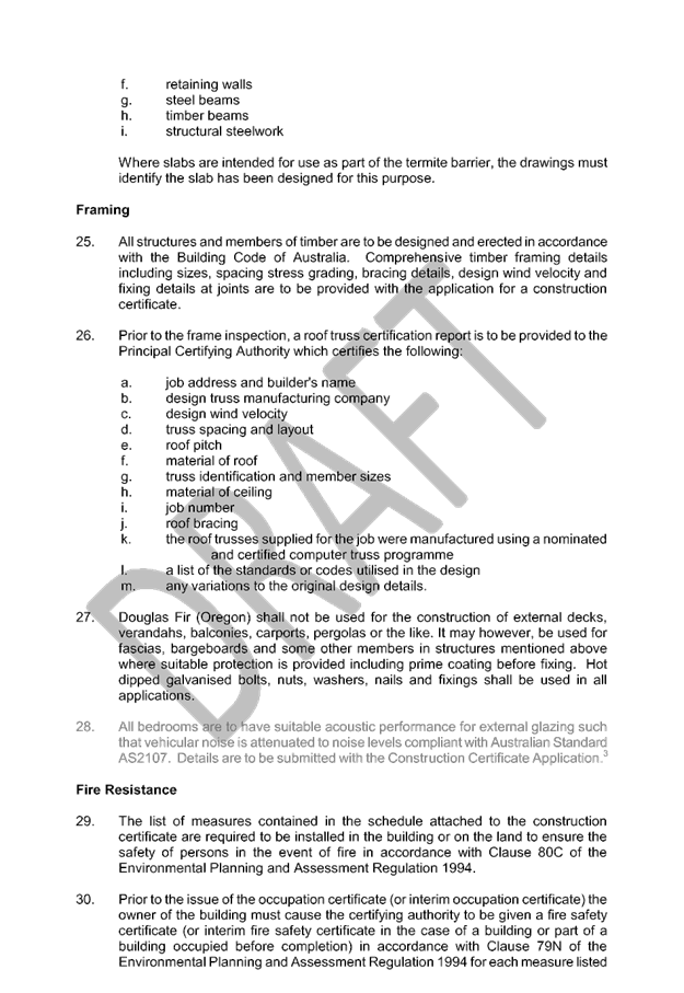
Assessment Panel
CHARTER
COMPOSITION:
Independent Chair (alternate, Director Development &
Environment)
Manager Development Assessment (alternate, Director Development & Environment or Development Assessment Planner)
Development Engineering Coordinator (alternate, Development
Engineer)
MISSION:
To assist in managing Council's
development assessment function
by providing independent and expert assessment of development applications
The Development Assessment Panel will make determinations on the basis of established criteria and practice and will not be influenced by "lobbying" and "weight of numbers" in its assessment process.
FUNCTIONS:
1.
To review development application reports and conditions
2.
To determine development applications outside of staff delegations
3.
To refer development applications to Council
for determination where necessary
4.
To provide a forum for objectors and applicants to make submissions on applications before DAP.
5.
To maintain transparency for the determination of development applications.
DELEGATED AUTHORITY:
1.
Pursuant to Section
377 of the Local Government Act, 1993 delegation to:
2.
Determine development applications under Part 4 of the Environmental Planning
and Assessment Act 1979
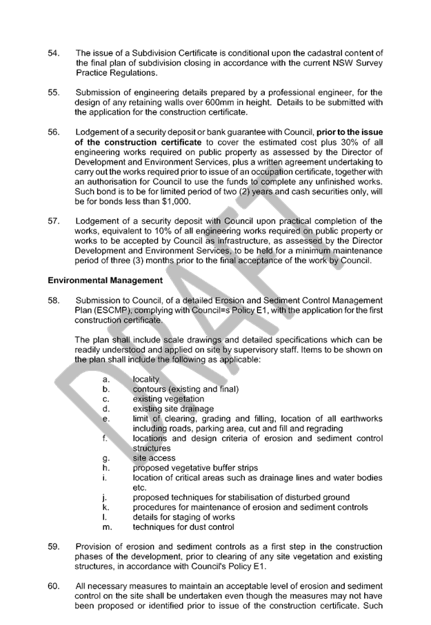
having regard to the relevant
environmental planning instruments, development control plans and Council
policies.
3.
Vary Modify or release restrictions as to use and/or covenants created
by Section 88B instruments under the Conveyancing Act 1919 in relation to
development applications for subdivisions being considered by the panel.
4.
Determine Koala Plans of Management under State Environmental Planning
Policy 44 - Koala Habitat Protection associated with development applications
being considered by the Panel.
TIMETABLE:
The Development Assessment Panel shall generally meet on the 1st and 3rd Wednesday each month at 2.00pm.
VENUE:
The venue will be
determined according to the likely
number of participants.
BUSINESS PAPER AND MINUTES:
1.
The Business Paper for the meeting shall be published
and distributed on the Friday prior
to the meeting.
2.
Special Meetings of the Panel may be convened by the Director
Development & Environment Services
with three (3) days notice.
3.
The format of the preparation and publishing of the Business
Paper and Minutes
of the Development Assessment Panel meetings shall be similar to the format
for Ordinary Council Meetings, except that the movers
and seconders shall not be recorded and only the actual decisions are shown.
Minutes shall also record how each member votes for each
item before the Panel.
FORMAT OF THE MEETING:
1.
Panel meetings shall be carried
out in accordance with Council's
Code of Meeting Practice for Council Sub-Committees, except where varied
by this Charter.
2.
Meetings shall be "Open" to the public.
3.
The Panel will hear from applicants and objectors or their representatives. Where considered necessary, the Panel will conduct site inspections which will be open to the
public.
INDEPENDENT CHAIR:
The Chair of the Development Assessment Panel shall be an independent person appointed by the General
Manager. The Independent Chair shall have experience and qualifications relevant to planning.
The term of the Independent Chair shall be four
(4) years.
QUORUM:
All members must be present at the Meeting to form a Quorum.
DECISION MAKING:
Decisions are to be made by the Development Assessment
Panel by "consensus". Where "consensus" is not possible,
the matter is to be referred to Council.
All development applications
involving a variation to a development standard greater than 10% under
Clause 4.6 of the Port Macquarie-Hastings Local Environmental Plan 2011 will be
considered by the Panel and recommendation made to the Council for determination.
Staff Members shall
not vote on matters before the Panel if they have been the principle author of the development assessment report.
LOBBYING:
Outside of scheduled
Development Assessment Panel meetings, applicants, their representatives, Councillors,
Council staff and the general public are not to lobby Panel members via
meetings, telephone conversations, correspondence and the like. Adequate
opportunity will be provided at Panel inspections or meetings for applicants,
their representatives and the general public to make verbal submissions in
relation to Business Paper items.
OBLIGATIONS OF PANEL
MEMBERS:
All DAP members
are required to comply with the following:
1.
Members must perform their Development Assessment Panel obligations faithfully and diligently and in accordance
with the DAP Code.
2.
DAP members must comply with Council's Code of Conduct.
3.
Except as required to properly perform
their duties, DAP members must not disclose
any confidential information (as advised by Council) obtained
in connection with the DAP functions.
4.
DAP members will have read and be familiar with the documents
and information provided
by Council prior to attending a DAP meeting.
5.
DAP members must act in accordance with Council's Occupational Health and Safety Policies and Procedures
6.
DAP members shall not speak to the media on any matter
before the Panel otherwise
than with the express approval
of the Director Development &
Environment Services.
Development Assessment Panel
ATTENDANCE
REGISTER
|
Member
|
22/02/17
|
8/3/17
|
22/03/17
|
12/04/17
|
10/05/17
|
|
Paul Drake
Matt Rogers (alternate)
|
P
|
P
|
P
|
P
|
P
|
|
Dan Croft
Patrick Galbraith-Robertson
Warren Wisemantel
(alternates)
|
P
|
P
|
P
|
P
|
P
|
|
David Troemel
Caroline Horan (alternate)
Bevan Crofts (alternate)
Grant Burge (alternate)
|
P
|
A
P
|
P
|
P
|
P
|
Key: P = Present
A
= Absent With Apology
X
= Absent Without Apology
Development
Assessment Panel Meeting
Wednesday 10 May 2017
Items of Business
01 Acknowledgement
of Country............................................................................ 7
02 Apologies......................................................................................................... 7
03 Confirmation
of Minutes.................................................................................... 7
04 Disclosures
of Interest..................................................................................... 12
05 DA2000
- 603.4 Modification To Aged Care Facility - Lot 26 DP 878913, Lot 2 DP
1019665, 821 Ocean Drive, Port Macquarie ........................................................................... 16
06 DA2015
- 698.2 Modification To Childcare Centre - Lot 2 DP 808998, 156 Horton Street,
Port Macquarie..................................................................................................... 131
07 DA2017
- 37.1 - Dwelling - Lot 72 DP 238688, No 19 Jasmine Street, Port Macquarie 173
08 DA2017
- 97.1 Additons To Existing Dwelling - Lot 24 DP 20480, No 18 Bundella Avenue
Lake Cathie........................................................................................................... 226
09 DA2017
- 99.1 Alterations And Additions To Dwelling Including Clause 4.6 Objection To
Clause 4.3 (Height Of Buildings) Of The Port Macquarie -Hastings Local
Environmental Plan 2011 And Construction Of Swimming Pool - Lot 31 DP 231816,
No 21 Matthew Flinders Drive, Port Macquarie..................................................................................................... 245
10 DA2017
- 181.1 Alterations And Additions To Dwelling And Boundary Fence - Lot 33 DP
1069338, No 76 The Anchorage, Port Macquarie.............................................. 266
11 DA2016
- 801.1 - Service Station And Signage - Lot 20 DP 1191370 No. 16 Sancrox Road,
Sancrox........................................................................................................ 316
12 General
Business
AGENDA Development Assessment Panel 10/05/2017
Subject: ACKNOWLEDGEMENT
OF COUNTRY
"I acknowledge that we are
gathered on Birpai Land. I pay respect to the Birpai Elders both past and
present. I also extend that respect to all other Aboriginal and Torres Strait
Islander people present."
RECOMMENDATION
That the apologies received be
accepted.
Subject: CONFIRMATION
OF PREVIOUS MINUTES
Recommendation
That the Minutes of the Development
Assessment Panel Meeting held on 12 April 2017 be confirmed.
MINUTES Development Assessment
Panel
Meeting
12/04/2017
PRESENT
Members:
Paul
Drake
Dan Croft
Grant Burge
Other Attendees:
Pat-Galbraith Robertson
Chris Gardiner
Fiona Tierney
|
The meeting opened at 2:00pm.
|
|
01 ACKNOWLEDGEMENT
OF COUNTRY
|
|
The
Acknowledgement of Country was delivered.
|
|
02 APOLOGIES
|
|
CONSENSUS:
That
the apology received from David Troemel be accepted.
|
|
03 CONFIRMATION
OF MINUTES
|
|
CONSENSUS:
That
the Minutes of the Development Assessment Panel Meeting held on 22 March 2017
be confirmed.
|
|
04 DISCLOSURES OF INTEREST
|
|
Dan Croft declared a non-pecuniary less than
significant interest in Item 8 as he has a vessel registered with the Port
Macquarie Marine Rescue Group. He considered this a less than significant
interest due to the minor nature of the registration fee.
|
|
05 DA2002 - 169.2
& DA2016 - 939.1 Modification To Design Of Previous Approved Residential
Subdivision And 6 Additional New Lots - Lot 505 DP 1192771, Greenmeadows
Drive, Port Macquarie
|
|
Speaker:
Tony Thorne (applicant)
CONSENSUS:
1. That Section 96 modification application DA2002 - 169 for
a alterations to design of residential subdivision at Lot 505, DP 1192771,
Greenmeadows Drive, Port Macquarie, be
determined by granting consent subject to the recommended modified
conditions.
2. That DA2016 - 939 for a subdivision involving an
additional 6 torrens title lots at Lot 505, DP 1192771,
Greenmeadows Drive, Port Macquarie, be
determined by granting consent subject to the recommended conditions and as
amended below.
·
Add the words ‘,unless otherwise agreed to by
Council.’ At the end of Advice F.
|
|
06 DA2016 - 942.1
Retail Premises at Lot 4 Sec A DP 975586, No. 52 Cameron Street, Wauchope
Street
|
|
Correspondence was tabled at the
meeting from Victoria Hari objecting to the proposal.
Correspondence was tabled at the
meeting from Derek Collins being the applicant in support of the proposal.
Speakers:
Harry Hari (o)
David Hore (applicant)
CONSENSUS:
That DA
2016 - 942.1 for a Retail Premises at Lot 4, Sec A DP 975586, No. 52 Cameron Street, Wauchope, be
determined by granting consent subject to the recommended conditions.
|
|
07 DA2016 - 984.1
Staged construction Of Multi Dwelling Housing With Torrens Title
Subdivision - Lots 10 & 11Sec F, DP 24850, No 54 Kalinda Drive, Port
Macquarie
|
|
Speaker:
Michelle Love (applicant)
CONSENSUS:
That DA
2016 - 984 for a staged construction
of multi dwelling housing with torrens title subdivision at Lot 10 & 11, DP 24850, No. 54 Kalinda
Drive, Port Macquarie, be determined by granting consent subject to the recommended
conditions.
|
|
08 DA2017 - 32.1
- Addition Of Floating Pontoon And Storage Shed For Jet Skis Associated With
an emergency services facility (Marine Rescue) - Lot 1 DP 1064060, Buller
Street, Port Macquarie
|
|
Speaker :
Graham McPherson (0)
The Panel was unable to reach
consensus.
For:
Dan Croft and Grant Burge
Against:
Paul Drake
The dissenting recommendation
from Paul Drake was:
‘DA2017- 32 for an
addition of floating pontoon and storage shed for jet skis associated with an
emergency services facility (Marine Rescue) at Lot 1 and 2 DP 1064060, No.
11A Buller Street, Port Macquarie, be determined by refusing consent for the
following reason: That the proposal will have an adverse visual impact. The
subleasing of space within the existing Marine Rescue building, which could
otherwise house the jet skis, should not be used as a reason to support the
proposal.’
|
|
09 DA2017
- 67.1 Additions To Dwelling - Lot 5 DP 257282, No 8 Unique Close
Camden Head
|
|
Speakers:
Peter
Moran (o)
Lisa
Strudwick (applicant)
CONSENSUS:
That DA 2017 - 67.1for
additions to dwelling at Lot 5, DP257282, No.8 Unique Close, Camden Head, be
determined by granting consent subject to the recommended conditions.
|
|
10 DA2017 - 109.1
Part Use Of Existing Dwelling For Bed And Breakfast Establishment - Lot 84 DP
1063863,No 20 Admirals Circle, Lakewood
|
|
Correspondence was tabled at the
meeting from Nigel Wilson objecting to the proposal.
Speaker:
Don Selway (applicant)
CONSENSUS:
That DA
2017 - 109 for a part use of existing
dwelling for Bed and Breakfast Establishment at Lot
84, DP 1063863, No. 20 Admirals Circle, Lakewood, be
determined by granting consent subject to the recommended conditions.
|
|
The meeting closed at 3:05am.
|
AGENDA Development Assessment Panel 10/05/2017
Subject: DISCLOSURES
OF INTEREST
RECOMMENDATION
That Disclosures of Interest be presented
DISCLOSURE OF
INTEREST DECLARATION
Name of Meeting: ………………………………………………………………………..
Meeting Date: ………………………………………………………………………..
Item Number: ………………………………………………………………………..
Subject: ………………………………………………………………………..
…………………………………………………….……………...…..
I,
.....................................................................................
declare the following interest:
 Pecuniary:
Take
no part in the consideration and voting and be out of sight of the meeting.
Non-Pecuniary
- Significant Interest:
Take
no part in the consideration and voting and be out of sight of the meeting.
Non-Pecuniary
- Less than Significant Interest:
May
participate in consideration and voting.
For the reason that:
....................................................................................................
.......................................................................................................................................
Name:
…………………………………………………….
Signed:
.........................................................................
Date: ..................................
 (Further
explanation is provided on the next page)
(Further
explanation is provided on the next page)
Further
Explanation
(Local Government Act and Code of Conduct)
A conflict of interest exists where a reasonable and informed
person would perceive that a Council official could be influenced by a private
interest when carrying out their public duty. Interests can be of two types:
pecuniary or non-pecuniary.
All interests, whether pecuniary or non-pecuniary are required to
be fully disclosed and in writing.
Pecuniary Interest
A pecuniary interest is an interest that a Council official has in
a matter because of a reasonable likelihood or expectation of appreciable
financial gain or loss to the Council official. (section 442)
A Council official will also be taken to have a pecuniary interest
in a matter if that Council official’s spouse or de facto partner or a
relative of the Council official or a partner or employer of the Council
official, or a company or other body of which the Council official, or a
nominee, partner or employer of the Council official is a member, has a
pecuniary interest in the matter. (section 443)
The Council official must not take part in the consideration or
voting on the matter and leave and be out of sight of the meeting. The
Council official must not be present at, or in sight of, the meeting of
the Council at any time during which the matter is being considered or
discussed, or at any time during which the council is voting on any question in
relation to the matter. (section 451)
Non-Pecuniary
A non-pecuniary interest is an interest that is private or
personal that the Council official has that does not amount to a pecuniary
interest as defined in the Act.
Non-pecuniary interests commonly arise out of family, or personal
relationships, or involvement in sporting, social or other cultural groups and
associations and may include an interest of a financial nature.
The political views of a Councillor do not constitute a private
interest.
The management of a non-pecuniary interest will depend on whether
or not it is significant.
Non Pecuniary – Significant Interest
As a general rule, a non-pecuniary conflict of interest will be
significant where a matter does not raise a pecuniary interest, but it
involves:
(a)
A relationship between
a Council official and another person that is particularly close, for example,
parent, grandparent, brother, sister, uncle, aunt, nephew, niece, lineal
descendant or adopted child of the Council official or of the Council official’s
spouse, current or former spouse or partner, de facto or other person living in
the same household.
(b)
Other relationships
that are particularly close, such as friendships and business relationships.
Closeness is defined by the nature of the friendship or business relationship,
the frequency of contact and the duration of the friendship or relationship.
(c)
An affiliation between
a Council official an organisation, sporting body, club, corporation or
association that is particularly strong.
If a Council official declares a non-pecuniary significant
interest it must be managed in one of two ways:
1.
Remove the source of
the conflict, by relinquishing or divesting the interest that creates the
conflict, or reallocating the conflicting duties to another Council official.
2.
Have no involvement in
the matter, by taking no part in the consideration or voting on the matter and
leave and be out of sight of the meeting, as if the provisions in section
451(2) apply.
Non Pecuniary – Less than Significant Interest
If a Council official has declared a non-pecuniary less than
significant interest and it does not require further action, they must provide
an explanation of why they consider that the conflict does not require further
action in the circumstances.
SPECIAL
DISCLOSURE OF PECUNIARY INTEREST DECLARATION
|
By
[insert full name of councillor]
|
|
|
In the
matter of
[insert name of environmental planning instrument]
|
|
|
Which is
to be considered at a meeting of the
[insert name of meeting]
|
|
|
Held on
[insert date of meeting]
|
|
|
PECUNIARY
INTEREST
|
|
Address of land in which councillor or an
associated person, company or body has a proprietary interest (the identified
land)i
|
|
|
Relationship of identified land to councillor
[Tick or cross one box.]
|
Councillor
has interest in the land (e.g. is owner or has other interest arising out of
a mortgage, lease trust, option or contract, or otherwise).
Associated
person of councillor has interest in the land.
Associated
company or body of councillor has interest in the land.
|
|
MATTER
GIVING RISE TO PECUNIARY INTEREST
|
|
Nature of land that is subject to a change
in zone/planning control by proposed
LEP (the subject land iii
[Tick or cross one box]
|
The
identified land.
Land
that adjoins or is adjacent to or is in proximity to the identified land.
|
|
Current zone/planning control
[Insert name of current planning instrument and
identify relevant zone/planning control applying to the subject land]
|
|
|
Proposed change of zone/planning control
[Insert name of proposed LEP and identify
proposed change of zone/planning control applying to the subject land]
|
|
|
Effect of proposed change of zone/planning control
on councillor
[Tick or cross one box]
|
Appreciable
financial gain.
Appreciable
financial loss.
|
|
|
|
Councillor’s
Name: …………………………………………
Councillor’s
Signature:
……………………………….
Date: ………………..
Important Information
This information is being
collected for the purpose of making a special disclosure of pecuniary interests
under sections 451 (4) and (5) of the Local Government Act 1993.
You must not make a special disclosure that you know or ought reasonably to
know is false or misleading in a material particular. Complaints made
about contraventions of these requirements may be referred by the
Director-General to the Local Government Pecuniary Interest and Disciplinary
Tribunal.
This form must be completed by
you before the commencement of the council or council committee meeting in
respect of which the special disclosure is being made. The
completed form must be tabled at the meeting. Everyone is entitled to
inspect it. The special disclosure must be recorded in the minutes of the
meeting.
i.
Section 443 (1) of the Local Government Act 1993 provides that
you may have a pecuniary interest in a matter because of the pecuniary interest
of your spouse or your de facto partner or your relativeiv or
because your business partner or employer has a pecuniary interest. You may
also have a pecuniary interest in a matter because you, your nominee, your
business partner or your employer is a member of a company or other body that
has a pecuniary interest in the matter.
ii.
Section 442 of the Local Government Act 1993 provides that a pecuniary
interest is an interest that a person has in a matter because of a
reasonable likelihood or expectation of appreciable financial gain or loss to
the person. A person does not have a pecuniary interest in a matter if the
interest is so remote or insignificant that it could not reasonably be regarded
as likely to influence any decision the person might make in relation to the
matter or if the interest is of a kind specified in section 448 of that
Act (for example, an interest as an elector or as a ratepayer or person liable
to pay a charge).
iii.
A pecuniary interest may arise by way of a change of permissible use of land
adjoining, adjacent to or in proximity to land in which a councillor or a
person, company or body referred to in section 443 (1) (b) or (c) of the
Local Government Act 1993 has a proprietary interest..
iv.
Relative is defined by the Local Government Act 1993 as
meaning your, your spouse’s or your de facto partner’s parent,
grandparent, brother, sister, uncle, aunt, nephew, niece, lineal descendant or
adopted child and the spouse or de facto partner of any of those persons.
AGENDA Development Assessment Panel 10/05/2017
Item: 05
Subject: DA2000 - 603.4 Modification To Aged Care
Facility - Lot 26 DP 878913, Lot 2 DP 1019665, 821 Ocean Drive, Port Macquarie
Report
Author: Benjamin Roberts
|
Applicant: King
& Campbell Pty Ltd
Owner: RSL
Lifecare Limited
Estimated Cost: N/A
Alignment with Delivery
Program
4.9.2 Undertake transparent
and efficient development assessment in accordance with relevant legislation.
|
|
RECOMMENDATION
That
the section 96 modification application to DA2000 - 603 for an aged care
facility at Lot 26, DP 878913 and Lot 2 DP 1019665, No. 821 Ocean Drive,
Port Macquarie, be determined by granting consent subject to the recommended
modified conditions.
|
Executive
Summary
This
report considers a section 96 modification application to an approved
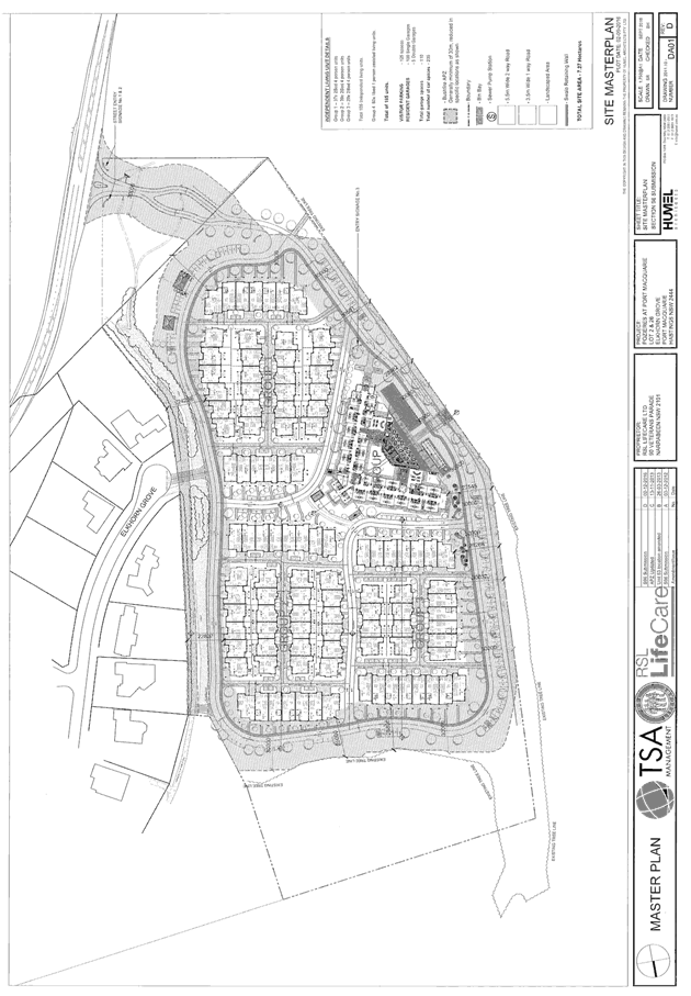
retirement complex on the subject site. In summary the proposed modification
application proposes the following changes:
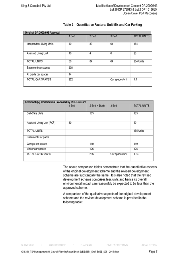
· Reduction
in units numbers from 204 to 185;
· General
reduction in building heights;
· Provide
all parking spaces at grade (i.e. no basement parking) and increase parking
from 222 spaces to 235 spaces.
This
report provides an assessment of the application in accordance with the
Environmental Planning and Assessment Act 1979.
Following exhibition of the
application, two (2) submissions have been
received.
1. BACKGROUND
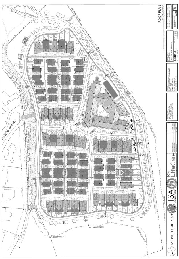
Existing sites features and Surrounding development
The
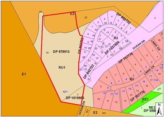
site has a total area of 7.821 hectares. The site is zoned RU1 Primary Production and E2
Environmental Conservation in accordance with the
Port Macquarie-Hastings Local Environmental Plan 2011, as shown in the
following zoning plan:
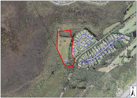
The existing subdivision pattern and location of existing
development within the locality is shown in the following aerial photograph:
Application History
A deferred commencement consent was issued by
Council on 20 November 2000 for a retirement complex on the site. The complex
comprised 204 residential aged care units and administration facilities. The
approval was granted pursuant to the provisions of SEPP 5 - Housing for Older
People or People with a Disability.
On 7 December 2001 Council confirmed that all deferred
commencement conditions were satisfied and the date consent was to operate was
7 December 2001. A Construction Certificate for the intersection access works
to Ocean Drive was issued by Council on 27 June 2002. Survey and land clearing
works for the purposes of the intersection were undertaken and inspected by
Council on 5 December 2006. It is evident that physical commencement has
occurred and the consent remains active.
Council
granted consent to modify the application on 26 March 2014 which in summary
provided a reduction in units numbers from 204
to 171 units and reconfiguration of units, general reduction in building
heights and provide all parking spaces at grade (i.e. no basement parking).
2. DESCRIPTION OF
DEVELOPMENT
Key aspects of the modification proposal include the
following:
· Reduction
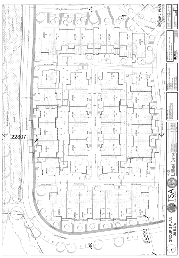
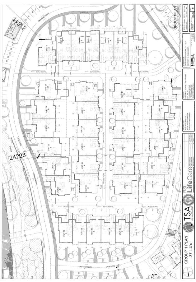
in units numbers from 204 to 185. Of the 185 units, 105 are serviced self care
units and 80 assisted living units;
· General
reduction in building heights;
· Provide
all parking spaces at grade (i.e. no basement parking) and increase parking
from 222 spaces to 235 spaces.
Refer
to attachments at the end of this report.
Application Chronology
· 7
December 2016 - Application lodged.
· 16 December 2016 to 13 January 2017 - Exhibition via
neighbour notification.
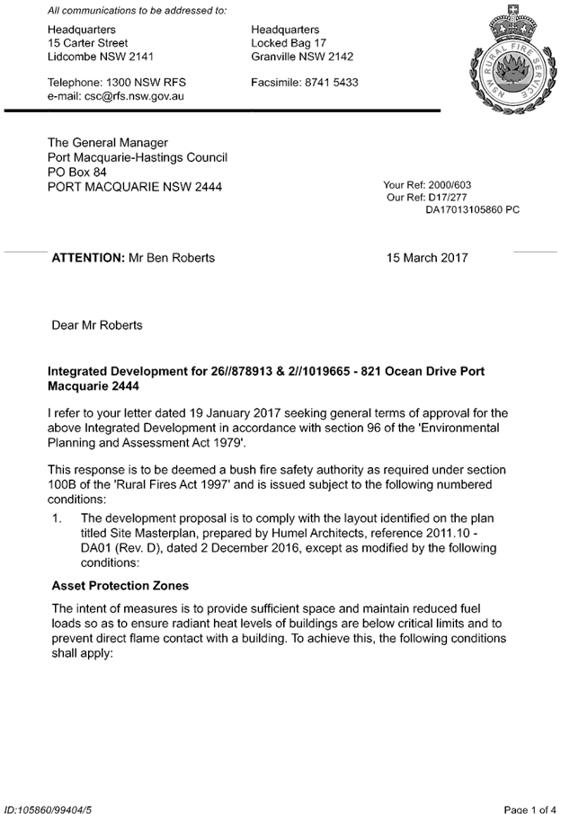
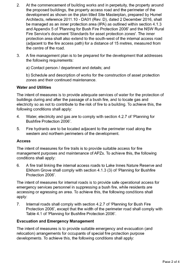
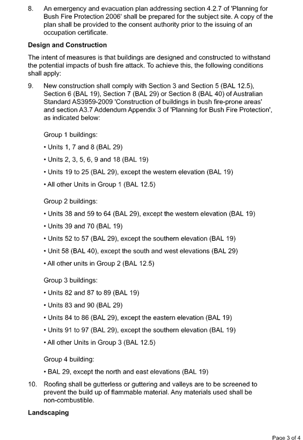
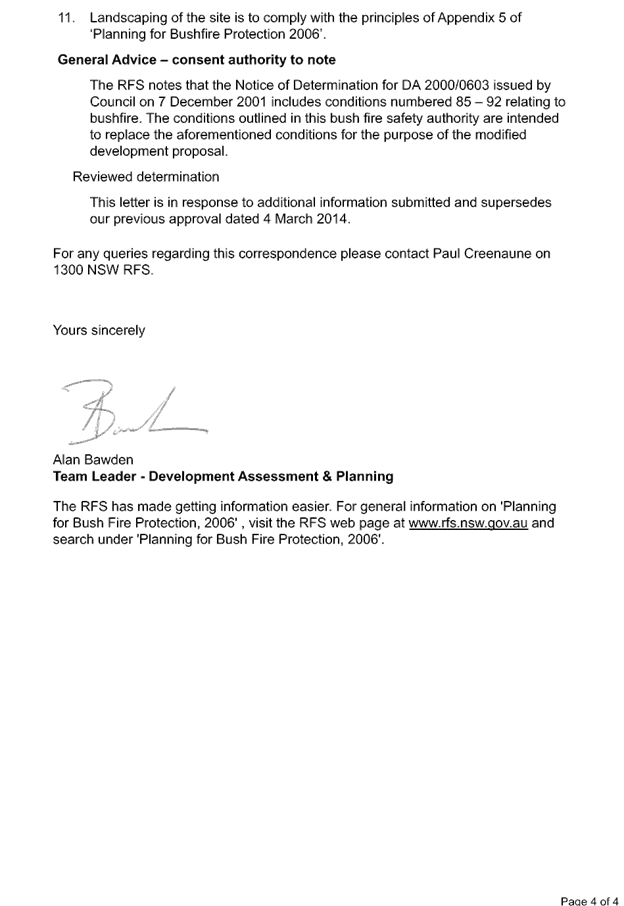
· 19 January 2017 - Referral to NSW Rural Fire Service (RFS).
· 27 February 2017 - Additional information request from
Rural Fire Service.
· 3 March 2017 - Applicant response to RFS information
request.
· 7 March 2017 - Referral of additional information to RFS.
· 16 March 2017 - Revised Bushfire Safety Authority received
from RFS.
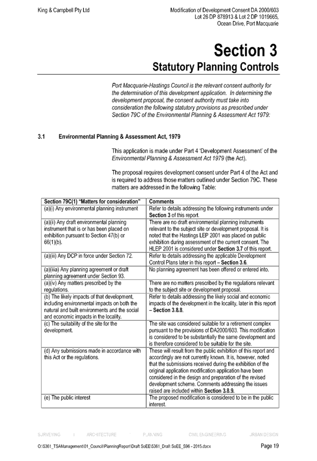
3. STATUTORY ASSESSMENT
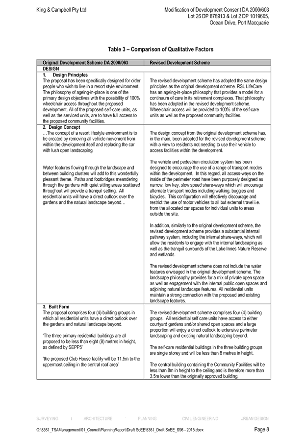
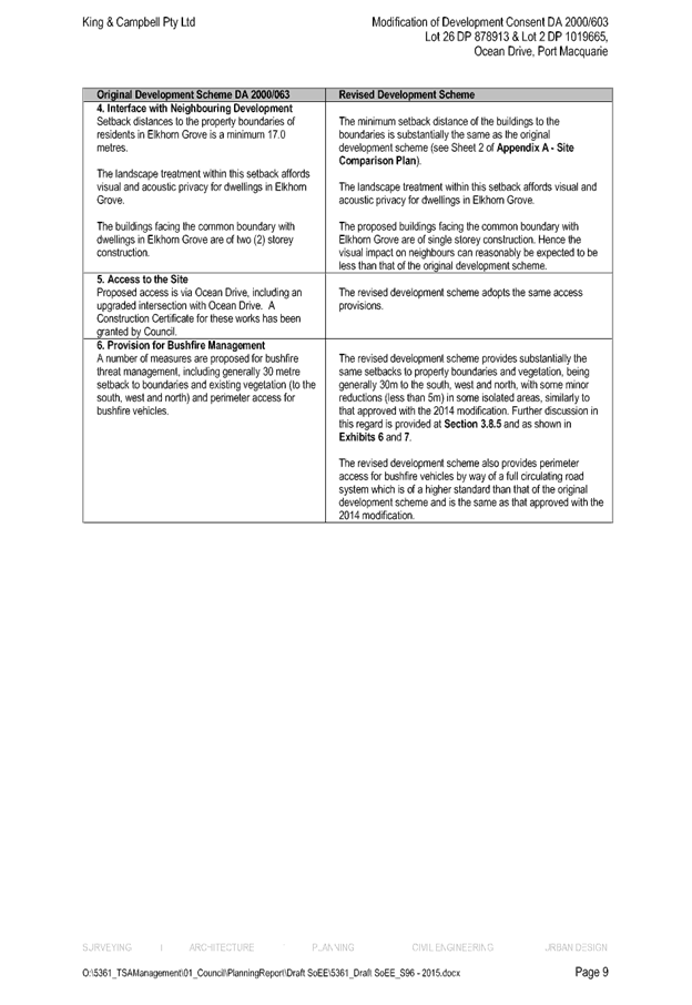
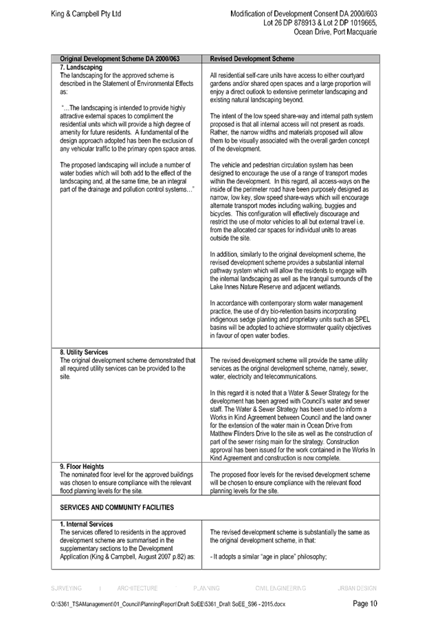
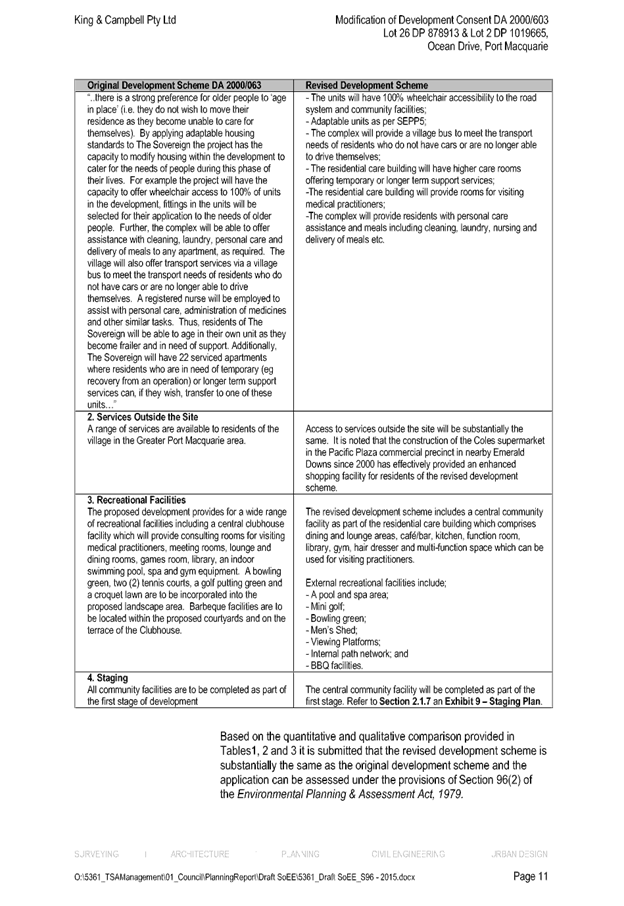
Is the proposal substantially the same?
Section 96 of the Environmental
Planning and Assessment Act 1979 enables the modification of consents and
categorises modification into three categories - S.96 (1) for modifications
involving minor error, misdescription or miscalculation; S.96 (1A) for
modifications involving minimal environmental impact; and S.96 (2) for other
modifications. Each type of modification must be considered as being
substantially the same to that which was originally consented to.
In Tyagrah Holdings Pty
Limited v Byron Shire Council (2008) NSWLEC 1420, Commissioner Bly sets out
a number of principles that can be utilised in determining whether a
development is substantially the same:
- ‘The word substantially means
essentially or materially or having the same essence. In assessing whether the
test is met a factual comparison between the approved development and the
proposed modifications is required.
- The question must be asked and answered
with respect to the particular circumstances of the individual modification
application
It is for the decision maker to decide the relevant range of facts to assist in
determining the question.
- Even though certain modifications of a
development may be described as significant this does not mean that the
modified development could not necessarily remain substantially the same as the
approved development.
- The comparison process involves an
appreciation both qualitative and quantitative of the development being
compared in its proper context.
- Any planning appraisal of the modified
development is not relevant to the threshold question.’
The subject application is being
considered under the provisions of Section 96(2). The
proposal is considered to be substantially the same development to that which
was originally consented to. Having regard to the above principles, the
proposed modifications are not considered to alter the fundamental
essence of the original development for the following reasons:
- The
intended use remains the same.
- The reduction in the number of units from
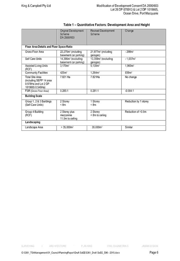
204 to 185 represents a 9.3% change. This is considered to be relatively minor in
the context of the overall development.
- The footprint of the development has
remained substantially the same with the development still comprising 4
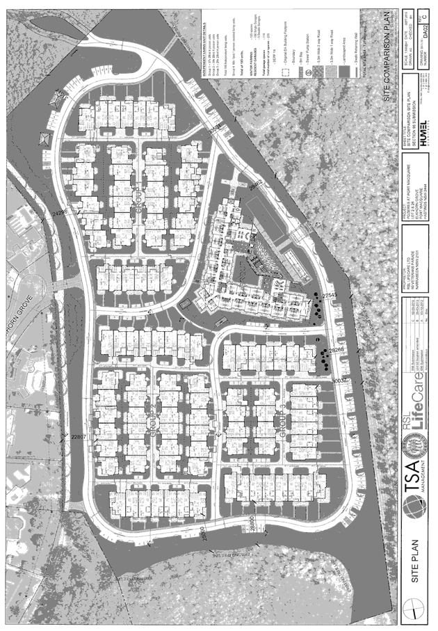
distinct groups of buildings. When viewed holistically, the site plan
illustrates the similarities in function and layout of the development to that
which was originally approved.
- The Floor space ratio of the development has
only changed from 0.285:1 to 0.281:1.
- Building setbacks to neighbouring properties
are substantially the same.
- Access to the site remains the same.
- The landscaped areas, communal facilities
and open apace areas are similar in scale and location to that which was
originally approved.
- No changes to conditions of consent are
sought that would fundamentally alter the intent of the original development
and consent.
- The reduction in building height, whilst
noticeable for a number of the building groups (from 2 to 1 storey) and the
removal of basement parking and addition of perimeter road are obvious changes.
The changes are not considered to be of such significance, when taking into
account other quantitative and qualitative factors mentioned above, to result
in an overall development that is radically different and not substantially the
same.
Whilst a degree of caution needs
to be taken in comparing the proposal to case law (given the varying nature and
contexts of development proposals), the following examples are considered to
demonstrate that S96 enables significant changes to components of a development
that do not amount to such a change that results in a substantial or radical
change to the overall development:
-
In Davi Developments Pty Ltd v Leichardt Council (2007) NSWLEC 106,
Justice Talbot found that reducing the number of units within a residential
flat building from 42 to 30, reduction in storeys from 7 to 6 and an entirely
different car parking layout did not fundamentally alter the characteristics of
the development and it remained substantially the same. In paragraph 57 Justice
Talbot states; ‘To modify is to alter without radical transformation
so that it is essentially or materially the same or having the same
essence….If I had to decide the question, I would be prepared to find
that the fundamental characteristics and essence of the building will remain essentially
the same. Some of the qualitative and quantitative effects will be different
but not to the extent that the character will be changed in a material
respect.’
- In Eastview (Australia) Pty Ltd v Ryde
City Council (2005) NSWLEC 393, Commissioner Nott found that by reducing
the height of 2 buildings within a 4-building mixed use development from 6 to 5
storeys (approximately 10m height reduction), removing the basement car parking
from 2 of the buildings, increasing the footprint of 2 of the buildings
by 250m2 per floor, addition of a café and addition of loading dock
facilities that the development remained substantially the same. In paragraph
20 of the judgment, Commissioner Nott states; ‘I am prepared to accept
as a question of fact that the proposed modified development is substantially
the same development as the originally approved development. There are some
individual significant changes, which taken in isolation on a smaller site
might have required a new development application; but in the context of the
quite large proposed development, the changes may be regarded as not causing
the proposed modified development to be substantially different from the
development that is the subject of the original consent.’
- In Bathla Investments Pty Limited v
Blacktown City Council (2008) NSWLEC 1506, Commissioner Murrell found that
for an 8 unit attached townhouse development that by increasing bedroom numbers
from 3 to 4 for each dwelling, reducing double garages to single garages,
increasing upper floor areas, detaching 4 of the townhouses and reducing side
setbacks (up to 8 metres) that the development remained substantially the same.
The applicant
has provided a quantitative and qualitative comparison between elements of the
current and modified proposal which is considered to satisfactorily demonstrate
that the proposal will be substantially the same development to that which was
originally consented to (refer to attachments).
Are
there any condition(s) of consent imposed by a Minister, government or public
authority that require modification?
Conditions
of consent were imposed by the NSW Rural Fire Service and required modification
based on the proposed changes.
Consultation has been undertaken with the RFS based on the
proposed modifications. The RFS have provided a revised bushfire safety
authority under the provisions of section 100B of the Rural Fires Act 1997. The
updated conditions provided by RFS form part of the amended conditions attached
to this report.
Does
the application require notification/advertising in accordance with the
regulations and/or any Development Control Plan?
Neighbour
notification has been undertaken - refer to submission summary below.
Any submissions made concerning the modification?
Two (2)
submissions were received following completion of the required neighbour
notification of the application.
Key
issues raised in the submission received and comments in response to these
issues are provided as follows:
|
Submission Issue/Summary
|
Planning Comment/Response
|
|
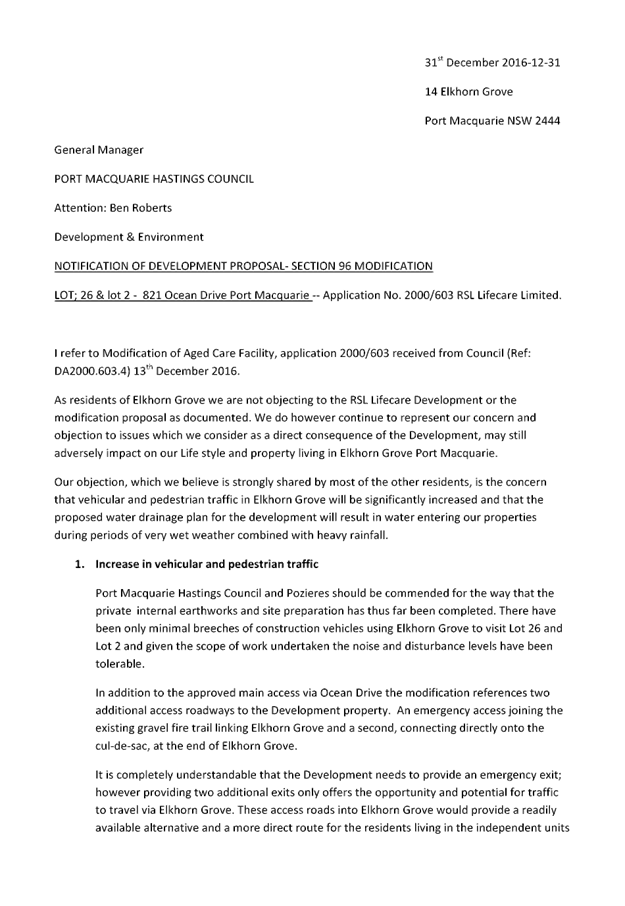
Concern surrounding vegetative screening along the
eastern boundary of the property.
|
Landscaping plans provide for the retention of existing
vegetation and stormwater swale along the eastern boundary. This is
consistent with the original consent and provides for adequate visual and
acoustic separation between dwellings.
|
|
Concern surrounding location of sewer pump station.
|
Infrastructure construction plans under review by
Council indicate a new sewer pump station to be located on the development
lot adjoining the cul de sac head of Elkhorn Grove. No adverse impacts to
properties within Elkhorn Grove are anticipated.
|
|
Concern surrounding vehicular access to Elkhorn Grove.
|
The current consent restricts construction and
operational access to the entry off Ocean Drive. Emergency access only is
provided via Elkhorn Grove. This application proposes no change to these
access arrangements. It is considered unreasonable to prevent emergency
access from being made available via Elkhorn Grove. An emergency would be a
rare event and access to Elkhorn Grove in such an event would not be onerous.
Such a contingency should be made available to enable swift egress.
It should be noted that the emergency access via Elkhorn
Grove has not changed from the original consent.
|
|
Increased flooding to Elkhorn Grove properties will
result from the fill and earthworks proposed.
|
There is no change to the fill and earthworks proposed
under this modification.
In terms of the approved fill and earthworks original
assessment by Council’s flood engineers indicate that such works would
not have an adverse impact on adjoining properties. Existing dwellings in
Elkhorn Grove are above the flood planning level.
|
|
Elkhorn Grove cul-de-sac will end up being a parking lot
for visitors to the village.
|
SEPP 5 prevents Council from refusing the development if
the minimum number of 121 car parking spaces are provided to service the
modified development. 235 spaces are proposed.
It is considered that sufficient parking is provided on
site to discourage any offsite parking by visitors.
|
Any
matters referred to in Section 79C(1) relevant to the modification?
(a)
the provisions of:
(i)
any environmental planning instrument, and
It is important
to note that the application was assessed and consented to on 20 November 2000.
For the purpose of this modification assessment needs to be given to the
environmental planning instruments applicable at the time. The following
relevant instruments were in force at the time.
Hastings
Local Environmental Plan 1987
The land was
zoned part Rural 1(a1) and part 7(a) Environment Protection
‘wetlands’ pursuant to Hastings Local Environmental Plan 1987.
The objectives
of the 1(a1) zone are:
(a) to
protect and encourage utilisation of the productive potential of resources
located in rural areas; and
(b) to
prevent the unnecessary, premature and sporadic fragmentation of rural land, to
protect the agricultural potential of land and also to ensure that development
does not create unreasonable or uneconomic demands for the provision or
extension of public amenities and services; and
(c) to
enable appropriate development falling within Item 3.
State
Environmental Planning Policy No. 5 - Housing for Older People or People
with a Disability acts so as to set aside the local planning controls such
that housing for older people or people with a disability is permitted. The
modified proposal is not considered to alter the original assessment in so far
that it would be inconsistent with the zone objectives.
The objectives of
the 7(a) zone were:
(a) to
identify and protect significant wetland areas from incompatible development
which will have a significant impact on the wetland; and
(b) to
enable appropriate development falling within Item 3.
The part of the
site that was zoned 7(a) lied within the larger Lake Innes/Kooloonbung Creek
wetland. This wetland is protected by the provisions of State Environmental
Planning Policy No. 14 - Coastal Wetlands. The modified development is to be
located outside the mapped coastal wetlands, although all surface
water/stormwater is to be disposed of to the wetland in accordance with the
original proposal and development consent.
Clause 20:
Development in proximity to a main or arterial road. This clause prohibits
certain developments within 400 metres of a main or arterial road. The proposal
as modified is not prohibited by the clause.
Clause 20A:
Development within zone 7(a). This clause requires special assessment of the
impact of works which result in landform alteration on land which is environmentally
sensitive. The application indicates that works will not encroach into the
wetland zone. On this site the line of wetland vegetation in the western sector
of the site, is the 7(a) zone boundary. To ensure the integrity of the wetland
a condition of consent was imposed to require temporary fencing around the
periphery of the wetland so as to prevent any encroachment for the duration of
construction. The modified layout does not encroach into the mapped SEPP 14
wetlands and the condition for temporary fencing would remain.
Clause 21: Tree
preservation within zone 7(a). It is not proposed to remove vegetation within
the wetland zone under the proposed modified layout.
Clause 23C:
Development on land containing potential acid sulphate soils. This clause
requires that Council shall not grant consent for development on land
containing potential acid sulphate soils unless it has considered a preliminary
acid sulphate soil assessment.
A preliminary
acid sulphate soils (ASS) assessment was carried out at the site as part of the
original development application and confirmed that ASS materials exist. Based
on the preliminary findings a detailed ASS management plan was deemed necessary
prior to commencement of any site works. Suitable consent conditions were
applied. No change to these requirements are proposed as part of the modified
layout.
Clause 31:
Bushfire protection. This clause provides that Council shall not grant consent
unless it is satisfied as to the bushfire protection measures to be incorporated
into the development and the maintenance of those facilities. The applicant
provided an updated bushfire risk assessment report based on the modified
layout. The further changes proposed under this modification were referred to
NSW RFS for comment. The NSW RFS have
subsequently issued a revised Bushfire Safety Authority which will form part of
any modified consent.
North
Coast Regional Plan
The modified
proposal remains consistent with the aims and objectives of this plan.
State
Environmental Planning Policy No 5 - Housing for Older People or People with a
Disability
This policy was
in place at the time consideration was given to the application. This policy
overrides and local planning provisions and aims to encourage the provision of
housing that will:
(a)
increase the supply and diversity of housing that meets the needs of older
people or people with a disability, and
(b) make
efficient use of existing infrastructure and services, and
(c) be of
good design.
These aims are
to be achieved by:
(a) setting
aside local planning controls that would prevent the development of housing for
older people or people with a disability that meets the development standards
specified in the Policy, and
(b) ensuring
that applicants and Council’s take into consideration the level of
additional demand for support services for older people or people with a
disability in the Council’s area to be generated by the development when
preparing and assessing development applications that are affected by the
Policy, and
(c) setting out
design principles that should be followed to achieve built form that responds
to the characteristics of its site and location.
The application
of the policy is set out in Clause 4 and Schedule 1 which specifies that the
Policy applies to land:
(a) that
is zoned primarily for urban purposes, or land that adjoins land zoned
primarily for urban purposes, and
Comment: The
land is zoned part Rural 1(a1) and part 7(a) Environment Protection
‘wetlands’ pursuant to Hastings Local Environmental Plan 1987. The
land adjoins the Elkhorn Grove residential development which is zoned
Residential 2(a1). The modification remains consistent in this regard.
(b) on
which development for the purpose of any of the following is permitted:
(i) dwelling
houses
(ii) residential
flat buildings,
(iii) hospitals
(iv) special
uses including churches, convents, educational establishments, schools and
seminaries.
Comment:
Hastings Local Environmental Plan 1987 prohibits the erection of a dwelling
house and/or a residential flat building on the land. Hospitals and special
uses such as churches and educational establishments are permissible. The
modification remains consistent in this regard.
The Policy does
not apply to land described in Schedule 1 (Environmentally Sensitive Land).
Schedule 1 specifies that the policy shall not apply to environmentally
sensitive land identified in any other environmental planning instrument by any
of the following words or descriptions:
- coastal
protection
- conservation
- critical
habitat
- environment
protection
- open
space
- escarpment
- floodway
- natural
hazard
- scenic
protection
- water
catchment
- natural
wetland
Comment:
Hastings Local Environmental Plan 1987 and SEPP 14 identify part of the site as
a wetland. It is not proposed to develop any land so identified. This remains
the case with the modified layout.
Clause 12:
Matters for
Consideration
Location,
facilities and support services: This clause provides that the consent
authority must not consent to the development application unless satisfied that
the residents of the proposed development will have reasonable access to
commercial and retail facilities, community services and recreational
facilities, health services, transport and where appropriate meal services,
personal care/nursing, domestic assistance and communal meeting spaces.
Comment: A bus
service is to operate to provide residents access to the local shopping centre
at Emerald Downs and other services and facilities within the CBD and adjacent
areas. A condition of consent was imposed on the original consent to ensure the
service operates on a daily basis with minimal turnaround time. No change to
this requirement is proposed as part of the modification.
Meal services,
personal care, nursing and housekeeping services are to be provided. The
complex also includes recreational facilities such as bowling green, gym,
billiard room etc.
Availability
of Facilities and Services: The consent authority must also be satisfied
that the services or facilities provided as part of the development are
available upon occupation.
Comment: It is
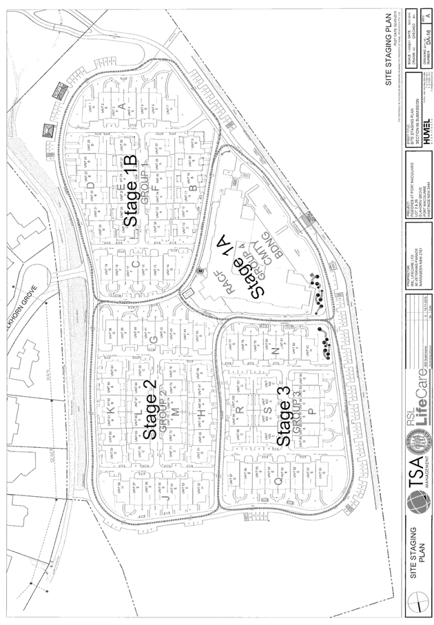
noted that the indicative staging of the development includes the community
building, club house and recreational facilities as part of stage 1. Which
means the facilities will all be available to residents upon occupation.
Water and
Sewer: The consent authority must be satisfied that adequate water supply
and wastewater systems can be managed for the site.
Comment: The
modified scheme will be connected to Council’s reticulated water supply
system. The modified scheme will also be connected to the sewer supply network.
Upgrading of existing water and sewer infrastructure will be required and
appropriate conditions of consent are in place.
Clause 13
Development Standards: This clause deals with development standards notably
wheelchair access and heights of buildings in residential zoned land.
Comment: The
modified scheme has been designed to accommodate wheelchair access throughout
the development. An accessibility review was undertaken and submitted as part
of the previous modification. The height restriction imposed by the Policy
applies only to development of residentially zoned land.
Clause 14
Standards which cannot be used as grounds for refusal: This clause deals with
development standards which cannot be used as grounds for refusal in certain
prescribed circumstances, notably height, density of development, parking and
landscaping.
Comment: The
modified scheme provides for a reduction in the building heights across the
site. A single storey configuration has been adopted for building groups 1, 2
and 3 whilst building group 4 will comprise a two storey configuration. All
buildings are less than the maximum 8m height nominated in this plan. The floor
space ratio of is below the maximum 0.5:1, landscaped area of 35,000m2 is well
above the minimum 5,305m2 and the 235 car parking spaces is above the minimum
121 required under the SEPP.
Having regard
for the Design requirements in Part 3 of the SEPP, the modified proposal is not
considered to fundamentally alter the original proposal and is consistent with
the SEPP having regard for the following:
- Site
Analysis - a suitable site analysis has been provided by the applicant and the
proposal adequately responds to the site. the reduction in overall fill and
deletion of basement parking is considered to be an improved response to the
site.
- Neighbourhood
Amenity and Streetscape - The development is suitably setback form Elkhorn
Grove properties and is extensively landscaped. The buildings are articulated
and of high quality finish. The proposal does not result in adverse
overshadowing of neighbouring properties.
- Visual
and Acoustic Privacy - adequate separation is considered to be provided from
Ocean Drive so as not to have an adverse impact on residents. Adequate
separation and landscaping is considered to be afforded to properties in
Elkhorn Grove so as the development will not have an adverse visual or acoustic
impact on neighbours. Conditions of consent have been recommended to better
manage internal acoustic impacts on bedrooms adjoining driveways (double
glazing).
- Solar
Access - Adequate solar access is provided to each unit having regard for dual
orientation of all self care units. Whilst individual private open space areas
are relatively small, it is considered that the type of accommodation does not
demand extensive areas given occupants typically seek a low maintenance area.
To supplement the small private open space areas, it is noted that communal
recreational spaces and facilities are extensive and well placed to maximise
solar access and usability. A BASIX certificate has been completed for all self
care dwellings.
- Stormwater
- a suitable total water cycle management plan has been submitted with the
application and will form part of the approved documentation. The plan has been
reviewed by Council’s engineers and it is considered that stormwater can
be acceptably managed on site. Detailed design will be required as part of the
construction certificate documentation.
- Crime
Prevention - adequate casual surveillance is provided within the complex.
Access to/from Elkhorn Grove is restricted to emergency access only. The
complex will be staffed.
- Accessibility
- access within the site is disabled compliant and footpaths are provided
through the site to all communal facilities. Roads have been designed to
facilitate a low speed environment and compatible with bicycles and buggies. An
accessibility review has been submitted with the application and will form part
of any approved documentation.
- Waste
Management - capable of being managed as per conditions of consent.
State
Environmental Planning Policy No 14 - Coastal Wetlands
This Policy
restricts development on land identified as a State gazetted wetland and
provides that the land shall not be cleared, drained or filled; or a levee
constructed on the land, without the consent of Council and the concurrence of
the Director of Urban Affairs and Planning. The proposed development as
modified will not encroach into the wetland and a buffer will be provided to
the edge of the vegetation.
It is noted
stormwater will be disposed of to the wetland however a pollution control pond
is proposed to be located in the buffer to strip nutrients from any drainage
discharge. Details are to be provided within a Water Quality Management Plan to
the satisfaction of Council. No change to these requirements are proposed as a
result of the modification.
(ii)
any proposed instrument that is or has been the subject of public consultation
under this Act and that has been notified to the consent authority (unless the
Director-General has notified the consent authority that the making of the
proposed instrument has been deferred indefinitely or has not been approved),
and
The Hastings
Local Environmental Plan 2001 was released in draft form when the application
was being assessed. The assessment of the original application identified that
the zoning of the subject land would not change and that existing planning
provisions will continue to apply. In this regard the modification to the
layout of the retirement complex remains consistent with the original
assessment.
(iii)
any development control plan, and
DCP 9
Residential and Tourist Accommodation: In accordance with the original
assessment it is considered that the design criteria, and the principles and
objectives of the DCP are sufficiently similar to the provisions of State
Environmental Planning Policy No. 5 such that separate assessment under the DCP
is not warranted.
It is noted that
the modified scheme provides for a reduction in the building heights across the
site when compared to the original approval. A single storey configuration has
been proposed for building groups 1, 2 and 3 whilst building group 4 will
comprise double storey configuration, less than 8m in height.
DCP 14
Housing for Aged or Disabled Persons: The provisions in this DCP mirror
development criteria in SEPP 5. Refer to comments under SEPP 5 heading.
DCP 18
Parking Code: See comments under SEPP 5 heading. The modified proposal
provides for sufficient off-street parking. Conditions of consent remain in
place in relation to car park design.
(iiia)
any planning agreement that has been entered into under section 93F, or any
draft planning agreement that a developer has offered to enter into under
section 93F, and
No planning
agreement has been offered or entered with regard to the site or development.
(iv)
the regulations (to the extent that they prescribe matters for the purposes of
this paragraph), and
There are no
relevant matters prescribed by the regulations relevant to the subject site or
modified development proposal.
(v)
any coastal zone management plan (within the meaning of the Coastal Protection
Act 1979),
NSW Coastal
Policy applies to the site. However the site is not located within either the
oceanic or estuarine Coastal Zone/s identified by the Policy. No impact would
result from the modification.
(b)
the likely impacts of that development, including environmental impacts on both
the natural and built environments, and social and economic impacts in the
locality,
Flora and fauna
The modified proposal is
consistent with the original approval in terms of impact on flora and fauna,
with no additional disturbance to native vegetation proposed to that which was
originally considered. Notwithstanding this, a revised ecological assessment
prepared by SLR was submitted with the previous modification to account for changes
in legislation. SLR concluded that the modified development is not likely to
have a significant effect on threatened species, populations, or ecological
communities, or their habitats. In this regard, Section 5A of the Act is
considered to have been satisfied. It is noted that the ameliorative measures
recommended in the ecological assessment will form part of the approved
documentation.
To reinforce the
recommendations of the ecological report a condition of consent has been
proposed under this modification to require a Vegetation Management Plan to be
approved by Council prior to release of any further Construction Certificate.
Traffic
A traffic impact assessment was
prepared by GHD to support the previous modification. The assessment concluded
that:
- The
modified proposal will have a lesser impact that that originally approved with
a reduction in daily vehicle trips from 558 to 323.
- The
approved intersection with Ocean Drive will operate satisfactorily in peak
periods based on 2012/13 conditions.
- The
approved intersection provides the minimum sight distance and the desirable
sight distance as per AUSTROADS.
- Parking
provision is over and above SEPP 5 requirements.
The minor
changes proposed under this modification are consistent with the findings of
the traffic impact assessment.
Notwithstanding
the above it is noted that as part of the S.138 Roads Act application,
concurrence to the ultimate intersection design will require Roads and Maritime
Service concurrence.
Flooding
Council’s Environmental
Engineer’s reviewed the previous modified application and advised that
the flood modelling for the site is now better known than in the year 2000 and
a lowered 1: in 100year level (2.5m AHD) affects the site. Accounting for sea
level rise and climate change a 900mm freeboard is required to be provided to
habitable buildings. A revised condition of consent was applied. It is also
considered that the further changes proposed will not have an adverse impact
associated with the displacement of flood waters.
(c)
the suitability of the site for the development,
The modification
remains consistent with the original development consent under which the site
was considered suitable for a retirement complex. It is noted that a number of
conditions have been imposed to minimise environmental impacts.
(d)
any submissions made in accordance with this Act or the regulations,
Refer to table
and comments earlier within the report.
(e)
the public interest.
The proposed
development, as modified, satisfies relevant planning controls and is not
expected to impact on the wider public interest.
4. DEVELOPMENT
CONTRIBUTIONS APPLICABLE
· Council
Policy requires contributions for water and sewer for self contained aged care
units or SEPP5 units.
· No
contributions are payable towards open space and arterial roads in accordance
with Council Policy S26/1 and SEPP5.
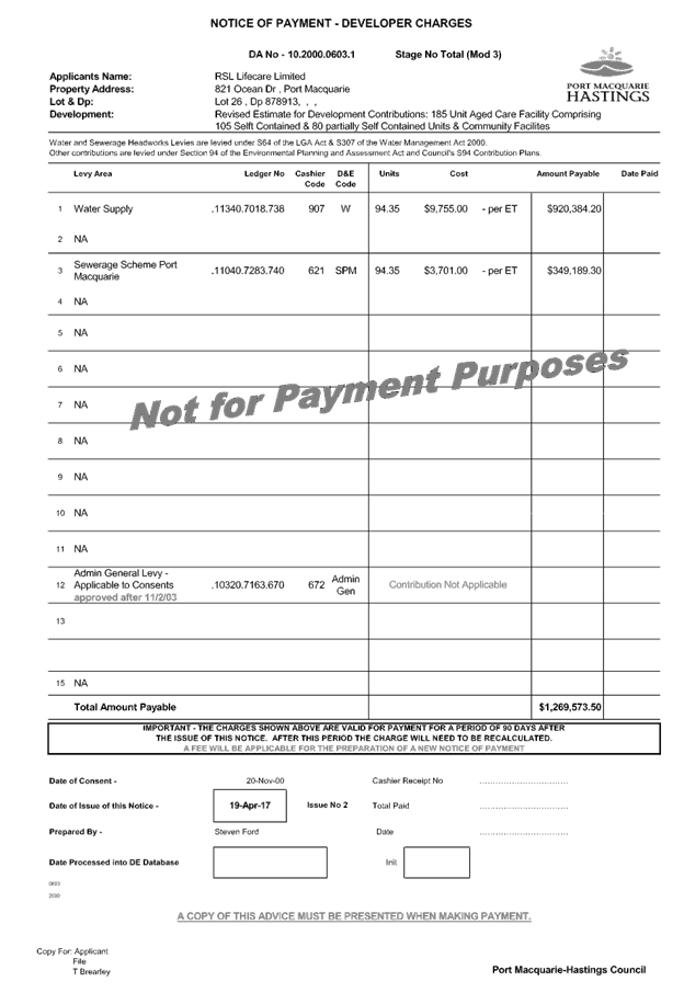
Refer to updated draft contribution schedule attached to this report and
recommended conditions.
5. CONCLUSION
The application has been assessed
in accordance with Section 96 of the Environmental Planning and Assessment Act
1979.
Issues raised during assessment
and neighbour consultation of the application have been considered in the
assessment of the application.
The site remains suitable for the
modified proposed development, is not contrary to the public's interest and
will not have a significant adverse social, environmental or economic impact.
Consequently, it is recommended that the modification application be approved,
subject to the recommended conditions of consent provided in the attachment
section of this report.
|
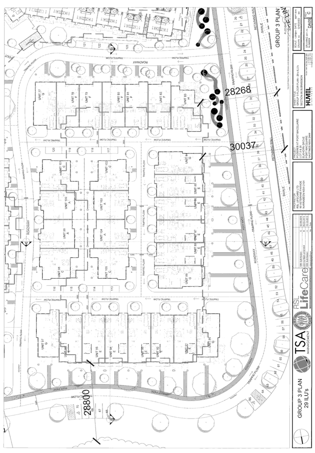
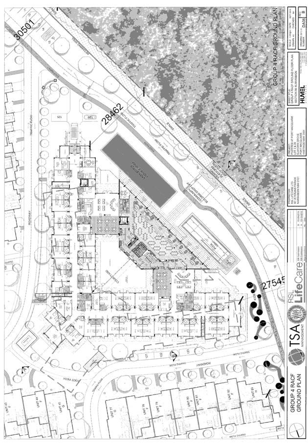
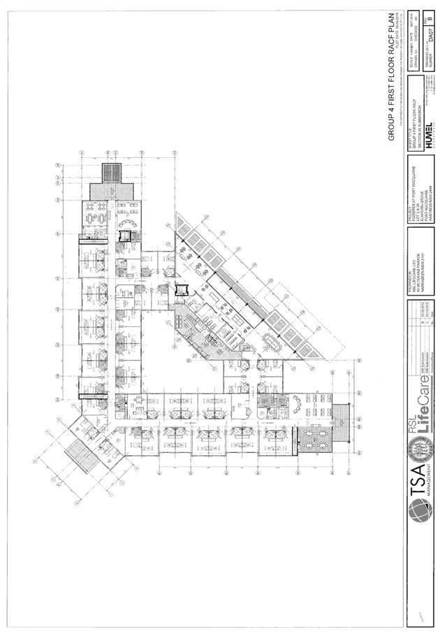
Attachments
1View. DA2000
- 603.4 Architectural Plans
2View. DA2000
- 603.4 Staging Plan
3View. DA2000
- 603.4 Landscape Plans
4View. DA2000
- 603.4 Proposed North Eastern Building Group with Boundary Setbacks
5View. DA2000
- 603.4 Proposed Section at Eastern Boundary
6View. DA2000
- 603.4 Acoustic Logic review of Condition 28
7View. DA2000
- 603.4 SoEE
8View. DA2000
- 603.4 Recommended Conditions
9View. DA
2000 - 603.4 Revised Bushfire Safety Authority conditions
10View. DA2000
- 603.4 Revised Contribution Estimate - RSL Lifecare Limited, 821 Ocean Dr,
Port Macquarie, 19-Apr-2017
11View. DA2000
- 603.4 Submission - Capner
12View. DA2000
- 603.4 Submission - McIlroy
|
|
ATTACHMENT
|
Development Assessment Panel
10/05/2017
|
|
ATTACHMENT
|
Development Assessment Panel
10/05/2017
|
|
ATTACHMENT
|
Development Assessment Panel
10/05/2017
|

|
ATTACHMENT
|
Development Assessment Panel
10/05/2017
|
|
ATTACHMENT
|
Development Assessment Panel
10/05/2017
|
|
ATTACHMENT
|
Development Assessment Panel
10/05/2017
|

|
ATTACHMENT
|
Development Assessment Panel
10/05/2017
|


|
ATTACHMENT
|
Development Assessment Panel
10/05/2017
|
|
ATTACHMENT
|
Development Assessment Panel
10/05/2017
|
|
ATTACHMENT
|
Development Assessment Panel
10/05/2017
|
|
ATTACHMENT
|
Development Assessment Panel
10/05/2017
|
|
ATTACHMENT
|
Development Assessment Panel
10/05/2017
|
AGENDA Development Assessment Panel 10/05/2017
Item: 06
Subject: DA2015 - 698.2 Modification To Childcare
Centre - Lot 2 DP 808998, 156 Horton Street, Port Macquarie
Report
Author: Benjamin Roberts
|
Applicant: Love
Project Management
Owner: Warrmara
Properties Pty Ltd
Estimated Cost: N/A
Alignment with Delivery
Program
4.9.2 Undertake transparent
and efficient development assessment in accordance with relevant legislation.
|
|
RECOMMENDATION
That
the section 96 modification application to DA2015 - 698 for a childcare centre at Lot 2, DP
808998, No. 156 Horton Street, Port Macquarie, be determined by granting
consent subject to the recommended modified conditions.
|
Executive
Summary
This
report considers a section 96 modification application to an approved childcare
centre at the subject site. In summary the proposed modification application
proposes the following changes:
- Internal floor plan layout
changes
- Extension of roofed deck area
This
report provides an assessment of the application in accordance with the
Environmental Planning and Assessment Act 1979.
Following exhibition of the
application, one (1) submission has been
received.
1. BACKGROUND
Existing sites features and Surrounding development
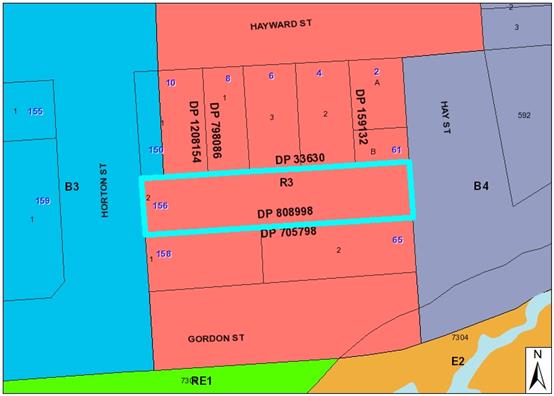
The site has an area of 2038m2.
The site is zoned R3 Medium Density Residential in accordance with the Port Macquarie-Hastings Local
Environmental Plan 2011, as shown in the following zoning plan:
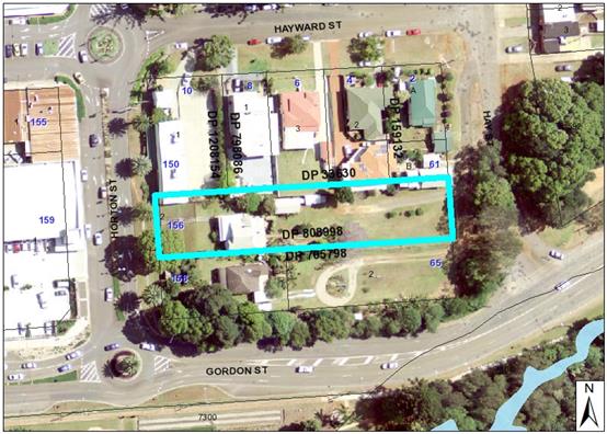
The existing subdivision pattern and location of existing
development within the locality is shown in the following aerial photograph:
Application History
On 25 May 2016 Council granted consent for demolition the
existing dwelling and associated structures and construction of a childcare
centre to cater for 72 children on the site. The consent is still active.
2. DESCRIPTION OF
DEVELOPMENT
Key aspects of the proposal include the following:
- Internal floor plan layout
changes
- Extension of roofed deck area to
Horton Street frontage
Refer
to attachments at the end of this report.
Application Chronology
· 9
March 2017 - Application lodged.
· 21 March to 3 April 2017 - Public exhibition via neighbour
notification
3. STATUTORY ASSESSMENT
Is the proposal substantially the same?
Section 96 of
the Environmental Planning and Assessment Act 1979 enables the modification of
consents and categorises modification into three categories - S.96 (1) for
modifications involving minor error, misdescription or miscalculation; S.96
(1A) for modifications involving minimal environmental impact; and S.96 (2) for
other modifications. Each type of modification must be considered as being
substantially the same to that which was originally consented to.
The subject application is being
considered under the provisions of Section 96(1A). The
proposal is considered to be substantially the same development to that which
was originally consented to. Having regard to the above principles, the
proposed modifications are not considered to alter the fundamental
essence of the original development for the following reasons:
- The intended use remains the same.
- The footprint of the development remains
substantially the same.
- Building setbacks to neighbouring properties
are substantially the same.
- Access to the site remains the same.
- No changes to conditions of consent are
sought that would fundamentally alter the intent of the original development
and consent.
Are
there any condition(s) of consent imposed by a Minister, government or public
authority that require modification?
Conditions
of consent were imposed by the NSW Rural Fire Service. Based on the minor
nature of changes proposed the RFS conditions do not require modification.
Does
the application require notification/advertising in accordance with the regulations
and/or any Development Control Plan?
Neighbour notification has been undertaken - refer to
submission summary below.
Any submissions made concerning the modification?
One (1)
submission was received following completion of the required neighbour
notification of the application.
Key
issues raised in the submission received and comments in response to these
issues are provided as follows:
|
Submission Issue/Summary
|
Planning Comment/Response
|
|
Insufficient footpath width will be provided along the
Hay Street road reserve outside the properties of 2 Hayward Street and 2 Hay
Street. Who is paying for the conceded width?
|
It is considered that providing a suitably sized road
access and pedestrian footpath to the Hay Street frontage will better serve
both the development and properties to which pedestrian and vehicular access
are obtained.
|
|
Noise pollution from children ‘amassed’ at
the rear boundary of 4A Hayward Street.
|
There is no
change under this modification to the approved building separation, operating
hours, location of outdoor play areas or to the 2m high fencing proposed
along the northern boundary. No further noise impacts would result from the
modified proposal.
|
|
Potential for children to be infected by disease from
the nearby fruit bat colony in Koolonbung Creek reserve.
|
The modified proposal will not result in any change to
such health risk.
|
|
The long term proposal to close the southern end of Hay
Street so as to eliminate the steep ramp like access to Gordon Street.
|
This is matter for Council’s future planning of
the area and not relevant to the modification application.
|
|
As the address of the property
is Horton Street then why isn’t all access to the development from
Horton Street.
|
There is no change to approved access arrangements under
this modification application.
|
|
The residents of 2 Hayward
Street and 61 Hay Street will be constantly harassed by traffic 1.5m from
their boundaries.
|
There is no change to approved access arrangements under
this modification application.
|
|
We would like to peruse the
plans Council has for the closure of Hay Street and Gordon Street so as to
compare with those plans prepared for the child care centre.
|
This is matter for Council’s future planning of
the area and not relevant to the modification application.
|
|
The risk of traffic accident
with children if a vehicle falls from the access several metres to the Hay
Street ramp.
|
There is no change to approved access arrangements under
this modification application.
|
|
What town planning theory has
been applied so as to allow the proposal to proceed this far.
|
Detailed assessment of planning considerations
undertaken with original development application. As indicated within this
report the modified proposal remains consistent with relevant planning
considerations.
|
Any matters
referred to in Section 79C(1) relevant to the modification?
(a)
the provisions of:
(i)
any environmental planning instrument, and
The modified
proposal remains consistent with the State Environmental Planning instruments
in force at the time of the original assessment.
In regard to
Port Macquarie-Hastings Local Environmental Plan 2011 the following minor
changes to height and FSR are noted as follows:
- The
minor decrease in overall building height from 7.6m to 7.5m remains consistent
with the maximum 10m building height applicable to the site.
- The
increase in overall floor area of 17m2 will result in a floor space
ratio still well below the maximum of 1:1 applicable to the site.
(ii)
any proposed instrument that is or has been the subject of public consultation
under this Act and that has been notified to the consent authority (unless the
Director-General has notified the consent authority that the making of the
proposed instrument has been deferred indefinitely or has not been approved),
and
No draft
instruments apply.
(iii)
any development control plan, and
The modified
proposal remains consistent with the Development Control Plan 2013. In particular
the following is noted:
- The extension of the outdoor decking to
the western elevation of the building is setback 13.5m from the Horton Street
boundary. Complies with setback provisions.
- There is no change to the number of
children to be catered for at the facility and therefore no additional parking
demand generated.
(iiia)
any planning agreement that has been entered into under section 93F, or any
draft planning agreement that a developer has offered to enter into under
section 93F, and
No planning
agreement has been offered or entered into with regard to the site or
development.
(iv)
the regulations (to the extent that they prescribe matters for the purposes of
this paragraph), and
There are no
relevant matters prescribed by the regulations relevant to the subject site or
modified development proposal.
(v)
any coastal zone management plan (within the meaning of the Coastal Protection
Act 1979),
NSW Coastal
Policy applies to the site. However the site is not located within either the oceanic
or estuarine Coastal Zone/s identified by the Policy. No impact would result
from the modification.
(b)
the likely impacts of that development, including environmental impacts on both
the natural and built environments, and social and economic impacts in the
locality,
The modified
proposal will be unlikely to have any adverse impacts to existing adjoining
properties and satisfactorily addresses the public domain.
There is no
change to the approved operating hours of 6am to 6:30pm weekdays.
There is no
change to the approved location of outdoor play areas and 2m high fencing
proposed along the northern boundary.
The modified
proposal does not have a significant adverse impact on existing view sharing.
The modified
proposal does not have significant adverse lighting impacts.
There are no
significant adverse privacy impacts from the modified proposal. Adequate
building separation is proposed/existing.
There is no
adverse overshadowing impacts that would result from the modified proposal.
The modified
proposal is considered to be compatible with existing development in the
locality and adequately addresses planning controls for the area.
(c)
the suitability of the site for the development,
The proposal as modified will
fit into the locality and the site attributes are conducive to the development.
(d)
any submissions made in accordance with this Act or the regulations,
Refer to
table and comments earlier within the report.
(e)
the public interest.
The proposed
development, as modified, satisfies relevant planning controls and is not
expected to impact on the wider public interest.
4. DEVELOPMENT
CONTRIBUTIONS APPLICABLE
The number children to be accommodated at the facility
remains unchanged. No change to contributions payable as a result of the
modification.
5. CONCLUSION
The application has been assessed
in accordance with Section 96 of the Environmental Planning and Assessment Act
1979.
Issues raised during assessment
and neighbour consultation of the application have been considered in the
assessment of the application.
The site remains suitable for the
modified proposed development, is not contrary to the public's interest and
will not have a significant adverse social, environmental or economic impact.
Consequently, it is recommended that the modification application be approved,
subject to the recommended conditions of consent provided in the attachment
section of this report.
|
Attachments
1View. DA2015
- 698.2 Plans
2View. DA2015
- 698.2 SoEE
3View. DA2015
- 698.2 Recommended Conditions
4View. DA2015
- 698.2 Submission - Flanagan
|
|
ATTACHMENT
|
Development Assessment Panel
10/05/2017
|
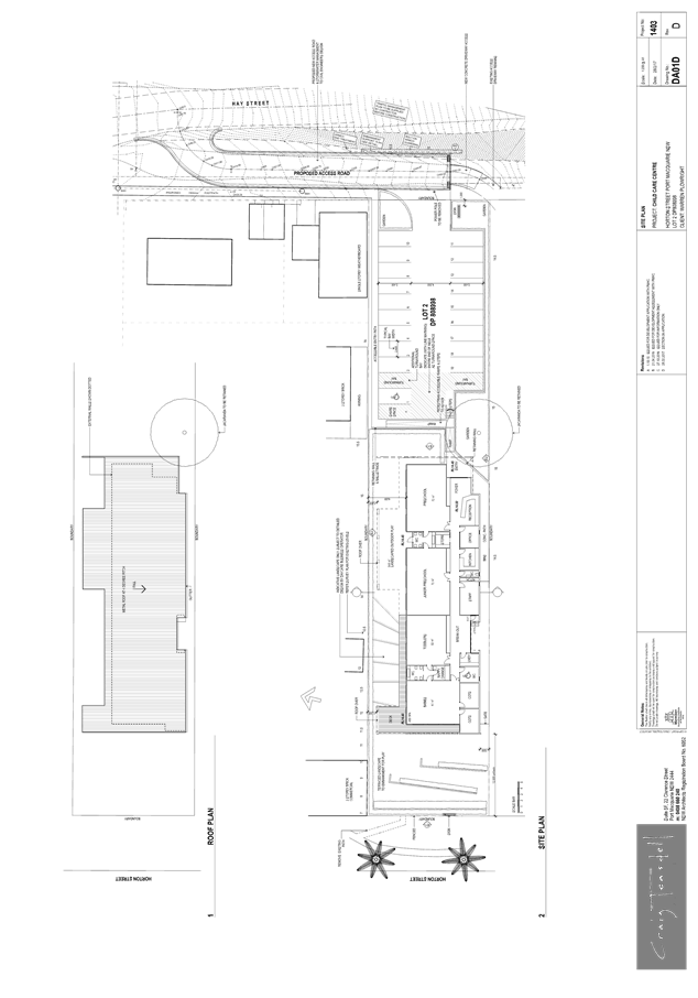
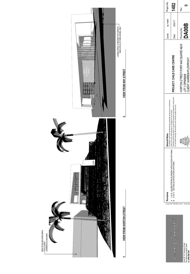
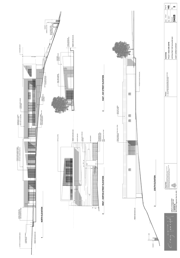
|
ATTACHMENT
|
Development Assessment Panel
10/05/2017
|

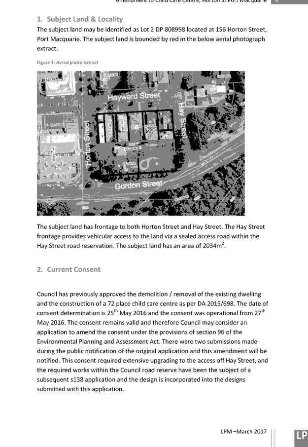
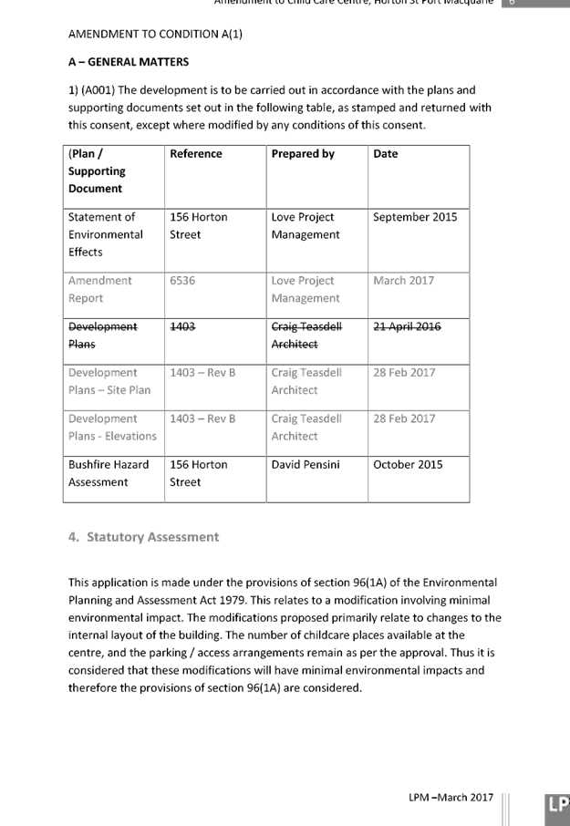

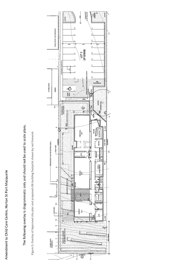
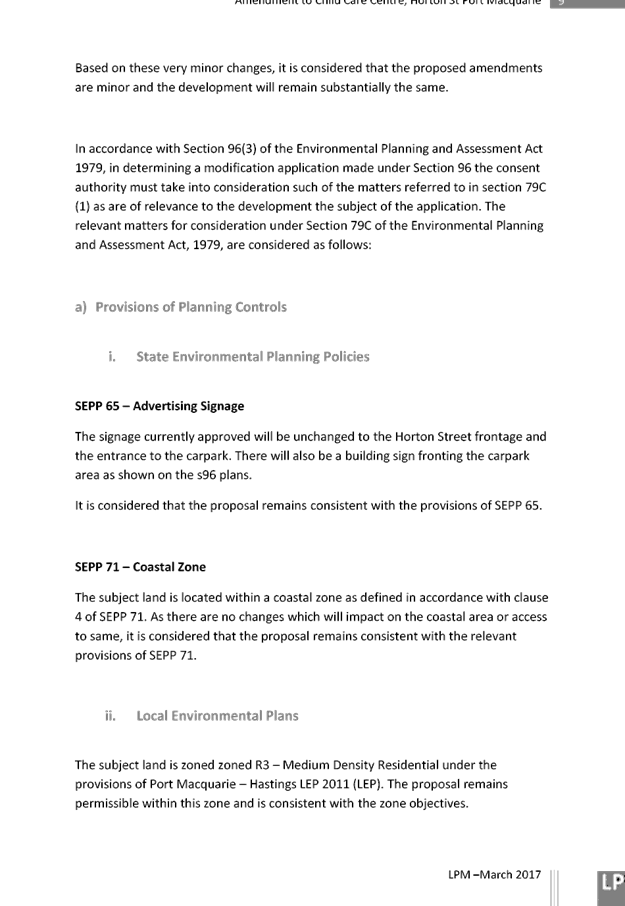
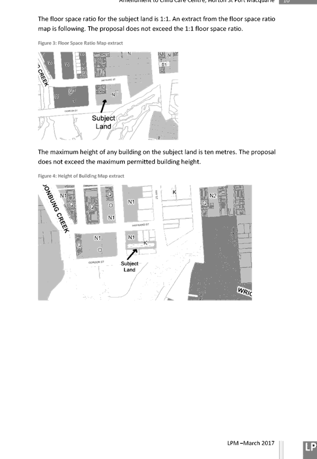
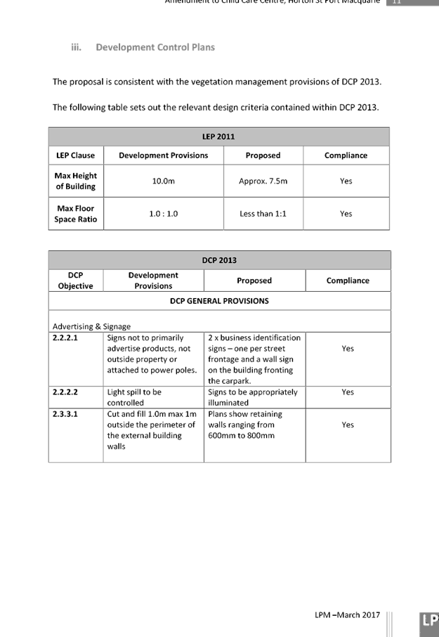
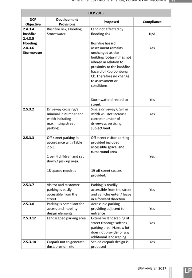
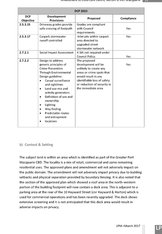
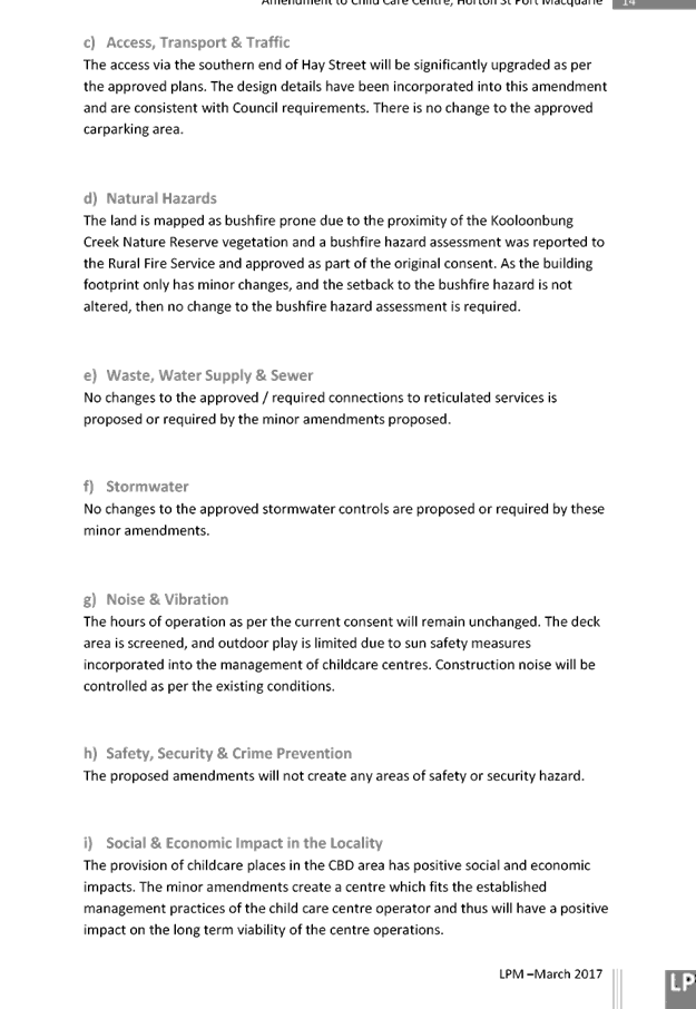

|
ATTACHMENT
|
Development Assessment Panel
10/05/2017
|

|
ATTACHMENT
|
Development Assessment Panel
10/05/2017
|
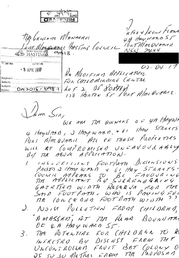
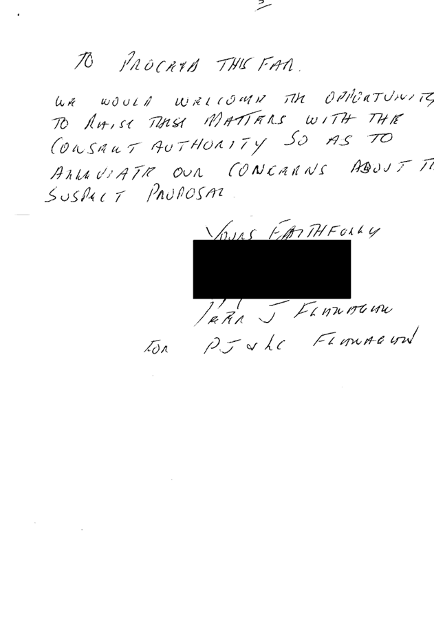
AGENDA Development Assessment Panel 10/05/2017
Item: 07
Subject: DA2017 - 37.1 - Dwelling - Lot 72 DP 238688,
No 19 Jasmine Street, Port Macquarie
Report
Author: Patrick Galbraith-Robertson
|
Applicant: Gonzo
Practice - S Trembath
Owner: J
Trembath and G Nicholls
Estimated Cost: $310K
Alignment with Delivery
Program
4.9.2 Undertake transparent
and efficient development assessment in accordance with relevant legislation.
|
|
RECOMMENDATION
That
DA 2017 - 37 for a dwelling at Lot 72, DP 238688, No. 19 Jasmine Street, Port
Macquarie, be determined by granting consent
subject to the recommended conditions.
|
Executive
Summary
This
report considers a Development Application (DA) for a dwelling at the subject site and provides an assessment of the
application in accordance with the Environmental Planning and Assessment Act
1979.
Following exhibition of the application,
one(1) submission has been received.
The plans have been amended during
the assessment of the DA. The amendments relate to a minor increase in the size
of the dwelling in the rear south-east section.
1. BACKGROUND
Existing sites features and Surrounding development
The site has an area of 613.4m2.
The site is zoned R1 general residential in accordance with the Port Macquarie-Hastings Local
Environmental Plan 2011, as shown in the following zoning plan:
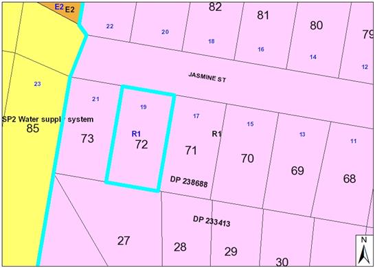
The existing subdivision pattern and location of existing
development within the locality is shown in the following aerial photograph
(2012):
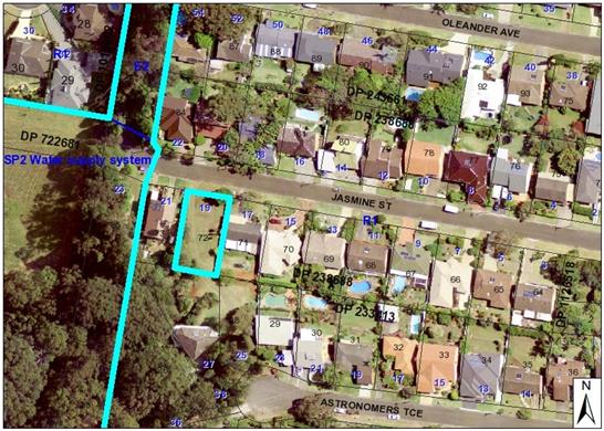
2. DESCRIPTION OF
DEVELOPMENT
Key aspects of the proposal include the following:
· Tree
removal
· Construction
of dwelling-house
Refer
to attachments at the end of this report.
Application Chronology
· 20
January 2017 - DA lodged with Council.
· 1 to 14 February 2017 - neighbour notification of proposal.
· 3 March 2017 - Additional information requested from
Applicant to address submission issues and to provide an aborist report of all
existing trees on-site.
· 27 April 2017 - Additional information received from
Applicant.
· 27 April 2017 - Amended plans received from Applicant.
3. STATUTORY ASSESSMENT
Section 79C(1) Matters for Consideration
In determining the application, Council is required to take
into consideration the following matters as are relevant to the development
that apply to the land to which the development application relates:
(a) The provisions (where
applicable) of:
(i) any Environmental
Planning Instrument:
(a)(i) Any environmental
planning instrument
State Environmental Planning Policy No. 44 - Koala Habitat
Protection
There is no Koala Plan of
Management on the site. Additionally, the site is less than 1ha in area therefore
no further investigations are required.
State Environmental Planning
Policy No.55 – Remediation of Land
Following an inspection of the site and a search of Council
records, the subject land is not identified as being potentially contaminated
and is suitable for the intended use.
State Environmental Planning
Policy No. 62 – Sustainable Aquaculture
Given the nature of the proposed
development and proposed stormwater controls the proposal will be unlikely to
have any adverse impact on existing aquaculture industries.
State Environmental Planning
Policy No. 71 – Coastal Protection and Clause 5.5 of Port Macquarie-Hastings
Local Environmental Plan 2011
The site is located within a
coastal zone as defined in accordance with clause 4 of SEPP 71.
In accordance with clause 5, this
SEPP prevails over the Port Macquarie-Hastings LEP 2011 in the event of any
inconsistency.
Having regard to clauses 8 and 12
to 16 of SEPP 71 and clause 5.5 of Hastings LEP 2011 inclusive the proposed
development will not result in any of the following:
a) any
restricted access (or opportunities for access) to the coastal foreshore
b) any
identifiable adverse amenity impacts along the coastal foreshore and on the
scenic qualities of the coast;
c) any
identifiable adverse impacts on any known flora and fauna (or their natural
environment);
d) subject to
any identifiable adverse coastal processes or hazards;
e) any
identifiable conflict between water and land based users of the area;
f) any
identifiable adverse impacts on any items of archaeological/heritage;
g) reduce the
quality of the natural water bodies in the locality.
The site is predominately cleared and located within an area
zoned for residential purposes.
State Environmental Planning Policy (Building
Sustainability Index: BASIX) 2004
A BASIX certificate has been
submitted demonstrating that the proposal will comply with the requirements of
the SEPP. It is recommended that a condition be imposed to ensure that
the commitments are incorporated into the development and certified at
Occupation Certificate stage.
Port
Macquarie-Hastings Local Environmental Plan 2011
The proposal is consistent with the LEP having regard to the
following:
· Clause
2.2, the subject site is zoned R1 General Residential. In accordance with
clause 2.3(1) and the R1 zone landuse table, the dwelling (or ancillary
structure to a dwelling) is a permissible landuse with consent.
The objectives of the R1 zone are
as follows:
o To
provide for the housing needs of the community.
o To
provide for a variety of housing types and densities.
o To enable other
land uses that provide facilities or services to meet the day to day needs of
residents.
In accordance with Clause 2.3(2),
the proposal is consistent with the zone objectives as it is a permissible
landuse and consistent with the established residential locality.
· Clause
4.3, the maximum overall height of the building above ground level (existing)
is 8.4m which complies with the standard height limit of 8.5m applying to the
site.
· Clause
4.4, the floor space ratio of the proposal is 0.29:1.0 which complies with the
maximum 0.65:1 floor space ratio applying to the site.
· Clause
5.9 - Trees listed in Development Control Plan 2013 are proposed to be removed.
Refer to comments later in report.
· Clause
5.10 – Heritage. The site does not contain or adjoin any known heritage
items or sites of significance.
· Clause
7.13, satisfactory arrangements are in place for provision of essential
services.
(a)(ii) Any proposed
instrument that is or has been placed on exhibition
No draft instruments apply to the
site.
(a)(iii) Any DCP in force
Port Macquarie-Hastings Development Control Plan 2013:
|
DCP 2013: Dwellings, Dual
occupancies, Dwelling houses, Multi dwelling houses & Ancillary
development
|
|
|
Requirements
|
Proposed
|
Complies
|
|
3.2.2.1
|
Ancillary development:
• 4.8m max. height
• Single storey
• 60m2 max. area
• 100m2 for lots
>900m2
• 24 degree max.
roof pitch
• Not located in
front setback
|
Water tank is appropriately
located
|
Yes
|
|
3.2.2.2
|
Articulation zone:
• Min. 3m front
setback
• An entry feature
or portico
• A balcony, deck,
patio, pergola, terrace or verandah
• A window box
treatment
• A bay window or
similar feature
• An awning or
other feature over a window
• A sun shading
feature
|
No elements within the
articulation zone.
|
N/A
|
|
Front setback (Residential not R5
zone):
• Min. 4.5m local
road
|
Front building line setback is
compliant with the minimum 4.5m front setback requirements.
|
Yes
|
|
3.2.2.3
|
Garage 5.5m min. and 1m behind
front façade.
Garage door recessed behind
building line or eaves/overhangs provided
|
Garage door setback is compliant
with the minimum front setback requirements.
Garage door recessed.
|
Yes
|
|
6m max. width of garage door/s
and 50% max. width of building
|
Width of garage door/s are
compliant with the maximum width requirements
|
Yes
|
|
Driveway crossover 1/3 max. of
site frontage and max. 5.0m width
|
Driveway crossing/s width are
compliant with the maximum width requirements
|
Yes
|
|
3.2.2.4
|
4m min. rear setback. Variation
subject to site analysis and provision of private open space
|
The rear setback requirements are
complied with.
|
Yes
|
|
3.2.2.5
|
Side setbacks:
• Ground floor =
min. 0.9m
• First floors
& above = min. 3m setback or where it can be demonstrated that
overshadowing not adverse = 0.9m min.
• Building wall
set in and out every 12m by 0.5m
|
The minimum side setback
requirements are complied with.
1.8m first floor setback on the
east side and 0.95m west side setback will not result in any identifiable
adverse overshadowing impacts to neighbouring properties.
The building wall articulation is
compliant and/or satisfactory to address the objective intent of the
development provision.
|
Yes
|
|
3.2.2.6
|
35m2 min. private open space area
including a useable 4x4m min. area which has 5% max. grade
|
The dwelling contains 35m²
open space in one area including a useable 4m x 4m space.
|
Yes
|
|
3.2.2.7
|
Front fences:
• If solid 1.2m
max height and front setback 1.0m with landscaping
• 3x3m min. splay
for corner sites
• Fences >1.2m
to be 1.8m max. height for 50% or 6.0m max. length of street frontage with
25% openings
• 0.9x0.9m splays
adjoining driveway entrances
|
No fences proposed
|
N/A
|
|
3.2.2.10
|
Privacy:
• Direct views
between living areas of adjacent dwellings screened when within 9m radius of
any part of window of adjacent dwelling and within 12m of private open space
areas of adjacent dwellings. ie. 1.8m fence or privacy screening which has
25% max. openings and is permanently fixed
• Privacy screen
required if floor level > 1m height, window side/rear setback (other than
bedroom) is less than 3m and sill height less than 1.5m
• Privacy screens
provided to balconies/verandahs etc which have <3m side/rear setback and
floor level height >1m
|
No direct views between living
areas of adjacent dwellings screened when within 9m radius of any part of
window of adjacent dwelling and within 12m of private open space areas of
adjacent dwellings.
The development will not compromise privacy due to a
combination of lack of windows on side/rear boundaries, having high sill
windows that face side/rear boundaries, limiting living areas that face
adjoining living areas/open space, compliant separation and use of
screening/fencing.
No privacy screens are
recommended.
|
Yes
|
|
DCP 2013: General
Provisions
|
|
|
Requirements
|
Proposed
|
Complies
|
|
2.7.2.2
|
Design addresses generic principles of Crime Prevention
Through Environmental Design guideline
|
No concealment or entrapment areas proposed. Adequate
casual surveillance available.
|
Yes
|
|
2.3.3.1
|
Cut and fill 1.0m max. 1m outside the perimeter of the
external building walls
|
Cut and fill <1.0m change 1m outside the perimeter of
the external building walls/footprint.
|
Yes
|
|
2.3.3.2
|
1m max. height retaining walls along road frontage
|
None proposed
|
N/A
|
|
Any retaining wall >1.0 in height to be certified by
structure engineer
|
Condition recommended to require engineering certification
|
Yes
|
|
Combination of retaining wall and front fence height max
1.8m, max length 6.0m or 30% of frontage, fence component 25% transparent,
and splay at corners and adjacent to driveway
|
No retaining wall front fence combination proposed.
|
N/A
|
|
2.3.3.8
|
Removal of hollow bearing trees
|
No trees proposed to be removed
|
N/A
|
|
2.6.3.1
|
Tree removal (3m or higher with 100m diameter trunk at 1m
above ground level and 3m from external wall of existing dwelling)
|
Several trees are proposed to be removed. Refer to
comments later in report.
|
Yes - Tree removal applied for
|
|
2.4.3
|
Bushfire risk, Acid sulphate soils, Flooding,
Contamination, Airspace protection, Noise and Stormwater
|
Refer to main body of report.
|
|
|
2.5.3.2
|
New accesses not permitted from arterial or distributor
roads
|
No new access proposed to arterial or distribution road.
|
N/A
|
|
Driveway crossing/s minimal in number and width including
maximising street parking
|
Driveway crossing minimal in width including maximising
street parking
|
Yes
|
|
2.5.3.3
|
Parking in accordance with Table 2.5.1.
1 space per single dwelling (behind building line)
|
1 or capacity for more than 1 parking space behind the
building line has been provided for.
|
Yes
|
|
2.5.3.11
|
Section 94 contributions
|
N/A
|
|
|
2.5.3.12 and 2.5.3.13
|
Landscaping of parking areas
|
Single dwelling only with 1 domestic driveway. No specific
landscaping requirements recommended.
|
N/A
|
|
2.5.3.14
|
Sealed driveway surfaces unless justified
|
Sealed driveway proposed
|
Yes
|
|
2.5.3.15 and 2.5.3.16
|
Driveway grades first 6m or ‘parking area’
shall be 5% grade with transitions of 2m length
|
Driveway grades capable of satisfying Council standard
driveway crossover requirements. Condition recommended for section 138 Roads
Act permit
|
Yes
|
|
2.5.3.17
|
Parking areas to be designed to avoid concentrations of
water runoff on the surface.
|
Single dwelling only with 1 domestic driveway. Stormwater
drainage is capable of being managed as part of plumbing construction.
|
Yes
|
(a)(iii)(a)
Any planning agreement or draft planning agreement
No planning
agreement has been offered or entered into relating to the site.
(a)(iv)
Any matters prescribed by the regulations
NSW Coastal
Policy 1997
The proposed
development is consistent with the objectives and strategic actions of this
policy.
(a)(v) Any Coastal Zone
Management Plan
None applicable.
(b) The likely impacts
of that development, including environmental impacts on both the natural and
built environments and the social and economic impacts in the locality
Context and setting
• The
proposal will be unlikely to have any adverse impacts to existing adjoining
properties and satisfactorily addresses the public domain particularly noting
compliance with Council’s adopted Planning Controls.
• The proposal is considered to be sufficiently consistent
with other residential development in the locality and adequately addresses
planning controls for the area.
• There
are no adverse impacts on existing view sharing
including no impact on what could be considered iconic views warranting further
detailed assessment.
• There are no identifiable adverse privacy impacts.
• There are no identifiable adverse overshadowing impacts.
The proposal does not prevent adjoining properties from receiving 3 hours of
sunlight to private open space and primary living areas on 21 June.
Access, transport and traffic
The proposal will be unlikely to have any adverse impacts in
terms access, transport and traffic. The existing road network will
satisfactorily cater for any increase in traffic generation as a result of the
development.
Water Supply
Service available – details required with S.68
application.
Sewer
Service available – details required with S.68
application.
Stormwater
The site slopes towards the street. Service available
– details required with S.68 application
Other Utilities
Telecommunication and electricity services are available to
the site.
Heritage
This site does not contain or adjoin any known heritage item
or site of significance.
Other land resources
No adverse impacts anticipated. The site is within an
established urban context and will not sterilise any significant mineral or
agricultural resource.
Water cycle
The proposed development will be unlikely to have any
adverse impacts on water resources and the water cycle.
Soils
The proposed development will be unlikely to have any
adverse impacts on soils in terms of quality, erosion, stability and/or
productivity subject to a standard condition requiring erosion and sediment
controls to be in place prior to and during construction.
Air and microclimate
The construction and/or operations of the proposed
development will be unlikely to result in any adverse impacts on the existing
air quality or result in any pollution.
Flora and fauna
During the assessment of the application an Aborist
Assessment Report has been submitted prepared by Environmental Arbor
Resources. A copy of this report has been attached to this assessment
report.
In summary, it can be confirmed
that there are 9 trees within the site, 4 being Melaleuca quinquenervia
(Broad-Leaved Paperbark) 1 x cheese tree, 3 cabbage palm and 1 x bottlebrush.
3 of the Paperbark trees are
identified as being previously lopped and are recommended for removal due to
the proximity to the proposed building works. The report makes recommendations
to suggest offset planting on Council reserves for all 4 Paperbark trees.
Council’s natural resource officer has advised that these Paperbarks are
not considered primary or secondary browse species based on recent local
research (Phillips, 2013). Furthermore, they are isolated and trimmed and
provide little if any food resource for the Local Koala Population. On these
grounds offset for their removal is not considered to be warranted.
1 of the cabbage palms at the rear
of the site are proposed to be retained. The majority of the vegetation
assessed is within the footprint of the proposed development. All vegetation
within the proposed footprint is recommended for removal and any other tree
with low retention value.
The Tree 1: Cheese tree is proposed
to be removed due to an encroachment for the power pole being put in next to
tree and lines run from power pole across the street. Retention of this tree is
not recommended given it does not have any identifiable significant amenity or
ecological value.
It is considered that no
significant adverse impacts on biodiversity or threatened species of flora and
fauna.
Waste
Satisfactory arrangements are in place for proposed storage
and collection of waste and recyclables. No adverse impacts anticipated.
Energy
The proposal includes measures to address energy efficiency
and will be required to comply with the requirements of BASIX.
Noise and vibration
No adverse impacts anticipated. Condition recommended to
restrict construction to standard construction hours.
Bushfire
The site is identified as being bushfire prone.
The Applicant has submitted a self assessment bushfire risk
assessment which recommends a Bushfire Attack Level 12.5.
BAL 12.5 construction is proposed. Reference is also made to
the Bushfire Risk Assessment provided by David Pensini under DA2016 - 46 for a
dwelling approved on No. 25 Astronomers Terrace, Port Macquarie.
The vegetation classifications were identified as shown in
the following image:
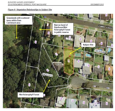
An assessment of bushfire risk having regard to section 4.3.5
of Planning for Bushfire Protection 2006 including vegetation classification
and slope concludes that a Bushfire Attack Level 12.5 (BAL) is appropriate.
Management of bushfire risk is acceptable subject to BAL
construction levels being implemented and APZ being maintained. An appropriate
condition is recommended.
Safety, security and crime prevention
The proposed development will be unlikely to create any
concealment/entrapment areas or crime spots that would result in any
identifiable loss of safety or reduction of security in the immediate area.
Social impacts in the locality
Given the nature of the proposed development and its’
location the proposal is unlikely to result in any adverse social impacts.
Economic impact in the locality
No adverse impacts. Likely positive impacts can be
attributed to the construction of the development and associated flow on
effects (ie maintained employment and increased expenditure in the area).
Site design and internal design
The proposed development design satisfactorily responds to
the site attributes and will fit into the locality. No adverse impacts likely.
Construction
No potential adverse impacts identified to neighbouring
properties with the construction of the proposal.
Cumulative impacts
The proposed development is not expected to have any adverse
cumulative impacts on the natural or built environment or the social and
economic attributes of the locality.
(c) The suitability of the site for
the development:
The proposal will fit into the
locality and the site attributes are conducive to the proposed development.
Site constraints of bushfire risk
have been adequately addressed and appropriate conditions of consent
recommended.
(d) Any submissions made in
accordance with this Act or the Regulations:
One(1) written
submission has been received following public exhibition of the application.
The submission has been received from the owner’s of 17 Jasmine Street.
Key
issues raised in the submission received and comments in response to these
issues are provided as follows:
|
Submission
Issue/Summary
|
Planning
Comment/Response
|
|
The proposal would result in a building which would
significantly protrude forward of the line of existing buildings in the
street.
|
The Applicant has provided additional details in response
to the issues raised stating that:
Firstly, the proposed
primary setback allowed by PMHC DCP 2013 (3.2.2.2) is 4.5m. The proposed
setback is 4.75m.
Furthermore, key design
intentions set out by the designer and client in the early stages of the
project were:
● To minimise site
disturbance by integrating into the topography of the land
● To maximise privacy
for the subject site and neighbours
● To maintain
westerly views of the recent third storey addition at 17 Jasmine Street
The eastern wing of the
house has been designed to maximise privacy to both properties, this has been
achieved primarily through layout and window placement. The proposed design
has the main bedroom at the front eastern corner of the building with a
shallow deck. If the building was set back as suggested above, it would
result in significant privacy reduction to both parties.
Furthermore, to set the
building further back would require significantly more cut and fill. The
design intention is to minimise the extent of site disturbance by being
sympathetic to the topography. Reducing site disturbance is a fundamental
philosophy to ecologically sustainable development and is fitting within the
PMHC DCP 2013 (2.3.3). To set back as suggested above would require further
excavation of:
● 26m 3 to the rear
of the garage
● 8m 3 to the rear of
the bedrooms
The proposed design sits in
a position that minimises site disturbance, while allowing 17 Jasmine to
maintain all of their third storey westerly views to Rosendahl Reservoir, as
well as maximising privacy for both parties.
The above response provided
from the Applicant is considered to satisfactorily address the issues raised
in the submission received. It is considered that there are insufficient
grounds to recommend refusal of the DA on this basis.
|
|
The front setback will have an adverse impact on
streetscape and western views to the reserve surrounding Rosendahl Reservoir
from the living area on the first floor. Suggest proposed building be set
back to align with other existing buildings in the street.
|
|
Concern with removal of 4
paperbark trees and it appears the building design has made an attempt to
preserve the trees however they are proposed to be removed. 3 trees are only
shown on the plans to be removed.
|
The Applicant has provided additional details in response
to the issues raised stating that:
The owners of 19 Jasmine
Street have commissioned an Arborist Assessment Report, included in
Appendix A, to identify the
species of all trees on the subject property and recommend further action.
Trees that are within the
footprint of the building, or of low retention value have been recommended
for
removal. The three
broad-leaved paperbarks mentioned above are recommended for removal due to
their
proximity to the proposed
building.
A survey of the site is
included in Appendix B. The tree referred to as ‘Large Tree’
above is a Cheese
Tree and is situated on
council land. The arborist report has recommended its removal due to a major
encroachment as the proposed power line runs through it from the power pole
across the street. It is also situated directly above the existing sewer line
and proposed stormwater line. The PMHC DCP 2013
(2.6.6.3) states that trees
on Council controlled land can be removed if they are interfering with
services
on private property on the
condition that written consent is provided by Council.
The arborist report has
recommended contributing towards Port Macquarie Hastings ‘Koala 2 for 1
Replanting Program’.
With the removal of 1 Koala food tree, 2 will be planted in a more suitable
location.
There are 4 Koala food
trees proposed to be removed and contributions will be made by the owners of
19
Jasmine Street towards the
preservation and redevelopment of Koala habitat within the ‘Port
Macquarie Hastings’ region, as stated in the PMHC DCP 2013 (2.6.3.2).
The above response provided
from the Applicant is considered to satisfactorily address the issues raised
in the submission received. It is considered that there are insufficient
grounds to recommend refusal of the DA on this basis.
|
|
Concern with proposed removal
of large tree at the boundary of 17 and 19 Jasmine Street which could be well
on Council land. The removal of tree will have an adverse impact on amenity
within the street.
|
|
Consider that merits of the
proposed front setback within the existing streetscape should have more
weight for consideration in appropriateness above the controls in the
Development Control Plan. 5 Land and Environment Court cases cited.
|
The Land and Environment Court
case law provided has been reviewed and considered to have no bearing on
affecting the assessment of the subject DCP compliant proposal. The caselaw
makes reference to Council’s controls where specific to have
significant weight for consideration for any assessment of setbacks. With
regard to view sharing impacts on merit this is considered earlier in this
report as being acceptable. One of the cases provided had a circumstance
where no front setback controls apply which has no relevance for the subject
proposal. One other case relates to a proposal which did not comply with the
planning controls and the case was the subject to the merits of a variation
to Council’s development controls. There are insufficient grounds to
recommend refusal to the DA on this basis.
|
(e) The Public Interest:
The proposed development will be in
the wider public interest with provision of appropriate additional housing.
The proposed development satisfies
relevant planning controls and is not expected to impact on the wider public
interest.
4. DEVELOPMENT
CONTRIBUTIONS APPLICABLE
No development contributions applicable.
5. CONCLUSION
The
application has been assessed in accordance with Section 79C of the
Environmental Planning and Assessment Act 1979.
Issues
raised during assessment and public exhibition of the application have been
considered in the assessment of the application. Where relevant, conditions
have been recommended to manage the impacts attributed to these issues.
The
site is suitable for the proposed development, is not contrary to the public's
interest and will not have a significant adverse social, environmental or
economic impact. It is recommended that the application be approved, subject to
the recommended conditions of consent provided in the attachment section of
this report.
|
Attachments
1View. DA2017
- 37.1 Plans
2View. DA2017
- 37.1 Abboricultural Assessment Report
3View. DA2017
- 37.1 Recommended Conditions
4View. DA2017
- 37.1 Submission - Matabarow 23012017
5View. DA2017
- 37.1 Submission - Matabarow 23012017.2
6View. DA2017
- 37.1 Submission - Matabarow 28022017
7View. DA2017
- 37.1 Submission - Matabarow 15032017
8View. DA2017
- 37.1 Submission - Matabarow 31032017
|
|
ATTACHMENT
|
Development Assessment Panel
10/05/2017
|
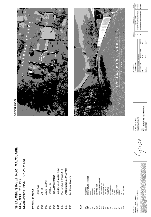
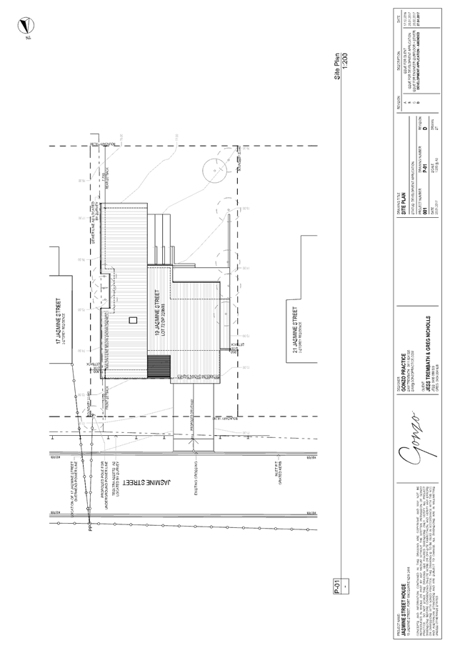
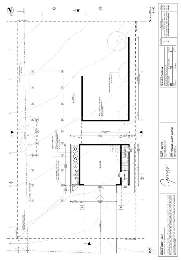
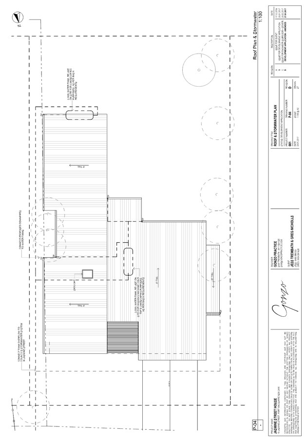
|
ATTACHMENT
|
Development Assessment Panel
10/05/2017
|
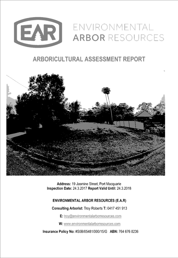
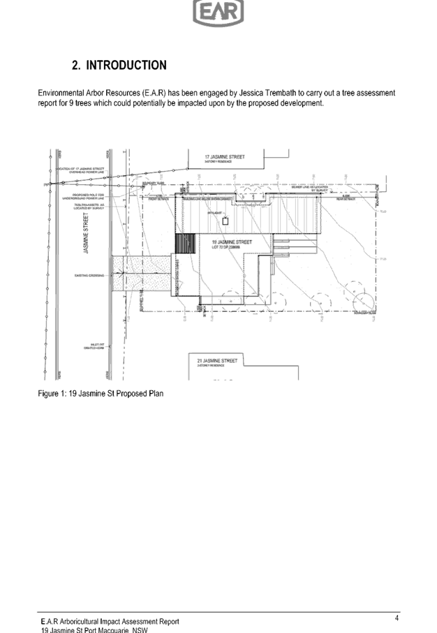
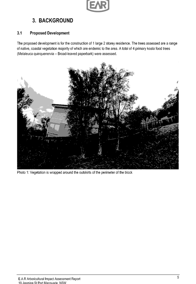
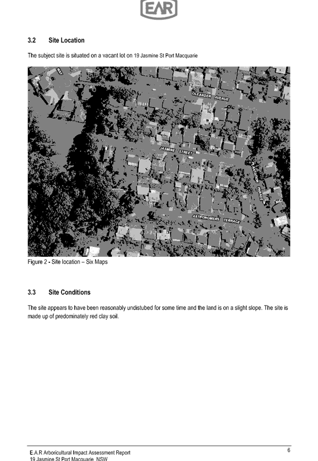
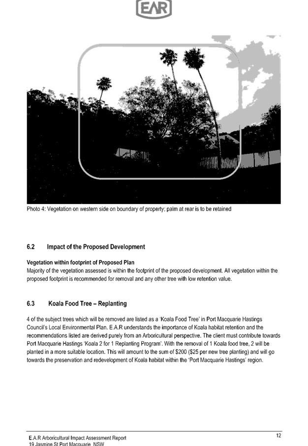
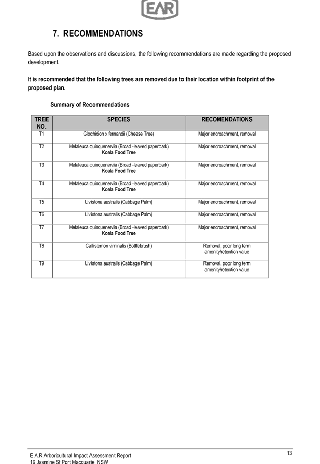
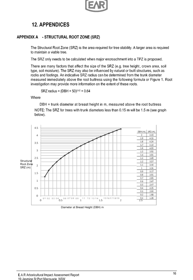
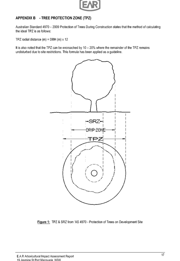


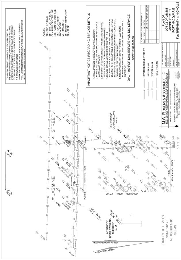
|
ATTACHMENT
|
Development Assessment Panel
10/05/2017
|
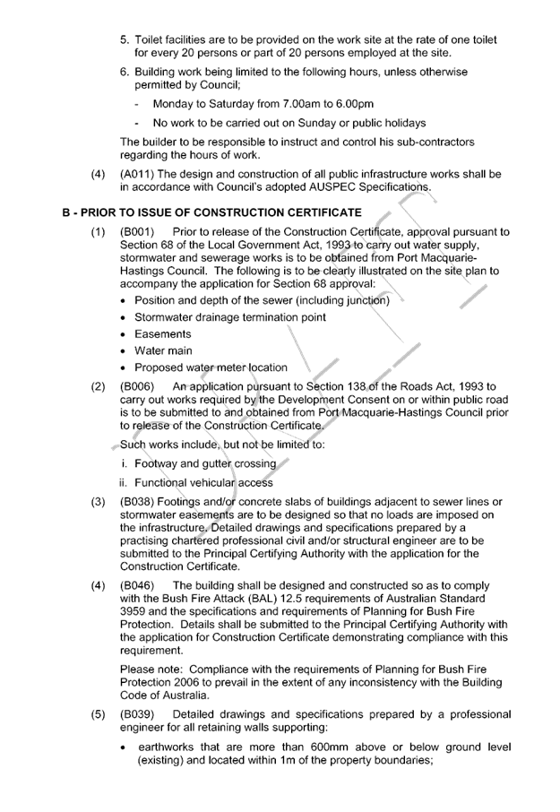
|
ATTACHMENT
|
Development Assessment Panel
10/05/2017
|
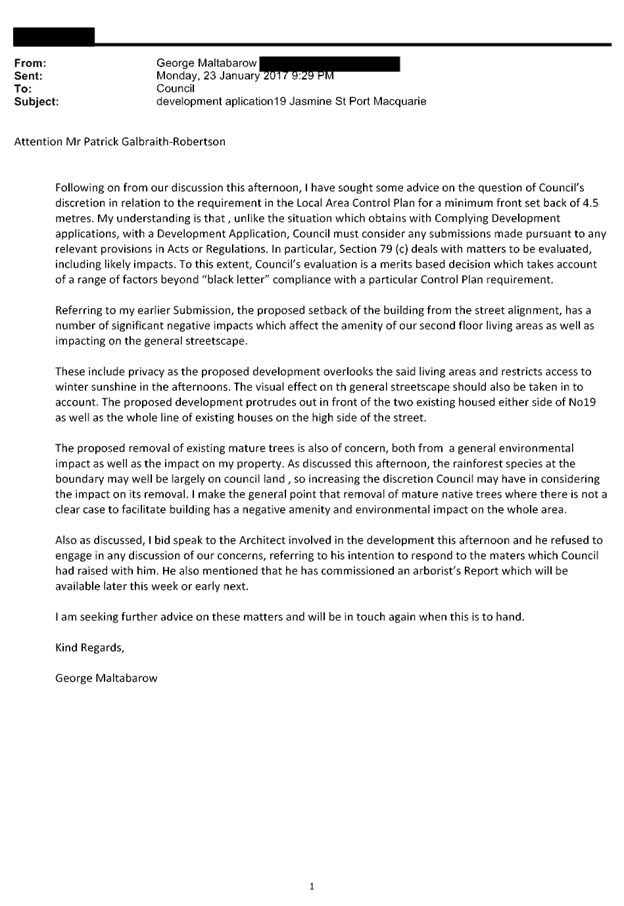
|
ATTACHMENT
|
Development Assessment Panel
10/05/2017
|
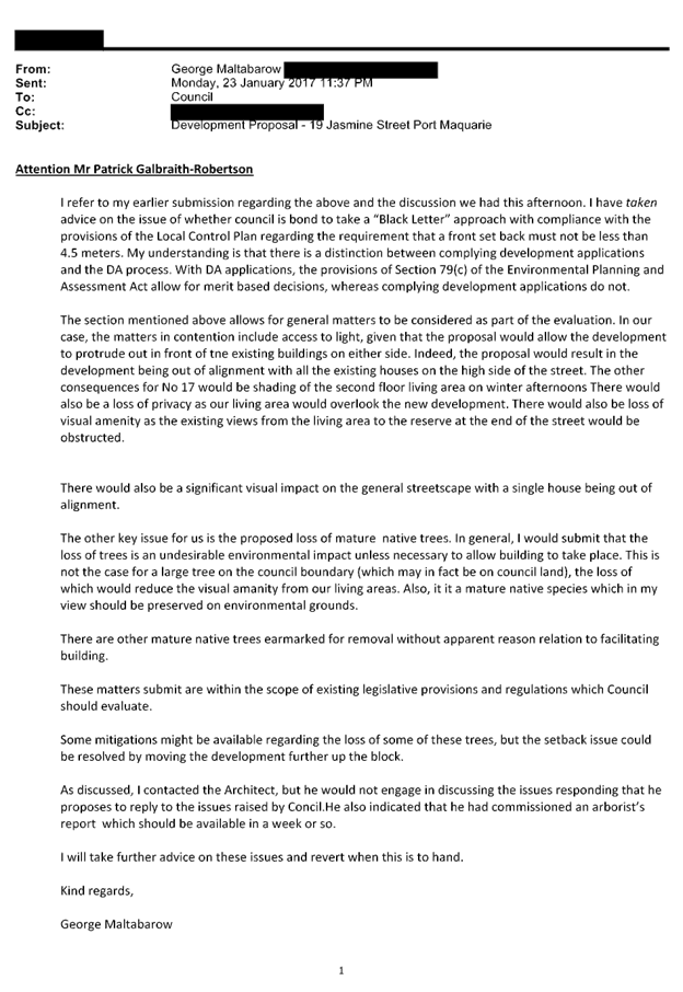
|
ATTACHMENT
|
Development Assessment Panel
10/05/2017
|
|
ATTACHMENT
|
Development Assessment Panel
10/05/2017
|

|
ATTACHMENT
|
Development Assessment Panel
10/05/2017
|
AGENDA Development Assessment Panel 10/05/2017
Item: 08
Subject: DA2017 - 97.1 Additons To Existing Dwelling -
Lot 24 DP 20480, No 18 Bundella Avenue Lake Cathie
Report
Author: Stephen Ryan
|
Applicant: R
J & M V Jolly
Owner: R
J & M V Jolly
Estimated Cost: $40,000
Alignment with Delivery
Program
4.9.2 Undertake transparent
and efficient development assessment in accordance with relevant legislation.
|
|
RECOMMENDATION
That
DA2017 - 97.1 for additions to existing dwelling at Lot 24, DP20480, No. 18 Bundella Avenue, Lake Cathie
be determined by granting consent subject to the recommended conditions.
|
Executive
Summary
This
report considers a development application for additions to an existing
dwelling at the subject site and provides an
assessment of the application in accordance with the Environmental Planning and
Assessment Act 1979.
Following exhibition of the
application, one (1) submission has been
received.
1. BACKGROUND
Existing sites features and Surrounding development
The site has an area of 663.9m2
The site is zoned R1 General Residential in accordance with the Port Macquarie-Hastings Local
Environmental Plan 2011, as shown in the following zoning plan:
The existing subdivision pattern and location of existing
development within the locality is shown in the following aerial photograph:
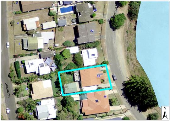
2. DESCRIPTION OF
DEVELOPMENT
Key aspects of the proposal include the following:
· Additions
to dwelling comprising enclosure of part of the rear deck including roof over
and extension of the front entry deck.
Refer
to attachments at the end of this report.
Application Chronology
· 14 February 2017 - Application lodged
· 20 February 2017 - Request for additional fees
(notification)
· 20 February 2017 - 8 March 2017 - Exhibition via neighbour
notification
· 2 March 2017- Submission received.
· 5 April 2017 - Site inspection.
3. STATUTORY ASSESSMENT
Section 79C(1) Matters for Consideration
In determining the application, Council is required to take
into consideration the following matters as are relevant to the development
that apply to the land to which the development application relates:
(a) The provisions (where
applicable) of:
(i) any Environmental
Planning Instrument:
State Environmental Planning Policy No.
44 - Koala Habitat Protection
There is no Koala Plan of
Management on the site. Additionally, the site is less than 1ha in area
therefore no further investigations are required.
State
Environmental Planning Policy No.55 – Remediation of Land
Following an inspection of the site and a search
of Council records, the subject land is not identified as being potentially
contaminated and is suitable for the intended use.
State
Environmental Planning Policy No. 71 – Coastal Protection and Clause 5.5
of Port Macquarie-Hastings Local Environmental Plan 2011
The site is
located within a coastal zone as defined in accordance with clause 4 of SEPP
71.
In accordance
with clause 5, this SEPP prevails over the Port Macquarie-Hastings LEP 2011 in
the event of any inconsistency.
Having regard to
clauses 8 and 12 to 16 of SEPP 71 and clause 5.5 of Hastings LEP 2011 inclusive
the proposed development will not result in any of the following:
a) any restricted
access (or opportunities for access) to the coastal foreshore
b) any
identifiable adverse amenity impacts along the coastal foreshore and on the
scenic qualities of the coast;
c) any
identifiable adverse impacts on any known flora and fauna (or their natural
environment);
d) subject to any
identifiable adverse coastal processes or hazards;
e) any identifiable
conflict between water and land based users of the area;
f) any
identifiable adverse impacts on any items of archaeological/heritage;
g) reduce the
quality of the natural water bodies in the locality.
The site is predominately cleared and
located within an area zoned for residential purposes.
State Environmental Planning Policy
(Building Sustainability Index: BASIX) 2004
BASIX is not
applicable (Cost Less than $50,000).
Port Macquarie-Hastings Local Environmental Plan 2011
The proposal is consistent with the LEP having regard to the
following:
· Clause 2.2,
the subject site is zoned R1 General Residential. In accordance with clause
2.3(1) and the R1 zone landuse table, the dwelling additions are a permissible
landuse with consent.
The objectives of
the R1 zone are as follows:
o To
provide for the housing needs of the community.
o To
provide for a variety of housing types and densities.
o To enable
other land uses that provide facilities or services to meet the day to day
needs of residents.
a)
In accordance with Clause 2.3(2),
the proposal is consistent with the zone objectives as it is a permissible
landuse and consistent with the established residential locality,
· Clause
2.7, the demolition requires consent as it does not fit within the provisions
of SEPP (Exempt and Complying) 2008.
· Clause
4.3, the maximum overall height of the building above ground level (existing)
is 6.0m which complies with the standard height limit of 8.5m applying to the
site.
· Clause
4.4, the floor space ratio of the proposal is 0.33:1.0 which complies with the
maximum 1.0:1 floor space ratio applying to the site.
· Clause 7.13,
existing services in place.
· Clause
4.6 – exceptions to development standards.
· Clause
5.6 – Architectural roof features.
· Clause
5.9 - No listed trees in Development Control Plan 2013 are proposed to be
removed.
· Clause
5.10 – Heritage. The site does not contain or adjoin any known heritage
items or sites of significance.
· Clause
7.1, the site is mapped as potentially containing class 3 acid sulphate
soils. No adverse impacts are expected to occur to the acid sulphate
soils found on site.
· Clause 7.3,
the site is not land within a mapped “flood planning area”.
· Clause 7.5
– Koala Habitat – The land is not identified as a “Koala Habitat
area” on the Koala Habitat Map.
· Clause 7.6
– Applies to land that is shown as Coastal Erosion Risk on the Coastal
Erosion Map (Lake Cathie/Town Beach). In this regard the following comments are
provided which incorporate consideration of the objectives of Clause 7.6 &
the Coastal Protection Act 1979, NSW Coastal Policy 1997 And any relevant
Coastal Zone Management Plan (CZMP);
o The proposal will not significantly
adversely affect coastal hazards;
o The proposal will not result in
significant detrimental increases in coastal risks to other development or
properties;
o The proposal will not significantly
alter coastal hazards to the detriment of the environment;
o The proposal enables evacuation of
coastal risk areas in an emergency;
o The proposal avoids or minimises
exposure to coastal hazards and is compatible with the coastal risk (see clause
below)
o The proposal is in line with the
provisions of the Lake Cathie Coastal Zone Management Plan.
· Clause 7.7
– Airspace operations- N/A
· Clause 7.8 -
Development in areas subject to aircraft noise- N/A
· Clause 7.9 -
Development subject to acoustic controls - N/A
· Clause7.13,
satisfactory arrangements are in place for provision of essential services.
(ii) Any
draft instruments that apply to the site or are on exhibition:
No draft
instruments apply to the site.
(iii) any
Development Control Plan in force:
Port
Macquarie-Hastings Development Control Plan 2013
|
DCP 2013: Dwellings, Dual occupancies, Dwelling
houses, Multi dwelling houses & Ancillary development
|
|
|
Requirements
|
Proposed
|
Complies
|
|
3.2.2.1
|
Ancillary
development:
• 4.8m max. height
• Single storey
• 60m2 max. area
• 24 degree max. roof pitch
• Not located in front setback
|
Front
deck addition.
2.1m-
Maintains existing deck height.
Single
storey
9.885m² in
total
Rear
setback
Front
setback- In excess of allowable deck setback within articulation zone.
|
Yes
Yes
Yes
N/A
Yes
|
|
|
Front
setback (Residential not R5 zone):
• Min. 4.5m local road or within 20% of adjoining
dwelling if on corner lot
|
4.5m
|
Yes
|
|
3.2.2.2
|
Articulation
zone:
• Min. 3m front setback
• An entry feature or portico
• A balcony, deck, patio, pergola, terrace or verandah
• A window box treatment
• A bay window or similar feature
• An awning or other feature over a window
• A sun shading feature
|
4.5m
-
Front deck addition
-
-
-
-
|
Yes
N/A
Yes
N/A
N/A
N/A
N/A
|
|
3.2.2.3
|
Garage
5.5m min. and 1m behind front façade.
Garage
door recessed behind building line or eaves/overhangs provided
|
Maintains existing garage setback
|
Yes
|
|
|
Driveway
crossover 1/3 max. of site frontage and max. 5.0m width
|
Maintains
existing driveway
|
Yes
|
|
3.2.2.4
|
4m
min. rear setback. Variation subject to site analysis and provision of
private open space
|
12m
|
Yes
|
|
3.2.2.5
|
Side
setbacks:
• Ground floor = min. 0.9m
• First floors & above = min. 3m setback or where
it can be demonstrated that overshadowing not adverse = 0.9m min.
• Building wall set in and out every 12m by 0.5m
|
1.057m
setback to northern boundary.
9m
(rear addition) & 13.7m (front deck addition) setback to southern
boundary
Due
to the orientation of the additions overshadowing
will not be adverse therefore the proposed setback is acceptable.
|
Yes
Yes
N/A
|
|
3.2.2.6
|
35m²
min. private open space area including a useable 4x4m min. area which has 5%
max. grade
|
Available
at rear
|
Yes
|
|
3.2.2.10
|
Privacy:
• Direct views between living areas of adjacent
dwellings screened when within 9m radius of any part of window of adjacent
dwelling and within 12m of private open space areas of adjacent dwellings.
ie. 1.8m fence or privacy screening which has 25% max. openings and is
permanently fixed
• Privacy screen required if floor level > 1m
height, window side/rear setback (other than bedroom) is less than 3m and
sill height less than 1.5m
b)
• Privacy screens provided to balconies/verandahs etc
which have <3m side/rear setback and floor level height >1m
|
Rear
deck is existing. Direct views from the rear deck are restricted by existing
vegetation. Privacy impacts are not considered to be any greater than what
already exists from the existing deck and kitchen window. The front deck
addition is to the public open space.
Existing
deck at rear. Works at the rear are not sited within 3m of the boundary and
do not require screening. The enclosing wall is to be sited 3.797m from the
northern boundary. Other works to the rear deck comprise a roof addition . The
front deck addition does not require a privacy screen as views are to
the public open space.
|
Yes
N/A
Yes
|
|
DCP 2013: General Provisions
|
|
|
Requirements
|
Proposed
|
Complies
|
|
2.7.2.2
|
Design addresses generic principles of Crime
Prevention Through Environmental Design guideline
|
Adequate
casual surveillance available
|
Yes
|
|
2.5.3.2
|
New
accesses not permitted from arterial or distributor roads
|
Maintains
existing access
|
Yes
|
|
|
Driveway crossing/s minimal in number and width
including maximising street parking
|
Maintains
existing driveway crossover
|
Yes
|
|
2.5.3.3
|
Parking in accordance with
Table 2.5.1.
1 space per single dwelling (behind building line)
|
No
change to existing parking
|
Yes
|
|
2.5.3.11
|
Section
94 contributions
|
Refer
to main body of report.
|
|
|
2.5.3.14
|
Sealed driveway surfaces unless justified
|
Existing
sealed driveway
|
Yes
|
(iiia) any
planning agreement that has been entered into under Section 93f or any draft
planning agreement that a developer has offered to enter into under Section
93f:
No planning agreement has been offered or entered into relating to the
site.
iv) any matters
prescribed by the Regulations:
New South Wales Coastal Policy:
The proposed development is consistent with the objectives and strategic
actions of this policy.
Demolition of buildings AS 2601:
N/A
v) any coastal
zone management plan (within the meaning of the Coastal Protection Act 1979),
that apply to the land to which the development application relates:
N/A
(b) The
likely impacts of that development, including environmental impacts on both the
natural and built environments, social and economic impacts in the locality:
Context and setting
Solar access-
• The
proposal will be unlikely to have any adverse impacts
in regard to solar access.
Public
domain-
• The
proposal will be unlikely to have any adverse impacts to existing adjoining
properties and satisfactorily addresses the public domain.
• The
proposal is considered to be consistent with other residential development in
the locality and adequately addresses planning controls for the area.
View sharing-
• There
are no adverse impacts on existing view sharing.
Privacy-
• Privacy impacts from the proposed works are considered to
be no greater than what already exists on the site.
Access, transport and traffic
The proposal will be unlikely to
have any adverse impacts in terms access, transport and traffic. The existing
road network will satisfactorily cater for any increase in traffic generation
as a result of the development.
Water Supply
Service available.
Sewer
Service available.
Stormwater
Service
available.
Other
Utilities
Telecommunication
and electricity services are available to the site.
Heritage
This site does not contain or adjoin any known heritage
item or site of significance.
Other land
resources
No adverse
impacts anticipated. The site is within an established urban context and will
not sterilise any significant mineral or agricultural resource.
Water
cycle
The proposed
development will be unlikely to have any adverse impacts on water resources and
the water cycle.
Soils
The proposed
development will be unlikely to have any adverse impacts on soils in terms of
quality, erosion, stability and/or productivity subject to a standard condition
requiring erosion and sediment controls to be in place prior to and during
construction.
Air and
microclimate
The
construction and/or operations of the proposed development will be unlikely to
result in any adverse impacts on the existing air quality or result in any
pollution.
Flora and
fauna
Construction
of the proposed development will not require any removal/clearing of any
significant vegetation and therefore will be unlikely to have any significant
adverse impacts on biodiversity or threatened species of flora and fauna.
Section 5A of the Act is considered to be satisfied.
Waste
Satisfactory
arrangements are in place for proposed storage and collection of waste and
recyclables. No adverse impacts anticipated.
Energy
The proposal includes measures to
address energy efficiency and will be required to comply with the requirements
of BASIX.
Noise and vibration
No adverse impacts anticipated.
Condition recommended to restrict construction to standard construction hours.
Bushfire
The site is not identified as
being bushfire prone.
Safety,
security and crime prevention
The proposed
development will be unlikely to create any concealment/entrapment areas or
crime spots that would result in any identifiable loss of safety or reduction
of security in the immediate area.
Social
impacts in the locality
Given the
nature of the proposed development and its’ location the proposal is
unlikely to result in any adverse social impacts.
Economic impact in the locality
No adverse impacts. Likely positive impacts can be attributed to the
construction of the development and associated flow on effects (i.e. increased
expenditure in the area).
Site design
and internal design
The proposed
development design is satisfactorily responds to the site attributes and will
fit into the locality. No adverse impacts likely.
Construction
No potential
adverse impacts identified to neighbouring properties with the construction of
the proposal.
Cumulative
impacts
The proposed
development is not expected to have any adverse cumulative impacts on the
natural or built environment or the social and economic attributes of the
locality.
(c) The
suitability of the site for the development
The proposal will
fit into the locality and the site attributes are conducive to the proposed
development.
(d) Any submissions made in
accordance with this Act or the Regulations:
One (1) written submission has been received following public
exhibition of the application.
Key issues raised in the submissions received and comments
in response to these issues are provided as follows:
|
Submission
Issue/Summary
|
Planning
Comment/Response
|
|
Reduction in privacy to the
property at the rear.
|
It is not considered that
there is any more significant privacy impact than already exists from the
existing deck and windows sited along the northern boundary. Direct
views from the rear deck are restricted by existing vegetation on the
adjoining property.
|
|
Requirement for privacy screen
as per previous consent.
|
Privacy screen requirements
relating to a previous consent are not applicable to this Development
Application.
The proposed works do not
alter the function of the existing deck.
|
(e) The Public Interest:
The proposed
development satisfies relevant planning controls and is unlikely to impact on
the wider public interest.
4. DEVELOPMENT
CONTRIBUTIONS APPLICABLE
· N/A
5. CONCLUSION
The application has been assessed in accordance with Section
79C of the Environmental Planning and Assessment Act 1979.
Issues raised during assessment and public exhibition of
the application have been considered in the assessment of the application.
Where relevant, conditions have been recommended to manage the impacts
attributed to these issues.
The site is suitable for the proposed development, is not
contrary to the public's interest and will not have a significant adverse
social, environmental or economic impact. It is recommended that the
application be approved, subject to the recommended conditions of consent
provided in the attachment section of this report.
|
Attachments
1View. DA2017
- 97.1 Plans
2View. DA2017
- 97.1 Recommended Conditions
3View. DA2017
- 97.1 Submission - Noble.
|
|
ATTACHMENT
|
Development Assessment Panel
10/05/2017
|
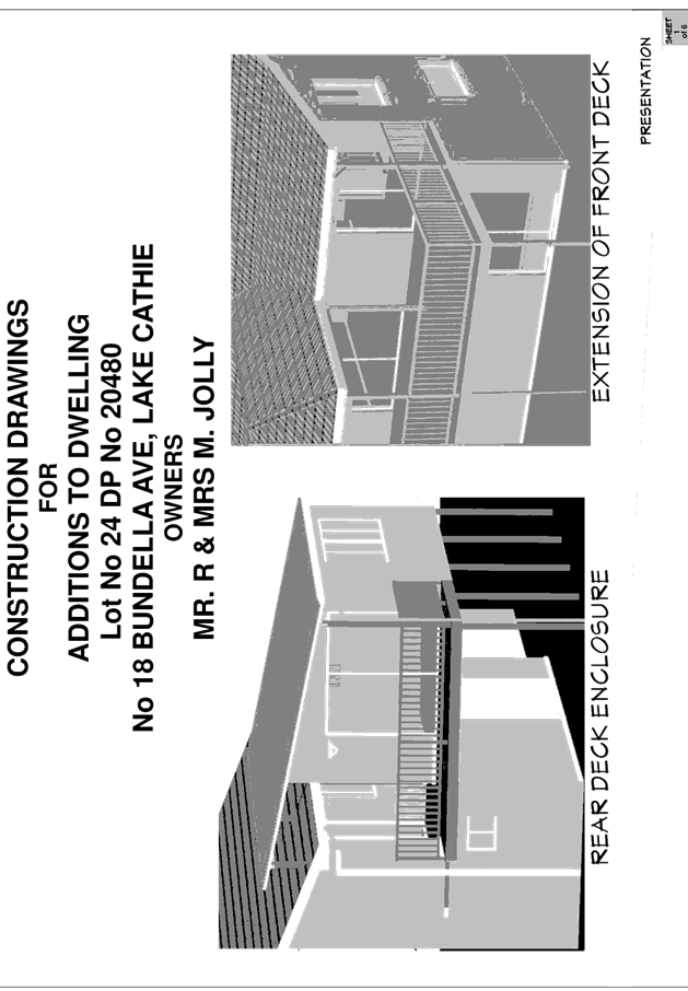
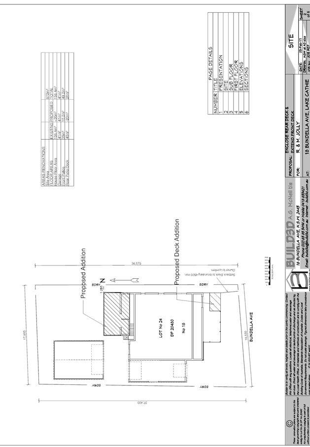
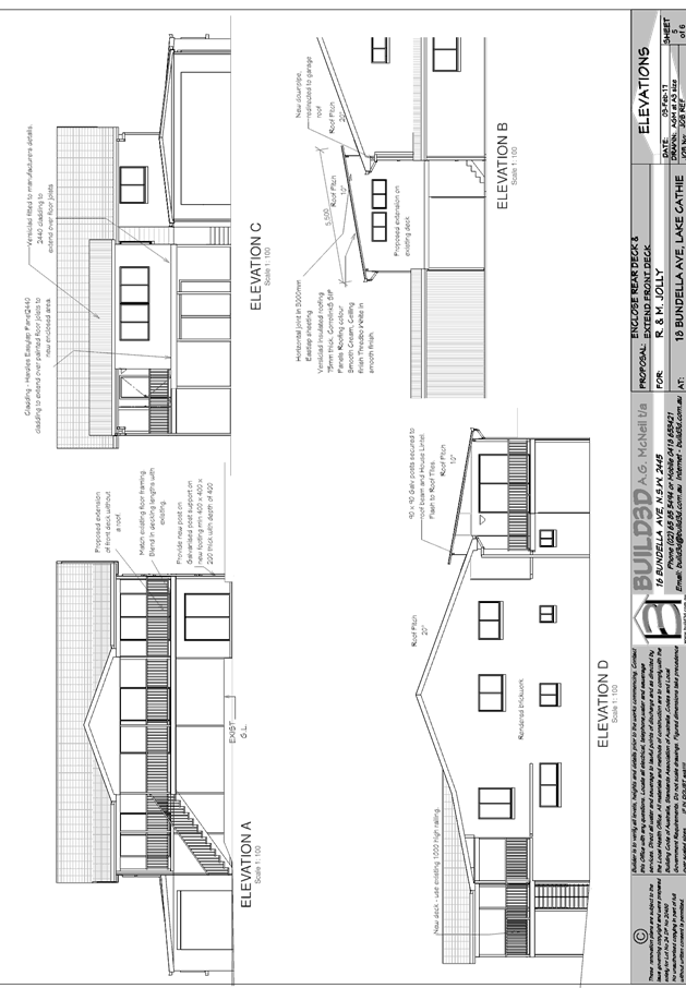
|
ATTACHMENT
|
Development Assessment Panel
10/05/2017
|

|
ATTACHMENT
|
Development Assessment Panel
10/05/2017
|
AGENDA Development Assessment Panel 10/05/2017
Item: 09
Subject: DA2017 - 99.1 Alterations And Additions To
Dwelling Including Clause 4.6 Objection To Clause 4.3 (Height Of
Buildings) Of The Port Macquarie -Hastings Local Environmental Plan 2011 And
Construction Of Swimming Pool - Lot 31 DP 231816, No 21 Matthew Flinders Drive,
Port Macquarie
Report
Author: Deb McKenzie
|
Applicant: S
A Hall and M A Hall
Owner: S
A Hall and M A Hall
Estimated Cost: $380,000
Alignment with Delivery
Program
4.9.2 Undertake transparent
and efficient development assessment in accordance with relevant legislation.
|
|
RECOMMENDATION
That
it be recommended to Council that DA 2017 - 99.1 for alterations and additions to existing dwelling at
Lot 31 DP231816, No.21 Matthew Flinders Drive, Port Macquarie be determined
by granting consent subject to the recommended conditions.
|
Executive
Summary
This
report considers a development application for alterations and additions to an
existing dwelling and construction of swimming pool at the subject site. The
application includes a request from the applicant to vary the maximum height of
the dwelling pursuant to Clause 4.6 of Port Macquarie-Hastings Local
Environmental Plan 2011. Clause 4.3 of HLEP 2011 prescribes a maximum height of
building limit for this site of 8.5m. The proposal contains a stepped roofline
with the maximum height of the northern ridge of the roof of 9.52m. This
equates to a variation of 12%.
Council
staff and/the Development Assessment Panel do not have delegation to approve
Clause 4.6 variations beyond 10% of the development standard. Therefore the
application is to be referred to Ordinary Council for determination.
This report
provides an assessment of the application in accordance with the Environmental
Planning and Assessment Act 1979. It concludes that the variation is reasonable
in this case and the proposal is suitable for the site.
1. BACKGROUND
Existing sites features and surrounding development
The site has an area of 602.4m2.
The site is zoned R1 General Residential in accordance with the Port Macquarie-Hastings Local
Environmental Plan 2011, as shown in the following zoning plan:
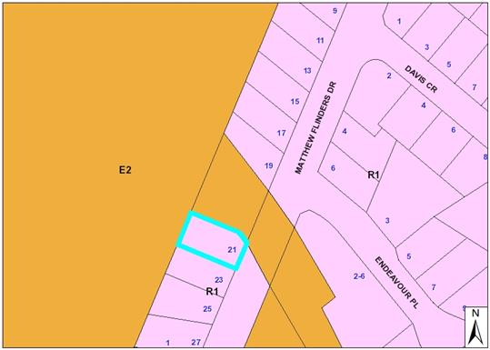
The existing subdivision pattern and location of existing
development within the locality is shown in the following aerial photograph:
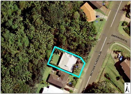
2. DESCRIPTION OF
DEVELOPMENT
Key aspects of the proposal include the following:
· Proposal
seeks to make substantial alterations and additions to the dwelling, utilising
the existing building envelope.
· The
dwelling is to contain 4 bedrooms, three bathrooms with upper floor master
bedroom, ensuite, yoga room and family/office room with verandahs.
· The
existing double garage is retained and new subfloor storage area created at
garage level.
· A
new swimming pool is to be located at the rear of the dwelling.
· There
are no neighbouring residential properties to the north or rear of the site.
· E2 Environmental Conservation Zone is located on the
northern side and at the rear of the site. This is heavily vegetated.
· The dwelling is located within a ‘flame zone’
in terms of bushfire risk. The application was referred to the RFS for comment.
Refer
to attachments at the end of this report.
Application Chronology
· Application
lodged: 14 February 2017
· Public
notification finished: 9 March 2017
· No
submissions received.
· RFS
response received: 23 March 2017.
· Advised
applicant of RFS requirements: 27 March 2017.
· Applicant
requests assessment of the application, as lodged: 4 April 2017.
3. STATUTORY ASSESSMENT
Section 79C(1) Matters for Consideration
In determining the application, Council is required to take
into consideration the following matters as are relevant to the development
that apply to the land to which the development application relates:
(a) The provisions (where
applicable) of:
(i) any Environmental
Planning Instrument:
State Environmental Planning Policy No.
26 - Littoral Rainforest
Clause 4 states the following:
4 Application
of Policy
(1) This Policy applies to:
(a) land enclosed by the outer edge
of the heavy black line on the series of maps held in the Department and marked
“State Environmental Planning Policy No 26—Littoral Rainforests
(Amendment No 2)”, and
(b) land not so enclosed but within
a distance of 100 metres from the outer edge of that heavy black line except
residential land and land to which State Environmental Planning Policy No
14—Coastal Wetlands applies.
The site is within 100m of a designated
Littoral Rainforest but is residentially zoned land. On this basis, the
provisions of the SEPP do not apply in this case.
State Environmental Planning Policy No.
44 - Koala Habitat Protection
The site is less than 1ha in area
therefore no further investigations are required.
State
Environmental Planning Policy No.55 – Remediation of Land
The subject land is not identified as being
potentially contaminated and is suitable for the intended use.
State
Environmental Planning Policy No. 71 – Coastal Protection and Clause 5.5
of Port Macquarie-Hastings Local Environmental Plan 2011
The site is
located within a coastal zone as defined in accordance with clause 4 of SEPP
71.
In accordance
with clause 5, this SEPP prevails over the Port Macquarie-Hastings LEP 2011 in
the event of any inconsistency.
Having regard to
clauses 8 and 12 to 16 of SEPP 71 and clause 5.5 of Hastings LEP 2011 inclusive
the proposed development will not result in any of the following:
a) any
restricted access (or opportunities for access) to the coastal foreshore
b) any
identifiable adverse amenity impacts along the coastal foreshore and on the
scenic qualities of the coast;
c) any
identifiable adverse impacts on any known flora and fauna (or their natural
environment);
d) subject
to any identifiable adverse coastal processes or hazards;
e) any
identifiable conflict between water and land based users of the area;
f) any
identifiable adverse impacts on any items of archaeological/heritage;
g) reduce
the quality of the natural water bodies in the locality.
The site is predominately cleared and
located within an area zoned for residential purposes.
State Environmental Planning Policy
(Building Sustainability Index: BASIX) 2004
A BASIX
certificate (number A269540) has been submitted demonstrating that the proposal
will comply with the requirements of the SEPP. It is recommended that a
condition be imposed to ensure that the commitments are incorporated into the
development and certified at Occupation Certificate stage.
Port Macquarie-Hastings Local Environmental Plan 2011
The proposal is consistent with the LEP having regard to the
following:
· Clause
2.2, the subject site is zoned R1 General Residential. In accordance with
clause 2.3(1) and the R1 zone landuse table, the dwelling (or ancillary
structure to a dwelling) is a permissible landuse with consent.
The objectives of
the R1 zone are as follows:
§ To provide for
the housing needs of the community.
§ To provide for a
variety of housing types and densities.
§ To enable other
land uses that provide facilities or services to meet the day to day needs of residents.
In accordance
with Clause 2.3(2), the proposal is consistent with the zone objectives as it
is a permissible landuse and consistent with the established residential
locality,
· Clause
2.7, the demolition requires consent as it does not fit within the provisions
of SEPP (Exempt and Complying) 2008. No specific requirements.
· Clause
4.3, the maximum overall height of the building above ground level (existing)
is 9.52m which is non-compliant with the standard height limit of 8.5m applying
to the site. The applicant has submitted a written request seeking variation of
the height limit pursuant to Clause 4.6 of the LEP. Refer to assessment
below.
· Clause
4.4, the floor space ratio of the proposal is 0.62:1 which complies with the
maximum 0.65:1 floor space ratio applying to the site.
· Clause
4.6 – exceptions to development standards. The applicant has submitted a
written request seeking variation of the height limit pursuant to Clause 4.6 of
the LEP. Refer to assessment below.
· Clause
5.10 – Heritage. The site does not contain or adjoin any known heritage
items or sites of significance.
· Clause7.13
- satisfactory arrangements are in place for provision of essential services.
Clause 4.6
Assessment
The applicant
has submitted a clause 4.6 variation request to allow the upper ridgeline of
the front of the dwelling (directly above the garage only) to be 9.52m, 1.02m
higher than the permitted 8.5m.
The area of the
non-compliance is contained on the northern portion of the dwelling. This area
of the dwelling does not adjoin any neighbouring dwellings (only rainforest)
and only applies to the roof above the upper floor office and verandah where
the fall of the land steps down the site towards the front boundary. The built
form steps down across the site from north to south, being only two storeys
adjacent the southern property boundary.
The variation
equates to a 12% of the development standard.
Clause 4.6(3) requires Council to be
satisfied that the written request justifies the contravention of the development
standard by demonstrating:
(a) that compliance
with the development standard is unreasonable or unnecessary in the
circumstances of the case, and
(b) that there are
sufficient environmental planning grounds to justify contravening the development
standard.
The applicant submits that:
· Compliance with the development
standard is will be minimal negative impact on the ‘streetscape’
proposal as the articulated roof form combined with the varied selection of
wall cladding materials will transform this building into a contemporary
seaside dwelling.
· It can also be seen that there is
a reduction in roof height along the southern boundary adjacent to the
adjoining dwelling which will help ameliorate any perception of bulk or
overbearing.
· There will be a minimal increase
in overshadowing of the adjoining site to the south caused by the lengthening
of the dwelling along this boundary. However it can be seen that a conventional
1.8m boundary fence would have also have an effect along this boundary.
· The use of highlight windows in
bedrooms combined with the alfresco shutters being below the top of the fence
line will ensure no loss of visual privacy and help minimise acoustic privacy.
The new top floor verandahs are located over 10m to the north away from the
adjoining southern boundary.
The
applicant’s submission establishes that there is a case to consider the
development standard as unreasonable and unnecessary for the proposal. Further,
that environmental planning grounds relating to streetscape, overshadowing and
overlooking are relevant.
Clause 4.6(4) states that
development consent must not be granted for development that contravenes a
development standard unless:
(a) the consent
authority is satisfied that:
(i) the
applicant’s written request has adequately addressed the matters required
to be demonstrated by subclause (3), and
(ii) the proposed
development will be in the public interest because it is consistent with the
objectives of the particular standard and the objectives for development within
the zone in which the development is proposed to be carried out, and
The
applicant’s submission has adequately addressed the matters in clause 3
above. The development standard and zone objectives are addressed below.
The R1 Zone
objectives are as follows:
· To
provide for the housing needs of the community.
· To
provide for a variety of housing types and densities.
· To
enable other land uses that provide facilities or services to meet the day to
day needs of residents.
Comment: the proposal
provides for the housing in the community, it maintains its low density nature,
in an area predominantly characterised by larger low density dwellings.
Therefore the proposal achieves the zone objectives.
The height of
building objectives are as follows:
(a) to
ensure that buildings are compatible with the height, bulk and scale of the
existing and desired future character of the locality
Comment: Lighthouse Beach contains a variety of dwellings
that have large building envelopes, located on sloping sites that predicate
non-compliance with local standards. The proposal has one area of
non-compliance that is result of the slope of the site towards the front
boundary. If the dwelling was compliant it would not necessarily present a
significantly different height, bulk and scale of development when viewed from
Matthew Flinders Drive.
(b) to
minimise visual impact, disruption of views, loss of privacy and loss of solar
access to existing development,
Comment: the design of the alterations and
additions are stepped across the site from north to south. There are no
neighbours on the northern side (only rainforest - zoned E2 land). The higher
component is retained directly over the garage. Adjacent the southern boundary
the dwelling is two storeys. The dwelling is setback 6.0m from the front
boundary, thereby not imposing over the street frontage or creating significant
opportunities for overlooking neighbours. There is no loss of view or shadow
effect as a result of the non-compliance in this case.
(c) to
minimise the adverse impact of development on heritage conservation areas and
heritage items,
Comment: Not applicable.
(d) to
nominate heights that will provide a transition in built form and land use
intensity within the area covered by this Plan.
Comment: the proposal is not antipathetic to this
objective.
Summary: the
applicant has established that strict compliance with the 8.5m height limit for
the dwelling is unreasonable and unnecessary in the circumstances. This is
based on:
· The area of
the non-compliance relates to one habitable room and verandah at the front of
the dwelling.
· The
additional height is located over the garage, towards the northern boundary
where there is no adjoining residential property.
· The height
of the dwelling adjacent the southern boundary is two storeys and complies with
the development standard.
· The dwelling
does not overpower the street presentation as it is setback some 6m from the
front boundary and articulated by the porch and entry stairs.
(ii) Any
draft instruments that apply to the site or are on exhibition:
Nil
(iii) any
Development Control Plan in force:
Port
Macquarie-Hastings Development Control Plan 2013
|
DCP 2013: Dwellings, Dual
occupancies, Dwelling houses, Multi dwelling houses & Ancillary
development
|
|
|
Requirements
|
Proposed
|
Complies
|
|
3.2.2.2
|
Articulation zone:
|
N/A
|
N/A
|
|
Front setback (Residential not R5
zone):
• Min. 6.0m
classified road
• Min. 4.5m local
road or within 20% of adjoining dwelling if on corner lot
• Min. 3.0m
secondary road
• Min. 2.0m
Laneway
|
Local road: > 4.5m
Proposal = 6m
|
Yes
|
|
3.2.2.4
|
4m min. rear setback. Variation
subject to site analysis and provision of private open space
|
As existing. No change.
|
Yes
|
|
3.2.2.5
|
Side setbacks:
• Ground floor =
min. 0.9m
• First floors
& above = min. 3m setback or where it can be demonstrated that
overshadowing not adverse = 0.9m min.
• Building wall
set in and out every 12m by 0.5m
|
Ground Floor = 0.9m
First Floor = 1.9m and no adverse
overshadowing caused by the building setback
|
Yes
|
|
3.2.2.6
|
35m2 min. private open space area
including a useable 4x4m min. area which has 5% max. grade
|
Alfresco area is 4.1m x 8.3m =
34.03sqm + rear setback area.
|
Yes
|
|
3.2.2.10
|
Privacy:
• Direct views
between living areas of adjacent dwellings screened when within 9m radius of
any part of window of adjacent dwelling and within 12m of private open space
areas of adjacent dwellings. ie. 1.8m fence or privacy screening which has
25% max. openings and is permanently fixed
• Privacy screen
required if floor level > 1m height, window side/rear setback (other than
bedroom) is less than 3m and sill height less than 1.5m
• Privacy screens
provided to balconies/verandahs etc which have <3m side/rear setback and
floor level height >1m
|
There are no neighbours on the
northern boundary.
The windows on the southern
boundary are highlight windows only and offset with openings in the northern
elevation of the adjoining dwelling.
The rear alfresco area is not
opened to the southern boundary and fitted with bi-fold shutters for
privacy purposes.
|
Yes
|
(iiia) any
planning agreement that has been entered into under Section 93f or any draft
planning agreement that a developer has offered to enter into under Section
93f:
None.
iv) any matters prescribed by the
Regulations:
NSW Coastal
Policy 1997
The proposed
development is consistent with the objectives and strategic actions of this
policy.
Demolition of
buildings AS 2601 – Clause 66 (b)
Demolition of
the existing building on the site is capable of compliance with this Australian
Standard and is recommended to be conditioned.
v) any coastal
zone management plan (within the meaning of the Coastal Protection Act 1979),
that apply to the land to which the development application relates:
Nil.
(b) The
likely impacts of that development, including environmental impacts on both the
natural and built environments, social and economic impacts in the locality:
Context and setting
• The
proposal will be unlikely to have any adverse impacts to existing adjoining
properties and satisfactorily addresses the public domain.
• The proposal is considered to be consistent with other
residential development in the locality and adequately addresses planning
controls for the area.
• There
is no adverse impact on existing view sharing.
• There is no adverse privacy impacts.
Access, transport and traffic
The proposal will be unlikely to have any adverse impacts in
terms access, transport and traffic.
Water, sewer, stormwater
Service available – details required with S.68
application.
Other Utilities
Telecommunication and electricity
services are available to the site.
Flora and fauna
Construction of
the proposed development will not require any removal/clearing of any
significant vegetation and therefore will be unlikely to have any significant
adverse impacts on biodiversity or threatened species of flora and fauna.
Waste
Satisfactory arrangements are in
place for proposed storage and collection of waste and recyclables. No adverse
impacts anticipated.
Energy
The proposal includes measures to
address energy efficiency and will be required to comply with the requirements
of BASIX.
Noise and vibration
No adverse impacts anticipated.
Bushfire
The site is identified as being
bushfire prone – Flame Zone. The application was referred to the RFS for
their assessment. The RFS provided conditions of approval which are recommended
to be included in the development consent.
Social and Economic impacts in
the locality
Given the nature of the proposed
development and its’ location the proposal is unlikely to result in any
adverse social or economic impacts.
Site design and internal
design
The proposed development design
is satisfactorily responds to the site attributes and will fit into the
locality. No adverse impacts likely.
Cumulative impacts
The proposed development is not
expected to have any adverse cumulative impacts on the natural or built
environment or the social and economic attributes of the locality.
(c) The suitability of the site for
the development:
The proposal
will fit into the locality and the site attributes are conducive to the
proposed development.
Site constraints
of bushfire zoning will need to be addressed in the building materials and
treatment of openings, as per the RFS requirements.
(d) Any submissions made in
accordance with this Act or the Regulations:
No written submissions were received following public
exhibition of the application.
(e) The Public Interest:
The proposed
development satisfies relevant planning controls and is unlikely to impact on
the wider public interest.
4. DEVELOPMENT
CONTRIBUTIONS APPLICABLE
· Nil.
5. CONCLUSION
The application has been assessed in accordance with
Section 79C of the Environmental Planning and Assessment Act 1979.
Issues raised during assessment and public exhibition of
the application have been considered in the assessment of the application.
Where relevant, conditions have been recommended to manage the impacts attributed
to these issues.
The site is suitable for the proposed development, is not
contrary to the public's interest and will not have a significant adverse
social, environmental or economic impact. It is recommended that the
application be approved, subject to the recommended conditions of consent
provided in the attachment section of this report.
|
Attachments
1View. DA2017
- 99.1 Plans
2View. DA2017
- 99.1 Recommended Conditions
|
|
ATTACHMENT
|
Development Assessment Panel
10/05/2017
|
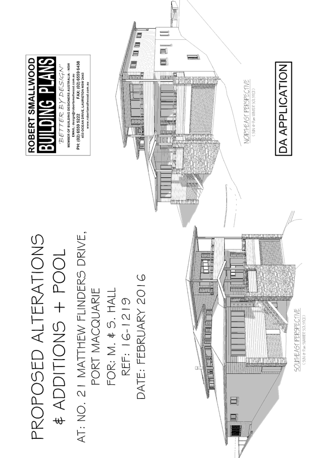
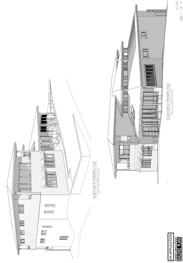
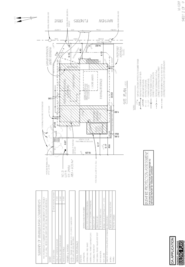
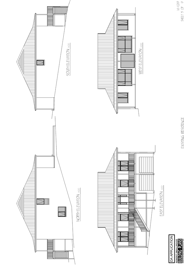
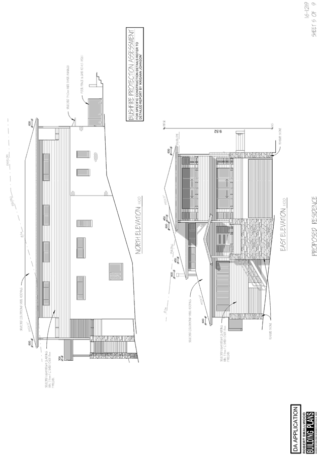
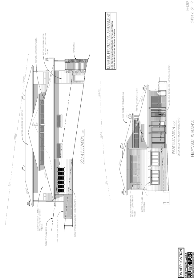
|
ATTACHMENT
|
Development Assessment Panel
10/05/2017
|

AGENDA Development Assessment Panel 10/05/2017
Item: 10
Subject: DA2017 - 181.1 Alterations And Additions To
Dwelling And Boundary Fence - Lot 33 DP 1069338, No 76 The Anchorage, Port
Macquarie
Report
Author: Robert Slater
|
Applicant: Wayne
Ellis Architect
Owner: R
R & K M Falzon
Estimated Cost: $14,767
Alignment with Delivery
Program
4.9.2 Undertake transparent and
efficient development assessment in accordance with relevant legislation.
|
|
RECOMMENDATION
1. That
DA 2017 - 181.1 for alterations and
additions to dwelling and boundary fence at Lot 33
DP 1069338 No. 76 The Anchorage, Port Macquarie,
be determined by granting consent subject to the recommended
conditions.
|
Executive
Summary
This
report considers a development application for alterations and additions to a
Dwelling and an existing masonry boundary fence at
the subject site and provides an assessment of the application in accordance
with the Environmental Planning and Assessment Act 1979.
Following exhibition of the
application, two (2) submissions have been
received.
1. BACKGROUND
Existing sites features and surrounding development
The site has an area of 833.9m2.
The site is zoned R1 General Residential in accordance with the Port Macquarie-Hastings Local
Environmental Plan 2011, as shown in the following zoning plan:
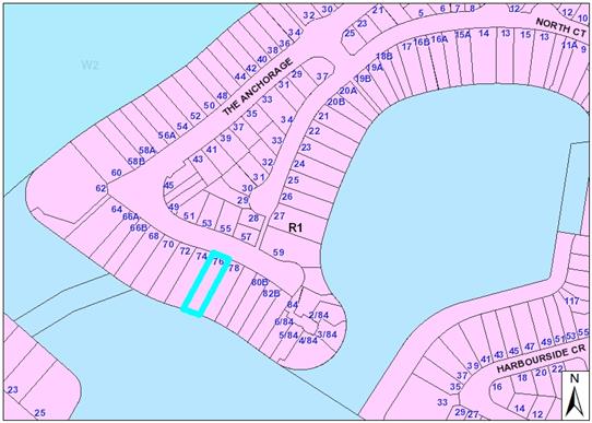
The existing subdivision pattern and location of existing
development within the locality is shown in the following aerial photograph:
The Anchorage precinct comprises predominately of single
dwellings; which are characterised by expansive open space areas overlooking
The Broadwater, South Harbour and the Hastings River. The majority of the
dwellings have access to The Broadwater via jetties and boat mooring facilities.
This open space area is subject to no- build restrictions, easements for
maintenance and in some cases footway.
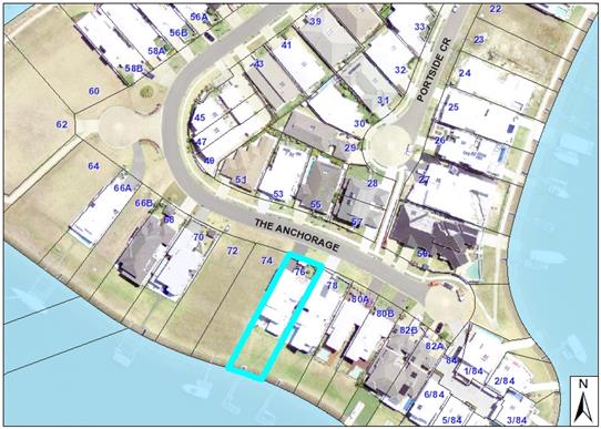
2. DESCRIPTION OF
DEVELOPMENT
Key aspects of the proposal include the following:
· The
removal of fixed glazing panels from the southern elevation of the existing
alfresco area;
· Removal
of the bi-fold doors from the western elevation of the existing alfresco area;
· A
2.6m high timber pergola partially roofed; and
· Extensions
and additions to an existing masonry wall
Refer
to attachments at the end of this report.
Application Chronology
· 8
July 2008 - 2008/167 - Original Application for two storey dwelling and
swimming pool
· 24 September 2009 - 2009/372 - Application for Boat mooring
facility and boat ramp.
· 9 March 2017 - 2017/181 Application for Alterations and
Additions to Dwelling and Boundary Fence.
· 16 March 2017- Notification letters sent to adjoining
neighbours
· 27 March 2017- Submission received
· 31 March 2017 - Submission received
· 5 April and 10 April - site inspections
· 19 April 2017 - Amended Plans received. Applicant making
minor changes to the proposed wall by reducing the height from 2.5m to 2.0m.
The changes did not warrant the re-notification of the application.
3. STATUTORY ASSESSMENT
Section 79C (1) Matters for Consideration
In determining the application, Council is required to take
into consideration the following matters as are relevant to the development
that apply to the land to which the development application relates:
(a) The provisions (where
applicable) of:
(i) any Environmental
Planning Instrument:
State Environmental Planning Policy No.
44 - Koala Habitat Protection
There is no Koala Plan of
Management on the site. Additionally, the site is less than 1ha in area
therefore no further investigations are required.
State
Environmental Planning Policy No.55 – Remediation of Land
Following an inspection of the site and a
search of Council records, the subject land is not identified as being
potentially contaminated and is suitable for the intended use. The requirements
of this SEPP are therefore satisfied.
State
Environmental Planning Policy No. 62 – Sustainable Aquaculture
In accordance
with clause 15C, given the nature of the proposed development, the existing
proposed stormwater controls and its location, the proposal will be unlikely to
have any identifiable adverse impact on any existing aquaculture industries
situated in the Hastings River.
State
Environmental Planning Policy No. 71 – Coastal Protection and Clause 5.5
of Port Macquarie-Hastings Local Environmental Plan 2011
The site is
located within a coastal zone as defined in accordance with clause 4 of SEPP
71.
In accordance
with clause 5, this SEPP prevails over the Port Macquarie-Hastings LEP 2011 in
the event of any inconsistency.
Pertaining to
clauses 8 and 12 to 16 of SEPP 71 and clause 5.5 of Hastings LEP 2011 inclusive
the proposed development will not result in any of the following:
a) any
restricted access (or opportunities for access) to the coastal foreshore
b) any
identifiable adverse amenity impacts along the coastal foreshore and on the
scenic qualities of the coast;
c) any
identifiable adverse impacts on any known flora and fauna (or their natural
environment);
d) subject
to any identifiable adverse coastal processes or hazards;
e) any
identifiable conflict between water and land based users of the area;
f) any
identifiable adverse impacts on any items of archaeological/heritage;
g) reduce
the quality of the natural water bodies in the locality.
In particular, the site is located within
an area zoned and already developed for residential purposes. The requirements
of this SEPP are therefore satisfied.
State Environmental Planning Policy
(Building Sustainability Index: BASIX) 2004
A BASIX
certificate is not required for the proposed development as it less than
$50,000 in value. The existing energy efficient measures pertaining to the
existing dwelling are considered adequate.
Port Macquarie-Hastings Local Environmental Plan 2011
The proposal is consistent with the LEP having regard to the
following:
· Clause
2.2, the subject site is zoned R1 General Residential. In accordance with
clause 2.3(1) and the R1 zone landuse table, the dwelling (or ancillary
structure to a dwelling) is a permissible landuse with consent.
The objectives
of the R1 zone are as follows:
o To provide for
the housing needs of the community.
o To
provide for a variety of housing types and densities.
o To
enable other land uses that provides facilities or services to meet the day to
day needs of residents.
•
In accordance with Clause 2.3(2),
the proposal is consistent with the zone objectives as it is a permissible
landuse and consistent with the established residential locality,
· In
accordance with Clause 4.3, the maximum overall height of the proposed pergola
above ground level (existing) is 2.6 m which complies with the standard height
limit of 8.5m applying to the site.
· In
accordance with Clause 4.4, as there is no change to the existing floor space
ratio of the proposal which complies with the maximum 0.65:1 floor space ratio
applying to the site.
· Clause
5.9 - No listed trees in Development Control Plan 2013 are proposed to be
removed.
· Clause
5.10 – Heritage. The site does not contain or adjoin any known heritage
items or sites of significance.
· Clause
7.1, the site is mapped as potentially containing class 3 acid sulphate soils.
The proposed development includes a partially covered pergola and an extension
to an existing boundary fence, which will require minimal excavation for footings,
however no excavation extending 1m below the natural surface level is proposed,
therefore no adverse impacts are expected to occur to the acid sulphate soils
found on site.
· Clause7.13,
existing satisfactory arrangements are in place for provision of essential
services.
(a)(ii)
Any proposed instrument that is or has been placed on exhibition
No draft
instruments apply to the site.
(a)(iii)
Any DCP in force
Port
Macquarie-Hastings Development Control Plan 2013:
|
DCP 2013: Dwellings, Dual
occupancies, Dwelling houses, Multi dwelling houses & Ancillary
development
|
|
|
Requirements
|
Proposed
|
Complies
|
|
3.2.2.1
|
Ancillary development:
• 4.8m max. height
• Single storey
• 60m2 max. area
• 100m2 for lots
>900m2
• 24 degree max.
roof pitch
• Not located in
front setback
|
Pergola 2.6m
Brick fence extension 3.6m in
length and 2.0m high
Pergola 17sq.m
Pergola flat roof
Located in the rear yard area
|
Yes
Merit based assessment
Yes
Yes
Yes
|
|
3.2.2.2
|
Articulation zone:
• Min. 3m front
setback
• An entry feature
or portico
• A balcony, deck,
patio, pergola, terrace or verandah
• A window box
treatment
• A bay window or
similar feature
• An awning or
other feature over a window
• A sun shading
feature
|
Not utilised as the proposed
development is situated at the rear of the property.
|
|
|
Front setback (Residential not R5
zone):
• Min. 6.0m
classified road
• Min. 4.5m local
road or within 20% of adjoining dwelling if on corner lot
• Min. 3.0m
secondary road
• Min. 2.0m
Laneway
|
No change to existing front
setback
|
Yes
|
|
3.2.2.3
|
Garage 5.5m min. and 1m behind
front façade.
Garage door recessed behind
building line or eaves/overhangs provided
|
No change to existing garage
|
Yes
|
|
|
6m max. width of garage door/s
and 50% max. width of building
|
No change to width of existing
garage
|
Yes
|
|
Driveway crossover 1/3 max. of
site frontage and max. 5.0m width
|
No change to existing driveway
|
Yes
|
|
|
Garage and driveway provided on
each frontage for dual occupancy on corner lot
|
Single occupancy no change to
existing garage and driveway
|
Yes
|
|
3.2.2.4
|
4m min. rear setback. Variation
subject to site analysis and provision of private open space
|
Not a requirement on the canals
|
Yes
|
|
3.2.2.5
|
Side setbacks:
• Ground floor =
min. 0.9m
• First floors
& above = min. 3m setback or where it can be demonstrated that
overshadowing not adverse = 0.9m min.
•
• Building wall
set in and out every 12m by 0.5m
|
No change to existing setbacks
All development situated at
ground level
No change to the buildings
existing level of articulation
|
Yes
N/a
Yes
|
|
3.2.2.6
|
35m2 min. private open space area
including a useable 4x4m min. area which has 5% max. grade
|
No change to existing POS
Area
|
Yes
|
|
|
|
|
|
|
|
3.2.2.10
|
Privacy:
• Direct views
between living areas of adjacent dwellings screened when within 9m radius of
any part of window of adjacent dwelling and within 12m of private open space
areas of adjacent dwellings. i.e. 1.8m fence or privacy screening which has
25% max. openings and is permanently fixed
• Privacy screen
required if
floor level > 1m height,
window side/rear setback (other than bedroom) is less than 3m and sill height
less than 1.5m
• Privacy screens
provided to balconies/verandahs etc which have <3m side/rear setback and
floor level height >1m
|
The proposed development makes
minimal changes to the existing level of visual and acoustic privacy afforded
to the adjoining property (74) adjacent to the south western boundary.
The increase in the height of
this wall to 2.0m is not essential for the
purposes of maintaining and or
improving visual and acoustic privacy.
However the height of existing
masonry wall between No’s (74) and (76) The Anchorage is currently
1730mm high, which does not comply with the statutory requirements of the
Swimming Pools Act.
The height of the existing
masonry wall is required to be raised to a height of at least 1.8m (one brick
and mortar joint 86mm) to comply with the regulations.
The existing 2.3m high masonry
wall on the north eastern boundary between No’s (76) and (78) The
Anchorage is also in part a swimming pool fence for the pool situated on
No.78 The Anchorage.
This wall as originally approved
at 1.8m, however an additional 500mm in height was required due the swimming
pools water feature effectively reducing the effective height of the pool
fence. It is for this reason the wall is not considered to provide a
precedent in this situation.
Not applicable to the proposed
development.
The proposed pergola’s
floor level height is less that 1.0m above existing ground level. However the
proposed pergola is to be situated less that 3.0m from the side boundary at
approximately 1.8m. To ensure a reasonable level of visual privacy it is
proposed to provide a 2.4m high timber screen.
|
Yes
N/a
Yes
|
|
DCP 2013: General
Provisions
|
|
|
Requirements
|
Proposed
|
Complies
|
|
2.7.2.2
|
Design addresses generic principles of Crime Prevention
Through Environmental Design guideline
|
Adequate casual surveillance available
|
Yes
|
|
2.3.3.1
|
Cut and fill 1.0m max. 1m outside the perimeter of the
external building walls
|
No cut and fill proposed
|
Yes
|
|
2.3.3.2
|
1m max. height retaining walls along road frontage
|
No retaining walls proposed
|
Yes
|
|
Any retaining wall >1.0 in height to be certified by
structure engineer
|
Not applicable to the application
|
N/a
|
|
Combination of retaining wall and front fence height max
1.8m, max length 6.0m or 30% of frontage, fence component 25% transparent,
and splay at corners and adjacent to driveway
|
Not applicable to the proposed development
|
N/a
|
|
2.3.3.8
|
Removal of hollow bearing trees
|
No trees to be removed
|
Yes
|
|
2.6.3.1
|
Tree removal (3m or higher with 100m diameter trunk at 1m
above ground level and 3m from external wall of existing dwelling)
|
No trees to be removed
|
Yes
|
|
2.4.3
|
Bushfire risk, Acid sulphate soils, Flooding,
Contamination, Airspace protection, Noise and Stormwater
|
Refer to main body of report.
|
|
|
2.5.3.2
|
New accesses not permitted from arterial or distributor
roads
|
No change to existing access arrangement
|
Yes
|
|
Driveway crossing/s minimal in number and width including
maximising street parking
|
No change to the existing driveway crossing
|
Yes
|
|
2.5.3.3
|
Parking in accordance with Table 2.5.1.
1 space per single dwelling (behind building line)
|
No change proposed to the existing parking arrangements
|
yes
|
|
2.5.3.11
|
Section 94 contributions
|
Refer to main body of report.
|
|
|
2.5.3.12 and 2.5.3.13
|
Landscaping of parking areas
|
Existing landscaping arrangements satisfactory
|
Yes
|
|
2.5.3.14
|
Sealed driveway surfaces unless justified
|
Existing concrete driveway
|
Yes
|
|
2.5.3.15 and 2.5.3.16
|
Driveway grades first 6m or ‘parking area’
shall be 5% grade with transitions of 2m length
|
No change to existing driveway grades
|
Yes
|
|
2.5.3.17
|
Parking areas to be designed to avoid concentrations of
water runoff on the surface.
|
Existing drainage systems satisfactory
|
Yes
|
|
Vehicle washing facilities – grassed area etc
available.
|
Existing grassed verge areas satisfactory
|
Yes
|
|
|
|
|
|
The proposal seeks to vary
Development 3.2.2.4 which provides that a minimum rear boundary setback of
900mm applies to swimming pools, sheds and the like subject to achieving
minimum required open space area. The applicant proposes to reduce the 900mm
rear boundary setback requirement to 300mm at the SE pergola post and 1170mm at
the SW pergola post.
The relevant objectives are to
allow adequate natural light and ventilation between dwellings/buildings and to
private open space areas and secondly to provide useable yard areas and open
space.
Having regard for the
development provisions and relevant objectives, the variation is considered
acceptable for the following reasons:
· The
proposed reduced setbacks do not reduce the natural light and ventilation between
adjoining dwellings.
· The
proposed reduced setbacks do not impinge on the useable private open space
(POS) areas of the subject property.
· Privacy
to the adjoining property is maintained via a 2.4m high timber privacy screen.
· In
this situation the rear building line is not the rear boundary of the property
and there are no adjoining properties situated to the rear of the subject
property. Therefore the setbacks from the rear building line are not as
critical in terms of impact.
The proposal
seeks to vary Development 3.2.2.5 which has an objective to reduce overbearing
and perceptions of building bulk on adjoining properties and to maintain
privacy and to provide for visual and acoustic privacy between buildings.
The existing 1.73m
x 16.0 x 230mm masonry wall situated on the south western boundary adjoining
numbers (76) and (74) The Anchorage does not comply with the statutory height
requirements for swimming pool fencing. This non compliance issue has been an
on-going matter between Council compliance staff and the owner.
The applicant
proposes to increase the height of the existing masonry wall from its existing
height of 1.73m to 2.0m over a distance of approximately 16m. Additionally it
is proposed to extend the length of the existing masonry wall a further 3.6m to
the rear building line. The overall length of the wall is 19.6m with a height
of 2.0m. The total length of the relevant boundary is approximately 55.9m. The
proposed wall represents 35% of the length of the boundary.
The proposed
alteration and additions to the boundary wall would have a moderate positive
impact in terms of visual and acoustic privacy. However, as noted above,
satisfactory visual and acoustic privacy issues were considered to be achieved
with the original development with the provision of a minimum 1.8m high
boundary wall along the south-western boundary. The additional boundary wall
height is not considered essential to achieve this outcome.
Further to the
above assessment relating to overbearing and perceptions of building bulk, the
Land and Environment Court has established a planning principle in Galea v
Marrickville Council (2005) NSWLEC 113 to test whether building on
the boundary in residential areas is appropriate. Comments in relation to the
planning principle are provided below.
Step 1: Is
the street characterised by terrace housing? Building to the boundary is likely
to be appropriate in streets where the existing form of development is
terrace houses or villa homes, i.e. where building to the boundary
follows the existing pattern of development.
Comment: The
precinct is characterised by a mixture of housing styles including harbour
homes, duplex’s and single dwellings. The predominant dwelling type in
the immediate vicinity of the proposed development are single dwellings which
have garage walls that are built to the boundary on either side having a zero
lot line and are approximately 2.5 high which numbers 78, 76, and 74 The
Anchorage of the approved development are examples of this.
Step 2: What
is the height and length of the wall on the boundary? Short lengths of single
storey walls (such as garages) are usually acceptable on the boundary.
Comment: (74)
The existing garage wall at No.74 The Anchorage has a zero lot line and is
approximately 2.5m in height. The length of the existing masonry wall is
approximately 16.0m in length while the overall length of the subject boundary
is approximately 55.9m in length. It is proposed to add a further 3.6m in
length to the wall which will result in wall having a total wall length of
19.6m and 2.0m in height. The proposed wall represents 35% of the subject
boundary. The proposed wall height of 2.0m is assessed to be single storey in
nature and considered to be reasonable.
Further, the
terms of the State Environmental Planning Policy (Exempt and Complying
Development Codes) 2008 - the construction or installation of a privacy screen
that is not attached to a boundary fence or retaining wall is development
specified for this code if it is not constructed or installed on land in a
foreshore area is permissible without consent.
The development
standards specified for that development are that the development must:
Not be higher
than 2.5m above ground level; and
Not be longer
than 5m; and
Not be located
closer than 900mm from each lot boundary; and
Be located in
the rear yard.
These
development standards have been used as a guide only in assessment of the
suitability of the proposed development in terms of bulk and scale and
reasonableness, but not limited to the document alone.
Comment: (78) no
further comment required on this step of the assessment process as the proposed
pergola structure is not located on the boundary.
Step 3: Has
the applicant control over the adjoining site(s) or the agreement of their
owners? Where the applicant has control over the development of the
adjoining sites or their owners agree to a wall on the common boundary,
such walls are likely to be appropriate.
Comment: (74) No
arrangements are in place for the future maintenance of the wall and the owner
of the adjoining land has objected to the proposal. It is noted that the Access
to Neighbouring Land Act 2000 provides for parties to make application to the
Local Court for an access order to carry out such work. However, the planning
principle recommends that arrangements be considered as part of the development
application to avoid future disputes. Whilst this may be desirable, this is not
considered to be a determinative issue noting the structure is essentially a
dividing boundary wall and has low maintenance requirement.
Comment: (78) No
future arrangements for the maintenance of the pergola structure is required as
the structure is situated wholly within the boundaries of the subject property
and is setback of 1.8m off the boundary which is ample room for the maintenance
of the structure.
Step 4: What
are the impacts on the amenity and/or development potential of adjoining sites?
Building to the boundary may be appropriate, even where the above tests are not
answered favourably, provided it can be shown that a wall on the boundary does
not diminish the amenity or the development potential of the adjoining
site.
Comment: (74)
The proposed height increase would result in a minor reduction in solar access
in the morning, (due to the north- south orientation of the wall) but would not
result in adverse overshadowing of the main private open space area nor
living room windows for more than 3 hours between 9am-3pm on 21 June.
The overshadowing impact is therefore be considered acceptable in the
context of the Development Control Plan provisions. View impacts are discussed
in detail later in this report.
Comment: (74)
With regard to the perceived impacts in relation to natural light and
ventilation, any impact is expected to be minimal due to the North –
South orientation of the masonry wall, additionally the existing setback
distance of 3.0m between the wall of the dwelling and the masonry fence
provides an adequate breezeway. The prevailing north easterly and southerly
breezes in summer are not impeded by the proposed development. It is therefore
considered that that the adequate light and ventilation to the private open
space (POS) areas and the living areas are achieved and that the objectives of
Development Provision 3.2.2.4 are satisfied.
Comment: (74)
The perceived visual impacts associated with the proposed masonry wall are
considered to be reasonable in the setting. The development would effectively
result in a 2.0m high wall on the boundary over a distance of 19.6m. The
proposed wall height is significantly lower than the wall situated on the
eastern boundary. A wall height not greater than 2.0m seems to be a reasonable
compromise.
Comment: (74)
The proposal would not adversely impact on the development potential of the
adjoining property as there is an existing two storey dwelling situated on the
site.
Comment :( 78)
The main impact of the pergola and screening structure is view loss across the
adjoining side boundary. This impact has been addressed in detail below in the
report under the heading of View Sharing. Privacy concerns are addressed by the
inclusion of the 2.4m high timber screen of the SE end of the pergola. The
perceived impact of reduced acoustic amenity due the use of the pergola
structure has been previously addressed above in the report.
Conclusion: The
proposed alterations and additions to the wall and the alfresco and the
proposed pergola structure are considered to be reasonable in the
setting. The proposal is considered to achieve the relevant DCP
objectives of reducing overbearing and perceptions of building bulk on
adjoining properties. It is recommended that the proposed variation to
Development Provision 3.2.2.5 be supported for the reasons stated above.
The issues
raised in the submissions and addressed above in the report are not considered
to be sufficient grounds for refusal of the application.
(a)(iii)(a)
Any planning agreement or draft planning agreement
No planning
agreement has been offered or entered into relating to the site.
(a)(iv)
Any matters prescribed by the regulations
No matters
prescribed by the Regulations are applicable to the proposal
NSW Coastal
Policy 1997
The proposed
development is consistent with the objectives and strategic actions of this
policy.
Demolition of
buildings AS 2601 – Clause 66 (b)
Demolition /
removal of the existing glazing units relating to the existing alfresco area on
the site is capable of compliance with this Australian Standard and is
recommended to be conditioned.
(a)(v) Any
Coastal Zone Management Plan
No coastal zone
management plan applies to the land.
(b)
The likely impacts of that development, including environmental impacts on both
the natural and built environments and the social and economic impacts in the
locality
Context & Setting
The development site has an area of 824m2. The allotments in
the Anchorage precinct are characterised as having narrow street frontages
(approx.15m) with elongated side boundaries (approx. 74m) and having zero-lot
line building wall elements.
The site has a rear building line with a no-build area
having the approximate dimensions of 15m x 19.4m leading down to the boat
mooring and pontoon/ramp facilities on the Broadwater. The proposal is
considered to be consistent with other two storey residential development in
the locality, while the design adequately addresses planning controls for the
area.
The proposal
is likely to have an acceptable level of impact on adjoining properties and
satisfactorily addresses the public domain.
View Sharing
During the public exhibition period concern surrounding
view loss was raised by adjoining residents and a number of photographs were
submitted.
An inspection of the subject site revealed that the
proposed development had the potential to affect the adjoining properties
existing view corridors. Council staff subsequently met with the
owners/occupiers of (78) and (74) The Anchorage and assessed views from key
areas within the subject properties. Photos from the site visit are included
below in this report.
The overall notion of view sharing is invoked when a
property enjoys existing views and a proposed development would share that view
by taking some of it away for its own enjoyment. Taking all the view away
cannot be called view sharing, although it may, in some circumstances, be quite
reasonable.
Using the principles of NSW Land and Environment Court
caselaw - Tenacity Consulting v Warringah 2004 NSW LEC 140, the
following comments are provided in regards to the view impacts using the 4 step
process to establish whether the view sharing is acceptable.
Step 1
Assessment of views to be affected. Water views are valued
more highly than land views. Iconic views (e.g. of the Opera House, the Harbour
Bridge or North Head) are valued more highly than views without icons. Whole
views are valued more highly than partial views, e.g. a water view in which the
interface between land and water is visible is more valuable than one in which
it is obscured.
Comments: (74) The existing view corridors
are enjoyed via The Broadwater to the weir situated to the north east and to
South Harbour to the south and to the Hastings River situated to the south west
of the subject site. Whilst not considered iconic, the views are desirable. The
views are considered to be whole views as there is a visible interface between
land and water. Refer to attached photos at the end of this report.
Comments: (78) The existing view corridors
enjoyed from the property via The Broadwater to the weir situated to the north
east and South Harbour situated to the south and to the Hastings River situated
to the south west of the subject property. Whilst not considered iconic, the
views are desirable. The views are considered to be whole views as there is a
visible interface between land and water. Refer to the attached photos at the
end of this report.
Step 2
Consider from what part of the property the views are
obtained. For example the protection of views across side boundaries is more
difficult than the protection of views from front and rear boundaries. In
addition, whether the view is enjoyed from a standing or sitting position may
also be relevant. Sitting views are more difficult to protect than standing
views. The expectation to retain side views and sitting views is often
unrealistic.
Comments:
(74) The views are enjoyed from the property across its adjoining north eastern
side boundary. The views are enjoyed from standing position and seated position
depending on the room location. The attached photos are taken from primary
living areas in the standing position (i.e. not bedrooms etc).
Comments: (78) The affected
views are obtained from the alfresco area situated at the rear of the property
across its adjoining south -west side boundary to The Broadwater and to the
Hastings River. These views are available from both the standing and seating
position.
Step 3
Assess the extent of the impact. This should be done for
the whole of the property, not just for the view that is affected. The impact
on views from living areas is more significant than from bedrooms or service
areas (though views from kitchens are highly valued because people spend so
much time in them). The impact may be assessed quantitatively, but in many
cases this can be meaningless. For example, it is unhelpful to say that the
view loss is 20% if it includes one of the sails of the Opera House. It is
usually more useful to assess the view loss qualitatively as negligible, minor,
moderate, severe or devastating.
Comments: (74) The views are
obtained from the Kitchen/living room window while extensive views can be
obtained from the alfresco room which is situated at the rear of the dwelling
which has extensive views across The Broadwater to South Harbour and the Hasting
River to the west and the weir situated to the east. Furthermore the views are
available in the seated and standing position from the alfresco room. The
raising of the existing masonry wall to 2.0m would have an impact on the
current views from the kitchen and the alfresco area. However, extensive views
would be retained from the alfresco room and living rooms on the ground floor
to the south and southwest with partial views to the north east. The overall
impact on the existing extensive views is considered to be moderate.
Comments:
(78) The view is obtained from the alfresco room situated at the rear of the
property. The view is available from the seated and standing positions. The
proposed pergola and the 2.4m high timber privacy screen would have an impact
on the current views from the alfresco room towards the south west towards the
Hastings River. Additionally, two navigational aids are located in the view
corridor which is considered to be “points of interest” in the
landscape. The proposed pergola would disrupt the view to one of the
navigational aids and the Hastings River beyond. The extensive views of the
water to the rear of the property remain and as such the overall impact is
considered to be moderate.
Step 4
Assess the
reasonableness of the proposal that is causing the impact. A development that
complies with all planning controls would be considered more reasonable than
one that breaches them. Where an impact on views arises as a result of
non-compliance with one or more planning controls, even a moderate impact may
be considered unreasonable. With a complying proposal, the question should be
asked whether a more skilful design could provide the applicant with the same
development potential and amenity and reduce the impact on the views of
neighbours. If the answer to that question is no, then the view impact of a
complying development would probably be considered acceptable and the view
sharing reasonable.
Comments:
(74) The proposed alterations and additions to the existing masonry wall has
been the subject of a merit based assessment and it is considered that a wall
measuring 2.0m high x 19.6m long to be suitable in a low density residential
situation. However, it is acknowledged that while the proposed new wall height
has the potential to impact on existing view corridors across the adjoining
side boundary extensive views would be retained. It is therefore considered
that view loss is not considered to be sufficient grounds for refusal of the
application.
Comments:
(78) The proposed pergola is ancillary development and is permissible within
the zone with Council consent. The location of the structure with its
incorporated privacy screen is considered to be reasonable in the situation and
having regard to the nature of the perceived impacts and the extent of the
views that would be retained it is therefore considered that view loss in the
situation is not sufficient grounds for refusal of the application.
Conclusion:
It should be noted that views across side boundaries are more difficult to
protect and the expectation to retain side views is often unrealistic. Given
the particular context the view loss is considered to be acceptable given the
above assessment of the view loss against the well established view sharing
planning principles.
Access,
transport and traffic
The proposal will be unlikely to have any adverse impacts in
terms access, transport and traffic. The existing road network will
satisfactorily cater for any increase in traffic generation as a result of the
development.
Water Supply
Existing Service available – details required with
S.68 application.
Sewer
Service available – details required with S.68
application.
Stormwater
Existing Service available
– details required with S.68 application
Other Utilities
Telecommunication and electricity
services are available to the site.
Heritage
This site does not contain or
adjoin any known heritage item or site of significance.
Other land resources
No adverse impacts anticipated.
The site is within an established urban context and will not sterilise any
significant mineral or agricultural resource.
Water cycle
The proposed development will be
unlikely to have any adverse impacts on water resources and the water cycle.
Soils
The proposed development will be
unlikely to have any adverse impacts on soils in terms of quality, erosion,
stability and/or productivity subject to standard condition requiring erosion
and sediment controls to be in place prior to and during construction.
Air and microclimate
The construction and/or
operations of the proposed development will be unlikely to result in any
adverse impacts on the existing air quality or result in any pollution.
Flora and fauna
Construction of the proposed
development will not require any removal/clearing of any significant vegetation
and therefore will be unlikely to have any significant adverse impacts on
biodiversity or threatened species of flora and fauna. Section 5A of the
Act is considered to be satisfied.
Waste
Satisfactory arrangements are in
place for proposed storage and collection of waste and recyclables. No adverse
impacts anticipated.
Energy
The proposed works are valued
less than $50,000 and therefore no additional BASIX measures are required.
Noise and vibration
No adverse impacts anticipated.
Condition recommended restricting construction to standard construction hours.
Bushfire
The site is not identified as
being bushfire prone therefore no further investigation or comment is required.
Safety, security and crime
prevention
The proposed development will be
unlikely to create any concealment/entrapment areas or crime spots that would
result in any identifiable loss of safety or reduction of security in the
immediate area.
Social
impacts in the locality
Given the nature of the proposed
development and its’ location the proposal is unlikely to result in any
adverse social impacts.
Economic impact in the
locality
No adverse impacts. Likely
positive impacts can be attributed to the construction of the development and
associated flow on effects (i.e. increased expenditure in the area).
Site design and internal
design
The proposed
development design is satisfactorily responds to the site attributes and will
fit into the locality. No adverse impacts likely
Construction
No potential adverse impacts
identified to neighbouring properties with the construction of the proposal.
Cumulative impacts
The proposed development is not
expected to have any adverse cumulative impacts on the natural or built
environment or the social and economic attributes of the locality. As detailed
in the report above, the precinct contains a unique mixture of development. In
particular, the rear building line in conjunction with the no-building area to
the rear of the properties maintains the unique character of the area and
affords extensive views of The Broadwater, South Harbour and the Hastings
River. The proposal is not considered to give rise to an adverse cumulative
impact.
(c) The
suitability of the site for the development
The site was
considered in the original assessment of the application to be suitable for the
proposed development. No aspect of the site has changed that would make it unsuitable
for the proposal. While there are a number of variations proposed, it is
considered that suitable justification has been provided in the case of the
proposed pergola.
Site constraints
have been adequately addressed and appropriate conditions of consent
recommended.
(d) Any
submissions made in accordance with this Act or the regulations
Following
exhibition in accordance with DCP 2013, two submissions were received
(d) Any submissions made in
accordance with this Act or the Regulations:
Two written submissions have been received following public
exhibition of the application. The key issues raised in the submissions
received and comments in response to these issues are provided as follows:
|
Submission
Issue/Summary
|
Planning
Comment/Response
|
|
Loss of Views
|
Refer to comments on
“View Sharing” above in this report.
|
|
Shading - Loss of the morning
sun to yard area.
|
Detailed shadow diagrams are
not considered necessary to carry out an appropriate assessment of the
potential overshadowing impacts. Refer to comments
on “Natural light and Ventilation” above in this report.
|
|
Privacy
|
Refer to comments on
“Privacy” above in this report.
|
|
Submission
Issue/Summary
|
Planning
Comment/Response
|
|
Noise
|
Channelling of noise between
side setbacks of buildings is a common occurrence in residential areas where
it is difficult to completely build out noise. In this case, the removal of
glazing from the existing alfresco area and the construction of a pergola is
permissible development in the zone with and not expected to significantly
impact on the acoustic amenity enjoyed by the adjoining neighbours. Further,
the fact that the alfresco area situated at No.78 is fully enclosed and the
existing masonry wall aid in minimising any perceived acoustic impacts.
|
|
Questioning the cost of the
proposal.
|
Building costs are not a
matter for consideration under section 79C.
|
|
The development will impact on
surrounding property values.
|
Property values are not a
matter for consideration under section 79C. The proposal is permissible with
consent in the zone and has satisfactorily responded to relevant planning
controls.
|
|
Bulk and Scale of Wall
|
Refer to comments on
“Bulk and Scale” issues above in this report.
|
|
Unacceptable impact on the
amenity of our residential property and the current environment and
surrounding properties
|
Refer to comments on
“Impact on Amenity” issues above in this report.
|
|
Potential for setting a
precedence
|
The proposal has been assessed
on its merits having regard to section 79C of the Act. It is not considered
that an undesirable precedent would be created with this proposal.
|
|
Privacy to pool has no valid
impact at all.
|
Refer to comments on
“Privacy” issues above in this report.
|
|
Legal issues between
neighbours
|
Noted, however disputes
between neighbours are not a matter for consideration under Section 79C, and
therefore no further comment is required.
|
|
No houses in the canal
precinct have a pergola and privacy screen.
|
The proposed pergola structure
is ancillary development to the existing dwelling under the LEP. The
proposal does not give rise to an unacceptable impact.
|
(e) The
public interest
The proposed
development satisfy relevant planning controls and is not considered to be
contrary to the wider public interest.
Development
Contributions Applicable
Not applicable
CONCLUSION
The application has been
assessed in accordance with Section 96 of the Environmental Planning and
Assessment Act 1979, including the relevant matters for consideration
under Section 79C (1).
Issues raised during assessment
and public exhibition of the application have been considered in the assessment
of the application and relevant comments provided in this report. Where relevant, conditions have been recommended to
manage the impacts attributed to these issues.
The
site is suitable for the proposed development, is not contrary to the public's
interest and will not have a significant adverse social, environmental or
economic impact. Consequently, it is recommended that the application be
approved, subject to the recommended conditions of consent provided in the
attachment section of this report.
|
Attachments
1View. DA2017
181.1 Plans
2View. DA2017
- 181.1 Recommended Conditions
3View. DA2017
- 181.1 Site Inspection Photos
4View. DA2017
- 181.1 Submission - Black
5View. DA2017
- 181.1 Submission - Black 31032017
6View. DA2017
- 181.1 Submission - Stewart.
|
|
ATTACHMENT
|
Development Assessment Panel
10/05/2017
|
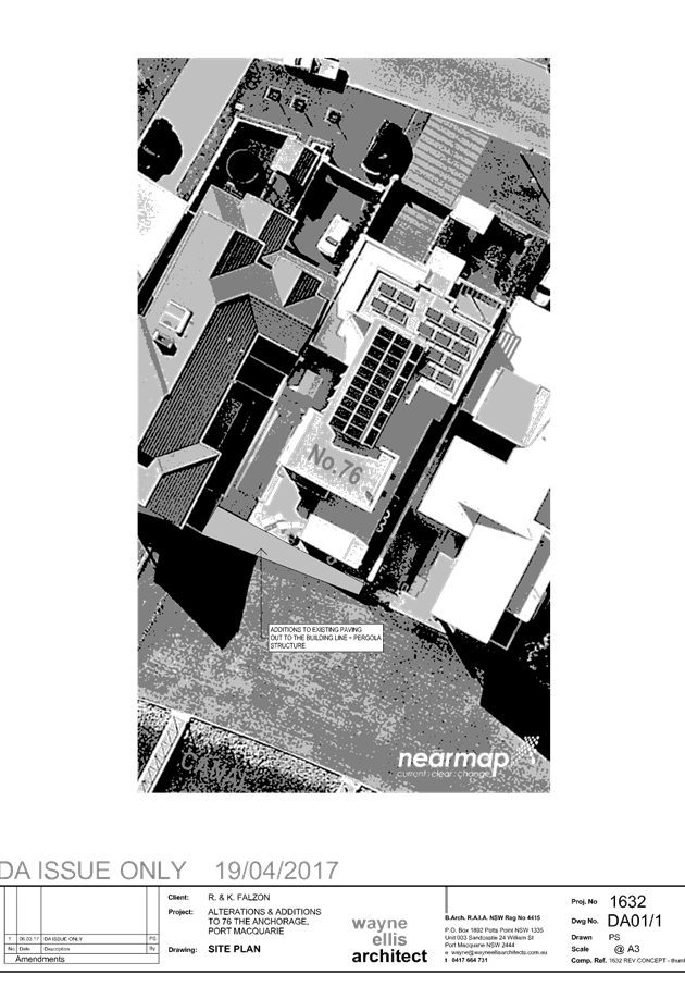
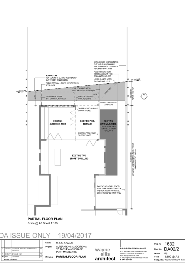
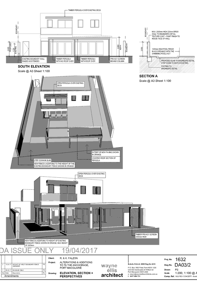
|
ATTACHMENT
|
Development Assessment Panel
10/05/2017
|

|
ATTACHMENT
|
Development Assessment Panel
10/05/2017
|
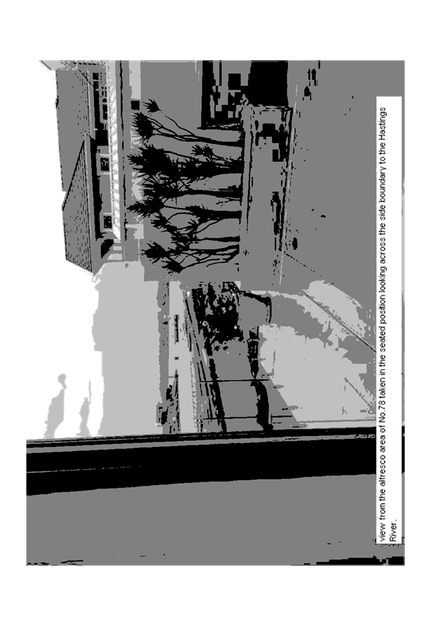
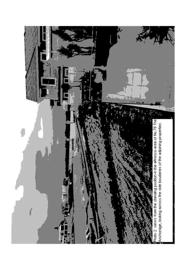
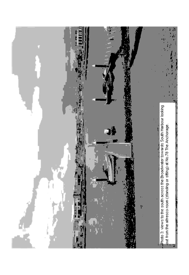
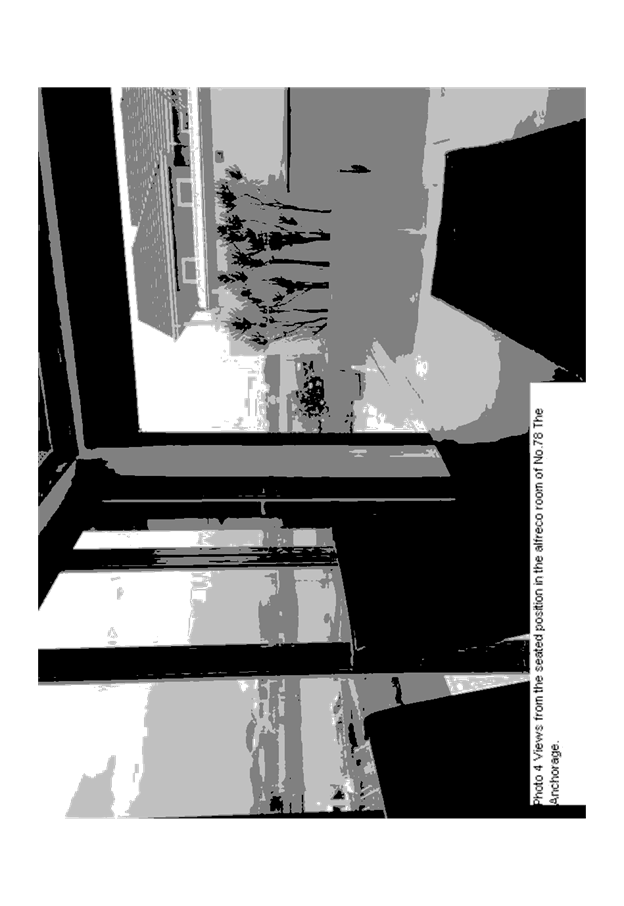
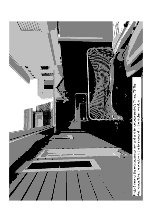
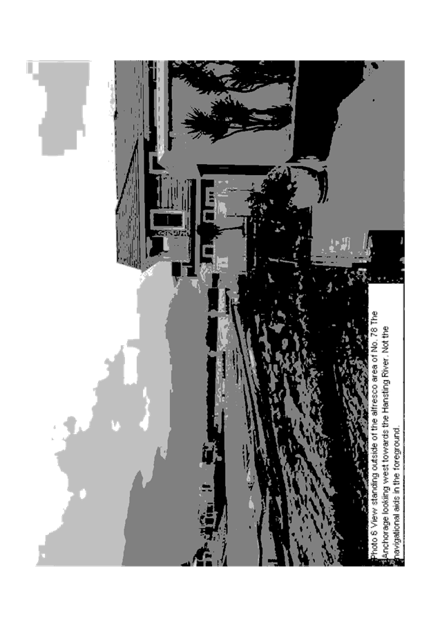


|
ATTACHMENT
|
Development Assessment Panel
10/05/2017
|

|
ATTACHMENT
|
Development Assessment Panel
10/05/2017
|
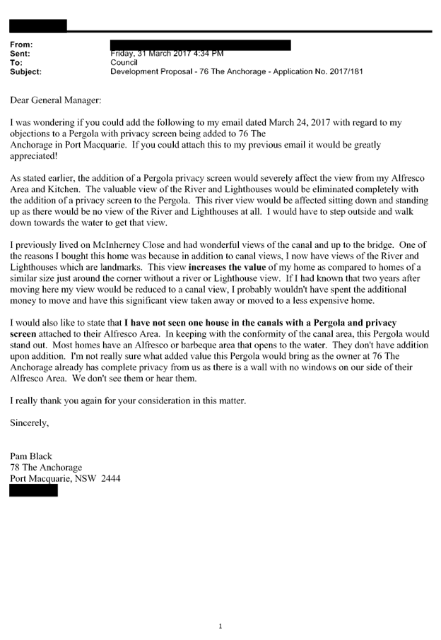
|
ATTACHMENT
|
Development Assessment Panel
10/05/2017
|
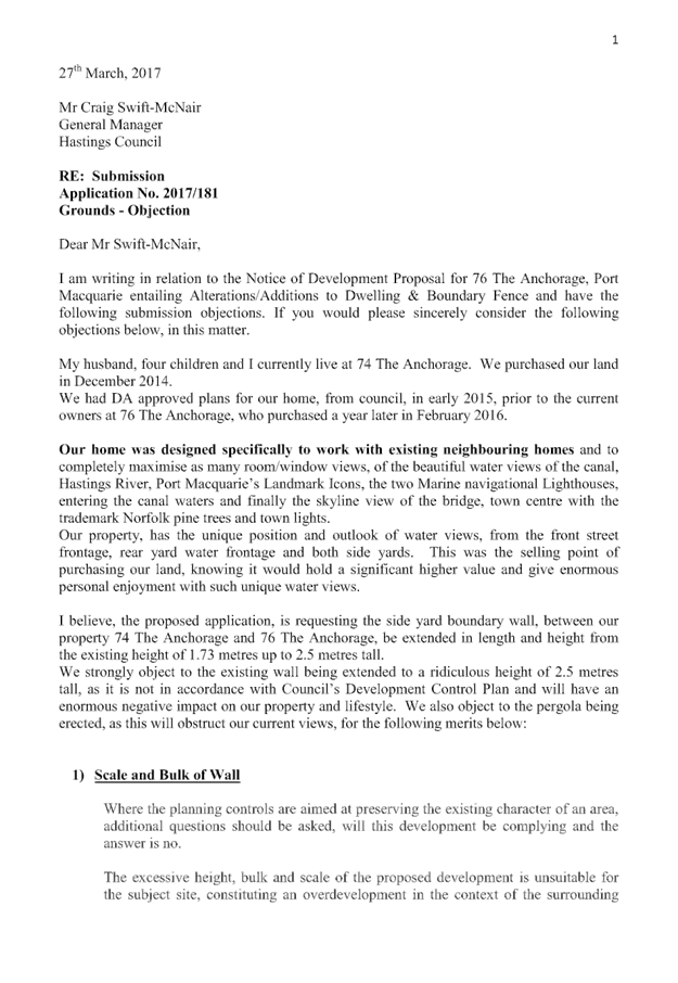
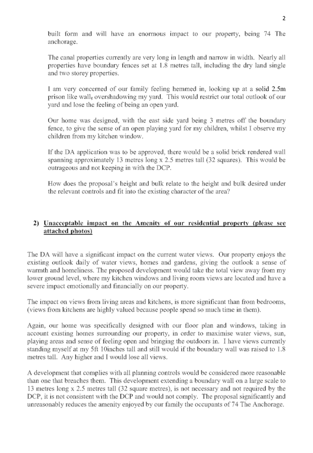
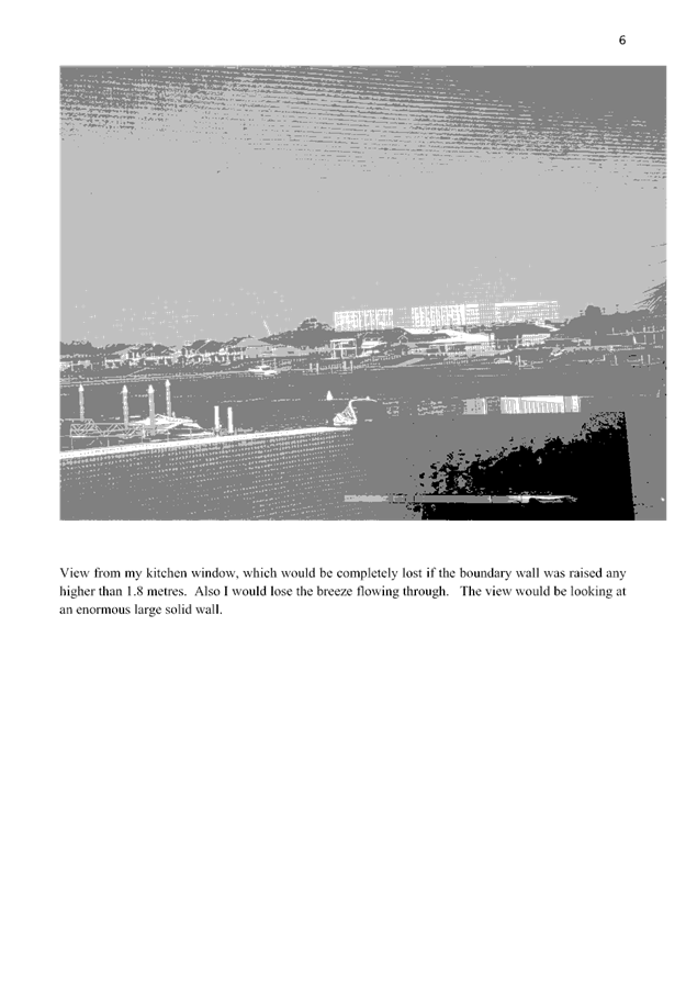
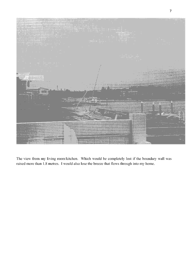
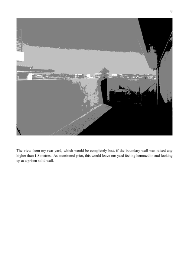
AGENDA Development Assessment Panel 10/05/2017
Item: 11
Subject: DA2016 - 801.1 - Service Station And Signage -
Lot 20 DP 1191370 No. 16 Sancrox Road, Sancrox
Report
Author: Patrick Galbraith-Robertson
|
Applicant: K
Behrens/Stevens Group Pty Ltd
Owner: Expressway
Spares Pty Ltd
Estimated Cost: $3.5M
Alignment with Delivery
Program
4.9.2 Undertake transparent
and efficient development assessment in accordance with relevant legislation.
|
|
RECOMMENDATION
That
DA 2016 - 801 for a service
station and signage at Lot 20, DP 1191370, No.
16 Sancrox Road, Sancrox, be
determined by refusing consent for the following reasons:
1. The proposal is characterised as a
highway service centre and is a prohibited land use in the IN1 general
industrial zone under the Port Macquarie-Hastings Local Environmental Plan
2011.
2. The proposal is likely to result in
adverse traffic and safety impacts in the immediate locality.
3. The proposal has potential to
result in adverse economic impacts in terms of planning highway service
centre sites within the Port Macquarie-Hastings Local Government Area.
|
Executive
Summary
This
report considers a Development Application (DA) for a service station
and signage at the subject site and provides an
assessment of the DA in accordance with the Environmental Planning and Assessment
Act 1979.
Following exhibition of the
application, one (1) submission has been
received.
Key assessment issues identified
in this report include landuse characterisation of the development, traffic,
economic impact and issues raised in the submission received. The Applicant
contends that the proposal is characterised as a ‘service station’
and not a ‘highway service centre’ as defined in the Port
Macquarie-Hastings Local Environmental Plan 2011.
The Applicant has not provided a
response to the additional information request during the assessment of the DA.
This assessment is based upon the currently submitted information.
1. BACKGROUND
Existing sites features and Surrounding development
The site has an area of 12.38
hectares.
The site has a development consent
in place for an industrial subdivision. The proposal only relates to 2 of the
approved lots within this subdivision.
The section of the site proposed to be developed is zoned IN1
Industrial in accordance with the Port Macquarie-Hastings
Local Environmental Plan 2011, as shown in the following zoning plan:
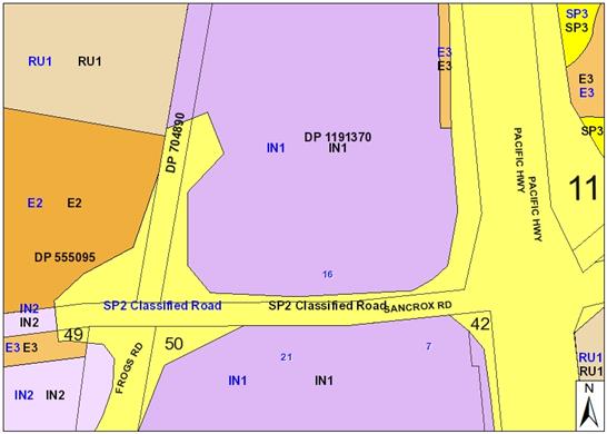
The existing subdivision pattern and location of existing
development within the locality is shown in the following aerial photograph
(source nearmap 2016):

The
subject site is located in the established Sancrox Employment Lands precinct on
the western side of the Pacific Highway.
The
property itself encompasses 2 proposed parcels of land and combined they are
generally rectangular in shape with a total area of 2.02 hectares. The subject
site has a frontage of 192.13m along its northern boundary to a drainage
reserve; a western side boundary of 84.74m; a southern rear boundary of 230.90m
to the Sancrox Road; and an eastern side boundary to the Pacific Highway of 73.37m.
Topographically, the natural surface levels of the site
fall in a south-west to north-east direction towards the Pacific Highway. The
overall crossfall is approximately 0.5% and the gradient can best be described
as very gentle.
The
adjoining lands directly to the north and west are currently vacant. Abutting
the site to the south (on the other side of Sancrox Road) is a number of
well-established light industrial / commercial complexes including Expressway
Spares.
To the
east, on the other side of the Pacific Highway lies the Fernbank Park
Employment Lands and the Cassegrain Winery.
Approximately
2.5 kilometres to south of the subject site, further along the Pacific Highway
lies a very large well-established highway service centre (HSC) at the intersection
of the Pacific and Oxley Highways. In addition to a service station, this HSC
encompasses a number of fast food restaurants (McDonalds, KFC and proposed
Oliver’s), food court, extensive convenience store, and day use, picnic
areas and playgrounds. This HSC is specifically designed to cater for the
everyday travelling needs of the general public utilising the Highway.
2. DESCRIPTION
OF DEVELOPMENT
Key aspects of the proposal (as detailed in the submitted
information) include the following:
· Construction
of a new Service Station with ancillary retail sales of general merchandise (GFA 298m²);
· Heavy
vehicle driver amenities;
· Installation
of three (3) x 90kL Underground Petroleum Storage Systems (UPSS) and associated infrastructure;
· Installation
of eleven (11) fuel dispensers and two (2) forecourt canopies;
· Two
(2) new vehicle crossings from Sancrox Road;
· Associated
car parking, landscaping and signage as illustrated on the proposed Architectural Drawings; and
· The
proposed hours of operation are 24 hours a day, 7 days a week. A minimum of two staff members will be present on site at any one
time.
An extract of the proposed site
plan is provided as follows:
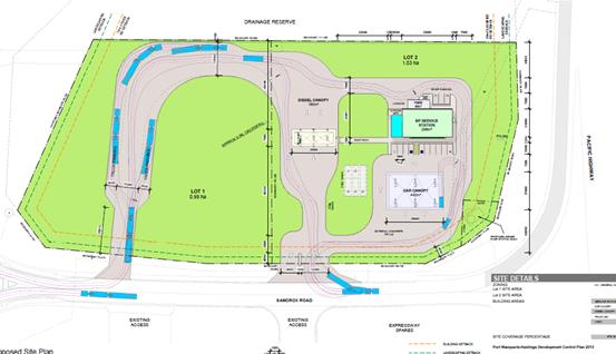
Refer
to attachments at the end of this report for more detailed plans and
information.
Application Chronology
· 17
October 2016 - DA lodged with Council.
· 21 October 2016 - Referral the NSW Roads and Maritime
Services for comment.
· 26 October to 8 November 2016 - Neighbour notification of
proposal.
· 23 November 2016 - Advice received from RMS.
· 2 December 2016 - Additional information requested -
permissibility queried, traffic and safety and RMS queries
· 5 December 2016 - Applicant advised that they will provide
a response.
· 15 March 2017 - Applicant requests for DA to be determined
on currently submitted information.
3. STATUTORY
ASSESSMENT
Section
79C(1) Matters for Consideration
In
determining the application, Council is required to take into consideration the
following matters as are relevant to the development that apply to the land to
which the development application relates:
(a) The
provisions (where applicable) of:
(i) any
Environmental Planning Instrument:
State Environmental Planning
Policy No. 33 - Hazardous and Offensive Development
The subject SEPP was introduced to clarify the definitions for
hazardous and offensive industries and to apply guidelines for the assessment
of industries that have the potential to create hazards or an offence.
In accordance with this SEPP, an
accredited dangerous goods consultant, Myros Design Pty Ltd, has conducted a
Preliminary Hazard Analysis (PHA) report. The thresholds screening applying
SEPP 33 found that the societal and environmental risks from the proposed
development are negligible. Therefore, only a level one qualitative Risk
Analysis was required. Accordingly, the design is acceptable for the site in
accordance with SEPP 33 requirements and would be unlikely to create any
significant risk.
State Environmental Planning
Policy No. 44 - Koala Habitat Protection
With reference to clauses 6 and 7, the subject land has is
greater than 1 hectare (including any adjoining land under same ownership) and
therefore the provisions of SEPP must be considered.
The DA has demonstrated that no
habitat will be removed or modified therefore no further investigations are
required.
State Environmental Planning Policy No.55 –
Remediation of Land
Following an inspection of the
site, a search of Council records and based upon the information submitted, the
subject land is not identified as being potentially contaminated and would be
suitable for the intended use.
State Environmental Planning Policy No. 62 –
Sustainable Aquaculture
Given the nature of the proposed
development and proposed stormwater controls, the proposal would be unlikely to
have any adverse impact on existing aquaculture industries.
State Environmental Planning Policy No. 64 –
Advertising and Signage
The proposed development includes
proposed advertising signage in the form of business/building identification
signage. The following signage is proposed:
· Freestanding
illuminated pylon sign 7.25m in height;
· Business
identification fascia sign above entrance;
· Internally
illuminated canopy fascia signs;
· Directional
signage;
· Wall
lifestyle graphics;
· Fuel
Dispenser column signs (to be located at each fuel point); and
· Accessible
parking sign and appropriate facilities signage inclusive of air and water
signage.
In accordance with clause 7, this
SEPP prevails over the Port Macquarie-Hastings LEP 2011 in the event of any
inconsistency.
The following assessment table provides an assessment
checklist against the Schedule 1 requirements of this SEPP:
|
Applicable clauses for consideration
|
Comments
|
Satisfactory
|
|
Clause 8(a) Consistent with objectives of the policy as
set out in Clause 3(1)(a).
|
The signage is consistent with the objectives to not
warrant refusal on its own.
|
Yes
|
Schedule 1(1) Character of
the area.
|
The proposed signage will be unlikely to be incompatible
with the desired character of the locality. However refer to comments
addressing RMS’ concerns later in this report. The subject site will be
visible from along the Pacific Highway to the east, but its visual impact
will be minimal.
There is no identifiable theme for outdoor advertising in
the area.
|
Yes
|
|
Schedule 1(2) Special areas.
|
The proposed signage does not
detract from any areas of environmental or cultural importance. There are no
such areas in direct proximity to the subject land.
|
Yes
|
|
Schedule 1(3) Views and vistas.
|
The proposed site signage does not obscure or compromise
any important existing or potential views or view corridors.
Most of the external signage
is located on the building or
fuel canopy and does not protrude above the structure on which it is located.
A 7.15m free standing pylon sign is proposed adjacent to eastern boundary of
the site however it does not reduce the quality of vistas or dominate the
skyline.
The proposed signage will not
unduly obscure any other advertising signage on any adjoining development
within the precinct.
|
Yes
|
|
Schedule 1(4) Streetscape, setting or landscape.
|
The proposed scale,
proportion and form of
signage are appropriate for
the streetscape given it directly addresses a collector road and the Pacific
Highway.
The setbacks from the
carriageways of both thoroughfares are proportional.
The proposed signage will
contribute to the visual
interest of the area and appropriately identify the user of the site.
The proposal does not screen
unsightliness, as the site is currently vacant.
The proposed signage will not
significantly protrude above other signs within the locality.
|
Yes
|
|
Schedule 1(5) Site and building.
|
The signage satisfactorily
integrates with the built form and site characteristics.
The proposed signage does not
detract from important features of the site or the proposed building.
The placement of signage is
considered the most
appropriate given the building
siting, access points, car parking and landscape elements. It also enhances
the identity of the site and promotes the precinct.
|
Yes
|
|
Schedule 1(6) Associated devices and logos with
advertisements and advertising structures.
|
The proposed signage includes
elements of appropriately illuminated signage. This also comprises logos and
international symbols representing facilities and services offered.
|
Yes
|
|
Schedule 1(7) Illumination.
|
The signage would be illuminated at appropriate LUX levels
so to not result in unacceptable glare. The lighting would be designed and
installed in accordance with relevant
Australian Standards. The illuminated signage will not
provide a significant safety concern for pedestrians, vehicles or aircraft
which would warrant refusal on its own.
The proposed illuminated signage will not be directly
visible from any surrounding residences. The signs would be illuminated at
night during operational hours. There is no curfew in place.
|
Yes
|
|
Schedule 1(7) Safety.
|
The proposed signage will not
reduce road safety.
Sightlines to and from the
site will not be affected and there will be no cause of distraction for
drivers.
The proposed signage will not
reduce existing safety for pedestrians and cyclists. All signage is contained
wholly within the site and not within the road or footpath.
The proposed signage does not
obscure sightlines from public areas.
|
Yes
|
State Environmental Planning
Policy (Infrastructure) 2007
· Clause 101,
refers to assessment of access, traffic and parking impacts addressed later in
this report. The development is of a type which is not sensitive to traffic
noise or vehicle emissions from the adjoining Pacific Highway and would be
unlikely to result in smoke and dust to affect the adjoining Pacific Highway.
· Clause
104(3)(b)(ii) and (iii), the DA has been referred to the NSW Roads and Maritime
Service (RMS). The RMS’ advice and other matters requiring consideration
are considered in the assessment of access, traffic and parking impacts
addressed later in this report. A copy of the RMS advice is attached to
this report.
Port Macquarie-Hastings Local Environmental
Plan 2011
The proposal is considered inconsistent with the LEP having
regard to the following:
· Clause
2.2, the subject site is zoned IN1 general industry.
1.
2. The following
landuses in the LEP are relevant to determine and characterise the proposed
use:
3.
service
station means a building or place used for the sale by retail
of fuels and lubricants for motor vehicles, whether or not the building or
place is also used for any one or more of the following:
(a) the ancillary sale by retail of spare parts
and accessories for motor vehicles,
(b) the cleaning of motor vehicles,
(c) installation of accessories,
(d) inspecting, repairing and servicing of motor
vehicles (other than body building, panel beating, spray painting, or chassis
restoration),
(e) the ancillary retail selling or hiring of
general merchandise or services or both.
transport depot means
a building or place used for the parking or servicing of motor powered or motor
drawn vehicles used in connection with a business, industry, shop or passenger
or freight transport undertaking.
truck depot means
a building or place used for the servicing and parking of trucks, earthmoving
machinery and the like.
highway
service centre means a building or place used to provide refreshments
and vehicle services to highway users. It may include any one or more of the
following:
(a) a restaurant or cafe,
(b) take away food and drink premises,
(c) service stations and facilities for
emergency vehicle towing and repairs,
(d) parking for vehicles,
(e) rest areas and public amenities.
4.
5. The Applicant
has submitted that the proposal is best characterised as a ‘service
station’ and contends that the new service station will result in the creation
of a new business enterprise within the existing Sancrox and Fernbank Park
Employment Lands precincts.
6.
7. Specifically,
the Applicant has provided the following justification:
8.
The predominant purpose of
the proposed service station is to provide facilities for the sale of fuels,
lubricants and motor accessories to the surrounding industrial developments in
both the Sancrox and Fernbank Park Employment Land precincts.
Most importantly, the
proposed development does not include a restaurant, fast food shop or takeaway
hot food facilities. As an ancillary use, the service station will sell hot and
cold drinks and prepackaged snack foods, and:
· The
service station will not be directly accessible from the Pacific Highway (a
classified road);
· The
service station has not been designed to address the Pacific Highway;
· The
use of the service station is not likely to be impacted on by traffic noise and
vibrations; and
· The
proposed development will not require significant excavations on adjacent to
the Pacific Highway road corridor.
9.
10. During the assessment of the
DA, the following additional information was requested however a response has
unfortunately not been provided from the Applicant:
1. The
permissibility of the proposed heavy vehicle driver amenities including
designated parking areas (which appear to be for rest area purposes) under the
Port Macquarie-Hastings Local Environmental Plan 2011 has not been addressed in
the submitted information. Initial concern is raised that this use is beyond
what could be considered a Service Station and could be best characterised as a
highway service centre.
2. The
building and pylon signage location fronting the Pacific Highway, 24 hours
operation, number of petrol bowsers and general design layout suggests intended
retail focus beyond what is detailed that the predominant purpose is to provide
for a service for the Sancrox and Fernbank Park Employment precincts. Details
should be provided to show why the service station is unable to have an
alternative design. The proposed Wildbean Café appears to also have
capacity as a cafe to retail food for main meals and seating contrary to the
details submitted.
11.
12. In accordance with clause
2.3(1) and the IN1 zone landuse table, it is considered that the proposal is
best characterised as a ‘highway service centre’ for the following
reasons:
13.
1. The submitted Traffic Impact analysis anticipates that the
development will primarily serve passing traffic on the Highway and not the
industrial precinct.
2. The
number of petrol bowsers (6) for light vehicles/general retail suggests an
intended retail focus beyond the Sancrox and Fernbank Park Employment
precincts.
3. The
building and pylon signage have been sited directly adjoining the Pacific
Highway and will primarily attract and serve the travelling public.
4. The
proposed hours of operation are 24 hours 7 days per week.
5. The
proposed Wildbean Café appears to have capacity as a cafe to retail food
for main meals and seating contrary to the details submitted. Justification as
to how this component of the service station is ancillary to the primary
service station landuse has not been provided.
6. The
proposed heavy vehicle driver amenities including designated parking areas
(which appear to be for rest area purposes) and separate fuelling area in
addition to the service station are related to but not ancillary to the service
station.
7. There
appears to be capacity on the site to expand the facility. Given the
configuration of the proposed development, it is unlikely that future use of
the site could be for an unrelated development.
14.
8. The
objectives of the IN1 zone are as follows:
§ To provide a wide range of industrial and warehouse land
uses.
§ To encourage employment opportunities.
§ To minimise any adverse effect of industry on other land
uses.
§ To support and protect industrial land for industrial uses.
§ To enable other land uses that provide facilities or
services to meet the day to day needs of workers in the area.
In accordance with Clause 2.3(2), the Applicant has stated
the following with regard to the objectives of the IN1 zone:
15.
The service station will
encourage employment opportunities; will not have any noticeable adverse
impacts on other developments in the precinct; will provide services and
facilities that support industrial land and landuses; and will provide
facilities to meet the day-to-day needs of workers in both the Sancrox and
Fernbank Park Employment Lands precincts.
16.
The Roads and Maritime Service indicated in their 2014
policy review of highway service centres along the Pacific Highway that there
were sufficient services to cater for current and any growth of traffic north
of Hexham to the Queensland border for the foreseeable future. There is a
nominated highway service centre site in the Section 117 directions issued by
the NSW Department of Planning and Environment at 1179 Oxley Highway, Sancrox on
the north-bound side of the Pacific Highway and Oxley Highway interchange.
Whilst this site has not yet been rezoned, there is a significant risk that the
subject proposal would have a negative economic impact on this future planned
facility. This would be inconsistent with the objectives of the IN1 zone and
Section 117 directions.
17.
The proposal is consistent with
the remainder of the LEP having regard to the following:
· Clause
4.3, the maximum overall height of the building above ground level (existing) is
7.4 m which complies with the standard height limit of 14.5m applying to the
site.
· Clause
5.9 - No listed trees in Development Control Plan 2013 are proposed to be
removed.
· Clause
5.10 – Heritage. The site does not contain or adjoin any known heritage items
or sites of significance.
· Clause
7.7 – The proposal would be unlikely to result in any identifiable impact
on airspace operations.
· Clause
7.8 - This proposal would be unlikely to be impacted upon by aircraft noise
operations.
· Clause
7.13, satisfactory arrangements would be in place for provision of essential
services including water supply, electricity supply, sewer infrastructure,
stormwater drainage and suitable road access to service the development.
(ii) Any draft
instruments that apply to the site or are on exhibition:
No draft
instruments apply to the site.
(iii) any Development
Control Plan in force:
Port
Macquarie-Hastings Development Control Plan 2013
|
DCP 2013: Chapter 3.5 - Industrial Development
|
|
DCP Objective
|
Development Provisions
|
Proposed
|
Complies
|
|
3.5.3.1
|
Minimum setbacks are provided as follows:
· 10m from a classified road;
· 7.6m from any other road boundary;
· 3m from any secondary road
frontage.
|
Minimum setbacks complied with.
|
Yes
|
|
3.5.3.2
|
Elevations of building which are visible from a public
road, reserve or adjacent or adjoining residential areas are to be
constructed using:
· brick, masonry, pre-coloured metal
cladding, or
· appropriately finished
‘tilt-slab’ concrete; or
· a combination of a number of these
materials.
|
Elevations design and finishes acceptable.
|
Yes
|
|
Large unrelieved expanses of wall or building mass are not
favoured, and as such should be broken up by the use of suitable building
articulation, fenestration or alternative architectural enhancements.
|
The proposal does not have any large unrelieved expanses
of walls.
|
N/A
|
|
3.5.3.3
|
Material storage/work areas and volumes to be provided
with application.
|
Minor storage likely required.
|
Yes
|
|
Open work and storage areas to be located at rear of
premises and screen from view by landscaping and/or fencing minimum 2m high.
|
Storage area located at rear of building.
|
Yes
|
|
3.5.3.4
|
Detailed landscaping plan submitted.
|
Detailed landscaping plan submitted.
|
Yes
|
|
Landscaped strip 3m wide for 2/3 of each road frontage.
|
Landscaped strip provided
|
Yes
|
|
No fencing in front setback unless for display items. High
quality fencing and landscaping.
|
No fencing proposed
|
N/A
|
|
3.5.3.5
|
An onsite recreation area is provided for staff that:
· Includes seating, tables and
rubbish bin.
· If outside, is adequately
protected from the weather
· Is safely accessible to all staff.
· Is separate private from public
areas.
· Is located away from noisy or odorous
activities.
|
Staff area provided.
|
Yes
|
|
3.5.3.6
|
Provide onsite facilities for changing, showering and
secure bike storage.
|
Staff amenities provided.
|
Yes
|
|
3.5.3.7
|
Development complies with NSW Industrial Noise Policy.
|
No potential adverse noise issues identified.
|
Yes
|
|
Building openings located to minimise noise impacts if
within 400m of residential zone.
|
N/A
|
|
|
External plant such as generators, air conditioning plant
and the like, should be enclosed to minimise noise nuisance and located away
from residences.
|
No potential adverse noise issues identified.
|
Yes
|
|
External and security lighting should be directed and
shielded to avoid light spillage to adjoining residential areas.
|
No potential light spill issues identified however the
development would need to be conditioned to comply with the requirements of
the Australian Standard for control of obtrusive effects of outdoor lighting
if it was approved.
|
Yes
|
|
Driveways should be arranged or screened to avoid
headlight glare on residential windows.
|
N/A
|
|
|
3.5.3.8
|
Office space ancillary to the industrial use is
permissible with consent, subject to satisfaction of the following matters:
· That the office component of a
proposed development is ancillary to the functions carried out in the
factory, warehouse or other industrial use.
· That the office area is not leased
to a separate company or entity.
· That parking facilities are
adequate to cater for the size of the office development.
|
Ancillary staff space proposed
|
Yes
|
|
3.5.3.9
|
The site should be serviced by reticulated water (and dual
reticulation where this is available), sewer and telecommunications.
|
Site is serviced with essential services.
|
Yes
|
|
3.5.3.10
|
Garbage storage areas are not visible from a public place.
|
Garbage storage areas at the rear of the building
|
Yes
|
|
3.5.3.11
|
Stormwater management strategy prepared.
|
Stormwater strategy submitted
|
Yes
|
|
Rainwater tank and dual reticulation for non-potable uses
on the site.
|
Refer to water supply comments later in this report.
|
Yes
|
|
DCP 2013: General Provisions
|
|
DCP Objective
|
Development Provisions
|
Proposed
|
Complies
|
|
2.2.2.1
|
Signs primarily identifying products or services are not
acceptable, even where relating to products or services available on that
site.
|
The signage proposed
relates only to the main
products sold at the site
characteristic of a service
station, and does not include any non-related services, unassociated
products, 3rd party promotion or additional business
merchandise advertising.
|
Yes
|
|
On-premise signs should not project above or to the side
of building facades
|
The signage does not project above or to the side of
building facades.
|
Yes
|
|
2.2.2.2
|
Where there is potential for light spill from signage in a
non residential zone adjoining or adjacent to residential development, illuminated
signage is to be fitted with a time switch to dim by 50% or turn off the
light by 11pm each night, depending on the nature of the development.
|
There is no potential light spill identified.
|
Yes
|
|
2.7.2.2
|
Design addresses generic principles of Crime Prevention
Through Environmental Design guideline:
· Casual surveillance and sightlines
· Land use mix and activity
generators
· Definition of use and ownership
· Lighting
· Way finding
· Predictable routes and entrapment
locations
|
The proposed development will be unlikely to create any
concealment/entrapment areas or crime spots that would result in any
identifiable loss of safety or reduction of security in the immediate area.
Appropriate external lighting can be provided.
|
Yes
|
|
2.3.3.1
|
Cut and fill 1.0m max. 1m outside the perimeter of the
external building walls
|
Cut and fill including stormwater facilities is
acceptable.
|
Yes
|
|
2.6.3.1
|
Tree removal (3m or higher with 100mm diameter trunk and
3m outside dwelling footprint
|
|
|
|
2.4.3
|
Bushfire risk, Acid sulphate soils, Flooding,
Contamination, Airspace protection, Noise and Stormwater
|
Refer to main body of report.
|
Yes
|
|
2.5.3.2
|
New accesses not permitted from arterial or distributor
roads. Existing accesses rationalised or removed where practical
|
Refer to traffic assessment details later in this report.
The primary access points are proposed off a nominated sub-arterial road
being a section of Sancrox Road.
|
No
|
|
Driveway crossing/s minimal in number and width including
maximising street parking.
|
Driveways limited
|
Yes
|
|
2.5.3.3
|
Off-street parking in accordance with Table 2.5.1.
Reduction possible if supported by parking demand study.
|
Parking provision numbers comply - refer to comments later
in this report addressing parking.
|
Yes
|
|
2.5.3.5
|
On-street parking permitted subject to justification.
|
None proposed
|
N/A
|
|
2.5.3.6
|
On-street parking includes streetscape improvements.
|
None proposed
|
N/A
|
|
2.5.3.7
|
Customer parking to be easily accessible.
|
Refer to traffic assessment details later in this report.
|
No
|
|
Way finding signs provided for parking areas.
|
Capable providing way finding signs
|
Yes - capable
|
|
Parking in accordance with AS 2890.1.
|
Parking design is capable of compliance with detailed
requirements of AS 2890.1.
|
Yes
|
|
2.5.3.8
|
Aged and disabled persons and persons wheeling prams or
trolleys are provided with suitable access and parking in accordance with AS
2890.1 and AS 2890.2.
|
Capable of compliance with access requirements
|
Yes
|
|
2.5.3.9
|
Bicycle and motorcycle parking considered and designed
generally in accordance with the principles of AS 2890.3
|
No specific parking identified.
|
No. However, insufficient weight to be considered as a
reason for refusal of the DA. Could be conditioned.
|
|
2.5.3.11
|
Section 94 contributions
|
Refer to main body of report.
|
|
|
2.5.3.12 and 2.5.3.13
|
Landscaping of parking areas
|
Landscaping satisfactory
|
Yes
|
|
2.5.3.14
|
Sealed driveway surfaces unless justified
|
Sealed driveways proposed
|
Yes
|
|
2.5.3.15
|
Driveway grades for first 6m of ‘parking area’
shall be 5% grade
(Note AS/NZS 2890.1 permits steeper grades)
|
Driveway grades capable of complying with Council
standards
|
Yes
|
|
2.5.3.16
|
Transitional grades min. 2m length
|
|
2.5.3.17
|
Parking areas to be designed to avoid concentrations of
water runoff on the surface.
|
Parking areas to be designed to avoid concentrations of
water runoff on the surface with appropriate stormwater management proposed.
|
Yes
|
|
Vehicle washing facilities – grassed area etc
available.
|
N/A
|
|
|
No direct discharge to K&G or swale drain
|
Car parking areas proposed to be drained to swales, bio
retention, rain gardens and infiltration areas.
Refer to stormwater comments later in this report.
|
Yes
|
|
2.5.3.18
|
Car parking areas drained to swales, bio retention, rain
gardens and infiltration areas
|
|
2.5.3.19
|
Off street commercial vehicles
facilities are provided in accordance with AS/NZS 2890.2
|
Off street commercial vehicles
facilities are capable of being provided in accordance with AS/NZS 2890.2
|
Yes
|
|
Loading bays will be provided
in accordance with the following requirements;
• Minimum dimensions to be 3.5m wide x 6m long. (This
may increase according to the size and type of vehicle).
• Vertical clearance shall be a minimum of 5m.
• Adequate provision shall be made on-site for the
loading, unloading and manoeuvring of delivery vehicles in an area separate
from any customer car parking area.
• A limited number of ‘employee only’ car
parking spaces may be combined with loading facilities.
• Loading areas shall be designed to accommodate
appropriate turning paths for the maximum design vehicle using the site.
• Vehicles are to be capable of manoeuvring in and out
of docks without causing conflict with other street or on-site traffic.
• Vehicles are to stand wholly within the site during
such operations.
|
The proposed development, due to its nature requires also
a small-dedicated loading and unloading bay for servicing the ancillary
products sold. Sufficient space has been designed and provided for behind the
service station building, adjacent to the enclosed service yard to enable
small rigid body trucks to access the development.
Fuel deliveries will be via an
articulated vehicle that will be positioned below the truck canopy when
filling takes place.
|
Yes
|
|
For external bays, one bay is
required for 500m² of floor space or 1000m² of site area.
|
|
|
Commercial development having a
floor space less than 500m² need not provide a loading bay.
|
|
|
Other commercial development
shall provide one loading bay for the first 1,000m² floor space and one
additional bay for each additional 2,000m².
|
|
|
2.5.3.20
|
The location and design of
loading bays should integrate into the overall design of the building and car
parking areas.
|
The location and design of
loading bays integrate into the overall design of the building and car parking
areas.
|
Yes
|
|
Where visible from the public
domain, loading bays are located behind the building.
|
Loading bays are located behind
the building.
|
Yes
|
|
Where loading bays are located
close to a sensitive land use, adequate visual and acoustic screening is provided.
|
N/A
|
|
|
2.5.3.21
|
Plans to confirm vehicular
access, circulation and manoeuvring in accordance with AUSTROADS and AS 2890.
|
Refer to comments later in this
report addressing traffic and access.
|
No
|
|
Adequate area provided for
loading/unloading and manoeuvring of B-Doubles where access is available from
approved B-Double routes.
|
Refer to comments later in this
report addressing traffic and access.
|
No
|
|
Ingress and egress in a forward
direction.
|
Ingress and egress in a forward
direction.
|
Yes
|
|
Driveways >6m from tangent
point of kerb radius and >1.5m from common side boundary with another lot.
|
N/A
|
|
|
Driveways not located within
intersection or restricted areas, and adequate sight distance available.
|
Refer to comments later in this
report addressing traffic and access.
|
No
|
|
DCP 2011: Sancrox Employment Lands
|
|
DCP Objective
|
Development Provisions
|
Proposed
|
Complies
|
|
OB3
|
A.
Landscape plantings and street trees
are to be in accordance with Council’s Street Planting List and
Aus-Spec Design Specifications.
|
Landscape plan complies
|
Yes
|
|
OB4
|
B.
A Stormwater Management Strategy
prepared by a certified practicing engineer in accordance with
Council’s Aus-Spec Design Specifications and Martens Concept Water
Cycle Management Strategy (Apr 2010) at Appendix 3 to the Sancrox Employment
Lands LES.
|
A Stormwater Strategy has been submitted which is
addressed later in this report.
|
Yes
|
|
OB6
|
C.
All industrial lots are to be
provided with on-site rain gardens at a minimum size of 2.5% of the gross lot
area. Rain gardens shall be designed and constructed as per Council’s
Aus-Spec Design Specifications and Martens Concept Water Cycle Management
Strategy.
|
Car parking areas proposed to be drained to swales, bio
retention, rain gardens and infiltration areas.
Refer to stormwater comments later in this report.
|
Yes
|
|
OB6
|
D.
All industrial lots are to be
provided with a minimum 10 KL rainwater tank. All roof water shall be
directed to the rainwater tank and tank overflows directed to the lot rain
garden.
|
A rain water tank is not proposed to be provided. Refer to
detailed comments addressing stormwater later in this report.
|
No. However, insufficient weight to be considered as a
reason for refusal of the DA. Could be conditioned.
|
|
OB6
|
E.
All site discharge, including
hardstand areas and outflows from the on-site rain garden is to be directed
to the on-site detention.
|
Car parking areas proposed to be drained to swales, bio
retention, rain gardens and infiltration areas.
Refer to stormwater comments later in this report.
|
Yes
|
|
OB19
|
F.
Buildings on future lots at the
Pacific Highway/ Sancrox Road intersection shall be designed by a suitably
qualified architect to create a distinctive and recognisable gateway entry to
the Employment Lands. Detailed design plans, including proposed colours for
buildings and signage are to accompany the DA for approval.
|
The proposed design has adopted a variety of use of
external materials, texture and colours to ensure.
The elevations of the proposed building have some
architectural interest.
The proposal incorporates generous (and conforming)
setbacks to Sancrox Road and the Pacific
Highway.
|
Yes
|
(iiia) any planning agreement that has
been entered into under Section 93f or any draft planning agreement that a developer
has offered to enter into under Section 93f:
There is a Sancrox Employment Land
Road Construction Planning Agreement in place relating to the site. The
obligations of the Planning Agreement are capable of being complied with and
could be conditioned if the development were to be approved.
iv) any
matters prescribed by the Regulations:
N/A
v) any coastal zone management plan
(within the meaning of the Coastal
Protection Act 1979), that apply to
the land to which the development application relates:
No Coastal Zone
Management Plan applies to the subject site.
(b) The likely
impacts of that development, including environmental impacts on both the
natural and built environments, social and economic impacts in the locality:
Context and setting
The proposal will be unlikely to have any adverse visual
impacts to existing adjoining properties or the public domain.
The proposal does not adequately
address the intent of the planning controls for the area in that the proposal
is not a permissible landuse.
The proposal would not have
significant adverse impacts on any existing view sharing.
The proposal would not have any
identifiable significant adverse lighting impacts.
There are no significant adverse
privacy impacts.
There are no adverse overshadowing
impacts.
Subdivision Context
The development is proposed on the northern side
of Sancrox Road west of the Pacific Highway, on proposed Lots 1 & 2 of an
industrial subdivision approved as part of DA 2012/305 (within former Lot 2, DP
22740). On 14 March 2017, Council approved a construction certificate for
subdivision works to service proposed Lots 1 & 2 and to construct sewer
(pump station) infrastructure required to service the development.
Within the area, Roads and Maritime Services (RMS)
is currently upgrading the Pacific Highway and has acquired part of former Lot
2, DP 22740. Relevant acquisition plans related to the land include DP
1191370 and DP 1228060. Currently the acquired lands are in Roads &
Maritime Services (RMS) ownership. It is understood that eventually
acquired lands adjacent to the Pacific Highway will be under the care and
control of the RMS, with Sancrox Road and the newly formed Orleans Avenue west
of the site to be under the care and control of Council.
Roads
18. The site is bounded by the
Pacific Highway to the east, Sancrox Road to the south and Orleans Avenue (a
newly formed and proposed industrial access road) to the west and north.
To facilitate Pacific Highway upgrades, the RMS has acquired lands along
several frontages of the site including the Pacific Highway, Sancrox Road and
Orleans Avenue. Currently, acquisition lands (defined in DP 1228060) are
held in RMS ownership and any proposed works over these lands to access Sancrox
Road will require RMS consent. To date evidence of owner’s consent has
not been provided and the RMS has requested additional information from the
Applicant as discussed under the Traffic and Transport heading below.
19.
20. 
21. Figure: current
cadastral boundaries of subject site and roads (shown orange) with indicative
boundary (shown red) of proposed Lots 1 and 2 (DA 2012/305)
22.
23. Sancrox Road is Council
owned and maintained, with an 11m wide formation currently within a 20m wide
road reserve to be widened with dedication of the RMS acquired lands. The
recently upgraded road formation includes barrier (SA) type kerb and gutter on
both sides.
24.
25. Orleans Avenue is currently
formed along the western boundary of the site as a 12m wide industrial road
including asphalt shoulders. The road reserve has not yet been dedicated to
Council. Orleans Avenue is proposed under DA 2012/305 to be extended to the
northwest of the site to facilitate access to the industrial subdivision lands
to the north. This DA does not currently propose direct access to or from
Orleans Ave.
26.
27. 
28. Figure: Aerial photograph taken 26 Jul 2016 of subject
site and new roads (credit Nearmap)
29.
30. Traffic Impact
Assessment
The Applicant has
submitted a Traffic Impact Assessment prepared by Transport and Traffic
Planning Associates (TTPA) dated October 2016. The TIA reviewed:
· existing (2016) and future (2026) road network conditions;
· access, servicing and circulation for the site;
· site trip generation and distribution in the AM and PM
conditions; and
· site parking.
The
report noted existing Annual Average Daily Traffic (AADT) provided by RMS as
follows, but did not disclose the year(s) the data were taken which is
important in understanding the operating condition of the intersection at the
time, and in estimating the extent to which data may have increased (e.g. due
to regional growth).
Anticipated future AADTs (in 2026, 10 years post-development) were
calculated by RMS for the Pacific Highway Upgrade Project and presented in the
TIA.
The
report asserts that the proposed access location “will be a significant
distance away from the offload of the highway… and there will be
excellent sight distances available.” Assessing officers disagree with
these statements, as discussed in the following section, as they are issues
contributing to unacceptable safety impacts.
Swept
path analysis for large trucks using the site was provided with the report and
DA drawings and indicates that onsite manoeuvring envelopes have been designed
consistent with AS/NZS 2890.
TTPA
note in the report that the RMS formula of 0.04 x Site Area results in an
inappropriate number because of the large area of the proposed site. This is a
source of uncertainty. The Applicant instead refers to proprietary data held
from a number of surveys of existing service stations located on regional
highways to derive an indicative generation rate of 120-140 vtph. The
validity of the Applicant’s trip generation rates of 120-140 trips cannot
be verified as the source survey and calculations are not disclosed, preventing
an assessment of the robustness of data or a comparison of the survey
site’s characteristics with the proposed site.
The
report continues with projected distribution of peak hour traffic generation
rates in the order of 120 in the AM and 100 in the PM peaks, increasing to 160
and 140 respectively in the future scenario. Comparison with RMS data has been
undertaken in the following section of the report, but here it is noted that
the vast majority (90%) of movements are projected to originate directly to and
from the highway on- and off-ramps. TTPA’s analysis therefore anticipates
that the development will primarily serve passing traffic on the Highway and
not the industrial precinct, which is an important consideration in the
following section.
31. Response to TIA by
Road Authority
32. Council is the local roads Authority
for Sancrox Road but referral to the RMS is required by Schedule 3 of the SEPP
(Infrastructure) 2007. Details of the Development Application were referred to
RMS on 21 October 2016. RMS raised comments (on 23 November 2016 in a response
letter to Council) that the TIA had not adequately addressed a number of
concerns, and these are numbered and summarised below along with Council
comments as follows:
33.
1. The
primary function of the interchange is the safety and efficiency of access to
the Pacific Highway, and these functions are not to be compromised.
34.
35. Council comment:
Sancrox Road serves as a primary road link to and from the Pacific Highway for
the industrial precinct and land to the west. As such, Sancrox
Road’s function in the vicinity of the highway off-ramp is primarily for
the movement of vehicles to and from the locality, and direct access to
adjoining land serves as a secondary function.
36.
37. Service stations in
proximity to highways are high-turnover facilities. The Lot 2 access point
approximately 100m west of the Pacific Highway ramps was originally envisaged
for an Industrial facility, which is characterised by lower traffic volumes.
The proposal is required to locate its entry / egress driveways with maximum
regard for the safety and efficiency of the ramps, which drivers will be
transitioning to and from at high speeds and with varying reaction times.
S101 of the SEPP (Infrastructure) 2007 requires the consent
authority not to approve development on land with frontage to a classified road
(in this case a State Road / highway) unless:
· vehicular
access to the land is not provided by a road other than the classified road
where practicable, and
· “the
safety, efficiency and ongoing operation of the classified road will not be
adversely affected by the development as a result of the design of the
vehicular access to the land…”
The proposal is likely to adversely
affect the safety, efficiency and ongoing operation of the classified road. The
highway on- and off- ramps are considered integral to the State Road. Given the
site’s frontage to Orleans Ave there is no reason, except for a marginal
increase in customer travel time, that the site layout cannot be reconfigured
to directly access Orleans Ave utilising the new interchange roundabout on
Sancrox Drive to satisfy the above provisions. This would also confer other
advantages which are discussed under point 7 below.
38.
2. Highway
Service Centres (as distinct from Service Stations) are a prohibited use in the
IN1 zone and are not consistent with the Minister’s Section 117 Direction
5.4 (except where located in accordance with that Direction).
39.
40.
Council comment: the concern shared by RMS and Council
staff is that the proposal is targeting passing trade using the highway without
providing all of the necessary facilities to cater for such high volumes and
mixed traffic types, which is the reason that special provisions for Highway
Service Centres are assumed to have been put in place at a State level,
and not in accordance with the intent of the planning provisions in terms
of permissibility and location.
41. Highway Service Centres
typically require designated interchange access points which have been
purpose-designed to cater for high traffic movements and minimise conflicts.
Further, they are required by RMS standards to provide large numbers of onsite
parking bays for trucks (in the order of 20 dedicated B-double bays at a
minimum). These facilities are not available, with a high potential for passing
highway truck traffic would utilise the proposed service centre regardless,
pushing the problem of onsite parking provision off-site to the public road
reserve, where the primary concern is safety and efficiency of traffic
accessing the highway. Highway Service Centres are prohibited in the IN1 zone
under the LEP.
42. It is incumbent on the
proponent to demonstrate that the DA is consistent with a Service Station use
that is targeting local traffic (i.e. supporting the industrial precinct)
rather than a Highway Service Centre. The proposed site access locations and
internal circulation layout suggest the focus of highway custom/trade.
43.
3. “The
proposed hours of operation should be consistent with the proposed Service
Station use and its ancillary nature to surrounding Industrial land
uses.”
44.
45. Council comment:
The surrounding industrial land uses are likely to operate in daytime hours
only, 5 to 7 days per week. The facility is proposed to be operated on a 24/7
basis and its primary revenue stream would therefore likely be passing highway
trade. Because the proposal seeks to operate outside of normal working hours
its primary purpose is not considered to be supporting the industrial precinct.
Instead it falls within the definition of a Highway Service Centre, which is
prohibited as discussed under point 2 above.
46.
4. Proposed
Lots 1 and 2 should be consolidated to enable on-site infrastructure to be
located to optimise the operation of the development.
47.
48. Council comment:
If the development were approved, both proposed Lots 1 and 2 would be integral
to each other in terms of ownership, truck parking demand and onsite
manoeuvring, and would need to be consolidated into one lot prior to any
Occupation Certificate. As a consequence of consolidation, a more optimised
access and circulation layout can be achieved to satisfy the traffic safety and
efficiency concerns held by Council and the RMS.
5. Heavy
vehicle circulation layout is not typical. There is no heavy vehicle parking
area downstream of the refuelling point. Trucks typically refuel and then park
up for refreshment. Forwards-only movements and manoeuvring in accordance with
AS 2890 are required.
49.
50.
Council comment: The onsite circulation scheme in its
current form has segregated truck and car movements on entry to the site which
is a desirable outcome for onsite safety. However, the scheme is considered
deficient for a number of reasons (which could be mitigated for minor
additional cost) including:
· Truck
movements exiting the site must cross the path of cars entering and exiting the
site,
· Locations
and operation of the access points. There are viable opportunities to reduce
even further the number of onsite and offsite conflicting turning movements,
and vastly reduce the potential for offsite queueing, by using the new Sancrox
Rd / Orleans Ave roundabout. These are discussed further at point 7 below,
· Confused
paths for staff accessing parking at the rear of the building, who would be
required to use the truck entrance or drive against the one-way scheme
(decreasing traffic safety),
· Confused
paths for customer cars, who must first turn across exiting traffic (including
trucks) to reach the refuelling point, parking and shops, and then turn around
270 degrees toward the egress driveway (decreasing traffic safety),
· Parking
spaces for 6 to 7 B-doubles are proposed before the refuelling point, rather
than after it and in proximity to the shop and facilities, increasing the
likelihood of trucks reversing onsite or exiting onto the public road to
re-enter the site to find parking, which are poor outcomes for public safety,
and
· There
are vast spaces of vacant land between circulation roadways which should be
used to provide minimum facilities and reduce traffic conflicts, or provide
more useable envelopes for future development.
51.
52. For these reasons Council
staff requested the layout be revised, and the Applicant declined to address
these issues.
53.
6. The
pylon sign orientation will limit visibility to traffic travelling on Sancrox
Road and should be relocated to the southern frontage and oriented east-west
rather than north-south, consistent with the local service centre use. The
proposal is to also comply with SEPP 64 and the Transport Corridor Outdoor
Advertising and Signage Guidelines.
Council comment: the pylon sign is considered
to be primarily targeting passing trade using the highway, which is consistent
with the prohibited Highway Service Centre land use. The amendments recommended
by the RMS would assist in demonstrating that the primary customer base is
likely to be from the industrial precinct, more consistent with a local service
station, as well as reducing distraction hazard for drivers using the Pacific Highway
and ramps.
7. The
TIA by TTPA is not considered to adequately address the road safety and traffic
impacts of the proposed development on the Pacific Highway and interchange. In
particular:
a) Peak
hour traffic generation rates of 120-140 trips are based on unidentified
surveys and the rates provided by the RMS Guide to Traffic Generating
Developments are not considered. TTPA has previously been advised by RMS
that this approach is not appropriate. The rates based on Gross Floor Area
(GFA) in the Guide suggest a significantly higher PM peak hour range
should be adopted.
b) The
proposed access driveways to Sancrox Road will generate turning conflicts with
potential on- and off-site queuing impacts on public road intersections and the
highway off-ramp.
54.
55. Council comment:
56.
The RMS Guide to Traffic Generating Developments (2002) and the
later publication Trip Generation Surveys – Service Stations –
Analysis Report (2013) provide trip generation rate guidelines for service
stations as follows, noting that they vary widely depending on the site. Peak
hour rates had the strongest correlation between sites and are given as a
function of the total site area A(S) and convenience store floor areas A(F).
Site area is calculated at 1,800 sqm excluding circulation roadways and
including the building, car parking and refuelling canopies. A(F) = 30 sqm of
café seating was measured from the proposed plans.
57.
The daily trip generation rate varies depending on operating hours, with
the 2002 report giving factors of 17 and 19 times the peak hour rate for fuel
sales and 24 hour convenience stores respectively. The 2013 report correlates
total daily vehicle trips and AM peak hour trips with the number of service
channels X2. The number of service channels proposed with this DA is
6 for cars (by comparison with the sites surveyed in the report) and the RMS
report makes no mention of truck pump points so those have not been counted for
the purposes of traffic estimation.
58.
59. A range of likely traffic
rates are tabulated below for the purpose of comparison and understanding the
sensitivity of the proposal.
60.
61. Table: Trip
generation from RMS reports
|
62. RMS Guide 2002
|
63.
|
|
64. PM peak hr trips
65. 0.04 A(S) + 0.3 A(F)
|
66.
|
|
67. Using 1,800 sqm site area
|
68. 0.04 x 1800 + 0.3 x 30
69. = 81 trips PM peak hour
|
|
70. Daily trips
71. 17x or 19x PM peak
|
72. 17 x 81 = 1400 trips per
day
|
|
73.
|
74.
|
|
75. RMS Surveys 2013
|
76.
|
|
77. PM peak hr trips
78. 0.0205 A(S) + 88.52
|
79.
|
|
80. Using 1,800 sqm site area
|
81. 0.0205 x 1800 + 88.52
82. = 125 trips PM peak hour
|
|
83. AM peak hr trips
84. 0.28 X22
+ 14 X2 + 16.7
|
85. 0.28 x 36 + 14 x 6 + 16.7
86. = 111 trips AM peak hour
|
87.
88. While the calculations given
by the RMS Guide approximately accord with TTPA’s own proprietary data,
the sensitivity of the RMS methods to site area may be more appropriate to
denser city sites such as those the data was obtained from. For this site the
assumptions taken in measurement of site area resulted in large swings in
magnitude of traffic estimates.
89.
90. The TIA provided existing
traffic counts on Sancrox Road of around 2,000 vehicles per day (vpd).
Projected 2026 AADT was estimated to be approximately 1,600 vpd on the Pacific
Highway northbound off-ramp (to Sancrox Road westbound), and 2,000 vpd over the
highway overpass.
91.
92. If 1,400 daily trips are
generated by the proposed service centre (as calculated above) with 50% comes
from the Pacific Highway northbound traffic (as a conservative analysis),
Sancrox Road would have a potential increase in traffic adjacent to the site of
700 daily trips (350 inbound and 350 outbound). This would equate to
nearly 40% overall increase over 2026 modelled Sancrox Road ramp volumes (700 /
(1,653 + 87)). Currently the TIA shows approximately 90% of development
traffic coming to/from the Pacific Highway northbound traffic, creating a
substantially greater impact to Sancrox Road than calculated above.
93.
94. With such large change to
Sancrox Road traffic, data needs to be validated to ensure development impacts
do not have a detrimental effect to the safe and efficient operation of the
Pacific Highway interchange. Further detail of traffic estimates,
capacity analysis and intersection operations along Sancrox Road west of
Pacific Highway are required.
95. Of major concern are the
proposed locations of access points to the public road network. Primary car
access to the site is located only 100m west of the highway ramps, creating a
westbound right turn movement across traffic into site (with potential to queue
within the road). This segment of road is expected to have frequent car and
truck movements once the precinct is developed because it functions as a leg of
the interchange allowing northbound Pacific Highway traffic to change to
southbound or vice versa, using the highway overpass. Refer to the Figure below
which illustrates the number of movement conflicts the proposed access
arrangements would generate.
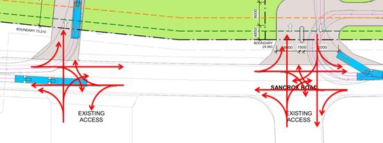
Figure: Illustration of conflicting traffic movements at
four-way intersections as a result of development as proposed
i. The
total available Stopping Sight Distance (SSD) from the highway northbound
off-ramp to a vehicle waiting to enter the site is estimated at 100m, which
using AUSTROADS calculations is the SSD required for a truck travelling at
60kph with slow reaction time. Such a driver is transitioning from
low-engagement highway driving to a congested industrial area with numerous
distractions and signage, compounding the risk.
ii. Of
key note is the requirement for vehicles turning right into the site to yield
to oncoming traffic, resulting in queuing within Sancrox Road backing up
towards the off-ramp, further increasing the risk of collision by drivers
exiting the highway.
iii. Additionally,
fixing the access location of the service station so close to the ramps
compromises the RMS’ and Council’s ability to reconfigure and
upgrade the interchange in future, for example in providing additional lanes or
turning movements to resolve deteriorating levels of service caused by
increasing traffic. Similar issues have been encountered in recent years at the
interchange of the Pacific Highway and Oxley Highway.
iv. One
such future upgrade may include the kerbing of the median within Sancrox Road
to limit right turn movements across traffic and require them to continue west
to the roundabout, for safety and efficiency reasons. However, if the current
access locations are approved, a future median kerb would force left-in, left-out
movements for the users of the service station, with all exiting users being
required to enter the Pacific Highway northbound on-ramp without the
opportunity to turn around until Hastings River Drive, 3km to the north. This
would be a significant disadvantage for the site and would be very difficult
for the Road Authority to implement.
v. A
better outcome for management of the Pacific Highway interchange while reducing
the risk of collisions could be achieved by utilising the new Sancrox Road / Orleans
Ave roundabout for circulation to the site as illustrated in the Figure below.
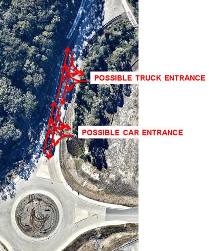
Figure: Illustration of possible alternative access
locations to minimise traffic impacts on Pacific Highway interchange, with
turning movements shown in red
vi. The
risk of collisions presented by vehicles queuing to enter or exit the site, and
vehicles turning across oncoming traffic, is therefore unacceptably high given
the various options for the site to mitigate this risk by relocating the
accesses to Orleans Ave.
96.
8. “The
proposed development is not to generate an increase in discharge to the Pacific
Highway stormwater drainage system.”
97.
Council comment: This standard requirement can be
addressed using on-site stormwater detention facilities. Refer to Stormwater heading
below.
98.
9. A
sewer pump station in the southeast corner of Lot 2 relies on direct access to
the Pacific Highway on-ramp. Alternative access should be provided (for example
by provision of a Right of Access over Lot 2).
Council comment: Refer to the Sewer heading below for
controls to this effect.
99.
100. In
summary, the RMS’ request for additional information is supported by
Council staff due to concerns around impacts on traffic safety, efficiency and
operations, particularly with regard to the high risk and importance of the
Pacific Highway. Traffic and engineering comments along with the RMS letter
with regard to the proposed development were sent to the Applicant and to date
no response addressing these concerns has been received by the Council.
101.
102. Inadequate
information has been provided to demonstrate that the development will not
create an unsafe traffic environment on Sancrox Road and impacting the Pacific
Highway due to access conflicts and queuing, and nor have appropriate traffic
safety solutions been provided. An acceptable solution is considered likely to
be achievable, but would require significant rework of the site layout to be
undertaken by the Applicant.
Parking
For parking rates, the RMS Guide gives a rate of 5
spaces per 100sqm of convenience store GFA, and 15 per 100sqm of restaurant
GFA. This equates to a recommended total of:
(5 x 320 / 100) + (15 x 30 / 100) = 16 + 5 = 21 spaces
Council’s DCP provides a rate of 1 per employee, plus
2 customers (minimum), plus 1 per 6 sqm of restaurant floor area. This results
in a minimum of:
(1 x 2) + 2 + (1 x 30 / 6) = 2 + 2 + 5 = 9 spaces.
The Applicant has proposed 13 spaces, which meets the
minimum DCP requirements.
Water Supply
Connection
Council records indicate that the
development site has an existing sealed water service from the 300 PVC water
main on the same side of Sancrox Road.
Final water service sizing would
need to be determined by a hydraulic consultant to suit the domestic and
commercial components of the development, as well as fire service and backflow
protection requirements.
Sewer Connection
Council
records indicate that the development site does not currently have a connection
to sewer.
The proposed development must drain to an
existing or proposed sewer manhole.
All-weather
access to the Sewer Pump Station site must be made available to Council
personal before, during and after construction.
A modified Sewer Pump Station site must be
excised from this development area prior to or as part of this subdivision. In
addition a five (5) metre wide Easement for Access and
Services is to be provided from the pump station site across this development
site to a point on Sancrox Road where access is possible to and from the pump
station in both directions on Sancrox Road.
Stormwater
The site naturally grades towards the north (the
rear) and is currently not serviced by piped infrastructure. Due to the
low-lying position of the land within the Fernbank Creek catchment, and rural
history, the parent subdivision proposal (DA 2012/305) included provision of a
large swale along the western and northern boundaries of the lots. This is
defined as the legal point of discharge for the development and a condition of
consent, if the development was approved, would need to require construction
and dedication of this downstream system to Council from the parent
subdivision (DA 2012/305) prior to any Occupation Certificate for the proposed
development.
Drainage outlets from the
development should be limited in number and located to minimise downstream
impacts. Adequate scour protection would be a requirement and given the 2
hectare size of the combined lots may need to be extensively engineered.
A detailed site stormwater
management plan would be required to be submitted for assessment with the Local
Government Act S.68 application and prior to the issue of a Construction
Certificate if the development was approved.
In accordance with Council’s
AUSPEC requirements, the following must be incorporated into the stormwater
drainage plan:
· On
site stormwater detention facilities. The peak outflow discharges from the
development site as a result of the proposed works must not exceed the
pre-development (green field) outflows. There is sufficient space within the
site to accommodate these facilities and a concept design has been included
with the DA.
· Water
quality controls due to the magnitude of hard surfaces at ground level and the
type of development’s risk profile (vehicle trafficked, spills likely).
The downstream treatment train will need to remove contaminants, impurities,
nitrate and phosphate levels through progressive treatment devices to ensure
the end of line site outflow meets the outcomes specified by Council’s
AUS-SPEC D7.
· As
the two Lots are proposed to comprise one integral development, and stormwater
drainage is likely to traverse the boundary, the lots shall be consolidated
prior to Occupation Certificate to ensure no land use conflicts in future.
· The
natural topography drains through the southeast corner of the site, and with
the Sancrox Road upgrade the RMS have constructed a pit and pipe drainage
network in this area. Council has little information currently on these assets
as handover has not yet occurred. The Applicant has shown the location of an
easement on the DA plans passing to the east of the building. Any easement to
drain water benefitting Council for the purpose of public road drainage shall
be registered on the title prior to Occupation Certificate. If the pipes
conveying flows from Sancrox Road to the swale along the northern boundary are
not constructed as part of the RMS project, they will be an improvement
benefitting the owner of proposed Lot 2 (by diverting surface runoff) and as
such they would need to be constructed and funded by the landowner in connection
with the development. Additionally, such a road drainage easement would need to
be a minimum of 3m wide and designed to contain overland flows from the road
during extreme storm events (those that exceed the capacity of the piped
network or in case pipes become blocked). This may necessitate site regrading
or widening of the easement, and no structures could be located within the site
of the easement, to minimise risk of flooding damage and guarantee access by
Council maintenance crews.
Other Utilities
Telecommunication and electricity services are
available to the site. Application would need to be made to the separate
utility authorities to determine any specific requirements they may have in
connection with the development.
Heritage
Following a site inspection (and a search of Council
records), no known items of Aboriginal or European heritage significance exist
on the property. No adverse impacts anticipated.
Other land resources
The site is within a developing industrial context
and will not sterilise any significant mineral or agricultural resource.
Water cycle
At occupation stage,
land can become contaminated from fuel leaks either above or below ground -
fuel leak containment, loss monitoring, groundwater monitoring wells and
surface bunding is required as a minimum. The forecourt area must drain
(minimum 2% fall required) to dry sumps or be directed to the proposed
“Pureceptor” for treatment prior to discharge to the SW system.
Various special conditions recommended to ensure compliance if the development
was approved.
The submitted information and
plans propose to install various measures to prevent surface and ground water
pollution. Compliance with the UPSS Regulation is required besides other
requirements. A minimum 2% fall on the bunded under canopy forecourt areas is
required. Conditions could be imposed to address specific requirements if the
development was to be approved.
The proposed development will be
unlikely to have any adverse impacts on water resources and the water cycle.
Soils
The proposed development will be unlikely to have
any adverse impacts on soils in terms of quality, erosion, stability and/or
productivity subject to a standard condition requiring erosion and sediment
controls to be in place prior to and during construction.
Air and microclimate
The construction and/or operations of the proposed
development would be unlikely to result in any adverse impacts on the existing
air quality or result in any pollution.
A standard precautionary site
management condition could be imposed if the development was to be approved.
At Occupation stage it is proposed to install Stage 1 vapour
recovery on the fuel lines and Stage 2 vapour recovery if required.
Flora and fauna
Construction of the proposed development will not
require any removal/clearing of any significant vegetation and therefore will
be unlikely to have any significant adverse impacts on biodiversity or
threatened species of flora and fauna. Section 5A of the Act is
considered to be satisfied.
The landscaping of the front setback areas comprises densely
planted native groundcovers and small native shrubs in gardens beds. Around the
car parking area, the landscaping comprises a number of native large trees to
provide shade during the warm summer months. The perimeter landscaping of the
facility will comprise corridors of buffer plantings including native trees,
shrubs grasses and low maintenance groundcovers.
The tree and shrub species proposed to be used will comprise
native plants endemic and/or compatible to the region.
Waste
Satisfactory arrangements are in
place for proposed storage and collection of waste and recyclables. No adverse
impacts anticipated.
Energy
The proposal includes measures to address energy
efficiency and will be required to comply with the requirements of Section J of
the Building Code of Australia. No adverse impacts anticipated.
Noise and vibration
During construction potential exists for offensive
noise to be generated but due to proximity of nearby buildings and the
industrial use, any impact is expected to be minimal.
Noise will be generated onsite but due to the
location and surrounding industrial land uses, minimal adverse impact is
expected.
Bushfire
The site is identified as being bushfire prone. In
accordance with Section 79BA - EP&A Act 1979 and having
regard to Section 1.1 of Planning for Bushfire Protection 2006, the objectives
of this Guideline are satisfied. There is adequate defendable space around the
proposed buildings and there is safe operational access and egress for
emergency vehicles if required.
Safety, security and crime prevention
The proposed development will be unlikely to
create any concealment/entrapment areas or crime spots that would result in any
identifiable loss of safety or reduction of security in the immediate
area.
Social and Economic impacts in the locality
The development would have an immediate impact
during both the construction phase and the occupation phase of the development.
The proposed investment of $3.5m in non-residential construction is estimated
to create four new jobs in direct employment, and an additional 14 new jobs in
flow-on effects - a total of 18 new jobs during the construction phase. Stevens
Group has advised 10 FTE retail jobs will be created following occupation of
the service station - REMPLAN modelling indicates these new jobs will create a
further 6 jobs in flow-on effects. Overall, REMPLAN estimates indicate the
development will create 34 new jobs through direct employment and flow-on
effects, injecting total wages of ~$2.5m into the local economy.
The Sancrox Employment Precinct is
designed to offer functionality for heavy vehicle industrial usage - a core
prerequisite for occupation by employers in manufacturing, transport,
warehousing and logistics is access to suitable refuelling capability. The
development of a suitable service station within this industrial zone could be
a catalyst for significant further employment-generating commercial activity
within this precinct however concern is raised with regard to the size,
location and nature of the proposal suggesting more predominant focus to
travelling public as outlined under the LEP earlier in this report.
As stated earlier, the RMS indicated
in their 2014 policy review of highway service centres along the Pacific
Highway that there were sufficient services to cater for current and any growth
of traffic north of Hexham to the Queensland border for the foreseeable future.
There is a nominated highway service centre site in the Section 117 directions
issued by the NSW Department of Planning and Environment at 1179 Oxley Highway
on the north-bound side of the Pacific Highway and Oxley Highway interchange.
Whilst this other site has not yet to be rezoned, there is a risk that this
proposal will have a negative economic impact on this future planned facility.
It is considered that the economic benefits mentioned above cannot outweigh the
risk for potential negative economic impacts to a planned service centre site.
Site
design and internal design
The proposed development design unsatisfactorily
responds to the site attributes and will not satisfactorily fit into the
locality. The Applicant has chosen not to provide additional information to address
the initial assessment issues raised.
Construction
No potential adverse impacts identified to
neighbouring properties with the construction of the proposal.
Cumulative
impacts
The proposed development could be likely to result
in adverse cumulative economic and traffic impacts. The site design appears to
capable of accommodating other landuses which would reenforce its intentions to
be highway service centre and or exacerbate traffic impacts. The Applicant has
chosen not to provide additional information to address the initial assessment
issues raised.
Food health
The proposal is capable of compliance with food
health standards if it was approved. A standard condition for fitout to
applicable Australian Standards requirements would be required.
(c) The
suitability of the site for the development:
It is considered based upon
assessment made earlier in this report that the proposal will not
satisfactorily fit into the locality and the site attributes are not conducive
to the nature and extent of the proposed development.
(d) Any
submissions made in accordance with this Act or the Regulations:
One(1) written submission has been received following public
exhibition of the DA. The submission is from the owner of 1179 Oxley Highway,
Sancrox who is located approximately 2.5 kilometres south of the subject
development site.
Key issues raised in the submission received and comments
in response to these issues are provided as follows:
|
Submission
Issue/Summary
|
Planning
Comment/Response
|
|
The IN1 general industry zone
does not permit highway service centres.
|
Agree.
|
|
The proposal is for a service
station next to the Pacific Highway and is clearly a highway service centre.
|
Agree that the proposal is for
a highway service centre, as defined.
|
|
The proposal includes an
advertising structure which is not a permitted use or compliant with the
zoning.
|
The signage referred to
relates to pylon sign on the site which is considered to be a business
identification sign which is a permissible use. Refer to more details under
State Environmental Planning Policy no.64 earlier in this report.
|
|
The Mid Coast Regional
strategy states
“In the future,
additional highway service centres could be located at Nambucca Heads (at the
northern interchange) and Port Macquarie (on the western side of the Pacific
Highway at the Oxley Highway interchange)”
This strategy clearly
articulates the preferred location for a Highway Service Centre at the
intersection of the Oxley and Pacific Highways. The proposed development is
not in line with the Mid Coast Regional Strategy.
|
Agree.
|
|
Clause 5.4 of the 117
Direction by the Minister For Planning requires referral for Planning
Proposals for Highway Service Centres. This development application should
not be altered to include a Planning Proposal because it would not comply
with the objective of clause 5.4 to have Highway Service Centres only at the
intersection of the Oxley and Pacific Highways.
|
Agree and noted.
|
|
The development of a fully
compliant Highway Service Centre is extremely price sensitive. As the name
implies they provide a high level of capital intensive services to improve
the safety of the travelling public. The approval of developments such as
that proposed that subvert this process makes it difficult to build the duly
planned developments with a full range of facilities that improve the safety
of the travelling public.
The Economic Impact in the DA
does not address the impact on the hierarchy as planned by the Mid Coast
Regional Strategy and referenced in the Hastings Urban Growth Strategy and
the LEP 2011 which specifically excludes Highway Service Centres in the IN1
zoning.
|
Agree that there is a
significant risk for the subject proposal to have a negative economic impact
on this future planned facility at 1179 Oxley Highway, Sancrox.
|
|
The turning circle for trucks
seems very tight and may restrict movement in a forward direction.
|
Refer to comments earlier in
this report.
|
|
The
development does not appear to have been well modelled and seems a likely
source of congestion and potential queuing across a major intersection with
the Pacific Highway.
|
Agree. Refer to comments
earlier in this report.
|
|
The site does not seem to be
modelled safely for heavy vehicles that may use it and there is potential of
life safety hazard due to proximity of retail fuelling to heavy vehicles.
|
Refer to comments earlier in
this report with regard to traffic.
|
|
The use for lot 1 is not
identified or modelled. A use for this should be identified and correctly
modelled. If it is to remain open space this should be limited by 88b
instrument or caveat in favour of Minister of planning. To protect the
integrity of this modelling the site should be consolidated with the land to
which this DA relates.
|
The proposed development could
result in adverse cumulative economic and traffic impacts. The Applicant has
chosen not to provide additional information to attempt to respond to the
initial assessment issues raised.
A condition as suggested for a
restriction as to user may not be appropriate.
A condition would be required to
require consolidation of the two proposed lots if the development was to be
approved.
|
|
Correctly planned Highway
Service Centres are saving the lives of the New South Wales community. Port
Macquarie is a 4-5 hour Drive from Sydney. The recommended break time for a
recreational driver is 2 hours so a Highway Service Centre on the North Bound
side of the Pacific highway at this location is important.
We also note the recommended
break time for a Bus driver is 5 hours. Which makes this location and
important one in which to have a fully functioning and easily accessible
Highway Service Centre.
|
Agree that a planned centre is
required. The subject proposal is however inconsistent with the location for
such a highway service centre.
|
(e) The Public
Interest:
As stated earlier in this report, there is a nominated
highway service centre site in the Section 117 directions issued by the NSW
Department of Planning and Environment at 1179 Oxley Highway on the north-bound
side of the Pacific Highway and Oxley Highway interchange. Whilst this site has
not yet to be rezoned, there is a risk that the subject proposal to have a
negative economic impact on this future planned facility. The proposed
development is inconsistent with the objectives of the IN1 zone.
Based upon the assessment made
in this report, it is considered that the proposed development is unable to
satisfy relevant planning controls and would not be in the wider public
interest.
4. DEVELOPMENT
CONTRIBUTIONS APPLICABLE
If the
development is approved, development contributions would be required towards
augmentation of town water supply and sewerage system head works under Section
64 of the Local Government Act 1993 and under Section 94A of the Environmental
Planning and Assessment Act 1979.
There is a Sancrox Employment Land
Road Construction Planning Agreement in place relating to the site. The
obligations of the Planning Agreement are capable of being complied with in
relation to development contributions and could be conditioned if the
development was to be approved.
5. CONCLUSION
The
application has been assessed in accordance with Section 79C of the
Environmental Planning and Assessment Act 1979.
Issues
raised during assessment and public exhibition of the application have been
considered in the assessment of the DA.
The
site is considered not suitable for the proposed development. It is recommended
that the application be refused subject to the reasons detailed earlier in this
report.
|
Attachments
1View. DA2016
- 801.1 Plans
2View. DA2016
- 801.1 Landscape Plans
3View. DA2016
- 801.1 1Service Station & Signage Sancrox Road - RMS Response
4View. DA2016
- 801.1 Submission - Hore
5View. DA2016
- 801.1 Stormwater Management Plan
|
|
ATTACHMENT
|
Development Assessment Panel
10/05/2017
|
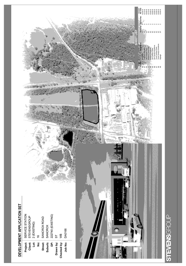
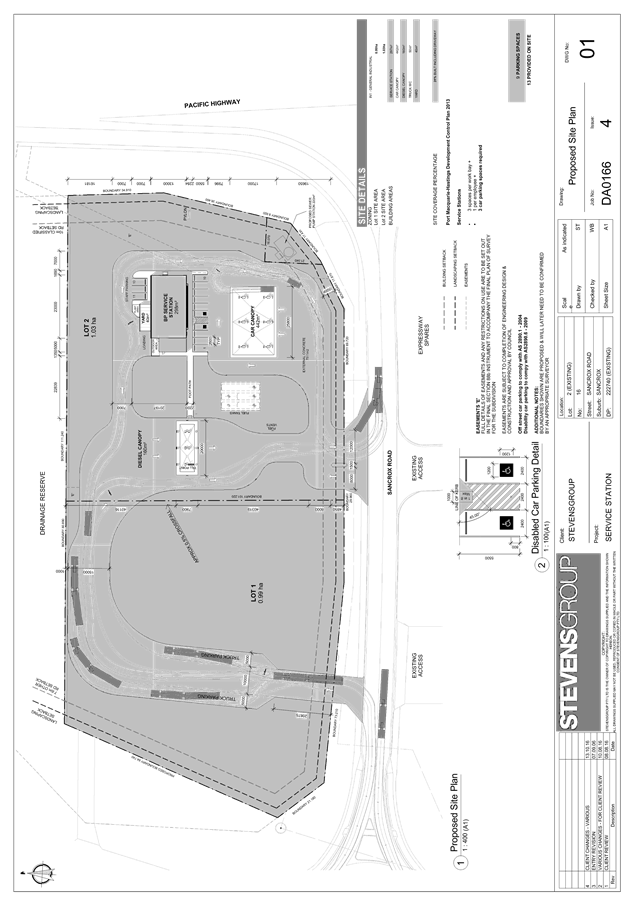
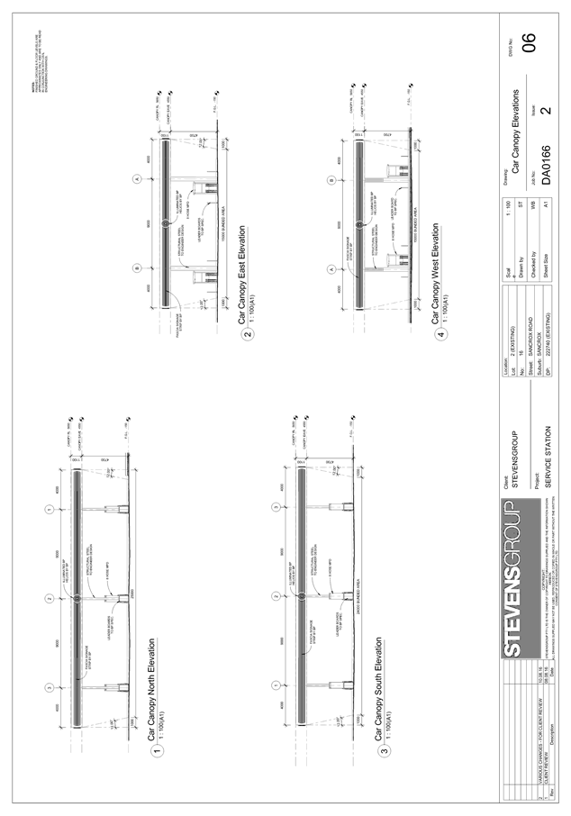
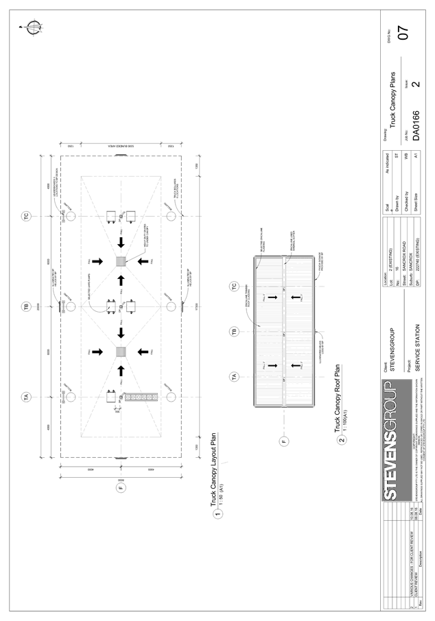
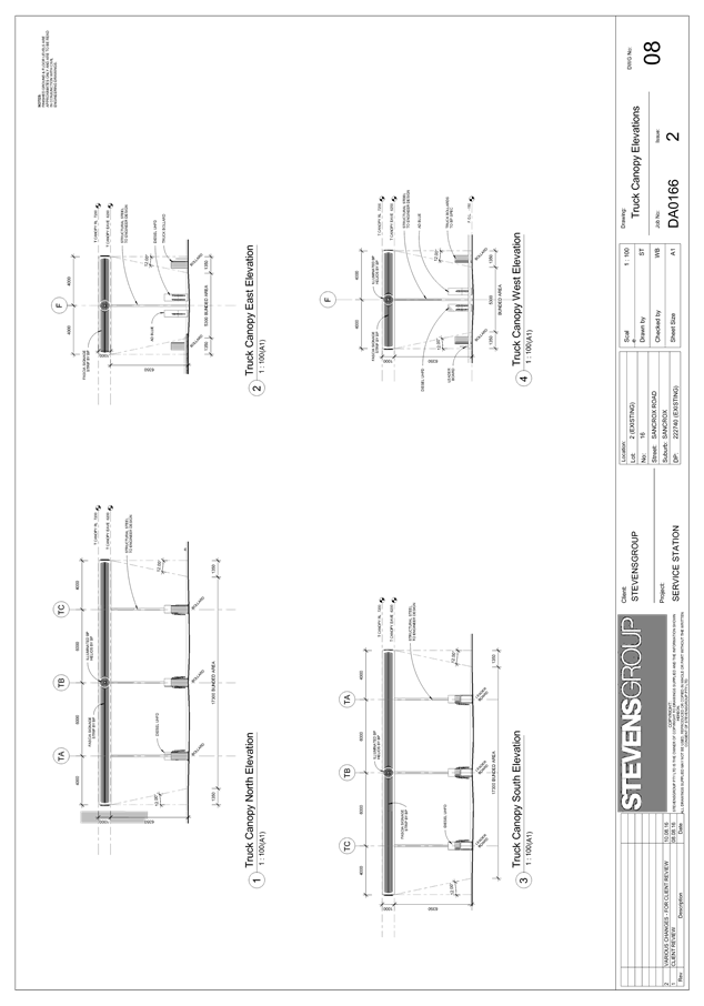
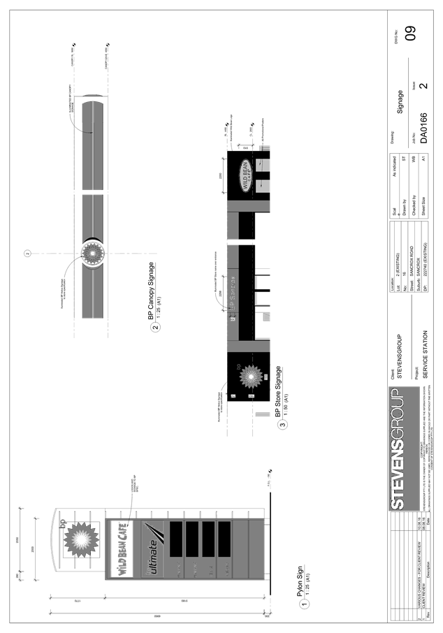
|
ATTACHMENT
|
Development Assessment Panel
10/05/2017
|
|
ATTACHMENT
|
Development Assessment Panel
10/05/2017
|
|
ATTACHMENT
|
Development Assessment Panel
10/05/2017
|
|
ATTACHMENT
|
Development Assessment Panel
10/05/2017
|