Business
Paper
|
date of meeting:
|
|
Wednesday 24 May
2017
|
|
location:
|
|
Function Room
Port
Macquarie-Hastings Council
17 Burrawan Street
Port Macquarie
|
|
time:
|
|
2:00pm
|
Development
Assessment Panel
CHARTER
COMPOSITION:
Independent Chair (alternate, Director Development &
Environment)
Manager Development Assessment (alternate, Director Development & Environment or Development Assessment Planner)
Development Engineering Coordinator (alternate, Development
Engineer)
MISSION:
To assist in managing Council's
development assessment function
by providing independent and expert assessment of development applications
The Development Assessment Panel will make determinations on the basis of established criteria and practice and will not be influenced by "lobbying" and "weight of numbers" in its assessment process.
FUNCTIONS:
1.
To review development application reports and conditions
2.
To determine development applications outside of staff delegations
3.
To refer development applications to Council
for determination where necessary
4.
To provide a forum for objectors and applicants to make submissions on applications before DAP.
5.
To maintain transparency for the determination of development applications.
DELEGATED AUTHORITY:
1.
Pursuant to Section
377 of the Local Government Act, 1993 delegation to:
2.
Determine development applications under Part 4 of the Environmental Planning
and Assessment Act 1979
having regard to the relevant
environmental planning instruments, development control plans and Council
policies.
3.
Vary Modify or release restrictions as to use and/or covenants created
by Section 88B instruments under the Conveyancing Act 1919 in relation to
development applications for subdivisions being considered by the panel.
4.
Determine Koala Plans of Management under State Environmental Planning
Policy 44 - Koala Habitat Protection associated with development applications
being considered by the Panel.
TIMETABLE:
The Development Assessment Panel shall generally meet on the 1st and 3rd Wednesday each month at 2.00pm.
VENUE:
The venue will be
determined according to the likely
number of participants.
BUSINESS PAPER AND MINUTES:
1.
The Business Paper for the meeting shall be published
and distributed on the Friday prior
to the meeting.
2.
Special Meetings of the Panel may be convened by the Director
Development & Environment Services
with three (3) days notice.
3.
The format of the preparation and publishing of the Business
Paper and Minutes
of the Development Assessment Panel meetings shall be similar to the format
for Ordinary Council Meetings, except that the movers
and seconders shall not be recorded and only the actual decisions are shown.
Minutes shall also record how each member votes for each
item before the Panel.
FORMAT OF THE MEETING:
1.
Panel meetings shall be carried
out in accordance with Council's
Code of Meeting Practice for Council Sub-Committees, except where varied
by this Charter.
2.
Meetings shall be "Open" to the public.
3.
The Panel will hear from applicants and objectors or their representatives. Where considered necessary, the Panel will conduct site inspections which will be open to the
public.
INDEPENDENT CHAIR:
The Chair of the Development Assessment Panel shall be an independent person appointed by the General
Manager. The Independent Chair shall have experience and qualifications relevant to planning.
The term of the Independent Chair shall be four
(4) years.
QUORUM:
All members must be present at the Meeting to form a Quorum.
DECISION MAKING:
Decisions are to be made by the Development Assessment
Panel by "consensus". Where "consensus" is not possible,
the matter is to be referred to Council.
All development applications
involving a variation to a development standard greater than 10% under
Clause 4.6 of the Port Macquarie-Hastings Local Environmental Plan 2011 will be
considered by the Panel and recommendation made to the Council for
determination.
Staff Members shall
not vote on matters before the Panel if they have been the principle author of the development assessment report.
LOBBYING:
Outside of scheduled
Development Assessment Panel meetings, applicants, their representatives,
Councillors, Council staff and the general public are not to lobby Panel
members via meetings, telephone conversations, correspondence and the like.
Adequate opportunity will be provided at Panel inspections or meetings for
applicants, their representatives and the general public to make verbal
submissions in relation to Business Paper items.
OBLIGATIONS OF PANEL
MEMBERS:
All DAP members
are required to comply with the following:
1.
Members must perform their Development Assessment Panel obligations faithfully and diligently and in accordance
with the DAP Code.
2.
DAP members must comply with Council's Code of Conduct.
3.
Except as required to properly perform
their duties, DAP members must not disclose
any confidential information (as advised by Council) obtained
in connection with the DAP functions.
4.
DAP members will have read and be familiar with the documents
and information provided
by Council prior to attending a DAP meeting.
5.
DAP members must act in accordance with Council's Occupational Health and Safety Policies and Procedures
6.
DAP members shall not speak to the media on any matter
before the Panel otherwise
than with the express approval
of the Director Development &
Environment Services.
Development Assessment Panel
ATTENDANCE
REGISTER
|
Member
|
22/02/17
|
8/3/17
|
22/03/17
|
12/04/17
|
10/05/17
|
|
Paul Drake
Matt Rogers (alternate)
|
P
|
P
|
P
|
P
|
P
|
|
Dan Croft
Patrick Galbraith-Robertson
Warren Wisemantel
(alternates)
|
P
|
P
|
P
|
P
|
P
|
|
David Troemel
Caroline Horan (alternate)
Bevan Crofts (alternate)
Grant Burge (alternate)
|
P
|
A
P
|
P
|
P
|
P
|
Key: P = Present
A
= Absent With Apology
X
= Absent Without Apology
Development
Assessment Panel Meeting
Wednesday 24 May 2017
Items of Business
01 Acknowledgement
of Country............................................................................ 7
02 Apologies......................................................................................................... 7
03 Confirmation
of Minutes.................................................................................... 7
04 Disclosures
of Interest..................................................................................... 12
05 DA2016
- 0700.1 - Eco Tourist Facility At Lot 101 DP 754444, 743 Ocean Drive, Grants
Beach...................................................................................................................... 16
06 DA2016
- 1006.1 Dual Occupancy and Torrens Title Subdivision at Lot 301 DP 831575, No.
12 Beacon Court, Port Macquarie........................................................................ 103
07 DA2016
- 932 - Alterations And Additions To Waste Management Facility And Koala Plan
Of Management - Lot 12 DP 1027602, Lot 11 DP875998, Lot 9 DP 876001 And
Lot 1 DP 1120786 Kingfisher Road, Port Macquarie.................................................................... 140
08 General
Business
AGENDA Development Assessment Panel 24/05/2017
Subject: ACKNOWLEDGEMENT
OF COUNTRY
"I acknowledge that we are
gathered on Birpai Land. I pay respect to the Birpai Elders both past and
present. I also extend that respect to all other Aboriginal and Torres Strait
Islander people present."
RECOMMENDATION
That the apologies received be
accepted.
Subject: CONFIRMATION
OF PREVIOUS MINUTES
Recommendation
That the Minutes of the Development
Assessment Panel Meeting held on 10 May 2017 be confirmed.
MINUTES Development Assessment
Panel
Meeting
10/05/2017
PRESENT
Members:
Paul
Drake
Dan Croft
David Troemel
Other Attendees:
Pat-Galbraith
Robertson
Deb McKenzie
Ben Roberts
Stephen Ryan
|
The meeting opened 2:05pm.
|
|
01 ACKNOWLEDGEMENT
OF COUNTRY
|
|
The
Acknowledgement of Country was delivered.
|
|
03 CONFIRMATION
OF MINUTES
|
|
CONSENSUS:
That
the Minutes of the Development Assessment Panel Meeting held on 12 April 2017
be confirmed.
|
|
04 DISCLOSURES
OF INTEREST
|
|
There were no disclosures of interest presented.
|
|
05 DA2000 - 603.4
Modification To Aged Care Facility - Lot 26 DP 878913, Lot 2 DP 1019665, 821
Ocean Drive, Port Macquarie
|
|
Speaker:
Scott
Marchant (applicant)
CONSENSUS:
That
the section 96 modification application to DA2000 - 603 for an aged care facility
at Lot 26, DP
878913 and Lot 2 DP 1019665, No. 821 Ocean Drive, Port Macquarie, be
determined by granting consent subject to the recommended modified conditions
and as amended below:
- Amend condition 94 to read:
‘All stormwater management for the site is to be generally in
accordance with the revised stormwater management plans (Drawing No.
5361 - Stormwater Concept, Revision A, dated 23 Nov 2016).
- Amend condition 115 to read: ‘The
footpath is to be designed in accordance with AS 1428.1.
|
|
06 DA2015 - 698.2
Modification To Childcare Centre - Lot 2 DP 808998, 156 Horton Street, Port
Macquarie
|
|
Speaker:
Craig Teasdell (applicant)
CONSENSUS:
That
the section 96 modification application to DA2015 - 698 for a childcare centre at
Lot 2, DP 808998, No. 156 Horton Street,
Port Macquarie, be determined by granting consent subject to the recommended
modified conditions.
|
|
07 DA2017 - 37.1
- Dwelling - Lot 72 DP 238688, No 19 Jasmine Street, Port Macquarie
|
|
Speaker:
Bill Amy (o)
Sam Trembath (applicant)
CONSENSUS:
That DA
2017 - 37 for a dwelling at Lot 72, DP 238688,
No. 19 Jasmine Street, Port Macquarie, be determined by granting consent subject to the
recommended conditions.
|
|
08 DA2017 - 97.1
Additons To Existing Dwelling - Lot 24 DP 20480, No 18 Bundella Avenue Lake
Cathie
|
|
Correspondence
from Andrew Noble dated 9/5/17 was tabled at the meeting objecting to the
proposal.
CONSENSUS:
That
DA2017 - 97.1 for additions to existing dwelling at Lot 24, DP20480, No. 18 Bundella Avenue, Lake Cathie
be determined by granting consent subject to the recommended conditions.
|
|
09 DA2017 - 99.1
Alterations And Additions To Dwelling Including Clause 4.6 Objection To
Clause 4.3 (Height Of Buildings) Of The Port Macquarie -Hastings Local
Environmental Plan 2011 And Construction Of Swimming Pool - Lot 31 DP 231816,
No 21 Matthew Flinders Drive, Port Macquarie
|
|
CONSENSUS:
That it
be recommended to Council that DA 2017 - 99.1
for alterations and additions to existing dwelling at Lot 31 DP231816, No.21
Matthew Flinders Drive, Port Macquarie be determined by granting consent
subject to the recommended conditions.
|
|
10 DA2017 - 181.1
Alterations And Additions To Dwelling And Boundary Fence - Lot 33 DP 1069338,
No 76 The Anchorage, Port Macquarie
|
|
Speaker:
Paula Stone (applicant)
CONSENSUS:
That DA 2017 - 181.1 for alterations and additions to dwelling and boundary
fence at Lot 33 DP 1069338 No. 76 The Anchorage, Port Macquarie, be
determined by granting consent subject to the recommended conditions and as
amended below:
- Delete condition E(2)
- Add additional condition in Section E of the consent to
read: ‘Prior to the issue of any occupation certificate, the
western elevation of the 2m high side fence/wall is to be finished (i.e
rendered and painted) the same as the eastern elevation.
|
|
11 DA2016 - 801.1
- Service Station And Signage - Lot 20 DP 1191370 No. 16 Sancrox Road,
Sancrox
|
|
CONSENSUS:
That DA
2016 - 801 for a service station and
signage at Lot 20,
DP 1191370, No. 16 Sancrox Road, Sancrox, be determined by refusing consent
for the following reasons:
1. The
proposal is characterised as a highway service centre and is a prohibited
land use in the IN1 general industrial zone under the Port Macquarie-Hastings
Local Environmental Plan 2011.
2. The
proposal is likely to result in adverse traffic and safety impacts in the
immediate locality.
3. The
proposal has potential to result in adverse economic impacts in terms of
planning highway service centre sites within the Port Macquarie-Hastings
Local Government Area.
|
|
The meeting closed at 2:52pm.
|
AGENDA Development Assessment Panel 24/05/2017
Subject: DISCLOSURES
OF INTEREST
RECOMMENDATION
That Disclosures of Interest be presented
DISCLOSURE OF
INTEREST DECLARATION
Name of Meeting: ………………………………………………………………………..
Meeting Date: ………………………………………………………………………..
Item Number: ………………………………………………………………………..
Subject: ………………………………………………………………………..
…………………………………………………….……………...…..
I, .....................................................................................
declare the following interest:
 Pecuniary:
Take
no part in the consideration and voting and be out of sight of the meeting.
Non-Pecuniary
- Significant Interest:
Take
no part in the consideration and voting and be out of sight of the meeting.
Non-Pecuniary
- Less than Significant Interest:
May
participate in consideration and voting.
For the reason that: ....................................................................................................
.......................................................................................................................................
Name:
…………………………………………………….
Signed:
.........................................................................
Date: ..................................
 (Further
explanation is provided on the next page)
(Further
explanation is provided on the next page)
Further
Explanation
(Local Government Act and Code of Conduct)
A conflict of interest exists where a reasonable and informed
person would perceive that a Council official could be influenced by a private
interest when carrying out their public duty. Interests can be of two types:
pecuniary or non-pecuniary.
All interests, whether pecuniary or non-pecuniary are required to
be fully disclosed and in writing.
Pecuniary Interest
A pecuniary interest is an interest that a Council official has in
a matter because of a reasonable likelihood or expectation of appreciable
financial gain or loss to the Council official. (section 442)
A Council official will also be taken to have a pecuniary interest
in a matter if that Council official’s spouse or de facto partner or a
relative of the Council official or a partner or employer of the Council
official, or a company or other body of which the Council official, or a
nominee, partner or employer of the Council official is a member, has a
pecuniary interest in the matter. (section 443)
The Council official must not take part in the consideration or
voting on the matter and leave and be out of sight of the meeting. The
Council official must not be present at, or in sight of, the meeting of
the Council at any time during which the matter is being considered or
discussed, or at any time during which the council is voting on any question in
relation to the matter. (section 451)
Non-Pecuniary
A non-pecuniary interest is an interest that is private or
personal that the Council official has that does not amount to a pecuniary
interest as defined in the Act.
Non-pecuniary interests commonly arise out of family, or personal
relationships, or involvement in sporting, social or other cultural groups and
associations and may include an interest of a financial nature.
The political views of a Councillor do not constitute a private
interest.
The management of a non-pecuniary interest will depend on whether
or not it is significant.
Non Pecuniary – Significant Interest
As a general rule, a non-pecuniary conflict of interest will be
significant where a matter does not raise a pecuniary interest, but it
involves:
(a)
A relationship between
a Council official and another person that is particularly close, for example,
parent, grandparent, brother, sister, uncle, aunt, nephew, niece, lineal
descendant or adopted child of the Council official or of the Council official’s
spouse, current or former spouse or partner, de facto or other person living in
the same household.
(b)
Other relationships
that are particularly close, such as friendships and business relationships.
Closeness is defined by the nature of the friendship or business relationship,
the frequency of contact and the duration of the friendship or relationship.
(c)
An affiliation between
a Council official an organisation, sporting body, club, corporation or
association that is particularly strong.
If a Council official declares a non-pecuniary significant
interest it must be managed in one of two ways:
1.
Remove the source of
the conflict, by relinquishing or divesting the interest that creates the
conflict, or reallocating the conflicting duties to another Council official.
2.
Have no involvement in
the matter, by taking no part in the consideration or voting on the matter and
leave and be out of sight of the meeting, as if the provisions in section
451(2) apply.
Non Pecuniary – Less than Significant Interest
If a Council official has declared a non-pecuniary less than
significant interest and it does not require further action, they must provide
an explanation of why they consider that the conflict does not require further
action in the circumstances.
SPECIAL
DISCLOSURE OF PECUNIARY INTEREST DECLARATION
|
By
[insert full name of councillor]
|
|
|
In the
matter of
[insert name of environmental planning instrument]
|
|
|
Which is
to be considered at a meeting of the
[insert name of meeting]
|
|
|
Held on
[insert date of meeting]
|
|
|
PECUNIARY
INTEREST
|
|
Address of land in which councillor or an
associated person, company or body has a proprietary interest (the identified
land)i
|
|
|
Relationship of identified land to councillor
[Tick or cross one box.]
|
Councillor
has interest in the land (e.g. is owner or has other interest arising out of
a mortgage, lease trust, option or contract, or otherwise).
Associated
person of councillor has interest in the land.
Associated
company or body of councillor has interest in the land.
|
|
MATTER
GIVING RISE TO PECUNIARY INTEREST
|
|
Nature of land that is subject to a change
in zone/planning control by proposed
LEP (the subject land iii
[Tick or cross one box]
|
The
identified land.
Land
that adjoins or is adjacent to or is in proximity to the identified land.
|
|
Current zone/planning control
[Insert name of current planning instrument and
identify relevant zone/planning control applying to the subject land]
|
|
|
Proposed change of zone/planning control
[Insert name of proposed LEP and identify
proposed change of zone/planning control applying to the subject land]
|
|
|
Effect of proposed change of zone/planning control
on councillor
[Tick or cross one box]
|
Appreciable
financial gain.
Appreciable
financial loss.
|
|
|
|
Councillor’s
Name: …………………………………………
Councillor’s
Signature:
……………………………….
Date: ………………..
Important Information
This information is being
collected for the purpose of making a special disclosure of pecuniary interests
under sections 451 (4) and (5) of the Local Government Act 1993.
You must not make a special disclosure that you know or ought reasonably to
know is false or misleading in a material particular. Complaints made
about contraventions of these requirements may be referred by the
Director-General to the Local Government Pecuniary Interest and Disciplinary
Tribunal.
This form must be completed by
you before the commencement of the council or council committee meeting in
respect of which the special disclosure is being made. The
completed form must be tabled at the meeting. Everyone is entitled to
inspect it. The special disclosure must be recorded in the minutes of the
meeting.
i.
Section 443 (1) of the Local Government Act 1993 provides that
you may have a pecuniary interest in a matter because of the pecuniary interest
of your spouse or your de facto partner or your relativeiv or
because your business partner or employer has a pecuniary interest. You may
also have a pecuniary interest in a matter because you, your nominee, your
business partner or your employer is a member of a company or other body that
has a pecuniary interest in the matter.
ii.
Section 442 of the Local Government Act 1993 provides that a pecuniary
interest is an interest that a person has in a matter because of a
reasonable likelihood or expectation of appreciable financial gain or loss to
the person. A person does not have a pecuniary interest in a matter if the
interest is so remote or insignificant that it could not reasonably be regarded
as likely to influence any decision the person might make in relation to the
matter or if the interest is of a kind specified in section 448 of that
Act (for example, an interest as an elector or as a ratepayer or person liable
to pay a charge).
iii.
A pecuniary interest may arise by way of a change of permissible use of land
adjoining, adjacent to or in proximity to land in which a councillor or a
person, company or body referred to in section 443 (1) (b) or (c) of the
Local Government Act 1993 has a proprietary interest..
iv.
Relative is defined by the Local Government Act 1993 as
meaning your, your spouse’s or your de facto partner’s parent,
grandparent, brother, sister, uncle, aunt, nephew, niece, lineal descendant or
adopted child and the spouse or de facto partner of any of those persons.
AGENDA Development Assessment Panel 24/05/2017
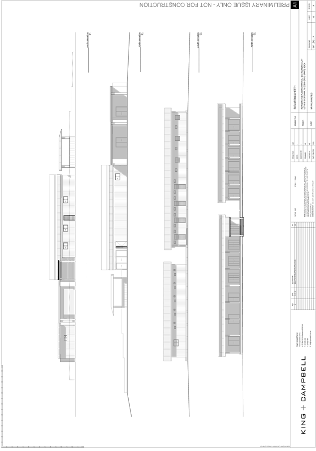
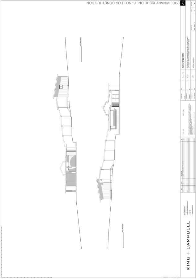
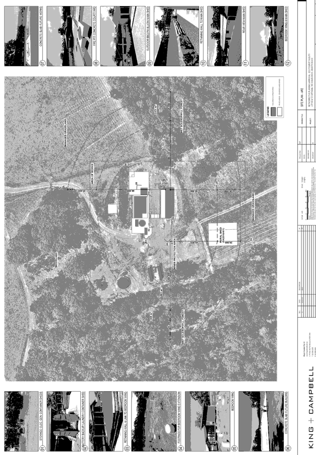
Item: 05
Subject: DA2016 - 0700.1 - Eco Tourist Facility At Lot
101 DP 754444, 743 Ocean Drive, Grants Beach
Report
Author: Clint Tink
|
Applicant: P
S Manfield
Owner: P
S Manfield
Estimated Cost: $285,000
Alignment with Delivery
Program
4.9.2 Undertake transparent
and efficient development assessment in accordance with relevant legislation.
|
|
RECOMMENDATION
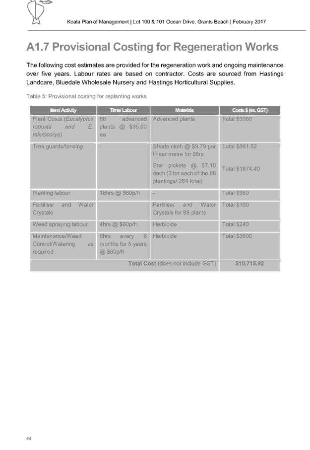
1. That the Koala Plan of Management prepared by Naturecall
Environmental dated 28 February 2017 be adopted.
1.
2. That DA 2016 - 0700.1 for an eco tourist facility at Lot 101, DP 754444, No. 743 Ocean
Drive, Grants Beach, be determined by granting consent subject to the
recommended conditions.
|
Executive
Summary
This
report considers a development application for an eco tourist facility at the subject site and provides an assessment of the
application in accordance with the Environmental Planning and Assessment Act
1979.
Following exhibition of the
application, no submissions were received.
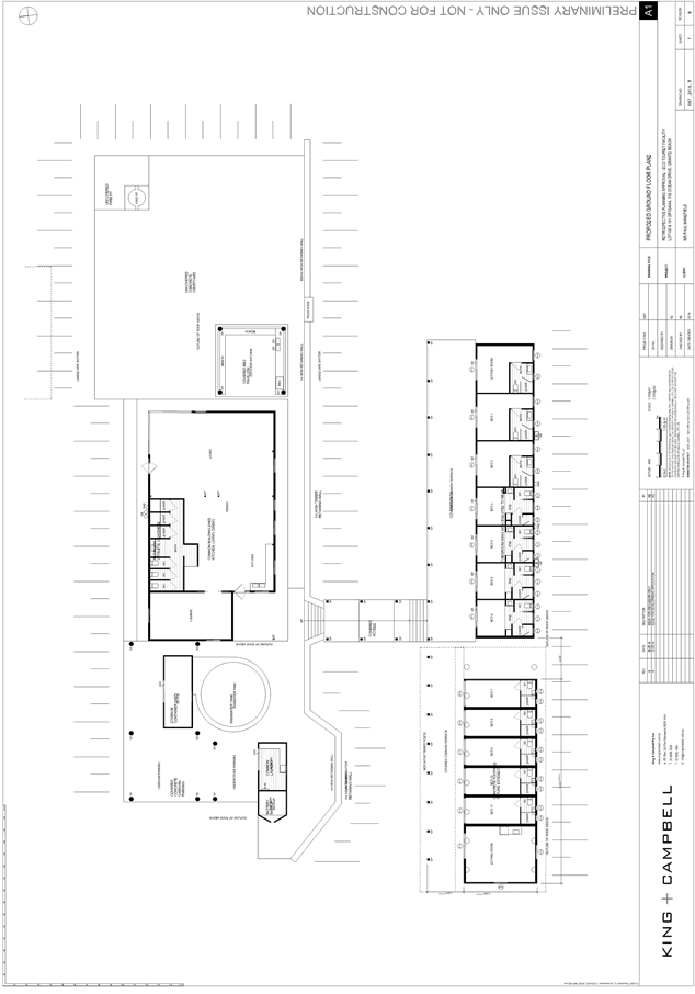
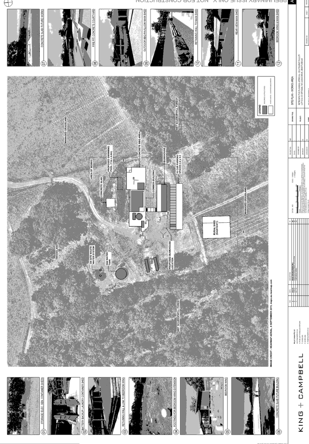
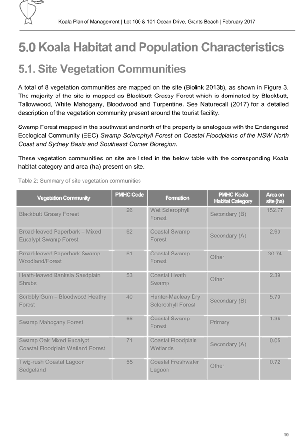
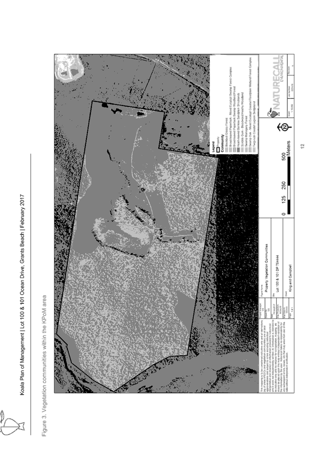
1. BACKGROUND
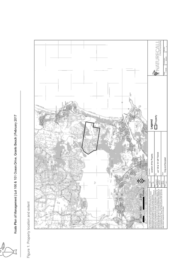
Existing sites features and Surrounding development
The site has an area of 171.1ha. The applicant also owns the adjoining Lot 100 DP 754444
at 72.73ha. However, Lot 101 does not form part of the application.
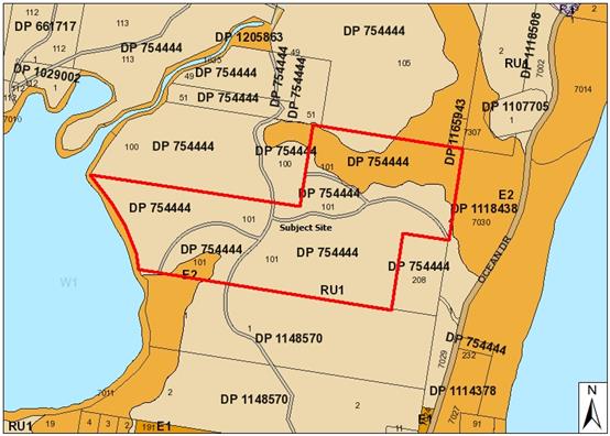
The site is zoned RU1 Primary Production and E2
Environmental Conservation in accordance with the
Port Macquarie-Hastings Local Environmental Plan 2011, as shown in the
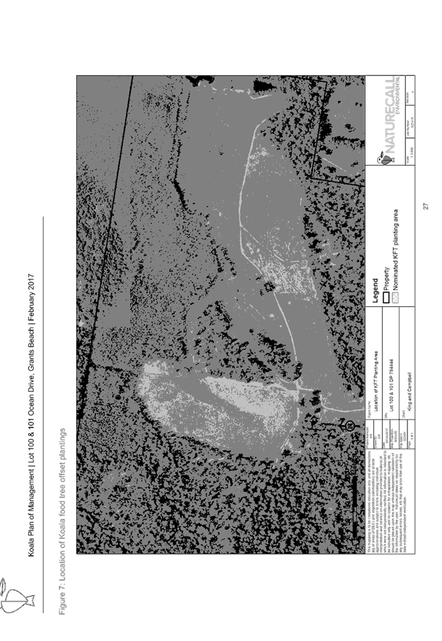
following zoning plan:
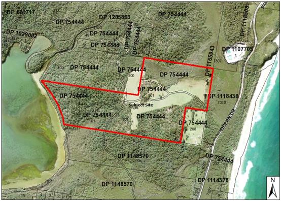
The existing subdivision pattern and location of existing
development within the locality is shown in the following aerial photograph:
2. DESCRIPTION OF
DEVELOPMENT
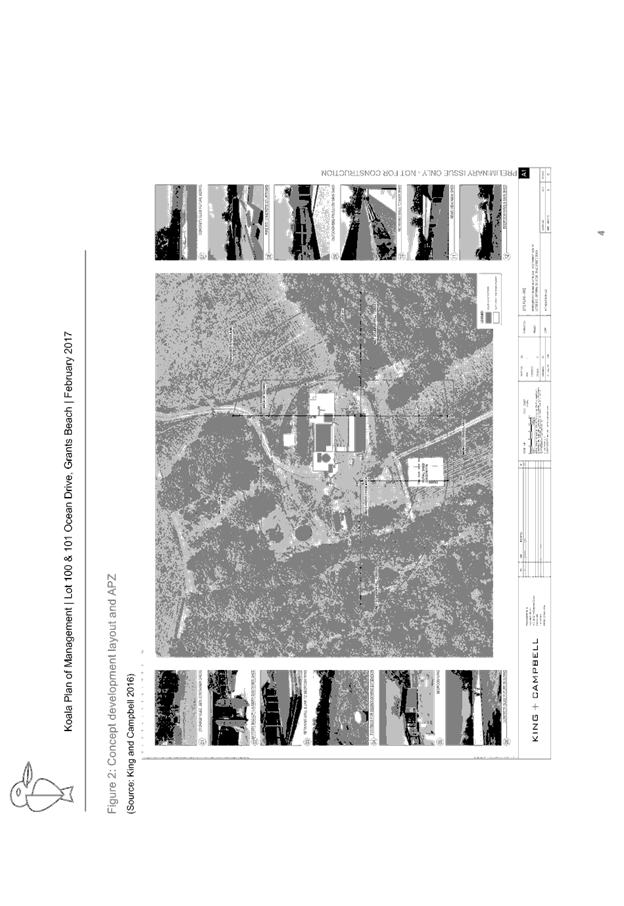
Key aspects of the proposal include the following:
· The
eco tourist facility will provide a bunkhouse comprising 10 bedrooms for
accommodation and 1 bedroom for a managers residence.
· A
recreation hall/living area incorporating cooking facilities, bbq area,
toilets, showers etc is also proposed.
· There
are a number of storage containers proposed to hold laundry facilities,
batteries and storage.
· A
swimming pool is proposed.
· Activities
for guests onsite include walking trails, quad bike riding, bird watching,
enjoying the natural setting/views and utilising the onsite facilities (ie
recreation hall, swimming pool etc). In addition to onsite activities, the site
is located in close proximity to beaches, lakes, walking trails and other local
facilities.
· No
functions will be held onsite, except those amongst guests using the
accommodation.
· The
building will be off grid utilising onsite water, sewer and electricity.
· The
site has legal access via existing right of carriageways.
· A
management plan forms part of the application to manage, monitor and make
improvements/changes to ensure the facility creates no adverse impacts on the
environment.
· A
number of the structures have been completed without consent. While this
consent is to allow their continued use as an eco tourist facility, a building
certificate will also be conditioned to be obtained before occupation.
· Council’s
Environmental Health Officer has applied conditions to deal with the commercial
kitchen, swimming pool and drinking water aspects of the proposal.
Refer
to attachments at the end of this report.
Application Chronology
· 12/4/2016
- Proposal was present to Council’s Pre-lodgement Meeting.
· 11/8/2016
- Approval was issued for a farm building shed.
· 7/9/2016
- DA2016 - 0700.1 lodged with Council.
· 12/9/2016
- Council staff requested additional fees.
· 14/9/2016
- Applicant paid outstanding fees.
· 15
to 28/9/2016 - Notification period.
· 23/9/2016
- Council staff requested additional information on the Statement of
Environmental Effects (SOEE), management, BASIX, walking trails, activities,
functions, management strategy, elevations, view sharing and room uses.
· 26/9/2016
- Applicant provided partial response to Council’s email dated 23/9/2016.
· 4/10/2016
- Having reviewed the applicant’s response on 26/9/2016, Council staff
requested clarification on sitting rooms, onsite management, elevations and
view sharing.
· 4
to 12/10/2016 - Discussion with applicant on management strategy requirements
of Clause 5.13.
· 7/10/2016
- Response from applicant to sitting room and management issues raised by
Council on 4/10/2016.
· 12/10/2016
- Excluding elevations, the applicant responded to outstanding items raised by
Council on 4/10/2016.
· 25/10/2016
- NSW RFS requested additional information on bushfire matters. Request
forwarded to applicant on 27/10/2016.
· 26/10/2016
- Applicant provided elevations in response to Council’s request on
4/10/2016.
· 28/10/2016 - Site inspected.
· 4/11/2016 - Council staff requested additional information
on driveways and parking. Discussion on the driveway issue with the applicant
continued until 7/11/2016.
· 8/11/2016 - Applicant responded to NSW RFS’s letter
dated 25/10/2016. Council staff forwarded the information onto the NSW RFS on
9/11/2016.
· 9/11/2016 - Applicant provided parking area in response to
Council’s request dated 4/11/2016.
· 9 to 10/11/2016 - Discussion on driveway requirements.
· 14/11/2016 - Owners consent provided to seal section of
driveway/right of carriageway. NSW RFS also requested additional information,
which was passed onto the applicant.
· 18/11/2016 - Discussion between the applicant and Council
staff regarding clearing for Asset Protection Zones (APZs) and ecological
assessment requirements.
· 15/12/2016 - Applicant submitted ecological report addressing
APZ clearing works.
· 19/12/2016 - Revised APZs referred to NSW RFS.
· 16-17/1/2016 - Council’s Natural Resources Officer
inspected the property, provided feedback on the ecological report and
requested additional information, including need for Koala Plan of Management
(KPOM).
· 2/2/2017 - NSW RFS provided Bushfire Safety Authority.
· 21/2/2017 - Council staff sent follow up email requesting
response to Natural Resource Officer’s concerns. Applicant confirmed KPOM
being done.
· 23/2/2017 - Applicant submitted revised ecological report
and KPOM.
· 28/2/2017 to 6/3/2017 - Council staff discussed KPOM
details with the applicant.
· 6/3/2017 - KPOM sent to Department of Planning.
· 11/4/2017 - Update provided on KPOM.
· 4/5/2017 - Discussion with applicant on draft conditions.
· 10/5/2017 - KPOM approved by Department of Planning.
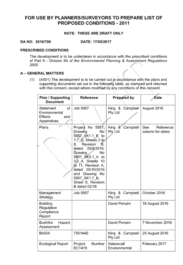
3. STATUTORY ASSESSMENT
Section 79C(1) Matters for Consideration
In determining the application, Council is required to take
into consideration the following matters as are relevant to the development
that apply to the land to which the development application relates:
(a) The provisions (where
applicable) of:
(i) any Environmental
Planning Instrument:
State Environmental Planning Policy No.
14 - Coastal Wetlands
The property contains SEPP 14 Coastal
Wetland areas in the lower sections of the property. However, the application
has demonstrated that no development is proposed to or near the SEPP 14
affected area. In this regard, further consideration of the SEPP does not apply
in this case.
State Environmental Planning Policy No.
44 - Koala Habitat Protection
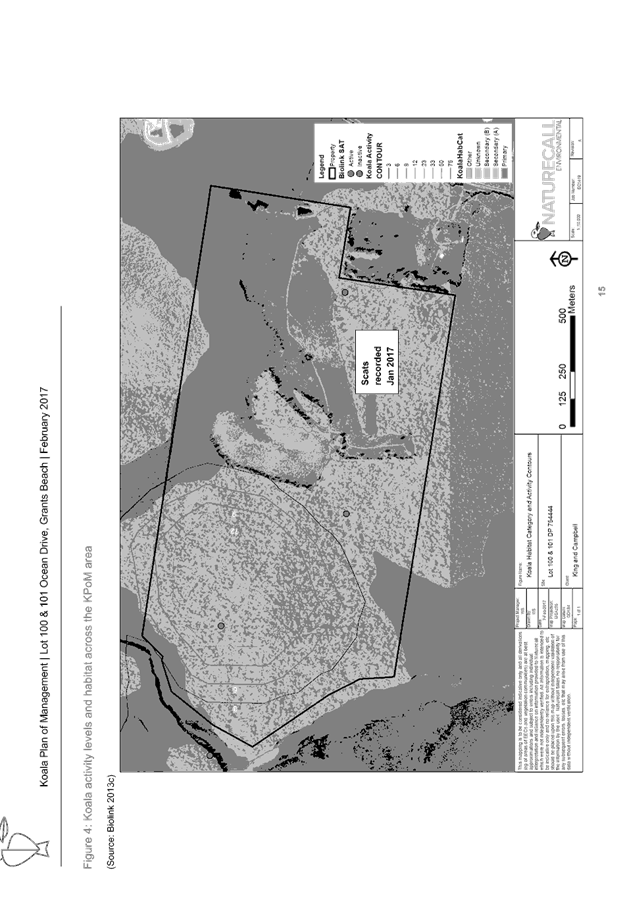
In accordance
with clauses 6 and 7, the subject land has an area of more than one (1) hectare
in size and therefore the provisions of the SEPP must be considered.
The applicant
commissioned an ecological assessment to be carried out on the property by
Naturecall Environmental. The results of the assessment (along with Council
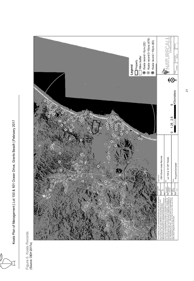
Data) showed that the site contained core koala habitat.
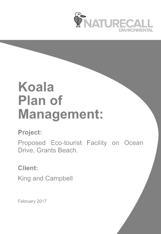
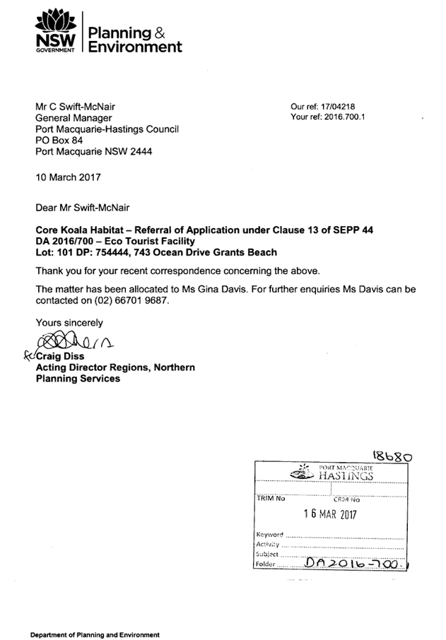
A Koala Plan
of Management (KPOM) was subsequently prepared by the consultant in accordance
with the SEPP and forwarded to the Department of Planning (DoP) for approval.
The DoP subsequently granted approval to the KPOM on 10 May 2017. A copy of the
KPoM and the DoP approval are attached at the end of this report.
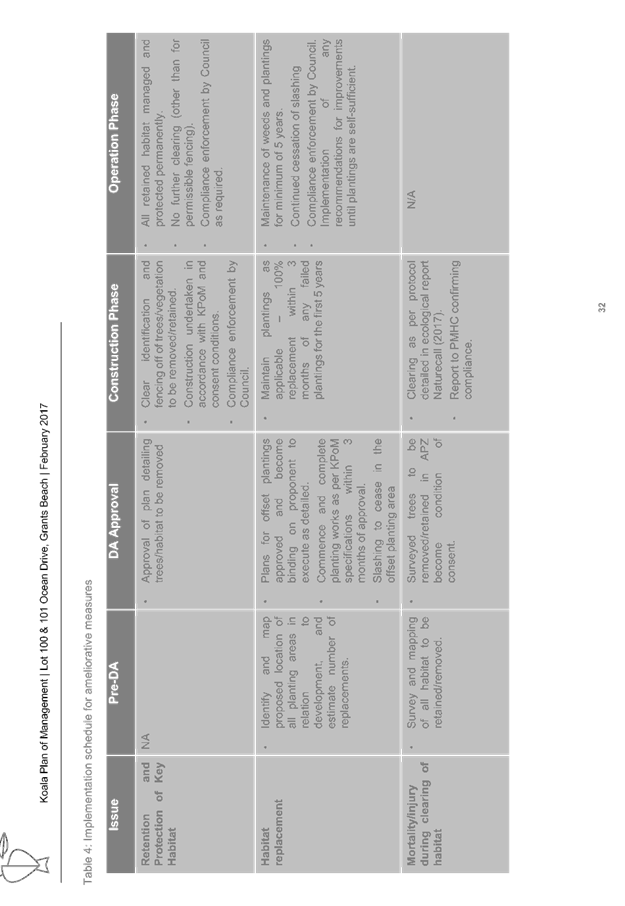
In accordance with Clause 13 of SEPP 44, the Development
Assessment Panel (DAP) as a delegate of Council is also required to approve the
KPOM. In considering whether to give approval, Circular B35 relating to SEPP 44
is to be taken into consideration. An assessment of the relevant criteria is
provided below:
|
SEPP 44 Criteria listed in
Circular B35
|
Assessment/Compliance
|
|
(i) an estimate of
population size
|
1-3 koalas within the property.
|
|
(ii) Identification of
preferred feed tree species for the locality and extent of resource available
|
Nominated -Tallowwood and
Swamp Mahogany dominant preferred trees species onsite. Approximately 22
Tallowwoods require removal and are proposed to be replaced at a rate of 4:1.
|
|
(iii) An assessment of the
regional distribution of koalas and the extent of alternative habitat
available to compensate for that affected by the actions
|
Comment provided. Site is
important component of both local and regional koala habitat.
|
|
(iv) Identification of
linkages of core koala habitat to other areas of habitat and movement of
koalas between areas of habitat. Provision of strategies to enhance and
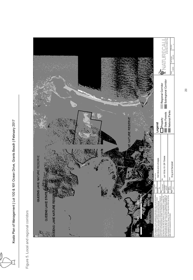
manage these corridors.
|
Linkage importance nominated,
will be preserved and enhanced. Site assists linking key east, north and
south habitat areas.
|
|
(v) Identification of major
threatening processes such as disease, clearance of habitat, road kill and
dog attack which impact on the population. Provisions of methods for
reducing these impacts.
|
Management plan provided identifying
threatening processes (i.e. tree loss, road kill, dogs etc) and strategies
for ongoing management.
|
|
(vi) Provision of detailed
proposals for the amelioration of impacts on koala populations from any
anticipated development within zones of core koala habitat.
|
Criteria provided. Habitat
protection and enhancement provided outside building areas, dog management
etc.
|
|
(vii) Identification of any
opportunities to increase size or improve condition of existing core habitat,
this should include lands adjacent to areas of identified core koala habitat.
|
KPOM largely nominates
strengthening of habitat through compensatory planting.
|
|
(viii) The plan should
state clearly what it aims to achieve (for example, maintaining or expanding
the current population size or habitat area)
|
Objectives stated.
|
|
(ix) The plan should
state the criteria against which achievement of these objectives is to be
measured (for example, a specified population size in a specific time frame
or the abatement of threats to the population)
|
Suitable implementation
schedule provided for DA,CC and operational phases.
|
|
(x) The plan should also
have provisions for continuing monitoring, review and reporting. This
should include an identification of who will undertake further work and how
it will be funded.
|
Annual monitoring proposed by
the developer.
|
The KPOM has
also been reviewed and accepted by Council’s Natural Resource section.
Based on the
above, the development addresses SEPP 44 and associated KPOM requirements. The
submitted KPOM provides a mechanism to protect and enhance key koala habitat
onsite and associated linkages.
State
Environmental Planning Policy No.55 – Remediation of Land
Following an inspection of the site and a
search of Council records, the subject land is not identified as being
potentially contaminated and is suitable for the intended use.
State
Environmental Planning Policy No. 62 – Sustainable Aquaculture
Given the nature
of the proposed development, setbacks to waterways and proposed stormwater controls;
the proposal will be unlikely to have any adverse impact on existing
aquaculture industries.
State
Environmental Planning Policy No. 64 – Advertising and Signage
No signage proposed.
State Environmental Planning
Policy No. 71 – Coastal Protection and Clause 5.5 of Port
Macquarie-Hastings Local Environmental Plan 2011
The site is located within a
coastal zone noting clause 4 of the SEPP.
The site is further identified as
being within a sensitive coastal location but does not trigger the need for a
masterplan under Clause 18 of the SEPP.
In accordance with clause 5, this
SEPP prevails over the Port Macquarie-Hastings LEP 2011 in the event of any
inconsistency.
Having regard for clauses 2, 8 and
12 to 16 of the SEPP and clause 5.5 of the PMH LEP 2011, the proposed
development will not result in any of the following:
a) any
restricted access (or opportunities for access) to the foreshore
b) any
adverse amenity impacts along the foreshore and on the scenic qualities of the
coast;
c) any adverse
impacts on flora and fauna;
d) the
development being subject to any adverse coastal processes or hazards;
e) any
significant conflict between water and land based users of the area;
f) any
adverse impacts on any items of archaeological/heritage;
g) reduction
in the quality of the natural water bodies in the locality (due to effluent
& stormwater disposal, construction impacts, landuse conflicts);
h) adverse
cumulative impacts on the environment;
i) a
form of development that is unsustainable in water and energy demands;
j) development
relying on flexible zone provisions.
The site is predominately cleared
but still located within an area well separated by distance and screened (via
vegetation) from surrounding coastal areas. No change to access to and from
coastal areas proposed.
State Environmental Planning Policy (Building
Sustainability Index: BASIX) 2004
A BASIX certificate (number
750144S) has been submitted demonstrating that the proposal will comply with
the requirements of the SEPP. It is recommended that a condition be imposed to
ensure that the commitments are incorporated into the development and certified
at Occupation Certificate stage.
State Environmental Planning
Policy (Infrastructure) 2007
Whilst the development gains access
from Ocean Drive (classified road), the access is existing with no major
changes proposed or required. A 3m seal section has been required by Council
Engineers, which is considered an improvement on the current gravel situation.
The development is also setback
over a kilometre from Ocean Drive and will therefore not be impacted by any
road noise or vibration.
Based on the above, the proposed
development complies with the requirements of the SEPP.
State Environmental Planning
Policy (Mining, Petroleum Production and extractive Industries) 2007
As per Clause 13, before
determining an application, the consent authority must:
(a) consider:
(i) the existing uses and
approved uses of land in the vicinity of the development, and
(ii) whether or not the
development is likely to have a significant impact on current or future
extraction or recovery of minerals, petroleum or extractive materials
(including by limiting access to, or impeding assessment of, those resources),
and
(iii) any ways in which
the development may be incompatible with any of those existing or approved uses
or that current or future extraction or recovery, and
(b) evaluate and compare
the respective public benefits of the development and the uses, extraction and
recovery referred to in paragraph (a) (i) and (ii), and
(c) evaluate any
measures proposed by the applicant to avoid or minimise any incompatibility, as
referred to in paragraph (a) (iii).
Having considered the above, the
proposed development adjoins the existing Hurd’s quarry located 1.5km
north east of the site. The applicant submitted a noise report that concluded
there would be no adverse noise impacts from the quarry on the eco tourist
facility. Furthermore, the distance/separation and existing vegetation
screening will ensure no adverse conflict or loss of future quarry
land/operations.
Based on the above, the provisions
of the SEPP will not be compromised.
State Environmental Planning
Policy (State and Regional Development) 2011
The proposed development does not
trigger any of the clauses or thresholds in the SEPP pertaining to tourist or
eco tourist facilities.
State Environmental Planning
Policy (Rural Lands) 2008
|
SEPP requirement
|
Comment
|
Complies
|
|
Objectives
|
|
|
|
2(a) to facilitate the orderly and economic use and
development of rural lands for rural and related purposes,
|
The proposed site is isolated from other agricultural
land, being bound by heavily timbered or ecological zoned land. This will
limit conflict with any adjoining rural zoned land. The area on the property
being developed is confined to one area. This reduces the overall footprint
and potential loss of agricultural land.
Overall, the development is seen as complimenting the
rural zoned land and will create no adverse conflicts. Through some minor
modifications, the structures could continue to be used as a residence (ie
should the venture fail).
|
Yes
|
|
2(b) to identify the Rural Planning Principles and
the Rural Subdivision Principles so as to assist in the proper management,
development and protection of rural lands for the purpose of promoting the
social, economic and environmental welfare of the State,
|
Principles have been considered and the proposal deemed
satisfactory.
|
Yes
|
|
2(c) to implement measures designed to reduce land
use conflicts,
|
The location of the development, separation from lot
boundaries and existing vegetation screening; will ensure no adverse conflict
with surrounding uses.
|
Yes
|
|
2(d) to identify State significant agricultural land
for the purpose of ensuring the ongoing viability of agriculture on that
land, having regard to social, economic and environmental considerations,
|
The site does not comprise State significant agricultural
land.
|
N/A
|
|
2(e) to amend provisions of other environmental planning
instruments relating to concessional lots in rural subdivisions.
|
Not relevant.
|
N/A
|
|
Rural Planning Principles
|
|
|
|
7(a) the promotion and protection of opportunities
for current and potential productive and sustainable economic activities in
rural areas,
|
The development provides an opportunity for rural lands to
not be impacted but rather supplemented/continued by a compatible use.
|
Yes
|
|
7(b) recognition of the importance of rural lands and
agriculture and the changing nature of agriculture and of trends, demands and
issues in agriculture in the area, region or State,
|
Refer to above comment.
|
Yes
|
|
7(c) recognition of the significance of rural land uses to
the State and rural communities, including the social and economic benefits
of rural land use and development,
|
Rural land and future viability will be retained/not
compromised.
|
Yes
|
|
7(d) in planning for rural lands, to balance the social,
economic and environmental interests of the community,
|
Rural land already exists and will not be impacted.
|
Yes
|
|
7(e) the identification and protection of natural
resources, having regard to maintaining biodiversity, the protection of
native vegetation, the importance of water resources and avoiding constrained
land,
|
The development is located predominately within existing
cleared areas. A plan of management will also be implemented to ensure the
tourist use does not degrade any of the existing native vegetation,
biodiversity etc.
|
Yes
|
|
7(f) the provision of opportunities for rural lifestyle,
settlement and housing that contribute to the social and economic welfare of
rural communities,
|
The tourist use will compliment settlement within the area
and can be converted to a residence, should the venture fail.
|
Yes
|
|
7(g) the consideration of impacts on services and infrastructure
and appropriate location when providing for rural housing,
|
The site is located within close proximity to services and
facilities and being off grid, will require minimal expansion or burden on
such services/facilities.
|
Yes
|
|
7(h) ensuring consistency with any applicable
regional strategy of the Department of Planning or any applicable local
strategy endorsed by the Director-General.
|
The proposed development will not compromise any strategy.
|
Yes
|
|
Rural Subdivision Principles
|
No subdivision proposed.
|
N/A
|
|
Matters to be considered in determining development
applications for rural subdivisions or rural dwellings
|
|
|
|
10(1) This clause applies to land in a rural zone, a
rural residential zone or an environment protection zone.
10(2) A consent authority must take into account the
matters specified in subclause (3) when considering whether to grant consent
to development on land to which this clause applies for any of the following
purposes:
(a) subdivision
of land proposed to be used for the purposes of a dwelling,
(b) erection of
a dwelling.
10(3) The following matters are to be taken into
account:
(a) the existing
uses and approved uses of land in the vicinity of the development,
(b) whether or
not the development is likely to have a significant impact on land uses that,
in the opinion of the consent authority, are likely to be preferred and the
predominant land uses in the vicinity of the development,
(c) whether or
not the development is likely to be incompatible with a use referred to in
paragraph (a) or (b),
(d) if the
land is not situated within a rural residential zone, whether or not the
development is likely to be incompatible with a use on land within an
adjoining rural residential zone,
(e) any measures
proposed by the applicant to avoid or minimise any incompatibility referred
to in paragraph (c) or (d).
|
Refer to comments above in this SEPP assessment, which
demonstrate the proposed development is compatible with the area and will
create no adverse conflict.
|
Yes
|
Port
Macquarie-Hastings Local Environmental Plan 2011
The proposal is consistent with the LEP having regard to the
following:
· Clause 2.2, the
subject site is zoned RU1 Primary Production and E2 Environmental Conservation.
For the purposes of this assessment report, the application will only consider
the provisions relevant to the RU1 zone as no work is proposed within the E2
zoned area. In accordance with clause 2.3(1) and the RU1 zone landuse table,
the proposed development for a eco tourist facility is a permissible landuse with
consent. It is considered that the site contains and adjoins special ecological
features such as Queens Lake and surrounding vegetated areas, local beaches,
North Brother mountain etc.
The objectives
of the RU1 zone are as follows:
o To encourage sustainable primary industry production by
maintaining and enhancing the natural resource base.
o To encourage diversity in primary industry enterprises and
systems appropriate for the area.
o To minimise the fragmentation and alienation of resource
lands.
o To minimise conflict between land uses within this zone and
land uses within adjoining zones.
In accordance with Clause 2.3(2), the proposal is consistent
with the zone objectives having regard to the following:
o The proposal is a permissible
landuse.
o The proposal does not impact on the
natural resource base (development is reversible and located within one area -
similar to a rural dwelling).
o The development diversifies uses
onsite without creating conflict.
o The development does not fragment
the land.
o The development will not create any
conflict - refer to comments on SEPP (Rural Lands) 2008.
· Clause 4.2A,
while technically no dwelling is proposed (ie eco tourist facility and
ancillary managers residence proposed), the site has a dwelling entitlement by
virtue of the lot meeting the 40ha minimum lot size standard.
· Clause 4.3
& 4.4, there is no height or FSR standard applicable to the site. However,
it is considered that the buildings are consistent with a rural setting.
· Clause 5.9,
tree removal has been considered in the ecological report and deemed to create
no adverse impacts.
· Clause 5.10,
the site does not contain or adjoin any known heritage items or sites of
significance. The area being developed is also disturbed from past activities.
Furthermore, the applicant performed an AHIM’s search that did not
identify any sites/items.
· Clause 5.13,
specifies matters to be considered in assessing development for eco-tourist
facilities. Having considered the Clause, the development achieves compliance
as follows:
o There is a demonstrated
connection between the development and the ecology/environment on site. The
development is positioned to take advantage of key views from the site and
contains low impact walking tracks and areas to enjoy the ecology. There are no
cultural values specific to the site.
o The site will utilise
predominately cleared areas for access and infrastructure. This limits the
impact on the environment. A Plan of Management (POM) is also to be implemented
to further protect and conserve the site.
o The development is well
positioned to take advantage of surrounding towns, beaches and other tourists
area/environments.
o The development will promote
an appreciation of the surrounding environment via facilities onsite. The POM
will further ensure protection and future maintenance of the site/environment.
o The POM will deal with waste
during operation. Standard waste controls will apply during construction.
o The applicant has provided a
view analysis, which demonstrates that the development (for the most part) will
not be visible from surrounding areas. Furthermore, the development will create
no more an impact than sheds etc that could occur in a rural area under exempt
development.
o Infrastructure is either
existing or will create no adverse impact on the environment. Applicant is
looking to utilise off the grid infrastructure where possible.
o The development will not
impact on the rural use of the property or surrounding area - refer to comments
on SEPP (Rural Lands ) 2008.
o A management plan has been
submitted addressing impacts, ways to reduce/manage impacts,
maintenance/protection of habitat onsite, review processes and quality control.
2. Based on the above,
the proposed development is consistent with the requirements of Clause 5.13 and
will create no adverse impacts.
· Clause 7.1,
parts of the property are mapped as potentially containing acid sulfate soils.
However, the mapped areas are on the lower sections of the property, which are
not to be disturbed.
· Clause 7.3,
parts of the property are mapped “flood planning area”. However,
the mapped areas are on the lower sections of the property, which are not being
developed. Furthermore, the access/egress from the site is flood free. In this
regard the following comments are provided which incorporate consideration of
the objectives of Clause 7.3, Council’s Flood Policy 2015, the NSW
Government’s Flood Prone Lands Policy and the NSW Government’s
Floodplain Development Manual (2005):
o The
proposal is compatible with the flood hazard of the land taking into account
projected changes as a result of climate change;
o The
proposal will not result in a significant adverse affect on flood behaviour
that would result in detrimental increases in the potential flood affectation
of other development or properties;
o The
proposal incorporates measures to minimise & manage the flood risk to life
and property associated with the use of land;
o The
proposal is not likely to significantly adversely affect the environment or
cause avoidable erosion, siltation, destruction of riparian vegetation or a
reduction in the stability of river banks or watercourses;
o The
proposal is not likely to result in unsustainable social and economic costs to
the community as a consequence of flooding;
· Clause 7.4,
parts of the property are mapped as flood risk management. The same comments
above in 7.3 apply to 7.4. No adverse impacts.
· Clause 7.13,
satisfactory arrangements are in place for provision of essential services
including water supply, electricity supply, on-site sewage management,
stormwater drainage and suitable road access to service the development.
· Clause 7.14,
applies additional provisions applicable to eco-tourist facilities. The
proposed development complies with the provisions as follows:
o Development for the purposes
of a dwelling or dual occupancy (attached) are permitted in the RU1 zone under
Clause 4.2A of LEP 2011.
o The gross floor area of the
eco-tourist facility and any ancillary accommodation does not exceed
1,000m². Including all structures, shipping containers, rural shed
(DA2016-411) etc; the development equates to approximately 980m². However,
500m² of this figure is the rural shed (DA2016-411), which in reality is
not linked to the eco-tourist facility development and can exist onsite
independently.
o The proposed development does
not cause unfunded demand for infrastructure. Internal roads will be privately
maintained and connect direct to the existing Ocean Drive. Occupant numbers are
not expected to be excessive due to the boutique nature of the development.
Furthermore, applicant proposes to utilise a number of off the grid services
(ie rain water and onsite waste management system) to enable the development to
operate. This reduces the burden on local infrastructure.
o The development will not
compromise the future extractive industry development. As mentioned previously
in this assessment, the proposal is well separated and screened from Hurds
Quarry.
3.
4. Based on the above,
the proposed development complies with Clause 7.14.
(ii) Any
draft instruments that apply to the site or are on exhibition:
No draft
instruments apply to the site.
(iii) any
Development Control Plan in force:
Port
Macquarie-Hastings Development Control Plan 2013
There is no section in the DCP
specific to eco-tourist facilities. Only the General Provisions below apply.
|
DCP 2013: General
Provisions
|
|
|
Requirements
|
Proposed
|
Complies
|
|
2.7.2.2
|
Design addresses generic principles of Crime Prevention
Through Environmental Design guideline
|
Adequate casual surveillance available from rooms. A
managers residence will also be provided to watch over the site and
occupants. CCTV cameras and lighting can be installed retrospectively if
required.
|
Yes
|
|
2.3.3.1
|
Cut and fill 1.0m max. 1m outside the perimeter of the
external building walls
|
1m high retaining walls exist/proposed. The retaining
walls create no adverse impacts.
|
Yes
|
|
2.3.3.2
|
1m max. height retaining walls along road frontage
|
Not relevant. Site is over 1km from the nearest public
road.
|
N/A
|
|
Any retaining wall >1.0 in height to be certified by
structure engineer
|
To be conditioned.
|
Yes
|
|
Combination of retaining wall and front fence height max
1.8m, max length 6.0m or 30% of frontage, fence component 25% transparent,
and splay at corners and adjacent to driveway
|
No front fence retaining wall combination proposed.
|
N/A
|
|
2.3.3.8
|
Removal of hollow bearing trees
|
Tree removal considered in ecological report and accepted
by Council’s Natural Resources Section
|
Yes
|
|
2.6.3.1
|
Tree removal (3m or higher with 100m diameter trunk at 1m
above ground level and 3m from external wall of existing dwelling)
|
Tree removal considered in ecological report and accepted
by Council’s Natural Resources Section
|
Yes
|
|
2.4.3
|
Bushfire risk, Acid sulphate soils, Flooding,
Contamination, Airspace protection, Noise and Stormwater
|
Refer to main body of report.
|
Noted
|
|
2.5.3.2
|
New accesses not permitted from arterial or distributor
roads
|
No new access proposed to Ocean Drive (classified road).
The existing access will be improved with 3m seal.
|
Yes
|
|
Driveway crossing/s minimal in number and width including
maximising street parking
|
Existing crossover to be utilised.
|
Yes
|
|
2.5.3.3
|
Parking in accordance with Table 2.5.1.
1.1 spaces per unit, 1 per 2 employees and 1 for onsite
manager
|
10 units proposed and 1 managers residence. There will
only ever be the onsite manager and an occasional cleaner employed onsite.
Therefore, 10 units x 1.1 + 1 space for manager/cleaner = 12 spaces.
Being a large rural property, there is sufficient area to
create a car park to cover the required spaces. The applicant has nominated
an area comprising 16 spaces to the rear of the units, including a disabled
parking space.
|
Yes
|
|
2.5.3.11
|
Section 94 contributions
|
Refer to main body of report. Contributions apply.
|
Yes
|
|
2.5.3.12 and 2.5.3.13
|
Landscaping of parking areas
|
Capable of being provided although not critical to a large
rural property surrounded by vegetation.
|
Yes
|
|
2.5.3.14
|
Sealed driveway surfaces unless justified
|
Council engineers have assessed the existing two wheel
drive gravel road into the property and deemed it acceptable for the use.
|
Yes
|
|
2.5.3.15 and 2.5.3.16
|
Driveway grades first 6m or ‘parking area’
shall be 5% grade with transitions of 2m length
|
Refer to above comment.
|
Yes
|
|
2.5.3.17
|
Parking areas to be designed to avoid concentrations of
water runoff on the surface.
|
Capable of complying.
|
Yes
|
|
Vehicle washing facilities – grassed area etc
available.
|
Site contains grassed areas for vehicle washing.
|
Yes
|
(iiia) any
planning agreement that has been entered into under Section 93f or any draft
planning agreement that a developer has offered to enter into under Section
93f:
None
relevant.
iv) any matters prescribed by the
Regulations:
NSW
Coastal Policy 1997
The
proposed development is consistent with the objectives and strategic actions of
this policy.
Fire
Safety
The
application has been assessed by one of Council’s Building Surveyors and
compliance with fire safety is considered possible subject to conditions.
v) any coastal
zone management plan (within the meaning of the Coastal Protection Act 1979),
that apply to the land to which the development application relates:
None
relevant.
(b) The
likely impacts of that development, including environmental impacts on both the
natural and built environments, social and economic impacts in the locality:
Context
and Setting
The site has distant frontage to Ocean Drive to the east.
Adjoining the site is predominately
timbered rural and environmental zoned land. A quarry exists approximately
1.5km to the north east.
The proposal will be unlikely to have
any adverse impacts to existing adjoining properties and satisfactorily
addresses the public domain.
The proposal is considered to be an
acceptable fit within the locality and adequately addresses planning controls
for the area.
The proposal does not have a
significant adverse impact on existing view sharing.
Roads
Adjacent to the site, Ocean Drive is a Roads and Maritime
Services (RMS) ‘classified’ road owned by Council. Council will
have to refer any applications for works within the road reserve (i.e. Section
138) to the RMS for concurrence.
Traffic and Transport
It is estimated that the proposal would generate the
following:
· Daily
Vehicle Trips – 3 per unit (36); and
· Evening
peak hour vehicle trips – 0.4 per unit (4.8).
Whilst no formal traffic assessment has been carried out for
that part of Ocean Drive between Bonny Hills and North Haven, it is considered
that the above vehicle trips would not have any adverse impacts on the existing
sub-arterial road network.
Site Frontage & Access
Vehicle access to the site is proposed via a right of
carriageway 20m wide over Lot 1 in DP1097395 and Lot 208 in DP754444. Access
shall comply with Council AUSPEC and Australian Standards and conditions have
been imposed to reflect these requirements.
Parking and Manoeuvring
A total of 16 parking spaces have been provided on-site
within a designated parking area available within the driveway. Parking and
driveway widths on site can comply with relevant Australian Standards (AS 2890)
and conditions have been imposed to reflect these requirements.
Water Supply Connection
Onsite water supply to be utilised.
Sewer Connection
Onsite waste management system to be utilised. The site
contains sufficient area to accommodate a compliant system.
Stormwater
Stormwater from the proposed development is planned to be
collected in rainwater tanks for re-use on site with overflow to be directed
into an existing highly vegetated gully. Surface water and water from hard
stand areas is proposed to flow overland (through vegetated areas) to the
existing highly vegetated gully. It is therefore submitted that this meets the
requirements to not detrimentally impact on upstream or downstream properties,
provides an effective outlet to an existing gully and ensures that flows are
generally restricted to natural drainage lines and located downstream of the
existing access road to allow for the safe passage of vehicles.
A detailed site stormwater
management plan will be required to be submitted for assessment with the S.68
application and prior to the issue of a CC.
Refer to relevant conditions of
consent.
Other Utilities
Telecommunication and electricity services can be made
available to the site at applicant’s expense. Applicant does propose to
utilise off grid electricity.
Heritage
Refer to comments on heritage in the LEP 2011 section of
this report.
Other land resources
The development will not sterilise any significant mineral
or agricultural resource.
Water cycle
The proposed development will be unlikely to have any
adverse impacts on water resources and the water cycle.
Soils
The proposed development will be unlikely to have any
adverse impacts on soils in terms of quality, erosion, stability and/or
productivity subject to a standard condition requiring erosion and sediment
controls to be in place prior to and during construction.
Air and microclimate
The construction and/or operations of the proposed
development will be unlikely to result in any adverse impacts on the existing
air quality or result in any pollution. Standard precautionary site management
condition recommended.
Flora and fauna
The applicant has submitted a flora and fauna impact
assessment report prepared by Naturecall Environmental dated February 2017.
The report concluded the following;
- No
threatened flora species were recorded or found to have potential occurrence
within the study area.
- No
EECs are present within the study area.
- Development
will see the thinning/under scrubbing of around 1.2ha of dry sclerophyll
forest.
- The
site and parts of the larger property qualify as Core Koala Habitat under SEPP
44.
- No
threatened fauna species were recorded during the survey, however the Koala was
recorded during a subsequent site inspection.
- A
total of 17 threatened fauna species and several migratory birds were found to
have at least a low potential to occur within the study area.
- Assessment
under the Seven Part Tests and EPBC MNES determined the impact, while a generic
negative effect in terms of incremental loss of habitat, is unlikely to be of
sufficient order of magnitude to have a significant impact. Hence a Species
Impact Statement is not considered required.
- Assessment
under the EPBCA – Matters of National Environmental Significance
determined the cumulative impact, while negative, was unlikely to be
significant. Hence referral to DEE for approval is not considered required.
- The
proposal can comply the with the PMHC DCP 2013 via retaining hollow-bearing
trees and planting of offset Koala food trees on the property.
Overall, the report addresses the
requirements of the ‘7 part test’ under Section 5A of the Act and
has been reviewed by Council’s Natural Resources Section as being
acceptable. Conditions will be applied to the consent to reinforce the requirements
of the ecological report.
Waste
Satisfactory arrangements are in place for proposed storage
and collection of waste and recyclables. No adverse impacts anticipated.
Standard precautionary site management condition recommended.
Energy
The proposal includes measures to address energy efficiency
and will be required to comply with the requirements of BASIX. No adverse
impacts anticipated.
Noise and vibration
Council’s Environmental Health Officer assessed the
application and provided the following comment:
From the information provided in the Grants Head Quarry
modification NIA Report prepared by ERM dated April 2012 for Hy-Tec and the
location of the facility, it’s not expected that quarry operational noise
and/or road traffic noise from Ocean Drive some 1200m away will adversely
impact on occupants of the tourist facility. No other significant noise source
have been identified in the vicinity. No occupants of the tourist facility have
lodged noise complaints with council.
Based on the above, no adverse impacts anticipated subject
to conditions.
Bushfire
The site is identified as being bushfire prone.
A tourist facility is considered a
Special Fire Purpose under S100B of the Rural Fires Act 1997. The application
triggers integrated development and requires a Bushfire Safety Authority from
the NSW Rural Fire Service. The applicant submitted a bushfire report prepared
by a Certified Consultant, which along with the development application, were
forwarded to the NSW Rural Fire Service. The NSW Rural Fire service have
subsequently issued a Bushfire Safety Authority, which will form part of the
development consent/approval.
Safety, security and crime prevention
The proposed development will be unlikely to create any
concealment/entrapment areas or crime spots that would result in any
identifiable loss of safety or reduction of security in the immediate
area.
Social impacts in the locality
Given the nature of the proposed development and its’
location the proposal is unlikely to result in any adverse social impacts.
Positive social impacts will be the creation of a unique eco tourist facility
for the area.
Economic impact in the locality
No adverse impacts. A likely positive impact is that the
development will maintain employment in the construction and tourism industry,
which will lead to flow impacts such as expenditure in the area.
Site design and internal design
The proposed development design
satisfactorily responds to the site attributes and will fit into the locality.
No adverse impacts likely.
Construction
No potential adverse impacts identified to neighbouring
properties with the construction of the proposal.
Cumulative Impacts
The proposed development is not expected to have any adverse
cumulative impacts on the natural or built environment or the social and
economic attributes of the locality.
(c) The suitability of the site for
the development:
The proposal
will fit into the locality and the site attributes are conducive to the
proposed development.
Site
constraints have been adequately addressed and appropriate conditions of
consent recommended.
(d) Any submissions made in
accordance with this Act or the Regulations:
No written submissions were received following public
exhibition of the application.
(e) The Public Interest:
The proposed
development will be in the wider public interest with provision of appropriate
additional tourist accommodation.
The proposed
development satisfies relevant planning controls and is not expected to impact
on the wider public interest.
4. DEVELOPMENT
CONTRIBUTIONS APPLICABLE
· Development contributions will be required under Section 94
of the Environmental Planning and Assessment Act 1979 towards roads, open
space, community cultural services, emergency services and administration
buildings.
5. CONCLUSION
The application has been assessed in accordance with
Section 79C of the Environmental Planning and Assessment Act 1979.
Issues raised during assessment and public exhibition of
the application have been considered in the assessment of the application.
Where relevant, conditions have been recommended to manage the impacts
attributed to these issues.
The site is suitable for the proposed development, is not
contrary to the public's interest and will not have a significant adverse
social, environmental or economic impact. It is recommended that the
application be approved, subject to the recommended conditions of consent
provided in the attachment section of this report.
|
Attachments
1View. DA2016
- 700.1 Plans
2View. DA2016
- 700.1 Revised KPOM
3View. DA2016
- 700.1 DOP KPOM Approval
4View. DA2016
- 700.1 Recommended Conditions
|
|
ATTACHMENT
|
Development Assessment Panel
24/05/2017
|
|
ATTACHMENT
|
Development Assessment Panel
24/05/2017
|


|
ATTACHMENT
|
Development Assessment Panel
24/05/2017
|
|
ATTACHMENT
|
Development Assessment Panel
24/05/2017
|

AGENDA Development Assessment Panel 24/05/2017
Item: 06
Subject: DA2016 - 1006.1 Dual Occupancy and Torrens
Title Subdivision at Lot 301 DP 831575, No. 12 Beacon Court, Port Macquarie
Report
Author: Chris Gardiner
|
Applicant: S
Waldow & W C Waldow
Owner: Wilshadow
Super Pty Ltd
Estimated Cost: $619,400
Alignment with Delivery
Program
4.9.2 Undertake transparent
and efficient development assessment in accordance with relevant legislation.
|
|
RECOMMENDATION
That
DA 2016 - 1006.1 for a Dual
Occupancy and Torrens Title Subdivision at
Lot 301, DP 831575, No. 12 Beacon
Court, Port Macquarie, be determined by granting consent subject to the
recommended conditions.
|
Executive
Summary
This
report considers a development application for a dual occupancy and
Torrens tile subdivision at the subject site and
provides an assessment of the application in accordance with the Environmental
Planning and Assessment Act 1979.
Following exhibition of the
application, one submission has been received.
1. BACKGROUND
Existing sites features and surrounding development
The site has an area of 933m2.
The site is zoned R1 General Residential in accordance with the Port Macquarie-Hastings Local
Environmental Plan 2011, as shown in the following zoning plan:
The existing subdivision pattern and location of existing
development within the locality is shown in the following aerial photograph:
2. DESCRIPTION OF
DEVELOPMENT
Key aspects of the proposal include the following:
· Subdivision
of the land into two Torrens title lots;
· Construction of a two storey dwelling on each lot.
Refer
to attachments at the end of this report.
Application Chronology
· 22
December 2016 - Application lodged.
· 12 January 2017 to 25 January 2017 - Neighbour notification
of the proposal.
· 17 March 2017 - Site and views from neighbouring property
at No. 14 Beacon Court inspected by assessing officer.
· 21 March 2017 - Additional information requested from
Applicant.
· 11 April 2017 - Additional information and amended plans
submitted by Applicant.
· 19 April 2017 - Copy of amended plans forwarded to
objector.
· 1 May 2017 - No. 14 Beacon Court re-inspected for view
impacts.
3. STATUTORY ASSESSMENT
Section 79C(1) Matters for Consideration
In determining the application, Council is required to take
into consideration the following matters as are relevant to the development
that apply to the land to which the development application relates:
(a) The provisions (where
applicable) of:
(i) any Environmental
Planning Instrument:
State
Environmental Planning Policy No. 55 – Remediation of Land
Following an
inspection of the site and a search of Council records, the subject land is not
identified as being potentially contaminated and is suitable for the intended
use.
State
Environmental Planning Policy (Building Sustainability Index: BASIX) 2004
BASIX
certificates (number 785312S and 785323S) have been submitted demonstrating
that the proposal will comply with the requirements of the SEPP. It is
recommended that a condition be imposed to ensure that the commitments are
incorporated into the development and certified at Occupation Certificate
stage.
Port Macquarie-Hastings Local Environmental Plan 2011
The proposal
is consistent with the LEP having regard to the following:
· Clause
2.2, the subject site is zoned R1 General Residential. In accordance with
clause 2.3(1) and the R1 zone landuse table, the proposed development for a
dual occupancy (detached) is a permissible landuse with consent.
The objectives of the R1 zone are as follows:
o To
provide for the housing needs of the community.
o To
provide for a variety of housing types and densities.
o To
enable other land uses that provide facilities or services to meet the day to
day needs of residents.
In accordance with Clause 2.3(2), the proposal is consistent with the
zone objectives having regard to the following:
o The
proposal is a permissible landuse;
o The
development would provide for a variety of housing types and densities to meet
the housing needs of the community.
· Clause
4.1A – The minimum lot size does not apply as the development includes
subdivision into two lots and the construction of a dwelling on each lot.
· Clause
4.3, the maximum overall height of the building above ground level (existing)
is 7.813m which complies with the standard height limit of 8.5m applying to the
site.
· Clause
4.4, the floor space ratio of the proposal is 0.47:1 which complies with the
maximum 0.65:1 floor space ratio applying to the site.
· Clause
5.9 - No listed trees in Development Control Plan 2013 are proposed to be
removed.
· Clause
5.10 – Heritage. The site does not contain or adjoin any known heritage
items or sites of significance.
· Clause
7.13, satisfactory arrangements are in place for provision of essential
services including water supply, electricity supply, sewer infrastructure,
stormwater drainage and suitable road access to service the development.
Provision of electricity will be subject to obtaining satisfactory arrangements
certification prior to the issue of a Subdivision Certificate as recommended by
a condition of consent.
(ii) Any
draft instruments that apply to the site or are on exhibition:
No draft
instruments apply to the site.
(iii) any
Development Control Plan in force:
Port
Macquarie-Hastings Development Control Plan 2013
|
DCP 2013: Dwellings, Dual occupancies, Dwelling
houses, Multi dwelling houses & Ancillary development
|
|
DCP Objective
|
Development Provisions
|
Proposed
|
Complies
|
|
3.2.2.2
|
Articulation zone:
• Min.
3m front setback
• An
entry feature or portico
• A
balcony, deck, patio, pergola, terrace or verandah
• A
window box treatment
• A
bay window or similar feature
• An
awning or other feature over a window
• A
sun shading feature
|
Unit 1 patio at 3.94m
|
Yes
|
|
Front setback (Residential not R5 zone):
· Min. 4.5m local
road
|
Minimum 3.959m front setback to local road.
|
No*
|
|
3.2.2.3
|
Garage minimum 5.5m front setback and garage door recessed
behind building line at least 1m or eaves/overhangs provided
|
Minimum 6.65m setback and more than 1 metre behind the
building line.
|
Yes
|
|
6m max. width of garage door/s and 50% max. width of
building
|
Unit 1: 5.0m wide and 34% of building width.
Unit 2: 5.0m wide and 34% of building width.
|
Yes
|
|
Driveway crossover 1/3 max. of site frontage and max. 5.0m
width
|
5.0m wide and 25% of site frontage.
|
Yes
|
|
3.2.2.4
|
4m min. rear setback. Variation subject to site analysis
and provision of private open space
|
Minimum 3.723m rear setback for Unit 2.
|
No*
|
|
3.2.2.5
|
Side setbacks:
· Ground floor min.
0.9m
· First floors
& above min. 3m setback, unless demonstrated that adjoining property
primary living areas & POS unaffected.
· Building wall
set in and out every 12m by 0.5m.
|
Minimum 1.89m first floor side setback to south east
boundary. The Applicant has submitted shadow diagrams demonstrating that the
development would not adversely overshadow neighbouring primary living areas
and private open space for more than 3 hours on 21 June. Therefore, a minimum
0.9m first floor side setback is acceptable.
Building wall articulation satisfactory.
|
Yes
|
|
3.2.2.6
|
35m2 min. private open space area including a
useable 4x4m min. area which has 5% max. grade and is directly accessible
from a ground floor living area.
|
Both dwellings have minimum 35m2 private open space
including 4m x4m area accessible from living room.
|
Yes
|
|
3.2.2.7
|
Front fences:
· If solid 1.2m
max height and front setback 1.0m with landscaping
· 3x3m min. splay
for corner sites
· Fences >1.2m
to be 1.8m max. height for 50% or 6.0m max. length of street frontage with
25% openings
· 0.9x0.9m splays
adjoining driveway entrances (Fig 3.3 of AS2890.1 2004 overrides this
standard by requiring a min 2.5x2m splay for driveway entrances) See David
Troemel for info.
|
1.5m high timber fence fence on top of 1.0m high retaining
wall.
The fence is less than 50% of the site frontage and is
proposed to be setback 1m behind the top of the retaining wall with
landscaping between the fence and the top of the retaining wall.
Condition recommended requiring fence to be minimum 25%
transparent in accordance with DCP provisions.
|
Yes, subject to condition.
|
|
3.2.2.8
|
· Front fences and
walls to have complimentary materials to context
· No chain wire,
solid timber, masonry or solid steel
|
Fencing material considered generally satisfactory.
|
Yes
|
|
3.2.2.10
|
Privacy:
· Direct views
between living areas of adjacent dwellings screened when within 9m radius of
any part of window of adjacent dwelling and within 12m of private open space
areas of adjacent dwellings. ie. 1.8m fence or privacy screening which has
25% max. openings and is permanently fixed
· Privacy screen
required if floor level > 1m height, window side/rear setback (other than
bedroom) is less than 3m and sill height less than 1.5m
· Privacy screens
provided to balconies/verandas etc which have <3m side/rear setback and
floor level height >1m
|
The rumpus and dining room windows of Unit 2 are located
within 3m of the side boundary and have a floor level exceeding 1m above
ground level. Privacy screening is encouraged by the DCP in such
circumstances.
However, in this instance the location of the windows is
to the rear of the existing dwelling at No. 10 Beacon Court and is adequately
separated the private open space and living room windows of that dwelling.
Privacy is otherwise addressed through building design,
separation distance, and fencing/screening.
|
Yes
|
|
DCP 2013: General Provisions
|
|
DCP Objective
|
Development Provisions
|
Proposed
|
Complies
|
|
2.7.2.2
|
Design addresses generic principles of Crime Prevention
Through Environmental Design guideline:
· Casual
surveillance and sightlines
· Land use mix and
activity generators
· Definition of
use and ownership
· Lighting
· Way finding
· Predictable
routes and entrapment locations
|
The proposed development will be unlikely to create any
concealment/entrapment areas or crime spots that would result in any
identifiable loss of safety or reduction of security in the immediate area.
The increase in housing density will improve natural surveillance within the
locality and openings from each dwelling overlook common and private areas.
|
Yes
|
|
2.3.3.1
|
Cut and fill 1.0m max. 1m outside the perimeter of the
external building walls
|
Up to 1.8m of cut.
|
No*
|
|
2.3.3.2
|
1m max. height retaining walls along road frontages
|
Maximum 1m retaining wall along road frontage.
|
Yes
|
|
Any retaining wall >1.0 in height to be certified by
structural engineer
|
Condition recommended requiring certification of retaining
walls.
|
Yes
|
|
Combination of retaining wall and front fence height
|
Maximum 1m retaining wall along road frontage with 1.5m
fence setback 1m behind the top of the retaining wall.
|
Yes
|
|
2.3.3.8 onwards
|
Removal of hollow bearing trees
|
None proposed to be removed.
|
Yes
|
|
2.6.3.1
|
Tree removal (3m or higher with 100mm diameter trunk and
3m outside dwelling footprint
|
None proposed to be removed.
|
Yes
|
|
2.4.3
|
Bushfire risk, Acid sulphate soils, Flooding,
Contamination, Airspace protection, Noise and Stormwater
|
Refer to main body of report.
|
|
|
2.5.3.2
|
New accesses not permitted from arterial or distributor
roads. Existing accesses rationalised or removed where practical
|
Access from local road.
|
Yes
|
|
Driveway crossing/s minimal in number and width including
maximising street parking
|
Single shared driveway 5.0m wide proposed.
|
Yes
|
|
2.5.3.3
|
Off-street parking in accordance with Table 2.5.1:
· 1 space = single
dwelling (behind building line) and dual occupancy
· Medium density
– 1 per 1 or 2 bed dwelling or 1.5 per 3-4 bed dwelling + 1 visitor/4
dwellings
|
Double garage for each dwelling.
|
Yes
|
|
2.5.3.11
|
Section 94 contributions
|
Refer to main body of report.
|
|
|
2.5.3.14
|
Sealed driveway surfaces unless justified
|
Concrete.
|
Yes
|
|
2.5.3.15
|
Driveway grades for first 6m of ‘parking area’
shall be 5% grade
(Note AS/NZS 2890.1 permits steeper grades)
|
Capable of complying. Long section will be required prior
to the issue of a Construction Certificate.
|
Yes
|
|
2.5.3.16
|
Transitional grades min. 2m length
|
Capable of complying. Long section will be required prior
to the issue of a Construction Certificate.
|
Yes
|
|
DCP 2013: Chapter 3.6 - Subdivision
|
|
DCP Objective
|
Development Provisions
|
Proposed
|
Complies
|
|
3.6.3.2
|
Subdivision of dual occupancy development or multi
dwelling housing where permissible in the LEP may create allotments smaller
than 450m2 if:
· Each lot to be
created is part of a community or strata title scheme, or
· Is part of an
integrated Torrens title housing development.
|
Proposal is an integrated Torrens title housing
development and includes creation of one lot smaller than 450m2.
|
|
|
3.6.3.3
|
Council may consider permitting Torrens Title battleaxe
allotments for ―infill development where it is demonstrated that;
· 5 full length of
the driveway; and
· addresses
privacy between the rear lot and the rear open space of the front lot by the
provision of adequate screening, larger lot size and setbacks; and
· extends
utilities to the end of the axe handle; and
· there is
sufficient space for garbage collection on the frontage.
|
Having regard to the lot width and slope, a Torrens title
lot that is not battleaxe is not considered achievable. A single shared
crossover is proposed that would not affect the amenity of the street or
street parking. Privacy between the lots has been adequately addressed in the
design.
Condition recommended requiring utilities to the end of
the battleaxe handle.
Condition also recommended requiring acoustic fencing
between the common driveway and proposed Unit 1.
|
Yes
|
|
3.6.3.4
|
Lots are to be designed to allow the construction of a
dwelling, which does not involve more than 1m cut, or fill, measured from
natural ground level, outside the dwellings external walls.
|
Proposal includes construction of dwelling on each lot and
has detailed the extent of cut and fill.
|
Yes
|
|
3.6.3.20
|
Water supply to meet Council’s design
specifications.
|
See comments later in this report under Water Supply
Connection.
|
Yes
|
|
3.6.3.21
|
All lots connected to reclaimed water if available.
|
Reclaimed water not available.
|
n/a
|
|
3.6.3.24
|
Separate sewer junction provided for each lot.
|
See comments later in this report under Sewer Connection.
|
Yes
|
|
3.6.3.27
|
Erosion and sediment control plan to be provided.
|
Standard condition recommended confirming this
requirement.
|
Yes
|
|
3.6.3.34
|
All service infrastructure should be underground unless
otherwise approved by Council.
|
Condition recommended requiring satisfactory arrangements
certification from electricity and telecommunications authorities.
|
Yes
|
The proposal
seeks to vary Development Provision 3.2.2.2 in relation to the minimum front
setback of Unit 1.
The relevant
objective is that front setbacks should support an attractive streetscape.
The proposal
is considered to be consistent with the objectives of the provision for the
following reasons:
· The
site has an angular frontage to the street and it would be difficult to orient
a building parallel to the street frontage.
· Setbacks
within the locality are variable due to the slope of the land and siting of
buildings to take advantage of available views.
· The
encroachment is minor (0.54m) and relates to the corner of the ground floor
living room only.
· The
building is articulated and the variation would not adversely impact the
streetscape.
The proposal
seeks to vary Development Provision 3.2.2.4 in relation to the minimum rear
setback of Unit 2.
The relevant
objectives are:
· To
allow adequate natural light and ventilation between dwellings/buildings and to
private open space areas;
· To
provide useable yard areas and open space.
The proposal
is considered to be consistent with the objectives of the provision for the
following reasons:
· The
encroachment into the rear setback is minor (0.28m) and relates to a small part
of a ground floor bedroom. The average setback of the wall to the rear boundary
exceeds 4m.
· The
adjoining property to the north is at a higher elevation and the reduced
setback would not adversely affect natural light and ventilation between the
dwellings.
· A
useable yard area would be retained between the dwelling and the rear boundary.
The proposal
seeks to vary Development Provision 2.3.3.1 in relation to the extent of cut
proposed more than 1m from the wall of the building.
The relevant
objective is to ensure that the design of any building or structure integrates
with the topography of the land to:
· Minimise
the extent of site disturbance caused by excessive cut and fill to the site;
· Ensure
there is no damage or instability to adjoining properties caused by excavation
or filling;
· Ensure
that there is no adverse alteration to the drainage of adjoining properties;
· Ensure
the privacy of adjoining dwellings and private open space are protected;
· Ensure
that adequate stormwater drainage is provided around the perimeter of buildings
and that overland flow paths are provided.
The proposal
is considered to be consistent with the objectives of the provision for the
following reasons:
· The
site is particularly steep and the extent of excavation is considered to be
necessary to create useable spaces.
· The
retaining walls will be required to be designed and certified by a structural
engineer to ensure that the stability of adjoining property is maintained.
· The
proposed excavation would not alter drainage patterns for adjoining properties
or overland flow paths around the perimeter of the building.
· The
areas with cut exceeding 1m are service areas and the extent of cut (combined
with boundary fencing) would improve privacy between the development and
adjoining property.
Based on the
above assessment, the variations proposed to the provisions of the DCP are
considered acceptable and the relevant objectives have been satisfied.
Cumulatively, the variations do not amount to an adverse impact or a
significance that would justify refusal of the application.
(iiia) any
planning agreement that has been entered into under Section 93f or any draft
planning agreement that a developer has offered to enter into under Section
93f:
No planning
agreement has been offered or entered into relating to the site.
iv) any matters prescribed by the
Regulations:
No provisions
of the regulations are applicable to the proposal.
v) any coastal
zone management plan (within the meaning of the Coastal Protection Act 1979),
that apply to the land to which the development application relates:
No Coastal
Zone Management Plan applies to the subject site.
(b) The
likely impacts of that development, including environmental impacts on both the
natural and built environments, social and economic impacts in the locality:
The site has
a general south-westerly street frontage orientation to Beacon Court.
Two storey
dwellings adjoin the site to the north, east, and west. The proposal will be
unlikely to have any adverse impacts to existing adjoining properties and
satisfactorily addresses the public domain.
The proposal
is considered to be compatible with other residential development in the
locality and adequately addresses planning controls for the area.
The proposal
does not have significant adverse lighting impacts.
There are no
significant adverse privacy impacts. Privacy has been adequately addressed
through building design.
View
Sharing
The public
exhibition of the proposal resulted in concerns being raised in relation to
loss of views from neighbouring property to the west at No. 14 Beacon Court,
and neighbouring property to the north at No. 30 Ocean Ridge Terrace.
The notion of
view sharing is invoked when a property enjoys existing views and a proposed
development would share that view by taking some of it away for its own
enjoyment. Taking it all away cannot be called view sharing, although it may,
in some circumstances, be quite reasonable.
Using the
planning principles of NSW Land and Environment Court in Tenacity Consulting
v Warringah 2004 NSW LEC 140, the following comments are provided in regard
to the view impacts using the 4 step process to establish whether the view
sharing is acceptable.
The below
assessment has been carried out with the benefit of an inspection of No. 14
Beacon Court while height poles for Unit 2 were in place. The owners of No. 30
Ocean Ridge Terrace were contacted to arrange a similar inspection, but did not
allow access for the relevant assessment to take place. A desktop assessment of
view impacts on No. 30 Ocean Ridge Terrace is therefore provided.
Step 1
Assessment
of views to be affected. Water views are valued more highly than land views.
Iconic views (e.g. of the Opera House, the Harbour Bridge or North Head) are
valued more highly than views without icons. Whole views are valued more highly
than partial views, e.g. a water view in which the interface between land and
water is visible is more valuable than one in which it is obscured.
Comments: No.
14 Beacon Court and No. 30 Ocean Ridge Terrace enjoy ocean views to the south
and south-east across the currently vacant site and adjacent properties, and
distant views to North Brother Mountain to the south. The views do not include
the interface of land and water. Views of North Brother Mountain are considered
to be iconic in the local context. The current views are overall considered to
be of high value.
Step 2
Consider
from what part of the property the views are obtained. For example the
protection of views across side boundaries is more difficult than the
protection of views from front and rear boundaries. In addition, whether the
view is enjoyed from a standing or sitting position may also be relevant.
Sitting views are more difficult to protect than standing views. The
expectation to retain side views and sitting views is often unrealistic.
Comments: The
existing views from No. 14 Beacon Court are obtained from both sitting and
standing positions on the rear deck/patio, kitchen, dining room, living room,
and elevated front deck. The affected views are obtained across the side
property boundary. It is considered unrealistic to fully retain existing views
across the side boundary in this instance.
The existing
views from No. 30 Ocean Ridge Terrace would be obtained from both sitting and
standing positions in a ground floor lounge room and private open space area
and first floor kitchen, dining, lounge room, and deck. The affected views are
obtained across the rear property boundary.
Step 3
Assess the
extent of the impact. This should be done for the whole of the property, not
just for the view that is affected. The impact on views from living areas is
more significant than from bedrooms or service areas (though views from
kitchens are highly valued because people spend so much time in them). The
impact may be assessed quantitatively, but in many cases this can be meaningless.
For example, it is unhelpful to say that the view loss is 20% if it includes
one of the sails of the Opera House. It is usually more useful to assess the
view loss qualitatively as negligible, minor, moderate, severe or devastating.
Comments:
Photographs are included in the attachments to this report showing the extent
of impact on existing views from affected properties. The height poles
represent the front corners of the Unit 2 upper floor patio. The impact on
views is summarised as follows from the relevant locations at No. 14 Beacon
Court:
· Rear
deck and patio - Main water view to the south-east lost. Water glimpse further
to the south retained.
· Kitchen
window - Approximately 60-70% of existing water view lost. Partial water view
retained.
· Dining
room window - Approximately 30-40% of existing water view lost. Partial water
view retained.
· Living
room windows - Existing water views retained and not impacted by the
development.
· Front
deck - Existing water views and views to North Brother Mountain retained and
not impacted by the development.
Overall, the
view loss is considered to be moderate.
According to
the approved plans in Council’s records, the existing dwelling at No. 30
Ocean Ridge Terrace has a finished ground floor level of 37.90m AHD and a first
floor level of 40.90m AHD. Unit 2 in the proposed development has a roof ridge
height of 39.61m AHD at the highest point, and a roof ridge height of 38.90m
AHD over Bed 3.
Views from
the first floor kitchen, dining, lounge room, and deck are therefore expected
to be retained from both sitting and standing positions as the floor level of
these rooms is 1.29m above the highest point of the proposed building.
Views to the
south from the ground floor lounge room and private open space area at No. 30
Ocean Ridge Terrace are expected to be lost from both sitting and standing
positions where the roof of proposed Unit 2 is at its highest. Partial views
are expected to be retained over the roof of Bed 3 from a standing position
Step 4
Assess the
reasonableness of the proposal that is causing the impact. A development that
complies with all planning controls would be considered more reasonable than
one that breaches them. Where an impact on views arises as a result of
non-compliance with one or more planning controls, even a moderate impact may
be considered unreasonable. With a complying proposal, the question should be
asked whether a more skilful design could provide the applicant with the same
development potential and amenity and reduce the impact on the views of
neighbours. If the answer to that question is no, then the view impact of a
complying development would probably be considered acceptable and the view
sharing reasonable.
Comments: The
proposal complies with the relevant planning controls for building height and
floor space ratio in the LEP, and generally complies with building setback
controls in the DCP. Minor variations proposed to the front and rear setback
controls would not contribute to any view loss from the development.
The design of
the building has been amended to reduce the overall height and change the roof
form of proposed Unit 2 to reduce the extent of view loss from adjoining
property.
Overall, the
proposed development is considered to be reasonable having regard to the
planning controls, and the view sharing acceptable.
Overshadowing
There are no
adverse overshadowing impacts. The Applicant has submitted shadow diagrams
demonstrating that the proposal does not prevent adjoining properties from
receiving 3 hours of sunlight to private open space and primary living areas on
21 June.
Roads
The site has
road frontage to Beacon Court which is a public road with an AC sealed
pavement, a layback kerb and gutter, under the care and control of Council.
Traffic
and Transport
The traffic
associated with the development is unlikely to have any adverse impacts to the
existing road network within the immediate locality.
Site
Frontage & Access
Vehicle
access to the site is proposed though a shared driveway with direct frontage to
Beacon Court. Access shall comply with Council AUSPEC and Australian Standards,
and conditions have been imposed to reflect these requirements.
Parking
and Manoeuvring
A total of 4
parking spaces have been provided on-site within garages with additional
parking provided available within the driveway. Parking and driveway
widths on site can comply with relevant Australian Standards (AS 2890) and
conditions have been imposed to reflect these requirements.
Due to the
type of development, a turning bay is required to enable vehicles associated
with proposed Unit 2 to enter and exit the site in a forward manner. Site plans
show adequate area is available and conditions have been imposed to reflect
these requirements.
Refer to
relevant conditions of consent.
Water
Supply Connection
Council
records indicate that the development site has existing service from the 100mm
diameter water mains on the opposite side of Beacon Court. This service can be
utilized by proposed Lot 1. An additional water service shall be required for
Lot 2. Engineering plans are required to show all existing and proposed water
services to the lot.
Detailed
plans will be required to be submitted for assessment with the Section 68
application.
Refer to
relevant conditions of consent.
Sewer
Connection
Council
records indicate that the development site is connected to Sewer via junction
which can be adopted for use for Lot 1. An additional sewer main junction is
required for Lot 2. Details shall be provided as part of the Section 68 application
process.
Detailed
plans will be required to be submitted for assessment with the Section 68
application.
Refer to
relevant conditions of consent.
Stormwater
The site
naturally grades towards the street frontage.
The legal
point of discharge for the proposed development is defined as a direct
connection to Council’s stormwater pit within Beacon Court.
Stormwater
from the proposed development is planned to be disposed via interallotment
drainage and direct connection to the KIP, which is consistent with the above
requirements.
A detailed
site stormwater management plan will be required to be submitted for assessment
with the Section 68 application and prior to the issue of a Construction
Certificate.
Refer to
relevant conditions of consent.
Other
Utilities
Telecommunication
and electricity services are available to the site.
Evidence of
satisfactory arrangements with the relevant utility authorities for provision
to each proposed lot will be required prior to Subdivision Certificate approval.
Heritage
No known
items of Aboriginal or European heritage significance exist on the property. No
adverse impacts anticipated.
Other land
resources
The site is
within an established urban context and will not sterilise any significant
mineral or agricultural resource.
Water
cycle
The proposed
development will be unlikely to have any adverse impacts on water resources and
the water cycle.
Soils
The proposed
development will be unlikely to have any adverse impacts on soils in terms of
quality, erosion, stability and/or productivity subject to a standard condition
requiring erosion and sediment controls to be in place prior to and during
construction.
Air and
microclimate
The
construction and/or operations of the proposed development will be unlikely to
result in any adverse impacts on the existing air quality or result in any
pollution. Standard precautionary site management condition recommended.
Flora and
fauna
Construction
of the proposed development will not require any removal/clearing of any
significant vegetation and therefore will be unlikely to have any significant
adverse impacts on biodiversity or threatened species of flora and fauna.
Section 5A of the Act is considered to be satisfied.
Waste
Satisfactory
arrangements are in place for proposed storage and collection of waste and
recyclables. No adverse impacts anticipated. Standard precautionary site
management condition recommended.
Energy
The proposal
includes measures to address energy efficiency and will be required to comply
with the requirements of BASIX. No adverse impacts anticipated.
Noise and
vibration
No adverse
impacts anticipated. Condition recommended restricting construction to standard
construction hours.
Bushfire
The site is
not identified as being bushfire prone.
Safety,
security and crime prevention
The proposed
development will be unlikely to create any concealment/entrapment areas or
crime spots that would result in any identifiable loss of safety or reduction
of security in the immediate area. The increase in housing density will improve
natural surveillance within the locality and openings from each dwelling
overlook common and private areas.
Social
impacts in the locality
Given the
nature of the proposed development and its’ location the proposal is unlikely
to result in any adverse social impacts.
Economic
impact in the locality
No adverse
impacts. A likely positive impact is that the development will maintain
employment in the construction industry, which will lead to flow impacts such
as expenditure in the area.
Site
design and internal design
The proposed
development design satisfactorily responds to the site attributes and will fit
into the locality. No adverse impacts likely.
Construction
No potential
adverse impacts identified to neighbouring properties with the construction of
the proposal.
Cumulative
impacts
The proposed
development is not expected to have any adverse cumulative impacts on the
natural or built environment or the social and economic attributes of the
locality.
(c) The suitability of the site for
the development:
The proposal
will fit into the locality and the site attributes are conducive to the
proposed development.
Site
constraints have been adequately addressed and appropriate conditions of
consent recommended.
(d) Any submissions made in
accordance with this Act or the Regulations:
One written submission has been received following public
exhibition of the application.
Key issues raised in the submissions received and comments
in response to these issues are provided as follows:
|
Submission
Issue/Summary
|
Planning
Comment/Response
|
|
Loss of views from No. 14
Beacon Court.
|
See comments earlier in this
report under ‘View Sharing’.
The proposed development is considered to be reasonable
having regard to the applicable planning principle.
|
|
The height poles erected were
insufficient to understand the full width of the building heights when viewed
from No. 30 Ocean Ridge Terrace. A third height pole at the edge of the Bed 3
roof is required to assess the impacts.
|
The height poles, in
conjunction with the plans, provide the assessing officer with sufficient
information to assess the relative height of the building.
A desktop analysis of the view impact has been provided
earlier in this report under ‘View Sharing’, noting the adjoining
property owner did not allow access for the purpose of view assessment.
|
|
Opposed to Council accepting
plans that don’t show elevations of the two buildings together on the
site.
|
The submitted plans include an
overall site plan and separate elevations of the two dwellings proposed.
There is considered to be sufficient information on the submitted plans,
including existing and proposed levels, to understand how the two building
will sit on the site.
|
(e) The Public Interest:
The proposed
development satisfies relevant planning controls and is unlikely to impact on
the wider public interest.
4. DEVELOPMENT
CONTRIBUTIONS APPLICABLE
· Development contributions will be required towards
augmentation of town water supply and sewerage system head works under Section
64 of the Local Government Act 1993.
· Development contributions will be required under Section 94
of the Environmental Planning and Assessment Act 1979 towards roads, open
space, community cultural services, emergency services and administration
buildings.
5. CONCLUSION
The application has been assessed in accordance with
Section 79C of the Environmental Planning and Assessment Act 1979.
Issues raised during assessment and public exhibition of
the application have been considered in the assessment of the application.
Where relevant, conditions have been recommended to manage the impacts
attributed to these issues.
The site is suitable for the proposed development, is not
contrary to the public's interest and will not have a significant adverse
social, environmental or economic impact. It is recommended that the
application be approved, subject to the recommended conditions of consent
provided in the attachment section of this report.
|
Attachments
1View. DA2016
- 1006.1 Plans
2View. DA2016
- 1006.1 Recommended Conditions
3View. DA2016
- 1006.1 Submission - Ascott-Evans
4View. DA2016
- 1006.1 Submission - Somerville
|
|
ATTACHMENT
|
Development Assessment Panel
24/05/2017
|
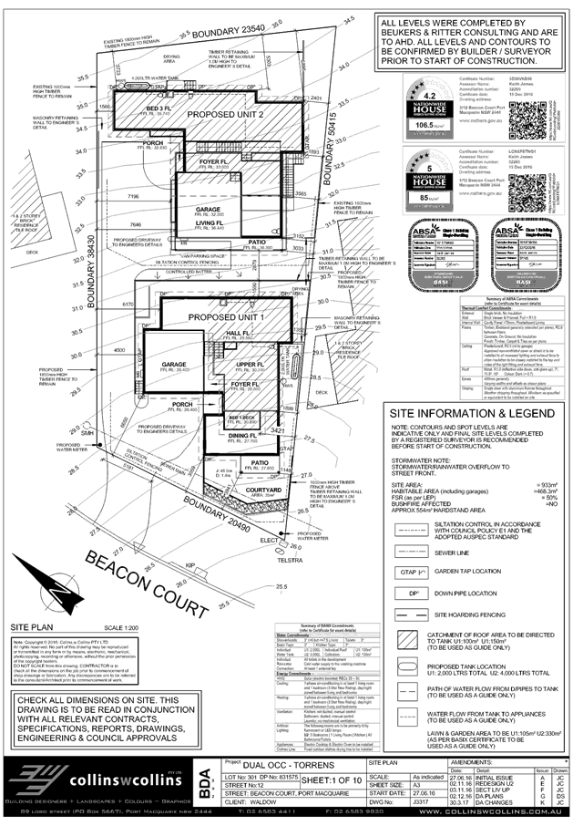
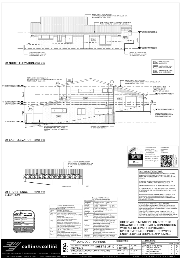
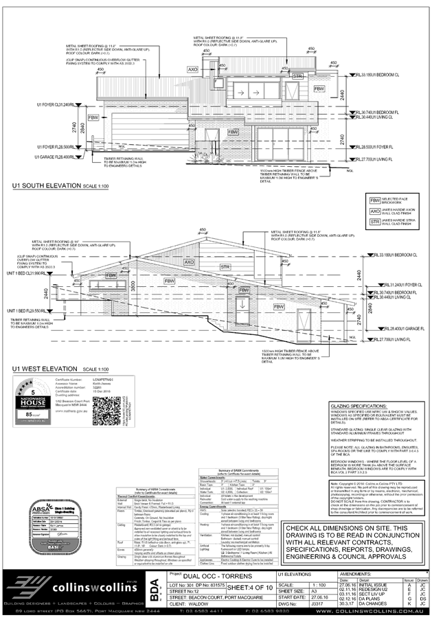
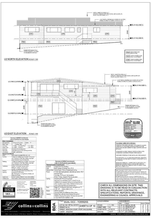
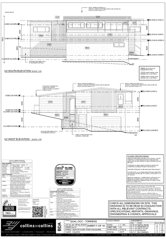
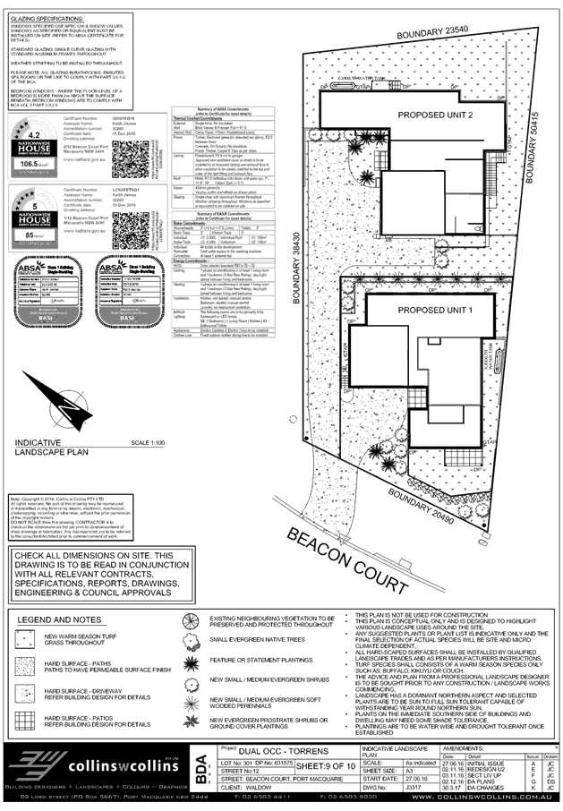
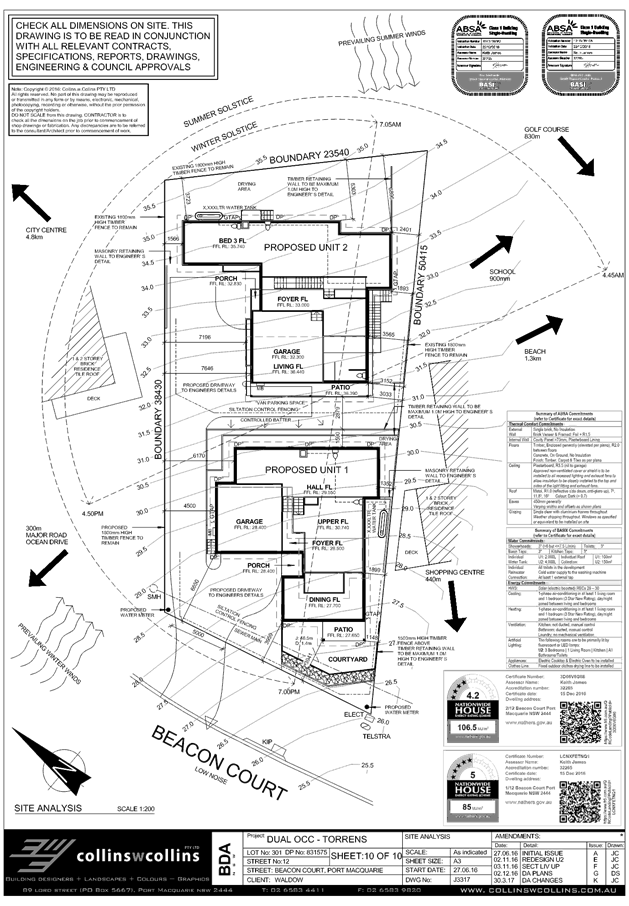
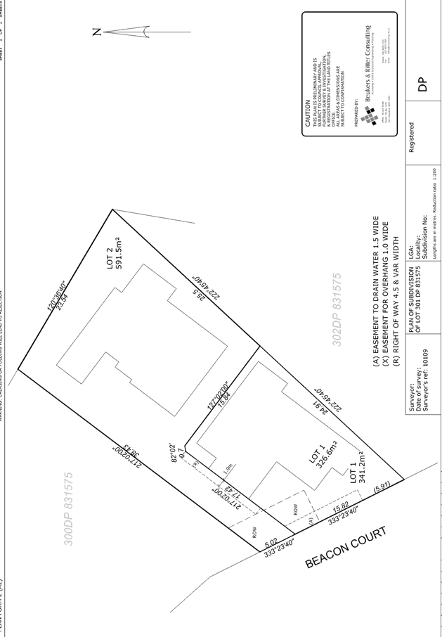
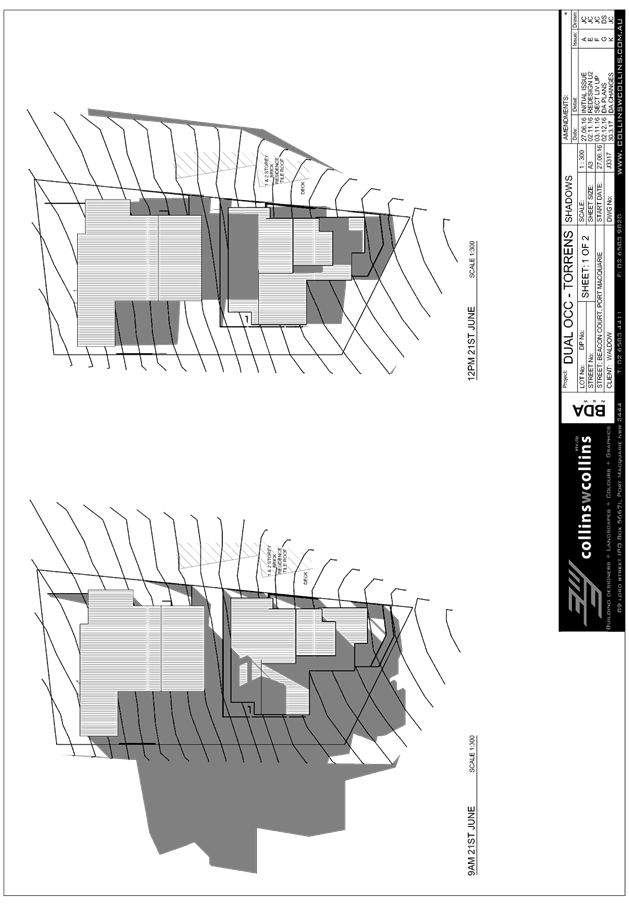
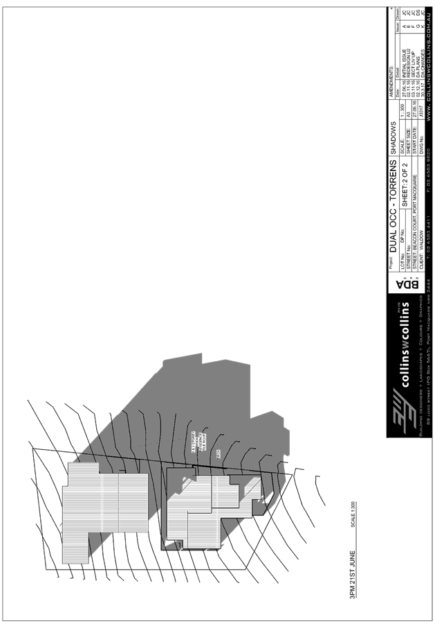
|
ATTACHMENT
|
Development Assessment Panel
24/05/2017
|
|
ATTACHMENT
|
Development Assessment Panel
24/05/2017
|
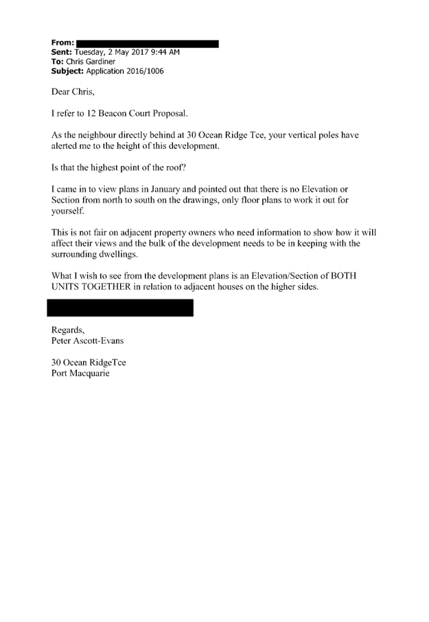
|
ATTACHMENT
|
Development Assessment Panel
24/05/2017
|

AGENDA Development Assessment Panel 24/05/2017
Item: 07
Subject: DA2016 - 932 - Alterations And Additions To
Waste Management Facility And Koala Plan Of Management - Lot 12 DP
1027602, Lot 11 DP875998, Lot 9 DP 876001 And Lot 1 DP 1120786 Kingfisher Road,
Port Macquarie
Report
Author: Patrick Galbraith-Robertson
|
Applicant: Port
Macquarie-Hastings Council
Owner: Port
Macquarie-Hastings Council
Estimated Cost: $2.5M
Parcel no: 34887,32656,32165,54886
Alignment with Delivery
Program
4.9.2 Undertake transparent
and efficient development assessment in accordance with relevant legislation.
|
|
RECOMMENDATION
That
the Development Assessment Panel recommend to Council that:
1. The Koala of Management - Kingfisher Road
Waste Transfer Station be approved.
2. DA 2016 - 932 for alterations and
additions to waste management facility at
Lot 12 DP 1027602, Lot 11 DP875998,
Lot 9 DP 876001 and Lot 1 DP 1120786, Kingfisher Road, Port Macquarie, be
determined by granting consent subject to the recommended conditions.
|
Executive
Summary
This
report considers a Development Application (DA) for alterations and additions
to an existing waste management facility at
the subject site and provides an assessment of the DA in accordance with the
Environmental Planning and Assessment Act 1979.
Following exhibition of the
application, three(3) submissions have been
received.
In accordance with Council’s
Development Applications Conflict of Interest Policy, this DA is required to be
determined by full Council as the Applicant and Owner is Council and
submissions have been received objecting to the proposal.
1. BACKGROUND
Existing sites features and Surrounding development
The Kingfisher Waste Transfer
Station (WTS) is located in Port Macquarie and access to the site is via
Kingfisher Road. The site has been operating as a WTS since 1996. The site was
also operated as a landfill for many years until Cairncross WMF opened in 2001.
The site contains; a former landfill, ancillary waste stockpile areas (i.e.
scrap metal and green waste), a concrete crushing and processing plant, a
liquid waste facility, a waste oil processing facility, various ancillary sheds
and a Waste Transfer Station.
The site is bounded by the Lake
Innes Nature Reserve to the east, St Columba
Anglican School to the south,
the Charles Sturt University (CSU) campus to the west and a boarding house
facility being constructed to the northwest (approved under DA2015 - 95.1).
The site has an irregular shape
with a total area of 19.16 hectares.
The site is managed by the Port
Macquarie-Hastings Council and is classified as operational land.
The site is zoned SP2
Infrastructure (Waste or Resource Management Facility), R2 Low Density
Residential and E2 - Environmental Conservation under Port Macquarie-Hastings
Local Environment Plan 2011, as shown in the
following zoning plan:
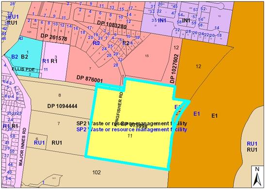
The nearest existing neighbour
is located approximately 76m to the north of the site (residential dwelling on
Kingfisher Road).
The existing subdivision pattern and location of existing
development within the locality is shown in the following aerial photograph
(2016):
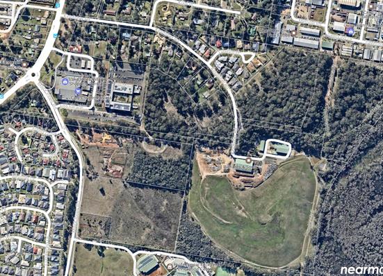
2. DESCRIPTION OF
DEVELOPMENT
The site has been subject to
numerous approvals in the past. The WTS shed and operation of the transfer
facility (including green waste and building waste processing etc) on site was
approved under DA1996 - 59. This DA involved the construction of the WTS shed a
Materials Recovery Facility (MRF) shed (no longer in use), various sheds and
facilities associated with the used of the site as a depot for JR Richards
waste operations (no longer operational from the site) and the operation of the
green waste, scrap metal and construction and demolition stockpile and
processing areas.
Key aspects of the proposal include the following:
· Alterations
and additions to the WTS.
· Relocation of the existing weighbridge to a new location
alongside a new additional weighbridge so that vehicle weights can be recorded
into and out of the site.
· The extension of the WTS shed will allow for a ‘push
pit’ waste compactor arrangement.
· Additional designated recycling facilities will also be
provided along with a new office/amenities and ‘tip shop’ building
which will sit within the WTS shed.
· The ‘tip shop’ area would be designated for
objects that could be sold (e.g. furniture and tools in good condition.
Refer
to attachments at the end of this report.
Designated Development
The Proposal does not meet the
requirements under the EP&A Act or EP&A Regulations for designated
development or state significant development (SSD).
Protection of the Environment
Operations Act 1997
The Protection of the
Environment Operations Act 1997 (PoEO Act) sets out procedures and
requirements for waste, air, water and noise pollution control.
Schedule 1 of the PoEO Act
establishes that an environment protection licence (EPL) must be obtained for a
scheduled activity (i.e. activities listed in Schedule 1 of the
PoEO Act).
Schedule 1 of the PoEO Act
outlines a number of waste storage, waste transfer, resource recovery or
processing facilities that require an EPL. Schedule 1 stipulates that if the
premises stores more than 1,000 tonnes of waste at any one time or processes
more than 6,000 tonnes of waste per year it is required to obtain an EPL from
the EPA. As the facility will store or receive more than 1,000 tonnes and 6,000
tonnes of waste per year respectively the development is required to obtain an
EPL from the EPA. EPL 20698 is in force on the site and was issued to PMHC on
4th July 2016.
Should consent be granted for
the proposed development the Council will be required to vary the EPL to cover
the revised development and site operations ( i.e. an application will be made
to the EPA to vary the EPL at or before Construction Certificate stage).
Application Chronology
· 2
December 2016 - DA lodged with Council.
· 7
December 2016 - Referral to NSW Roads and Maritime Services (RMS).
· 12 December 2016 to 13 January 2017 - Neighbour
notification of proposal
· 21 December 2016 - Advice received from RMS.
· 9 February 2017 - Additional information requested from
Applicant - submission issues and access and traffic impacts.
· 15 March 2017 - Meeting with Applicant to discuss
assessment issues.
· 21 March 2017 - Advice received from Department of Planning
and Environment that the proposed Koala Plan of Management is approved.
· 5 May 2017 - Additional information received from Applicant
- response to submission issues and suggested consent conditions to address
access and traffic impacts.
3. STATUTORY ASSESSMENT
Section 79C(1) Matters for Consideration
In determining the DA, Council is required to take into
consideration the following matters as are relevant to the development that
apply to the land to which the development application relates:
(a) The provisions (where
applicable) of:
(i) any Environmental
Planning Instrument:
State
Environmental Planning Policy No. 14 - Coastal Wetlands
The site is identified as being
partially within mapped SEPP 14 wetlands. The site also adjoins the Lake Innes Nature
Reserve (managed by National Parks & Wildlife
Service - NPWS), which is wholly
identified as containing SEPP 14 wetlands (near
the subject site).
The development is consistent
with the aims and objectives of the SEPP and does not contravene any of the
restrictions listed under clause (7)(1) of the SEPP. Namely the development
does not involve any clearing, levying, draining or filling of the SEPP 14
wetlands.
It is considered that no adverse
impacts would be expected on the nearby SEPP 14 wetlands as a result of the
development subject to the imposition of standard erosion and sediment control
measures being imposed on the development consent. A specific condition is
recommended in relation to stormwater quality treatment to be satisfied prior
to the issue of a Construction Certificate.
State
Environmental Planning Policy No.33 - Hazardous and Offensive Development
SEPP 33 – Hazardous and
Offensive Development links the permissibility of an industrial development
proposal to its safety and environmental performance. Certain activities may
involve handling, storing or processing a range of materials, which, in the
absence of controls, may create risk outside of operational borders to people,
property or the environment. Such activities would be defined by SEPP 33 as a
'potentially hazardous industry' or 'potentially offensive industry'. SEPP 33
applies to any industrial development proposals which fall within these
definitions.
The Proposal does not fall
within the definition of a “potentially hazardous industry” or
“potentially offensive industry” under the SEPP 33, due to the
existing nature of the site. The Proposal is modifying and improving operations
on site.
Existing small quantities of
domestic hazardous wastes (i.e. paints etc) are removed quarterly by a licence
contractor. The installation of a compacter bin system will also reduce odours.
It is considered that the
proposal has minimal potential for impacts to human and environmental health.
Given this, it is considered that the impacts associated with the proposal are
unlikely to be ‘offensive’ or ‘hazardous’. Further
hazard analysis is therefore not required.
State Environmental Planning Policy No.
44 - Koala Habitat Protection
With reference to clauses 6 and 7, the
subject land is greater than 1 hectare (including any adjoining land under same
ownership) and therefore the provisions of SEPP must be considered.
This SEPP aims to provide
protection of areas of natural vegetation that provides habitat for koalas. It
restricts a local Council from granting development consent for proposals on
land identified as core koala habitat without preparation of a Koala Plan of
Management (KPoM).
A KPoM has been completed for
the proposed development and proposes to compensate for the removal of up to 17
trees for the upgrade of the WTS. The KPoM prescribes a number of measures to
ensure no net loss of Koala habitat and that opportunities for Koala movement
are enhanced. To this effect, compensation plantings over an area of 0.7 ha
shall be completed and Koala stiles installed at strategic locations to enable
dispersing Koalas to traverse security fencing which surrounds much of the
site. Additionally, monitoring of Koalas and the compensation planting shall
occur in perpetuity and be completed by Council staff or appropriately
experienced ecological contractors.
The KPoM has been referred to and approved by the
Department of Planning and Environment. The KPoM is considered to be
appropriate particularly noting the offset compensatory trees proposed for the
proposal. It is recommended that the KPoM be approved.
Issues raised by neighbouring properties in relation to the
KPoM are addressed later in this report. A copy of the KPoM is attached to this
report.
State
Environmental Planning Policy No.55 – Remediation of Land
The objective of SEPP 55 is to
provide for a coordinated state-wide planning approach for the remediation of
contaminated land. SEPP 55 aims to promote the remediation of contaminated land
with the objective of reducing the risk of harm to human health or other
aspects of the environment. Clause 7 of SEPP 55 imposes an obligation on the
approval authority to have regard to certain matters before granting approval.
These matters include:
- Whether the land is contaminated
- Whether the land is, or will be, suitable for
the purpose for which development is to be carried out
- If remediation is required for the land to be
suitable for the proposed purpose, whether the land will be remediated before
the land is used for that purpose.
SEPP 55 also imposes obligations
to carry out any remediation work in accordance with relevant guidelines,
developed under the Contaminated Land Management Act 1995 and to
notify the relevant council of certain matters in relation to any remediation
work.
The WTS site is located adjacent
to the former landfill area which has been classified as Class A contaminated
land. It is not proposed to disturb the former landfill area, however the
Applicant has advised that in the event that contaminated soil was disturbed,
remediation would be undertaken as necessary.
State
Environmental Planning Policy No. 62 – Sustainable Aquaculture
Given the nature
of the proposed development and proposed stormwater controls the proposal will
be unlikely to have any adverse impact on existing aquaculture industries.
State
Environmental Planning Policy No. 64 – Advertising and Signage
The Proposal does not involve
any additional signage which requires consent.
Signage changes will be required
to reflect the revised traffic arrangements which will result from the amended
site layout, however as this is road signage, it is not required to meet the
provisions of SEPP 64.
State Environmental Planning
Policy (Infrastructure) 2007
The development meets the applicable provisions of SEPP
(Infrastructure) 2007, namely Division 23 - waste or resource management
facilities.
The
development may be carried out with consent within the prescribed SP2 zone.
This includes the ‘business premises or retail
premises’ being the ‘Tip Shop’ which is proposed to be
located within the expanded WTS shed.
Section 121 of the ISEPP facilitates the development for the
purposes of waste or resource management facilities to be undertaken, with
development consent within a ‘prescribed zone’ which includes rural
zones (RU1 Primary Production, RU2 Rural Landscape, IN1 General Industrial, IN3
Heavy Industrial, SP1 Special Activities and SP2 Infrastructure). The WTS site
is zoned SP2 under the Port Macquarie–Hastings Local Environmental Plan
2011 (PMH LEP), which is considered to be a ‘prescribed zone’.
Therefore, development of a waste or resource management facilities is
permissible with consent on the site.
Referral to the Roads & Maritime Service (RMS) has been
made as the development meets the requirements of Clause 104 of Schedule 3 of
SEPP (Infrastructure) 2007.
In accordance with Clause 104 (3)(b) PMHC must take into
consideration any comment from RMS. Refer to comments later in this report.
Port
Macquarie-Hastings Local Environmental Plan 2011
The proposal is consistent with the LEP having regard to the
following:
· Clause
2.2, the subject site is zoned SP2 - Infrastructure (Waste or Resource
Management Facility), R2 - Low
Density Residential (existing weighbridge site and vacant site) and E2 - Environmental
Conservation (small strip in north eastern corner of site). In accordance with
clause 2.3(1) and the SP2 zone landuse table, the
proposed development for
alterations to the Waste Transfer Station (WTS) is a permissible landuse with
consent in the SP2 zone.
The objectives of the SP2 zone
are as follows:
a)
· To
provide for infrastructure and related uses.
· To
prevent development that is not compatible with or that may detract from
b)
the provision of infrastructure.
c)
In accordance with Clause 2.3(2), the proposal is consistent
with the zone objectives having regard to the following:
o the
proposal is a permissible landuse.
o the
proposal is for alterations to an existing established waste facility and will
cater for the increasing population of Port Macquarie .
· Clause
2.7, the demolition requires consent as it does not fit within the provisions
of SEPP (Exempt and Complying) 2008.
· Clause
4.1, the development does not propose any subdivision, therefore the minimum
lot sizes will not be affected by the development proposal.
· Clause
5.9 - several listed trees in Development Control Plan 2013 are proposed to be
removed. Refer to SEPP44 and flora and fauna assessment sections of this
report.
· Clause
5.10 – Heritage. The site does not contain or adjoin any known heritage
items or sites of significance.
· Clause
7.1, the proposal site is mapped as potentially containing class 2 and 3 acid
sulphate soils (PASS). The proposed development includes excavation and
earthworks, however no excavation extending 1.0m below the natural surface
level is proposed. Further to this all proposed earthworks will be located on
previously disturbed land and all earthworks are proposed on land which is
outside of the mapped PASS area. Therefore no adverse impacts are expected to
occur to the acid sulphate soils found on site.
· Clause
7.3, the site is land within a mapped “flood planning area” (Land
subject to flood discharge of 1:100 annual recurrence interval flood event
(plus 0.9m East of the Pacific Highway). However the proposed works are located
above the Probable Maximum Flood (PMF), therefore no adverse impacts will occur
in relation to flood impacts.
· Clause
7.5 – the Proposal site is not land that is
shown as “Koala Habitat area” on the Koala Habitat Map. However SEPP
44 is applicable to the subject development. Refer to SEPP 44 requirements and
Appendix E for further details on Koala management.
· Clause
7.13, satisfactory arrangements are in place for provision of essential
services including water supply, electricity supply, sewer infrastructure,
stormwater drainage and suitable road access to service the development.
(ii) Any
draft instruments that apply to the site or are on exhibition:
No draft
instruments apply to the site.
(iii) any
Development Control Plan in force:
Port
Macquarie-Hastings Development Control Plan 2013
|
DCP
objective
|
Requirement
|
Proposed
|
Complies
|
|
2.3.3.1
|
Cut
and fill 1.0m max.
1.0m
outside the
perimeter
of the external
building
walls
|
Cut
and fill exceeding
1.0m
will be required for the new access road.
However
the works are
located
well within the boundaries of the site, therefore this will ensure there is
no damage or instability to adjoining properties caused by excavation or
filling, nor will there be any adverse alteration to the drainage of
adjoining dwellings and private open space.
The
development will also ensure that adequate stormwater drainage is provided
around the perimeter of buildings and roads and that both overland and piped
flow paths are provided.
|
No -
variation justified
|
|
2.3.3.2
|
Any retaining wall >1.0 in
height to be certified by
structural engineer
|
If
required, engineering certification will be provided for any retaining walls
required which are over 1.0m.
|
Yes
|
|
2.3.3.8
onwards
|
Removal
of hollow
bearing
trees
|
No hollow bearing trees are
proposed to be removed.
|
N/A
|
|
2.6.3.1
|
Tree
removal (3.0m or
higher
with 100m
diameter
trunk and 3.0m
outside
dwelling footprint
|
17 trees proposed to be
removed.
|
Yes
- satisfactorily addressed
|
|
2.4.3
|
Bushfire risk, Acid
sulphate soils, Flooding,
Contamination, Airspace
protection, Noise and
Stormwater
|
Refer to main body of report.
|
Yes
|
|
2.5.3.3
|
Off-street parking in
accordance with Table 2.5.1:
|
See ‘parking and
manoeuvring section’
below.
|
Yes
|
|
2.5.3.7
|
Parking in accordance
with AS 2890.1
|
Capable of being provided.
|
|
|
2.5.3.11
|
Development
contributions
|
Refer
to main body of report
|
Yes
|
|
2.5.3.12 and 2.5.3.13
|
Landscaping of parking
areas
|
Landscaping is proposed.
|
Yes
|
|
2.5.3.14
|
Sealed driveway surfaces
unless justified
|
All
access ways will be sealed
|
Yes
|
|
2.5.3.15
|
Driveway grades for first
6.0m of ‘parking
area’
shall be 5% grade
(Note AS/NZS 2890.1
permits steeper grades)
|
N/A, however all internal
roads to meet road design guidelines.
|
N/A
|
|
2.5.3.16
|
Transitional grades min.
2.0m length
|
See
above
|
Yes
|
|
2.5.3.17
|
Parking areas to be
designed to avoid
concentrations of water
runoff on the surface.
|
All internal roads to meet
road design guidelines.
|
Yes
|
|
2.5.3.18
|
Car parking areas
drained to swales, bio
retention, rain gardens
and infiltration areas
|
All car parking areas will
drain to the existing
Stormwater management facility
in the north eastern corner of the Kingfisher WMF site. All drainage water
will be transferred via both the overland and piped system.
|
Yes
|
|
2.7.2.2
|
Design addresses
generic principles of
Crime Prevention through
Environmental Design.
|
The site is under camera
surveillance and has security lighting. Further the site is patrolled by a
security team on a regular basis.
|
Yes
|
(iiia) any
planning agreement that has been entered into under Section 93f or any draft
planning agreement that a developer has offered to enter into under Section
93f:
No planning
agreement has been offered or entered into relating to the site.
iv) any matters prescribed by the
Regulations:
Demolition of
buildings AS 2601 – Clause 92
Demolition of the existing building
on the site is capable of compliance with this Australian Standard and is
recommended to be conditioned.
v) any
coastal zone management plan (within the meaning of the Coastal
Protection Act 1979), that apply to
the land to which the development application relates:
· No
Coastal Zone Management Plan applies to the subject site.
(b) The
likely impacts of that development, including environmental impacts on both the
natural and built environments, social and economic impacts in the locality:
Context
and setting
North: Low density
residential and vacant residentially zoned land
The closest dwelling to the site
is located 76m to the north of the site on Lot 27,
DP1145906.
East: Nature Reserve
The Lake Innes Nature Reserve
directly abuts the eastern edge of the subject site.
The former landfill separates
the WTS shed from the Nature Reserve. The
Nature Reserve is located
approximately 230m from the WTS shed.
South: School
To the south of the site is St
Columba Anglican School, which directly abuts the southern extremity of the
former landfill of the site. The School is located approximately 300m from the
WTS shed.
West: Vacant rural land
To the west of the site is the
currently vacant rural land which is owned by Charles Sturt University. Any
future development on this site will be located a minimum distance of 180m from
the WTS shed.
The proposal will be unlikely to
have any adverse impacts to existing adjoining properties or the public domain.
The proposal is considered to be
compatible with surrounding land uses given the separation to the WTS facilities.
There are no identifiable adverse
view sharing, privacy or overshadowing impacts.
The proposal will be unlikely to
result in any adverse lighting impacts.
Roads
The site has road frontage to Kingfisher road, which is
designated as a local road (using the AUS-SPEC classification system).
Kingfisher Road is a sealed public road with a formation
width of 11 metres for the majority of the road with a section of variable
width at the eastern end within a 20 metre road reserve. The road has a
combination SA and SE kerb and gutter, with no footpaths currently constructed
on either side of the road.
Traffic and Transport
The proposal is anticipated to generate 145 daily trips.
However, this does not represent an increase in vehicle movements compared to
the existing operation. This is because the proposal will result in a decrease
in heavy vehicle movements from 1078 movements per year to 468 movements per
year, which equates to a 43% decrease in heavy vehicles. This reduction is due
to the compaction of the waste which needs to be removed from the site which
will reduce the volume by 66%.
Traffic associated with the development is unlikely to have
any adverse impacts to the existing road network within the immediate locality.
Roads and Maritime Services (RMS)
Consistent with RMS requirements, the proposal was referred
to the RMS on 7/12/2016. RMS’ review of the proposal determined:
Council was advised to be satisfied that the intersection of
Kingfisher Road and John Oxley Drive is appropriately designed and delineated
to accommodate peak heavy and light vehicle movements generated by the proposed
development.
In this regard, as there is no
increase to traffic movements, it is considered satisfactory that the
intersection will remain unchanged.
Notwithstanding the above, it is
noted that Council’s longer term planning for John Oxley Dr corridor is
proposing to include upgrades to the Kingfisher and John Oxley Dr. Current
approved concept plans includes traffic signals for the John Oxley Dr and Kingfisher
Rd intersection. Detailed design of the corridor is scheduled to be undertaken
in the next 2 years and the upgrade works are currently planned for in the 10
year forward planning works program.
Site Frontage & Access
Vehicle access to the site is proposed though one access
driveway to Kingfisher Road. All accesses shall comply with Council
AUSPEC and Australian Standards, and conditions have been imposed to reflect
these requirements.
Due to the type
and size of development, additional works are required to include:
· Road
construction from the end of the existing constructed and approved pavement to
the proposed development.
· Rehabilitation of the existing road pavement being
undertaken with in 5 years of the development consent for that section of
Kingfisher Road from John Oxley Drive to the Student Housing/Boarding House DA
reconstruction.
Parking and Manoeuvring
The proposal includes onsite parking to be provided within
the waste transfer station shed. Parking will be provided for staff and customers,
and be located adjacent to these facilities. These parking spaces will
be line marked and designated as parking spaces for staff and WTS
customers.
Due to the type of development, car park circulation is
required to enable vehicles to enter and exit the site in a forward
manner. Site plans show adequate area is available and conditions have
been imposed to reflect these requirements. All manoeuvring and parking
will be required to comply with AS2890.
Water Supply Connection
Records
indicate that the proposed development site has a 100mm metered water service
from the 150mm PVC water main in Kingfisher Road. Final water service sizing will need to be determined by a
hydraulic consultant to suit the domestic,
commercial and industrial components as well as addressing fire service and
backflow protection requirements. Details are
to be provided on the engineering plans.
Sewer Connection
Records
indicate that the site has an existing private sewer pump station and private
sewer rising main to the vicinity of Pump Station No. 61 in Geebung Road. Sewer upgrade
design details (if applicable) will
need to be determined by a hydraulic consultant. Details are to be provided on the engineering plans for the
required construction certificate (CC).
Stormwater
The site naturally grades towards the south-east and is
currently serviced via an existing sediment basin located on the eastern side
of the site. This stormwater pond also contains a gross pollutant trap
(GPT) and sediment capture system.
The point of discharge for the
proposed development is defined as the existing sediment basin spillway to the
adjoin Kooloonbung Nature Reserve.
Stormwater from the proposed
development is planned to be disposed via the existing GPT and sediment basin
to Kooloonbung Reserve which is consistent with the above requirements.
A detailed site stormwater
management plan will be required to be submitted for assessment with the S.68
application and prior to the issue of a CC.
Other Utilities
Telecommunication and electricity services are available to
the site.
Heritage
Following a site inspection (and a search of Council
records), no known items of Aboriginal or European heritage significance exist
on the property.
Due to the high level of past disturbance evident throughout
the site, it is extremely unlikely that that any in-situ artefacts would be
present in the area. As such, the proposal is unlikely to impact on any
aboriginal places, objects and features of significance.
Other land resources
The site is within an established urban context and will not
sterilise any significant mineral or agricultural resource.
Water cycle
The proposed development will be unlikely to have any
adverse impacts on water resources and the water cycle.
Soils
The proposed development will be unlikely to have any
adverse impacts on soils in terms of quality, erosion, stability and/or
productivity subject to a standard condition requiring erosion and sediment
controls to be in place prior to and during construction.
Air and microclimate
The construction and/or operations of the proposed
development will be unlikely to result in any adverse impacts on the existing
air quality or result in any pollution. Standard precautionary site management
condition recommended.
Flora and fauna
Construction of the proposed access road and weighbridges
will require the removal of seventeen (17) native trees from the subject site.
However, it is considered that the proposal is unlikely to have any significant
adverse impacts on flora and fauna subject to appropriate conditions including
compliance with the proposed Koala Plan of Management.
The proposal therefore will be unlikely to have any
significant adverse impacts on biodiversity or threatened species of flora and
fauna. Section 5A of the Act is considered to be satisfied.
Waste
The
proposal will provide the Port Macquarie urban area with an improved regional
waste management facility to deposit general and other waste.
The
impacts of the Proposal include construction and operational impacts. Construction
impacts relate to the waste streams which would be generated by the
construction process. Operational impacts relate to the management of waste
stream at the facility and compliance with government strategies and policies.
Operational impacts
Waste streams currently received
at the WTS will include general mixed waste, cardboard, e-waste, mattresses,
oil, co-mingled recycling, greenwaste, oil, hazardous waste, batteries, tyres,
metal and bricks and concrete. General mixed waste is expected to continue to
contribute the largest volumes of waste to be managed at the facility. The
intention of the WTS is to provide a improved drop-off services for household
quantities of waste (eg. trailers / utes). Small scale commercial enterprises
(i.e. green waste) utilise the WTS on occasion, however commercial and bulk
wastes will continue to be directed to the Cairncross WMF.
The WTS has been designed to
maximise resource recovery.
Customers are required to pass
resource recovery stations prior to reaching the mixed residual waste drop-off
area. In addition the WTS site layout allows for surveillance of all drop-off
areas by operational staff. This will increase the likelihood of customers
depositing waste in the appropriate locations.
Mitigation measures
Many of the impacts of the
proposal have a positive effect on waste management.
However, to ensure that waste
management operations associated with the Proposal
(i.e. the push pit and compactor
system) do not negatively impact the surrounding environment, the existing Port
Macquarie Waste Management Centre, Kingfisher
Road, Operational Environment
Management Plan (2007) will be updated.
Energy
The proposal includes measures to address energy efficiency
and will be required to comply with the requirements of the Building Code of
Australia. No adverse impacts anticipated.
Noise and vibration
No adverse impacts anticipated given the nature of the
development. Standard noise conditions are recommended including requirements
to not generate offensive noise.
Condition recommended to restrict construction to standard
construction hours.
Bushfire
The site is identified as being
bushfire prone.
The adjoining vacant land and
the development site contains managed forest Vegetation.
Bushfire Prone Land Map as Category
1 Bushfire Prone Vegetation and therefore the proposed development could be
subject to the impact from future bushfires that occur in this vegetation.
Section 79BA of the Environmental
Planning and Assessment Act requires the consent authority, when
considering development within a bushfire prone area, to confirm that the
development complies with the requirements of Planning for Bushfire Protection
2006.
Bushfire protection has been
considered for the additions to the Kingfisher WTS. A
20m minimum width from managed
vegetation on the land to the north of the WTS buildings exists. This 20m
protection zone is considered appropriate.
It is considered that the proposal
satisfies the objectives of PBP 2006 and the bushfire risk is acceptable
subject to the APZ being maintained.
Safety, security and crime
prevention
The proposed development is
unlikely to create any concealment/entrapment areas
or crime spots that would result
in any loss of safety or reduction of
security in the immediate area.
The Proposal already includes a
number of onsite security measures to ensure the
protection and safety of the WTS
site, its employees and retail customers. Security at
the WTS site includes:
- Fencing to prevent unauthorised entry.
- Controlled circuit television (CCTV) security
system at key locations, including the main entrance, WTS shed, and at other
strategic locations throughout the site.
- A telecommunications system with connection to
the WTS site office and other buildings.
Social impacts in the locality
Given the nature of the proposed development and its
location the proposal is unlikely to result in any adverse social impacts.
Economic impact in the locality
No adverse impacts. A likely positive impact is that the
development will maintain employment in the construction industry, which will
lead to flow impacts such as expenditure in the area.
Site design and internal design
The proposed development design satisfactorily responds to
the site attributes and will fit into the locality. No adverse impacts likely.
Construction
No potential adverse impacts identified to neighbouring
properties with the construction of the proposal.
Cumulative impacts
The proposed development is not expected to have any adverse
cumulative impacts on the natural or built environment or the social and
economic attributes of the locality.
(c) The suitability of the site for
the development:
The proposal will fit into the
locality and the site attributes are conducive to the proposed development.
Site constraints have been
adequately addressed and appropriate conditions of consent recommended.
(d) Any submissions made in
accordance with this Act or the Regulations:
Three (3) written submissions have been received following neighbour
notification of the application.
Key issues raised in the submissions received and comments
in response to these issues are provided as follows:
|
Submission
Issue/Summary
|
Planning
Comment/Response
|
|
Objection to the use of neighbouring land for the use of
fauna corridors (Koala Stiles) across boundary fences.
|
The proposed Koala Stile locations are indicative only,
however have been identified by specialist Koala ecologists. Council ecology
staff and the Department of Planning KPOM have raised no objection to the
indicative koala stile locations. Final locations will be subject to review
at construction stage and agreement with respective neighbouring landowners.
|
|
A section of boundary fence between the sites had been
noted in the ecological assessment as being open, however this has been
repaired.
|
The repair to the boundary fencing is noted.
|
|
Lack of consultation regarding the Ecological Assessment
and proposed fauna crossings (Koala Stiles).
|
Council staff attempted to contact the owners of
neighbouring properties which were earmarked for potential Koala Stile
locations via email. It should be noted that if the locations are not
acceptable by the landowner there is sufficient flexibility n the KPoM to
utilise other locations.
|
|
The inclusion of a rejected DA on neighbouring land in the
SOEE is unnecessary.
|
Noted, it is agreed this is not relevant and does not have
a bearing on the subject application.
|
|
Concerned about the continual upgrading of the Waste
Management Facility without utilising the alternative access road via the
Port Macquarie Industrial Estate (i.e. via Geebung Drive)
|
The proponent has advised that construction of the
alternate access road is cost prohibitive due to steep grades, large cuts and
significant tree removal.
It is considered that the proposed access arrangement
should be assessed on merit. It is anticipated that the heavy vehicle
movements will decrease from 1,078 heavy vehicle movements per year to 468
heavy vehicle movements per year (Hyder, 2015). This represents a 43%
decrease in heavy vehicle movements along Kingfisher Road. These new
arrangements will have a net beneficial impact on the existing road network
within the immediate locality. A reduction in maintenance requirements and
adverse noise and vibration to neighbouring residents along Kingfisher Road
can be expected with fewer heavy vehicle movements.
An alternative access road via Geebung Drive is considered
unnecessary.
|
|
Council should close the entrance/exit to the waste
facility from Kingfisher Road and relocate it to the industrial area. This
would be a safer, cost effective design solution and would remove the large
trucks and additional traffic being used for the waste facility from a
residential area.
|
|
The development will increase the travel flow along
Kingfisher Road which is not presently built for the type of traffic that
uses the road. The road is narrow, has sight restrictions at hill crests and
is suitable for residential traffic only. In places the road is only 6m wide.
|
Refer to above comments regarding decrease in heavy
vehicle movement.
The development was referred to the RMS as it was deemed
to be a ‘traffic generating development’. The RMS did not have
any concerns with the proposed works, nor did they raise any concerns with
the use of the existing road access (i.e. Kingfisher Road). The road width is
deemed appropriate for the development and no changes to the road
alignment/width is required as a result of this development.
A condition is however recommended to rehabilitate
Kingfisher Road from John Oxley Drive to the Boarding House/Student
Accommodation site as offered by the Applicant which is to occur within 5
years of the consent being issued.
|
|
Traffic speed along Kingfisher Road is concerning for
pedestrians and cars entering Kingfisher Road from Lyrebird Place. Cars are
also regularly parked on the road restricting the road width. There are no
footpaths available along the entire length of Kingfisher Road.
|
Regulating traffic speeds is a matter for the police. The
road width is appropriate for the development and no changes to the road
alignment/width is required as a result of this development.
|
|
The intersection of Kingfisher Road & John Oxley Drive
needs upgrading due to the increased use as a result of the additional heavy
vehicle movements.
|
Refer to above comments regarding decrease in heavy
vehicle movement.
The intersection is not considered to require an upgrade
as a result of the development.
A condition is however recommended to rehabilitate
Kingfisher Road from John Oxley Drive to the Boarding House/Student
Accommodation site as offered by the Applicant which is to occur within 5
years of the consent being issued.
Notwithstanding the above, it is noted that
Council’s longer term planning for John Oxley Dr corridor is proposing
to include upgrades to the Kingfisher and John Oxley Dr. Current approved
concept plans includes traffic signals for the John Oxley Dr and Kingfisher
Rd intersection. Detailed design of the corridor is scheduled to be
undertaken in the next 2 years and the upgrade works are currently planned
for in the 10 year forward planning works program.
|
|
The 592 bed student accommodation facility proposed for
Kingfisher Road will place additional stress on Kingfisher Road &
additional heavy vehicle movements will add to this.
|
Refer to above comments.
|
|
The proposal does not accommodate for a pedestrian link
from the end of Kingfisher Road to the Googik Track as proposed under the
2015 PMH Bike Plan.
|
The concept alignment for the bike track link is
considered capable of being provided when required. The link is indicatively
shown crossing Kingfisher Road at or near the entrance to the site.
Appropriate road crossing treatments (concrete blisters, signposting) etc are
capable of being incorporated to the road design. The link through the site
is also capable of being provided.
|
|
Council should contribute to the upgrade/resealing of
Kingfisher Road and the intersection with John Oxley Drive and should provide
a footpath along the length of Kingfisher Road to make it safer for
pedestrians.
|
Rehabilitation of Kingfisher Road will
be undertaken in conjunction with the development which is to occur
within 5 years of the consent being issued.
As the proposed development does not generate any
pedestrian movements it is not directly required to provide any footpath
upgrades. Nevertheless, it is expected that any future rehabilitation of
Kingfisher Road would consider a footpath.
|
(e) The Public Interest:
The
Proposal will provide the Port Macquarie urban area with an improved regional
waste management facility to deposit general and other waste.
The proposed
development satisfies relevant planning controls and is unlikely to adversely
impact on the wider public interest.
4. DEVELOPMENT
CONTRIBUTIONS APPLICABLE
· Development contributions will be required towards
augmentation of town water supply and sewerage system head works under Section
64 of the Local Government Act 1993.
· Development contributions will be required under Section
94A of the Environmental Planning and Assessment Act 1979 are not required with
the proposed conditions for upgrade and rehabilitation works.
5. CONCLUSION
The application has been assessed in accordance with
Section 79C of the Environmental Planning and Assessment Act 1979.
Issues raised during assessment and public exhibition of
the application have been considered in the assessment of the application.
Where relevant, conditions have been recommended to manage the impacts
attributed to these issues.
The site is suitable for the proposed development, is not
contrary to the public's interest and will not have a significant adverse
social, environmental or economic impact. It is recommended that the
application be approved, subject to the recommended conditions of consent
provided in the attachment section of this report.
|
Attachments
1View. DA2016
- 932.1 Plans
2View. DA2016
- 932.1 KPOM
3View. DA2016
- 932.1 Recommended Conditions
4View. DA2016
- 932.1 Submission - Mifsud
5View. DA2016
- 932.1 Submission - Pirlo
6View. DA2016
- 932.1 Submission - Schaffar
|
|
ATTACHMENT
|
Development Assessment Panel
24/05/2017
|
|
ATTACHMENT
|
Development Assessment Panel
24/05/2017
|

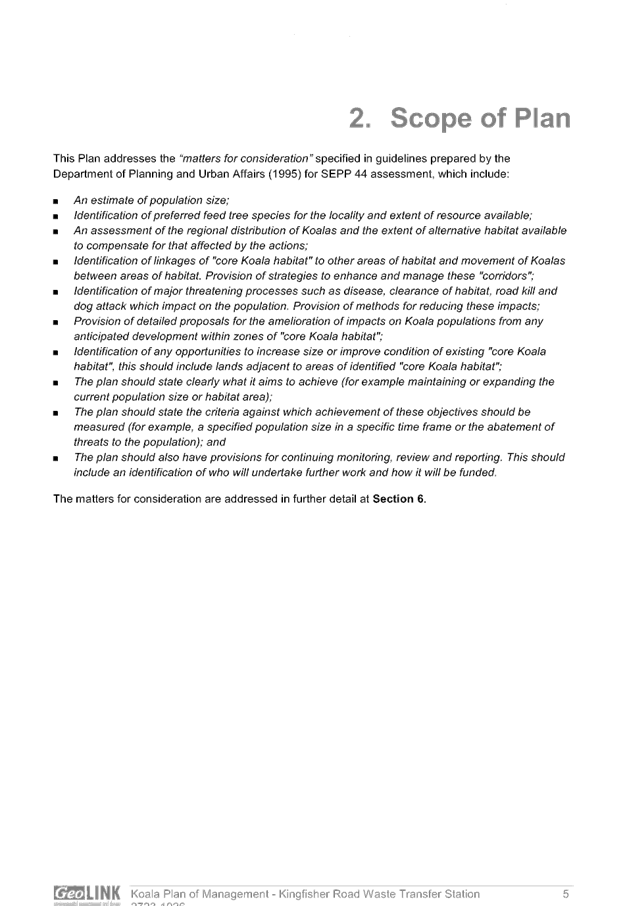
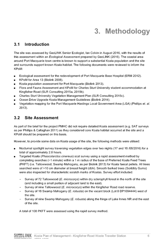
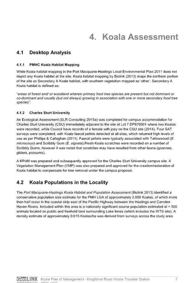
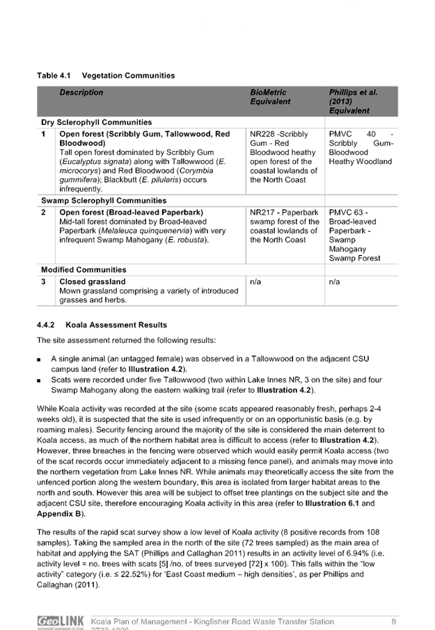
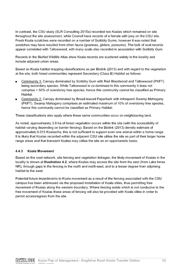
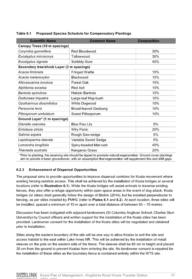
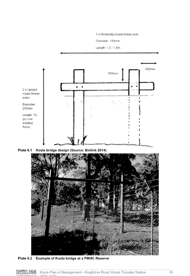
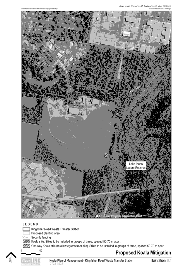
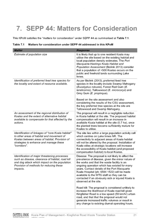

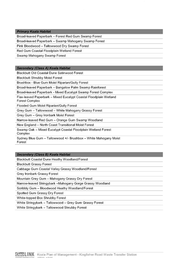

|
ATTACHMENT
|
Development Assessment Panel
24/05/2017
|
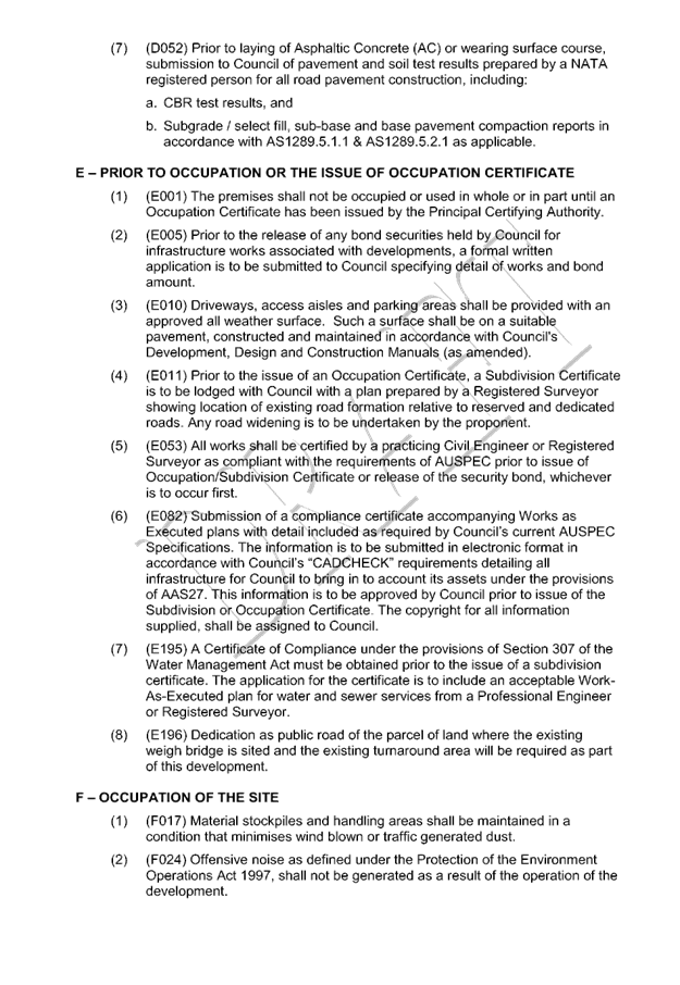
|
ATTACHMENT
|
Development Assessment Panel
24/05/2017
|
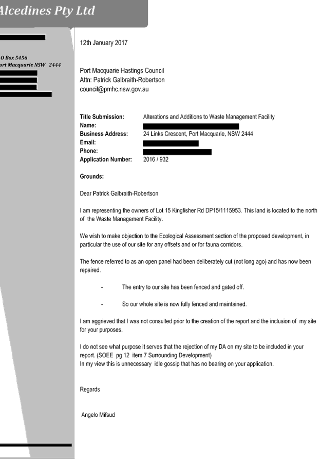
|
ATTACHMENT
|
Development Assessment Panel
24/05/2017
|
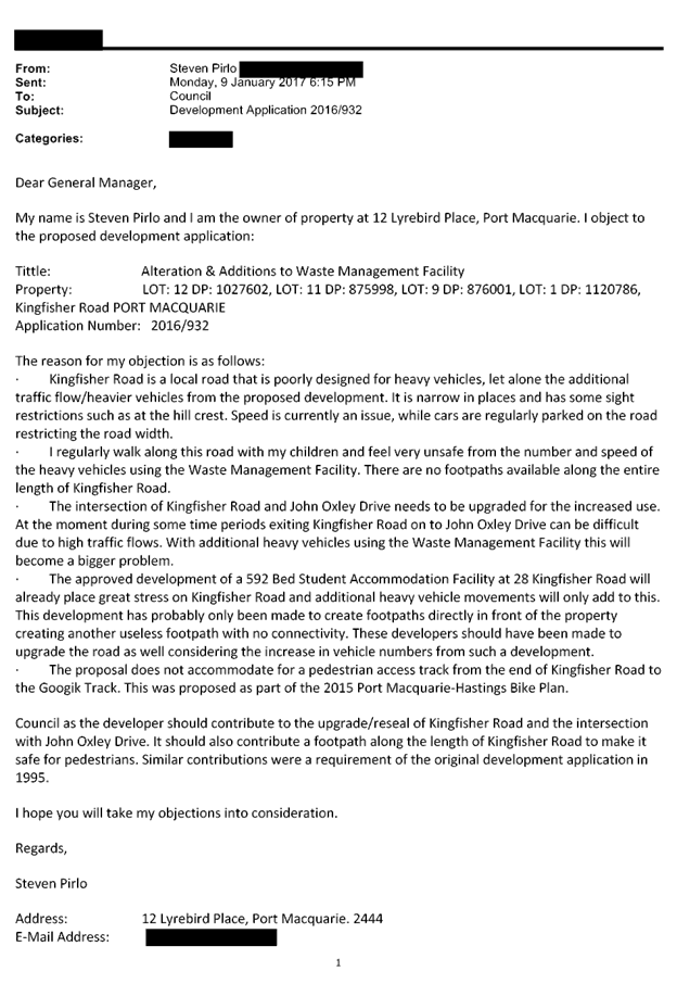

|
ATTACHMENT
|
Development Assessment Panel
24/05/2017
|