Business
Paper
|
date of meeting:
|
|
Wednesday 13
December 2017
|
|
location:
|
|
Committee Room
Port
Macquarie-Hastings Council
17 Burrawan Street
Port Macquarie
|
|
time:
|
|
2:00pm
|
Development
Assessment Panel
CHARTER
1.0 OBJECTIVES
To assist in managing Council's development assessment
function by providing independent and expert determinations of development
applications that fall outside of staff delegations.
2.0 KEY FUNCTIONS
·
To review development application reports and conditions;
·
To determine development
applications outside of staff delegations;
·
To refer development applications
to Council for determination where necessary;
·
To provide a forum for objectors and applicants
to make submissions on applications
before the Development Assessment Panel
(DAP);
·
To maintain transparency in the determination of development
applications.
Delegated Authority of Panel
Pursuant to
Section 377 of the Local Government Act, 1993 delegation to:
·
Determine development applications under Part 4
of the Environmental Planning and Assessment
Act 1979 having
regard to the relevant environmental planning instruments,
development control plans and Council policies.
·
Vary, modify or release restrictions as to use
and/or covenants created by Section 88B instruments under the Conveyancing Act
1919 in relation to development applications for subdivisions being considered
by the panel.
·
Determine Koala Plans of Management under State
Environmental Planning Policy 44 - Koala Habitat Protection associated with
development applications being considered by the Panel.
Noting the trigger to escalate
decision making to Council as highlighted in section 5.2.
3.0
MEMBERSHIP
3.1
Voting
Members
·
Two independent external members. One of the
independent external members to be the Chairperson.
·
Group Manager Development Assessment (alternate
- Director Development & Environment or Development Assessment Planner)
The independent external members shall have expertise in
one or more of the following areas: planning, architecture, heritage, the
environment, urban design, economics, traffic and transport, law, engineering,
government and public administration.
3.2
Non-Voting Members
·
Not applicable
3.3 Obligations
of members
·
Members must act faithfully and diligently and
in accordance with this Charter.
·
Members must comply with Council's Code of Conduct.
·
Except as required to properly perform their
duties, DAP members must not
disclose any confidential information (as advised by Council) obtained in connection with the DAP functions.
·
Members will have read and be familiar with the
documents and information provided by Council prior
to attending a DAP meeting.
·
Members must act in accordance with Council's
Workplace Health and Safety Policies and Procedures
·
External members of the Panel are not authorised
to speak to the media on behalf of Council. Council officers that are members
of the Committee are bound by the
existing operational delegations in relation to speaking to the media.
·
Staff members shall not vote on matters before
the Panel if they have been the principle author of the development assessment report.
3.4
Member Tenure
·
The independent external members will be
appointed for the term of four (4) years
maximum in which the end of the tenure of these members would occur in a
cascading arrangement.
3.5 Appointment
of members
·
The independent external members (including the
Chair) shall be appointed by the General Manager following an external
Expression of Interest process.
·
Staff members of the Panel are in accordance
with this Charter.
4.0 TIMETABLE
OF MEETINGS
·
The Development Assessment Panel will generally
meet on the 1st and 3rd Wednesday each month at 2.00pm at the Port Macquarie
offices of Council.
·
Special Meetings of the Panel may be convened by
the Director Development & Environment Services with three (3) days notice.
5.0
MEETING PRACTICES
5.1
Meeting
Format
·
At all Meetings of the Panel the Chairperson
shall occupy the Chair and preside. The Chair will be responsible for keeping
of order at meetings.
·
Meetings shall be open to the public.
·
The Panel will hear from applicants
and objectors or their r e p r e s e n t a t i v e s .
·
Where considered necessary, the Panel will
conduct site inspections which will
be open to the public.
5.2
Decision Making
·
Decisions are to be made by consensus. Where
consensus is not possible on any item, that item is to be referred to Council
for a decision.
·
All development applications involving a
proposed variation to a development standard
greater than 10% under Clause
4.6 of the Local Environmental Plan will be
considered by the Panel and recommendation made to the Council for a decision.
5.3
Quorum
·
All members (2 independent external members and
1 staff member) must be present at a
meeting to form a quorum.
5.4
Chairperson and Deputy Chairperson
·
Independent Chair (alternate, second independent member)
5.5
Secretariat
·
The Director Development &n Environment is
to be responsible for ensuring that the Panel has adequate secretariat support.
The secretariat will ensure that the business paper and supporting papers are
circulated at least three (3) days prior to
each meeting. Minutes shall be appropriately approved and circulated to each
member within three (3) weeks of a meeting being held.
·
The format of and the preparation and publishing
of the Business Paper and Minutes shall be similar to the format for Ordinary
Council Meetings.
5.6
Recording of decisions
·
Minutes will record decisions and how each
member votes for each item before the Panel.
6.0 CONVENING
OF “OUTCOME SPECIFIC” WORKING GROUPS
Not applicable.
7.0 CONFIDENTIALITY
AND CONFLICT OF INTEREST
·
Members of the Panel must comply with the
applicable provisions of Council’s Code of Conduct. It is the personal
responsibility of members to comply with the standards in the Code of Conduct
and regularly review their personal circumstances with this in mind.
·
Panel members must declare any conflict of
interests at the start of each meeting or before discussion of a relevant item
or topic. Details of any conflicts of interest should be appropriately minuted.
Where members are deemed to have a real or perceived conflict of interest, it
may be appropriate they be excused from deliberations on the issue where the
conflict of interest may exist. A Panel meeting may be postponed where there is
no quorum.
8.0 LOBBYING
·
All members and applicants are to adhere to
Council’s Lobbying policy. Outside of
scheduled Development Assessment Panel meetings, applicants, their
representatives, Councillors, Council staff and the general public are not to
lobby Panel members via meetings, telephone conversations, correspondence and
the like. Adequate opportunity will be provided at Panel inspections or
meetings for applicants, their representatives and the general public to make
verbal submissions in relation to Business Paper items.
Development Assessment Panel
ATTENDANCE
REGISTER
|
Member
|
27/09/17
|
11/10/17
|
25/10/17
|
08/11/17
|
22/11/17
|
|
Paul Drake
|
P
|
P
|
P
|
P
|
P
|
|
Robert Hussey
|
P
|
P
|
P
|
P
|
P
|
|
David Crofts
(alternate member)
|
-
|
|
-
|
|
|
|
Dan Croft
(Group Manager Development
Assessment)
Clinton Tink
(Acting GM Development
Assessment
(alternates)
- Director Development & Environment
- Development Assessment Planner
|
P
|
P
|
P
|
P
|
P
P
|
Key: P = Present
A
= Absent With Apology
X
= Absent Without Apology
Development
Assessment Panel Meeting
Wednesday 13 December
2017
Items of Business
01 Acknowledgement
of Country............................................................................ 8
02 Apologies......................................................................................................... 8
03 Confirmation
of Minutes.................................................................................... 8
04 Disclosures
of Interest..................................................................................... 11
05 DA2017
- 336.1 Boundary Adjustment Between Two Torrens Title Lots, Residential Flat
Building And Café With Associated Strata Title Subdivision - Lot 167
Seaside Drive And Lot 229 Surfers Drive, Lake Cathie........................................................................................... 15
06 DA2017
- 455.1 Residential Subdivision (10 Lots) Including Clause 4.6 Objection To
Clause 4,1 (Minimum Lot Size) Of The Port Macquarie-Hastings Local
Environmental Plan 2011 At Lot 65 DP1226839, Shore Break Crescent, Lake Cathie ............................................. 172
07 DA2017
- 877.1 Dwelling - Lot 709 DP 1228141, No 49 Yaluma Drive, Port Macquarie 226
08 DA2017
- 866.1 Alterations And Additions To Dwelling And Construction Of Pool -
Lot 134 DP 246284, No 60 Hibbard Drive, Port Macquarie................................................. 257
09 DA2017
- 966.1 Animal Boarding And Training Establishment (Dogs) - Lot 6 DP
252224, No 406 Pembrooke Road, Redbank........................................................................... 294
10 General
Business
AGENDA Development Assessment Panel 13/12/2017
Subject: ACKNOWLEDGEMENT
OF COUNTRY
"I acknowledge that we are
gathered on Birpai Land. I pay respect to the Birpai Elders both past and
present. I also extend that respect to all other Aboriginal and Torres Strait
Islander people present."
RECOMMENDATION
That the apologies received be
accepted.
Subject: CONFIRMATION
OF PREVIOUS MINUTES
Recommendation
That the Minutes of the Development
Assessment Panel Meeting held on 6 December 2017 be confirmed.
MINUTES
Development Assessment Panel Meeting
06/12/2017
PRESENT
Members:
Paul
Drake
Robert Hussey
Clinton Tink
Other Attendees:
Dan Croft
Patrick Galbraith-Robertson
|
The meeting opened at 2:00pm
|
|
01 ACKNOWLEDGEMENT
OF COUNTRY
|
|
The
Acknowledgement of Country was delivered.
|
|
03 CONFIRMATION
OF MINUTES
|
|
CONSENSUS:
That
the Minutes of the Development Assessment Panel Meeting held on 22 November
2017 be confirmed.
|
|
04 DISCLOSURES
OF INTEREST
|
|
There were no disclosures of interest presented.
|
|
05 DA2017 - 437.1
- Demolition Of Existing Dwelling And Construction Of New Dwelling And
Swimming Pool Including Clause 4.6 Objection To Clause 4.3 (Height Of
Buildings) Of Port Macquarie-Hastings Local Environmental Plan 2011 - Lot 123
DP 31187, No 32 Bourne Street, Port Macquarie
|
|
Speakers:
Anthony Hilkemeijer (applicant)
Shannon Hilkemeijer (owner)
Peter Hilkemeijer
CONSENSUS:
The Panel was unable to reach a
consensus.
For: Clinton Tink
Against: Paul Drake, Robert
Hussey
The dissenting recommendation
was:
That DA2017 – 437.1 for
demolition of existing dwelling and construction of new dwelling and swimming
pool including Clause 4.6 objection to Clause 4.3 (height of buildings) at
Lot 123 DP 31187, No. 32 Bourne Street, Port Macquarie be determined by
refusing consent for the following reasons:
- In accordance with Section 79C(a)(iii) breaches of the
Port Macquarie Hastings Development Control Plan 2013 lead to an
overdevelopment of the site (ie setbacks and height), especially in
relation to loss of views and impact on the public pathway.
- In accordance with Section 79C(b) the definite adverse
impact of loss of a significant valued view from 32 Anderson Street over
the Pacific Ocean and the beach, a loss of such a view being all but
100%.
- In accordance with Section 79C(c) the size and scale of
the proposal rendering the site unsuitable.
- In accordance with Section 79C(e) the proposal is not in
the public interest as it is a contravention of the Land and Environment
Court principles and will impact on the public pathway.
|
|
The meeting closed at 3:00pm.
|
AGENDA Development Assessment Panel 13/12/2017
Subject: DISCLOSURES
OF INTEREST
RECOMMENDATION
That Disclosures of Interest be presented
DISCLOSURE OF
INTEREST DECLARATION
Name of Meeting: ………………………………………………………………………..
Meeting Date: ………………………………………………………………………..
Item Number: ………………………………………………………………………..
Subject: ………………………………………………………………………..
…………………………………………………….……………...…..
I,
.....................................................................................
declare the following interest:
 Pecuniary:
Take
no part in the consideration and voting and be out of sight of the meeting.
Non-Pecuniary
- Significant Interest:
Take
no part in the consideration and voting and be out of sight of the meeting.
Non-Pecuniary
- Less than Significant Interest:
May
participate in consideration and voting.
For the reason that:
....................................................................................................
.......................................................................................................................................
Name:
…………………………………………………….
Signed:
.........................................................................
Date: ..................................
 (Further
explanation is provided on the next page)
(Further
explanation is provided on the next page)
Further
Explanation
(Local Government Act and Code of Conduct)
A conflict of interest exists where a reasonable and informed
person would perceive that a Council official could be influenced by a private
interest when carrying out their public duty. Interests can be of two types:
pecuniary or non-pecuniary.
All interests, whether pecuniary or non-pecuniary are required to
be fully disclosed and in writing.
Pecuniary Interest
A pecuniary interest is an interest that a Council official has in
a matter because of a reasonable likelihood or expectation of appreciable
financial gain or loss to the Council official. (section 442)
A Council official will also be taken to have a pecuniary interest
in a matter if that Council official’s spouse or de facto partner or a
relative of the Council official or a partner or employer of the Council
official, or a company or other body of which the Council official, or a
nominee, partner or employer of the Council official is a member, has a
pecuniary interest in the matter. (section 443)
The Council official must not take part in the consideration or
voting on the matter and leave and be out of sight of the meeting. The
Council official must not be present at, or in sight of, the meeting of
the Council at any time during which the matter is being considered or
discussed, or at any time during which the council is voting on any question in
relation to the matter. (section 451)
Non-Pecuniary
A non-pecuniary interest is an interest that is private or
personal that the Council official has that does not amount to a pecuniary
interest as defined in the Act.
Non-pecuniary interests commonly arise out of family, or personal
relationships, or involvement in sporting, social or other cultural groups and
associations and may include an interest of a financial nature.
The political views of a Councillor do not constitute a private
interest.
The management of a non-pecuniary interest will depend on whether
or not it is significant.
Non Pecuniary – Significant Interest
As a general rule, a non-pecuniary conflict of interest will be
significant where a matter does not raise a pecuniary interest, but it
involves:
(a)
A relationship between
a Council official and another person that is particularly close, for example,
parent, grandparent, brother, sister, uncle, aunt, nephew, niece, lineal
descendant or adopted child of the Council official or of the Council official’s
spouse, current or former spouse or partner, de facto or other person living in
the same household.
(b)
Other relationships
that are particularly close, such as friendships and business relationships.
Closeness is defined by the nature of the friendship or business relationship,
the frequency of contact and the duration of the friendship or relationship.
(c)
An affiliation between
a Council official an organisation, sporting body, club, corporation or
association that is particularly strong.
If a Council official declares a non-pecuniary significant
interest it must be managed in one of two ways:
1.
Remove the source of
the conflict, by relinquishing or divesting the interest that creates the
conflict, or reallocating the conflicting duties to another Council official.
2.
Have no involvement in
the matter, by taking no part in the consideration or voting on the matter and
leave and be out of sight of the meeting, as if the provisions in section
451(2) apply.
Non Pecuniary – Less than Significant Interest
If a Council official has declared a non-pecuniary less than
significant interest and it does not require further action, they must provide
an explanation of why they consider that the conflict does not require further
action in the circumstances.
SPECIAL
DISCLOSURE OF PECUNIARY INTEREST DECLARATION
|
By
[insert full name of councillor]
|
|
|
In the
matter of
[insert name of environmental planning instrument]
|
|
|
Which is
to be considered at a meeting of the
[insert name of meeting]
|
|
|
Held on
[insert date of meeting]
|
|
|
PECUNIARY
INTEREST
|
|
Address of land in which councillor or an
associated person, company or body has a proprietary interest (the identified
land)i
|
|
|
Relationship of identified land to councillor
[Tick or cross one box.]
|
Councillor
has interest in the land (e.g. is owner or has other interest arising out of
a mortgage, lease trust, option or contract, or otherwise).
Associated
person of councillor has interest in the land.
Associated
company or body of councillor has interest in the land.
|
|
MATTER
GIVING RISE TO PECUNIARY INTEREST
|
|
Nature of land that is subject to a change
in zone/planning control by proposed
LEP (the subject land iii
[Tick or cross one box]
|
The
identified land.
Land
that adjoins or is adjacent to or is in proximity to the identified land.
|
|
Current zone/planning control
[Insert name of current planning instrument and
identify relevant zone/planning control applying to the subject land]
|
|
|
Proposed change of zone/planning control
[Insert name of proposed LEP and identify proposed
change of zone/planning control applying to the subject land]
|
|
|
Effect of proposed change of zone/planning control
on councillor
[Tick or cross one box]
|
Appreciable
financial gain.
Appreciable
financial loss.
|
|
|
|
Councillor’s
Name: …………………………………………
Councillor’s
Signature:
……………………………….
Date: ………………..
Important Information
This information is being
collected for the purpose of making a special disclosure of pecuniary interests
under sections 451 (4) and (5) of the Local Government Act 1993.
You must not make a special disclosure that you know or ought reasonably to
know is false or misleading in a material particular. Complaints made
about contraventions of these requirements may be referred by the
Director-General to the Local Government Pecuniary Interest and Disciplinary
Tribunal.
This form must be completed by
you before the commencement of the council or council committee meeting in
respect of which the special disclosure is being made. The
completed form must be tabled at the meeting. Everyone is entitled to
inspect it. The special disclosure must be recorded in the minutes of the
meeting.
i.
Section 443 (1) of the Local Government Act 1993 provides that
you may have a pecuniary interest in a matter because of the pecuniary interest
of your spouse or your de facto partner or your relativeiv or
because your business partner or employer has a pecuniary interest. You may
also have a pecuniary interest in a matter because you, your nominee, your
business partner or your employer is a member of a company or other body that
has a pecuniary interest in the matter.
ii.
Section 442 of the Local Government Act 1993 provides that a pecuniary
interest is an interest that a person has in a matter because of a
reasonable likelihood or expectation of appreciable financial gain or loss to
the person. A person does not have a pecuniary interest in a matter if the
interest is so remote or insignificant that it could not reasonably be regarded
as likely to influence any decision the person might make in relation to the
matter or if the interest is of a kind specified in section 448 of that
Act (for example, an interest as an elector or as a ratepayer or person liable
to pay a charge).
iii.
A pecuniary interest may arise by way of a change of permissible use of land
adjoining, adjacent to or in proximity to land in which a councillor or a
person, company or body referred to in section 443 (1) (b) or (c) of the
Local Government Act 1993 has a proprietary interest..
iv.
Relative is defined by the Local Government Act 1993 as
meaning your, your spouse’s or your de facto partner’s parent,
grandparent, brother, sister, uncle, aunt, nephew, niece, lineal descendant or
adopted child and the spouse or de facto partner of any of those persons.
AGENDA Development Assessment Panel 13/12/2017
Item: 05
Subject: DA2017 - 336.1 Boundary Adjustment Between Two
Torrens Title Lots, Residential Flat Building And Café With Associated
Strata Title Subdivision - Lot 167 Seaside Drive And Lot 229 Surfers Drive,
Lake Cathie
Report
Author: Patrick Galbraith-Robertson
|
Applicant: Land
Dynamics Pty Ltd
Owner: Catarina
Village Pty Ltd
Estimated Cost: $16.94 M
Alignment with Delivery
Program
4.3.1 Undertake transparent
and efficient development assessment in accordance with relevant legislation.
|
|
RECOMMENDATION
That
DA2017 – 336.1 for a boundary
adjustment between two existing torrens title lots, residential flat
building and café with associated strata title subdivision at Lot 167 DP 1229250 & Lot 229 DP1235792, Seaside Drive and Surfers
Drive, be determined by granting consent subject to the recommended
conditions.
|
Executive
Summary
This report considers a
Development Application for a boundary adjustment between two torrens
title lots, residential flat building and café with associated strata
title subdivision at the subject site and provides an
assessment of the application in accordance with the Environmental Planning and
Assessment Act 1979.
This
matter is being reported to the Development Assessment Panel due to the
submissions received.
Following exhibition of the application,
15 submissions have been received. 8 of these
submissions have raised concerns with proposal and 7 submissions have been
received supporting the proposal.
The proposal has been amended
during the assessment of the application. Amendments to the proposal have
included but not limited to a reduction in building height, addition of a
boundary adjustment to two (2) existing torrens title Lots and a proposed right
of carriageway across a section of the proposed adjusted Lot.
1. BACKGROUND
Existing
sites features and surrounding development
The site has a total area of
5.1718 hectares. The adjusted
development site – Lot 167 with boundary adjustment will be
2991.95m²
The site forms part of an
overall development site subject to a Part 3A Concept Approval (07_0010) issued
by the Minister for Planning and Infrastructure on 28 November 2011.
The
subject land may be described as Lot 167 DP 1229250, Ocean Drive, Lake Cathie.
The site is located between the villages of Lake Cathie and Bonny Hills, with
access from Ocean Drive.
The
building is proposed on Lot 167 and access to the site is over the adjoining
land known as Lot 168 DP 1229250.
Lots 167 and 168 have recently
been created and were previously Lot 2 DP 1225210.
DA2012/381 (as modified) was
issued by Council for subdivision and road layout.
The road network is currently
under construction on the overall original development site, including
provision of water, sewer and services. Road 1 to the west has been
constructed.
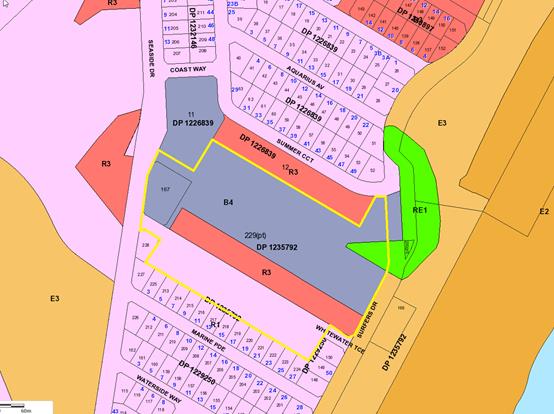
The
site is zoned B4 mixed use, R3 medium density residential, RE1 public
recreation and R1 general residential in accordance
with the Port Macquarie-Hastings Local Environmental Plan 2011, as shown in the
following zoning plan:
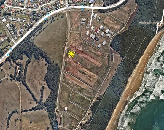
The
location of existing development within the locality at August 2017 is shown in
the following aerial photograph:
2. DESCRIPTION OF
DEVELOPMENT
This development is the first
building in the high density, mixed use Hilltop Village.
Key
aspects of the proposal include the following:
· Boundary adjustment to two (2) existing torrens title lots
existing Lot 167 and 168.
· Construction
of a 5 storey residential flat building development comprising construction of
forty-one (41) units and a café with a three (3) level basement parking
area.
· Strata title subdivision
The proposed building height has
been reduced during the assessment of the application. Specifically the top
most points of the two lift overruns were originally proposed at RL38.05m and
RL40.05m and main roof sections at RL37.05m and RL39.05m. The amended plans
proposed a maximum height at the top of these two overruns of RL37.05m and
38.70m and main roof sections at RL36.17m and RL37.82m. The Ground Level
floor plans have been lowered from RL23.20m to RL22.30m and RL21.2m to RL20.65m.
Refer
to attachments at the end of this report.
Application Chronology
· 27
April 2017 – DA lodged with Council
· 4
May 2017 – BASIX certificates requested
· 10 to 23 May 2017 – Neighbour notification of
proposal
· 11 May 2017 – BASIX certificates received from
Applicant
· 23 May 2017 – Letters of support received from
Applicant
· 1 June 2017 – Additional information requested
– submission issues, more justification for alternate Village Square
proposal, more survey detail, concern with maximum building height, concern
with floor space ratio, bedroom numbers in some apartments, parking
requirements for café queried, queried estimate construction cost,
questioned existing ground levels and amended shadow diagrams requested
· 13 July 2017 – Further additional information
requested – concerns with treatment of future main street
· 15 August 2017 – Additional information and amended
plans received from Applicant
· 21 August 2017 – Additional fees requested
· 11 September 2017 – Additional information requested
– 3D height plane requested, more parking assessment details, more shadow
diagram information, concerns with treatment of future main street, alternate
laneway access arrangements questioned, advised that modification to DA2012 –
381 for the laneway access to be determined prior to this DA, concerns with
stormwater and ground water assessments
· 18 October 2017 – Additional information and amended
plans received from Applicant
· 3 November 2017 – Additional 3D height plane details
received from Applicant
· 21 November 2017 – Additional information requested
from Applicant – stormwater concerns
· 21 November 2017 – Additional information received
from Applicant.
3. STATUTORY ASSESSMENT
Section
79C(1) Matters for Consideration
In determining
the application, Council is required to take into consideration the following
matters as are relevant to the development that apply to the land to which the
development application relates:
(a) The
provisions (where applicable) of:
(i) any
Environmental Planning Instrument:
State Environmental Planning
Policy No. 44 - Koala Habitat Protection
This policy
aims to encourage proper conservation and management of natural vegetation
areas that provide habitat for koalas. The Lake Cathie-Bonny Hills (Area 14)
Koala Plan of Management applies to the site.
There are no
trees located on this site and the proposal is consistent with the adopted Lake
Cathie-Bonny Hills (Area 14) Koala Plan of Management.
State Environmental Planning
Policy No.55 – Remediation of Land
Following an inspection of the
site and a search of Council records, the subject land is not identified as
being potentially contaminated and is suitable for the intended use.
State Environmental Planning
Policy No. 62 – Sustainable Aquaculture
Given the nature of the proposed
development and proposed stormwater controls the proposal will be unlikely to
have any adverse impact on existing aquaculture industries.
State Environmental Planning Policy No. 65 – Design
Quality of Residential Flat Development (SEPP 65)
The policy
applies to development for the purpose of a residential flat building, shop top
housing or mixed use development with a residential accommodation component if:
(a) the
development consists of any of the following:
(i) the erection
of a new building,
(ii) the
substantial redevelopment or the substantial refurbishment of an existing
building,
(iii) the
conversion of an existing building, and
(b) the
building concerned is at least 3 or more storeys (not including levels below
ground level (existing) or levels that are less than 1.2 metres above ground
level (existing) that provide for car parking), and
(c) the
building concerned contains at least 4 or more dwellings.
Based on the above and the development proposed, the SEPP
must be considered.
It should be noted that clause 6A of SEPP 65 applies in
respect of the objectives, design criteria and design guidance set out in Parts
3 and 4 of the Apartment Design Guide for the following:
(a) visual privacy,
(b) solar and daylight
access,
(c) common
circulation and spaces,
(d) apartment size
and layout,
(e) ceiling
heights,
(f) private open
space and balconies,
(g) natural
ventilation,
(h) storage.
If a development control plan contains provisions that
specify requirements, standards or controls in relation to a matter to which
clause 6A applies, those provisions in the development control plan have no
effect.
Clause 6A applies regardless of when the development control
plan was made.
In terms of lodging an application under SEPP 65, it is
noted that the proposal has provided the verification and detail required by
clause 50 and Schedule 1, Part 1(2)(5) of the Environmental Planning and
Assessment Regulation 2000.
In accordance with clause 28(2)(b), the following table
provides an assessment against the design quality principles:
|
Requirement
|
Proposed
|
Complies
|
|
Principle 1: Context and neighbourhood character
Good design responds and
contributes to its context. Context is the key natural and built features of an
area, their relationship and the character they create when combined. It also
includes social, economic, health and environmental conditions.
Responding to context involves
identifying the desirable elements of an area’s existing or future
character. Well designed buildings respond to and enhance the qualities and
identity of the area including the adjacent sites, streetscape and
neighbourhood.
Consideration of local context
is important for all sites, including sites in established areas, those
undergoing change or identified for change.
|
The proposal is for a five
storey residential flat building with basement car parking and ground floor
cafe. Encouraging higher density development in areas such as the subject
site is desirable for the area.
The design responds to the
site context and characteristics by achieving a higher density, and providing
potential links to access adjoining sites and connections to the proposed
main street Ocean Blue Boulevard.
|
Yes
|
|
Principle 2: Built form and
scale
Good design achieves a scale,
bulk and height appropriate to the existing or desired future character of
the street and surrounding buildings.
Good design also achieves an
appropriate built form for a site and the building’s purpose in terms
of building alignments, proportions, building type, articulation and the
manipulation of building elements.
Appropriate built form defines
the public domain, contributes to the character of streetscapes and parks,
including their views and vistas, and provides internal amenity and outlook.
|
The proposal incorporates a
minor variation to the LEP controls for building height. Refer to comments on
clauses 4.3 and 4.6 of LEP 2011 assessment for consideration of the proposed
variations.
Overall, the height and bulk
of the proposed building are considered to be acceptable in the streetscape
and future desired character of the area.
The building incorporates
ground floor setbacks to each of the street frontages, which are consistent
with the desired character for the area. Satisfactory articulation and
variation in building colours and materials are also proposed.
The proposed internal unit
layouts provide for satisfactory internal amenity and having regard to the
orientation of the block.
|
Yes
|
|
Principle 3: Density
Good design achieves a high
level of amenity for residents and each apartment, resulting in a density
appropriate to the site and its context.
Appropriate densities are
consistent with the area’s existing or projected population.
Appropriate densities can be sustained by existing or proposed
infrastructure, public transport, access to jobs, community facilities and
the environment.
|
The proposed FSR for the site
is consistent with the objectives of the B4 mixed use business zone and the
height of buildings envisaged for the area.
The proposed density is also
considered to be sustainable having regard to availability of infrastructure
and likely future public transport, proximity to future services and
community facilities and the environmental quality of the area.
|
Yes
|
|
Principle 4: Sustainability
Good design combines positive
environmental, social and economic outcomes.
Good sustainable design
includes use of natural cross ventilation and sunlight for the amenity and
liveability of residents and passive thermal design for ventilation, heating
and cooling reducing reliance on technology and operation costs. Other
elements include recycling and reuse of materials and waste, use of
sustainable materials and deep soil zones for groundwater recharge and
vegetation.
|
All units contain acceptable
orientated balconies/aspect and opportunities for natural ventilation.
BASIX certificate has also
been provided demonstrating that the design satisfies acceptable energy and
water efficiency measures.
Suitable landscaping areas
proposed.
|
Yes
|
|
Principle 5: Landscape
Good design recognises that
together landscape and buildings operate as an integrated and sustainable
system, resulting in attractive developments with good amenity. A positive
image and contextual fit of well designed developments is achieved by
contributing to the landscape character of the streetscape and neighbourhood.
Good landscape design enhances
the development’s environmental performance by retaining positive
natural features which contribute to the local context, co-ordinating water
and soil management, solar access, micro-climate, tree canopy, habitat values
and preserving green networks.
Good landscape design
optimises useability, privacy and opportunities for social interaction,
equitable access, respect for neighbours’ amenity and provides for
practical establishment and long term management.
|
A landscaping plan has been
submitted with the application and shows areas consistent with planning
controls. In particular, the plan provides a good mixture of useable
landscaped ground floor open space along with large balcony areas that can
accommodate private landscaping.
There are no existing
landscaping elements worth retaining onsite.
The proposed landscaping will
be consistent with other landscaping on newer developments in the area.
|
Yes
|
|
Principle 6: Amenity
Good design positively
influences internal and external amenity for residents and neighbours.
Achieving good amenity contributes to positive living environments and
resident well being.
Good amenity combines
appropriate room dimensions and shapes, access to sunlight, natural
ventilation, outlook, visual and acoustic privacy, storage, indoor and
outdoor space, efficient layouts and service areas and ease of access for all
age groups and degrees of mobility.
|
The building incorporates
generous unit layouts and design which optimise the northern orientation,
ventilation, privacy, open space etc.
Adequate storage and outdoor
space provided throughout the building and site.
Accessibility is possible via
a mixture of ramps, stairs and lifts.
Building depth is
satisfactory.
|
Yes
|
|
Principle 7: Safety
Good design optimises safety
and security within the development and the public domain. It provides for
quality public and private spaces that are clearly defined and fit for the
intended purpose. Opportunities to maximise passive surveillance of public
and communal areas promote safety.
A positive relationship
between public and private spaces is achieved through clearly defined secure
access points and well lit and visible areas that are easily maintained and
appropriate to the location and purpose.
|
The various array of windows,
doors and balconies throughout the building provide surveillance of the site
and also the public domain.
Access to the site is
predominately controlled via single entry point off the proposed Whitewater
Terrace. Access to both these areas can be controlled electronically.
The interface between public
and private/communal space is considered to be clearly defined at the site
frontage.
|
Yes
|
|
Principle 8: Housing
diversity and social interaction
Good design achieves a mix of
apartment sizes, providing housing choice for different demographics, living
needs and household budgets.
Well designed apartment
developments respond to social context by providing housing and facilities to
suit the existing and future social mix.
Good design involves practical
and flexible features, including different types of communal spaces for a
broad range of people and providing opportunities for social interaction
among residents.
|
The proposal includes a good
mix of 1, 2 and 3 bedroom apartments to suit a variety of budgets and housing
needs.
|
Yes
|
|
Principle 9: Aesthetics
Good design achieves a built
form that has good proportions and a balanced composition of elements,
reflecting the internal layout and structure. Good design uses a variety of
materials, colours and textures.
The visual appearance of a
well designed apartment development responds to the existing or future local
context, particularly desirable elements and repetitions of the streetscape.
|
The plans provide examples of
the colours, textures and finishes.
The colours and materials
provided indicate a contemporary quality design and finish. It is considered
that the aesthetics of the building will respond appropriately to the
surrounding environment and context of the desired character of the locality.
|
Yes
|
In accordance with Clause 28(2), the proposal has also
adequately addressed the SEPP 65 Apartment Design Guide. The following table
provides an assessment against the Apartment Design Guide with assessment
comments considering the applicable Design Criteria and Design Objectives where
applicable:
|
Apartment Design Guide (ADG)
Objective
|
Design Guidance/Design
Criteria (Italics)
|
Proposed
|
Complies
|
|
3A Site analysis
|
|
3A - 1 Site analysis illustrates
that design decisions have been based on opportunities and constraints of the
site conditions and their relationship to the surrounding context.
|
Each element in the Site Analysis
Checklist should be addressed (Appendix 1 of ADG)
|
Suitable site analysis completed.
|
Yes
|
|
3B Orientation
|
|
3B - 1 Building types and layouts
respond to the streetscape and site while optimising solar access within the
development.
|
Buildings along the street
frontage define the street, by facing it and incorporating direct access from
the street (see figure 3B.1).
Where the street frontage is to
the east or west, rear buildings should be orientated to the north.
Where the street frontage is to
the north or south, overshadowing to the south should be minimised and
buildings behind the street frontage should be orientated to the east and
west (see figure 3B.2).
|
Orientation acceptable.
Building designed to face all
street frontages with an access off the proposed Whitewater Terrace.
Building has been placed and
designed to maximise the north aspect where possible.
Overshadowing has been minimised
to southern neighbours.
|
Yes
|
|
3B - 2 Overshadowing of
neighbouring properties is minimised during mid winter.
|
Living areas, private open space
and communal open space should receive solar access in accordance with
sections 3D Communal and public open space and 4A Solar and daylight access.
Solar access to living rooms,
balconies and private open spaces of neighbours should be considered.
|
The design of the development has
an emphasis on north orientation with all units having north facing living
areas where possible.
The orientation of the
development and setbacks also ensure no identifiable adverse overshadowing of
adjoining properties.
|
Yes
|
|
3C Public domain interface
|
|
3C - 1 Transition between private
and public domain is achieved without compromising safety and security
|
Terraces, balconies and courtyard
apartments should have direct street entry, where appropriate.
Changes in level between private
terraces, front gardens and dwelling entries above the street level provide
surveillance and improve visual privacy for ground level dwellings (see
figure 3C.1).
Upper level balconies and windows
should overlook the public domain.
|
Terraces of the ground floor
apartments have direct street entry points.
The front fences and walls along
the street frontages have adopted permeable materials and treatments.
Balconies and windows overlook
public domain.
|
Yes
|
|
3C - 2 Amenity of the public
domain is retained and enhanced.
|
Planting softens the edges of any
raised terraces to the street, for example above sub-basement car parking.
Mail boxes should be located in
lobbies, perpendicular to the street alignment or integrated into front
fences where individual street entries are provided.
The visual prominence of
underground car park vents should be minimised and located at a low level
where possible.
Substations, pump rooms, garbage
storage areas and other service requirements should be located in basement
car parks or out of view.
Ramping for accessibility should
be minimised by building entry location and setting ground floor levels in
relation to footpath levels.
|
Landscaping has been incorporated
into the design to soften the built form.
Mailbox location acceptable.
Substations, pump rooms, garbage
storage areas and other service requirements will be located in basement car
parks or out of view.
Ramping for accessibility has
been be minimised by building entry locations and setting ground floor levels
in relation to footpath levels.
|
Yes
|
|
3D Communal and public open
space
|
|
3D - 1 An adequate area of
communal open space is provided to enhance residential amenity and to provide
opportunities for landscaping
|
Design Criteria
1. Communal open space has a
minimum area equal to 25% of the site (see figure 3D.3)
2. Developments achieve a
minimum of 50% direct sunlight to the principal usable part of the communal
open space for a minimum of 2 hours between 9 am and 3 pm on 21 June (mid
winter).
Communal open space should be
consolidated into a well designed, easily identified and usable area.
Communal open space should have a
minimum dimension of 3m, and larger developments should consider greater
dimensions.
Communal open space should be
co-located with deep soil areas.
Direct, equitable access should
be provided to communal open space areas from common circulation areas,
entries and lobbies.
Where communal open space cannot
be provided at ground level, it should be provided on a podium or roof.
Where developments are unable to
achieve the design criteria, such as on small lots, sites within business
zones, or in a dense urban area, they should:
- provide
communal spaces elsewhere such as a landscaped roof top terrace or a common
room
- provide
larger balconies or increased private open space for apartments
- demonstrate
good proximity to public open space and facilities and/or provide contributions
to public open space
|
>25% of the site is provided
for a communal open space area requirement.
In addition to the above, the
communal area is easily accessible, well defined, usable, co-located with
deep soil areas, located at ground level and contains a mixture of light and
shade areas. The proposed café will also provide for an additional
amenity for future residents if required.
|
Yes
|
|
3D - 2 Communal open space is
designed to allow for a range of activities, respond to site conditions and
be attractive and inviting
|
Facilities are provided within
communal open spaces and common spaces for a range of age groups (see also 4F
Common circulation and spaces), incorporating some of the following elements:
- seating
for individuals or groups
- barbecue
areas
- play
equipment or play areas
- swimming
pools, gyms, tennis courts or common rooms.
|
The
proposed common areas are regular in shape and will be satisfactorily usable,
with pedestrian pathways and seating proposed to the common open space and it
experiences good solar access.
More
specific landscape details will be required prior to issue of a Construction
Certificate.
|
Yes
|
|
3D - 3 Communal open space is
designed to maximise safety
|
Communal open space and the
public domain should be readily visible from habitable rooms and private open
space areas while maintaining visual privacy.
|
Communal open space and the
public domain should be readily visible from habitable rooms and private open
space areas while maintaining visual privacy.
|
Yes
|
|
3E Deep soil zones
|
|
3E - 1 Deep soil zones provide
areas on the site that allow for and support healthy plant and tree growth.
They improve residential amenity and promote management of water and air quality
|
Design Criteria
1. Deep soil zones are to meet
the following minimum requirements:
a) <
650m²,
no min dimension, 7% site area deep soil zone.
b) 650-1500m²,
3m dimension, 7% site area deep soil zone.
c) >1500m²,
6m dimension, 7% site area deep soil zone.
On some sites it may be possible
to provide larger deep soil zones, depending on the site area and context:
- 10%
of the site as deep soil on sites with an area of 650m² - 1,500m²
- 15%
of the site as deep soil on sites greater than 1,500m².
Deep soil zones should be located
to retain existing significant trees and to allow for the development of
healthy root systems, providing anchorage and stability for mature trees.
Design solutions may include:
- basement
and sub basement car park design that is consolidated beneath building
footprints
- use
of increased front and side setbacks
- adequate
clearance around trees to ensure long term health
- co-location
with other deep soil areas on adjacent sites to create larger contiguous
areas of deep soil.
Achieving the design criteria may
not be possible on some sites including where:
- the
location and building typology have limited or no space for deep soil at
ground level (e.g. central business district, constrained sites, high density
areas, or in centres)
- there
is 100% site coverage or non-residential uses at ground floor level.
Where a proposal does not achieve
deep soil requirements, acceptable stormwater management should be achieved
and alternative forms of planting provided such as on structure.
|
The site is >1500m². The
applicant proposes 16.7% deep soil zone.
|
Yes
|
|
3F Visual privacy
|
|
3F - 1 Adequate building
separation distances are shared equitably between neighbouring sites, to
achieve reasonable levels of external and internal visual privacy
|
Design Criteria
1. Separation between windows
and balconies is provided to ensure visual privacy is achieved. Minimum
required separation distances from buildings to the side and rear boundaries
are as follows:
a) Building
height up to 12m (4 storey) need 6m setback to habitable and 3m to non
habitable.
b) Buildings
up to 25m (5-8 storeys) need 9m to habitable and 4.5m to non habitable.
c) Buildings
over 25m (9+ storeys) need 12m to habitable and 6m to non habitable.
Note: Separation distances between
buildings on the same site should combine required building separations
depending on the type of room (see figure 3F.2).
Gallery access circulation
should be treated as habitable space when measuring privacy separation
distances between neighbouring properties
Generally one step in the built
form as the height increases due to building separations is desirable.
Additional steps should be careful not to cause a 'ziggurat' appearance.
For residential buildings next to
commercial buildings, separation distances should be measured as follows:
- for
retail, office spaces and commercial balconies use the habitable room
distances
- for
service and plant areas use the non-habitable room distances.
New development should be located
and oriented to maximise visual privacy between buildings on site and for
neighbouring buildings. Design solutions include:
- site
layout and building orientation to minimise privacy impacts (see also section
3B Orientation)
- on
sloping sites, apartments on different levels have appropriate visual
separation distances (see figure 3F.4).
Apartment buildings should have
an increased separation distance of 3m (in addition to the requirements set
out in design criteria 1) when adjacent to a different zone that permits
lower density residential development to provide for a transition in scale
and increased landscaping (figure 3F.5).
Direct lines of sight should be
avoided for windows and balconies across corners.
No separation is required between
blank walls
|
Eastern side setback of greater
than 9m to habitable and 4.5m to non-habitable provided.
No adjoining buildings as yet.
|
Yes
|
|
3F - 2 Site and building design
elements increase privacy without compromising access to light and air and
balance outlook and views from habitable rooms and private open space
|
Communal open space, common areas
and access paths should be separated from private open space and windows to
apartments, particularly habitable room windows.
|
Communal open space in the
eastern section of the site, common areas and access paths are satisfactorily
separated.
|
Yes
|
|
3G Pedestrian access and
entries
|
|
3G - 1 Building entries and
pedestrian access connects to and addresses the public domain
|
Multiple entries (including
communal building entries and individual ground floor entries) should be
provided to activate the street edge.
Entry locations relate to the
street and subdivision pattern and the existing pedestrian network.
Building entries should be
clearly identifiable and communal entries should be clearly distinguishable
from private entries.
Where street frontage is limited
and multiple buildings are located on the site, a primary street address
should be provided with clear sight lines and pathways to secondary building
entries.
|
Building entries and pedestrian
access connects to and addresses the public domain.
Multiple entries (including
communal building entries and individual ground floor entries) provided to
activate the street edge.
Building entries are clearly
identifiable and communal entries are distinguishable from private entries.
|
Yes
|
|
3G - 2 Access, entries and
pathways are accessible and easy to identify
|
Building access areas including
lift lobbies, stairwells and hallways should be clearly visible from the
public domain and communal spaces.
The design of ground floors and
underground car parks minimise level changes along pathways and entries.
Steps and ramps should be
integrated into the overall building and landscape design.
For large developments ‘way
finding’ maps should be provided to assist visitors and residents (see
figure 4T.3).
For large developments electronic
access and audio/video intercom should be provided to manage access
|
Access, entries and pathways are
accessible and easy to identify.
|
Yes
|
|
3H Vehicle access
|
|
3H - 1 Vehicle access points are
designed and located to achieve safety, minimise conflicts between
pedestrians and vehicles and create high quality streetscapes
|
Car park access should be
integrated with the building’s overall facade. Design solutions may
include:
- the
materials and colour palette to minimise visibility from the street
- security
doors or gates at entries that minimise voids in the facade
- where
doors are not provided, the visible interior reflects the facade design and
the building services, pipes and ducts are concealed.
Car park entries should be
located behind the building line.
Vehicle entries should be located
at the lowest point of the site minimising ramp lengths, excavation and
impacts on the building form and layout.
Car park entry and access should
be located on secondary streets or lanes where available.
Vehicle standing areas that
increase driveway width and encroach into setbacks should be avoided.
Access point locations should
avoid headlight glare to habitable rooms.
Adequate separation distances
should be provided between vehicle entries and street intersections.
The width and number of vehicle
access points should be limited to the minimum.
Visual impact of long driveways
should be minimised through changing alignments and screen planting.
The need for large vehicles to
enter or turn around within the site should be avoided.
Garbage collection, loading and
servicing areas are screened.
Clear sight lines should be
provided at pedestrian and vehicle crossings.
Traffic calming devices such as
changes in paving material or textures should be used where appropriate.
Pedestrian and vehicle access
should be separated and distinguishable. Design solutions may include:
- changes
in surface materials
- level
changes
- the
use of landscaping for separation
|
Car park access satisfactorily
integrated with the building’s overall facades.
Car park entry located behind the
building line.
Vehicle entry located at the
lowest point of the site minimising ramp lengths, excavation and impacts on
the building form and layout.
Car park entry and access located
on secondary street proposed Whitewater Terrace street.
Access point location avoids
headlight glare to habitable rooms.
Adequate separation distances
provided between vehicle entry and street intersection of Whitewater Terrace
proposed and Seaside Drive.
The width of the vehicle access
point is limited.
Garbage collection, loading and
servicing areas are screened.
|
Yes
|
|
3J Bicycle and car parking
|
|
3J - 1 Car parking is provided
based on proximity to public transport in metropolitan Sydney and centres in
regional areas
Notes
Port Macquarie is a nominated
regional centre.
In terms of using Guide to
Traffic Generating Developments, Port Macquarie is a “sub-regional
centre” as by definition it does not have access to rail.
Medium density is 2 - <20
dwellings.
High Density is 20 or more
dwellings
|
Design Criteria
1. For
development in the following locations:
a) on
sites that are within 800 metres of a railway station or light rail stop in
the Sydney Metropolitan Area; or
b) on
land zoned, and sites within 400 metres of land zoned, B3 Commercial Core, B4
Mixed Use or equivalent in a nominated regional centre
the minimum car parking
requirement for residents and visitors is set out in the Guide to Traffic
Generating Developments, or the car parking requirement prescribed by the relevant
council, whichever is less
The car parking needs for a
development must be provided off street.
Where a car share scheme operates
locally, provide car share parking spaces within the development. Car share
spaces, when provided, should be on site.
Where less car parking is
provided in a development, council should not provide on street resident
parking permits
Guide to Traffic Generating
Developments
Medium density residential flat
buildings require:
- 1
space per unit +
- 1
space for every 5 x 2 bedroom unit +
- 1
space for every 2 x 3 bedroom unit +
- 1
space for 5 units (visitor parking).
High density residential flat
buildings for metropolitan sub-regional centres require:
- 0.6
spaces per 1 bedroom unit
- 0.9
spaces per 2 bedroom unit
- 1.40
spaces per 3 bedroom unit +
- 1
space per 5 units (visitor parking)
|
Site is within a B4 zone.
Building is termed high density
under the Traffic Guide.
44 residential spaces + 9 visitor
spaces + 5 café spaces are required.
Applicant proposes 80 spaces onsite.
Refer to detailed table breakdown
of requirements later in this report under the consideration of Parking
impacts.
|
Yes
|
|
3J - 2 Parking and facilities are
provided for other modes of transport
|
Conveniently located and
sufficient numbers of parking spaces should be provided for motorbikes and
scooters.
Secure undercover bicycle parking
should be provided that is easily accessible from both the public domain and
common areas.
Conveniently located charging
stations are provided for electric vehicles, where desirable
|
The basement car park allows for
vehicle spaces to be used for motorbikes etc. There are also storage areas
available for bicycles.
|
Yes
|
|
3J - 3 Car park design and access
is safe and secure
|
Supporting facilities within car
parks, including garbage, plant and switch rooms, storage areas and car wash
bays can be accessed without crossing car parking spaces.
Direct, clearly visible and well
lit access should be provided into common circulation areas.
A clearly defined and visible
lobby or waiting area should be provided to lifts and stairs.
For larger car parks, safe
pedestrian access should be clearly defined and circulation areas have good
lighting, colour, line marking and/or bollards
|
Car park design and access is
safe and secure.
|
Yes
|
|
3J - 4 Visual and environmental
impacts of underground car parking are minimised
|
Excavation should be minimised
through efficient car park layouts and ramp design.
Car parking layout should be well
organised, using a logical, efficient structural grid and double loaded
aisles.
Protrusion of car parks should
not exceed 1m above ground level. Design solutions may include stepping car
park levels or using split levels on sloping sites.
Natural ventilation should be
provided to basement and sub basement car parking areas.
Ventilation grills or screening
devices for car parking openings should be integrated into the facade and
landscape design
|
Visual and environmental impacts
of underground car parking are minimised.
|
Yes
|
|
4A Solar and daylight access
|
|
4A - 1 To optimise the number of
apartments receiving sunlight to habitable rooms, primary windows and private
open space
|
Design Criteria
1. Living rooms and private
open spaces of at least 70% of apartments in a building receive a minimum of
2 hours direct sunlight between 9 am and 3 pm at mid winter in the Sydney
Metropolitan Area and in the Newcastle and Wollongong local government areas.
2. In all other areas, living
rooms and private open spaces of at least 70% of apartments in a building
receive a minimum of 3 hours direct sunlight between 9 am and 3 pm at mid
winter.
3. A maximum of 15% of
apartments in a building receive no direct sunlight between 9 am and 3 pm at
mid winter
The design maximises north aspect
and the number of single aspect south facing apartments is minimised.
Single aspect, single storey
apartments should have a northerly or easterly aspect.
Living areas are best located to
the north and service areas to the south and west of apartments.
To optimise the direct sunlight
to habitable rooms and balconies a number of the following design features
are used:
- dual
aspect apartments
- shallow
apartment layouts
- two
storey and mezzanine level apartments
- bay
windows
To maximise the benefit to
residents of direct sunlight within living rooms and private open spaces, a
minimum of 1m²
of direct sunlight, measured at 1m above floor level, is achieved for at
least 15 minutes.
Achieving the design criteria may
not be possible on some sites. This includes:
- where
greater residential amenity can be achieved along a busy road or rail line by
orientating the living rooms away from the noise source
- on
south facing sloping sites
- where
significant views are oriented away from the desired aspect for direct
sunlight
Design drawings need to
demonstrate how site constraints and orientation preclude meeting the design
criteria and how the development meets the objective.
|
73% of units receive sunlight for
a minimum of 3 hours between 9am and 3pm, mid-winter.
All units receive some light and
therefore the 15% standard (dot point 3) is not reached.
The design maximises north aspect
and the number of single aspect south facing apartments is minimised.
|
Yes
|
|
4A - 3 Design incorporates
shading and glare control, particularly for warmer months
|
A number of the following design
features are used:
- balconies
or sun shading that extend far enough to shade summer sun, but allow winter
sun to penetrate living areas
- shading
devices such as eaves, awnings, balconies, pergolas, external louvres and
planting
- horizontal
shading to north facing windows
- vertical
shading to east and particularly west facing windows
- operable
shading to allow adjustment and choice
- high
performance glass that minimises external glare off windows, with
consideration given to reduced tint glass or glass with a reflectance level
below 20% (reflective films are avoided)
|
Design incorporates shading and
glare control, particularly for warmer months.
|
Yes
|
|
4B Natural ventilation
|
|
4B - 1 All habitable rooms are
naturally ventilated
|
The building's orientation
maximises capture and use of prevailing breezes for natural ventilation in habitable
rooms.
Depths of habitable rooms support
natural ventilation.
The area of unobstructed window
openings should be equal to at least 5% of the floor area served.
Light wells are not the primary
air source for habitable rooms.
Doors and openable windows
maximise natural ventilation opportunities by using the following design
solutions:
- adjustable
windows with large effective openable areas
- a
variety of window types that provide safety and flexibility such as awnings
and louvres
- windows
which the occupants can reconfigure to funnel breezes into the apartment such
as vertical louvres, casement windows and externally opening doors
|
Design and location of openings
make use of natural ventilation.
Condition recommended to require
operable/openable windows for common foyers.
|
Yes
|
|
4B - 2 The layout and design of
single aspect apartments maximises natural ventilation
|
Apartment depths are limited to
maximise ventilation and airflow (see also figure 4D.3)
Natural ventilation to single
aspect apartments is achieved with the following design solutions:
- primary
windows are augmented with plenums and light wells (generally not suitable
for cross ventilation)
- stack
effect ventilation / solar chimneys or similar to naturally ventilate
internal building areas or rooms such as bathrooms and laundries
- courtyards
or building indentations have a width to depth ratio of 2:1 or 3:1 to ensure
effective air circulation and avoid trapped smells
|
Depth of units are acceptable
given the multi aspect apartments allowing light and ventilation.
|
Yes
|
|
4B - 3 The number of apartments
with natural cross ventilation is maximised to create a comfortable indoor
environment for residents
|
Design Criteria
1. At least 60% of apartments
are naturally cross ventilated in the first nine storeys of the building.
Apartments at ten storeys or greater are deemed to be cross ventilated only
if any enclosure of the balconies at these levels allows adequate natural
ventilation and cannot be fully enclosed.
2. Overall depth of a
cross-over or cross-through apartment does not exceed 18m, measured glass
line to glass line.
The building should include dual
aspect apartments, cross through apartments and corner apartments and limit
apartment depths.
In cross-through apartments
external window and door opening sizes/areas on one side of an apartment
(inlet side) are approximately equal to the external window and door opening
sizes/areas on the other side of the apartment (outlet side) (see figure
4B.4).
Apartments are designed to
minimise the number of corners, doors and rooms that might obstruct airflow.
Apartment depths, combined with
appropriate ceiling heights, maximise cross ventilation and airflow
|
70% of units are cross
ventilated.
Overall depth of cross-over or
cross-through apartments do not exceed 18m, measured glass line to glass
line.
The building includes several
dual aspect apartments, cross through apartments and corner apartments and
limited apartment depths.
|
Yes
|
|
4C Ceiling heights
|
|
4C - 1 Ceiling height achieves
sufficient natural ventilation and daylight access
|
Design Criteria
1. Measured from finished
floor level to finished ceiling level, minimum ceiling heights are:
Minimum ceiling height for
apartment and mixed use buildings
Habitable rooms = 2.7m
Non-habitable = 2.4m
For 2 storey apartments
= 2.7m for main living area floor and 2.4m for second floor, where its
area does not exceed 50% of the apartment area
Attic spaces = 1.8m at edge of
room with a 30 degree minimum ceiling slope
If located in mixed use areas
= 3.3m for ground and first floor to promote future flexibility of use
These minimums do not preclude
higher ceilings if desired.
Ceiling height can accommodate
use of ceiling fans for cooling and heat distribution.
|
Units have minimum 2.8m ceiling
heights.
Ceiling heights can accommodate
use of ceiling fans for cooling and heat distribution.
|
Yes
|
|
4C - 2 Ceiling height increases
the sense of space in apartments and provides for well proportioned rooms
|
A number of the following design
solutions can be used:
- the
hierarchy of rooms in an apartment is defined using changes in ceiling
heights and alternatives such as raked or curved ceilings, or double height
spaces
- well
proportioned rooms are provided, for example, smaller rooms feel larger and
more spacious with higher ceilings
- ceiling
heights are maximised in habitable rooms by ensuring that bulkheads do not
intrude. The stacking of service rooms from floor to floor and coordination
of bulkhead location above non-habitable areas, such as robes or storage, can
assist
|
Ceiling heights are a minimum
2.8m and acceptable throughout the development.
|
Yes
|
|
4D Apartment size and layout
|
|
4D - 1 The layout of rooms within
an apartment is functional, well organised and provides a high standard of
amenity
|
Design Criteria
1. Apartments are required to
have the following minimum internal areas:
Studio = 35m²
1 bedroom = 50m²
2 bedroom = 70m²
3 bedroom = 90m²
The minimum internal areas
include only one bathroom. Additional bathrooms increase the minimum internal
area by 5m²
each.
A fourth bedroom and further
additional bedrooms increase the minimum internal area by 12m² each.
2. Every habitable room must
have a window in an external wall with a total minimum glass area of not less
than 10% of the floor area of the room. Daylight and air may not be borrowed
from other rooms.
Kitchens should not be located as
part of the main circulation space in larger apartments (such as hallway or
entry space).
A window should be visible from
any point in a habitable room.
Where minimum areas or room
dimensions are not met apartments need to demonstrate that they are well
designed and demonstrate the usability and functionality of the space with
realistically scaled furniture layouts and circulation areas. These
circumstances would be assessed on their merits
|
1 bedroom = minimum 74m²
2 bedroom = minimum 87m²
3 bedroom = minimum 130m²
Every habitable room has access
to a window with compliant glass area.
Kitchens are not part of hallways
etc.
|
Yes
|
|
4D - 2 Environmental performance
of the apartment is maximised
|
Design Criteria
1. Habitable room depths are
limited to a maximum of 2.5 x the ceiling height.
2. In open plan layouts (where
the living, dining and kitchen are combined) the maximum habitable room depth
is 8m from a window.
Greater than minimum ceiling
heights can allow for proportional increases in room depth up to the
permitted maximum depths.
All living areas and bedrooms
should be located on the external face of the building.
Where possible:
- bathrooms
and laundries should have an external openable window.
- main
living spaces should be oriented toward the primary outlook and aspect and
away from noise sources
|
Habitable room depths do not
exceed 2.5 x the ceiling height.
The open plan areas do not exceed
8m.
Living areas and bedrooms are
located on the external face of the building.
|
Yes
|
|
4D - 3 Apartment layouts are
designed to accommodate a variety of household activities and needs
|
Design Criteria
1. Master bedrooms have a
minimum area of 10m²
and other bedrooms 9m²
(excluding wardrobe space).
2. Bedrooms have a minimum
dimension of 3m (excluding wardrobe space).
3. Living rooms or combined
living/dining rooms have a minimum width of:
• 3.6m for studio and 1
bedroom apartments
• 4m for 2 and 3 bedroom
apartments
4. The width of cross-over or
cross-through apartments are at least 4m internally to avoid deep narrow
apartment layouts.
Access to bedrooms, bathrooms and
laundries is separated from living areas minimising direct openings between
living and service areas.
All bedrooms allow a minimum
length of 1.5m for robes.
The main bedroom of an apartment
or a studio apartment should be provided with a wardrobe of a minimum 1.8m long,
0.6m deep and 2.1m high.
Apartment layouts allow
flexibility over time, design solutions may include:
- dimensions
that facilitate a variety of furniture arrangements and removal
- spaces
for a range of activities and privacy levels between different spaces within
the apartment
- dual
master apartments
- dual
key apartments Note: dual key apartments which
are separate but on the same title are regarded as two sole occupancy units
for the purposes of the Building Code of Australia and for calculating the
mix of apartments
- room
sizes and proportions or open plans (rectangular spaces (2:3) are more easily
furnished than square spaces (1:1))
- efficient
planning of circulation by stairs, corridors and through rooms to maximise
the amount of usable floor space in rooms
|
Master bedrooms comply with the
10m²
minimum standard and other bedrooms comply with the 9m² standard.
Bedrooms comply with 3m minimum
dimension.
Living rooms comply with 4m
minimum dimension.
Suitable separation of rooms
exists via use of doors, walls etc
Robes in bedrooms considered
acceptable.
Layouts contain flexibility.
|
Yes
|
|
4E Private open space and
balconies
|
|
4E - 1 Apartments provide
appropriately sized private open space and balconies to enhance residential
amenity
|
Design Criteria
1. All apartments are required
to have primary balconies as follows:
a) Studio
apartments = 4m²
b) 1
bedroom apartments = 8m²
and 2m min depth.
c) 2
bedroom apartments = 10m²
and 2m min depth.
d) 3+
bedroom apartments = 12m²
and 2.4m min depth.
The minimum balcony depth to
be counted as contributing to the balcony area is 1m.
2. For apartments at ground
level or on a podium or similar structure, a private open space is provided
instead of a balcony. It must have a minimum area of 15m² and a
minimum depth of 3m.
Increased communal open space
should be provided where the number or size of balconies are reduced.
Storage areas on balconies is
additional to the minimum balcony size.
Balcony use may be limited in
some proposals by:
- consistently
high wind speeds at 10 storeys and above
- close
proximity to road, rail or other noise sources
- exposure
to significant levels of aircraft noise
- heritage
and adaptive reuse of existing buildings
In these situations, juliet
balconies, operable walls, enclosed wintergardens or bay windows may be
appropriate, and other amenity benefits for occupants should also be provided
in the apartments or in the development or both. Natural ventilation also
needs to be demonstrated
|
The 2 bedroom apartments have a
balcony that is in excess of the 10m²
and 2.0m minimum depth.
The 3 bedroom apartments have a
balcony that is in excess of the 12m²
and 2.4m minimum depth.
Ground floor apartments have in
excess of the 15m²
and 3m minimum depth.
|
Yes
|
|
4E - 2 Primary private open space
and balconies are appropriately located to enhance liveability for residents
|
Primary open space and balconies
should be located adjacent to the living room, dining room or kitchen to
extend the living space.
Private open spaces and balconies
predominantly face north, east or west.
Primary open space and balconies
should be orientated with the longer side facing outwards or be open to the
sky to optimise daylight access into adjacent rooms.
|
Private open space areas adjoin
living areas and balconies are of a suitable useable size.
|
Yes
|
|
4E - 3 Private open space and
balcony design is integrated into and contributes to the overall
architectural form and detail of the building
|
Solid, partially solid or
transparent fences and balustrades are selected to respond to the location.
They are designed to allow views and passive surveillance of the street while
maintaining visual privacy and allowing for a range of uses on the balcony.
Solid and partially solid balustrades are preferred.
Full width full height glass
balustrades alone are generally not desirable.
Projecting balconies should be
integrated into the building design and the design of soffits considered.
Operable screens, shutters, hoods
and pergolas are used to control sunlight and wind.
Balustrades are set back from the
building or balcony edge where overlooking or safety is an issue.
Downpipes and balcony drainage
are integrated with the overall facade and building design.
Air-conditioning units should be
located on roofs, in basements, or fully integrated into the building design.
Where clothes drying, storage or
air conditioning units are located on balconies, they should be screened and
integrated in the building design.
Ceilings of apartments below
terraces should be insulated to avoid heat loss.
Water and gas outlets should be
provided for primary balconies and private open space
|
Balconies suitably comply with
requirements.
|
Yes
|
|
4E - 4 Private open space and
balcony design maximises safety.
|
Changes in ground levels or
landscaping are minimised.
Design and detailing of balconies
avoids opportunities for climbing and falls.
|
Changes in ground levels or
landscaping are minimised.
Design and detailing of balconies
avoids opportunities for climbing and falls subject to also complying with
the Building Code of Australia. Specific details will be required to be
provided and addressed prior to the issue of a construction certificate.
|
Yes
|
|
4F Common circulation and
spaces
|
|
4F - 1 Common circulation spaces
achieve good amenity and properly service the number of apartments
|
Design Criteria
1. The maximum number of
apartments off a circulation core on a single level is eight.
2. For buildings of 10 storeys
and over, the maximum number of apartments sharing a single lift is 40.
Greater than minimum requirements
for corridor widths and/ or ceiling heights allow comfortable movement and
access particularly in entry lobbies, outside lifts and at apartment entry
doors.
Daylight and natural ventilation
should be provided to all common circulation spaces that are above ground.
Windows should be provided in
common circulation spaces and should be adjacent to the stair or lift core or
at the ends of corridors.
Longer corridors greater than 12m
in length from the lift core should be articulated. Design solutions may
include:
- a
series of foyer areas with windows and spaces for seating
- wider
areas at apartment entry doors and varied ceiling heights
Design common circulation spaces
to maximise opportunities for dual aspect apartments, including multiple core
apartment buildings and cross over apartments.
Achieving the design criteria for
the number of apartments off a circulation core may not be possible. Where a
development is unable to achieve the design criteria, a high level of amenity
for common lobbies, corridors and apartments should be demonstrated,
including:
- sunlight
and natural cross ventilation in apartments
- access
to ample daylight and natural ventilation in common circulation spaces
- common
areas for seating and gathering
- generous
corridors with greater than minimum ceiling heights
- other
innovative design solutions that provide high levels of amenity
Where design criteria 1 is not
achieved, no more than 12 apartments should be provided off a circulation
core on a single level.
Primary living room or bedroom
windows should not open directly onto common circulation spaces, whether open
or enclosed. Visual and acoustic privacy from common circulation spaces to
any other rooms should be carefully controlled
|
Maximum number of apartments
accessed off each of the two (2) circulation cores is 5.
Natural light and potential for
ventilation provided to common circulation areas.
Levels 1-5 will likely utilise
mechanical ventilation unless operable windows are proposed. Condition
recommended to require operable windows be provided to all windows on common
circulation spaces.
Corridor widths are acceptable.
Living areas do not directly
access core area.
|
Yes - capable
|
|
4F - 2 Common circulation spaces
promote safety and provide for social interaction between residents
|
Direct and legible access should
be provided between vertical circulation points and apartment entries by
minimising corridor or gallery length to give short, straight, clear sight
lines.
Tight corners and spaces are
avoided.
Circulation spaces should be well
lit at night.
Legible signage should be
provided for apartment numbers, common areas and general wayfinding.
Incidental spaces, for example
space for seating in a corridor, at a stair landing, or near a window are
provided.
In larger developments, community
rooms for activities such as owner’s corporation meetings or resident
use should be provided and are ideally co-located with communal open space.
Where external galleries are
provided, they are more open than closed above the balustrade along their
length.
|
Direct and legible access is
provided between vertical circulation points and apartment entries by
minimising corridor or gallery length to give short, straight, clear sight
lines.
Tight corners and spaces are
avoided.
Circulation spaces are capable of
being well lit at night and provided with appropriate signage.
|
Yes
|
|
4G Storage
|
|
4G - 1 Adequate, well designed
storage is provided in each apartment
|
Design Criteria
1. In addition to storage in
kitchens, bathrooms and bedrooms, the following storage is provided:
a) Studio
apartments = 4m³.
b) 1
bedroom apartments = 6m³.
c) 2
bedroom apartments 8m³.
d) 3+
bedroom apartments = 10m³.
At least 50% of the
required storage is to be located within the apartment.
Storage is accessible from either
circulation or living areas.
Storage provided on balconies (in
addition to the minimum balcony size) is integrated into the balcony design,
weather proof and screened from view from the street.
Left over space such as under
stairs is used for storage
|
Storage amount, locations and
design are acceptable.
|
Yes
|
|
4G - 2 Additional storage is
conveniently located, accessible and nominated for individual apartments
|
Storage not located in apartments
is secure and clearly allocated to specific apartments.
Storage is provided for larger
and less frequently accessed items.
Storage space in internal or
basement car parks is provided at the rear or side of car spaces or in cages
so that allocated car parking remains accessible.
If communal storage rooms are
provided they should be accessible from common circulation areas of the
building.
Storage not located in an
apartment is integrated into the overall building design and is not visible
from the public domain.
|
Basement storage is accessible in
the basement.
Storage has been integrated into
the design.
|
Yes
|
|
4H Acoustic privacy
|
|
4H - 1 Noise transfer is
minimised through the siting of buildings and building layout
|
Adequate building separation is
provided within the development and from neighbouring buildings/adjacent uses
(see also section 2F Building separation and section 3F Visual privacy).
Window and door openings are
generally orientated away from noise sources.
Noisy areas within buildings
including building entries and corridors should be located next to or above
each other and quieter areas next to or above quieter areas.
Storage, circulation areas and
non-habitable rooms should be located to buffer noise from external sources.
The number of party walls (walls
shared with other apartments) are limited and are appropriately insulated.
Noise sources such as garage
doors, driveways, service areas, plant rooms, building services, mechanical
equipment, active communal open spaces and circulation areas should be
located at least 3m away from bedrooms.
|
The use of separation, screening
and having high use living areas face adjoining low use non habitable rooms
(i.e. bathrooms) ensures no adverse acoustic issues. Living areas are also
grouped throughout the levels of the building.
Other acoustic provisions of ADG
have been suitably implemented.
|
Yes
|
|
4H - 2 Noise impacts are
mitigated within apartments through layout and acoustic treatments
|
Internal apartment layout
separates noisy spaces from quiet spaces, using a number of the following
design solutions:
- rooms
with similar noise requirements are grouped together
- doors
separate different use zones
- wardrobes
in bedrooms are co-located to act as sound buffers
Where physical separation cannot
be achieved noise conflicts are resolved using the following design
solutions:
- double
or acoustic glazing
- acoustic
seals • use of materials with low noise penetration properties
- continuous
walls to ground level courtyards where they do not conflict with streetscape
or other amenity requirements
|
Internal apartment layouts
satisfactorily separate noisy spaces from quiet spaces.
|
Yes
|
|
4J Noise and pollution
|
|
4J - 1 In noisy or hostile
environments the impacts of external noise and pollution are minimised
through the careful siting and layout of buildings
|
To minimise impacts the following
design solutions may be used:
- physical
separation between buildings and the noise or pollution source
- residential
uses are located perpendicular to the noise source and where possible
buffered by other uses
- non-residential
buildings are sited to be parallel with the noise source to provide a
continuous building that shields residential uses and communal open spaces
- non-residential
uses are located at lower levels vertically separating the residential component
from the noise or pollution source. Setbacks to the underside of residential
floor levels should increase relative to traffic volumes and other noise
sources
- buildings
should respond to both solar access and noise. Where solar access is away
from the noise source, non habitable rooms can provide a buffer
- where
solar access is in the same direction as the noise source, dual aspect
apartments with shallow building depths are preferable (see figure 4J.4)
|
Development design has
implemented and had satisfactory regard for ADG requirements.
It should be noted that fencing,
screening, level differences relating the streets etc have also been utilised
to provide protection from noise sources.
|
Yes
|
|
4J - 2 Appropriate noise
shielding or attenuation techniques for the building design, construction and
choice of materials are used to mitigate noise transmission
|
Design solutions to mitigate
noise include:
- limiting
the number and size of openings facing noise sources
- providing
seals to prevent noise transfer through gaps
- using
double or acoustic glazing, acoustic louvres or enclosed balconies
(wintergardens)
- using
materials with mass and/or sound insulation or absorption properties e.g.
solid balcony balustrades, external screens and soffits
|
Development design has
implemented and had regard for ADG requirements.
A specific Noise Impact report
has been submitted as addressed under clause 7.9 of the LEP which is
satisfactory subject to implementing its recommendations.
|
Yes
|
|
4K Apartment mix
|
|
4K - 1 A range of apartment types
and sizes is provided to cater for different household types now and into the
future
|
A variety of apartment types is
provided The apartment mix is appropriate, taking into consideration:
- the
distance to public transport, employment and education centres
- the
current market demands and projected future demographic trends
- the
demand for social and affordable housing
- different
cultural and socioeconomic groups
Flexible apartment configurations
are provided to support diverse household types and stages of life including
single person households, families, multi-generational families and group
households.
|
A suitable variety of apartment
mix is provided. The units provide for singles, couples and small families.
|
Yes
|
|
4K - 2 The apartment mix is
distributed to suitable locations within the building
|
Different apartment types are
located to achieve successful facade composition and to optimise solar access
(see figure 4K.3).
Larger apartment types are
located on the ground or roof level where there is potential for more open
space and on corners where more building frontage is available.
|
Location of apartments provides
acceptable compliance with ADG.
The ground and top floor
apartments contain reasonably large apartment areas.
|
Yes
|
|
4L Ground floor apartments
|
|
4L - 1 Street frontage activity
is maximised where ground floor apartments are located
|
Direct street access should be
provided to ground floor apartments.
Activity is achieved through
front gardens, terraces and the facade of the building. Design solutions may
include:
- both
street, foyer and other common internal circulation entrances to ground floor
apartments
- private
open space is next to the street
- doors
and windows face the street
Retail or home office spaces
should be located along street frontages.
Ground floor apartment layouts
support small office home office (SOHO) use to provide future opportunities
for conversion into commercial or retail areas. In these cases provide higher
floor to ceiling heights and ground floor amenities for easy conversion.
|
Direct street access to ground
floor units proposed where street frontage and to connectivity pathways
provided along eastern side of the site.
Ground floor café proposed
on northern side of the building.
Design of ground floor dwellings
could be converted to allow for future home office use.
|
Yes
|
|
4L - 2 Design of ground floor
apartments delivers amenity and safety for residents
|
Privacy and safety should be
provided without obstructing casual surveillance. Design solutions may
include:
- elevation
of private gardens and terraces above the street level by 1-1.5m (see figure
4L.4)
- landscaping
and private courtyards
- window
sill heights that minimise sight lines into apartments
- integrating
balustrades, safety bars or screens with the exterior design
Solar access should be maximised
through:
- high
ceilings and tall windows
- trees
and shrubs that allow solar access in winter and shade in summer
|
The use of elevation, fencing,
screening and landscaping provides a suitable mixture of privacy and
surveillance.
Solar access will not be
adversely inhibited.
|
Yes
|
|
4M Facades
|
|
4M - 1 Building facades provide
visual interest along the street while respecting the character of the local
area
|
Design solutions for front
building facades may include:
- a
composition of varied building elements
- a
defined base, middle and top of buildings
- revealing
and concealing certain elements
- changes
in texture, material, detail and colour to modify the prominence of elements
Building services should be
integrated within the overall façade.
Building facades should be well
resolved with an appropriate scale and proportion to the streetscape and
human scale. Design solutions may include:
- well
composed horizontal and vertical elements
- variation
in floor heights to enhance the human scale
- elements
that are proportional and arranged in patterns
- public
artwork or treatments to exterior blank walls
- grouping
of floors or elements such as balconies and windows on taller buildings
Building facades relate to key
datum lines of adjacent buildings through upper level setbacks, parapets,
cornices, awnings or colonnade heights.
Shadow is created on the facade throughout
the day with building articulation, balconies and deeper window reveals.
|
The building façade
contains suitable elements that comply with ADG requirements.
|
Yes
|
|
4M - 2 Building functions are
expressed by the facade
|
Building entries should be clearly
defined.
Important corners are given
visual prominence through a change in articulation, materials or colour, roof
expression or changes in height.
The apartment layout should be
expressed externally through facade features such as party walls and floor
slabs
|
Entries are satisfactorily
defined.
The building provides suitable
articulation and expression for this corner site.
|
Yes
|
|
4N Roof design
|
|
4N - 1 Roof treatments are
integrated into the building design and positively respond to the street
|
Roof design relates to the
street. Design solutions may include:
- special
roof features and strong corners
- use
of skillion or very low pitch hipped roofs
- breaking
down the massing of the roof by using smaller elements to avoid bulk
- using
materials or a pitched form complementary to adjacent buildings
Roof treatments should be
integrated with the building design. Design solutions may include:
- roof
design proportionate to the overall building size, scale and form
- roof
materials compliment the building
- service
elements are integrated
|
Roof design is acceptable.
Bulk of the roof has been
minimised.
|
Yes
|
|
4N - 2 Opportunities to use roof
space for residential accommodation and open space are maximised
|
Habitable roof space should be
provided with good levels of amenity. Design solutions may include:
- penthouse
apartments
- dormer
or clerestory windows
- openable
skylights
Open space is provided on roof
tops subject to acceptable visual and acoustic privacy, comfort levels,
safety and security considerations.
|
Penthouse apartments are proposed
with large balconies.
Privacy below the top floor
retained via roof areas over the lower balconies.
|
Yes
|
|
4N - 3 Roof design incorporates
sustainability features
|
Roof design maximises solar
access to apartments during winter and provides shade during summer. Design
solutions may include:
- the
roof lifts to the north
- eaves
and overhangs shade walls and windows from summer sun.
Skylights and ventilation systems
should be integrated into the roof design
|
Roof design provides suitable
shading and solar access. Balcony and balcony roof areas provide additional
shading to lower areas.
|
Yes
|
|
4O Landscape design
|
|
4O - 1 Landscape design is viable
and sustainable
|
Landscape design should be
environmentally sustainable and can enhance environmental performance by
incorporating:
- diverse
and appropriate planting
- bio-filtration
gardens
- appropriately
planted shading trees
- areas
for residents to plant vegetables and herbs
- composting
- green
roofs or walls
Ongoing maintenance plans should
be prepared.
Microclimate is enhanced by:
- appropriately
scaled trees near the eastern and western elevations for shade
- a
balance of evergreen and deciduous trees to provide shading in summer and
sunlight access in winter
- shade
structures such as pergolas for balconies and courtyards
Tree and shrub selection
considers size at maturity and the potential for roots to compete (see Table
4)
Table 4 requires
- For
site area up to 850m²
= 1 medium tree per 50m²
of deep soil zone
- Between
850 - 1,500m²
= 1 large tree or 2 medium trees per 90m²
of deep soil zone
- Greater
than 1,500m²
= 1 large tree or 2 medium trees per 80m²
of deep soil zone
|
Suitable landscape plan provided
that allows a range of plantings and potential for limited stormwater
detention.
|
Yes
|
|
4O - 2 Landscape design
contributes to the streetscape and amenity
|
Landscape design responds to the
existing site conditions including:
- changes
of levels
- views
- significant
landscape features including trees and rock outcrops
Significant landscape features
should be protected by:
- tree
protection zones (see figure 4O.5)
- appropriate
signage and fencing during construction
Plants selected should be endemic
to the region and reflect the local ecology
|
Suitable landscaping plan
provided that will allow variation in species type and size conducive to the
size of the development.
|
Yes
|
|
4P Planting on structures
|
|
4P - 1 Appropriate soil profiles
are provided
|
Structures are reinforced for
additional saturated soil weight
Soil volume is appropriate for
plant growth, considerations include:
- modifying
depths and widths according to the planting mix and irrigation frequency
- free
draining and long soil life span
- tree
anchorage
Minimum soil standards for plant
sizes should be provided in accordance with Table 5.
Table 5 requires
- Large
trees 12-18m high, up to 16m crown spread at maturity = need 150m³ of soil at a depth
of 1,200mm and area of 10m x 10m or equivalent.
- Medium
trees 8-12m high, up to 8m crown spread at maturity = need 35m³ of soil at a depth
of 1,000mm and area of 6m x 6m or equivalent.
- Small
trees 6-8m high, up to 4m crown spread at maturity = need 9m³ of soil at a
depth of 800mm and area of 3.5m x 3.5m or equivalent.
- Shrubs
need soil depth of 500-600mm
- Ground
cover needs soil depth of 300-450mm
- Turf
needs soil depth of 200mm
|
Appropriate soil profiles can be
provided for proposed landscaping.
|
Yes - capable
|
|
4P - 2 Plant growth is optimised
with appropriate selection and maintenance
|
Plants are suited to site
conditions, considerations include:
- drought
and wind tolerance
- seasonal
changes in solar access
- modified
substrate depths for a diverse range of plants
- plant
longevity
A landscape maintenance plan is
prepared.
Irrigation and drainage systems
respond to:
- changing
site conditions
- soil
profile and the planting regime
- whether
rainwater, stormwater or recycled grey water is used
|
Specific detail can be provided
at CC stage. Indicative landscaping details submitted.
|
Yes - capable
|
|
4P - 3 Planting on structures
contributes to the quality and amenity of communal and public open spaces
|
Building design incorporates
opportunities for planting on structures. Design solutions may include:
- green
walls with specialised lighting for indoor green walls
- wall
design that incorporates planting
- green
roofs, particularly where roofs are visible from the public domain
- planter
boxes
Note: structures designed to
accommodate green walls should be integrated into the building facade and
consider the ability of the facade to change over time
|
Building design incorporates
landscape planting on structures.
|
Yes
|
|
4Q Universal design
|
|
4Q - 1 Universal design features
are included in apartment design to promote flexible housing for all
community members
|
Developments achieve a benchmark
of 20% of the total apartments incorporating the Liveable Housing Guideline's
silver level universal design features
|
20% of 41 units = 8.2 units
required to be ‘Liveable’.
The Applicant has provided 1
adaptable Unit on the ground floor – Unit type B. All units are capable
of being made more ‘Liveable’ if required.
|
Yes
|
|
4Q - 2 A variety of apartments
with adaptable designs are provided
|
Adaptable housing should be
provided in accordance with the relevant council policy Design solutions for
adaptable apartments include:
- convenient
access to communal and public areas
- high
level of solar access
- minimal
structural change and residential amenity loss when adapted
- larger
car parking spaces for accessibility
- parking
titled separately from apartments or shared car parking arrangements
|
Building design allows
adaptability to enable compliance with ADG requirements.
|
Yes
|
|
4Q - 3 Apartment layouts are
flexible and accommodate a range of lifestyle needs
|
Apartment design incorporates
flexible design solutions which may include:
- rooms
with multiple functions
- dual
master bedroom apartments with separate bathrooms
- larger
apartments with various living space options
- open
plan ‘loft’ style apartments with only a fixed kitchen, laundry
and bathroom
|
Apartment design allows for
flexible room usage.
|
Yes
|
|
4S Mixed use
|
|
4S – 1 Mixed use
developments are provided in appropriate locations and provide active street
frontages that encourage pedestrian movement
|
Mixed use development
concentrated around public transport and centres.
Mixed use developments positively
contribute to the public domain.
|
The proposal includes a mixed use
development with ground floor café tenancy and residential flat
building behind and above.
The café will provide an
active frontage to the new proposed main street – Ocean Boulevard.
|
Yes
|
|
4S - 2 Residential levels of the
building are integrated within the development, and safety and amenity is
maximised for residents
|
Residential circulation areas
should be clearly defined. Design solutions may include:
- residential
entries are separated from commercial entries and directly accessible from
the street
- commercial
service areas are separated from residential components
- residential
car parking and communal facilities are separated or secured
- security
at entries and safe pedestrian routes are provided
- concealment
opportunities are avoided
Landscaped communal open space
should be provided at podium or roof levels.
|
Satisfactory residential
circulation areas should be clearly defined.
Proposed café is
separately accessible externally with likely proposed back of house area.
|
Yes
|
|
4U Energy efficiency
|
|
4U - 1 Development incorporates
passive environmental design
|
Adequate natural light is
provided to habitable rooms (see 4A Solar and daylight access).
Well located, screened outdoor
areas should be provided for clothes drying
|
Location of balconies and open
space receive a satisfactory level of solar access.
|
Yes
|
|
4U - 2 Development incorporates
passive solar design to optimise heat storage in winter and reduce heat
transfer in summer
|
A number of the following design
solutions are used:
- the
use of smart glass or other technologies on north and west elevations
- thermal
mass in the floors and walls of north facing rooms is maximised
- polished
concrete floors, tiles or timber rather than carpet
- insulated
roofs, walls and floors and seals on window and door openings
- overhangs
and shading devices such as awnings, blinds and screens
Provision of consolidated heating
and cooling infrastructure should be located in a centralised location (e.g.
the basement)
|
BASIX certificate provided.
Provisions provided in the design
or can be retrospectively applied.
|
Yes
|
|
4U - 3 Adequate natural
ventilation minimises the need for mechanical ventilation
|
A number of the following design
solutions are used:
- rooms
with similar usage are grouped together
- natural
cross ventilation for apartments is optimised
- natural
ventilation is provided to all habitable rooms and as many non-habitable
rooms, common areas and circulation spaces as possible
|
All the units are provided with a
sufficient number of openings and allowances for ventilation.
|
Yes
|
|
4V Water management and
conservation
|
|
4V - 1 Potable water use is
minimised
|
Water efficient fittings,
appliances and wastewater reuse should be incorporated.
Apartments should be individually
metered.
Rainwater should be collected,
stored and reused on site.
Drought tolerant, low water use
plants should be used within landscaped areas
|
BASIX certificate provided.
Apartments are individually
required to be individually metered.
Rainwater collection is not
proposed – refer BASIX certificate.
A satisfactory concept
landscaping plan has been submitted. A specific detailed landscaping plan
will be required to be submitted prior to issue of a construction certificate.
|
Yes
|
|
4V - 3 Flood management systems
are integrated into site design
|
Detention tanks should be located
under paved areas, driveways or in basement car parks.
On large sites parks or open
spaces are designed to provide temporary on site detention basins.
|
Rainwater collection is not
proposed – refer BASIX certificate.
|
N/A
|
|
4W Waste management
|
|
4W - 1 Waste storage facilities
are designed to minimise impacts on the streetscape, building entry and
amenity of residents
|
Adequately sized storage areas
for rubbish bins should be located discreetly away from the front of the
development or in the basement car park.
Waste and recycling storage areas
should be well ventilated.
Circulation design allows bins to
be easily manoeuvred between storage and collection points.
Temporary storage should be
provided for large bulk items such as mattresses.
A waste management plan should be
prepared
|
Suitable sized basement garbage
storage proposed.
Garbage area located in the
basement out of site and accessible to occupants.
Private collection required and
to be recommended to be conditioned.
Ventilation provided.
|
Yes
|
|
4W - 2 Domestic waste is
minimised by providing safe and convenient source separation and recycling
|
All dwellings should have a waste
and recycling cupboard or temporary storage area of sufficient size to hold
two days worth of waste and recycling.
Communal waste and recycling
rooms are in convenient and accessible locations related to each vertical
core.
For mixed use developments,
residential waste and recycling storage areas and access should be separate
and secure from other uses.
Alternative waste disposal
methods such as composting should be provided
|
A waste and recycling cupboard or
temporary storage area of sufficient size to hold two days worth of waste and
recycling can be provided for within all dwellings.
Communal waste area is located in
basement off the vertical cores.
|
Yes - capable
|
|
4X Building maintenance
|
|
4X - 1 Building design detail
provides protection from weathering
|
A number of the following design
solutions are used:
- roof
overhangs to protect walls
- hoods
over windows and doors to protect openings
- detailing
horizontal edges with drip lines to avoid staining of surfaces
- methods
to eliminate or reduce planter box leaching
- appropriate
design and material selection for hostile locations
|
Design contains satisfactory
weather protection measures.
|
Yes
|
|
4X - 2 Systems and access enable
ease of maintenance
|
Window design enables cleaning
from the inside of the building.
Building maintenance systems
should be incorporated and integrated into the design of the building form,
roof and façade.
Design solutions do not require
external scaffolding for maintenance access.
Manually operated systems such as
blinds, sunshades and curtains are used in preference to mechanical systems.
Centralised maintenance, services
and storage should be provided for communal open space areas within the
building.
|
No specific details provided on
likely maintenance.
Except for some southern windows,
the majority of windows could be accessed via balconies/extension poles.
Scaffolding or abseiling
equipment maybe required for maintenance if required.
Centralised maintenance, services
and storage provided for within communal open space areas.
|
Yes – capable
|
|
4X - 3 Material selection reduces
ongoing maintenance costs
|
A number of the following design
solutions are used:
- sensors
to control artificial lighting in common circulation and spaces
- natural
materials that weather well and improve with time such as face brickwork
- easily
cleaned surfaces that are graffiti resistant
- robust
and durable materials and finishes are used in locations which receive heavy
wear and tear, such as common circulation areas and lift interiors
|
Specific material selection can
be applied in detail during construction process.
|
Yes - capable
|
Clause 30(1), states that consent
cannot be refused on the following grounds if the development satisfies the
relevant design criteria:
(a) if
the car parking for the building will be equal to, or greater than, the
recommended minimum amount of car parking specified in Part 3J of the Apartment
Design Guide,
(b) if
the internal area for each apartment will be equal to, or greater than, the
recommended minimum internal area for the relevant apartment type specified in
Part 4D of the Apartment Design Guide,
(c) if
the ceiling heights for the building will be equal to, or greater than, the
recommended minimum ceiling heights specified in Part 4C of the Apartment
Design Guide.
As noted in the above assessment, the proposed development
satisfies the relevant design criteria for car parking, internal area and
ceiling heights and consent is not proposed to be refused on any of these grounds.
Clause 30(2), states that development consent must not be
granted if, in the opinion of the consent authority, the development does not
demonstrate that adequate regard has been given to:
(a) the design
quality principles, and
(b) the objectives
specified in the Apartment Design Guide for the relevant design criteria.
The above assessment tables demonstrates that adequate
regard has been given to the provisions of the SEPP and ADG.
Further to the above assessment, Clauses 143A and 154A of
the Environmental Planning and Assessment Regulation 2000 require a certifying
authority not issue a construction certificate for the development unless the
certifying authority has received the statement by the qualified designer
verifying that the development achieves compliance with the design quality
principles at the construction certificate and occupation certificate.
Compliance with Clauses 143A and 154A will form conditions of consent.
State Environmental Planning Policy No. 71 –
Coastal Protection and Clause 5.5 of Port Macquarie-Hastings Local
Environmental Plan 2011
The site is located within a coastal zone noting clause 4 of
the SEPP.
In accordance with clause 5, this SEPP prevails over the
Port Macquarie-Hastings LEP 2011 in the event of any inconsistency.
Having regard for clauses 2, 8 and 12 to 16 of the SEPP and
clause 5.5 of the PM-H LEP 2011, the proposed development will not result in
any of the following:
a) any
restricted access (or opportunities for access) to the foreshore;
b) any
adverse amenity impacts along the foreshore and on the scenic qualities of the
coast;
c) any adverse
impacts on flora and fauna;
d) the
development being subject to any adverse coastal processes or hazards;
e) any
significant conflict between water and land based users of the area;
f) any
adverse impacts on any items of archaeological/heritage;
g) reduction
in the quality of the natural water bodies in the locality (due to effluent
& stormwater disposal, construction impacts, landuse conflicts);
h) adverse
cumulative impacts on the environment;
i) a
form of development that is unsustainable in water and energy demands;
The site and
locality is zoned for medium to high density residential and mixed use
developments.
State Environmental Planning Policy (Building
Sustainability Index: BASIX) 2004
A BASIX certificate has been submitted demonstrating that
the proposal will comply with the requirements of the SEPP. It is
recommended that a condition be imposed to ensure that the commitments are
incorporated into the development and certified at Occupation Certificate
stage.
State Environmental Planning Policy (Infrastructure) 2007
The development does not trigger the clauses or thresholds
in the SEPP.
State Environmental Planning Policy (Major Development)
2005
The development does not trigger any clauses or thresholds
in the SEPP.
Port
Macquarie-Hastings Local Environmental Plan 2011
The proposal is consistent with
the LEP having regard to the following:
· Clause
2.2, the subject site is zoned B4 mixed use, R3 medium density residential, RE1
public recreation and R1 general residential. The proposed new building is to
be located in the B4 zone. In accordance with clause 2.3(1) and the B4 zone
land use table, the proposed development for a residential flat building and
café in the B4 zone is a permissible land use with consent.
The
objectives of the B4 zone are as follows:
• To provide a mixture of
compatible land uses.
• To integrate
suitable business, office, residential, retail and other development in
accessible locations so as to maximise public transport patronage and encourage
walking and cycling.
• To ensure that
new developments make a positive contribution to the public domain and
streetscape.
In accordance
with Clause 2.3(2), the proposal is consistent with the zone objectives having
regard to the following:
o The proposal is a
permissible land use;
o The development
will provide medium to high density residential apartments to meet the housing
needs of the community;
o The proposal has
regard to the desired character of the street and supports active and safe use
at the pedestrian level.
· Clause
4.3, this clause establishes the maximum “height of a building” (or
building height) that a building may be built to on any parcel of land. The
term “building height (or height of building)” is defined in the
LEP to mean “the vertical distance between ground level (existing) and
the highest point of the building, including plant and lift overruns, but
excluding communication devices, antennae, satellite dishes, masts, flagpoles,
chimneys, flues and the like”. The term “ground level
(existing)” is also defined in the LEP to mean “the existing
level of a site at any point”.
The building
height limit for the site is identified on the Height of Buildings Map as being
14.5m (for the section of site to which the new building is proposed upon). The
majority of the built form complies with the standard. However, there are some
protrusions of the top floor roof that exceed the height limit by up to 0.87m
to a maximum 15.37m in building height. Refer to below image, which
demonstrates the areas of the building that exceed the height limit. It should
be noted that the height of the building has been reduced and more
clarification of existing ground levels have been provided.
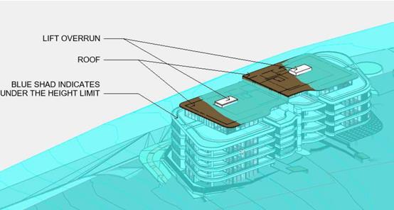

· Clause 4.1,
the proposed boundary adjustment relating to the two (2) torrens title lots
complies with the 1000m² minimum Lot size requirements. The minimum lot
size provisions do not apply to strata subdivision component of the proposal as
per Clause 4.1(4).
· Clause 4.4, the floor space ratio (FSR) of the proposal is
1.5:1 which complies with the maximum 1.5:1
floor space ratio applying to the site. The Applicant has amended the proposal
during the assessment of the application to propose a boundary adjustment
between the existing Lots 167 and 168 which has resulted in an amended
compliant calculation for the floor space ratio of the proposal.
· Clause 4.6, consent
must not be granted for a proposal that contravenes a development standard
unless the consent authority has considered a written request from the
applicant that justifies the variation by showing that the subject standard is
unreasonable or unnecessary and that there are sufficient environmental planning
grounds to justify the contravening of the standard.
As a result of the above, the
Applicant has submitted a Clause 4.6 variation to the standard based on the
following summarised reasons:
1. The
areas of non-compliance are limited and not throughout the entire development.
2. The non-compliance is primarily restricted to the lift
overruns and two small portions of the roof of the upper floor only, which is
stepped in from the levels below.
3. The exceedance relates to 6% over the height limit at
the worst points.
4. The site fall contributes to the variation in small
parts of the building, as well as the need for a lift overrun to extend above
the normal roof line. The building has been steps in the middle to minimise the
extent of variation.
5. No amenity or bulk issues relate from the
non-compliance and as such strict compliance would not achieve an added
benefit.
6. The development remains generally in keeping with the
envisaged bulk and scale for the area. The overall design is of a high standard
and the reduced footprint of the upper level assists in minimising bulk.
7. The minor non-compliances would not be discernible from
the public domain.
8. Strict compliance would require additional cut which
would have a greater impact on the public domain and amenity for the ground
level.
9. There
is no public benefit in strict compliance in this instance.
Having considered the
application and Clause 4.6 variation, the proposal will have limited impact on
the environment as per the reasons identified by the Applicant above. In
addition, it is also considered that the development:
· The topmost
level is set in from the primary façade of the lower 4 levels.
· The building
is stepped across the site to respond to the topography.
· Will provide
a height that meets the existing and proposed future character of the area.
· The
development contains significant sections of compliance with the standard.
· Compliance
with the standard would be unreasonable in this case given the minor nature of
the variations proposed and compliance with the FSR.
· The
development is consistent with the zoning and height objectives of the LEP 2011
and is unlikely to have any implications on State related issues or the broader
public interest.
· The floor to
ceiling heights are not excessive.
· There is
public interest in the efficient use of land within proximity to existing
services and infrastructure. Such development encourages walking, cycling and
use of public transport and decreases ongoing maintenance costs for public
infrastructure compared to lower density residential development. The height of
the building has helped maximise the FSR and true development potential of the
property.
· The
variations will not be readily visible due to the minor nature of the 6%
variation.
· The development
complies with the FSR requirement, which is an indicator of bulk and scale.
· There will
be negligible public domain impact.
· The
development is well articulated which further reduces the bulk of the building.
In considering the height variation, compliance with the
objectives of Clause 4.3 of the LEP have been considered below:
(a) to ensure that buildings are compatible with the
height, bulk and scale of the existing and desired future character of the
locality,
Comment:
The proposed building height varies across the site. The
building presents as a 5 storey building which is stepped down the site
responding to the site topography.
The top level of the building is set in from the sides of
the levels below and the majority of the building is within the recommended
building height.
The proposed height, bulk and scale of the development is
considered compatible with the desired future character of the locality
notwithstanding the sections of the roof of the building encroaching partially
above the 14.5m standard height limit.
(b) to minimise visual impact, disruption of
views, loss of privacy and loss of solar access to existing development,
Comment:
The proposed development and minor height variation is
unlikely to create any adverse view loss or overshadowing.
Potential privacy impacts have been satisfactorily
addressed in the building design.
(c) to minimise the adverse impact of
development on heritage conservation areas and heritage items,
Comment:
The site does not contain any known heritage items or sites
of significance.
(d) to nominate heights that will provide a
transition in built form and land use intensity within the area covered by this
Plan.
Comment:
The proposed height is considered to be consistent with the
future strategic heights for the locality. The minor variations do not
compromise this intent.
As per the Department of Planning and
Environment’s Planning Circulars PS 08-003 & 08-014, Council can
assume the Director’s Concurrence for variations to height limits. In
addition, the variation is less than 10% and able to be determined by DAP,
which provides transparency to the decision.
· Clause 5.9, no listed trees in Development Control Plan
2013 are proposed to be removed.
· Clause 5.10, the site does not contain any known heritage
items or sites of significance.
· Clause 7.7, a controlled activity approval shall be
obtained from the airport operator for any crane that may be used during the
construction phase that would penetrate the Obstacle Limitation Surface (OLS)
for the Port Macquarie Airport. To avoid any doubt as to whether an approval is
required, Applicants should check with the airport operator at the earliest
possible stage. An appropriate condition is recommended in this regard.
· Clause 7.9, the LEP maps identify this part of the site as
being subject to Acoustic Controls, most likely as it is at the top of the
site, with the remainder falling away towards the beach. The Part 3A Concept
Approval included an Acoustic Report prepared by Heggies. The Applicant has
submitted details that this report has been reviewed and a site specific
Acoustic Report has been prepared by Matrix Thornton which has regard to the
specific of Lot 167 and the proposed building.
Based on predictions for 2029, as considered in the Traffic
Noise Impact Assessment prepared by Heggies, Report 30-139-R1, Revision 1:
· Residences on the west façade, and on some levels on
the north facade require Category 2 materials. All other residences will have
satisfactory internal noise levels using Category 1 materials.
· Mechanical ventilation is not required to meet the noise
goals.
The submitted Matrix Thornton report has been assessed as
being satisfactory and appropriate conditions are recommended to ensure
compliance with its recommendations.
· Clause 7.13, satisfactory arrangements are in place for
provision of essential services including water supply, electricity supply,
sewer infrastructure, stormwater drainage and suitable road access to service
the development.
(ii) Any
draft instruments that apply to the site or are on exhibition:
The proposal
is not inconsistent with any of the proposed provisions of the Draft State
Environmental Planning Policy (Coastal Management) 2016.
(iii) any
Development Control Plan in force:
Port
Macquarie-Hastings Development Control Plan 2013
|
Residential Flat Development, Tourist and Visitor
Accommodation and Mixed Use Development
|
|
DCP Objective
|
Development Provisions
|
Proposed
|
Complies
|
|
3.3.2.2
|
Satisfactory site analysis plan submitted.
|
Satisfactory site analysis plan submitted.
|
Yes
|
|
3.3.2.3
|
Statement addressing site attributes and constraints
submitted.
|
Statement addressing site attributes and constraints
submitted.
|
Yes
|
|
3.3.2.4
|
Streetscape and front setback:
· Within 20% of
the average setback of the adjoining buildings.
· 3m setback to
all frontages if no adjoining development.
· 2m setback to
secondary frontages.
· Max. 9m setback
for tourist development to allow for swimming pool.
|
Minimal setback proposed and the site is zoned B4 mixed
use business. The front setbacks are varied with a zero front setback to the
future main street – proposed Ocean Blue Boulevard, a minimum
approximate 2.6m setback to Seaside drive and a minimum approximate 2.7m
setback to proposed Whitewater Terrace. The site is also a corner site.
|
N/A – commercial zoned site
|
|
3.3.2.5
|
Balconies and building extrusions can encroach up to 600mm
into setback.
|
N/A
|
N/A
|
|
Buildings generally aligned to street boundary.
|
Buildings generally aligned to street boundaries
|
Yes
|
|
Primary openings aligned to street boundary or rear of
site.
|
Primary openings aligned to street boundaries
|
Yes
|
|
3.3.2.6
|
Side setbacks comply with Figure 3.3-1:
· Min. Side
setback 1.5m for 75% of building depth.
· Windows on side
walls min. 3m from side boundary.
· 3m minimum where
adjacent to existing strata titled building.
|
Side setback to the east greater than 3m
|
Yes
|
|
Min. 6m rear setback (including sub basements)
|
No rear setback for property as it is a corner allotment.
|
Yes
|
|
3.3.2.11
|
Deep soil zones:
· Extend the width
of the site and have minimum depth of 6m.
· Are contiguous
across sites and within sites (see Fig 3.3-4).
|
423m² of deep soil zone or 16.7% of the site area is
proposed.
The location of the deep soil zone is satisfactory noting
the site is a corner allotment with no rear boundary.
|
Yes
|
|
3.3.2.12
|
Deep soil zones accommodate existing advanced trees, and
allow for advanced tree planting.
|
Deep soil zones can accommodate for advanced tree
planting.
|
Yes
|
|
3.3.2.13
|
Deep soil zones integrated with stormwater management
measures.
|
Deep soil zones are capable to have integrated stormwater
management measures.
|
Yes
|
|
3.3.2.14
|
Sunlight to the principal area of ground-level private
open space of adjacent properties should not be reduced to less than 3 hours
between 9.00am and 3.00pm on June 22.
|
No existing dwellings constructed on neighbouring
properties as yet. Overshadowing address later in this report.
|
N/A
|
|
Where existing overshadowing by buildings and fences is
greater than this, sunlight should not be reduced by more
than 20%.
|
|
|
Buildings should not reduce the sunlight available to the
windows of living areas that face north in existing adjacent dwellings to
less than the above specification.
|
|
|
3.3.2.15
|
Internal clothes drying space provided (not mechanical).
|
No internal clothes drying space. Considered no mandatory.
|
N/A
|
|
Ceiling fans provided in preference to air conditioning.
|
N/A – refer BASIX
|
N/A
|
|
Solar hot water systems (or equivalent technology)
provided.
|
N/A – refer BASIX
|
N/A
|
|
Photovoltaic arrays installed where practical.
|
The plans reference a 11.0 peak kilowatt system
photovoltaic system to be installed.
|
Yes
|
|
3.3.2.16
|
Landscape plan provided including:
· 35% soft
landscaping with minimum width of 3m.
· Existing
vegetation and proposed treatment.
· Details of hard
landscaping.
· Location of
communal recreational facilities.
· Species not to
obscure doors, paths, etc.
· Street trees in
accordance with Council’s list.
|
Satisfactory concept landscape plan submitted. Condition
recommended to required detailed landscaping plan. It is noted that the
proposed main street for the future village – proposed Ocean Blue Boulevard
has a development consent in place of the road itself conceptually with
specific details for construction including landscaping to be submitted prior
to issue of a Construction Certificate for that road. These two landscape
elements will be required to be integrated with each other.
|
Yes
|
|
3.3.2.17
|
Existing vegetation to be retained and nutrient-rich water
prevented from entering native gardens.
|
No existing vegetation on-site.
|
N/A
|
|
3.3.2.18
|
Landscape plan to demonstrate how trees and vegetation contribute
to energy efficiency and prevent winter shading on neighbouring properties.
|
Satisfactory concept landscaping plan submitted. Condition
recommended to submit a detailed landscaping plan prior to the issue of a
Construction Certificate.
|
Yes
|
|
3.3.2.19
|
Street trees in accordance with Council’s list.
|
A condition is recommended to require more details on
landscaping prior to issue of a Construction Certificate
|
Yes - capable
|
|
3.3.2.22
|
Fencing or landscaping defines public/communal and private
open space.
|
Fencing or landscaping defines public/communal and private
open space.
|
Yes
|
|
3.3.2.23
|
Solid fences should be:
· Max. 1.2m high,
· Setback 1m,
· Suitably
landscaped,
· Provide 3m x 3m
splay.
|
N/A
|
N/A
|
|
Where front fences higher than 1.2m:
· Max. 1.8m high,
· Landscaped
recesses for 50% of frontage, or length of fence not more than 6m or 50% of
street frontage.
· Min. 25%
transparent,
· 3m x 3m splay
for corner sites.
· 900mm x 900mm
splay at vehicle driveways.
|
1.5m high fences proposed setback from the front boundary
with landscaping and transparency in fencing.
|
Yes
|
|
3.3.2.24
|
Fencing materials consistent with or complimentary to
existing fencing in the street.
|
No existing fencing in the existing streets.
|
N/A
|
|
3.3.2.25
|
Fences constructed of chain wire, solid timber or masonry
and solid street not permitted, even if consistent with existing fencing in
the locality.
|
N/A
|
N/A
|
|
3.3.2.26
|
Building to be designed so that:
· Busy, noisy
areas face the street.
· Quiet areas face
the side or rear of the lot.
· Bedrooms have
line of site separation of at least 3m from parking areas, streets and shared
driveways.
|
Building designed so that:
· Busy, noisy
areas face the street.
· Bedrooms have
line of satisfactory site separation from parking areas, streets and shared
driveways.
|
Yes
|
|
Openings of adjacent dwellings separated by at least 6m.
|
No existing dwellings within 6m of the proposed building.
|
Yes
|
|
3.3.2.27
|
Building designed so noise transmission between apartments
is minimised.
|
Building designed so noise transmission between apartments
is minimised.
|
Yes
|
|
Uses are to be coupled internally and between apartments
i.e. noisy internal and noisy external spaces should be placed together. (See
Figure 3.3-6).
|
Uses are to be coupled internally and between apartments.
|
Yes
|
|
3.3.2.28
|
Development complies with AS/NZS2107:2000 Acoustic
– Recommended design sound levels and reverberation times for building
interiors for residential development.
|
A Noise Impact Assessment report has been submitted which
is satisfactory. Refer to this matter addressed later in this report under
addressed in detail under clause 7.9 of the LEP.
|
Yes – capable subject to conditions
|
|
3.3.2.29
|
Impact of noise from key public places to be considered.
|
|
3.3.2.31
|
Developments to be designed in accordance with AS 1428.
|
Development capable of compliance with the design
requirements of AS 1428. Specific details required to be submitted with the
application for Construction Certificate
|
Yes
|
|
3.3.2.32
|
Barrier free access to at least 20% of dwellings provided.
|
Barrier free access to all dwellings provided.
|
Yes
|
|
3.3.2.33
|
Developments located close to open space, recreation,
entertainment and employment.
|
The proposal is located on a site which has been planned
for a new Village centre at an appropriate high density
|
Yes
|
|
Where LEP permits FSR > 1:1, FSR not less than 1:1
should be achieved.
|
FSR greater than 1:1 proposed.
|
Yes
|
|
3.3.2.34
|
Variety of types - studio, 1, 2, 3 and 3+ bedroom
apartments
|
A variety of dwelling types are proposed
|
Yes
|
|
Studio and 1 bedroom apartments not > 20% of total
number of apartments.
|
Only 1 x 1 bedroom apartment proposed
|
Yes
|
|
Mix of 1 and 3 bedroom apartments at ground level.
|
Mix of 1 and 3 bedroom apartments at ground level.
|
Yes
|
|
3.3.2.35
|
Council’s Affordable Housing Strategy to be considered
for residential flat buildings.
|
A mix of dwelling types are proposed.
|
Yes
|
|
3.3.2.36
|
Lift over-runs and plant integrated within roof
structures.
|
Lift over-runs and plant integrated within roof
structures.
|
Yes
|
|
Outdoor recreation areas on roof tops to be landscaped and
incorporate shade structures and wind screens.
|
No common outdoor recreation area on rooftop. Penthouse
apartments have private outdoor recreation areas on rooftop of Level 3.
More details of landscaping can be provided prior to issue
of a Construction Certificate.
|
Yes
|
|
Outdoor roof areas oriented to the street.
|
Private outdoor roof areas oriented to the street.
|
Yes
|
|
Roof design to generate interesting skyline.
|
Roof design will generate an interesting skyline.
|
Yes
|
|
3.3.2.37
|
Facade composition should:
· Have balance of
horizontal and vertical elements.
· Respond to
environmental and energy needs.
· Incorporate wind
mitigation.
· Reflect uses
within the buildings.
· Include
combination of building elements.
|
Facade composition:
· provides a
balance of horizontal and vertical elements.
· responds to
environmental and energy needs.
· incorporates
wind mitigation.
· reflect uses
within the buildings.
· includes a
combination of building elements.
|
Yes
|
|
3.3.2.38
|
Building elements, materials and colours consistent or
complimentary to those existing in the street.
|
Building elements, materials and colours consistent or
complimentary to those existing in the street.
|
Yes
|
|
3.3.2.39
|
Entrances clearly identifiable from street level.
|
Entrances clearly identifiable from street level.
|
Yes
|
|
Entries provide clear transition between public street and
shared private circulation spaces/apartments.
|
Entries provide clear transition between public street and
shared private circulation spaces/apartments.
|
Yes
|
|
Entries provide clear line of sight between one
circulation space and the next.
|
Entries provide clear line of sight between one
circulation space and the next.
|
Yes
|
|
Entries avoid ambiguous and publicly accessible small
spaces in entry areas.
|
Entries avoid ambiguous and publicly accessible small
spaces in entry areas.
|
Yes
|
|
Entries sheltered and well lit.
|
Entries sheltered and well lit.
|
Yes
|
|
Entries and circulation spaces sized for movement of
furniture.
|
Entries and circulation spaces sized for movement of
furniture.
|
Yes
|
|
Lobby width minimum 2.5m wide and 3.0m high.
|
Lobby width > minimum 2.5m width however 2.8m height
approximately
|
Yes * No* minor variation of 0.2m in height acceptable
given two lobbies proposed and well designed with natural light and
ventilation available
|
|
Corridor lengths minimised and avoid tight corners.
|
Corridor lengths minimised and avoid tight corners.
|
Yes
|
|
Longer corridors articulated by:
· Changing
direction and width.
· Utilising series
of foyers.
· Incorporating
windows.
|
Longer corridors articulated by changing direction and
windows are provided.
|
Yes
|
|
3.3.2.40
|
Minimum 1 balcony per apartment.
|
1 balcony per apartment.
|
Yes
|
|
Main balcony accessible from living area.
|
Main balcony accessible from living areas.
|
Yes
|
|
Balconies take advantage of favourable climatic
conditions.
|
Balconies take advantage of favourable climatic
conditions.
|
Yes
|
|
Balconies and balustrades balance privacy and views.
|
Balconies and balustrades balance privacy and views.
|
Yes
|
|
3.3.2.41
|
Balconies include sunscreens, pergolas, shutters and
operable walls.
|
Balconies include screens, shutters and satisfactory
shading.
|
Yes
|
|
Balconies recessed to create shadowing to facade.
|
Balconies recessed to create shadowing to facade.
|
Yes
|
|
Solid balustrades discouraged.
|
Solid
balustrades are discouraged but may be considered where it is demonstrated
that outlook and privacy is achieved and that there is sufficient
articulation or visual interest in the building facade to accommodate the
solid element.
|
yes
|
|
Air conditioning units not visible from the street.
|
No air conditioning units proposed.
|
N/A
|
|
3.3.2.42
|
Secure open air clothes drying facilities that are:
· easily
accessible,
· screened from
public domain and communal spaces,
· located with
high degree of solar access.
|
No outdoor clothes drying facilities.
|
N/A
|
|
3.3.2.43
|
Mailboxes integrated into building design and sighted to
ensure accessibility and security.
|
Mailboxes integrated into building design and sighted to
ensure accessibility and security.
|
Yes
|
|
3.3.2.44
|
Public and private space clearly defined.
|
Public and private space clearly defined subject to more
specific details on landscaping
|
Yes - capable
|
|
Entrances:
· oriented to
public street,
· provide direct
and well lit access between car parks, lift lobbies and unit entrances,
· optimise
security by grouping clusters (max. 8) around a common lobby
|
Entrances:
· oriented to
public street,
· provision of
direct and capability for well lit access between car parks, lift lobbies and
unit entrances,
· optimise
security by grouping clusters around a common lobby
|
Yes
|
|
Surveillance facilitated by:
· views over
public space from living areas,
· casual views of
common internal areas,
· provision of
windows and balconies,
· separate entries
to ground level apartments.
|
Surveillance facilitated by:
· views over
public space from living areas,
· casual views of
common internal areas,
· provision of
windows and balconies,
· separate entries
to ground level apartments.
|
Yes
|
|
Concealment avoided by:
· preventing dark
or blind alcoves,
· providing
lighting in all common areas,
· providing graded
car parking illumination (greater at entrances).
|
Concealment avoided by:
· preventing dark
or blind alcoves,
· providing
lighting in all common areas,
·
|
Yes
|
|
Access to all parts of the building to be controlled.
|
Access to all parts of the building to be controlled.
|
Yes
|
|
3.3.2.45
|
Accessible storage provided for tenants in basement car
park or garages.
|
Accessible storage provided for tenants in basement car
park or garages.
|
Yes
|
|
One bike stowage space per dwelling provided.
|
Bicycle storage areas proposed in basement
|
Yes
|
|
3.3.2.46
|
For developments of < 6 dwellings individual waste
management permitted. Designated area to be provided for storage of bins:
· not visible from
street,
· easily
accessible,
· not adjoining
private or communal space, windows or clothes drying areas,
· on hard stand
area,
· close to street
and a tap for washing,
· maintained free
of pests.
|
Communal bulk waste facilities integrated into development
and located at basement level.
|
Yes
|
|
Communal bulk waste required where:
· > 6
dwellings, or
· Number of bins
wouldn’t fit in street frontage, or
· Topography would
make street collection difficult.
|
Communal bulk waste facilities integrated into development
and located at basement level.
|
Yes
|
|
Communal bulk waste facilities integrated into development
and located at ground or sub-basement level.
· Not visible from
street,
· Easily
accessible,
· Can be serviced
by collection vehicles,
· Not adjoining
private or communal space, windows or clothes drying areas,
· Has water and
drainage facilities for cleaning,
· Maintained free
of pests.
|
Communal bulk waste facilities integrated into development
and located at basement level.
|
Yes
|
|
Evidence provided that site can be serviced by waste
collection service.
|
Private waste collection proposed and required as a
recommended condition of consent.
|
Yes
|
|
3.3.2.47
|
Common trenching of utility services where possible.
|
Services capable of being provided to proposal all
underground
|
Yes
|
|
Above ground utility infrastructure integrated with
building design.
|
Above ground utility infrastructure required to be
integrated with building design. Substation location details are to be
provided with the application for construction certificate.
|
Yes- capable
|
|
Site and individual units numbered.
|
Site and individual units can be appropriately numbered.
|
Yes - capable
|
|
Common aerials and satellite dishes provided.
|
Common aerials and satellite dishes can be appropriately
provided.
|
Yes - capable
|
|
DCP 2013: General Provisions
|
|
DCP Objective
|
Development Provisions
|
Proposed
|
Complies
|
|
2.7.2.2
|
Design addresses generic principles of Crime Prevention
Through Environmental Design guideline:
· Casual
surveillance and sightlines
· Land use mix and
activity generators
· Definition of
use and ownership
· Lighting
· Way finding
· Predictable
routes and entrapment locations
|
The proposed development will be unlikely to create any
concealment/entrapment areas or crime spots that would result in any
identifiable loss of safety or reduction of security in the immediate area.
The increase in housing density will improve natural surveillance within the
locality and openings from each dwelling overlook common and private areas.
|
Yes
|
|
2.3.3.1
|
Cut and fill 1.0m max. 1m outside the perimeter of the
external building walls
|
Cut and fill 1.0m max. 1m outside the perimeter of the
external building walls
|
Yes
|
|
2.3.3.2
|
1m max. height retaining walls along road frontages
|
Approximate 1m max. height retaining walls along road
frontages stepped to respond to topography
|
Yes
|
|
Any retaining wall >1.0 in height to be certified by
structural engineer
|
Condition recommended to require engineering certification
for project.
|
Yes
|
|
Combination of retaining wall and front fence height
|
Combination of retaining wall and front fence heights
satisfactory
|
Yes
|
|
2.3.3.8 onwards
|
Removal of hollow bearing trees
|
No tree removal proposed.
|
N/A
|
|
2.6.3.1
|
Tree removal (3m or higher with 100mm diameter trunk and
3m outside dwelling footprint
|
No tree removal proposed.
|
N/A
|
|
2.4.3
|
Bushfire risk, Acid sulphate soils, Flooding,
Contamination, Airspace protection, Noise and Stormwater
|
Refer to main body of report.
|
Yes
|
|
2.5.3.2
|
New accesses not permitted from arterial or distributor
roads. Existing accesses rationalised or removed where practical
|
New access proposed from proposed Whitewater Terrace.
|
Yes
|
|
Driveway crossing/s minimal in number and width including maximising
street parking
|
Driveway crossing from future Whitewater Terrace minimal
in width including maximising street parking
|
Yes
|
|
2.5.3.3
|
Off-street parking in accordance with Table 2.5.1:
· 1 space = single
dwelling (behind building line) and dual occupancy
· Medium density
– 1 per 1 or 2 bed dwelling or 1.5 per 3-4 bed dwelling + 1 visitor/4
dwellings
|
N/A refer to parking assessment under the RMS Traffic
Generating Guide called up by the SEPP 65 Apartment Design Guideline.
|
N/A
|
|
2.5.3.5
|
On-street parking permitted subject to justification
|
On-street parking not reliant upon for required parking
provision.
|
N/A
|
|
2.5.3.7
|
Visitor parking to be easily accessible
|
Visitor parking easily accessible in basement parking
area.
|
Yes
|
|
Parking in accordance with AS 2890.1
|
Parking and driveway widths on site can comply with
relevant Australian Standards (AS 2890) and conditions have been imposed to
reflect these requirements. Due to the type of development, car park
circulation is required to enable vehicles to enter and exit the site in a
forward manner.
|
Yes - capable
|
|
2.5.3.9
|
Bicycle and motorcycle parking considered and designed
generally in accordance with the principles of AS2890.3
|
Bicycle parking/storage is available within the Basement 2
level. Motorcycles could be parked in this space.
|
Yes
|
|
2.5.3.11
|
Section 94 contributions
|
Refer to main body of report.
|
Yes
|
|
2.5.3.12 and 2.5.3.13
|
Landscaping of parking areas
|
No specific landscaping of parking areas as basement
parking proposed with a private driveway connecting to future Whitewater
Terrace.
|
N/A
|
|
2.5.3.14
|
Sealed driveway surfaces unless justified
|
Sealed driveway surfaces required
|
Yes
|
|
2.5.3.15
|
Driveway grades for first 6m of ‘parking area’
shall be 5% grade
(Note AS/NZS 2890.1 permits steeper grades)
|
Parking and driveway widths on site can comply with
relevant Australian Standards (AS 2890) and conditions have been imposed to
reflect these requirements.
|
Yes
|
|
2.5.3.16
|
Transitional grades min. 2m length
|
|
2.5.3.17
|
Parking areas to be designed to avoid concentrations of
water runoff on the surface.
|
The carparking areas are proposed within basement levels
of the building. The access driveway is partly uncovered.
|
Yes
|
|
Vehicle washing facilities – grassed area etc
available.
|
No vehicle washing facilities are proposed as only
encourage by the DCP.
|
N/A
|
|
No direct discharge to K&G or swale drain
|
No direct discharge to K&G or swale drain
|
Yes
|
|
2.5.3.18
|
Car parking areas drained to swales, bio retention, rain
gardens and infiltration areas
|
The carparking areas are proposed within basement levels
of the building
|
N/A
|
DCP 2013 – 5.2.2 Rainbow Beach
There are area-based placed provisions in place for the
subject locality which forms part of a planned Precinct B within Rainbow Beach,
also known as Area 14 or the Lake Cathie – Bonny Hills Growth Area.
The subject site is within the future Hilltop Village which
is desired to include a mix of permanent residential accommodation and tourist
accommodation units.
The
desired outcomes for the precinct include:
• A new village centre is
established as the primary retail, commercial and community focus of the
precinct, and
• Development provides
a mix of living options with higher density residential areas within walking
distance to the village centre.
Precincts
B is referenced in the DCP provisions as being subject to the following Concept
Approval under the repealed Part 3A of the Environmental Planning and
Assessment Act 1979 (Part 3A). The following are generalised summaries of
the approval:
Precinct
B
07_0010
Residential, Commercial and Tourist Development (Concept Plan) being an approval for:
• residential uses
for about 217 low density dwellings and about 82 medium density dwellings;
• a ‘Hill-Top
Village’ neighbourhood centre, including tourist and residential uses of
about 160 apartments;
• environmental
works associated with the Littoral Rainforest and Duchess Creek;
• provision of
perimeter road, pedestrian, cycle paths and opens space and access to Rainbow
Beach; and
• provision of
associated infrastructure including stormwater, drainage and utilities.
Lot
167 (the development site) is identified as M10 on the staging plan.
The Part 3A Concept Approval
(07_0010) sets out the vision for the site and requires separate development
consent to be obtained for the individual buildings. The overall site is being
developed by two different parties and Catarina Estate forms the southern
portion. Lot 167 is the first building in Hilltop Village which will be
prominent upon entry into Catarina Estate and Main Street.
An extract of the Concept Approval
is shown below:
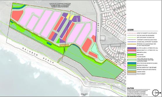
The Concept Approval includes several conditions and a
Statement of Commitments.
The following comments are provided having regard to the
Concept Approval and the DCP Development Provisions:
· The Part 3A Concept Approval acknowledged that the LEP for
a building height up to 14.5m for the subject site.
· Stormwater requirements are addressed later in this report
including recommended conditions.
· The design has been based on the roads approved to three
sides of the site.
· No areas subject to environmental works are located near
the subject site.
· Specific conditions are recommended to address geotechnical
assessment requirements prior to works commencing on-site.
· Likely traffic impacts in the locality have been assessed
as being acceptable as addressed later in this report. No upgrades to road
intersections are required.
· One of the principle findings of the concept plan
application was to ensure that the proposed buildings in the Hilltop Village
are not visible from Rainbow Beach. This has been demonstrated in the submitted
details.
· The road network
providing the frontage to the subject site has been approved under DA2012
– 381.
· A Village Square
with an area of 2750m² was recommended to be provided generally in
accordance with the following diagram:
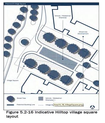
· The Applicant has
submitted an alternate design to what was indicatively shown on the DCP. More
specifically, the Applicant has provided the following specific satisfactory
details to justify the suitability of the design submitted:
As part of the design of the building on
Lot 167 and the design of Main Street / Ocean Blue Boulevard, the Village
Square area has been refined. The key principle is of a pedestrian friendly
main street in the Hilltop Village and a meeting area. Main Street is
accessible by vehicles and the proposed design shown below in Figure 14
indicates the treatment proposed to provide a pedestrian and vehicular shareway
and to provide a connection from the café and outdoor seating area on
Lot 167 and any future development to the north. The Streetscape Strategy for
the area contains furniture, planting, bollards and a change of road materials
(refer to Figures 14 and 15). The timber used in the building has been extended
into the street furniture and bollards and the landscaping design incorporates
both private and public land. The walls and pathways are curved to respond to
the building and provide linkages to the ground floor café and outdoor
seating area, as well as the main entrances to the building and grassed areas
in the north-eastern corner of the site.
Consultation has been undertaken with the
Consultants for the owners of land to the north regarding their plans for the
development of the northern side of the Hilltop Village, however they do not
have plans at this stage. As such, we have interpreted the intent of the Part
3A consent and DCP to provide a connection from the ground floor of the
building by way of a café, landscaping, grassed areas and a vegetated
pergola to a pedestrian friendly, traffic slowed area along Main Street (refer
to Figure 16). It is envisaged that any building to the north would also have
an orientation and connection to Main Street in this section. The master
planning for the remainder of Hilltop Village also includes a pedestrian
friendly village square will also be provided at the eastern end, in
conjunction with the pocket park. Overall, the required amount of area for the
Village Square will be well in excess of that required by the approval and DCP.
…….
Lot 167 is the first
allotment adjoining the Village Square. The design will allow for a Village
Square over part of the subject site, main road and the northern lot which is
consistent with the approximate area approved. The Village Square comprises the
eastern portion of the site including outdoor seating and grassed areas,
footpaths, landscaping and Main Street. The ideology of the Village Square has
been adopted from the exhibit, with the café, outdoor seating and open
space orientated to the north to form the southern edge of the Village Square
and it can be reasonably assumed this will occur on the northern lot also. The
remainder of the Hilltop Village to the east will extend along Main Street and
continue the landscaping, street furniture and paving theme and provide a
connection via the pathways. This will allow for the Village Square to continue
down Main Street and into the remainder of Hilltop Village.
· During the assessment of the application, with
respect to the Village Square, the plans have been amended to reflect more
certainty as to the overall design intent for the area. The café,
outdoor seating and grassed areas all form the southern edge of the Village
Square and there will be a relatively level transition to the road and onto the
future northern side of the square (to be developed by different property
developer). It is also noted that a substantial open space area is planned on
the eastern-most end of the Village Square.
· The alternate design with regard to the
Village Square fulfils the following requirements as embodied in the DCP
concept:
o Presents an attractive,
landscaped entrance to the main street, and offers some natural and built
shade;
o Provides for safe pedestrian
circulation around and across the main street, with delineation of movement
areas through paving design and kerb treatment to be detailed in construction
plan details under DA2012 – 381;
o While the eastern entrance is
not envisaged in this proposal as a ‘town square’ there is
opportunity for public furniture such as a bench for seating in a shaded area -
for example as a meeting point;
o The landscaped areas and road
will ultimately be dedicated to Council so a low maintenance solution is
preferred.
The
above commentary demonstrates that satisfactory consideration to the objectives
of the DCP and Part 3A approval have been given and the proposal is recommended
to be supported in this regard.
Having regard to the DCP provisions, it should be noted that
the following preamble applies to the assessment of Development Applications:
Variations
Council
may consider varying the development provisions where it can be adequately
demonstrated that the objective to which the provision relates can be wholly
achieved by reasonable or innovative solutions and the proposal is consistent
with all relevant LEP aims and Zone Objectives.
Based on the above assessment, the variation proposed to the
provisions of the DCP is considered acceptable and the relevant objectives have
been satisfied. Cumulatively, this variation does not amount to an adverse
impact that would justify refusal of the application.
(iiia) any
planning agreement that has been entered into under Section 93f or any draft
planning agreement that a developer has offered to enter into under Section
93f:
The
landowners within Area 14 have previously entered into Voluntary Planning
Agreements for the purposes of Section 93F of the Act in relation to the
rezoning of the land. The Seawide Area 14 Stage 1B Planning Agreement and the
Milland Area 14 Stage 1B Planning Agreement between Council and the landowners
were executed on 14 September 2011. The landowners agreed to make Development
Contributions in accordance with the VPAs in connection with carrying out of
development permitted by the LEP.
The
VPAs provide for the carrying out of works by the landowners including
establishing and maintaining environmental lands, road works, local park
embellishment, pedestrian beach access and dedication of land to Council.
The agreements also include arrangements for payment of development
contributions towards management of environmental lands, administration levy
contribution, open space and roads contributions.
The subject
proposal does not trigger any requirements of any of these Planning Agreements.
It is also noted that the Area 14 Section 94 Local Roads Contributions Plan has
come into effect since the original subdivision under DA2012 – 381 was
approved.
iv) any matters prescribed by the
Regulations:
New
South Wales Coastal Policy:
The proposed development is
consistent with the objectives and strategic actions of this policy.
v) any
coastal zone management plan (within the meaning of the Coastal
Protection Act 1979), that apply to
the land to which the development application relates:
No Coastal
Zone Management Plan applies to the subject site.
(b) The
likely impacts of that development, including environmental impacts on both the
natural and built environments, social and economic impacts in the locality:
Context & Setting
The proposal will be unlikely to have any adverse impacts to
existing adjoining properties and satisfactorily addresses the public domain.
The proposal is considered to be
consistent with the desired character for the locality and adequately addresses
planning controls, including variations to recommended standards as justified.
There are no adverse identifiable adverse impacts on
existing view sharing. This is the first building at
the Hilltop Village.
There are no identifiable adverse
privacy impacts to neighbouring properties.
Overshadowing
The relevant standards for overshadowing adopted in
Development Control Plan 2013 are:
(a) Sunlight
to the principal areas of ground-level private open space of adjacent
properties should not be reduced to less than 3 hours between 9am and 3pm on 22
June. Where existing overshadowing by buildings and fences is greater than
this, sunlight should not be reduced by more than 20%.
(b) Buildings
should not reduce the sunlight available to the windows of living areas that
face north in existing adjacent dwellings to less than the above specification.
The relevant design guidance for overshadowing of
neighbouring properties in mid winter in the adopted SEPP 65 Apartment Design
Guide are:
Living areas, private open space and communal open space
should receive solar access in accordance with sections 3D Communal and public
open space and 4A Solar and daylight access.
A minimum 50% direct sunlight to
the principal usable part of the communal open space for a minimum of 2 hours
between 9am and 3pm on 21 June (mid winter).
In this instance, the Applicant was requested during the
assessment of the application to specifically address the likely impacts of
shadowing to neighbouring properties. The following additional information was
provided by the Applicant:
· The
overshadowing impact has been shown on the shadow diagrams submitted previously
and pasted below. It is known that these sites directly to the south are likely
to experience some overshadowing. The design of the proposed building has had
regard to overshadowing impacts, hence the narrow northern and southern
elevations to minimise the shadow impact.
· The
diagrams demonstrate that at the worst point in mid-winter, the overshadowing
is shared over roads or a small portion of a residential lot to the south at
9am. However, it is cleared by 12pm where the impact is on the road only.
· The area
which falls onto a residential lot at 9am has been highlighted in red below.
The diagrams show extra shadow beyond this DA, relating to future DA’s
and therefore the impacts appear worse than experienced and should be
discarded.
· Whilst
there is some impact on the residential lot to the south at 9am, it is cleared
by midday and therefore the solar access requirements are satisfied.
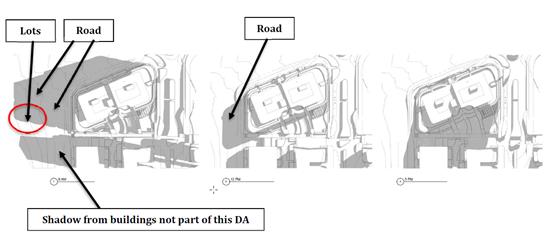
The shadow angles and lengths shown in the submitted plans
have been reviewed and are considered to be accurate and reasonable to comply
with the above DCP and SEPP 65 Apartment Guide requirements.
Roads
The site has existing road frontage to Seaside Drive, a
public urban Collector road owned and maintained by Council. The road width
ranges between 11m and 9m, within a 19m wide (minimum) road reserve. Seaside
Drive was constructed as part of the parent subdivision DA 2012/381 and is the
primary access route to the site. Due to the projected commercial truck traffic
along this road in connection with the future Hilltop Village commercial and
medium density residential uses, the pavement has been designed to Commercial
standard.
Future Road 7 (Ocean Blue Boulevard) is planned to run along
the northern boundary of the site in a west-east direction to connect Seaside
Drive to Surfers Drive. Design and construction of this road has been considered
under existing DA 2012/381, although no construction design has yet been
submitted by the developer(s) for approval at this time. Those DA conditions of
consent specify Road 7 as a Commercial street within a 25m road reserve.
Future Road 9 (Whitewater Terrace) will adjoin the southern
boundary of the site, also aligned in a west-east direction between Seaside Dr
and Surfers Dr. A Construction Certificate for Road 9 has been approved,
although the road has not been constructed and dedicated to Council.
Although this DA is proposed to be approved prior to
dedication of both of these east-west roads, the roads are considered critical
links to enable traffic distribution and forwards circulation around the
Hilltop Village. Considering the extensive village centre master plan road
works, there is also currently a risk of road, footpath and driveway slopes and
surface levels not matching up with the proposed development levels at the
boundary. As such, a condition of consent has been recommended requiring road
construction plans to be approved prior to Construction Certificate for the
building, and dedication of the roads to Council prior to issue of the
Occupation Certificate for the building.
The proposal involves excavation below the zone of influence
of soil supporting the existing and future road reserves (due to the deep
basements) and expert engineering will be required for both the temporary and
permanent shoring and underpinning of the road. A special bond is to be taken
and dilapidation report recorded for this purpose for the duration of
construction.
The parent subdivision for Catarina estate is also subject
to a previous Part 3A (Major Projects) Concept Approval. One of the
requirements of that approval (project reference number MP07_0010, Statement of
Commitments, commitment CP12) is that for a medium density building DA such as
this in the Hilltop Village, geotechnical testing and an assessment of slope
stability is required by a suitably experienced engineer to ensure that all
appropriate measures are incorporated into the structural foundation design.
This may also extend to road support given the substantial basement excavation.
As such, conditions of consent for this study is required prior to any
Construction Certificate for building works.
Refer to relevant conditions of consent.
Traffic and Transport
Previous Traffic Impact Assessments (TIA) relevant to the
site include a report by RoadNet (April 2010) for the parent subdivision which
was lodged under DA 2012/381. This TIA primarily dealt with traffic volume
projections along the Ocean Drive/Road 1 (Seaside Drive) corridor, and
modelling of the Ocean Drive / Road 1 intersection performance. Earlier TIAs
also exist but provide no specific considerations relevant to this DA, so are
not discussed here.
The intersection of Road 1 (Seaside Drive) and Ocean Drive
is planned and funded for upgrade by Council under a local Contributions Plan.
It is understood that the intersection will need to be upgraded around 2019 and
will have adequate capacity and service levels until that time to cater for new
development traffic.
Previously Forecast Traffic
A subsequent TIA by Transport & Urban Planning (January
2014) for the Seawide estate and adjoining developments including Catarina
(this site, formerly known as Milland) provided further analysis of trip
generation rates associated with the current lot layout. It concluded that 150
medium density dwellings across the R3 and B4 zoned land in Catarina estate
would be expected to generate 128 trips during both the AM and PM daily
commuter peak hour periods. Further, traffic arising from approximately
3,000sqm of commercial floorspace was predicted to equate to 103 trips in the
AM peak and 360 PM peak hour trips.
For the purpose of assessing the proposed residential
component of the development, by distributing the 128 AM and 128 PM peak trips
predicted in the 2014 TIA across the 30,000sqm of R3 and B4 zoned land within
Catarina, the 2,500sqm site of this development is allocated approximately 11
peak hour trips from the total demand, or 13 medium density (2-3 bedroom)
dwellings assuming a peak trip generation rate of 0.85 per dwelling.
Similarly distributing the commercial trips forecast
in the 2014 TIA, the site area of 2,500sqm can be allocated a commercial trips
credit of 360 PM trips x 2,500 / 30,000 = 30 trips in the PM peak. During the
AM peak, the forecast commercial rate was 103 trips, or 9 trips allocated to
this development.
Proposed Traffic
A new TIA by Streetwise Road Safety and Traffic Services Pty
Ltd (dated April 2017) has been lodged as part of this specific development
proposal. This TIA notes that 41 dwellings (residential units) are proposed
with an anticipated peak traffic of 27 trips per hour using rates from the RMS
Guide to Traffic Generating Developments 2002. The proposed development
substantially exceeds the previously anticipated traffic intensity in terms of
medium density residences, by approximately (27 – 11) = 16 trips per peak
hour.
The proposal includes 55sqm of serviced café floor
area and approximately 100sqm of external seating, which at a rate of 60 trips
per day per 100sqm (from the TIA, which uses the rate from the RMS Guide),
equates to a likely maximum 93 trips per day, or approximately 9 in the peak
hour periods. This would be a reduction of (9 - 30) = 21 trips during the PM
peak.
Figure: Trip
generation summary for previous forecast versus the proposed development
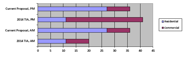
The development has effectively
proposed a smaller than expected commercial floor space, and larger than
expected residential component, with a resulting small net traffic decrease
during the PM peak and a net traffic increase of 16 vehicles during the AM peak
hour. Having regard to the above traffic volumes, the existing road network has
sufficient capacity to cater for the development, and it is not considered
necessary to alter the timing of delivery of the major intersection with Ocean
Drive.
The development proposes significant cut volumes for the
multi-level basement which will need to be exported from site for disposal or
use elsewhere. To protect the public road, existing road conditions shall be
evaluated as part of a dilapidation report and bond securities held prior to
any earthworks. Details shall be provided as part of a Roads Act (Section 138)
application.
Roads and Maritime Services (RMS) – Ocean Drive
Ocean Drive, which serves the development precinct, is an
RMS classified regional road. However, the scale of this Residential Flat
Building development is not significant enough to trigger referral of the
proposal to RMS under the SEPP (Infrastructure) 2007 provisions, and as no
works are required within the Ocean Drive road reserve, a Roads Act (s138)
referral will also not be required.
Site Frontage & Access
Vehicle access to the site is proposed though an individual
driveway to the basement car parking via Road 9 (Whitewater Terrace). Access
including gradients shall comply with Council’s AUSPEC and Australian
Standards, and conditions have been imposed to reflect these requirements.
Due to the type and size of development, provision of at
least 1.2m wide concrete footpath paving along two (2) of the three (3) street
frontages – being Ocean Drive/Road 1 Seaside Drive and Road 9 (Whitewater
Terrace) of the new building will be required.
DA 2012/381 originally proposed a
public laneway servicing this and adjoining properties at the location of the
proposed private access driveway. To ensure the function of the laneway
is maintained, consent conditions have been imposed consistent with current
approved plans for DA 2012/381 requiring a “Right of Access” be
created over the development driveway burdening proposed development lot (Lot
167) and benefiting proposed lots to east (Lots 73 & 75).
The below image extract shows the current approved road and
subdivision layout under DA2012 – 381 as modified:
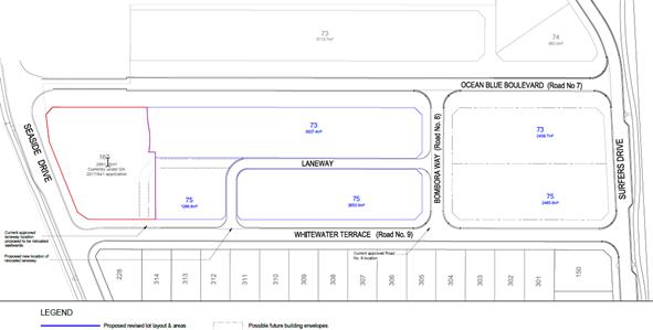
Parking and Manoeuvring
66 allocated residence spaces (including two disability
spaces), 9 visitor spaces, and 5 café parking spaces have been provided
on-site across three basement parking levels, for a total of 80 parking spaces.
Note there is a discrepancy with labelling of spaces on the DA approved plan, with
RES 52 to RES 54 not shown.
SEPP No 65 (Design Quality of
Residential Apartment Development) stipulates that a development cannot be
refused on the basis of parking provision if the number of spaces required in
Part 3J of the Apartment Design Guide is provided onsite. The Apartment Design
Guide requires, for sites within 400m of land zoned B4 Mixed Use, minimum
parking provision in line with the RMS Guide to Traffic Generating
Developments (High Density Residential Flat Buildings with greater than 20
dwellings and located in sub-regional centres) or the Council’s DCP,
whichever is less.
|
|
No. of residences
|
Parking rate
(RMS Guide)
|
Subtotal Required
|
|
1 Bedroom
|
1
|
0.6
|
0.6 (1)
|
|
2 Bedroom
|
21
|
0.9
|
18.9 (19)
|
|
2 Bedroom + Study
|
8
|
0.9
|
7.2 (8)
|
|
3 Bedroom
|
11
|
1.4
|
15.4 (16)
|
|
Visitor
|
|
1 per 5 units
|
8.2 (9)
|
|
Café
|
55 + 90 sqm
|
1 per 30 sqm
|
4.8 (5)
|
|
Total
|
41
|
|
44 residential spaces +
9 visitor spaces +
5 café spaces =
Total of 58 spaces required
|
The proposal has met or exceeded the minimum requirements
for onsite parking provision with 66 residential spaces + 9 visitor spaces + 5
café spaces = total of 80 parking spaces provided on-site.
Parking and driveway widths on site can comply with relevant
Australian Standards (AS 2890) and conditions have been imposed to reflect
these requirements. Due to the type of development, car park circulation is
required to enable vehicles to enter and exit the site in a forward
manner. Provision of a dedicated turnaround bay at the end of each blind
aisle to comply with AS 2890.1, including line marking will be required. For
example, convert space RES 69 in Basement 1 and RES 23 in Basement 3 to
dedicated turning bays. There is more parking provided than the minimum required
therefore some loss of parking can be accommodated to satisfy these
requirements.
Water Supply Connection
Council records indicate that the
development site does not have a water connection.
Final water service sizing will need to be
determined by a hydraulic consultant to suit the domestic and commercial
components of the development, as well as fire service and backflow protection
requirements in accordance with AS 2419.
The existing potable and reclaimed water
mains must be extended down Road 7 and Road 9 to the development lot’s
boundaries. Water main sizes are to be determined by PMHC’s Water Supply
Section.
Each proposed units are required to be
individually metered for water.
Refer to relevant conditions of consent.
Sewer Connection
Council records indicate that the
development site is connected to Sewer via junction to the existing sewer line
that runs along the northern property boundary.
The development must discharge all sewage
to a single direct connection to an existing or proposed sewer manhole. Any
disused sewer junctions must be capped at the main.
A separate sewer connection to Councils main is required for
each adjusted Torrens Title lot. A manhole will also be required at the high
end of the line as it will be more than 40m long.
If the main is subject to future extension an end of line
terminal shaft (poo pit) will be required.
As the dwellings are to be Strata Titled, a private sewer
system can be adopted, connected from a single manhole junction or each
dwelling can be connected directly to Council main with individual connections.
As the development will exceed 2ET discharge, sewer
connection is to be made from a manhole.
The hydraulic designer is to confer with Council sewer
section prior to submitting sewer design plans.
The proposed ground floor café will likely require a
trade waste system to be installed. Appropriate conditions are recommended
including a requirement for a first use DA to be submitted to Council.
Detailed plans will be required to be submitted for
assessment with the S.68 application.
Refer to relevant conditions of consent.
Stormwater
The site naturally grades towards the south, and there have
been significant alterations of the landform with earthworks for the parent
subdivision, creating two separate drainage sub-catchments to the southwest and
southeast.
The legal point of discharge for the proposed development is
defined as a direct piped connection to Council’s drainage network in
Seaside Drive and/or future Road 9 (Whitewater Terrace). A concept stormwater
plan has been provided to this effect.
A detailed site stormwater management plan will be required
for assessment with the S.68 application and prior to the issue of a
Construction Certificate.
Subdivision of the surrounding estate under DA 2012/381
included provision of end-of-line stormwater basins with the dual purpose of
detaining peak outflows from the precinct (so that they were not to exceed
pre-development peak flows) and also reducing pollutant and nutrient runoff levels
to acceptable limits, as per Council’s AUSPEC requirements for
subdivision. Provided the proposed development would not exceed the parameters
assumed in the original design (such as percentage of impervious area, flow
paths, and pollutant loads), normally these end-of-line facilities would be
deemed capable of supporting the new development.
However, at this stage there appears to be an inconsistency
with the approved drainage master plan, in that an area of land approximately
equal to this site’s footprint (3000sqm) will drain towards the
south-eastern sub-catchment rather than the southwest as originally designed.
As such, the south-eastern basin may be potentially overwhelmed and additional
detention and quality treatment capacity may need to be built into the system.
A condition of consent has been recommended to have the
developer resolve this with the detailed design plans (Local Government Act s68
application to Council), and there are a number of ways this could be achieved:
a) Reorient
the points of discharge for both piped and overland flows so that no additional
detention and quality treatment is required, as catchment hydrology (including
land areas draining to pits) remains the same as previously approved; or
b) Provide
adequate additional detention and water quality treatment within the site of
the Residential Flat Building (and not within the public road reserve); and
c) Provide
additional detention and water quality treatment within the next future Hilltop
Village DA to offset the increased stormwater discharge form the proposed
development site, including the provision of a restriction as to user on the
title of the residue lot to advise potential purchasers of this requirement,
prior to or concurrently with approval of the Subdivision Certificate for the
boundary adjustment.
The lower basement storeys are not
capable of being drained by gravity to the public network, so provision of a
sump, pump and backup pump (including backup power) will be required with all
details as per Council’s AUSPEC standards. This is to ensure that flows
arising from minor subsoil seepage into the basement, or incidences such as
open-air driveway pit blockages, are captured and disposed of without flooding
the basement.
Other Utilities
Telecommunication and electricity services are available to
the site. A standard condition is recommended to require provision of
confirmation of satisfactory arrangements from providers prior to issue of an
Occupation Certificate.
Heritage
Refer to comments on heritage in the LEP section of this
report.
Other land resources
The site is within an established urban context and will not
sterilise any significant mineral or agricultural resource.
Water cycle
An issue raised during the original Part 3A Concept Approval
MP07_0010 and subsequent DA 2012/381 for the precinct surrounded the potential
impacts of excavation below natural surface level on subsurface aquifers.
Specifically, there is the potential that one or more aquifers supplies the
Littoral Rainforest adjacent to the shoreline, and that excavation may
compromise this water supply leading to long term decline of the SEPP 26
protected ecological community. Several specialist Ground Water Management
studies and plans by Martens Consulting Engineers (July 2007, July 2010 and
July 2012) have explored this potential, although their scope was in relation
to the broader precinct, with a caveat that further investigation may be
required when specific building designs are proposed (i.e. at DA). Some
relevant excerpts include:
(Martens,
July 2012)
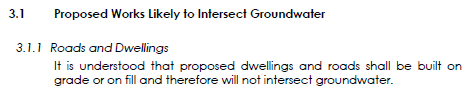
(Martens,
July 2010)
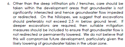
There is not sufficient data to
understand the implications of excavation deeper than 2.5m below natural
surface level, as the existing reports have expressly excluded this from their
scope. Further testing (bore logs) and a specialist report are therefore
required prior to Construction Certificate, given this proposal includes a
three-storey basement, to ensure that the basement design and construction
preserves existing aquifer flows and integrity through and/or around the site.
It should be noted that an approval
under the Water Management Act may also be required and it will be up to the
applicant to obtain this approval.
Refer to relevant conditions of
consent.
Soils
The proposed development will be unlikely to have any
adverse impacts on soils in terms of quality, erosion, stability and/or
productivity subject to a standard condition requiring erosion and sediment
controls to be in place prior to and during construction.
Air and microclimate
The construction and/or operations of the proposed
development will be unlikely to result in any adverse impacts on the existing
air quality or result in any pollution. Standard precautionary site management
condition recommended.
Flora and fauna
Construction of the proposed development will not require
any removal/clearing of any significant vegetation and therefore will be
unlikely to have any significant adverse impacts on biodiversity or threatened
species of flora and fauna. Section 5A of the Act is considered to be
satisfied.
Waste
Satisfactory arrangements are in place for proposed storage
and collection of waste and recyclables. Private garbage collection
arrangements are proposed and required. No adverse impacts anticipated.
Standard precautionary site management condition recommended.
Energy
The proposal includes measures to address energy efficiency
and will be required to comply with the requirements of BASIX and Section J of
the Building Code of Australia. No adverse impacts anticipated.
Noise and vibration
No adverse impacts anticipated. Any noise generated during
construction is likely to be short term and conditions will be imposed to
restrict work to standard construction hours.
Bushfire
The site is not identified as being bushfire prone.
Safety, security and crime prevention
The proposed development will be unlikely to create any
concealment/entrapment areas or crime spots that would result in any
identifiable loss of safety or reduction of security in the immediate
area.
Social impacts in the locality
The proposed development is considered to have the
following positive social impacts:
· Increase in housing;
· Increase mix of accommodation in the area catering for
various markets;
· Employment opportunities during constructions of the
facility;
· Development compatible with the transitioning nature of the
area (i.e. higher density accommodation).
Potential negative issues have been considered throughout
this report and either deemed acceptable or can be resolved through conditions.
Economic impact in the locality
The proposed development will create an overall positive
economic impact through expansion of higher density accommodation facilities.
There will also maintain employment in the construction industry within the
area. This can create and maintain employment opportunities, which in turn lead
to flow on effects such as expenditure and investment in the local economy.
Site design and internal design
The proposed development design satisfactorily responds to
the site attributes and will fit into the locality. No adverse impacts likely.
Construction
Prescribed
conditions require that the developer protect and support adjoining structures
if excavation extends below the footings of the structure, building or work.
A condition
is also recommended requiring dilapidation reports to be prepared for adjoining
properties, to allow for monitoring and rectification works (if necessary) of
any damage caused by construction activities.
Cumulative Impacts
The proposed
development is not expected to have any adverse cumulative impacts on the
natural or built environment or the social and economic attributes of the
locality.
(c) The suitability of the site for
the development:
The proposal will fit into the
locality as justified and the site attributes are conducive to the proposed
development.
Site constraints of potential
ground water interference, road noise and potential encroachment on the
Obstacle Limitation Surface (OLS) for the Port Macquarie Airport have been
adequately addressed and appropriate conditions of consent recommended.
(d) Any
submissions made in accordance with this Act or the Regulations:
15 submissions
have been received. 8 of these submissions have raised concerns with proposal
and 7 submissions have been received to declare support for the proposal.
Key
issues of concern raised in the submissions received and comments in response
to these issues are provided as follows:
|
Submission
Issue/Summary
|
Planning
Comment/Response
|
|
Road No.7 – Future
Main Street for Village Centre not to be constructed as a through road
· Question whether developer will be constructing a through
road to allow vehicle access to the proposed Tavern and Café.
· If there is no direct through route to beach, visitors
will use Summer Circuit as a more direct route to commercial outlets and
beach parking.
· Summer Circuit has not been designed as an arterial road
and is relatively narrow.
· The changes to road configuration are inconsistent with
the approved Part 3A masterplan and will create unnecessary traffic
congestion in the lower order roads and decrease the amenity to residents in
the low density living nearby.
|
The
Applicant has provided additional details during the assessment of the
application that the Masterplan provided in the Statement of Environmental
Effects is for context only and not part of this application. The Applicant
has further advised that any changes to the road design will be considered in
consultation with a traffic engineer in order to ensure traffic flows and
appropriate widths of streets.
A separate DA will be required to be lodged for any
changes to road layouts and/or future buildings and building envelopes.
It is recommended that prior to issue of any
Construction Certificate for building works, a Construction Certificate shall
be approved for the construction of Road 7 (Ocean Blue Boulevard) and Road 9
(Whitewater Terrace) under DA 2012/381. Construction and dedication to the
public of the full length of Road 7 and Road 9 (Whitewater Terrace) from
Seaside Drive to Surfers Drive shall occur prior to issue of any Occupation
Certificate.
|
|
Building height and floor space ratio compliance
· Question the actual building height proposed at the worst
point including whether a variation of 1.1m as detailed in the submitted
Statement of Environmental Effects.
· Question whether variations proposed to the building
height and floor space ratio standards will be consistent with
Council’s objectives for the locality and design principles which were
considered when preparing the Port Macquarie-Hastings Local Environmental
Plan 2011.
· No objections to a 2 storey building however concern
raised to a multi storey building for Lake Cathie as it will spoil the whole
development.
· The height variation exacerbates the imposing bulk and
scale of the proposed building in such a prominent hilltop location and in
what is otherwise a low density residential setting and urban landscape.
|
The building height of the proposal has been amended
during the assessment the DA. Refer to the detailed assessment of Building
Height compliance under the Port Macquarie-Hastings Local Environmental Plan
2011 including clause 4.6 variation to the building height. The building is
considered appropriate, as amended and justified.
The Part 3A approval envisaged multi-storey development
on this site and the remainder of the Hilltop Village. This form of
development is consistent with the zoning and controls for this emerging
area. Two storeys would be inconsistent with the desired future character for
the area as well as the regional strategies.
|
|
Extent of overshadowing
· Question the extent of the overshadowing at 9am as it is
detailed to follow the western side of Seaside Drive.
|
The shadow diagrams have been updated during the
assessment of the application. Refer to the detailed assessment of
overshadowing addressed earlier in this report under the Impacts section and
earlier under SEPP65.
|
|
Traffic Impacts
· A Traffic Impact Analysis which contains updated traffic
data and modelling to confirm when the Ocean Drive and Seaside Drive
intersection should be signalised should be provided.
|
The Applicant has advised during the assessment of the DA
that the Traffic Impact Statement was submitted with the application
to address this intersection. This application does not trigger any upgrading
works. However, separate to this application, it is noted that the RoadNet
Traffic Impact Study Area 14 had two sets of triggers for upgrades, being
years 2019 and 2029 and Council has not commenced any of the upgrade
requirements for the road network.
Refer to the detailed assessment of addressing impacts on
Roads and Traffic earlier in this report which concludes that the proposal is
suitable subject to conditions of consent.
|
|
Part 3A concept plan
· The proposed concept plan submitted shows a future road
layout and building locations which is not in keeping with the Part 3A
approval.
· The proposed main street or Ocean Blue Boulevard does not
connect with the beachfront road.
· The concept plan submitted shows Surfers Drive being
narrowed in front of the serviced apartments proposed. This is not in keeping
with the original approval.
· The proposed Pub and restaurant shown on the submitted
plans is located very close to the residential dwellings as such will result
in noise and amenity issues for future residents.
· There appears to be no on-site parking for pub and
restaurant. Any reliance on the beachfront carpark is opposed.
|
The
Applicant has provided additional details during the assessment of the
application that the Masterplan provided in the Statement of Environmental
Effects is for context only and not part of this application. Any changes to
the road design will be considered in consultation with a traffic engineer in
order to ensure traffic flows and appropriate widths of streets.
A separate
DA will be required to be lodged for any changes to road layouts and/or
future buildings and building envelopes.
|
(e) The Public Interest:
The proposed development
satisfies relevant planning controls, including variations to standard as
justified, and is unlikely to adversely impact on the wider public interest.
4. DEVELOPMENT
CONTRIBUTIONS APPLICABLE
· Development contributions will be required towards augmentation
of town water supply and sewerage system head works under Section 64 of the
Local Government Act 1993.
· Development contributions will be required under Section 94
of the Environmental Planning and Assessment Act 1979 towards roads, open space,
community cultural services, emergency services and administration buildings.
· It is also noted that the Area 14 Section 94 Local
Roads Contributions Plan has come into effect since the original subdivision
under DA2012 – 381 was approved.
5. CONCLUSION
The
application has been assessed in accordance with Section 79C of the
Environmental Planning and Assessment Act 1979.
Issues
raised during assessment and public exhibition of the application have been
considered in the assessment of the application. Where relevant, conditions
have been recommended to manage the impacts attributed to these issues.
The
site is suitable for the proposed development, is not contrary to the public's
interest and will not have a significant adverse social, environmental or
economic impact. It is recommended that the application be approved, subject to
the recommended conditions of consent provided in the attachment section of
this report.
|
Attachments
1View. DA2017
- 336.1 Plans
2View. DA2017
- 336.1 Recommended Conditions
3View. DA2017
- 336.1 Submission - Abraham
4View. DA2017
- 336.1 Submission - Beecroft
5View. DA2017
- 336.1 Submission - Bottle
6View. DA2017
- 336.1 Submission - Boyce
7View. DA2017
- 336.1 Submission - Hall & Others
8View. DA2017
- 336.1 Submission - Hopkins for Seawide Estate
9View. DA2017
- 336.1 Submission - Hopkins for Vardanega
10View. DA2017
- 336.1 Submission - Ibrahim
11View. DA2017
- 336.1 Submission - Ibrahim & Morris
12View. DA2017
- 336.1 Submission - Jakimoski
13View. DA2017
- 336.1 Submission - King
14View. DA2017
- 336.1 Submission - Maksimov
15View. DA2017
- 336.1 Submission - Pogson
16View. DA2017
- 336.1 Submission - Raad
17View. DA2017
- 336.1 Submission - St Vincents Foundation
|
|
ATTACHMENT
|
Development Assessment Panel
13/12/2017
|
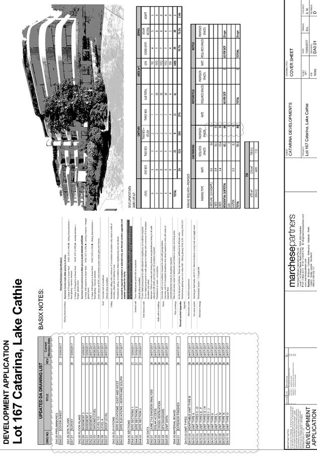
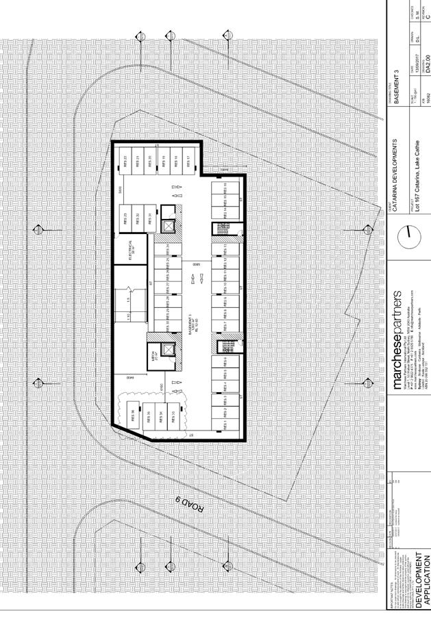
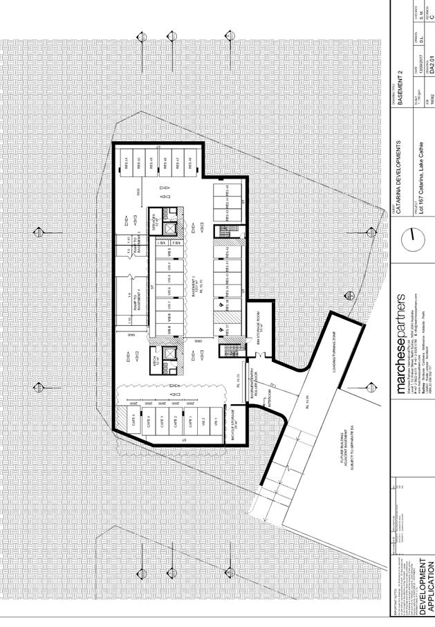
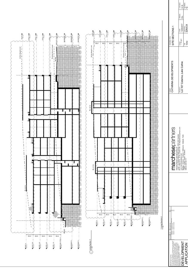
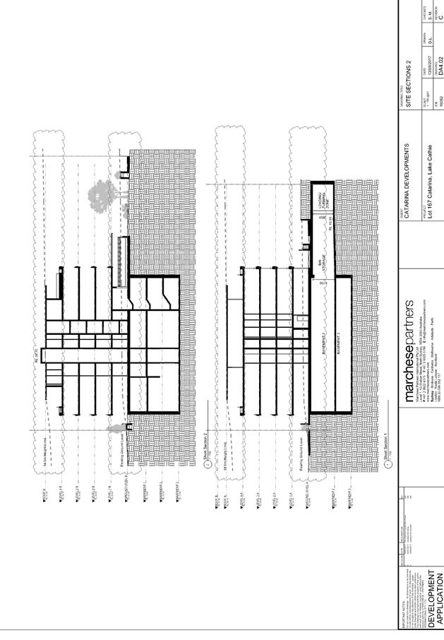
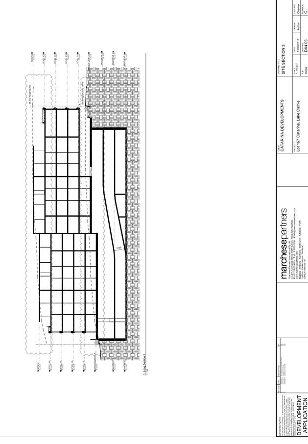
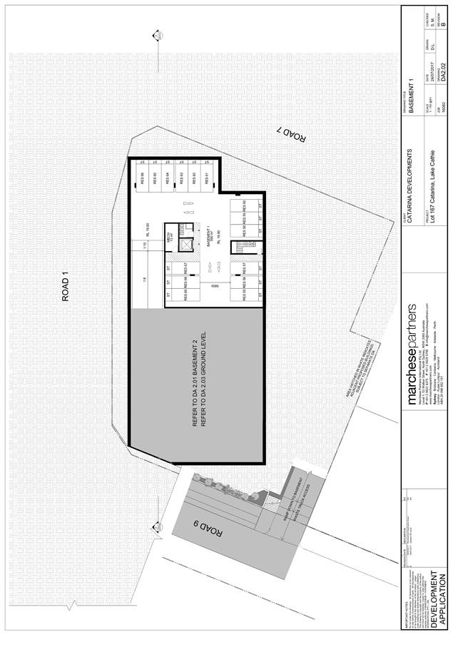
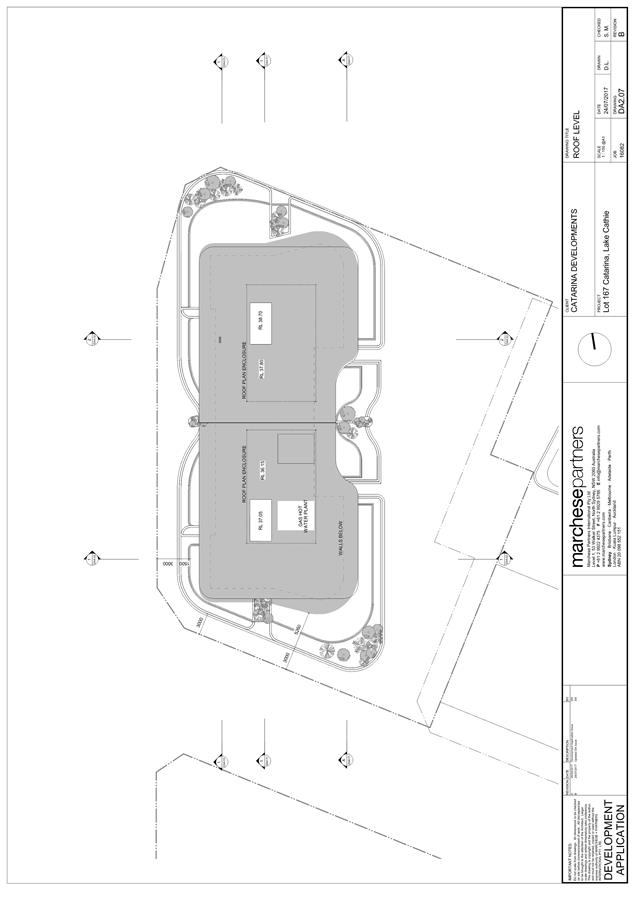
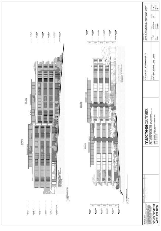
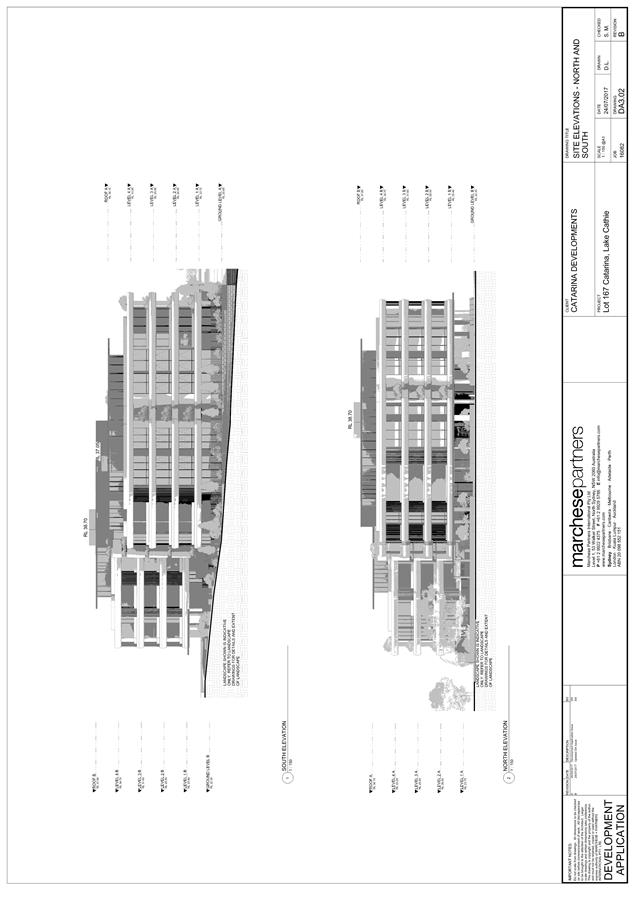
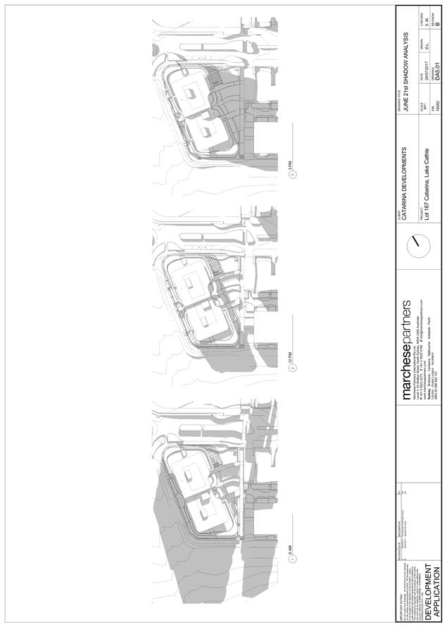
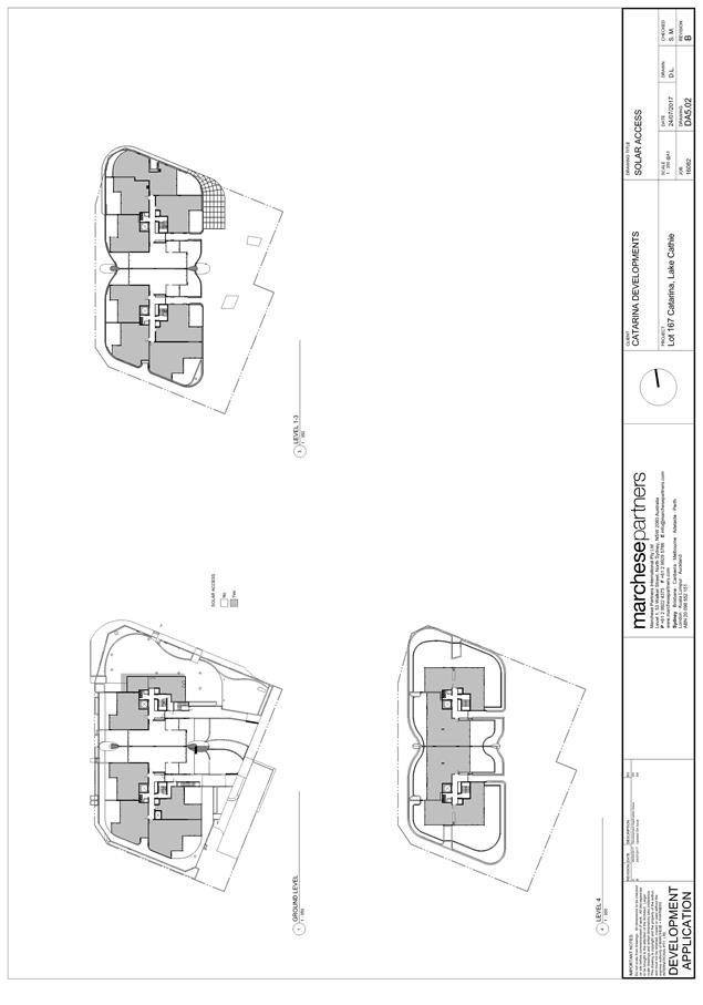
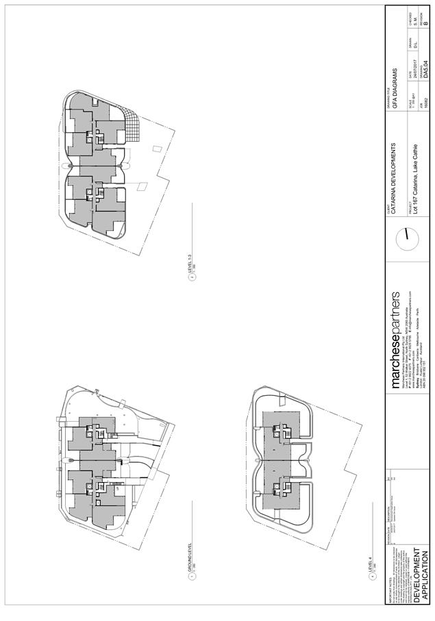
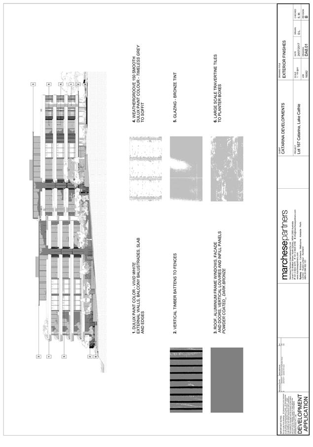
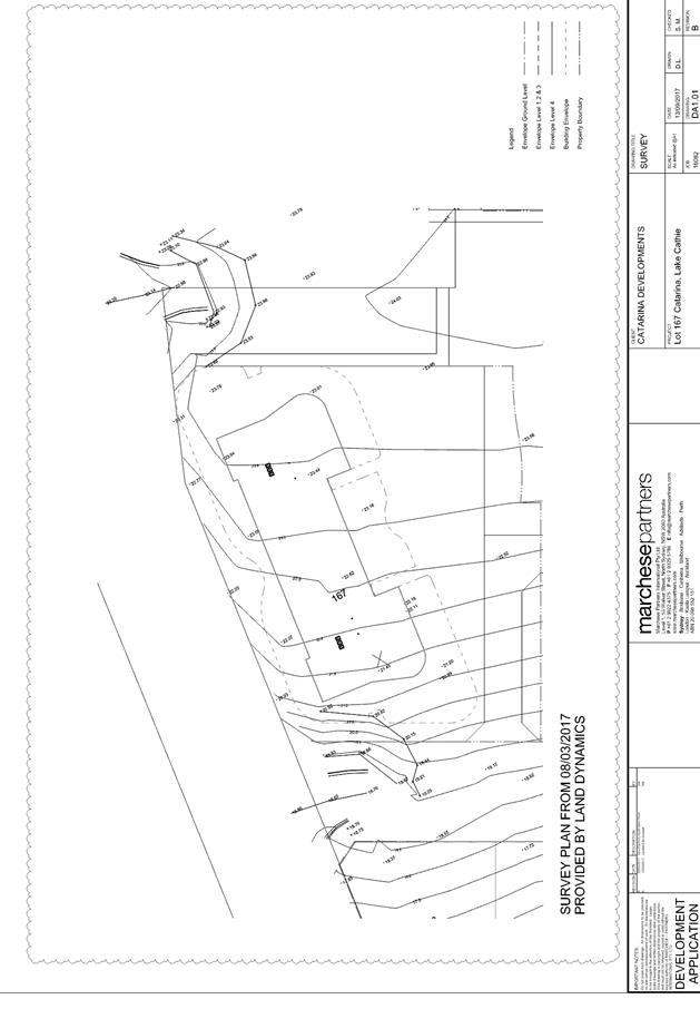
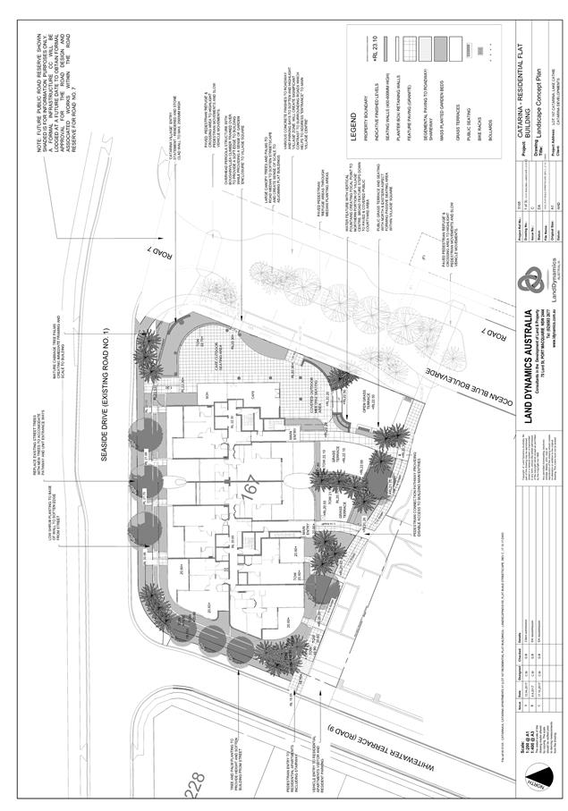
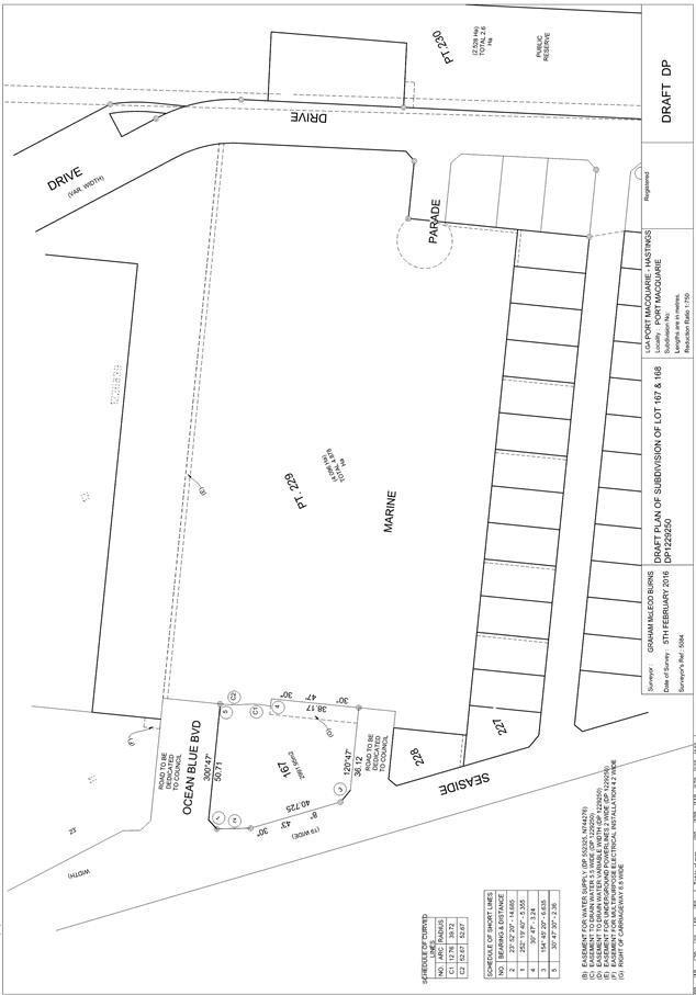
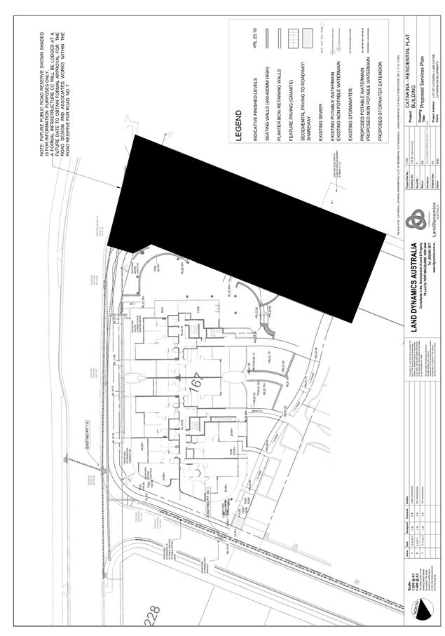
|
ATTACHMENT
|
Development Assessment Panel
13/12/2017
|

|
ATTACHMENT
|
Development Assessment Panel
13/12/2017
|
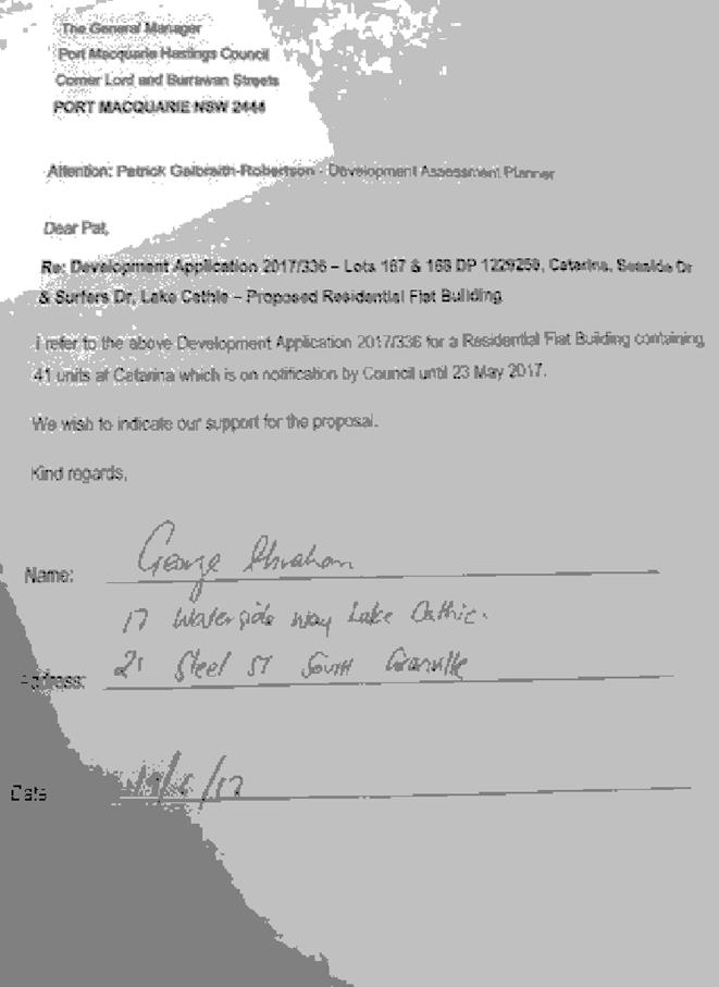
|
ATTACHMENT
|
Development Assessment Panel
13/12/2017
|
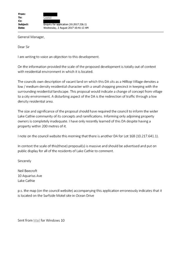
|
ATTACHMENT
|
Development Assessment Panel
13/12/2017
|
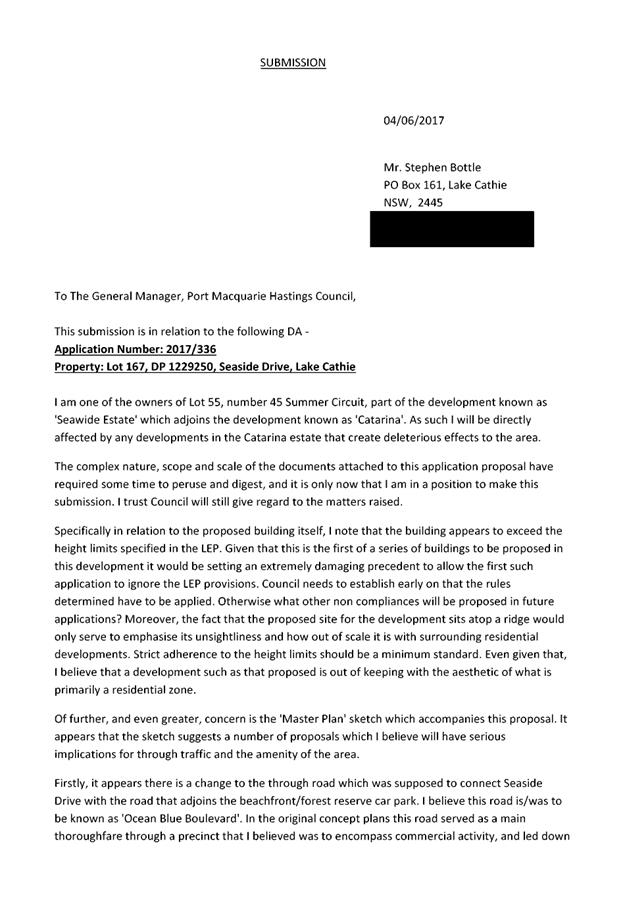
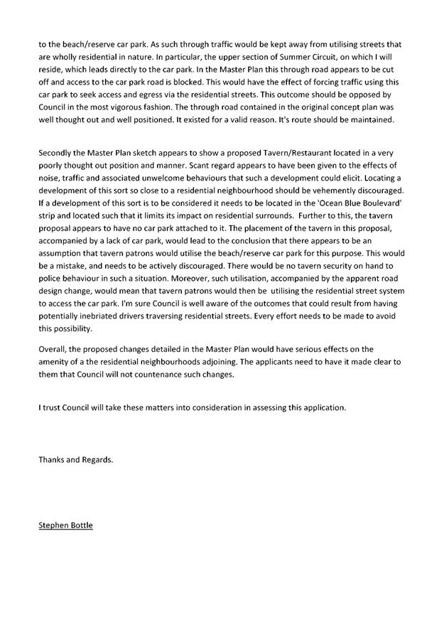
|
ATTACHMENT
|
Development Assessment Panel
13/12/2017
|
|
ATTACHMENT
|
Development Assessment Panel
13/12/2017
|


|
ATTACHMENT
|
Development Assessment Panel
13/12/2017
|
|
ATTACHMENT
|
Development Assessment Panel
13/12/2017
|
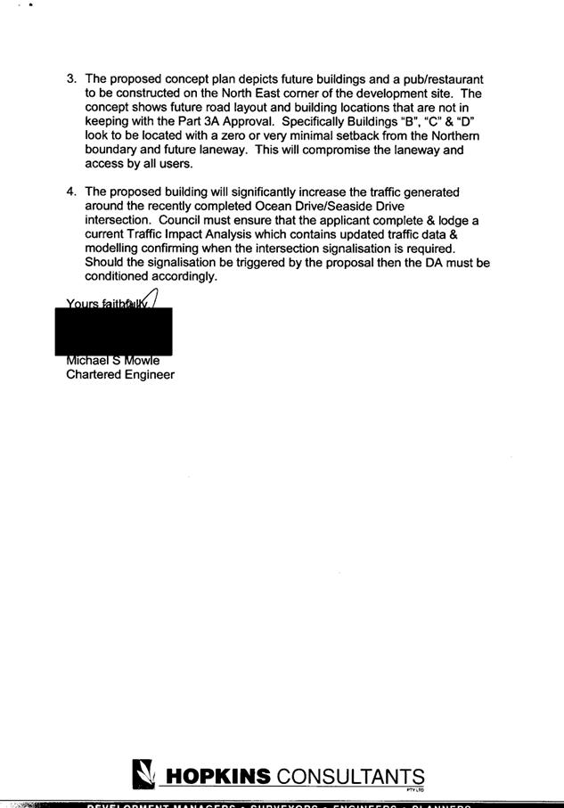
|
ATTACHMENT
|
Development Assessment Panel
13/12/2017
|
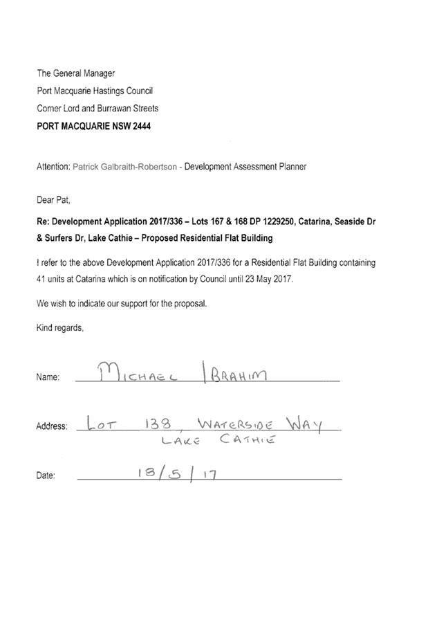
|
ATTACHMENT
|
Development Assessment Panel
13/12/2017
|
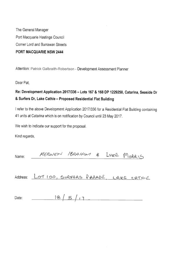
|
ATTACHMENT
|
Development Assessment Panel
13/12/2017
|

|
ATTACHMENT
|
Development Assessment Panel
13/12/2017
|
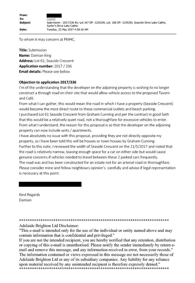
|
ATTACHMENT
|
Development Assessment Panel
13/12/2017
|
|
ATTACHMENT
|
Development Assessment Panel
13/12/2017
|
|
ATTACHMENT
|
Development Assessment Panel
13/12/2017
|
|
ATTACHMENT
|
Development Assessment Panel
13/12/2017
|
AGENDA Development Assessment Panel 13/12/2017
Item: 06
Subject: DA2017 - 455.1 Residential Subdivision (10
Lots) Including Clause 4.6 Objection To Clause 4,1 (Minimum Lot Size) Of The
Port Macquarie-Hastings Local Environmental Plan 2011 At Lot 65 DP1226839,
Shore Break Crescent, Lake Cathie
Report
Author: Benjamin Roberts
|
Applicant: Hopkins
Consultants Pty Ltd
Owner: Seawide
Pty Ltd
Estimated Cost: Nil
Alignment with Delivery
Program
4.3.1 Undertake transparent
and efficient development assessment in accordance with relevant legislation.
|
|
RECOMMENDATION
That
it be recommended to Council that DA2017 – 455.1 for a Residential
Subdivision (10 Lots) including Clause 4.6 Objection to Clause 4.1 (Minimum
Lot Size) of the Port Macquarie-Hastings Local Environmental Plan 2011 at Lot
65, DP 1226839, Shore Break Crescent,
Lake Cathie, be determined by granting consent subject to the recommended
conditions.
|
Executive Summary
This
report considers a development application for a residential subdivision
(10 lots) at the subject site and provides an assessment
of the application in accordance with the Environmental Planning and Assessment
Act 1979.
Following exhibition of the
application, no submissions have been
received. The development is required to be
reported to an Ordinary Meeting of Council for determination as it involves a
variation to the Port Macquarie Hastings Local Environmental Plan 2011 (LEP
2011) minimum lot size standard by more than 10%.
1. BACKGROUND
Subdivision History and Part 3A Approvals
There are existing Part 3A Concept Plan and Stage 1 Project
Approvals for residential, commercial, tourist/mixed uses and environmental
works applicable to the site. A summary is provided below.
07_0010 Residential, Commercial and Tourist Development
(Concept Plan) being an approval for:
- residential
uses for about 217 low density dwellings and about 82 medium density dwellings
- a
‘Hill-Top Village’ neighbourhood centre, including tourist and
residential uses of about 160 apartments
- environmental
works associated with the Littoral Rainforest and Duchess Creek
- provision
of perimeter road, pedestrian, cycle paths and opens space and access to
Rainbow Beach
- provision
of associated infrastructure including stormwater, drainage and utilities
07_0010 Residential, Commercial and Tourist Development
(Project Application)
Dealing with:
- environmental
works including establishment of regeneration area, erection of temporary
fencing and construction of a timber boardwalk.
Part 3A of the Environmental Planning and Assessment Act,
1979 (the Act) was repealed on 26 August 2011. The Part 3A application was
undetermined at the time of these changes. Schedule 6A of the Act established
the transitional arrangements and subject to clause 2 of this schedule, the
project is a ‘transitional Part 3A project’. Accordingly Part 3A of
the Act as existed, prior to its repeal, continues to apply to the project.
Under the terms of the concept plan approval, future
approval to carry out the project, other than ‘Stage 1 Environmental
Works’, are subject to Part 4 of the Act.
Development Application DA2012/381 for a 176 lot
subdivision and associated infrastructure was granted consent by the Joint
Regional Planning Panel on 21 February 2013, and was subsequently modified on
27 August 2013. This subdivision is currently under construction and the lots
are yet to be registered.
The proposal is for an infill subdivision of a development
lot identified as Lot 64 on the modified approved plans for DA2012/381 (see
below).
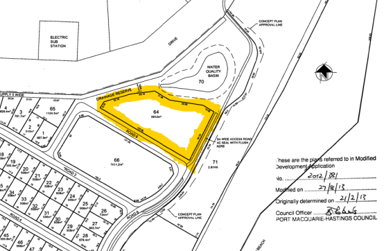
Existing sites features and Surrounding development
Lot 64 in the plan above is now
recognised as Lot 65 DP 1226839 and has an area of 5739m2.
The site is zoned R1 General Residential, R3 Medium
Density Residential and E3 Environmental Management in
accordance with the Port Macquarie-Hastings Local Environmental Plan 2011, as
shown in the following zoning plan:
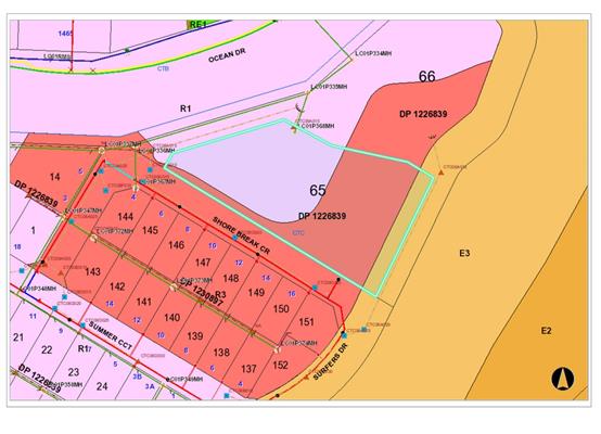
The existing subdivision pattern and location of existing
development within the locality is shown in the following aerial photograph:
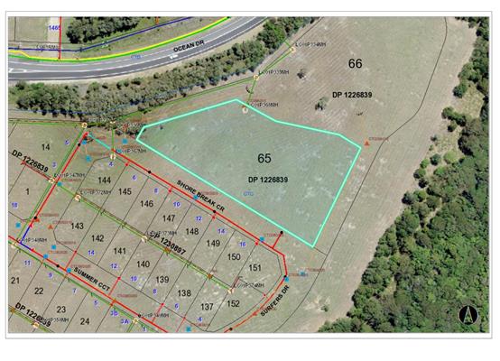
2. DESCRIPTION OF
DEVELOPMENT
Key aspects of the proposal include the following:
· Subdivision
of the land into 10 residential allotments;
· Variation
of the minimum lot size development standard for the land in the Port
Macquarie-Hastings Local Environmental Plan 2011.
Refer
to attachments at the end of this report.
Application Chronology
· 29
May 2017 – Application lodged.
· 13 to 26 June 2017 – Public exhibition via neighbour
notification.
· 12 July 2017 – Additional information request.
· 4 October 2017 – Part additional information provided.
· 13 October 2017 – Part additional information
provided.
· 14 November 2017 – Request for outstanding additional
information.
· 22 November 2017 – Additional information provided.
3. STATUTORY ASSESSMENT
Section 79C(1) Matters for Consideration
In determining the application, Council is required to take
into consideration the following matters as are relevant to the development
that apply to the land to which the development application relates:
(a) The provisions (where
applicable) of:
(i) any Environmental
Planning Instrument:
State
Environmental Planning Policy No. 26 - Littoral Rainforests
This policy
aims to preserve and protect littoral rainforests in their natural state. This
policy applies to land within 100m of the marked boundaries identified in a
series of maps marked “State Environmental Planning Policy No. 26 -
Littoral Rainforest (Amendment No.2)”.
The eastern
boundary of the site forms part of the mapped Littoral Rainforest.
Consideration to the potential impacts upon the Littoral Rainforest was
considered by the Department in their assessment of the Part 3A Concept Plan.
The relevant matters for consideration as required by this policy were
addressed in Part 5 of the Director-General’s Environmental Assessment
Report.
The application
is consistent with the Part 3A Concept Plan Approval and further consideration
of this policy is not deemed necessary.
State
Environmental Planning Policy No. 44 - Koala Habitat Protection
This policy
aims to encourage proper conservation and management of natural vegetation
areas that provide habitat for koalas. The Lake Cathie-Bonny Hills (Area 14)
Koala Plan of Management applies to the site.
There are no
trees located on this site and the proposal is consistent with the adopted Lake
Cathie-Bonny Hills (Area 14) Koala Plan of Management.
State
Environmental Planning Policy No. 71 – Coastal Protection and Clause 5.5
of Port Macquarie-Hastings Local Environmental Plan 2011
The
policy applies generally to development in the coastal zone. Clause 2 sets out
the aims of the policy which includes the protection, preservation and
effective management of coastal areas and natural resources including
vegetation, beaches and amenity. Clause 8 sets out the matters for
consideration by a consent authority when determining a development application
in the coastal zone.
As
part of the Part 3A Concept Plan the Department considered these matters and
concluded that the project would improve public access to the coastal
foreshore, demonstrates due regard to its environmental setting and
surroundings, is not detrimental to the scenic amenity of the coastal
foreshore, includes measures to protect and regenerate existing coastal
habitats and includes measures to protect and conserve items of Aboriginal
cultural heritage.
In
obtaining the Part 3A Concept Plan Approval for the development, the applicant
is not required to obtain a Master Plan (or waiver) from the Department under
SEPP 71. The application is consistent with the Part 3A Concept Plan Approval
and further consideration of this policy is not deemed necessary.
Having
regard for clauses 2, 8 and 12 to 16 of the SEPP and clause 5.5 of LEP 2011,
the proposed development will not result in any of the following:
a) any restricted access (or opportunities for access) to
the foreshore
b) any adverse amenity impacts along the
foreshore and on the scenic qualities of the coast;
c) any adverse impacts on flora and fauna;
d) the development being subject to any adverse
coastal processes or hazards;
e) any significant conflict between water and land based
users of the area;
f) any adverse impacts on any items of
archaeological/heritage;
g) reduction in the quality of the natural
water bodies in the locality (due to effluent & stormwater disposal,
construction impacts, landuse conflicts);
h) adverse cumulative impacts on the environment;
i) a form of development that is unsustainable in water and
energy demands;
j) development relying on flexible zone provisions.
The
site is cleared and located within an area zoned for residential purposes.
Port
Macquarie-Hastings Local Environmental Plan 2011
The
proposal is consistent with the LEP having regard to the following:
· Clause 2.2, the subject site is zoned R1 General
Residential, R3 Medium Density Residential and E3 Environmental Management.
The objectives of the R1 general residential are as
follows:
o To provide for the housing needs of the community.
o To provide for a variety of housing types and densities.
o To enable other land uses that provide facilities or
services to meet the day to day needs of residents.
The objectives of the R3 medium density residential zone
are as follows:
o To provide for the housing needs of the community within a
medium density residential environment.
o To provide a variety of housing types within a medium
density residential environment.
o To enable other land uses that provide facilities or
services to meet the day to day needs of residents.
The objectives of the E3 Environmental Management zone are
as follows:
o To protect, manage and restore areas with special
ecological, scientific, cultural or aesthetic values.
o To provide for a limited range of development that does not
have an adverse effect on those values.
In accordance with Clause 2.3(2), the proposal is
consistent with the zone objectives having regard to the following:
o The proposal would provide lots capable of a variety of
medium density housing types.
o The development would contribute to meeting the housing
needs of the community.
· Clause
4.1, the lot sizes within the proposed subdivision range from 450m2
to 845m2. The lot size map identifies a minimum lot size provision
of 450m2 and 1000m2 applicable to the land. A copy of the
minimum lot size map over the site is provided below:
· 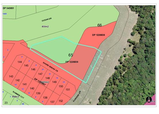
Proposed lot 401 will comply with the minimum 450m2
applicable. However none of the other lots will technically comply with the
minimum lot size provision of 1,000m2. Specifically, the strip
alongside the frontage of Shore Break Crescent. Refer to proposed subdivision
layout with minimum lot size mapping overlayed below for context. Had it not be
for this strip lots 404, 405, 406 and 407 would comply with the 450m2
minimum lot size provision.
· 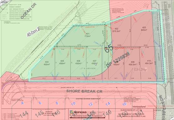
Lots 402, 403, 408, 409 and 410 do not comply with the
minimum 1000m2 lot size provision. The proposal constitutes a
variation of up to 55% of the development standard.
The
objectives of clause 4.1 are as follows:
(a) to ensure that lot sizes are
compatible with local environmental values and constraints,
Comment: The site of the proposed infill
subdivision is not affected by any significant environmental or other
significant constraints. The reduced lot sizes are therefore considered
compatible with the site characteristics.
(b) to facilitate efficient use of
land resources for residential and other human purposes,
Comment: The lot sizes would facilitate residential densities in the
Rainbow Beach area consistent with the densities projected in Development
Control Plan 2013.
(c) to minimise the fragmentation of
rural land suitable for sustainable primary production,
Comment: Not applicable.
(d) to protect high ecological,
scientific, cultural or aesthetic values of land in environment protection
zones.
Comment: The E3 zone extends approximately 8m into the property along the
eastern boundary. There is no vegetation located on the lot. There is no high
ecological, scientific, cultural or aesthetic values identified on the land.
· Clause
4.6, development consent must not be granted for development that contravenes a development standard unless the Council is satisfied that
the applicant’s written request has adequately addressed the following
matters:
(a) that compliance with the development
standard is unreasonable or unnecessary in the circumstances of the case, and
(b) that there are sufficient environmental
planning grounds to justify contravening the development standard
Additionally, the proposed development must be shown to be
in the public interest because it is consistent with the objectives of the
particular standard and the objectives for development within the zone in which
the development is proposed to be carried out.
As detailed above under clauses 2.3 and 4.1, the proposed
development would satisfactorily achieve the objectives of the zone and minimum
lot size standards and is considered to be in the public interest.
Compliance with the minimum lot size standard is considered
unnecessary in the circumstances of the case as the proposed development would
provide suitable housing opportunities and not compromise the overall housing
density projected for the area.
There is sufficient justification on environmental planning
grounds for the development as follows:
o The same subdivision layout could be achieved with an
integrated Torrens title housing development under the provisions of Clause
4.1A of the LEP, which would not require a variation of the minimum lot size
provisions.
o The lot size mapping is irregular in relation to the lot,
being that the minimum 1000m2 lot size provision extends along the
frontage of the lot facing Shore Break Crescent.
o Each proposed lot is capable of accommodating a dwelling
that complies with the DCP controls.
o The development provides greater flexibility in building
design for future purchasers of the land.
o The development would not compromise the desired dwelling
yields for the Rainbow Beach urban release area.
o The
proposal would not significantly compromise the future redevelopment of the
land for higher density residential uses in accordance with the land
zoning.
Council has assumed concurrence under the Department of Planning and
Environment’s Planning Circular PS 08-003 to determine the application.
However, the application is required to be determined at a meeting of full
Council in accordance with Planning Circular PS 08-014 due to the variation
being greater than 10%.
· Clause
5.5 - Development within the coastal zone - relevant objectives of this clause
are addressed by SEPP 71 section (see above).
· Clause
5.9 - No listed trees in Development Control Plan 2013 are proposed to be
removed.
· Clause
5.10 – Heritage. The site does not contain or adjoin any known heritage
items or sites of significance.
· Clause
6.1 - A copy of the Director General’s Certificate certifying that
satisfactory arrangements are in place for the provision of State public
infrastructure for the Area 14 Urban Release Area at Lake Cathie / Bonny Hills
has been provided to Council and is dated 6 December 2012.
· Clause
6.2, satisfactory arrangements are in place for provision of essential public
utility infrastructure including stormwater, water and sewer infrastructure to
service the development within an urban release area.
· Clause
6.3 - Development Control Plan 2011 - Rainbow Beach provisions are in place for
the urban release area. See comments below under the DCP section for details.
· Clause
7.9 - Part of the subject site is mapped as being subject to acoustic controls.
A Traffic Noise Impact Assessment was undertaken by Heggies Pty Ltd, dated 5
July 2010 as part of the Part 3A Concept Plan application and road traffic
noise impacts were also considered as part of the residential subdivision
approved under DA2012/381 that will create the development lot.
· Heggies
have advised that the relevant current Australian Standards are an appropriate
tool in the assessment of road traffic noise where the SEPP (Infrastructure)
2007 provisions do not apply. The relevant standards are as follows:
o AS
2107:2000 - Acoustics - Recommended design sound levels and reverberation times
for building interiors; and
o AS
3671:1989 - Acoustics - Road traffic noise intrusion - Building siting and
construction.
Construction categories 1 and 2 contained within AS
3671:1989 can provide an internal noise reduction of between 10dBA to 25dBA
respectively. In relation to the predicted noise levels for the residential
subdivision approved under DA2012/381, the incorporation of category 2
construction measures as follows was considered to satisfy acceptable internal
noise level criteria:
o Category
2 construction measures for dwellings with a direct frontage to Ocean Drive.
It was also proposed as part of DA2012/381 that allotments
with direct frontage to Ocean Drive would incorporate lapped and capped
boundary fencing 1.8m in height erected upon a 0.4m high earth mound. The
proposed treatment would extend approximately 360m along the Ocean Drive
frontage and provide for additional noise mitigation.
The conditions of consent for DA2012/381 required a
restriction as to user under Section 88B of the Conveyancing Act 1919 to be
placed on the titles of the lots with a direct frontage to Ocean Drive.
The noise barrier proposed as part of DA2012/381 only
extends to the western side of the development site and some of the lots are
exposed to road traffic noise despite the greater separation distance.
Modelling in the Heggies report suggests that Category 2 construction measures
would be required for all lots in the proposed subdivision. A condition of consent is
proposed requiring a restriction as to user under Section 88B of the
Conveyancing Act 1919 to be placed on the titles of the lots.
With the above restriction, the proposed development is
considered capable of achieving satisfactory internal noise levels.
· Clause
7.13, satisfactory arrangements are in place for provision of essential
services including water supply, electricity supply, sewer infrastructure,
stormwater drainage and suitable road access to service the development.
Provision of electricity will be subject to obtaining satisfactory arrangements
certification prior to the issue of a Subdivision Certificate as recommended by
a condition of consent.
(ii) Any
draft instruments that apply to the site or are on exhibition:
No draft
instruments apply to the site.
(iii) any
Development Control Plan in force:
Port
Macquarie-Hastings Development Control Plan 2013
|
DCP 2013: Chapter 3.6 - Subdivision
|
|
DCP Objective
|
Development Provisions
|
Proposed
|
Complies
|
|
3.6.3.2
|
Torrens title lots minimum width of 15m when measured at a
distance of 5.5m from front property boundary.
|
Lots 405, 406, 407 are 14.52m wide. Lot 408 is 14.71m wide. All other lots area greater than 15m
wide.
The lots are capable of accommodating a dwelling that can
comply with the DCP requirements.
|
No, but acceptable.
|
|
Minimum width of 7m when boundaries are extended to kerb
line.
|
Yes.
|
Yes
|
|
Minimum depth of 25m.
|
All lots that are not corner lots comply with this
requirement.
|
Yes
|
|
3.6.3.3
|
Battleaxe lots discouraged in greenfield development.
|
Battleaxe arrangement proposed for lots 401, 402 and 403.
|
No, but acceptable.
|
|
3.6.3.4
|
Lots are to be designed to allow the construction of a
dwelling, which does not involve more than 1m cut, or fill, measured from
natural ground level, outside the dwellings external walls.
|
Lots not expected to require more than 1m of cut or fill
for dwelling construction. Acceptable site levels established under
DA2012/381.
|
Yes
|
|
3.6.3.5
|
Wherever possible orientate streets to maximise the number
of east, west and south facing lots and to minimise the number of narrow
north facing lots.
Residential street blocks should preferably be orientated
north-south with dimensions generally
limited to 60-80m by 120-150m as illustrated in Figure
3.6-2.
|
Street layout already established under DA2012/381.
|
n/a
|
|
Lot size and shape are to reflect orientation to ensure
future dwelling construction has optimal opportunity for passive solar
design.
|
Lot orientation satisfactory.
|
Yes
|
|
3.6.3.6
|
Kerb and guttering, associated street drainage, pavement
construction and foot paving across the
street frontages should be constructed as part of the
subdivision works where these do not exist (may be varied subject to criteria
in this clause).
|
Relevant works will be required as part of the
subdivision. See comments later in this report.
|
Yes
|
|
3.6.3.20
|
Water supply to meet Council’s design
specifications.
|
See comment later in this report under Water Supply
Connection.
|
Yes
|
|
3.6.3.24
|
Separate sewer junction provided for each lot.
|
See comment later in this report under Sewer Connection.
|
Yes
|
|
3.6.3.27
|
Erosion and sediment control plan to be provided.
|
Condition recommended requiring erosion and sediment
control plan to be provided prior to the issue of a Construction Certificate.
|
Yes
|
|
3.6.3.34
|
All service infrastructure should be underground unless
otherwise approved by Council.
|
Condition recommended requiring satisfactory arrangements
certification for electricity and telecommunications infrastructure.
|
Yes
|
|
All service infrastructure should be installed in a common
trench.
|
|
Conduits for the main technology network system should be
provided in all streets.
|
|
Conduits are to be installed in accordance with the
National Broadband Network Company Limited’s
‘Guidelines for Fibre to the Premises Underground
Deployment’.
|
|
Access pits are to be installed at appropriate intervals
along all streets.
|
|
3.6.3.51
|
Street trees should be provided along all road frontages
generally at a rate of 1 per 20m interval.
|
Street tree planting for all the adjoining streets shown
on approved plans for DA2012/381.
|
Yes
|
|
DCP 2013: General Provisions
|
|
DCP Objective
|
Development Provisions
|
Proposed
|
Complies
|
|
2.7.2.2
|
Design addresses generic principles of Crime Prevention
Through Environmental Design guideline:
· Casual
surveillance and sightlines
· Land use mix and
activity generators
· Definition of
use and ownership
· Lighting
· Way finding
· Predictable
routes and entrapment locations
|
The subdivision layout will provide for additional
dwellings with frontage to the existing subdivision roads, which will improve
passive surveillance in the area.
|
Yes
|
|
2.3.3.1
|
Cut and fill 1.0m max. 1m outside the perimeter of the
external building walls
|
Earthworks are currently being carried out at the site in
accordance with DA2012/381. No further cut and fill proposed in this
application.
|
Yes
|
|
2.3.3.8 onwards
|
Removal of hollow bearing trees
|
None proposed to be removed.
|
Yes
|
|
2.6.3.1
|
Tree removal (3m or higher with 100m diameter trunk and 3m
outside dwelling footprint
|
None proposed to be removed.
|
Yes
|
|
2.4.3
|
Bushfire risk, Acid sulphate soils, Flooding,
Contamination, Airspace protection, Noise and Stormwater
|
Refer to main body of report.
|
|
|
2.5.3.2
|
New accesses not permitted from arterial or distributor
roads. Existing accesses rationalised or removed where practical
|
All proposed lots would have access from internal
subdivision roads.
|
Yes
|
|
2.5.3.11
|
Section 94 contributions
|
Refer to main body of report.
|
|
|
DCP 2011: Rainbow Beach - Precinct B
|
|
DCP Objective
|
Development Provisions
|
Proposed
|
Complies
|
|
OB1
|
DP1.1 Road layout, open space and commercial and
residential generally in accordance with figures.
|
Yes
|
Yes
|
|
OB2
|
DP2.1 Development yields achieve
those in figure.
|
The proposed development achieves a lot yield well below
the 31-36 dwellings per hectare envisaged for development on the R3 zoned
land in the DCP. However, analysis of the overall development within Precinct
B by the applicant indicates that over 500 dwellings for the precinct is
still expected to be achieved, without increasing the density of this
particular site.
In the longer term, lots could be consolidated and
redeveloped for higher density residential uses.
|
No, but acceptable
|
|
DP2.2 Higher residential
densities are provided in areas close to retail or community activities and
public transport nodes.
|
See comments above.
|
No, but acceptable
|
|
OB5
|
DP5.1 Cycle ways, share ways and
pedestrian facilities in accordance with figure 89.
|
Relevant facilities to be provided as part of DA2012/381.
|
Yes
|
|
OB6
|
DP6.1 Development subject to
acoustic controls to comply with AS3671.
|
See comments earlier under clause 7.9 of LEP.
|
Yes
|
|
DP6.2 Subdivision layout avoids
need for acoustic fencing or noise barriers.
|
No acoustic fencing or noise barriers required for the
proposal.
|
Yes
|
|
OB16
|
DP16.1 All stormwater and
groundwater works are to be undertaken in accordance with the recommendations
in the Total Water Cycle Management Plan dated July 2012 prepared by
King and Campbell.
|
Capable of complying. See comments under Stormwater later
in this report.
|
Yes
|
|
OB20
|
DP20.1 Development
provides;
•
an east west main street road as part of the Hilltop Village,
•
a public perimeter road, incorporating walking and cycle park for the full
frontage of the rainforest,
•
a public car park and local park adjoining the beach access path,
•
a shared pathway link to the existing formed pathway along Ocean Drive, and
•
a road connection to Precinct C.
|
Relevant facilities provided as part of DA2012/381.
Proposal would not affect provision of these items.
|
Yes
|
The proposal
seeks a variation to provision 3.6.3.2 which requires Torrens title lots be a
minimum width of 15m when measured at a distance of 5.5 metres from the front
property boundary. Proposed lots 405, 406, 407 are 14.52m wide. Proposed lot
408 is 14.71m wide.
The
objectives of this provision are:
- To provide a range of lot sizes to
suit variety of dwelling and household types;
- To ensure the lot layout plan reflects the
site’s opportunities and constraints.
The variation
is considered acceptable for the following reasons:
- The subdivision provides for a mixture of
lot sizes and future dwelling types.
- The subdivision layout reflects site
opportunities and constraints.
The proposal
seeks a variation to provision 3.6.3.3 which suggests that battleaxe allotments
are discouraged in Greenfield development. However, Council may consider
permitting battleaxe for “infill” development where it is
demonstrated that:
- A Torrens Title lot, that is not a
battleaxe lot, cannot be achieved; and
- the number of crossovers do not reduce
the amenity of the street or on street parking; and
- the impact of noise, dust and headlights
on the land owners adjoining the driveway is addressed by the construction of
an acoustic fence for the full length of the driveway; and
- addresses privacy between the rear lot
and the rear open space of the front lot by the provision of adequate
screening, larger lot size and setbacks; and
- extends utilities to the end of the axe
handle; and
- there is sufficient space for garbage
collection on the frontage.
The proposal
can satisfy the above standards.
The
objectives of this provision are as follows:
- To ensure subdivision design and road
layout responds to the topography of the land and the site constraints.
- To prevent servicing costs (associated
with access, utilities and services) from being transferred to the land owner
because of poor subdivision design.
- To reduce the impacts of battleaxe
allotments in infill areas on adjoining landowners, the streetscape and the
final landowner.
- To ensure that development of rear lots
of battleaxe allotments does not result in the impacts greater than would be
expected from a single dwelling in terms of:
·
• Traffic generation;
·
• Noise;
·
• Privacy;
·
• Utilities;
·
• Waste management; and
·
• Amenity.
The proposal
is considered to satisfy the above objectives.
The proposal
seeks to vary development provision 5.2.2.1 which attempts to achieve a minimum
dwelling site density of 30 dwellings per hectare in the R3 Medium Density
Residential Zone. The proposal would result in a density of 10 lots over half a
hectare (i.e. 20 lots per hectare).
The relevant
objectives are as follows:
· To
establish a clear urban structure that maximises the sense of neighbourhood and
encourages walking and cycling
· To
ensure development in each precinct is delivered in an orderly and efficient
manner
· To
facilitate the efficient use of land that accommodates the area’s
predicted population growth
· To
achieve housing choice and residential densities sufficient to support:
- Business and mixed use
centres
- Public transport
provision
- Infrastructure
investment
· To
encourage compact urban form and clearly define the new town centre
The proposed
subdivision will still result in a mix of low and medium density housing
opportunities and is not expected to have a negative impact on the overall
desired development yields of Area 15.
Based on the
above assessment, the variations proposed to the provisions of the DCP are
considered acceptable and the relevant objectives have been
satisfied. Cumulatively, the variations do not amount to an adverse impact
that would justify refusal of the application.
(iiia) any
planning agreement that has been entered into under Section 93f or any draft
planning agreement that a developer has offered to enter into under Section
93f:
The
landowners entered into Voluntary Planning Agreements for the purposes of
Section 93F of the Act in relation to the rezoning of the land. The Seawide
Area 14 Stage 1B Planning Agreement between Council and the landowner was
executed on 14 September 2011. The landowners agreed to make Development
Contributions in accordance with the VPAs in connection with carrying out of
development permitted by the LEP.
The VPAs
provide for the carrying out of works by the landowners including establishing
and maintaining environmental lands, road works, local park embellishment,
pedestrian beach access and dedication of land to Council. The agreements also
include arrangements for payment of development contributions towards
management of environmental lands, administration levy contribution, open space
and roads contributions.
iv) any matters prescribed by the
Regulations:
New South Wales Coastal Policy:
The proposed
development is consistent with the objectives and strategic actions of this
policy. See comments earlier under SEPP No. 71 - Coastal Protection.
v) any coastal
zone management plan (within the meaning of the Coastal Protection Act 1979),
that apply to the land to which the development application relates:
No Coastal Zone Management Plan
applies to the subject site.
(b) The
likely impacts of that development, including environmental impacts on both the
natural and built environments, social and economic impacts in the locality:
The site is
located on the southern fringe of the coastal village of Lake Cathie. The
coastal village of Bonny Hills is located approximately 1km further south. The
site has a frontage onto Ocean Drive along its north western boundary.
Adjoining the
site to the north is a stormwater detention basin. Beyond Ocean Drive is residential
land with medical centre and electricity substation. Immediately adjoining the
site to the south and west is residential land under development. Adjoining the
site to the east is Rainbow Beach separated by a corridor of Littoral
Rainforest.
The proposal
is for an infill subdivision of a development lot previously approved as part
of DA2012/381 for a 176 lot subdivision of the land. The development is a
logical progression of the earlier approved subdivision. The proposal satisfies
relevant planning controls and is not considered to be at odds with the context
and setting of the locality.
Roads
The site has road frontage to Shore Break Crescent, a
Council-owned and maintained public road with a ‘Local Street’
sealed width of 7m situated within a 15m wide road reserve. The pavement has
been designed as part of the parent subdivision (DA 2012/381) to meet
‘Commercial’ standard, to cater for the traffic and servicing needs
of a range of possible developments. The road is bordered by kerb and gutter on
both sides. A 1.2m wide concrete footpath fronts the development lots,
consistent with Council’s policies in providing a path on at least one
side of Local Streets.
Traffic and Transport
A Traffic and Access Assessment by Transport &
Urban Planning was most recently revised in January 2014 in relation to DA
2012/381 for the parent subdivision. It projected an ultimate development yield
for the Seawide land of 70 dwellings in the R1 General Residential zone (one
per lot) and 70 dwellings in the R3 Medium Density zone.
The primary concern is that the intersection of Ocean Drive
and Seaside Drive, which constitutes the primary access into the Seawide
estate, is to be upgraded prior to traffic counts exceeding the capacity of the
current intersection. Upgrade of the intersection by Council is provided for in
a local Contributions Plan and was expected to become warranted and funded
around 2019.
This proposal defines some lot boundaries within the R1
General Residential zone, typically with an average area of 450sqm per lot,
which is consistent with the previously assumed density (and thus the traffic
generation) of dwellings on the General Residential R1 zone.
The remainder of the site is within the R3 Medium Density
Residential zone. The future forms of dwellings in this zone across the
precinct are likely to be highly variable, with multiple dwellings per lot. If
full development of the R3 zoned land in the Seawide precinct was to occur it
appears the previously projected yield of 70 dwellings may be exceeded. However,
this proposal does not intensify or restrict the form of future dwellings
– potential impacts of traffic intensification will need to be assessed
with each future Development Application where buildings are proposed. At that
time it may be appropriate to bring forward timing of construction of the
intersection.
Roads and Maritime Services (RMS)
The proposal is not of sufficient scale to warrant referral
to the RMS under the provisions of the SEPP (Infrastructure) 2007. The proposal
does not involve works within the nearby RMS-classified road (Ocean Drive) so
referral with any future Roads Act (s138) application is not required.
Site Frontage & Access
All lots directly front Shore Break Crescent with the
exception of Lots 401, 402 and 403. 401 and 402 are proposed to share a common
laneway. 403 is served by its own laneway. A condition has been recommended to
require these access handles to be held in private ownership (i.e. as part of
the lots they benefit), to ensure Council is not burdened with the future
maintenance of the accesses. A number of other requirements have also been
included to ensure adequate provision of services along the laneways, notably
including construction of heavy duty driveway crossings to cater for traffic
associated with multiple future dwellings. Reciprocal rights of access and
easements for services will also be needed with the plan of subdivision.
With reference to the off-street
parking standard AS 2890.1, two-way driveways are considered necessary where
traffic is likely to exceed 30 trips per hour (or approximately 33 dwellings).
None of the driveways is likely to be subject to these volumes of traffic
unless for a business such as a childcare centre. As such, two-way flow widths
are not required by the proposed consent conditions. Suitability of the lots
for such a purpose will need to be assessed under a future DA if proposed and
it is noted that the 4.5m and 6m wide proposed laneways are likely to present a
constraint given the minimum 6.1m driveway width (clear width between fences)
required by AS 2890.1, plus potential need for pedestrian access.
The adjacent drainage lot to the
west, north and east of the site (adjoining the boundaries of Lots 401, 403 and
404) exists and is maintained by Council for the public purpose of conveyance
and treatment of stormwater. As such, future access to the basin or adjoining
maintenance driveway is to be prohibited by a condition of consent.
The Shore Break Crescent reserve
including the concrete footpath and street trees (on the opposite side of the
road) was constructed under the parent subdivision and no additional
embellishments of the street frontage are considered necessary.
Parking and
Manoeuvring
Adequate
space is provided within each lot to achieve onsite parking and manoeuvring for
a range of future housing forms. Due to the type of development, circulation
within the rear lots (401, 402, 403) is required to enable vehicles to enter
and exit the site in a forward manner and there is considered to be sufficient
space to achieve this.
Water Supply Connection
Council records indicate that the development site does not
currently have a water service but is capable of being serviced.
Council owned water mains are not to traverse private
property. Engineering plans are required to detail the proposed water main
extension. In accordance with the Water Supply Policy, hydrants shall be
installed to meet the Australian Standard 2419.
Refer to relevant conditions of consent.
Sewer Connection
Council records indicate that the development site is
connected to sewer via junction to the existing sewer manhole located in the
north western corner of the lot.
Each lot requires an individual connection to sewer. Any
existing sewer junctions that will be abandoned shall be capped at the main and
manholes must plugged and re-benched if applicable. Details are to be shown on
the engineering plans.
Refer to relevant conditions of consent.
Stormwater
The site naturally grades towards
the north (rear) and is currently serviced by a connection to the
inter-allotment and road stormwater drainage system.
Stormwater from the proposed
development is planned to be disposed of via an extension of the
inter-allotment drainage through the site. A piped connection (junction) is to
be provided to each lot. Overland flow paths are also to be provided for within
the site of the proposed drainage easements.
A detailed site stormwater
management plan will be required to be submitted for assessment with the S.68
application and prior to the issue of a CC.
In accordance with Council’s
AUSPEC requirements, developments are to provide detention facilities to limit
peak outflows to pre-development conditions and quality treatment to ensure
runoff is adequately cleaned of pollutants (including nitrogen and phosphorus).
The downstream public basin has previously been designed to cater for
development of this site assuming specific parameters such as the future
fraction of impervious (roof and paved) area. The current subdivision proposal
does not constitute an intensification for this purpose as the underlying
parameter assumptions remain current. Assessment of future building proposals
will consider whether the previous assumptions (such as impervious area) are
valid or whether additional onsite treatment facilities are required.
Refer to relevant conditions of
consent.
Other Utilities
Telecommunication and electricity services are available to
the site.
Evidence of
satisfactory arrangements with the relevant utility authorities for provision
to each proposed lot will be required prior to Subdivision Certificate
approval.
Heritage
See comments earlier under clause 5.10 of LEP.
Other land resources
The site is within an established urban context and will not
sterilise any significant mineral or agricultural resource.
Water cycle
The proposed development will be unlikely to have any
adverse impacts on water resources and the water cycle.
Soils
The proposed development will be unlikely to have any
adverse impacts on soils in terms of quality, erosion, stability and/or
productivity subject to a standard condition requiring erosion and sediment
controls to be in place prior to and during construction.
Air and microclimate
The construction and/or operations of the proposed
development will be unlikely to result in any adverse impacts on the existing
air quality or result in any pollution. Standard precautionary site management
condition recommended.
Flora and fauna
Construction of the proposed development will not require
any removal/clearing of any significant vegetation and therefore will be
unlikely to have any significant adverse impacts on biodiversity or threatened
species of flora and fauna. Section 5A of the Act is considered to be
satisfied.
Waste
Satisfactory arrangements are in place for proposed storage
and collection of waste and recyclables. No adverse impacts anticipated.
Standard precautionary site management condition recommended.
Energy
No adverse impacts anticipated. Lot shapes and orientation
are considered satisfactory for the provision of future energy efficient
dwellings.
Noise and vibration
See comments earlier under Clause 7.9 of the LEP. Condition
also recommended restricting construction to standard construction hours.
Bushfire
The site is not identified as being bushfire prone. However,
the applicant submitted the original bushfire report prepared by Australian
Bushfire Protection Planners Pty Ltd and dated 23 March 2010 for the parent
subdivision. The required Asset Protection Zone identified to the adjoining
Littoral Rainforest to the east is nominated on the subdivision plan.
Safety, security and crime prevention
The subdivision layout will provide for additional dwellings
with frontage to the existing subdivision roads, which will improve passive
surveillance in the area.
Social impacts in the locality
Given the nature of the proposed development and its’
location the proposal is unlikely to result in any adverse social impacts.
Economic impact in the locality
No adverse impacts. A likely positive impact is that the
development will maintain employment in the construction industry, which will
lead to flow impacts such as expenditure in the area.
Site design and internal design
The proposed development design satisfactorily responds to
the site attributes and will fit into the locality. No adverse impacts likely.
Construction
No potential adverse impacts identified to neighbouring
properties with the construction of the proposal.
Cumulative impacts
The proposed development is not expected to have any adverse
cumulative impacts on the natural or built environment or the social and
economic attributes of the locality.
(c) The suitability of the site for
the development:
The proposal
will fit into the locality and the site attributes are conducive to the
proposed development.
Site
constraints have been adequately addressed and appropriate conditions of
consent recommended.
(d) Any submissions made in
accordance with this Act or the Regulations:
No written submissions have been received following public
exhibition of the application.
(e) The Public Interest:
The proposed
development satisfies relevant planning controls and is unlikely to impact on
the wider public interest.
4. DEVELOPMENT
CONTRIBUTIONS APPLICABLE
· Development contributions will be required towards augmentation
of town water supply and sewerage system head works under Section 64 of the
Local Government Act 1993.
· Development contributions will be required under Section 94
of the Environmental Planning and Assessment Act 1979 towards roads, open space,
community cultural services, emergency services and administration buildings.
5. CONCLUSION
The application has been assessed in accordance with
Section 79C of the Environmental Planning and Assessment Act 1979.
The site is suitable for the proposed development, is not
contrary to the public's interest and will not have a significant adverse
social, environmental or economic impact. It is recommended that the
application be approved, subject to the recommended conditions of consent
provided in the attachment section of this report.
|
Attachments
1View. DA2017
- 455.1 Plans
2View. DA2017
- 455.1 SOEE
3View. DA2017
- 455.1 Recommended Conditions
|
|
ATTACHMENT
|
Development Assessment Panel
13/12/2017
|
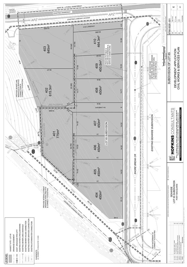
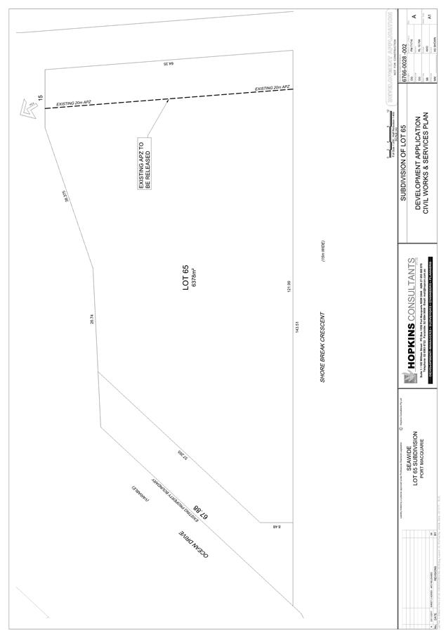
|
ATTACHMENT
|
Development Assessment Panel
13/12/2017
|
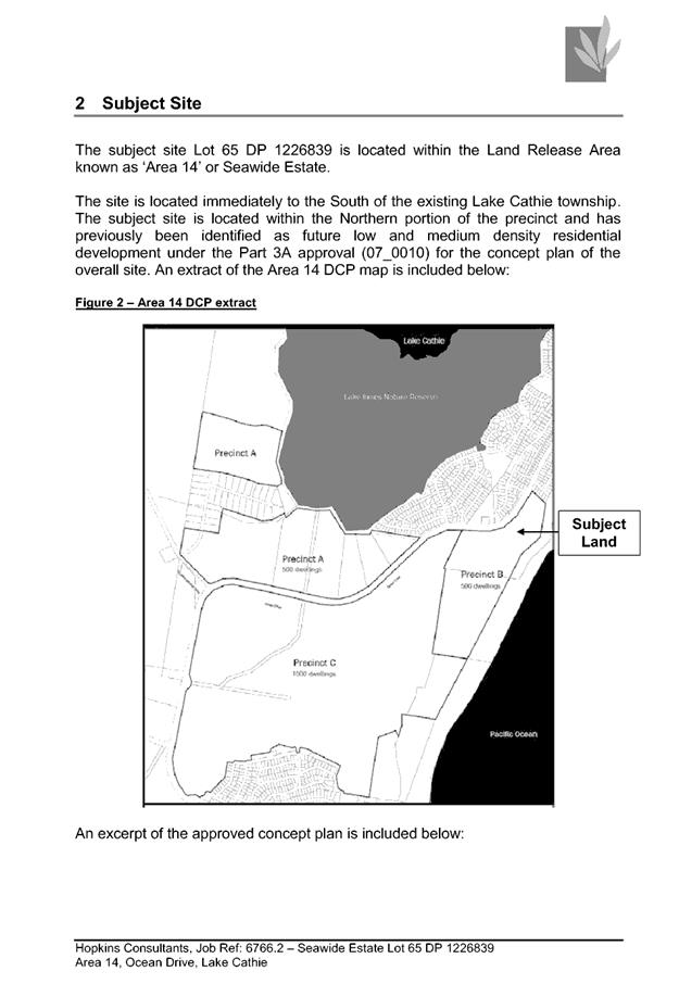
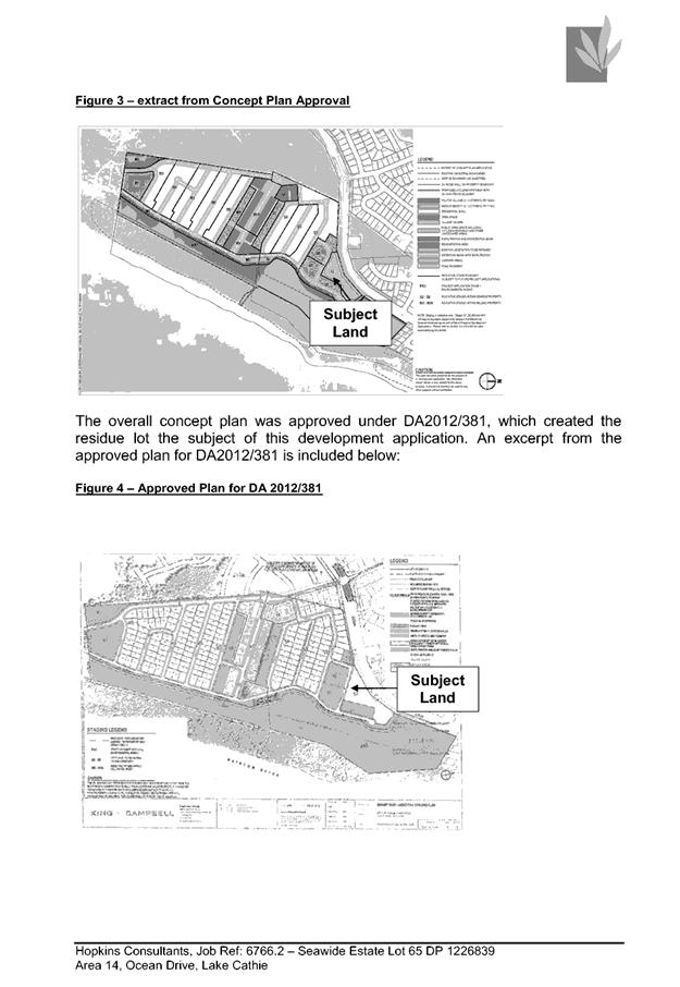
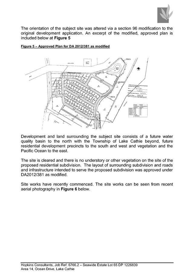
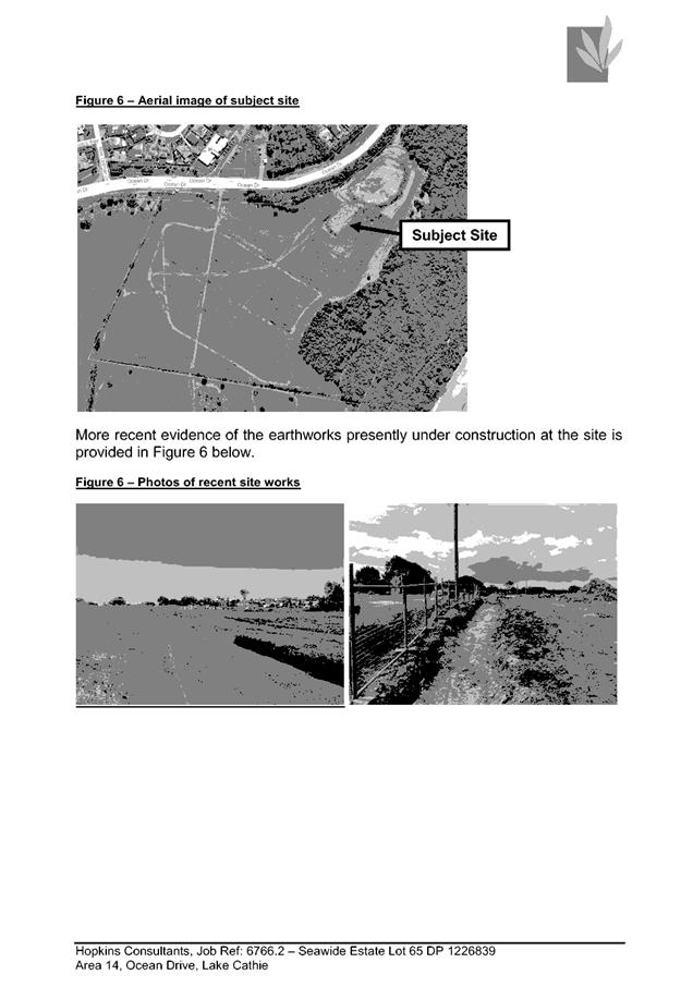
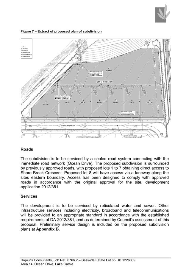
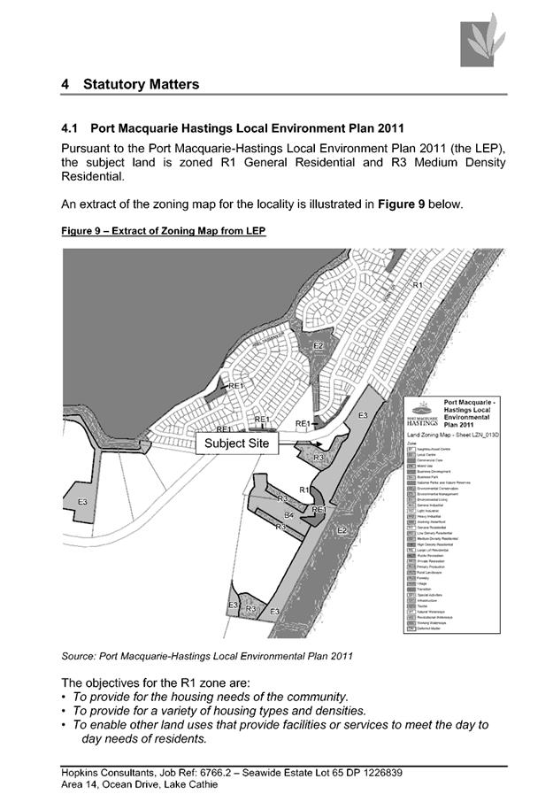
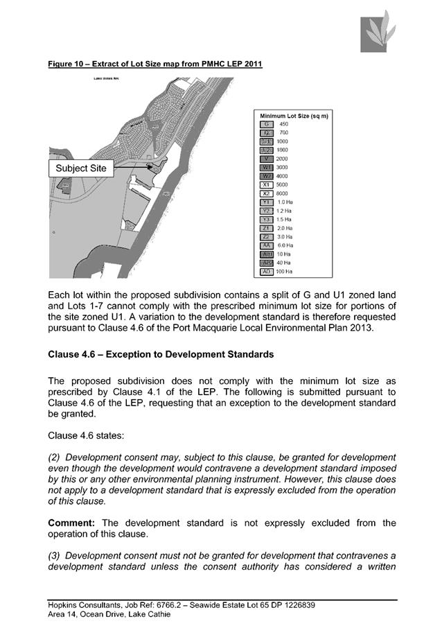
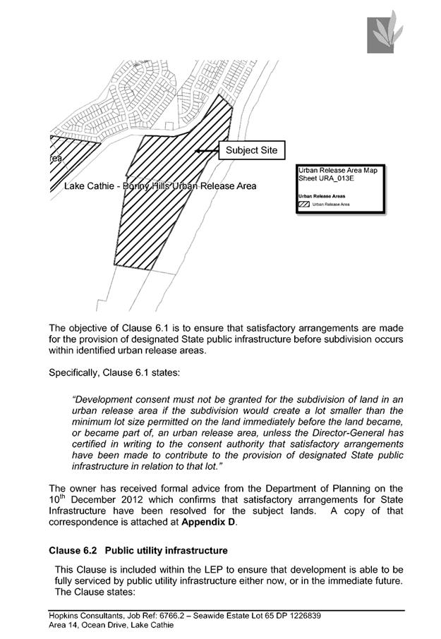
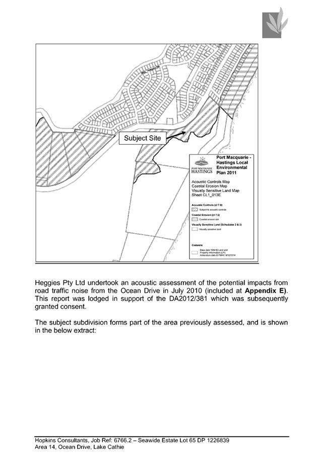
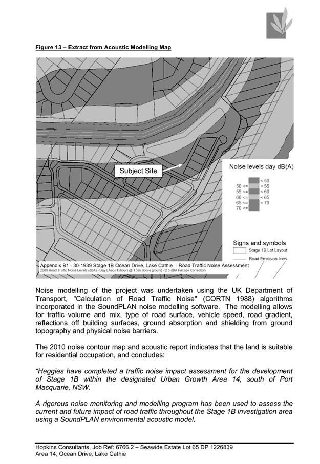
|
ATTACHMENT
|
Development Assessment Panel
13/12/2017
|
AGENDA Development Assessment Panel 13/12/2017
Item: 07
Subject: DA2017 - 877.1 Dwelling - Lot 709 DP 1228141,
No 49 Yaluma Drive, Port Macquarie
Report
Author: Patrick Galbraith-Robertson
|
Applicant: Coral
Homes Pty Ltd
Owner: C
& L Nankervis
Estimated Cost: $592K
Alignment with Delivery
Program
4.3.1 Undertake transparent
and efficient development assessment in accordance with relevant legislation.
|
|
RECOMMENDATION
That
DA 2017 – 877.1 for a dwelling
at Lot 709, DP 1228141, No.
49 Yaluma Drive, Port Macquarie,
be determined by granting consent subject to the recommended conditions.
|
Executive Summary
This
report considers a Development Application for a dwelling at the subject site and provides an assessment of the
application in accordance with the Environmental Planning and Assessment Act
1979.
This matter is being reported to
the Development Assessment Panel due to the submissions received.
Following exhibition of the
application, two (2) submissions have been
received.
The proposal has been amended
during the assessment of the application. Amendments to the proposal have
included increasing the south-west side setback, increased drop edge beam
construction on the south-western corner of the building and refinements to the
retaining wall design along the south western side of the site.
1. BACKGROUND
Existing sites features and surrounding development
The site has an area of 784m².
The site is zoned R1 General Residential in accordance with the Port Macquarie-Hastings Local
Environmental Plan 2011, as shown in the following zoning plan:
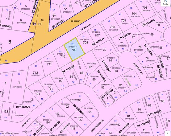
The existing subdivision pattern and location of existing
development within the locality is shown in the following aerial photograph
(source: nearmap August 2017):
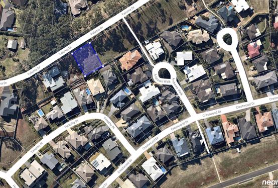
2. DESCRIPTION OF
DEVELOPMENT
Key aspects of the proposal include the following:
· Construction
of a two (2) storey dwelling-house with associated retaining walls.
Refer
to attachments at the end of this report.
Application Chronology
· 29
September 2017 – DA lodged with Council.
· 23
October to 6 November 2017 – Neighbour notification of proposal.
· 25 October 2017 – Additional information request
– show existing ground levels, request increasing the south-western side
setback, address privacy requirements of the Development Control Plan 2013,
consider a drop edge beam return extended for south-western corner and confirm
boundary fence can be constructed along boundary near retaining wall.
· 7 November 2017 – Copy of redacted submissions
forwarded to Applicant for consideration.
· 8 November 2017 – Amended plans received and
additional information.
· 9 November 2017 – Additional information requested to
address the specific recommended privacy requirements of Development Control
Plan 2013 with respect to the rear neighbouring properties.
· 9 November 2017 – Earthworks plans received from the
Applicant.
· 13 November 2017 – Amended plans received and
additional information to address privacy requirements of the Development
Control Plan 2013.
3. STATUTORY ASSESSMENT
Section 79C(1) Matters for Consideration
In determining the application, Council is required to take
into consideration the following matters as are relevant to the development
that apply to the land to which the development application relates:
(a) The provisions (where
applicable) of:
(i) any Environmental
Planning Instrument:
State Environmental Planning
Policy No. 44 - Koala Habitat Protection
There is no Koala Plan of
Management on the site. Additionally, the site is less than 1ha in area.
Therefore, no further investigations are required.
State Environmental Planning Policy No.55 –
Remediation of Land
Following an inspection of the site
and a search of Council records, the subject land is not identified as being
potentially contaminated and is suitable for the intended use.
State Environmental Planning Policy No. 62 –
Sustainable Aquaculture
Given the nature of the proposed
development and proposed stormwater controls the proposal will be unlikely to
have any adverse impact on existing aquaculture industries.
State Environmental Planning Policy No. 71 –
Coastal Protection and Clause 5.5 of Port Macquarie-Hastings Local
Environmental Plan 2011
The site is located within a
coastal zone as defined in accordance with clause 4 of SEPP 71.
In accordance with clause 5, this
SEPP prevails over the Port Macquarie-Hastings LEP 2011 in the event of any
inconsistency.
Having regard to clauses 8 and 12
to 16 of SEPP 71 and clause 5.5 of Hastings LEP 2011 inclusive the proposed
development will not result in any of the following:
a) any
restricted access (or opportunities for access) to the coastal foreshore
b) any
identifiable adverse amenity impacts along the coastal foreshore and on the
scenic qualities of the coast;
c) any
identifiable adverse impacts on any known flora and fauna (or their natural
environment);
d) subject to
any identifiable adverse coastal processes or hazards;
e) any
identifiable conflict between water and land based users of the area;
f) any
identifiable adverse impacts on any items of archaeological/heritage;
g) reduce the
quality of the natural water bodies in the locality.
The site is predominately cleared and located within an area
zoned for residential purposes.
State Environmental Planning Policy (Building
Sustainability Index: BASIX) 2004
A BASIX certificate has been submitted demonstrating that
the proposal will comply with the requirements of the SEPP. It is
recommended that a condition be imposed to ensure that the commitments are
incorporated into the development and certified at Occupation Certificate
stage.
Port Macquarie-Hastings Local Environmental
Plan 2011
The proposal is consistent with the LEP having regard to the
following:
· Clause 2.2,
the subject site is zoned R1 General Residential. In accordance with clause
2.3(1) and the R1 zone landuse table, the dwelling is a permissible landuse
with consent.
The objectives of the R1 zone are as
follows:
o To
provide for the housing needs of the community.
o To
provide for a variety of housing types and densities.
o To enable other land uses that
provide facilities or services to meet the day to day needs of residents.
In accordance with Clause 2.3(2), the
proposal is consistent with the zone objectives as it is a permissible landuse
and consistent with the desired and existing character of this developing
residential locality.
· Clause 4.3,
the maximum overall height of the building above ground level (existing) is 8.3
m (note: maximum height shown on plans at 8.746m is incorrect by definition),
which complies with the standard height limit of 8.5m applying to the site.
· Clause 4.4,
the floor space ratio of the proposal is 0.4:1.0 which complies with the maximum
0.65:1 floor space ratio applying to the site.
· Clause 5.9,
no listed trees in Development Control Plan 2013 are proposed to be removed.
· Clause 5.10,
the site does not contain or adjoin any known heritage items or sites of
significance.
· Clause 7.13,
satisfactory arrangements are in place for provision of essential services.
(a)(ii) Any proposed
instrument that is or has been placed on exhibition
No draft instruments apply to the
site.
(a)(iii) Any DCP in force
Port Macquarie-Hastings Development Control Plan 2013:
|
DCP 2013: Dwellings, Dual
occupancies, Dwelling houses, Multi dwelling houses & Ancillary
development
|
|
|
Requirements
|
Proposed
|
Complies
|
|
3.2.2.1
|
Ancillary development:
• 4.8m
max. height
• Single
storey
• 60m2
max. area
• 100m2
for lots >900m2
• 24
degree max. roof pitch
• Not
located in front setback
|
Water tank is appropriately
located
|
Yes
|
|
3.2.2.2
|
Articulation zone:
• Min.
3m front setback
• An
entry feature or portico
• A
balcony, deck, patio, pergola, terrace or verandah
• A
window box treatment
• A
bay window or similar feature
• An
awning or other feature over a window
• A
sun shading feature
|
The dwelling contains a portico and first floor balcony
within the articulation zone. The portico and balcony do not exceed 25% of
the articulation zone and are still setback a minimum 3m.
|
Yes
|
|
Front setback (Residential not R5
zone):
• Min.
6.0m classified road
• Min.
4.5m local road
• Min.
3.0m secondary road
• Min.
2.0m Laneway
|
The assumed primary front
building line setback is compliant with the minimum 4.5m front setback
requirements.
|
Yes
|
|
3.2.2.3
|
Garage 5.5m min. and 1m behind
front façade.
Garage door recessed behind
building line or eaves/overhangs provided
|
Garage door setback is compliant
with the minimum front setback requirements.
Garage door recessed.
|
Yes
|
|
6m max. width of garage door/s
and 50% max. width of building
|
Width of garage door are
compliant with the maximum width requirements
|
Yes
|
|
Driveway crossover 1/3 max. of
site frontage and max. 5.0m width
|
Driveway crossing width is
compliant with the maximum width requirements
|
Yes
|
|
3.2.2.4
|
4m min. rear setback. Variation
subject to site analysis and provision of private open space
|
The rear setback requirements are
complied with. A minimum 6.88m rear setback is proposed.
|
Yes
|
|
3.2.2.5
|
Side setbacks:
• Ground
floor = min. 0.9m
• First
floors & above = min. 3m setback or where it can be demonstrated that
overshadowing not adverse = 0.9m min.
• Building
wall set in and out every 12m by 0.5m
|
The minimum side setback
requirements are complied with.
The upper floor has a minimum
2.5m minimum side setback to a section of the Bed 4 ensuite with the
remainder of the building set at a minimum 3.0m as shown on the site plan.
The building wall articulation is
compliant and/or satisfactory to address the objective intent of the
development provision.
|
Yes
|
|
3.2.2.6
|
35m² min. private open space
area including a useable 4x4m min. area which has 5% max. grade
|
The dwelling contains 35m²
of useable area available for open space in one area including a
useable 4m x 4m space.
|
Yes
|
|
3.2.2.10
|
Privacy:
• Direct
views between living areas of adjacent dwellings screened when within 9m
radius of any part of window of adjacent dwelling and within 12m of private
open space areas of adjacent dwellings. ie. 1.8m fence or privacy screening
which has 25% max. openings and is permanently fixed
• Privacy
screen required if floor level > 1m height, window side/rear setback
(other than bedroom) is less than 3m and sill height less than 1.5m
• Privacy
screens provided to balconies/verandahs etc which have <3m side/rear
setback and floor level height >1m
|
No direct views between internal
living areas from the proposed dwelling to adjacent dwellings when within a
9m radius of any part of the windows of adjacent southern neighbouring
dwellings and/or within 12m of their primary private open space areas.
There are vacant sites to the
east and west with no approvals in place as yet.
Upper bedroom balconies are no
closer than 3m to boundary.
The main living deck at an
elevated ground floor level at the rear achieves a 12m separation to main
primary private open space area of southern neighbours.
No privacy screens are
recommended.
Refer also commentary in
submissions section of this report and working drawings below submissions
table for assistance.
|
Yes
|
|
DCP 2013: General
Provisions
|
|
|
Requirements
|
Proposed
|
Complies
|
|
2.7.2.2
|
Design addresses generic principles of Crime Prevention
Through Environmental Design guideline
|
No concealment or entrapment areas proposed. Adequate
casual surveillance available.
|
Yes
|
|
2.3.3.1
|
Cut and fill 1.0m max. 1m outside the perimeter of the
external building walls
|
Outside the perimeter of the external building walls:
- Cut
will be a maximum 1.4m within the north-eastern corner of the site.
- Fill
is maximum change 1m
|
No*
Yes
|
|
2.3.3.2
|
1m max. height retaining walls along road frontage
|
None proposed
|
N/A
|
|
Any retaining wall >1.0 in height to be certified by
structure engineer
|
Condition recommended to require engineering certification
for all retaining walls
|
Yes
|
|
Combination of retaining wall and front fence height max
1.8m, max length 6.0m or 30% of frontage, fence component 25% transparent,
and splay at corners and adjacent to driveway
|
No retaining wall front fence combination proposed.
|
N/A
|
|
2.3.3.8
|
Removal of hollow bearing trees
|
No trees proposed to be removed
|
N/A
|
|
2.6.3.1
|
Tree removal (3m or higher with 100m diameter trunk at 1m
above ground level and 3m from external wall of existing dwelling)
|
No trees proposed to be removed
|
N/A
|
|
2.4.3
|
Bushfire risk, Acid sulphate soils, Flooding,
Contamination, Airspace protection, Noise and Stormwater
|
Refer to main body of report.
|
|
|
2.5.3.2
|
New accesses not permitted from arterial or distributor
roads
|
No new access proposed to arterial or distribution road.
|
N/A
|
|
Driveway crossing/s minimal in number and width including
maximising street parking
|
Driveway crossing minimal in width including maximising
street parking
|
Yes
|
|
2.5.3.3
|
Parking in accordance with Table 2.5.1.
1 space per single dwelling (behind building line)
|
1 or capacity for more than 1 parking space behind the
building line has been provided for.
|
Yes
|
|
2.5.3.11
|
Section 94 contributions
|
N/A
|
|
|
2.5.3.12 and 2.5.3.13
|
Landscaping of parking areas
|
Single dwelling only with 1 domestic driveway. No specific
landscaping requirements recommended.
|
N/A
|
|
2.5.3.14
|
Sealed driveway surfaces unless justified
|
Sealed driveway proposed
|
Yes
|
|
2.5.3.15 and 2.5.3.16
|
Driveway grades first 6m or ‘parking area’
shall be 5% grade with transitions of 2m length
|
Driveway grades capable of satisfying Council standard
driveway crossover requirements. Condition recommended for section 138 Roads
Act permit
|
Yes
|
|
2.5.3.17
|
Parking areas to be designed to avoid concentrations of
water runoff on the surface.
|
Single dwelling only with 1 domestic driveway. Stormwater
drainage is capable of being managed as part of plumbing construction.
|
Yes
|
The proposal seeks to vary the
Development Provision relating to maximum recommended cut outside the building
walls. The maximum cut is proposed to be approximately 1.4m and preliminary
engineering details have been submitted as part of the DA assessment. The
levels have been refined during the assessment of the application.
The relevant objectives are:
To ensure that design of any building or structure
integrates with the topography of the land to:
• Minimise the extent of site
disturbance caused by excessive cut and fill to the site.
• Ensure there is no damage or
instability to adjoining properties caused by excavation or filling.
• Ensure that there is no adverse
alteration to the drainage of adjoining properties.
• Ensure the privacy of adjoining
dwellings and private open space are protected.
• Ensure that adequate stormwater
drainage is provided around the perimeter of buildings and that overflow paths
are provided.
Having regard
for the development provisions and relevant objectives, the variation is
considered acceptable for the following reasons:
· The
exceedance of cut will unlikely lead to excessive site disturbance given the
existing levels across the front section of the site.
· There
are no adverse impacts including privacy or overshadowing identified to the
neighbouring properties.
· The
height of the retaining walls will not adversely affect the streetscape of
Yaluma Drive.
Having regard to
the DCP provisions, it should be noted that the following preamble applies to
the assessment of Development Applications:
Variations
Council may consider varying the development provisions
where it can be adequately demonstrated that the objective to which the
provision relates can be wholly achieved by reasonable or innovative solutions
and the proposal is consistent with all relevant LEP aims and Zone Objectives.
Based on the
above assessment, the variation proposed to the provisions of the DCP is
considered acceptable and the relevant objectives have been satisfied.
Cumulatively, this variation does not amount to an adverse impact that would
justify refusal of the application.
(a)(iii)(a)
Any planning agreement or draft planning agreement
No planning
agreement has been offered or entered into relating to the site.
(a)(iv)
Any matters prescribed by the regulations
NSW Coastal Policy
1997
The proposed
development is consistent with the objectives and strategic actions of this
policy.
(a)(v) Any Coastal Zone
Management Plan
None applicable.
(b) The likely impacts
of that development, including environmental impacts on both the natural and
built environments and the social and economic impacts in the locality
Context and setting
• The
proposal will be unlikely to have any adverse impacts to existing adjoining
properties and satisfactorily addresses the public domain.
• The proposal is considered to be consistent with other
residential development in the locality including the future character of this
developing section of Yaluma Drive. The proposal also adequately addresses
planning controls (as justified) for the area.
• There
are no identifiable adverse impacts on existing view
sharing. It is noted that the proposal is compliant with height and side
setback controls.
• There are no adverse privacy impacts having regard to the
DCP requirements.
• There are no identifiable adverse overshadowing impacts.
The proposal does not prevent adjoining properties from receiving 3 hours of
sunlight to private open space and primary living areas on 21 June.
Access, transport and traffic
The proposal will be unlikely to have any adverse impacts in
terms access, transport and traffic. The existing road network will
satisfactorily cater for any increase in traffic generation as a result of the
development.
Water Supply
An existing water service is available within Yaluma Drive
for connection. Specific connection details will be addressed at the S.68
stage.
Sewer
The site slopes towards the rear of the site. A sewer main
service including a junction is available to connect to in the south-eastern
rear corner of the site with details required at the S.68 stage.
Stormwater
The site slopes towards the rear of the site. The site is
serviced by an existing interallotment stormwater drainage system providing a
junction to the existing stormwater line in the south-eastern corner. The line
has benefitting easements across neighbouring properties to provide this
ability to legally dispose of stormwater. It is also noted that a 5000 litre
water tank is proposed to be installed on-site.
Other Utilities
Underground telecommunication and electricity services are
available to the site.
Heritage
This site does not contain or adjoin any known heritage item
or site of significance.
Other land resources
No adverse impacts anticipated. The site is within an
established urban context and will not sterilise any significant mineral or
agricultural resource.
Water cycle
The proposed development will be unlikely to have any
adverse impacts on water resources and the water cycle.
Soils
The proposed development will be unlikely to have any
adverse impacts on soils in terms of quality, erosion, stability and/or
productivity subject to a standard condition requiring erosion and sediment
controls to be in place prior to and during construction.
Air and microclimate
The construction and/or operations of the proposed
development will be unlikely to result in any adverse impacts on the existing
air quality or result in any pollution.
Flora and fauna
Construction of the proposed development will not require
any removal/clearing of any significant vegetation and therefore will be
unlikely to have any significant adverse impacts on biodiversity or threatened
species of flora and fauna. Section 5A of the Act is considered to be
satisfied.
Waste
Satisfactory arrangements are in place for proposed storage
and collection of waste and recyclables. No adverse impacts anticipated.
Energy
The proposal includes measures to address energy efficiency
and will be required to comply with the requirements of BASIX.
Noise and vibration
No adverse impacts anticipated. Condition recommended to
restrict construction to standard construction hours.
Bushfire
The site is not identified as being bushfire prone.
Safety, security and crime prevention
The proposed development will be unlikely to create any
concealment/entrapment areas or crime spots that would result in any
identifiable loss of safety or reduction of security in the immediate area.
Social impacts in the locality
Given the nature of the proposed development and its’
location the proposal is unlikely to result in any adverse social impacts.
Economic impact in the locality
No adverse impacts. Likely positive impacts can be
attributed to the construction of the development and associated flow on
effects (ie maintained employment and expenditure in the area).
Site design and internal design
The proposed development design satisfactorily responds to
the site attributes and will fit into the locality. No adverse impacts likely.
Construction
No potential adverse impacts identified to neighbouring
properties with the construction of the proposal.
Cumulative impacts
The proposed development is not
expected to have any adverse cumulative impacts on the natural or built
environment or the social and economic attributes of the locality.
(c) The suitability of the
site for the development
The proposal will fit into the
locality and the site attributes are conducive to the proposed development.
(d) Any submissions made in
accordance with this Act or the Regulations:
Two (2) written submissions have been received following public
exhibition of the application.
Key issues raised in the submissions received and comments
in response to these issues are provided as follows:
|
Submission
Issue/Summary
|
Planning
Comment/Response
|
|
10 Timothy Place
|
|
The proposed dwelling will overlook our backyard and
lounge room windows giving us no privacy.
Always expected some dwelling to
be built behind us with a slight visual of our backyard but this planned
development will look straight into our lounge room.
|
It is
noted that this neighbour is directly to the south of the proposal.
The
filling proposed is now refined to be no more than 1m in height outside the
building envelope.
The
finished floor level of the internal living room area is assumed to be
RL40.095m (the garage has no set down area) and the rear deck has a setdown
area of 65mm below that.
The
rear of the proposed dwelling with its elevated ground floor deck is
approximately 2m above existing ground level, 1.4m above the adjusted ground
level (600mm of fill before measuring height of adjusted floor level)
proposed and has a drop edge beam construction proposed in part.
The
proposed dwelling and its rear setback relating to this southern neighbour
are considered suitable for the following reasons:
· The proposed dwelling has a minimum setback distance to
the rear boundary at the closest point of 6.89m. This is greater than the
minimum 4m recommended standard by the DCP.
· The diagram below this table illustrates key distance
criteria with relation to the closest living room window and this closest
southern neighbour. The key distances from the proposed rear deck are not
shown however if 2.5m is added to the 12m radius shown in yellow to measure
from the proposed rear deck also (at a point roughly half of the blue 5.36m
line shown) it is considered that there is no direct views to the principal
private open space area of this neighbour within 12m of the proposed living
room deck.
· The upper main living room floor plan of this
neighbouring southern dwelling is set approximately 2.6m lower than the
common boundary fencing point between these properties. There is also an
existing 1.8m high fence. Refer working drawings compiled by the Assessing
Officer shown also below for reference.
· All upper floor level rooms of the proposed dwelling are
also bedrooms only on the rear southern side. The DCP does not require any
specific consideration of bedroom windows privacy impacts.
|
|
There
will be shadowing to some of the garden and part of the house in the late
afternoon.
|
It is
noted that the original shadow diagrams were incorrect. This matter was
raised with the Applicant during the assessment of the application.
The
Applicant originally submitted the shadow diagrams only due to the setback
(particularly for the first floor level) being originally less than 3m on the
western side boundary as triggered by the DCP.
With regard to the submission,
the dwelling proposed has a greater setback than the minimum 4m recommended
standard and it is considered that the proposal will not result in any
identifiable adverse shadow impacts during the key 9am to 3pm period at the
mid-winter solstice to this southern neighbour. Requesting a greater rear
setback particularly for the first floor, which is compliant with the height
limit, would be considered unreasonable.
|
|
12 Timothy Place
|
|
The development overlooks our
living area, backyard, swimming pool and our dining area. The filling area is
almost 2 metres from 37.71 to 39.77 and then there is 2 storey on top so
that will set the house very high.
|
It is
noted that this neighbour is directly to the south-west of the proposal.
The
filling proposed is now refined to be no more than 1m in height outside the
building envelope.
The
finished floor level of the internal living room area is assumed to be
RL40.095m (the garage has no set down area) and the rear deck has a set down
area of 65mm below that.
The
rear of the proposed dwelling with its elevated ground floor deck is
approximately 2m above existing ground level, 1.4m above the adjusted ground
level (600mm of fill before measuring height of adjusted floor level)
proposed and has a drop edge beam construction proposed in part.
The
proposed dwelling and its rear setback relating to this southern neighbour
are considered suitable for the following reasons:
· The proposed dwelling has a minimum setback distance to
the rear boundary at the closest point of 6.89m. This is greater than the
minimum 4m recommended standard by the DCP.
· There are no primary living areas or primary private open
space areas within 9m or 12m of proposed dwelling.
· The upper main living room floor plan of this
neighbouring southern dwelling is set approximately 3.3m lower (based upon a
review of their approved plans as constructed) than ground level at the
north-eastern corner of this neighbour’s property. There is also an
existing 1.8m high fence in between this neighbour and the proposal and a new
additional fence to be proposed on the western boundary of the subject
proposal’s site.
· All upper floor level rooms of the proposed dwelling are
also bedrooms only on the rear southern side. The DCP does not require any
specific consideration of bedroom windows privacy impacts.
|
|
The
shadow diagram in the proposal is misleading (incorrect direction of the
north), the development will have negative impact 'shading' on us and
the adjoining residences (51 Yaluma drive).
|
It is
agreed that the original shadow diagrams were incorrect. This matter was
raised with the Applicant during the assessment of the application.
The
Applicant originally submitted the shadow diagrams only due to the setback
(particularly for the first floor level) being originally less than 3m on the
western side boundary as triggered by the DCP.
With regard to the submission
issue raised, the dwelling proposed has a greater setback than the minimum 4m
recommended standard and it is considered that the proposal will not result
in any identifiable adverse shadow impacts during the key 9am to 3pm period
at the mid-winter solstice to this southern neighbour. Requesting a greater
rear setback particularly for the first floor, which is compliant with the
height limit, would be considered unreasonable.
With regard to No.51 Yaluma
Drive, the proposed western side setback has been increased to provide for a
primary 3m side setback (Note the bed 4 ensuite has a 2.5m setback with no
eave referred to earlier in this report).
|
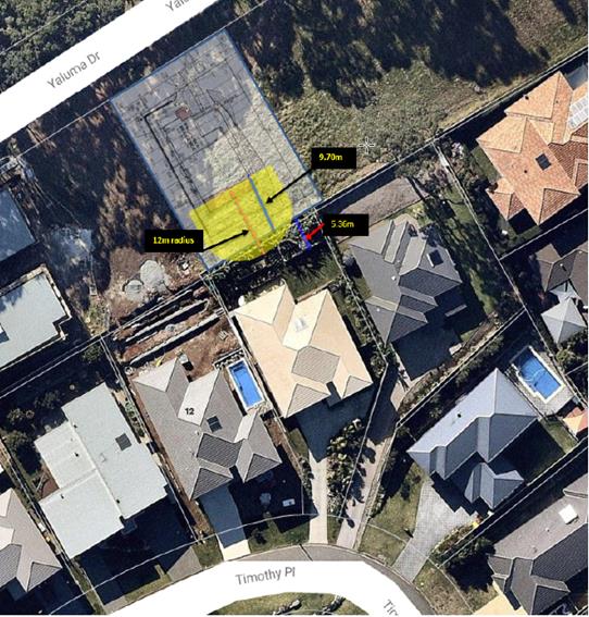
(e) The
Public Interest:
The proposed
development will be in the wider public interest with provision of appropriate additional
housing.
The proposed
development satisfies relevant planning controls and is not expected to
adversely impact on the wider public interest.
4. DEVELOPMENT
CONTRIBUTIONS APPLICABLE
No contributions are applicable.
5. CONCLUSION
The application has been assessed in accordance with
Section 79C of the Environmental Planning and Assessment Act 1979.
Issues raised during assessment and public exhibition of
the application have been considered in the assessment of the application.
Where relevant, conditions have been recommended to manage the impacts
attributed to these issues.
The site is suitable for the proposed development, is not
contrary to the public's interest and will not have a significant adverse
social, environmental or economic impact. It is recommended that the
application be approved, subject to the recommended conditions of consent
provided in the attachment section of this report.
|
Attachments
1View. DA2017
- 877.1 DA Plans.
2View. DA2017
- 877.1 Recommended Conditions
3View. DA2017
- 877.1 Submission - Alkinani
4View. DA2017
- 877.1 Submission - Kennedy
|
|
ATTACHMENT
|
Development Assessment Panel
13/12/2017
|
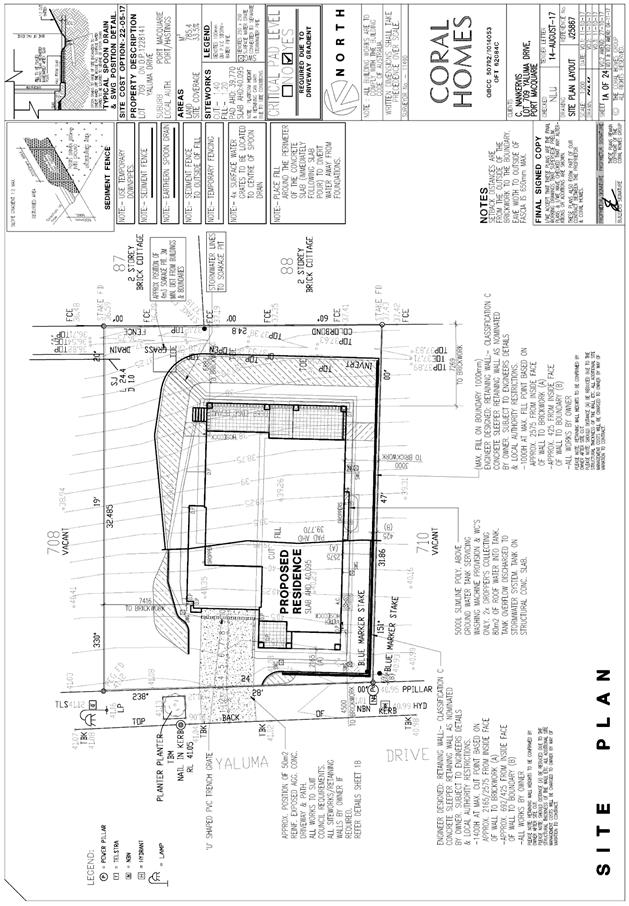
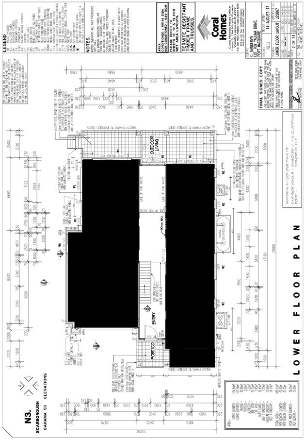
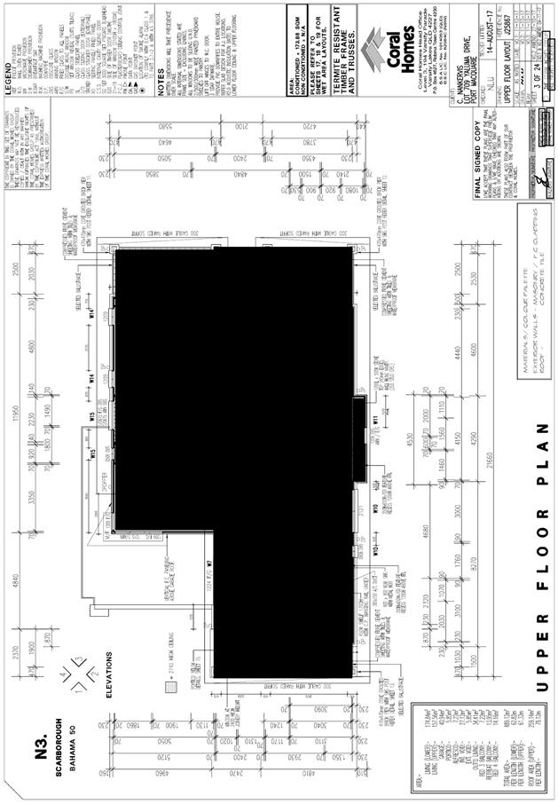
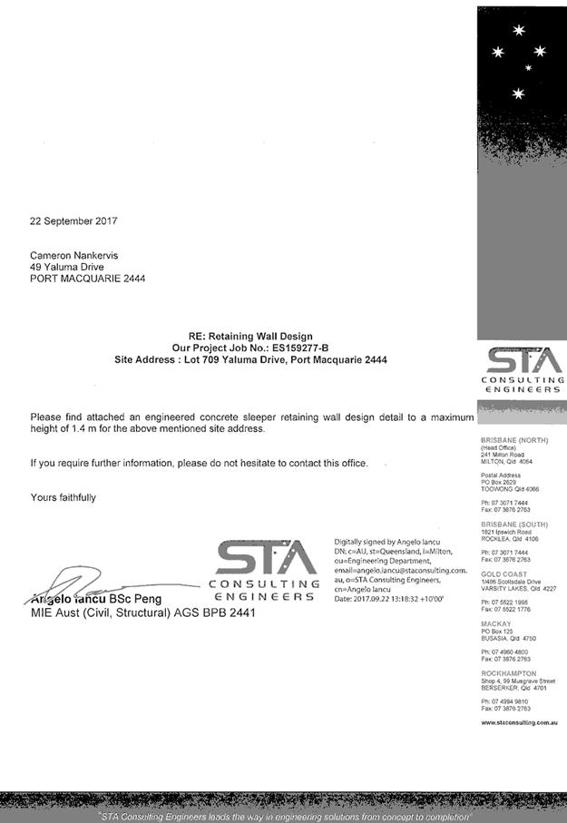
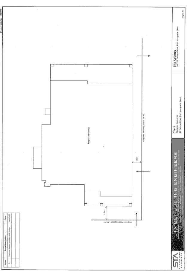
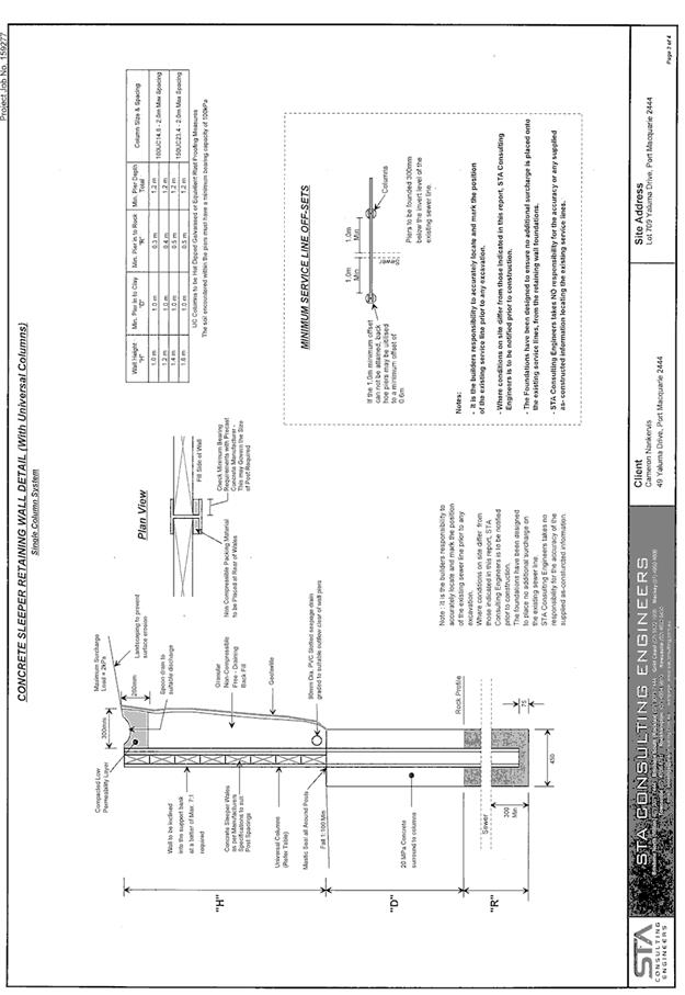
|
ATTACHMENT
|
Development Assessment Panel
13/12/2017
|

|
ATTACHMENT
|
Development Assessment Panel
13/12/2017
|
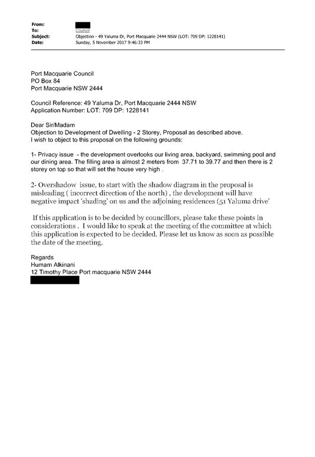
|
ATTACHMENT
|
Development Assessment Panel
13/12/2017
|
AGENDA Development Assessment Panel 13/12/2017
Item: 08
Subject: DA2017 - 866.1 Alterations And Additions To Dwelling And
Construction Of Pool - Lot 134 DP 246284, No 60 Hibbard Drive, Port Macquarie
Report Author: Fiona Tierney
|
Applicant: Dale
C Carr & Associates
Owner: M
S & S M Sciascia
Estimated Cost: $350,000
Alignment with Delivery Program
4.3.1 Undertake transparent
and efficient development assessment in accordance with relevant legislation.
|
|
RECOMMENDATION
That
DA 2017 – 866.1 for alterations
and additions to dwelling and construction of pool at Lot 134, DP 246284, No. 60 Hibbard Drive, Port
Macquarie, be determined by granting consent
subject to the recommended conditions.
|
Executive
Summary
This
report considers a development application for alterations and additions to
dwelling and construction of pool at the subject site and provides an
assessment of the application in accordance with the Environmental Planning and
Assessment Act 1979.
Following exhibition of the
application, 1 submission has been received.
1. BACKGROUND
Existing sites features and Surrounding development
The site has an area of 824.4m2.
The site is zoned R1 General Residential in accordance with the Port Macquarie-Hastings Local
Environmental Plan 2011, as shown in the following zoning plan:
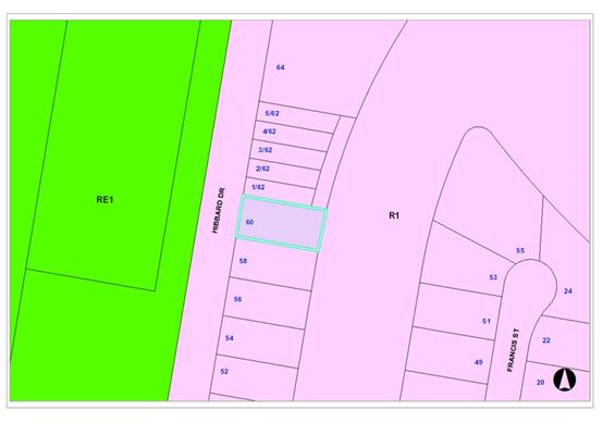
The existing subdivision pattern and location of existing
development within the locality is shown in the following aerial photograph:
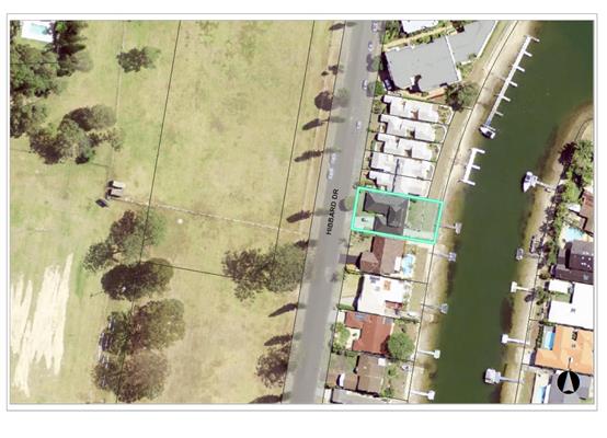
2. DESCRIPTION OF DEVELOPMENT
Key aspects of the proposal include the following:
· Ground
floor awning
· Boat
Ramp/Shed
· Upper
floor additions and Juliet balcony
· Lower
floor reconfiguration and additions
· In
ground swimming pool
Refer
to attachments at the end of this report.
Application Chronology
· 28
September 2017 - Application lodged.
· 11 October 2017 to 24 October 2017 - Neighbour notification
of the proposal.
· 27 November 2017 - Site and impact to neighbouring properties
inspected by assessing officer.
3. STATUTORY ASSESSMENT
Section 79C(1) Matters for Consideration
In determining the application, Council is required to take
into consideration the following matters as are relevant to the development
that apply to the land to which the development application relates:
(a) The provisions (where
applicable) of:
(i) any Environmental
Planning Instrument:
State
Environmental Planning Policy No. 55 – Remediation of Land
Following an
inspection of the site and a search of Council records, the subject land is not
identified as being potentially contaminated and is suitable for the intended
use.
State
Environmental Planning Policy No. 71 – Coastal Protection and Clause 5.5
of Port Macquarie-Hastings Local Environmental Plan 2011
The site is
located within a coastal zone as defined in accordance with clause 4 of SEPP
71.
In accordance
with clause 5, this SEPP prevails over the Port Macquarie-Hastings LEP 2011 in
the event of any inconsistency.
Having regard to
clauses 8 and 12 to 16 of SEPP 71 and clause 5.5 of Hastings LEP 2011 inclusive
the proposed development will not result in any of the following:
a) any
restricted access (or opportunities for access) to the coastal foreshore
b) any
identifiable adverse amenity impacts along the coastal foreshore and on the
scenic qualities of the coast;
c) any
identifiable adverse impacts on any known flora and fauna (or their natural
environment);
d) subject
to any identifiable adverse coastal processes or hazards;
e) any
identifiable conflict between water and land based users of the area;
f) any
identifiable adverse impacts on any items of archaeological/heritage;
g) reduce
the quality of the natural water bodies in the locality.
The site is located within an area zoned
for residential purposes.
State
Environmental Planning Policy (Building Sustainability Index: BASIX) 2004
BASIX
certificate (number A292448) has been submitted demonstrating that the proposal
will comply with the requirements of the SEPP. It is recommended that a
condition be imposed to ensure that the commitments are incorporated into the
development and certified at Occupation Certificate stage.
Port
Macquarie-Hastings Local Environmental Plan 2011
The proposal
is consistent with the LEP having regard to the following:
• Clause
2.2, the subject site is zoned R1 General Residential. In accordance with
clause 2.3(1) and the R1 zone landuse table, the dwelling and ancillary
structure to a dwelling is a permissible landuse with consent.
The objectives of the R1 zone are as follows:
o To
provide for the housing needs of the community.
o To
provide for a variety of housing types and densities.
o To
enable other land uses that provide facilities or services to meet the day to
day needs of residents.
In accordance with Clause 2.3(2), the proposal is consistent with the
zone objectives as it is a permissible landuse, contributes to the range of
housing options available for the community and consistent with the residential
locality.
• Clause
4.3 Height of buildings – the dwelling is less than the maximum 8.5m
height limit.
• Clause
4.4 Floor space ratio – the proposed FSR is 0.41:1, less than the
allowable 0.65:1.
• Clause
7.3 Flooding - The site is located in an area subject to flooding. The
application has been referred to Council’s flood engineer who has
concurred that the proposal is acceptable and appropriate conditions have been
applied.
• Clause
7.13, satisfactory arrangements are in place for provision of essential
services.
(ii) Any
draft instruments that apply to the site or are on exhibition:
No draft
instruments apply to the site
(iii) any
Development Control Plan in force:
Port
Macquarie-Hastings Development Control Plan 2013
|
DCP 2013: Dwellings, Dual occupancies, Dwelling
houses, Multi dwelling houses & Ancillary development
|
|
DCP Objective
|
Development Provisions
|
Proposed
|
Complies
|
|
3.2.2.3
|
Garage minimum 5.5m front setback and garage door recessed
behind building line at least 1m or eaves/overhangs provided
|
Complies with 5.5m and 1m setback requirement.
|
Yes
|
|
6m max. width of garage door/s and 50% max. width of
building
|
Existing
|
N/A
|
|
Driveway crossover 1/3 max. of site frontage and max. 5.0m
width
|
Existing
|
N/A
|
|
3.2.2.4
|
4m min. rear setback. Variation subject to site analysis
and provision of private open space
|
Rear/canal setback is governed by the 88B instrument.
Proposal is consistent with the 88B instrument setbacks and adjoining
development.
|
Yes
|
|
3.2.2.5
|
Side setbacks:
· Ground floor
min. 0.9m
· First floors
& above min. 3m setback, unless demonstrated that adjoining property
primary living areas & POS unaffected.
· Building wall
set in and out every 12m by 0.5m.
|
Building wall articulation satisfactory.
|
Yes
|
|
3.2.2.6
|
35m2 min. private open space area including a
useable 4x4m min. area which has 5% max. grade and is directly accessible
from a ground floor living area.
|
Dwelling has a minimum 35m2 private open space
including 4m x 4m area accessible from living room.
|
Yes
|
|
3.2.2.10
|
Privacy:
· Direct views
between living areas of adjacent dwellings screened when within 9m radius of
any part of window of adjacent dwelling and within 12m of private open space
areas of adjacent dwellings. ie. 1.8m fence or privacy screening which has
25% max. openings and is permanently fixed
· Privacy screen
required if floor level > 1m height, window side/rear setback (other than
bedroom) is less than 3m and sill height less than 1.5m
· Privacy screens
provided to balconies/verandas etc which have <3m side/rear setback and
floor level height >1m
|
One objection has been received relating to privacy from
the neighbour to the North. However, the closest windows are bedroom windows
and a privacy screen is proposed along the western end of the alfresco area.
Existing screening also exists along the fence through existing vegetation.
Small Juliet balcony is proposed accessible from upper
bedroom, which will create minimal privacy impacts.
|
Yes
|
|
DCP 2013: General Provisions
|
|
DCP Objective
|
Development Provisions
|
Proposed
|
Complies
|
|
2.7.2.2
|
Design addresses generic principles of Crime Prevention
Through Environmental Design guideline:
· Casual
surveillance and sightlines
· Land use mix and
activity generators
· Definition of
use and ownership
· Lighting
· Way finding
· Predictable
routes and entrapment locations
|
The proposed development will be unlikely to create any
concealment/entrapment areas or crime spots that would result in any
identifiable loss of safety or reduction of security in the immediate area.
The increase in housing density will improve natural surveillance within the
locality and openings from the dwelling overlook common and private areas.
|
Yes
|
|
2.3.3.2
|
1m max. height retaining walls along road frontages
|
|
N/A
|
|
Any retaining wall >1.0 in height to be certified by
structural engineer
|
Condition recommended requiring certification of retaining
walls.
|
Yes
|
|
Combination of retaining wall and front fence height
|
|
N/A
|
|
2.3.3.8 onwards
|
Removal of hollow bearing trees
|
None proposed to be removed.
|
Yes
|
|
2.6.3.1
|
Tree removal (3m or higher with 100mm diameter trunk and
3m outside dwelling footprint
|
None proposed to be removed.
|
Yes
|
|
2.4.3
|
Bushfire risk, Acid sulphate soils, Flooding,
Contamination, Airspace protection, Noise and Stormwater
|
Refer to main body of report.
|
|
|
2.5.3.2
|
New accesses not permitted from arterial or distributor
roads. Existing accesses rationalised or removed where practical
|
Access from local road.
|
Yes
|
|
Driveway crossing/s minimal in number and width including
maximising street parking
|
Existing.
|
Yes
|
|
2.5.3.3
|
Off-street parking in accordance with Table 2.5.1:
· 1 space = single
dwelling (behind building line) and dual occupancy
· Medium density
– 1 per 1 or 2 bed dwelling or 1.5 per 3-4 bed dwelling + 1 visitor/4
dwellings
|
Double garage.
|
Yes
|
|
2.5.3.14
|
Sealed driveway surfaces unless justified
|
Concrete.
|
Yes
|
|
2.5.3.15
|
Driveway grades for first 6m of ‘parking area’
shall be 5% grade
(Note AS/NZS 2890.1 permits steeper grades)
|
Capable of complying.
|
Yes
|
|
2.5.3.16
|
Transitional grades min. 2m length
|
Capable of complying.
|
Yes
|
(iiia) any
planning agreement that has been entered into under Section 93f or any draft
planning agreement that a developer has offered to enter into under Section
93f:
No planning
agreement has been offered or entered into relating to the site.
iv) any matters prescribed by the
Regulations:
New South Wales Coastal Policy:
Site is
located within the area covered by the Coastal Policy. The proposed development
will impact on the achievement of the aims and objectives of the policy or SEPP
71.
Demolition
of buildings AS 2601:
Demolition of
the parts of the existing building on the site is capable of compliance with
this Australian Standard and is recommended to be conditioned.
v) any coastal
zone management plan (within the meaning of the Coastal Protection Act 1979),
that apply to the land to which the development application relates:
No Coastal
Zone Management Plan applies to the subject site.
(b) The
likely impacts of that development, including environmental impacts on both the
natural and built environments, social and economic impacts in the locality:
The site has
a general westerly street frontage orientation to Hibbard Drive. The site is
set amongst existing canal development that is a mixture of single and two
storey dwellings.
The dwelling
will present with a two storey elevation/view from the street and adjoining
properties. The proposal will be unlikely to have any significant adverse
impacts to existing adjoining properties and satisfactorily addresses the
public domain.
The proposal
is considered to be compatible with other residential development in the
locality and adequately addresses planning controls for the area.
The proposal
does not have significant adverse lighting impacts.
There are no
significant adverse privacy impacts. Privacy has been adequately addressed
through building design and existing site circumstances.
Overshadowing
There are additional
overshadowing impacts due to the orientation of the subdivision blocks. However,
the second storey is setback 3 metres to each side boundary which assists with
reducing the impact. Overall, no adverse overshadowing will occur.
Roads
The site has
road frontage to Hibbard Drive which is a public road with a sealed pavement, a
layback kerb and gutter, under the care and control of Council.
Traffic
and Transport
The traffic
associated with the development is unlikely to have any adverse impacts to the
existing road network within the immediate locality.
Site
Frontage & Access
Vehicle
access to the site is proposed though an existing driveway. Access shall comply
with Council AUSPEC and Australian Standards, and conditions have been imposed
to reflect these requirements.
Parking
and Manoeuvring
A total of 2
parking spaces have been provided on-site within the garage with additional
parking provided available within the driveway. Parking and driveway widths on
site can comply with relevant Australian Standards (AS 2890) and conditions
have been imposed to reflect these requirements.
Water
Supply Connection
Council
records indicate that the development site has an existing service.
Detailed
plans will be required to be submitted for assessment with the Section 68
application.
Refer to
relevant conditions of consent.
Sewer
Connection
Council
records indicate that the development site is connected to Sewer via a junction,
which can be adopted for use for the site. Details shall be provided as part of
the Section 68 application process.
Detailed
plans will be required to be submitted for assessment with the Section 68
application.
Flooding
The site is
located in an area subject to flooding. The application has been referred to
Council’s flood engineer who has concurred that the proposal is
acceptable and appropriate conditions have been applied.
Stormwater
The property contains existing
stormwater infrastructure.
Detailed
stormwater plans will be required to be submitted with the S.68 application but
is overall considered achievable.
Other
Utilities
Telecommunication
and electricity services are available to the site.
Heritage
No known
items of Aboriginal or European heritage significance exist on the property. No
adverse impacts anticipated.
Other land
resources
The site is
within an established urban context and will not sterilise any significant
mineral or agricultural resource.
Water
cycle
The proposed
development will be unlikely to have any adverse impacts on water resources and
the water cycle.
Soils
The proposed
development will be unlikely to have any adverse impacts on soils in terms of
quality, erosion, stability and/or productivity subject to a standard condition
requiring erosion and sediment controls to be in place prior to and during
construction.
Air and
microclimate
The
construction and/or operations of the proposed development will be unlikely to
result in any adverse impacts on the existing air quality or result in any
pollution. Standard precautionary site management condition recommended.
Flora and
fauna
Construction
of the proposed development will not require any removal/clearing of any
significant vegetation and therefore will be unlikely to have any significant
adverse impacts on biodiversity or threatened species of flora and fauna.
Section 5A of the Act is considered to be satisfied.
Waste
Satisfactory
arrangements are in place for proposed storage and collection of waste and
recyclables. No adverse impacts anticipated. Standard precautionary site
management condition recommended.
Energy
The proposal
includes measures to address energy efficiency and will be required to comply
with the requirements of BASIX. No adverse impacts anticipated.
Noise and
vibration
No adverse
impacts anticipated. Condition recommended restricting construction to standard
construction hours.
Bushfire
The site is
not identified as being bushfire prone.
Safety,
security and crime prevention
The proposed
development will be unlikely to create any concealment/entrapment areas or
crime spots that would result in any identifiable loss of safety or reduction
of security in the immediate area.
Social
impacts in the locality
Given the
nature of the proposed development and its’ location the proposal is
unlikely to result in any adverse social impacts.
Economic
impact in the locality
No adverse
impacts. A likely positive impact is that the development will maintain
employment in the construction industry, which will lead to flow on impacts
such as expenditure in the area.
Site
design and internal design
The proposed
development design satisfactorily responds to the site attributes and will fit
into the locality. No adverse impacts likely.
Construction
No potential
adverse impacts identified to neighbouring properties with the construction of
the proposal.
Cumulative Impacts
The proposed
development is not expected to have any adverse cumulative impacts on the
natural or built environment or the social and economic attributes of the
locality.
(c) The suitability of the site for
the development:
The proposal
will fit into the locality and the site attributes are conducive to the
proposed development.
Site
constraints have been adequately addressed and appropriate conditions of
consent recommended.
(d) Any submissions made in
accordance with this Act or the Regulations:
One (1) written submission was received following public exhibition
of the application.
Key issues raised in the submissions received and comments
in response to these issues are provided as follows:
|
Submission
Issue/Summary
|
Planning
Comment/Response
|
|
Development extends further
towards canal than original plan shown.
|
Submission details that a
previous concept plan was shown - this plan is different but not a reason for
refusal. Private matter.
|
|
Interference with natural light into lounge room for
additions and screen to alfresco.
|
Proposal is consistent with similar development within
the street. No exceptionally marked loss of light anticipated.
|
|
Privacy impacts from bedroom window opposite.
|
Existing gym/habitable room with window opposite - no
significant additional loss of privacy.
|
|
Privacy impacts balcony.
|
No balcony adjoining boundary as submitter had thought.
Small Juliet balcony on Northern side that is not anticipated to be a
significant privacy issue (ie low use area).
|
|
Proposed pool privacy impacts and noise.
|
No significant privacy issues to adjoining neighbours -
pool is at ground level. Possible noise due to use but considered appropriate
development that is reasonable in residential context.
|
|
Geotechnical adequacy of soil for pool.
|
Construction certificate/engineering issue. Considered
capable of being addressed and construction certificate stage.
|
|
Over development of the site
|
Development is consistent with other residential development
in the vicinity. The proposal complies with the density and height provisions
of the LEP.
|
|
View Loss
|
Minor view loss from one half of the upper bedroom
window. Significant canal views to North and South available from additional
bedroom window and lower floor living areas. No iconic views or substantial
land/water interface is to be lost.
|
|
Retention of street tree creating conductor for lightning
and pedestrian hazard
|
Not a consideration under this application - no abnormal
conditions apply.
|
|
Completion time - possible limit
|
Standard legislative commencement times will apply.
|
(e) The Public Interest:
The proposed
development satisfies relevant planning controls and is unlikely to impact on
the wider public interest.
4. DEVELOPMENT
CONTRIBUTIONS APPLICABLE
Contributions do not apply to dwelling additions.
5. CONCLUSION
The application has been assessed in accordance with
Section 79C of the Environmental Planning and Assessment Act 1979.
Issues raised during assessment and public exhibition of the
application have been considered in the assessment of the application. Where
relevant, conditions have been recommended to manage the impacts attributed to
these issues.
The site is suitable for the proposed development, is not
contrary to the public's interest and will not have a significant adverse
social, environmental or economic impact. It is recommended that the
application be approved, subject to the recommended conditions of consent
provided in the attachment section of this report.
|
Attachments
1View. DA2017
- 866.1 Plans
2View. DA2017
- 866.1 Recommended Conditions
3View. DA2017
- 866.1 Submission - Raab
|
|
ATTACHMENT
|
Development Assessment Panel
13/12/2017
|
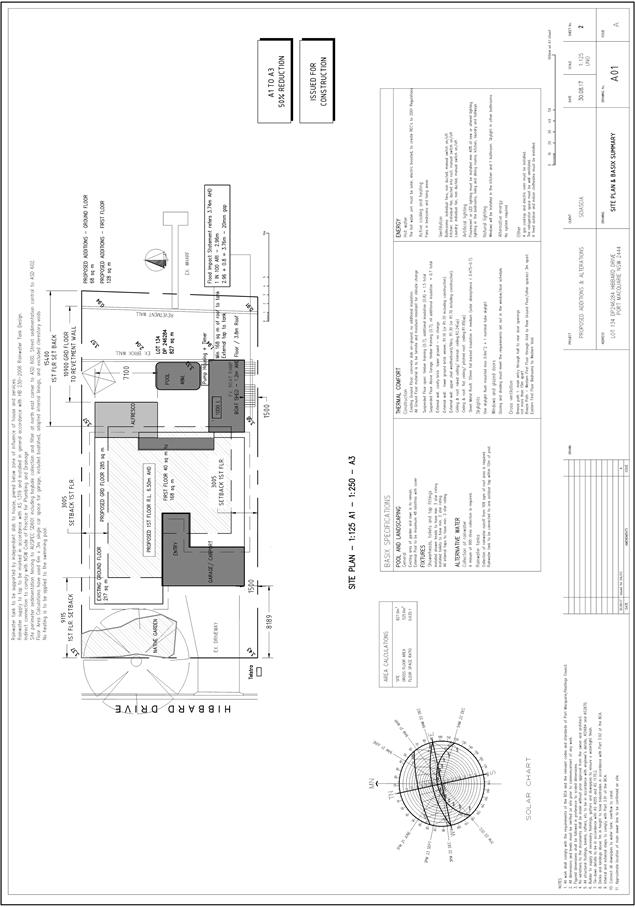
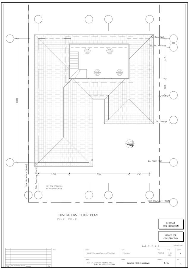
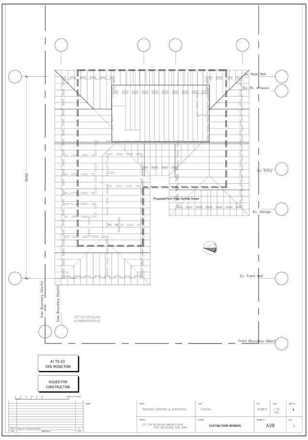
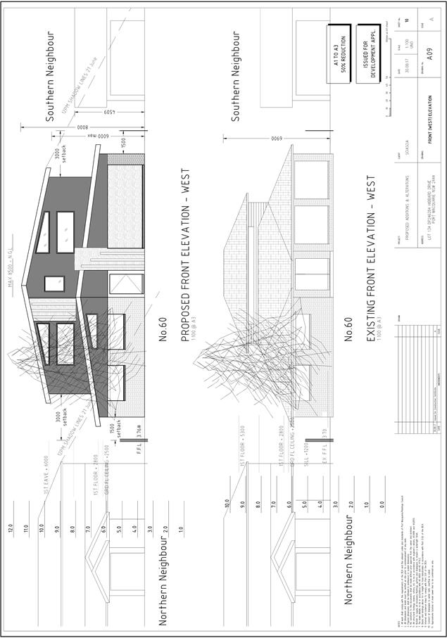
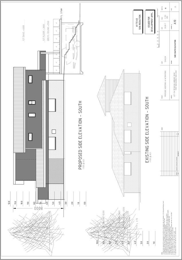
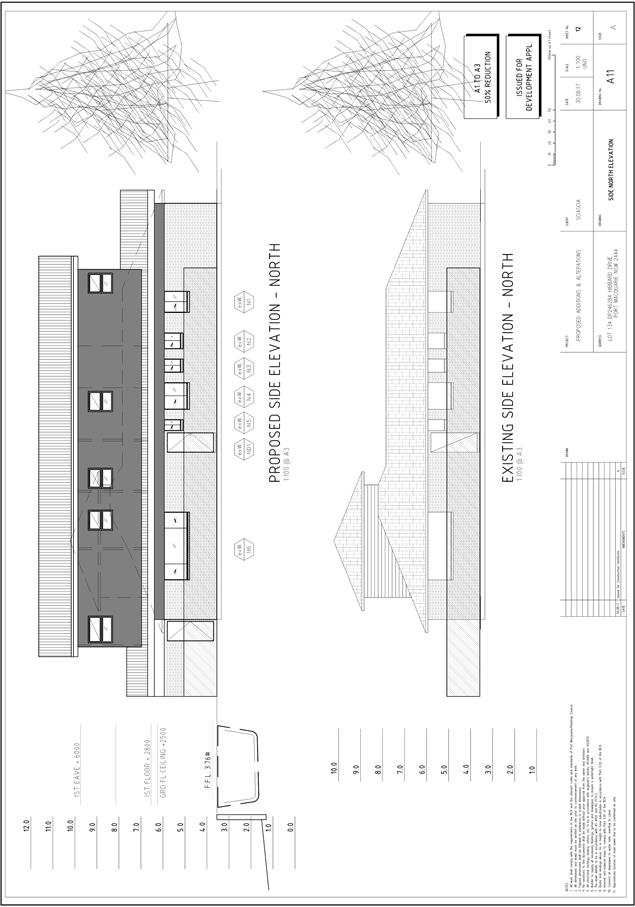
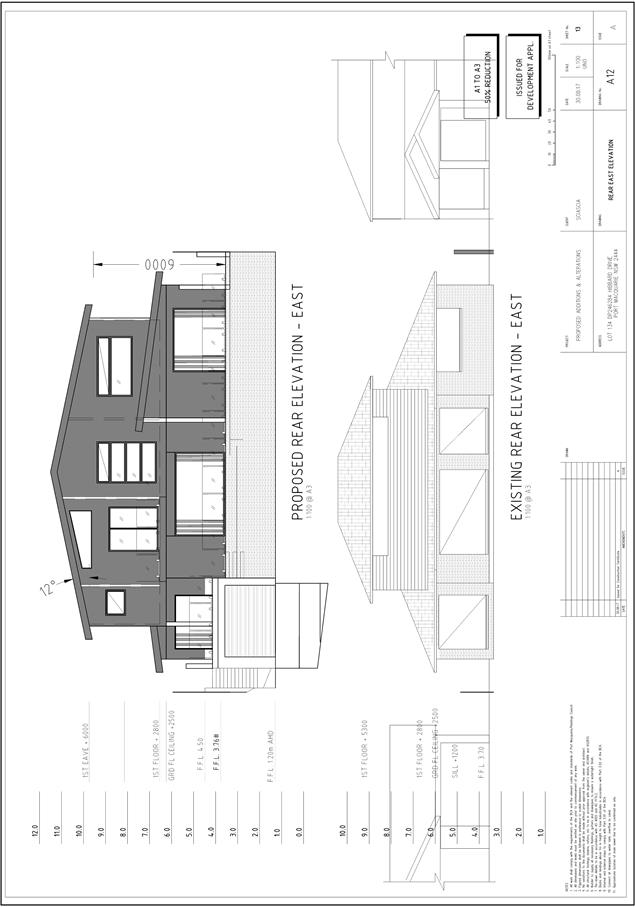
|
ATTACHMENT
|
Development Assessment Panel
13/12/2017
|
|
ATTACHMENT
|
Development Assessment Panel
13/12/2017
|

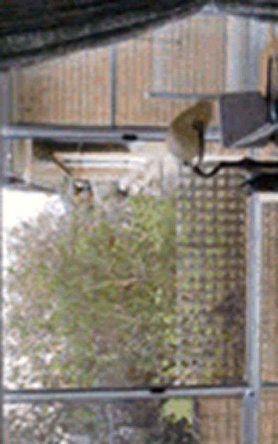
AGENDA Development Assessment Panel 13/12/2017
Item: 09
Subject: DA2017 - 966.1 Animal Boarding And Training Establishment
(Dogs) - Lot 6 DP 252224, No 406 Pembrooke Road, Redbank
Report Author: Fiona Tierney
|
Applicant: G
A & D A NELSON
Owner: G
A & D A NELSON
Estimated Cost: NIL
Alignment with Delivery Program
4.3.1 Undertake transparent
and efficient development assessment in accordance with relevant legislation.
|
|
RECOMMENDATION
That
DA2017 – 966.1 for an Animal
Boarding and Training Establishment (Dogs) at Lot 6, DP 252224, No. 406 Pembrooke
Rd, Redbank, be determined by granting consent subject to the
recommended conditions.
|
Executive
Summary
This report considers a development
application for an Animal Boarding and Training Establishment at the subject
site and provides an assessment of the application in accordance with the
Environmental Planning and Assessment Act 1979.
Following exhibition of the
application, 2 submissions were received.
1. BACKGROUND
Existing sites features and Surrounding development
The site has an area of 2.245
Ha.
The site is zoned RU1- Primary Production in accordance with the Port Macquarie-Hastings Local
Environmental Plan 2011, as shown in the following zoning plan:
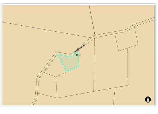
The existing subdivision pattern and location of existing development
within the locality is shown in the following aerial photograph:
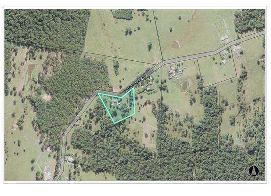
2. DESCRIPTION OF
DEVELOPMENT
Key aspects of the proposal include the following:
· Designated
fenced areas for dog training.
· Indoor
boarding (ie within the dwelling) of dogs.
Refer
to attachments at the end of this report.
Application Chronology
· 30
October 2017 - Application lodged.
· 7 November 2017 to 20 November 2017 - Neighbour
notification of the proposal.
· 20 November 2017 - Additional information and amended plans
submitted by Applicant.
· 24 November 2017 – Site proposal discussed and impact
to neighbouring properties inspected by assessing officer.
3. STATUTORY ASSESSMENT
Section 79C(1) Matters for Consideration
In determining the application, Council is required to take
into consideration the following matters as are relevant to the development
that apply to the land to which the development application relates:
(a) The provisions (where
applicable) of:
(i) any Environmental
Planning Instrument:
State Environmental Planning Policy No.
33 - Hazardous and Offensive Development
The subject SEPP was introduced to clarify
the definitions for hazardous and offensive industries and to apply guidelines
for the assessment of industries that have the potential to create hazards or
an offence. In this case, the development does not propose an industry and the
SEPP does not apply
State Environmental Planning Policy No.
44 - Koala Habitat Protection
With reference to clauses 6 and 7, the
subject land is greater than one hectare (including any adjoining land under
same ownership) and therefore the provisions of SEPP must be considered.
In this case, the
application has demonstrated that no habitat will be removed or modified (ie
site involves cleared farm land). Therefore no further investigations are
required.
State
Environmental Planning Policy No.55 – Remediation of Land
Following an inspection of the site and a
search of Council records, the subject land is not identified as being
potentially contaminated and is suitable for the intended use.
State
Environmental Planning Policy No. 62 – Sustainable Aquaculture
Given the nature
of the proposed development, buffers, and distance to the brackish waters of
the Hastings River; the proposal will be unlikely to have any adverse impact on
existing aquaculture industries.
State Environmental Planning
Policy No. 64 – Advertising and Signage
The proposed development does not
include proposed advertising signage - separate application will be required to
be made with each first use application where any proposal falls outside Exempt
and Complying Development.
State Environmental Planning
Policy (Rural Lands) 2008
The proposed development is
unlikely to create any conflict with surrounding rural uses, will not result in
a loss of rural land and provides a use that compliments the rural area.
Conditions will also be proposed to manage any likely impacts to an acceptable
level. Overall, the development is considered to be consistent with the
objectives of the SEPP.
Port Macquarie-Hastings Local Environmental Plan 2011
The proposal
is consistent with the LEP having regard to the following:
· Clause
2.2, the subject site is zoned RU1 Primary Production. In accordance with
clause 2.3(1) and the RU1 zone landuse table, the proposed development for an
Animal Boarding and Training Establishment is a permissible landuse with
consent.
The objectives of the RU1 zone are as follows:
o To
encourage sustainable primary industry production by maintaining and enhancing
the natural resource base.
o To
encourage diversity in primary industry enterprises and systems appropriate for
the area.
o To
minimise fragmentation and alienation of resource lands.
o To
minimise conflict between land uses within this zone and land uses within
adjoining zones.
In accordance with Clause 2.3(2), the proposal is consistent with the
zone objectives having regard to the following:
o The
proposal is a permissible landuse;
o The
development would provide for diversity in primary industry enterprises.
· Clause
5.9 - No listed trees in Development Control Plan 2013 are proposed to be
removed.
· Clause
5.10 – Heritage. The site does not contain or adjoin any known heritage
items or sites of significance.
· Clause
7.13, satisfactory arrangements are in place for provision of essential
services including water supply, electricity supply, sewer infrastructure,
stormwater drainage and suitable road access to service the development.
(ii) Any
draft instruments that apply to the site or are on exhibition:
None relevant
to the proposal.
(iii) any
Development Control Plan in force:
Port
Macquarie-Hastings Development Control Plan 2013
|
DCP 2013: Dwellings, Dual occupancies, Dwelling
houses, Multi dwelling houses & Ancillary development
|
|
|
DCP Objective
|
Development Provisions
|
Proposed
|
Complies
|
|
|
2.3.3.8 onwards
|
Removal of hollow bearing trees
|
None proposed to be removed.
|
Yes
|
|
2.6.3.1
|
Tree removal (3m or higher with 100mm diameter trunk and
3m outside dwelling footprint
|
None proposed to be removed.
|
Yes
|
|
2.4.3
|
Bushfire risk, Acid sulphate soils, Flooding,
Contamination, Airspace protection, Noise and Stormwater
|
Refer to main body of report.
|
|
|
2.5.3.2
|
New accesses not permitted from arterial or distributor
roads. Existing accesses rationalised or removed where practical
|
No new access to arterial or distributor road proposed.
|
Yes
|
|
Driveway crossing/s minimal in number and width including
maximising street parking
|
Existing.
|
Yes
|
|
2.5.3.3
|
Off-street parking in accordance with Table 2.5.1:
· 2 per
establishment up to 10 animals plus 1 per 10 animals thereafter.
· 1 space = single
dwelling (behind building line) and dual occupancy
|
Double garage exists. Applicant to nominate area for 5
spaces. Condition of consent applied.
|
Yes
|
|
2.5.3.14
|
Sealed driveway surfaces unless justified
|
Existing rural gravel driveway is considered sufficient.
|
Yes
|
|
|
|
|
|
Context
and setting
The proposal
seeks to have a limited number of dogs on the site. In particular, there will
be 10 dogs on the site at any one time for training purposes and an additional
10 dogs maximum to be accommodated on site within a ‘home’
environment (ie 20 dogs in total).
The proposal
is considered to be compatible with other rural development in the locality and
adequately addresses planning controls for the area. However, given the unique
nature of the facility and the reliance on effective onsite management to deal
with issues such a noise and waste, it is proposed to limit the duration of the
consent for a period of twelve (12) months. This will enable a suitable period
to evaluate effective management of these issues. The proponent would need to
lodge a modification application
Roads
The site has
road frontage to Pembrooke Road which is a public road with sealed pavement
under the care and control of Council.
Traffic
and Transport
The traffic
associated with the development is unlikely to have any adverse impacts to the
existing road network within the immediate locality. It is recommended that a
designated parking area be provided (with no parking in Pembrooke Rd) and that
vehicles leave the site in a forward direction.
Site
Frontage & Access
Vehicle
access to the site is proposed though an existing rural driveway. Access shall
comply with Council AUSPEC and Australian Standards, and conditions have been
imposed to reflect these requirements.
Parking
and Manoeuvring
A minimum
total of 4 parking spaces have been provided on-site within the garage with
additional available parking adjoining the existing dwelling and within the
driveway for clients attending the dog training. Parking and driveway widths on
site can comply with relevant Australian Standards (AS 2890) and conditions
have been imposed to reflect these requirements.
A turning area
has been provided to enable vehicles to enter and exit the site in a forward
manner. Site plans show adequate area is available and conditions have been
imposed to reflect these requirements.
Water
Supply Connection
Council
records indicate that the development site has and existing water tank.
Detailed
plans will be required to be submitted for assessment with the Section 68
application.
Sewer
Connection
Council
records indicate that the development site is not connected to reticulated sewer
and an existing septic tank is in place.
Dog Waste is
to be disposed of as a combination of compost on site and bagged waste to the
red bin as per waste requirements. Council’s waste section has confirmed
this arrangement is acceptable as dog waste has a high hair content that does
not make it suitable for septic tanks. No dog washing is proposed.
Other
Utilities
Telecommunication
and electricity services are available to the site.
Heritage
No known
items of Aboriginal or European heritage significance exist on the property. No
adverse impacts anticipated.
Other land
resources
The site will
not sterilise any significant mineral or agricultural resource.
Water
cycle
The proposed
development will be unlikely to have any adverse impacts on water resources and
the water cycle.
Soils
The proposed
development will be unlikely to have any adverse impacts on soils in terms of
quality, erosion, stability and/or productivity.
Air and
microclimate
The operations
of the proposed development will be unlikely to result in any adverse impacts
on the existing air quality or result in any pollution. Standard precautionary
site management condition recommended.
Flora and
fauna
Construction
of the proposed development will not require any removal/clearing of any
significant vegetation and therefore will be unlikely to have any significant
adverse impacts on biodiversity or threatened species of flora and fauna.
Section 5A of the Act is considered to be satisfied.
Waste
Satisfactory
arrangements are in place for proposed storage and collection of waste from the
dogs. Conditions to be applied in relation management storage and odour.
Noise and
vibration
No adverse
impacts anticipated. Condition recommended restricting noise levels, hours of
operation and management of dogs.
Bushfire
The site is
identified as being bushfire prone. Dwelling is existing and no new buildings
are proposed.
Safety,
security and crime prevention
The proposed
development will be unlikely to create any concealment/entrapment areas or
crime spots that would result in any identifiable loss of safety or reduction
of security in the immediate area.
Social
impacts in the locality
Given the
nature of the proposed development and its’ location the proposal is
unlikely to result in any adverse social impacts.
Economic
impact in the locality
No adverse
impacts. A likely positive impact is that the development will maintain
employment in the dog training industry, which will lead to flow on impacts
such as expenditure in the area.
Site
design and internal design
The proposed
development design satisfactorily responds to the site attributes and will fit
into the locality. No adverse impacts likely.
Construction
No potential
adverse impacts.
Cumulative Impacts
The proposed
development is not expected to have any adverse cumulative impacts on the
natural or built environment or the social and economic attributes of the
locality.
(c) The suitability of the site for
the development:
The proposal
will fit into the locality and the site attributes are conducive to the
proposed development.
Site
constraints have been adequately addressed and appropriate conditions of
consent recommended
(d) Any submissions made in
accordance with this Act or the Regulations:
Two written submissions have been received following public
exhibition of the application.
Key issues raised in the submissions received and comments
in response to these issues are provided as follows:
|
Submission
Issue/Summary
|
Planning
Comment/Response
|
|
Odour smell prevention
|
Development is for a small
number of dogs -10 spaces maximum are for dogs being trained that do not stay
at the site and 10 spaces maximum are for dogs that are kept in a
“home” style environment. Conditions are to be applied in
relation to health, hygiene and waste management in addition to time limited
consent to enable evaluation of management of the development.
|
|
Effect on native habitat/wildlife
|
Dogs are kept within a fenced area and within the
existing dwelling. No significant impact on wildlife is anticipated.
|
|
Waste management
|
The applicant proposes a combination of composting and
bagged waste into the red bin system. Council’s waste officers have
advised acceptable for small quantities. Waste officers advise that for 10
boarding dogs and 10 training dogs that this will be acceptable.
|
|
Water runoff - construction
|
No major construction proposed - additional fencing only.
|
|
No neighbour consultation
|
The application has been advertised to adjoining
neighbours.
|
|
Use of Council Red bin for faeces
|
Approval granted by Council’s waste section.
|
|
Are there buildings/kennels to be constructed to house
dogs
|
No kennels/buildings proposed to house dogs.
|
|
Maximum numbers of dogs
|
10 for training and 10 for boarding. 20 in total
at any one time.
|
|
Are individual pens to be constructed
|
No pens to be constructed.
|
|
Noise reduction barriers are required.
|
Conditions to be imposed. Small scale development with
limited days and hours - small numbers of dogs that are unlikely to create an
issue. On site management is considered to be the best means to manage noise
and it is considered that the proposed condition to time limit the consent
will enable evaluation of the management effectiveness prior to considering a
more permanent approval.
|
|
Safety - property located on s bends with 80km speed
limit/increased traffic volumes
|
Small traffic numbers are proposed and adequate line of
site exist - vehicles can enter and leave in a forward direction.
|
|
Property devaluation
|
Not a consideration of this application
|
|
Safety concerns that dogs will escape and be a nuisance
to neighbours - safety of children.
|
Improved fencing proposed and conditions applied.
|
(e) The Public Interest:
The proposed
development satisfies relevant planning controls and is unlikely to impact on
the wider public interest.
4. DEVELOPMENT
CONTRIBUTIONS APPLICABLE
N/A
5. CONCLUSION
The application has been assessed in accordance with
Section 79C of the Environmental Planning and Assessment Act 1979.
Issues raised during assessment and public exhibition of
the application have been considered in the assessment of the application.
Where relevant, conditions have been recommended to manage the impacts attributed
to these issues.
The site is suitable for the proposed development, is not
contrary to the public's interest and will not have a significant adverse
social, environmental or economic impact. It is recommended that the
application be approved, subject to the recommended conditions of consent
provided in the attachment section of this report.
|
Attachments
1View. DA2017
- 966.1 DA Plans.
2View. DA2017
- 966.1 Submission - Green
3View. DA2017
- 966.1 Submission - Schofield, Johnson & Wass
4View. DA2017
- 966.1 recommended DA conditions
|
|
ATTACHMENT
|
Development Assessment Panel
13/12/2017
|
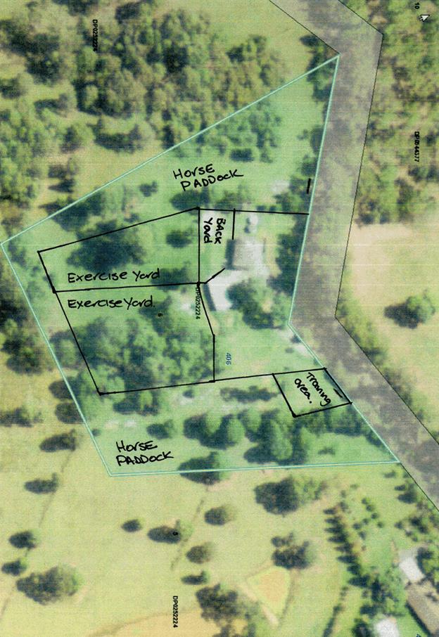
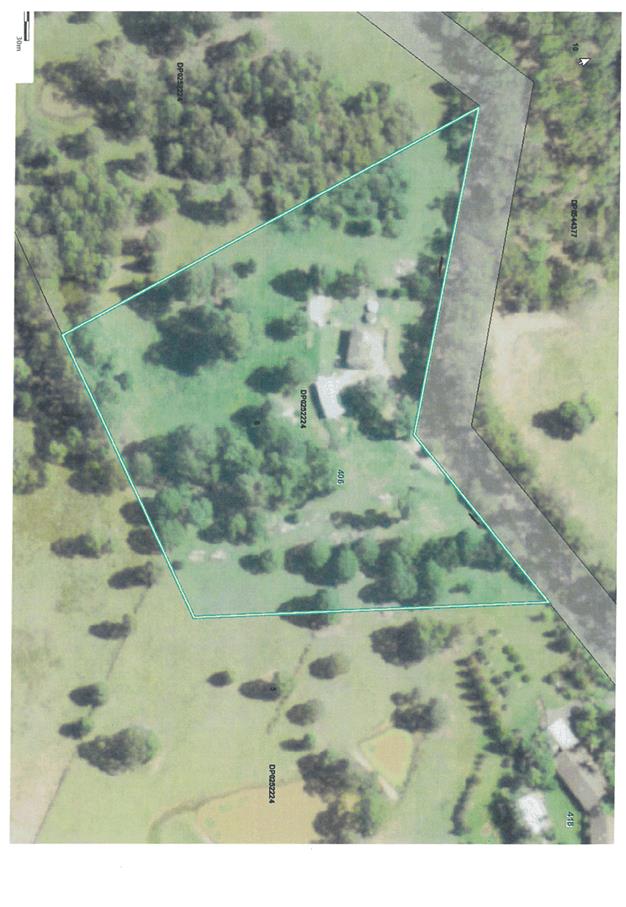
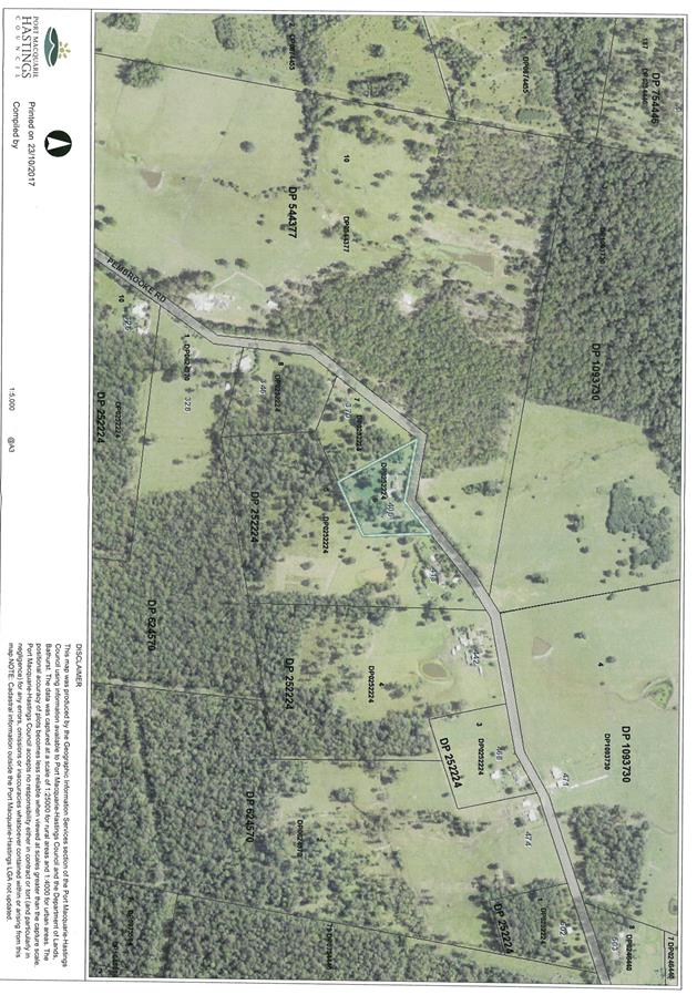
|
ATTACHMENT
|
Development Assessment Panel
13/12/2017
|
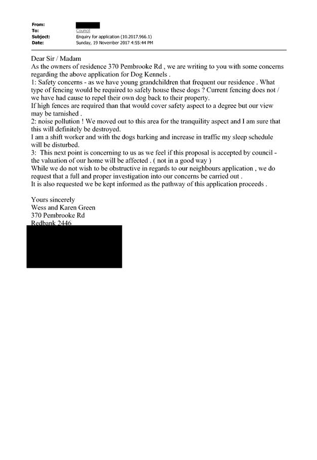
|
ATTACHMENT
|
Development Assessment Panel
13/12/2017
|
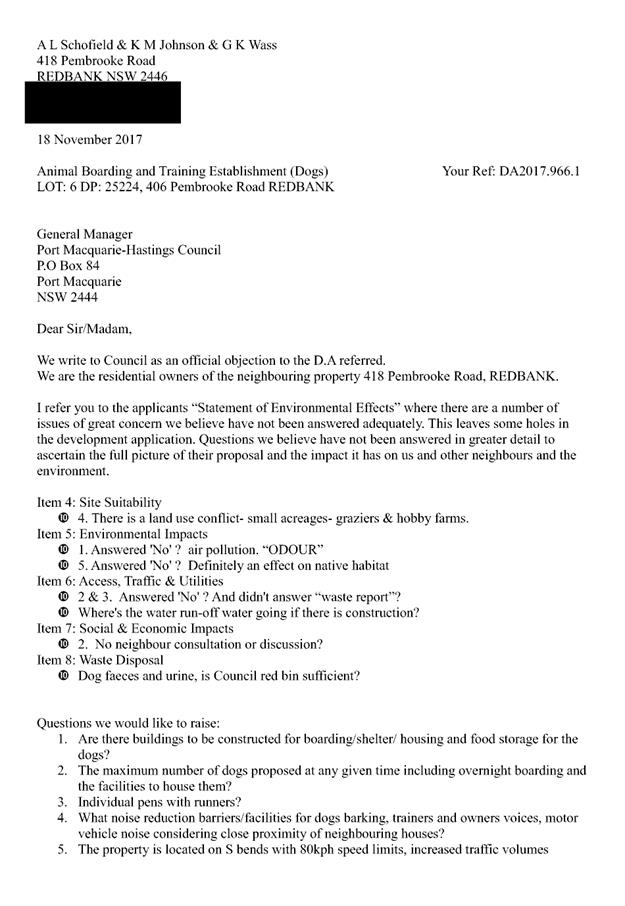
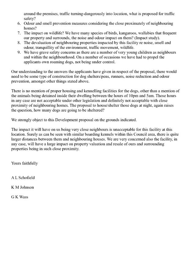
|
ATTACHMENT
|
Development Assessment Panel
13/12/2017
|