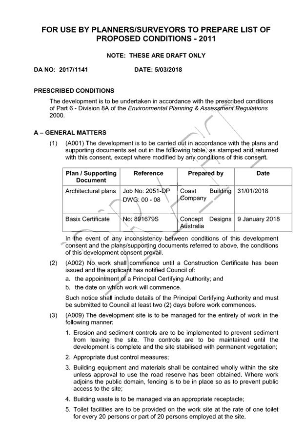
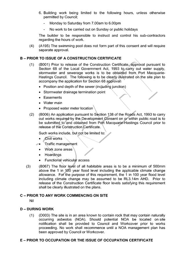
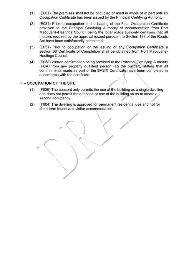
Business
Paper
|
date of meeting:
|
|
Wednesday 14 March
2018
|
|
location:
|
|
Function Room
Port
Macquarie-Hastings Council
17 Burrawan Street
Port Macquarie
|
|
time:
|
|
2:00pm
|
Development
Assessment Panel
CHARTER
1.0 OBJECTIVES
To assist in managing Council's development assessment
function by providing independent and expert determinations of development
applications that fall outside of staff delegations.
2.0 KEY FUNCTIONS
·
To review development application reports and conditions;
·
To determine development
applications outside of staff delegations;
·
To refer development applications
to Council for determination where necessary;
·
To provide a forum for objectors and applicants
to make submissions on applications
before the Development Assessment Panel
(DAP);
·
To maintain transparency in the determination of development
applications.
Delegated Authority of Panel
Pursuant to
Section 377 of the Local Government Act, 1993 delegation to:
·
Determine development applications under Part 4
of the Environmental Planning and Assessment
Act 1979 having
regard to the relevant environmental planning instruments,
development control plans and Council policies.
·
Vary, modify or release restrictions as to use
and/or covenants created by Section 88B instruments under the Conveyancing Act
1919 in relation to development applications for subdivisions being considered
by the panel.
·
Determine Koala Plans of Management under State
Environmental Planning Policy 44 - Koala Habitat Protection associated with
development applications being considered by the Panel.
Noting the trigger to escalate
decision making to Council as highlighted in section 5.2.
3.0
MEMBERSHIP
3.1
Voting
Members
·
Two independent external members. One of the
independent external members to be the Chairperson.
·
Group Manager Development Assessment (alternate
- Director Development & Environment or Development Assessment Planner)
The independent external members shall have expertise in
one or more of the following areas: planning, architecture, heritage, the
environment, urban design, economics, traffic and transport, law, engineering,
government and public administration.
3.2
Non-Voting Members
·
Not applicable
3.3 Obligations
of members
·
Members must act faithfully and diligently and
in accordance with this Charter.
·
Members must comply with Council's Code of Conduct.
·
Except as required to properly perform their
duties, DAP members must not
disclose any confidential information (as advised by Council) obtained in connection with the DAP functions.
·
Members will have read and be familiar with the
documents and information provided by Council prior
to attending a DAP meeting.
·
Members must act in accordance with Council's
Workplace Health and Safety Policies and Procedures
·
External members of the Panel are not authorised
to speak to the media on behalf of Council. Council officers that are members
of the Committee are bound by the
existing operational delegations in relation to speaking to the media.
·
Staff members shall not vote on matters before
the Panel if they have been the principle author of the development assessment report.
3.4
Member Tenure
·
The independent external members will be
appointed for the term of four (4) years
maximum in which the end of the tenure of these members would occur in a
cascading arrangement.
3.5 Appointment
of members
·
The independent external members (including the
Chair) shall be appointed by the General Manager following an external
Expression of Interest process.
·
Staff members of the Panel are in accordance
with this Charter.
4.0 TIMETABLE
OF MEETINGS
·
The Development Assessment Panel will generally
meet on the 1st and 3rd Wednesday each month at 2.00pm at the Port Macquarie
offices of Council.
·
Special Meetings of the Panel may be convened by
the Director Development & Environment Services with three (3) days notice.
5.0
MEETING PRACTICES
5.1
Meeting
Format
·
At all Meetings of the Panel the Chairperson
shall occupy the Chair and preside. The Chair will be responsible for keeping
of order at meetings.
·
Meetings shall be open to the public.
·
The Panel will hear from applicants
and objectors or their r e p r e s e n t a t i v e s .
·
Where considered necessary, the Panel will
conduct site inspections which will
be open to the public.
5.2
Decision Making
·
Decisions are to be made by consensus. Where
consensus is not possible on any item, that item is to be referred to Council
for a decision.
·
All development applications involving a
proposed variation to a development standard
greater than 10% under Clause
4.6 of the Local Environmental Plan will be
considered by the Panel and recommendation made to the Council for a decision.
5.3
Quorum
·
All members (2 independent external members and
1 staff member) must be present at a
meeting to form a quorum.
5.4
Chairperson and Deputy Chairperson
·
Independent Chair (alternate, second independent member)
5.5
Secretariat
·
The Director Development &n Environment is
to be responsible for ensuring that the Panel has adequate secretariat support.
The secretariat will ensure that the business paper and supporting papers are
circulated at least three (3) days prior to
each meeting. Minutes shall be appropriately approved and circulated to each
member within three (3) weeks of a meeting being held.
·
The format of and the preparation and publishing
of the Business Paper and Minutes shall be similar to the format for Ordinary
Council Meetings.
5.6
Recording of decisions
·
Minutes will record decisions and how each
member votes for each item before the Panel.
6.0 CONVENING
OF “OUTCOME SPECIFIC” WORKING GROUPS
Not applicable.
7.0 CONFIDENTIALITY
AND CONFLICT OF INTEREST
·
Members of the Panel must comply with the
applicable provisions of Council’s Code of Conduct. It is the personal
responsibility of members to comply with the standards in the Code of Conduct
and regularly review their personal circumstances with this in mind.
·
Panel members must declare any conflict of
interests at the start of each meeting or before discussion of a relevant item
or topic. Details of any conflicts of interest should be appropriately minuted.
Where members are deemed to have a real or perceived conflict of interest, it
may be appropriate they be excused from deliberations on the issue where the
conflict of interest may exist. A Panel meeting may be postponed where there is
no quorum.
8.0 LOBBYING
·
All members and applicants are to adhere to
Council’s Lobbying policy. Outside of
scheduled Development Assessment Panel meetings, applicants, their
representatives, Councillors, Council staff and the general public are not to
lobby Panel members via meetings, telephone conversations, correspondence and
the like. Adequate opportunity will be provided at Panel inspections or
meetings for applicants, their representatives and the general public to make
verbal submissions in relation to Business Paper items.
Development Assessment Panel
ATTENDANCE
REGISTER
|
Member
|
22/11/17
|
06/12/17
|
13/12/17
|
14/02/18
|
28/02/18
|
|
Paul Drake
|
P
|
P
|
P
|
P
|
|
|
Robert Hussey
|
P
|
P
|
P
|
P
|
A
|
|
David Crofts
(alternate member)
|
|
|
|
|
P
|
|
Dan Croft
(Acting Director
Development & Environment)
Clinton Tink
(Acting GM Development
Assessment
(alternates)
- Director Development & Environment
- Development Assessment Planner
|
P
P
|
P
P
|
P
P
|
P
P
|
P
|
Key: P = Present
A
= Absent With Apology
X
= Absent Without Apology
Development
Assessment Panel Meeting
Wednesday 14 March
2018
Items of Business
01 Acknowledgement
of Country............................................................................ 8
02 Apologies......................................................................................................... 8
03 Confirmation
of Minutes.................................................................................... 8
04 Disclosures
of Interest..................................................................................... 15
05 DA2017
- 1141.1 Dwelling - Lot 271 DP 1234160 No. 64A The Anchorage, Port Macquarie...................................................................................................................... 19
06 DA2017
- 1065.1 Alterations To Caravan Park, Lot 2 DP 1233513, Munster Street, Port
Macquarie...................................................................................................................... 43
07 DA2017-1100.1
Dwelling & Swimming Pool, Lot 34 DP 22916, No 12 Surf Street, Port
Macquarie...................................................................................................................... 81
08 Section
96 Modification DA2016 - 404.2 Modification to Industry (Cement Depot) - Lot 21
DP 1205839, 39 Randall Street, Wauchope........................................................... 114
09 Section
96 Modification DA2013 - 211.2 - Modification To A Continued Use Of Animal
Boarding And Training Establishment (Horse Riding) - Lot 4 DP 1110091, No 334
Crows Road, Frazers Creek............................................................................................................ 155
10 Section
96 Modification DA2010 - 572.11 - Modification Of Subdivision Layout And
Dwelling Design (Proposed Lots 213 To 217) - Lot 498 DP 1237901 Crestwood
Drive, Port Macquarie...................................................................................................................... 264
11 General
Business
AGENDA Development Assessment Panel 14/03/2018
Subject: ACKNOWLEDGEMENT
OF COUNTRY
"I acknowledge that we are
gathered on Birpai Land. I pay respect to the Birpai Elders both past and
present. I also extend that respect to all other Aboriginal and Torres Strait
Islander people present."
RECOMMENDATION
That the apologies received be
accepted.
Subject: CONFIRMATION
OF PREVIOUS MINUTES
Recommendation
That the Minutes of the Development
Assessment Panel Meeting held on 28 February 2018 be confirmed.
MINUTES
Development Assessment Panel Meeting
28/02/2018
PRESENT
Members:
Paul
Drake
David Crofts
Clinton Tink
Other Attendees:
Ben Roberts
Patrick
Galbraith-Robertson
Warren
Wisemantel
David
Troemel
|
The meeting opened at 2:00pm.
|
|
01 ACKNOWLEDGEMENT
OF COUNTRY
|
|
The
Acknowledgement of Country was delivered.
|
|
02 APOLOGIES
|
|
CONSENSUS:
That
the apology received from Robert Hussey be accepted.
|
|
03 CONFIRMATION
OF MINUTES
|
|
CONSENSUS:
That
the Minutes of the Development Assessment Panel Meeting held on 14 February
2018 be confirmed.
|
|
04 DISCLOSURES
OF INTEREST
|
|
There were no disclosures of interest presented.
|
|
05 DA2017 - 721.1
Manufactured Housing Estate, Manager's Residence And Associated
Infrastructure - Lot 2 DP 1224314, Lot 2 DP 1172154 Thrumster Street,
Thrumster
|
|
Speakers:
Tim
Smead (o)
Geraldine
Haigh (applicant)
CONSENSUS:
That
DA 2017 – 721.1 for a Manufactured Housing Estate, Manager’s
Residence and Associated Infrastructure at Lot 2, DP 1224314 and Lot 2, DP
1172154 Thrumster Street, Thrumster, be determined by granting consent
subject to the recommended conditions as amended below:
Replace
condition F(2) with the following:
F2
(E008)Payment to Council of the Section 94 contributions set out in the
“Notice of Payment – Developer Charges” schedule attached
to this consent, based upon the number of bedrooms in the individual
manufactured home/s, unless deferral of payment of contributions has been
approved by Council. The contributions are levied, pursuant to the Area
13 Environmental Land Management Planning Agreement and Environmental
Planning and Assessment Act 1979 as amended, and in accordance with the
provisions of the following plans:
•
Hastings S94 Administration Building Contributions Plan
•
Hastings Administration Levy Contributions Plan
•
Hastings S94 Major Roads Contributions Plan
•
Hastings S94 Open Space Contributions Plan
•
Community Cultural and Emergency Services Contributions Plan 2005
•
S94 Local Roads Contributions Plan - Areas 13, 14 and 15
The plans may be viewed during office hours at the
Council Chambers located on the corner of Burrawan and Lord Streets, Port
Macquarie, 9 Laurie Street, Laurieton, and High Street, Wauchope.
The attached “Notice of Payment” is valid for
the period specified on the Notice only. The contribution amounts shown on
the Notice are subject to adjustment in accordance with CPI increases
adjusted quarterly and the provisions of the relevant plans. Payments can
only be made using a current “Notice of Payment” form. Where a
new Notice of Payment form is required, an application in writing together
with the current Notice of Payment application fee is to be submitted to
Council.
Delete
condition B(6).
Add
condition F20 to state:
F20
(F195) Prior to occupation or the issue of any certificate of completion of a
manufactured home within the estate, a stop sign is to be installed at the
intersection of the access road and Thrumster Street.
|
|
06 DA2017 - 871.1
Service Station And Signage - Lot 20 DP 1191370 No. 16 Sancrox Road, Sancrox
|
|
Speakers:
Tony
Thorne (applicant)
CONSENSUS:
That
DA 2017 – 871.1 for a service station and signage at Lot 20, DP
1191370, No. 16 Sancrox Road, Sancrox, be determined by granting consent
subject to recommended conditions as amended below:
Amend
condition B9 to state:
B9
(A195) The provision, at no cost to Council, of a minimum 1.2m wide
concrete foot path for the Sancrox Road frontage of Lot 1, between the
proposed eastern driveway and the existing concrete footpath on the
north-eastern leg of the Orleans Drive roundabout. Design details in accordance
with AUSPEC and Council Standard drawing ASD 100 series. The design plans
must be approved by Council pursuant to Section 138 of the Roads Act.
Amend
condition B2 (10) to state:
B2(10) Provision of a 1.2m concrete footpath
along Sancrox Road for the road frontage of approved Lot 1, between the
proposed eastern driveway and the existing concrete footpath on the
north-eastern leg of the Orleans Drive roundabout.
|
|
07 DA2017
- 1007.1 Eight Semi-Detached Dwellings With Torrens Title Subdivision
Lots 114,115,116 And 117 DP 1229250, 43 Seaside Drive And 4-6 Waterside
Way Lake Cathie
|
|
Speakers:
Eric Ding (o)
James Collins (applicant)
CONSENSUS:
That DA 2017 - 1007 for eight (8) semi-detached dwellings
with torrens title subdivision at Lot 114,115,116 & 117, DP 1229250, No.
43 Seaside Drive & 4-6 Waterside Way, Lake Cathie, be determined by
granting consent subject to the recommended conditions as amended below:
Add condition A11 to state:
A11 (A195) Sewer manholes
shall remain in a single lot and shall maintain clearance requirements. Any
boundary adjustment shall maintain one metre (1m) clearance from any sewer
manhole.
Add condition B16 to state:
B16
(B195) Prior to release of the Construction Certificate, the front fence for
the courtyard to proposed Unit 4 is to be minimised in size so as to create
an open space area compliant with the requirements of 3.2.2.6 of Port
Macquarie Hastings Development Control Plan 2013 but no greater. The fence is
also not to exceed a height of 1.8m above the finished ground level and be
consistent with the requirements of 3.2.2.7 of Port Macquarie Hastings
Development Control Plan 2013. Plans showing the changes are to be submitted
to the Principal Certifying Authority, prior to release of the Construction
Certificate.
Amend condition A10 to state:
(10)
(A007) The development must only proceed in
accordance with the approved stages as set out below:
·
Stage 1- Units 1 & 2
·
Stage 2- Units 3 & 4 and boundary
adjustment between Lots 115 & 116 DP 1229250
·
Stage 3- Units 5 & 6 and boundary
adjustment between Lots 115 & 116 DP 1229250
·
Stage 4 -Units 7 & 8
Unless specified, the
conditions of this consent will apply to all stages, with any decision on any
discrepancy with conditions and associated staging resting with Council. Any
decision to allow a change to staging will rest with Council along with
applicable conditions and any contributions payable.
|
|
08 DA2017
- 780.1 Shop Top Housing - Lot 1 DP 536032, No. 4 Hastings River Drive, Port
Macquarie
|
|
Speakers:
Tony McVeigh (o)
Bill Vogel (o)
Wayne Ellis (applicant)
David Pensini (applicant)
CONSENSUS:
That DA2017 – 780.1 be deferred to allow the
applicant to address the deficiency in parking and how it can be accommodated
either onsite or in the area.
|
|
09 DA2017
- 981.1 Ancillary Building (Shed) Lot 2 DP 244961, No 8 Azalea Avenue,
Wauchope
|
|
Speakers:
Victoria Sheringham (o)
Alex Van Oirschot (applicant)
CONSENSUS:
That DA 2017 – 981.1 for an ancillary building
(shed) at Lot 2, DP 244961, No. 8 Azalea Avenue, Wauchope be determined by
granting consent subject to the recommended conditions as amended belw:
Add condition B1 to state:
B1
(B195) Prior to the release of the Construction Certificate, the plan on page
3 of the Best Sheds plans is to be mirror reversed.
Add condition B2 to state:
B2
(B196) Prior to release of the Construction Certificate, the shed is to be
located 1.5m from the eastern boundary and the area between the shed and
fence planted with lilly pilly plant species at 1.5m spacings and allowed to
grow to a minimum 2m in height to screen the shed. Plans showing the changes
are to be submitted to the Principal Certifying Authority, prior to release
of the Construction Certificate and the landscaping put in place prior to
release of the Occupation Certificate and maintained at all times.
|
|
The meeting closed at 4:00pm.
|
AGENDA Development Assessment Panel 14/03/2018
Subject: DISCLOSURES
OF INTEREST
RECOMMENDATION
That Disclosures of Interest be presented
DISCLOSURE OF
INTEREST DECLARATION
Name of Meeting: ………………………………………………………………………..
Meeting Date: ………………………………………………………………………..
Item Number: ………………………………………………………………………..
Subject: ………………………………………………………………………..
…………………………………………………….……………...…..
I,
.....................................................................................
declare the following interest:
 Pecuniary:
Take
no part in the consideration and voting and be out of sight of the meeting.
Non-Pecuniary
- Significant Interest:
Take
no part in the consideration and voting and be out of sight of the meeting.
Non-Pecuniary
- Less than Significant Interest:
May
participate in consideration and voting.
For the reason that:
....................................................................................................
.......................................................................................................................................
Name:
…………………………………………………….
Signed:
.........................................................................
Date: ..................................
 (Further
explanation is provided on the next page)
(Further
explanation is provided on the next page)
Further
Explanation
(Local Government Act and Code of Conduct)
A conflict of interest exists where a reasonable and informed
person would perceive that a Council official could be influenced by a private
interest when carrying out their public duty. Interests can be of two types:
pecuniary or non-pecuniary.
All interests, whether pecuniary or non-pecuniary are required to
be fully disclosed and in writing.
Pecuniary Interest
A pecuniary interest is an interest that a Council official has in
a matter because of a reasonable likelihood or expectation of appreciable
financial gain or loss to the Council official. (section 442)
A Council official will also be taken to have a pecuniary interest
in a matter if that Council official’s spouse or de facto partner or a
relative of the Council official or a partner or employer of the Council
official, or a company or other body of which the Council official, or a
nominee, partner or employer of the Council official is a member, has a
pecuniary interest in the matter. (section 443)
The Council official must not take part in the consideration or
voting on the matter and leave and be out of sight of the meeting. The
Council official must not be present at, or in sight of, the meeting of
the Council at any time during which the matter is being considered or
discussed, or at any time during which the council is voting on any question in
relation to the matter. (section 451)
Non-Pecuniary
A non-pecuniary interest is an interest that is private or
personal that the Council official has that does not amount to a pecuniary
interest as defined in the Act.
Non-pecuniary interests commonly arise out of family, or personal
relationships, or involvement in sporting, social or other cultural groups and
associations and may include an interest of a financial nature.
The political views of a Councillor do not constitute a private
interest.
The management of a non-pecuniary interest will depend on whether
or not it is significant.
Non Pecuniary – Significant Interest
As a general rule, a non-pecuniary conflict of interest will be
significant where a matter does not raise a pecuniary interest, but it
involves:
(a)
A relationship between
a Council official and another person that is particularly close, for example,
parent, grandparent, brother, sister, uncle, aunt, nephew, niece, lineal
descendant or adopted child of the Council official or of the Council official’s
spouse, current or former spouse or partner, de facto or other person living in
the same household.
(b)
Other relationships
that are particularly close, such as friendships and business relationships.
Closeness is defined by the nature of the friendship or business relationship,
the frequency of contact and the duration of the friendship or relationship.
(c)
An affiliation between
a Council official an organisation, sporting body, club, corporation or
association that is particularly strong.
If a Council official declares a non-pecuniary significant
interest it must be managed in one of two ways:
1.
Remove the source of
the conflict, by relinquishing or divesting the interest that creates the
conflict, or reallocating the conflicting duties to another Council official.
2.
Have no involvement in
the matter, by taking no part in the consideration or voting on the matter and
leave and be out of sight of the meeting, as if the provisions in section
451(2) apply.
Non Pecuniary – Less than Significant Interest
If a Council official has declared a non-pecuniary less than
significant interest and it does not require further action, they must provide
an explanation of why they consider that the conflict does not require further
action in the circumstances.
SPECIAL
DISCLOSURE OF PECUNIARY INTEREST DECLARATION
|
By
[insert full name of councillor]
|
|
|
In the
matter of
[insert name of environmental planning instrument]
|
|
|
Which is
to be considered at a meeting of the
[insert name of meeting]
|
|
|
Held on
[insert date of meeting]
|
|
|
PECUNIARY
INTEREST
|
|
Address of land in which councillor or an
associated person, company or body has a proprietary interest (the identified
land)i
|
|
|
Relationship of identified land to councillor
[Tick or cross one box.]
|
Councillor
has interest in the land (e.g. is owner or has other interest arising out of
a mortgage, lease trust, option or contract, or otherwise).
Associated
person of councillor has interest in the land.
Associated
company or body of councillor has interest in the land.
|
|
MATTER GIVING
RISE TO PECUNIARY INTEREST
|
|
Nature of land that is subject to a change
in zone/planning control by proposed
LEP (the subject land iii
[Tick or cross one box]
|
The
identified land.
Land
that adjoins or is adjacent to or is in proximity to the identified land.
|
|
Current zone/planning control
[Insert name of current planning instrument and
identify relevant zone/planning control applying to the subject land]
|
|
|
Proposed change of zone/planning control
[Insert name of proposed LEP and identify
proposed change of zone/planning control applying to the subject land]
|
|
|
Effect of proposed change of zone/planning control
on councillor
[Tick or cross one box]
|
Appreciable
financial gain.
Appreciable
financial loss.
|
|
|
|
Councillor’s
Name: …………………………………………
Councillor’s
Signature:
……………………………….
Date: ………………..
Important Information
This information is being
collected for the purpose of making a special disclosure of pecuniary interests
under sections 451 (4) and (5) of the Local Government Act 1993.
You must not make a special disclosure that you know or ought reasonably to
know is false or misleading in a material particular. Complaints made
about contraventions of these requirements may be referred by the
Director-General to the Local Government Pecuniary Interest and Disciplinary
Tribunal.
This form must be completed by
you before the commencement of the council or council committee meeting in
respect of which the special disclosure is being made. The
completed form must be tabled at the meeting. Everyone is entitled to
inspect it. The special disclosure must be recorded in the minutes of the
meeting.
i.
Section 443 (1) of the Local Government Act 1993 provides that
you may have a pecuniary interest in a matter because of the pecuniary interest
of your spouse or your de facto partner or your relativeiv or
because your business partner or employer has a pecuniary interest. You may
also have a pecuniary interest in a matter because you, your nominee, your
business partner or your employer is a member of a company or other body that
has a pecuniary interest in the matter.
ii.
Section 442 of the Local Government Act 1993 provides that a pecuniary
interest is an interest that a person has in a matter because of a
reasonable likelihood or expectation of appreciable financial gain or loss to
the person. A person does not have a pecuniary interest in a matter if the
interest is so remote or insignificant that it could not reasonably be regarded
as likely to influence any decision the person might make in relation to the
matter or if the interest is of a kind specified in section 448 of that
Act (for example, an interest as an elector or as a ratepayer or person liable
to pay a charge).
iii.
A pecuniary interest may arise by way of a change of permissible use of land
adjoining, adjacent to or in proximity to land in which a councillor or a
person, company or body referred to in section 443 (1) (b) or (c) of the
Local Government Act 1993 has a proprietary interest..
iv.
Relative is defined by the Local Government Act 1993 as
meaning your, your spouse’s or your de facto partner’s parent,
grandparent, brother, sister, uncle, aunt, nephew, niece, lineal descendant or
adopted child and the spouse or de facto partner of any of those persons.
AGENDA Development Assessment Panel 14/03/2018
Item: 05
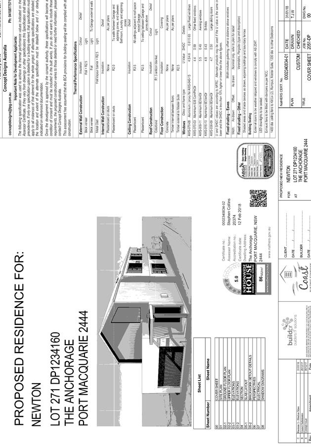
Subject: DA2017 - 1141.1 Dwelling - Lot 271 DP 1234160
No. 64A The Anchorage, Port Macquarie
Report
Author: Stephen Ryan
|
Applicant: Coast
Building Company Pty Ltd
Owner: J
D & S A Newton
Estimated Cost: $747,774
Alignment with Delivery
Program
4.3.1 Undertake transparent
and efficient development assessment in accordance with relevant legislation.
|
|
RECOMMENDATION
That
DA2017 – 1141.1 for a dwelling
at Lot 271, DP1234160, No. 64A The Anchorage, Port Macquarie, be determined
by granting consent subject to the recommended conditions.
|
Executive
Summary
This
report considers a development application for a dwelling at the subject site and provides an assessment of the
application in accordance with the Environmental Planning and Assessment Act
1979.
Following exhibition of the
application, one (1) submission has been
received.
1. BACKGROUND
Existing sites features and surrounding development
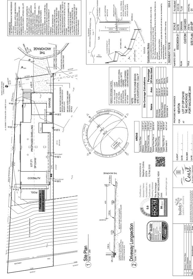
The site has an area of 663.7m2.
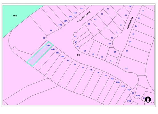
The site is zoned R1 General Residential in accordance with the Port Macquarie-Hastings Local
Environmental Plan 2011, as shown in the following zoning plan:
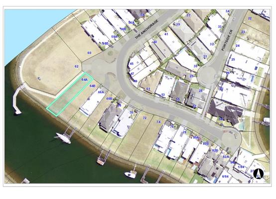
The existing subdivision pattern and location of existing
development within the locality is shown in the following aerial photograph:
2. DESCRIPTION OF DEVELOPMENT
Key aspects of the proposal include the following:
· New
two storey dwelling with attached garage.
· Submission
received.
Refer
to attachments at the end of this report.
Application Chronology
· 19 December 2017 - Application lodged.
· 12 January 2018 - 25 January 2018 - Exhibition via
neighbour notification.
· 25 January 2018 - Submission received.
· 21 February 2018 - Revised plans received relating to
glazing changes.
· 27 February 2018 - Email sent to applicant advising of
submission.
· 27 February 2018 - Response from applicant.
· 27 February 2018 - Email sent to objector outlining
applicant’s response.
3. STATUTORY ASSESSMENT
Section 79C(1) Matters for Consideration
In determining the application, Council is required to take
into consideration the following matters as are relevant to the development
that apply to the land to which the development application relates:
(a) The provisions (where
applicable) of:
(i) any Environmental
Planning Instrument:
State Environmental Planning Policy No.
44 - Koala Habitat Protection
There is no Koala Plan of
Management on the site. Additionally, the site is less than 1ha in area
therefore no further investigations are required.
State
Environmental Planning Policy No.55 – Remediation of Land
Following an inspection of the site and a
search of Council records, the subject land is not identified as being
potentially contaminated and is suitable for the intended use.
State
Environmental Planning Policy No. 71 – Coastal Protection and Clause 5.5 of
Port Macquarie-Hastings Local Environmental Plan 2011
The site is located within a
coastal zone as defined in accordance with clause 4 of SEPP 71.
In accordance with clause 5, this
SEPP prevails over the Port Macquarie-Hastings LEP 2011 in the event of any
inconsistency.
Having regard to clauses 8 and 12
to 16 of SEPP 71 and clause 5.5 of Hastings LEP 2011 inclusive the proposed
development will not result in any of the following:
a) any
restricted access (or opportunities for access) to the coastal foreshore
b) any
identifiable adverse amenity impacts along the coastal foreshore and on the
scenic qualities of the coast;
c) any
identifiable adverse impacts on any known flora and fauna (or their natural
environment);
d) subject to
any identifiable adverse coastal processes or hazards;
e) any
identifiable conflict between water and land based users of the area;
f) any
identifiable adverse impacts on any items of archaeological/heritage;
g) reduce the
quality of the natural water bodies in the locality.
The site is located within an area zoned and already built out
for residential purposes.
State Environmental Planning Policy
(Building Sustainability Index: BASIX) 2004
A BASIX
certificate (number 891679S) has been submitted demonstrating that the proposal
will comply with the requirements of the SEPP. It is recommended that a
condition be imposed to ensure that the commitments are incorporated into the
development and certified at Occupation Certificate stage.
Port
Macquarie-Hastings Local Environmental Plan 2011
The proposal is consistent with the LEP having regard to the
following:
· Clause 2.2,
the subject site is zoned R1 General Residential. In accordance with clause
2.3(1) and the R1 zone landuse table, the dwelling is a permissible landuse
with consent.
The objectives of
the R1 zone are as follows:
o To provide for the housing needs
of the community.
o To provide for a variety of
housing types and densities.
o To enable other
land uses that provide facilities or services to meet the day to day needs of
residents.
In accordance
with Clause 2.3(2), the proposal is consistent with the zone objectives as it
is a permissible landuse and consistent with the established residential
locality.
· Clause
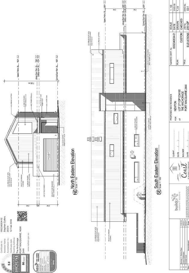
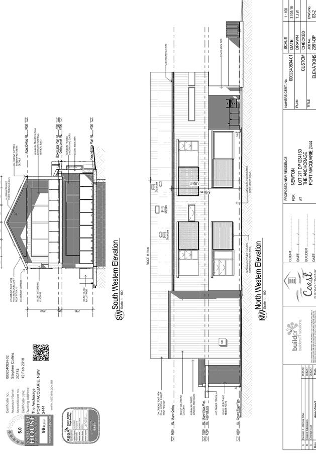
4.3, the maximum overall height of the building above ground level (existing)
is 7.95m, which complies with the standard height limit of 8.5m applying to the
site.
· Clause
4.4, the floor space ratio of the proposal is 0.52:1.0, which complies with the
maximum 0.65.0:1 floor space ratio applying to the site.
· Clause
5.10, the site does not contain or adjoin any known heritage items or sites of
significance.
· Clause
7.1, the site is mapped as potentially containing class 3 acid sulphate soils.
The proposed development includes excavation for footings & slab, however
no excavation extending 1m below the natural surface level is proposed.
Therefore, no adverse impacts are expected to occur to the acid sulphate soils
found on site.
· Clause 7.3,
the site is land within a mapped “flood planning area”. In this
regard the following comments are provided which incorporate consideration of
the objectives of Clause 7.3, Council’s Flood Policy (2015); the NSW
Government’s Flood Prone Lands Policy and the NSW
Government’s Floodplain Development Manual (2005):
o The
proposal is compatible with the flood hazard of the land taking into account
projected changes as a result of climate change;
o The
proposal will not result in a significant adverse effect on flood behaviour
that would result in detrimental increases in the potential flood affectation
of other development or properties;
o The
proposal incorporates measures to minimise & manage the flood risk to life
and property associated with the use of land;
o The
proposal is not likely to significantly adversely affect the environment or
cause avoidable erosion, siltation, destruction of riparian vegetation or a
reduction in the stability of river banks or watercourses;
o The
proposal is not likely to result in unsustainable social and economic costs to
the community as a consequence of flooding.
Based on the above, the proposal is considered to comply
with Clause 7.3.
· Clause 7.13,
satisfactory arrangements are in place for provision of essential services.
(ii) Any
draft instruments that apply to the site or are on exhibition:
No draft
instruments relevant to the proposal.
(iii) Any
Development Control Plan in force:
Port
Macquarie-Hastings Development Control Plan 2013
|
DCP
2013: Dwellings, Dual occupancies, Dwelling houses, Multi dwelling houses
& Ancillary development
|
|
|
Requirements
|
Proposed
|
Complies
|
|
3.2.2.1
|
Ancillary development:
• 4.8m max. height
• Single storey
• 60m2 max. area
• 24 degree max.
roof pitch
• Not located in
front setback
|
Pool not part of this application.
|
N/A
|
|
3.2.2.2
|
Articulation zone:
• Min. 3m front
setback
• An entry feature
or portico
• A balcony, deck,
patio, pergola, terrace or verandah
• A window box
treatment
• A bay window or
similar feature
• An awning or
other feature over a window
• A sun shading
feature
|
A 3.22m setback is proposed to
the front entry portico.
|
Yes
|
|
|
Front setback (Residential not R5
zone):
• Min. 4.5m local
road or within 20% of adjoining dwelling if on corner lot
|
4.5m to garage and over 4.5m to remainder of the
front building line.
|
Yes
|
|
3.2.2.3
|
Garage 5.5m min. and 1m behind
front façade.
Garage door recessed behind
building line or eaves/overhangs provided
|
4.5m setback at the minimum (due to angle of the
front boundary) but extending to over 5.5m.
|
No – refer to comments at the end of this
table.
|
|
|
Driveway crossover 1/3 max. of
site frontage and max. 5.0m width
|
The driveway complies with the
5.0m requirement but occupies more than 1/3 site frontage.
|
No – refer to comments
at the end of this table.
|
|
3.2.2.4
|
4m min. rear setback.
Variation subject to site analysis and provision of private open space
|
>4m setback available
|
Yes
|
|
3.2.2.5
|
Side setbacks:
• Ground floor =
min. 0.9m
• First floors
& above = min. 3m setback or where it can be demonstrated that
overshadowing not adverse = 0.9m min.
• Building wall
set in and out every 12m by 0.5m
|
0.2m garage & 0.9m &
1.5m dwelling.
1.5m first floor level.
Maximum wall length of 15.12m
& 14.280m.
|
No – refer to comments
at the end of this table.
|
|
3.2.2.6
|
35m² min. private open
space area including a useable 4x4m min. area which has 5% max. grade
|
Available at rear
|
Yes
|
|
3.2.2.10
|
Privacy:
• Direct views
between living areas of adjacent dwellings screened when within 9m radius of
any part of window of adjacent dwelling and within 12m of private open space
areas of adjacent dwellings. ie. 1.8m fence or privacy screening which has
25% max. openings and is permanently fixed
• Privacy screen
required if floor level > 1m height, window side/rear setback (other than
bedroom) is less than 3m and sill height less than 1.5m
1.
2.
3.
4.
• Privacy screens
provided to balconies/verandahs etc which have <3m side/rear setback and
floor level height >1m
|
Windows and living areas on
ground level either face a public pathway or would be screened via standard
1.8m high fencing.
Upper level windows consist of
bedrooms ensuite, laundry & rumpus room. In this case, screening is not
required to the first floor rumpus, which has a sill height 1.5m.
Upper level rear deck open
only on north facing side. No adjoining property to north only public
pathway. Privacy screen not applicable.
|
Yes
|
|
DCP
2013: General Provisions
|
|
|
Requirements
|
Proposed
|
Complies
|
|
2.7.2.2
|
Design addresses generic
principles of Crime Prevention Through Environmental Design guideline
|
No adverse concealment or
entrapment areas. Site boundary suitably defined. Adequate casual
surveillance available.
|
Yes
|
|
2.3.3.1
|
Cut and
fill 1.0m max. 1m outside the perimeter of the external building walls
|
|
Yes
|
|
2.5.3.2
|
New accesses not permitted
from arterial or distributor roads
|
No new access from arterial or
distributor roads
|
Yes
|
|
Driveway
crossing/s minimal in number and width including maximising street parking
|
Single driveway crossover
|
Yes
|
|
2.5.3.3
|
Parking in accordance with Table 2.5.1.
1 space per
single dwelling
|
Double garage proposed.
|
Yes
|
|
2.5.3.11
|
Section 94 contributions
|
Credit exists from lot.
|
N/A
|
|
2.5.3.14
|
Sealed
driveway surfaces unless justified
|
Sealed driveway proposed.
|
Yes
|
|
2.5.3.15
and 2.5.3.16
|
Driveway
grades first 6m or ‘parking area’ shall be 5% grade with
transitions of 2m length
|
Achieves grades.
|
Yes
|
|
2.5.3.17
|
Parking
areas to be designed to avoid concentrations of water runoff on the surface
|
Stormwater capable of being
managed onsite.
|
Yes
|
|
Vehicle
washing facilities – grassed area etc available.
|
Suitable area exists at the
front of the property.
|
Yes
|
The proposal seeks to vary Development Provision 3.2.2.3
The relevant objectives are:
· To
minimise the impact of garages and driveways on the streetscape, on street
parking and amenity.
· To
minimise the visual dominance of garages in the streetscape.
Having regard
for the development provisions and relevant objectives, the variations are considered
acceptable for the following reasons:
· The
proposal incorporates a garage built 4.5m extending to over 5.5m from the
street boundary.
· The
variation is considered to be consistent with other dwellings in the street and
necessitated by the narrow nature of the lot.
· The front
entry portico within the articulation zone and two storey design aims to
minimise the visual dominance of the garage on the streetscape.
· The
driveway still contains suitable area for parking a vehicle off street.
· The lot
width at the front boundary is only 10.61m, which makes compliance with the
standard difficult.
The proposal seeks to vary Development Provision 3.2.2.5
The relevant objectives are:
· To reduce
overbearing and perceptions of building bulk on adjoining properties and to
maintain privacy.
· To
provide for visual and acoustic privacy between dwellings.
Having regard
for the development provisions and relevant objectives, the variations are
considered acceptable for the following reasons:
· The
garage adjoining the boundary is single storey in height and for a length of
8.870m. It will not present as excessive in terms of building bulk to the
adjoining property.
· Zero lot lines for
garages are a feature of development in this locality. The proposal remains
consistent with such an approach.
· The variations do not
create any visual or acoustic privacy issues.
· The provision requires
first floors to be setback a minimum of 3m. The setback may be reduced down to
900mm where it can be demonstrated that the adjoining property primary living
areas and primary private open space areas should not be adversely overshadowed
for more than 3hrs between 9am-3pm on 21 June. Overall, the development will
not adversely overshadowing living areas on adjoining properties.
· The variation is
considered consistent with the side boundary setbacks of the surrounding
dwellings.
· Private open space is
retained at the rear of the lots which will receive adequate solar access as
demonstrated by the shadow diagrams provided.
· The unarticulated wall
lengths are only minor variations from the control and will not result in
perceptions of excessive building bulk from adjoining properties.
· The bulk and scale of
the development is consistent with development in the locality.
(iiia) any
planning agreement that has been entered into under Section 93f or any draft
planning agreement that a developer has offered to enter into under Section
93f:
No planning agreement has been offered or entered into relating to the
site.
iv) any matters
prescribed by the Regulations:
New South Wales Coastal Policy:
The proposed development is consistent with the objectives and strategic
actions of this policy.
Demolition of buildings AS 2601:
N/A
v) any coastal
zone management plan (within the meaning of the Coastal Protection Act 1979),
that apply to the land to which the development application relates:
N/A
(b) The
likely impacts of that development, including environmental impacts on both the
natural and built environments, social and economic impacts in the locality:
Context and setting
The property is located at the
end of a small cul de sac head that comes off The Anchorage. The overall area
consists of a canal estate development comprising predominately two storey
dwellings of similar bulk and scale.
Solar access
The proposal will be unlikely to
have any adverse impacts in regard to solar access.
Availability in regard to solar access is considered to be consistent with
other dwellings in the locality.
5.
Public
domain
The proposal will be unlikely to have any adverse impacts to
existing adjoining properties and satisfactorily addresses the public domain.
The proposal is also considered to be consistent with other residential
development in the locality and adequately addresses planning controls for the
area.
6.
View sharing
There are no adverse impacts on existing view sharing.
7.
Access, transport and traffic
The proposal will be unlikely to
have any adverse impacts in terms access, transport and traffic. The existing
road network will satisfactorily cater for any increase in traffic generation
as a result of the development.
Water Supply
Service available.
Sewer
Service available.
Stormwater
Service
available.
Other
Utilities
Telecommunication
and electricity services are available to the site.
Heritage
This site does not contain or adjoin any known heritage
item or site of significance.
Other land
resources
No adverse
impacts anticipated. The site is within an established urban context and will
not sterilise any significant mineral or agricultural resource.
Water
cycle
The proposed
development will be unlikely to have any adverse impacts on water resources and
the water cycle.
Soils
The proposed
development will be unlikely to have any adverse impacts on soils in terms of
quality, erosion, stability and/or productivity subject to a standard condition
requiring erosion and sediment controls to be in place prior to and during
construction.
Air and
microclimate
The
construction and/or operations of the proposed development will be unlikely to
result in any adverse impacts on the existing air quality or result in any
pollution.
Flora and
fauna
Construction
of the proposed development will not require any removal/clearing of any
significant vegetation and therefore will be unlikely to have any significant
adverse impacts on biodiversity or threatened species of flora and fauna.
Waste
Satisfactory
arrangements are in place for proposed storage and collection of waste and
recyclables. No adverse impacts anticipated.
Energy
The proposal includes measures to
address energy efficiency and will be required to comply with the requirements
of BASIX.
Noise and vibration
No adverse impacts anticipated.
Condition recommended to restrict construction to standard construction hours.
Bushfire
The site is not identified as
being bushfire prone.
Safety,
security and crime prevention
The proposed
development will be unlikely to create any concealment/entrapment areas or
crime spots that would result in any identifiable loss of safety or reduction
of security in the immediate area.
Social
impacts in the locality
Given the
nature of the proposed development and its’ location the proposal is
unlikely to result in any adverse social impacts.
Economic impact in the locality
No adverse impacts. Likely positive impacts can be attributed to the
construction of the development and associated flow on effects (i.e. maintained
expenditure in the area).
Site design
and internal design
The proposed
development design is satisfactorily responds to the site attributes and will
fit into the locality. No adverse impacts likely.
Construction
No potential
adverse impacts identified to neighbouring properties with the construction of
the proposal.
Cumulative
impacts
The proposed
development is not expected to have any adverse cumulative impacts on the
natural or built environment or the social and economic attributes of the
locality.
(c) The suitability of the site for
the development:
The proposal
will fit into the locality & the site attributes are conductive to the
proposed development.
(d) Any submissions
made in accordance with this Act or the Regulations:
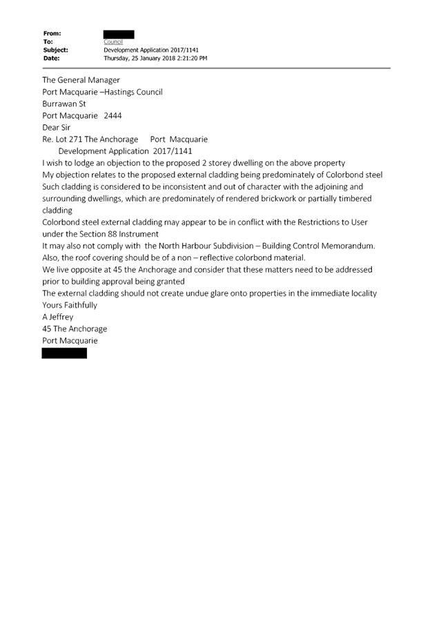
1 (one) written submission was received following public exhibition
of the application.
Key issues raised in the submission received and comments
in response to these issues are provided as follows:
|
Submission
Issue/Summary
|
Planning
Comment/Response
|
|
The use of colorbond steel on
the roof & wall cladding is inconsistent with the adjoining rendered
& timber clad dwellings.
|
The use of colorbond material
for roofing & cladding is not out of character with the varied designs
and colour schemes of dwellings within the locality. Furthermore, changes to
cladding and colour schemes can be done as exempt development, limiting
Councils involvement in such an issue.
|
|
Colorbond steel may be inconsistent with the restrictions
under the 88B.
|
The development is consistent with the relevant 88B
instrument applying to the site. It should also be noted that Council does
not enforce any private restrictions placed on an 88B instrument by the
developer.
|
|
Colorbond steel may not comply with the North Harbour
subdivision building control memorandum.
|
The
development is consistent with the relevant Memorandums that Council is a
party too. It should also be noted that Council does
not enforce any private Memorandums established by the developer.
|
|
Roof covering & external cladding should not cause
glare.
|
Council
controls do not specify colour or glare requirements. In particular, changes
to the colour of a building can be done as exempt development. Nonetheless,
the applicant has indicated that the colorbond colour ‘Surfmist
Matt’ was chosen due to its anti-glare properties.
|
(e) The Public Interest:
The proposed
development satisfies relevant planning controls and is unlikely to impact on
the wider public interest.
4. DEVELOPMENT
CONTRIBUTIONS APPLICABLE
Not applicable.
5. CONCLUSION
The application has been assessed in accordance with
Section 79C of the Environmental Planning and Assessment Act 1979.
Issues raised during assessment and public exhibition of
the application have been considered in the assessment of the application.
Where relevant, conditions have been recommended to manage the impacts
attributed to these issues.
The site is suitable for the proposed development, is not
contrary to the public's interest and will not have a significant adverse
social, environmental or economic impact. It is recommended that the
application be approved, subject to the recommended conditions of consent
provided in the attachment section of this report.
|
Attachments
1View. DA2017
- 1141.1 Plans
2View. DA2017
- 1141.1 Recommended Conditions
3View. DA2017
- 1141.1 Submission - Jeffrey
|
|
ATTACHMENT
|
Development Assessment Panel
14/03/2018
|
|
ATTACHMENT
|
Development Assessment Panel
14/03/2018
|
|
ATTACHMENT
|
Development Assessment Panel
14/03/2018
|
AGENDA Development Assessment Panel 14/03/2018
Item: 06
Subject: DA2017 - 1065.1 Alterations To Caravan Park,
Lot 2 DP 1233513, Munster Street, Port Macquarie
Report
Author: Chris Gardiner
|
Applicant: Love
Project Management
Owner: NSW
Trade & Investment – Crown Lands
Estimated Cost: $15,000
Alignment with Delivery Program
4.3.1 Undertake transparent
and efficient development assessment in accordance with relevant legislation.
|
|
RECOMMENDATION
That
DA 2017 – 1065.1 for
Alterations to Caravan Park at Lot 2, DP 1233513, Munster
Street, Port Macquarie, be determined by granting consent subject to the
recommended conditions.
|
Executive
Summary
This
report considers a development application for alterations to a caravan park
at the subject site and provides an assessment of the
application in accordance with the Environmental Planning and Assessment Act
1979.
Following exhibition of the
application, 3 submissions have been received.
1. BACKGROUND
Existing sites features and surrounding development
The site has an area of 8.195
hectares.
The site is zoned RE1 Public Recreation in accordance with the Port Macquarie-Hastings Local
Environmental Plan 2011, as shown in the following zoning plan:
The existing subdivision pattern and location of existing
development within the locality is shown in the following aerial photograph:
2. DESCRIPTION OF
DEVELOPMENT
Key aspects of the proposal include the following:
· Demolition
of existing structures;
· Change
to the number and configuration of sites from 2 long term sites, 363 short term
sites and 100 camp sites to zero long term sites, 330 short term sites and 100
campsites (overall reduction of 35 sites).
Refer
to attachments at the end of this report.
Application Chronology
· 27
November 2017 – Application lodged.
· 12 December 2017 to 12 January 2018 – Neighbour
notification.
· 12 December 2017 – Additional information requested
by Council staff.
· 17 December 2017 – Additional information provided by
Applicant.
· 17 January 2018 – Further additional information
requested by Council staff.
· 25 January 2018 and 1 March 2018 – Further additional
information submitted by Applicant.
3. STATUTORY ASSESSMENT
Section 79C(1) Matters for Consideration
In determining the application, Council is required to take
into consideration the following matters as are relevant to the development
that apply to the land to which the development application relates:
(a) The provisions (where
applicable) of:
(i) any Environmental
Planning Instrument:
State
Environmental Planning Policy No. 21 - Caravan Parks
8 Development
consent required for caravan parks
(1)
Development for the purposes of a caravan park may be carried out only with the
development consent of the Council.
(2)
Before granting development consent to the use of land for the purposes of a
caravan park, a Council must determine:
(a) the number of sites (if any) within that land that the
Council considers are suitable for long-term residence, within the meaning of
the Local Government (Caravan Parks and Camping Grounds) Transitional
Regulation 1993, and
(b) the number of sites (if any) within that land that the
Council considers are not suitable for long-term residence, but are suitable
for short-term residence, within the meaning of that Regulation.
(3)
A Council must not grant development consent to the use of land for the
purposes of a caravan park unless it imposes as a condition of that consent a
condition specifying the maximum number of sites (if any) within that land that
may be used for long-term residence.
(4)
The holder of an approval under Part 1 of Chapter 7 of the Local Government Act 1993 to operate a caravan park
or camping ground on land must not, without the development consent of the
Council, allow a person to occupy a site within that land:
(a) for a continuous period of more than 3 months, except
as provided by paragraph (b), or
(b) for a continuous period longer than the period (if any)
for which the person is allowed to be accommodated within the land by an
extension that has been granted under clause 19 (6) of the Local Government
(Caravan Parks and Camping Grounds) Transitional Regulation 1993, if such a use
of that site was not lawful under the Environmental Planning and Assessment Act 1979 when
this Policy commenced.
(4A)
Except as provided by subclause (4), nothing in this Policy or any other
environmental planning instrument requires separate development consent to be
obtained for the installation or placement of a moveable dwelling on land on
which development for the purposes of a caravan park is being lawfully carried
out.
(5)
This clause does not apply to any land that is authorised to be used for the
purposes of a manufactured home estate by a development consent granted
pursuant to State Environmental Planning Policy No 36—Manufactured
Home Estates or dedicated or reserved under the National Parks and Wildlife Act 1974.
The proposal
does not seek consent for any long-term sites.
10 Matters
to be considered by Councils
A Council
may grant a development consent required by this Policy only after it has
considered the following:
(a) whether, because of
its location or character, the land concerned is particularly suitable for use
as a caravan park for tourists or for long-term residence,
Comment: The
land concerned is already used as a caravan park for tourists and for long-term
residence.
(b) whether there
is adequate provision for tourist accommodation in the locality of that land,
and whether existing or potential tourist accommodation will be displaced by
the use of sites for long-term residence,
Comment: The
site is located near the Town Beach and Town Centre precincts, where there is a
substantial amount of tourist accommodation. The proposal does not include any
long-term sites.
(c) whether there
is adequate low-cost housing, or land available for low-cost housing, in that
locality,
Comment: The
proposal would retain existing short-term, low-cost housing opportunities at
the site.
(d) whether necessary community
facilities and services are available within the caravan park to which the
development application relates or in the locality (or both), and whether those
facilities and services are reasonably accessible to the occupants of the
caravan park,
Comment: The
development would not result in any reduction in the community facilities
within the caravan park. The site is within walking distance of the Port
Macquarie Town Centre, which has a range of facilities and services for
residents/tourists.
(e) any relevant
guidelines issued by the Director, and
Comment: No
relevant guidelines have been issued.
(f) the provisions
of the Local Government (Caravan Parks and Camping Grounds) Transitional
Regulation 1993.
Comment: The
below table considers the applicable provisions of the Local Government
(Manufactured Home Estates, Caravan Parks, Camping Grounds and Moveable
Dwellings) Regulation 2005.
|
CLAUSE
|
REQUIREMENT
|
COMMENT/COMPLIANCE
|
|
Part 3, Division 1
Operation of caravan parks and camping grounds
|
|
71 Factors for consideration before approval is granted
|
(1) Council must be satisfied that the estate will be
designed in accordance with Division 3; and
(2) Council must have regard to the Floodplain
Development Manual.
|
(1) Yes - refer to comments on Division 3
(2) Site is flood prone. See comments under clauses 7.3
and 7.4 of LEP.
|
|
72 Matters to be specified in approval
|
Any approval must specify the number, size and location
of the dwelling and camping sites.
|
Section 68 approval to operate will need to specify these
matters.
|
|
73 Conditions of approval
|
The consent must be conditioned to ensure the design,
construction, maintenance and operation of the estate is in accordance with
Division 3.
|
Section 68 approval to operate will need to specify these
matters.
|
|
Part 3, Division 3 Caravan parks and camping grounds
|
|
83 Minimum size of caravan park or camping ground
|
Estate must have an area of not less than 1 hectare.
|
Complies - site has an area of 8.195 hectares.
|
|
84 Community amenities
|
Minimum 10% of site area to be reserved for recreation
and other communal activities
|
Complies - more than 10% of site area available for
recreation and communal activities.
|
|
85 Size of dwelling sites and camp sites
|
(1) A long-term site must have an area of at least
80 square metres.
(2) A short-term site must have an area of at least
65 square metres.
(3) A camp site must have an area of at least:
(a) 40 square metres, in the case of a camp
site for which a separate parking space is provided within 30 metres of the
camp site, or
(b) 50 square metres, in any other case.
|
Capable of complying. The proposal includes 330
short-term sites within the same area that has previously been approved for 2
long-term sites and 363 short-term sites. The overall area of the individual
sites would therefore be expected to increase. Details of compliant site
sizes will need to be submitted with the Section 68 application.
The proposal does not include any changes to the existing
100 camp sites.
|
|
86 Site identification
|
Dwelling sites to be identified and site
boundaries delineated.
|
Capable of complying. Would need to be in place prior to
Section 68 approval to operate.
|
|
87 Dwelling sites to have road frontage
|
A dwelling site must have vehicular
access to an access road.
|
All dwelling sites have existing vehicular access to an
access road.
|
|
88 Setbacks of community buildings
|
(1) A community building must not
be located closer than 10 metres to the boundary of a caravan park or camping
ground, or to the boundary of a dwelling site or camp site, unless the
approval for the caravan park or camping ground so allows.
(2) The approval for a caravan
park or camping ground must not allow a lesser distance than 10 metres unless
the council is satisfied that the community building has been or will be
properly screened, fenced, enclosed or otherwise treated.
(3) A community building must not
in any case be located closer than 3 metres to the boundary of a caravan park
or camping ground or 5 metres to the boundary of a dwelling site or camp
site.
|
N/A. No new community buildings proposed or required.
|
|
89 Setbacks of dwelling sites and camp sites from road
frontages
|
(1) A dwelling site or camp site
must not be located closer than 10 metres to a public road or 3 metres to any
other boundary of the caravan park or camping ground unless the approval for
the caravan park or camping ground so allows.
(2) The approval for a caravan
park or camping ground must not allow a lesser distance unless the council is
satisfied that the dwelling site or camp site has been or will be properly
screened, fenced, enclosed or otherwise treated.
|
Proposed reconfigured sites comply with road and boundary
setback requirements.
|
|
90 Use of buffer zones
|
Nothing in this Regulation prevents land
within a buffer zone arising from the setbacks required by this Division from
being used:
(a) for community amenities,
access roads, car parking spaces, footpaths or landscaping, or
(b) for any similar purpose
allowed by the approval for the caravan park or camping ground.
|
N/A
|
|
91 Separation distances
|
(1) A moveable dwelling must not
be installed closer to any other moveable dwelling than:
(a) 3 metres, if it is
situated on a long-term site, or
(b) 2.5 metres, if it is
situated on a short-term site or camp site.
(2) This clause does not prohibit
the installation of semi-detached relocatable homes on adjoining dwelling
sites so long as they are separated by construction conforming to the fire
safety and sound insulation provisions relating to class 1 buildings
contained in Section 3.7.1 and 3.8.6 of Volume Two of the Building
Code of Australia.
|
Capable of complying.
|
|
92 Entrance and exit roads
|
(1) A road that forms an entrance
to or exit from a caravan park or camping ground must be at least 7 metres
wide.
(2) In the case of a divided road,
the width of the sealed portion of the road on either side of the median
strip must be at least 5 metres.
(3) The arrangement for the width
of an entrance or exit road to taper into or meet the width of the sealed
portion of the access roads leading to the entrance or exit must be as
specified in the approval for the caravan park or camping ground.
|
Site has existing approved entrance and exit roads.
|
|
93 Forecourt
|
A caravan park must have a forecourt,
measuring at least 4 metres by 20 metres, to accommodate incoming vehicles.
|
Existing forecourt.
|
|
94 Width of roads
|
(1) The width of an access road
must be:
(a) at least 6 metres for a
two-way access road, and
(b) at least 4 metres for a
one-way access road.
(2) The direction of travel for a
one-way access road must be indicated by means of conspicuous signs.
|
Existing approved internal road network.
|
|
95 Speed limits
|
The speed limit applicable to an access
road:
(a) must not exceed 15
kilometres per hour, and
(b) must be indicated by
means of conspicuous signs.
|
Existing speed limit within the caravan park.
|
|
96 Resident parking
|
(1) A caravan park or camping ground must contain
at least one resident parking space for each dwelling site or camp site.
(2) The parking space for a dwelling site or camp
site may be on-site (that is, forming part of the site) or off-site (that is,
not forming part of the site).
(3) An off-site space must be marked (for example,
by means of line marking, marker pegs or similar means) to identify the
particular dwelling site or camp site to which it relates.
(4) An off-site parking space for a dwelling site
or camp site must be situated in the location specified in the approval for
the caravan park or camping ground.
(5) Each off-site parking space is to have, at
minimum, dimensions of:
(a) 5.4 metres by 2.5 metres, in the case of
angle parking, and
(b) 6.1 metres by 2.5 metres, in any other
case.
|
The proposed new studio sites (1A – 8A and 1B
– 3B) have one parking space per dwelling site. Spaces 5A – 8A
are located off the sites and will need to be marked and allocated
accordingly.
Existing reconfigured short-term and camp sites would retain one parking
space on each site.
Parking spaces are capable of complying with the minimum
dimensions.
|
|
97 Visitor parking
|
(1) A caravan park or camping ground must contain
no fewer visitor parking spaces than the following:
(a) one visitor parking space for each 10 (and
any remaining fraction of 10) long-term sites in the caravan park or camping
ground,
(b) one visitor parking space for each 20 (and
any remaining fraction of 20) short-term sites in the caravan park or camping
ground,
(c) one visitor parking space for each 40 (and
any remaining fraction of 40) camp sites in the caravan park or camping
ground.
(2) The minimum number of visitor parking spaces to
be provided is 4.
|
The proposed development would result in an overall
reduction of 2 long-term sites and 33 short-term sites and would reduce the
existing demand for visitor parking.
|
|
98 Visitor parking for people with disabilities
|
(1) A caravan park or camping
ground must contain at least one visitor parking space for people with disabilities.
(2) A caravan park or camping
ground that contains more than 100 sites must contain at least one visitor
parking space for people with disabilities for each 100 sites or fraction of
100 sites.
(3) Such parking is to be provided
in accordance with AS/NZS 2890.1:2004 Parking
facilities—Off street parking.
(4) Visitor parking spaces for
people with disabilities must be clearly identified as such.
(5) Visitor parking spaces
provided under this clause may be counted for the purposes of clause 97.
|
The proposed development would result in an overall
reduction of 2 long-term sites and 33 short-term sites and would reduce the
existing demand for visitor parking.
A parking space for people with disabilities is proposed
for site 1B, which will be an accessible unit.
|
|
99 Road surfaces
|
All access roads, including all passing
and parking bays, must have an all-weather sealed or other surface finish
specified in the approval for the caravan park or camping ground, and must be
adapted to the topography to allow for adequate drainage and to eliminate
excessive grades.
|
Conditions recommended requiring sealed surface for new
parking areas.
|
|
100 Lighting
|
All access roads must be adequately lit
between sunset and sunrise.
|
Existing lighting of roadways. No changes proposed.
|
|
101 Water supply
|
(1) A caravan park or camping
ground:
(a) must be connected to a
mains water supply, or
(b) must be provided with an
alternative water supply service as specified in the approval for the caravan
park or camping ground.
(2) A dwelling site must be
connected to the water supply service for the caravan park or camping ground.
(5) The water supply service must
comply with:
(a) the Plumbing and Drainage Act 2011 and any regulations under that
Act, and
(b) the requirements of any
relevant statutory body.
|
Connection to water service will be required for each
proposed site. Condition recommended requiring connection prior to the issue
of a Section 68 approval to operate.
|
|
102 Sewerage
|
(1) A caravan park or camping
ground:
(a) must be connected to a
main sewer, or
(b) must be provided with an
alternative sewage disposal system as specified in the approval for the
caravan park or camping ground.
(2) A long-term site must be
provided with a connection to the sewage disposal system for the caravan park
or camping ground.
(3) A caravan park or camping
ground that includes any short-term sites or camp sites must be provided with
at least one common soil waste dump point for the disposal of closet waste
from caravan holding tanks and the like. The common soil waste dump point
must be located so as to permit adequate access by caravans and campervans.
(4) A short-term site must be
provided with a disposal point, as specified in the approval, for the
disposal of sullage (that is, domestic waste from baths, basins, showers,
laundries and kitchens, including floor wastes from those sources) from any
moveable dwelling installed on the site. More than one short-term site may be
provided with the same disposal point.
(5) The sewage disposal system
must comply with:
(a) the Plumbing and Drainage Act 2011 and any regulations under that
Act, and
(b) the requirements of any
relevant statutory body.
|
Connection to sewer will be required for each site.
Condition recommended requiring connection prior to the issue of a Section 68
approval to operate.
|
|
103 Drainage
|
(1) A caravan park or camping ground
must be provided with a stormwater drainage system.
(2) All dwelling sites and camp
sites must be adequately drained.
|
See comments later in this report under Stormwater.
|
|
104 Electricity Supply
|
(1) A dwelling site must be
supplied with electricity from a reticulated electricity service.
(2) In the case of a long-term
site, the electricity must be supplied by means of an electrical circuit
connected to a separate electricity meter.
|
Electricity supply will need to be provided prior to the
Section 68 approval to operate.
|
|
105 Common trenches
|
A common trench may be used for the
installation of services in accordance with guidelines set out in AMCORD.
|
Noted.
|
|
106 Modification of calculations
|
In calculating the facilities to be
provided in accordance with this Subdivision:
(a) 2 camp sites are taken to
be the equivalent of one dwelling site, and
(b) dwelling sites reserved
for use by self-contained moveable dwellings, and dwelling sites provided
with ensuite facilities, are to be disregarded.
|
Noted. See calculations below under clauses 107-109.
|
|
107 Number of showers and toilets to be provided.
|
Facilities to be provided in accordance
with table.
|
N/A. The number of dwelling sites would not be increased
by the proposal.
|
|
108 Facilities for people with disabilities
|
Minimum one facility required. Can be
disregarded if all sites proposed to be designated for self-contained
moveable dwellings.
|
The proposal would not increase the number of dwelling
and camping sites.
|
|
109 Other facilities
|
(1) All showers and handbasins
required by this Subdivision must be supplied with hot and cold running
water.
(2) A mirror must be provided:
(a) for each handbasin
provided, or
(b) if 2 or more handbasins
are provided together, for each pair of handbasins.
(3) Means for sanitary napkin
disposal must be provided in each communal facility that contains water
closets for female use and, in a facility containing 10 or more water
closets, must be provided at the rate of one for each 10 (or remaining
fraction of 10) water closets.
|
N/A
|
|
110 Construction of shower blocks and toilet blocks
|
(1) Except as otherwise provided
by the approval for the caravan park or camping ground, the shower and toilet
facilities provided for a caravan park or camping ground must be housed in a
shower block or toilet block:
(a) that is constructed of
brick or concrete masonry block, and
(b) that has a non-slip floor
of tile or other impervious material adequately drained to outlets, and
(c) that has smooth, hard,
durable and water-resistant interior finishes, and
(d) that has shower recesses
with tile or other impervious finishes to a height of at least 1.8 metres,
and
(e) that has tile or other
impervious skirtings around water closet cubicle walls, and
(f) that has tile or other
impervious finish around wash basins, and
(g) that has adequate
lighting (both inside and outside) and adequate ventilation at all times, and
(h) that has all its walls,
ceilings and floors, fixtures, fittings and appliances maintained in a clean
and sanitary condition at all times.
(2) Subject to clause 108 (2) and
(3), if male and female shower or toilet facilities are located in the same
building, that building must be divided for separate use by each sex.
(3) Water closets must be provided
in individual cubicles having a minimum floor area of 1.1 square metres and a
minimum width of 0.8 metre.
|
N/A
|
|
111 Proximity of dwelling sites to shower blocks and
toilet blocks
|
(1) A long-term site must not be
situated more than 75 metres (measured in a straight line) from a shower
block or toilet block.
(2) A short-term site or camp site
must not be situated more than 100 metres (measured in a straight line) from
a shower block or toilet block.
(3) This clause does not apply in
respect of dwelling sites reserved for use by self-contained moveable
dwellings and dwelling sites provided with ensuite facilities.
|
New/reconfigured short-term sites are located within 100m
of the existing amenity buildings.
|
|
113 Washing Machines
|
(1) A caravan park or camping
ground must be provided with:
(a) at least one washing
machine for each 25 (and any remaining fraction of 25 greater than 12)
long-term sites, and
(b) at least one washing
machine for each 30 (and any remaining fraction of 30 greater than 15)
short-term sites.
(2) The minimum number of washing
machines to be provided is 2.
|
Proposal would not increase the number of washing
machines required as there is a reduction in the overall number of sites.
|
|
114 Laundry Tubs
|
(1) A caravan park or camping
ground must be provided with:
(a) at least one laundry tub
for each 50 (and any remaining fraction of 50) long-term sites, and
(b) at least one laundry tub
for each 60 (and any remaining fraction of 60) short-term sites.
(2) The minimum number of laundry
tubs to be provided is one.
|
Proposal would not increase the number of laundry tubs
required as there is a reduction in the overall number of sites.
|
|
115 Clothes dryers
|
(1) A caravan park or camping
ground must be provided with:
(a) at least one mechanical
clothes dryer for each 60 (and any remaining fraction of 60 greater than 30)
long-term sites, and
(b) at least one mechanical
clothes dryer for each 80 (and any remaining fraction of 80 greater than 40)
short-term sites.
(2) The minimum number of
mechanical clothes dryers to be provided is one.
|
Proposal would not increase the number of mechanical
clothes dryers required as there is a reduction in the overall number of
sites.
|
|
116 Drying area
|
(1) A caravan park or camping
ground must be provided with clothes line space at the rate of 2 metres of
line for each dwelling site.
(2) The minimum length of clothes
line space to be provided is 50 metres.
|
No increase in number of dwelling sites proposed.
Additional clothes line space not required.
|
|
117 Water supply
|
Washing machines and laundry tubs
required by this Subdivision must be supplied with both hot and cold water.
|
Noted. This would need to be confirmed prior to the issue
of a Section 68 approval to operate.
|
|
118 Ironing facilities
|
A caravan park or camping ground must be
provided with ironing boards, electric irons and power points available for
connection to electric irons at the rate of one for every 60 (or remaining
fraction of 60) short-term sites.
|
None required. No short-term sites proposed.
|
|
119 Construction of laundry blocks
|
Except as otherwise provided by the approval for the
caravan park or camping ground, the laundry facilities provided for a caravan
park or camping ground must be housed in a laundry block:
(a) that is constructed of brick or concrete
masonry block, and
(b) that has a non-slip floor of tile or other
impervious material adequately drained to outlets, and
(c) that has smooth, hard, durable and
water-resistant interior finishes, and
(d) that has adequate lighting (both inside
and outside) and adequate ventilation at all times, and
(e) that has all its walls, ceilings and
floors, fixtures, fittings and appliances maintained in a clean and sanitary
condition at all times.
|
N/A. Existing building.
|
|
120 Maintenance
|
The laundry facilities required by this
Subdivision that are housed in a laundry block must be maintained in a
serviceable and safe condition.
|
Noted. This will be a requirement of the Section 68
approval to operate.
|
|
127 Garbage removal
|
Arrangements specified in the approval
for the caravan park or camping ground must be instituted and maintained for
the removal of garbage and for the maintenance of garbage receptacles in a
clean and sanitary condition.
|
No changes proposed to existing waste management for the
premises.
|
|
128 Fire hydrants
|
(1) No part of a dwelling site,
camp site or community building within a caravan park or camping ground may
be situated more than 90 metres from a fire hydrant.
(2) Any fire hydrant located
within a caravan park or camping ground must:
(a) be a double-headed
pillar-type fire hydrant, and
(b) be maintained to the
standard specified in the approval for the caravan park or camping ground.
|
No changes to existing hydrant coverage of the sites.
|
|
129 Fire hose reels
|
(1) Fire hose reels must be
installed so that each dwelling site or camp site in the caravan park or
camping ground can be reached by a fire hose.
(2) The fire hose reels must be
constructed in accordance with AS/NZS 1221:1997, Fire hose reels and
installed in accordance with AS 2441—1988, Installation of
fire hose reels, as in force on 1 September 2005.
|
Submitted plans show fire hose reels.
|
|
130 Car washing bay
|
A caravan park must be provided with an
area for use for washing vehicles.
|
No change to existing arrangements.
|
State
Environmental Planning Policy No. 44 - Koala Habitat Protection
With
reference to clauses 6 and 7, the subject land is greater than 1 hectare
(including any adjoining land under same ownership) and therefore the
provisions of SEPP must be considered.
Schedule 2
Koala feed trees do not make up more than 15% of the canopy or understorey
vegetation on the site and it therefore doesn’t constitute potential
koala habitat. No further consideration of the SEPP is required.
State
Environmental Planning Policy No. 55 – Remediation of Land
Following an
inspection of the site and a search of Council records, the subject land is not
identified as being potentially contaminated and is suitable for the intended
use.
State
Environmental Planning Policy No. 62 – Sustainable Aquaculture
Given the
nature of the proposed development and proposed stormwater controls the
proposal will be unlikely to have any adverse impact on existing aquaculture
industries.
State
Environmental Planning Policy No. 71 – Coastal Protection and Clause 5.5
of Port Macquarie-Hastings Local Environmental Plan 2011
The site is
located within a coastal zone noting clause 4 of the SEPP.
In accordance
with clause 5, this SEPP prevails over the Port Macquarie-Hastings LEP 2011 in
the event of any inconsistency.
Having regard
for clauses 2, 8 and 12 to 16 of the SEPP and clause 5.5 of the PMH LEP 2011,
the proposed development will not result in any of the following:
a) any restricted access (or
opportunities for access) to the foreshore
b) any adverse amenity impacts along
the foreshore and on the scenic qualities of the coast;
c) any adverse impacts on flora and fauna;
d) the development being subject to
any adverse coastal processes or hazards;
e) any significant conflict between
water and land based users of the area;
f) any adverse impacts on any
items of archaeological/heritage;
g) reduction in the quality of the
natural water bodies in the locality (due to effluent & stormwater
disposal, construction impacts, landuse conflicts);
h) adverse cumulative impacts on the
environment;
i) a form of development that is
unsustainable in water and energy demands;
j) development relying on
flexible zone provisions.
The site is
predominately cleared and located within an area zoned for recreational
purposes.
Port Macquarie-Hastings Local Environmental Plan 2011
The proposal
is consistent with the LEP having regard to the following:
· Clause
2.2, the subject site is zoned RE1 Public Recreation. In accordance with clause
2.3(1) and the RE1 zone landuse table, the proposed development for a caravan
park is a permissible landuse with consent.
The objectives of the RE1 zone are as follows:
o To enable land to be used for public open space or recreational
purposes.
o To provide a range of recreational settings and activities and
compatible land uses.
o To protect and enhance the natural environment for recreational
purposes.
In accordance with Clause 2.3(2), the proposal is consistent with the
zone objectives having regard to the following:
o The
proposal is a permissible landuse;
o The
development would retain a use that is compatible with recreational activities.
· Clause
2.7, the demolition requires consent as it does not fit within the provisions
of SEPP (Exempt and Complying Development Codes) 2008.
· Clause
5.5 - Development within the coastal zone - relevant objectives of this clause
are addressed by SEPP 71 section (see above). Climate Change & Coastal
Hazard implications addressed under Clause 7.3 & 7.4 below.
·
· Clause
5.10 – Heritage. Part of the southern side of the site is mapped as being
of potential archaeological significance (A111 – Archaeology of early
European settlement). The works proposed in the application do not include any
excavation on this part of the site and referral to the Heritage Council is not
required.
·
· Clause
7.1, the site is mapped as potentially containing class 3 acid sulphate soils.
The proposed development does not involve any excavation extending 1m or more
below the natural surface level. Therefore, no adverse impacts are expected to
occur to the acid sulphate soils found on site.
·
· Clause
7.3, the site is land within a mapped “flood planning area” (land
subject to flood discharge of 1:100 annual recurrence interval flood event,
plus the applicable climate change allowance and relevant freeboard). In this
regard the following comments are provided which incorporate consideration of
the objectives of Clause 7.3, Council’s Flood Policy 2015, the NSW
Government’s Flood Prone Lands Policy and the NSW
Government’s Floodplain Development Manual (2005):
o The
proposal is compatible with the flood hazard of the land taking into account
projected changes as a result of climate change;
o The
proposal will not result in a significant adverse effect on flood behaviour
that would result in detrimental increases in the potential flood affectation
of other development or properties;
o The
proposal incorporates measures to minimise & manage the flood risk to life
and property associated with the use of land;
o The
proposal is not likely to significantly adversely affect the environment or
cause avoidable erosion, siltation, destruction of riparian vegetation or a
reduction in the stability of river banks or watercourses;
o The
proposal is not likely to result in unsustainable social and economic costs to
the community as a consequence of flooding;
o Minimum
floor levels for habitable buildings are recommended in the conditions;
o Buildings
will be required to be engineered to withstand flood forces and to minimise
impacts on the movement of flood waters.
· Clause
7.4 – Flood risk management – the site includes land between the
flood planning area and the line that is shown as the probable maximum flood
level on the Flood Planning Map. The site is an existing caravan park and has a
previous flood evacuation plan that has been accepted by Council. The proposed
development would result in a reduction in the overall number of sites by 35
sites and would therefore reduce the number of people at risk during
evacuation.
· Clause
7.13, satisfactory arrangements are in place for provision of essential
services including water supply, electricity supply, sewer infrastructure,
stormwater drainage and suitable road access to service the development.
(ii) Any
draft instruments that apply to the site or are on exhibition:
Draft
State Environmental Planning Policy (Coastal Management) 2016
The Draft
SEPP was publicly exhibited between 11 November 2016 and 20 January 2017 and is
intended to consolidate and replace SEPP 14 (Coastal Wetlands), SEPP 26
(Littoral Rainforests) and SEPP 71 (Coastal Protection).
The proposal
is considered to be consistent with the provisions of the Draft SEPP, which are
generally the same as those discussed under SEPP No. 71 – Coastal
Protection earlier in this report.
(iii) any
Development Control Plan in force:
Port
Macquarie-Hastings Development Control Plan 2013
|
DCP 2013: General
Provisions
|
|
|
Requirements
|
Proposed
|
Complies
|
|
2.7.2.2
|
Design addresses generic
principles of Crime Prevention Through Environmental Design guideline
|
The proposed development will
be unlikely to create any concealment/entrapment areas or crime spots that
would result in any identifiable loss of safety or reduction of security in
the immediate area.
|
Yes
|
|
2.3.3.8
|
Removal of hollow bearing
trees
|
None proposed to be removed.
|
Yes
|
|
2.6.3.1
|
Tree removal (3m or higher
with 100mm diameter trunk at 1m above ground level and 3m from external wall
of existing dwelling)
|
None proposed to be removed.
|
Yes
|
|
2.4.3
|
Bushfire risk, Acid sulphate
soils, Flooding, Contamination, Airspace protection, Noise and Stormwater
|
Refer to main body of report.
|
|
|
2.5.3.3
|
Parking in accordance with
Table 2.5.1.
1 space per single dwelling
(behind building line)
|
See comments earlier under
SEPP No. 21 regarding parking requirements.
|
|
|
2.5.3.11
|
Section 94 contributions
|
Refer to main body of report.
|
|
(iiia) any
planning agreement that has been entered into under Section 93f or any draft
planning agreement that a developer has offered to enter into under Section
93f:
No planning agreement
has been offered or entered into relating to the site.
iv) any matters prescribed by the
Regulations:
New South Wales Coastal Policy:
The proposed
development is consistent with the objectives and strategic actions of this
policy. See comments earlier under SEPP No. 71 – Coastal Protection.
Demolition
of buildings AS 2601:
Demolition of
existing buildings on the site is capable of compliance with this Australian
Standard and is recommended to be conditioned.
v) any coastal
zone management plan (within the meaning of the Coastal Protection Act 1979),
that apply to the land to which the development application relates:
No Coastal
Zone Management Plan applies to the subject site.
(b) The
likely impacts of that development, including environmental impacts on both the
natural and built environments, social and economic impacts in the locality:
The site has
a general southerly street frontage orientation to Munster Street and a partial
frontage to Murray Street and Sunset Parade.
Adjoining the
site to the north and west is the Hastings River breakwall and foreshore.
Adjoining the
site to the east is the Town Beach reserve.
Adjoining the
site to the south are higher density residential and tourist accommodation and
a mix of commercial uses.
The proposal
is considered to be compatible with other development in the locality and
adequately addresses planning controls for the area.
The proposal
does not have a significant adverse impact on existing view sharing.
The proposal
does not have significant adverse lighting impacts.
There is no
adverse overshadowing impacts. The proposal does not prevent adjoining properties
from receiving 3 hours of sunlight to private open space and primary living
areas on 21 June.
Roads
The site has
road frontage to Munster Street. Adjacent to the site, Munster Street is a
sealed public road under the care and control of Council.
Traffic
and Transport
The site is
currently approved for 2 long-term sites, 363 short-term sites, and 100 camp
sites. This development proposes to reduce the overall number of sites to 330
short-term sites and 100 camp sites and would result in a reduction in the
existing traffic generation. The traffic associated with the development is
unlikely to have any adverse impacts to the existing road network within the
immediate locality.
Site
Frontage & Access
Vehicle
access to the site is proposed through the existing driveway off the northern
end of Munster Street. No changes to the existing access or site frontage works
are proposed.
Parking
and Manoeuvring
Parking and
internal road widths on site can comply with the Local Government (Manufactured
Home Estates, Caravan Parks, Camping Grounds and Moveable Dwellings) Regulation
2005 and conditions have been imposed to reflect these requirements.
Water
Supply Connection
Extension of
the internal water supply infrastructure will be required to service the new/reconfigured
sites in accordance with the Local Government (Manufactured Home Estates,
Caravan Parks, Camping Grounds and Moveable Dwellings) Regulation 2005.
Detailed
plans will be required to be submitted for assessment with the S.68
application.
Refer to
relevant conditions of consent.
Sewer
Connection
Extension of
the internal sewerage infrastructure will be required to service the
new/reconfigured sites in accordance with the Local Government (Manufactured
Home Estates, Caravan Parks, Camping Grounds and Moveable Dwellings) Regulation
2005.
Detailed
plans will be required to be submitted for assessment with the S.68
application.
Refer to
relevant conditions of consent.
Stormwater
The site
naturally grades towards the Hastings River and stormwater from individual
sites is generally discharged to concrete dish drains along the internal road
network. The road network drains to a series of pits along the northern
boundary of the site, which discharge through the breakwall to the Hastings
River.
A detailed
site stormwater management plan will be required to be submitted for assessment
with the S.68 application and prior to the issue of a Construction Certificate.
In accordance
with Councils AUSPEC requirements, the following will be required to be incorporated
into the stormwater drainage plan:
a) The
legal point of discharge for the proposed development is defined as the
existing stormwater drainage system. New roof and pavement areas shall be
drained by a direct piped connection to existing drainage wherever practicable.
b) The design shall provide details of any components of the
existing stormwater drainage system servicing the site that are to be retained.
The capacity of the downstream system for all storms up to 1 in 5 year Average
Recurrence Interval will need to be demonstrated and if capacity is inadequate
options may include pipe upgrade and/or onsite detention.
Overall,
stormwater is able to be managed onsite with conditions of consent applied to
manage the detailed design.
Other
Utilities
Telecommunication
and electricity services are available to the site.
Heritage
See comments
earlier under Clause 5.10 of the LEP.
Other land
resources
The site is
within an established urban context and will not sterilise any significant
mineral or agricultural resource.
Water
cycle
The proposed
development will be unlikely to have any adverse impacts on water resources and
the water cycle.
Soils
The proposed
development will be unlikely to have any adverse impacts on soils in terms of
quality, erosion, stability and/or productivity subject to a standard condition
requiring erosion and sediment controls to be in place prior to and during
construction.
Air and
microclimate
The
construction and/or operations of the proposed development will be unlikely to
result in any adverse impacts on the existing air quality or result in any
pollution. Standard precautionary site management condition recommended.
Flora and
fauna
Construction
of the proposed development will not require any removal/clearing of any
significant vegetation and therefore will be unlikely to have any significant
adverse impacts on biodiversity or threatened species of flora and fauna.
Waste
Satisfactory
arrangements are in place for proposed storage and collection of waste and
recyclables. No adverse impacts anticipated. Standard precautionary site
management condition recommended.
Energy
No adverse
impacts anticipated.
Noise and
vibration
No adverse
impacts anticipated. Condition recommended to restrict construction to standard
construction hours.
Bushfire
The site is
not identified as being bushfire prone.
Safety,
security and crime prevention
The proposed
development will be unlikely to create any concealment/entrapment areas or
crime spots that would result in any identifiable loss of safety or reduction
of security in the immediate area.
Social
impacts in the locality
Given the
nature of the proposed development and its’ location the proposal is
unlikely to result in any adverse social impacts.
As noted
earlier in this report under SEPP 21 – Caravan Parks, the proposed
reconfiguration of sites is not expected to adversely impact on the provision
of low cost housing or tourist accommodation opportunities, given the location
on the fringe of the Port Macquarie CBD. The land is located within walking
distance of a range of services and recreational activities likely to be
required by the residents of the caravan park.
The Applicant
has advised that the reduction in site numbers within the park is a result of a
trend towards larger caravans and manufactured homes and the size of the
individual sites needs to be increased accordingly. The proposed number of
sites reflects how the park is currently operating despite the approval for a
larger number of sites.
Economic
impact in the locality
No adverse
impacts. A likely positive impact is that the development will maintain
employment in the construction industry, which will lead to flow impacts such
as expenditure in the area.
Site
design and internal design
The proposed
development design satisfactorily responds to the site attributes and will fit
into the locality. No adverse impacts likely.
Construction
No potential
adverse impacts identified to neighbouring properties with the construction of
the proposal.
Cumulative
impacts
The proposed
development is not expected to have any adverse cumulative impacts on the
natural or built environment or the social and economic attributes of the
locality.
Natural
Hazards
See comments
earlier in this report regarding flooding and acid sulphate soils.
(c) The suitability of the site for
the development:
The proposal
will fit into the locality and the site attributes are conducive to the
proposed development.
Site
constraints have been adequately addressed and appropriate conditions of
consent recommended.
(d) Any submissions made in
accordance with this Act or the Regulations:
Three (3) written submissions have been received following public
exhibition of the application.
Key issues raised in the submissions received and comments
in response to these issues are provided as follows:
|
Submission
Issue/Summary
|
Planning
Comment/Response
|
|
Impact of glare from roofs of
buildings on sites 1A – 8A and 1B – 3B. Roofs should be a dark,
non-reflective colour.
|
The development application considers
the sites within the caravan park only and future buildings would be subject
to Section 68 application/s. The sites in the caravan park are capable of
accommodating a variety of manufactured homes, of different roof form and
external finishes.
|
|
What is intended for the area (along the southern
boundary) where the cabins are currently located?
|
This is a matter for the operator of the caravan park.
The submitted plans indicate that the area will remain as
9 short-term sites, which is consistent with the current approval to operate.
Any future changes to the use of this area would be subject to a separate
application.
|
|
Loss of views to trees and water.
|
The development application considers the sites within
the caravan park only and future buildings would be subject to Section 68
application/s.
The proposed reconfigured studio sites (sites 1A –
8A and 1B – 3B) are located at a substantially lower level than the
adjoining residential apartments to the south and would not affect any
significant views.
|
|
Parking provision for residents and visitors.
|
The proposal would provide for a parking space on each of
the 330 short-term sites and there would be no reduction in the existing
visitor parking. Given that the development would result in a reduction of 35
sites within the park, the amount of parking available is considered to be an
improvement on the current situation.
|
|
Additional noise from traffic.
|
The proposal would result in 35 less sites that the
current approval for the caravan park. The traffic associated with the
development is also expected to be reduced on this basis.
|
(e) The Public Interest:
The proposed
development satisfies relevant planning controls and is unlikely to impact on
the wider public interest.
4. DEVELOPMENT
CONTRIBUTIONS APPLICABLE
· Development contributions will not be required towards
augmentation of town water supply and sewerage system head works under Section
64 of the Local Government Act 1993.
· Development contributions will not be required under
Section 94 of the Environmental Planning and Assessment Act 1979 towards roads,
open space, community cultural services, emergency services and administration
buildings.
5. CONCLUSION
The application has been assessed in accordance with
Section 79C of the Environmental Planning and Assessment Act 1979.
Issues raised during assessment and public exhibition of
the application have been considered in the assessment of the application.
Where relevant, conditions have been recommended to manage the impacts
attributed to these issues.
The site is suitable for the proposed development, is not
contrary to the public's interest and will not have a significant adverse
social, environmental or economic impact. It is recommended that the
application be approved, subject to the recommended conditions of consent
provided in the attachment section of this report.
|
Attachments
1View. DA2017
- 1065.1 Plans - DAP Set
2View. DA2017
- 1065.1 Recommended Conditions
3View. DA2017
- 1065.1 Submission - Atkins
4View. DA2017
- 1065.1 Submission - Bradley-Cahalan
5View. DA2017
- 1065.1 Submission - Cooper
|
|
ATTACHMENT
|
Development Assessment Panel
14/03/2018
|
|
ATTACHMENT
|
Development Assessment Panel
14/03/2018
|
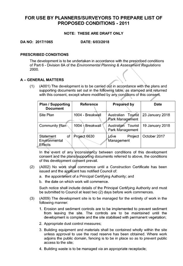
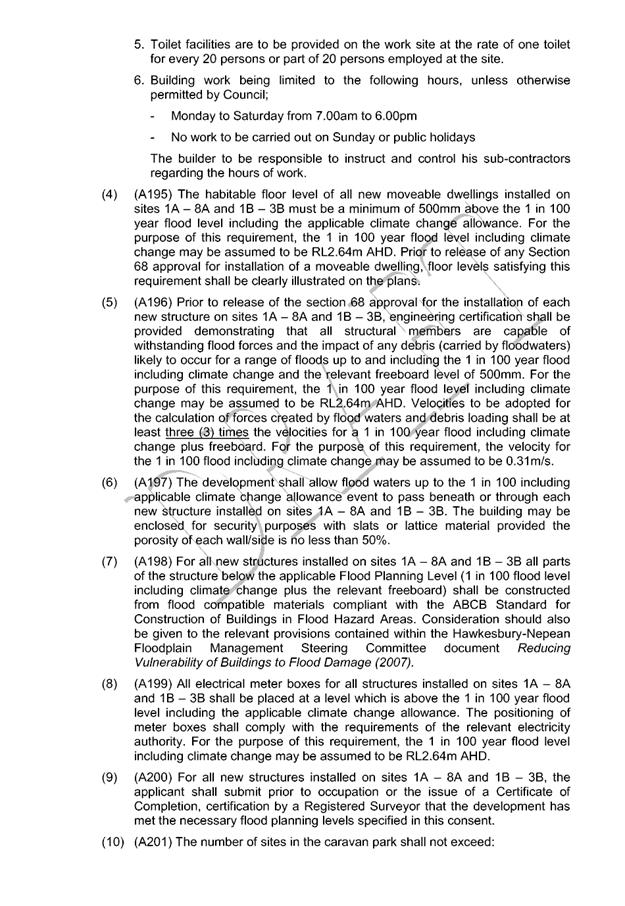
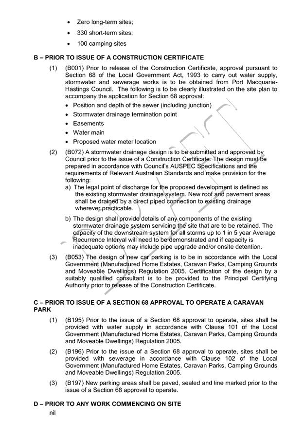
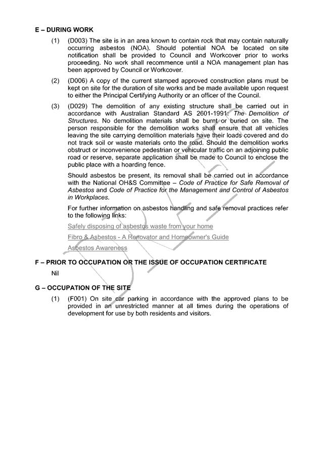
|
ATTACHMENT
|
Development Assessment Panel
14/03/2018
|

|
ATTACHMENT
|
Development Assessment Panel
14/03/2018
|
|
ATTACHMENT
|
Development Assessment Panel
14/03/2018
|
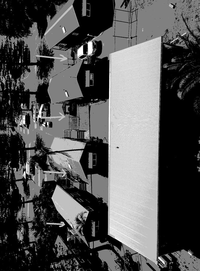
AGENDA Development Assessment Panel 14/03/2018
Item: 07
Subject: DA2017-1100.1 Dwelling & Swimming Pool,
Lot 34 DP 22916, No 12 Surf Street, Port Macquarie
Report
Author: Deb McKenzie
|
Applicant: S
N & H C Morgan
Owner: As
above
Estimated Cost: $799,900
Alignment with Delivery
Program
4.3.1 Undertake transparent
and efficient development assessment in accordance with relevant legislation.
|
|
RECOMMENDATION
That
DA2017 – 1100.1 for the construction
of new dwelling house and swimming pool at
Lot 34 DP 22916, No. 12 Surf Street, Port Macquarie be determined by granting
consent subject to the recommended conditions.
|
Executive
Summary
This
report considers a development application for the construction of a dwelling
house and swimming pool at the subject site
and provides an assessment of the application in accordance with the
Environmental Planning and Assessment Act 1979.
Following exhibition of the
application, four (4) submissions, including
one (1) late submission have been received.
1. BACKGROUND
Existing sites features and surrounding development
The site has an area of 524.8m².
The site is generally rectangular with Surf Street frontage of 17.1m and side
boundaries of 32.185m. The site falls from rear to street from RL26.00m AHD to
RL22.00m AHD. The subject site has been vacant with generally unmanaged
vegetation for a considerable time.
Development in the area comprises a mix of low and medium
density single dwellings, multi-dwelling housing and medium density residential
flat buildings. To the north, east and west are single dwellings, adjoining to
the south is a residential flat building. More broadly this area of
Flynn’s Beach contains a number of permanent and tourist-based unit
developments of various sizes, heights and age.
The site is zoned R3 Medium Density Residential in accordance with the Port Macquarie-Hastings Local
Environmental Plan 2011, as shown in the following zoning plan:
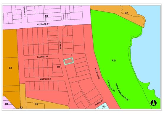
The existing subdivision pattern and location of existing
development within the locality is shown in the following aerial photograph:
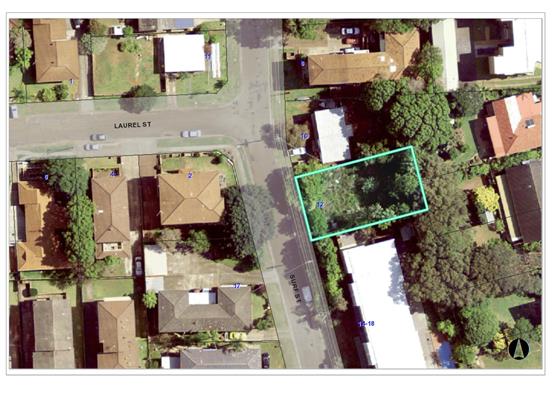
2. DESCRIPTION OF
DEVELOPMENT
Key aspects of the proposal include the following:
· Site
is zoned R3 – Medium Density Residential
· Permissible
height of building limit is 14.5m and FSR is 1.5:1
· Site
area is less than 600m².
· Previous
residential flat building was approved on the site but not commenced/approval
lapsed.
· Proposal
is large single dwelling – up to 9m in height
· Surrounding
development is mix of low and medium density development
Refer
to attachments at the end of this report.
Application Chronology
· 12/12/2017
– Development Application (DA) lodged
· 5/1/18 – 18/1/18 – Public Notification of DA
· 1/1/18 – Two submissions received
· 12/1/1/8 – Submission received
· 29/1/18 – Late submission received (due to Xmas/New
Year holidays)
· 29/1/18 – Submissions sent to applicant’s
architect
· 6/2/18 – Email from architect agreeing to fencing of
site
3. STATUTORY ASSESSMENT
Section 4.15 Evaluation
In determining the application, Council is required to take
into consideration the following matters as are relevant to the development
that apply to the land to which the development application relates:
(a) The provisions (where
applicable) of:
(i) any Environmental
Planning Instrument:
State
Environmental Planning Policy No. 44 - Koala Habitat Protection
The site is
less than 1ha in area and therefore no further investigations are required.
However it
should be noted that a Tree Assessment, prepared by Woodvale Tree Services,
identified all the significant vegetation on the site. It concluded:
“there are no Primary or Secondary trees identified that as
species are listed as having significance to Koala’s within the Port
Macquarie Hastings Council Development Control Plans.”
State
Environmental Planning Policy No.55 – Remediation of Land
Following an
inspection of the site and a search of Council records, the subject land is not
identified as being potentially contaminated and is suitable for the intended
use.
State
Environmental Planning Policy No. 71 – Coastal Protection and Clause 5.5
of Port Macquarie-Hastings Local Environmental Plan 2011
The site is
located within a coastal zone as defined in accordance with clause 4 of SEPP
71.
In accordance
with clause 5, this SEPP prevails over the Port Macquarie-Hastings LEP 2011 in
the event of any inconsistency.
Having regard
to clauses 8 and 12 to 16 of SEPP 71 and clause 5.5 of Hastings LEP 2011
inclusive the proposed development will not result in any of the following:
a) any restricted access (or opportunities for
access) to the coastal foreshore
b) any identifiable adverse amenity impacts along
the coastal foreshore and on the scenic qualities of the coast;
c) any identifiable adverse impacts on any known
flora and fauna (or their natural environment);
d) subject to any identifiable adverse coastal
processes or hazards;
e) any identifiable conflict between water and
land based users of the area;
f) any identifiable adverse impacts on any items
of archaeological/heritage;
g) reduce the quality of the natural water bodies
in the locality.
The site is
predominately cleared and located within an area zoned for residential
purposes.
State
Environmental Planning Policy (Building Sustainability Index: BASIX) 2004
A BASIX
certificate (No. 859586S) has been submitted demonstrating that the proposal
will comply with the requirements of the SEPP. It is recommended that a
condition be imposed to ensure that the commitments are incorporated into the
development and certified at Occupation Certificate stage.
Port Macquarie-Hastings Local Environmental Plan 2011
The proposal
is consistent with the LEP having regard to the following:
· Clause
2.2, the subject site is zoned R3 Medium Density Residential. In accordance
with clause 2.3(1) and the R1 zone landuse table, the dwelling (or ancillary
structure to a dwelling) is a permissible landuse with consent.
The objectives of the R3 zone are as follows:
o To provide for the housing needs of the community within a medium
density residential environment.
o To provide a variety of housing types within a medium density
residential environment.
o To enable other land uses that provide facilities or services to meet
the day to day needs of residents.
In accordance with Clause 2.3(2), the proposal is consistent with the zone
objectives as it is a permissible landuse and consistent with the established
residential locality.
· Clause
4.3, the maximum overall height of the building above ground level (existing)
is 8.9m which complies with the standard height limit of 14.5m applying to the
site.
· Clause
4.4, the floor space ratio of the proposal is 0.9:1, which complies with the
maximum 1.5:1 floor space ratio applying to the site. Note: the GFA of the
dwelling is calculated as 470.6m² (32.5m² of the garage is GFA for
the purposes of FSR).
· Clause
5.9, no listed trees in Development Control Plan 2013 are proposed to be
removed.
· Clause
5.10, the site does not contain or adjoin any known heritage items or sites of
significance.
· Clause
7.13, satisfactory arrangements are in place for provision of essential
services.
(ii) Any
draft instruments that apply to the site or are on exhibition:
No draft
instruments relevant or impact on the proposal.
(iii) any
Development Control Plan in force:
Port
Macquarie-Hastings Development Control Plan 2013
|
DCP
2013: Dwellings, Dual occupancies, Dwelling houses, Multi dwelling houses
& Ancillary development
|
|
|
Requirements
|
Proposed
|
Complies
|
|
3.2.2.1
|
Ancillary
development:
• 4.8m
max. height
• Single
storey
• 60m2
max. area
• 100m2
for lots >900m2
• 24
degree max. roof pitch
• Not
located in front setback
|
Water tank
is appropriately located on the southern side of the dwelling.
|
Yes
|
|
3.2.2.2
|
Articulation
zone:
• Min.
3m front setback
• An
entry feature or portico
• A
balcony, deck, patio, pergola, terrace or verandah
• A
window box treatment
• A
bay window or similar feature
• An
awning or other feature over a window
• A
sun shading feature
|
No elements
within the articulation zone.
|
N/A
|
|
Front
setback (Residential not R5 zone):
• Min.
6.0m classified road
• Min.
4.5m local road
• Min.
3.0m secondary road
• Min.
2.0m Laneway
|
Front
setback is 6.045m to front wall of dwelling. Complies.
|
Yes
|
|
3.2.2.3
|
Garage 5.5m
min. and 1m behind front façade.
Garage door
recessed behind building line or eaves/overhangs provided
|
Garage door
is setback 1.855m behind the front wall of the dwelling.
Garage door
recessed.
|
Yes
|
|
6m max.
width of garage door/s and 50% max. width of building
|
Width of
garage door is less than 6m and less than 50% of the width of the dwelling.
|
Yes
|
|
Driveway
crossover 1/3 max. of site frontage and max. 5.0m width
|
Driveway
crossing is 5m –1/3 of the width of the site (17.1m).
|
Yes
|
|
3.2.2.4
|
4m min.
rear setback. Variation subject to site analysis and provision of private
open space
|
The rear
setback is 5.127m. Complies.
|
Yes
|
|
3.2.2.5
|
Side
setbacks:
• Ground
floor = min. 0.9m
• First
floors & above = min. 3m setback or where it can be demonstrated that overshadowing
not adverse = 0.9m min.
• Building
wall set in and out every 12m by 0.5m
|
Northern:
1000mm to ground floor level and rumpus room.
4600m to
upper bedroom level.
Southern:
1599mm to garage and kitchen/living area; steps out to 999mm to bedroom 4,
bathroom and toilet and 3999mm to upper bedroom level.
Bedroom 4,
bathroom and toilet is not compliant with 3m setback control. However, the
height of this external wall above natural ground level is less than a
standard first level and there are no privacy issues created by the low
traffic rooms. Further there is no additional shadow impacts over and above
what would be anticipated by a complaint setback in this location.
|
Acceptable
variation to side setback on southern side of building.
|
|
3.2.2.6
|
35m²
min. private open space area including a useable 4x4m min. area which has 5%
max. grade
|
The
dwelling contains 175.8m² rear yard private open space, which
complies with the minimum dimensions.
|
Yes
|
|
3.2.2.7
|
Front
fences:
• If
solid 1.2m max height and front setback 1.0m with landscaping
• 3x3m
min. splay for corner sites
• Fences
>1.2m to be 1.8m max. height for 50% or 6.0m max. length of street
frontage with 25% openings
• 0.9x0.9m
splays adjoining driveway entrances
|
No front
fence shown on plans.
Side
fences, where relevant are to be 1.8m timber fences, as agreed by the
applicant in response to the submissions received.
|
Condition
of consent to apply.
|
|
3.2.2.8
|
Front
fences and walls to have complimentary materials to context.
No chain wire, solid timber, masonry or solid
steel front fences.
|
Details to
be submitted with Construction Certificate compliant with 3.2.2.7 above.
|
Condition
of consent to apply.
|
|
3.2.2.10
|
Privacy:
• Direct
views between living areas of adjacent dwellings screened when within 9m
radius of any part of window of adjacent dwelling and within 12m of private
open space areas of adjacent dwellings. ie. 1.8m fence or privacy screening
which has 25% max. openings and is permanently fixed
• Privacy
screen required if floor level > 1m height, window side/rear setback
(other than bedroom) is less than 3m and sill height less than 1.5m
• Privacy
screens provided to balconies/verandahs etc which have <3m side/rear setback
and floor level height >1m
|
The
proposal includes screening, blank walls, low traffic rooms and minimal
openings where visual or acoustic privacy impacts may occur. These measures
are considered adequate to address privacy.
|
Yes
|
|
DCP 2013: General
Provisions
|
|
|
Requirements
|
Proposed
|
Complies
|
|
2.7.2.2
|
Design addresses generic principles of Crime Prevention
Through Environmental Design guideline
|
No concealment or entrapment areas proposed. Adequate
casual surveillance available.
|
Yes
|
|
2.3.3.1
|
Cut and fill 1.0m max. 1m outside the perimeter of the
external building walls
|
Cut and fill of the site required due to fall of up to
4.0m from rear to front of the site.
Any retaining walls 1.0m or higher are to be certified by
an engineer. Standard condition of consent to apply.
|
Yes
|
|
2.3.3.2
|
1m max. height retaining walls along road frontage
|
None proposed.
|
N/A
|
|
Any retaining wall >1.0 in height to be certified by
structure engineer
|
Condition recommended to require engineering certification
|
Yes
|
|
Combination of retaining wall and front fence height max
1.8m, max length 6.0m or 30% of frontage, fence component 25% transparent,
and splay at corners and adjacent to driveway
|
No retaining wall front fence combination proposed.
|
N/A
|
|
2.3.3.8
|
Removal of hollow bearing trees
|
No hollow bearing trees proposed to be removed
|
N/A
|
|
2.6.3.1
|
Tree removal (3m or higher with 100m diameter trunk at 1m
above ground level and 3m from external wall of existing dwelling)
|
The site is currently in an unmanaged state. Vegetation
across the site is proposed to be removed. No significant koala trees exist
on the site. There are no specific requirements regarding tree removal.
|
Yes
|
|
2.4.3
|
Bushfire risk, Acid sulphate soils, Flooding,
Contamination, Airspace protection, Noise and Stormwater
|
Refer to main body of report.
|
|
|
2.5.3.2
|
New accesses not permitted from arterial or distributor
roads
|
No new access proposed to arterial or distribution road.
|
N/A
|
|
Driveway crossing/s minimal in number and width including
maximising street parking
|
Driveway crossing minimal in width including maximising
street parking
|
Yes
|
|
2.5.3.3
|
Parking in accordance with Table 2.5.1.
1 space per single dwelling (behind building line)
|
Large double garage proposed with additional onsite
parking provided in front of the building line. There is no requirement for
the parking space and the front setback area should be landscaped in the
residential setting of Surf Street.
A condition of consent, requiring removal of the parking
space in front of the building line is to be applied with this area to be
landscaped.
|
Yes
|
|
2.5.3.11
|
Section 7.11 contributions
|
Single dwelling only. No contributions applicable
|
N/A
|
|
2.5.3.12 and 2.5.3.13
|
Landscaping of parking areas
|
Single dwelling only with 1 domestic driveway. Landscaping
of front setback area to be condition of consent.
|
N/A
|
|
2.5.3.14
|
Sealed driveway surfaces unless justified
|
Sealed driveway proposed
|
Yes
|
|
2.5.3.15 and 2.5.3.16
|
Driveway grades first 6m or ‘parking area’
shall be 5% grade with transitions of 2m length
|
Driveway grades capable of satisfying Council standard
driveway crossover requirements. Condition recommended for section 138 Roads
Act permit.
|
Yes
|
|
2.5.3.17
|
Parking areas to be designed to avoid concentrations of
water runoff on the surface.
|
Single dwelling only with 1 domestic driveway. Stormwater
drainage is capable of being managed as part of plumbing construction.
|
Yes
|
(iiia) any
planning agreement that has been entered into under Section 7.4 or any draft
planning agreement that a developer has offered to enter into under Section
7.4:
No planning
agreement has been offered or entered into relating to the site.
iv) any matters prescribed by the
Regulations:
New South Wales Coastal Policy:
The proposed
development is consistent with the objectives and strategic actions of this
policy.
Demolition
of buildings AS 2601 – Clause 66 (b)
Nil.
v) any coastal zone management plan (within the meaning of the
Coastal Protection Act 1979), that apply to the land to which the development
application relates:
None
applicable.
(b) The
likely impacts of that development, including environmental impacts on both the
natural and built environments, social and economic impacts in the locality:
Context
and setting
• The
proposal will be unlikely to have any adverse impacts to existing adjoining properties
and satisfactorily addresses the public domain.
• The
proposal is considered to be consistent with other residential development in
the locality and adequately addresses planning controls for the area.
• There
are no adverse impacts on existing view sharing.
• There
are no adverse privacy impacts.
Access,
transport and traffic
The proposal
will be unlikely to have any adverse impacts in terms access, transport and
traffic. The existing road network will satisfactorily cater for any increase
in traffic generation as a result of the development.
Water,
Sewer, Stormwater Supply
Services
available – details required with S.68 application.
Other
Utilities
Telecommunication
and electricity services are available to the site.
Heritage
This site does
not contain or adjoin any known heritage item or site of significance.
Other land
resources
No adverse
impacts anticipated. The site is within an established urban context and will
not sterilise any significant mineral or agricultural resource.
Water
cycle
The proposed
development will be unlikely to have any adverse impacts on water resources and
the water cycle.
Soils
The proposed
development will be unlikely to have any adverse impacts on soils in terms of
quality, erosion, stability and/or productivity subject to a standard condition
requiring erosion and sediment controls to be in place prior to and during
construction.
Air and
microclimate
The
construction and/or operations of the proposed development will be unlikely to
result in any adverse impacts on the existing air quality or result in any
pollution.
Flora and
fauna
Construction
of the proposed development will not require any removal/clearing of any
significant vegetation and therefore will be unlikely to have any significant adverse
impacts on biodiversity or threatened species of flora and fauna.
Waste
Satisfactory
arrangements are in place for proposed storage and collection of waste and
recyclables. No adverse impacts anticipated.
Energy
The proposal
includes measures to address energy efficiency and will be required to comply
with the requirements of BASIX.
Noise and
vibration
No adverse
impacts anticipated. Condition recommended to restrict construction to standard
construction hours.
Bushfire
The site is
not identified as being bushfire prone. No requirements.
Social
impacts in the locality
Given the
nature of the proposed development and its’ location the proposal is
unlikely to result in any adverse social impacts.
Economic
impact in the locality
No adverse
impacts. Likely positive impacts can be attributed to the construction of the
development and associated flow on effects (ie maintained employment and
expenditure in the area).
Site
design and internal design
The proposed
development design satisfactorily responds to the site attributes and will fit
into the locality. No adverse impacts likely.
Construction
Neighbours to
the north and east have requested timber fence construction along the
boundaries to either retain/match a recently constructed new timber fence
(northern boundary) and/or access for koalas to food trees at the rear of
properties along Pacific Drive. However, it is noted that fencing on the
northern side of the dwelling will be required to comply with the Australian
Standards for swimming pools and there will be no unobstructed access to the
rear of the property post construction. Therefore while the applicant has
agreed to provide timber fencing as requested, there is no planning benefit in
requiring these as a condition of consent. On this basis the submissions are
not supported.
Conditions of
consent are to be applied regarding the proposed pool fencing to ensure it
complies with the Australian Standards, particularly at the intersection of
fence and building.
Cumulative Impacts
The proposed
development is not expected to have any adverse cumulative impacts on the
natural or built environment or the social and economic attributes of the
locality.
(c) The suitability of the site for
the development:
The proposal
will fit into the locality and the site attributes are conducive to the
proposed development.
(d) Any submissions made in
accordance with this Act or the Regulations:
Four (4) written submissions have been received following public
exhibition of the application.
Key issues raised in the submissions received and comments
in response to these issues are provided as follows:
|
Submission
Issue/Summary
|
Planning
Comment/Response
|
|
Fencing at rear to be timber,
not colorbond to allow koalas to traverse the fence and maintain access to
rear of property.
|
Applicant has agreed to rear
fencing being timber. Notwithstanding, any access to the rear of the property
and therefore the neighbouring property to the east will no longer be
available once the dwelling is built. Therefore the submission requesting
ongoing access for koalas is not able to be achieved. The submission is not
supported.
|
|
Fencing along northern boundary to be timber, not
colorbond. Existing timber fence only reconstructed in August 2017 and timber
to fit with future house improvements.
|
Applicant has agreed to timber northern boundary fence,
where appropriate (ie not subject to compliance with Australian Standards for
the swimming pool and retaining of the boundary).
|
|
Retention of a corridor from the front of the property to
the rear so koalas can access trees within No.s 42 & 44 Pacific Drive.
|
The property has been a vacant site, unmanaged site for a
considerable number of years. There are no koala trees on the subject site
and therefore any koala habitat is not located on the subject site. The
properties to the east of the site contain large trees and therefore have
been accessible for koalas via the vacant block. Any compliant development
would prevent future access to the rear of the site for security reasons. It
is not reasonable to require the creation of an access easement as part of
this application. The submission in this case is not supported.
|
|
Overshadowing of communal washing line located within the
northern side setback area of No. 14-18 Surf Street.
|
A review of the shadow diagrams reveals that this area
will be predominantly in shadow at the time of the winter solstice. A site
inspection confirms that a clothes line is erected in this area and will be
impacted during winter. Other seasons of the year will not impact to this
extent. The adjoining residential flat building contains an area in the
south-east corner where this drying area could be relocated during winter months
or permanently. The overshadowing does not impact on any habitable rooms or
outdoor private open space areas within the unit complex. The submission in
this case is not considered to carry sufficient weight to warrant refusal of
the application.
|
(e) The Public Interest:
The proposed
development satisfies relevant planning controls and is unlikely to impact on
the wider public interest.
4. DEVELOPMENT
CONTRIBUTIONS APPLICABLE
N/A
5. CONCLUSION
The application has been assessed in accordance with Section
4.15 (previously Section 79C) of the Environmental Planning and Assessment Act
1979.
Issues raised during assessment and public exhibition of
the application have been considered in the assessment of the application.
Where relevant, conditions have been recommended to manage the impacts
attributed to these issues.
The site is suitable for the proposed development, is not
contrary to the public's interest and will not have a significant adverse
social, environmental or economic impact. It is recommended that the
application be approved, subject to the recommended conditions of consent
provided in the attachment section of this report.
|
Attachments
1View. DA2017
- 1100.1 Plans.
2View. DA2017
- 1100.1 Recommended Conditions
3View. DA2017
- 1100.1 Submission - Gillogly & Whatson
4View. DA2017
- 1100.1 Submission - Knox
5View. DA2017
- 1100.1 Submission - Turner
6View. DA2017
- 1100.1 Submission - Yee-Pickering
|
|
ATTACHMENT
|
Development Assessment Panel
14/03/2018
|
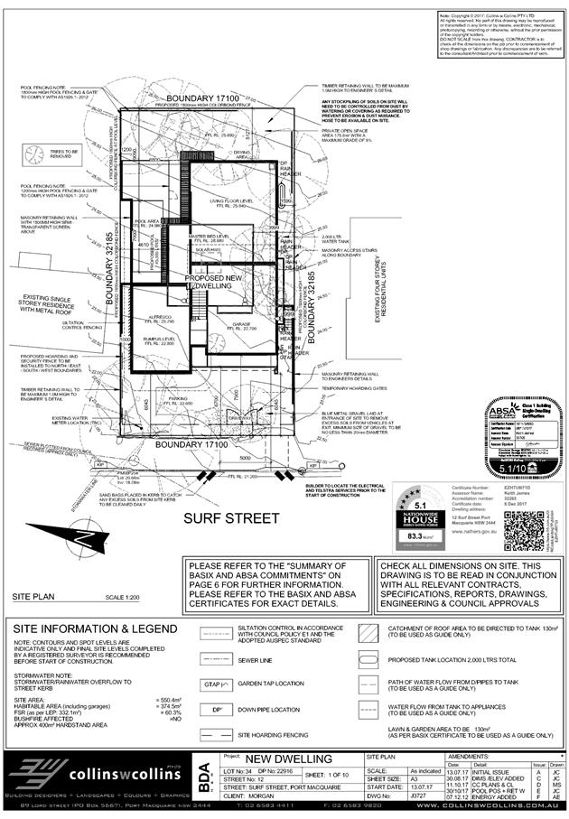
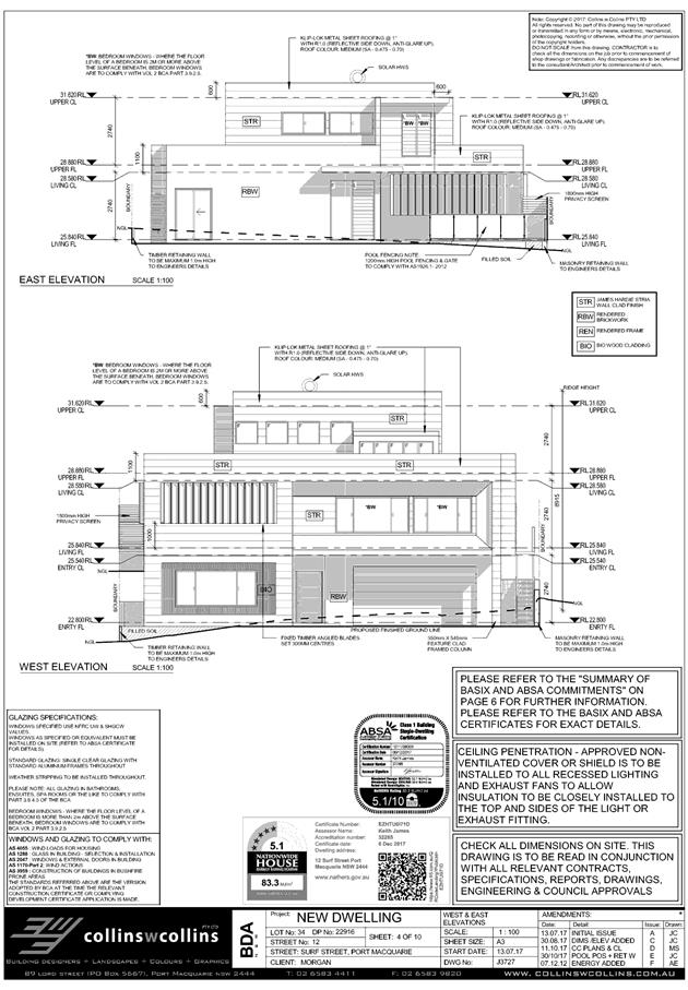
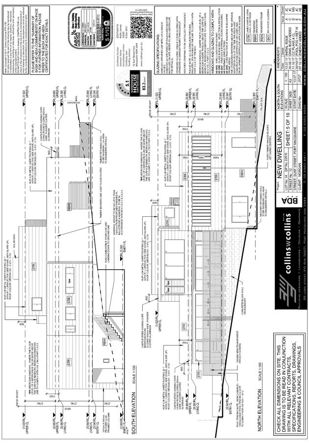
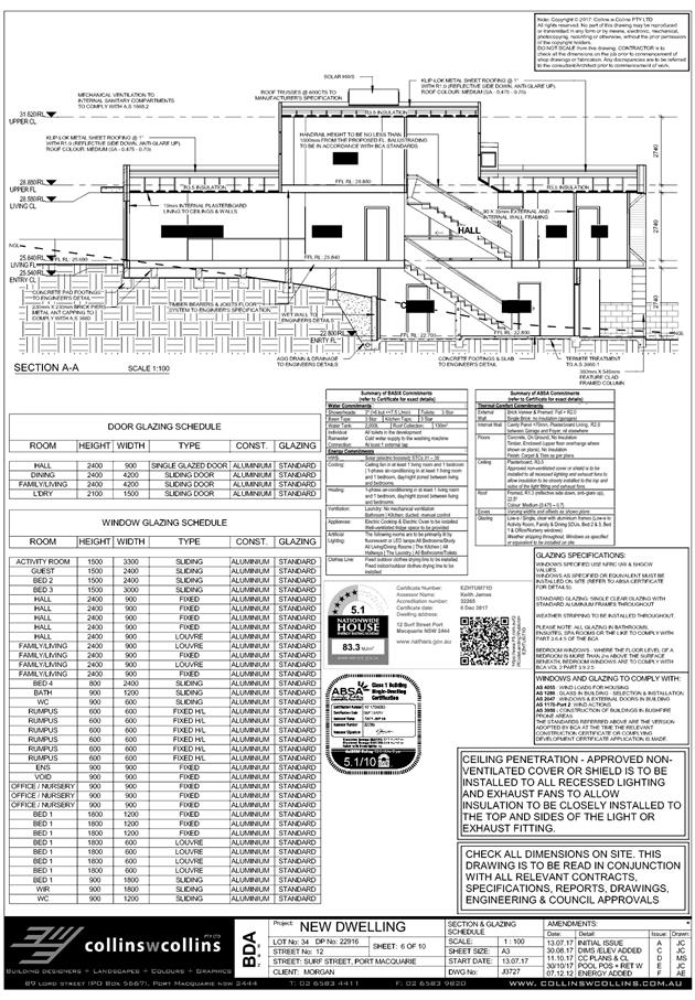
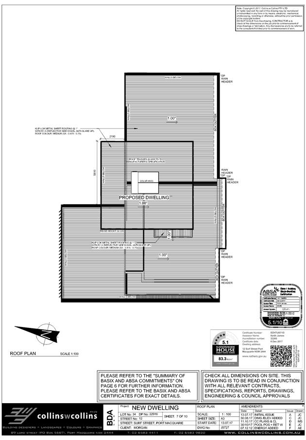
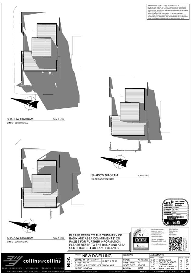
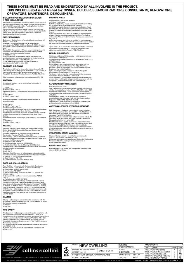
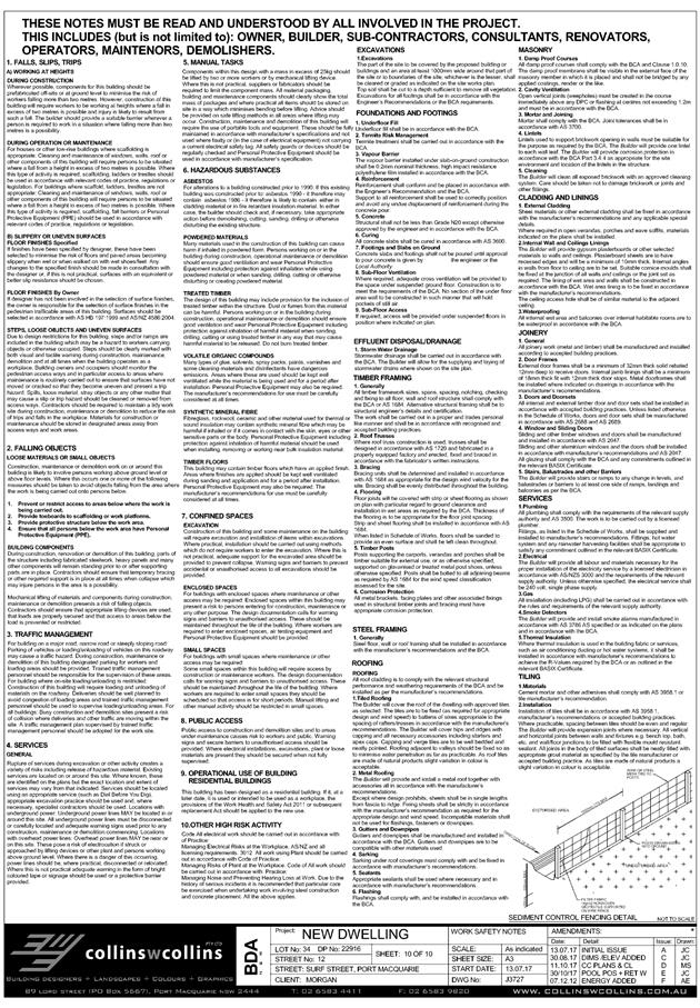
|
ATTACHMENT
|
Development Assessment Panel
14/03/2018
|
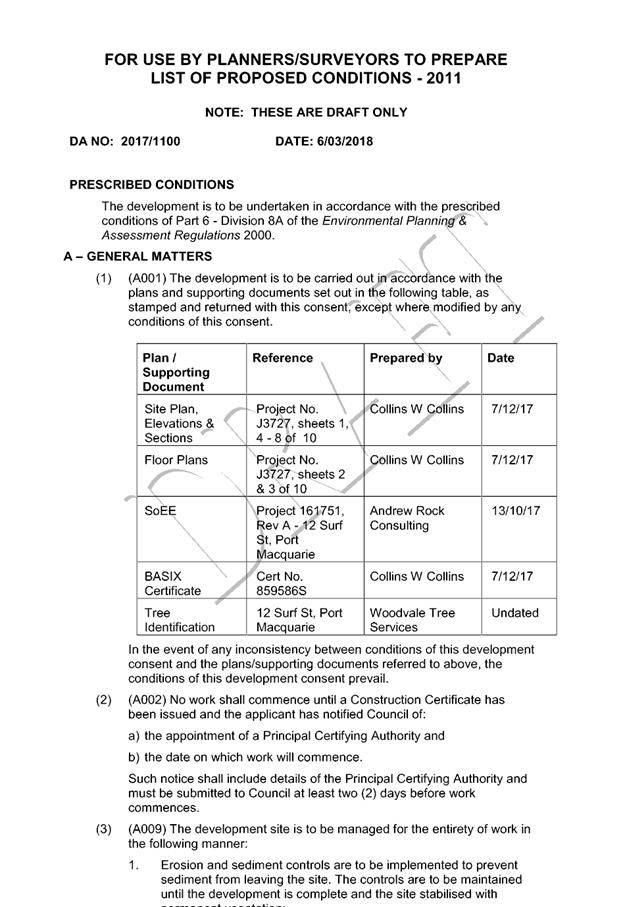
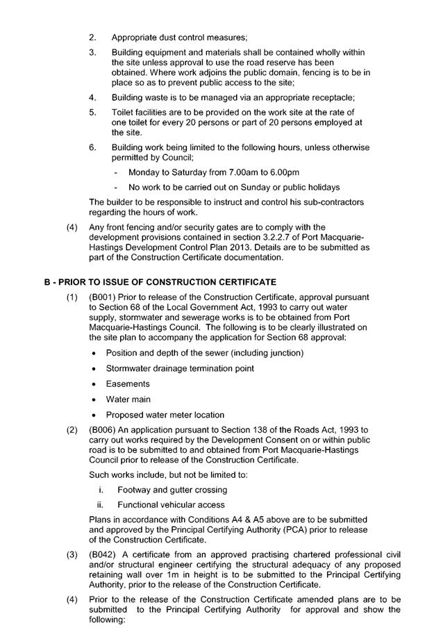
|
ATTACHMENT
|
Development Assessment Panel
14/03/2018
|
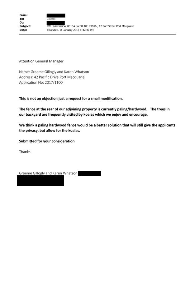
|
ATTACHMENT
|
Development Assessment Panel
14/03/2018
|
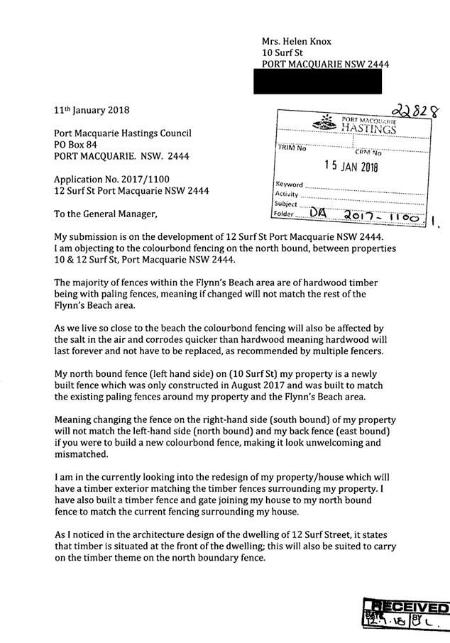
|
ATTACHMENT
|
Development Assessment Panel
14/03/2018
|
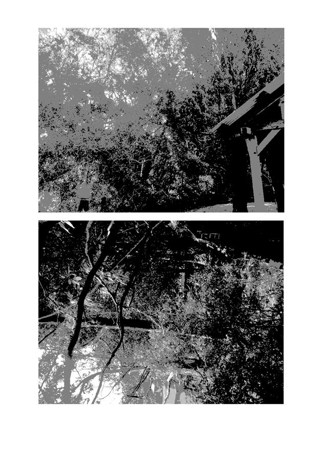
|
ATTACHMENT
|
Development Assessment Panel
14/03/2018
|
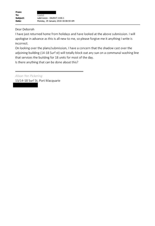
AGENDA Development Assessment Panel 14/03/2018
Item: 08
Subject: Section 96 Modification DA2016 - 404.2
Modification to Industry (Cement Depot) - Lot 21 DP 1205839, 39 Randall Street,
Wauchope
Report
Author: Benjamin Roberts
|
Applicant: Emm
Consulting Pty Ltd
Owner: Transport
for NSW
Estimated Cost: N/A
Alignment with Delivery
Program
4.3.1 Undertake transparent
and efficient development assessment in accordance with relevant legislation.
|
|
RECOMMENDATION
That
the section 96 modification to DA2016 - 404 for a modification to industry
(cement depot) – increase in throughput at Lot 21, DP 1205839, No. 39 Randall Street, Wauchope, be
determined by granting consent subject to the recommended conditions.
|
Executive
Summary
This
report considers a Section 96(2) modification application at the subject site
and provides an assessment of the application in accordance with the
Environmental Planning and Assessment Act 1979.
Development
consent was granted by Council on 23 November 2016 for an increase in
throughput of the existing industry (cement depot) from 15,000 tonnes per annum
to 60,000 tonnes per annum. The development is integrated development and
General Terms of Approval (GTAs) were issued by the New South Wales
Environmental Protection Authority (EPA). One of the GTAs is that noise
generated at the premises must not exceed a noise limit of 50 dB(A) LAeq(15
minute) at all residential noise receivers.
This
modification application seeks to increase the noise limit contained within the
GTA from 50 dB(A) LAeq(15 minute) to 58 dB(A) LAeq(15 minute).
Following exhibition of the
application, one (1) submission has been
received.
1. BACKGROUND
Existing sites features and surrounding development
The
site is located at 4 Wallace Street, Wauchope. The site is approximately
1000m² in area and forms part of the larger land holding known as Lot 21
DP1205839. The land holding is traversed by the North Coast Railway line and
contains the railway station buildings.
The
land holding is zoned IN1 General Industrial and B4 Mixed Use, and the site of
the development is zoned IN1 General Industrial in accordance with the Port
Macquarie-Hastings Local Environmental Plan 2011, as shown in the following
zoning plan:
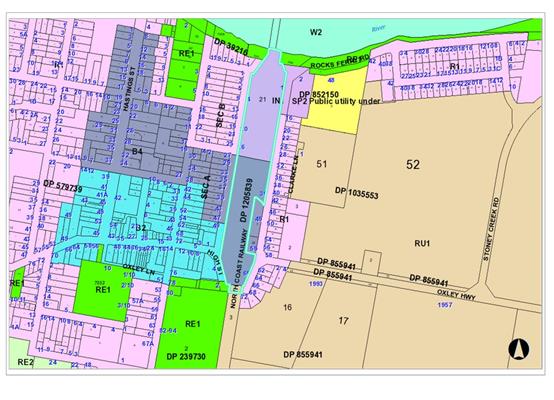
The existing subdivision pattern and location of existing
development within the locality is shown in the following aerial photograph:
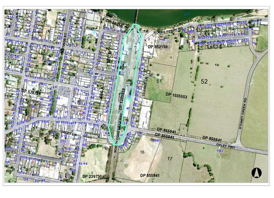
2. DESCRIPTION OF
DEVELOPMENT
Key aspects of the proposal include the following:
· Seek an increase to the noise limit contained within a
General Term of Approval issued by NSW EPA from 50 dB(A) LAeq(15 minute)
to 58 dB(A) LAeq(15 minute).
Refer
to attachments at the end of this report.
Application Chronology
· 18
October 2017 – Application lodged.
· 20 October 2017 – Application referred to NSW
Environmental Protection Authority (EPA).
· 2 November to 1 December 2017 – Public exhibition via
neighbour notification.
· 8 November 2017 – Request for additional information
received from EPA.
· 10 December 2017 – Additional information request
sent to applicant.
· 6 December 2017 – Copy of submission sent to EPA.
· 6 December 2017 – Additional information response
received from applicant.
· 7 December 2017 – Additional information referred to
EPA.
· 20 December 2017 – Response from EPA received.
· 3 January 2018 – EPA response provided to applicant.
3. STATUTORY ASSESSMENT
Is the proposal substantially the same?
Section
96 of the Environmental Planning and Assessment Act 1979 enables the
modification of consents and categorises modifications into three categories -
S.96(1) for modifications involving minor error, mis-description or
miscalculation; S.96(1A) for modifications involving minimal environmental
impact; and S.96(2) for other modifications or modifications that require a
condition imposed by a Minister, public authority or approval body to be
amended. Each type of modification must be considered as being substantially
the same to that which was originally consented to.
The
subject application is being considered under the provisions of Section 96(2)
as a condition by the EPA requires amending. The proposal is considered to be
substantially the same development to that which was originally lodged and
consented to and will have minimal environmental impact. In particular, the
only change relates to a consent condition surrounding maximum permitted noise
levels. No further change to the cement quarry operations or throughput is
proposed. Having regard to the above, the proposed modification is not
considered to alter the fundamental essence of the original development.
Are
there any condition(s) of consent imposed by a Minister, government or public
authority that require modification?
Yes. A
change to a condition imposed by the NSW Environmental Protection Authority (EPA)
is sought. The application was referred to the NSW EPA for consideration. The
EPA’s response is attached. The matters raised in the EPA response are
discussed below.
1. The
proponent’s response confirmed that the cumulative noise level from
operations during a 15minute period is 58dBA. It also advised that the
calculated daytime amenity noise level is LAeq, day 55dB. The proponent is
therefore proposing an increase to the consent intrusive (15 minute) level of
58dBA. This is more than 10dB above the previously derived Project Specific
Noise Level of 47dBA. The EPA does not usually licence such levels.
-
2.
Planning comment: Noted.
-
2. The
site appears to be a legacy of past planning decisions that don’t align
with today’s expectations regarding noise. The EPA however acknowledges
that the mitigation works undertaken by the proponent are likely to have
reduced noise by up to 6dB. Considering the information provided, the EPA could
support the application provided noise from the activity does not exceed the
amenity level of LAeq, day 55dB, and that this level is not increased by noise
from other industries in the area.
-
5.
Planning comment: Noted. Council can
only assess the application at hand. Any future expansion by an existing
industry or Boral would be subject to further noise impact assessment.
-
7.
Council’s Environmental Health
Officer has reviewed the professional reports and advised that the new Noise
Policy for Industry prepared by NSW EPA dated October 2017 provides an amenity
criterion of 65 decibels for a residence in an “industrial
interface” area and 60 decibels for an urban residence so the proposed
noise level of 58dB(A) does not appear unreasonable.
-
9.
Notwithstanding this any modified
consent would be issued consistent with the EPA advice with a maximum amenity
level of LAeq, day 55dB.
-
3. Council
and the proponent must consider that this sterilises or severely constrains the
local area for other industry (Boral will take up the entire noise
“headroom” for industry in the local area) and for any future
expansion of the site by Boral. Council will need to consider the
socio-economic benefits of the development and weigh them against the community
response to the proposed expansion in deciding whether to approve the
application.
-
12.
Planning comment: Noted. Council can
only assess the application at hand. Any future expansion by an existing
industry or Boral would be subject to further noise impact assessment.
4. It is
noted that the proponent has previously ruled out the construction of a noise
wall. The EPA recommends that this option is reconsidered. A noise wall would
likely reduce the noise levels further whilst also providing a visual barrier
to the operation.
-
14.
Planning comment: The application is
supported by a further review of noise emissions undertaken by EMM Consulting,
dated 29 August 2017. The report provides an assessment of feasible and
reasonable noise mitigation measures as per the NSW EPA’s Industrial Noise
Policy. The review concludes that the main source of noise emissions from the
site is engine noise from trucks manoeuvring on site and that a noise barrier is not considered practical and would have
limited effectiveness given the site constraints i.e. limited distance between
the location for loading and the site entry/exit. The report outlines
additional noise mitigation measures that have been undertaken to minimise
truck engine noise while trucks are being loaded on site.
-
16.
Council’s Environmental Health
Officer has reviewed the professional reports and agrees that a noise barrier
is unlikely to be of any great benefit in this instance.
5. The
EPA also recommends that Council include a condition in any approval, if
granted, for Boral to schedule arrivals and deliveries so that trucks are not
queuing in Wallace Street prior to being allowed on the Boral site and are not
arriving prior to commencement of operations at 7am.
-
18.
Planning comment. Noted. Condition
recommended.
Does
the application require notification/advertising in accordance with the
regulations and/or any Development Control Plan?
Neighbour
notification has been undertaken in accordance with the Port Macquarie-Hastings
Development Control Plan 2013.
Any submissions made concerning the modification?
During
exhibition one (1) petition style submission was received containing nine (9)
signatures.
Key issues raised in the submission received and comments
in response to the issues are provided as follows:
|
Submission
Issue/Summary
|
Planning
Comment/Response
|
|
The increase in noise and
production would be detrimental to our wellbeing.
|
There is no change to approved
production levels under this application. There is no evidence provided to
suggest the increase in allowable maximum noise levels will be detrimental to
the wellbeing of nearby residents. The EPA have permitted a maximum allowable
noise level of 55dBA (day time).
|
|
The increase in noise and
production would be detrimental to our property values.
|
There is no change to approved
production levels under this application. There is no evidence provided to
suggest the increase in allowable maximum noise levels to 55dBA (day time)
will affect property values.
|
|
The increase in noise and
production would disrupt our lives more than it already does.
|
There is no change to approved
production levels under this application. No evidence has been provided to
suggest the increase in allowable maximum noise level to 55dBA (day time)
will adversely disrupt the lives of nearby residents.
|
|
We already put up with trucks
that block the road at times and the noise is just tolerable at the moment.
|
Condition has been added to
ensure truck arrivals and deliveries are scheduled to ensure no queening in
Wallace Street. Refer to comments under noise impacts heading of this report.
|
|
The operation needs to move to
a more suitable place not a suburban street.
|
This is an existing industry
operating within an industrial zone.
|
Any
matters referred to in section 79C (1) relevant to the modification?
Overall,
the proposed development remains consistent with the original s79C assessment.
Refer to comments provided in the original DAP assessment attached to this
report. Comments on notable changes are included below.
Noise
Operational
noise
A noise
impact assessment was submitted as part of the original application. The
assessment reviewed both operational and road traffic noise. The assessment was
undertaken by EMM consulting, dated 24 February 2016 and reviewed by
Council’s Environmental Health Officer. In summary, the original proposed
increase in throughput was deemed to not change existing hours of operation or
require any modifications or additions to existing site infrastructure at the
depot. Hence, there would be no change to the level of operational noise
emissions from the site above the measured worst case at the site.
The
original General Terms of Approval issued by the NSW EPA also provided specific
noise level emission conditions that will need to be adhered to. This current
modification is requesting a change to a condition 9 of the issued General Term
of Approval. In support of this application, a further review of noise
emissions was undertaken by EMM Consulting, dated 29 August 2017. This report
was reviewed by Council’s Environmental Health Officer whom advised the
proposal is reasonable and because truck engine noise is the main noise
generator onsite, a noise barrier is unlikely to be of any great benefit.
Council’s
Environmental Health Officer also advised that the new Noise Policy for
Industry prepared by NSW Environmental Protection Authority dated October 2017
has an amenity criterion of 65 decibels for a residence in an “Industrial
Interface” area and 60 decibels for an urban residence so the expected
operational noise level of 58 dB(A) from the Boral depot is not considered
unreasonable.
The
response from the NSW Environmental Protection Authority is attached and in
summary provides for an increase in the maximum permitted amenity level of
LAeq, day 55dB only and not day 58dB as requested. Consistent with the EPA
advice any modified consent shall contain reference to a maximum LAeq, day 55dB
noise limit.
Proposed changes to conditions
Refer to attached draft recommended consent with conditions
subject to change being highlighted in red. A copy of the current consent
conditions is also attached for reference.
4. DEVELOPMENT
CONTRIBUTIONS
As per original application it has been considered that the
increase in throughput will not result in any adverse impact to the local road
network. Accordingly development contributions are not applicable under Section
94 of the Environmental Planning and Assessment Act 1979 towards roads, open
space, community cultural services, emergency services and administration buildings.
5. CONCLUSION
The application has been assessed in accordance with
Section 96 and 79C of the Environmental Planning and Assessment Act 1979.
Issues raised during assessment and public exhibition of
the application have been considered in the assessment of the application.
Where relevant, conditions have been recommended to manage the impacts
attributed to these issues.
The site is suitable for the proposed development, is not
contrary to the public's interest and will not have a significant adverse
social, environmental or economic impact. It is recommended that the
application be approved, subject to the recommended conditions of consent
provided in the attachment section of this report.
|
Attachments
1View. DA2016
- 404.1 EPA issued GTAs
2View. DA2016
- 404.1 Development Consent and Conditions
3View. DA2016
- 404.2 Statement of Environmental Effects
4View. DA2016
- 404.2 EPA Response letter
5View. DA2016
- 404.2 Applicants response to additional information response from EPA
6View. DA2016
- 404.2 Recommended Conditions
7View. DA2016
- 404.2 Response to Council regarding Community Submission on Modification -
Boral
8View. DA2016
- 404.2 Submission - Masters
|
|
ATTACHMENT
|
Development Assessment Panel
14/03/2018
|
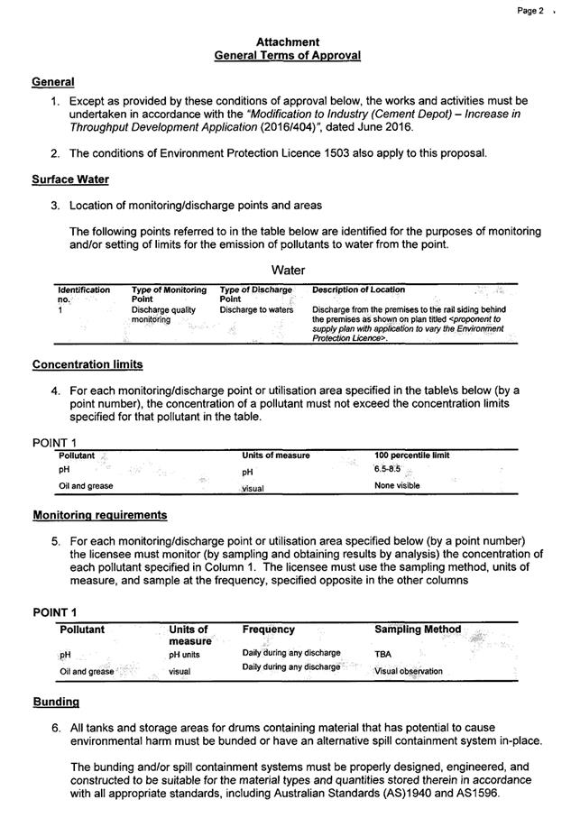
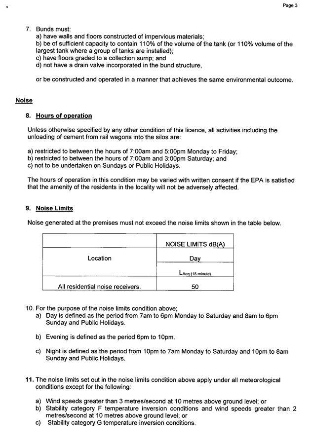
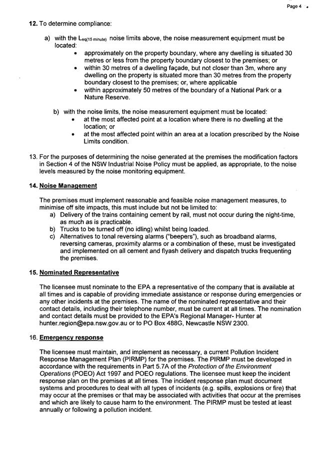
|
ATTACHMENT
|
Development Assessment Panel
14/03/2018
|
|
ATTACHMENT
|
Development Assessment Panel
14/03/2018
|
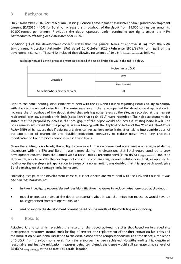

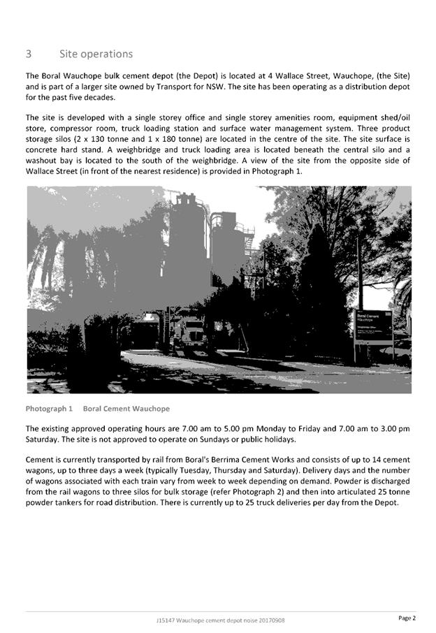

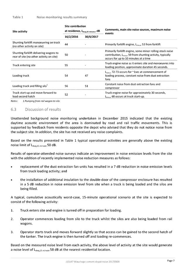
|
ATTACHMENT
|
Development Assessment Panel
14/03/2018
|
|
ATTACHMENT
|
Development Assessment Panel
14/03/2018
|
|
ATTACHMENT
|
Development Assessment Panel
14/03/2018
|

|
ATTACHMENT
|
Development Assessment Panel
14/03/2018
|
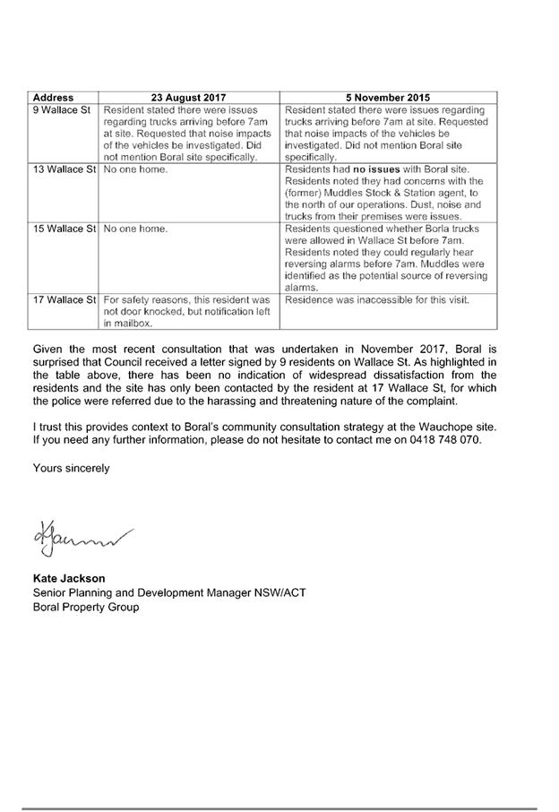
|
ATTACHMENT
|
Development Assessment Panel
14/03/2018
|
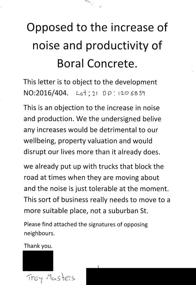
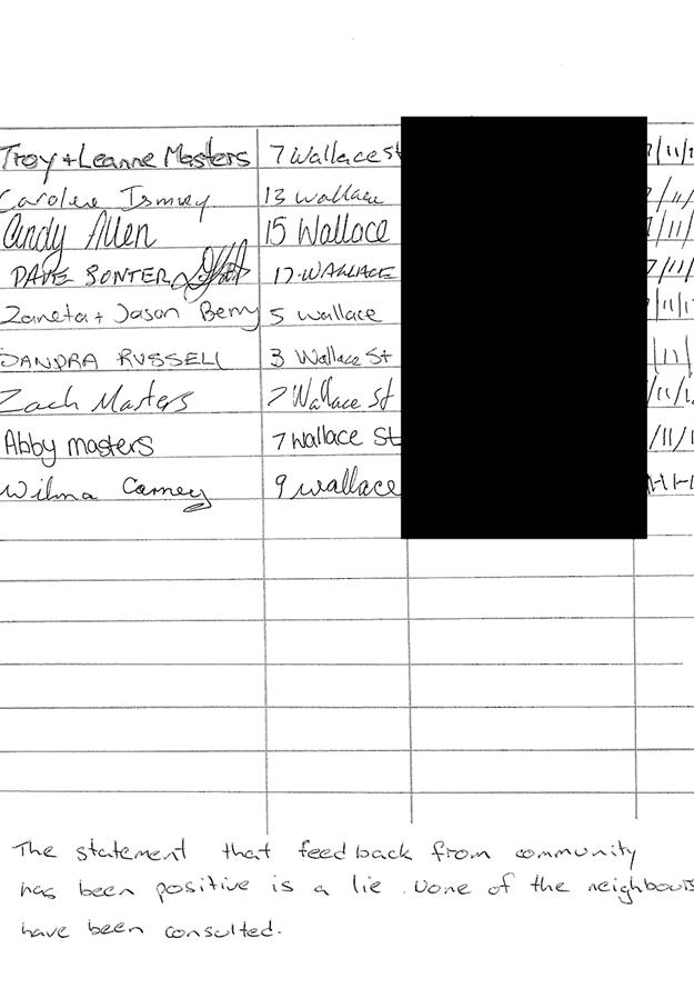

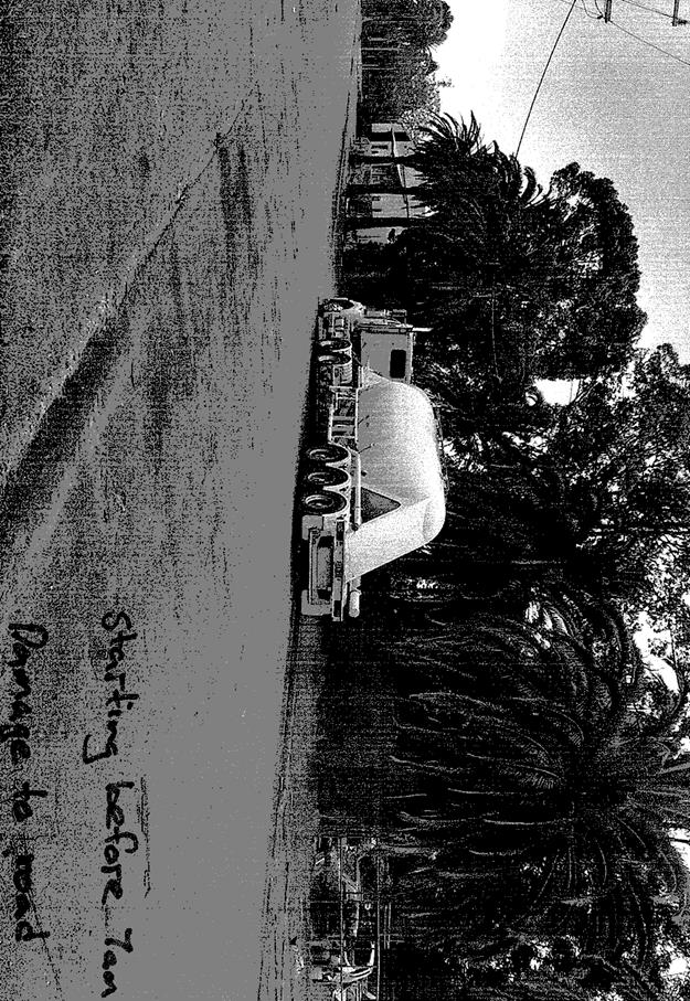
AGENDA Development Assessment Panel 14/03/2018
Item: 09
Subject: Section 96 Modification DA2013 - 211.2 -
Modification To A Continued Use Of Animal Boarding And Training Establishment
(Horse Riding) - Lot 4 DP 1110091, No 334 Crows Road, Frazers Creek
Report
Author: Patrick Galbraith-Robertson
|
Applicant: J
A Woods
Owner: M
F Ennor & J A Woods
Estimated Cost: N/A
Alignment with Delivery
Program
4.3.1 Undertake transparent
and efficient development assessment in accordance with relevant legislation.
|
|
RECOMMENDATION
That
the Section 96 modification to DA2013 - 211 for a proposed amendment
to conditions of consent relating to a previous approved continued use of an
animal boarding and training establishment (horse riding) at Lot 4, DP 1110091, No. 334 Crows
Road, Frazers Creek, be determined by granting approval subject to the
recommended conditions.
|
Executive
Summary
This report considers a Section
96(1A) modification of consent application at the
subject site and provides an assessment of the application in accordance with
the Environmental Planning and Assessment Act 1979.
Being a Section 96 modification,
the modified proposal has only been assessed against the legislation and
related planning guidelines in place at the time of the original assessment.
Following exhibition of the
application, three (3) submissions were
received.
Key assessment issues relate to
the submission issues raised.
1. BACKGROUND
Existing
sites features and Surrounding development
The site has an area of 154.6
hectares.
The
site is zoned RU2 Rural Landscape in
accordance with the Port Macquarie-Hastings Local Environmental Plan 2011, as
shown in the following zoning plan:
The
existing subdivision pattern and location of existing development within the
locality is shown in the following aerial photograph:
2. DESCRIPTION OF
DEVELOPMENT
The
original proposal was approved on 1 October 2014 by Council’s Development
Assessment Panel as follows and subject to conditions which included a time
limited consent of three (3) years:
· The boarding of up to 30 draft-cross, stockhorse and walers
on the property for breeding and training purposes.
· Conducting horse riding tours within the local area with
guides.
· Overnight trail rides to local tourist spots such as the
Beechwood Hotel are offered. Horse riding outside the property only occurs on
or through land with the appropriate landowner’s permission.
· All riders are brought on to the site from Bellangry Road
by the property managers via a troop carrier traversing Crows Road. There are
no intended direct vehicular visits to the property.
· Use of a section of Crows Road crown road within close
proximity to Bellangry Road - established parking area - for parking of
customer vehicles and pickup by operators
· Occasional guest accommodation offered with overnight
tourist accommodation within existing worker’s cottage accommodation
building.
· No formal camping area is proposed
· A maximum of 12 riders at any one time with up to two
sessions per day (as amended during the assessment of the DA).
· Installation of an upgraded on-site sewage management
system
· A new external toilet was originally proposed however has
been deleted from the proposal during the assessment of the DA.
· The proposal is currently in operation and has been
operating since 2003.
On 1
October 2014 the Development Assessment Panel resolved the following:
‘This
consent is valid for a period of 3 years from the date of determination. An
application to modify this consent or a new development application will need
to be lodged and determined before the expiration of the 3 year period to
continue the development. It is recommended this be done at least 6months prior
to expiration.
Key
aspects of the modified proposal include the following:
· Remove/delete the conditional restriction requirement for
development from 3 years to being unrestricted in timeframe.
· Seek a timeframe extension to allow time for Department of
Industry - Lands process of road closure to be complete with a license and buy
back of the section of Crown Road traversing the property.
· There
are no plan changes to the layout or nature of operations of the current
approved operating development.
Refer
to attachments at the end of this report of current consent, approved plans and
relevant attachments. There are no changes to plans.
Application
Chronology
· 6
October 2017 – Modification application lodged.
· 7
November 2017 – Additional information request – clarification of
proposed changes to conditions.
· 7
November 2017 – Applicant provided additional information to clarify
proposed changes.
· 10 to 23 November 2017 – Neighbour notification of
proposed modification proposal.
· 23 November 2017 – Submission issues forwarded to
Applicant.
· 30 January 2018 – Additional information received
from Applicant in response to submission issues.
· 7 March 2018 – Additional information received from
Applicant – confirmation of right of carriageway registration and
response to submission issues.
3. STATUTORY
ASSESSMENT
Is
the proposal substantially the same?
Section 96 of the Environmental
Planning and Assessment Act 1979 enables the modification of consents and
categorises modifications into three categories - S.96(1) for modifications
involving minor error, mis-description or miscalculation; S.96(1A) for
modifications involving minimal environmental impact; and S.96(2) for other
modifications. Each type of modification must be considered as being substantially
the same to that which was originally consented to.
The subject application is being
considered under the provisions of Section 96(1A).
The proposal is considered to be
substantially the same development to that which was originally lodged and
consented to and will have minimal environmental impact when comparing the
modification proposal to the original proposal. The proposed modification is
not considered to alter the fundamental essence of the original development.
Are there any condition(s)
of consent imposed by a Minister, government or public authority that require
modification?
No
changes to any conditions imposed by a Minister, government or public
authority.
Does
the application require notification/advertising in accordance with the regulations
and/or any Development Control Plan?
Neighbour
notification has been undertaken in accordance with the Port Macquarie Hastings
Development Control Plan 2013.
Any submissions made concerning the modification?
Three (3) written submissions were received following public
exhibition via neighbour notification of the application.
Key issues raised in the submissions received and comments
in response to the issues are provided as follows:
|
Submission
Issue/Summary
|
Planning
Comment/Response
|
|
427 Crows Road
|
|
Concern with number of trips
troop carrier making along Crows Road to pick up customers for riding
session.
|
The Applicant has a
responsibility to comply with the condition for a maximum 12 riders at any
one time, which will limit the number of troop carrier movements.
|
|
Concern with customers driving
into the site as well as along Crows Road past the carpark pick up point
which is contrary to the terms of the DA.
|
This is a compliance matter
which the Applicant has been reminded of.
|
|
Bellrowan should contributed
to road standard maintenance given the large increase in traffic for a
business.
|
No upgrades are recommended in
the original approval. This is a matter to be resolved between parties
sharing the Crown road.
It is noted that from a site
visit that the road has been upgraded in sections with contribution from the
Applicant.
|
|
Riders are not staying within
the site and are not permitted to use a Crown Road.
|
Riders are permitted to ride
within the site and are permitted to use any repass on any established Crown
Road.
|
|
Question whether the carpark
at the end of the Crows Road has been surveyed and approved by Crown Lands.
|
The parking of vehicles within
the road reserve of Crows Road near Bellangry Road is permitted. Refer to
attached written advice to this report. No survey information is available.
|
|
217 Crows Road
|
|
The existing carpark has never
had approval and 6 months have passed by with no approval granted.
|
The parking of vehicles within
the road reserve of Crows Road near Bellangry Road is permitted. Refer to
attached written advice to this report.
The Applicant has also advised
that the carpark is available for other residents of Crows Road as a
load/unload point and for family and friends.
|
|
Question the amount of time
waiting as being short. People can have to wait up until an hour to be picked
up with no facilities such as toilets.
|
The subject area for pick up
is still considered to be a short term parking area for customers. Customers
should time their visit to coincide with the planned pickup time. This an
ongoing management issue that Bellrowan Horse Riding will need to manage and
is a not a reason for recommending refusal to the application. No formal
facilities are recommended to be put in place and unable to be positioned
within a Crown Road reserve.
The Applicant has further
advised that the clients are advised to be at the pickup point a maximum of
10 minutes prior to departure. They are also informed that if they are early,
just 6 minutes back along Bellangry Road is the Beechwood Café where
they are told they can purchase coffee and ice creams etc.
|
|
Concern with the standard of
the carpark on Crows Road and question whether some of parking area is on
private land. Question whether assessing officer inspected the carpark
and site.
|
The parking of vehicles within
the road reserve of Crows Road near Bellangry Road is permitted. Refer to
attached written advice to this report.
The Crown Road reserve is 20m
wide and no vehicles are blocked from travelling on the main road access.
The assessing officer has
inspected the carpark and the site including prior to completing this
assessment report.
|
|
Concern with safety of entry
from Bellangry Road. The intersection is dangerous.
|
The existing access
arrangements with a legal Crown Road connecting to Bellangry Road as approved
has not changed. It is noted that cars entering Crows Road are doing a left
turn only when they arrive and the carpark pick up point is located some 200m
along Crows Road with no queuing required.
|
|
Question whether emergency
services can access the site.
|
It is noted that ambulances may not be able to physically
access the site in the event of accident on the property. In the event of a
life threatening or serious injury the Westpac rescue helicopter can be
engaged or if nonlife threatening or a minor injury sustained a
client/customer can be transported by the operator’s troop carrier back
to the carparking area near Bellangry Road and then transported to nearest
hospital.
|
|
Concern with timeframe to
realign the Crown Road access with structures on it some 2 ½ years on.
|
With regard to existing structures within the Crown road
reserve referred to (in proximity to the existing dwelling on the property),
the Applicant is seeking an extension of 5 years of time 13 October 2014 (13
October 2019) required for the Crown Lands process to complete the license.
Four (4) years is only recommended to be supported (13 October 2018). The
Applicant has advised that a right of carriageway has been put in place to
provide legal alternative access to neighbours around the Crown reserve. The
lease application has also been lodged with Crown Lands.
Having regard to the Applicant’s genuine approach
to resolving and progressing compliance with the condition and having regard
to being advised that the process is lengthy, the timeframe is recommended to
be extended but only until 13 October 2018.
|
|
Concern that the 3 to 4 metre
width Crows Road is stated by Council to be completely unacceptable for a
Council road however Council approves it for business to operate.
|
The existing access
arrangements with a legal Crown Road connecting to Bellangry Road as approved
has not changed.
The site is accessed via Crows Road which is a crown
road in average condition. All visitors are required to park in the parking
area nearby to Bellangry Road in the crown road reserve. Visitors are
required to be brought onto the site via the operator’s vehicle (troop
carrier) so as to reduce the number of vehicle movements along Crows Road.
This is a management issue the operator is required to comply with and the
maintenance is a private matter between the residents.
|
|
Bellrowan should contributed
to road standard maintenance given the large increase in traffic for a
business.
|
No upgrades are recommended in
the original approval. This is a matter to be resolved between parties
sharing the Crown road.
It is noted that there is use
of the Crows Road by 5 properties in the first 1.5 kilometres and after that
point there is another 5 properties. The traffic referred to may not
specifically be entirely related to the operations of Bellrowan as referred
to.
|
|
Concern with timeframe to
process the original DA and comply with conditions of consent.
|
The lengthy timeframe is noted
however given the nature and somewhat complexity of the issues raised during
the original application, including requiring input from NSW Rural Fire
Service, it is considered the timeframe is justified.
The Applicant has made
reasonable efforts to comply with all requests for additional information and
attended to complying with conditions of consent noting the cost involved
with such upgrades.
|
|
43 Ocean Valley Road
|
|
Dispute that the conditions
have been complied with.
|
All conditions have been
complied with, with the exception of the Crown Road license not being
finalised (which is lodged and in process and takes a considerable amount of
time).
All visitors are required to park in the parking area
nearby to Bellangry Road in the crown road reserve. Visitors are required to
be brought onto the site via the operator’s vehicle (troop carrier) to reduce
the number of vehicle movements along Crows Road. This is a management issue
the operator is required to comply with.
|
|
There have been numerous
instances of trespass onto neighbours land by users of the subject business.
|
Use of existing formed crown
roads for passing or travel outside the subject property is permissible and
any other matters of trespass claimed are not an issue for the subject
DA.
The Applicant has advised that
there was an issue of identifying whether the crown road was following the
defined route over this neighbours property approximately 8 years ago.
However the owners have ensured there is no issue now.
|
|
There have been instances
where horses have escaped the Applicant’s property causing the
potential for injury or damage to persons or property on neighbour’s
land.
|
The Applicant has advised that
there may have been an issue historically of horses not being confined to
boundaries which was not deliberate and they were retrieved as soon as
possible when made aware of the issue.
The Applicant has stated that
no horses have escaped in the last 8 years.
|
|
Concern raised of insurance
implications of a bushfire trail through this neighbouring property was
allowed. Concern raised that this use is unauthorised and the subject
neighbouring property does not provide owner’s consent to such use of a
fire trail.
|
There is no change to existing
approved arrangements that in the event of a bushfire emergency the existing
Crown Road through this neighbouring property can be used as an alternate escape
route. This was approved by the NSW Rural Fire Service.
The Applicant has advised that
they would like to retain this option of emergency exit in the event of fire
emergency.
The neighbour’s
permission is not considered to be required to use existing Crown Roads as
constructed.
|
|
The fire trails referred to
are roads on this neighbouring land which do not align with the purported
Crown Roads and will be on private property.
|
Any matters referred to in
section 79C (1) relevant to the modification?
Overall, the proposed development
remains consistent with the original s79C assessment. Areas of the original
assessment impacted by the changes or with revised comments are outlined below:
Port
Macquarie-Hastings Development Control Plan 2011
In accordance with Development
Provision 3.1 and 3.2, the DCP does not specify any recommended off-street
parking rate for the facility. In this regard, the parking arrangements within
the Crows Road road reserve are satisfactory for the maximum 12 riders to park
their cars and then be picked up by the operators. The area is considered to
have ample capacity to allow for parking of several cars in a safe location on
the Crows Road reserve itself. Other staff and trainers can park at the
facility or obtain a lift in the same arrangements.
Context
& Setting
The
proposal is remote from any public domain with no adverse impacts identified.
The proposal adequately addresses applicable planning
controls.
Access,
Transport & Traffic
The
site is accessed via Crows Road which is a crown road in average condition. All
visitors are required to park in the parking area nearby to Bellangry Road in
the crown road reserve. Visitors are brought onto the site via the
operator’s vehicle (troop carrier) to reduce the number of vehicle
movements along Crows Road.
The
current condition A(7) requires the following:
(7) A licence from NSW Trade
and Investment for the continued use of the structures and the carparking area
located within the Crown road reserve is to be obtained within 6 months of
consent.
With regard to the existing
parking area on Crow’s Road referred to above, the Applicant has provided
written advice from the Department of Industry – Lands that a license is
not necessary as per the second part of the above condition. This component of
the ‘carparking area’ is therefore recommended to be deleted from
the condition.
With
regard to existing structures within the Crown road reserve referred to (in proximity
to the existing dwelling on the property), the Applicant is seeking an
extension of 5 years of time 13 October 2014 (13 October 2019) required for the
Crown Lands process to complete the license. Four (4) years is only recommended
to be supported (13 October 2018). The Applicant has also noted that a right of
carriageway (refer attached document of transfer granting easement and
application for lease form completed as lodged) is put in place to provide
legal alternative access to neighbours around the Crown reserve. Having regard
to the Applicant’s genuine approach to resolving and progressing
compliance with the condition and having regard to being advised that the
process is lengthy, the extension in timeframe is recommended to be supported however
only until 13 October 2018.
The
above condition A(7) is recommended to be modified as per the attached modified
conditions list.
Overall,
the proposal will be unlikely to have any identifiable adverse impacts within
the immediate locality in terms access, transport and traffic. The existing
public road network connecting to the Crown Road access will satisfactorily
cater for any increase in traffic generation as a result of the development.
On-site
sewer
An
on-site wastewater management report prepared by Rosewood Environmental
Services was previously submitted and approved. The Rosewood report provided a
satisfactory assessment of the suitability of the site for wastewater treatment
and provides options for waste water disposal with either a wastewater treatment
unit and land application system or a single waste water treatment unit (4000
litre septic tank) both with evapo-transpiration trenches.
An upgrade of the on-site sewage management system was
conducted in 2015, with a Council inspection undertaken. The installation was
done in accordance with the Rosewood Environmental Report for a new septic tank
and 4 x 20m trenches.
The OSM system upgrade was sized for the existing residence,
guest quarters and an external toilet for horse riders and staff.
The conditional matters required under this consent have
therefore been satisfied.
Water
and soils
The
proposal includes continued ongoing horse riding on existing trails within the
property with no additional trails proposed.
Air
& Micro-climate
The
operations of the proposed development will be unlikely to result in any
adverse impacts on the existing air quality or result in any pollution or odour
impacts to neighbour.
Flora
& Fauna
The
proposal includes approval for selective removal of immature trees within the
southern extent of the bushfire asset protection zone to achieve the maximum
tree canopy coverage permitted under Bushfire risk regulations. The removal of
these trees will be unlikely to result in any significant adverse ecological
impacts and larger habitat trees will be retained.
Noise
& Vibration
The
proposed continued scale of the facility operations is considered to not be
significant with up to a maximum of 12 riders in any one session with
associated overnight accommodation. The nature of horse riding within an
established rural setting is considered unlikely to generate any identifiable
adverse noise impacts that could be offensive to neighbouring properties.
With
regard to the overnight accommodation and associated objections received, the
Applicant has anecdotally advised that their facility is not intended to
generate any offensive noise within the locality of an evening and night-time.
In this regard, the nearest sensitive receivers being dwellings (lawfulness of
these dwellings has not been checked) are approximately 600m+ from the proposed
facility. This is considered to be a significant distance from the facility to
reduce any noise generated from people speaking outside. The Applicants
previously have been advised of the concerns raised in the submissions
received.
The current precautionary offensive noise condition under
the Protection of Environment Operations Act 1997 is to be retained in place to
address any complaints in the event of significant noise.
Natural
Hazards - Bushfire risk
The
site is identified as being bushfire prone.
The
current condition A(2) and A(6) requires the following:
(3) (A013) The general terms
of approval from the following authorities, as referred to in section 93 of the
Environmental Planning and Assessment Act 1979, and referenced below, are
attached and form part of the consent conditions for this approval.
NSW Rural Fire Service -
The General Terms of Approval, Reference D13/1136 DA13060487661 and dated (23
July 2014), are attached and form part of this consent.
(6) All upgrade works
required by conditions of this consent (including bushfire mitigation measures)
and the Emergency and Evacuation Management Plan are to be completed within six
(6) months of the date of commencement of this consent.
The
applicant has previously submitted several bushfire reports prepared by a
Certified Consultant which have taken a considerable amount of time to resolve.
The key recommendations of the bushfire safety authority granted include the
following requirements which are recommended to form part of the consent
approval conditions:
1. The facility is to be closed in the event of
a catastrophic bushfire danger rating declared.
2. The main dwelling is to be upgraded to be a bushfire
refuge building.
3. An asset protection zone (APZ) of 100m is to
be provided comprising 70m inner protection APZ and 30m outer APZ.
4. A Vegetation Management Plan shall be
prepared and submitted to Council to specify how the vegetation will be managed
within the APZ areas.
5. A 10,000 litre fire fighting water supply must be
available.
6. Emergency evacuation
is to comply with the requirements of NSW Rural Fire Service’s Planning
for Bushfire Protection 2006. An emergency evacuation plan is required to be
prepared.
7. Compliance with the approved Bushfire Operational Plan
submitted.
The Applicant has submitted satisfactory information to
address these conditional requirements.
Safety,
Security & Crime Prevention
The
proposed development will be unlikely to create any concealment/entrapment
areas or crime spots that would result in any identifiable loss of safety or
reduction of security in the immediate area. The facility has been in operation
since 2003 with no apparent issues of security.
Social
Impact in the Locality
Given the nature of the proposed development and its’
location the proposal is unlikely to result in any adverse social impacts.
Cumulative
Impacts
The proposed development is not expected to have any
adverse cumulative impacts on the natural or built environment or the social
and economic attributes of the locality.
(c)
The suitability of the site for the development:
The
current conditions A(8), E(1) and F(1) to F(6) requires the following:
A(8) This consent is valid
for a period of 3 years from the date of determination. An application to
modify this consent or a new development application will need to be lodged and
determined before the expiration of the 3 year period to continue the
development. It is recommended this be done at least 6 months prior to
expiration.
E(1) (E001) The workers
cottage premises shall not be occupied by overnight clients until an Occupation
Certificate has been issued by the Principal Certifying Authority.
F(1)
(F005) This consent does not permit camping associated with the
horse riding facility operations outside of a 30m radius footprint of the
existing workers dwelling. Overnight accommodation in the existing workers
dwelling is for clients and workers associated with the horse riding facility.
F(2)
(F009) All new and existing essential fire safety measures shall be maintained
in working condition at all times within the workers cottage.
F(3)
(F195) All clients shall park in the Crows Road road reserve in close proximity
to Bellangry Road and not enter the site by their own vehicle.
F(4)
(F196) Clearing of trees within the Outer Protection Area Asset Protection Zone
(OPA APZ) required by the NSW Rural Fire Service is to be kept of a minimum to
satisfy the tree canopy coverage requirements. No hollow bearing or old growth
trees are permitted to be removed within these OPA APZ areas.
F(5)
(F197) Offensive noise as defined under the Protection of Environment
Operations Act 1997, shall not be generated as a result of the operation of the
development.
F(6)
A maximum of 12 riders in any one session are permitted on the site any one
time.
The
proposal will fit into the locality and the site attributes are conducive to
the proposed development. The Applicant has submitted all necessary information
and have advised that they have made a genuine effort to comply with all
conditional requirements of the current consent. There is no reason identified
to recommend refusing consent to the modification application.
Overall,
it is considered that the site is suitable and that the proposal be granted a
continued operational consent and the current condition timeframe restriction
be removed.
4. DEVELOPMENT
CONTRIBUTIONS APPLICABLE
No development contributions are
required particularly having regard to the existing use rights of the existing
workers cottage which has been in existence since the 1960s.
5. CONCLUSION
The
application has been assessed in accordance with Section 96 and 79C of the
Environmental Planning and Assessment Act 1979.
Issues
raised during assessment and public exhibition of the application have been
considered in the assessment of the application.
The
site is suitable for the proposed modified development, is not contrary to the
public's interest and will not have a significant adverse social, environmental
or economic impact. It is recommended that the modification application be
approved, subject to the recommended conditions of consent provided in the
attachment section of this report.
|
Attachments
1View. DA2013
- 211.2 Plans & Documents
2View. DA2013
- 211.2 Recommended Conditiona
3View. DA2013
- 211.2 Email re Continued Use of Land
4View. DA2013
- 211.2 Transfer Granting Easement
5View. DA2013
- 211.2 DA Consent Approval, Plans, On-site & Bushfire Report
6View. DA2013
- 211.2 Submission - Byrnes for Rumbel
7View. DA2013
- 211.2 Submission - Coyle
8View. DA2013
- 211.2 Submission - Van De Linde
|
|
ATTACHMENT
|
Development Assessment Panel
14/03/2018
|
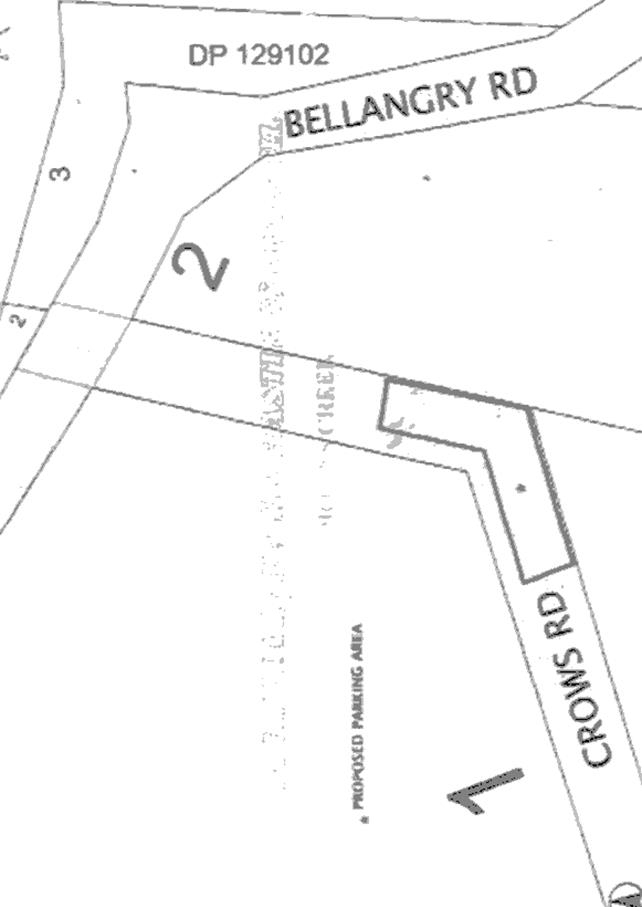
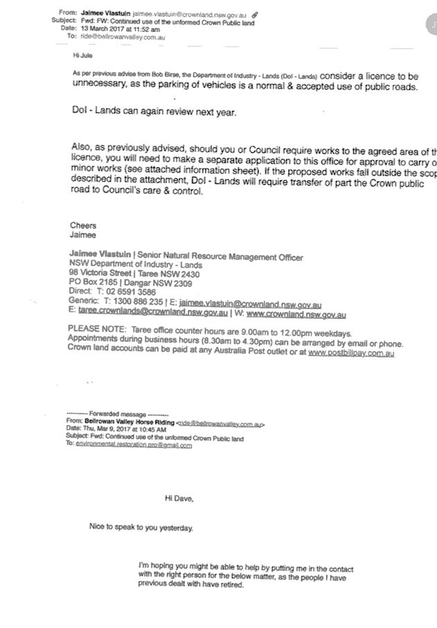
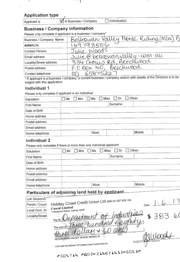
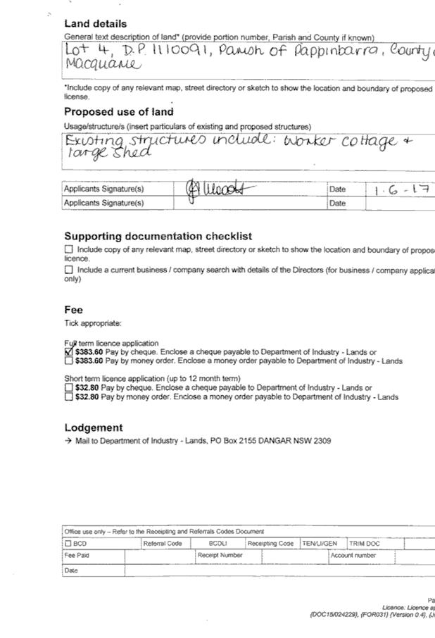
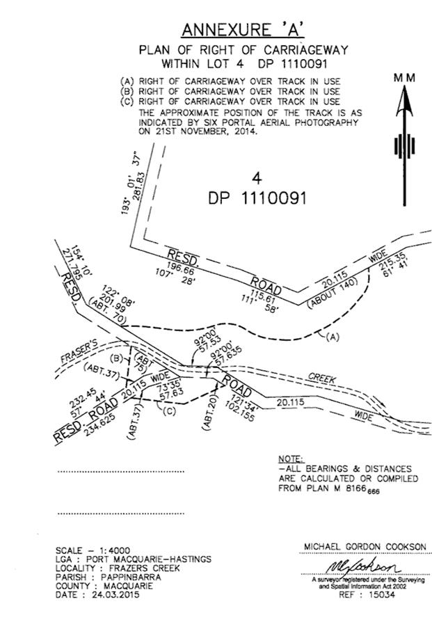
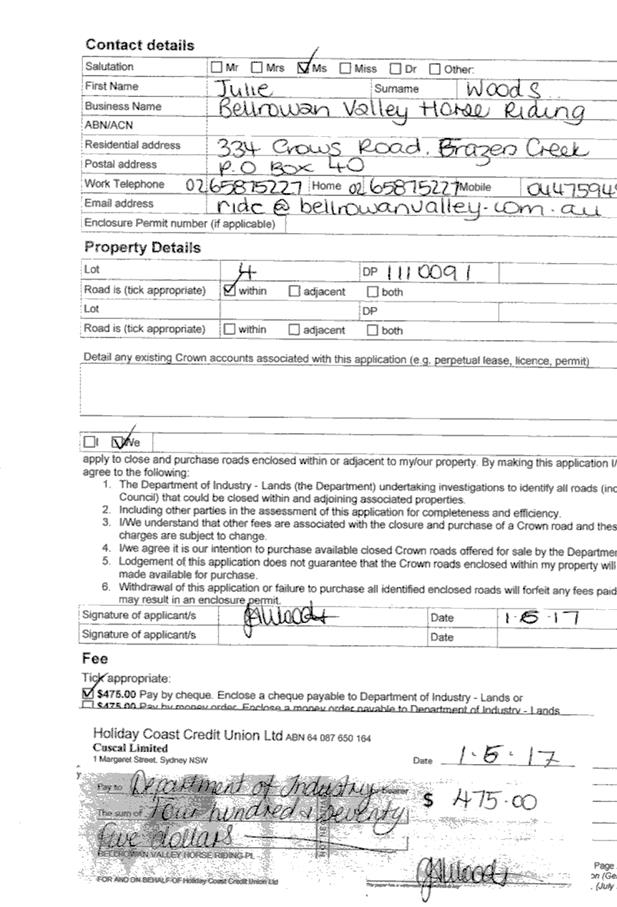
|
ATTACHMENT
|
Development Assessment Panel
14/03/2018
|
|
ATTACHMENT
|
Development Assessment Panel
14/03/2018
|
|
ATTACHMENT
|
Development Assessment Panel
14/03/2018
|
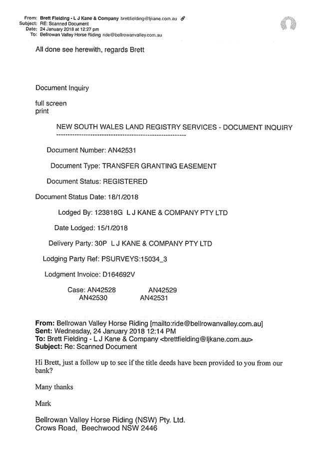
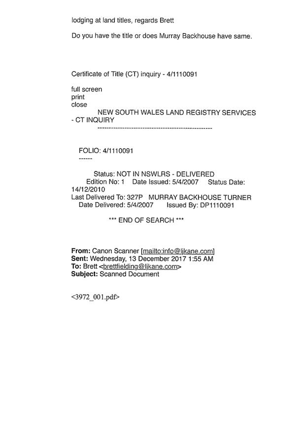

|
ATTACHMENT
|
Development Assessment Panel
14/03/2018
|
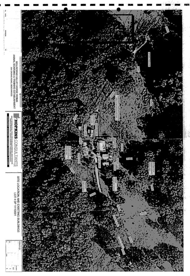
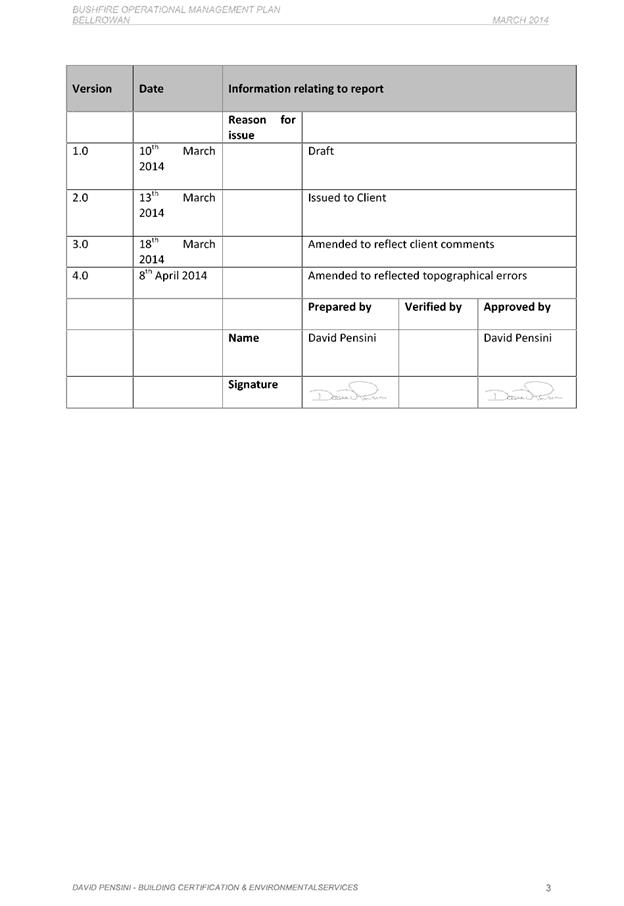
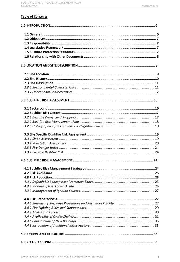
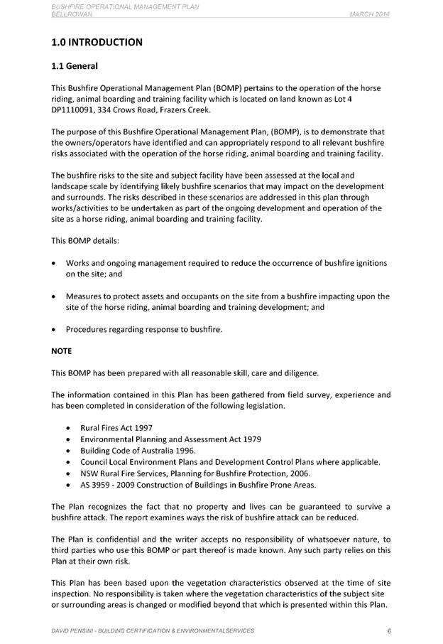
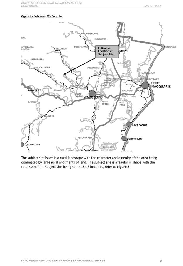
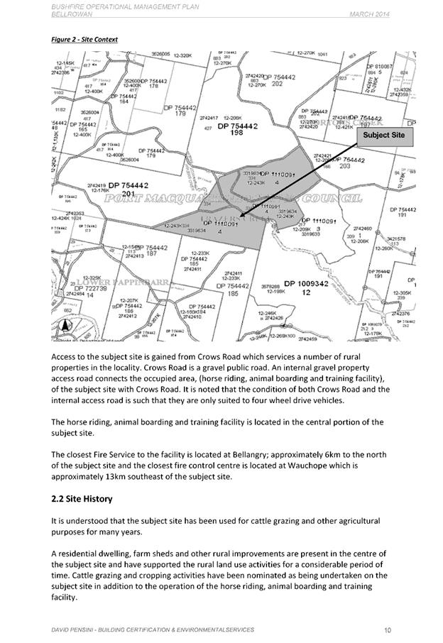
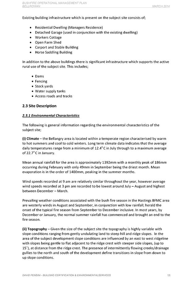
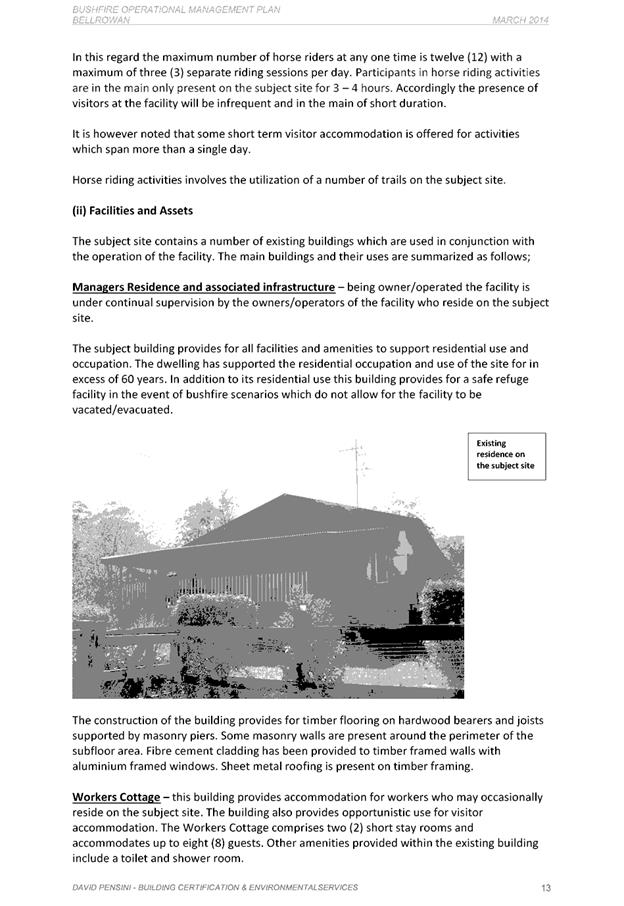
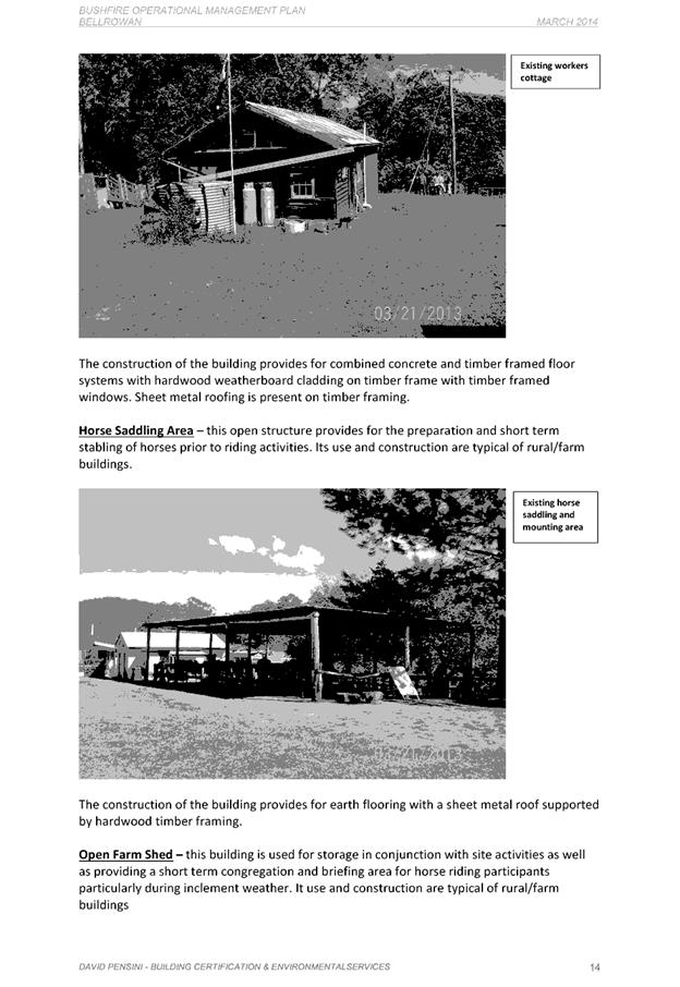
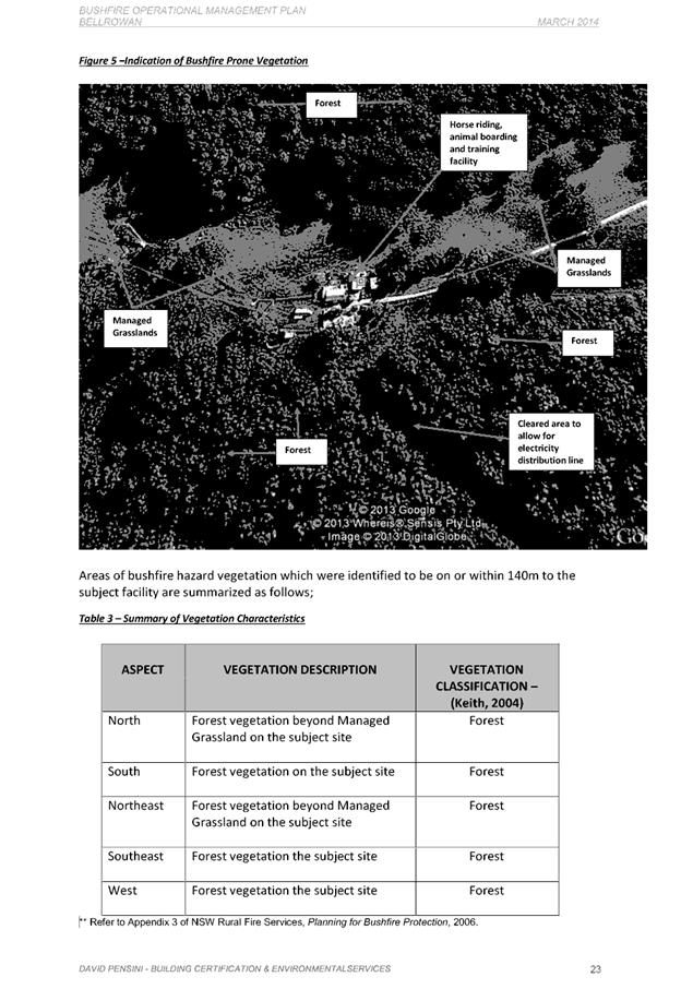
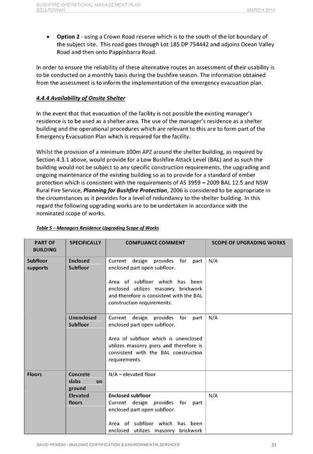
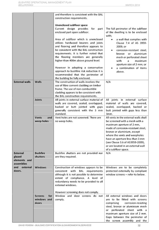
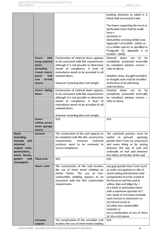
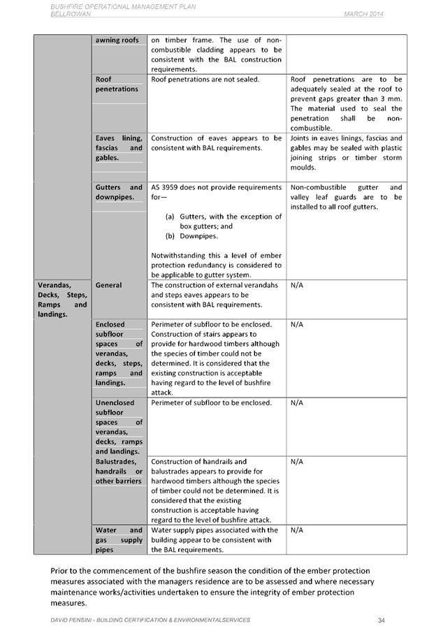
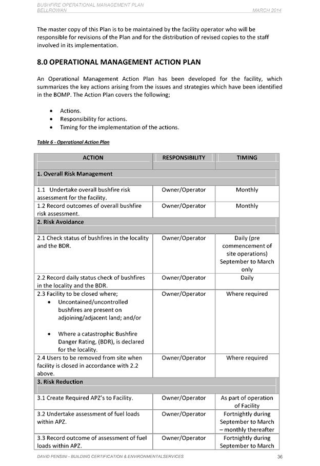
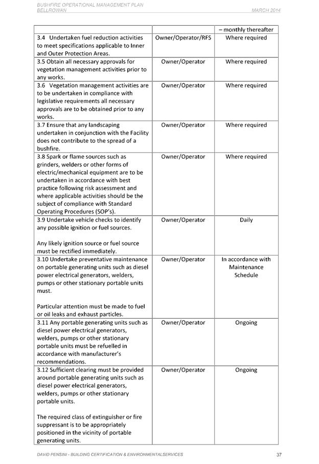
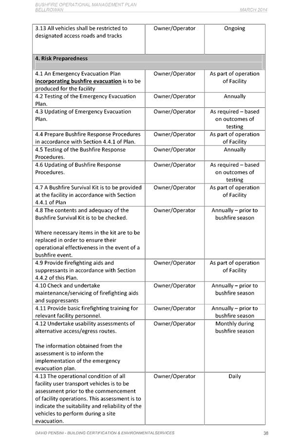
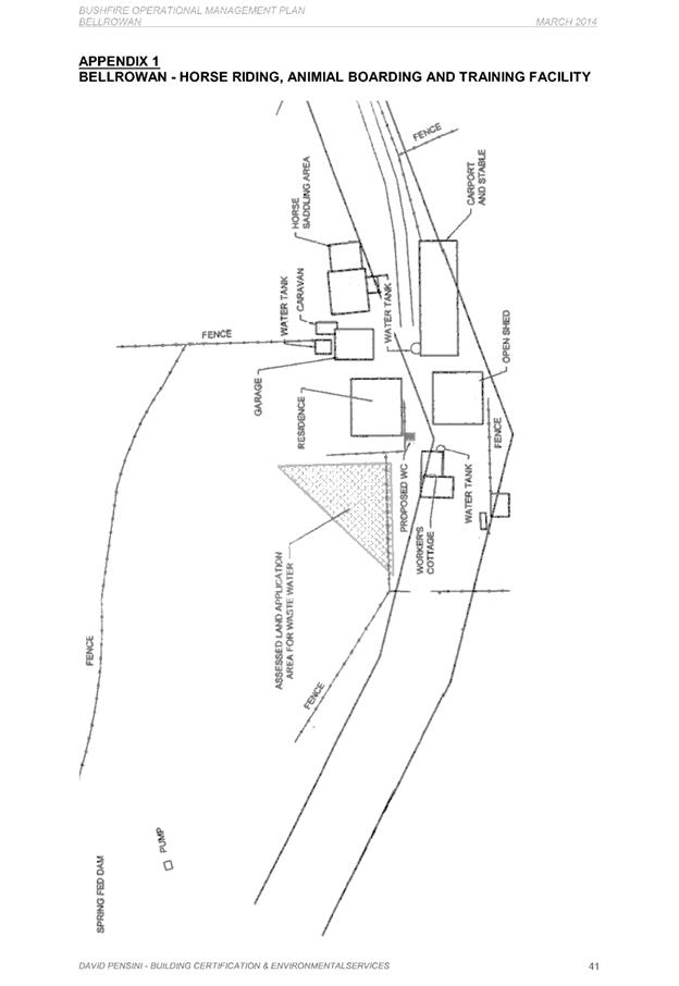
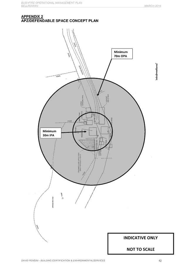
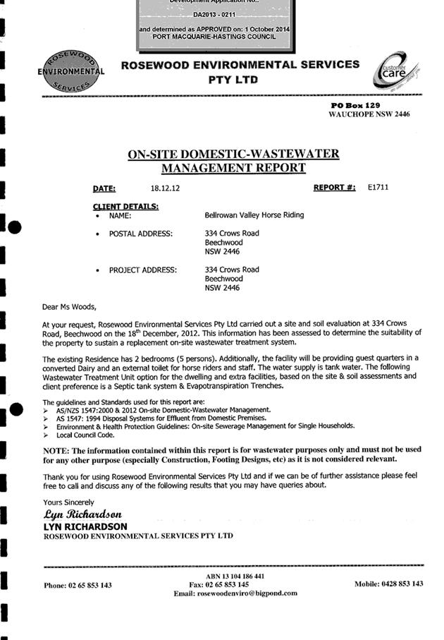
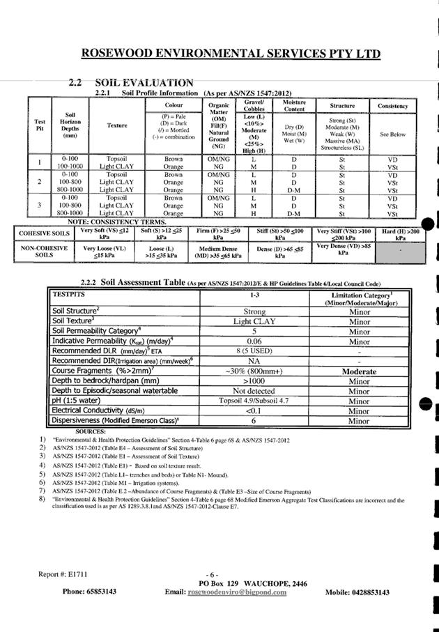
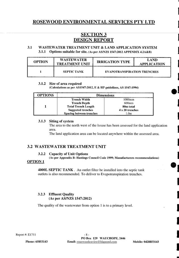
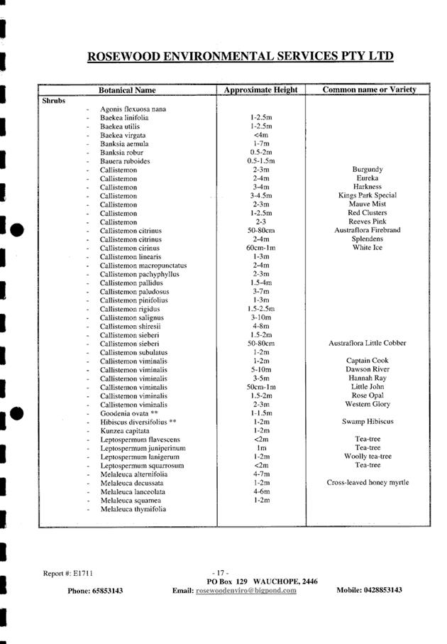
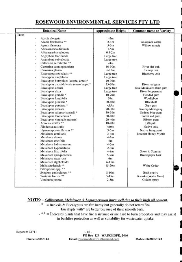
|
ATTACHMENT
|
Development Assessment Panel
14/03/2018
|
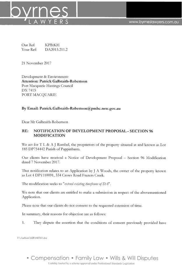
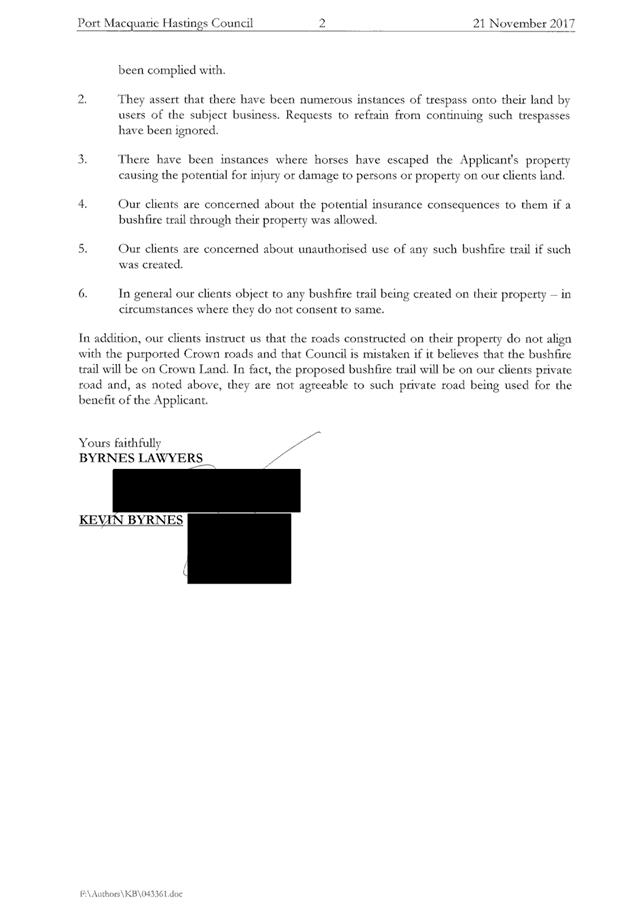
|
ATTACHMENT
|
Development Assessment Panel
14/03/2018
|
|
ATTACHMENT
|
Development Assessment Panel
14/03/2018
|
AGENDA Development Assessment Panel 14/03/2018
Item: 10
Subject: Section 96 Modification DA2010 - 572.11 -
Modification Of Subdivision Layout And Dwelling Design (Proposed Lots 213 To
217) - Lot 498 DP 1237901 Crestwood Drive, Port Macquarie.
Report
Author: Patrick Galbraith-Robertson
|
Applicant: Land
Dynamics Australia
Owner: Richmond
Horizons Pty Ltd & A R & P A Richmond
Estimated Cost: Nil
Alignment with Delivery
Program
4.3.1 Undertake transparent
and efficient development assessment in accordance with relevant legislation.
|
|
RECOMMENDATION
That
DA2010 – 572.11 for a Section 96 modification to subdivision layout and
design of dwellings (proposed Lots 213 to 217) at Lot 498, DP 1237901,
Crestwood Drive, Port Macquarie be determined by granting the modified
consent subject to recommended conditions as modified.
|
Executive
Summary
This report considers a Section
96(1A) modification of consent application at the
subject site and provides an assessment of the application in accordance with
the Environmental Planning and Assessment Act 1979.
Being a Section 96 modification,
the modified proposal has only been assessed against the legislation and
related planning guidelines in place at the time of the original assessment.
Following exhibition of the
application, three (3) submissions were received.
The modification proposal has been
amended following the neighbour notification period. The primary changes are
detailed later in this report.
1. BACKGROUND
Existing
sites features and Surrounding development
The current site is a residual lot
from a developing subdivision and multi-dwelling housing development under the
subject DA.
The site has an area of 4793.6m².
The
site is zoned 2(a1) residential in accordance
with the Hastings Local Environmental Plan 2001, which was in force at the time
of the original application, as shown in the following zoning plan:
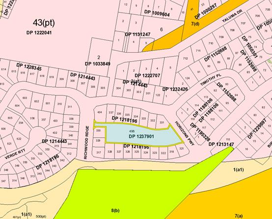
The
existing subdivision pattern and location of existing development within the
locality is shown in the following aerial photograph (Nearmap: December 2017):
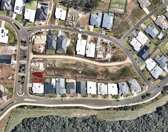
2. DESCRIPTION OF
DEVELOPMENT
Key aspects of the modified proposal (as amended following
neighbour notification) include the following:
· Amendments
to design of approved dwellings on proposed Lots 213 to 217;
· Relocation of the northern boundary of proposed Lots 213
– 219 to be moved 1m south;
· Propose to allow access to the end corner lot being
proposed Lot 220 from either Pennant Lane or Horizons Parkway.
Refer
to attachments at the end of this report.
Below
is a summary of the changes/amendments made to the modification in Rev A
submitted on 24 January 2018:
1. Removal of proposed dwellings on Lots 219
and 220, remaining as two (2) lots being as approved;
2. Retention of the original approved dwelling
on Lot 218, with changes only proposed to Dwellings on Lots 213 to 217;
3. Relocation of the northern boundary of Lots
213 – 219 to be moved 1m south. This allows for the existing electricity
easement to be wholly within the Community Lot 1 as required by the electrical
supply company. In addition, the relocation of this front boundary to the south
ensures a 7m wide road carriageway which is a requirement of the original DA
approval; and
4. Proposes to allow access to
the end corner lot being Lot 220 from either Pennant Lane or Horizons Parkway.
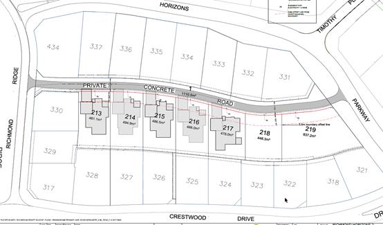
A
previous modification application was approved on 8 July 2014 for Lot 219 to
become two (2) proposed Lots 219 and 220 also. This is not proposed to change
and any new dwellings proposed on these two (2) lots (as shown below), will be
the subject of a separate DA to be lodged with Council. The Applicant has
confirmed that they intend to act on this component of the application
previously approved to create the two lots. Any new DA for dwellings on either
Lot 219 or 220 will also be required to be notified separately unless they are
Complying Development or single storey.
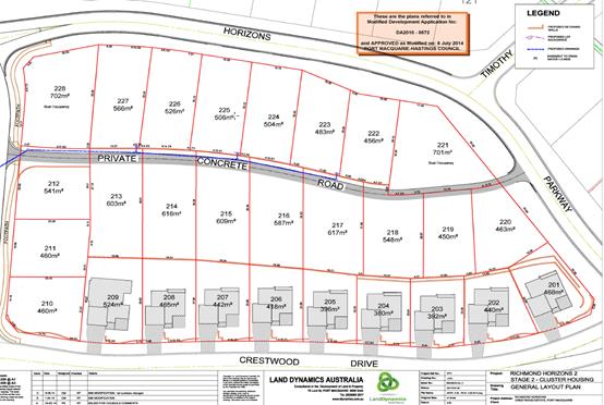
There have been several other modification applications
approved under this DA to amend the design of individual dwellings. The
original application was approved by Council on 20 December 2010. An extract of
the overall plan approved is shown below:
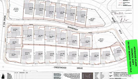
Application Chronology
· 16
November 2017 – Modification application lodged with Council;
· 29 November to 12 December 2017 – Neighbour
notification of modification proposal.
· 29 November 2017 – Additional information requested
– concerns with previous approval consistency eastern end.
· 24 January 2018 – Additional information and amended
plans received.
3. STATUTORY ASSESSMENT
Is
the proposal substantially the same?
Section 96 of the Environmental
Planning and Assessment Act 1979 enables the modification of consents and
categorises modifications into three categories - S.96(1) for modifications
involving minor error, mis-description or miscalculation; S.96(1A) for modifications
involving minimal environmental impact; and S.96(2) for other modifications.
Each type of modification must be considered as being substantially the same to
that which was originally consented to.
The subject application is being
considered under the provisions of Section 96(1A).
The proposal is considered to be
substantially the same development to that which was originally lodged and
consented to and will have minimal environmental impact when making a
comparison between the original and proposed modified proposal. In particular,
the main changes occur to the design of dwellings on Lot 213 to 217 and the
minor change to the northern boundary of Lot 213 to 219 (associated with the
Pennant Lane).
Having regard to the above, the
proposed modification is not considered to alter the fundamental essence of the
original development and is considered within the scope of a modification
application.
Are there any condition(s)
of consent imposed by a Minister, government or public authority that require
modification?
No
changes to any conditions imposed by a Minister, government or public
authority.
Does
the application require notification/advertising in accordance with the
regulations and/or any Development Control Plan?
Neighbour
notification has been undertaken in accordance with the DCP.
Any
submissions made concerning the modification?
Three (3) written submissions were received following public
exhibition via neighbour notification of the application.
The issues raised in the submissions received have been
forwarded to the Applicant during the assessment of the DA to respond to.
Key issues raised in the submissions received and comments
in response to the issues are provided as follows:
|
Submission
Issue/Summary
|
Planning
Comment/Response
|
|
Objects
to dwelling design for Lots 218, 219 and 220.
|
The
dwelling design for Lot 218 is no longer proposed to be altered as part of
the application and the proposed dwellings have been deleted from Lots 219
and 220. Any future development on these lots will be subject to further
application.
|
|
Loss
of sunlight / solar access issues from dwellings being higher than Nos. 76,
78 and 80 Crestwood Drive.
|
As the
lots are sited to the north and due to the topography of the subject Pennant Lane
sites being above the Crestwood Drive sites, there will be overshadowing
experienced from any development. By making a comparison to the current
original approved dwellings to the proposed modification there is minimal
difference in the impacts.
|
|
Lot
219 is now proposed to be two lots rather than a dual occupancy.
|
The
original submission proposed to alter the dual occupancy lot into two
separate lots. However, during the assessment it was identified that two (2)
lots were approved in this location with no buildings. The buildings on Lot
219 and 220 (as shown on plan extract earlier in this report) have been
deleted from this application. A separate new DA will be required to be
lodged for these two (2) lots. Any new DA for dwellings on either Lot 219 or
220 will also be required to be notified separately unless they are Complying
Development or single storey.
|
|
No
details of boundary fencing to be installed.
|
Boundary
fencing is a matter under the Dividing Fences Act and is normally between the
two relevant owners. However in this case, it is recommended that a condition
be imposed to require installation of a minimum 1.5m high fence on the
southern boundary of the lots prior to issue of an Occupation Certificate.
The fence will provide additional privacy to the neighbours to the south.
|
|
Current
drainage issues, which will be made worse and impact on stability of No. 80
Crestwood Drive.
|
Drainage is required for each
lot, which will improve the current situation of uncontrolled overland flow
as there is no development on these lots as yet. Roof water for each dwelling
when constructed will need to be connected to the existing inter-allotment
stormwater system currently installed on-site.
|
|
Amenity
impacts including loss of privacy, overlooking and overshadowing to No. 80
Crestwood Drive from the proposed dwelling on Lot 217.
|
Lot
217 (originally Lot 139) was approved as a single-storey dwelling with an
elevated rear floor level. This modification still remains as a single storey
dwelling with similar levels and height. The floor level of this dwelling is
also set lower than the Pennant Lane, which provides access to the site. It
should be noted however that a two storey dwelling could be accommodated
within the height limit.
A
comparison of the proposed dwelling on Lot 217 reveals that the rear setback
has been increased from 2.255m to 4.01m as proposed by this modification. The
footprint of the dwelling is also marginally smaller and the alfresco area
has been moved to the eastern side of the dwelling rather than closer to the
southern boundary.
All of
these changes increase the privacy for both the future residents and the
neighbours to the south and reduces any likely amenity impacts, including
overshadowing impacts. There is also an additional condition recommended for
a minimum 1.5m height boundary fence to improve privacy.
|
Any matters referred to in
section 79C (1) relevant to the modification?
Overall, the proposed development
remains consistent with the original s79C assessment. Areas of the original
assessment impacted by the changes or with revised comments are outlined below:
State Environmental Planning Policy (Building
Sustainability Index: BASIX) 2004
Satisfactory BASIX certificates were submitted with the
original application.
A revised BASIX certificate hasn’t been submitted for
the revised modified dwelling designs proposed demonstrating that the revised
proposal will comply with the requirements of the SEPP. It is recommended
that an additional new condition be imposed to ensure that the commitments are
incorporated into the development and certified at Occupation Certificate
stage.
Port Macquarie-Hastings Local Environmental
Plan 2001
The
above LEP was in place at the original time of assessment and determination of
this DA.
The
subject section of the original development site was zoned 2(a1) residential
under this LEP. The subject dwellings and community title subdivision component
remain permissible.
(iii) any Development
Control Plan in force:
Development
Control Plan No.9 – Residential and Tourist Development
The
above DCP was in place at the original time of
assessment and determination of this DA.
The
following table provides a checklist against the applicable controls which need
only to be revisited. It is important to note that internal amenity issues
within the cluster housing development are not strictly required by the
development control provisions in place at the time of the original approval.
Any issues would be the subject of a merit assessment unless a new separate DA
is lodged for a new dwelling on any of the lots within the community title
subdivision lots ie. Lots 219 and 220.
|
DCP 9 - Residential and Tourist Development
|
|
Development Provisions
|
Proposed
|
Complies
|
|
2.2 Max 6m height limit –
upper-most ceiling from ground level at any point on the site
|
Lot 213 dwelling = 5.14m
Lot 214 dwelling = 5.14m
Lot 215 dwelling = 5.18m
Lot 216 dwelling = 5.14m
Lot 217 dwelling = 5.77m
|
Yes – all comply
|
|
-
2.3 Front setbacks 4.5m
|
The front setback controls for
the subject dwellings do not apply as the setback is to a private laneway
only. A 5.5m setback is achieved within the driveways, which is desired under
the more current planning controls – DCP 2013.
|
N/A
|
|
2.3 Side and rear setbacks
|
Internal
amenity issues within the cluster housing development as originally approved
are not strictly subject to the development control provisions in place at the
time.
It is
noted however that all dwellings have a rear internal southern setback of
minimum 4m or more, which would comply with more current planning controls
– DCP 2013.
|
N/A
|
|
2.5 Private open space minimum
35m2 area inclusive of 4x4m useable area
|
35m²
of greater with useable area achieved for all modified dwellings.
|
Yes
|
Other
issues of merit impact from the original assessment that have been revisited
due to the modification are listed below:
Roads
Relocation of the northern
boundary of Lots 213 – 219 to be moved 1m south. This allows for the
existing electricity easement to be wholly within the Community Lot 1 as
required by the electrical supply company. In addition, the relocation of this
front boundary to the south ensures a 7m wide road carriageway which is a
requirement of the original DA approval.
The Applicant has modified the subdivision plan during the
assessment to require the private road (over common property) to be of similar
scale and size required as part of the original consent (3.5m wide one-way
driveway within a 7m wide common property. Based upon this, no changes
are required and access is consistent with Condition B(2) of the existing DA
consent.
Stormwater
Drainage is required for each lot, which will improve the
current situation. Roof water for each dwelling when constructed will need to
be connected to the existing inter-allotment stormwater system currently
installed on-site. No new risks are identified.
4. DEVELOPMENT
CONTRIBUTIONS APPLICABLE
Applicable development contributions to each dwelling as
modified and/or lot if released first will need to be reassessed/checked at
Subdivision Certificate and Construction Certificate stage for each of the
dwellings (whichever occurs first).
5. CONCLUSION
The application has been assessed in accordance with
Section 96 and 79C of the Environmental Planning and Assessment Act 1979.
Issues raised during assessment and public exhibition of
the application have been considered in the assessment of the application.
The site remains suitable for the proposed development, is
not contrary to the public's interest and will not have a significant adverse
social, environmental or economic impact. It is recommended that the
modification application be approved, subject to the recommended modified
conditions of consent provided in the attachment section of this report.
|
Attachments
1View. DA2010
- 572.11 Plans
2View. DA2017
- 572.11 Recommended Conditions
3View. DA2010
- 572.11 Submission - Gilmour 02122017
4View. DA2010
- 572.11 Submission - Gilmour 22022018
5View. DA2017
- 572.11 Submission - Hoogers
6View. DA2010.572.11
- Submission - Quach & Lo
|
|
ATTACHMENT
|
Development Assessment Panel
14/03/2018
|
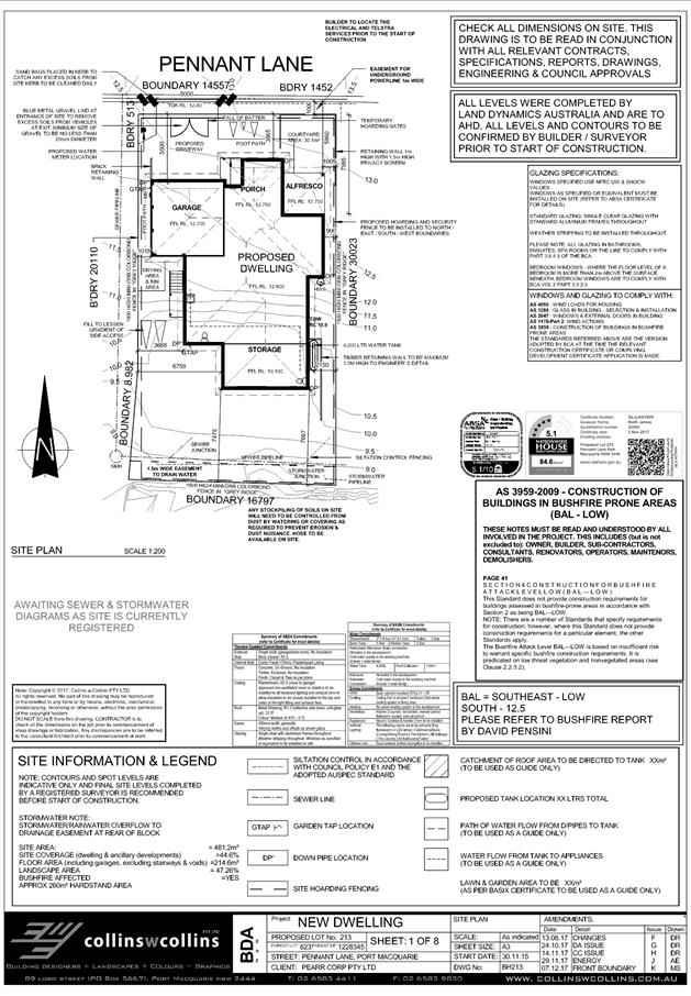
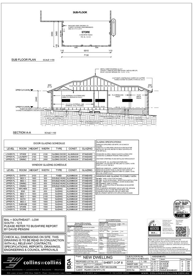
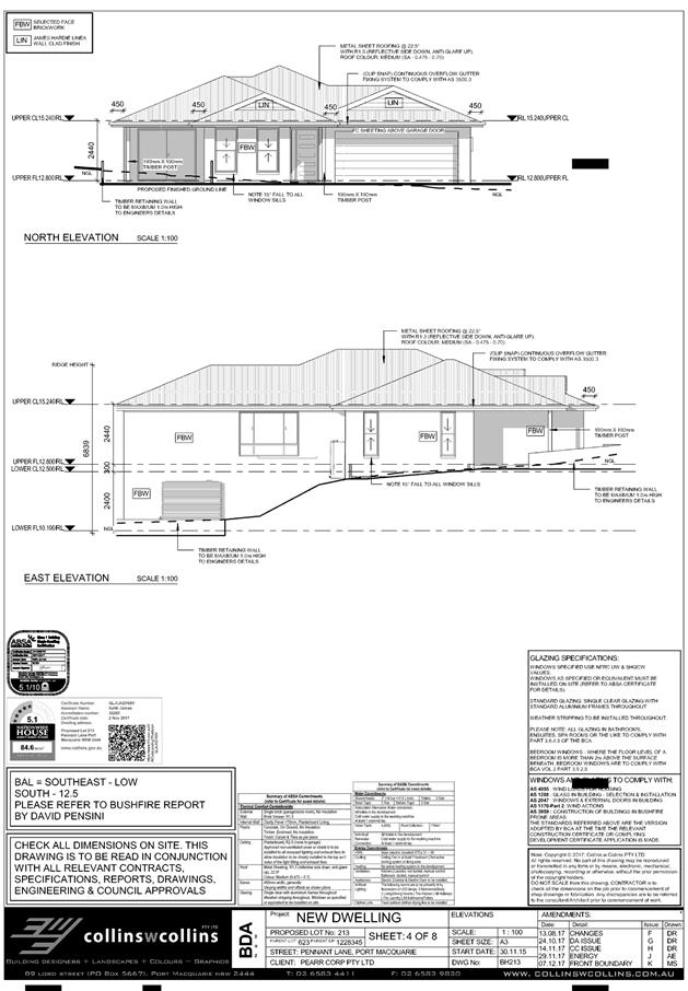
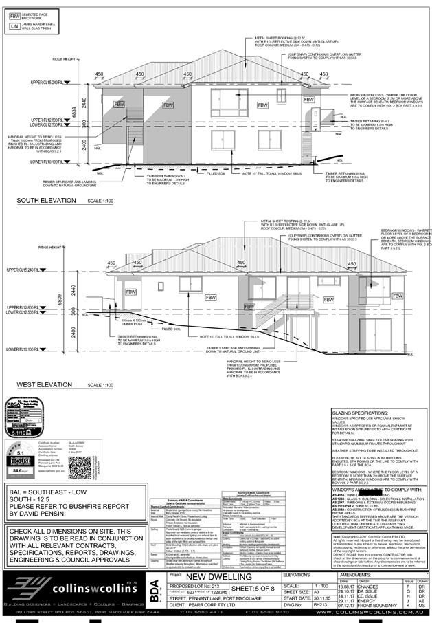
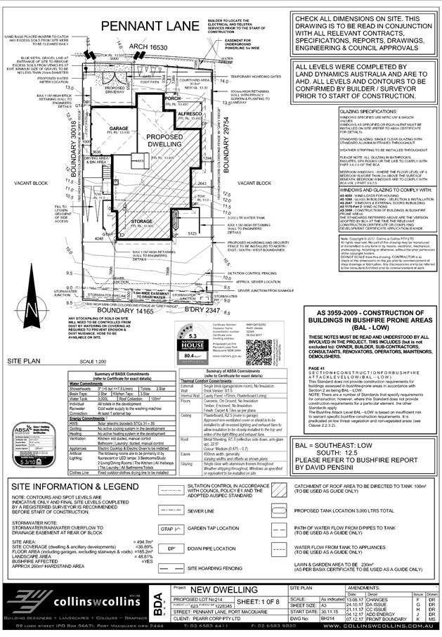
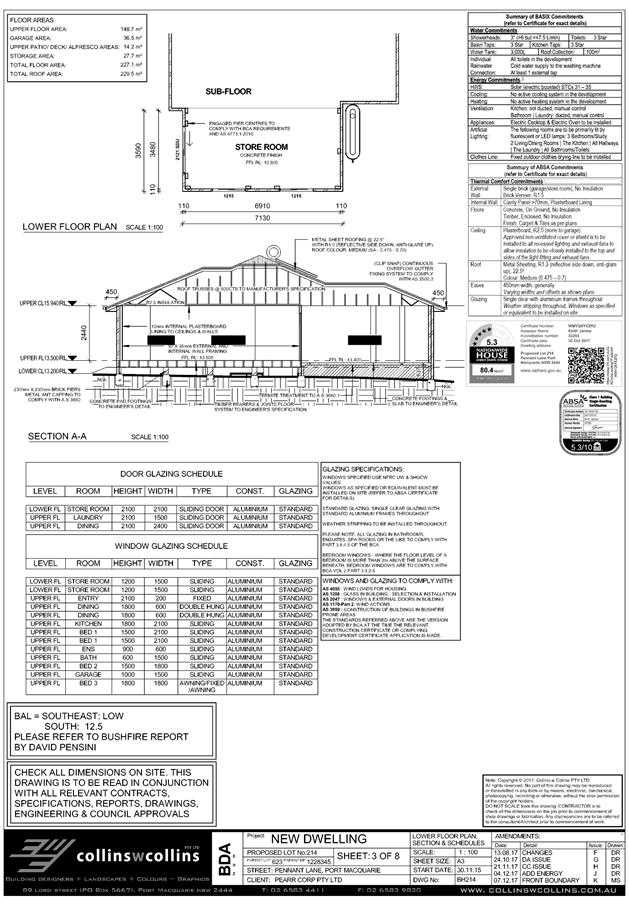
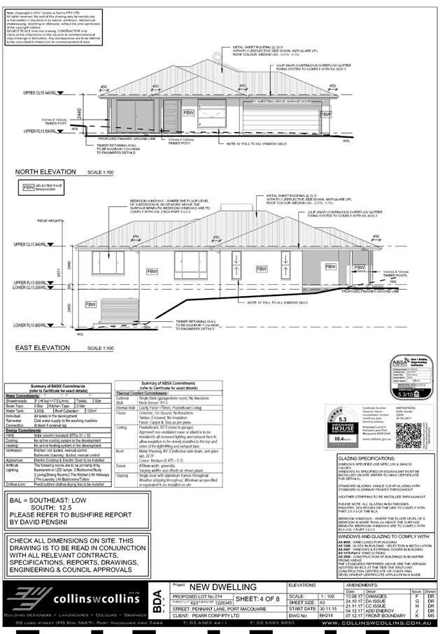
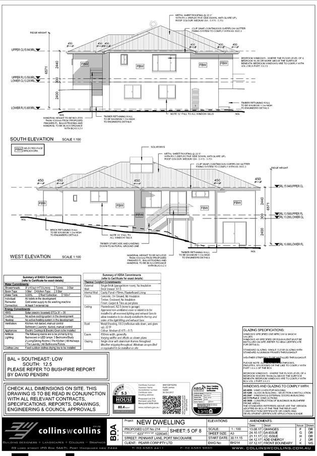
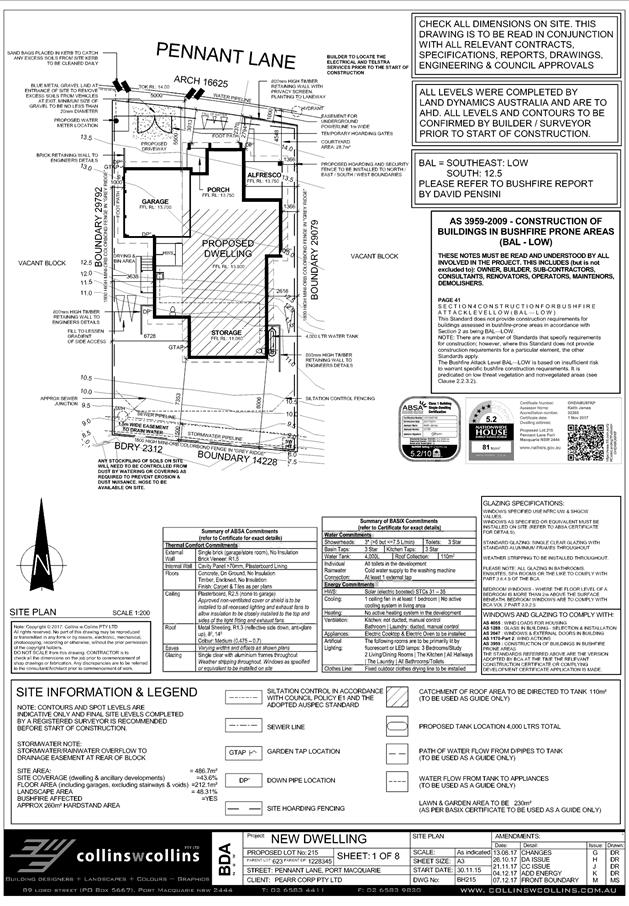
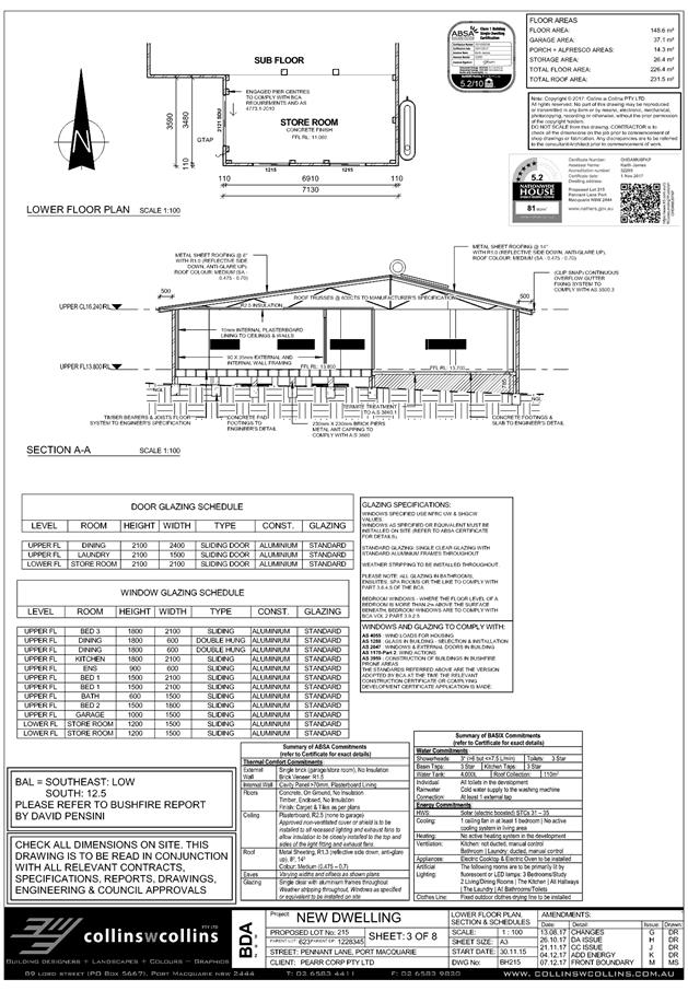
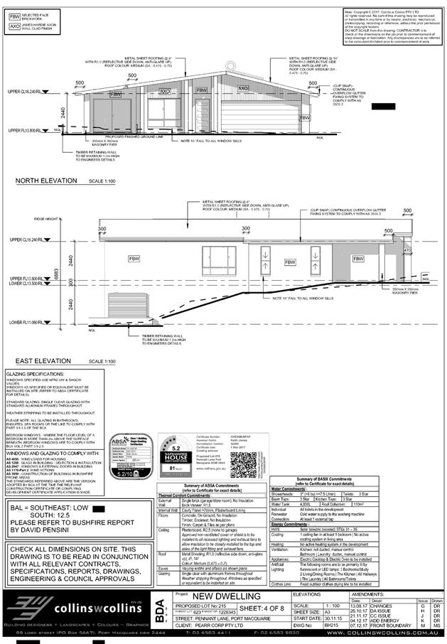
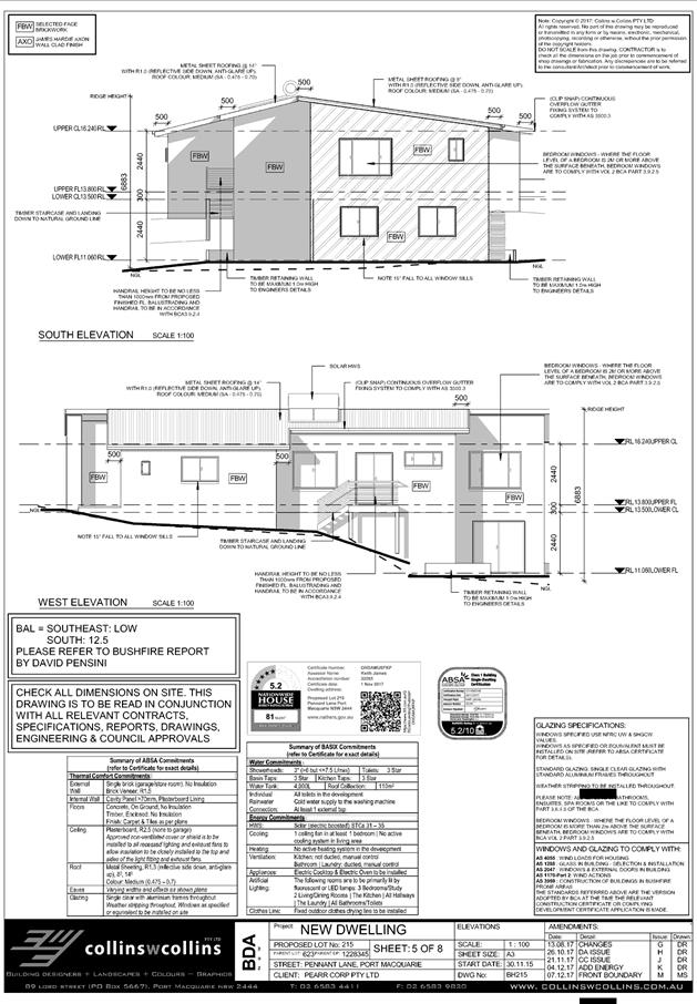
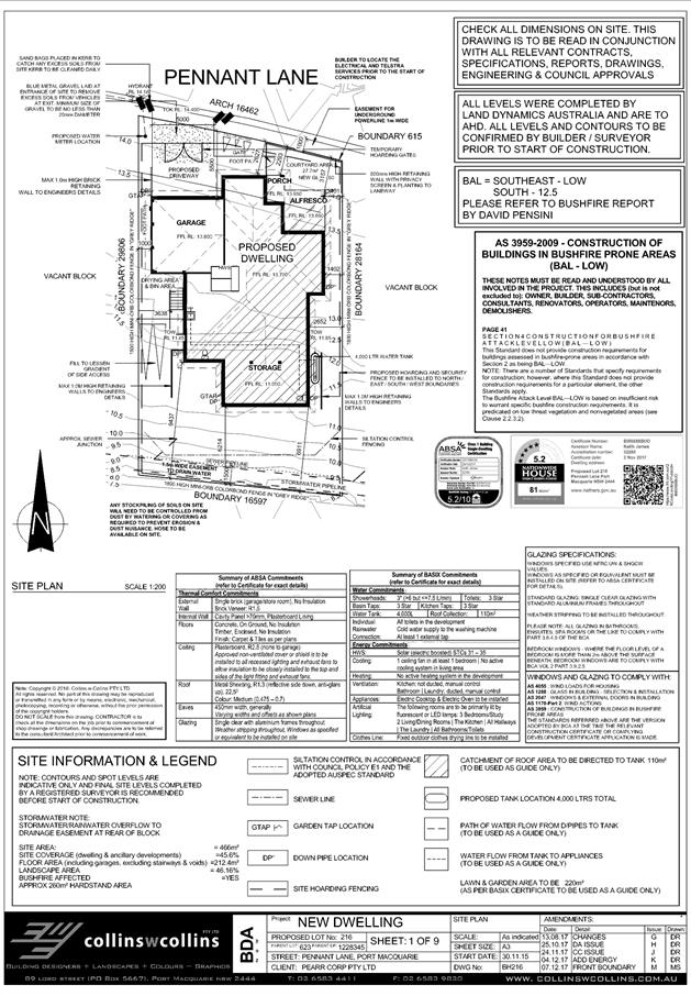
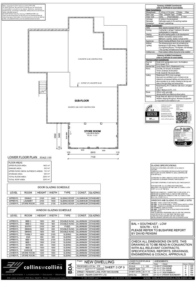
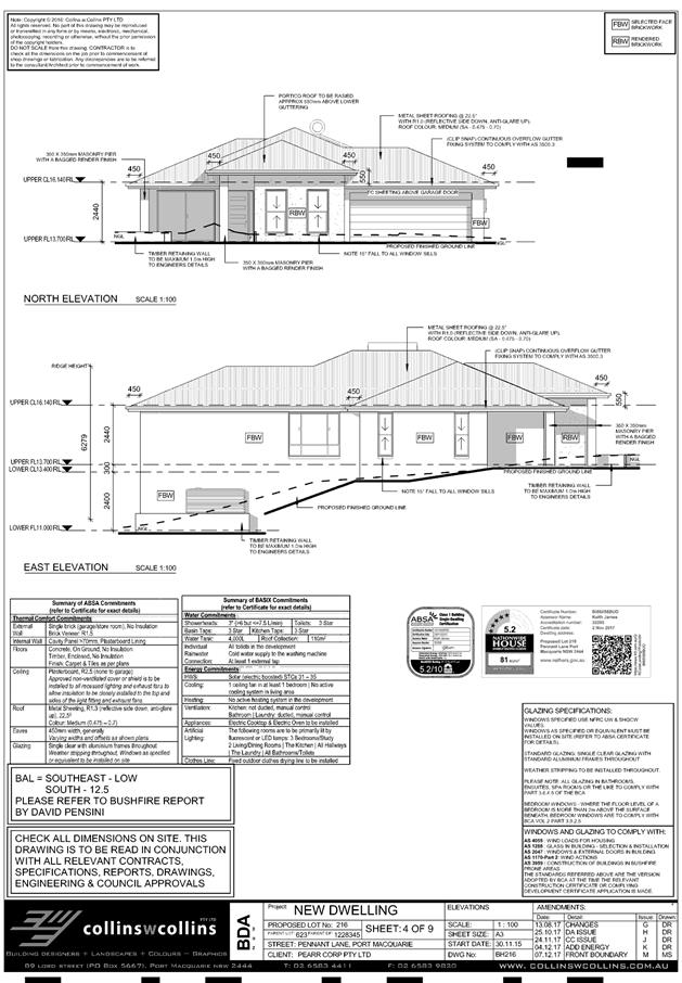
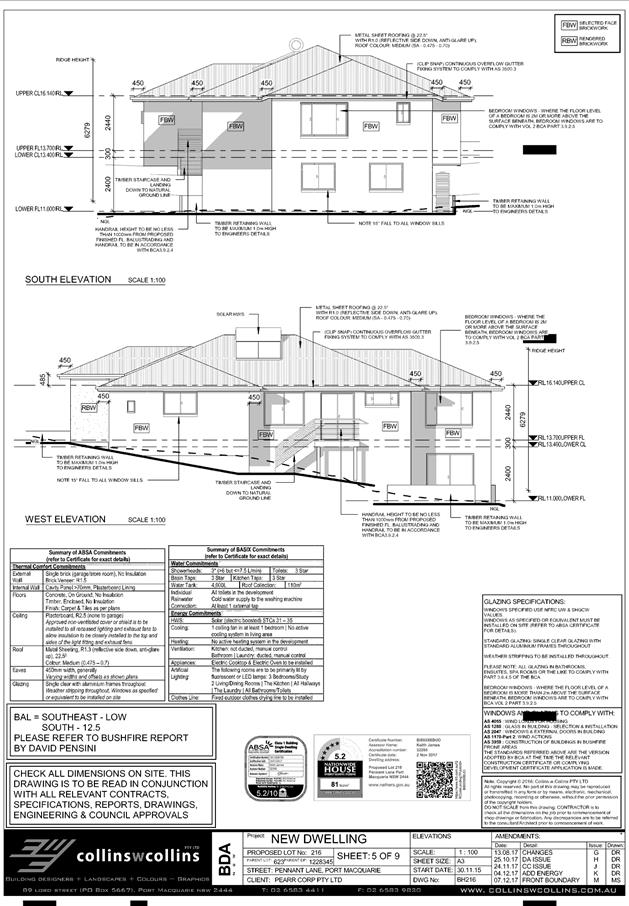
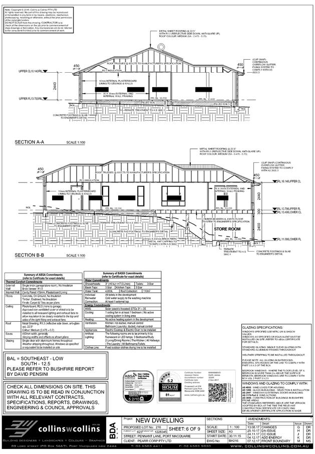
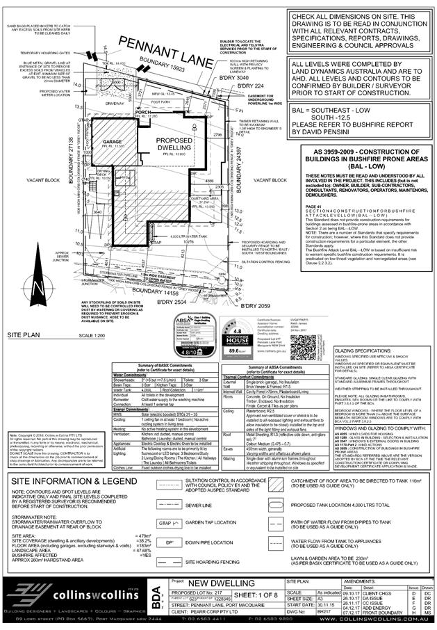
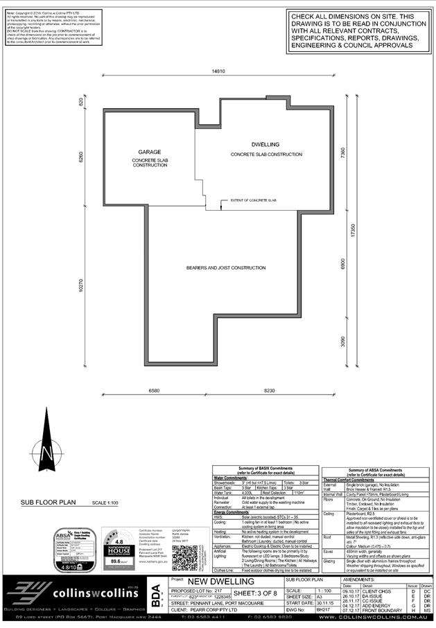
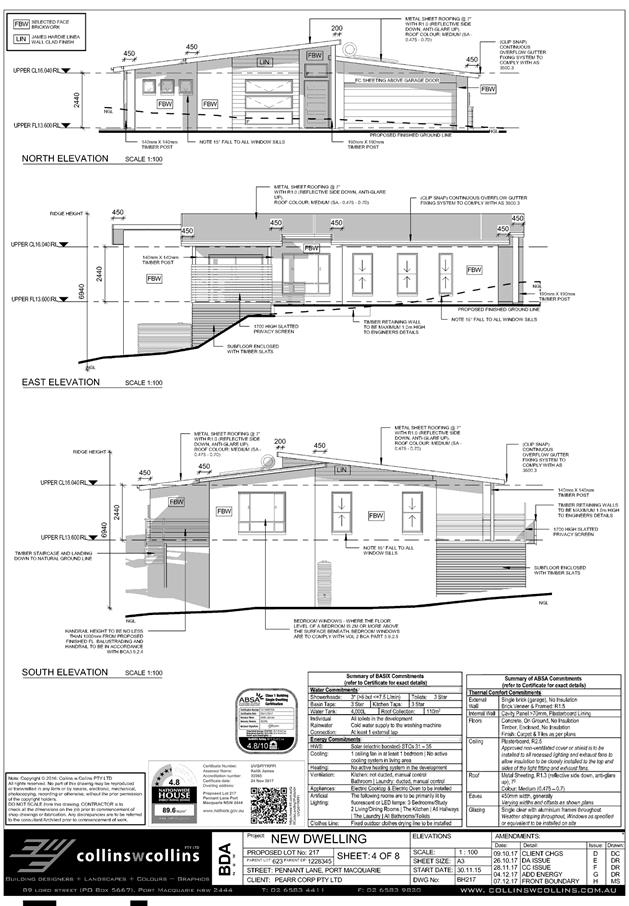
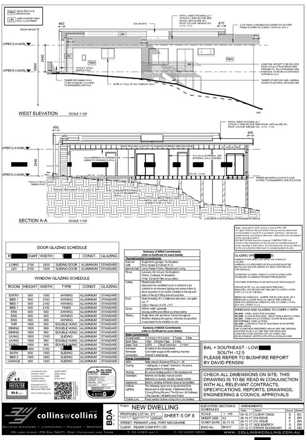
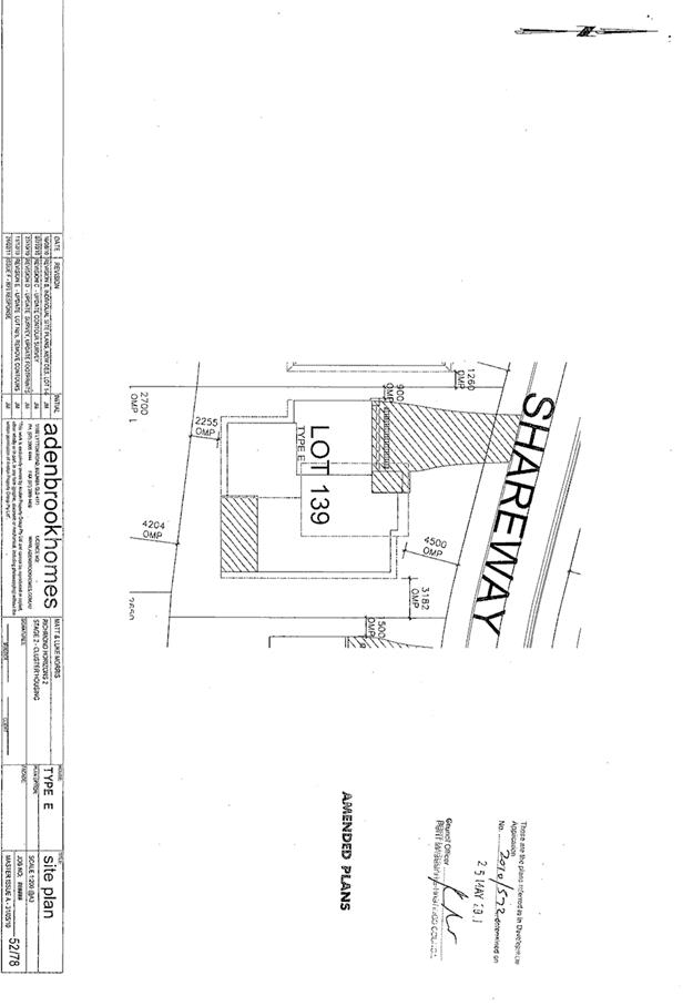
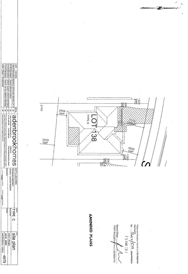
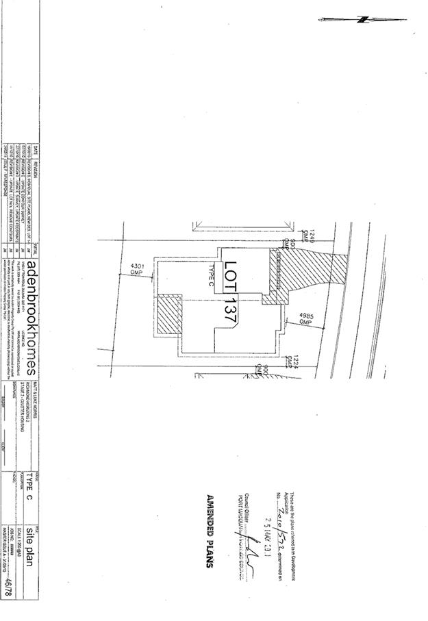
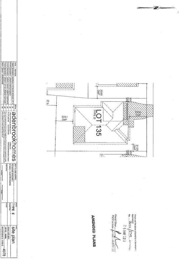
|
ATTACHMENT
|
Development Assessment Panel
14/03/2018
|
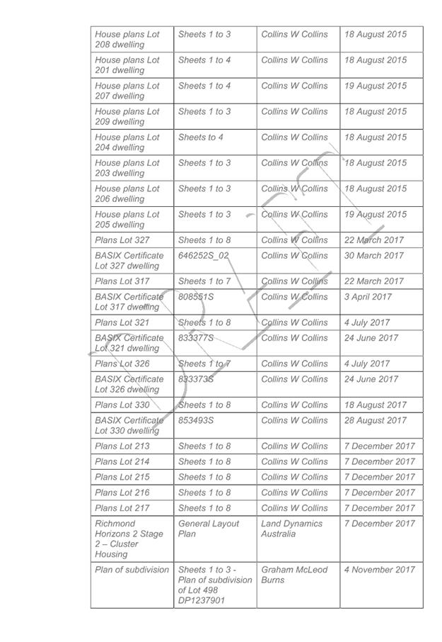
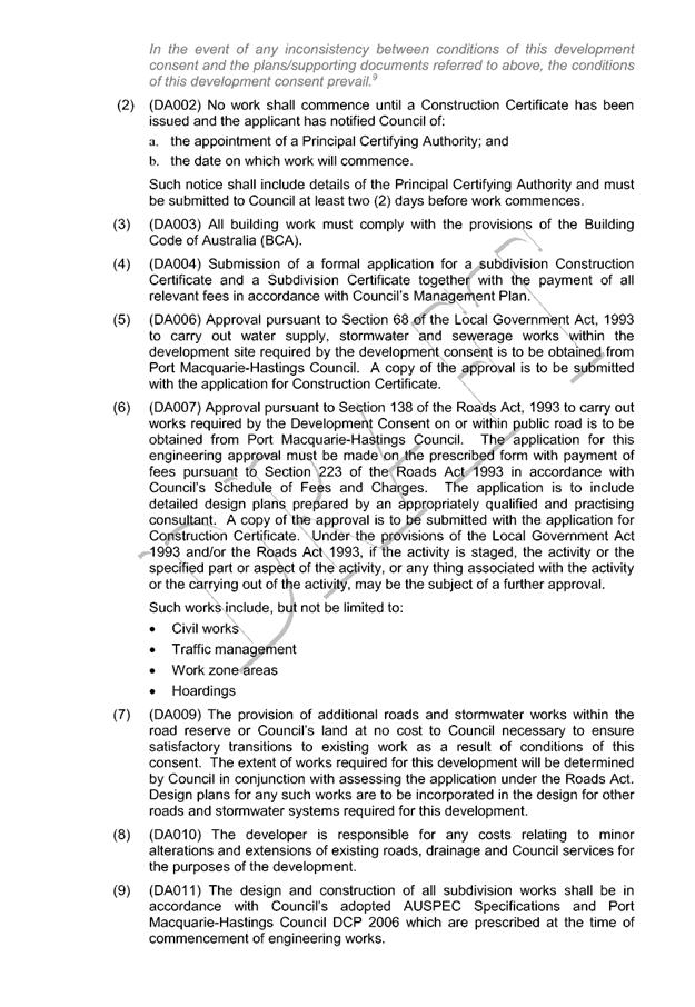
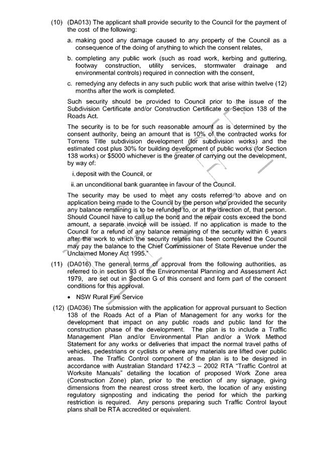
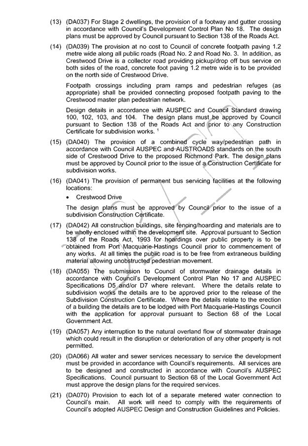
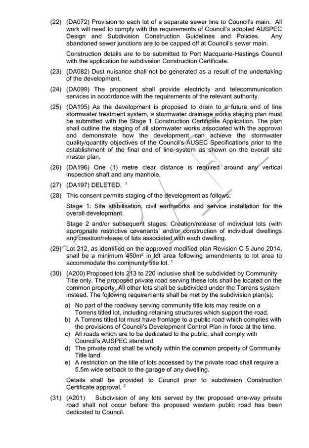
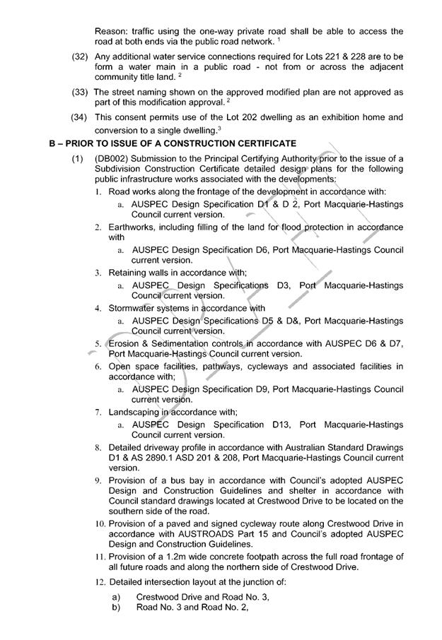
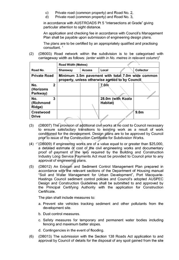
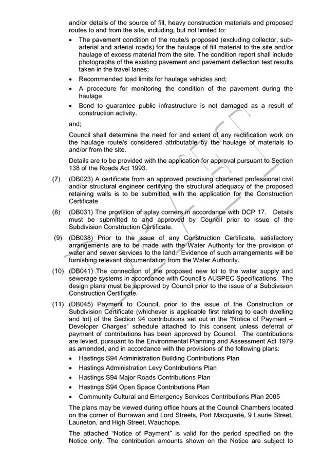
|
ATTACHMENT
|
Development Assessment Panel
14/03/2018
|
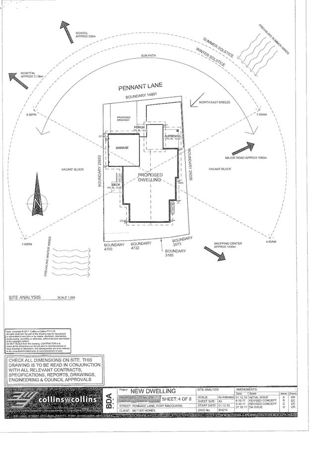
|
ATTACHMENT
|
Development Assessment Panel
14/03/2018
|
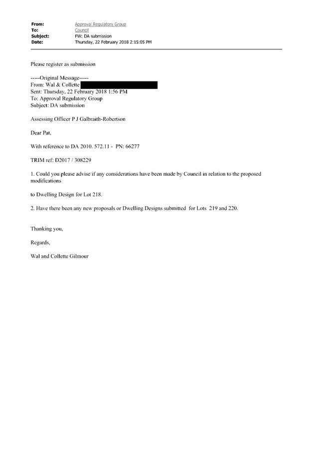
|
ATTACHMENT
|
Development Assessment Panel
14/03/2018
|
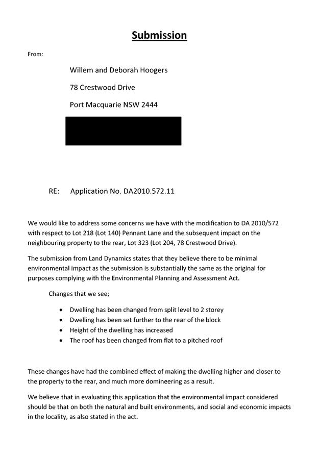
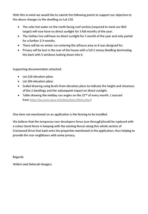
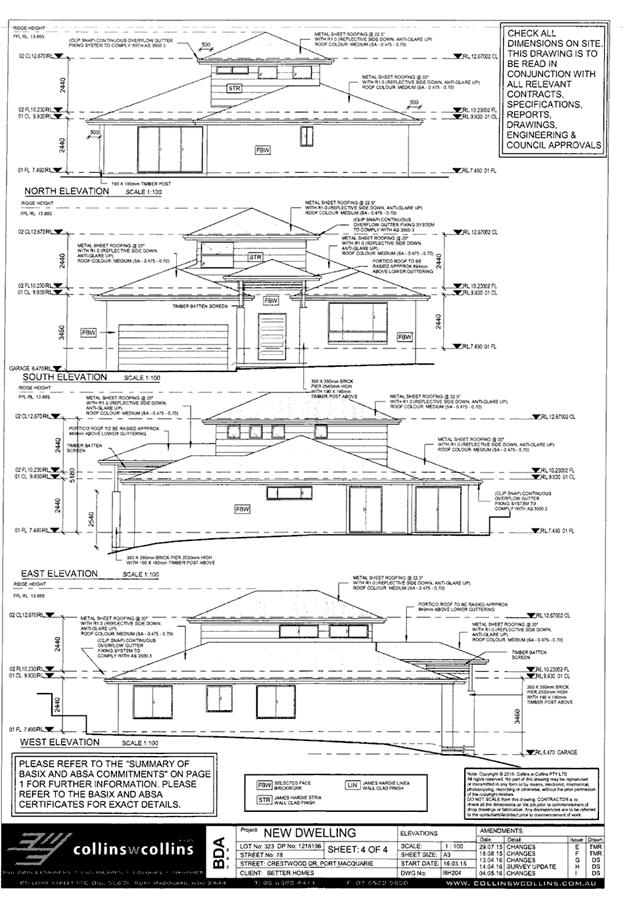
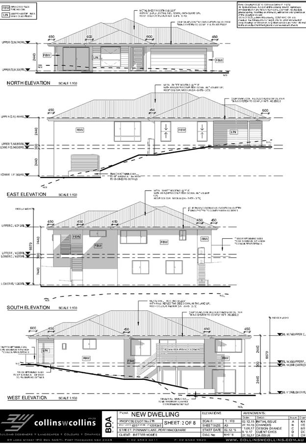
|
ATTACHMENT
|
Development Assessment Panel
14/03/2018
|