Business
Paper
|
date of meeting:
|
|
Wednesday 28 March
2018
|
|
location:
|
|
Function Room
Port
Macquarie-Hastings Council
17 Burrawan Street
Port Macquarie
|
|
time:
|
|
2:00pm
|
Development
Assessment Panel
CHARTER
1.0 OBJECTIVES
To assist in managing Council's development assessment
function by providing independent and expert determinations of development
applications that fall outside of staff delegations.
2.0 KEY FUNCTIONS
·
To review development application reports and conditions;
·
To determine development
applications outside of staff delegations;
·
To refer development applications
to Council for determination where necessary;
·
To provide a forum for objectors and applicants
to make submissions on applications
before the Development Assessment Panel
(DAP);
·
To maintain transparency in the determination of development
applications.
Delegated Authority of Panel
Pursuant to
Section 377 of the Local Government Act, 1993 delegation to:
·
Determine development applications under Part 4
of the Environmental Planning and Assessment
Act 1979 having
regard to the relevant environmental planning instruments,
development control plans and Council policies.
·
Vary, modify or release restrictions as to use
and/or covenants created by Section 88B instruments under the Conveyancing Act
1919 in relation to development applications for subdivisions being considered
by the panel.
·
Determine Koala Plans of Management under State
Environmental Planning Policy 44 - Koala Habitat Protection associated with
development applications being considered by the Panel.
Noting the trigger to escalate
decision making to Council as highlighted in section 5.2.
3.0
MEMBERSHIP
3.1
Voting
Members
·
Two independent external members. One of the
independent external members to be the Chairperson.
·
Group Manager Development Assessment (alternate
- Director Development & Environment or Development Assessment Planner)
The independent external members shall have expertise in
one or more of the following areas: planning, architecture, heritage, the
environment, urban design, economics, traffic and transport, law, engineering,
government and public administration.
3.2
Non-Voting Members
·
Not applicable
3.3 Obligations
of members
·
Members must act faithfully and diligently and
in accordance with this Charter.
·
Members must comply with Council's Code of Conduct.
·
Except as required to properly perform their
duties, DAP members must not
disclose any confidential information (as advised by Council) obtained in connection with the DAP functions.
·
Members will have read and be familiar with the
documents and information provided by Council prior
to attending a DAP meeting.
·
Members must act in accordance with Council's
Workplace Health and Safety Policies and Procedures
·
External members of the Panel are not authorised
to speak to the media on behalf of Council. Council officers that are members
of the Committee are bound by the
existing operational delegations in relation to speaking to the media.
·
Staff members shall not vote on matters before
the Panel if they have been the principle author of the development assessment report.
3.4
Member Tenure
·
The independent external members will be
appointed for the term of four (4) years
maximum in which the end of the tenure of these members would occur in a
cascading arrangement.
3.5 Appointment
of members
·
The independent external members (including the
Chair) shall be appointed by the General Manager following an external
Expression of Interest process.
·
Staff members of the Panel are in accordance
with this Charter.
4.0 TIMETABLE
OF MEETINGS
·
The Development Assessment Panel will generally
meet on the 1st and 3rd Wednesday each month at 2.00pm at the Port Macquarie
offices of Council.
·
Special Meetings of the Panel may be convened by
the Director Development & Environment Services with three (3) days notice.
5.0
MEETING PRACTICES
5.1
Meeting
Format
·
At all Meetings of the Panel the Chairperson
shall occupy the Chair and preside. The Chair will be responsible for keeping
of order at meetings.
·
Meetings shall be open to the public.
·
The Panel will hear from applicants
and objectors or their r e p r e s e n t a t i v e s .
·
Where considered necessary, the Panel will
conduct site inspections which will
be open to the public.
5.2
Decision Making
·
Decisions are to be made by consensus. Where
consensus is not possible on any item, that item is to be referred to Council
for a decision.
·
All development applications involving a
proposed variation to a development standard
greater than 10% under Clause
4.6 of the Local Environmental Plan will be
considered by the Panel and recommendation made to the Council for a decision.
5.3
Quorum
·
All members (2 independent external members and
1 staff member) must be present at a
meeting to form a quorum.
5.4
Chairperson and Deputy Chairperson
·
Independent Chair (alternate, second independent member)
5.5
Secretariat
·
The Director Development &n Environment is
to be responsible for ensuring that the Panel has adequate secretariat support.
The secretariat will ensure that the business paper and supporting papers are
circulated at least three (3) days prior to
each meeting. Minutes shall be appropriately approved and circulated to each
member within three (3) weeks of a meeting being held.
·
The format of and the preparation and publishing
of the Business Paper and Minutes shall be similar to the format for Ordinary
Council Meetings.
5.6
Recording of decisions
·
Minutes will record decisions and how each
member votes for each item before the Panel.
6.0 CONVENING
OF “OUTCOME SPECIFIC” WORKING GROUPS
Not applicable.
7.0 CONFIDENTIALITY
AND CONFLICT OF INTEREST
·
Members of the Panel must comply with the
applicable provisions of Council’s Code of Conduct. It is the personal
responsibility of members to comply with the standards in the Code of Conduct
and regularly review their personal circumstances with this in mind.
·
Panel members must declare any conflict of
interests at the start of each meeting or before discussion of a relevant item
or topic. Details of any conflicts of interest should be appropriately minuted.
Where members are deemed to have a real or perceived conflict of interest, it
may be appropriate they be excused from deliberations on the issue where the
conflict of interest may exist. A Panel meeting may be postponed where there is
no quorum.
8.0 LOBBYING
·
All members and applicants are to adhere to
Council’s Lobbying policy. Outside of
scheduled Development Assessment Panel meetings, applicants, their
representatives, Councillors, Council staff and the general public are not to
lobby Panel members via meetings, telephone conversations, correspondence and
the like. Adequate opportunity will be provided at Panel inspections or
meetings for applicants, their representatives and the general public to make
verbal submissions in relation to Business Paper items.
Development Assessment Panel
ATTENDANCE
REGISTER
|
Member
|
06/12/17
|
13/12/17
|
14/02/18
|
28/02/18
|
14/03/18
|
|
Paul Drake
|
P
|
P
|
P
|
|
P
|
|
Robert Hussey
|
P
|
P
|
P
|
A
|
A
|
|
David Crofts
(alternate member)
|
|
|
|
P
|
P
|
|
Dan Croft
(Acting Director
Development & Environment)
Clinton Tink
(Acting GM Development
Assessment
(alternates)
- Director Development & Environment
- Development Assessment Planner
|
P
P
|
P
P
|
P
P
|
P
|
P
|
Key: P = Present
A
= Absent With Apology
X
= Absent Without Apology
Development
Assessment Panel Meeting
Wednesday 28 March
2018
Items of Business
01 Acknowledgement
of Country............................................................................ 8
02 Apologies......................................................................................................... 8
03 Confirmation
of Minutes.................................................................................... 8
04 Disclosures
of Interest..................................................................................... 16
05 DA2017
- 853.1 Multi Dwelling Housing and Torrens Title Subdivision of proposed Lots
401, 402, 403 and 404 - currently Lot 208, DP 1224779, Ventura Place, Port
Macquarie...... 20
06 DA2018
- 91.1 Garage/Shed - Lot 39 DP 790538, No 13 Babinda Avenue, West Haven 98
07 DA2017
- 234 - Waste Management Facility (Concrete Recycling) - Lot 1 DP 1202080,
Pacific Highway, Pembrooke..................................................................................... 122
08 Section
96 Modification DA2017 - 500.2 - Modify Design Of Previous Approved Dwelling -
Lot 703 DP 1228141, No 37 Yaluma Drive, Port Macquarie.................................... 188
09 DA2017
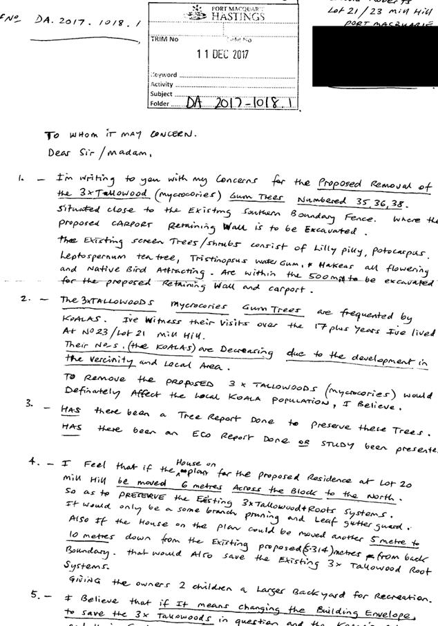
- 1018.1 Dwelling - Lot 20 DP 803114, No 21 Mill Hill, Port Macquarie.. 213
10 General
Business
AGENDA Development Assessment Panel 28/03/2018
Subject: ACKNOWLEDGEMENT
OF COUNTRY
"I acknowledge that we are
gathered on Birpai Land. I pay respect to the Birpai Elders both past and
present. I also extend that respect to all other Aboriginal and Torres Strait
Islander people present."
RECOMMENDATION
That the apologies received be
accepted.
Subject: CONFIRMATION
OF PREVIOUS MINUTES
Recommendation
That the Minutes of the Development
Assessment Panel Meeting held on 14 March 2018 be confirmed.
MINUTES
Development Assessment Panel Meeting
14/03/2018
PRESENT
Members:
Paul
Drake
David Crofts
Clinton Tink
Other Attendees:
Patrick Galbraith-Robertson
Chris
Gardiner
David
Troemel
|
The meeting opened at 2:00pm.
|
|
01 ACKNOWLEDGEMENT
OF COUNTRY
|
|
The
Acknowledgement of Country was delivered.
|
|
02 APOLOGIES
|
|
CONSENSUS:
That
the apology received from Robert Hussey be accepted.
|
|
03 CONFIRMATION
OF MINUTES
|
|
CONSENSUS:
That
the Minutes of the Development Assessment Panel Meeting held on 28 February
2018 be confirmed.
|
|
04 DISCLOSURES
OF INTEREST
|
|
There were no disclosures of interest presented.
|
|
05 DA2017 -
1141.1 Dwelling - Lot 271 DP 1234160 No. 64A The Anchorage, Port Macquarie
|
|
Speakers:
Sally
Newton (owner)
CONSENSUS:
That
DA2017 – 1141.1 for a dwelling at Lot 271, DP1234160, No. 64A The
Anchorage, Port Macquarie, be determined by granting consent subject to the
recommended conditions.
|
|
06 DA2017 -
1065.1 Alterations To Caravan Park, Lot 2 DP 1233513, Munster Street, Port
Macquarie
|
|
Speakers:
Michelle
Love (applicant)
CONSENSUS:
That
DA 2017 – 1065.1 for Alterations to Caravan Park at Lot 2, DP 1233513,
Munster Street, Port Macquarie, be determined by granting consent subject to
the recommended conditions.
|
|
07 DA2017-1100.1
Dwelling & Swimming Pool, Lot 34 DP 22916, No 12 Surf Street, Port Macquarie
|
|
Speakers:
Helen
Knox (o)
James
Collins (applicant)
CONSENSUS:
That
DA2017 – 1100.1 for the construction of new dwelling house and swimming
pool at Lot 34 DP 22916, No. 12 Surf Street, Port Macquarie be determined by
granting consent subject to the recommended conditions.
|
|
08 Section
96 Modification DA2016 - 404.2 Modification to Industry (Cement Depot) - Lot
21 DP 1205839, 39 Randall Street, Wauchope
|
|
Speakers:
Kate
Jackson (applicant)
CONSENSUS:
That
the section 96 modification to DA2016 - 404 for a modification to industry
(cement depot) – increase in throughput at Lot 21, DP 1205839, No. 39
Randall Street, Wauchope, be determined by granting consent subject to the
recommended conditions as amended below:
Amend
condition A2 to state:
A2 (A013)
The general terms of approval from the following authorities, as referred to
in section 93 of the Environmental Planning and Assessment Act 1979, and
referenced below, are attached and form part of the consent conditions for
this approval.
·
NSW Environment Protection Authority - The General Terms of
Approval, Reference EF13/2674 and dated 5 March 2018, are attached and form
part of this consent.
|
|
09 Section 96
Modification DA2013 - 211.2 - Modification To A Continued Use Of Animal
Boarding And Training Establishment (Horse Riding) - Lot 4 DP 1110091, No 334
Crows Road, Frazers Creek
|
|
Speakers:
Mark
Ennor (applicant)
CONSENSUS:
That
the Section 96 modification to DA2013 - 211 for a proposed amendment to
conditions of consent relating to a previous approved continued use of an
animal boarding and training establishment (horse riding) at Lot 4, DP
1110091, No. 334 Crows Road, Frazers Creek, be determined by granting
approval subject to the recommended conditions.
|
|
10 Section
96 Modification DA2010 - 572.11 - Modification Of Subdivision Layout And
Dwelling Design (Proposed Lots 213 To 217) - Lot 498 DP 1237901 Crestwood
Drive, Port Macquarie.
|
|
Speakers:
Michael Quach (o)
Willem Hoogers (o)
Donna Clarke (applicant)
Derek Collins (applicant)
CONSENSUS:
That DA2010 – 572.11 for a Section 96 modification
to subdivision layout and design of dwellings (proposed Lots 213 to 217) at
Lot 498, DP 1237901, Crestwood Drive, Port Macquarie be determined by
granting the modified consent subject to recommended conditions as amended
below:
Amend condition A1 to state:
A1
(DA001) The development is
to be carried out in accordance with the plans and supporting documents set
out in the following table except where modified by any conditions of this consent.
|
Plan / Supporting Document
|
Reference
|
Prepared by
|
Date
|
|
Plans
|
Sheets
1 to 4 78/78 – Issue F
|
Adenbrook
Homes
|
24/02/2011
|
|
Plans
|
Sheets
2 & 3 – Revision E
|
Adenbrook
Homes
|
11/12/2010
|
|
Driveway
access
section
plans
|
Drawing
No. P08 – P15
Revision
No 1
|
Luke
& Company
|
Undated
|
|
Site
cross
section plan
|
Drawing
No. 30F7 Issue B
|
Luke
& Company
|
15/02/11
|
|
Richmond
Horizons 2 Stage 2 Cluster Housing
|
Drawing
1
|
Land
Dynamics
|
18
February 2015
|
|
External
layout and grading plan
|
2
of 7
|
Luke
& Company
|
17/12/2010
|
|
Typical
landscape sections & example images
|
7
of 7
|
Luke
& Company
|
17/12/2010
|
|
Landscape
- planting concept
|
6
of 7
|
Luke
& Company
|
17/12/2010
|
|
Subdivision
layout plan (including residue)
|
1
|
Luke
& Company
|
15/4/2011
|
|
House
Plans for Lot 202
|
Sheets
1 to 5
|
Collins
W Collins
|
27
July 2015
|
|
BASIX
certificate
|
637837S
|
Collins
W Collins
|
22
June 2015
|
|
BASIX
certificates
|
646229S,
637843S, 637847S, 646246S,
645768S,
646250S,
646252S,
646982S,
|
Collins
W Collins
|
7
July 2015
|
|
House
plans Lot 208 dwelling
|
Sheets
1 to 3
|
Collins
W Collins
|
18
August 2015
|
|
House
plans Lot 201 dwelling
|
Sheets
1 to 4
|
Collins
W Collins
|
18
August 2015
|
|
House
plans Lot 207 dwelling
|
Sheets
1 to 4
|
Collins
W Collins
|
19
August 2015
|
|
House
plans Lot 209 dwelling
|
Sheets
1 to 3
|
Collins
W Collins
|
18
August 2015
|
|
House
plans Lot 204 dwelling
|
Sheets
to 4
|
Collins
W Collins
|
18
August 2015
|
|
House
plans Lot 203 dwelling
|
Sheets
1 to 3
|
Collins
W Collins
|
18
August 2015
|
|
House
plans Lot 206 dwelling
|
Sheets
1 to 3
|
Collins
W Collins
|
18
August 2015
|
|
House
plans Lot 205 dwelling
|
Sheets
1 to 3
|
Collins
W Collins
|
19
August 2015
|
|
Plans
Lot 327
|
Sheets
1 to 8
|
Collins
W Collins
|
22
March 2017
|
|
BASIX
Certificate Lot 327 dwelling
|
646252S_02
|
Collins
W Collins
|
30
March 2017
|
|
Plans
Lot 317
|
Sheets
1 to 7
|
Collins
W Collins
|
22
March 2017
|
|
BASIX
Certificate Lot 317 dwelling
|
808551S
|
Collins
W Collins
|
3
April 2017
|
|
Plans
Lot 321
|
Sheets
1 to 8
|
Collins
W Collins
|
4
July 2017
|
|
BASIX
Certificate Lot 321 dwelling
|
833377S
|
Collins
W Collins
|
24
June 2017
|
|
Plans
Lot 326
|
Sheets
1 to 7
|
Collins
W Collins
|
4
July 2017
|
|
BASIX
Certificate Lot 326 dwelling
|
833373S
|
Collins
W Collins
|
24
June 2017
|
|
Plans
Lot 330
|
Sheets
1 to 8
|
Collins
W Collins
|
18
August 2017
|
|
BASIX
Certificate Lot 330 dwelling
|
853493S
|
Collins
W Collins
|
28
August 2017
|
|
Plans
Lot 213
|
Sheets
1 to 8
|
Collins
W Collins
|
12
February 2018
|
|
Plans
Lot 214
|
Sheets
1 to 8
|
Collins
W Collins
|
7
December 2017
|
|
Plans
Lot 215
|
Sheets
1 to 8
|
Collins
W Collins
|
7
December 2017
|
|
Plans
Lot 216
|
Sheets
1 to 8
|
Collins
W Collins
|
7
December 2017
|
|
Plans
Lot 217
|
Sheets
1 to 8
|
Collins
W Collins
|
7
December 2017
|
|
Richmond
Horizons 2 Stage 2 – Cluster Housing
|
General
Layout Plan
|
Land
Dynamics Australia
|
7
December 2017
|
|
Plan
of subdivision
|
Sheets
1 to 3 - Plan of subdivision of Lot 498 DP1237901
|
Graham
McLeod Burns
|
4
November 2017
|
|
BASIX
certificate Lot 213 dwelling
|
882519S_02
|
Collins
W Collins
|
9
March 2018
|
|
BASIX
certificate Lot 214 dwelling
|
882253S_02
|
Collins
W Collins
|
9
March 2018
|
|
BASIX
certificate Lot 215 dwelling
|
882390S
|
Collins
W Collins
|
30
November 2017
|
|
BASIX
certificate Lot 216 dwelling
|
882467S
|
Collins
W Collins
|
30
November 2017
|
|
BASIX
certificate Lot 217 dwelling
|
882497S
|
Collins
W Collins
|
30
November 2017
|
In the event of any inconsistency between conditions of this
development consent and the plans/supporting documents referred to above, the
conditions of this development consent prevail.9
Amend condition A30 to state:
A30 A200) Proposed
lots 213 to 220 inclusive shall be subdivided by Community Title only. The
proposed private road serving these lots shall be located on the common
property. All other lots shall be subdivided under the Torrens system
instead. The following requirements shall be met by the subdivision plan(s):
a)
No part of the roadway serving
community title lots may reside on a Torrens titled lot, including retaining
structures which support the road.
b)
A Torrens titled lot must have
frontage to a public road which complies with the provisions of
Council’s Development Control Plan in force at the time.
c)
All roads which are to be dedicated
to the public, shall comply with Council’s AUSPEC standard
d)
The private road shall be wholly
within the common property of Community Title land
e)
A restriction on the title of lots
accessed by the private road shall require a 5.5m wide setback to the garage
of any dwelling.
f)
Access to Lot 220 can be off the
private lane or Horizons Parkway.
Details shall be provided to Council prior to subdivision Construction
Certificate approval. 2
Replace the wording of condition B21 to state:
B21 The floor and elevation
plans submitted with the Construction Certificate for the Lot 217 dwelling
shall include a minimum 1.7m height privacy screen along the southern
elevation of the alfresco area.
|
|
The meeting closed at 3:20pm.
|
AGENDA Development Assessment Panel 28/03/2018
Subject: DISCLOSURES
OF INTEREST
RECOMMENDATION
That Disclosures of Interest be presented
DISCLOSURE OF
INTEREST DECLARATION
Name of Meeting: ………………………………………………………………………..
Meeting Date: ………………………………………………………………………..
Item Number: ………………………………………………………………………..
Subject: ………………………………………………………………………..
…………………………………………………….……………...…..
I,
.....................................................................................
declare the following interest:
 Pecuniary:
Take
no part in the consideration and voting and be out of sight of the meeting.
Non-Pecuniary
- Significant Interest:
Take
no part in the consideration and voting and be out of sight of the meeting.
Non-Pecuniary
- Less than Significant Interest:
May
participate in consideration and voting.
For the reason that:
....................................................................................................
.......................................................................................................................................
Name:
…………………………………………………….
Signed:
.........................................................................
Date: ..................................
 (Further
explanation is provided on the next page)
(Further
explanation is provided on the next page)
Further
Explanation
(Local Government Act and Code of Conduct)
A conflict of interest exists where a reasonable and informed
person would perceive that a Council official could be influenced by a private
interest when carrying out their public duty. Interests can be of two types:
pecuniary or non-pecuniary.
All interests, whether pecuniary or non-pecuniary are required to
be fully disclosed and in writing.
Pecuniary Interest
A pecuniary interest is an interest that a Council official has in
a matter because of a reasonable likelihood or expectation of appreciable
financial gain or loss to the Council official. (section 442)
A Council official will also be taken to have a pecuniary interest
in a matter if that Council official’s spouse or de facto partner or a
relative of the Council official or a partner or employer of the Council
official, or a company or other body of which the Council official, or a
nominee, partner or employer of the Council official is a member, has a
pecuniary interest in the matter. (section 443)
The Council official must not take part in the consideration or
voting on the matter and leave and be out of sight of the meeting. The
Council official must not be present at, or in sight of, the meeting of
the Council at any time during which the matter is being considered or
discussed, or at any time during which the council is voting on any question in
relation to the matter. (section 451)
Non-Pecuniary
A non-pecuniary interest is an interest that is private or
personal that the Council official has that does not amount to a pecuniary
interest as defined in the Act.
Non-pecuniary interests commonly arise out of family, or personal
relationships, or involvement in sporting, social or other cultural groups and
associations and may include an interest of a financial nature.
The political views of a Councillor do not constitute a private
interest.
The management of a non-pecuniary interest will depend on whether
or not it is significant.
Non Pecuniary – Significant Interest
As a general rule, a non-pecuniary conflict of interest will be
significant where a matter does not raise a pecuniary interest, but it
involves:
(a)
A relationship between
a Council official and another person that is particularly close, for example,
parent, grandparent, brother, sister, uncle, aunt, nephew, niece, lineal
descendant or adopted child of the Council official or of the Council official’s
spouse, current or former spouse or partner, de facto or other person living in
the same household.
(b)
Other relationships
that are particularly close, such as friendships and business relationships.
Closeness is defined by the nature of the friendship or business relationship,
the frequency of contact and the duration of the friendship or relationship.
(c)
An affiliation between
a Council official an organisation, sporting body, club, corporation or
association that is particularly strong.
If a Council official declares a non-pecuniary significant
interest it must be managed in one of two ways:
1.
Remove the source of
the conflict, by relinquishing or divesting the interest that creates the
conflict, or reallocating the conflicting duties to another Council official.
2.
Have no involvement in
the matter, by taking no part in the consideration or voting on the matter and
leave and be out of sight of the meeting, as if the provisions in section
451(2) apply.
Non Pecuniary – Less than Significant Interest
If a Council official has declared a non-pecuniary less than
significant interest and it does not require further action, they must provide
an explanation of why they consider that the conflict does not require further
action in the circumstances.
SPECIAL
DISCLOSURE OF PECUNIARY INTEREST DECLARATION
|
By
[insert full name of councillor]
|
|
|
In the
matter of
[insert name of environmental planning instrument]
|
|
|
Which is
to be considered at a meeting of the
[insert name of meeting]
|
|
|
Held on
[insert date of meeting]
|
|
|
PECUNIARY
INTEREST
|
|
Address of land in which councillor or an
associated person, company or body has a proprietary interest (the identified
land)i
|
|
|
Relationship of identified land to councillor
[Tick or cross one box.]
|
Councillor
has interest in the land (e.g. is owner or has other interest arising out of
a mortgage, lease trust, option or contract, or otherwise).
Associated
person of councillor has interest in the land.
Associated
company or body of councillor has interest in the land.
|
|
MATTER
GIVING RISE TO PECUNIARY INTEREST
|
|
Nature of land that is subject to a change
in zone/planning control by proposed
LEP (the subject land iii
[Tick or cross one box]
|
The
identified land.
Land
that adjoins or is adjacent to or is in proximity to the identified land.
|
|
Current zone/planning control
[Insert name of current planning instrument and
identify relevant zone/planning control applying to the subject land]
|
|
|
Proposed change of zone/planning control
[Insert name of proposed LEP and identify proposed
change of zone/planning control applying to the subject land]
|
|
|
Effect of proposed change of zone/planning control
on councillor
[Tick or cross one box]
|
Appreciable
financial gain.
Appreciable
financial loss.
|
|
|
|
Councillor’s
Name: …………………………………………
Councillor’s
Signature:
……………………………….
Date: ………………..
Important Information
This information is being
collected for the purpose of making a special disclosure of pecuniary interests
under sections 451 (4) and (5) of the Local Government Act 1993.
You must not make a special disclosure that you know or ought reasonably to
know is false or misleading in a material particular. Complaints made
about contraventions of these requirements may be referred by the
Director-General to the Local Government Pecuniary Interest and Disciplinary
Tribunal.
This form must be completed by
you before the commencement of the council or council committee meeting in
respect of which the special disclosure is being made. The
completed form must be tabled at the meeting. Everyone is entitled to
inspect it. The special disclosure must be recorded in the minutes of the
meeting.
i.
Section 443 (1) of the Local Government Act 1993 provides that
you may have a pecuniary interest in a matter because of the pecuniary interest
of your spouse or your de facto partner or your relativeiv or
because your business partner or employer has a pecuniary interest. You may
also have a pecuniary interest in a matter because you, your nominee, your
business partner or your employer is a member of a company or other body that
has a pecuniary interest in the matter.
ii.
Section 442 of the Local Government Act 1993 provides that a pecuniary
interest is an interest that a person has in a matter because of a
reasonable likelihood or expectation of appreciable financial gain or loss to
the person. A person does not have a pecuniary interest in a matter if the
interest is so remote or insignificant that it could not reasonably be regarded
as likely to influence any decision the person might make in relation to the
matter or if the interest is of a kind specified in section 448 of that
Act (for example, an interest as an elector or as a ratepayer or person liable
to pay a charge).
iii.
A pecuniary interest may arise by way of a change of permissible use of land
adjoining, adjacent to or in proximity to land in which a councillor or a
person, company or body referred to in section 443 (1) (b) or (c) of the
Local Government Act 1993 has a proprietary interest..
iv.
Relative is defined by the Local Government Act 1993 as
meaning your, your spouse’s or your de facto partner’s parent,
grandparent, brother, sister, uncle, aunt, nephew, niece, lineal descendant or
adopted child and the spouse or de facto partner of any of those persons.
AGENDA Development Assessment Panel 28/03/2018
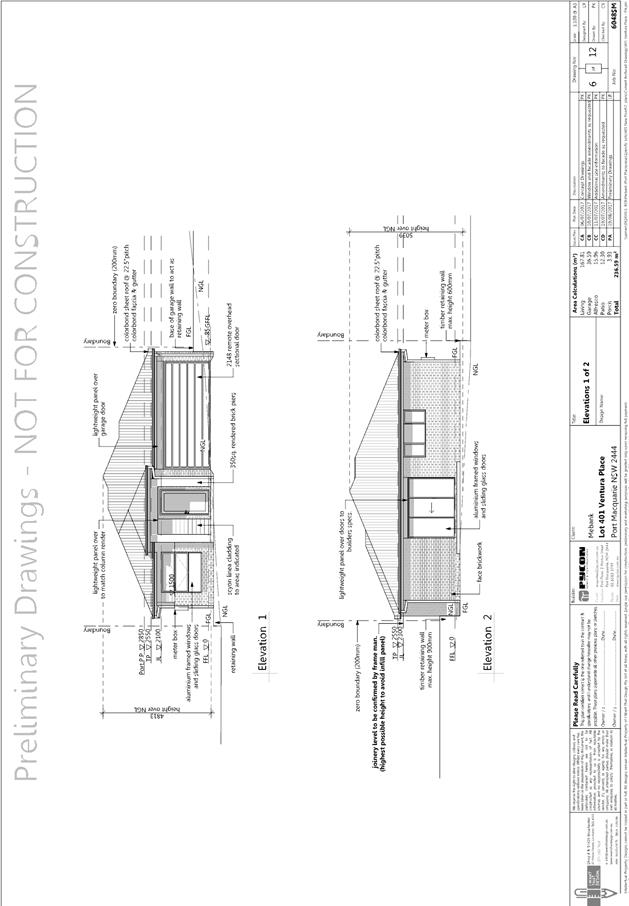
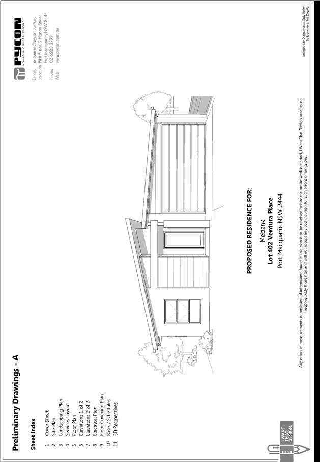
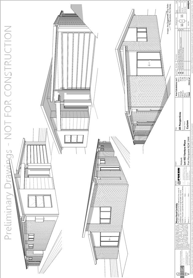
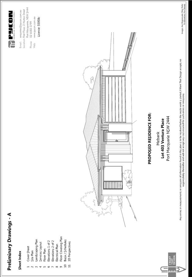
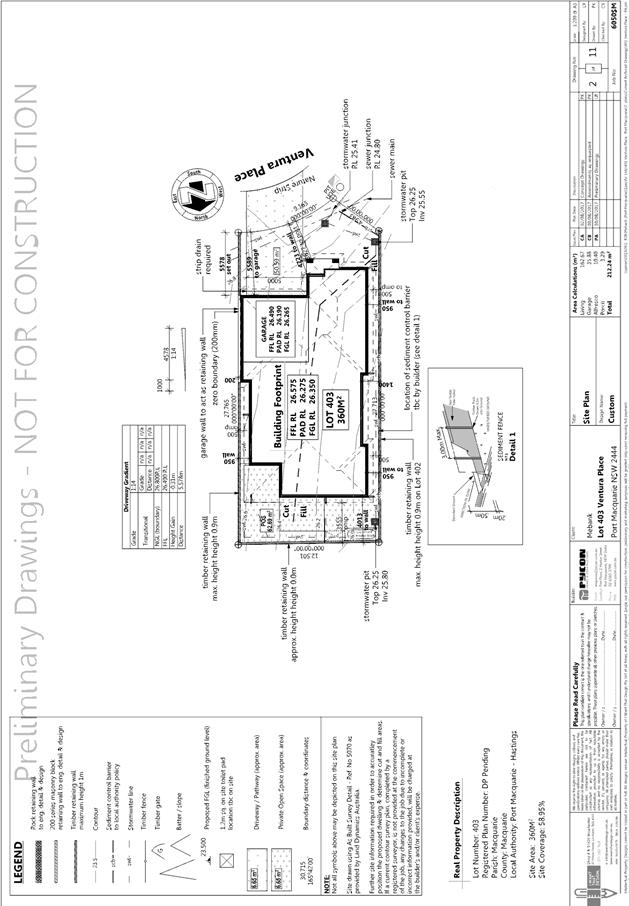
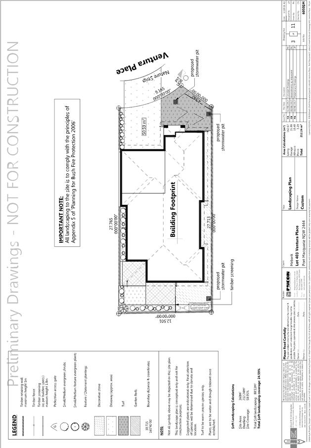
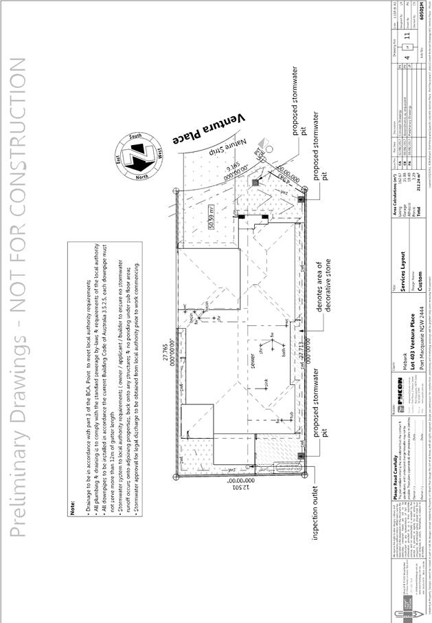
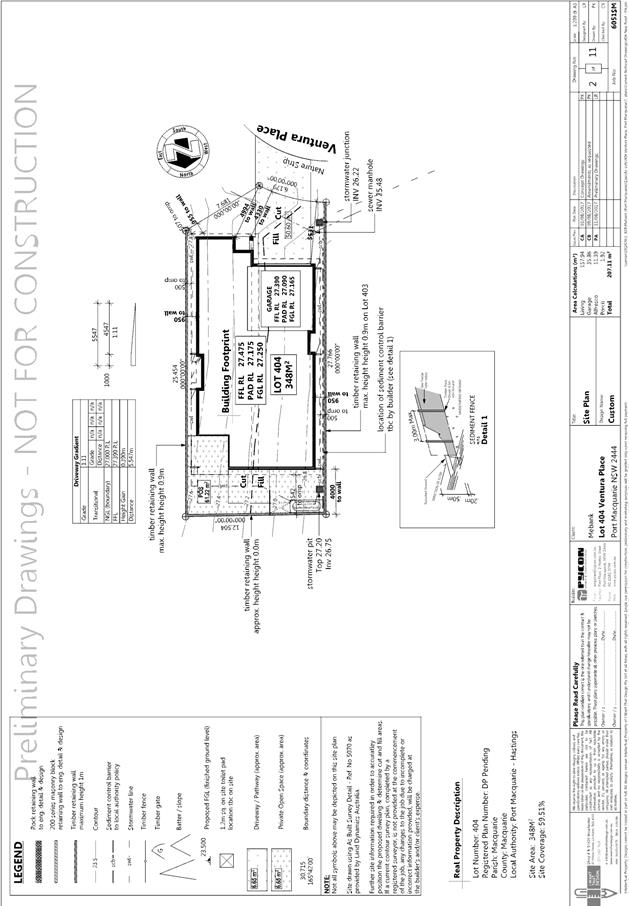
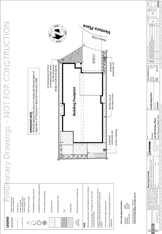
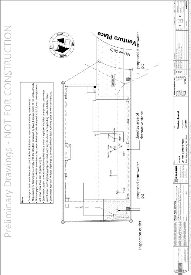
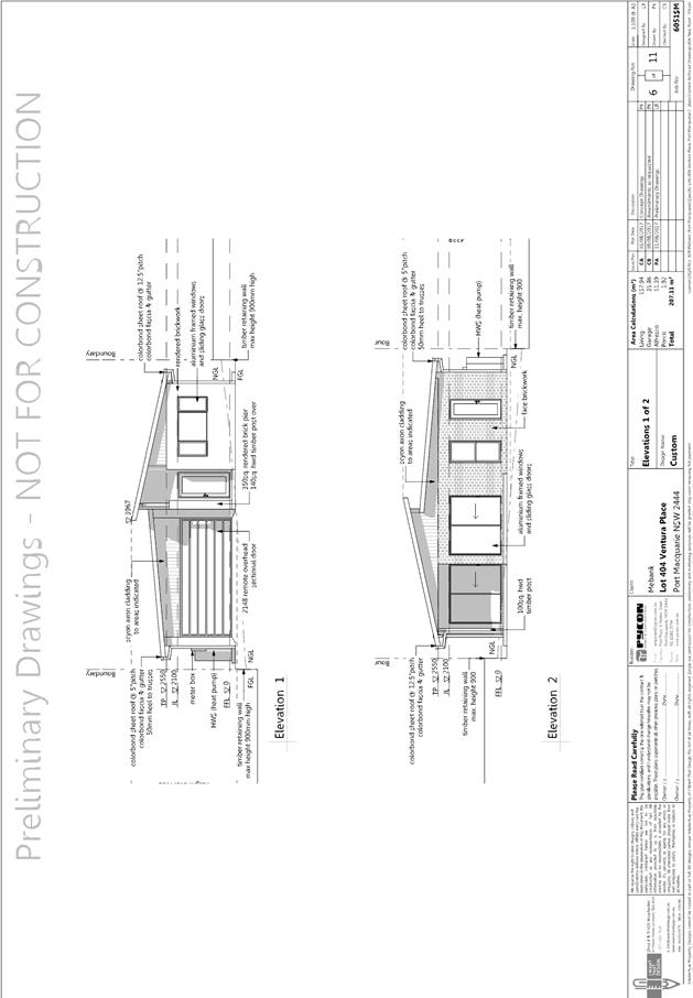
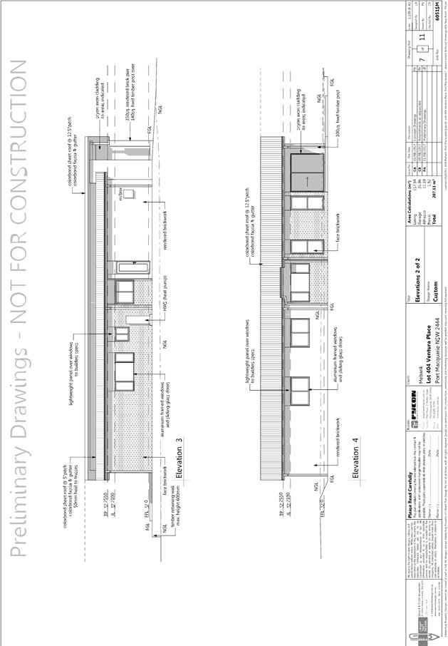
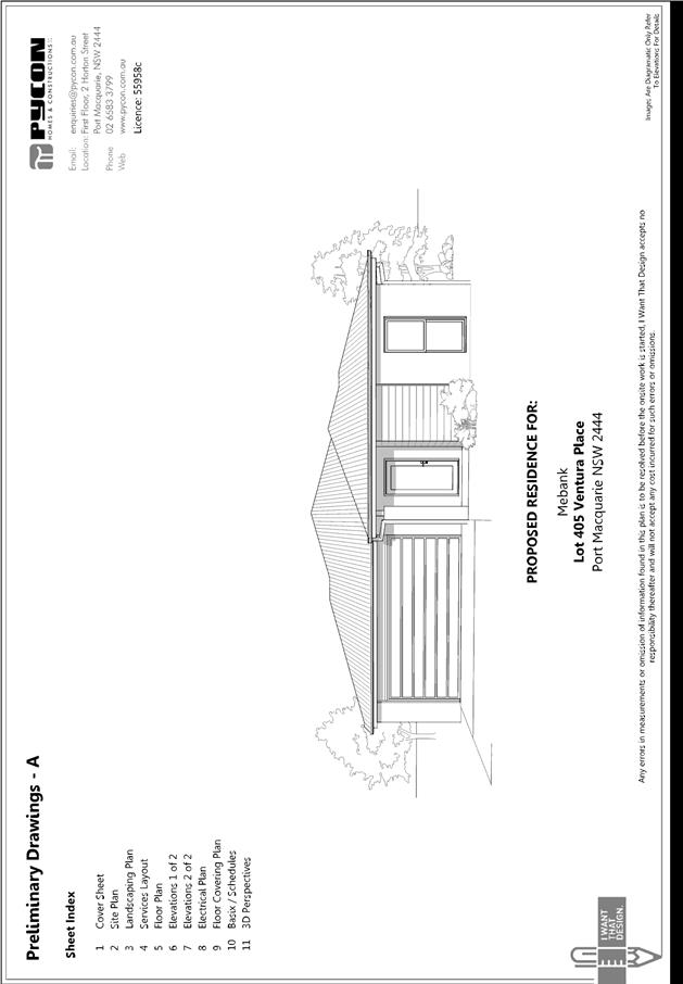
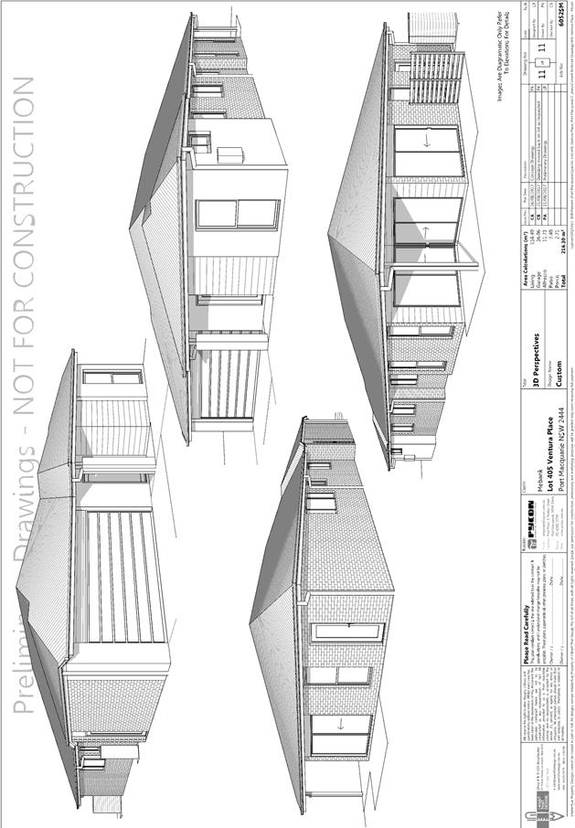
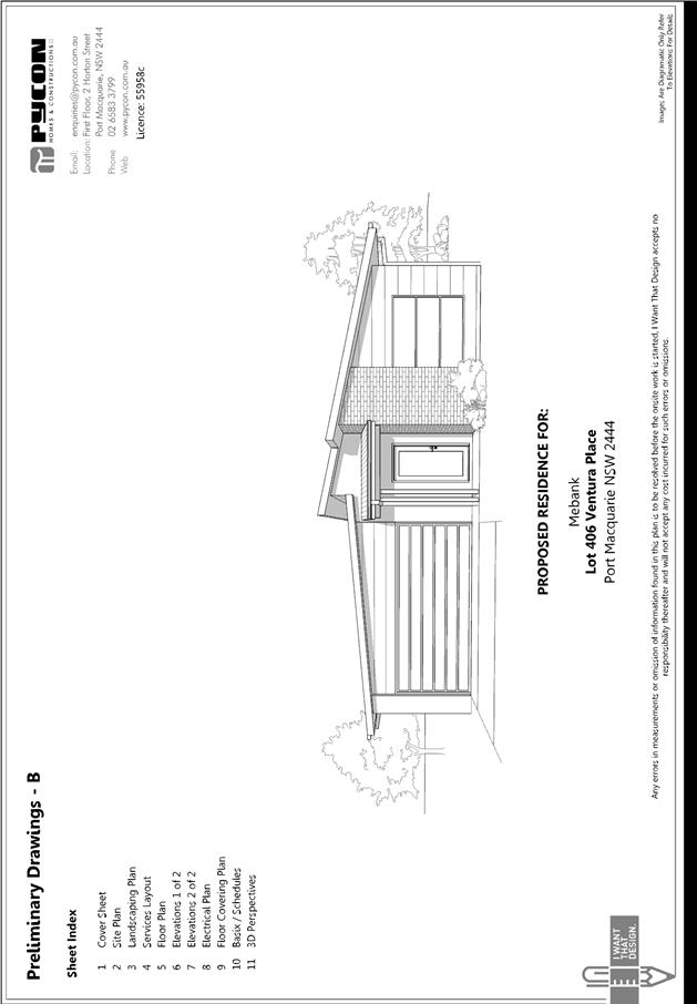
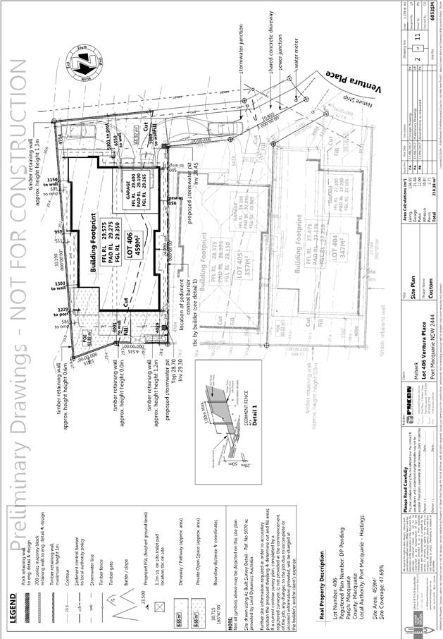
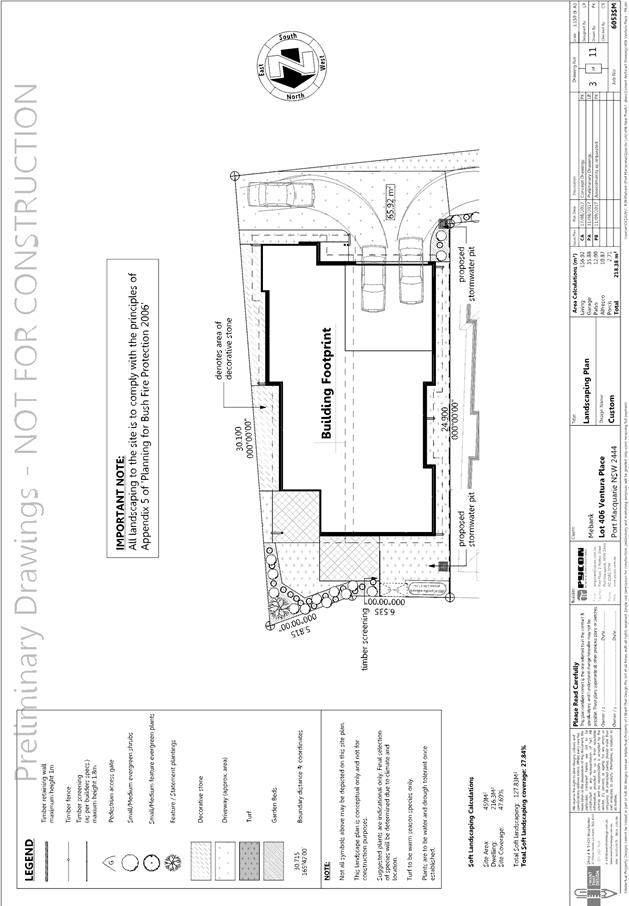
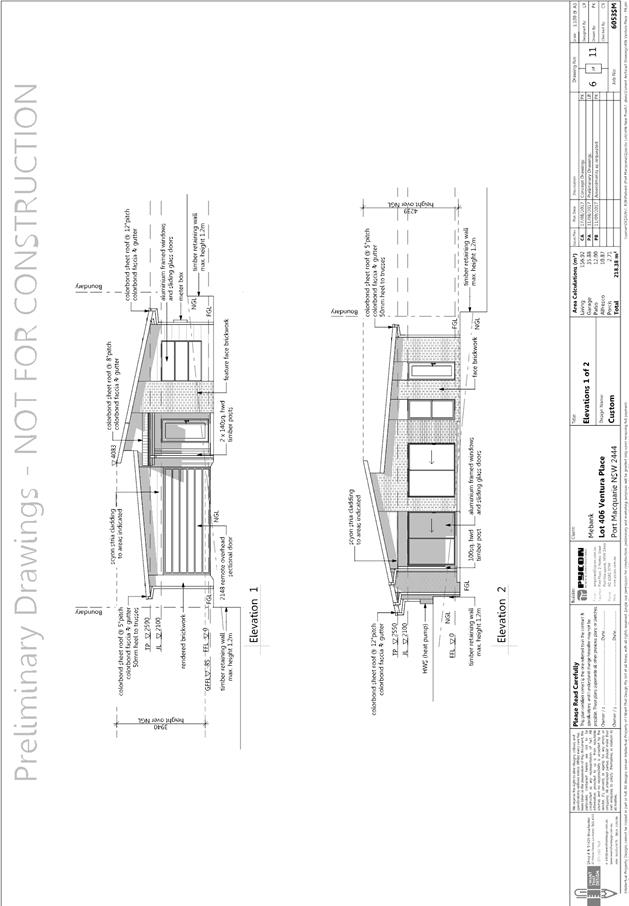
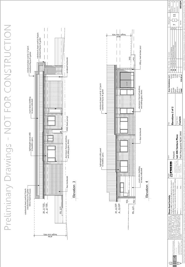
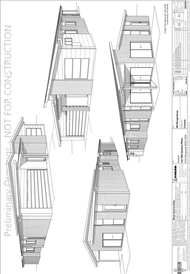
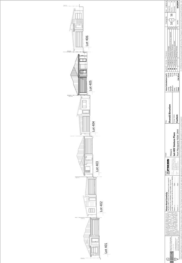
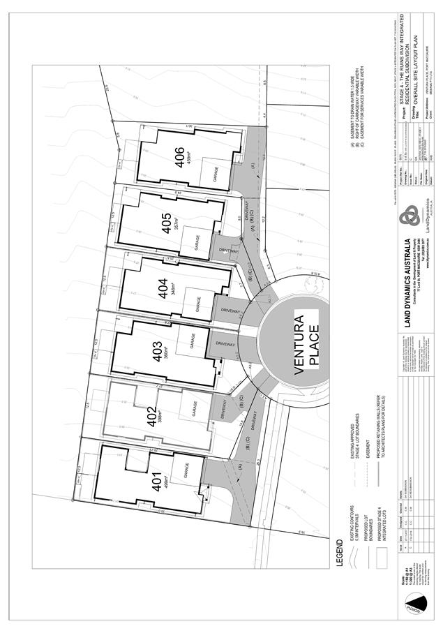
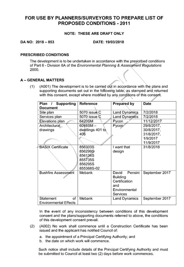
Item: 05
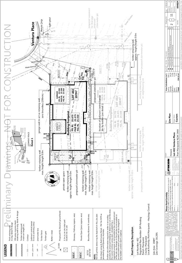
Subject: DA2017 - 853.1 Multi Dwelling Housing and
Torrens Title Subdivision of proposed Lots 401, 402, 403 and 404 - currently
Lot 208, DP 1224779, Ventura Place, Port Macquarie
Report
Author: Benjamin Roberts
|
Applicant: Land
Dynamics Australia
Owner: Precoz
Pty Ltd
Estimated Cost: $1,620,000
Alignment with Delivery
Program
4.3.1 Undertake transparent
and efficient development assessment in accordance with relevant legislation.
|
|
RECOMMENDATION
That
DA 2017 – 853.1 for multi
dwelling housing and torrens title subdivision on proposed Lots 401,
402, 403 and 404, currently Lot 208, DP 1224779,
Ventura Place, Port Macquarie, be determined by granting consent subject to
the recommended conditions.
|
Executive
Summary
This
report considers a development application for multi dwelling housing and
torrens tile subdivision at the subject site and provides an assessment of the
application in accordance with the Environmental Planning and Assessment Act
1979.
Following exhibition of the
application, one (1) submission has been received.
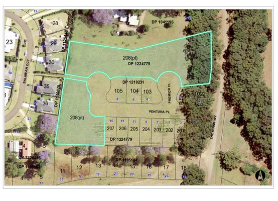
1. BACKGROUND
Existing sites features and Surrounding development
The current site, being Lot 208 DP
1224779, has an area of 8300m2. The
combined area of proposed lots 401, 402, 403 and 404 approved under DA2004/363
is 2423m2.
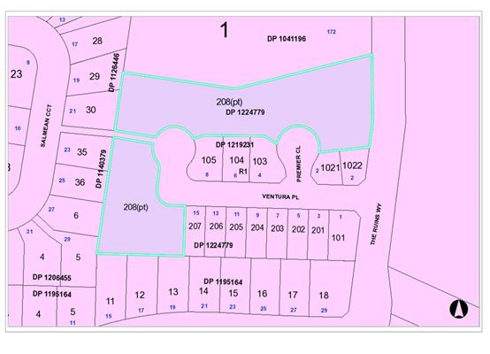
The site is zoned R1 General Residential in accordance with the Port Macquarie-Hastings Local
Environmental Plan 2011, as shown in the following zoning plan:
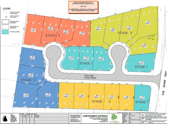
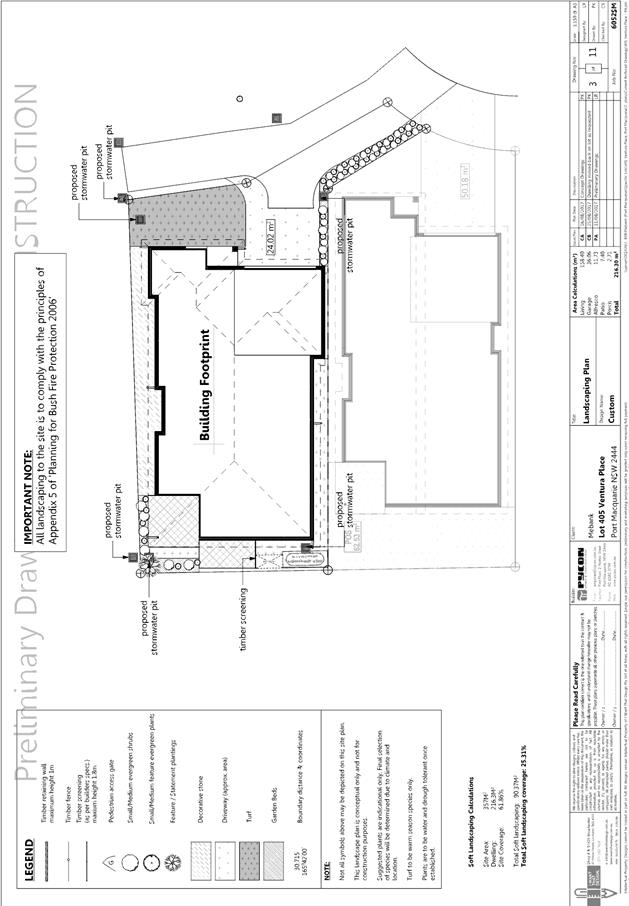
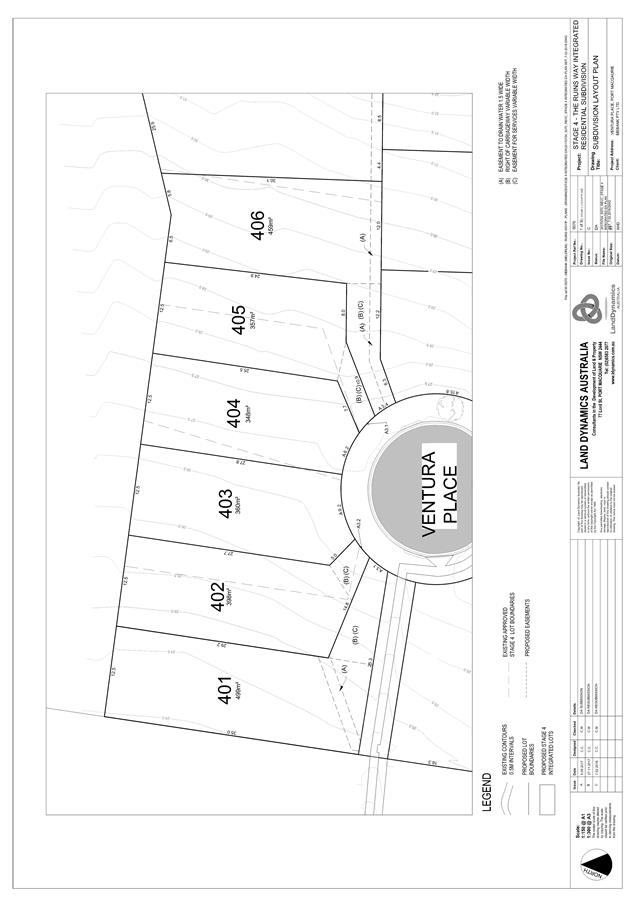
The approved
subdivision plan as recently modified is provided below. The proposal is over
proposed lots 401, 402, 403 and 404 as highlighted in red in stage 4. The
proposed application would essentially ‘supersede’ the underlying
subdivision.
The existing subdivision pattern and location of existing
development within the locality is shown in the following aerial photograph:
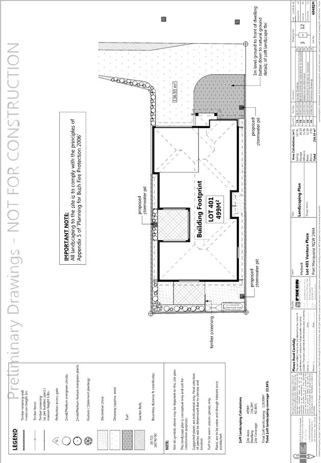
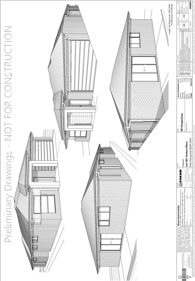
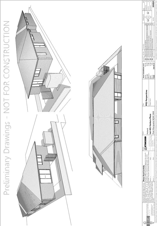
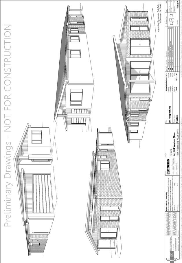
2. DESCRIPTION OF
DEVELOPMENT
Key aspects of the proposal include the following:
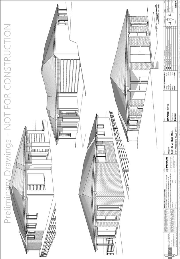
· Erection
of multi dwelling housing comprising six dwellings and associated
infrastructure
· Torrens
title subdivision
Refer
to attachments at the end of this report.
Application Chronology
· 22
September 2017 – Application lodged.
· 6
October 2017 – Additional information request (integrated referral
cheque).
· 9
October 2017 – Cheque received and referred to NSW Rural Fire Service.
· 11 to 24 October 2017 – Public exhibition via
neighbour notification.
· 15 November 2017 – Additional information request.
Proposal inconsistent with approved subdivision creating the lots. Overall site
plan and elevations.
· 13 December 2017 – Overall site and elevation plans
received.
· 16 December 2017 – Section 96 modification lodged to
amend inconsistency with lot boundaries under DA2004/363.
· 31 January 2018 – Additional information request.
Right of Carriageways (ROC) required. Driveways and ROCs to be illustrated on
plans.
· 14 February 2018 – Revised plans received.
· 27 February 2018 – Section 96 application approved
for amendment to lot boundaries of DA2004/363.
3. STATUTORY ASSESSMENT
Section 79C(1) Matters for Consideration
In determining the application, Council is required to take
into consideration the following matters as are relevant to the development
that apply to the land to which the development application relates:
(a) The provisions (where
applicable) of:
(i) Any Environmental
Planning Instrument:
State Environmental Planning Policy No. 44 - Koala Habitat
Protection
There is no Koala Plan of
Management on the site. Additionally, the site is less than 1ha in area.
Therefore, no further investigations are required.
State Environmental Planning
Policy No.55 – Remediation of Land
Following an inspection of the site and a search of Council
records, the subject land is not identified as being potentially contaminated
and is suitable for the intended use.
Standard conditions of consent will be applied to cover the
removal of any asbestos in the existing dwelling during the demolition process.
State Environmental Planning
Policy No. 62 – Sustainable Aquaculture
Given the nature of the proposed
development and proposed stormwater controls the proposal will be unlikely to
have any adverse impact on existing aquaculture industries.
State Environmental Planning Policy (Building
Sustainability Index: BASIX) 2004
A BASIX certificate has been
submitted demonstrating that the proposal will comply with the requirements of
the SEPP. It is recommended that a condition be imposed to ensure that
the commitments are incorporated into the development and certified at
Occupation Certificate stage.
Port
Macquarie-Hastings Local Environmental Plan 2011 (LEP 2011)
The proposal is consistent with the LEP having regard to the
following:
· Clause 2.2, the
subject site is zoned R1 General Residential. In accordance with clause 2.3(1)
and the R1 zone landuse table, the proposed multi dwelling housing and strata
subdivision, is a permissible landuse with consent.
The objectives of the R1 zone are as
follows:
o To provide for the housing
needs of the community.
o To provide for a variety of
housing types and densities.
o To enable other land uses that
provide facilities or services to meet the day to day needs of residents.
In accordance with Clause 2.3(2), the
proposal is consistent with the zone objectives as it is a permissible landuse,
will contribute to the range of housing options available and is compatible
with the residential locality.
· Clause 4.1, does
not apply a multi dwelling housing development – see Clause 4.1A below.
· Clause 4.1A allows
an integrated housing application whereby construction and subdivision are
included in the one application. When both construction and subdivision are
included in the one application, Clause 4.1A allows the minimum lot size
standard to be varied/reduced.
The intent of the clause is to encourage
housing diversity without compromising residential amenity. This overall
assessment shows that the development will have limited impact on adjoining
properties. The surrounding area also contains a mixture of low and medium to
high density residential development. This proposal will be consistent with
this density and character.
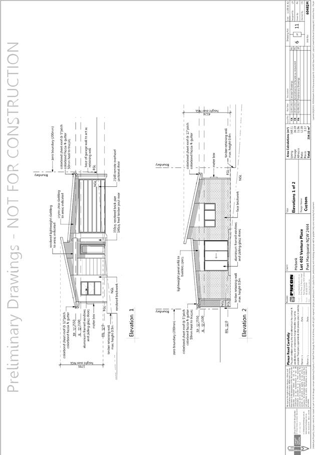
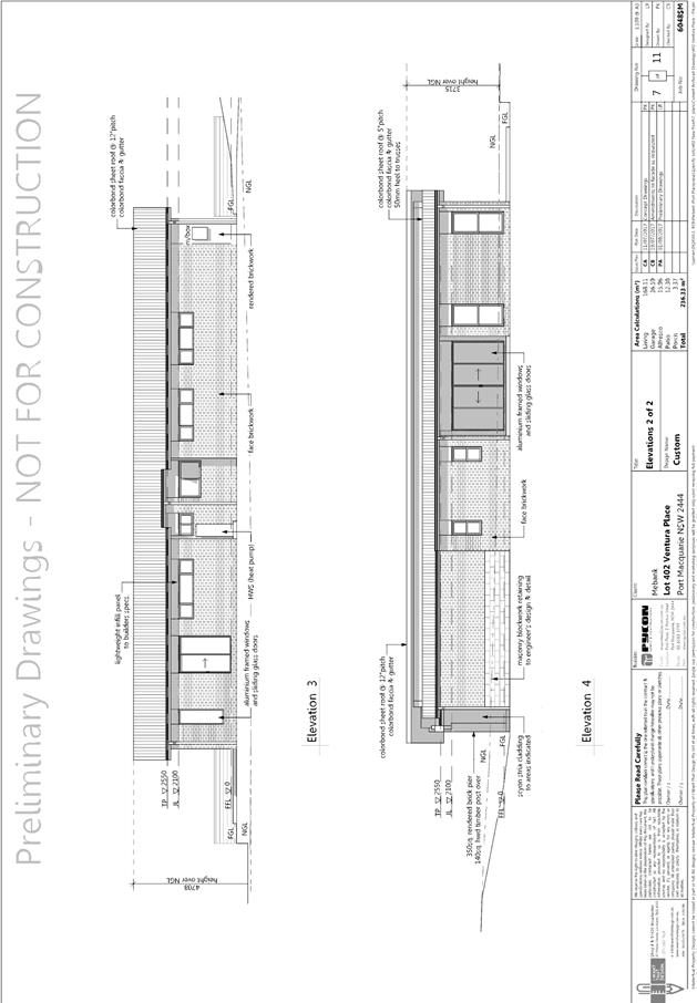
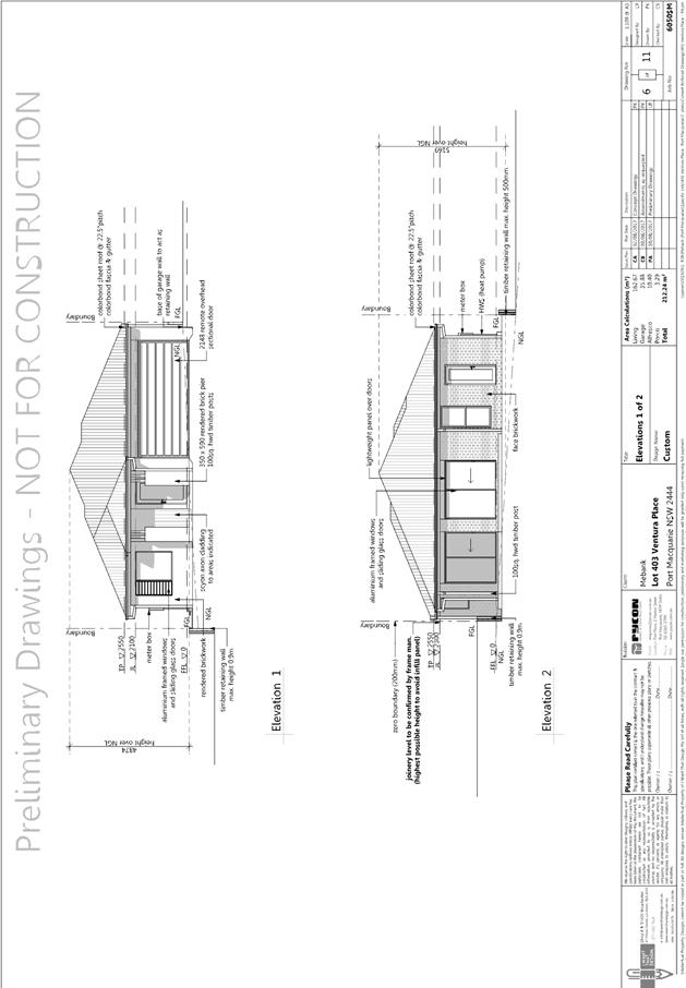
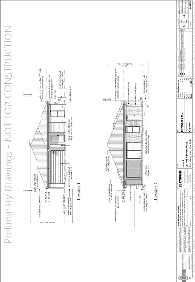
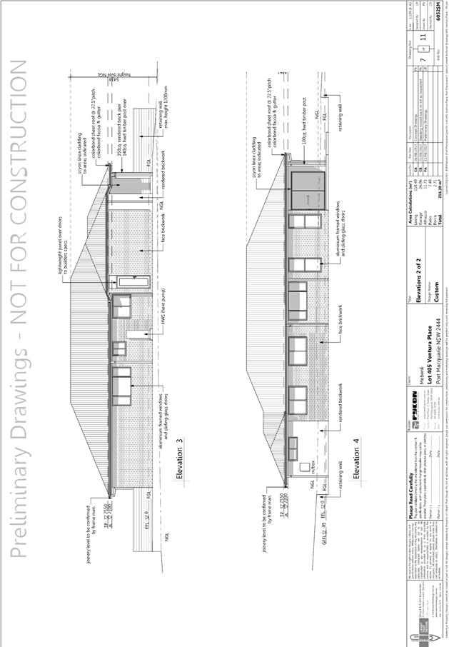
· Clause 4.3, the maximum overall height of the
building above ground level (existing) is 5.5m, which complies with the
standard height limit of 8.5m applying to the site.
· Clause 4.4, the
floor space ratio of the proposal is 0.41:1.0, which complies with the maximum
0.65:1 floor space ratio applying to the site.
· Clause 5.9, there
are no trees to be removed from the site.
· Clause 5.10, the
site does not contain or adjoin any known heritage items or sites of
significance.
· Clause 7.13,
satisfactory arrangements are in place for provision of essential services.
(ii) Any
draft instruments that apply to the site or are on exhibition:
None relevant
to the proposal.
(iii) Any
Development Control Plan in force:
Port
Macquarie-Hastings Development Control Plan 2013
|
DCP 2013: Dwellings, Dual
occupancies, Dwelling houses, Multi dwelling houses & Ancillary
development
|
|
|
Requirements
|
Proposed
|
Complies
|
|
3.2.2.1
|
Ancillary development:
• 4.8m max. height
• Single storey
• 60m2 max. area
• 100m2 for lots
>900m2
• 24 degree max.
roof pitch
• Not located in
front setback
|
Water tank and drying areas are
appropriately located behind the front building line.
Bin areas capable of being
located behind building line.
|
Yes
|
|
3.2.2.2
|
Articulation zone:
• Min. 3m front
setback
• An entry feature
or portico
• A balcony, deck,
patio, pergola, terrace or verandah
• A window box
treatment
• A bay window or
similar feature
• An awning or
other feature over a window
• A sun shading
feature
|
Front porch on dwelling 403 located 3.5m from boundary at
closest point.
|
Yes
|
|
Front setback (Residential not R5
zone):
• Min. 4.5m local
road or within 20% of adjoining dwelling if on corner lot.
|
Front building line setback
requirements are complied with. The closest point to front boundary is
dwelling 403 with a 4.8m setback
|
Yes
|
|
3.2.2.3
|
Garage 5.5m min. and 1m behind
front façade.
Garage door recessed behind
building line or eaves/overhangs provided
|
Garage door setback requirements
are complied with.
|
Yes
|
|
6m max. width of garage door/s
and 50% max. width of building
|
Garage doors are compliant with
the provisions of the DCP.
|
Yes
|
|
Driveway crossover 1/3 max. of
site frontage and max. 5.0m width
|
While the driveway crossing width
exceed 1/3 of the site frontage and 5m width. The variation is considered
acceptable given the street cul-de-sac. The development control is not
considered to be practical in this circumstance. Each dwelling is considered
to provide for good street presentation and the development overall will not
create any adverse impact on the streetscape, amenity of the area or
significant loss of on street parking.
|
No, but acceptable.
|
|
3.2.2.4
|
4m min. rear setback. Variation
subject to site analysis and provision of private open space
|
Dwellings 401,402,403,404 and 406
all provide a 4m rear setback. Dwelling 405 is setback 2m from rear boundary
at closest point.
|
No – refer to comment below
|
|
3.2.2.5
|
Side setbacks:
• Ground floor = min.
0.9m
• Building wall
set in and out every 12m by 0.5m
|
The minimum side setback
requirements are complied with.
The wall articulation is
compliant and satisfies the objectives of the development provision.
|
Yes
|
|
3.2.2.6
|
35m2 min. private open space area
including a useable 4x4m min. area which has 5% max. grade
|
Each occupancy contains a 4m x 4m area and minimum of 35m² open
space in one area (dwelling 405 has smallest area at 37m2).
|
Yes.
|
|
3.2.2.10
|
Privacy:
• Direct views
between living areas of adjacent dwellings screened when within 9m radius of
any part of window of adjacent dwelling and within 12m of private open space
areas of adjacent dwellings. ie. 1.8m fence or privacy screening which has
25% max. openings and is permanently fixed
• Privacy screen
required if floor level > 1m height, window side/rear setback (other than
bedroom) is less than 3m and sill height less than 1.5m
• Privacy screens
provided to balconies/verandahs etc. which have <3m side/rear setback and
floor level height >1m
|
The development will not compromise privacy in the area
due to a combination slab on ground single storey construction and 1.8m
boundary fencing.
|
Yes
|
|
DCP 2013: General
Provisions
|
|
|
Requirements
|
Proposed
|
Complies
|
|
2.7.2.2
|
Design addresses generic principles of Crime Prevention
Through Environmental Design guideline
|
No concealment or entrapment areas proposed. Adequate
casual surveillance available. Fencing defines property boundaries.
|
Yes
|
|
2.3.3.1
|
Cut and fill 1.0m max. 1m outside the perimeter of the
external building walls
|
No cut or fill greater than 1m proposed
|
Yes
|
|
2.5.3.2
|
New accesses not permitted from arterial or distributor
roads
|
No new access proposed to arterial or distribution road.
|
N/A
|
|
Driveway crossing/s minimal in number and width including
maximising street parking
|
Driveway crossing is minimal in width and retains street
parking.
|
Yes
|
|
2.5.3.3
|
Parking in accordance with Table 2.5.1.
Dwelling/dual occupancies
1 space per dwelling/occupancy (behind building line).
Multi dwelling
1 space per 1 & 2 bedroom occupancies
1.5 spaces per 3+ bedroom occupancies
0.25 spaces per occupancy for visitor parking.
|
Proposal involves 6 x 4 bedroom units. Therefore, 6 x 1.5
spaces + 6 x 0.25 visitor spaces = 10.5 spaces required. The development
proposes double garages for each unit (i.e. 6 x 2 spaces = 12 spaces) and
visitor stack parking in front of each dwelling. The proposal exceeds the
requirements of the DCP.
|
Yes
|
|
2.5.3.11
|
Section 94 contributions
|
Contributions apply - refer to ET calc and NOP.
|
Yes
|
|
2.5.3.12 and 2.5.3.13
|
Landscaping of parking areas
|
Suitable landscaping areas proposed around
driveway/parking locations.
|
Yes
|
|
2.5.3.14
|
Sealed driveway surfaces unless justified
|
Sealed driveway areas proposed.
|
Yes
|
|
2.5.3.15 and 2.5.3.16
|
Driveway grades first 6m or ‘parking area’
shall be 5% grade with transitions of 2m length
|
Driveway grades capable of satisfying Council standard
driveway crossover requirements. Condition recommended for section 138 Roads
Act permit
|
Yes
|
|
2.5.3.17
|
Parking areas to be designed to avoid concentrations of
water runoff on the surface.
|
Stormwater drainage is capable of being managed.
|
Yes
|
Note: Subdivision provisions of
the DCP (except battle axe handle width) are aimed at the creation of vacant
lots (i.e. not lots within an integrated housing proposal such as this) and
have therefore been excluded from the above assessment. Servicing requirements
are discussed later in this report.
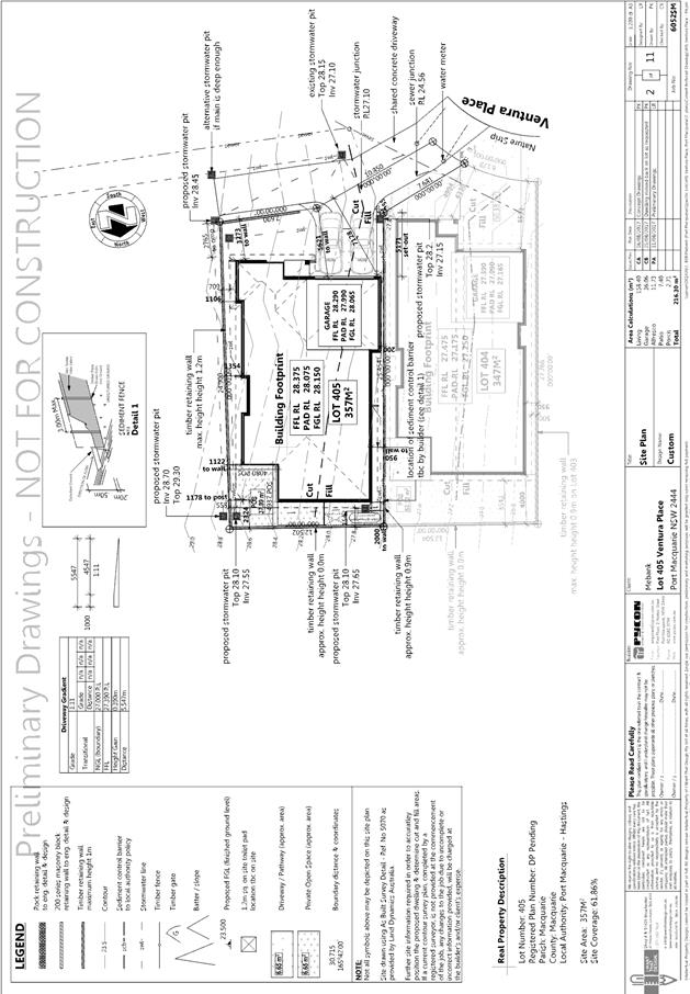
3.2.2.4 – Rear building
setback
The objectives of this Clause are
as follows:
· To allow
adequate natural light and ventilation between dwellings/buildings and to
provide private open space areas.
· To
provide usable yard areas and open space
The proposed rear setback to
dwelling 405 is 2m at the closest point. The variation is considered acceptable
having regard for the following:
· The
private open space are is 37m2 with a 4m x 4m area.
· The
open space area is level, directly accessible off a living areas and considered
to be capable of supporting practical outdoor use associated with the dwelling.
· The
open space area is orientated to the north providing good solar access and
ventilation.
(iiia) Any
planning agreement that has been entered into under Section 93f or any draft
planning agreement that a developer has offered to enter into under Section
93f:
None
relevant.
iv) Any matters prescribed by the
Regulations:
None relevant
v) Any coastal
zone management plan (within the meaning of the Coastal Protection Act 1979),
that apply to the land to which the development application relates:
None relevant
(b) The
likely impacts of that development, including environmental impacts on both the
natural and built environments, social and economic impacts in the locality:
Context
and setting
• The
proposal will be unlikely to have any adverse impacts to existing adjoining
properties and satisfactorily addresses the public domain.
• The
proposal is considered to be consistent with other residential development in
the locality and adequately addresses planning controls for the area.
• There
are no adverse impacts on existing view sharing.
• There
are no adverse privacy impacts.
• There
are no adverse overshadowing impacts. The proposal does not prevent adjoining
properties from receiving 3 hours of sunlight to private open space and primary
living areas on 21 June.
Roads
The site
has road frontage to Ventura Place.
Adjacent to the site, Ventura Place is a sealed public road
under the care and control of Council. Ventura Place is a local road with a 7m
formation within a 15m road reserve.
Traffic
and Transport
The traffic associated with the development is unlikely to
have any adverse impacts to the existing road network within the immediate
locality.
Site
Frontage & Access
Access shall comply with Council AUSPEC and Australian
Standards, and conditions have been imposed to reflect these
requirements.
Parking
and Manoeuvring
Parking and driveway widths on site can comply with relevant
Australian Standards (AS 2890) and conditions have been imposed to reflect
these requirements.
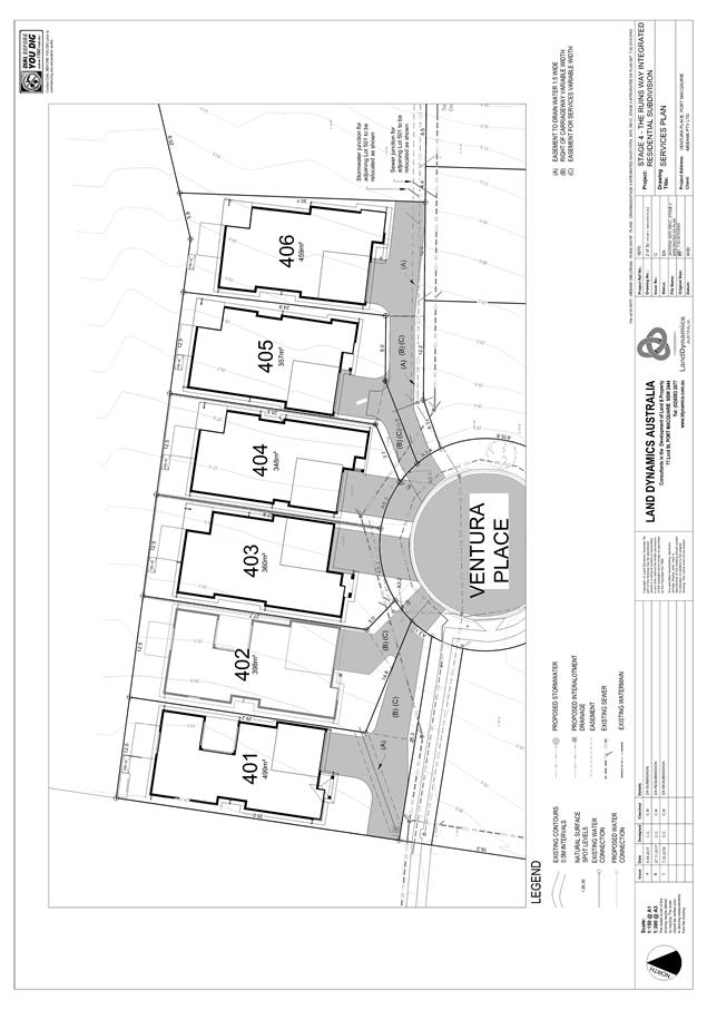
Water Supply Connection
Council records indicate that the development site has four
existing 20mm sealed water services from the 100 PVC water main on the same
side of Ventura Place.
Each lot requires an individual metered water service. The
existing water services must be re-located to suit the proposed lot boundaries.
Water services cannot terminate in potential driveway locations – they
must terminate on either boundary. Details are to be shown on the engineering
plans.
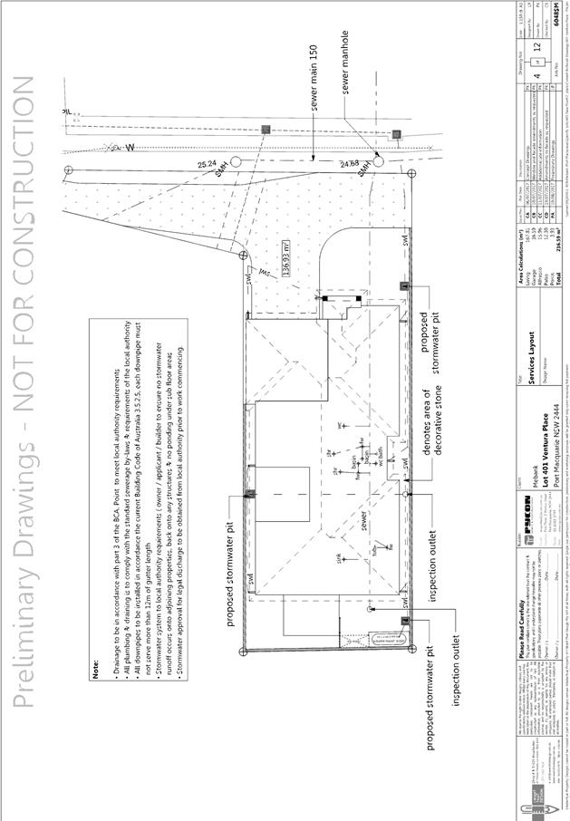
Sewer Connection
Council records indicate that the development site is
connected to sewer via junction to the existing sewer line that runs along the
southern boundary. Each lot requires an individual connection to sewer.
Engineering plans are required to detail how proposed Lot 402 will be able to
drain to the sewer junction shown on the conceptual plan. A sewer main
extension may be required from manhole PM77P156MH. Details are to be shown on
the engineering plans.
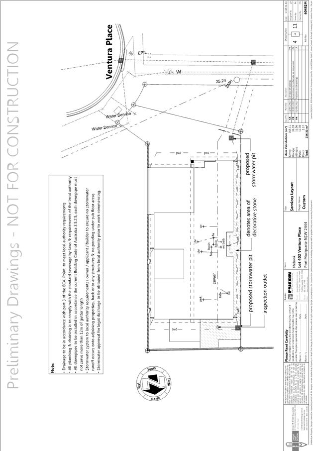
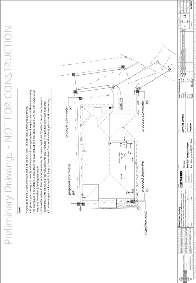
Stormwater
Stormwater from the proposed development is planned to be
disposed via piped interallotment drainage. An engineering solution to
appropriately manage stormwater is considered
capable of being achieved. A detailed site stormwater management plan will be
required to be submitted for assessment with the S.68 application and prior to
the issue of a construction certificate.
In accordance with Councils AUSPEC requirements, the
following will be required to be incorporated into the stormwater drainage
plan:
· On site stormwater
detention facilities
· Provision of
interallotment drainage to allow the proposed development to drain to the
nominated point of discharge via a single suitably sized conduit
Other
Utilities
Telecommunication
and electricity services are available to the site.
Other land
resources
No adverse
impacts anticipated. The site is within an established urban context and will
not sterilise any significant mineral or agricultural resource.
Water
cycle
The proposed
development will be unlikely to have any adverse impacts on water resources and
the water cycle.
Soils
The proposed
development will be unlikely to have any adverse impacts on soils in terms of
quality, erosion, stability and/or productivity subject to a standard condition
requiring erosion and sediment controls to be in place prior to and during
construction.
Air and
microclimate
The
construction and/or operations of the proposed development will be unlikely to
result in any adverse impacts on the existing air quality or result in any
pollution.
Flora and
fauna
Construction
of the proposed development will not require any removal/clearing of any
significant vegetation and therefore will be unlikely to have any significant
adverse impacts on biodiversity or threatened species of flora and fauna.
Waste
Due to the
insufficient frontage of the development to support conventional kerbside
collection. A condition has been recommended requiring a restriction on the
title of the allotments requiring owners to enter into a private waste
management agreement.
Energy
The proposal
includes measures to address energy efficiency and will be required to comply
with the requirements of BASIX.
Noise and
vibration
No adverse
impacts anticipated. Condition recommended to restrict construction to standard
construction hours.
Bushfire
The site is identified as being bushfire prone. As a result,
the applicant has submitted a bushfire report, which has been forwarded to the
NSW Rural Fire Service as integrated development.
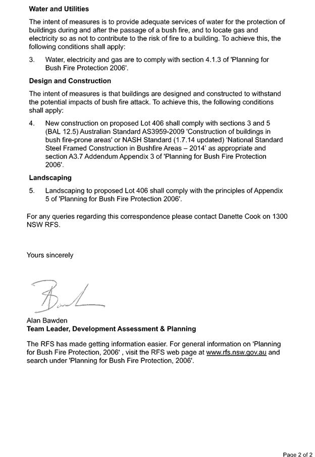
The NSW Rural Fire Service has subsequently issued a
Bushfire Safety Authority consisting of a series of conditions, which have been
incorporated into the draft conditions. Council staff concur with the findings
and recommendations of the NSW Rural Fire Service.
Safety,
security and crime prevention
The proposed
development will be unlikely to create any concealment/entrapment areas or
crime spots that would result in any identifiable loss of safety or reduction
of security in the immediate area.
A suitable
level of surveillance of the area will be retained by the design.
Social
impacts in the locality
Given the
nature of the proposed development and its’ location the proposal is
unlikely to result in any adverse social impacts.
Economic
impact in the locality
No adverse
impacts. Likely positive impacts can be attributed to the construction of the
development and associated flow on effects (ie maintained employment and expenditure
in the area).
Site
design and internal design
The proposed
development design satisfactorily responds to the site attributes and will fit
into the locality. No adverse impacts likely.
Construction
No potential
adverse impacts identified to neighbouring properties with the construction of
the proposal. Standard conditions will be imposed to control demolition,
erosion, noise etc.
Cumulative Impacts
The proposed development is not expected to have any
adverse cumulative impacts on the natural or built environment or the social
and economic attributes of the locality.
(c) The suitability of the site for
the development:
The proposal
will fit into the locality and the site attributes are conducive to the
proposed development.
Site
constraints have been adequately addressed and appropriate conditions of
consent recommended.
(d) Any submissions made in
accordance with this Act or the Regulations:
One written submission has been received following public
exhibition of the application.
Key issues raised in the submissions received and comments
in response to these issues are provided as follows:
|
Submission
Issue/Summary
|
Planning
Comment/Response
|
|
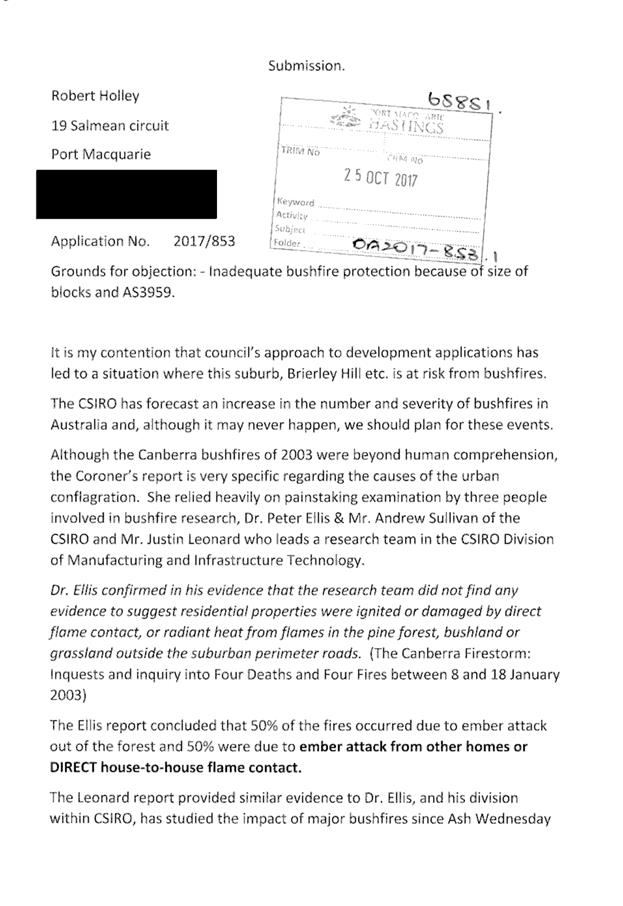
The proposal is subject to
adverse risk of bushfire and the dwellings are inappropriately sited noting
this risk. All the dwellings should be subject to specific bushfire
construction requirements due to the risk of embers, not just dwelling 406.
|
The NSW Rural Fire Service has
issued a conditional bushfire safety authority (BSA) for the development.
These conditions are recommended to be included in any consent. Noting the
issuing of the BSA there are considered insufficient grounds to refuse the
application on bushfire grounds.
|
(e) The Public Interest:
The proposed
development will be in the wider public interest with provision of appropriate
additional housing.
The proposed
development satisfies relevant planning controls and is not expected to impact
on the wider public interest.
4. DEVELOPMENT
CONTRIBUTIONS APPLICABLE
· Development contributions will be required towards
augmentation of town water supply and sewerage system head works under Section
64 of the Local Government Act 1993.
· Development contributions will be required under Section 94
of the Environmental Planning and Assessment Act 1979 towards roads, open
space, community cultural services, emergency services and administration
buildings.
5. CONCLUSION
The application has been assessed in accordance with
Section 79C of the Environmental Planning and Assessment Act 1979.
Issues raised during assessment and public exhibition of
the application have been considered in the assessment of the application.
Where relevant, conditions have been recommended to manage the impacts
attributed to these issues.
The site is suitable for the proposed development, is not
contrary to the public's interest and will not have a significant adverse
social, environmental or economic impact. It is recommended that the
application be approved, subject to the recommended conditions of consent provided
in the attachment section of this report.
|
Attachments
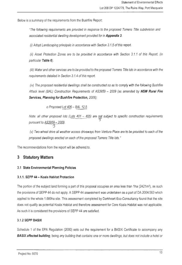
1View. DA2017
- 853.1 Plans
2View. DA2017
- 853.1 Recommended Conditions
3View. DA2017
- 853.1 NSW Bushfire Safety Authority Conditions
4View. DA2017
- 853.1 Submission - Holley
|
|
ATTACHMENT
|
Development Assessment Panel
28/03/2018
|


|
ATTACHMENT
|
Development Assessment Panel
28/03/2018
|


|
ATTACHMENT
|
Development Assessment Panel
28/03/2018
|
|
ATTACHMENT
|
Development Assessment Panel
28/03/2018
|

AGENDA Development Assessment Panel 28/03/2018
Item: 06
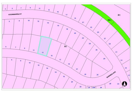
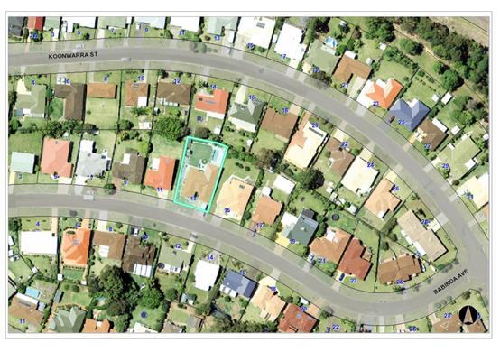
Subject: DA2018 - 91.1 Garage/Shed - Lot 39 DP 790538,
No 13 Babinda Avenue, West Haven
Report
Author: Anthony Crane
|
Applicant: B
J & F L Eldridge
Owner: B
J & F L Eldridge
Estimated Cost: $72,000
Alignment with Delivery
Program
4.3.1 Undertake transparent
and efficient development assessment in accordance with relevant legislation.
|
|
RECOMMENDATION
That
DA2018 – 91.1 for a garage/shed at Lot 39 DP790538, No.13 Babinda
Avenue, West Haven be determined by granting consent subject to the recommended
conditions.
|
Executive
Summary
This
report considers a development application for a garage/shed at the subject site and provides an assessment of the
application in accordance with the Environmental Planning and Assessment Act
1979.
Following exhibition of the
application, one submission has been received.
1. BACKGROUND
Existing sites features and surrounding development
The site has an area of 889.2m2.
The site is zoned R1 General Residential in accordance with the Port Macquarie-Hastings Local
Environmental Plan 2011, as shown in the following zoning plan:
The existing subdivision pattern and location of existing
development within the locality is shown in the following aerial photograph:
2. DESCRIPTION OF
DEVELOPMENT
Key aspects of the proposal include the following:
· Construction
of a brick garage/shed with tiled roof.
· The
building is located in the rear yard with a 0.9m side setback. Originally, the
building had a 0.5m side setback but was later amended to 0.9m.
· Objector
advised of amended site plan showing compliant side setback and advised that he
still wants his submission considered.
Refer
to attachments at the end of this report.
Application Chronology
· Application
lodged 14/02/2018
· One
submission received 12/03/2018
· Amended
site plan received 16/03/2018
3. STATUTORY ASSESSMENT
Section 79C(1) Matters for Consideration
In determining the application, Council is required to take
into consideration the following matters as are relevant to the development
that apply to the land to which the development application relates:
(a) The provisions (where
applicable) of:
(i) Any Environmental
Planning Instrument:
State
Environmental Planning Policy No. 44 - Koala Habitat Protection
There is no
Koala Plan of Management on the site. Additionally, the site is less than 1ha
in area therefore no further investigations are required.
State
Environmental Planning Policy No.55 – Remediation of Land
Following an
inspection of the site and a search of Council records, the subject land is not
identified as being potentially contaminated and is suitable for the intended
use.
State
Environmental Planning Policy No. 62 – Sustainable Aquaculture
Given the
nature of the proposed development and proposed stormwater controls the
proposal will be unlikely to have any adverse impact on existing aquaculture
industries.
State
Environmental Planning Policy No. 71 – Coastal Protection and Clause 5.5
of Port Macquarie-Hastings Local Environmental Plan 2011
The site is
located within a coastal zone as defined in accordance with clause 4 of SEPP
71.
In accordance
with clause 5, this SEPP prevails over the Port Macquarie-Hastings LEP 2011 in
the event of any inconsistency.
Having regard
to clauses 8 and 12 to 16 of SEPP 71 and clause 5.5 of Hastings LEP 2011
inclusive the proposed development will not result in any of the following:
a) any restricted access (or
opportunities for access) to the coastal foreshore
b) any identifiable adverse amenity
impacts along the coastal foreshore and on the scenic qualities of the coast;
c) any identifiable adverse impacts on
any known flora and fauna (or their natural environment);
d) subject to any identifiable adverse
coastal processes or hazards;
e) any identifiable conflict between
water and land based users of the area;
f) any identifiable adverse impacts on
any items of archaeological/heritage;
g) reduce the quality of the natural
water bodies in the locality.
The site is
predominately cleared and located within an area zoned and built out for
residential purposes.
Port Macquarie-Hastings Local Environmental Plan 2011
The proposal
is consistent with the LEP having regard to the following:
· Clause
2.2, the subject site is zoned R1 General Residential. In accordance with
clause 2.3(1) and the R1 zone landuse table, the garage/shed is ancillary to
the dwelling being a permissible landuse with consent.
The
objectives of the R1 zone are as follows:
o To
provide for the housing needs of the community.
o To
provide for a variety of housing types and densities.
o To
enable other land uses that provide facilities or services to meet the day to
day needs of residents.
In accordance with Clause 2.3(2), the proposal is consistent with the
zone objectives as it is a permissible landuse and consistent with the
established residential locality.
· Clause
4.3, the maximum overall height of the building above ground level (existing)
is 4.12m, which complies with the standard height limit of 8.5m applying to the
site.
· Clause
4.4, the floor space ratio of the proposal complies with the maximum 0.65:1
floor space ratio applying to the site.
· Clause
5.9, no listed trees in Development Control Plan 2013 are proposed to be
removed.
· Clause
5.10, the site does not contain or adjoin any known heritage items or sites of
significance.
· Clause
7.1, the site is not mapped as potentially containing acid sulphate soils.
· Clause
7.3, the site is not land within a mapped “flood planning area”.
· Clause
7.13, satisfactory arrangements are in place for provision of essential
services.
(ii) Any
draft instruments that apply to the site or are on exhibition:
No draft
instruments apply to the site.
(iii) Any Development Control Plan in force:
Port
Macquarie-Hastings Development Control Plan 2013
|
DCP
2013: Dwellings, Dual occupancies, Dwelling houses, Multi dwelling houses
& Ancillary development
|
|
|
Requirements
|
Proposed
|
Complies
|
|
3.2.2.1
|
Ancillary development:
• 4.8m
max. height
• Single
storey
• 60m2
max. area
• 100m2
for lots >900m2
• 24
degree max. roof pitch
• Not
located in front setback
|
The shed complies with the
height and size controls and is not located in the front setback.
|
Yes
|
|
3.2.2.4
|
4m min. rear setback.
Variation subject to site analysis and provision of private open space
|
The rear setback requirements
are complied with. In particular, sheds can be located 900mm from rear
boundaries.
|
Yes
|
|
3.2.2.5
|
Side setbacks:
• Ground
floor = min. 0.9m
• First
floors & above = min. 3m setback or where it can be demonstrated that
overshadowing not adverse = 0.9m min.
• Building
wall set in and out every 12m by 0.5m
|
The minimum side setback
requirements are complied with.
The building wall articulation
is compliant and/or satisfactory to address the objective intent of the
development provision.
|
Yes
|
|
3.2.2.6
|
35m2 min. private open space
area including a useable 4x4m min. area which has 5% max. grade
|
The dwelling contains
35m² open space in one area including a useable 4m x 4m space.
|
Yes
|
|
3.2.2.7
|
Front fences:
• If
solid 1.2m max height and front setback 1.0m with landscaping
• 3x3m
min. splay for corner sites
• Fences
>1.2m to be 1.8m max. height for 50% or 6.0m max. length of street
frontage with 25% openings
• 0.9x0.9m
splays adjoining driveway entrances
|
No fences proposed
.
|
N/A
|
|
DCP 2013: General
Provisions
|
|
|
Requirements
|
Proposed
|
Complies
|
|
2.7.2.2
|
Design addresses generic
principles of Crime Prevention Through Environmental Design guideline
|
No concealment or entrapment
areas proposed. Adequate casual surveillance available.
|
Yes
|
|
2.3.3.1
|
Cut and fill 1.0m max. 1m
outside the perimeter of the external building walls
|
Cut and fill <1.0m change
1m outside the perimeter of the external building walls
|
Yes
|
|
2.3.3.2
|
1m max. height retaining walls
along road frontage
|
None proposed
|
N/A
|
|
Any retaining wall >1.0 in
height to be certified by structure engineer
|
No retaining wall likely
>1m
|
Yes
|
|
Combination of retaining wall
and front fence height max 1.8m, max length 6.0m or 30% of frontage, fence
component 25% transparent, and splay at corners and adjacent to driveway
|
No retaining wall front fence
combination proposed.
|
N/A
|
|
2.3.3.8
|
Removal of hollow bearing
trees
|
No trees proposed to be
removed
|
N/A
|
|
2.6.3.1
|
Tree removal (3m or higher
with 100m diameter trunk at 1m above ground level and 3m from external wall
of existing dwelling)
|
No trees proposed to be
removed
|
N/A
|
|
2.4.3
|
Bushfire risk, Acid sulphate
soils, Flooding, Contamination, Airspace protection, Noise and Stormwater
|
Refer to main body of report.
|
|
|
2.5.3.2
|
New accesses not permitted
from arterial or distributor roads
|
No new access proposed to
arterial or distribution road.
|
N/A
|
|
Driveway crossing/s minimal in
number and width including maximising street parking
|
Driveway crossing existing
|
N/A
|
|
2.5.3.3
|
Parking in accordance with Table
2.5.1.
1 space per single dwelling
(behind building line)
|
1 or capacity for more than 1
parking space behind the building line has been provided for.
|
Yes
|
|
2.5.3.11
|
Section 94 contributions
|
Refer to main body of report.
|
|
|
2.5.3.12 and 2.5.3.13
|
Landscaping of parking areas
|
Single dwelling only with 1
domestic driveway. No specific landscaping requirements recommended.
|
N/A
|
|
2.5.3.14
|
Sealed driveway surfaces
unless justified
|
Sealed driveway existing
|
N/A
|
|
2.5.3.15 and 2.5.3.16
|
Driveway grades first 6m or
‘parking area’ shall be 5% grade with transitions of 2m length
|
N/A
|
N/A
|
|
2.5.3.17
|
Parking areas to be designed
to avoid concentrations of water runoff on the surface.
|
N/A
|
N/A
|
iiia) any planning agreement that
has been entered into under Section 93f or any draft planning agreement that a
developer has offered to enter into under Section 93f:
No planning
agreement has been offered or entered into relating to the site.
iv) Any matters prescribed by
the regulations
NSW
Coastal Policy 1997
The proposed
development is consistent with the objectives and strategic actions of this
policy.
Demolition
of buildings AS 2601:
N/A
v) Any coastal
zone management plan (within the meaning of the Coastal Protection Act 1979), that apply to the land
to which the development application relates:
None
applicable.
(b) The likely impacts of
that development, including environmental impacts on both the natural and built
environments and the social and economic impacts in the locality
Context
and setting
• The
proposal will be unlikely to have any adverse impacts to existing adjoining
properties and satisfactorily addresses the public domain.
• The
proposal is considered to be consistent with other residential development in
the locality and adequately addresses planning controls for the area.
• There
are no adverse impacts on existing view sharing.
• There
are no adverse privacy impacts.
• There
are no adverse overshadowing impacts. The proposal does not prevent adjoining
properties from receiving 3 hours of sunlight to private open space and primary
living areas on 21 June.
Access,
transport and traffic
The proposal
will be unlikely to have any adverse impacts in terms access, transport and
traffic. The existing road network will satisfactorily cater for any increase
in traffic generation as a result of the development.
Stormwater
Service
available – details required with S.68 application
Other
Utilities
Telecommunication
and electricity services are available to the site.
Heritage
This site
does not contain or adjoin any known heritage item or site of significance.
Other land
resources
No adverse
impacts anticipated. The site is within an established urban context and will
not sterilise any significant mineral or agricultural resource.
Water
cycle
The proposed
development will be unlikely to have any adverse impacts on water resources and
the water cycle.
Soils
The proposed
development will be unlikely to have any adverse impacts on soils in terms of
quality, erosion, stability and/or productivity subject to a standard condition
requiring erosion and sediment controls to be in place prior to and during
construction.
Air and
microclimate
The
construction and/or operations of the proposed development will be unlikely to
result in any adverse impacts on the existing air quality or result in any
pollution.
Flora and
fauna
Construction
of the proposed development will not require any removal/clearing of any
significant vegetation and therefore will be unlikely to have any significant
adverse impacts on biodiversity or threatened species of flora and fauna.
Waste
Satisfactory
arrangements are in place for proposed storage and collection of waste and
recyclables. No adverse impacts anticipated.
Noise and
vibration
No adverse
impacts anticipated. Condition recommended to restrict construction to standard
construction hours.
Bushfire
The site is
not identified as being bushfire prone.
Safety,
security and crime prevention
The proposed
development will be unlikely to create any concealment/entrapment areas or
crime spots that would result in any identifiable loss of safety or reduction
of security in the immediate area.
Social
impacts in the locality
Given the
nature of the proposed development and its’ location the proposal is
unlikely to result in any adverse social impacts.
Economic
impact in the locality
No adverse
impacts. Likely positive impacts can be attributed to the construction of the
development and associated flow on effects (ie maintained employment and
expenditure in the area).
Site
design and internal design
The proposed
development design satisfactorily responds to the site attributes and will fit
into the locality. No adverse impacts likely.
Construction
No potential
adverse impacts identified to neighbouring properties with the construction of
the proposal.
Cumulative
impacts
The proposed
development is not expected to have any adverse cumulative impacts on the
natural or built environment or the social and economic attributes of the
locality.
(c) The
suitability of the site for the development
The proposal
will fit into the locality and the site attributes are conducive to the
proposed development.
Site
constraints have been adequately addressed and appropriate conditions of
consent recommended.
(d) Any submissions made
in accordance with this Act or the Regulations:
One written submission has been received following public
exhibition of the application.
Key issues raised in the submissions received and comments
in response to these issues are provided as follows:
|
Submission
Issue/Summary
|
Planning
Comment/Response
|
|
Ground in drainage easement in
objector’s property adjacent to boundary has subsided and is considered
to be unstable. Proposed building has potential to cause further damage to
this area.
|
Proposed building to be sited
0.9m from boundary on stable, natural ground. Structural engineer’s
design for footings provided. Stormwater to be directed to existing system.
|
|
View across eastern side boundary will be blocked by
proposed building.
|
No iconic views available. View to rear remains unchanged
for adjoining property. Views across side boundaries cannot be guaranteed.
Proposed building complies fully with Council’s DCP 2013.
Based on the above, no adverse view loss will occur and
suitable view sharing retained.
|
(e) The Public Interest:
The proposed
development satisfies relevant planning controls and is unlikely to impact on
the wider public interest.
4. DEVELOPMENT
CONTRIBUTIONS APPLICABLE
· Not applicable to garage/shed.
5. CONCLUSION
The application has been assessed in accordance with
Section 79C of the Environmental Planning and Assessment Act 1979.
Issues raised during assessment and public exhibition of
the application have been considered in the assessment of the application.
Where relevant, conditions have been recommended to manage the impacts
attributed to these issues.
The site is suitable for the proposed development, is not
contrary to the public's interest and will not have a significant adverse
social, environmental or economic impact. It is recommended that the application
be approved, subject to the recommended conditions of consent provided in the
attachment section of this report.
|
Attachments
1View. DA2018
- 91.1 Plans
2View. DA2018
- 91.1 Recommended Conditions
3View. DA2018
- 91.1 Submission - Bewley
|
|
ATTACHMENT
|
Development Assessment Panel
28/03/2018
|
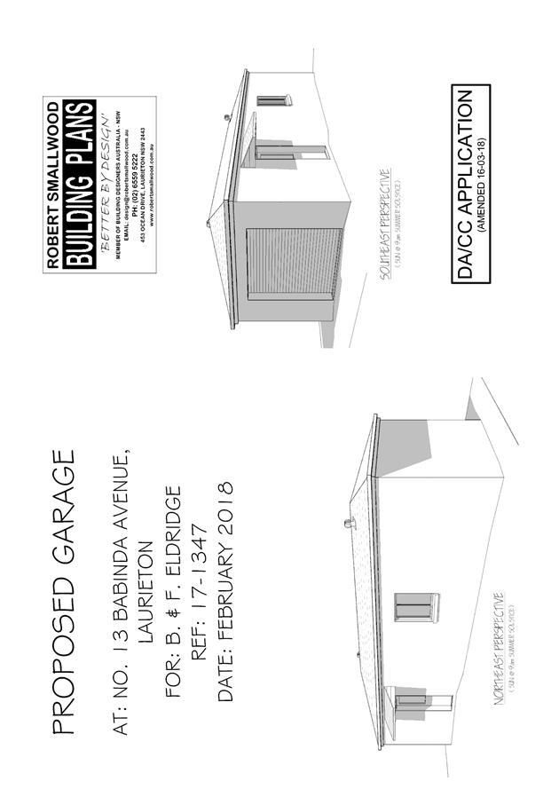
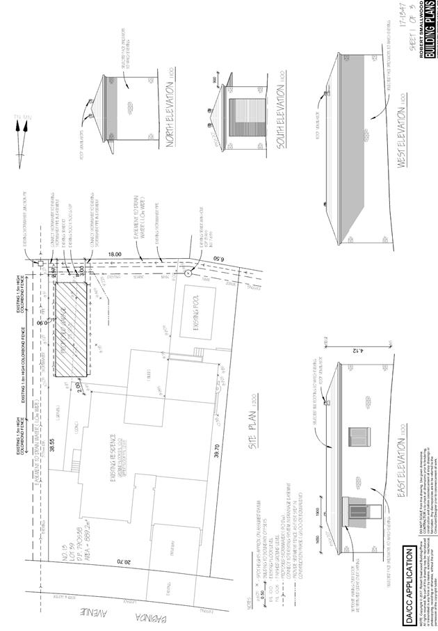
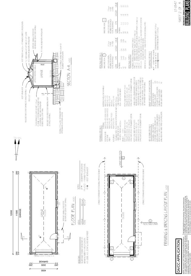
|
ATTACHMENT
|
Development Assessment Panel
28/03/2018
|
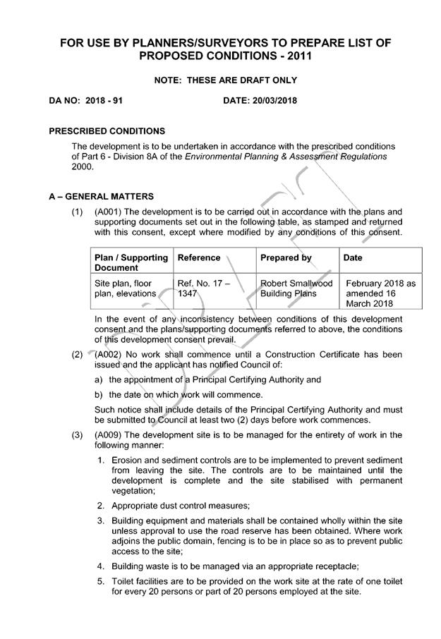

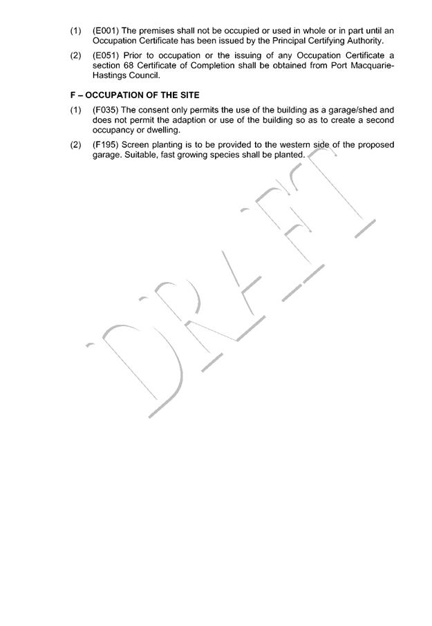
|
ATTACHMENT
|
Development Assessment Panel
28/03/2018
|
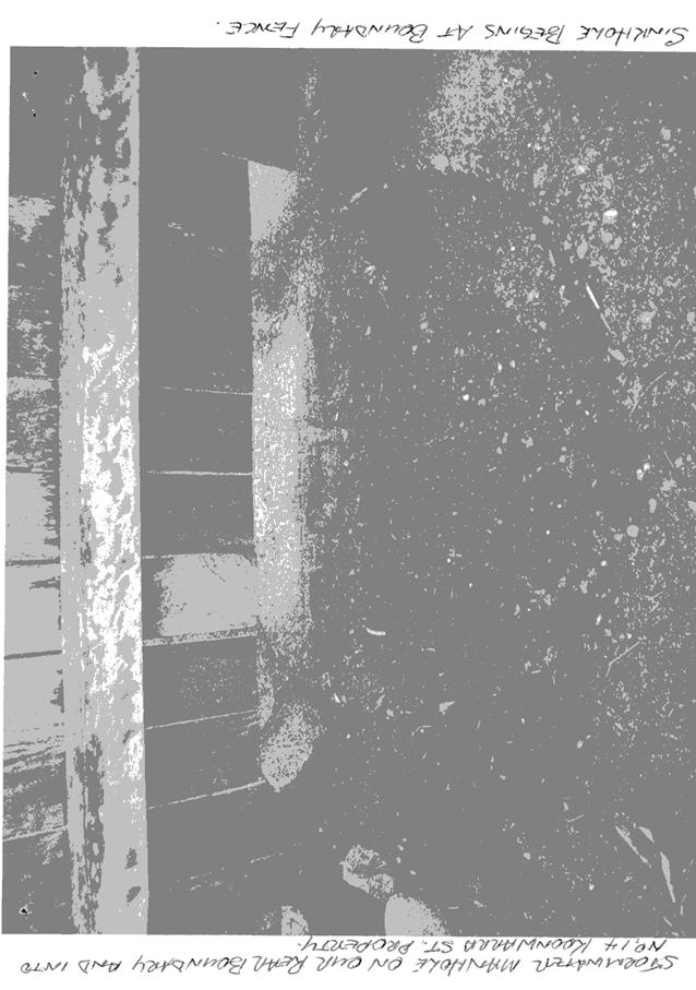
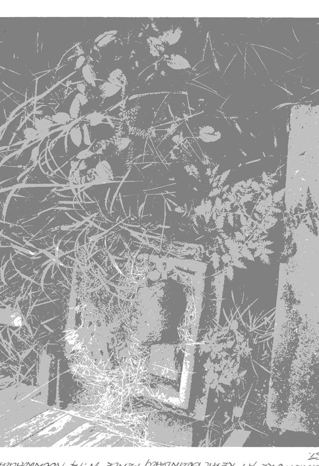
AGENDA Development Assessment Panel 28/03/2018
Item: 07
Subject: DA2017 - 234 - Waste Management Facility
(Concrete Recycling) - Lot 1 DP 1202080, Pacific Highway, Pembrooke
Report
Author: Patrick Galbraith-Robertson
|
Applicant: Alan
Taylor & Associates
Owner: Port
Macquarie – Hastings Council
Estimated Cost: $1.5M
Alignment with Delivery
Program
4.3.1 Undertake transparent
and efficient development assessment in accordance with relevant legislation.
|
|
RECOMMENDATION
That
the Development Assessment Panel recommend to Council that DA2017 -
234 for a waste management facility
(concrete recycling facility) at Lot 1, DP 1202080, Pacific
Highway, Pembrooke, be determined by refusing consent for the following reasons:
1. Integrated Development concurrence has not
been obtained for the proposal. An Environment Protection License has not
been granted by the NSW Environment Protection Authority for the proposal
pursuant to section 91 of the Environmental Planning and Assessment Act 1979
and Protection of the Environment Operations Act 1997.
2. The Applicant has failed to
submit a site and development specific specialist Traffic Report to address
the proposal’s likely impacts and ascertain whether mitigation measures
will be required.
3. The Applicant has failed to
submit a specialist Noise and Dust report to address the proposal’s
likely impacts and ascertain whether mitigation measures will be required.
4. The Applicant has failed to
provide the necessary specialist stormwater management plans to
satisfactorily address required stormwater quality management.
5. The Applicant has failed to provide
satisfactory details on management of asbestos and contaminated materials.
6. The Applicant has failed to
provide the necessary dust monitoring (depositional dust analysis) in
accordance with AS/NZS 3580.10.1-2003.
7. The
Applicant has failed to provide satisfactory details on perimeter landscaping
details.
|
Executive Summary
This report considers a
Development Application (DA) for a waste management facility (concrete
recycling) at the subject site and provides an
assessment of the application in accordance with the Environmental Planning and
Assessment Act 1979.
Following exhibition of the
application, one (1) submission has been
received.
This DA is being reported to the
Development Assessment Panel (DAP) due to the submission received and the
application being on Council land.
This DA will need to be reported
to an Ordinary Meeting of Council following consideration by the DAP in
Council’s Conflict of Interest Policy.
The Development Application has
been lodged with Council for 12 months and there have been requests for
additional information and these requests have unfortunately been
unsatisfactorily addressed including requirements for technical water, noise
and dust reports. The NSW Environmental Protection Authority have confirmed
their requests for additional information, which are required prior to any
consideration being given to issuing general terms of approval (or concurrence)
to the proposal as an Integrated Development. The Applicant has been provided
with a significant period of time to resolve these matters.
1. BACKGROUND
Existing
sites features and Surrounding development
The site has an area of 111.04
hectares.
The
site is zoned SP2 waste or resource management facility in accordance with the Port Macquarie-Hastings Local
Environmental Plan 2011, as shown in the following zoning plan:
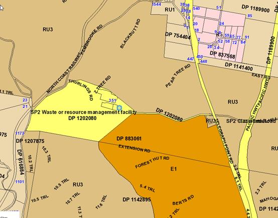
The existing
location of existing development within the locality is shown in the following
aerial photograph (red X shows site location):
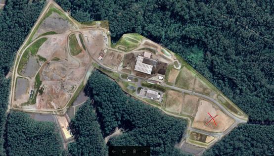
The site is located within an
existing and planned waste management facility precinct with access to the
Pacific Highway (to be known as Telegraph Point Road as this section of Highway
has been declassified) to the east – see below image.
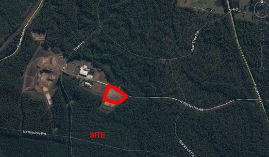
National Park and State Forest
adjoin the site and existing Waste Management Facility.
The proposed site is identified as Development Pad 3 within
the Cairncross Waste Management Facility (WMF), Industrial Waste Precinct. The
site adjoins the Cairncross WMF Access Road to the north, Development Pad 2 to
the west and Road 2 on the east and south. East of Road 1 is the Rawdon Island
Nature Reserve.
The area of the site development area is 17,296m2.
2. DESCRIPTION
OF DEVELOPMENT
Key
aspects of the proposal include the following:
· Use
of Development Pad 3 within the Cairncross Waste Management Facility (WMF),
Industrial Waste Precinct for a waste management facility for concrete
recycling including construction of associated new driveway access, buildings
and facilities – refer below image of site plan submitted;
· It’s
proposed to carry out the works in three (3) stages:
Stage 1 = Areas
A, B & C;
Stage 2 = Area
D – Future machinery shed; and
Stage 3 = Area
E – Shed for sale of resource recovery materials;
· The proposed hours of
operation are Monday to Saturday 7am to 5pm.
· The
proposal is an Integrated Development pursuant to the Environmental Planning
and Assessment Act 1979 and the Protection of the Environment Operations Act
1997. In regard, the proposal requires concurrence from the NSW Environment
Protection Authority (EPA) prior to determination of the DA.
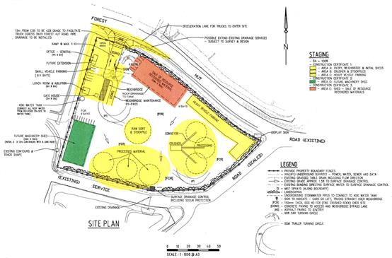
Concurrence
has been unable to be obtained from the EPA to obtain general terms of approval
which would then set out the terms for obtaining an Environmental Protection
License. The primary information not provided relates to specialist noise and
dust assessments and satisfactory clarification of the intended quantities of
material to be processed/handled on-site.
Refer
to attachments at the end of this report.
Application
Chronology
· 23 March 2017 – DA lodged with Council.
· 7 to 26 April 2017 – Neighbour notification of
development proposal.
· 10 May 2017 – Additional information requested
– additional fees for integrated development, advised of submission
issues raised, questioned material volumes, stormwater management approach
unsatisfactory, clearance to services/ easement, traffic impact details, site
specific noise assessment, question how bitumous and asbestos products (which
are unable to be accepted) will be managed, deceleration lane details and
turning paths, landscaping details, crime prevention measures, fencing details,
site specific dust report, odour general details, potential hazards and request
a concrete pavement be provided for the Cairncross access road entrance
point.
· 15 May 2017 – Council General Manager confirmed
internal assessment by Council Officer acceptable to continue.
· 16 May 2017 – Referral to the NSW Roads and Maritime
Services (RMS) for comment under State Environmental Planning Policy
(Infrastructure) 2007.
· 8 June 2017 – Advice received from the RMS.
· 20 June 2017 – Copy of submission forwarded to EPA.
· 4 July 2017 – Applicant provided waste volume detail,
stormwater advice, disagree on upgrade of access road point, wheel wash or
shaker pad will be added to an amended plan, traffic details advice, disagree
on request for noise, odour and dust specialist reports based upon context and
hazard assessment details confirmed.
· 11 July 2017 – EPA request for additional information
forwarded to the Applicant to provide a response to.
· 8 August 2017 – Additional information request status
follow up.
· 21 August 2017 – Applicant advised that all
information requested by the EPA will be provided to Council to forward to the
EPA for concurrence on behalf of Bridle Group.
· 30
August 2017 - DA2017 – 626 for recycled hardstand area approved by
Council on the same site. No works carried out or commenced on-site.
· 20 September 2017 – Bridle Group requested EPA to
permit deferral of specialist noise and air quality impact assessments.
· 25 September 2017 – EPA advice received that deferral
for specialist noise and air quality assessments are not permitted.
· 5 October 2017 – Additional information received from
Bridle Group including draft letter of advice to forward to the EPA.
· 9 October 2017 – Advised Bridle Group that a full response
to the EPA request is required before referral can occur to the EPA.
· 25 October 2017 – Further advice received from the
NSW EPA in response to the draft information provided from Bridle Group.
Confirmation that specialist noise, water quality and air impact assessments
specific to the proposed site are required. The material volumes are also
questioned and stockpiling and selling of recovered materials are questioned. A
copy of as constructed drawings for the proposed site including stormwater detention
basin and artificial wetland should be provided.
· 31 October 2017 – Copy of EPA letter dated 25 October
2017 received from Applicant.
· 17 November 2017 – Original additional information
request sent 10 May 2017 forwarded to Applicant as requested.
· 19 February 2017 – Follow up request for additional
information sent to Bridle Group and Applicant. A timeline was also provided to
submit the required information otherwise final reporting and a likely
recommendation for refusal would occur.
· 20 February 2017 – Bridle Group advised information
will be submitted however with no timeline estimated for completion.
· 10 March 2017 - Follow up request for additional
information request send to Bridle Group and Applicant.
· 12 March 2017 – Applicant submitted specialist Water
Assessment Impact report and draft Air and Noise Report dated 22 December 2017
and January 2018.
· 12 March 2017 – Request for additional information on
how the final Air and Noise reports are progressing since late December to
early January.
3. STATUTORY
ASSESSMENT
Section
79C(1) Matters for Consideration
In
determining the application, Council is required to take into consideration the
following matters as are relevant to the development that apply to the land to
which the development application relates:
(a) The
provisions (where applicable) of:
(i) Any
Environmental Planning Instrument:
State Environmental Planning Policy No. 33 - Hazardous
and Offensive Development
The subject SEPP was introduced to clarify the definitions
for hazardous and offensive industries and to apply guidelines for the
assessment of industries that have the potential to create hazards or an
offence.
In this case, the development has the potential to be an
offensive development given the processing component of the proposal, which
will generate significant noise and the provisions of the SEPP apply. Having
considered the SEPP, it is unclear due to a lack of specialist noise assessment
information as to whether the proposed development will be confirmed to not be
an offensive industry.
State Environmental Planning Policy No. 44 - Koala
Habitat Protection
With reference to clauses 6 and 7, the subject land is
greater than 1 hectare (including any adjoining land under same ownership) and
therefore the provisions of SEPP must be considered.
The application has demonstrated that no habitat will be
removed or modified. Therefore, no further investigations are required.
State Environmental Planning Policy No.55 –
Remediation of Land
Following an inspection of the site and a search of Council
records, the subject land is not identified as being potentially contaminated
and could potentially be suitable for the intended use.
The site development pad does not contain acid sulphate
soils or previous industrial contamination.
State Environmental Planning Policy No. 62 –
Sustainable Aquaculture
Based upon the current submitted information, it is unclear
as to whether the proposed development will have potential to lead to any
adverse impacts on existing aquaculture industries.
State Environmental Planning Policy No. 64 –
Advertising and Signage
The proposed development does not include any proposed
advertising signage in the form of business/building identification and/or
general advertising.
State Environmental Planning Policy (Infrastructure) 2007
The proposal has been referred to the NSW Roads and Maritime
Service (RMS). The RMS’ advice and other matters requiring consideration
under clause 104(3)(b)(ii) and (iii) are considered in the assessment of
access, traffic and parking impacts addressed later in this report.
Port Macquarie-Hastings Local Environmental
Plan 2011
The proposal is consistent with the LEP having regard to the
following:
· Clause 2.2, the subject
site is zoned SP2 waste or resource management facility. In accordance with
clause 2.3(1) and the SP2 zone landuse table, the proposed waste management
facility is a permissible landuse with consent.
The objectives of the SP2 zone
are as follows:
o To provide for infrastructure and
related uses.
o To prevent development that is
not compatible with or that may detract from the provision of infrastructure.
In accordance with Clause 2.3(2),
the proposal is consistent with the zone objectives having regard to the
following:
o the proposal is a permissible
landuse;
o the proposal is directly related
to the intent of the zoning for the site and is co-locating similar landuses.
· Clause 5.10, the site
does not contain or adjoin any known heritage items or sites of significance.
· Clause 7.13,
satisfactory arrangements are in place for provision of essential services
including water supply, electricity supply, sewage management/sewer
infrastructure, stormwater drainage and potentially suitable road access to
service the development.
(ii) Any
draft instruments that apply to the site or are on exhibition:
No draft instruments apply to the site.
(iii) Any
Development Control Plan in force:
Port Macquarie-Hastings Development Control Plan 2013:
No specific precinct provisions under the DCP apply to the
proposal.
The extent of fill associated with the proposed hardstand
areas and excavation is likely to be less than a 1m change in height.
ENVIRONMENTAL
MANAGEMENT
Cut
and Fill Regrading
The
majority of cut and fill has been completed under DA2013 - 659.
There
would be some fill required as part of this DA to build up the access driveway.
The Applicant has advised that this access point would be designed to not
impede existing stormwater drainage and would be stabilised with planting of
batters. If possible, fill from the immediate locality would be used where it
is certified clean and capable of compaction to the necessary densities.
Environmental
Management Areas and Buffers
The existing benched area designated for this development
has an area of approximately 1.7ha. Appropriate buffers have been assessed
under DA2013 – 659.
Parking
Provision
The
Applicant has provided the following satisfactory justification for provision
of on-site parking using the following calculations:
Stage 1 Initial Offices
1 per 30sq.m office area or 1.5 per office space
1 per 70sq.m landscape material display, 1 per employee and
2 visitors.
REQUIRED: 3
PROVIDED: 6*
*In addition to the spaces above, 4 will be placed in Heavy
Machinery Parking
Stage 2 Machinery shed
1 per 70sq.m
REQUIRED: 11
PROVIDED: 8*
*8 Spaces immediately north of the machinery shed will be
provided in conjunction with the 6 spaces provided in stage 1,
Stage 3 Resource recovery sales
1 per 100sq.m
REQUIRED: 10
PROVIDED: 6*
*In addition to the spaces provided above, staff parking
for 4 cars for the resource recovery shed will already be in the spillover
section of the heavy vehicle parking area as provided on site at Stage 1 (Area
C). These car spaces will be immediately beside the shed. (ie the western end)
Total Required: 24 spaces
Total Provided: 24 spaces
(iiia) Any
planning agreement that has been entered into under Section 93f or any draft
planning agreement that a developer has offered to enter into under Section
93f:
No planning agreement has been offered or entered into
relating to the site.
iv) Any
matters prescribed by the Regulations:
N/A
v) Any
coastal zone management plan (within the meaning of the Coastal
Protection Act 1979), that apply to the land to which the
development application relates:
· No
Coastal Zone Management Plan applies to the subject site.
(b) The
likely impacts of that development, including environmental impacts on both the
natural and built environments, social and economic impacts in the locality:
Context
and setting
Insufficient information has been submitted to identify and
assess whether the proposal will result in any adverse impacts to existing
adjoining properties.
There are no identifiable adverse impacts identified to the
public domain.
The proposal could be considered to be consistent with other
waste development in the locality subject to appropriate justification.
There are no significant adverse lighting, view sharing,
privacy or overshadowing impacts identified to neighbouring properties.
The Applicant has failed to provide satisfactory details on
perimeter landscaping (buffer), boundary fence design, and site layout clear of
easements.
Roads and Maritime Services (RMS)
Consistent with RMS requirements, the proposal was referred
to the RMS on 08/06/2017. RMS’ review of the proposal determined:
Roads and Maritime has reviewed the referred information
and provides the following comments to assist the consent authority in making a
determination;
1. The existing Pacific Highway will be declassified to
Local road status following completion of the Oxley Highway to Kundabung
Pacific Highway upgrade project in early 2018 (weather permitting).
2. Forest Hut Road is described as a private road. It
would be classified as a ‘road related area’ in accordance with
traffic legislation for the purposes of enforcement. Any regulatory controls
will need to be considered by Council’s Local Traffic Committee prior to
Council approval.
3. Standard white on blue service signs have been
installed on the existing Pacific Highway to identify the facility and guide
traffic. A number of advertising signs have been erected on both sides of the
highway at the junctions of Forest Hut Road and Bill Hill Road. Council should
be satisfied that these signs are on private property and comply with
Council’s Development Control Plan and NSW Department of Planning and
Environment’s Transport Corridor Outdoor Advertising and Signage
Guidelines.
The feedback advice provided above has been taken into
consideration with the below assessment comments. Note: there is no change to
existing signage proposed as part of the application.
Roads
The site has road frontage to Cairncross WMF Access Road and
Road 2 (service road).
The Cairncross WMF Access Road and Road 2 (service road) are
Private Roads owned and managed by Port Macquarie Hastings Council (PMHC). The
Cairncross WMF Access Road is a 7.1m sealed road and Road 2 (service road) is a
6.0m sealed road.
Traffic and Transport
The Applicant has been requested to provide a specialist
traffic report detailing the estimated traffic volumes accessing the site
(AADT) including:
· Estimated
growth rates over the life of the development.
· Morning
and afternoon peak hour volumes (vph) in and out of the site.
· Import
and export volumes of materials.
· Types
(sizes) of trucks that would be in use.
The Applicant has failed to provide the necessary specialist report for
assessment purposes. It is therefore not possible to assess and mitigate
impacts of the proposed development.
Site Frontage & Access
As mentioned above, the Applicant has not provided
specialist traffic report details, which makes it difficult to reasonably
assess the proposal’s likely impacts and to ascertain whether mitigation
measures will be required.
Whilst no specialist traffic and parking report has been
received the following matters of significance are noted:
· Vehicle access to the
site is proposed through a concrete driveway coming off Cairncross WMF Access
Road fronting Pacific Highway. Site access is to comply with Council AUSPEC and
Australian Standards.
· Whilst no details have
been provided it is considered that given the location, nature of the proposed
access and requirement for heavy vehicle access, the Cairncross WMF Access Road
will require a concrete pavement, 30m either side of the access point, be
constructed for the full width of the existing road to manage the screwing
effect of trucks entering the site.
· The deceleration lane
for trucks, proposed as per Alan Taylor and Associates, site plans, Revision A;
“Cairncross Waste Management Facility – Concrete Processing Site
– Pad 3 Forest Hut Road,” dated 20-03-2017, require additional
details and justification. Demonstration of suitability and compliance with
AUSTROADS to be provided including, details of complying gradients for batter
slopes and site distances taking into consideration a minimum of 2.0m clearance
to the main power and communications pit in the Cairncross WMF Access Road that
would be required.
· A wheel wash or shaker
pad is needed on site to control sediment from being transported on to the main
Cairncross WMF Access Road.
The below image shows the location of the access road
providing access to the site:
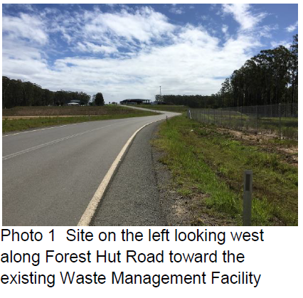
Parking and Manoeuvring
A total of 24 parking spaces have been proposed to be
provided on-site. Parking and driveway widths on-site can comply with relevant
Australian Standards (AS 2890) with ample room for overflow and truck
parking.
Whilst no specialist traffic and parking report has been
received the following matters of significance are noted:
· Due to the type of
development, car park circulation is required to enable vehicles to enter and
exit the site in a forward manner. Additional information has been recommended
to be provided to show adequate area is available.
· In addition,
separation of heavy vehicle routes from public and staff cars including
pedestrian desire lines is required wherever possible to minimise safety risks.
· If entrance gating
is to be proposed, this should be shown on the site plan ensuring there is
adequate distance for vehicles to queue without backing up into the road.
Conditions could be imposed as per AS2890.1 Clause 3.4.
Water Supply Connection
The site has water services available at the boundary.
However, while water mains are installed to the site; the water main connection
to Telegraph Point is not yet constructed. This is expected late 2018. Overall,
water is not available until this Pembrooke Road main is installed.
The Applicant has advised that a rainwater tank will be
proposed to collect all roof water.
Sewer Connection
The southern side of the site contains sewer services which
have not yet been connected to Council’s sewer network. A 5.0m wide
‘easement’ is in place and no infrastructure, stockpiles or other
materials may be constructed or placed in this area.
The sewer connection may be available at a future date
however not for immediate use. Provision of toilet facilities will be by site
structures pumped out by waste services.
Stormwater
The Applicant failed to provide the necessary specialist
stormwater management plans however has very recently provided a Water Quality
Assessment report as prepared by Precise Environmental Consulting Environmental
Scientists.
The existing wetland system developed as part of the
Cairncross Waste Management Facility (WMF) Industrial Waste Precinct (located
south of Road 2) is not suitable on its’ own for the treatment of runoff
from this type of development and must not be used as part of the treatment system.
As such this site must provide its own on-site sediment system prior to
discharging to the constructed wetland system. Preliminary water quality and
quantity calculations and plans must be provided to justify any proposal. This
is also identified in the Precise Environmental Consulting report recently
received.
Additional information in the stormwater management plans is
required to demonstrate that stormwater quality and quantity impacts associated
with the proposed hardstand and recycling use of the site can be managed
adequately onsite prior to discharge to the surrounding environment.
The proposed site plan should also be updated to amend the
layout of the operations to reflect the required provision of a stormwater
quality control installation. Specific details of stormwater quality control
are to be provided to show that stormwater can be dealt with on site with
quality modelling for the development to be undertaken in accordance with
recommended procedures within Chapter 13 – Modelling Urban Stormwater Management
Systems of ARQ 2006.
The pollutant outflow concentrations must comply with the
relevant requirements of AUS-SPEC D7 in particular table D7.4 and table D7.7
with water quality testing from a NATA approved laboratory being required on a quarterly
basis.
Other Utilities
The western side of the site contains water, sewer, power
and communications services. A 5.0m wide ‘easement’ is in place and
no infrastructure, stockpiles or other materials may be constructed or placed
in this area.
Electrical and communications conduits only are provided to
the boundary of the site. The Applicant would be required to provide the
necessary electrical and communications connections to the main switchboard
(via the existing conduits) based on their site specific needs.
Heritage
Following a site inspection (and a search of Council
records), no known items of Aboriginal or European heritage significance exist
on the property. No adverse impacts anticipated.
Other land resources
The site is within an established urban context and will not
sterilise any significant mineral or agricultural resource.
Water cycle
In terms of potential water pollutants, waste concrete may
be an important contributor (more so than masonry) due mainly to the
characteristics and constituents of concrete, which include cement hydration
products and from its use in higher risk applications such as service station
forecourts (hydrocarbons etc). Water
pollutants from waste concrete may include pH, heavy metals including arsenic,
chromium, lead and selenium, polycyclic aromatic hydrocarbons (PAH) and
volatile organic compounds (VOC) such as benzene.
A specialist Water Quality Impact assessment has been
submitted late in the assessment process. This report has not yet been
forwarded to the NSW EPA however is considered well justified in regards to
addressing the likely impacts of the proposal together with making satisfactory
recommendations in regards to mitigation measures including a recommendation
for stormwater detention basin on the site.
A final assessment and review of additional information
provided has not been undertaken by the EPA.
Soils
The proposed development will be unlikely to have any
adverse impacts on soils in terms of quality, erosion, stability and/or
productivity subject to a standard condition requiring erosion and sediment
controls to be in place prior to and during construction.
Air and microclimate
The Applicant has failed to provide the necessary dust
monitoring (depositional dust analysis) in accordance with AS/NZS
3580.10.1-2003.
A final assessment and review of the proposal has not been
undertaken by the EPA due to the outstanding specialist dust assessment
information not being received. It is unclear as to whether the proposed
development will have any adverse impacts on the air and microclimate of this
locality.
Whilst no specialist dust report has been received the
following matters of significance are noted:
· Dust from the site must
be managed to ensure that no dust escapes the site and becomes an OH&S
issue for staff and customers on adjoining land (ie. Development Pads 1, 2, 4,
5, 6), the future STP (south or Road 2), the existing Organic Resource Recovery
Facility (ORRF) office, the Cairncross weighbridge, and material Recovery
Facility (MRF) office.
· Monitoring sites would
be required to be installed on and off the site to ensure that no dust escapes
the site. The water supply (when installed) only allows for toilet flushing and
limited washing of plant and equipment. The water supply does not allow for
dust suppression and firefighting.
· Silica dust from
concrete crushing and recycling - sufficient dust suppression and management is
required along with an adequate buffer zone. A site specific Operational
Management Plan would be recommended for this facility.
· The Applicant must
provide sufficient water storage capacity (tanks) and pumps for dust
suppression and firefighting. Fire requirements must be in accordance with BCA
and AS 2419.
Flora and fauna
The siting for the development comprises of a previously
cleared and benched area on the eastern side of the existing Cairncross Waste
Management Facility.
Construction of the proposed development will not require
any removal/clearing of any significant vegetation and therefore will be unlikely
to have any significant adverse impacts on biodiversity or threatened species
of flora and fauna.
The
Applicant has detailed that landscaping of the site and parking areas is to be
provided along the northern boundary of the site fronting Forest Hut Road and
the eastern boundary fronting the service road. Landscaping is to consist
primarily of planting to stabilise the existing and proposed batters and is
also to include indigenous shade trees at 3m centres within the fenced area.
Waste
The proposal is for a waste management facility.
The Applicant has been requested by Council assessment staff
and the EPA to provide more details on the likely total amount of waste to be
processed and stored at the proposed facility. See attached letters of request
from the EPA. Specifically it was requested to confirm the maximum quantity
(tonnes) of material to be processed onsite each year, for the purpose of
establishing an annual limit as a condition of consent. An annual limit enables
assessment of the impacts of the development based on a likely worst case.
Compliance with this limit would be ensured by reference to production and
weighbridge records.
If the proposal was approved standard precautionary site
construction management conditions and limits would be recommended.
Energy
No adverse impacts anticipated.
Noise and vibration
The Applicant has currently only provided a noise assessment
based on a 2003 Noise Impact Assessment (NIA) for the Kingfisher Road site.
While the information in this report provides some detail on plant noise
levels, it has not considered site issues such as other users at the Cairncross
site and the nature of the use (ie. neighbouring lots, weighbridge operators etc).
The Applicant has failed to provide the necessary site
specific noise management assessments in accordance with the NSW Industrial
Noise Policy (2000). A final assessment and review has not been undertaken
by the EPA due to the outstanding specialist noise assessment information not
being received. It is unclear as to whether the proposed development will be
unlikely to have any adverse noise impacts within the subject locality.
Whilst a final specialist report has not yet been provided
the following additional assessment comments are noted:
· Noise from the
site must be managed to ensure that it does not become an OH&S issue for
staff and customers on adjoining land (ie. Development Pads 1, 2, 4, 5, 6), the
future STP (south or Road 2), the existing Organic Resource Recovery Facility
(ORRF) office, the Cairncross weighbridge, and material Recovery Facility (MRF)
office.
· The proposed hours
of operation are noted to be Monday to Saturday 7am to 5pm.
Asbestos
The Applicant has failed to provide satisfactory details on
methods to address potential asbestos and contaminated management. Procedures
are required to be in place to dispose of asbestos material according to NSW Work
Health and Safety (WHS) legislation, and the requirements of the Protection of
the Environment Operations Act 1997 and the Protection of the Environment
(Waste) Regulation 2005, and comply with the EPA Protocol For Managing Asbestos
During Resource Recovery Of Construction And Demolition Waste (2014).
Bushfire
The site is identified as being bushfire prone.
The siting of the proposed development within the larger
site as Development Pad 3 within the Cairncross Waste Management Facility
(WMF), Industrial Waste Precinct, is provided with satisfactory access,
defendable space as an Asset Protection Zone and is capable of future water
supply coverage. The Applicant however must provide sufficient water storage
capacity (tanks) and pumps for fire fighting. Fire requirements must be in
accordance with BCA and AS 2419.
The proposal is not a residential use however could be
capable meeting the aims and objectives of the Planning for Bushfire Protection
2006 subject to additional details being provided.
Safety, security and crime prevention
The proposed development will be unlikely to create any
concealment/entrapment areas or crime spots that would result in any
identifiable loss of safety or reduction of security in the immediate
area.
The Applicant has detailed that the landscaping of parking
areas is to be provided along the northern boundary of the site fronting Forest
Hut Road. Man-proof chainwire fencing is to be installed to the perimeter of
the subject land.
It is considered that the Applicant has however failed to
provide satisfactory details on perimeter landscaping (to provide a
satisfactory buffer).
Social impacts in the locality
Given the nature of the proposed development and its’
location the proposal is unlikely to result in any adverse social impacts.
Economic impact in the locality
No adverse impacts identified. A likely positive impact
would be that the development will maintain employment in the industry, which
will lead to flow impacts such as expenditure in the area.
Site design and internal design
Insufficient details have been provided to establish whether
the proposed development design will be satisfactory with regard to the site
attributes and locality.
Construction
Subject to compliance with potential appropriate mitigation
measures, no potential adverse impacts identified to neighbouring properties
with the construction of the proposal.
If the development was approved, a condition would be
recommended to require a Construction Certificate to be obtained prior to works
commencing on-site.
Cumulative impacts
The proposed development would not be expected to have any
adverse cumulative impacts on the natural or built environment or the social
and economic attributes of the locality subject to resolution of noise, dust
and amenity impacts.
(c) The
suitability of the site for the development:
Unsatisfactory details are available to demonstrate as to
whether the proposal will fit into the locality and it is unclear as to whether
the site attributes are conducive to the proposed development.
(d) Any
submissions made in accordance with this Act or the Regulations:
One (1) written
submission has been received following public exhibition of the application.
Key
issues raised in the submissions received and comments in response to these
issues are provided as follows:
|
Submission
Issue/Summary
|
Planning
Comment/Response
|
|
Concerns/objections with regards
to the development proposal.
Ø Smell
Ø Lowering
the value of our property
Ø Noise
|
With regard to potential smell
or odour impacts it is unlikely that the subject proposal will result in any
adverse impacts to the property owner who has lodged this submission due to
the existing physical separation distance of greater than 1 kilometre and the
likely nature of the waste material to be stored and processed.
With regard to potential
claims of impacts on property values – this is not a matter for
consideration under the Environmental Planning and Assessment Act 1979.
With regard to potential
likely noise impacts, the likely impacts are unclear and a specialist report
has been requested as detailed earlier in this report. Unfortunately, this
report has not been forthcoming from the Applicant. Refer also to comments
earlier in this report.
|
(e) The
Public Interest:
The proposed development is
unable to satisfy relevant planning controls and would not be in the
public’s interest to recommend supporting unless satisfactory specialist
traffic, noise, water quality and dust assessments are received.
4. DEVELOPMENT
CONTRIBUTIONS APPLICABLE
· Development contributions would be required at a later
stage towards augmentation of town water supply and sewerage system head works
under Section 64 of the Local Government Act 1993. If the development was
approved a standard condition requirement for a Section 307 Water Management
2000 certificate to be obtained prior to the issue of an Occupation Certificate
would be required.
· Development contributions would be required under Section
94A of the Environmental Planning and Assessment Act 1979.
5. CONCLUSION
The
application has been assessed in accordance with Section 79C of the
Environmental Planning and Assessment Act 1979.
Issues
raised during assessment and public exhibition of the application have been
considered in the assessment of the application.
The
proposal has been assessed on the current information and is unable to be
justifieddue to a lack of supporting information. It is recommended that the
application be refused for the reasons detailed earlier in this report.
|
Attachments
1View. DA2017
- 234.1 Cairncross Proposed Lease Boundary Plan - Concrete Site v5-Lease -
Final
2View. DA2017
- 234.1 Site Plan
3View. DA2017
- 234.1 EPA Request for Additional Information
4View. DA2017
- 234.1 EPA Letter Draft Response Request for Additional Inform...
5View. DA2017
- 234.1 Further information EPA.
6View. DA2017
- 234.1 EPA Response to Bridle Concrete Resources Request to Defer Noise and
Air
7View. DA2017
- 234.1 Water Quality Assessment
8View. DA2017
- 234.1 Submission - Rowsell
|
|
ATTACHMENT
|
Development Assessment Panel
28/03/2018
|
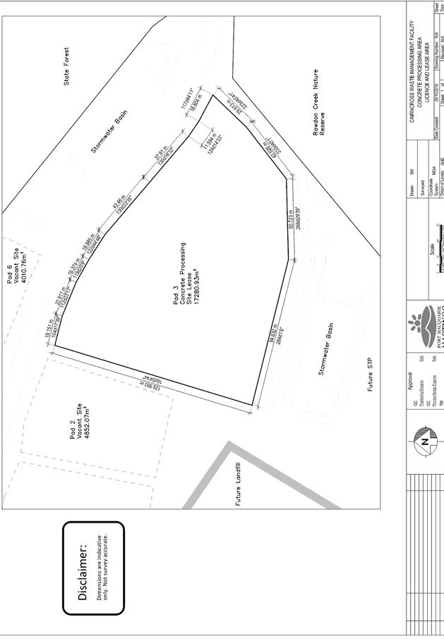
|
ATTACHMENT
|
Development Assessment Panel
28/03/2018
|
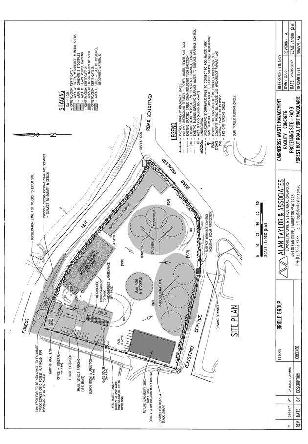
|
ATTACHMENT
|
Development Assessment Panel
28/03/2018
|
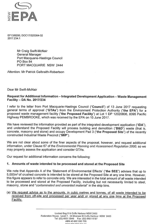
|
ATTACHMENT
|
Development Assessment Panel
28/03/2018
|

|
ATTACHMENT
|
Development Assessment Panel
28/03/2018
|
|
ATTACHMENT
|
Development Assessment Panel
28/03/2018
|
|
ATTACHMENT
|
Development Assessment Panel
28/03/2018
|
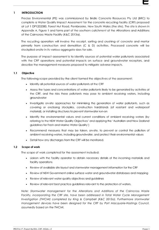
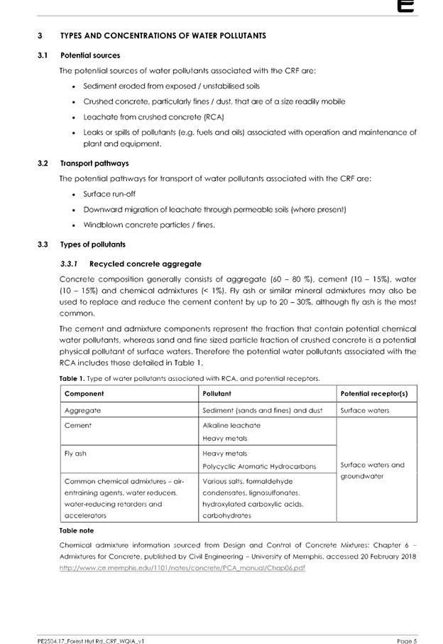
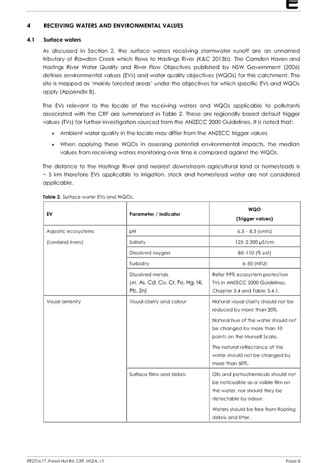

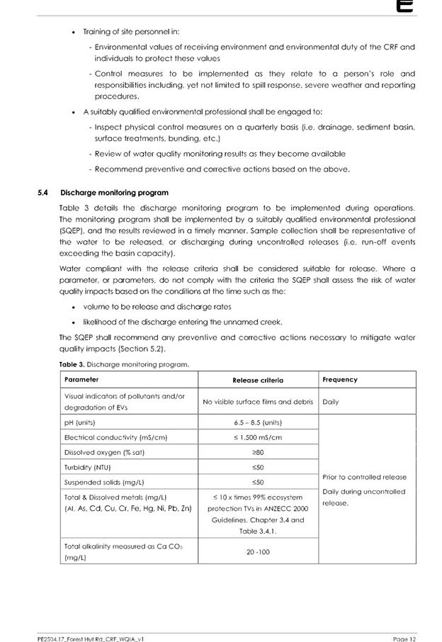


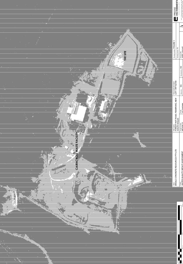
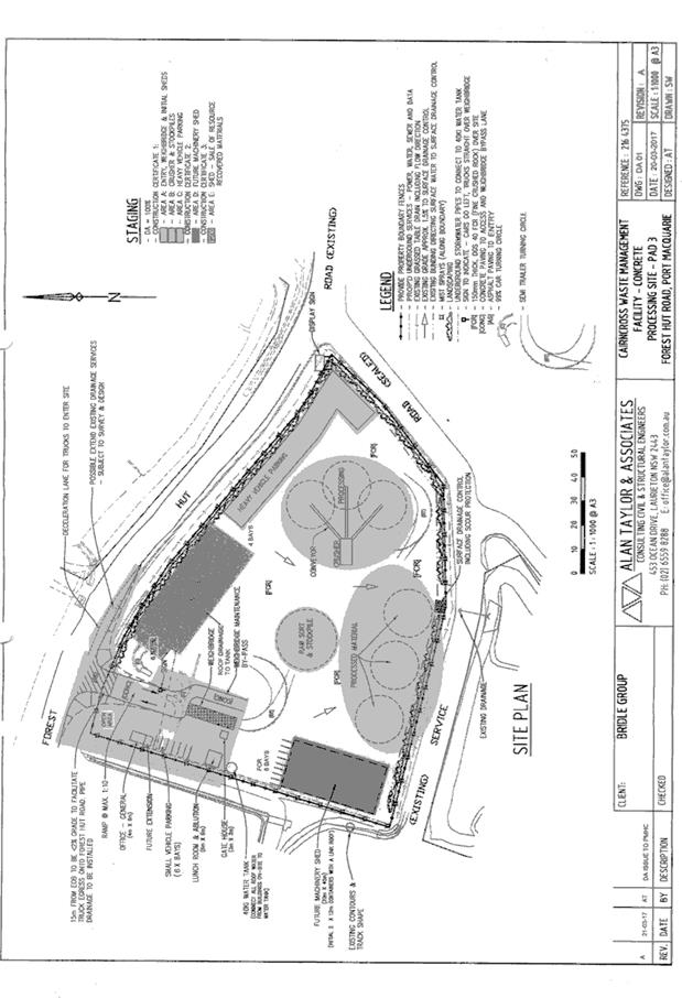
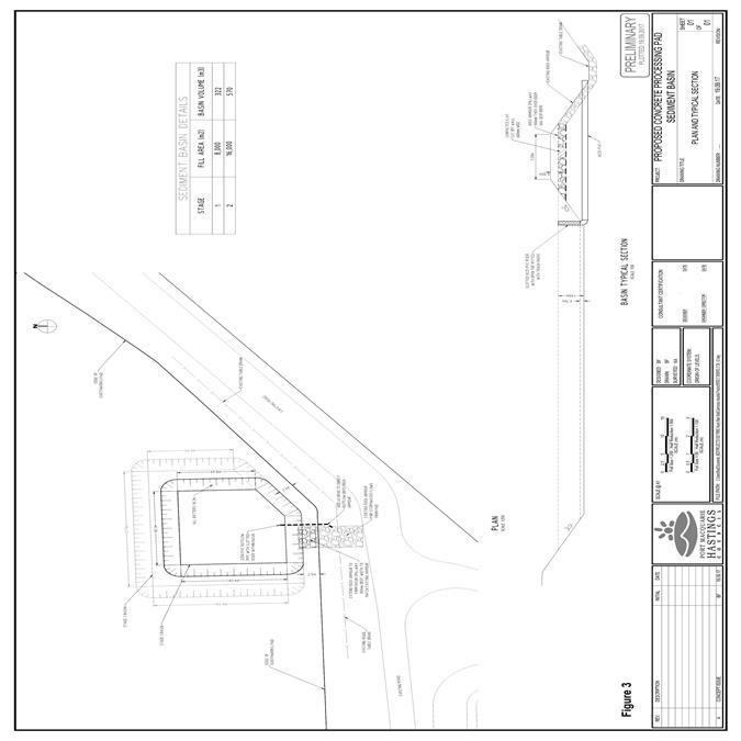
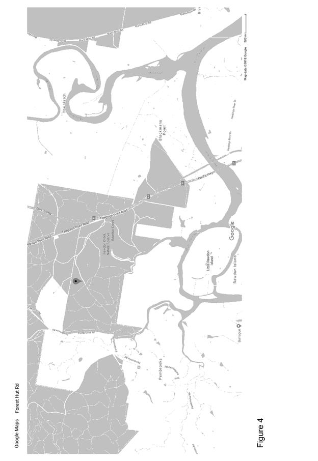
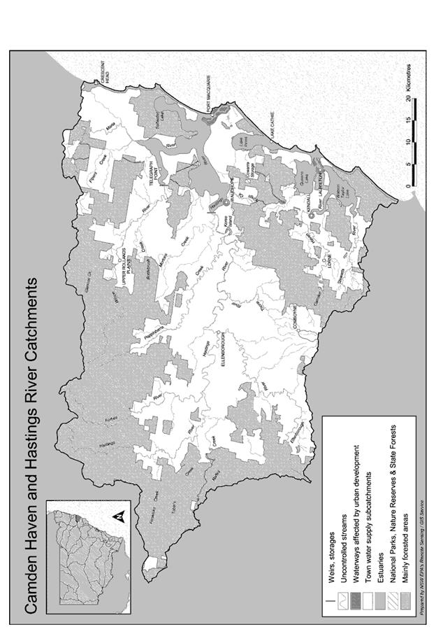
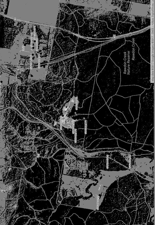
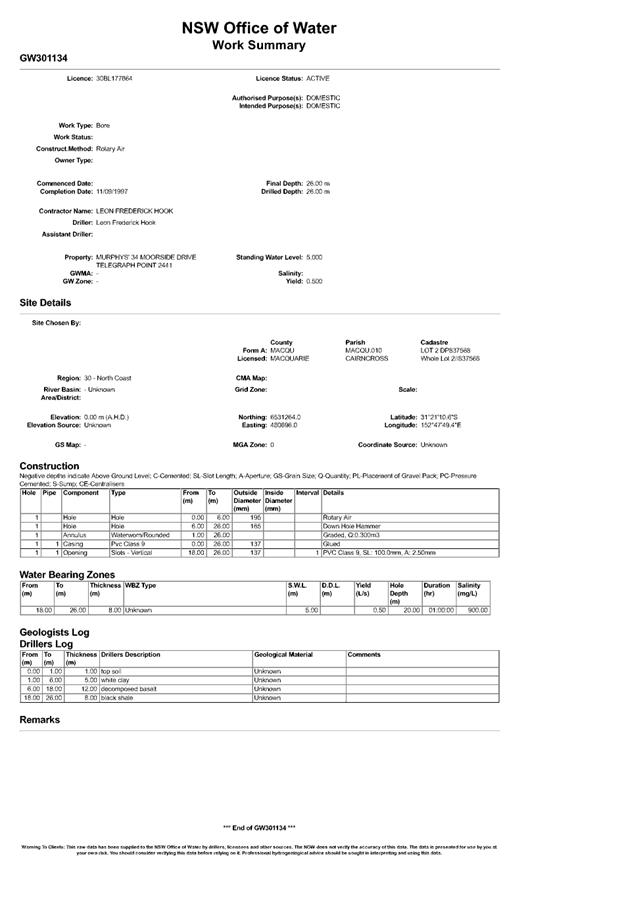
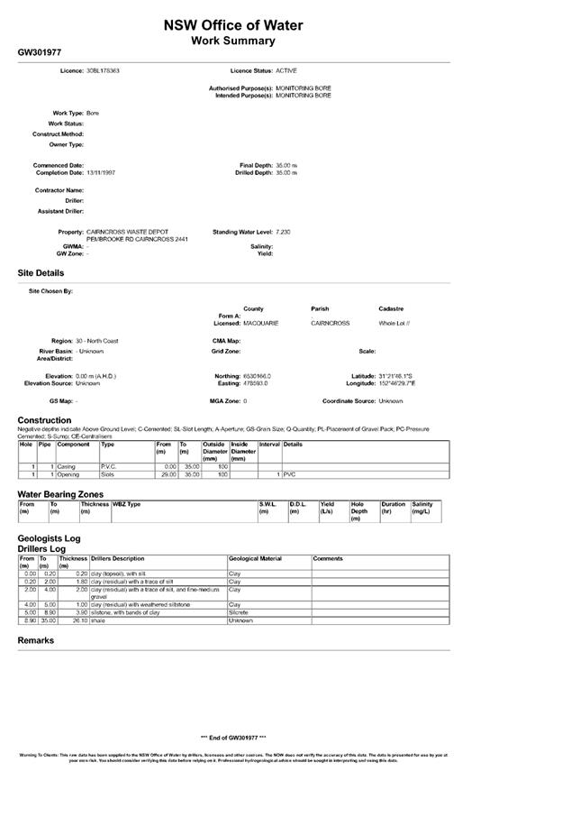


|
ATTACHMENT
|
Development Assessment Panel
28/03/2018
|
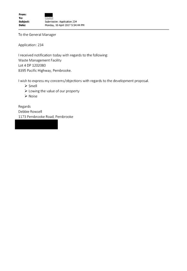
AGENDA Development Assessment Panel 28/03/2018
Item: 08
Subject: Section 96 Modification DA2017 - 500.2 -
Modify Design Of Previous Approved Dwelling - Lot 703 DP 1228141, No 37 Yaluma
Drive, Port Macquarie
Report
Author: Patrick Galbraith-Robertson
|
Applicant: JE
Miller Builders
Owner: R
& J Border
Estimated Cost: NIL
Alignment with Delivery
Program
4.3.1 Undertake
transparent and efficient development assessment in accordance with relevant
legislation.
|
|
RECOMMENDATION
That
DA 2017 – 500.2 for a Section
96 modification to design of previous approved dwelling at Lot 703, DP 1228141, No. 37 Yaluma
Drive, Port Macquarie, be determined by granting the modified consent subject
to the recommended conditions.
|
Executive
Summary
This report considers a Section
96(1A) modification of consent application at the
subject site and provides an assessment of the application in accordance with
the Environmental Planning and Assessment Act 1979.
Being a Section 96 modification,
the modified proposal has only been assessed against the legislation and
related planning guidelines in place at the time of the original assessment.
The building is currently under
construction and has the roof sheeting complete.
Following exhibition of the
application, one (1) submission has been
received.
1. BACKGROUND
Existing sites features and Surrounding development
The site has an area of 799.35
m2.
The site is zoned R1 general residential in accordance with the Port Macquarie-Hastings Local
Environmental Plan 2011, as shown in the following zoning plan:
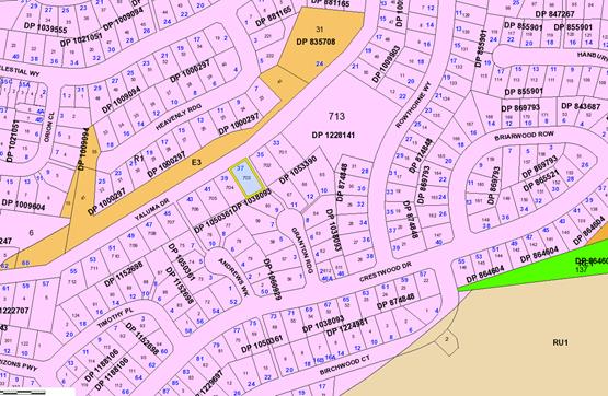
The existing subdivision pattern and location of existing
development within the locality is shown in the following aerial photograph
(2012):
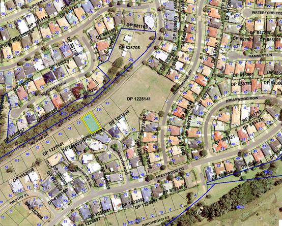
Aerial December 2017:
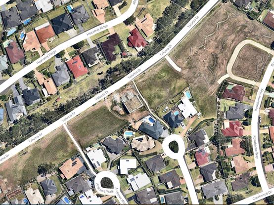
2. DESCRIPTION OF
DEVELOPMENT
Key aspects of the proposal include the following:
· Raising
of the garage floor level by 105mm to RL45.38m AHD.
· Raising
of the habitable ground floor level at the front of the building by 105mm to
RL45.55m AHD.
· Raising
of the ground floor lower level (split level) at the rear by 135mm from
RL44.145m AHD to RL44.28m AHD.
· Raising
of the upper floor level (split level) at the rear by 135mm from RL47.245m AHD
to RL47.38m.
· Increase
of maximum roof building height (from existing ground level) by 255mm at the
highest roof ridge point from 8.145m at the time to 8.4m (based on FFLs,
heights and site plan contours shown and not scaling off the elevations).
· Increase
of the maximum roof building height (from existing ground level) by 255mm at
the rear-most part of the building from 8.245m to 8.5m (based on FFLs, heights
and site plan contours shown and not scaling off the elevations). The maximum
building height is therefore 8.5m at the rear-most section of the roof line
above the south-western corner of the upper floor alfresco. It should be noted
that the rear-most part of the building is slightly higher than the upper-most
ridge as the ground level slopes away faster than the rake of the roof.
The
floor levels and the upper ridge of roof have been confirmed on-site by survey
as constructed to the plans submitted by a registered surveyor.
The
floor to ceiling heights, front building line, side and rear setbacks have not
changed to that which has been approved under the current DA plans. This has
been double checked using Council’s Trapeze plan overlay software (light
table checking).
It should be noted that when the
original DA was lodged, it did not comply with the 8.5m height limit. However,
during the assessment period of the original DA, the plans were subsequently
amended to comply.
Refer
to attachments at the end of this report.
Application Chronology
· 11 August 2017 – original DA approved. Stamped
approved plans attached to this report.
· 5
February 2018 – section 96 modification application lodged.
· 22
February 2018 – amended drawings received showing more details on heights
and levels and additional information
· 27 February to 12 March 2018 – Neighbour notification
of modification proposal.
· 13 March 2017 – Additional information received.
· 14 March 2017 – Additional information received.
· 15 March 2017- Additional information requested –
request for further survey information. This information was not
received however the ridge height and floor levels are considered sufficient.
3. STATUTORY ASSESSMENT
Is
the proposal substantially the same?
Section 96 of the Environmental
Planning and Assessment Act 1979 enables the modification of consents and
categorises modifications into three categories - S.96(1) for modifications
involving minor error, mis-description or miscalculation; S.96(1A) for
modifications involving minimal environmental impact; and S.96(2) for other
modifications. Each type of modification must be considered as being
substantially the same to that which was originally consented to.
The subject application is being
considered under the provisions of Section 96(1A).
The proposal is considered to be
substantially the same development to that which was originally lodged and
consented to and will have minimal environmental impact when making a
comparison between the original and proposed modified proposal. In particular,
the main changes occur to the design of floor levels and a corresponding
increase in roof height which has resulted in a minor change to the building
height of the dwelling.
Having regard to the above, the
proposed modification is not considered to alter the fundamental essence of the
original development and is considered to be within the scope of a modification
application.
Are there any condition(s)
of consent imposed by a Minister, government or public authority that require
modification?
No
changes to any conditions imposed by a Minister, government or public
authority.
Does
the application require notification/advertising in accordance with the
regulations and/or any Development Control Plan?
Neighbour
notification has been undertaken in accordance with the DCP.
Any
submissions made concerning the modification?
One (1) written submission has been received following public
exhibition via neighbour notification of the application.
The issues raised in the submission received have been
forwarded to the Applicant during the assessment of the DA.
Key issues raised in the submission received and comments
in response to the issues are provided as follows:
|
Submission
Issue/Summary
|
Planning
Comment/Response
|
|
Question
whether the dwelling constructed is lawful as the height exceeds 8.5m.
|
Upon a
detailed review of the modified plans, the proposed modified building height
is compliant at the highest rear section of the building at a maximum 8.5m.
|
|
Copy of survey certificate requested prior to
modification application being lodged to establish actual ridge heights,
finished slab levels and lower roof/wall height of the southern elevation
adjacent to the second brick column.
|
Survey
heights have been provided of finished floor levels and the upper-most roof
ridge heights.
The
height of the rear-most section of the building has been calculated to be
600mm lower than the ridge and calculated to be 8.5m in building height using
the LEP definition.
|
|
Private Certifier advised that building exceeded 8.5m in
height.
|
It is
assumed that this advice provided was made in error without qualification as
the building heights need to be assessed against the pre-existing ground
levels as per the definition of building height in the Port
Macquarie-Hastings Local Environmental Plan 2011.
|
|
The
information submitted with the modification application does not detail the
wall/roof height on the southern elevation.
|
This detail has been requested
during the assessment of the application post neighbour notification. The
building height is 8.5m at the highest point.
|
|
The
new ridge height is RL51.3 and the lower roof/wall height is RL50.8m with an
existing natural ground level of RL42 giving an overall height of
approximately 8.8m (information taken from revised site plan and Beukers
written survey).
|
The upper-most ridge height is
RL51.3m however the lower rear roof/wall height referred to is 600mm lower at
RL50.7m and the existing ground level at the time to the highest point of the
building was RL42.2 (as shown on the site plans both original and modified).
50.7m – 42.2m = 8.5m
building height
The concern raised by the
submission is not agreed with. No further justification is required of the
Applicant.
|
|
The new site plan indicates a primary street setback of
3.72m and encroachment of 0.58m into the required 4.5m primary frontage
setbacks. This was not dimensioned, considered or formed part of the
development consent.
|
The front setback of the articulation zone feature was
originally assessed as having a setback of 3.72m which is permitted under
Council’s Development Control Plan 2013 and referenced in the SEPP
Housing Code that the objection refers to.
The front setback has not changed as approved.
|
|
A section 96 modification is not appropriate to assess an
unlawful development. A new DA is required.
|
A section 96 modification is considered appropriate in
this instance.
|
|
The dwelling under construction could not be constructed
as Complying Development as the setback is required to be 6m and the deck
area is no greater than 3m in height from natural ground level.
|
The Complying Development criteria are noted however the
subject dwelling has been applied for, assessed and approved under a
Development Application. The proposal meets the Development Control Plan 2013
front, side and rear setback criteria.
The rear setback is a minimum 12.51m.
|
|
A clause 4.6 objection is required to the 8.5m building
height standard.
|
The height is considered to be 8.5m at the highest part
of the building based upon the plans and information submitted. No variation
is proposed.
|
|
Request that an alternate senior assessing officer review
a new DA for the dwelling.
|
A section 96 modification has been lodged and is
considered appropriate.
A change of assessing officer is not required as the
modification application will be determined by the Development Assessment
Panel.
|
Any matters referred to in section
79C (1) relevant to the modification?
Overall, the proposed development
remains consistent with the original s79C assessment. Areas of the original
assessment impacted by the changes or with revised comments are outlined below:
Port Macquarie-Hastings Local Environmental
Plan 2001
The
above LEP was in place at the original time of assessment and determination of
this DA.
· Clause 4.3, the maximum
overall height of the building above ground level (existing) is 8.5m (increased
from 8.245m) which complies with the standard height limit of 8.5m applying to
the site.
Context
and setting
• The
modified proposal will be unlikely to have any adverse impacts to existing
adjoining properties and satisfactorily addresses the public domain.
• The modified proposal is considered to be consistent with
the desired character for future and existing residential development in the
locality and adequately addresses planning controls for the area.
• There
are no identifiable adverse impacts on existing view
sharing with the modified proposal noting the compliance of the building with
the building heights, the split level design response of the building to the
site and the majority of the building bulk being centred to the rear of the
site.
• There are no identifiable adverse privacy impacts with the
modified proposal.
• There are no identifiable adverse overshadowing impacts
with the modified proposal.
4. DEVELOPMENT
CONTRIBUTIONS APPLICABLE
No
contributions applicable – single dwelling only.
5. CONCLUSION
The
application has been assessed in accordance with Section 96 and 79C of the
Environmental Planning and Assessment Act 1979.
Issues
raised during assessment and public exhibition of the application have been
considered in the assessment of the application.
The
site remains suitable for the proposed development, is not contrary to the
public's interest and will not have a significant adverse social, environmental
or economic impact. It is recommended that the modification application be approved,
subject to the recommended modified conditions of consent provided in the
attachment section of this report.
|
Attachments
1View. DA2017
- 500. 2 Amended Plans
2View. DA2017
- 500.1 Original Plans
3View. DA2017
- 500.2 Floor Level Certificate
4View. DA2017
- 500.2 Recommended Amended Conditions
5View. DA2017
- 500.2 Submission - Wilkie
|
|
ATTACHMENT
|
Development Assessment Panel
28/03/2018
|

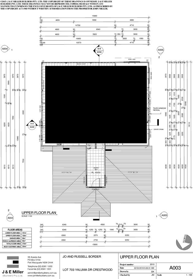
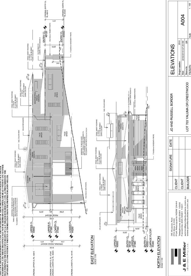
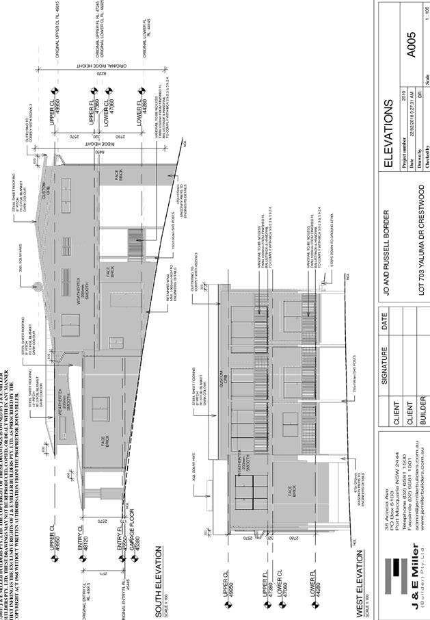
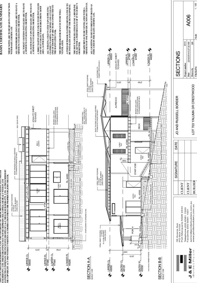
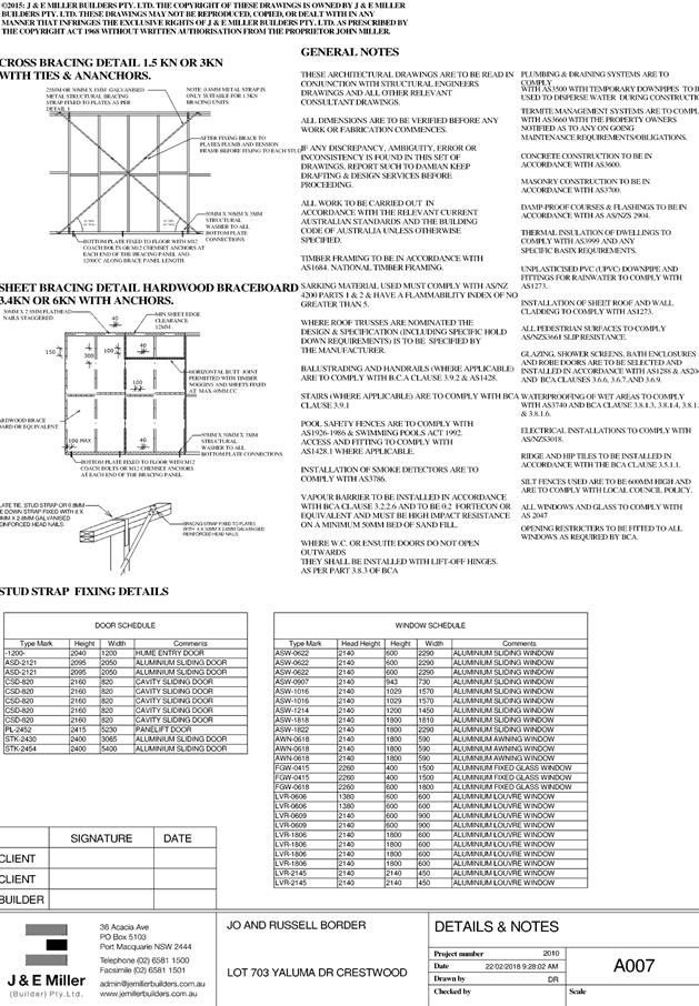
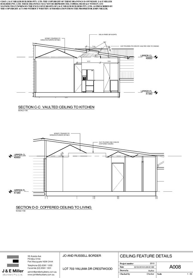
|
ATTACHMENT
|
Development Assessment Panel
28/03/2018
|
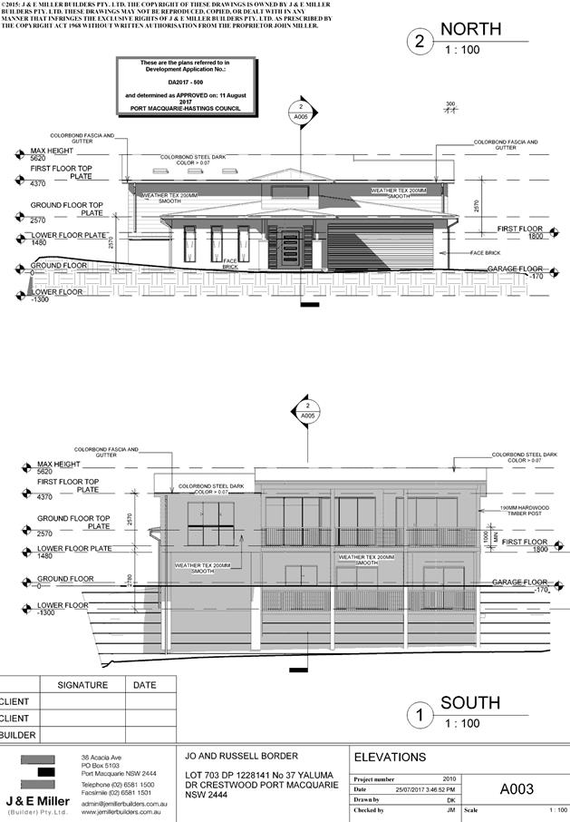
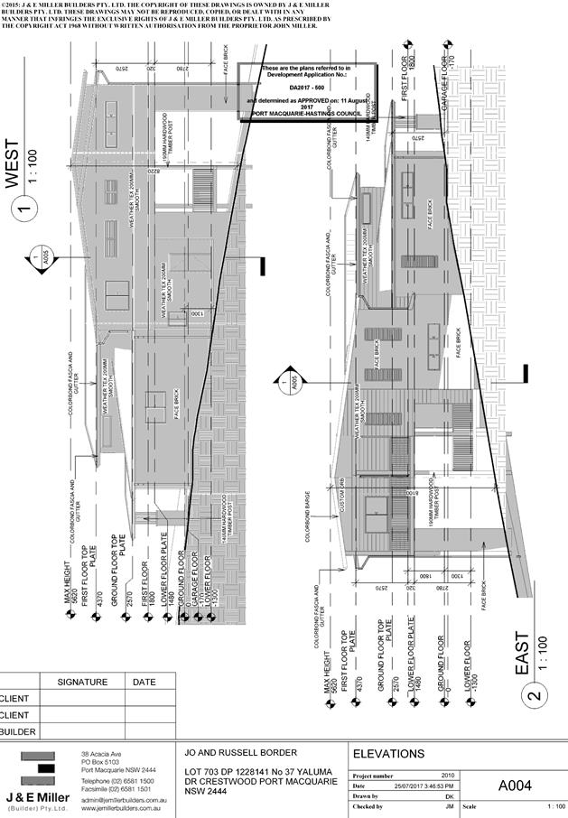
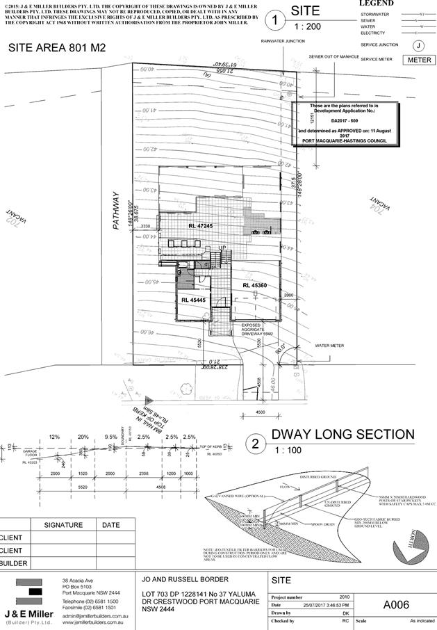
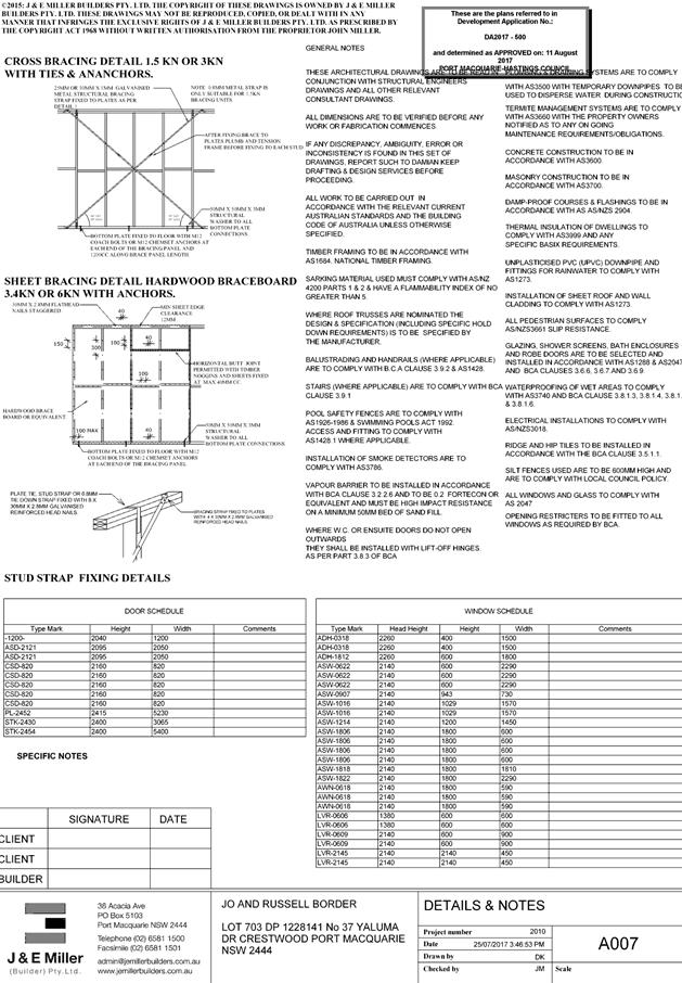
|
ATTACHMENT
|
Development Assessment Panel
28/03/2018
|
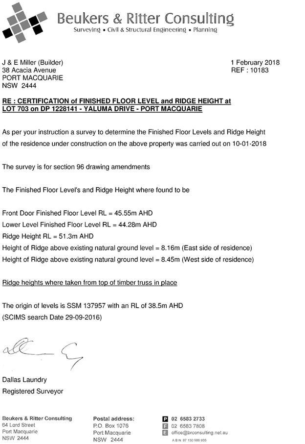
|
ATTACHMENT
|
Development Assessment Panel
28/03/2018
|
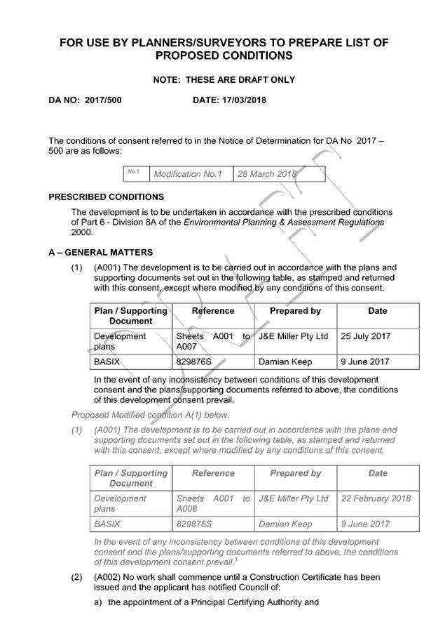
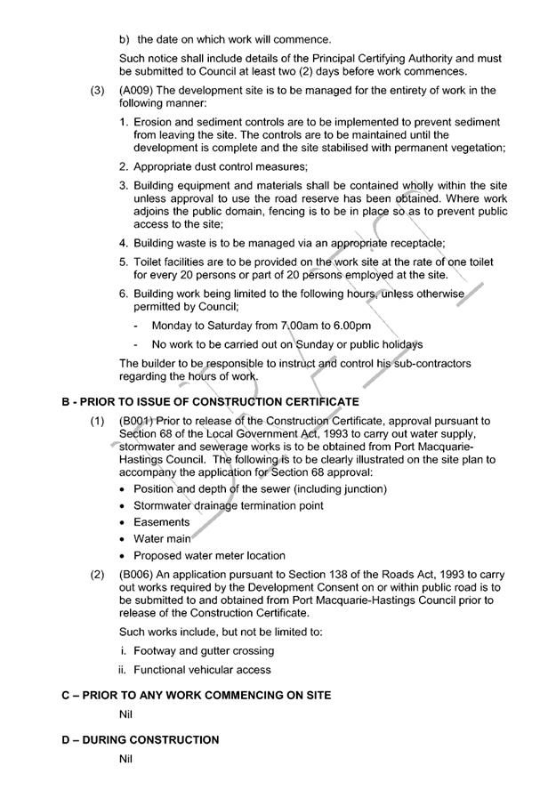

|
ATTACHMENT
|
Development Assessment Panel
28/03/2018
|
AGENDA Development Assessment Panel 28/03/2018
Item: 09
Subject: DA2017 - 1018.1 Dwelling - Lot 20 DP 803114,
No 21 Mill Hill, Port Macquarie
Report
Author: Deb McKenzie
|
Applicant: KiS
Drafting & Design
Owner: J
L Williams
Estimated Cost: $350,000
Alignment with Delivery
Program
4.3.1 Undertake transparent and
efficient development assessment in accordance with relevant legislation.
|
|
RECOMMENDATION
That
DA2017 – 1018.1 for a dwelling at Lot 20, DP 803114, No. 21 Mill Hill,
Port Macquarie, be determined by granting consent subject to the recommended
conditions.
|
Executive
Summary
This
report considers a development application for a dwelling at the subject site and provides an assessment of the
application in accordance with the Environmental Planning and Assessment Act
1979.
Following exhibition of the
application, one submission has been received.
1. BACKGROUND
Existing sites features and Surrounding development
The site has an area of 932.1m2.
The site is zoned R1 General Residential in accordance with the Port Macquarie-Hastings Local
Environmental Plan 2011, as shown in the following zoning plan:
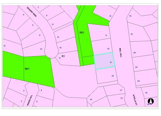
The existing subdivision pattern and location of existing
development within the locality is shown in the following aerial photograph:
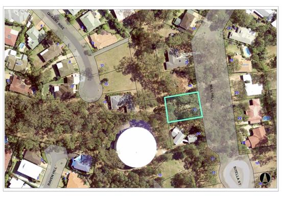
2. DESCRIPTION OF DEVELOPMENT
Key aspects of the proposal include the following:
· The
site is the last vacant residential property in Mill Hill.
· The
site backs onto a reserve adjacent the water supply tank at the top of the
ridge.
· The
site contains koala habitat trees that are reportedly visited by koalas on a
regular basis.
· The
lot contains a building envelope on the land title.
Application Chronology
· 15/11/17
– DA lodged.
· 11/12/17
– notification finished.
· 11/12/17
– submission received.
· 30/11/17
– additional information requested regarding ecological assessment
· 02/01/18
– additional information received (ecological assessment).
· 19/02/18-
meeting with applicant and proponent.
· 09/03/18
– additional information received from applicant (revised plans and
ecological assessment)
3. STATUTORY ASSESSMENT
Section 4.15(1) Matters for Consideration
In determining the application, Council is required to take
into consideration the following matters as are relevant to the development
that apply to the land to which the development application relates:
(a) The provisions (where
applicable) of:
(i) any Environmental
Planning Instrument:
The
provisions (where applicable) of:
(a)(i) Any environmental
planning instrument
State Environmental Planning Policy No. 44 - Koala Habitat
Protection
A Mill Hill Koala Plan of
Management applies to the site (EcoPro 1999).
There are twelve (12) koala food
trees on the subject site. These are shown in Figure 1 below (source:
Naturecall Environmental, March 2018).
The following trees are to be
removed – T3, T4, T5, T6, T7, T8, T12. The remainder are retained. The
seven (7) trees to be removed are due to either
location within the building envelope or location with the Bushfire Inner
Protection Area (IPA) of the site. The applicant has agreed to replacing the 7
trees at a ratio of 2:1 either within the reserve at the top of the ridge or elsewhere,
as agreed with Council. Replacement planting is allowed under the KPOM and the
proposal is consistent with such requirements. The final location for the new trees is yet to be finalised, however, initial
discussions with the applicant indicate that suitable site/s are available.
Due to the importance of replacing
these trees - in an agreed location - it is proposed to issue a ‘deferred
commencement’ development consent that will operate once the siting of
the new trees is agreed, in writing, with Council and payment towards the
purchase and planting of the trees is received by Council. This will ensure
that Council officers can be assured this work is capable of being finalised in
a reasonable timeframe and the applicant can commence site works for the
dwelling.
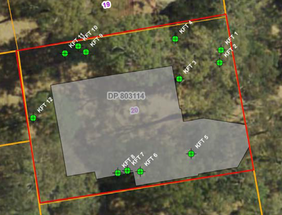
Figure 1: location of the koala
food trees on the site
State Environmental Planning
Policy No.55 – Remediation of Land
Following an inspection of the site and a search of Council
records, the subject land is not identified as being potentially contaminated
and is suitable for the intended use.
State Environmental Planning Policy (Building
Sustainability Index: BASIX) 2004
A BASIX certificate has been
submitted demonstrating that the proposal will comply with the requirements of
the SEPP. It is recommended that a condition be imposed to ensure that the
commitments are incorporated into the development and certified at Occupation
Certificate stage.
Port
Macquarie-Hastings Local Environmental Plan 2011
The proposal is consistent with the LEP having regard to the
following:
· Clause 2.2, the
subject site is zoned R1 General Residential. In accordance with clause 2.3(1)
and the R1 zone landuse table, the dwelling is a permissible landuse with
consent.
The objectives
of the R1 zone are as follows:
o To provide for the housing
needs of the community.
o To provide for a variety of
housing types and densities.
o To enable other land uses
that provide facilities or services to meet the day to day needs of residents.
In accordance with Clause 2.3(2),
the proposal is consistent with the zone objectives as it is a permissible
landuse and consistent with the established residential locality.
· Clause 4.3, the
maximum overall height of the building above ground level (existing) is 8.49m
which complies with the standard height limit of 8.5 m applying to the site.
· Clause 4.4, the
floor space ratio of the proposal is 0.35:1.0 which complies with the maximum
0.65:1 floor space ratio applying to the site.
· Clause 5.9 –
Seven (7) Tallowood trees are to be removed as part of the application.
Compensatory planting at a ratio of 2:1 is proposed in accordance with DCP. An
Ecological Assessment, prepared by Natural Call Environmental, dated March 2018
was submitted with the DA, justifying the tree removal. Conditions of consent
to apply.
· Clause 5.10
– Heritage. The site does not contain or adjoin any known heritage items
or sites of significance.
· Clause 7.5 –
Koala Habitat applies to the site. Refer to comments under SEPP 44 heading and
Clause 5.9 above. Conditions of consent are to apply regarding compensatory
plantings.
· Clause 7.13 -
satisfactory arrangements are in place for provision of essential services.
(ii) Any
draft instruments that apply to the site or are on exhibition:
Nil
(iii) any
Development Control Plan in force:
Port
Macquarie-Hastings Development Control Plan 2013
|
DCP 2013: Dwellings, Dual
occupancies, Dwelling houses, Multi dwelling houses & Ancillary
development
|
|
|
Requirements
|
Proposed
|
Complies
|
|
3.2.2.2
|
Articulation zone:
• Min. 3m front
setback
• An entry feature
or portico
• A balcony, deck,
patio, pergola, terrace or verandah
• A window box
treatment
• A bay window or
similar feature
• An awning or
other feature over a window
• A sun shading
feature
|
No elements within the
articulation zone.
|
N/A
|
|
Front setback (Residential not R5
zone):
• Min. 6.0m classified
road
• Min. 4.5m local
road
• Min. 3.0m
secondary road
• Min. 2.0m
Laneway
|
Dwelling is sited within the
designated building envelope for this site.
Setback = 12.4m.
|
Yes
|
|
3.2.2.3
|
Garage 5.5m min. and 1m behind
front façade.
Garage door recessed behind
building line or eaves/overhangs provided
|
Garage is setback behind the
entry porch, 12.4m from the front boundary.
|
Yes
|
|
6m max. width of garage door/s
and 50% max. width of building
|
6.3m wide garage. Less than 50%
of the building width. Carport also located on southern side of garage.
|
Yes
|
|
Driveway crossover 1/3 max. of
site frontage and max. 5.0m width
|
Driveway crossing width is long
due to distance from kerb to front boundary. Compliant.
|
Yes
|
|
3.2.2.4
|
4m min. rear setback. Variation
subject to site analysis and provision of private open space
|
Rear setback = 5.314m Complies.
|
Yes
|
|
3.2.2.5
|
Side setbacks:
• Ground floor =
min. 0.9m
• First floors
& above = min. 3m setback or where it can be demonstrated that
overshadowing not adverse = 0.9m min.
• Building wall
set in and out every 12m by 0.5m
|
Southern side: 4.030m to wall of
building and 500mm to side of carport. As the wall is a blank wall
construction of a car port, this variation is acceptable in this case.
Northern: 6.78m to edge of water
tanks.
The upper level retreat is
located towards to the northern side of the dwelling, over 7m from the
northern boundary.
|
No, but acceptable
|
|
3.2.2.6
|
35m2 min. private open space area
including a useable 4x4m min. area which has 5% max. grade
|
The dwelling contains over 35m² open space in one area
including a useable 4m x 4m space.
|
Yes
|
|
3.2.2.10
|
Privacy:
• Direct views
between living areas of adjacent dwellings screened when within 9m radius of
any part of window of adjacent dwelling and within 12m of private open space
areas of adjacent dwellings. ie. 1.8m fence or privacy screening which has
25% max. openings and is permanently fixed
• Privacy screen
required if floor level > 1m height, window side/rear setback (other than
bedroom) is less than 3m and sill height less than 1.5m
• Privacy screens
provided to balconies/verandahs etc which have <3m side/rear setback and
floor level height >1m
|
No direct views between living
areas of adjacent dwellings.
No privacy screens are
recommended.
|
Yes
|
|
DCP 2013: General
Provisions
|
|
|
Requirements
|
Proposed
|
Complies
|
|
2.7.2.2
|
Design addresses generic principles of Crime Prevention
Through Environmental Design guideline
|
No concealment or entrapment areas proposed. Adequate
casual surveillance available.
|
Yes
|
|
2.3.3.1
|
Cut and fill 1.0m max. 1m outside the perimeter of the
external building walls
|
Condition recommended to require engineering certification
|
Condition of consent.
|
|
2.3.3.2
|
1m max. height retaining walls along road frontage
|
None proposed.
|
N/A
|
|
Any retaining wall >1.0 in height to be certified by
structure engineer
|
Condition recommended to require engineering
certification.
|
Yes
|
|
Combination of retaining wall and front fence height max 1.8m,
max length 6.0m or 30% of frontage, fence component 25% transparent, and
splay at corners and adjacent to driveway
|
No retaining wall front fence combination proposed.
|
N/A
|
|
2.3.3.8
|
Removal of hollow bearing trees
|
No hollow bearing trees proposed to be removed. 2:1 koala
habitat tree replacement condition of consent.
|
N/A
|
|
2.6.3.1
|
Tree removal (3m or higher with 100m diameter trunk at 1m
above ground level and 3m from external wall of existing dwelling)
|
Discussed in this report previously.
Conditions of consent to apply.
|
N/A
|
|
2.4.3
|
Bushfire risk, Acid sulphate soils, Flooding,
Contamination, Airspace protection, Noise and Stormwater
|
Refer to main body of report.
|
|
|
2.5.3.2
|
New accesses not permitted from arterial or distributor
roads
|
No new access proposed to arterial or distribution road.
|
N/A
|
|
Driveway crossing/s minimal in number and width including
maximising street parking
|
Driveway crossing minimal in width.
|
Yes
|
|
2.5.3.3
|
Parking in accordance with Table 2.5.1.
1 space per single dwelling (behind building line)
|
Double garage provided + carport adjoining.
Complies.
|
Yes
|
|
2.5.3.14
|
Sealed driveway surfaces unless justified
|
Sealed driveway to be condition of consent
|
Condition of consent.
|
|
2.5.3.15 and 2.5.3.16
|
Driveway grades first 6m or ‘parking area’
shall be 5% grade with transitions of 2m length
|
Driveway grades capable of satisfying Council standard
driveway crossover requirements. Condition recommended for section 138 Roads
Act permit.
|
Yes
|
|
2.5.3.17
|
Parking areas to be designed to avoid concentrations of
water runoff on the surface.
|
Single dwelling only with 1 domestic driveway. Stormwater
drainage is capable of being managed as part of plumbing construction.
|
Yes
|
(iiia) any
planning agreement that has been entered into under Section 93f or any draft
planning agreement that a developer has offered to enter into under Section
93f:
Nil
iv) any matters prescribed by the
Regulations:
Nil
v) any coastal
zone management plan (within the meaning of the Coastal Protection Act 1979),
that apply to the land to which the development application relates:
Nil
(b) The
likely impacts of that development, including environmental impacts on both the
natural and built environments, social and economic impacts in the locality:
The site is
zoned for residential purposes. The subject site is a long established vacant
allotment. The land title of all properties in Mill Hill are subject to
building envelope restrictions. New land purchasers are aware of these
restrictions when buying in this area. There is a Koala Plan of Management for
the Mill Hill area. Therefore, koala habitat trees and koalas are well known to
occur in this area.
The site
contains twelve (12) Tallowood trees – known koala habitat trees. Seven
(7) of those trees are located within the building envelope or close proximity
to the building envelope on the site. These require removal as part of this
application. The applicant has been requested to review this situation and has
agreed to compensate for the loss of seven (7) trees at a ratio of 2:1. It is
has been assessed by Council officers and found to be acceptable in the
circumstances of this case. The replacement of koala trees at a ratio of 2:1
(14 trees in this case) is consistent with the requirements of the KPOM.
Notwithstanding
agreement being reached for tree planting compensation the location of the 14
new trees (2:1 ratio) has not been finalised. On this basis, it is proposed to
issue a ‘deferred commencement’ consent requiring as Part A of that
consent, written agreement (via plan or GPS location, or both) with Council
officers of the appropriate location/s for the trees and payment for
their purchase and planting. Once satisfied, the consent can commence and the
applicant can proceed to Part B conditions of the consent (site works and
construction). This is proposed to ensure that this important matter, while
capable of being satisfied, is actioned in the short term.
The site is
identified as bushfire prone land. A bushfire attack level certificate,
prepared by S & K Johnson for the site recommends a BAL 19 construction
level for all elevations of the building and BAL 29 for the alfresco area and
associated stairs and landings. The entire site is to be treated as an Inner
Protection Zone (IPZ) for the life of the buildings. In this regard, canopy
cover must be less than 15%, any canopy must be located more than 5 metres from
any roofline, trees should have lower limbs removed up to a height of 2 metres
above the ground (4 metres if emergency vehicles need to park next to or drive
around them) and shrubs and gardens need to be 1.5m away from exposed windows
and doors. These, and other design and landscaping recommendations will be
applied as conditions of consent in this case.
Cumulative Impacts
Acceptable,
subject to imposition of the conditions of consent requiring compensatory
planting at a ratio of 2:1; and ensuring that the plantings are appropriately
sited and carried out.
(c) The suitability of the site for
the development:
The subject
site is the last vacant property in Mill Hill. There is a reasonable
expectation by the landowner of being able to construct a dwelling on the land,
subject to the consent of Council and reflecting the site specific constraints.
The applicant was requested to submit further information addressing, in more
detail, the koala habitat trees on the site and the siting the dwelling. A
revised ecological assessment was also submitted. Based on the outcomes of a
review of the information submitted, the proposed dwelling is considered suitable
for the site.
(d) Any submissions made in
accordance with this Act or the Regulations:
One (1) written submissions have been received following public
exhibition of the application.
Key issues raised in the submissions received and comments
in response to these issues are provided as follows:
|
Submission
Issue/Summary
|
Planning
Comment/Response
|
|
Removal of Tallowood trees
close to the southern fence – loss of koala trees + impact on koala
population?
|
This matter has been reviewed
and assessed in some detail as part of the assessment of this application.
Council officers have agreed to the replacement of seven (7) Tallowoods at a
rate of 2:1, resulting in 14 trees to be planted. The trees to be removed are
located within the building envelope of the dwelling or within the bushfire
inner protection area (IPA) adjacent the building. The remaining seven (7)
Tallowoods identified on site are to be retained.
|
|
Was a tree report submitted with the application?
|
The applicant was requested to submit an Ecological
Assessment. A revised version of that assessment (dated March 2018) forms the
basis of the ecological assessment of the development on the subject site.
|
|
Move the house 6m to the north and 5m to towards to
street.
|
Repositioning of the house was discussed at a meeting
with Council officers during assessment of the application. The subject
affected trees would be affected due to the excavation and proximity to
nearly any dwelling proposed on the site.
|
|
Visual impact and effect of proposed removal of the
trees.
|
The subject site has been vacant for many years and
currently forms part of the backdrop to Mill Hill and the neighbourhood. The
site has a dwelling entitlement and a building envelope on it that allows for
residential construction on the site. 7 of the 14 Tallowoods are to be
retained on site, thereby addressing this submission where possible.
|
|
Replanting not the same as existing trees.
|
This is acknowledged. However, as a form of compensation,
replanting at a rate of 2:1 will assist.
|
|
Is there a time limit on the building envelope or who can
release the building envelope on the land title?
|
In relation to the subject site the existing covenant on
the land title – the building envelope is current and valid.
|
(e) The Public Interest:
The proposed
development satisfies relevant planning controls and is unlikely to impact on
the wider public interest.
4. DEVELOPMENT
CONTRIBUTIONS APPLICABLE
· Not applicable – credit exists from the lot.
5. CONCLUSION
The application has been assessed in accordance with
Section 4.15 of the Environmental Planning and Assessment Act 1979.
Issues raised during assessment and public exhibition of
the application have been considered in the assessment of the application. Where
relevant, conditions have been recommended to manage the impacts attributed to
these issues.
The site is suitable for the proposed development, is not
contrary to the public's interest and will not have a significant adverse
social, environmental or economic impact. It is recommended that the
application be approved, subject to the recommended conditions of consent
provided in the attachment section of this report.
|
Attachments
1View. DA2017
- 1018.1 Plans
2View. DA2017
- 1018.1 Recommended Conditions
3View. DA2017
- 1018.1 Submission - Roberts
|
|
ATTACHMENT
|
Development Assessment Panel
28/03/2018
|
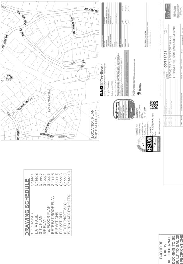
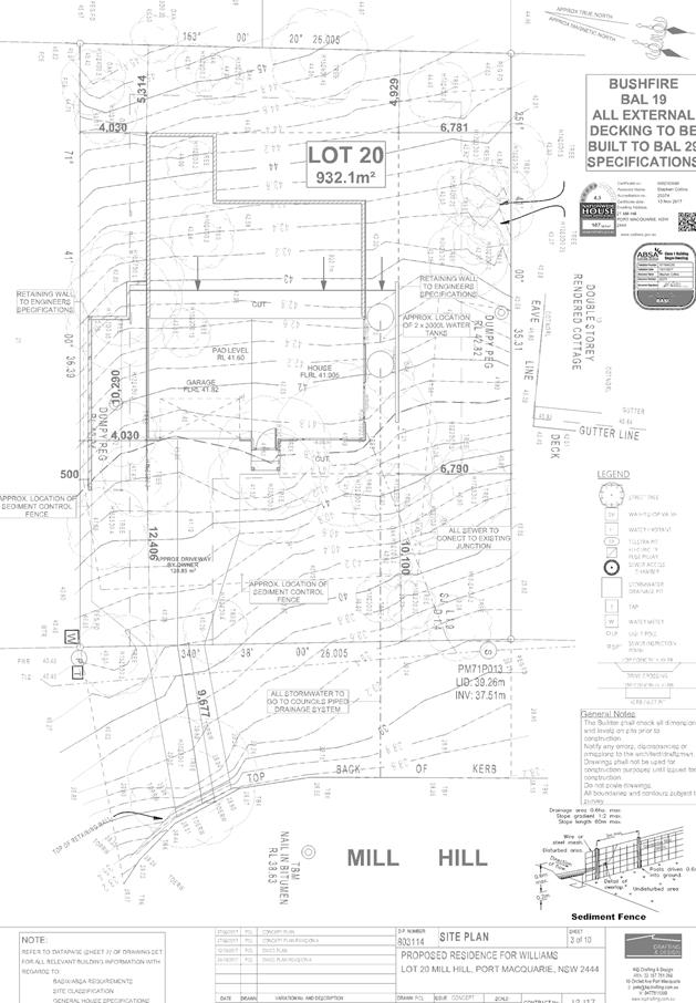
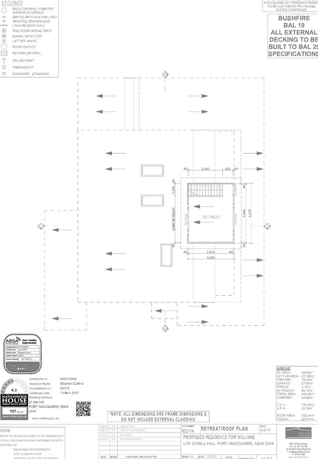
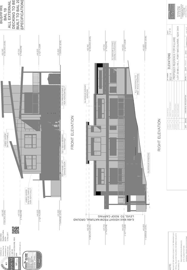
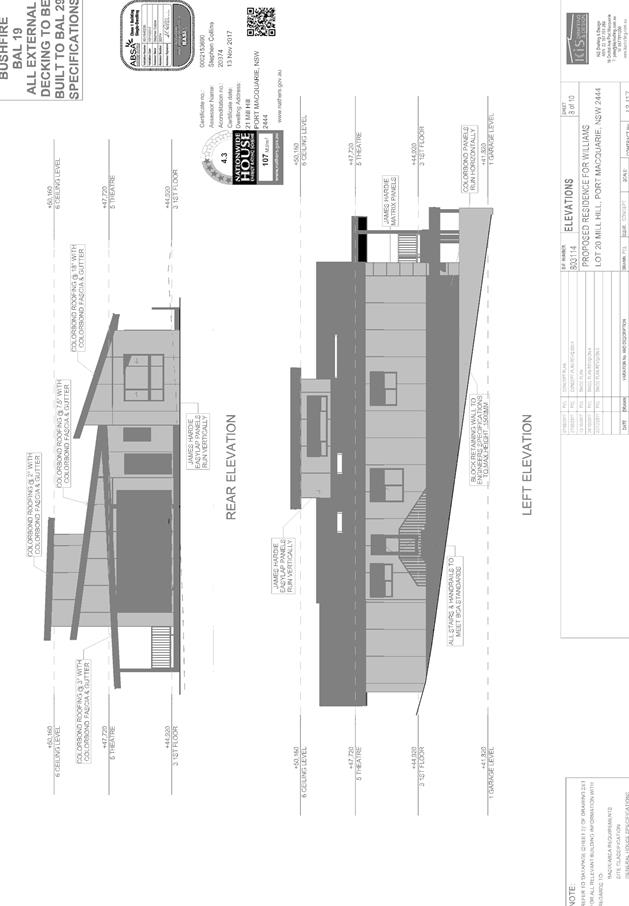
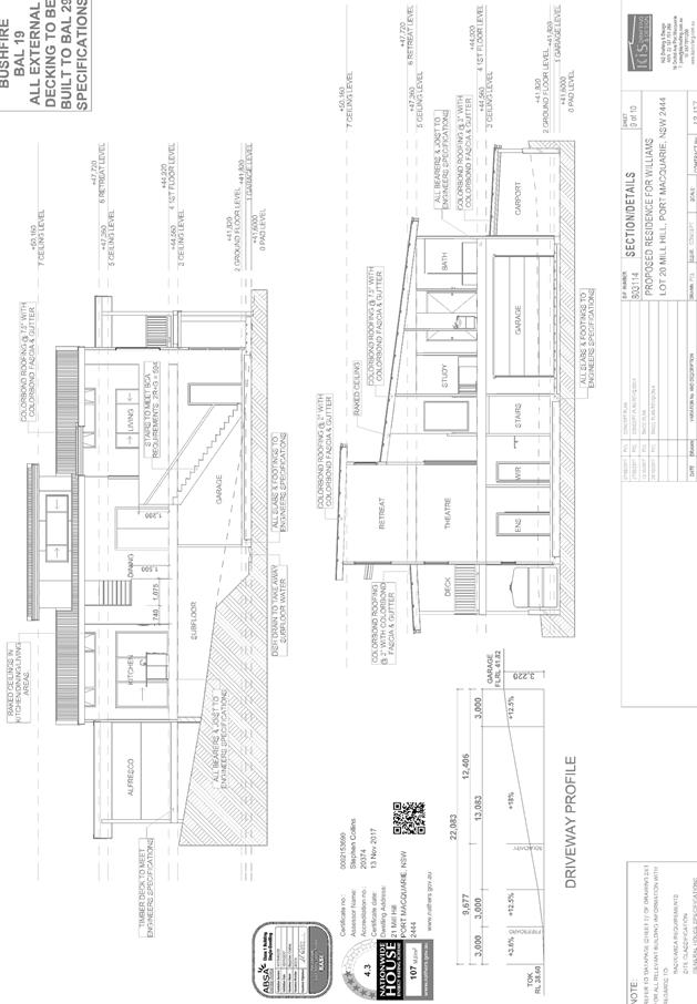
|
ATTACHMENT
|
Development Assessment Panel
28/03/2018
|
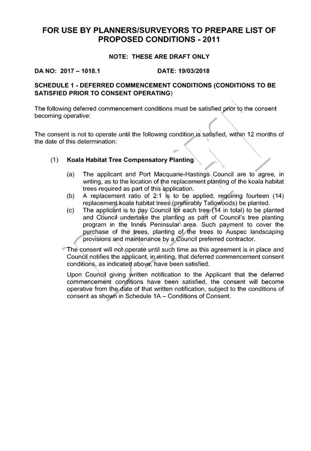

|
ATTACHMENT
|
Development Assessment Panel
28/03/2018
|