Business
Paper
|
date of meeting:
|
|
Wednesday 20 June
2018
|
|
location:
|
|
Council Chambers
17 Burrawan Street
Port Macquarie
|
|
time:
|
|
5.30pm
|
Community Vision A sustainable high quality of life for all
Community Mission Building
the future together
People
Place Health Education Technology
Council’s Corporate Values é Sustainability
é Excellence in Service Delivery
é Consultation and Communication
é Openness and Accountability
é Community Advocacy
Community Themes é Leadership and Governance
é Your Community Life
é Your Business and Industry
é Your Natural and Built Environment
How Members of the Public
Can Have Their Say at Council Meetings
Council has a commitment to providing
members of the public with an input into Council's decision making. The
Council's Code of Meeting Practice provides two (2) avenues for members of the
public to address Council on issues of interest or concern at the Ordinary
Council Meeting. These are:
·
Addressing Council on an Agenda Item (if the matter is
listed in the Council Business Paper)
·
Addressing Council in the Public Forum (if the matter is
not listed in the Council Business Paper)
You can request to address Council by
completing the:
·
‘Request to Speak on an Agenda Item’ form
·
‘Request to Speak in the Public Forum’ form
These can be obtained from Council’s
Offices at Laurieton, Port Macquarie and Wauchope or by downloading it from Council’s website.
Requests can also be lodged on-line at:
http://www.pmhc.nsw.gov.au/About-Us/How-Council-Works/Council-Committee-Meetings/Request-to-speak-on-an-Agenda-Item
http://www.pmhc.nsw.gov.au/About-Us/How-Council-Works/Council-and-Committee-Meetings/Request-to-speak-in-a-Public-Forum
Your request to address Council must be
received by Council no later than 4:30pm on the day prior to the Council
Meeting.
·
Council will permit no more than
two (2) speakers ‘in support of’ and two (2) speakers ‘in
opposition to’ the recommendation on any one (1) Agenda Item.
·
A maximum of five (5) speakers
will be heard in the Public Forum.
·
There is no automatic right under legislation
for the public to participate in a Meeting of Council or a Committee of
Council.
·
For a member of the public to be
considered to address Council they must agree to strictly adhere to all
relevant adopted Council Codes, Policies and Procedures at all times.
·
Consideration of items for which
requests to address the Council Meeting have been received will commence at
5:30pm.
·
When your name is called, please
proceed to the Council Table and address Council.
·
Each speaker will be allocated a
maximum of five (5) minutes to address Council. This time is strictly enforced.
·
Councillors may ask questions of a
speaker following an address. Each answer, by the speaker to a question,
is limited to two (2) minutes. A speaker cannot ask questions of Council.
·
An Agenda Item will be
debated by Council following the address.
·
Council will not determine any
matter raised in the Public Forum session, however Council may resolve
to call for a future report.
·
If you have any documentation to
support your presentation, provide two (2) copies to Council by 12 noon on the
day of the Meeting.
·
If a speaker has an audio visual
presentation, a copy of the presentation is to be provided to Council by 12
noon on the day of the Meeting.
·
The following will not be
considered in the Public Forum (in accordance with the Code of Meeting
Practice, clause 2.14.14):
-
Proposed or current development
and rezoning applications and related matters.
-
A third (3rd) or subsequent application
by a single member of the public to address Council on the same issue in the
same calendar year. Council, at its discretion, may elect to exempt
representatives or members of community groups from this restriction.
-
Any formal procurement process,
contract negotiation or dispute resolution being undertaken.
-
Any matter the General Manager (or
their delegate) considers inappropriate for discussion in the Public Forum.
·
Council accepts no responsibility
for any defamatory statements made by speakers.
·
Members of the public may quietly
enter and leave the Meeting at any time.
Wednesday 20 June
2018
Items of
Business
01 Acknowledgement
of Country............................................................................ 1
02 Local
Government Prayer................................................................................... 1
03 Apologies......................................................................................................... 1
04 Confirmation
of Minutes.................................................................................... 1
05 Disclosures
of Interest..................................................................................... 28
06 Mayoral
Minute
06.01..... Mayoral Discretionary Fund Allocations.............................................. 32
07 Confidential
Correspondence to Ordinary Council Meeting................................. 33
08 Public
Forum................................................................................................... 34
09 Leadership
and Governance........................................................................... 35
09.01..... 2018 Local Government NSW Annual Conference................................ 36
09.02..... Voting Delegates - Vice President Local
Government NSW Board........ 38
09.03..... Status of Reports From Council Resolutions....................................... 40
09.04..... Disclosure of Interest Return.............................................................. 45
09.05..... Making of Rates and Charges for 2018/2019,
Adoption of the Fees and Charges and Revenue Policy for 2018/2019............................................................ 47
09.06..... Integrated Planning and Reporting (IPR)
Documents ........................... 54
09.07..... Monthly Financial Review for May 2018............................................... 92
09.08..... Investments - May 2018..................................................................... 98
09.09..... Town Centre Master Plan Sub-Committee -
Membership..................... 102
10 Your
Community Life................................................................................... 105
10.01..... Kendall Main Street Master Plan....................................................... 106
10.02..... Recommended Item from Cultural Steering
Group - (General Business Item) - Surf Museum - Town Beach North............................................................ 113
10.03..... Recommended Items from the Mayor's Sporting
Fund Sub-Committee - May 2018 ....................................................................................................... 115
10.04..... Artwalk 2018 - Post Event Report..................................................... 116
10.05..... Cultural Plan Review......................................................................... 125
11 Your
Business and Industry
Nil
12 Your
Natural and Built Environment............................................................. 129
12.01..... Acquisition of Land and Easement - Long
Flat Sewerage Scheme...... 130
12.02..... Regional Transport Infrastructure Steering
Group Membership Amendment 133
12.03..... Stormwater Strategy Development Update -
Integrating Council's Stormwater Strategy with the Integrated Water Cycle
Management Strategy....................... 135
12.04..... Garden Crescent, Port Macquarie Car Parking
Works as Material Public Benefit....................................................................................................... 145
12.05..... Open Space Contributions Plan ....................................................... 149
12.06..... Deferral of Strata Development
Contributions................................... 156
12.07..... Port Macquarie-Hastings Urban Growth
Management Strategy 2017-2036 167
12.08..... The Boom Reserve Dog Off-Leash Park........................................... 216
12.09..... Classification of Land Transferred to
Council for Sewer Purposes...... 222
12.10..... Classification of Land Acquired by Council
- Stingray Creek.............. 224
13 Questions
for Next Meeting
14 Confidential Matters
Motion to move into
Confidential Committee of the Whole............................... 227
14.01..... Request for Bad Debt Write-Off
14.02..... T-18-13 Hartys Creek Bridge Replacement
14.03..... T-18-16 Provision of Legal Services
14.04..... T-18-18 Provision of Hire Services -
Contract Plant, Ancillary Equipment and Plant Operators
14.05..... Property Purchase by Property Reserve
Adoption
of Recommendations from Confidential Committee of the Whole
AGENDA Ordinary Council 20/06/2018
Subject: ACKNOWLEDGEMENT
OF COUNTRY
"I acknowledge that we are
gathered on Birpai Land. I pay respect to the Birpai Elders both past and
present. I also extend that respect to all other Aboriginal and Torres Strait
Islander people present."
Subject: LOCAL
GOVERNMENT PRAYER
A Minister from the Combined Churches of Port Macquarie will
be invited to deliver the Local Government Prayer.
RECOMMENDATION
That the apologies received be
accepted.
Subject: CONFIRMATION
OF PREVIOUS MINUTES
Recommendation
That the Minutes of the Ordinary
Council Meeting held on 16 May 2018 be confirmed.
MINUTES
Ordinary Council Meeting
16/05/2018
PRESENT
Members:
Councillor Peta Pinson (Mayor)
Councillor Lisa Intemann (Deputy
Mayor)
Councillor Rob Turner
Councillor Michael Cusato
Councillor Sharon Griffiths
Councillor Peter Alley
Councillor Justin Levido
Councillor Geoff Hawkins
Councillor Lee Dixon
Other Attendees:
Acting General Manager (Rebecca
Olsen)
Acting Director Corporate
Performance (Adam Holthouse)
Acting Director Development and
Environment (Dan Croft)
Director Infrastructure (Alex
Fisher)
Director Strategy and Growth
(Jeffery Sharp)
Group Manager Governance and
Procurement (Blair Hancock)
Governance Support Officers
(Bronwyn Lyon/Gai Lazarides)
Communications Manager (Andy
Roberts)
|
The meeting opened at 5.30pm.
|
|
01 ACKNOWLEDGEMENT
OF COUNTRY
|
|
The
Mayor opened the Meeting with an Acknowledgement of Country and welcomed all
in attendance in the Chamber.
|
|
02 LOCAL
GOVERNMENT PRAYER
|
|
Peter
Charles, Assistant Minister from the
Presbyterian Church delivered the Local Government Prayer.
|
The
Mayor acknowledged Robyn Sparks for her 10 year attendance at Council meetings.
|
04 CONFIRMATION
OF MINUTES
|
|
RESOLVED:
Intemann/Hawkins
That
the Minutes of the Ordinary Council Meeting held on 18 April 2018 be
confirmed.
carried: 8/1
For: Alley, Cusato, Dixon, Hawkins, Intemann, Levido, Pinson
and Turner
Against: Griffiths
|
|
05 DISCLOSURES
OF INTEREST
|
|
Councillor Levido declared a
Non-Pecuniary, Significant Interest in Item 12.11 - Section 4.55 Modification DA2010 - 577.4 - Modification
To Subdivision Lot Layout Including Addition Of One (1) Torrens Title Lot -
Lot 2 DP 1231106, No. 72 Lorne Road, Kendall,
the reason being that Councillor Levido is a partner
in the Port Macquarie law firm, Donovan Oates Hannaford Lawyers and acts for
the owner of a property the subject of the report.
Councillor Levido declared a
Non-Pecuniary, Significant Interest in Item 14.06 - Section 4.55 Modification DA2010 - 577.4 - Modification
To Subdivision Lot Layout Including Addition Of One (1) Torrens Title Lot -
Lot 2 DP 1231106, No. 72 Lorne Road, Kendall,
the reason being that Councillor Levido is a partner
in the Port Macquarie law firm, Donovan Oates Hannaford Lawyers and acts for
the owner of a property the subject of the report.
Councillor Intemann declared a
Non-Pecuniary, Less Than Significant Interest in Item 09.06 - Mid North Coast Regional Equestrian Centre, the reason being that Councillor Intemann is the
honorary Patron of the Port Macquarie Pony Club which is mentioned in the
report as a potential user of the proposed facility.
Councillor Intemann declared a
Non-Pecuniary, Less Than Significant Interest in Item 12.05 - Planning Proposal: Bundaleer Aged Care Centre, 4-8
Johnstone Street and 67 High Street, Wauchope,
the reason being that Councillor Intemann is a Director of the Hastings
Cooperative Limited, the Chair of which is a member of the Board of Bundaleer
Care Services.
Councillor Intemann declared a
Pecuniary Interest in Item 12.06 - Planning
Proposal: Proposed Highway Service Centre, 1179 Oxley Highway, Sancrox, the reason being that Councillor Intemann is a Director
of Hastings Cooperative Ltd which operates service stations on the Oxley
Highway in Wauchope about 10kms from the location of the proposal.
Councillor Pinson declared a
Pecuniary Interest in Item 14.06 - T-18-02
Southern Arm Trunk Main Cowarra Balance Tank to Pacific Highway, the reason being that Councillor Pinson owns a company
known as Stabilcorp which has occasional business dealings with one of the
tenderers.
|
|
06.01 Mayoral Discretionary Fund Allocations
|
|
RESOLVED:
Pinson
That the Mayoral Discretionary Fund allocations for the period
5 April to 1 May 2018 inclusive be noted.
carried: 9/0
For: Alley, Cusato, Dixon, Griffiths, Hawkins, Intemann,
Levido, Pinson and Turner
Against: Nil
|
|
07 CONFIDENTIAL
CORRESPONDENCE TO ORDINARY COUNCIL MEETING
|
|
RESOLVED:
Levido/Dixon
That Council
determine that the attachments to Item Numbers 9.08 and 11.01 be considered
as confidential, in accordance with section 11(3) of the Local Government
Act.
carried: 9/0
For: Alley, Cusato, Dixon, Griffiths, Hawkins, Intemann,
Levido, Pinson and Turner
Against: Nil
|
|
08 PUBLIC FORUM
|
|
The
Mayor advised of applications to address Council in the Public Forum from:
1.
Mr Paul Jones regarding Water Fluoridation
Update Report 18/04/18
2.
Mr Peter Newman regarding 2018-19 Operational
Plan – Kew Main Street Plan.
RESOLVED: Cusato/Dixon
That the above requests to speak
in the Public Forum be acceded to.
carried: 9/0
For: Alley, Cusato, Dixon, Griffiths, Hawkins, Intemann,
Levido, Pinson and Turner
Against: Nil
|
|
08.01 Water Fluoridation Update Report 18/04/18
|
|
Mr
Paul Jones, Citizens Against Fluoridation Inc, addressed Council in regard to
the Water Fluoridation Update Report 18/04/18 and answered questions from
Councillors.
|
|
08.02 2018-19 Operational Plan – Kew Main
Street Plan
|
|
Mr
Peter Newman, Kew Business Community Group addressed Council in regard to the
2018-19 Operational Plan – Kew Main Street Plan.
|
|
Requests to Speak on an Agenda Item
|
|
The
Mayor advised of requests to speak on an agenda item, as follows:
Item
12.01 – Mr Fred O’Toole in opposition of the recommendation.
Item
12.05 – Mr Gareth Norman in opposition of the recommendation.
Item
12.05 – Ms Michelle Love in opposition of the recommendation.
Item
12.06 – Mr Michael Mowle in support of the recommendation.
Item
12.10 – Mr Teale Bryan in support of the recommendation.
Item
12.11 – Mr Michael Mowle in support of the recommendation.
RESOLVED:
Cusato/Dixon
That
the requests to speak on an agenda item be acceded to:
|
|
Suspension of Standing Orders
|
|
RESOLVED: Hawkins/Turner
That
Standing Orders be suspended to allow items 12.01, 12.05, 12.06, 12.10, 12.11
to be brought forward and considered next.
|
|
12.01 Notice of Alteration
of a Motion - Petition - Request for Ocean Tidal Pool in Port Macquarie
|
|
Mr
Fred O’Toole, Port Macquarie Tidal Pool Committee Inc, addressed
Council in opposition of the recommendation. Councillor Levido clarified his
Alteration of Motion.
RESOLVED:
Turner/Cusato
That Council alter the “12.02
– Notice of Motion – Request for Ocean Tidal Pool in Port
Macquarie” adopted at the April 2018 Ordinary Council meeting to:
That Council:
1.
Note the 2016 petition for an ocean tidal pool
in Port Macquarie resubmitted to the Mayor by the Port Macquarie Tidal Pool
Committee Incorporated.
3.
Note the petition received by the Mayor from
Jenny Broughton in March 2018 in favour of an ocean tidal pool in Port
Macquarie.
4.
Note that an ocean tidal pool in Port
Macquarie is not a priority for Council.
5.
Request the two petitions be considered by
Council as public submissions to the 2018-19 Operational Plan.
6.
Encourage the Port Macquarie Tidal Pool
Committee Incorporated to make any future requests, submissions and grant
applications through Council’s recognised engagement processes to
ensure that the competing priorities of all volunteer and community groups in
our area receive appropriate and equal consideration by Council.
7.
Noting that as any development of an Ocean
Tidal Pool would require consent from the landowner (in this case the Crown)
as part of any future Development Application, request the General Manager
seek advice from the Department of Industry Crown Lands as to the
Crown’s position regarding the construction of new ocean tidal pools
and what information the Crown would require in order to be able to
consider giving land owner’s consent to such a proposal being lodged.
carried: 6/3
For: Cusato, Dixon, Hawkins, Intemann, Levido and Turner
Against: Alley, Griffiths and Pinson
|
|
12.05 Planning Proposal: Bundaleer Aged
Care Centre, 4-8 Johnstone Street and 67 High Street, Wauchope
|
|
Councillor
Intemann declared a Non-Pecuniary, Less Than Significant Interest in this
matter and remained in the room during the Council's consideration.
Mr
Gareth Norman, Bundaleer Care Services, addressed Council in opposition of
the recommendation and answered questions from Councillors.
Ms
Michelle Love, Love Project Management, addressed Council in opposition of
the recommendation and answered questions from Councillors.
MOTION
MOVED:
Intemann/Alley
That Council:
1.
Prepare a Planning Proposal pursuant to
section 3.33 of the Environmental Planning and Assessment Act 1979 for the
amendment of the provisions of Port Macquarie-Hastings Local Environmental
Plan 2011 to permit development of the land for the purpose of residential
care facilities to exceed the maximum height of building and maximum floor
space ratio controls applying to land in Wauchope, as follows:
a)
In respect to Lot 1 DP 603483, 4-8 Johnstone
St:
i)
maximum height of 11.5m for the area labelled
“A” and 14.5m to the area labelled “B” shown in
Figure 17 of this report
ii)
maximum floor space ratio of 1.30:1,
b)
In respect to Lot A DP 157092, being 67 High
St:
i)
maximum height of 11.5m for the area labelled
“A” in Figure 17 of this report,
ii)
maximum floor space ratio of 1.00:1.
c)
The flexibility provisions of Clause 4.6
Exceptions to development controls, and 5.6 Architectural roof features, will
not apply to the additional permitted height limits.
8.
Forward the Planning Proposal to the NSW
Department of Planning and Environment requesting a Gateway Determination
pursuant to section 3.34 of the Environmental Planning and Assessment Act
1979.
9.
Prepare a draft Development Control Plan in
respect to the land, and exhibit concurrently with the Planning Proposal,
incorporating the provisions described in the report.
10.
Request that the Secretary of the Department
of Planning & Environment issue a Written Authorisation to Council to
Exercise Delegation of the plan making functions under section 3.36 of the
Act in respect of the Planning Proposal.
11.
Delegate authority to the General Manager to
make any minor amendments to the Planning Proposal as a result of the Section
3.34 Gateway Determination, prior to public exhibition of the proposal.
12.
Undertake community consultation in accordance
with the Gateway Determination.
13.
Receive a report following the public
exhibition period to demonstrate compliance with the Gateway Determination
and to assess any submissions received.
AMENDMENT
MOVED: Turner/Hawkins
That Council:
1.
Prepare a Planning Proposal pursuant to
section 3.33 of the Environmental Planning and Assessment Act 1979 for the
amendment of the provisions of Port Macquarie-Hastings Local Environmental
Plan 2011 to permit development of the land for the purpose of residential
care facilities to exceed the maximum height of building and maximum floor
space ratio controls applying to land in Wauchope being Lot 1 DP 603483, 4-8 Johnstone St and Lot A DP 157092, 67 High St, as follows:
a)
maximum height of 14.5m for the area shown
blue in Figure 4 of this report
b)
maximum floor space ratio of 1.4:1
2.
Forward the Planning Proposal to the NSW
Department of Planning and Environment requesting a Gateway Determination
pursuant to section 3.34 of the Environmental Planning and Assessment Act
1979.
3.
Request that the Secretary of the Department
of Planning & Environment issue a Written Authorisation to Council to
Exercise Delegation of the plan making functions under section 3.36 of the
Act in respect of the Planning Proposal.
4.
Delegate authority to the General Manager to
make any minor amendments to the Planning Proposal as a result of the Section
3.34 Gateway Determination, prior to public exhibition of the proposal.
5.
Undertake community consultation in accordance
with the Gateway Determination.
6.
Receive a report following the public
exhibition period to demonstrate compliance with the Gateway Determination
and to assess any submissions received.
carried: 6/3
For: Cusato, Dixon, Griffiths, Hawkins, Pinson and Turner
Against: Alley, Intemann and Levido
THE
AMENDMENT BECAME THE MOTION AND WAS PUT
RESOLVED:
Turner/Hawkins
That
Council:
1.
Prepare a Planning Proposal pursuant to
section 3.33 of the Environmental Planning and Assessment Act 1979 for the
amendment of the provisions of Port Macquarie-Hastings Local Environmental
Plan 2011 to permit development of the land for the purpose of residential
care facilities to exceed the maximum height of building and maximum floor
space ratio controls applying to land in Wauchope being Lot 1 DP 603483, 4-8 Johnstone St and Lot A DP 157092, 67 High St, as follows:
a)
maximum height of 14.5m for the area shown
blue in Figure 4 of this report
b)
maximum floor space ratio of 1.4:1
2.
Forward the Planning Proposal to the NSW
Department of Planning and Environment requesting a Gateway Determination
pursuant to section 3.34 of the Environmental Planning and Assessment Act
1979.
3.
Request that the Secretary of the Department
of Planning & Environment issue a Written Authorisation to Council to
Exercise Delegation of the plan making functions under section 3.36 of the
Act in respect of the Planning Proposal.
4.
Delegate authority to the General Manager to
make any minor amendments to the Planning Proposal as a result of the Section
3.34 Gateway Determination, prior to public exhibition of the proposal.
5.
Undertake community consultation in accordance
with the Gateway Determination.
6.
Receive a report following the public
exhibition period to demonstrate compliance with the Gateway Determination
and to assess any submissions received.
carried: 6/3
For: Cusato, Dixon, Griffiths, Hawkins, Pinson and Turner
Against: Alley, Intemann and Levido
|
|
12.06 Planning Proposal: Proposed Highway
Service Centre, 1179 Oxley Highway, Sancrox
|
|
Councillor Intemann declared a
Pecuniary Interest in this matter and left the room and was out of sight
during the Council's consideration, the time being 07:23pm.
Councillor Cusato left the
meeting, the time being 07:23pm.
Councillor Cusato returned to
the meeting, the time being 07:25pm.
Mr Michael Mowle, Hopkins Consultants,
addressed Council in support of the recommendation.
RESOLVED: Alley/Cusato
That Council:
1.
Prepare a Planning Proposal pursuant to
section 3.33 of the Environmental Planning and Assessment Act 1979 for the
amendment of the provisions of Port Macquarie-Hastings Local Environmental
Plan 2011 to permit development of Lot 11 DP 1029846, 1179 Oxley Highway,
Sancrox:
a)
To permit development for the purpose of a
Highway Service Centre, including ancillary hotel or motel accommodation for
heavy vehicle drivers, and
b)
to permit subdivision to excise the Highway
Service Centre from the balance of the site, despite the minimum lot size
provisions.
c)
To permit subdivision, following construction
of the Highway Service Centre, without being subject to the minimum lot size
shown in the lot size map.
d)
To retain a dwelling entitlement on the
residue lot.
2.
Forward the Planning Proposal to the NSW
Department of Planning and Environment requesting a Gateway Determination
pursuant to section 3.34 of the Environmental Planning and Assessment Act
1979, upon:
a)
Satisfactory arrangements being
demonstrated by the Applicant for a coordinated access point from the
proposed highway service centre to the Oxley Highway, which can service the
southern and northern gateway sites and Billabong Drive, and
b)
Written advice being received from the Roads
and Maritime Services that the proposed highway service centre can be safely
and efficiently integrated into the Pacific and Oxley Highways, and
c)
Satisfactory arrangements being in place for
the connection of the site to reticulated sewer.
3.
Request the General Manager facilitate a
meeting between the Applicant, their traffic consultants and Roads and
Maritime Services, to discuss the resolution of transport planning issues
associated with the Planning Proposal, including the location and design of
access from the Highway Service Centre to the Oxley Highway.
4.
Request that the Secretary of the Department
of Planning & Environment issue a Written Authorisation to Council to
Exercise Delegation of the plan making functions under section 3.36 of the
Act in respect of the Planning Proposal.
5.
Delegate authority to the General Manager to
prepare a planning proposal in accordance with this report and to make any
minor amendments to the Planning Proposal as a result of the Section 3.34
Gateway Determination, prior to public exhibition of the proposal.
6.
Undertake community consultation in accordance
with the Gateway Determination.
7.
Prepare a draft Development Control Plan, in
respect to the land and the northern Gateway site, incorporating provisions
described in this report accordance with clause 18 of the Environmental
Planning and Assessment Regulation 2000.
8.
Receive a further report providing details of
proposed amendments to the Development Control Plan for approval prior to the
Planning Proposal and draft Development Control Plan being exhibited
concurrently.
9.
Receive a report following the public
exhibition period to demonstrate compliance with the Gateway Determination
and to assess any submissions received.
carried: 8/0
For: Alley, Cusato, Dixon, Griffiths, Hawkins, Levido, Pinson
and Turner
Against: Nil
|
|
Deputy Mayor Intemann returned
to the meeting, the time being 07:30pm.
|
|
12.10 DA2017 - 1084.1 Clubhouse - Lot 7054 DP
1074173, No. 12 Maritime Lane (Oxley Oval), Port Macquarie
|
|
Councillor Hawkins left the
meeting, the time being 07:31pm.
Councillor Hawkins returned to
the meeting, the time being 07:32pm.
Mr Teale Bryan, Vikings and
Cricket, addressed Council in support of the recommendation and answered
questions from Councillors.
RESOLVED:
Intemann/Cusato
That DA 2017 – 1084.1 for
a clubhouse at Lot 7054, DP 1074173, No. 12 Maritime Lane (Oxley Oval), Port
Macquarie, be determined by granting consent subject to the recommended
conditions, with the following amendment:
- Amend condition C5 to read:
‘(C195) Prior to removal of the 2 Norfolk Pines, written
confirmation is to be obtained from Council’s Director Development
and Environment that satisfactory arrangements are in place for the
provision of offset plantings of Norfolk Pines at a ratio of 2:1 (i.e. 4
replacement trees).’
carried: 9/0
For: Alley, Cusato, Dixon, Griffiths, Hawkins, Intemann,
Levido, Pinson and Turner
Against: Nil
|
|
12.11 Section 4.55 Modification DA2010 - 577.4
- Modification To Subdivision Lot Layout Including Addition Of One (1)
Torrens Title Lot - Lot 2 DP 1231106, No. 72 Lorne Road, Kendall
|
|
Councillor Levido declared a
Non-Pecuniary, Significant Interest in this matter and left the room and was
out of sight during the Council's consideration, the time being 07:39pm.
Mr Michael Mowle, Hopkins
Consultants, addressed Council in support of the recommendation and answered
questions from Councillors.
RESOLVED:
Intemann/Turner
That
Section 4.55 modification to DA 2010 - 577
for a modification to subdivision layout including addition of one (1)
torrens title lot at Lot 2, DP 1231106, No. 72
Lorne Road, Kendall,
be determined by granting the modified consent subject to the recommended
conditions.
carried: 8/0
For: Alley, Cusato, Dixon, Griffiths, Hawkins, Intemann,
Pinson and Turner
Against: Nil
|
|
Councillor Levido returned to
the meeting, the time being 07:45pm.
|
|
09.01 Status of Reports From
Council Resolutions
|
|
RESOLVED:
Cusato/Alley
That Council note the
information contained in the Status of Reports from Council Resolutions
report.
carried: 9/0
For: Alley, Cusato, Dixon, Griffiths, Hawkins, Intemann,
Levido, Pinson and Turner
Against: Nil
|
|
09.02 2018-2019 Councillor
and Mayoral Fees
|
|
RESOLVED:
Intemann/Alley
That
in relation to Councillor remuneration for the 2018-2019 financial year,
Council:
1.
Pursuant to the provisions of section 248(2)
of the Local Government Act 1993, Council set the annual fee payable to a
Councillor for the financial year commencing 1 July 2018 to be $19,790.
2.
Pursuant to the provisions of section 249(3)
of the Local Government Act 1993, Council set the annual fee payable to the
Mayor for the financial year commencing 1 July 2018 to be $62,960 (this
amount includes the fee payable to a Councillor).
carried: 9/0
For: Alley, Cusato, Dixon, Griffiths, Hawkins, Intemann,
Levido, Pinson and Turner
Against: Nil
|
|
09.03 Quarterly Budget Review Statement
|
|
RESOLVED:
Hawkins/Pinson
That Council note the Quarterly Budget Review Statement
for the March 2018 quarter.
carried: 9/0
For: Alley, Cusato, Dixon, Griffiths, Hawkins, Intemann,
Levido, Pinson and Turner
Against: Nil
|
|
09.04 Investments - April
2018
|
|
RESOLVED:
Alley/Intemann
That Council:
1.
Note the Investment Report for the month of
April 2018.
2.
Request the General Manager to provide a
briefing to councillors on floating rate notes (FRN) with particular
attention to primary and secondary markets, risk analysis and price
determination.
carried: 9/0
For: Alley, Cusato, Dixon, Griffiths, Hawkins, Intemann,
Levido, Pinson and Turner
Against: Nil
|
|
09.05 Monthly Financial Review for April 2018
|
|
RESOLVED: Hawkins/Alley
That Council adopt the adjustments in the “Financial
and Economic Implications” section of the Monthly Financial Review
Report for April 2018.
carried: 9/0
For: Alley, Cusato, Dixon, Griffiths, Hawkins, Intemann,
Levido, Pinson and Turner
Against: Nil
|
|
09.06 Mid North Coast Regional Equestrian
Centre
|
|
Councillor Hawkins left the meeting, the time being
07:53pm.
Councillor Hawkins returned to the meeting, the time being
07:56pm.
Councillor Intemann declared a
Non-Pecuniary, Less Than Significant Interest in this matter and remained in
the room during the Council's consideration.
RESOLVED:
Intemann/Pinson
That Council:
1.
Note the request from the Camden Haven Pastoral Agricultural Horticultural
& Industrial Society for a financial contribution in support of their
Regional Sports Infrastructure Fund application for construction of The Mid
North Coast Regional Equestrian Centre.
2.
Provide support of $25,000 to the Camden Haven Pastoral Agricultural
Horticultural & Industrial Society should their grant application under
the Regional Sports Infrastructure Fund be successful.
3.
Confirm that the proposal represents
a significant community and public benefit and that approval has been given
to waive Development Application fees and associated administrative and
application fees to an approximate value of $11,000.
carried: 8/1
For: Alley, Cusato, Dixon, Griffiths, Intemann, Levido, Pinson
and Turner
Against: Hawkins
|
|
09.07 2017-2018 Operational
Plan - Quarterly Progress Report as at 31 March 2018
|
|
RESOLVED:
Griffiths/Dixon
That
Council note the 2017-2018 Operational Plan - Quarterly Progress
Report as at 31 March 2018.
carried: 9/0
For: Alley, Cusato, Dixon, Griffiths, Hawkins, Intemann,
Levido, Pinson and Turner
Against: Nil
|
|
09.08 Property Investment Portfolio - Six
Monthly Report
|
|
RESOLVED:
Levido/Hawkins
That Council note the update provided on the Property
Investment Portfolio as provided in this report.
carried: 9/0
For: Alley, Cusato, Dixon, Griffiths, Hawkins, Intemann,
Levido, Pinson and Turner
Against: Nil
|
|
09.09 Development Activity And Assessment
System Performance
|
|
RESOLVED: Cusato/Alley
That Council note the Development Activity and Assessment
System Performance report for the third quarter of 2017-2018.
carried: 9/0
For: Alley, Cusato, Dixon, Griffiths, Hawkins, Intemann,
Levido, Pinson and Turner
Against: Nil
|
|
10.01 2017-2018 Community Grants Projects for
Endorsement
|
|
RESOLVED: Pinson/Dixon
That Council:
1.
Note the budget available for Community Grants
2017-2018 Round 2 is $108,388:
2.
Pursuant to provisions of Section 356 of the
Local Government Act 1993, grant financial assistance from the Community
Grants 2017-2018 Round 2 for the total amount of $69,412 to the following:
Organisation Name Project Funding
General:
Wauchope
Patchwork Quilters Defibrillator
Incorporated
$2,695
Laurieton Men's Shed Car
Hoist $8,789
Port Macquarie Women's Shed Tools
and Storage $6,000
Telegraph Point Community IT
Equipment $3,801
Association
Hollisdale Rural Fire Brigade Shed
Extension $10,000
Comboyne Community Association Restumping
Museum $10,000
Energy Forever Birpai
Solar Project $5,846
Port Macquarie JP’s Office
resources $7,484
Sub
Total: $54,615
Place Making Grants:
Creek to Creek Seating
and Shelter $3,297
Sub
Total:
$3,297
Bicentenary Grants:
Douglas Vale Conservation
Group Bicentenary
Drama $500
Bonny Hills Progress Assoc. Community
Event $4,000
Hastings District Flying Club Historical
Book $2,500
Port Macquarie & District
Family History Group Historical
Book $2,000
Tacking Point SLC Historical
Book $2,000
Friends of Mrs York’s
Garden Community
Event $500
Sub
Total:
$11,500
TOTAL:
$69,412
3.
Allocate the remaining funds of $38,976 to GL
41826 – Bicentenary Activities to assist in developing Bicentenary
projects and events to be delivered across the LGA.
carried: 9/0
For: Alley, Cusato, Dixon, Griffiths, Hawkins, Intemann,
Levido, Pinson and Turner
Against: Nil
|
|
10.02 Trialling of Parklets
in the Port Macquarie Town Centre
|
|
RESOLVED:
Hawkins/Alley
That Council:
1.
Note the information contained within the
Trialling of Parklets in the Port Macquarie Town Centre Report.
2.
Support the implementation of a trial for
Parklets in the Port Macquarie Town Centre in accordance with the proposed
model and processes as outlined in this report.
3.
Adopt Funding Option 2 as outlined in this
report requiring the Operator to fully fund Parklet construction,
installation and maintenance.
4.
Request the General Manager provide a future
report to Council presenting the outcome of the Parklet trial process for
consideration.
carried: 6/3
For: Alley, Cusato, Dixon, Hawkins, Levido and Turner
Against: Griffiths, Intemann and Pinson
|
|
10.03 Recommended Items from the Mayor's
Sporting Fund Sub-Committee - April 2018
|
|
RESOLVED: Pinson/Cusato
That Council, pursuant to the
provisions of Section 356 of the Local Government Act 1993, grant financial
assistance from the Mayor’s Sporting Fund as follows:
1.
Ryan Williams in the amount of $600.00 to
assist with the expenses he would have incurred travelling to and competing
at the 2018 BMX Australian National Championships held in Bunbury, Western
Australia in March 2018.
2.
Morgan Jean in the amount of $600.00 to assist
with the expenses he would have incurred travelling to and competing at both
the NSWCHS Swimming Championships and the 2018 Georgina Hope Foundation
National Age Championships held in Sydney from 8 – 10 April and 21
– 2018 April 2018 respectively.
carried: 9/0
For: Alley, Cusato, Dixon, Griffiths, Hawkins, Intemann,
Levido, Pinson and Turner
Against: Nil
|
|
10.04 Hastings Regional
Sports Fields - Engagement and Project Update
|
|
RESOLVED:
Cusato/Dixon
That Council note the
Project Update provided below and the Community Engagement Report attached
which outlines the methodology undertaken to date through the community
engagement process for the Hastings Regional Sports Fields.
carried: 9/0
For: Alley, Cusato, Dixon, Griffiths, Hawkins, Intemann,
Levido, Pinson and Turner
Against: Nil
|
|
11.01 Event Sponsorship Program Round 2, 2018
|
|
RESOLVED:
Turner/Hawkins
That Council pursuant to provisions of Section 356 of the
Local Government Act 1993, grant financial assistance from the Event
Sponsorship Program Round 2 2018 in the total amount of $20,000 to:
|
Event Name
|
Sponsorship Recommended
|
|
Digital Technology Expo
|
$5,000
|
|
Beach to Brother Marathon
|
$5,000
|
|
Elephant Trail Race
|
$5,000
|
|
Coastal Country Music Festival
|
$2,500
|
|
Wildwood Music Festival
|
$2,500
|
|
Total allocated this round
|
$20,000
|
|
|
carried: 9/0
For: Alley, Cusato, Dixon, Griffiths, Hawkins, Intemann, Levido,
Pinson and Turner
Against: Nil
|
|
11.02 Economic Development Strategy 2017-2021:
Six Monthly Report on Progress
|
|
RESOLVED:
Turner/Hawkins
That Council note the six monthly progress report on
implementation of the 2017-2021 Port Macquarie-Hastings Economic Development
Strategy.
carried: 9/0
For: Alley, Cusato, Dixon, Griffiths, Hawkins, Intemann,
Levido, Pinson and Turner
Against: Nil
|
Item - 12.01 Notice of Alteration
of a Motion - Petition - Request for Ocean Tidal Pool in Port Macquarie - has
been moved to another part of the document.
|
12.02 Notice of Motion - Upgrade of Port
Macquarie Breakwall by Crown Land
|
|
RESOLVED: Turner/Cusato
That Council:
1. Note
the information contained in the Council report for Item 12.06 from the
Ordinary Council Meeting in August 2017
2. Note
the continued lack of action by the NSW Department
of Industry – Lands & Forestry (Minor Ports) with regard to the
planned upgrade to the Port Macquarie Breakwall.
3. Request
the General Manager write to the Minister for Lands
and Forestry, Mr Paul Toole MP and the Member for Port Macquarie, Mrs Leslie
Williams MP, reminding them of the significant community consultation
undertaken by Council on the Department’s behalf, and requesting the
commencement of this long-overdue priority project on behalf of our
community.
carried: 9/0
For: Alley, Cusato, Dixon, Griffiths, Hawkins, Intemann,
Levido, Pinson and Turner
Against: Nil
|
|
12.03 Notice of Motion - Short Street Plaza Car
Park
|
|
RESOLVED:
Alley/Intemann
That Council:
1. Note
the significance of the Plaza site and adjoining lands and the intent of the
Port Macquarie Foreshore Final Vision & Master Plan (2009), the Hastings
Regional Crown Reserve Precinct A Plan of Management (2014), Development
Control Plan 20 Port Macquarie Town Centre (2009) and Port Macquarie-Hastings
Development Control Plan 2013, to support excellence in urban design for this
land.
2. Note
that Council resolution 12.07 on the 16 August 2017 has not
solicited a reply.
3. Request
the General Manager to write to Minister Niall Blair in his capacity as the
Minister responsible for the Crown Land Estate requesting that under Division
4.2 of the Crown Lands Management Act 2016 No 58, that the Plaza Car Park
Site, otherwise known as Lot 701 DP1026899, be vested to Port
Macquarie-Hastings Council as operational land, indicating Council’s
interest to develop the site in accordance with:
a) The
objectives of the Hastings Regional Crown Reserve – Precinct A, Plan of
Management; and
b) The outcome of
a Community Engagement Plan conducted by Council relating to the commercial
and public activation of this site.
c) The
dedication of the site as a public car park.
4. Attach relevant material to the letter
including Council resolutions which directly relate to the site, such as:
a) Council’s Expression of Interest, Item
8.01 Ordinary Council Meeting 4 February 2015 and attachments, which also
documents public consultation.
b) The public petition that accrued approximately
12,700 signatures, noting their concerns regarding the site.
c) The resolution of the Ordinary Council Meeting
15 July, 2015 under Mayoral Minute which confirms the relevant planning
instruments and principles of design which apply.
d) News article Port Macquarie News, 7 September
2015 which reports the positions of the parties including an undertaking by
the Member for Port Macquarie and the Minister for Lands to protect the
public car parking spaces by a positive covenant.
e) Council’s letter of 28 September 2015 to
the NSW Government asking their intentions for the site.
5. Request the General Manager to write to the
Hon Leslie Williams requesting her urgent intervention to end the deadlock on
the stalemate with regard to this important community asset.
6. Request the General Manager to schedule a
Councillor briefing session after receiving a reply from the Minister to
consider options for Council to progress this matter.
carried: 9/0
For: Alley, Cusato, Dixon, Griffiths, Hawkins, Intemann,
Levido, Pinson and Turner
Against: Nil
|
|
12.04 Hastings River Flood Study Update
|
|
RESOLVED:
Intemann/Dixon
That Council:
1. Place
on public exhibition the updated Hastings River Flood Study commencing from
28 May 2018 for a minimum of 60 days.
2. Place
on public exhibition the revised Port Macquarie-Hastings Council Flood Policy
from 28 May 2018 for a minimum of 60 days.
3. Note
that a further report is planned to be tabled at the September 2018 meeting
of Council, detailing the submissions received from the public during the
exhibition period.
carried: 8/1
For: Alley, Dixon, Griffiths, Hawkins, Intemann, Levido,
Pinson and Turner
Against: Cusato
|
Item - 12.05 Planning
Proposal: Bundaleer Aged Care Centre, 4-8 Johnstone Street and 67 High
Street, Wauchope - has been moved to another part of the document.
Item - 12.06 Planning Proposal:
Proposed Highway Service Centre, 1179 Oxley Highway, Sancrox - has been
moved to another part of the document.
|
12.07 Recycled Waste
|
|
RESOLVED:
Turner/Intemann
That Council note the information
contained within the report.
carried: 9/0
For: Alley, Cusato, Dixon, Griffiths, Hawkins, Intemann,
Levido, Pinson and Turner
Against: Nil
|
|
12.08 DA2017 - 1062.1 - Two (2) Lot Subdivision
Including Clause 4.6 Variation To Clause 4.1 (Minimum Lot Size) Of Port
Macquarie-Hastings Local Environmental Plan 2011 - Lot 180 DP 1197447 No. 8
Highfields Circuit, Port Macquarie
|
|
RESOLVED:
Levido/Griffiths
That
the determination of DA 2017 – 1062.1
for a two (2) lot subdivision including clause 4.6 variation to clause
4.1 (minimum lot size) of Port Macquarie-Hastings Local Environmental Plan
2011 at Lot 180,
DP 1197447, No. 8 Highfields Circuit, Port
Macquarie, be noted.
carried: 9/0
For: Alley, Cusato, Dixon, Griffiths, Hawkins, Intemann,
Levido, Pinson and Turner
Against: Nil
|
|
12.09 DA2018 - 112.1 -
Alterations And Additions To Dwelling Including Clause 4.6 Variation To
Clause 4.3 (Height of Building) Of Port Macquarie-Hastings Local
Environmental Plan 2011 at Lot A DP 23431, No.18 table Street, Port Macquarie
|
|
RESOLVED:
Levido/Griffiths
That the determination of DA 2018 – 112.1 for alterations and additions to dwelling including
clause 4.6 variation to clause 4.3 (height of buildings) of Port
Macquarie-Hastings Local Environmental Plan 2011 at Lot A DP 23431, No. 18 Table
Street, Port Macquarie, be noted.
carried: 9/0
For: Alley, Cusato, Dixon, Griffiths, Hawkins, Intemann,
Levido, Pinson and Turner
Against: Nil
|
Item - 12.10 DA2017 - 1084.1
Clubhouse - Lot 7054 DP 1074173, No. 12 Maritime Lane (Oxley Oval), Port
Macquarie - has been moved to another part of the document.
Item - 12.11 Section 4.55
Modification DA2010 - 577.4 - Modification To Subdivision Lot Layout Including
Addition Of One (1) Torrens Title Lot - Lot 2 DP 1231106, No. 72 Lorne Road,
Kendall - has been moved to another part of the document.
|
13 QUESTIONS FOR NEXT
MEETING
|
|
Nil.
|
|
CONFIDENTIAL COMMITTEE OF THE
WHOLE
|
|
RESOLVED: Turner/Dixon
1.
That pursuant to section 10A
subsections 2 & 3 and 10B of the Local Government Act 1993 (as amended),
the press and public be excluded from the proceedings of the Council in
Confidential Committee of the Whole (Closed Session) on the basis that items
to be considered are of a confidential nature.
2.
That Council move into Confidential
Committee of the Whole (Closed Session) to receive and consider the following
items:
Item 14.01 Property Purchase by Sewer Fund
This item is considered confidential under Section
10A(2)(c) of the Local Government Act 1993, as it contains information that
would, if disclosed, confer a commercial advantage on a person with whom the
Council is conducting (or proposes to conduct) business.
Item 14.02 Property Purchase by Property Reserve
This item is considered confidential under Section
10A(2)(c) of the Local Government Act 1993, as it contains information that
would, if disclosed, confer a commercial advantage on a person with whom the
Council is conducting (or proposes to conduct) business.
Item 14.03 Council Owned Land in William Street
Port Macquarie (PIN 34119)
This item is considered confidential under Section
10A(2)(c) of the Local Government Act 1993, as it contains information that
would, if disclosed, confer a commercial advantage on a person with whom the
Council is conducting (or proposes to conduct) business.
Item 14.04 T-18-04 Supply and Delivery of Chemicals
This item is considered confidential under Section
10A(2)(d(i)) of the Local Government Act 1993, as it contains commercial
information of a confidential nature that would, if disclosed, prejudice the
commercial position of the person who supplied it.
Item 14.05 T-18-06 Invasive weed control,
vegetation management for bushfire Works and Feral Animal Management Services
This item is considered confidential under Section
10A(2)(d(i)) of the Local Government Act 1993, as it contains commercial
information of a confidential nature that would, if disclosed, prejudice the
commercial position of the person who supplied it.
Item 14.06 T-18-02 Southern Arm Trunk Main Cowarra
Balance Tank to Pacific Highway
This item is considered confidential under Section
10A(2)(d(i)) of the Local Government Act 1993, as it contains commercial
information of a confidential nature that would, if disclosed, prejudice the
commercial position of the person who supplied it.
3.
That the resolutions made by the
Council in Confidential Committee of the Whole (Closed Session) be made
public as soon as practicable after the conclusion of the Closed Session and
such resolutions be recorded in the Minutes of the Council Meeting.
carried: 9/0
For: Alley, Cusato, Dixon, Griffiths, Hawkins, Intemann,
Levido, Pinson and Turner
Against: Nil
|
|
Adjourn meeting
|
|
The
Ordinary Council Meeting adjourned at 8.55pm.
|
|
Resume meeting
|
|
The
Ordinary Council Meeting resumed at 9.12pm
|
|
ADOPTION OF RECOMMENDATIONS
FROM THE CONFIDENTIAL COMMITTEE OF THE WHOLE
|
|
RESOLVED: Levido/Alley
That
the undermentioned recommendations from Confidential Committee of the Whole
(Closed Session) be adopted:
Item 14.01 Property Purchase by Sewer
Fund
This
item is considered confidential under Section 10A(2)(c) of the Local
Government Act 1993, as it contains information that would, if disclosed,
confer a commercial advantage on a person with whom the Council is conducting
(or proposes to conduct) business.
RECOMMENDATION
That Council:
1. Submit
an offer within the adopted value range nominated by Council’s
Consulting Valuer for the purchase of Lot 13 DP1139180 (Fernbank Creek Road).
2. Subject
to the outcome of resolution 1 above:
Delegate
to the General Manager authority to:
a. Sign
the Contract for Sale
b. Sign
the letter to Revenue NSW seeking an exemption from the payment of Stamp Duty
c. Sign
the Revenue NSW Purchaser Declaration Form
d. Sign
the Land Registry Services Transfer Form
e. Sign
any of the above or additional forms, either by hand or electronically, that
may be required with the introduction of e conveyancing from 1 July 2018
3. Utilise
Council’s Sewer Fund to complete this acquisition should
Council’s offer be accepted
4. On
completion of the purchase of Lot 13 DP1139180, pursuant to Section 34 of the
Local Government Act 1993, commence the process to classify Lot 13 DP1139180
as “operational” land by placing on exhibition for minimum of 28
days the proposed resolution “ it is intended to classify Lot 13
DP1139180 (land on Fernbank Creek Road) as operational land.”
5. Note
that a further report will be tabled to Council detailing any submissions
received from the public during the exhibition period.
Item 14.02 Property Purchase by
Property Reserve
This
item is considered confidential under Section 10A(2)(c) of the Local
Government Act 1993, as it contains information that would, if disclosed,
confer a commercial advantage on a person with whom the Council is conducting
(or proposes to conduct) business.
RECOMMENDATION
That Council:
1.
Submit an Expression of Interest within the adopted value range
nominated by Council’s Consulting Valuer for the purchase of Lot 6
DP31128 (44 John Oxley Drive) and/or Lot 1 DP22077 (46 John Oxley Drive)
2.
Subject to the outcome of resolution 1 above:
Delegate to the
General Manager authority to:
a. Sign
the Contracts for Sale
b. Sign
the letters to Revenue NSW seeking an exemption from the payment of Stamp
Duty
c. Sign
the Revenue NSW Purchaser Declaration Forms
d. Sign
the Land Registry Services Transfer Forms
e. Sign
any of the above or additional forms, either by hand or electronically, that
may be required with the introduction of e conveyancing from 1 July 2018
3. Utilise
Council’s Property Reserve to complete this acquisition should
Council’s offer be accepted.
4. On
completion of the purchase of Lot 6 DP31128 and Lot 1 DP22077, pursuant to
Section 34 of the Local Government Act 1993, commence the process to classify
Lot 6 DP31128 and/or Lot 1 DP22077 as “operational” land by
placing on exhibition for minimum of 28 days the proposed resolution “
it is intended to classify Lot 6 DP31128 (44 John Oxley Drive, Port
Macquarie) and/or Lot 1 DP22077 (46 John Oxley Drive, Port Macquarie) as
operational land.”
5. Note
that a further report will be tabled to Council detailing any submissions
received from the public during the exhibition period.
Item 14.03 Council Owned Land in
William Street Port Macquarie (PIN 34119)
This
item is considered confidential under Section 10A(2)(c) of the Local
Government Act 1993, as it contains information that would, if disclosed,
confer a commercial advantage on a person with whom the Council is conducting
(or proposes to conduct) business.
RECOMMENDATION
That Council:
1.
Note the information contained in the Council Owned Land in William
Street Port Macquarie (PIN 34119) report.
2.
Delegate authority to the General Manager to negotiate terms in
consideration of legal advice and enter into a Deed of Extension with Gowing
Bros Limited, to extend the date for exercise of the Call Option Deed with
Gowing Bros Limited for the option to purchase the property, by six (6)
months.
Item 14.04 T-18-04 Supply and Delivery
of Chemicals
This
item is considered confidential under Section 10A(2)(d(i)) of the Local
Government Act 1993, as it contains commercial information of a confidential
nature that would, if disclosed, prejudice the commercial position of the
person who supplied it.
RECOMMENDATION
That
Council:
1. Accept
the tenders from the following suppliers to be appointed to a panel of
suppliers for the Supply and Delivery of Chemicals as listed below for a two
(2) year period commencing 1 June 2018, with one (1) option to extend for a
further one (1 ) year period, such option to be for the benefit of the
Council and may be exercised only by the Council in its sole discretion:
a) Air
Liquide Australia Limited for the supply of Carbon Dioxide and maintenance of
Carbon Dioxide Vessel and Associated Equipment;
b) Chemprod
Nominees Pty Ltd t/as Omega Chemicals for the supply of Liquid Aluminium
Sulphate;
c) Ionics
Australasia Pty Ltd ( A Coogee Chemicals business) t/as Elite Chemicals for
the supply of Sodium Hydroxide and Sodium Hypochlorite; and
d) IXOM
Operations Pty Ltd for the supply of Calcium Nitrate, Hydrated Lime and
Hydrofluorosilicic Acid.
2. Accept
the Schedule of Rates for the supply and delivery of chemicals from:
a) Air
Liquide Australia Limited for the supply of Carbon Dioxide and maintenance of
Carbon Dioxide Vessel and Associated Equipment;
b) Chemprod
Nominees Pty Ltd t/as Omega Chemicals for the supply of Liquid Aluminium
Sulphate;
c) Ionics
Australasia Pty Ltd ( A Coogee Chemicals business) t/as Elite Chemicals for
the supply of Sodium Hydroxide and Sodium Hypochlorite; and
d) IXOM
Operations Pty Ltd for the supply of Calcium Nitrate, Hydrated Lime and
Hydrofluorosilicic Acid.
3. Affix
the seal of Council to the necessary documents.
4. Maintain
the confidentiality of the documents and considerations in respect of Tender
T-18-04.
Item 14.05 T-18-06 Invasive weed
control, vegetation management for bushfire Works and Feral Animal Management
Services
This
item is considered confidential under Section 10A(2)(d(i)) of the Local
Government Act 1993, as it contains commercial information of a confidential nature
that would, if disclosed, prejudice the commercial position of the person who
supplied it.
RECOMMENDATION
That Council:
1. Accept
tenders from the following contractors to be appointed to a panel arrangement
for the provision of Invasive Weed Control, Vegetation Management for
Bushfire Works and Feral Animal Management Services for a two (2) year period
commencing 1 June 2018, with one (1) option to extend for a further two (2)
year period, such option to be for the benefit of the Council and may be
exercised only by the Council in its sole discretion:
a) Australian
Environmental Services Pty Ltd
b) BARRC
– Bushland & Rainforest Restoration & Consulting;
c) Biodiversity
Australia Pty Ltd t/a Naturecall Environmental;
d) Gondwana
Bush Restoration;
e) Guppy
Enterprises Pty Ltd t/a Aus Eco Solutions;
f) Reconeco
Pty Ltd;
g) B
& T Whitehead t/a Saltair Flora and Fauna; and
h) KL
Benson & JD McGahey t/a Wild Things Native Gardens.
2. Accept
the Schedule of Rates from:
a) Australian
Environmental Services Pty Ltd
b) BARRC
– Bushland & Rainforest Restoration & Consulting;
c) Biodiversity
Australia Pty Ltd t/a Naturecall Environmental;
d) Gondwana
Bush Restoration;
e) Guppy
Enterprises Pty Ltd t/a Aus Eco Solutions;
f) Reconeco
Pty Ltd;
g) B
& T Whitehead t/a Saltair Flora and Fauna; and
h) KL
Benson & JD McGahey t/a Wild Things Native Gardens for the provision of
Invasive Weed Control, Vegetation Management for Bushfire Works and Feral
Animal Management Services.
3. Affix
the seal of Council to the necessary documents
4. Maintain
the confidentiality of the documents and considerations in respect of Tender
T-18-06.
Item 14.06 T-18-02 Southern Arm Trunk
Main Cowarra Balance Tank to Pacific Highway
This
item is considered confidential under Section 10A(2)(d(i)) of the Local
Government Act 1993, as it contains commercial information of a confidential
nature that would, if disclosed, prejudice the commercial position of the
person who supplied it.
RECOMMENDATION
That
Council:
1. Accept
the tender from Eire Constructions Pty Ltd for $2,863,505.00 (exclusive of
GST) for the construction of the Southern Arm Trunk Main - Cowarra Balance
Tank to Pacific Highway.
2. Accept
the Schedule of Rates from Eire Constructions Pty Ltd for the construction of
the Southern Arm Trunk Main - Cowarra Balance Tank to Pacific Highway.
3. Affix
the seal of Council to the necessary documents.
4. Maintain
the confidentiality of the documents and consideration in respect of Tender
T-18-02.
|
|
The meeting closed at 9.13pm.
|
………………………………………..
Peta Pinson
Mayor
AGENDA Ordinary Council 20/06/2018
Subject: DISCLOSURES
OF INTEREST
RECOMMENDATION
That Disclosures of Interest be presented
DISCLOSURE OF
INTEREST DECLARATION
Name of Meeting: ………………………………………………………………………..
Meeting Date: ………………………………………………………………………..
Item Number: ………………………………………………………………………..
Subject: ………………………………………………………………………..
…………………………………………………….……………...…..
I,
.....................................................................................
declare the following interest:
 Pecuniary:
Take
no part in the consideration and voting and be out of sight of the meeting.
Non-Pecuniary
- Significant Interest:
Take
no part in the consideration and voting and be out of sight of the meeting.
Non-Pecuniary
- Less than Significant Interest:
May
participate in consideration and voting.
For the reason that:
....................................................................................................
.......................................................................................................................................
Name:
…………………………………………………….
Signed:
.........................................................................
Date: ..................................
 (Further
explanation is provided on the next page)
(Further
explanation is provided on the next page)
Further
Explanation
(Local Government Act and Code of Conduct)
A conflict of interest exists where a reasonable and informed
person would perceive that a Council official could be influenced by a private
interest when carrying out their public duty. Interests can be of two types:
pecuniary or non-pecuniary.
All interests, whether pecuniary or non-pecuniary are required to
be fully disclosed and in writing.
Pecuniary Interest
A pecuniary interest is an interest that a Council official has in
a matter because of a reasonable likelihood or expectation of appreciable
financial gain or loss to the Council official. (section 442)
A Council official will also be taken to have a pecuniary interest
in a matter if that Council official’s spouse or de facto partner or a
relative of the Council official or a partner or employer of the Council
official, or a company or other body of which the Council official, or a
nominee, partner or employer of the Council official is a member, has a
pecuniary interest in the matter. (section 443)
The Council official must not take part in the consideration or
voting on the matter and leave and be out of sight of the meeting. The
Council official must not be present at, or in sight of, the meeting of
the Council at any time during which the matter is being considered or
discussed, or at any time during which the council is voting on any question in
relation to the matter. (section 451)
Non-Pecuniary
A non-pecuniary interest is an interest that is private or
personal that the Council official has that does not amount to a pecuniary
interest as defined in the Act.
Non-pecuniary interests commonly arise out of family, or personal
relationships, or involvement in sporting, social or other cultural groups and
associations and may include an interest of a financial nature.
The political views of a Councillor do not constitute a private
interest.
The management of a non-pecuniary interest will depend on whether
or not it is significant.
Non Pecuniary – Significant Interest
As a general rule, a non-pecuniary conflict of interest will be
significant where a matter does not raise a pecuniary interest, but it
involves:
(a)
A relationship between
a Council official and another person that is particularly close, for example,
parent, grandparent, brother, sister, uncle, aunt, nephew, niece, lineal
descendant or adopted child of the Council official or of the Council official’s
spouse, current or former spouse or partner, de facto or other person living in
the same household.
(b)
Other relationships
that are particularly close, such as friendships and business relationships.
Closeness is defined by the nature of the friendship or business relationship,
the frequency of contact and the duration of the friendship or relationship.
(c)
An affiliation between
a Council official an organisation, sporting body, club, corporation or
association that is particularly strong.
If a Council official declares a non-pecuniary significant
interest it must be managed in one of two ways:
1.
Remove the source of
the conflict, by relinquishing or divesting the interest that creates the
conflict, or reallocating the conflicting duties to another Council official.
2.
Have no involvement in
the matter, by taking no part in the consideration or voting on the matter and
leave and be out of sight of the meeting, as if the provisions in section
451(2) apply.
Non Pecuniary – Less than Significant Interest
If a Council official has declared a non-pecuniary less than
significant interest and it does not require further action, they must provide
an explanation of why they consider that the conflict does not require further
action in the circumstances.
SPECIAL
DISCLOSURE OF PECUNIARY INTEREST DECLARATION
|
By
[insert full name of councillor]
|
|
|
In the
matter of
[insert name of environmental planning instrument]
|
|
|
Which is
to be considered at a meeting of the
[insert name of meeting]
|
|
|
Held on
[insert date of meeting]
|
|
|
PECUNIARY
INTEREST
|
|
Address of land in which councillor or an
associated person, company or body has a proprietary interest (the identified
land)i
|
|
|
Relationship of identified land to councillor
[Tick or cross one box.]
|
Councillor
has interest in the land (e.g. is owner or has other interest arising out of
a mortgage, lease trust, option or contract, or otherwise).
Associated
person of councillor has interest in the land.
Associated
company or body of councillor has interest in the land.
|
|
MATTER
GIVING RISE TO PECUNIARY INTEREST
|
|
Nature of land that is subject to a change
in zone/planning control by proposed
LEP (the subject land iii
[Tick or cross one box]
|
The
identified land.
Land
that adjoins or is adjacent to or is in proximity to the identified land.
|
|
Current zone/planning control
[Insert name of current planning instrument and
identify relevant zone/planning control applying to the subject land]
|
|
|
Proposed change of zone/planning control
[Insert name of proposed LEP and identify
proposed change of zone/planning control applying to the subject land]
|
|
|
Effect of proposed change of zone/planning control
on councillor
[Tick or cross one box]
|
Appreciable
financial gain.
Appreciable
financial loss.
|
|
|
|
Councillor’s
Name: …………………………………………
Councillor’s
Signature:
……………………………….
Date: ………………..
Important Information
This information is being
collected for the purpose of making a special disclosure of pecuniary interests
under sections 451 (4) and (5) of the Local Government Act 1993.
You must not make a special disclosure that you know or ought reasonably to
know is false or misleading in a material particular. Complaints made
about contraventions of these requirements may be referred by the
Director-General to the Local Government Pecuniary Interest and Disciplinary
Tribunal.
This form must be completed by
you before the commencement of the council or council committee meeting in
respect of which the special disclosure is being made. The
completed form must be tabled at the meeting. Everyone is entitled to
inspect it. The special disclosure must be recorded in the minutes of the
meeting.
i.
Section 443 (1) of the Local Government Act 1993 provides that
you may have a pecuniary interest in a matter because of the pecuniary interest
of your spouse or your de facto partner or your relativeiv or
because your business partner or employer has a pecuniary interest. You may
also have a pecuniary interest in a matter because you, your nominee, your
business partner or your employer is a member of a company or other body that
has a pecuniary interest in the matter.
ii.
Section 442 of the Local Government Act 1993 provides that a pecuniary
interest is an interest that a person has in a matter because of a
reasonable likelihood or expectation of appreciable financial gain or loss to
the person. A person does not have a pecuniary interest in a matter if the
interest is so remote or insignificant that it could not reasonably be regarded
as likely to influence any decision the person might make in relation to the
matter or if the interest is of a kind specified in section 448 of that
Act (for example, an interest as an elector or as a ratepayer or person liable
to pay a charge).
iii.
A pecuniary interest may arise by way of a change of permissible use of land
adjoining, adjacent to or in proximity to land in which a councillor or a
person, company or body referred to in section 443 (1) (b) or (c) of the
Local Government Act 1993 has a proprietary interest..
iv.
Relative is defined by the Local Government Act 1993 as
meaning your, your spouse’s or your de facto partner’s parent,
grandparent, brother, sister, uncle, aunt, nephew, niece, lineal descendant or
adopted child and the spouse or de facto partner of any of those persons.
AGENDA Ordinary Council 20/06/2018
Item: 06.01
Subject: MAyORAL Minute - Mayoral Discretionary Fund
Allocations
Mayor, Peta
Pinson
|
RECOMMENDATION
That the Mayoral Discretionary Fund allocations for the
period 2 May to 6 June 2018 inclusive be noted.
|
Discussion
Mayoral Discretionary Fund Allocations
The Mayor made the following allocations from the Mayoral
Discretionary Fund for the period 2 May to 6 June 2018 inclusive:
|
Donation to Mother’s Day Classic Fundraiser
|
$200.00
|
|
Donation of Glasshouse Vouchers to Kickin’ Goals
Fundraiser
|
$200.00
|
|
Donation to Australian Cancer Research Foundation
|
$100.00
|
|
Donation of Glasshouse Vouchers to IMF RAW Fundraiser
|
$200.00
|
|
Donation of Glasshouse Vouchers to Hastings Cancer Trust
Glimmer Ball Fundraiser
|
$200.00
|
|
Donation to PMQ Red Shield Appeal Breakfast Launch
Fundraiser
|
$50.00
|
|
Donation to Suicide Prevention
|
$200.00
|
|
Donation to Westpac Rescue Helicopter Service
|
$1,000.00
|
|
|
$2,150.00
|
AGENDA Ordinary Council 20/06/2018
Subject: CONFIDENTIAL CORRESPONDENCE TO
ORDINARY COUNCIL MEETING
Presented by:
General Manager, Craig Swift-McNair
Alignment with Delivery Program
1.3.2 Build trust and improve
Council’s public reputation through transparency, good decision making
and living Council’s Values.
There are no
confidential attachments to reports for the Ordinary Council Meeting.
AGENDA Ordinary Council 20/06/2018
Residents
are able to address Council in the Public Forum of the Ordinary Council Meeting
on any Council-related matter not listed on the agenda.
A maximum
of five speakers can address any one Council Meeting Public Forum and each
speaker will be given a maximum of five minutes to address Council.
Council may wish to ask questions following an address, but a speaker
cannot ask questions of Council.
Once an
address in the Public Forum has been completed, the speaker is free to
leave the chambers quietly.
If you wish
to address Council in the Public Forum, you must apply to address that meeting no
later than 4.30pm on the day prior to the meeting by completing the
'Request to Speak in Public Forum at Ordinary Council Meeting Form'. This
form is available at Council's offices or online at www.pmhc.nsw.gov.au.
20/06/2018
|
What we are trying to achieve
A community that works
together in decision making that is defined as ethically, socially and
environmentally responsible.
|
|
What the result will be
We will have:
•
A community that has the opportunity to be involved in decision
making
•
Open, easy, meaningful, regular and diverse communication
between the community and decision makers
•
Partnerships and collaborative projects, that meet the
community’s expectations, needs and challenges
• Knowledgeable,
skilled and connected community leaders
• Strong
corporate management that is transparent
How we will get there
1.1
Inform and engage with the community about what Council does using
varied communication channels
1.2
Maintain strong partnerships between all stakeholders - local, state
and federal — so that they are affective advocates for the community
1.3
Demonstrate leadership
1.4
Use innovative, efficient and sustainable practices
1.5
Ensure strong corporate and financial management that is transparent
and accountable
|
20/06/2018
|
Item: 09.01
Subject: 2018 Local Government NSW Annual Conference
Presented
by: General Manager, Craig Swift-McNair
Alignment with Delivery Program
1.2.1 Promote Council participation and build linkages in
local, state and federal initiatives, forums and opportunities to support
Council’s continued planning for the growth of the region.
|
|
RECOMMENDATION
That Council:
1. Grant
approval for Mayor Peta Pinson, Councillor Peter Alley, Councillor Mike
Cusato and Councillor Sharon Griffiths to attend the 2018 Local Government
NSW Annual Conference to be held in Albury from 21 to 23 October 2018.
2. Determine
that Mayor Peta Pinson, Councillor Peter Alley, Councillor Mike Cusato and
Councillor Sharon Griffiths be Council’s voting delegates at the
Conference.
|
Executive Summary
The 2018 Local Government NSW Annual Conference will be held
at the Entertainment Centre, Albury from 21 to 23 October 2018.
Mayor Peta Pinson and Councillors Peter Alley, Mike Cusato
and Sharon Griffiths have indicated their interest in attending the conference
and Council is also required to determine who will be the voting delegates.
The General Manager will also be attending the Conference.
Discussion
The Local Government NSW Annual Conference is the signature
event of the year for all NSW Councils and provides a forum in which to debate
important issues pertinent to our local communities. It also provides the
opportunity to hear from State and Federal Government leaders, business
representatives, community groups and academics.
As at the time of writing this report, the Draft 2018
Conference program had not been released.
As per Council’s “Payment of Expenses and
Provision of Facilities to Councillors” Policy, a Councillor may nominate
or be nominated to attend conferences, seminars, or similar functions.
Mayor Pinson and Councillors Alley, Cusato and Griffiths
have indicated their interest in attending the 2018 Local Government NSW
Conference.
Voting Delegate Entitlements
Local Government NSW has confirmed that, as in previous
years, Council will be entitled to four (4) voting delegates at the
Conference. It is proposed that the Mayor and Councillors Alley, Cusato
and Griffiths be Council’s voting delegates.
Reporting Requirements for Conferences
As per Council’s Policy, the Mayor and Councillors
attending the Local Government NSW Annual Conference are not required to
provide a written report following the Conference.
Options
Council could determine not to send delegates to the annual
conference or choose to send more or less delegates to the Annual Conference,
noting that the number of voting delegates is fixed at four (4), however more
Councillors are able to attend than there are voting delegates allocated to
Council.
Internal Consultation
· Mayor;
· General
Manager;
· Councillors.
Planning & Policy Implications
This report satisfies the requirements of Council’s
Payment of Expenses and Provision of Facilities to Councillors Policy.
Financial & Economic Implications
The 2018-2019 budget contains an allocation for expenses pertaining to conferences and
out-of-pocket expenses for Councillors. The attendance by Councillors at the
Conference can be funded from within the existing budget allocation.
The estimated cost to attend the Conference is $7,500 which
includes conference registrations/workshops and accommodation for the Mayor,
Councillors and the General Manager. In addition to the above, there will be
costs associated with travel and any out-of-pocket expenses, as allowed for under the Policy and these will be
at the expense of Council.
20/06/2018
|
Item: 09.02
Subject: Voting Delegates - Vice President Local
Government NSW Board
Presented
by: Corporate Performance, Rebecca Olsen
Alignment with Delivery Program
1.2.1 Promote Council participation and build linkages in
local, state and federal initiatives, forums and opportunities to support
Council’s continued planning for the growth of the region.
|
|
RECOMMENDATION
That Council nominate Mayor Peta Pinson, Deputy Mayor
Intemann, Councillor Hawkins and Councillor Alley as voting delegates to vote
for the current vacancy to the LGNSW Board role of Vice-President
(Rural/Regional councils).
|
Executive Summary
A casual vacancy on the Board of LGNSW in the office of
Vice-President (Rural/Regional councils) has triggered a Board member election.
Port Macquarie-Hastings Council is eligible to provide four (4) nominees to
vote.
Mayor Peta Pinson, Deputy Mayor Intemann, Councillor Hawkins
and Councillor Alley have indicated their interest being nominated to
vote.
Discussion
Local Government and Shires Association of NSW South Wales
(LGNSW) is the peak organisation that represents the interests of NSW general
and special purpose councils.
On 25 May 2018 a letter (at Attachment 1) was received by
the General Manager from Local Government NSW notifying an impending election
to fill a casual vacancy on the Board of the LGNSW.
Due to the resignation of the previous Vice President, a
casual vacancy exists on the Board of LGNSW for the office of Vice-President
(Rural/Regional councils).
Voting Delegate Entitlements
Port Macquarie-Hastings Council is eligible to provide four
(4) nominations to vote, this is noted in an annexure to the correspondence
provided to the General Manager (at Attachment 2).
All nominated voting delegates have until Friday, 6 July
2018, 12 noon (AEST) to provide nomination forms.
The Australian Electoral Commission will cause an Election
Notice inviting nominations for the office of Vice-President (Rural/Regional
councils) to be published in the Association’s official journal, the
LGNSW Weekly, and sent to each member entitled to vote in the election by post,
on Friday, 13 July 2018.
Options
Council could determine not to nominate voting delegates.
Internal Consultation
· Mayor;
· General
Manager;
· Councillors;
· Group
Manager Governance & Procurement.
Planning & Policy Implications
There are no planning or policy implications.
Financial & Economic Implications
There are no financial or economic implications.
|
Attachments
1View. Letter to General
Managers_Nomination of voting delegates
2View. Annexure A_Nomination of
voting delegates
|
20/06/2018
|
Item: 09.03
Subject: Status of Reports From Council Resolutions
Presented
by: Corporate Performance, Rebecca Olsen
Alignment with Delivery
Program
1.3.2 Build trust and improve
Council's reputation through transparency, good decision making and living
Council’s Values.
|
|
RECOMMENDATION
That Council note the information contained in the Status
of Reports from Council Resolutions report.
|
Discussion
|
Report
|
Date &
Item
of Resolution
|
Status
|
Reporting
Officer
|
Previous
Anticipated Date/s for Report
|
Current
Anticipated Date for Report
|
|
Urban Growth
Management Strategy 2017-2018 – post exhibition
|
18/10/17
Item 12.06
|
|
DSG
|
Feb-18
|
Jun-18
|
|
Stormwater
Strategy
|
13/12/17
Item 12.11
|
|
DI
|
|
Jun-18
|
|
The Boom Reserve
Dog Off-Leash Park
|
21/03/18
Item 12.05
|
|
DDE
|
|
Jun-18
|
|
2018-19 IP&R
Documents – post exhibition
|
21/03/18
Item 09.07
|
|
DCP
|
|
Jun-18
|
|
Deferral of
Strata Development Contributions
|
18/04/18
Item 11.01
|
|
DDE
|
|
Jun-18
|
|
Land Acquisition
– Classification of Land Recently Acquired by Council – Stingray
Creek – Post Exhibition
|
18/04/18
Item 12.04
|
|
DCP
|
|
Jun-18
|
|
Transfer of Land
to Council for Sewer Purposes – Post Exhibition
|
18/04/18
Item 12.05
|
|
DCP
|
|
Jun-18
|
|
Alternative Investment Options for higher returns
|
15/11/17
Item 09.10
|
Delayed pending further development and referral to Audit
Risk and Improvement Committee. Awaiting Councillor Briefing.
|
DCP
|
|
Jul-18
|
|
Biodiversity
Strategy – post exhibition
|
13/12/17
Item 12.06
|
Submissions
still being reviewed.
|
DDE
|
Apr-18
May-18
Jun-18
|
Jul-18
|
|
Draft Structure
Plan for the Greater Sancrox Area - consideration/investigations of potential
urban capability/serviceability / capacity of lands between Oxley Highway to
north, Pacific Highway to west and Houston Mitchell Drive to south and
viability of rural residential development in the Greater Sancrox area.
|
18/02/15
Item 13.07
|
Delayed to align
with UGMS report.
|
DSG
|
Dec-16
May-17
Jun-17
Dec-17
|
Jul-18
|
|
Tuffins Lane
Sporting Fields - Terms of Agreement
|
14/12/16
Item 06.02
|
|
GM
|
|
Jul-18
|
|
Future of
Committees following establishment of Cultural Steering Group
|
19/04/17
Item 15.05
|
Item is to be
discussed at a future Cultural Steering Group meeting.
|
DSG
|
Jun-17
Jul-17
Sep-17
Oct-17
Feb-18
Apr-18
|
Jul-18
|
|
Markets Policy
|
13/12/17
Item 11.01
|
In discussion
with the Economic and Cultural Development Portfolio.
|
DSG
|
Apr-18
|
Jul-18
|
|
Impact of Road
Openings and Closures on Private Property
|
18/09/13
Item 12.03
|
To be included
in overall review of roads policies.
Information still being sought.
|
DI
|
Mar-15
Jun-17
Jul-17
Dec-17
Mar-18
|
Jul-18
|
|
Correspondence responses
update – by-election for popularly elected Mayor
|
18/04/18
Item 09.02
|
|
|
|
Jul-18
|
|
Clearing of
Vegetation on Flagstaff Hill
|
18/04/18
Item 12.11
|
|
DDE
|
|
Aug-18
|
|
Port Macquarie
Town Centre Pedestrian Facility Investigations - post community engagement
|
14/12/16
Item 13.05
|
With the design
recently commenced following delays from RMS regarding funding allocations,
aspects of the engagement are outstanding.
|
DI
|
Aug-17
Oct-17
Feb-18
|
Sep-18
|
|
Opportunities
for Local Firms to do Business with Council
|
16/08/17
Item 11.01
|
|
DCP
|
|
Oct-18
|
|
Performance of
Property Investment Portfolio 6-Monthly Report
|
12/12/17
Item 09.09
|
|
DSG
|
|
Nov-18
|
|
Canal
Maintenance
|
18/10/17
Item 12.04
|
|
DI
|
|
2018/2019 FY
|
|
Draft
Biodiversity Certification Assessment and Strategy - Port Macquarie Airport
and Surrounding Land - viability and implications of the options for securing
the required Blackbutt Tallowwood dry grassy open forest and Koala habitat
credits, prior to the clearing that creates the demand for those credits.
|
10/08/16
Item 12.01
|
|
DDE
|
|
TBA
|
|
Planning
Proposal - Homedale Road Kew - post exhibition
|
14/12/16
Item 13.07
|
Awaiting further
response from proponent prior to public exhibition based on state agency
consultation.
|
DSG
|
Oct-17
Dec-17
May-18
|
TBA
|
|
Planning
Proposal – Lot 2 DP1091253 Beach Street Bonny Hills
|
19/04/16
Item 12.02
|
|
DSG
|
|
TBA
|
|
Planning
Proposal - Lot 14 DP240042, Pioneer Street, North Haven. King And Campbell
Pty Ltd For Rd & Ml Tate And Tate Developments Pty Ltd - Post Exhibition
|
17/05/17
Item 13.05
|
|
DSG
|
|
TBA
|
|
Tree Management
– Proposed Improvements
|
20/09/17
Item 12.06
|
|
DDE
|
|
TBA
|
|
Long Flat
Village Sewer Scheme – Acquisition of Land and Easement –
Classify as Operational Land
|
18/10/17
Item 12.03
|
|
DI
|
|
TBA
|
|
Planning
Proposal PP2016 – 11.1 Mission Terrace Lakewood – post exhibition
|
15/11/17
Item 12.06
|
|
DDE
|
|
TBA
|
|
Flying Fox
Colony in Kooloonbung Creek nature Reserve
|
18/04/18
Item 12.02
|
|
DDE
|
|
TBA
|
|
Property
Purchase by Sewer Fund - post exhibition
|
16/05/18
Item 14.01
|
|
DSG
|
|
TBA
|
|
Property
Purchase by Property Reserve – post exhibition
|
16/05/18
Item 14.02
|
|
DSG
|
|
TBA
|
|
Planning
Proposal: Bundaleer Aged Care Centre, 4-8 Johnstone Street And 67 High
Street, Wauchope
|
16/05/18
Item 12.05
|
|
DSG
|
|
TBA
|
|
Planning
Proposal: Proposed Highway Service Centre, 1179 Oxley Highway, Sancrox
– post exhibition
|
16/05/18
Item 12.06
|
|
DSG
|
|
TBA
|
|
Planning
Proposal: Proposed Highway Service Centre, 1179 Oxley Highway, Sancrox
– amendments to DCP
|
16/05/18
Item 12.06
|
|
DSG
|
|
TBA
|
|
Trialling Of
Parklets In The Port Macquarie Town Centre
|
16/05/18
Item 10.02
|
|
DSG
|
|
TBA
|
Cyclic Reports
|
Report
|
Reporting
Officer
|
Reporting
Cycle
|
Month
|
|
Mayoral
Discretionary Fund Allocations
|
GM
|
Monthly
|
Every
|
|
Monthly
Financial Update
|
DCP
|
Monthly
|
Every
|
|
Investments
|
DCP
|
Monthly
|
Every
|
|
Recommendations
by the Mayor’s Sporting Fund Sub-Committee
|
SG
|
Monthly
|
Every
|
|
Development
Activity and Assessment System Performance
|
DDE
|
Quarterly
|
May, Aug, Nov,
Feb
|
|
Operational Plan
– Quarterly Progress
|
DCP
|
Quarterly
|
Nov, Feb, Apr,
Aug
|
|
Glasshouse
Strategic Plan Update
|
DCP
|
Biannual
|
Feb, Aug
|
|
Delivery Program
– Six Monthly Progress
|
DCP
|
Biannual
|
Mar, Sep
|
|
Site Specific
LEP Amendments - Update
|
DSG
|
Biannual
|
Mar, Sep
|
|
Long Term Energy
Strategy – Progress
|
DDE
|
Biannual
|
Apr, Oct
|
|
Economic
Development Strategy - Progress
(20/11/2013 - Item 10.03)
|
DSG
|
Biannual
|
May, Nov
|
|
Performance of
Property Investment Portfolio 6-Monthly
(12/12/17 - Item 09.09)
|
DSG
|
Biannual
|
May, Nov
|
|
Mayoral and
Councillor Fees (Setting of)
|
GM
|
Annually
|
Jun
|
|
MIDROC Strategic
Plan 2013-2017 Outcomes
(21/08/2013 - Item 08.03)
|
GM
|
Annually
|
Sep
|
|
Council Policy -
Status
|
DCP
|
Annually
|
Jul
|
|
Recreation
Action Plan – Status
|
DDE
|
Annually
|
Jul
|
|
Annual Report of
the Activities of the Mayor’s Sporting Fund
|
DSG
|
Annually
|
Sep
|
|
Compliments and
Complaints Annual Report
|
DSG
|
Annually
|
Sep
|
|
Council Meeting
Dates
|
GM
|
Annually
|
Sep
|
|
Creation of
Office - Deputy Mayor
|
GM
|
Annually
|
Sep
|
|
Audit Committee
Annual Report
|
DCP
|
Annually
|
Sep
|
|
Annual Report of
Disability Discrimination Act Action Plan
|
DSG
|
Annually
|
Sep
|
|
Legislative
Compliance Register
|
CP
|
Annually
|
Sep
|
|
MIDROC Strategic
Plan 2013-2017 Outcomes
(21/08/2013 - Item 08.03)
|
GM
|
Annually
|
Sep
|
|
Annual
Disclosure of Interest Returns
|
GM
|
Annually
|
Oct
|
|
Council’s
Annual Report
|
DCP
|
Annually
|
Nov
|
|
Update Report -
Impact of cost shifting for the previous financial year including any
additional categories of cost-shifting that have been identified
(21/10/15 - Item 09.04)
|
DCP
|
Annually
|
Nov
|
20/06/2018
|
Item: 09.04
Subject: Disclosure of Interest Return
Presented
by: Corporate Performance, Rebecca Olsen
Alignment with Delivery
Program
1.3.2 Build trust and improve
Council's reputation through transparency, good decision making and living
Council’s Values.
|
|
RECOMMENDATION
That Council note the
Disclosure of Interest returns for the following positions:
1. Bridges
and Structures Engineer.
|
Executive Summary
This report informs Council of the
lodgement of a return disclosing the interests of a designated person which are
required under section 445 of the Local Government Act 1993.
Discussion
Section
445 of the Local Government Act 1993, requires Designated Persons to
prepare and submit written returns of interests in accordance with section 449.
The following positions are designated person under the Local Government Act:
1. Bridges and
Structures Engineer
Section
450A(1) requires the General Manager to keep a Register of Returns and section
450A(2) requires the General Manager to table the Returns at the first Council
meeting held after the last date for lodgement.
The
Returns are then held in the Governance Section of Council and, as required by
section 6 of the Government Information (Public Access) Act 2009, are
available for public inspection, by appointment.
The
returns for the following positions will be tabled at this meeting:
1. Bridges and
Structures Engineer
Options
Nil. Lodgement of a Return by
a Designated Person is a requirement under section 445 of the Local Government
Act.
Community
Engagement & Internal Consultation
Internal Consultation
· Group
Manager Governance and Procurement.
· General
Manager.
· Bridges
and Structures Engineer
Planning & Policy Implications
There are no planning or policy
implications.
Financial & Economic Implications
There are no financial or economic
implications.
20/06/2018
|
Item: 09.05
Subject: Making of Rates and Charges for 2018/2019,
Adoption of the Fees and Charges and Revenue Policy for 2018/2019
Presented
by: Corporate Performance, Rebecca Olsen
Alignment with Delivery Program
1.5.1 Manage Council’s financial assets and provide
accurate, timely and reliable information.
|
|
RECOMMENDATION
That Council:
1. Make
an Ordinary Rate – Residential, pursuant to Section 494 of the Local
Government Act, for 2018/2019 of (0.27861 cents) in the dollar with a Base
Amount of $583.00 for all rateable land in the Port Macquarie-Hastings LGA
categorised as ‘Residential Defined Urban Centres”.
In accordance with Section 537 of the Act the percentage to be raised by the
base amount will be 49.31%.
2. Make
an Ordinary Rate – Residential, pursuant to Section 494 of the Local
Government Act, for 2018/2019 of (0.29615 cents) in the dollar with a Base
Amount of $483.00 for all rateable land in the Port Macquarie-Hastings LGA
categorised as ‘Residential Other”. In accordance with
Section 537 of the Act the percentage to be raised by the base amount will be
39.2%.
3. Make
an Ordinary Rate – Business, pursuant to Section 494 of the Local
Government Act, for 2018/2019 of (0.58793 cents) in the dollar with a Base
Amount of $583.00 for all rateable land in the Port Macquarie-Hastings LGA
categorised as ‘Business Defined Urban Centres”. In
accordance with Section 537 of the Act the percentage to be raised by the
base amount will be 20.1%.
4. Make
an Ordinary Rate – Business, pursuant to Section 494 of the Local
Government Act, for 2018/2019 of (2.28888 cents) in the dollar with a Base
Amount of $583.00 for all rateable land in the Port Macquarie-Hastings LGA
categorised as ‘Business Port Macquarie CBD”. In accordance
with Section 537 of the Act the percentage to be raised by the base amount
will be 5.11%.
5. Make
an Ordinary Rate – Business, pursuant to Section 494 of the Local
Government Act, for 2018/2019 of (0.51241 cents) in the dollar with a Base
Amount of $483.00 for all rateable land in the Port Macquarie-Hastings LGA
categorised as ‘Business Other”. In accordance with Section
537 of the Act the percentage to be raised by the base amount will be 30.55%.
6. Make
an Ordinary Rate – Farmland, pursuant to Section 494 of the Local
Government Act, for 2018/2019 of (0.29574 cents) in the dollar with a Base
Amount of $583.30 for all rateable land in the Port Macquarie-Hastings LGA
categorised as ‘Farmland”. In accordance with Section 537
of the Act the percentage to be raised by the base amount will be 26.78%.
7. Make
a Special Rate – Residential, pursuant to Section 495 of the Local
Government Act, for 2018/2019 of (0.06927 cents) in the dollar for all
rateable land within the Broadwater Special Rate area outlined in the
attached rating maps.
8. Make
a Special Rate – Residential, pursuant to Section 495 of the Local
Government Act, for 2018/2019 of (0.15433 cents) in the dollar for all
rateable land within the Sanctuary Springs Special Rate area outlined in the
attached rating maps.
9. Make
an Annual Charge for Waste Management Services – Domestic, pursuant to
Section 496 of the Local Government Act, for 2018/2019 on all rateable land,
categorised as Residential or Farmland, to which a domestic waste service is
(or able to be) provided. The Domestic Waste Annual Charge will be
based on the type of service received:
|
Type of Service
|
Charge for
2018/19
|
|
Standard service – 240 litre fortnightly general
waste
|
$435.00
|
|
Minimiser service – 140 litre fortnightly general
waste
|
$382.00
|
|
Excess Service – 240 litre weekly general waste
|
$644.00
|
|
Half standard service – 240 litre fortnightly
general waste (multi-unit dwellings only)
|
$240.00
|
|
Half excess service – 240 litre weekly general
waste (multi-unit dwellings only)
|
$345.00
|
|
Half minimiser service - 140 litre fortnightly
general waste (multi-unit dwellings only)
|
$213.00
|
|
Half special weekly service (multi-unit dwellings only)
|
$292.00
|
|
Availability charge on vacant land
|
$75.00
|
|
Availability charge on land not receiving full charge
(multi-unit dwellings only)
|
$135.00
|
|
Additional recycling service – 240 litre
fortnightly
|
$63.00
|
|
Additional organics service – 240 litre weekly
|
$93.00
|
|
Additional weekly garbage service – 240 litre general
waste
|
$338.00
|
|
Additional weekly garbage service – 140 litre
general waste (multi-unit dwellings only)
|
$257.00
|
|
On application only special weekly service – 140
litre weekly general waste
|
$538.00
|
|
Minimum waste charge – single dwellings
|
$382.00
|
10. Make
an Annual Charge for Waste Management Services – Other, pursuant to
Section 501 of the Local Government Act, for 2018/2019 on all rateable land,
categorised as Business, to which a waste service is (or able to be)
provided. The Other Waste Annual Charge will be based on the type of
service received:
|
Type of Service
|
Charge for
2018/19
|
|
Commercial weekly service – 140 litre general
waste
|
$538.00
|
|
Commercial excess Service – 240 litre weekly
general waste
|
$644.00
|
|
Commercial half weekly service – 140 litre
fortnightly general waste (shared)
|
$292.00
|
|
Commercial half excess service – 240 litre weekly
general waste (shared)
|
$345.00
|
|
Availability charge on vacant land – business
properties
|
$75.00
|
|
Commercial availability charge on land not receiving
full charge
|
$75.00
|
|
Commercial additional recycling service – 240
litre fortnightly
|
$63.00
|
|
Commercial additional organics service – 240 litre
weekly
|
$93.00
|
|
Commercial additional weekly garbage service – 240
litre general waste
|
$338.00
|
|
Commercial additional weekly garbage service – 140
litre general waste
|
$257.00
|
|
Waste management access charge
|
$29.00
|
11. Make
an Annual Charge for Water Availability and a charge per kilolitre for Water
Usage, pursuant to Section 501 and 502 of the Local Government Act, for 2018/2019
on all rateable land, to which a water service is (or able to be)
provided. The Water Annual Charge will be based on water meter size:
|
Size of water meter connection
|
Charge for
2018/19
|
|
20 mm including vacant properties and equivalent tenants
|
$205.00
|
|
25 mm
|
$319.00
|
|
32 mm
|
$526.00
|
|
40 mm
|
$820.00
|
|
50 mm
|
$1,284.00
|
|
80 mm
|
$3,280.00
|
|
100 mm
|
$5,123.00
|
|
150 mm
|
$11,534.00
|
|
200 mm
|
$20,499.00
|
|
Fire service – 50 mm
|
$642.00
|
|
Fire service – 80 mm
|
$1,640.00
|
|
Fire service – 100 mm
|
$2,561.50
|
|
Fire service – 150 mm
|
$5,767,00
|
|
Fire service – 200 mm
|
$10,249.50
|
|
Step 1 usage charges – per kilolitre
|
$2.86
|
|
Step 2 usage charges – per kilolitre
|
$5.72
|
12. Make
an Annual Charge for Sewer Availability, pursuant to Section 501 of the Local
Government Act, for 2018/2019 on all rateable land, to which a sewer service
is (or able to be) provided. Make a usage charge for sewerage usage,
pursuant to Section 502 of the Local Government Act, for 2018/2019 on Caravan
Parks, Retirement Homes, Motels, Clubs, Hotels, Schools, Backpacker Hostels,
Flats, Major Regional Shopping Centres. The Sewer charges are as
follows:
|
Service
|
Charge for
2018/19
|
|
Pressure Sewer
|
$829.50
|
|
Connected or available (excluding churches and halls)
|
$859.50
|
|
Non-rateable (other than churches & halls S555)
|
$684.20
|
|
Non-rateable (S556)
|
$859.50
|
|
Unconnected (S548a)
|
$551.60
|
|
Non-rateable (churches & halls S555)
|
$551.60
|
|
Usage Charge - per kilolitre
|
$1.29
|
13. Make
an Annual Charge for Reclaimed Water Availability, pursuant to Section 501 of
the Local Government Act, for 2018/2019 on Port Macquarie urban area
business/commercial/council facilities where a reclaimed water service is
provided. Make a usage charge for reclaimed water usage, pursuant to
Section 502 of the Local Government Act, for 2018/2019 where a reclaimed
water service is provided. The reclaimed water annual charges are based
on meter size:
|
Reclaimed Metre size
|
Charge for
2018/19
|
|
20 mm
|
$102.50
|
|
25 mm
|
$159.50
|
|
32 mm
|
$263.00
|
|
40 mm
|
$410.00
|
|
50 mm
|
$642.00
|
|
80 mm
|
$1,640.00
|
|
100 mm
|
$2,561.50
|
|
150 mm
|
$5,767.00
|
|
200 mm
|
$10,249.50
|
|
Usage Charge - per kilolitre
|
$1.43
|
14. Make
an Annual Charge for Stormwater Management Services, pursuant to Section 496A
of the Local Government Act, for 2018/2019 on each parcel of rateable land
for which the service is available. The stormwater annual charges are
as follows:
|
Service
|
Charge for
2018/19
|
|
Residential
|
$25.00
|
|
Residential - Strata
|
$12.50
|
|
Business - Strata
|
$12.50
|
|
Business – 0m2 to 350m2
|
$25.00
|
|
Business – 351m2 to 700m2
|
$50.00
|
|
Business – 701m2 to 1,000m2
|
$75.00
|
|
Business – 1,001m2 to 1,400m2
|
$100.00
|
|
Business – 1,401m2 to 1,750m2
|
$125.00
|
|
Business – 1,751m2 to 2,100m2
|
$150.00
|
|
Business – 2,101m2 to 2,450m2
|
$175.00
|
|
Business – 2,451m2 to 2,800m2
|
$200.00
|
|
Business – 2,801m2 to 3,200m2
|
$225.00
|
|
Business – 3,201m2 to 3,500m2
|
$250.00
|
|
Business – 3,501m2 to 3,850m2
|
$275.00
|
|
Business – 3,851m2 to 4,200m2
|
$300.00
|
|
Business – 4,201m2 to 4,600m2
|
$325.00
|
|
Business – 4,601m2 to 4,900m2
|
$350.00
|
|
Business – 4,901m2 to 5,200m2
|
$375.00
|
|
Business – 5,201m2 to 5,600m2
|
$400.00
|
|
Business – 5,601m2 to 5,950m2
|
$425.00
|
|
Business – 5,951m2 to 6,300m2
|
$450.00
|
|
Business – 6,300m2 to 6,600m2
|
$475.00
|
|
Business > 6,601m2
|
$500.00
|
15. Make
an Annual Charge for Onsite Effluent Services, pursuant to Section 501 of the
Local Government Act, for 2018/2019 on each parcel of rateable land for which
the service is provided. The Onsite Effluent annual charge are based on
the risk of the system:
|
System
|
Charge for
2018/19
|
|
Low risk system
|
$37.00
|
|
Medium risk system
|
$73.00
|
|
High risk system
|
$104.00
|
|
Small commercial
|
$208.00
|
|
Large commercial
|
$260.00
|
16. Adopt
the following Integrated Planning and Reporting (IPR) documents:
a) Fees & Charges
2018-2019
b) Revenue Policy 2018-2019
c) Rating Maps 2018-2019
17. Set
the interest rate on overdue rates and charges at 7.5% from 1 July 2018 in
accordance with the Office of Local Government directive.
|
Executive Summary
The rates and annual charges for 2018/2019 have to be
formally ‘made’ by Council resolution under Section 535 of the Local
Government Act 1993. This report encompasses the rates and annual
charges along with the fees and charges that are included in the 2018/2019
Revenue Policy that require formal adoption by Council.
The full listing of rates, fees
and charges, relevant statutory regulations and the proposed income generated
is contained in the Revenue Policy and the Fees and Charges documents as
attached to this report.
Discussion
The Fees and Charges document and Revenue Policy are an
integral part of the Integrated Planning and Reporting (IPR) suite of
documents. These documents outline Council’s rating structure and
the fees and charges to be applied to the 2018/2019 financial year.
Rates and annual charges
The Ordinary Rate structure detailed in the recommendation
to this report incorporates an increase in Council’s General Rating
Income of 2.3% for 2018/2019, which is the rate peg increase approved by
IPART. The same increase (2.3%) has been applied to all the annual
charges (excluding stormwater). The base stormwater annual charge has
remained unchanged since its inception in 2006/2007. The rates and annual
charges structure has remained unchanged from the Draft Revenue policy that was
placed on exhibition.
Fees and charges
Council has recently undergone a GST review on all of our
fees and charges. This has meant that the GST treatment on some fees has
changed, however the gross amount of the fees has not been increased.
There may be further GST adjustments as the process is finalised.
Some minor amendments to the Crematorium Fees has been
included in the fees and charges document to provide better clarity around the
fee structure for customers.
Following public exhibition and consideration of
submissions, the Glasshouse Ross Family Studio and Podium are now offered for
discounted rates for eligible community groups seven days per week.
Options
It is a statutory requirement that
Council adopt its Integrated Planning and Reporting suite of documents by 30
June 2018. Not adopting the documents cited in the resolution would jeopardise
compliance with this legislative requirement.
Community Engagement &
Internal Consultation
The draft revenue policy and fees and charges documents were
placed on public exhibition from 22 March to 22 April 2018. The consultation
process undertaken is outlined in the “Integrated Planning and Reporting
(IPR) Suite of Documents” report included in this meeting.
Planning & Policy
Implications
This report is aligned with Council’s legislative
obligations under the requirements of the NSW Integrated Planning and Reporting
Framework.
Financial & Economic
Implications
The making of the rate and
adoption of the fees and charges will allow Council to raise the income that is
required to undertake the works included in the 2018/2019 Operational Plan.
|
Attachments
1View. 2018-2019 Rating Maps
2View. 2018-2019 Fees and Charges
3View. 2018-2019 Revenue Policy
|
20/06/2018
|
Item: 09.06
Subject: Integrated Planning and Reporting (IPR)
Documents
Presented
by: Corporate Performance, Rebecca Olsen
Alignment with Delivery Program
1.1.4 Provide easy to understand and accessible community
reporting.
|
|
RECOMMENDATION
That Council:
1. Adopt
the following Integrated Planning and Reporting (IPR) documents:
a)
Delivery Program 2017-2021 (Revised 2018); and
b)
Operational Plan 2018-2019.
2. Note the 2018-2019 budget position of a $511,873
shortfall which will be reported to Council monthly during the financial
year.
3. Enter into total borrowings of $1.5 million as outlined
in the Financial Implications section of the report for playing fields at
Wauchope.
4. Transfer $5,500,000 from the Playing Fields reserve to
the Regional Roads Infrastructure reserve as Council’s contribution
towards the Ocean Drive duplication project.
5. Transfer $337,967 to the Regional Roads Infrastructure
Reserve as Council’s general fund contribution to the Lighthouse Road
East project.
6. Transfer $2,000,000 into the Regional Road Infrastructure
Reserve as Council’s contribution for Maria River Road subject to grant
funding being successful and also subject to matching funds from Kempsey
Shire Council, noting that this funding will come from a combination of the
following:-
a) A one off transfer of $162,033 into the Regional Road
Infrastructure Reserve;
b) A transfer of savings from the 2017-2018 financial year
up to a maximum of $1,837,967;
c) In the event that b) cannot be achieved that borrowings
are entered into for the balance required.
|
Executive Summary
It is a Local Government statutory requirement for NSW
Councils to develop the Integrated Planning and Reporting (IPR) documents, and
for them to be endorsed by Council, by 30 June in the year following a Council
election. The election occurred in September 2016.
Each year Council is required by legislation to review its
four year Delivery Program and create a 12 month Operational Plan. Legislation
(Section 404 and 405 of the Local Government Act (1993)) requires the IPR
documents be placed on public exhibition annually for a minimum of 28 days
before being endorsed by the Council. For the 2018-19 documents the public
exhibition period was from 22 March to 22 April 2018.
At the conclusion of the public exhibition period, a
workshop was held with Senior Council staff and Councillors to review and
consider all submissions, with a view to identifying changes required to the
draft plans. The purpose of this report is to consider the community feedback
received during the public exhibition period and evaluate the changes and
alterations now proposed by staff in order to finalise the planning documents
prior to the start of the new financial year.
Changes recommended to the
documents are outlined in detail in the body of this report. The budget
position has altered between March and June to allow for budget to better align
with planned works.
The budget statement now indicates
a shortfall position of $511,873.
Total expenditure, excluding
depreciation, developer provided assets and infrastructure asset write-offs
will be $178.5m, with total revenues expected to be $184.1m (excluding the
developer provided assets contribution). The difference between the
income and expenditure is funded by a combination of loans and money previously
allocated to reserves for specific purposes. This results in a net cash
shortfall position for 2018-2019 of $512k. Further information relating to the
2018-2019 budget can be found under the Financial & Economic Implications
section of this report, as well as the attached one year 2018-2019 Operational
Plan.
The 2018-2019 financial year will see Council continue to
deliver/commence some major infrastructure works such as Camden Haven River
Recreational Boating improvements, Dunbogan
Bridge, Bago Road Pavement Rehabilitation
Program, Local roads proactive transport program, Hastings
Regional Sporting facility, Port Macquarie
Airport Terminal upgrade and Small Town Sewerage schemes for Comboyne, Long
Flat and Telegraph Point along with Road resealing works and construction of
new footpath across the region.
In addition to delivering some
major projects, Council will continue to deliver other services such as water
and sewer services, library services, cultural services and waste
services. Council will also continue to maintain our $2 billion of assets
on behalf of the community.
Whilst there is a shortfall of
$511,873 for the 2018-2019 financial year the budget is considered
representative of key priorities across the LGA. Ongoing financial diligence
will occur and be reported to Council to address this position over the coming
financial year.
Documents to be endorsed (as attached) are:
· Delivery Program
2017-2021(Revised 2018)
· Operational
Plan 2018-2019
The supplementary documents to the Operational Plan
2018-2019 are:
· Fees and Charges;
· Annual statement
of Revenue Policy; and
· Rating Maps.
These documents have been included in a separate report
tabled to this same Council meeting with subject: ‘Making of Rates and
Charges for 2018-19, Adoption of Fees and Charges’.
Discussion
At the ordinary Council meeting on 21 March 2018 Council
resolved to place the suite of Integrated Planning and Reporting documents for
2018-2019, listed above on public exhibition for a period of 32 days from 22
March to 22 April 2018.
The Integrated Planning and Reporting framework, adopted by
NSW Government in 2009, outlines the important relationship between
Council’s funding priorities, service levels and community expectations.
To comply with legislation Port Macquarie-Hastings Council has completed a
review and developed its suite of planning documents following the September
2016 council election.
Port Macquarie-Hastings Council IPR documents consists of:
Draft Delivery Program 2017-2021 (Revised) and 2018-2019
Operational Plan
This combined document includes:
Four Year Delivery Program (DP) 2017-2021 (Revised)
Developed by Councillors for their four year term the DP is
Council’s commitment to undertake principal activities under each of the
community themes as established by the Community Strategic Plan (CSP) within
the resources available under the Resourcing Strategy. The DP includes the
intended outcomes, how performance will be assessed and a four year financial
plan.
The DP is aligned to the adopted Towards 2030 Community
Strategic Plan that commits to the community vision of “A sustainable
high quality of life for all”, and also to the mission “Building
the future together - people, place, health, education and technology”.
One Year Operational Plan (OP) 2018-2019
Supporting the DP is the one year OP which includes
individual projects and actions which will be undertaken during the 2018-2019
financial year. This document is organised by the community themes that are
consistent throughout the integrated council suite of documents.
The OP includes a budget snapshot providing an overview of
key projects proposed across the region that have been prioritised by the
community, a breakdown of major projects by area.
The proposed 2018-2019 capital
works program is included within the body of the Operational Plan according to
Community Themes and totals $57.2m.
The documents within the framework must align to the
quadruple bottom line addressing civic leadership, social, environmental and
economic issues in an integrated manner.
The Port Macquarie-Hastings CSP, DP and OP are structured
under four community themes that align to the quadruple bottom line:
· Leadership and
Governance;
· Your Community
Life;
· Your Business and
Industry; and
· Your Natural and
Built Environment.
To strengthen Integrated Planning and Reporting, Council has
achieved ‘integration’ across the suite of plans by:
· Clearly linking
the goals in the CSP to the activities in the DP and OP, using colour coding
and alpha/numeric referencing;
· Reflecting asset,
financial, and workforce activities in the Resourcing Strategy in both the DP
and OP; and
· Identifying
activities in Workforce Plan and Asset Plans which will have impact on the
Financial Plans.
Some of the major commitments in capital works and
operational priorities for 2018-2019 include:
Across the region
· Road resealing
works throughout the Local Government Area - $2,000,000
· Local roads
proactive transport program - $1,000,000
· Construction of
footpaths in the Local Government area - $500,000
· Stormwater Renewal
Program $646,930
Laurieton/Camden Haven and surrounds
· Continuation of
Camden Haven River Recreational Boating improvements
· Stormwater
Remediation works – Batar Creek Road Kendall - Stage 2 - $320,000
· Rodley Street
Bonny Hills - Construction of Stormwater Flooding Mitigation Measures -
$700,000
· Small Town
Sewerage scheme - Comboyne - Provision of centralised sewerage systems
$4,000,000
· Kendall Local Park
- Replacement of Skate Park - $150,000
· Wall Reserve, The
Parade - Playground Replacement -$84,950
· Riverfront Reserve
- Reserve Improvements - $30,000
· Herons Creek
Reserve - Playground Replacement – $51,000
· Dunbogan Bridge -
Reid Street - Substructure Rehabilitation - $1,500,000
· Bold Street -
Deliver Pedestrian Crossing - $347,000
· Construction of
Sewer Rising Main from Camden Haven Sewer Pump Station #1 to Dunbogan Bridge -
$650,000
Port Macquarie
· Port Macquarie
Airport - terminal upgrade - $3,500,000
· King Fisher Waste
Depot - Transfer Station upgrade and expansion - $1,000,000
· Hastings River
Recreational Boating Improvements – design and pre-construction -
$310,000
· Port Macquarie
Pool - Detailed design - $500,000
· Stormwater
Remediation - Calwalla Crescent - Construction of Stormwater Remediation
Measures - $275,000
· Stormwater
Remediation - Gordon Street to Buller Street - Stormwater Remediation Measures
- $300,000
· John Oxley Drive
Upgrade - Detailed Design - The Ruins Way to Wrights Road Oxley Highway -
$500,000
· Port Macquarie
Coastal Walk - Upgrade as per adopted master plan - $1,265,000
· Crestwood Park
– construction of new park - $370,670
· Port Macquarie
Regional Sports Stadium - Construction of new Training Field including Lighting
- $186,973
· Port
Macquarie-Hastings Hockey Facility - Install Lighting to Field 2 - $237,640
Wauchope, Rural and surrounds
· Hastings Regional
Sporting facility - Stage 1 development - $1,500,000
· Bago Road Pavement
Rehabilitation Program - rehabilitation from Cameron Street to the Pacific
Highway - $ 1,870,243
· Comboyne Road -
Replacement of bridge over Hartys Creek - $700,000
· Small Town
Sewerage scheme - Long Flat - Provision of centralised sewerage systems
$4,000,000
· Small Town
Sewerage scheme - Telegraph Point - Provision of centralised sewerage
systems $4,000,000
· Blackbutt Park -
Facility upgrade and replacement of park furniture $80,000
· Beechwood Road -
Stage 5 - Beechwood Road Rehabilitation - $500,000
· Construction of
the Wauchope to Sancrox trunk main - $1,285,574.
A snapshot of key projects across the region is shown below:
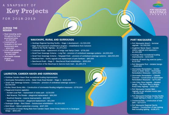
Exhibition Period and Submissions
The draft documents were placed on public exhibition from 22
March to 22 April 2018. The engagement activities undertaken are outlined in
the Community Engagement and Internal Consultation section of this report. A
number of submissions were received during this period and the details of
these, and staff responses, are also outlined in the Community Engagement and
Internal Consultation section of this report.
A workshop was also held between staff and Councillors to
discuss the submissions and any potential changes to the budget and IPR
documentation as a result of the submissions.
Post Exhibition Amendments to the Capital Works Program
The capital works program incorporated in the one year
Operational Plan 2018- 2019 that was placed on public exhibition was valued at
$87 million.
In the intervening weeks there have been a number of changes
to the capital works program as a result of the following:
· Deferral or
removal of part or all of projects due to managers undertaking a detailed
review of their ability to deliver the projects in the plan.
· Additional grant
funding has been received which has caused items initially in the plan to be
removed to allow for delivery of grant funded projects.
· A number of items
have been included due to design works now being complete.
· Whilst these projects
do not appear in the Operational Plan until full funding has been confirmed,
allocations for Council contributions to several key projects are being
provided to enable these projects to proceed should the balance of the funding
be provided by other levels of government. These projects are:
o Maria River Road. With a total
project cost of $18m, $2m is being placed into reserve for Councils
contribution. Completion of this project will require matching funding from
Kempsey Shire Council with the balance being provided by other levels of
government.
o Lighthouse Road. The
construction plans for Lighthouse Road were completed in 2016 and Council has
recently made an application under Building Better Regions fund for works on
Lighthouse Road (Matthew Flinders Drive to the Lighthouse). Council is still
waiting notification on the outcome of this application. Should Council be
successful with this application, $337,967 will be required from general fund
as a contribution.
· The Ocean Drive
duplication project has been reduced from $5.5m to $360,000. The
remaining funds have been transferred to the Regional Road Infrastructure
reserve as Councils contribution towards this project noting that the balance
of the funding will need to be provided by other levels of government for this
project to proceed.
As a result of these intervening alterations and submission
considerations the capital works program outlined in the Operational Plan
2018-2019 is now $57.2m.
In addition to the reasons outlined above, Council
considered a report on Council’s financial sustainability at the Ordinary
Council meeting held on 21 February 2018. The report noted that overall
financial sustainability of Port Macquarie-Hastings Council is strong and
particularly impressive given the operating environment of Council.
Notwithstanding this, we note that there are a number of potential areas in
which ongoing improvement may benefit financial sustainability going forward. One
improvement identified was to improve budget accuracy, and by reviewing
projects in terms of the reasons outlined above, this also improves budget
accuracy and reduces variations at year end.
The specific changes to the
program are listed below.
|
Item
|
Section
|
Reason for adjustment
|
Amount
|
|
Area 15 Sewerage Upgrade (Lakewood/Kew)
|
Sewerage
|
Design now complete
|
$424,000
|
|
Port Macquarie Sewerage
Pumping Station #64
|
Sewerage
|
Will provide cost savings
once complete
|
$165,000
|
|
Sewer Rising Main –
Camden Haven SPS #1
|
Sewerage
|
Combine with another
project in 18/19
|
$139,000
|
|
Sewerage Technical
Instruments
|
Sewerage
|
Not Required
|
($40,880)
|
|
Port Macquarie Sewer
Pumping Station #18
|
Sewerage
|
Development Driven
|
($153,300)
|
|
Sewer Minor Extensions
|
Sewerage
|
Not required
|
($255,500)
|
|
Small Towns Sewerage
Program - Comboyne
|
Sewerage
|
Deferral
|
($2,646,900)
|
|
Small Towns Sewerage
Program – Long Flat
|
Sewerage
|
Deferral
|
($2,651,000)
|
|
Small Towns Sewerage
Program – Telegraph Point
|
Sewerage
|
Deferral
|
($3,938,900)
|
|
Reclaimed Trunk Main Area
14
|
Water Supply
|
Design now complete
|
$1,100,000
|
|
Water Supply Technical
Instruments
|
Water Supply
|
Not required
|
($40,880)
|
|
Flowmeter Installation
Upgrades
|
Water Supply
|
Not required
|
($76,650)
|
|
Inlet Trunk Main –
Cowarra Dam
|
Water Supply
|
Deferral
|
($1,226,400)
|
|
Thrumster Reclaimed Water
Reservoir
|
Water Supply
|
Deferral
|
($3,985,800)
|
|
Granite Street Water
Reservoir
|
Water Supply
|
Deferral
|
($5,007,800)
|
|
Southern Arm Trunkmain
– Pacific Hwy to Bonny Hills
|
Water Supply
|
Deferral
|
($7,000,700)
|
|
Kingfisher Waste Depot
|
Waste Management
|
Deferral
|
($2,000,000)
|
|
Bold Street Pedestrian
Crossing
|
Transport & Traffic
|
Grant
|
$347,000
|
|
Dunbogan Bridge
Rehabilitation
|
Transport & Traffic
|
Grant
|
$1,500,000
|
|
Koala Street Upgrade
– Concept Designs
|
Transport & Traffic
|
Deferral
|
($150,000)
|
|
Kindee Bridge Replacement
|
Transport & Traffic
|
Deferral
|
($300,000)
|
|
Maria River Road – An
allocation of $2m towards this project has been provided noting the balance
of the funding to be provided and confirmed by Kempsey Shire Council and
other levels of government before the project can proceed.
|
Transport & Traffic
|
Deferral
|
($500,000)
|
|
Ocean Drive Duplication
– These funds have been transferred to the Regional Road Infrastructure
reserve as Councils contribution towards this project. Whilst $5,500,000 has
been allocated from Council, only $360,000 is expected to be spent in
2018/2019 with the balance of $5,140,000 to be expended in future years.
|
Transport & Traffic
|
Deferral
|
($5,140,000)
|
|
Mrs Yorks Garden –
Concept Plan Development
|
Sports & Recreation
|
New Project
|
$50,000
|
|
Wayfinding Signage
|
Sports & Recreation
|
New Project
|
$50,000
|
|
PM Regional Sporting
Stadium
|
Sports & Recreation
|
Grant
|
$186,973
|
|
PM Hastings Hockey Fields
– Lighting Field 2
|
Sports & Recreation
|
Grant
|
$237,640
|
|
Short Street Reserve -
Amenities
|
Sports & Recreation
|
Grant
|
$255,030
|
|
Crestwood Park – new
park
|
Sports & Recreation
|
S94 Funding
|
$370,670
|
|
Port Macquarie Coastal Walk
|
Sports & Recreation
|
Grant
|
$765,000
|
|
Reservoir Park –
Playground Replacement
|
Sports & Recreation
|
Deferral
|
($20,600)
|
|
Sister City Park –
Playground Replacement
|
Sports & Recreation
|
Deferral
|
($31,000)
|
|
Blair Street Reserve
– Playground Replacement
|
Sports & Recreation
|
Deferral
|
($84,900)
|
|
James Street Reserve
– Playground Replacement
|
Sports & Recreation
|
Deferral
|
($84,900)
|
|
Pilot Beach Reserve -
Amenities
|
Sports & Recreation
|
Deferral
|
($100,000)
|
|
Settlement Point Reserve -
Amenities
|
Sports & Recreation
|
No longer required
|
($100,000)
|
|
Total
|
|
|
$29,945,797
|
The developer of Crestwood Estate has transferred the
Crestwood Park land to Council as part of a recent subdivision approval. The
construction of the park works by Council is proposed in the 2018-19 financial
year. Design plans have been completed by the developer and embellishment
of the park will be funded by Section 94 open space development contributions.
Along with capital works adjustments one change was made to
an operational budget:
|
Item
|
Section
|
Amount
|
|
Operational
Adjustments
|
|
|
|
Increase in Councillor and
Mayoral Allowances (adjusted for overheads)
|
Governance
|
$2,266
|
|
Total
|
|
$2,266
|
Options
It is a statutory requirement to adopt the Integrated
Planning and Reporting documents by 30 June 2018. Not adopting the documents
cited in the resolution would jeopardise compliance with this legislation.
Council could seek additional information or make other amendments
to the documentation.
Community Engagement and
Internal Consultation
The draft documents were placed on public exhibition from 22
March to 22 April 2018. During this time the following actions were carried out
in order to generate widespread community feedback.
Exhibition Promotion:
· Advertised in
Council Matters, posters in all offices and libraries;
· Hard copy of all
documents placed at Council Customer Service Offices and Libraries Branches;
· Mayoral promotion
through radio spot and Mayor’s column;
· E-news articles
sent to all subscribers;
· E-news story to
Have Your Say database; and
· Pop up engagement
stalls at local shopping centres across the region during the exhibition
period.
Exhibition Participation:
Pop up community engagement stalls were held in local
shopping centres across the region during the 28 days public exhibition period.
Conversations were held with the community in the following locations:
· 26 March 2018 -
Wauchope, Library - (21 conversations)
· 27 March 2018 -
Laurieton – Coles – (47 conversations)
· 10 April 2018 -
Lake Cathie – Woolworths (46 conversations)
· 12 April 2018 -
Hay Street - Glasshouse Forecourt (20 conversations)
· 17 April 2018
– Settlement City – (42 conversations)
The “Have Your Say” online portal activity during the exhibition
period was as follows:
· Total visits
– 1,400
· Max visitors per
day - 136
· Engaged visitors -
35
· Informed visitors
(downloaded documents) - 502
· Aware visitors
(read through documents without downloading) - 956
104 submissions were received via letter, e-mail, on-line,
and pop-up engagements and related to a broad range of Council Services
including the Airport, Roads, Bridges and Transport, Economic Development,
Financial Management, Stormwater and Drainage, Natural Resource Management,
Sports and Recreation, Sewerage, Waste Management, Water Supply, Business
Improvement / Integrated Planning and Reporting, Community Place, Glasshouse,
Strategic Landuse Planning and Building Maintenance
Submissions response summary
Due to the volume of submissions
and supporting documentation received, it is not practical to include
hardcopies with the attachments to this report, the information and tables
below instead summarises the submissions and Council’s response. Councillors
will be provided with full copies of the submissions prior to the Council
meeting.
|
Council
Service:
Airport
|
|
Submitter’s name
|
Submitter’s issue
|
|
Helen
Gibson - 7729
|
Request
a water bubbler in the secure area of the airport terminal
|
|
Response
Council
is commencing the construction of the terminal building upgrade early in the
2018-19 financial year. The new terminal design provides for an upgraded food
and beverage offering within the secured area of the terminal.
|
|
Council Service:
Business Improvement and Integrated Planning and
Reporting
|
|
Submitter’s name
|
Submitter’s issue
|
|
Greater PMQ Tourism Association - 8094
|
1. Reference to Operational Plan action
1.4.2.2. Would like to know if the Business Improvement Strategy has
been adopted by Council or is this still to be determined.
2. Document hierarchy appears inconsistent in
relation to the diagram on page 10.
|
|
Response
1.
Yes. The Business Improvement Strategy was adopted at Council's Ordinary
Meeting on 21 March 2018. The purpose of the Strategy directly reflects
the outcome it seeks to achieve through implementation.
2.
The diagram on page 10 illustrates Council's other Strategic Plans, e.g.
Landuse Strategy etc. that inform the Delivery Program and Operational Plan.
This is noted and clarification of this section will be updated in the final
adopted document.
|
|
Council Service:
Community
Place
|
|
Submitter’s name
|
Submitter’s issue
|
|
Greater
PMQ Tourism Association – 8094
|
Re
Operational Plan Action 1.4.3.2 – Review and evaluate referrals,
compliments and complaints on an annual basis.
There
is an opportunity to define more stringent performance measures with respect
to complaints where performance can be trended, benchmarked and reported
|
|
Response
Noted.
Performance measures for customer compliments and complaints will be informed
by the Customer Experience Project currently underway. An amendment to
the measure may be made on completion of this project in the future.
|
|
Council
Service:
Economic
Development
|
|
Submitter’s name
Greater
PMQ Tourism Association – 8094
|
Submitter’s issue
1.
Recommend that Operational Plan action 1.1.5.1 and 1.1.5.2 be amended to
undertake a review of the existing Communications and Marketing Strategies
for adequacy. Suggested in 1.1.5.2 that marketing and education campaigns be
separated as actions as they are two distinct processes.
2. Re: Operational Plan action 1.2.1.1 - It is
requested that the Tourism Association, with our current 174 tourism business
membership base be included in this consultation.
3. Re: Operational Plan action 2.2.1.1 - Provide
opportunities for young people to learn and develop through youth focused activities.
This is a ‘Youth’ strategy that falls under the auspices of the
Cultural Plan, which could be cross referenced.
4.
Destination marketing and industry engagement are the only strategies
referenced under Operational Plan action 3.1.4.1. It is requested that
actions under the other Destination Management Plan strategies be included,
namely: Build the Capacity of all Industry Sectors; Product Development and;
Improved Infrastructure Planning and Development.
5.
Destination NSW and the North Coast Destination Network are placing
significant emphasis on developing business tourism. As such, it is requested
that the following new Action be included: 3.1.4.1 – Implement a
Business Tourism Plan in line with the goals set by North Coast Destination Network
to grow our visitor economy.
|
|
Response
1.
Noted. Consolidation and wording amendment has been completed to some of the
actions as appropriate.
2.
Council considers that the business chambers represent the tourism
association, as well as other businesses, which supports this Operational
Plan action. It is also noted that the Tourism Association have
representation on the Economic Development Steering Group. Council
would like to acknowledge that The Tourism Association, can at any time,
request a meeting with Senior Staff to discuss any matters of interest.
3.
Noted. Consolidation and wording amendment has been completed to some of the
actions as appropriate.
4.
Noted. Consolidation and wording amendment has been completed to some
of the actions as appropriate.
5. With reference to a
'Business Tourism Plan’, this will be considered in upcoming
conversations with Destination North Coast, noting proposed regional
approach.
|
|
Council
Service:
Financial
Management
|
|
Submitter’s name
|
Submitter’s issue
|
|
Mac
Adams Music Centre - 7946
|
Would
like Community Hall hire fees increased for the Mac Adams Centre
|
|
Response
Noted
and support increase given improvements to the space, relativity to other
facilities and evidence of demand for use of facility. This fee will be
reviewed in 2018-19.
|
|
Council
Service:
Glasshouse
|
|
Submitter’s name
|
Submitter’s issue
|
|
Greater
PMQ Tourism Association - 8094
|
Would
like to know if the Glasshouse Strategic Plan falls under the auspices of the
Cultural Plan and be cross-referenced.
|
|
Response
The
review of the Glasshouse Strategic Plan will be considered in the context of
Council’s broader Cultural Plan. Council has requested that the
Cultural Steering Group provide recommendations to Council on the review of
the Glasshouse Strategic Plan as part of its review of the Cultural Plan.
|
|
Council
Service:
Glasshouse
|
|
Submitter’s name
|
Submitter’s issue
|
|
Musicians
and Bands of Local Government Area (Councillor Turner)
|
Podium
hire fees - Glasshouse Steps - reduction of proposed fee
|
|
Response
Noted.
Council has committed to amend the fees and charges document to incorporate
community discount for 7 days per week for the Podium and Ross Family Studio.
Also, a review of the Glasshouse Podium Fee by September 2018 will be
undertaken.
|
|
Council Service: Natural Resource Management
|
|
Submitter’s name
|
Submitter’s issue
|
|
Kerry
Behrendt - 7959
|
Concerns
with Bats at Koolonbung Creek Walk - Smell, noise and dead trees.
|
|
Response
The
Flying Fox Population is monitored and managed in accordance with the Kooloonbung
Creek Nature Park Plan of Management. This plan aims to minimise the impacts
of the flying foxes on site, whilst meeting protection obligations under
State and Federal Law.
|
|
Paul
Dirago – 7975
|
Concerns
regarding the Flying Fox problem and would like to know Council's strategic
approach to the issue
|
|
Response
In
relation to concerns raised about the Flying Fox issue. A report was
presented at Council’s Ordinary Council Meeting held 18 April 2018
relating to this matter in which Council resolved to:
1.
Note the 2014 petition to Ms Leslie Williams MP resubmitted to the Mayor from
concerned residents regarding the Flying Fox colony in the Kooloonbung Creek
Nature Reserve.
2.
Note the response from Ms Leslie Williams MP dated 7 March 2018 in relation
to the Flying Fox colony in the Kooloonbung Creek Nature Reserve.
3.
Request that the General Manager write to Office of Environment and Heritage
(OEH) and both Federal and State local members of parliament seeking advice
on funding opportunities to manage the impact of Flying Fox colonies
adjoining residential properties.
4.
That the General Manager bring back a report to Council for further
consideration as soon as practicable following receipt of advice from the
OEH.
Staff
will table a report to Council addressing the above resolution once advice is
received from OEH. This report will outline options available and community
consultation needed to support these options.
|
|
Bonny
Hills Progress Association - 8105
|
Concerns
that the Operational Plan action 4.8.3.1 - Implement Biodiversity Strategy
actions provides no detail or budget
|
|
Response
The
first stage is to adopt the Biodiversity Strategy, with the view to a phased
implementation of identified actions across future budgets. It is
planned that the Strategy be presented to Council in the first half of the
2018-19 financial year.
|
|
Council
Service:
Roads and Transport
– Rural Roads
|
|
Submitter’s name
|
Submitter’s issue
|
|
Rollands
Plains Community Group - 25304
|
Request
to raise the creek crossing on Clarefield Dungay Creek Road Marlo Merrican
between 328 and 370 and upgrade Bril Bril Road
|
|
Rollands
Plains Community Group - 7761
|
The sealing of Bril Bril
Road 5.6kms
|
|
Graham
Day - 7524
|
Council
build a new bridge and tar remaining dangerous unsealed sections of Logans
Crossing Road.
|
|
Sergio
and Robyn Pavan - 7735
|
Upgrading
and sealing Stoney Creek Rd, Redbank through to Pembrooke Rd, Sealing the
gravel Hursley Rd.
|
|
June
Dunne - 7713
|
When
is sealing of Maria River road
|
|
John
Hutchinson – 6674
|
Request
to seal a portion of unsealed roads across the region
|
|
Neil
Jones – 7954
|
Request
for raising of the crossing by 1 metre of Marlo Merrican Creek at 3.5 Km
along Clarefield Dungay Creek Road, Marlo Merrican (Rollands Plains).
|
|
Response
An
analysis for the sealing of unsealed roads is currently underway. This
analysis will be used to determine the prioritisation criteria for investing
in upgrading unsealed roads.
This
analysis will also help to inform a Rural Roads Management Plan, which is
being developed as part of the Regional Integrated Transport Strategy. An immediate
action is to develop a Policy for Unsealed Roads management. It will set the
basis for Council to continue to explore the management and future investment
of all our unsealed roads, and associated infrastructure like creek
crossings, across our Local Government Area and to take a strategic view of
our unsealed road network to ensure any future investment is appropriately
allocated.
This
policy will be presented to a Council Meeting to place it on public
exhibition in the coming months. The view is to have the policy for
Unsealed Roads adopted by September 2018. Any forward action plan for
addressing Maria Road, and other similar roads, will then be informed by this
policy.
In terms of Maria River
Road, with a total project cost of $18m, $2m is being placed into reserve for
Councils contribution. Completion of this project will require matching
funding from Kempsey Shire Council with the balance being provided by other
levels of government.
|
|
Council
Service:
Roads and Transport
– Upgrade to Lighthouse Road Port Macquarie
|
|
Submitter’s name
|
Submitter’s issue
|
|
Paul
Dirago – 6079/7975
|
Safety
concerns for a safe footpath/road on this section of road. Would like
necessary works included in 18-19 Operational Plan
|
|
Katja
Plentiger - 6454
|
Request
to upgrade Lighthouse Road for safety reasons
|
|
Wayne
Jones - 7986
|
Safety
concerns for pedestrians on Lighthouse Road and the poor condition of the
road
|
|
Kenneth
Holley – 6463
|
Request
to upgrade Lighthouse Road
|
|
Response
Any
development of the project will be subject to a successful grant funding
application.
The
construction plans for Lighthouse Road were completed in 2016 and Council has
recently made an application under Building Better Regions fund for works on
Lighthouse Road (Matthew Flinders Drive to the Lighthouse). Council is still
awaiting the notification on the outcome of this application. Should Council
be successful with this application, $337,967 has been allocated to an
internal reserve as a general fund contribution.
|
|
Council Service:
Roads and Transport
– Tacking Point Lighthouse - disable access and parking
|
|
Submitter’s name
|
Submitter’s issue
|
|
Paul
Dirago - 7975
|
Providing
a disable ramp at Tacking Point Lighthouse and concerns about parking and
also pedestrian safety on Lighthouse Road East (Coastal Walk)
|
|
Response
Tacking
Point Lighthouse – Ramp for people with disabilities - has been
identified as a project in Council's Stronger Country Communities Fund Round
2 application in May 2018. A Building Better Regions Fund application was
lodged for the upgrade of Lighthouse Rd East.
Parking
at this location is constrained by landform and environment and there are no
plans to increase parking areas at this time.
|
|
Council
Service:
Roads and Transport
– Footpaths
|
|
Submitter’s name
|
Submitter’s issue
|
|
Donald
Stewart - 6081
|
Would
like Council to consider construction of new footpath on the eastern side of
Central Road - Parklands Village
|
|
Stuart
Inglis - 6461
|
Request
for footpath schedule to be published in the plans. Would like to see
connected footpaths for safety reasons around Cathie Road PMQ, Bangalay Child
Care Centre.
|
|
Brenda
Northfield - 7106
|
Would
like Council to consider construction of new footpath from the corner of Lake
and Laurie Street to Cnr of Lake and Seymour Streets be included in 2018-19
Operational Plan
|
|
F
Burns - 7751
|
Request
footpath continued from Brotherglen Drive to Lakewood shops
|
|
Terry
Ryan - 7731
|
Finish
Missing Link -Footpath on western side of Clifton Drive from shopping centre to
top of the hill below the medical centre
|
|
Erlinda
Smith - 7719
|
Requesting
for footpath from Edward St to Growers Market - missing link
|
|
Response
Council
receives a large number of requests annually for the construction of new
footpaths but it is not possible to construct all of the new paths that are
requested by the community. Council allocates priorities to new footpath
works on the basis of safety, construction cost, traffic volume on adjacent
road, proximity to town centres, shops, schools, medical facilities,
recreation areas and other factors.
Council
allocates priorities to new footpath works on the basis of numerous factors
including safety, construction cost, traffic volume on adjacent road, and
proximity to town centres, shops, schools, medical facilities, recreation
areas.
A
footpath on the eastern side of Central Road has been assessed as meeting the
criteria for inclusion in the annual footpath program. As such, a 130m
section of path from the southern Parklands Village driveway to the existing
path near the Lifeline shop will be constructed during the 2018-19 financial
year as part of this program.
New
footpaths at Cathie Road Port Macquarie near Bangalay Child Care Centre, Lake
Road between Laurie Street and Seymour Street, from Brotherglen Drive to
Lakewood shops, around Lakewood, along Clifton Drive and along Edward St to
Growers Market will be considered for inclusion in future annual footpath
programs.
Council
is currently working to publish the annual footpath construction program
along with the assessment criteria on Council's website.
|
|
Council
Service:
Roads and
Transport – Footpath funding
|
|
Submitter’s name
|
Submitter’s issue
|
|
Bonny
Hills Progress Association - 8105
|
Concerned
that there is only $500K allocated in the budget for the entire LGA (noted
that there is also two large coastal pathway projects in the plan)
|
|
Response
It
is acknowledged that there is an allocation of $500,000 specifically for the
construction of new footpaths across the Local Government Area. Council has
also allocated another $500,000 as contributing funding towards State
Government Grants that fund the provision of new pedestrian and cycling
infrastructure.
This
additional funding has allowed the construction of the shared path along
Ocean Drive at Lakewood, the shared path construction in Dunbogan and several
pedestrian refuges on Ocean Drive through Lake Cathie and Bonny Hills.
Council
receives a large number of requests annually for the construction of new
footpaths but due to the limitations of this funding it is not possible to
construct all of the new paths that are requested by the community. Council
allocates priorities to new footpath works based on safety, construction
cost, traffic volume on adjacent road, proximity to town centres, shops,
schools, medical facilities, recreation areas and other factors.
Re: Coastal pathway
projects.
Reference to the Camden
Haven Coastal Walk upgrade as a subset to the Port Macquarie Coastal Walk upgrade
within the draft 2018-19 Operational Plan was an error. The full budget
allocation of $500K is for the upgrade of Port Macquarie Coastal Walk.
An allocation of $140K for the Camden Haven Coastal Walk is included in the
draft 2019-20 Works Program and will be considered for inclusion in the draft
2019-20 Operational Plan.
|
|
Council
Service:
Roads and Transport
– Road Resealing
|
|
Submitter’s name
|
Submitter’s issue
|
|
Leanne
Taylor - 6284
|
Would
like Council to check quality of contractors work for road resealing - they
are sealing over potholes
|
|
Response
Council
actively manages the performance of our contractors and instructs
improvements in works where required. Roads are a dynamic environment with
potholes sometimes appearing between preparation work and resealing
works.
|
|
Council
Service:
Roads and Transport
– Bold Street Pedestrian Crossing
|
|
Submitter’s name
|
Submitter’s issue
|
|
Rodney
Adams – 6308
|
Would
like a copy of the Bold Street Pedestrian crossing plans
|
|
Response
Council
are currently developing plans for the upgrade to Bold Street. Once
completed, the plans will be publicly exhibited on our Have Your Say website
(http://haveyoursay.pmhc.nsw.gov.au/)
|
|
Council
Service:
Roads and Transport
– Upgrade to Koala Street Port Macquarie
|
|
Submitter’s name
|
Submitter’s issue
|
|
Katja
Plentiger - 6454
|
Request
to upgrade Koala Street for safety reasons with help of Government Grants
|
|
Response
Council
is committed to the upgrade of Koala Street with a concept design and
investigation project planned to commence in the 2019-20 financial year. The
required budget of $150,000 had been listed in the Draft Operation Plan for
next financial year, however due to our focus on prioritising development of our
Regional Integrated Transport Strategy commencement of this work has been
deferred to the following financial year.
|
|
Council Service:
Roads and Transport – Bridge to Bridge (Beach to Beach)
|
|
Submitter’s name
|
Submitter’s issue
|
|
Lois Richards - 6807
|
Request for additional funding for Bridge to Bridge
to be completed
|
|
Response
We
believe this submission is referring to the Beach-to-Beach share path project
from North Haven to Pilot Beach, Dunbogan.
$500,000
has been allocated in 2018 for ongoing design and planning work as well as
the construction of the section between Scarborough Way and Seaview Ave.
Over
the last three years Council and the NSW Government has contributed
significant funds to the Beach-to-Beach project, which has enabled the
construction of long sections of path along The Boulevard. Council will
continue to seek funding assistance from the NSW Government for this
important project.
|
|
Council
Service:
Roads and
Transport – Upgrades to Boundary Road Port Macquarie
|
|
Submitter’s name
|
Submitter’s issue
|
|
Kenneth
Holley – 6463
|
Request
to upgrade Boundary Road
|
|
Response
Council
is currently investigating and designing the upgrade of Boundary Street Port Macquarie.
Concept designs are nearing completion and are a necessary first stage in
moving towards an upgrade of the road. Once completed, the concepts will be
used to give an indication of the cost of the works so funding can be
considered, including seeking grant funding from the State Government.
|
|
Council
Service:
Roads and Transport
– Ring Road
|
|
Submitter’s name
|
Submitter’s issue
|
|
Ray
Evans – 6468
|
Would
like to see a new road running from Ocean Drive skirting Lake Innes to the
Oxley Hwy.
|
|
Paul
Dirago - 7975
|
Orbital
Road.
|
|
Response
Council
is currently completing an engineering feasibility investigation for the Port
Macquarie Orbital Road, which will link Ocean Drive to Hastings River Drive
via the Oxley Highway. The completion of this investigation will occur in the
coming months with the final report scheduled to be provided to Council for
consideration mid-year, and broader community information/engagement to
follow in the latter half of this year.
This
feasibility study has included a desktop preliminary environmental review,
strategic concept designs and multi-criteria analysis to analyse various
route options, cost analysis of the routes and engagement with Roads and
Maritime Service. The final part of the investigation is a benefit to cost
analysis of the feasible options. On completion of these works, all
information gained to date will provide Council a good opportunity to discuss
with State and Federal members the next steps to progress this planning,
noting more detailed designing and onsite investigations are still required.
|
|
Council
Service:
Roads and
Transport – Roundabout/traffic light request
|
|
Submitter’s name
|
Submitter’s issue
|
|
Kimberley
Hamnett – 7064
|
Request
for roundabout or traffic lights at the intersection next to Super Cheap Auto
on Hastings River Drive
|
|
Response
Council has a long-term
master plan for Hastings River Drive. This includes a roundabout at the
Newport Island Road intersection, which is currently under construction.
The next priorities are
a) to install traffic
signals at the Aston Street intersection to allow the pedestrian crossing to
be removed; and
b) Duplication of the
road between Hughes Place and Boundary Street. The master plan includes
traffic signals at the Bellbowrie Street and Widderson Street
intersections. It is expected that design investigations will take
place in the short to medium term.
|
|
Council
Service:
Roads and
Transport – Street Sweeping and Pressure Cleaning - Wauchope
|
|
Submitter’s name
|
Submitter’s issue
|
|
Heather
Sharman – 7500
|
Street
Sweeping and Street Pressure cleaned at Hastings Street Wauchope
|
|
Response
Wauchope
streets are currently swept three times per fortnight on Mondays and Fridays.
Street sweeping and pressure cleaning is also provided on a reactive basis
based on risk.
Should
there be a desire by the local businesses to provide an additional service in
partnership with Council, this option can be explored further.
|
|
Council
Service:
Roads and
Transport – Bus Shelters
|
|
Submitter’s name
|
Submitter’s issue
|
|
Jenny
Wickham - 7504
|
Would
like bus shelter / bus stop at Lake Cathie (Park)
|
|
Monika
Hans – 6304
|
Would
like a bus shelter erected near the BP service station in Wauchope and also
provide line marking to indicate it’s a bus shelter
|
|
Response
Over
the next two years, Council will be installing 18 new bus shelters across the
LGA including three in Wauchope. One of these will be at 213 High Street to
compliment an existing shelter on the opposite side of the road. This new
shelter will only be 200m away from the BP Service Station.
One
of these will be installed on Ocean Drive (east) at Lake Cathie
Reserve.
|
|
Council Service:
Roads and Transport – Pedestrian improvements
|
|
Submitter’s name
|
Submitter’s issue
|
|
Anne
Pincott - 7511
|
Improvements
to road surfaces in the PMHC area and Overhead pedestrian crossing over
Gordon street, near Koolonbung Park.
|
|
Noelene
Skinner - 7831
|
Pedestrian
crossing CBD - Gordon Street
|
|
Response
Council
have identified the need for pedestrian improvements around the Port
Macquarie CBD and currently has planning and design work underway for a
signalised intersection at Gordon and Horton Streets, which will give
pedestrians a safe priority crossing point. Council is also undertaking
high-level planning and investigations for pedestrian underpass along the
Koolonbung Creek under the Gordon St bridge.
|
|
Council
Service:
Roads and
Transport – Road Resealing
|
|
Submitter’s name
|
Submitter’s issue
|
|
Scott
Battle - 7516
|
Roadwork
/ Resealing carried out poorly. E.g. the state of the Boulevard in
Dunbogan 201/17; and Hastings River Drive
|
|
Response
In maintaining our regional
road network, Council delivers a number of inter-related works programs
including, resealing, resheeting and rehabilitation.
Resealing is an effective
method of reducing the rate of road deterioration and the recurrence of regular
road maintenance, it will not however address any underlying defects or
problems within the road structure should these exist. As such, when
Council undertakes a road reseal, preparation works are completed prior to
resealing to treat the known defects at the time of the works.
Unfortunately, these
defects are often unknown and unable to be identified at that time, and can
lead to future localised pavement failures that can be misconstrued as poor
quality of work. The quality of the reseal is not considered the primary
failure mechanism, rather the quality of the underlying pavement, and it is
important to note that if Council had not taken the decision to reseal, the
road would be in a poorer state of repair.
Where known defects in the
underlying pavement are excessive, Council will undertake full road
reconstruction or rehabilitation. Committing to road rehabilitations
however requires significant community investment. Subsequently, Council is
committed to providing the highest quality product within the constraints of
funding and environmental conditions.
With respect to the
specific sites that you refer to, overall, the resealing program in the
Camden Haven Area has seen a measurable reduction in reactive maintenance
over the past two years since resealing, and the resealing program has since
progressed to the Wauchope area.
That said, there have been
a number of localised pavement failures identified, which are reflective of
deeper pavement issues. In particular, we have observed a number of locations
in Dunbogan, particularly on The Boulevard and Diamond Head Rd that ideally
require a full reconstruction due to the steady deterioration and the
presence of new pavement defects.
While it is regrettable
that these localised pavement failures have occurred, this is not
representative of the majority work completed by Council throughout Lake
Cathie, Bonny Hills, the Camden Haven and Wauchope and surrounds.
With respect to Hastings
River Dr, Council are progressively upgrading and reconstructing this road,
with four sections of road upgrade completed over the past few years, being
Gordon St to Aston St, Boundary Street intersection, Boundary St to Tuffins
Lane and Newport Island Rd (underway).
|
|
Council
Service:
Road and
Transport – Slipway – Wauchope
|
|
Submitter’s name
|
Submitter’s issue
|
|
Kenneth
Campbell – 7523
|
Construct
slipway to Cameron Street to help relieve traffic problem.
|
|
Response
In
exploring this issue recently, Council has developed high-level concept
designs for the slipway. These designs have been used in the work
currently undertaken as part of the Area wide Traffic Study, which is being
undertaken in partnership with the RMS. As part of the study, several
road upgrade projects were tested for their impacts on traffic movements and
congestion, including the Cameron St slipway.
The
study found that the slipway did not significantly reduce congestion along
High St, however the report did recommend Council maintain ownership of the
land required for the slipway and that the concept be revisited in the long
term as traffic patterns change outside what is predicted. This road upgrade
project will be reviewed as part of the planned periodic reviews of the Area
Wide Traffic Study.
|
|
Council Service:
Roads and Transport – Maintenance funds for new road
construction
|
|
Submitter’s name
|
Submitter’s issue
|
|
Graeme
Roberts – 7745
|
Maintenance
funds seem to have been diverted to new road construction
|
|
Response
The road and stormwater
maintenance funding allocated through the 2017-18 Operational Plan has been
spent solely on maintenance activities. The Draft 2018-19 Operational Plan
has similar levels of funding that will also be spent on road and stormwater
maintenance activities.
Council has completed a
number of road reconstruction and road rehabilitation projects in 2017-18
that have been funded through “Roads to Recovery”, RMS Grant
Funding, Section 94 developer contributions and Council’s General Fund.
|
|
Council
Service:
Roads and
Transport – Road Signage
|
|
Submitter’s name
|
Submitter’s issue
|
|
Phillip
Morton - 7747
|
Request
for Appropriate road signage at Telegraph Point Road/Pembrooke Road,
Pembrooke Road/Reids Road, Rollands Plains Road/Ballengarra Bransdon Road
|
|
Response
Council
will investigate this request for additional signage and may form part of
Councils routine traffic and maintenance budget.
|
|
Council
Service:
Roads
and Transport – Bus Area at proposed Wauchope Sporting fields
|
|
Submitter’s name
|
Submitter’s issue
|
|
Bob
Gilligan - 7759
|
Access
for buses to proposed fields complex in Wauchope. It would be much better to
have bus only area on Stoney Creek road next to the fields.
|
|
Response
Due
to the location of the car parks to fit within the site, it is not cost
feasible to have a separate access just for buses. Car parks are being
designed to incorporate rotation of vehicles within them to find parks. No
car parks are being located on access roads. Both of these design
considerations will reduce the number of cars on the access roads and holding
up bus access.
The
bus drop off area is to be located near the premier field and the Centre Of
Excellence. Once buses get to the main car park they will split to a
dedicated bus drop off area then circulate around to exit the site. The bus
turn around will not be within a car park.
For
school sports, many buses arriving together would not be an issue as there
would not be many cars accessing the site. During major events, a large
number of buses are expected, as offsite parking will be required. In this
instance, the site will be controlled by traffic marshals to direct and
restrict cars from the main entrances to avoid congestion. The direct access
off the highway will also be open under traffic control which will enable
more car parking within the off leash dog area'.
|
|
Council
Service:
Roads and
Transport – Traffic Management
|
|
Submitter’s name
|
Submitter’s issue
|
|
Roy
Brown - 7716
|
What
is Council doing with traffic management in Wrights Road and John Oxley
Drive.
|
|
Travers
Powell - 7758
|
Congestion
of traffic throughout town with suggestions to solve problem
|
|
Response
As
part of planning for the continual growth in our region Council is currently
developing a Regional Integrated Transport Strategy to identify the key
transport decisions and actions that will guide Council to ensure our
transport networks are safe, operate efficiently and have adequate capacity
for now and into the future.
The
purpose of this strategy is to ensure that we take a holistic view of the
entire transport network thus having a broader focus rather than a diagnosis
of individual pressure points.
This
strategy will link together future transport planning including potential
orbital links, the Area Wide Traffic Study, investigations being undertaken
by Roads and Maritime Services (RMS) for State highways within our Local
Government Area, like the Oxley Highway, as well as maximising opportunities
to increase the use of public transport, walking and cycling.
The
strategy will also determine how Council incorporate Land Use planning, such
as the Health and Education precinct around Wrights Road and John Oxley
Drive, which are all being considered as part of the Urban Growth Management
Strategy.
Council
will, where appropriate, look to incorporate the State Government’s
Transport vision outlined in the Future Transport Strategy and specifically
building on the good work that has gone into the Regional Infrastructure and
Services Plan. Aligning with these State Government strategies will help
ensure any future investment by the State Government within our region is
appropriately allocated.
|
|
Council
Service:
Roads and Transport – Arterial Road
Improvements
|
|
Submitter’s name
|
Submitter’s issue
|
|
Bruce
Burgess – 7942
|
Request
for improvements at Gordon St, between Horton and Ocean Drv. Lake Rd,
between Gordon St and Ocean Drv. Widderson St, between Oxley Hwy and Hastings
River Drive.
|
|
Response
Gordon St – Ocean Dr
to Horton
Council has committed to
the Pavement Design for the purpose of reconstruction the road in the 2018-19
Draft Operational Plan. The intention is to commence construction works
within the next four years. This item is referenced in the Operational Plan -
4.4.1.46 CW Design and investigations for Gordon Street Pavement
Reconstruction and Service Relocations - between Ocean Drive and Horton
Street
Lake Rd – Gordon St
to Ocean Dr
Council has designed this
project with construction expected to commence in 2019. This is referenced in
the Operational Plan - 4.4.2.1 CW - Undertake road resurfacing and
rehabilitation works throughout the local government area in accordance
with the rolling priority program and roads maintenance hierarchy
Widderson St – Oxley
Hwy to Hastings River Dr
Geotechnical testing has
been completed and we are committed to completing the final design in 2019.
This project is within Council's four-year road reseal and rehabilitation
programme. The proposed works are however not included in the 2018-19
Operational Plan.
|
|
Council
Service:
Roads and
Transport – Roads and Footpath – Dunbogan
|
|
Submitter’s name
|
Submitter’s issue
|
|
Nola
Davies – 7754
|
(1)
The Boulevarde, Dunbogan is especially dangerous for pedestrians and cyclists
between the old tip road and Longworth Road as there is no pathway there.
(2)
The Boulevarde - include funding to fix the problem.
(3)
Extending the path cycleway to Pilot Beach. Council remove impediments to the
Beach-to-Beach project by completing the necessary planning documents.
|
|
Response
Over
the last three years the NSW Government and Council has contributed
significant funds to the Beach-to-Beach project, which has enabled the
construction of long sections of path along The Boulevard.
A
further $500,000 has been allocated in 2018 for ongoing design work and the
construction of the section between Scarborough Way and Seaview Ave. $350,000
over 2019 and 2020 for the necessary planning documents has been committed by
the State Government.
Council
will continue to seek funding assistance from the NSW Government.
|
|
Council
Service:
Roads and
Transport – Bicycle Paths
|
|
Submitter’s name
|
Submitter’s issue
|
|
Kerry
Behrendt - 7959
|
Concerns
there are not enough bike paths
|
|
Response
In
the longer term, as part of planning for the continual growth in our region
Council is currently developing a Regional Integrated Transport Strategy to
identify the key transport decisions and actions that will guide Council to
ensure our transport networks are safe, operate efficiently and have adequate
capacity for now and into the future. This strategy will include all modes of
transport including cycling.
In
the interim, Council's planning for cycle lanes and shared pedestrian and
Council’s Bike Plan guides bike paths. Where feasible Council includes
cycle lanes in road upgrade projects.
The following list includes
projects with either separate shared paths or dedicated cycle lanes that have
been completed in recent years.
· Hastings River Drive/Newport Island roundabout
– approx. 180m shared path plus on road cycle lane,
· Town Green East – 200m shared path,
· School to School Path – Pacific Hwy to
Laurieton – 570m shared path,
· Stingray Creek Bridge, 240m shared path,
· Hastings River Drive Park to Aston Street –
520m shared path,
· Lake Road, Toorak Court to Oxley Highway –
160m shared path,
· School to School Path – Pac Hwy to
Laurieton 1,550m shared path,
· Beach-to-Beach various lengths - Dunbogan
– 630m shared path,
· The Boulevarde, Dunbogan – 240m shared path,
· Houston Mitchell Drive roundabout – 552m
shared path + on road cycle lane,
· Ocean Drive Medical Centre, Lake Cathie – 400m
shared path,
· Town Beach North – 120m shared path and
· School to School – Kendall to Kew 170m shared
path
|
|
Council
Service:
Roads and
Transport – Kew Main Street Master Plan
|
|
Submitter’s name
|
Submitter’s issue
|
|
Kew
Business Community - 7974
|
Request
for funding allocation in the 18-19 Operational Plan to undertake actions
from the 2010 Kew Main Street Plan.
|
|
Response
The
design work that was funded as part of the 2017-18 Operational Plan is still
ongoing along with the community consultation. This work will continue into
the 2018-19 financial year and will allow Council to prioritise (based on
Community feedback) and determine the construction costs for the highest
priority stage, which will be considered in the budget preparation for the
2019-20 budget, a process that will start in September 2018.
|
|
Council Service:
Roads and
Transport – Area Wide Traffic Study
|
|
Submitter’s name
|
Submitter’s issue
|
|
Bonny
Hills Progress Association - 8105
|
Would
like an update on the progress of the Area Wide Traffic Study and advise when
meaningful data will be available
|
|
Response
The Area Wide Traffic Study
is now substantially complete. This study and the information it provides is
one of many key inputs that will inform Council's Regional Integrate
Transport Strategy. The Area Wide Traffic Study itself is not a strategy that
will guide transport planning decisions.
The Regional Integrated
Transport Strategy will identify the key transport decisions and actions that
will guide Council to ensure our transport networks are safe, operate
efficiently and have adequate capacity for now and into the future. The
timeline for the strategy development will see community engagement occurring
throughout 2019.
The purpose of this
strategy is to ensure that we take a holistic view of the entire transport
network thus having a broader focus rather than a diagnosis of individual
pressure points.
This strategy will link
together future transport planning including potential orbital links, the
Area Wide Traffic Study, investigations being undertaken by Roads &
Maritime Services for State highways within our Local Government Area, like
the Oxley Highway, as well as maximising opportunities to increase the use of
public transport, walking and cycling.
The strategy will also
determine how Council incorporate Land Use planning, such as the Rainbow
Beach area and proposed investigation areas, which are all being considered
as part of the Urban Growth Management Strategy.
Council will, where
appropriate, look to incorporate the State Government’s Transport
vision outlined in the Future Transport Strategy and specifically building on
the good work that has gone into the Regional Infrastructure and Services
Plan. Aligning with these State Government strategies will help ensure any
future investment by the State Government within our region is appropriately
allocated.
|
|
Council
Service:
Roads and
Transport – Corridor Planning for roads
|
|
Submitter’s name
|
Submitter’s issue
|
|
Bonny
Hills Progress Association - 8105
|
Would
like to know the status of 2017-2018 Operational Plan action 4.4.1.32 -
Commence corridor planning - Kendall Road - Ocean Drive - Hastings River
Drive regional road corridor
|
|
Response
The
Regional Road corridor strategy covers 53km of regional road from Kendall to
Blackmans Point. It currently includes a combination of two and four lane
sections of arterial road with speed limits between 50 – 100 km/h.
Daily traffic volumes range from 4,000 vehicles per day on Kendall Road to
26,000 vehicles per day on Ocean Drive south of Lake Road.
Council
is currently waiting for the finalisation of the Area Wide Traffic Study as a
key input to the Corridor Strategy prior to commencing the required detailed
technical analysis and community engagement. The timeline for the project
will see the draft Strategy being reported to Council towards the end of
2019. Between July 2018 and July 2019 Council will undertake technical
assessments and community engagement along the route.
|
|
Council
Service:
Sports and
Recreation – Off Leash Dog Park
|
|
Submitter’s name
|
Submitter’s issue
|
|
Natasha Rankin - 6708
|
Request
for off leash dog park to be located at Blackbutt Drive Wauchope
|
|
Julie Maurer - 6711
|
Request for off leash dog
park to be located at Blackbutt Drive Wauchope
|
|
Sue Harvey - 6713
|
Request for off leash dog
park to be located at Blackbutt Drive Wauchope
|
|
Emily Pezet - 6801
|
Request for off leash dog
park to be located at Blackbutt Drive Wauchope
|
|
Diana Reynolds - 6803
|
Request for off leash dog
park to be located at Blackbutt Drive Wauchope
|
|
Helen Clunas - 7069
|
Request for off leash dog
park to be located at Blackbutt Drive Wauchope
|
|
Neville Parsons - 7074
|
Request for off leash dog
park to be located at Blackbutt Drive Wauchope
|
|
Carolyn Gorton - 7183
|
Request for off leash dog
park to be located at Blackbutt Drive Wauchope
|
|
Barry Thompson - 7187
|
Request for off leash dog
park to be located at Blackbutt Drive Wauchope
|
|
Kevin Whitbread - 7254
|
Request for off leash dog
park to be located at Blackbutt Drive Wauchope
|
|
Kathryn Stephens - 7739
|
Request for off leash dog
park to be located at Blackbutt Drive Wauchope
|
|
Patti Taylor - 7743
|
Request for off leash dog
park to be located at Blackbutt Drive Wauchope
|
|
Bob Gilligan - 7759
|
Request for off leash dog
park to be located at Blackbutt Drive Wauchope
|
|
Response
Council
recognises the need for an off-leash dog exercise park in Wauchope and has
planned to provide a facility at the planned sporting fields at the corner of
Oxley Highway and Stoney Creek Road. However, the timing for provision of
this facility is yet to be confirmed.
Given
there is existing demand for an off-leash dog exercise park to service
Wauchope and surrounds and this area does not have easy access to dog
exercise beaches like Port Macquarie and the Camden Haven. Staff support the
community lead proposal for development of an off-leash dog exercise park on
Council owned land at the corner of Blackbutt Drive and Peppermint Close
(Note it is still proposed to provide an off leash dog park as part of the
sports field development at Wauchope).
Accordingly,
an Operational Plan action for 2018-19 has now been developed to include this
project - 2.3.4.13 CW - Develop off leash dog exercises parks in Port
Macquarie and Wauchope.
|
|
Council
Service:
Sports and Recreation
– Dog Park – Port Macquarie
|
|
Submitter’s name
|
Submitter’s issue
|
|
Arthur
Sawilejskij - 7742
|
Need
for Dog Park in Port Macquarie
|
|
Diana
Reynolds – 7025
|
Concerns
over proposed Off Leash Dog Park in the Boom Reserve Port Macquarie
|
|
Response
A dog park for Port Macquarie is on the agenda and
is included in the draft 2018-19 Operational Plan. Refer to Operational Plan
action 2.3.4.13 CW - Develop off leash dog exercise parks in Port Macquarie
and Wauchope.
An update report is proposed to be presented to the
June 2018 Ordinary Council Meeting regarding the Port Macquarie facility,
which has been proposed for Boom Reserve.
|
|
Council
Service:
Sports and
Recreation – Coastal Walk Port Macquarie
|
|
Submitter’s name
|
Submitter’s issue
|
|
David
Bailey - 5954
|
In
reference to the Oxley Beach - Southern end of the Doctors Walk. Would like
to see a proper crossing and rails put in place as it dangerous and slippery
when wet.
|
|
Response
The
upgrade of the Port Macquarie Coastal Walk is a priority for Council. Council
funds have been allocated in the 2017-18 and draft 2018-19 Operational Plan,
and state government funding secured, for upgrading of the Coastal Walk.
Improvements
to the Doctor's Walk area have been prioritised through the recently adopted
Coastal Walk Master Plan with construction to be undertaken during 2018-19.
|
|
Council
Service:
Sports and
Recreation - Hydro pool at Laurieton
|
|
Submitter’s name
|
Submitter’s issue
|
|
Ross
Ricketts - 5992
|
Request
for a hydro pool at Laurieton
|
|
Response
Council's
current focus in relation to swimming facilities is on the completion of the
upgrades to Wauchope Pool, and planning for a new aquatic facility in Port
Macquarie, which has commenced this year. These projects have been
prioritised over other potential aquatics improvements, as both existing
facilities were known to have significant structural issues.
|
|
Council Service:
Sports and Recreation – Beechwood Tennis Court
|
|
Submitter’s name
|
Submitter’s issue
|
|
Beechwood
Tennis Club
|
Request
for funding support for Beechwood Tennis Club for resurfacing the courts,
fencing repairs and lighting upgrades
|
|
Response
Council
has considered Beechwood Tennis Club's request for funding assistance and has
determined that the upgrade of courts at this facility will form part of
Council's submission for grant funding through the Stronger Country
Communities Fund.
Applications
for this grant program closed on 4 May with an announcement regarding
successful projects expected in September 2018.
|
|
Council
Service:
Sports and
Recreation – Port Macquarie Skate Park
|
|
Submitter’s name
|
Submitter’s issue
|
|
Ruby
Macarthur - 6450
|
Would
like to see expansion of the PMQ Skate Park for Pro skaters and children -
also more shading around the skate park
|
|
Response
Council's
current focus in relation to skate facilities is on the replacement of
Kendall Skate Park. The existing facility is considered to be at end of
useful life and an allocation of $150,000 has been included in the draft
2018-19 Operational Plan to allow for its replacement. On this basis, the
allocation of funds for extension of Port Macquarie Skate Park is not
considered a priority at this time.
Town
Beach playground is tentatively scheduled for an upgrade in the short term.
The addition of skate able / rideable elements associated with the playground
will be considered by staff when this project is prioritised.
|
|
Council
Service:
Sports and
Recreation – Miners Beach
|
|
Submitter’s name
|
Submitter’s issue
|
|
Katja
Plentiger - 6454
|
Requesting
to enlarge signage at Miners Beach detailing that this is not a nudist beach
and widen the track to the beach.
|
|
Response
The
area of Miners Beach below the mean high water mark is under Crown Land
ownership and is managed by Council as Trust Manager. The area above the mean
high water mark is the remit of National Parks & Wildlife Service. On
this basis, the request for upgrading of the walking track to Miners Beach is
a consideration for National Parks.
Council
and National Parks have collectively considered a number of requests over the
years for a change in status regarding nude bathing at Miners Beach. At this
point in time there is no plan to prohibit nude bathing from Miners Beach by
Council or NPWS.
|
|
Council Service:
Sports and Recreation – Lake Cathie/Laurieton
Sporting facilities
|
|
Submitter’s name
|
Submitter’s issue
|
|
Stan Vincent - 6456
|
Request for indoor sporting complex at Lake Cathie
or Laurieton
|
|
Response
Council
has undertaken significant engagement with the community in recent years to
establish need and priority for recreation and sporting infrastructure and
services across the Port Macquarie – Hastings. This engagement and
needs analysis informed the development of Council’s Recreation Action
Plan 2017 – 2025.
You can learn more about
this Plan at:
http://www.pmhc.nsw.gov.au/Facilities-Recreation/Outdoor-Spaces/Playgrounds-Parks-Reserves/Recreation-Action-Plan-2017-2025
At
this point in time, provision of an indoor sports hall in Lake Cathie or
Laurieton is not considered a priority within the Plan. Some schools in the
Camden Haven do have their own indoor sports facilities. Some of these
schools currently provide after-hours access for community groups. Do not
hesitate to contact the nearest school to determine whether they are able to
accommodate your sporting needs.
|
|
Council
Service:
Sports and Recreation
– Jabiru Park
|
|
Submitter’s name
|
Submitter’s issue
|
|
Rosalind
Watson - 6709
|
Request
to have improvements undertaken at Jabiru Park Lake Cathie. Adding bollards,
new fishing table and pruning of branches near driveway exit
|
|
Response
Council's
focus for Lake Cathie foreshore improvements is on planned dredging
activities and re-establishment of the Foreshore Reserve beach; SCCF funding
application and partnering with Bonny Hills / Lake Cathie Lions, Lake Cathie
Progress Association and the stake park group on Master Plan implementation.
A
commitment has been made for staff to apply for funding through the 2018-19
Recreational Fishing Grants program to allow for replacement of the fish
cleaning table in Jabiru Reserve. Requested tree pruning is an operational
issue which will be considered by staff as per standard assessment process.
Bollard installation is not supported at this time - this reserve has
historically provided critical overflow parking opportunities during peak
holiday periods.
|
|
Council
Service:
Sports and
Recreation – Camden Haven Playing fields
|
|
Submitter’s name
|
Submitter’s issue
|
|
Lois
Richards – 6807
|
Seeking
to know if more playing fields are planned for the Camden Haven.
|
|
Response
Council has undertaken
significant engagement with the community in recent years to establish need
and priority for recreation and sporting infrastructure and services across
the Port Macquarie – Hastings. This engagement and needs analysis
informed the development of Council’s Recreation Action Plan 2017
– 2025.
You can learn more about
this Plan at:
http://www.pmhc.nsw.gov.au/Facilities-Recreation/Outdoor-Spaces/Playgrounds-Parks-Reserves/Recreation-Action-Plan-2017-2025
The Plan identifies the
following priorities for sports fields within the Camden Haven:
• Lake Cathie Bonny
Hills Sports Complex – Stage 1 Construction – Short Term
• Lake Cathie Bonny
Hills Sports Complex – Stage 2 Construction – Medium Term
• Camden Haven
Sporting and Equestrian Facility – Detailed design & approvals
– Medium Term
|
|
Council
Service:
Sports and
Recreation – Westport Park
|
|
Submitter’s name
|
Submitter’s issue
|
|
Kenneth
Holley - 6463
|
Requesting
a sound shell at Westport Park to cater for large crowds
|
|
Response
Provision
of this infrastructure is not identified in the Westport Park Plan of
Management. Council's planning for this type of facility is centred on
provision of an amphitheatre at Town Beach North.
|
|
Council
Service:
Sports and
Recreation – Lake Cathie Foreshore
|
|
Submitter’s name
|
Submitter’s issue
|
|
Lake
Cathie Skate and Recreation Park Project - 7017
|
Request
that Lake Cathie Foreshore Master Plan be allocated funding in the 2018-2019
Operational Plan to support works associated with skate and recreation park
and request Council to commence an application for NSW Government funding for
this project.
|
|
Lake
Cathie/Bonny Hills Lions Club - 7024
|
Request
for funding be allocated to the Lake Cathie Master Plan in the 2018-19
Operational Plan for initial site works, demolition of old toilet block and
new toilet block, building of the skate park with support of grant funding
application in line with the Stronger Country Community Grant Program.
|
|
Lake
Cathie Progress Association - 7029
|
Request
for funding be allocated to the Lake Cathie Master Plan in the 2018-19
Operational Plan for initial site works, demolition of old toilet block and
new toilet block, building of the skate park with support of grant funding
application in line with the Stronger Country Community Grant Program.
|
|
Response
Council
has considered the request for funding assistance for implementation of Lake
Cathie Foreshore Master Plan and has determined that the upgrade of the
reserve will form part of Council's submission for grant funding through the
Stronger Country Communities Fund.
Applications
for this grant program closed on 4 May with an announcement regarding
successful projects expected in September 2018.
|
|
Council
Service:
Sports and
Recreation – Joey’s Meadow Playground
|
|
Submitter’s name
|
Submitter’s issue
|
|
Stephen
Gillespie – 7513
|
Requiring
fence around the playground (Joey's Meadow) at College Rise Thrumster.
|
|
Response
Further
investigation to be undertake in relation to this submission.
|
|
Council
Service:
Sports and
Recreation – Playground replacement
|
|
Submitter’s name
|
Submitter’s issue
|
|
Scott
Battle - 7516
|
Replacement
of playgrounds that are still safe and sound preferred by families using the
park are ripped and replaced e.g. River Reserve in Dunbogan on the Boulevard
|
|
Response
Comment
regarding playground renewal noted. Refurbishment or reuse of playground
equipment is common practice
|
|
Council
Service:
Sports and
Recreation – Mowing and weed removal
|
|
Submitter’s name
|
Submitter’s issue
|
|
Graeme
Roberts - 7745
|
Request
for regular mowing and weed removal. Requiring increased activity to remove
weeds from median strips of main roads.
|
|
Response
Increased
maintenance focus in particular areas within the Parks and Open Space area
are noted for action.
|
|
Council
Service:
Building
Maintenance – Public toilets
|
|
Submitter’s name
|
Submitter’s issue
|
|
Phillip
Morton – 7747
|
The
placement of a Disabled Access Public Toilet at Rollands Plains School of
Arts Hall
|
|
Response
The
request for Council provision of an accessible public amenity on the Rollands
Plains Hall is not supported on the basis that the tenure arrangements for
management of this site are between the hall trust and Department of Lands -
Lands and Water.
The
trust should seek support from Department of Lands - Lands for this project
and funding opportunities are available for provision of such infrastructure
through the Public Reserves Management Fund program administered by the Dept.
|
|
Council Service:
Sports and Recreation – Trees
|
|
Submitter’s name
|
Submitter’s issue
|
|
Terry
Ryan – 7731
|
Corner
Settlement Point Rd near Settlers Inn - left the gum tree need trimming its
dangerous.
|
|
Response
One
significant eucalypt is being removed as part of the Hastings River Drive /
Newport Island Rd works. The remainder of large trees located on private
land (Settler's inn site).
|
|
Council
Service:
Sports and
Recreation – Mrs Yorks Garden
|
|
Submitter’s name
|
Submitter’s issue
|
|
Di
Davidson - 7880
|
Request
for funding to continue for the re-creation of Mrs Yorks Garden including Mrs
Yorks Walk and other facilities
|
|
Response
The Friends of Mrs Yorks
Garden (FMYG) submission to the draft 2018-19 Operational Plan proposes works
outside of current approved scope for Mrs York’s Garden including:
·
Add a viewing platform above the waterfall bank.
·
Restore and/or interpret the historic Waterfall/Windmill
component
·
Provide additional, unique seating, sculptures and
interpretive/educational signage
·
Enhance the area known as Allman Hill with restoration of the
graves, seating and landscaping.
A budget of $50,000 is
being allocated to allow staff to develop a revised Concept Plan, undertake
community engagement and to gain required environmental approvals to allow
for further works to be undertaken by FMYG.
|
|
Council
Service:
Stormwater
and Drainage – Flood Study
|
|
Submitter’s name
|
Submitter’s issue
|
|
Shana
Rowe – 6310
|
Would
like information on the North Brother Flood Study
|
|
Response
Council
is currently working on the flood study report and is proposing to have
community consultation on the draft report by mid 2018, with the opportunity
for residents to provide feedback.
For
information about this project, including the proposed timeline can be found
on Council's engagement website - https://haveyoursay.pmhc.nsw.gov.au/North-Brother-local-catchments-flood-study
|
|
Council Service:
Stormwater and Drainage - Reserves
|
|
Submitter’s name
|
Submitter’s issue
|
|
Reginald Angel – 6331
|
Request for additional funding for maintenance of
reserves and walkways near The Point Drive/Brierley Ave/Ochre View.
|
|
Response
Stormwater
related issues in this area are addressed on a reactive basis based on risk.
The level of service currently in this area is consistent with this process.
At this time, Council's focus for investment in stormwater management is
primarily used to alleviate flooding of houses and businesses and to reline
stormwater lines with sinkholes, and this proposal will not be funded.
|
|
Council
Service:
Strategic
Land use planning
|
|
Submitter’s name
|
Submitter’s issue
|
|
Bonny
Hills Progress Association - 8105
|
Concerns
about capacity of land on corner of Ocean and Houston Mitchell Drive for
light industrial development - restricted size and poor location
|
|
Response
The site at the corner of
Houston Mitchell Drive and Ocean Drive is identified as an Investigation Area
for potential service industrial development in the adopted Urban Growth
Management Strategy 2011.
Investigations have been
commenced by the landowner but there has been no decision by Council at this
time to proceed with a planning proposal for the site.
The Urban Growth Management
Strategy is currently under review. A draft Strategy was exhibited in
December 2017.
Comments from the Bonny
Hills Progress Association are being considered by Council in the review of
the Urban Growth Management Strategy.
|
|
Council
Service:
Waste
– Kerbside collection
|
|
Submitter’s name
|
Submitter’s issue
|
|
Roderick
Hollingsworth - 6305
|
Would
like to see Kerbside Collections re-instated
|
|
Response
Council
currently offer an unlimited pay-as-you-go service for kerb side collection
of bulky waste (two cubic metres), equivalent to the size of a small
trailer. The cost is $34 per collection, which must be paid the week
before the service.
Pick
up days are Monday to Wednesday, requests for a Monday collection close at
3pm the Friday before.
|
|
Council Service:
Waste - Recycling
|
|
Submitter’s name
|
Submitter’s issue
|
|
Colleen Carmody – 7878
|
PMHC could offer incentives to business to set up
factories to convert recycled materials into commodities
|
|
Response
Council
is working with our local waste contractors and other levels of Government on
ways to minimise the impact of the recent changes, and we are asking the
local community to continue their recycling, and to minimise the amount of
contamination in their yellow bins.
While
China’s decision has placed some stress on the local recycling
industry, it also provides great opportunity to grow local, sustainable
businesses and implement new and improved strategies to manage our waste.
PMHC is already looking at recycled glass and concrete in our road base for
some projects.
There
may be further opportunities where Council could incentivised further
processing. However, Council needs to be mindful of market pressures
including who will buy these new products, how much can be produced and costs
to transport the materials to the end user. Council will need to fully
understand the cost implications of any proposal before committing funds.
Nevertheless,
Council is committed to ensuring that recycling continues.
|
|
Council
Service:
Water
– Water Supply
|
|
Submitter’s name
|
Submitter’s issue
|
|
Warren
Turner – 6466
|
Would
like to know what planning is being undertaken to provide additional water
supply given the vast increase in housing
|
|
Response
Port
Macquarie-Hastings Council is the local water supply authority and is
responsible for the town's water supply. The current design capacity of both
Cowarra Dam and Port Macquarie Dam is based on population growth and demand
projections, and the expected flow that can be drawn from the Hastings River.
Council
has adopted recommendations from the NSW State Government in determining the
capacity of our local water supply. The combined total storage for both dams
(when full) is 12,500 mega litres. The annual total demand for water is
currently in the range of 5,600 to 6,000 mega litres per year.
Population
projections for the Port Macquarie-Hastings Local Government Area indicate an
additional 24,000 people are expected to live in the area by 2036. Demand
management initiatives have resulted in a net reduction in water consumption
over a number of years, however further population increase will see an
additional 35 % of water volume required annually by 2046.
Water
supply is under regular review with the need to supply a secure, safe and
affordable supply of paramount concern. It is not financially practical to
have unlimited storage capacity and unlimited supply of water, hence the need
for water restrictions during periods of extreme dry, low water flow or
quality.
Water
restrictions are introduced when the combined total storage of our two dams
falls below 70%, it doesn’t mean we are about to run out of water,
however it encourages prudent use of water to ensure if we do experience a
significant drought event that there will be sufficient water available in
storage for an extended period.
After
a number of years of investigation, modelling and research, the Council
Integrated Water Cycle Management Strategy will be compiled into an
easy-to-understand snapshot of the current situation, future population,
projected demands and major capital works required to meet that demand. This
document will be adopted by the end of 2018 and will be available on
Council’s website.
In
summary, water supply is a paramount concern and focus of Council, with a
range of plans in place to accommodate the growing population of the Local
Government Area and major capital works projects undertaken as required.
|
|
Council
Service:
Sewerage
– Sewage works
|
|
Submitter’s name
|
Submitter’s issue
|
|
Katja
Plentiger – 6454
|
Poor
air quality coming from the Sewage Treatment Plant on Koala Street PMQ.
Questioned if tests are undertaken within one kilometre of the treatment
plant to test air quality
|
|
Ray
Evans - 6469
|
Smell
coming from the sewage treatment plant on a nightly basis. Can anything
be done?
|
|
Response
The
odours from the Port Macquarie Sewage Treatment Plant (STP) are caused by
Hydrogen Sulphide (H2S), which is a gas naturally created by raw sewage. The
Port Macquarie STP has a soil odour bed which captures the majority of the
hydrogen sulphide at the inlet to the plant to minimise odours. Whilst
H2S is detectable at very low levels, this is not harmful to human health at
these levels.
Council
is investigating options to further mitigate problematic odour from the Port
Macquarie STP such as the installation of a biological odour filter –
this work is included in the 2018-19 Operational Plan as part of the
Electrical and Mechanical Asset Replacement. We anticipate that in
future, odours will be further minimised.
To
ensure that the Port Macquarie STP can continue to provide capacity into the
future, Council’s forward planning includes the construction of a new
Sewage Treatment Plant at Thrumster. Pre-construction work on this
project commences in the 2018-19 financial year.
Once
complete, a large amount (roughly a quarter) of the existing sewerage system
in Port Macquarie will be redirected to it, which will relieve the load on
the Port Macquarie STP and allow it to continue to meet the requirements of
further local development.
|
|
Council
Service:
Sewerage
– Sewage works
|
|
Submitter’s name
|
Submitter’s issue
|
|
Graham
Day - 7524
|
When
will Logans Crossing be sewered?
|
|
Response
Council does not currently have any plans to provide sewerage
services to Logans Crossing due to the low density of properties in this
area. It is not possible to provide a viable service to rural customers
due to the costs of operations, maintenance and asset renewal associated with
such dispersed systems.
Additionally, from a technical perspective, the
complexities of long sections of sewer rising main or pressure sewer include
odour and maintenance issues associated with anaerobic sewage conditions, further
impeding the viability of systems in rural areas.
|
|
Council
Service:
Sport and
Recreation – Tidal Pool
|
|
Submitter’s name
|
Submitter’s issue
|
|
Sean
Morgan – 5939
|
Request
for Tidal Pool
|
|
Leanne
Taylor – 6284
|
Access
to a tidal pool, benefit for tourism and health
|
|
Anne
Pincott - 7511
|
Establishment
of Sea Pool at either Shelley or Flynns Beach.
|
|
Tidal
Pool Petitions
|
Include
petitions below as public submissions to the 2018-19 Operational Plan
1. Petition from Port
Macquarie Tidal Pool Committee - 2016.
2. Petition received by the
Mayor from Broughton in March 2018 in favour of an ocean tidal pool in Port
Macquarie.
|
|
Response
At
the Ordinary Meeting Council Meeting held 18 May 2018, Council resolved the
following:
That
Council alter the “12.02 – Notice of Motion – Request for
Ocean Tidal Pool in Port Macquarie” adopted at the April 2018 Ordinary
Council meeting to:
That
Council:
1.
Note the 2016 petition for an ocean tidal pool in Port Macquarie resubmitted
to the Mayor by the Port Macquarie Tidal Pool Committee Incorporated.
2.
Note the petition received by the Mayor from Jenny Broughton in March 2018 in
favour of an ocean tidal pool in Port Macquarie.
3.
Note that an ocean tidal pool in Port Macquarie is not a priority for
Council.
4.
Request the two petitions be considered by Council as public submissions to
the 2018-19 Operational Plan.
5.
Encourage the Port Macquarie Tidal Pool Committee Incorporated to make any
future requests, submissions and grant applications through Council’s
recognised engagement processes to ensure that the competing priorities of
all volunteer and community groups in our area receive appropriate and equal
consideration by Council.
6.
Noting that as any development of an Ocean Tidal Pool would require consent
from the landowner (in this case the Crown) as part of any future Development
Application, request the General Manager seek advice from the Department of
Industry Crown Lands as to the Crown’s position regarding the
construction of new ocean tidal pools and what information the Crown would
require in order to be able to consider giving land owner’s consent to
such a proposal being lodged.
|
Internal Consultation
The following levels of staff
have reviewed, assessed and considered the draft documents throughout the
public exhibition period:
· Councillors
· Executive
· Senior Leadership
Team
· Integrated
Planning and Reporting Development Officer
· Planning and
Reporting Officer
· Staff
Planning & Policy Implications
This report is aligned with Council’s legislative
obligations under the requirements of the NSW Integrated Planning and Reporting
Framework.
Financial & Economic
Implications
The 2018-2019 Budget
Within the one year Operational
Plan is an overview of how the proposed activities included in the plan will be
funded, including the budget statement and capital works program.
The 2018-2019 budget forecasts a
budget shortfall (excluding depreciation and loss on disposal of assets) of
$511,873. This compares to the $586,858 shortfall in the previous
(2017-2018) budget.
Budget Summary
|
|
2018-2019 Budget
|
|
Operating Budget
|
|
|
Operating Income
|
184,109,593
|
|
Developer Provided Asset
Contributions
|
6,533,000
|
|
Operating Expenses (excluding
depreciation, loss on the disposal of assets and interest
expense)
|
(107,242,500)
|
|
Interest Expense
|
(2,994,057)
|
|
Net Operating Budget
|
80,406,036
|
|
|
|
|
Capital Items
|
|
|
Net transfers from reserves
|
(7,573,363)
|
|
New Loans
|
1,500,000
|
|
Purchase of Assets
|
(57,197,414)
|
|
Developer Provided Assets
|
(6,533,000)
|
|
Loan Principal Repayments
|
(11,114,132)
|
|
Net Capital Result
|
(80,917,909)
|
|
|
|
|
Budget Result
surplus/(shortfall)
|
(511,873)
|
The total cash expenditure in
2018-2019 will be $185.1m which includes the following breakdown:
Expenditure
|
|
2018-2019 Budget
|
|
Ongoing
operational costs (excluding depreciation, interest on loans and asset write offs)
|
107,242,500
|
|
Capital Works Projects
|
57,197,414
|
|
Developer Provided Assets
|
6,533,000
|
|
Debt Servicing Costs
|
14,108,189
|
|
|
185,081,103
|
Council's projected income for
2018-2019 is forecast at $190.6m, broken down as below:
Income
|
|
2018-2019 Budget
|
|
Rates
and annual charges
|
97,247,715
|
|
User
charges and fees, for services such as water, waste management, building and
planning, animal registration, crematorium, airport and library
|
36,824,822
|
|
Interest
Income
|
7,643,385
|
|
Grants
and contributions made up primarily of state and federal government grants
and developer contributions.
|
36,693,115
|
|
Developer
provided asset contributions
|
6,533,000
|
|
Other
revenue such waste management income, rental of Council facilities and fines.
|
5,700,556
|
|
|
190,642,593
|
Loans
and Borrowing
To provide for the future needs of
our community, Council borrows money to fund infrastructure and community
assets which cannot be funded out of normal revenue sources.
Total borrowings for 2018-2019
will be $1.5 million. This includes proposed new borrowings as shown
below:
|
New Borrowings by Project
|
Amount
|
|
Sporting Fields
|
1,500,000
|
|
|
1,500,000
|
As at the time of writing this
report, the end of financial year result for 2017/2018 is not yet known. As per
Recommendation 6, should the Maria River Road project proceed, any savings up
to $1,837,967 will be placed into reserve to fund this project. In the event
that savings of this magnitude are not realised, the balance will need to be
borrowed.
|
Attachments
1View. Four Year Delivery Program
2017-2021 (Revised 2018) and One Year Operational Plan 2018 - 2019
|
20/06/2018
|
Item: 09.07
Subject: Monthly Financial Review for May 2018
Presented
by: Corporate Performance, Rebecca Olsen
Alignment with Delivery
Program
1.5.1 Manage Council’s
financial assets and provide accurate, timely and reliable information.
|
|
RECOMMENDATION
That Council adopt the adjustments in the
“Financial and Economic Implications” section of the Monthly
Financial Review Report for May 2018.
|
Executive Summary
This report will detail the monthly budget adjustments to 31
May 2018.
The Council adopted budget position as at 1 July 2017 was a
shortfall of $586,858. The approved budget adjustments since that time have
improved this budget position to a surplus of $368,655. The budget adjustments
included in this report will maintain this surplus position.
Discussion
Each month, Council’s budgets are reviewed by Managers
and Directors with any required adjustments reported. The purpose of this
report is to provide Council with an up to date view of the current actual
financial position in comparison to the original adopted 2017-2018 budget along
with the proposed movement of funds to accommodate any changes.
Any overspends greater than $50,000 and 2% of the project
budget are reviewed and approved by the Executive Group, being their function
to oversee operational activities and approve operational actions.
Monthly
Budget Review Summary
|
Original Budget as at 1 July 2017
|
Shortfall
|
($586,858)
|
|
Plus adjustments:
|
|
|
|
July Review
|
Balanced
|
$0
|
|
August Review
|
Surplus
|
$267,217
|
|
September Review
|
Shortfall
|
($34,492)
|
|
October Review
|
Balanced
|
$0
|
|
November Review
|
Surplus
|
$290,110
|
|
December Review
|
-
|
-
|
|
January Review
|
Balanced
|
$0
|
|
February Review
|
Balanced
|
$0
|
|
March Review
|
Balanced
|
$0
|
|
April Review
|
Surplus
|
$432,678
|
|
May Review
|
Balanced
|
$0
|
|
Forecast budget position
for 30 June 2018
|
Surplus
|
$368,655
|
May 2018 Adjustments
The following adjustments reflect
budget movements as a result of over-expenditure reviews, transfers between
accounts, grant funding, transfer from reserves and additional receipts etc.
that have no impact on the budget position (for example additional income has
an associated expenditure budget):
|
Description
|
Notes
|
Funding Source
|
Amount
|
|
Grant Funds
|
1
|
Grant
|
$130,000
|
|
Reserve Transfers
|
2
|
Reserve
|
$18,178
|
|
Contributions
|
3
|
Contribution
|
$19,545
|
|
Transfer between projects
|
4
|
Revenue/Reserve
|
$78,000
|
|
Over-expenditure reviews
approved by executive
|
5
|
Revenue/Reserve
|
$2,074,351
|
|
S94 Funding
|
6
|
S94
|
$2,870
|
|
Council Resolutions
|
7
|
Reserve
|
$574,600
|
|
Total
|
|
|
$2,897,544
|
1. Grant funding
The total
increase in project value for 2017-2018 is $130,000.
|
Council project
|
Grant provider
|
Grant Amount
|
Funding
|
Comments
|
Section
|
|
Road Safety Officer – Distracted Driver
Education Program
|
RMS
|
$10,000
|
Grant
|
|
Network & Project Planning
|
|
Orbital Road Study
|
RMS
|
$100,000
$20,000
|
Grant
Reserve
|
Council has also transferred $20,000 from
the North South Link Road Investigations project.
|
Transport & Traffic
|
|
TOTAL
|
|
$130,000
|
|
|
|
2. Reserve
Transfers
Additional reserve funding has been used this month to fund
the following project.
|
Project
Name
|
Reserve
|
T/f
from (reduction) T/f To (increase)
|
Other
Funding
|
Reserve
Amount
|
Comments
|
|
The
Hub Business & Co-Working Space
|
Economic
Development
|
T/f
from
|
Nil
|
$18,178
|
This
is to cover the initial set up of the space.
|
|
Net
Transfer from reserves
|
|
$18,178
|
|
3. Contributions
Received
On occasion Council receives contributions from the public
towards capital works. The following contribution has been received:
|
Project
Name – Funds transferred to
|
Received
from
|
Amount
|
Comments
|
|
Commemorative
Seating
|
Various
members of the public
|
$19,545
|
Council
receives contributions towards commemorative seating throughout the LGA
|
|
Total
|
|
$19,545
|
|
4. Transfers between projects
|
Project Transferred from
|
Project Transferred to
|
Amount
|
Comments
|
|
Long Flat Showground
-Replace Playground Softfall
|
Long Flat Sports & Rec
Grounds – Playground Replacement
|
$15,000
|
Council is currently
undertaking two parks projects in Long Flat. For ease of management the
projects have been combined.
|
|
PM Airport - Improvements
|
PM Airport –
Environmental Approvals
|
$20,000
|
The additional funds for
the Environmental Approvals project are to progress the Airport’s Bio
certification approval and EPBC Act referral
|
|
Transport Design Works
|
Maria River Road Upgrade
Design
|
$43,000
|
The Maria River Road
Upgrade Design project has been given a separate project number for better
management
|
|
Total
|
|
$78,000
|
|
5. Over-expenditure
Reviews approved by Executive
|
Project
|
Funding
|
Amount
|
Comments
|
|
Cairncross Facility Upgrade
and Expansion Approvals
|
Waste Management Reserves
|
$186,519
|
The additional funding is
to cover Department of Planning Approvals, Water quality analysis and a
response to submissions report.
|
|
Hyndman’s Creek
Bridge Replacement
|
Road Renewal Reserve
|
$76,675
|
The majority of this
over-spend was detailed within the project plan with budget adjustments to be
made at the end of the project.
|
|
Pavement Rejuvenation
Treatments
|
T/f from
00669 Capitalised Works
– Mtce Funding - $43,069
|
$43,069
|
These projects were included
in the 17/18 Road Reseal and Rehabilitation Program. The program
involved the road resealing and road rehabilitation of local roads in
Wauchope and the immediate surrounding areas. Rehabilitation works were
completed in Lakewood, Bonny Hills, Lake Cathie and Rollands Plains.
The 30 road rehabilitation projects, 60 asphalt rejuvenations and 37 reseals
were funded from 14 separate job numbers. The values of the job numbers
rarely matched the exact value of the final works. The expenditure was
managed on a macro scale with funding supplemented from operational projects
to maximise the extent of the works.
|
|
High Traffic Road
Resurfacing
|
T/f from
00669 Capitalised works
Mtce Funding- $12,837
41691 Ocean Drive –
Lakewood Pavement Rehab - $401,910
00662 – Sealed Road
Repairs - $426,713
|
$841,460
|
|
Regional Road Block Grant
Funding
|
T/f from
00662 Sealed Road Repairs -
$29,325
00669 Capitalised Works
Mtce Funding - $46,296
|
$75,621
|
|
Beechwood Road – West
of Bains Bridge
|
T/f from
41494 Local Roads Proactive
Transport Program - $96,862
41465 Road Reseals -
$135,941
00662 Sealed Road Repairs -
$134,505
|
$367,308
|
|
Hill St & Granite
Street Roadworks
|
T/f from
41089 Rollands Plains Rd
Rehab – Doyles to Herbert - $129,133
00662 Sealed Road Repairs -
$195,443
|
$324,576
|
|
Beechwood Road –
Oxley to Cowdery
|
T/f from
Road Reseals - $73,733
|
$73,733
|
|
Campbell Street –
Nelson to Waugh
|
T/f from
Road Reseals - $85,390
|
85,390
|
|
Total
|
|
$2,074,351
|
6. Section
94 Funding
|
Project
|
Funding
|
Amount
|
Comments
|
|
Red Ochre Environmental
Management Lands
|
VPA Funding
|
$2,870
|
Council has received funds
from a VPA to cover these works
|
|
Total
|
|
$2,870
|
|
7. Council
resolutions
|
Project
|
Council
Meeting
|
Amount
|
Funding/Comments
|
|
Sewerage Fund Land
Acquisitions
|
Item 14.01 to the Committee
of the Whole on 16 May 2018
|
$521,600
|
Sewer Fund Reserves
|
|
Property Purchase in Port
Macquarie
|
Item 14.02 to the Committee
of the Whole on 16 May 2018
|
$53,000
|
Property Reserve.
This budget covers the deposit and valuation. Settlement will be undertaken
early in July 2018 and as such the remaining budget will be allocated at that
time.
|
|
Total
|
|
$574,600
|
|
Update from the
Auditor-General’s Local Government Briefing
At the last meeting of the Audit, Risk & Improvement
Committee held on 10 May 2018, the following was resolved:-
|
06 Auditor-General's
Local Government Briefing
|
|
Resolved: Intemann/Parkinson
1. Note Steve O’Rourke’s report on his recent attendance
to the Auditor-General's local government briefing and thank Steve for
attending.
2. That Councillors be
verbally briefed that PMHC is well positioned in terms of Audit Committee
related issues and that this notation be included in the monthly Finance
report to Council which will be reported to the June 2018 Council Meeting.
3. That the briefing from
Steve O’Rourke where he felt it was a worthwhile exercise and that he
considered that PMHC was certainly at the upper end performance of a range of
measures relative to the councils present be noted.
carried: 5/0
For: Hawkins, Intemann, Marchant, O'Rourke and Parkinson
Against: Nil
|
Noting this resolution satisfies Point 2, above, noting that
Councillors will also be verbally briefed of this information.
Options
Council may adopt the
recommendation as proposed or amend as required.
Planning
& Policy Implications
There are no planning and policy
implications.
Financial
& Economic Implications
Attached to the report for information is each individual
budget adjustment by Division and Section. The budget movements within this
report maintain the current budget position at a surplus of $368,655.
Responsible Accounting
Officer Statement
The approved original budget
result for 2017-2018 was a shortfall of $586,858. The budget adjustments
in this report maintain the current budget position at a surplus of
$368,655. The surplus position is considered a satisfactory result for
the year.
|
Attachments
1View. May 2018 Budget Review
|
20/06/2018
|
Item: 09.08
Subject: Investments - May 2018
Presented
by: Corporate Performance, Rebecca Olsen
Alignment with Delivery Program
1.5.1 Manage Council’s financial assets and provide
accurate, timely and reliable information.
|
|
RECOMMENDATION
That Council note the Investment Report for the month
of May 2018.
|
Executive Summary
· Total funds
invested as at 31 May 2018 equals $276,482,312.
· Interest for the
month of May was $658,941.
· The year-to-date
investment income of $7,299,139 represents 93% of the total annual investment
income budget of $7,864,300.
· Council’s
total investment portfolio performance over the last 12 months was 1.30% above
the benchmark (3.08% against 1.78%). Benchmark being the Bank Bill
reference rate as at 31 May 2018 as identified on www.bloombergindices.com.
Discussion
Council has engaged Imperium Markets to provide both an
investment management platform and investment advisory service. This decision
was based on the need to provide more rigour and transparency around investment
choices and to provide a sound framework to support the need for increased
financial sustainability into the future.
The attached investment report and portfolio provides
detailed information on the performance of council’s investment
portfolio.
Overview
Councils (including Port Macquarie-Hastings Council) provide
a broad range of services and associated infrastructure to their communities.
These services include (but are not limited to) the
following:
· Water and Sewer
services;
· Waste services;
· Port Macquarie
Airport;
· Cemeteries;
· Roads and Bridges;
· Various Recreation
and Cultural facilities.
The Port Macquarie-Hastings area is a high growth centre of
the North Coast region and is expected to accommodate a significant proportion
of regional growth over the next two decades. The population will grow from
79,114 in 2016 to 102,926 in 2036. As a consequence of this growth, Council
must not only provide services to the existing community and maintain existing
assets, but Council must also plan for future maintenance and capital
expenditure on the infrastructure that will be needed to support the community,
business and visitors to the area into the future.
Council holds cash reserves as an alternative to (or to
supplement) borrowing. As at June 2017, Council held $251 million in cash and
reserves. Predominantly, these reserves are all allocated for specific
purposes, with 70% of these reserves legally only being able to be used for the
purpose for which they were collected (for example for water and sewer). The
remaining reserves are also predominantly held for specific purposes (for
example, for the development of the Airport, or to fund projects which have
already commenced). The balances of these reserves are audited annually and
published in Council’s financial statements.
An independent analysis was conducted on Council’s
financial reserves. The review found:
· The Port
Macquarie-Hastings local government area has experienced an unprecedented level
of development activity. Whilst this has increased the level of reserves held
through developer contributions, councils experiencing a high level of
development activity require relatively high levels of reserves in order to adequately
cope with the required levels of infrastructure spending.
· Council’s
reserve levels to be broadly appropriate and reasonable in light of
Council’s circumstances. In particular... that Council has successfully
maintained a prudent buffer to prepare against potential financial risks
associated with the predicted high development activity.
The full report is available on Council’s website:
http://www.pmhc.nsw.gov.au/About-Us/What-Council-Does/Corporate-Planning-Reporting-Budgets/Financial-Reports?BestBetMatch=financial%20reserves|cdbad291-68a4-4d81-8aee-b3733958e5ca|bd0cff62-3134-4e81-9f7e-de4e65feb428|en-AU
Current Investments
Council is required to undertake investments in accordance
with section 625 of the Local Government Act 1993. This report provides
details of Council’s investments, and certifies that all funds that
Council has invested as at 31 May 2018, comply with this Act.
All investments have been made in accordance with the Act
and Regulations, and Council’s Investment Policy.
As at 31 May 2018, the
investments held by Council totalled $276,482,312 and were attributed to the
following funds:
|
General Fund
|
121,185,616
|
|
Waste Fund
|
15,114,982
|
|
Water Fund
|
88,225,520
|
|
Sewer Fund
|
50,638,365
|
|
Sanctuary Springs Fund
|
38,678
|
|
Broadwater
|
1,279,151
|
|
|
276,482,312
|
Whilst the current level of investments remain high, these
largely relate to funds which have legal restrictions (for example water and
sewer), or for funds held for specific purposes.
These funds may be spent in the shorter or longer term
depending on the required timing of future works. The totals will fluctuate
dependent on the status of individual projects.
Options
This is an information report.
Community Engagement &
Internal Consultation
Council uses the services of
an independent financial advisor, on an ongoing basis with investments. The
investments placed this month were term deposits. At least three quotes were
obtained from financial institutions in line with Council’s Investment
Policy. Council obtains regular updates regarding market activities positions
from various institutions.
Planning & Policy
Implications
There are no planning and policy implications.
Financial & Economic
Implications
Benchmark and budget levels have been met on a year to date
basis. On an annual basis, if benchmark levels are not reached, then this may
result in budget cuts in other areas to fund the shortfall.
Council’s total investment portfolio performance for
31 May 2018 is 1.30% above the benchmark (3.08% against 1.78%) and year to-date
income is 115% of the total annual budget.
It should be noted that investment income is noted as a
gross amount. Section 97(5) of the Local Government Act 1993 indicates that any
security deposit held with Council must be repaid with interest accrued. These
security deposits will only relate to bonds held for security to make good
damage done to works.
The overall investment income will be adjusted at financial
year end by the total interest refunded on repayment of bonds. As Council
constantly receives and refunds bonds, it is difficult to accurately determine
the quantum of these refunds.
Certification
I hereby certify that the investments listed within this
report were made in accordance with Section 625 of the Local Government Act
1993, clause 212 of the Local Government (General) Regulation 2005 and
Council’s Investment Policy.
Mitchel Woods
Responsible Accounting Officer
|
Attachments
1View. Port Macquarie-Hastings
Monthly Report - May 2018
2View. Port Macquarie-Hastings
Council Portfolio as at 31 05 2018
|
20/06/2018
|
Item: 09.09
Subject: Town Centre Master Plan Sub-Committee -
Membership
Presented
by: Strategy and Growth, Jeffery Sharp
Alignment with Delivery Program
1.3.1 Provide effective leadership and equity.
|
|
RECOMMENDATION
That Council:
1. Extend
current tenure of each member by twelve months from September 2018.
2. Due
to the current vacancy on the Sub Committee following the resignation of Mr
Michael Mowle, invite Mr John McGuigan to be a voting member for a twelve
month period.
3. Consider
a report detailing the revised Town Centre Master Plan Charter at the March
2019 meeting.
|
Executive Summary
Town Centre Master Plan Sub Committee membership expressions
of interest are due to be called in June for three positions.
A review of the Town Centre Maser Plan Charter has commenced
however it is proposed to invite existing members to consider a 12 month
extended tenure to allow the Charter to align with other important strategic
initiatives.
Discussion
Council last considered
membership of the Town Centre Master Plan Sub Committee (TCMPSC) in September
2017 where it was resolved as follows:
RESOLVED:
Levido/Cusato
That the undermentioned
recommendations from Confidential Committee of the Whole (Closed Session) be
adopted:
Item 14.05 EOI-17-10 Independent
Member of the Town Centre Master Plan Sub-Committee
This item is considered
confidential under Section 10A(2)(d(i)) of the Local Government Act 1993, as it
contains commercial information of a confidential nature that would, if
disclosed, prejudice the commercial position of the person who supplied it.
RECOMMENDATION
That
Council:
1. Appoint
the new member in the listed representative position, to the Town Centre Master
Plan Sub-Committee, following completion of the current two (2) year membership
term:
CBD
Trader - Ms Geraldine Haigh.
2. Review
the Town Centre Master Plan Sub-Committee Charter prior to calling for EOIs for
membership in June 2018, with a specific focus on membership and
representation.
3. Invite
Mr John McGuigan to be a non-voting Sub-Committee Member utilising Clause 3.4
of the current Charter, for a period of 12 months.
4. Commence
the appointments by inviting the new members to the next Town Centre Master
Plan Sub-Committee Meeting on 28 September 2017.
5. Maintain
the confidentiality of the documents and considerations in respect of
Expression of Interest EOI-17-10.
Whilst work on the TCMPSC Charter review has commenced in
line with the previous resolution, it has become apparent that a broader view
of Port Macquarie CBD needs to be taken given the ongoing work in the
development of Port Macquarie as a regional city. Ongoing work by staff
in developing a future blueprint to address the regional city status and other
smart city initiatives will require the sub committee charter and membership to
align with Council’s overall direction.
In line with the current Town Centre Master Plan
Sub-Committee Charter, expressions of interest are due to be called for three
roles in the near future.
A casual vacancy also exists with the recent resignation of
Mr Michael Mowle form the sub committee.
To avoid potential membership issues it is proposed to
invite existing members to consider extending all their tenures by twelve
months from September 2018 to allow the Charter to be reviewed in line with
other strategic directions of Council. It is further proposed to invite
Mr John McGuigan to be a voting member for the similar twelve month period.
Options
Council has the option to accept the recommendation or
resolve alternatives which would invite applications for members of the TCMPSC.
Community Engagement &
Internal Consultation
Internal consultations has occurred between the Chair of the
TCMP and the Director of Strategy and Growth as well as other senior staff.
Planning & Policy
Implications
There are no planning and
policy implications in relation to this report.
If the recommendation is
adopted, a minor deviation from the existing charter is proposed by all members
of the TCMP being offered an additional 12 month tenure on the Sub Committee.
Financial & Economic
Implications
There are no financial and
economic implications in relation to this report.
20/06/2018
|
What we are trying to achieve
A healthy, inclusive and vibrant community.
|
|
What the result will be
We will have:
•
Community hubs that provide access to services and social
connections
•
A safe, caring and connected community
•
A healthy and active community that is supported by
recreational infrastructure
•
A strong community that is able to identify and address social
issues
•
Community participation in events, programs, festivals and
activities
How we will get there
2.1 Create
a community that feels safe
2.2 Advocate
for social inclusion and fairness
2.3 Provide
quality programs, community facilities and public spaces, for example, community
halls, parks and vibrant town centres
2.4 Empower
the community through encouraging active involvement in projects,
volunteering and events
2.5 Promote
a creative and culturally rich community
|
20/06/2018
|
Item: 10.01
Subject: Kendall Main Street Master Plan
Presented
by: Strategy and Growth, Jeffery Sharp
Alignment with Delivery Program
2.4.1 Work with the community to identify and address
community needs, to inform Council processes, services and projects.
|
|
RECOMMENDATION
That Council:
1. Note
the information contained within the Community Engagement & Internal Consultation
section of this report.
2. Adopt
the Kendall Main Street Master Plan as presented for future implementation.
|
Executive
Summary
The Kendall Main Street is defined as the section of River
Street and Graham Street between the bridge over the Camden Haven River and the
intersection at Comboyne Street.
The intent of the Main Street Plan is to develop a strategy
to redevelop the main street to improve road safety, movement and parking,
activate the main street by creating more useable areas, improve walking and
cycling safety, preserve the rich local heritage, and improve the
street’s visual amenity.
Community input for the Main Street Plan involved two public
engagement sessions, Council’s Have Your Say online tool and a public
exhibition period between 27 October 2017 and 27 November 2017.
Throughout the process the local community has shown a great
level of support for the Main Street Plan, with a desire to continue to be
involved following the adoption of the plan.
The Main Street Plan encapsulates a long term vision for
four distinct precincts:
· Area A: River,
Graham and Comboyne Street upgrade
· Area B: The
Village Green
· Area C: Bus Stop
Precinct upgrade
· Area D: Kendall
Community Op Shop development
Discussion
To initially develop the Kendall Main Street Plan, Roads and
Maritime Services (RMS) provided $30,000 and Council $10,000 for the project as
part of the 2016/17 Active Transport program. On the back of the master plan Council
has submitted a $45,000 nomination for “Detailed design of road/path
elements of Kendall Main Street Plan” under the 2018/19 Active Transport
program. Council has not yet been advised if this nomination is successful.
In 2017 Council engaged an urban
design team, The Design Partnership, to undertake the master plan development,
including community engagement, concept plans, implementation schedule and
funding options.
Through the development of the Main Street plan it was
identified that Kendall has a vibrant residential population as well as
significant visitors each year. The town and community maintain a strong sense
of civic pride, a creative culture and longstanding historical ties to the
cultural heritage of the area. Traffic management, car parking, pedestrian
circulation and general urban amenity is poorly defined in the Kendall Main
Street, i.e. the section of River Street and Graham Street between the bridge
over the Camden Haven River and the intersection at Comboyne Street.
There are a number of land uses and constraints that
contribute to a complex environment including intersecting roads, railway line
level crossing, tennis courts, tennis court reserve, war memorial hall,
historical monuments, café, op shop, swimming pool, skate park and broad
expanses of pavement for informal parking.
The Main Street Plan is based on the following urban design
objectives:
1. Establish
Graham Street Precinct as a community sporting hub for the village and the
region;
2. Create
a safer environment for the community and visitors;
3. Create
new public open spaces that provide a variety of activities for a range of ages
and abilities;
4. Improve
the legibility of Kendall’s road network;
5. Create
a visual connection with the river;
6. Improve
accessibility to and throughout Kendall;
7. Retain
Kendall’s village character;
8. Respect
Kendall’s rich and layered history; and
9. Improve
parking legibility throughout Kendall.
The Main Street Plan develops a vision for the four
identified precincts, as summarised below:
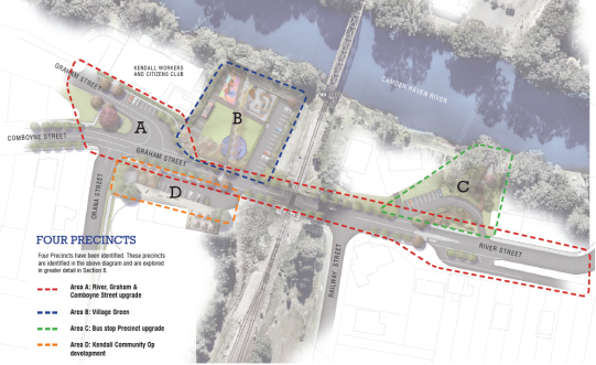
Area A: River, Graham and Comboyne Street upgrade
· Convert the Graham
Street and Comboyne Street intersection into a T intersection
· Kerb and
guttering, parking, pedestrian islands/crossings and footpaths
· Landscaping and
streetscape beautification
· New pedestrian
rail crossing.
Area B: The Village Green
· Community open
space with micro market, flexible lawn area, upgraded toilet block, new car
park, picnic area, lookout and river access, skate park, children’s
playground, exercise space, relocated bullock artwork, sculptural fence and
play element.
· The precinct
cannot be developed until the existing tennis courts are removed and relocated
to Orara Street.
Area C: Bus Stop Precinct upgrade
· The upgrade
includes the following core elements: Kerb and gutter, formal car parking, RV
parking space, new landscaping and streetscape beautification, seating and
picnic table.
· This precinct also
includes a new wharf lookout and Kendall entry signage.
Area D: Kendall Community Op Shop development
· An upgrade of the
Kendall Community Op Shop, consistent with the Main Street Plan, was completed
in March 2018.
The Kendall Main Street Master Plan is a long term vision
with a range of inter-related and inter-dependent actions. In the short term,
the adoption of the Main Street Plan will lead to various actions, including:
· Project A: River,
Graham and Comboyne Street Upgrade – Concept design
· Project C: Bus
Stop Precinct Upgrade – Concept design
· Project B1: The
Village Green – Investigate and resolve property access issues
· Project C1: Wharf
Lookout – Investigate and resolve property access issues
· Project C2:
Kendall Entry Signage – Implement signs as part of broader towns and
villages entry signage project
· Tennis court
relocation – Continue to work with Kendall Tennis Club to permit
relocation of tennis courts to Orara Street
· Skate park
relocation – Continue to progress planning for skate park relocation to
site of present tennis courts
· Funding and grants
– Pursue suitable funding opportunities as they arise
· Development and
land use planning – Consider Kendall Main Street Plan in all future
development and land use planning
· Infrastructure
planning – Consider Kendall Main Street Plan in all future infrastructure
planning
The Master Plan contains individual projects that can be
implemented as opportunities and funding arise.
Options
Council can adopt the recommendation as presented, or
determine an alternate resolution.
Community
Engagement & Internal Consultation
External
The development of the Master Plan involved a number of
different engagement phases. Outcomes of the engagement are detailed in the
attached Master Plan, Engagement Summary report and below.
The first community engagement session was held on 17
February 2017 and attended by approximately 60 people. Attendees were asked to
identify issues and opportunities in the area.
The second community engagement session was held on 27 October
2017 and attended by approximately 50 people. Attendees were asked to comment
on the Draft Master Plan. The majority of attendees were supportive of the plan
and only a small number of minor changes to the document were subsequently
required.
The Draft Master Plan was placed on public exhibition
between 27 October 2017 and 27 November 2017.
The project was included on Have Your Say between February
and November 2017. There were 280 total visits to the Have Your Say page during
the public exhibition period with 157 downloads of the Draft Master Plan. A
small number of online submissions were received.

The Camden Haven Courier published a story on the project on
25 October 2017 which encouraged people to attend the second community
engagement session.
Through the public exhibition phase Council received two
formal submissions, see below:
|
Submission
|
Issue
|
|
1
|
Bill and Daphne Jones
|
I was impressed with presentation Fri 27/10/2017 and
agree in principal the proposed plan presented, however I question the re
alignment of the Graham/Comboyne St making Comboyne St the main thoroughfare
when Graham St carries the bulk of heavy vehicles mainly Log and Milk wagons.
|
|
Response/
Comment:
|
Noted. Better/safer intersection
as well as better/safer pedestrian movements were among the highest themes
identified by the community over the course of the master plan engagement.
|
|
2
|
Millicent Jones
|
No need for another park –
we already have 3.
No need for skateboard ramp
– we have one.
Planting trees in front of Miss
Nellies Café unnecessary.
Planting trees in front of Op
Shop will cut down the parking space badly. Also make turning difficult.
Kendall Main Street is regarded
by locals as that area above Orara Street up past the store to our Anzac Park
to our community centre and School of Arts. NOT down the bottom of the hill.
The Y road works excellently as
it is, but the centre of the Y needs proper build up.
We DO need footpaths, curb and
guttering in many areas of Kendall. Especially up the road towards Kew where
children struggle to push their bikes off the side of the road through long
weeds.
We also need our roads maintained.
Do not waste money on flippant
beautifying – be practical and useful.
|
|
Response/ Comment:
|
Noted. The Master Plan is
consistent with community feedback and input up to this point.
Increased landscaping and
beautification to maintain village character, the rationalisation of park
space (including the skate park), better/safer pedestrian movements and
better/safer intersection were among the highest themes identified by the
community over the course of the master plan engagement.
|
Internal
PMHC Community & Place – Group Manager
PMHC Community & Place – Place Facilitator
PMHC Transport & Stormwater Network – Group
Manager
PMHC Transport & Stormwater Network – Engineering
Planning Manager
PMHC Transport & Stormwater Network – Senior
Stormwater Drainage Engineer
PMHC Transport & Stormwater Network – Road Safety
Officer
PMHC Recreation & Buildings – Group Manager
PMHC Recreation & Buildings – Senor Landscape
Architect
The Final Master Plan as presented for adoption contains a
small number of changes to the Draft Master Plan that was publicly exhibited
consistent with community feedback.
Planning
& Policy Implications
The Master Plan is consistent with Council’s broader
program of developing Community Plans across the local government area. Community
Plans are a collaborative and participatory process that enables communities to
self-determine a vision for their place, determine priorities and actions and
achieve positive outcomes through planning and collaboration. The Community
Plans enable Council and the community to understand the issues and priorities
for each community; assess these priorities in relationship to Council’s
operational plan development; encourage community lead place development.
The Master Plan will guide the future form and development
of the Kendall Main Street. It will enable Council to work with the community
to identify and address community needs, to inform Council processes, services
and projects.
Financial
& Economic Implications
Once adopted, the Master Plan will assist in the development
of future Council works programs and guide the allocation of Council funds and
assist in grant applications.
A future funding plan will be required to support the master
plan as it is considerably more than an infrastructure plan and has relevance
to Community & Place (e.g. op shop, activation of village space, heritage
items, public art), Recreation & Buildings (e.g. skate park relocation, tennis
courts, playground, park) and Economic Development (e.g. business opportunities,
tourism). There is also an opportunity to include this plan in a future
Community Plan with actions supported by both Council and the Community.
|
Attachments
1View. Kendall Main Street Master Plan
2View. Kendall Main Street Plan -
Engagement Summary
|
20/06/2018
|
Item: 10.02
Subject: Recommended Item from Cultural Steering Group - (General Business
Item) - Surf Museum - Town Beach North
Presented
by: Strategy and Growth, Jeffery Sharp
Alignment with Delivery Program
2.3.4 Plan, investigate, design and construct open spaces,
recreational and community facilities.
|
|
RECOMMENDATION
That Council consider the unsolicited proposal for a
Port Macquarie Surf Museum as a submission to the Reviewed Cultural Plan when
it is on exhibition.
|
Background
The Cultural Steering Group met on 18 April 2018 and considered
an item in general business around a proposal to construct a Surf Museum within
the Town Beach area.
The CSG reached consensus with the minutes for the item
following:
|
08.03 Surf Museum - Town Beach - North
|
|
That a
recommendation be put to the May Ordinary Council Meeting.
CONSENSUS:
That it be a recommendation to
Council:
That Council undertake a
review of the Town Beach Master Plan to determine if a Surf Museum can be
located on Town Beach-North.
|
Council Executive Comment
Council formally adopted the Town Beach long Term Master
Plan in February 2013 following significant community consultation and
engagement.
The request from the CSG for Council to consider a review of
the Town Beach Master Plan to consider a Surf Museum (attachment 2) be located
in the area was not considered as part of the Draft Operational Plan 2018/19
during the exhibition period.
The unsolicited proposal could be considered as part of the
Reviewed Cultural Plan exhibition period and Council’s Executive further
believe that a site selection process should be completed for such a facility
prior to any consideration of amending or altering any existing Master Plans.
|
Attachments
1View. Town Beach Long Term Master
Plan
2View. Artists Impressions - Port
Macquarie Surf Museum
|
20/06/2018
|
Item: 10.03
Subject: Recommended Items from the Mayor's Sporting Fund Sub-Committee -
May 2018
Presented
by: Strategy and Growth, Jeffery Sharp
Alignment with Delivery Program
2.3.2 Provide a range of inclusive sporting and
recreational opportunities and facilities to encourage a healthy and active
lifestyle.
|
|
RECOMMENDATION
That Council, pursuant to the
provisions of Section 356 of the Local Government Act 1993, grant financial
assistance from the Mayor’s Sporting Fund as follows:
1. That Connor Cook be granted
the amount of $150.00 to assist with the expenses he would have incurred
competing at the NSW State Cricket Challenge held in Campbelltown Sydney from
15 – 18 April 2018 inclusive.
2. That Madelaine
Goodridge be granted the amount of $300.00 to assist with the expenses she
would have incurred competing at the 2018 Georgina Hope Australian Age
Swimming Championships held in Sydney from 21–28 April 2018 inclusive.
|
Executive Summary
The Mayor’s Sporting Fund
Sub-Committee met on 24 May 2018, reached consensus on Item 8 (attached) and
submits the above recommendation for Council’s approval.
|
Attachments
1View. Extract Item 8 MSF Meeting
Minutes 24 May 2018
|
20/06/2018
|
Item: 10.04
Subject: Artwalk 2018 - Post Event Report
Presented
by: Strategy and Growth, Jeffery Sharp
Alignment with Delivery Program
2.5.1 Support cultural activities within the community.
|
|
RECOMMENDATION
That Council:
1. Note
the information in the Artwalk 2018 – Post Event Report.
2. Request
the Cultural Steering Group work with staff on the ongoing development of
future ArtWalk events.
|
Executive Summary
Following from the success of the 2016 and 2017 ArtWalk
program, the third annual ArtWalk returned to the Port Macquarie CBD on 19th
April from 6pm - 9pm, with an expanded program of free arts and cultural
offerings. The purpose of the program was to activate the Port Macquarie
CBD by working to highlight our existing arts and cultural businesses, public
art, and raise the profile of our regional artists and cultural capability.
This year’s event saw an estimated 11,500 people
attend the event, showing a growth of approximately 300% increase from the
establishment of the event in 2016, indicating an increased desire for Arts and
Cultural activities. This is a significant amount of people who are coming down
to the CBD for this three hour period, boosting our night time economy.
This year’s program saw new initiatives and a new
ArtSmarts professional mentoring pilot program to enhance the existing ArtWalk
program, highlighting the profile of Arts, Culture and creative industries.
ArtWalk has resulted in not only in a vibrant CBD with a
stimulated night time economy, the program has provided a professional business
support for this growing industry. It has fostered creative collaborations,
raised the profile of our arts and cultural sector within the community and
provided enduring connections between artists, businesses, Council and the community.
The success of the ArtWalk program creates the opportunity to continue to grow
this impact in future years.
Discussion
Held on the Thursday evening on 19 April 2018 the third
ArtWalk event took place in Port Macquarie CBD, the culmination of planning
with community members, businesses and Council.
The event explored the theme of “Journeys”
linking in with the theme for the 2018 John Oxley Bicentennial.
Due to the popularity of the event held in the previous
year, this year’s program expanded to include events in the lead up to
the evening, a professional learning program, and satellite events over the
weekend period, providing opportunities to create, learn, explore, indulge and
discover arts and cultural activities across our Local Government area.
The ArtWalk event ran from 6pm – 9pm along Clarence,
Hay, Murray Street and Town Green. The program provided a night of
sensory delights enabling the community to explore our local historic
collections and discover local artists exhibiting in unconventional spaces. It
showcased artists and their work, local museums, musicians and performing
artists. The event worked collaboratively with the support of local
business, who teamed up with artists, opening their business spaces at night to
provide a pop up “gallery space”. Our existing museums and
galleries also opened their buildings to showcase artist works and facilitate
guided tours and talks about their collections. This has increased and
contributed to the visitation to each cultural facility, with so local people entering
these buildings for the first time in many years.
Live art, music and demonstrations such as stencilling and
glassblowing were held in public spaces, and local restaurants and coffee
houses hosted local artists work, activating an incredible cultural precinct.
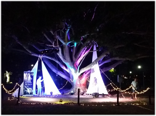
Fig Tree activation –
Tim Madren – Banjo Patterson meets Coldpay
The event was enhanced by the generous support and use of
space by El Paso Motel Group, Laing & Simmons and the business group of
Clarence House and Four Espresso, Sunset Gallery. The event was supported
through 20 volunteers, who on the evening, provided maps, assisted with set up
and pack down, and provided general information about the event and satellite
events.
This year saw a huge increase in the number of participants
and venues with over 60 live sites on display. Resulting in a huge crowd
of est. 11500 people attending this cultural event.
This table demonstrates the measures to capture to compare
events and growth over the past 3 years.
|
Measure
|
2016
|
2017
|
2018
|
Comments
|
|
Budget
|
$10,000
|
$15,000
|
$25,000
|
Operational Budget
|
|
Equivalent of in kind
support
|
Approx 250 Staff hours
|
Approx 270 Staff hours
|
Approx 300 Staff hours
|
Including project
management & delivery
|
|
Number of Artists Involved
|
18
|
45
|
71
|
|
|
Number of Artist Market
Businesses
|
0
|
18
|
31
|
|
|
Number of business Involved
|
9
|
26
|
42
|
|
|
Number of attendee surveys
completed
|
130
|
194
|
225
|
|
|
Number of Live Sites
|
18
|
42
|
63
|
|
|
Artwalk App Map views
|
No App
|
4816
|
10,906
|
|
|
Event Attendees (approx)
|
3,500
|
8,500
|
11,500
|
|
|
Facebook Likes
|
0
|
448
|
811
|
|
|
Estimated direct spend by
participants into local business from ArtWalk event
|
Not measured
|
$150,000 *estimate only
|
$365,102
|
|

Activation – hula-hoops
on town green
There were a number of new initiatives which linked with
this year’s ArtWalk program:
Community Artwork - Illumination
Birpai Land Council worked with Council’s Creative
Project Officer Lucy Pascale to create the Community Illumination. Workshops
were held with the Birpai Youth Group and Men’s group in the lead up the
Artwalk Program. Over 200 illuminations were created to showcase our
growing and diverse community, and the people of the Birpai Country.
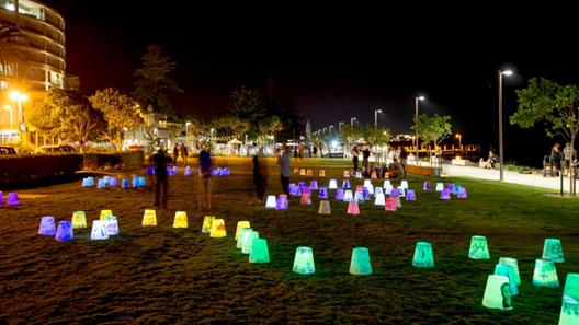
Illumination on Town Green
Faces of the Hastings
In the lead up to ArtWalk and as part of the bicentenary
project, PMHC engaged local photographer Ronnie Grammatica to take portraits of
our local community. These images were installed in large format poster
prints in a temporary public art installation on a building due for
demolition. The images captured the diversity of who our community is, as
well as bringing art out into the streets and embedded as part of the
everyday. This program will also be rolled out in Wauchope and Laurieton
in the lead up to the Bicentennial event in October.
ArtSmarts Program
The introduction of a pilot professional learning program
was developed to assist in the professional development of artists. The
program was written and developed to connect with the business skills and
networks required for living in the Port Macquarie-Hastings Region as well as
general business skills development facilitating local artists to look at
opportunities to commercialise their skills and talent. After an EOI
application, 15 artists were selected to be part of this pilot program.
Over six months, participants were given a two hour program
focussing on marketing, branding, product development and pricing along with 6
mentoring sessions each with a local arts business facilitator. On the
evening, 14 participants participated in the ArtWalk event, launching their
products and services to a huge audience.
Outcomes from the program includes all participants now
being business savvy including having an ABN, website and marketing channels
set up, 12/15 developed new product to showcase at ArtWalk 2018 including a
published book, tea towels, jewellery range and workshop programs. Part
of the program focused on exploring additional revenue streams through their
creative practice that would support their current practice. The program has
given confidence in business skills and can be shown with the following pre and
post survey results.
|
ArtSmart Survey
|
Pre Program Survey (Agree or Strongly Agree)
|
Post Program Survey (Agree or Strongly Agree)
|
|
I am confident about my
business skills in regards to my art
|
18.18%
|
100%
|
|
I know how I can
commercialise my work
|
18.18%
|
100%
|
|
I have a strong connection
with the creative community
|
9.09%
|
71.43%
|
|
I am confident in calling
myself an artist
|
54.54%
|
100%
|
|
I know how the work I
produce is unique and how to market it to a broad audience
|
9.09%
|
100%
|
|
I am confident in taking
the next step in my creative business venture
|
41.56%
|
85.72
|
|
I talk to other creative
people in the community to collaborate on projects and ideas
|
9.09%
|
57.14
|
|
I have a solid business
plan and goals for my creative business
|
0%
|
57.14%
|
|
I am aware of places within
my local community where I can find opportunities to develop my creative
practice
|
18.18%
|
100%
|
|
I have a strong network
within the community that supports my creative development
|
0%
|
85.67%
|
Council will be running the ArtSmarts program again and will
culminate at ArtWalk 2019. The program will commence with the recruitment
in July 2018 and be run over an 8 month period.

Interactive Mandala –
Hay Street Forecourt

Sand Artist activation
– Clarence House
Satellite Events
Council also introduced on a
trial basis, the development of satellite events to encourage participants to
not only come along to the ArtWalk event, but to get out into our regions and
explore other arts and cultural pursuits that are available across the region.
11 additional satellite events were on offer at the following venues:
· Hastings Valley
Fine Arts Gallery
· Ultragrafix
Gallery
· Bye Bye Birdie
– Players Theatre
· Wauchope Creative
Festival
· Smart Portraits
Workshop with Ronnie Grammatica
· Sista Sing –
Wauchope Arts Council
· Heritage Week
Opening – Douglas Vale Vineyard
· Rose Renaissance
– Rydges
· Original Sound
Lounge – Live Music at various venues
· The Maes –
Wauchope Arts Council
· The Artist Markets
Marketing
The event was marketed to a targeted local audience
utilising limited resources. The main focus of the campaign was towards online
and social media coverage, with good media campaigns in the local
newspapers. Council’s destination marketing also supported the
event through targeted advertising for family holiday makers.
Key adverts in the Focus magazine and good lead up stories in
the local media provided interest in the local event. A small social media
campaign was also run targeting family and local audiences. The event was
also promoted through participants social media channels, which provided
greater reach for the local audience.
The demographics of the event showed us the 29% of people
were from outside the local government area, an increase in visitors from last
year’s event. 33% of participants were children who attended with
their families as part of a group. 87% of people who came to the event came
downtown specifically for this event.
Feedback
By any standards the third annual ArtWalk event was an
outstanding success. Approximately 11,500 people attended the three hour
event, and more than 700 people attending satellite events and programs.
Surveys and digital feedback forms captured community and participant feedback
on the night, as well as follow up media stories, social media posts, and
post-event interviews with artists and businesses. With almost 200 responses
from community, participants and businesses, the survey highlighted that the
ArtWalk event significantly achieved the goals identified in early planning.
Responses form the survey indicated that the event increased
their awareness of Arts, Culture and Creative businesses by a lot (62.5%), or a
little (33.93%), a key objective of the program.
While the purpose of the program was to highlight our arts
and cultural assets, the measurable outcomes from the program can also be seen
to have provided social, Civic and economic benefit through a sense of safety
and security, a sense of belonging and civic pride, and significant stimulation
of creativity within the community, along with a vibrant night time economy.
The event feedback ranked the following aspects of the event
as either excellent or good. Creativity (98.94%), Atmosphere (98.41%),
Entertainment (95.23%), Vibrancy (97.33%), Community feel (96.81%), Safety
(95.58%), Accessibility (93.04%). The area for improvement was
around access to food, and can also be seen within the direct comments section
from participant’s feedback.
Given that the event was only three hours, it made
significant contributions to the night time economy, in particular for food
based business located within the CBD region. Based on the survey
results, it is estimated that the ArtWalk event had an economic impact of
$847,223. Direct spend on the evening at the event was estimated at $365,102
and the direct spend from visitors per day, based on REMPLAN, was approximately
$466,900.
Conclusion
Following the outstanding success of the third annual
ArtWalk program there is great evidence that this event has the capacity to
become an iconic event for the Port Macquarie Hastings region. The event struck
a chord with residents and visitors providing them the opportunity to explore
arts and culture in a unique fashion. A formal debrief is underway to determine
future activities and other aspects of the ArtWalk event and how it could
develop into a flagship event for the Hastings. Feedback from local services
and participants has been extremely complimentary. Council staff will need to
explore the opportunities to develop this program into a flagship event, which
could boost the visitor economy and creating a unique experience for both the
local community and visitors to the region.
Planning information for the development of an arts and
cultural festival flagship style event in 2019 incorporating ArtWalk (including
budget and operational) will be presented to a Councillors briefing later in
the year.
Options
1. Council
note the information in the report or
2. Council
seek further information about the event.
Community Engagement &
Internal Consultation
Engagement with business houses commenced in February,
testing the appetite to support the event. Once again, based on the
experience form the previous years, there was no resistance to being a part of
the event again. This year, support for the event has grown, with more
businesses hosting artists within their spaces.
This year PMHC staff also worked with other key
organisations including TAFE NSW and the Birpai Land Council, and Hello Koalas
group.
PMHC actively engaged the restaurant and food outlets within
the precinct to create easy takeaway street style options.
Internal Consultation
Community Place Team
Electrical Services
Parks & Recreational Services
Glasshouse
Roads & Transport
Economic Development
External Consultation:
Port Macquarie Emergency Services
Local Businesses
Local Artists
Port Macquarie Museum
Arts Mid North Coast
Planning & Policy
Implications
The ArtWalk Program delivers on
the following actions in the 2016 – 2019 Cultural Plan.
1.5 Foster partnerships and collaborations
between other government, corporate, education, community and not for profit
agencies to further build capacity and identity.
2.1 Celebrate and support diverse communities
through the arts, culture and heritage and encourage sustainability and
capacity building.
2.6 Promote Port Macquarie-Hastings Arts
Culture and Heritage programs and events as a key feature of our regions
identity.
5.1 Provide opportunities for cultural
celebration through festivals, events and programs which offer opportunities to
showcase our community.
Financial & Economic
Implications
The program was delivered through the Creative Place Making
program. The program was delivered within a budget of $25,000 for the ArtWalk
event plus an approximate 300 hours of Council staff time (approx. $20,000)
value. It is estimated that the ArtWalk event had an economic impact of
$847,223. Direct spend on the evening at the event was estimated at $365,102
and the direct spend from visitors per day, based on REMPLAN, was approximately
$466,900.
20/06/2018
|
Item: 10.05
Subject: Cultural Plan Review
Presented
by: Strategy and Growth, Jeffery Sharp
Alignment with Delivery Program
2.5.1 Support cultural activities within the community.
|
|
RECOMMENDATION
That Council:
1. Acknowledge
the Cultural Steering Groups review and endorsement of the Draft 2018 –
2021 Cultural Plan and place the draft plan on public exhibition for a period
of 30 days between the 25th June and 20th July 2018.
2. Refer
the submissions to the Cultural Steering Group for consideration prior to the
finalisation of the Plan and reporting to Council.
|
Executive
Summary
On 10 August 2016 Council resolved that Council:
1. Note the submissions to the draft
Cultural Plan.
2. Adopt the Port Macquarie-Hastings
Cultural Plan 2016-2019.
3. Request that the General Manager
bring forward a report to the Council Meeting in April 2017 on progress as
measured against the performance indicators in the Cultural Plan.
4. Review the Cultural Plan within 12
months.
CARRIED: 6/3
FOR: Besseling, Griffiths, Hawkins,
Intemann, Levido and Sargeant
AGAINST: Cusato, Roberts and Turner
At the 15 February 2017 Ordinary Council meeting, Council
resolved to form a Cultural Steering Group with one its objectives to assist
Council in the implementation and review of the Cultural Plan.
An external facilitator was contracted to assist the
Cultural Steering Group in the review of the Cultural Plan and members attended
a series of three workshops over September & October, 2017 along with
additional working group meetings in March, April and May of 2018, which
have resulted the development of a new Cultural Plan for 2018-2021 it includes
a strategic focus with a new vision, key strategies, objectives and actions to
develop our region and be recognised internationally as an innovative leader of
creativity and culture.
This report provides an update on the review process of the
Cultural Plan and presents a new Cultural Plan spanning 2018 – 2021
period. The plan has been reviewed and amended by the Cultural Steering
Group and is now seeking endorsement to go on public exhibition for comment.
Discussion
Port Macquarie-Hastings Council is committed to ensuring
arts, heritage and culture play a strong role in the development of the Port
Macquarie-Hastings region’s future, its identity and sense of place.
Council currently plays a major part in delivering cultural
services across the region, and is supported by the ever-growing number of
community organisations, events and activities that contribute to ensuring that
our community is diverse, resilient and connected.
Council also has a leadership role in assisting the growth
and development of arts and cultural activity. A strong arts and cultural
framework will contribute to the delivery of the four key objectives of the
Towards 2030 Community Strategic Plan.
At the 15 February 2017 Ordinary
Council meeting, Council resolved to form a Cultural Steering Group (CSG) with
one its objectives to assist Council in the implementation and review of the
Cultural Plan.
The CSG objectives are to:
· Assist
Council in the implementation and review of the Cultural Plan;
· Assist
Council in monitoring the success of the Plan against established criteria;
· Engage
with and provide input to Council on other Arts and Cultural matters which are
relevant to the Local Government Area; and
· Provide
and receive two-way feedback from the community.
The CSG key functions are to:
· Provide
a forum in which Local Government and community leaders can discuss and debate,
plan and progress local and regionally significant cultural and creative
outcomes that continue the growth of our community and our places in the Port
Macquarie Hastings Local Government Area.
· Be an
interactive group that provides a forum for developing the strategic community
arts, culture and active spaces direction for the Local Government Area. The
Steering Group is committed to collaboration, innovation and development of a
‘whole-of-place’ approach for the purpose of promoting community
capacity building that will ensure the wellbeing of our community while
developing a clear sense of and connection to our place.
In September 2017, an external
facilitator was engaged to assist the CSG in the Cultural Plan review and
members attended a series of three workshops over September & October in
2017. The workshops focused initially on a review of the document, its
visions, strengths, weaknesses, threats and opportunities as well as developing
key strategies, tasks and measures. An outcome from these workshops produced a
new aspirational vision for the Cultural Plan of:
“Greater
Port Macquarie is recognised internationally as an
innovative
leader of creativity and culture”
Over the past 6 months, the CSG
has reviewed and consolidated the existing plan into four new key strategic
objectives, and actions that will drive and support cultural development within
the Port Macquarie-Hastings region for the period 2018-2021.
The four Key Strategic
Objectives are:
1. Develop and empower our
region’s Art & Cultural Communities and Assets
2. Enrich our community through
experiences that embrace and celebrate our diverse and unique Art and Culture.
3. Create community pride and
ownership in our cultural brand which promotes our unique heritage, people and
places.
4. Ensure the effective planning,
funding, integration and measurement of Council’s Arts and Cultural
programs.
Supporting these objectives are
30 key strategies and actions to be delivered over 2018 – 2021 period.
These actions are strategically
focused and will provide solid groundwork to inform the development of future actions
in the cultural plan. The 2018 - 2021 plan will be a cross-Council initiative
and will be undertaken through partnerships and collaboration with state and
Federal Governments, local industry, the education sector, community based arts
and cultural organisations and creative individuals.
The plan will enable Council to
identify the resources required to ensure maintenance and development of the
area’s cultural and heritage resources; help develop a thriving creative
industry; and encourage, support and enable participation in artistic
expression and cultural experimentation to inspire innovation and a sense of
wonder.
Options
That Council can adopt the recommendations as presented, or
seek additional information regarding the plan prior to public exhibition.
Community
Engagement & Internal Consultation
Extensive community engagement was undertaken to develop the
2016-2018 Cultural Plan, with over 1200 community member contributing.
The Cultural Steering Group were the driving force behind
the development of the new plan and are a demographically representative group
from a range of arts and cultural pursuits.
The public exhibition stage will include engagement with key
stakeholder groups and be in a number of methods including:
· Face to Face discussions
· Pop up engagement
· Online engagement
on Have Your Say
· Static displays in
the libraries and customer service centres.
Planning
& Policy Implications
There are no planning and
policy implications in relation to this report.
After the completion of the
public exhibition period and the final refinement of the Cultural Plan
2018-2021, the previous plan will need to be rescinded.
Financial
& Economic Implications
There are no financial and
economic implications in relation to this report.
Following the adoption of the
Cultural Plan 2018-2021 an annual detailed action plan with funding allocation
from the proposed 18/19 operational plan will be developed. This will then be
reviewed annually as part of the integrated planning process and budgeted
accordingly.
|
Attachments
1View. 2018 - 2021 Draft Cultural
Plan
|
20/06/2018
|
What we are trying to achieve
A connected, sustainable,
accessible community and environment that is protected now and into the
future.
|
|
What
the result will be
We will have:
•
Effective management and maintenance of essential water, waste
and sewer infrastructure
•
A community that is prepared for natural events and climate
change
•
Sustainable and environmentally sensitive development outcomes
that consider the impact on the natural environment
•
Accessible transport network for our communities
•
Infrastructure provision and maintenance that meets community
expectations and needs
•
Well planned communities that are linked to encourage and
manage growth
•
Accessible and protected waterways, foreshores, beaches and
bushlands
•
An environment that is protected and conserved for future
generations
•
Renewable energy options that are understood and accessible by
the community
How
we will get there
4.1 Provide
(appropriate) infrastructure and services including water cycle management,
waste management, and sewer management
4.2 Aim
to minimise the impact of natural events and climate change, for example, floods,
bushfires and coastal erosion
4.3 Facilitate
development that is compatible with the natural and built environment
4.4 Plan
for integrated transport systems that help people get around and link our
communities
4.5 Plan
for integrated and connected communities across the Port Macquarie-Hastings
area
4.6 Restore
and protect natural areas
4.7 Provide
leadership in the development of renewable energy opportunities
4.8 Increase
awareness of issues affecting our environment, including the preservation of
flora and fauna
|
20/06/2018
|
Item: 12.01
Subject: Acquisition of Land and Easement - Long Flat Sewerage Scheme
Presented
by: Corporate Performance, Rebecca Olsen
Alignment with Delivery Program
4.1.3 Plan, investigate, design and construct sewerage
assets ensuring health, safety, environmental protection and the future
growth of the region.
|
|
RECOMMENDATION
That Council:
1. Pay
the negotiated amount of $101,250.00 (GST free) for compensation and the
reimbursement of design review and negotiation costs to the owners of Lot 22
DP818173 and Lot 1 DP1042541, PJ & M L O’Neill, for the acquisition
of land generally shown as Lot 2 in Mark Rogers’ draft plan of survey
reference 17380DP02 and the acquisition of an easement for the drainage of
sewage 3 metres wide as shown in Mark Rogers’ draft plan of survey
reference 17380DP04.
2. Pay
the owners’ legal costs for the property conveyance.
3. Delegate
authority to the General Manager to sign:
a) Deed
of Acquisition / Contract for the Sale of Land;
b) Deed
of Agreement;
c) Land
Registry Services Transfer Forms;
d) Revenue
NSW Purchaser Declaration;
e) Letter
to Revenue NSW seeking exemption from the payment of stamp duty.
|
Executive
Summary
A report to consider the acquisition of land and easement to
enable the construction of the sewer treatment plant and discharge of treated
effluent as part of the Long Flat Village Sewerage Scheme (OP 4.1.3.4 CW).
Discussion
Council has previously been successful in securing grant
funding to enable the provision of sewerage to the villages of Comboyne, Long
Flat and Telegraph Point. The acquisition of land and easements is
required in each village for infrastructure such as pumping stations, treatment
plants and pipes to transfer both the untreated and treated effluent.
At Long Flat, land has already been acquired for the pumping
station.
This report deals with the acquisition of land for the
proposed treatment plant, effluent re-use from the treatment plant and the
acquisition of an easement for treated effluent from the treatment plant to the
river discharge point. Draft survey plans depicting the land and easement
to be acquired are attached to this report.
Preceding the allocation of the grant funding, the Long Flat
community was invited to submit expressions of interest to allow for the re-use
of the treated effluent for farmland irrigation. The owners of the land
associated with this agreement, expressed interest in the reuse of treated
effluent, hence designs were subsequently developed to accommodate the plant
and effluent storage with reuse potential.
Following negotiations on price and conditions with the
landowner and subject to formal approval by Council, acquisition of the land
will be undertaken via the normal process.
In order for the works to proceed prior to the completion of
this process, a Deed of Agreement with the landowner is proposed to include the
following:
· The purchase of
land is conditional on the award of a Tender for the construction of a sewerage
scheme at Long Flat;
· Payment of the
negotiated amount of $101,250.00 (GST free) for purchase of the land and
reimbursement of the owner’s design review and negotiation costs;
· Payment of the
owner’s reasonable legal expenses for the property conveyance;
· Consent for
Council and their nominated contractor to undertake construction of the
required works following authorisation of the Deed, prior to the formal finalisation
of acquisition;
· That the formal
land acquisition will be undertaken through the normal Council processes.
Recommendation is also sought providing authority for the
General Manager to sign the Deed of Agreement when issued.
The final design may nominally alter the boundaries of the
land required for the treatment plant. Accordingly, at this time the
survey plans have not been registered and are presented in their draft
format. Pending the final design and plan registration, administrative
matters including the classification of the land to be acquired will be held
over and reported to Council at a later date.
Options
There is the option to:
1. Pay
the compensation and costs as recommended in this report.
2. Not
pay the compensation and costs and commence negotiations with other landowners
to secure land for the establishment of the sewer treatment plant.
Community
Engagement & Internal Consultation
There has been engagement with the landowners and
consultation within Council’s Infrastructure Division and Corporate
Performance Division.
Planning
& Policy Implications
As the proposed treatment plant and associated
infrastructure has been specifically designed for this particular property,
should Council not proceed with this acquisition the Long Flat Sewerage Scheme roll
out would be greatly delayed. New costs for an alternate site, the
re-location of a portion of the reticulation system and the re-design to suit
the new location, would be incurred.
Financial & Economic
Implications
The acquisition of the land and easement entitles the
landowner to compensation assessed under the provisions of the Land
Acquisition (Just Terms Compensation) Act 1991.
Compensation valuations were obtained from Council’s
consulting valuer and the owners’ valuer. Agreement was reached on
the compensation and the reimbursement of costs including costs associated with
reviewing designs and accounting advice. An offer of a total of
$101,250.00 (GST free) was made to the landowners.
The landowners have agreed to the acquisition subject to
payment of the above compensation and reimbursement of costs.
Noting that the acquisition is critical to the continuation
of the Long Flat Village Sewerage Scheme project, it is recommended that
Council accept the negotiated offer to acquire the land and easement as
outlined in this report.
In addition to the compensation amount identified above,
Council in its role as an Acquiring Authority, is required to also meet the
reasonable valuation and legal costs incurred by the landowners arising from
the acquisition. The owners’ valuation costs of $3,300 incl GST
have already been paid. The owners’ legal costs for the conveyance
are estimated at $3,000 incl GST.
There is funding available under OP 4.1.3.4 CW to meet the
compensation assessment and reimbursement of costs outlined in this report.
|
Attachments
1View. Draft plan of survey
reference 17380DP02 showing land (Lot 2) to be acquired
2View. Draft plan of survey
reference 17380DP04 showing easement to be acquired
|
20/06/2018
|
Item: 12.02
Subject: Regional Transport Infrastructure Steering Group Membership
Amendment
Presented
by: Infrastructure, Alex Fisher
Alignment with Delivery Program
4.4.1 Plan, investigate, design and construct transport
assets which address pedestrians, cyclist and vehicular needs to cater for
the future growth of the region.
|
C
|
RECOMMENDATION
That Council:
1. Appoint
the Engineering Planning Manager, Transport and Stormwater Network as a
voting member of the Regional Transport Infrastructure Steering Group in lieu
of the Group Manager Transport and Stormwater Network
2. Endorse
the amended Regional Transport Infrastructure Steering Group Charter
reflecting the membership changes.
|
Executive
Summary
In support of operational
reporting line changes within the Infrastructure Division amendment to the
membership of the Steering Group is requested. The reporting line changes have
been made to allow a greater focus on strategic planning and strategy
development for transport infrastructure, whereby the Engineering Planning
Manager, Transport and Stormwater Network reports directly to the Director
Infrastructure on regional transport infrastructure matters.
Subsequently approval is sought
for the Engineering Planning Manager, Transport and Stormwater Network to be
appointed as a voting member on the Steering Group, replacing the Group Manager
Transport and Stormwater.
In accordance with the Steering
Group charter, endorsed by Council at the October 2017 Ordinary Council
meeting, appointment of members is only by a Council resolution duly passed.
The amended Regional Transport
Infrastructure Steering Group Charter is attached.
Discussion
To establish a dedicated focus
on strategic planning and strategy development for transport infrastructure an
operational reporting line change was made within Infrastructure Division. In
the current Transport and Stormwater Network Group structure, Operations, Fleet
Services and Engineering Planning teams report directly to the Group Manager
Transport and Stormwater Network. Under the revised reporting arrangements,
Engineering Planning will report directly to Director Infrastructure.
In support of this operational
reporting line change, amendment to the membership of the Regional Transport
Infrastructure Steering Group is suggested.
The Steering Group charter that
was endorsed by Council at the October 2017 Ordinary Council meeting outlines
the membership for the Steering Group as:
Membership - Voting Members
· Councillor,
Major Projects Portfolio
· Director
Infrastructure
· Director
Strategy and Growth
· Group
Manager Transport and Stormwater Network
· RMS
Manager – Regional Planning (North/West)
· RMS
Regional Manager (Northern)
There is now a requirement for the Engineering Planning
Manager, Transport and Stormwater Network to be appointed as a voting member on
the Steering Group, replacing the Group Manager Transport and Stormwater,
reflective of the current accountabilities for Regional Transport
Infrastructure.
As outlined in the Steering Group charter, the appointment
of members is only by a Council resolution duly passed.
It is recommended that the Engineering Planning Manager,
Transport and Stormwater Network be appointed as a voting member of the Regional
Transport Infrastructure Steering Group and the Group Manager Transport and
Stormwater Network be removed as a voting member.
Options
Council has the option to approve, decline or amend the
recommendation.
Community Engagement &
Internal Consultation
Consultation has occurred with the Regional Transport
Infrastructure Steering Group, the Director Infrastructure, Group Manager
Transport and Stormwater Network and Engineering Planning Manager Transport and
Stormwater Network.
Planning & Policy
Implications
There are no planning and policy implications in relation to
this report.
Financial & Economic
Implications
There are no financial and economic implications in relation
to this report.
|
Attachments
1View. Amended Regional Transport
Infrastructure Steering Group Charter
|
20/06/2018
|
Item: 12.03
Subject: Stormwater Strategy Development Update -
Integrating Council's Stormwater Strategy with the Integrated Water Cycle
Management Strategy
Presented
by: Infrastructure, Alex Fisher
Alignment with Delivery Program
4.1.5 Work towards planning, investigation, design,
construction of stormwater assets.
|
|
RECOMMENDATION
That Council note:
1. The
key objectives, priorities and initiatives underpinning the development of
Council’s stormwater strategy as outlined in this report.
2. That,
based on the stormwater strategy planning work to date, a number of
stormwater flood mitigation projects are currently underway, which have been
funded by the Water Fund Dividend.
3. That
the forward development, community and stakeholder engagement, and formal
adoption of the stormwater strategy will be included within the development
of Integrated Water Cycle Management Strategy.
4. That
the development and adoption the final Integrated Water Cycle Management
Strategy, including the stormwater strategy, is a key operational activity
within the 2018/19 Operational Plan.
|
Executive Summary
Over the past six months
significant work has been undertaken in the development of Council’s
stormwater strategy, resulting in the identification and development of key
objectives, priorities and initiatives for stormwater management across the Local
Government Area. Based on this planning, Council has identified the
following stormwater Focus Areas:
· Focus Area 1
– Mitigate localised stormwater flooding of properties at the highest
priority sites.
· Focus Area 2
– Gain a comprehensive understanding of current stormwater asset
conditions and renew highest priority degraded assets based on risk.
· Focus Area 3
– Produce a Development Servicing Plan for stormwater works.
· Focus Area 4
– Gain an understanding of the impacts of stormwater on water quality
within receiving waters and implement water quality improvement works at the
highest priority sites.
· Focus Area 5
– Explore and implement stormwater reuse solutions to supplement and
support sustainable water supply for the region.
Aligned primarily with Focus Areas 1 and 2, work has also
progressed on flood mitigation catchment modelling and asset condition
assessments, as well as design, construction and renewals of priority flood
mitigation works.
Concurrently, Council has been developing an Integrated
Water Cycle Management (IWCM) Strategy, a key objective for which is the
integrated management of urban water supply including potable water, wastewater
and stormwater. Subsequently, the forward development and documentation
of Council’s stormwater strategy is planned to be included within the
development of Integrated Water Cycle Management Strategy.
Finalisation of the IWCM Strategy brings together work
already completed across multiple areas of investigation including an IWCM
issues paper, technical reports exploring options and recommendations to
address identified issues, water supply secure yield analysis, and will now
also include the stormwater strategy planning outlined in this paper.
Ongoing development, stakeholder and community engagement,
finalisation, and Council adoption of the IWCM Strategy is a key activity
planned to be undertaken as part of the 2018/19 Operational Plan.
The Water, Stormwater, Sewer and Waste Councillor Portfolio
have been kept informed of the progress of planning for both the IWCM and
stormwater management, and will engaged throughout the ongoing development of
the IWCM Strategy.
Discussion
Background
At the December 2017 Ordinary
Council Meeting, Council resolved:
RESOLVED: Intemann/Levido
That in view of the potential for water and sewer
dividend funds being directed to stormwater projects, Council request the
General Manager to develop a strategy for stormwater works for future years,
working with the Water, Stormwater, Sewer and
Waste Councillor Portfolio, with a report to be tabled at
the June 2018 Council meeting detailing the proposed strategy.
CARRIED: 8/0
FOR: Alley, Cusato, Griffiths, Hawkins, Intemann, Levido,
Pinson and Turner
AGAINST: Nil
Since this time significant work has been undertaken in the
development of Council’s stormwater strategy, resulting in the
identification and development of key objectives, priorities and initiatives for
stormwater management across the Local Government Area. This planning
work forms the basis for defining a structured, transparent and holistic
forward works program for stormwater management by Council.
Purpose
The purpose of this report is
to provide an update with respect to the stormwater strategy planning work
underway and outline how forward development of this work will be included
within the Integrated Water Cycle Management (IWCM) Strategy for the Local
Government Area. This report also provides a status update on the
stormwater flood mitigation projects are currently underway, which have been
funded by the Water Fund Dividend.
Integrated Water Cycle
Management
IWCM is the integrated management of water supply, sewerage
and stormwater services within a whole of catchment strategic framework, while
having regard to catchment plans and other management plans. IWCM helps to:
· Identify water
management strengths and problems;
· Address these
problems;
· Determine the
appropriate management responses; and
· Manage the impacts
so that social, environmental and economic objectives are met.
The three components of urban water – potable water,
sewage and stormwater – share common issues, as well as individual
problems. IWCM promotes holistic management of these services, which saves
resources and improves services for our community. The integration of the
systems is shown in Figure 1 below.
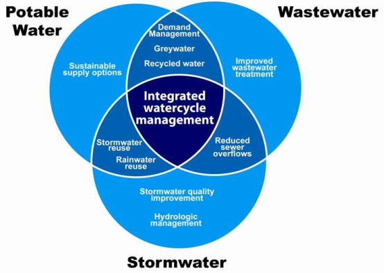
Figure
1: Principles of IWCM showing the links between potable water, sewage and
stormwater
Along with providing safe potable drinking water and
wastewater services, the provision of a safe and effective stormwater drainage
network that has adequate capacity is a core service of Council. To ensure
Council is taking a holistic approach to providing its core services to the
community the stormwater strategy will be fully integrated into and developed
with the IWCM Strategy.
The process to complete an
IWCM has oversight from the Department of Industry and requires adherence to a
checklist defining the requirements to complete an IWCM. The checklist is
essentially a roadmap and has been prepared to assist Council and its community
to identify the urban water service issues across all three water cycle
components, assess the options, develop and evaluate IWCM scenarios and adopt
sound IWCM options, strategy and financial plan to address the identified issues.
Stormwater planning
The aim of the stormwater component of the IWCM Strategy is
to achieve social, environmental and economic objectives through the adequate
management of stormwater runoff.
Key stormwater objectives that will be outlined in the draft
IWCM Strategy are:
Social:
· Protecting and
improving community amenity by controlling and directing excess stormwater
runoff away from properties.
Environmental:
· Protecting and
improving the quality of our waterways, streams, rivers and beaches through
monitoring and controlling pollutants within stormwater runoff.
· Reducing potable
water use through harvesting and re-using stormwater to address localised and
larger scale water supply needs, and support regional water supply
sustainability.
· Limiting or
eliminating stormwater infiltration into the sewer system by controlling and
directing excess stormwater runoff away from sewer infrastructure, thus
reducing sewer surcharge risks.
Economic:
· Facilitating and
allowing sustainable urban development, including infill development, through
adequately planned and constructed stormwater systems that meet the capacity
requirements.
· Taking a whole of
life approach to the management of stormwater assets by providing adequate
maintenance and renewal of existing assets and ensuring all new assets are
sustainable and maintainable in line with Council’s financial position.
Current planning and prioritisation methodologies used to achieve
the key objectives will be documented in the draft IWCM Strategy and will form
the basis for engaging with the broader community to finalise the strategy.
Based on current stormwater planning Council has identified
the following stormwater Focus Areas that will be outlined in the draft IWCM
Strategy.
· Focus Area 1
– Mitigate localised stormwater flooding of properties at the highest
priority sites.
1. This Focus Area aims
to achieve the following objectives: Social - Protecting and improving community
amenity and Environmental - Limiting or eliminating the stormwater infiltration
into the sewer system. Works that are significantly contributing to achieving
this environmental object may be eligible for direct contributing funding from
the sewer fund.
· Focus Area 2
– Gain a comprehensive understanding of current stormwater asset
conditions and renew highest priority degraded assets based on risk.
2. This Focus Area aims
to achieve the following objective: Economic - Taking a whole of life approach
to the management of stormwater assets.
· Focus Area 3
– Produce a Development Servicing Plan for stormwater works.
3. This Focus Area aims
to achieve the following objective: Economic - Facilitating and allowing
sustainable urban infill development. This Focus Area will also have the added
benefit of introducing an alternative funding source for stormwater works via
developer contributions.
· Focus Area 4
– Gain an understanding of the impacts of stormwater on water quality
within receiving waters and implement water quality improvement works at the
highest priority sites.
4. This Focus Area aims
to achieve the following objective: Environmental - Protecting and improving
the quality of our waterways, streams, rivers and beaches.
· Focus Area 5
– Explore and implement stormwater reuse solutions to supplement and
support sustainable water supply for the region.
5. This Focus Area aims
to achieve the following objective: Environmental - Reducing potable water use
by beneficial harvesting and re-use of stormwater to address localised and
larger scale water supply needs, and support regional water supply
sustainability.
During the consultation of the draft IWCM Strategy,
stakeholder and community engagement will be undertaken to obtain feedback on
the proposed Focus Areas and refine these as necessary.
Undertaking initiatives and actions aligned to each of the
Focus Areas will ensure Council is working towards achieving the key
objectives. However it is acknowledged that there are significant challenges in
overcoming all of the stormwater issues and problems across the Local
Government Area within available funding as outlined in previous Council
reports, such as the Stormwater Drainage – Risk and Opportunities report
(presented to the February 2017 Ordinary Council meeting). For this reason
robust prioritisation criteria will be used to identify the highest priority
works for each action.
This criteria will be outlined in the draft IWCM Strategy
and stakeholder and community feedback sought on the detail behind the criteria
and the appropriateness of each criterion.
The current prioritisation criteria used for stormwater
flood mitigation works (Focus Area 1) and asset renewals (Focus Area 2) will be
used as the basis for inclusion in the draft IWCM Strategy.
These current prioritisation criteria are:
Stormwater flood Mitigation Works:
Amenity Benefit 1 – 5 score
Environmental
Benefit 1 – 5 score
Asset Condition 1– 5 score
Cost
of Project 1 – 5 Score
Asset Renewals:
Criticality Rating 1 – 5
score
Structural Condition 1 – 5
score
Serviceability
Condition 1 – 5 score
The Criticality Rating is also used to drive the Closed
Circuit Television (CCTV) inspection program. This will ensure that data is
captured for the highest risk assets. The structural and serviceability
condition criteria are determined through this inspection process.
Further work is required to develop prioritisation criteria
for water quality improvement works.
The recommendations from current stormwater investigations
and studies will be coupled with the prioritisation criteria to determine the
highest priority works to be funded first. This prioritisation coupled with the
key objectives will be used to guide future investment in improving stormwater
systems.
Currently however, work is underway on a number of priority
projects. In 2016 Council resolved to make an annual allocation to
stormwater works, and more recently successfully applied to direct a dividend
from the water fund to stormwater projects. This has enabled Council works
to start addressing Focus Areas 1 and 2 based on current prioritisation
criteria. These works will be undertaken while further planning work is
completed in line with the proposed strategy. Of the flood mitigation
construction works outlined below, one has been fully funded from the Water
Fund Dividend and two others have been made possible by combining the dividend
funding with general revenue.
Focus Area 1 - current and committed works for 2018 –
2020:
Flood Mitigation construction works:
· Skyline Terrace
diversion berm – completed 2017/18
· Batar Creek Road,
Kendall stormwater upgrade stage 1– complete 2017/18
· Rodley Street,
Bonny Hills stormwater upgrade – committed 2018/19
· Calwalla Crescent,
Port Macquarie stormwater upgrade – committed 2018/19
· Batar Creek Road,
Kendall stormwater upgrade stage 2– committed 2018/19
· Black Swan
Terrace, West Haven drainage basin upgrade – committed 2018/19
Flood Mitigation detailed designs:
· Lake Road/Jindalee
Road Intersection Stormwater upgrade design – underway
· Black Swan Terrace
Drainage basin upgrade design - underway
· Sherwood Road /
Lincoln Road Stormwater system upgrade design - underway
· Dilladerry
Crescent stormwater system upgrade design – underway
· West Port (Gordon
to Buller Street) flood mitigation designs – committed 2018/19
· Gordon Street
Upgrade (including Stormwater improvements) design – committed 2018/19
Flood Mitigation catchment modelling and concept designs:
· Lake Road
Industrial Area Stormwater Model – Completed 2018
· North Brother Local
Catchments Flood Study - underway
· Port Macquarie,
Hibbard Sub – Catchment - Bellbowrie Street Hotspot analysis –
committed 2018/19
· Bonny Hills
Catchment – Panorama Drive Hotspot analysis – committed 2018/19
Focus Area 2 - current and committed works for 2018 - 2020:
CCTV program
· 37 km of condition
assessment – completed since 2015/16
· 40 km of condition
assessment – committed 2018/19 (utilising newly established Council
Stormwater CCTV crew)
Renewals
· Hollingworth
Street stormwater reline and outlet upgrade – completed 2017/18
· Andrews Park,
Wauchope stormwater reline - underway
· Shoreline Drive,
North Shore stormwater flood flap and reline – underway
· Longworth Road
Dunbogan stormwater reline - underway
· 559 Ocean Drive,
North Haven stormwater reline – underway
· Black Swan Tce,
Westhaven stormwater reline – committed 2018/19
· 85 Hastings River
Drive & 6-8 Denham Street Port Macquarie stormwater reline –
committed 2018/19
· River/Railway
Streets, Kendall stormwater reline – committed 2018/19
· 29 Widderson
Street, Port Macquarie stormwater reline – committed 2019/20
· 5 Cook Street
North Haven stormwater reline – committed 2019/20
The following proposed initiatives and actions that will be
included in the draft IWCM Strategy and are based on achievement of the key
objectives outlined.
Proposed priority strategy initiatives:
· Develop
comprehensive Urban Stormwater Catchment Management Plans for each of the 62
sub-catchments – timeframe year 0 to 3.
· Renew and update
the current flood mitigation works program utilising information within the
Catchment management plans and adopted prioritisation criteria –
timeframe year 2 to 4.
· Identify areas of
potential infill development and undertake catchment modelling to identify
system capacity improvement works to facilitate infill development –
timeframe year 0 to 5 (high priority modelling currently underway).
· As part of the
existing education program, include an education campaign aimed at reducing
stormwater ingress into sewer – timeframe year 3 to 5.
· Produce a
Development Servicing Plan for works to facilitate high growth infill
development based on current catchment modelling, including establishment of
developer charges to be levied on any development accessing and impacting the
integrated water cycle – timeframe year 2 to 5.
· Review of all
stormwater quality improvement devices to determine effectiveness of quality
treatment and develop a set of robust prioritisation criteria for determining
the highest priority sites for improvement works – timeframe year 5 to
10.
· Develop a water
quality management plan that examines the carrying capacity of receiving waters
to cope with increasing urbanisation and population growth and identifies high
priority sites for water quality improvement works – timeframe year 5 to
10.
· Investigate
options for beneficial reuse of stormwater at both localised and catchment
levels, and develop a stormwater reuse action plan – timeframe year 10 to
15 years.
Proposed priority short term strategy actions:
· Undertake Gordon
Street Stormwater upgrade works in conjunction with Gordon Street pavement
rehabilitation works - timeframe year 1 to 3
· Undertake Panorama
Drive stormwater upgrade works detailed designs - timeframe year 1 to 2
· Undertake Lake /
Jindalee Road stormwater construction works in conjunction with Lake Road /
Jindalee Road intersection upgrade works - timeframe year 1 to 5.
· Undertake
Dilladerry Cres stormwater upgrade construction works - timeframe year 1
to 5
Next Steps
The next step to progress the inclusion of the stormwater
strategy components outlined in this report into the IWCM Strategy is to
consolidate all planning work undertaken to date to facilitate stakeholder
engagement to support development of the draft IWCM Strategy.
Community engagement and consultation then will also be a
key element of the IWCM Strategy development and finalisation.
Subsequent implementation of the IWCM and its committed
works, initiatives and actions will involve community and stakeholder
engagement as appropriate to the work. In particular production of Development
Servicing Plans will require significant engagement with the development
industry.
Options
Council has the option to approve, decline or amend the
recommendation.
Community Engagement & Internal Consultation
Consultation has occurred with the Director Infrastructure,
Group Manager Transport and Stormwater Network, Group Manager Water and Sewer,
Engineering Planning Manager Transport and Stormwater Network and Planning
Manager Water and Sewer to produce this report.
No public consultation has occurred to date with the
development of the specific stormwater strategy components to be integrated
into the draft IWCM Strategy, as outlined in this report.
Community consultation has been undertaken previously during
2015 relating to the development of the IWCM Issues Paper, which formed one of
the foundation elements for the stormwater strategy planning outlined in this
report.
Further community consultation is planned for 2018/2019 as
part of the IWCM Strategy development.
Planning & Policy Implications
There are no direct planning and policy implications in
relation to this report.
The final adoption of IWCM Strategy requires DPI Water
concurrence.
Financial & Economic Implications
There are no direct financial and economic implications in
relation to this report. The subsequent adoption of the IWCM Strategy will
however have financial and economic implications for Council related to the
implementation of the final strategy.
In 2016 Council resolved to make an annual allocation to
stormwater works, and more recently successfully applied to direct a dividend
from the water fund to stormwater projects. Building on this, further
work is required to develop appropriate funding models to determine the forward
impacts on Council’s financial position with respect to the strategy
implementation.
As per the proposed priority strategy initiative relating to
production of Development Servicing Plans, funding models may include developer
charges to be levied on any development accessing and impacting the integrated
water cycle, and will support Council to recover part of its stormwater
infrastructure costs.
This will be a key element of the Strategy development
process.
20/06/2018
|
Item: 12.04
Subject: Garden Crescent, Port Macquarie Car Parking Works as Material
Public Benefit
Presented
by: Strategy and Growth, Jeffery Sharp
Alignment with Delivery Program
4.5.2 Plan for infrastructure that supports population
growth.
|
|
RECOMMENDATION
That Council:
1. Approve
the application to undertake works involving the construction of 46 car
parking spaces at Garden Crescent, Port Macquarie on the basis that the work
will provide material public benefit pursuant to s7.11(5)(b) of the
Environmental Planning and Assessment Act 1979 (as amended), subject to the
applicant entering into a Works in Kind Agreement.
2. Pursuant
to Section 55(3)(i) of the Local Government Act 1993, not invite
tenders for the construction of the works in Item 1, due to extenuating
circumstances, as described in the report.
3. Delegate
authority to the General Manager to execute the Works in Kind Agreement in
item 1 above.
|
Executive Summary
Council has received an application to undertake works as
material pubic benefit from the developers of the Garden Village Seniors
Housing development on Garden Crescent, Port Macquarie. The works involve
construction of public car parking within Council’s road reserve.
The car parking is proposed to be constructed partly at the expense of the
developer and partly in lieu of payment of roads contributions in connection
with the adjacent development.
The car parking is not identified in a contributions plan.
The outcome is considered to provide a significant
improvement to car parking in the locality and within a short walk from the
Findlay Park playing fields on Findlay Avenue.
The value of the works will exceed $150,000 and it is
recommended that for the purposes of Section 55 of the Local Government Act
1993 Council does not call tenders in this case due to extenuating
circumstances and that a satisfactory result would not be achieved by inviting
tenders.
The costs have been verified by Council’s Transport
and Stormwater Network team.
Discussion
The applicant has proposed to
undertake car parking works in Garden Crescent as material public benefit in
lieu of the payment of development contributions pursuant to Section 7.11(5)(b)
(previously s94(5)(b)) of the Environmental Planning & Assessment Act 1979
(as amended).
The Development
Development Application 2013/688 for Demolition of Dwelling
& Staged Construction of Residential Flat Buildings for the Purpose of
Senior Living was determined under delegation on 2 April 2014. The development
has commenced and the development contributions have been paid. The developer
will provide sufficient onsite parking to serve the development and is not
required to make monetary contributions towards public car parking.
The proposed Works as Material Public Benefit
The proposed works consist of the construction of 46 parking
spaces in Garden Crescent opposite the proposed development. A plan of the
works is attached. The design plans were prepared by Council staff.
The recent upgrade of Hastings River Drive, in this
locality, has reduced the amount of formal and informal overflow parking that
was previously used in conjunction with sporting events at the nearby Findlay
Park playing fields. The proposed car parking works will provide additional
formal parking for the locality and help alleviate potential parking conflicts
created by informal overflow parking during sporting events. The estimated cost
of the works is $325,000 with the total roads contributions to be offset being
$190,605.90. Should the application be approved and the parking works completed
the developer will be refunded the roads contributions already paid. The
Developer has also agreed that should the works cost less than the estimated
$325,000 the maximum contribution refund will be 60% of the cost of the works
or $190,605.90 whichever is the lessor.
The Local Government Act
An important aspect of the proposal is that the works are
estimated to exceed $150,000 in cost. The applicant has proposed to undertake
the work and has provided an estimate of the costs. The costs have been
reviewed and verified by Council’s Transport and Stormwater Network team.
Council has received legal advice that Works in Kind
agreements involving the construction of works having a value greater than
$150,000 are subject to tendering requirements under Section 55 (s55) of the
Local Government Act 1993 (Act). Exceptions are provided under s55(3) of
the Act including s55(3)(i) that specifies ‘a contract where,
because of the extenuating circumstances, remoteness of locality or the
unavailability of competitive or reliable tenderers, a council decides by
resolution (which states the reasons for the decision) that a satisfactory
result would not be achieved by inviting tenders’.
Based on the legal advice regarding s55(3)(i), it is
recommended that tenders not be called in this particular case due to
extenuating circumstances for the following reasons.
· The developer in
this case is able to undertake the works estimated to be $325,000 in
conjunction with other works and will bear costs above the amount of the roads
development contributions.
· Council is
obtaining good value for money. The cost to Council of offsetting the
development contributions would likely be significantly less than the cost of
contracting to a third party to undertake the works.
· There is little
risk potential tenderers could claim Council has a preferential arrangement
with the developer, or claim they would have tendered for the proposal had
tenders been invited.
A formal Works in Kind agreement will need to be executed to
formalise the developer’s application.
Options
Council could resolve to approve the application to
undertake works as material public benefit or reject the application.
Where Council decides to accept the offer described above it
is recommended that Council determine not to call tenders in this particular
case due to extenuating circumstances.
If the application is rejected, no offset or refund of
development contributions would apply.
Community
Engagement & Internal Consultation
As part of the preparation of the Review of Environmental
Factors (REF) for the proposed works, adjacent landowners were notified of the
proposal. Two e-mails and one letter submission was received from a nearby
resident in response to the notification. A copy of each submission is
attached.
|
Submission
|
Issue
|
|
Christina Brooks
|
Concerned at the impact on
residents being caused by the current use of Garden Crescent and the
adjoining park for the construction of the expansion of the Garden Village
Seniors Housing Development. Additional parking in the park is outrageous and
will lead to a loss of trees and amenity within the park. Additional
undercover parking could have been included in the development.
|
|
Response/
Comment:
|
The use of the Garden Crescent
and the adjacent park during construction was approved as part of the
development application. Compliance with the conditions of the consent is a
matter that has been followed up separately with the contractor. The proposed
additional parking will be limited to Garden Crescent road reserve and will
not encourage parking onto the adjacent park. No trees are proposed to be
removed. The developer is providing sufficient onsite parking as part of the
development to comply with Council’s DCP.
|
The Group Manager Transport and Stormwater Networks has been
consulted and supports the construction of public car parking at Garden
Crescent and the offset of roads development contributions in this case. The
Group Manager Recreation and Buildings is also in support of the proposal.
Planning & Policy
Implications
The proposal conforms to Council’s Works in Kind
Policy.
Tendering requirements relating to contracts for works with
a value greater than $150,000 are considered in this report.
Financial & Economic
Implications
There are no financial and economic implications in relation
to this report.
The proposal will allow for car parking infrastructure
upgrade works to the value of $325,000 (ex GST) to proceed in the short term
without any significant impact on Council’s financial position. The value
of the public works to be offset against development contributions of
$190,605.90 is considered to be not significant in the context of the
contributions plan works programs.
The proposal will allow for formalised public car parking to
be established in Garden Crescent in the short term without significant impact
on Council’s financial position.
The design, assessment and construction of the car park
works will be subject to Council’s normal procedures for construction and
acceptance of public infrastructure.
Provision will also be included to allow for standard rise
and fall variations in the cost of the work which will need to be verified by
Council’s Transport and Stormwater Network Manager.
|
Attachments
1View. Garden Cres Car Parking
2View. Email from Christina Brooks
regarding Garden Crescent Parking 9 April 2018
3View. Letter from Christina
Brooks regarding Garden Crescent Parking 7 April 2018
4View. Email from Christina Brooks
regarding Garden Crescent Parking 1 May 2018
|
20/06/2018
|
Item: 12.05
Subject: Open Space Contributions Plan
Presented
by: Strategy and Growth, Jeffery Sharp
Alignment with Delivery Program
4.5.2 Plan for infrastructure that supports population
growth.
|
|
RECOMMENDATION
That Council:
1. Approve
the Open Space Contributions Plan 2018 with the alterations detailed
in the report.
2. Give
public notice of the approval of the Open Space Contributions Plan
2018 to commence on 31 July 2018.
|
Executive Summary
Council resolved at the meeting of 21 February 2018 to place
a new draft Open Space Contributions Plan 2018 on public exhibition. The plan
was exhibited from 1 March to 11 April 2018 and two submissions were received.
The draft plan was identified as an action from the 2016/17 and 2017/18
Operational Plan and the draft Urban Growth Management Strategy. The draft plan will apply across the Local Government Area (LGA) and
follows on from background work including the Recreation Needs Study 2015 and
Recreation Action Plan in 2017.
Revised open space development
contributions rates are proposed under the draft plan and, if approved, will
apply to development consents determined from commencement of the plan. The
plan commences on the date that public notice is given of the approval of the
plan by Council (or such later date that may be specified in the notice).
Discussion
The draft Open
Space Contributions Plan 2018 (draft plan) was considered by Council on 21
February 2018 when Council resolved as follows:
|
12.11 Open Space Contributions Plan
|
|
RESOLVED:
Levido/Griffiths
That Council place the Draft Open Space Contributions Plan
2018 on public exhibition from 1 March 2018 until 11 April 2018.
carried: 8/0
For: Alley, Cusato, Dixon, Griffiths, Hawkins, Intemann,
Levido and Turner
Against: Nil
|
As a result of the public exhibition 2
submissions were received. Consideration of the submissions is discussed later
in this report.
Council levies development contributions
under provisions of the Environmental Planning and Assessment Act 1979 (as
amended) (the Act) and the Environmental Planning and Assessment Regulation
(the Regulation) for the capital costs of community facilities that will serve
new development. The preparation of contributions plans and voluntary planning
agreements that provide for the levying of development contributions is also
governed by the Act and Regulation. Note: from 1 March 2018 the Act was
amended to provide different section numbering. Section 94 is now Section 7.11.
Preparation of the draft Open Space
Contributions Plan 2018 (draft plan) builds on recent
background work including the Recreation Needs Study
2015 and Recreation Action Plan in 2017. The draft plan will provide an up to
date forward works program that reflects current works cost estimates.
Contribution rates in the draft plan have been calculated by
apportioning the costs of works equitably between all those who will benefit
from the infrastructure, including any existing population. Where it can be
established that the new facility is solely required by new development,
apportionment will be 100% i.e. the new facility will be fully funded from
development contributions. There are two components to the
total Open Space Contributions. A district rate for facilities that serve the
broader Local LGA (such as sporting fields) and a local contribution for
facilities (such as local parks) that serve specific local catchments.
Some minor adjustments to the calculated
contributions rates were made following public notification to take into
account items that were added in response to submissions. The additions are
discussed later in this report. Some minor typographical and clarification
changes were also made to the draft plan.
A comparison of existing and proposed contribution rates per
equivalent tenement (ET) (or one “house block” of residential land)
are shown in the table below. The contribution rates in the draft plan were
calculated as of 1 July 2017 and were subject to CPI increases. Final rates
adjusted for CPI from 1 May 2018 have now been prepared for adoption of the new
contributions plan. Contributions rates are revised quarterly in line with the
Consumer Price Index and the first update will occur on 1 August 2018 along
with other development contributions.
Comparison
of Existing and Proposed Development Contribution Rates
|
Locality
|
Draft Local Rate
|
Draft District Rate
|
Draft Total
|
Current Local Rate
|
Current District Rate
|
Current Total Rate
|
Difference
|
|
Lake Cathie/Bonny Hills
|
$1,859
|
$4,746
|
$6,605
|
$1,845
|
$4,460
|
$6,305
|
$300
|
|
Thrumster
|
$1,785
|
$4,746
|
$6,531
|
$2,267
|
$4,460
|
$6,727
|
-$196
|
|
Innes Peninsular
|
$1,424
|
$4,746
|
$6,170
|
$1,607
|
$4,460
|
$6,067
|
$103
|
|
Camden Haven
|
$1,138
|
$4,746
|
$5,884
|
$1,775
|
$4,460
|
$6,235
|
-$351
|
|
Port Macquarie
|
$770
|
$4,746
|
$5,516
|
$1,402
|
$4,460
|
$5,862
|
-$346
|
|
Wauchope
|
$386
|
$4,746
|
$5,132
|
$429
|
$4,460
|
$4,889
|
$243
|
|
Rural
|
$0
|
$4,746
|
$4,746
|
$0
|
$4,460
|
$4,460
|
$286
|
Development in the rural area located
outside of the draft plan local catchments will not be subject to a local
catchment contribution other than for King Creek. Development within the King
Creek catchment is subject to an existing and separate contributions plan and
local contributions would continue to be calculated under that plan.
The western growth area of Wauchope has
been excluded from the plan due to the uncertainty around extent of facilities
and population served. Current developments within the growth area are
covered by planning agreements regarding payment of contributions for open
space. It is proposed that a new local contributions plan will be developed for
the growth area in conjunction with the growth area rezoning.
The revised open space development
contributions rates proposed under the draft plan will apply to development
consents determined from commencement of the draft plan. For older consents the
contribution rate applicable under the plan that was in place at the time of
the consent continues to apply.
Works in the draft plan cover the period from 2007 through
to 2031 for district facilities to take into account recoupment for works that
have already been completed. The draft also includes a future works program for
the next 14 years. Local catchments also start at 2007 and continue to
2026 or until the design population for the growth area is reached. Collection
of development contributions and the provision of infrastructure will be
dependent on the rate of development. Local catchment facilities
identified for the growth area local catchments, for example Thrumster, will be
provided as development progresses in those areas.
The works schedule contains a list of open space projects
for which development contributions will be sought. The cost estimates
have been prepared by Council and take into account preconstruction design and
associated studies, land acquisition and construction costs. Where
possible the costs associated with Council delivery of similar projects or
construction industry quotes for works have been used to prepare the estimates.
Options
Council has the following
options in relation to the draft plan.
1. Approve the plan as exhibited.
2. Approved the draft plan with the recommended changes as
noted in the consultation section of the report.
3. Approve
the draft plan with such changes to the plan and works programs as Council
deems appropriate.
4. Not
approve the draft plan and maintain the existing contributions plan. This would
mean that works programs and estimated costs would not be consistent with
current planning and may not reflect current costs.
It is recommended that Council approve the draft plan with
the recommended changes as noted in the consultation section of the report.
Community Engagement &
Internal Consultation
Public exhibition was undertaken for
6 weeks from 1 March to 11 April 2018 (statutory requirement
is minimum 4 weeks). Key stakeholders including local consultants, chambers of
commerce, progress associations and building industry representatives were
notified and a ‘drop in’ information session was included as part
of the community engagement.
Two submissions (attached) were received as a result of the
public exhibition. Details of the consideration of the submissions is provided
below.
|
Submission
|
Issue
|
|
1.
|
Hastings Valley Mountain Bike
Riders
hmvmbrclub@gmail.com
|
Wayne Richards Park is a
geographically accessible location and as had recent upgrades for mountain
biking with substantial volunteer labour. However additional works are still
needed to upgrade trails to become a leading facility on Council owned land similar
to Old Mans Valley in Hornsby. The estimated cost of 4-5km of quality trail
is $200,000.
|
|
Response/
Comment:
|
The proposed upgrade to Wayne
Richards Park is justifiable given the recent rise in popularity of this
sport. It is recommended that an amount of $200,000 be included in the
district works schedule at 100% apportionment.
|
|
2
|
iKew Visitor Information and Community Centre
133 Nancy Bird Walton Drive, Kew, NSW
|
Seeking Council’s support to accept the unique importance of
Kew as a destination for locals, district visitors, inbound tourists and
travelling visitors. There is a need for open space recreational facilities
at Kew. Council owns land at Kew which includes iKew and which is also
immediately adjacent to the Centre, this land is perfect for the development
of a natural features outdoor recreational space.
|
|
Response/
Comment:
|
The proposed local park
facilities are the subject of a grant application however it is still
appropriate for the facility to be included in the plan at the Camden Haven
apportionment rate of 26.4%. Given the uncertainty of grant funding Council
would need to be able to fund the remaining 73.6% if the grant application
was not successful. It is recommend that an amount of $150,000 at an
apportionment of 26.4% ($39,600) for the s94 component be included in the
plan.
|
Since the presentation of the draft plan to Council in
February this year further works have been undertaken on the design for the
Hastings Regional Sporting Facility (HRSF) at Wauchope and the Sporting
Facility at Thrumster. The HRSF work has identified a need for the purchase of
some additional land and additional works to provide suitable access and
parking for the facility. An additional amount of $500,000 for acquisition and
a further $500,000 for construction is recommended to be included in the plan.
The Thrumster Facility will require additional preconstruction works of
$500,000 however the construction amount has been reduced by the same amount.
The mountain bike trail works recommended in response to the
submissions and the additional works for the HRSF will add an additional
$1,200,000 million to the district works program. Unlike the local park
facility at Kew (proposed in the iKew submission) no specific grant application
for these works have been lodged at this stage. While specific grant funding
for these works cannot be confirmed, it is likely that significant grant
funding will be received by Council as part of current grant funding programs.
It is proposed that an acknowledgment of grant funding be included in the
calculations to offset the proposed increase in the district works program. As
a result the district rates will not be increased.
A copy of the amended draft contributions plan incorporating
the changes recommended above is attached.
In preparing the draft plan the following
Council staff have been consulted:
· Director Strategy and Growth
· Director Development and Environment
· Group Manager Strategic Land Use Planning
· Group
Manager Recreation and Buildings
Planning & Policy
Implications
The draft plan will apply across the LGA
and replace the current plan known as Hastings Open Space Contributions Plan
2006, except for the western growth area of Wauchope, where the existing plan
and contributions rates will continue to apply. The draft plan is the
culmination of strategic planning documents including the Recreation Needs
Study 2015, Recreation Action Plan 2017 and planning for growth areas. The plan
includes a detailed works schedule of new facilities and upgrades that are
proposed to serve population growth.
Financial & Economic
Implications
The table below shows the total cost of works to be
undertaken under the draft plan together with the development contributions and
Council funding components. For works that will also serve the existing
population Council will need to fund the existing population component
(approximately $36M) from general revenue or other sources.
Apportionment shown in the table is calculated as the
percentage of the future population benefitting from the new works (and works
already provided) compared to the total population (existing plus new) that
will benefit from the works. For example the total District population to be
served is estimated at 97,000 in 2031. The population as at 2007 (the start
date for the plan) was 71,097. Apportionment is then calculated as 97,000 minus
71,097 divided by 97,000 equalling 26.7%.
Table
of total costs and funding apportionment
|
Plan Area
|
Apportionment
|
Total Cost of Facilities
(Excluding Recoupment)
|
Total s94
component
|
Total Council Funding component
|
|
District
|
26.7%
|
$80,186,615
|
$49,739,917
|
$30,446,698
|
|
Camden Haven
|
26.4%
|
$3,027,460
|
$1,386,164
|
$1,641,296
|
|
Innes Peninsula
|
100.0%
|
$2,738,686
|
$2,738,686
|
$0
|
|
Lake Cathie/Bonny Hills
|
45.1%
|
$4,178,442
|
$3,768,110
|
$410,332
|
|
Port Macquarie
|
11.6%
|
$4,224,329
|
$1,336,648
|
$2,887,681
|
|
Thrumster
|
100.0%
|
$7,064,024
|
$7,064,024
|
$0
|
|
Wauchope
|
12.2%
|
$840,825
|
$102,546
|
$738,279
|
|
Total
|
|
$102,260,381
|
$66,136,095
|
$36,124,286
|
Contribution rates in the draft plan have
been recalculated from the exhibition draft to be current as at 1 May 2018.
In addition to the Council funding component, it is
estimated that there will be a shortfall of contribution income under the draft
plan of up to $6M (mainly in the area of district facilities) that will also
need to be funded by Council. This is due to a number of development consents
that are current but were approved before the introduction of the current plan
and therefore not subject to the new development contributions. Also, recent
consents will not pay a higher rate where it is proposed under the draft plan.
In these instances some of the cost of works that would ordinarily be met by
development contributions will need to be funded from other sources such as
general rate income. The total Council funding required under the plan is
therefore in the order of $42M.
Council’s Finance section has advised that the average
capital expenditure on open space infrastructure over the past 3 years has averaged
slightly over $3M. Accordingly, sufficient funding for the works under the plan
should be available to Council over the projected 14 years of future district
spending under the plan. Depending on the timing of some of the works under the
draft plan Council may need to borrow funds if works were undertaken sooner
than the timing proposed in the draft plan.
Contributions Cap
The State Government has
introduced contribution caps that restrict total development contributions in
identified growth areas to a maximum of $30,000 and other areas to a maximum of
$20,000. Council’s current contributions are generally well below the
contribution caps. If it is proposed to exceed the cap, plans need to be
reviewed by IPART and works must conform to an essential works list which would
limit some of the works currently proposed under Council’s Contributions
Plans.
With the approval of the draft plan the only area that will
exceed the contribution cap will be the Camden Haven catchment outside of the
Area 15 Growth Area and where a bushfire contribution is payable. In this
instance the cap will be exceed by up to $351. As a result, the
contributions for community facilities (the most recent plan to apply in the
area) are reduced by this amount in order for contributions to stay below the
Cap. The draft plan will see a slight drop in open space contributions applying
in the Camden Haven which will reduce the amount the cap is exceeded in the
short term. Exceeding the Cap is not a major issue at present given the limited
future growth in the Camden Haven outside of the Area 15 Growth Area. The issue
of the Cap will be reviewed in conjunction with the new Major Roads
Contributions Plan.
|
Attachments
1View. Open Space Contributions
Plan June 2018
2View. Submission - Hastings Valley
Mountain Bike Riders
3View. Submission - iKew
Information and Community Centre
|
20/06/2018
|
Item: 12.06
Subject: Deferral of Strata Development Contributions
Presented
by: Strategy and Growth, Jeffery Sharp
Alignment with Delivery Program
3.1.1 Assist the growth of local business and industry,
ensuring this is a central consideration of Council activities.
|
|
RECOMMENDATION
That Council:
1. Note
the issues and risks identified in the review of the Development
Contributions Deferral Service, as described in this report.
2. Note
the current resource and funding shortfall in administering the existing
deferral scheme.
3. Consider
including an additional investigation for Major Strata Developments as part
of the 2019/20 Operational Plan.
|
Executive
Summary
This report is in response to a request from Council to the
General Manager to:
1. Review
the current deferral of payment of development contributions service, and
2. Investigate
the possibility of extending this service to major strata developments.
A review of the current deferral service has identified the
benefits to the development industry in terms of project feasibility and cash
flow, as well as a number of administrative issues, including:
· Resourcing
· Incomplete cost
recovery
· Council’s
opportunity cost not recovered in full
· Priorities beyond
Council’s control
· Complexities from
property title obligations
· Unknown impacts
from a shift to eConveyancing
· Managing
electronic deposits to Council’s bank account
Investigations have also been undertaken to consider an
extension to the deferral service to incorporate strata developments. Key
issues include:
· Definitions,
applicability and fairness
· Security, risk and
timing
· Adequate
resourcing and desired level of service
· Leveraging
opportunities for community benefit
Due to current priorities and existing resources, it is proposed
that Council consider including a Deferral Initiative Project for Major Strata
Developments as part of the 2019/20 Operational Plan, to further investigate
whether to expand the current development contributions deferral scheme.
At that time, the aim of this project would be to consult
with relevant stakeholders, including Councillors, the development industry,
solicitors and conveyancers, and the community to provide solutions to the
questions and issues identified in this report.
The output if ultimately adopted, would be to develop the
applicability criteria and business rules for a trial extension of the deferral
scheme, over say 3 years.
It is estimated that it would take in the order of six
months further investigation to consider options prior to the commencement of
any trial scheme.
The initial investigation will need to include risk
assessment, the development of business rules and a service plan for a trial
project, and the consideration of resourcing and other contributions planning
priorities in more detail for both the existing deferral scheme and any
proposed new or altered deferral scheme.
Discussion
At its meeting of 18 April 2018, Council resolved as
follows:
RESOLVED: Pinson/Turner
That Council request the General Manager investigate and
report back to the June 2018 Council Meeting:
1. The
possibility of offering the deferral of development contributions for major
strata developments, with particular emphasis on the financial implications of
such deferrals and whether a trial of such an initiative is possible.
2. A
review of the contributions deferral scheme as applied to vacant residential
land subdivisions over the last couple of years including the option of levying
a fee for service as part of the contributions deferral scheme moving forward
to take into account the reality of the increased administrative workload on
Council in operating this scheme.
CARRIED: 7/0
FOR: Alley, Cusato,
Hawkins, Intemann, Levido, Pinson and Turner
AGAINST: Nil
For logical sequence this report addresses the above request
in two parts.
First a review of the current deferral scheme, including
administrative issues and considerations. This part is a review of the current
service to identify issues and does not offer specific solutions.
The second part provides an overview of suggested
considerations in extending the deferral service to include strata
developments, taking into consideration the workability, risk and resourcing
issues identified in the first part.
Background
Development contributions for new development are levied by
Council via two separate mechanisms:
· Contributions
for water and sewer are levied under Development Servicing Plans prepared under
Developer Charges Guidelines pursuant to the provisions of the Water Management
Act via Section 64 of the Local Government Act 1993 (s64).
· Contributions
for roads, open space, community and cultural facilities are levied pursuant to
Contributions Plans prepared under the Environmental Planning and Assessment
Act 1979. These plans can be prepared in two formats:
o plans prepared
under Section 7.11 (formerly section 94) are levied per equivalent tenement
(ET), generally the equivalent of a single dwelling on a separate block of
land.
o plans prepared
under Section 7.12 (formerly section 94A) are a flat rate levy based on a
proportion of the cost of development. The State Government limits this to a
maximum rate of 1% of cost of construction above $200,000 and to 0.5% between
$100,001 and $200,000, with no levy payable where cost is $100,000 or less.
The legislation provides for
deferral of contributions payments at Council’s discretion.
Council’s Development Contributions Assessment
Policy provides for deferral of payment of development contributions
generally as follows:
1. Residential
and Rural Residential Subdivision – for a maximum of two years from
the release of the subdivision certificate or until each lot is sold and
secured by a bank guarantee, charge on land, caveat on individual lots or
planning agreement.
2. Building
development or other development not involving subdivision – for a
maximum of two years from the release of the construction or complying
development certificate and secured by a bank guarantee.
3. Student
Accommodation – for a maximum of five years from the issue of the
Construction Certificate or until the sale of the land, whichever is sooner and
secured by a charge on the land or a bank guarantee.
4. Non-residential
development – where total contributions payable do not exceed
$50,000, payments can be made without security by 24 equal monthly instalments
by a direct debit arrangement.
Part 1:
Review of current deferral scheme
The following table provides an overview of the popularity
of each option and security preference.
|
Type
|
New agreements last two years
|
Security
|
|
Residential and rural residential subdivision
|
33
|
Caveat on title – 32
Bank guarantee – 1
Charge on land - 0
Planning agreement - 0
|
|
Development not involving subdivision
|
1
|
Bank guarantee - 1
|
|
Student accommodation
|
0
|
Bank guarantee - 0
|
|
Non-residential development
|
4
|
None – N/A
|
In the case of deferral using caveat on title as security,
Council enters into a deed with the developer to formalise the arrangement. The
fee for this service is $500 excluding GST per new deed. This fee is intended
to recover the cost of Council’s legal fees to draft and update a
template style agreement or in some cases to prepare the agreement, and does
not cover Council’s administration costs. These costs are described
further below.
The most popular of these payment options is for residential
subdivision, and the most popular security for these is a caveat registered on
the individual lot titles.
The creation of a new deed in most cases uses a standard
deed template prepared by Council’s Lawyers, and involves:
· Preparation of the
draft deed to include the relevant development details.
· Review of the
draft deed by the other party, and if no amendments, their signature of a
physical copy of the deed and returned to Council.
· Arranging for
Council’s delegate to enter into the agreement by executing the deed with
their signature
· Deferred
contributions are then secured by a caveat registered on the title of the
parent lot before the release of the subdivision.
· Recording the
details of the arrangement on contributions deferral register.
Property legislation then ensures the caveat on the parent
lot is transferred to the new lots when the subdivision is created.
Contributions are then progressively paid with the settlement of each lot to a
new owner and may be in batches or by individual lots depending on sales. This
involves:
· Notification from
the solicitor or conveyancer of the pending settlement date and requesting a
withdrawal of the caveat on the lot.
· Checking lot
details are consistent with the development approval and deed.
· Calculating an
updated contributions amount at the rate applicable at the time of payment.
· Arranging for
Council’s delegate to authorise the withdrawal of each caveat and
necessary correspondence to Land Registry Services NSW.
· Return of the
signed withdrawal of caveat certificate to the solicitor or conveyancer.
· The solicitor or
conveyancer then acts as an unpaid agent of Council at settlement, collecting
cheques for payment of development contributions in exchange for the withdrawal
of caveat documentation.
· The solicitor or
conveyancer deposits the cheques into Council’s bank account.
· Each payment is
manually receipted by the Finance section.
· The receipt of
payment is provided to the new landowner.
· Paid contributions
are recorded on a register.
Note that some deeds of deferral may be complicated due to
multiple parent properties, a variety of development consents or mortgage
arrangements and take extra steps and time to deal with.
Benefits of the current process
The ability to defer payment of contributions provides a
smoother cash flow for development projects. Without the option to defer
payments, a typical subdivision size of 20 lots in an urban release area could
see the developer required to outlay more than $800,000 in development
contributions at a point of negative cash flow in the project after significant
capital investment in securing land and development consent and establishing
the subdivision site, but prior to any positive cash flow from sale of lots.
Anecdotal and unrecorded comments from developers suggest the ability to defer
contributions payments may significantly improve project feasibility, lowering
project risk, and at times is critical to achieving feasibility and securing
project finance.
The critical success factor in Council’s deferral
service is the ability for the developer to provide security through a caveat
on title or charge on land rather than a bank guarantee. The latter option
incurs a financial liability on the developer’s accounts and affects
accounting balances and liquidity by increasing upfront costs prior to
achieving a saleable asset.
Level of compliance
There has been a high level of compliance with the deferral
scheme to date with no defaults on payment and one request for extension beyond
the two year limit. It is worth noting this has been during a buoyant period in
housing construction and sales, seeing the lots sold and settled within the two
year period. The cost of pursuing legal action to recover outstanding payments
is therefore unknown.
Costs and administrative issues with current process
Resource-intensive process
Given the nature of subdivision, there will always be
more instances of withdrawal of caveats than of new deeds. The average size of
subdivisions under deferred payments in the last two years is just over twenty
lots per deed. On a weekly average, the staff time to arrange withdrawal of
caveats on each lot is about 18 times more than that spent on preparing new deeds,
not including the Council delegate’s time to review and sign the
withdrawal paperwork.
Incomplete cost recovery
A typical deed resulting in the average of 20 new lots will
require on average about 38 hours from start to finish, preparing the deed at
the beginning of the process and release all of the caveats as they sell during
the following two years. This incurs average staff costs of about $1,719 per
deed. About 90% of this cost is in the administration of the withdrawal of
caveats.
As mentioned earlier, a standard fee of $500 is charged for
each new deed. This covers only part of the legal costs in each case,
which means the administration of the deeds is 100% subsidised from other
revenue sources. In the twelve months to April 2018, 25 new deeds were
processed, meaning the cash flow benefit to developers was subsidised by
$42,975 for that period.
There is also an issue of fairness in that the fee is
charged per deed, regardless of the number of lots created by the subdivision
where clearly most of the administrative costs are incurred in releasing the individual
caveats on each lot, with larger subdivisions requiring more administrative
work.
Council’s opportunity cost is not recovered in full
No interest component is charged for residential subdivision
deferrals. However, deferred contributions are paid at the rate current at the
time of payment meaning that the outstanding contributions are increased by the
Consumer Price Index (CPI). This means that the full utility Council could have
otherwise received from earning interest is lost except for the CPI component.
For example, an average 20-lot subdivision at Thrumster
could defer payment of $821,880 for the full two years. At an interest rate of
3%, the compound interest that could have otherwise been accrued on this amount
is $50,757. The erosion from CPI at 1.6% (the average for two years between
2015 and 2017) is $26,715, leaving a net opportunity cost of up to $24,041 on
average per deed. This means a net opportunity cost from lost interest on the
25 new deeds in the year to April 2018 could be up to about $600,000 in
addition to the unrecovered administration costs mentioned above.
Subject to priorities beyond Council’s control
Property settlement dates are set by financial institutions
and solicitors or conveyancers. The Development Contributions Team is often
informed of settlement dates with less than seven days’ notice, requiring
re-prioritisation of other tasks to accommodate the request. Similarly, the
number of requests for deferral is closely correlated with the amount of
development activity in the LGA. A high number of development applications will
generally result in a correspondingly high number of requests for deferral of
contributions payments. As the deferral is linked to the release of subdivision
certificates, there is a need to prioritise the processing of new deferral
deeds over other matters, such as the review of contribution plans.
Unforseen complexities
from property title obligations
Once Council establishes a
caveat in their favour on a property title, any transaction on that land
requires Council’s consent as the caveator. These matters can include
land title transfers prior to subdivision, new mortgage arrangements and
dealings regarding easements. Some dealings involving land title transfers can
be particularly complex and beyond the capabilities of the Contributions Team.
Legal advice at further cost may be sought to minimise Council’s exposure
to financial risk and avoid situations where the obligation to pay outstanding
contributions is misplaced in the transfer.
Unknown impacts from shift to eConveyancing
As part of the State Government’s commitment to
digital innovation, the Registrar General requires all lawyers and conveyancers
to use eConveyancing for standalone caveats and transfers, mortgages and
discharges from 1 July 2018. As outlined above, Council as a caveator becomes a
party to a range of dealings on land. The changes to procedures may see lawyers
and conveyancers charging a fee for their service. Staff are also seeking
advice on any governance considerations from the new system.
Management of electronic deposits to Council’s bank
account
Also arising from the shift to electronic transactions is a
greater need to manage how contributions payments are received in Council. All
transactions under eConveyancing will be conducted electronically. This means
all deferred contributions payments will be transferred into Council’s
bank account electronically at the time of settlement. At present, some
electronic payments for contributions are made to Council’s bank account.
Despite best attempts to require sufficient identifying information to
accompany such transfers, such as DA number and lot identifier, payments are
often unrecognisable among the transactions as this information has not been
included, consuming more staff time to resolve.
Any future report on the existing deferral scheme should
include mechanisms to better recover costs of administering the scheme.
Part 2:
Considerations for
extending the deferral service to strata developments
The following paragraphs
summarise the key issues for consideration in extending the deferral scheme.
Likely benefits
It is anticipated that similar benefits to cash flow and
project feasibility would be available should the deferral service be extended
to incorporate strata developments. However as discussed earlier, this is
likely to be realised only if the new service’s security requirements do
not incur a financial liability on the developer. At this stage, the only
security type in use which provides this is caveat on title. The use of
bank guarantees incurs a financial liability on the developer’s accounts.
Definitions
Residential subdivision
The policy allows for deferral of payment for
‘residential subdivision’. This term is not defined in the policy
or elsewhere in the legislation.
The Environmental Planning & Assessment Act 1979 defines
the term ‘subdivision’ to include the registration of a plan of
strata subdivision. While it was clearly not the intent of the policy to apply
to strata developments, as evidenced by established practice, the ambiguity in
the policy definition could lead to a construction that the policy already
applies to strata subdivision. This is proposed to be addressed in the next
Policy Review cycle, removing any ambiguity about the existing scheme.
Major strata development
The Council has requested consideration of extending the
deferral service only to ‘major strata development’. This term
could be defined in a number of ways.
· Number of
dwellings – noting that this does not always mean a multiple storey
development.
· Number of storeys
– which may be of benefit in encouraging a particular built form, for
example shop top housing in the town centre.
· Cost of
construction – similar to the contributions levy which is a proportion of
construction cost and a reasonable guide to development size but may not always
mean multiple storey or a minimum number of units.
· Identified key
projects – for example, identified ‘catalyst’ or iconic
projects to encourage redevelopment of an area or innovation in dwelling design
or construction.
Each of these options could potentially result in different
outcomes and each option excludes other strata developments that won’t
meet the criteria. Justification in terms of fairness to the development
industry will need to be considered.
Security, risk and timing
Council staff have sought legal advice on the workability of
security by caveat on title of strata lots. The advice confirms this system is
possible and would work in a similar way to that under Torrens Title. However,
strata title development follows a different timeline.
For Torrens Title, the subdivision to create the lots is
approved through the DA process, followed by the carrying out of subdivision
works to establish the individual lots ready for sale. Contributions are most
often paid at the time the unimproved lot is sold and prior to construction of
the dwelling. The caveat on the title acts to prevent transfer of ownership
without the outstanding contributions being paid.
The deed of deferral grants Council with a charge on the
land equal to the value of the development contribution. Typically, residential
lots have a market value of between $200,000 and $400,000 so a contributions
payment of $35,000 represents between about 8% and 17% of the value of the
land. In the event of a default, say by the developer not being able to proceed
with sale of the lots due to going into administration, Council would have the
right to claim the outstanding amount from the assets held by an administrator,
or it could wait and retrieve the payment from any new owner.
For Strata Title developments, the building is approved
through the DA process, then constructed, followed by a strata subdivision to
establish separate titles for each lot and associated car spaces as well as the
common property. At the time the common property is created by registration of
a strata plan, the legislation requires that any caveat affecting common
property is discharged. Council as caveator would need to issue consent to
remove the caveat on the common property at the time of strata subdivision,
introducing an extra step in the process compared to Torrens Title.
Unless the full contributions amount is paid prior to
registration of the strata plan and the caveat released on the parent lot, the
caveat on title would transfer to the individual lots and would prevent the
transfer of title for individual lots unless contributions for each lot are
paid in full. The complexity of monitoring and administering such a process
under strata title legislation is as yet unknown.
Depending on the scale of the development, there may be
situations where the outstanding contributions will be close to, and may
exceed, the estimated value of the unimproved land creating a potential
financial risk. In the event of the developer being unable to continue the
development to strata subdivision, Council may wish to ensure the value of the
parent lot adequately covers the value of the development contributions,
remembering that this value per square metre of land will increase due to the
higher density of apartment buildings.
A matter for further risk assessment is the nature of the
land to which Council would have a financial interest after the strata
subdivision is in place. In particular whether the asset (now an individual
strata lot, perhaps with construction incomplete) can be made suitably liquid
to ensure cost recovery in event of default, noting that apartment development
may carry a higher risk of project failure than standard Torrens Title
subdivision.
There is also potential for reputational risk if the service
is not adequately resourced at the desired level of service.
Adequate resourcing
As detailed further above, most of the work associated with
the current deferral service is carried out by Development Contributions
Administration Officer. This position was established in 2016 as temporary
part-time (0.5 FTE).
Extending the service to include strata development will
require additional resources, firstly to develop and deliver the policy, and
then for ongoing administration to implement an expanded deferral scheme.
The amount of additional resource required cannot be
determined until the full complexities of managing caveats on strata title are
known.
As indicated earlier in the report, the existing scheme is
not covering the administrative costs of implementation and any new or amended
scheme should consider full cost recovery options.
Opportunities
Extending the service creates a potential opportunity for
the deferral service to act as a development incentive and leverage a benefit
to the community out of the benefit provided to the developer under the scheme.
With increasing State Government control of local planning tools, there are
fewer opportunities to influence local development outcomes to meet community
expectations so more creative opportunities should be explored. Increased
densities or influencing built form could be incentivised through such a
deferral scheme.
Summary
This section has provided a business case for consideration
by Council to determine whether to proceed to further investigate and implement
an expanded development contributions deferral scheme.
If Council wishes to proceed, the next step would be to
consult with relevant stakeholders, including Councillors, the development
industry, solicitors and conveyancers, and the community to provide solutions
to the questions and issues arising from the above analysis. The output would
be to develop the applicability criteria and business rules for the scheme. It
is estimated that this investigation would take in the order of six months to
deliver options for consideration of a trial scheme.
The objective of this initial investigation would be to
develop at least one option to trial the service including a suitable fee
structure to ensure full cost recovery of the overall deferral scheme.
The investigation will need to address a number of questions
including:
· Which developments
would the scheme apply to and why?
· What is the
project feasibility benefit to the development industry from such a scheme?
· What
development-side project risks does Council need to consider and what solutions
are there to manage them?
· What are the
acceptable levels of financial and reputational risk to Council?
· Are there any
alternatives to provision of security that may be more efficiently delivered by
Council and still provide a financial benefit to the developer?
· What fees would
need to be charged to ensure full cost recovery, including consideration of
opportunity cost to Council?
· How can fees be
more fairly attributed to developments of different size, for example, would an
administration fee based on number of lots be fairer?
· What is the
desired level of service and what resources are required to deliver it?
· Which functional
area in the organisation can deliver the service in the most efficient way for
the customer?
· What
customer-centred process improvements could help deliver better service? For
example:
o Improving the
electronic deposits of funds
o service
implications of eConveyancing.
· How
can the service be used to incentivise the provision of benefits to the
community?
· What is a suitable
duration to trial the project?
· What new processes
need to be implemented?
· What are the
performance measures to determine whether Council should continue with the
service past the trial period?
· What opportunities
exist to incorporate incentives?
· What resources are
necessary to administer the proposed scheme?
The aim of the investigation would be to produce:
· A report outlining
the findings of the above scoping questions, including a brief risk assessment.
· A procedure for
any proposed new service.
· A fees and charges
schedule to ensure full cost recovery.
· Any necessary
draft amendments to the Development Contributions Assessment Policy.
Options
Under the legislation, deferring payment of development
contributions is at Council’s discretion.
Council is not in a position to implement an expanded
development contributions deferral scheme immediately as it is necessary to
investigate some issues in more detail and establish associated policies,
procedures, fees and charges.
A short term Initiative Project would be required to
investigate and develop at least one option to trial an expansion to the scheme
to include strata developments.
Having considered the issues presented in this report,
Council may:
1. Determine
not to proceed with additional investigations.
2. Determine
to proceed with the additional investigations now, using the scope outlined in
the previous section or as modified by Council as they see fit.
3. Determine
to proceed with the additional investigations as part of the 2019/20
Operational Plan.
Choosing not to proceed with the additional investigations
means business continues as usual and no additional costs are incurred. A
community opportunity to influence higher density development to support
Council’s housing choice policy is lost.
Should Council choose to proceed with the additional
investigations now means Council will incur an investment of resource time and
cost to develop the trial project, which may also affect delivery of other
projects discussed in the Planning and Policy Implications section. If Council
does move forward with the additional investigations now, the General Manager
will need to be given authority to resource appropriately to complete the
necessary investigations in a timely manner.
Should Council choose to proceed with the additional
investigations as part of the 2019/20 Operational Plan allows a more coordinated
service and project planning and could be incorporated with the comprehensive
review of the Development Contributions Assessment Policy anticipated for that
year. The resourcing cost and implications for other projects may not be as
great as that for the previous option.
This option is proposed by staff given the current
resourcing available, the forward program of projects already existing and the
need to complete relevant detailed investigations prior to the establishment of
any potential trials.
Community
Engagement & Internal Consultation
Legal advice on the working of strata title legislation was
received from Council’s Lawyers.
External engagement has not been part of the work to prepare
this report.
Internal engagement has occurred through discussion with the
informal Infrastructure Funding Coordination Group, including representatives
from Finance, Infrastructure, Assets, Community Place and Economic Development.
The Director Development and Environment has provided
feedback on this report.
Planning
& Policy Implications
The additional investigations and any subsequent trial
project will require reconsideration of the Strategic Land Use Planning
Group’s Service Plan to adjust priorities and resourcing requirements.
Without mitigation, key projects at risk of slipping if this
project takes priority include the Major Roads Contributions Plan,
infrastructure contributions planning for the Health and Education Precinct,
review of the Planning Agreement and Works In Kind Policies and the finalisation
of the Coastal Koala Plan of Management.
A trial project including relevant cost recovery mechanisms
would require an amendment to the Development Contributions Assessment Policy
and potentially an amendment to Council’s Fees and Charges depending on
the timing.
Financial
& Economic Implications
It is clear that whilst the existing scheme is providing
benefit to the development industry, providing some cash flow certainty, the
administrative costs borne by Council are in excess of the fees collected.
There is no capacity to incorporate the resourcing cost of
the additional investigations within the current resource allocation and budget
of the Development Contributions Team without re-prioritisation of the projects
listed above unless additional resources are applied.
20/06/2018
|
Item: 12.07
Subject: Port Macquarie-Hastings Urban Growth
Management Strategy 2017-2036
Presented
by: Strategy and Growth, Jeffery Sharp
Alignment with Delivery Program
4.5.1 Carry out strategic planning to manage population
growth and provide for co-ordinated urban development.
|
|
RECOMMENDATION
That Council:
1. Note
the submissions received and recommended amendments to the draft Urban Growth
Management Strategy contained in the attached Consultation Report.
2. Adopt
the revised Urban Growth Management Strategy attached to this report.
3. Submit
the revised Urban Growth Management Strategy to the Director General of the
NSW Department of Planning for approval.
4. Delegate
to the General Manager the authority to make minor amendments and corrections
to the Strategy during referral to the Department of Planning.
5. That
Council receive an annual update report in relation to the implementation and
status of the Urban Growth Management Strategy actions during preparation of
Council’s annual Operational Plans.
|
Executive Summary
The aim of this report is to provide a summary of
submissions received during exhibition of the draft Port Macquarie-Hastings
Urban Growth Management Strategy (UGMS) in November/December 2017.
This is the first review of the UGMS adopted by Council in
2010 and endorsed by the NSW Department of Planning & Environment in May
2011.
The Strategy is all about urban development in the Port
Macquarie-Hastings, including housing, retail, industry and tourism. It
is about planning for projected population growth, in the right places and in
the right way, to create a more diverse and prosperous economy and to maintain
a healthy environment and great places to live.
The Strategy has a 20 year timeframe but also looks at
longer term growth options. It is being prepared in accordance with the
North Coast Regional Plan 2017.
The draft UGMS 2017 was exhibited from 1 November 2017 to 23
December 2017. The community engagement for the draft Strategy included
key stakeholder and community group meetings and resulted in:
• 1,480
visits to Council’s website,
• 963
Downloads (Vol1 = 568 + Vol 2 = 339),
• 97
Visitors to Online Survey, and
• 120
Submissions in total:
o 34
Submissions on Have your say
o 6
Government Agency Submissions
o 8
Postcard submissions
o 72
submissions from individuals and stakeholder groups
The submissions cover a wide range of issues. In order
of frequency, the most common issues raised are:
1. Amenity,
Local Character and Place
2. The
Environment
3. Transport
and Infrastructure
4. Economy
5. Housing
6. Implementation
& Monitoring
7. Open
Space and Recreation
8. Strategy
Aims
9. Land
supply
10. Energy and
Resources
There are also a significant number of submissions that
raise site-specific issues.
Details of the submissions and the proposed response to
issues raised are provided in Attachment 1. Copies of the submissions are
provided in Attachment 2.
A summary of the key issues raised is provided in the body
of this report, generally in the order that the issues are addressed in the
draft UGMS.
• Part
1: Introduction
• Part
2: Context
• Part
3: Housing and Residential Growth
• Part
4: Economic Development and Employment
• Part
5: Making it Happen
Recommended changes to the draft Strategy are addressed in
each part of the report. Proposed changes to Actions are summarised at
the end of each Part of this report.
Population forecast statistics have been updated following
release of new 2016 census data and review by i.d. consulting for Council since
exhibition of the draft UGMS. There has been no substantive change to the
statistics, which should lead to changes to the recommended actions in the
final draft UGMS.
The year range 2017 – 2036 has been retained in the
title in the final Strategy as it is generally based on projections using 2016
housing and census data.
Details of the submissions and the proposed response to
issues raised, are provided in Attachment 1. Copies of the submissions
are provided in Attachment 2 and a copy of the exhibited draft Strategy,
showing recommended text and map changes, is provided as Attachment 3.
Discussion
Part 1: Introduction
A. Aims,
objectives and Vision
The Urban Growth Strategy is one of Council’s key
strategies under the Port Macquarie-Hastings Community Strategic Plan
‘Towards 2030’.
The Vision and Mission in the draft UGMS have been taken
from the Community Strategic Plan and from community engagement for the
Community Strategic Plan.
Vision – A sustainable high quality of life for all
Mission – Building the future together –
people, place, health, education and technology.
There was comment in submissions that:
• There
is no clear vision on what the community wants in terms of growth and how to
achieve this
• The
strategy is letting the broader community down; does not appear to be
strategically or community based and Council does not have an agreed starting
point with the community or understand what the community want
• The
stated aim of the strategy appears to only focus on economic outcomes for the
region. It should express a balanced approach to future planning.
• There
is inconsistency between visions in the UGMS and other leading Council plans
(Cultural Plan and Economic Development Strategy).
The existing Community Vision and Council Mission in the
Community Strategic Plan remain as the guiding statements for Council’s
Strategic Planning. They emphasise the principle of sustainability and
the need for balance, as well as our aim to build a better future and this is a
good starting point for the UGMS.
Whereas other specific strategies may adopt more specific
vision statements, the Urban Growth Management Strategy is a comprehensive
framework for land use planning and growth. It covers environmental,
social and economic issues and the general community Vision and Council Mission
have therefore been adopted in this case.
The Strategy must also be consistent with the North Coast
Regional Plan 2017, which includes aims and objectives for the North Coast and
requires that councils prepare local growth management strategies.
In 2011, Council developed the UGMS as a consolidation and
review of a number of land use planning strategies. There were separate
strategies at that time in relation to urban growth for different parts of the
local government area, as well as separate strategies for industrial, rural
residential and retail development.
The presentation of a single land use planning strategy
based on considerable community engagement represented a big step forward in
coordinating strategic planning and decision making regarding future growth and
land use planning.
In this strategy review, Council has gone further, to
present information and options regarding longer term growth to inform a community
discussion about the future. There has been a concerted effort to get
community input into these key issues, as discussed in this report.
The UGMS establishes a broad framework for growth and there
will be more detailed community engagement as Council implements the actions in
the Strategy.
Additional community engagement is proposed in relation to
many of the actions in the UGMS, as discussed in this report, including
additional community engagement for a new action - the development of Local
Area Planning Statements, as discussed under Our Local Places in Part 2 of this
report.
Community engagement is currently underway to help inform
the development of a new Community Strategic Plan.
Proposed amendments to draft UGMS
·
No change is proposed to the Vision or Mission in the draft UGMS
2018.
Part 2: Context
A. Our Region
The Department of Planning and Environment (DP&E) finalised
preparation of a Regional Plan for the North Coast Region in March 2017.
The Region extends from the Port Macquarie-Hastings in the south to the
Queensland border.
Port Macquarie is described as one of four ‘regional
cities’ in the region and as a focus for regional population growth and
development.
The draft UGMS has been prepared to align with the Regional
Plan. It includes a variety of key actions, which are consistent with the
Regional Plan, such as:
·
The preparation of a local growth management strategy,
·
Plans to increase housing choice,
·
Plans for a new Health and Education Precinct,
·
Plans for an Airport Business Park, and
·
Plans to maintain a thriving cultural and civic centre.
Council will also need to seek the Department’s
endorsement for the Urban Growth Management Strategy.
The DP&E submission (20-03-18) in relation to the draft
UGMS is included in Attachment 2.
The Department has acknowledged:
·
‘the quality of the work undertaken to-date and support
Council’s continued pursuit to deliver strategic-led planning outcomes
for its community’.
The DP&E also provide specific comments which are
considered in this report, including that:
·
‘some of the proposed investigation areas are located
outside the current urban growth area boundary’ in the Regional
Plan. The strategy could identify, that should Council determine to
pursue these areas, that any structure plans that are prepared will be
submitted to the Department for approval prior to seeking a rezoning (similar
to the approach taken by Council with the John Oxley Drive Structure Plan).
Future proposals will otherwise need to ensure consistency with the North Coast
Regional Plan 2036 Urban Growth Area Variation Principles at the Gateway
determination stage.’
The urban growth area (UGA) boundary is defined on mapping
in the Regional Plan. The boundaries of proposed UGMS investigation areas
extend outside the UGA boundary at Fernbank Creek, Sancrox and at Bonny Hills
(at the intersection of Bonny View Drive and Ocean Drive).
As suggested by the Department, it is proposed that Council
submit structure plans that are prepared in accordance with the UGMS for the
approval of the Department where the investigations involve areas outside of
urban growth area (UGA).
Amendments to the UGA may be required in some areas where
investigation is not proposed in the UGMS.
Proposed amendments to draft UGMS
·
The final draft Strategy (p.13) notes that Council will continue
to work with the DP&E, particularly in relation to the preparation of a Regional
City Action Plan for Port Macquarie (Action 21).
·
The draft Strategy has been amended (p.101) to note that any
Structure Plan prepared for land outside the urban growth area boundary will be
submitted for the approval of the Department.
B. Our Local
places
The need to preserve local community and local character is
a common issue in submissions, particularly in relation to Lake Cathie and
Bonny Hills, as summarised below:
·
Urban sprawl is undermining the visual, natural and critical
appeal of the area to residents and visitors
·
The fragility of the coastal strip, loss of village character
·
A vision for Bonny Hills – integrated and community led,
not developer led
·
Bonny Hills as part of a network of connected villages
·
Strong support for sympathetic local development not another
overdeveloped coastal strip
·
The need to maintain village identities, visual separation,
landscaped buffers and sympathetic land uses adjacent to villages and town
gateway/s
Community and local character is what makes a place
distinctive and is created by a combination of factors including the local
environment, buildings, architectural style, subdivision patterns, activity and
topography. Character is the way a place looks and feels, so it is
‘place-based’.
Council will be working closely with the community to
develop a series of community plans during the next 2 years, starting with a
community plan for Bonny Hills.
The community plans will help to inform Local Strategic
Planning Statements, which are required throughout NSW by 2020, in accordance
with recent changes to the NSW Environmental Planning & Assessment
Act.
The Local Statements will aim to define the special
character and values that are to be preserved and how change will be managed in
the future. They will also consider issues such as future housing,
infrastructure and social needs.
Respecting character does not mean that new development
should not occur. The Port Macquarie-Hastings is a key regional centre
for population growth. It is important, however, that we take a design
led approach where growth is planned to take place, to ensure that new
development is compatible with the character of the area.
In areas where major growth is planned, such as in growth
areas in Port Macquarie and Lake Cathie/Bonny Hills, Council has taken a
design-led approach in the past.
In Lake Cathie/Bonny Hills, for example, Council
commissioned an Urban Design Master Plan in 2003, with a focus on achieving
coordinated, high quality development outcomes and to create new local
communities. The urban design analysis considered local character,
connectivity, important view lines and the type of new development that will
complement the character of existing centres.
There was extensive community engagement and the adopted
Master Plan set a framework for new village centres, social facilities,
schools, playing fields, essential infrastructure and environmental
corridors. The Rainbow Beach area is now zoned for growth and this will
take place gradually in coming years, as discussed in this report in Part 3
Housing and in Part 4 Economic Development.
The UGMS helps to provide a framework for local area
planning by defining where development can and should not occur. For
example, the Strategy considers natural limits to growth around our major
centres due to areas of high environmental value.
Council will continue with an increased emphasis on
place-based planning and engagement with local communities during the period of
the new UGMS.
Proposed amendments to draft UGMS
·
Draft Action 30 has been amended to reflect this and is now
proposed as ‘Council will be working closely with the community to
develop a series of community plans and to inform Local Strategic Planning
Statements’ (Year 1-2), as shown at the end of Part 5 of this report.
C. Population
growth
The population of the North
Coast Region is expected to increase by 76,200 people by 2036, as shown in the
North Coast Regional Plan. Around two-thirds of this growth is expected
to occur in the regional cities of Port Macquarie, Coffs Harbour and Tweed
Heads. The Regional Plan has a minimum target of 8,800 additional
dwellings in the Port Macquarie-Hastings by 2036 based on a projected
population of 94,700 people at that time.
Council has received new forecast data from i.d. Consulting,
based on the 2016 census, since the exhibition of the draft UGMS in December
2017. The new forecast assumes an increase to 104,000 people (previous
estimated at 103,000) by 2036. It is predicted that this will generate a
need 10,450 additional dwellings between 2017 and 2036, based on projections by
i.d. Consulting. This amounts to approximately 1,200 additional people
per year and a need for around 500 new dwellings per year to accommodate
projected population growth.
The DP&E has raised no objection to Council’s use
of the i.d. Consulting projections but notes that:
·
‘the Strategy could benefit from further detail
regarding how the identified 10,000 additional dwellings will be sufficient to
cater for this aspirational growth (when the Regional Plan identifies the need
for 8,800 additional dwellings due to a population growth of only 13,000),
particularly when considering the LGA’s declining household occupancy
rate and the expected on-going demand for tourist accommodation’.
The population and housing projections prepared by i.d.
Consulting are based on a different forecasting methodology to that used by the
NSW State Government. The projections by i.d Consulting take into account
local circumstances, including land supply and are used by councils throughout
Australia. The use of the higher population and housing projections helps
to ensure that we have strategic planning in place to accommodate a higher
growth scenario in the coming 20 years.
The current i.d. forecast includes an allowance for tourist
dwellings within an 8% assumed vacancy rate for private dwellings. The
average household occupancy rate for the local government area has been
forecast by i.d to remain steady at 2.31 persons/dwelling in the period to
2036.
All population growth and demand estimates have a level of
uncertainty and Council therefore regularly reviews population projections as
well as changes in demographics and housing demand, to ensure that our planning
remains up-to-date.
Proposed amendments to draft UGMS
·
Dwelling forecasts in the strategy have been updated based on
population projections and demographic information from the 2016 census as
shown on Council’s website.
·
Draft Action 20 has been amended to state that Council will
review population statistics and growth forecasts annually during the current
census period, given the rate of change currently being experienced in the Port
Macquarie-Hastings, as shown at the end of Part 5 of this report.
D. Our
Environment
The need to protect and enhance the natural environment is a
common theme in many submissions. The comments raised include:
·
The challenge for Council will be to promote growth away from
high environmental value areas to limit the impact of future urban development
on future generations
·
Need to maintain and increase green belts
·
Protect and enhance Koala habitat
·
There should be an increased focus on ‘precautionary
principle’, best practice and the North Coast Regional Plan principle
– “to focus development to areas of least biodiversity sensitivity
and implement ‘avoid, minimise, offset’ hierarchy
·
That the UGMS is informed by the Koala and Biodiversity
Strategies
·
We would like to be assured that the UGMS takes into account
the modelling on connectivity that has been undertaken as part of the Draft
Biodiversity Strategy.
As noted in the draft Strategy, the environment has a wider
value than biodiversity alone, it is important for the health of future
generations and it is fundamental to our local character, identity and economy
(e.g. tourism).
Council’s aim is to take a strategic approach to
biodiversity planning. The planning in the draft UGMS has therefore
placed a high importance on minimising the potential for impacts on local
environmental values due to population growth.
The Strategy uses new biodiversity mapping that has been
produced by Council as the basis for future planning. This mapping is
consistent with that used in the draft Biodiversity Strategy and Koala Strategy
which are currently under review.
The mapping identifies medium – high priority
biodiversity areas, and these areas have been avoided as much as possible in
the identification of urban investigation areas. For example, it is not
proposed to support the request to allow development on land between the
existing Thrumster urban release area and the Pacific Highway, which has been
mapped as having environmental value and has been found to contain threatened
species in the past.
The DP&E has advised (20-03-2018) that:
·
‘Any area proposed for possible urban investigation or
development (such as the Fernbank Creek residential investigation area, the
Lake Cathie / Bonny Hills industrial service investigation areas and the West
Bonny Hills residential investigation area) should avoid areas of high
environmental value, important farmland and areas containing important natural
or mineral resources. If these areas are affected by the constraints, the
strategy should clearly identify the potential constraints and also highlight
that the land may not be suitable for future development’.
Amongst other things, the NSW Office of Environment &
Heritage (OEH), has suggested to Council that:
·
The Strategy should clearly identify that some growth areas will
be constrained and that future development potential of these areas will
require further consideration.
·
The completion time for the Biodiversity Strategy and the Koala
Plan of Management should be given a higher priority for finalisation within
the Strategy and should ideally inform the Strategy before it is finalised.
Council’s mapping of environmental values is generally
consistent with the mapping of environmental values used by the State
government but has a much higher accuracy than the environmental mapping used
in the preparation of the Regional Plan. This mapping has been used to
identify significant environmental areas and investigation areas have generally
been located to avoid these areas.
In some instances, smaller areas of environmental value are
located within investigation areas (e.g. along watercourses). The
inclusion of these areas within investigation areas does not mean that they will
be developed. The proposed investigations will need to consider the
ongoing conservation and management of the environmental areas in more detail.
Draft Actions 28 and 29 in the UGMS include the completion
and implementation of Biodiversity and Koala Strategies, with an indicative
timing (Year 1-5). The draft Biodiversity Strategy, Koala Strategy and
Comprehensive Koala Plan of Management are currently under review in
consultation with the community and are expected to be finalised in 2018.
The Year 1-5 timing refers to ongoing implementation actions that are expected
to take place during the next 5 years.
No change is necessary to the current draft Actions.
Additional commentary has been included in the revised draft
Strategy to note that the ongoing conservation and management of high value
environmental areas within investigation areas is a key aim.
E. Natural
Resources
The Department of Planning & Environment –
Division of Resources and Geoscience, Geological Survey of NSW (GSNSW) has made
a submission to the draft Strategy, as shown in Attachment 2. In summary,
GSNSW comment that:
·
Key investigation areas at Fernbank Creek and Bonny Hills have
proximity to identified mineral resources
·
GSNSW generally does not support intensification of residential
development within quarry transition zones, however each proposal needs to be
considered on its individual merits having regard to potential land use
conflicts such as dust, noise, vibration.
Where it is not practical to exclude smaller areas of regionally
significant farmland or mineral resource transition (buffer) areas from
investigation areas, the UGMS identifies that these issues will need to be
considered in detail as part of investigations.
Proposed amendments to
draft UGMS
·
Additional commentary has been included in the revised draft
Strategy regarding areas of regionally significant farmland or mineral resource
transition (buffer) areas within investigation areas. The UGMS identifies
that these issues will need to be considered in detail as part of
investigations.
Part 3: Housing and
Residential Growth
A. Future
Urban Growth
The draft Strategy includes a
review of options for long term growth in the Port Macquarie-Hastings, beyond
the 20 year period of the new UGMS. There is a focus on Port Macquarie in
this review given the status of Port Macquarie as a regional City and
recognition that options for growth around Port Macquarie may be limited.
The review of long term growth options provides important
context for decisions by Council regarding housing in Part 3 of the UGMS.
It was shown at the end of Part 3 that with projected
population growth rates, if development continues at current development
densities in an east to west direction, then potential future growth areas at
Fernbank Creek, Sancrox and West Lake Innes will be exhausted by 2070.
These areas are those that are generally located outside
areas of high environmental value or hazard (e.g. flooding). The
potential future growth areas at Fernbank Creek, Sancrox and West Lake Innes
are shown as Areas A, B and C respectively in the revised Figure 28 in the
UGMS, as shown below:
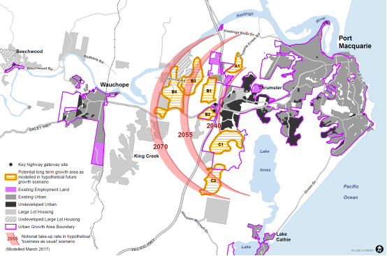
If some or all of these areas are developed for low density
rural residential development, then the period of potential growth will be
shorter.
The options considered in the draft UGMS for longer term
growth were:
1. Limit
growth to existing zoned areas
2. Plan to
redirect housing demand to other centres
3. Plan for
growth in only one or two of the potential future growth areas
4. Plan to
permit development in all of the potential future growth areas.
Given the relatively short timeframe to 2070 and expected
pressure for continued growth, the recommendation in the draft Strategy was in
support of Option 4, to protect the integrity of all of the potential future
growth areas around Port Macquarie during the period of the new UGMS to
2036.
The recommendations in the draft Strategy were to focus on a
planned response to housing choice in established areas and continue to plan
for urban release areas in the coming 20 years, to meet projected demand.
There has been limited feedback in submissions on these
options during the Strategy exhibition. However, there was some comment,
as summarised below:
·
An agreed strategic position for growth is needed – is
there a limit to growth?
·
“1000” additional future residents per annum
should not be presented as an inescapable fact
·
More and more growth is not good for the majority (e.g.
congestion)
·
Option 1 is the best - accommodate all new housing within
established and existing residential zoned land. Better than Option
2. Options 3 and 4 discounted on the basis of potential habitat loss.
·
Strong support for Option 1, followed by Option 2.
·
Suggest higher density in existing developed areas including
R5 Large Lot Residential areas and rural villages (e.g. Beechwood, Tele Pt).
The North Coast Regional Plan identifies Port Macquarie as
one of four regional cities on the NSW North Coast and aims to focus growth in
these major centres to promote sustainability and economic development within
the region. There is no limit to growth suggested in the Regional Plan,
however, it will be subject to regular review.
Consistent with the Regional Plan there is an existing
supply of undeveloped residential land in Port Macquarie to accommodate housing
growth in the next 15-20 years. As shown later in this part of the report
in relation to land supply, the supply of land in urban release areas and
options for new housing will progressively diminish over the next 15 to 20
years unless additional land is released.
Council could nevertheless seek to limit growth to the
existing zoned areas (Option 1), as suggested in the submissions above.
Under this scenario pressure for growth would then transfer to established
residential areas and it is expected that population growth would be restricted,
as infill housing options are more difficult to achieve, market choice would be
limited and housing would become less affordable.
Council could also plan to redirect housing demand to other
centres (Option 2), however it is unlikely that projected demand for new
housing in Port Macquarie can be transferred to other centres, such as west
Wauchope. The character of these other centres is a key consideration in
this Strategy as is the sustainability of increasing travel distances for large
populations within the Port Macquarie-Hastings.
It is recommended that Council base it’s planning on
Option 4, to protect the integrity of all of the potential future growth areas
around Port Macquarie during the period of the Strategy and to avoid
development that may compromise long term development options and choices for
future generations.
As discussed later in this part of the report, it is
proposed that investigations commence in the Fernbank Creek and Sancrox areas
within the next 5 years to assess the suitability of these areas for urban
development.
Proposed amendments to draft UGMS
·
The final draft UGMS contains amended commentary in relation to
the long term growth options in line with the above discussion.
B. Housing
choice
A key goal in the draft Strategy is to provide housing
choice for the Port Macquarie-Hastings population. The DP&E is
supportive of this aim, which is consistent with the principles of the North
Coast Regional Plan.
·
The Department of Planning & Environment advise (20-03-2018)
that: “the North Coast Regional Plan 2036 establishes a goal of
delivering 40 percent of new housing by 2036 in the form of dual occupancies,
apartments, townhouses, villas or dwellings on lots less than 400 square
metres. While it is acknowledged that the draft strategy encourages a
town housing choice option for Port Macquarie, it is important that the final
strategy identify how this goal will be met.”
Other points raised in submissions in relation to housing
choice include:
·
It would be good to see greater encouragement of more
efficient use of space as in terraces and low rise apartments, where land
forgone can be set aside for more parks and bush.
·
Concern over trend to smaller lot sizes
·
There needs to be a greater focus on medium density
development
·
Council should review the capacity for housing in existing
areas
·
Increase use of R2 Low Density Residential and R3 Medium
Density Residential
·
Medium density infill development is not economically feasible
and there is therefore a need for incentives for developers (e.g. contributions
discounts)
·
Request consideration of smaller housing options to suit
ageing in place and younger, smaller households.
The Port Macquarie-Hastings is generally well placed to
deliver new housing to meet local and regional population growth
estimates. We have a substantial supply of land for development in urban
release areas by regional standards, as discussed later in this Part of the
report. However, this does not mean that we will achieve the 40% target
in the Regional Plan.
Council has limited capacity to ensure that minimum dwelling
densities are achieved in urban release areas using the standard local
environmental plan provisions on offer in NSW and Development Control Plan
provisions have only ‘guideline’ status.
In practice, there is a strong market trend towards single
storey, detached dwellings in the urban release areas and an average density of
development in recent urban release area subdivisions in the Port Macquarie-
Hastings of approximately 10.5 dwellings per hectare.
In relation to housing choice, the Regional Plan aims to
provide a greater variety of housing, in locations that can accommodate more
housing and that have existing or planned infrastructure and services, to
create a more compact urban footprint. A greater variety of housing is
needed to meet our changing demographic (e.g. an ageing population) and to
promote affordability.
There is no further detail in the Regional Plan as to how
this variety of housing should be achieved in the Port Macquarie-Hastings,
other than that it is proposed to ‘Enhance the variety of housing options
by increasing the number of homes in and around the Port Macquarie city
centre’.
Council has planning in place for higher density development
in the area between Settlement City and Flynns Beach and has reviewed the
planning policy for this area in the past 5 years. This planning was
undertaken with funding assistance from, and in consultation with, the NSW
Department of Planning & Environment.
It is proposed that Council expand on this work to promote
improved housing choice, by undertaking a review of housing policy in the first
2 years of the new Strategy period (Action 1). It is also proposed to
review planning for the Wauchope CBD and adjoining mixed use area (Action 2)
and for the Port Macquarie CBD (Action 12). Engagement will take place with
local communities regarding housing choice in the development of Community
Plans and Local Strategic Planning Statements (Action 30).
The aim is to provide more certainty regarding housing
choice, including a review of where town living and apartment living options
are best located. The review will include a review of local environmental
plan and development control plan provisions related to housing. Key
considerations will include zone objectives, height, minimum lot size, floor
space ratios, secondary dwellings, student housing and local character.
Proposed amendments to draft UGMS
·
The content of the final draft UGMS (Attachment X) includes more
clarity regarding the aims of the housing review.
C. Land
supply and demand
Council’s current policy in the UGMS 2011 is to
maintain a 15 year supply of zoned residential land, ready for development,
including allowance for lead in times for investigation and rezoning of land
(p.99).
Council currently has coordinated planning in place for new
urban release areas at Thrumster, Lake Cathie/Bonny Hills and to the east of
Kew. This planning has been undertaken in consultation with landowners,
State Government agencies and the community. It has included urban design and
environmental studies, traffic and stormwater modelling, infrastructure
planning and funding arrangements to cover essential costs associated with
development.
Submissions in relation to land supply have included the
following points:
·
An oversupply of land for investigation is needed to account
for lead-in planning timeframes
·
The land supply estimates have been overstated
·
The estimate of 600 dwellings from infill in the CBD is optimistic.
·
Council should bring forward proposed investigation areas
commencing 2018 in conjunction with infrastructure planning and
coordination
·
A land supply review is required at least every two years,
including demand and up-take rates
The proposed 15 year supply is the highest target in local
government areas in the North Coast region and is well in excess of the former
5 year standard in the Mid North Coast Regional Strategy.
The aim in maintaining a 15 year land supply is to promote
market choice, competition and affordability in the housing market, allowing
for growth cycles whilst also providing reasonable certainty for builders,
developers and government regarding return on investment, particularly in
relation to up-front infrastructure costs.
A detailed review of the yield estimates and supply
estimates in the draft Strategy in existing, zoned residential areas has been
undertaken by Council’s Strategic Land Use Planning team. The
significant differences between Council’s revised estimates and those in
submissions have been reviewed in more detail.
Where possible, estimated yields have been based on existing
approvals. An average subdivision yield of 10.5 lots (12 dwellings) per
hectare has otherwise been assumed on unconstrained, vacant residential land,
consistent with what has typically been achieved in recent subdivisions in
urban release areas in the Port Macquarie-Hastings. Allowance has been
made for constraints within investigation areas.
The estimate of 600 dwellings in central Port Macquarie is
consistent with recent trends. This amounts to around 30 dwellings per year to
2036, which includes estimated yield from vacant residential areas below 1ha in
size. This is conservative noting likely market demand for smaller
dwellings in coastal areas and the aim in this strategy and in the Regional
Plan to promote a mix of housing types.
Infill development may well be higher than 30 dwellings per
year in Port Macquarie as the redevelopment of coastal land becomes more attractive
and viable in terms of land value. Development yield in release areas may
also exceed 12 dwellings per hectare given recent changes to permit some forms
of multi dwelling development as complying development throughout NSW.
The yield estimates are therefore quite conservative.
In total, the yield estimates have been revised down
following the more detailed review of yields in release areas. However,
the revised yield estimate for Lake Cathie/Bonny Hills is slightly higher than
those projected in the draft Strategy based on current approvals.
|
|
Draft UGMS
|
Final draft UGMS
|
|
Locality
|
Projected dwellings per
annum
|
Residential land
estimated dw. yield
|
Years
supply
|
Residential land
estimated dw. yield
|
Years supply July 2017
|
Approx.
Years
supply May 2018
|
|
Port Macquarie
(including Innes Peninsula & Thrumster)
|
340
|
6,620
incl. infill
|
19.4 years
|
5,570
Incl. infill
|
16.4 years
|
15 years
|
|
Wauchope
(excluding the Yippin Creek urban
release area)
|
35
|
350
|
10 years
|
350
|
10 years*
|
9 years*
|
|
Lake Cathie/Bonny Hills
|
70
|
1,232
|
18 years
|
1,382
|
19.7 years
|
18 years
|
|
Camden Haven
|
50
|
2,437
|
48.7 years
|
1,820
|
36.4 years
|
35 years
|
|
Total: Port Macquarie-Hastings
|
495
|
10,639
|
21.5
|
9,122
|
18.4 years
|
17 ears
|
Notes:
·
Supply estimates have been
determined using year to end data at July 2017 and will be updated annually.
·
* The supply estimate in
Wauchope excludes rural zoned land currently under investigation at Yippin
Creek. If rezoned, this land could increase the supply estimate to
approximately 30 years.
·
Rural residential yields are
not included in the supply estimates above.
As shown above, there is a significant supply of residential
land in and around the major urban centres in the Port
Macquarie-Hastings. Nevertheless, it is expected that the supply of
vacant residential land will fall below 15 years in Port Macquarie, Wauchope
and Lake Cathie/Bonny Hills during the first 5 years of the UGMS.
There has been strong take up of residential land in 2017 in
Port Macquarie, Wauchope and Lake Cathie/Bonny Hills.
It is therefore proposed to carry out investigations in
these areas, as discussed in the remainder of this part of the report.
These investigations will involve multiple landowners and the successful
release of land for coordinated urban growth will depend on the cooperation of
multiple parties in each case.
It is not possible to guarantee a 15 year supply in all
areas, particularly where significant natural constraints to growth exist. The
final draft Strategy has therefore been amended to clarify that the 15 year supply
is dependent on successful coordination of multiple parties and lead in
planning, assessment of natural constraints and community engagement.
Council will continue to review development in the Port
Macquarie-Hastings as part of a regional land monitor and it is proposed to
update growth projections and land supply forecasts annually (Action 20).
Proposed amendments to draft UGMS
·
The supply estimates in the draft UGMS have been updated.
D. Urban
Investigation Areas
I. Port
Macquarie
In addition to a focus on housing choice in Port Macquarie,
it was proposed to commence the investigation of new residential areas in the
coming 5 years, in the exhibited draft UGMS. It was proposed to:
·
Review LEP and DCP provisions for land at West Lindfield (Year
2-3) (Action 10).
·
Preliminary consultation and investigation regarding potential
development in the Fernbank Creek area (Year 3-4) (Action 6).
Note: The
draft Strategy stated (p.63) that: ‘Subject to the outcomes of this
consultation and an assessment of key issues such as essential infrastructure,
environmental management and residential supply and demand, Council will then
determine a program of more detailed investigations for the Fernbank Creek
and/or Sancrox areas’.
There have been a large number of submissions in relation to
investigation areas in and around Port Macquarie. The large majority
relate to the particular circumstances in the Le Clos Sancrox subdivision,
which is considered later in this part of the report.
The following comments relate to general growth options
around Port Macquarie:
·
Investigations to rezone land at Greater Sancrox should
proceed ahead of investigations Lake Inness Road and Fernbank based on
significantly larger yield estimates and infrastructure upgrades for roadwork
and services.
·
Inappropriate zoning, in particular Lake Innes South, suggest
back zoning for environmental protection
The preferred sequencing of potential long term growth areas
around Port Macquarie was considered by a cross divisional team within Council,
during preparation of the draft UGMS. Based on a review of environmental
and infrastructure issues, the recommended sequence of investigations was
proposed to be West Lindfield (deferred area) followed by Fernbank Creek,
Sancrox and then West Lake Innes in the longer term.
Given the revised land supply estimates in and around Port
Macquarie, it is proposed that Council undertake planning for the West
Lindfield (deferred) area in Year 2-3 and that Council commence investigations
for both the Fernbank Creek and Eastern Sancrox areas within the next 5
years. This is discussed in more detail below.
The Lake Innes long term growth area includes large
relatively unconstrained areas which are potentially suitable for development
in the long term as well as fragmented, smaller areas of environmental
constraint. These constraints do not preclude longer term investigations
for future growth in the Lake Innes area, which can consider the need for
environment protection as part of the investigation process.
West Lindfield (deferred area)
The deferred area at West Lindfield was not rezoned as part
of the Thrumster local environmental plan amendment because the landowners in
the deferred area were unwilling to contribute to equitable arrangements for
environmental management at Thrumster in 2008. The area is a logical addition
to the land supply in Port Macquarie and it is therefore proposed that Council
review the planning for the deferred West Lindfield land and seek a resolution
to this issue.
As shown on the map below, the ownership of the deferred
area is fragmented and there will be a need for a level of coordination within the
landowner group. There are currently 12 separate landowners, with
ownership boundaries are shown in red.
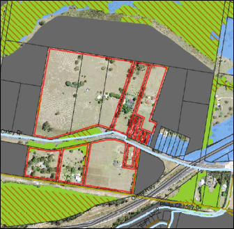
Action 10 in the exhibited draft UGMS has been retained to
‘Review LEP and DCP provisions for land at West Lindfield, previously
deferred from the Thrumster urban release area’. It is proposed to
commence in Year 2-3 of the new UGMS period in the draft Strategy.
Fernbank Creek
The Fernbank Creek area has good access to the proposed
Sancrox Sewerage Treatment Plant and is potentially a logical addition to
existing land supply in Port Macquarie. It is relatively close to other
urban services in Port Macquarie and Thrumster and there is a substantial area
of land with low to no environmental constraint.
The Fernbank Creek area also has a high level of ownership
fragmentation (26 separate land owners, with ownership boundaries are shown in
red), as shown in the following map.
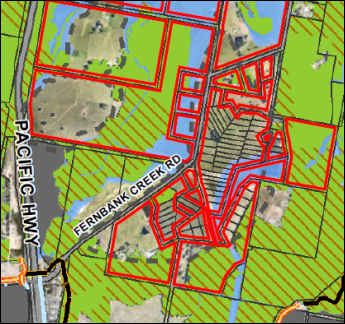
Action 6 in the exhibited draft UGMS proposed
‘Preliminary consultation and investigation regarding potential
development in the Fernbank Creek area’, commencing indicatively in Year
3-4.
On review, it is proposed that Council expand the scope of
preliminary investigations to include the broader Sancrox area and produce an
Outline Plan as Stage 1 of investigations, commencing indicatively in Year 2 of
the new UGMS period. This Action is discussed in more detail below.
Sancrox
A number of submissions have been received in relation to
the Sancrox area:
·
Rural residential development should be allowed for in the
Greater Sancrox area in accordance with the UGMS 2011-2031 and the Greater
Sancrox Structure Plan 2014 – 2023. Furthermore, the timeframe for
further investigations referred to in the Greater Sancrox Structure Plan should
commence as soon as possible.
·
Requesting rezoning of certain land in Bushland Drive for
rural residential development and attaching a concept subdivision layout
demonstrating that rural residential development of the land will not
compromise potential long-term conversion for residential purposes.
·
Request to investigate land at the intersection of the Oxley
Highway and Rawdon Island Road given that infrastructure in and around the
Greater Sancrox precinct has recently improved (ie Pacific Highway upgrade, new
10ML water reservoir, new SPS adjacent to Sancrox Road & concept developed
to extend a new rising main along Fernbank Creek Road to the new Fernbank
STP). The RMS will undertake construction of a new Oxley Highway/Rawdon
Island Road intersection in 2018.
·
Land to the south west of the Oxley Highway/Pacific Highway
Interchange is shown as ‘Proposed Investigation Area’ for urban
purposes in Council’s current UGMS 2011 and draft Greater Sancrox
Structure Plan (Feb 2015). Bring forward the indicative timing for urban
investigation and rezoning to ensure affordable housing and to meet demand.
Identify an area of large lot or rural residential housing on the site to act
as a buffer between future urban development and the proposed Highway Service
Centre
·
Request that investigations for urban rezoning in Greater
Sancrox could commence in 2018 with a target of rezoning land by 2025.
Council identified the Sancrox area as an investigation area
for rural residential development in 2004. Initial landowner
investigations were not accepted by the State government due to a need for
coordination, and Council coordinated investigations from 2011 – 2015
with the aim of preparing a Structure Plan for the Sancrox area.
Council has resolved to consider whether urban development
relating to Port Macquarie should be permitted to the west of the Pacific
Highway in the review of the Port Macquarie-Hastings Urban Growth Management
Strategy:
February 2015
RESOLVED: Turner/Cusato
That Council:
1. Note the revised Greater Sancrox Area Structure Plan as
described in this report.
2. Include as part of Council’s current review of
the Port Macquarie-Hastings Urban Growth Management Strategy 2011,
consideration/investigations;
a. to determine whether urban development relating to Port
Macquarie should be permitted to the west of the Pacific Highway with such
consideration/investigations to include the potential urban
capability/serviceability/capacity of lands between Oxley Highway to the north,
Pacific Highway to the west and Houston Mitchell Drive to the south in reaching
any conclusion or conclusions; and
b. as to the viability of rural residential development in
the Greater Sancrox area.
3. Request the General Manager report to a Council Meeting
promptly after the aforesaid review is completed and endorsed/adopted by
Council with respect to the Greater Sancrox Area focusing on the implications
of the review on that Area.
4. Defer
this matter until after consideration of the report dealt with in 3 above.
As discussed above under Part 3A - Future Urban Growth, it
is recommended that Council base it’s long term planning on Option 4, to
protect the integrity of all of the potential future growth areas around Port
Macquarie during the period of the Strategy and to avoid development that may
compromise long term development options and choices for future generations.
Further rural residential development is not proposed at
Sancrox as a first step towards urban because there is no evidence to suggest
that this can be achieved in practice. A successful conversion would
require the coordination of far more landowners and/or the up-front
installation of services for higher density development to avoid a piecemeal
approach to future development. Rural residential development will diminish the
potential supply of land for urban growth around PMQ and will remove options
for growth for future generations.
As discussed under Part 3C Land Supply and Demand, the
supply of vacant residential land will fall below 15 years in Port Macquarie
during the first 5 years of the UGMS and it is therefore proposed to carry out
investigations in Port Macquarie in the short term.
In addition to planning for the West Lindfield deferred
area, it is proposed that Council commence Stage 1 investigations for the
Ferbank Creek and Sancrox areas, as discussed above, commencing in year 2 of
this Strategy.
This is proposed to involve:
·
Consideration of the structure planning work already done for the
Sancrox area,
·
Consult landowners regarding future growth and the investigation
process,
·
Preparation of an Outline Plan for urban development in the
Fernbank Creek and Sancrox areas, to identify precincts and areas where the
coordination of development can be achieved,
·
State government endorsement of the Outline Plan as proposed in
the DP&E submission (see Part 2A of this report), and
·
Commencement of more detailed investigations in one or more of
those precincts, subject to the outcomes of the Outline Plan.
The preparation of an Outline Plan is an important step
given the high level of fragmentation in the Sancrox area and the need for
coordinated infrastructure and environmental management outcomes.
Isolated, ad hoc proposals on individual properties will not result in a
coordinated outcome.
The aim of the Outline Plan will be to create a plan for
long term growth, including sustainable local communities and urban
environments. There will need to be consultation with multiple
landowners, State agencies and the community, similar to the planning
undertaken by Council for the Thrumster and Rainbow Beach urban release areas.
The Outline Plan will provide a framework for more detailed
precinct plan investigations, and then local environmental plan, development
control plan and contributions planning for individual precincts. It will
not result in the rezoning of all potential future growth areas in the Fernbank
Creek and Sancrox areas significantly ahead of the supply principles in the
UGMS.
Infrastructure funding will be a key issue and the expected
sequence of development in these areas is generally east to west given the need
for sewerage infrastructure from Fernbank Creek to Sancrox.
Environmental management will also be a key issue.
Current known areas of high environmental value or hazard (e.g. flooding) are
not proposed be investigated for urban development and the focus of
investigations will therefore be on potential future growth A and B, as shown
in the long term growth analysis in this report.
The preliminary consultation and investigation will consider
the need for support studies to address key matters, such as:
·
Urban design
·
Heritage values
·
Environmental issues
·
Hazards such as bushfire, flooding and buffers between uses
·
Transport planning and infrastructure
·
Water, sewerage and stormwater infrastructure
·
Social and recreational opportunities
More detailed follow up investigations are expected to be
proposed in stages for specific precincts following completion of the Outline
Plan.
Proposed amendments to draft UGMS
·
Action 6 in the exhibited draft UGMS has been revised to propose
that Council undertake preliminary investigations for the Fernbank Creek and
Sancrox areas and produce an Outline Plan, commencing indicatively in Year 2 of
the new UGMS period.
·
It is proposed that Council retain Action 16 to investigate
proposals for development on the Gateway sites at the intersection of the
Pacific and Oxley Highways.
Note: Investigations have commenced on the southern site for a proposed Highway
Service Centre, consistent with the UGMS 2011 and State government policy
regarding locations for Highway Service Centres. The development of the
Gateway sites can be considered independently of the broader investigations for
land release in the Sancrox area.
Le Clos Sancrox
Council has received submissions from a large number of
landowners in the Le Clos Sancrox estate. This is a difficult issue for
landowners and Council in the context of the planning for Sancrox, as
summarised below:
·
Strong concern in relation to:
o the
approach to rural residential development .i.e. “council will not support
rural living in areas potentially needed for long term growth of Port
Macquarie”
·
Omission of a decision on the future of the Le Clos Sancrox
redundant viticulture subdivision
o Recommend
options to address the long standing Le Clos Sancrox matter, including:
·
Immediate commencement of the rezoning process to convert the
area to R5 Large lot residential
·
Immediate commencement of the rezoning process to convert the
area to R3 Medium density residential or R4 High density residential
·
A composite of the above
·
Possible legal action by landowners if no change to the draft
UGMS
o Seek
immediate and urgent action in relation to Le Clos Sancrox.
The Le Clos Sancrox subdivision was approved by Council in
1986 to permit cooperative viticulture, including approximately 46 house lots
with an average size of 3200 sqm. Unfortunately, it has proven very difficult
to resolve on-site effluent disposal, bushfire protection and access arrangements
for these house lots.
In 2006, Council resolved to ‘impose a moratorium
on all development of properties in the Le Clos Sancrox and Le Clos Verdun
Estates until such time that appropriate rezoning and reconfiguration of the
Estate has been finalised’.
In 2009, the Le Clos Verdun estate was rezoned to rural
residential, following coordinated investigations by landowners in that
estate. Similar investigations have not been undertaken for the Le Clos
Sancrox estate to date.
The Sancrox area was proposed for rural residential and
there have been structure plan investigations by Council. However, the
Sancrox area has now been proposed generally for future urban development in
the draft UGMS and the landowners are looking for a clear direction to provide
certainty regarding development on their lots.
Council planners have met with landowner representatives
from the Le Clos Sancrox estate on two occasions since exhibition of the draft
UGMS. The discussion with landowners has included an overview of the land
supply and long term growth context in the draft UGMS, as discussed above, as
well as the need for coordinated infrastructure and environmental planning from
Council’s and the community’s perspective.
The landowner representatives have indicated a willingness
to coordinate a reconfiguration of the existing Le Clos subdivision. This
will need to include preparation of support studies, funding for key
infrastructure and coordination of delivery, including environmental
management.
A number of options may exist for rezoning and
reconfiguration and it is proposed to consider this in more detail in a
separate report to Council as soon as possible, in accordance with Part 3 of
the resolution of Council in February 2015 (shown earlier in this part of the
report).
II. Urban
Investigation Areas – Wauchope
The supply of vacant residential land in Wauchope is
estimated at approximately 10 years, as discussed earlier in this report.
In addition, Council has completed a Structure Plan for land at Yippin Creek,
which proposes substantial new areas for residential growth to the west of
Wauchope.
The draft UGMS has proposed the immediate review of Local
environmental plan, development control plan, and contributions plan provisions
to implement the Yippin Creek Structure Plan, in years 1-3 of the new UGMS.
The submissions received during exhibition in relation to
investigation areas at Wauchope are summarised below:
·
Submissions seeking expansion of the proposed urban
residential rezoning at Yippin Creek to expand the proposed residential
footprint in the Yippin Creek investigation area from that shown in the adopted
Structure Plan.
·
Seeking expansion of the Urban Growth Area Boundary at
Wauchope to permit residential zoning at Clarkes Lane, Wauchope, adjacent to
the proposed Regional Sporting Precinct.
·
Seeking rezoning of flood free land at Weismantle St, Wauchope
to the east of the North Coast railway line, to permit rural residential
development
The Yippin Creek investigation area incorporates a range of
lot sizes, from smaller lots in an established rural residential estate along
Yippin Creek Road to larger rural lots.
During preparation of the Yippin Creek Structure Plan, there
were submissions from landowners opposed to urban development in the rural
residential estate and Council has generally determined in the adopted
Structure Plan to retain the existing character within the rural residential
estate, with the exception of one lot on the periphery of the estate, which has
been identified for urban investigation.
There were also submissions from landowners requesting that
their land be included in the area proposed as residential in the draft
Structure Plan.
Council determined not to add these additional areas in
order to concentrate proposed residential development in the relatively low
constraint and unfragmented parts of the study area. Redevelopment of the
rural residential estate was not proposed as this would impact on the amenity
of existing residents and it would require a high level of coordination in
relation to infrastructure upgrades and environmental management.
The submissions in relation to the draft UGMS include
additional requests for expansion of the proposed Yippin Creek residential
area. For the reasons discussed above, it is not proposed to expand the
footprint of the proposed Yippin Creek residential area.
There have been previous requests to Council to rezone the
land to the east of the North Coast Railway line at Clarkes Lane and Weismantle
Street based on proximity to Wauchope. These areas are separated from Wauchope
by the North Coast Railway line and the requests are not supported due to local
constraints, including servicing and access limitations.
It is proposed that Council retain Action 4 to review LEP
and DCP provisions to promote development in the Yippin Creek urban release
area. This is proposed indicatively in years 1-2. No other changes
are proposed to draft UGMS in relation to Wauchope investigation areas.
III. Urban
Investigation Areas – Lake Cathie/Bonny Hills
Council has received a number of submissions in relation to
proposed investigation areas in the Lake Cathie/Bonny Hills area. The
issues raised can be summarised as:
·
There is a need to balance and preserve the biodiversity
mosaic in the proposed West Bonny Hills investigation area
·
Greater consideration of the environmental impact on the
proposed West Lake Cathie Urban Investigation Area
·
Strong objection by community group to consideration of the
area immediately west of Lake Cathie for future residential - environmental
impact
·
Question the adequacy of infrastructure for the proposed west
Bonny Hills Urban Investigation Area that is twice the size of Area 14
·
Request to expedite actions to investigate area north of
Forest Parkway, Lake Cathie and include an area further north in the same ownership
·
Request for four lot subdivision of 37ha property within the
West Bonny Hills urban investigation area.
The exhibited draft UGMS (p.63) aims ‘to plan for
continued local growth in Wauchope, Lake Cathie, Bonny Hills and the Camden
Haven based on population projections for those centres, subject to natural
limits on development in those areas and the need to preserve the character of
local communities’.
The West Lake Cathie and West Bonny Hills investigation
areas were first identified in the Greater Lake Cathie and Bonny Hills Urban
Design Master Plan, which was adopted by Council in 2003/4 after community
engagement. The Master Plan has since formed the basis of Council
planning in the Lake Cathie and Bonny Hills area and the investigation areas have
been included in the North Coast Regional Plan.
West Lake Cathie
The investigation area to the west of Lake Cathie (to the
north of Forest Parkway) has been preliminarily assessed by Council staff as
having lower ecological constraints and relatively easy access to established
infrastructure and services in comparison to the West Bonny Hills investigation
area.
Investigations have therefore been proposed for the West
Lake Cathie area (Action 5), in Year 2-3 of the new UGMS. Key issues will
include buffers to Lake Cathie, stormwater and bushfire management, and habitat
connectivity.
It is not proposed to expand the West Lake Cathie
investigation area to the north noting proposals to also investigate land to
the west of Bonny Hills, community concern about further expansion of the
development footprint around Lake Cathie, and that the proposed areas are
outside the Urban Growth Area boundary in the Regional Plan.
West Bonny Hills
The West Bonny Hills investigation area is complex, as noted
in the submissions above. Potential development areas are fragmented from
one another by high value environmental areas and core koala habitat, which are
important in terms of connectivity for known koala populations.
Action 11 of the draft UGMS proposed that Council
‘investigate options for development and prepare a structure plan for the
West Bonny Hills Investigation Area’, commencing in Year 4-5.
It is proposed to amend the description of this action is to
‘Commence Stage 1 investigations and prepare an Outline Plan for the West
Bonny Hills investigation Area’, similar to the action discussed above
for Fernbank Creek and Sancrox.
The Bonny Hills community has demonstrated a keen interest
in this area, so community engagement will also be fundamental in the Outline
Plan process. Specialist input will be required to address key issues and
provide the basis for more detailed local environmental plan, development
control plan and contributions planning.
Key issues will include the protection and management of environmental
areas and an appropriate urban design response to the local area. Road,
pedestrian and cycleway connectivity and the coordination of water and sewerage
infrastructure will also be key issues. Mineral resource buffers in the local
area will need to be assessed.
More detailed follow up investigations are expected to be
proposed in stages for specific precincts following completion of the Outline
Plan. This may include investigations for light industrial development,
as discussed in Part 4C of this report.
Subdivision within the investigation area, as proposed in
submission 46 is not supported as this will further complicate the preparation
of a Structure Plan and the delivery of coordinated outcomes.
Proposed amendments to draft UGMS
It is proposed that Council retain Action 11, commencing in
year 4-5. The proposed description of this action is to ‘Commence
Stage 1 investigations and prepare an Outline Plan for the West Bonny Hills
investigation Area’.
IV. Investigation
Areas – Camden Haven
·
Request to bring forward investigations to rezone land identified
as “Future investigation” at Ivers Road, (south Area 15) on the
basis that existing zoned land reserves to the North of Ocean Drive (formerly
known as Area 15) are in single ownership with little chance of short term
release onto the local market
The supply of residential land in the Camden Haven earlier
in this part of the report shows that there is over 30 years of vacant
residential land. Council is also investigating land to the west of Kew,
which will slightly increase this supply if the land is rezoned.
A large proportion of this supply is concentrated in one
ownership, as noted in the submission. However, there are 15 landowners
in the Area 15 release area and there is no evidence that it is being withheld
from the market at this time. Council is currently assessing a
development application for subdivision of one of the larger properties to
create 138 residential lots.
Council is also bringing forward construction of a critical
rising sewer main connection north from Area 15 to the Kew/Kendall Sewerage
Treatment Plant at Herons Creek. This is expected to overcome one of the
major up-front costs and potential impediments to development in the Area 15
release area.
It is premature to assume that development is being limited
by land ownership in the Camden Haven and accordingly no change is proposed to
the conclusions and Actions in the draft UGMS in relation to investigation
areas in the Camden Haven.
V. Investigation
Areas – Rural residential
Rural residential development is a form of low density
residential housing that needs to be carefully planned, efficiently serviced
and located to avoid conflicts in rural areas. It is widely distributed
along the coast and hinterland in the Port Macquarie-Hastings as shown in
Figure 26 of the draft UGMS.
There is currently a generous supply of undeveloped rural
residential land and new rural residential areas are concentrated on
unconstrained land near the coastal villages of Kendall and Beechwood, which
provide a basic range of local services. An additional investigation area
was identified to the north of Telegraph Point in the draft UGMS.
The submissions received in relation to rural residential
development can be summarised as follows:
·
NSW DPI support a stable environment for rural investment that
avoids conflict between residential and agricultural neighbours
·
Request that the land adjoining the Telegraph Point
investigation area also be identified for investigation.
·
Requests for new rural residential land in the Greater Sancrox
area
·
Request to bring forward investigations for affordable housing
and R5 Large Lot Residential at the Oxley Highway Interchange site (Hore)
·
Request to include Kenwood Drive for R5 Large Lot residential
development
·
Request to permit dual occupancy (detached) development in R5
Large Lot Residential areas
The NSW Department of Primary Industries comment is
consistent with the principles for rural residential development in the draft
UGMS, which are based on the North Coast Regional Plan and Settlement Planning
Guidelines.
The Telegraph Point investigation area is proposed to
supplement supply in undeveloped rural residential land at Kendall and
Beechwood and turnover in established rural residential areas, which also cater
for market demand.
The boundary of the Telegraph Point investigation area has
been determined with regard to limits to water supply, environmental
considerations, slope, village character and amenity. No change is proposed in
the final UGMS, however, the boundary of the investigation area has been
adjusted to the 25m contour, to approximate the area that may be suitable for
subdivision and that can be serviced with reticulated water. Further more
detailed investigation of appropriate zone boundaries is proposed in accordance
with Action 7.
Additional rural residential land is not proposed at Sancrox
as discussed in the long term growth section earlier in this part of the
report. This includes the remainder of the land proposed for Highway
Service Centre, which has been proposed as an urban investigation area for some
time.
Rural residential investigation is also not proposed at
Kenwood Drive, consistent with the principle in the former Regional Strategy
that new rural residential areas should not be planned east of the Pacific
Highway and given community concern regarding further expansion of urban
development around Lake Cathie.
It has been proposed in the draft UGMS (Action 8) to review
local environmental plan provisions for small lots around nominated rural
villages. The Department of Planning & Environment has questioned
this action:
·
DP&E: “the proposal to permit dwellings on smaller
lots adjacent to villages will need to address and justify the need for such an
approach and its consistency with the State and regional planning
framework”.
This action arose from the approval of a dwelling on an
undersized rural lot on the fringe of Kendall. The Department did not
object in that instance and this raised a question for Council, whether
dwellings should be permitted generally on undersized lots within a close
radius of villages, such as Kendall, that offer a range of local
services.
The proposed review will need to consider the State and
regional planning network and has been retained as an action in the final draft
UGMS. Also, as part of that action, it is proposed to include a review of
the merits of permitting detached dual occupancy with consent in rural zones.
Proposed amendments to draft UGMS
·
The wording of draft Action 8 regarding dwellings on smaller lots
adjacent to villages has been amended to include a review of the merits of
permitting detached dual occupancy with consent in all rural zones.
A summary of proposed changes to the Actions table at the end
of Part 3 of the UGMS, is provided below:
Housing Choice Actions
|
|
Action
|
Description
|
Indicative Timing
|
|
1
|
Review
Local Environmental Plan (LEP) and Development Control Plan (DCP) provisions
to promote appropriate housing choice options
|
A
review of the key planning zones and policies that are available to guide
residential development. This review is intended to take place as a first
step to help inform the actions below.
|
Year
1-2
|
|
2
|
Review
planning for the Wauchope CBD and adjoining mixed use area
|
The
character of the Wauchope CBD needs to be carefully considered when planning
for new development.
|
Year
3-4
|
|
3
|
Undertake
neighbourhood planning in Kendall
|
To
consider the appropriate mix of housing and to enhance the unique character
of Kendall.
|
Year
4-5
|
|
4
|
Review
LEP and DCP provisions to promote development of the Yippin Creek Urban
Release Area
|
To
implement the adopted Structure Plan for the Yippin Creek area and provide
opportunities for new housing in Wauchope.
|
Year
1-3
|
|
5
|
Investigate
options for development and review LEP and DCP provisions in the West Lake
Cathie Investigation Area
|
Planning
for potential residential growth to the west of Lake Cathie as an extension
of current growth areas at Rainbow Beach
|
Year
2-3
|
|
6
|
Preliminary consultation and investigation Preparation of an Outline Plan (Stage 1
investigations) for the Fernbank Creek and Sancrox potential future
growth areas.
|
Preliminary Stage 1 planning for potential future
urban growth at Fernbank Creek and Sancrox areas
|
Year 3 2-4
|
|
7
|
Investigate
options for limited rural residential development at Telegraph Point and
review LEP and DCP provisions
|
Investigations
for rural residential development are proposed to the north of the existing
village of Telegraph Point
|
Year
4-5
|
|
8
|
Review
LEP provisions for small lots around nominated rural villages and the
merits of permitting detached dual occupancy with consent in all rural zones
|
To
consider whether there should be scope for dwellings on small rural lots near
larger rural villages and whether detached dual occupancy should be
permitted in all rural zones
|
Year
4-5
|
|
9
|
Monitor
rates of subdivision and development in the LGA
|
Council
monitoring of growth to inform local and regional planning
|
Annually
|
|
10
|
Review
LEP and DCP provisions for land at West Lindfield, previously deferred from
the Thrumster urban release area
|
A
review of land that was deferred from rezoning at West Lindfield in Port
Macquarie
|
Year
2-3
|
|
11
|
Commence
Stage 1 investigations and prepare an Outline Plan for the West Bonny Hills
investigation Area
|
Preliminary
planning for potential future urban growth to the west of Bonny Hills
|
Year
4-5
|
Notes:
·
Actions are in not in order of priority. Timing is indicative
only and will be confirmed in Council’s annual operation plans.
·
All actions will be reviewed in the next Strategy review in
2022.
·
Year 1 = 2018/19
Part 4: Economic Development and Employment
A. Business
centres - hierarchy
Council has maintained a consistent approach in planning for
retail and business centres since the adoption of a Retail Policy in 2004.
The aim has been to maintain a clear hierarchy of retail
centres, with the Port Macquarie CBD and Settlement City at the top of the
hierarchy and smaller, local retail outlets at the bottom. The rationale
for this hierarchy is to protect the viability of the higher order centres
which provide a greater range of retail products and business services and
which are important as key centres for community activities in the Port
Macquarie-Hastings and on the NSW North Coast.
Council started to use the term ‘Greater CBD’ in
2004, to describe the Port Macquarie town centre along with Settlement City,
Gordon Street and Munster Street shops. However, there has been a
conscious shift away from the use of the term ‘Greater CBD’ in the
exhibited draft UGMS, given the physical separation between these individual
centres and their different functions.
In the draft UGMS 2017, the term ‘Port Macquarie
CBD’ has been used to describe the Port Macquarie town centre. This
is different to the terminology used in the Hill PDA report which was exhibited
with the draft UGMS.
The rationale for this change is that the Port Macquarie
town centre is the main business and service centre in the Port
Macquarie-Hastings. The town centre accounts for a large proportion of
commercial floorspace, including government uses and serves as a significant
tourism destination. It is the historic centre of the Port
Macquarie-Hastings from a cultural perspective and functions as the primary hub
for tourist and public events.
The Port Macquarie town centre does not
function as one entity with Settlement City, Gordon Street or Munster
Street. The town centre is physically separated from Settlement
City by approximately 1.5km of foreshore open space.
This change in terminology has resulted in some concern from
Settlement City landowners, as shown below:
·
Objection to proposed retail hierarchy, noting Settlement City
precinct has been relegated the same role as Gordon & Munster Street
precincts (Lendlease)
·
The draft Strategy should retain the concept of the Greater
Port Macquarie CBD as a focus for investment and development
·
Request to recognise potential redevelopment of Settlement
City in the strategy
Settlement City
Settlement City remains in a B3 Core Business zone, the same
as the Port Macquarie town centre. It has significant scope for growth in
accordance with Council planning for the Settlement City Precinct that has been
established since 2009. The Strategy is not proposing any change to the
range of uses permitted in the B3 Core Business zone at Settlement City.
The draft UGMS has retained Settlement City and the Port
Macquarie town centre at the top of the Retail Hierarchy, in the
‘Regional City’ category, as shown in Figure 19 on p.73 of the
draft Strategy. This is in recognition of the primary retail role of both
centres in the Port Macquarie Hastings. The result in Figure 19 is that
Settlement City sits alongside Gordon Street and Munster Street in the
hierarchy, as shown below:
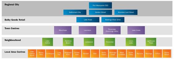
This was not intended to diminish the role of Settlement
City, which is clearly greater in importance than Gordon Street and Munster
Street. The draft Figure has therefore been reconfigured to place the
Port Macquarie CBD and Settlement City at the top and Gordon Street/Munster
Street below.
The draft Strategy already highlights the development
opportunities that exist at Settlement City within the established B3
Commercial Core zone. The final draft Strategy also includes recognition
of the ongoing importance of Settlement City, with reference to the adopted
Settlement City Precinct Structure Plan 2009 which aims to promote coordinated
development in the Settlement City Precinct.
Bellbowrie
Council has received a submission in relation to the Bellbowrie
area:
·
Bellbowrie business owners request to allow ‘commercial
premises’ development (‘offices, retail and business
premises’)
The Bellbowrie Business Park provides opportunities for
local service industry and bulky goods retail, in central Port Macquarie.
It is currently zoned B5 Business Development, which is the same as other land
fronting Hastings River Drive and Lake Road in Port Macquarie. The B5 zone
permits a range of business, including bulky goods retail, but does not permit
‘Commercial Premises’, which encompass ‘business
premises’, ‘office premises’, and ‘retail
premises’.
The primary distinction between the B5 Business development
zone and the B2 Local Centre and B3 Commercial Core zones is that
‘Commercial premises’ are not permitted with consent in the B5
zone, whereas they are permitted with consent in the B2 and B3 zones. The
request to allow commercial premises is therefore a request to change the zone
to higher order Business zone which would allow a full range of retail and
business uses.
This is at odds with the adopted retail hierarchy in the
current UGMS 2011 and is not supported by data in the recent Retail Review
undertaken by Hill PDA, which shows that there is sufficient capacity for new
commercial premises in the Port Macquarie CBD and Settlement City.
The Bellbowrie area plays an important support role to the
primary retail centres, providing scope for the types of businesses and light
industry that are typically located in the B5 zone. That is, businesses
that require larger sites, main road frontage/visual exposure, a larger trade
area and parking areas.
No change is therefore proposed to the draft UGMS.
Local Area Centres
There has also been a submission regarding Local Area
Centres:
·
Request that Council reconsider and amend the retail GFA
figures used for Local Area Centres to better reflect current and potential
volumes of usage using currently zoned properties
This submission refers to the classification of local retail
centres in the Retail Hierarchy in the draft UGMS. Local Area Centres
include North Haven, Kew, Kendall, Lighthouse Beach, Flynns Beach, Waniora
Parkway, Clifton and Timbertown. (Note: The term ‘Local Area
Centre’ has been used in the UGMS, in preference to the term ‘Small
Villages’ in the Retail Review by Hill PDA that was exhibited with the
draft Strategy).
The role of these local centres in the Hierarchy is to
service retail demand in the surrounding locality. The appropriate size
of the centres is described generally as up to 2,000m2 Gross Floor
Area (GFA) by 2036 (excluding bulky goods, and non-retail shop front
space).
This is a general measure to define the role of local
centres in the Hierarchy. At present, all local centres are well below
the 2,000m2 threshold, with the exception of North Haven which has
approximately 2,000 m2 GFA existing.
The hierarchy and UGMS will not prevent development
proposals for new retail development in existing Business zones. It
simply provides a guide where Council is considering new Business zones as to
the appropriate size of the centre in the Hierarchy.
A comprehensive retail review is proposed again as a
pre-curser to the next UGMS review and this can include an up-date of retail
floorspace estimates in local centres. No further action is recommended
at this time.
Proposed amendments to draft UGMS
·
Amendments are proposed to the Figure 19 Retail Hierarchy and
accompanying text, as discussed above.
B. Health and
Education Precinct
The draft Strategy proposes that Council undertake planning
for a health and education precinct which encompasses the Port Macquarie Base
Hospital, Charles Sturt University and surrounding land. This is
consistent with the North Coast Regional Plan.
The proposed precinct includes land within the John Oxley
Drive Precinct which Council considered in a Structure Plan in 2012. It
is proposed to review the adopted Structure Plan to adapt to changes in the
area since 2012, including the decision by CSU to locate on Major Innes Road.
The submissions received by Council in relation to Health
and Education include the following:
·
Inclusion of Strategic Planning aims/principles to encourage
and promote active transport options, including walking and cycling,
connections to key precincts such as the proposed Health & Education
Precinct, energy efficiency, waste and resource recovery, local biodiversity
and food security
·
That Council commit to a strategy to significantly expand its
university student capacity and explore investigation areas to allow for
planned growth.
·
CSU has a “no retail on campus” policy so there is
a need for an expanded retail sector in the adjacent Lake Innes area as the
campus grows - suggest flexible zoning to permit range of developments
The Hospital/CSU Health and Education Precinct is a major
initiative and opportunity for the future of the Port Macquarie-Hastings, with
potential to facilitate a range of health and education related uses and to
provide increased opportunities for students in the Port
Macquarie-Hastings.
Council has therefore commissioned specialist consultants to
undertake an Enquiry by Design process and to prepare a Precinct Plan in
consultation with stakeholders in the proposed Health and Education Precinct,
government representatives and the community.
This process will include consideration of a wide range of
issues, including transport, energy efficiency, biodiversity and
sustainability. Connectivity between the proposed Health and Education Precinct
and other key nodes will also be a key consideration, including links to other
key health and education nodes in the Port Macquarie-Hastings.
Retail planning and land use zones will be addressed as a
key outcome in a Master Plan for the Precinct. Council will then review
local environmental plan, development control plan and development
contributions plans for the Precinct.
No change is therefore proposed to the draft UGMS.
C. Planning
for industry
The draft UGMS identifies a surplus of industrial land in
the Port Macquarie-Hastings, based on an Industrial land review by Hill PDA in
2015. This review suggests that the Port Macquarie-Hastings is generally
well placed to provide industrial development opportunities in the coming 20
years.
At present, there is in excess of 50 years total supply of industrial
land in the Port Macquarie-Hastings, following release of approximately 70ha of
industrial land at Sancrox and approximately 20ha at Fernbank Creek since
adoption of the 2011 UGMS.
Council has received one submission in relation to the
supply of general industrial land at Sancrox:
·
Request to identify additional land at Sancrox (adjoining
Expressway Spares and HF Hand) for industrial investigation.
A small area of residual land between HF Hand and Frogs Road
(the new Highway overpass) has been identified as a potential site-specific
amendment in Council’s strategic planning program. This land is
currently under investigation on the basis that it is a small, isolated area
and that the current rural zoning is inappropriate in the circumstances.
Land to the south of Frogs Road adjoining the Pacific
Highway was identified in the 2011 UGMS for consideration in proposed structure
planning for the Sancrox area. The UGMS notes that the relationship with
possible future residential/rural residential development will be a key issue.
The draft Structure Plan presented to Council in 2015 noted
that the existing supply of 85-90 ha of zoned industrial land immediately to
the north and northeast is sufficient to meet projected demand for the next 20
years. The need for buffers between light industrial development and
surrounding uses was identified as a key issue.
There has been no change in circumstances to warrant earlier
investigation of additional industrial land at Sancrox. The UGMS has
therefore retained some commentary regarding potential future investigations
and the status of this area will be considered in the proposed Outline Plan for
the longer term growth areas (Action 6). The supply and demand for
industrial land will be considered again as part of the next review of the
UGMS.
No change is proposed to the draft UGMS.
Gateway sites
A submission has also been received from a landowner
requesting that Council include in the UGMS a case for a Highway Service Centre
on the Pacific Highway immediately north of the village of Kew. They have
argued that a complete Highway Service Centre requires sufficient space to
accommodate the range of elements needed in a Highway Service Centre and that
the land in question is well suited for this purpose.
The proposal is inconsistent with the State Government
Section 117 Direction regarding Highway Service Centres, which lists the
localities in which highway service centres may be permitted. In the Port
Macquarie-Hastings, the nominated site is the Oxley Highway interchange (both
sides of the Pacific Highway). The submission seeks Councils support to
justify an inconsistency to the 117 Direction.
As discussed in Part 3D of this report, it is proposed that
Council retain Action 16 to investigate proposals for development on the
Gateway sites at the intersection of the Pacific and Oxley
Highways. Investigations have commenced on the southern site for a
proposed Highway Service Centre, consistent with the UGMS 2011 and State
government policy regarding locations for Highway Service Centres. The
development of the Gateway sites can be considered independently of the broader
investigations for land release in the Sancrox area.
There is currently sufficient industrial zoned land to meet
projected demand in the short term in the Camden Haven. Action 18 of the
draft Strategy is to investigate options for future service industrial land in
the Camden Haven in Year 5, to inform the next review of the Urban Growth
Management Strategy.
No change to the draft UGMS is proposed.
Lake Cathie/Bonny Hills
Whilst the overall supply of industrial land is generous,
successive reviews of industrial land supply since 2007 have identified of
shortage of service industrial land to meet local demand and provide local
employment opportunities in Lake Cathie/Bonny Hills. There is currently
no industrial land at all in the Lake Cathie/Bonny Hills area and the local
population is projected to grow by around 3,400 people to just under 10,000
people in total by 2036.
Council identified land at the intersection of Houston
Mitchell Drive and Ocean Drive in the 2011 UGMS and investigations have since
been undertaken by the owner of that land in consultation with Council. Support
studies have been prepared for the owner in advance of a proposal for
industrial rezoning of the land at the time of this report.
It is anticipated that it could yield in the order of 4ha of
industrial land, whereas the projected demand for industrial land in Lake
Cathie/Bonny Hills by 2036 is around 8ha. Accordingly, Council staff have
sought to identify suitable additional land for industrial investigation in the
coming 5 years.
The adjoining land to the south of the above investigation
area was nominated as a potentially suitable site in the exhibited draft UGMS
2017.
Several submissions have been received in relation to the
existing and proposed service industrial investigation areas, as summarised
below:
·
Strong opposition to industry at Gateway site to Lake
Cathie/Bonny Hills
·
Existing development is unsightly
·
land at the Gateway to Lake Cathie/Bonny Hills area for visual
buffering, waste, traffic management and flood affected
·
Request alternate location
·
Bring forward planning for ‘service industrial’
precinct at Ocean Drive/Houston Mitchell Drive to better meet the needs of the
existing population and to meet the projected growth in the area.
A number of submissions express strong opposition to service
industrial development on Ocean Dve/Houston Mitchell Drive. The main
concern is that there will be a negative visual impact at an important gateway
entry to Lake Cathie and Bonny Hills.
Investigations for service (light) industry have been
included as Action 17 in the exhibited draft UGMS, indicatively in Year 1-5
noting that investigations have already commenced in accordance with the UGMS
2011. Council has proposed buffers to main roads and surrounding land
uses and consultation with the proponent has emphasised the need for landscaping
along the major road frontages to ameliorate the visual impact of any
industrial development at the intersection of Houston Mitchell Drive and Ocean
Drive.
The proposed rezoning has not been publicly exhibited at
this stage because Council is awaiting support studies. Nevertheless, the
concern from the community regarding industry along Ocean Drive is noted.
The concern regarding the current use of the site as a depot
(truck parking) is also noted. This use is unauthorised and is being
reviewed separately by Council.
King & Campbell has made a submission on behalf of the
owner of the northern service industrial investigation area, noting:
·
Investigations are underway for land on the corner of Ocean
Drive and Houston Mitchell Drive for service industrial land uses.
King & Campbell has also made a submission on behalf of
St Agnes Parish, advising that the Parish has purchased Lot 7 DP594792, which
forms the southern part of the proposed service industrial investigation area
at the intersection of Bonny View Drive and Ocean Dve, as shown in the draft
UGMS 2017.
The King & Campbell submission:
·
Requests that Council rezone the proposed service industrial
investigation area on the cnr Ocean Drive and Bonny View Drive, to an urban
zone to permit the development of a school
·
Notes that the Parish ‘is planning for the construction
of a new Catholic High School on the subject property to commence in three (3)
years’, and ‘It is expected that St Agnes Parish Primary Schools
and High Schools will be at capacity by 2020.’
·
Notes the importance of new educational infrastructure to the
community in Lake Cathie/Bony Hills and the reduction in travel
distance/traffic congestion if students no longer travel to Port Macquarie.
The Lake Cathie and Bonny Hills Urban Design Master Plan
(2003) includes two school sites. The first, near the intersection of
Houston Mitchell Dve and Ocean Dve, has been used to provide a State primary
school. The second, on the eastern side of Ocean Drive opposite Bonny
View Drive, remains vacant. This has formed the basis for release area
planning that has been coordinated by Council since 2003.
It is understood from discussions with King & Campbell,
that this second school site, which is owned by St Agnes Parish, is too small
for the establishment of a school due to environmental constraints. The
Parish has therefore purchased land on the western side of Ocean Drive for a
proposed school. This site is located within the industrial investigation
area in the draft UGMS 2017.
Note: Further detail regarding the demand for schools is
provided in submission No. 53 from King & Campbell.
It is not possible to approve a school under the rural zone
that currently applies to the land in question and it would not be possible to
approve a school within a Light Industrial zone, if that zone were applied by
Council in the future. The Parish is therefore seeking an urban zone,
such as residential, which would permit the approval of a school by Council in
the near future.
The case for the exhibited draft service industrial
investigation areas is addressed in the exhibited draft UGMS (Vol. 2 p.92/93).
In summary:
·
Investigations have commenced into the investigation area at the
intersection of Ocean Drive and Houston Mitchell Drive for service industry.
·
It is centrally located in terms of access to planned development
in Lake Cathie and Bonny Hills.
·
Any additional investigation area should be located nearby, if
possible, to improve connections between related businesses.
·
Potential sites for service industry have been considered to the
West of Lake Cathie and in the West Bonny Hills Future Investigation Area.
·
Land to the west of Lake Cathie is an extension of existing
residential development at Forest Parkway.
·
Land to the west of Bonny Hills may have potential for a range of
uses but is fragmented, with high value environmental areas.
·
The identified area, at the intersection of Bonny View Drive was
preferred because it has potential synergies with the site to the north, it is
relatively central to future populations and easily accessible.
Proposed amendments to draft UGMS
On balance, acknowledging the need for ongoing engagement
with the Lake Cathie and Bonny Hills communities, it is proposed that Council:
·
Reword Action 17 to: Investigate the capacity of land at the
intersections of Ocean Drive with Houston Mitchell Drive for light industrial
use and at the intersection of Ocean Drive with Bonny View Drive for service
light industrial development or for use as a school.
·
Consider the need for additional light industrial land in the
preparation of a Stage 1 Outline Plan for West Bonny Hills.
The investigations for light industry at the intersection of
Ocean Drive and Houston Mitchell Drive will include an emphasis on the need for
visual buffering to main roads and for an internal access from Houston Mitchell
Dve (i.e. direct access off Ocean Drive is not proposed).
Investigation of the land at the intersection of Ocean Drive
and Bonny View Drive will include a detailed review of the viability of the
existing school site on the eastern side of Ocean Drive.
The aim of the Outline Plan will be to create a plan for
long term growth, including sustainable local communities and urban
environments. It will consider, amongst other things, the need for
service industrial development to serve the Lake Cathie and Bonny Hills
communities.
There will need to be consultation with multiple landowners,
State agencies and the community, similar to the planning undertaken by Council
for the Thrumster and Rainbow Beach urban release areas.
The Outline Plan will provide a framework for more detailed
precinct plan investigations, and then local environmental plan, development
control plan and contributions planning for individual precincts.
Specialist input and reports may be needed in order to
address key matters, such as:
·
An appropriate urban design response to the environmental, visual
landscape, biodiversity and heritage values of the area.
·
Environmental issues
·
Hazards such as bushfire, flooding and buffers between uses
·
Transport planning and infrastructure
·
Water, sewerage and stormwater infrastructure
·
Social and Recreational planning
Current known areas of high environmental value or hazard
(e.g. flooding) are not proposed be investigated for urban development.
D. Tourism
Consistent with the North Coast Regional Plan, the UGMS aims
to promote a range of tourism development, from larger-scale conference and
function centres in Port Macquarie to smaller scale accommodation options in
rural areas where they complement and are consistent with agricultural
pursuits.
Port Macquarie is identified in the Regional Plan as one of
five prime tourism development areas on the North Coast, which will cater for
larger-scale tourism development with access to higher level services and
facilities.
It is also proposed to review local environmental plan
provisions for tourism, agribusiness and recreation uses in rural and
environmental zones to promote uses that will result in a stronger agricultural
sector and that complement the character and long term viability of our rural
areas.
In summary, the submissions regarding tourism include the
following comments:
·
Strong support for the strategy intent and overall content - Port
Macquarie Tourism Association
·
Strong support for Strategic Action 14 to develop a Destination
Management Plan for the sub-region
·
Council should review existing tourism-zoned land and investigate
potential sites for future tourism development
·
Request to include part of Breckenridge Farm Stay for tourist
rezoning.
·
NSW DPI flag that ‘appropriate precautions need to be
considered in relation to land use conflict potential biosecurity risk’.
Council should keep tourism operations within the rural landscape to a small
scale.
The support of the Port Macquarie Tourism Association is
appreciated. The proposed development of a Destination Plan for the
sub-region is included as Action 14 in the exhibited draft Strategy to help
coordinate and promote tourism in the Port Macquarie-Hastings.
Tourist uses are generally permitted with consent in urban
areas in our major centres. In addition, the SP3 Tourist zone is used in some
special circumstances, where tourist uses are preferred over other urban uses,
such as the Sails Resort on the Hastings River in Port Macquarie and the
Cassegrain Winery on the Pacific Highway at Sancrox.
The SP3 zone permits a wide range of uses, including all
forms of tourist and visitor accommodation (e.g. serviced apartments), food and
drink premises, neighbourhood shops and a range of other uses. It is
therefore not possible to apply the zone pre-emptively unless the full range of
urban services are provided, as is the case in urban release areas.
The draft Strategy has flagged opportunities for tourist
related development in the Fernbank Creek area and there is potential for
specific tourist uses on the Oxley Highway gateway sites to the west of the
Pacific Highway (Action 16).
It is therefore proposed that Council consider LEP
amendments for specific uses on merit, as is the case under the current UGMS
2011.
In the case of Breckenridge Farm Stay, an intensification of
the existing approved tourist use has not been supported for reasons including
the close proximity of the site to the North Coast railway line and industrial
areas, service constraints and potential flood hazard issues.
The proposed review of permissible tourist-related uses in
rural areas has been retained (Action 19). This will include careful
consideration of land use conflict issues and the appropriate scale of tourism
operations.
A summary of proposed changes to the Actions table at the
end of Part 4 of the UGMS, is provided below:
Economic Development actions
|
|
Action
|
Description
|
Indicative Timing
|
|
12
|
Review local environmental
plan and development control plan provisions for the Port Macquarie CBD
|
To ensure that the CBD is
recognised as the primary retail and business centre in the Port
Macquarie-Hastings and as a centre of regional significance on the NSW North
Coast
|
Year 3-4
|
|
13
|
Council led precinct
planning for the proposed health and education precinct
|
To coordinate development
and create opportunities for a mix of uses associated with key medical and
education facilities
|
Year 1-3
|
|
14
|
Develop a new Destination
Management Plan for the Port Macquarie-Hastings
|
To help coordinate and
promote tourism in the Port Macquarie-Hastings
|
Year 1-2
|
|
15
|
Planning for the
development of a Business Park at the Port Macquarie Airport
|
To expand the existing
Business Park at the entry to the Airport to create opportunities for
technology and airport related businesses
|
Year 1
|
|
16
|
Planning for the
‘gateway sites’ at the intersection of the Pacific and Oxley
Highways in Port Macquarie
|
Consider proposals to plan
for ‘Highway Service Centre’ and associated tourist uses
|
Year 1-5 2
|
|
17
|
Investigate the capacity of
land at the intersections of Ocean Drive with Houston Mitchell Drive for
light industrial use and at the intersection of Ocean Drive with Bonny
View Drive for service light industrial development or for
use as a school
|
To identify suitable land
for light industry to service the Lake Cathie and Bonny Hills communities and
to consider the potential use of land at the intersection of Ocean Drive with
Bonny View Drive for use as a school
|
Year 1-5 2
|
|
18
|
Investigate options for
future service industrial land in the Camden Haven
|
To inform the next review
of the Urban Growth Management Strategy
|
Year 5
|
|
19
|
Review planning controls
for rural and environmental areas in relation to recreation, agri-business
and nature-based tourism
|
To look at opportunities
for small to medium scale tourist development in rural and environmental
zones
|
Year 3-4
|
Notes:
·
Actions are in not in order of
priority. Timing is indicative only and will be confirmed in Council’s
annual operation plans.
·
All actions will be reviewed in
the next Strategy review in 2022.
·
Year 1 = 2018/19
Part 5: Making it
happen
In the final part of the
draft Strategy, we consider some key questions regarding implementation:
·
How do we ensure that growth is well planned and coordinated?
·
How do we continue to get around easily and efficiently as our
population grows?
·
How do we provide essential infrastructure?
·
How do we maintain our natural environment and amenity and
character? and
·
How do we pay for it all?
Feedback on these key questions is considered below:
A. Coordination
The Hastings Construction Industry Association make the
following key point in their submission:
·
Infrastructure planning is key to a robust & workable UGMS
– PMHC must coordinate this in conjunction with Strategic planning,
Infrastructure/Assets & with future Development Servicing Plans
Coordination is fundamental to the successful implementation
of the UGMS and to the quality of urban growth that is delivered in coming
years. The key actions in the draft Strategy include a number that relate
to areas of highly fragmented land ownership and Council therefore plays
a key role in engagement and coordination in each proposed development precinct.
Following on from the major urban release area planning
undertaken by Council in the past 10 -20 years, the major priorities in the
exhibited draft UGMS include:
·
Health and Education Precinct planning
·
Yippin Creek release area planning
·
West Lindfield deferred area planning
·
Fernbank Creek and Sancrox growth area planning, and
·
West Bonny Hills growth area planning
Council needs to prioritise actions based on what can
realistically be delivered, as summarised in the Planning and Policy
Implications section in this report.
B. Improving
connectivity
The draft UGMS has been developed in parallel with an Area
Wide Traffic Study. The AWTS is a technical study and traffic model that
assists in understanding the issues faced across the network over the next 20
years in line with the growth as projected in the UGMS. It has been
undertaken in partnership with NSW Roads and Maritime Services recognising that
the RMS has a key role in relation to Highways and major arterial roads.
In response to the draft UGMS, the RMS has noted:
·
the importance of collaboration with Council to understand
demands on the road transport network & partnering with Council to develop
a strategic area-wide traffic study to assist Council’s understanding of
the impacts of planned future release areas and inform development of
contribution plans to support planned growth
Other comments in submissions in relation roads and
transport include:
·
Concerns raised that more people, houses etc. means
congestion, greater expenses and lower living
·
LGA wide traffic study is now critical & must produce an
LGA wide strategy plan for future road connections (preferably to include a staged
approach to road infrastructure)
·
Ensure planning favours public transport, walking, cycling
·
Planning for autonomous vehicles and the energy requirements
of population growth
·
Suggest building/designing for resilience in urban areas
– more focus on cycle ways and public transport
·
CSU request progression of Orbital Transport routes and flood
free access to PMQ Airport & Business Park.
·
Major upgrades are needed to Ocean Drive and connecting roads
to improve efficiency of the road network.
·
Local resident submission requesting extension of Carlie Jane
Drive to provide a north-south (and secondary) access to Lake Innes estate.
·
Council should commit to planning for a link road west of Lake
Innes from Houston Mitchell Drive to Sovereign Hills
·
Council should commit to begin a process with NSW Roads and
Maritime Services to explore the possibility of a flyover linking the Pacific
Highway, Houston Mitchell Drive and Burrawan Drive.
·
Concern regarding omission of the Bonny Hills Bypass as a
solution to future road planning
Following on from the AWTS, a Regional Integrated Transport
Strategy (RITS) is being developed by Council to identify key transport
decisions and actions across the entire road network. The new RITS will
consider all forms of transport, including walkways, cycleways and public
transport.
The RITS will link with other key strategic plans, including
the UGMS, to provide a holistic view of the entire transport network,
maximising opportunities to address the communities current and future needs
and aligning our transport objectives with land use planning, the State
Government Future Transport Strategy and funding prospects.
The RMS has undertaken future traffic modelling along the
Oxley Highway particularly between the Pacific Highway and Gordon Street to
inform future plans for the highway, which will assist Council in developing
our short, medium and long term plans, especially where intersection upgrades
are planned by the RMS.
Council is continuing investigations into the feasibility of
an Orbital Link Road in Port Macquarie. This has included preliminary
environmental reviews, preliminary concept designs and multi-criteria analysis
to identify a preferred route, preliminary cost analysis and RMS engagement. It
also includes investigations into a flood-free airport access road.
·
OEH recommend removal of the proposed loop road shown on NPWS
estate lands on the Major Road Network map
No change is proposed in response to this comment. The
orbital road link is shown as a Local Transport Investigation Link on p33 (Fig
48) of the North Coast Regional Plan. The NPWS local office was consulted
in the early stages of the orbital road investigations (10/3/16) and further
consultation is proposed as investigations progress.
A Corridor Strategy is being prepared by Council for
Hastings River Drive, Ocean Drive and Kendall Road for the coastal road
corridor from Blackman’s Point in the north to Kendall in the
south. The aim of the Corridor Strategy is to determine future investment
priorities, having regard to future land use, road design, safety, public
transport and other related issues.
Investigation area planning for the major urban release
areas has included traffic modelling and planning for improvements to the road
network, such as major intersection upgrades, footpaths, cycleways and public
transport. Funding arrangements are in place for this infrastructure.
Proposed amendments to draft UGMS
·
Action 26 of the exhibited draft UGMS has been amended to note
that Council is preparing a Regional Integrated Transport Strategy in Years 1-2
of the UGMS period. This action will include consideration of orbital
road and corridor planning priorities and it is not necessary to specifically
list these as actions in the final strategy.
C. Water,
Sewer and Stormwater
The draft Strategy provided a brief overview of water,
sewerage and stormwater infrastructure and planning for future growth.
This includes the reclaimed water network that is in operation in Port
Macquarie, Wauchope, Lake Cathie/Bonny Hills and in parts of the Camden Haven.
There were a
number of related issues in submissions, as summarised below:
·
Concern in relation to sustainable water supply vs
environmental flows, population growth vs infrastructure capacity/delivery
·
The need to plan around climate change impacts –
particularly extreme temperature/drought/bushfire events
·
Concern regarding the lack of implementation actions in the
draft strategy supporting the commentary regarding future water infrastructure,
.i.e. filtration plant/infrastructure, increased dam storage and increased
capacity of trunk mains.
·
The need to factor in “what is the actual aggregate and
per capita water/sewerage/power usage now, the present capacity for
storage/treatment/supply to support more people and the cost to ratepayers now
and in the future?”
·
Concern in relation to the adequacy of infrastructure in West
Haven/Kew for projected population growth.
As noted in the draft UGMS, Council is preparing an
Integrated Water Cycle Management Strategy (IWCMS) for the Port
Macquarie-Hastings, which will determine future water, sewerage and stormwater
infrastructure needs, including the growth predictions in the UGMS. The
IWCMS will consider climate change predictions.
In relation to water infrastructure, a common question
during exhibition has been whether we can provide a secure water supply to a
growing population. This will be addressed in more detail in the IWCMS,
however, as noted in the draft UGMS, there are options available to Council to
upgrade the existing water supply network to cater for future growth. In
addition to demand management, including Council’s reclaimed water
network, Council is considering one or more of the following measures in the
development of the IWCMS:
·
The construction of a water filtration plant,
·
Increased water storage, or
·
Increases in trunk main capacity.
·
Improved Catchment Initiatives
In relation to sewerage infrastructure, Council is planning
to construct a new sewerage treatment plant (STP) to the north of Thrumster, which
will service growth areas to the west of Port Macquarie and some of the
sewerage flows from Port Macquarie. This will free up capacity in the
existing Koala Street STP to accommodate future increases in demand in central
Port Macquarie. Planning for the new STP is a key action in the UGMS.
Council is currently implementing reticulated sewerage
services to some rural villages and an upgrade to the Kew/Kendall STP.
There is capacity in the Bonny Hills STP and plans for a long term upgrade of
that facility to cater for growth in the Lake Cathie/Bonny Hills area.
In relation to stormwater, investigations for urban release
areas has included modelling of pre and post development flows and new
infrastructure to meet water quality targets. This will be required as
part of the planning for new investigation areas in the UGMS.
Proposed amendments to draft UGMS
·
Action 27 of the exhibited draft UGMS has been amended to note that Council is preparing an
Integrated Water Cycle Management Strategy (IWCMS) for the Port
Macquarie-Hastings, which will determine future water, sewerage and stormwater
infrastructure needs. This action will include consideration of the
Thrumster Sewerage Treatment Plant and it is not necessary to specifically list
this as an action in the final strategy.
D. Funding
The following issues in the Hastings Construction Industry
submission are related to the funding section in Part 5 of the draft Strategy.
·
DSP reviews are needed across existing & any new release
areas
·
Council should incentivise redevelopment in older areas in
Port Macquarie, because apartments are difficult to finance.
·
Contributions plans need to be adjusted to align with
identified infrastructure requirements
Council has contributions plans in place for urban release areas
and for district level infrastructure in accordance with relevant State
legislation. This is a key part of Council’s planning for release
areas, to fund infrastructure that cannot feasibly be constructed by individual
developers as development takes place.
The contributions plans are updated on a needs basis,
notionally with a full review every 10 years and periodic updates in
between. For example, the local roads contributions plans for the major
urban release areas were updated in 2016.
Reviews of Council’s contributions plans for major
roads, open space and water and sewerage infrastructure have been listed as key
actions in the draft UGMS:
·
Draft Action 23: Review Major Roads Contributions Plan –
Year 2-3
·
Draft Action 24: Review Open Space Contributions Plan –
Year 1
·
Draft Action 25: Review the Water and Sewer Development Servicing
Plans – Year 2-3
These key actions have been retained in the final draft
UGMS.
In relation to incentives for redevelopment in older areas
in Port Macquarie, Council is considering a possible trial of deferred
contributions payments for strata lots to reduce the up-front cost of
development and improve project cashflow. The cost to the community from
lost contributions revenue and implementation costs will be key considerations.
No change is proposed to the section of the draft UGMS
regarding funding urban growth.
E. Environmental
Management
The Environmental Management section in the draft UGMS notes
the importance of local biodiversity and the challenges of climate
change. Council’s response is proposed to be informed by the
completion and implementation of a Biodiversity Strategy (Action 28) and
strategies for the management of Koala Populations (Action 29).
·
The proposed development areas at Thrumster, Yippin Creek and at
the Port Macquarie Airport (including the proposed link road between the
airport and Ocean Drive) contain areas that are also shown as priority
biodiversity areas. Even areas not marked as priority biodiversity areas, such
as the proposed residential development at Fernbank Creek have some habitat
value. The slow incremental loss of bushland is leading to the decline of
many bird and other species.
·
Strong concern re the present method of land clearing by
developers
·
Better integration between development and natural areas to
balance growth with preservation and protection of the natural environment and
maintain local character
·
There is a need for an environmental management strategy that
better deals with urban growth free of fragmented & small vegetated areas
& keeps key ecology areas in corridors or larger viable tracts
·
There needs to be alignment of key aims and actions with an
adopted Koala Plan of Management and Biodiversity Strategy
·
Both the proposed future urban areas to the west of Bonny Hills
and Lake Cathie are situated in areas partly designated as medium to high
biodiversity value and koala habitat. We would be concerned at the loss of
habitat for birds and other species should these areas be cleared for
residential housing on small blocks. The Draft Biodiversity Strategy also
identifies the Lake Cathie area as an important wetland linkage corridor.
·
We are concerned about the retention, protection and maintenance
of habitat corridors in the Camden Haven, particularly between Dooragan
National Park and Queens Lake Nature Reserve.
As discussed in Part 2D of this report, the UGMS is based on
biodiversity mapping and the general exclusion of areas of medium to high
environmental from urban investigation areas. The areas identified for
investigation in the draft Strategy are predominantly cleared of vegetation and
have been cleared for many years.
Detailed local investigations for urban development will
then consider issues such as local habitat connectivity, buffering of important
vegetation communities and the ongoing tenure and management of local
environmental areas.
In the case of koala habitat, the draft Koala Strategy and
Comprehensive Koala Plan of Management are based on the principle that it is
very difficult to successfully integrate urban development into areas of koala
habitat. These draft documents are currently on exhibition and it is
expected that they will form the basis for future planning following community
engagement and adoption by Council.
Feedback has also been received regarding waste and energy
as shown below:
·
Ensure planning promotes community renewable energy projects,
water recycling and waste minimization
This subject has not been specifically addressed in the
draft UGMS.
Council’s Waste Strategy identifies the Cairncross
Landfill, with capacity for 80-100 years, and waste transfer stations in the
major urban centres in the Port Macquarie-Hastings. The Strategy includes
a commitment to food and organics recovery and recycling.
Council has investigated renewable energy projects including
gas flaring and waste to energy initiatives. Such initiatives are
currently not feasible but will be subject to ongoing review.
These comments have been included in the final draft UGMS as
part of the environmental management section.
F. Community
and Place Making, Open Space and Community Engagement
There have been no specific
comments in relation to the final sections of the draft UGMS regarding
community facilities, place making, open space and community engagement.
Proposed amendments to draft UGMS
·
Draft Action 30 has been amended, as discussed in Part 2B to
propose that Council will be working closely with the community to develop a
series of community plans and to inform Local Strategic Planning Statements
(Year 1-2), as shown below.
A summary of proposed changes to the Actions table at the
end of Part 5 of the UGMS, is provided below:
Making it Happen actions
|
|
Action
|
Description
|
Indicative Timing
|
|
20
|
Update
Council demographic data using 2016 census data Council
will review populations statistics and growth forecasts annually during the
current census period
|
An
annual update of the demographic information and growth forecasting on
Council’s website following release of the 2016 census data,
given the rate of change currently being experienced in the Port
Macquarie-Hastings
|
Year
1-2 Annual
|
|
21
|
Collaboration
with the NSW government to prepare a Regional Cities Action Plan
|
Input
to the preparation of a Regional City Action Plan for Port Macquarie by the
NSW State government.
|
Year
1-2
|
|
22
|
Commence
UGMS review to coincide with next review of the North Coast Regional Plan
|
The
next review of this Strategy is planned to take place in 2022 following
review of the North Coast Regional Plan
|
Year
4-5
|
|
23
|
Review
major roads contributions plan
|
An
update of the existing Plan and review the costing and extent of road and
traffic facilities needed to serve new development
|
Year
2-3 1-2
|
|
24
|
Review
open space contributions plan
|
An
update of the existing Plan and review the costing and type of open space
facilities needed to serve new development
|
Year
1 5
|
|
25
|
Review
the Water and Sewer Development Servicing Plans
|
An
update of the existing Plans and review the costing and type of water and
sewerage facilities needed to serve new development
|
Year
2-3
|
|
26
|
Complete
Orbital Road feasibility analysis Preparation
of a Regional Integrated Transport Strategy.
|
Planning
in relation to the viability and implementation of orbital roads around Port
Macquarie This action will include
consideration of orbital road and corridor planning priorities.
|
Year
1- 5 2
|
|
27
|
Construction of Stage 1 of the new Thrumster
Sewerage Treatment Plant to the west of Port Macquarie Preparation of an Integrated Water Cycle
Management Strategy (IWCMS) for the Port Macquarie-Hastings.
|
To determine future water, sewerage and stormwater
infrastructure needs, including planning and construction of Stage 1 of the
Sewerage Treatment Plant to service new development west of Port Macquarie.
|
Year 2-5 1-2
|
|
28
|
Complete
Biodiversity Strategy and implement key actions
|
A
strategy to prioritise protection and enhancement of key biodiversity areas
in the Port Macquarie-Hastings
|
Year
1-5
|
|
29
|
Complete
strategies in relation to koala populations and implement key actions
|
A
combination of strategy and policy to identify measures to protect koala
populations in the Port Macquarie-Hastings
|
Year
1-5
|
|
30
|
Undertake
place making priorities Develop
Community Plans and Local Strategic Planning Statements in consultation with
key communities.
|
To
identify the vision and character of our communities, as be
identified and prioritised by Council in annual Operational Plans
|
Year
1- 5 2
|
|
31
|
Review
the Port Macquarie-Hastings Heritage inventory
|
An
update of the existing Inventory to identify any important heritage items and
consider the appropriate measures for their protection
|
Year
1-2
|
|
32
|
Complete
a review of the Port Macquarie-Hastings Development Control Plan
|
A
staged review of the comprehensive DCP for the Port Macquarie-Hastings, to
provide policy guidance for development applications
|
Year
1-5 2
|
|
33
|
Preparation
of a Coastal Management Plan
|
To
consider management issues for the Port Macquarie-Hastings coastline and
estuaries (e.g. coastal erosion)
|
Year
2-3
|
Notes:
·
Actions are in not in order of
priority. Timing is indicative only and will be confirmed in Council’s
annual operation plans.
·
All actions will be reviewed in
the next Strategy review in 2022.
·
Year 1 = 2018/19
Options
A summary of the key issues raised is provided in the body
of this report, including proposed changes to the exhibited draft Strategy.
It is recommended that Council adopt the final draft
Strategy. However, Council could opt to make further changes to the final
draft Strategy or to not adopt the Strategy at this time.
The recommended actions in the revised draft Strategy have
been prioritised with regard to a number of factors, including legislative
requirements and the supply of land for housing. The timing of the
actions is indicative and is dependent on staff resources and funding for
associated support studies, as discussed in the Financial and Economic
Implications section below.
Community Engagement &
Internal Consultation
The draft UGMS 2017 was exhibited from 1 November 2017 to 23
December 2017. The community engagement for the draft Strategy included
key stakeholder and community group meetings and resulted in:
• 1,480
visits to Council’s website,
• 963
Downloads (Vol1 = 568 + Vol 2 = 339),
• 97
Visitors to Online Survey, and
• 120
Submissions in total:
o 34
Submissions on Have your say
o 6
Government Agency Submissions
o 8
Postcard submissions
o 72
submissions from individuals and stakeholder groups
The submissions cover a wide range of issues. In order
of frequency, the most common issues raised are:
1. Amenity,
Local Character and Place
2. The
Environment
3. Transport
and Infrastructure
4. Economy
5. Housing
6. Implementation
& Monitoring
7. Open
Space and Recreation
8. Strategy Aims
9. Land
supply
10. Energy and
Resources
There are also a significant number of submissions that
raise site-specific issues.
Details of the submissions and the proposed response to
issues raised, are provided in Attachment 1. Copies of the submissions
are provided in Attachment 2 and proposed amendments to the exhibited draft
UGMS are shown in Attachment 3.
Planning & Policy
Implications
The final draft UGMS is recommended to be adopted as one of
Council’s primary strategies to inform land use planning, annual
operational plans and resource planning in Council. It is proposed that
Council review the UGMS again in 5 years to ensure that the strategy remains
up-to-date.
The final draft UGMS will be sent to the NSW Department of
Planning & Environment for endorsement following adoption by Council.
Until endorsed, the current adopted and endorsed UGMS from 2011 will remain the
valid Strategy for the Department when considering planning matters related to
the Port Macquarie-Hastings.
The new UGMS will provide important information for a
proposed Regional City Action Plan for Port Macquarie that is currently being
prepared by the Department.
As discussed in Part 2A of this report, the Department has
highlighted that ‘some of the proposed investigation areas are located
outside the current urban growth area boundary’ in the Regional
Plan. As suggested by the Department, it is proposed that Council submit
structure plans that are prepared in accordance with the UGMS for the approval
of the Department where the investigations involve areas outside of urban
growth area. Amendments to the Urban Growth Area may be required in some
areas where investigation is not proposed in the UGMS.
Financial & Economic
Implications
The UGMS is a whole of Council Strategy and includes a
number of initiatives that will have financial and resource implications in
each of Council’s Divisions. For example, the Regional Integrated
Transport Strategy and Integrated Water Cycle Management Plan will be
coordinated by Council’s Infrastructure Division. Urban release
area planning will involve inputs from many sections of Council to achieve an
integrated outcome.
Strategic planning for growth is a key function of Council
to ensure that the implementation and funding of future growth is coordinated
and in the best interests of the community. The Strategic Land Use
Planning team in Council’s Strategy & Growth Division has
responsibility for coordinating and delivering the majority of the proposed
actions in the UGMS. The availability of resources within the Strategic
Land Use Planning team is therefore key to Council’s ability to deliver
the Actions in the UGMS.
There is a limit to the number of projects that can be
effectively managed at any given time with current resources, noting the
likelihood that the responsibility for coordination will fall to Council in
areas with fragmented land ownership. Investigations for new urban
release areas, such as those at Yippin Creek, Fernbank Creek/Sancrox and West
Bonny Hills will also depend on studies, such as traffic and stormwater
modelling, to support any proposal for rezoning.
Council can explore funding options with landowners to
guarantee that the reasonable up-front costs of investigations are recovered by
Council. This includes the potential apportionment of costs between
landowners, as was done in planning for the Area 15 urban release area to the
east of Kew.
Where land ownership is fragmented and owners are not
willing to contribute, planning may not proceed without Council funding.
There is limited scope to recoup the cost of related studies through developer
contributions because the State government has imposed a cap on developer
contributions.
Funding for the delivery of the draft UGMS actions has not
been committed by Council at this time and will require additional resources in
annual operational plans.
Should Council wish to bring
forward the timing of projects or add additional strategic planning projects,
the resource implications will increase.
It is recommended that Council receive an annual update
report in relation to the implementation and status of the Urban Growth
Management Strategy actions during preparation of Council’s annual
Operational Plans.
|
Attachments
1View. UGMS submissions summary
2View. UGMS submissions Part 1
3View. UGMS submissions Part 2
4View. Exhibited UGMS_markups
& appendices
|
20/06/2018
|
Item: 12.08
Subject: The Boom Reserve Dog Off-Leash Park
Presented
by: Development and Environment, Daniel Croft
Alignment with Delivery Program
2.3.4 Plan, investigate, design and construct open spaces,
recreational and community facilities.
|
|
RECOMMENDATION
That Council:
1. Note the information
contained within the The Boom Reserve Dog Off-leash Park Report.
2. Rescind a resolution made at
the Ordinary Council Meeting held on 20 April 2011 to establish a leash-free
dog exercise area at The Boom Reserve, Port Macquarie.
3. Adopt Stuart Park as
the preferred location for Port Macquarie’s Dog Off-leash Park.
|
Executive
Summary
The purpose of this report is to respond to a Council
resolution from the 21 March 2018 meeting associated with the proposal to
establish a dog off-leash park at The Boom Reserve, Port Macquarie.
This proposal was met by strong
resistance from residents adjacent to The Boom Reserve and Council resolved to
investigate opportunities for off-street parking to support the use of the
facility. Council also resolved to investigate whether there are more suitable
alternatives for an off-leash dog park in Port Macquarie.
Investigations have determined
that options for off-street parking to support the development of a dog
off-leash park at The Boom Reserve are not ideal and will be unlikely to
prevent facility users from taking up on-street parking opportunities unless a
larger car park area is constructed within the central section of the reserve.
This option is not supported by staff given the impact this will have on
broader recreational use of the reserve.
Staff have considered alternative locations for a dog
off-leash park and have considered these sites against a range of selection
criteria. This analysis has determined that Stuart Park is a more appropriate
site for a dog off-leash park than The Boom Reserve on the basis that this
sporting precinct is currently used for dog training and obedience classes and
there are existing public amenities and car parks. Further, this facility will
not create significant additional amenity issues for adjacent residents beyond
existing facility uses.
Discussion
A report regarding the proposed development of a dog
off-leash park in The Boom Reserve was considered at the Ordinary Council
Meeting held on 21 March 2018:
12.05 THE BOOM RESERVE DOG
OFF-LEASH PARK
RESOLVED: Turner/Griffiths
That Council:
1. Note the information contained within the The Boom
Reserve Dog Off-leash Park Report.
1. Defer the concept for the dog off-leash park in The
Boom Reserve to allow for further investigation on whether the proposal can
provide for off-street parking to support use of the facility.
2. Request the General Manager investigate whether there
are more suitable alternatives for an off-leash dog park in Port Macquarie.
3. Request the General Manager provide a report to the
Ordinary Council Meeting scheduled for June 2018 outlining the findings of
points 2 and 3 above.
CARRIED:
9/0
FOR:
Alley, Cusato, Dixon, Griffiths, Hawkins, Intemann, Levido, Pinson and Turner
AGAINST: Nil
This report addresses items 2 to 4 of this Council
resolution.
Off-street parking opportunity – The Boom Reserve
There are a number of areas around The Boom Reserve where
off-street parking could be provided (refer to attachment - The Boom Reserve
- Off-street parking opportunities).
However, the provision of formalised car parks in these areas
will:
· Require
significant tree removal
· Impact on the
amenity of adjacent residents
· Affect the visual
amenity of key entry points into the reserve
· Be unlikely to
accommodate total parking demand during peak use periods
· Be expensive to
construct.
Staff also think that this option is less likely to meet the
needs of park users. Some potential off-street parking areas, such as the area
adjacent to 11 The Jib, are further removed from the planned facility than the
key entry point of The Boom. On this basis, park users are more likely to take
up on-street parking opportunities closer to the main entry into the facility
to reduce the distances they are required to walk. This risk could be mitigated
through provision of signage and education of park users about parking options
although these treatments are unlikely to prevent take up of more convenient
on-street options.
In addition to development of car parking at identified key
entry points to The Boom Reserve, there is opportunity to construct one larger
off-street car parking area within the reserve. There are economies of scale in
constructing one car park in an area close to the proposed dog off-leash park
rather than providing fragmented parking options. This option provides staging
potential should car parking demand increase over time.
This option will:
· Reduce
impact on existing vegetation when compared to multiple off-street car parking
areas
· Impact on the
amenity of adjacent residents
· Be less expensive
to construct than provision of multiple off-street car parking areas
· Reduce the amount
of open space available for recreational use by the local community. This was a
concern raised by local residents in relation to the proposed dog off-leash
park.
Alternative locations for a Dog Off-leash Park
In considering this matter, staff gave thought to the key
site selection criteria for a dog off-leash park (source: Unleashed. A guide to
Successful Dog Parks – South Australian Government):
· Be easily
accessible by road
· Have adequate
space for off-street parking
· Have connections
to existing pedestrian paths and trails
· Be within walking
distance of residential areas
· Have good
surveillance from public areas (not an isolated site).
Other considerations include:
· Proximity to
compatible uses/activities or other community facilities
· Some natural
vegetation and topography
· Spatial separation
from existing dog off-leash areas
· Likely
construction cost
· Amenity impact on
adjacent residences.
Sites considered:
Previous reports to Council have outlined the site selection
process which identified The Boom Reserve as the preferred location for a dog
off-leash park in Port Macquarie. Other sites previously considered include:
· John Fraser Place
(corner of Lake Road)
· Tuffins Lane
· Corner Ocean Drive
& Burgess Close
Tuffins Lane is a privately owned sports facility. On this
basis, it has not been considered in this site consideration process.
Additional sites considered through this process include:
· Oxley Oval
(reserve area corner Pacific Drive & Burrawan Street)
· Stuart Park
· Wayne Richards
Park
· Blair Reserve
· Ashdown Reserve
Crown Lands Plans of Management have been adopted for some
larger reserves within Port Macquarie such as Westport Park and Town Beach.
These plans have not identified potential for provision of dog off-leash parks.
On this basis, these sites have not been considered as part of this process.
Of these additional sites, Wayne Richards Park was excluded
on the basis that sporting activities are maximising available use
opportunities (i.e. cycling activities are utilising open space areas outside
of constructed sports fields).
Analysis of these sites against the above mentioned
selection criteria has been undertaken by staff. Refer to attachment - Port
Macquarie Dog Off-leash Park - Consideration of alternative sites.
Following consideration of potential sites against selection
criteria for a dog off-leash park staff have determined that Stuart Park should
be the preferred location for this facility in Port Macquarie. The key reasons
for this determination are:
· It will provide
integration of the dog off-leash park with other community recreational
facilities
· There is existing
use of the Stuart Park/Woods Street sporting precinct for dog training and
obedience classes
· There is
significant parking opportunity around the sporting precinct
· There are existing
public amenities provided at this location
· There is good
spatial separation from existing dog leash free areas in Port Macquarie
(beaches)
· The facility will
activate an under-used part of the precinct
· The proposed dog
off-leash park will not create significant additional amenity concerns beyond
existing facility uses
· There are plans
(subject to funding) to further diversify recreational offerings at this
facility to maximise the formal and informal use of this sporting precinct.
These plans include provision of a children’s playground, construction of
a walking/running trail & installation of picnic facilities. Refer to the
attached plan - Stuart Park Regional Sporting Hub Regional Sports
Infrastructure Fund.
Should Council support the development of Port
Macquarie’s Dog Off-leash Park at Stuart Park, staff propose to deliver a
facility very similar to what was proposed for The Boom Reserve (refer to
attached Concept Plan) noting that the shape will need to change slightly to
fit in with existing vegetation and infrastructure.
Options
Council can opt to:
· Retain The Boom
Reserve as the preferred location for a dog off-leash park in Port Macquarie.
· Resolve that
Stuart Park is the preferred location for a dog off-leash park in Port
Macquarie.
· Adopt one of the
other sites identified in this report as the preferred location for a dog
off-leash park in Port Macquarie.
· Request staff
undertake further assessment of potential locations for a dog off-leash park in
Port Macquarie.
Community
Engagement & Internal Consultation
Community engagement results associated with the proposal to
establish a dog off-leash park at The Boom Reserve was reported to the 21 March
2018 Ordinary Council Meeting.
Investigations as outlined in this report have involved the
following Council staff:
· Group Manager
Recreation and Buildings
· Acting Director
Development and Environment
· Acting Group
Manager Development Assessment
· Senior Landscape
Architect
There has been engagement with Stuart Park and Wood Street
sporting user groups in the development of the concept plans to support the
Regional Sport Infrastructure Fund application for upgrades to this precinct as
outlined in the attachment - Stuart Park Regional Sporting Hub Regional
Sports Infrastructure Fund. This plan includes the potential for a dog
off-leash park at Stuart Park.
Planning
& Policy Implications
Koalas
There is no existing Koala
Plan of Management that applies to Stuart Park.
The draft Coastal Koala Plan of Management:
· Some vegetation
adjacent to the northern edge of Woods Street Playing Fields is mapped as Core
Koala Habitat. The proposed location for the dog off-leash park within Stuart
Park is not considered Core Koala Habitat or Koala Habitat Link Area.
· Identifies The Boom
Reserve as Core Koala Habitat.
A site specific Koala Habitat Assessment was undertaken by
Environmental Resources Management Australia for the Stuart Park precinct in
2009. The Assessment was developed to support a proposal for the co-location of
PCYC and Port Pirates Rugby Union Clubhouse being considered at that time.
The Assessment determined that the Stuart Park site does not
constitute ‘core’ koala habitat.
Approval Pathway
The dog off-leash park is considered Development permitted
without consent under Section 65(3) of the State Environmental Planning Policy
(Infrastructure) 2007. A Review of Environmental Factors is required under this
planning pathway.
Financial & Economic
Implications
The draft 2018/19 Operational Plan exhibited earlier this
year identified an allocation of $120,000 for development of a dog off-leash
park at The Boom Reserve, Port Macquarie.
In developing this report,
staff have proposed that funding be retained for provision of a dog off-leash
park in Port Macquarie pending confirmation of a preferred site. This funding
allocation is subject to adoption by Council as part of the final 2018/19
Operational Plan being reported to the June 2018 Ordinary Council Meeting.
|
Attachments
1View. Concept Plan - The Boom
Reserve Dog Off-Leash Park
2View. The Boom Reserve -
Off-street parking opportunities
3View. Stuart Park Regional
Sporting Hub Regional Sports Infrastructure Fund Application - May 2018
4View. Port Macquarie Dog
Off-leash Park - Consideration of alternative sites
|
20/06/2018
|
Item: 12.09
Subject: Classification of Land Transferred to Council for Sewer Purposes
Presented
by: Corporate Performance, Rebecca Olsen
Alignment with Delivery Program
4.1.3 Plan, investigate, design and construct sewerage
assets ensuring health, safety, environmental protection and the future
growth of the region.
|
|
RECOMMENDATION
That Council classify Lot 72 Deposited Plan
1239695 (land off Major Innes Road, Port Macquarie) as operational land.
|
Executive
Summary
A report to classify land off Major Innes Road, Port
Macquarie transferred to Council for sewer purposes.
Discussion
At the Ordinary Council meeting held on 18 April 2018,
Council considered a report on the transfer and classification of land to be
transferred to Council and resolved as below. The land contains a sewer
pumping station.
|
12.05 TRANSFER OF LAND TO COUNCIL FOR SEWER PURPOSES
|
|
RESOLVED: Levido/Cusato
That Council:
1. Accept
the transfer of land being Lot 72 Deposited Plan 1239695.
2. Delegate
authority to the General Manager to sign:
a) The
Land Registry Services Transfer Form
b) Letter
to Revenue NSW seeking exemption from the payment of Stamp Duty
c) Revenue
NSW Purchaser Declaration Form
3. Pursuant
to Section 34 of the Local Government Act 1993, commence the process to
classify Lot 72 Deposited Plan 1239695 as “operational” land by
placing on public exhibition the proposed resolution “It is intended to
classify Lot 72 Deposited Plan 1239695 (land off Major Innes Road, Port
Macquarie) as operational land”, from 25 April 2018 for a minimum
period of 28 days.
4. Note
that a further report will be tabled to Council at the June 2018 Ordinary
Council meeting, detailing any submissions received from the public during
the exhibition period.
CARRIED: 7/0
FOR: Alley,
Cusato, Hawkins, Intemann, Levido, Pinson and Turner
AGAINST: Nil
|
Public exhibition of the proposed
land classification has been made in accordance with Resolution 3 above.
At the conclusion of the exhibition period, no submissions were received.
Options
Given Council’s prior resolutions, the use of the land
and having regard to nil submissions being received during the exhibition
period, an “operational” land classification is appropriate.
Community
Engagement & Internal Consultation
The proposed land classification was exhibited for the
minimum period of 28 days. At the conclusion of the exhibition period, no
submissions were received.
Planning
& Policy Implications
There are no planning and
policy implications in relation to this report.
Financial
& Economic Implications
There are no financial and
economic implications in relation to this report.
20/06/2018
|
Item: 12.10
Subject: Classification of Land Acquired by Council - Stingray Creek
Presented
by: Corporate Performance, Rebecca Olsen
Alignment with Delivery Program
4.6.1 Develop and implement a range of programs for the
environmental management of lands within the local government area.
|
|
RECOMMENDATION
That Council classify Lot 1 Deposited Plan
1234044 as operational land.
|
Executive
Summary
A report to adopt a classification of land acquired by
Council as an environmental offset arising from the construction of the new bridge
spanning Stingray Creek.
Discussion
At the Ordinary Council meeting held on 18 April 2018,
Council considered a report on the classification of land acquired as an
environmental offset arising from the construction of the new Stingray Creek
Bridge and resolved as below:
|
12.04
LAND ACQUISITION - CLASSIFICATION OF LAND RECENTLY
ACQUIRED
BY COUNCIL - STINGRAY CREEK
|
|
RESOLVED: Levido/Intemann
That Council:
1. Pursuant
to Section 34 of the Local Government Act 1993, commence the process to
classify Lot 1 Deposited Plan 1234044 as “operational” land by
placing on public exhibition the proposed resolution “It is intended to
classify Lot 1 Deposited Plan 1234044 (land off Stingray Creek - Royan Road,
North Haven) as operational land”, from 25 April 2018 for a minimum
period of 28 days.
2. Note that a further report will be tabled
to Council at the June 2018 Ordinary Council meeting, detailing any
submissions received from the public during the exhibition period.
CARRIED: 7/0
FOR: Alley, Cusato, Hawkins, Intemann, Levido, Pinson and
Turner
AGAINST: Nil
|
Public exhibition of the proposed
land classification has been made in accordance with Resolution 1 above.
At the conclusion of the exhibition period, one submission was received (as
attached).
Options
Given Council’s prior resolutions and the intended use
of the land, an “operational” land, classification is appropriate
to allow Council to undertake the environmental management activities required.
Community
Engagement & Internal Consultation
The proposed land classification was exhibited for the
minimum period of 28 days. At the conclusion of the exhibition period one
(1) submission was received.
|
Submission
|
Issue
|
|
1.
|
Queenslake Developments Pty Ltd
|
Seeking clarification on the environmental offset process
including:
(a) the
DP number of the lot acquired;
(b) whether
the land had already been acquired, why and at what price;
(c) how
Council will access the land.
|
|
Response/
Comment:
|
Council officers have been in contact with the
correspondent and have outlined the steps in the environmental offset process
and why this particular parcel of land was acquired. A formal response
to the correspondent will be prepared following the Council meeting.
In relation to the questions above:
(a) There
was an administrative error in the exhibition notice that listed the DP as
12340444 rather than 1234044. The exhibition notice, as per the draft
resolution, described the location of the land as “land off Stingray
Creek - Royan Road, North Haven”, which is considered more meaningful
to the public as a method of locating the land rather than a sole reliance on
a DP number. There are no other similar DPs in the area and the
location of the land subject of the classification could not be confused with
any other land.
(b) Reference
is made to previous reports to Council on this matter dated 16 November 2016
where Council resolved to purchase the land for $78,800 (excl. GST) to
satisfy the requirements for environmental offsets associated with impacts to
the immediate foreshore and mangroves due to the construction of the new
bridge; and 18 April 2018 where Council resolved to publicly notify the
proposed land classification as operational land.
(c) Council’s
Environmental Services Section will have ongoing management responsibility
for the environmental land and have advised that it is preferred to access the
property via the waterway, so no right of carriageway was sought from
adjoining properties.
|
|
|
|
|
Planning
& Policy Implications
There are no planning and
policy implications in relation to this report.
Financial
& Economic Implications
There are no financial and
economic implications in relation to this report.
|
Attachments
1View. Submission - Queenslake
Developments Pty Ltd
|
AGENDA Ordinary Council 20/06/2018
Subject: CONFIDENTIAL
COMMITTEE OF THE WHOLE
|
RECOMMENDATION
1.
That Council move into Confidential Committee of the Whole to
receive and consider the following items:
Item
14.01 Request for Bad Debt
Write-Off
This
item is considered confidential under Section 10A(2)(b) of the Local
Government Act 1993, as it contains discussion in relation to the personal
hardship of a resident or ratepayer.
Item
14.02 T-18-13 Hartys Creek
Bridge Replacement
This
item is considered confidential under Section 10A(2)(d(i)) of the Local
Government Act 1993, as it contains commercial information of a confidential
nature that would, if disclosed, prejudice the commercial position of the
person who supplied it.
Item
14.03 T-18-16 Provision of
Legal Services
This
item is considered confidential under Section 10A(2)(d(i)) of the Local
Government Act 1993, as it contains commercial information of a confidential
nature that would, if disclosed, prejudice the commercial position of the
person who supplied it.
Item
14.04 T-18-18 Provision of
Hire Services - Contract Plant, Ancillary Equipment and Plant Operators
This
item is considered confidential under Section 10A(2)(d(i)) of the Local
Government Act 1993, as it contains commercial information of a confidential
nature that would, if disclosed, prejudice the commercial position of the
person who supplied it.
Item
14.05 Property Purchase by
Property Reserve
This
item is considered confidential under Section 10A(2)(c) of the Local
Government Act 1993, as it contains information that would, if disclosed,
confer a commercial advantage on a person with whom the Council is conducting
(or proposes to conduct) business.
2. That
pursuant to Section 10A subsections 2 & 3 and 10B of the Local Government
Act 1993 (as amended), the press and public be excluded from the proceedings
of the Council in Confidential Committee of the Whole on the basis that the
items to be considered are of a confidential nature.
3. That
the recommendations made in Confidential Committee of the Whole be made
public as soon as practicable.
|
Subject: ADOPTION
OF RECOMMENDATIONS FROM THE CONFIDENTIAL COMMITTEE OF THE WHOLE
|
RECOMMENDATION
That the undermentioned
recommendations from Confidential Committee of the Whole be adopted:
Item
14.01 Request for Bad Debt
Write-Off
This
item is considered confidential under Section 10A(2)(b) of the Local
Government Act 1993, as it contains discussion in relation to the personal
hardship of a resident or ratepayer.
RECOMMENDATION
Item
14.02 T-18-13 Hartys Creek
Bridge Replacement
This
item is considered confidential under Section 10A(2)(d(i)) of the Local
Government Act 1993, as it contains commercial information of a confidential
nature that would, if disclosed, prejudice the commercial position of the
person who supplied it.
RECOMMENDATION
Item
14.03 T-18-16 Provision of
Legal Services
This
item is considered confidential under Section 10A(2)(d(i)) of the Local
Government Act 1993, as it contains commercial information of a confidential
nature that would, if disclosed, prejudice the commercial position of the
person who supplied it.
RECOMMENDATION
Item
14.04 T-18-18 Provision of
Hire Services - Contract Plant, Ancillary Equipment and Plant Operators
This
item is considered confidential under Section 10A(2)(d(i)) of the Local
Government Act 1993, as it contains commercial information of a confidential
nature that would, if disclosed, prejudice the commercial position of the
person who supplied it.
RECOMMENDATION
Item
14.05 Property Purchase by
Property Reserve
This
item is considered confidential under Section 10A(2)(c) of the Local
Government Act 1993, as it contains information that would, if disclosed,
confer a commercial advantage on a person with whom the Council is conducting
(or proposes to conduct) business.
RECOMMENDATION
|