Business
Paper
|
date of meeting:
|
|
Wednesday 14
November 2018
|
|
location:
|
|
Function Room
Port
Macquarie-Hastings Council
17 Burrawan Street
Port Macquarie
|
|
time:
|
|
2:00pm
|
Development
Assessment Panel
CHARTER
1.0 OBJECTIVES
To assist in managing Council's development assessment
function by providing independent and expert determinations of development
applications that fall outside of staff delegations.
2.0 KEY FUNCTIONS
·
To review development application reports and conditions;
·
To determine development
applications outside of staff delegations;
·
To refer development applications
to Council for determination where necessary;
·
To provide a forum for objectors and applicants
to make submissions on applications
before the Development Assessment Panel
(DAP);
·
To maintain transparency in the determination of development
applications.
Delegated Authority of Panel
Pursuant to
Section 377 of the Local Government Act, 1993 delegation to:
·
Determine development applications under Part 4
of the Environmental Planning and Assessment
Act 1979 having
regard to the relevant environmental planning instruments,
development control plans and Council policies.
·
Vary, modify or release restrictions as to use
and/or covenants created by Section 88B instruments under the Conveyancing Act
1919 in relation to development applications for subdivisions being considered
by the panel.
·
Determine Koala Plans of Management under State
Environmental Planning Policy 44 - Koala Habitat Protection associated with
development applications being considered by the Panel.
Noting the trigger to escalate
decision making to Council as highlighted in section 5.2.
3.0
MEMBERSHIP
3.1
Voting
Members
·
Two independent external members. One of the
independent external members to be the Chairperson.
·
Group Manager Development Assessment (alternate
- Director Development & Environment or Development Assessment Planner)
The independent external members shall have expertise in
one or more of the following areas: planning, architecture, heritage, the
environment, urban design, economics, traffic and transport, law, engineering,
government and public administration.
3.2
Non-Voting Members
·
Not applicable
3.3 Obligations
of members
·
Members must act faithfully and diligently and
in accordance with this Charter.
·
Members must comply with Council's Code of Conduct.
·
Except as required to properly perform their
duties, DAP members must not
disclose any confidential information (as advised by Council) obtained in connection with the DAP functions.
·
Members will have read and be familiar with the
documents and information provided by Council prior
to attending a DAP meeting.
·
Members must act in accordance with Council's
Workplace Health and Safety Policies and Procedures
·
External members of the Panel are not authorised
to speak to the media on behalf of Council. Council officers that are members
of the Committee are bound by the
existing operational delegations in relation to speaking to the media.
·
Staff members shall not vote on matters before
the Panel if they have been the principle author of the development assessment report.
3.4
Member Tenure
·
The independent external members will be
appointed for the term of four (4) years
maximum in which the end of the tenure of these members would occur in a
cascading arrangement.
3.5 Appointment
of members
·
The independent external members (including the
Chair) shall be appointed by the General Manager following an external
Expression of Interest process.
·
Staff members of the Panel are in accordance
with this Charter.
4.0 TIMETABLE
OF MEETINGS
·
The Development Assessment Panel will generally
meet on the 1st and 3rd Wednesday each month at 2.00pm at the Port Macquarie
offices of Council.
·
Special Meetings of the Panel may be convened by
the Director Development & Environment Services with three (3) days notice.
5.0
MEETING PRACTICES
5.1
Meeting
Format
·
At all Meetings of the Panel the Chairperson
shall occupy the Chair and preside. The Chair will be responsible for keeping
of order at meetings.
·
Meetings shall be open to the public.
·
The Panel will hear from applicants
and objectors or their r e p r e s e n t a t i v e s .
·
Where considered necessary, the Panel will
conduct site inspections which will
be open to the public.
5.2
Decision Making
·
Decisions are to be made by consensus. Where
consensus is not possible on any item, that item is to be referred to Council
for a decision.
·
All development applications involving a
proposed variation to a development standard
greater than 10% under Clause
4.6 of the Local Environmental Plan will be
considered by the Panel and recommendation made to the Council for a decision.
5.3
Quorum
·
All members (2 independent external members and
1 staff member) must be present at a
meeting to form a quorum.
5.4
Chairperson and Deputy Chairperson
·
Independent Chair (alternate, second independent member)
5.5
Secretariat
·
The Director Development &n Environment is
to be responsible for ensuring that the Panel has adequate secretariat support.
The secretariat will ensure that the business paper and supporting papers are
circulated at least three (3) days prior to
each meeting. Minutes shall be appropriately approved and circulated to each
member within three (3) weeks of a meeting being held.
·
The format of and the preparation and publishing
of the Business Paper and Minutes shall be similar to the format for Ordinary
Council Meetings.
5.6
Recording of decisions
·
Minutes will record decisions and how each
member votes for each item before the Panel.
6.0 CONVENING
OF “OUTCOME SPECIFIC” WORKING GROUPS
Not applicable.
7.0 CONFIDENTIALITY
AND CONFLICT OF INTEREST
·
Members of the Panel must comply with the
applicable provisions of Council’s Code of Conduct. It is the personal
responsibility of members to comply with the standards in the Code of Conduct
and regularly review their personal circumstances with this in mind.
·
Panel members must declare any conflict of
interests at the start of each meeting or before discussion of a relevant item
or topic. Details of any conflicts of interest should be appropriately minuted.
Where members are deemed to have a real or perceived conflict of interest, it
may be appropriate they be excused from deliberations on the issue where the
conflict of interest may exist. A Panel meeting may be postponed where there is
no quorum.
8.0 LOBBYING
·
All members and applicants are to adhere to Council’s
Lobbying policy. Outside of
scheduled Development Assessment Panel meetings, applicants, their
representatives, Councillors, Council staff and the general public are not to
lobby Panel members via meetings, telephone conversations, correspondence and
the like. Adequate opportunity will be provided at Panel inspections or
meetings for applicants, their representatives and the general public to make
verbal submissions in relation to Business Paper items.
Development Assessment Panel
ATTENDANCE
REGISTER
|
Member
|
11/07/28
|
25/07/18
|
08/08/18
|
26/09/18
|
24/10/18
|
|
Paul Drake
|
P
|
P
|
A
|
P
|
P
|
|
Robert Hussey
|
P
|
P
|
P
|
P
|
P
|
|
David Crofts
(alternate member)
|
|
|
P
|
|
|
|
Dan Croft
(Acting Director
Development & Environment)
Clinton Tink
(Acting GM Development
Assessment
(alternates)
- Director Development & Environment
- Development Assessment Planner
|
P
|
P
|
P
|
P
|
P
|
Key: P = Present
A
= Absent With Apology
X
= Absent Without Apology
Development
Assessment Panel Meeting
Wednesday 14 November
2018
Items of Business
01 Acknowledgement
of Country............................................................................ 8
02 Apologies......................................................................................................... 8
03 Confirmation
of Minutes.................................................................................... 8
04 Disclosures
of Interest..................................................................................... 12
05 DA2018
- 649.1 Alterations And Additions To A Dwelling Including A Clause 4.6
Variation To Clause 4.3 (Height Of Buildings) Of The Port Macquarie Hastings
Local Environmental Plan 2011 - Lot 346 DP 236950, No. 14 Vendul Crescent, Port
Macquarie........................... 16
06 DA2018
- 639.1 Seniors Housing - Lot 1 DP527052, No 7 Sherwood Road, Port Macquarie...................................................................................................................... 46
07 General
Business
 AGENDA Development Assessment Panel 14/11/2018
Subject: ACKNOWLEDGEMENT
OF COUNTRY
"I acknowledge that we are
gathered on Birpai Land. I pay respect to the Birpai Elders both past and
present. I also extend that respect to all other Aboriginal and Torres Strait
Islander people present."
RECOMMENDATION
That the apologies received be
accepted.
Subject: CONFIRMATION
OF PREVIOUS MINUTES
Recommendation
That the Minutes of the Development
Assessment Panel Meeting held on 24 October 2018 be confirmed.
 MINUTES
Development Assessment Panel Meeting
24/10/2018
PRESENT
Members:
Paul
Drake
Robert Hussey
Dan Croft
Other Attendees:
Patrick
Galbraith-Robertson
Chris
Gardiner
David
Troemel
|
The meeting opened at 2:00pm.
|
|
01 ACKNOWLEDGEMENT
OF COUNTRY
|
|
The
Acknowledgement of Country was delivered.
|
|
03 CONFIRMATION
OF MINUTES
|
|
CONSENSUS:
That
the Minutes of the Development Assessment Panel Meeting held on 26 September
2018 be confirmed.
|
|
04 DISCLOSURES
OF INTEREST
|
|
There were no disclosures of interest presented.
|
|
05 DA2018 - 215.1
- Demolition Of Heritage Listed Chimneys Associated With Former Mill Workers
Cottages And Interpretation Plan - No. 47 Homedale Road, Kew
|
|
Speakers:
Mike Dodkin (o)
Geraldine Haigh (applicant)
Jason Bignell (applicant)
A submission from Martin Parish
dated 22 October 2018 was tabled at the meeting.
CONSENSUS:
That
DA2018 – 215.1 for a demolition of heritage listed chimneys
associated with former mill workers’ cottages and Interpretation Plan at Lot 1, DP 1161722, No. 47 Homedale Road, Kew, be determined by granting consent subject to the
recommended conditions and as amended below:
- Amend
condition A(5) to read: ‘The Option 1 recommendations of the
approved Interpretation Strategy, with the exception of creation of a
public reserve, shall be completed within 24 months of the demolition of
the chimneys.’
|
|
06 DA2018 - 555.1
Alterations And Additions To Dwelling And Use As A Home Business (Hair And
Beauty Salon), Lot 246 DP 828767, No. 10 Spindrift Row, Port Macquarie
|
|
Speakers:
Donna Clarke (o)
Sarah Younger (o
Don Johanson (o)
Desiree Kelly (o),
Jason France (o),
Julia Thompson (applicant)
Geoff Picker (applicant)
CONSENSUS:
That DA
2018 – 555.1 for Alterations and
Additions to Dwelling and Use as a Home Business (Hair and Beauty Salon)
at Lot 246, DP 828767, No. 10 Spindrift
Row, Port Macquarie,
be determined by granting consent subject to the recommended conditions and
as amended below:
- Additional condition in
Section B of the consent to read: ‘B(4) A privacy screen shall
be provided for the full length of the southern end of the porch. The
privacy screen shall be 1.8m high and a maximum of 25% transparent.
Details are to be submitted for the approval of the Principal Certifying
Authority prior to the issue of a Construction Certificate.’
- Amend condition F(5) to read: ‘(F025)
Hours of operation of the development are restricted to the following
hours:
-
9.00 am to 5.00 pm – Mondays to Fridays
-
9.00 am to 12.00 noon – Saturdays
-
No work is to be carried out on Sundays and Public Holidays’
- Additional condition in Section F to read: ‘F(8)
A maximum of 6 customers per day are permitted on weekdays, and a
maximum of 3 customers per day on Saturdays.’
- Additional condition in Section F to read: ‘F(9)
The consent for the home business is granted on the basis of a trial
period of 1 year from the date of the issue on the Occupation
Certificate to ensure that the development operates within a reasonable
residential amenity standard. Prior to the expiration of the trial
period the Applicant may make application for the home business to
operate permanently. The performance of the home business during the
trial period will be taken into account in considering whether to grant
consent on a permanent basis.
During
the trial period the proponent shall provide contact details in a clearly
visible location and maintain a register of complaints and any actions taken
to resolve them. The register is to be submitted with the application for the
home business to operate on a permanent basis.’
|
|
The meeting closed at 3:42pm.
|
AGENDA Development Assessment Panel 14/11/2018
Subject: DISCLOSURES
OF INTEREST
RECOMMENDATION
That Disclosures of Interest be presented
DISCLOSURE OF
INTEREST DECLARATION
Name of Meeting: ………………………………………………………………………..
Meeting Date: ………………………………………………………………………..
Item Number: ………………………………………………………………………..
Subject: ………………………………………………………………………..
…………………………………………………….……………...…..
I,
.....................................................................................
declare the following interest:
 Pecuniary:
Take
no part in the consideration and voting and be out of sight of the meeting.
Non-Pecuniary
- Significant Interest:
Take
no part in the consideration and voting and be out of sight of the meeting.
Non-Pecuniary
- Less than Significant Interest:
May
participate in consideration and voting.
For the reason that: ....................................................................................................
.......................................................................................................................................
Name: …………………………………………………….
Signed:
.........................................................................
Date: ..................................
 (Further
explanation is provided on the next page)
(Further
explanation is provided on the next page)
Further
Explanation
(Local Government Act and Code of Conduct)
A conflict of interest exists where a reasonable and informed
person would perceive that a Council official could be influenced by a private
interest when carrying out their public duty. Interests can be of two types:
pecuniary or non-pecuniary.
All interests, whether pecuniary or non-pecuniary are required to
be fully disclosed and in writing.
Pecuniary Interest
A pecuniary interest is an interest that a Council official has in
a matter because of a reasonable likelihood or expectation of appreciable
financial gain or loss to the Council official. (section 442)
A Council official will also be taken to have a pecuniary interest
in a matter if that Council official’s spouse or de facto partner or a
relative of the Council official or a partner or employer of the Council
official, or a company or other body of which the Council official, or a
nominee, partner or employer of the Council official is a member, has a
pecuniary interest in the matter. (section 443)
The Council official must not take part in the consideration or
voting on the matter and leave and be out of sight of the meeting. The
Council official must not be present at, or in sight of, the meeting of
the Council at any time during which the matter is being considered or discussed,
or at any time during which the council is voting on any question in relation
to the matter. (section 451)
Non-Pecuniary
A non-pecuniary interest is an interest that is private or
personal that the Council official has that does not amount to a pecuniary
interest as defined in the Act.
Non-pecuniary interests commonly arise out of family, or personal
relationships, or involvement in sporting, social or other cultural groups and
associations and may include an interest of a financial nature.
The political views of a Councillor do not constitute a private
interest.
The management of a non-pecuniary interest will depend on whether
or not it is significant.
Non Pecuniary – Significant Interest
As a general rule, a non-pecuniary conflict of interest will be
significant where a matter does not raise a pecuniary interest, but it
involves:
(a)
A relationship between
a Council official and another person that is particularly close, for example,
parent, grandparent, brother, sister, uncle, aunt, nephew, niece, lineal
descendant or adopted child of the Council official or of the Council official’s
spouse, current or former spouse or partner, de facto or other person living in
the same household.
(b)
Other relationships
that are particularly close, such as friendships and business relationships.
Closeness is defined by the nature of the friendship or business relationship,
the frequency of contact and the duration of the friendship or relationship.
(c)
An affiliation between
a Council official an organisation, sporting body, club, corporation or
association that is particularly strong.
If a Council official declares a non-pecuniary significant
interest it must be managed in one of two ways:
1.
Remove the source of
the conflict, by relinquishing or divesting the interest that creates the
conflict, or reallocating the conflicting duties to another Council official.
2.
Have no involvement in
the matter, by taking no part in the consideration or voting on the matter and
leave and be out of sight of the meeting, as if the provisions in section
451(2) apply.
Non Pecuniary – Less than Significant Interest
If a Council official has declared a non-pecuniary less than
significant interest and it does not require further action, they must provide
an explanation of why they consider that the conflict does not require further
action in the circumstances.
SPECIAL
DISCLOSURE OF PECUNIARY INTEREST DECLARATION
|
By
[insert full name of councillor]
|
|
|
In the
matter of
[insert name of environmental planning instrument]
|
|
|
Which is
to be considered at a meeting of the
[insert name of meeting]
|
|
|
Held on
[insert date of meeting]
|
|
|
PECUNIARY
INTEREST
|
|
Address of land in which councillor or an
associated person, company or body has a proprietary interest (the identified
land)i
|
|
|
Relationship of identified land to councillor
[Tick or cross one box.]
|
Councillor
has interest in the land (e.g. is owner or has other interest arising out of
a mortgage, lease trust, option or contract, or otherwise).
Associated
person of councillor has interest in the land.
Associated
company or body of councillor has interest in the land.
|
|
MATTER
GIVING RISE TO PECUNIARY INTEREST
|
|
Nature of land that is subject to a change
in zone/planning control by proposed
LEP (the subject land iii
[Tick or cross one box]
|
The
identified land.
Land
that adjoins or is adjacent to or is in proximity to the identified land.
|
|
Current zone/planning control
[Insert name of current planning instrument and
identify relevant zone/planning control applying to the subject land]
|
|
|
Proposed change of zone/planning control
[Insert name of proposed LEP and identify
proposed change of zone/planning control applying to the subject land]
|
|
|
Effect of proposed change of zone/planning control
on councillor
[Tick or cross one box]
|
Appreciable
financial gain.
Appreciable
financial loss.
|
|
|
|
Councillor’s
Name: …………………………………………
Councillor’s
Signature:
……………………………….
Date: ………………..
Important Information
This information is being
collected for the purpose of making a special disclosure of pecuniary interests
under sections 451 (4) and (5) of the Local Government Act 1993.
You must not make a special disclosure that you know or ought reasonably to
know is false or misleading in a material particular. Complaints made
about contraventions of these requirements may be referred by the
Director-General to the Local Government Pecuniary Interest and Disciplinary
Tribunal.
This form must be completed by
you before the commencement of the council or council committee meeting in
respect of which the special disclosure is being made. The
completed form must be tabled at the meeting. Everyone is entitled to
inspect it. The special disclosure must be recorded in the minutes of the
meeting.
i.
Section 443 (1) of the Local Government Act 1993 provides that
you may have a pecuniary interest in a matter because of the pecuniary interest
of your spouse or your de facto partner or your relativeiv or
because your business partner or employer has a pecuniary interest. You may
also have a pecuniary interest in a matter because you, your nominee, your
business partner or your employer is a member of a company or other body that
has a pecuniary interest in the matter.
ii.
Section 442 of the Local Government Act 1993 provides that a pecuniary
interest is an interest that a person has in a matter because of a
reasonable likelihood or expectation of appreciable financial gain or loss to
the person. A person does not have a pecuniary interest in a matter if the
interest is so remote or insignificant that it could not reasonably be regarded
as likely to influence any decision the person might make in relation to the
matter or if the interest is of a kind specified in section 448 of that
Act (for example, an interest as an elector or as a ratepayer or person liable
to pay a charge).
iii.
A pecuniary interest may arise by way of a change of permissible use of land
adjoining, adjacent to or in proximity to land in which a councillor or a
person, company or body referred to in section 443 (1) (b) or (c) of the
Local Government Act 1993 has a proprietary interest..
iv.
Relative is defined by the Local Government Act 1993 as
meaning your, your spouse’s or your de facto partner’s parent,
grandparent, brother, sister, uncle, aunt, nephew, niece, lineal descendant or
adopted child and the spouse or de facto partner of any of those persons.
 AGENDA Development Assessment Panel 14/11/2018
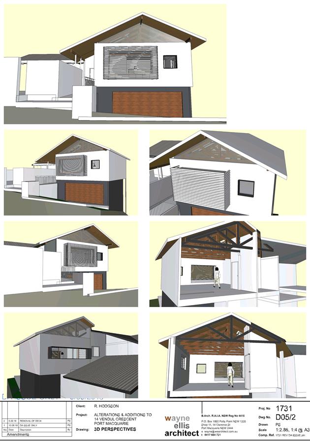
Item: 05
Subject: DA2018 - 649.1 Alterations And Additions To A
Dwelling Including A Clause 4.6 Variation To Clause 4.3 (Height Of Buildings)
Of The Port Macquarie Hastings Local Environmental Plan 2011 - Lot 346 DP
236950, No. 14 Vendul Crescent, Port Macquarie
Report Author:
Clint Tink
|
Applicant: Wayne
Ellis Architect
Owner: Liquor
Folliculi Pty Ltd
Estimated Cost: $43,995
Alignment with Delivery
Program
4.3.1 Undertake transparent
and efficient development assessment in accordance with relevant legislation.
|
|
RECOMMENDATION
That
the Development Assessment Panel recommend to Council that DA2018
– 649.1 for alterations and additions
to a dwelling including Clause 4.6 variation to Clause 4.3 (height of
buildings) of the Port Macquarie Hastings Local Environmental Plan 2011
at Lot 346 DP 236950, 14 Vendul Crescent,
Port Macquarie, be determined by granting consent subject to the recommended
conditions.
|
Executive
Summary
This
report considers a development application for alterations and additions to a
dwelling at the subject site and provides an
assessment of the application in accordance with the Environmental Planning and
Assessment Act 1979.
Following exhibition of the
application, no submissions were received.
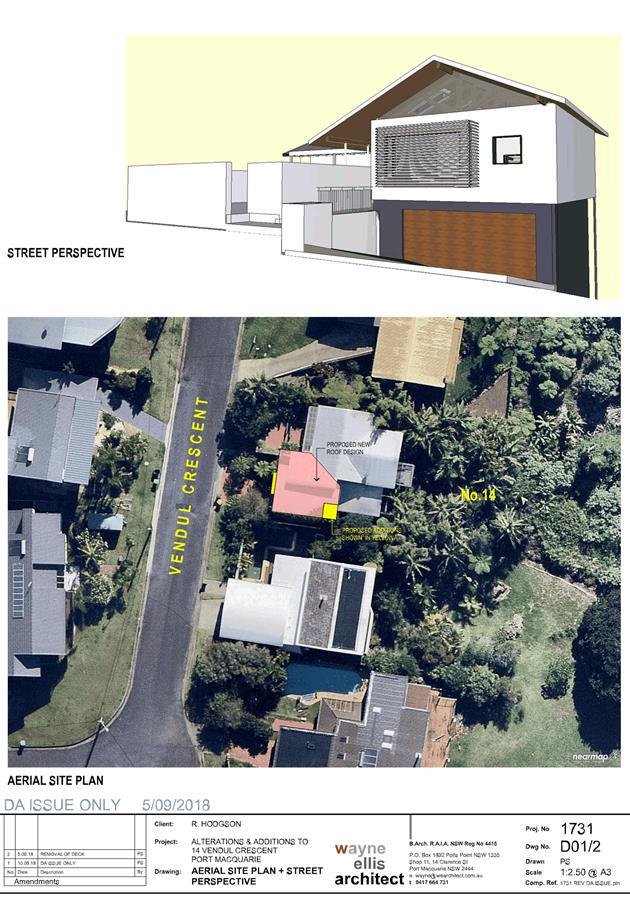
1. BACKGROUND
Existing sites features and surrounding development
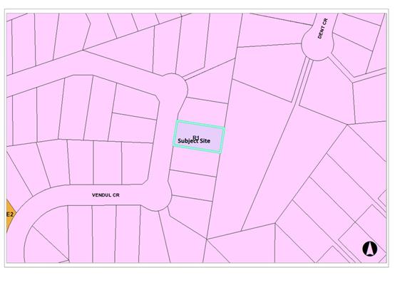
The site has an area of 651.3m².
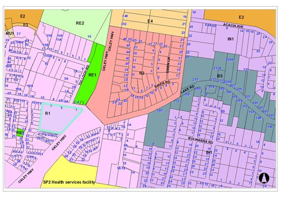
The site is zoned R1 General Residential in accordance with the Port Macquarie-Hastings Local
Environmental Plan 2011, as shown in the following zoning plan:
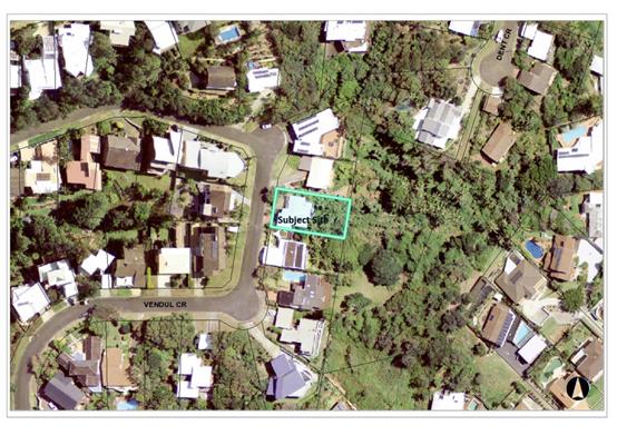
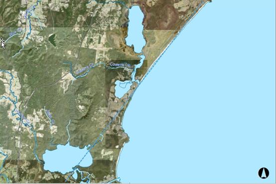
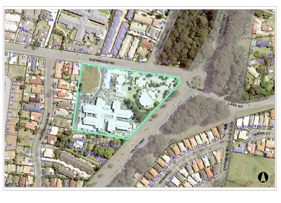
The existing subdivision pattern and location of existing
development within the locality is shown in the following aerial photograph:
2. DESCRIPTION OF
DEVELOPMENT
Key aspects of the proposal include the following:
· Proposal
involves alterations and additions to an existing multi storey dwelling.
· The
works are predominately contained within the footprint of the existing
dwelling.
· Part
of the existing roof design is being amended. The design results in a minor
553mm increase to the existing building height (relevant to that area of the
dwelling). The additional height is predominately located central to the
building design with the wall heights remaining relatively the same.
· The
height limit for the area is 8.5m. It should be noted that the existing
dwelling already exceeds the standard. In particular, the existing dwelling has
a section that exceeds the height limit by 4.29m or 50% of the standard. Even where
the new works are proposed, the existing roof already exceeds the height limit
by 1.88m or 22%.
· The
revised roof design will result in the height limit being exceeded by 2.44m or
29%.
· The
front of the dwelling, when viewed from the street, complies with the 8.5m
height limit (ie the height is 7.25m).
· As
a result of the above, a Clause 4.6 variation is
proposed to Clause 4.3 (Height of Buildings) of Port Macquarie-Hastings Local
Environmental Plan 2011.
Refer
to attachments at the end of this report.
Application Chronology
· 20/8/2018
– Development Application lodged with Council.
· 27/8/2018
– Council staff requested further detail on owners consent.
· 28/8/2018
– Council staff requested additional information on vegetation removal,
view impacts, height impacts and consideration of State Environmental Planning
Policy (Coastal Management) 2018.
· 30/8/2018
to 12/9/2018 – Notification period.
· 31/8/2018
– Application referred to Local NSW Rural Fire Service for consideration.
· 5/9/2018
– Applicant advised that the rear deck would be removed from the
proposal. Discussion with Council staff on additional information request.
· 8-10/9/2018
– Discussion with applicant on bushfire report.
· 12-13/9/2018
– Revised bushfire report submitted and associated discussion with
Council staff on report detail. The revised bushfire report was sent to the
Local NSW Rural Fire Service.
· 13/9/2018 – Applicant submitted revised plans,
removing the rear deck.
· 14/9/2018 – Owners consent clarified.
· 18/9/2018 – Local NSW Rural Fire Service accepted the
proposal subject to conditions.
3. STATUTORY ASSESSMENT
Section 4.15(1) Matters for Consideration
In determining the application, Council is required to take
into consideration the following matters as are relevant to the development
that apply to the land to which the development application relates:
(a) The provisions (where
applicable) of:
(i) any Environmental
Planning Instrument:
State Environmental Planning Policy No. 44 - Koala
Habitat Protection
There is no Koala Plan of Management on the site.
Additionally, the site is less than 1ha in area and requires no vegetation
removal. Therefore, no further investigations are required.
State Environmental Planning Policy No. 55 –
Remediation of Land
Following an inspection of the site and a search of Council
records, the subject land is not identified as being potentially contaminated
and is suitable for the intended use.
State Environmental Planning Policy No. 62 –
Sustainable Aquaculture
Given the nature of the proposed development and proposed
stormwater controls the proposal will be unlikely to have any adverse impact on
existing aquaculture industries.
State Environmental Planning Policy (Coastal Management)
2018 and Clause 5.5 of Port Macquarie-Hastings Local Environmental Plan 2011
The assessment table below considers the relevant provisions of the SEPP.
|
Clause
|
Provision
|
Proposed
|
Complies
|
|
10 Development of
coastal wetlands or littoral rainforest land
(Applies to land mapped as
“coastal wetlands” or “littoral rainforest”)
|
|
10(4)
|
Sufficient measures have
been, or will be, made to protect the biophysical, hydrological and
ecological integrity of the coastal wetland or littoral rainforest.
|
The site contains sections
of mapped littoral rainforest to the east of the existing dwelling. By
removing the proposed eastern deck from the application, no works are
proposed on the mapped littoral rainforest area. Therefore, Clause 10 does not
apply.
|
Yes
|
|
11 Development on land
in proximity to coastal wetlands or littoral rainforest land
(Applies to land mapped as
“proximity area for coastal wetlands” or “proximity area
for littoral rainforest” or both)
|
|
11(1)(a)
|
The
proposed development will not significantly impact on the biophysical,
hydrological or ecological integrity of the adjacent coastal wetland or
littoral rainforest.
|
The alterations and additions will not impact on the
biophysical, hydrological or ecology of the littoral rainforest due to the
already developed nature of the dwelling/site, existing stormwater in place
and the fact no vegetation clearing is required.
|
Yes
|
|
11(1)(b)
|
The
quantity and quality of surface and ground water flows to the adjacent
coastal wetland or littoral rainforest if the development is on land within
the catchment of the coastal wetland or littoral rainforest.
|
No change to water quality or quantity. In particular,
minimal new hard stand areas proposed and the development will continue to
drain to an existing approved stormwater system at pre-development flows.
|
Yes
|
|
12 Development on certain land within the coastal
vulnerability area
(Applies to land mapped as “coastal vulnerability
area”)
|
|
12(a)
|
If the proposed development comprises the erection of a building
or works—the building or works are engineered to withstand current and
projected coastal hazards for the design life of the building or works.
|
The site is not located within the coastal vulnerability
area.
|
N/A
|
|
12(b)(i)
|
The
proposed development is not likely
to alter coastal processes to the detriment of the natural environment or
other land.
|
The site is not located within the coastal vulnerability
area.
|
N/A
|
|
12(b)(ii)
|
The
proposed development is not likely
to reduce the public amenity, access to and use of any beach, foreshore, rock
platform or headland adjacent to the proposed development.
|
The site is not located within the coastal vulnerability
area.
|
N/A
|
|
12(b)(iii)
|
The
proposed development incorporates
appropriate measures to manage risk to life and public safety from coastal
hazards.
|
The site is not located within the coastal vulnerability
area.
|
N/A
|
|
12(c)
|
Measures are in place to ensure that there are
appropriate responses to, and management of, anticipated coastal processes
and current and future coastal hazards
|
The site is not located within the coastal vulnerability
area.
|
N/A
|
|
13 Development on land within the coastal environment
area
(Applies to land mapped as “coastal environment
area”)
|
|
13(1)(a)
|
Whether the proposed development is likely to cause an
adverse impact on the integrity and resilience of the biophysical,
hydrological (surface and groundwater) and ecological environment.
|
No adverse impact will occur. Proposal is for alterations
and additions to a single dwelling only, well clear of any key coastal
environment. Refer to comments on Clause 11 above, in relation to the
littoral rainforest provisions.
|
Yes
|
|
13(1)(b)
|
Whether the proposed development is likely to cause an
adverse impact on coastal environmental values and natural coastal processes.
|
No adverse impact will occur. Proposal is for alterations
and additions to a single dwelling only and will not impact on values or
processes.
|
Yes
|
|
13(1)(d)
|
Whether the proposed development is likely to cause an
adverse impact on marine vegetation, native vegetation and fauna and their
habitats, undeveloped headlands and rock platforms.
|
No adverse impact will occur. Proposal is for alterations
and additions to a single dwelling only, clear of any key coastal
environment/area.
|
Yes
|
|
13(1)(e)
|
Whether the proposed development is likely to cause an
adverse impact on existing public open space and safe access to and along the
foreshore, beach, headland or rock platform for members of the public,
including persons with a disability.
|
No adverse impact will occur. Proposal is for alterations
and additions to a single dwelling only and will not impact on access to any
key coastal area.
|
Yes
|
|
13(1)(f)
|
Whether the proposed development is likely to cause an
adverse impact on Aboriginal cultural heritage, practices and places.
|
The site is not known to contain any heritage items or
places. The site is also disturbed from past activities.
|
Yes
|
|
13(1)(g)
|
Whether the proposed development is likely to cause an
adverse impact on the use of the surf zone.
|
The site is well clear of the surf zone. As a result, no
adverse impact will occur.
|
Yes
|
|
13(2)
|
(a) the development is
designed, sited and will be managed to avoid an adverse impact referred to in
subclause (1), or
(b) if that impact cannot
be reasonably avoided—the development is designed, sited and will be
managed to minimise that impact, or
(c) if that impact cannot
be minimised—the development will be managed to mitigate that impact.
|
Refer to above comments, which confirm no adverse impact
will occur.
|
Yes
|
|
14 Development on land within the coastal use area
(Applies to land mapped as “coastal use area”)
|
|
14(a)(i)
|
Whether the proposed development is likely to cause an
adverse impact on existing, safe access to and along the foreshore, beach,
headland or rock platform for members of the public, including persons with a
disability.
|
No adverse impact will occur. Proposal is for alterations
and additions to a single dwelling only and will not impact on access to any
key coastal area.
|
Yes
|
|
14(a)(ii)
|
Whether the proposed development is likely to cause an
adverse impact on overshadowing, wind funnelling and the loss of views from
public places to foreshores.
|
No adverse impact will occur. Proposal is for alterations
and additions to a single dwelling only. The proposed changes do not
significantly change the bulk and scale of the dwelling and as a result will
ensure no adverse overshadowing, wind funnelling, loss of views etc. The
walls of the dwelling remain relatively unchanged with the minor change to height
gradually occurring central to the building.
|
Yes
|
|
14(a)(iii)
|
Whether the proposed development is likely to cause an
adverse impact on the visual amenity and scenic qualities of the coast,
including coastal headlands.
|
No adverse impact will occur. Proposal is for alterations
and additions to a single dwelling only within a semi developed residential
area. The bulk, scale and positioning of works will ensure no adverse impacts
on the visual or scenic qualities of the coast.
|
Yes
|
|
14(a)(iv)
|
Whether the proposed development is likely to cause an
adverse impact on Aboriginal cultural heritage, practices and places.
|
The site is not known to contain any heritage items or
places. The site is also disturbed from past activities.
|
Yes
|
|
14(a)(v)
|
Whether the proposed development is likely to cause an
adverse impact on cultural and built environment heritage.
|
The site is not known to contain any cultural/heritage
items or value. The site is also disturbed from past activities.
|
Yes
|
|
14(b)
|
(i) the development is
designed, sited and will be managed to avoid an adverse impact referred to in
paragraph (a), or
(ii) if that impact cannot
be reasonably avoided—the development is designed, sited and will be
managed to minimise that impact, or
(iii) if that impact cannot
be minimised—the development will be managed to mitigate that impact.
|
Refer to above comments, which confirm no adverse impact
will occur.
|
Yes
|
|
14(c)
|
The
consent authority has has taken into
account the surrounding coastal and built environment, and the bulk, scale
and size of the proposed development.
|
The coastal environment has been considered in the
assessment and the development deemed acceptable.
|
Yes
|
|
15 Development in coastal zone
generally—development not to increase risk of coastal hazards
(Applies to all land in the coastal zone other than land
mapped as “coastal vulnerability area”)
|
|
15(1)
|
The
proposed development is not likely to cause increased risk of coastal hazards
on the land or other land.
|
The site is not within a coastal hazard area.
|
N/A
|
|
16 Development in coastal zone generally—coastal
management programs to be considered
|
|
16
|
Development consent must not be granted to development on
land within the coastal zone unless the consent authority has taken into
consideration the relevant provisions of any certified coastal management
program that applies to the land.
|
No coastal zone management program applies to the land.
|
N/A
|
|
20 Flexible zone provisions
|
|
20
|
Flexible
zone provisions not applicable to land to which the SEPP applies.
|
The proposal does not rely upon flexible zone provisions.
|
Yes
|
Overall, the proposed development is not likely to result in
any of the following:
a) any
adverse impact on integrity and resilience of the biophysical,
hydrological (surface and groundwater) and ecological environment;
b) any
adverse impacts coastal environmental values and natural coastal
processes;
c) any
adverse impacts on marine vegetation, native vegetation and fauna
and their habitats, undeveloped headlands and rock platforms;
d) any
adverse impact on marine vegetation, native vegetation and fauna
and their habitats, undeveloped headlands and rock platforms;
e) any
adverse impact on Aboriginal cultural heritage, practices and
places;
f) any
adverse impacts on the cultural and built environment heritage;
g) any
adverse impacts to or from the surf zone;
h) any adverse impact on the visual amenity and scenic qualities of the
coast, including coastal headlands;
i) overshadowing, wind funnelling and the loss of views from public places
to foreshores;
The bulk, scale and size of the proposed development is
compatible with the surrounding coastal and built environment.
State Environmental Planning Policy (Building
Sustainability Index: BASIX) 2004
The cost of the alterations and additions do not exceed
$50,000. Therefore, the proposal is not considered a BASIX affected
development.
Port Macquarie-Hastings Local Environmental
Plan 2011
The proposal is consistent with the LEP having regard to the
following:
· Clause
2.2, the subject site is zoned R1 General Residential. In accordance with
clause 2.3(1) and the R1 zone landuse table, alterations and additions to a
dwelling is a permissible landuse with consent.
The objectives of the R1 zone are as
follows:
o To provide for the housing
needs of the community.
o To provide for a variety of
housing types and densities.
o To enable other land uses
that provide facilities or services to meet the day to day needs of residents.
In accordance with Clause 2.3(2),
the proposal is consistent with the zone objectives as it is a permissible
landuse and compatible with the established residential locality.
· Clause
2.7, the demolition requires consent as it does not fit within the provisions
of SEPP (Exempt and Complying Development Codes) 2008.
· Clause
4.3, this clause establishes the maximum “height of a building” (or
building height) that a building may be built to on any parcel of land. The
term “building height (or height of building)” is defined in the
LEP to mean “the vertical distance between ground level (existing) and
the highest point of the building, including plant and lift overruns, but
excluding communication devices, antennae, satellite dishes, masts, flagpoles,
chimneys, flues and the like”. The term “ground level
(existing)” is also defined in the LEP to mean “the existing
level of a site at any point”.
The
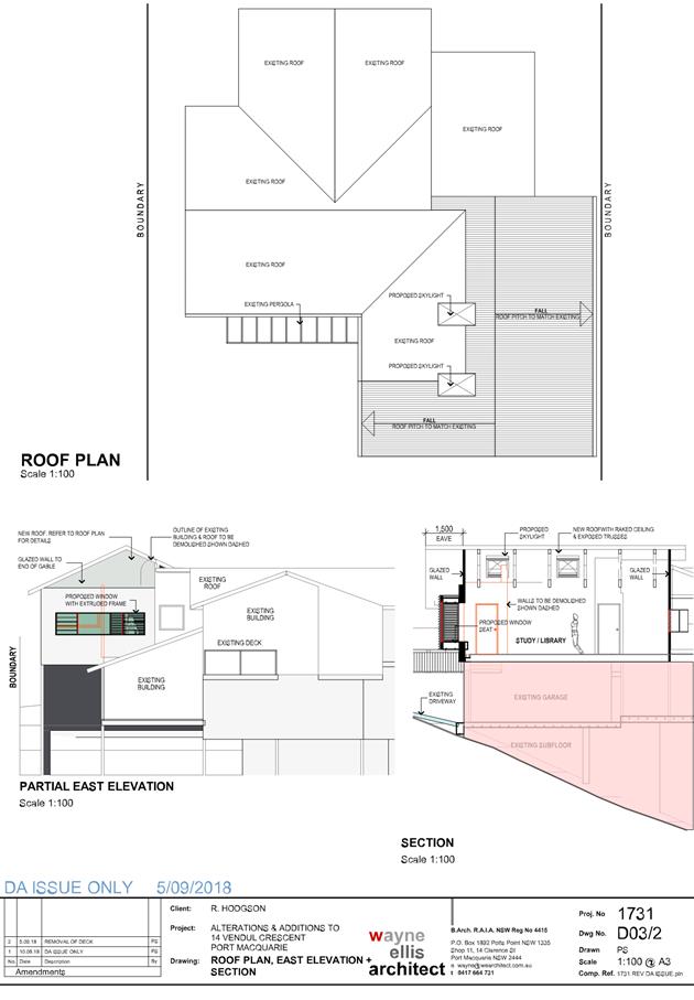
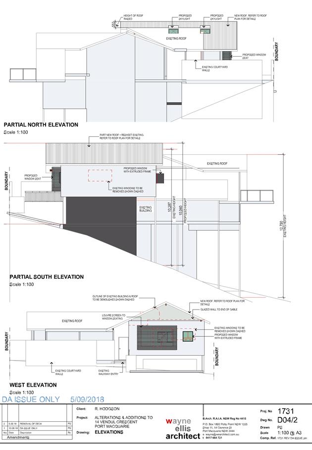
building height limit for the site is identified on the Height of Buildings Map
as being 8.5m. The proposed development (new works) exceed the height by 2.44m,
which represents a variation of 29%. Refer to the attached elevation plans,
which demonstrate the areas of the building that exceed the height limit.
In
considering the height variation, compliance with the objectives of Clause 4.3
of the LEP have been considered below:
(a)
to ensure that buildings are compatible with the height, bulk and scale of the
existing and desired future character of the locality,
Comment:
The
locality and Vendul Crescent are characterised by a number of dwellings with
similar heights, due mainly to the steepness of the land.
Key
aspects of this proposal are:
- The dwelling still
presents as a single storey dwelling to the street/public domain.
- The change in height
occurs central to the building with the wall heights facing side
boundaries/neighbours remaining relatively unchanged. This will limit the
impact on neighbours as the central height will not be visible.
- The section of the
dwelling being changed is only being raised 553mm.
- The dwelling already has
multiple sections that do not meet the height limit and actually exceed the
height limit by more than the proposed 2.44m/29% under this application.
Based
on the above, the proposed height, bulk and scale of the development is
considered compatible with the existing and future character of the locality.
(b) to
minimise visual impact, disruption of views, loss of privacy and loss of solar
access to existing development,
Comment:
The
visual impact of the building is considered satisfactory for the following
reasons:
- The
main variations are located behind the facades of the building and are
therefore less distinct.
- The
variations are minor in the context of the existing built form and other
existing height variations.
- The
building height is similar to the existing dwellings in the area and will
therefore not be visually dominant.
- The
variation is created by the land sloping steeply away from the street.
View
impacts and solar access are considered elsewhere in this report under
‘View Sharing’ and ‘Overshadowing’. The proposed
development and minor height variation do not create any adverse view loss or
overshadowing.
Potential
privacy impacts are considered under the relevant DCP provisions below and have
been satisfactorily addressed in the building design.
(c) to
minimise the adverse impact of development on heritage conservation areas and
heritage items,
Comment:
The
site does not contain any known heritage items or sites of significance.
(d) to
nominate heights that will provide a transition in built form and land use
intensity within the area covered by this Plan.
Comment:
The proposed height is consistent with other
dwellings in the area. The variation does not compromise this intent of the
standard.
In addition to the above, the applicant has
lodged a written request in accordance with Clause 4.6 of the LEP objecting to
the 8.5m building height standard applying to the site (see comments below
under Clause 4.6).
· Clause
4.4, the floor space ratio of the dwelling is being increased 10m² and
conservatively using mapping, will result in an FSR below the 0.65:1 standard
(ie calculations suggest approx. 0.6:1).
· Clause
4.6, consent must not be granted for a proposal that contravenes a development
standard unless the consent authority has considered a written request from the
applicant that justifies the variation by showing that the subject standard is
unreasonable and/or unnecessary and that there are sufficient environmental
planning grounds to justify the contravening of the standard without
compromising the public interest.
As a result of the
above, the applicant submitted a Clause 4.6 variation for the height standard
(ie Clause 4.3). The applicant’s reasoning for varying Clause 4.3 are as
follows:
- The
resultant height difference is minimal at 553mm.
- The
proposed height from the street is 7.25m, which is under the 8.5m height limit.
- The
height limit is already exceeded when viewed from the east.
- Precedence
already exists on adjoining properties.
- The
site slopes away steeply from the street and strict compliance with the
standard is difficult to achieve and considered unreasonable.
- To
obtain reasonable views and access from the street, it is difficult to get
floor levels that result in a compliant height.
- The
proposal does not adversely impact on views from neighbouring properties.
Having considered the application
and Clause 4.6 variation to Clause 4.3, the proposal was deemed to have limited
impact on the environment as per the reasons identified by the applicant above.
In addition, it was also considered by staff that:
- The
variation will not be readily visible due to the minor nature of the variation
(553mm to a small portion of the building). In addition, the bulk of the
variation occurs behind the front façade and central to the roof (ie not
easily visible from adjoining properties or the public domain).
- The
existing built form of the dwelling has multiple sections that already do not
meet the height limit and exceed the height limit by more than that being
varied under this application.
- Limited
change to height of walls proposed, which will ensure no adverse increase in
overshadowing to that occurring at present.
- There
are similar sized buildings within 500m of the site. As a result, the proposed
height and minor variation were not unreasonable within the context of the
area.
- There
will be negligible public domain impact.
- The
development is well articulated, which further reduces the bulk of the
building.
- No
significant views impacts will occur.
- Through
the use of screening, separation, room layout and window type; there will be no
loss of privacy.
- The
development is consistent with the zoning and height objectives of the LEP 2011
and is unlikely to have any implications on State related issues or the broader
public interest.
- The public benefit of the standard is not compromised
or eroded.
As per the Planning
Circular PS 18 - 003, Council can assume the Director’s Concurrence for
variations to height. As a result, Concurrence from the Department of Planning
and Environment is therefore not required. However, the variation is over 10%
of the standard and will need to be determined by Council as per the circulars.
Overall, the design
provides a suitable height that has regard for the current legislative height
controls and what has actually been built in the area to date. Compliance with
the standard would be unreasonable in this case due to the surrounding examples
of non-compliance and the design difficulty associated with the steep slope. It
is recommended that the Clause 4.6 variation to Clause 4.3 be supported.
· Clause 5.5, relevant provisions of this clause are
addressed by State Environmental Planning Policy (Coastal Management) 2018
above in this report.
· Clause
5.10, the site does not contain or adjoin any known heritage items or sites of
significance.
· Clause
7.13, satisfactory arrangements are in place for provision of essential
services.
(ii) Any
draft instruments that apply to the site or are on exhibition:
None
relevant.
(iii) any
Development Control Plan in force:
Port Macquarie-Hastings
Development Control Plan 2013
|
DCP 2013: Dwellings, Dual
occupancies, Dwelling houses, Multi dwelling houses & Ancillary
development
|
|
|
Requirements
|
Proposed
|
Complies
|
|
3.2.2.1
|
Ancillary development:
• 4.8m max. height
• Single storey
• 60m2 max. area
• 100m2 for lots
>900m2
• 24 degree max.
roof pitch
• Not located in
front setback
|
None proposed.
|
N/A
|
|
3.2.2.2
|
Articulation zone:
• Min. 3m front
setback
• An entry feature
or portico
• A balcony, deck,
patio, pergola, terrace or verandah
• A window box
treatment
• A bay window or
similar feature
• An awning or
other feature over a window
• A sun shading
feature
|
The dwelling contains a proposed bay window feature within
the articulation zone. The window does not exceed 25% of the articulation
zone and is still setback over 3m.
|
Yes
|
|
Front setback (Residential not R5
zone):
• Min. 6.0m
classified road
• Min. 4.5m local
road
• Min. 3.0m
secondary road
• Min. 2.0m
Laneway
|
Front building line setback is
compliant with the minimum 4.5m front setback requirements.
|
Yes
|
|
3.2.2.3
|
Garage 5.5m min. and 1m behind
front façade.
Garage door recessed behind
building line or eaves/overhangs provided
|
Garage door setback remains
unchanged.
|
N/A
|
|
6m max. width of garage door/s
and 50% max. width of building
|
Width of garage door remains
unchanged.
|
N/A
|
|
Driveway crossover 1/3 max. of
site frontage and max. 5.0m width
|
Driveway crossing width remains
unchanged.
|
N/A
|
|
3.2.2.4
|
4m min. rear setback. Variation
subject to site analysis and provision of private open space
|
The rear setback requirements are
complied with/remained unchanged.
|
N/A
|
|
3.2.2.5
|
Side setbacks:
• Ground floor =
min. 0.9m
• First floors
& above = min. 3m setback or where it can be demonstrated that
overshadowing not adverse = 0.9m min.
• Building wall
set in and out every 12m by 0.5m
|
The southern side setback is the
only one being changed under this application. On such a façade,
the new works will provide a continuation of the existing 850mm side setback
for a length of an additional 1.76m. No significant impact will be created
but the wall will need to be fire rated during the Construction Certificate
process.
The building wall articulation is
compliant and/or satisfactory to address the objective intent of the
development provision.
|
No, but acceptable.
|
|
3.2.2.6
|
35m² min. private open space
area including a useable 4x4m min. area which has 5% max. grade
|
Open space areas will remain unchanged.
|
N/A
|
|
3.2.2.7
|
Front fences:
• If solid 1.2m
max height and front setback 1.0m with landscaping
• 3x3m min. splay
for corner sites
• Fences >1.2m
to be 1.8m max. height for 50% or 6.0m max. length of street frontage with
25% openings
• 0.9x0.9m splays
adjoining driveway entrances
|
No fences proposed.
|
N/A
|
|
3.2.2.8
|
Front fences and walls to have
complimentary materials to context
No chain wire, solid timber,
masonry or solid steel front fences
|
No fences proposed.
|
N/A
|
|
3.2.2.10
|
Privacy:
• Direct views
between living areas of adjacent dwellings screened when within 9m radius of
any part of window of adjacent dwelling and within 12m of private open space
areas of adjacent dwellings. ie. 1.8m fence or privacy screening which has
25% max. openings and is permanently fixed
• Privacy screen
required if floor level > 1m height, window side/rear setback (other than
bedroom) is less than 3m and sill height less than 1.5m
• Privacy screens
provided to balconies/verandahs etc which have <3m side/rear setback and
floor level height >1m
|
No new openings are proposed that
face adjoining properties and that are also within the relevant 9m/12m radius
dimension.
|
Yes
|
|
DCP 2013: General
Provisions
|
|
|
Requirements
|
Proposed
|
Complies
|
|
2.7.2.2
|
Design addresses generic principles of Crime Prevention
Through Environmental Design guideline
|
No concealment or entrapment areas proposed. Adequate
casual surveillance available.
|
Yes
|
|
2.3.3.1
|
Cut and fill 1.0m max. 1m outside the perimeter of the
external building walls
|
No cut or fill proposed.
|
N/A
|
|
2.3.3.2
|
1m max. height retaining walls along road frontage
|
None proposed.
|
N/A
|
|
Any retaining wall >1.0 in height to be certified by structure
engineer
|
None proposed.
|
N/A
|
|
Combination of retaining wall and front fence height max
1.8m, max length 6.0m or 30% of frontage, fence component 25% transparent,
and splay at corners and adjacent to driveway
|
No new retaining wall front fence combination proposed.
|
N/A
|
|
2.3.3.8
|
Removal of hollow bearing trees
|
No trees proposed to be removed.
|
N/A
|
|
2.6.3.1
|
Tree removal (3m or higher with 100m diameter trunk at 1m
above ground level and 3m from external wall of existing dwelling)
|
No trees proposed to be removed.
|
N/A
|
|
2.4.3
|
Bushfire risk, Acid sulphate soils, Flooding,
Contamination, Airspace protection, Noise and Stormwater
|
Refer to main body of report.
|
Noted
|
|
2.5.3.2
|
New accesses not permitted from arterial or distributor
roads
|
No access proposed to arterial or distribution road.
|
N/A
|
|
Driveway crossing/s minimal in number and width including
maximising street parking
|
No change to existing driveway proposed or required.
|
N/A
|
|
2.5.3.3
|
Parking in accordance with Table 2.5.1.
1 space per single dwelling (behind building line)
|
No change to existing parking proposed or required.
|
Yes
|
|
2.5.3.11
|
Section 94 contributions
|
Development is alterations and additions to an existing
dwelling only. No new occupancy created. Therefore, contributions do not
apply.
|
Yes
|
|
2.5.3.12 and 2.5.3.13
|
Landscaping of parking areas
|
No change to landscaping proposed or required in this
case. Works are contained within the existing footprint.
|
N/A
|
(iiia) any
planning agreement that has been entered into under section 7.4, or any draft
planning agreement that a developer has offered to enter into under section
7.4:
None
relevant.
iv) any matters prescribed by the
Regulations:
New South Wales Coastal Policy:
The proposed development is consistent with the objectives
and strategic actions of this policy - refer to comments on State Environmental
Planning Policy (Coastal Management) 2018 above in this assessment report.
Demolition
of buildings AS 2601:
Demolition is capable of compliance with the Australian
Standard and is recommended to be conditioned.
(b) The
likely impacts of that development, including environmental impacts on both the
natural and built environments, social and economic impacts in the locality:
Context
& Setting
• Surrounding
uses comprise a mixture of multi storey dwellings with most being 2 and 3
storey.
• The
proposal will be unlikely to have any adverse impacts to existing adjoining
properties and satisfactorily addresses the public domain.
• The proposal is considered to be consistent with other residential
development in the locality and adequately addresses planning controls for the
area.
• There is no adverse privacy or overshadowing impacts.
View Sharing
The overall notion of view sharing is invoked when a
property enjoys existing views and a proposed development would share that view
by taking some of it away for its own enjoyment. Taking all the view away
cannot be called view sharing, although it may, in some circumstances, be quite
reasonable
Having considered the principles of NSW Land and
Environment Court case law - Tenacity Consulting v Warringah 2004 NSW LEC
140 and following an inspection of the area, the following comments
are provided in regards to the view impacts using the 4 step process to
establish whether the view sharing is acceptable.
Step 1
Assessment of views to be affected. Water views are valued
more highly than land views. Iconic views (e.g. of the Opera House, the Harbour
Bridge or North Head) are valued more highly than views without icons. Whole
views are valued more highly than partial views, e.g. a water view in which the
interface between land and water is visible is more valuable than one in which
it is obscured.
Comments: An initial site inspection flagged the issue of
potential view loss as it was unclear from the information originally submitted
with the application. Concern was raised whether 10 & 21 Vendul Crescent
will lose views to North Brother Mountain and the Lighthouse respectively.
However, the applicant submitted photos clarifying that no adverse impact on
views would occur. Only part of a distant, already obscured water view from 21
Vendul Crescent would be affected. The views from 10 Vendul Crescent are across
a side boundary and from low use rooms. See further principles below, which
apply little weight to views from low use rooms. Nonetheless, aerial mapping
also shows the view to North Brother Mountain should still be retained down the
road reserve.
See photos/mapping below:
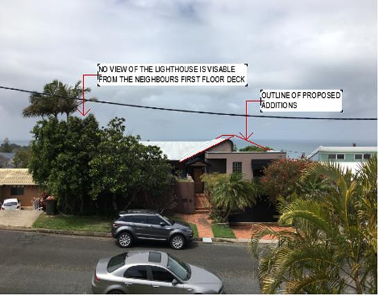
Photo 1: View from 21 Vendul
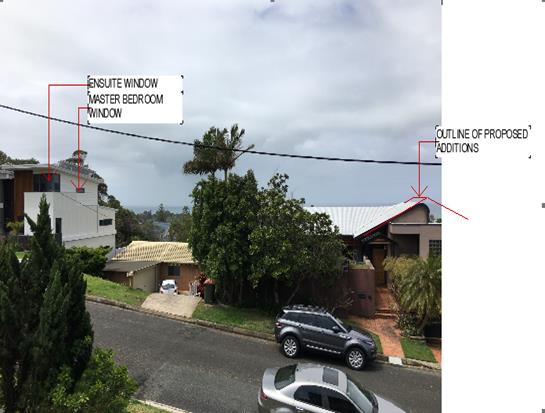
Photo 1: Use of 10 Vendul
Map 1: Dotted blue line shows view line from 10 Vendul
Crecent to North Brother Mountain.
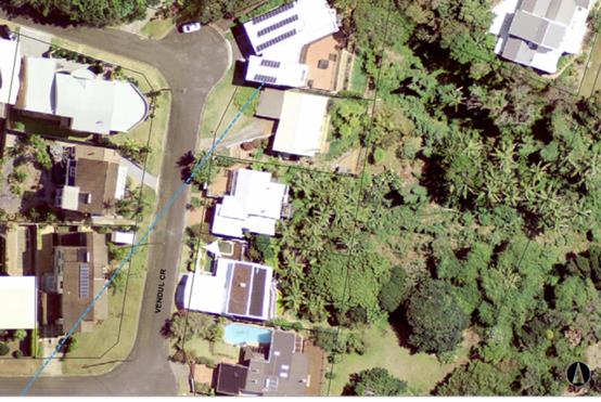
Map 2: Shows an enlarged image of the above dotted blue
view line from 10 Vendul Crescent. The view is down the street.
As can be seen in the photos/mapping and in light of the
principle of the case; no high value views exist or will be affected.
Step 2
Consider from what part of the property the views are
obtained. For example the protection of views across side boundaries is more
difficult than the protection of views from front and rear boundaries. In
addition, whether the view is enjoyed from a standing or sitting position may
also be relevant. Sitting views are more difficult to protect than standing
views. The expectation to retain side views and sitting views is often
unrealistic.
Comments: The
limited water views from 10 Vendul Crescent are obtained from living/deck areas
across the front boundary. The views from 21 Vendul Crescent are obtained from
a bedroom and ensuite window, across a side boundary/down the street.
Step 3
Assess the extent of the impact. This should be done for
the whole of the property, not just for the view that is affected. The impact
on views from living areas is more significant than from bedrooms or service
areas (though views from kitchens are highly valued because people spend so
much time in them). The impact may be assessed quantitatively, but in many
cases this can be meaningless. For example, it is unhelpful to say that the
view loss is 20% if it includes one of the sails of the Opera House. It is
usually more useful to assess the view loss qualitatively as negligible, minor,
moderate, severe or devastating.
Comments: The
extent of the impact upon views from 10 Vendul Crescent will be minor and
acceptable. This is on the basis that the height and
footprint of the subject dwelling remain relatively the same. The increased
height is central to the dwelling with existing outer walls, footprint and vegetation
already blocking the majority of the view. Refer to previous photo for context.
The view from 21 Vendul Crescent up the road to North
Brother will be retained.
Step 4
Assess the
reasonableness of the proposal that is causing the impact. A development that
complies with all planning controls would be considered more reasonable than
one that breaches them. Where an impact on views arises as a result of
non-compliance with one or more planning controls, even a moderate impact may
be considered unreasonable. With a complying proposal, the question should be
asked whether a more skilful design could provide the applicant with the same
development potential and amenity and reduce the impact on the views of
neighbours. If the answer to that question is no, then the view impact of a
complying development would probably be considered acceptable and the view
sharing reasonable.
Comments:
Considering the comments on Clause 4.3 and 4.6 in the LEP 2011 section of this
report, the proposal is considered reasonable and will not significantly change
existing views. The proposed development will still achieve a suitable level of
view sharing in terms of the planning principles of the court case.
It should
also be noted that no submissions were received from adjoining neighbours,
which is normally a sign of the acceptance of the design and that the existing
views will not be impacted.
Overshadowing
Based on the submitted plans, the proposed development will
not significantly increase overshadowing of key living areas/open space of any
adjoining property to the point where an adverse impact is created. In
particular, the increased height is predominately central to the dwelling with
the external wall heights to remain relatively unchanged.
Access, Transport & Traffic
The proposal will be unlikely to have any adverse impacts in
terms access, transport and traffic. The existing road network will
satisfactorily cater for any increase in traffic generation as a result of the
development.
Utilities, Water, Sewer & Stormwater
The proposed
development will not impact on existing services.
Soils
The proposed development will not have any adverse impacts
on soils in terms of quality, erosion, stability and/or productivity subject to
a standard condition requiring erosion and sediment controls to be in place
prior to and during construction.
Air & Micro-climate
The operations of the proposed development will not result
in any adverse impacts on the existing air quality or result in any pollution.
Flora
& Fauna
Construction of the proposed development will not require
removal/clearing of any significant vegetation. The design is contained within
the footprint of the existing building. The NSW Rural Fire Service have also
confirmed that no vegetation removal is required to meet the bushfire
requirements.
Waste
Satisfactory arrangements are in place for proposed storage
and collection of waste and recyclables. No adverse impacts anticipated.
Noise & Vibration
Construction noise impacts are considered capable of being
managed via standard construction hour conditions/restrictions.
Being a residential property, no adverse occupation noise
will occur.
Bushfire
The site is identified as being bushfire prone.
The Applicant has submitted a bushfire report prepared by a Certified
Consultant.
The application and report were referred to the Local NSW
Rural Fire Service for comment. The Local NSW Rural Fire Service have reviewed
the proposal and made recommendations which will be required to be imposed via
conditions of consent.
Management of bushfire risk is considered acceptable subject
to BAL 40 construction levels being implemented and landscape management. No
tree removal is required. An appropriate condition is recommended.
Safety,
Security & Crime Prevention
The proposed
development creates no new concealment and entrapment areas. Surveillance is
provided by the dwelling or street. In addition, the owner has the option of
installing sensor lights and CCTV if deemed necessary.
Social Impact in the Locality
Given the nature and type of
development proposed, no adverse social impacts foreseen.
Economic Impact in the Locality
No adverse impacts. Likely
positive impacts can be attributed to the construction of the development and
associated flow on effects (i.e. maintained employment in the construction
industry and associated expenditure in the area).
Site Design and Internal Design
The proposed
design satisfactorily responds to the site attributes and will fit into the
locality. No adverse impacts likely.
Construction
While there
may be some standard short term impacts associated with a construction site
(i.e. loss of off street parking due to construction workers, construction
noise etc), no long term impacts to neighbouring properties will occur. In
addition, standard conditions will be recommended to restrict hours of
construction.
Cumulative Impacts
The proposed
development is not expected to have any adverse cumulative impacts on the
natural or built environment or the social and economic attributes of the
locality.
The height of
the building and variation is consistent with other houses in the area as
property owners address the steep terrain.
(c) The suitability of the site for
the development:
While there
are variations proposed, it is considered that suitable justification has been
provided in this case to ensure the development is consistent with other
development in the area. In this regard, the development is considered to still
satisfy relevant planning controls for the area and is not expected to impact
adversely on the wider public interest.
(d) Any submissions made in
accordance with this Act or the Regulations:
No written submissions were received following public
exhibition of the application.
(e) The Public Interest:
The proposed
development satisfies relevant planning controls and is unlikely to impact on
the wider public interest.
4. DEVELOPMENT
CONTRIBUTIONS APPLICABLE
Not applicable – no additional residential component
being created.
5. CONCLUSION AND
STATEMENT OF REASON
The application has been assessed
in accordance with Section 4.15 of the Environmental Planning and Assessment
Act 1979.
Issues raised during assessment
and public exhibition of the application have been considered in the assessment
of the application. Where relevant, conditions have been recommended to manage
the impacts attributed to these issues.
The site is considered suitable
for the proposed development and the proposal adequately addresses relevant
planning controls. The development is not considered to be contrary to the
public's interest and will not result a significant adverse social,
environmental or economic impact. It is recommended that the application be
approved, subject to the recommended conditions of consent provided in the
attachment section of this report.
|
Attachments
1View. DA2018
- 649.1 Recommended Conditions
2View. DA2018
- 649.1 Plans
|
|
ATTACHMENT
|
Development Assessment Panel
14/11/2018
|
|
ATTACHMENT
|
Development Assessment Panel
14/11/2018
|
 AGENDA Development Assessment Panel 14/11/2018
Item: 06
Subject: DA2018 - 639.1 Seniors Housing - Lot 1
DP527052, No 7 Sherwood Road, Port Macquarie
Report
Author: Patrick Galbraith-Robertson
|
Applicant: Uniting
Church In Australia Property Trust
Owner: Uniting
Church In Australia Property Trust
Estimated Cost: $2.6M
Alignment with Delivery
Program
4.3.1 Undertake transparent
and efficient development assessment in accordance with relevant legislation.
|
|
RECOMMENDATION
That
DA 2018 – 639.1 for Seniors Housing at Lot 1, DP527052, No. 7 Sherwood Road, Port Macquarie
be determined by granting consent subject to the recommended conditions.
|
Executive
Summary
This
report considers a Development Application for seniors housing at the subject site and provides an assessment of the
application in accordance with the Environmental Planning and Assessment Act
1979.
Following exhibition of the
application, two (2) submissions have been
received.
1. BACKGROUND
Existing sites features and surrounding development
The site has an area of 2.3710
hectares.
The site is zoned R1 General Residential in accordance with
the Port Macquarie-Hastings Local Environmental Plan 2011, as shown in the
following zoning plan:
The site contains the Uniting
Church, administration buildings, Lifeline and a 110 bed Residential Aged Care
Facility known as ‘Mingaletta’.
The existing subdivision pattern and location of existing
development within the locality is shown in the following aerial photograph:
2. DESCRIPTION OF
DEVELOPMENT
Key aspects of the proposal include the following:
· Construction
of 15 single storey self-contained dwellings as in-fill self-care seniors
housing including 10 off-street parking spaces;
· Tree removal and offset planting;
· Staging of the proposal with Stage 1; Site preparation and
earthworks and Stage 2: Construction of the 15 units
Refer
to attachments at the end of this report.
Application Chronology
· 17
August 2018 – DA lodged with Council.
· 23 August 2018 – Additional fees requested.
· 23 August 2018 – Additional fees received.
· 24 August 2018 – Referral to NSW Rural Fire Service
· 28 August to 10 September 2018 – Neighbour
notification of proposal.
· 13 September 2018 – Copy of submission forwarded to
Applicant to respond to.
· 21 September 2018 – Additional information requested
– substation location, disabled parking space design and private garbage
collection queried.
· 5 October 2018 – NSW Rural Fire Service Bushfire
Safety Authority received.
· 10 October 2018 – Applicant provided response to
additional information requests.
· 11 October 2018 – Second submission forwarded to
Applicant to respond to.
3. STATUTORY ASSESSMENT
Section
4.15(1) Matters for Consideration
In
determining the application, Council is required to take into consideration the
following matters as are relevant to the development that apply to the land to
which the development application relates:
State Environmental Planning Policy No. 44 - Koala
Habitat Protection
With reference to clauses 6 and 7, the subject land is
greater than 1 hectare and therefore the provisions of SEPP must be considered.
The site has a total area of 2.3ha and the provisions of
this policy therefore apply to the site and proposed development.
The portion of the site proposed to contain the development
is predominately managed grass with a cluster of trees in the south-western
corner. Three (3) of the trees (Tallowwood) proposed to be removed are
identified within Schedule 2 of this policy as Koala feed trees.
The removal of these trees is not considered likely to have
a detrimental impact on the koala for the following reasons:
· The
existing trees are juveniles (planted in 2009) and are isolated from any
adjoining vegetation by existing urban development;
· The
site has a number of Koala feed trees located along its eastern boundary which
are proposed to be maintained. These trees are located in proximity to the
north-south vegetation corridor running along the eastern side of John Oxley
Drive and to the north of the site;
· The
Port Macquarie-Hastings LEP 2011 (Map KHA_013D) and the draft Coastal
Koala Plan of Management do not identify the site as containing Koala habitat.
In addition to the above, it is proposed to compensate for
the removal of the 3 Koala feed trees (Tallowwood) with the replanting of 10
Tallowwoods elsewhere on site as shown below:
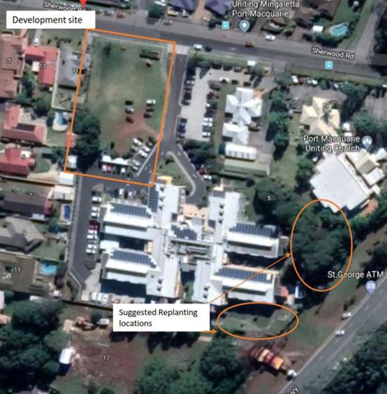
The consulting arborist, Port Tree Fella, recommends that
the compensatory re-plantings be planted in the eastern portion of the site to
complement the existing Koala feed trees located within this area. An initial
investigation of the area suggests that the area is limited to accommodate 10
trees therefore only the minimum DCP recommended offset planting of 6 trees (at
a ratio of 2:1) are recommended to be planted.
The application has demonstrated that no significant habitat
will be removed (noting the additional plantings proposed to offset the
plantings) therefore no further investigations are required.
State Environmental Planning Policy No. 55 –
Remediation of Land
Following an inspection of the site and a search of Council
records, the subject land is not identified as being potentially contaminated
and is suitable for the intended use.
State Environmental Planning Policy No. 62 –
Sustainable Aquaculture
Given the nature of the proposed development and proposed
stormwater controls the proposal will be unlikely to have any adverse impact on
existing aquaculture industries.
State Environmental Planning
Policy No. 64 – Advertising and Signage
The application seeks consent for a small sign located
adjacent to the driveway entry. This sign shall contain dimensions of 1.2m high
by 2m wide. The sign will identify the proposed development (building
identification signage) as well as the one-way traffic direction.
In accordance with clause 7, this SEPP prevails over the
Port Macquarie-Hastings LEP 2011 in the event of any inconsistency.
The following assessment table provides an assessment
checklist against the Schedule 1 requirements of this SEPP:
|
Applicable clauses for consideration
|
Comments
|
Satisfactory
|
|
Clause 8(a) Consistent with
objectives of the policy as set out in Clause 3(1)(a).
|
The signage is limited in scale
and meets the objectives of this Policy.
|
Yes
|
Schedule
1(1) Character of the area.
|
The signage is limited in scale
and sufficiently compatible with the character of the existing residential
locality.
|
Yes
|
|
Schedule 1(2) Special areas.
|
Yes
|
|
Schedule 1(3) Views and vistas.
|
The signage will not compromise
any important views or vistas.
|
Yes
|
|
Schedule 1(4) Streetscape,
setting or landscape.
|
The scale of the signage is
limited and limited to one sign only. No adverse impacts can be identified to
the existing streetscape.
|
Yes
|
|
Schedule 1(5) Site and building.
|
The signage is limited in scale
and lower than the proposed buildings.
|
Yes
|
|
Schedule 1(6) Associated devices
and logos with advertisements and advertising structures.
|
N/A
|
N/A
|
|
Schedule 1(7) Illumination.
|
No illumination proposed
|
N/A
|
|
Schedule 1(7) Safety.
|
No safety concerns identified.
|
Yes
|
State Environmental Planning Policy (Building
Sustainability Index: BASIX) 2004
A BASIX certificate has been submitted demonstrating that
the proposal will comply with the requirements of the SEPP. It is
recommended that a condition be imposed to ensure that the commitments are
incorporated into the development and certified at Occupation Certificate
stage.
State Environmental Planning Policy (Infrastructure) 2007
Vehicular access is proposed as a part of this application
to the local road known as Sherwood Road. The proposed connection to Sherwood
Road is approximately 190m from the intersection of Sherwood Road and the
classified road (Oxley Highway).
The proposed Independent Living Units alone do not trigger
any of the thresholds of Schedule 3 of this Policy. The proposed development
seeks to provide a total of 10 parking spaces with a circular driveway network,
the closest egress to the Oxley Highway being approximately 190m from the
classified road.
The site contains in excess of 50 parking spaces on site
(estimated 132). However, no changes to these spaces or access arrangements are
proposed. For this reason, referral to the RMS is not considered relevant. The
following comments are made with respect to Clause 101 of this Policy:
· Vehicular
access is proposed to the local road known as Sherwood Road. The proposed
connection to Sherwood Road is approximately 190m from the intersection of
Sherwood Road and the classified road (Oxley Highway);
· The
development portion of the site is located approximately 180m from the Oxley
Highway and the proposed access is not considered likely to result in any
reduced risk of safety for the existing classified road or reduced efficiency
or on-going operation of the classified road.
The proposed development is not considered likely to
generate a significant amount of emissions and the development is considered to
be appropriately located so as not to be affected by road noise or vehicle
emissions.
State Environmental Planning Policy (Housing for Seniors
or People with a Disability) 2004
|
Clause
|
Proposed
|
Complies
|
|
4. Land to which Policy applies
|
|
|
|
Policy applies to land within New South Wales that is
land zoned primarily for urban purposes or land that adjoins land zoned
primarily for urban purposes, but only if:
(a) development for the purpose of any of
the following is permitted on the land:
(i) dwelling-houses,
(ii) residential flat buildings,
(iii) hospitals,
(iv) development of a kind identified in
respect of land zoned as special uses, including (but not limited to)
churches, convents, educational establishments, schools and seminaries, or
(b) the land is being
used for the purposes of an existing registered club.
|
The subject site is zoned R1 General Residential and
is therefore zoned for urban purposes.
|
Yes
|
|
8. Seniors
|
|
|
|
In this Policy, seniors are any of the
following:
(a) people aged 55 or
more years,
(b) people who are
resident at a facility at which residential care (within the meaning of the Aged
Care Act 1997 of the Commonwealth) is provided,
(c) people who have
been assessed as being eligible to occupy housing for aged persons provided
by a social housing provider.
|
The application seeks to provide housing for seniors
or people with a disability.
|
Yes
|
|
9. People with a disability
|
|
|
|
In this Policy, people with a disability are
people of any age who have, either permanently or for an extended period, one
or more impairments, limitations or activity restrictions that substantially
affect their capacity to participate in everyday life.
|
The application seeks to provide housing for seniors
or people with a disability.
|
Yes
|
|
10. Seniors housing
|
|
|
|
In this Policy, seniors housing is residential
accommodation that is, or is intended to be, used permanently for seniors or
people with a disability consisting of:
(a) a residential care
facility, or
(b) a hostel, or
(c) a group of
self-contained dwellings, or
(d) a combination of these,
but does not include a hospital.
Note. The concept of seniors housing is intended
to be a shorthand phrase encompassing both housing for seniors and for people
with a disability. This Policy deals with both kinds of housing.
Accommodation provided by seniors housing does not
have to be limited to seniors or people with a disability. Clause 18 provides
that seniors housing may be used for the accommodation of the following:
(a) seniors or people
who have a disability,
(b) people who live
within the same household with seniors or people who have a disability,
(c) staff employed to
assist in the administration of and provision of services to housing provided
under this Policy.
Relevant classifications in the Building Code of
Australia for the different types of residential accommodation are as
follows:
(a) Class 3, 9a or 9c
in relation to residential care facilities,
(b) Class 1b or 3 in
relation to hostels,
(c) Class 1a or 2 in
relation to self contained dwellings.
|
This proposal seeks consent for a 15 self-contained
dwellings being in-fill self-care dwellings.
|
Yes
|
|
13. Self-contained dwellings
|
|
|
|
1) General term: “self-contained
dwelling”
In this Policy, a self-contained dwelling is a dwelling or part of a
building (other than a hostel), whether attached to another dwelling or not,
housing seniors or people with a disability, where private facilities for
significant cooking, sleeping and washing are included in the dwelling or
part of the building, but where clothes washing facilities or other facilities
for use in connection with the dwelling or part of the building may be
provided on a shared basis.
(2) Example: “in-fill self-care
housing”
In this Policy, in-fill self-care housing is seniors housing on land
zoned primarily for urban purposes that consists of 2 or more self-contained
dwellings where none of the following services are provided on site as part
of the development: meals, cleaning services, personal care, nursing care.
(3) Example: “serviced self-care
housing”
In this Policy, serviced self-care housing is seniors housing that
consists of self-contained dwellings where the following services are
available on the site: meals, cleaning services, personal care, nursing care.
|
The application is consistent with the definition of
in-fill self-care housing.
|
Yes
|
|
18. Restrictions on occupation of seniors
housing allowed under this Chapter
|
|
|
|
(1) Development allowed by this Chapter
may be carried out for the accommodation of the following only:
(a) seniors or people
who have a disability,
(b) people who live
within the same household with seniors or people who have a disability,
(c) staff employed to
assist in the administration of and provision of services to housing provided
under this Policy.
(2) A consent authority must not consent to a
development application made pursuant to this Chapter unless:
(a) a condition is
imposed by the consent authority to the effect that only the kinds of people
referred to in subclause (1) may occupy any accommodation to which the
application relates, and
(b) the consent
authority is satisfied that a restriction as to user will be registered
against the title of the property on which development is to be carried out,
in accordance with section 88E of the Conveyancing Act 1919,
limiting the use of any accommodation to which the application relates to the
kinds of people referred to in subclause (1).
(3) Subclause (2) does not limit the kinds of
conditions that may be imposed on a development consent, or allow conditions
to be imposed on a development consent otherwise than in accordance with the
Act.
|
Condition of
consent required to ensure only the categories of people referred to in
Subclause that may occupy the accommodation.
|
Yes - capable
|
|
26. Location and access to
facilities
|
|
|
|
(1) A consent authority must not consent
to a development application made pursuant to this Chapter unless the consent
authority is satisfied, by written evidence, that residents of the proposed
development will have access that complies with subclause (2) to:
(a) shops, bank
service providers and other retail and commercial services that residents may
reasonably require, and
(b) community services
and recreation facilities, and
(c) the practice of a
general medical practitioner.
(2) Access complies with this clause if:
(a) the facilities and
services referred to in subclause (1) are located at a distance of not more
than 400 metres from the site of the proposed development that is a distance
accessible by means of a suitable access pathway and the overall average
gradient for the pathway is no more than 1:14, although the following
gradients along the pathway are also acceptable:
(i) a gradient of no
more than 1:12 for slopes for a maximum of 15 metres at a time,
(ii) a gradient of no
more than 1:10 for a maximum length of 5 metres at a time,
(iii) a gradient of no
more than 1:8 for distances of no more than 1.5 metres at a time, or
(b) in the case of a
proposed development on land in a local government area within the Sydney
Statistical Division—there is a public transport service available to
the residents who will occupy the proposed development:
(i) that is located at
a distance of not more than 400 metres from the site of the proposed
development and the distance is accessible by means of a suitable access
pathway, and
(ii) that will take
those residents to a place that is located at a distance of not more than 400
metres from the facilities and services referred to in subclause (1), and
(iii) that is
available both to and from the proposed development at least once between 8am
and 12pm per day and at least once between 12pm and 6pm each day from Monday
to Friday (both days inclusive),
and the
gradient along the pathway from the site to the public transport services
(and from the public transport services to the facilities and services
referred to in subclause (1)) complies with subclause (3), or
(c) in the case of a
proposed development on land in a local government area that is not within
the Sydney Statistical Division—there is a transport service available
to the residents who will occupy the proposed development:
(i) that is located at
a distance of not more than 400 metres from the site of the proposed
development and the distance is accessible by means of a suitable access pathway,
and
(ii) that will take
those residents to a place that is located at a distance of not more than 400
metres from the facilities and services referred to in subclause (1), and
(iii) that is
available both to and from the proposed development during daylight hours at
least once each day from Monday to Friday (both days inclusive),
and the gradient along the
pathway from the site to the public transport services (and from the transport
services to the facilities and services referred to in subclause (1))
complies with subclause (3).
Note. Part 5 contains
special provisions concerning the granting of consent to development
applications made pursuant to this Chapter to carry out development for the
purpose of certain seniors housing on land adjoining land zoned primarily for
urban purposes. These provisions include provisions relating to transport
services.
(3) For the purposes of
subclause (2) (b) and (c), the overall average gradient along a pathway from
the site of the proposed development to the public transport services (and
from the transport services to the facilities and services referred to in
subclause (1)) is to be no more than 1:14, although the following gradients
along the pathway are also acceptable:
(i) a gradient of no
more than 1:12 for slopes for a maximum of 15 metres at a time,
(ii) a gradient of no
more than 1:10 for a maximum length of 5 metres at a time,
(iii) a gradient of no
more than 1:8 for distances of no more than 1.5 metres at a time.
(4) For the purposes of
subclause (2):
(a) a suitable
access pathway is a path of travel by means of a sealed footpath or other
similar and safe means that is suitable for access by means of an electric
wheelchair, motorised cart or the like, and
(b) distances that are
specified for the purposes of that subclause are to be measured by reference
to the length of any such pathway.
(5) In this clause:
bank service provider
means any bank, credit union or building society or any post office that
provides banking services.
|
A bus stop is located out the front of the site in
Sherwood Road on the same side of the road as the proposal. The bus stop is
approximately 60m from the development. The public transport service runs at
least once per day on weekdays and provides access to the relevant facilities
in the Port Macquarie CBD.
It is noted that the site location has previously been
considered suitable for the existing 110 bed residential care facility.
|
Yes
|
|
27. Bush fire prone land
|
|
|
|
(1) A consent authority must not consent
to a development application made pursuant to this Chapter to carry out
development on land identified on a bush fire prone land map certified under
section 146 of the Act as “Bush fire prone land—vegetation
category 1”, “Bush fire prone land—vegetation category
2” or “Bush fire prone land—vegetation buffer” unless
the consent authority is satisfied that the development complies with the
requirements of the document titled Planning for Bush Fire Protection,
ISBN 0 9751033 2 6, prepared by the NSW Rural Fire Service in co-operation
with the Department of Planning, dated December 2006.
(2) A consent authority, in determining a
development application made pursuant to this Chapter to carry out development
on land in the vicinity of land identified on a bush fire prone land map
certified under section 146 of the Act as “Bush fire prone
land—vegetation category 1”, “Bush fire prone
land—vegetation category 2” or “Bush fire prone
land—vegetation buffer”, must take into consideration the general
location of the proposed development, the means of access to and egress from
the general location and other relevant matters, including the following:
(a) the size of the existing population
within the locality,
(b) age groups within that population and
the number of persons within those age groups,
(c) the number of hospitals and other
facilities providing care to the residents of the facilities within the
locality, and the number of beds within those hospitals and facilities,
(d) the number of schools within the
locality and the number of students at those schools,
(e) existing development within the
locality that has been carried out under this Policy or State Environmental Planning Policy
No 5—Housing for Older People or People with a Disability,
(f) the road network within the locality
and the capacity of the road network to cater for traffic to and from
existing development if there were a need to evacuate persons from the
locality in the event of a bush fire,
(g) the adequacy of access to and from the
site of the proposed development for emergency response vehicles,
(h) the nature, extent and adequacy of bush
fire emergency procedures that are able to be applied to the proposed
development and its site,
(i) the requirements of New South Wales
Fire Brigades.
(3) In exercising its functions under subclause
(1) or (2), a consent authority must consult with the NSW Rural Fire Service
and have regard to its comments.
|
A bushfire hazard assessment has been completed in
support of the proposed development.
Bushfire Safety Authority has been obtained from the
NSW Rural Fire Service during the assessment of the DA.
|
Yes
|
|
28 . Water and sewer
|
|
|
|
(1) A consent
authority must not consent to a development application made pursuant to this
Chapter unless the consent authority is satisfied, by written evidence, that
the housing will be connected to a reticulated water system and have adequate
facilities for the removal or disposal of sewage.
(2) If the water and
sewerage services referred to in subclause (1) will be provided by a person
other than the consent authority, the consent authority must consider the
suitability of the site with regard to the availability of reticulated water
and sewerage infrastructure. In locations where reticulated services cannot
be made available, the consent authority must satisfy all relevant regulators
that the provision of water and sewerage infrastructure, including
environmental and operational considerations, are satisfactory for the
proposed development.
|
Water and sewer connections will be supplied in
accordance with Council requirements.
|
Yes
|
|
30. Site analysis
|
|
|
|
(1) A consent
authority must not consent to a development application made pursuant to this
Chapter unless the consent authority is satisfied that the applicant has
taken into account a site analysis prepared by the applicant in accordance with
this clause.
(2) A site analysis must:
(a) contain
information about the site and its surrounds as described in subclauses (3)
and (4), and
(b) be accompanied by
a written statement (supported by plans including drawings of sections and
elevations and, in the case of proposed development on land adjoining land
zoned primarily for urban purposes, an aerial photograph of the site):
(i) explaining how the
design of the proposed development has regard to the site analysis, and
(ii) explaining how
the design of the proposed development has regard to the design principles
set out in Division 2.
(3) The following
information about a site is to be identified in a site analysis:
(a) Site dimensions:
· length
· width
(b) Topography:
spot levels and/or contour
· north point
· natural drainage
· any contaminated
soils or filled areas
(c) Services:
· easements
· connections for
drainage and utility services
(d) Existing
vegetation:
· location
· height
· spread of
established trees
· species
(e) Micro climates:
· orientation
· prevailing winds
(f) Location of:
· buildings and
other structures
· heritage
features and items including archaeology
· fences
· property
boundaries
· pedestrian and
vehicle access
(g) Views to and from
the site
(h) Overshadowing by neighbouring
structures
(4) The following
information about the surrounds of a site is to be identified in a site
analysis:
(a) Neighbouring
buildings:
· location
· height
· use
· balconies on
adjacent properties
· pedestrian and
vehicle access to adjacent properties
(b) Privacy:
· adjoining
private open spaces
· living room
windows overlooking site
· location of any
facing doors and/or windows
(c) Walls built to the
site’s boundary:
· location
· height
· materials
(d) Difference in
levels between the site and adjacent properties at their boundaries
(e) Views and solar
access enjoyed by neighbouring properties
(f) Major trees on
adjacent properties
(g) Street frontage
features:
· poles
· trees
· kerb crossovers
· bus stops
· other services
(h) The built form and
character of adjacent development (including buildings opposite on both sides
of the street(s) fronted):
· architectural
character
· front fencing
· garden styles
(i) Heritage features
of surrounding locality and landscape
(j) Direction and
distance to local facilities:
· local shops
· schools
· public transport
· recreation and
community facilities
(k) Public open space:
· location
· use
(l) Adjoining bushland
or environmentally sensitive land
(m) Sources of
nuisance:
· flight paths
· noisy roads or
significant noise sources
· polluting
operations
(n) Adjoining land
uses and activities (such as agricultural activities).
|
Satisfactory site analysis information submitted.
|
Yes
|
|
31. Design of in-fill
self-care housing
|
|
|
|
In determining a development
application made pursuant to this Chapter to carry out development for the
purpose of in-fill self-care housing, a consent authority must take into
consideration (in addition to any other matters that are required to be, or may
be, taken into consideration) the provisions of the Seniors Living Policy:
Urban Design Guideline for Infill Development published by the Department
of Infrastructure, Planning and Natural Resources in March 2004.
|
Satisfactory consideration given to the Design
Guideline.
|
Yes
|
|
32. Design of
residential development
|
|
|
|
A consent authority must not
consent to a development application made pursuant to this Chapter unless the
consent authority is satisfied that the proposed development demonstrates
that adequate regard has been given to the principles set out in Division 2.
|
Refer to below.
|
Yes
|
|
33. Neighbourhood
amenity and streetscape
|
|
|
|
The proposed development should:
(a) recognise the
desirable elements of the location’s current character (or, in the case
of precincts undergoing a transition, where described in local planning
controls, the desired future character) so that new buildings contribute to
the quality and identity of the area, and
(b) retain, complement
and sensitively harmonise with any heritage conservation areas in the
vicinity and any relevant heritage items that are identified in a local
environmental plan, and
(c) maintain
reasonable neighbourhood amenity and appropriate residential character by:
(i) providing building
setbacks to reduce bulk and overshadowing, and
(ii) using building
form and siting that relates to the site’s land form, and
(iii) adopting
building heights at the street frontage that are compatible in scale with
adjacent development, and
(iv) considering,
where buildings are located on the boundary, the impact of the boundary walls
on neighbours, and
(d) be designed so
that the front building of the development is set back in sympathy with, but
not necessarily the same as, the existing building line, and
(e) embody planting
that is in sympathy with, but not necessarily the same as, other planting in
the streetscape, and
(f) retain, wherever
reasonable, major existing trees, and
(g) be designed so
that no building is constructed in a riparian zone.
|
The proposal complies with Council’s Local
Environmental Plan and Development Control Plan requirements in regards to
key design character controls noting the justified front garage setback
variation.
|
Yes
|
|
34. Visual and
acoustic privacy
|
|
|
|
The proposed development should
consider the visual and acoustic privacy of neighbours in the vicinity and
residents by:
(a) appropriate site
planning, the location and design of windows and balconies, the use of
screening devices and landscaping, and
(b) ensuring
acceptable noise levels in bedrooms of new dwellings by locating them away
from driveways, parking areas and paths.
Note. The Australian and New
Zealand Standard entitled AS/NZS 2107–2000,
Acoustics—Recommended design sound levels and reverberation times for
building interiors and the Australian Standard entitled AS
3671—1989, Acoustics—Road traffic noise
intrusion—Building siting and construction, published by Standards
Australia, should be referred to in establishing acceptable noise levels.
|
The proposed development provides for satisfactory
visual and acoustic privacy of neighbours in the vicinity and future
residents.
|
Yes
|
|
35. Solar access
and design for climate
|
|
|
|
The proposed development should:
(a) ensure adequate
daylight to the main living areas of neighbours in the vicinity and residents
and adequate sunlight to substantial areas of private open space, and
(b) involve site
planning, dwelling design and landscaping that reduces energy use and makes
the best practicable use of natural ventilation solar heating and lighting by
locating the windows of living and dining areas in a northerly direction.
Note. AMCORD: A National
Resource Document for Residential Development, 1995, may be referred to in
establishing adequate solar access and dwelling orientation appropriate to
the climatic conditions.
|
A BASIX certificate has been submitted which satisfies
minimum sunlight and ventilation requirements.
|
Yes
|
|
36. Stormwater
|
|
|
|
The proposed development should:
(a) control and
minimise the disturbance and impacts of stormwater runoff on adjoining
properties and receiving waters by, for example, finishing driveway surfaces
with semi-pervious material, minimising the width of paths and minimising
paved areas, and
(b) include, where
practical, on-site stormwater detention or re-use for second quality water
uses.
|
Stormwater arrangements are acceptable as detailed
later in this report.
|
Yes
|
|
37. Crime prevention
|
|
|
|
The proposed development should
provide personal property security for residents and visitors and encourage
crime prevention by:
(a) site planning that
allows observation of the approaches to a dwelling entry from inside each
dwelling and general observation of public areas, driveways and streets from
a dwelling that adjoins any such area, driveway or street, and
(b) where shared
entries are required, providing shared entries that serve a small number of
dwellings and that are able to be locked, and
(c) providing
dwellings designed to allow residents to see who approaches their dwellings
without the need to open the front door.
|
The design of the proposal will provide for a
satisfactory level of personal property security for residents and visitors
will be achieved.
|
Yes
|
|
38. Accessibility
|
|
|
|
The proposed development should:
(a) have obvious and
safe pedestrian links from the site that provide access to public transport
services or local facilities, and
(b) provide
attractive, yet safe, environments for pedestrians and motorists with
convenient access and parking for residents and visitors.
|
The proposed development provides for obvious and safe
pedestrian access and provides a satisfactory and convenient parking area for
residents and visitors.
|
Yes
|
|
39. Waste management
|
|
|
|
The proposed development should
be provided with waste facilities that maximise recycling by the provision of
appropriate facilities.
|
Waste facilities will be provided
|
Yes
|
|
40. Development standards—minimum
sizes and building height
|
|
|
|
(1) General
A consent authority must not consent to a development application made
pursuant to this Chapter unless the proposed development complies with the
standards specified in this clause.
(2) Site size
The size of the site must be at least 1,000 square metres.
(3) Site frontage
The site frontage must be at least 20 metres wide measured at the building
line.
(4) Height in zones where
residential flat buildings are not permitted
If the development is proposed in a residential zone where residential flat
buildings are not permitted:
(a) the height of all
buildings in the proposed development must be 8 metres or less, and
Note. Development consent
for development for the purposes of seniors housing cannot be refused on the
ground of the height of the housing if all of the proposed buildings are 8
metres or less in height. See clauses 48 (a), 49 (a) and 50 (a).
(b) a building that is
adjacent to a boundary of the site (being the site, not only of that particular
development, but also of any other associated development to which this
Policy applies) must be not more than 2 storeys in height, and
Note. The purpose of this
paragraph is to avoid an abrupt change in the scale of development in the
streetscape.
(c) a building located
in the rear 25% area of the site must not exceed 1 storey in height.
(5) Development applications
to which clause does not apply
Subclauses (2), (3) and (4) (c) do not apply to a development application
made by any of the following:
(a) the Department of
Housing,
(b) any other social
housing provider.
|
The proposal complies with all minimum size
restrictions and height planning controls.
|
Yes
|
|
41. Standards to
self-contained dwellings
|
|
|
|
The
proposed development complies with the standards specified in Schedule 3.
|
The proposed
development is capable of compliance with the standards specified in Schedule
3. Condition recommended.
|
Yes –
|
|
46. Inter-relationship
of Part with design principles in Part 3
|
|
|
|
(1) Nothing in this Part permits
the granting of consent to a development application made pursuant to this
Chapter if the consent authority is satisfied that the proposed development
does not demonstrate that adequate regard has been given to the principles
set out in Division 2 of Part 3.
Note. It is considered
possible to achieve good design and achieve density ratios set out in
Division 2. Good design is critical to meriting these density ratios.
(2) For the avoidance of
doubt, nothing in this Part limits the matters to which the Director-General
may have regard in refusing to issue a site compatibility certificate.
|
Noted.
|
Yes
|
|
50. Standards that
cannot be used to refuse development consent for self-contained dwellings
|
|
|
|
A consent authority must not
refuse consent to a development application made pursuant to this Chapter for
the carrying out of development for the purpose of a self-contained dwelling
(including in-fill self-care housing and serviced self-care housing) on any
of the following grounds:
(a) building height:
if all proposed buildings are 8 metres or less in height (and regardless of
any other standard specified by another environmental planning instrument
limiting development to 2 storeys),
(b) density and scale:
if the density and scale of the buildings when expressed as a floor space
ratio is 0.5:1 or less,
(c) landscaped area:
if:
(i) in the case of a
development application made by a social housing provider—a minimum 35
square metres of landscaped area per dwelling is provided, or
(ii) in any other
case—a minimum of 30% of the area of the site is to be landscaped,
(d) Deep soil zones:
if, in relation to that part of the site (being the site, not only of that
particular development, but also of any other associated development to which
this Policy applies) that is not built on, paved or otherwise sealed, there
is soil of a sufficient depth to support the growth of trees and shrubs on an
area of not less than 15% of the area of the site (the deep soil zone).
Two-thirds of the deep soil zone should preferably be located at the rear of
the site and each area forming part of the zone should have a minimum
dimension of 3 metres,
(e) solar access: if
living rooms and private open spaces for a minimum of 70% of the dwellings of
the development receive a minimum of 3 hours direct sunlight between 9am and
3pm in mid-winter,
(f) private open space
for in-fill self-care housing: if:
(i) in the case of a
single storey dwelling or a dwelling that is located, wholly or in part, on
the ground floor of a multi-storey building, not less than 15 square metres
of private open space per dwelling is provided and, of this open space, one
area is not less than 3 metres wide and 3 metres long and is accessible from
a living area located on the ground floor, and
(ii) in the case of
any other dwelling, there is a balcony with an area of not less than 10
square metres (or 6 square metres for a 1 bedroom dwelling), that is not less
than 2 metres in either length or depth and that is accessible from a living
area,
Note. The open space needs
to be accessible only by a continuous accessible path of travel (within the
meaning of AS 1428.1) if the dwelling itself is an accessible one. See
Division 4 of Part 4.
(g) (Repealed)
(h) parking: if at
least the following is provided:
(i) 0.5 car spaces for
each bedroom where the development application is made by a person other than
a social housing provider, or
(ii) 1 car space for
each 5 dwellings where the development application is made by, or is made by
a person jointly with, a social housing provider.
Note. The provisions of this
clause do not impose any limitations on the grounds on which a consent
authority may grant development consent.
|
All buildings are under the maximum 8.5m height of
building limit.
Total gross floor area of
8,600.5m2 and a total FSR of 0.36:1 is proposed. The FSR complies
with the LEP.
The application seeks to
provide a total landscaped area of 773m2 which equates to 33% of
the works area.
The proposal meets minimum
solar access provisions.
All dwellings have compliant
private open space areas.
The development includes a
total of 17 bedrooms. A rate of 0.5 spaces per bedroom therefore requires to
provide a minimum of 8.5 parking spaces, rounded to 9.
The proposal provides a total
of 9 external spaces and 1 garage space to Unit 15. The development is
therefore considered
consistent with
the numerical parking
requirements of
SEPP (Seniors Housing).
|
|
|
Schedule 3 Standards
concerning accessibility and useability for hostels and self-contained
dwellings
|
|
|
|
Part 1 – Standards
applying to hostels and self-contained dwellings
1 Application
of standards in this Part
The standards set out in this
Part apply to any seniors housing that consists of hostels or self-contained
dwellings.
2 Siting
standards
(1) Wheelchair access
If the whole of the site has a gradient of less than 1:10, 100% of the
dwellings must have wheelchair access by a continuous accessible path of
travel (within the meaning of AS 1428.1) to an adjoining public road.
(2) If the whole of the
site does not have a gradient of less than 1:10:
(a) the percentage of
dwellings that must have wheelchair access must equal the proportion of the
site that has a gradient of less than 1:10, or 50%, whichever is the greater,
and
(b) the wheelchair
access provided must be by a continuous accessible path of travel (within the
meaning of AS 1428.1) to an adjoining public road or an internal road or a
driveway that is accessible to all residents.
Note. For example, if 70% of
the site has a gradient of less than 1:10, then 70% of the dwellings must
have wheelchair access as required by this subclause. If more than 50% of the
site has a gradient greater than 1:10, development for the purposes of
seniors housing is likely to be unable to meet these requirements.
(3) Common areas
Access must be provided in accordance with AS 1428.1 so that a person using a
wheelchair can use common areas and common facilities associated with the
development.
3 Security
Pathway lighting:
(a) must be designed
and located so as to avoid glare for pedestrians and adjacent dwellings, and
(b) must provide at
least 20 lux at ground level.
4 Letterboxes
Letterboxes:
(a) must be situated
on a hard standing area and have wheelchair access and circulation by a
continuous accessible path of travel (within the meaning of AS 1428.1), and
(b) must be lockable,
and
(c) must be located
together in a central location adjacent to the street entry or, in the case
of self-contained dwellings, must be located together in one or more central
locations adjacent to the street entry.
5 Private car
accommodation
If car parking (not being car
parking for employees) is provided:
(a) car parking spaces
must comply with the requirements for parking for persons with a disability
set out in AS 2890, and
(b) 5% of the total
number of car parking spaces (or at least one space if there are fewer than
20 spaces) must be designed to enable the width of the spaces to be increased
to 3.8 metres, and
(c) any garage must
have a power-operated door, or there must be a power point and an area for
motor or control rods to enable a power-operated door to be installed at a
later date.
6 Accessible
entry
Every entry (whether a front
entry or not) to a dwelling, not being an entry for employees, must comply
with clauses 4.3.1 and 4.3.2 of AS 4299.
7 Interior:
general
(1) Internal doorways must
have a minimum clear opening that complies with AS 1428.1.
(2) Internal corridors must
have a minimum unobstructed width of 1,000 millimetres.
(3) Circulation space at
approaches to internal doorways must comply with AS 1428.1.
8 Bedroom
At least one bedroom within each
dwelling must have:
(a) an area sufficient
to accommodate a wardrobe and a bed sized as follows:
(i) in the case of a
dwelling in a hostel—a single-size bed,
(ii) in the case of a
self-contained dwelling—a queen-size bed, and
(b) a clear area for
the bed of at least:
(i) 1,200 millimetres
wide at the foot of the bed, and
(ii) 1,000 millimetres
wide beside the bed between it and the wall, wardrobe or any other
obstruction, and
(c) 2 double general
power outlets on the wall where the head of the bed is likely to be, and
(d) at least one
general power outlet on the wall opposite the wall where the head of the bed
is likely to be, and
(e) a telephone outlet
next to the bed on the side closest to the door and a general power outlet
beside the telephone outlet, and
(f) wiring to allow a
potential illumination level of at least 300 lux.
9 Bathroom
(1) At least one bathroom
within a dwelling must be on the ground (or main) floor and have the
following facilities arranged within an area that provides for circulation
space for sanitary facilities in accordance with AS 1428.1:
(a) a slip-resistant
floor surface,
(b) a washbasin with
plumbing that would allow, either immediately or in the future, clearances
that comply with AS 1428.1,
(c) a shower that
complies with AS 1428.1, except that the following must be accommodated
either immediately or in the future:
(i) a grab rail,
(ii) portable shower
head,
(iii) folding seat,
(d) a wall cabinet
that is sufficiently illuminated to be able to read the labels of items
stored in it,
(e) a double general
power outlet beside the mirror.
(2) Subclause (1) (c) does
not prevent the installation of a shower screen that can easily be removed to
facilitate future accessibility.
10 Toilet
A dwelling must have at least one
toilet on the ground (or main) floor and be a visitable toilet that complies
with the requirements for sanitary facilities of AS 4299.
11 Surface
finishes
Balconies and external paved
areas must have slip-resistant surfaces.
Note. Advise regarding
finishes may be obtained from AS 1428.1.
12 Door hardware
Door handles and hardware for all
doors (including entry doors and other external doors) must be provided in
accordance with AS 4299.
13 Ancillary
items
Switches and power points must be
provided in accordance with AS 4299.
Part 2 – Additional
standards for self-contained dwellings
14 Application
of standards in this Part
The standards set out in this
Part apply in addition to the standards set out in Part 1 to any seniors
housing consisting of self-contained dwellings.
15 Living room
and dining room
(1) A living room in a
self-contained dwelling must have:
(a) a circulation
space in accordance with clause 4.7.1 of AS 4299, and
(b) a telephone
adjacent to a general power outlet.
(2) A living room and
dining room must have wiring to allow a potential illumination level of at
least 300 lux.
16 Kitchen
A kitchen in a self-contained
dwelling must have:
(a) a circulation
space in accordance with clause 4.5.2 of AS 4299, and
(b) a circulation
space at door approaches that complies with AS 1428.1, and
(c) the following
fittings in accordance with the relevant subclauses of clause 4.5 of AS 4299:
(i) benches that
include at least one work surface at least 800 millimetres in length that
comply with clause 4.5.5 (a),
(ii) a tap set (see
clause 4.5.6),
(iii) cooktops (see
clause 4.5.7), except that an isolating switch must be included,
(iv) an oven (see
clause 4.5.8), and
(d) “D”
pull cupboard handles that are located towards the top of below-bench
cupboards and towards the bottom of overhead cupboards, and
(e) general power
outlets:
(i) at least one of
which is a double general power outlet within 300 millimetres of the front of
a work surface, and
(ii) one of which is
provided for a refrigerator in such a position as to be easily accessible after
the refrigerator is installed.
17 Access to
kitchen, main bedroom, bathroom and toilet
In a multi-storey self-contained
dwelling, the kitchen, main bedroom, bathroom and toilet must be located on
the entry level.
18 Lifts in
multi-storey buildings
In a multi-storey building
containing separate self-contained dwellings on different storeys, lift
access must be provided to dwellings above the ground level of the building
by way of a lift complying with clause E3.6 of the Building Code of
Australia.
19 Laundry
A self-contained dwelling must
have a laundry that has:
(a) a circulation
space at door approaches that complies with AS 1428.1, and
(b) provision for the
installation of an automatic washing machine and a clothes dryer, and
(c) a clear space in
front of appliances of at least 1,300 millimetres, and
(d) a slip-resistant
floor surface, and
(e) an accessible path
of travel to any clothes line provided in relation to the dwelling.
20 Storage for
linen
A self-contained dwelling must be
provided with a linen storage in accordance with clause 4.11.5 of AS 4299.
21 Garbage
A garbage storage area must be
provided in an accessible location.
|
The proposal is capable of compliance with all the
standards of this Schedule. A condition is recommended in this regard.
|
Yes - capable
|
|
|
|
|
Port Macquarie-Hastings Local Environmental
Plan 2011
The proposal is consistent with
the LEP having regard to the following:
· Clause
2.2, the subject site is zoned R1 general residential. In accordance with
clause 2.3(1) and the R1 zone landuse table, the proposed development for
seniors housing is a permissible landuse with consent.
The objectives of the R1 zone are as
follows:
o To provide for the housing needs of the community.
o To provide for a variety of housing types and densities.
o To enable other land uses that provide facilities or
services to meet the day to day needs of residents.
In accordance with Clause 2.3(2),
the proposal is consistent with the zone objectives having regard to the
following:
o the proposal is a permissible
landuse;
o the proposal will provide a
variety of housing type at a suitable density.
· Clause
4.3, the maximum overall height of the building above ground level (existing)
is approximately 4.5m which complies with the standard height limit of 8.5m
applying to the site.
· Clause
4.4, the proposed development proposes a gross floor area of approximately
1,047.5m2 within an area of approximately 2,325m2
resulting in a floor space ratio (FSR) of 0.45:1. The site has a total area of
2.3ha and includes numerous separate buildings understood to have total gross
floor areas of approximately 7,553.5m2 (including the church, 2
administration buildings and residential aged care facility). Including the
proposed self-contained dwellings the site is considered to have a total gross
floor area of 8,600.5m2 and a total FSR of 0.36:1. The proposal and
the site is therefore considered consistent with the maximum floor space ratio
of 0.65:1.
· Clause
5.10 – Heritage. The site does not contain or adjoin any known heritage
items or sites of significance.
· Clause
7.13, satisfactory arrangements are in place for provision of essential
services including water supply, electricity supply, on-site sewage
management/sewer infrastructure, stormwater drainage and suitable road access
to service the development.
(a)(ii) Any proposed instrument that is or has been
placed on exhibition
No draft instruments apply to the site.
(a)(iii) Any DCP in force
Port Macquarie-Hastings Development Control Plan 2013:
|
DCP 2013: Dwellings, Dual occupancies, Dwelling
houses, Multi dwelling houses & Ancillary development
|
|
|
Requirements
|
Proposed
|
Complies
|
|
3.2.2.1
|
Ancillary development:
• 4.8m
max. height
• Single
storey
• 60m2
max. area
• 100m2
for lots >900m2
• 24
degree max. roof pitch
• Not
located in front setback
|
Water tanks are appropriately located
|
Yes
|
|
3.2.2.2
|
Articulation zone:
• Min.
3m front setback
• An
entry feature or portico
• A
balcony, deck, patio, pergola, terrace or verandah
• A
window box treatment
• A
bay window or similar feature
• An
awning or other feature over a window
• A
sun shading feature
|
No elements within the articulation zone.
|
N/A
|
|
Front setback (Residential not R5 zone):
• Min.
6.0m classified road
• Min.
4.5m local road or within 20% of adjoining dwelling if on corner lot
• Min.
3.0m secondary road
• Min.
2.0m Laneway
|
Front building line setback requirements are complied
with.
|
Yes
|
|
3.2.2.3
|
Garage 5.5m min. and 1m behind front façade.
Garage door recessed behind building line or
eaves/overhangs provided
|
Garage associated with Unit 15 is set perpendicular to
Sherwood Road with a setback of 5m.
|
No*
|
|
6m max. width of garage door/s and 50% max. width of
building
|
Garage door 2.7m wide and 27% of width of building.
|
Yes
|
|
Driveway crossover 1/3 max. of site frontage and max. 5.0m
width
|
Driveway crossing width requirements are complied with.
|
Yes
|
|
3.2.2.4
|
4m min. rear setback. Variation subject to site analysis
and provision of private open space
|
The rear setback requirements are complied with.
|
Yes
|
|
3.2.2.5
|
Side setbacks:
• Ground
floor = min. 0.9m
• First
floors & above = min. 3m setback or where it can be demonstrated that
overshadowing not adverse = 0.9m min.
• Building
wall set in and out every 12m by 0.5m
|
The minimum side setback requirements are satisfied, with
the exception that there are posts associated with Units 1 to 7 are within
0.9m proposed at 0.5m. It is proposed to condition that the posts are setback
to a minimum 0.9m.
The wall articulation is compliant and satisfies the
objectives of the development provision.
|
Yes - capable
|
|
3.2.2.6
|
35m2 min. private open space area including a useable 4x4m
min. area which has 5% max. grade
|
Each occupancy does not contain 35m² open space in
one area including a useable 4m x 4m area however the Seniors SEPP permits a
smaller private open space area.
|
No – Seniors SEPP permits a smaller private open
space area
|
|
3.2.2.7
|
Front fences:
• If
solid 1.2m max height and front setback 1.0m with landscaping
• 3x3m
min. splay for corner sites
• Fences
>1.2m to be 1.8m max. height for 50% or 6.0m max. length of street
frontage with 25% openings
• 0.9x0.9m
splays adjoining driveway entrances
|
No fences proposed
|
N/A
|
|
3.2.2.8
|
Front fences and walls to have complimentary materials to
context
No chain wire, solid timber, masonry or solid steel front
fences
|
No fencing proposed.
|
N/A
|
|
3.2.2.10
|
Privacy:
• Direct
views between living areas of adjacent dwellings screened when within 9m
radius of any part of window of adjacent dwelling and within 12m of private
open space areas of adjacent dwellings. ie. 1.8m fence or privacy screening
which has 25% max. openings and is permanently fixed
• Privacy
screen required if floor level > 1m height, window side/rear setback
(other than bedroom) is less than 3m and sill height less than 1.5m
• Privacy
screens provided to balconies/verandahs etc which have <3m side/rear setback
and floor level height >1m
|
No direct views between living areas of adjacent dwellings
screened when within 9m radius of any part of window of adjacent dwelling and
within 12m of private open space areas of adjacent dwellings.
No privacy screens are recommended.
|
Yes
|
|
3.2.2.11
|
Roof terraces
|
N/A
|
|
|
3.2.2.13 onwards
|
Jetties and boat ramps
|
N/A
|
|
|
DCP 2013: General Provisions
|
|
|
Requirements
|
Proposed
|
Complies
|
|
2.7.2.2
|
Design addresses generic principles of Crime Prevention
Through Environmental Design guideline
|
No concealment or entrapment areas proposed. Adequate
casual surveillance available.
|
Yes
|
|
2.3.3.1
|
Cut and fill 1.0m max. 1m outside the perimeter of the
external building walls
|
Cut and fill <1.0m change 1m outside the perimeter of
the external building walls
|
Yes
|
|
2.3.3.2
|
1m max. height retaining walls along road frontage
|
None proposed
|
N/A
|
|
Any retaining wall >1.0 in height to be certified by
structure engineer
|
Condition recommended to require engineering certification
|
Yes
|
|
Combination of retaining wall and front fence height max
1.8m, max length 6.0m or 30% of frontage, fence component 25% transparent,
and splay at corners and adjacent to driveway
|
No retaining wall front fence combination proposed.
|
N/A
|
|
2.3.3.8
|
Removal of hollow bearing trees
|
No trees proposed to be removed
|
N/A
|
|
2.6.3.1
|
Tree removal (3m or higher with 100m diameter trunk at 1m
above ground level and 3m from external wall of existing dwelling)
2 for 1 offset planting required for removal of koala food
trees.
|
It is proposed to compensate for the removal of the 3
Koala feed trees (Tallowwood) with the replanting of 6 Tallowwoods elsewhere
on site. An appropriate condition is recommended.
|
Yes
|
|
2.4.3
|
Bushfire risk, Acid sulphate soils, Flooding,
Contamination, Airspace protection, Noise and Stormwater
|
Refer to main body of report.
|
|
|
2.5.3.2
|
New accesses not permitted from arterial or distributor
roads
|
No new access proposed to arterial or distributor road.
|
N/A
|
|
Driveway crossing/s minimal in number and width including maximising
street parking
|
Driveway crossings are minimal in width including
maximising street parking
|
Yes
|
|
2.5.3.3
|
Parking in accordance with Table 2.5.1.
Dwelling/dual occupancies
1 space per dwelling/occupancy (behind building line).
Multi dwelling
1 space per 1 & 2 bedroom occupancies
1.5 spaces per 3+ bedroom occupancies
0.25 spaces per occupancy for visitor parking.
|
13 x 1 bedroom dwellings +
2 x 2 bedroom dwellings
15 x 1 space = 15 spaces +
1 space / 4 dwellings for visitors = 4 visitor spaces
Total = 19 parking spaces required
10 spaces proposed. 9 of the spaces are external located
at the front of the site
|
No – the Seniors SEPP permits a lesser parking
provision as discussed earlier in this report
|
|
2.5.3.11
|
Section 94 contributions
|
Contributions apply - refer to ET calc and NOP.
|
Yes
|
|
2.5.3.12 and 2.5.3.13
|
Landscaping of parking areas
|
Suitable landscaping proposed around driveway/parking
locations.
|
Yes
|
|
2.5.3.14
|
Sealed driveway surfaces unless justified
|
Sealed driveway areas proposed.
|
Yes
|
|
2.5.3.15 and 2.5.3.16
|
Driveway grades first 6m or ‘parking area’
shall be 5% grade with transitions of 2m length
|
Driveway grades capable of satisfying Council standard
driveway crossover requirements. Condition recommended for section 138 Roads
Act permit.
|
Yes
|
|
2.5.3.17
|
Parking areas to be designed to avoid concentrations of
water runoff on the surface.
|
Stormwater drainage is capable of being managed as part of
plumbing construction.
|
Yes
|
The proposal seeks to vary Development Provision 3.2.2.3
relating to the garage associated with Unit 15 being setback 5m from the front
boundary within the 5.5m recommended setback. The garage is also set forward of
the remaining primary building lines.
The relevant objectives are:
· To minimise the impact of garages and driveways on the
streetscape, on street parking and amenity.
· To minimise the
visual dominance of garages in the streetscape.
Having regard for the development provisions and relevant
objectives, the variation is considered acceptable for the following reasons:
· The subject garage
has access off the main common driveway proposed and does not include its own
individual access.
· The building is
setback greater than the minimum 4.5m typically permitted for a habitable component
of a dwelling.
· No garage door
faces directly to the street.
· The northern
elevation of the garage has the appearance of a habitable room with 4 windows
proposed in this elevation.
· No adverse impacts
can be identified to the existing streetscape of Sherwood Road.
· Landscaping is
proposed within the front setback forward of the garage.
Based on the above assessment, the variations proposed to
the provisions of the DCP are considered acceptable and the relevant objectives
have been satisfied.
Cumulatively, the variations do not amount to an adverse
impact or a significance that would justify refusal of the application.
(a)(iii)(a) Any planning agreement or draft planning
agreement
No planning agreement has been offered or entered into relating
to the site.
(a)(iv) The regulations
N/A
(b) The likely
impacts of that development, including environmental impacts on both the
natural and built environments and the social and economic impacts in the
locality
Context and Setting
The site has a general northerly street frontage orientation
to Sherwood Road.
Adjoining the site to the west are two properties occupied
by single dwellings.
The proposal will be unlikely to have any identifiable
adverse impacts to existing adjoining properties and satisfactorily addresses
the public domain.
The proposal is considered to be consistent with other
residential and non-residential development in the locality and adequately
addresses planning controls for the area.
The proposal does not have a significant adverse impact on
existing view sharing.
The proposal does not have significant adverse lighting
impacts.
There are no significant adverse privacy impacts.
Adequate building separation is proposed/existing.
There is no adverse overshadowing impacts. The proposal does
not prevent adjoining properties from receiving 3 hours of sunlight to private
open space and primary living areas on 21 June.
Roads
The site has road frontage to Sherwood Road.
Adjacent to the site, Sherwood Road is a sealed public road
under the care and control of Council. Sherwood Road is an urban collector road
with an 11 metre carriageway within a 20 metre road reserve. Both sides of the
street have 1.2 metre wide concrete footpath paving and SA kerb & gutter.
Traffic and Transport
The addition in traffic associated with the development is
unlikely to have any adverse impacts to the existing road network within the
immediate locality.
The volume and frequency of traffic generated by the
development is considered minor with respect to the surrounding residential
development to the west of the site and the capacity and level of service
provided by the round-a-bout at the intersection of Sherwood Road and Oxley
Highway.
Site Frontage & Access
Vehicle access to the site is proposed through two access
driveways to Sherwood Road. All accesses shall comply with Council AUSPEC and
Australian Standards, and conditions have been imposed to reflect these
requirements.
Parking and Manoeuvring
A total of 10 parking spaces including one disable access
space have been provided on-site. Parking and driveway widths on site can
comply with relevant Australian Standards (AS 2890) and conditions have been
imposed to reflect these requirements.
Due to the type of development, car park circulation is
required to enable vehicles to enter and exit the site in a forward manner. The
site plans show adequate area is available and conditions have been imposed to
reflect these requirements.
Refer to relevant conditions of consent.
Water Supply Connection
Council records indicate that the development site has
multiple metered water services.
Each dwelling shall be individually metered for water supply
and supplied through either an existing or proposed master water meter. Final
water service sizing will need to be determined by a hydraulic consultant to
suit the domestic and commercial components of the development, as well as fire
service and backflow protection requirements in accordance with AS3500.
The existing water supply assembly (domestic, fire
hydrant/sprinkler) adjacent the driveway shall be assessed for potential
vehicle impact. Any mitigation measures shall be installed at no cost to
Council.
Refer to relevant conditions of consent.
Sewer Connection
Council records indicate that the development site has
multiple connections to Council’s sewer system. The development shall
discharge all sewage to the existing sewer junction coming from the sewer
manhole adjacent to the proposed driveway. Details are to be shown on the
engineering plans.
Refer to relevant conditions of consent.
Stormwater
The site naturally grades towards the street frontage and is
currently serviced via an existing interallotment drainage system connection to
the public piped drainage system.
A detailed site stormwater management plan will be required
to be submitted for assessment with the S.68 application and prior to the issue
of a Construction Certificate.
In accordance with Councils AUSPEC requirements, the
following must be incorporated into the stormwater drainage plan:
· On
site stormwater detention facilities.
Other Utilities
Telecommunication and electricity services are available to
the site.
Heritage
Following a site inspection (and a search of Council
records), no known items of Aboriginal or European heritage significance exist
on the property. No adverse impacts anticipated.
Other land resources
The site is within an established urban context and will not
sterilise any significant mineral or agricultural resource.
Water cycle
The proposed development will be unlikely to have any
adverse impacts on water resources and the water cycle.
Soils
The proposed development will be unlikely to have any
adverse impacts on soils in terms of quality, erosion, stability and/or
productivity subject to a standard condition requiring erosion and sediment
controls to be in place prior to and during construction.
Air and microclimate
The construction and/or operations of the proposed development
will be unlikely to result in any adverse impacts on the existing air quality
or result in any pollution. Standard precautionary site management condition
recommended.
Flora and fauna
Construction of the proposed development will require removal
of trees and planting of offset trees as detailed earlier in this report. The
proposal will be considered unlikely to have any significant adverse impacts on
biodiversity or threatened species of flora and fauna.
Part 7 of the Biodiversity Conservation Act is considered to
be satisfied.
Waste
Satisfactory arrangements are in place for proposed storage
and collection of waste and recyclables.
Private garbage collection is proposed. A separate, central
lockable and covered garbage area is proposed in the grassed area between Units
9 and 10 allowing collection from the internal access driveway servicing
Mingaletta Aged Care.
No adverse impacts anticipated. Standard precautionary site
management condition recommended.
Energy
The proposal includes measures to address energy efficiency
and will be required to comply with the requirements of BASIX. No adverse
impacts anticipated.
Noise and vibration
No adverse impacts anticipated. Condition recommended to
restrict construction to standard construction hours.
Bushfire
In accordance with Section 100B - Rural Fires Act 1997 - the
application proposes development for a special fire protection purpose on bush
fire prone land. As a result, the Applicant has submitted a bushfire report
prepared by a Certified Consultant. The report was forwarded to the NSW Rural
Fire Service who have since issued a Bushfire Safety Authority, which will be
incorporated into the consent.
A copy of the Bushfire Safety Authority conditions are
attached to this report.
Safety, security and crime prevention
The proposed development will be unlikely to create any
concealment/entrapment areas or crime spots that would result in any
identifiable loss of safety or reduction of security in the immediate area. The
increase in housing density will improve natural surveillance within the
locality and openings from each dwelling overlook common and private areas.
Social impacts in the locality
Given the nature of the proposed development and its’
location the proposal is unlikely to result in any adverse social impacts.
Economic impact in the locality
No adverse impacts. A likely positive impact is that the
development will maintain employment in the construction industry, which will
lead to flow impacts such as expenditure in the area.
Site design and internal design
The proposed development design satisfactorily responds to
the site attributes and will fit into the locality. No adverse impacts likely.
Construction
No potential adverse impacts identified to neighbouring
properties with the construction of the proposal.
Cumulative impacts
The proposed development is not expected to have any adverse
cumulative impacts on the natural or built environment or the social and
economic attributes of the locality.
(c) The suitability of the site for the development
The proposal will fit into the locality and the site
attributes are conducive to the proposed development.
Site constraints of bushfire risk have been adequately
addressed and appropriate conditions of consent recommended.
(d) Any submissions made in accordance with this Act or the
Regulations:
Two (2) written submissions have been received following public
exhibition of the application.
Key issues raised in the submissions received and comments
in response to these issues are provided as follows:
|
Submission
Issue/Summary
|
Planning
Comment/Response
|
|
Should no additional parking for 20-30 cars be
provided, then those cars will park in spaces currently used by Lifeline and
for church activities, including the playgroups and funerals. Concern
that this will result in a significant detriment for existing users of the
site.
|
The siting for the development is not an existing formal
car park and the proposal complies with SEPP (Seniors Housing) for minimum
provision of car parking. 10 parking spaces are proposed.
|
|
Parking pressures might be
exacerbated by inadequate provision for parking in the proposed development
itself. As a minimum the development should provide one car space (or
garage) per unit and provision of five spaces for parking for visitors to the
seniors housing
|
The
proposal complies with SEPP (Seniors Housing) for minimum provision of car
parking. 10 parking spaces are proposed.
|
|
Sherwood Road is already
overcrowded with parked cars it appears at least three current spaces on
Sherwood Road will be lost for entry and exit points to the new development.
|
The
driveway access points comply with Council Policy and are of a minimum
combined width to retain possibility for onstreet parking.
|
|
On garbage collection nights the
Uniting Church and Lifeline Centre currently leave their bins in the gutter
so cars do not park in front of same to enable the garbage contractors to not
have to exit their trucks to empty the bins.
|
Private
garbage collection arrangements are proposed for the proposal. A
separate, central lockable and covered garbage area is proposed in the
grassed area between Units 9 and 10 allowing collection from the internal
access driveway servicing Mingaletta Aged Care.
|
|
The proposed tree replanting it
will be behind a 1.8 metre pool style security fence where koalas will not be
able to access, so see no point in planting koala browse trees to replace the
trees to be removed.
|
It is
noted that the tree planting will be behind a fence however the proposal is
still supported to proposed offset planting on the site as discussed earlier
in this report.
|
|
The application states there is
a shop within 400 metres to the west of the development – that has not
been there for a number of years, a bus stop within one hundred metres
– there is actually a bus stop right outside Mingaletta.
|
Noted
that there is no longer shops at the corner of Merrymen Way and Lincoln Road
to the west of the site.
The
proposal has direct access to a bus stop at the front of the site.
|
(e) The Public Interest:
The proposed development will be in the wider public
interest with provision of appropriate additional housing.
The proposed development satisfies relevant planning
controls and is not expected to impact on the wider public interest.
Ecologically Sustainable Development and Precautionary
Principle
Ecologically sustainable development requires the effective
integration of economic and environmental considerations in decision-making
processes.
The four principles of ecologically sustainable development
are:
· the
precautionary principle,
· intergenerational
equity,
· conservation
of biological diversity and ecological integrity,
· improved
valuation, pricing and incentive mechanisms.
The principles of ESD require that a balance needs to be
struck between the man-made development and the need to retain the natural
vegetation. Based on the assessment provided in the report and with recommended
conditions of consent, it is considered an appropriate balance has been struck.
4. DEVELOPMENT
CONTRIBUTIONS APPLICABLE
· Development contributions will be required towards
augmentation of town water supply and sewerage system head works under Section
64 of the Local Government Act 1993.
· Development contributions will be required under Section
7.11 (formerly S94) of the Environmental Planning and Assessment Act 1979
towards roads, open space, community cultural services, emergency services and
administration buildings.
5. CONCLUSION
AND STATEMENT OF REASON
The application has been assessed in accordance with Section
4.15 of the Environmental Planning and Assessment Act 1979.
Issues raised during assessment and public exhibition of the
application have been considered in the assessment of the application. Where
relevant, conditions have been recommended to manage the impacts attributed to
these issues.
The site is considered suitable for the proposed development
and the proposal adequately addresses relevant planning controls. The
development is not considered to be contrary to the public's interest and will
not result a significant adverse social, environmental or economic impact. It
is recommended that the application be approved, subject to the recommended
conditions of consent provided in the attachment section of this report.
|
Attachments
1View. DA2018
- 639.1 Recommended Conditions
2View. DA2018
- 639.1 Bushfire Safety Authority
3View. DA2018
- 639.1 Correspondence - Crime Prevention
4View. DA2018
- 639.1 Plans
|
|
ATTACHMENT
|
Development Assessment Panel
14/11/2018
|
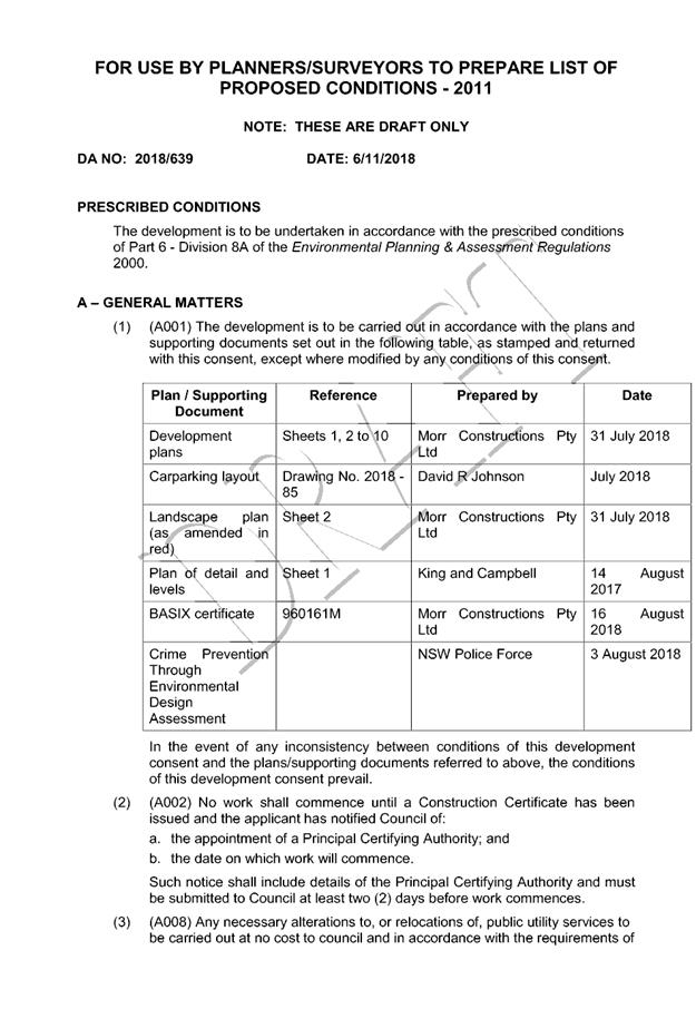
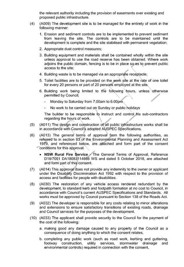
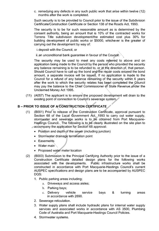
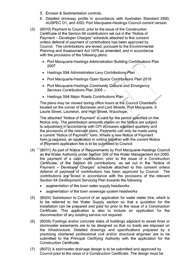
|
ATTACHMENT
|
Development Assessment Panel
14/11/2018
|
|
ATTACHMENT
|
Development Assessment Panel
14/11/2018
|
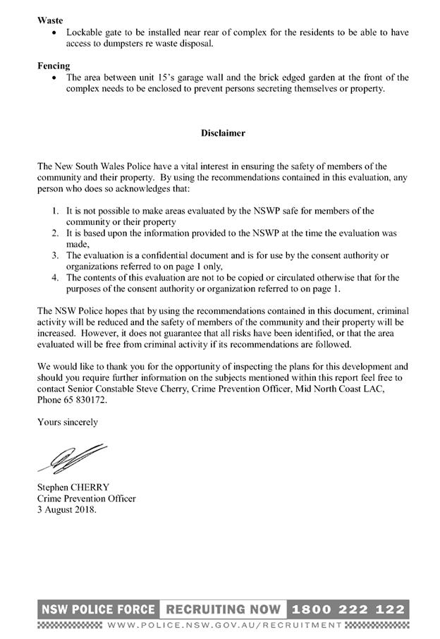
|
ATTACHMENT
|
Development Assessment Panel
14/11/2018
|