AGENDA Development Assessment Panel 28/11/2018
Item: 05
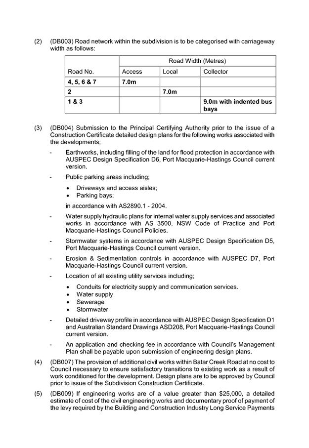
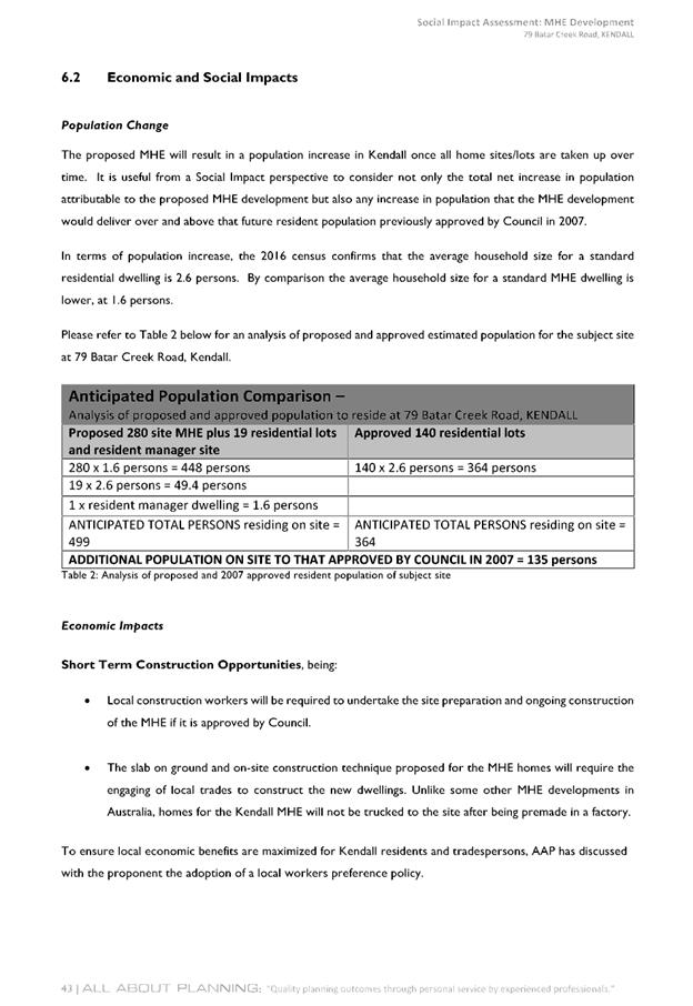
Subject: DA2017 - 736.1- Staged 198 Site Manufactured
Home Estate With Associated Amenities And Infrastructure, And Modification To
Previous Approved Subdivision (DA2006-57) - 79 Batar Creek Road, Kendall
Report
Author: Patrick Galbraith-Robertson
|
Applicant: Land
Dynamics
Owner: M
J & P B Angel
Estimated Cost: $7.075M
Parcel no: 30145,
30146 & 30147
Alignment with Delivery
Program
4.3.1 Undertake transparent
and efficient development assessment in accordance with relevant legislation.
|
|
RECOMMENDATION
That
DA2017 - 736.1 for a two (2) lot subdivision, modification to previous
approved subdivision and a staged 198 site manufactured home estate with
associated amenities and infrastructure at Lot 1 DP 122192, Lot 79 DP 655658,
Lot 23 DP112083 and Lot 1 DP 1142845, Batar Creek Road, Kendall be determined
by granting consent subject to the recommended conditions.
|
Executive
Summary
This
report considers a Development Application for a two (2) lot
subdivision, modification to previous approved subdivision and staged 198 site
manufactured home estate within associated amenities and infrastructure at the subject site. The report provides an assessment of
the application in accordance with the Environmental Planning and Assessment
Act 1979.
Following exhibition of the
application on two (2) occasions, 134 submissions
and a signed petition have been received.
The proposal has been amended
during the assessment, including the following changes:
1. A reduction in the number of MHE sites from
280 to 198 and residential lots from 19 to 12.
2. Increase in the extent of open spaces areas
and landscaping throughout the development site and increase in buffer to the
showground to 20m width and Batar Creek Road in the north-west corner of the
site.
3. Submission of a Design Statement for
regulating the character of future dwellings to be incorporated into the MHE.
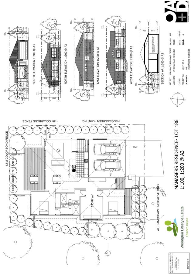
4. Change of location of on-site
manager’s residence to site No.78.
5. The width of the road corridors within the
MHE have been increased.
6. Change in visitor parking spaces within the
MHE to 70 parking spaces including 4 disabled parking spaces.
7. Deletion of the entry gate to the MHE.
8. Addition of Lot 1 DP 1142845 to the
proposal.
1. BACKGROUND
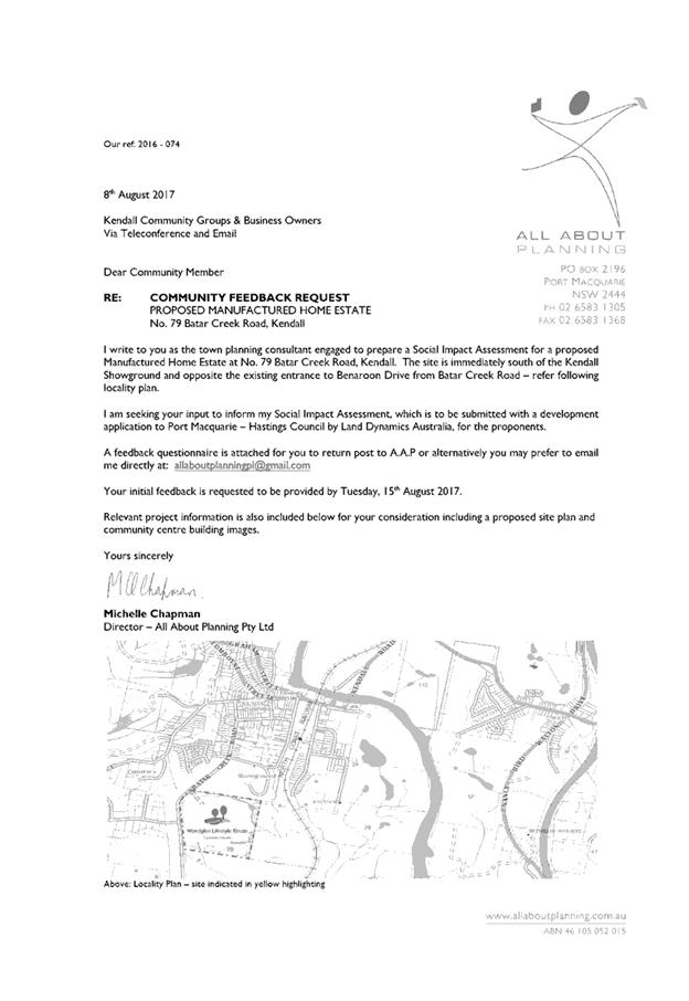
Existing sites features and surrounding development
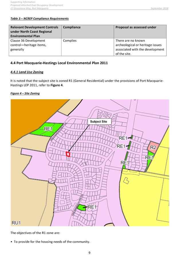
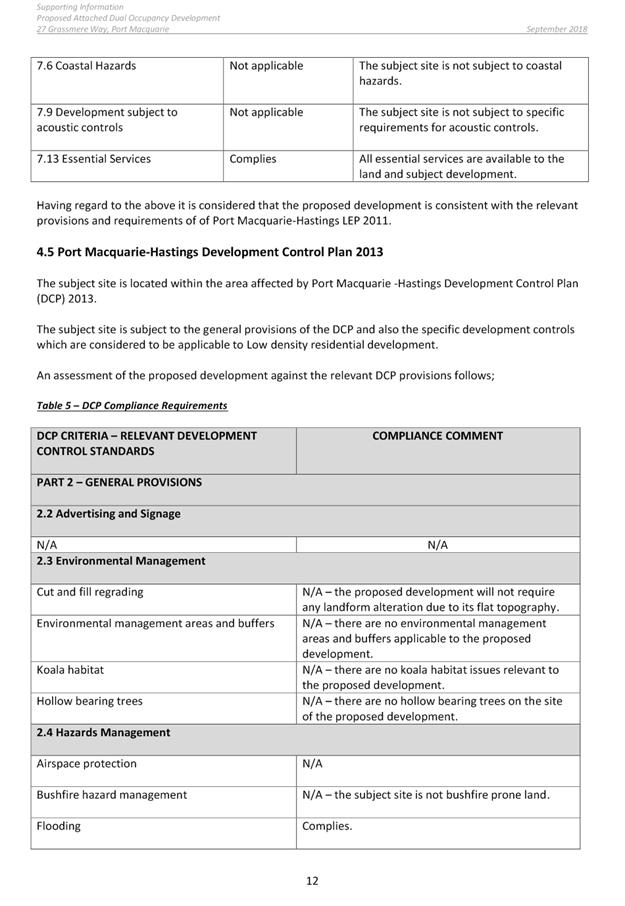
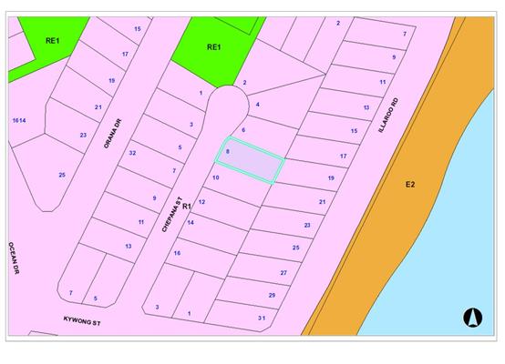
The site is zoned R1 General Residential in accordance with the Port Macquarie-Hastings Local
Environmental Plan 2011, as shown in the following zoning plan:
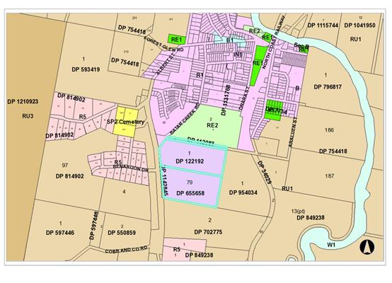
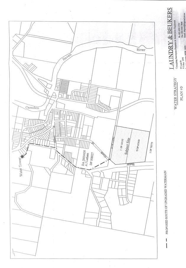
The
subject land is described as Lot 1 DP 122192, Lot 79 DP 655658, Lot 23 DP
112083 and Lot 1 DP 1142845, No. 79 Batar Creek Rd, Kendall. The land occupies
an area of approximately 21.8ha and is mainly cleared.
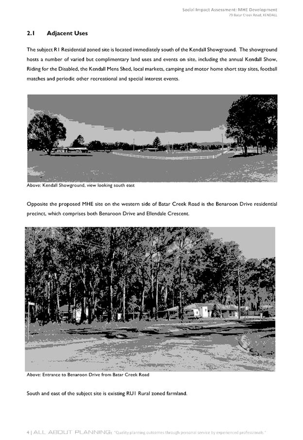
The
site currently contains a dwelling house and associated out buildings on the
two larger parcels, with direct access to Batar Creek Road. A narrow parcel of
land along the northern boundary is also included in the development site. The
site is located on the southern edge of the town of Kendall and immediately to
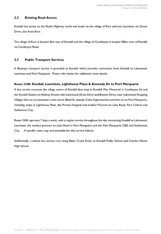
the north is the Kendall Showground. To the west of the site is a large lot
residential area with access via Benaroon Drive. A large farm dam with an
approximate area of 7500m² is in the southeast of the site.
The site has been extensively
cleared in the past and has been used for the grazing of cattle. Small patches
of vegetation have regrown in some areas. Small stands of remnant forest along
the northwest and eastern boundary remain, along with occasional scattered
trees throughout the site.
The site was rezoned from rural
to residential in 2006.
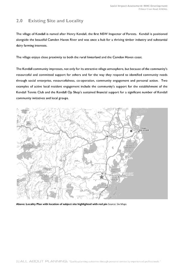
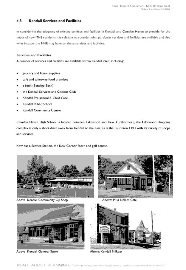
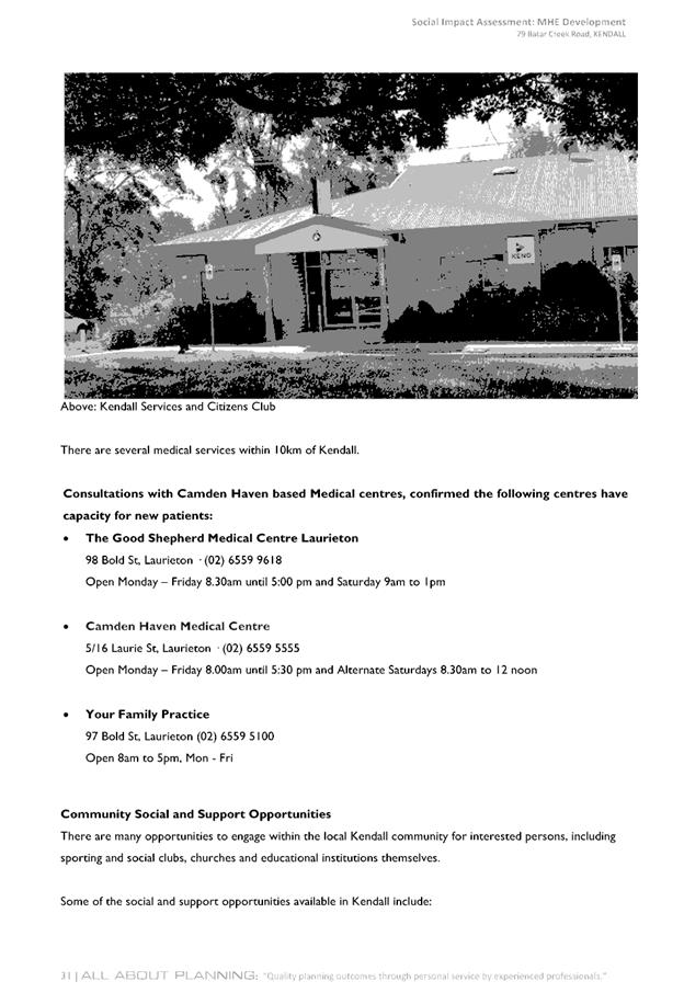
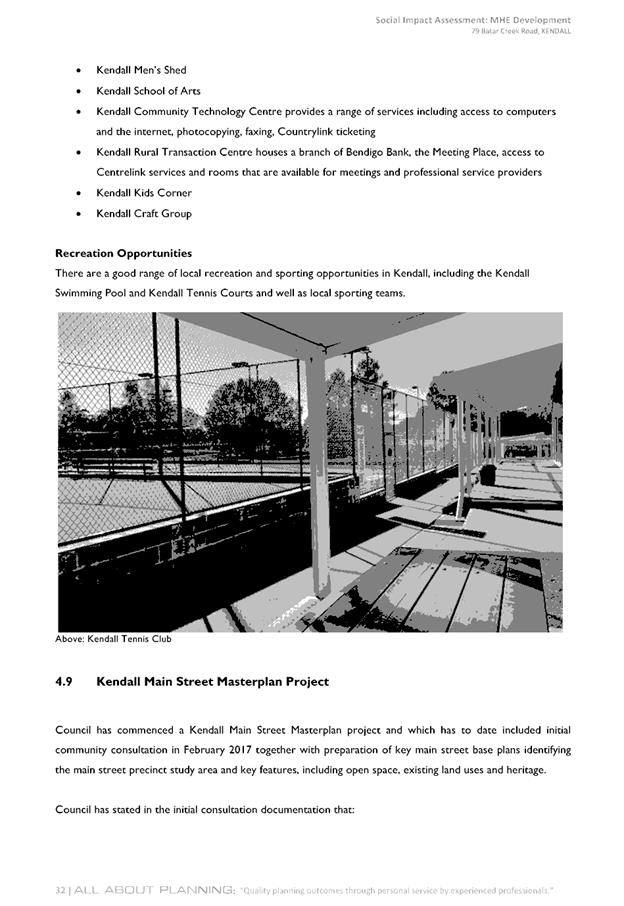
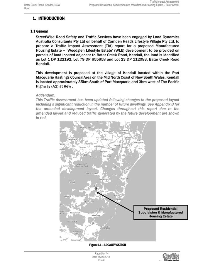
Kendall
is a village located approximately 13km west of the coastal township of
Laurieton and approximately 25km south of Port Macquarie. Kendall and Kew
provide for a range of services and facilities to the residents of both
villages and the surrounding rural locality including a primary school, RSL
Club, Hotel, general store and other convenience stores, service station, show
ground, public swimming pool, tennis courts, showground, golf course and
community hall.
The North Coast Rail Line is to
the east of the subject site. A small ridgeline extends onto the subject site
from the northwest and progresses towards the centre of the site. Generally
flat topography is present in the central portion of the subject site adjacent
to the crest of the ridgeline.
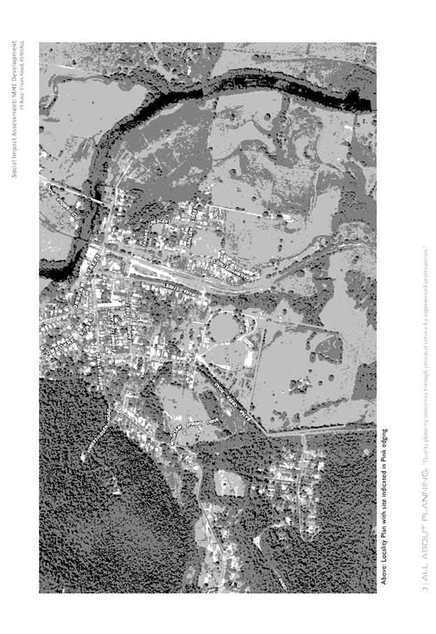
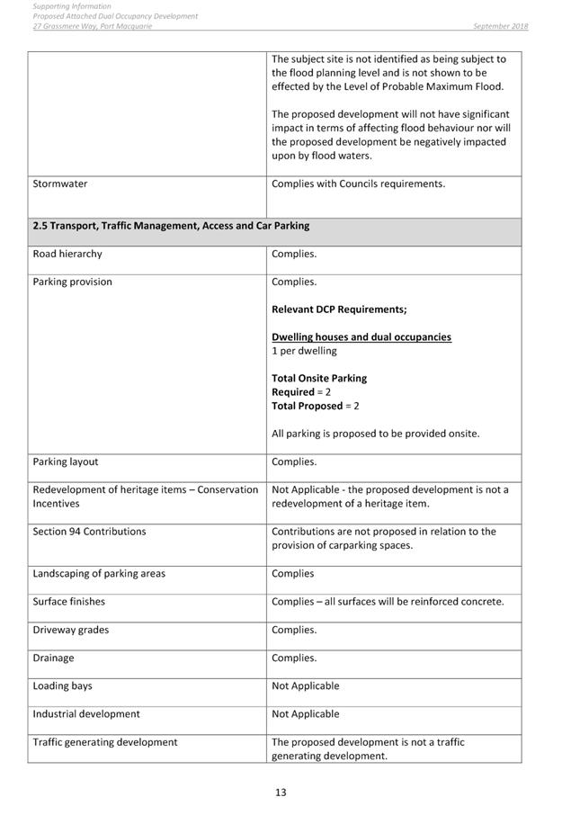
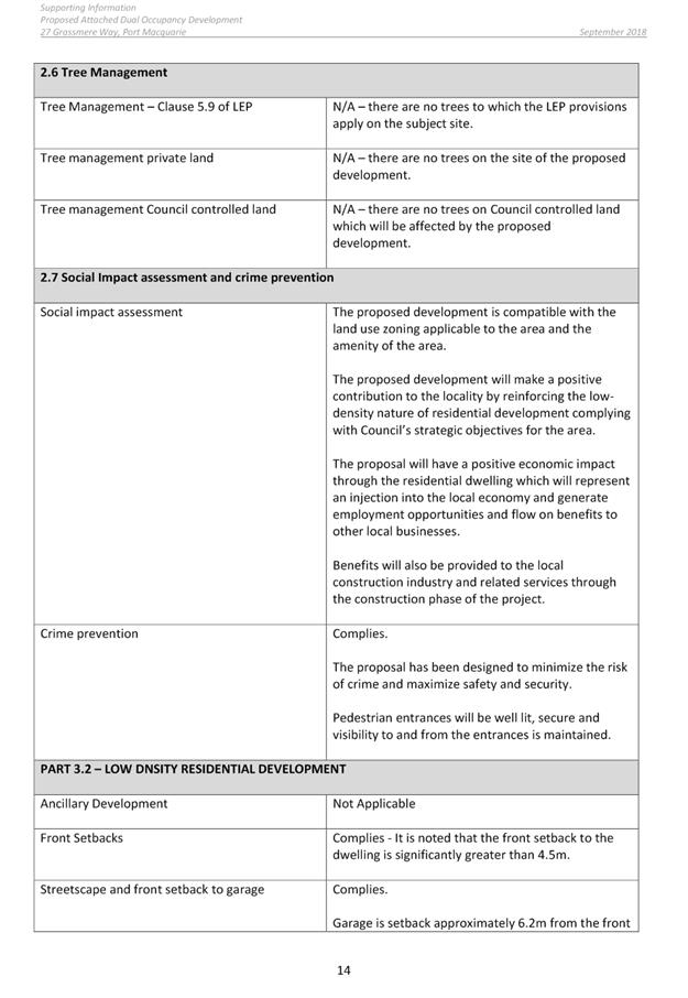
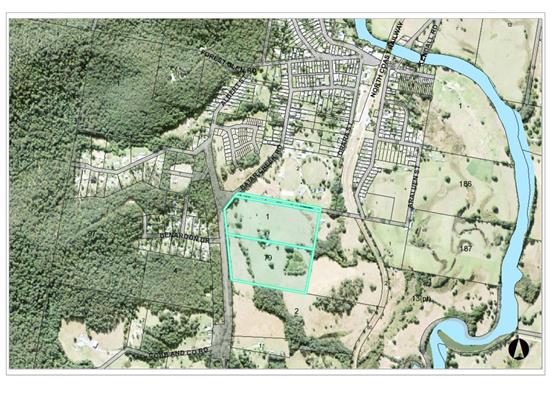
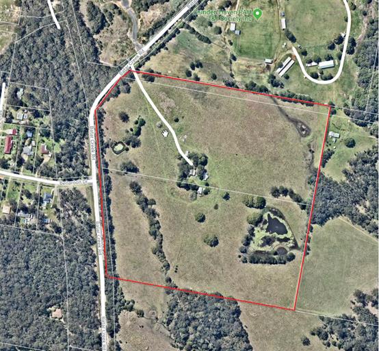
The
existing subdivision pattern and location of existing development within the
locality is shown in the following aerial photographs (2012 and Nearmap July
2018):
2. DESCRIPTION OF
DEVELOPMENT
Key
aspects of the proposal include the following:
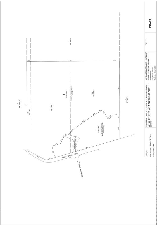
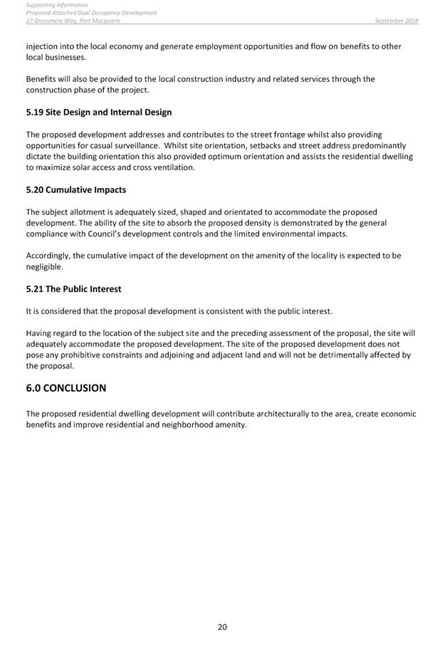
· Consolidation
of the four (4) allotments and re-subdivision into two (2) lots to reflect the
boundary between the subdivision consent in the southern and western sections
of the site and this development is proposed.
· Demolition of all structures and filling of the dam.
· Retention of 12 existing torrens title residential
allotments and partial road design as per DA 2006/57, including access to Batar
Creek Rd via a roundabout and construction of a cycleway to the north of the
site (to occur as per the existing consent DA2006/57).
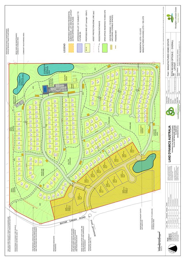
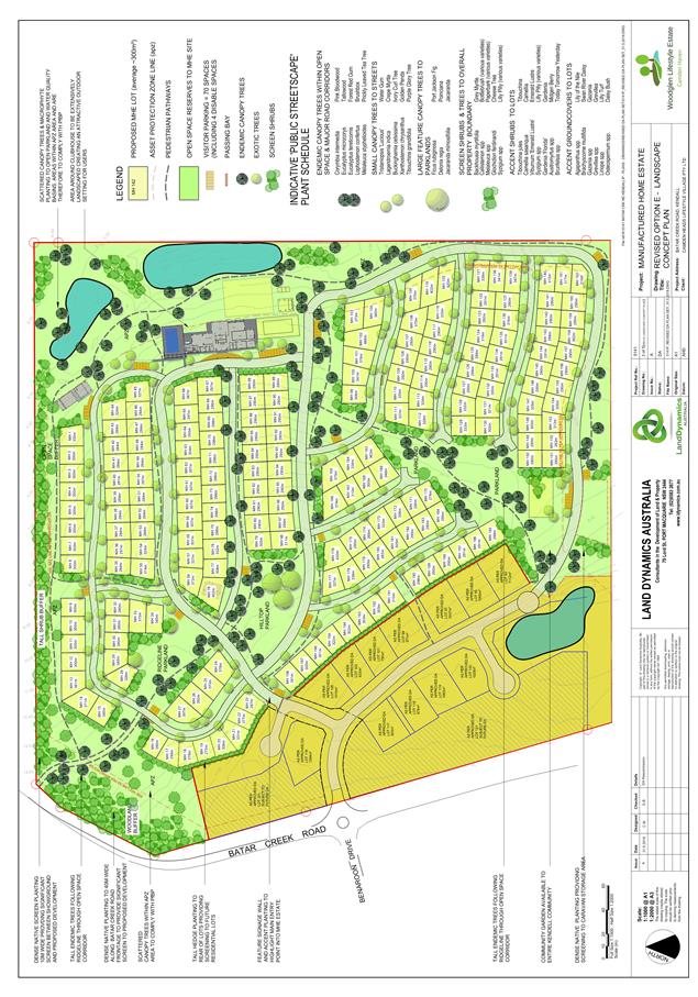
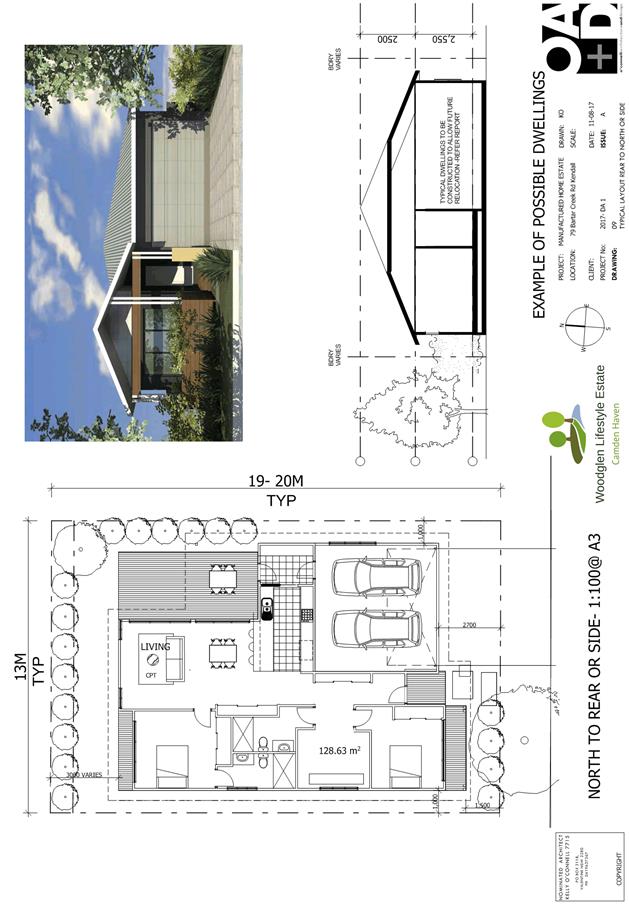
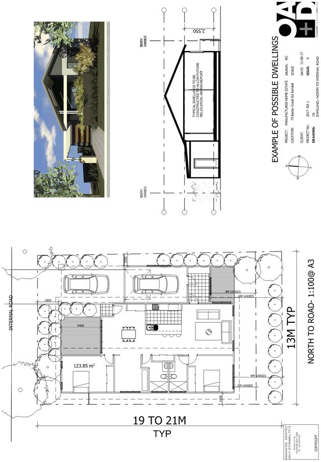
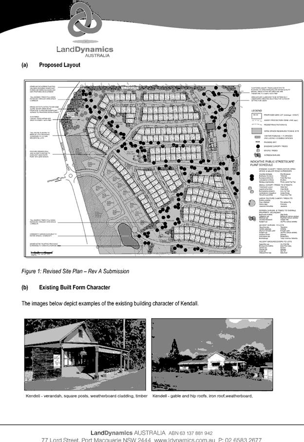
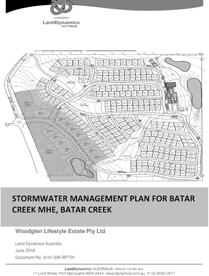
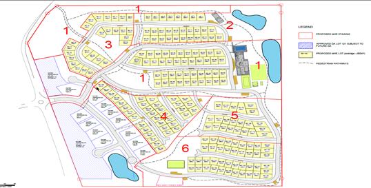
· 198
manufactured housing sites under a private title arrangement, to be
constructed in stages. The proposed residential sites vary in size and range
from 272m² to 466m².
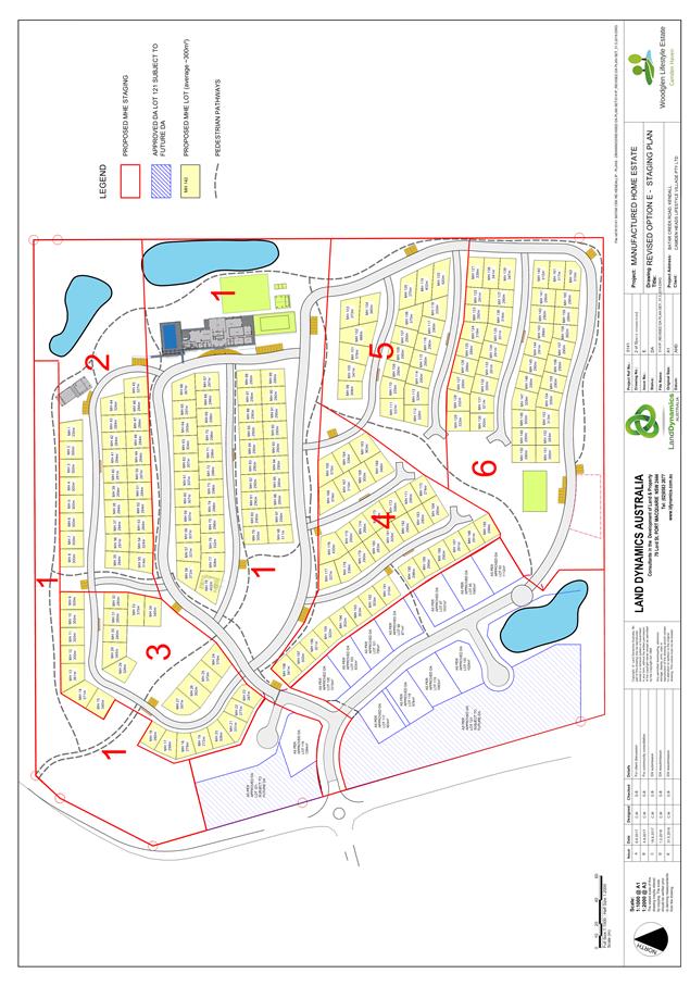
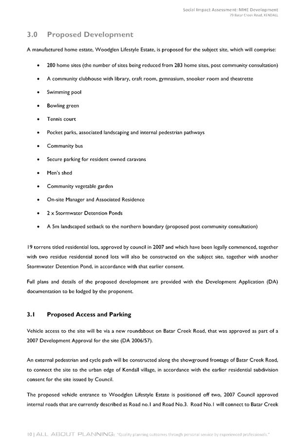
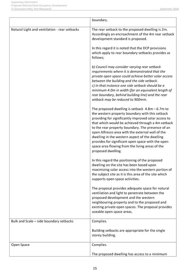
· It
is proposed to undertake the development in a number of stages, as shown in the
Staging Plan below. The vehicular access point will be constructed at Batar
Creek Rd and up to the entrance of the main entrance to the MHE as part of
Stage 1. This construction will occur as part of the current approval under
DA2006/57 and appropriate rights of carriageway in favour of the MHE will be
created.
· The
Clubhouse is included in Stage 1 so that residents in Stage 1 have access to
community facilities from the beginning of the development. The remaining
community facilities will be provided at varying stages depending on their
location within the site.
· On-site
manager’s residence will be located on site No. 78.
· Road
network within the MHE connecting into the approved road design and access from
Batar Creek Road. The roads within the MHE are in private ownership with access
over the private roads.
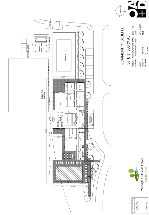
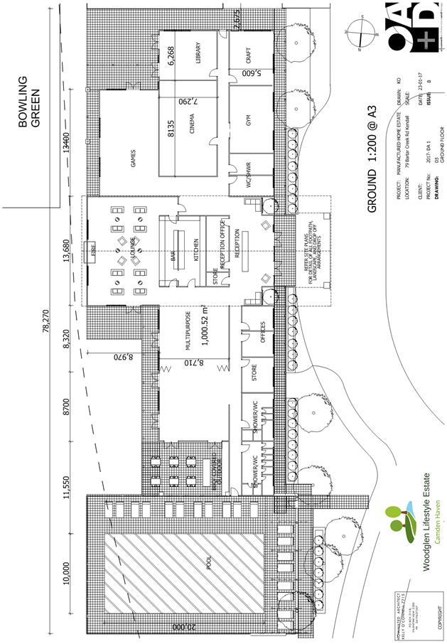
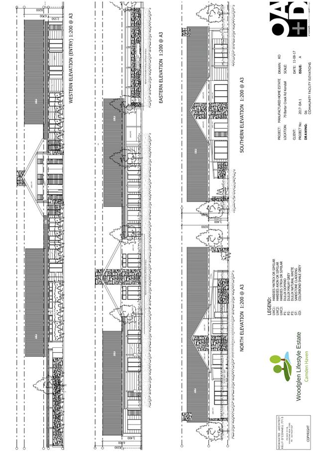
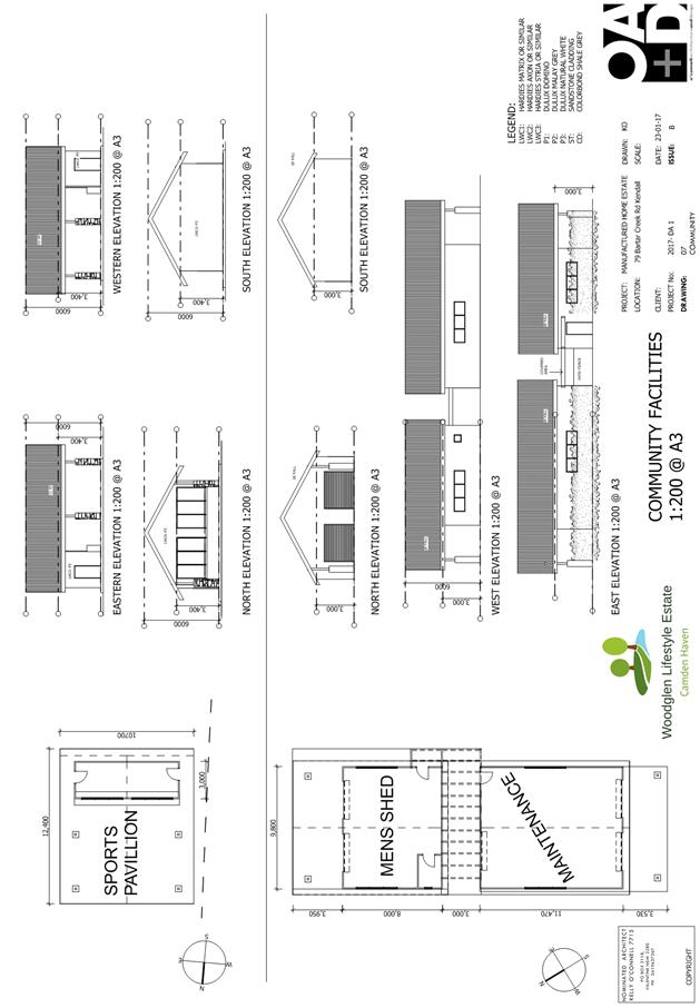
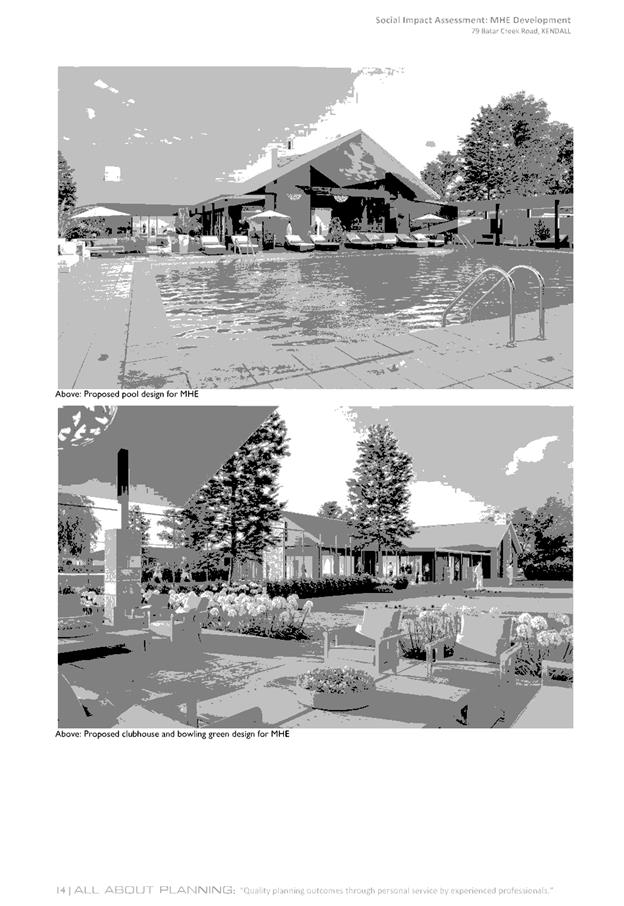
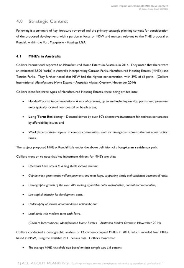
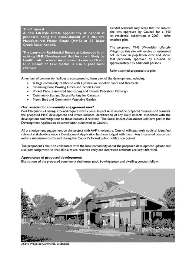
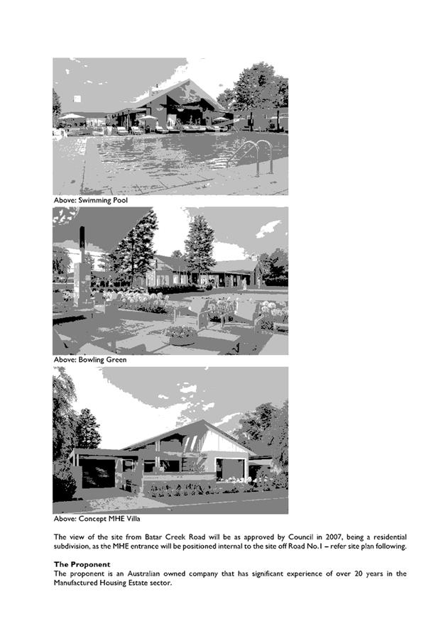
· Facilities for the residents of the MHE including a
Clubhouse (dining and bar area, lounge area, cinema, craft, gym, library, games
area, administration, kitchen and toilets), swimming pool, bowling green,
tennis court, community vegetable garden, men’s shed, maintenance shed
and caravan storage area.
· A
series of internal private parks and landscaping links with pathways throughout
the development and an external link to the north-west of the site which leads
into Kendall, as well as a number of smaller links to the subdivision to the
south-west approved by DA2006/57.
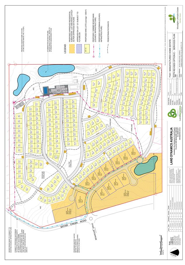
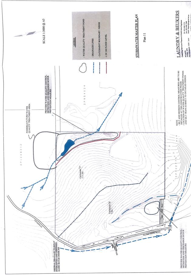
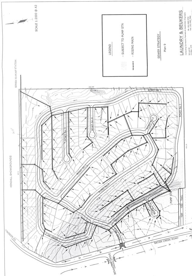
· Bio-detention ponds for drainage and water quality within
the eastern landscaped areas (consistent with DA2006/57).
· Provision of services and utilities to the site.
· Provision of Asset Protection Zones.
· Removal of vegetation along the eastern boundary and
replacement planting in the large area of open space in the north-east corner.
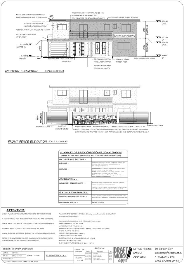
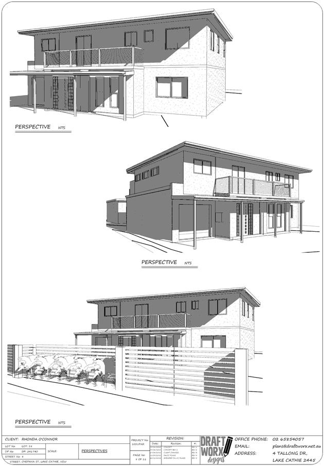
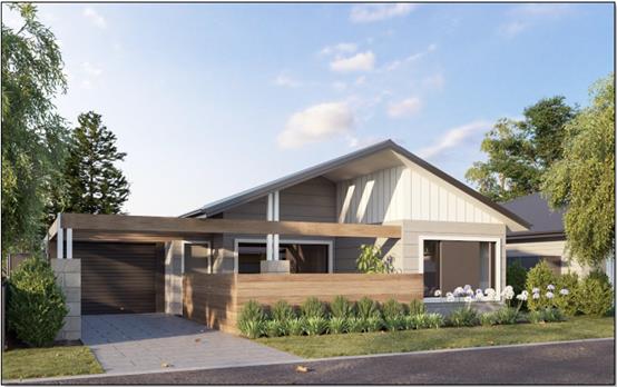
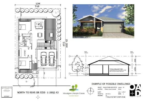
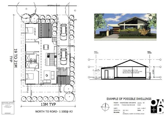
· Consent is being sought for the MHE sites, with a range of
dwelling types that would fit the sites, with examples shown in the supporting
documentation and a Design Statement provided for the future dwellings. Separate
approval under S.68 would then be sought for the dwellings and tenure is secure
under the Residential (Land Lease) Communities Act 2013 No 97.
· 70 visitor car
parking spaces (including 4 disabled spaces) are proposed throughout the
development and at the entry to the site adjacent to the security entrance.
· A 20m wide landscaped strip to the showground to the north
with a 1.8m high wire security fence to the boundary and timber fencing to the
dwelling sites.
· Timber fencing to the southern and western boundaries of
the MHE, adjacent to the approved residential lots.
· An objection under s.82 of the Local Government Act is also
sought as part of this application, to allow the dwellings to be built on site.
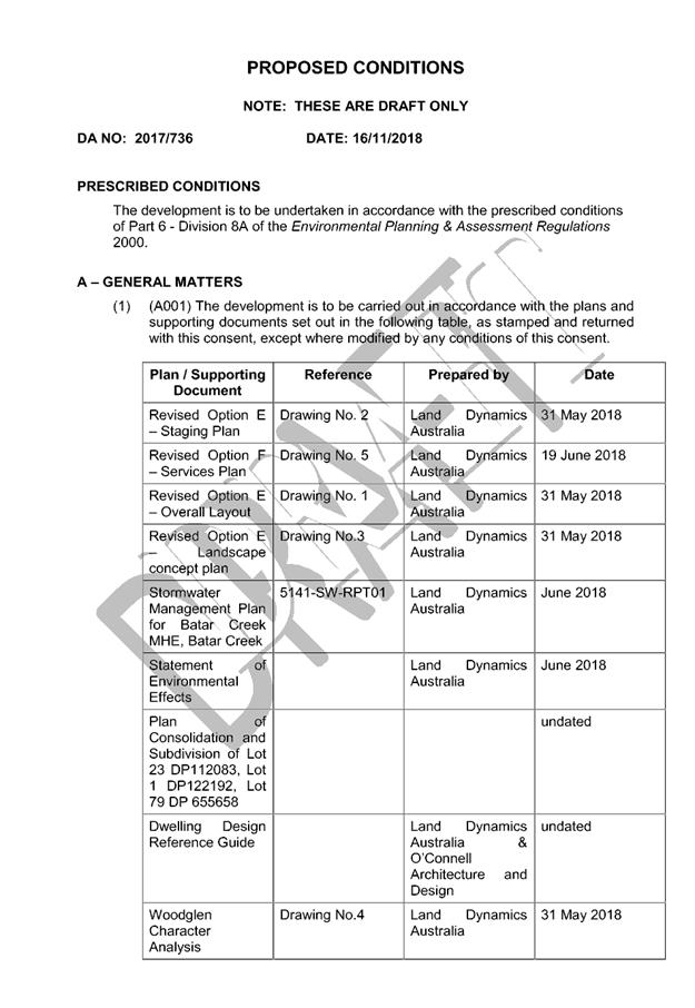
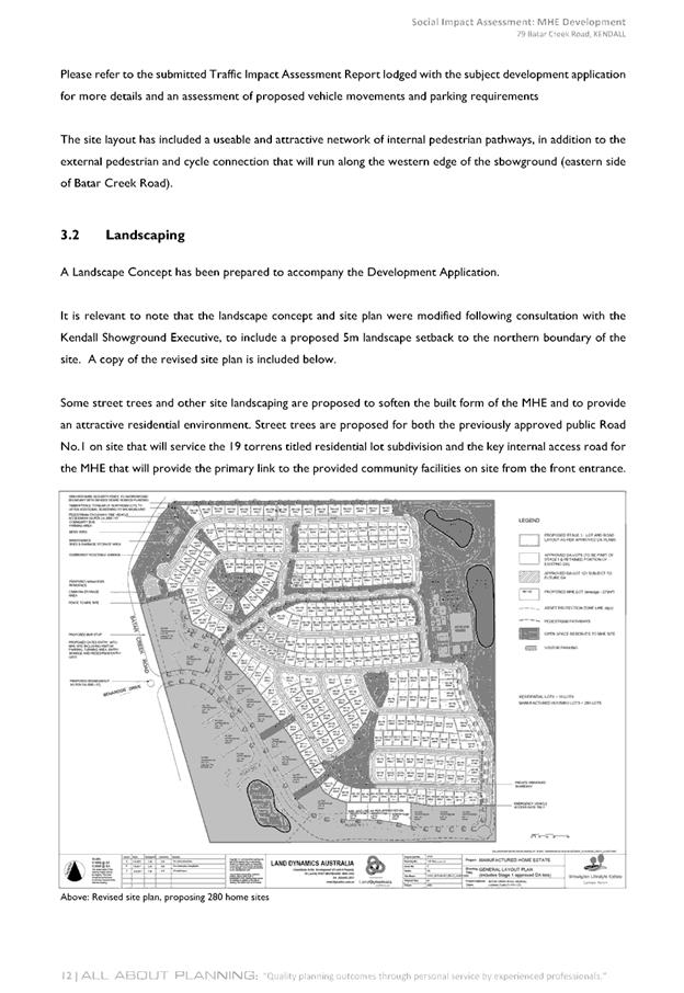
Select extracts of images from
the details submitted are shown below:
Staging
proposed
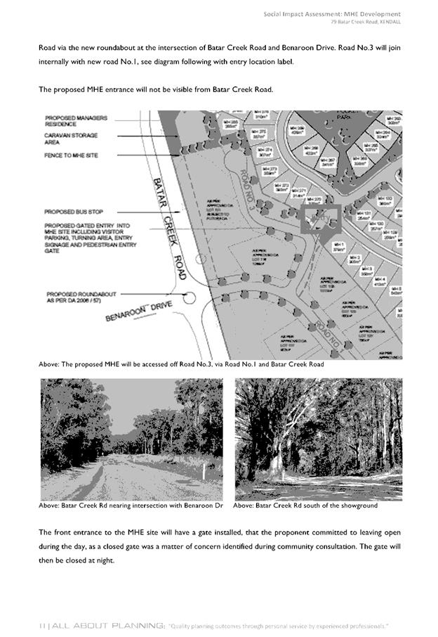
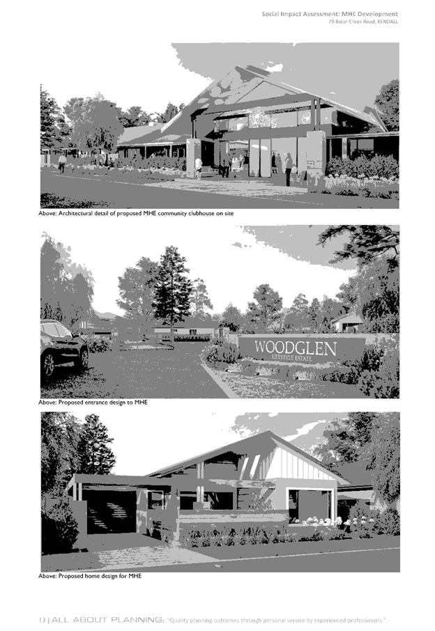
Example of manufactured
home
Example of manufactured
home
Example of manufactured
home
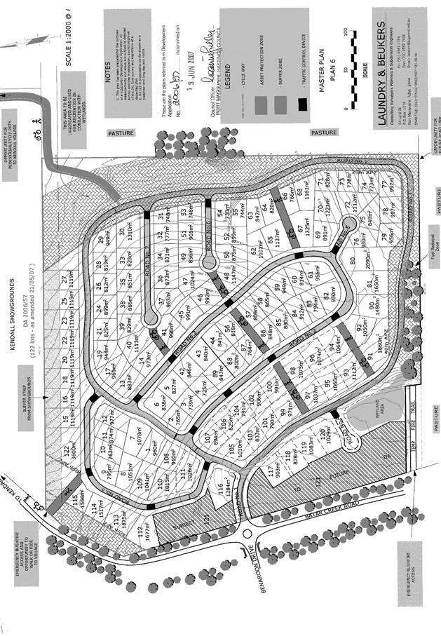
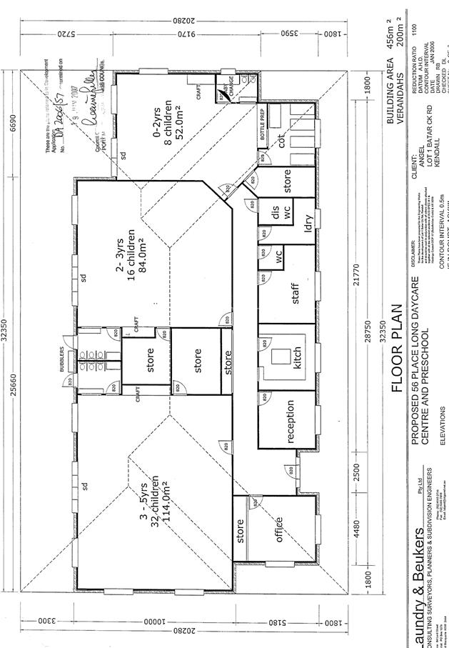
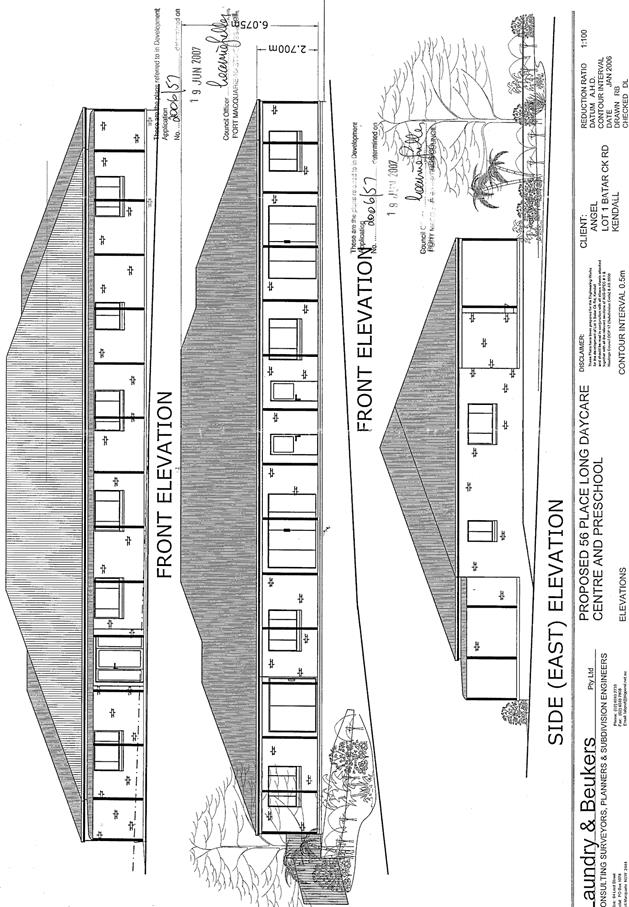
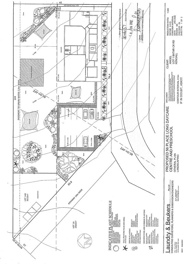
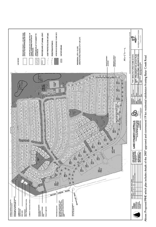
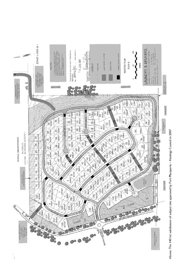
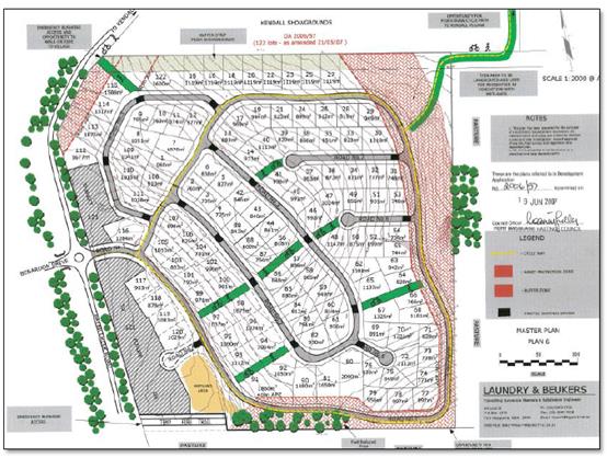
DA 2006 – 57
approved layout
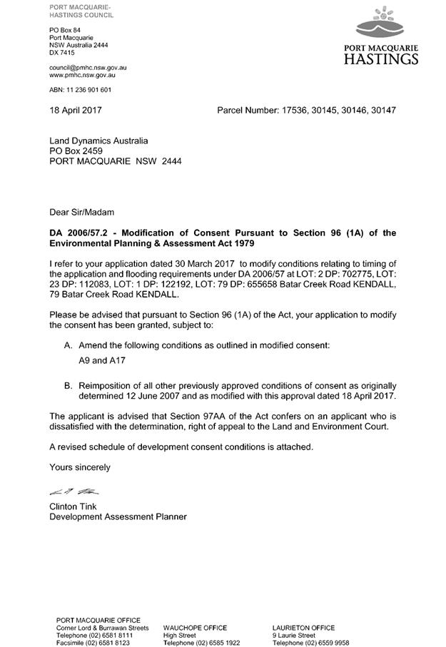
Council confirmed by letter
dated 9 December 2010 that works had physically commenced and as such the
consent has not lapsed. The consent was modified by Council on 18 April 2017 to
rectify errors and remove the restriction on the timeframe for completion of
the development.
DA2006/57 was approved on the
site for a residential subdivision and child care centre. The general concept
has been based on this approved layout, in particular having regard to the
vehicular entry point and perimeter road layout, landscaped drainage area along
the eastern boundary and pedestrian linkages to the north. This approval can be
undertaken in stages, which Council requires to be confirmed prior to the
Construction Certificate.
It is not proposed that the MHE
would occupy the entire site and as such, the traditional subdivision has been
maintained on the south-west portion of the site, in accordance with DA2006/57.
The intersection, including an approved round-about at Batar Creek Rd is being
constructed as part of DA2006/57. A cycleway along Batar Creek Rd to the northern
edge of the showground will also be constructed as part of that consent.
Refer
to attachments at the end of this report.
Application Chronology
· 22
August 2017 – DA lodged with Council.
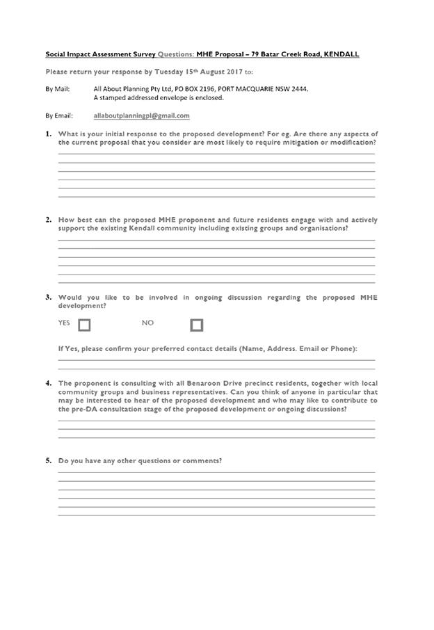
· 29 August 2017 – Additional fees and Social Impact
Assessment requested.
· 5 September 2017 – Referral to NSW Rural Fire
Service.
· 7 September 2017 – Social Impact Assessment received
and showground interface plan.
· 14 September to 13 October 2017 – Neighbour
notification and advertising of original proposal.
· 17 October 2017 – Bushfire Safety Authority from the
NSW Rural Fire Service received.
· 18 October 2017 – Applicant advised that a lot of
public interest in application following exhibition.
· 2 November 2017 – Additional information request
– issues raised: submission issues, sewer, access, transport, traffic,
water supply, stormwater, flooding, relationship to previous DA2006 –
57.2 and proximity to showground.
· 23 November 2017 – Meeting with Applicant to discuss
assessment issues.
· 23 November 2017 – Referral to the NSW Roads and
Maritime Services.
· 28 November 2017 – Applicant submitted detailed sewer
loading calculations.
· 11 December 2017 – Referral sent to the NSW Rail
Authority.
· 12 December 2017 – Additional assessment concerns
raised with regards to traffic impacts.
· 19 December 2017 – Advice received from the NSW Roads
and Maritime Services.
· 12 February 2018 – Meeting with Applicant to discuss
assessment issues.
· 16 March 2018 - Meeting with Applicant to discuss
assessment issues.
· 22 March 2018 – Applicant requested advice on how
other MHE developments have been assessed with regards to traffic.
· 28 March 2018 – Applicant provided with neighbour
contact details to explore sewer main alternative alignments.
· 4 April 2018 – Advice provided to Applicant on how
other developments assessed from a traffic impact perspective.
· 10 April 2018 – Advice provided to Applicant that
on-site sewage option for managing sewerage is not able to be considered.
· 4 May 2018 - Meeting with Applicant to discuss assessment
issues.
· 15 May 2018 – Applicant advised that community
meeting planned for 17 May 2018 at Kendall Services Club.
· 1 June 2018 – Advice provided to Applicant from
Council Sewer section.
· 25 June 2018 – Amended proposal and additional information
submitted by Applicant.
· 26 June 2018 – Amended proposal referred back to the
NSW Rural Fire Service.
· 29 June 2018 – Further details on sewerage management
proposal queried.
· 29 June 2018 – Additional sewer details received from
Applicant.
· 4 July 2018 to 30 July 2018 – Amended proposal
notified and public exhibited.
· 27 July 2018 – Extension of exhibition period until
13 August 2018.
· 31 July 2018 – Amended Bushfire Safety Authority
received from the NSW Rural Fire Service.
· 20 August 2018 – Submission issues forwarded to
Applicant for consideration.
· 21 August 2018 – Applicant advised liaising with
showground representatives.
· 22 August 2018 – Meeting with showground
representative regarding new sewer alignment.
· 22 August 2018 – Sewer section advice provided to
Applicant.
· 28 August 2018 – Advice provided to showground with
regards to optional sewerage alignment.
· 7 September 2018 – Alternative sewer upgrade line
proposed not relying on showground access.
· 12 September 2018 – Advice provided to the Applicant
on the alternate sewer alignment.
· 20 September 2018 - Applicant confirmed latest sewer
alignment, updated services plan and provided a response to the submission
issues raised with the amended proposal.
· 2 October 2018 – Further information submitted
regarding stormwater and flooding assessment issues.
· 20 November 2018 – Discussed draft consent conditions
with Applicant and owner’s consent received for Lot 1 DP 1142845.
3. STATUTORY ASSESSMENT
Section
79C(1) Matters for Consideration (as in force at the time of the lodgement of
the DA)
In
determining the application, Council is required to take into consideration the
following matters as are relevant to the development that apply to the land to
which the development application relates:
(a) The
provisions (where applicable) of:
(i) Any
Environmental Planning Instrument:
State
Environmental Planning Policy No. 21 - Caravan Parks
The
proposal is not for a caravan park under this SEPP. The proposal is for a
manufactured home estate with the following SEPP 36 being applicable to
consider.
State
Environmental Planning Policy No. 36 - Manufactured Home Estates
The aims of this policy and comments are provided below:
a) to
facilitate the establishment of manufactured home estates as a contemporary
form of medium density residential development that provides an alternative to
traditional housing arrangements, and
Comment(s): Manufactured Home Estates are considered a
contemporary form of medium density housing. The proposed development will
provide an alternative to traditional housing.
(b) to
provide immediate development opportunities for manufactured home estates on
the commencement of this Policy, and
Comments: This policy was gazetted and commenced on 16 July
1993.
(c) to
encourage the provision of affordable housing in well designed estates, and
Comment(s): The proposal will provide a form of alternative
residential housing in a specifically designed estate. Adequate provision has
been made for on-site facilities, services and open space above minimum
standards of the Local Government (Manufactured Home Estates, Caravan Parks,
Camping Grounds and Moveable Dwellings) Regulation 2005.
(d) to
ensure that manufactured home estates are situated only in suitable locations
and not on land having important resources or having landscape, scenic or
ecological qualities that should be preserved, and
Comment(s): Assessment of the proposal (as amended) having
regard to landscape, scenic and in particular ecological qualities have
concluded the site suitable for the proposed development.
(e) to
ensure that manufactured home estates are adequately serviced and have access
to essential community facilities and services; and
Comment(s): The proposed development will be capable of
being serviced by adequate infrastructure including reticulated water and sewer
facilities. The proposal will provide a number of community facilities within
the estate and access to social and health services will be available by a
private bus service.
(f) to
protect the environment surrounding manufactured home estates, and
Comment(s): Measures have been incorporated into the design
of the estate to provide adequate protection to the environment within and
surrounding the proposed estate. Buffers to Batar Creek Road and the adjoining
Showground and additional landscaped open space has been added to the proposal
during the assessment of the DA.
(g) to
provide measures which will facilitate security of tenure for residents of
manufactured home estates.
Comment(s): Tenure is largely secured through the large
upfront capital required to establish supporting infrastructure. Conditions of
consent have been recommended to require community and recreational facilities
to be provided up front and before occupation of any sites particularly noting
the Staging of the proposal. Tenancy agreements are the other means for tenure
security for future residents.
The
proposed development is considered consistent with the aims of this policy.
Clause
6 - Where development for the purposes of a manufactured home estate may be
carried out
Clause
6 of this policy provides where development for the purposes of a manufactured
home estate maybe carried out.
The
proposed development is permissible with the consent of Council pursuant to
clause 6. In particular, the subject clause allows a manufactured home estate
on land where a ‘caravan park’ is permissible. The R1 residential
zoning of the subject land permits ‘caravan parks’ with development
consent. In addition, the proposed development is not subject to any of the
excluded areas contained in Schedule 2 of the SEPP.
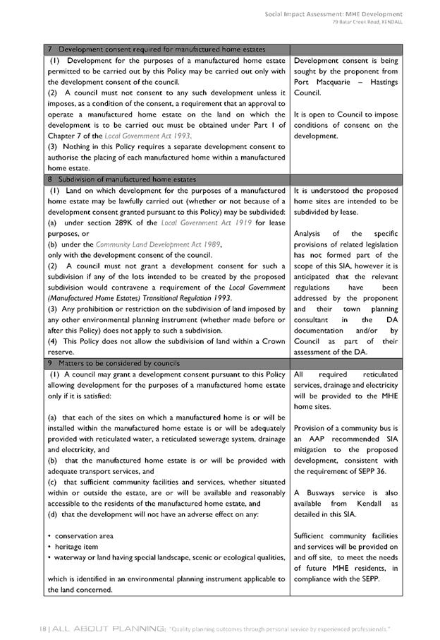
Clause
7 - Development consent required for manufactured home estates
Clause
7(1) provides that development for the purposes of a manufactured home estate
permitted to be carried out by this Policy may be carried out only with the
development consent of the Council.
Comment(s):
Noted. This Development Application is seeking development consent.
Clause
7(2) provides that a Council must not consent to any such development unless it
imposes, as a condition of the consent, a requirement that an approval to
operate a manufactured home estate on the land on which the development is to
be carried out must be obtained under Part 1 of Chapter 7 of the Local Government
Act 1993.
Comment(s): Noted. A suitable condition is recommended in
this regard.
Clause
7(3) provides that nothing in this Policy requires a separate development
consent to authorise the placing of each manufactured home within a
manufactured home estate.
Comment(s):
Noted. The installation or construction of a dwellings on individual
manufactured home sites will not require separate development consent.
Clause
8 - Subdivision of manufactured home estates
(1) Land on which
development for the purposes of a manufactured home estate may be lawfully
carried out (whether or not because of a development consent granted pursuant
to this Policy) may be subdivided:
(a) under section 289K of the Local Government Act
1919 for lease purposes, or
(b) under the Community Land Development Act 1989,
only with the development consent of the council.
(2) A Council must not
grant a development consent for such a subdivision if any of the lots intended
to be created by the proposed subdivision would contravene a requirement of the
Local Government (Manufactured Home Estates) Transitional Regulation 1993.
(3) Any prohibition or
restriction on the subdivision of land imposed by any other environmental
planning instrument (whether made before or after this Policy) does not apply
to such a subdivision.
(4)
This Policy does not allow the subdivision of land within a Crown
reserve.
Comment(s):
No subdivision of the MHE for lease or community title purposes is proposed
with the subject development application.
Clause 9 - Matters to be considered by Councils
Clause 9(1) provides that Council may grant development
consent for the purposes of a manufactured home estate only if it satisfied:
(a) That each of the sites on which a
manufactured home is or will be installed within the manufactured home is or
will be installed within the manufactured home estate is or will be adequately
provided with reticulated water, a reticulated sewerage system, drainage and
electricity, and
Comment(s):
Each of the proposed sites within the proposed estate are capable of being
serviced by reticulated water, reticulated sewer, drainage and electricity
services. Appropriate conditions are recommended in this regard.
(b) that the manufactured home estate
is or will be provided with adequate transport services, and
Comments(s):
The road network provided to and within the estate is considered appropriate
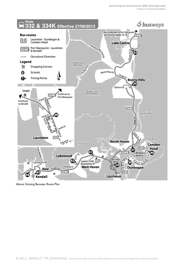
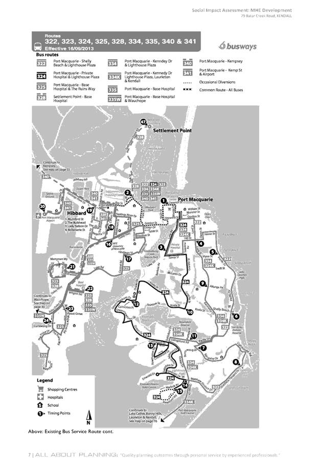
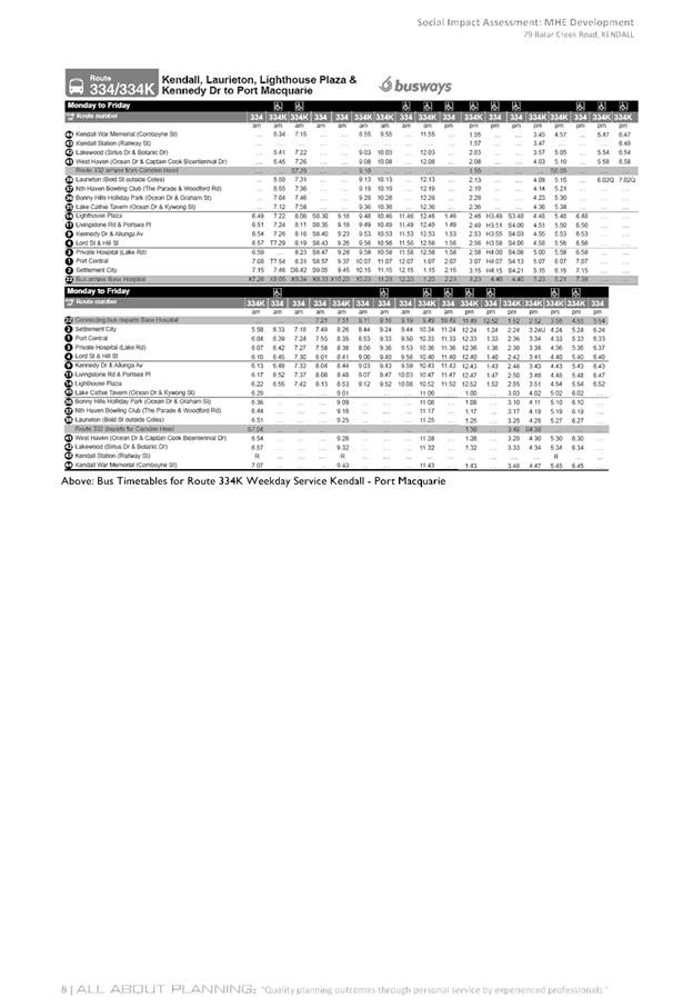
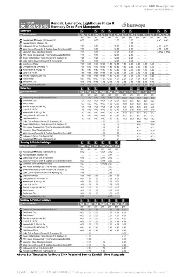
for the proposed development. A private daily bus service is proposed to
provide residents who can’t drive a motor vehicle with access to wider
services and destinations as an alternate mode of transport. A Community Bus
Time Table is to be developed and distributed to residents.
(c) that
sufficient community facilities and services, whether situated within or
outside the estate, are or will be available and reasonably accessible to the
residents of the manufactured home estate, and
Comment(s):
A range of community facilities are proposed within
the estate, which will be directly available and accessible to the residents
within the estate. The community facilities proposed include a clubhouse,
swimming pool, bowling green, tennis court, men’s shed and community
gardens. In providing a private bus service residents within the estate will
also have access to other facilities and services outside the estate and
surrounds.
(d) that the
development will not have an adverse effect on any:
• conservation
area
• heritage item
• waterway or
land having special landscape, scenic or ecological qualities,
which is identified in an
environmental planning instrument applicable to the land concerned.
Comment(s):
The proposed development will not have any identifiable adverse impacts on any
of the above. The previous subdivision approval of the site is also noted.
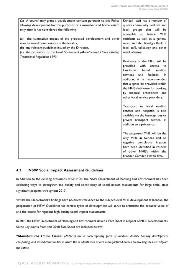
Clause
9(2) provides that Council may grant development consent for the purposes of a
manufactured home estate only after it has considered the following:
(a) the cumulative impact of the
proposed development and other manufactured home estates in the locality,
Comments:
An assessment of the proposed development, supporting documentation and
legislative provisions suggests that there will be no adverse cumulative impact
on the locality or other manufactured home estates in the area to warrant
recommending refusing consent to the DA.
(b) any relevant guidelines issued by
the Director,
Comment(s): No relevant guidelines identified.
(c) the provisions of the Local
Government (Manufactured Home Estates) Transitional Regulation 1993.
Comment(s): The above Regulation has since been repealed.
The Local Government (Manufactured Home Estates, Caravan Parks, Camping Grounds
and Moveable Dwellings) Regulation 2005 is the current Regulation
applicable. A detailed checklist of compliance with the Local Government
(Manufactured Home Estates, Caravan Parks, Camping Grounds and Moveable
Dwellings) Regulation 2005 is provided below:
Local
Government (Manufactured Home Estates, Caravan Parks, Camping Grounds and
Moveable Dwellings) Regulation 2005.
It is
noted the Development Application was accompanied by a section 82(1) objection
under the Local Government Act 1993. Specifically seeking an exemption to
clause 41 of this regulation which requires manufactured homes to be
constructed and assembled onsite. This is noted however it is considered that
this is not a matter for consideration under the Development Application
process.
The
relevant parts of the regulation are addressed below in the following table:
|
CLAUSE
|
REQUIREMENT
(in summary)
|
COMMENT/COMPLIANCE
|
|
Division 1 Application of
Part
|
|
Clause
1-4
|
No
specific requirements only information on the legislation in terms of
operation, definitions etc
|
Noted
|
|
5
Application of Part
|
This
part applies to both the operation of the manufactured home estate and the
installation of the home itself.
|
Noted
|
|
Division 2 Approvals and
exemptions
|
|
6
Factors for consideration before approval is granted
|
(1) Council must be satisfied that the estate will be designed
in accordance with Division 3; and
(2) Council must have regard to the Floodplain
Development Manual.
|
(1) The
proposed development has been designed in accordance with Division 3, refer
to comments in Division 3;
(2)
Consultation has been undertaken with Council’s Flooding Engineer as
part of the site is mapped as flood prone land. Fill is proposed in low lying
section to meet required flood planning levels. Council’s Flooding
Engineer has given consideration to the proposal with regard to the Floodplain
Development Manual and provided recommended conditions to be applied to any
consent issued.
|
|
7
Matters to be specified in approval
|
Any
approval must specify the number, size and location of the dwelling sites.
|
N/A only
relevant to approval to operate.
|
|
8
Conditions of approval
|
The
approval must be conditioned to ensure the design, construction, maintenance
and operation of the estate is in accordance with Division 3.
|
N/A only
relevant to approval to operate.
|
|
9
Conditional exemption
|
(1) Council approval is not
required for:
(a) the installation of a home within the
estate, so long as it is designed, constructed and installed in accordance
with Division 4 and is only occupied after certificate of completion is
issued; or
(b) the associated structure is designed,
constructed and installed in accordance with Division 4.
(2) This exemption applies only of the installation is
carried out by the operator of the estate.
(3) This exemption does not apply to the installation of
a home on flood liable land.
(4) This exemption does not apply for homes or associated
structures of more than one storey.
|
N/A only
relevant to approval to operate.
|
|
10
Installation on flood liable land
|
(1) Council must have regard to the Floodplain
Development Manual.
(2) The home must be designed, constructed and installed
in accordance with Division 4.
|
(1) As
detailed above part of the site is mapped as flood prone land. However fill
is proposed to meet the necessary flood planning levels.
(2)
Noted.
|
|
11
Installation of manufactured home or associated structure of more than one
storey
|
Council
assessment must have regard to the amenity of the adjoining occupiers.
|
N/A only
relevant to approval to operate/install. The plans provided indicate the
dwellings will be of single storey construction.
|
|
Division
3 Manufactured home estates
|
|
12
Minimum size of estate
|
Estate
must have an area of not less than 1 hectare.
|
Complies
– total proposed manufactured home estate area is approximately 20
hectares.
|
|
13
Community amenities
|
(1) 10% of total area of estate must be reserved for
recreation or other communal activities.
(2) If lesser proportion, Council must have regard to the
type and range of amenities proposed.
|
Approximately
43% of the site is available for recreational or communal activities which is
in excess of the 10% minimum standard.
|
|
14 Size
of dwelling sites
|
A
dwelling site must have an area of at least 130m².
|
Complies
– All proposed site have areas exceeding 130m². Minimum site area
is 272m2 to 466m2.
|
|
15 Site identification
|
(1) Dwelling site to be numbered with clearly identified
boundaries.
(2) Site identification must be conspicuous.
|
Complies
– Each of the dwelling sites will be clearly numbered.
|
|
16
Dwelling sites to have road frontage
|
A
dwelling site must have vehicular access to a road.
|
Complies
– all proposed dwelling sites have frontage to a road
|
|
17
Setbacks of community
buildings
|
(1) Not to be located closer than 10m to boundary of
estate and dwelling sites.
(2) Any lesser distance to satisfy Council that building
has been properly screened, fenced, enclosed or otherwise treated.
(3) Must not in any case be closer than 2m to any
boundary.
|
The
community facility buildings are to be setback greater than 10m from
boundaries of the site.
|
|
18
Setbacks of dwelling sites from road frontages
|
(1) No closer than 10m to a public road or 3m to any
other boundary unless approved.
(2) Any lesser distance to satisfy Council
that the dwelling site has been properly screened, fenced, enclosed or
otherwise treated.
|
All
dwelling sites are located greater than 10m from a public road and 3m from
any other property boundary.
|
|
19 Use
of buffer zones
|
Buffer
zones can be used for:
(a) community amenities, access roads, car parking,
footpaths or landscaping, or
(b) or any similar purpose.
|
Complies.
|
|
20
Entrance and exit roads
|
(1) Entrance to or exit from estate must be 8m wide.
(2) Divided roads to have at least 5m on either side.
(3) Tapers between entrance and access roads to be in the
approval.
|
Complies.
The entrance and exit roads meet the requirements.
|
|
21 Width
of roads
|
(1) Road reserve to be:
(a) 8.5m for major access road, and
(b) 6m for minor access road.
(2) Sealed portion of access road must be:
(a) 6m for major roads, and
(b) 4m for minor roads.
(3) Passing bays required for minor access
roads exceeding 80m in length
(4) Passing bays at intervals of 100m.
(5) Sealed portion of access road with a
passing bay to be:
(a) 8.5m for major road, and
(b) 6m for minor roads.
|
The
widths of all proposed internal roads are capable of compliance with the
requirements. Passing bays not required as no minimum road (i.e. 4m width is
proposed).
|
|
22 Speed
restrictions as part of road design
|
(a) 30 km/hr for major access roads, and
(b) 15 km/hr for minor access roads.
|
To be sign-posted
accordingly and suitable condition recommended.
|
|
23
Visitor parking
|
(1)(a) 8 spaces for an estate
with 35 sites.
(b) 12 spaces for 35 to 70 sites.
(c) 16 spaces for 70 to 105 sites.
(d) 20 spaces for 105, plus 1/7 sites over
140.
(2)(a) Minimum dimensions of 5.4m x 2.5m, and
(b) 6.1m x 2.5m.
(3) Visitor spaces to be clearly identified.
|
For the
198 sites proposed a total of 29 visitor car parking spaces are required. It
is proposed to provide 70 visitor spaces throughout the property.
All spaces
satisfy the minimum dimension requirements.
|
|
24
Visitor parking for people with disabilities
|
(1) 1 space for people with a disability.
(2) If more than 100 sites - 1 / 100 sites of fraction of
100 sites.
(3) In accordance with AS/NZS 2890.1:2004.
(4) Visitor and disabled spaces to be clearly marked.
(5) Visitor spaces to be counted under clause 23.
|
For the
198 sites proposed a total of 2 disabled visitor spaces are required. 4
disabled visitor spaces proposed.
|
|
25 Road
surfaces
|
Must
have all-weather sealed surface, allow for adequate drainage and eliminate
excessive grades.
|
All
proposed roads to and within the development will have all asphalt sealed
surface and will allow for adequate drainage.
|
|
26
Lighting
|
Roads to
be lit between sunset and sunrise.
|
All
roads proposed to be lit via fixed street lighting.
|
|
27 Water
supply
|
(1)(a) Estate must be connected to mains
water,
or
(b) provided with an alternative.
(2)(a) Dwelling site must be connected to the
estate water supply, and
(b) separately metered.
(3)(a) water supply to comply with the
Plumbing and Drainage Code of Practice, and
(b) Requirements of relevant statutory
bodies.
(4) Water for domestic requirements to comply
with 'Australian Drinking Water Guidelines.
|
Complies
– Estate is to be connected to mains water. Each dwelling site
is to be connected to the estate water supply and to be separately metered.
|
|
28
Sewerage
|
(1)(a) Estate must be
connected to main sewer, or
(b) alternative approved system.
(2) Dwelling site to be connected to estate system.
(3)(a) System to comply with the Plumbing and
Drainage Code of Practice, and
(b) Requirements of relevant statutory
bodies.
|
Complies.
Estate to be connected to reticulated main sewer. A new sewer main is
required outside of the development site. Each dwelling site will be
required to be connected to the estate system.
|
|
29
Drainage
|
(1) Estate to comply with
specified and approved stormwater drainage system.
(2)(a) dwelling site to be connected with
estate system, or
(b) or provided with on-site drainage system.
(3)(a) System to comply with the Plumbing and
Drainage Code of Practice, and
(b) Requirements of relevant statutory
bodies.
|
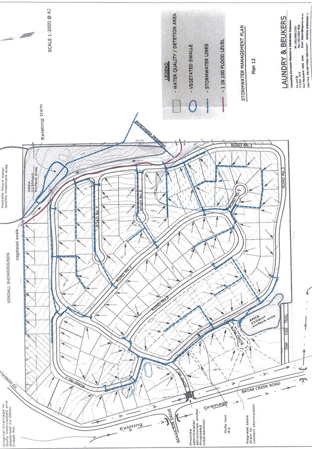
Conceptual
stormwater management plan has been submitted and will be conditioned to
comply. Dwelling sites will be required to be directly connected to
the stormwater drainage system.
|
|
30
Electricity supply
|
(1) Dwelling site to be supplied with electricity and a
separate meter.
(2) Installation in accordance with AS/NZS 3000:2000.
(3) Electricity charge to comply with standard for
locality.
|
Electricity
supply is capable of being supplied to each dwelling site. Recommended
condition applied requiring letter from respective electricity authority
confirming satisfactory arrangement have been made.
|
|
31
Telephone lines
|
Must be
available to each dwelling site.
|
Each
dwelling site will capable of having a telephone service available.
|
|
32
Common trenches
|
Common
trench may be used.
|
Noted.
|
|
33
Garbage removal
|
Arrangements
to be specified and must be in a clean and sanitary condition.
|
All
proposed dwelling sites will be provided with a garbage collection service
via a private waste contractor. Bin storage areas have been identified on
plans in the north-east corner of site.
|
|
34 Fire
hydrants
|
(1) Dwelling site and community building to be no more
than 90m from fire hydrant.
(2)(a) hydrant to be a
double-headed pillar-type hydrant, and
(b) maintained to standard specified.
|
Fire
hydrants are proposed to meet the requirements.
|
|
35
Buildings
|
(1) A building must not be
erected in an estate unless the approval allows.
(2) Buildings allowed within an estate
include:
(a) community building,
(b) Brick or masonry separating walls or
external facades to homes.
(3) Brick or masonry external façade
permitted only if:
(a) the dwelling site is within a
'neighbourhood lot',
and
(b) the owner of the lot is also the
proprietor.
|
Complies.
No buildings, other than community/recreational buildings are proposed as
part of this proposal.
|
|
36 Use
of manufactured home
estates
|
(1)(a) estate must not be used for any other
commercial purpose, or
(b) manufacture, construction or
reconstruction of a moveable dwelling.
(2) Manufactured home may be used for
exhibition purposes.
(3) Renovation and maintenance permitted on
homes.
|
Noted.
|
|
37
Community map
|
Map to
be provided to Council.
|
Noted. A
community map will be provided to Council and will be a condition of any
approval to operate the MHE under a separate section 68 permit.
|
|
38
Access to approval and
community
map
|
Approval,
community map and this Regulation must be available for inspection.
|
Noted.
Will be condition as part of the approval to operate the MHE under a separate
section 68 permit.
|
State
Environmental Planning Policy No. 44 - Koala Habitat Protection
With reference
to clauses 6 and 7, the subject land is greater than 1 hectare (including any
adjoining land under same ownership) and therefore the provisions of SEPP must
be considered.
The
Applicant has submitted an ecological impact assessment prepared by Naturecall
Environmental. The ecological assessment identified that the site qualified as
Potential Koala Habitat due to the property containing greater than 15%
Schedule 2 species however the site was assessed as not qualifying as Core
Koala Habitat.
A findings
of the Ecological Assessment are considered acceptable and the no further
provisions of this SEPP require consideration in this regard.
State
Environmental Planning Policy No.55 – Remediation of Land
Following
an inspection of the site and a search of Council records, the subject land is
not identified as being potentially contaminated and is suitable for the
intended use.
State
Environmental Planning Policy No. 62 – Sustainable Aquaculture
Given
the nature of the proposed development and proposed stormwater controls the
proposal will be unlikely to have any adverse impact on any nearby existing
aquaculture industries.
State
Environmental Planning Policy No. 64 – Advertising and Signage
The proposal incorporates entry
feature signage to the front wall at the entrance to the proposed estate. The
proposal satisfies the applicable requirements of this policy. The assessment
table provided below provides consideration of the proposal in accordance with schedule
1 of the policy.
|
Applicable clauses for consideration
|
Comments
|
Satisfactory
|
|
Clause 8(a) Consistent with objectives of the policy
as set out in Clause 3(1)(a).
|
The signage is consistent with the objectives of this
policy.
|
Yes
|
Schedule 1(1) Character of the
area.
|
The entrance wall and signage to be
incorporated will not be out of character with the area.
|
Yes
|
|
Schedule 1(2) Special areas.
|
The entrance signage will not
adversely impact on any identifiable special areas.
|
Yes
|
|
Schedule 1(3) Views and vistas.
|
The entrance signage will not
adversely impact on any views or vistas.
|
Yes
|
|
Schedule 1(4) Streetscape, setting
or landscape.
|
The entrance works and signage will
not adversely detract from the streetscape.
|
Yes
|
|
Schedule 1(5) Site and building.
|
This signage is compatible with the
entrance wall to which it is to be located.
|
Yes
|
|
Schedule 1(6) Associated devices
and logos with advertisements and advertising structures.
|
None proposed.
|
N/A
|
|
Schedule 1(7) Illumination.
|
No illumination of the entrance signage is proposed.
|
Yes
|
|
Schedule 1(7) Safety.
|
The signage will not adversely
impact on public safety matters.
|
Yes
|
State
Environmental Planning Policy (Housing for Seniors or People with a Disability)
2004
The Applicant has submitted that
the development is not age restricted. No provisions of this SEPP require
specific consideration in this regard.
State
Environmental Planning Policy (Infrastructure) 2007
The proposal has been referred
to NSW Roads and Maritime Services (RMS) during the assessment of the
application. The advice received from the RMS has been considered later in this
report.
State Environmental Planning
Policy (State and Regional Development) 2011
The proposed development does
not have a capital investment value of more than $20 million and is not
considered Regional Development (as per legislation in force at the time of
lodgement of the DA). No provisions of this SEPP require specific consideration
in this regard.
Port Macquarie-Hastings Local Environmental
Plan 2011
The proposal is consistent with the LEP having regard to the
following:
· Clause
2.2, the subject site is zoned R1 General Residential and RU1 Primary
Production (only Lot 1 DP 1142845 zoned RU1). In accordance the SEPP36 for a
Manufactured Home Estate to be permissible a ‘caravan park’ under
this LEP is to be permissible. In this regard, in accordance with clause 2.3(1)
and the R1 and RU1 zone landuse table, the proposed development for a
‘caravan park’ is a permissible landuse with consent in the R1 zone
however it is noted that the proposal could arguably be also defined as
‘multi-dwelling housing’ which is also permissible in the R1 zone.
The proposed recreation and communal facilities are based upon the submitted
details and locations best characterised as being ancillary and subordinate to
the primary landuse and therefore permissible. The current approved road access
across Lot 1 DP 1142845 has been approved under DA2006 – 57 which is
propose to be modified by this DA and will be consolidated under the two (2)
torrens title subdivision. The SEPP 36 requires communal facilities also which
implies permissibility also for such ancillary uses.
The objectives of the R1 zone are as follows:
o To provide for the housing needs
of the community.
o To provide for a variety of
housing types and densities.
o To enable other land uses that
provide facilities or services to meet the day to day needs of residents.
The objectives of the RU1 zone
are as follows:
o To
encourage sustainable primary industry production by maintaining and enhancing
the natural resource base.
o To
encourage diversity in primary industry enterprises and systems appropriate for
the area.
o To
minimise the fragmentation and alienation of resource lands.
o To
minimise conflict between land uses within this zone and land uses within
adjoining zones.
In accordance with Clause 2.3(2), the proposal is consistent
with the zone objectives having regard to the following:
o the proposal is a permissible
landuse;
o the proposal will provide for an
alternative type of residential housing with a range of opportunities for
varied housing types.
o the entire site is not proposed as
MHE with part of a previous approved torrens title subdivision retained to be
proposed.
o The Lot 1 referred to above has no
agricultural potential and is intended to consolidated with the subdivision
component of the proposal.
· Clause
2.7, the demolition of existing structures on the site requires consent as it
does not fit within the provisions of SEPP (Exempt and Complying) 2008.
· Clause
4.1, the lot sizes within the proposed two(2) lot subdivision and the remaining
subdivision to be modified under DA2006 – 57 range from 790m2 to 17.587
hectares. All proposed lots comply with the minimum lot sizes identified in the
Lot Size Map – 450m2 lot size relating to the site.
· Clause
4.4, the floor space ratio of the component of proposal with permanent
community amenity buildings does not exceed and complies with the maximum
0.65:1 floor space ratio applying to the site.
· Clause
5.10 – Heritage. The site does not contain or adjoin any known heritage
items or sites of significance.
· Clause
7.3, the site is land within a mapped “flood planning area” (Land
subject to flood discharge of 1:100 annual recurrence interval flood event
(plus the applicable climate change allowance and relevant freeboard) In this
regard the following comments are provided which incorporate consideration of
the objectives of Clause 7.3 and 7.4, Council’s Flood Policy 2015, the
NSW Government’s Flood Prone Lands Policy and the NSW
Government’s Floodplain Development Manual (2005):
o The
proposal is compatible with the flood hazard of the land taking into account
projected changes as a result of climate change;
o The
proposal will not result in a significant adverse effect on flood behaviour
that would result in detrimental increases in the potential flood affectation
of other development or properties;
o The
proposal incorporates measures to minimise & manage the flood risk to life
and property associated with the use of land;
o The
proposal is not likely to significantly adversely affect the environment or
cause avoidable erosion, siltation, destruction of riparian vegetation or a
reduction in the stability of river banks or watercourses;
o The
proposal is not likely to result in unsustainable social and economic costs to
the community as a consequence of flooding;
· Clause
7.13, satisfactory arrangements are in place for provision of essential
services including water supply, electricity supply, sewer infrastructure,
stormwater drainage and suitable road access to service the development.
Provision of electricity will be subject to obtaining satisfactory arrangements
certification prior to the issue of a Subdivision Certificate and/or Occupation
Certificate stage as recommended by conditions of consent.
(ii) Any
draft instruments that apply to the site or are on exhibition:
No draft
instruments apply to the site
(iii) any
Development Control Plan in force:
Port
Macquarie-Hastings Development Control Plan 2013
The following
relevant provisions of the plan are addressed as follows:
|
DCP 2013: General Provisions
|
|
|
Requirements
|
Proposed
|
Complies
|
|
2.2.2.1
|
Signage to be building or business identification. Be contained
to within the property. Not project above building facades. Potential for
light spill from illumination to be subject to curfew.
|
Entrance signage on front wall identifying the estate
proposed. No illumination proposed.
|
Yes
|
|
2.3.3.3
|
Significant land reforming proposals shall not change
surface levels by more than 5m.
|
Landform change is less than 5m change proposed.
|
Yes
|
|
2.3.3.1
|
Cut and fill 1.0m max. 1m outside the perimeter of the
external building walls
|
Earthworks proposed up front and capable of being
managed. These provisions relates to developed individual sites where
neighbour amenity issues are required to be considered. Suitable site
management conditions recommended.
|
Yes
|
|
2.3.3.2
|
1m max. height retaining walls along road frontage
|
No retaining walls along road frontage proposed.
|
N/A
|
|
Any retaining wall >1.0 in height to be certified
by structure engineer
|
Engineering certification capable.
|
Yes - capable
|
|
Combination of retaining wall and front fence height
max 1.8m, max length 6.0m or 30% of frontage, fence component 25%
transparent, and splay at corners and adjacent to driveway
|
No combination of retaining and front fence proposed.
|
N/A
|
|
2.3.3.8
|
Removal of hollow bearing trees
|
No hollow bearing trees are proposed to be removed.
Refer to detailed comments under the flora and fauna headings of this report.
|
Yes
|
|
2.6.3.1
|
Tree removal (3m or higher with 100m diameter trunk at
1m above ground level and 3m from external wall of existing dwelling)
|
Tree removal is proposed, Refer to detailed comments
under flora and fauna heading of this report.
2 for 1 replacement koala food tree plantings are
recommended by the ecological report submitted. 13 koala food trees are
proposed to be removed therefore 26 offset plantings required. The amended
landscaping plan submitted satisfactorily addresses this requirement.
|
Yes
|
|
2.4.3
|
Bushfire risk, Acid sulphate soils, Flooding,
Contamination, Airspace protection, Noise and Stormwater
|
Refer to main body of report.
|
Yes
|
|
2.5.3.2
|
New accesses not permitted from arterial or
distributor roads
|
Access proposed via proposed public road connection to
Batar Creek Road under a previous approved subdivision DA.
|
Yes
|
|
Driveway crossing/s minimal in number and width
including maximising street parking
|
Single entry and exit point proposed via public road.
|
Yes
|
|
2.5.3.3
|
Parking in accordance with Table 2.5.1.
|
Adequate off-street parking is proposed consistent
with the requirement of the Local Government (Manufactured Home Estates,
Caravan Parks, Camping Grounds and Moveable Dwellings) Regulation 2005.
|
Yes
|
|
2.5.3.11
|
Section 94 contributions
|
Refer to main body of report.
|
Yes
|
|
2.5.3.12 and 2.5.3.13
|
Landscaping of parking areas
|
Suitable landscaping proposed.
|
Yes
|
|
2.5.3.14
|
Sealed driveway surfaces unless justified
|
Internal roads to be sealed.
|
Yes
|
|
2.5.3.15 and 2.5.3.16
|
Driveway grades first 6m or ‘parking area’
shall be 5% grade with transitions of 2m length
|
Internal roads can comply with requirements of the
Local Government (Manufactured Home Estates, Caravan Parks, Camping Grounds
and Moveable Dwellings) Regulation 2005.
|
Yes
|
|
2.5.3.17
|
Parking areas to be designed to avoid concentrations
of water runoff on the surface.
|
Parking areas will be adequately drained.
|
Yes
|
|
Vehicle washing facilities – grassed area etc
available.
|
Suitable areas available for car washing.
|
Yes
|
|
2.7.2.1
|
Social impact assessment shall be submitted in
accordance with Council’s Social Impact Assessment Policy
|
A Social Impact Assessment has been submitted with the
DA which is considered later in this report.
|
Yes
|
|
2.7.2.2
|
Design addresses generic principles of Crime
Prevention Through Environmental Design guideline
|
Adequate casual surveillance will be available for all
community amenities within the development.
|
Yes
|
|
DCP 2013: Chapter 3.6 - Subdivision
|
|
DCP Objective
|
Development Provisions
|
Proposed
|
Complies
|
|
3.6.3.1
|
A site analysis is required for
all development and shall illustrate:
· microclimate;
· lot dimensions;
· north point;
· existing
contours and levels to AHD;
· flood affected
areas;
· overland flow
patterns, drainage and services;
· any contaminated
soils or filled areas, or areas of unstable land;
· easements and/or
connections for drainage and utility services;
· identification
of any existing trees and other significant vegetation;
· any existing
buildings and other structures, including their setback distances;
· heritage and
archaeological features;
· fences;
· existing and
proposed road network, including connectivity and access for all adjoining
land parcels;
· pedestrian and vehicle
access;
· views to and
from the site;
· overshadowing by
neighbouring structures; and
· any other
notable features or characteristics of the site.
|
Satisfactory site analysis submitted.
|
Yes
|
|
3.6.3.2
|
Torrens title lots minimum width of 15m when measured
at a distance of 5.5m from front property boundary.
|
>15m width within all proposed torrens title lots
|
Yes
|
|
Minimum width of 7m when boundaries are extended to
kerb line.
|
N/A
|
N/A
|
|
Minimum depth of 25m.
|
>25m depth within all proposed torrens title lots
|
Yes
|
|
For lots where average slope of the site is equal to,
or exceeds 16%, indicative road and driveway grades are required
demonstrating satisfactory access.
|
No long sections of likely driveway grades required.
|
N/A
|
|
3.6.3.3
|
Battleaxe lots discouraged in greenfield development.
|
No battle axe lots proposed.
|
N/A
|
|
3.6.3.4
|
Lots are to be designed to allow the construction of a
dwelling, which does not involve more than 1m cut, or fill, measured from
natural ground level, outside the dwellings external walls.
|
All torrens lots capable of accommodating dwelling
designs with minimum cut and/or fill
|
Yes
|
|
Lot sizes increased for sloping sites in accordance
with Table 3.6.1.
|
Lot sizes >600m2
|
Yes
|
|
Additional information provided for slope categories in
accordance with Table 3.6.2.
|
N/A
|
N/A
|
|
3.6.3.5
|
Wherever possible orientate streets to maximise the
number of east, west and south facing lots and to minimise the number of
narrow north facing lots.
Residential street blocks should preferably be
orientated north-south with dimensions generally limited to 60-80m by
120-150m as illustrated in Figure 3.6-2.
|
Lot orientation designs are acceptable for future
dwellings.
|
Yes.
|
|
Lot size and shape are to reflect orientation to
ensure future dwelling construction has optimal opportunity for passive solar
design.
|
Lot orientation designs acceptable to permit future
dwellings with passive solar design capability.
|
Yes
|
|
3.6.3.6
|
Kerb and guttering, associated street drainage,
pavement construction and foot paving across the street frontages should be
constructed as part of the subdivision works where these do not exist (may be
varied subject to criteria in this clause)
|
Kerb and gutter required for the torrens title
subdivision component.
|
Yes
|
|
3.6.3.7
|
Subdivisions close to urban centres or along arterial
roads serviced by public transport achieve yield of >35 dwellings per
hectare.
|
N/A – modifying previous subdivision approval
|
N/A
|
|
3.6.3.20
|
Water supply to meet Council’s design
specifications.
|
Water supply arrangements satisfactory – refer
to comments later in report.
|
Yes
|
|
3.6.3.21
|
All lots connected to reclaimed water if available.
|
N/A
|
N/A
|
|
3.6.3.24
|
Separate sewer junction provided for each lot.
|
Separate sewer junction provided for each lot.
|
Yes
|
|
3.6.3.27
|
Erosion and sediment control plan to be provided.
|
Erosion and sediment control plan to be in place prior
to and during construction.
|
Yes
|
|
3.6.3.34
|
All service infrastructure should be underground
unless otherwise approved by Council.
|
All service infrastructure to be underground
|
Yes
|
|
All service infrastructure should be installed in a
common trench.
|
Construction detail to come at Construction
Certificate stage – capable of being achieved
|
Yes – capable
|
|
Conduits for the main technology network system should
be provided in all streets.
|
Construction detail to come at Construction
Certificate stage – capable of being achieved
|
Yes – capable
|
|
Conduits are to be installed in accordance with the
National Broadband Network Company Limited’s
‘Guidelines for Fibre to the Premises
Underground Deployment’.
|
Construction detail to come at Construction
Certificate stage – capable of being achieved
|
Yes – capable
|
|
Access pits are to be installed at appropriate
intervals along all streets.
|
Construction detail to come at Construction Certificate
stage – capable of being achieved
|
Yes – capable
|
|
3.6.3.51
|
Street trees should be provided along all road
frontages generally at a rate of 1 per 20m interval.
|
Street trees should be provided along all road
frontages generally at a rate of 1 per 20m interval.
|
|
|
Street trees should not affect solar access.
|
Street trees will not result in any identifiable
adverse impacts on solar access.
|
Yes
|
|
3.6.3.52
|
Street trees from Council’s list.
|
N/A – modifying previous subdivision approval
– no street trees are proposed within the existing approved subdivision
to be modified by this DA
|
N/A
|
(iiia) Any
planning agreement that has been entered into under section 7.4, or any draft
planning agreement that a developer has offered to enter into under section
7.4:
No planning
agreement has been offered or entered into relating to the site.
iv) Any matters prescribed by the
Regulations:
Demolition of buildings AS 2601
– Clause 92
Demolition of the existing building
on the site is capable of compliance with this Australian Standard and is
recommended to be conditioned.
(b) The
likely impacts of that development, including environmental impacts on both the
natural and built environments, social and economic impacts in the locality:
Context and Setting
The proposal will be unlikely to have any adverse impacts to
existing adjoining properties or the public domain.
The land to the east is zoned rural and will have a
substantial separation to the MHE dwellings due to the large area of open
space, drainage and community facilities.
The showground to the north will be screened by new fencing
and a landscape strip along the entire northern boundary.
The proposal is considered to adequately address the
planning controls for the area. The site is zoned for residential purposes and
is adjoining the existing village of Kendall.
The Applicant has stated that the design of the subdivision
and MHE has retained the allotments along Batar Creek Road as a transition
between the subdivision and the MHE.
The more prominent hill top area of the site has been
identified as open space and landscaping, in order to reduce the visual impact
of the development when viewed from afar. The additional planting also assists
in this regard.
The proposal will not have any identifiable adverse impacts
on existing view sharing or significant vistas.
The proposal will be unlikely to result in any significant
adverse lighting impacts.
There are no identifiable adverse privacy impacts.
There are no identifiable adverse overshadowing impacts. The
proposal (including future manufactured homes and dwellings) will be unlikely
to prevent adjoining properties from receiving 3 hours of sunlight to private
open space and primary living areas on 21 June.
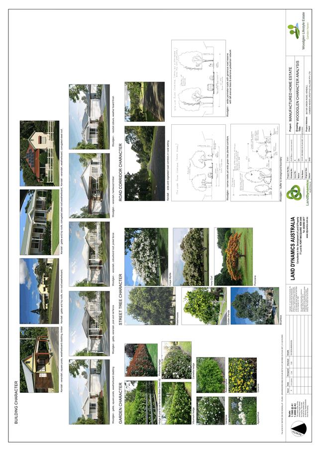
Impact on existing Character of Locality
The assessment of impact on local character within the
village of Kendall has been specifically requested to be addressed by the
Applicant during the assessment of the application.
For a new development to be visually compatible with its
context, it should contain, or at least respond to, the essential elements that
make up the character of the surrounding environment. The most important
contributor to character of Kendall is the relationship of built form to
surrounding space created by building height, setbacks, landscaping,
architectural style and materials used in existing buildings.
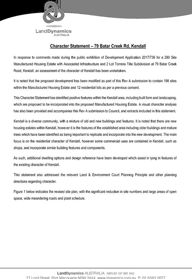
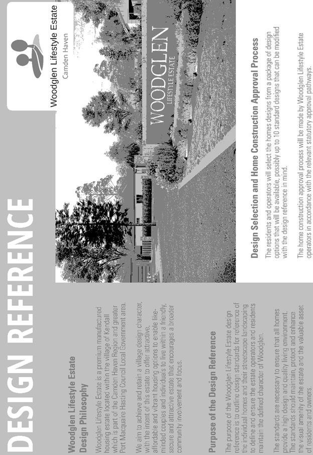
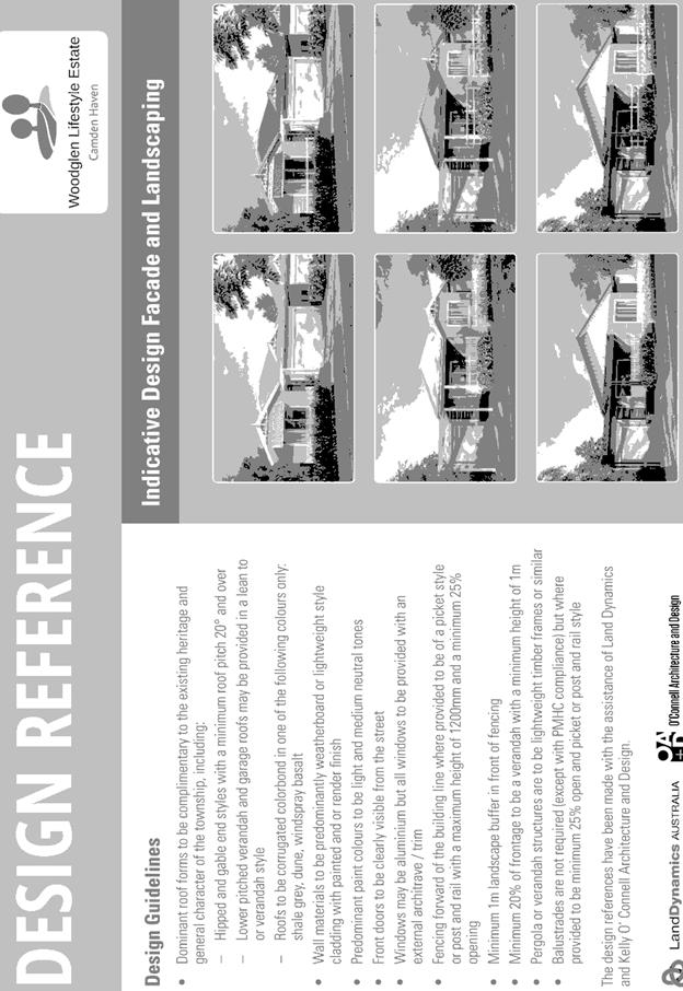
The Applicant has submitted a Character Statement together
with an amended proposal and Design Reference Guide for future MHE dwellings
for consideration in the justifying the suitability of the proposal.
The proposal (as amended) has been carefully assessed and
the following key assessment comments are provided having regard to accepted
Land and Environment Court Planning Principles established in Project
Venture Developments V Pittwater Council (2005) NSWLEC 191:
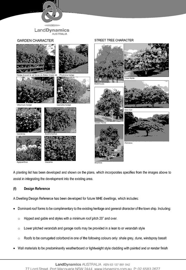
· Open space is an
essential part of the urban framework of Kendall. Existing plantings, gardens
and trees within Kendall have been identified as forming part of the local
character. The amended proposal has incorporated a significant amount of open
space and landscaping with opportunities for planting canopy trees.
· The MHE sites are
grouped together with large areas of open space surrounding and key
architectural features, built form and landscaping incorporated.
· Kendall
doesn’t have a consistent character however does contain many older
buildings and dwellings with minimal setbacks located in the central area of
the township. Other areas contain newer dwellings on standard residential sized
blocks and others on rural-residential lots.
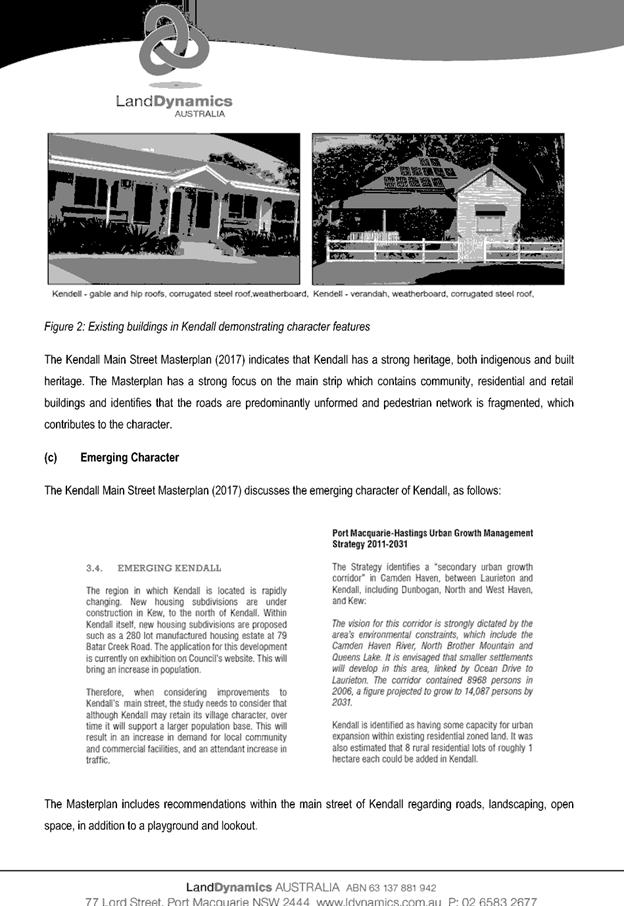
· The character of
Kendall has changed in the past 10-15 years with the approval of new
residential land subdivisions.
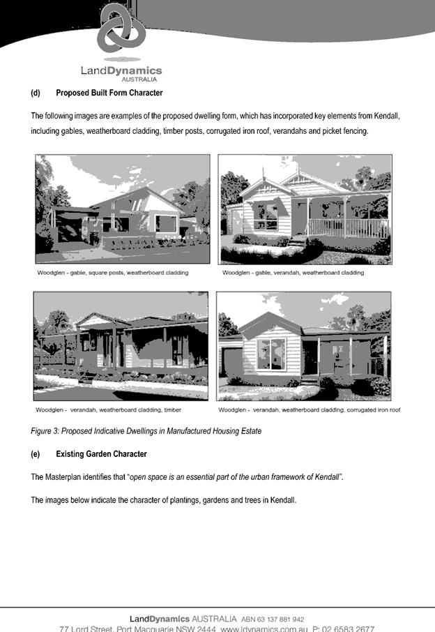
· Key built elements
of other buildings in Kendall include gables, weatherboard cladding, timber
posts, corrugated iron roof, verandahs and picket fencing. The design reference
guide submitted by the Applicant satisfactorily responds to these key built
form character requirements and the community amenity buildings also
satisfactorily respond to the existing character also.
· The previous
approved residential subdivision is being kept in part at the front of the site
to provide a mix of built form and landscape.
It is considered that based upon the above that the proposal
will result in a change in character for the Kendall area in particular however
this is considered to be an acceptable physical and visual impact change.
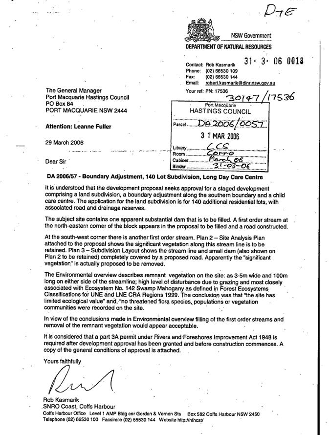
Infrastructure with DA 2006/57
DA 2006/57 was originally consented on 12 June 2007. The
landowner’s consultant provided evidence on 8 December 2010 that DA
2006/57 had been physically commenced. As the current proposal seeks to build
on the same footprint, impacts on infrastructure in the surrounding area
arising from the above items cannot form part of the current s79c assessment,
except to the extent that the current proposal will intensify or increase these
impacts.
The previous DA 2006/57 sets out a number of infrastructure
requirements in connection with the residential lot subdivision and child care
centre. Of note these included:
· Potable
water, sewerage, underground electricity and telecommunications connections
from Kendall to each lot;
· (Condition
A17) Filling of the site a minimum 0.5m above the 1 in 100 year flood level (RL
5.5m AHD);
· (Condition
A22) Street trees along the entire Road 1 as compensation for trees to be
removed from the site (min. 75L plantings). Council’s AUSPEC D13 provides
for a minimum average of 1 street tree per lot. 55 lots front Road 1 in the
original consent and so 55 offset tree plantings are required. A plan is
required to demonstrate how these trees will be provided under the current
proposed layout within the public domain;
· (Condition
A25) A minimum 2.1m wide shared cycleway from the site to the northern corner
of the Kendall Showground (Lot 2 DP 1048212);
· (Condition
A26) A new roundabout at the intersection of the estate entry and Batar Creek
Road / Benaroon Drive;
· (Condition
B1) Upgrade of the road shoulder and table drain for the full site frontage to
Batar Creek Road;
· (Condition
B2) A 9m wide perimeter collector road;
· (Condition
B19) Regeneration of bushland within the eastern drainage basin area;
· (Condition
B20) Dedicated public pathway 10m wide in the north west of the site linking
from Batar Creek Rd to the internal subdivision roads;
· (Condition
B21) Obtain a permit from ARTC to bore a sewerage pipeline under the railway;
· (Condition
E25) Obtain a permit for works within 40m of water courses, including the
proposed filling of onsite streams (now known as a Controlled Activity Approval
application to the Office of Water);
· (Condition
F3) A 24-month landscape and street tree maintenance program;
· A
diversion swale along the western road frontage of the site to prevent runoff
from Batar Creek Road flooding proposed residential lots along the western
gully; and
· Provision
of bio-retention basins in the east and southwest of the site to ensure
catchment runoff meets AUSPEC D5 (use of detention facilities to mitigate any
increase in peak outflows) and D7 (water quality outcomes). Refer to the
Stormwater heading below for further discussion.
After the initial 2-lot subdivision, it is noted that the
Applicant can proceed with the original subdivision instead of this
Manufactured Home Estate (MHE) proposal.
Where appropriate, the above infrastructure requirements
have been adjusted in line with the current proposal and are reflected in the
recommended conditions of consent.
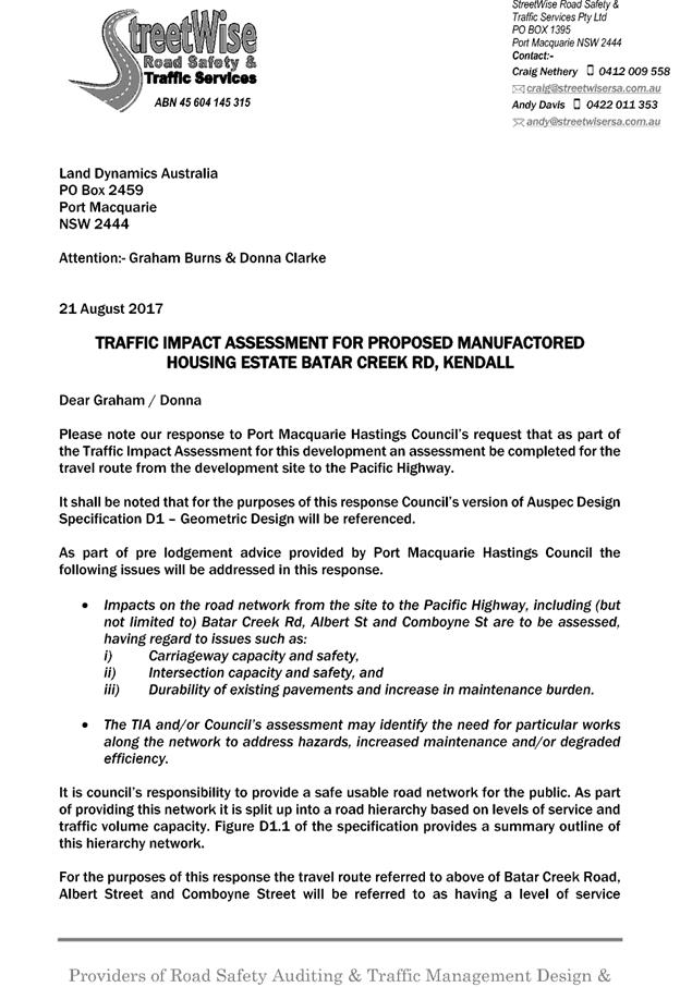
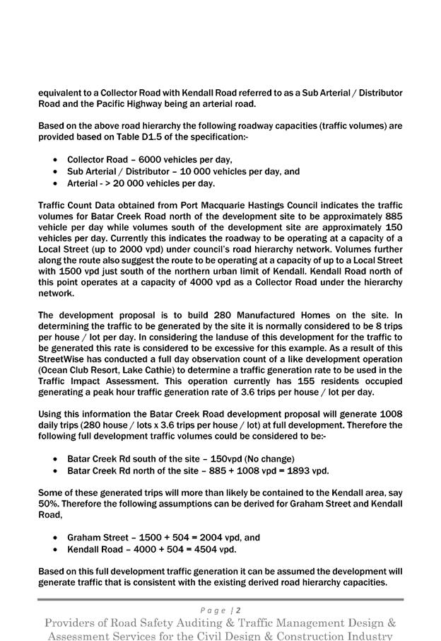
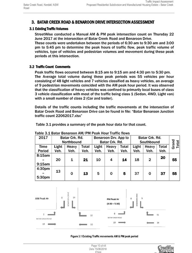
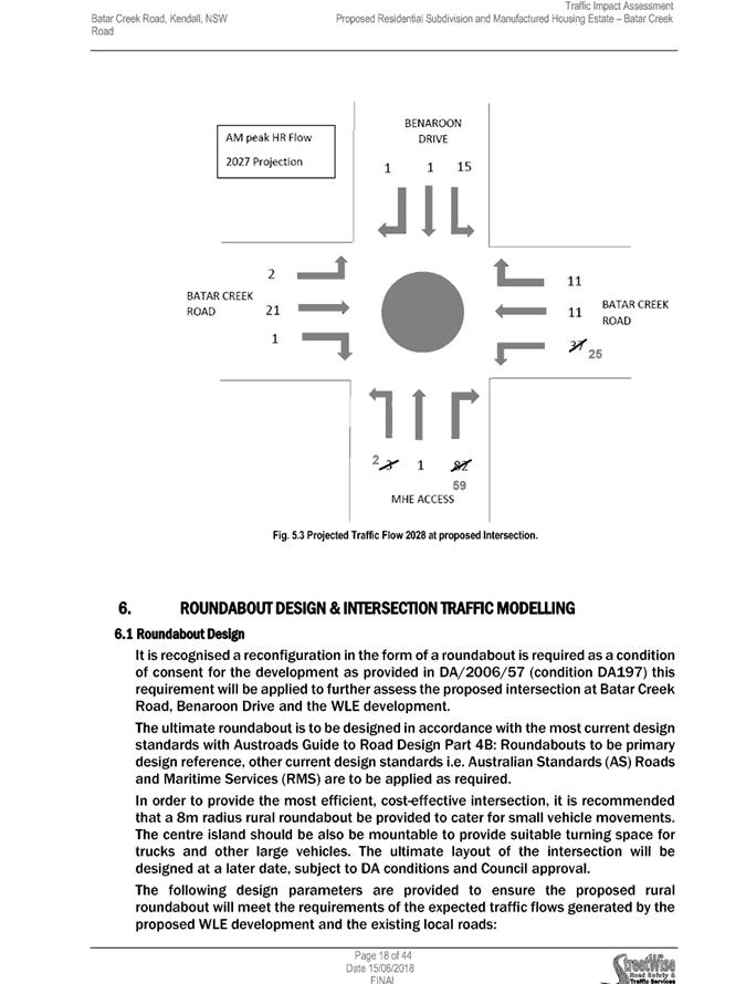
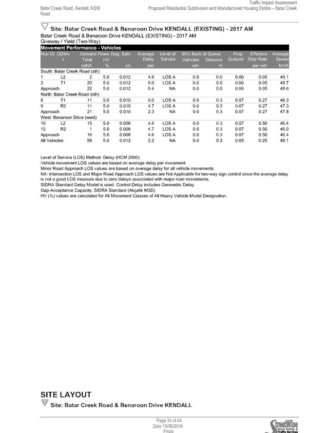
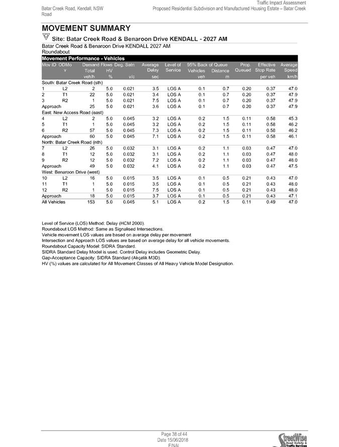
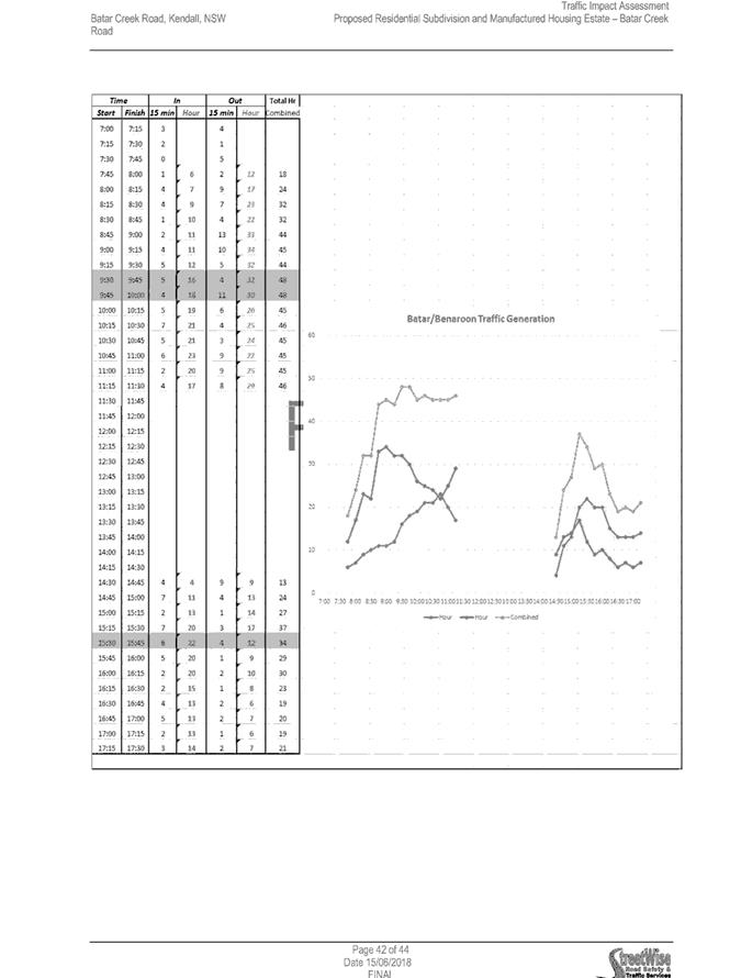
Traffic Study
Streetwise Road Safety & Traffic Services was engaged by
the Applicant to conduct a Traffic Impact Assessment (TIA) for the
development. The study assessed existing and future traffic conditions,
and impacts that the development will have on the existing road network.
Council staff has reviewed this information and its impacts to the surrounding
public road network as determined the following.
The site is fronted by Batar Creek
Rd south of the showground. Currently, Batar Creek Road is defined as an
Urban Collector with a 9m wide pavement formation north of the showground and a
Rural Local Road with a 6m wide pavement formation south of the showground.
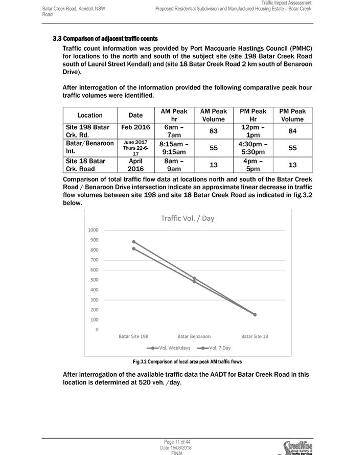
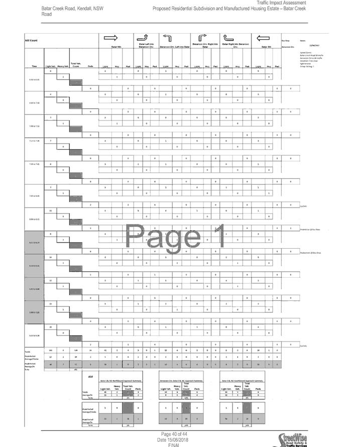
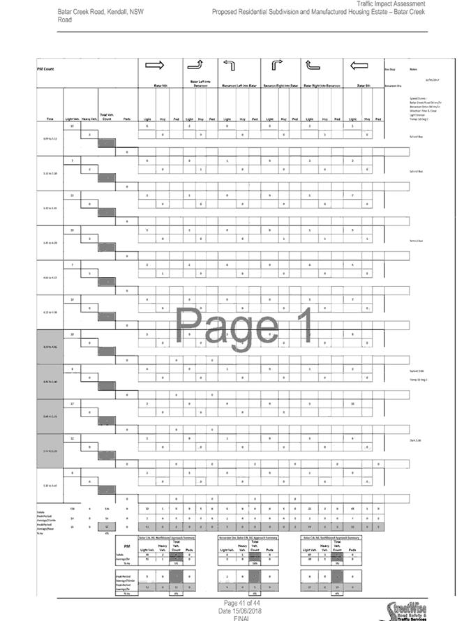
The traffic study has carried out a
traffic count at the intersection of Batar Creek Rd and Benaroon Dr and
determined the existing daily traffic conditions adjacent to the site are 520
vehicles per day (vpd) and 55 veh/hr (am and pm conditions). Councils traffic
counts on Batar Creek Road north of the site (near Laurel Street) taken in 2016
indicated a traffic count of 890 vpd, which is inconsistent with the findings
of the one day count. Insufficient information has been provided in the
Applicant’s traffic study to explain this discrepancy. Therefore, for the
purposes of this report, Council officers have assumed worst case conditions
along Batar Creek Road based upon Council 2016 counts.
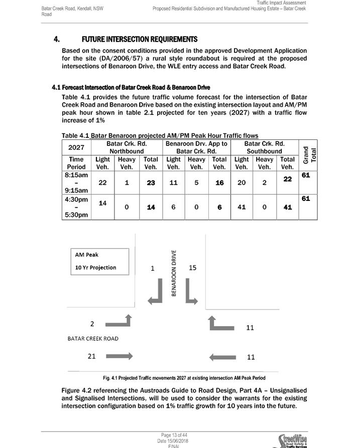
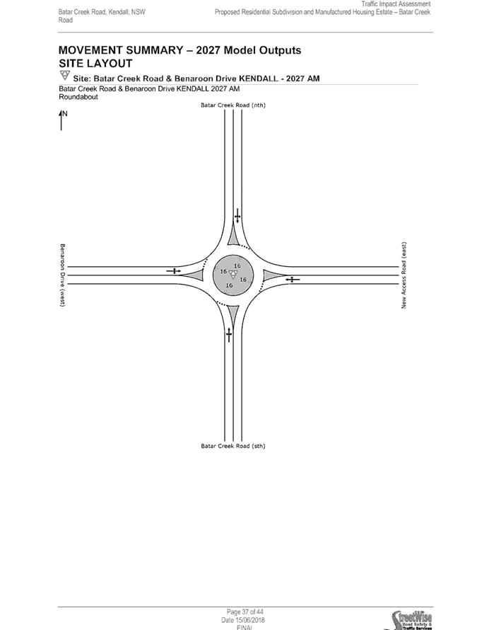
Future background conditions were
evaluated assuming a 1% (growth rate) p.a. increase in traffic over a ten year
period, to year 2027. Using Council’s daily counts, this equates to
anticipated background daily conditions in the year 2027 of 1,003 vpd.
The development proposal will
consist of a mixture of Torrens Title lots and the proposed Manufacture Housing
Estate (MHE) development sites. According to RMS “Guide to Traffic
Generating Developments” (TDT 2013/04A Technical Direction) daily trip
generation rates for standard residential dwellings in regional areas is
determined to be 7.4vpd, 0.78 morning peak hour trips and up to 0.71 evening
peak hour trips, resulting in 89 vpd for the 12 proposed Torrens Title lots.
The RMS guide does not provide
similar industry trip generation rates for Manufactured Housing Estates
(MHE). As such, further assumptions need to be made in determining
their impacts.
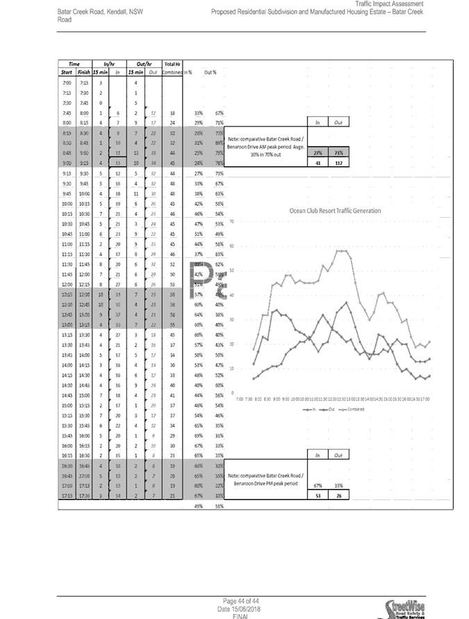
Streetwise has conducted a one-day
count on the 28 Jun 2017 at the Ocean Club Resort (reserved for over 55yr
olds). Findings of the survey concluded the estimated daily trip
generation for Ocean Club generates 3.6 vpd. Details associated with how
this information was collected cannot be confirmed and only show data between
7:30 AM to 5:30 PM which may not reflect actual daily conditions.
The RMS “Guide to Traffic
Generating Developments” recommends daily trip generation of 4-5 vpd,
(and peak hour conditions of 0.4-0.5 vph) for two bedroom dwellings; and 5-6.5
vpd (0.5-0.65 vph) for three bedroom dwellings (using Median Density
Residential Development numbers).
It is noted that this MHE proposes
larger sites (280m2 to 397m2) than others seen
in the area (approximately 250 m2) allowing larger dwellings to be
constructed on each site. As sites do not define the dwelling sizes,
estimates need to be made regarding dwellings size. For the purpose of
this report, Council has assumed the potential for two and/or three bedroom
dwellings (noting floor plans show capability of third bedroom). Assuming a
trip generation rate of 6.5 vpd, 198 MHE sites are expected to generate a total
of 1,287 vpd.
Summarising finding above, Council
staff expects future traffic conditions (post development) on Batar Creek Road
to be approximately 2,290 vpd. Council current engineering standards
(Aus-Spec, D1 “Table D1 Characteristics of Roads in Rural Residential and
Rural Subdivision Roads”) for rural roads would define road with expected
daily traffic conditions over 2,000 vehicles to be upgraded to Collector
Standards (see table below):
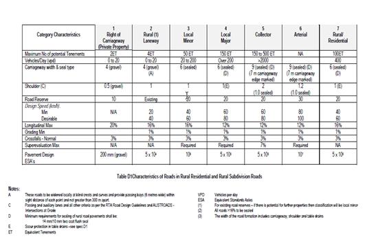
Furthermore, the scale of the
development will create more than the minimum equivalent tenements requirements
for a rural collector road. As such this development creates the need to
upgrade Batar Creek Road from a Rural Local Road standard to a Collector Road
standard. The DA has been conditioned to require this upgrade to Batar Creek
Road, from the development intersection on Batar Creek Road north to the
existing collector road network (showground driveway).
North of the showground, the
existing pavement width is 9m, which is consistent with an Urban Collector
standard. Section of road has two pinch points at existing culverts, where
two-way traffic is restricted. Council staff has considered that the culverts
shall be widened to cater for the collector standard, which includes for the
provision footpaths both sides, recognising however, that this development
shall require the construction of the footpath on one side only.
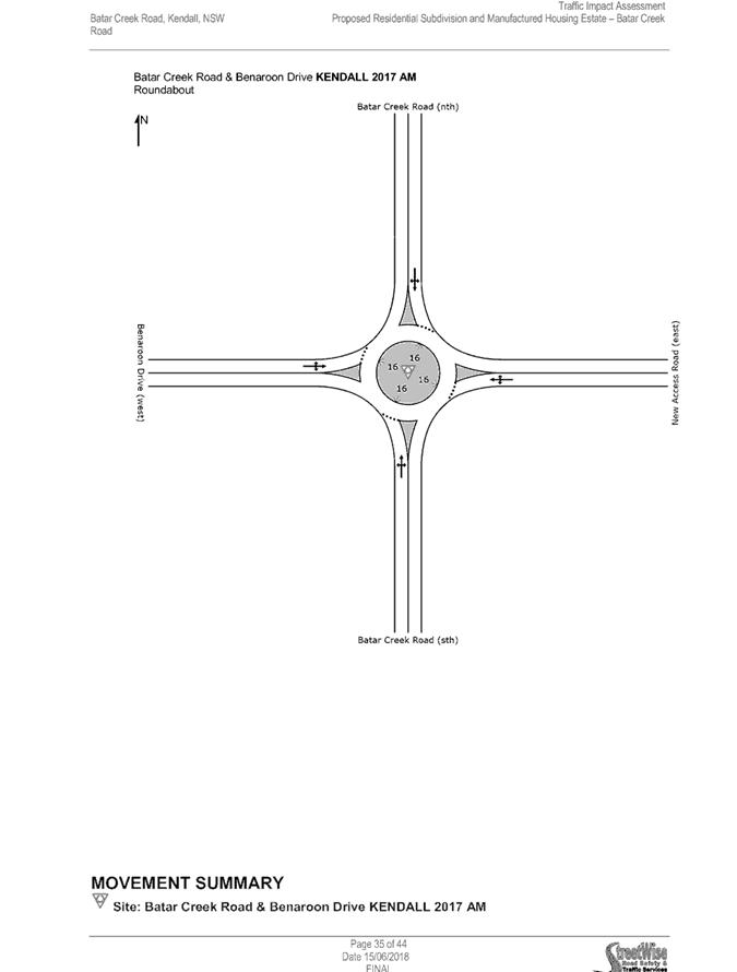
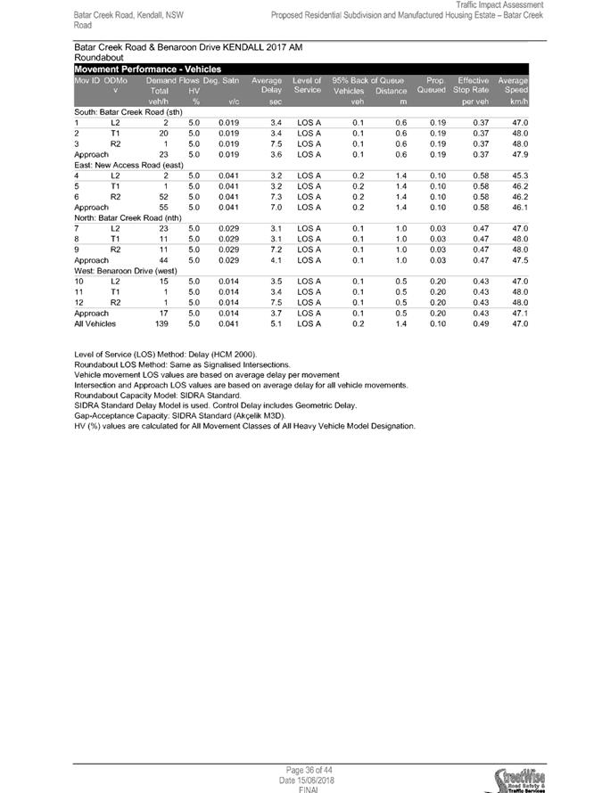
Streetwise has assessed the
development intersection with Batar Creek Road and determined this intersection
should be upgraded to a roundabout, consistent with the previous DA on this
site (DA 2006/57). Council staff agrees with this assessment.
Conditions have been applied to the
DA reflecting the above.
Road Network
Many of the concerns associated with additional traffic
using the public road network as a result of new developments can be divided
into three domains: safety, where the risk of harm to persons or property is
increased or a new hazard is created; efficiency, where parts of the road
network approach capacity resulting in unacceptable delays as determined using
traffic engineering practice; and maintenance, where the additional traffic
wear on the road results in more frequent and/or higher cost maintenance by
Council (and thus the community).
The primary route between the
development site and the Pacific Highway, which provides access to other settlements,
employment areas and services, is via the Kendall and Kew town centres.
Constraints in relation to that road network are analysed in this section.
There are other road routes out of
Kendall, including southwards along Batar Creek Road through State Forest and
Middle Brother National Park to the Pacific Highway, but due to travel time
these will attract a negligible share of daily trip generation as a result of
the proposed development.
The figure below shows in red
various traffic count data, which approximately represent the average daily
trips at each location, obtained by Council between 2014 and 2016 in the
vicinity of the local road network affected by the development. The
applicant’s derived 520 trips per day at the proposed roundabout intersection
of Batar Creek Road and Benaroon Drive is also shown.


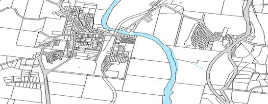
For the purpose of the road safety and capacity analysis in
this report, the route has been broken into segments as illustrated (A) to (D)
shown above. Road standards for a given classification such as number of
traffic trips and widths are set out in Council’s AUSPEC D1 (Geometric
Design) Table D1.5. Where Equivalent Tenements are calculated they are intended
as a guide only, and represent the equivalent number of residential dwellings
it would take to generate a similar amount of traffic on average, using a rate
of 9 trips per dwelling derived from the RMS Guide to Traffic Generating
Developments 2002.
|
(A) Batar
Creek Road – Benaroon Drive to Laurel Street
|
|
Batar Creek Road in the vicinity of the site is
characteristic of a rural road, with bitumen seal, gravel shoulders and a
grassed swale draining each side of the road formation. It is a public road
owned and maintained by Council.
The adjoining land is zoned R1 General Residential (the
site to the east) and R5 Large Lot Residential (Benaroon Drive to the west).
As the road heads north past the showground the adjoining
lot frontages become narrow, in character with a residential area. The road
widens out with room for on-street parking in vicinity of the showground, and
concrete kerb and gutter for much (but not all) of the road. The section of
road around the Laurel Street intersection narrows considerably and lacks
kerb and gutter. This section is a sag point with significant flooding risk
and is detailed in the Kendall Stormwater Management Plan (Storm Consulting,
2013).
|
|
|
Existing
|
Post-development
|
|
Traffic trips per
day
|
520 to 900
|
2410
|
|
Residential
Equivalent Tenements (ETs)
|
58 to 100
|
268 to 310
|
|
Min. AUSPEC
Standard
|
Urban Local
|
Urban Collector
|
|
Sealed Width
|
6m (south of showground)
5.5 to 11m
(south of Laurel St)
|
9 sealed
|
|
On completion, this section of road will be frequented by
trucks associated with the existing rural and forestry land to the south, a
large increase in service trucks (garbage collection) proportional to the
population increase, and a likely proportional increase in school buses,
public buses and MHE bus trips. In terms of safety, given this and the large
(greater than double) increase in general traffic volume, the width of the
existing road along section (A) is a serious concern.
Under Council’s AUSPEC standard, the traffic volumes
meet the lower range of both the recommended daily trips and Equivalent
Tenement (ET) thresholds for a Collector Road, which sets a width of 9m.
Where no provision is made for off-road cyclists along a road, at least 1.5m
of pavement width in each direction should be available as on-road lanes or
sealed shoulders.
For section (A) conditions of consent have therefore been
recommended to require widening of the road to a minimum sealed width of 9m,
being two 3.5m wide lanes plus two 1.0m sealed shoulders. In addition, a
shared footpath shall be provided from the development to the showground, min
2.5m wide.
|
As can be seen in the above road network diagram, there is a
drop in the traffic count along Albert Street which indicates that there is an
alternative traffic desire line along Laurel Street attracting a significant
proportion of traffic. The magnitude of this traffic split has been estimated
as follows:
I. From
review of aerial photography there appear to be approximately 110 dwellings
along Batar Creek Road from Kendall to the State Forest to the south. For 890
trips per day this equates to 8 trips per dwelling (similar to the RMS Guide).
II. Albert
Street had approximately 65 completed dwellings in mid-2016 (the year both
traffic counts were obtained). Assuming a rate of 8 trips per dwelling, this
would equate to roughly 520 trips per day.
III. The
number of trips counted on Albert Street (800 per day) minus the number of
trips that would only use Albert Street at (II) above (i.e. excluding Batar
Creek Road traffic) gives 280 trips per day using Batar Creek Road via Albert
Street.
IV. The
number of trips using Batar Creek Road via Laurel Street is likely to be 890
minus the trips going via Albert Street (280) which yields 610 trips per day,
based on the available data. This is an approximately 70% to 30% split Laurel
St vs Albert St.


|
(B) Laurel and Orara Streets
– Batar Creek Road to Graham Street
|
|
Laurel and Orara Streets
It is assumed that without reconfiguring existing
intersections, the split between Laurel and Albert Streets would remain in
the same proportion (70% and 30% respectively) with new traffic on completion
of the development. 70% of the 2780 (210x9+890) total trips equates to 1946
trips per day.
|
|
|
Existing
|
Post-development
|
|
Traffic trips per
day
|
610 (estimated)
+ local residences
|
~1946
|
|
Residential
Equivalent Tenements (ETs)
|
68
|
~278
|
|
Min. AUSPEC
Standard
|
Local Street
|
Local/Collector Street
|
|
Sealed Width
|
9m
|
9m
|
|
Numerous public submissions have raised concern with the
proposed increase of traffic on Laurel Street for the loss of residential
amenity and tension between on-street parking and through traffic. Another
significant concern in regard to safety is the presence of a blind crest
vertical curve midway along Laurel Street.
While these are existing concerns, the proposed
intensification will not affect the classification of the existing road.
No upgrade of the road classification appears required
for this segment, as the resulting trips post-development are still within
the AUSPEC defined range for a Local Street/Collector Street with width of
7m.
|
|
(C) Albert and Comboyne Streets – Batar Creek
Road to Graham Street
|
|
Allocating the remaining (30%) portion of trips from
Batar Creek Road, on completion of the development an additional 834
trips are expected along this segment.
|
|
|
Existing
|
Post-development
|
|
Traffic trips per
day
|
800 to 1500
|
~1724-2334
|
|
Residential
Equivalent Tenements (ETs)
|
89 to 167
|
299 to 377
|
|
Min. AUSPEC
Standard
|
Local Street
|
Local Street/Collector
|
|
Sealed Width
|
6m
|
6m-9m
|
|
No upgrade of the road classification appears required
for this segment, as the resulting trips post-development are still within
the AUSPEC defined range for a Local Street/Collector Street with width of
7m.
|
|
(D) Kew Road - Graham Street to Nancy Bird Walton Dr
|
|
Impacts on these roads is not considered significant.
Examining the existing vehicle movements and the proposed increase from the
development, the impact is considered insignificant.
|
Roads and Maritime Services (RMS)
Consistent with RMS requirements, the proposal was referred
to the RMS on 19 December 2017. RMS’ review of the proposal
determined:
Roads and
Maritime has reviewed the referred information and provides the following
comments to assist the consent authority in making a determination:
1. The Consent Authority should be satisfied that the impacts of
through and turning traffic has been adequately addressed for the impacts on
the regional and local road network.
Council has
considered the details of the traffic study in relation to the vehicle movement
per day and the impact of the additional traffic on local road networks. The
applicant has used 4v/d to calculate the future traffic associated with the
development. This rate is making an assumption that the development has been
restricted to an aged demographic. This figure is not considered appropriate
for the reasons detailed earlier.
The additional
traffic impact from the development has changed the classification of Batar
Creek Road. Council has applied DA conditions to deal with the upgrade required
with the development.
2. The proposed roundabout should be designed and constructed in
accordance with Austroads Guide to Road Design Part 4B. The design should
accommodate the turning paths of the relevant design vehicles requiring access
to the site. Suitable street lighting should be identified and installed to
relevant specifications.
This development
has proposed a roundabout on Batar Creek Road (at Benaroon Drive). Given the
traffic counts as detailed in the traffic study, this approach would be
supported by Council. Full design details will be required to comply with
Austroads and Aus-Spec and shall be provided as part of the Roads Act Approval.
3. Any proposed change in speed zoning should be referred to Roads and
Maritime for consideration prior to the issue of any Roads Act approval for the
roundabout.
Council has
applied DA conditions to address any speed changes as a result of the
development.
4. Consideration should be given to external connectivity for public
transport facilities and active transport modes such as walking and cycling.
In line with the
upgrade of Batar Creek Road, Council has conditioned a shareway/cycleway for
connectivity of new residents with the village. These upgrade works extend into
the village in order to provide bike/walking paths for future residents.
5. Regulatory signs and devices will require the endorsement of
the Local Traffic Committee prior to Council’s approval.
Endorsement of
the Local Traffic Committee shall be required prior to Council approval of the
future roundabout on Batar Creek Road. DA conditions have been applied to the
DA to address this concern raised by RMS.
Pedestrians
This development is proposing effectively 208 new
residential sites for development. A pedestrian path has been proposed to
connect to Batar Creek Road on the North Western corner of the site.
This proposed location is approx.
375m south of the showground entry. At this location Batar Creek Road is 6m
wide with an uneven reserve and tree lined. There is no existing footpath
network in this area.
The proposed development is approx.
1km from Albert Street (intersection at Benaroon Drive) or 750m from the north
western corner of the side. The development is considered to be within a reasonable
distance from the town to require connectivity; by way of footpaths and
cycleways. DA conditions have been applied to the consent to require
footpath and cycleway connectivity to Albert Street.
The section of Batar Creek Road,
south of the showground entry has been conditioned to provide a cycleway at
2.5m wide, which is to provide connectivity to the manufactured home estate and
the torrens title lots.
The section of Batar Creek north of
the show ground has been conditioned to have a 1.5m footpath on one side of the
road only, noting that the pavement along this section of road is approx. 9m
wide, which can accommodate cyclists. This footpath shall continue to Albert
Street and shall include the inclusion of widening the culvert crossings to accommodate
footpath both sides of the road, although only one side has been conditioned to
be constructed at this stage.
Design Plans shall be required as
part of the Road Act Approval, and details relating to slope and gradients
shall be assessed in relation to Aus-Spec and disability access.
Parking and Manoeuvring
A total of 70 parking spaces (including 4 disabled spaces)
have been provided on-site. Parking and driveway widths on site can
comply with relevant Australian Standards (AS 2890), Local Government
Regulations and conditions have been imposed to reflect these
requirements.
Due to the type of development, car
park circulation is required to enable vehicles to enter and exit the site in a
forward manner. Site plans show adequate area is available and conditions
have been imposed to reflect these requirements.
Water Supply Connection
Council records indicate that the development site is not
currently connected to water.
Council’s existing water
supply system shall be extended to service the development site at no cost to
Council. Water main extensions to the site include a 200mm diameter main from
Albert Street across the Poets Ridge development (through the existing water
supply easement), along the west side of Batar Creek Road to Benaroon Drive
area then crossing Batar Creek Road into the development site. Connection to the
100mm Benaroon Drive water main will be required.
Each dwelling shall be individually metered for water supply
with a master meter at the road frontage. Final water service sizing will need
to be determined by a hydraulic consultant to suit the domestic and commercial
components of the development, as well as fire service and backflow protection
requirements.
Sewer Connection
Council records indicate that the development site is not
currently connected to sewer.
The Council sewerage system
adjacent to the proposed development does not have sufficient sewerage capacity
to cater for this development. A Sewerage Reticulation Strategy shall be
submitted to the Water and Sewer Section for approval prior to release of the
Construction Certificate. The internal village sewerage lines are to be private
owned and maintained.
Several concept schemes were
submitted during the assessment of the DA to address sewerage disposal from the
development. The latest conceptual option is shown below:
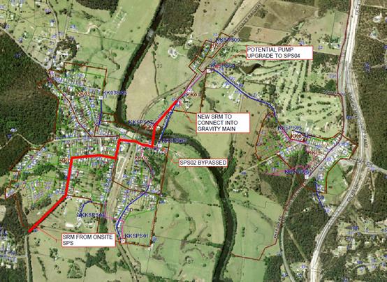
A sewerage pumping station shall be
constructed to Council’s requirements and discharge into manhole
KK04P008MH with an odour control device installed at no cost to Council. If
flushing of the proposed sewer pump station is required to facilitate a
sufficiently sized turnover of sewage then this is to also occur at no cost to
Council.
The proposed sewer infrastructure
for this development shall be extended at no cost to Council to provide Lot 2
DP1048212 with a gravity sewer connection.
The extension of Council’s
sewerage system to serve the development by the Applicant involves under boring
of the North Coast Railway and will require Council to enter into a licence
with the Australian Rail Track Corporation (ARTC). In this regard, it
would be a requirement that prior to the issue of the Construction Certificate,
the Applicant is required to submit sewerage plans that satisfy both
Council’s and the ARTC’s requirements. During construction
the Applicant must adhere to the requirements of Council for the construction
of sewer and the ARTC with regard to the licence for the construction of
infrastructure within the railway corridor.
Stormwater
The development site forms part of the Camden Haven River
Catchment. It generally drains to the east and south towards natural
gullies downstream of the site.
The development site is also
traversed by a number of natural overland flowpaths, one originating from the
land to the north and northwest, with the flowpath entering the site from the
adjoining showground. A second flowpath adjoins the site frontage to Batar
Creek Road, originating from developed land to the west. It is likely that
flows from within this second flowpath do not enter the subject development
site, however analysis of the capacity of the existing street drainage system,
catchment and overland flowpath is required to be submitted at CC stage to
confirm. This has been addressed by way of conditions of consent.
The Development Application is
accompanied by a stormwater management plan which includes the provision of
both on-site stormwater detention facilities and water quality control
facilities designed to meet the requirements and targets of AUS-SPEC D5 and D7
in relation to stormwater discharge rates and quality.
Conceptually, the proposal achieves
compliance with the above standards, however detailed modelling and assessment
will be required to be submitted in support of a future Construction
Certificate/S68 application.
As outlined in the Road Network
section above, the development proposal results in a need/requirement to
upgrade a number of existing roadways/intersections as a result of the increase
traffic generation resulting from the development. Any road /intersection
upgrade, must be accompanied by a stormwater management plan to demonstrate
that the upgraded road pavement meets the stormwater drainage requirements of
AUS-SPEC D5 and D7. This will necessitate the construction, upgrade and
amplification of existing stormwater infrastructure within and adjoining those
sections of Batar Creek Road being upgraded as a result of the proposed
development.
Other Utilities
Telecommunication and electricity services are available to
the site.
Evidence of satisfactory
arrangements with the relevant utility authorities for provision to each
proposed lot and the MHE will be required prior to Subdivision Certificate
approval and final Section 68 permit to operate the MHE being issued.
Heritage
Following a site inspection (and a search of Council
records), no known items of Aboriginal or European heritage significance exist
on the property. No adverse impacts anticipated.
Other land resources
The site is within an established urban context and will not
sterilise any significant mineral or agricultural resource.
Water cycle
The proposed development will be unlikely to have any
adverse impacts on water resources and the water cycle.
Soils
The proposed bulk earthworks including site levelling,
vegetation removal and dam filling have previously been approved for the site,
thus they will provide a suitable platform for the development.
The proposed development will be
unlikely to have any adverse impacts on soils in terms of quality, erosion,
stability and/or productivity subject to a standard condition requiring erosion
and sediment controls to be in place prior to and during construction.
Air and microclimate
The construction and/or operations of the proposed
development will be unlikely to result in any adverse impacts on the existing
air quality or result in any pollution. Standard precautionary site management
condition recommended.
Flora and fauna
Construction of the proposed development will require
removal/clearing of vegetation. The Applicant has submitted an ecological
impact assessment prepared by Naturecall Environmental. In summary the
following has be identified from the ecological assessment:
· No threaten
flora species have been identified.
· The
development will see the removal of 1500m2 of modified swamp forest vegetation.
· The study
site does not contain any core koala habitat under SEPP 44.
· No threatened
fauna species were recorded on the site.
· Removal of
13 koala food trees is proposed and offset planting is required and proposed
– refer to landscaping plan.
· An
assessment under the seven part test (as in force at the time of lodgement of
the DA) determined the impact, whilst being a generic negative effect in terms
of incremental loss of habitat, is unlikely to be of sufficient order of
magnitude to have a significant impact.
The extent of the previous approved
subdivision works is also noted.
The ecological assessment is
acceptable and demonstrates that the proposal will be unlikely to have any
significant adverse impacts on biodiversity or threatened species of flora and
fauna. Section 5A of the Act (as in force at the time of lodgement) is
satisfied.
Waste
Satisfactory arrangements are in place for proposed storage
and collection of waste and recyclables. No adverse impacts anticipated.
Standard precautionary site management condition recommended.
Energy
The proposal includes measures to address energy efficiency
in the design of the on-site communal facilities and will be required to comply
with the requirements of Section J of the Building Code of Australia. No
adverse impacts anticipated.
Noise and vibration
The operation of the dwellings and community facilities are
proposed by the Applicant to not be restricted by hours of operation, but
rather by standard noise criteria under the Protection of the Environment
Operations Act 1997.
A 20m wide landscaped strip (as amended) to the showground
to the north with a 1.8m high wire security fence to the boundary and timber
fencing to the dwelling sites. This should assist with providing some
mitigation of potential impacts with showground operations and activities.
No other
adverse impacts are anticipated.
A standard condition recommended to restrict construction to
standard construction hours.
Bushfire
The site is identified as being bushfire prone.
In accordance with Section 100B - Rural
Fires Act 1997 - the application proposes: subdivision of bush fire prone
land (2 lot subdivision included in proposal) and a MHE that could lawfully be
used for residential purposes.
The Applicant has submitted a
bushfire report prepared by a Consultant. The report assumes that proposed
subdivision will occur and has carried out an assessment under Section 100B
requirements.
The Commissioner has assessed the
development and has issued a Bushfire Safety Authority subject to conditions. A
copy of the Authority is attached to this report.
Safety, security and crime prevention
The proposed development will be unlikely to create any
concealment/entrapment areas or crime spots that would result in any
identifiable loss of safety or reduction of security in the immediate
area.
The increase in housing density
will improve natural surveillance within the locality.
Social impacts in the locality
A Social Impact Assessment prepared by All About Planning
has been submitted with the DA as required by Council’s Development
Control Plan 2013 and Social Impact Assessment Policy.
The below is a list of the key recommendations from the Social
Impact Assessment, which the Applicant has justified that have been
incorporated into the site plan or are addressed in the accompanying expert
reports:
Retain an on-site resident manager.
1. The landscaping must
also reduce visual impacts from both the showground and MHE site by introducing
a substantial landscaped setback along the full northern boundary of the MHE.
2. A
Traffic Engineering Assessment is to be provided with the Development
Application.
3. Consideration
of pedestrian refuge/crossing point near Benaroon Drive on Batar Creek Road, a
footpath to link proposed Road No.1 to the start of the pedestrian and cycle
path in the north-west corner of the site, street lighting and upgrade of
nearby roads.
4. Address
showground security concerns by incorporating a high security fence along the
full northern boundary of the MHE site.
5. The
front gate to the site is to be left open during the day, to facilitate site
access by visitors, tradespersons and the like and to ensure a friendly and
welcoming entrance to the site is maintained. The open gate policy is to be
reflected in the MHE’s adopted Operational Plan.
6. A
Community Bus is to be provided to assist with the transport needs of MHE
residents. A Community Bus Time Table is to be developed and distributed to
residents.
7. The
pedestrian and cycle link required under the DA 2006/57 for residential
subdivision on the site is to be constructed as part of the initial site works,
together with the other community facilities, boundary fencing and landscaping.
8. The
roundabout required under the DA 2006/57 for residential subdivision on the
site is to be constructed as part of the initial site works, together with the
other community facilities, boundary fencing and landscaping.
9. Preparation
of a MHE Showground Community Engagement Plan to minimise risk of complaints
from MHE residents about ongoing showground events and activities.
10. Enquiries are to be
made with Council to confirm if current Section 94 and 64 contributions are
targeted for expenditure within Kendall. Further, whether Council will permit a
Kendall specific material public benefit or Voluntary Planning Agreement in
lieu of these standard contributions.
11. Ongoing
Kendall community consultation is to be undertaken.
12. During
Council’s public exhibition of the proposed development details, one hard
copy of the proposed development should be provided by the proponent for
Council to arrange for display at the Kendall Community Centre.
13. A suitably fitted
out space is to be created within the community clubhouse for booking and use
by a consulting medical professional or other relevant resident service
providers.
14. An offer is to be
extended by the MHE site management and owners for occasional use of the
MHE’s on-site synthetic grass tennis court for local based tennis
competitions on request by the Kendall Tennis Club.
15. The MHE operator is
to adopt an Internal Neighbour Disputes Policy and this policy is to be
referenced in all site lease agreements.
16. The MHE developer
is to adopt a Local Workers Employment Priority Policy for suitable qualified
and available trades for all construction and ongoing operational stages.
17. The stormwater
detention basins proposed on site should be required by condition of consent to
be constructed in the early stages of the development as appropriate for the
size of the proposed staged construction.
Subject to the above being complied
with, the proposal has been assessed as being unlikely to result in adverse
social impacts which would warrant refusing the DA.
A key requirement of the Social
Impact Assessment is to recommend provision of a private Community Bus to
assist with the transport needs of MHE residents particularly noting that the
proposal may provide for housing of seniors. A booking room is also to be
available for local medical practitioners and other resident
providers.Residents of the MHE will have access to Laurieton based medical
facilities via the private bus transport.
Issues relating to impact on
character have been addressed above earlier in this report. It is also noted
that the gate at the entrance to the MHE has been removed.
Appropriate conditions have been recommended to address the
requirements of the above.
Economic impact in the locality
No adverse impacts. A likely positive impact is that the
development will maintain employment in the construction industry, which will
lead to flow impacts such as expenditure in the area.
Site design and internal design
The proposed development design satisfactorily responds to
the site attributes and will fit into the locality. No adverse impacts likely.
Construction
No potential adverse impacts identified to neighbouring
properties with the construction of the proposal.
Cumulative impacts
The proposed
development is not expected to have any adverse cumulative impacts on the
natural or built environment or the social and economic attributes of the
locality.
(c) The suitability of the site for
the development:
The proposal will adequately fit
into the locality and the site attributes are conducive to the proposed
development to not warrant recommending refusing consent to the application.
Site constraints of bushfire risk,
stormwater and flooding have been adequately addressed and appropriate
conditions of consent recommended.
(d) Any submissions made in
accordance with this Act or the Regulations:
134 written submissions and a signed petition have been received
following public exhibition of the application on two (2) occasions due to
amendments being made to the proposal.
Key issues raised in the submissions received and comments
in response to these issues are provided as follows:
|
Submission
Issue/Summary
|
Planning
Comment/Response
|
|
General
infrastructure
|
|
|
Township
of Kendall does not have the infrastructure and amenities to support
this size development.
|
Subject to compliance with all recommended conditions for
upgrades to infrastructure and services the proposal is suitable for the
site.
The proposal provides for private bus transport for which
future residents of the MHE who are not able to drive by car will be able to
travel to other destinations other than Kendall if required.
The zoning of the site permits the proposal.
|
|
Adverse impacts on local
residential home values.
|
Any potential impacts on land and property values are
unable to be considered as part of the planning assessment of the DA.
|
|
No provision made by the
developers or the Council to contribute to the improvement of roads, storm
water or waste services.
|
Subject to compliance with all recommended conditions for
upgrades to infrastructure and services the proposal is suitable for the
site.
The Applicant has also requested that with regard to any
works that involve a material public benefit shall be given due consideration
to be offset against development contributions in a works in kind / offset
arrangement against Section 94 contributions.
|
|
If the proposal is to be
approved, an enormous investment in infrastructure is required before the
project starts.
|
Subject to compliance with all recommended conditions for
upgrades to infrastructure and services the proposal is suitable for the
site. Major upgrades to sewer main and road infrastructure as part of Batar
Creek Road form part of these requirements.
|
|
No firefighting plans or equipment have been
indicated.
|
This will be subject to details assessment as part of the
assessment under a Section 68 permit application to comply with the Local
Government Regulations for Manufactured Home Estates.
|
|
Roads
and traffic
|
|
|
Batar
Creek Road is too narrow.
|
Batar Creek Road as a rural collector road is
recommended to be conditions to be upgraded from the development up to the
entry of the showground to a 7m wide carriageway with 1m sealed shoulders
both sides of the road. North of the showground, the rural collector standard
shall be required in terms of pavement depth with kerb and gutter both side
of the pavement, in keeping with current development along this section.
A shareway/footpath is also required along Batar
Creek Road.
|
|
Batar Creek Road has no lines, no
street lights, and no gutters, nowhere safe for people / children to walk
down the road.
|
|
Where the proposed roundabout at
the end of Benaroon Drive at the moment this intersection is used as a school
bus pick up and drop off zone.
|
A condition is recommended to
require provision of a bus bay in accordance with Council’s adopted
AUSPEC Design and Construction Guidelines and shelter in accordance with
Council standard drawings.
|
|
Batar Creek Road would not cope
with the increased traffic either in the construction phase or with the
residents upon completion.
|
Subject
to compliance with all recommended conditions for upgrades to infrastructure
and services the proposal is suitable for the site.
|
|
The streets of Kendall are in
very poor condition.
|
|
Council needs to do major road
upgrades within Kendall and between Kew and Kendall.
|
|
Neither Council
nor the developer intend any road upgrades to Batar Creek Road or the road
intersections leading from Batar Creek Road.
|
|
Major concern with intersections
of Albert Street and Comboyne, (near School of Arts village hall), and the
major intersection at Comboyne and Graham Street, (near Citizens and Services
Club). These intersections are often confusing and awkward even when traffic
is light. The increased volume of traffic will increase the potential
for accidents, and will probably make these intersections highly congested
and dangerous.
|
The
subject roads have been assessed earlier in this report as having capacity to
handle the additional traffic and it is considered that there is not enough
nexus between the proposed development and these other sections of road to be
required to have upgrades as conditions of consent.
|
|
At times cars are parked on
either side of the top section of Comboyne St, between the Liquor Shop and
the hall, reducing the road to an awkward single lane. The projected
increase in traffic will worsen this situation.
|
|
The proposal
should be referred to the NSW Roads and Maritime Services (RMS) in accordance
with the Infrastructure SEPP.
|
Referral
to the RMS has occurred and advice received has been considered in this
assessment as detailed earlier in this report.
|
|
There are 443 dwellings in Kendall. This development
aims to add another 299 manufactured homes. There is no question the increase
in traffic resulting from this development, on roads that already require
improvement, will have an impact on safety.
|
The
proposal has been amended to reduce the number of manufactured home sites
from 280 to 198 sites. The subject roads have been assessed earlier in this
report as having capacity to handle the additional traffic.
|
|
The right hand turn out of Batar Creek Road onto
Albert Street is quite dangerous as there is limited view of oncoming
traffic.
|
The
subject roads have been assessed earlier in this report as having capacity to
handle the additional traffic and is there is not enough nexus between the
proposed development and these sections of road to be required to have
upgrades as conditions of consent.
Subject to compliance with all recommended conditions for
upgrades to infrastructure and services the proposal is suitable for the
site.
|
|
The developer’s own Traffic Assessment
calculates an increase of around 300 cars per day, resulting in a dramatic
increase of over 1000 vehicle trips per day. The fact that there are no plans
to upgrade the roads is highly concerning.
|
|
Has the state of the bridge been assessed to cope
with an influx of traffic.
|
|
Laurel St is narrow and has a dangerous crest, (cars
often are head on at the crest as they go around parked cars on the narrow
road).
|
|
Poor visibility turning right on to Comboyne St
exiting Kendall.
|
|
The Intersection of Graham Street and Comboyne
Street is poor.
|
|
With the railway running through Kendall and halting
traffic on every occasion freight or passenger trains pass through (for up to
five minutes with some longer freight trains). What measures will be put in
place to hold and disperse this traffic build-up so that it does not cause
continual disruption to businesses and the town centre with the increase in
traffic proposed.
|
|
The developer has not resolved or addressed any of
the traffic concerns raised by the community and Council within their amended
submission.
|
|
How much of the Section 94 contributions will be spent
in Kendall.
|
Specifics
of where the section 94 contributions would be spent if the development goes
ahead (and noted to be in stages) would need to be considered at that time by
Council.
The
Applicant has stated that the developer is open to a works in kind
arrangement whereby some of proposed works off-site could be provided at the
time of the development in lieu of payment of development contributions.
|
|
No mention has been made in the traffic report of
the logging trucks travelling along Batar Creek Road during logging
season and the size of the proposed roundabout would be difficult for a fully
laden logging truck to negotiate.
|
Batar Creek Road as a rural collector road is
recommended to be upgraded via a consent condition to require upgrading from
the development up to the entry of the showground, i.e. 7m wide carriageway
with 1m sealed shoulders both sides of the road. North of the showground, the
rural collector standard shall be required in terms of pavement depth with
kerb and gutter both side of the pavement, in keeping with current
development along this section.
|
|
Pedestrians and cyclists
|
|
|
Footpaths will be needed to be
addressed.
|
Conditions
are recommended to require construction of a minimum 2.5m wide pedestrian
shareway along Batar Creek Road to the entrance to the Showground and a 1.5m
footpath from the Showground to Albert Street.
A 1.5m
wide footpath is also required along the entry road within the development.
|
|
Increased traffic will increase
the danger to children both cycling and walking to the pool and tennis
courts.
|
|
The lack of footpaths within the
Kendall area does not cope with Kendall’s population now. Increasing
the population will not help.
|
|
Public transport
|
|
|
Public transport is minimal
there is no Public Bus service to where the proposed estate will be.
|
A
private bus service is proposed for those future residents of the MHE that
are unable to drive by car to other destinations.
|
|
Water
supply
|
|
|
The proposal will put more
strain on Water Supply. Residents in Benaroon Drive have water pressure
problems which will be made worse.
|
Council’s existing water supply system shall
be extended to service the development site at no cost to Council. Water main
extensions to the site include a 200mm diameter main from Albert Street
across the Poets Ridge development (through the existing water supply
easement), along the west side of Batar Creek Road to Benaroon Drive area
then crossing Batar Creek Road into the development site. Connection to the
100mm Benaroon Drive water main will be required.
|
|
Since the poets ridge estate has
gone ahead there has been a drop in our water pressure.
|
|
Sewerage capacity
|
|
|
Can the present sewerage
treatment plant cope with the increase.
|
The
Council sewerage system adjacent to the proposed development does not have
sufficient sewerage capacity to cater for this development. A Sewerage
Reticulation Strategy shall be submitted to the Water and Sewer Section for
approval prior to release of the Construction Certificate.
Refer to comments provided earlier in this report
including a proposed new sewer line.
|
|
The increased loading (181,000 to 249,000
litres/day) on the sewerage system during peak periods would necessitate
significant upgrades to existing infrastructure.
|
|
No sewer plan is shown.
|
|
Social impacts
|
|
|
The proposal will be a gated
community become a separate community from Kendall.
|
The
original gates at the entrance proposed have been removed as part of the
amended proposal.
|
|
The other residents of Kendall
will not be allowed to use their pool, tennis court or bowling green.
|
The Applicant has advised that an offer is to be extended
by the MHE site management and owners for occasional use of the MHE’s
on-site synthetic grass tennis court for local based tennis competitions on
request by the Kendall Tennis Club.
Other
amenities are a requirement of the State Government’s SEPP 36 to
provide on-site.
|
|
People will need to commute to
work, shops, school, health services and other government services in either
Port Macquarie or Taree.
|
A
private bus service is proposed for those future residents of the MHE that
are unable to drive by car to other destinations including medical facilities
within Laurieton.
The Applicant is also required
to provide a suitably fitted out space is to be created within the community
clubhouse for booking and use by a consulting medical professional or other
relevant resident service providers.
|
|
There is also no amenities such
as supermarkets, chemists, doctors etc within Kendall itself and transport by
bus is almost non-existent in the afternoon so any non-drivers would be
isolated.
|
|
There is a lack of medical and
pharmaceutical services in Kendall. The proposal is for an over 55s
development. These should be located, sensibly, near appropriate medical,
pharmaceutical and hospital services. There is little prospect of attracting
medical services to Kendall given the overall difficulty of attracting
doctors to live and work in regional areas.
|
|
A better location for this many
households would surely be in Port Macquarie or Taree close to services.
|
This
is difficult to assess and this assessment relates to the subject proposal
only. The site is zoned to permit the MHE proposal.
|
|
Small cheap homes is a recipe
for social problems and at the very least a less than optimal plan for
housing.
|
The
site is zoned to permit the MHE proposal.
|
|
With so many small houses so
close together there will be increased neighbourhood disagreements over noise
and other issues of close proximity.
|
The
amended proposal includes proposed sites ranging in area from 249m2 to 561m2
which is much greater than the minimum 130m2 site area permitted under
SEPP36. There is also relatively large areas of open space provided along the
roads and between the groups of sites.
|
|
A huge influx to Kendall’s
population will have a detrimental impact on the social cohesion.
|
The
proposal is noted to be a significant increase in population and housing
numbers to Kendall however that is assuming all stages of the development
proceed in the short to medium term.
The
proposal’s suitability for the site has been assessed in its entirety
as being acceptable and does not warrant recommending refusal on the grounds
of an increase in population or number of dwellings for the reasons stated
through this report.
|
|
The
Social Impact Assessment should cover core
issues around access to
services and
amenities but also more broader context, setting and the unique character of Kendall.
|
|
Minimum
financial or social gain to Kendall will result due to there being no need to
integrate the Estate with the Kendall community.
|
The
proposal is permissible in the R1 zone applying to the site under State
Government SEPP 36 legislation.
|
|
There is distinct scope for a
‘ghetto’ to be created.
|
There
is no evidence that this will occur and the proposal is not intending to
create a ghetto.
|
|
Unable
to establish from the documentation that this is a development where the
residents are to be over 55.
|
There
is no restriction proposed formally within the proposal to be a Seniors
Housing development however it is noted that the proposal is targeting this
age group.
|
|
The
development provision includes that a variety of dwelling types including
studio, 1, 2, and 3+ bedrooms. This MHE proposal appears only to provide 2
bedroom dwellings. This is not achieving the diversity anticipated by this
policy.
|
The
Applicant has chosen to propose an alternate form of residential housing
permitted under State Government legislation and the front western section of
the site will mostly be retained for standard residential housing with
relatively large residential lots.
|
|
The
proposal removes the opportunity for most younger people to be able to
purchase a property because it appears that mortgages and financing is not
possible.
|
|
No
police presence in Kendall to cope with any additional adverse activities.
|
An
on-site manager is proposed to manage any potential issues other than what
needs to be policed if so required.
|
|
Population
growth does not naturally lead to a better economic outcome for local
businesses. The proposal will not benefit local businesses.
|
The
proposal is assumed to have potential to benefit growth of local businesses
with additional residents.
|
|
Emergency services
|
|
|
There will be more strain on the
local Emergency Services for example when there is flooding the
township.
|
Noted.
The site is zoned for the subject proposal and will be flood free on its own
at completion of the works.
|
|
What measures are in place for
safety of residents should there be a bushfire or natural disaster.
|
A
specialist Bushfire Risk Assessment (as amended) has been submitted and
Bushfire Safety Authority has been granted by the NSW Rural Fire Service to
the proposal subject to conditions.
|
|
Has a
Bushfire Risk Assessment been performed for the new development, both in its
own right and for potential impact on the Showgrounds as a refuge.
|
|
Impacts on adjoining
showground
|
|
|
Noise restrictions will be
placed on the Camden Haven Showground and Society.
|
A 20m
wide landscaped strip (as amended) to the showground to the north with a 1.8m
high wire security fence to the boundary and timber fencing to the dwelling
sites. This should assist with providing some mitigation of potential impacts
with showground operations and activities.
|
|
A buffer of medium height Lilly
Pillys will do nothing to reduce noise.
|
|
Security to the showground needs
to be addressed as this would be a shortcut to most of Kendall’s
existing facilities.
|
A
dividing fence will be required on the northern boundary of the site.
|
|
The maintenance of the
landscaped buffer area located at the rear of multiple small dwellings
appears not to have been considered.
|
Maintenance
of the buffer area will be the ongoing responsibility of the estate operators
for the residents.
|
|
Question whether 20m buffer and
engagement plan will mitigate any issues with showground.
|
This
engagement process will assist with setting expectations for future residents
and resolving any issues.
|
|
Crime risk
|
|
|
Possibility of criminal
activities increasing in the area.
|
A
specific Crime Prevention Through Environmental Design (CPTED) report has not
been submitted however together with the justification details and based upon
a Council assessment of the design layout and building designs no adverse
crime risk potential can be identified. Adequate casual surveillance
will be available for all community amenities within the development. The
Applicant has also stated that appropriate external lighting, signage and
fencing will be proposed together with on-site management which will reduce
the potential for crime risk behaviour.
|
|
No Crime Prevention Through
Environmental Design report has been submitted.
|
|
Impact
on character of Kendall
|
|
|
Object
to 283 manufactured homes on one site is not in keeping with the living style
in a small and quiet country village of Kendall.
|
The
number of MHE sites has been reduced to 198 during the assessment of the
application
Based
upon the current amended proposal inclusive of character analysis and design
restrictions proposed, landscaping and retaining part of the previous
approved subdivision at the front western section of the site, the proposal
is acceptable.
|
|
The size and scale of this
development would be to the detriment of the village of Kendall and its'
residents.
|
|
Cheap
mass produced cabins in rows will be installed like Lake Cathie Ocean Club Resort
with no trees.
|
|
The establishment of
Manufactured Home Estate is an alternative form of medium density housing.
|
Noted.
|
|
The bulk and scale of the
prefabricated housing is not in keeping with the rural village character of
Kendall.
|
The
Applicant has stated that there will a certain level of uniformity in terms
of the range of materials and single storey nature of dwellings however there
will be varying roof forms, materials, landscaping and fencing.
The
impact of the proposal on the existing character of Kendall has been assessed
earlier in this report.
|
|
Council's Urban Growth Strategy
[UGMS] states: “Kendall has some capacity for urban expansion within
existing residential zoned land. It is important, however, that new
developments respect the historic built form and natural landscape of the
town and that a strong visual and physical separation is maintained from
Kew.” (UGMS-1.1.2(c) Rural Residential-p55).
|
Noted.
The impact of the proposal on the existing character of Kendall has been
assessed earlier in this report. Based upon the current amended proposal
inclusive of character analysis and design restrictions proposed, landscaping
and retaining part of the previous approved subdivision at the front western
section of the site, the proposal is considered acceptable.
|
|
It is a high-density
prefabricated housing estate, which is highly incompatible with the rural
aspect and historic built form and natural landscape of the town. A
high-density development is completely out-of-place in a village of low to
medium density housing.
|
Manufactured
housing estates are considered not to be high density developments and the
subject proposal is noted to be less dense than other MHEs within the local
government area.
|
|
Kendall is an open neighbourhood rural streetscape of individualised rural housing, many of which have historic value. Some buildings have heritage listing. This development
will introduce a self-contained housing estate.
|
The
existing character of Kendall has been noted during the assessment of the
application.
The
number of MHE sites has been reduced to 198 during the assessment of the
application.
Based
upon the current amended proposal inclusive of character analysis and design
restrictions proposed, landscaping and retaining part of the previous
approved subdivision at the front western section of the site, the proposal
is acceptable.
|
|
The proposal will result in an inferior aesthetic compatibility.
|
|
The clustered development is obviously not in harmony with the
existing built form and natural landscape.
|
|
The Kendall Serviceman’s Club, Kendall Tennis
Club, Kendall Pool and Kendall Men’s Shed all contribute to the
character of Kendall Village and demonstrate a strong sense of community.
These services in Kendall, along with the Show Grounds, community garden,
Kendall Hall and The Meeting Place provide a sense of place for residents
which the proposal does not respond to.
|
The
existing community facilities within Kendall are noted.
|
|
The canopy trees which line
Batar Creek Road define the rural character of Kendall, the developer intends
to remove all vegetation on the site and replace with landscape plantings
this is completely out of character for the area.
|
A
select line of trees as shown on the plans along Batar Creek Road are not
proposed to be removed unless infrastructure upgrades require such removal.
The subject Lot 121 is noted to be subject to a subsequent future DA. No
specifics are available as part of this DA.
The
replacement landscaping for the remainder of the site to be cleared is
substantial including planting of trees which will grow into large canopy
trees and considered acceptable.
|
|
The developers themselves seem
somewhat uncertain and contradictory as to whether their planned estate is
compatible with Kendall’s unique character. Perhaps they realise this
high density, prefabricated housing estate is totally out of character with
Kendall, and needs to be hidden from the public domain by Batar Creek Road
buffers.
|
This
concern raised following the original proposal being exhibited was noted. The
Applicant was requested to address and subsequently have submitted an amended
proposal with a significant reduction in MHE sites, increased landscaping and
additional justification from a character perspective.
|
|
The amended DA is still not
within character of the local area.
|
Based upon the current amended
proposal inclusive of character analysis and design restrictions proposed,
landscaping and retaining part of the previous approved subdivision at the
front western section of the site, the proposal is acceptable
|
|
The screening and fencing is an
admission on the developer’s part that the MHE is not in character with
the local character. There is no other area in Kendall that needs to be
screened off.
|
|
Density
and site suitability
|
|
|
This type of housing is not
appropriate in such a concentrated form and not a fix to housing
affordability.
|
The
MHE is permissible under State Government legislation being the SEPP 36.
|
|
This development will add 299
new dwellings into a village of around 450 dwellings.
|
The
proposal has been amended during the assessment of the application to
proposed 198 MHE sites.
|
|
There
will be 63% increase in residences in Kendall made up almost entirely of
small houses on small blocks located in a small relatively isolated area with
poor traffic access.
|
The
MHE is permissible under State Government legislation being the SEPP 36.
|
|
Support for the proposal which
will provide good housing needed in the area and boost the local economy.
|
Noted support
in 1 submission.
|
|
The amended proposal with a
total of 210 new dwellings is not developing at a natural rate, for example
over 30 years and is a sudden massive increase of population in Kendall.
|
The
proposal is noted to be a significant increase in population and housing
numbers to Kendall however that is assuming all stages of the development
proceed in the short to medium term.
The
proposal’s suitability for the site has been assessed in its entirety
as being acceptable and does not warrant recommending refusal on the grounds
of an increase in population or number of dwellings for the reasons stated
through this report.
|
|
Conventional subdivision blocks
should be proposed and be consistent with the character or Kendall.
|
The
Applicant has chosen to propose an alternate form of residential housing
permitted under State Government legislation and the front western section of
the site will mostly be retained for standard residential housing with
relatively large residential lots.
|
|
We understand the proposed site
for this development is zoned R2- General Residential. The proposed
development requires R3 or R4 zoning, none of which exist in Kendall or
surrounds.
|
The
site is zoned R1 general residential. The proposal is permissible in the zone
with consent.
|
|
Kendall is a rural residential
area and the zoning doesn’t permit the proposal.
|
The R1
zoning of the site permits the proposal either as multi dwelling housing or a
caravan park under the Port Macquarie-Hastings Local Environmental Plan 2011.
|
|
Eve to eve high density
dwellings on 240m2 blocks is not in keeping with the Kendall community
lifestyle.
|
The
proposed sites range in area from 249m2 to 561m2 and there are relatively
large areas of open space provided along the roads and between the groups of sites.
|
|
Is this the first stage of
development and is more development proposed for Lot 121.
|
Further
development of proposed Lot 121 at the front of the site could be any form of
residential development subject to appropriate justification for site suitability.
|
|
The proposal does not align with
Council’s rural residential strategy.
|
The
site is not zoned for rural residential purposes such as a R5 large lot
residential zone. The site is zoned a R1 general residential.
|
|
The economics of the project have not been well
assessed nor the likely demand for such housing in the area, given the
Links Estate development and expansions.
|
The
Applicant has stated that the proposal will have a positive social impact
providing additional housing options and a variety of dwelling designs and
MHE site sizes. The part retention of the approved subdivision at the front
western section of the site will permit other forms of conventional housing
to also occur in part.
|
|
The lack of canopy trees will be a blight on the local
environment.
|
The
replacement landscaping for the remainder of the site to be cleared is
substantial including planting of trees which will grow into large canopy
trees and considered acceptable.
|
|
Noise generally will increase significantly
with the higher population.
|
The
site is zoned for residential purposes which foreshadows a planned change in
character of usage and increased residential population for the site compared
to its current use.
The
usage of community amenities will be restricted to not give rise to
‘offensive noise’ as defined under the Protection of Environment
Operations Act 1997.
|
|
No provision for solar power to be used, no
provision for water collection from the rooves, no recycling on site, no
vegetable growing on site which contains good volcanic soil from the Comboyne
Plateau.
|
The
Applicant has advised that there is an intention to have such sustainable
features incorporated into the proposal.
It is
noted that there are no specific legislative requirements to require rain
water tanks or solar systems (solar hot water or PV) compared to conventional
housing which requires a BASIX certificate in accordance with State
Government requirements.
|
|
There are no passively solar elements or other elements
that reduce electricity use.
|
There are no passive solar elements or other
elements that reduce electricity use proposed.
|
|
Drains on the phone and internet connections is
bound to occur with resulting weaker signals and poorer services.
|
There
is no evidence identifiable to suggest that local phone and internet services
will be adversely affected, The proponent will be required to obtain
satisfactory arrangements certificate from the appropriate providers prior to
construction commencing.
|
|
Rates attributable to each future housing unit will
be considerably smaller than the existing average for a residential
block. This means that there will significant subsidisation of future
infrastructure costs by the wider community.
|
Council
rates are a separate matter to the determination and assessment of this DA.
Development contributions will still remain payable by the developer to
address future augmentation of sewer and water services, roads, community
facilities and open space.
|
|
The number of houses should be significantly reduced
by possibly half.
|
The
number of MHE sites has been reduced significantly from the original 280
manufactured housing sites to 198 sites with an amended proposal.
|
|
The proposed development
is disproportionate to the size of the existing village.
|
The
proposal is noted to be a significant increase in population and housing
numbers to Kendall however that is assuming all stages of the development
proceed in the short to medium term.
The
proposal’s suitability for the site has been assessed in its entirety
as being acceptable and does not warrant recommending refusal on the grounds
of an increase in population or number of dwellings for the reasons stated
through this report.
|
|
A portion of the land in
2006 was not owned by the Applicant and owned by the Crown.
|
The previous
assessment report under DA2006 – 57 stated:
Batar Creek
Road is a two lane bitumen sealed road with shoulders and table drains. The
road is contained within a travelling stock route and Council has only
control of 10m either side of the centre line. The remaining area within the
travelling stock route is crown land controlled by the Department of Lands.
The Owners have made an application to the Department of Lands to purchase
this strip of land for management and access purposes.
This
Lot is now owned by the owners of the remainder of the property since 2009
and forms part of the proposed development.
|
|
Does the Applicant have an
option on the purchase of the land.
|
The
current owner is not the Applicant. It has been assumed there is an option to
purchase the land.
|
|
It is institutionalised
habitation unconnected to its location or to its’ social milieu.
|
The
proposal is permissible on the R1 zoned site under State Government SEPP 36
legislation.
The
original proposed gates have been removed from the proposal
|
|
The concept and implementing of
closed housing estates behind guarded gates and wire fences is more redolent
of the U.S.A. and its peculiar social problems than it is of a free, liberal
and safe Australia and smacks more of a 'get rich quick' scheme than a means
of providing socially responsible housing.
|
|
The proposal
is a caravan park and not a housing estate.
|
The
application proposes a manufactured home estate. A caravan park typically
includes caravans and moveable dwellings.
|
|
A
men’s shed is proposed but no women’s shed.
|
Advice
noted. It assumed that other activities can occur within other on-site
community facilities for women.
|
|
Local
biodiversity and connectivity will not be improved.
|
An
ecological impact assessment prepared by a suitably qualified ecologist has
been submitted. Substantial areas of landscaping are included in the amended
proposal including proposed planting of trees which will grow into large
canopy trees.
|
|
A mix of
houses is not proposed.
|
The
Applicant has chosen to propose an alternate form of residential housing
permitted under State Government legislation and the front western section of
the site will mostly be retained for standard residential housing with
relatively large residential lots.
|
|
The proposal
will result in land use conflict.
|
Based
upon the buffers, residential zoning of the site and current approved
residential subdivision on the site no adverse landuse conflicts can be
identified.
|
|
The removal of trees from Crown
Land to allow access to proposed development site opposes the Rural Lands
Protection Act of 1989 the Native Vegetation Act of 2003 and Tree
Preservation orders.
|
The
subject land is assumed to refer to the Lot 1 DP 1142845 fronting Batar Creek
Road and has an approval for road access under the previous approved
subdivision DA2006 – 57. The DA has been amended to include the lot
into the proposal.
|
|
The ratio of developed to open space is not in
keeping with surrounding development density.
|
The
proposal has been amended during the assessment of the DA to significantly
reduce the density of the proposal with additional landscaped open space
areas and significantly less MHE sites.
|
|
The giant transient trailer park for this quiet
rural community should not be approved.
|
The
proposal is not intended to be a ‘trailer park’ or caravan park.
|
|
The establishment and maintenance of the additional
trees and landscaping should be proposed.
|
The
replacement landscaping for the remainder of the site to be cleared is
substantial including planting of trees which will grow into large canopy
trees and considered acceptable.
|
|
The amended proposal with MHE sites reduced to 200
does not address the concerns originally raised.
|
The
amended proposal sufficiently addresses the submission and assessment issues
raised to not warrant recommending refusal to the application.
|
|
The concerns currently being expressed by the
Kendall township in general, evidenced by the holding of a public meeting
shows that the proposal is not justified.
|
The
interest in the proposal from the Kendall community is noted and has been
carefully considered in the assessment of the application. The number of
submissions received is noted and has drawn more careful attention on to a
substantial amount of site suitability issues.
|
|
There is no
mention of on-site management to ensure the safety of residents and adherence
to a set standard of living, such as exists within Ocean Club Resort in Lake
Cathie, for example.
|
An
on-site manager is proposed who will assist with crime prevention and ongoing
operational concerns for residents within the MHE.
|
|
Question how zoning has changed to R1 then DAs plans
for the previous approved subdivision then a total different design and
concept submitted with the MHE.
|
The
zoning is R1 general residential and the previous subdivision was approved by
Council.
|
|
The subject proposal is not substantially the same
as the original development as DA2006 – 57.
|
The
proposal is for a new DA for the MHE and to modify the previous approved
DA2006 – 57.
|
|
The proposal fails to meet the objectives of the R1
residential zoning. The current approved subdivision would better meet the
objectives of the R1 zone.
|
The
proposal sufficiently meets the objectives of the R1 zone particularly as the
proposal provides for an alternative form of residential housing as permitted
by SEPP36.
|
|
The proposal is not responsive to the demographics
of the area.
|
The
proposal provides for an alternative form of residential housing as permitted
by SEPP36.
|
|
The recreational facilities are prohibited on the
site in the R1 general residential zone.
|
The
application is made under SEPP 36 and the associated regulations and all MHE
developments must include community facilities.
|
|
The proposal should address the requirements of the
Seniors Housing State Environmental Planning Policy.
|
The
proposal is not proposed under the Seniors Housing SEPP and the Applicant has
confirmed they are not seeking to propose to use the provisions of this SEPP.
|
|
On-site garbage storage is not indicated on the plans
and question whether garbage bins will be left on the street for pickup.
|
Private
garbage collection is proposed and a designated garbage storage area on-site
is proposed.
|
|
Fencing
|
|
|
No mention of fencing details on
eastern side of site.
|
The
Applicant has stated that there is no fencing proposed on the eastern
boundary at this stage and fencing is a matter under the Dividing Fences Act
for both parties as neighbours. The Applicant has advised that they have
commenced discussions with the adjoining showground owners in this regard.
|
|
Stormwater and flooding
impacts
|
|
|
A great amount of extra
stormwater and drainage is going to affect downstream properties, the
showground and other residents upstream.
|
The
issues surrounding flooding and stormwater have been the subject of detailed
assessment of the DA. Refer to comments earlier in this report to address
flooding and stormwater impacts. Appropriate conditions are also recommended
to mitigate any potential impacts to appropriate Council standards.
|
|
There is a risk of flooding
unless works are done by Council and the proponent.
|
|
The undersized stormwater pipe
under the nearby railway line should be addressed.
|
|
The
proposal includes an intention to fill in a gully that drains water from
surrounding properties. It is a low lying wet area and this may cause
flooding to the properties affected.
|
|
Council’s
erosion and sediment controls are either ineffective or not enforced. How
would this proposal be any different.
|
|
The
very high percentage of impervious surfaces within the proposed development,
will result in an enormous increase in stormwater runoff, with the associated
increased impacts on downstream erosion and both upstream/downstream
flooding.
|
|
No
details of capacity of the stormwater detention have been provided and no
hydrology report has been submitted to address how sitting water will affect
the local water table and adjoining properties.
|
|
Will
any adjoining properties be subject to providing easements to service the
development.
|
|
Exhibition and knowledge
of proposal
|
|
|
The developer only notified a
total of only 22 Kendall residents.
|
Noted.
The
proposal has been neighbour notified to an extensive area of surrounding
properties on two (2) occasions.
|
|
Fire risk to buildings
|
|
|
High fire risk with volatile
external cladding.
|
The
use of such building materials is separately regulated.
|
|
Loss of prime agricultural
land
|
|
|
Destruction of prime
agricultural land.
|
The
site is zoned R1 general residential and not RU1 primary production.
The
potential for loss of agricultural farm land was considered in 2006 at the
time of rezoning. A subsequent subdivision was approved in 2007 on the site.
|
|
The site has soil of such prime
agricultural quality that it supplied Laurieton with vegetables in the 1950s.
|
The
site is zoned R1 general residential and not RU1 primary production.
|
|
The Council should acquire the
land for future food security.
|
Council
is unable to acquire the privately owned land parcel for this purpose.
|
|
Physical commencement of 2006
subdivision consent
|
|
|
Despite no work having been
commenced on the site, an extension to the application was granted by the
council in December 2010, sighting that “substantial commencement had
been carried out by the DA survey”. However, a parcel of Crown Land at
the entrance to the site thwarts access, therefore, no development can be
carried out until this parcel of land be re-zoned. No evidence of this
re-zoning exists to date, therefore nobody can legally access the site to
carry out any form of work.
|
On the
9 December 2010 Council confirmed that this DA2006/57 was physically
commenced due to the setting out by survey upon the land of each of the
component elements of the subdivision in accordance with the approved plans.
|
(e) The Public Interest:
The proposal will accommodate an acceptable standard of
living for future residents and will be capable of providing opportunity for an
alternate housing in the market.
The subdivision and development of the site will improve the
supply of housing in the Port Macquarie region, in accordance with the adopted
State and Regional strategies.
The proposed development satisfies relevant planning
controls and is not expected to impact on the wider public interest.
Ecologically Sustainable Development and Precautionary
Principle
Ecologically sustainable development requires the effective
integration of economic and environmental considerations in decision-making
processes.
The four principles of ecologically sustainable development
are:
· the
precautionary principle,
· intergenerational
equity,
· conservation
of biological diversity and ecological integrity,
· improved
valuation, pricing and incentive mechanisms.
The principles of ESD require that a balance needs to be
struck between the man-made development and the need to retain the natural
vegetation. Based on the assessment provided in the report and with recommended
conditions of consent, it is considered an appropriate balance has been struck.
Climate change
Refer to comments provided
earlier in this report under Port Macquarie-Hastings LEP addressing climate
change.
4. DEVELOPMENT
CONTRIBUTIONS APPLICABLE
· Development contributions will be required towards
augmentation of town water supply and sewerage system head works under Section
64 of the Local Government Act 1993.
· Development contributions will be required under Section 94
of the Environmental Planning and Assessment Act 1979 towards roads, open
space, community cultural services, emergency services and administration
buildings.
The Applicant has requested that with regard to any works
that involve a material public benefit shall be given due consideration to be
offset against development contributions in a works in kind / offset
arrangement against Section 94 contributions. The Applicant further states that
these works could at the time of the development provide a public benefit and
can be considered by Council separately to the DA determination and any
conditional requirements for upgrades to public infrastructure external to the
site.
5. CONCLUSION AND
STATEMENT OF REASON
The application has been
assessed in accordance with Section 4.15 of the Environmental Planning and
Assessment Act 1979.
Issues raised during assessment
and public exhibition of the application have been considered in the assessment
of the application. Where relevant, conditions have been recommended to manage
the impacts attributed to these issues.
The site is considered suitable
for the proposed development and the proposal adequately addresses relevant
planning controls. The development is not considered to be contrary to the
public's interest and will not result a significant adverse social,
environmental or economic impact. It is recommended that the application be
approved, subject to the recommended conditions of consent provided in the
attachment section of this report.
|
Attachments
1View. DA2017
- 736.1 Plans
2View. DA2017
- 736.1 Recommended DA Conditions
3View. DA2017
- 736.1 Modification of Consent
4View. DA2017
- 736.1 Consent and Stamped Plans
5View. DA2017
- 736.1 Character Statement
6View. DA2017
- 736.1 Dwelling Design Reference
7View. DA2017
- 736.1 DNR Letter
8View. DA2017
- 736.1 Streetwise Letter
9View. DA2017
- 736.1 RFS Bushfire Safety Authority
10View. DA2017
- 736.1 Social Impact Assessment
11View. DA2017
- 736.1 Stormwater Management Plan
12View. DA2017
- 736.1 Traffic Impact Assessment
|
AGENDA Development Assessment Panel 28/11/2018
Item: 06
Subject: DA2018 - 790.1 Additional Dwelling to Create
Dual Occupancy and Strata Subdivision
Report
Author: Steven Ford
|
Applicant: David
Pensini Building Certification & Environmental Services
Owner: Wenkenwel
Pty Ltd & D J & K R Pensini & Others
Estimated Cost: $250,000
Alignment with Delivery
Program
4.3.1 Undertake transparent
and efficient development assessment in accordance with relevant legislation.
|
|
RECOMMENDATION
That
DA 2018-790 for an Additional
Dwelling to Create a Dual Occupancy and Strata Subdivision at Lot 130, DP 815514, No. 27 Grassmere
Way, Port Macquarie, be determined by granting consent subject to the
recommended conditions.
|
Executive
Summary
This
report considers a development application for an additional dwelling to
create a Dual Occupancy and strata subdivision at the
subject site and provides an assessment of the application in accordance with
the Environmental Planning and Assessment Act 1979.
Following exhibition of the
application, two (2) submissions have been
received.
1. BACKGROUND
Existing sites features and surrounding development
The site has an area of 796m2.
The site is zoned R1 General Residential in accordance with the Port Macquarie-Hastings Local
Environmental Plan 2011, as shown in the following zoning plan:
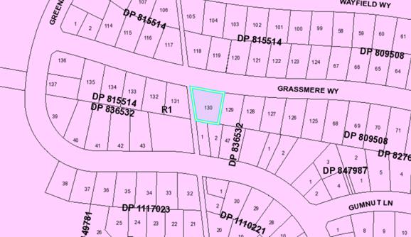
The existing subdivision pattern and location of existing
development within the locality is shown in the following aerial photograph:
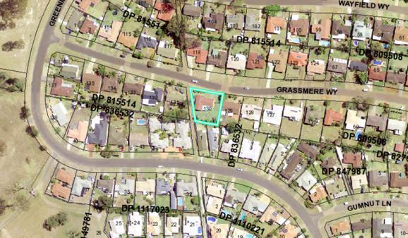
2. DESCRIPTION OF DEVELOPMENT
Key aspects of the proposal include the following:
· Construction
of an additional dwelling to create a Dual Occupancy and Strata Subdivision
Refer
to attachments at the end of this report.
Application Chronology
· 26
September 2018 – Application Lodged
· 5
October 2018 to 18 October 2018 – Neighbour notification
3. STATUTORY ASSESSMENT
Section 4.15(1) Matters for Consideration
In determining the application, Council is required to take
into consideration the following matters as are relevant to the development
that apply to the land to which the development application relates:
(a) The provisions (where
applicable) of:
(i) any Environmental
Planning Instrument:
State Environmental Planning Policy No. 44 - Koala
Habitat Protection
There is no Koala Plan of Management on the site.
Additionally, the site is less than 1ha in area therefore no further
investigations are required.
State Environmental Planning Policy No. 55 –
Remediation of Land
Following an inspection of the site and a search of Council
records, the subject land is not identified as being potentially contaminated
and is suitable for the intended use.
State Environmental Planning Policy No. 62 –
Sustainable Aquaculture
Given the nature of the proposed development and proposed
stormwater controls the proposal will be unlikely to have any adverse impact on
existing aquaculture industries.
State Environmental Planning
Policy (Coastal Management) 2018 and Clause 5.5 of Port Macquarie-Hastings
Local Environmental Plan 2011
The site is not located within a coastal use area / coastal
environment area.
State Environmental Planning Policy (Building
Sustainability Index: BASIX) 2004
A BASIX certificate (number 958205S) has been submitted
demonstrating that the proposal will comply with the requirements of the
SEPP. It is recommended that a condition be imposed to ensure that the
commitments are incorporated into the development and certified at Occupation
Certificate stage.
Port Macquarie-Hastings Local Environmental
Plan 2011
The proposal is consistent with the LEP having regard to the
following:
· Clause
2.2, the subject site is zoned R1. In accordance with clause 2.3(1) and the R1
zone landuse table, the proposed development for an additional dwelling to
create Dual Occupancy and Strata Subdivision in accordance with the
definitions) is a permissible landuse with consent.
The objectives of the R1 zone are as
follows:
o To
provide for the housing needs of the community.
o To
provide for a variety of housing types and densities.
o To
enable other land uses that provide facilities or services to meet the day to
day needs of residents.
In accordance with Clause 2.3(2),
the proposal is consistent with the zone objectives having regard to the
following:
o the proposal is a permissible
landuse;
o provides a variety of housing
types
· Clause
2.7, the demolition fits within the provisions of SEPP (Exempt and Complying)
2008.
· Clause
4.1(4A) , the minimum lot sizes do not apply to the proposal as it is
characterised as attached dwelling / dual occupancy / semi-detached dwelling or
multi dwelling housing development.
· Clause
4.3, the maximum overall height of the building above ground level (existing)
is approximately 4.8m which complies with the standard height limit of 8.5 m
applying to the site.
· Clause
4.4, the floor space ratio of the proposal is 0.4:1.0 which complies with the
maximum 0.65:1 floor space ratio applying to the site.
· Clause
5.10 – Heritage. The site does not contain or adjoin any known heritage
items or sites of significance.
· Clause7.13,
satisfactory arrangements are in place for provision of essential services
including water supply, electricity supply, sewer infrastructure, stormwater
drainage and suitable road access to service the development. Provision of
electricity will be subject to obtaining satisfactory arrangements
certification prior to the issue of a Subdivision Certificate as recommended by
a condition of consent.
(a)(ii) Any proposed instrument that is or has been
placed on exhibition
No draft instruments apply to the site.
(a)(iii) Any DCP in force
Port Macquarie-Hastings Development Control Plan 2013:
|
DCP 2013: Dwellings, Dual occupancies, Dwelling
houses, Multi dwelling houses & Ancillary development
|
|
|
Requirements
|
Proposed
|
Complies
|
|
3.2.2.1
|
Ancillary development:
• 4.8m
max. height
• Single
storey
• 60m2
max. area
• 100m2
for lots >900m2
• 24
degree max. roof pitch
• Not
located in front setback
|
Water tank is appropriately located
|
Yes
|
|
3.2.2.2
|
Articulation zone:
• Min.
3m front setback
• An
entry feature or portico
• A
balcony, deck, patio, pergola, terrace or verandah
• A
window box treatment
• A
bay window or similar feature
• An
awning or other feature over a window
• A
sun shading feature
|
The development contains a fenced courtyard within the
articulation zone. The courtyard is not enclosed by an awning and is
consistent with a front fence
|
Acceptable
|
|
Front setback (Residential not R5 zone):
• Min.
6.0m classified road
• Min.
4.5m local road or within 20% of adjoining dwelling if on corner lot
• Min.
3.0m secondary road
• Min.
2.0m Laneway
|
Front building line setback requirements are complied with
and remains consistent with the existing.
|
Yes
|
|
3.2.2.3
|
Garage 5.5m min. and 1m behind front façade.
Garage door recessed behind building line or
eaves/overhangs provided
|
Garage door setback requirements are complied with. The
front building line is well articulated and setback the same distance as the
existing building line, with a brick dividing wall extending 1.8m separating
the two single garages and providing articulation.
|
Yes
|
|
6m max. width of garage door/s and 50% max. width of
building
|
Width of garage door requirements are complied with.
|
Yes
|
|
Driveway crossover 1/3 max. of site frontage and max. 5.0m
width
|
Driveway crossing width requirements are complied with.
|
Yes
|
|
3.2.2.4
|
4m min. rear setback. Variation subject to site analysis
and provision of private open space
|
The minimum rear setback requirements are not complied
with. The proposed rear setback for the additional dwelling is 2m - see below
justification.
|
Acceptable
|
|
3.2.2.5
|
Side setbacks:
• Ground
floor = min. 0.9m
• First
floors & above = min. 3m setback or where it can be demonstrated that
overshadowing not adverse = 0.9m min.
• Building
wall set in and out every 12m by 0.5m
|
The minimum side setback requirements are complied with.
The wall articulation is compliant and satisfies the
objectives of the development provision.
|
Yes
|
|
3.2.2.6
|
35m2 min. private open space area including a useable 4x4m
min. area which has 5% max. grade
|
Each occupancy contains 35m² open space in one area
including a useable 4m x 4m area.
|
Yes
|
|
3.2.2.7
|
Front fences:
• If
solid 1.2m max height and front setback 1.0m with landscaping
• 3x3m
min. splay for corner sites
• Fences
>1.2m to be 1.8m max. height for 50% or 6.0m max. length of street
frontage with 25% openings
• 0.9x0.9m
splays adjoining driveway entrances
|
The proposed front fence design is considered to meet the
fencing provisions and objectives of DCP 2013. No adverse impacts will occur.
|
Yes
|
|
3.2.2.8
|
Front fences and walls to have complimentary materials to
context
No chain wire, solid timber, masonry or solid steel front
fences
|
Fencing design complies.
|
Yes
|
|
3.2.2.10
|
Privacy:
• Direct
views between living areas of adjacent dwellings screened when within 9m
radius of any part of window of adjacent dwelling and within 12m of private
open space areas of adjacent dwellings. ie. 1.8m fence or privacy screening
which has 25% max. openings and is permanently fixed
• Privacy
screen required if floor level > 1m height, window side/rear setback
(other than bedroom) is less than 3m and sill height less than 1.5m
• Privacy
screens provided to balconies/verandahs etc which have <3m side/rear setback
and floor level height >1m
|
The development will not compromise privacy in the area
due to a combination of lack of windows on side/rear boundaries, having high
sill windows that face side/rear boundaries, limiting living areas that face
adjoining living areas/open space, compliant separation and use of
screening/fencing. No additional screening is required.
|
Yes
|
|
DCP 2013: General Provisions
|
|
|
Requirements
|
Proposed
|
Complies
|
|
2.7.2.2
|
Design addresses generic principles of Crime Prevention
Through Environmental Design guideline
|
No concealment or entrapment areas proposed. Adequate
casual surveillance available.
|
Yes
|
|
2.3.3.1
|
Cut and fill 1.0m max. 1m outside the perimeter of the
external building walls
|
Cut and fill <1.0m change 1m outside the perimeter of
the external building walls
|
Yes
|
|
2.3.3.2
|
1m max. height retaining walls along road frontage
|
None proposed
|
N/A
|
|
Any retaining wall >1.0 in height to be certified by
structure engineer
|
No retaining wall likely >1m
|
Yes
|
|
Combination of retaining wall and front fence height max
1.8m, max length 6.0m or 30% of frontage, fence component 25% transparent,
and splay at corners and adjacent to driveway
|
No retaining wall front fence combination proposed.
|
N/A
|
|
Driveway crossing/s minimal in number and width including
maximising street parking
|
Driveway crossing(s) is/are minimal in width including
maximising street parking
|
Yes
|
|
2.5.3.3
|
Parking in accordance with Table 2.5.1.
Dwelling/dual occupancies
1 space per dwelling/occupancy (behind building line).
Multi dwelling
1 space per 1 & 2 bedroom occupancies
1.5 spaces per 3+ bedroom occupancies
0.25 spaces per occupancy for visitor parking.
|
Proposal involves 2 x 3 bedroom units. Therefore, 2 spaces
required. The development proposes 2 single garages.
|
Yes
|
|
2.5.3.11
|
Section 94 contributions
|
Contributions apply - refer to ET calc and NOP.
|
Yes
|
|
2.5.3.12 and 2.5.3.13
|
Landscaping of parking areas
|
Suitable landscaping proposed around driveway/parking locations.
|
Yes
|
|
2.5.3.14
|
Sealed driveway surfaces unless justified
|
Sealed driveway areas proposed.
|
Yes
|
|
2.5.3.15 and 2.5.3.16
|
Driveway grades first 6m or ‘parking area’
shall be 5% grade with transitions of 2m length
|
Driveway grades capable of satisfying Council standard
driveway crossover requirements.
|
Yes
|
|
2.5.3.17
|
Parking areas to be designed to avoid concentrations of
water runoff on the surface.
|
Stormwater drainage is capable of being managed as part of
plumbing construction.
|
Yes
|
The proposal seeks to vary Development Provision relating to
3.2.2.4
The relevant objectives are; To allow adequate natural light
and ventilation between dwellings/buildings and to private open space areas. To
provide useable yard areas and open space.
Having regard for the development provisions and relevant
objectives, the variation is considered acceptable for the following reasons:
· Council may
consider varying rear setback requirements where it is demonstrated that the
private open space could achieve better solar access between the building and
the side setback.
· In that instance
one side setback should be a minimum 4.0m in width (for an equivalent length of
rear boundary, behind building line) and the rear setback may be reduced to
900mm.
The additional dwelling has a 4.6m to 6.7m side setback to
the western boundary, which provides solar access to the private open space and
living areas. This achieves the minimum 4.0m side setback width for
approximately 7m. Based on the positioning of the proposed dwelling, western
orientation of the living areas has provided maximum solar access. This is
considered to provide adequate natural ventilation and light between the
development and the southern adjoining property and the existing private open
space
Based on the above assessment, the variation proposed to the
provisions of the DCP is considered acceptable and the relevant objectives have
been satisfied.
Note: Subdivision provisions of the DCP (except battleaxe
handle width) are aimed at the creation of vacant lots (i.e. not lots within an
integrated housing proposal such as this) and have therefore been excluded from
the above assessment. Servicing requirements are discussed later in this
report.
(a)(iii)(a) Any planning agreement or draft planning
agreement
No planning agreement has been offered or entered into
relating to the site.
(a)(iv) The regulations
NSW Coastal Policy 1997
The proposed development is consistent with the objectives
and strategic actions of this policy.
Demolition of buildings AS 2601 – Clause 92
Demolition of the existing building on the site is capable
of compliance with this Australian Standard and is recommended to be
conditioned.
(b) The likely
impacts of that development, including environmental impacts on both the
natural and built environments and the social and economic impacts in the
locality
Context and
setting
• The
proposal will be unlikely to have any adverse impacts to existing adjoining
properties and satisfactorily addresses the public domain.
• The proposal is considered to be consistent with other
residential development in the locality and adequately addresses planning
controls for the area.
• There
are no adverse impacts on existing view sharing.
• There are no adverse privacy impacts.
• There are no adverse overshadowing impacts. The proposal
does not prevent adjoining properties from receiving 3 hours of sunlight to
private open space and primary living areas on 21 June.
Roads, Traffic and
Transport
There are no changes to the
existing driveway. The proposal is not considered to create any significant
additional parking demand and/or result in any adverse traffic generation. The
proposal will be unlikely to have any adverse impacts in terms access,
transport and traffic. The existing road network will satisfactorily cater for
any increase in traffic generation as a result of the development.
Water Supply Connection
Service available – details required with S.68
application.
Sewer Connection
Service available – details required with S.68
application.
Stormwater
Service available – details required with S.68
application.
Other Utilities
Telecommunication and electricity
services are available to the site.
Other Utilities
Telecommunication and electricity services are available to
the site. Evidence of satisfactory arrangements with the relevant utility
authorities for provision to each proposed lot will be required prior to
Subdivision Certificate approval.
Heritage
No known items of Aboriginal or European heritage
significance exist on the property. No adverse impacts anticipated.
Other land resources
The site is within an established urban context and will not
sterilise any significant mineral or agricultural resource.
Water cycle
The proposed development will be unlikely to have any
adverse impacts on water resources and the water cycle.
Soils
The proposed development will be unlikely to have any
adverse impacts on soils in terms of quality, erosion, stability and/or
productivity subject to a standard condition requiring erosion and sediment
controls to be in place prior to and during construction.
Air and microclimate
The construction and/or operations of the proposed
development will be unlikely to result in any adverse impacts on the existing
air quality or result in any pollution. Standard precautionary site management
condition recommended.
Flora and fauna
Construction of the proposed development will not require
any removal/clearing of any significant vegetation and therefore will be
unlikely to have any significant adverse impacts on biodiversity or threatened
species of flora and fauna. Part 7 of the Biodiversity Conservation Act
is considered to be satisfied.
Waste
Satisfactory arrangements are in place for proposed storage
and collection of waste and recyclables. No adverse impacts anticipated.
Standard precautionary site management condition recommended.
Energy
The proposal includes measures to address energy efficiency
and will be required to comply with the requirements of BASIX.
Noise and vibration
No adverse impacts anticipated. Condition recommended to
restrict construction to standard construction hours.
Bushfire
The site is not identified as being bushfire prone.
Safety, security and crime prevention
The proposed development will be unlikely to create any
concealment/entrapment areas or crime spots that would result in any
identifiable loss of safety or reduction of security in the immediate
area. The increase in housing density will improve natural surveillance
within the locality and openings from each dwelling overlook common and private
areas.
Social impacts in the locality
Given the nature of the proposed development and its’
location the proposal is unlikely to result in any adverse social impacts.
Economic impact in the locality
No adverse impacts. A likely positive impact is that the
development will maintain employment in the construction industry, which will
lead to flow impacts such as expenditure in the area.
Site design and internal design
The proposed development design satisfactorily responds to
the site attributes and will fit into the locality. No adverse impacts likely.
Construction
No potential adverse impacts identified to neighbouring
properties with the construction of the proposal.
Cumulative impacts
The proposed development is not expected to have any adverse
cumulative impacts on the natural or built environment or the social and
economic attributes of the locality.
(c) The suitability of the site for the development
The proposal will fit into the locality and the site
attributes are conducive to the proposed development.
Site constraints have been adequately addressed and
appropriate conditions of consent recommended.
(d) Any submissions made in accordance with this Act
or the regulations
Following exhibition of the application in accordance with
DCP 2013, 2 submissions were received.
|
Submission Issue/Summary
|
Planning Comment/Response
|
|
As the development has only two single car spaces and is 2
x 3 bedroom units, we feel that extra cars will have to park on the street.
|
The development in accordance with Table 2.5-1 Car Parking
Requirements of the PMHC Development Control Plan 2011, requires Dwelling
houses/Dual Occupancies to have 1 space per dwelling. Adequate provision is
made for off-street parking with 2 x single garages provided for off street
parking.
|
|
There are no units in our street (Grassmere Way) and only
single dwellings and we feel that this could reduce the price of our house
and others within the street.
|
The area is zoned R1 and the proposal is consistent with
the zone objectives having regard to the following:
· the proposal is a
permissible landuse;
· provides a variety of
housing types
· the development is
consistent of other dual occupancies/multi dwelling housing development
within the immediate area.
|
(e) The public interest
The proposed development will be in the wider public
interest with provision of appropriate additional housing.
The proposed development satisfies relevant planning
controls and is not expected to impact on the wider public interest.
4. DEVELOPMENT
CONTRIBUTIONS APPLICABLE
· Development contributions will be required towards
augmentation of town water supply and sewerage system head works under Section
64 of the Local Government Act 1993.
· Development contributions will be required under Section
7.11 of the Environmental Planning and Assessment Act 1979 towards roads, open
space, community cultural services, emergency services and administration
buildings.
5. CONCLUSION AND
STATEMENT OF REASON
The application has been assessed
in accordance with Section 4.15 of the Environmental Planning and Assessment
Act 1979.
Issues raised during assessment
and public exhibition of the application have been considered in the assessment
of the application. Where relevant, conditions have been recommended to manage
the impacts attributed to these issues.
The site is considered suitable
for the proposed development and the proposal adequately addresses relevant
planning controls. The development is not considered to be contrary to the
public's interest and will not result a significant adverse social,
environmental or economic impact. It is recommended that the application be
approved, subject to the recommended conditions of consent provided in the
attachment section of this report.
|
Attachments
1View. DA2018
- 790.1 Plans and documents
2View. DA2018
- 790.1 Recommended Conditions
|