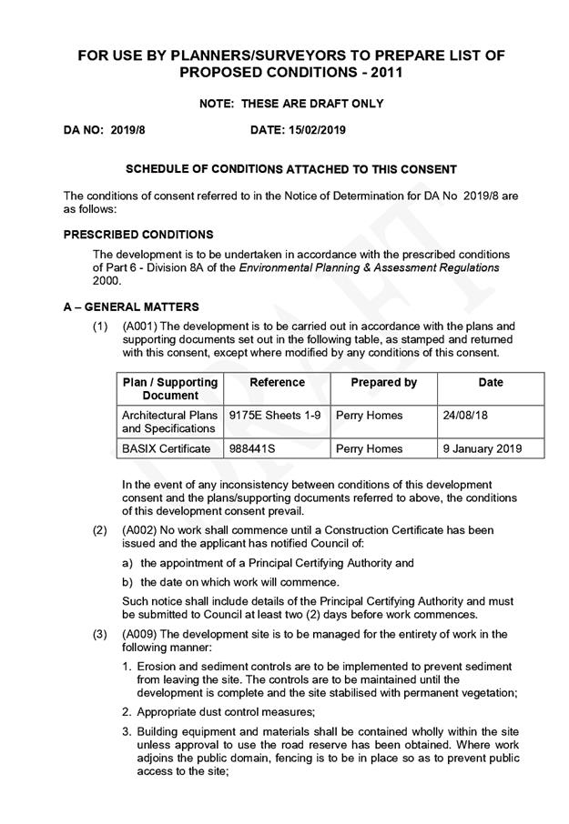
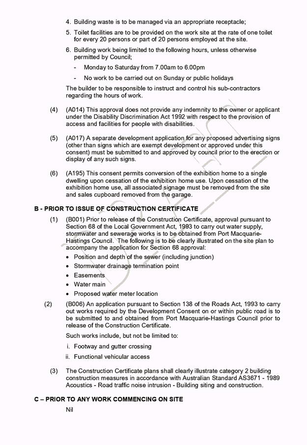
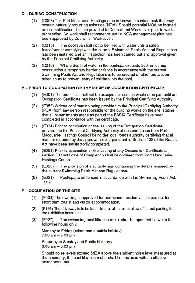
Business
Paper
|
date of meeting:
|
|
Wednesday 27
February 2019
|
|
location:
|
|
Function Room
Port
Macquarie-Hastings Council
17 Burrawan Street
Port Macquarie
|
|
time:
|
|
2:00pm
|
Development
Assessment Panel
CHARTER
1.0 OBJECTIVES
To assist in managing Council's development assessment
function by providing independent and expert determinations of development
applications that fall outside of staff delegations.
2.0 KEY FUNCTIONS
·
To review development application reports and conditions;
·
To determine development
applications outside of staff delegations;
·
To refer development applications
to Council for determination where necessary;
·
To provide a forum for objectors and applicants
to make submissions on applications
before the Development Assessment Panel
(DAP);
·
To maintain transparency in the determination of development
applications.
Delegated Authority of Panel
Pursuant to
Section 377 of the Local Government Act, 1993 delegation to:
·
Determine development applications under Part 4
of the Environmental Planning and Assessment
Act 1979 having
regard to the relevant environmental planning instruments,
development control plans and Council policies.
·
Vary, modify or release restrictions as to use
and/or covenants created by Section 88B instruments under the Conveyancing Act
1919 in relation to development applications for subdivisions being considered
by the panel.
·
Determine Koala Plans of Management under State
Environmental Planning Policy 44 - Koala Habitat Protection associated with
development applications being considered by the Panel.
Noting the trigger to escalate
decision making to Council as highlighted in section 5.2.
3.0
MEMBERSHIP
3.1
Voting
Members
·
Two independent external members. One of the
independent external members to be the Chairperson.
·
Group Manager Development Assessment (alternate
- Director Development & Environment or Development Assessment Planner)
The independent external members shall have expertise in
one or more of the following areas: planning, architecture, heritage, the
environment, urban design, economics, traffic and transport, law, engineering,
government and public administration.
3.2
Non-Voting Members
·
Not applicable
3.3 Obligations
of members
·
Members must act faithfully and diligently and
in accordance with this Charter.
·
Members must comply with Council's Code of Conduct.
·
Except as required to properly perform their
duties, DAP members must not
disclose any confidential information (as advised by Council) obtained in connection with the DAP functions.
·
Members will have read and be familiar with the
documents and information provided by Council prior
to attending a DAP meeting.
·
Members must act in accordance with Council's
Workplace Health and Safety Policies and Procedures
·
External members of the Panel are not authorised
to speak to the media on behalf of Council. Council officers that are members
of the Committee are bound by the
existing operational delegations in relation to speaking to the media.
·
Staff members shall not vote on matters before
the Panel if they have been the principle author of the development assessment report.
3.4
Member Tenure
·
The independent external members will be
appointed for the term of four (4) years
maximum in which the end of the tenure of these members would occur in a
cascading arrangement.
3.5 Appointment
of members
·
The independent external members (including the
Chair) shall be appointed by the General Manager following an external
Expression of Interest process.
·
Staff members of the Panel are in accordance
with this Charter.
4.0 TIMETABLE
OF MEETINGS
·
The Development Assessment Panel will generally
meet on the 1st and 3rd Wednesday each month at 2.00pm at the Port Macquarie
offices of Council.
·
Special Meetings of the Panel may be convened by
the Director Development & Environment Services with three (3) days notice.
5.0
MEETING PRACTICES
5.1
Meeting
Format
·
At all Meetings of the Panel the Chairperson
shall occupy the Chair and preside. The Chair will be responsible for keeping
of order at meetings.
·
Meetings shall be open to the public.
·
The Panel will hear from applicants
and objectors or their r e p r e s e n t a t i v e s .
·
Where considered necessary, the Panel will
conduct site inspections which will
be open to the public.
5.2
Decision Making
·
Decisions are to be made by consensus. Where
consensus is not possible on any item, that item is to be referred to Council
for a decision.
·
All development applications involving a
proposed variation to a development standard
greater than 10% under Clause
4.6 of the Local Environmental Plan will be
considered by the Panel and recommendation made to the Council for a decision.
5.3
Quorum
·
All members (2 independent external members and
1 staff member) must be present at a
meeting to form a quorum.
5.4
Chairperson and Deputy Chairperson
·
Independent Chair (alternate, second independent member)
5.5
Secretariat
·
The Director Development &n Environment is
to be responsible for ensuring that the Panel has adequate secretariat support.
The secretariat will ensure that the business paper and supporting papers are
circulated at least three (3) days prior to
each meeting. Minutes shall be appropriately approved and circulated to each
member within three (3) weeks of a meeting being held.
·
The format of and the preparation and publishing
of the Business Paper and Minutes shall be similar to the format for Ordinary
Council Meetings.
5.6
Recording of decisions
·
Minutes will record decisions and how each
member votes for each item before the Panel.
6.0 CONVENING
OF “OUTCOME SPECIFIC” WORKING GROUPS
Not applicable.
7.0 CONFIDENTIALITY
AND CONFLICT OF INTEREST
·
Members of the Panel must comply with the
applicable provisions of Council’s Code of Conduct. It is the personal
responsibility of members to comply with the standards in the Code of Conduct
and regularly review their personal circumstances with this in mind.
·
Panel members must declare any conflict of
interests at the start of each meeting or before discussion of a relevant item
or topic. Details of any conflicts of interest should be appropriately minuted.
Where members are deemed to have a real or perceived conflict of interest, it
may be appropriate they be excused from deliberations on the issue where the
conflict of interest may exist. A Panel meeting may be postponed where there is
no quorum.
8.0 LOBBYING
·
All members and applicants are to adhere to
Council’s Lobbying policy. Outside of
scheduled Development Assessment Panel meetings, applicants, their
representatives, Councillors, Council staff and the general public are not to
lobby Panel members via meetings, telephone conversations, correspondence and
the like. Adequate opportunity will be provided at Panel inspections or
meetings for applicants, their representatives and the general public to make
verbal submissions in relation to Business Paper items.
Development Assessment Panel
ATTENDANCE
REGISTER
|
Member
|
28/11/18
|
05/12/18
|
19/12/18
|
23/01/19
|
13/02/19
|
|
Paul Drake
|
P
|
P
|
P
|
P
|
P
|
|
Robert Hussey
|
P
|
P
|
A
|
P
|
P
|
|
David Crofts
(alternate member)
|
|
|
P
|
|
|
|
Dan Croft
(Acting Director
Development & Environment)
Clinton Tink
(Acting GM Development
Assessment
(alternates)
- Director Development & Environment
- Development Assessment Planner
|
P
|
P
|
P
|
P
|
P
|
Key: P = Present
A
= Absent With Apology
X
= Absent Without Apology
Development
Assessment Panel Meeting
Wednesday 27 February
2019
Items of Business
01 Acknowledgement
of Country............................................................................ 8
02 Apologies......................................................................................................... 8
03 Confirmation
of Minutes.................................................................................... 8
04 Disclosures
of Interest..................................................................................... 13
05 DA2019
- 008.1 Exhibition Home - Lot 20 DP1230717, No 8 Seaside Drive, Lake Cathie 17
06 DA2018
- 1041.1 Alterations and Additions to Dwelling Including a Clause 4.6 Variation
to Clause 4.3 (Height Of Buildings) of the Port Macquarie Hastings Local
Environmental Plan 2011 - Lot 18 DP 31187, No.23 Bourne Street, Port Macquarie............................................... 35
07 DA2018
- 1058.1 - Continued Use of Alterations and Additions to Dwelling (Unit 4) as
part of Multi Dwelling Housing Development - Lot 3 DP 1214081, No. 114
Greenmeadows Drive, Port Macquarie....................................................................................................... 70
08 DA2018
- 599.1 - Use of Existing Dwelling for Tourist and Visitor Accommodation - Lot
9 DP 234920, No.118 Camden Head Road, Dunbogan............................................. 105
09 DA2018
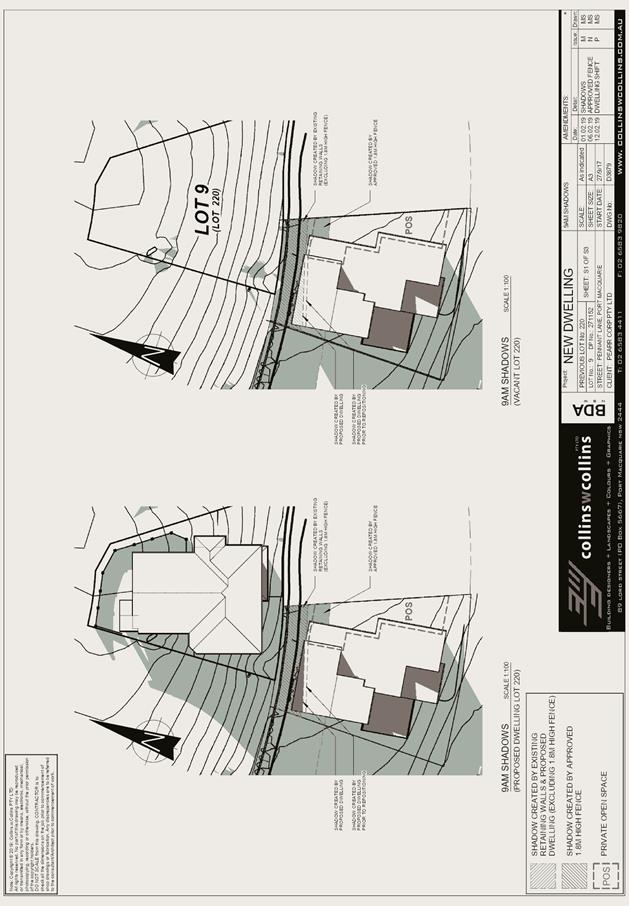
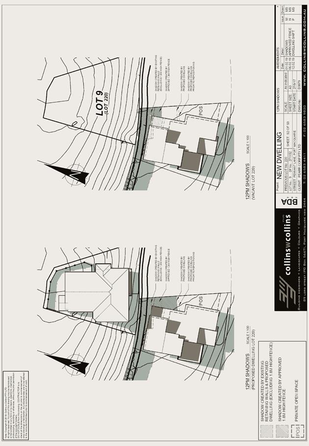
- 1104.1 - Two Dwellings - Lots 8 and 9 DP 271152, No 3 Pennant Lane,
Port Macquarie..................................................................................................................... 157
10 General
Business
AGENDA Development Assessment Panel 27/02/2019
Subject: ACKNOWLEDGEMENT
OF COUNTRY
"I acknowledge that we are
gathered on Birpai Land. I pay respect to the Birpai Elders both past and
present. I also extend that respect to all other Aboriginal and Torres Strait
Islander people present."
RECOMMENDATION
That the apologies received be
accepted.
Subject: CONFIRMATION
OF PREVIOUS MINUTES
Recommendation
That the Minutes of the Development
Assessment Panel Meeting held on 13 February 2019 be confirmed.
MINUTES
Development Assessment Panel Meeting
13/02/2019
PRESENT
Members:
Paul
Drake
Robert Hussey
Dan Croft
Other Attendees:
Ben Roberts
Caroline
Horan
Jon
Power
Anna
Stricker
Michael
Roberts
|
The meeting opened at 2:00pm.
|
|
01 ACKNOWLEDGEMENT
OF COUNTRY
|
|
The
Acknowledgement of Country was delivered.
|
|
03 CONFIRMATION
OF MINUTES
|
|
CONSENSUS:
That
the Minutes of the Development Assessment Panel Meeting held on 23 January
2019 be confirmed.
|
|
04 DISCLOSURES
OF INTEREST
|
|
There were no disclosures of interest presented.
|
|
05 DA 2018 - 1033.1
Alterations and Additions to Dwelling - Lot 11 DP 22923, No. 102 Settlement
Point Road, Port Macquarie
|
|
Speakers:
Nick
Lawton (o)
Craig
Maltman (applicant)
CONSENSUS:
That DA
2018 - 1033 for Dwelling Alterations
and Additions at Lot 11, DP 22923, No. 102
Settlement Point Road, Port Macquarie be determined
by granting consent subject to the recommended conditions.
|
|
06 DA2018 - 353.1
Commercial Premises and Tourist and Visitor Accommodation with Clause 4.6
variation to Clause 4.3 (Height of Buildings) and Clause 4.4 (Floor Space
Ratio) of the Port Macquarie-Hastings Local Environmental Plan 2011 at Lot
123 DP 1219042, No. 17 Clarence Street, Port Macquarie
|
|
Speakers:
Suzy
Berry (o)
Andrew
Thompson (o)
Brett
Avery (o)
Wayne
Ellis (applicant)
David
Pensini (applicant)
THE
PANEL WAS UNABLE TO REACH CONSENSUS.
Robert
Hussey put forward the following motion:
That
DA2018 – 353 be refused on the grounds that:
- insufficient on-site car
parking has been provided (deficit of 21 spaces) as required by the Port
Macquarie-Hastings Development Control Plan 2013. In the context of this
proposed tourist development located within an area with time limited
parking the public interest would not be well served by allowing such a
significant shortfall in parking spaces on site, or offsetting this
number of spaces via the contribution plan.
- The proposed turning
movements at the reception area are unreasonably compromised and should
be redesigned to avoid regular interruption to the in-out vehicular
movements by the 3-point turn.
FOR: Robert Hussey
AGAINST: Paul Drake and Dan Croft
The
dissenting recommendation was:
That
DA2018 – 353 be deferred to allow the applicant to readdress
non-compliance with development standards and provide further evidence to
support parking provision on site so as to avoid significant dependence on
contribution offsets.
|
|
07 DA2018 - 519.1
Ancillary Building - Pergola Lot 33 DP 1069338, 76 The Anchorage Port
Macquarie
|
|
The Chair tabled a submission from Traelee Stewart
objecting to the proposal
Speakers:
Paula
Stone (applicant).
CONSENSUS:
That DA
2018 – 519.1 for an ancillary building
- pergola at Lot 33, DP 1069338, No. 76 The Anchorage, Port
Macquarie, be determined by granting consent
subject to the recommended conditions and as amended below:
- Delete
condition B(2)
|
|
08 DA2018 - 863
Part Change of Use to Bed and Breakfast Establishment, Lot 3 DP 805503, No.
14 Warrigal Ridge Sancrox
|
|
CONSENSUS:
That DA
2018/863.1 for a Part Change of Use to Bed and Breakfast Establishment at Lot
3, DP 805503, No. 14 Warrigal Ridge, Sancrox, be determined by granting a
deferred commencement consent requiring the following to be satisfied within
12 months:
1. All requirements of the Building Code of Australia, the
NSW Rural Fire Service, the report prepared by Tim Mecham submitted with the
application and the required building modification works to the ground floor
level are to be completed to the satisfaction of Council prior to the
premises being used as a bed and breakfast establishment.
|
|
09 DA2018
- 933.1 Alterations and Additions to Dwelling - Lot 8 DP 844137, No. 1A
Banksia Avenue, Bonny Hills
|
|
Speaker :
Lisa
Munro (applicant)
CONSENSUS:
That DA 2018 – 933.1 for alterations and additions
to dwelling at Lot 8 DP844137, No.1A Banksia Avenue, Bonny Hills be
determined by granting consent subject to the recommended conditions and as
amended below:
1.
Additional condition in Section B of the consent to read: ‘Prior
to release of the Construction Certificate, the plans are to be amended
to delete the upper floor deck (external staircase still permitted).
|
|
The meeting closed at 3:11pm.
|
AGENDA Development Assessment Panel 27/02/2019
Subject: DISCLOSURES
OF INTEREST
RECOMMENDATION
That Disclosures of Interest be presented
DISCLOSURE OF
INTEREST DECLARATION
Name of Meeting: ………………………………………………………………………..
Meeting Date: ………………………………………………………………………..
Item Number: ………………………………………………………………………..
Subject: ………………………………………………………………………..
…………………………………………………….……………...…..
I,
.....................................................................................
declare the following interest:
 Pecuniary:
Take
no part in the consideration and voting and be out of sight of the meeting.
Non-Pecuniary
- Significant Interest:
Take
no part in the consideration and voting and be out of sight of the meeting.
Non-Pecuniary
- Less than Significant Interest:
May
participate in consideration and voting.
For the reason that: ....................................................................................................
.......................................................................................................................................
Name:
…………………………………………………….
Signed:
.........................................................................
Date: ..................................
 (Further
explanation is provided on the next page)
(Further
explanation is provided on the next page)
Further
Explanation
(Local Government Act and Code of Conduct)
A conflict of interest exists where a reasonable and informed
person would perceive that a Council official could be influenced by a private
interest when carrying out their public duty. Interests can be of two types:
pecuniary or non-pecuniary.
All interests, whether pecuniary or non-pecuniary are required to
be fully disclosed and in writing.
Pecuniary Interest
A pecuniary interest is an interest that a Council official has in
a matter because of a reasonable likelihood or expectation of appreciable
financial gain or loss to the Council official. (section 442)
A Council official will also be taken to have a pecuniary interest
in a matter if that Council official’s spouse or de facto partner or a
relative of the Council official or a partner or employer of the Council
official, or a company or other body of which the Council official, or a
nominee, partner or employer of the Council official is a member, has a
pecuniary interest in the matter. (section 443)
The Council official must not take part in the consideration or
voting on the matter and leave and be out of sight of the meeting. The
Council official must not be present at, or in sight of, the meeting of
the Council at any time during which the matter is being considered or
discussed, or at any time during which the council is voting on any question in
relation to the matter. (section 451)
Non-Pecuniary
A non-pecuniary interest is an interest that is private or
personal that the Council official has that does not amount to a pecuniary
interest as defined in the Act.
Non-pecuniary interests commonly arise out of family, or personal
relationships, or involvement in sporting, social or other cultural groups and
associations and may include an interest of a financial nature.
The political views of a Councillor do not constitute a private
interest.
The management of a non-pecuniary interest will depend on whether
or not it is significant.
Non Pecuniary – Significant Interest
As a general rule, a non-pecuniary conflict of interest will be
significant where a matter does not raise a pecuniary interest, but it
involves:
(a)
A relationship between
a Council official and another person that is particularly close, for example,
parent, grandparent, brother, sister, uncle, aunt, nephew, niece, lineal
descendant or adopted child of the Council official or of the Council official’s
spouse, current or former spouse or partner, de facto or other person living in
the same household.
(b)
Other relationships
that are particularly close, such as friendships and business relationships.
Closeness is defined by the nature of the friendship or business relationship,
the frequency of contact and the duration of the friendship or relationship.
(c)
An affiliation between
a Council official an organisation, sporting body, club, corporation or
association that is particularly strong.
If a Council official declares a non-pecuniary significant interest
it must be managed in one of two ways:
1.
Remove the source of
the conflict, by relinquishing or divesting the interest that creates the
conflict, or reallocating the conflicting duties to another Council official.
2.
Have no involvement in
the matter, by taking no part in the consideration or voting on the matter and
leave and be out of sight of the meeting, as if the provisions in section
451(2) apply.
Non Pecuniary – Less than Significant Interest
If a Council official has declared a non-pecuniary less than
significant interest and it does not require further action, they must provide
an explanation of why they consider that the conflict does not require further
action in the circumstances.
SPECIAL
DISCLOSURE OF PECUNIARY INTEREST DECLARATION
|
By
[insert full name of councillor]
|
|
|
In the
matter of
[insert name of environmental planning instrument]
|
|
|
Which is
to be considered at a meeting of the
[insert name of meeting]
|
|
|
Held on
[insert date of meeting]
|
|
|
PECUNIARY
INTEREST
|
|
Address of land in which councillor or an
associated person, company or body has a proprietary interest (the identified
land)i
|
|
|
Relationship of identified land to councillor
[Tick or cross one box.]
|
Councillor
has interest in the land (e.g. is owner or has other interest arising out of
a mortgage, lease trust, option or contract, or otherwise).
Associated
person of councillor has interest in the land.
Associated
company or body of councillor has interest in the land.
|
|
MATTER
GIVING RISE TO PECUNIARY INTEREST
|
|
Nature of land that is subject to a change
in zone/planning control by proposed
LEP (the subject land iii
[Tick or cross one box]
|
The
identified land.
Land
that adjoins or is adjacent to or is in proximity to the identified land.
|
|
Current zone/planning control
[Insert name of current planning instrument and
identify relevant zone/planning control applying to the subject land]
|
|
|
Proposed change of zone/planning control
[Insert name of proposed LEP and identify
proposed change of zone/planning control applying to the subject land]
|
|
|
Effect of proposed change of zone/planning control
on councillor
[Tick or cross one box]
|
Appreciable
financial gain.
Appreciable
financial loss.
|
|
|
|
Councillor’s
Name: …………………………………………
Councillor’s
Signature:
……………………………….
Date: ………………..
Important Information
This information is being
collected for the purpose of making a special disclosure of pecuniary interests
under sections 451 (4) and (5) of the Local Government Act 1993.
You must not make a special disclosure that you know or ought reasonably to
know is false or misleading in a material particular. Complaints made
about contraventions of these requirements may be referred by the
Director-General to the Local Government Pecuniary Interest and Disciplinary
Tribunal.
This form must be completed by
you before the commencement of the council or council committee meeting in
respect of which the special disclosure is being made. The
completed form must be tabled at the meeting. Everyone is entitled to
inspect it. The special disclosure must be recorded in the minutes of the
meeting.
i.
Section 443 (1) of the Local Government Act 1993 provides that
you may have a pecuniary interest in a matter because of the pecuniary interest
of your spouse or your de facto partner or your relativeiv or
because your business partner or employer has a pecuniary interest. You may
also have a pecuniary interest in a matter because you, your nominee, your
business partner or your employer is a member of a company or other body that
has a pecuniary interest in the matter.
ii.
Section 442 of the Local Government Act 1993 provides that a pecuniary
interest is an interest that a person has in a matter because of a
reasonable likelihood or expectation of appreciable financial gain or loss to
the person. A person does not have a pecuniary interest in a matter if the
interest is so remote or insignificant that it could not reasonably be regarded
as likely to influence any decision the person might make in relation to the
matter or if the interest is of a kind specified in section 448 of that
Act (for example, an interest as an elector or as a ratepayer or person liable
to pay a charge).
iii.
A pecuniary interest may arise by way of a change of permissible use of land
adjoining, adjacent to or in proximity to land in which a councillor or a
person, company or body referred to in section 443 (1) (b) or (c) of the
Local Government Act 1993 has a proprietary interest..
iv.
Relative is defined by the Local Government Act 1993 as
meaning your, your spouse’s or your de facto partner’s parent,
grandparent, brother, sister, uncle, aunt, nephew, niece, lineal descendant or
adopted child and the spouse or de facto partner of any of those persons.
AGENDA Development Assessment Panel 27/02/2019
Item: 05
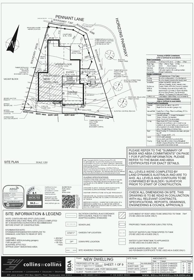
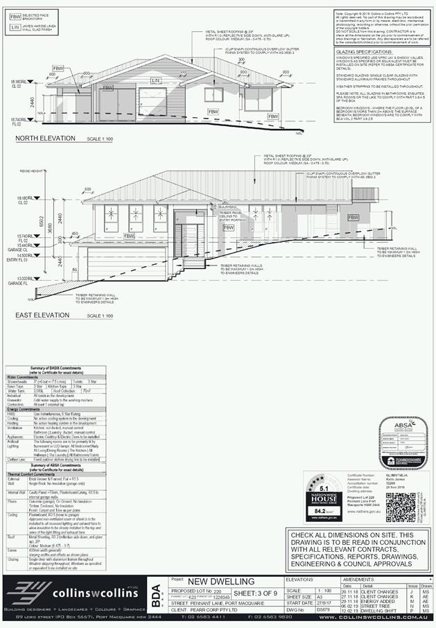
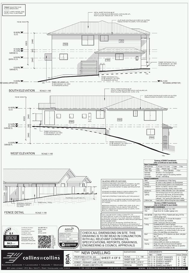
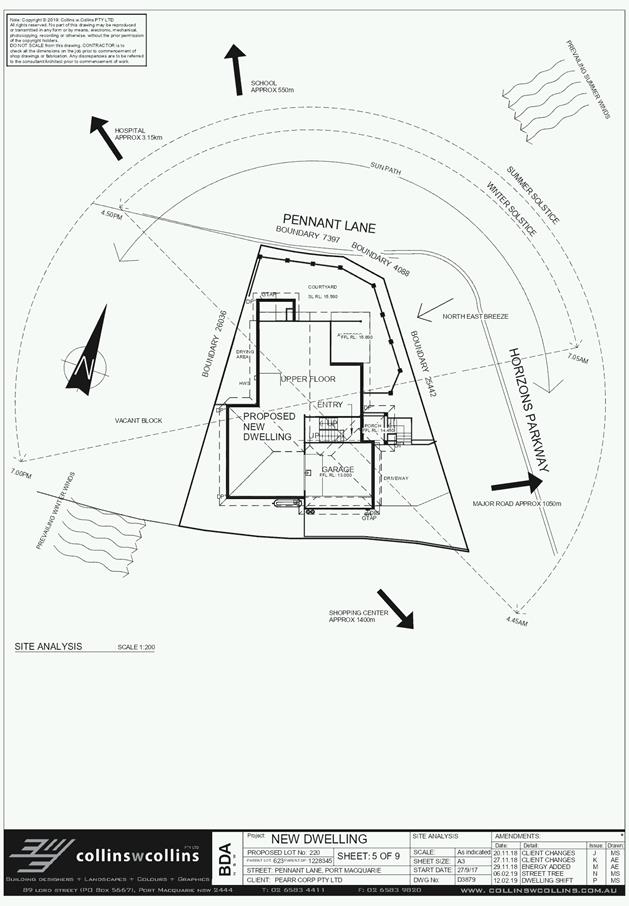
Subject: DA2019 - 008.1 Exhibition Home - Lot 20
DP1230717, No 8 Seaside Drive, Lake Cathie
Report
Author: Fiona Tierney
|
Applicant: Perry
Homes (Aust) Pty Ltd
Owner: Rapview
Investments
Estimated Cost: $380,000
Alignment with Delivery
Program
4.3.1 Undertake transparent
and efficient development assessment in accordance with relevant legislation.
|
|
RECOMMENDATION
That
DA 2019 - 008 for an Exhibition
Home at Lot 20, DP 1230717, No.
8 Seaside Drive, Lake Cathie, be
determined by granting consent subject to the recommended conditions.
|
Executive
Summary
This
report considers a development application for an exhibition home at the
subject site and provides an assessment of the application in accordance with
the Environmental Planning and Assessment Act 1979.
Following exhibition of the
application, one (1) submission has been
received.
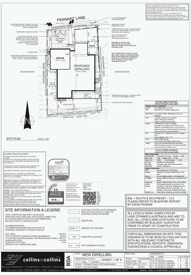
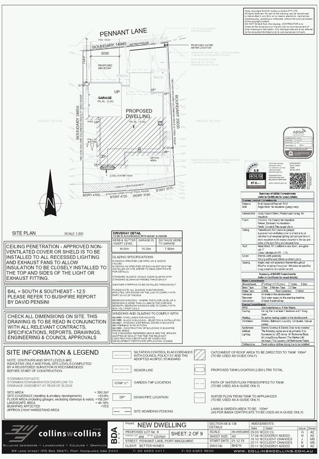
1. BACKGROUND
Existing sites features and Surrounding development
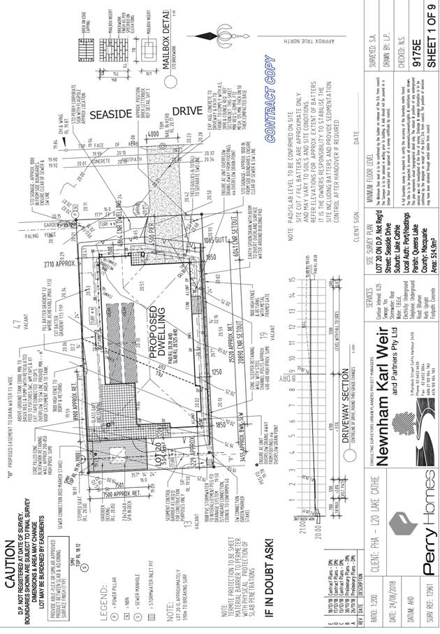
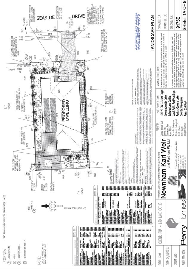
The site has an area of 514.8m2.
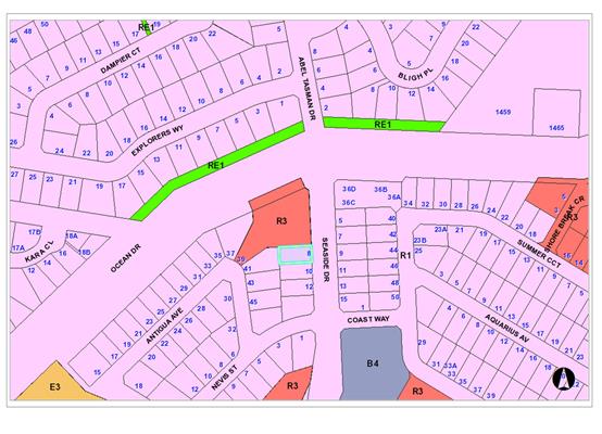
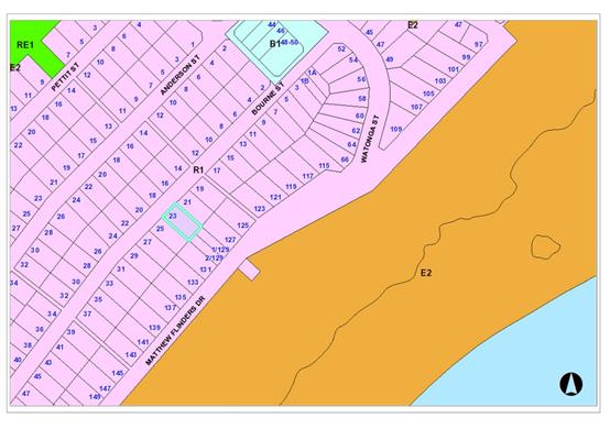
The site is zoned R1 General Residential in accordance with the Port Macquarie-Hastings Local
Environmental Plan 2011, as shown in the following zoning plan:
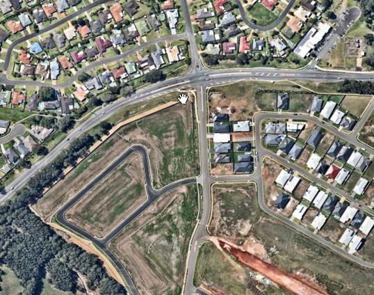
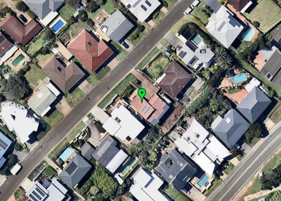
The existing subdivision pattern and location of existing
development within the locality is shown in the following aerial photograph:
2. DESCRIPTION OF
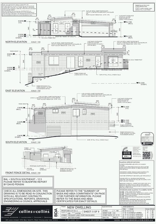
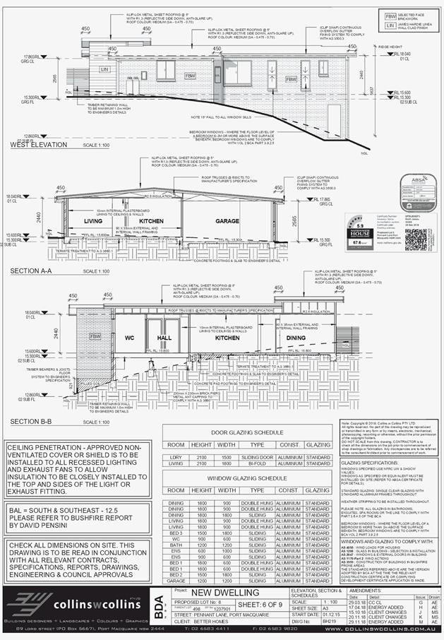
DEVELOPMENT
Key aspects of the proposal include the following:
· Construction
of exhibition home
Refer
to attachments at the end of this report.
Application Chronology
· 8
January 2019 - Application lodged with Council
· 17-31 January 2019 –Exhibition period
3. STATUTORY ASSESSMENT
Section 4.15(1) Matters for Consideration
In determining the application, Council is required to take
into consideration the following matters as are relevant to the development
that apply to the land to which the development application relates:
(a) The provisions (where
applicable) of:
(i) Any Environmental
Planning Instrument:
State
Environmental Planning Policy No.55 – Remediation of Land
Following an inspection of the site and a
search of Council records, the subject land is not identified as being
potentially contaminated and is suitable for the intended use.
State
Environmental Planning Policy No. 62 – Sustainable Aquaculture
Given the nature of the proposed
development and proposed stormwater controls the proposal will be unlikely to
have any adverse impact on existing aquaculture industries.
State Environmental Planning
Policy No. 64 – Advertising and Signage
In accordance with clause 7, this SEPP prevails over the
Port Macquarie-Hastings LEP 2011 in the event of any inconsistency.
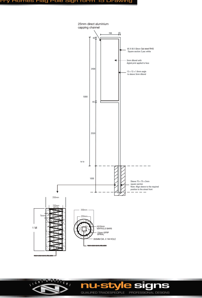
Details of a 5m free-standing pole sign is proposed on the
plans.
The following assessment table provides an assessment
checklist against the Schedule 1 requirements of this SEPP:
|
Applicable clauses for consideration
|
Comments
|
Satisfactory
|
|
Clause 8(a) Consistent with objectives
of the policy as set out in Clause 3(1)(a).
|
The signage is limited to 3 sign
details with dimensions of 1.7m 2 each in size. The size and
limiting signage to its purpose satisfies the objectives of this policy.
|
Yes
|
Schedule
1(1) Character of the area.
|
No adverse streetscape or
character impacts can be identified to this new light industrial estate.
|
Yes
|
|
Schedule 1(2) Special areas.
|
The sign is not in a special area
|
N/A
|
|
Schedule 1(3) Views and vistas.
|
No adverse impacts to any views
or vistas can be identified.
|
Yes
|
|
Schedule 1(4) Streetscape,
setting or landscape.
|
No adverse streetscape impacts
can be identified.
|
Yes
|
|
Schedule 1(5) Site and building.
|
The sign is a moderately sized
freestanding sign at the front of the site proposed which is appropriate.
|
Yes
|
|
Schedule 1(6) Associated devices
and logos with advertisements and advertising structures.
|
The content of the signage is
Perry Homes Exhibition home branding for identifying the use.
|
Yes
|
|
Schedule 1(7) Illumination.
|
No illumination is proposed.
|
N/A
|
|
Schedule 1(7) Safety.
|
No safety issues for travelling
public can be identified with the location and size of the signage.
|
Yes
|
State Environmental Planning Policy
(Building Sustainability Index: BASIX) 2004
A BASIX
certificate has been submitted demonstrating that the proposal will comply with
the requirements of the SEPP. It is recommended that a condition be
imposed to ensure that the commitments are incorporated into the development
and certified at Occupation Certificate stage.
Port Macquarie-Hastings Local Environmental Plan 2011
The proposal is consistent with the LEP having regard to the
following:
· Clause
2.2, the subject site is zoned R1 General Residential. In accordance with
clause 2.3(1) and the R1 zone landuse table, the exhibition home (which will in
the future be converted to a single dwelling house is a permissible landuse
with consent.
The objectives
of the R1 zone are as follows:
o To
provide for the housing needs of the community.
o To
provide for a variety of housing types and densities.
o To
enable other land uses that provide facilities or services to meet the day to
day needs of residents.
·
In accordance with Clause 2.3(2),
the proposal is consistent with the zone objectives as it is a permissible
landuse and consistent with the established residential locality.
· Clause
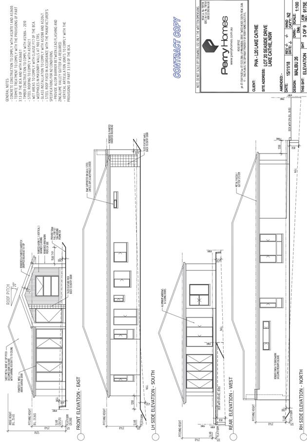
4.3 - the maximum overall height of the building above ground level (existing)
is 5.25 m which complies with the standard height limit of 8.5 m applying to
the site.
· Clause
4.4 - the floor space ratio of the proposal is 0.35:1.0 which complies with the
maximum 0.65:1 floor space ratio applying to the site.
· Clause
5.9 - No listed trees in Development Control Plan 2013 are proposed to be
removed.
· Clause
5.10 – Heritage. The site does not contain or adjoin any known heritage
items or sites of significance.
· Clause
7.9 - The site is subject to acoustic controls. The noise report for the
subdivision provides that category 2 noise construction is required for this
lot. A condition has been applied requiring Construction Certificate plans to
nominate category 2 noise construction.
· Clause
7.13, satisfactory arrangements are in place for provision of essential
services.
(ii) Any
draft instruments that apply to the site or are on exhibition:
No
draft instruments apply to the site.
(iii) Any
Development Control Plan in force:
Port
Macquarie-Hastings Development Control Plan 2013
|
DCP
2013: Dwellings, Dual occupancies, Dwelling houses, Multi dwelling houses
& Ancillary development
|
|
|
Requirements
|
Proposed
|
Complies
|
|
3.2.2.2
|
Articulation
zone:
• Min. 3m front
setback
• An entry feature
or portico
• A balcony, deck,
patio, pergola, terrace or verandah
• A window box
treatment
• A bay window or
similar feature
• An awning or
other feature over a window
• A sun shading
feature
|
|
Yes
|
|
Front
setback (Residential not R5 zone):
• Min. 6.0m
classified road
• Min. 4.5m local
road or within 20% of adjoining dwelling if on corner lot
• Min. 3.0m
secondary road
• Min. 2.0m laneway
|
4.8m setback.
|
Yes
|
|
3.2.2.3
|
Garage 5.5m min. and 1m behind
front façade.
Garage door recessed behind
building line or eaves/overhangs provided
|
Garage is
setback 6.041m and recessed behind building line.
|
Yes
|
|
6m max. width of garage door/s
and 50% max. width of building
|
4.8m garage door width. <50%
of street frontage.
|
Yes
|
|
Driveway crossover 1/3 max. of
site frontage and max. 5.0m width
|
4m crossover. <1/3 of site
frontage.
|
Yes
|
|
Garage and driveway provided on
each frontage for dual occupancy on corner lot
|
Not a corner block.
|
N/A
|
|
3.2.2.4
|
4m min. rear setback. Variation
subject to site analysis and provision of private open space
|
5.2m rear setback
|
No*
|
|
3.2.2.5
|
Side setbacks:
• Ground floor =
min. 0.9m
• First floors
& above = min. 3m setback or where it can be demonstrated that
overshadowing not adverse = 0.9m min.
• Building wall
set in and out every 12m by 0.5m
|
Single Storey
1m south side setback
2.7m north side setback
Adequate articulation provided.
|
Yes
Yes
Yes
|
|
3.2.2.6
|
35m2 min. private open space area
including a useable 4x4m min. area which has 5% max. grade
|
>35m2 of private open space
provided with a directly accessible outdoor living area from the dining and
family rooms.
|
Yes
|
|
3.2.2.10
|
Privacy:
• Direct views
between living areas of adjacent dwellings screened when within 9m radius of
any part of window of adjacent dwelling and within 12m of private open space
areas of adjacent dwellings. ie. 1.8m fence or privacy screening which has
25% max. openings and is permanently fixed
• Privacy screen
required if floor level > 1m height, window side/rear setback (other than
bedroom) is less than 3m and sill height less than 1.5m
• Privacy screens
provided to balconies/verandahs etc which have <3m side/rear setback and
floor level height >1m
|
No adverse privacy impacts
identified. Single storey with 1.8m high dividing fence will provide for
privacy between dwellings.
|
Yes
|
|
DCP
2013: General Provisions
|
|
|
Requirements
|
Proposed
|
Complies
|
|
2.7.2.2
|
Design addresses generic principles of Crime Prevention
Through Environmental Design guideline
|
Adequate casual surveillance available
|
Yes
|
|
2.3.3.1
|
Cut and fill 1.0m max. 1m outside the perimeter of the
external building walls
|
1m max cut and fill.
|
Yes
|
|
2.3.3.2
|
1m max. height retaining walls along road frontage
|
No retaining along road frontage proposed.
|
N/A
|
|
Any retaining wall >1.0 in height to be certified by
structure engineer
|
1m max height proposed.
|
Yes
|
|
Combination of retaining wall and front fence height max
1.8m, max length 6.0m or 30% of frontage, fence component 25% transparent,
and splay at corners and adjacent to driveway
|
N/A
|
N/A
|
|
2.3.3.8
|
Removal of hollow bearing trees
|
No tree removal proposed.
|
N/A
|
|
2.6.3.1
|
Tree removal (3m or higher with 100m diameter trunk at 1m
above ground level and 3m from external wall of existing dwelling)
|
No tree removal proposed.
|
N/A
|
|
2.4.3
|
Bushfire risk, Acid sulphate soils, Flooding,
Contamination, Airspace protection, Noise and Stormwater
|
Refer to main body of report.
|
Yes
|
|
2.5.3.2
|
New accesses not permitted from arterial or distributor
roads
|
None proposed.
|
N/A
|
|
Driveway crossing/s minimal in number and width including
maximising street parking
|
Single crossover.
|
Yes
|
|
2.5.3.3
|
Parking in accordance with Table 2.5.1.
1 space per single dwelling (behind building line)
|
Double garage provided.
|
Yes
|
|
2.5.3.11
|
Section 94 contributions
|
Refer to main body of report.
|
N/A
|
|
2.5.3.12 and 2.5.3.13
|
Landscaping of parking areas
|
Landscaping acceptable.
|
Yes
|
|
2.5.3.14
|
Sealed driveway surfaces unless justified
|
To be sealed.
|
Yes
|
|
2.5.3.15 and 2.5.3.16
|
Driveway grades first 6m or ‘parking area’
shall be 5% grade with transitions of 2m length
|
Capable of compliance.
|
Yes
|
|
2.5.3.17
|
Parking areas to be designed to avoid concentrations of
water runoff on the surface.
|
Acceptable.
|
Yes
|
|
Vehicle washing facilities – grassed area etc
available.
|
Acceptable.
|
Yes
|
(iiia) Any
planning agreement that has been entered into under section 7.4, or any draft
planning agreement that a developer has offered to enter into under section
7.4:
No planning
agreement has been offered or entered into relating to the site.
iv) Any matters prescribed by the
Regulations:
New South Wales Coastal Policy:
Complies with
the objectives.
(b) The
likely impacts of that development, including environmental impacts on both the
natural and built environments, social and economic impacts in the locality:
Context and setting
· The
proposal is unlikely to have any adverse impacts on existing adjoining
properties and satisfactorily addresses the public domain.
· The proposal is considered to be consistent with other
residential development in the locality and adequately addresses planning
controls for the area.
· There
is no adverse impact on existing view sharing.
· There is no adverse privacy impacts.
· There is no adverse overshadowing impacts. The proposal
does not prevent adjoining properties from receiving 3 hours of sunlight to
private open space and primary living areas on 21 June.
Access, transport and traffic
The proposal will be unlikely to have any adverse impacts in
terms access, transport and traffic. The existing road network will
satisfactorily cater for any increase in traffic generation as a result of the
development.
Water Supply
Service available – details required with S.68 application.
Sewer
Service available – details required with S.68
application.
Stormwater
Service available – details
required with S.68 application
Other Utilities
Telecommunication and electricity
services are available to the site.
Heritage
This site does not contain or
adjoin any known heritage item or site of significance.
Other land resources
No adverse impacts anticipated.
The site is within an established urban context and will not sterilise any
significant mineral or agricultural resource.
Water cycle
The proposed development will be
unlikely to have any adverse impacts on water resources and the water cycle.
Soils
The proposed development will be
unlikely to have any adverse impacts on soils in terms of quality, erosion,
stability and/or productivity subject to a standard condition requiring erosion
and sediment controls to be in place prior to and during construction.
Air and microclimate
The construction and/or
operations of the proposed development will be unlikely to result in any
adverse impacts on the existing air quality or result in any pollution.
Flora and fauna
Construction of the proposed
development will not require any removal/clearing of any significant vegetation
and therefore will be unlikely to have any significant adverse impacts on
biodiversity or threatened species of flora and fauna. Section 5A of the
Act is considered to be satisfied.
Waste
Satisfactory arrangements are in
place for proposed storage and collection of waste and recyclables. No adverse
impacts anticipated.
Energy
The proposal includes measures to
address energy efficiency and will be required to comply with the requirements
of BASIX.
Noise and vibration
No adverse impacts anticipated.
Condition recommended to restrict construction to standard construction hours.
Category building 2 construction required to meet acceptable internal noise
levels from road traffic noise.
Bushfire
The site is not identified as
being bushfire prone. Nos specific bushfire measures required.
Safety, security and crime
prevention
The proposed development will be
unlikely to create any concealment/entrapment areas or crime spots that would
result in any identifiable loss of safety or reduction of security in the
immediate area.
Social impacts in the locality
Given the nature of the proposed
development and its’ location the proposal is unlikely to result in any
adverse social impacts.
Economic impact in the
locality
No adverse impacts. Likely
positive impacts can be attributed to the construction of the development and
associated flow on effects (ie increased expenditure in the area).
Site design and internal
design
The proposed development design
is satisfactorily responds to the site attributes and will fit into the
locality. No adverse impacts likely.
Construction
No potential adverse impacts
identified to neighbouring properties with the construction of the proposal.
Cumulative Impacts
The proposed development is not
expected to have any adverse cumulative impacts on the natural or built
environment or the social and economic attributes of the locality.
(c) The suitability of the site for
the development:
The proposal
will fit into the locality and the site attributes are conducive to the
proposed development.
(d) Any submissions made in
accordance with this Act or the Regulations:
One (1) written submissions have been received following public
exhibition of the application.
Key issues raised in the submissions received
and comments in response to these issues are provided as follows:
|
Submission
Issue/Summary
|
Planning
Comment/Response
|
|
Lack of parking- development
likely to generate large numbers of vehicles
|
Use is a temporary use.
Parking is available onsite- double stacked car parking in driveway on street
during time as use for exhibition home and double garage when it reverts to
use as a single dwelling. Traffic generation and parking demand from the
development is unlikely to create undue impact to surrounding residential
development.
|
(e) The Public Interest:
The proposed
development satisfies relevant planning controls and is unlikely to impact on
the wider public interest.
4. DEVELOPMENT CONTRIBUTIONS
APPLICABLE
N/A
5. CONCLUSION AND
STATEMENT OF REASON
The application has been assessed
in accordance with Section 4.15 of the Environmental Planning and Assessment
Act 1979.
Issues raised during assessment
and public exhibition of the application have been considered in the assessment
of the application. Where relevant, conditions have been recommended to manage
the impacts attributed to these issues.
The site is considered suitable
for the proposed development and the proposal adequately addresses relevant
planning controls. The development is not considered to be contrary to the
public's interest and will not result a significant adverse social,
environmental or economic impact. It is recommended that the application be
approved, subject to the recommended conditions of consent provided in the
attachment section of this report.
|
Attachments
1View. DA2019
- 8.1 Recommended Conditions
2View. DA2019
- 8.1 Plans
|
|
ATTACHMENT
|
Development Assessment Panel
27/02/2019
|
|
ATTACHMENT
|
Development Assessment Panel
27/02/2019
|
AGENDA Development Assessment Panel 27/02/2019
Item: 06
Subject: DA2018 - 1041.1 Alterations and Additions to
Dwelling Including a Clause 4.6 Variation to Clause 4.3 (Height Of Buildings)
of the Port Macquarie Hastings Local Environmental Plan 2011 - Lot 18 DP 31187,
No.23 Bourne Street, Port Macquarie
Report
Author: Fiona Tierney
|
Applicant: C
P & A J Hickey
Owner: C
P & A J Hickey
Estimated Cost: $370,000
Alignment with Delivery
Program
4.3.1 Undertake transparent
and efficient development assessment in accordance with relevant legislation.
|
|
RECOMMENDATION
That
DA 2018 – 1041.1 for
alterations and additions to an existing dwelling including Clause 4.6
variation to Clause 4.3 (height of buildings) of the Port Macquarie Hastings
Local Environmental Plan 2011 at Lot 18, DP 31187, No. 23 Bourne Street, Port
Macquarie, be determined by granting consent
subject to the recommended conditions.
|
Executive
Summary
This
report considers a development application for alterations and additions to an
existing dwelling at the subject site and provides an assessment of the
application in accordance with the Environmental Planning and Assessment Act
1979.
Following exhibition of the
application, four (4) submissions have been
received.
This report recommends approval of
the development application and support for the clause 4.6 variation subject to
the recommended conditions
1. BACKGROUND
Existing sites features and surrounding development
The site has an area of 613.4m2.
The site is zoned R1 General Residential in accordance with the Port Macquarie-Hastings Local
Environmental Plan 2011, as shown in the following zoning plan:
The existing subdivision pattern and location of existing
development within the locality is shown in the following aerial photograph:
2. DESCRIPTION OF
DEVELOPMENT
Key aspects of the proposal include the following:
· Demolition
of existing roof over garage.
· Construction
of additional level over garage and living area
· Extension
of deck to the rear
· The
front of the dwelling, when viewed from the street, complies with the 8.5m
height limit
· As
a result of the above, a Clause 4.6 variation is
proposed to Clause 4.3 (Height of Buildings) of Port Macquarie-Hastings Local
Environmental Plan 2011.
Refer
to attachments at the end of this report.
Application Chronology
· 4
December 2018- Application lodged
· 2-21January 2019 (plus an additional 10 days granted
for late submission)– Neighbour notification
· 19 December 2018- Amended plans submitted- additional
clarity detail
· 29 February 2019- Height poles installed
· 1 February 2019- onsite meeting draftsman- assess privacy
impacts and view height poles
· 6 February 2019- on site meeting to assess view loss for
each objector
3. STATUTORY ASSESSMENT
Section 4.15(1) Matters for Consideration
In determining the application, Council is required to take
into consideration the following matters as are relevant to the development
that apply to the land to which the development application relates:
(a) The provisions (where
applicable) of:
(i) Any Environmental
Planning Instrument:
State Environmental Planning Policy No.
44 - Koala Habitat Protection
There is no Koala Plan of
Management on the site. Additionally, the site is less than 1ha in area
therefore no further investigations are required.
State
Environmental Planning Policy No.55 – Remediation of Land
Following an inspection of the site and a
search of Council records, the subject land is not identified as being
potentially contaminated and is suitable for the intended use.
State Environmental Planning Policy (Coastal Management)
2018 and Clause 5.5 of Port Macquarie-Hastings Local Environmental Plan 2011
The site is located within a coastal use area / coastal
environment area.
In accordance with clause 7, this SEPP prevails over the
Port Macquarie-Hastings LEP 2011 in the event of any inconsistency.
Having regard to clauses 13 and 14 of the SEPP and clause
5.5 of the Port Macquarie-Hastings LEP 2011 the proposed development is not
considered likely to result in any of the following:
a) any
adverse impact on integrity and resilience of the biophysical,
hydrological (surface and groundwater) and ecological environment;
b) any
adverse impacts coastal environmental values and natural coastal
processes;
c) any
adverse impacts on marine vegetation, native vegetation and fauna
and their habitats, undeveloped headlands and rock platforms;
d) any
adverse impact on marine vegetation, native vegetation and fauna
and their habitats, undeveloped headlands and rock platforms;
e) any
adverse impact on Aboriginal cultural heritage, practices and
places;
f) any adverse
impacts on the cultural and built environment heritage;
g) any
adverse impacts the use of the surf zone;
h) any adverse impact on the visual amenity and scenic qualities of the
coast, including coastal headlands;
i) overshadowing, wind funnelling and the loss of views from public places
to foreshores;
The bulk, scale and size of the proposed development is
compatible with the surrounding coastal and built environment. The site is in
an established residential area.
State Environmental Planning Policy (Building
Sustainability Index: BASIX) 2004
A BASIX certificate has been submitted
demonstrating that the proposal will comply with the requirements of the SEPP.
It is recommended that a condition be imposed to ensure that the commitments
are incorporated into the development and certified at Occupation Certificate
stage
Port Macquarie-Hastings Local Environmental Plan 2011
The proposal is consistent with the LEP having regard to the
following:
· Clause
2.2, the subject site is zoned R1 General Residential. In accordance with
clause 2.3(1) and the R1 zone landuse table, the dwelling (or ancillary
structure to a dwelling) is a permissible landuse with consent.
· The
objectives of the R1 zone are as follows:
o To provide for the
housing needs of the community.
o To provide for a
variety of housing types and densities.
o To enable other
land uses that provide facilities or services to meet the day to day needs of
residents.
· In
accordance with Clause 2.3(2), the proposal is consistent with the zone
objectives as it is a permissible landuse, contributes to housing variety and
is sufficiently consistent with the existing residential locality
· Clause
2.7, the demolition requires consent as it does not fit within the provisions
of SEPP (Exempt and Complying) 2008.
· Clause
4.3, the maximum overall height of the building above ground level (existing)
is 9.35m which does not comply with the standard height limit of 8.5m applying
to the site.
· Clause
4.4, the floor space ratio of the proposal is 0.416:1.0 which complies with the
maximum 1:1 floor space ratio applying to the site.
· Clause
4.6 – The application seeks to vary the 8.5 metre height limit identified
under Clause 4.3 of the LEP. Clause 4.3, this clause establishes the maximum
“height of a building” (or building height) that a building may be
built to on any parcel of land. The term “building height (or height of
building)” is defined in the LEP to mean “the vertical distance
between ground level (existing) and the highest point of the building,
including plant and lift overruns, but excluding communication devices,
antennae, satellite dishes, masts, flagpoles, chimneys, flues and the like”.
The term “ground level (existing)” is also defined in the LEP to
mean “the existing level of a site at any point”.
The
building height limit for the site is identified on the Height of Buildings Map
as being 8.5m. The proposed development (new works) exceed the height by 0.85m,
which represents a variation of 10%. Refer to the attached elevation plans,
which demonstrate the areas of the building that exceed the height limit.
In
considering the height variation, compliance with the objectives of Clause 4.3
of the LEP have been considered below:
(a) To ensure
that buildings are compatible with the height, bulk and scale of the existing
and desired future character of the locality,
Comment:
·
The locality and Bourne Street are characterised by a number of
dwellings with similar heights, due mainly to the steepness of the land.
Key
aspects of this proposal are:
- The dwelling still
presents as a single storey dwelling to the street/public domain given it is
set well below street level.
- The variation in height
occurs central to the building where the original lower floor level (at the
time the dwelling was originally constructed) was excavated well into the site.
This will limit the impact on neighbours as the central height will not be
visible.
Based
on the above, the proposed height, bulk and scale of the development is
considered compatible with the existing and future character of the locality.
(b) To minimise
visual impact, disruption of views, loss of privacy and loss of solar access to
existing development,
Comment:
The
visual impact of the building is considered satisfactory for the following
reasons:
- The
main variations are located behind the facades of the building and are
therefore less distinct.
- The
variations are minor in the context of the existing built form and other
existing height variations.
- The
building height is similar to the existing dwellings in the area and will
therefore not be visually dominant.
- The
variation is created by the land sloping steeply away from the street.
View
impacts and solar access are considered elsewhere in this report under
‘View Sharing’ and ‘Overshadowing’. The proposed
development and minor height variation do not create any adverse view loss or
significant additional overshadowing.
Potential
privacy impacts are considered under the relevant DCP provisions below and have
been satisfactorily addressed in the building design.
(c) To minimise
the adverse impact of development on heritage conservation areas and heritage
items,
Comment:
The
site does not contain any known heritage items or sites of significance.
(d)
To nominate heights that will provide a transition in built form and land use
intensity within the area covered by this Plan.
Comment:
The proposed height is consistent with other
dwellings in the area. The variation does not compromise this intent of the
standard.
In addition to the above, the applicant has
lodged a written request in accordance with Clause 4.6 of the LEP objecting to
the 8.5m building height standard applying to the site.
·
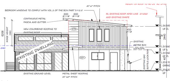
Proposed front elevation with existing roof line marked in
red hashed line.
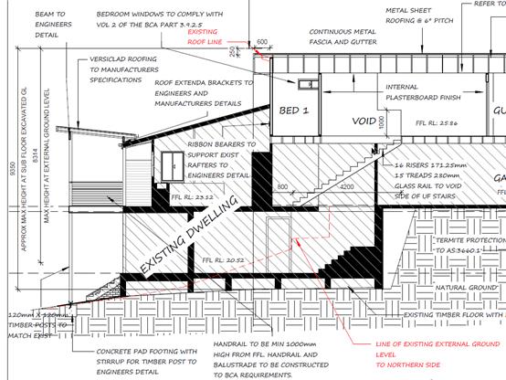
Section through indicating existing and natural ground
levels.
In accordance with the provisions of sub-clause 4.6(3), the
Applicant has requested that compliance with the building height provisions
identified under Clause 4.3 is unreasonable and unnecessary in the
circumstances of this case, for the following reasons:
- Having
regard to the other dwellings in this locality, it is considered that the
proposed building is compatible with the height, bulk and scale of the existing
and likely future character of this locality. Whilst the existing design has
followed the slope of the land, a small area of the roof now technically
exceeds the 8.5m height due to heights being calculated from existing ground
level and not natural ground level.
The existing sub floor area was excavated with more than
the required under floor minimum requirements, which has consequently made the
overall height taken from this point slightly higher than the defined height
limit.
At the natural ground level on the exterior of the
dwelling, the proposed design would be under the 8.5m at the highest point and
therefore compliant. It is only the over excavated area under the subfloor of
the existing dwelling that presents the exceeded height limit in a very small
area.
- With
the steep nature of the site and surrounding properties, the proposed occupies
a similar or less bulk and scale than recently renovated neighbouring
properties. The shadow diagrams also demonstrate that the proposed dwelling
will not adversely impact on overshadowing, including the additional height.
For a number of the properties it can be argued that there is a net view gain
due to a lowering of the roof on one side.
- Compliance
with the development standard is unnecessary as the areas of the roof which
vary the height standard do not impact on overshadowing, view lines, or
perceptions of building bulk and scale.
·
·
In addition to the above, the following is noted:
- The
primary bulk of the building is contained within the 8.5m height limit.
- The
extent of the height is limited to only a maximum 0.85m or 10% above the 8.5m
standard.
·
·
For the above reasons, the objection is considered to be well
founded and it is recommended that the variation be supported.
·
·
In accordance with the Department of Planning and Environment
Circular PS 08-014, the proposal includes variations to the LEP which is not
greater than 10% and therefore can be determined under delegated authority
(Development Assessment Panel has delegations to determine). A report
will be required to be made to an Ordinary meeting of Council to advise of the
clause 4.6 variation should consent be granted.
·
(ii) Any
draft instruments that apply to the site or are on exhibition:
No draft instruments
apply to the site.
(iii) Any
Development Control Plan in force:
Port
Macquarie-Hastings Development Control Plan 2013
|
DCP 2013: Dwellings, Dual
occupancies, Dwelling houses, Multi dwelling houses & Ancillary
development
|
|
|
Requirements
|
Proposed
|
Complies
|
|
3.2.2.2
|
Articulation zone:
• Min. 3m
front setback
• An entry
feature or portico
• A balcony,
deck, patio, pergola, terrace or verandah
• A window
box treatment
• A bay
window or similar feature
• An awning
or other feature over a window
• A sun
shading feature
|
No encroachments within the
articulation zone
|
Yes
|
|
Front setback (Residential not R5
zone):
• Min. 4.5m
local road
|
The minimum setback is 7.4m.
|
Yes
|
|
3.2.2.3
|
Garage 5.5m min. and 1m behind
front façade.
Garage door recessed behind
building line or eaves/overhangs provided
|
The garage door is accessed from
the side angle and is located below street level. Garage does not dominate
the street frontage. Garage door will technically be 1m behind outermost
point.
|
Yes
|
|
6m max. width of garage door/s
and 50% max. width of building
|
Not located within front
elevation
|
N/A
|
|
Driveway crossover 1/3 max. of
site frontage and max. 5.0m width
|
Existing.
|
Yes
|
|
3.2.2.4
|
4m min. rear setback. Variation
subject to site analysis and provision of private open space
|
7.286m
rear setback
|
Yes
|
|
3.2.2.5
|
Side setbacks:
• Ground
floor = min. 0.9m
• First
floors & above = min. 3m setback or where it can be demonstrated that
overshadowing not adverse = 0.9m min.
• Building
wall set in and out every 12m by 0.5m
|
Existing side setbacks
|
Yes
Yes
Yes
|
|
3.2.2.6
|
35m2 min. private open space area
including a useable 4x4m min. area which has 5% max. grade
|
Existing
|
Yes
|
|
3.2.2.7
|
Front fences:
• If solid
1.2m max height and front setback 1.0m with landscaping
• 3x3m min.
splay for corner sites
• Fences
>1.2m to be 1.8m max. height for 50% or 6.0m max. length of street
frontage with 25% openings
• 0.9x0.9m
splays adjoining driveway entrances
• Front
fences and walls to have complimentary materials to context
|
No front fences proposed
|
Yes
|
|
3.2.2.10
|
Privacy:
• Direct
views between living areas of adjacent dwellings screened when within 9m
radius of any part of window of adjacent dwelling and within 12m of private
open space areas of adjacent dwellings. ie. 1.8m fence or privacy screening
which has 25% max. openings and is permanently fixed
• Privacy
screen required if floor level > 1m height, window side/rear setback
(other than bedroom) is less than 3m and sill height less than 1.5m
• Privacy
screens provided to balconies/verandahs etc which have <3m side/rear
setback and floor level height >1m
|
Existing. Topography of the site
results in overlooking of properties below. Small extension of rear deck area
proposed. No significant additional impact on current privacy impact level.
Applicant has planted bamboo and other vegetation to increase privacy
screening. Also added frosting to balcony glass panels that limit vision from
a seated position and from within the living areas of the house.
|
Yes
|
|
DCP 2013: General Provisions
|
|
|
Requirements
|
Proposed
|
Complies
|
|
2.7.2.2
|
Design addresses generic principles of Crime Prevention
Through Environmental Design guideline
|
Adequate casual surveillance available
|
Yes
|
|
2.3.3.1
|
Cut and fill 1.0m max. 1m outside the perimeter of the external
building walls
|
Existing
|
Yes
|
|
2.3.3.2
|
1m max. height retaining walls along road frontage
|
Existing
|
N/A
|
|
Any retaining wall >1.0 in height to be certified by
structure engineer
|
Existing
|
N/A
|
|
Combination of retaining wall and front fence height max
1.8m, max length 6.0m or 30% of frontage, fence component 25% transparent,
and splay at corners and adjacent to driveway
|
N/A
|
|
|
2.3.3.8
|
Removal of hollow bearing trees
|
No hollow bearing trees identified for removal.
|
Yes
|
|
2.6.3.1
|
Tree removal (3m or higher with 100m diameter trunk at 1m
above ground level and 3m from external wall of existing dwelling)
|
|
N/A
|
|
2.4.3
|
Bushfire risk, Acid sulphate soils, Flooding,
Contamination, Airspace protection, Noise and Stormwater
|
|
Yes
|
|
2.5.3.2
|
New accesses not permitted from arterial or distributor
roads
|
N/A
|
|
|
Driveway crossing/s minimal in number and width including
maximising street parking
|
Existing
|
Yes
|
|
2.5.3.3
|
Parking in accordance with Table 2.5.1.
1 space per single dwelling (behind building line)
|
Existing
|
Yes
|
|
2.5.3.11
|
Section 94 contributions
|
N/A
|
|
|
2.5.3.12 and 2.5.3.13
|
Landscaping of parking areas
|
Single dwelling. Landscaping indicatively shown in the
front setback area.
|
Yes
|
|
2.5.3.14
|
Sealed driveway surfaces unless justified
|
Sealed driveway proposed
|
Yes
|
|
2.5.3.15 and 2.5.3.16
|
Driveway grades first 6m or ‘parking area’
shall be 5% grade with transitions of 2m length
|
Existing
|
Yes
|
|
2.5.3.17
|
Parking areas to be designed to avoid concentrations of
water runoff on the surface.
|
Existing
|
Yes
|
|
Vehicle washing facilities – grassed area etc
available.
|
Existing
|
N/A
|
(iiia) Any
planning agreement that has been entered into under section 7.4, or any draft
planning agreement that a developer has offered to enter into under section
7.4:
No
planning agreement has been offered or entered into relating to the site.
iv) Any matters prescribed by the
Regulations:
New South Wales Coastal Policy:
The proposed
development is consistent with the objectives and strategic actions of this
policy.
Demolition
of buildings AS 2601:
Demolition of
the existing parts of the building on the site is capable of compliance with
this Australian Standard and is recommended to be conditioned.
(b) The
likely impacts of that development, including environmental impacts on both the
natural and built environments, social and economic impacts in the locality:
Context and setting
• The
proposal will be unlikely to have any adverse impacts to existing adjoining
properties and satisfactorily addresses the public domain.
• The proposal is considered to be sufficiently consistent
with other residential development in the locality and adequately addresses
planning controls for the area including justifiable variations to the Building
Height and other Development Provisions under Development Control Plan 2013.
• There are no identifiable adverse privacy impacts having
regard to recommended development provisions of Development Control Plan 2013,
the design of the new building’s primarily living areas and the privacy
screening and plantings proposed.
• There no significant additional overshadowing impacts. The
proposal does not prevent adjoining properties from receiving 3 hours of
sunlight to a reasonable area of private open space and primary living area on
21 June. It is difficult to maintain access to all private open space areas due
to self -shadowing, topography and fencing. It is considered the addition is
appropriate in the circumstances
View sharing
During the
neighbour notification period concerns surrounding view loss were raised
by a number of neighbours opposite and to the south of the subject
development at nos 18,20 and 26 Bourne Street.
The notion of
view sharing is invoked when a property enjoys existing views and a proposed
development would share that view by taking some of it away for its own
enjoyment. (Taking it all away cannot be called view sharing, although it may,
in some circumstances, be quite reasonable.)
Using the
planning principles of NSW Land and Environment Court in Tenacity Consulting
v Warringah 2004 NSW LEC 140, the following comments are provided in regard
to the view impacts using the 4 step process to establish whether the view
sharing is acceptable.
Step 1
Assessment
of views to be affected. Water views are valued more highly than land views.
Iconic views (e.g. of the Opera House, the Harbour Bridge or North Head) are
valued more highly than views without icons. Whole views are valued more highly
than partial views, e.g. a water view in which the interface between land and
water is visible is more valuable than one in which it is obscured.
Comments:
No. 18 Bourne
Street enjoys views along the coast with glimpses of land/water interface and
beach. This view is to be valuable and extensive. The significance of this view
is considered to be high.
No 20 Bourne
Street enjoy views similar views along the coast. The significance of this view
is considered to be high.
No 26 Bourne
Street also enjoys similar views, however they also have iconic views of the
Tacking Point Lighthouse that are significant in a local sense.
Step 2
Consider
from what part of the property the views are obtained. For example the
protection of views across side boundaries is more difficult than the
protection of views from front and rear boundaries. In addition, whether the
view is enjoyed from a standing or sitting position may also be relevant.
Sitting views are more difficult to protect than standing views. The
expectation to retain side views and sitting views is often unrealistic.
Comments:
Affected
views from No.18 Bourne Street are obtained from the upper habitable levels
which are the primary living areas. Views are obtained from both a sitting and
standing position
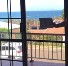
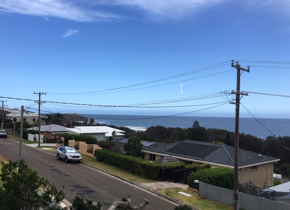
A photo of
the view from the primary living area on the upper level looking across the
development site towards the Pacific Ocean is shown below.
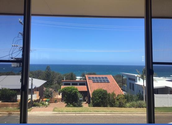
Affected
views from No.20 Bourne Street are obtained from the upper habitable levels
which are the primary living areas. Views are obtained from both a sitting and
standing position.
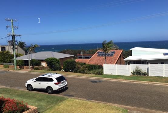
A photo of
the view from the primary living area on the upper level looking across the
development site towards the Pacific Ocean is shown below. Also shown is
indicative view loss from within living area.
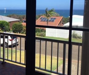
Affected
views from No.26 Bourne Street are obtained from the upper habitable levels
which are the primary living areas and a third level bedroom. Views are
obtained from both a sitting and standing position. Iconic Lighthouse views are
obtained from the external balcony.
A photo of
the view from the upper level looking up the street across the development site
towards the Pacific Ocean is shown below.
Step 3
Assess the
extent of the impact. This should be done for the whole of the property, not
just for the view that is affected. The impact on views from living areas is
more significant than from bedrooms or service areas (though views from
kitchens are highly valued because people spend so much time in them). The
impact may be assessed quantitatively, but in many cases this can be
meaningless. For example, it is unhelpful to say that the view loss is 20% if
it includes one of the sails of the Opera House. It is usually more useful to
assess the view loss qualitatively as negligible, minor, moderate, severe or
devastating.
Comments:
The extent of
the impact upon the views enjoyed from No.18 Bourne Street is considered minor
and would potentially increase the available view due to the change in roof
shape that will now be angled lower on the southern side. It is appreciated
that some concern exists that there will be an accumulative erosion of the view
from the North Western side of Bourne Street. The view is quite extensive and
some comfort must be taken in that a number of houses have been more recently
renovated/extended so some certainty will exist for some time that significant
views will be maintained. Due to the topography of the site and the view loss
sensitivity views are unlikely to devastating as the elevations closest to the
street are generally single storey.
The extent of
impact upon the views enjoyed from No. 20 Bourne Street is slightly more given
the view is across the site and the works will extend toward the street. It is
however still considered minor in that the percentage of vegetation and ocean
lost over the subject site is minimal relative to the entire view available to
the property.
The extent of
impact upon the views form No. 26 Bourne Street are negligible. Looking some
distance up the street across the development site a small portion of distant
outcrop of vegetation will be obscured.
Step 4
Assess the
reasonableness of the proposal that is causing the impact. A development that
complies with all planning controls would be considered more reasonable than
one that breaches them. Where an impact on views arises as a result of
non-compliance with one or more planning controls, even a moderate impact may
be considered unreasonable. With a complying proposal, the question should be
asked whether a more skilful design could provide the applicant with the same
development potential and amenity and reduce the impact on the views of
neighbours. If the answer to that question is no, then the view impact of a
complying development would probably be considered acceptable and the view
sharing reasonable.
Comments:
The majority
of the proposal complies with the maximum building height of 8.5m set for the
area. There are non-compliances with the provisions of DCP 2013 and in part the
LEP building height, however none of these matters would have any impact on
view sharing as they relate to prior cut to the site that is below natural
ground level and so is in keeping with the existing character, bulk and scale
of the existing area.
It is
considered that the applicant has considered the impacts of their proposal on
dwellings opposite as they have largely maintained their works within the
existing roof profile leaving the northern lower roof largely untouched and
maintaining the existing view corridors across the majority of the site.
Access, transport and traffic
The proposal will be unlikely to have any adverse impacts in
terms access, transport and traffic. The existing road network will
satisfactorily cater for any increase in traffic generation as a result of the
development.
Water Supply
Service available – details required with S.68
application.
Sewer
Service available – details required with S.68
application.
Stormwater
Service available to
existing– details required with S.68 application
Other Utilities
Telecommunication and electricity
services are available to the site.
Heritage
This site does not contain or
adjoin any known heritage item or site of significance.
Other land resources
No adverse impacts anticipated.
The site is within an established urban context and will not sterilise any
significant mineral or agricultural resource.
Water cycle
The proposed development will be
unlikely to have any adverse impacts on water resources and the water cycle.
Soils
The proposed development will be
unlikely to have any adverse impacts on soils in terms of quality, erosion,
stability and/or productivity subject to a standard condition requiring erosion
and sediment controls to be in place prior to and during construction.
Air and microclimate
The construction and/or
operations of the proposed development will be unlikely to result in any
adverse impacts on the existing air quality or result in any pollution.
Flora and fauna
Construction of the proposed
development will not require any removal/clearing of any significant vegetation
and therefore will be unlikely to have any significant adverse impacts on
biodiversity or threatened species of flora and fauna. Section 5A of the
Act is considered to be satisfied.
Waste
Satisfactory arrangements are in
place for proposed storage and collection of waste and recyclables. No adverse
impacts anticipated.
Energy
The proposal includes measures to
address energy efficiency and will be required to comply with the requirements
of BASIX.
Noise and vibration
No adverse impacts anticipated.
Condition recommended to restrict construction to standard construction hours.
Bushfire
The site is identified as being
bushfire prone.
The applicant has submitted a
bushfire BAL certificate report prepared by a Certified Consultant. The report
recommends a BAL level of 12.5.
Safety, security and crime
prevention
The proposed development will be
unlikely to create any concealment/entrapment areas or crime spots that would
result in any identifiable loss of safety or reduction of security in the
immediate area. The primary access to the dwelling is available from both the
garage floor level and the adjoining public pathway.
Social impacts in the locality
Given the nature of the proposed
development and its’ location the proposal is unlikely to result in any
adverse social impacts.
Economic impact in the
locality
No adverse impacts. Likely
positive impacts can be attributed to the construction of the development and
associated flow on effects (ie increased expenditure in the area).
Site design and internal
design
The proposed development design
is satisfactorily responds to the site attributes and will fit into the
locality. No adverse impacts likely.
Construction
No potential adverse impacts identified
to neighbouring properties with the construction of the proposal.
Cumulative Impacts
The proposed
development is not expected to have any adverse cumulative impacts on the
natural or built environment or the social and economic attributes of the
locality
(c) The suitability of the site for
the development:
The proposal
will fit into the locality and the site attributes are conducive to the
proposed development.
(d) Any submissions made in
accordance with this Act or the Regulations:
Four (4) written submissions have been received following public
exhibition of the application.
Key issues raised in the submissions received and comments
in response to these issues are provided as follows:
|
Submission
Issue/Summary
|
Planning
Comment/Response
|
|
Details and measurements are
unclear.
|
The applicant has provided
additional details and Council officers have met the applicant and objectors
on site to assist in interpretation. Height poles have also been installed to
enable a visual indication of likely impacts.
The applicant has also
provided a surveyors plan that provides certified levels and points on the
adjoining roof that provides greater certainty that claims made in relation
to view loss are reasonably accurate.
|
|
Solar panel installation
|
Owner has advised that panels will be installed flush
with roof and that they are willing to relocate them to the eastern roof.
Neighbour concerns related to concerns that panels would be placed on props
that would increase the impact on view loss.
|
|
Colour of roof cladding
|
Applicant has advised that the colour will be a midrange
colour such as Woodland grey. Neighbour concerns relate to glare from white
roof colours.
|
|
Over the regulated height- 3 storeys should not be
permissible.
|
3 Storey dwellings are not prohibited. Controls are
centred around bulk and scale. In this instance the height is over the
required 8.5m due to the height measurement being measured from the excavated
existing ground level. It is not considered that the area of variation will
unduly contribute to the impact of the dwelling on adjoining neighbouring
properties given that the area visible to neighbours is below the height
limit.
|
|
Lack of neighbour consultation
|
Whilst neighbour consultation is desirable it is not
always situation people feel comfortable with. The application has been
formally notified and some neighbour consultation has been carried out within
this process.
|
|
Out of character with surrounding area
|
It is considered that the development is within character
and is appropriate in bulk and scale.
|
|
Privacy loss
|
The topography of the sites does result in overlooking to
properties below.
The owner has submitted additional detail on how they
propose to address privacy impacts. Bamboo (mature height 6-8m) Banana trees
and golden cane palms.
Frosted panels in glass balcony panels that restrict view
when seated or from within enclosed are of dwelling.
Timber panels have been added to existing fence after
previous removal of vegetation.
The existing view from the rear deck is shown below. The
minor extension to the existing deck will not unduly increase privacy impacts
to the property below. It is noted however that significant vegetation was
removed in the last 12 months that has attributed to loss of privacy. The
owner has sought to re-establish screening and it is anticipated screening
will return in the short term.
|
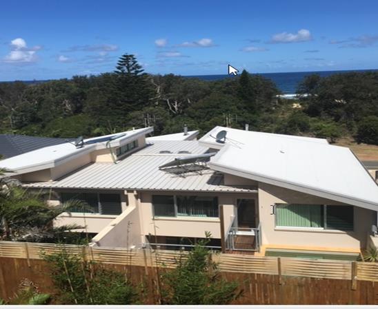
View from existing deck down to 129 Matthew Flinders Drive.
(e) The Public Interest:
The proposed
development satisfies relevant planning controls and is unlikely to impact on
the wider public interest.
4. DEVELOPMENT
CONTRIBUTIONS APPLICABLE
· No development contributions are applicable as the site is
an existing Council approved residential lot.
5. CONCLUSION AND
STATEMENT OF REASON
The application has been assessed
in accordance with Section 4.15 of the Environmental Planning and Assessment
Act 1979.
Issues raised during assessment
and public exhibition of the application have been considered in the assessment
of the application. Where relevant, conditions have been recommended to manage
the impacts attributed to these issues.
The site is considered suitable
for the proposed development and the proposal adequately addresses relevant
planning controls. The development is not considered to be contrary to the public's
interest and will not result a significant adverse social, environmental or
economic impact. It is recommended that the application be approved, subject to
the recommended conditions of consent provided in the attachment section of
this report.
|
Attachments
1View. DA
2018 - 1041.1 Recommended Conditions
2View. DA2018
- 1041.1 SOEE
3View. DA2018
- 1041.1 Plans
|
|
ATTACHMENT
|
Development Assessment Panel
27/02/2019
|
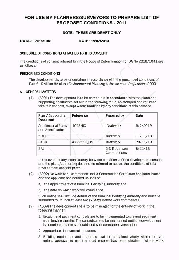
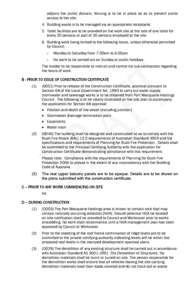
|
ATTACHMENT
|
Development Assessment Panel
27/02/2019
|
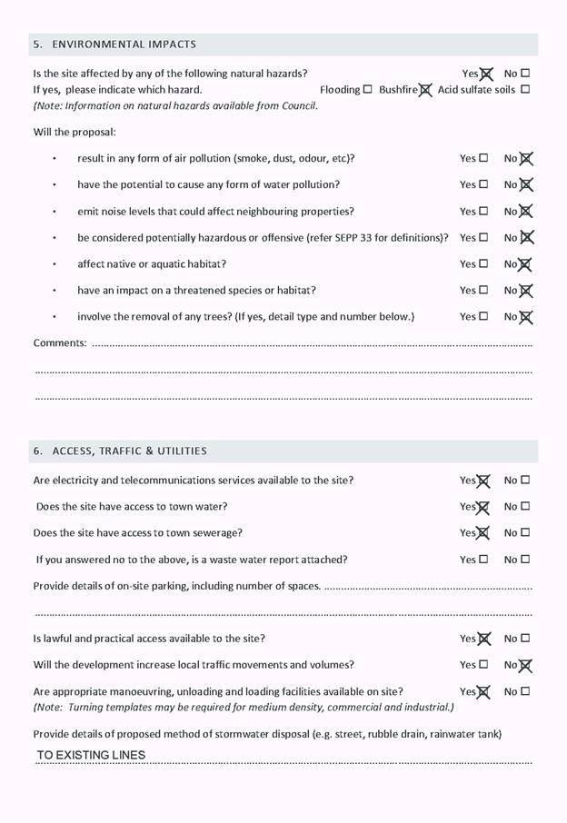
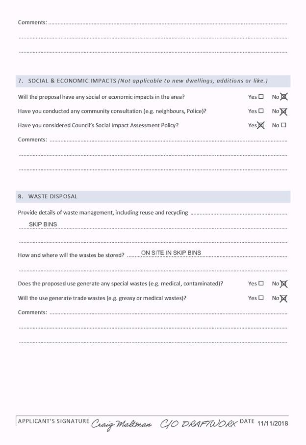
|
ATTACHMENT
|
Development Assessment Panel
27/02/2019
|
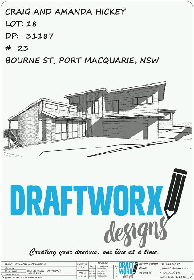
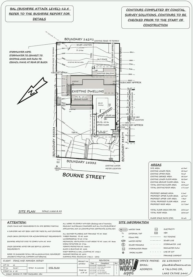
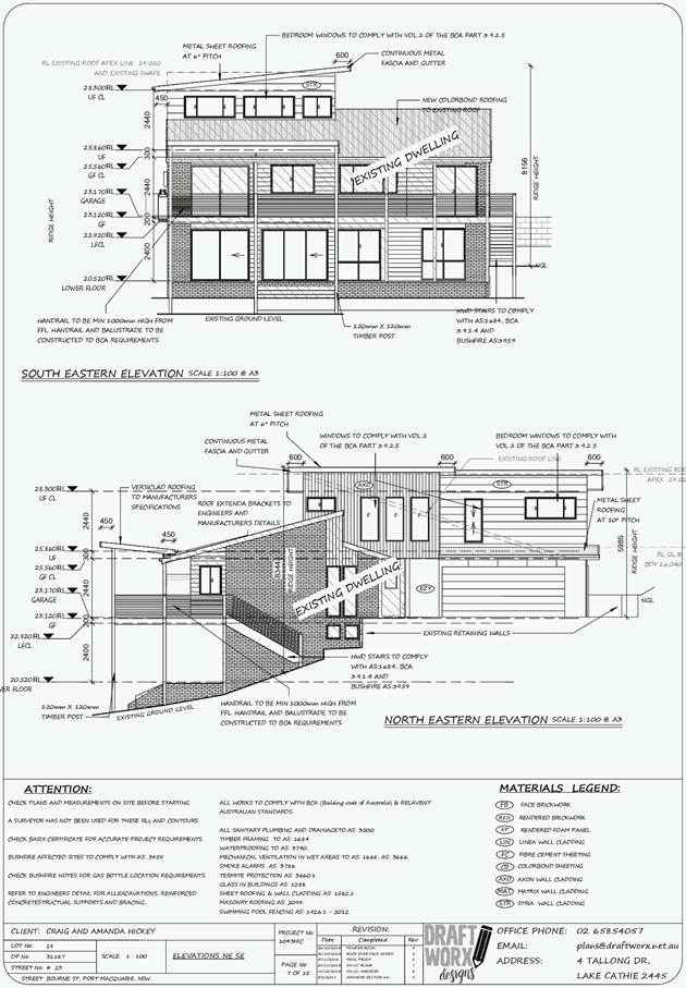
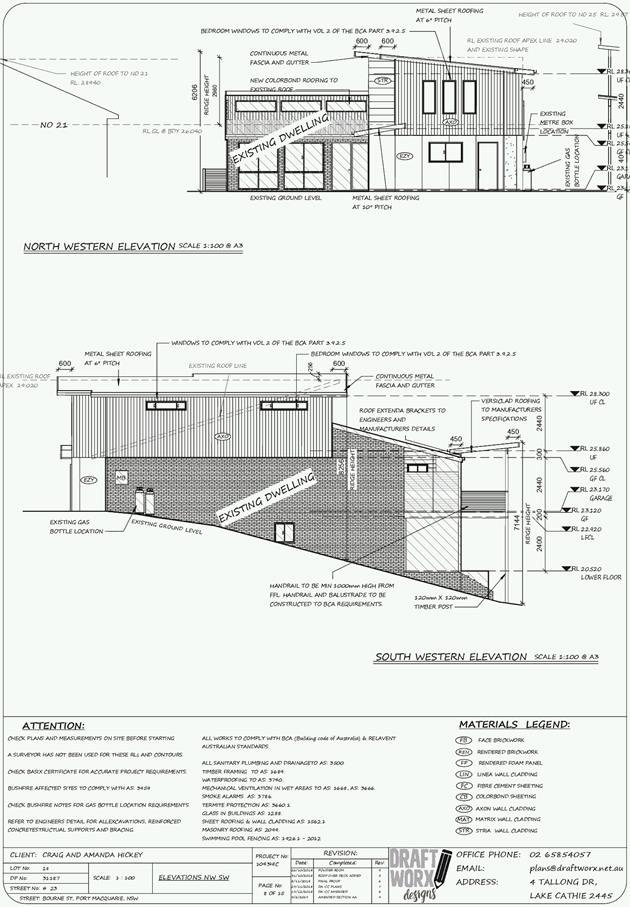
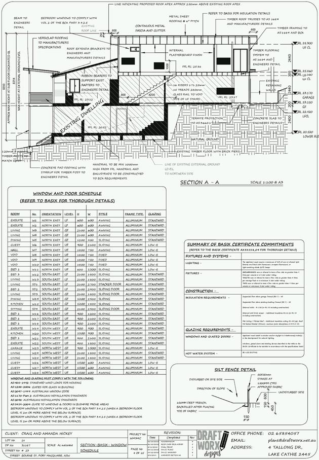
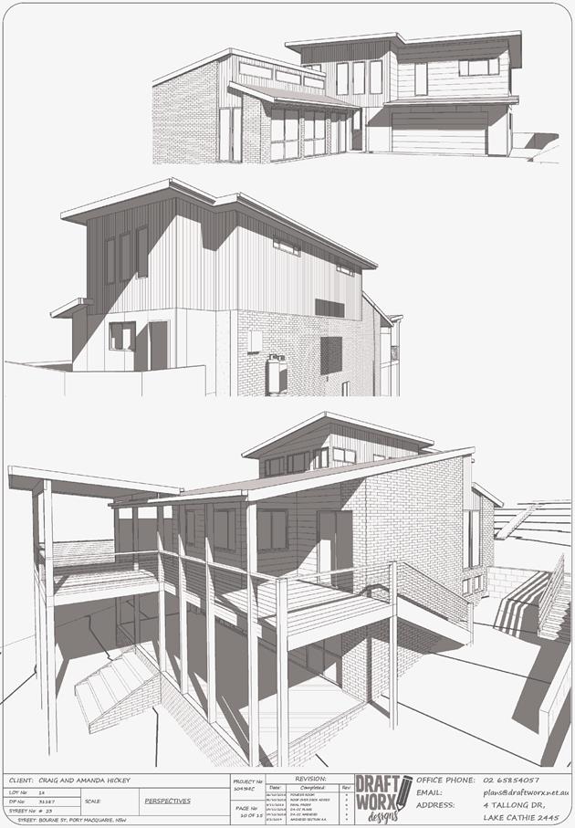
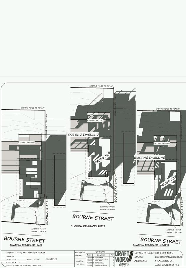
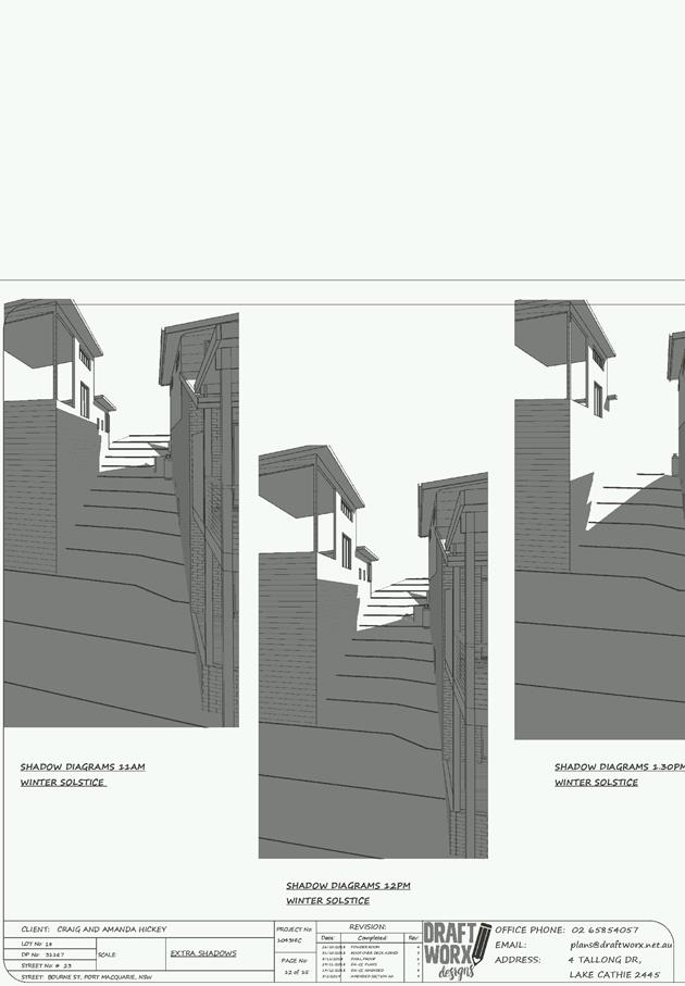
AGENDA Development Assessment Panel 27/02/2019
Item: 07
Subject: DA2018 - 1058.1 - Continued Use of Alterations
and Additions to Dwelling (Unit 4) as part of Multi Dwelling Housing
Development - Lot 3 DP 1214081, No. 114 Greenmeadows Drive, Port Macquarie
Report
Author: Patrick Galbraith-Robertson
|
Applicant: BDM
Constructions Pty Ltd CARE Love Project Management
Owner: Phillip
Jean Holdings Pty Ltd
Estimated Cost: $10,000
Alignment with Delivery
Program
4.3.1 Undertake transparent
and efficient development assessment in accordance with relevant legislation.
|
|
RECOMMENDATION
That
DA 2018 - 1058 for the continued
use of alterations and additions to dwelling (unit 4) as part of
multi-dwelling housing development at Lot 3, DP 1214081, No.
114 Greenmeadows Drive, Port Macquarie,
be determined by granting consent subject to the recommended conditions.
|
Executive
Summary
This
report considers a Development Application for continued use of alterations
additions to dwelling (unit 4) as part of multi-dwelling housing development
at the subject site and provides an assessment of the
application in accordance with the Environmental Planning and Assessment Act
1979.
Following exhibition of the
application, one (1) submission has been
received.
The proposal relates to continued
use of partly completed extensions to Unit 4 and completion of the works. The
works have been the subject of compliance action by Council’s Compliance
Division.
This report recommends that the
development application be approved subject to the recommended conditions.
1. BACKGROUND
Existing sites features and surrounding development
The site has an area of 1095.76m2.
The site is zoned R1 General Residential in accordance with the Port Macquarie-Hastings Local
Environmental Plan 2011, as shown in the following zoning plan:
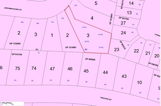
The existing subdivision pattern and location of existing
development within the locality is shown in the following aerial photograph:
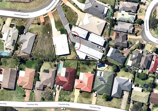
2. DESCRIPTION OF
DEVELOPMENT
Key aspects of the proposal include the following:
· The
addition relates to Unit 4 only and the garden bed and driveway area between
Unit 4 and Unit 1. The addition will extend the living room of Unit 4 over a
portion of the area which had been approved as outdoor paving. The outdoor
living space of Unit 4 is then extended marginally to the north by moving the
existing timber fence north. This requires a change to the garden bed adjoining
Unit 1 to expand the driveway in this area to ensure vehicles and garbage
trucks have adequate turning and manoeuvring area to meet Council standards.
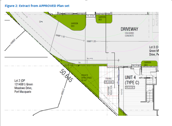
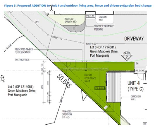
Refer
to attachments at the end of this report.
Application Chronology
· 10
December 2018 – DA lodged with Council
· 17 December 2018 to 14 January 2019 – Neighbour
notification of proposal
· 29 January to 11 February 2019 – Renotification of
proposal to neighbours due to administrative error with property address.
3. STATUTORY ASSESSMENT
Section 4.15(1) Matters for Consideration
In determining the application, Council is required to take
into consideration the following matters as are relevant to the development
that apply to the land to which the development application relates:
(a) The provisions (where
applicable) of:
(i) Any Environmental
Planning Instrument:
State Environmental Planning Policy No. 44 - Koala
Habitat Protection
There is no Koala Plan of Management on the site.
Additionally, the site is less than 1ha in area therefore no further
investigations are required.
State Environmental Planning Policy No. 55 –
Remediation of Land
Following an inspection of the site and a search of Council
records, the subject land is not identified as being potentially contaminated
and is suitable for the intended use.
State Environmental Planning Policy No. 62 –
Sustainable Aquaculture
Given the nature of the proposed development and proposed
stormwater controls the proposal will be unlikely to have any adverse impact on
existing aquaculture industries.
Port Macquarie-Hastings Local Environmental
Plan 2011
The proposal is consistent with the LEP having regard to the
following:
· Clause
2.2, the subject site is zoned R1 General Residential. In accordance with
clause 2.3(1) and the R1 zone landuse table, the alterations and additions to a
dwelling as part of a multi-dwelling housing development is a permissible
landuse with consent.
· The
objectives of the R1 zone are as follows:
o To provide for the housing
needs of the community.
o To provide for a variety of
housing types and densities.
o To enable other land uses
that provide facilities or services to meet the day to day needs of residents.
· In
accordance with Clause 2.3(2), the proposal is consistent with the zone
objectives as it is a permissible landuse and consistent with the established
residential locality.
· Clause
4.3, the maximum overall height of the building above ground level does not
change and complies with the standard height limit of 8.5m applying to the
site. The additions are single storey and are below the highest roofline points
on the site. See below image for reference (white is additions):
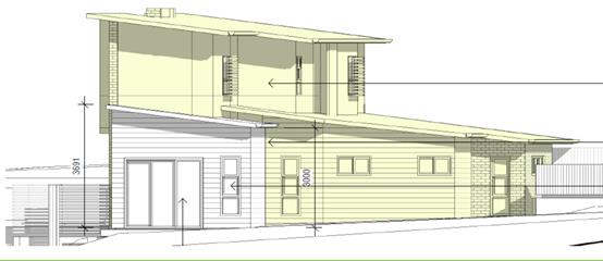
· Clause
4.4, the floor space ratio of the proposal (including the subject extension to
Unit 4) is 0.6:1.0 which complies with the maximum 0.65:1 floor space ratio
applying to the site.
· Clause
5.10 – Heritage. The site does not contain or adjoin any known heritage
items or sites of significance.
· Clause
7.13, satisfactory arrangements are in place for provision of essential
services including water supply, electricity supply, sewer infrastructure,
stormwater drainage and suitable road access to service the development.
(ii) Any
draft instruments that apply to the site or are on exhibition:
No draft instruments apply to the site.
(iii) Any
Development Control Plan in force:
Port
Macquarie-Hastings Development Control Plan 2013
|
DCP 2013: Dwellings, Dual
occupancies, Dwelling houses, Multi dwelling houses & Ancillary
development
|
|
|
Requirements
|
Proposed
|
Complies
|
|
3.2.2.5
|
Side setbacks:
• Ground floor =
min. 0.9m
• First floors
& above = min. 3m setback or where it can be demonstrated that
overshadowing not adverse = 0.9m min.
• Building wall
set in and out every 12m by 0.5m
|
The minimum side setback
requirements are complied with.
The building wall articulation is
compliant and/or satisfactory to address the objective intent of the
development provision.
|
Yes
|
|
3.2.2.6
|
35m2 min. private open space area
including a useable 4x4m min. area which has 5% max. grade
|
The Unit 4 dwelling contains 35m² open space in one area
including a useable 4m x 4m space.
|
Yes
|
|
3.2.2.10
|
Privacy:
• Direct views
between living areas of adjacent dwellings screened when within 9m radius of
any part of window of adjacent dwelling and within 12m of private open space
areas of adjacent dwellings. ie. 1.8m fence or privacy screening which has
25% max. openings and is permanently fixed
• Privacy screen
required if floor level > 1m height, window side/rear setback (other than
bedroom) is less than 3m and sill height less than 1.5m
• Privacy screens
provided to balconies/verandahs etc which have <3m side/rear setback and
floor level height >1m
|
No direct views between living
areas of adjacent dwellings screened when within 9m radius of any part of
window of adjacent dwelling and within 12m of private open space areas of
adjacent dwellings.
No privacy screens are
recommended.
|
Yes
|
|
DCP 2013: General
Provisions
|
|
|
Requirements
|
Proposed
|
Complies
|
|
2.7.2.2
|
Design addresses generic principles of Crime Prevention
Through Environmental Design guideline
|
No concealment or entrapment areas proposed. Adequate
casual surveillance available.
|
Yes
|
|
2.3.3.1
|
Cut and fill 1.0m max. 1m outside the perimeter of the
external building walls
|
Cut and fill <1.0m change 1m outside the perimeter of
the external building walls
|
Yes
|
|
2.3.3.2
|
1m max. height retaining walls along road frontage
|
None proposed
|
N/A
|
|
Any retaining wall >1.0 in height to be certified by
structure engineer
|
No retaining wall likely >1m
|
Yes
|
|
Combination of retaining wall and front fence height max
1.8m, max length 6.0m or 30% of frontage, fence component 25% transparent,
and splay at corners and adjacent to driveway
|
No retaining wall front fence combination proposed.
|
N/A
|
(iiia) Any
planning agreement that has been entered into under section 7.4, or any draft
planning agreement that a developer has offered to enter into under section
7.4:
No planning agreement has been offered or entered into
relating to the site.
iv) Any matters prescribed by the
Regulations:
New South Wales Coastal Policy:
The proposed development is consistent with the objectives
and strategic actions of this policy.
(b) The
likely impacts of that development, including environmental impacts on both the
natural and built environments, social and economic impacts in the locality:
Context and setting
The proposal will be unlikely to have any adverse impacts to
existing adjoining properties or the public domain.
The proposal is considered to be compatible with other
residential development in the locality and adequately addresses planning
controls for the area.
The proposal does not have a significant adverse impact on
existing view sharing.
The proposal does not have significant adverse lighting
impacts.
There are no significant adverse privacy impacts.
There is no adverse overshadowing impacts. The proposal does
not prevent adjoining properties from receiving 3 hours of sunlight to private
open space and primary living areas on 21 June.
Access, Traffic and Transport
The proposal will be unlikely to have any adverse impacts in
terms access, transport and traffic. The existing road network will
satisfactorily cater for any increase in traffic generation as a result of the
development.
Stormwater
Service available. Additional roof area can connect roof
water to existing system. A condition is recommended in this regard.
Other Utilities
Telecommunication and electricity services are available to
the site.
Heritage
This site does not contain or adjoin any known heritage item
or site of significance.
Other land resources
The site is within an established urban context and will not
sterilise any significant mineral or agricultural resource.
Water cycle
The proposed development will be unlikely to have any
adverse impacts on water resources and the water cycle.
Soils
The proposed development will be unlikely to have any
adverse impacts on soils in terms of quality, erosion, stability and/or
productivity.
Air and microclimate
The construction and/or operations of the proposed
development will be unlikely to result in any adverse impacts on the existing
air quality or result in any pollution. Standard precautionary site management
condition recommended.
Flora and fauna
Construction of the proposed development will not require
any removal/clearing of any native vegetation and therefore does not trigger
the biodiversity offsets scheme. Part 7 of the Biodiversity Conservation
Act 2016 is considered to be satisfied.
Waste
No adverse impacts anticipated. Standard precautionary site
management condition recommended.
Energy
The proposal includes measures to address energy efficiency.
Noise and vibration
No adverse impacts anticipated. Condition recommended to
restrict construction to standard construction hours.
Bushfire
The site is identified as being bushfire prone.
An assessment of bushfire risk having regard to section
4.3.5 of Planning for Bushfire Protection 2006 including vegetation
classification and slope concludes that a Bushfire Attack is a low risk. No
specific Bushfire Attack Level construction measures are recommended.
Safety, security and crime prevention
The proposed development will be unlikely to create any
concealment/entrapment areas or crime spots that would result in any
identifiable loss of safety or reduction of security in the immediate area. The
increase in housing density will improve natural surveillance within the
locality and openings from each dwelling overlook common and private areas.
Social impacts in the locality
Given the nature of the proposed development and its’
location the proposal is unlikely to result in any adverse social impacts.
Economic impact in the locality
No adverse impacts. A likely positive impact is that the
development will maintain employment in the construction industry, which will
lead to flow impacts such as expenditure in the area.
Site design and internal design
The proposed development design satisfactorily responds to
the site attributes and will fit into the locality. No adverse impacts likely.
Construction
No potential adverse impacts identified to neighbouring
properties with the construction of the proposal.
Cumulative impacts
The proposed development is not expected to have any adverse
cumulative impacts on the natural or built environment or the social and
economic attributes of the locality.
(c) The suitability of the site for
the development:
The proposal will fit into the locality and the site
attributes are conducive to the proposed development.
Site constraints of bushfire have been adequately addressed.
(d) Any submissions made in
accordance with this Act or the Regulations:
One (1) written submission has been received following public
exhibition of the application.
Key issues raised in the submissions received and comments
in response to these issues are provided as follows:
|
Submission
Issue/Summary
|
Planning
Comment/Response
|
|
The four dwellings built
encroach on all neighbouring properties.
|
The existing development has
been assessed and determined by granting approval.
|
|
The subject extension proposal has works already
commenced and half completed without Council approval.
|
Noted. Council’s Compliance staff have
determined that either the works be removed or an application submitted for
retrospective approval and completion of works. The subject DA applies for
the continued use of the extension partly completed and complete the works.
|
|
The second storey is unstable due to the overhang of the
building and the reason for the extension.
|
This is incorrect and following a site visit it is
apparent that the current first floor level is structurally sound on its own
without the extension.
|
|
A registered surveyor should confirm there are no
encroachments with regards to the boundary line of the neighbouring 112
Greenmeadows Drive.
|
A site inspection has confirmed that the plan dimensions
submitted with the current application are correct with no identifiable
encroachments. A Surveyor is considered unnecessary to confirm the setback.
|
|
112 Greenmeadows Drive have concerns that the proposal
encroaches with the allowable boundary laws.
|
The proposal as submitted including changes to the
private open space complies with Council’s Development Control Plan
2013.
|
(e) The Public Interest:
The proposed development
satisfies relevant planning controls and is unlikely to impact on the wider
public interest.
4. DEVELOPMENT
CONTRIBUTIONS APPLICABLE
No contributions
are applicable to the proposal. There are no additional new bedrooms proposed
only extended internal living space for Unit 4.
5. CONCLUSION
AND STATEMENT OF REASON
The application has been assessed in accordance with Section
4.15 of the Environmental Planning and Assessment Act 1979.
Issues raised during assessment and public exhibition of the
application have been considered in the assessment of the application. Where
relevant, conditions have been recommended to manage the impacts attributed to
these issues.
The site is considered suitable for the proposed development
and the proposal adequately addresses relevant planning controls. The
development is not considered to be contrary to the public's interest and will
not result a significant adverse social, environmental or economic impact. It
is recommended that the application be approved, subject to the recommended
conditions of consent provided in the attachment section of this report.
|
Attachments
1View. DA2018
- 1058.1 Recommended Conditions
2View. DA2018
- 1058.1 SOEE
3View. DA2018
- 1058.1 Plans
|
|
ATTACHMENT
|
Development Assessment Panel
27/02/2019
|
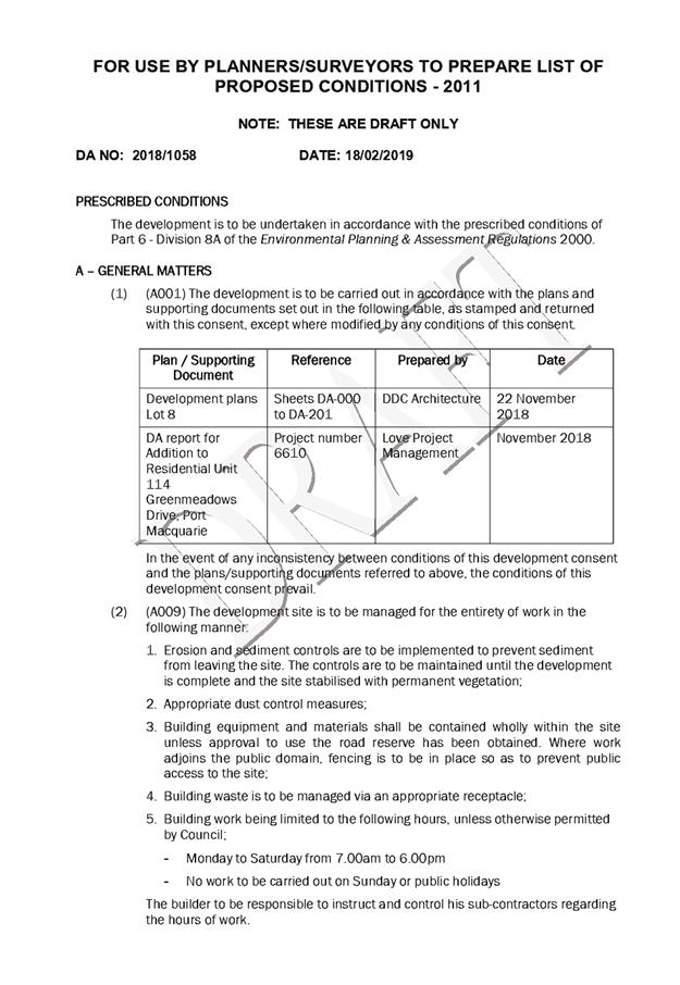
|
ATTACHMENT
|
Development Assessment Panel
27/02/2019
|

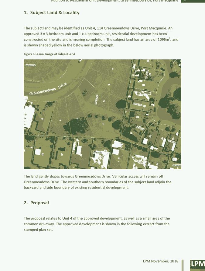
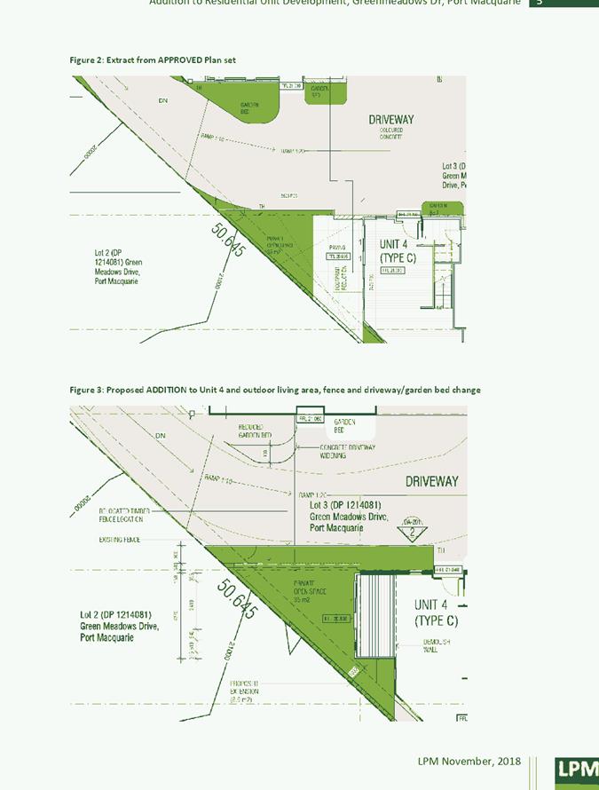
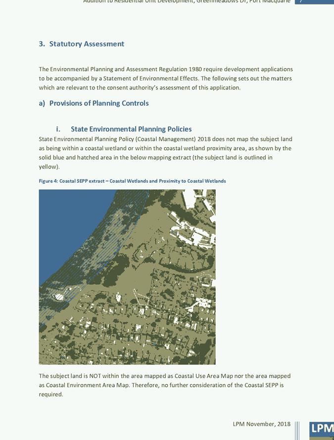
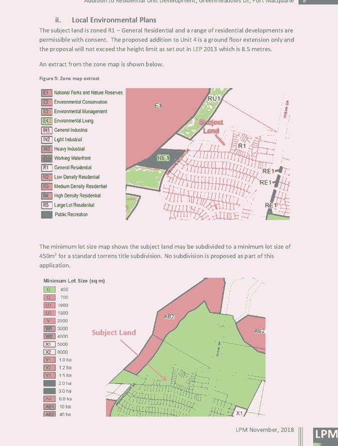
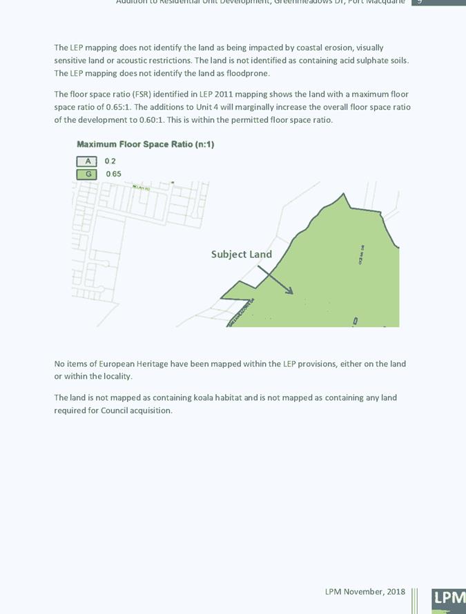
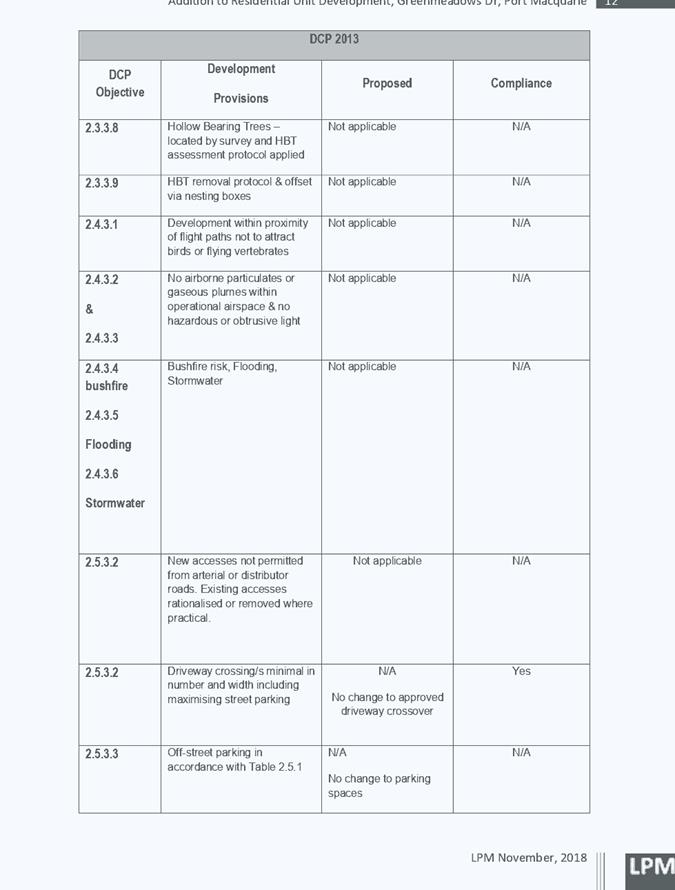
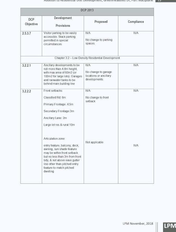
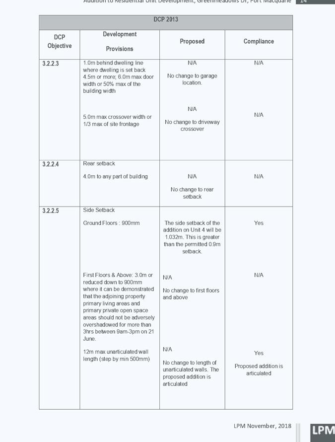
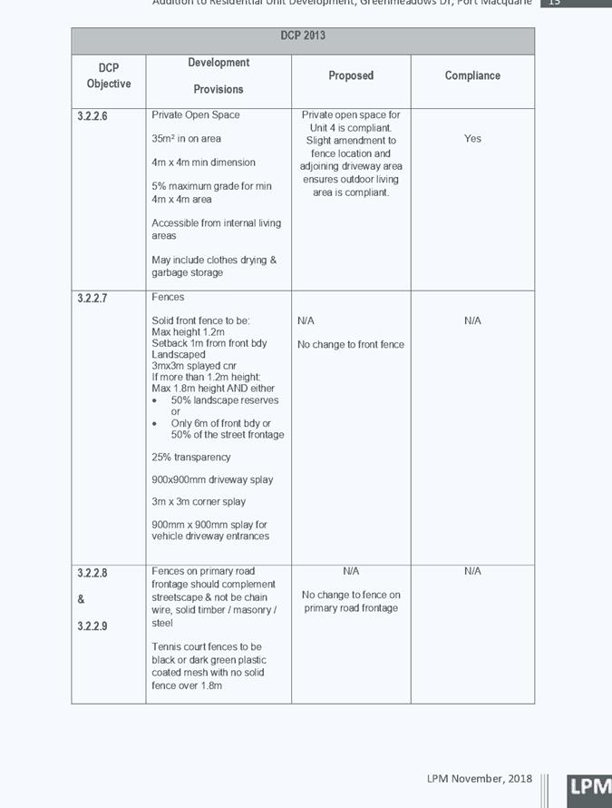
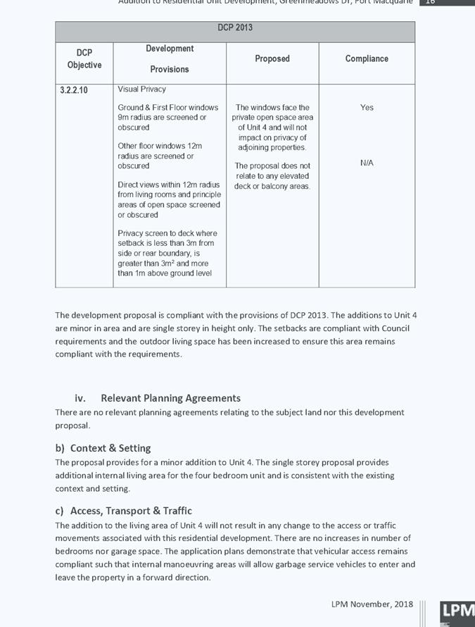
|
ATTACHMENT
|
Development Assessment Panel
27/02/2019
|
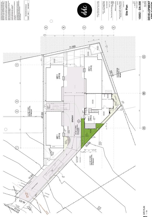
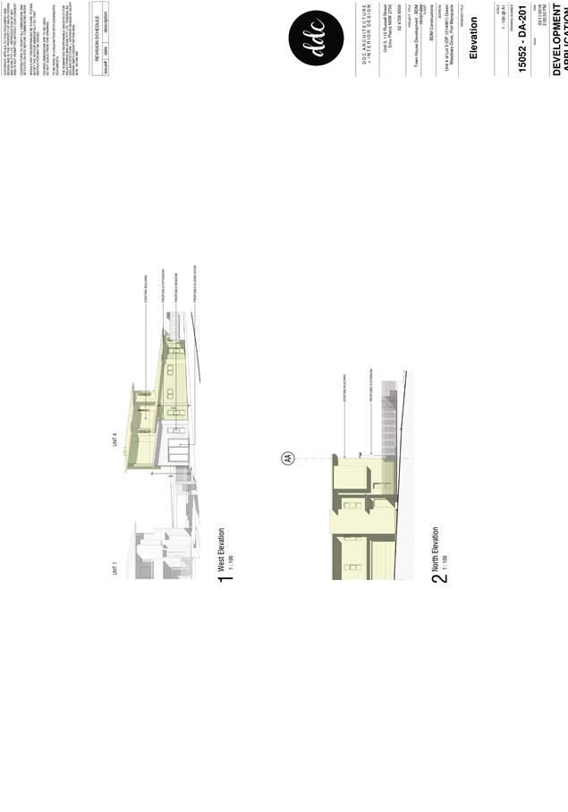
AGENDA Development Assessment Panel 27/02/2019
Item: 08
Subject: DA2018 - 599.1 - Use of Existing Dwelling for
Tourist and Visitor Accommodation - Lot 9 DP 234920, No.118 Camden Head Road,
Dunbogan
Report
Author: Patrick Galbraith-Robertson
|
Applicant: P
Smith CARE David Pensini – Building and Environmental Services
Owner: P
Smith
Estimated Cost: $NIL
Alignment with Delivery
Program
4.3.1 Undertake transparent
and efficient development assessment in accordance with relevant legislation.
|
|
RECOMMENDATION
That
DA2018 - 599 for use of an existing
dwelling for tourist and visitor accommodation at Lot 9, DP 234920, No. 118 Camden
Head Road, Port Macquarie, be determined by granting consent subject to the
recommended conditions.
|
Executive
Summary
This
report considers a Development Application for a use of an existing dwelling
for tourist and visitor accommodation at the
subject site and provides an assessment of the application in accordance with
the Environmental Planning and Assessment Act 1979.
Following exhibition of the
application, one (1) submission has been
received.
This report recommends that the
development application be approved subject to the recommended conditions.
1. BACKGROUND
Previous
unlawful use of the premises for tourist and visitor accommodation
The subject dwelling has been
utilized for holiday accommodation with noise complaints to council being the
catalyst for Council to request the submission of a Development Application for
the tourist accommodation use.
Short-term
holiday letting in NSW
There
has been rapid growth in short-term holiday (STHL) letting in NSW with the
emergence on online booking services. STHL is estimated to be worth $31.3
billion nationally, with NSW constituting approximately 50% of the national total.
In
2016, the NSW Legislative Assembly Committee on Environment and Planning
conducted an enquiry into the adequacy of regulation for STHL in NSW. The NSW
Government generally supports the findings and recommendation of the
Parliamentary Inquiry and considers that STHL is generally acceptable in a
residence. However, there is a point where STHL becomes a more intensive
commercial type of use.
The
NSW Department of Planning and Environment have released an Explanation of
Intended Effect (effectively a Planning Proposal) in October 2018 although
there is no firm adopted Government position on how STHL is to be managed
through the planning system at this stage. However, using the principle of the
Land and Environment Court in Dobrohotoff v Bennic [2013] NSWLEC 61 the
proposed development could not be considered to be development for the purpose
of a dwelling house. Development consent is therefore required for a change of
use from a dwelling to tourist and visitor accommodation.
Existing sites features and surrounding development
The site has an area of 648.4m2.
The site is zoned R1 General Residential in accordance with the Port Macquarie-Hastings Local
Environmental Plan 2011, as shown in the following zoning plan:
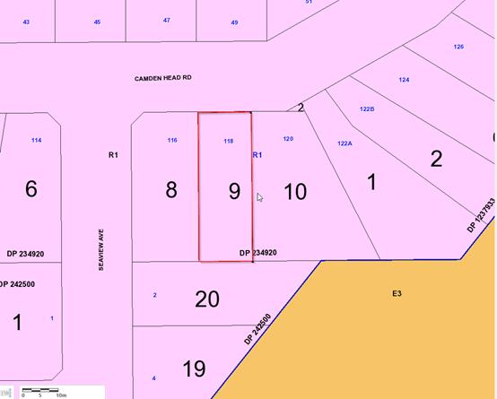
The
existing subdivision pattern and location of existing development within the
locality is shown in the following aerial photograph (Nearmap 2018):
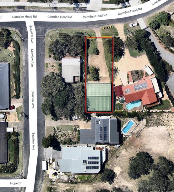
The site has a general north street frontage orientation to
Camden Head Road, Dunbogan.
Adjoining the site to the east, south and west are existing
residential dwellings.
2. DESCRIPTION OF
DEVELOPMENT
Key
aspects of the proposal include the following:
· Change
of use of the existing 4 bedroom dwelling to allow for its use for short term
tourist accommodation in conjunction with the residential use and occupation of
the building.
· The
owners of the property occupy the property at times. The property is occupied
for approximately 25% of the time with short term accommodation accounting for
15% of occupation with the remaining 10% being owner occupied.
· The
use of the building for short term tourist accommodation is subject to a
minimum three (3) night stay with a minimum Saturday to Saturday booking
requirement during school holiday/peak periods.
· The
maximum occupancy of the dwelling for tourist accommodation is 10 persons.
· Pets
are not permitted on the subject property in conjunction with its proposed
tourist accommodation use unless permission is given in writing from the
managing agent.
· The
proposed development requires no alterations to the subject building so as to
provide for a built form which is suitable for use for tourist accommodation.
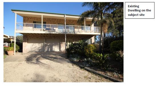
Refer
to attachments at the end of this report.
Application Chronology
· 6
August 2018 – DA lodged with Council
· 9
August 2018 – Additional fees requested from Applicant
· 14 to 27 August 2018 – Neighbour notification of
proposal
· 29 August 2018 – Additional fees paid by Applicant
· 30 August 2018 – Referral of proposal to the NSW
Rural Fire Service for Bushfire Safety Authority
· 30 October 2018 – Bushfire Safety Authority issued by
the NSW Rural Fire Service
· 6 December 2018 – Floor plans requested from
Applicant
· 12 February 2019 – Floors plans received from
Applicant
3. STATUTORY ASSESSMENT
Section 4.15(1) Matters for Consideration
In determining the application, Council is required to take
into consideration the following matters as are relevant to the development
that apply to the land to which the development application relates:
(a) The provisions (where
applicable) of:
(i) Any Environmental
Planning Instrument:
State Environmental Planning Policy No. 44 - Koala
Habitat Protection
With reference to clauses 6 and 7, the subject land is less
than 1 hectare (including any adjoining land under same ownership) and
therefore the provisions of SEPP do not require consideration.
State Environmental Planning Policy No. 55 –
Remediation of Land
Following an inspection of the site and a search of Council
records, the subject land is not identified as being potentially contaminated
and is suitable for the intended use.
State Environmental Planning Policy No. 62 –
Sustainable Aquaculture
Given the nature of the proposed development, the proposal
will be unlikely to have any adverse impact on existing aquaculture industries.
State Environmental Planning
Policy No. 64 – Advertising and Signage
No signage is proposed. A standard condition is recommended
to require approval for any signage other than signage which is exempt
development.
State Environmental Planning
Policy (Coastal Management) 2018 and Clause 5.5 of Port Macquarie-Hastings
Local Environmental Plan 2011
The site is located within a coastal use area, coastal
environment area and proximity area to coastal wetlands and littoral rainforest.
In accordance with clause 7, this SEPP prevails over the
Port Macquarie-Hastings LEP 2011 in the event of any inconsistency.
Having regard to clauses 13 and 14 of the SEPP and clause
5.5 of the Port Macquarie-Hastings LEP 2011 the proposed development is not
considered likely to result in any of the following:
a) any
adverse impact on integrity and resilience of the biophysical,
hydrological (surface and groundwater) and ecological environment;
b) any
adverse impacts coastal environmental values and natural coastal
processes;
c) any
adverse impacts on marine vegetation, native vegetation and fauna
and their habitats, undeveloped headlands and rock platforms;
d) any
adverse impact on marine vegetation, native vegetation and fauna
and their habitats, undeveloped headlands and rock platforms;
e) any
adverse impact on Aboriginal cultural heritage, practices and
places;
f) any
adverse impacts on the cultural and built environment heritage;
g) any
adverse impacts the use of the surf zone;
h) any adverse impact on the visual amenity and scenic qualities of the
coast, including coastal headlands;
i) overshadowing, wind funnelling and the loss of views from public places
to foreshores;
The site is located within an area zoned for residential
purposes and permits tourist use subject to obtaining development consent.
Port Macquarie-Hastings Local Environmental Plan 2011
Relevant
clauses of the LEP are as follows:
· Clause
2.2, the subject site is zoned R1 General Residential. In accordance with
clause 2.3(1) and the R1 zone landuse table, the proposed development is best
characterised as tourist and visitor accommodation, which is permissible in the
zone.
· The
objectives of the R1 zone are as follows:
o To
provide for the housing needs of the community.
o To
provide for a variety of housing types and densities.
o To
enable other land uses that provide facilities or services to meet the day to
day needs of residents.
· In
accordance with Clause 2.3(2), the proposal is considered to be consistent with
the zone objectives having regard to the following:
o The
existing dwelling is proposed to become short-term tourist and visitor
accommodation which is a permissible landuse.
o Whilst
the proposal is not a facility or service intended to meet the day to day needs
of residents the dwelling will provide accommodation for tourists and visitors
and occasional use by owners/residents.
(ii) Any
draft instruments that apply to the site or are on exhibition:
No draft instruments apply to the site.
(iii) Any
Development Control Plan in force:
Port
Macquarie-Hastings Development Control Plan 2013
|
DCP 2013: Residential Flat Development, Tourist and
Visitor Accommodation and Mixed Use Development
|
|
DCP Objective
|
Development Provisions
|
Proposed
|
Complies
|
|
3.3.2.4
|
Streetscape and front setback:
· Within 20% of the average setback
of the adjoining buildings.
· 3m setback to all frontages if no
adjoining development.
· 2m setback to secondary frontages.
· Max. 9m setback for tourist
development to allow for swimming pool.
|
Existing building. However, front setback is compatible
with adjoining development.
|
Yes
|
|
3.3.2.6
|
Side setbacks comply with Figure 3.3-1:
· Min. Side setback 1.5m for
75% of building depth.
· Windows on side walls min.
3m from side boundary.
· 3m minimum where adjacent to
existing strata titled building.
|
Living room, bedroom, bathroom and games room windows
within 3m of southern boundary.
It has been demonstrated that satisfactory acoustic
impacts would be maintained in accordance with the objectives of the control
with operating mitigation measures.
Privacy screen existing at 2 Seaview Avenue first floor
deck.
|
No – however acceptable as existing dwelling
|
|
Min. 6m rear setback (including sub basements)
|
Existing building with setback less than 6m rear setback.
|
Yes
|
|
3.3.2.11
|
Deep soil zones:
· Extend the width of the site
and have minimum depth of 6m.
· Are contiguous across sites
and within sites (see Fig 3.3-4).
|
Adequate deep soil zone planting areas existing across
entire site.
|
Yes
|
|
3.3.2.16
|
Landscape plan provided including:
· 35% soft landscaping with
minimum width of 3m.
· Existing vegetation and
proposed treatment.
· Details of hard landscaping.
· Location of communal
recreational facilities.
· Species not to obscure
doors, paths, etc.
· Street trees in accordance
with Council’s list.
|
Existing development includes adequate soft landscaping.
|
Yes
|
|
3.3.2.22
|
Fencing or landscaping defines public/communal and private
open space.
|
Existing fencing and landscaping define private and public
space.
|
Yes
|
|
3.3.2.26
|
Building to be designed so that:
· Busy, noisy areas face the
street.
· Quiet areas face the side or
rear of the lot.
· Bedrooms have line of site
separation of at least 3m from parking areas, streets and shared driveways.
|
Noisy areas face the front and rear.
Bedrooms do not require separation from driveway as
dwelling intended to be let as one letting.
|
Yes/No – existing dwelling
N/A
|
|
Openings of adjacent dwellings separated by at least 6m.
|
Site analysis confirms that 6m separation from openings in
adjacent dwellings is achieved.
|
No
|
|
3.3.2.28
|
Development complies with AS/NZS2107:2000 Acoustic
– Recommended design sound levels and reverberation times for building
interiors for residential development.
|
Existing dwelling to be used for holiday letting. No new
building works proposed.
|
N/A
|
|
3.3.2.30
|
Direct views between living room windows to be screened
where:
· Ground floor windows are
within 9m of windows in an adjoining dwelling.
· Other floors are within a
12m radius.
· Living room windows are
within 12m radius of the principal area of private open space of other
dwellings.
|
Direct views adequately screened by existing building
design and southern neighbour’s privacy screening on first floor deck
at 2 Seaview Avenue.
|
Yes
|
|
Direct views may be screened with either a 1.8m high fence
or wall, or screening that has maximum 25% openings.
|
Existing screening at 2 Seaview Avenue satisfies these
requirements.
|
Yes
|
|
Windows in habitable rooms screened if >1m above ground
level and wall set back <3m.
|
Existing screening at 2 Seaview Avenue satisfies these
requirements.
|
Yes
|
|
Balconies, decks, etc screened if <3m from boundary and
floor area >3m2 and floor level >1m above ground level.
|
Existing balconies at 2 Seaview Avenue adequately
screened.
|
Yes
|
|
3.3.2.46
|
For developments of < 6 dwellings individual waste
management permitted. Designated area to be provided for storage of bins:
· not visible from street,
· easily accessible,
· not adjoining private or
communal space, windows or clothes drying areas,
· on hard stand area,
· close to street and a tap
for washing,
· maintained free of pests.
|
Waste storage area nominated on the submitted plans and
expected to be adequate for the scale of the proposal.
An arrangement is in place for the bins to be placed at
the kerb for collection and returned to the storage location.
|
Yes
|
|
DCP 2013: General Provisions
|
|
DCP Objective
|
Development Provisions
|
Proposed
|
Complies
|
|
2.7.2.2
|
Design addresses generic principles of Crime Prevention
Through Environmental Design guideline:
· Casual surveillance and
sightlines
· Land use mix and activity
generators
· Definition of use and
ownership
· Lighting
· Way finding
· Predictable routes and
entrapment locations
|
The proposed development will be unlikely to create any concealment/entrapment
areas or crime spots that would result in any identifiable loss of safety or
reduction of security in the immediate area.
|
Yes
|
|
2.3.3.1
|
Cut and fill 1.0m max. 1m outside the perimeter of the
external building walls
|
Existing building. No cut or fill proposed.
|
Yes
|
|
2.3.3.8 onwards
|
Removal of hollow bearing trees
|
None proposed to be removed.
|
Yes
|
|
2.6.3.1
|
Tree removal (3m or higher with 100mm diameter trunk and
3m outside dwelling footprint
|
None proposed to be removed.
|
Yes
|
|
2.4.3
|
Bushfire risk, Acid sulphate soils, Flooding,
Contamination, Airspace protection, Noise and Stormwater
|
Refer to main body of report.
|
|
|
2.5.3.3
|
Off-street parking in accordance with Table 2.5.1
|
Tourist and visitor accommodation requires 1.1 spaces per
unit, plus 1 space per 2 employees (onsite at any one time), plus 1 space for
any onsite manager.
The proposal includes 4 guest bedrooms, but would be let
out as a single dwelling rather than individual rooms. The DCP therefore only
strictly requires 1.1 (rounded to 2) parking spaces as there would be no
employees on site.
The dwelling has a double garage and stacked parking areas
available within the driveway which are considered acceptable.
|
Yes
|
|
2.5.3.7
|
Visitor parking to be easily accessible
|
Parking at front of the site.
|
Yes
|
|
Parking in accordance with Australian Standards
|
Commercial developments are generally not permitted to
have stacked car parking. However, given that the building would be let in
its entirety and the group of guests will know each other, it is reasonable
to consider that a stacked parking arrangement could work for the proposed
use.
|
No, but acceptable
|
|
2.5.3.14
|
Sealed driveway surfaces unless justified
|
Existing driveway satisfactory.
|
Yes
|
Based on the above assessment, the DCP is considered to be
satisfactorily addressed and the proposal does not amount to adverse impact or
a significance that would justify refusal of the application.
(iiia) Any
planning agreement that has been entered into under section 7.4, or any draft
planning agreement that a developer has offered to enter into under section
7.4:
No planning agreement has been offered or entered into
relating to the site.
iv) Any matters prescribed by the
Regulations:
NSW
Coastal Policy 1997
The
proposed development is consistent with the objectives and strategic actions of
this policy. See comments earlier under Coastal Management State Environmental
Planning Policy.
Fire
Safety and other considerations – Clause 93
This
clause requires the consent authority to take into consideration whether the
fire protection and structural capacity of the building will be appropriate to
the building’s proposed use. Consent to change the use of the building
must not be granted unless the consent authority is satisfied that the building complies (or will, when
completed, comply) with such of the Category 1 fire safety provisions as are
applicable to the building’s proposed use.
The change to tourist
accommodation is a change from a Class 1a to a Class 1b. An Occupation
Certificate will be required to be obtained within a 3 month recommended
timeframe which will also require essential fire safety services. The proposed
installation of lighting and smoke alarms in accordance with the Building Code
of Australia as recommended by David Pensini is considered acceptable.
(b) The
likely impacts of that development, including environmental impacts on both the
natural and built environments, social and economic impacts in the locality:
Context and Setting
With the mitigation measures proposed to operation, the
proposal will be unlikely to have any adverse impacts to existing adjoining
properties or the public domain.
The proposal is considered to be consistent with other
residential development in the locality and adequately addresses planning
controls for the area.
The proposal does not have any identifiable significant
adverse lighting impacts.
There are no significant adverse privacy impacts.
Adequate building separation and dwelling is proposed/existing.
Traffic and Transport
The site is currently approved
for a dwelling house expected to generate approximately 9 daily trips. The
proposed use is expected to generate more variable traffic depending on the
number of vehicles used by the guests staying at the premises, and the total
number of guests. The traffic associated with the use would not adversely
impact the existing road network in the locality.
Site Frontage & Access
Vehicle access to the site is
proposed via an existing driveway crossover to The Peninsula. No frontage works
or changes to the existing access are proposed.
Parking and Manoeuvring
A total of 2 parking spaces in
the garage plus stacked parking in the driveway are existing on-site.
Commercial developments are generally not permitted to have stacked car
parking. However, given that the building would be let in its entirety and the
group of guests will know each other, it is reasonable to consider that a
stacked parking arrangement could work for the proposed use.
It is considered that a larger
commercial parking facility to AS 2890 would adversely impact the residential
character of the area, and the potential for future conversion of the site back
to a dwelling.
Noise and vibration
While it is acknowledged that
the DCP does not set specific acoustic criteria for this type of development,
it is not considered that the noise impacts can be deemed acceptable simply for
this fact. The impacts of the development (including noise) still remain a
merit consideration in the assessment of the application.
During the evening is when it is
expected that noise generated at the premises (outside evening meals with
talking/music) is most likely to cause a nuisance or disturbance to neighbours.
The Applicant has submitted the
following justifications for the operations being restricted to previous
nuisance to neighbours:
1. The booking of accommodation is
via a local real estate agent which provides for an opportunity to actively vet
potential occupants of the dwelling.
2. The use of the building for
short term tourist accommodation is subject to a minimum three (3) night stay
with a minimum Saturday to Saturday booking requirement during school
holiday/peak periods. This ensures that one off transient ‘over-night’
stays are avoided with occupation being targeted towards families looking for a
standard of accommodation which is typical of a residential setting and
expectations.
3. Rental of the property for
tourist accommodation purposes is subject to strict terms and conditions which
includes prohibitions on activities which maybe the cause of noise generation
which would not be consistent with a residential area, refer to Appendix 1 of
report.
4. The use of a local real estate
agent for the management of a property provides for reactive management, e.g.
respond to complaints regarding inappropriate behaviour.
5. Notwithstanding the availability
of a managing agent, the owner of the property is available to respond to
complaints regarding inappropriate behaviour.
6. As with the permanent occupation
of a dwelling inappropriate behaviour can be addressed through other regulatory
mechanisms e.g. Police/local council.
The submitted application
appropriately assess the noise impacts of the development and any mitigation
measures necessary to ensure that impacts on neighbours are acceptable.
Appropriate conditions are recommended.
Safety, security and crime
prevention
There is nothing about the
design of the building that would particularly facilitate crime risk in the
locality.
Social impacts in the
locality
No adverse social impacts can be
identified to neighbouring properties subject to compliance with the mitigation
operating measures proposed by the Applicant.
Economic impact in the
locality
It is expected that the proposed
development would have some positive economic impacts through tourism and other
associated expenditure in the area by guests.
Site design and internal
design
The existing building on the
site has been designed as a permanent residential dwelling. The building
setbacks are consistent with what would be expected for a dwelling, and the
building layout has main living areas at the rear of the site overlooking the
water. Other dwellings in the locality are designed in a similar manner with
indoor and outdoor living spaces oriented to the rear.
Other Utilities
Telecommunication and electricity services are available to
the site.
Heritage
Following a site inspection (and a search of Council
records), no known items of Aboriginal or European heritage significance exist
on the property. No adverse impacts anticipated.
Waste
Satisfactory arrangements are in place for proposed storage
and collection of waste and recyclables. No adverse impacts anticipated.
Standard precautionary site management condition recommended.
Energy
No adverse energy usage impacts anticipated.
Bushfire
The site is identified as being bushfire prone.
In accordance with Section 100B - Rural Fires Act 1997 - the
application proposes tourist accommodation on bush fire prone land. As a
result, the applicant has submitted a bushfire report which has been forwarded
to the NSW Rural Fire Service (RFS). The RFS have since issued a Bushfire
Safety Authority, which are recommended to be incorporated into the consent.
Cumulative impacts
The proposed development is not expected to have any adverse
cumulative impacts on the natural or built environment or the social and
economic attributes of the locality.
(c) The suitability of the site for
the development:
The proposal will fit into the locality and the site
attributes are conducive to the proposed development.
Site constraints of bushfire risk have been adequately
addressed and appropriate conditions of consent recommended.
(d) Any submissions made in
accordance with this Act or the Regulations:
One (1) written submission has been received following public
exhibition of the application.
Key issues raised in the submissions received and comments
in response to these issues are provided as follows:
|
Submission
Issue/Summary
|
Planning
Comment/Response
|
|
Impact on 2 Seaview Avenue with regards to privacy,
continual late night noise after 10pm when the property is rented out for
holiday accommodation and on health, sleep and wellbeing.
|
Previous operating issues
prior to lodgement of the DA are proposed to be resolved by new mitigation
measures proposed as detailed earlier in this report.
|
|
Adjoining
windows are directly opposite bedrooms of 2 Seaview Avenue.
|
Bedrooms and bathroom windows are difficult to protect
from a privacy impact perspective.
|
|
The lounge
room looks directly into the bedroom and shower cubicle of 2 Seaview Avenue.
|
|
A house of 10 people is not normal for residential family
circumstances.
|
Agree – hence for tourist purposes this is the
reason for lodgement of the DA as discussed earlier in this report.
|
|
Owners of 2
Seaview Avenue have installed privacy and noise measures into their home to mitigate
against the proposal particularly the rear balcony and downstairs recreation
room.
|
Privacy measures installed by neighbour noted and
confirmed by inspection by assessing officer on-site. No adverse privacy
impacts identified to warrant further mitigation measures.
With regard to noise impacts - previous operating issues
prior to lodgement of the DA are proposed to be resolved by new mitigation
operation measures proposed as detailed earlier in this report.
|
|
Laurieton Police Station is not manned at night and
reliance on Port Macquarie Police for a noise complaints is difficult.
|
Police can still be contacted in the event of public
disturbance issues.
|
|
Recommend Downstairs recreation area (garage) to have no
table tennis or parties after 10pm Privacy/Noise proof wall/screen to be
erected on the first 1/3 of balcony (where the portable bbq is now situated)
to help reduce noise and eliminate peering eyes looking into bedroom of 2
Seaview Avenue.
|
Functions, parties or extra guests are not permitted as proposed
under the proposed Rental Terms and Conditions management plan.
|
|
Recommend external privacy screen on the lounge room
window to stop tenants looking directly into to shower and bedroom of 2
Seaview Avenue and restrict smoking on rear balcony.
|
Privacy measures installed by neighbour noted and
confirmed by inspection by assessing officer on-site. No adverse privacy
impacts identified to warrant further mitigation measures.
|
(e) The Public Interest:
The proposed
development satisfies relevant planning controls and is unlikely to impact on
the wider public interest.
4. DEVELOPMENT
CONTRIBUTIONS APPLICABLE
No contributions are applicable to the proposal.
5. CONCLUSION AND
STATEMENT OF REASON
The application has been assessed in accordance with Section
4.15 of the Environmental Planning and Assessment Act 1979.
Issues raised during assessment and public exhibition of the
application have been considered in the assessment of the application. Where
relevant, conditions have been recommended to manage the impacts attributed to
these issues.
The site is considered suitable for the proposed development
and the proposal adequately addresses relevant planning controls. The
development is not considered to be contrary to the public's interest and will
not result a significant adverse social, environmental or economic impact. It
is recommended that the application be approved, subject to the recommended
conditions of consent provided in the attachment section of this report.
|
Attachments
1View. DA
2018 - 599.1 Recommended Conditions
2View. DA2018
- 599.1 Bushfire Safety Authority
3View. DA2018
- 599.1 SOEE
4View. DA2018
- 599.1 Plans
|
|
ATTACHMENT
|
Development Assessment Panel
27/02/2019
|
|
ATTACHMENT
|
Development Assessment Panel
27/02/2019
|
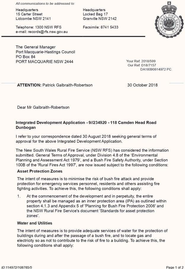
|
ATTACHMENT
|
Development Assessment Panel
27/02/2019
|
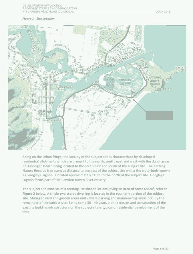
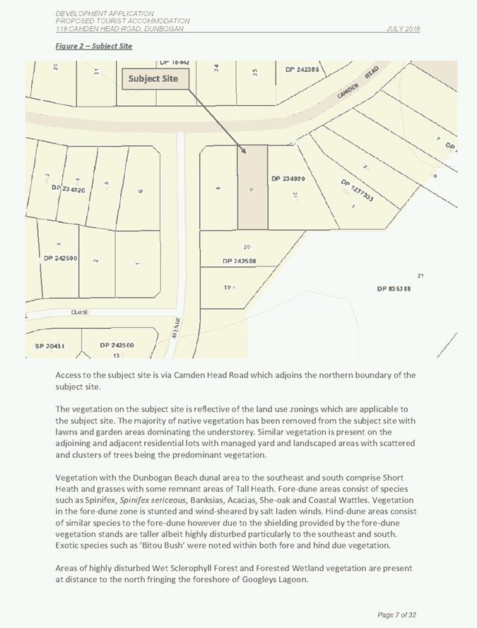
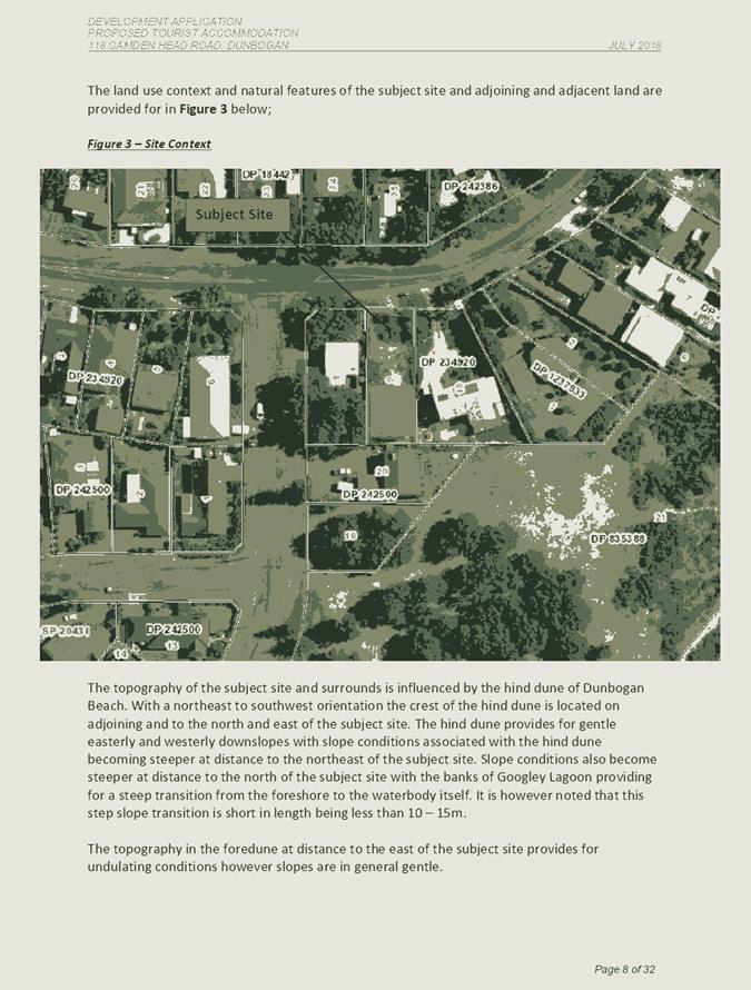
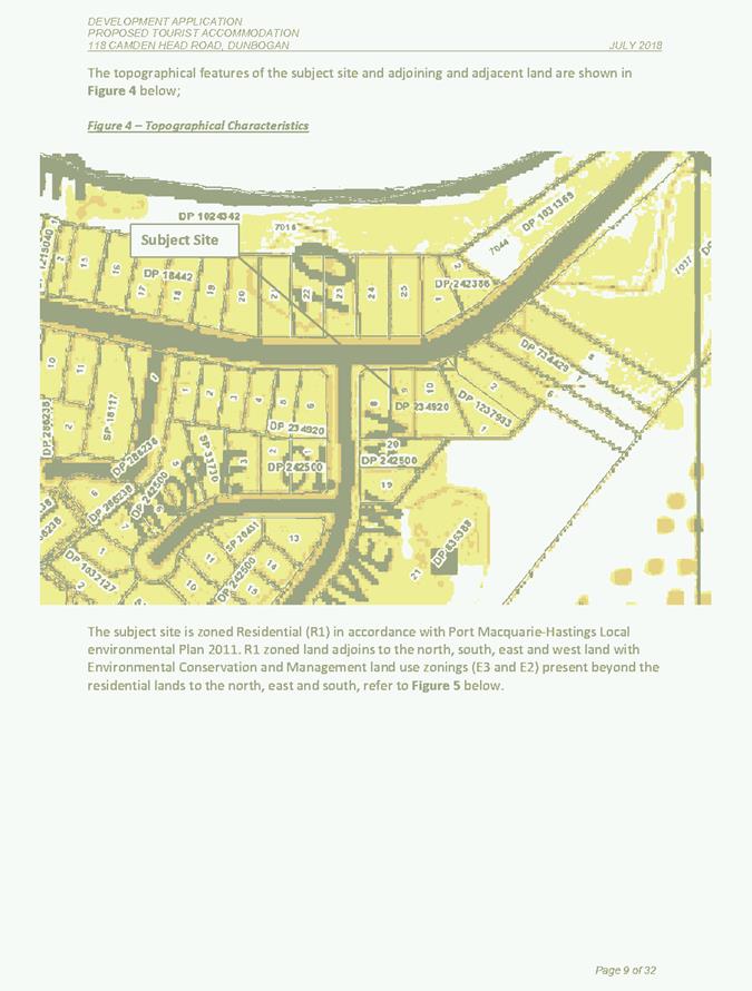
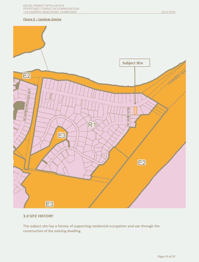
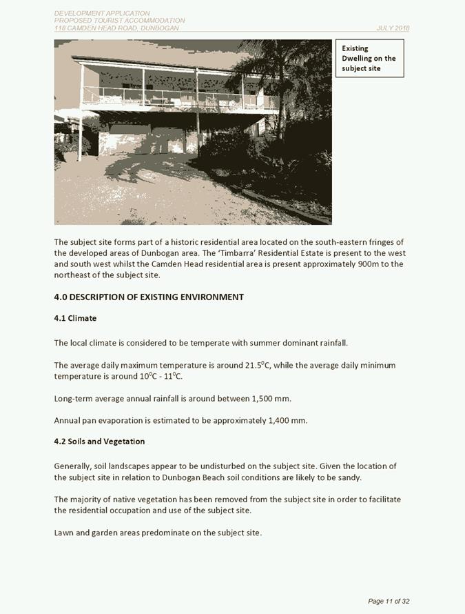
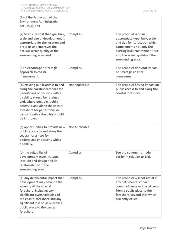
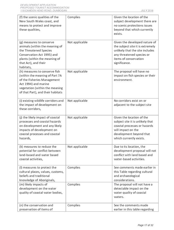
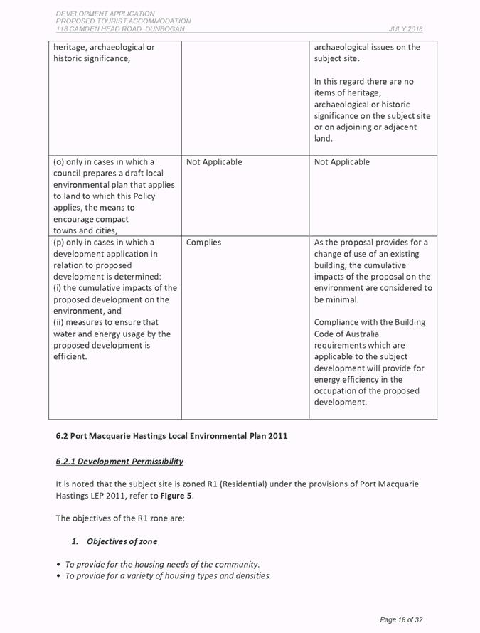
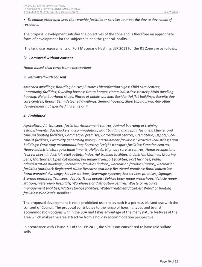
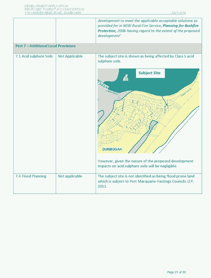
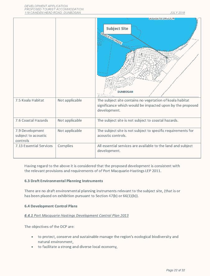
|
ATTACHMENT
|
Development Assessment Panel
27/02/2019
|
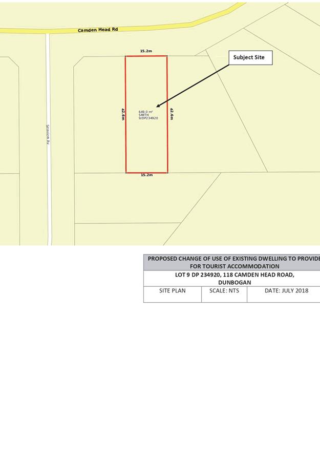
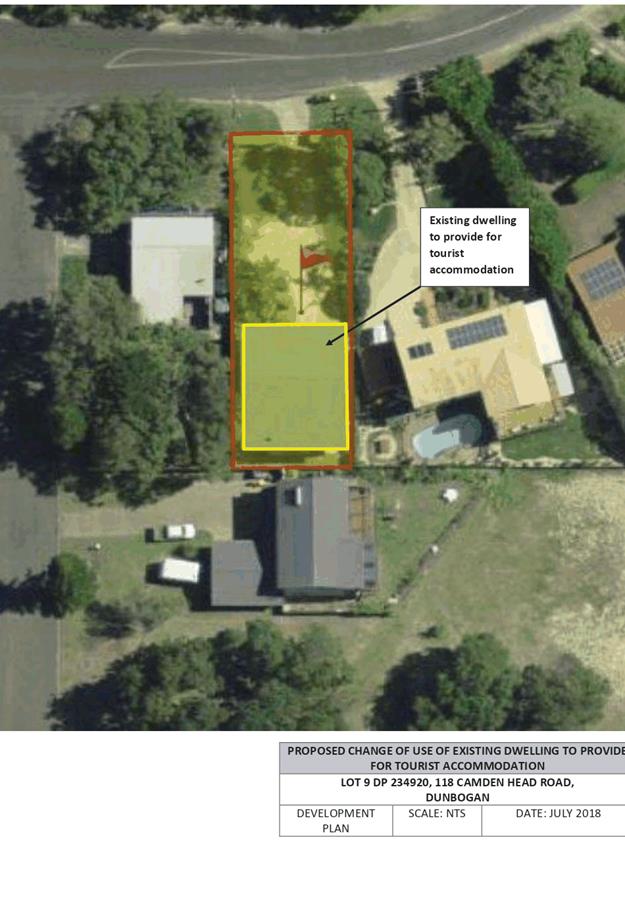
AGENDA Development Assessment Panel 27/02/2019
Item: 09
Subject: DA2018 - 1104.1 - Two Dwellings - Lots 8 and 9
DP 271152, No 3 Pennant Lane, Port Macquarie
Report
Author: Patrick Galbraith-Robertson
|
lApplicant: Love
Project Management
Owner: Richmond
Horizons Pty Ltd & AR & PA Richmond
Estimated Cost: $630,000
Alignment with Delivery
Program
4.3.1 Undertake transparent
and efficient development assessment in accordance with relevant legislation.
|
|
RECOMMENDATION
That
DA2018 - 1104 for two dwellings at
Lots 8 & 9, DP 271152, No. 3 Pennant Lane, Port Macquarie, be
determined by granting consent subject to the recommended conditions.
|
Executive
Summary
This
report considers a Development Application for two dwellings at the subject site and provides an assessment of the application
in accordance with the Environmental Planning and Assessment Act 1979.
Following exhibition of the
application, one (1) submissions have been
received.
Post exhibition - Lot 9 dwelling has been amended during the
assessment of the DA to increase the south side setback from a minimum 2.48m to
a minimum 3m for the 2 storey section of the building. A 3m setback is
compliant with the DCP.
This report recommends that the development application be
approved subject to the recommended conditions.
1. BACKGROUND
Existing sites features and surrounding development
The sites have individual areas of
443.3m2 and 389.86m2.
The site is zoned R1 General Residential in accordance with the Port Macquarie-Hastings Local
Environmental Plan 2011, as shown in the following zoning plan:
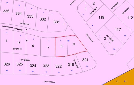
The existing subdivision pattern and location of existing
development within the locality is shown in the following aerial photograph
(nearmap October 2018 without property boundaries):
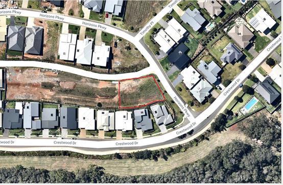
2. DESCRIPTION OF
DEVELOPMENT
Key aspects of the proposal include the following:
· Two
dwellings – 1 dwelling on Lot 8 and 1 dwelling on Lot 9
Refer
to attachments at the end of this report.
Application Chronology
· 20
December 2018 – DA lodged with Council.
· 7 to 21 January 2019 – Neighbour notification of
proposal
· 30 January 2019 – Additional information requested
from Applicant – submission and assessment issues
· 15 February 2019 – Additional information received
from Applicant including amended plans for Lot 9 dwelling
3. STATUTORY ASSESSMENT
Section 4.15(1) Matters for Consideration
In determining the application, Council is required to take
into consideration the following matters as are relevant to the development
that apply to the land to which the development application relates:
(a) The provisions (where
applicable) of:
(i) Ay Environmental Planning
Instrument:
State Environmental Planning Policy No. 44 - Koala
Habitat Protection
There is no Koala Plan of Management on the site.
Additionally, the site is less than 1ha in area therefore no further
investigations are required.
State Environmental Planning Policy No. 55 –
Remediation of Land
Following an inspection of the site and a search of Council
records, the subject land is not identified as being potentially contaminated
and is suitable for the intended use.
State Environmental Planning Policy No. 62 –
Sustainable Aquaculture
Given the nature of the proposed development and proposed
stormwater controls the proposal will be unlikely to have any adverse impact on
existing aquaculture industries.
State Environmental Planning Policy (Coastal Management)
2018 and Clause 5.5 of Port Macquarie-Hastings Local Environmental Plan 2011
The site is located within a proximity area to a mapped
coastal wetland to the south of the site.
In accordance with clause 7, this SEPP prevails over the
Port Macquarie-Hastings LEP 2011 in the event of any inconsistency.
Having regard to clauses 13 and 14 of the SEPP and clause
5.5 of the Port Macquarie-Hastings LEP 2011 the proposed development is not
considered likely to result in any of the following:
a) any adverse impact on integrity and resilience of the biophysical, hydrological (surface and
groundwater) and ecological environment;
b) any
adverse impacts coastal environmental values and natural coastal
processes;
c) any
adverse impacts on marine vegetation, native vegetation and fauna
and their habitats, undeveloped headlands and rock platforms;
d) any
adverse impact on marine vegetation, native vegetation and fauna
and their habitats, undeveloped headlands and rock platforms;
e) any
adverse impact on Aboriginal cultural heritage, practices and
places;
f) any
adverse impacts on the cultural and built environment heritage;
g) any
adverse impacts the use of the surf zone;
h) any adverse impact on the visual amenity and scenic qualities of the
coast, including coastal headlands;
i) overshadowing, wind funneling and the loss of views from public places
to foreshores;
The bulk, scale and size of the proposed development is compatible
with the surrounding coastal and existing built environment. The site is
cleared and located within an area zoned for residential purposes.
State Environmental Planning Policy (Building
Sustainability Index: BASIX) 2004
BASIX certificates have been submitted demonstrating that
the proposal will comply with the requirements of the SEPP. It is recommended
that a condition be imposed to ensure that the commitments are incorporated
into the development and certified at Occupation Certificate stage.
Port Macquarie-Hastings Local Environmental
Plan 2011
The proposal is consistent with the LEP having regard to the
following:
· Clause
2.2, the subject site is zoned R1 General Residential. In accordance with
clause 2.3(1) and the R1 zone landuse table, the dwellings (or ancillary
structures to the dwellings) are a permissible landuse with consent.
· The
objectives of the R1 zone are as follows:
o To provide for the
housing needs of the community.
o To provide for a
variety of housing types and densities.
o To enable other land
uses that provide facilities or services to meet the day to day needs of
residents.
· In
accordance with Clause 2.3(2), the proposal is consistent with the zone
objectives as it is a permissible landuse and consistent with the established
residential locality.
· Clause 4.3,
the maximum overall height of the buildings above ground level (existing) are
approximately 6.83m (Lot 9) and 5.64m (Lot 8) which complies with the standard
height limit of 8.5m applying to the sites.
· Clause 4.4,
the floor space ratios of the proposals are 0.49:1 (Lot 9) and 0.4:1.0 (Lot 8)
which complies with the maximum 0.65:1 floor space ratio applying to the sites.
· Clause 5.5 -
Development within the coastal zone - relevant objectives of this clause are addressed
by SEPP (Coastal Management) 2018 section (see above).
· Clause 5.10
– Heritage. The site does not contain or adjoin any known heritage items
or sites of significance.
· Clause
7.13, satisfactory arrangements are in place for provision of essential
services including water supply, electricity supply, sewer infrastructure,
stormwater drainage and suitable road access to service the development.
(ii) Any
draft instruments that apply to the site or are on exhibition:
No draft instruments apply to the site.
(iii) Any
Development Control Plan in force:
Port
Macquarie-Hastings Development Control Plan 2013
|
DCP 2013: Dwellings, Dual
occupancies, Dwelling houses, Multi dwelling houses & Ancillary
development
|
|
|
Requirements
|
Proposed
|
Complies
|
|
3.2.2.1
|
Ancillary development:
• 4.8m max. height
• Single storey
• 60m2 max. area
• 100m2 for lots
>900m2
• 24 degree max.
roof pitch
• Not located in
front setback
|
Water tanks are appropriately
located.
|
Yes
|
|
3.2.2.2
|
Articulation zone:
• Min. 3m front
setback
• An entry feature
or portico
• A balcony, deck,
patio, pergola, terrace or verandah
• A window box
treatment
• A bay window or
similar feature
• An awning or
other feature over a window
• A sun shading
feature
|
The Lot 9 dwelling contains an alfresco post and porch
within the articulation zone. These structures do not exceed 25% of the
articulation zone and are setback 3m.
|
Yes
|
|
Front setback (Residential not R5
zone):
• Min. 6.0m
classified road
• Min. 4.5m local
road
• Min. 3.0m
secondary road
• Min. 2.0m
Laneway
|
Lot 8 fronts a private road
– Pennant Lane as part of a community title development.
Lot 9 is a corner lot which
fronts a private road Pennant Lane as part of a community title development
(secondary frontage) and a primary road frontage to Horizons Parkway.
Front building line setback is
unable to comply with the minimum 4.5m primary front setback requirement with
a section of the building at a minimum 3.96m (note articulation zone permits
the porch and alfresco post forward of the primary building line to a minimum
3m).
|
Yes
No*
|
|
3.2.2.3
|
Garage 5.5m min. and 1m behind
front façade.
Garage door recessed behind
building line or eaves/overhangs provided
|
Garage door setbacks are
compliant with the minimum front setback requirements.
Garage door recessed.
|
Yes
|
|
6m max. width of garage door/s
and 50% max. width of building
|
Width of garage door/s are
compliant with the maximum width requirements
|
Yes
|
|
Driveway crossover 1/3 max. of
site frontage and max. 5.0m width
|
Driveway crossing/s width are
compliant with the maximum width requirements
|
Yes
|
|
3.2.2.4
|
4m min. rear setback. Variation
subject to site analysis and provision of private open space
|
The rear setback requirements are
complied with – Lot 8 only as Lot 9 is a corner lot.
|
Yes
|
|
3.2.2.5
|
Side setbacks:
• Ground floor =
min. 0.9m
• First floors
& above = min. 3m setback or where it can be demonstrated that
overshadowing not adverse = 0.9m min.
• Building wall
set in and out every 12m by 0.5m
|
The minimum side setback
requirements are complied with.
The building wall articulation is
compliant and/or satisfactory to address the objective intent of the
development provision.
Lot 9 dwelling has been amended
during the assessment of the DA to increase the south side setback from a
minimum 2.48m to a minimum 3m for the 2 storey section of the building. A 3m
setback is compliant with the DCP.
|
Yes
|
|
3.2.2.6
|
35m2 min. private open space area
including a useable 4x4m min. area which has 5% max. grade
|
The dwelling contains 35m²
open space in one area including a useable 4m x 4m space.
|
Yes
|
|
3.2.2.7
|
Front fences:
• If solid 1.2m
max height and front setback 1.0m with landscaping
• 3x3m min. splay
for corner sites
• Fences >1.2m
to be 1.8m max. height for 50% or 6.0m max. length of street frontage with
25% openings
• 0.9x0.9m splays
adjoining driveway entrances
|
The proposed front fence design for Lot 9 is considered to
meet the fencing provisions and objectives of DCP 2013. No adverse impacts
will occur.
|
Yes
|
|
3.2.2.8
|
Front fences and walls to have
complimentary materials to context
No chain wire, solid timber,
masonry or solid steel front fences
|
Front fences and walls to have
complimentary materials to context
|
Yes
|
|
3.2.2.10
|
Privacy:
• Direct views
between living areas of adjacent dwellings screened when within 9m radius of
any part of window of adjacent dwelling and within 12m of private open space
areas of adjacent dwellings. ie. 1.8m fence or privacy screening which has
25% max. openings and is permanently fixed
• Privacy screen
required if floor level > 1m height, window side/rear setback (other than
bedroom) is less than 3m and sill height less than 1.5m
• Privacy screens
provided to balconies/verandahs etc which have <3m side/rear setback and
floor level height >1m
|
No direct views between living
areas of adjacent dwellings screened when within 9m radius of any part of
window of adjacent dwelling and within 12m of private open space areas of
adjacent dwellings.
Lot 9 dwelling first floor only
has bedroom windows on the southern elevation.
Lot 8 dwelling first floor only
has bathroom and bedroom windows in the southern elevation.
No privacy screens are
recommended.
|
Yes
|
|
DCP 2013: General
Provisions
|
|
|
Requirements
|
Proposed
|
Complies
|
|
2.7.2.2
|
Design addresses generic principles of Crime Prevention
Through Environmental Design guideline
|
No concealment or entrapment areas proposed. Adequate
casual surveillance available.
|
Yes
|
|
2.3.3.1
|
Cut and fill 1.0m max. 1m outside the perimeter of the
external building walls
|
Cut and fill <1.0m change 1m outside the perimeter of
the external building walls
|
Yes
|
|
2.3.3.2
|
1m max. height retaining walls along road frontage
|
None proposed
|
N/A
|
|
Any retaining wall >1.0 in height to be certified by
structure engineer
|
No retaining wall likely >1m
Condition recommended to require engineering certification
given proximity of retaining walls to boundaries
|
Yes + condition recommended
|
|
Combination of retaining wall and front fence height max
1.8m, max length 6.0m or 30% of frontage, fence component 25% transparent,
and splay at corners and adjacent to driveway
|
No retaining wall front fence combination proposed.
|
N/A
|
|
2.5.3.2
|
New accesses not permitted from arterial or distributor
roads
|
No new access proposed to arterial or distribution road.
|
N/A
|
|
Driveway crossing/s minimal in number and width including
maximising street parking
|
Driveway crossing minimal in width including maximising
street parking
|
Yes
|
|
2.5.3.3
|
Parking in accordance with Table 2.5.1.
1 space per single dwelling (behind building line)
|
1 or capacity for more than 1 parking space behind the
building line has been provided for each dwelling.
|
Yes
|
|
2.5.3.11
|
Section 94 contributions
|
Refer to main body of report.
|
|
|
2.5.3.12 and 2.5.3.13
|
Landscaping of parking areas
|
Single dwellings only with 1 domestic driveway/dwelling.
No specific landscaping requirements recommended.
|
N/A
|
|
2.5.3.14
|
Sealed driveway surfaces unless justified
|
Sealed driveway proposed
|
Yes
|
|
2.5.3.15 and 2.5.3.16
|
Driveway grades first 6m or ‘parking area’
shall be 5% grade with transitions of 2m length
|
Driveway grades capable of satisfying Council standard
driveway crossover requirements. Condition recommended for section 138 Roads
Act permit
|
Yes
|
|
2.5.3.17
|
Parking areas to be designed to avoid concentrations of
water runoff on the surface.
|
Single dwelling only with 1 domestic driveway. Stormwater
drainage is capable of being managed as part of plumbing construction.
|
Yes
|
The proposal seeks to vary Development Provision relating to
the primary building line setback for the Lot 9 dwelling with a small corner of
the building setback 3.961m from Horizons Parkway.
The relevant objectives are:
· Front setbacks
should support an attractive streetscape.
Having regard for the development provisions and relevant
objectives, the variation is considered acceptable for the following reasons:
· The encroachment
is minor at 0.5m within the standard 4.5m setback and limited to 1 corner of
the building only.
· The section of
building relates to a single storey part of the new building which is behind a
proposed front fence, the northern part of the building is cut into the site
lower than the streets and the variation will not be readily apparent from
either Horizon’s Parkway or Pennant Lane.
· The subject corner
of the building is behind the articulation zone features.
· The secondary
setback is greater than the minimum 3m minimum standard.
· No adverse impacts
to the existing streetscape can be identified.
· The subject
section of street along Horizons Parkway between Crestwood Drive and Pennant
Lane is limited to 2 properties with no discernible setback line.
· The building is
well articulated as presented to the street frontage.
Based on the above assessment, the variation proposed to the
provisions of the DCP is considered acceptable and the relevant objectives have
been satisfied. Cumulatively, the variation does not amount to an adverse
impact or a significance that would justify refusal of the application.
(iiia) Any
planning agreement that has been entered into under section 7.4, or any draft
planning agreement that a developer has offered to enter into under section
7.4:
No planning agreement has been offered or entered into
relating to the site.
iv) Any matters prescribed by the
Regulations:
NSW Coastal Policy 1997
The proposed development is consistent with the objectives
and strategic actions of this policy.
(b) The
likely impacts of that development, including environmental impacts on both the
natural and built environments, social and economic impacts in the locality:
Context and Setting
The proposal will be unlikely to have any adverse impacts to
existing adjoining properties and satisfactorily addresses the public domain.
The proposal is considered to be compatible with other
residential development in the locality and adequately addresses planning
controls for the area.
The proposal does not have a significant adverse impact on
existing view sharing.
The proposal does not have significant adverse lighting
impacts.
There are no significant adverse privacy impacts.
There are no identifiable adverse overshadowing impacts
given compliance of the amended proposal with the minimum 3m side setback
provision of Development Control Plan 2013. Satisfactory amended plans
including shadow diagrams have been submitted demonstrating that the
neighbouring dwellings to the south experience a certain degree of
overshadowing in mid-winter to private open space and assumed living areas due
to the existing level difference and boundary fencing proposed/existing.
Access, Traffic and Transport
The proposal will be unlikely to have any adverse impacts in
terms access, transport and traffic. The existing road network will
satisfactorily cater for any increase in traffic generation as a result of the
development.
Water Supply Connection
Service available – details required with S.68
application.
Sewer Connection
Service available – details required with S.68
application.
Stormwater
Service available – details required with S.68
application.
Other Utilities
Telecommunication and electricity services are available to
the site.
Heritage
This site does not contain or adjoin any known heritage item
or site of significance.
Other land resources
The site is within an established urban context and will not
sterilise any significant mineral or agricultural resource.
Water cycle
The proposed development will be unlikely to have any
adverse impacts on water resources and the water cycle.
Soils
The proposed development will be unlikely to have any
adverse impacts on soils in terms of quality, erosion, stability and/or
productivity subject to a standard condition requiring erosion and sediment
controls to be in place prior to and during construction.
Air and microclimate
The construction and/or operations of the proposed development
will be unlikely to result in any adverse impacts on the existing air quality
or result in any pollution. Standard precautionary site management condition
recommended.
Flora and fauna
Construction of the proposed development will not require
any removal/clearing of any native vegetation and therefore does not trigger
the biodiversity offsets scheme. Part 7 of the Biodiversity Conservation
Act 2016 is considered to be satisfied.
Waste
Satisfactory arrangements are in place for proposed storage
and collection of waste and recyclables. No adverse impacts anticipated.
Standard precautionary site management condition recommended.
Energy
The proposal includes measures to address energy efficiency
and will be required to comply with the requirements of BASIX.
Noise and vibration
No adverse impacts anticipated. Condition recommended to
restrict construction to standard construction hours.
Bushfire
The site is identified as being bushfire prone.
An assessment of bushfire risk having regard to section
4.3.5 of Planning for Bushfire Protection 2006 including vegetation
classification and slope concludes that a Bushfire Attack Level 12.5 shall be
required.
Management of bushfire risk is acceptable subject to BAL
construction levels being implemented and APZ being maintained. An appropriate
condition is recommended.
Safety, security and crime prevention
The proposed development will be unlikely to create any
concealment/entrapment areas or crime spots that would result in any
identifiable loss of safety or reduction of security in the immediate area. The
increase in housing density will improve natural surveillance within the
locality and openings from each dwelling overlook common and private areas.
Social impacts in the locality
Given the nature of the proposed development and its’
location the proposal is unlikely to result in any adverse social impacts.
Economic impact in the locality
No adverse impacts. A likely positive impact is that the
development will maintain employment in the construction industry, which will
lead to flow impacts such as expenditure in the area.
Site design and internal design
The proposed development design satisfactorily responds to
the site attributes and will fit into the locality. No adverse impacts likely.
Construction
No potential adverse impacts identified to neighbouring
properties with the construction of the proposal.
Cumulative impacts
The proposed development is not expected to have any adverse
cumulative impacts on the natural or built environment or the social and
economic attributes of the locality.
(c) The
suitability of the site for the development:
The proposal will fit into the locality and the site
attributes are conducive to the proposed development.
Site constraints of bushfire/flooding have been adequately
addressed and appropriate conditions of consent recommended.
(d) Any
submissions made in accordance with this Act or the Regulations:
One (1) written
submission has been received following public exhibition of the application.
Key issues
raised in the submissions received and comments in response to these issues are
provided as follows:
|
Submission
Issue/Summary
|
Planning
Comment/Response
|
|
The plans show that the 3
Pennant Lane/Lot 9 dwelling will be approximately 2m from the boundary of 74
Crestwood Drive.
|
Post exhibition - Lot 9
dwelling has been amended during the assessment of the DA to increase the
south side setback from a minimum 2.48m to a minimum 3m for the 2 storey
section of the building. A 3m south side setback is compliant with the side
setback provisions of DCP.
|
|
The dwelling at 1 Pennant Lane/Lot 9 is too close to the
rear/side boundary of 74 Crestwood Drive which will create issues of light,
sun, privacy and noise.
|
The Lot 9 site is a corner lot with no rear boundary
technically. A 3m south side setback is compliant with the side setback
provisions of DCP.
No direct views between living areas of adjacent
dwellings screened when within 9m radius of any part of window of adjacent
dwelling and within 12m of private open space areas of adjacent dwellings.
Lot 9 dwelling first floor only has bedroom windows on
the southern elevation.
There are no identifiable adverse overshadowing impacts
given compliance of the amended proposal with the minimum 3m side setback
provision of Development Control Plan 2013. Satisfactory amended plans
including shadow diagrams have been submitted demonstrating that the
neighbouring dwellings to the south experience a certain degree of
overshadowing in mid-winter to private open space and assumed living areas
due to the existing level difference and boundary fencing proposed/existing.
|
|
The setback of Lot 8 dwelling is greater than the Lot 9
dwelling at approximately 4m which is a satisfactory outcome.
|
Setback of this Lot 8 is noted which has a rear setback
development control applying to it in difference to the Lot 9 dwelling on a
corner lot.
|
(e) The Public Interest:
The proposed development
satisfies relevant planning controls and is unlikely to impact on the wider
public interest.
4. DEVELOPMENT
CONTRIBUTIONS APPLICABLE
No
development contributions applicable. The two dwellings are proposed on two
existing residential lots with no dwellings proposed or approved on them.
5. CONCLUSION
AND STATEMENT OF REASON
The application has been assessed in accordance with Section
4.15 of the Environmental Planning and Assessment Act 1979.
Issues raised during assessment and public exhibition of the
application have been considered in the assessment of the application. Where
relevant, conditions have been recommended to manage the impacts attributed to
these issues.
The site is considered suitable for the proposed development
and the proposal adequately addresses relevant planning controls. The
development is not considered to be contrary to the public's interest and will
not result a significant adverse social, environmental or economic impact. It
is recommended that the application be approved, subject to the recommended
conditions of consent provided in the attachment section of this report.
|
Attachments
1View. DA2018
- 1104.1 Recommended Conditions
2View. DA
2018 - 1104.1 Plans
|
|
ATTACHMENT
|
Development Assessment Panel
27/02/2019
|
|
ATTACHMENT
|
Development Assessment Panel
27/02/2019
|