Business
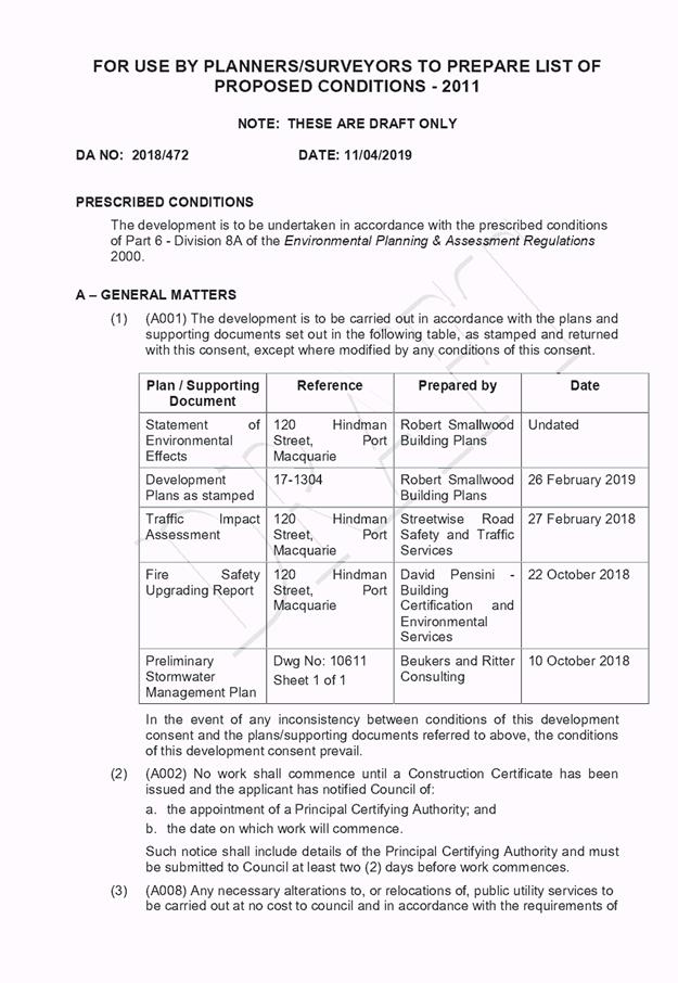
Paper
|
date of meeting:
|
|
Wednesday 24 April
2019
|
|
location:
|
|
Function Room
Port
Macquarie-Hastings Council
17 Burrawan Street
Port Macquarie
|
|
time:
|
|
2:00pm
|
Development
Assessment Panel
CHARTER
1.0 OBJECTIVES
To assist in managing Council's development assessment
function by providing independent and expert determinations of development
applications that fall outside of staff delegations.
2.0 KEY FUNCTIONS
·
To review development application reports and conditions;
·
To determine development
applications outside of staff delegations;
·
To refer development applications
to Council for determination where necessary;
·
To provide a forum for objectors and applicants
to make submissions on applications
before the Development Assessment Panel
(DAP);
·
To maintain transparency in the determination of development
applications.
Delegated Authority of Panel
Pursuant to
Section 377 of the Local Government Act, 1993 delegation to:
·
Determine development applications under Part 4
of the Environmental Planning and Assessment
Act 1979 having
regard to the relevant environmental planning instruments,
development control plans and Council policies.
·
Vary, modify or release restrictions as to use
and/or covenants created by Section 88B instruments under the Conveyancing Act
1919 in relation to development applications for subdivisions being considered
by the panel.
·
Determine Koala Plans of Management under State
Environmental Planning Policy 44 - Koala Habitat Protection associated with
development applications being considered by the Panel.
Noting the trigger to escalate
decision making to Council as highlighted in section 5.2.
3.0
MEMBERSHIP
3.1
Voting
Members
·
Two independent external members. One of the
independent external members to be the Chairperson.
·
Group Manager Development Assessment (alternate
- Director Development & Environment or Development Assessment Planner)
The independent external members shall have expertise in
one or more of the following areas: planning, architecture, heritage, the
environment, urban design, economics, traffic and transport, law, engineering,
government and public administration.
3.2
Non-Voting Members
·
Not applicable
3.3 Obligations
of members
·
Members must act faithfully and diligently and
in accordance with this Charter.
·
Members must comply with Council's Code of Conduct.
·
Except as required to properly perform their
duties, DAP members must not
disclose any confidential information (as advised by Council) obtained in connection with the DAP functions.
·
Members will have read and be familiar with the
documents and information provided by Council prior
to attending a DAP meeting.
·
Members must act in accordance with Council's
Workplace Health and Safety Policies and Procedures
·
External members of the Panel are not authorised
to speak to the media on behalf of Council. Council officers that are members
of the Committee are bound by the
existing operational delegations in relation to speaking to the media.
·
Staff members shall not vote on matters before
the Panel if they have been the principle author of the development assessment report.
3.4
Member Tenure
·
The independent external members will be
appointed for the term of four (4) years
maximum in which the end of the tenure of these members would occur in a
cascading arrangement.
3.5 Appointment
of members
·
The independent external members (including the
Chair) shall be appointed by the General Manager following an external
Expression of Interest process.
·
Staff members of the Panel are in accordance
with this Charter.
4.0 TIMETABLE
OF MEETINGS
·
The Development Assessment Panel will generally
meet on the 1st and 3rd Wednesday each month at 2.00pm at the Port Macquarie
offices of Council.
·
Special Meetings of the Panel may be convened by
the Director Development & Environment Services with three (3) days notice.
5.0
MEETING PRACTICES
5.1
Meeting
Format
·
At all Meetings of the Panel the Chairperson
shall occupy the Chair and preside. The Chair will be responsible for keeping
of order at meetings.
·
Meetings shall be open to the public.
·
The Panel will hear from applicants
and objectors or their r e p r e s e n t a t i v e s .
·
Where considered necessary, the Panel will
conduct site inspections which will
be open to the public.
5.2
Decision Making
·
Decisions are to be made by consensus. Where
consensus is not possible on any item, that item is to be referred to Council
for a decision.
·
All development applications involving a
proposed variation to a development standard
greater than 10% under Clause
4.6 of the Local Environmental Plan will be
considered by the Panel and recommendation made to the Council for a decision.
5.3
Quorum
·
All members (2 independent external members and
1 staff member) must be present at a
meeting to form a quorum.
5.4
Chairperson and Deputy Chairperson
·
Independent Chair (alternate, second independent member)
5.5
Secretariat
·
The Director Development &n Environment is
to be responsible for ensuring that the Panel has adequate secretariat support.
The secretariat will ensure that the business paper and supporting papers are
circulated at least three (3) days prior to
each meeting. Minutes shall be appropriately approved and circulated to each
member within three (3) weeks of a meeting being held.
·
The format of and the preparation and publishing
of the Business Paper and Minutes shall be similar to the format for Ordinary
Council Meetings.
5.6
Recording of decisions
·
Minutes will record decisions and how each
member votes for each item before the Panel.
6.0 CONVENING
OF “OUTCOME SPECIFIC” WORKING GROUPS
Not applicable.
7.0 CONFIDENTIALITY
AND CONFLICT OF INTEREST
·
Members of the Panel must comply with the
applicable provisions of Council’s Code of Conduct. It is the personal
responsibility of members to comply with the standards in the Code of Conduct
and regularly review their personal circumstances with this in mind.
·
Panel members must declare any conflict of
interests at the start of each meeting or before discussion of a relevant item
or topic. Details of any conflicts of interest should be appropriately minuted.
Where members are deemed to have a real or perceived conflict of interest, it
may be appropriate they be excused from deliberations on the issue where the
conflict of interest may exist. A Panel meeting may be postponed where there is
no quorum.
8.0 LOBBYING
·
All members and applicants are to adhere to
Council’s Lobbying policy. Outside of
scheduled Development Assessment Panel meetings, applicants, their
representatives, Councillors, Council staff and the general public are not to
lobby Panel members via meetings, telephone conversations, correspondence and
the like. Adequate opportunity will be provided at Panel inspections or
meetings for applicants, their representatives and the general public to make
verbal submissions in relation to Business Paper items.
Development Assessment Panel
ATTENDANCE
REGISTER
|
Member
|
13/02/19
|
27/02/19
|
13/03/19
|
27/03/19
|
10/04/19
|
|
Paul Drake
|
P
|
P
|
P
|
P
|
P
|
|
Robert Hussey
|
P
|
P
|
|
P
|
A
|
|
David Crofts
(alternate member)
|
|
|
P
|
|
P
|
|
Dan Croft
(Acting Director
Development & Environment)
Clinton Tink
(Acting GM Development
Assessment
(alternates)
- Director Development & Environment
- Development Assessment Planner
|
P
|
P
|
P
|
P
|
P
|
Key: P = Present
A
= Absent With Apology
X
= Absent Without Apology
Development
Assessment Panel Meeting
Wednesday 24 April
2019
Items of Business
01 Acknowledgement
of Country............................................................................. 8
02 Apologies.......................................................................................................... 8
03 Confirmation
of Minutes..................................................................................... 8
04 Disclosures
of Interest..................................................................................... 13
05 Section
4.55 Modification DA2004 - 687.6 To Modify The Hours Of Operation of Existing
Sawmill At Lot 1 DP 1065577, Old Kempsey Road, Gum Scrub...................................... 17
06 DA2018
- 472.1 Change of Use - Dwelling to Centre Based Childcare Centre - Lot 6 DP
262151, No.120 Hindman Street, Port Macquarie........................................................... 69
07 DA2018
- 876.1 - Demolition of Existing Dwelling, Dual Occupancy and Torrens Title
Subdivision - Lot 272 DP 236277, No. 45 The Summit Road, Port Macquarie..................... 140
08 DA2018
- 952.1 Multi Dwelling Housing and Torrens Title Subdivision, Lot 434 to 437
DP1244641, Manikato Way Port Macquarie..................................................... 200
09 DA2018
- 1051.1 Recreation Facility (Indoor) at Lot 1 DP 1250139, No. 18 John Oxley
Drive, Port Macquarie..................................................................................................... 266
10 DA2018
- 1085 Dual Occupancy and Torrens Title Subdivision, Lot 2 DP 1222707, No. 63
Yaluma Drive Port Macquarie......................................................................... 296
11 General
Business
AGENDA Development Assessment Panel 24/04/2019
Subject: ACKNOWLEDGEMENT
OF COUNTRY
"I acknowledge that we are
gathered on Birpai Land. I pay respect to the Birpai Elders both past and
present. I also extend that respect to all other Aboriginal and Torres Strait
Islander people present."
RECOMMENDATION
That the apologies received be
accepted.
Subject: CONFIRMATION
OF PREVIOUS MINUTES
Recommendation
That the Minutes of the Development
Assessment Panel Meeting held on 10 April 2019 be confirmed.
MINUTES
Development Assessment Panel Meeting
10/04/2019
PRESENT
Members:
Paul Drake
David Crofts
Dan Croft
Other Attendees:
Chris Gardiner
Caroline Horan
|
The meeting opened at 2:00pm.
|
|
01 ACKNOWLEDGEMENT
OF COUNTRY
|
|
The Acknowledgement of Country was
delivered.
|
|
02 APOLOGIES
|
|
CONSENSUS:
That the apology received from
Robert Hussey be accepted.
|
|
03 CONFIRMATION
OF MINUTES
|
|
CONSENSUS:
That the Minutes of the
Development Assessment Panel Meeting held on 27 March 2019 be confirmed.
|
|
04 DISCLOSURES OF
INTEREST
|
|
There were no
disclosures of interest presented.
|
|
05 DA2018
- 1063.1 Multi Dwelling Housing and Torrens Title Subdivision at Lot 6 DP
22220, No. 31 Chalmers Street, Port Macquarie
|
|
Speaker:
Rob Little (o)
Peter Khalil (applicant)
CONSENSUS:
That DA2018 – 1063.1 for
Multi Dwelling Housing and Torrens Title Subdivision at Lot 6, DP 22220, No. 31
Chalmers Street, Port Macquarie, be determined by granting consent subject to
the recommended conditions.
|
|
06 DA2017
- 1059.1 Staged Residential Subdivision (138 Lots) at Lot 2 DP 504042, Lot 2
DP 594388, and Lot 5 DP 24500, No. 131, 139, & 167 Ocean Drive, Kew
|
|
Speaker:
Tony Thorne (applicant)
CONSENSUS:
That DA2017 – 1059.1 for a Staged
Residential Subdivision (138 Lots) at Lot 2 DP 504042, Lot 2 DP 594388, and
Lot 5 DP 24500, No. 131, 139, & 167 Ocean Drive, Kew, be determined by
granting consent subject to the recommended conditions and as amended below:
·
Amend condition B(25) to read:
‘Prior
to the issue of the Stage 2 Construction Certificate the Principal Certifying
Authority shall be provided with evidence of consent from the owners of the
following land for the purpose of carrying out extension of sewer
infrastructure to serve the development:
a) Lot 12 DP 1091444 (No. 201 Ocean Drive, Kew); and
b) Lot 10 DP 1250178 (No. 11 Resort Road, Kew).
Alternatively, evidence may be provided that sewer
infrastructure has been extended to the property boundary by a neighbouring
developer.’
·
New condition in Section B of the consent to
read:
‘Prior
to the issue of the Stage 10 Construction Certificate the Principal
Certifying Authority shall be provided with evidence of consent from the
owners of the following land for the purpose of carrying out extension of
sewer infrastructure to serve the development:
a) Lot 33 DP 754405 (No. 169B Ocean Drive, Kew); and
b) Lot 10 DP 1250178 (No. 11 Resort Road, Kew).
Alternatively, evidence may be
provided that sewer infrastructure has been extended to the property boundary
by a neighbouring developer.’
·
New condition in
Section B of the consent to read:
‘The intersection between
Road 8 and Lake Ridge Drive, shall include the raising of Lake Ridge Drive,
north of the intersection to above the peak 100 year recurrence flood level,
in accordance with the requirements of the WorleyParsons reports (2009 &
2011). In addition, the detailed design shall also include the design and
construction of the culverts under Lake Ridge Drive. Lake Ridge Drive shall
be constructed in accordance with the DCP and current Aus-Spec standards
noting that the DCP defines the road as a collector standard south of this
intersection, and local standard north of this intersection. Detailed plans
shall be provided as part of the infrastructure works associated with stage
10 of the development.’
|
|
07 DA2018
- 1110.1 Alterations and Additions to existing building and Change Of Use to
Specialised Retail Premises at Lot 2 DP 598025, No. 215 Lake Road, Port
Macquarie
|
|
Speaker:
Graeme Bell (o)
CONSENSUS:
That DA2018 - 1110 for
Alterations and Additions to Existing Building and Change of Use to
Specialised Retail Premises at Lot 2, DP 598025, No. 215 Lake Road, Port
Macquarie, be determined by granting consent subject to the recommended
conditions and as amended below:
·
New condition Section E of the consent to
read:
‘Prior to issue of an occupation certificate
certification is to be provided by a suitably qualified consultant that all
outdoor lighting complies with AS 4282 - 2019
control of the obtrusive effects of outdoor lighting.’
·
Amend condition F(5) to read:
‘Any exterior
lighting on the site shall be designed and installed so as not to cause a
nuisance or adverse impact on the amenity of the surrounding area by light
overspill. The lighting shall be the minimum level of illumination necessary
for safe operation and must be designed, installed and used in accordance
with AS 4282 - 2019 control of the obtrusive effects of outdoor lighting. No
flashing, moving or intermittent lighting is permitted on the site.’
|
|
The meeting closed at 2:38pm.
|
AGENDA Development Assessment Panel 24/04/2019
Subject: DISCLOSURES
OF INTEREST
RECOMMENDATION
That Disclosures of Interest be presented
DISCLOSURE OF
INTEREST DECLARATION
Name of Meeting: ………………………………………………………………………..
Meeting Date: ………………………………………………………………………..
Item Number: ………………………………………………………………………..
Subject: ………………………………………………………………………..
…………………………………………………….……………...…..
I,
.....................................................................................
declare the following interest:
 Pecuniary:
Take
no part in the consideration and voting and be out of sight of the meeting.
Non-Pecuniary
- Significant Interest:
Take
no part in the consideration and voting and be out of sight of the meeting.
Non-Pecuniary
- Less than Significant Interest:
May
participate in consideration and voting.
For the reason that: ....................................................................................................
.......................................................................................................................................
Name: …………………………………………………….
Signed:
.........................................................................
Date: ..................................
 (Further
explanation is provided on the next page)
(Further
explanation is provided on the next page)
Further
Explanation
(Local Government Act and Code of Conduct)
A conflict of interest exists where a reasonable and informed
person would perceive that a Council official could be influenced by a private
interest when carrying out their public duty. Interests can be of two types:
pecuniary or non-pecuniary.
All interests, whether pecuniary or non-pecuniary are required to
be fully disclosed and in writing.
Pecuniary Interest
A pecuniary interest is an interest that a Council official has in
a matter because of a reasonable likelihood or expectation of appreciable
financial gain or loss to the Council official. (section 442)
A Council official will also be taken to have a pecuniary interest
in a matter if that Council official’s spouse or de facto partner or a
relative of the Council official or a partner or employer of the Council
official, or a company or other body of which the Council official, or a
nominee, partner or employer of the Council official is a member, has a
pecuniary interest in the matter. (section 443)
The Council official must not take part in the consideration or
voting on the matter and leave and be out of sight of the meeting. The
Council official must not be present at, or in sight of, the meeting of
the Council at any time during which the matter is being considered or discussed,
or at any time during which the council is voting on any question in relation
to the matter. (section 451)
Non-Pecuniary
A non-pecuniary interest is an interest that is private or
personal that the Council official has that does not amount to a pecuniary
interest as defined in the Act.
Non-pecuniary interests commonly arise out of family, or personal
relationships, or involvement in sporting, social or other cultural groups and
associations and may include an interest of a financial nature.
The political views of a Councillor do not constitute a private
interest.
The management of a non-pecuniary interest will depend on whether
or not it is significant.
Non Pecuniary – Significant Interest
As a general rule, a non-pecuniary conflict of interest will be
significant where a matter does not raise a pecuniary interest, but it
involves:
(a)
A relationship between
a Council official and another person that is particularly close, for example,
parent, grandparent, brother, sister, uncle, aunt, nephew, niece, lineal
descendant or adopted child of the Council official or of the Council official’s
spouse, current or former spouse or partner, de facto or other person living in
the same household.
(b)
Other relationships
that are particularly close, such as friendships and business relationships.
Closeness is defined by the nature of the friendship or business relationship,
the frequency of contact and the duration of the friendship or relationship.
(c)
An affiliation between
a Council official an organisation, sporting body, club, corporation or
association that is particularly strong.
If a Council official declares a non-pecuniary significant
interest it must be managed in one of two ways:
1.
Remove the source of
the conflict, by relinquishing or divesting the interest that creates the
conflict, or reallocating the conflicting duties to another Council official.
2.
Have no involvement in
the matter, by taking no part in the consideration or voting on the matter and
leave and be out of sight of the meeting, as if the provisions in section
451(2) apply.
Non Pecuniary – Less than Significant Interest
If a Council official has declared a non-pecuniary less than
significant interest and it does not require further action, they must provide
an explanation of why they consider that the conflict does not require further
action in the circumstances.
SPECIAL
DISCLOSURE OF PECUNIARY INTEREST DECLARATION
|
By
[insert full name of councillor]
|
|
|
In the
matter of
[insert name of environmental planning instrument]
|
|
|
Which is
to be considered at a meeting of the
[insert name of meeting]
|
|
|
Held on
[insert date of meeting]
|
|
|
PECUNIARY
INTEREST
|
|
Address of land in which councillor or an
associated person, company or body has a proprietary interest (the identified
land)i
|
|
|
Relationship of identified land to councillor
[Tick or cross one box.]
|
Councillor
has interest in the land (e.g. is owner or has other interest arising out of
a mortgage, lease trust, option or contract, or otherwise).
Associated
person of councillor has interest in the land.
Associated
company or body of councillor has interest in the land.
|
|
MATTER
GIVING RISE TO PECUNIARY INTEREST
|
|
Nature of land that is subject to a change
in zone/planning control by proposed
LEP (the subject land iii
[Tick or cross one box]
|
The
identified land.
Land
that adjoins or is adjacent to or is in proximity to the identified land.
|
|
Current zone/planning control
[Insert name of current planning instrument and
identify relevant zone/planning control applying to the subject land]
|
|
|
Proposed change of zone/planning control
[Insert name of proposed LEP and identify
proposed change of zone/planning control applying to the subject land]
|
|
|
Effect of proposed change of zone/planning control
on councillor
[Tick or cross one box]
|
Appreciable
financial gain.
Appreciable
financial loss.
|
|
|
|
Councillor’s
Name: …………………………………………
Councillor’s
Signature:
……………………………….
Date: ………………..
Important Information
This information is being
collected for the purpose of making a special disclosure of pecuniary interests
under sections 451 (4) and (5) of the Local Government Act 1993.
You must not make a special disclosure that you know or ought reasonably to
know is false or misleading in a material particular. Complaints made
about contraventions of these requirements may be referred by the
Director-General to the Local Government Pecuniary Interest and Disciplinary
Tribunal.
This form must be completed by
you before the commencement of the council or council committee meeting in
respect of which the special disclosure is being made. The
completed form must be tabled at the meeting. Everyone is entitled to
inspect it. The special disclosure must be recorded in the minutes of the
meeting.
i.
Section 443 (1) of the Local Government Act 1993 provides that
you may have a pecuniary interest in a matter because of the pecuniary interest
of your spouse or your de facto partner or your relativeiv or
because your business partner or employer has a pecuniary interest. You may
also have a pecuniary interest in a matter because you, your nominee, your
business partner or your employer is a member of a company or other body that
has a pecuniary interest in the matter.
ii.
Section 442 of the Local Government Act 1993 provides that a pecuniary
interest is an interest that a person has in a matter because of a
reasonable likelihood or expectation of appreciable financial gain or loss to
the person. A person does not have a pecuniary interest in a matter if the
interest is so remote or insignificant that it could not reasonably be regarded
as likely to influence any decision the person might make in relation to the
matter or if the interest is of a kind specified in section 448 of that
Act (for example, an interest as an elector or as a ratepayer or person liable
to pay a charge).
iii.
A pecuniary interest may arise by way of a change of permissible use of land
adjoining, adjacent to or in proximity to land in which a councillor or a
person, company or body referred to in section 443 (1) (b) or (c) of the
Local Government Act 1993 has a proprietary interest..
iv.
Relative is defined by the Local Government Act 1993 as
meaning your, your spouse’s or your de facto partner’s parent,
grandparent, brother, sister, uncle, aunt, nephew, niece, lineal descendant or
adopted child and the spouse or de facto partner of any of those persons.
AGENDA Development Assessment Panel 24/04/2019
Item: 05
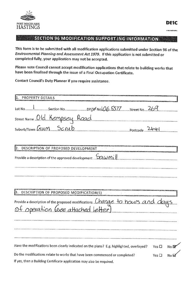
Subject: Section 4.55 Modification DA2004 - 687.6 To
Modify The Hours Of Operation of Existing Sawmill At Lot 1 DP 1065577, Old
Kempsey Road, Gum Scrub
Report
Author: Fiona Tierney
|
83Applicant: Hopkins
Consultants Pty Ltd
Owner: D
J & O V Hayden
Estimated Cost: Nil
Alignment with Delivery
Program
4.3.1 Undertake transparent
and efficient development assessment in accordance with relevant legislation.
|
|
RECOMMENDATION
That
the section 4.55 modification to DA 2004 – 687.6 to modify hours
of operation of an existing sawmill at Lot 1, DP 1065577, No.
269 Old Kempsey Rd, Gum Scrub, be
determined by granting consent subject to the recommended conditions.
|
Executive
Summary
This report considers a Section
4.55 modification application to modify the hours of operation of an existing
sawmill at the subject site and provides an assessment of the application in
accordance with the Environmental Planning and Assessment Act 1979.
Being a Section 4.55 modification,
the modified proposal has only been assessed against the legislation and
related planning guidelines in place at the time of the original assessment.
Development consent was granted by
Council on 16 October 2004 for a sawmill upgrade and office. A modification to
the sawmill to modify hours of operation and change the approved Saturday
operation to Sunday was granted on 24 April 2018. This consent was issued for a
trial period of 12 months and this application seeks to obtain consent for
these changes to be approved on a permanent basis.
As a condition of the 12-month
trial period the applicant was advised that:
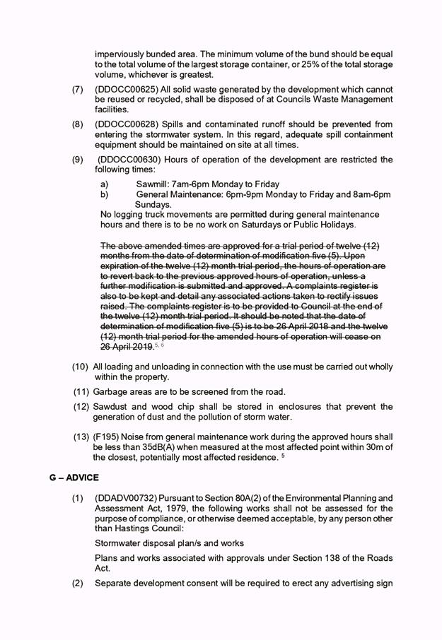
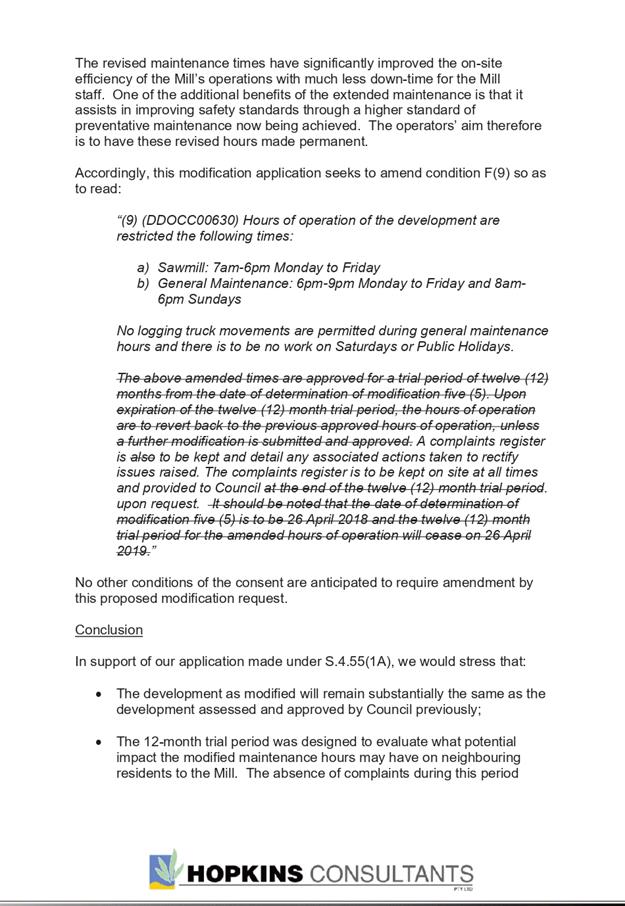
“The above amended times
are approved for a trial period of twelve (12) months form the date of
determination of modification five (5). Upon expiration of the twelve (12)
month trial period, the hours of operation are to revert back to the previous
approved hours of operation, unless a further modification is submitted and
approved. A complaints register is also to be kept and detail any associated
actions taken to rectify issues raised. The complaints register is to be
provided to Council at the end of the twelve (12) month trial period. It should
be noted that the date of determination of modification five (5) is to be 16
April 2018 and the twelve (12) month trial period for the amended hours of
operation will cease on 26 April 2019.”
Following exhibition of the
application, 3 submissions have been received.
This report recommends that the
section 4.55 modification application for DA 2004 – 687.6 be
approved.
1. BACKGROUND
Existing sites features and Surrounding
development
The
site has an area of 14.65ha.
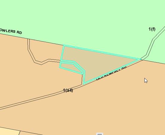
The site was zoned 1(a4) Rural Agricultural in accordance with the Port Macquarie-Hastings Local
Environmental Plan 2001, as shown in the following zoning plan:
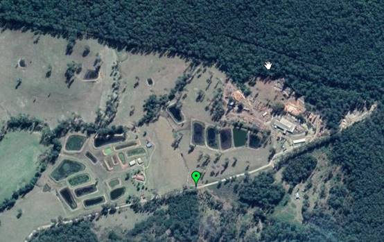
The existing subdivision pattern and location of existing
development within the locality is shown in the following aerial photograph:
2. DESCRIPTION OF
DEVELOPMENT
Key aspects of the proposal include the following:
· Modification
to the hours of operation for Monday to Friday from the current approved hours
7am-6pm to the proposed 7am-9pm and restrict extended hours (6pm-9pm) for
general maintenance only.
· Swap
the current approved hours from Saturday to Sunday and restrict time to 8am-6pm
for general maintenance only.
Refer
to attachments at the end of this report.
Application Chronology
· 22
January 2018 - Application received.
· 29 January 2018 – 12 February 2018- Neighbour
notification of proposal.
· 12 April 2018 – Site inspection.
· 26 April 2018 - 12-month consent issued by Council’s
Development Assessment Panel.
· 19 March 2019- Application received.
· 26 March 2019 - 8 April 2019- neighbour notification.
· 14 April 2019 - Inspection of site (Sunday) to assess
activity/noise/traffic.
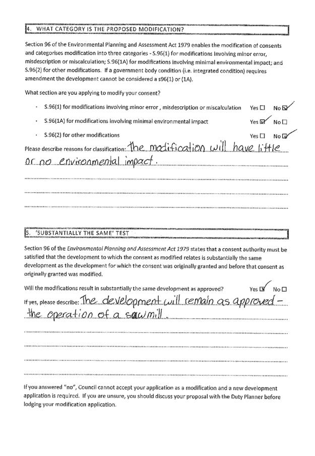
3. STATUTORY ASSESSMENT
Is the proposal substantially the same?
Section
4.55 of the Environmental Planning and Assessment Act 1979 enables the
modification of consents and categorises modifications into three categories -
S.4.55(1) for modifications involving minor error, mis-description or
miscalculation; S.4.55(1A) for modifications involving minimal environmental
impact; and S.4.55(2) for other modifications or modifications that require a
condition imposed by a Minister, public authority or approval body to be
amended. Each type of modification must be considered as being substantially
the same to that which was originally consented to.
The proposal is considered to be a S.4.55(1A) and remains
substantially the same development to that which was originally lodged and
consented to and will have minimal environmental impact. In particular, the
only change relates to a change in operating hours and a swap from Saturday to
Sunday for operation. No further change to the Mill operations is proposed.
Having regard to the above, the proposed modification is not considered to
alter the fundamental essence of the original development.
Much of
the matters raised in submissions relate to ongoing issues with the operation
of the Mill in general terms and not necessarily in relation to the subject
changes applied for under this application. It was noted at the site inspection
that dust generation of the trucks is significant and that care must be taken
on bends with risk that trucks moving at speed may be present. It is
recommended that a review be conducted to ensure compliance with overall
conditions.
Are
there any condition(s) of consent imposed by a Minister, government or public
authority that require modification?
No.
Does
the application require notification/advertising in accordance with the
regulations and/or any Development Control Plan?
Neighbour
notification has been undertaken in accordance with the Port Macquarie-Hastings
Development Control Plan 2013.
Any submissions made concerning the modification?
During the
original modification thirteen (13) submissions were received.
During
exhibition of the new/continued modification three (3) submissions were
received.
Key issues raised in the submission received and comments
in response to the issues are provided as follows:
|
Submission Issue/Summary
|
Planning Comment/Response
|
|
Road Safety.
|
The proposal does not intend
to alter the volumes of traffic to the site and is not the subject of this
application. The applicant has liaised with staff and drivers in relation to
incidents and advised of the keeping of a register to note and respond to
complaints.
|
|
Dust generation. Health Concerns.
Road should be sealed
|
The proposal does not intend to alter the volumes of
traffic to the site and are not the subject of this application. In specific
relation to this modification, the site was inspected on a Sunday. Whilst
some movement of employee vehicles was observed, no deliveries or truck
movements was observed. The road was required to be upgraded in width and
with a gravel top as part of the 2004/2005 consent. Council has previously
considered upgrade f the surface but this is not currently recognised as a
part of the works program.
|
|
Roads deteriorating.
|
The proposal does not intend to alter the volumes of
traffic to the site and are not the subject of this application. As part of the
existing consent the section of road between Gum Scrub Rd and the Mill was
upgraded to Council requirements ( width increase and gravel base 200mm
thick) in recognition of increased traffic movements.
|
|
Health and enjoyment of residents diminished from traffic.
|
The proposal does not intend to alter the volumes of
traffic to the site and are not the subject of this application.
|
|
Noise - object to change/expansion of hours.
|
Conditions are to be applied relating to noise.
Maintenance activities only are permitted during these expanded hours and no
additional logging truck movements to and from the site are permitted at
these times. In specific relation to this modification, the site was
inspected on a Sunday. Whilst some movement of employee vehicles was observed,
no deliveries or truck movements was observed.
In effect, impacts are reduced by an additional day due
to the removal of logging trucks on both Saturday and Sunday. Trucks are
permitted on Saturdays under the current consent. Refer to noise comments
below.
|
|
Religious precedent - will
this set standard for hours of operation.
|
Regardless of religious beliefs, applications are
assessed on merit. On balance, the variation is considered acceptable. The
varied proposal has operated for 12 months without any noise complaints. One
complaint was noted for a single incident of a truck arriving earlier than
7am.
The proposal is for an increase in hours to enable
maintenance. No Timber Mill operations are permitted. Conditions relating to
noise and permissible activities is to be applied to the consent.
|
Any
matters referred to in section 79C (1)/4.15 relevant to the modification?
Overall,
the proposed development remains consistent with the original s79C/4.15
assessment. Refer to comments provided in the original DAP assessment attached
to this report. Comments on notable changes are included below.
Noise
It’s
proposed to modify the existing development consent condition (which restricts
operation of the sawmill to 7am-6pm Mondays to Saturdays) to allow for
maintenance work to be carried out in the evenings until 9pm, Mondays to
Fridays. The proposal is also seeking to swap the Saturday operating hours to
Sundays, with no work on Saturdays.
If
approved the new operating hours will be 7am to 9pm Mondays to Fridays and 8am
to 6pm on Sundays. General sawmill operations will remain at the pre-approved
hours of 7am to 6pm Monday to Friday and general maintenance work only from 6pm
to 9pm Monday to Friday and 8am to 6pm on Sundays.
The
EMM noise report dated 13 November 2017 indicates that noise levels from the
general maintenance work proposed to be carried out from 6pm to 9pm Monday to
Friday after the mill has closed and from 8am to 6pm on Sundays will be at an
acceptable level (<35dB(A)) for the rural location at the closest residence
not associated with the sawmill.
The
newly introduced “Noise Policy for Industry” NSW EPA October 2017
sets the amenity level for a rural area during the day at 50 decibels and
during the evening at 45dB(A) so the predicted <35dB(A) is deemed to be
satisfactory.
No
complaints have been received to Council or the sawmill in relation to noise
issue at the site during the 12-month trial period.
Proposed changes to conditions
Refer to attached draft recommended consent with conditions
subject to change being highlighted in red.
4. DEVELOPMENT
CONTRIBUTIONS APPLICABLE
As per original application it has been considered that the
change to hours and exchange of days will not result in any adverse impact to
the local road network. Accordingly, development contributions are not
applicable in this case.
5. CONCLUSION
The application has been assessed in accordance with
Section 4.55 of the Environmental Planning and Assessment Act 1979.
Issues raised during assessment and public exhibition of
the application have been considered in the assessment of the application.
Where relevant, conditions have been recommended to manage the impacts
attributed to these issues.
The site is suitable for the proposed development, is not
contrary to the public's interest and will not have a significant adverse
social, environmental or economic impact. It is recommended that the
application be approved, subject to the recommended conditions of consent
provided in the attachment section of this report.
|
Attachments
1View. DA2004
- 687.6 Modification of consent
2View. DA2004
- 687.6 Public plans and documents
|
|
ATTACHMENT
|
Development Assessment Panel
24/04/2019
|

|
ATTACHMENT
|
Development Assessment Panel
24/04/2019
|


AGENDA Development Assessment Panel 24/04/2019
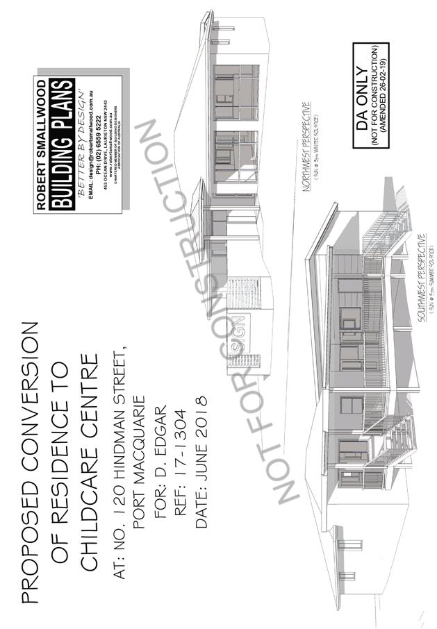
Item: 06
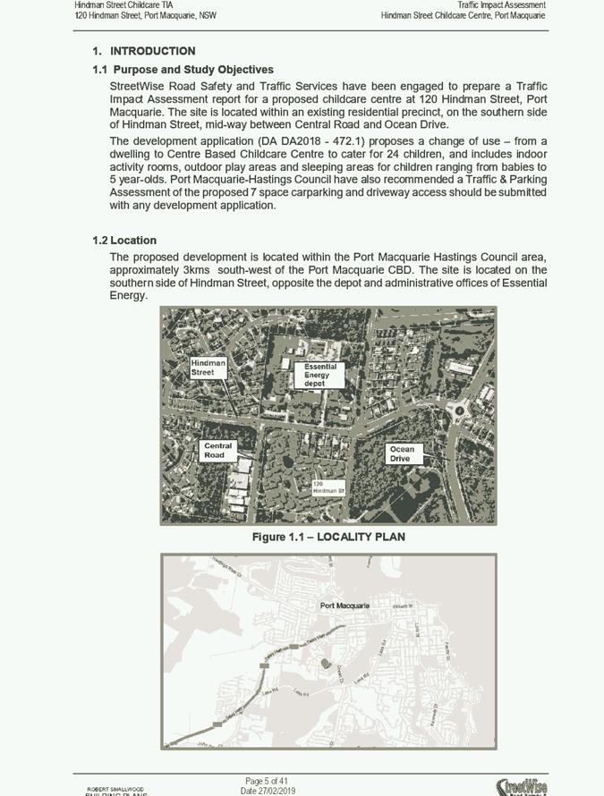
Subject: DA2018 - 472.1 Change of Use - Dwelling to
Centre Based Childcare Centre - Lot 6 DP 262151, No.120 Hindman Street, Port
Macquarie
Report
Author: Benjamin Roberts
|
Applicant: Robert
Smallwood
Owner: D
Edgar
Estimated Cost: $245,000
Alignment with Delivery
Program
4.3.1 Undertake transparent
and efficient development assessment in accordance with relevant legislation.
|
|
RECOMMENDATION
That
DA 2017 - 663.1 for a change
of use from a dwelling to a centre based childcare centre at Lot 6, DP 262151, No. 120 Hindman
Street, Port Macquarie, be determined by granting consent subject to the
recommended conditions.
|
Executive
Summary
This
report considers a development application for a change of use from a
dwelling to a centre based childcare centre at the
subject site and provides an assessment of the application in accordance with
the Environmental Planning and Assessment Act 1979.
Following exhibition of the
application, one (1) submission has been
received.
This report recommends that the
development application be approved subject to conditions.
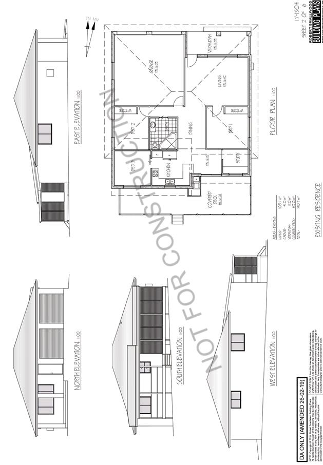
1. BACKGROUND
Existing sites features and Surrounding development
The site has an area of 1014m2.
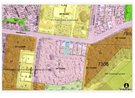
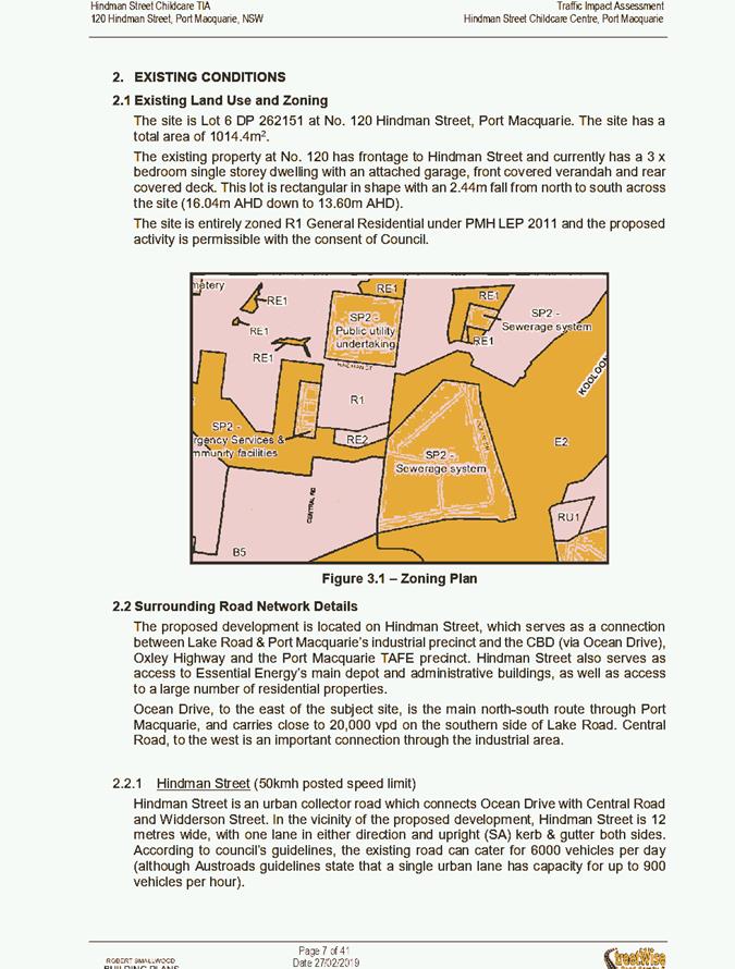
The site is zoned R1 General Residential in accordance with the Port Macquarie-Hastings Local
Environmental Plan 2011, as shown in the following zoning plan:
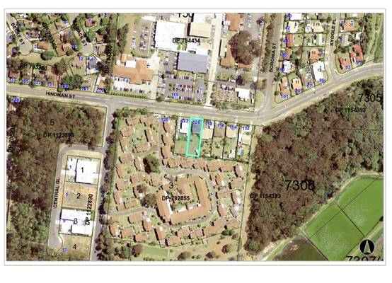
The existing subdivision pattern and location of existing
development within the locality is shown in the following aerial photograph:
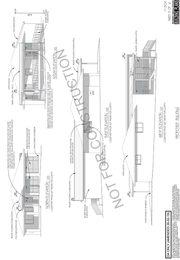
2. DESCRIPTION OF
DEVELOPMENT
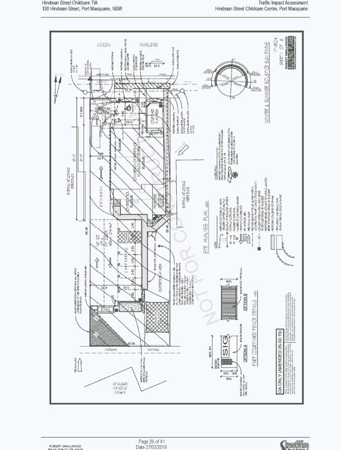
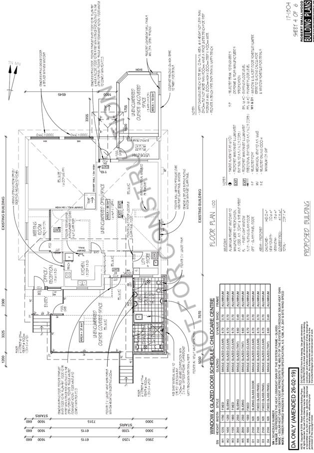
Key aspects of the proposal include the following:
· Change
of use from dwelling to medical centre with associated fit out, car parking and
signage.
· Facility
to cater for a maximum of 24 children.
· Hours
of operation 7am to 6pm Mondays to Fridays.
Refer
to attachments at the end of this report.
Application Chronology
· 29
June 2018 - Application lodged.
· 9
July 2018 - Additional information request (RFS cheque).
· 12 to 25 July 2018 - Public exhibition via neighbour
notification.
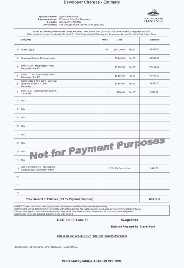
· 6 August 2018 - Additional information request (BCA report,
access and stormwater issues).
· 7 August 2018 - Stormwater response provided from
applicant.
· 15 August 2018 - Access response provided from applicant.
· 16 August 2018 - Additional information request (stormwater
management issue).
· 23 August 2018 - Bushfire Safety Authority conditions
received from NSW RFS.
· 5 September 2018 - Additional information request
(preliminary stormwater management plan required demonstrating onsite detention
capable).
· 19 October 2018 - Preliminary stormwater management plan
provided.
· 24 October 2018 - Additional details required for
stormwater management.
· 8 November 2018 - Additional stormwater details provided.
· 14 December 2018 - Advice to applicant that single lane
access still of concern.
· 27 February 2019 - Traffic assessment and fire safety
upgrade report lodged.
3. STATUTORY ASSESSMENT
Section 4.15(1) Matters for Consideration
In determining the application, Council is required to take
into consideration the following matters as are relevant to the development
that apply to the land to which the development application relates:
(a) The provisions (where
applicable) of:
(i) Any Environmental
Planning Instrument:
State Environmental Planning Policy 44 - Koala Habitat
Protection
The site has an area of less than 1 hectare therefore the
requirements for this SEPP do not require consideration.
State Environmental Planning Policy 55 – Remediation
of Land
In accordance with clause 7, following an inspection of the
site and a search of Council records, the subject land is not identified as
being potentially contaminated and is suitable for the intended use.
State
Environmental Planning Policy 62 - Sustainable Aquaculture
Given the nature of the proposed development and proposed
stormwater controls, the proposal will be unlikely to have any adverse impact
on existing aquaculture industries.
State Environmental Planning Policy 64 - Advertising and
Signage
The proposed development includes proposed advertising
signage in the form of business identification advertising.
The signage comprises a business identification sign on the
front courtyard fence of the Hindman Street frontage. The sign is proposed to
be illuminated until 9pm each day.
In accordance with clause 7, this SEPP prevails over the
Port Macquarie-Hastings LEP 2011 in the event of any inconsistency.
The following assessment table provides an assessment
checklist against the Schedule 1 requirements of this SEPP:
|
Applicable clauses for
consideration
|
Comments
|
Satisfactory
|
|
Clause 8(a) Consistent with
objectives of the policy as set out in Clause 3(1)(a).
|
The signage is compatible with
the desired amenity and visual character for the immediate locality. The
signage will provide effective communication in a suitable location on the
site having regard to the existing context.
|
Yes
|
|
Schedule 1(1) Character of the
area.
|
|
Schedule 1(2) Special areas.
|
The signage is limited in
scale and is compatible with the existing context.
|
Yes
|
|
Schedule 1(3) Views and
vistas.
|
The signage will not have any
identifiable adverse impacts on important views or vistas.
|
Yes
|
|
Schedule 1(4) Streetscape,
setting or landscape.
|
The scale and proportion of
the signage is appropriate to existing streetscapes and setting. The signage
does not protrude above the proposed front wall.
|
Yes
|
|
Schedule 1(5) Site and
building.
|
The size of the signage is
compatible with the building design features and desired functioning of the
site.
|
Yes
|
|
Schedule 1(6) Associated
devices and logos with advertisements and advertising structures.
|
No logos are proposed as part
of the business identification signage.
|
Yes
|
|
Schedule 1(7) Illumination.
|
The illumination should be
restricted to 9pm consistent with DCP provisions.
|
Yes
|
|
Schedule 1(7) Safety.
|
The signage will not result in
any identifiable public road safety concerns in the locality.
|
Yes
|
State Environmental Planning Policy (Coastal Management)
2018
The site is located within a coastal environment area.
In accordance with clause 7, this SEPP prevails over the Port
Macquarie-Hastings LEP 2011 in the event of any inconsistency.
Having regard to clause 13 of the SEPP the proposed
development is not considered likely to result in any of the following:
a) any
adverse impact on existing, safe access to and along the
foreshore, beach, headland or rock platform for members of the public,
including persons with a disability,
b) any
adverse impact on Aboriginal cultural heritage, practices and
places;
c) any
adverse impacts on the cultural and built environment heritage;
d) any
adverse impacts the use of the surf zone;
e) any adverse impact on the visual amenity and scenic qualities of the
coast, including coastal headlands;
f) overshadowing, wind funnelling and the loss of views from public places
to foreshores;
State Environmental
Planning Policy (Educational Establishments and Childcare Facilities) 2017
In accordance
with clause 22 concurrence of the Regulatory Authority is not required. The
application has demonstrated that the indoor and outdoor unencumbered space requirements
comply with the relevant regulations.
In accordance
with clause 23 the consent authority must take into consideration any
applicable provisions of the Child Care Planning Guideline.
Consideration
has been given to the relevant matters for consideration and objectives
outlined in the guideline. The proposal is considered to be consistent with the
guidelines.
State Environmental Planning Policy (State and Regional
Development) 2011
The capital investment value is less than $5 million and the
proposed development is not recognised as regionally significant development.
Port Macquarie-Hastings Local Environmental Plan 2011
The proposal is
consistent with the LEP having regard to the following:
· Clause
2.2 - The subject site is zoned R1 general residential.
· In
accordance with clause 2.3(1) and the R1 zone landuse table, the proposed
development for a childcare centre is a permissible landuse with consent.
The
objectives of the R1 zone are as follows:
o To
provide for the housing needs of the community.
o To
provide for a variety of housing types and densities.
o To
enable other land uses that provide facilities or services to meet the day to
day needs of residents.
· In
accordance with Clause 2.3(2), the proposal is consistent with the zone
objectives having regard to the following:
o The
proposal is a permissible landuse;
o The
proposal will provide for an additional service to meet the day to day needs of
residents;
· Clause
2.7 - The partial demolition of the existing dwelling requires consent as it
does not fit within the provisions of SEPP (Exempt and Complying) 2008.
· Clause
4.3 - The maximum overall height of the building above ground level complies
with the building height limit of 8.5m applying to the site.
· Clause
4.4 - The floor space ratio of the proposal complies with the maximum floor
space ratio of 0.65:1 applying to the site.
· Clause
5.10 – Heritage. The site does not contain or adjoin any listed
archaeological heritage items.
· Clause
7.13 - Satisfactory arrangements are in place for provision of essential
services including water supply, electricity supply, sewer infrastructure,
stormwater drainage and suitable road access to service the development.
(ii) Any
draft instruments that apply to the site or are on exhibition:
No draft
instruments apply.
(iii) Any
Development Control Plan in force:
Port
Macquarie-Hastings Development Control Plan 2013
No
specific building controls apply to a development of this nature. The following
applicable general provisions are addressed in the table below:
|
Requirement
|
Proposed
|
Complies
|
|
2.2
Advertising and signage
|
The signage is intended to
identify the business. The signage does not project above or the side of
building facades.
|
Yes
|
|
2.5
Transport, Traffic Management, Access and Carparking
Childcare Centres:
1 space per 4 children and set
down and pick up area.
|
The proposed development will
have a maximum of 24 children and therefore require 6 spaces.
7 off-street parking spaces
are proposed.
There is no formal set down
and pick up area. Given all children are required to be signed in by parents,
a set down and pickup area is not practical.
Satisfactory landscaping is
proposed to soften the impact of the at grade car parking area and building
on the site.
Refer to further comments
later in report addressing traffic and access.
|
Yes
|
|
2.7
Social Impact Assessment and Crime Prevention
|
No adverse crime risk
potential identified with design layout of the centre. Adequate boundary
fencing is provided to the centre has been designed to provide surveillance
of outdoor areas.
|
Yes
|
(iiia) Any
planning agreement that has been entered into under section 7.4, or any draft
planning agreement that a developer has offered to enter into under section
7.4:
No planning
agreement has been offered or entered into.
iv) Any matters prescribed by the
Regulations:
Fire safety and other considerations - Clause 93
The application involves a building change of use. In
accordance with this clause the consent authority is to take into consideration
whether the fire protection and structural capacity of the building will be
appropriate to the building’s proposed use.
The application was supported by a fire safety upgrading
report prepared by David Pensini of Building Certification and Environmental
services dated 22 October 2018.
The report identified a number of upgrading measures.
Subject to the implementation of these upgrade measures the building will be
appropriate for the proposed use as a childcare facility.
Demolition
of buildings AS 2601:
Part
demolition of the existing building is capable of compliance with this
Australian Standard and is recommended to be conditioned.
(b) The
likely impacts of that development, including environmental impacts on both the
natural and built environments, social and economic impacts in the locality:
The proposal
is unlikely to have any adverse impacts on existing adjoining properties and
satisfactorily addresses the public domain. The building form is well
articulated with a clear entrance defined from the proposed at grade carpark.
The proposal
does not have a significant adverse impact on existing view sharing.
The proposal
does not have significant adverse lighting impacts.
There are no
significant adverse privacy impacts. Adequate building separation is
proposed/existing.
There are no
adverse overshadowing impacts. The proposal does not prevent adjoining
properties from receiving 3 hours of sunlight to private open space and primary
living areas on 21 June.
The proposal is considered to be compatible with existing
development in the locality and adequately addresses planning controls for the
area.
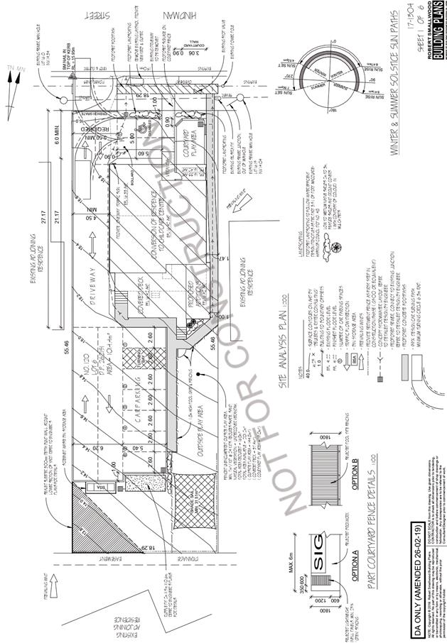
Roads, Traffic and Transport
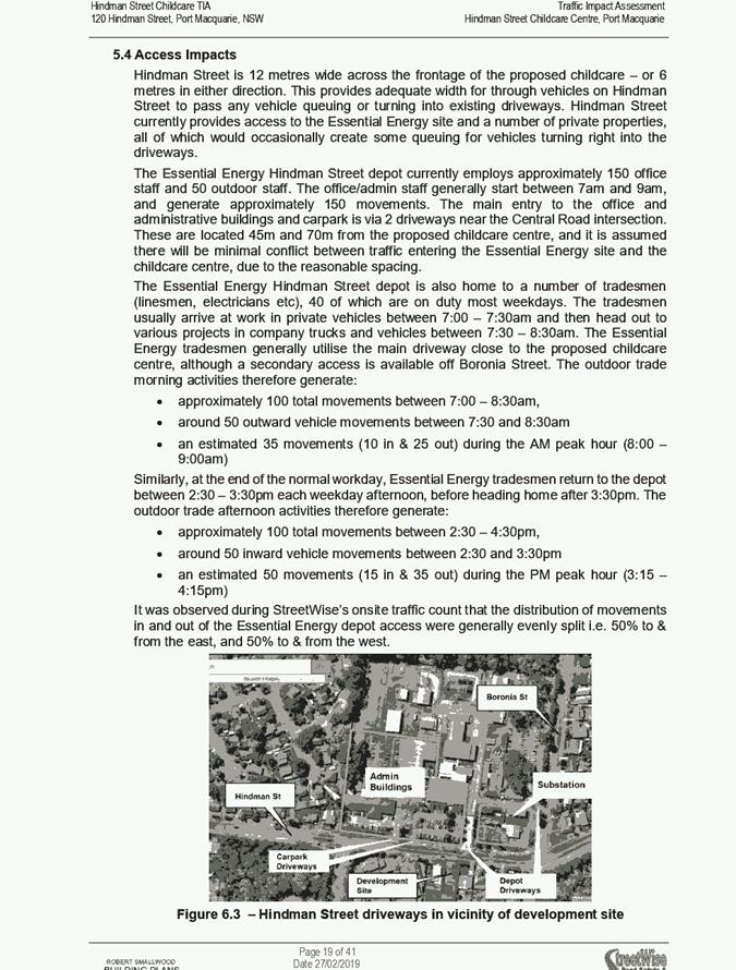
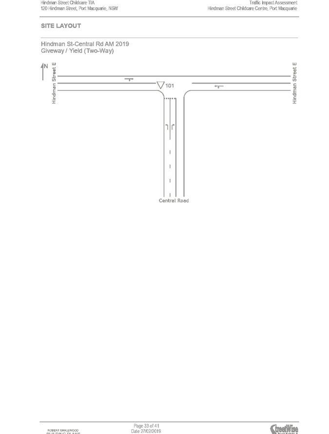
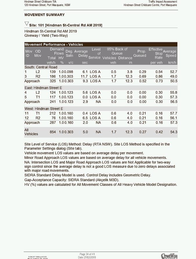
The site has road frontage to Hindman Street. Hindman Street
is a sealed public road under the care and control of Council. Hindman
Street is a collector road with a 11.5m road formation within a 20m road
reserve.
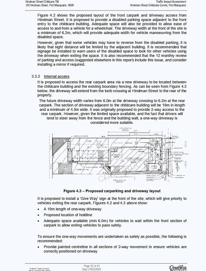
The proposed access to the site is directly from Hindman
Street via a new 5.5m wide driveway alongside the western boundary. The
driveway will provide access between the building and western boundary fence to
6 off-street car parking behind the building. One disabled parking space is
located out front of the building.
The part of the driveway between the building and driveway
for a length of 19m will be a minimum 4.5m wide and limit vehicle movements to
one-way.
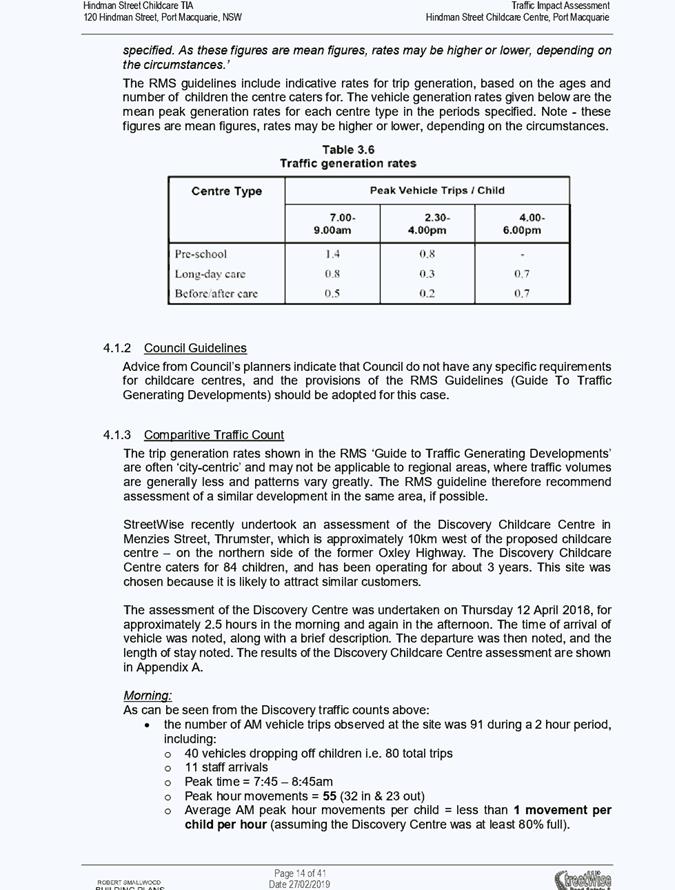
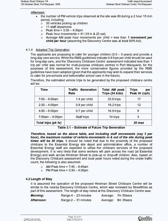
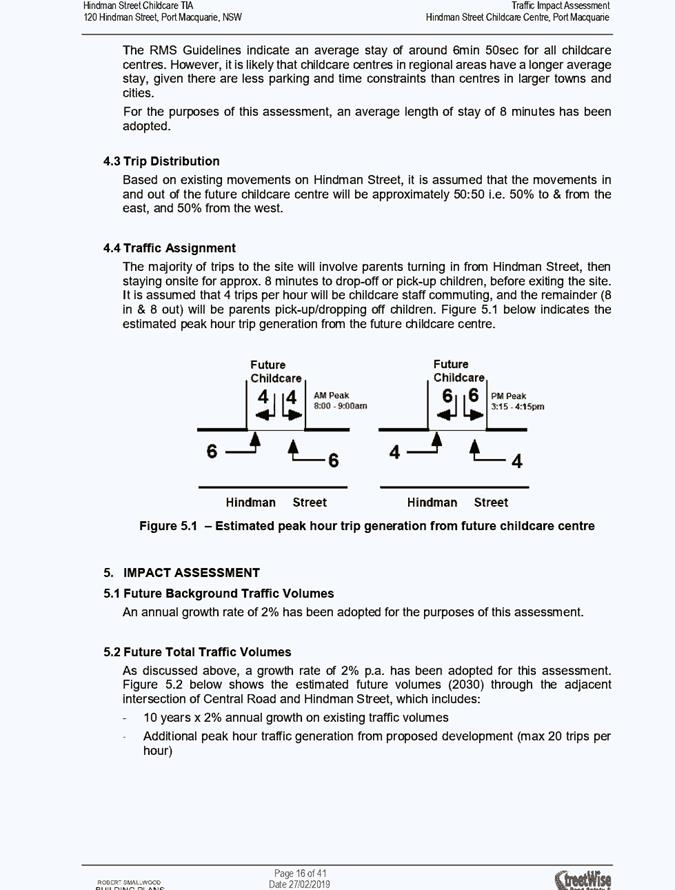
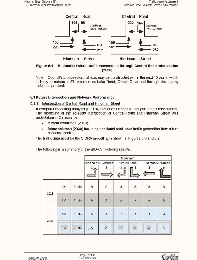
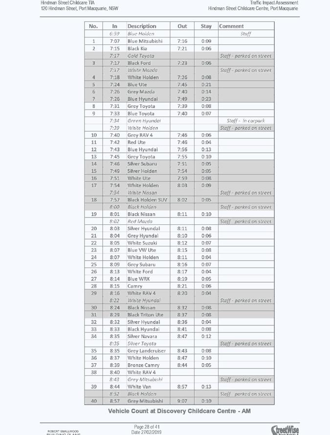
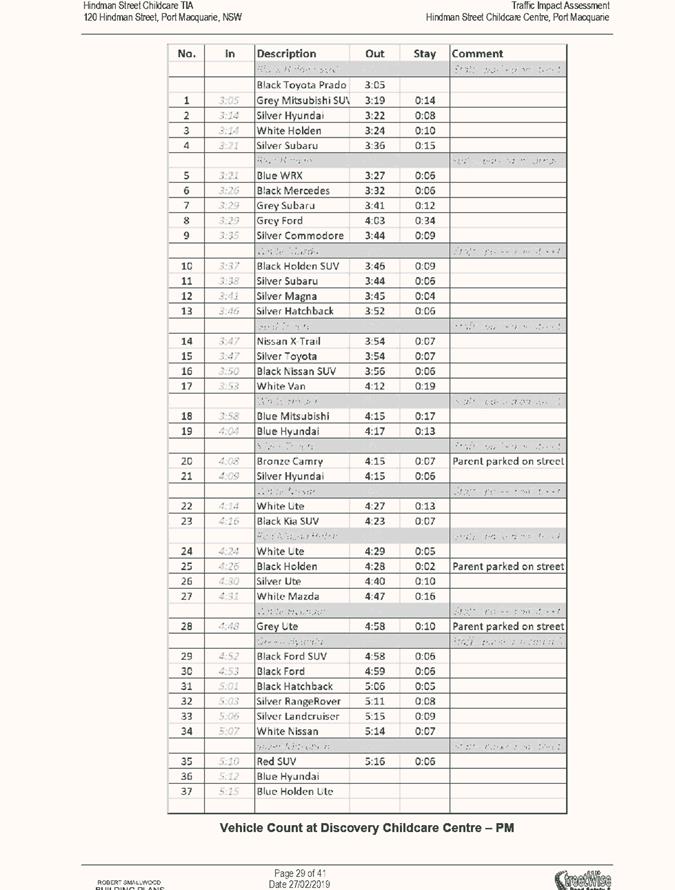
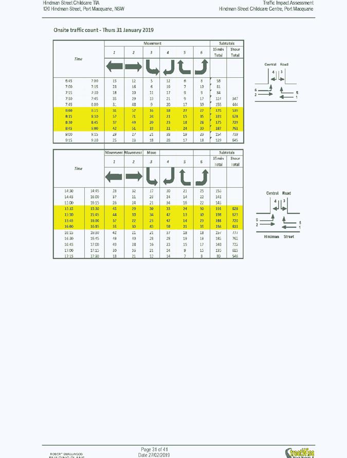
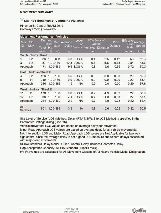
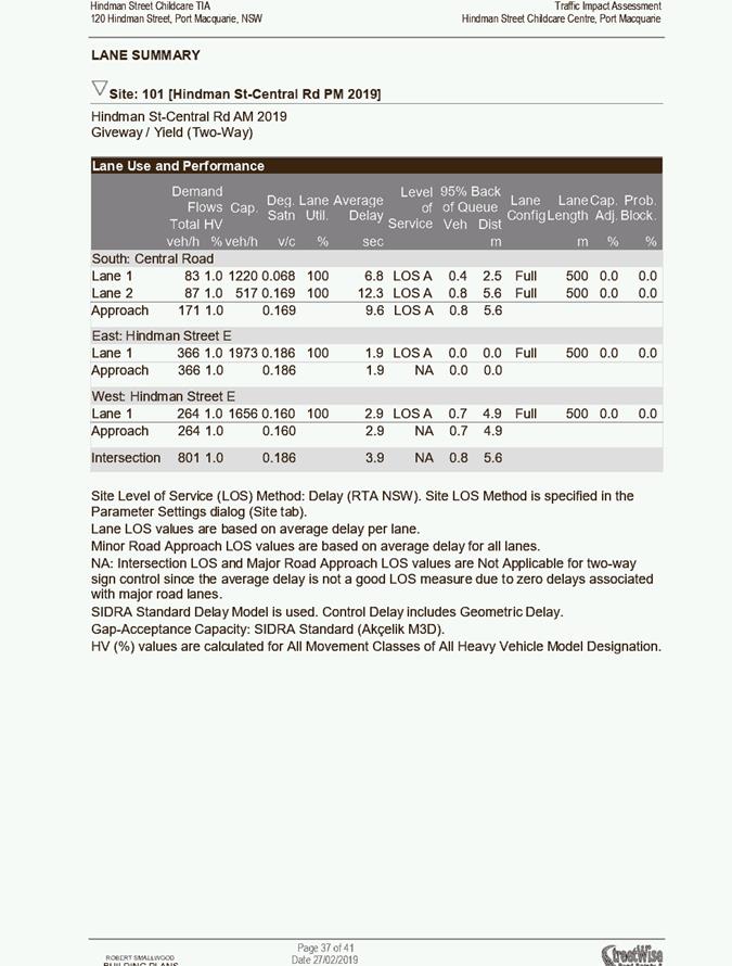
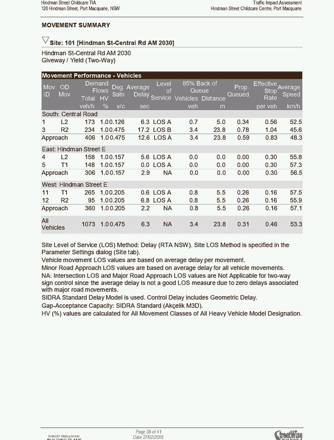
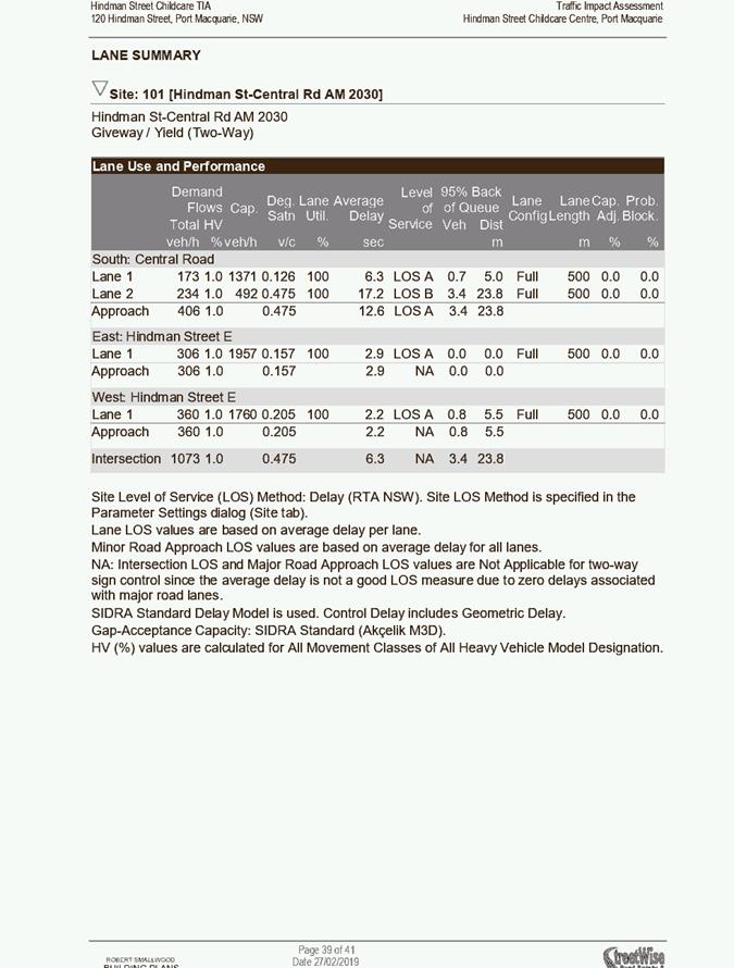
The application is supported by a Traffic Impact Assessment
prepared by Street Wise Road Safety and Traffic Services dated 27 February
2019. The key findings of the study and recommendations are provided as
follows:
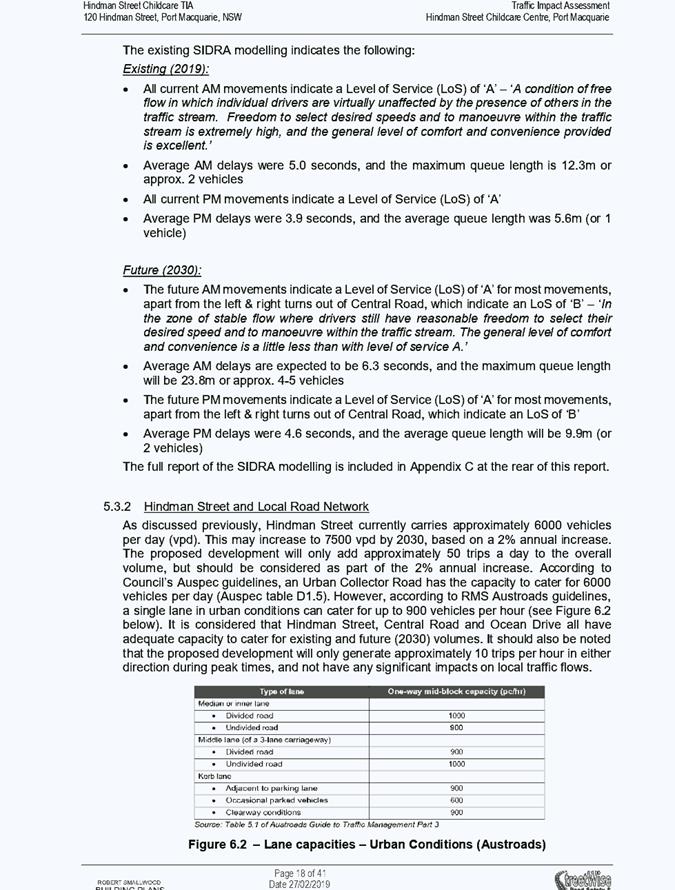
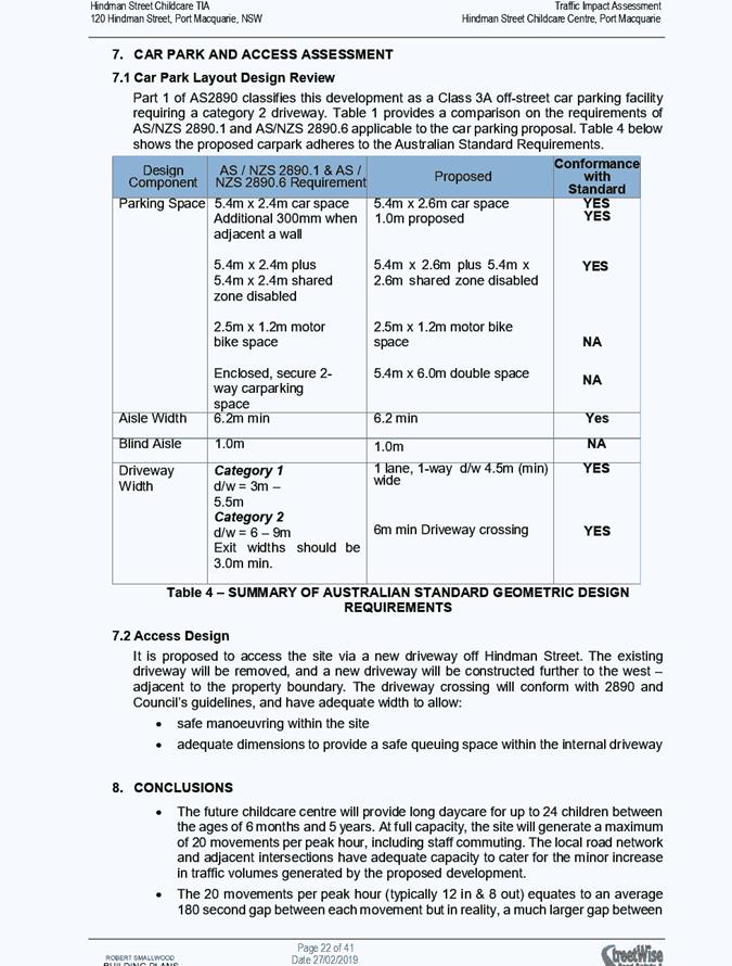
· Hindman Street and
the local road network has the capacity to cater for the future traffic volumes
generated by the proposed Childcare Centre, with safety, efficiency and with
minimal impacts. The following recommendations should be considered to further
improve road safety in the vicinity of the future childcare centre:
· Minimise kerbside
parking on the southern side of Hindman Street (across the frontage of the
future childcare centre) through education of the childcare centre users.
· Consideration
should be given to the future landscaping of the childcare centre, and also the
height and location of any future boundary fence/wall, to ensure sight distance
for vehicles entering and exiting the site aren’t compromised.
· Preparation of a
Traffic Management Plan for pedestrian movements, staff & parent parking
and vehicle movements in & around the proposed childcare centre to ensure
maximum safety for all users. The TMP should be regularly updated and
publicised to all users
· Review traffic
volumes, patterns and onsite traffic safety when the site is fully operational.
Revise onsite Traffic Management Plan, if required.
· It is proposed that
incoming vehicles will have priority over exiting vehicles, and a queuing space
suitable for 1 vehicle will be provided at the front of the site. Also, to
ensure the short section of one-way movements are undertaken as safely as
possible, it is proposed to provide the following measures:
o Provide painted centreline
in all sections of 2-way movement to ensure vehicles are correctly positioned
on driveway
o Provide signage to
ensure drivers are aware of one-way movements, priorities, and location to wait
o Provide education
and regular updates (i.e. newsletters, emails etc) to ensure all users of the
site are aware of the carparking and access requirements
o Provision of
suitable signage within the carpark to make drivers aware of the one-way
driveway, and the requirement to check for oncoming vehicles.
· The safety and
efficiency of the carpark and access should be reviewed once the proposed
childcare centre is completed and fully operational (say 12 months after
opening).
· Provide signage to
warn exiting vehicles about the potential for pedestrians in the vicinity of
the childcare centre.
Council’s development engineering section have
reviewed the proposal and traffic impact assessment and agree that the increase
in traffic from this development will not have a detrimental effect on the
surrounding road network. It is also considered that having regard to the
anticipated traffic volumes for a 24 place facility and the referenced
provision of AS2890 that the one-way movement for the 19m length is acceptable
subject to the educational and signage measures recommended within the traffic
impact assessment.
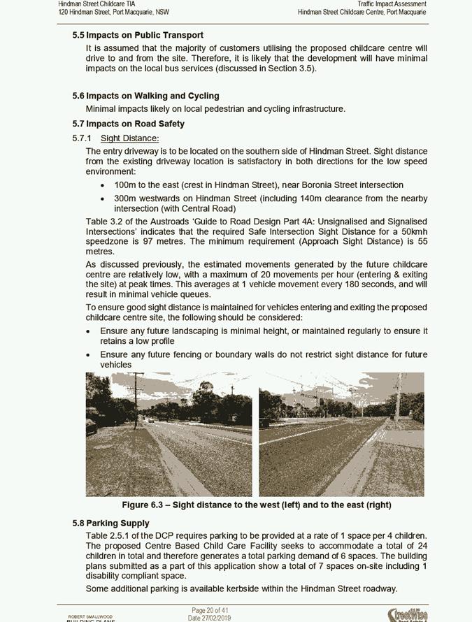
Site Frontage & Access
Vehicle access to the site is proposed though one access
driveway to Hindman Street. All accesses shall comply with Council AUSPEC and
Australian Standards, and conditions have been imposed to reflect these
requirements.
Parking and Manoeuvring
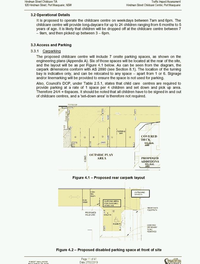
A total of 7 parking spaces (including 1 disabled spaces)
have been provided on-site. Parking and driveway widths on site can
comply with relevant Australian Standards (AS 2890) and conditions have been
imposed to reflect these requirements.
Due to the type of development, car park circulation is
required to enable vehicles to enter and exit the site in a forward
manner. Site plans show adequate area is available and conditions have
been imposed to reflect these requirements.
Pedestrians
Foot paving
is required across the full frontage. Suitable conditions have been
recommended.
Utilities
Telecommunication
and electricity services are available to the site.
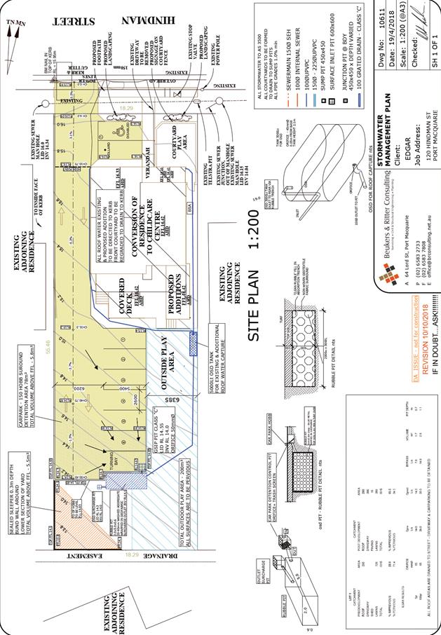
Stormwater
The site naturally grades towards the rear and is currently
unserviced. The site is benefitted by an easement for drainage located within
the adjoining lot to the rear, however this easement is not piped. The
construction of a pipeline in this easement would necessitate the placement of
some 80m+ of stormwater pipeline, construction of numerous pits and outlet
protection. The applicant has indicated that the scale of works associated with
activating this existing easement for drainage is not feasible and has proposed
an alternate drainage solution involving the disposal of stormwater runoff
on-site.
In this regard, a stormwater drainage plan has been
submitted which incorporates a combination of stormwater treatment measures
including:
· Rainwater storage,
· On-site detention,
· On-site
absorption/dispersion trenches, and
· An above ground
rainwater storage area,
All of which have been conceptually designed to limit the
volume and rate of stormwater discharge to pre-development rates. Doing so
ensures that the development results in no change in runoff directed to
adjoining downstream property.
Conditions have been recommended requiring that detailed
hydraulic modelling be undertaken and submitted with the subsequent
Construction Certificate application to demonstrate that the proposed drainage
system achieves the abovementioned aims. The modelling must be undertaken in
accordance with Australian Rainfall and Runoff 016 and shall demonstrate
compliance for all storm events up to and including the 1% AEP event and for a
range of durations.
Refer to relevant recommended
conditions of consent.
Water Supply Connection
Council records indicate that the development site has an
existing 20mm metered water service from the 100 AC water main on the same side
of Hindman Street.
Final water service sizings will need to be determined by a
hydraulic consultant, as well as fire service coverage to AS 2419 and backflow
protection requirements in accordance with AS3500. Minimum water service sizing
for commercial developments is 25mm.
Refer to relevant recommended conditions of consent.
Sewer Connection
Council
records indicate that the development site is currently connected to sewer via
a junction to a manhole located on the northern boundary.
Council records indicate that there is an existing manhole
in very close proximity to the proposed driveway. The engineering plans need to
provide adequate levels on the driveway, surrounding ground and the manhole lid
to determine if any further works are required on the manhole, i.e. raising/lowering
the lid.
Detailed plans will be required to be submitted for
assessment with the S.68 application. Refer to relevant recommended conditions
of consent.
Soils
The proposed
development will be unlikely to have any adverse impacts on soils in
terms of quality,
erosion, stability and/or productivity subject to a standard condition
requiring erosion and sediment controls to be in place prior to and during
construction.
Air & Micro-climate
The
construction and/or operations of the proposed development will be unlikely to
result in any
adverse impacts on the existing air quality or result in any pollution.
Standard
precautionary site management condition recommended.
Flora & Fauna
Construction
of the proposed development will not require any removal/clearing of
any
significant vegetation and therefore will be unlikely to have any significant
adverse
impacts on biodiversity or threatened species of flora and fauna.
Waste
Satisfactory
arrangements are in place for proposed storage and collection of waste
and
recyclables. No adverse impacts anticipated. Standard precautionary site
management
condition recommended.
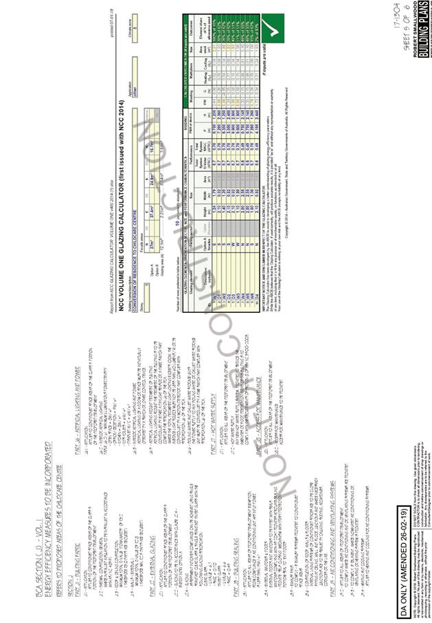
Energy
The proposal
includes measures to address energy efficiency and will be required to
comply with
the requirements of Section J of the Building Code of Australia. No adverse
impacts anticipated.
Noise & Vibration
The proposed
hours of operation are 7am to 6pm weekdays only. A condition confirming these
operational hours has been recommended. A condition restricting construction
work to standard hours is also recommended.
Childcare
centres have the potential to result in noise impacts for adjoining residential
occupants. Outdoor play areas experience a high level of activity and are
subsequently
the central noise source emanating from a childcare centre.
The outdoor
play area is located behind the building and illustrated on the plans. 1.8m
high colourbond fencing exists along western, eastern and southern boundaries. Having
regard to the proposed hours of operation, existing fencing and building
separation distances it is anticipated that no significant adverse noise
impacts would result that could warrant refusal of the application.
Natural Hazards
The site is
identified as being bushfire prone. In accordance with Section 100B -
Rural Fires
Act 1997 - the application proposes development of bushfire prone land
for a Special
Fire Protection Purpose.
The applicant
has submitted a bushfire report. The report has carried out an assessment under
Section 100B requirements. The Commissioner has assessed the development and
has issued a Bushfire Safety Authority consisting of a series of conditions.
These conditions comprise part of the recommended conditions attached to this
report.
Safety, Security & Crime Prevention
The proposed development will be
unlikely to create any concealment/entrapment
areas or crime spots that would
result in any identifiable loss of safety or reduction of
security in
the immediate area.
Social Impact in the Locality
Given the nature of the proposed
development and its’ location the proposal is
unlikely to
result in any adverse social impacts.
Economic Impact in the Locality
No adverse impacts. Likely
positive impacts can be attributed to the construction and
operation of
the development.
Site Design and Internal Design
The proposed development design
satisfactorily responds to the site attributes and
will fit into
the locality. No adverse impacts likely.
Construction
No potential adverse impacts
identified to neighbouring properties with the
construction
of the proposal.
Cumulative Impacts
The proposed development is not
expected to have any adverse cumulative impacts
on the natural or built
environment or the social and economic attributes of the
locality.
(c) The suitability of the site for
the development:
The proposal will fit into the
locality and the site attributes are conducive to the
proposed development. Site
constraints have been adequately addressed and
appropriate
conditions of consent recommended.
(d) Any submissions made in
accordance with this Act or the Regulations:
One (1) written submission has been received following public
exhibition of the application.
Key issues raised in the submission received and comments
in response to these issues are provided as follows:
|
Submission
Issue/Summary
|
Planning
Comment/Response
|
|
A childcare centre is
incompatible with the existing retirement village adjoining the property to
the rear of the site. The decision to reside in this retirement village was
based on the peace and quiet it provides. The dividing fence is only 2 to 3
metres from my balcony where I spend a lot of time. I would be adversely
impacted by noise from children at the facility.
|
Childcare centres are a
permissible land use within the residential zone. The proposal
adequately addresses relevant planning controls and
is considered suitable and not incompatible with the existing and adjoining
land uses. The balcony of the adjoining retirement village unit in question
is setback 5m from the boundary and separated by an existing minimum 1.8m
high colour bond fence. The primary outdoor play area is located in the south
eastern portion of the site and does not immediately adjoining the balcony.
Having regard to the proposed hours of operation, building separation and
fencing the proposal will not result in any significant amenity impact that
would warrant refusal of the application.
|
(e) The Public Interest:
The proposed
development satisfies relevant planning controls and is unlikely to impact on
the wider public interest.
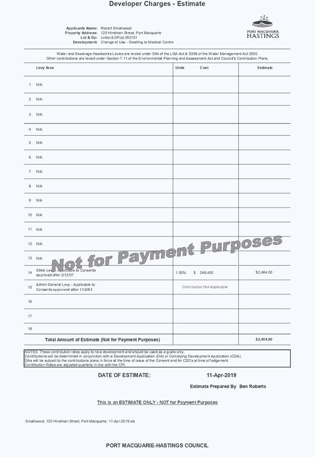
4. DEVELOPMENT
CONTRIBUTIONS APPLICABLE
· Development contributions will be required under Section
7.12 of the Environmental Planning and Assessment Act 1979.
· In accordance with clause 2.9(2) of Development
Contribution Assessment Policy charges for development involving a change of
use where the combined total of the water supply and sewerage head works
charges do not exceed $2,000 will be exempted. The proposal qualifies for this
exemption.
5. CONCLUSION AND
STATEMENT OF REASON
The application has been assessed
in accordance with Section 4.15 of the Environmental Planning and Assessment
Act 1979.
Issues raised during assessment
and public exhibition of the application have been considered in the assessment
of the application. Where relevant, conditions have been recommended to manage
the impacts attributed to these issues.
The site is considered suitable
for the proposed development and the proposal adequately addresses relevant
planning controls. The development is not considered to be contrary to the
public's interest and will not result a significant adverse social,
environmental or economic impact. It is recommended that the application be
approved, subject to the recommended conditions of consent provided in the
attachment section of this report.
|
Attachments
1View. DA2018
- 472.1 Recommended conditions
2View. DA2018
- 472.1 Traffic assessment report
3View. DA2018
- 472.1 Plans
4View. DA2018
- 472.1 Contributions estimate
|
|
ATTACHMENT
|
Development Assessment Panel
24/04/2019
|
|
ATTACHMENT
|
Development Assessment Panel
24/04/2019
|


|
ATTACHMENT
|
Development Assessment Panel
24/04/2019
|

|
ATTACHMENT
|
Development Assessment Panel
24/04/2019
|
AGENDA Development Assessment Panel 24/04/2019
Item: 07
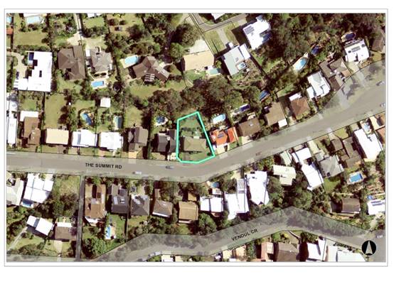
Subject: DA2018 - 876.1 - Demolition of Existing
Dwelling, Dual Occupancy and Torrens Title Subdivision - Lot 272 DP
236277, No. 45 The Summit Road, Port Macquarie
Report
Author: Patrick Galbraith-Robertson
|
Applicant: G
& G Schwarzel
Owner: G
& G Schwarzel
Estimated Cost: $1.176M
Alignment with Delivery
Program
4.3.1 Undertake transparent
and efficient development assessment in accordance with relevant legislation.
|
|
RECOMMENDATION
That
DA2018 - 876.1 for demolition of existing dwelling and construction of
dual occupancy with torrens title subdivision at
Lot 272, DP 236277, No. 45 The
Summit Road, Port Macquarie, be determined by granting consent subject to the
recommended conditions.
|
Executive
Summary
This
report considers a Development Application for demolition of an existing
dwelling, dual occupancy and Torrens title subdivision at
the subject site and provides an assessment of the application in accordance
with the Environmental Planning and Assessment Act 1979.
Following exhibition of the
application, 10 submissions have been
received.
The proposal has been amended
during the assessment of the DA including reducing the building height to be
compliant with the 8.5m building height standard.
This DA was previously report to
Council’s Development Assessment Panel (DAP) on the 13 March 2019. The
following resolution was made at this DAP meeting:
CONSENSUS:
That
DA2018 – 876 be deferred to enable:
1.
Re-examination of the floor space ratio calculations, particularly noting the
nominated alfresco areas.
2.
Redesign of dwelling 2 so as to be more sensitive to the view impacts from the
development on 47 The Summit Road. Height poles are to be erected at the
northern and southern extremity of the eastern elevation of dwelling 2 as
proposed on the site to enable a more informed assessment of view impacts.
The Applicant has subsequently
submitted additional information and amended plans in response to the
DAP’s recommendation. The amended plans (excluding floor plans) and
additional information received are attached to this report (amended areas are
highlighted on the plans by green circles). The amendments relate to a
re-design of the south east corner of dwelling 2 (stair well) so as to improve
view availability to the neighbouring property. The lower floor alfresco areas
have been redesigned so as they are no longer capable of being considered floor
area in floor space ratio calculations. There is also a slight reduction in
floor area of both units that has resulted in a reduction in floor space ratio
from 0.65:1 to 0.6:1. As the amendments were considered to lessen the impact of
the proposal they were not re-notified however the original submissions are
still addressed in the report.
The Applicant will have height
guides erected for the purposes of the DAP members to inspect the view impacts
prior to the meeting this report is being made to (same as below photos).
The following photos have also
been taken by the assessing officer on 15 April 2019 for the DAP’s
consideration:
Photo of view from kitchen
window of No.47 The Summit Road showing height guide at the south-eastern
corner of proposed dwelling 2
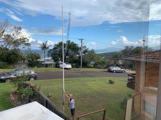
Photo of view from front
living room bay window of No.47 The Summit Road showing height guide at the
south-eastern corner of proposed dwelling 2
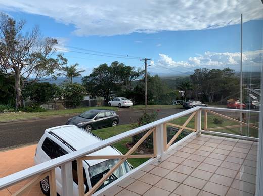
2 Photos of views from deck
of No.47 The Summit Road showing height guide at the south-eastern corner of proposed
dwelling 2
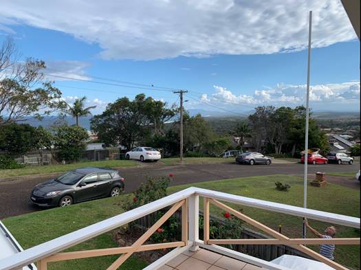
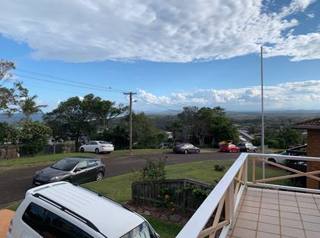
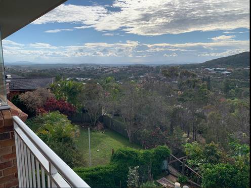
Photo of views from living
room window on west side of No.47 The Summit Road showing height guide at the
south-eastern corner of proposed dwelling 2
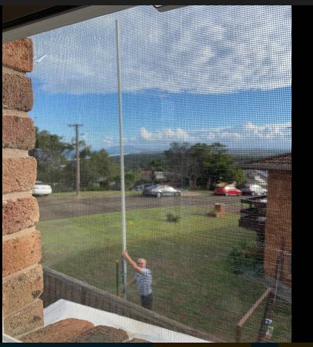
Photo of views from dining
room window on north-west side of No.47 The Summit Road showing height guide of
the first floor deck level (not roof of remainder) at the north-eastern corner
of proposed dwelling 2
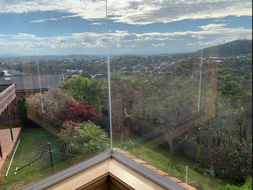
Photo of views from rear
deck on north side of No.47 The Summit Road showing height guide of the first
floor deck level (not roof of remainder) at the north-eastern corner of
proposed dwelling 2
1. BACKGROUND
Existing sites features and surrounding development
The site has an area of 752.31m2.
The site is zoned R1 general residential in accordance with the Port Macquarie-Hastings Local
Environmental Plan 2011, as shown in the following zoning plan:
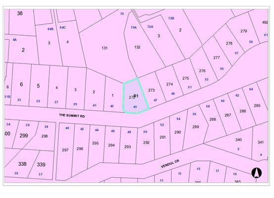
The existing subdivision pattern and location of existing
development within the locality is shown in the following aerial photograph
(2012):
2. DESCRIPTION OF
DEVELOPMENT
Key aspects of the proposal include the following:
· Demolition
of existing dwelling
· Construction
of dual occupancy including 2 detached dwellings
· 1
into 2 lot Torrens title subdivision
Refer
to attachments at the end of this report.
Application
Chronology
· 22
October 2018 – DA lodged with Council
· 30
October to 12 November 2018 - Neighbour notification of proposal
· 6 December 2018 – Additional information requested
– submission issues and stormwater concerns
· 13 December 2018 – Additional information requested
– height, driveway, fencing, character, floor space ratio, windows,
kitchenette and view impacts issues to address
· 11 February 2019 – Amended plans and additional
information received
· 13 March 2019 - DAP meeting
· 5 April 2019 - amended plans received
3. STATUTORY
ASSESSMENT
Section
4.15(1) Matters for Consideration
In
determining the application, Council is required to take into consideration the
following matters as are relevant to the development that apply to the land to
which the development application relates:
(a) The
provisions (where applicable) of:
(i) Any
Environmental Planning Instrument:
State Environmental Planning Policy No. 44 - Koala
Habitat Protection
There is no Koala Plan of Management on the site.
Additionally, the site is less than 1ha in area therefore no further
investigations are required.
State Environmental Planning Policy No. 55 –
Remediation of Land
Following an inspection of the site and a search of Council
records, the subject land is not identified as being potentially contaminated
and is suitable for the intended use.
State Environmental Planning Policy No. 62 –
Sustainable Aquaculture
Given the nature of the proposed development and proposed
stormwater controls the proposal will be unlikely to have any adverse impact on
existing aquaculture industries.
State Environmental Planning Policy (Coastal Management)
2018 and Clause 5.5 of Port Macquarie-Hastings Local Environmental Plan 2011
The site is located within a proximity area to Littoral
Rainforest.
In accordance with clause 7, this SEPP prevails over the
Port Macquarie-Hastings LEP 2011 in the event of any inconsistency.
Having regard to clauses 13 and
14 of the SEPP and clause 5.5 of the Port Macquarie-Hastings LEP 2011 the
proposed development is not considered likely to result in any of the
following:
a) any
adverse impact on integrity and resilience of the biophysical, hydrological
(surface and groundwater) and ecological environment;
b) any
adverse impacts coastal environmental values and natural coastal processes;
c) any
adverse impacts on marine vegetation, native vegetation and fauna and their
habitats, undeveloped headlands and rock platforms;
d) any
adverse impact on marine vegetation, native vegetation and fauna and their
habitats, undeveloped headlands and rock platforms;
e) any
adverse impact on Aboriginal cultural heritage, practices and places;
f) any
adverse impacts on the cultural and built environment heritage;
g) any
adverse impacts the use of the surf zone;
h) any
adverse impact on the visual amenity and scenic qualities of the coast,
including coastal headlands;
i) overshadowing,
wind funnelling and the loss of views from public places to foreshores;
The bulk, scale and size of the proposed development is
sufficiently compatible with the surrounding coastal and built environment
noting the zoning and planning controls applying to the site. The site is
predominately cleared and located within an area zoned for residential
purposes.
State Environmental Planning Policy (Building
Sustainability Index: BASIX) 2004
A BASIX certificate has been submitted demonstrating that
the proposal will comply with the requirements of the SEPP. Amended plans
have been submitted during the assessment of the DA which will require an
updated BASIX certificate. It is recommended that a condition be imposed to
ensure that the commitments are incorporated into the development and certified
at Construction Certificate and Occupation Certificate stage.
Port Macquarie-Hastings Local Environmental Plan 2011
The proposal is consistent with the LEP having regard to the
following:
· Clause
2.2, the subject site is zoned R1 general residential. In accordance with
clause 2.3(1) and the R1 zone landuse table, the proposed development for a
dual occupancy is a permissible landuse with consent.
The objectives of the R1 zone are as
follows:
• To provide for
the housing needs of the community.
• To provide
for a variety of housing types and densities.
• To enable
other land uses that provide facilities or services to meet the day to day
needs of residents.
In accordance with Clause 2.3(2),
the proposal is consistent with the zone objectives having regard to the
following:
o the proposal is a permissible
landuse;
o the proposal will contribute
to the range of residential housing in the area
· Clause
2.7 - the demolition requires consent as it does not fit within the provisions
of SEPP (Exempt and Complying) 2008.
· Clause
4.1- (4A), the minimum lot sizes do not apply to the proposal as it is
characterised as dual occupancy.
· Clause
4.3 - the maximum overall height of the buildings above ground level (existing)
is 8.3m which complies with the standard height limit of 8.5m applying to the
site.
· Clause
4.4 - the floor space ratio of the proposal is 0.6 :1.0 which complies with the
maximum 0.65:1 floor space ratio applying to the site.
· Clause
5.10 – Heritage. The site does not contain or adjoin any known heritage
items or sites of significance.
· Clause
7.13 - satisfactory arrangements are in place for provision of essential
services including water supply, electricity supply, sewer infrastructure,
stormwater drainage and suitable road access to service the development.
Provision of electricity will be subject to obtaining satisfactory arrangements
certification prior to the issue of a Subdivision Certificate as recommended by
a condition of consent.
(ii) Any
draft instruments that apply to the site or are on exhibition:
No draft instruments apply to the site.
(iii) Any
Development Control Plan in force:
Port Macquarie-Hastings Development Control Plan 2013:
|
DCP 2013: Dwellings, Dual occupancies, Dwelling
houses, Multi dwelling houses & Ancillary development
|
|
|
Requirements
|
Proposed
|
Complies
|
|
3.2.2.1
|
Ancillary development:
• 4.8m
max. height
• Single
storey
• 60m2
max. area
• 100m2
for lots >900m2
• 24
degree max. roof pitch
• Not
located in front setback
|
Water tanks are appropriately located
|
Yes
|
|
3.2.2.2
|
Articulation zone:
• Min.
3m front setback
• An
entry feature or portico
• A
balcony, deck, patio, pergola, terrace or verandah
• A
window box treatment
• A
bay window or similar feature
• An
awning or other feature over a window
• A
sun shading feature
|
The development contains decks/ verandahs within the
articulation zone. The decks/ verandahs do not technically exceed 25% of the
articulation zone and is setback the minimum 3m.
|
Yes
|
|
Front setback (Residential not R5 zone):
• Min.
6.0m classified road
• Min.
4.5m local road or within 20% of adjoining dwelling if on corner lot
• Min.
3.0m secondary road
• Min.
2.0m Laneway
|
Front building line setback requirementscomply with the
exception of the south-western corner of Lot A/Dwelling 1
|
Yes/No*
|
|
3.2.2.3
|
Garage 5.5m min. and 1m behind front façade.
Garage door recessed behind building line or
eaves/overhangs provided
|
Garage door setback requirements are complied with.
|
Yes
|
|
6m max. width of garage door/s and 50% max. width of
building
|
Width of garage door requirements are complied with.
|
Yes
|
|
Driveway crossover 1/3 max. of site frontage and max. 5.0m
width
|
Driveway crossing width requirements are complied with.
|
Yes
|
|
3.2.2.4
|
4m min. rear setback. Variation subject to site analysis
and provision of private open space
|
The rear setback requirements are complied with and much
greater than the minimum 4m setback.
|
Yes
|
|
3.2.2.5
|
Side setbacks:
• Ground
floor = min. 0.9m
• First
floors & above = min. 3m setback or where it can be demonstrated that
overshadowing not adverse = 0.9m min.
• Building
wall set in and out every 12m by 0.5m
|
The minimum side setback requirements are complied with.
The wall articulation is compliant and satisfies the
objectives of the development provision.
A review of the shadow diagram
and inspection of the site and neighbouring properties has identified that
the overshadowing impacts are not of a sufficient magnitude in time to
warrant refusing consent to the proposal. The proposal does not prevent
adjoining properties from receiving 3 hours of sunlight to private open space
and primary living areas on 21 June.
|
Yes
|
|
3.2.2.6
|
35m2 min. private open space area including a useable 4x4m
min. area which has 5% max. grade
|
Each occupancy contains 35m² open space in one area
including a useable 4m x 4m area. .
|
Yes
|
|
3.2.2.7
|
Front fences:
• If
solid 1.2m max height and front setback 1.0m with landscaping
• 3x3m
min. splay for corner sites
• Fences
>1.2m to be 1.8m max. height for 50% or 6.0m max. length of street
frontage with 25% openings
• 0.9x0.9m
splays adjoining driveway entrances
|
No fences proposed
|
N/A
|
|
3.2.2.8
|
Front fences and walls to have complimentary materials to
context
No chain wire, solid timber, masonry or solid steel front
fences
|
No fencing proposed.
|
N/A
|
|
3.2.2.10
|
Privacy:
• Direct
views between living areas of adjacent dwellings screened when within 9m
radius of any part of window of adjacent dwelling and within 12m of private
open space areas of adjacent dwellings. ie. 1.8m fence or privacy screening
which has 25% max. openings and is permanently fixed
• Privacy
screen required if floor level > 1m height, window side/rear setback
(other than bedroom) is less than 3m and sill height less than 1.5m
• Privacy
screens provided to balconies/verandahs, etc which have <3m side/rear
setback and floor level height >1m
|
No direct views between living areas of adjacent dwellings
screened when within 9m radius of any part of window of adjacent dwelling and
within 12m of private open space areas of adjacent dwellings.
Privacy screens are proposed on the rear decks in
particular – as amended.
|
Yes
|
|
DCP 2013: General Provisions
|
|
|
Requirements
|
Proposed
|
Complies
|
|
2.7.2.2
|
Design addresses generic principles of Crime Prevention
Through Environmental Design guideline
|
No concealment or entrapment areas proposed. Adequate
casual surveillance available.
|
Yes
|
|
2.3.3.1
|
Cut and fill 1.0m max. 1m outside the perimeter of the
external building walls
|
Cut and fill <1.0m change 1m outside the perimeter of
the external building walls
|
Yes
|
|
2.3.3.2
|
1m max. height retaining walls along road frontage
|
None proposed
|
N/A
|
|
Any retaining wall >1.0 in height to be certified by
structure engineer
|
No retaining wall likely >1m
Condition also recommended to require engineering
certification
|
Yes
|
|
Combination of retaining wall and front fence height max
1.8m, max length 6.0m or 30% of frontage, fence component 25% transparent,
and splay at corners and adjacent to driveway
|
No retaining wall front fence combination proposed.
|
N/A
|
|
Driveway crossing/s minimal in number and width including
maximising street parking
|
Driveway crossings are minimal in width including
maximising street parking
|
Yes
|
|
2.5.3.3
|
Parking in accordance with Table 2.5.1.
Dwelling/dual occupancies
1 space per dwelling/occupancy (behind building line).
Multi dwelling
1 space per 1 & 2 bedroom occupancies
1.5 spaces per 3+ bedroom occupancies
0.25 spaces per occupancy for visitor parking.
|
Proposal involves 2 x 4 bedroom dwellings. Therefore 2 x 1
spaces = 2 spaces required. The development proposes 4+ parking spaces.
|
Yes
|
|
2.5.3.11
|
Section 94 contributions
|
Contributions apply - refer to ET calc and NOP.
|
Yes
|
|
2.5.3.12 and 2.5.3.13
|
Landscaping of parking areas
|
Suitable limited landscaping proposed around
driveway/parking locations.
|
Yes
|
|
2.5.3.14
|
Sealed driveway surfaces unless justified
|
Sealed driveway areas proposed.
|
Yes
|
|
2.5.3.15 and 2.5.3.16
|
Driveway grades first 6m or ‘parking area’
shall be 5% grade with transitions of 2m length
|
Driveway grades capable of satisfying Council standard
driveway crossover requirements. Condition recommended for section 138 Roads
Act permit
|
Yes
|
|
2.5.3.17
|
Parking areas to be designed to avoid concentrations of
water runoff on the surface.
|
Stormwater drainage is capable of being managed as part of
plumbing construction.
|
Yes
|
Note: Subdivision provisions of the DCP (except battleaxe
handle width) are aimed at the creation of vacant lots (i.e. not lots within an
integrated housing proposal such as this) and have therefore been excluded from
the above assessment. Servicing requirements are discussed later in this
report.
The proposal seeks to vary Development Provision relating to
front setback and articulation zone technically on the south-west corner of
dwelling 1/Lot A. The below and aerial image showing boundaries and marked up
image by the assessing officer shows the distance as approximately 1.9m to the
splay in the front boundary returning to the western neighbour’s
boundary.
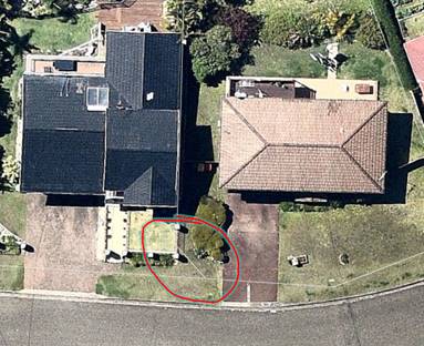
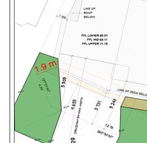
The relevant single objective is:
Front setbacks should support an attractive streetscape.
Having regard for the development provisions and relevant objectives,
the variation is considered acceptable for the following reasons:
· The subject
section of the front of the building deck dwelling 1/Lot A is setback 3.731m to
the primary frontage which is a greater setback than the minimum 3m setback
permitted as a section of articulation zone.
· The western
neighbour’s front boundary is in line with the primary frontage line of
the subject dwelling 1 Lot A.
· There will be no
discernible adverse impact on the streetscape given the primary alignment of
the primary front boundary in the context of the remainder of the street.
· The western side
setback is compliant with the DCP.
· It could
technically be argued that the subject second boundary is a secondary frontage
due to the change in the angle of the continuous boundaries fronting the road
reservation area.
Based on the above assessment, the variation proposed to the
provisions of the DCP is considered acceptable and the relevant objectives have
been satisfied. The variation does not amount to an adverse impact or a
significance that would justify refusal of the application.
(iiia) Any
planning agreement that has been entered into under section 7.4, or any draft
planning agreement that a developer has offered to enter into under section
7.4:
No planning agreement has been offered or entered into
relating to the site.
iv) Any matters prescribed by the
Regulations:
NSW Coastal Policy 1997
The proposed development is consistent with the objectives
and strategic actions of this policy.
Demolition of buildings AS 2601 – Clause 92
Demolition of the existing building on the site is capable
of compliance with this Australian Standard and is recommended to be
conditioned.
(b) The
likely impacts of that development, including environmental impacts on both the
natural and built environments, social and economic impacts in the locality:
Context and
setting
• The
proposal will be unlikely to have any adverse impacts to existing adjoining
properties and satisfactorily addresses the public domain.
• The proposal is considered to be sufficiently compatible
with other residential development in the locality and adequately addresses
planning controls for the area.
• There
are no adverse impacts on existing view sharing.
• There are no adverse privacy impacts.
View sharing
During the neighbour
notification period concerns surrounding view loss were raised by two (2)
neighbours to the east and west of the subject development at no.s 43 and 47
The Summit.
The location of the neighbours
relative to the development site is shown below:
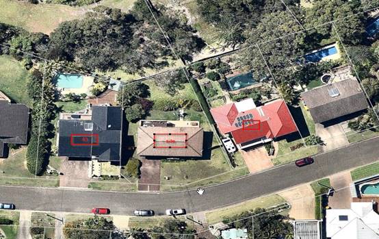
The notion of view sharing is
invoked when a property enjoys existing views and a proposed development would
share that view by taking some of it away for its own enjoyment. Taking it all
away cannot be called view sharing, although it may, in some circumstances, be
quite reasonable.
Using the planning principles of
NSW Land and Environment Court in Tenacity Consulting v Warringah 2004 NSW
LEC 140, the following comments are provided in regard to the view impacts
using the 4 step process to establish whether the view sharing is acceptable.
Step 1
Assessment of views to be
affected. Water views are valued more highly than land views. Iconic views
(e.g. of the Opera House, the Harbour Bridge or North Head) are valued more
highly than views without icons. Whole views are valued more highly than
partial views, e.g. a water view in which the interface between land and water
is visible is more valuable than one in which it is obscured.
Comments:
No. 43 The Summit Road enjoys views
from the front of dwelling of the coast, North Brother Mountain with glimpses
of land/water interface and beach. From the rear of the dwelling across the
development site there is a glimpse view of the Ocean.
The front views are considered
to be valuable and iconic particularly of North Brother Mountain. The
significance of the front views is considered to be high and the rear view to
be low.
No 47 The Summit Road enjoys
views partly across the development site side boundary from the front of
dwelling of the coast, North Brother Mountain with glimpses of land/water
interface and beach. From the rear of this home distant views are enjoyed
across the development site from the dining room of the distant mountain views
including Bago Bluff and Cairncross Mountain. The front view from the kitchen
particularly is considered to be valuable and iconic particularly of North
Brother Mountain and the rear view is valuable but moderately significant but
considered not iconic. See below photos taken by the assessing officer:
View from kitchen window of
No. 47 The Summit Road:
Views from rear of No.47 The
Summit Road upper floor dining room:
Step 2
Consider from what part of
the property the views are obtained. For example the protection of views across
side boundaries is more difficult than the protection of views from front and
rear boundaries. In addition, whether the view is enjoyed from a standing or
sitting position may also be relevant. Sitting views are more difficult to
protect than standing views. The expectation to retain side views and sitting
views is often unrealistic.
Comments:
Affected views (as described
above) from No. 43 The Summit are obtained from the upper habitable bedroom
level which is not the primary living area. Views are obtained from both a
standing position.
Affected views (as described
above) from No.47 The Summit are obtained from the upper habitable levels which
are the primary living areas (dining room and kitchen). Views are obtained from
both a sitting and standing position in the rear dining room and primary from a
standing position in the kitchen at the front of the dwelling.
Step 3
Assess the extent of the
impact. This should be done for the whole of the property, not just for the
view that is affected. The impact on views from living areas is more
significant than from bedrooms or service areas (though views from kitchens are
highly valued because people spend so much time in them). The impact may be
assessed quantitatively, but in many cases this can be meaningless. For
example, it is unhelpful to say that the view loss is 20% if it includes one of
the sails of the Opera House. It is usually more useful to assess the view loss
qualitatively as negligible, minor, moderate, severe or devastating.
Comments:
The extent of the impact upon
the affected views enjoyed from No. 43 The Summit Road is considered minor as
it is from an upper floor bedroom.
The extent of view loss upon the
affected views enjoyed from No.47 The Summit Road from the front kitchen window
is considered to be devastating however the view is across the eastern boundary
of the development site and the kitchen room is setback approximately 11m from
the front boundary. The extent of view loss of the distant mountains from
the rear dining room of this dwelling will be severe however the view is across
the eastern boundary of the development site.
Step 4
Assess the reasonableness of
the proposal that is causing the impact. A development that complies with all
planning controls would be considered more reasonable than one that breaches
them. Where an impact on views arises as a result of non-compliance with one or
more planning controls, even a moderate impact may be considered unreasonable.
With a complying proposal, the question should be asked whether a more skilful
design could provide the applicant with the same development potential and
amenity and reduce the impact on the views of neighbours. If the answer to that
question is no, then the view impact of a complying development would probably
be considered acceptable and the view sharing reasonable.
Comments:
The proposal (as amended)
complies with the maximum building height of 8.5m set for the immediate
locality. The front section of the dwellings is also 2 storey and less than
8.5m in height. There are no non-compliances with the provisions of DCP 2013
with the exception of the front south-western front corner splay which has no
discernible impact on the streetscape having regard to the planning controls
which permit the proposal including a reduced front setback with a limited
articulation zone for both dwellings.
The proposal will have a
devastating impact on the view from No.47 The Summit Road’s kitchen
window however it is considered that even if the proposal was setback 6 or 8m
the impact would still be significant and the view is across a side boundary of
the development site. The Applicant has been made aware of these impacts
however considers that the proposal complies with Council controls and views
across the side boundaries should have limited consideration. As stated in the
principles above, taking all of a view all away cannot be called view sharing,
although it may, in some circumstances (such as the subject proposal) be
reasonable.
In conclusion with regard to
view sharing impacts, based upon the above it is considered that the proposal
is acceptable and unable to be refused on the grounds of view sharing impacts
to neighbouring properties.
Overshadowing
The impacts of potential
overshadowing the neighbours has been raised with the Applicant during the
assessment of the DA. The below diagram has been provided which provides an
indication of shadows which will be generated at the winter solstice at the key
times between 9am and 3pm.
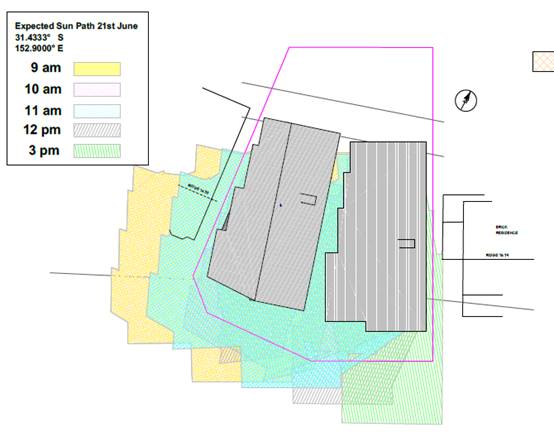
A review
of the above diagram and inspection of the site and neighbouring properties has
identified that the overshadowing impacts are not of a sufficient magnitude in
time to warrant refusing consent to the proposal. The proposal does not prevent
adjoining properties from receiving 3 hours of sunlight to private open space
and primary living areas on 21 June.
Roads
The site has road frontage to The Summit Road, which is a
sealed road under the care and control of Council. The Summit Road is a
Local road with an upright kerb and gutter. The pavement width is approximately
8m wide.
Traffic and Transport
The additional traffic associated with the development is
unlikely to have any adverse impacts to the existing road network within the
immediate locality.
Site Frontage & Access
Vehicle access to the site is proposed though individual
driveways to the Summit Road. Access shall comply with Council AUSPEC and
Australian Standards, and conditions have been imposed to reflect these
requirements.
Parking and Manoeuvring
Parking spaces have been provided on-site within garages
with additional parking provided available within the driveway. Parking
and driveway widths on site can comply with relevant Australian Standards (AS
2890) and conditions have been imposed to reflect these requirements.
Water Supply Connection
Council
records indicate that the development site has an existing 20mm sealed service
from the 100mm diameter AC water main on the opposite side of The Summit Road.
An additional water service is required to service the development. Engineering
plans are required to show all existing and proposed water services to the lot.
Final water service sizing will need to be determined by a
hydraulic consultant to suit the development as well as addressing fire service
coverage to AS 2419 and backflow protection.
Detailed plans will be required to be submitted for
assessment with the S.68 application.
Refer to relevant conditions of consent.
Sewer Connection
Council records indicate that the development
site has an existing sewer junction from the AC sewer main which runs inside
the northern boundary the development. Torrens title subdivision shall require
provision of an additional sewer service. Engineering plans shall be required
as part of the Subdivision Works (Infrastructure) application.
Detailed plans will be required to be submitted for
assessment with the S.68 application.
Refer to relevant conditions of consent.
Stormwater
The site naturally grades towards the rear.
The legal point of discharge for the proposed development is
defined as a direct connection to Council’s kerb and gutter with the use
of an approved adaptor (one per lot only). The rear garden area located below
the level of the pavement shall drain to a rubble drain/soak away. Details
shall be provided as part of the S68 application.
A detailed site stormwater management plan will be required
to be submitted for assessment with the S.68 application and prior to the issue
of a CC.
In accordance with Councils AUSPEC requirements, the
following must be incorporated into the stormwater drainage plan:
· On
site stormwater detention facilities
Refer to relevant conditions of
consent.
Other Utilities
Telecommunication and electricity services are available to
the site. Evidence of satisfactory arrangements with the relevant utility
authorities for provision to each proposed lot will be required prior to
Subdivision Certificate approval.
Heritage
No known items of Aboriginal or European heritage
significance exist on the property. No adverse impacts anticipated.
Other land resources
The site is within an established urban context and will not
sterilise any significant mineral or agricultural resource.
Water cycle
The proposed development will be unlikely to have any adverse
impacts on water resources and the water cycle.
Soils
The proposed development will be unlikely to have any
adverse impacts on soils in terms of quality, erosion, stability and/or
productivity subject to a standard condition requiring erosion and sediment
controls to be in place prior to and during construction.
Air and microclimate
The construction and/or operations of the proposed
development will be unlikely to result in any adverse impacts on the existing
air quality or result in any pollution. Standard precautionary site management
condition recommended.
Flora and fauna
Construction of the proposed development will not require
any removal/clearing of any identified significant vegetation and therefore
will be unlikely to have any significant adverse impacts on biodiversity or
threatened species of flora and fauna. Part 7 of the Biodiversity
Conservation Act is considered to be satisfied.
Waste
Satisfactory arrangements are in place for proposed storage
and collection of waste and recyclables. No adverse impacts anticipated.
Standard precautionary site management condition recommended.
Energy
The proposal includes measures to address energy efficiency
and will be required to comply with the requirements of BASIX.
Noise and vibration
No adverse impacts anticipated. Condition recommended to
restrict construction to standard construction hours.
Bushfire
The site is not identified as being bushfire prone.
Safety, security and crime prevention
The proposed development will be unlikely to create any
concealment/entrapment areas or crime spots that would result in any
identifiable loss of safety or reduction of security in the immediate
area. The increase in housing density will improve natural surveillance
within the locality and openings from each dwelling overlook common and private
areas.
Social impacts in the locality
Given the nature of the proposed development and its’
location the proposal is unlikely to result in any adverse social impacts.
Economic impact in the locality
No adverse impacts. A likely positive impact is that the
development will maintain employment in the construction industry, which will
lead to flow impacts such as expenditure in the area.
Site design and internal design
The proposed development design satisfactorily responds to
the site attributes and will fit into the locality. No adverse impacts likely.
Construction
No potential adverse impacts identified to neighbouring
properties with the construction of the proposal.
Cumulative impacts
The proposed development is not expected to have any adverse
cumulative impacts on the natural or built environment or the social and
economic attributes of the locality.
(c) The
suitability of the site for the development:
The proposal will sufficiently fit into the locality based
upon compliance with the planning controls (including a minor front setback
variation) applying to the site and the site attributes are conducive to the
proposed development.
(d) Any
submissions made in accordance with this Act or the Regulations:
Ten (10) written submissions have been received following public exhibition of
the application.
Key
issues raised in the submissions received and comments in response to these
issues are provided as follows:
|
Submission
Issue/Summary
|
Planning Comment/Response
|
|
The proposal will have a devastating effect on the iconic
view of North Brother Mountain from the kitchen of 47 The Summit Road. The
proposal is forward of other residences in the street.
|
View sharing impacts to 43 and 47 The Summit Road have
been assessed earlier in this report. The building height has been reduced be
compliant with the 8.5m building height limit. Further amendments have been
made to the plans post DAP meeting in March to improve view sharing.
|
|
The
proposal will severely restrict the view to the north-west to the airport,
Bago and Cairncross Mountains from the dining room of 47 The Summit Road.
|
|
There
are no other dual occupancies between the corner of Roma Terrace and the
Summit Road.
|
The
residential zoning and Development Control Plan permit the development to be
proposed on the site. The proposal (as amended) has been assessed as being
acceptable and suitable to the site.
The
planning controls permit a change in character in type of housing.
|
|
The
proposed building height is 0.8m over the 8.5m building height restriction
and is considered excessive. The height exceedance adversely impacts upon 43
The Summit Road.
|
The
proposal has been amended to comply with the 8.5m building height limit with
a proposed maximum height of 8.3m.
|
|
There
is little justification for the clause 4.6 variation to building height.
|
|
Concern
with privacy impacts to 43 The Summit Road including from the rear decks and
rear yard. Request screening of decks to be angled to the south.
|
The
Applicant has reviewed the screening along the western elevation of dwelling
1/Lot A and this is considered acceptable to satisfy the standard
requirements of the Development Control Plan 2013.
|
|
Request
height poles to be erected including the finished floor levels.
|
The
Applicant has erected height poles post macrh DAP meeting. The proposal to
comply with the 8.5m building height standard and address all privacy
requirements of Development Control Plan 2013.
|
|
Proposal
will have significant overshadowing impacts to ground floor rumpus, side of
house and private open space of 43 The Summit Road in the morning periods mid
winter.
|
This
request has been forwarded to the Applicant for consideration. The Applicant
has not proposed any change to the western side setback of dwelling 1/Lot A
and justified their position that the proposal will not result in any adverse
overshadowing impacts to this neighbour based upon existing orientation and
permitted standards in the Development Control Plan.
A
review of the shadow diagrams provided and inspection of the site and
neighbouring properties has identified that the overshadowing impacts are not
of a sufficient magnitude in time to warrant refusing consent to the
proposal. The proposal does not prevent adjoining properties from receiving 3
hours of sunlight to private open space and primary living areas on 21 June.
|
|
The
side setback is requested to be increased to a minimum 3m to reduce the
overshadowing impacts to 43 The Summit.
|
|
The
proposal will eliminate the ocean views from one window and reduce them from
another at 43 The Summit. The area of impact appears to be related to the
height exceedance and side setback should be increased to 3m minimum.
|
View
sharing impacts to 43 and 47 The Summit Road have been assessed earlier in
this report. The building height has been reduced be compliant with the 8.5m
building height limit. Further amendments have been made post DAP meeting in
March 2019 to improve the view availability to 43 The Summit.
|
|
Council
should verify the proximity of the building to the south-west front corner
splay.
|
Refer
to assessment under the Development Control Plan 2013 and variation
recommended to be supported due to this technicality.
|
|
Request
a dilapidation report of neighbouring 43 The Summit Road be carried out prior
to issue of a Construction Certificate including the existing sewer running
under the home.
|
This
concern has been forwarded to the Applicant for consideration. The Applicant
has advised that given the limited excavation proposed, likely nature of
construction and side setbacks it is considered unnecessary to require a
specialist dilapidation report prior to construction commencing.
The
justification provided from the Applicant is considered acceptable and it is
noted that a qualified and experienced engineer would be required to design
and certify structural capacity of the proposed buildings including
excavation and filling.
|
|
The
floor space ratio is estimated to be 0.81:1 and is requested to be reviewed.
|
The
gross floor space of the dwellings internally within the buildings has been
amended and the ratio has been recalculated to be compliant with the 0.65:1
standard - amended plans achieve FSR of 0.6:1.
|
|
Details
of the retaining walls in the rear yard and implications on fencing should be
provided.
|
Additional
details have been shown on the amended plans (attached to this report)
including a proposed new boundary fence. The filled area complies with
Council’s Development Control Plan 2013.
|
|
The
proposal will increase the living density and will negatively impact on the
amenity of 43 The Summit Road in regards to sleeping quarters and areas of
outdoor play for the children.
|
The
residential zoning and Development Control Plan permit the development to be
proposed on the site. The proposal (as amended) has been assessed as being
acceptable and suitable to the site. State Government legislation imposes a
requirement that Council is not permitted to require more onus standards
above DCP controls where a proposal complies with the deemed to comply
Development Control provisions.
|
|
The proposal does not
respect and reflect the neighbourhood and street character in its design.
Just because a building code allows a height limit does not mean that it
should be maintained to the maximum.
|
For a new development to be
visually compatible with its context, it should contain, or at least respond
to, the essential elements that make up the character of the surrounding
urban environment. The most important contributor to urban character is the
relationship of built form to surrounding space, a relationship that is
created by building height, setbacks and landscaping. In this regard, the
proposed building height is now compliant with the maximum building height of
8.5m, the front setback and side setback DCP guidelines and satisfactory
landscaping is proposed. The proposal as read from the street is 2 storeys
and there are numerous other 2 storey dwellings that have been approved
and/or constructed within the immediate The Summit Road locality. The
proposal is not located within a nominated conservation area.
|
|
The proposal will be a
stark contrast to the rest of the current housing in the street.
|
|
The
large bulky nature of the proposed buildings will impact the outlook and
dominate the private open space of 43 the Summit.
|
|
Unit 1
has a 12m frontage and land sizes are 370m2 which is much smaller than the
LEP and surrounding houses.
|
The
residential zoning and Development Control Plan permits the development to be
proposed on the site. The proposal (as amended) has been assessed as being
acceptable and suitable to the site.
|
|
The
proposal will have impacts on the value of 43 The Summit Road and 70A
Bangalay Drive.
|
Any
potential impacts on property values is not a matter for consideration in the
assessment of the Development Application under the Environmental Planning
and Assessment Act 1979.
|
|
The
proposed subdivision will increase traffic and on street parking is already
busy.
|
The additional traffic associated with the
development is unlikely to have any adverse impacts to the existing road
network within the immediate locality.
The
proposal provides for compliant off-street carparking and opportunity for
casual visitor parking within the driveways behind the front property
boundaries.
|
|
There
are already four townhouses at 27-31 The Summit.
|
Noted.
|
|
If the
proposal is passed other similar developments will occur.
|
The
zoning and planning controls permit this type of housing where the site
conditions allow.
|
|
How is
parking going to be provided for 2 to 3 cars and there is serious parking
issues in the street.
|
The
proposal provides for compliant off-street carparking and opportunity for
casual visitor parking within the driveways behind the front property
boundaries.
|
|
There
is no detailed landscape plan to show how the frontage could be sympathetic
to surrounding areas.
|
The
Applicant has provided an indicative concept landscape plan which proposes a
limited area of low water use shrubs and ground cover in the front setback
particularly where visible from the public domain.
Given
the extent of other numerous homes with only front yards of lawn it is
difficult to recommend full landscaping of the front yard. There are no
specific requirements in Council’s Development Control Plan 2013 to
specify landscaping also.
|
|
The
proposal will allow for direct visibility into the backyards of 70 and 70A
Bangalay Drive which backs on the development and all privacy will be
removed.
|
The
typical 12m distance privacy separation distance standard in Development Control
Plan 2013 is satisfied and it is noted that existing trees within 70 and 70A
Bangalay Drive provide some obscuring of direct views as intended by the
Development Control Plan.
|
|
The
proposal will reduce the privacy of the bedrooms of 48 The Summit Road.
|
Any
privacy potential privacy impacts to bedrooms is not a matter for considered
under Council’s Development Control Plan 2013.
|
|
Additional
catchment in a stormwater event will discharge onto 70 The Summit Road.
Question whether the developer installing stormwater drainage/onsite
detention to collect from the rear and drain to the front of the block.
|
Additional
stormwater detail has been submitted during the assessment of the DA which
proposes charged stormwater lines back to The Summit for the building itself.
Refer to additional comments earlier in this report addressing Stormwater
impacts and recommended conditions of consent.
|
(e) The
Public Interest:
The proposed development will be in the wider public
interest with provision of appropriate additional housing.
The proposed development
satisfies relevant planning controls as justified and is unlikely to impact on
the wider public interest.
4. DEVELOPMENT
CONTRIBUTIONS APPLICABLE
· Development contributions will be required towards
augmentation of town water supply and sewerage system head works under Section
64 of the Local Government Act 1993.
· Development contributions will be required under Section 94
of the Environmental Planning and Assessment Act 1979 towards roads, open
space, community cultural services, emergency services and administration
buildings.
5. CONCLUSION
AND STATEMENT OF REASON
The application has been assessed in accordance with Section
4.15 of the Environmental Planning and Assessment Act 1979.
Issues raised during assessment and public exhibition of the
application have been considered in the assessment of the application. Where
relevant, conditions have been recommended to manage the impacts attributed to
these issues.
The site is considered suitable for the proposed development
and the proposal adequately addresses relevant planning controls. The
development is not considered to be contrary to the public's interest and will
not result a significant adverse social, environmental or economic impact. It
is recommended that the application be approved, subject to the recommended
conditions of consent provided in the attachment section of this report.
|
Attachments
1View. DA2018
- 876.1. Recommended conditions.
2View. DA2018
- 876.1 Contribution Estimate
3View. DA2018
- 876.1. 45 The Summit submission to DAP 12-04-19.
4View. DA2018
- 876.1.Plans.
|
|
ATTACHMENT
|
Development Assessment Panel
24/04/2019
|
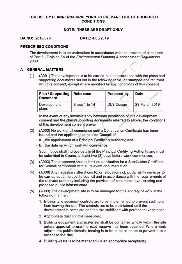

|
ATTACHMENT
|
Development Assessment Panel
24/04/2019
|
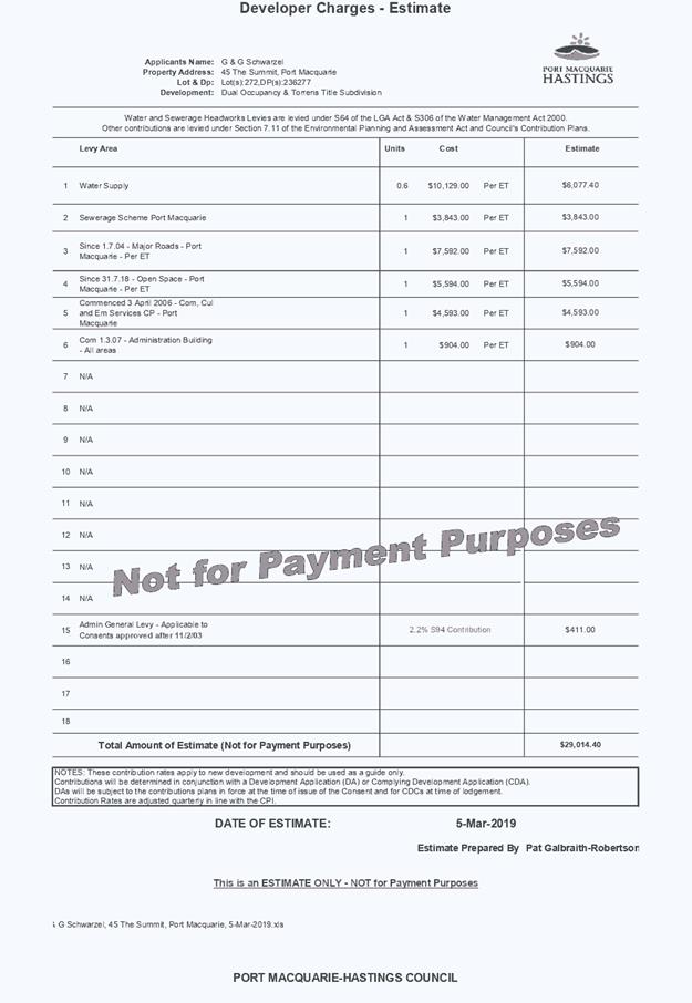
|
ATTACHMENT
|
Development Assessment Panel
24/04/2019
|
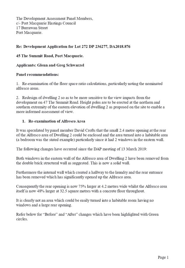
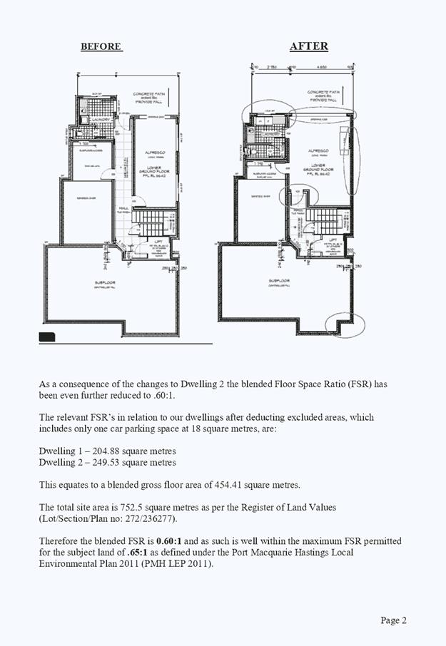
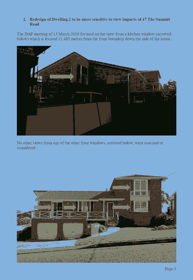
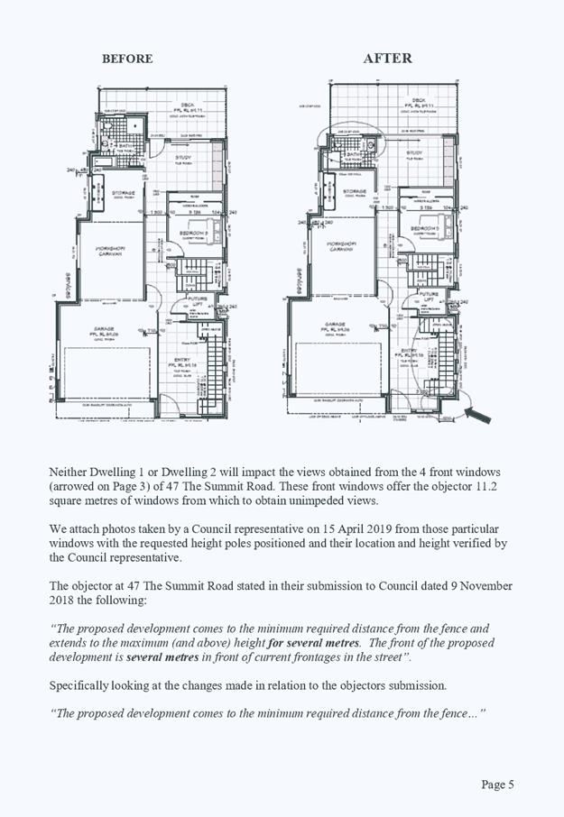
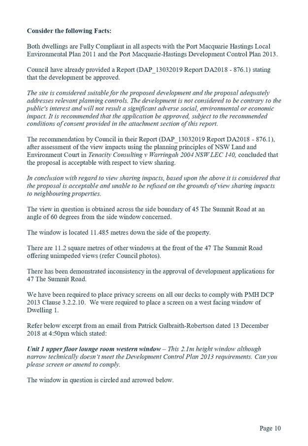
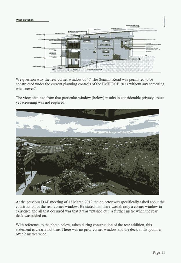
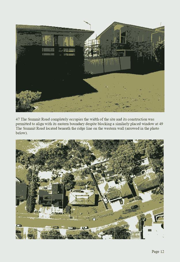
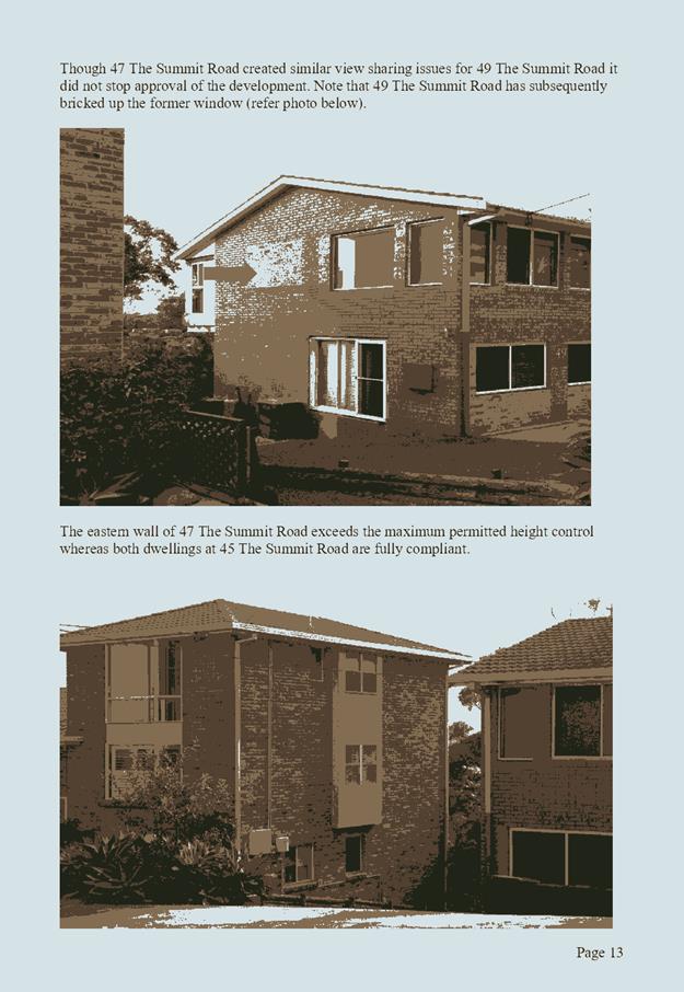
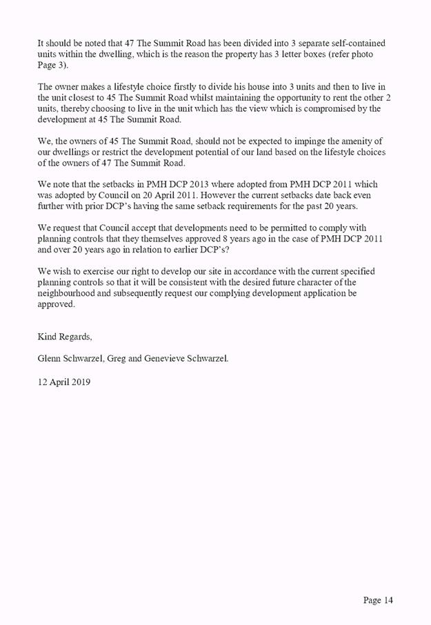
|
ATTACHMENT
|
Development Assessment Panel
24/04/2019
|
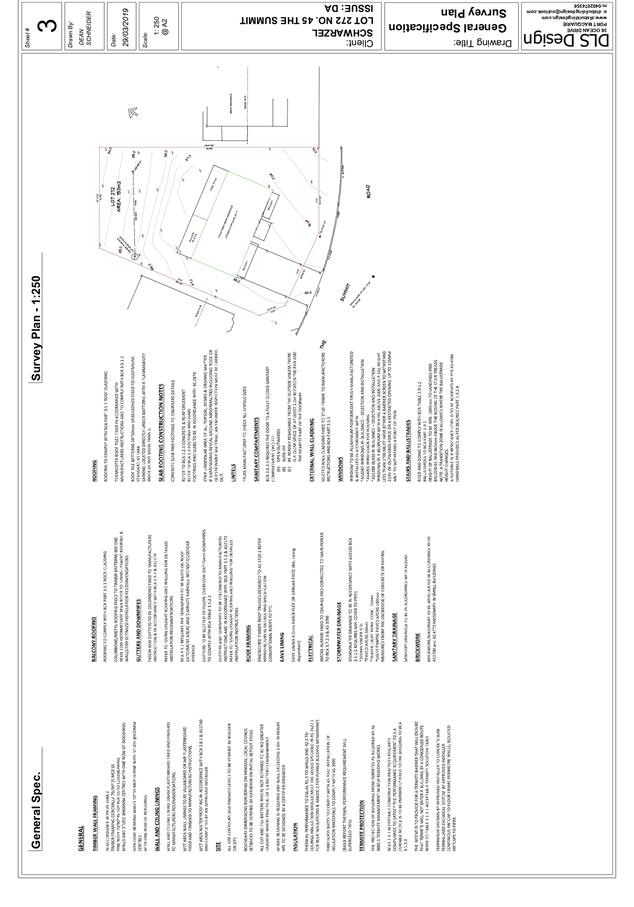
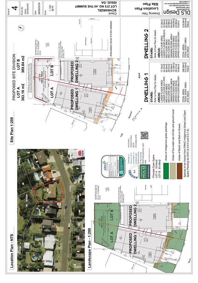
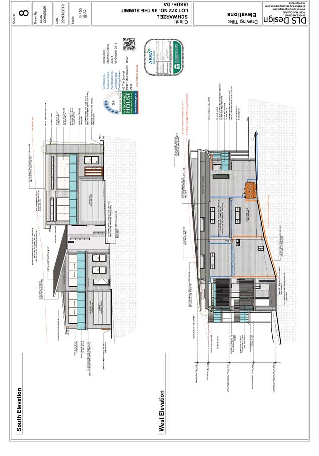
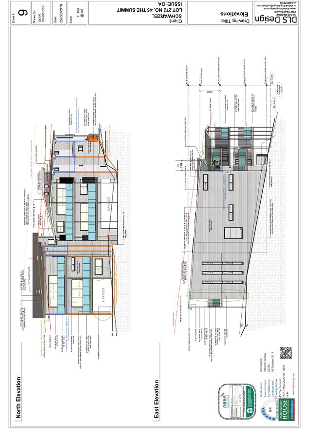
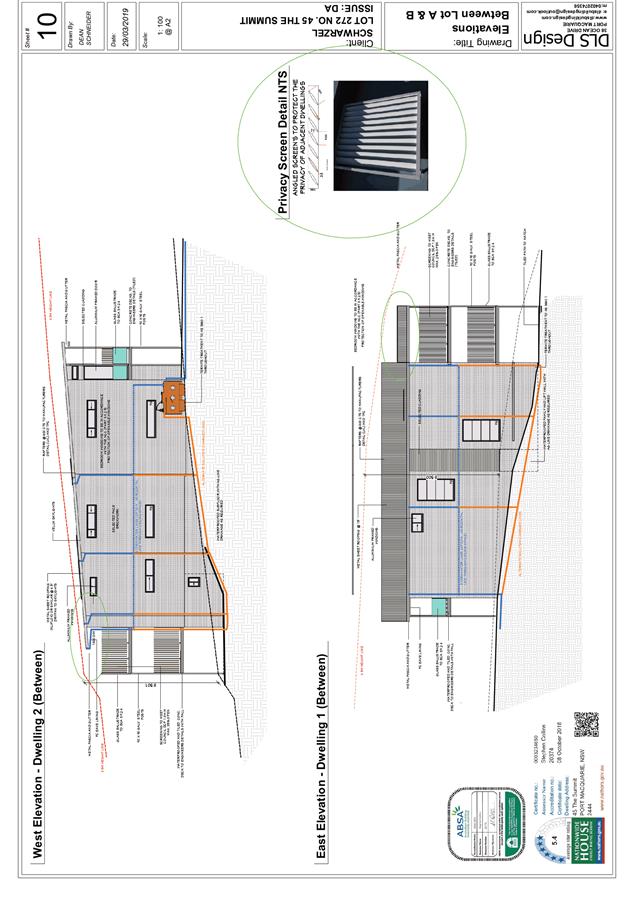
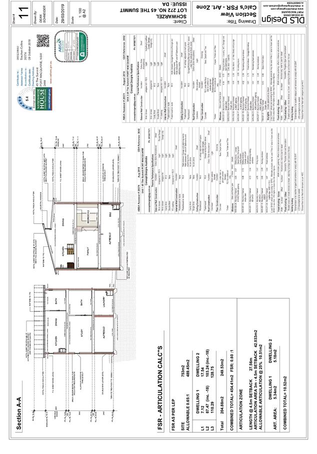
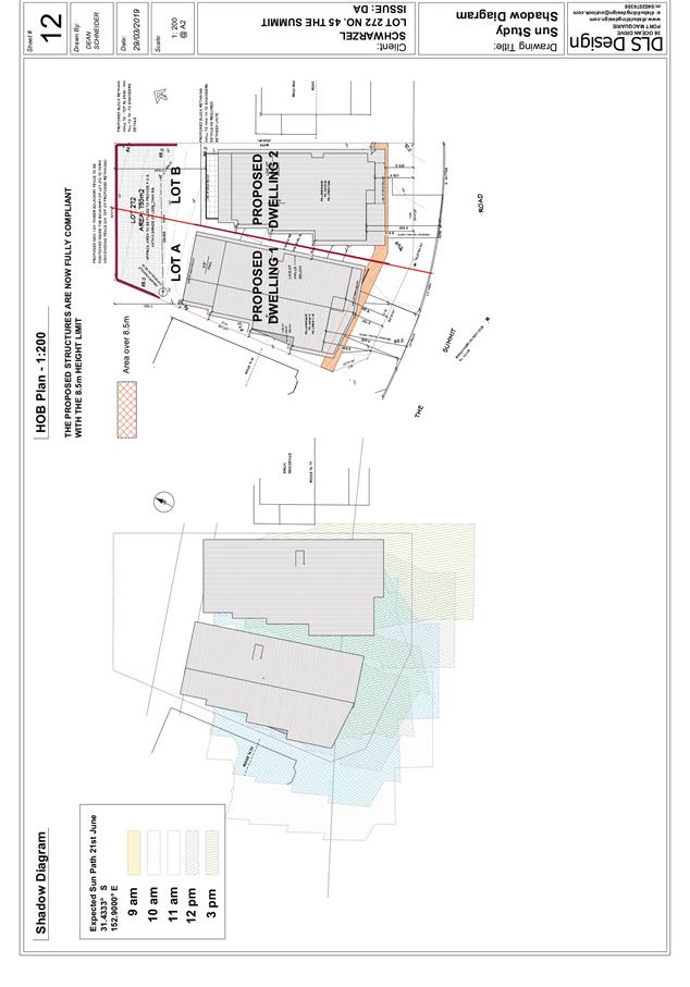
AGENDA Development Assessment Panel 24/04/2019
Item: 08
Subject: DA2018 - 952.1 Multi Dwelling Housing and Torrens Title Subdivision,
Lot 434 to 437 DP1244641, Manikato Way Port Macquarie
Report Author: Steven Ford
|
Applicant: Port
City Developments Pty Ltd
Owner: Charlestown
Projects Pty Ltd
Estimated Cost: $3,084,000
Parcel no: 68059,
68060, 68061 & 68062
Alignment with Delivery Program
4.3.1 Undertake transparent
and efficient development assessment in accordance with relevant legislation.
|
|
RECOMMENDATION
That
DA 2018/952 for a Multi
Dwelling Housing and Torrens Title Subdivision at Lot 434, 435, 436 & 437,
DP 1244641, No. 4, 6, 8 &
10 Manikato Way PORT MACQUARIE, be determined by granting consent subject to the
recommended conditions.
|
Executive
Summary
This
report considers a development application for Multi Dwelling Housing and
Torrens Title Subdivision at the subject site
and provides an assessment of the application in accordance with the
Environmental Planning and Assessment Act 1979.
Following exhibition of the
application, 1 submission was received.
This report recommends that the
development application be approved subject to conditions.
1. BACKGROUND
Existing sites features and Surrounding development
The site has a total area of 2,422.6m2.
The site is zoned R1 General Residential in accordance with the Port Macquarie-Hastings Local
Environmental Plan 2011, as shown in the following zoning plan:
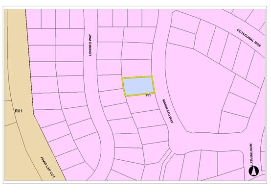
The existing subdivision pattern and location of existing
development within the locality is shown in the following aerial photograph:
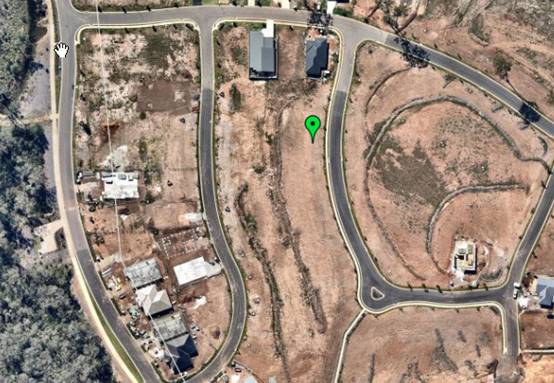
2. DESCRIPTION OF
DEVELOPMENT
Key aspects of the proposal include the following:
· Multi
Dwelling Housing (4 x 4 bedroom attached dwellings and 4x 4 bedroom dwellings)
· 4
into 8 Torrens Title Subdivision
Refer
to attachments at the end of this report.
Application Chronology
· 08
November 2018 - Application lodged
· 16 - 29 November 2018 - Neighbour notification of the
proposal
· 11 March 2019 - Additional Information and amended plans
received
· 25 March 2019 - Shadow diagram received
· 10 April 2019 - Additional information regarding stormwater
servicing plans received
3. STATUTORY ASSESSMENT
Section 4.15(1) Matters for Consideration
In determining the application, Council is required to take
into consideration the following matters as are relevant to the development
that apply to the land to which the development application relates:
(a) The provisions (where
applicable) of:
(i) Any Environmental
Planning Instrument:
State Environmental Planning Policy No. 44 - Koala Habitat
Protection
The site is subject to the adopted Mahers Headland/Area
13/Area 14 Koala Plan of Management. No tree removal is proposed and the
proposal is consistent with the adopted plan of management.
State Environmental Planning Policy No. 55 –
Remediation of Land
Following an inspection of the site and a search of Council
records, the subject land is not identified as being potentially contaminated
and is suitable for the intended use.
State Environmental Planning Policy No. 62 –
Sustainable Aquaculture
Given the nature of the proposed development and proposed
stormwater controls the proposal will be unlikely to have any adverse impact on
existing aquaculture industries.
State Environmental Planning Policy (Coastal Management)
2018 and Clause 5.5 of Port Macquarie-Hastings Local Environmental Plan 2011
The site is located within a coastal use area / coastal
environment area.
In accordance with clause 7, this SEPP prevails over the
Port Macquarie-Hastings LEP 2011 in the event of any inconsistency.
Having regard to clauses 13 and 14 of the SEPP and clause
5.5 of the Port Macquarie-Hastings LEP 2011 the proposed development is not
considered likely to result in any of the following:
a) any
adverse impact on integrity and resilience of the biophysical, hydrological
(surface and groundwater) and ecological environment;
b) any
adverse impacts coastal environmental values and natural coastal processes;
c) any
adverse impacts on marine vegetation, native vegetation and fauna and their
habitats, undeveloped headlands and rock platforms;
d) any
adverse impact on marine vegetation, native vegetation and fauna and their
habitats, undeveloped headlands and rock platforms;
e) any
adverse impact on Aboriginal cultural heritage, practices and places;
f) any
adverse impacts on the cultural and built environment heritage;
g) any
adverse impacts the use of the surf zone;
h) any
adverse impact on the visual amenity and scenic qualities of the coast,
including coastal headlands;
i) overshadowing,
wind funnelling and the loss of views from public places to foreshores;
The bulk, scale and size of the proposed development is
compatible with the surrounding coastal and built environment. The site is
predominately cleared and located within an area zoned for residential
purposes.
State Environmental Planning Policy (Building
Sustainability Index: BASIX) 2004
A BASIX certificate (number 971765S, 971848S, 971858S,
971872S, 971876S, 971906S, 971927S, 971930S) has been submitted demonstrating
that the proposal will comply with the requirements of the SEPP. It is
recommended that a condition be imposed to ensure that the commitments are
incorporated into the development and certified at Occupation Certificate
stage.
Port Macquarie-Hastings Local Environmental Plan
2011
The proposal is consistent with the LEP having regard to
the following:
· Clause 2.2 - the subject site is zoned R1 General
Residential. In accordance with clause 2.3(1) and the R1 zone landuse table,
alterations and additions to a dwelling is a permissible landuse with consent.
The objectives of the R1
zone are as follows:
o To provide for the housing needs
of the community.
o To provide for a variety of
housing types and densities.
o To enable other land uses that
provide facilities or services to meet the day to day needs of residents.
· In accordance with Clause 2.3(2) - the proposal is
consistent with the zone objectives as it is a permissible landuse and
consistent with the established residential locality. The proposal will
contribute to the range of housing options available in the local government
area.
· Clause
4.1(4A) - The minimum lot sizes do not apply to the proposal as it is
characterised as attached dwelling / dual occupancy or multi dwelling housing
development.
· Clause
4.3 - The maximum overall height of the building above ground level (existing)
is 8.419m which complies with the standard height limit of 8.5 m applying to
the site. This was achieved by reducing the ceiling height of the upper floors
and does not provide any adverse overshadowing for future adjoining
developments and achieves the objectives of this clause.
· Clause
4.4 - The floor space ratio of the proposal is 0.57:1.0 which complies with the
maximum 0.65:1 floor space ratio applying to the site.
· Clause
5.10 – Heritage. The site does not contain or adjoin any known heritage
items or sites of significance.
· Clause
7.5 – Koala Habitat – Applies to land as per SEPP 44
comments. No trees are required to be removed to facilitate the
development. The proposal is consistent with the koala plan of management
applying to the site.
· Clause
7.9 - Development subject to acoustic controls
· Clause7.13
- Satisfactory arrangements are in place for provision of essential services
including water supply, electricity supply, sewer infrastructure, stormwater
drainage and suitable road access to service the development. Provision of
electricity will be subject to obtaining satisfactory arrangements
certification prior to the issue of a Subdivision Certificate as recommended by
a condition of consent.
(a)(ii) Any proposed instrument that is or has been placed
on exhibition
No draft instruments apply to the site.
(a)(iii) Any DCP in force
Port Macquarie-Hastings Development Control Plan 2013:
|
DCP 2013: Dwellings, Dual occupancies, Dwelling houses,
Multi dwelling houses & Ancillary development
|
|
|
Requirements
|
Proposed
|
Complies
|
|
3.2.2.1
|
Ancillary
development:
• 4.8m max. height
• Single storey
• 60m2 max. area
• 100m2 for lots >900m2
• 24 degree max. roof pitch
• Not located in front setback
|
Water
tank is appropriately located behind front building line.
|
Yes
|
|
3.2.2.2
|
Articulation
zone:
• Min. 3m front setback
• An entry feature or portico
• A balcony, deck, patio, pergola, terrace or verandah
• A window box treatment
• A bay window or similar feature
• An awning or other feature over a window
• A sun shading feature
|
No
elements within the articulation zone.
|
N/A
|
|
Front
setback (Residential not R5 zone):
• Min. 6.0m classified road
• Min. 4.5m local road or within 20% of adjoining dwelling
if on corner lot
• Min. 3.0m secondary road
• Min.
2.0m Laneway
|
Minimum
– 8.5m
Front
building line setback requirements are complied with.
|
Yes
|
|
3.2.2.3
|
Garage
5.5m min. and 1m behind front façade.
Garage
door recessed behind building line or eaves/overhangs provided
|
Garage
door setback requirements are complied with.
|
Yes
|
|
6m
max. width of garage door/s and 50% max. width of building
|
Width
of garage door requirements are complied with. See justification below
|
Acceptable
|
|
Driveway
crossover 1/3 max. of site frontage and max. 5.0m width
|
See justification
below. This variation is considered acceptable.
|
Acceptable
|
|
3.2.2.4
|
4m
min. rear setback. Variation subject to site analysis and provision of
private open space
|
Minimum
– 5.5m to the alfresco and 6.7m to the rear building line.
The
rear setback requirements are complied with.
|
Yes
|
|
3.2.2.5
|
Side setbacks:
• Ground floor = min. 0.9m
• First floors & above = min. 3m setback or where it
can be demonstrated that overshadowing not adverse = 0.9m min.
• Building wall set in and out every 12m by 0.5m
|
The
minimum side setback requirements are complied with.
Variation
to first floor side setback. See below justification
The
wall articulation is compliant and satisfies the objectives of the
development provision.
|
Acceptable
|
|
3.2.2.6
|
35m2
min. private open space area including a useable 4x4m min. area which has 5%
max. grade
|
Each
occupancy contains 35m² open space including a level alfresco area
directly accessible from the living areas and extends to the rear yard.
|
Yes
|
|
3.2.2.7
|
Front fences:
• If solid 1.2m max height and front setback 1.0m
with landscaping
• 3x3m min. splay for corner sites
• Fences >1.2m to be 1.8m max. height for 50% or 6.0m
max. length of street frontage with 25% openings
• 0.9x0.9m splays adjoining driveway entrances
|
No
fences proposed
|
N/A
|
|
3.2.2.8
|
Front
fences and walls to have complimentary materials to context
No
chain wire, solid timber, masonry or solid steel front fences
|
No
fencing proposed.
|
N/A
|
|
3.2.2.10
|
Privacy:
• Direct views between living areas of adjacent dwellings screened
when within 9m radius of any part of window of adjacent dwelling and within
12m of private open space areas of adjacent dwellings. ie. 1.8m fence or
privacy screening which has 25% max. openings and is permanently fixed
• Privacy screen required if floor level > 1m height,
window side/rear setback (other than bedroom) is less than 3m and sill height
less than 1.5m
• Privacy screens provided to balconies/verandahs etc which
have <3m side/rear setback and floor level height >1m
|
First
floor side window sill heights a minimum 1.5m, satisfies the objectives.
The
development will not compromise privacy in the area due to a combination of
living area on ground floor, location of windows on side/rear boundaries,
sill height of first floor windows, side/rear boundary setbacks, limiting
living areas that face adjoining living areas/open space, compliant
separation and use of screening/fencing.
|
Yes
|
|
DCP 2013: General Provisions
|
|
|
Requirements
|
Proposed
|
Complies
|
|
2.7.2.2
|
Design
addresses generic principles of Crime Prevention Through Environmental Design
guideline
|
No concealment or entrapment areas proposed. Adequate
casual surveillance available.
|
Yes
|
|
2.3.3.1
|
Cut
and fill 1.0m max. 1m outside the perimeter of the external building walls
|
Augmentation of the existing land surface will be
required to accommodate the proposed finished floor levels.
Proposed Cut and fill <1.0m change 1m outside the
perimeter of the external building walls.
|
Yes
|
|
2.3.3.2
|
1m
max. height retaining walls along road frontage
|
None proposed
|
N/A
|
|
Any
retaining wall >1.0 in height to be certified by structure engineer
|
Condition recommended to require engineering
certification
|
Yes
|
|
Combination
of retaining wall and front fence height max 1.8m, max length 6.0m or 30% of
frontage, fence component 25% transparent, and splay at corners and adjacent
to driveway
|
No
retaining wall front fence combination proposed.
|
N/A
|
|
2.3.3.8
|
Removal
of hollow bearing trees
|
No
trees proposed to be removed
|
N/A
|
|
2.6.3.1
|
Tree
removal (3m or higher with 100m diameter trunk at 1m above ground level and
3m from external wall of existing dwelling)
|
No
trees proposed to be removed
|
N/A
|
|
2.4.3
|
Bushfire
risk, Acid sulphate soils, Flooding, Contamination, Airspace protection,
Noise and Stormwater
|
Refer
to main body of report.
|
|
|
2.5.3.2
|
New
accesses not permitted from arterial or distributor roads
|
No
new access proposed to arterial or distributor road.
|
N/A
|
|
Driveway
crossing/s minimal in number and width including maximising street parking
|
Driveway
crossing(s) is/are minimal in width including maximising street parking
|
Yes
|
|
2.5.3.3
|
Parking
in accordance with Table 2.5.1.
Dwelling/dual
occupancies
1
space per dwelling/occupancy (behind building line).
Multi
dwelling
1
space per 1 & 2 bedroom occupancies
1.5
spaces per 3+ bedroom occupancies
0.25
spaces per occupancy for visitor parking.
|
Min.
8x (1.5 + 0.25 spaces) = 14 spaces. Total 16 off street spaces proposed.
Dual
occupancy proposed with double garage for each dwelling and potential for
stacked visitor parking in the driveway of each dwelling due to large front
setback.
Objectives
of this clause have been satisfied.
|
Yes
|
|
2.5.3.11
|
Section
94 contributions
|
Contributions
apply.
|
Yes
|
|
2.5.3.12 and 2.5.3.13
|
Landscaping
of parking areas
|
Suitable
landscaping proposed around driveway/parking locations.
|
Yes
|
|
2.5.3.14
|
Sealed
driveway surfaces unless justified
|
Sealed
driveway areas proposed.
|
Yes
|
|
2.5.3.15 and 2.5.3.16
|
Driveway
grades first 6m or ‘parking area’ shall be 5% grade with
transitions of 2m length
|
Driveway
grades capable of satisfying Council standard driveway crossover
requirements. Condition recommended for section 138 Roads Act permit
|
Yes
|
|
2.5.3.17
|
Parking
areas to be designed to avoid concentrations of water runoff on the surface.
|
Stormwater
drainage is capable of being managed as part of plumbing construction.
|
Yes
|
The proposal seeks to vary Development Provision relating
to 3.2.2.3
The relevant objectives are:
· To minimise the impact of garages and driveways on the
streetscape, on street parking and amenity.
· To minimise the visual dominance of garages in the
streetscape.
Having regard for the development provisions and relevant
objectives, the variation is considered acceptable for the following reasons:
· The garages are setback 1m behind the building line, being
the front entry portico and first floor overhang;
· The garages are setback an average of 9m from the street;
· The finished floor level of the garages is between 1m to
1.7m (average of 1.43m) below the road level and varying visibility and impact
from the road;
· The total width of the garage openings is less than 6m;
· The driveways narrow in width to 3.6m at the kerb;
· Four (4) street trees will remain in front of the subject
site providing for street amenity; and
· Six (6) on street parking spaces will remain available
(refer to the amended site plan).
· In addition, it is considered that shifting the houses
forward to a more typical 4.5m building line would increase the visual presence
of the garages and visual impact. It is therefore considered that the setbacks
and garage floor levels are appropriate for the site and consistent with the
objectives of clause 3.2.2.3 of the DCP.
The proposal seeks to vary Development Provision relating
to 3.2.2.5
The relevant objectives are:
· To reduce overbearing and perceptions of building bulk on
adjoining properties and to maintain privacy.
· To provide for visual and acoustic privacy between
dwellings.
Having regard for the development provisions and relevant
objectives, the variation is considered acceptable for the following reasons:
· Shadow diagrams have been provided. The shadow diagram
provides an assessment of the summer and winter variations associated with the
proposed development.
· Due to the nature of the site, there is little change in
overshadowing when proposed Dwelling 1 is setback 3m at the first floor to Lot
433 and 448 to the South.
· Given the orientation and alignment of the subject sites,
overshadowing will be experienced by the adjoining sites during the morning
winter period. It is noted that there will be no shadow impacts on the sites to
the west during the evening winter period. A minimum of 2 hours of solar access
will therefore be available to the sites to the west.
· No overshadowing impacts to the sites to the east will be
experienced due to a combination of the physical separation (provided via the
Manikato Way road reserve) and the slope of the land.
· Due to proposed dwelling 1’s position directly to the
north of the adjoining site (Lot 433), it is considered that shadow impacts
would be experienced during both the winter and summer periods within this
site. However, because proposed dwelling 1 is directly to the north, shadowing
will be experienced in the rear portion of Lot 433 during the morning period,
throughout the centre of the site during the middle third of the day and then
predominately in the front portion of the site during the afternoon. A minimum
of 3 hours of solar access is achievable for the future rear yard / private
open space.
Based on the above assessment, the variations proposed to
the provisions of the DCP are considered acceptable and the relevant objectives
have been satisfied.
Cumulatively, the variations do not amount to an adverse
impact or a significance that would justify refusal of the application.
(a)(iii)(a) Any planning agreement or draft planning
agreement
No planning agreement has been offered or entered into relating
to the site.
(a)(iv) The regulations
NSW Coastal Policy 1997
The proposed development is consistent with the objectives
and strategic actions of this policy.
(b) The likely impacts of that development, including
environmental impacts on both the natural and built environments and the social
and economic impacts in the locality
Context and setting
• The
proposal will be unlikely to have any adverse impacts to existing adjoining
properties and satisfactorily addresses the public domain.
• The
proposal is considered to be consistent with other residential development in
the locality and adequately addresses planning controls for the area.
• There
are no adverse impacts on existing view sharing.
• There
are no adverse privacy impacts.
• There
are no adverse overshadowing impacts. The proposal does not prevent adjoining
properties from receiving 3 hours of sunlight to private open space and primary
living areas on 21 June.
Roads
The site has road frontage to Manikato Way.
Adjacent to the site Manikato Way is a sealed public road
under the care and control of Council. Manikato Way a local road with a
7m road formation within a 15m road reserve.
Traffic and Transport
The site is currently approved for 4 residential lots
expected to generate 28 daily trips. This development proposes to generate 56
daily trips. The addition in traffic associated with the development is
unlikely to have any adverse impacts to the existing road network within the
immediate locality.
Site Frontage & Access
Vehicle access to the site is proposed though individual
driveways to each proposed lot. Access shall comply with Council AUSPEC and
Australian Standards, and conditions have been imposed to reflect these
requirements. Driveway gradients have been demonstrated to comply however
they are close to the acceptable limits so appropriate conditions have been
included.
Parking and Manoeuvring
A total of 4 parking spaces have been provided on-site for
each proposed allotment within garages with additional parking provided
available within the driveway. Parking and driveway widths on site can
comply with relevant Australian Standards (AS 2890) and conditions have been
imposed to reflect these requirements.
Water Supply Connection
Council records indicate that the development site does not
have a metered water service. Each proposed unit requires an individual metered
water service. A water supply plan shall be submitted to the Water and Sewer
Section for approval.
Refer to relevant conditions of consent.
Sewer Connection
Council records indicate that the development site is
connected to Sewer via junction to the existing sewer line that runs outside
the northern property boundary. Each proposed lot requires an individual
connection to Council’s sewer system. A sewer reticulation plan shall be
submitted to the Water and Sewer Section for approval.
Refer to relevant conditions of consent.
Stormwater
The site naturally grades towards the North-west and is
currently serviced via an existing interallotment drainage system.
The legal point of discharge for the proposed development
is defined as a direct connection to the existing interallotment drainage
system servicing the site.
Stormwater from the proposed development is planned to be
disposed of via the existing interallotment system which is consistent with the
above requirements.
A detailed site stormwater management plan will be required
to be submitted for assessment with the S.68 application and prior to the issue
of a CC.
In accordance with Councils AUSPEC requirements, the
following will be required to be incorporated into the stormwater drainage
plan:
· On site stormwater detention facilities
· Alterations to Council’s stormwater infrastructure
must demonstrate compliance with AUSPEC requirements.
Other Utilities
Telecommunication and electricity services are available to
the site. Evidence of satisfactory arrangements with the relevant utility
authorities for provision to each proposed lot will be required prior to
Subdivision Certificate approval.
Water Supply Connection
Service available – details required with S.68
application.
Sewer Connection
Service available – details required with S.68
application.
Stormwater
Service available – details required with S.68
application.
Other Utilities
Telecommunication and electricity services are available to
the site.
Heritage
This site does not contain or adjoin any known heritage
item or site of significance.
Other land resources
The site is within an established urban context and will
not sterilise any significant mineral or agricultural resource.
Water cycle
The proposed development will be unlikely to have any
adverse impacts on water resources and the water cycle.
Soils
The proposed development will be unlikely to have any
adverse impacts on soils in terms of quality, erosion, stability and/or
productivity subject to a standard condition requiring erosion and sediment
controls to be in place prior to and during construction.
Air and microclimate
The construction and/or operations of the proposed
development will be unlikely to result in any adverse impacts on the existing
air quality or result in any pollution. Standard precautionary site management
condition recommended.
Flora and fauna
Construction of the proposed development will not require
any removal/clearing of any significant vegetation and therefore will be
unlikely to have any significant adverse impacts on biodiversity or threatened
species of flora and fauna.
Waste
Satisfactory arrangements are in place for proposed storage
and collection of waste and recyclables. No adverse impacts anticipated.
Standard precautionary site management condition recommended.
Energy
The proposal includes measures to address energy efficiency
and will be required to comply with the requirements of BASIX.
Noise and vibration
No adverse impacts anticipated. Condition recommended to
restrict construction to standard construction hours.
Bushfire
The site is identified as being bushfire prone.
The Applicant has submitted a bushfire report prepared by a
Certified Consultant/as a self-assessment.
An assessment of bushfire risk having regard to section
4.3.5 of Planning for Bushfire Protection 2006 including vegetation
classification and slope concludes that a Bushfire Attack Level Low shall be
required.
In accordance with Section 100B - Rural Fires Act 1997 -
the application proposes subdivision of bush fire prone land that could
lawfully be used for residential purposes. As a result, the applicant has
submitted a bushfire report prepared by a Certified Consultant. The report was
forwarded to the NSW Rural Fire Service who have considered the information
submitted and have issued general terms of approval without any specific
conditions
Safety, security and crime prevention
The proposed development will be unlikely to create any
concealment/entrapment areas or crime spots that would result in any
identifiable loss of safety or reduction of security in the immediate area.
Social impacts in the locality
Given the nature of the proposed development and its’
location the proposal is unlikely to result in any adverse social impacts.
Economic impact in the locality
No adverse impacts. A likely positive impact is that the
development will maintain employment in the construction industry, which will
lead to flow impacts such as expenditure in the area.
Site design and internal design
The proposed development design satisfactorily responds to
the site attributes and will fit into the locality. No adverse impacts likely.
Construction
No potential adverse impacts identified to neighbouring
properties with the construction of the proposal.
Cumulative impacts
The proposed development is not expected to have any
adverse cumulative impacts on the natural or built environment or the social
and economic attributes of the locality.
(c) The suitability of the site for the development
The proposal will fit into the locality and the site
attributes are conducive to the proposed development.
Site constraints have been adequately addressed and
appropriate conditions of consent recommended.
(d) Any submissions made in accordance with this Act or the
regulations
Following exhibition of the application in accordance with
DCP 2013, 1 submission were received.
|
Submission Issue/Summary
|
Planning Comment/Response
|
|
This application proposes to create eight lots of
approximately 350m2, of which the minimum lot size as specified by PMHC is to
be 450m2. To circumnavigate this issue, the developer has proposed to build
eight double story houses which meet the floor space ratio. However, the
intention of the floor ratio clause is to regulate the density of development
and generation of vehicular and pedestrian traffic – which is a
complete contradiction of the proposed works. Fitting 8 properties of
smaller, dense size will at a minimum double the population and vehicular
traffic compared to normal development of the land. Whilst the clause also
tries to encourage increased building height, it is specified to be at key
locations, which I strongly feel Ascot Park does not fall into this category.
With so much land available and further releases on the horizon, I do not
feel that the prestige estate of Ascot Park requires “city” sized
lot and increased housing density.
|
It is noted that the proposed development is 4 into 8
lots, with each proposed dwelling having an identifiable street frontage.
This is considered as multi dwelling housing, which is a permissible with
consent under the Port Macquarie Hastings Local Environmental Plan 2011
(LEP).
Clause 4.1(4A) of the LEP, minimum lot sizes do not apply
to the proposal as it is characterised as multi dwelling housing development
or dual occupancies.
The floor space ratio of the proposal is 0.57:1.0 which
complies with the maximum 0.65:1 floor space ratio applying to the site under
Clause 4.4 of the LEP.
The proposed development has met the objectives of the
PMHC Development Control Plan 2013, Chapter 3.2 Low Density Residential
Development.
In this instance, Multi Dwelling Housing and subdivision
as proposed is considered acceptable and it has satisfactorily achieved the
development standards.
|
|
Ascot Park has been advertised as “an outstanding
estate of larger-than-average home sites, thoughtfully integrated within a
magnificent bushland setting”. This application completely undermines
that sales pitch which the developer has used, and it is extremely
disappointing they have supported the application of this approval, as our
covenant clearly states no subdivision can occur without “prior written
approval of Ascot Park Pty Limited”.
|
Concern noted, Section 88B restrictions for proposed
developments or building material requiring the approval of the initial
Developer are considered a Civil matter between Developer and the Applicant.
The proposed development is permissible within the R1
General Residential land zoning, and has achieved the objectives of both the
Local Environmental Plan 2011 and Development Control Plan 2013.
The proposal is considered capable of complying with the
Building Code of Australia and the construction will require appropriate
certification.
|
|
The fact there is a clearance on the final 12 blocks of
stage 3 scheduled in early December 2018 indicates that land demand has
decreased, therefore increasing supply would be counterproductive to the
estate sales and in contradiction to the requirement of floor ratio clause.
|
This is not considered to be a determinative issue. The
application is required to be assesses on merit against relevant planning
legislation.
|
|
With such a proposal, we, as a neighbouring resident of
the proposed development believe that our, and other residents’,
privacy will be affected by this development.
|
The proposal has included minimal side windows and ensure
a 1.5m sill height for windows on the first floor. Note that the primary
living areas for the proposed development are located on the ground floor and
has a minimum side setback of 1.2m to the adjoining lots.
The development will not compromise privacy in the area
due to a combination of living area on the ground floor, location of windows
on side/rear boundaries, sill height of first floor windows, front/side/rear
boundary setbacks, limiting living areas that face adjoining living
areas/open space, compliant separation and use of screening/fencing.
|
(e) The public interest
The proposed development will be in the wider public
interest with provision of appropriate additional housing.
The proposed development satisfies relevant planning
controls and is not expected to impact on the wider public interest.
4. DEVELOPMENT
CONTRIBUTIONS APPLICABLE
· Development contributions will be required towards
augmentation of town water supply and sewerage system head works under Section
64 of the Local Government Act 1993.
· Development contributions will be required under Section 94
of the Environmental Planning and Assessment Act 1979 towards roads, open
space, community cultural services, emergency services and administration
buildings.
5. CONCLUSION AND
STATEMENT OF REASON
The application has been assessed
in accordance with Section 4.15 of the Environmental Planning and Assessment
Act 1979.
Issues raised during assessment
and public exhibition of the application have been considered in the assessment
of the application. Where relevant, conditions have been recommended to manage
the impacts attributed to these issues.
The site is considered suitable
for the proposed development and the proposal adequately addresses relevant
planning controls. The development is not considered to be contrary to the
public's interest and will not result a significant adverse social,
environmental or economic impact. It is recommended that the application be
approved, subject to the recommended conditions of consent provided in the
attachment section of this report.
|
Attachments
1View. DA2018
- 952.1 Recommended conditions
2View. DA2018
- 952.1 SoEE
3View. DA2018
- 952.1 Plans
4View. DA2018
- 952.1 Contributions estimate
|
|
ATTACHMENT
|
Development Assessment Panel
24/04/2019
|
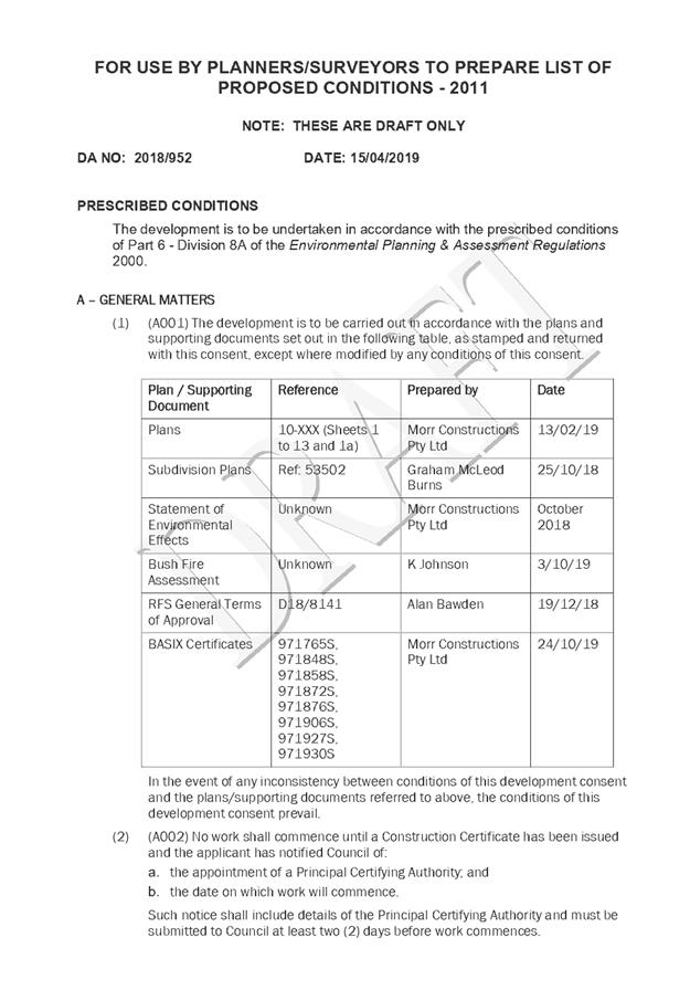
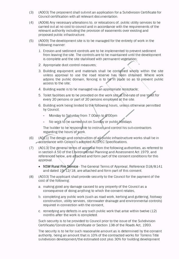
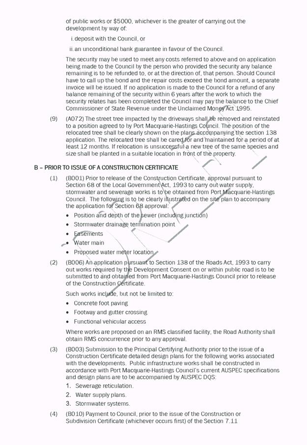
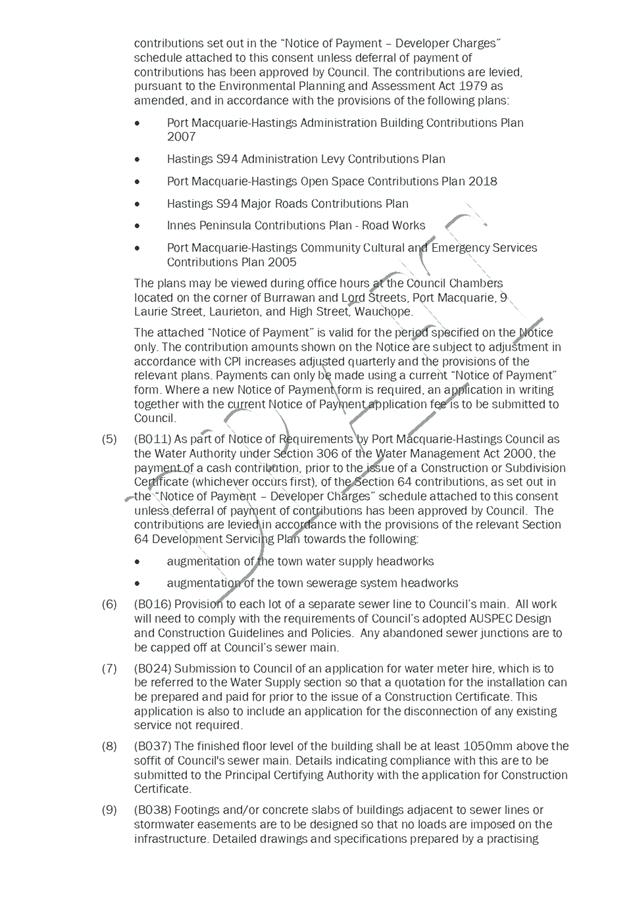
|
ATTACHMENT
|
Development Assessment Panel
24/04/2019
|
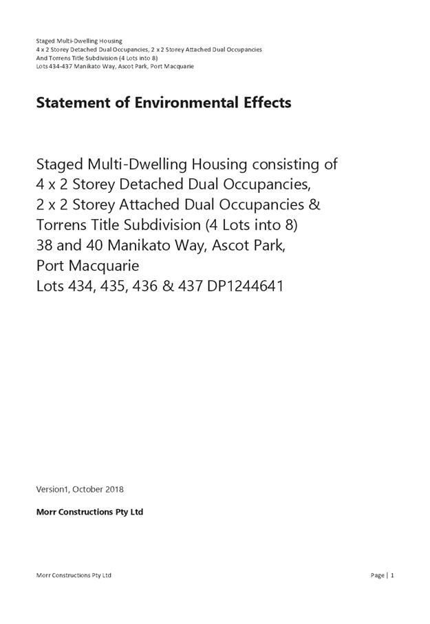
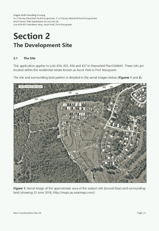
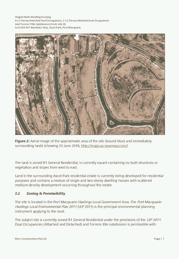
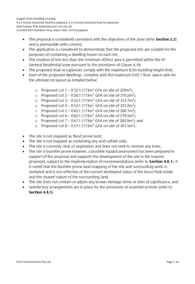
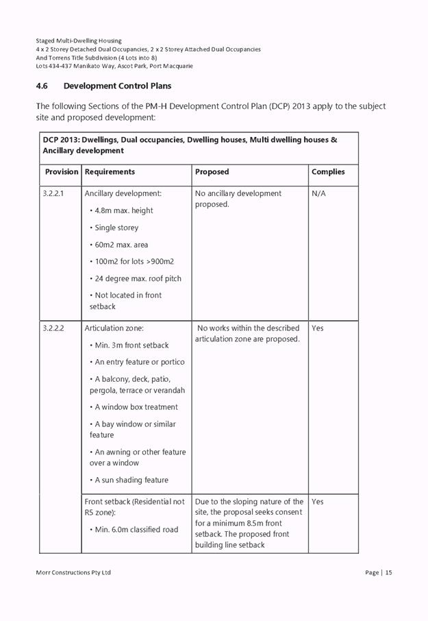
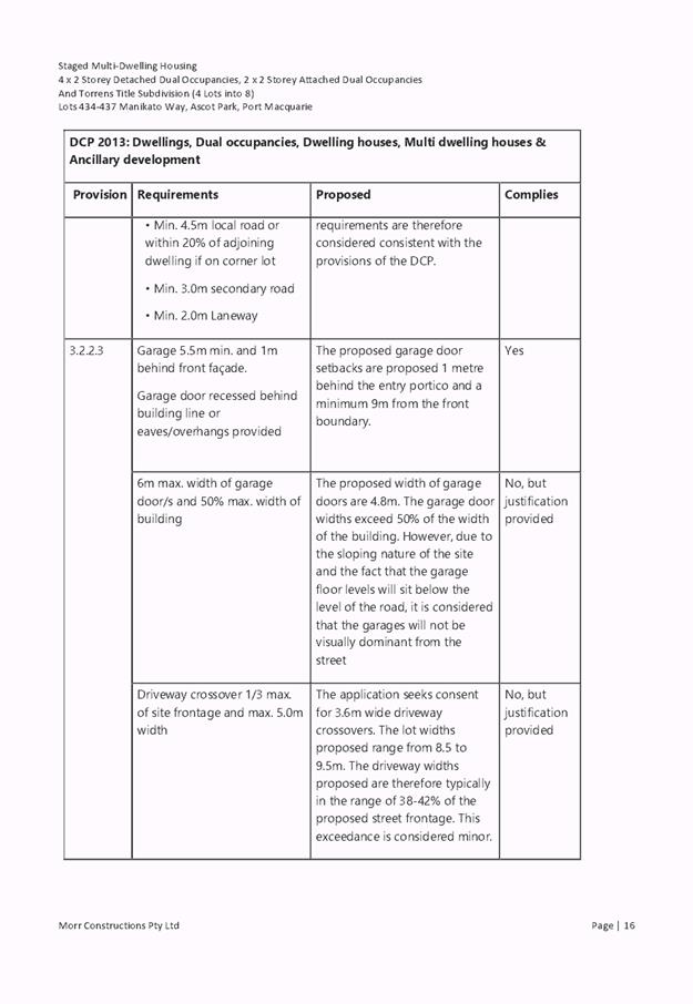
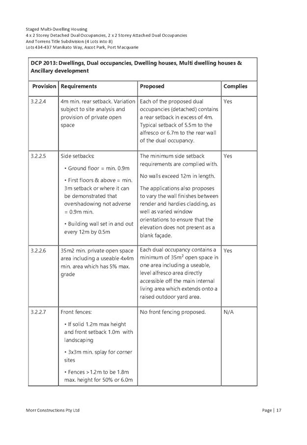
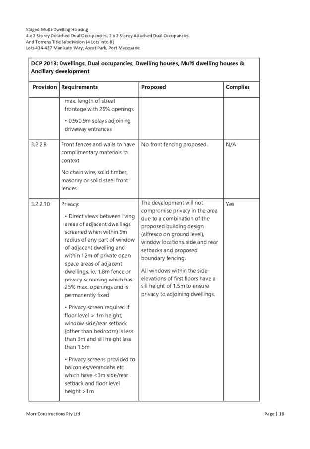
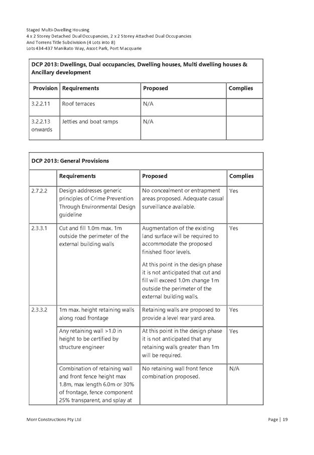
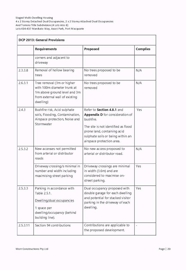
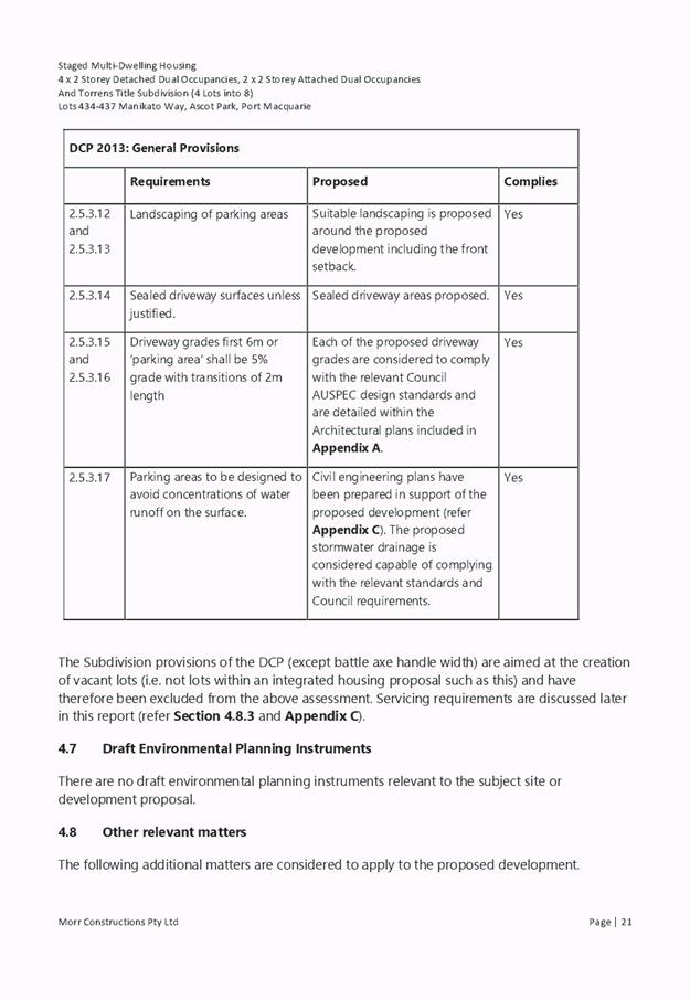
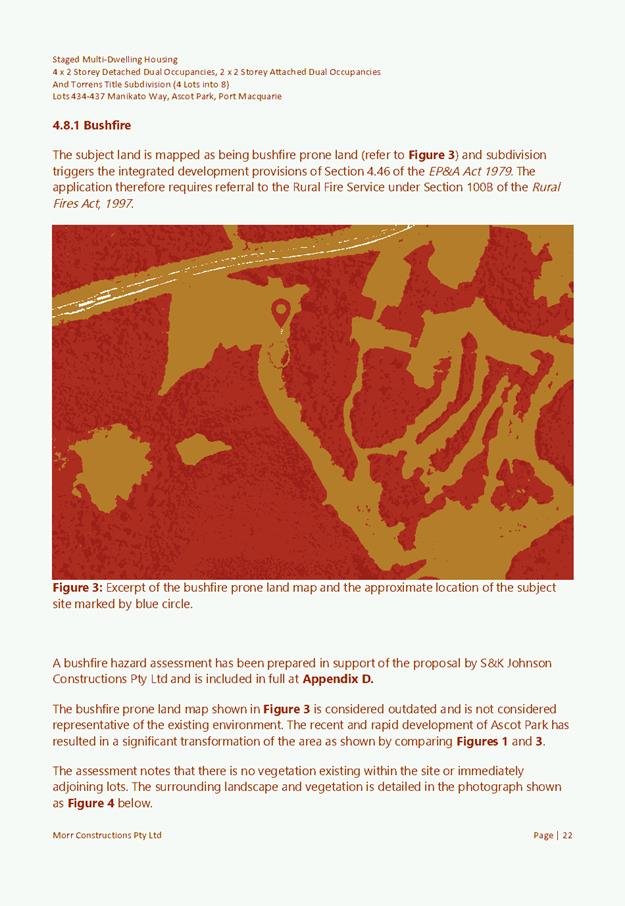

|
ATTACHMENT
|
Development Assessment Panel
24/04/2019
|
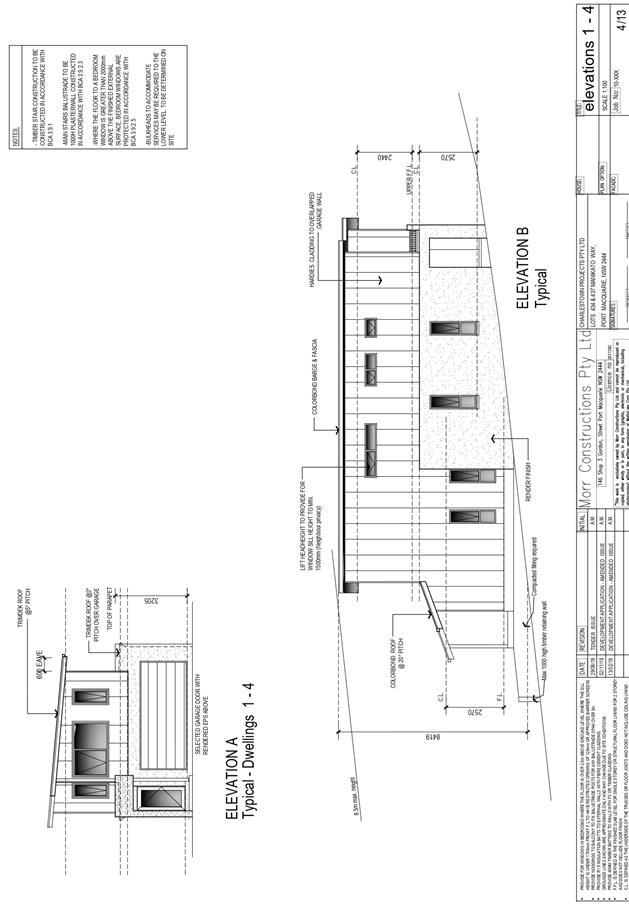
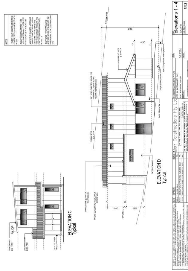
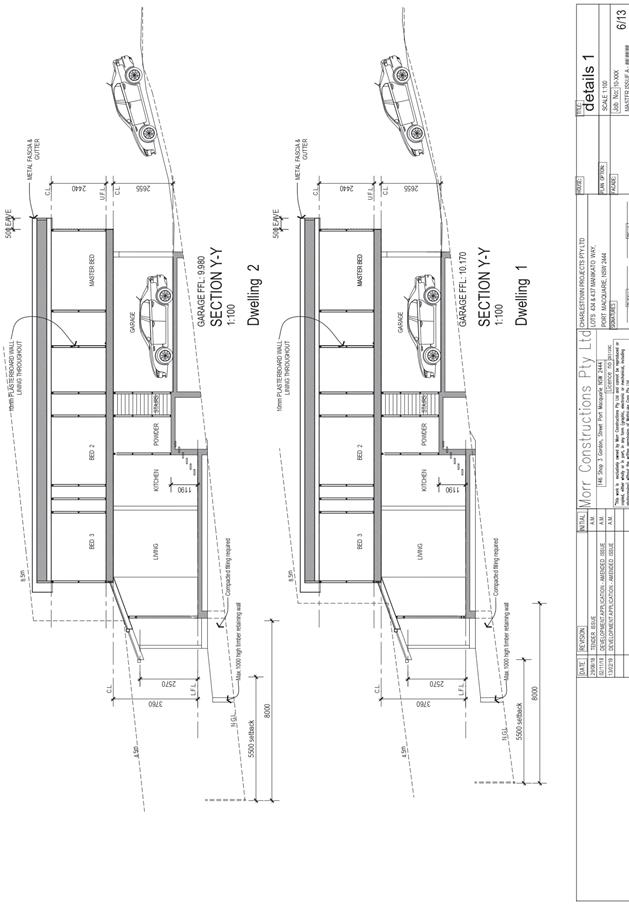
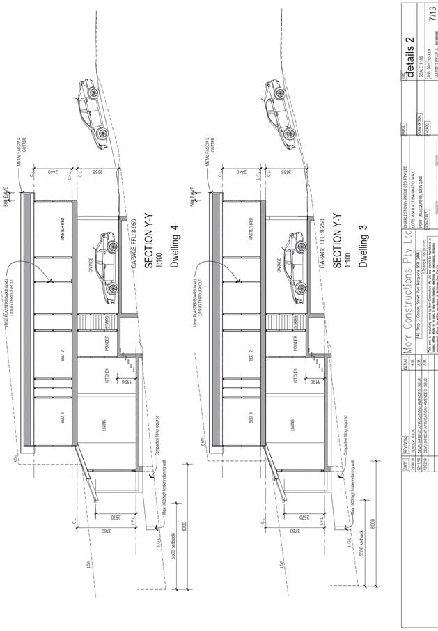
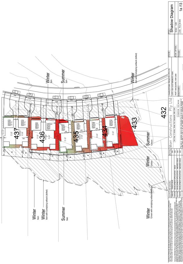
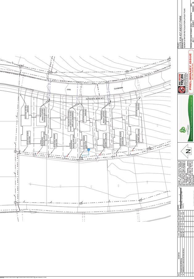
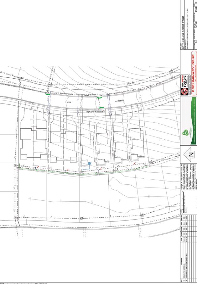
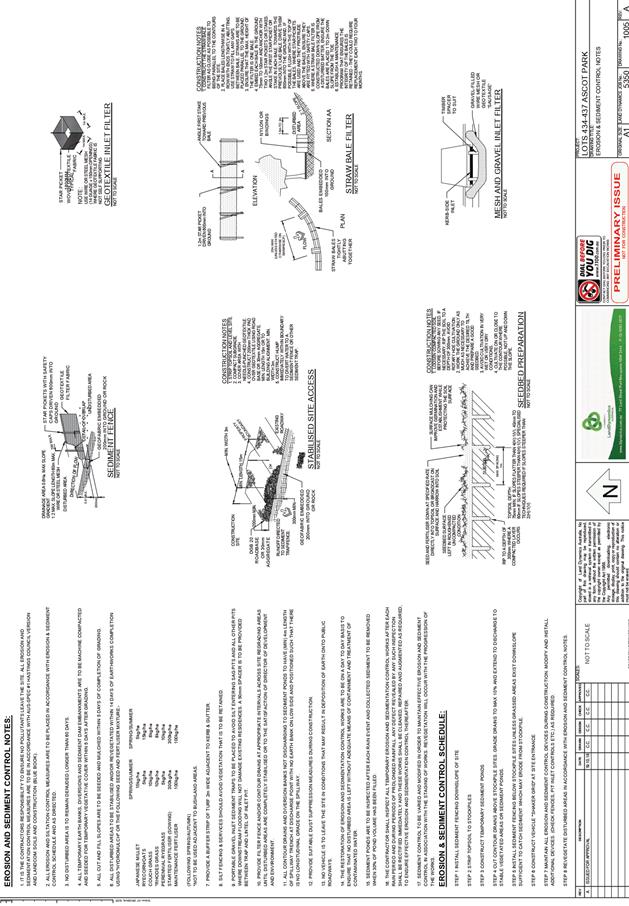
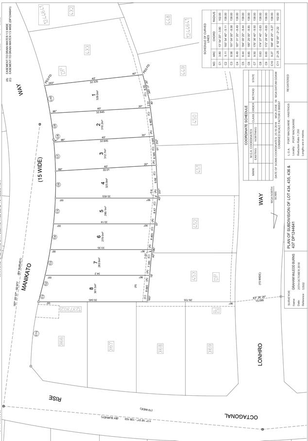
|
ATTACHMENT
|
Development Assessment Panel
24/04/2019
|
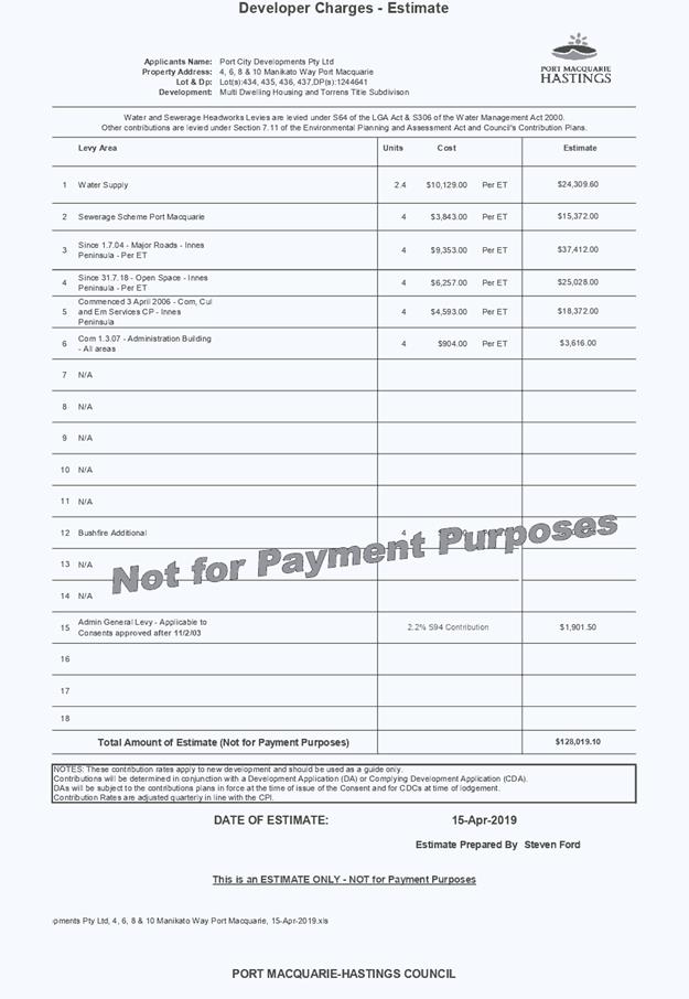
AGENDA Development Assessment Panel 24/04/2019
Item: 09
Subject: DA2018 - 1051.1 Recreation Facility (Indoor) at Lot 1 DP 1250139,
No. 18 John Oxley Drive, Port Macquarie
Report Author: Chris Gardiner
|
Applicant: M
I Joyce
Owner: MPG
Funds Management Ltd
Estimated Cost: $300,000
Alignment with Delivery Program
4.3.1 Undertake transparent
and efficient development assessment in accordance with relevant legislation.
|
|
RECOMMENDATION
That
DA 2018 - 1051.1 for a Recreation
Facility (Indoor) at Lot 1, DP 1250139, No.
18 John Oxley Drive, Port Macquarie,
be determined by granting consent subject to the recommended conditions.
|
Executive
Summary
This
report considers a development application for a recreation facility
(indoor) at the subject site and provides an
assessment of the application in accordance with the Environmental Planning and
Assessment Act 1979.
Following exhibition of the
application, 3 submissions have been received.
This report recommends approval of
the development application subject to the recommended conditions.
1. BACKGROUND
Existing sites features and Surrounding development
The site has an area of 4.789
hectares.
The site is zoned B5 in
accordance with the Port Macquarie-Hastings Local Environmental Plan 2011, as
shown in the following zoning plan:
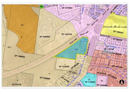
The existing subdivision pattern and location of existing
development within the locality is shown in the following aerial photograph:
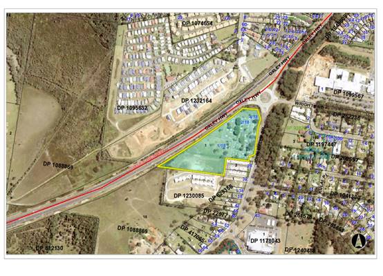
2. DESCRIPTION OF
DEVELOPMENT
Key aspects of the proposal include the following:
· Change
of use from bulky goods premises to recreation facility (indoor), with
ancillary café and crèche for gym members;
· Internal fitout for gymnasium, including addition of 709m2
upper floor; and
· Increase in the dimensions of the previously approved
tenancy signage.
Refer
to attachments at the end of this report.
Application Chronology
· 6
December 2018 - Application lodged.
· 14
December 2018 - Additional information requested prior to notification of
application.
· 22
February 2019 - Additional information received.
· 28 February 2019 to 13 March 2019 - Neighbour notification.
· 8 March 2019 - Further additional information requested.
· 8 April 2019 - Additional information received.
3. STATUTORY ASSESSMENT
Section 4.15(1) Matters for Consideration
In determining the application, Council is required to take
into consideration the following matters as are relevant to the development
that apply to the land to which the development application relates:
(a) The provisions (where
applicable) of:
(i) Any Environmental
Planning Instrument:
State Environmental Planning Policy No. 44 - Koala Habitat
Protection
The land is subject to a Koala Plan of Management (KPoM) approved
under DA2015 – 600. The KPoM relates to the removal of vegetation in the
John Oxley Drive corridor associated with the road upgrades required for that
development.
Key management actions in the approved KPoM include:
· Installation of advisory signage for pedestrians with dogs;
· Ongoing fox control;
· Installation of floppy top fencing between the habitat
corridor and John Oxley Drive and advisory signage for motorists;
· Offset planting for habitat loss; and
· Appropriate construction phase management for tree removal.
The KPoM does not contain any provisions relevant to the
proposed internal alterations and change of use. In accordance with clause 9(2)
of the SEPP, the proposal is not considered to be inconsistent with the KPoM.
State Environmental Planning Policy No. 55 –
Remediation of Land
Following an inspection of the site and a search of Council
records, the subject land is not identified as being potentially contaminated
and is suitable for the intended use.
State Environmental Planning Policy No. 62 –
Sustainable Aquaculture
Given the nature of the proposed development and proposed
stormwater controls the proposal will be unlikely to have any adverse impact on
existing aquaculture industries.
State Environmental Planning Policy No. 64 –
Advertising and Signage
The proposed development includes proposed advertising
signage in the form of a business identification sign on the south elevation of
the building. Signage for the building was approved in generally the same
location under DA2015 – 600.5, but the proposal seeks to increase the
length of the sign for the tenancy
In accordance with clause 7, this SEPP prevails over the
Port Macquarie-Hastings LEP 2011 in the event of any inconsistency.
The following assessment table provides an assessment
checklist against the Schedule 1 requirements of this SEPP:
|
Applicable clauses for consideration
|
Comments
|
Satisfactory
|
|
Clause
8(a) Consistent with objectives of the policy as set out in Clause 3(1)(a).
|
The
proposed signage complies with the subject Clause. In particular, the
proposed signage is not excessive, is consistent with surrounding signage and
will not impact on streetscape.
|
Yes
|
|
Schedule
1(1) Character of the area.
|
Signage
is consistent with others in the area and will not compromise the character
of the locality.
|
Yes
|
|
Schedule
1(2) Special areas.
|
Not
a special area.
|
Yes
|
|
Schedule
1(3) Views and vistas.
|
No
views or vistas impacted.
|
Yes
|
|
Schedule
1(4) Streetscape, setting or landscape.
|
The
proposed signage is not excessive; is consistent with surrounding signage; and
will not impact on streetscape.
|
Yes
|
|
Schedule
1(5) Site and building.
|
The
signage is slightly larger than originally approved, but changes to the
tenancy configuration have resulted in the subject tenancy having a wider
frontage. The extent of the sign is appropriate for the scale of the building
and the height of the sign will be consistent with adjoining tenancies.
|
Yes
|
|
Schedule
1(6) Associated devices and logos with advertisements and advertising structures.
|
None
proposed.
|
Yes
|
|
Schedule
1(7) Illumination.
|
The
sign is proposed to be illuminated and the Statement of Environmental Effects
notes that it would be on a timer set to switch off by 10pm.
The
illuminated signage approved at the site under DA2015 - 600 is permitted to
be illuminated until 11.00pm. The proposal would therefore have less impact
that the existing approval.
|
Yes
|
|
Schedule
1(7) Safety.
|
The
signage will create no safety impacts.
|
Yes
|
State Environmental Planning Policy (Infrastructure) 2007
Clause 101 – The site has frontage to a classified
road (Oxley Highway). Impacts of the overall development on the classified road
network were considered under DA2015 – 600 in consultation with the RMS.
The proposed change of use does not trigger any of the traffic generating
development thresholds of Clause 104. Referral to the RMS is not required.
The traffic impacts of the development are discussed in
detail later in this report under Traffic and Transport. The proposed use is
not sensitive to road traffic noise.
Port Macquarie-Hastings Local Environmental Plan
2011
The proposal is consistent with the LEP having regard to
the following:
· Clause 2.2, the subject site is zoned B5 Business
Development. In accordance with clause 2.3(1) and the B5 zone landuse table,
the proposed development for a recreation facility (indoor) is a permissible
landuse with consent. The proposed café and crèche are considered
to be ancillary to the recreation facility as they are intended to be for use
by gym members only.
The objectives of the B5 zone are as follows:
o To enable a mix of business and warehouse uses, and
specialised retail premises that require a large floor area, in locations that
are close to, and that support the viability of, centres.
o To minimise conflict between land uses within the
zone and with adjoining zones.
o To ensure that new developments make a positive
contribution to the public domain and streetscape.
· In accordance with Clause 2.3(2), the proposal is
consistent with the zone objectives having regard to the following:
o The proposal is a permissible landuse;
o The development would contribute to the mix of business and
specialised retail uses on the site.
· Clause 4.3 -The maximum overall height of the building
above ground level existing) would not be increased by the internal
alterations.
· Clause 4.4 - No maximum floor space ratio (FSR)
applies to the site.
· Clause 5.10 – Heritage. The site does not contain or
adjoin any known heritage items or sites of significance.
· Clause 7.1 - Part of the site is mapped as potentially
containing class 5 acid sulphate soils. The proposed development is located
clear of the mapped area and would not require any excavation. Therefore, no
adverse impacts are expected to occur to the acid sulphate soils found on site.
· Clause 7.3 - Part of the site is land within a mapped
“flood planning area” (land subject to flood discharge of 1:100
annual recurrence interval flood event, plus the applicable climate change
allowance and relevant freeboard). The original assessment of DA2015 –
600 established appropriate floor levels for the buildings. The proposed
internal alterations and change of use would be consistent with the provisions
of this clause.
· Clause 7.13 - Satisfactory arrangements are in place for
provision of essential services including water supply, electricity supply,
sewer infrastructure, stormwater drainage and suitable road access to service
the development.
(ii) Any
draft instruments that apply to the site or are on exhibition:
No draft
instruments apply to the site.
(iii) Any
Development Control Plan in force:
Port
Macquarie-Hastings Development Control Plan 2013
|
DCP 2013: Business & Commercial Development
|
|
DCP Objective
|
Development Provisions
|
Proposed
|
Complies
|
|
3.4.3.9
|
A minimum of 50% of the ground floor level front facade is
to be clear glazed.
|
Minimum of 50% clear glazing to the shopfront.
|
Yes
|
|
Active frontages must consist of one or more of the
following:
· A shop front.
· Commercial and
residential lobbies.
· Café or
restaurant if accompanied by an entry from the street.
· Public building
if accompanied by an entry from the street.
|
Active frontage consists of reception area for gymnasium
and cafe.
|
Yes
|
|
Active ground floor uses are to be accessible and at the
same level as the footpath.
|
Yes
|
Yes
|
|
3.4.3.22
|
Any ramps are to be integrated into the overall building
and landscape design.
|
Integrated access proposed.
|
Yes
|
|
The development complies with AS1428—Design for
Access and Mobility.
|
Capable of complying. To be confirmed with CC application.
|
Yes
|
|
3.4.3.26
|
Bulk waste facilities must be stored in a designated area
that is physically and visually integrated into the development at ground or
sub-basement level that:
· is not visible
from the street or public domain;
· is easily
accessible to businesses;
· may be serviced
by collection vehicles;
· has water and
drainage facilities for cleaning and maintenance; and
· does not
immediately adjoin onsite employee recreation area; and
· be maintained to
be free of pests.
|
Bulk waste storage and collection addressed in conditions
of DA2015 – 600. The facilities are capable of serving this proposal.
|
Yes
|
|
Cardboard compactors are provided for large retail and
commercial developments.
|
|
Where waste facilities cannot be collected at the street,
evidence that the site can be serviced by a waste collection service must be
provided.
|
|
3.4.3.35
|
Commercial Development Adjoining Residential Land uses:
The development is designed so that all vehicle movement
areas and servicing areas are located away from adjoining residential areas.
|
See comments later in this report under Noise and
Vibration.
|
Yes
|
|
Where this cannot be achieved visual and acoustic
treatment of the interface is required.
|
|
The building elevation adjoining the residential area must
be;
· Articulated,
with changes in setback at intervals no greater than 10m;
· Use a variety of
materials and treatments;
· Be setback a
minimum of half the height of the wall or a minimum of 3.0metres whichever is
greater.
|
The proposal would not alter the building elevation
adjoining residential uses.
|
N/A
|
|
Waste areas are located and managed to minimise pests,
noise and odour.
|
Yes
|
Yes
|
|
DCP 2013: General Provisions
|
|
DCP Objective
|
Development Provisions
|
Proposed
|
Complies
|
|
2.2.2.1
|
Signs primarily identifying products or services are not
acceptable, even where relating to products or services available on that
site.
|
Proposal is for business identification signs only.
|
Yes
|
|
Signage is not permitted outside property boundaries
except where mounted upon buildings and clear of pedestrians and road
traffic. No signage is permitted upon light or power poles or upon the nature
strip (the area between the property boundary and constructed roadway).
Limited directional
signage and “A” frame signage may separately
be approved by Council under the Roads Act 1993 or section 68 of the Local
government Act 1993.
|
None proposed outside property boundary.
|
Yes
|
|
An on-building 'chalkboard' sign, for the purpose of
describing services or goods for sale which vary on a regular basis generally
should not be any larger than 1.5m2, and should contain a sign written
heading indicating the premises to which it refers.
|
N/A
|
N/A
|
|
On-premise signs should not project above or to the side
of building facades
|
Signage consistent with height and location of those
approved for adjoining tenancies under DA2015 – 600.4
|
Yes
|
|
2.2.2.2
|
Where there is potential for light spill from signage in a
non-residential zone adjoining or adjacent to residential development,
illuminated signage is to be fitted with a time switch to dim by 50% or turn
off the light by 11pm each night, depending on the nature of the development.
|
The
sign is proposed to be illuminated and the Statement of Environmental Effects
notes that it would be on a timer set to switch off by 10pm.
|
N/A
|
|
2.7.2.2
|
Design addresses generic principles of Crime Prevention
Through Environmental Design guideline:
· Casual
surveillance and sightlines
· Land use mix and
activity generators
· Definition of
use and ownership
· Lighting
· Way finding
· Predictable
routes and entrapment locations
|
The proposed development will be unlikely to create any
concealment/entrapment areas or crime spots that would result in any
identifiable loss of safety or reduction of security in the immediate area.
|
Yes
|
|
2.3.3.1
|
Cut and fill 1.0m max. 1m outside the perimeter of the
external building walls
|
None proposed.
|
Yes
|
|
2.3.3.2
|
1m max. height retaining walls along road frontages
|
None proposed.
|
N/A
|
|
Any retaining wall >1.0 in height to be certified by
structural engineer
|
N/A
|
N/A
|
|
Combination of retaining wall and front fence height
|
N/A
|
N/A
|
|
2.3.3.8 onwards
|
Removal of hollow bearing trees
|
None proposed to be removed.
|
Yes
|
|
2.6.3.1
|
Tree removal (3m or higher with 100mm diameter trunk and
3m outside dwelling footprint
|
None proposed to be removed.
|
Yes
|
|
2.4.3
|
Bushfire risk, Acid sulphate soils, Flooding,
Contamination, Airspace protection, Noise and Stormwater
|
Refer to main body of report.
|
|
|
2.5.3.2
|
New accesses not permitted from arterial or distributor
roads. Existing accesses rationalised or removed where practical
|
No new access proposed.
|
N/A
|
|
Driveway crossing/s minimal in number and width including
maximising street parking
|
N/A
|
N/A
|
|
2.5.3.3
|
Off-street parking in accordance with Table 2.5.1.
(Provision to consider reduced parking where supported by
parking demand study)
|
Previous approvals:
The overall development on the site (including Bunnings
and the bulky goods tenancies – DA2015 – 600.3) was assessed as
requiring 354 parking spaces to satisfy the DCP requirements. A total of 457
parking spaces were approved for the development. The majority of the spaces
have been completed, but 61 of the spaces are currently within the fenced
construction zone around the tenancy building. These space would need to be
available prior to the use commencing.
DA2018 – 962.1 for a medical centre in the adjoining
tenancy required an additional 11 parking spaces. This increased the overall
parking requirement to 365 spaces, leaving a surplus of 92 parking spaces.
Current proposal:
The proposal includes the following:
· Gymnasium – 1781.3m2
at 7.5 spaces per 100m2 GFA = 133.6 spaces;
· Office – 23.7m2
at 1 space per 30m2 GLFA = 0.79 spaces;
· Café – 98m2
at 1 space per 30m2 serviced floor area = 3.27 spaces.
The previous approval of the tenancy for bulky goods under
DA2015 – 600 assumed a parking demand of 15.1 spaces based on the
ground floor area of 1207.1m2.
The overall DCP parking demand for the proposed use is
therefore 122.56 (rounded to 123) spaces. Added to the existing parking
demand of 365 spaces, this gives a total site parking demand of 488 spaces.
This exceeds the existing parking provision of 457 spaces
by 31 spaces.
The Applicant has submitted a site specific traffic and
parking assessment addressing the timing of peak parking demands for the
various uses on the site. This is addressed in more detail under Parking
later in this report.
|
No, but acceptable
|
|
2.5.3.11
|
Section 94 contributions
|
Refer to main body of report.
|
|
|
DCP 2013: Chapter 4.4 - Port Macquarie West (John
Oxley Drive East)
|
|
DCP Objective
|
Development Provisions
|
Proposed
|
Complies
|
|
4.4.2.1
|
A development application should be accompanied by a Noise
Impact Assessment report, which is to be prepared by a professional
acoustician in accordance with the Industrial Noise Policy 2000, NSW
Environment Protection Authority and with applicable
Australian Standards.
|
Noise impact assessment submitted.
|
Yes
|
|
4.4.2.2
|
Sunlight to the principal area of ground-level private and
other key open space of adjacent residential properties shall not be reduced
to less than 3 hours between 9.00am and 3.00pm on June 22.
|
The proposal is for internal alterations and a change of
use and would not affect solar access to adjoining property.
|
Yes
|
|
Buildings shall not reduce the sunlight available, to the
north-facing windows of living areas in existing adjacent dwellings, to less
than the above specification.
|
|
4.4.2.3
|
The design details for any development application should
address mitigation of any adverse impacts of the proposed development, when
viewed from outside the site, in relation to:
• siting and bulk of buildings
• car parking areas
• signage.
Photomontages could be used to illustrate the visual
impacts on the property to the south, and when viewed from east-bound traffic
on the Oxley Highway.
|
Proposal would not alter the visual impact of the
proposal.
|
Yes
|
Based on the above
assessment, the variation proposed to the provisions of the DCP is considered
acceptable and the relevant objectives have been satisfied. The variation does
not amount to an adverse impact or a significance that would justify refusal of
the application.
(iiia) Any
planning agreement that has been entered into under section 7.4, or any draft
planning agreement that a developer has offered to enter into under section 7.4:
No planning
agreement has been offered or entered into relating to the site.
iv) Any matters prescribed by the
Regulations:
No provisions
of the regulations are applicable to the proposal.
(b) The
likely impacts of that development, including environmental impacts on both the
natural and built environments, social and economic impacts in the locality:
The site has a general easterly street frontage orientation
to John Oxley Drive and a north-westerly frontage to the Oxley Highway.
Adjoining the site to the north and west is a manufactured
home estate.
Adjoining the site to the east is low density residential
land and some medical uses.
Adjoining the site to the south is a seniors housing
development.
Roads
The site is located south of the Oxley Highway, adjacent to
the intersection with John Oxley Drive and Wrights Road. The north-western
boundary of the development lot fronts the Oxley Highway, which is a State
classified road and consequently a Controlled Access Road (CAR), requiring all
vehicular access to be via other local roads wherever possible. An existing
sound wall runs along the length of the site’s north-western boundary
with the highway.
The Oxley Highway in the vicinity of the site is dual
carriageway two-way divided road. The road reserve varies in width ranging
between approximately 50 and 60 metres. Oxley Highway is classified as an
arterial road.
To the east, the site is bounded by John Oxley Drive
(formerly the Oxley Highway). The road reserve along the site boundary ranges
between 75m and 120m in width, with a large proportion of the reserve
vegetated. The road formation is currently characterised as a dual carriageway
two-way divided road with a signalised intersection at the site access. The
road is classified by Council as an ‘Urban Distributor’ under the
AUS-SPEC system and is capable of handling the additional traffic generated by
the development with minimal impact to the existing pavement. Council has
developed a concept master plan which includes duplication of the proposed John
Oxley Drive corridor to cater to future growth in the area.
Traffic and Transport
The Applicant has submitted a Traffic and Parking
Assessment prepared by TPS Group and dated 11 February 2019, which analyses the
impacts of the additional traffic generated by the use on the signalised
intersection at the site access and also the nearby intersection of the Oxley
Highway/John Oxley Drive/Wrights Road.
The traffic modelling in the report shows that the
development access will continue to operate at a degree of saturation (DOS)
with queue lengths comparable to current conditions. The roundabout at the
intersection of John Oxley Drive / Oxley Highway will only be marginally
affected with an increase in DOS of 89% to 92%.
The report adequately assesses the traffic generation
expected to be associated with this development at the site access and on the
broader road network. The marginal increase in traffic as demonstrated in the
report is considered negligible and acceptable for the situation.
Site Frontage & Access
The proposal would not alter the access arrangements and
site frontage works approved for the site under DA2015 – 600.
Parking
The site contains 31 spaces less than the minimum required
in accordance with DCP 2013. The Applicant has submitted a Traffic and Parking
Assessment prepared by TPS Group and dated 11 February 2019, which analyses the
peak periods of parking demand for the various uses on the site and the
potential for shared use of the overall parking spaces on the site.
Key findings of the report include:
· The peak periods for parking demand associated with Bunnings
and the bulky goods premises occur on Thursdays and Saturdays, with the
Thursday peak parking demand being approximately 60% of the Saturday peak
parking demand.
· Based on data from similar facilities the peak parking
demand associated with the gymnasium is expected to be weekdays between 5.00pm
and 6.00pm, with peak demands on Saturday mornings being substantially lower
(see below graphs).
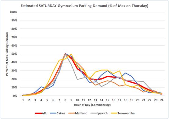
· The worst case parking demand for the gymnasium tenancy is
considered to be 140 spaces and would occur on weekdays between 5.00pm and
6.00pm. This coincides with a peak parking demand for the Bunnings and bulky
goods premises of only 60% of the Saturday peak, which equates to approximately
215 spaces.
· The available 457 parking spaces is sufficient for the
demand generated by each of the approved uses during their peak periods.
Part of the parking area originally approved under DA2015 -
600 (approximately 61 spaces) was within a fenced construction zone at the time
of assessment. It will be necessary for these parking spaces to be completed
and certified prior to the issue of an Occupation Certificate for the use, to
ensure that the parking is available for use by customers.
Water Supply Connection
Water supply will be provided to the tenancy as part of
DA2015 – 600. A further S68 approval will be required for the fit out
work. Refer to relevant conditions of consent.
Sewer Connection
Sewer will be connected to the tenancy as part of DA2015
– 600. A further S68 approval will be required for the fit out work.
Refer to relevant conditions of consent.
Stormwater
Proposed internal alterations would not increase impervious
areas or affect existing stormwater management for the site.
Other Utilities
Telecommunication and electricity services are available to
the site.
Heritage
This site does not contain or adjoin any known heritage
item or site of significance.
Other land resources
The site is within an established urban context and will
not sterilise any significant mineral or agricultural resource.
Water cycle
The proposed development will be unlikely to have any
adverse impacts on water resources and the water cycle.
Soils
The proposed development will be unlikely to have any
adverse impacts on soils in terms of quality, erosion, stability and/or
productivity subject to a standard condition requiring erosion and sediment
controls to be in place prior to and during construction.
Air and microclimate
The construction and/or operations of the proposed
development will be unlikely to result in any adverse impacts on the existing
air quality or result in any pollution. Standard precautionary site management
condition recommended.
Flora and fauna
Part of the site is identified on the Biodiversity Values
Map. However, Clause 7.3(4) of the Biodiversity Conservation Regulation 2017
provides the following:
Despite anything to the contrary in this Part,
proposed development (other than subdivision) does not exceed the biodiversity
offsets scheme threshold merely because it is to be carried out on a lot
included in the Map if the lot was the result of a subdivision carried out
before the commencement of the Act and the lot is within land zoned R1 to R4,
RU5, B1 to B8 or IN1 to IN3 under an environmental planning instrument.
The development is located on a lot in the B5 zone
that was created prior to the commencement of the Act. The proposal if for
internal alterations and change of use of an approved building and satisfies
the test of significance.
Waste
Satisfactory arrangements are in place for proposed storage
and collection of waste and recyclables. No adverse impacts anticipated.
Standard precautionary site management condition recommended.
Energy
The proposal includes measures to address energy efficiency
and will be required to comply with the requirements of Section J of the
Building Code of Australia. No adverse impacts anticipated.
Noise and vibration
The submitted Statement of Environmental Effects indicates
that the hours of operation for the use will be 5.30am to 8.30pm Monday to
Sunday, with 24 hour swipe card access outside those hours.
The application includes a Noise Emission Assessment
prepared by Acoustic Logic and dated 18 February 2019. The report includes
hours of operation that are slightly more restricted than those above:
· Monday to Thursday - 5.30am to 8.30pm;
· Friday - 5.30am to 7.00pm;
· Saturday - 8.00am to 3.00pm;
· Sunday - 8.00am to 2.00pm; and
· 24 hour swipe card access for members outside these hours.
Given that the noise assessment has been carried out based
on the above hours, it is recommended that the condition restrict operation to
those hours (rather than the ones noted in the Statement of Environmental
Effects).
The report includes consideration of noise impacts
associated with the proposed use, including the use of music for gym classes
and traffic accessing the parking area after hours.
The report concludes that the proposal will achieve noise
levels consistent with the NSW EPA Noise Policy for Industry, subject to the
following recommendations:
· Minimum 6mm thick glazing with acoustic rating of Rw 29 is
to be installed to all glazed elements of the façade;
· There is to be no music in external areas of the tenancy;
· Car park areas outside of the tenancy are not to be used as
part of regular gym activities;
· There is to be signs at the entry/exit of the premises
reminding members to minimise noise when entering/exiting the gym –
especially during the hours of 10pm – 7am;
Conditions are recommended confirming the above
requirements.
Bushfire
The site is identified as being bushfire prone.
The original development of the site under DA2015 –
600 adequately addressed the requirements of Planning for Bush Fire Protection
2006. The proposed internal alterations and change of use would not alter the
bushfire risk.
Safety, security and crime prevention
The proposal includes 24-hour access for members. A CPTED
Assessment prepared by Love Project Management and dated 1 April 2019 has been
submitted in support of the application. The report addresses the principles of
Crime Prevention Through Environmental Design (CPTED) and includes a review of
crime statistics for the area.
The premises are proposed to be provided with the following
security features:
· Closed Circuit Security cameras installed throughout the
premises;
· Back to base security monitoring;
· Voice over cameras offering back to base interaction
between patrons and the security control centre;
· Wall mounted duress buttons throughout the premises;
· Gym members will have the option of wearing duress buttons
when in the premises should they seek additional safety levels;
· After hours access is limited to members only, including
“tailgating” technology to limit access to members with access
cards only;
It is also noted that the entrance to the building is
visible to passing traffic in John Oxley Drive and the car park area is well
lit for the early part of the night. It is understood that lighting of the car
park adjacent to Bunnings is currently switched of at approximately 9.00pm. It
will be necessary to provide lighting to the parking area immediately adjacent
to the tenancy throughout the night to ensure the safety of gym users.
A condition is recommended confirming the extent of
lighting and that external lighting is required to comply with AS4282 - Control
of the obtrusive effects of outdoor lighting. Lighting of the parking area
adjacent to the hardware and building supplies tenancy will not be permitted
due to the potential amenity impacts on the adjoining residential use.
The report concludes that safety and security would be
satisfactory subject to the following recommendations:
· Formal surveillance of the access / exit point of the
gymnasium via the proposed CCTV infrastructure;
· Signage to ensure the 24-hour access door is immediately
identifiable as the after hours access point;
· Clear internal EXIT signage within the building to ensure
the exit is identifiable should a power outage occur whilst people are in the
building. This is to include lighting of the stairwell;
· Internal lighting within the gym to ensure the internal
area is well lit whilst patrons are inside. This may include motion sensor
lighting to minimise lighting usage when the building is not occupied; and
· A mechanism to ensure the gym members are able to call for
assistance if required – as per the “duress button” system
proposed to be installed.
It is recommended that the CPTED Assessment be included in
the approved documents for the development, to ensure that the recommendations
are incorporated into the consent.
Social impacts in the locality
Given the nature of the proposed development and its’
location the proposal is unlikely to result in any adverse social impacts.
Economic impact in the locality
No adverse impacts anticipated. The proposal would have
positive impacts through the construction phase and with ongoing employment
opportunities.
Site design and internal design
The proposed development design satisfactorily responds to
the site attributes and will fit into the locality. No adverse impacts likely.
Construction
No potential adverse impacts identified to neighbouring
properties with the construction of the proposal.
Cumulative impacts
The proposed development is not expected to have any
adverse cumulative impacts on the natural or built environment or the social
and economic attributes of the locality.
(c) The suitability of the site for
the development:
The proposal
will fit into the locality and the site attributes are conducive to the
proposed development.
Site
constraints have been adequately addressed and appropriate conditions of
consent recommended.
(d) Any submissions made in
accordance with this Act or the Regulations:
Three (3) written submissions have been received following
public exhibition of the application.
Key issues raised in the submissions received and comments
in response to these issues are provided as follows:
|
Submission
Issue/Summary
|
Planning
Comment/Response
|
|
Parking for the development
does not appear adequate in relation to DCP parking rates.
|
As noted in the assessment,
the proposal provides 31 less spaces that required under the DCP. The
Applicant has provided a specialist traffic and parking assessment that
demonstrates the overall parking on the site will be adequate due to
differences in the time of peak parking demand for the various uses.
|
|
From local experience the peak period for gymnasiums is
usually 9.00am to 11.00am.
|
The parking assessment has used data from similar World
Gym facilities in Cairns, Maitland, Toowoomba, and Mackay, based on swipe
card usage. The data suggests that 9.00am to 11.00am is also a busier period
(approximately 75% of the 5.00pm to 6.00pm peak).
The outcome of the overall parking availability would not
be any different if 9.00am to 11.00am was considered to be to peak
period for the gymnasium use.
|
|
Impact on existing traffic congestion in John Oxley Drive
and the Oxley Highway.
|
As discussed earlier in this report under Traffic and
Transport, a detailed traffic assessment has been submitted with the
application. The traffic modelling in the report shows that the development
access will continue to operate at a degree of saturation (DOS) with queue
lengths comparable to current conditions. The roundabout at the intersection
of John Oxley Drive / Oxley Highway will only be marginally affected with an
increase in DOS of 89% to 92%.
|
|
The submitted plans do not provide for disabled access to
the upper floor of the building.
|
Amended plans have been submitted, which provide for a
lift to the upper floor and accessible bathroom facilities. The plans
submitted with the application for a Construction Certificate will need to
demonstrate compliance with the Building Code of Australia, and this will
ensure that adequate access is available for people with a disability.
|
|
The application does not adequately address safety and
security for 24 hour access.
|
A Crime Prevention Through Environmental Design (CPTED)
assessment has been submitted in response to this issue and is discussed
earlier in the report. The measures proposed in the report are considered
adequate to protect the safety of gym users.
|
|
Gyms can be noisy at all times of day and there is a retirement
village nearby. Have noise impacts been addressed.
|
The application includes a Noise Emission Assessment
prepared by Acoustic Logic, which is discussed in more detail earlier in this
report. The assessment demonstrates that the proposal will achieve noise
levels consistent with the NSW EPA Noise Policy for Industry subject to a
number of recommendations, which have been incorporated into the recommended
conditions.
|
|
Social and economic impacts, including impacts on other
local businesses offer the same services.
|
The proposal is located within an existing building
previously approved for use as bulky goods premises. The overall development
on the site was subject to extensive consideration of social and economic
impact as part of the original determination of DA2015 - 600. The proposed
change of use to a gymnasium is not expected to significantly alter the
impacts.
Competition impacts on other local businesses are not a
relevant consideration in the assessment of the application.
|
|
Is a separate application required for 24 hour operation?
|
No. The current application seeks consent for 24 hour
operation.
|
|
The application notes that the café will not make
any food on site and therefore would be better characterised as a pro shop or
retail store.
How will the restriction on member only use be policed?
|
The Applicant has confirmed that the proposed
‘café’ would be ancillary to the gymnasium and would only
provide services for gym members. It is therefore not necessary to
characterise the use separately under the LEP Land Use Table. The overall
proposal remains development for the purpose of a recreation facility
(indoor).
A condition is recommended confirming the restriction for
member use only. This would create an appropriate mechanism for compliance
action in the event that the use changed without a further application.
|
|
Safety and security conditions should be imposed on the
proposal that are similar to those required for other 24 hour gyms.
|
Appropriate conditions have been recommended.
|
|
The amount of bathroom and toilet facilities proposed
does not appear sufficient for the size of the facility.
|
The plans submitted with the application for a
Construction Certificate will need to demonstrate that the proposal satisfies
the Building Code of Australia, including provision of the minimum required
amenity facilities. If this results in any significant change to the
building, modification of the consent would be required.
|
(e) The Public Interest:
The proposed
development satisfies relevant planning controls and is unlikely to impact on
the wider public interest.
4. DEVELOPMENT
CONTRIBUTIONS APPLICABLE
· Development contributions will be required towards
augmentation of town water supply and sewerage system head works under Section
64 of the Local Government Act 1993.
· Development contributions will be required under Section
7.12 of the Environmental Planning and Assessment Act 1979 towards the provision, extension or augmentation of public
amenities or public services.
5. CONCLUSION AND
STATEMENT OF REASON
The application has been assessed
in accordance with Section 4.15 of the Environmental Planning and Assessment
Act 1979.
Issues raised during assessment
and public exhibition of the application have been considered in the assessment
of the application. Where relevant, conditions have been recommended to manage
the impacts attributed to these issues.
The site is considered suitable
for the proposed development and the proposal adequately addresses relevant
planning controls. The development is not considered to be contrary to the
public's interest and will not result a significant adverse social,
environmental or economic impact. It is recommended that the application be
approved, subject to the recommended conditions of consent provided in the
attachment section of this report.
|
Attachments
1View. DA2018
- 1051.1 Recommended conditions
2View. DA2018
- 1051.1 Plans
|
|
ATTACHMENT
|
Development Assessment Panel
24/04/2019
|
|
ATTACHMENT
|
Development Assessment Panel
24/04/2019
|
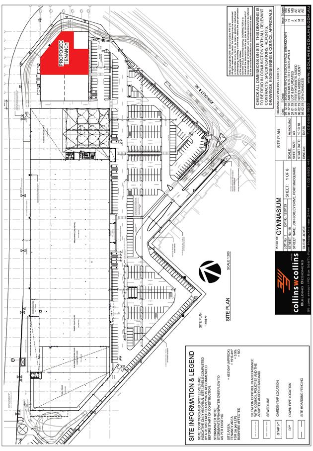
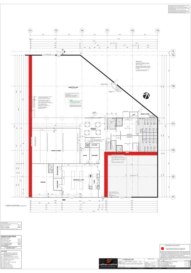

AGENDA Development Assessment Panel 24/04/2019
Item: 10
Subject: DA2018 - 1085 Dual Occupancy and Torrens Title
Subdivision, Lot 2 DP 1222707, No. 63 Yaluma Drive Port Macquarie
Report
Author: Steven Ford
|
Applicant: Joyce
Constructions (NSW) Pty Ltd
Owner: M
I Joyce
Estimated Cost: $818,775
Alignment with Delivery
Program
4.3.1 Undertake transparent
and efficient development assessment in accordance with relevant legislation.
|
|
RECOMMENDATION
That
DA 2018/1085 for a Dual
Occupancy and Torrens Title Subdivision at
Lot 2, DP 1222707, No. 63 Yaluma
Drive, Port Macquarie, be determined by granting consent subject to the
recommended conditions.
|
Executive
Summary
This
report considers a development application for a [description of development]
at the subject site and provides an assessment of the
application in accordance with the Environmental Planning and Assessment Act
1979.
Following exhibition of the
application, 3 submissions have been received.
This report recommends that the
development application be approved subject to conditions.
1. BACKGROUND
Existing sites features and Surrounding development
The site has an area of 798.9m2.
The site is zoned R1 - General Residential in accordance with the Port Macquarie-Hastings Local
Environmental Plan 2011, as shown in the following zoning plan:
The existing subdivision pattern and location of existing
development within the locality is shown in the following aerial photograph:
2. DESCRIPTION OF
DEVELOPMENT
Key aspects of the proposal include the following:
· Attached
Dual Occupancy (2x 4 bedroom dwellings)
· 1
into 2 lots Torrens Title Subdivision
Refer
to attachments at the end of this report.
Application Chronology
· 18
December 2018 – Application Lodged
· 2 January 2019 to 15 January 2019 – Neighbourhood
Notification
· 15 February 2019 - RFS General Terms of Approval received
· 15 March 2019 – Additional information, response to
submissions and amended plans submitted
3. STATUTORY ASSESSMENT
Section 4.15(1) Matters for Consideration
In determining the application, Council is required to take
into consideration the following matters as are relevant to the development
that apply to the land to which the development application relates:
(a) The provisions (where
applicable) of:
(i) Any Environmental
Planning Instrument:
State Environmental Planning Policy No. 44 - Koala
Habitat Protection
There is a Koala Plan of Management (KPoM) on the site
referred to as the Vieceli Port Macquarie SEPP 44 Assessment and Koala
Management Plan, prepared by EcoPro dated September 1999. The proposal does not
necessitate the removal of any vegetation and does not conflict with the KPoM.
State Environmental Planning Policy No. 55 –
Remediation of Land
Following an inspection of the site and a search of Council
records, the subject land is not identified as being potentially contaminated
and is suitable for the intended use.
State Environmental Planning Policy No. 62 –
Sustainable Aquaculture
Given the nature of the proposed development and proposed
stormwater controls the proposal will be unlikely to have any adverse impact on
existing aquaculture industries.
State Environmental Planning Policy (Building
Sustainability Index: BASIX) 2004
A BASIX certificate has been submitted demonstrating that
the proposal will comply with the requirements of the SEPP. It is
recommended that a condition be imposed to ensure that the commitments are
incorporated into the development and certified at Occupation Certificate
stage.
Port Macquarie-Hastings Local Environmental
Plan 2011
The proposal is consistent with the LEP having regard to the
following:
· Clause
2.2 - the subject site is zoned R1 General Residential. In accordance with
clause 2.3(1) and the R1 zone landuse table, the proposed development for a
dual occupancy is a permissible landuse with consent.
The objectives of the R1 zone are as
follows:
o To provide for the housing
needs of the community.
o To provide for a variety of
housing types and densities.
o To enable other land uses
that provide facilities or services to meet the day to day needs of residents.
· In
accordance with Clause 2.3(2), the proposal is consistent with the zone
objectives having regard to the following:
o the proposal is a permissible
landuse;
o provides for an appropriate
alternative form of residential housing
·
· Clause
4.1(4A) - The minimum lot sizes do not apply to the proposal as it is
characterised as attached dwelling or multi dwelling housing development.
· Clause
4.3 - The maximum overall height of the building above ground level (existing)
is 8.5 m which complies with the standard height limit of 8.5 m applying to the
site.
· Clause
4.4 - The floor space ratio of the proposal is 0.60:1.0 which complies with the
maximum 0.65:1 floor space ratio applying to the site.
· Clause
5.10 – Heritage. The site does not contain or adjoin any known heritage
items or sites of significance.
· Clause
7.5 – Koala Habitat – Applies to land that is shown as “Koala
Habitat area” on the Koala Habitat Map. Plan of Management/ mapped koala
habitat – check compliance with KPoM. Note: no vegetation clearing
required for bushfire, discussed later in this report.
· Clause7.13
- Satisfactory arrangements are in place for provision of essential services
including water supply, electricity supply, sewer infrastructure, stormwater
drainage and suitable road access to service the development. Provision of
electricity will be subject to obtaining satisfactory arrangements
certification prior to the issue of a Subdivision Certificate as recommended by
a condition of consent.
(a)(ii) Any proposed instrument that is or has been
placed on exhibition
No draft instruments apply to the site.
(a)(iii) Any DCP in force
Port Macquarie-Hastings Development Control Plan 2013:
|
DCP 2013: Dwellings, Dual occupancies, Dwelling
houses, Multi dwelling houses & Ancillary development
|
|
|
Requirements
|
Proposed
|
Complies
|
|
3.2.2.1
|
Ancillary development:
• 4.8m
max. height
• Single
storey
• 60m2
max. area
• 100m2
for lots >900m2
• 24
degree max. roof pitch
• Not
located in front setback
|
Water tank is appropriately located
|
Yes
|
|
3.2.2.2
|
Articulation zone:
• Min.
3m front setback
• An
entry feature or portico
• A
balcony, deck, patio, pergola, terrace or verandah
• A
window box treatment
• A
bay window or similar feature
• An
awning or other feature over a window
• A
sun shading feature
|
No elements within the articulation zone.
|
N/A
|
|
Front setback (Residential not R5 zone):
• Min.
6.0m classified road
• Min.
4.5m local road or within 20% of adjoining dwelling if on corner lot
• Min.
3.0m secondary road
• Min.
2.0m Laneway
|
Front building line setback requirements are complied
with.
|
Yes
|
|
3.2.2.3
|
Garage 5.5m min. and 1m behind front façade.
Garage door recessed behind building line or
eaves/overhangs provided
|
Garage door setback requirements are complied with.
|
Yes
|
|
6m max. width of garage door/s and 50% max. width of
building
|
Garage doors exceed max 50% width of building. However,
meet the objectives of the DCP.
See notes below
|
Acceptable
|
|
Driveway crossover 1/3 max. of site frontage and max. 5.0m
width
|
Driveway width (Unit 1) exceeds 1/3 of the site frontage.
Driveway crossing width variation has been justified, see below.
|
Acceptable
|
|
3.2.2.4
|
4m min. rear setback. Variation subject to site analysis
and provision of private open space
|
The rear setback requirements are complied with.
|
Yes
|
|
3.2.2.5
|
Side setbacks:
• Ground
floor = min. 0.9m
• First
floors & above = min. 3m setback or where it can be demonstrated that
overshadowing not adverse = 0.9m min.
• Building
wall set in and out every 12m by 0.5m
|
Ground floor side setbacks have been complied with.
First floor and above:
East 900mm
West 1.5m - refer to justification below.
The wall articulation is compliant and satisfies the
objectives of the development provision.
|
Acceptable
|
|
3.2.2.6
|
35m2 min. private open space area including a useable 4x4m
min. area which has 5% max. grade
|
U1: 22.1m² (deck) + secondary deck and yard area
U2: 19.4m² (deck) + secondary deck and yard area
4x4m area has not been achieved due to site constraints.
However, level private open space is available on ground level and first
floor decks for both dwellings.
See further justification below
|
Acceptable
|
|
3.2.2.7
|
Front fences:
• If
solid 1.2m max height and front setback 1.0m with landscaping
• 3x3m
min. splay for corner sites
• Fences
>1.2m to be 1.8m max. height for 50% or 6.0m max. length of street
frontage with 25% openings
• 0.9x0.9m
splays adjoining driveway entrances
|
No fences proposed
|
N/A
|
|
3.2.2.8
|
Front fences and walls to have complimentary materials to
context
No chain wire, solid timber, masonry or solid steel front
fences
|
No fencing proposed.
|
Yes/N/A
|
|
3.2.2.10
|
Privacy:
• Direct
views between living areas of adjacent dwellings screened when within 9m
radius of any part of window of adjacent dwelling and within 12m of private
open space areas of adjacent dwellings. ie. 1.8m fence or privacy screening
which has 25% max. openings and is permanently fixed
• Privacy
screen required if floor level > 1m height, window side/rear setback
(other than bedroom) is less than 3m and sill height less than 1.5m
• Privacy
screens provided to balconies/verandahs etc which have <3m side/rear
setback and floor level height >1m
|
The development will not compromise privacy in the area
due to a combination of lack of windows on side/rear boundaries, having high
sill windows that face side/rear boundaries, limiting living areas that face
adjoining living areas/open space, compliant separation and use of
screening/fencing.
|
Yes
|
|
DCP 2013: General Provisions
|
|
|
Requirements
|
Proposed
|
Complies
|
|
2.7.2.2
|
Design addresses generic principles of Crime Prevention
Through Environmental Design guideline
|
No concealment or entrapment areas proposed. Adequate
casual surveillance available.
|
Yes
|
|
2.3.3.1
|
Cut and fill 1.0m max. 1m outside the perimeter of the
external building walls
|
Cut and fill of 1.6m maximum change 1m outside the
perimeter of the external building walls.
See justification below
|
Acceptable
|
|
2.3.3.2
|
1m max. height retaining walls along road frontage
|
None proposed
|
N/A
|
|
Any retaining wall >1.0 in height to be certified by
structure engineer
|
Condition recommended to require engineering certification
|
Yes
|
|
Combination of retaining wall and front fence height max
1.8m, max length 6.0m or 30% of frontage, fence component 25% transparent,
and splay at corners and adjacent to driveway
|
No retaining wall front fence combination proposed.
|
N/A
|
|
2.3.3.8
|
Removal of hollow bearing trees
|
No trees proposed to be removed
|
N/A
|
|
2.6.3.1
|
Tree removal (3m or higher with 100m diameter trunk at 1m
above ground level and 3m from external wall of existing dwelling)
|
No trees proposed to be removed
|
N/A
|
|
2.4.3
|
Bushfire risk, Acid sulphate soils, Flooding,
Contamination, Airspace protection, Noise and Stormwater
|
Refer to main body of report.
|
|
|
2.5.3.2
|
New accesses not permitted from arterial or distributor
roads
|
No new access proposed to arterial or distributor road.
|
N/A
|
|
Driveway crossing/s minimal in number and width including
maximising street parking
|
Driveway crossing(s) is/are minimal in width including
maximising street parking
|
Yes
|
|
2.5.3.3
|
Parking in accordance with Table 2.5.1.
Dwelling/dual occupancies
1 space per dwelling/occupancy (behind building line).
Multi dwelling
1 space per 1 & 2 bedroom occupancies
1.5 spaces per 3+ bedroom occupancies
0.25 spaces per occupancy for visitor parking.
|
Proposal involves 2x double garages, providing 4 car
parking spaces behind the front building line.
|
Yes
|
|
2.5.3.11
|
Section 94 contributions
|
Contributions apply - refer to ET calc and NOP.
|
Yes
|
|
2.5.3.12 and 2.5.3.13
|
Landscaping of parking areas
|
Suitable landscaping proposed around driveway/parking
locations.
|
Yes
|
|
2.5.3.14
|
Sealed driveway surfaces unless justified
|
Sealed driveway areas proposed.
|
Yes
|
|
2.5.3.15 and 2.5.3.16
|
Driveway grades first 6m or ‘parking area’ shall
be 5% grade with transitions of 2m length
|
Driveway grades capable of satisfying Council standard
driveway crossover requirements. Condition recommended for section 138 Roads
Act permit
|
Yes
|
|
2.5.3.17
|
Parking areas to be designed to avoid concentrations of
water runoff on the surface.
|
Stormwater drainage is capable of being managed as part of
plumbing construction.
|
Yes
|
Issue: Cut and Fill exceeding 1m
The proposal seeks to vary Development Provision relating to
DCP Clause 2.3.3.1
The relevant objectives are:
To ensure that design of any building or structure
integrates with the topography of the land to:
· Minimise the
extent of site disturbance caused by excessive cut and fill to the site.
· Ensure there is no
damage or instability to adjoining properties caused by excavation or filling.
· Ensure that there
is no adverse alteration to the drainage of adjoining properties.
· Ensure the privacy
of adjoining dwellings and private open space are protected.
· Ensure that
adequate stormwater drainage is provided around the perimeter of buildings and
that overflow paths are provided.
Having regard for the development provisions and relevant
objectives, the variation is considered acceptable for the following reasons:
· It is noted that the required retaining wall will be
constructed in accordance with engineer design and specifications.
· The proposed cuts and retaining walls are not directly
adjacent to existing neighbouring buildings and in this regard, will have
minimal impacts with regards to damage and instability.
· The proposal will incorporate adequate drainage
measures at the areas of the proposed cut to ensure that overflow paths are
provided and to minimise impacts to existing drainage. Appropriate drainage is
proposed adjacent to the dwellings and the stormwater management plans confirms
this.
· The proposed development has given due consideration
to maintaining appropriate standards of residential privacy. The proposed site
cut will not impact on residential privacy.
Issue: Garage doors exceed max 50% width of building |
Driveway width (Unit 1) exceeds 1/3 of the site frontage
The proposal seeks to vary Development Provision relating to
DCP Clause 3.2.2.3
The relevant objectives are:
· To minimise the
impact of garages and driveways on the streetscape, on street parking and
amenity.
· To minimise the
visual dominance of garages in the streetscape.
Having regard for the development provisions and relevant
objectives, the variation is considered acceptable for the following reasons:
· The proposed
garages are positioned behind the building line in compliance with the
requirements of DCP 2013. The proposed upper floor overhang will assist in
reducing visual dominance of the garage to the streetscape.
· The proposed dwelling façade is well articulated,
integrates varying external materials and finishes incorporating design
elements to create interest and reduce visual dominance of the garage to the
streetscape.
· By providing double garages will reduce the impact of
on street car parking and the proposed development will not impact the street
amenity significantly.
Issue: Less than 3.0m setback to the upper floor |
Unarticulated wall length (Unit 2) exceeds 12m
The proposal seeks to vary Development Provision relating to
DCP Clause 3.2.2.5
The relevant objectives are:
· To reduce
overbearing and perceptions of building bulk on adjoining properties and to
maintain privacy
· To provide for
visual and acoustic privacy between dwellings.
Having regard for the development provisions and relevant
objectives, the variation is considered acceptable for the following reasons:
Unit 1
· The proposal provides a setback of 1.375m to the
garage wall adjacent to the western boundary, which is consistent with the
provisions of DCP 2013. The proposal provides a varied setback to the upper
floor adjacent to the western boundary, with the minimum dimension being 1.5m
and increasing to 2.176m, which is not consistent with the provisions of DCP
2013.
· The proposed dwelling is within permissible height limits
and the western elevation is well-articulated, incorporating angled walls and
varying external materials and finishes.
· The proposed upper deck incorporates a 1.8m high
privacy screen to the proposed deck to minimise impacts to residential privacy.
· Due to the angle of the front boundaries, the proposed
Unit 1 is positioned forward of the neighbouring dwelling to the west and as a
result, is not adjacent to windows, dwelling openings or private open space. In
this regard, the proposed dwelling will not be visually dominant from living
areas by occupants of the neighbouring property.
Unit
2
· The proposal provides a varied setback to the upper
floors adjacent the eastern boundary, with the minimum dimension being 1.065m.
· The upper level has an unarticulated length of
12.113m, which minimally exceeds the permissible 12m in the DCP 2013. This is
not considered to have any significance due to the total eastern elevation
across all levels is well articulated and only partially encroaches the side
setback requirements.
· The proposed dwelling is within permissible height
limits and the western elevation is well-articulated, incorporating angled
walls and varying external materials and finishes to create reduce perceptions
of bulk and create visual interest when viewed from the neighbouring
properties.
· The subject wall contains highlight windows only and
as such, will have minimal, if any, impacts to residential privacy.
· Additional shadow diagrams have been submitted by the
applicant during the assessment of the application. The shadow diagrams
satisfactorily demonstrate that the proposal does not overshadow primary living
areas for more than 3hrs between 9am and 3pm on 21 June.
Issue: Private Open Spaces less than 35m2 in one
area | 4m x 4m not provided
The proposal seeks to vary Development Provision relating to
DCP Clause 3.2.2.6
The relevant objectives are: To encourage useable private
open space for dwellings to meet the occupant’s requirements for privacy,
safety, access, outdoor activities and landscaping.
Having regard for the development provisions and relevant
objectives, the variation is considered acceptable for the following reasons:
· The proposal
provides primary and secondary decks accessible from the entry and lower
levels, with rear yard access available from the lower level decks.
· The primary decks
positioned on the entry level are accessed directly via the internal living
areas, have a gradient less than 5% and are under cover, allowing for
all-weather use.
· The entry level
floor plan shows that the deck dimensions are minimally less than the required
4m x 4m area, for both units
· Decks located on
the Entry Level, are directly accessible from internal living areas and can be
assumed to be primary living areas.
· The combined total
area of the decks and rear yard are consistent with the DCP 2013.
Based on the above assessment, the variations proposed to
the provisions of the DCP are considered acceptable and the relevant objectives
have been satisfied.
Cumulatively, the variations do not amount to an adverse
impact or a significance that would justify refusal of the application.
(a)(iii)(a) Any planning agreement or draft planning
agreement
No planning agreement has been offered or entered into
relating to the site.
(a)(iv) The regulations
NSW Coastal Policy 1997
The proposed development is consistent with the objectives
and strategic actions of this policy.
(b) The likely
impacts of that development, including environmental impacts on both the
natural and built environments and the social and economic impacts in the
locality
Context and
setting
• The
proposal will be unlikely to have any adverse impacts to existing adjoining
properties and satisfactorily addresses the public domain.
• The proposal is considered to be consistent with other
residential development in the locality and adequately addresses planning
controls for the area.
• There
are no adverse impacts on existing view sharing.
• There are no adverse privacy impacts.
• There are no adverse overshadowing impacts. The proposal
does not prevent adjoining properties from receiving 3 hours of sunlight to
private open space and primary living areas on 21 June.
Access, transport and traffic
The proposal will be unlikely to have any adverse impacts in
terms of access, transport and traffic. The existing road network will
satisfactorily cater for any increase in traffic generation as a result of the
development
Water Supply Connection
Council records indicate that the development site has an
existing potable service from the 100mm diameter PVC water main on the same
side of Yaluma Drive. This service can be utilized by Lot 2. An additional
water service is required for Lot 1. Engineering plans are required to show all
existing and proposed water services to the lot.
Detailed plans will be required to be submitted for
assessment with the S.68 application.
Refer to relevant conditions of consent.
Sewer Connection
Council records indicate that the development site has an
existing sewer junction from the manhole located in the south western corner of
the development. This junction can be utilised for Lot 1. Torrens title
subdivision shall require provision of a sewer service to Lot 2. Engineering
plans shall be required as part of the Construction Certificate (Infrastructure)
and S.68 plumbing and drainage application.
Refer to relevant conditions of consent.
Stormwater
The site naturally grades towards the rear and there is an
existing stormwater drainage easement of variable width that runs along the
southern boundary and a second drainage easement of 1.5m wide that cuts across
the site towards the eastern boundary line.
The legal point of discharge for the proposed development is
defined as a direct connection to the existing interallotment drainage system
servicing the site.
A detailed site stormwater management plan will be required
to be submitted for assessment with the S.68 application and prior to the issue
of a CC.
In accordance with Councils AUSPEC requirements, the
following must be incorporated into the stormwater drainage plan:
· On
site stormwater detention facilities.
· Water
quality controls.
· Provision
of interallotment drainage to allow the proposed development to drain to the
nominated point of discharge via a single suitably sized conduit
· As
the site is traversed by / located adjacent to an existing stormwater pipeline,
a dilapidation report is required to be undertaken pre and post works to ensure
that the structural integrity of the public stormwater infrastructure is not
impacted upon by the proposed development.
Refer to relevant conditions of
consent.
Other Utilities
Telecommunication and electricity services are available to
the site.
Evidence of satisfactory arrangements with the relevant
utility authorities for provision to each proposed lot will be required prior
to Subdivision Certificate approval.
Heritage
Following a site inspection (and a search of Council
records), no known items of Aboriginal or European heritage significance exist
on the property. No adverse impacts anticipated.
Other land resources
The site is within an established urban context and will not
sterilise any significant mineral or agricultural resource.
Water cycle
The proposed development will be unlikely to have any
adverse impacts on water resources and the water cycle.
Soils
The proposed development will be unlikely to have any
adverse impacts on soils in terms of quality, erosion, stability and/or
productivity subject to a standard condition requiring erosion and sediment
controls to be in place prior to and during construction.
Air and microclimate
The construction and/or operations of the proposed
development will be unlikely to result in any adverse impacts on the existing
air quality or result in any pollution. Standard precautionary site management condition
recommended.
Flora and fauna
Construction of the proposed development will not require
any removal/clearing of any significant vegetation and therefore will be
unlikely to have any significant adverse impacts on biodiversity or threatened
species of flora and fauna. Part 7 of the Biodiversity Conservation Act
is considered to be satisfied.
Waste
Satisfactory arrangements are in place for proposed storage
and collection of waste and recyclables. No adverse impacts anticipated.
Standard precautionary site management condition recommended.
Energy
The proposal includes measures to address energy efficiency
and will be required to comply with the requirements of BASIX. No adverse
impacts anticipated.
Noise and vibration
No adverse impacts anticipated. Condition recommended to
restrict construction to standard construction hours.
Bushfire
The site is identified as being bushfire prone.
In accordance with Section 100B - Rural Fires Act 1997 - the
application proposes subdivision of bush fire prone land that could lawfully be
used for residential purposes. As a result, the applicant has submitted a
bushfire report prepared by a Certified Consultant. The report was forwarded to
the NSW Rural Fire Service who have since issued a Bushfire Safety Authority,
which will be incorporated into the consent.
Safety, security and crime prevention
The proposed development will be unlikely to create any
concealment/entrapment areas or crime spots that would result in any
identifiable loss of safety or reduction of security in the immediate
area. The increase in housing density will improve natural surveillance
within the locality and openings from each dwelling overlook common and private
areas.
Social impacts in the locality
Given the nature of the proposed development and its’
location the proposal is unlikely to result in any adverse social impacts.
Economic impact in the locality
No adverse impacts. A likely positive impact is that the
development will maintain employment in the construction industry, which will
lead to flow impacts such as expenditure in the area.
Site design and internal design
The proposed development design satisfactorily responds to
the site attributes and will fit into the locality. No adverse impacts likely.
Construction
No potential adverse impacts identified to neighbouring
properties with the construction of the proposal.
Cumulative impacts
The proposed development is not expected to have any adverse
cumulative impacts on the natural or built environment or the social and
economic attributes of the locality.
(c) The suitability of the site for the development
The proposal will fit into the locality and the site
attributes are conducive to the proposed development.
Site constraints have been adequately addressed and
appropriate conditions of consent recommended.
(d) Any submissions made in accordance with this Act or
the regulations
Following
exhibition of the application in accordance with DCP 2013, Four (4) written submissions have been received following public
exhibition of the application.
Key issues raised in the
submissions received and comments in response to these issues are provided as
follows:
|
Submission
Issue/Summary
|
Planning
Comment/Response
|
|
Sale of the land between The Developer, and the
now land owners, was under contract and the condition that proposed
residential buildings were for single dwelling use only and not to include
dual residential buildings and subdivisions.
|
It is advised that
contract of sale is a civil matter between the vendor and purchaser and not a
consideration during the DA process for a permissible land use.
Note the Section 88B
provided and referred to in the submission was for a DP1131247, which relates
prior subdivision by the original Developer.
It should be noted that
there is no restriction / covenant on the title of DP1222707 restricting the
development of a dual occupancy or subdivision.
The proposed development
is capable of being considered under the Port Macquarie-Hastings Local
Environment Plan 2011.
|
|
Yaluma Drive is a small thoroughfare that will not
support the volume of traffic that is inevitable due to the trend of dual
occupancy and duplex developments.
The impact of additional traffic in Yaluma Drive, should
current development trends and settlement patterns continue, highlights a
contradiction of Councils vision and objectives that land use and population
growth will be managed to maintain and enhance quality of life for all
persons in the community in a balanced way for current and future
generations.
The impact of traffic volume and the social impact
creates a lessened quality of life and potential safety hazards to both
vehicle drivers, pedestrians and home owners.
|
As addressed above in this
report, under Traffic, the proposed dual occupancy will be unlikely to have
any adverse impacts in terms of access, transport and traffic. The existing
road network will satisfactorily cater for any increase in traffic generation
as a result of the development of a Dual Occupancy.
Additionally, the
development proposes 4 off street car parking spaces for the proposed dual
occupancy, behind the front building line, with the opportunity of stacked
visitor parking in the driveway. This exceeds the minimum car parking
requirements in the Port Macquarie Hastings Development Control Plan 2013.
|
|
Consideration needs to be given to the scenario, that
vehicle ownership possibly will extend beyond two vehicles and include boats
and caravans. This scenario cannot be dismissed lightly as there are more
than enough examples of this existing in Port Macquarie already.
|
The development has
provided off street that is consistent with the requirements of the
Port Macquarie Hastings Development Control Plan 2013.
|
|
Excavation of 1.7m is only 390mm off southern boundary.
There is concern above cave in and erosion effecting natural ground height
and the adjoining development currently being constructed.
|
The proposed cut is to
allow for the proposed Bedroom 3 to be constructed without requiring a wet
wall construction. The retaining walls will be conditioned to be constructed
to the engineer’s details.
The variation is
considered to be justified given the nature of the site and design response
to the site conditions.
|
|
Minimum lot size is below the standard 450m. To have both
of these dwellings positioned so close effects our street frontage .
|
Port Macquarie Hastings
LEP 2011, Clause 4.1(4A), minimum lot sizes do not apply to the proposal as
it is characterised as attached dwelling or multi dwelling housing
development.
Additionally, the proposed
development is a permissible land use and has included many design elements
to reduce perceptions of bulk and scale. The front building line addressing
the street, is consistent with the Port Macquarie Hastings DCP 2013 and
surrounding developments.
|
|
6M Garage door width does not comply, this effects the
street frontage.
|
Garage doors exceed max
50% width of building. However, meet the objectives of the Clause 3.2.2.3,
Port Macquarie Hastings DCP 2013.
|
|
The site setback first floor and above do not comply with
the eves and the width as well as the 12 m wall length. This building will
loom over our entertainment area and will impact our main living areas.
During our dealings with Collins W Collins we were told that council were
strict on height restrictions and we had to compromise on our design to
comply with council. Why should another property owner be able to push the
boundaries at our expense
|
The proposal provides a
varied setback to the first and upper floors adjacent the eastern boundary,
with the minimum dimension being 1.065m.
The upper level has an
unarticulated length of 12.113m, exceeding the permissible 12m in the DCP
2013. This is not considered to have any significance due to the total
eastern elevation across all levels is well articulated with design elements
and has demonstrated that the proposal does not overshadow primary living
areas for more than 3hrs between 9am and 3pm on 21 June.
The proposed development
is within the prescribed permissible height limits and floor space ratios which
are relevant to the subject site and as such the bulk and scale of the
overall development is in keeping with the bulk and scale outcomes envisaged
by the DCP.
Cumulatively, the
variations do not amount to an adverse impact or a significance that would
justify refusal of the application.
|
|
The
dwellings will cast a shadow in winter months to 61 Yaluma Drive which will
impact private open space.
|
Additional
shadow diagrams have been submitted by the applicant during the assessment of
the DA. The shadow diagrams satisfactorily demonstrate that the proposal does
not overshadow primary living areas for more than 3hrs between 9am and 3pm on
21 June.
|
(e) The Public Interest:
The proposed
development satisfies relevant planning controls and is unlikely to impact on
the wider public interest.
4. DEVELOPMENT
CONTRIBUTIONS APPLICABLE
· Development contributions will be required towards
augmentation of town water supply and sewerage system head works under Section
64 of the Local Government Act 1993.
· Development contributions will be required under Section 94
of the Environmental Planning and Assessment Act 1979 towards roads, open
space, community cultural services, emergency services and administration
buildings.
5. CONCLUSION AND
STATEMENT OF REASON
The application has been assessed
in accordance with Section 4.15 of the Environmental Planning and Assessment
Act 1979.
Issues raised during assessment
and public exhibition of the application have been considered in the assessment
of the application. Where relevant, conditions have been recommended to manage
the impacts attributed to these issues.
The site is considered suitable
for the proposed development and the proposal adequately addresses relevant
planning controls. The development is not considered to be contrary to the
public's interest and will not result a significant adverse social,
environmental or economic impact. It is recommended that the application be
approved, subject to the recommended conditions of consent provided in the
attachment section of this report.
|
Attachments
1View. DA2018
- 1085.1 Recommended conditions
2View. DA2018
- 1085.1 Plans
3View. DA2018
- 1085.1 Contribution estimate
|
|
ATTACHMENT
|
Development Assessment Panel
24/04/2019
|

|
ATTACHMENT
|
Development Assessment Panel
24/04/2019
|

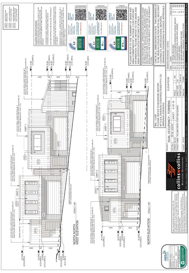
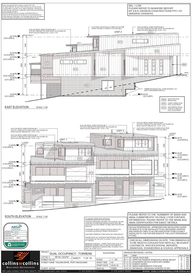
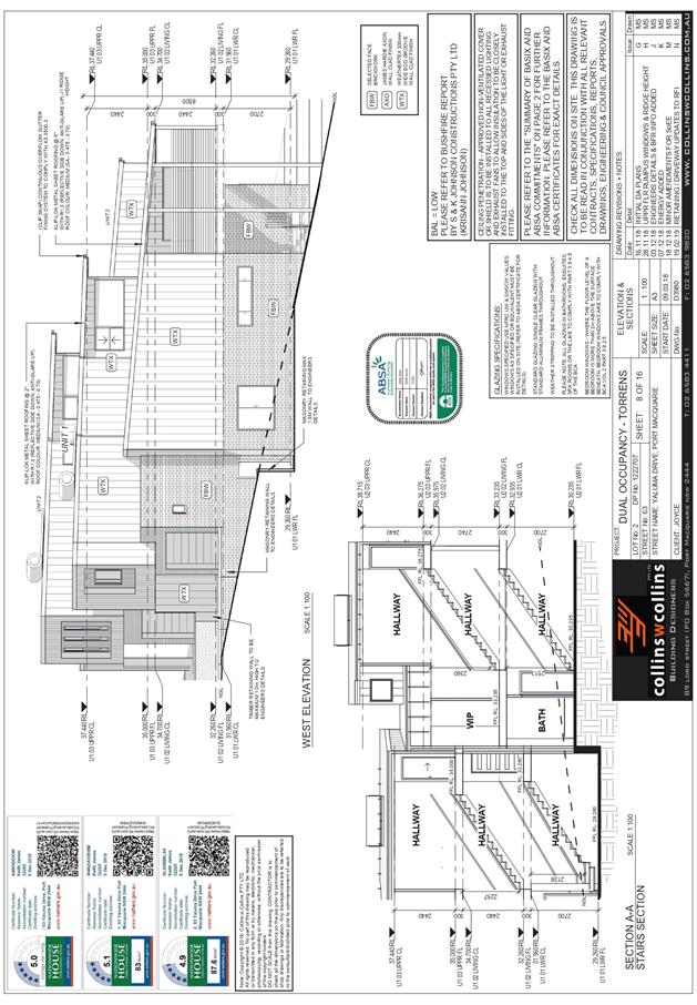
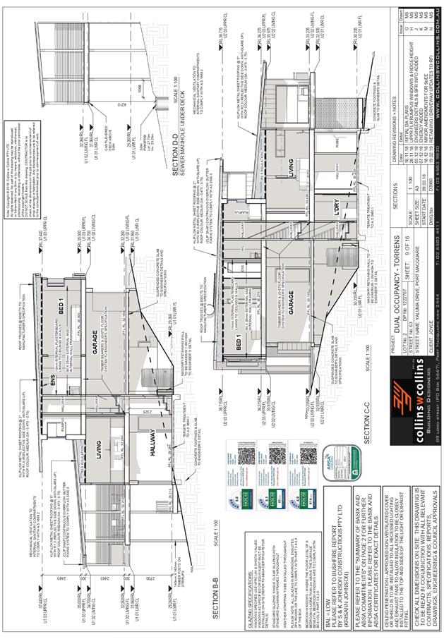
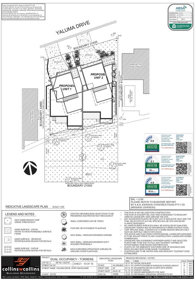
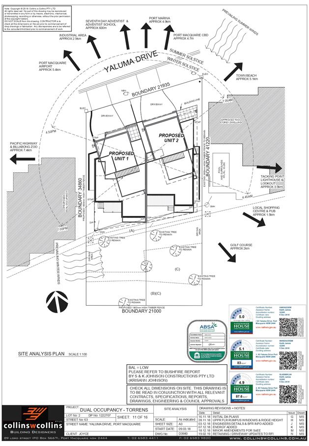
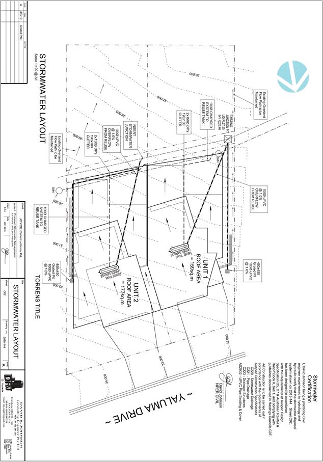
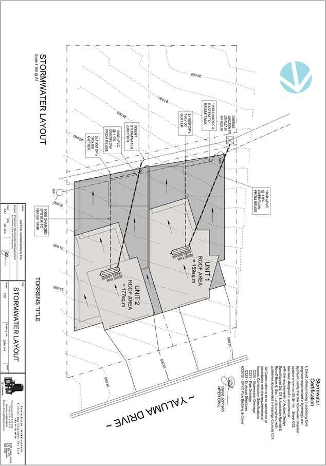
|
ATTACHMENT
|
Development Assessment Panel
24/04/2019
|