Business
Paper
|
date of meeting:
|
|
Wednesday 22 May
2019
|
|
location:
|
|
Function Room
Port
Macquarie-Hastings Council
17 Burrawan Street
Port Macquarie
|
|
time:
|
|
2:00pm
|
Development
Assessment Panel
CHARTER
1.0 OBJECTIVES
To assist in managing Council's development assessment
function by providing independent and expert determinations of development
applications that fall outside of staff delegations.
2.0 KEY FUNCTIONS
·
To review development application reports and conditions;
·
To determine development
applications outside of staff delegations;
·
To refer development applications
to Council for determination where necessary;
·
To provide a forum for objectors and applicants
to make submissions on applications
before the Development Assessment Panel
(DAP);
·
To maintain transparency in the determination of development
applications.
Delegated Authority of Panel
Pursuant to
Section 377 of the Local Government Act, 1993 delegation to:
·
Determine development applications under Part 4
of the Environmental Planning and Assessment
Act 1979 having
regard to the relevant environmental planning instruments,
development control plans and Council policies.
·
Vary, modify or release restrictions as to use
and/or covenants created by Section 88B instruments under the Conveyancing Act
1919 in relation to development applications for subdivisions being considered
by the panel.
·
Determine Koala Plans of Management under State
Environmental Planning Policy 44 - Koala Habitat Protection associated with
development applications being considered by the Panel.
Noting the trigger to escalate
decision making to Council as highlighted in section 5.2.
3.0
MEMBERSHIP
3.1
Voting
Members
·
Two independent external members. One of the
independent external members to be the Chairperson.
·
Group Manager Development Assessment (alternate
- Director Development & Environment or Development Assessment Planner)
The independent external members shall have expertise in
one or more of the following areas: planning, architecture, heritage, the
environment, urban design, economics, traffic and transport, law, engineering,
government and public administration.
3.2
Non-Voting Members
·
Not applicable
3.3 Obligations
of members
·
Members must act faithfully and diligently and
in accordance with this Charter.
·
Members must comply with Council's Code of Conduct.
·
Except as required to properly perform their
duties, DAP members must not
disclose any confidential information (as advised by Council) obtained in connection with the DAP functions.
·
Members will have read and be familiar with the
documents and information provided by Council prior
to attending a DAP meeting.
·
Members must act in accordance with Council's
Workplace Health and Safety Policies and Procedures
·
External members of the Panel are not authorised
to speak to the media on behalf of Council. Council officers that are members
of the Committee are bound by the
existing operational delegations in relation to speaking to the media.
·
Staff members shall not vote on matters before
the Panel if they have been the principle author of the development assessment report.
3.4
Member Tenure
·
The independent external members will be
appointed for the term of four (4) years
maximum in which the end of the tenure of these members would occur in a
cascading arrangement.
3.5 Appointment
of members
·
The independent external members (including the
Chair) shall be appointed by the General Manager following an external
Expression of Interest process.
·
Staff members of the Panel are in accordance
with this Charter.
4.0 TIMETABLE
OF MEETINGS
·
The Development Assessment Panel will generally
meet on the 1st and 3rd Wednesday each month at 2.00pm at the Port Macquarie
offices of Council.
·
Special Meetings of the Panel may be convened by
the Director Development & Environment Services with three (3) days notice.
5.0
MEETING PRACTICES
5.1
Meeting
Format
·
At all Meetings of the Panel the Chairperson
shall occupy the Chair and preside. The Chair will be responsible for keeping
of order at meetings.
·
Meetings shall be open to the public.
·
The Panel will hear from applicants
and objectors or their r e p r e s e n t a t i v e s .
·
Where considered necessary, the Panel will
conduct site inspections which will
be open to the public.
5.2
Decision Making
·
Decisions are to be made by consensus. Where
consensus is not possible on any item, that item is to be referred to Council
for a decision.
·
All development applications involving a
proposed variation to a development standard
greater than 10% under Clause
4.6 of the Local Environmental Plan will be
considered by the Panel and recommendation made to the Council for a decision.
5.3
Quorum
·
All members (2 independent external members and
1 staff member) must be present at a
meeting to form a quorum.
5.4
Chairperson and Deputy Chairperson
·
Independent Chair (alternate, second independent member)
5.5
Secretariat
·
The Director Development &n Environment is
to be responsible for ensuring that the Panel has adequate secretariat support.
The secretariat will ensure that the business paper and supporting papers are
circulated at least three (3) days prior to
each meeting. Minutes shall be appropriately approved and circulated to each
member within three (3) weeks of a meeting being held.
·
The format of and the preparation and publishing
of the Business Paper and Minutes shall be similar to the format for Ordinary
Council Meetings.
5.6
Recording of decisions
·
Minutes will record decisions and how each
member votes for each item before the Panel.
6.0 CONVENING
OF “OUTCOME SPECIFIC” WORKING GROUPS
Not applicable.
7.0 CONFIDENTIALITY
AND CONFLICT OF INTEREST
·
Members of the Panel must comply with the
applicable provisions of Council’s Code of Conduct. It is the personal
responsibility of members to comply with the standards in the Code of Conduct
and regularly review their personal circumstances with this in mind.
·
Panel members must declare any conflict of
interests at the start of each meeting or before discussion of a relevant item
or topic. Details of any conflicts of interest should be appropriately minuted.
Where members are deemed to have a real or perceived conflict of interest, it
may be appropriate they be excused from deliberations on the issue where the
conflict of interest may exist. A Panel meeting may be postponed where there is
no quorum.
8.0 LOBBYING
·
All members and applicants are to adhere to Council’s
Lobbying policy. Outside of
scheduled Development Assessment Panel meetings, applicants, their
representatives, Councillors, Council staff and the general public are not to
lobby Panel members via meetings, telephone conversations, correspondence and
the like. Adequate opportunity will be provided at Panel inspections or
meetings for applicants, their representatives and the general public to make
verbal submissions in relation to Business Paper items.
Development Assessment Panel
ATTENDANCE
REGISTER
|
Member
|
27/02/19
|
13/03/19
|
27/03/19
|
10/04/19
|
24/04/19
|
|
Paul Drake
|
P
|
P
|
P
|
P
|
P
|
|
Robert Hussey
|
P
|
|
P
|
A
|
P
|
|
David Crofts
(alternate member)
|
|
P
|
|
P
|
|
|
Dan Croft
(Acting Director
Development & Environment)
Clinton Tink
(Acting GM Development
Assessment
(alternates)
- Director Development & Environment
- Development Assessment Planner
|
P
|
P
|
P
|
P
|
P
|
Key: P = Present
A
= Absent With Apology
X
= Absent Without Apology
Development
Assessment Panel Meeting
Wednesday 22 May 2019
Items of Business
01 Acknowledgement
of Country............................................................................. 8
02 Apologies.......................................................................................................... 8
03 Confirmation
of Minutes..................................................................................... 8
04 Disclosures
of Interest....................................................................................... 9
05 DA2019
- 213.1 Dwelling Lot 144 DP 1230897, No. 4 Shore Break Crescent, Lake Cathie...................................................................................................................... 13
06 DA2018
- 353.1 Commercial Premises and Tourist and Visitor Accommodation with Clause
4.6 Variation to Clause 4.3 (Height of Buildings) and Clause 4.4 (Floor Space
Ratio) of the Port Macquarie-Hastings Local Environmental Plan 2011 at Lot 123
DP 1219042, No. 17 Clarence Street, Port Macquarie..................................................................................... 32
07 DA2018
- 427.1 Dual Occupancy and Torrens Title Subdivision, Boat Ramps and Jetty at
Lot 7 DP 246284, No. 14 Sirius Close, Port Macquarie............................................. 279
08 DA2019
- 27.1 Permanent Group Home - Lot 31 DP 1190016, No. 5 McGilvray Road, Bonny
Hills..................................................................................................................... 308
09 DA2018
- 641.1 Additions to Existing Building and Change of Use to Commercial Premises
- Lots 1 & 2 DP 3749 No.150 Nancy Bird Walton Drive, Kew...................................... 411
10 General
Business
AGENDA Development Assessment Panel 22/05/2019
Subject: ACKNOWLEDGEMENT
OF COUNTRY
"I acknowledge that we are
gathered on Birpai Land. I pay respect to the Birpai Elders both past and
present. I also extend that respect to all other Aboriginal and Torres Strait
Islander people present."
RECOMMENDATION
That the apologies received be
accepted.
Subject: CONFIRMATION
OF PREVIOUS MINUTES
Recommendation
That the Minutes of the Development
Assessment Panel Meeting held on 8 May 2019 be confirmed.
AGENDA Development Assessment Panel 22/05/2019
Subject: DISCLOSURES
OF INTEREST
RECOMMENDATION
That Disclosures of Interest be presented
DISCLOSURE OF
INTEREST DECLARATION
Name of Meeting: ………………………………………………………………………..
Meeting Date: ………………………………………………………………………..
Item Number: ………………………………………………………………………..
Subject: ………………………………………………………………………..
…………………………………………………….……………...…..
I,
.....................................................................................
declare the following interest:
 Pecuniary:
Take
no part in the consideration and voting and be out of sight of the meeting.
Non-Pecuniary
- Significant Interest:
Take
no part in the consideration and voting and be out of sight of the meeting.
Non-Pecuniary
- Less than Significant Interest:
May
participate in consideration and voting.
For the reason that:
....................................................................................................
.......................................................................................................................................
Name:
…………………………………………………….
Signed:
.........................................................................
Date: ..................................
 (Further
explanation is provided on the next page)
(Further
explanation is provided on the next page)
Further
Explanation
(Local Government Act and Code of Conduct)
A conflict of interest exists where a reasonable and informed
person would perceive that a Council official could be influenced by a private
interest when carrying out their public duty. Interests can be of two types:
pecuniary or non-pecuniary.
All interests, whether pecuniary or non-pecuniary are required to
be fully disclosed and in writing.
Pecuniary Interest
A pecuniary interest is an interest that a Council official has in
a matter because of a reasonable likelihood or expectation of appreciable
financial gain or loss to the Council official. (section 442)
A Council official will also be taken to have a pecuniary interest
in a matter if that Council official’s spouse or de facto partner or a
relative of the Council official or a partner or employer of the Council
official, or a company or other body of which the Council official, or a
nominee, partner or employer of the Council official is a member, has a
pecuniary interest in the matter. (section 443)
The Council official must not take part in the consideration or
voting on the matter and leave and be out of sight of the meeting. The
Council official must not be present at, or in sight of, the meeting of
the Council at any time during which the matter is being considered or
discussed, or at any time during which the council is voting on any question in
relation to the matter. (section 451)
Non-Pecuniary
A non-pecuniary interest is an interest that is private or
personal that the Council official has that does not amount to a pecuniary
interest as defined in the Act.
Non-pecuniary interests commonly arise out of family, or personal
relationships, or involvement in sporting, social or other cultural groups and
associations and may include an interest of a financial nature.
The political views of a Councillor do not constitute a private
interest.
The management of a non-pecuniary interest will depend on whether
or not it is significant.
Non Pecuniary – Significant Interest
As a general rule, a non-pecuniary conflict of interest will be
significant where a matter does not raise a pecuniary interest, but it
involves:
(a)
A relationship between
a Council official and another person that is particularly close, for example,
parent, grandparent, brother, sister, uncle, aunt, nephew, niece, lineal
descendant or adopted child of the Council official or of the Council official’s
spouse, current or former spouse or partner, de facto or other person living in
the same household.
(b)
Other relationships
that are particularly close, such as friendships and business relationships.
Closeness is defined by the nature of the friendship or business relationship,
the frequency of contact and the duration of the friendship or relationship.
(c)
An affiliation between
a Council official an organisation, sporting body, club, corporation or
association that is particularly strong.
If a Council official declares a non-pecuniary significant
interest it must be managed in one of two ways:
1.
Remove the source of
the conflict, by relinquishing or divesting the interest that creates the
conflict, or reallocating the conflicting duties to another Council official.
2.
Have no involvement in
the matter, by taking no part in the consideration or voting on the matter and
leave and be out of sight of the meeting, as if the provisions in section
451(2) apply.
Non Pecuniary – Less than Significant Interest
If a Council official has declared a non-pecuniary less than
significant interest and it does not require further action, they must provide
an explanation of why they consider that the conflict does not require further
action in the circumstances.
SPECIAL
DISCLOSURE OF PECUNIARY INTEREST DECLARATION
|
By
[insert full name of councillor]
|
|
|
In the
matter of
[insert name of environmental planning instrument]
|
|
|
Which is
to be considered at a meeting of the
[insert name of meeting]
|
|
|
Held on
[insert date of meeting]
|
|
|
PECUNIARY
INTEREST
|
|
Address of land in which councillor or an
associated person, company or body has a proprietary interest (the identified
land)i
|
|
|
Relationship of identified land to councillor
[Tick or cross one box.]
|
Councillor
has interest in the land (e.g. is owner or has other interest arising out of
a mortgage, lease trust, option or contract, or otherwise).
Associated
person of councillor has interest in the land.
Associated
company or body of councillor has interest in the land.
|
|
MATTER
GIVING RISE TO PECUNIARY INTEREST
|
|
Nature of land that is subject to a change
in zone/planning control by proposed
LEP (the subject land iii
[Tick or cross one box]
|
The
identified land.
Land
that adjoins or is adjacent to or is in proximity to the identified land.
|
|
Current zone/planning control
[Insert name of current planning instrument and
identify relevant zone/planning control applying to the subject land]
|
|
|
Proposed change of zone/planning control
[Insert name of proposed LEP and identify
proposed change of zone/planning control applying to the subject land]
|
|
|
Effect of proposed change of zone/planning control
on councillor
[Tick or cross one box]
|
Appreciable
financial gain.
Appreciable
financial loss.
|
|
|
|
Councillor’s
Name: …………………………………………
Councillor’s
Signature:
……………………………….
Date: ………………..
Important Information
This information is being
collected for the purpose of making a special disclosure of pecuniary interests
under sections 451 (4) and (5) of the Local Government Act 1993.
You must not make a special disclosure that you know or ought reasonably to
know is false or misleading in a material particular. Complaints made
about contraventions of these requirements may be referred by the
Director-General to the Local Government Pecuniary Interest and Disciplinary
Tribunal.
This form must be completed by
you before the commencement of the council or council committee meeting in
respect of which the special disclosure is being made. The
completed form must be tabled at the meeting. Everyone is entitled to
inspect it. The special disclosure must be recorded in the minutes of the
meeting.
i.
Section 443 (1) of the Local Government Act 1993 provides that
you may have a pecuniary interest in a matter because of the pecuniary interest
of your spouse or your de facto partner or your relativeiv or
because your business partner or employer has a pecuniary interest. You may
also have a pecuniary interest in a matter because you, your nominee, your
business partner or your employer is a member of a company or other body that
has a pecuniary interest in the matter.
ii.
Section 442 of the Local Government Act 1993 provides that a pecuniary
interest is an interest that a person has in a matter because of a
reasonable likelihood or expectation of appreciable financial gain or loss to
the person. A person does not have a pecuniary interest in a matter if the
interest is so remote or insignificant that it could not reasonably be regarded
as likely to influence any decision the person might make in relation to the
matter or if the interest is of a kind specified in section 448 of that
Act (for example, an interest as an elector or as a ratepayer or person liable
to pay a charge).
iii.
A pecuniary interest may arise by way of a change of permissible use of land
adjoining, adjacent to or in proximity to land in which a councillor or a
person, company or body referred to in section 443 (1) (b) or (c) of the
Local Government Act 1993 has a proprietary interest..
iv.
Relative is defined by the Local Government Act 1993 as
meaning your, your spouse’s or your de facto partner’s parent,
grandparent, brother, sister, uncle, aunt, nephew, niece, lineal descendant or
adopted child and the spouse or de facto partner of any of those persons.
AGENDA Development Assessment Panel 22/05/2019
Item: 05
Subject: DA2019 - 213.1 Dwelling Lot 144 DP 1230897,
No. 4 Shore Break Crescent, Lake Cathie
Report
Author: Development Assessment Planner, Robert Slater
|
Applicant: Matto
Luke Corp Pty Ltd
Owner: W
M Owen & S A Lievore
Estimated Cost: $305,214
Alignment with Delivery
Program
4.3.1 Undertake transparent
and efficient development assessment in accordance with relevant legislation.
|
|
RECOMMENDATION
That
DA 2019 - 213.1 for a dwelling at Lot 144, DP 1230897, No.
4 Shore Break Crescent, Lake Cathie, be
determined by granting consent subject to the recommended conditions.
|
Executive
Summary
This
report considers a development application for a two storey dwelling at the subject site and provides an assessment of the
application in accordance with the Environmental Planning and Assessment Act
1979.
Following exhibition of the
application, one (1) submission have been
received.
1. BACKGROUND
Existing sites features and Surrounding development
The site has an area of 493
m2.
The
site is zoned R3 Medium Density Residential in
accordance with the Port Macquarie-Hastings Local Environmental Plan 2011, as
shown in the following zoning plan:
The
existing subdivision pattern and location of existing development within the
locality is shown in the following aerial photograph:
The Seawide estate residential
precinct comprises of a mix of single and two storey dwellings.
Photo 1 - Subject
development site.
2. DESCRIPTION
OF DEVELOPMENT
Key
aspects of the proposal include the following:
· Two
storey dwelling.
Refer
to attachments at the end of this report.
Application
Chronology
· 27/03/2019
- Application lodged
· 29/03/2019 - Application notified
· 10/04/2019 - Submission received
· 24/04//2019 - Site inspection
3. STATUTORY
ASSESSMENT
Section
4.15(1) Matters for Consideration
In determining
the application, Council is required to take into consideration the following
matters as are relevant to the development that apply to the land to which the
development application relates:
(a) The
provisions (where applicable) of:
(i) Any
Environmental Planning Instrument:
State Environmental Planning Policy No. 44 – Koala
Habitat Protection
The Rainbow Beach Koala Plan of Management applies to the
site. The proposal does not require the removal of any koala browse trees and
is not contrary to the plan.
State Environmental Planning Policy No. 55 –
Remediation of Land
Following an inspection of the site and a search of Council
records, the subject land is not identified as being potentially contaminated
and is suitable for the intended use.
State Environmental Planning Policy (Coastal Management)
2018
The site is located within a coastal use area / coastal
environment area.
Having regard to clauses 11 of the SEPP the proposed
development is on land identified as “proximity area” for coastal
wetlands. The proposed residential development is not considered likely
to result in any of the following:
(a) any adverse impact on the
biophysical, hydrological or ecological integrity of the adjacent coastal
wetland or littoral rainforest, or
(b) any adverse impact on
the quantity and quality of surface and ground water flows to and from the
adjacent coastal wetland or littoral rainforest.
The proposed stormwater
management measures are considered to be adequate to direct roof and surface
waters from the site to the existing street stormwater infrastructure
Having regard to clauses 13 and 14 of the SEPP the proposed
development is not considered likely to result in any of the following:
a) adverse
impact on integrity and resilience of the biophysical,
hydrological (surface and groundwater) and ecological environment;
b) adverse
impacts coastal environmental values and natural coastal
processes;
c) adverse
impacts on marine vegetation, native vegetation and fauna and
their habitats, undeveloped headlands and rock platforms;
d) adverse
impact on marine vegetation, native vegetation and fauna and
their habitats, undeveloped headlands and rock platforms;
e) adverse
impact on Aboriginal cultural heritage, practices and places;
f) adverse
impacts on the cultural and built environment heritage;
g) adverse
impacts the use of the surf zone;
h) adverse impact on the visual amenity and scenic qualities of the coast,
including coastal headlands;
i) overshadowing, wind funnelling and the loss of views from public places
to foreshores;
j) adverse
impacts on existing public open space and safe access to and
along the foreshore, beach, headland or rock platform for members of the
public, including persons with a disability;
The bulk, scale and size of the proposed development is
compatible with the surrounding coastal and built environment. The site is
predominately cleared and located within an area zoned for residential
purposes.
State Environmental Planning Policy (Building Sustainability
Index: BASIX) 2004
A BASIX certificate has been submitted demonstrating that
the proposal will comply with the requirements of the SEPP. It is recommended
that a condition be imposed to ensure that the commitments are incorporated
into the development and certified at Occupation Certificate stage.
State Environmental Planning Policy (Infrastructure) 2007
Clause 101 refers to development with frontage to a
classified road. In this case, the proposed development does not have frontage
to a classified road or create any additional crossovers onto the classified
road or substantial increase in traffic. Therefore, no adverse impact on the
road network will occur
In terms of road traffic noise impacts, the proposed two
storey dwelling is impacted by road traffic noise intrusion and therefore the
property is burdened by a restriction on the use of the land requiring that
category 2 construction measures be incorporated into its design to achieve the
acceptable daytime and night time noise levels contained within AS/NZS
2107:2000 - Acoustics - Recommended design sound levels and reverberation times
for building interiors. Conditions of consent are recommended to achieve
compliance with this standard.
Port Macquarie-Hastings Local Environmental
Plan 2011
The proposal is consistent with the LEP having regard to the
following:
In accordance with Clause 2.2, the
subject site is zoned R3 Medium Density Residential. In accordance with clause
2.3(1) and the R3 zone landuse table, the dwelling is a permissible landuse
with consent.
The objectives of the R1 zone are
as follows:
· To
provide for the housing needs of the community within a medium density
residential environment.
· To
provide a variety of housing types within a medium density residential
environment.
· To
enable other land uses that provide facilities or services to meet the day to
day needs of residents.
·
Clause 2.3(2) - The proposal is consistent with
the zone objectives as it is a permissible landuse and consistent with the
established residential locality. Whilst the development is not considered to
represent medium density, the proposal is consistent with single dwellings in
the immediate proximity of the site.
·
Clause 4.3 - The maximum overall height of the
building above ground level (existing) is approximately 7.2m which complies
with the standard height limit of 11.5m applying to the site.
·
Clause 4.4 - The floor space ratio of the
proposal is 0.37:1 which complies with the maximum 1.0:1 floor space ratio
applying to the site.
·
Clause 7.9 - The development is subject to
acoustic controls due to road traffic noise intrusion.
·
Clause 7.13 - Satisfactory arrangements
are in place for provision of essential services including water supply,
electricity supply, sewer infrastructure, stormwater drainage and suitable road
access to service the development.
Port Macquarie-Hastings Development Control Plan 2013:
|
DCP 2013: Dwellings, Dual
occupancies, Dwelling houses, Multi dwelling houses & Ancillary
development
|
|
|
Requirements
|
Proposed
|
Complies
|
|
3.2.2.2
|
Articulation zone:
• Min. 3m front
setback
• An entry feature
or portico
• A balcony, deck,
patio, pergola, terrace or verandah
• A window box
treatment
• A bay window or
similar feature
• An awning or other
feature over a window
• A sun shading feature
|
The verandah does not exceed 25% of the articulation zone,
however it encroaches into the 3.0m front setback. Also a slab extension
encroaches into the articulation zone.
|
No*
|
|
Front setback (Residential not R5
zone):
• Min. 6.0m
classified road
• Min. 4.5m local
road
• Min. 3.0m
secondary road
• Min. 2.0m Laneway
|
Front building line setback is
compliant with the minimum 4.5m front setback requirements.
|
No*
|
|
3.2.2.3
|
Garage 5.5m min. and 1m behind
front façade.
Garage door recessed behind building
line or eaves/overhangs provided
|
Garage door setback is compliant
with the minimum front setback requirements.
Garage door recessed.
|
Yes
|
|
6m max. width of garage door/s
and 50% max. width of building
|
Width of garage door/s are
compliant with the maximum width requirements
|
Yes
|
|
Driveway crossover 1/3 max. of
site frontage and max. 5.0m width
|
Driveway crossing/s width are
compliant with the maximum width requirements
|
Yes
|
|
3.2.2.4
|
4m min. rear setback. Variation
subject to site analysis and provision of private open space
|
The rear setback requirements are
complied with.
|
Yes
|
|
3.2.2.5
|
Side setbacks:
• Ground floor =
min. 0.9m
• First floors &
above = min. 3m setback or where it can be demonstrated that overshadowing
not adverse = 0.9m min.
• Building wall set
in and out every 12m by 0.5m
|
The minimum side setback
requirements are complied with.
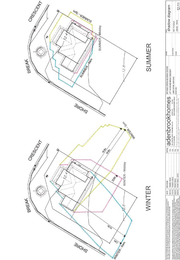
The upper floor side (NE) setback
is proposed to be less than 3m and the Applicant has submitted shadow
diagrams demonstrating that building additions would not overshadow primary
living areas or private open space for more than 3 hours between 9.00am and
3.00pm on 21 June.
The building wall articulation is
compliant.
|
Yes
No. Refer to comments below *
Yes
|
|
3.2.2.6
|
35m2 min. private open space area
including a useable 4x4m min. area which has 5% max. grade
|
The dwelling contains 35m²
open space in one area including a useable 4m x 4m space.
|
Yes
|
|
3.2.2.10
|
Privacy:
• Direct views
between living areas of adjacent dwellings screened when within 9m radius of
any part of window of adjacent dwelling and within 12m of private open space
areas of adjacent dwellings. i.e. 1.8m fence or privacy screening which has
25% max. openings and is permanently fixed
• Privacy screen
required if floor level > 1m height, window side/rear setback (other than
bedroom) is less than 3m and sill height less than 1.5m
• Privacy screens
provided to balconies/verandahs etc which have <3m side/rear setback and
floor level height >1m
|
The development will not compromise privacy to the
adjoining properties due to a combination of minimising windows on side/rear
boundaries, having high sill windows that face side/rear boundaries, limiting
living areas that face adjoining living areas/open space, compliant separation
and use of 1.8m high boundary fencing.
No privacy screens are proposed.
|
Yes
|
|
DCP 2013: General
Provisions
|
|
|
Requirements
|
Proposed
|
Complies
|
|
2.7.2.2
|
Design addresses generic principles of Crime Prevention
Through Environmental Design guideline
|
No concealment or entrapment areas proposed. Adequate
casual surveillance available.
|
Yes
|
|
2.3.3.1
|
Cut and fill 1.0m max. 1m outside the perimeter of the
external building walls
|
Cut and fill <1.0m change 1m outside the perimeter of
the external building walls
|
Yes
|
|
2.3.3.2
|
1m max. height retaining walls along road frontage
|
None proposed
|
N/A
|
|
Any retaining wall >1.0 in height to be certified by
structure engineer
|
No retaining walls likely >1m
|
Yes
|
|
Combination of retaining wall and front fence height max
1.8m, max length 6.0m or 30% of frontage, fence component 25% transparent,
and splay at corners and adjacent to driveway
|
No retaining wall front fence combination proposed.
|
N/A
|
|
2.3.3.8
|
Removal of hollow bearing trees
|
No trees proposed to be removed
|
N/A
|
|
2.6.3.1
|
Tree removal (3m or higher with 100m diameter trunk at 1m
above ground level and 3m from external wall of existing dwelling)
|
No trees proposed to be removed
|
N/A
|
|
2.4.3
|
Bushfire risk, Acid sulphate soils, Flooding,
Contamination, Airspace protection, Noise and Stormwater
|
Refer to main body of report.
|
|
|
2.5.3.2
|
New accesses not permitted from arterial or distributor
roads
|
No new access proposed to arterial or distribution road.
|
N/A
|
|
Driveway crossing/s minimal in number and width including maximising
street parking
|
Driveway crossing minimal in width including maximising
street parking
|
Yes
|
|
2.5.3.3
|
Parking in accordance with Table 2.5.1.
1 space per single dwelling (behind building line)
|
1 or capacity for more than 1 parking space behind the building
line has been provided for.
|
Yes
|
|
2.5.3.11
|
Section 94 contributions
|
Refer to main body of report.
|
|
|
2.5.3.12 and 2.5.3.13
|
Landscaping of parking areas
|
Single dwelling only with 1 domestic driveway. No specific
landscaping requirements recommended.
|
N/A
|
|
2.5.3.14
|
Sealed driveway surfaces unless justified
|
Sealed driveway proposed
|
Yes
|
|
2.5.3.15 and 2.5.3.16
|
Driveway grades first 6m or ‘parking area’
shall be 5% grade with transitions of 2m length
|
Driveway grades capable of satisfying Council standard
driveway crossover requirements. Condition recommended for section 138 Roads
Act permit
|
Yes
|
|
2.5.3.17
|
Parking areas to be designed to avoid concentrations of
water runoff on the surface.
|
Single dwelling only with 1 domestic driveway. Stormwater
drainage is capable of being managed as part of plumbing construction.
|
Yes
|
|
|
|
|
|
|
The proposal seeks to vary
Development Provision 3.2.2.2 which provides that dwellings may incorporate an
articulation zone to a street frontage at no less than 3m from the property
boundary. The applicant proposes encroachments into the zone as follows:
|
Building Element
|
Proposed Setback (minimum)
|
Encroachment
|
|
NW: cnr bwk Front verandah
|
2.51m
|
490mm
|
|
NW: slab extension
|
800mm
|
2.20m
|
The relevant objectives are that
front setbacks should support an attractive
streetscape
Having regard for the development provisions and relevant
objectives, the variation is considered acceptable for the following reasons:
· The
proposed verandah encroachment is due to the site being constrained by a
splayed front boundary. The encroachment is considered to be minor in nature
and the applicant has adequately demonstrated through the built design that the
encroachment will not have a detrimental impact on the streetscape.
· The
slab extension encroachment while significant is expected not to have a
detrimental impact on the streetscape. It is recommended that a condition be
placed on the consent that the slab extension not be further enclosed or roofed
without the prior written consent of port Macquarie Hastings Council.
The proposal seeks to vary
Development Provision 3.2.2.2 which provides that primary and secondary front
setbacks to dwellings should be 4.5m and 3.0m respectively. The applicant proposes
encroachments into the primary setback to the extent of 1.49m and 1.35m at the
north west corner of the proposed dwelling. The encroaching building elements
include the stair void and the family room respectively.
Having regard to the development provisions and relevant
objectives, the variation is considered acceptable for the following reasons:
· The
site is constrained by a partial splay in the front boundary line and the
proposed development has frontage to a curvature in the road reserve.
· Although
technically the development site is not a corner block that would be subject to
a secondary frontage, the proposed setbacks are compliant with the minimum
secondary frontage requirements.
· The
applicant has adequately demonstrated that the proposed encroachments will have
minimal impact on the streetscape.
The proposal seeks to vary Development 3.2.2.5 which
provides the first floors and above should be setback minimum of 3m from the
side boundary or reduced down to 900mm where it can be demonstrated that the
adjoining property primary living areas and primary private open space areas
should not be adversely overshadowed for more than 3hrs between 9am-3pm on 21
June.
The applicant proposes a 2.3m first floor setback to the
north-eastern boundary.
The relevant objectives are to
reduce overbearing and perceptions of building bulk on adjoining properties and
to maintain privacy and to provide for visual and acoustic privacy between
buildings.
Having regard to the development provisions and relevant
objectives, the variation is considered acceptable for the following reasons:
· The
upper floor side setback is proposed to be 2.3m which is less than 3m and the
Applicant has submitted shadow diagrams demonstrating that the proposed
dwelling would not adversely overshadow primary living areas or private open
space of the adjoining property (currently vacant) for more than 3 hours
between 9.00am and 3.00pm on 21 June.
Based on the
above assessment, the variations proposed to the provisions of the DCP are
considered acceptable and the relevant objectives have been satisfied.
Cumulatively, the variations do not amount to an adverse
impact or a significance that would justify refusal of the application.
(iiia) Any
planning agreement that has been entered into under section 7.4, or any draft
planning agreement that a developer has offered to enter into under section
7.4:
No planning agreement has been offered or entered into
relating to the site.
(iv) Any matters prescribed by the
Regulations:
Demolition of buildings AS 2601 – Clause 92
No demolition is required and therefore the clause does not
apply.
(b) The likely
impacts of that development, including environmental impacts on both the
natural and built environments and the social and economic impacts in the
locality
· The proposal is
unlikely to have any adverse impacts to existing adjoining properties and
satisfactorily addresses the public domain.
· The proposal is
considered to be compatible with other residential development in the locality
and adequately addresses planning controls for the area.
· The proposal does
not have a significant adverse impact on existing view sharing.
· The proposal does
not have significant adverse lighting impacts.
· There are no
significant adverse privacy impacts.
· There are no
significant adverse overshadowing impacts. The proposal does not prevent
adjoining properties from receiving 3 hours of sunlight to private open space
and primary living areas on 21 June.
Access, Traffic and Transport
The proposal is unlikely to have any adverse impacts in
terms access, transport and traffic. The existing road network will
satisfactorily cater for any increase in traffic generation as a result of the
development.
Water Supply Connection
Service available – details required with S.68
application.
Sewer Connection
Service available – details required with S.68
application.
Stormwater
Service available – details required with S.68
application.
Other Utilities
Telecommunication and electricity services are available to
the site.
Heritage
This site does not contain or adjoin any known heritage item
or site of significance.
Other land resources
The site is within an established urban context and will not
sterilise any significant mineral or agricultural resource.
Water cycle
The proposed development is unlikely to have any adverse
impacts on water resources and the water cycle.
Soils
The proposed development is unlikely to have any adverse
impacts on soils in terms of quality, erosion, stability and/or productivity
subject to a standard condition requiring erosion and sediment controls to be
in place prior to and during construction.
Air and microclimate
The construction and/or operations of the proposed
development is unlikely to result in any adverse impacts on the existing air
quality or result in any pollution. Standard precautionary site management
condition recommended.
Flora and fauna
Construction of the proposed development will not require
any removal/clearing of any native vegetation and therefore does not trigger
the biodiversity offsets scheme. Part 7 of the Biodiversity Conservation
Act 2016 is considered to be satisfied.
Waste
Satisfactory arrangements are in place for proposed storage
and collection of waste and recyclables. No adverse impacts anticipated.
Standard precautionary site management condition is recommended.
Energy
The proposal includes measures to address energy efficiency
and will be required to comply with the requirements of BASIX.
Noise and vibration
No adverse impacts anticipated. Condition recommended to
restrict construction to standard construction hours.
Bushfire
The site is identified as being bushfire prone.
An assessment of bushfire risk having regard to section
4.3.5 of Planning for Bushfire Protection 2006 including vegetation
classification and slope concludes that a Bushfire Attack Level 12.5 shall be
required.
Management of bushfire risk is acceptable subject to BAL
construction levels being implemented and APZ being maintained. An appropriate
condition is recommended.
Safety, security and crime prevention
The proposed development is unlikely to create any
concealment/entrapment areas or crime spots that would result in any
identifiable loss of safety or reduction of security in the immediate area. The
increase in housing density will improve natural surveillance within the
locality and openings from each dwelling overlook common and private areas.
Social impacts in the locality
Given the nature of the proposed development and its’
location the proposal will not result in any adverse social impacts.
Economic impact in the locality
No adverse impacts. A likely positive impact is that the
development will maintain employment in the construction industry, which will
lead to flow impacts such as expenditure in the area.
Site design and internal design
The proposed development design satisfactorily responds to
the site attributes and will fit into the locality. No adverse impacts.
Construction
Construction impacts are capable of being managed. Standard
site management conditions recommended.
Cumulative impacts
The proposed development is
not anticipated to have any adverse cumulative impacts on the natural or built
environment or the social and economic attributes of the locality.
(c) The suitability of the site for the development
The
site is considered to be suitable for the proposed development and the
variations proposed to the DCP have been appropriately justified
Site constraints have been
adequately addressed and appropriate conditions of consent recommended.
(d) Any submissions made in accordance with this Act
or the regulations
Following exhibition of the application in accordance with
DCP 2013, one submission was received.
Key
issues raised in the submission and comments in response to these issues are
provided as follows:
|
Submission
Issue/Summary
|
Planning
Comment/Response
|
|
Overshadowing of our private open space and alfresco
areas
|
Background:
The dwelling under construction at 16 Summer Circuit has
a rear boundary setback of 5.1.5m, while the alfresco area (recessed) has a
rear boundary setback of approximately 6.7m.
The subject two storey dwelling is situated 16.0m off the
common boundary. This is compliant with the numerical standard requirement of
the DCP, being 4.0m.
The applicant has demonstrated that the impact is
acceptable and that the POS and primary living areas will receive adequate
natural light and ventilation and receive a minimum of 3 hours of sunlight
between the hours of 9am and 3pm on the 21st June.
|
|
Detrimental effect on privacy
|
There is no requirement for the windows on the ground and
first floor to be obscured or screened as the windows are not situated within
a 9m radius from any part of a window of the dwelling at 16 Summer Circuit.
The proposed rear boundary setback is approximately 16.0m
Additionally, although setback 16.0m from the rear
boundary, the applicant has substituted the first floor living room
(child’s retreat) window facing the rear boundary with a highlight
window having a sill height of 1.5m.
Any direct views from the ground floor will be adequately
reduced by the proposed 1.8m high boundary fence.
The applicant has demonstrated that the design and siting
of the proposed two storey dwelling does not have direct views between primary
indoor and outdoor living areas meets the objective of protecting the visual
privacy on-site and nearby residents.
|
(e) The Public Interest:
The proposed
development satisfies relevant planning controls and will not adversely impact
on the wider public interest.
4. DEVELOPMENT
CONTRIBUTIONS APPLICABLE
N/A
5. CONCLUSION
AND STATEMENT OF REASON
The application has been assessed in accordance with Section
4.15 of the Environmental Planning and Assessment Act 1979.
Issues raised during assessment and public exhibition of the
application have been considered in the assessment of the application. Where
relevant, conditions have been recommended to manage the impacts attributed to
these issues.
The site is considered suitable for the proposed development
and the proposal adequately addresses relevant planning controls. The
development is not considered to be contrary to the public's interest and will
not result a significant adverse social, environmental or economic impact. It
is recommended that the application be approved, subject to the recommended
conditions of consent provided in the attachment section of this report.
|
Attachments
1View. DA2019
- 213.1 Recommended Conditions
2View. DA2019
- 213.1 Plans
|
|
ATTACHMENT
|
Development Assessment Panel
22/05/2019
|
|
ATTACHMENT
|
Development Assessment Panel
22/05/2019
|
AGENDA Development Assessment Panel 22/05/2019
Item: 06
Subject: DA2018 - 353.1 Commercial Premises and Tourist
and Visitor Accommodation with Clause 4.6 Variation to Clause 4.3 (Height of
Buildings) and Clause 4.4 (Floor Space Ratio) of the Port Macquarie-Hastings
Local Environmental Plan 2011 at Lot 123 DP 1219042, No. 17 Clarence Street,
Port Macquarie
Report
Author: Development Assessment Planner, Benjamin Roberts
|
Applicant: David
Pensini
Owner: Yogi
Bear Holdings Pty Ltd
Estimated Cost: $14,733,000
Alignment with Delivery
Program
4.3.1 Undertake transparent
and efficient development assessment in accordance with relevant legislation.
|
|
RECOMMENDATION
That
DA2018 - 353.1 for a commercial
premises and tourist and visitor accommodation with clause 4.6 variation to
clause 4.3 (Height of Buildings) and clause 4.4 (Floor Space Ratio) of the
Port Macquarie-Hastings Local Environmental Plan 2011 at Lot 123, DP
1219042, No. 17 Clarence Street, Port
Macquarie, be determined by granting consent subject to the recommended
conditions.
|
Executive
Summary
This report considers a
development application for a commercial premises and tourist and
visitor accommodation with clause 4.6 variation to clause 4.3 (Height of
Buildings) and clause 4.4 (Floor Space Ratio) of the Port Macquarie-Hastings
Local Environmental Plan 2011 at the subject site and provides an assessment of
the application in accordance with the Environmental Planning and Assessment
Act 1979.
Following
exhibition of the application, eight (8) submissions have been received.
This
report recommends that the development application be approved subject to
conditions.
1. BACKGROUND
Previous consideration of the
application
In considering the matter, the
Development Assessment Panel on 23 January 2019 was unable to reach consensus
as follows:
Robert Hussey moved the following
motion:
“That DA2018 –
353 be refused on the grounds that:
1. Insufficient on-site car parking has been provided
(deficit of 21 spaces) as required by the Port Macquarie-Hastings Development
Control Plan 2013. In the context of this proposed tourist development located
within an area with time limited parking the public interest would not be well
served by allowing such a significant shortfall in parking spaces on site, or
offsetting this number of spaces via the contribution plan.
2. The proposed turning movements at the reception
area are unreasonably compromised and should be redesigned to avoid regular interruption
to the in-out vehicular movements by the 3-point turn.”
For: Robert Hussey
Against: Paul Drake and Dan Croft.
The dissenting
recommendation was:
“That DA2018 – 353 be deferred to allow
the applicant to readdress non-compliance with development standards and
provide further evidence to support parking provision on site so as to avoid
significant dependence on contribution offsets.”
Given the
Development Assessment Panel was unable to reach consensus at its meeting on 23
January 2019 the matter was reported to Council in accordance with the DAP
charter on 20 February 2019 with the following recommendation from staff:
“That DA2018 - 353 for a
commercial premises and tourist and visitor accommodation with clause 4.6
variation to clause 4.3 (Height of Buildings) and clause 4.4 (Floor Space
Ratio) of the Port Macquarie-Hastings Local Environmental Plan 2011 at Lot 123,
DP 1219042, No. 17 Clarence Street, Port Macquarie, be determined by granting
consent subject to the recommended conditions.”
In considering the matter at its
meeting on 20 February 2019 Council resolved as follows:
RESOLVED:
Intemann/Alley
That
DA2018 – 353 be deferred to allow the applicant to readdress
non-compliance with development standards and provide further car parking
provision on site so as to avoid dependence on parking offsets.
CARRIED:
6/1
FOR:
Alley, Cusato, Dixon, Hawkins, Intemann and Turner
AGAINST: Levido
The
applicant subsequently lodged revised plans on 19 April 2019 to include a
further level of basement parking to the proposed development.
Existing
sites features and Surrounding development
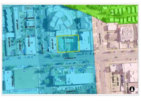
The site has an area of 1518m2.
The
site is zoned B3 Commercial Core in accordance
with the Port Macquarie-Hastings Local Environmental Plan 2011, as shown in the
following zoning plan:
The
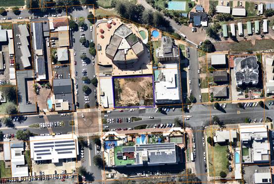
existing subdivision pattern and location of existing development within the
locality is shown in the following aerial photograph:
2. DESCRIPTION
OF DEVELOPMENT
Key
aspects of the proposal include the following:
· Construction of a seven (7) storey building comprising
basement level parking.
· The building will comprise ground floor commercial and
tourist accommodation over levels 1 to 6. Levels 1 to 6 will contain 47
apartments comprising 4 x 3 bed units (with dual key arrangement), 28 x 2 bed
units (with dual key arrangement), 12 x 2 bed units and 3 x 1 bed units. With
the combination of dual key arrangements, the proposal may provide for up to 79
leasable units.
Refer
to attachments at the end of this report.
Application
Chronology
· 16
May 2018 – Application lodged.
· 22
May 2018 – Application placed on hold following applicant advice that
revised plans are to be lodged.
· 25
June 2018 – Revised plans lodged.
· 5 July to 3 August 2018 – Public exhibition via
neighbour notification and advertising.
· 3 July 2018 – Additional information request to
applicant. Building height and off-street parking.
· 6 August 2018 – Additional information request to
applicant. Traffic impact assessment required.
· 25 September 2018 – Additional information response
from applicant addressing building height, parking and traffic requests.
· 23 January 2019 - Consideration by Development Assessment
Panel.
· 20 February 2019 - Consideration by Council.
· 19 April 2019 - Revised plans lodged.
3. STATUTORY
ASSESSMENT
Section
4.15(1) Matters for Consideration
In
determining the application, Council is required to take into consideration the
following matters as are relevant to the development that apply to the land to
which the development application relates:
(a) The
provisions (where applicable) of:
(i) Any
Environmental Planning Instrument:
State
Environmental Planning Policy 55 – Remediation of Land
In accordance with clause 7,
following an inspection of the site and a search of Council records, the
subject land is not identified as being potentially contaminated and is
suitable for the intended use.
State
Environmental Planning Policy 62 - Sustainable Aquaculture
In accordance with clause 15C,
given the nature of the proposed development, proposed stormwater controls and
its’ location, the proposal will be unlikely to have any identifiable
adverse impact on any existing aquaculture industries within the nearby
Hastings River approximately 150m to the north-west from the site.
State Environmental Planning Policy 64 - Advertising and
Signage
There is
no signage proposed as part of the application. Suitable condition has been
recommended advising of consent requirements for future signage.
State
Environmental Planning Policy 65 - Design Quality of Residential Flat
Development
In accordance with clause 4 the
policy does not apply to serviced apartments.
State
Environmental Planning Policy (Coastal Management) 2018
The site is located within the mapped coastal environment
area.
In accordance with clause 7, this SEPP prevails over the
Port Macquarie-Hastings LEP 2011 in the event of any inconsistency.
Having regard to clauses 13 and 14 of the SEPP and clause
5.5 of the Port Macquarie-Hastings LEP 2011 the proposed development is not
considered likely to result in any of the following:
a) any
adverse impact on integrity and resilience of the biophysical,
hydrological (surface and groundwater) and ecological environment;
b) any
adverse impacts coastal environmental values and natural coastal
processes;
c) any
adverse impacts on marine vegetation, native vegetation and fauna
and their habitats, undeveloped headlands and rock platforms;
d) any
adverse impact on marine vegetation, native vegetation and fauna
and their habitats, undeveloped headlands and rock platforms;
e) any
adverse impact on Aboriginal cultural heritage, practices and places;
f) any
adverse impacts on the cultural and built environment heritage;
g) any
adverse impacts the use of the surf zone;
h) any adverse impact on the visual amenity and scenic qualities of the
coast, including coastal headlands;
i) overshadowing, wind funnelling and the loss of views from public places
to foreshores;
The bulk, scale and size of the proposed development is
compatible with the surrounding coastal and built environment. The site is
cleared and located within an area zoned for commercial purposes.
State
Environmental Planning Policy (Building Sustainability Index: BASIX) 2004
In
accordance with clause 7, the proposal is not a BASIX affected building.
Specifically, the definition of a BASIX affected building is as follows:
BASIX affected building means any building that contains
one or more dwellings, but does not include a hotel or motel.
State
Environmental Planning Policy (Infrastructure) 2007
The
proposal is not traffic generating development for the purpose of schedule 3 of
this policy. No referral to Roads and Maritime Services was undertaken.
State
Environmental Planning Policy (State and Regional Development) 2011
The
proposal is not identified as regionally or state significant development. The
capital investment value is $14.7 million. The trigger for regionally
significant development is $30 million.
Port
Macquarie-Hastings Local Environmental Plan 2011
The proposal is consistent with
the LEP having regard to the following:
· Clause 2.2 - The
subject site is zoned B3 Commercial Core.
· Clause 2.3(1) and
the B3 zone landuse table - The proposed development for commercial premises
and tourist and visitor accommodation are permissible landuses with consent.
· Clause 2.3(2) -
The consent authority must have regard to the objectives of a zone when
determining a development application.
The
objectives of the B3 Commercial Core zone are as follows:
o To provide a wide
range of retail, business, office, entertainment, community and other suitable
land uses that serve the needs of the local and wider community.
o To encourage
appropriate employment opportunities in accessible locations.
o To maximise public
transport patronage and encourage walking and cycling.
o To ensure that new
residential accommodation and tourist and visitor accommodation within the zone
does not conflict with the primary function of the centre for retail and
business use.
o To provide for the
retention and creation of view corridors and pedestrian links throughout the
Greater Port Macquarie city centre.
·
· Clause 2.3(2) -
The proposal is consistent with the zone objectives having regard to the
following:
o The proposal is a
permissible land use;
o The development would
provide additional ground floor retail and business use;
o The development will
provide suitable tourist and visitor accommodation;
o The proposal is
accessible and will provide employments opportunities.
·
· Clause 4.1 - It is
noted that no subdivision is proposed as part of the application.
· Clause 4.3 - The
maximum overall height of the proposal above ground level (existing) is 23.65m.
The maximum building height standard applicable to the site is 19m. As a
result, the applicant has submitted a Clause 4.6 variation to the standard. The
variation represents a 24.5% departure from the standard.
In gaining an
appreciation of the extent of building height variation sought it is important
to note the site has been excavated under a prior development consent. The
ground level on site is now below that which previously existed. Specifically,
in the western central portion of the site ground levels are at least 700mm
lower than historic natural ground levels. Also of due consideration is that in
marrying in with Town Centre Master Plan works along the Clarence Street
frontage the finished ground level adjacent to the southern elevation of the
building will be approximately 800mm above the existing ground level along this
frontage.
To this extent the
roof of the proposed building comparative to the existing footpath level along
Clarence Street level will vary between 17.8m in the south-eastern corner and
19.5m in the south-western corner. Whereas within the site, at the excavated
ground level, the building height would be 20.55m in the south-eastern corner
and up to 22.65m in the south-western corner. Along the northern elevation of
the proposed building, at the excavated ground level, the building height
varies from between 22.65m and 23.65m. The height plane plans provided as an
attachment to this report illustrate the extent of the height variation
proposed. The height plane plans also illustrate the height of the previously
approved buildings on the site.
· Clause 4.6(3) -
Consent must not be granted for a proposal that contravenes a development
standard unless the consent authority has considered a written request from the
applicant that justifies the variation by showing that the subject standard is
unreasonable or unnecessary and that there are sufficient environmental
planning grounds to justify the contravening of the standard.
As a result of the
above, the applicant submitted a Clause 4.6 variation to the standard based on
the following reasons:
o The building
design and height is consistent with the existing and future character of the
locality in relation to height, bulk and scale.
o Existing building
designs in the locality provide for lift overruns, roof top access and communal
use rooftop areas in addition to the main building envelopes.
o There will be
negligible impacts in relation to appearance, views, loss of privacy and loss
of solar access.
o The proposal will
have minimal impact on the heritage values of the site.
o The proposal will
continue to provide for a transition in built form and land use intensity.
Having
consideration to the above the applicant has demonstrated the proposal is
consistent with the performance objectives of the height of building clause and
will have limited impact on the environment. In addition, it is also considered
that:
o The proposal is
consistent with the objectives of the LEP and is unlikely to have any
implications on State related issues or the broader public interest.
o When viewed from
the street it will present as a six storey building. The 6th floor
is adequately setback from the perimeter of the main building, add minimal bulk
and will articulate the built form.
o As per Planning
Circular PS 18-003, Council can assume the Director-General’s concurrence
for variations to height limits. The height variation is more than a 10%
deviation from the standard and therefore the application needs to be
determined by full council rather than under staff delegation.
· Clause 4.4 - The
floor space ratio of the proposal is 3.52:1. The maximum floor space ratio
standard applicable to the site is 3.5:1. As a result, the applicant has
submitted a Clause 4.6 variation to the standard. The variation represents a
0.57% variation from the standard. This equates to an additional floor area of
34.03m2 above the standard.
· Clause 4.6(3) - Consent must not be granted for a proposal
that contravenes a development standard unless the consent authority has
considered a written request from the applicant that justifies the variation by
showing that the subject standard is unreasonable or unnecessary and that there
are sufficient environmental planning grounds to justify the contravening of
the standard.
As a result of
the above, the applicant submitted a Clause 4.6 variation to the standard based
on the following reasons:
o The extent of the
floor space variation is minor.
o The building design is
consistent with the existing and future character of the locality in relation
to building height, bulk and scale.
o The proposal is
consistent with the floor space ratio objectives.
Having
consideration to the above the applicant has demonstrated the proposal is
consistent with the performance objectives of the floor space ratio clause. In
addition, it is also considered that the proposal is unlikely to have any
implications on State related issues or the broader public interest.
As per
Planning Circulars PS 18-003, Council can assume the Director-General’s
Concurrence for variations to floor space ratios. The floor space ratio
variation is less than a 10% deviation from the standard and could be
determined by staff under delegation. However, noting the building height
variation proposed the application will be determined by full council in any
event.
· Clause 5.9 - No listed trees in Development Control Plan
2013 are proposed to be removed.
· Clause
5.10 the site is a listed archaeological site (A111). The applicant provided a
preliminary archaeological assessment for a previous application being for the
excavation of basement parking which was referred to the NSW Heritage Council.
The prior consent contained conditions addressing heritage including a further
requirement for a final archaeological report on findings during excavation. A
final archaeological report prepared by I Vetta and J Baloh dated August 2018
supported this application. The application and final report were referred to
the NSW Heritage Council. The heritage Council have reviewed the application
and final report and concluded that no further investigation or approval under
the Heritage Act 1977 is needed. The NSW Heritage Council has
recommended the following consent condition be applied to any consent granted.
The condition forms part of the recommended consent conditions attached to this
report:
“Should
any historical relics be unexpectedly discovered in any areas of the site not
subject to an excavation permit, then all excavation or disturbance to the area
is to stop immediately and the Heritage Council of NSW is to be informed in
accordance with Section 146 of the Heritage Act 1977”.
· Clause 7.3 - The land is above the flood planning area and
no flood related building controls apply to the site.
· Clause 7.4 - The north-western portion of the site is
partly mapped within the flood plain risk management area. The development
provides for adequate emergency evacuation onto Clarence Street and no specific
flood related measures are required.
· Clause 7.7 -
The proposed development does not penetrate the Obstacle Limitation Surface
(OLS) of the Port Macquarie Airport. In particular the OLS for the site is
approximately 60m. However, if a crane is to be utilised during construction,
care will be required. A condition is recommended to ensure any crane used
onsite does not penetrate the OLS and in the event that it does a controlled
activity approval from the airport operator be obtained prior to works
commencing.
· Clause 7.13
- Satisfactory arrangements are in place for provision of essential public
utility infrastructure including stormwater, water and sewer infrastructure to
service the development.
(ii) Any draft
instruments that apply to the site or are on exhibition:
No draft instruments apply to
the site.
(iii) Any Development
Control Plan in force:
Port
Macquarie-Hastings Development Control Plan 2013
Applicable general provisions
|
Requirements
|
Proposed
|
Complies
|
|
· Advertising & Signage
|
None proposed.
|
N/A
|
|
· Community Participation & Social Impact Assessment
|
Public exhibition undertaken in accordance with the
requirements of this plan. Social Impact Assessment not considered necessary
for the proposal.
|
Yes
|
|
· Crime Prevention
|
Adequate casual surveillance available and principles of
crime prevention through environmental design achieved.
|
Yes
|
|
· Environmental Management
|
· Site is mapped as potential
archaeological site. Refer to comments earlier within report.
· No tree removal proposed.
· Stormwater management
details to be provided.
|
Yes
N/A
Stormwater capable of being managed. Details to be
provided with section 68 application.
|
|
· Off-street
parking in accordance with Table 2.5.1:
- Motel accommodation requires 1.1 per unit + 1 per 2 employees (onsite
at any one time) + 1 for on-site manager.
- Commercial premises requires 1 per 30m2 of Gross Leasable
Floor Area (GLFA).
- Function room requires 1 per 30m2 serviced floor area in
commercial zones.
|
Motel accommodation with dual key arrangement:
- 79
units = 86.9
- No
onsite manager = 0
- 6
employees = 3
Total for motel = 89.9 spaces.
Commercial premises:
- 195.3m2
= 6.51 spaces.
Function Room
- 80.22m2
= 2.674 spaces
Total required parking for dual
key arrangement = 99.084 spaces.
Total parking proposed = 81
spaces.
|
No*
|
The proposal seeks a variation to clause 2.5.3 which
requires onsite parking to be provided in accordance with Table 2.5.1. In
accordance with the table above 99.084 (100) spaces are required to serve the
development with 100% occupancy of all units inclusive of 32 dual key units.
The proposal includes 81 spaces. Thus resulting in a parking shortfall of
18.084 spaces.
The DCP provides that Council may consider a reduced level
of parking where it is supported by a parking demand study that assesses the
peak parking demands for the overall development and completed by a suitably
qualified and experienced person.
The relevant objectives of the plan are:
- Adequate
provision is made for off-street parking commensurate with volume and turnover
of traffic likely to be generated by the development.
- To
ensure no adverse impacts on traffic and road function.
The application was supported by a traffic impact assessment
that included a parking demand analysis. The assessment was prepared by TTM
Consulting dated 9 August 2018. The assessment included a dual occupancy (i.e.
dual key) parking sensitivity assessment. The assessment assumed an 80%
occupancy rate and that 20% of guests would arrive via taxi, ride sharing or
public transport. Based on these assumptions it was estimated that the parking
demand for 79 units alone would be approximately 50-51 spaces. With the
addition of the ground floor commercial parking demand of 6.51 spaces, employee
parking demand of 3 spaces and function centre parking demand of 2.674 spaces
the total peak parking demand equates to between 62.184 - 63.184 spaces. Under
this scenario a parking surplus of 17.816 spaces would apply.
It is considered reasonable to assume a reduced occupancy
rate for motel style accommodation. Data obtained from the Destination NSW
website (source being Australian Bureau of Statistics (ABS), survey of Tourist
Accommodation) suggests for the years ending 2014 and 2015 occupancy rates were
62% and 68% respectively for tourist style accommodation in Port Macquarie for
establishments with 15 or more rooms. The adopted 80% occupancy rate is
considered appropriate and probably on the conservative side having regard to
these statistics.
However, assuming 20% of guests will not arrive via private
vehicle is not substantiated within the parking study. No data, survey work or
research has been provided that validates this assumption. In the absence of
such evidence it is considered inappropriate to adopt this assumption. The
traffic study acknowledges that during periods of high occupancy (peak holiday
periods) that the car parking demand may be higher and recommend that a parking
booking system be implemented to manage the available parking. However, this is
considered inappropriate as there will likely be an increased reliance on
on-street parking during these times. It is argued that the adopted parking
demand rate within the DCP for motel style accommodation already accounts for a
portion of guests arriving by alternate means. Council staff also consider that
the assumption of an 80% occupancy ratio further accounts for a portion of
persons arriving by alternate means during peak periods and that a further
discount is not appropriate.
Council staff calculations of parking demand based on 80%
occupancy rate is provided as follows:
· 79 lettable units
at 80% occupancy equates to 63.2 units (i.e. 79 x 0.8 = 63.2). 63.2 units x 1.1
spaces per unit = 69.52 spaces.
· Employees: 6 at 1
per 2 employees (6/2) = 3 spaces.
· Commercial
premises: 195.3m2 (1 per 30m2) = 6.51 spaces.
· Function Room:
80.22m2 (1 per 30m2) = 2.674 spaces.
· Total parking
demand required = 81.704 spaces.
Parking proposed is 81 spaces. Therefore, a parking
shortfall of 0.704 space is a result (i.e. 81.704 spaces required – 81
spaces proposed).
Having regard to the overall findings of the traffic impact
assessment prepared by a suitably qualified professional, Council staff are
comfortable that proposal will not result in any significant adverse impacts to
traffic, parking or road function. Nevertheless, the site is located within the
Port Macquarie-Hastings Contributions Plan 1993 – Part C – Car
Parking and it is considered appropriate that a development contribution be
made under this plan for the identified parking shortfall of 0.704 of a parking
space. A condition has been recommended surrounding the payment of the parking
shortfall contribution.
Part 5
- Area based provisions - Port Macquarie Town Centre
|
Requirements/Objectives
|
Proposed
|
Complies
|
|
Clarence Street precinct
The future heritage and
leisure focus of the town for visitors and residents, Clarence Street will be
a distinctive tree lined pedestrian dominated area with hotels and holiday
apartments above an active street frontage lined with restaurants, heritage buildings
and sidewalk cafés.
The new buildings should
respond to the heritage buildings without mimicking them.
|
7 storey apartment style building with ground floor
commercial.
Ground floor commercial will provide active street
frontage.
Building design considered to be not out of character with
existing flat buildings within the precinct.
|
Consistent with objectives.
|
|
Site amalgamation
- Amalgamations are desired on
land identified in Figure 26.
- If applicants propose a
different amalgamation pattern then they must demonstrate that orderly
development, high levels of connectivity and vehicle access will occur and
that mid-block connections are provided appropriately.
|
Proposal inconsistent with desired amalgamation plan.
Refer to figure below table.
|
Three lots (minus the corner lot) have been amalgamated.
Considered to be a good outcome.
|
|
Active Frontages and Shop Widths
- Maximum shop widths comply
with Figure 27: Maximum shop widths.
|
The ground floor shop front width is less than 30m.
|
Yes.
|
|
Façade Enclosure
Façade enclosure
complies with the block controls.
Block 1:
- Ground
60%
- First
50%
- Second/Third
40%
- Top
floor 40%
|
Façade enclosure considered acceptable.
|
Yes.
|
|
Roof Design
Break
up roofs where possible with hips, gables and changes in materials.
|
Roof broken up with lift
overrun and root top terrace structures.
|
Yes
|
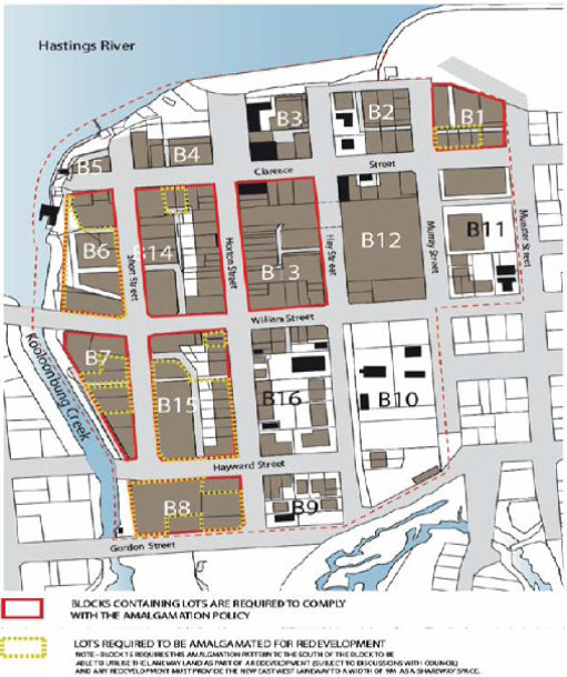
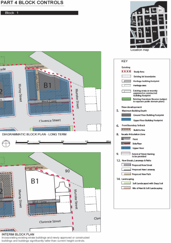
Summary - Block 1 controls
Maximum Building Depth. Ground whole site less setbacks, First/Second/Third/Top
= 20m.
Building depth of approximately 22m considered appropriate.
Front Setback (Clarence Street).
Ground/First/Second/Third = 0m. Top Floor = 3m.
Front lobby on front boundary 0m consistent. <1m
first/second/third/fourth/fifth with elements within articulation zone. Noting
top floor setback 3m.
Rear Setback. Minimum 0m to Block 1 Lane for
Ground/First/Second/Third. Top Floor minimum 3m.
Proposed 8.7m to rear boundary. Further setback on top
floor. Note future laneway not possible having regard to Macquarie Waters
building.
Side Setback. Minimum 0m to Block 1 Pathway for
Ground/First/Second/Third. Top Floor minimum 3m.
Proposed 0m side boundary setback from ground to 5th
level. The top floor setbacks range between 0m, (approximately 7.6m length of
eastern aspect of building – stair shaft and portion of Unit 604), up to
13.695m (north-western aspect of building).
The side setback variation to the 3m top floor in relation
to portions of the top floor is considered acceptable due to the:
· reasonably short
wall lengths of the proposed building compared to the overall length of the
site.
· the relationship
of the non-compliant length of external wall of the proposed building with the
existing western external wall of the adjoining building to east.
· the relationship
of the proposed building to the bulk and scale of development to the east.
· the significant
open area of the proposed development.
· the overall merits
of the proposed development and the practical difficulties associated with
compliance and achieving a viable project.
· the lack of
detrimental overshadowing of the adjoining properties due to the existing lots
orientation to north and south.
· the minimization
of privacy impacts to the adjoining properties due to a lack of
· regular windows in
the proposed side
· elevations,
· the size and scale
of existing adjoining development to the east, west and north.
· the flow through
ventilation for the proposed units which do not need to rely on side windows to
provide ventilation.
· the use of varying
finishes on the side elevations to create additional interest and relief and to
decrease the vertical emphasis on the building as a whole.
· the non-compliance
will result in no loss of primary views for residents of other buildings.
Façade Enclosure. Ground 60%, First 50%,
Second/Third 40%, Top Floor 40%.
Façade enclosure considered acceptable.
Front articulation zone. Ground min 0m. First to fifth
min 1.8m Max 4m. Top Floor N/a
Articulation provided to the street considered appropriate.
Rear/Side Articulation 0m.
Wall finish treatment is
proposed to the western elevation which will provide an appropriate interim
measure until the corner block is developed.
Vehicle entry from streets and paths. Off Block 1 Lane,
Munster or Murray Streets
Access directly from Clarence Street.
New Streets, Laneways and Paths. Block 1 Lane. Min 7m
wide – two way vehicle movement and 1m footpath.
Proposed level basement car parking. No provision for
laneway. Full width footpath across frontage required.
Arcades. N/A.
Car Parking Underground, on street, some on grade.
Proposed basement car parking and commercial spaces at
grade.
Landscaping. N/A.
Residential Flat Development,
Tourist and Visitor Accommodation, Mixed Use Development Provisions.
|
Objectives/Provisions
|
Proposed
|
Complies
|
|
Site Design & Analysis
- Attributes
and constraints adequately considered in design.
- Consideration
to adjacent and adjoining sites in design.
|
Site analysis provided.
|
Yes.
|
|
Site Layout
- Functional
& integrated with neighbourhood.
- Energy
efficient design.
|
Detailed site plan provided with application demonstrating
integration with potential integration with adjoining sites.
|
Yes.
|
|
Height Limits & FSR
- Complies
with LEP
- Min
floor to ceiling 2.7m.
- FSR
at least 1:1.
|
Variation to height proposed.
Ceiling heights comply.
FSR 3.52:1.
|
No. Refer to LEP clause 4.6 comments.
Yes.
Yes.
|
|
Streetscape & Front Setback
- Front
setback with 20% of average setback of adjoining buildings.
- Tourist
accommodation 9m max setback for pool.
- Balconies
may encroach up to 600mm into setbacks.
- Building
aligned to street boundary.
- Openings
align with street or rear of site.
|
Proposed 0m front setback.
Swimming pool proposed on roof top.
Balconies within setbacks.
Building aligns with street.
Openings face street.
|
Considered acceptable.
N/A
Yes.
Yes.
Yes.
|
|
Side & Rear Setbacks
- Side
setback min 1.5 for max 75% of building depth.
- Windows
in side walls setback 3m from side.
- Adjoins
existing strata building side set back min 3m.
- Rear
setback min 6m to building & sub basement.
- Party
wall development if site amalgamation not possible and higher density
envisaged.
- Corner
sites consolidated with adjacent sites.
|
0m side setbacks
No windows in side walls.
Adjoins strata title flat building to the east.
8.7m rear setback to building.
Site amalgamation as per DCP not achievable.
Not a corner site.
|
Considered acceptable.
N/A.
Considered acceptable.
Yes.
Noted but considered best achievable outcome.
N/A
N/A
|
|
Building Depth
- Max
18m
|
Building depth of approximately 22m.
|
Building depth considered acceptable. The depth is
reflective of existing similar sized buildings adjoining.
|
|
Energy Conservation & Solar Access
- Adequate
light and ventilation.
- Overshadowing.
- Energy
efficiency.
|
North facing balconies. No adverse shadow impacts given
lot orientation.
|
Yes. Ventilation and solar access considered appropriate
having regard to the short term use proposed.
|
|
Landscaping
|
Landscaping proposed along Clarence Street frontage.
|
Yes
|
|
Deep Soil
- Buildings
should be sited across frontage
- Deep soil
zones should extend width of the site and be minimum depth of 6m.
- Deep soil
zone should accommodate advanced plantings.
- Integration
with stormwater management system
|
No deep soil zone proposed.
|
The site is zoned B3 Commercial and consistent with the
area based provisions above no deep soil zone requirement has been envisaged
for this site.
|
|
Private Open Space
- Ground
floor dwelling min 35m2 with 4mx4m area.
- Areas
<2m in width be excluded from area.
- Balconies
on or above first floor min 8m2 with min 2m width with direct living area
access.
|
No ground floor units proposed. The rooftop terrace area
inclusive of BBQ, gym, pool and toilets facilities provides sufficient
communal open space.
|
Yes. Each unit also contains access to external balconies
of sufficient width and depth.
|
|
Fences and Walls
- None
proposed
|
None proposed
|
N/A
|
|
Acoustic Privacy
- Living
areas to face street
- Parking
and driveways separation >3m from bed windows
- Openings
of adjacent dwellings >3m separation.
- Building
wall design minimise noise transition comply with AS.
|
Noted that some bedrooms at front of building face street.
N/A no ground floor units.
No side wall openings.
Designed to comply with noise transmission requirements.
|
Noise impacts considered to be minimal having regard to
the short term nature of use. Additional glazing to bedroom windows possible.
N/A
Yes
|
|
Visual Privacy
- Direct
views between adjacent living areas screened if with distances.
- Screening
or fence requirements.
- Window
privacy screen requirements
- Balcony
privacy screen requirements
|
No side wall openings.
Privacy walls and screening proposed where necessary.
|
Yes
Yes
|
|
Accessibility
- In
accordance with AS1428
- Barrier
free min 20% of dwellings
- Layout
for variety of groups
- Building
design capable of adaptation to whole of partial changes of use
|
Capable of compliance with AS1428. Details to be provided
with Construction Certificate. Ground flood at grade access with lift
proposed.
|
Yes.
|
|
Social Dimensions & Affordability
- Located
close to open space/recreation areas.
- FSR
not less than 1:1
- Variety
of apartment types, 1, 2, 3+ beds.
- Consider
Affordable Housing Strategy
|
Close to Town Green open space and foreshore areas.
FSR greater than 1:1.
1, 2 and 3 bedroom units.
|
Yes.
Yes.
Yes.
|
|
Roof Form
- Variations
in form & materials to be provided
- Lift
overruns & plant integrated within roof structure
|
Roof top structures provided varied roof form.
Overrun and plant incorporated into roof top structures.
|
Yes.
|
|
Façade Composition & Articulation
- Well
balanced
- Consistent
& complimentary to elements & materials of existing buildings
|
Consistent with existing flat buildings within the
locality.
|
Yes
|
|
Entries & Corridors
- Clear
line of transition
- Sheltered
& lit
- Adequate
circulation space
- Corridor
width min 2.5m wide & 3m high
|
Building entry well defined, sheltered and adequate
circulation space.
|
Yes
|
|
Balconies
- Min
one balcony per apartment.
- Main
balcony min 2m width a 8m2.
- Directly
accessible from living area.
- Balconies
recessed, balustrade.
|
Balcony per unit.
Complies.
Off living area.
Recessed and balustrade details provided.
|
Yes
Yes
Yes
Yes
|
|
Emergency Services
- Accessible
|
Capable of access from street hydrant.
|
Yes
|
|
Laundries & Clothes Drying Facilities
|
Rooftop communal laundry proposed.
|
Yes
|
|
Mailboxes
|
Not required.
|
N/A
|
|
Safety & Security
|
Design meets principles of crime prevention through
environmental design.
|
Yes
|
|
Site Storage
|
Adequate storage proposed.
|
Yes
|
|
Waste Management
- Communal
bulk waste facilities to be provided.
- Designated
area at ground or basement
|
Garbage storage on ground floor behind commercial
tenancies.
|
Yes
|
|
Utilities
|
Services available.
|
Yes
|
|
Strata Title Subdivision
|
No subdivision proposed.
|
N/A
|
Business and Commercial Development Provisions
|
Requirements/Objectives
|
Proposed
|
Complies
|
|
Building Heights:
|
Proposed 23.65m.
19m LEP max height limit applies.
|
No. Refer to LEP clause 4.6 comments.
|
|
Setbacks:
· A zero
metre setback to ground floor is preferred in all business zone developments.
|
0m front setback.
|
Yes
|
|
Roof Form:
· Variations
in roof form including the use of skillions, gables and hips are to be
provided in the development.
|
Variation with roof terrace proposed. Lift overrun and
plant incorporated.
|
Yes.
|
|
Building Facades, Materials & Finishes:
· Colours, construction
materials and finishes shall be predominately pale in colour and textured,
tonal and subtle.
|
Proposed colours appear acceptable and consistent with
existing flat buildings within the street.
|
Yes
|
|
· Shopfront
widths are to be between 15 and 20metres.
|
Shopfront widths acceptable.
|
Yes
|
|
· Architectural
detailing is to be provided to promote articulation, character and visual
interest in the streetscape.
|
Architectural detailing provided within the articulation
zone. Incorporates overhangs and recesses.
|
Yes
|
|
Active Frontages:
· Ground
floor levels shall not be used for residential purposes in B1, B2, B3 and B4
zones.
|
Ground floor incorporates shop/retail.
|
Yes
|
|
· A minimum
of 50% of the ground floor level front facade is to be clear glazed.
|
Approx 50% of street frontage clear glazed.
|
Yes
|
|
Arcades
|
No arcade proposed.
|
N/A
|
|
Awnings
|
Awning structure provides coverage for the extent of the
active street frontage.
|
Yes
|
|
· Skylights
may be provided in the awning for a maximum depth of 1/3 of the total awning
depth.
|
None proposed.
|
N/A
|
|
· Under
awning lighting shall comply with AS/NZS1158.
|
Capable of compliance.
|
Yes.
|
|
· Awnings
are designed and constructed to encourage pavement dining in areas identified
for pavement dining, along the foreshore and in piazzas.
|
Awnings designed to encourage outdoor dining
opportunities.
|
Yes.
|
|
Landscaping:
· A
landscape plan shall be submitted with the development application
|
Landscape plan provided.
|
Yes
|
|
Gateways &
landmark Sites:
|
N/A
|
N/A
|
|
Waste management:
· A
waste management plan for the construction and/or occupation of the
development is provided
|
Waste management plan provided.
|
Yes
|
|
Vehicular Access Location
and Design:
· No direct
vehicular access to at grade or basement car parking from the active street
frontage will be permitted in B1 zones.
· The number
of vehicular crossovers shall be kept to a minimum and appropriate sight
lines provided to ensure safe integration of pedestrian and vehicular
movement.
|
B3 Zone. Single crossover proposed. Access to basement car
park from main entrance off Clarence Street.
Single crossover proposed at
grade.
|
Yes.
Yes
|
|
Pedestrian Entries &
Access:
· The
development complies with AS1428—Design for Access and Mobility.
|
Designed to comply with standard.
|
Yes
|
|
Outdoor Dining:
|
None proposed.
|
N/A
|
|
Commercial Development
Adjoining Residential Land uses:
· The
development is designed so that all vehicle movement areas and servicing
areas are located away from adjoining residential areas.
|
Site adjoins residential units located to the east.
Site does not adjoin residential zoned land.
|
Yes
|
|
· Waste
areas are located and managed to minimise pests, noise and odour.
|
Garbage storage located on ground floor behind commercial
tenancy and basement for residential units.
|
Yes
|
(iiia) Any planning agreement that has
been entered into under section 7.4, or any draft planning agreement that a
developer has offered to enter into under section 7.4:
No planning agreement has been
offered or entered into.
iv) Any
matters prescribed by the Regulations:
New
South Wales Coastal Policy:
The proposed development is
consistent with the objectives and strategic actions of this policy. See SEPP
(Coastal Management) 2018 comments for further detail.
(b) The likely
impacts of the development, including environmental impacts on both the natural
and built environments, social and economic impacts in the locality:
Context & Setting
The site was historically three
single Torrens title lots with each containing old unit buildings. The old
units have been demolished and the lots consolidated under a previous
development consent. Site has also been subject
to excavation under a previous development consent and slopes away from south
to north approximately 2m. The site has a frontage of 45.25m to Clarence Street
and an average depth of 33.53m.
Adjoining the site to the north
is the North Point Apartments (9 storey residential flat building). Adjoining
the site to the east is the Macquarie Waters apartments (six storey residential
flat building). Adjoining the site to the south is Clarence Street and beyond
is the Port Pacific Resort building. Adjoining the site to the west is a single
storey commercial building fronting Murray Street.
The proposal is considered
appropriate in terms of density and height and will be unlikely to have any
adverse impacts to existing adjoining properties and satisfactorily addresses
the public domain. The proposal is considered to be consistent with other
higher density developments in the locality.
The proposal will not compromise
any important views or view corridors. Impact to views enjoyed from units of
the Port Pacific building would be minimal given the change in grade on
Clarence Street and the subject site, and the location of existing buildings
adjacent to the site.
It is evident that the
orientation of the block, units and subsequent balconies seek to maximise light
and ventilation with the northern orientation. The building has been positioned
in the southern portion of the block. This provides for adequate separation to
the units in the North point apartment building. It is considered that
sufficient spatial separation between the units will be provide for an
acceptable level of privacy.
Roads
The site has road frontage to
Clarence Street. Adjacent to the site, Clarence Street is a sealed public road
under the care and control of Council. Clarence Street is local commercial road
with a 22 metre carriageway within a 30 metre road reserve. The existing road
includes SA kerb and gutter, footpath paving, and combination of parallel
parking and angled parking.
Access, Transport & Traffic
The application was supported by a Traffic Impact Assessment
prepared by TTM Consulting, dated 9 August 2018. The conclusions of the
assessment are provided below:
8 Summary and Conclusions
8.1 Development Summary
The access is proposed to be
via a 6.0m wide Category 2 access crossover.
The development access will
provide an effective queue provision of 4 vehicles between the property
boundary and the security access door.
8.2 Car Parking Arrangements
The car parking provision
generally exceeds Council’s Development Control Plan’s minimum
parking requirements.
The ground level and basement
car park layouts, as a minimum, comply with the Australian Standard
requirements. Overall, TTM considers the proposed car parking arrangements for
this development are adequate.
8.3 Impact on Surrounding
Road Network
Assessment of the proposed
development indicates that the development will not have a significant impact
on the future road network. As such, no further mitigating road works are
required.
8.4 Service Vehicle
Arrangements
Servicing for this development
will be facilitated in the designated loading area on the ground level,
accessed from Clarence Street. The largest design vehicle, a VAN, can enter, manoeuvre,
service and exit the site in a forward gear. Overall, the proposed service
vehicle arrangements are considered adequate to meet the needs of the proposed
development.
8.5 Active Transport
Facilities
The current public transport
infrastructure and proposed site provisions for pedestrian/bicycle facilities
is considered adequate for the development.
8.6 Conclusion
Based on the assessment
contained within this report, TTM see no traffic engineering reason why the
relevant approvals should not be granted.
Key issues or recommendations to be addressed by conditions.
To protect existing road facilities, existing road
conditions shall be evaluated and bond securities held prior to any earthworks
Details shall be provided as part of a Roads Act (Section 138) application.
Site Frontage & Access
Vehicle access to the site is proposed though one access
driveway to Clarence Street. All accesses shall comply with Council AUSPEC and
Australian Standards, and conditions have been imposed to reflect these requirements.
Due to the type and size of
development, additional works are required to include:
· Reconstruction
of kerb and gutter to the east of improvement works (new kern and pavement) to
marry in with works already carried out by Council as part of the Town Centre
Master Plan.
· Concrete
footpath paving (full width) along the full frontage
· A
condition is recommended requiring that prior to the preparation of any
engineering plans or submission of any applications for construction to
Council, the applicant is to contact Councils Engineering Development to ensure
any design accords with Town Centre Master Plan works already carried out on
Clarence Street across subject property. The applicant is advised that works
include altering verge, carriageway and kerb levels to improve surface drainage
conditions for the full frontage of the development.
Parking and Manoeuvring
Parking and driveway widths on site can comply with relevant
Australian Standards (AS 2890) and conditions have been imposed to reflect these
requirements.
Due to the type of development, car park circulation is
required to enable vehicles to enter and exit the site in a forward manner.
Site plans show adequate area is available and conditions have been imposed to
reflect these requirements.
Refer to relevant conditions of
consent.
Pedestrians
In accordance with the Port
Macquarie Town Centre Master Plan, the proposed development will require full
width concrete paving along the frontage of the site with specified materials
and finishes. Suitable conditions recommended.
Public
Domain
No adverse impacts on public
spaces or access thereto.
Utilities
Telecommunication and
electricity services are available to the site.
Stormwater
The proposed preliminary
stormwater design prepared by David Johnson Consulting Engineer, dated May 2014
is acceptable in principle.
The site naturally grades towards the rear and is benefitted
by an easement 1 metre wide to drain water over SP65485, the development
proposes to extinguish the easement and instead drain to the Council’s
pipe network in Clarence Street.
The legal point of discharge for the proposed development is
defined as a direct connection to Council’s stormwater pit/pipeline in Clarence
Street, which is consistent with the development proposal.
A detailed site stormwater management plan will be required
to be submitted for assessment with the S.68 application and prior to the issue
of a building Construction Certificate.
In accordance with Councils AUSPEC requirements, onsite
detention facilities must be incorporated into the stormwater drainage plan.
Preliminary plans incorporate onsite detention facilities.
The statement of environmental effects (SOEE)
outlines measures to be implemented during construction to manage stormwater.
Details from the SOEE are provided below:
- Appropriate controls will be installed to
prevent soil erosion and sediment transport from the site during rainfall
during the construction phase of the project. A variety of erosion and
sediment controls will be used on the site. Strategies to be used on site
will include:
·
Hay bale retardation and sediment retention
basin. The removal of stormwater from the excavated area will be via a
temporary hay bale structure which will be provided on site. The size of the
structure to be determined via the volume of water to be treated. In this
regard the operation of the structure is to be inspected on a daily basis and
the quality of discharge water monitored.
·
Where necessary the size of the structure
will be increased so as to ensure that acceptable discharge standards are met.
·
All stormwater is to be collected and
conveyed to the structure using suitable sized pumps. The foot valve of the
pump is to be fitted with a silt sock. The hay bale structure will act as a
two-stage sedimentation basin. Pumped water will be discharged into the larger
section of the structure where it will be allowed to settle and seep through
the straw bales into the final section where it will be allowed to settle
before draining through the overflow to discharge into the stormwater drain
servicing the site.
·
The pond shall be regularly inspected, and
excess sediment removed on a daily or more frequent basis as required.
·
Sediment filter fencing, or gravel
groynes/sausages will be used downstream of the discharge from the hay bale
structure to provide additional treatment.
·
Gravel groynes/sausages for sediment
retention will be utilized around stormwater drains, inlets and pits once
constructed.
·
Tracking of sediment from the site by tucks
entering and leaving will be controlled by the provision of a ‘shaker
grid’ at the site entry together with the placing of a gravel driveway at
the entry site.
·
Discharges from dewatering operations shall
be treated to remove excess suspended matter prior to discharge from the site.
Discharges shall be free of pollutants, shall be within a pH range of 6.5-8.5
and shall have a maximum non-filterable residue (NFR) concentration of 50 mg/L
to allow for discharge to the stormwater system within Environment Protection
Authority requirements.
·
Removal of suspended matter from dewatering
discharges shall be achieved by treatment of discharges through the hay bale
filtration/sedimentation pond detailed in 6.1 above.
Detailed plans for the
management of stormwater will be required to be submitted for assessment with
the infrastructure construction certificate and S.68 applications.
Water
Records indicate that the
current development site has an existing 20mm metered water service from the
150mm PVC water main on the same side of Clarence Street.
Each residential and commercial
unit will require individual water metering with the meters either located on
the road frontage or at the unit with remote reading facility located adjacent
to the road frontage or in an easily accessible area such as a foyer.
Final water service sizing will
need to be assessed by a hydraulic consultant to suit the commercial, domestic
and fire service components of the proposed development, as well as backflow
protection requirements. The existing 20mm metered water service is to be
disconnected. There is no charge for this disconnection service.
Detailed plans will be required
to be submitted for assessment with the infrastructure construction certificate
and S.68 applications.
Sewer
Council records indicate that
the development site is connected to sewer via junction to the existing sewer
line that runs along the northern property boundary. A sewer reticulation
strategy is to be provided. A manhole will be required at the high end of the
line as it will be more than 40m long. If the main is subject to future
extension an end of line terminal shaft (poo pit) will be required.
As the development will exceed
2ET discharge, sewer connection is to be made from a manhole. The hydraulic
designer is to confer with Council sewer section prior to submitting sewer
design plans.
Detailed plans will be required
to be submitted for assessment with the infrastructure construction certificate
application and S.68 applications.
Soils
The proposed development will be
unlikely to have any adverse impacts on soils in terms of quality, erosion,
stability and/or productivity subject to a standard condition requiring erosion
and sediment controls to be in place prior to and during construction.
Air
& Micro-climate
The operations of the proposed
development will be unlikely to result in any adverse impacts on the existing
air quality or result in any pollution.
Flora
& Fauna
Construction of the proposed
development will not require any removal/clearing of any significant vegetation
and therefore will be unlikely to have any significant adverse impacts on
biodiversity or threatened species of flora and fauna.
Waste
Satisfactory arrangements are in
place for proposed storage and collection of waste and recyclables. No adverse
impacts anticipated.
Energy
The proposal is not BASIX
affected building. The proposal will include measures to address energy
efficiency in order to comply with the requirements of section J of the
Building Code of Australia (BCA). No adverse impacts anticipated.
Noise
& Vibration
Having regard to the location of
the site and nature of the development, there will be anticipated short term
noise impacts during construction activities. Consent condition has been
recommended to restrict construction to standard construction hours and a
condition requiring a construction management plan which includes a schedule of
works and approximate timing, contact number of site supervisor and mechanism
for providing notice to adjoining owners for schedule noisy works.
In terms of vibration impacts
and proximity of adjoining sites which are built to boundary a condition has
been recommended to require dilapidation reports prior to work and upon
completion of works to adjoining properties.
In terms of the visitor
accommodation use, it is noted that no onsite manager is proposed. A condition
of consent has been recommended to require a complaints register to be
established by management and this be made available upon request to Council.
The condition also requires that a telephone number be provided on the front of
the building for any complaints.
Having regard to the short term
nature of stays proposed and use of the communal roof top terrace facilities
which includes a BBQ area, swimming pool and outdoor terrace the potential
exists for noise during high activity times. It is noted that these roof top
areas have been located in the north western part of the top floor which will
provide adequate separation between adjoining flat buildings to the north and
east of the site. It still considered that some type of management regarding
the use of this rooftop area is required. A condition has been recommended
requiring a rooftop management plan be development and approved by Council
prior to issue of any occupation certificate. A further condition has been
applied requiring the approved plan to be displayed in a prominent position on
the rooftop area so guests are duly informed.
Natural
Hazards
The site is not mapped as
bushfire prone land. Refer to comments under clause 7.4 of LEP comments for
flood considerations.
Safety,
Security & Crime Prevention
The proposed development will be unlikely to create any
concealment/entrapment areas or crime spots that would result in a loss of
safety or security in the area. The increase in housing density will improve
natural surveillance within the locality and openings from each dwelling
overlook common and private areas.
Social
Impact in the Locality
Given the nature of the proposed
development and its location the proposal is unlikely to result in any adverse
social impacts.
Economic
Impact in the Locality
No adverse impacts. Likely
positive impacts can be attributed to the construction of the development.
Site
Design and Internal Design
The proposed development design is satisfactorily responds
to the site attributes and will fit into the locality. No adverse impacts
likely.
Construction
Having regard to the location of
the site and nature of the development, there will be anticipated short term
inconveniences during construction activities. No significant adverse
construction impacts are identified to neighbouring properties that would
warrant refusal of this application.
Cumulative
Impacts
The proposed development is not
expected to have any adverse cumulative impacts on the natural or built
environment or the social and economic attributes of the locality.
(c) The
suitability of the site for the development:
The proposal will fit into the
locality and the site attributes are conducive to the proposed development.
Site constraints have been adequately addressed and appropriate conditions of
consent recommended.
(d) Any
submissions made in accordance with this Act or the Regulations:
Eight (8) written submissions have been received following public
exhibition of the application.
Key
issues raised in the submissions received and comments in response to these
issues are provided as follows:
|
Submission Issue/Summary
|
Planning Comment/Response
|
|
The proposal provides no
detail on overshadowing impacts. Private open space on the adjoining
Macquarie Waters building is orientated north-west. Shadow diagrams should be
provided to determine the extent of shadow impacts.
|
Having regard to the sites
north south orientation it is evident that the adjoining properties will not
be adversely overshadowed by the development for more than 3 hours between
9am -3pm on 21 June.
|
|
Based on the information lodged it is difficult to
ascertain whether the building height proposed is being taken off
pre-excavated site levels or existing level as excavated.
|
The applicant provided revised plans and clause 4.6
variation confirming building height proposed form existing ground level as
excavated onsite.
|
|
The proposal bases its car parking demand on 47 units and
6 staff. The proposal however contains 79 separately lettable units. The DCP
currently provides no mechanism for reduced parking for a dual key system. A
shortfall of 36 parking spaces is not appropriate for the locality having
regard to existing parking demand experienced.
|
Refer to DCP assessment table within this report.
|
|
The proposal does not propose a 6m wide deep soil zone as
per DCP 2013, specifically provisions 3.3.2.6, 3.3.2.11 and 3.3.2.16.
|
Provision 3.3.2.6 refers to side and rear setbacks. The
rear setback complies. Provision 3.3.2.11 refers to deep soil zone width and
depth. The lack of deep soil is consistent with the area based provisions and
commercial zoning of this site. Provision 3.3.2.16 refers to landscaping
requirements. Having regard to the commercial zoning the minimal landscaping
proposed along the street frontage is considered acceptable.
|
|
The current condition of the site is not acceptable.
Currently stormwater collects and pools in the north-western corner and
leaches into the basement of the north point building. It is requested that
Council instruct the landowner to fix this stormwater problem immediately.
|
Noted Council staff are aware of the existing stormwater
issue and will continue to monitor and managed accordingly. Stormwater for
the proposed development can be adequately managed.
|
|
The building is excessive in size and height. There is no
good reason for the height variation.
|
Refer to building height comments under LEP 2011 of the
report. The proposed building is considered to be consistent with other
buildings in the locality. The majority of the built form is contained within
the height controls. The elements on the roof add further articulation to
this form and are consistent with similar roof top elements on flat buildings
in the locality.
|
|
There is insufficient parking proposed to accommodate the
proposed development.
|
Refer to parking assessment comments under the table to
DCP 2013 of the report.
|
|
The northern setback is insufficient to the north point
building.
|
Refer to DCP 2013 assessment table within this report.
Rear setback complies.
|
|
No details of expected building construction start and
finish times. Potential noise impact to adjoining residents. Temporary noise
blocking panels should be installed to existing adjoining units.
|
Standard building construction times will apply as per
recommended consent conditions. No significant adverse building construction
noise impacts are anticipated that would warrant refusal of this application.
|
|
No details of cranes have been provided. Safety hazard to
existing adjoining units and traffic blocks likely. During construction items
may fall onto my residence at 2 Murray Street.
|
The placement and management of cranes and any machinery
during construction will be undertaken by site managers and subject to
workplace safety measures.
|
|
Service disruptions would occur during construction. How
will I be informed? Is there sufficient services to meet the demand of the
proposed development?
|
Anticipated service disruptions during construction will
be managed by the relevant service provider. Upgrading of services will be
required as deemed appropriate by the relevant service provider.
|
|
Ongoing noise impacts from occupants utilising the open
style communal roof top space with swimming pool.
|
A rooftop management has been provided for this space and
will form part of the consent conditions. No significant adverse noise
impacts are anticipated that would warrant refusal of this application.
|
|
Ongoing noise impacts from air-conditioning plant.
|
Standard noise control regulations apply to management of
noise from such sources. No significant adverse noise impacts are anticipated
that would warrant refusal of this application.
|
|
Open car parking is proposed at ground level with
driveways at same level as North Point level 2 apartments. This will result in
adverse noise and security impact.
|
Adequate building separation is proposed between the
ground level parking and North Point building. The north point building is
setback approximately 13m form the site boundary. No significant adverse
noise impacts are anticipated that would warrant refusal of this application.
|
|
The proposed units will be only 20m from my bedroom and
living space in North Point apartments. This will result in a significant
loss of privacy.
|
The orientation of the block, building and subsequent
balconies seek to maximise light and ventilation with the northern
orientation. The building has been positioned in the southern portion of the
block with the rear balconies setback approximately 8.7m from the rear
boundary. This provides for approximately 20m separation to the units in the
north point building. It is considered that sufficient spatial separation
exists between the units.
|
|
The northern side of the building contains a large amount
of glazing which will direct light and heat into the units of north point.
|
Adequate building separation is proposed. No adverse
reflection or heat impact will result from the glazing proposed.
|
|
There is no discussion about potential liquid trade
wastes that may be generated from the ground floor shop.
|
The proposal is for a ground floor commercial tenancy
only. The use proposed is unknown and likely require further development
consent under which waste management will be considered.
|
|
No details of solar panels or rainwater use provided.
Council should require this as part of all new developments.
|
The proposal is not a BASIX affected building therefore
such measures are optional.
|
|
Having regard to previous failures will Council require
the building to start within a certain timeframe?
|
Planning legislation provides that should development
consent be granted a proponent has 5 years to physically commence work. Once
commenced there is no legal obligation to complete the development within a
set time frame.
|
|
The units in north point will be greatly devalued if approved.
|
Impact upon property values is not a relevant planning
consideration.
|
|
How will dust and debris be managed during construction
noting location of clothes drying facilities adjoining in the north point
building?
|
Standard site management conditions will apply including
dust control.
|
|
The owner is extremely difficult to deal with and has
ignored previous consent conditions and instruction by Council for stormwater
management.
|
Noted.
|
(e) The
Public Interest:
The proposed development
satisfies relevant planning controls and is unlikely to impact on the wider
public interest.
4. DEVELOPMENT
CONTRIBUTIONS APPLICABLE
· Development contributions will be required towards
augmentation of town water supply and sewerage system head works under Section
64 of the Local Government Act 1993.
· Development contributions will be required under Section 94
of the Environmental Planning and Assessment Act 1979 towards roads, car
parking, open space, community cultural services, emergency services and
administration buildings.
5. CONCLUSION
AND STATEMENT OF REASON
The application has been assessed in accordance with Section
4.15 of the Environmental Planning and Assessment Act 1979.
Issues raised during assessment and public exhibition of the
application have been considered in the assessment of the application. Where
relevant, conditions have been recommended to manage the impacts attributed to
these issues.
The site is considered suitable for the proposed development
and the proposal adequately addresses relevant planning controls. The
development is not considered to be contrary to the public's interest and will
not result a significant adverse social, environmental or economic impact. It
is recommended that the application be approved, subject to the recommended
conditions of consent provided in the attachment section of this report.
|
Attachments
1View. DA2018
- 353.1 Recommended Conditions
2View. DA2018
- 353.1 Clause 4.6 Report (FSR)
3View. DA2018
- 353.1 Clause 4.6 Report (Height)
4View. DA2018
- 353.1 Additional Information Letter - September 2018
5View. DA2018
- 353.1 Heritage Office Response Letter
6View. DA2018
- 353.1 Archaeological Report
7View. DA2018
- 353.1 Groundwater Assessment
8View. DA2018
- 353.1 Traffic Impact Assessment Report
9View. DA2018
- 353.1 SOEE
10View. DA2018
- 353.1 Contributions Estimate
11View. DA2018
- 353.1 Plans
|
|
ATTACHMENT
|
Development Assessment Panel
22/05/2019
|

|
ATTACHMENT
|
Development Assessment Panel
22/05/2019
|
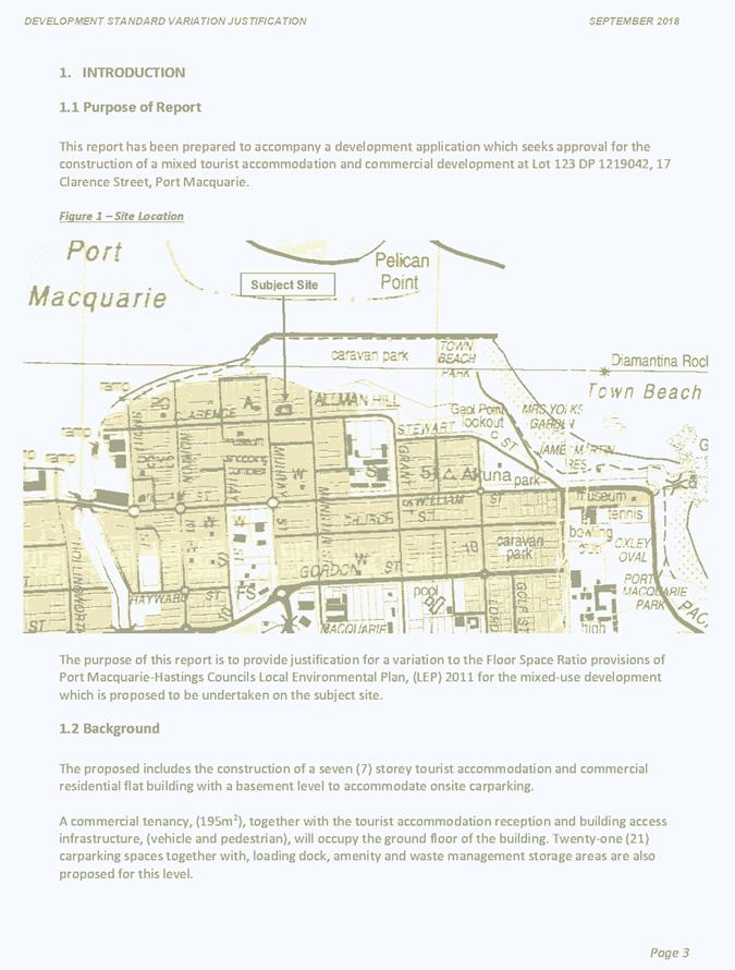
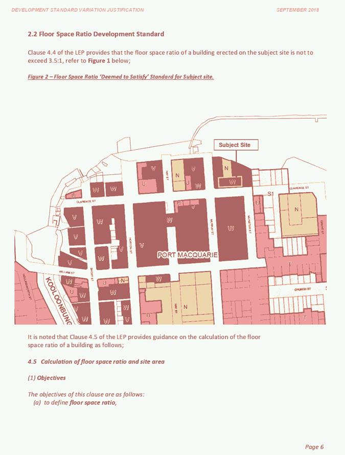
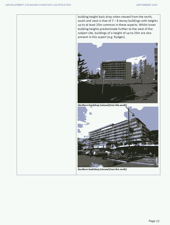
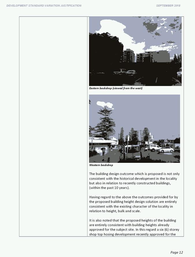
|
ATTACHMENT
|
Development Assessment Panel
22/05/2019
|

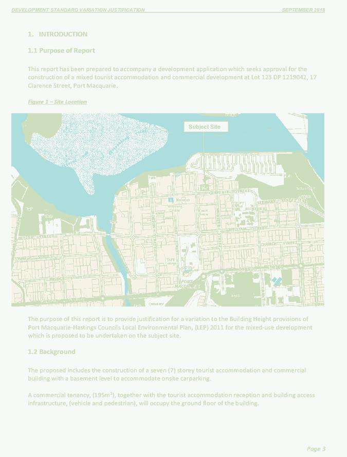
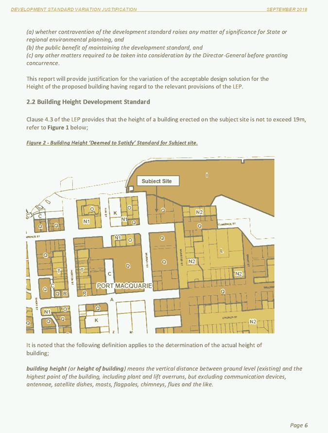
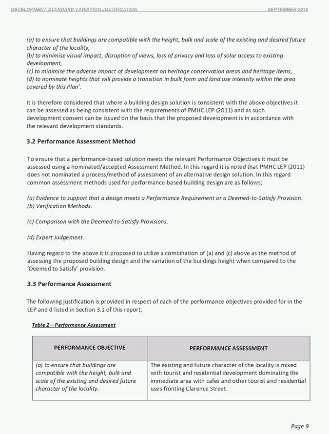
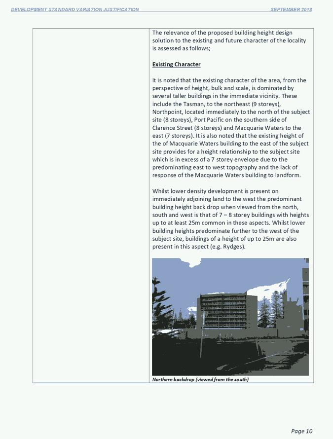
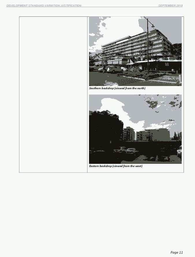
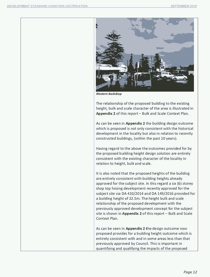
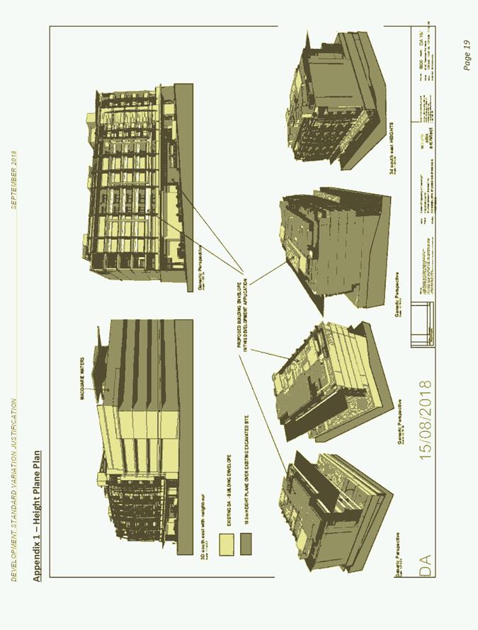
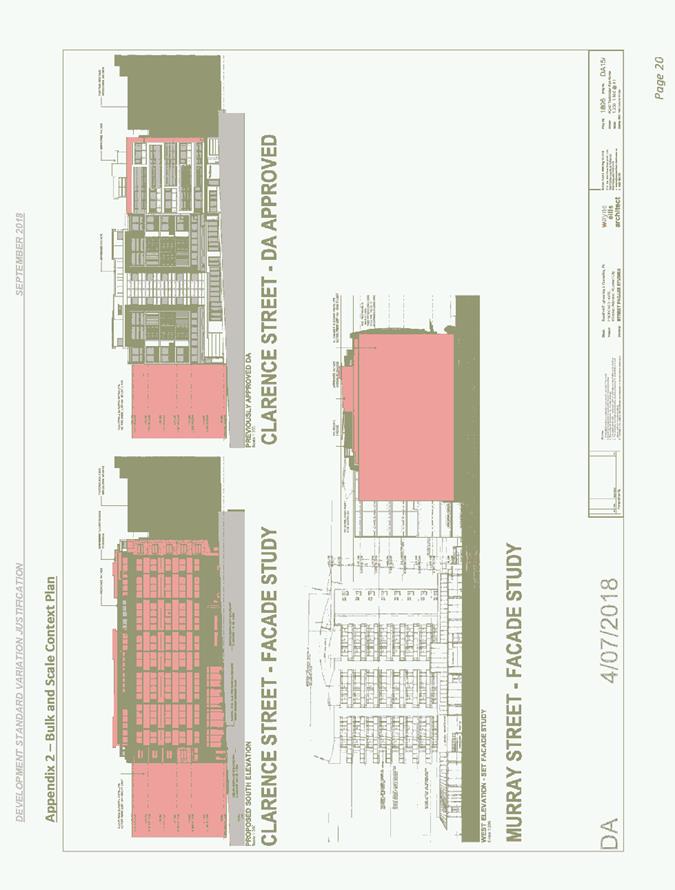
|
ATTACHMENT
|
Development Assessment Panel
22/05/2019
|
|
ATTACHMENT
|
Development Assessment Panel
22/05/2019
|
|
ATTACHMENT
|
Development Assessment Panel
22/05/2019
|
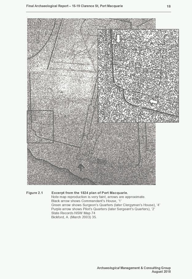
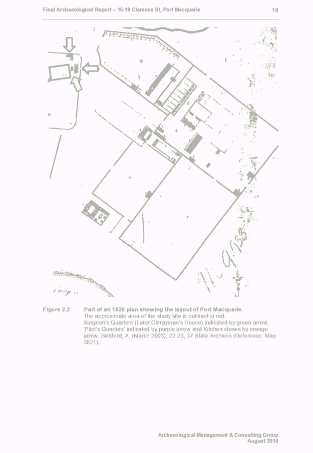
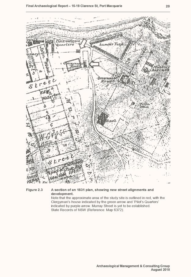
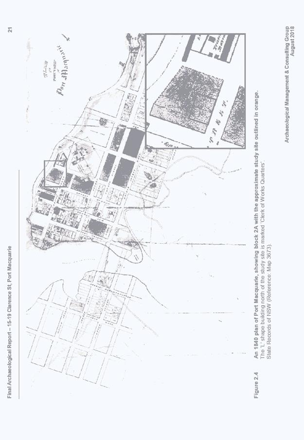
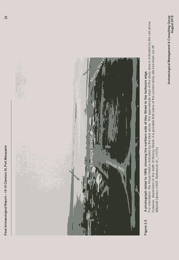
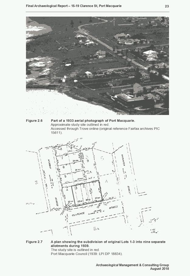
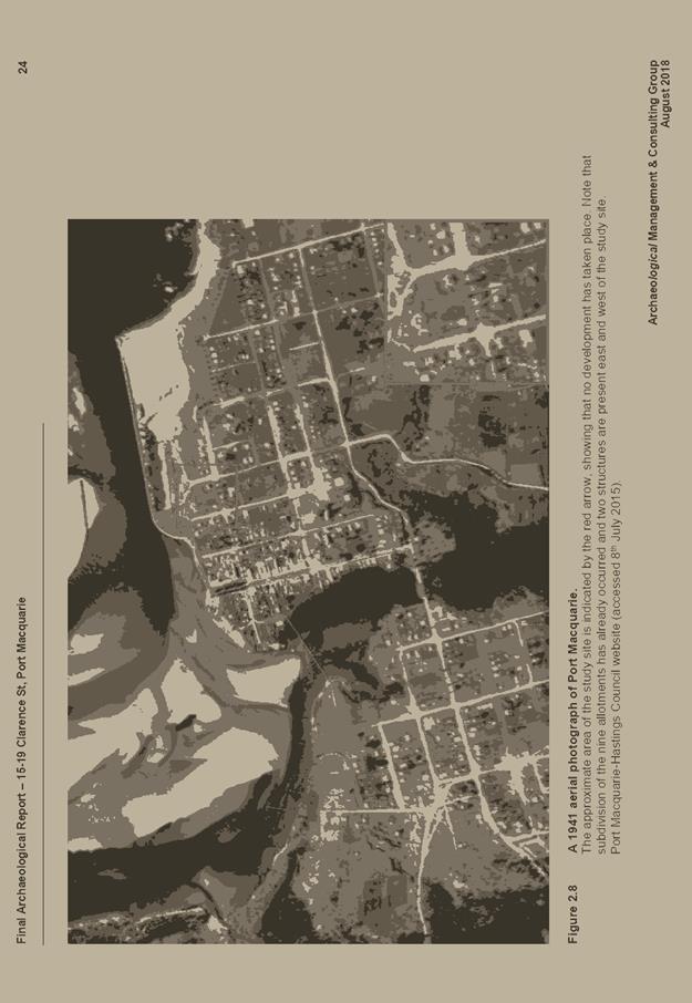
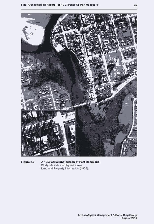
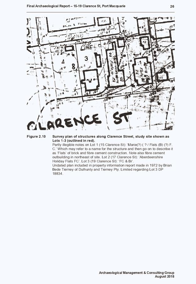
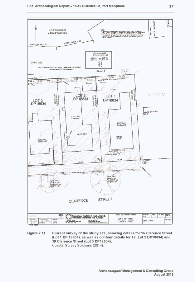
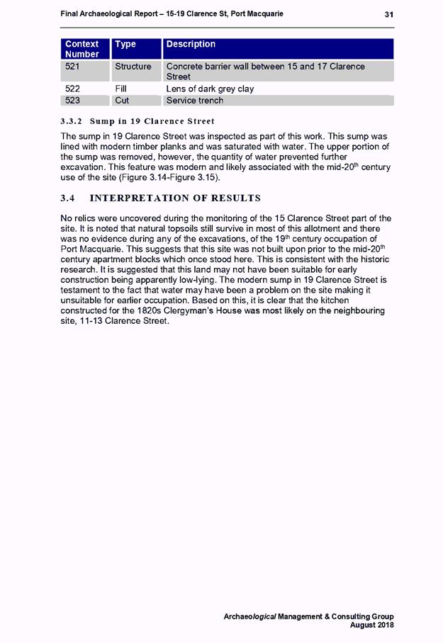
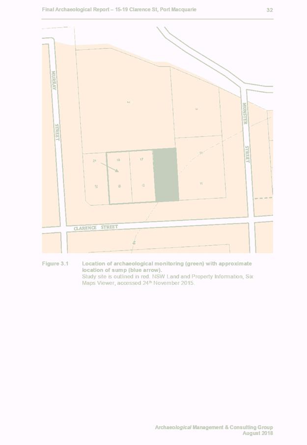
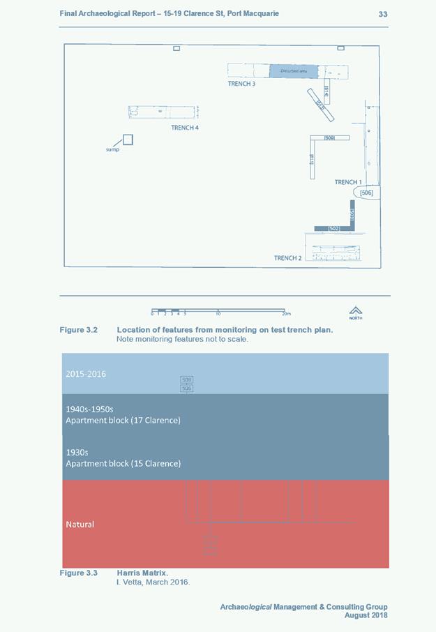
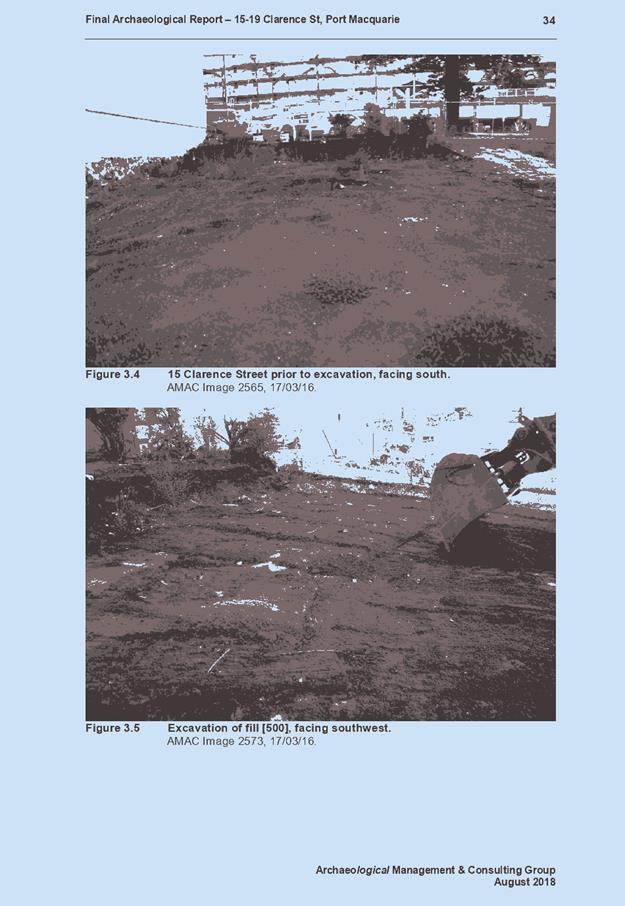
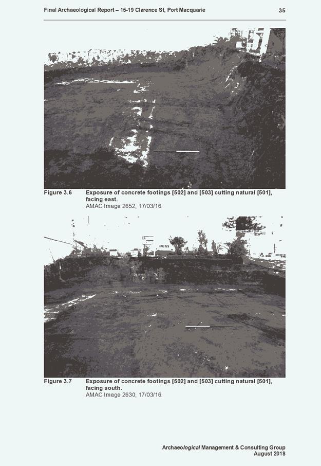
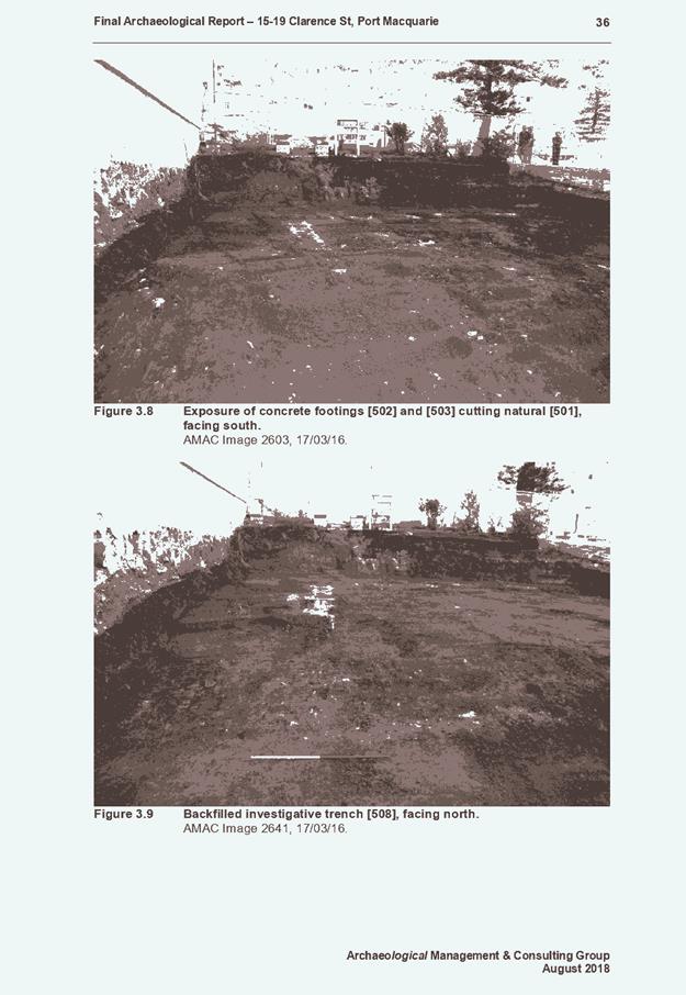
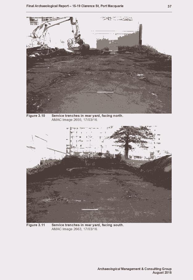
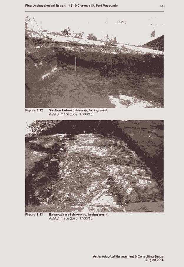
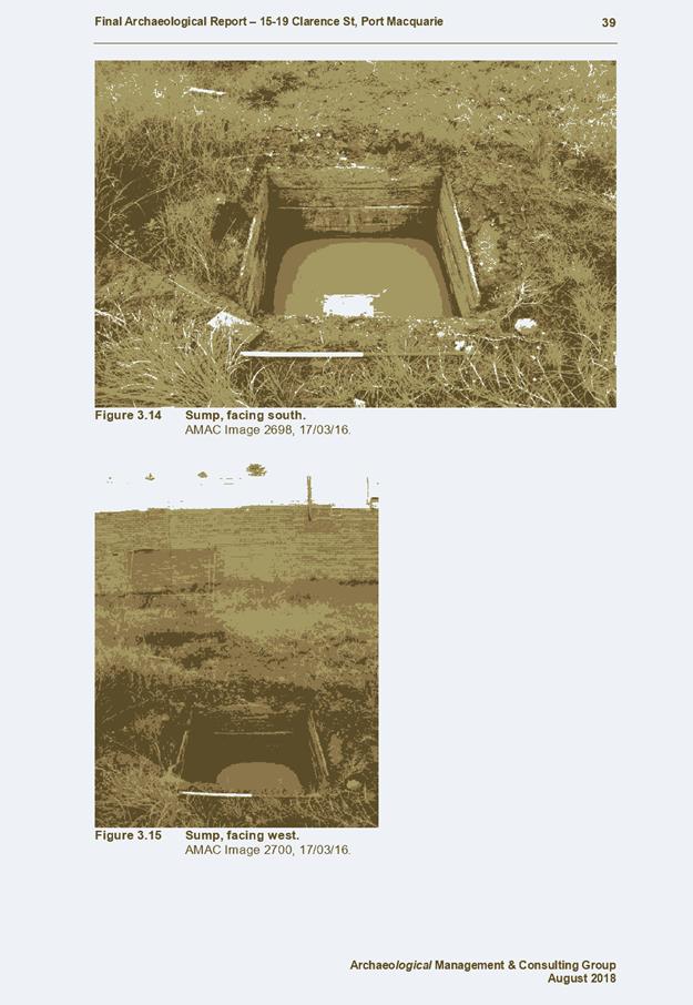
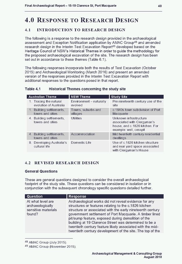
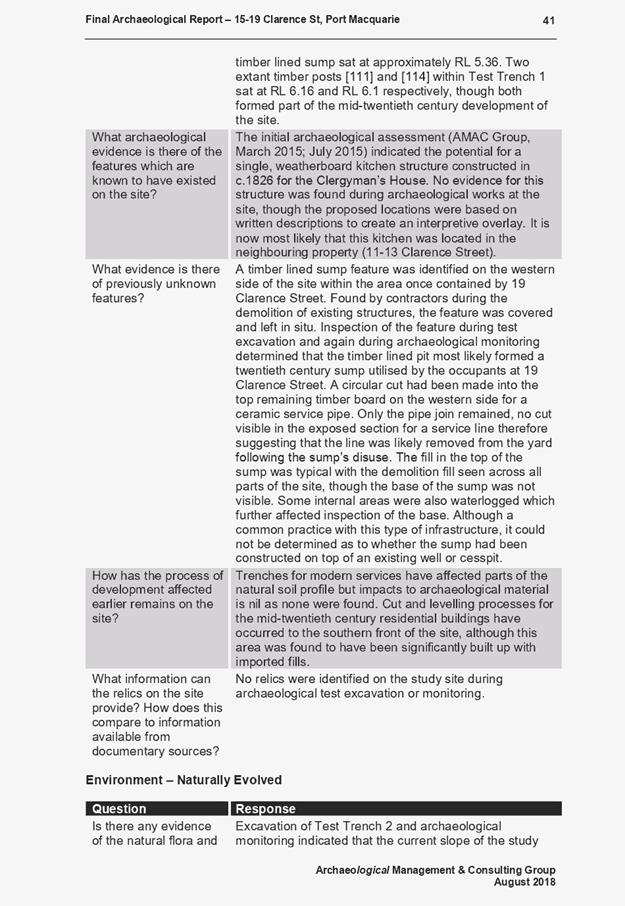
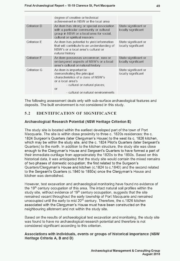
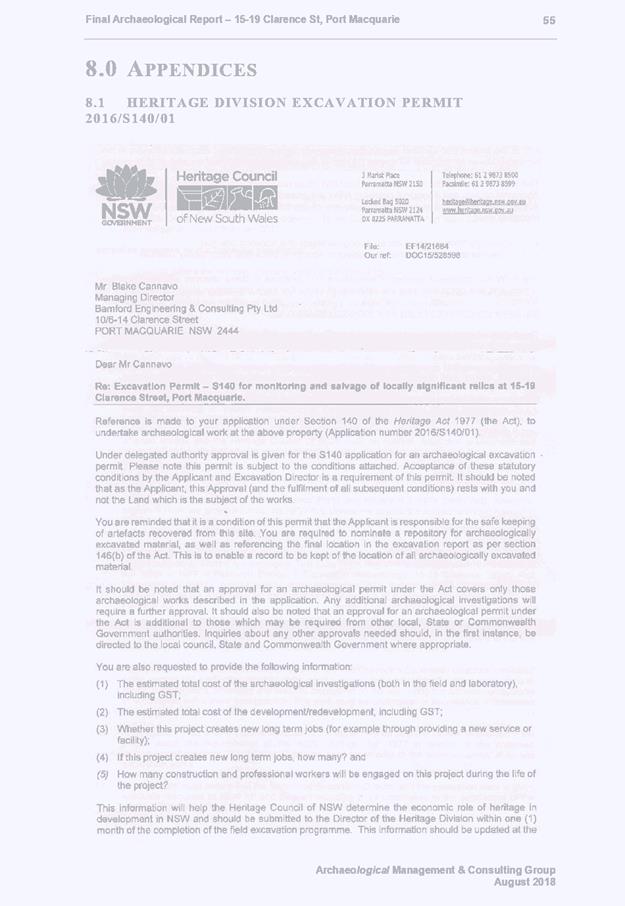
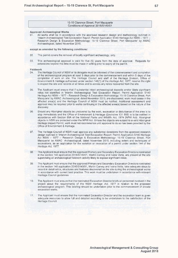

|
ATTACHMENT
|
Development Assessment Panel
22/05/2019
|
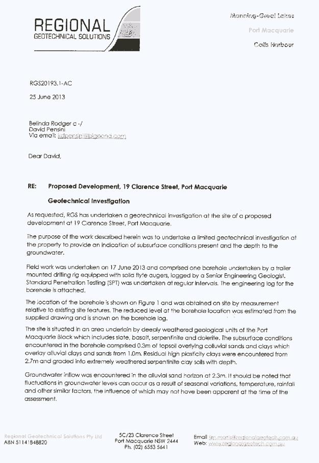
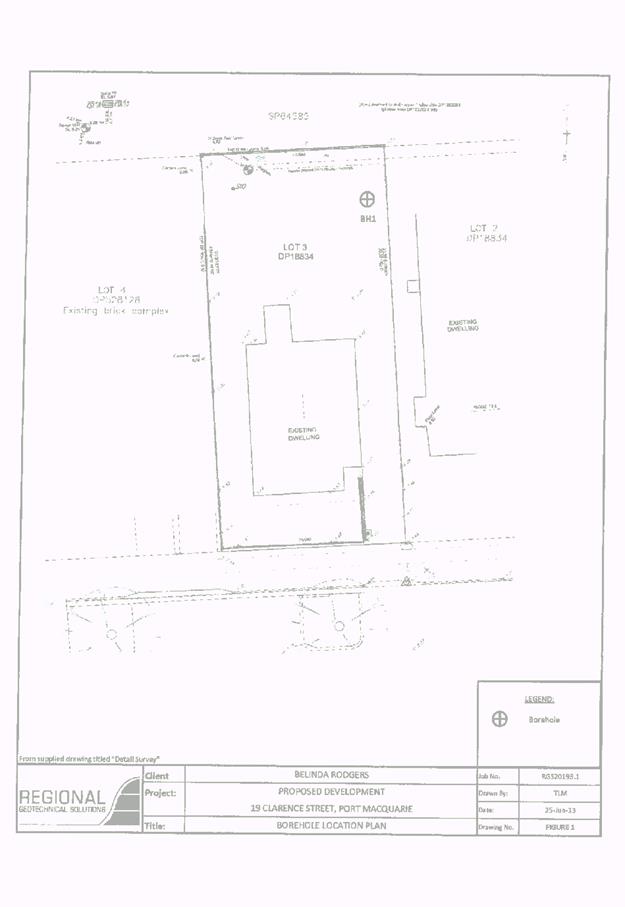
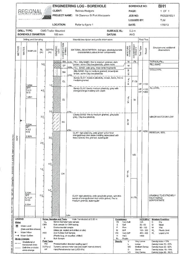
|
ATTACHMENT
|
Development Assessment Panel
22/05/2019
|
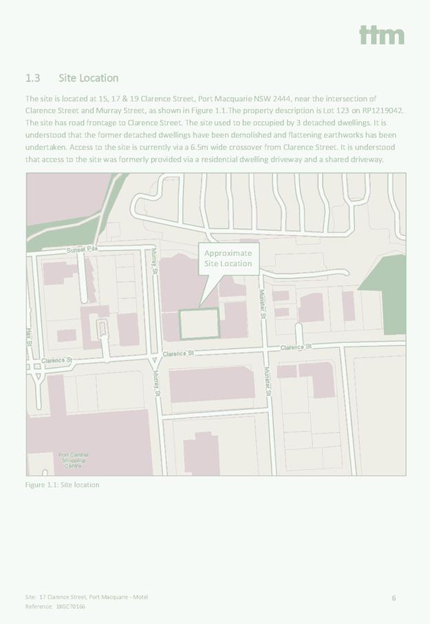
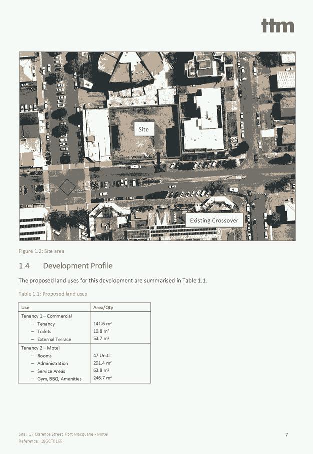
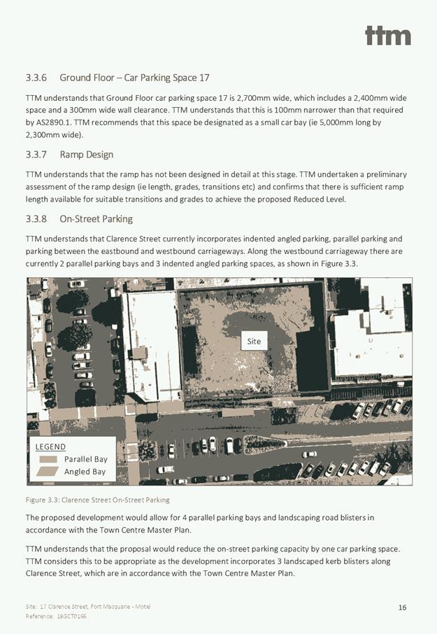
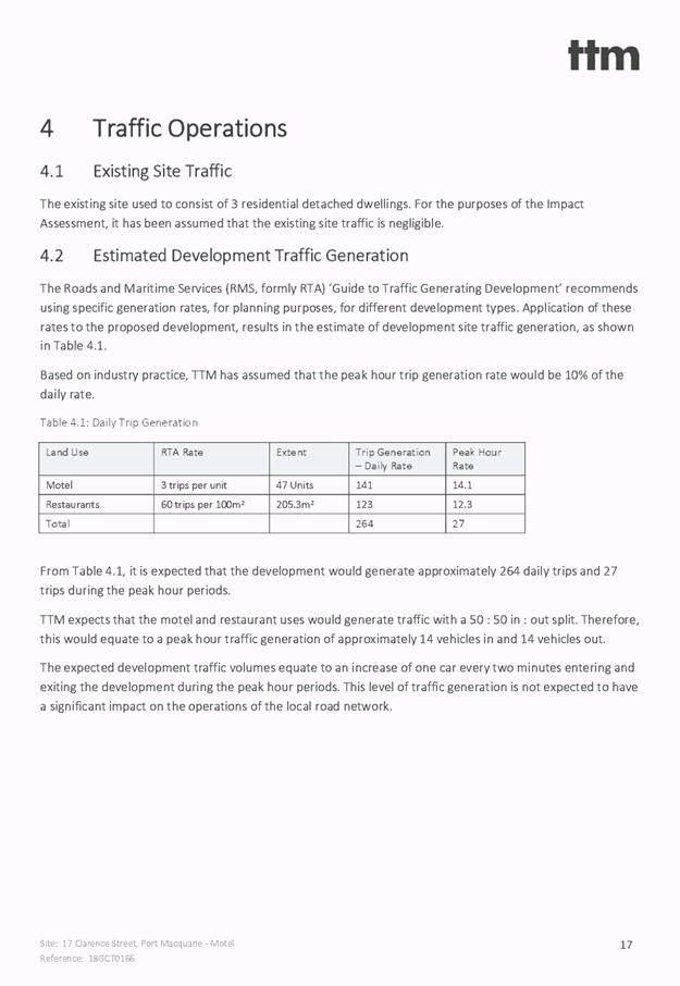
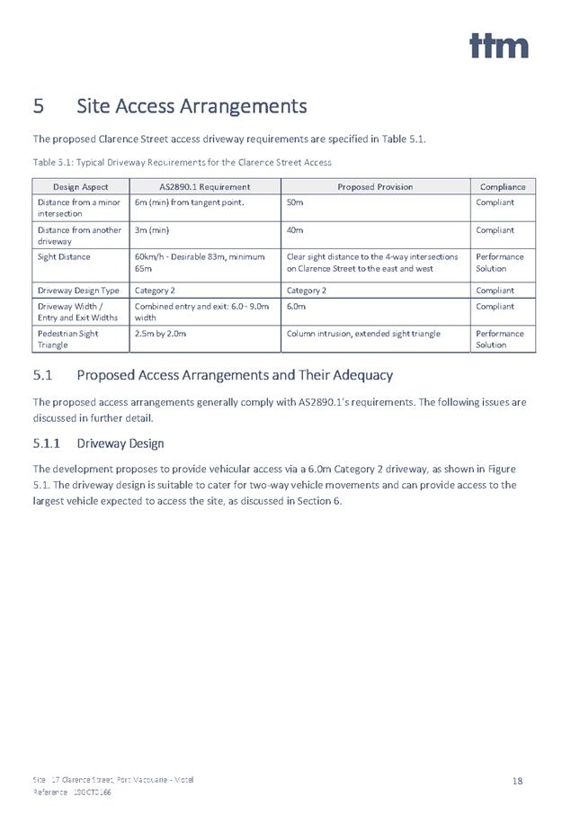
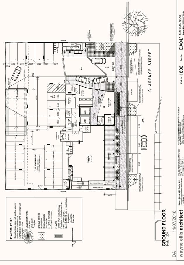
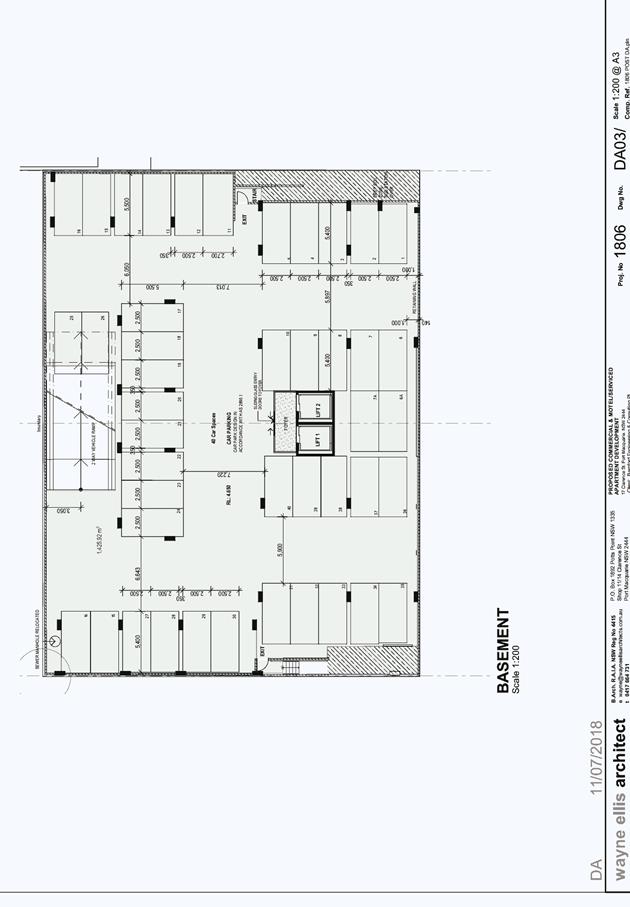
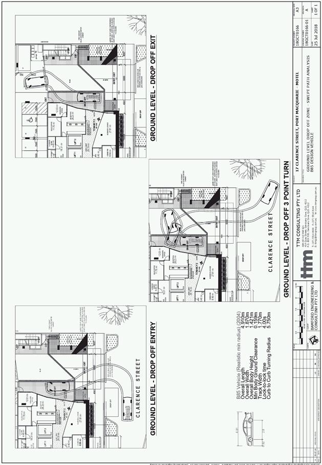
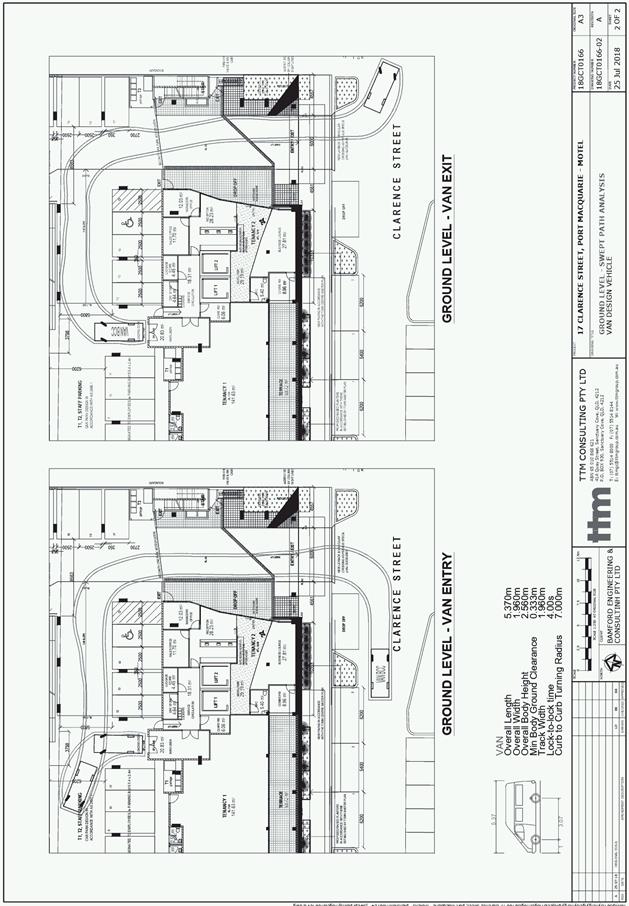
|
ATTACHMENT
|
Development Assessment Panel
22/05/2019
|
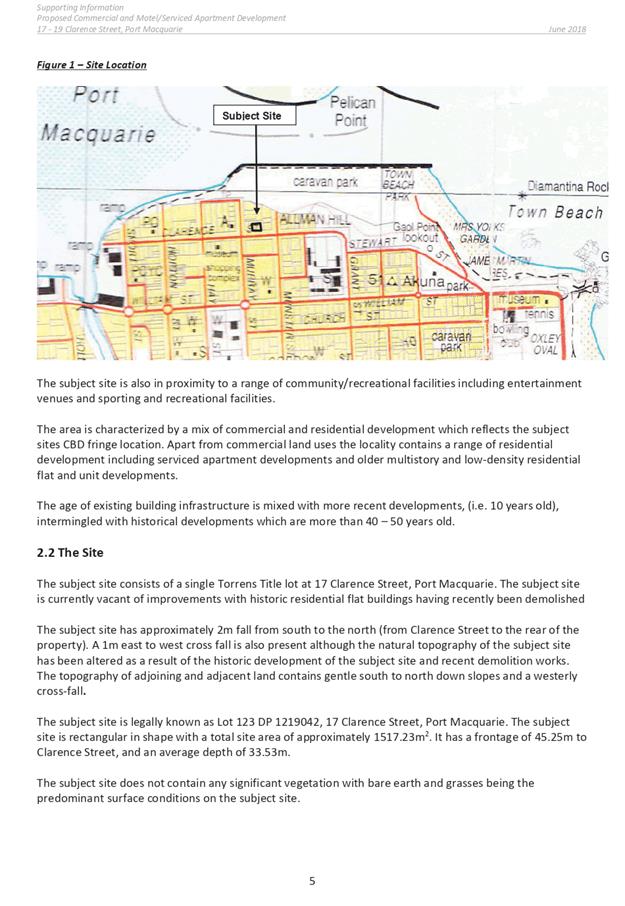
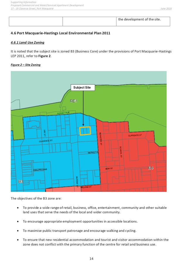
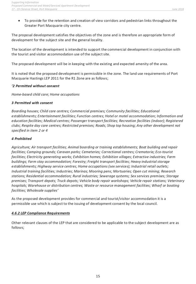
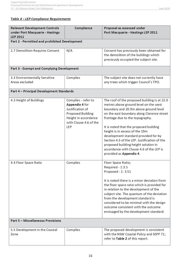
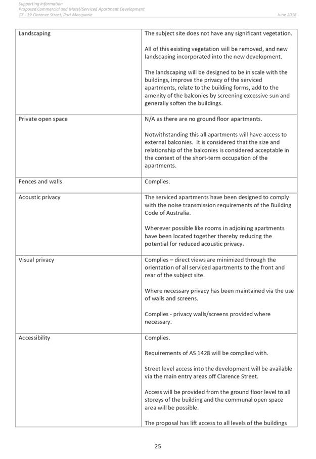

|
ATTACHMENT
|
Development Assessment Panel
22/05/2019
|
|
ATTACHMENT
|
Development Assessment Panel
22/05/2019
|
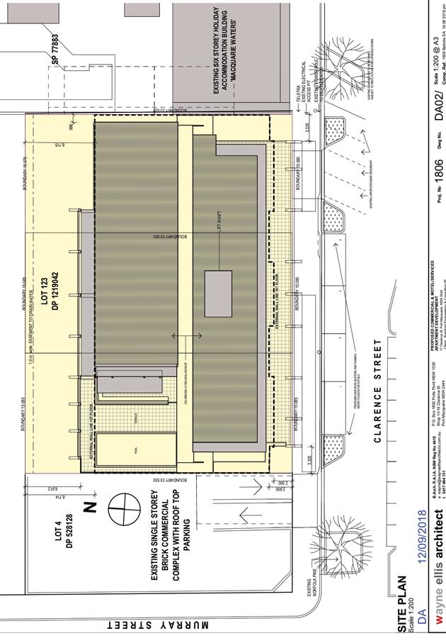
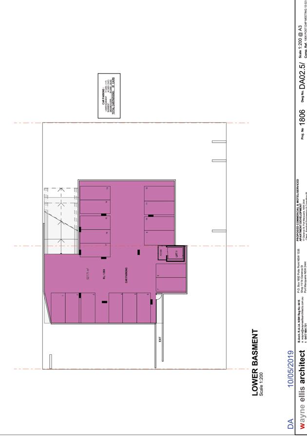
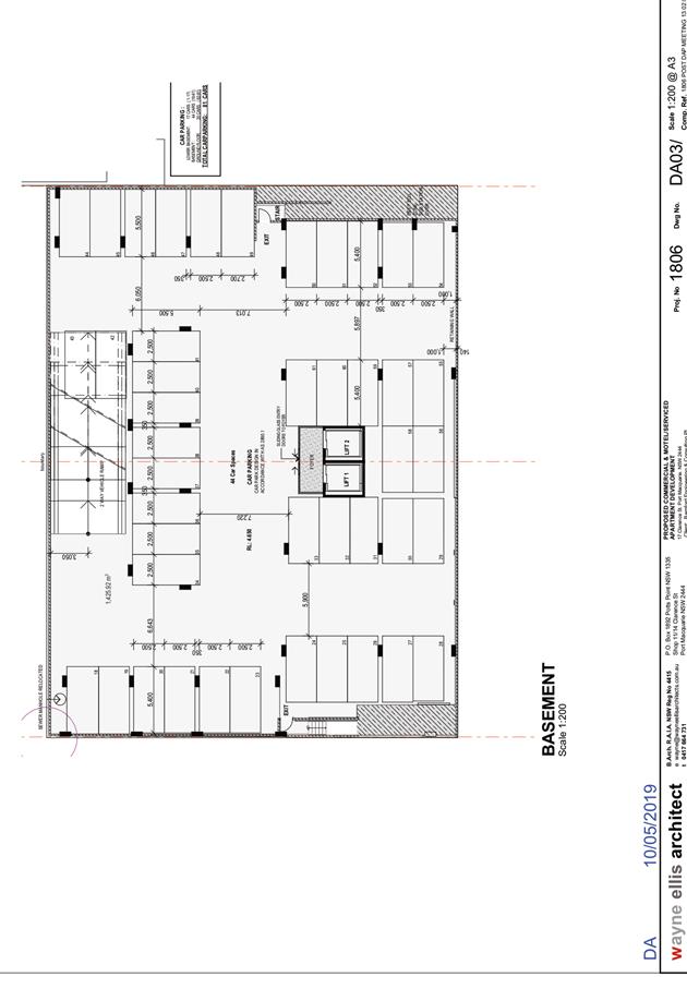
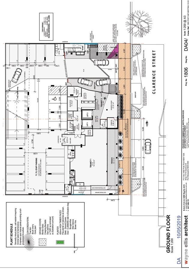
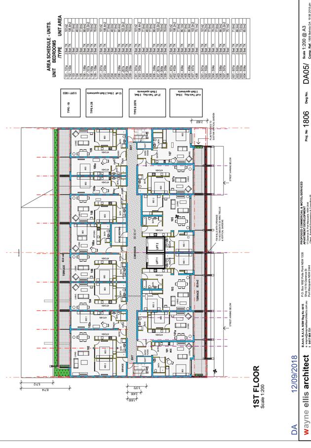
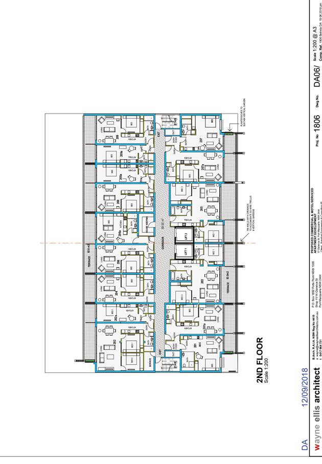
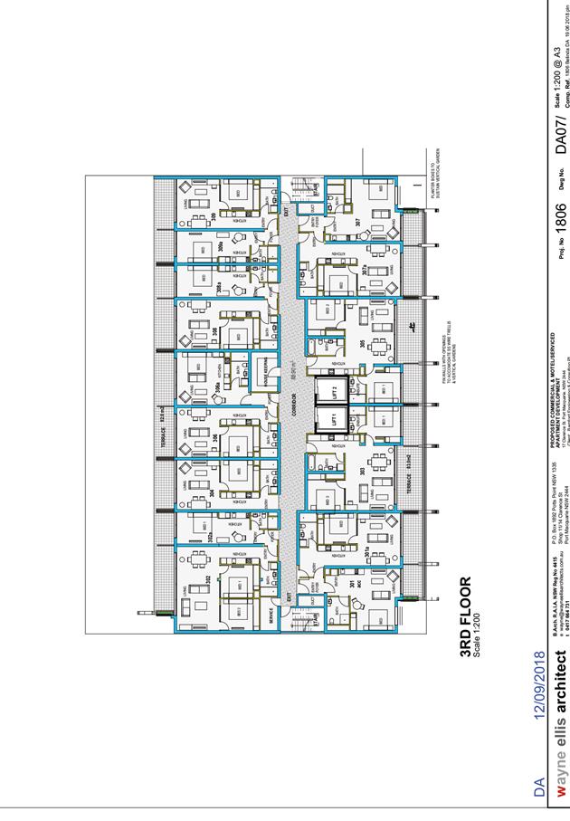

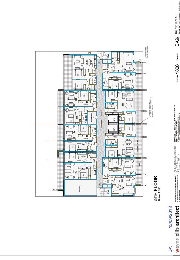
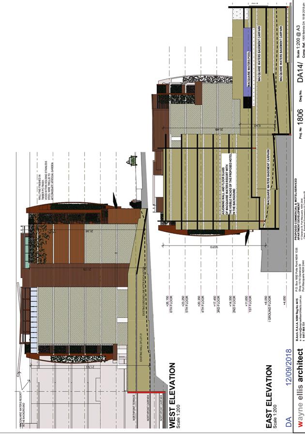
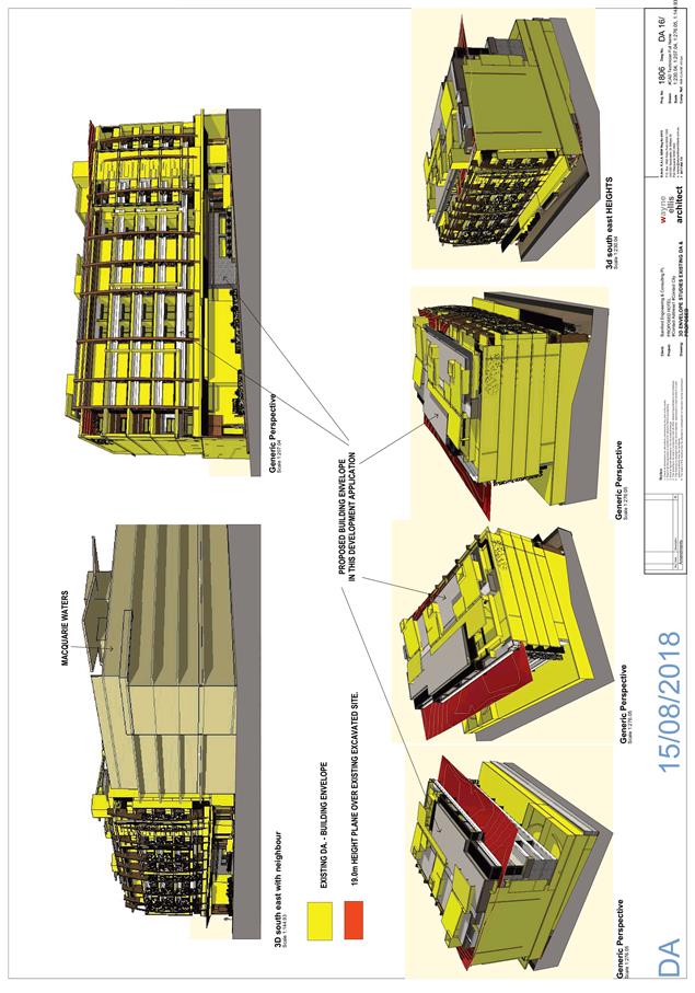
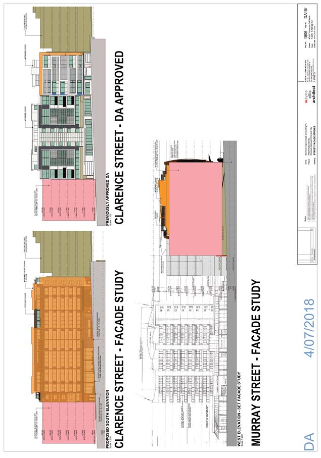
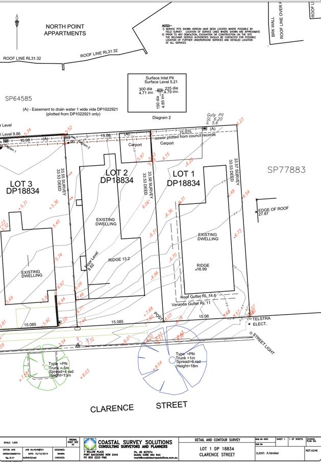
AGENDA Development Assessment Panel 22/05/2019
Item: 07
Subject: DA2018 - 427.1 Dual Occupancy and Torrens Title Subdivision, Boat
Ramps and Jetty at Lot 7 DP 246284, No. 14 Sirius Close, Port Macquarie
Report Author: Development
Assessment Planner, Chris Gardiner
|
Applicant: L
G Wilkie
Owner: L
G Wilkie
Estimated Cost: $700,000
Alignment with Delivery Program
4.3.1 Undertake transparent
and efficient development assessment in accordance with relevant legislation.
|
|
RECOMMENDATION
That
DA2018 - 427.1 for a Dual
Occupancy and Torrens Title Subdivision, Boat Ramps and Jetty at Lot 7, DP 246284, No. 14 Sirius
Close, Port Macquarie, be determined by granting consent subject to the
recommended conditions.
|
Executive
Summary
This
report considers a development application for a Dual Occupancy and
Torrens Title Subdivision, Boat Ramps and Jetty at
the subject site and provides an assessment of the application in accordance
with the Environmental Planning and Assessment Act 1979.
Following exhibition of the
application, one submission has been received.
This report recommends approval of
the development application subject to conditions.
1. BACKGROUND
Existing
sites features and Surrounding development
The site has an area of 860.6m2.
The
site is zoned R1 General Residential in
accordance with the Port Macquarie-Hastings Local Environmental Plan 2011, as
shown in the following zoning plan:
The
existing subdivision pattern and location of existing development within the
locality is shown in the following aerial photograph:
2. DESCRIPTION
OF DEVELOPMENT
Key
aspects of the proposal include the following:
· Demolition
of existing dwelling and swimming pool;
· Construction
of two-storey attached dual occupancy, boat ramps and shared jetty;
· 2
lot Torrens title subdivision;
· Removal
of street tree.
Refer
to attachments at the end of this report.
Application
Chronology
· 8
June 2018 - Application lodged.
· 29 June 2018 to 12 July 2018 - Neighbour notification.
· 9 July 2018 - Additional information requested from
Applicant.
· 28 March 2019 - Additional information submitted.
3. STATUTORY
ASSESSMENT
Section
4.15(1) Matters for Consideration
In
determining the application, Council is required to take into consideration the
following matters as are relevant to the development that apply to the land to
which the development application relates:
(a) The
provisions (where applicable) of:
(i) Any
Environmental Planning Instrument:
State
Environmental Planning Policy No. 55 – Remediation of Land
Following
an inspection of the site and a search of Council records, the subject land is
not identified as being potentially contaminated and is suitable for the
intended use.
State
Environmental Planning Policy (Coastal Management) 2018
The
site is located within a coastal use area and a coastal environment area.
In
accordance with clause 7, this SEPP prevails over the Port Macquarie-Hastings
LEP 2011 in the event of any inconsistency.
Having
regard to clauses 13 and 14 of the SEPP the proposed development is not
considered likely to result in any of the following:
a) any adverse impact on integrity and resilience of the biophysical,
hydrological (surface and groundwater) and ecological environment;
b) any adverse impacts coastal environmental values and natural coastal
processes;
c) any adverse impacts on marine vegetation, native vegetation and fauna and
their habitats, undeveloped headlands and rock platforms;
d) any adverse impact on marine vegetation, native vegetation and fauna and
their habitats, undeveloped headlands and rock platforms;
e) any adverse impact on Aboriginal cultural heritage, practices and places;
f) any adverse impacts on the
cultural and built environment
heritage;
g) any adverse impacts the use of the surf zone;
h) any adverse impact on the visual amenity and scenic
qualities of the coast, including coastal headlands;
i) overshadowing, wind funnelling and the loss of views from
public places to foreshores;
The
bulk, scale and size of the proposed development is compatible with the
surrounding coastal and built environment. The site is predominately cleared
and located within an area zoned for residential purposes.
State
Environmental Planning Policy (Building Sustainability Index: BASIX) 2004
BASIX
certificates have been submitted demonstrating that the proposal will comply
with the requirements of the SEPP. It is recommended that a condition be
imposed to ensure that the commitments are incorporated into the development
and certified at Occupation Certificate stage.
Port Macquarie-Hastings Local Environmental Plan 2011
The
proposal is consistent with the LEP having regard to the following:
· Clause 2.2 - The subject site is zoned R1 General
Residential.
· Clause 2.3(1) and the R1 zone landuse table - The proposed
development for dual occupancy (two semi-detached dwellings following
subdivision) is a permissible landuse with consent.
The objectives of the R1 zone are as follows:
o To provide for the housing needs of the community.
o To provide for a variety of housing types and densities.
o To enable other land uses that provide facilities or
services to meet the day to day needs of residents.
· Clause 2.3(2) - The proposal is consistent with the zone
objectives having regard to the following:
o The proposal is a permissible landuse;
o The development would provide variety in housing types and
densities to meet the housing needs of the community.
· Clause 2.7 - The demolition requires consent as it does not
fit within the provisions of SEPP (Exempt and Complying Development Codes)
2008.
· Clause 4.1A – The proposal includes subdivision into
two lots and construction of a semi-detached dwelling on each lot. Subdivision
to create lots smaller than the 450m2 minimum lot size specified on
the Lot Size Map is therefore permitted.
· Clause 4.3 - The maximum overall height of the building
above ground level (existing) is 7.1m which complies with the standard height
limit of 8.5m applying to the site.
· Clause 4.4 - The floor space ratio of the proposal is
0.50:1 which complies with the maximum 0.65:1 floor space ratio applying to the
site.
· Clause 5.7 – Development below highwater mark –
Consent has been sought in this application for the proposed jetty and boat ramps.
· Clause 5.10 – Heritage. The site does not contain or
adjoin any known heritage items or sites of significance.
· Clause 7.1 - The site is mapped as potentially containing
class 1 and 3 acid sulphate soils. A condition is recommended requiring the development
to be carried out in accordance with Council’s Acid Sulphate Soil
Management Plan for Minor Works.
· Clause 7.3 - The site is within the mapped “flood
planning area” (Land subject to flood discharge of 1:100 annual
recurrence interval flood event (plus the applicable climate change allowance
and relevant freeboard). In this regard the following comments are provided
which incorporate consideration of the objectives of Clause 7.3,
Council’s Flood Policy 2015, the NSW Government’s Flood Prone
Lands Policy and the NSW Government’s Floodplain Development
Manual (2005):
o The proposal is compatible with the flood hazard of the
land taking into account projected changes as a result of climate change;
o The proposal will not result in a significant adverse
affect on flood behaviour that would result in detrimental increases in the
potential flood affectation of other development or properties;
o The proposal incorporates measures to minimise and manage
the flood risk to life and property associated with the use of land;
o The proposal is not likely to significantly adversely
affect the environment or cause avoidable erosion, siltation, destruction of
riparian vegetation or a reduction in the stability of river banks or
watercourses;
o The proposal is not likely to result in unsustainable
social and economic costs to the community as a consequence of flooding;
· Clause 7.13 - Satisfactory arrangements are in place for
provision of essential services including water supply, electricity supply,
sewer infrastructure, stormwater drainage and suitable road access to service
the development. Provision of electricity will be subject to obtaining
satisfactory arrangements certification prior to the issue of a Subdivision
Certificate as required by a condition of consent.
(ii) Any draft
instruments that apply to the site or are on exhibition:
No draft instruments apply to
the site.
(iii) Any Development
Control Plan in force:
Port
Macquarie-Hastings Development Control Plan 2013
|
DCP 2013: Dwellings, Dual occupancies, Dwelling
houses, Multi dwelling houses & Ancillary development
|
|
|
Requirements
|
Proposed
|
Complies
|
|
3.2.2.1
|
Ancillary development:
• 4.8m
max. height
• Single
storey
• 60m2
max. area
• 100m2
for lots >900m2
• 24
degree max. roof pitch
• Not
located in front setback
|
None proposed.
|
N/A
|
|
3.2.2.2
|
Articulation zone:
• Min.
3m front setback
• An
entry feature or portico
• A
balcony, deck, patio, pergola, terrace or verandah
• A
window box treatment
• A
bay window or similar feature
• An
awning or other feature over a window
• A
sun shading feature
|
Entry patios at 3m front setback. The patios do not exceed
25% of the articulation zone and are still setback a minimum of 3m.
|
Yes
|
|
Front setback (Residential not R5 zone):
• Min.
6.0m classified road
• Min.
4.5m local road or within 20% of adjoining dwelling if on corner lot
• Min.
3.0m secondary road
• Min.
2.0m Laneway
|
Front building line setback requirements are complied
with.
|
Yes
|
|
3.2.2.3
|
Garage 5.5m min. and 1m behind front façade.
Garage door recessed behind building line or
eaves/overhangs provided
|
Garage door setback requirements are complied with.
|
Yes
|
|
6m max. width of garage door/s and 50% max. width of
building
|
Garage doors each 4.88m wide and 54% of the width of the
building. The proposal is a very minor variation and it is common in the
canals for dwellings to be designed to address the water rather than the
street. The proposal would not be out of place in the streetscape.
|
No, but acceptable
|
|
Driveway crossover 1/3 max. of site frontage and max. 5.0m
width
|
3m wide and less than 1/3 of site frontage.
|
Yes
|
|
3.2.2.4
|
4m min. rear setback. Variation subject to site analysis
and provision of private open space
|
The rear setback requirements are complied with.
|
Yes
|
|
3.2.2.5
|
Side setbacks:
• Ground
floor = min. 0.9m
• First
floors & above = min. 3m setback or where it can be demonstrated that
overshadowing not adverse = 0.9m min.
• Building
wall set in and out every 12m by 0.5m
|
The minimum side setback requirements are complied with.
The wall articulation is compliant and satisfies the
objectives of the development provision.
|
Yes
|
|
3.2.2.6
|
35m2 min. private open space area including a useable 4x4m
min. area which has 5% max. grade
|
Each occupancy contains 35m² open space in one area
including a useable 4m x 4m area.
|
Yes
|
|
3.2.2.7
|
Front fences:
• If
solid 1.2m max height and front setback 1.0m with landscaping
• 3x3m
min. splay for corner sites
• Fences
>1.2m to be 1.8m max. height for 50% or 6.0m max. length of street
frontage with 25% openings
• 0.9x0.9m
splays adjoining driveway entrances
|
No front fences proposed.
|
N/A
|
|
3.2.2.8
|
Front fences and walls to have complimentary materials to
context
No chain wire, solid timber, masonry or solid steel front
fences
|
No front fencing proposed.
|
N/A
|
|
3.2.2.10
|
Privacy:
• Direct
views between living areas of adjacent dwellings screened when within 9m
radius of any part of window of adjacent dwelling and within 12m of private
open space areas of adjacent dwellings. ie. 1.8m fence or privacy screening
which has 25% max. openings and is permanently fixed
• Privacy
screen required if floor level > 1m height, window side/rear setback
(other than bedroom) is less than 3m and sill height less than 1.5m
• Privacy
screens provided to balconies/verandahs etc which have <3m side/rear
setback and floor level height >1m
|
The development will not compromise privacy in the area
due to a combination of lack of windows on side/rear boundaries, having high
sill windows that face side/rear boundaries, limiting living areas that face
adjoining living areas/open space, compliant separation and use of
screening/fencing.
|
Yes
|
|
3.2.2.11
|
Roof terraces
|
N/A
|
|
|
3.2.2.12
|
Jetties and boat ramps:
The design of any jetty or boating structure should be in
accordance with Council’s adopted design specification documents
|
Standard condition recommended requiring jetty/pontoon to
comply with Council’s specifications.
|
Yes
|
|
3.2.2.13
|
Mooring piles are to be set at a level no lower than the
level which ensures that the floating structure is retained during the design
1:100 year flood event.
|
These requirements are satisfied.
|
Yes.
|
|
The width of a jetty walkway leading to a platform should
not be greater than 1.0 metres.
|
|
The area of a platform at the end of a walkway should not
exceed 10m².
|
|
The overall length of a jetty when measured from the
existing revetment wall should not exceed 17m.
|
|
Boating ramps should have a maximum overall width of 3.0
metres and a maximum overall length of 10.0 metres when measured from the
existing revetment wall unless associated with a boatshed where the boat ramp
should not exceed 2.7m in width.
|
|
Pontoons moored at right angles to the revetment wall
should not extend beyond a point 17 metres from the wall.
|
|
Pile cut off levels should not be lower than RL3.0m AHD.
|
|
Fixed jetties may only extend to a point 7m from the
revetment wall.
|
|
Any extension beyond a point 7m from the revetment wall is
to be by way of a pivoting walkway to a floating pontoon.
|
|
The deck of the jetty is to be above and not resting on
the revetment wall and the top surface is not to be above RL 1.4m AHD.
|
|
Pontoons moored parallel to the revetment wall should not
extend beyond a point 12 metres from it.
|
|
Floating moorings should be located between 17m from the
revetment wall.
|
|
Fixed mooring poles should not be greater than 17m from
the revetment wall.
|
|
3.2.2.14
|
Jetties and moorings (both fixed and floating) should be
located a minimum of 10m from any jetty or mooring (both fixed and floating)
located on any adjacent property.
|
More than 10m from adjoining jetties.
|
Yes
|
|
|
Boat ramps and jetties should be located in such a way
that vessels using the boat ramp or moored on a jetty do not project past a
line which is a prolongation of the side boundaries of the development site.
|
Within prolongation of side boundaries.
|
Yes
|
|
3.2.2.15
|
For a dual occupancy development only one shared jetty is
permitted.
|
Single shared jetty. Condition recommended requiring
appropriate easement for shared use and maintenance over the part of the
jetty located within the lots.
|
Yes
|
|
DCP 2013: General Provisions
|
|
|
Requirements
|
Proposed
|
Complies
|
|
2.7.2.2
|
Design addresses generic principles of Crime Prevention
Through Environmental Design guideline
|
No concealment or entrapment areas proposed. Adequate
casual surveillance available.
|
Yes
|
|
2.3.3.1
|
Cut and fill 1.0m max. 1m outside the perimeter of the
external building walls
|
New 1.2m high retaining wall proposed to replace existing
retaining wall. The works propose a realignment of the existing wall and
would involve small areas of cut/fill exceeding 1m. The works are consistent
with the finished landform on adjoining properties and would result in a
significant change to the current site.
|
No, but acceptable.
|
|
2.3.3.2
|
1m max. height retaining walls along road frontage
|
None proposed
|
N/A
|
|
Any retaining wall >1.0 in height to be certified by
structure engineer
|
Condition recommended to require engineering
certification.
|
Yes
|
|
Combination of retaining wall and front fence height max
1.8m, max length 6.0m or 30% of frontage, fence component 25% transparent,
and splay at corners and adjacent to driveway
|
No retaining wall front fence combination proposed.
|
N/A
|
|
2.3.3.8
|
Removal of hollow bearing trees
|
No hollow bearing trees proposed to be removed
|
N/A
|
|
2.6.3.1
|
Tree removal (3m or higher with 100m diameter trunk at 1m
above ground level and 3m from external wall of existing dwelling)
|
The proposal includes removal of a mature Tallowwood in
the street frontage to allow for the development and construction of
associated driveways. Council’s Tree Management section have reviewed
the proposal and submitted Arborist’s report and agreed that the tree
can be removed at the developer’s cost subject to provision of a
replacement amenity tree and offset planting of 2 Koala food trees in a
location agreed by Council. A condition has been recommended confirming the
offset requirements.
|
Yes
|
|
2.4.3
|
Bushfire risk, Acid sulphate soils, Flooding,
Contamination, Airspace protection, Noise and Stormwater
|
Refer to main body of report.
|
|
|
2.5.3.2
|
New accesses not permitted from arterial or distributor
roads
|
No new access proposed to arterial or distributor road.
|
N/A
|
|
Driveway crossing/s minimal in number and width including
maximising street parking
|
Driveway crossings are minimal in width including
maximising street parking.
|
Yes
|
|
2.5.3.3
|
Parking in accordance with Table 2.5.1.
Dwelling/dual occupancies
1 space per dwelling/occupancy (behind building line).
Multi dwelling
1 space per 1 & 2 bedroom occupancies
1.5 spaces per 3+ bedroom occupancies
0.25 spaces per occupancy for visitor parking.
|
Dual occupancy provides a minimum of 1 parking space per
dwelling.
|
Yes
|
|
2.5.3.11
|
Section 94 contributions
|
Contributions apply - refer to ET calc and NOP.
|
Yes
|
|
2.5.3.12 and 2.5.3.13
|
Landscaping of parking areas
|
Suitable landscaping proposed around driveway/parking
locations.
|
Yes
|
|
2.5.3.14
|
Sealed driveway surfaces unless justified
|
Sealed driveway areas proposed.
|
Yes
|
|
2.5.3.15 and 2.5.3.16
|
Driveway grades first 6m or ‘parking area’
shall be 5% grade with transitions of 2m length
|
Driveway grades capable of satisfying Council standard
driveway crossover requirements. Condition recommended for section 138 Roads
Act permit
|
Yes
|
|
2.5.3.17
|
Parking areas to be designed to avoid concentrations of
water runoff on the surface.
|
Stormwater drainage is capable of being managed as part of
plumbing construction.
|
Yes
|
Note: Subdivision provisions
of the DCP (except battleaxe handle width) are aimed at the creation of vacant
lots (i.e. not lots within an integrated housing proposal such as this) and
have therefore been excluded from the above assessment. Servicing requirements
are discussed later in this report.
Based on the above assessment, the variations proposed to
the provisions of the DCP are considered acceptable and the relevant objectives
have been satisfied.
Cumulatively, the variations do not amount to an adverse
impact or a significance that would justify refusal of the application.
(iiia) Any planning agreement that has
been entered into under section 7.4, or any draft planning agreement that a
developer has offered to enter into under section 7.4:
No planning agreement has been
offered or entered into relating to the site.
iv) Any
matters prescribed by the Regulations:
Demolition
of buildings AS 2601:
Demolition of the existing
building on the site is capable of compliance with this Australian Standard and
is recommended to be conditioned.
(b) The likely
impacts of the development, including environmental impacts on both the natural
and built environments, social and economic impacts in the locality:
Context
and setting
• The proposal will be unlikely to have any adverse impacts
to existing adjoining properties and satisfactorily addresses the public
domain.
• The proposal is considered to be compatible with other
residential development in the locality and adequately addresses planning
controls for the area.
• There are no adverse impacts on existing view sharing.
• There are no adverse privacy impacts.
• There are no adverse overshadowing impacts. The proposal
does not prevent adjoining properties from receiving 3 hours of sunlight to
private open space and primary living areas on 21 June.
Roads
The
site has road frontage to Sirius Close.
Adjacent
to the site, Sirius Close is a sealed public road under the care and control of
Council.
Traffic
and Transport
The
traffic associated with the development is unlikely to have any adverse impacts
to the existing road network within the immediate locality.
Site
Frontage & Access
Vehicle
access to the site is proposed though two individual driveways with direct
frontage to Sirius Close. Access shall comply with Council AUSPEC and
Australian Standards, and conditions have been imposed to reflect these
requirements.
Water
Supply Connection
Council
records indicate that the development site has an existing 20mm sealed water
service from the 100mm Asbestos Cement water main on the opposite side of
Sirius Close. Each proposed lot requires an individual metered water service
with the meter located at the property road frontage.
Detailed
plans will be required to be submitted for assessment with the S.68
application.
Sewer
Connection
Council
records indicate that the development site is connected to Sewer via a junction
to the existing 150mm Asbestos Cement sewer main running parallel to the front
boundary of the development site. Each proposed lot requires an individual
junction to the existing Sewer main. Engineering plans shall be required as
part of the Infrastructure Construction Certificate.
Stormwater
The
site naturally grades towards the rear and is currently serviced via a direct
connection to the public piped drainage system.
The legal
point of discharge for the proposed development is an inter-allotment drainage
system connecting to the public piped drainage system in Sirius Close.
A
detailed site stormwater management plan will be required to be submitted for
assessment with the Section 68 application and prior to the issue of a Construction
Certificate. In accordance with Councils AUSPEC requirements, the following
must be incorporated into the stormwater drainage plan:
· Structural design is required for that part of the dwelling
constructed adjacent to the stormwater easement. The design shall demonstrate
that no loading is transferred to the existing stormwater pipeline traversing
the site.
· Plans to show eaves located out of the existing easement or
alternatively supporting documentation is to be submitted demonstrating that a
minimum vertical clearance of 3000mm is available between the ground surface
and the underside of the eaves.
Other
Utilities
Telecommunication
and electricity services are available to the site. Evidence of satisfactory
arrangements with the relevant utility authorities for provision to each
proposed lot will be required prior to Subdivision Certificate approval.
Heritage
No
known items of Aboriginal or European heritage significance exist on the
property. No adverse impacts anticipated.
Other
land resources
The
site is within an established urban context and will not sterilise any
significant mineral or agricultural resource.
Water
cycle
The
proposed development will be unlikely to have any adverse impacts on water
resources and the water cycle.
Soils
The
proposed development will be unlikely to have any adverse impacts on soils in
terms of quality, erosion, stability and/or productivity subject to a standard
condition requiring erosion and sediment controls to be in place prior to and
during construction.
Air
and microclimate
The
construction and/or operations of the proposed development will be unlikely to
result in any adverse impacts on the existing air quality or result in any
pollution. Standard precautionary site management condition recommended.
Flora
and fauna
The
proposed development includes removal of a single Tallowwood in the site
frontage in Sirius Close. The Biodiversity Offset Scheme doesn’t apply
for the following reasons:
· The land isn’t identified on the Biodiversity Values
Map;
· The extent of clearing is below the thresholds in Clause
7.2 of the Biodiversity Conservation Regulation 2017;
· The application of the test of significance (5 part test)
demonstrates that the development will not have a significant impact on
biodiversity values.
Waste
Satisfactory
arrangements are in place for proposed storage and collection of waste and
recyclables. No adverse impacts anticipated. Standard precautionary site management
condition recommended.
Energy
The
proposal includes measures to address energy efficiency and will be required to
comply with the requirements of BASIX.
Noise
and vibration
No
adverse impacts anticipated. Condition recommended to restrict construction to
standard construction hours.
Bushfire
The site is not identified as being bushfire prone.
Safety,
security and crime prevention
The
proposed development will be unlikely to create any concealment/entrapment
areas or crime spots that would result in any identifiable loss of safety or
reduction of security in the immediate area. The increase in housing density
will improve natural surveillance within the locality and openings from each
dwelling overlook common and private areas.
Social
impacts in the locality
Given
the nature of the proposed development and its’ location the proposal is
unlikely to result in any adverse social impacts.
Economic
impact in the locality
No
adverse impacts. A likely positive impact is that the development will maintain
employment in the construction industry, which will lead to flow impacts such
as expenditure in the area.
Site
design and internal design
The
proposed development design satisfactorily responds to the site attributes and
will fit into the locality. No adverse impacts likely.
Construction
No
potential adverse impacts identified to neighbouring properties with the
construction of the proposal.
Cumulative
impacts
The
proposed development is not expected to have any adverse cumulative impacts on
the natural or built environment or the social and economic attributes of the
locality.
(c) The
suitability of the site for the development:
The proposal will fit into the
locality and the site attributes are conducive to the proposed development.
Site constraints have been
adequately addressed and appropriate conditions of consent recommended.
(d) Any
submissions made in accordance with this Act or the Regulations:
One written
submission has been received following public exhibition of the application.
Key
issues raised in the submission and comments in response to these issues are
provided as follows:
|
Submission Issue/Summary
|
Planning Comment/Response
|
|
Dividing fence (wall) between
the site and adjoining property at 12B Sirius Close has been damaged by a
tree on the Applicant’s property. Request that the wall be repaired at
the Applicant’s expense.
|
Disputes over the maintenance
or repair of a dividing fence need to be resolved through the relevant
procedures in the Dividing Fences Act 1991, and are not a matter for
consideration by the consent authority.
In the context of the proposal
it is necessary that a 1.8m high fence be provided/maintained between the
properties to satisfy the privacy provisions in the DCP. A condition has been
recommended requiring such fencing to be completed prior to the issue of an
Occupation Certificate.
The location, style, materials
and cost sharing will need to be determined separately between the parties.
|
(e) The
Public Interest:
The proposed development
satisfies relevant planning controls and is unlikely to impact on the wider
public interest.
4. DEVELOPMENT
CONTRIBUTIONS APPLICABLE
· Development contributions will be required towards
augmentation of town water supply and sewerage system head works under Section
64 of the Local Government Act 1993.
· Development contributions will be required under Section 94
of the Environmental Planning and Assessment Act 1979 towards roads, open
space, community cultural services, emergency services and administration
buildings.
5. CONCLUSION
AND STATEMENT OF REASON
The application has been assessed in accordance with Section
4.15 of the Environmental Planning and Assessment Act 1979.
Issues raised during assessment and public exhibition of the
application have been considered in the assessment of the application. Where
relevant, conditions have been recommended to manage the impacts attributed to
these issues.
The site is considered suitable for the proposed development
and the proposal adequately addresses relevant planning controls. The
development is not considered to be contrary to the public's interest and will
not result a significant adverse social, environmental or economic impact. It
is recommended that the application be approved, subject to the recommended
conditions of consent provided in the attachment section of this report.
|
Attachments
1View. DA2018
- 427.1 Recommended Conditions.
2View. DA2018
- 427.1 Contributions Estimate
3View. DA2018
- 427.1 Plans
|
|
ATTACHMENT
|
Development Assessment Panel
22/05/2019
|
|
ATTACHMENT
|
Development Assessment Panel
22/05/2019
|
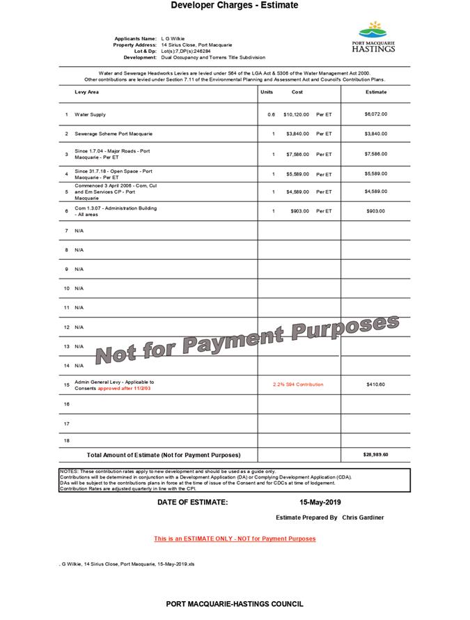
|
ATTACHMENT
|
Development Assessment Panel
22/05/2019
|
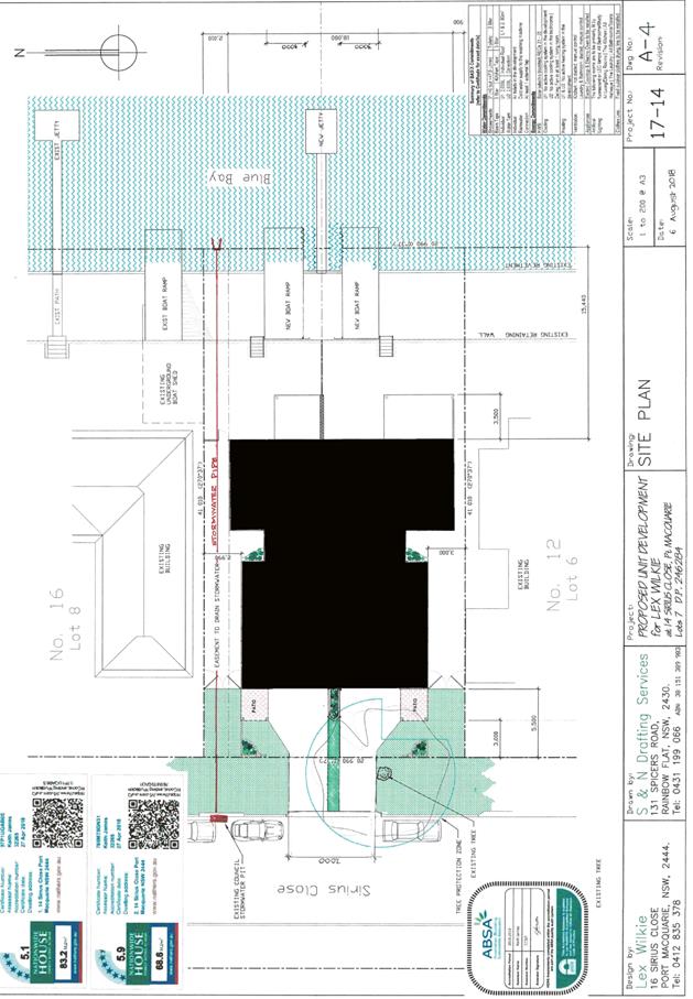
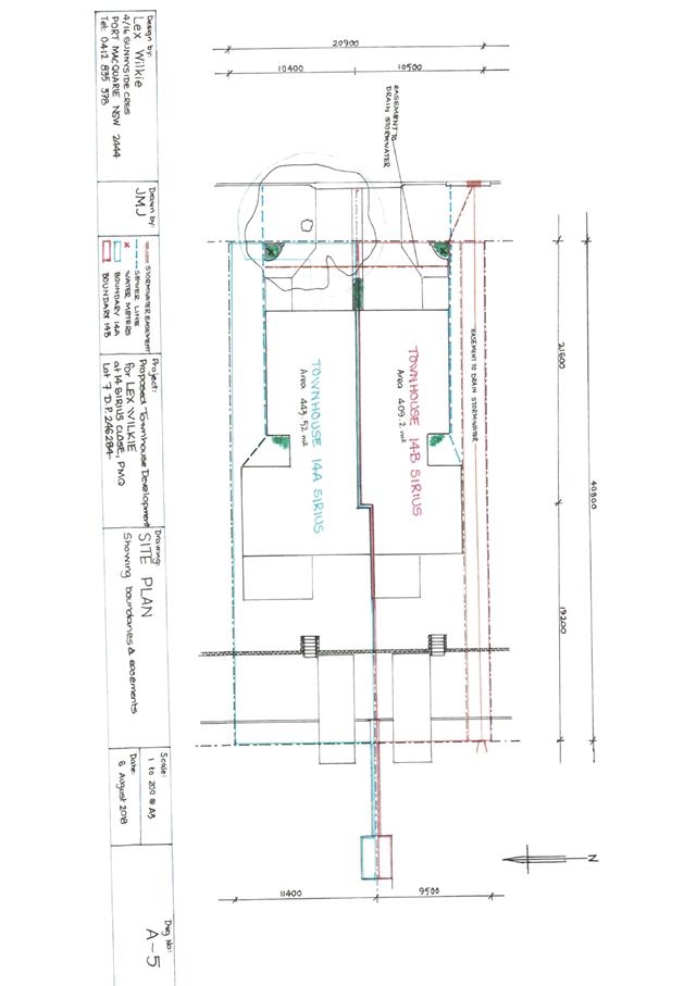
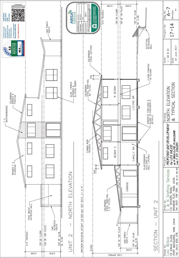
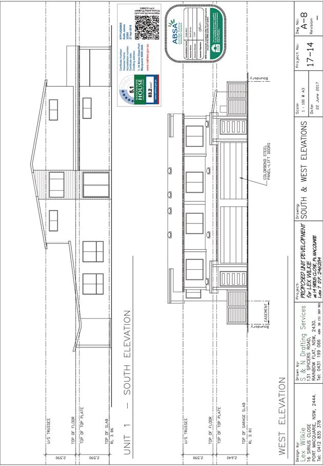
AGENDA Development Assessment Panel 22/05/2019
Item: 08
Subject: DA2019 - 27.1 Permanent Group Home - Lot 31 DP
1190016, No. 5 McGilvray Road, Bonny Hills
Report
Author: Development Assessment Planner, Fiona Tierney
|
Applicant: BlueCHP
Limited
Owner: Minister
for Disability Services
Estimated Cost: $1,148,000
Alignment with Delivery
Program
4.3.1 Undertake transparent
and efficient development assessment in accordance with relevant legislation.
|
|
RECOMMENDATION
That
DA 2019 - 27.1 for a Permanent Group Home at Lot 31, DP 1190016, No. 5 McGilvray
Road, Bonny Hills, be determined by granting
consent subject to the recommended conditions.
|
Executive
Summary
This
report considers a development application for a permanent group home at the subject site and provides an assessment of the
application in accordance with the Environmental Planning and Assessment Act
1979.
Following exhibition of the
application, four (4) submissions have been
received.
This report recommends that the
development application be approved subject to conditions.
1. BACKGROUND
Existing sites features and Surrounding development
The site has an area of 2024.4m2.
The site is zoned R1 General Residential in accordance with the Port Macquarie-Hastings Local
Environmental Plan 2011, as shown in the following zoning plan:
The existing subdivision pattern and location of existing
development within the locality is shown in the following aerial photograph:
2. DESCRIPTION OF
DEVELOPMENT
Key aspects of the proposal include the following:
· Demolition
of existing dwelling and associated structures
· Construction
of Five (5) bedroom Permanent Group Home
Refer
to attachments at the end of this report.
Application Chronology
· 18
January 2019 - Application lodged
· 24 January 2019 to 6 February 2019 - Neighbour notification
3. STATUTORY ASSESSMENT
Section 4.15(1) Matters for Consideration
In determining the application, Council is required to take
into consideration the following matters as are relevant to the development
that apply to the land to which the development application relates:
(a) The provisions (where
applicable) of:
(i) Any Environmental
Planning Instrument:
State Environmental Planning Policy No. 44 - Koala
Habitat Protection
With reference to clauses 6 and 7, the subject land is not
greater than 1 hectare (including any adjoining land under same ownership) and
therefore the provisions of SEPP do not apply.
The application has demonstrated that no habitat will be
removed or modified therefore no further investigations are required.
State Environmental Planning Policy No. 55 –
Remediation of Land
Following an inspection of the site and a search of Council
records, the subject land is not identified as being potentially contaminated
and is suitable for the intended use.
State Environmental Planning Policy (Building
Sustainability Index: BASIX) 2004
A BASIX certificate has been submitted demonstrating that
the proposal will comply with the requirements of the SEPP. It is
recommended that a condition be imposed to ensure that the commitments are
incorporated into the development and certified at Occupation Certificate
stage.
State Environmental Planning Policy (Infrastructure) 2007
Vehicular access is proposed as a part of this application
to the local road known as McGilvray Road. The proposed connection to Sherwood
Road is approximately 50m from the intersection of McGilvray and the classified
road (Ocean Drive).
The proposed Group Home alone does not trigger any of the
thresholds of Schedule 3 of this Policy. The proposed development seeks to
provide a total of 1 accessible space within a garage and 2 stacked spaces in
front.
For this reason, referral to the RMS is not considered to be
required.
The proposed development is not considered likely to
generate a significant amount of emissions and the development is considered to
be appropriately located so as not to be affected by road noise or vehicle
emissions.
State Environmental Planning Policy (Affordable rental
Housing) 2009
|
Clause
|
Proposed
|
Complies
|
|
7. Land to which Policy applies
|
|
|
|
Policy applies to land within New South Wales.
|
The subject site is zoned R1 General Residential and
is therefore zoned for urban purposes.
|
Yes
|
|
DIVISION 7 Group Homes
|
|
|
|
42 Definitions:
group home means a permanent group home or a transitional
group home
permanent group home means a dwelling:
(a) that
is occupied by persons as a single household with or without paid supervision
or care and whether or not those persons are related or payment for board and
lodging is required, and
(b) that
is used to provide permanent household accommodation for people with a
disability or people who are socially disadvantaged,
prescribed zone means:
(a) any
of the following land use zones or a land use zone that is equivalent to any
of those zones:
(i) Zone
R1 General Residential,
(ii) Zone
R2 Low Density Residential,
(iii) Zone
R3 Medium Density Residential,
(iv) Zone
R4 High Density Residential,
(v) Zone
B4 Mixed Use,
(vi) Zone
SP1 Special Activities,
(vii) Zone
SP2 Infrastructure
|
The application seeks to provide housing for people
with a disability as a permanent group home. It is to be occupied as a single
household with one common care provider resident at the site on rostered
shifts 24/7.
The site is located within an R1 General Residential
Zone
|
Yes
Yes
|
|
43 Development in prescribed zones
(1)
Development for the purpose of a permanent group home or a transitional group
home on land in a prescribed zone may be carried out:
(a) without
consent if the development does not result in more than 10 bedrooms being
within one or more group homes on a site and the development is carried out
by or on behalf of a public authority, or
(b) with
consent in any other case.
|
The development is not being carried on behalf of a
public authority. The applicant has advised it is a private venture.
|
Yes
|
|
46 Determination of development applications
(1) A
consent authority must not:
(a) refuse
consent to development for the purpose of a group home unless the consent
authority has made an assessment of the community need for the group home, or
(b) impose
a condition on any consent granted for a group home only for the reason that
the development is for the purpose of a group home.
(2)
This clause applies to development for the purpose of a group home that is
permissible with consent under this or any other environmental planning
instrument.
|
The applicant has demonstrated a community need for
the group home. There is shortage of group homes within the Hastings area and
very limited options in Bonny Hills.
|
Yes
|
Port Macquarie-Hastings Local Environmental
Plan 2011
The proposal is consistent with
the LEP having regard to the following:
· Clause
2.2 - The subject site is zoned R1 general residential. I
· Clause
2.3(1) and the R1 zone landuse table - The proposed development for seniors
housing is a permissible landuse with consent.
The objectives of the R1 zone are as
follows:
o To provide for the housing needs of the community.
o To provide for a variety of housing types and densities.
o To enable other land uses that provide facilities or
services to meet the day to day needs of residents.
· Clause
2.3(2) - The proposal is consistent with the zone objectives having regard to
the following:
o the proposal is a permissible
landuse;
o the proposal will provide a
variety of housing type at a suitable density.
· Clause
4.3 - The maximum overall height of the building above ground level (existing)
is approximately 5.5m which complies with the standard height limit of 8.5m
applying to the site.
· Clause
4.4 - The proposed development proposes a gross floor area of approximately
261m2 within an area of approximately 2024m2 resulting in
a floor space ratio (FSR) of 0.13:1. Which complies with the maximum
floor space ratio of 0.65:1.
· Clause
5.10 – Heritage. The site does not contain or adjoin any known heritage
items or sites of significance.
· Clause
7.13 - Satisfactory arrangements are in place for provision of essential services
including water supply, electricity supply, sewer infrastructure, stormwater
drainage and suitable road access to service the development.
(ii) Any
draft instruments that apply to the site or are on exhibition:
Nil
(iii) Any
Development Control Plan in force:
Port Macquarie-Hastings Development Control Plan 2013:
|
DCP 2013: Dwellings, Dual occupancies, Dwelling
houses, Multi dwelling houses & Ancillary development
|
|
|
Requirements
|
Proposed
|
Complies
|
|
3.2.2.1
|
Ancillary development:
• 4.8m
max. height
• Single
storey
• 60m2
max. area
• 100m2
for lots >900m2
• 24
degree max. roof pitch
• Not
located in front setback
|
Water tanks are appropriately located
|
Yes
|
|
3.2.2.2
|
Articulation zone:
• Min.
3m front setback
• An
entry feature or portico
• A
balcony, deck, patio, pergola, terrace or verandah
• A
window box treatment
• A
bay window or similar feature
• An
awning or other feature over a window
• A
sun shading feature
|
No elements within the articulation zone.
|
N/A
|
|
Front setback (Residential not R5 zone):
• Min.
6.0m classified road
• Min.
4.5m local road or within 20% of adjoining dwelling if on corner lot
• Min.
3.0m secondary road
• Min.
2.0m Laneway
|
Front building line setback requirements are complied
with.
|
Yes
|
|
3.2.2.3
|
Garage 5.5m min. and 1m behind front façade.
Garage door recessed behind building line or
eaves/overhangs provided
|
Carport is set back from front façade.
|
Yes
|
|
6m max. width of garage door/s and 50% max. width of
building
|
|
Yes
|
|
Driveway crossover 1/3 max. of site frontage and max. 5.0m
width
|
Driveway crossing width requirements are complied with.
|
Yes
|
|
3.2.2.4
|
4m min. rear setback. Variation subject to site analysis
and provision of private open space
|
The rear setback requirements are complied with.
|
Yes
|
|
3.2.2.5
|
Side setbacks:
• Ground
floor = min. 0.9m
• First
floors & above = min. 3m setback or where it can be demonstrated that
overshadowing not adverse = 0.9m min.
• Building
wall set in and out every 12m by 0.5m
|
The minimum side setback requirements are satisfied. The
wall articulation is compliant and satisfies the objectives of the
development provision.
|
Yes - capable
|
|
3.2.2.6
|
35m2 min. private open space area including a useable 4x4m
min. area which has 5% max. grade
|
|
Yes
|
|
3.2.2.7
|
Front fences:
• If
solid 1.2m max height and front setback 1.0m with landscaping
• 3x3m
min. splay for corner sites
• Fences
>1.2m to be 1.8m max. height for 50% or 6.0m max. length of street
frontage with 25% openings
• 0.9x0.9m
splays adjoining driveway entrances
|
Open form front fencing proposed less than 1.2m
|
Yes
|
|
3.2.2.8
|
Front fences and walls to have complimentary materials to
context
No chain wire, solid timber, masonry or solid steel front
fences
|
Detail provided open form timber and wire.
|
Yes
|
|
3.2.2.10
|
Privacy:
• Direct
views between living areas of adjacent dwellings screened when within 9m
radius of any part of window of adjacent dwelling and within 12m of private
open space areas of adjacent dwellings. ie. 1.8m fence or privacy screening
which has 25% max. openings and is permanently fixed
• Privacy
screen required if floor level > 1m height, window side/rear setback
(other than bedroom) is less than 3m and sill height less than 1.5m
• Privacy
screens provided to balconies/verandahs etc which have <3m side/rear
setback and floor level height >1m
|
No direct views between living areas of adjacent dwellings
screened when within 9m radius of any part of window of adjacent dwelling and
within 12m of private open space areas of adjacent dwellings.
No privacy screens are recommended.
|
Yes
|
|
DCP 2013: General Provisions
|
|
|
Requirements
|
Proposed
|
Complies
|
|
|
2.7.2.2
|
Design addresses generic principles of Crime Prevention
Through Environmental Design guideline
|
No concealment or entrapment areas proposed. Adequate
casual surveillance available. CPTED Report submitted.
|
Yes
|
|
|
2.3.3.1
|
Cut and fill 1.0m max. 1m outside the perimeter of the
external building walls
|
Cut and fill >1.0m change 1m outside the perimeter of
the external building walls- however is located well within
|
Yes
|
|
|
2.3.3.2
|
1m max. height retaining walls along road frontage
|
None proposed
|
N/A
|
|
|
Any retaining wall >1.0 in height to be certified by
structure engineer
|
Condition recommended to require engineering certification
|
Yes
|
|
|
Combination of retaining wall and front fence height max
1.8m, max length 6.0m or 30% of frontage, fence component 25% transparent,
and splay at corners and adjacent to driveway
|
No retaining wall front fence combination proposed.
|
N/A
|
|
|
2.3.3.8
|
Removal of hollow bearing trees
|
No hollow bearing trees proposed to be removed
|
N/A
|
|
|
2.6.3.1
|
Tree removal (3m or higher with 100m diameter trunk at 1m
above ground level and 3m from external wall of existing dwelling)
2 for 1 offset planting required for removal of koala food
trees.
|
A number of exotics and weed species are proposed to be
removed. Natives and Koala browse trees are to be retained.
|
Yes
|
|
|
2.4.3
|
Bushfire risk, Acid sulphate soils, Flooding,
Contamination, Airspace protection, Noise and Stormwater
|
Refer to main body of report.
|
|
|
|
2.5.3.2
|
New accesses not permitted from arterial or distributor
roads
|
No new access proposed to arterial or distributor road.
|
N/A
|
|
|
Driveway crossing/s minimal in number and width including
maximising street parking
|
Driveway crossings are minimal in width including
maximising street parking
|
Yes
|
|
|
2.5.3.3
|
Parking in accordance with Table 2.5.1.
To Comply with SEPP(Housing for Seniors or People with a
disability)
2 off street spaces required
|
1 accessible space under carport for van and 2 stacked
spaced in front.
|
Yes
|
|
|
2.5.3.11
|
Section 94 contributions
|
Contributions apply - refer to ET calc and NOP.
|
Yes
|
|
|
2.5.3.12 and 2.5.3.13
|
Landscaping of parking areas
|
Suitable landscaping proposed around driveway/parking locations.
|
Yes
|
|
|
2.5.3.14
|
Sealed driveway surfaces unless justified
|
Sealed driveway areas proposed.
|
Yes
|
|
|
2.5.3.15 and 2.5.3.16
|
Driveway grades first 6m or ‘parking area’
shall be 5% grade with transitions of 2m length
|
Driveway grades capable of satisfying Council standard
driveway crossover requirements. Condition recommended for section 138 Roads
Act permit.
|
Yes
|
|
|
2.5.3.17
|
Parking areas to be designed to avoid concentrations of
water runoff on the surface.
|
Stormwater drainage is capable of being managed as part of
plumbing construction.
|
Yes
|
|
(iiia) Any
planning agreement that has been entered into under section 7.4, or any draft
planning agreement that a developer has offered to enter into under section
7.4:
No planning agreement has been offered or entered into
relating to the site.
iv) Any matters prescribed by the
Regulations:
New South Wales Coastal Policy:
The proposed development is consistent with the objectives
and strategic actions of this policy. (See Clause 5.5 of LEP 2011 &
Assessment Officers Assessment Table under section (b) for assessment against
Coastal Policy Objectives)
Demolition
of buildings AS 2601:
Demolition of the existing building on the site is capable
of compliance with this Australian Standard and is recommended to be
conditioned.
(b) The
likely impacts of the development, including environmental impacts on both the
natural and built environments, social and economic impacts in the locality:
Context and Setting
The site has a general northerly street frontage orientation
to McGilvray Road.
Adjoining the site to the west are properties occupied by
single dwellings. A Preschool with caretakers residence is proposed immediately
to the east and the rear block is vacant.
The proposal is to operate as closely as possible to a
residential dwelling and will be unlikely to have any identifiable adverse
impacts to existing adjoining properties and satisfactorily addresses the
public domain.
The proposal is considered to be consistent with other
residential and non-residential development in the locality and adequately
addresses planning controls for the area.
The proposal does not have a significant adverse impact on
existing view sharing.
The proposal does not have significant adverse lighting
impacts.
There are no significant adverse privacy impacts.
Adequate building separation is proposed/existing.
There is no adverse overshadowing impacts. The proposal does
not prevent adjoining properties from receiving 3 hours of sunlight to private
open space and primary living areas on 21 June.
Roads
The site has road frontage to the north onto McGilvray Road
and to the west onto Ngamba Place.
McGilvray Road is a sealed road consisting of approximately
8m sealed pavement inside a 30m reserve with some sections nearby that have lay
back kerb, and other sections nearby that have gravel shoulder. The road is
considered a local street per AUSPEC.
Ngamba Place is currently a sealed road consisting of
approximately 6m sealed pavement with 1m gravel shoulders on each side, inside
a reserve of 20m and is classified as an urban access place as per AUSPEC.
Traffic and Transport
The site is currently approved for General Residential use,
which with the current dwelling onsite would generate an average of 7 trips per
day based on standard industry figures. The traffic associated with this
development is considered to be comparable in nature to that of the use of the
site as currently is, being a residential dwelling, considering also that the
permanent residents will be transported around by the support staff and not
driving themselves. Accordingly, any additional traffic associated with the
development is considered negligible and unlikely to have any adverse impacts
to the existing road network within the immediate locality.
Site Frontage & Access
Vehicle access to the site is proposed though an individual
driveway with direct frontage to McGilvray Road being a Council-owned public
road. Access shall comply with Council AUSPEC and Australian Standards, and
conditions have been imposed to reflect these requirements
Parking and Manoeuvring
At least 3 parking spaces, including 1 disabled space, have
been provided on-site within the carport and driveway. Parking and
driveway widths on site can comply with relevant Australian Standards (AS 2890)
and conditions have been imposed to reflect these requirements.
Surplus parking demands can be accommodated on Ngamba Place,
within walking distance with footpath provisions and layback kerb for access.
Water Supply Connection
Council records indicate that the
development site has an existing 20mm metered water service. Final water
service sizing for the proposed development will need to be determined by a
hydraulic consultant to suit the development, as well as addressing fire
service and backflow protection requirements. Any internal fire hydrant
or fire sprinkler systems are to be metered with individual single detector
check installations.
Detailed plans will be required to be submitted for
assessment with the S.68 application.
Sewer Connection
Council records indicate that the
development site is connected to Sewer via a junction to the existing sewer
line inside the northern boundary of the development site. The proposed
development can discharge all sewage to this junction.
Detailed plans will be required to be submitted for
assessment with the S.68 application.
Stormwater
The site naturally grades towards the street frontage on
McGilvray Road and is currently serviced via an inlet pit into the public piped
drainage system. The legal point of discharge for the proposed development is
defined as a direct connection to Council’s stormwater inlet pit.
A detailed site stormwater management plan will be required
to be submitted for assessment with the Local Government Act (s68) and Roads
Act (s138) applications prior to the issue of a CC.
Other Utilities
Telecommunication and electricity services are available to
the site.
Heritage
Following a site inspection (and a search of Council
records), no known items of Aboriginal or European heritage significance exist
on the property. No adverse impacts anticipated.
Other land resources
The site is within an established urban context and will not
sterilise any significant mineral or agricultural resource.
Water cycle
The proposed development will be unlikely to have any
adverse impacts on water resources and the water cycle.
Soils
The proposed development will be unlikely to have any
adverse impacts on soils in terms of quality, erosion, stability and/or
productivity subject to a standard condition requiring erosion and sediment
controls to be in place prior to and during construction.
Air and microclimate
The construction and/or operations of the proposed
development will be unlikely to result in any adverse impacts on the existing
air quality or result in any pollution. Standard precautionary site management
condition recommended.
Flora and fauna
Construction of the proposed development will require
removal of a small number of exotic trees and shrubs immediately surrounding
the existing dwelling. The proposal will be considered unlikely to have any
significant adverse impacts on biodiversity or threatened species of flora and
fauna.
Part 7 of the Biodiversity Conservation Act is considered to
be satisfied.
Waste
Satisfactory arrangements are in place for proposed storage
and collection of waste and recyclables.
No adverse impacts anticipated. Standard precautionary site
management condition recommended.
Energy
The proposal includes measures to address energy efficiency
and will be required to comply with the requirements of BASIX. No adverse
impacts anticipated.
Noise and vibration
No adverse impacts anticipated. Condition recommended to
restrict construction to standard construction hours.
Bushfire
In accordance with Section 100B - Rural Fires Act 1997 - the
application proposes development for a special fire protection purpose on bush
fire prone land. As a result, the Applicant has submitted a bushfire report
prepared by a Certified Consultant. The report was forwarded to the NSW Rural
Fire Service who have since issued a Bushfire Safety Authority, which will be
incorporated into the consent.
A copy of the Bushfire Safety Authority conditions are
attached to this report.
Safety, security and crime prevention
The proposed development will be unlikely to create any
concealment/entrapment areas or crime spots that would result in any
identifiable loss of safety or reduction of security in the immediate area. The
increase in housing density will improve natural surveillance within the
locality and openings from each dwelling overlook common and private areas.
Social impacts in the locality
Given the nature of the proposed development and its’
location the proposal is unlikely to result in any adverse social impacts. The
provision of a permanent group home is considered to be a social benefit to
support community needs.
Economic impact in the locality
No adverse impacts. A likely positive impact is that the
development will maintain employment in the construction industry, which will
lead to flow impacts such as expenditure in the area.
Site design and internal design
The proposed development design satisfactorily responds to
the site attributes and will fit into the locality. No adverse impacts likely.
Construction
No potential adverse impacts identified to neighbouring
properties with the construction of the proposal.
Cumulative impacts
The proposed development is not expected to have any adverse
cumulative impacts on the natural or built environment or the social and
economic attributes of the locality.
(c) The suitability of the site for
the development:
The proposal will fit into the locality and the site
attributes are conducive to the proposed development.
Site constraints of bushfire risk have been adequately
addressed and appropriate conditions of consent recommended.
(d) Any submissions made in
accordance with this Act or the Regulations:
5 written submissions have been received following public
exhibition of the application.
Key issues raised in the submissions received and comments
in response to these issues are provided as follows:
|
Submission
Issue/Summary
|
Planning
Comment/Response
|
|
Traffic issues-additional
traffic turning into McGilvray Rd and onto Ocean Drive- safety issues
|
A planned upgrade of the intersection is proposed as part
of the requirements of the adjoining childcare centre that creates a
significant increase in traffic movements.
|
|
Excavation height excessive on boundary adjoining their
driveway.
|
Discussed
with objector and confirmed excavation is not on the boundary and they are
satisfied that this will not impact on their property.
|
|
No traffic study or allowance for significant parking
demand and disabled access. Overflow parking should be allocated in Ngamba Pl.
and kerb and gutter provided.
|
The site is currently approved for General Residential
use, which with the current dwelling onsite would generate an average of 7
trips per day based on standard industry figures. The traffic associated with
this development is considered to be comparable in nature to that of the use
of the site as currently is, being a residential dwelling, considering also
that the permanent residents will be transported around by the support staff
and not driving themselves. Accordingly, any additional traffic associated
with the development is considered negligible and unlikely to have any
adverse impacts to the existing road network within the immediate locality.
|
|
Development should be required to pay 50% of costs
applied to childcare centre development to upgrade intersection of McGilvray
Rd and Ngamba Place.
|
The
traffic impacts have been assessed by Council’s Engineer has determined
that traffic movements for the proposed development are consistent with a
residential property. It is not considered appropriate to impose this
requirement.
|
(e) The Public Interest:
The proposed
development satisfies relevant planning controls and will not adversely impact
on the wider public interest.
4. DEVELOPMENT
CONTRIBUTIONS APPLICABLE
Not applicable. The group home is equivalent to a single
dwelling and a credit for the exiting dwelling exists.
5. CONCLUSION AND
STATEMENT OF REASON
The application has been assessed
in accordance with Section 4.15 of the Environmental Planning and Assessment
Act 1979.
Issues raised during assessment
and public exhibition of the application have been considered in the assessment
of the application. Where relevant, conditions have been recommended to manage
the impacts attributed to these issues.
The site is considered suitable
for the proposed development and the proposal adequately addresses relevant
planning controls. The development is not considered to be contrary to the
public's interest and will not result a significant adverse social,
environmental or economic impact. It is recommended that the application be
approved, subject to the recommended conditions of consent provided in the
attachment section of this report.
|
Attachments
1View. DA2019
- 27.1 Recommended Conditions
2View. DA2019
- 27.1 Plans and SOEE
|
|
ATTACHMENT
|
Development Assessment Panel
22/05/2019
|
|
ATTACHMENT
|
Development Assessment Panel
22/05/2019
|
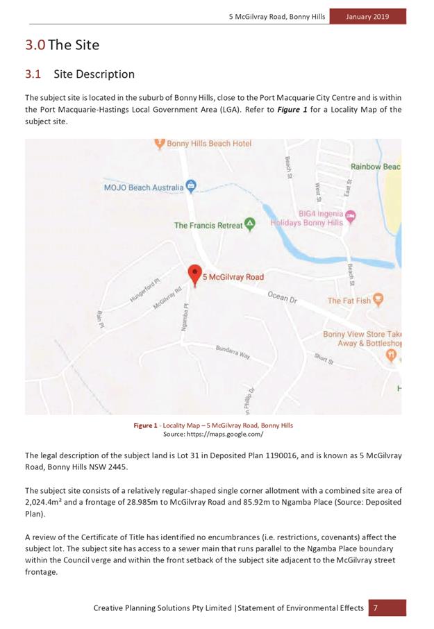
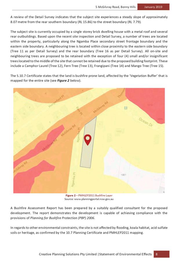
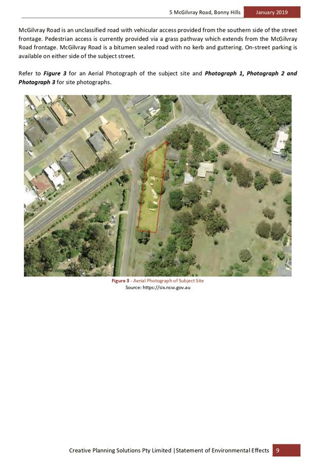
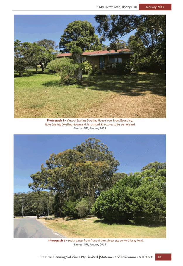
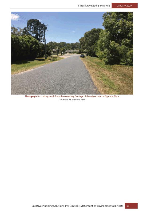
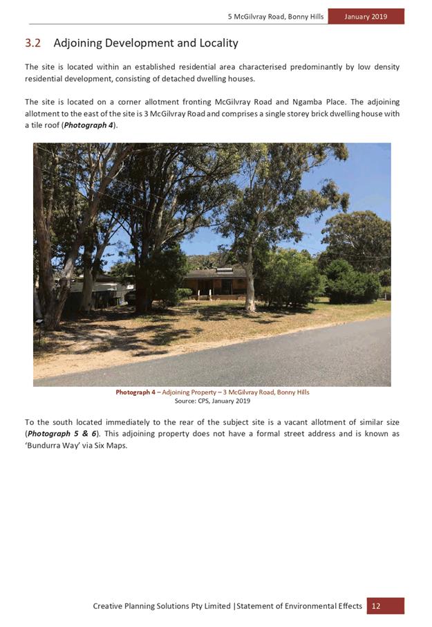
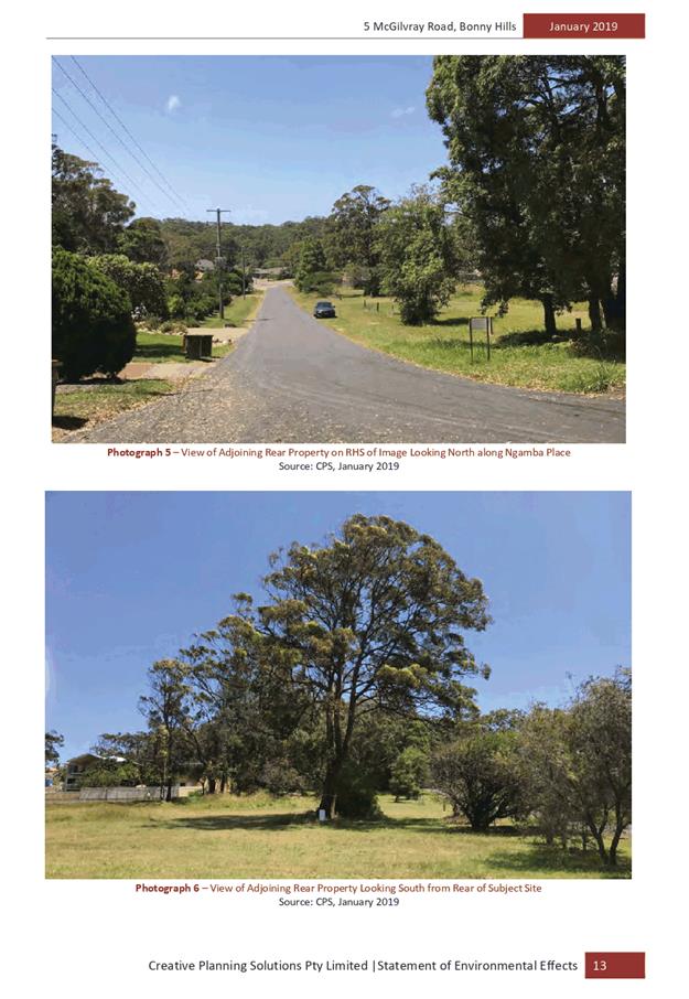
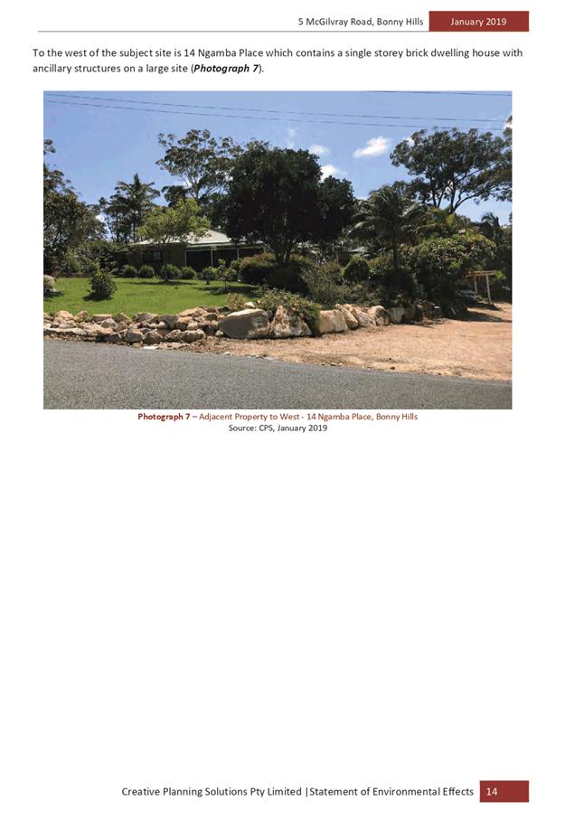
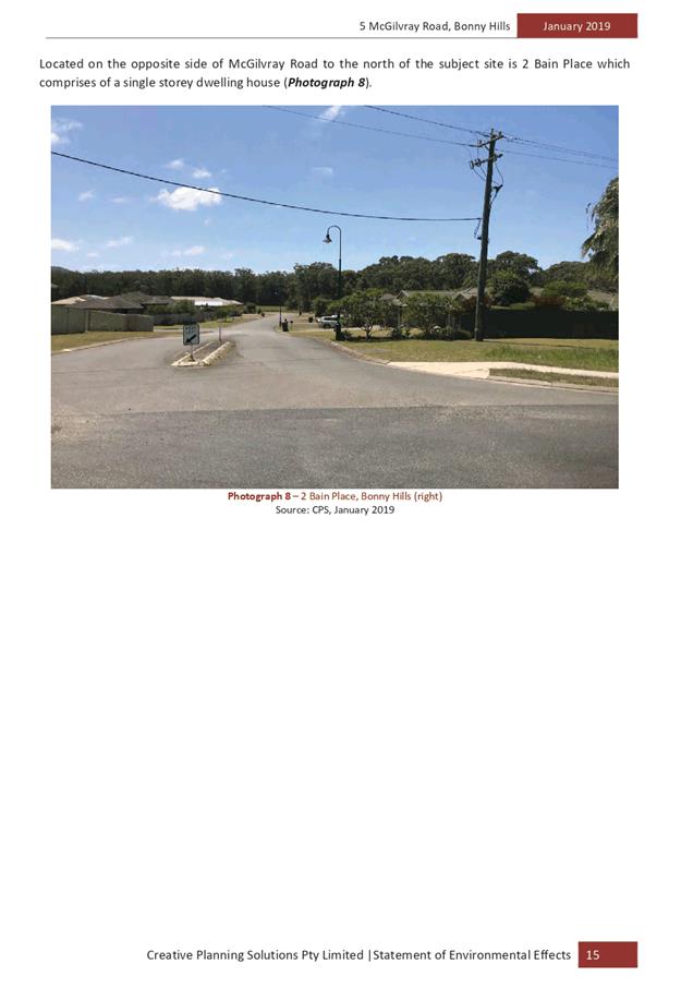
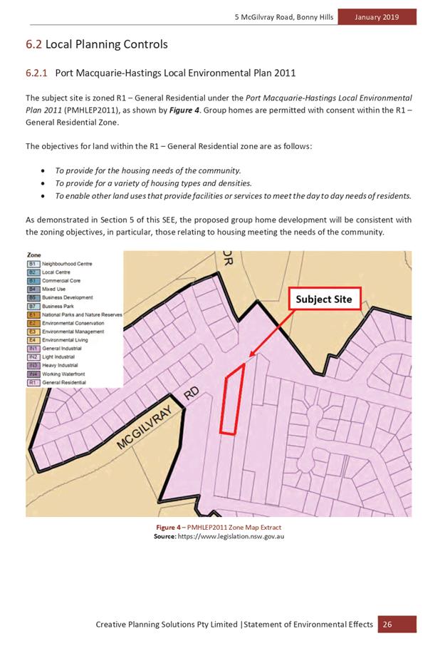
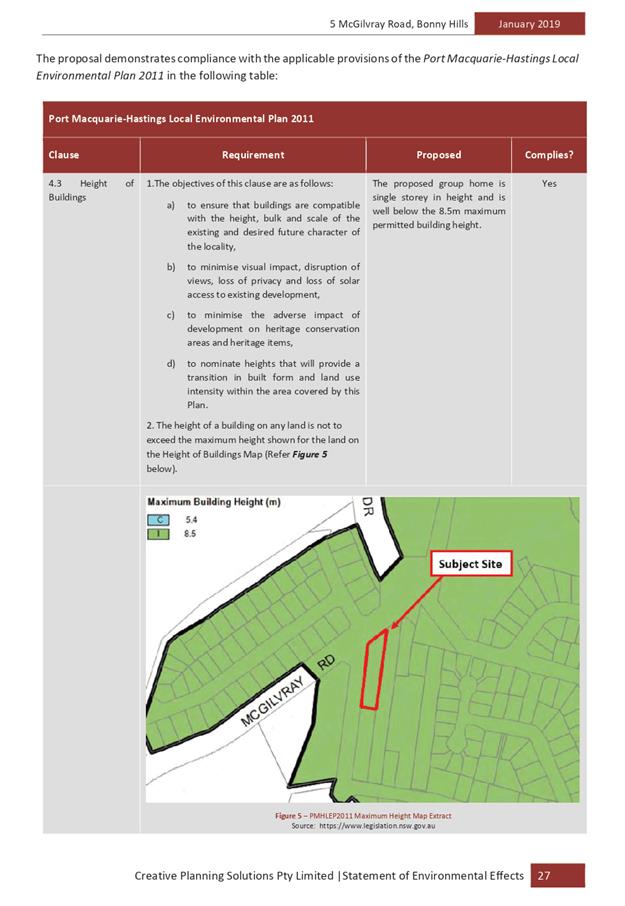
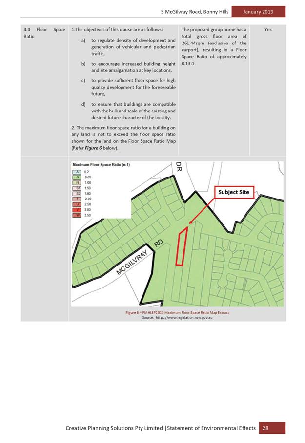
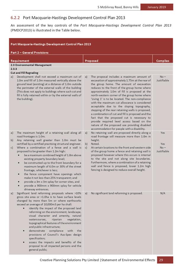
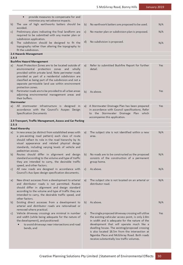
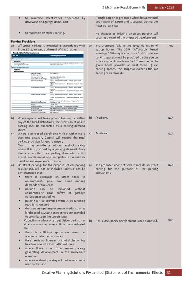
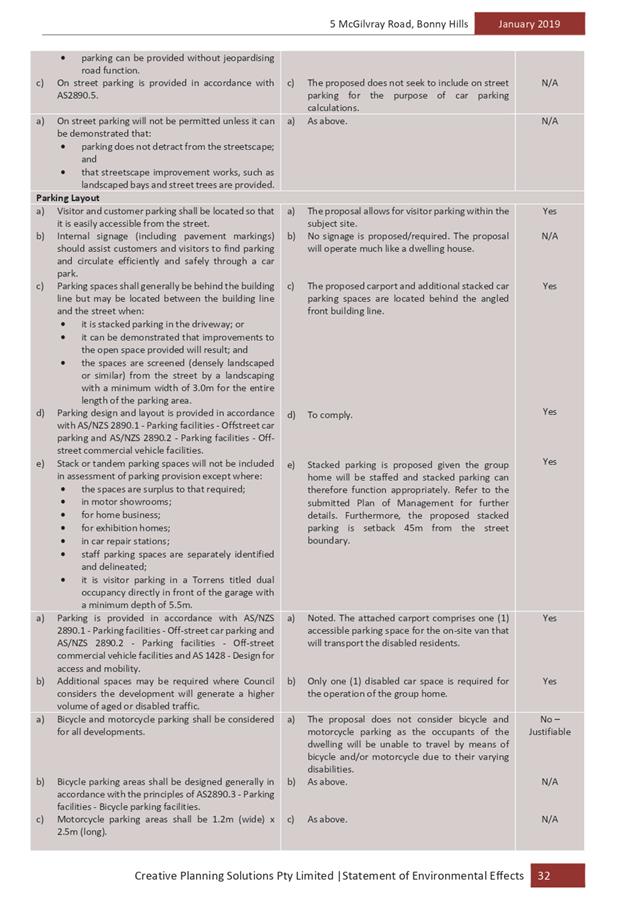
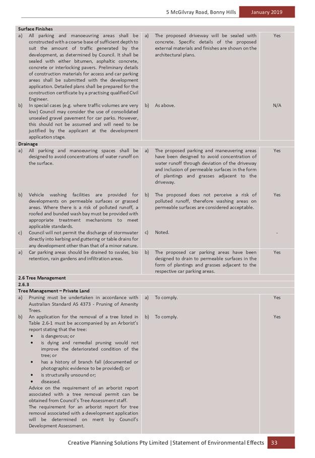
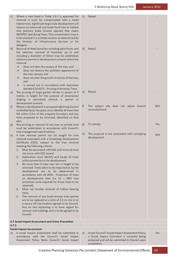
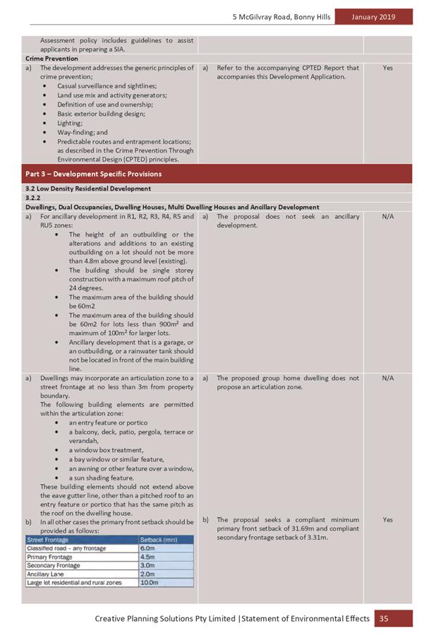
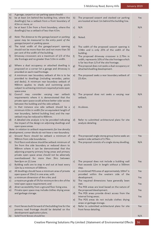
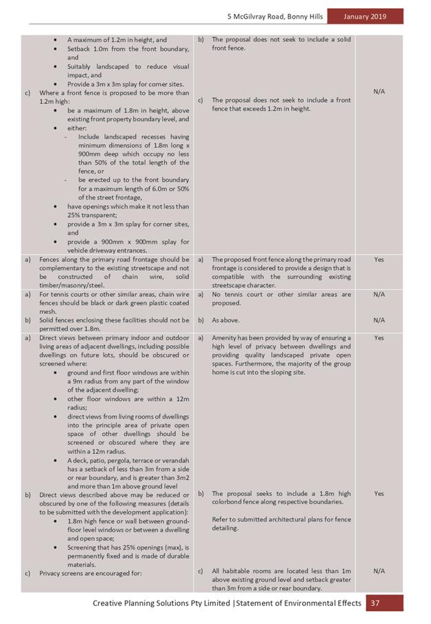
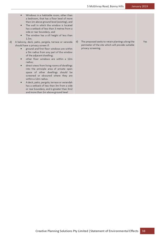


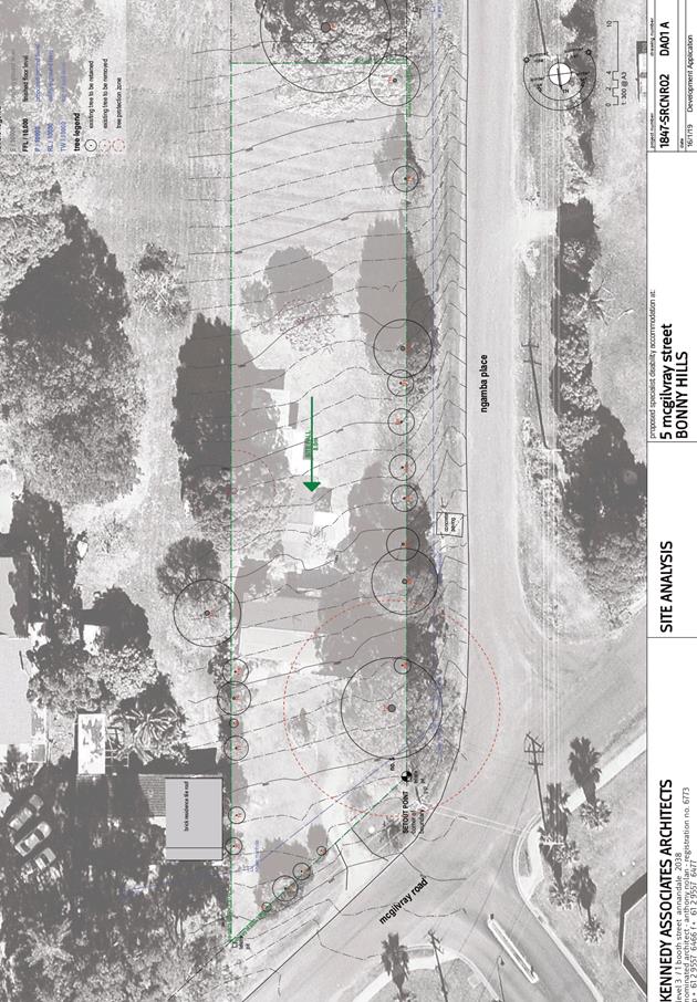
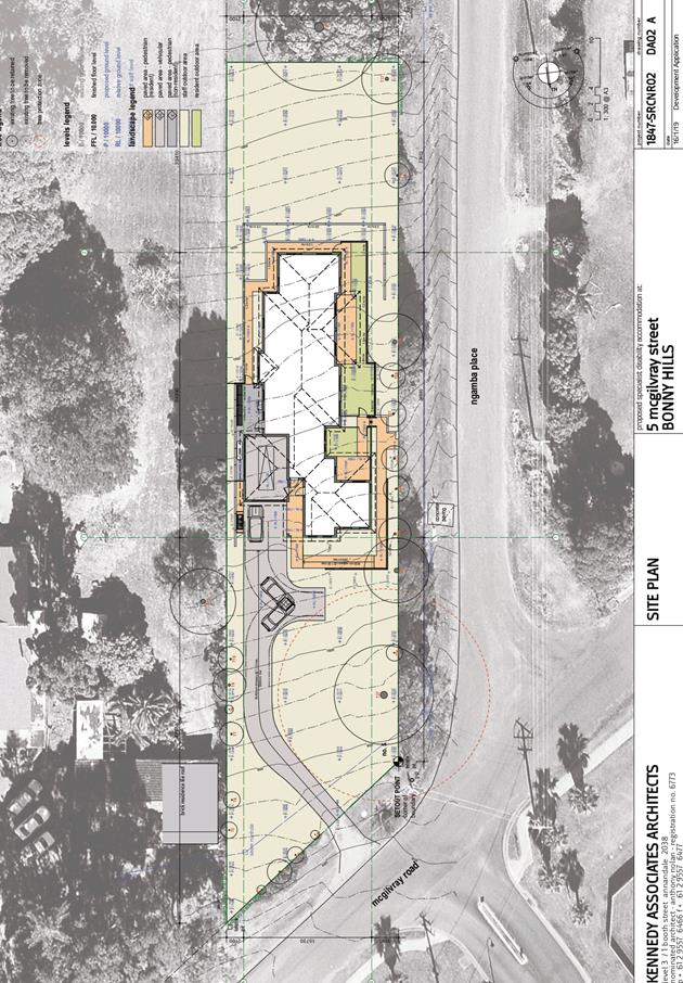
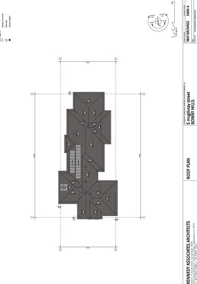
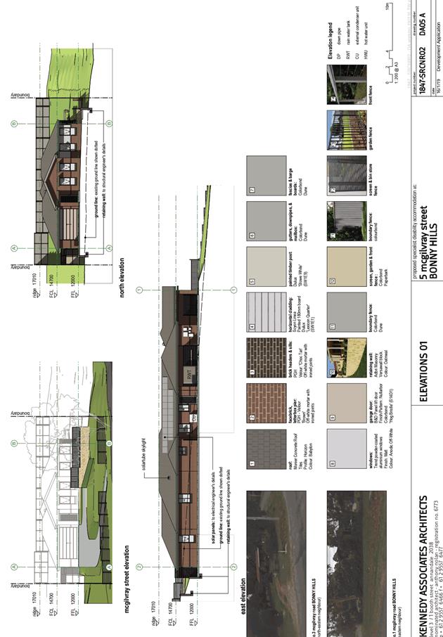
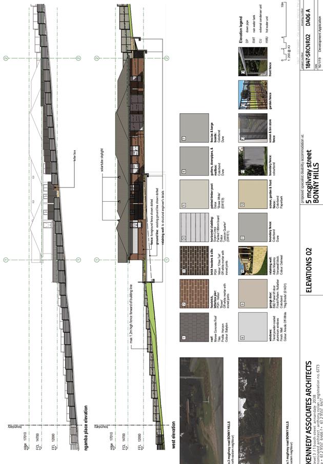
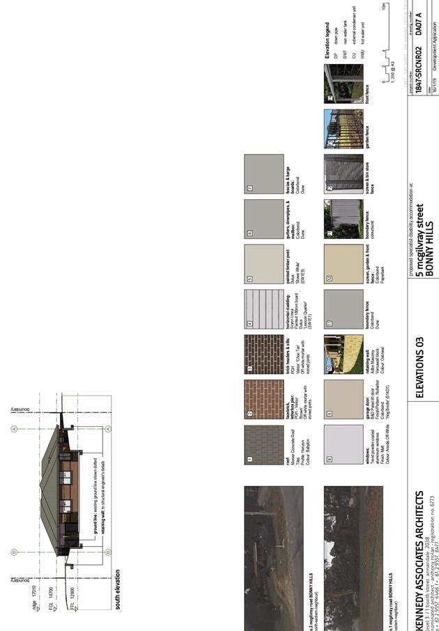
AGENDA Development Assessment Panel 22/05/2019
Item: 09
Subject: DA2018 - 641.1 Additions to Existing Building and Change of Use to
Commercial Premises - Lots 1 & 2 DP 3749 No.150 Nancy Bird Walton Drive,
Kew
Report Author: Development
Assessment Planner, Fiona Tierney
|
Applicant: S
Gross
Owner: S
Gross & F J Hawkins
Estimated Cost: $10,000
Alignment with Delivery Program
4.3.1 Undertake transparent
and efficient development assessment in accordance with relevant legislation.
|
|
RECOMMENDATION
That
DA 2018 - 641 for additions to
existing building and change of use to commercial premises at Lot 1 & 2, DP 3749, No. 150 Nancy
Bird Walton Drive, Kew, be determined by granting consent subject to the
recommended conditions.
|
Executive
Summary
This report considers a development
application for additions to existing building and change of use at the subject site and provides an assessment of the
application in accordance with the Environmental Planning and Assessment Act
1979.
Following exhibition of the
application, one (1) submission was received.
This report recommends that the
development application be approved subject to conditions.
1. BACKGROUND
Existing
sites features and Surrounding development
The site has an area of 1786.083m2.
The
site is zoned B4 in accordance with the Port
Macquarie-Hastings Local Environmental Plan 2011, as shown in the following
zoning plan:
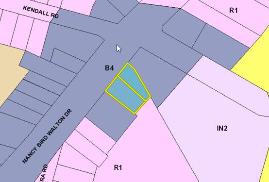
The
existing subdivision pattern and location of existing development within the
locality is shown in the following aerial photograph:
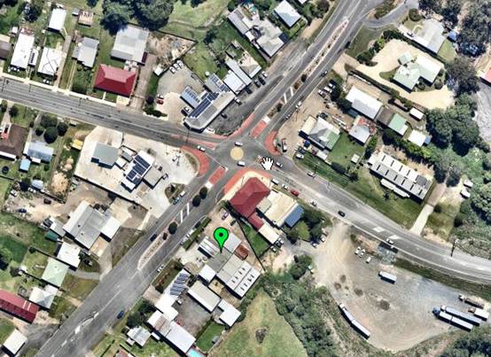
2. DESCRIPTION
OF DEVELOPMENT
Key
aspects of the proposal include the following:
· Use
of the site for the following tenancies:
o Existing -
‘Retro Room’ - Retail Premises.
o Art Gallery
and ancillary yoga.
o Existing
Retail Premises.
o Storage area
for retail tenancies.
o Existing -
Motor Vehicle Repair Workshop.
· Removal
of unauthorised care takers residence
· Enclosure
of undercover area for storage
· Parking
allocation and delineation.
· Fire
Safety upgrade
Refer
to attachments at the end of this report.
Application
Chronology
· 17
August 2018 - Application Lodged.
· 28 August 2018 to 10 September 2018 - Neighbour
notification of proposal.
· 12 September 2018 - Additional information requested - Plan
detail, parking strategy, construction and BCA compliance.
· 19 October 2018 - Onsite meeting with stakeholders.
· 19 January 2019 - Additional information received
Parking.
· 14 February 2019 - Additional information received-
construction.
3. STATUTORY
ASSESSMENT
Section
4.15(1) Matters for Consideration
In
determining the application, Council is required to take into consideration the
following matters as are relevant to the development that apply to the land to
which the development application relates:
(a) The
provisions (where applicable) of:
(i) Any
Environmental Planning Instrument:
State Environmental Planning
Policy No.55 – Remediation of Land
Following an inspection of the
site and a search of Council records, the subject land is identified as being
potentially contaminated from the past petrol station use. A remediation report
has been submitted previously and the site deemed suitable for commercial
purposes. Furthermore, the application was referred to Council’s
Environmental Health Officer who identified no conflicting issues. As a result,
no further work or investigation is considered to be required.
Port
Macquarie-Hastings Local Environmental Plan 2011
The proposal is consistent with
the LEP having regard to the following:
· Clause
2.2 - The subject site is zoned B4 Mixed Use.
· Clause
2.3(1) and the B4 zone landuse table - The proposed development for fire safety
upgrade, change of use of existing areas to retail premises and enclosure of
undercover areas to retail storage is a permissible landuse with consent.
The
objectives of the B4 zone are as follows:
o To provide a
mixture of compatible land uses.
o To integrate
suitable business, office, residential, retail and other development in
accessible locations so as to maximise public transport patronage and encourage
walking and cycling.
o To ensure that new
developments make a positive contribution to the public domain and streetscape.
· Clause
2.3(2) - The proposal is consistent with the zone objectives having regard to
the following:
o The proposal is a
permissible landuse.
o The proposal adds
to the mixture of uses within the area.
o The proposal does
not adversely impact on public domain or streetscape.
o Conditions will be
utilised to reduce conflict with neighbouring properties.
· Clause
5.9 - No listed trees in Development Control Plan 2013 are proposed to be removed.
· Clause
7.13 - Satisfactory arrangements are in place for provision of essential
services including water supply, electricity supply, sewage management,
stormwater drainage and suitable road access to service the development.
(ii) Any draft instruments
that apply to the site or are on exhibition:
Nil
(iii) Any Development
Control Plan in force:
Port
Macquarie-Hastings Development Control Plan 2013
The following table provides a checklist against the
Development Provisions requirements of this DCP:
|
DCP 2013: General
Provisions
|
|
|
Requirements
|
Proposed
|
Complies
|
|
2.7.2.2
|
Design addresses generic principles of Crime Prevention
Through Environmental Design guideline
|
The layout does not create any identifiable crime risk
safety issues. The design limits potential concealment areas and allows
surveillance of the carpark and street.
|
Yes
|
|
2.5.3.2
|
New accesses not permitted from arterial or distributor
roads
|
Existing access to be utilised.
|
Yes
|
|
Driveway crossing/s minimal in number and width including
maximising street parking
|
Driveway crossing is appropriate and maximises potential
for street parking.
|
Yes
|
|
2.5.3.3
|
Parking in accordance with Table 2.5.1.
|
The commercial floor area is a total of 342m2 at a rate of
1 per 30m2
= 12 spaces required.
The internal storage area is for use of commercial tenant
only so no additional demand created.
The proposed provision of a once a week art appreciation
yoga class in the art studio for less than 10 clients is considered to be
ancillary to the art gallery and does not generate its own demand for
parking.
Existing mechanical workshop requires 5 spaces.
Total 17 spaces therefore required.
16 formal spaces have been provided and a number of
informal spaces that are not ideally located or compliant. These are
nominated for over flow/staff parking.
The proposal has a number of approved uses on site and
this consent is to clarify uses. The proposal deletes the care takers residence
and the additional area is only to be used for storage related to the retail
components. It is not considered that additional demand will be created
through this consent and that the site has existing credit through the
historical uses.
This application aims to clarify the uses under a unified
consent on a site that has previously been developed in an adhoc way.
The site has been inspected by Council’s Engineer
and 17 spaces with adequate manoeuvring areas can be provided at the front
with appropriate configuration.
Details are to be submitted to and approved by Council
with the construction certificate application.
|
Capable of compliance - refer to conditions of consent.
|
|
2.5.3.12 and 2.5.3.13
|
Landscaping of parking areas
|
Landscaping of parking areas is
satisfactory.
|
Yes
|
|
2.5.3.14
|
Sealed driveway surfaces unless justified
|
Sealed driveways proposed.
|
Yes
|
|
2.5.3.15 and 2.5.3.16
|
Driveway grades first 6m or ‘parking area’
shall be 5% grade with transitions of 2m length
|
Existing
|
Yes
|
|
2.5.3.17
|
Parking areas to be designed to avoid concentrations of
water runoff on the surface.
|
Existing
|
Yes
|
(iiia) Any planning agreement that has
been entered into under section 7.4, or any draft planning agreement that a
developer has offered to enter into under section 7.4:
Nil
iv) Any
matters prescribed by the Regulations:
Nil
(b) The likely
impacts of the development, including environmental impacts on both the natural
and built environments, social and economic impacts in the locality:
Context and setting
The proposal will be unlikely to have any adverse visual impacts
to existing adjoining properties or the public domain.
The proposal has adequately addressed the intent of the
planning controls for the area and is a permissible landuse.
The proposal will not have any identifiable significant
adverse lighting impacts.
There are no significant adverse privacy impacts.
Roads
The site is bounded by
the Pacific Highway and Kendall Road.
Site Frontage &
Access
Vehicle access and
egress to the site is proposed though the existing entry driveway and a
dedicated exit driveway.
Parking
The existing centre has
sufficient parking for the proposed uses on the site. The existing mechanical
workshop operated ancillary to the use of the site as a petrol station and is
located at the rear of the site and has historically utilised a drive through situation
to store and park staff vehicles in the south east corner of the site. 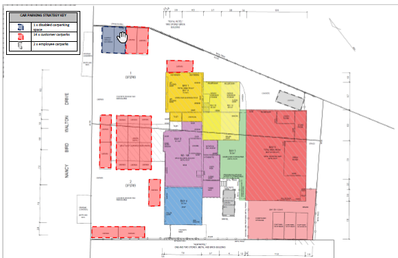
The above parking plan is not
considered to provide for the most efficient use of the site for parking. The
site has been inspected by Council’s Engineer who has identified that a
more appropriate layout would be for parking in a long run in front of the
shops or nose in along the front boundary would enable the 17 spaces to be
accommodated. An amended parking layout is to be submitted with the application
for the construction certificate.
Water Supply
Connection
Council records indicate that the
development site has an existing sealed water service.
Final water service sizing would
need to be determined by a hydraulic consultant to suit the commercial
components of the development, as well as fire service and backflow protection
requirements. Considered capable of being complied with.
Sewer Connection
There
is existing sewer in place, which will not require any changes.
Stormwater
There is no change to existing hard stand spaces proposed
and therefore no change to stormwater.
Other Utilities
Telecommunication and electricity services are
available to the site with no changes foreseen.
Heritage
Following a site inspection (and a search of Council
records), no known items of Aboriginal or European heritage significance exist
on the property.
There is a local heritage item (Kew Hotel) on the adjoining
property to the north. However, this application is for a change of use only
and will create no adverse impacts.
Other land resources
The site is within a developing
industrial/commercial context and will not sterilise any significant mineral or
agricultural resource.
Soils
The proposed development will be unlikely to have
any adverse impacts on soils in terms of quality, erosion, stability and/or
productivity.
Air and microclimate
The construction and/or operations of the proposed
development would be unlikely to result in any adverse impacts on the existing
air quality or result in any pollution.
Flora and fauna
Construction of the proposed development will not
require any removal/clearing of any significant vegetation and therefore will
be unlikely to have any significant adverse impacts on biodiversity or
threatened species of flora and fauna.
Waste
Satisfactory arrangements are in place for proposed storage
and collection of waste and recyclables. No adverse impacts anticipated.
Noise and vibration
The
application was referred to Council’s Environmental Health Officer for
consideration of potential noise impacts during operation. It was determined
that through the imposition of conditions, noise levels could be managed and
contained within acceptable levels.
Bushfire
The site is identified as being bushfire prone
however site is existing and no additional residential components proposed. No
further consideration required.
Safety, security and crime prevention
The proposed development will be unlikely to
create any concealment/entrapment areas or crime spots that would result in any
identifiable loss of safety or reduction of security in the immediate
area.
Social and Economic impacts in the locality
The development is likely to create positive social and
economic benefits through employment and associated flow on effects.
Site
design and internal design
The proposed development design satisfactorily
responds to the site attributes and will satisfactorily fit into the locality.
Construction
No potential adverse impacts identified to
neighbouring properties with the construction of the proposal.
Cumulative Impacts
No adverse cumulative impacts identified within
the locality.
(c) The
suitability of the site for the development:
Based upon the assessment in this report, it is considered that
the site is suitable for the development.
(d) Any
submissions made in accordance with this Act or the Regulations:
One (1) written
submission was received following public exhibition of the application.
Key
issues raised in the submission and comments in response to these issues are
provided as follows:
|
Submission Issue/Summary
|
Planning Comment/Response
|
|
Car parking along Southern
boundary- Noise
|
A site meeting was held with
the objector, applicant and their relevant consultants to discuss issues
raised in the submission. Concerns were raised as to traffic movements along
the Southern boundary that could potentially create amenity impacts. It was agreed
that general movements would not be permitted along this boundary and no
customer use is to be permitted.
The driveway access (whilst
approved) is not suitable for general use due to the grade and condition of
this access.
In terms of parking, noise and
traffic movements, the site was traditionally a petrol station with a
mechanic workshop that had significantly more traffic movements and noise at
the site. It is considered that the proposed retail premises, art gallery and
ancillary yoga are more compatible with the adjoining businesses.
|
|
Privacy- windows could easily be added. Deck unauthorised
|
Council can only assess what is submitted within this
application and cannot pre-empt unauthorised activity. There is not
considered to be a significant impact to privacy on site.
|
|
Fire Safety and toilet facilities
|
The applicant submitted additional details in relation to
fire safety upgrade and this was referred to Council’s Fire Safety
officer. Conditions have been applied requiring compliance with the Building
Code of Australia.
3 toilets are available on site which are sufficient for
the number of staff proposed on site and the seating available for the
café being below the trigger point for customer toilets.
|
(e) The
Public Interest
The proposed development
satisfies relevant planning controls and will not impact on the wider public
interest.
4. DEVELOPMENT
CONTRIBUTIONS APPLICABLE
Credits
exist on site - no contributions applicable.
5. CONCLUSION
AND STATEMENT OF REASON
The application has been assessed in accordance with Section
4.15 of the Environmental Planning and Assessment Act 1979.
Issues raised during assessment and public exhibition of the
application have been considered in the assessment of the application. Where
relevant, conditions have been recommended to manage the impacts attributed to
these or any other issues.
The site is considered suitable for the proposed development
and the proposal adequately addresses relevant planning controls. The
development is not considered to be contrary to the public's interest and will
not result a significant adverse social, environmental or economic impact. It
is recommended that the application be approved, subject to the recommended
conditions of consent provided in the attachment section of this report.
|
Attachments
1View. DA2018
- 641.1 Recommended Conditions
2View. DA2018
- 641.1 SOEE
3View. DA2018
- 641.1 Plans
|
|
ATTACHMENT
|
Development Assessment Panel
22/05/2019
|
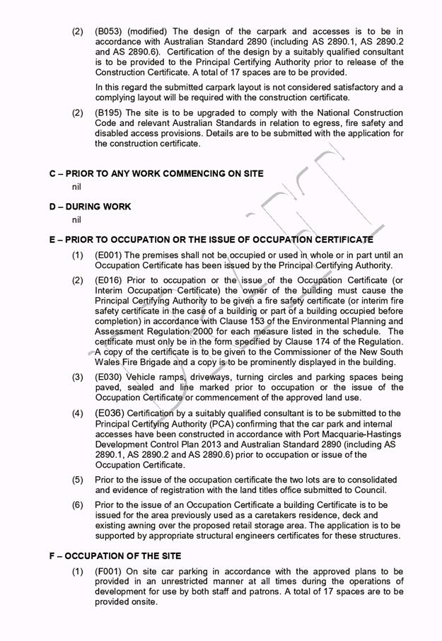
|
ATTACHMENT
|
Development Assessment Panel
22/05/2019
|

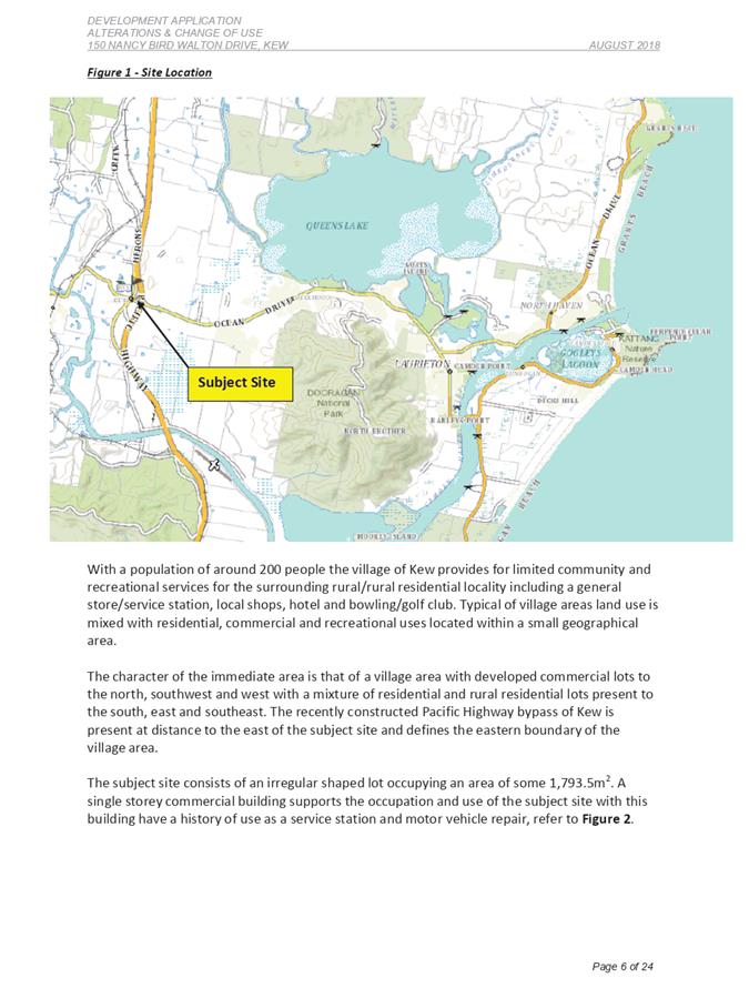
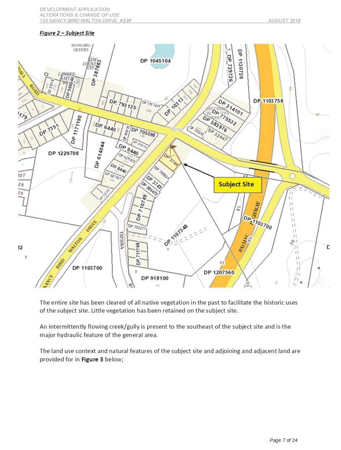
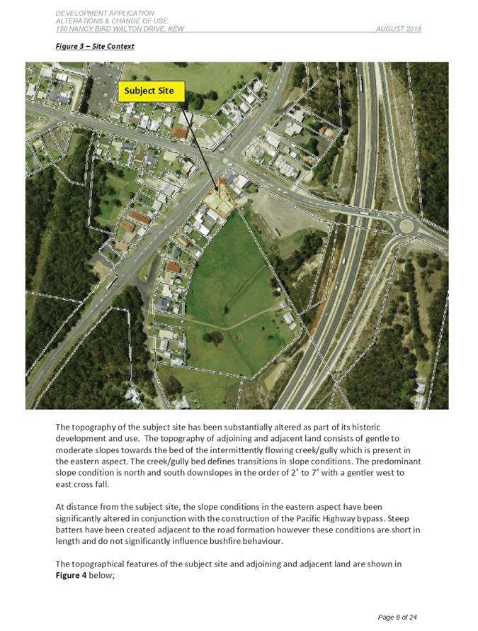
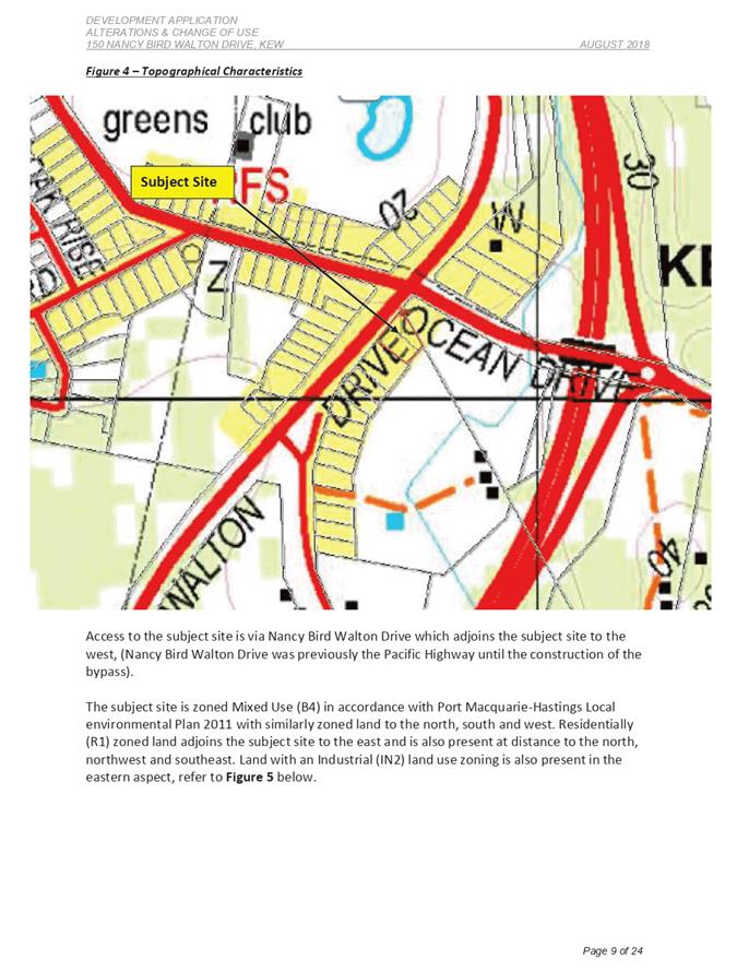
|
ATTACHMENT
|
Development Assessment Panel
22/05/2019
|