Business
Paper
|
date of meeting:
|
|
Wednesday 11
September 2019
|
|
location:
|
|
Function Room
Port
Macquarie-Hastings Council
17 Burrawan Street
Port Macquarie
|
|
time:
|
|
2:00pm
|
Development
Assessment Panel
CHARTER
1.0 OBJECTIVES
To assist in managing Council's development assessment
function by providing independent and expert determinations of development
applications that fall outside of staff delegations.
2.0 KEY FUNCTIONS
·
To review development application reports and conditions;
·
To determine development
applications outside of staff delegations;
·
To refer development applications
to Council for determination where necessary;
·
To provide a forum for objectors and applicants
to make submissions on applications
before the Development Assessment Panel
(DAP);
·
To maintain transparency in the determination of development
applications.
Delegated Authority of Panel
Pursuant to
Section 377 of the Local Government Act, 1993 delegation to:
·
Determine development applications under Part 4
of the Environmental Planning and Assessment
Act 1979 having
regard to the relevant environmental planning instruments,
development control plans and Council policies.
·
Vary, modify or release restrictions as to use
and/or covenants created by Section 88B instruments under the Conveyancing Act
1919 in relation to development applications for subdivisions being considered
by the panel.
·
Determine Koala Plans of Management under State
Environmental Planning Policy 44 - Koala Habitat Protection associated with
development applications being considered by the Panel.
Noting the trigger to escalate
decision making to Council as highlighted in section 5.2.
3.0
MEMBERSHIP
3.1
Voting
Members
·
Two independent external members. One of the
independent external members to be the Chairperson.
·
Group Manager Development Assessment (alternate
- Director Development & Environment or Development Assessment Planner)
The independent external members shall have expertise in
one or more of the following areas: planning, architecture, heritage, the
environment, urban design, economics, traffic and transport, law, engineering,
government and public administration.
3.2
Non-Voting Members
·
Not applicable
3.3 Obligations
of members
·
Members must act faithfully and diligently and
in accordance with this Charter.
·
Members must comply with Council's Code of Conduct.
·
Except as required to properly perform their
duties, DAP members must not
disclose any confidential information (as advised by Council) obtained in connection with the DAP functions.
·
Members will have read and be familiar with the
documents and information provided by Council prior
to attending a DAP meeting.
·
Members must act in accordance with Council's
Workplace Health and Safety Policies and Procedures
·
External members of the Panel are not authorised
to speak to the media on behalf of Council. Council officers that are members
of the Committee are bound by the
existing operational delegations in relation to speaking to the media.
·
Staff members shall not vote on matters before
the Panel if they have been the principle author of the development assessment report.
3.4
Member Tenure
·
The independent external members will be
appointed for the term of four (4) years
maximum in which the end of the tenure of these members would occur in a
cascading arrangement.
3.5 Appointment
of members
·
The independent external members (including the
Chair) shall be appointed by the General Manager following an external
Expression of Interest process.
·
Staff members of the Panel are in accordance
with this Charter.
4.0 TIMETABLE
OF MEETINGS
·
The Development Assessment Panel will generally
meet on the 1st and 3rd Wednesday each month at 2.00pm at the Port Macquarie
offices of Council.
·
Special Meetings of the Panel may be convened by
the Director Development & Environment Services with three (3) days notice.
5.0
MEETING PRACTICES
5.1
Meeting
Format
·
At all Meetings of the Panel the Chairperson
shall occupy the Chair and preside. The Chair will be responsible for keeping
of order at meetings.
·
Meetings shall be open to the public.
·
The Panel will hear from applicants
and objectors or their r e p r e s e n t a t i v e s .
·
Where considered necessary, the Panel will
conduct site inspections which will
be open to the public.
5.2
Decision Making
·
Decisions are to be made by consensus. Where
consensus is not possible on any item, that item is to be referred to Council
for a decision.
·
All development applications involving a
proposed variation to a development standard
greater than 10% under Clause
4.6 of the Local Environmental Plan will be
considered by the Panel and recommendation made to the Council for a decision.
5.3
Quorum
·
All members (2 independent external members and
1 staff member) must be present at a
meeting to form a quorum.
5.4
Chairperson and Deputy Chairperson
·
Independent Chair (alternate, second independent member)
5.5
Secretariat
·
The Director Development &n Environment is
to be responsible for ensuring that the Panel has adequate secretariat support.
The secretariat will ensure that the business paper and supporting papers are
circulated at least three (3) days prior to
each meeting. Minutes shall be appropriately approved and circulated to each
member within three (3) weeks of a meeting being held.
·
The format of and the preparation and publishing
of the Business Paper and Minutes shall be similar to the format for Ordinary
Council Meetings.
5.6
Recording of decisions
·
Minutes will record decisions and how each
member votes for each item before the Panel.
6.0 CONVENING
OF “OUTCOME SPECIFIC” WORKING GROUPS
Not applicable.
7.0 CONFIDENTIALITY
AND CONFLICT OF INTEREST
·
Members of the Panel must comply with the
applicable provisions of Council’s Code of Conduct. It is the personal
responsibility of members to comply with the standards in the Code of Conduct
and regularly review their personal circumstances with this in mind.
·
Panel members must declare any conflict of
interests at the start of each meeting or before discussion of a relevant item
or topic. Details of any conflicts of interest should be appropriately minuted.
Where members are deemed to have a real or perceived conflict of interest, it
may be appropriate they be excused from deliberations on the issue where the
conflict of interest may exist. A Panel meeting may be postponed where there is
no quorum.
8.0 LOBBYING
·
All members and applicants are to adhere to Council’s
Lobbying policy. Outside of
scheduled Development Assessment Panel meetings, applicants, their
representatives, Councillors, Council staff and the general public are not to
lobby Panel members via meetings, telephone conversations, correspondence and
the like. Adequate opportunity will be provided at Panel inspections or
meetings for applicants, their representatives and the general public to make
verbal submissions in relation to Business Paper items.
Development Assessment Panel
ATTENDANCE
REGISTER
|
Member
|
10/04/19
|
24/04/19
|
22/05/19
|
12/06/19
|
24/07/19
|
28/08/19
|
|
Paul Drake
|
P
|
P
|
P
|
P
|
P
|
P
|
|
Robert Hussey
|
A
|
P
|
P
|
|
|
P
|
|
David Crofts
(alternate member)
|
P
|
|
|
P
|
P
|
|
|
Dan Croft
(Group Manager Development
Assessment)
(alternates)
- Director Development & Environment
- Development Assessment Planner
|
P
|
P
|
P
|
P
|
P
|
P
|
Key: P = Present
A
= Absent With Apology
X
= Absent Without Apology
Development
Assessment Panel Meeting
Wednesday 11
September 2019
Items of Business
01 Acknowledgement
of Country............................................................................. 8
02 Apologies.......................................................................................................... 8
03 Confirmation
of Minutes..................................................................................... 8
04 Disclosures
of Interest..................................................................................... 14
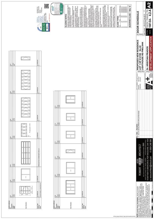
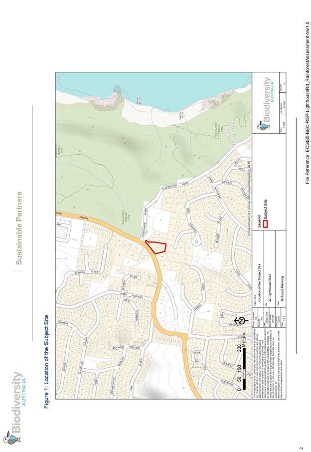
05 DA2019
- 154.1 Demolition of Existing Dwelling and Construction of New Dwelling and
Swimming Pool Lot 1 DP 612190 42 Lighthouse Road, Port Macquarie............................... 18
06 DA2018
- 365.1 Demolition of Dwelling and Erection of New Dwelling and Shed - Lot 4 DP
538813, No 160 Settlement Point Road, Port Macquarie.................................. 153
07 DA2018
- 507.1 3 Lot Subdivision including Clause 4.6 Variation to Clause 4.1 (Minimum
Lot Size) of Port Macquarie Hastings Local Environmental Plan 2011 - Lot 41 and
Lot 42 DP 75403 and Lot 8 DP 114360, No. 434 and 440 Herons Creek Road, Herons
Creek...... 299
08 DA2019
- 465.1 Alterations and Additions to Dwelling and Construction of a Secondary
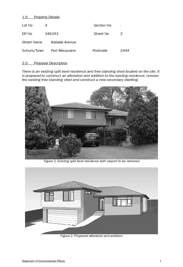
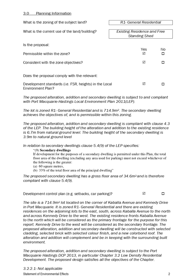
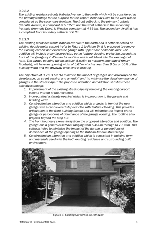
Dwelling, Lot 4 DP 246193, No. 2 Kaballa Avenue Port Macquarie.................................. 329
09 General
Business
AGENDA Development Assessment Panel 11/09/2019
Subject: ACKNOWLEDGEMENT
OF COUNTRY
"I acknowledge that we are
gathered on Birpai Land. I pay respect to the Birpai Elders both past and
present. I also extend that respect to all other Aboriginal and Torres Strait
Islander people present."
RECOMMENDATION
That the apologies received be
accepted.
Subject: CONFIRMATION
OF PREVIOUS MINUTES
Recommendation
That the Minutes of the Development
Assessment Panel Meeting held on 28 August 2019 be confirmed.
MINUTES
Development Assessment Panel Meeting
28/08/2019
PRESENT
Members:
Paul
Drake
Robert Hussey
Dan Croft
Other Attendees:
Caroline Horan
Pat
Galbraith-Robertson
Michael
Roberts
Ben
Roberts
|
The meeting opened at 2:00pm.
|
|
01 ACKNOWLEDGEMENT
OF COUNTRY
|
|
The
Acknowledgement of Country was delivered.
|
|
03 CONFIRMATION
OF MINUTES
|
|
CONSENSUS:
That
the Minutes of the Development Assessment Panel Meeting held on 24 July 2019
be confirmed.
|
|
04 DISCLOSURES
OF INTEREST
|
|
There were no disclosures of interest presented.
|
|
05 DA2019 - 417.1
Secondary Dwelling - Lot 131 DP 834256, No 70 Bangalay Drive, Port Macquarie
|
|
Speaker:
Jeremy
Gray (applicant)
CONSENSUS:
That DA
2019 - 417 for a Secondary Dwelling at Lot 131, DP 834256, No. 70 Bangalay
Drive, Port Macquarie, be determined by granting
consent subject to the recommended conditions.
|
|
06 Section 4.55
Modification to DA2016 - 835.2 Alterations and Additions to Dwelling - Lot X
DP 384377, No. 65 The Boulevarde Dunbogan
|
|
Speaker:
Patrick Meagher (applicant)
CONSENSUS:
That
Section 4.55 modification application to modify DA 2016 - 835.2 for alterations and additions to dwelling at Lot X, DP
384377, No. 65 The Boulevarde, Dunbogan, be
determined by granting consent subject to the recommended amended conditions
and as amended below:
- Additional condition in Section
E of the consent to read: ‘Screen landscaping, achieving a mature
height of 1.5m, is to be provided between the spa and the front boundary
(for the length of the spa barrier/fence) to the satisfaction of
Council. The landscaping is to be maintained for the life of the
development.’
|
|
07 DA2019
- 154.1 Demolition of Existing Dwelling and Construction of New Dwelling and
Swimming Pool Lot 1 DP 612190 42 Lighthouse Road, Port Macquarie
|
|
Speaker:
Michelle
Chapman (applicant)
Rob
Snow (applicant)
Kristian
Prados (applicant)
CONSENSUS:
That DA 2019 - 154 for demolition of existing dwelling
and construction of new dwelling and swimming pool at Lot 1, DP 612190, No.
42 Lighthouse Road, Port Macquarie, be deferred to address the following:
1.
A stormwater management plan is required demonstrating that the
development satisfactorily manages stormwater on the site and that the
proposal will not be adversely impacted by the stormwater overland flow path
traversing the property or causes adverse impacts on neighbouring properties.
2.
The dwelling be designed to provide for a rear setback
complying with the provisions of the Port Macquarie-Hastings Development
Control Plan 2013.
|
|
08 DA2019 - 463.1
Dwelling - Lot 33 DP 552382, No. 2 Bell Street, Dunbogan
|
|
CONSENSUS:
That DA
2019 - 463.1 for a dwelling at Lot 33, DP
552382, No. 2 Belle Street, Dunbogan, be determined by granting consent
subject to the recommended conditions and as amended below:
- Additional condition in Section
E of the consent to read: ‘Prior to the issue of an occupation
certificate a flood management plan is to be submitted to and approved
by Council and a covenant is to be placed on the title of the property
referencing the plan.’
|
|
09 DA2017
- 736.2 - Modification To Previous Approved Manufactured Home Estate and
Subdivision - No. 79 Batar Creek Road, Kendall
|
|
Speaker:
Donna
Clarke (applicant)
CONSENSUS:
That the Section 4.55(2) modification application to DA 2017
- 736.2 for a manufactured home estate and
subdivision at Lot 1 DP 122192, Lot 79 DP 655658,
Lot 23 DP112083 and Lot 1 DP 1142845, Batar Creek Road, Kendall, be
determined by granting consent subject to the recommended modified conditions
and as amended below:
- Amend condition B(2)
points 13 & 14 to state:
13. Provision of
pedestrian access ways/shareways a minimum of 2.5m 2.1m wide, from the
north-west corner of the site proposed intersection on Batar Creek Road
(at Benaroon Drive) to the Showground entrance on Batar Creek Road as
part of Stage 1 of the Manufactured Home Estate. Such access ways to include
a concrete pathway including kerb ramps where necessary.
14. Provision
of a 1.5m wide concrete footpath along Batar Creek Road from the showground
to Albert Street as part of Stage 3 of the Manufactured Home Estate. Such
access ways to include a concrete pathway including kerb ramps where
necessary.
- Amend B(18) point c) to
state:
c) A
footpath, min width of 1.5m shall be provided from the showground to the
intersection with Albert Street as part of Stage 3 of the Manufactured Home
Estate. Pram ramps shall be constructed as necessary. Details shall be
provided as part of the Construction Certificate/Roads Act Application.
- Amend
B(20) point b)(iii) to state:
iii) As
part of this development and for connectivity to the town, a 1.5m footpath
shall be provided on one side of Batar Creek Road for this section of road as
part of the Manufactured Home Estate.
|
|
10 GENERAL
BUSINESS
|
|
The
Panel discussed Item 05 with Mr Trevor Raymond.
|
|
The meeting closed at 3:08pm.
|
AGENDA Development Assessment Panel 11/09/2019
Subject: DISCLOSURES
OF INTEREST
RECOMMENDATION
That Disclosures of Interest be presented
DISCLOSURE OF
INTEREST DECLARATION
|
Name of Meeting:
|
|
Meeting
Date:
|
|
Item
Number:
|
|
Subject:
|
|
I,
the undersigned, hereby declare the following interest:
Pecuniary:
 Take no part
in the consideration and voting and be out of sight of the meeting. Take no part
in the consideration and voting and be out of sight of the meeting.
Non-Pecuniary
– Significant Interest:
Take no part
in the consideration and voting and be out of sight of the meeting.
Non-Pecuniary
– Less than Significant Interest:
May
participate in consideration and voting.
|
|
For
the reason that:
|
|
Name:
Signed:
|
Date:
|
|
Please submit to the
Governance Support Officer at the Council Meeting.
|
 (Refer
to next page and the Code of Conduct)
(Refer
to next page and the Code of Conduct)
Pecuniary Interest
4.1
A pecuniary interest is an interest
that you have in a matter because of a reasonable likelihood or expectation of
appreciable financial gain or loss to you or a person referred to in clause
4.3.
4.2
You will not have a pecuniary
interest in a matter if the interest is so remote or insignificant that it
could not reasonably be regarded as likely to influence any decision you might
make in relation to the matter, or if the interest is of a kind specified in
clause 4.6.
4.3
For the purposes of this Part, you
will have a pecuniary interest in a matter if the pecuniary interest is:
(a)
your interest, or
(b)
the interest of your spouse or de
facto partner, your relative, or your partner or employer, or
(c)
a company or other body of which
you, or your nominee, partner or employer, is a shareholder or member.
4.4
For the purposes of clause 4.3:
(a)
Your “relative” is any
of the following:
(b)
“de facto partner” has
the same meaning as defined in section 21C of the Interpretation Act 1987.
4.5
You will not have a pecuniary
interest in relation to a person referred to in subclauses 4.3(b) or (c)
(a)
if you are unaware of the relevant
pecuniary interest of your spouse, de facto partner, relative, partner,
employer or company or other body, or
(b)
just because the person is a member
of, or is employed by, a council or a statutory body, or is employed by the
Crown, or
(c)
just because the person is a member
of, or a delegate of a council to, a company or other body that has a pecuniary
interest in the matter, so long as the person has no beneficial interest in any
shares of the company or body.
Non-Pecuniary
5.1
Non-pecuniary interests are private
or personal interests a council official has that do not amount to a pecuniary
interest as defined in clause 4.1 of this code. These commonly arise out of
family or personal relationships, or out of involvement in sporting, social,
religious or other cultural groups and associations, and may include an
interest of a financial nature.
5.2
A non-pecuniary conflict of
interest exists where a reasonable and informed person would perceive that you
could be influenced by a private interest when carrying out your official
functions in relation to a matter.
5.3
The personal or political views of
a council official do not constitute a private interest for the purposes of
clause 5.2.
5.4
Non-pecuniary conflicts of interest
must be identified and appropriately managed to uphold community confidence in
the probity of council decision-making. The onus is on you to identify any
non-pecuniary conflict of interest you may have in matters that you deal with,
to disclose the interest fully and in writing, and to take appropriate action
to manage the conflict in accordance with this code.
5.5
When considering whether or not you
have a non-pecuniary conflict of interest in a matter you are dealing with, it
is always important to think about how others would view your situation.
Managing non-pecuniary conflicts of interest
5.6
Where you have a non-pecuniary
conflict of interest in a matter for the purposes of clause 5.2, you must
disclose the relevant private interest you have in relation to the matter fully
and in writing as soon as practicable after becoming aware of the non-pecuniary
conflict of interest and on each occasion on which the non-pecuniary conflict
of interest arises in relation to the matter. In the case of members of council
staff other than the general manager, such a disclosure is to be made to the
staff member’s manager. In the case of the general manager, such a
disclosure is to be made to the mayor.
5.7
If a disclosure is made at a
council or committee meeting, both the disclosure and the nature of the
interest must be recorded in the minutes on each occasion on which the
non-pecuniary conflict of interest arises. This disclosure constitutes
disclosure in writing for the purposes of clause 5.6.
5.8
How you manage a non-pecuniary
conflict of interest will depend on whether or not it is significant.
5.9
As a general rule, a non-pecuniary
conflict of interest will be significant where it does not involve a pecuniary
interest for the purposes of clause 4.1, but it involves:
a)
a relationship between a council
official and another person who is affected by a decision or a matter under
consideration that is particularly close, such as a current or former spouse or
de facto partner, a relative for the purposes of clause 4.4 or another person
from the council official’s extended family that the council official has
a close personal relationship with, or another person living in the same
household
b)
other relationships with persons
who are affected by a decision or a matter under consideration that are
particularly close, such as friendships and business relationships. Closeness
is defined by the nature of the friendship or business relationship, the frequency
of contact and the duration of the friendship or relationship.
c)
an affiliation between the council
official and an organisation (such as a sporting body, club, religious,
cultural or charitable organisation, corporation or association) that is
affected by a decision or a matter under consideration that is particularly
strong. The strength of a council official’s affiliation with an
organisation is to be determined by the extent to which they actively
participate in the management, administration or other activities of the
organisation.
d)
membership, as the council’s
representative, of the board or management committee of an organisation that is
affected by a decision or a matter under consideration, in circumstances where
the interests of the council and the organisation are potentially in conflict
in relation to the particular matter
e)
a financial interest (other than an
interest of a type referred to in clause 4.6) that is not a pecuniary interest
for the purposes of clause 4.1
f)
the conferral or loss of a personal
benefit other than one conferred or lost as a member of the community or a
broader class of people affected by a decision.
5.10
Significant non-pecuniary conflicts
of interest must be managed in one of two ways:
a)
by not participating in
consideration of, or decision making in relation to, the matter in which you
have the significant non-pecuniary conflict of interest and the matter being
allocated to another person for consideration or determination, or
b)
if the significant non-pecuniary
conflict of interest arises in relation to a matter under consideration at a
council or committee meeting, by managing the conflict of interest as if you
had a pecuniary interest in the matter by complying with clauses 4.28 and 4.29.
5.11
If you determine that you have a
non-pecuniary conflict of interest in a matter that is not significant and does
not require further action, when disclosing the interest you must also explain
in writing why you consider that the non-pecuniary conflict of interest is not
significant and does not require further action in the circumstances.
5.12
If you are a member of staff of
council other than the general manager, the decision on which option should be
taken to manage a non-pecuniary conflict of interest must be made in
consultation with and at the direction of your manager. In the case of the
general manager, the decision on which option should be taken to manage a
non-pecuniary conflict of interest must be made in consultation with and at the
direction of the mayor.
5.13
Despite clause 5.10(b), a councillor
who has a significant non-pecuniary conflict of interest in a matter, may
participate in a decision to delegate consideration of the matter in question
to another body or person.
5.14 Council committee members are not required to declare
and manage a non-pecuniary conflict of interest in accordance with the
requirements of this Part where it arises from an interest they have as a
person chosen to represent the community, or as a member of a non-profit
organisation or other community or special interest group, if they have been
appointed to represent the organisation or group on the council committee.
SPECIAL
DISCLOSURE OF PECUNIARY INTEREST DECLARATION
This
form must be completed using block letters or typed.
If
there is insufficient space for all the information you are required to
disclose,
you
must attach an appendix which is to be properly identified and signed by you.
|
By
[insert full name of councillor]
|
|
|
In the
matter of
[insert name of environmental planning instrument]
|
|
|
Which is
to be considered at a meeting of the
[insert name of meeting]
|
|
|
Held on
[insert date of meeting]
|
|
|
PECUNIARY
INTEREST
|
|
Address of
the affected principal place of residence of the councillor or an associated
person, company or body (the identified land)
|
|
|
Relationship
of identified land to councillor
[Tick or cross one box.]
|
The councillor has interest in the land (e.g. is owner or has other
interest arising out of a mortgage, lease, trust, option or contract, or
otherwise).
An associated person of the councillor has an interest in the land.
An associated company or body of the councillor has interest in the land.
|
|
MATTER
GIVING RISE TO PECUNIARY INTEREST
|
|
Nature of
land that is subject to a change
in
zone/planning control by proposed
LEP (the
subject land
[Tick or cross one box]
|
The identified land.
Land that adjoins or is adjacent to or is in proximity to the identified
land.
|
|
Current
zone/planning control
[Insert name of current planning instrument and
identify relevant zone/planning control applying to the subject land]
|
|
|
Proposed
change of zone/planning control
[Insert name of proposed LEP and identify proposed
change of zone/planning control applying to the subject land]
|
|
|
Effect of
proposed change of zone/planning control on councillor or associated person
[Tick or cross one box]
|
Appreciable financial gain.
Appreciable financial loss.
|
|
|
|
[If more than one pecuniary interest is to be
declared, reprint the above box and fill in for each additional interest]
Councillor’s Signature:
……………………………….
Date: ………………..
This form is to be retained
by the council’s general manager and included in full in the minutes of
the meeting
Last Updated: 3 June 2019
Important Information
This information is being collected for the purpose of
making a special disclosure of pecuniary interests under clause 4.36(c) of the
Model Code of Conduct for Local Councils in NSW (the Model Code of Conduct).
The special disclosure must relate only to a pecuniary
interest that a councillor has in the councillor’s principal place of
residence, or an interest another person (whose interests are relevant under
clause 4.3 of the Model Code of Conduct) has in that person’s principal
place of residence.
Clause 4.3 of the Model Code of Conduct states that you
will have a pecuniary interest in a matter because of the pecuniary interest of
your spouse or your de facto partner or your relative or because your business
partner or employer has a pecuniary interest. You will also have a pecuniary
interest in a matter because you, your nominee, your business partner or your
employer is a member of a company or other body that has a pecuniary interest
in the matter.
“Relative” is defined by clause 4.4 of the Model
Code of Conduct as meaning your, your spouse’s or your de facto
partner’s parent, grandparent, brother, sister, uncle, aunt, nephew,
niece, lineal descendant or adopted child and the spouse or de facto partner of
any of those persons.
You
must not make a special disclosure that you know or ought reasonably to know is
false or misleading in a material particular. Complaints about breaches
of these requirements are to be referred to the Office of Local Government and
may result in disciplinary action by the Chief Executive of the Office of Local
Government or the NSW Civil and Administrative Tribunal.
This form must be completed by you before the commencement
of the council or council committee meeting at which the special disclosure is
being made. The completed form must be tabled at the meeting. Everyone is
entitled to inspect it. The special disclosure must be recorded in the minutes
of the meeting.
A pecuniary interest may arise by way of a change of
permissible use of land adjoining, adjacent to or in proximity to land in which
a councillor or a person, company or body referred to in clause 4.3 of the
Model Code of Conduct has a proprietary interest
AGENDA Development Assessment Panel 11/09/2019
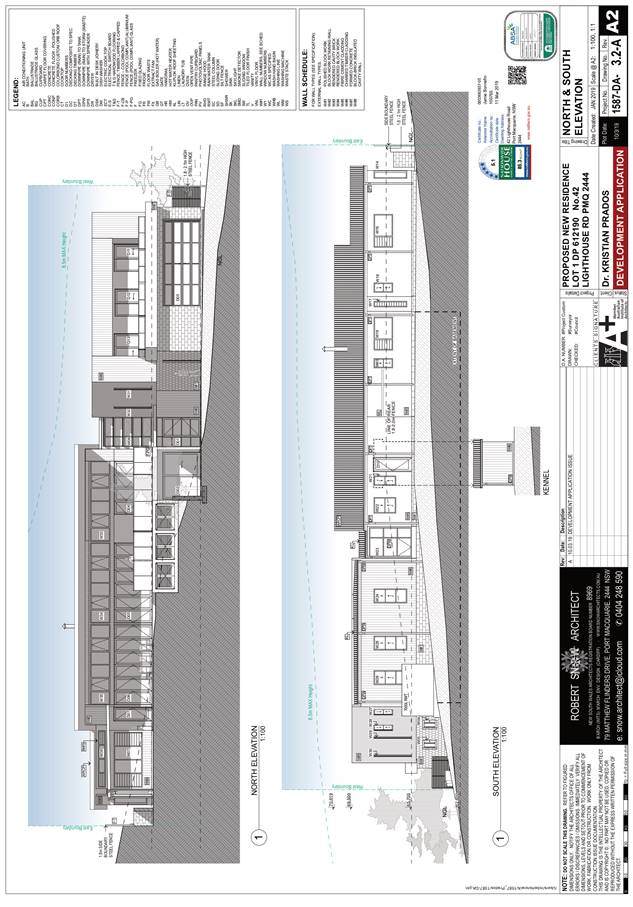
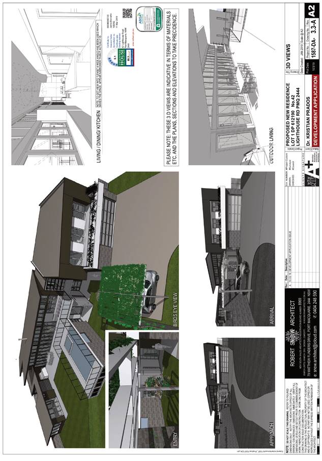
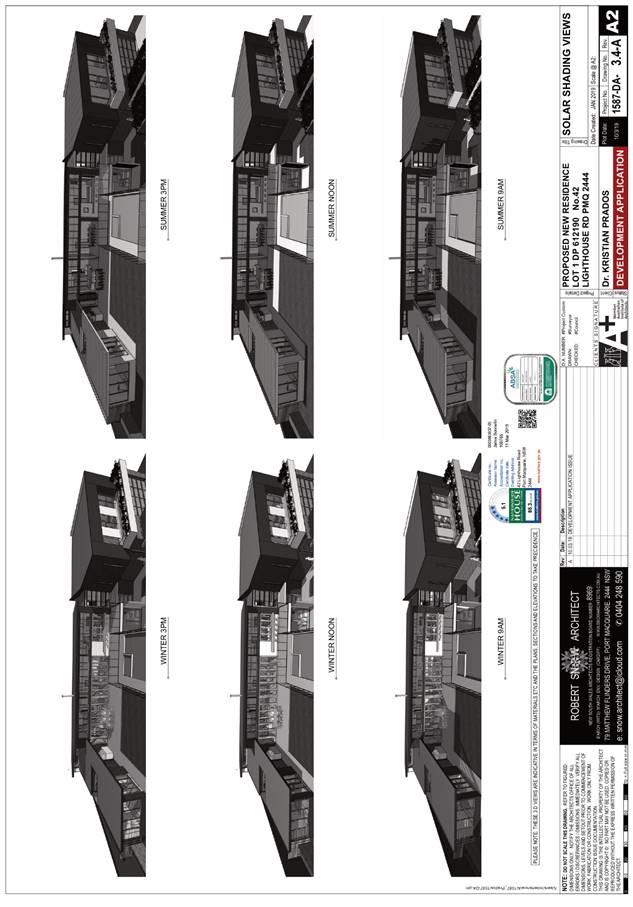
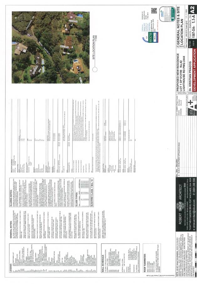
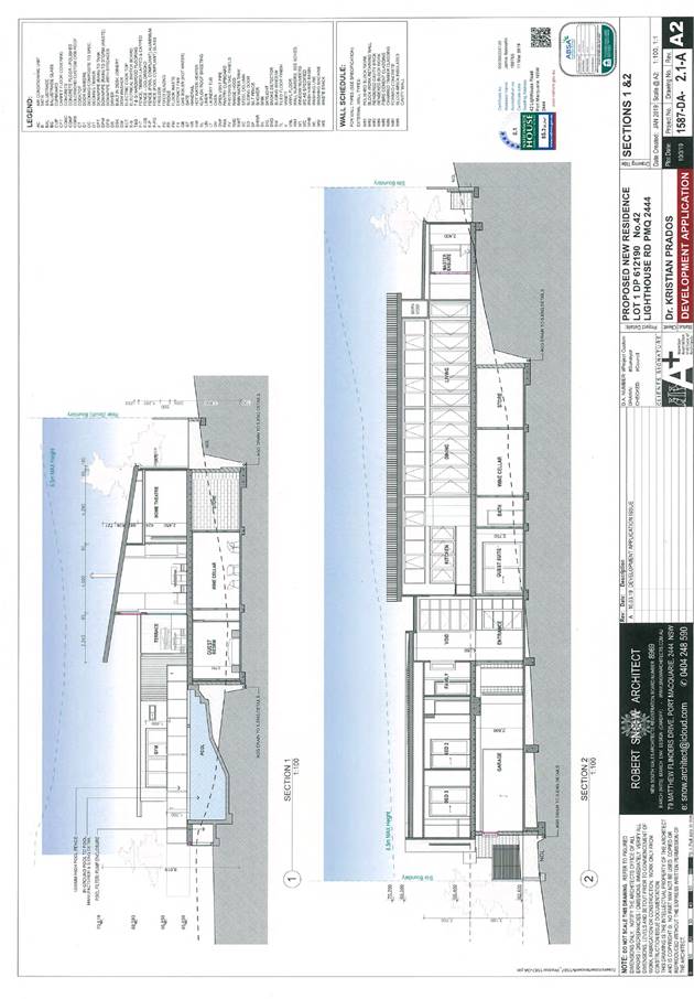
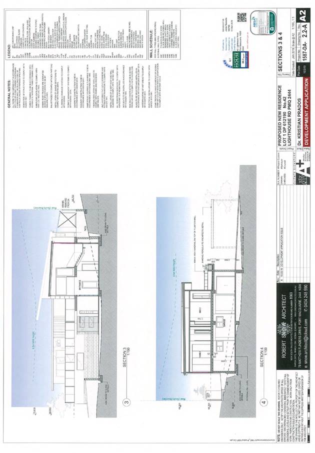
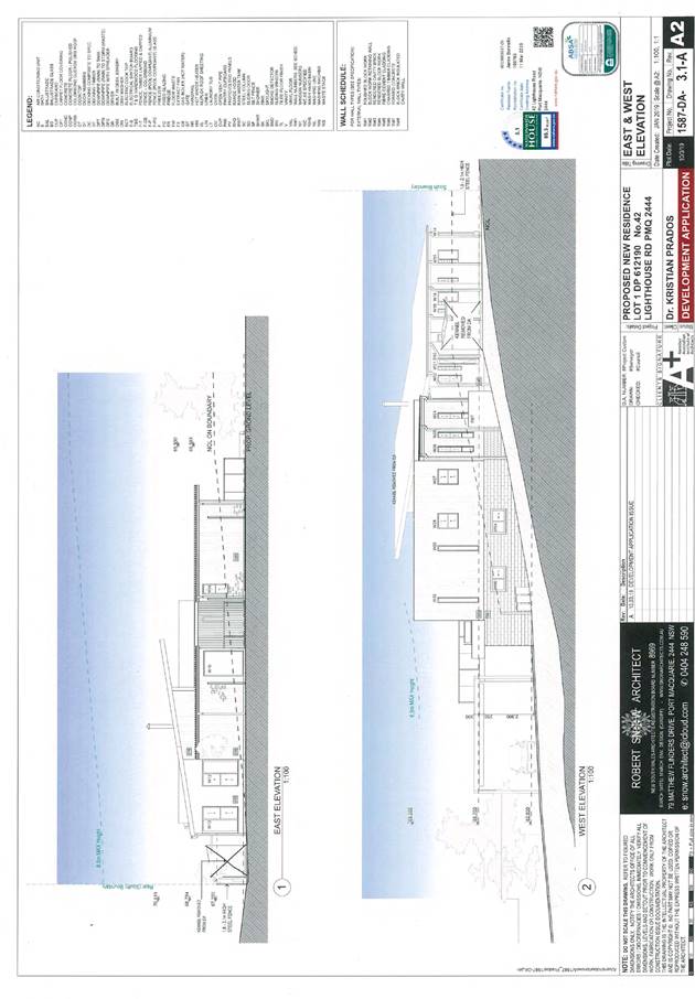
Item: 05
Subject: DA2019 - 154.1 Demolition of Existing Dwelling
and Construction of New Dwelling and Swimming Pool Lot 1 DP 612190 42
Lighthouse Road, Port Macquarie
Report
Author: Development Assessment Planner, Benjamin Roberts
|
Applicant: K
L Prados
Owner: K
L Prados
Estimated Cost: $1,350,000
Alignment with Delivery
Program
4.3.1 Undertake transparent
and efficient development assessment in accordance with relevant legislation.
|
|
RECOMMENDATION
That
DA 2019 - 154 for demolition of
existing dwelling and construction of new dwelling and swimming pool at Lot 1, DP
612190, No. 42 Lighthouse Road, Port Macquarie, be determined by granting
consent subject to the recommended conditions.
|
Executive
Summary
This
report considers a development application for a demolition of existing
dwelling and construction of new dwelling and swimming pool at the subject site and provides an assessment of the
application in accordance with the Environmental Planning and Assessment Act
1979.
Following exhibition of the
application, one (1) submission has been
received.
The application was considered by Council’s
Development Assessment panel (DAP) on 28 August 2019 where it was resolved:
That
DA 2019 - 154 for demolition of existing
dwelling and construction of new dwelling and swimming pool at Lot 1, DP 612190, No.
42 Lighthouse Road, Port Macquarie, be deferred to address the following:
1. A
stormwater management plan is required demonstrating that the development
satisfactorily manages stormwater on the site and that the proposal will not be
adversely impacted by the stormwater overland flow path traversing the property
or causes adverse impacts on neighbouring properties.
2. The
dwelling be designed to provide for a rear setback complying with the
provisions of the Port Macquarie-Hastings Development Control Plan 2013.
Subsequent to the DAP meeting, the
proponent’s architect meet with Council’s Senior Stormwater
Engineer on site to discuss a proposed stormwater management strategy.
Following this, a stormwater management plan and a revised site plan providing
for a 4m rear building setback has been submitted (attached). The stormwater
management plan has been assessed by Council’s Senior Stormwater Engineer
who has advised that the plan is acceptable in principle and that ‘no
objections are raised towards the proposal from a stormwater perspective subject
to the submission of detailed plans and calculations andS.68 stage.’
Refer to additional stormwater comment in the report.
This report recommends that the
subject development application be approved subject to the conditions included
in Attachment 1.
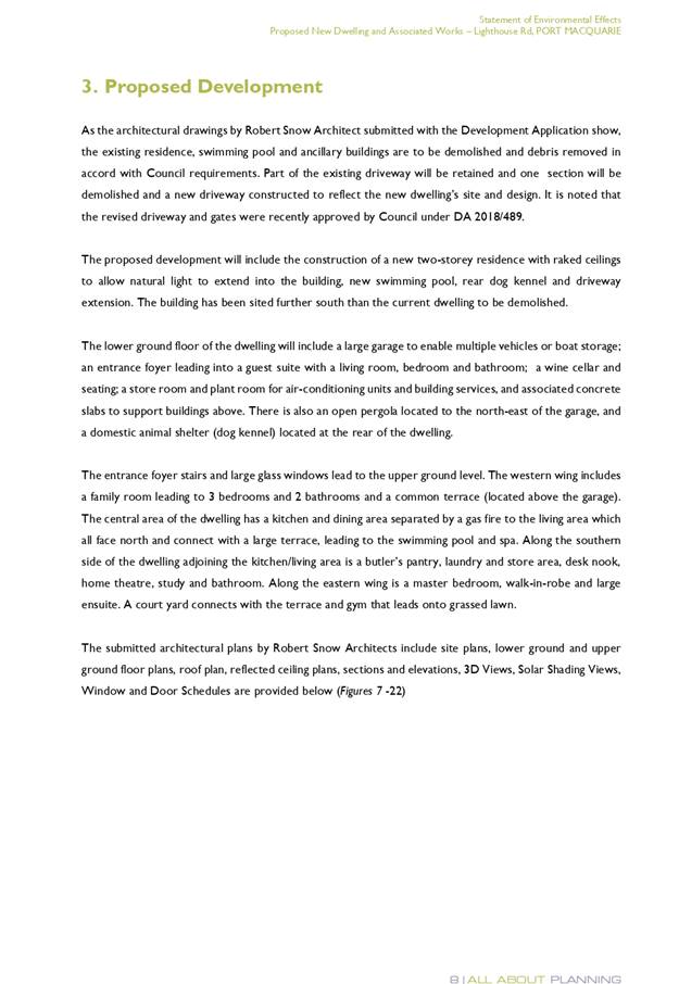
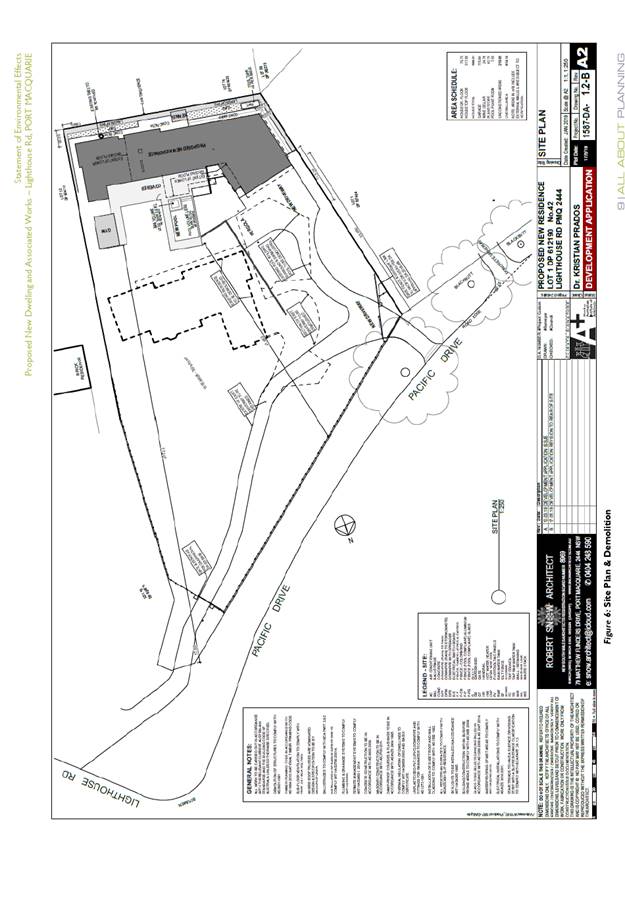
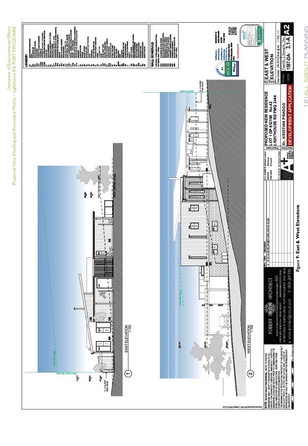
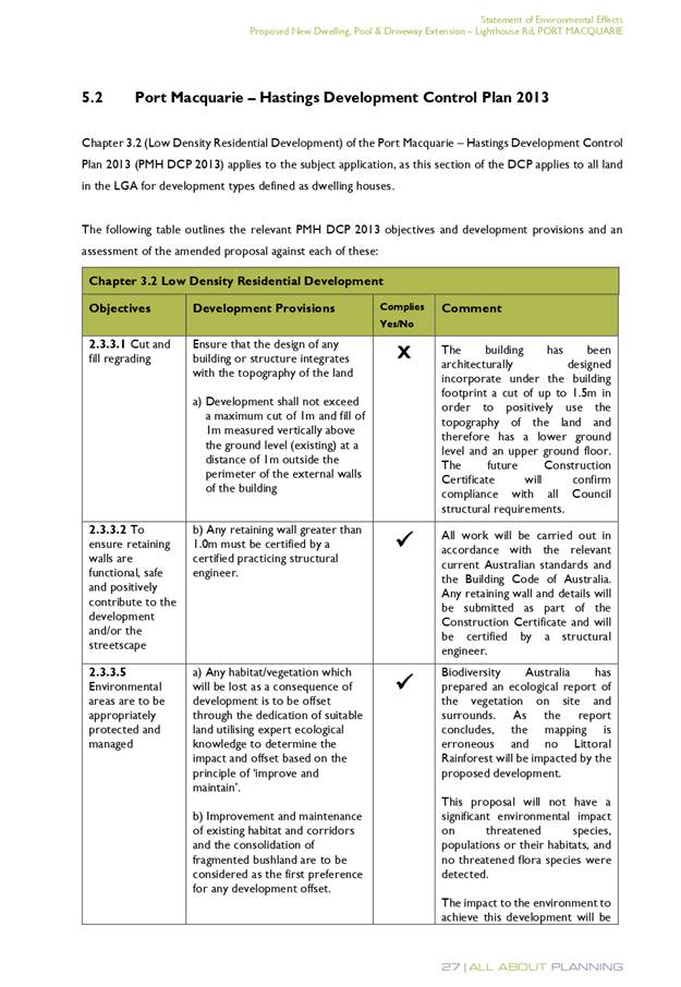
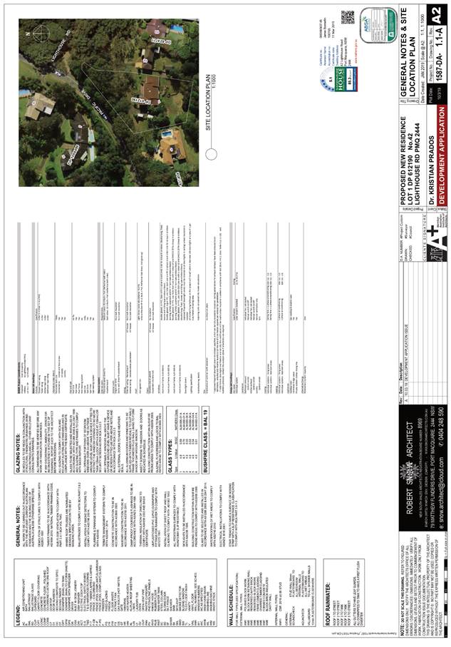
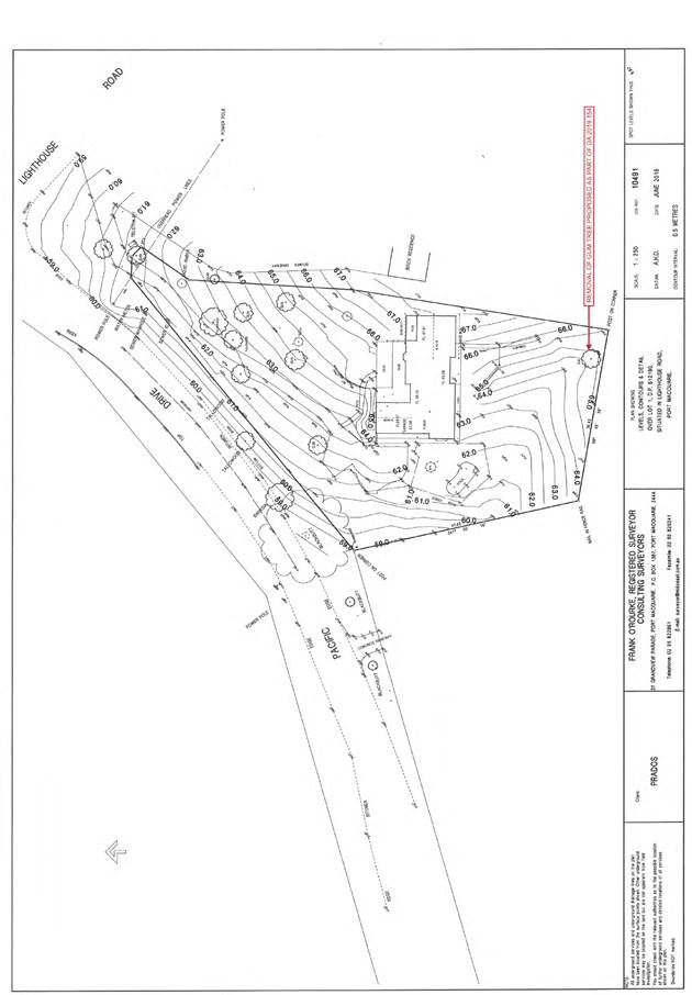
1. BACKGROUND
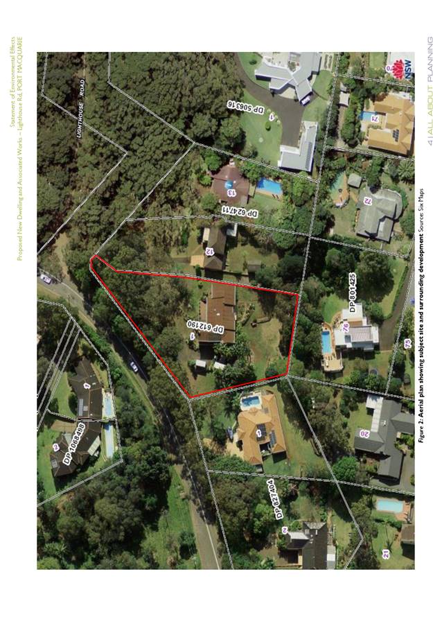
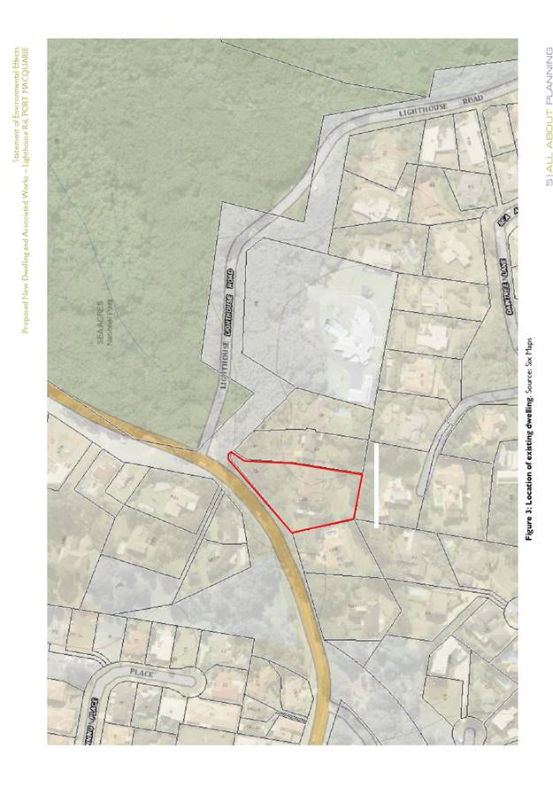
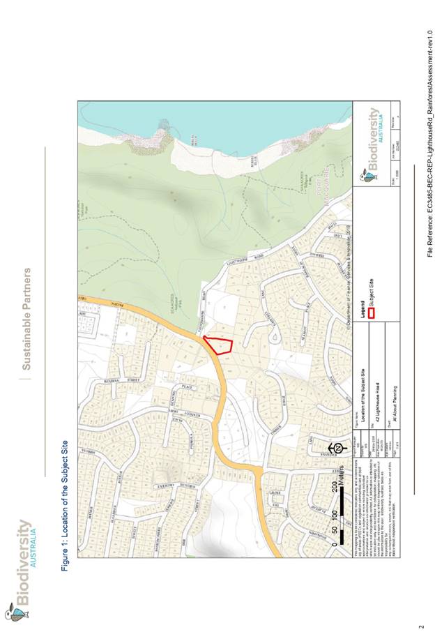
Existing Sites Features and Surrounding Development
The site has an area of 3578m2.
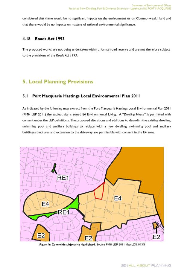
The site is zoned E4 Environmental Living in accordance with the Port Macquarie-Hastings Local
Environmental Plan 2011, as shown in the following zoning plan:
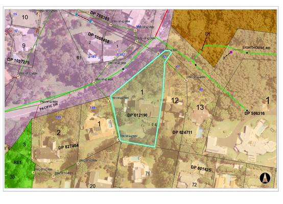
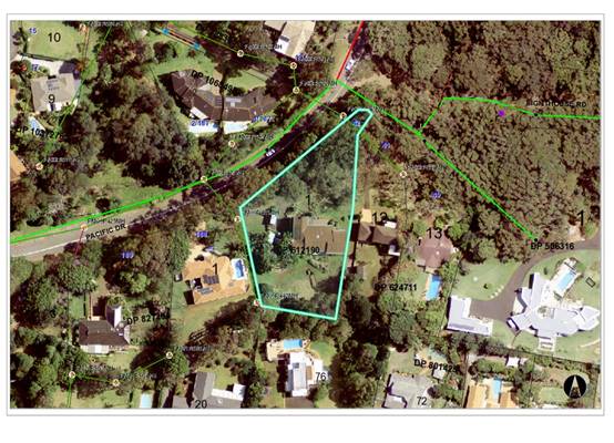
The existing subdivision pattern and location of existing
development within the locality is shown in the following aerial photograph:
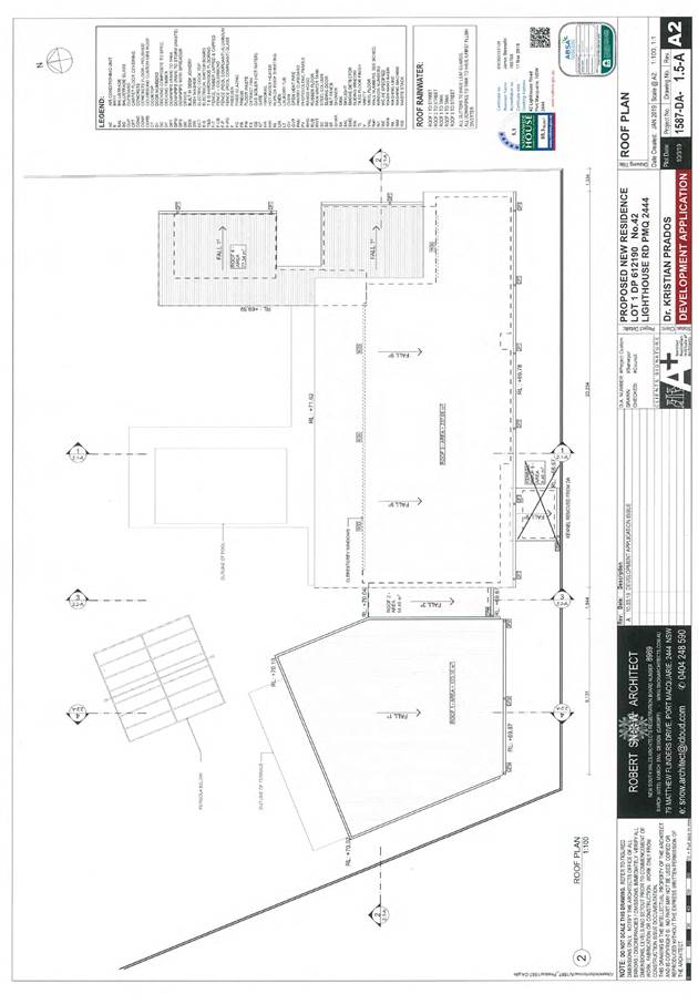
2. DESCRIPTION OF
DEVELOPMENT
Key aspects of the proposal include the following:
· Demolition
of existing dwelling and tree removal
· Construction
of new dwelling and swimming pool
Refer
to attachments at the end of this report.
Application Chronology
· 11
March 2019 - Application lodged.
· 21
March to 3 April 2019 - Public exhibition via neighbour notification.
· 3
April 2019 - Additional information request. Site mapped as littoral rainforest
under Coastal Management SEPP. Application is designated development.
Environmental Impact Statement (EIS) and additional fees required.
· 2 May 2019 - Additional fees paid.
· 22 June 2019 - Environmental Impact Statement and revised
plans received. Secondary dwelling and dog kennel removed from proposal.
· 4 July to 2 August 2019 - Re-exhibition as designated
development via advertising and neighbour notification.
· 28 August 2019 - application considered by DAP and deferred
for further information.
3. STATUTORY ASSESSMENT
Section 4.15(1) Matters for Consideration
In determining the application, Council is required to take
into consideration the following matters as are relevant to the development
that apply to the land to which the development application relates:
(a) The provisions (where
applicable) of:
(i) Any Environmental
Planning Instrument:
State Environmental Planning Policy No. 44 - Koala
Habitat Protection
There is no Koala Plan of Management on the site.
Additionally, the site is less than 1ha in area therefore no further
investigations are required.
State Environmental Planning Policy No. 55 –
Remediation of Land
Following an inspection of the site and a search of Council
records, the subject land is not identified as being potentially contaminated
and is suitable for the intended use.
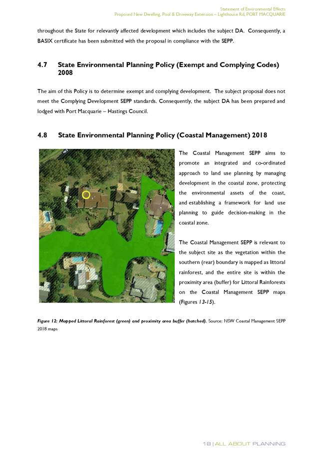
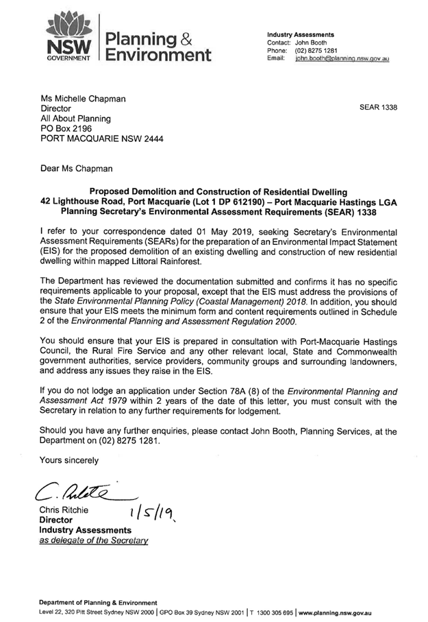
State Environmental Planning Policy (Coastal Management)
2018
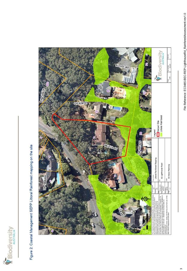
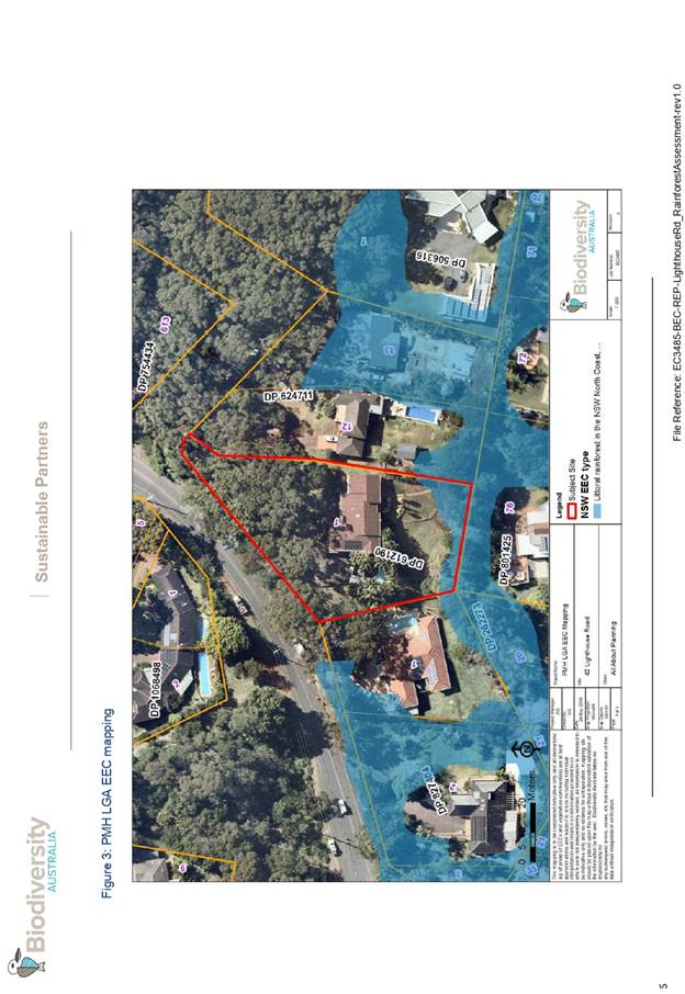
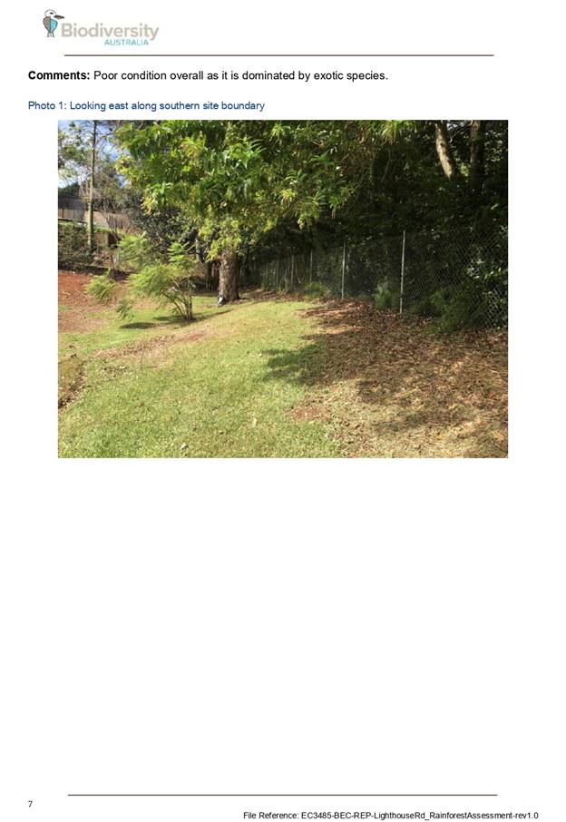
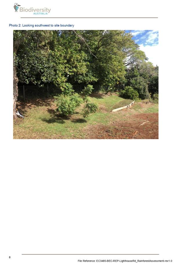
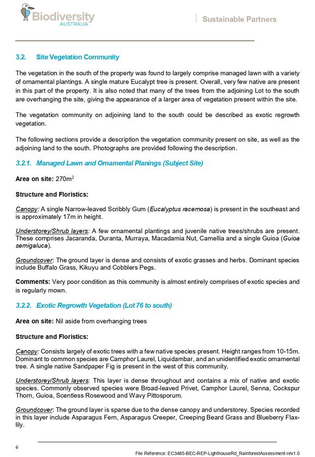
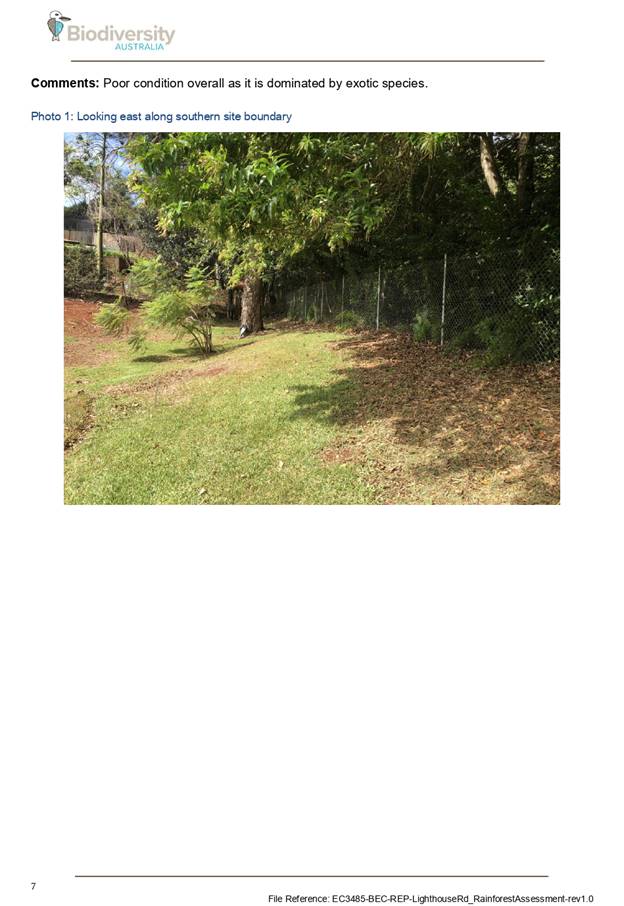
The site is partially mapped as littoral rainforest and
within a proximity area to littoral rainforest under this policy.
In accordance with clause 7, this SEPP prevails over the
Port Macquarie-Hastings LEP 2011 in the event of any inconsistency.
In accordance with clause 10, the proposal is declared to be
designated development. The application was accompanied by an Environmental
Impact Statement (EIS) which is consistent with the issued Secretary’s
Environmental Assessment Requirements (SEARs). A copy of the issued SEARs and
EIS are provided as attachments to this report.
The application was also supported by a site vegetation
assessment, prepared by Biodiversity Australia, dated 24 May 2019. The
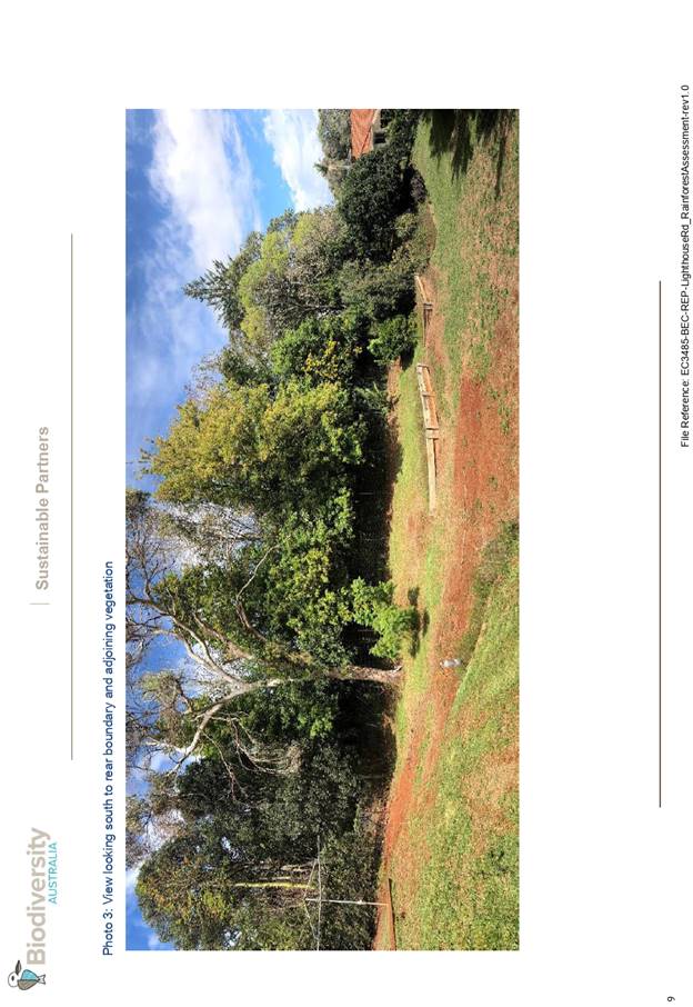
assessment concluded:
“that the vegetation
does not comprise Littoral Rainforest as it lacks key floristic and structural
attributes. Vegetation on adjoining land to the south is also unlikely to
qualify as Littoral Rainforest at present, however it would have the potential
to regenerate into Littoral Rainforest if weeds are removed.
It is recommended that the
Coastal SEPP mapping layer is amended to remove the Littoral Rainforest mapping
from both the subject site and the adjoining land to the south.”
In accordance with clause 11, the proposal will not
significantly impact on:
(a) the
biophysical, hydrological or ecological integrity of the adjacent coastal
wetland or littoral rainforest, or
(b) the
quantity and quality of surface and ground water flows to and from the adjacent
coastal wetland or littoral rainforest.
In accordance with clause 15, the proposed development is
not likely to cause increased risk of coastal hazards on that land or other
land.
In accordance with clause 16, there is no certified coastal
management program that applies to the land.
The bulk, scale and size of the proposed development is
compatible with the surrounding coastal and built environment. The site is
predominately cleared and located within an area with established residential
properties.
State Environmental Planning Policy (Building
Sustainability Index: BASIX) 2004
A BASIX certificate has been submitted demonstrating that
the proposal will comply with the requirements of the SEPP. It is recommended
that a condition be imposed to ensure that the commitments are incorporated
into the development and certified at Occupation Certificate stage.
Port Macquarie-Hastings Local Environmental
Plan 2011
The proposal is consistent with the LEP having regard to the
following:
· Clause 2.2 - The
subject site is zoned E4 Environmental Living. In accordance with clause 2.3(1)
and the E4 zone landuse table, the new dwelling and ancillary swimming pool is
a permissible landuse with consent.
The objectives of the E4 zone are as
follows:
o To provide for
low-impact residential development in areas with special ecological, scientific
or aesthetic values.
o To ensure that
residential development does not have an adverse effect on those values.
· Clause 2.3(2) - The
proposal is consistent with the zone objectives as it is a permissible landuse
and demonstrated no adverse impact on ecological values.
· Clause 2.7 - The
demolition of the existing dwelling requires consent as it does not fit within
the provisions of SEPP (Exempt and Complying Development Codes) 2008.
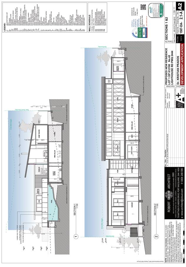
· Clause 4.3 - The maximum
overall height of the building above ground level complies with the standard
height limit of 8.5m applying to the site. Refer to architectural plans with
maximum building height envelope shown.
· Clause 5.10 –
Heritage. The site does not contain or adjoin any known heritage items or sites
of significance.
· Clause 7.13 -
Satisfactory arrangements are in place for provision of essential services
including water supply, electricity supply, sewer infrastructure, stormwater
drainage and suitable road access to service the development.
(ii) Any
draft instruments that apply to the site or are on exhibition:
No draft
instruments apply.
(iii) Any
Development Control Plan in force:
Port
Macquarie-Hastings Development Control Plan 2013
|
DCP 2013: Dwellings, Dual
occupancies, Dwelling houses, Multi dwelling houses & Ancillary
development
|
|
|
Requirements
|
Proposed
|
Complies
|
|
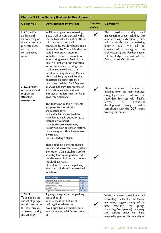
3.2.2.1
|
Ancillary development:
• 4.8m max. height
• Single storey
• 60m2 max. area
• 100m2 for lots
>900m2
• 24 degree max.
roof pitch
• Not located in
front setback
|
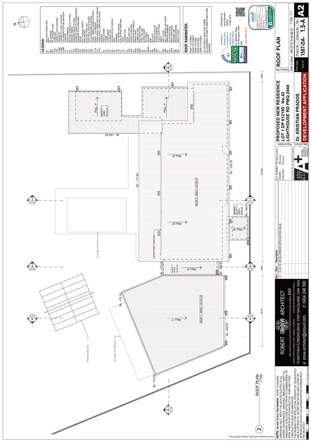
Rainwater tank is located behind
building line. Swimming pool is generously setback 41m from the Pacific Drive
boundary.
|
Yes
|
|
3.2.2.2
|
Articulation zone:
• Min. 3m front setback
• An entry feature
or portico
• A balcony, deck,
patio, pergola, terrace or verandah
• A window box
treatment
• A bay window or
similar feature
• An awning or other
feature over a window
• A sun shading
feature
|
Pergola and swimming pool
structures are within the front setback. The structures are well setback from
the Pacific Drive boundary.
|
Yes
|
|
3.2.2.3
|
Garage 5.5m min. and 1m behind
front façade.
Garage door recessed behind
building line or eaves/overhangs provided
|
Garage door setback is compliant
with the minimum front setback requirements.
Garage door recessed.
|
No. The pergola appears to be a
form of off-street parking similar to a carport. It is considered acceptable
given the generous setback to Pacific Drive, existing vegetation and open
nature of the structure.
|
|
6m max. width of garage door/s
and 50% max. width of building
|
Width of garage door is compliant
with the maximum width requirements
|
Yes
|
|
Driveway crossover 1/3 max. of
site frontage and max. 5.0m width
|
Driveway crossing width is
compliant with the maximum width requirements
|
Yes
|
|
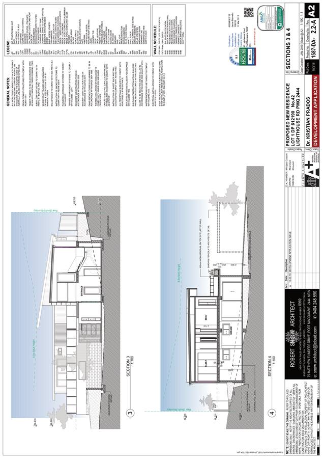
3.2.2.4
|
4m min. rear setback. Variation
subject to site analysis and provision of private open space
|
3.035m rear setback is proposed.
Consistent with the provisions the recused rear setback provides for north
facing private open space which will achieve better solar access. Generous
area available for private open space in the northern setback.
|
Yes
|
|
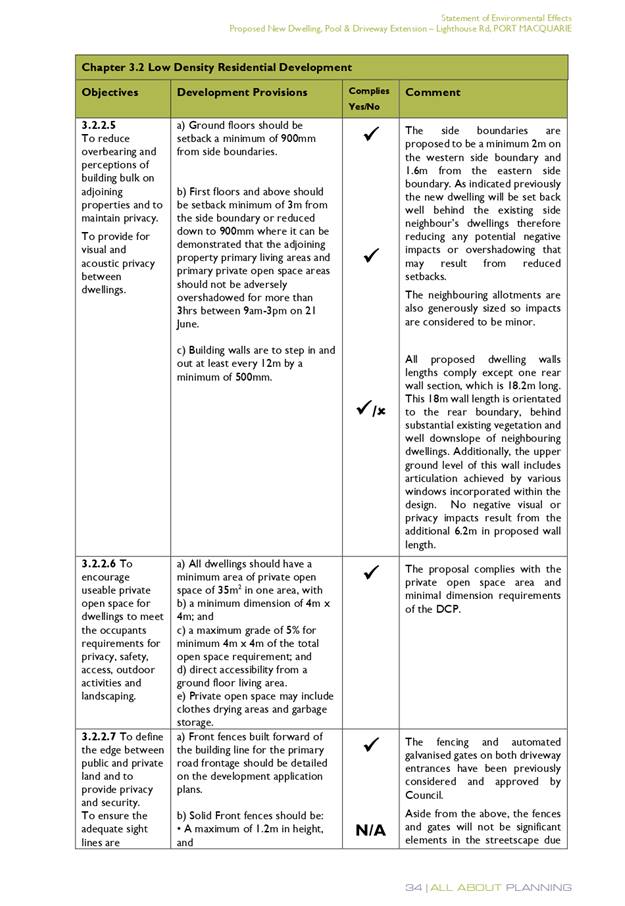
3.2.2.5
|
Side setbacks:
• Ground floor =
min. 0.9m
• First floors &
above = min. 3m setback or where it can be demonstrated that overshadowing
not adverse = 0.9m min.
• Building wall set
in and out every 12m by 0.5m
|
The site slopes away from the
east and having regard to the proposed cut and fill will present as single
storey along the eastern boundary and two storey along the western boundary.
The eastern side setback is 1.66m. The western side setback is 2m. The
reduced western side setback is acceptable as given the block orientation no
adverse overshadowing impact will result to the adjoining property at 188
Pacific Drive.
The building wall articulation is
compliant and/or satisfactory to address the objective intent of the
development provision.
|
Yes
|
|
3.2.2.6
|
35m2 min. private open space area
including a useable 4x4m min. area which has 5% max. grade
|
The dwelling contains >35m² open space in one area
including a useable 4m x 4m space.
|
Yes
|
|
3.2.2.7
|
Front fences:
• If solid 1.2m max
height and front setback 1.0m with landscaping
• 3x3m min. splay
for corner sites
• Fences >1.2m to
be 1.8m max. height for 50% or 6.0m max. length of street frontage with 25%
openings
• 0.9x0.9m splays
adjoining driveway entrances
|
Detail of fencing not provided.
Condition has been recommended requiring fencing details consistent with DCP
be illustrated on building Construction Certificate plans.
|
Yes
|
|
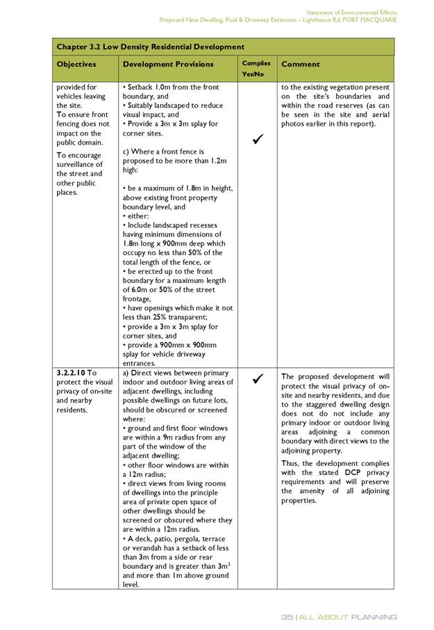
3.2.2.8
|
Front fences and walls to have
complimentary materials to context
No chain wire, solid timber,
masonry or solid steel front fences
|
Refer comments above.
|
Yes
|
|
3.2.2.10
|
Privacy:
• Direct views
between living areas of adjacent dwellings screened when within 9m radius of
any part of window of adjacent dwelling and within 12m of private open space
areas of adjacent dwellings. ie. 1.8m fence or privacy screening which has
25% max. openings and is permanently fixed
• Privacy screen
required if floor level > 1m height, window side/rear setback (other than
bedroom) is less than 3m and sill height less than 1.5m
• Privacy screens
provided to balconies/verandahs etc which have <3m side/rear setback and
floor level height >1m
|
The two storey component along the western boundary
contains bedroom and bathroom windows only.
The upper floor north facing terrace is within 3m of the
western boundary. No privacy screen is illustrated. The adjoining property at
188 Pacific Drive has a pool and outdoor living area orientated east which is
partly within a 12m radius of the proposed upper terrace. To protect privacy
between these areas a condition has been recommenced requiring a privacy
screen to the west facing part of the upper floor terrace. Alternatively,
increasing the planter box to achieve a minimum width of 1.8m
will provide sufficient privacy.
|
Yes subject to the imposition of
condition requiring privacy screen to west facing upper floor terrace or
increasing the width of the planter box to a minimum of 1.8m Subject to the
imposition of the recommended condition the proposal will not compromise privacy
in the area due to the generous building separation and orientation of
primary living and outdoor areas to the north.
|
|
DCP 2013: General
Provisions
|
|
|
Requirements
|
Proposed
|
Complies
|
|
2.7.2.2
|
Design addresses generic principles of Crime Prevention Through
Environmental Design guideline
|
No concealment or entrapment areas proposed. Adequate
casual surveillance available.
|
Yes
|
|
2.3.3.1
|
Cut and fill 1.0m max. 1m outside the perimeter of the
external building walls
|
Cut of approximately 1.5m proposed.
|
No but considered acceptable in this instance.
|
|
2.3.3.2
|
1m max. height retaining walls along road frontage
|
None proposed along road frontage.
|
N/A
|
|
Any retaining wall >1.0 in height to be certified by
structure engineer
|
Retaining wall over 1m proposed.
|
Yes
Condition recommended to require engineering certification
|
|
Combination of retaining wall and front fence height max
1.8m, max length 6.0m or 30% of frontage, fence component 25% transparent,
and splay at corners and adjacent to driveway
|
No retaining wall front fence combination proposed.
|
N/A
|
|
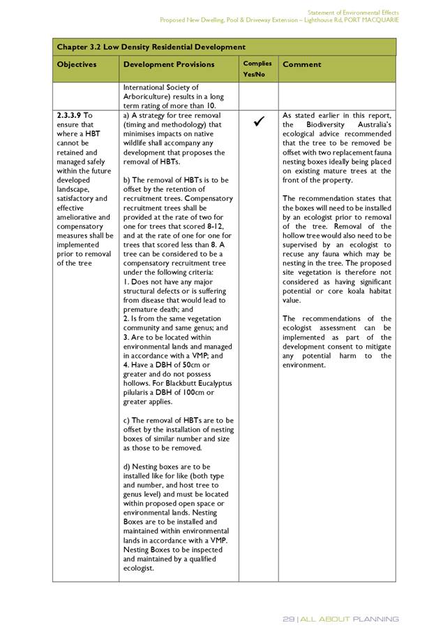
2.3.3.8
|
Removal of hollow bearing trees
|
The Narrow-leaved Scribbly Gum was identified as
containing some hollow bearing potential by the ecologist. The ecologist
scored the tree as having a likely medium value of 12 in the hollow bearing
tree assessment protocol. The ecologist noted the large dead branches and
described the tree as looking dangerous. Consistent with the DCP provisions
the ecologist recommends that if removed two replacement fauna nesting boxes
ideally located on existing mature trees at the front of the property should
be installed. The ecologist recommends these boxes be installed by an
ecologist prior to removal of the tree and the tree removal also supervised
by an ecologist.
|
The tree is in poor condition and is best characterised as
dangerous. The best outcome would be for it to be removed and offsets
measures be implemented as per the ecologist advice. Suitable conditions have
been recommended.
|
|
2.6.3.1
|
Tree removal (3m or higher with 100m diameter trunk at 1m
above ground level and 3m from external wall of existing dwelling)
|
The Narrow-leaved scribbly gum is a tree identified in as
a Koala food tree. The tree is identified as dangerous and is proposed to be
removed.
|
Consistent with the plan compensatory Koala habitat trees
shall be provided at a ratio of 2:1. Suitable area and locations exist on
site to accommodate replants. Conditions have been recommended.
|
|
2.4.3
|
Bushfire risk, Acid sulphate soils, Flooding,
Contamination, Airspace protection, Noise and Stormwater
|
Refer to main body of report.
|
Yes
|
|
2.5.3.2
|
New accesses not permitted from arterial or distributor
roads
|
No new access proposed to arterial or distributor roads.
|
N/A
|
|
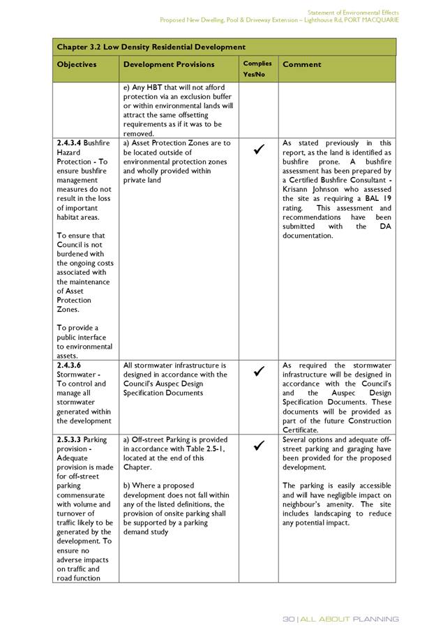
Driveway crossing/s minimal in number and width including maximising
street parking
|
Driveway crossing minimal in width
|
Yes
|
|
2.5.3.3
|
Parking in accordance with Table 2.5.1.
1 space per single dwelling (behind building line)
|
Ample off-street parking is proposed.
|
Yes
|
|
2.5.3.11
|
Section 94 contributions
|
Refer to main body of report.
|
N/A
|
|
2.5.3.12 and 2.5.3.13
|
Landscaping of parking areas
|
Single dwelling only. No specific landscaping requirements
recommended.
|
N/A
|
|
2.5.3.14
|
Sealed driveway surfaces unless justified
|
Sealed driveway proposed.
|
Yes
|
|
2.5.3.15 and 2.5.3.16
|
Driveway grades first 6m or ‘parking area’
shall be 5% grade with transitions of 2m length
|
Driveway grades capable of satisfying Council standard
driveway crossover requirements. Condition recommended for section 138 Roads
Act permit
|
Yes
|
|
2.5.3.17
|
Parking areas to be designed to avoid concentrations of
water runoff on the surface.
|
Single dwelling only. Stormwater drainage is capable of
being managed as part of plumbing construction.
|
Yes
|
(iiia) Any
planning agreement that has been entered into under section 7.4, or any draft
planning agreement that a developer has offered to enter into under section
7.4:
No planning
agreement has been offered, or entered into.
iv) Any matters prescribed by the
Regulations:
Demolition
of buildings
Demolition
of the existing dwelling onsite is capable of compliance with Australian
Standard 2601-1991: The Demolition of Structures.
(b) The
likely impacts of that development, including environmental impacts on both the
natural and built environments, social and economic impacts in the locality:
The proposal will be unlikely to have any adverse impacts to
existing adjoining properties and satisfactorily addresses the public domain.
The proposal is considered to be compatible with other
residential development in the locality and adequately addresses planning
controls for the area.
The proposal does not have a significant adverse impact on
existing view sharing.
The proposal does not have significant adverse lighting
impacts.
There are no significant adverse privacy impacts. The
adjoining dwelling to south (12 Daintree Lane) is setback approximately 20m
from the boundary. The 20m setback is well vegetated with mature trees. The
removal of the single Narrow-leaved scribbly gum from the rear of the property
will not result in any adverse privacy impacts.
There is no adverse overshadowing impacts. The adjoining
dwelling to south (12 Daintree Lane) is setback approximately 20m from the boundary.
The proposal does not prevent adjoining properties from receiving 3 hours of
sunlight to private open space and primary living areas on 21 June.
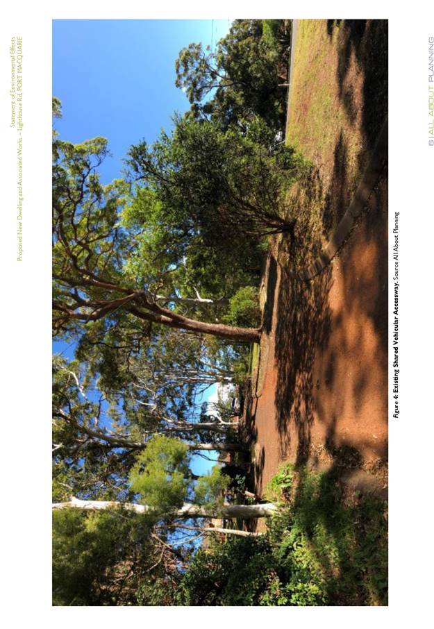
Access, Traffic and Transport
A new driveway is proposed in the south-western corner of
the property directly onto Pacific Drive. This new driveway formed part of a
previous application for alterations and additions to the existing dwelling
that was approved 13 November 2018. A survey report and Arborist report
supported this application, which subject to recommendations validated
retention of a large Blackbutt tree within the Pacific Drive road reserve close
to the new driveway. Conditions have been recommended (that were applied to the
prior consent for alterations and additions) requiring tree protection for
driveway works near the Blackbutt tree and a change to the title restriction,
which currently prohibits direct vehicular access to Pacific Drive. It is also
recommended that the prior consent (DA2018/489) be surrendered prior to issue
of any building construction certificate to ensure there is no conflict between
consents.
The proposal will be unlikely to have any adverse impacts in
terms access, transport and traffic.
Water Supply Connection
Service available. Details required
with section 68 application.
Sewer Connection
Service available. Details
required with section 68 application.
Stormwater
There is no stormwater infrastructure available for direct
connection to the development.
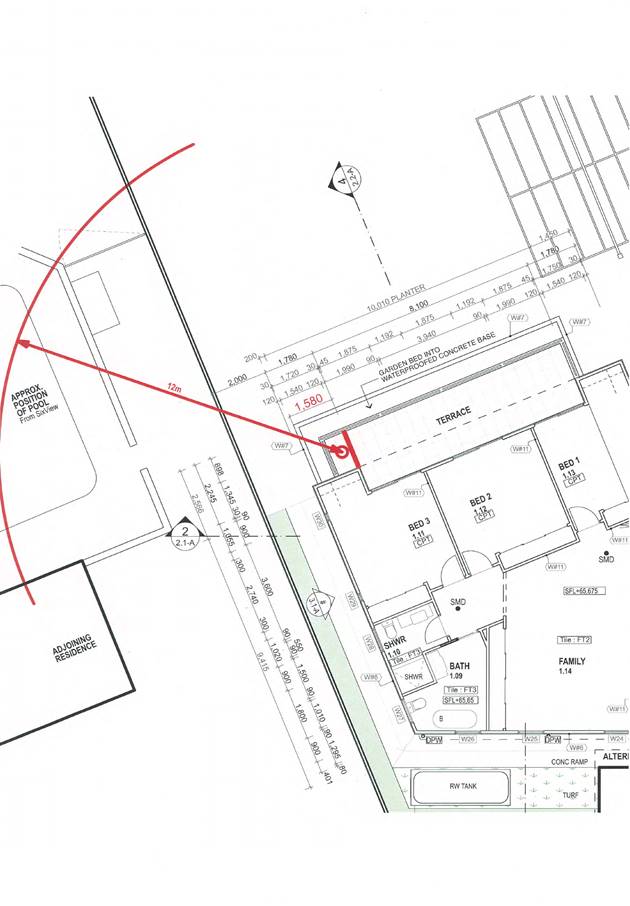
Following the DAP resolution on 28 August 2019 to provide
more information on stormwater management, the proponent’s architect met
with Council’s Senior Stormwater Engineer on site. It was determined that
an overland flow path was required around/through the site to allow for the
conveyance of stormwater runoff from the natural gully traversing the site. In
addition, the method via which stormwater flows flowing within the gully needed
to be managed in such a way to not increase the volume, rate or location of
discharge into the lower section of the gully on the adjoining downstream
property.
Amendments have been proposed to the site plan to set the
proposed dwelling 4m clear of the rear boundary, with a swale to be provided
around the dwelling. The swale would be at a level sufficiently lower than the
floor levels of the dwelling and would be shaped to intercept the gully at its
upstream end, and provide a clear overland flow path around the dwelling to
where it ultimately terminated at the location where the existing gully meets
the adjoining downstream property. In regards to the formation of the
swale, the proponent is proposing to provide a series of inlet pits and
interconnected stormwater pipelines within the swale to capture and convey
flows from the upstream gully. The rationale for this is that it would make the
area more useable for the landowner. The swale would realistically therefore
only carry water if the pits were to block.
Given that the proposal would result in the capture of
runoff from the upstream gully into a piped drainage system, it would not be
appropriate to simply discharge that runoff onto the adjoining downstream
property, as the resultant flows would likely be faster flowing and of a
greater volume (as a result of lower friction in the pipe vs overland and no
infiltration). Hence, the proponent is proposing to divert these piped flows to
some detention tanks, which would slow the flow of runoff, prior to splitting
the resultant discharge to two soak away pits:
· One located at the
Pacific Drive frontage (servicing the majority of flows from the detention
tanks) from where surcharge could be directed to the street drainage system,
and
· A second pit
acting as an overflow from the detention system located within the lower
portion of the gully traversing the site - from where discharge would drain
overland through the gully and adjoining property.
Subject to detailed design and modelling at S.68 stage, the
proposal would result in a lessening of the volume of runoff entering the natural
gully traversing the adjoining downstream property, whilst also providing for
the safe conveyance of stormwater flows from the upstream gully through the
site.
The proposed drainage strategy is acceptable in principle
and no objections are raised towards the proposal form a stormwater perspective
subject to the submission of detailed plans and calculations at S.68 stage.
Other Utilities
Telecommunication and electricity
services are available to the site.
Heritage
This site does not contain or
adjoin any known heritage item or site of significance.
Other land resources
The proposal will not sterilise
any significant mineral or agricultural resource.
Water cycle
The proposed development will be
unlikely to have any adverse impacts on water resources and the water cycle.
Soils
The proposed development will be
unlikely to have any adverse impacts on soils in terms of quality, erosion,
stability and/or productivity subject to a standard condition requiring erosion
and sediment controls to be in place prior to and during construction.
Air and microclimate
The construction and/or operations
of the proposed development will be unlikely to result in any adverse impacts
on the existing air quality or result in any pollution. Standard precautionary site
management condition recommended.
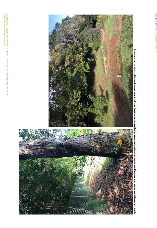
Flora and fauna
The proposed development
includes removal of some exotic/ornamental plants and one Narrow-leaved
Scribbly Gum in the south-eastern corner of the site. The Biodiversity Offset
Scheme does not apply for the following reasons:
· The
land wasn’t identified on the Biodiversity Values Map at the time the
application was made;
· The
extent of clearing is below the thresholds in Clause 7.2 of the Biodiversity
Conservation Regulation 2017;
· The
application of test of significance (5 part test) demonstrates that the
development will not have a significant impact on biodiversity values.
The application was supported by a site vegetation
assessment, prepared by Biodiversity Australia, dated 24 May 2019. The onsite
assessment concludes:
“that the vegetation
does not comprise Littoral Rainforest as it lacks key floristic and structural
attributes. Vegetation on adjoining land to the south is also unlikely to
qualify as Littoral Rainforest at present, however it would have the potential
to regenerate into Littoral Rainforest if weeds are removed.
It is recommended that the
Coastal SEPP mapping layer is amended to remove the Littoral Rainforest mapping
from both the subject site and the adjoining land to the south.”
This advice also formed part of the correspondence sent to
the Department when seeking the Planning Secretary’s Environmental
Assessment Requirements (SEARs). It is noted that the SEARs issued by the
Department have no specific requirements surrounding flora and fauna impacts. A
copy of the issued SEARs is provided as an attachment this report.
The Narrow-leaved Scribbly Gum while recognised as dangerous
does contain some hollowing bearing potential. Refer to comments in DCP table
earlier within report.
Subsequent advice from the ecologist has confirmed that this
tree is likely to have low habitat value and that its removal should be offset
by the installation of two nest boxes within the existing mature eucalypts at
the front of the property. The ecologist also recommends the nest boxes be
installed by an ecologist prior to removal of the tree and that the tree
removal be supervised by an ecologist. In addition and consistent with the DCP
provisions two compensatory Koala food trees are to be provided on the site.
Suitable conditions have been recommended.
Waste
Satisfactory arrangements are in
place for proposed storage and collection of waste and recyclables. No adverse
impacts anticipated. Standard precautionary site management condition
recommended.
Energy
The proposal includes measures to
address energy efficiency and will be required to comply with the requirements
of BASIX.
Noise and vibration
No adverse impacts anticipated.
Condition recommended to restrict construction to standard construction hours.
Bushfire
The site is identified as being
bushfire prone. The applicant has submitted a Bushfire Attack Level (BAL)
certificate prepared by a qualified professional.
A review of the certificate and
assessment of bushfire risk having regard to section 4.3.5 of Planning for
Bushfire Protection 2006 including vegetation classification and slope
concludes that a Bushfire Attack Level 19 shall be required.
Management of bushfire risk is
acceptable subject to BAL construction levels being implemented and APZ being
maintained. An appropriate condition has been recommended.
Safety, security and crime
prevention
The proposed development will be
unlikely to create any concealment/entrapment areas or crime spots that would
result in any identifiable loss of safety or reduction of security in the
immediate area.
Social impacts in the locality
Given the nature of the proposed
development and its’ location the proposal is unlikely to result in any
adverse social impacts.
Economic impact in the locality
No adverse impacts. A likely
positive impact is that the development will maintain employment in the
construction industry, which will lead to flow impacts such as expenditure in
the area.
Site design and internal design
The proposed development design
satisfactorily responds to the site attributes and will fit into the locality.
No adverse impacts likely.
Construction
No potential adverse impacts identified
to neighbouring properties with the construction of the proposal.
Cumulative Impacts
The proposed development is not expected to have any
adverse cumulative impacts on the natural or built environment or the social
and economic attributes of the locality.
(c) The suitability of the site for
the development:
The proposal will fit into the locality and
the site attributes are conducive to the proposed development.
Site
constraints have been adequately addressed and appropriate conditions of consent
recommended.
(d) Any submissions made in
accordance with this Act or the Regulations:
One (1) written submission has been received following public
exhibition of the application.
Key issues raised in the submission received and comments
in response to these issues are provided as follows:
|
Submission
Issue/Summary
|
Planning
Comment/Response
|
|
The setback to the rear
boundary is too close and should be increased by a further 2m and established
as a green buffer zone.
|
Refer to DCP table and
comments. The dwelling setback of 3.035m is considered acceptable.
|
|
Responsibility for trimming vegetation on the common
boundary.
|
Any existing or proposed vegetation removal or pruning is
subject to the provisions of the adopted Development Control Plan 2013. The Trees
(Disputes between neighbours) Act 2006 covers any disputes between
neighbours involving trees.
|
|
There have been numerous complaints from neighbours
regarding barking dogs at night. It is requested the proposed kennel be
relocated north of the dwelling.
|
The kennel is no longer proposed under this application.
|
|
It is requested that the large gum tree proposed to be removed
be retained. It provides privacy and is part of the local Koala habitat. If
this is not possible then replacement plantings should be undertaken.
|
Refer to comments in flora and fauna and DCP table
section of this report. Two nest boxes have been recommended by the ecologist
to be provided onsite. Two replacement Koala tree plantings shall also be
required consistent with DCP 2013 provisions.
No adverse privacy impacts would result from the tree
removal that would warrant refusal of this application.
|
|
It is requested that the rainwater tank abut the wall of
the proposed building as opposed to being on the boundary fence.
|
The rainwater tank is setback over 1m from the rear
boundary which complies with the minimum 900mm setback requirement.
|
(e) The Public Interest:
The proposed
development satisfies relevant planning controls and will not adversely impact
on the wider public interest.
4. DEVELOPMENT
CONTRIBUTIONS APPLICABLE
Not applicable.
5. CONCLUSION AND
STATEMENT OF REASON
The application has been assessed
in accordance with Section 4.15 of the Environmental Planning and Assessment
Act 1979.
Issues raised during assessment
and public exhibition of the application have been considered in the assessment
of the application. Where relevant, conditions have been recommended to manage
the impacts attributed to these issues.
The site is considered suitable
for the proposed development and the proposal adequately addresses relevant
planning controls. The development is not considered to be contrary to the
public's interest and will not result a significant adverse social,
environmental or economic impact. It is recommended that the application be
approved, subject to the recommended conditions of consent provided in the
attachment section of this report.
|
Attachments
1View. DA2019
- 154.1 - Recommended Conditions
2View. DA2019
- 154.1 Environmental Impact Statement
3View. DA2019
- 154.1 Email Steggall - Scribbbly Gum Tree - HBT Potential and Recommended
Nest Box Offsetting
4View. DA2019
- 154.1 Ecology Advice - Vegetation Classification - Will Steggall
5View. DA2019
- 154.1 DA Plans.
6View. DA2019
- 154.1 SEARs Local Secretary - Environmental Assessment Requirements
|
|
ATTACHMENT
|
Development Assessment Panel
11/09/2019
|
|
ATTACHMENT
|
Development Assessment Panel
11/09/2019
|


|
ATTACHMENT
|
Development Assessment Panel
11/09/2019
|


|
ATTACHMENT
|
Development Assessment Panel
11/09/2019
|


|
ATTACHMENT
|
Development Assessment Panel
11/09/2019
|

|
ATTACHMENT
|
Development Assessment Panel
11/09/2019
|
AGENDA Development Assessment Panel 11/09/2019
Item: 06
Subject: DA2018 - 365.1 Demolition of Dwelling and
Erection of New Dwelling and Shed - Lot 4 DP 538813, No 160 Settlement Point
Road, Port Macquarie
Report
Author: Building Surveyor, Michael Roberts
|
Applicant: D
G Chapman
Owner: D
G Chapman
Estimated Cost: $550,000
Alignment with Delivery
Program
4.3.1 Undertake transparent
and efficient development assessment in accordance with relevant legislation.
|
|
RECOMMENDATION
That
DA 2018 - 365.1 for the demolition of existing Dwelling, construction of a
new Dwelling, Shed and Earthworks at Lot 4, DP 538813, No. 160 Settlement
Point Road, Port Macquarie, be determined by granting consent subject to the
recommended conditions.
|
Executive
Summary
This
report considers a development application for the demolition of existing
dwelling, construction of a new dwelling, shed and earthworks at the subject site and provides an assessment of the
application in accordance with the Environmental Planning and Assessment Act
1979.
Following exhibition of the
application, eight (8) submissions have been
received. This report recommends that the development application be
approved subject to the conditions included attached.
1. BACKGROUND
Existing Sites Features and Surrounding Development
The site has an area of 6709m2.
The site is zoned R1 General Residential in accordance with the Port Macquarie-Hastings Local
Environmental Plan 2011, as shown in the following zoning plan:
The existing subdivision pattern and location of existing
development within the locality is shown in the following aerial photograph:
2. DESCRIPTION OF
DEVELOPMENT
Key aspects of the proposal include the following:
· Demolition of existing Dwelling, construction of a new
Dwelling, Shed and Earthworks.
Refer
to attachments at the end of this report.
Application Chronology
· 21
May 2018 - Application lodged.
· 25
May 2018 - Council received a customer request regarding unauthorised fill
material being placed on the site. Compliance action commenced requiring any
contaminated fill material to be removed and appropriate sediment control
measures to be installed. Contaminated fill material subsequently removed from
site.
· 29 May 2018 - 11 June 2018 - Public exhibition via
neighbour notification.
· 12 June 2018 - Submissions received and compiled.
· 25 June 2018 - Additional information request sent to
applicant.
· 31 August 2018 - Initial draft Flood Study submitted.
· 31 August 2018 -19 July 2019 - Additional information items
being addressed.
· 19 July 2019 - All additional information received and
amended plans submitted.
· 24 July 2019 - 6 August 2019 - Public re-exhibition via
neighbour notification.
· 7 August 2019 - Submissions received and compiled.
· 30 August 2019 - DAP meeting notification issued.
3. STATUTORY ASSESSMENT
Section 4.15(1) Matters for Consideration
In determining the application, Council is required to take
into consideration the following matters as are relevant to the development
that apply to the land to which the development application relates:
(a) The
provisions (where applicable) of:
(i) Any Environmental
Planning Instrument:
State Environmental Planning Policy No. 44 - Koala
Habitat Protection
There is no Koala Plan of Management on the site.
Additionally, the site is less than 1ha in area therefore no further
investigations are required.
State Environmental Planning Policy No. 55 –
Remediation of Land
Following an inspection of the site and a search of Council
records, the subject land is not identified as being potentially contaminated
and is suitable for the intended use.
State Environmental Planning Policy No. 62 –
Sustainable Aquaculture
Given the nature of the proposed development and proposed
stormwater controls the proposal will be unlikely to have any adverse impact on
existing aquaculture industries.
State Environmental Planning Policy (Coastal Management)
2018
The site is located within a coastal use, coastal
environment area, the proximity area for coastal wetlands and the proximity
area for littoral rainforests.
In accordance with clause 7, this SEPP prevails over the
Port Macquarie-Hastings LEP 2011 in the event of any inconsistency.
Having regard to clause 11 of the SEPP the proposed
development is not considered to significantly impact on any of the following:
a) the biophysical, hydrological or ecological integrity of the adjacent
coastal wetland or littoral rainforest, or;
b) the quantity and quality of surface and ground water flows to and from
the adjacent coastal wetland or littoral rainforest.
Having regard Clauses 13 and 14 of the
SEPP, the consent authority must be satisfied that the development has been
designed, sited and will be managed to minimise any impact on a Coastal
environment and Coastal use area. The proposed development is not considered
likely to result in any adverse impacts on the following:
a) the integrity and resilience of the biophysical, hydrological (surface and
groundwater) and ecological environment;
b) coastal environmental values and natural coastal processes;
c) the water
quality of the marine estate (within the meaning of the Marine Estate Management Act 2014), in particular, the cumulative impacts of the proposed development on
any of the sensitive coastal lakes identified in Schedule 1;
d) marine vegetation, native vegetation and fauna and their habitats,
undeveloped headlands and rock platforms;
e) existing public open space and safe access to and along the foreshore,
beach, headland or rock platform for members of the public, including persons
with a disability;
f) Aboriginal cultural heritage, practices and places;
g) the use of the surf zone;
h) existing,
safe access to and along the foreshore, beach, headland or rock platform for
members of the public, including persons with a disability;
i) overshadowing,
wind funnelling and the loss of views from public places to foreshores;
j) the
visual amenity and scenic qualities of the coast, including coastal headlands;
k) Aboriginal
cultural heritage, practices and places;
l) cultural
and built environment heritage; and
The consent authority must be satisfied that
if any impact cannot be reasonably avoided that the development is designed,
sited and managed to minimise that impact.
The applicant has submitted a report
addressing the provisions of the SEPP (Coastal Management) 2018. The report was
prepared by GEM Planning Projects on the 2nd April 2019. The outcome
of the report are summarised below:
“The
proposal does not directly impact the surface level or vegetation of the area
mapped coastal wetland area. Nor does it significantly impact the
hydrological integrity of the mapped wetland area, land mapped in proximity
to coastal wetland or land mapped in proximity to littoral rainforest.
The
design of the filling and surface water management by Flume Engineering has
purposely sought to ensure no net change to the hydrology of the mapped area.
The design ensures stormwater quality and flows are acceptable by integrating a
multiple rock check dams along a centrally located grass swale drain as well as
rock lined level spreader designed to dissipate any remaining flow velocity.
The discharge location is 10m clear of the mapped wetland boundary.
Existing
ground cover adjacent the mapped ‘coastal wetland’ is managed grass
and grass cover is to be re-established over the proposed fill as soon as
practical.
Clean
fill to be used ensuring that no contaminants or leachate would enter the
mapped ‘wetland’ area.
Sediment
& erosion control fencing to be maintained along the perimeter of the toe
of the fill, a minimum of 5m clear of the mapped ‘coastal wetland’
boundary until such time as sufficient grass cover is established. Refer to
Erosion & Sediment Control Plans submitted with the DA.
The
modest increase in the site impervious area is addressed by way of on-site
detention rainwater tank (8kL dual compartment) and on site detention swale at
the rear of the dwelling.
Water
quality measures and level spreader arrangement are proposed to disperse the
piped flow back to natural sheet regime.
As
mentioned above, it is proposed to place clean fill and ensure grass cover is
established as soon as practical and as such no impacts on groundwater quality
or percolation (quantity) is anticipated. There are no development elements
identified that would be expected to interrupt or otherwise disturb the water
table.
It is
considered reasonable to acknowledge that the subject land has existing use
rights for the residential use of the whole of the site. Further, the proposed
reconstruction of a dwelling and ancillary elements in the dwelling curtilage
for minor filling, sheds and gardens were typical of the nature of residential
occupancy in this location prior to the introduction of the SEPPs and would
reasonably constitute a continuance of that use.”
The applicant engaged the services of Flume Engineering to
conduct a Stormwater Management Assessment for the development proposed. The
design detailed how stormwater would be captured, managed and dispersed on-site
to minimise potential impacts on the adjoining environmentally sensitive areas.
The bulk, scale and size of the proposed development is
compatible with the surrounding coastal and built environment. The site is
predominately cleared and located within an area zoned for residential
purposes.
The applicant has adequately addressed the provisions of the
State Environmental Planning Policy (Coastal Management) 2018 and will be
implementing control measures to minimise any potential impacts as a result of
the proposed development. These measures are detailed above and will be
implemented under the development consent. Conditions of consent have been
recommended to ensure such measures are complied with during and post
construction until the site becomes established.
State Environmental Planning Policy (Building
Sustainability Index: BASIX) 2004
A BASIX certificate has been submitted demonstrating that
the proposal will comply with the requirements of the SEPP. It is recommended
that a condition be imposed to ensure that the commitments are incorporated
into the development and certified at Occupation Certificate stage.
Port Macquarie-Hastings Local Environmental
Plan 2011
The proposal is consistent with the LEP having regard to the
following:
· Clause
2.2 - the subject site is zoned R1 General Residential. In accordance with
clause 2.3(1) and the R1 zone landuse table, the dwelling (or ancillary
structure to a dwelling) is a permissible landuse with consent.
The objectives of the R1 zone are as follows:
o To provide for the housing
needs of the community.
o To provide for a variety of
housing types and densities.
o To enable other land uses
that provide facilities or services to meet the day to day needs of residents.
· Clause
2.3(2) - The proposal is consistent with the zone objectives as it is a
permissible landuse and consistent with the established residential locality.
The proposal will contribute to the range of housing available in the local
government area.
· Clause
2.7 - The demolition requires consent as it does not fit within the provisions
of SEPP (Exempt and Complying Development Codes) 2008.
· Clause
4.3 - The maximum overall height of the building above ground level (existing)
is 7.5m which complies with the standard height limit of 8.5m applying to the
site.
· Clause
4.4 - The floor space ratio of the proposal is 0.09:1.0 which complies with the
maximum 0.65:1 floor space ratio applying to the site.
· Clause
5.10 – The site does not contain or adjoin any known heritage items or
sites of significance.
· Clause
7.1 - The site is mapped as potentially containing class 3 acid sulfate soils.
The proposed development includes some excavation for dwelling footings,
however no excavation extending 1m below the natural surface level is proposed,
therefore no adverse impacts are expected to occur to the acid sulphate soils
found on site.
· Clause
7.3 - The site is land within a mapped “flood planning area” (Land
subject to flood discharge of 1:100 annual recurrence interval flood event
(plus the applicable climate change allowance and relevant freeboard). In this
regard the following comments are provided which incorporate consideration of
the objectives of Clause 7.3, Council’s Flood Policy 2015, the NSW
Government’s Flood Prone Lands Policy and the NSW
Government’s Floodplain Development Manual (2005):
- Replacement
dwellings are permitted in Flood Storage areas under Council’s Policy.
- The
1:100 year (including climate change) flood level for this site is RL3.08m AHD.
Under the Flood Policy all habitable FFL’s must be at or above 3.58m AHD,
being the 1:100 year flood level plus 500mm freeboard. The proposed development
exceeds this level and is therefore acceptable.
- All
enclosed garages and sheds must have a FFL which is at or above the 1:20 year
flood level. For this site, the 1:20 year flood level is RL2.32m AHD. The
proposed development meets the required FFL level and is therefore considered
acceptable.
- As
the site is hydraulically classified as flood storage, any filling or land
reshaping is required to be supported by a Flood Impact Assessment. A flood
study was compiled and submitted by Flume Engineering to support the
application. The flood study is considered to be acceptable and satisfactorily
demonstrates that the proposal will not have a significant impact on, or be
impacted by, floodwaters
- Conditions
of consent have been provided by Council’s Flood Engineer to ensure
compliance with Council’s Flood Policy. These conditions must be
satisfied prior to the issue of a Construction Certificate.
(ii) Any proposed instrument that is or has been placed
on exhibition
No draft instruments apply to the site.
(iii) Any DCP in force
Port Macquarie-Hastings Development Control Plan 2013:
|
DCP 2013: Dwellings, Dual
occupancies, Dwelling houses, Multi dwelling houses & Ancillary
development
|
|
|
Requirements
|
Proposed
|
Complies
|
|
3.2.2.1
|
Ancillary development:
• 4.8m max. height
• Single storey
• 100m2 for lots
>900m2
• 24 degree max.
roof pitch
• Not located in
front setback
|
The shed does not comply with the
100m2 GFA and height controls.
Proposed GFA = 150m2.
Proposed height - 5.68m + 1.32m
(Fill) = 7m above NGL at highest point.
It is not located in the front
setback.
|
No
|
|
3.2.2.2
|
Articulation zone:
• Min. 3m front setback
• An entry feature
or portico
• A balcony, deck,
patio, pergola, terrace or verandah
• A window box
treatment
• A bay window or
similar feature
• An awning or other
feature over a window
• A sun shading
feature
|
Front fence & staircase
permissible within the articulation zone.
|
Yes
|
|
Front setback (Residential not R5
zone):
• Min. 6.0m
classified road
• Min. 4.5m local
road
• Min. 3.0m
secondary road
• Min. 2.0m Laneway
|
Front building line setback is
compliant with the minimum required 4.5m front setback.
Proposed 5m front setback to
local road.
|
Yes
|
|
3.2.2.3
|
Garage 5.5m min. and 1m behind
front façade.
Garage door recessed behind
building line or eaves/overhangs provided
|
The open carport is proposed
1.55m setback from the front wall of the building. However due to the
orientation of the front boundary there is a minor encroachment into the
required 5.5m garage setback requirement. The encroachment exists at the
north western corner of the carport where it reduces down to 5m at its
closest point. This encroachment exists for a length of 5m or approximately
20% of the street frontage.
The garage door setback is
setback a further 5m from the carport alignment.
|
No
|
|
6m max. width of garage door/s
and 50% max. width of building
|
Width of garage door/s are
compliant with the maximum width requirements
|
Yes
|
|
Driveway crossover 1/3 max. of
site frontage and max. 5.0m width
|
Driveway crossing/s width are
compliant with the maximum width requirements
|
Yes
|
|
3.2.2.4
|
4m min. rear setback. Variation
subject to site analysis and provision of private open space
|
The rear setback requirements are
complied with.
|
Yes
|
|
3.2.2.5
|
Side setbacks:
• Ground floor =
min. 0.9m
• First floors &
above = min. 3m setback or where it can be demonstrated that overshadowing
not adverse = 0.9m min.
• Building wall set
in and out every 12m by 0.5m
|
The following setbacks are
proposed.
Dwelling:
East - 5m
West - 1.3m however no adverse
overshadowing.
Shed setbacks:
East - 47m
West - 7m
The building wall articulation is
satisfactory to address the objective intent of the development provision.
|
Yes
No
|
|
3.2.2.6
|
35m2 min. private open space area
including a useable 4x4m min. area which has 5% max. grade
|
The dwelling contains 35m²
open space in one area including a useable 4m x 4m space.
|
Yes
|
|
3.2.2.7
|
Front fences:
• Fences >1.2m to
be 1.8m max. height for 50% or 6.0m max. length of street frontage with 25%
openings
• 0.9x0.9m splays
adjoining driveway entrances
|
Front fence proposed.
Height - 1.8m.
Length - 10m or 41%.
25% openings proposed.
|
Yes
|
|
3.2.2.8
|
Front fences and walls to have
complimentary materials to context
No chain wire, solid timber,
masonry or solid steel front fences
|
|
Yes
|
|
3.2.2.10
|
Privacy:
• Direct views
between living areas of adjacent dwellings screened when within 9m radius of
any part of window of adjacent dwelling and within 12m of private open space
areas of adjacent dwellings. ie. 1.8m fence or privacy screening which has
25% max. openings and is permanently fixed
• Privacy screen
required if floor level > 1m height, window side/rear setback (other than
bedroom) is less than 3m and sill height less than 1.5m
• Privacy screens
provided to balconies/verandahs etc which have <3m side/rear setback and
floor level height >1m
|
No direct views between living
areas of adjacent dwelling to the East. The existing neighbouring dwelling
contains upper & lower floor windows however these windows do not serve
any primary indoor living spaces.
The proposed front patio does not
overlook living rooms and private open space areas, and is predominantly
enclosed.
No privacy screens are
recommended.
The western elevation of the proposed development contains
Bedroom & Bathroom windows. The proposed front and rear Decks are setback
less than 3m and have a floor level >1m. The applicant has proposed to
install a 1500mm high privacy screen on both elevated Decks to satisfy these
provisions.
|
Eastern Elevation -
Yes
Western Elevation – Yes
|
|
3.2.2.11
|
Roof terraces
|
None proposed
|
N/A
|
|
3.2.2.13 onwards
|
Jetties and boat ramps
|
None proposed
|
N/A
|
|
DCP 2013: General
Provisions
|
|
|
Requirements
|
Proposed
|
Complies
|
|
2.7.2.2
|
Design addresses generic principles of Crime Prevention
Through Environmental Design guideline
|
No concealment or entrapment areas proposed. Adequate
casual surveillance available.
|
Yes
|
|
2.3.3.1
|
Cut and fill 1.0m max. 1m outside the perimeter of the
external building walls
|
Cut and fill <1.0m change 1m outside the perimeter of
the external building walls
|
Yes
|
|
2.3.3.2
|
1m max. height retaining walls along road frontage
|
Minor retaining works proposed either side of driveway
ramp but <1m high in frontage area.
|
Yes
|
|
Any retaining wall >1.0 in height to be certified by
structure engineer
|
Where any retaining walls >1m will require Engineering
with Construction Certificate.
|
Yes
|
|
Combination of retaining wall and front fence height max
1.8m, max length 6.0m or 30% of frontage, fence component 25% transparent,
and splay at corners and adjacent to driveway
|
No retaining wall front fence combination proposed.
|
N/A
|
|
2.3.3.8
|
Removal of hollow bearing trees
|
No trees proposed to be removed
|
N/A
|
|
2.6.3.1
|
Tree removal (3m or higher with 100m diameter trunk at 1m
above ground level and 3m from external wall of existing dwelling)
|
No trees proposed to be removed
|
N/A
|
|
2.4.3
|
Bushfire risk, Acid sulphate soils, Flooding,
Contamination, Airspace protection, Noise and Stormwater
|
Refer to main body of report.
|
|
|
2.5.3.2
|
New accesses not permitted from arterial or distributor
roads
|
No new access proposed to arterial or distribution road.
|
N/A
|
|
Driveway crossing/s minimal in number and width including
maximising street parking
|
Driveway crossing minimal in width including maximising
street parking
|
Yes – Roads Act 138 submitted
|
|
2.5.3.3
|
Parking in accordance with Table 2.5.1.
1 space per single dwelling (behind building line)
|
1 or capacity for more than 1 parking space behind the
building line has been provided for.
|
Yes
|
|
2.5.3.11
|
Section 94 contributions
|
Refer to main body of report.
|
|
|
2.5.3.12 and 2.5.3.13
|
Landscaping of parking areas
|
Single dwelling only with 1 domestic driveway. No specific
landscaping requirements recommended.
|
N/A
|
|
2.5.3.14
|
Sealed driveway surfaces unless justified
|
Sealed driveway proposed
|
N/A – R138
|
|
2.5.3.15 and 2.5.3.16
|
Driveway grades first 6m or ‘parking area’
shall be 5% grade with transitions of 2m length
|
Driveway grades capable of satisfying Council standard
driveway crossover requirements. Condition recommended for section 138 Roads
Act permit
|
Yes
|
|
2.5.3.17
|
Parking areas to be designed to avoid concentrations of
water runoff on the surface.
|
Single dwelling only with 1 domestic driveway. Stormwater
drainage is capable of being managed as part of plumbing construction.
|
Yes
|
The proposal seeks to vary Development Provision relating to
Clauses 3.2.2.1, 3.2.2.3 and 3.2.2.5.
The relevant objectives are:
Clause 3.2.2.1
o To facilitate and sustain certain development as ancillary
development.
Clause 3.2.2.3
o To minimise the impact of garages and driveways on the
streetscape, on street parking and amenity.
o To minimise the
visual dominance of garages in the streetscape.
Clause 3.2.2.5
o To reduce overbearing and perceptions of building bulk on
adjoining properties and to maintain privacy.
o To provide for
visual and acoustic privacy between dwellings.
Having regard for the development provisions and relevant
objectives, the variation is considered acceptable for the following reasons:
Clause 3.2.2.1
The proposed shed is required to be built at or above the 1
in 20 Flood Level - 2.32m AHD. To achieve the required floor level the flood
mound will require approximately 1.2 - 1.3m of fill. The shed ridge height is
proposed at 5.7m therefore the overall shed height above existing ground level
will be approximately 7m above natural ground level.
The gross floor area (GFA) of the proposed shed exceeds the
maximum permissible floor area by 50m2. The shed was initially
proposed at a 200m2 and subsequently reduced down to 150m2
to minimise visual dominance and be consistent with other sheds built within
the Settlement Point area.
The western boundary setback has also been increased from 3m
to 7m. The shed will also maintain a generous setback of 26m to the northern
boundary.
With consideration to the above changes, Council is
satisfied that the proposed shed complies with the intent and objectives of
Clause 3.2.2.1.
The proposed shed is appropriately setback from side
boundaries and does not result in any adverse overshadowing, view impact or
privacy issues. The siting of the shed has effectively minimised the perceived
bilk and scale of the structure from adjoining properties and the public
domain.
Clause 3.2.2.3
The proposed open carport fronting Settlement Point Road
encroaches within the front setback for 20% of the frontage. The solid garage
front wall is setback a further 5m behind the carport alignment. This
encroachment is considered minor and will not create a visual dominance of
garages in the streetscape.
Clause 3.2.2.5
This provision requires building walls to be articulated by
500mm at least every 12m. The proposed development includes walls that exceed
this requirement however the inclusion of window openings and contrasting
external cladding materials assist to break up the perception of long walls and
building bulk.
Based on the above assessment, the variations proposed to
the provisions of the DCP are considered acceptable and the relevant objectives
have been satisfied. Cumulatively, the variations do not amount to an adverse
impact nor are they of a significance that would justify refusal of the
application.
(iii)(a) Any planning agreement or draft planning
agreement
No planning agreement has been offered or entered into
relating to the site.
(iv) The Regulation
NSW Coastal Policy 1997
The proposed development is consistent with the objectives
and strategic actions of this policy.
Demolition of buildings AS 2601 – Clause 92
Demolition of the existing building on the site is capable
of compliance with this Australian Standard and is recommended to be
conditioned.
(b) The likely impacts of that
development, including environmental impacts on both the natural and built
environments and the social and economic impacts in the locality
The proposal will be unlikely to have any adverse impacts to
existing adjoining properties and satisfactorily addresses the public domain.
The proposal is considered to be compatible with other
residential development in the locality and adequately addresses planning
controls for the area.
The proposal does not have a significant adverse impact on
existing view sharing.
The proposal does not have significant adverse lighting impacts.
There are no significant adverse privacy impacts.
There is no adverse overshadowing impacts. The proposal does
not prevent adjoining properties from receiving 3 hours of sunlight to private
open space and primary living areas on 21 June.
Access, Traffic and Transport
The proposal will not have any adverse impacts in terms
access, transport and traffic. The existing road network will satisfactorily
cater for any increase in traffic generation as a result of the development.
Water Supply Connection
Service available – details required with S.68
application.
Sewer Connection
Service available – details required with S.68
application.
Stormwater
The owner engaged the services of Flume Engineering to
compile an on-site stormwater management design and report. This report has
been reviewed by Council’s Stormwater Engineering section and appropriate
conditions of consent have been included in the development consent. These
conditions must be satisfied prior to the issue of a Section 68 approval and subsequent
Construction Certificate release.
Other Utilities
Telecommunication and electricity services are available to
the site.
Heritage
This site does not contain or adjoin any known heritage item
or site of significance.
Other land resources
The site is within an established urban context and will not
sterilise any significant mineral or agricultural resource.
Water cycle
The proposed development will be unlikely to have any
adverse impacts on water resources and the water cycle.
Soils
The proposed development will be unlikely to have any
adverse impacts on soils in terms of quality, erosion, stability and/or
productivity subject to a standard condition requiring erosion and sediment
controls to be in place prior to and during construction.
Air and microclimate
The construction and/or operations of the proposed
development will be unlikely to result in any adverse impacts on the existing
air quality or result in any pollution. Standard precautionary site management
condition recommended.
Flora and fauna
Construction of the proposed development will be unlikely to
have any significant adverse impacts on biodiversity or threatened species of
flora and fauna for the following reasons:
· Development will
not require any removal/clearing of any significant vegetation,
· No soil
disturbance is permitted within close proximity to the mapped coastal wetlands
area at the rear of the site. The plans submitted show a 5m exclusion zone from
this sensitive area.
· A condition of
consent has been imposed to ensure the exclusion zone is demarcated on site
prior to any works commencing and shall be maintained for the duration of
works.
· A condition of
consent has been imposed requiring erosion and sediment controls to be
installed and maintained until the site is stabilised with permanent vegetation
cover.
· A condition of
consent has been imposed ensuring appropriate dust control measures are
implemented.
· Flume Engineering
have prepared an on-site stormwater management design to capture and control
the dispersion of stormwater from the site.
With consideration to the above comments and conditions of
consent, Part 7 of the Biodiversity Conservation Act is considered to be
satisfied.
Waste
Satisfactory arrangements are in place for proposed storage
and collection of waste and recyclables. No adverse impacts anticipated.
Standard precautionary site management condition recommended.
Energy
The proposal includes measures to address energy efficiency
and will be required to comply with the requirements of BASIX.
Noise and vibration
No adverse impacts anticipated. Condition recommended to
restrict construction to standard construction hours.
Bushfire
The site is identified as being bushfire prone.
The Applicant has submitted a bushfire report prepared as a
self-assessment.
An assessment of bushfire risk having regard to section
4.3.5 of Planning for Bushfire Protection 2006 including vegetation
classification and slope concludes that a Bushfire Attack Level 12.5 shall be
required.
Management of bushfire risk is acceptable subject to BAL
construction levels being implemented and APZ being maintained. An appropriate
condition is recommended.
Safety, security and crime prevention
The proposed development will be unlikely to create any
concealment/entrapment areas or crime spots that would result in any
identifiable loss of safety or reduction of security in the immediate area.
Social impacts in the locality
Given the nature of the proposed development and its’
location the proposal will not result in any adverse social impacts.
Economic impact in the locality
No adverse impacts. A likely positive impact is that the
development will maintain employment in the construction industry, which will
lead to flow impacts such as expenditure in the area.
Site design and internal design
The proposed development design satisfactorily responds to
the site attributes and will fit into the locality. No adverse impacts.
Construction
No potential adverse impacts identified to neighbouring
properties with the construction of the proposal.
Cumulative impacts
The proposed development will not have any adverse
cumulative impacts on the natural or built environment or the social and
economic attributes of the locality.
(c) The
suitability of the site for the development
The proposal will fit into the locality and the site
attributes are conducive to the proposed development.
Site constraints of bushfire and flooding have been
adequately addressed and appropriate conditions of consent recommended.
(d) Any submissions made in
accordance with this Act or the Regulations
The DA proposal was advertised during the following dates:
Initial advertising period - 29/05/2018 until 11/06/2018.
Following exhibition during these dates, four (4)
submissions were received.
Additional advertising period - 24/07/2019 until 06/08/2019.
Following
exhibition during these dates, a further four (4) submissions were received.
In total,
Eight (8) written submissions have been received
following the two periods of public exhibition of the application.
Key issues raised in the submissions received and comments
in response to these issues are provided as follows:
|
Submission
Issue/Summary
|
Planning
Comment/Response
|
|
The large size of the proposed dwelling and its
appearance will detract from the local streetscape character.
|
The proposed dwelling has been
designed to meet the required FSR and height controls of PMH LEP 2011. The
size and appearance is consistent with other dwellings in the locality.
|
|
Impact of
the proposed fill and buildings on the surrounding floodplain and hydrology
of the area. Potential to alter natural overland flows leading to floodwater
concentrating and re-directing onto adjoining properties.
|
The applicant engaged the services of Flume Engineering
to compile a site specific Flood Study and Stormwater Management Assessment.
Both reports have been reviewed by Council’s Flood and Stormwater
Engineer’s with appropriate conditions of consent being imposed.
|
|
Fill areas,
quantities and levels not clearly shown on plan.
|
A site survey has been undertaken by Coastal Survey
Solutions to give accurate existing ground levels to AHD. This has been
provided to assist in determining appropriate grading of the site to ensure
effective overland flow and stormwater management in accordance with the
flood and stormwater studies submitted. The fill heights have been provided
for the proposed dwelling, shed, garden bed and access ramps. The remainder
of the site (excluding Coastal SEPP area) has been flood modelled for up to 0.3m
of fill. The amount of fill will vary depending on contours and site
topography. A condition of consent has been recommended to ensure fill depth
does not exceed 0.3m over the natural ground surface (excluding proposed
buildings and garden bed) prior to the unapproved fill being imported to the
site.
|
|
Impact of
the proposal on the State protected flora and fauna sites nearby –
Coastal Wetland and Littoral Rainforest.
|
The applicant has addressed the provisions of State
Environmental Planning Policy (Coastal Management) 2018 to the satisfaction
of the consent authority. See earlier comments in this report.
|
|
Impact of
proposal on threatened fauna species - koalas and birds. Environmental Impact
Statement (EIS) should be submitted.
|
There is no Koala Plan of Management (KPoM) that exists
over this site. The requirement to provide an EIS is not triggered under the
EP&A Act. Appropriate control measures will be implemented during
construction to minimise impact on adjacent sensitive wetlands. Refer to
conditions of consent.
|
|
Dumping of
contaminated fill material and without first obtaining DA consent.
|
Compliance action was initiated following the
unauthorised importation of fill on-site. The owner was directed to remove
contaminated fill material and implement measures to control erosion and
sediment dispersion. This matter was resolved to the satisfaction of Council.
|
|
Concerns over the intended use of the proposed dwelling.
|
The application is for the construction of a residential
dwelling. Consent conditions have been imposed relating to the occupation of
the dwelling for permanent residential use and not for short term tourist and
visitor accommodation.
|
|
Presence of asbestos in existing building and dust pollution
during demolition.
|
Consent conditions have been recommended relating to
demolition, asbestos removal and dust suppression.
|
|
The shed will be used for residential occupation and
commercial use.
|
Condition of consent recommended ensuring the shed must
not be utilised for habitable, commercial or industrial purposes.
|
|
The raised access road should be removed.
|
The access road shall not exceed 0.3m in depth and must
be graded to prevent overland flow being concentrated and re-directed onto
the adjoining property. A condition of consent has been recommended requiring
a stormwater drainage design to be submitted confirming this prior to the
issue of a Construction Certificate.
|
|
Work outside normal construction hours.
|
Standard condition of consent recommended restricting
hours - Condition (A009).
|
|
Detailed Statement of Environmental Effects (SoEE) should
be required.
|
The original standard SoEE provided did include
inaccuracies however all matters have subsequently been addressed to the
satisfaction of the consent authority.
|
(e) The Public Interest
The proposed
development satisfies relevant planning controls and will not adversely impact
on the wider public interest.
4. DEVELOPMENT
CONTRIBUTIONS APPLICABLE
Not applicable - existing
residential lot/dwelling
Additional Comments
88B Instrument
Site inspection photographs
Picture 1. Existing dwelling & driveway looking
North West.
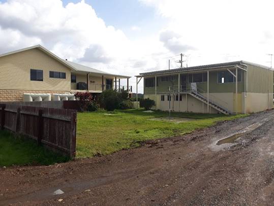
Picture 2. Neighbouring dwelling looking West.
Picture 3. Neighbouring dwelling looking North East.
Picture 4. Existing fill material looking East.
Picture 5. Fill material & wetland looking South
East.
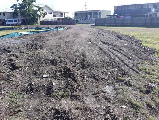
Picture 6. Existing driveway fill looking North West.
5. CONCLUSION AND
STATEMENT OF REASON
The application has been assessed
in accordance with Section 4.15 of the Environmental Planning and Assessment
Act 1979.
Issues raised during assessment
and public exhibition of the application have been considered in the assessment
of the application. Where relevant, conditions have been recommended to manage
the impacts attributed to these issues.
The site is considered suitable
for the proposed development and the proposal adequately addresses relevant
planning controls. The development is not considered to be contrary to the
public's interest and will not result a significant adverse social,
environmental or economic impact. It is recommended that the application be
approved, subject to the recommended conditions of consent provided in the
attachment section of this report.
|
Attachments
1View. DA2018
- 365.1 Recommended Conditions
2View. DA2018
- 365.1 Plans
3View. DA2018
- 365.1 Flood Risk & Impact Assessment
4View. DA2018
- 365.1 Stormwater Management Assessment
5View. DA2018
- 365.1 Bushfire Assessment
6View. DA2018
- 365.1 SEPP (Coastal Management) 2018 assessment
7View. DA2018
- 365.1 BASIX Certificate
|
|
ATTACHMENT
|
Development Assessment Panel
11/09/2019
|
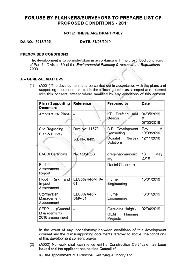
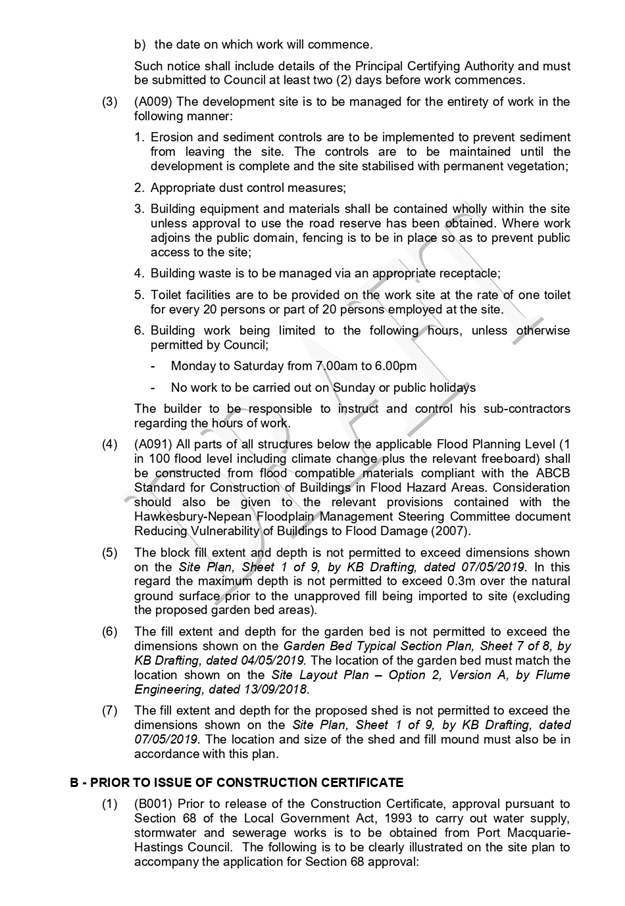
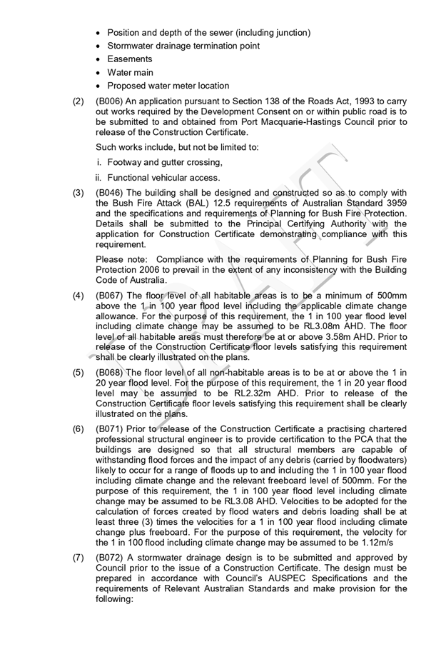

|
ATTACHMENT
|
Development Assessment Panel
11/09/2019
|
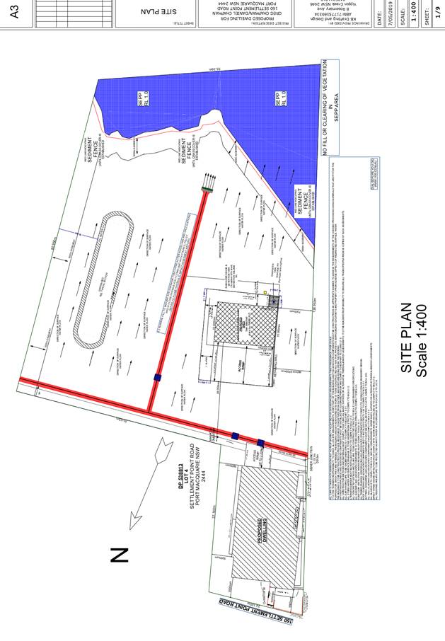
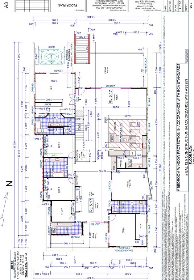
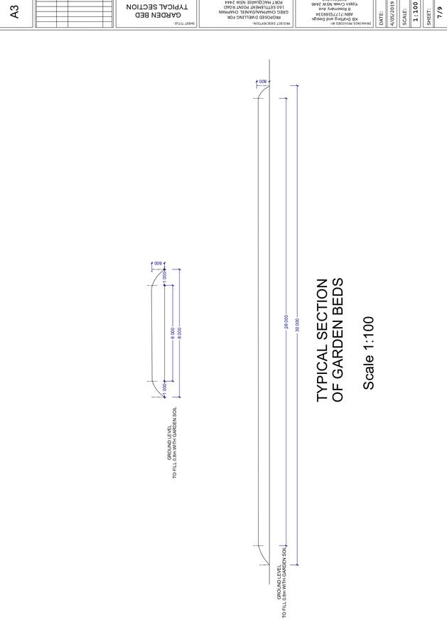
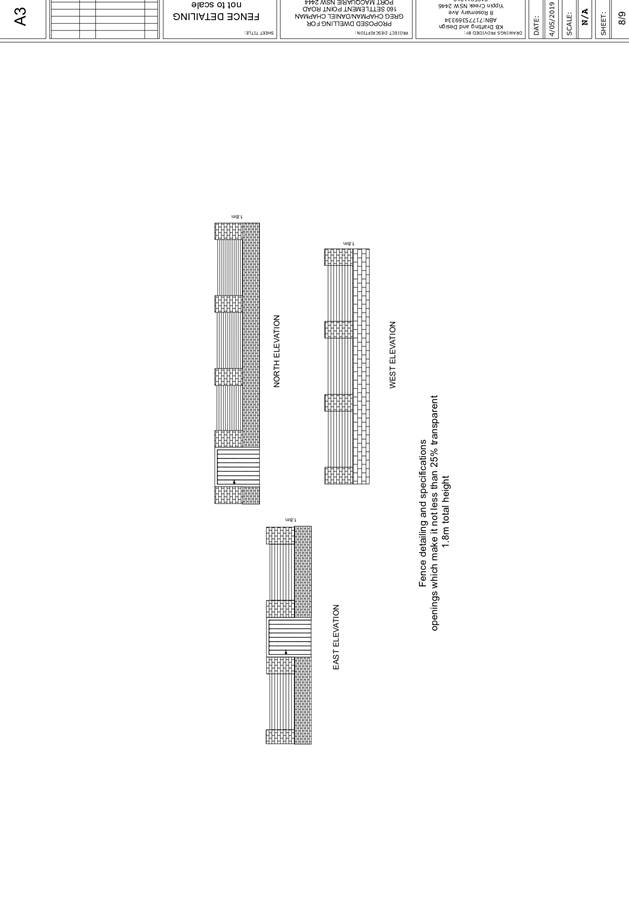
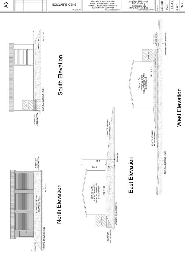
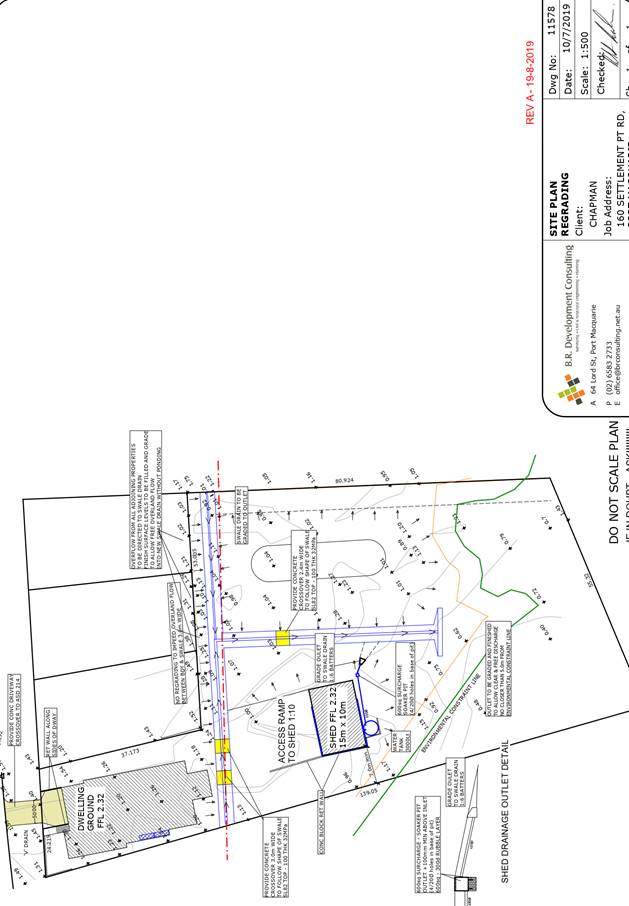
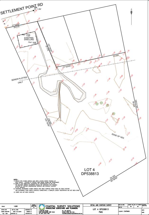
|
ATTACHMENT
|
Development Assessment Panel
11/09/2019
|


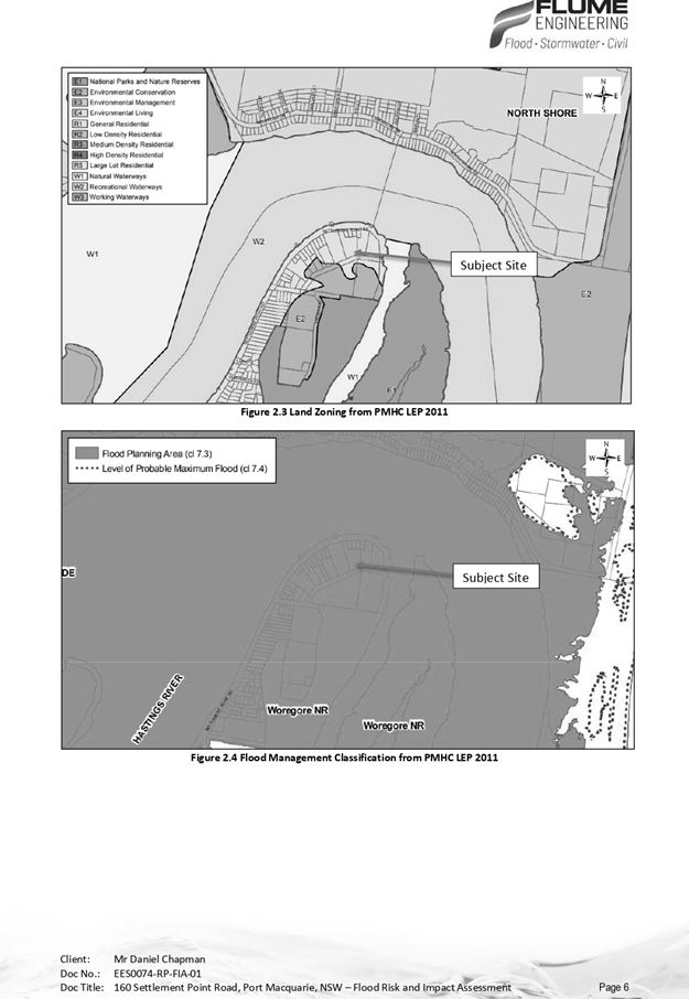

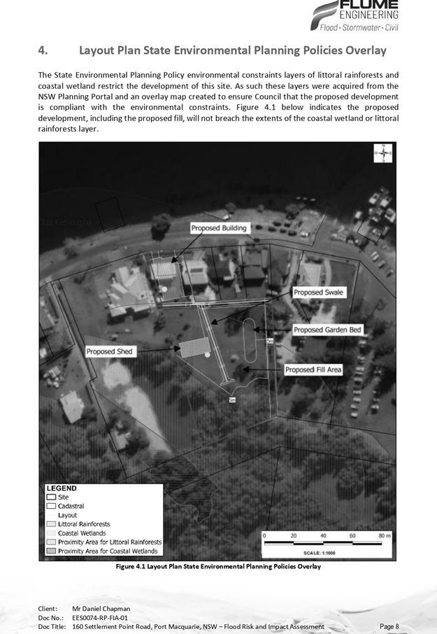
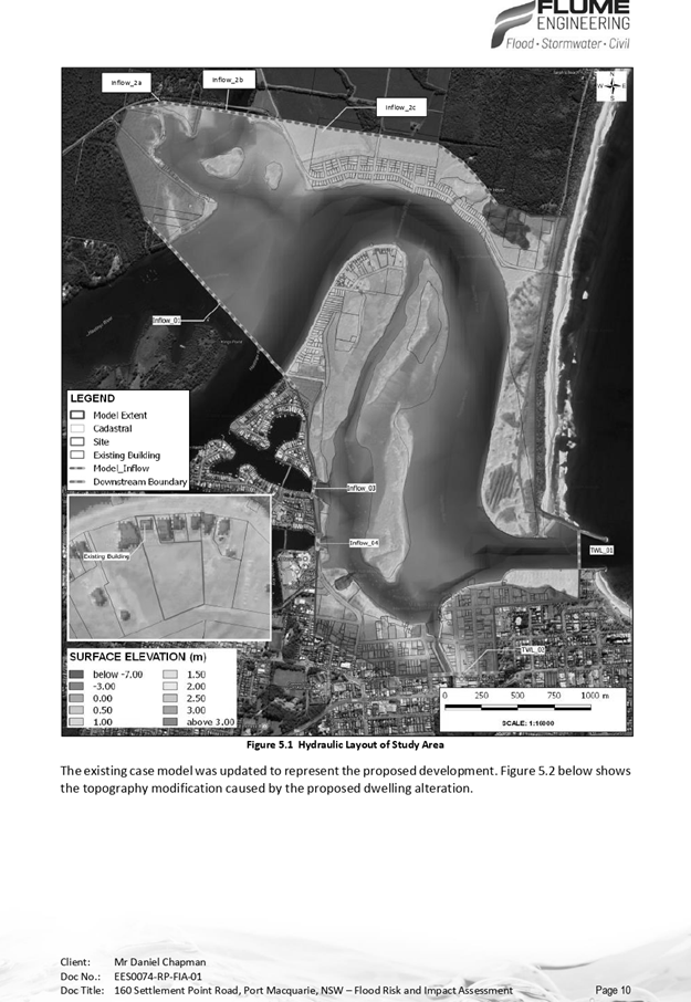
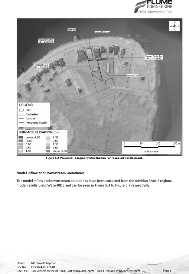
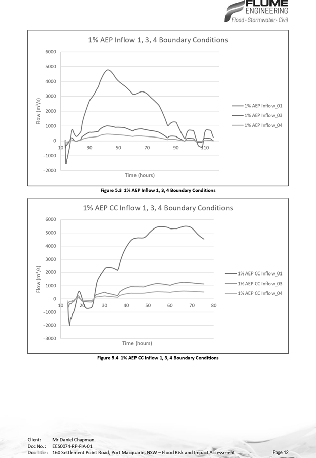
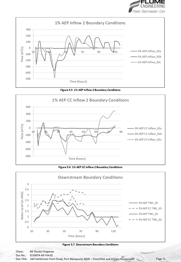
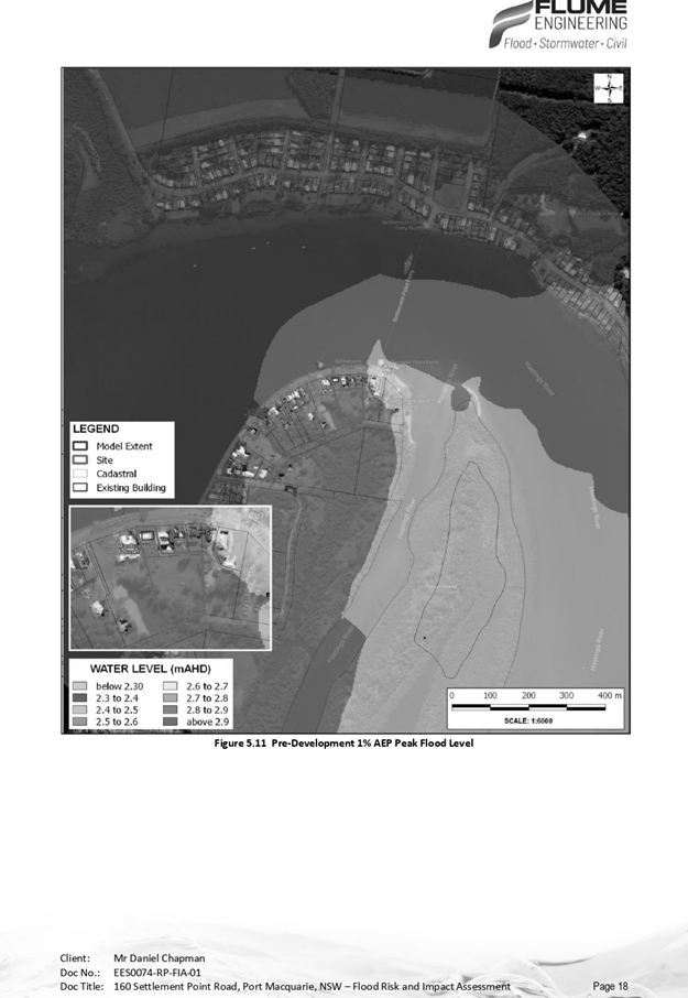
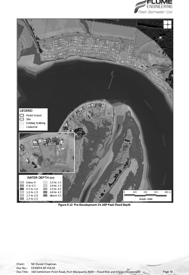
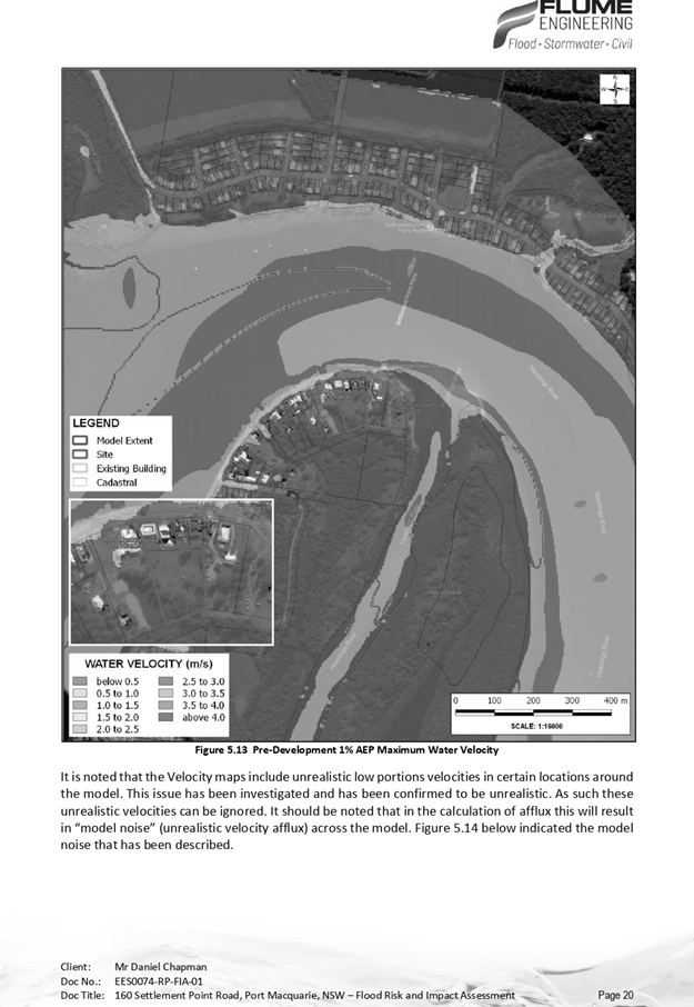
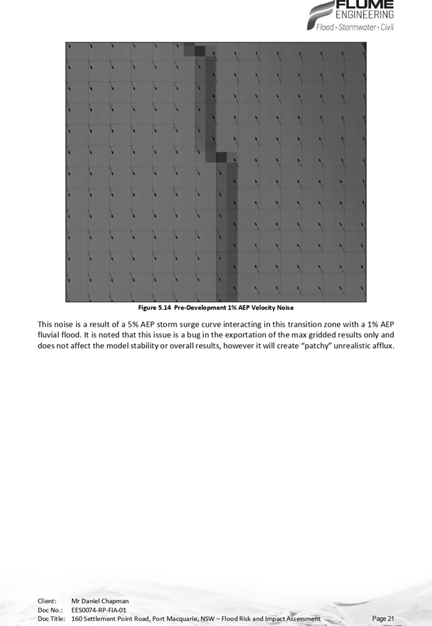
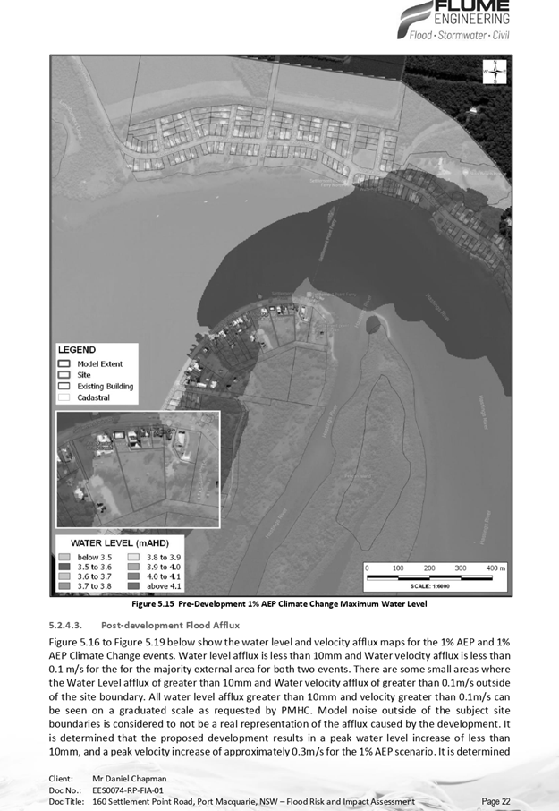
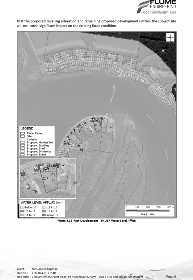
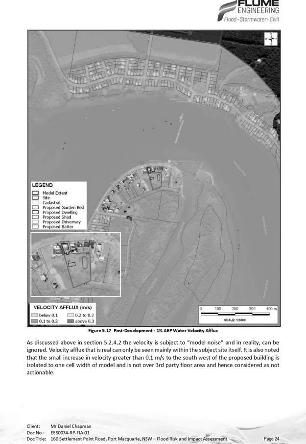
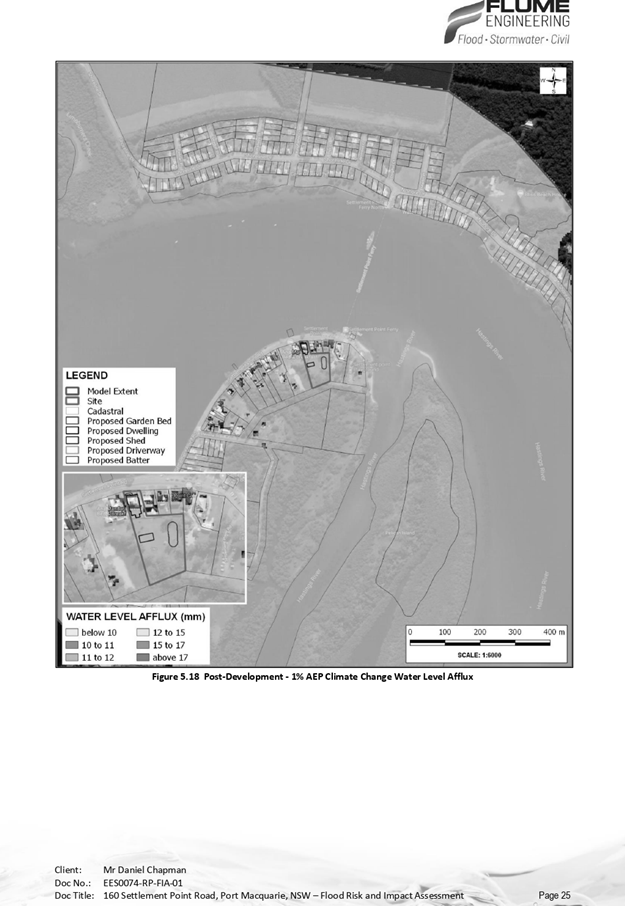
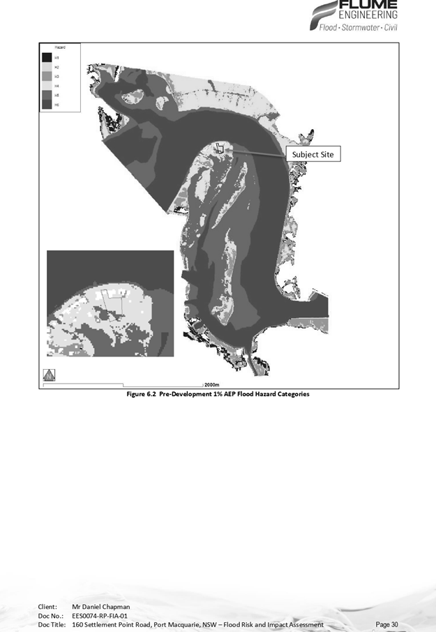
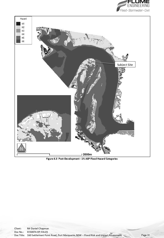

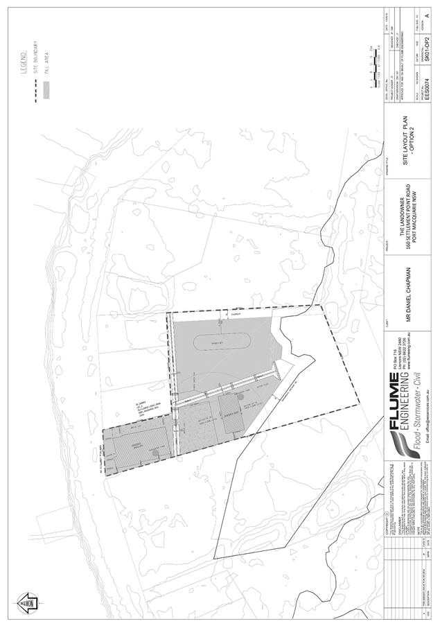

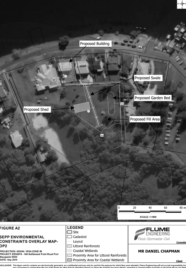

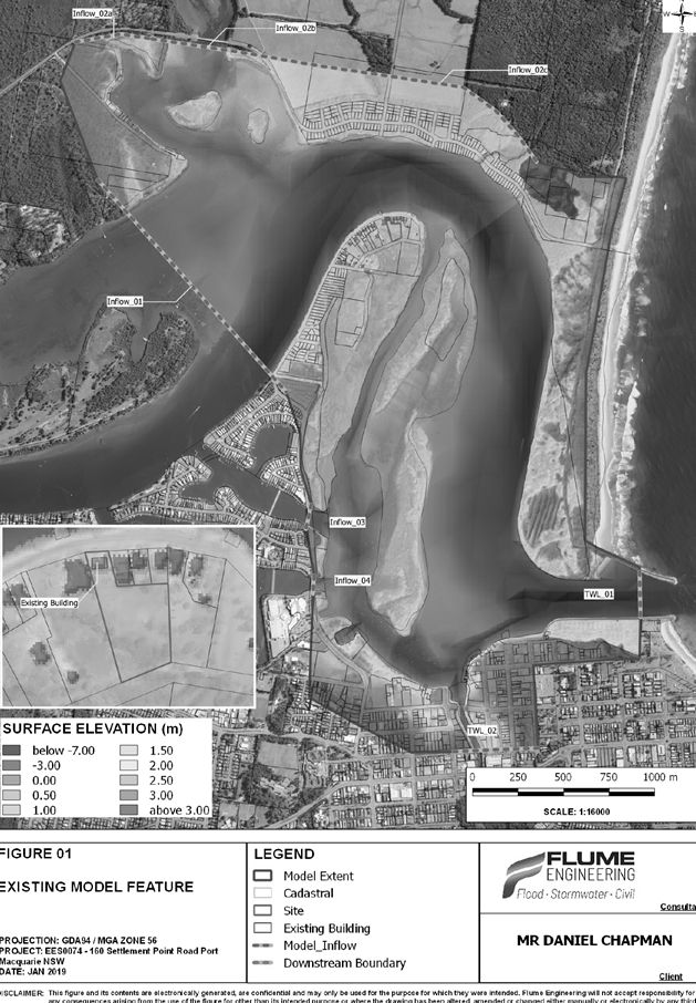
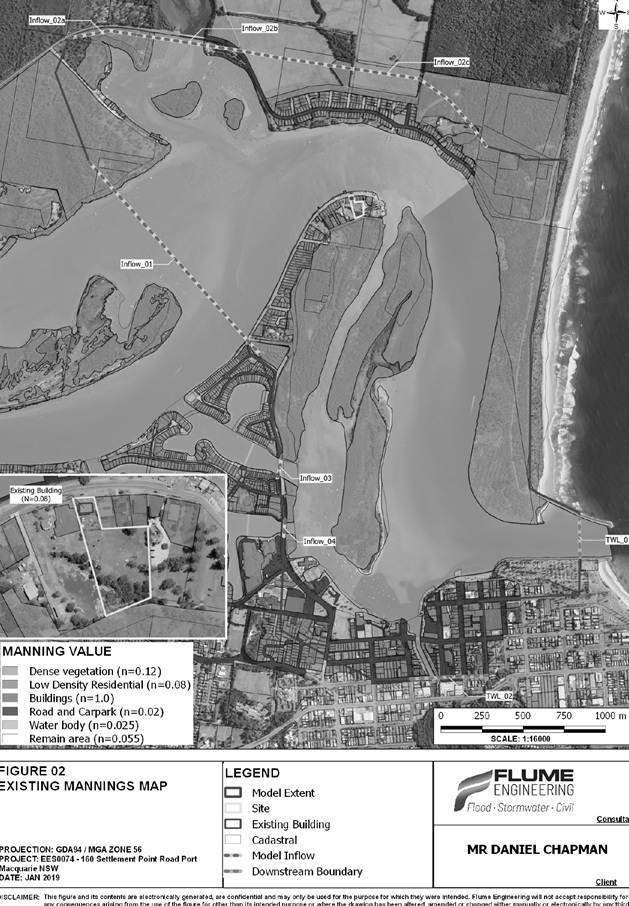
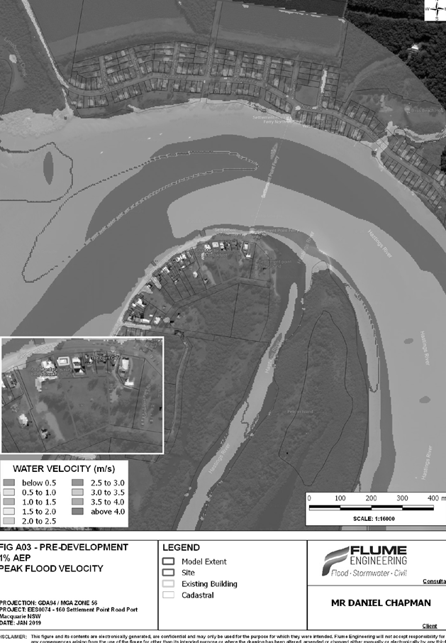
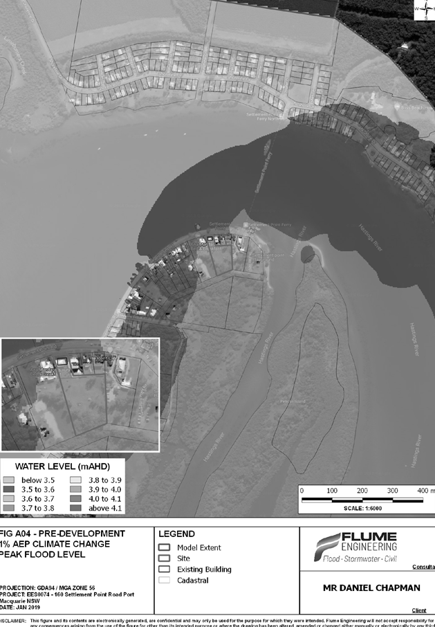
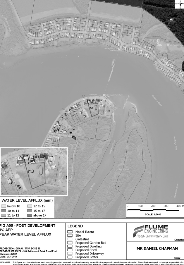
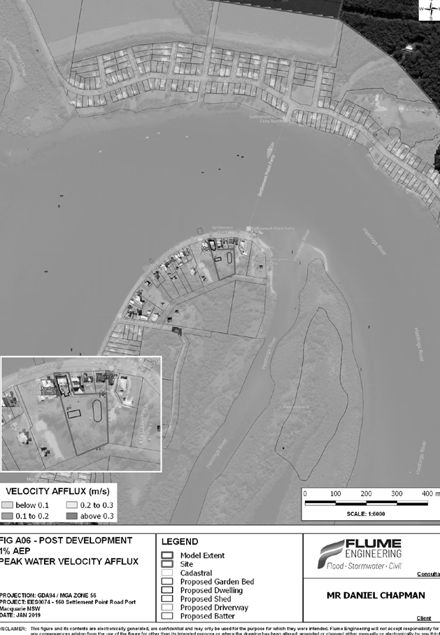
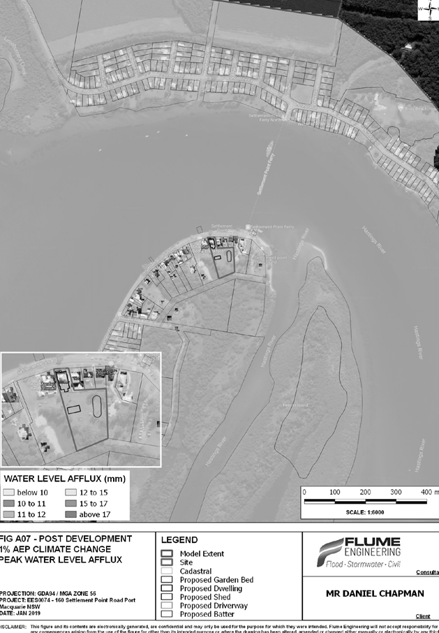
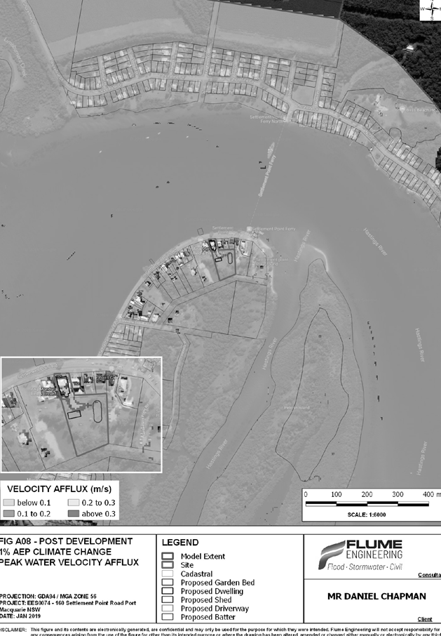

|
ATTACHMENT
|
Development Assessment Panel
11/09/2019
|


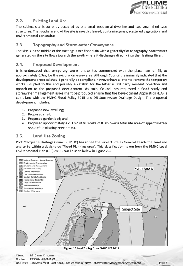
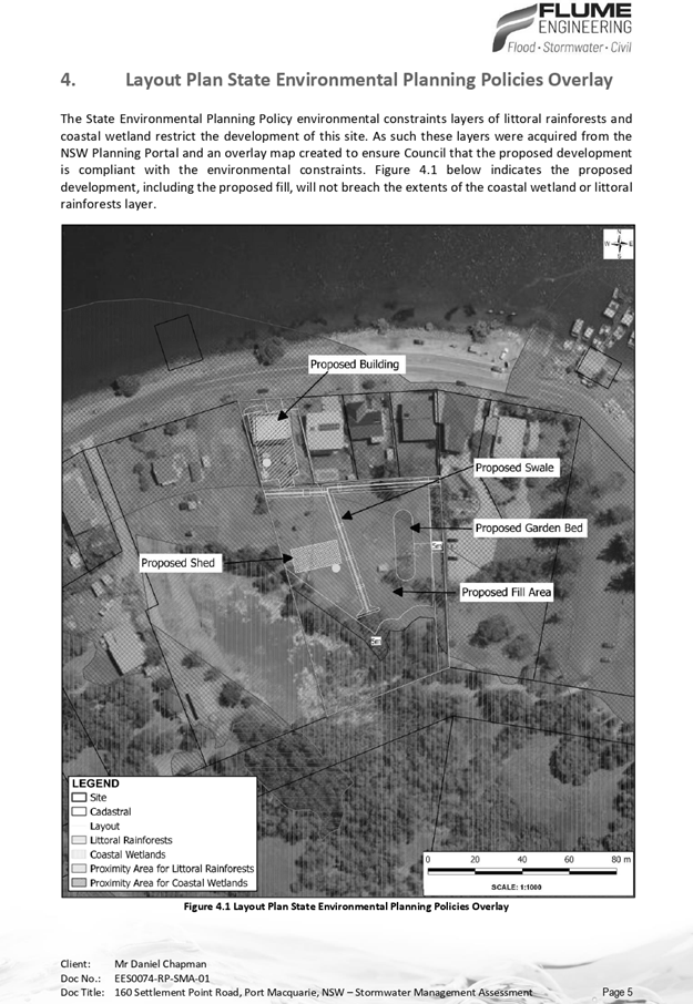


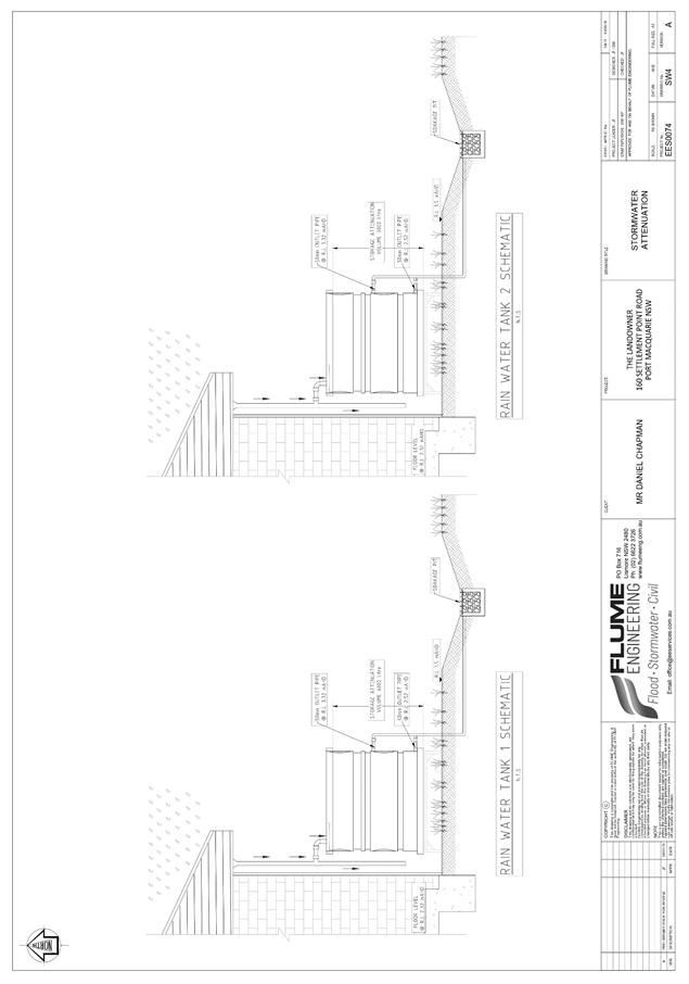
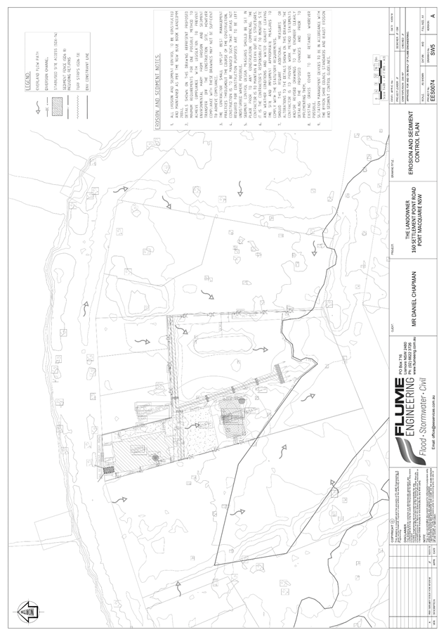

|
ATTACHMENT
|
Development Assessment Panel
11/09/2019
|
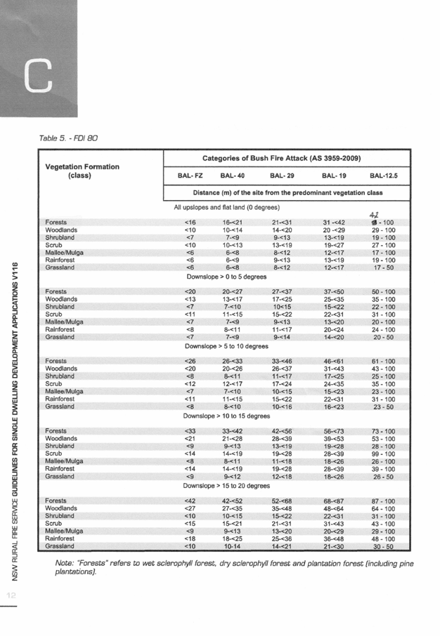
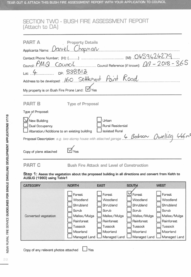
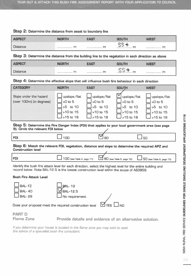
|
ATTACHMENT
|
Development Assessment Panel
11/09/2019
|
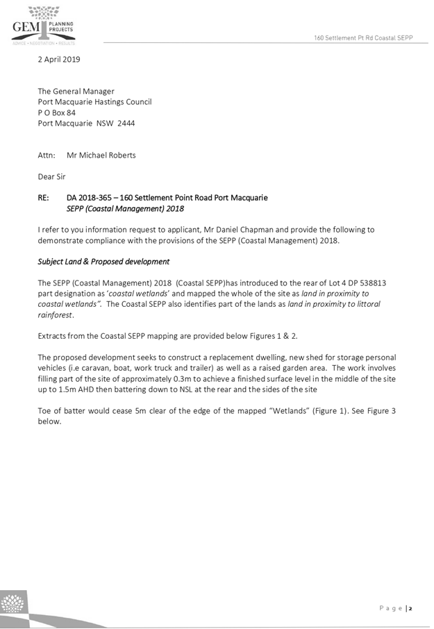
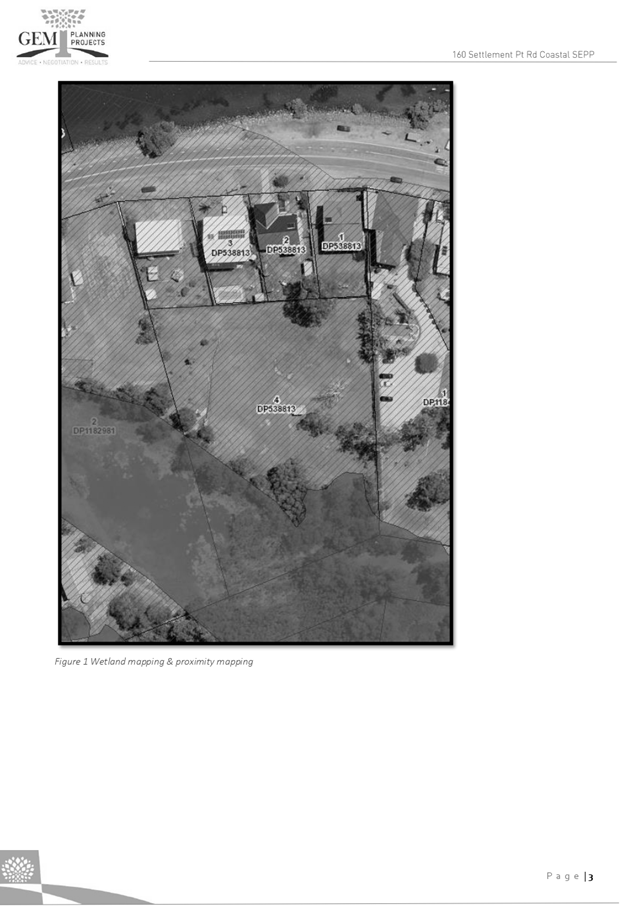
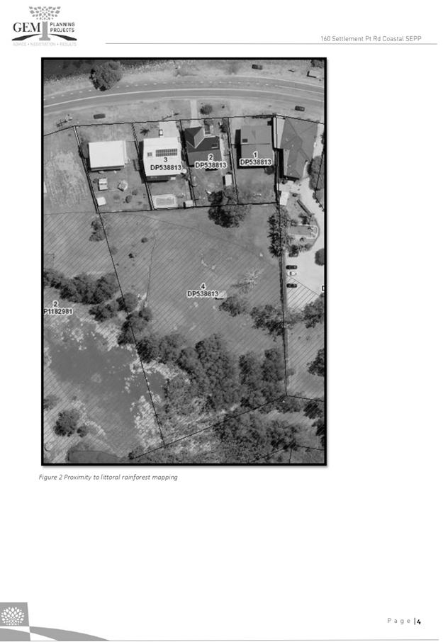
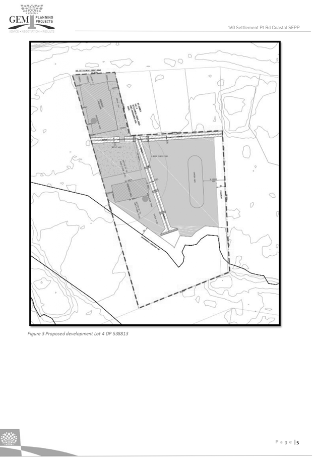
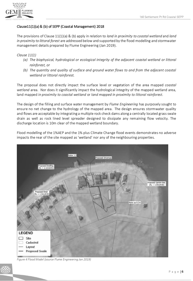
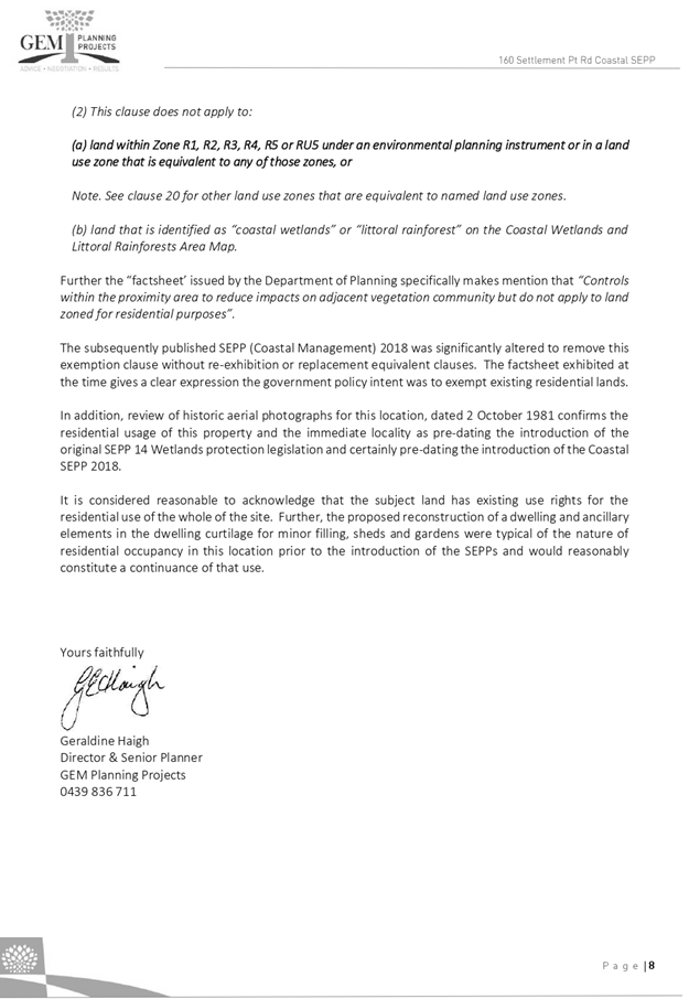
|
ATTACHMENT
|
Development Assessment Panel
11/09/2019
|
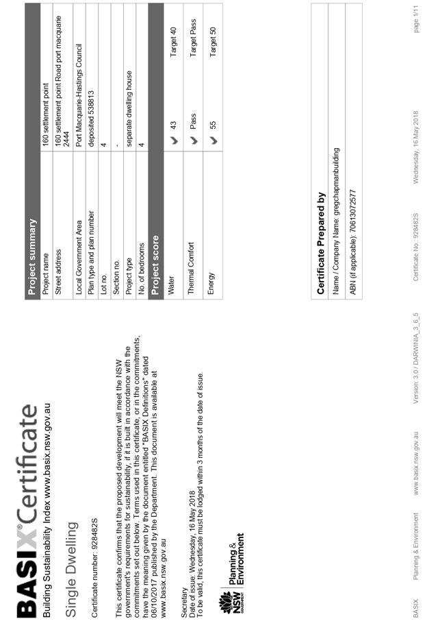
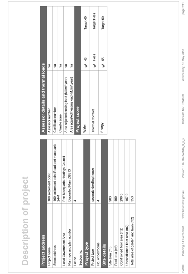
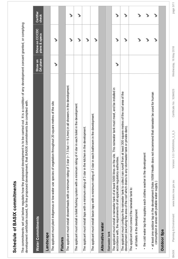
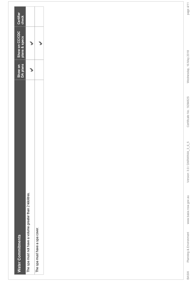
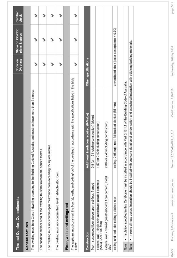
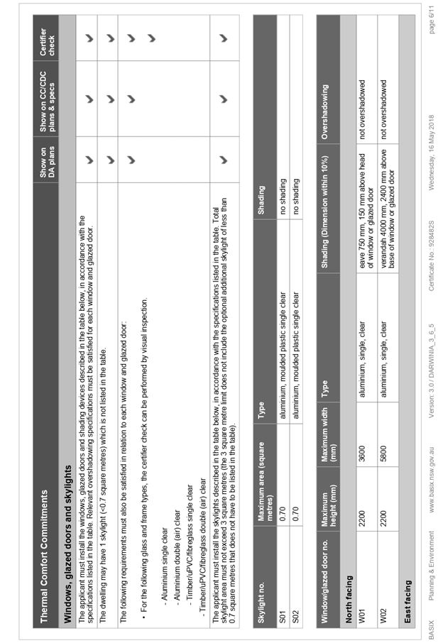
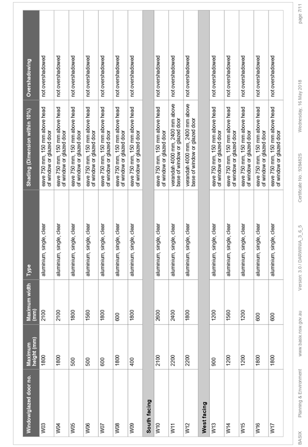
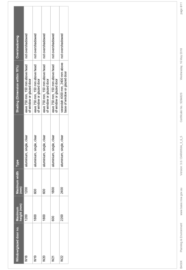
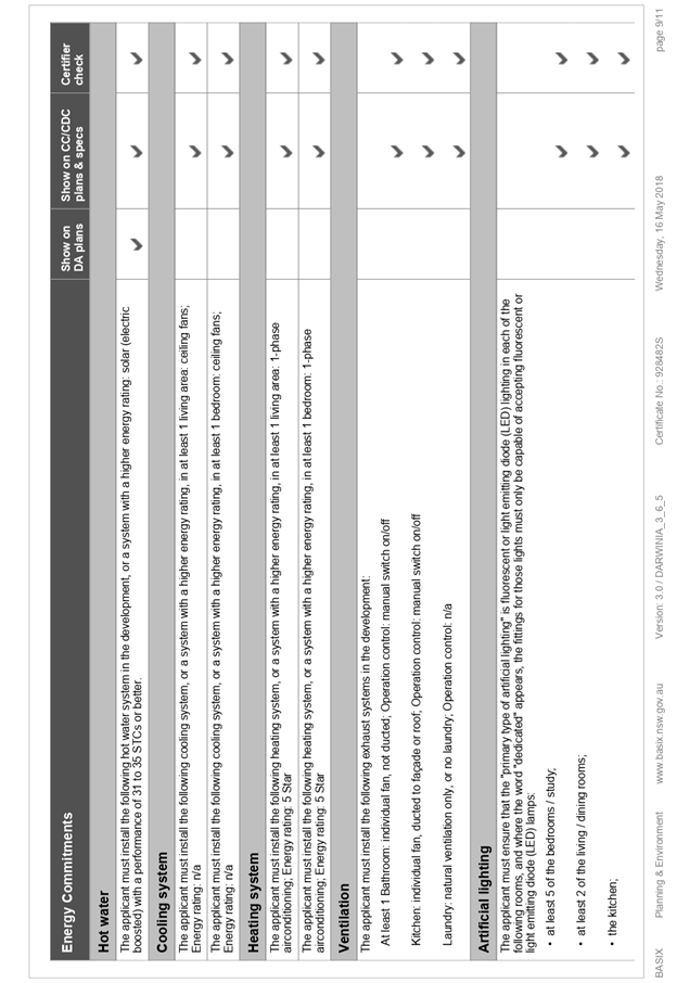
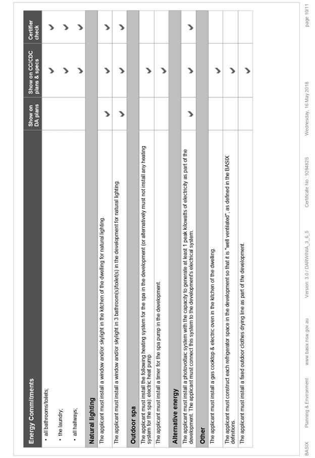
AGENDA Development Assessment Panel 11/09/2019
Item: 07
Subject: DA2018 - 507.1 3 Lot Subdivision including
Clause 4.6 Variation to Clause 4.1 (Minimum Lot Size) of Port Macquarie
Hastings Local Environmental Plan 2011 - Lot 41 and Lot 42 DP 75403 and Lot 8
DP 114360, No. 434 and 440 Herons Creek Road, Herons Creek
Report
Author: Development Assessment Planner, Steven Ford
|
Applicant: J
R & K M McCarron C/- Beukers and Ritter Consulting
Owner: J
R & K M McCarron
Estimated Cost: $0
Parcel no: 61934,
16853, 30230
Alignment with Delivery
Program
4.3.1 Undertake transparent
and efficient development assessment in accordance with relevant legislation.
|
|
RECOMMENDATION
That
the Development Assessment Panel (DAP) endorse the report of the Development
Assessment Planner and recommended to Council that DA 2018/507 for a 3 Lot Subdivision including a clause 4.6
variation of clause 4.1 (minimum lot size) of the Port Macquarie Hastings
Local Environmental Plan 2011 at Lots 41
& 42 DP 754403 and Lot 8 DP 114360, No. 434 & 440 Herons Creek
Rd, Herons Creek, be determined by granting consent subject to the
recommended conditions.
|
Executive
Summary
This
report considers a development application for a 3 Lot Subdivision
including a clause 4.6 variation of clause 4.1 (minimum lot size) of the Port
Macquarie Hastings Local Environmental Plan 2011 at
the subject site and provides an assessment of the application in accordance
with the Environmental Planning and Assessment Act 1979. The proposed
variation seeks a 62% and 35% variation to the 2000m2 lot
size standard applying to the site. As this variation is greater than 10%
the matter must be determined by the Council in accordance with Planning
Circular PS 18-003.
Following exhibition of the
application, no submissions were received.
This report recommends that the development application be endorsed by the DAP
subject to the conditions included attached and recommended to Council for
approval.
1. BACKGROUND
Existing Sites Features and Surrounding Development
The site has a total area of 4,223m2.
The site is zoned RU5 Village in accordance with the Port Macquarie-Hastings Local
Environmental Plan 2011, as shown in the following zoning plan
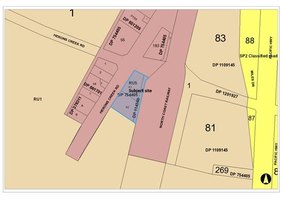
The existing subdivision pattern and location of existing
development within the locality is shown in the following aerial photograph:
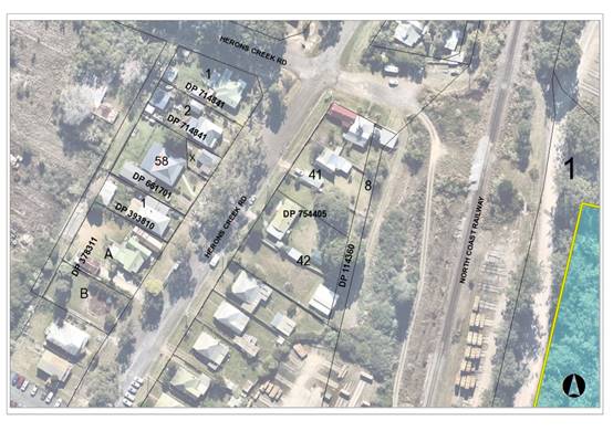
2. DESCRIPTION OF
DEVELOPMENT
Key aspects of the proposal include the following:
· Re-subdivision
of existing 3 lots into 3 Lots so as to result in
each of the existing dwellings being located on a separate lot
· Demolition
of existing shed
· Council
records indicate that all existing dwellings are lawfully established
· No
new dwellings are proposed
Refer
to attachments at the end of this report.
Application Chronology
· 16/7/2018
- Application Received
· 18/7/2018 - Request for additional information regarding
Clause 4.6 variation, additional plans for alterations to buildings on proposed
Lot 3.
· 20/7/2018 to 2/8/2018 - Public Notification
· 24/7/2018
- Bushfire Hazard Assessment received
· 26/9/2018 - Update request regarding additional information
requested
· 17/10/2018 - Comments and conditions received from the NSW
Rural Fire Service
· 17/7/2019 - Clause 4.6 variation report and revised plans
received
· 23/7/2019 to 5/8/2019 - Public Re-notification
3. STATUTORY ASSESSMENT
Section 4.15(1) Matters for Consideration
In determining the application, Council is required to take
into consideration the following matters as are relevant to the development
that apply to the land to which the development application relates:
(a) The provisions (where
applicable) of:
(i) Any Environmental
Planning Instrument
State Environmental Planning Policy No. 44 - Koala
Habitat Protection
With reference to clauses 6 and 7, the subject land has is
greater than 1 hectare (including any adjoining land under same ownership) and
therefore the provisions of SEPP must be considered.
The Department of Planning and Infrastructure’s
Circular No. B35, Section 1.5 states that “In relation to affected
development applications it is the intention of the policy that investigations
for ‘potential’ and ‘core’ koala habitats be limited to
those areas in which it is proposed to disturb habitat”.
The application has demonstrated that no habitat will be
removed or modified therefore.
State Environmental Planning Policy No. 55 –
Remediation of Land
Following an inspection of the site and a search of Council
records, the subject land is not identified as being potentially contaminated
and is suitable for the intended use.
Port Macquarie-Hastings Local Environmental
Plan 2011
The proposal is consistent with the LEP having regard to the
following:
· Clause
2.2 - The subject site is zoned RU5 Village.
· Clause
2.3(1) and the RU5 zone landuse table - The residential subdivision is a
permissible landuse with consent.
The objectives of the RU5 zone are as
follows:
o To provide for a range of land uses, services and
facilities that are associated with a rural village.
o To permit development that is appropriate in scale and type
with the characteristics of a rural village.
o To minimise conflict between land uses within the zone and
land uses within adjoining zones.
·
· Clause
2.3(2) - The proposal is consistent with the zone objectives having regards to
the following;
o The proposal is for subdivision of existing
landuses on the site with no landuse conflicts identified. The existing uses
and subdivision pattern is consistent and compatible with the village of
Heron’s Creek.
· Clause
2.7 - The demolition of the existing shed requires consent as it does not fit
within the provisions of SEPP (Exempt and Complying Codes) 2008. Relevant
consent conditions relating to the demolition have been recommended.
· Clause
4.1 - The lot sizes within the proposed subdivision are 756m2, 1298m2
and 2242m2. The minimum lot size applying to the land is 2000m2
therefore two of the proposed lots do not comply with the development standard
and represent a 62% and 35% variation to the 2000m2 lot size standard - Refer
to Clause 4.6 comments below.
· Clause
4.2B - The development is within the specified zoning and cannot/can be
subdivided by strata or community titled because the proposed lots
meet/do not meet the minimum lot size. (NB: Clause stops strata and community
title subdivisions of rural, large lot residential, rural residential and
environmental zones that do not meet the min lot size).
· Clause
4.4 - No floor space ratio applies to the site. The dwellings are existing.
· Clause
4.6 – Consent must not be granted for a proposal that contravenes a
development standard unless the consent authority has considered a written
request from the Applicant that justifies the variation by showing that the
subject standard is unreasonable and/or unnecessary and that there are
sufficient environmental planning grounds to justify the contravening of the
standard without compromising the public interest.
·
·
As a result of the above, the Applicant submitted a Clause 4.6
variation for the lot size standard (ie Clause 4.1). The Applicant’s
reasoning for varying Clause 4.1 is as follows:
o The proposal does not result
in any additional dwellings within the village and therefore no additional
loading on existing public or private infrastructure.
o The proposal does not involve
any tree removal or other change to existing vegetation on any of the lots.
o Minor alterations are proposed
to one of the dwellings in order to located fully on the private land –
an improvement over the existing situation
o The proposal does not require
any changes to the existing access to each of the proposed lots.
o The proposal is generally
consistent with the development pattern of dwellings within the village area,
including the variety of lots size in the immediately vicinity of the site.
·
·
The objectives of the minimum lot size standard are as follows:
·
(a) to ensure that lot sizes are
compatible with local environmental values and constraints,
·
(b) to facilitate efficient use of
land resources for residential and other human purposes,
·
(c) to minimise the fragmentation of
rural land suitable for sustainable primary production,
·
(d) to protect high ecological,
scientific, cultural or aesthetic values of land in environment protection
zones.
·
·
Having considered the application and Clause 4.6 variation to
Clause 4.1, the proposal is considered acceptable and will have no significant
impact on the environment as per the reasons identified by the applicant above.
In addition, it is considered that:
o The character of the locality
will not be adversely impacted given the dwellings on the proposed allotments
already exist.
o The proposed lot layout is
consistent with other residential lots adjoining the site. As there are
numerous lots within the immediate locality with existing dwellings which are
below the 2000m2 minimum lot size.
o The minor building works do
not impact adjoining lots and the structures currently overhanging the
boundaries are to be modified to comply with the boundary lines.
o The development is consistent
with the zone objectives of and is unlikely to have any implications on State
related issues or the broader public interest.
·
As per the Planning Circular PS 18-003, Council can assume the
Director’s Concurrence for variations to lot size in the RU5 zone,
however, the determination cannot be made by a Council officer due to the
subject variation being greater than 10% of the development standard. Hence,
this report and recommendation to Council.
·
· Clause
5.10 – The site does not contain or adjoin any known heritage items or
sites of significance.
· Clause7.13
- Satisfactory arrangements are in place for provision of essential services
including water supply, electricity supply, on-site sewage management/sewer
infrastructure, stormwater drainage and suitable road access to service the
development. Provision of electricity will be subject to obtaining satisfactory
arrangements certification prior to the issue of a Subdivision Certificate as
recommended by a condition of consent.
(ii) Any proposed instrument that is or has been placed
on exhibition
No draft instruments apply to the site.
(iii) Any DCP in force
Port Macquarie-Hastings Development Control Plan 2013
|
DCP 2013: Chapter 3.6 - Subdivision
|
|
DCP Objective
|
Development Provisions
|
Proposed
|
Complies
|
|
3.6.3.1
|
A site analysis is required for all development and shall
illustrate:
· microclimate;
· lot dimensions;
· north point;
· existing contours and levels to
AHD;
· flood affected areas;
· overland flow patterns, drainage
and services;
· any contaminated soils or filled
areas, or areas of unstable land;
· easements and/or connections for
drainage and utility services;
· identification of any existing
trees and other significant vegetation;
· any existing buildings and other
structures, including their setback distances;
· heritage and archaeological
features;
· fences;
· existing and proposed road
network, including connectivity and access for all adjoining land parcels;
· pedestrian and vehicle access;
· views to and from the site;
· overshadowing by neighbouring
structures; and
· any other notable features or
characteristics of the site.
|
A 3 lot subdivision, in an area that is bushfire prone.
The proposed lots have existing dwellings.
The proposed subdivision plan shows satisfactory site
analysis details.
|
Yes
|
|
3.6.3.2
|
Torrens title lots minimum width of 15m when measured at a
distance of 5.5m from front property boundary.
|
The lots have a frontages of 20.4m, 30.1m, 40.45m
addressing Herons Creek Road
|
Yes
|
|
Minimum width of 7m when boundaries are extended to kerb
line.
|
Minimum width is 20m
|
Yes
|
|
Minimum depth of 25m.
|
Minimum depth of 37m
|
Yes
|
|
For lots where average slope of the site is equal to, or
exceeds 16%, indicative road and driveway grades are required demonstrating
satisfactory access.
|
The slope is less than 16%.
|
Yes
|
|
Subdivision of dual occupancy development or multi
dwelling housing where permissible in the LEP may create allotments smaller
than 450m2 if:
· Each lot to be created is part of
a community or strata title scheme, or
· Is part of an integrated Torrens
title housing development.
|
No lots smaller than 450m2
|
N/A
|
|
3.6.3.6
|
Kerb and guttering, associated street drainage, pavement
construction and foot paving across the street frontages should be
constructed as part of the subdivision works where these do not exist (may be
varied subject to criteria in this clause)
|
Existing kerb and guttering along frontage.
There are no pedestrian paths along Herons Creek Road or
the adjoining lots
|
Yes
|
|
3.6.3.7
|
Subdivisions close to urban centres or along arterial
roads serviced by public transport achieve yield of >35 dwellings per
hectare.
|
The subdivision is within an RU5 Village zone and has
access to existing public transport.
|
Acceptable
|
|
3.6.3.20
|
Water supply to meet Council’s design
specifications.
|
Existing dwellings connected to water.
|
Yes
|
|
3.6.3.21
|
All lots connected to reclaimed water if available.
|
No reclaimed water available
|
N/A
|
|
3.6.3.24
|
Separate sewer junction provided for each lot.
|
Existing dwellings connected to village sewer
|
Yes
|
|
3.6.3.27
|
Erosion and sediment control plan to be provided.
|
Standard conditions recommended but no works proposed
|
Yes
|
|
3.6.3.34
|
All service infrastructure should be underground unless
otherwise approved by Council.
|
No requirement deemed necessary to require underground
services given existing dwellings on the lots (no specific conditions
considered necessary). The Applicant will need to obtain satisfactory
arrangements certification from the appropriate electricity and
telecommunications providers prior to the issue of a Subdivision Certificate.
|
Yes - acceptable
|
|
All service infrastructure should be installed in a common
trench.
|
N/A
|
|
|
Conduits for the main technology network system should be
provided in all streets.
|
N/A
|
|
|
Conduits are to be installed in accordance with the
National Broadband Network Company Limited’s
‘Guidelines for Fibre to the Premises Underground
Deployment’.
|
N/A
|
|
|
Access pits are to be installed at appropriate intervals
along all streets.
|
N/A
|
|
In addition to the above it is
noted that each of the existing dwellings on the proposed lots contain a
sufficient private open space and off street parking area (i.e, effectively,
there is no significant change to the existing on ground situation or use of
the land).
(iiia) Any
planning agreement that has been entered into under section 7.4, or any draft
planning agreement that a developer has offered to enter into under section 7.4
No planning
agreement has been offered or entered into relating to the site.
(iv) Any matters prescribed by the
Regulations
Demolition of buildings AS
2601 – Clause 92
Demolition of the existing
building on the site is capable of compliance with this Australian Standard and
is recommended to be conditioned.
(b) The
likely impacts of that development, including environmental impacts on both the
natural and built environments, social and economic impacts in the locality
The site fronts to Herons Creek Road to the west. Adjoining
the site to the east is the north coast railway line. Adjoining the site to the
south is multi residential (“worker’s cottages”) and a Timber
Mill. Adjoining the site to the west are a number of similar undersized RU5
residential lots.
The proposal will be unlikely to have any adverse impacts to
existing adjoining properties and satisfactorily addresses the public domain.
The proposal is considered to be consistent with other residential development
in the locality and adequately addresses planning controls for the area.
The proposal does not have a significant adverse impact on
existing view sharing.
The proposal does not have significant adverse lighting
impacts.
There are no significant adverse privacy impacts.
Adequate building separation is exists.
There is no adverse overshadowing impacts.
Roads
The site has road frontage to Herons Creek Road, a sealed
public road under the care and control of Council. Due to there being no
increase in the number of dwellings, there will be no additional traffic or
impact of the road or adjoining intersections.
Traffic and Transport
Changes in traffic associated with the development will not
have any adverse impacts to the existing road network within the immediate
locality.
Water Supply Connection
Council records indicate that Lot
41 is unmetered and Lot 8 and 42 have 20mm serviced water meter from the 100mm
AC main on the same side of Herons Creek Rd. A water supply reticulation plan
is required to show all existing and proposed water services to the lot - refer
to relevant conditions of consent.
Sewer Connection
Council records indicate that each individual proposed lot
has a separate sewer connection to Councils main. There are no conditions of
consent required for Sewer.
Stormwater
·
Each proposed lot has an existing dwelling and the subdivision
will follow the existing fence lines. Each lot slopes towards the street
frontage and towards the rear of the site - refer to relevant conditions of
consent.
Other Utilities
Telecommunication and electricity services are available to
the site.
Heritage
Following a site inspection (and a search of Council/AHIMS
records??), no known items of Aboriginal or European heritage significance
exist on the property. No adverse impacts anticipated.
Other land resources
The site is within an established urban context and will not
sterilise any significant mineral or agricultural resource.
Water cycle
The proposed development will be unlikely to have any
adverse impacts on water resources and the water cycle.
Soils
The proposed development will be unlikely to have any
adverse impacts on soils in terms of quality, erosion, stability and/or
productivity subject to a standard condition requiring erosion and sediment
controls to be in place prior to and during construction.
Air and microclimate
The construction and/or operations of the proposed
development will be unlikely to result in any adverse impacts on the existing
air quality or result in any pollution. Standard precautionary site management
condition recommended.
Flora and fauna
Construction of the proposed development will not require
any removal/clearing of any significant vegetation.
Waste
Satisfactory arrangements are in place for proposed storage
and collection of waste and recyclables. No adverse impacts anticipated.
Standard precautionary site management condition recommended.
Noise and vibration
No adverse impacts anticipated. Condition recommended to
restrict demolition/construction to standard construction hours.
Bushfire
The site is identified as being bushfire prone.
In accordance with Section 100B - Rural Fires Act 1997 - the
application proposes subdivision of bush fire prone land that could lawfully be
used for residential purposes. As a result, the applicant has submitted a
bushfire report prepared by a Certified Consultant. The report was forwarded to
the NSW Rural Fire Service who have since issued a Bushfire Safety Authority,
which have been recommended to be incorporated into the conditions of consent.
Safety, security and crime prevention
The proposed development will be unlikely to create any
concealment/entrapment areas or crime spots that would result in any
identifiable loss of safety or reduction of security in the immediate area.
Social impacts in the locality
Given the nature of the proposed development and its’
location the proposal is unlikely to result in any adverse social impacts.
Economic impact in the locality
No adverse impacts.
Site design and internal design
The proposed development design satisfactorily responds to the
site attributes and will fit into the locality. No adverse impacts likely.
Cumulative impacts
The proposed development will not have any adverse
cumulative impacts on the natural or built environment or the social and
economic attributes of the locality.
(c) The suitability of the site for
the development:
The proposal will fit into the locality and the site
attributes are conducive to the proposed development.
Site
constraints have been adequately addressed and appropriate conditions of
consent recommended.
(d) Any submissions made in
accordance with this Act or the Regulations:
No written submissions have been received following public
exhibition of the application.
(e) The Public Interest:
The proposed
development satisfies relevant planning controls and will not adversely impact
on the wider public interest.
4. DEVELOPMENT
CONTRIBUTIONS APPLICABLE
Contribution credits are applied to the existing dwellings.
However, as one of the proposed lots is now over 2000m2, additional
contributions are applicable in accordance with Council’s Contributions
Assessment Policy:
· Development contributions will be required towards
augmentation of town water supply and sewerage system head works under Section
64 of the Local Government Act 1993.
· Development contributions will be required under Section
7.11 of the Environmental Planning and Assessment Act 1979 towards roads, open
space, community cultural services, emergency services and administration
buildings.
5. CONCLUSION AND
STATEMENT OF REASON
The application has been assessed
in accordance with Section 4.15 of the Environmental Planning and Assessment
Act 1979.
Issues raised during assessment
and public exhibition of the application have been considered in the assessment
of the application. Where relevant, conditions have been recommended to manage
the impacts attributed to these issues.
The site is considered suitable
for the proposed development and the proposal adequately addresses relevant
planning controls. The development is not considered to be contrary to the
public's interest and will not result a significant adverse social,
environmental or economic impact. It is recommended that the application be
approved, subject to the recommended conditions of consent provided in the
attachment section of this report.
|
Attachments
1View. DA
2018 - 507.1 Recommended Conditions
2View. DA2018
- 507.1 Clause 4.6 Variation to Clause 4.1 (Minimum Lot Size) of Port
Macquarie Hastings Local Environmental Plan 2011
3View. DA2018
- 507.1 Contributions Estimate
4View. DA2018
- 507.1 Plans
|
|
ATTACHMENT
|
Development Assessment Panel
11/09/2019
|
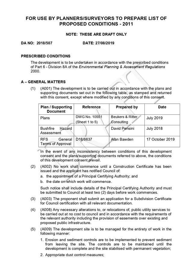
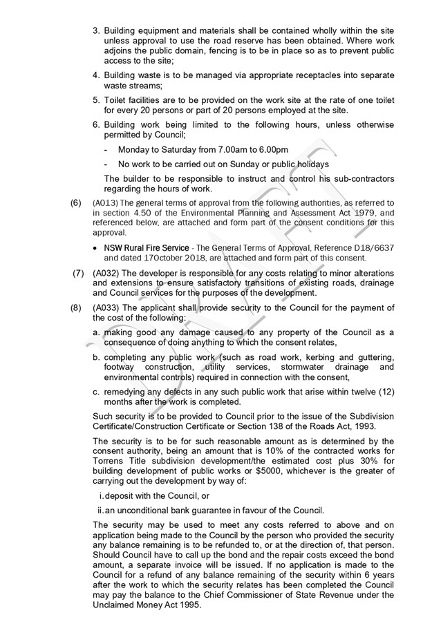
|
ATTACHMENT
|
Development Assessment Panel
11/09/2019
|
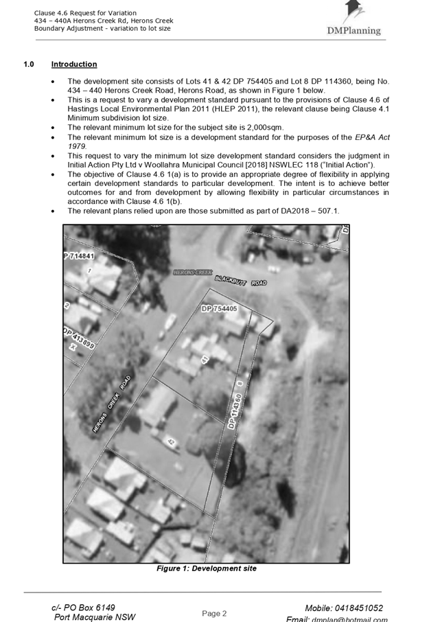
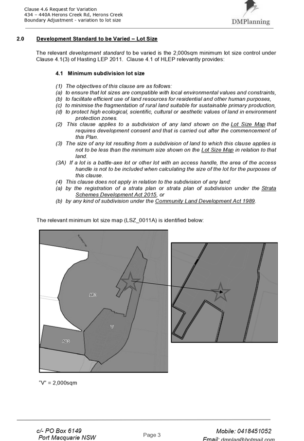
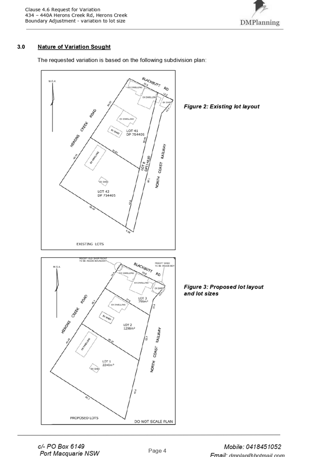
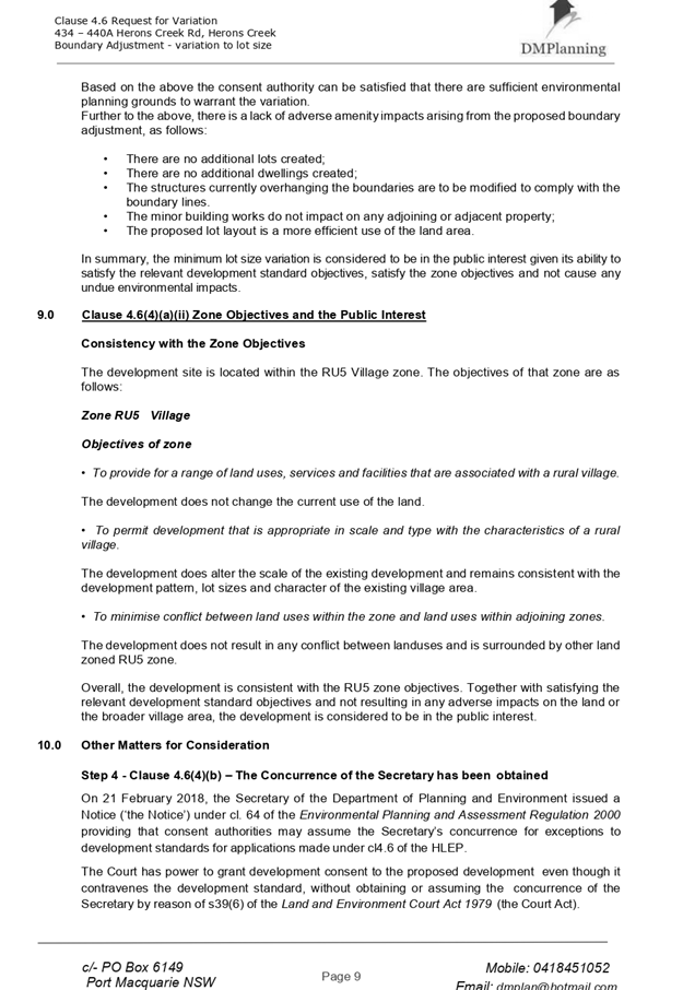
|
ATTACHMENT
|
Development Assessment Panel
11/09/2019
|
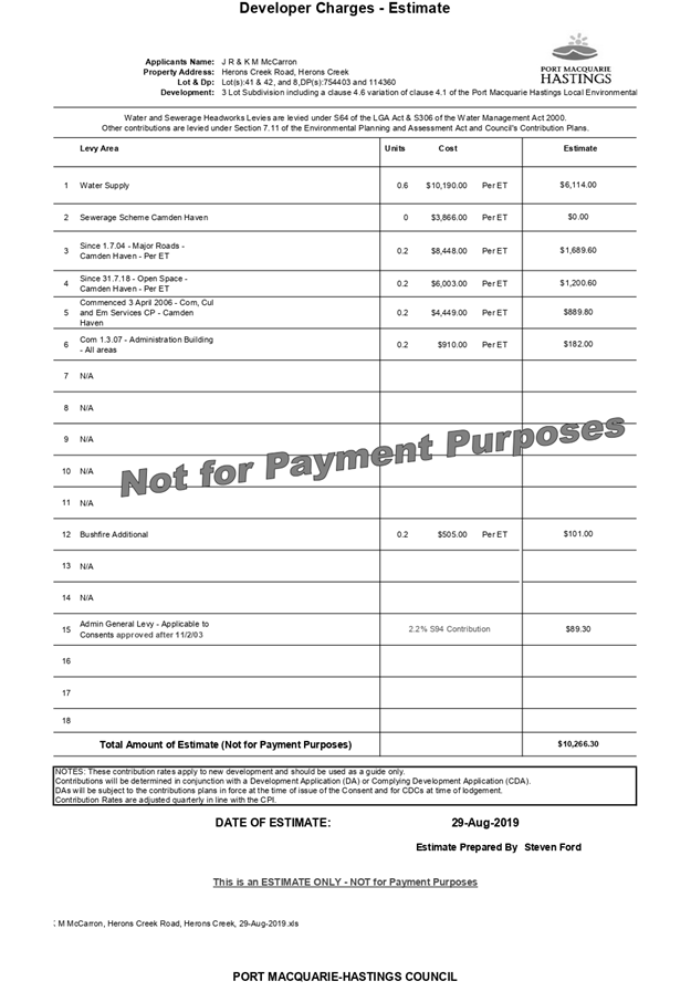
|
ATTACHMENT
|
Development Assessment Panel
11/09/2019
|
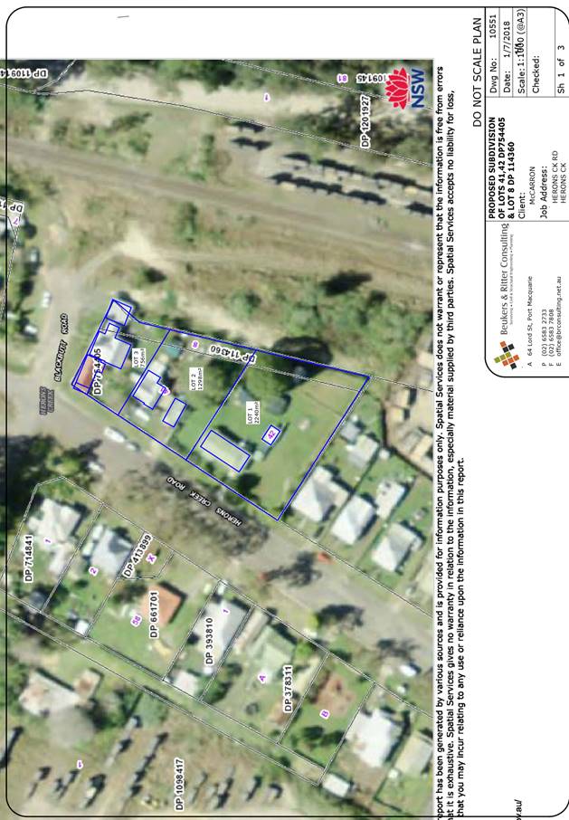

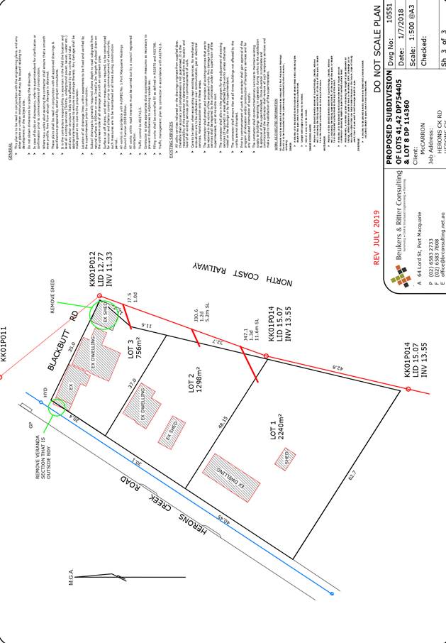
AGENDA Development Assessment Panel 11/09/2019
Item: 08
Subject: DA2019 - 465.1 Alterations and Additions to Dwelling and
Construction of a Secondary Dwelling, Lot 4 DP 246193, No. 2 Kaballa Avenue
Port Macquarie
Report Author: Development
Assessment Planner, Steven Ford
|
Applicant: Davy
Watt & Associates
Owner: M
A Zwetsloot & B N Swain
Estimated Cost: $204,000
Alignment with Delivery Program
4.3.1 Undertake transparent
and efficient development assessment in accordance with relevant legislation.
|
|
RECOMMENDATION
That
DA 2019 - 465.1 for Alterations
and additions to dwelling and construction of a secondary dwelling at Lot 4,
DP 246193, No. 2 Kaballa Avenue, Port Macquarie, be determined by granting consent subject to the
recommended conditions.
|
Executive
Summary
This
report considers a development application for Alterations and Additions to
Dwelling and Construction of a Secondary Dwelling at the subject site and provides an assessment of the
application in accordance with the Environmental Planning and Assessment Act
1979.
Following exhibition of the
application one submission was received.
This report recommends that the development application be approved subject to
the attached conditions.
1. BACKGROUND
Existing Sites Features and Surrounding Development
The site has an area of 714.9m2.
The site is zoned R1 General Residential in accordance with the Port Macquarie-Hastings Local
Environmental Plan 2011, as shown in the following zoning plan:
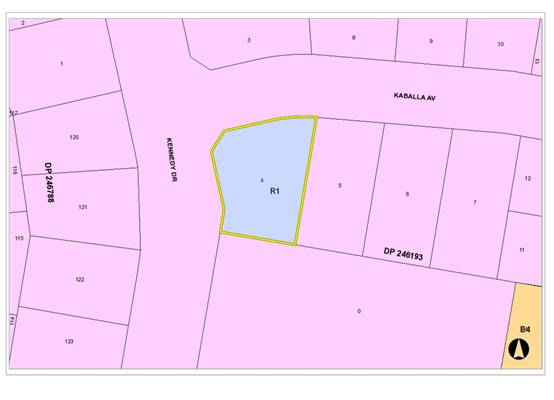
The existing subdivision pattern and location of existing
development within the locality is shown in the following aerial photograph:
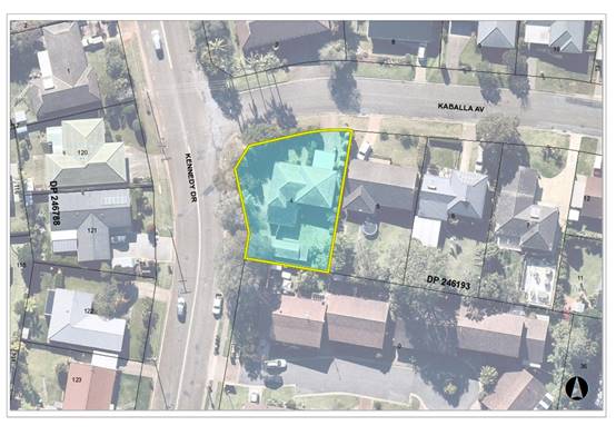
2. DESCRIPTION OF
DEVELOPMENT
Key aspects of the proposal include the following:
· Alterations
and additions to existing dwelling
· Demolition
of existing detached garage and construction of a secondary dwelling
Refer
to attachments at the end of this report.
Application Chronology
· 28
June 2019 - Application lodged.
· 08 July 2019 to 22 July 2019 - Neighbour notification.
· 22 July 2019 - Submission received
· 13 August 2019 - Additional information requested from
Applicant.
· 14 August 2019 - Additional information submitted by
Applicant.
· 14 August 2019 - Response to submission emailed by Planner
· 14 August 2019 - Further additional information requested
from Applicant.
· 16 August 2019 - Additional information and revised plans
submitted by Applicant.
3. STATUTORY ASSESSMENT
Section 4.15(1) Matters for Consideration
In determining the application, Council is required to take
into consideration the following matters as are relevant to the development
that apply to the land to which the development application relates:
(a) The provisions (where
applicable) of:
(i) Any Environmental
Planning Instrument
State Environmental Planning Policy No. 44 - Koala
Habitat Protection
There is no Koala Plan of Management on the site.
Additionally, the site is less than 1ha in area therefore no further
investigations are required.
State Environmental Planning Policy No. 55 –
Remediation of Land
Following an inspection of the site and a search of Council
records, the subject land is not identified as being potentially contaminated
and is suitable for the intended use.
State Environmental Planning Policy (Coastal Management)
2018
The site is located within a coastal use area / coastal
environment area.
In accordance with clause 7, this SEPP prevails over the
Port Macquarie-Hastings LEP 2011 in the event of any inconsistency.
Having regard to clauses 13 and 14 of the SEPP the proposed
development is not considered likely to result in any of the following:
a) any
adverse impact on integrity and resilience of the biophysical,
hydrological (surface and groundwater) and ecological environment;
b) any
adverse impacts coastal environmental values and natural coastal
processes;
c) any
adverse impact on marine vegetation, native vegetation and fauna
and their habitats, undeveloped headlands and rock platforms;
d) any
adverse impact on Aboriginal cultural heritage, practices and
places;
e) any
adverse impacts on the cultural and built environment heritage;
f) any
adverse impacts the use of the surf zone;
g) any adverse impact on the visual amenity and scenic qualities of the
coast, including coastal headlands;
h) overshadowing, wind funnelling and the loss of views from public places
to foreshores;
i) any
adverse impacts on existing public open space and safe access to
and along the foreshore, beach, headland or rock platform for members of the
public, including persons with a disability;
In accordance with Clause 15 the
proposal is not likely to cause increased risk of coastal hazards on that land
or other land.
The bulk, scale and size of the proposed development is
compatible with the surrounding coastal and built environment. The site is predominately
cleared and located within an area zoned for residential purposes.
State Environmental Planning Policy (Building
Sustainability Index: BASIX) 2004
A BASIX certificate has been
submitted demonstrating that the proposal will comply with the requirements of
the SEPP. It is recommended that a condition be imposed to ensure that the
commitments are incorporated into the development and certified at Occupation
Certificate stage.
State Environmental Planning Policy (Affordable Rental
Housing) 2009
Clause 20 - The site is in a prescribed zone and secondary
dwellings are permissible with consent pursuant to the SEPP.
Clause 22(2) - The development would not result in there
being a dwelling other than the primary dwelling and the secondary dwelling.
Clause 22(3) - The proposed secondary dwelling would not
have a floor area exceeding 60m2 and the combined floor area of the
primary and secondary dwelling would not exceed the maximum permitted under the
Port Macquarie-Hastings Local Environmental Plan 2011 (see comments below under
LEP).
Clause 22(4) - Consent cannot be refused on the grounds of
site area or parking.
Clause 24 - The consent authority must not consent to a
development application that would result in any subdivision of a lot on which
development for the purposes of a secondary dwelling has been carried out.
The requirements of this SEPP are therefore satisfied.
Port
Macquarie-Hastings Local Environmental Plan 2011
The proposal is consistent with the LEP having regard to the
following:
· Clause
2.2 - The subject site is zoned R1 General Residential. In accordance with
clause 2.3(1) and the R1 zone landuse table, the secondary dwelling is a
permissible landuse with consent.
The objectives of the R1 zone are as
follows:
o To provide for the housing
needs of the community.
o To provide for a variety of
housing types and densities.
o To enable other land uses
that provide facilities or services to meet the day to day needs of residents.
· Clause
2.3(2) - The proposal is consistent with the zone objectives as it is a
permissible landuse and consistent with the established residential locality.
· Clause
4.3 - The maximum overall height of the building above ground level (existing)
is 6.7m, which complies with the standard height limit of 8.5 m applying to the
site.
· Clause
4.4 - The floor space ratio of the proposal complies with the maximum 0.65:1
floor space ratio applying to the site.
· Clause
5.4 – Development complies with controls relating to secondary dwellings.
· Clause
5.10 – Heritage. The site does not contain or adjoin any known heritage
items or sites of significance.
· Clause
7.13 - Satisfactory arrangements are in place for provision of essential
services including water supply, electricity supply, on-site sewage
management/sewer infrastructure, stormwater drainage and suitable road access
to service the development.
(ii) Any
draft instruments that apply to the site or are on exhibition:
No draft
instruments apply to the site.
(iii) Any
Development Control Plan in force:
Port
Macquarie-Hastings Development Control Plan 2013
(iiia) Any
planning agreement that has been entered into under section 7.4, or any draft
planning agreement that a developer has offered to enter into under section
7.4:
|
DCP 2013: Dwellings, Dual
occupancies, Dwelling houses, Multi dwelling houses & Ancillary
development
|
|
|
Requirements
|
Proposed
|
Complies
|
|
3.2.2.1
|
Ancillary development:
• Not located in
front setback
|
Ancillary water tank located
behind the building line
|
Yes
|
|
3.2.2.2
|
Articulation zone:
• Min. 3m front
setback
• An entry feature
or portico
• A balcony, deck,
patio, pergola, terrace or verandah
• A window box
treatment
• A bay window or
similar feature
• An awning or other
feature over a window
• A sun shading
feature
|
No elements within the articulation
zone to the primary frontage along Kaballa Ave.
The secondary dwelling contains an existing hardstand
space within the articulation zone. This does not exceed 25% of the
articulation zone for the secondary frontage.
|
Acceptable
|
|
Front setback (Residential not R5
zone):
• Min. 4.5m local
road
|
5.15m
|
Yes
|
|
3.2.2.3
|
Garage 5.5m min. and 1m behind
front façade.
Garage door recessed behind
building line or eaves/overhangs provided
|
Garage setback 5.83m at closest
point to front boundary and recessed 500mm behind upper floor.
|
Yes and no
The garage is not 1m behind the
upper floor however the variation is acceptable noting the articulation
provided by upper level, improvement from existing car port (to be
demolished) and relatively minor variation in the context of corner
site and long road frontage.
|
|
6m max. width of garage door/s
and 50% max. width of building
|
6m and 20% of building
|
Yes
|
|
Driveway crossover 1/3 max. of
site frontage and max. 5.0m width
|
Existing
|
Yes
|
|
3.2.2.4
|
4m min. rear setback. Variation
subject to site analysis and provision of private open space
|
No rear boundary requirements due
to site being a corner lot
|
Yes
|
|
3.2.2.5
|
Side setbacks:
• Ground floor =
min. 0.9m
• First floors &
above = min. 3m setback or where it can be demonstrated that overshadowing
not adverse = 0.9m min.
• Building wall set
in and out every 12m by 0.5m
|
Ground floor = 0.95m
First floor additions above
garage to be 2.4m from eastern boundary. The additions proposed result in no
adverse solar impacts to adjoining primary living areas.
The building wall articulation is
compliant.
|
Yes
|
|
3.2.2.6
|
35m2 min. private open space area including a useable 4x4m
min. area which has 5% max. grade
|
The primary dwelling has 35m² of private open space
in one area including a useable 4m x 4m space. The secondary dwelling has
30m2 useable private open space area. However, given the size and nature of
the development, adequate open space is considered to be available for the
secondary dwelling. The occupants are also likely to share the open space
areas.
|
Yes and no
|
|
3.2.2.7
|
Front fences:
• If solid 1.2m max
height and front setback 1.0m with landscaping
• 3x3m min. splay
for corner sites
• Fences >1.2m to
be 1.8m max. height for 50% or 6.0m max. length of street frontage with 25%
openings
• 0.9x0.9m splays
adjoining driveway entrances
|
The proposed front fence is a maximum 1.8m in height, not
located along front boundary for greater than 6m, is landscaped where setback
1m from boundary and is provided with compliant splays and transparency..
|
Yes
|
|
3.2.2.8
|
Front fences and walls to have
complimentary materials to context
No chain wire, solid timber,
masonry or solid steel front fences
|
Fencing design complies.
|
Yes
|
|
3.2.2.10
|
Privacy:
• Direct views
between living areas of adjacent dwellings screened when within 9m radius of
any part of window of adjacent dwelling and within 12m of private open space
areas of adjacent dwellings. ie. 1.8m fence or privacy screening which has
25% max. openings and is permanently fixed
• Privacy screen
required if floor level > 1m height, window side/rear setback (other than
bedroom) is less than 3m and sill height less than 1.5m
• Privacy screens
provided to balconies/verandahs etc which have <3m side/rear setback and
floor level height >1m
|
The development will not compromise privacy in the area
due to a combination of lack of windows facing side boundaries, having high
sill windows, limiting living areas that face adjoining living areas/open
space, compliant separation and use of screening/fencing.
|
Yes
|
|
DCP 2013: General
Provisions
|
|
|
Requirements
|
Proposed
|
Complies
|
|
2.7.2.2
|
Design addresses generic principles of Crime Prevention
Through Environmental Design guideline
|
No concealment or entrapment areas proposed. Adequate
casual surveillance available.
|
Yes
|
|
2.3.3.1
|
Cut and fill 1.0m max. 1m outside the perimeter of the
external building walls
|
Cut and fill <1.0m change 1m outside the perimeter of
the external building walls
|
Yes
|
|
2.3.3.2
|
1m max. height retaining walls along road frontage
|
No proposed changes
|
N/A
|
|
Any retaining wall >1.0 in height to be certified by
structure engineer
|
No proposed retaining wall likely >1m
|
Yes
|
|
Combination of retaining wall and front fence height max 1.8m,
max length 6.0m or 30% of frontage, fence component 25% transparent, and
splay at corners and adjacent to driveway
|
No retaining wall front fence combination proposed.
|
N/A
|
|
2.3.3.8
|
Removal of hollow bearing trees
|
No trees proposed to be removed
|
N/A
|
|
2.6.3.1
|
Tree removal (3m or higher with 100m diameter trunk at 1m
above ground level and 3m from external wall of existing dwelling)
|
No trees proposed to be removed
|
N/A
|
|
2.4.3
|
Bushfire risk, Acid sulphate soils, Flooding,
Contamination, Airspace protection, Noise and Stormwater
|
Refer to main body of report.
|
|
|
2.5.3.2
|
New accesses not permitted from arterial or distributor
roads
|
No new access proposed to arterial or distribution road.
|
N/A
|
|
Driveway crossing/s minimal in number and width including
maximising street parking
|
Driveway crossing minimal in width including maximising
street parking
|
Yes
|
|
2.5.3.3
|
Parking in accordance with Table 2.5.1.
1 space per single dwelling (behind building line).
Parking for secondary dwelling optional.
|
2 spaces in garage and 2 stacked
parking spaces
behind the building line for primary dwelling. Off street
parking is available for the secondary dwelling (in front of the dwelling).
|
Yes
|
|
2.5.3.11
|
Section 94 contributions
|
Refer to main body of report.
|
|
|
2.5.3.12 and 2.5.3.13
|
Landscaping of parking areas
|
Development is for a secondary dwelling only with standard
driveway which is existing. Proposed fencing and landscaping will soften any
impact. No specific landscaping requirements recommended.
|
Acceptable
|
|
2.5.3.14
|
Sealed driveway surfaces unless justified
|
Sealed driveway proposed
|
Yes
|
|
2.5.3.15 and 2.5.3.16
|
Driveway grades first 6m or ‘parking area’
shall be 5% grade with transitions of 2m length
|
Driveway grades capable of satisfying Council standard
driveway crossover requirements. Condition recommended for section 138 Roads
Act permit
|
Yes
|
|
2.5.3.17
|
Parking areas to be designed to avoid concentrations of
water runoff on the surface.
|
Development is for a secondary dwelling only with standard
driveway. Stormwater drainage is capable of being managed as part of plumbing
construction.
|
Yes
|
iv) Any matters prescribed by the
Regulations:
Demolition of buildings AS
2601 – Clause 66 (b)
Demolition of the existing
building on the site is capable of compliance with this Australian Standard and
is recommended to be conditioned.
(b) The
likely impacts of that development, including environmental impacts on both the
natural and built environments, social and economic impacts in the locality:
The proposal will not have any significant adverse impacts
on existing adjoining properties and satisfactorily addresses the public
domain.
The proposal is considered to be compatible with other
residential development in the locality and adequately addresses planning
controls for the area.
The proposal does not have a significant adverse impact on
existing view sharing.
The proposal does not have significant adverse lighting
impacts.
There are no significant adverse privacy impacts.
There are no significant adverse overshadowing impacts. The
proposal does not prevent adjoining properties from receiving 3 hours of
sunlight to private open space and primary living areas on 21 June.
Access, Traffic and Transport
The proposal will not have any significant adverse impacts
in terms access, transport and traffic. The existing road network will
satisfactorily cater for any increase in traffic generation as a result of the
development.
Water Supply Connection
Service available – details required with S.68
application.
Sewer Connection
Service available – details required with S.68
application.
Stormwater
Service available – details required with S.68
application.
Other Utilities
Telecommunication and electricity services are available to
the site.
Heritage
This site does not contain or adjoin any known heritage item
or site of significance. The site is considered to be disturbed land.
Other land resources
The site is within an established urban context and will not
sterilise any significant mineral or agricultural resource.
Water cycle
The proposed development will not have any significant
adverse impacts on water resources and the water cycle.
Soils
The proposed development will not have any adverse impacts
on soils in terms of quality, erosion, stability and/or productivity subject to
a standard condition requiring erosion and sediment controls to be in place
prior to and during construction.
Air and microclimate
The construction and/or operations of the proposed
development will not result in any significant adverse impacts on the existing
air quality or result in any pollution. Standard precautionary site management
condition recommended.
Flora and fauna
Construction of the proposed development will not require
any removal/clearing of any native vegetation and therefore does not trigger
the biodiversity offsets scheme. Part 7 of the Biodiversity Conservation
Act 2016 is considered to be satisfied.
Waste
Satisfactory arrangements are in place for proposed storage
and collection of waste and recyclables. No adverse impacts anticipated.
Standard precautionary site management condition recommended.
Energy
The proposal includes measures to address energy efficiency
and will be required to comply with the requirements of BASIX.
Noise and vibration
The construction of the proposed development will not result
in any significant adverse impacts on the existing air quality or result in any
pollution. Standard precautionary site management condition recommended.
Bushfire
The site is not identified as being bushfire prone.
Safety, security and crime prevention
The proposed development will be unlikely to create any
concealment/entrapment areas or crime spots that would result in any
identifiable loss of safety or reduction of security in the immediate area.
Social impacts in the locality
Given the nature of the proposed development and its
location the proposal is not considered to have any significant adverse social
impacts.
Economic impact in the locality
The proposal is not considered to have any significant
adverse economic impacts on the locality. A likely positive impact is that the
development will maintain employment in the construction industry, which will
lead to flow impacts such as expenditure in the area.
Site design and internal design
The proposed development design satisfactorily responds to
the site attributes and will fit into the locality. Site access will
substantially remain the same and no adverse impacts likely.
Construction
Construction impacts are considered capable of being
managed, standard construction and site management conditions have been
recommended.
Cumulative impacts
The proposed development is not considered to have any
significant adverse cumulative impacts on the natural or built environment or
the social and economic attributes of the locality.
(c) The suitability of the site for
the development:
The proposal will fit into the locality and the site attributes
are conducive to the proposed development.
Site constraints of have been adequately addressed and
appropriate conditions of consent recommended.
(d) Any submissions made in
accordance with this Act or the Regulations:
One written submission was received following public exhibition
of the application.
Key issues raised in the submissions received and comments
in response to these issues are provided as follows:
|
Submission
Issue/Summary
|
Planning
Comment/Response
|
|
The subject property owner has
breached Council by-laws on several occasions since moving into the property.
|
The matters raised, regarding
noise and other occurrences from the property was referred to Council’s
Compliance Officers and is not a matter for consideration in assessing the subject
development application.
From the site inspection, no
external work regarding this development application, to the existing
dwelling, front fence or garage has commenced.
|
|
The secondary dwelling is very close to the fence line of
my town house, and I am concerned about the increased noise this is going to
bring. Back deck currently overlooks trees and the neighbouring backyards, so
is quite private. If the new dwelling is constructed it will impact this and
possibly the resale value of the property.
|
Secondary dwellings are permissible within the R1 General
Residential zone. The proposed secondary dwelling has compliant side boundary
setbacks of 4.146m to the eastern boundary and 0.95m to the southern
boundary. The plans indicate that the secondary dwelling will appear very
similar to the existing rear garage along the southern boundary and there are
no proposed windows overlooking (Southern) shared boundary, which will
provide privacy and reduce perceived noise impacts.
The Applicant has provided revised plans to include
privacy screening on the southern elevation of the proposed deck. The
proposed entry pathway has been relocated from along the southern boundary to
the gate adjoining the existing driveway and along the northern elevation of
the secondary dwelling to provide additional separation and reduce the
perceived impacts.
|
(e) The Public Interest:
The proposed
development satisfies relevant planning controls and will not adversely impact
on the wider public interest.
4. DEVELOPMENT CONTRIBUTIONS
APPLICABLE
Not applicable for secondary dwellings.
5. CONCLUSION AND
STATEMENT OF REASON
The application has been assessed
in accordance with Section 4.15 of the Environmental Planning and Assessment
Act 1979.
Issues raised during assessment
and public exhibition of the application have been considered in the assessment
of the application. Where relevant, conditions have been recommended to manage
the impacts attributed to these issues.
The site is considered suitable
for the proposed development and the proposal adequately addresses relevant
planning controls. The development is not considered to be contrary to the
public's interest and will not result a significant adverse social,
environmental or economic impact. It is recommended that the application be
approved, subject to the recommended conditions of consent provided in the
attachment section of this report.
|
Attachments
1View. DA2019
- 465.1 Recommended Conditions
2View. DA2019
- 465.1 Plans
3View. DA2019
- 465.1 SOEE
|
|
ATTACHMENT
|
Development Assessment Panel
11/09/2019
|
|
ATTACHMENT
|
Development Assessment Panel
11/09/2019
|
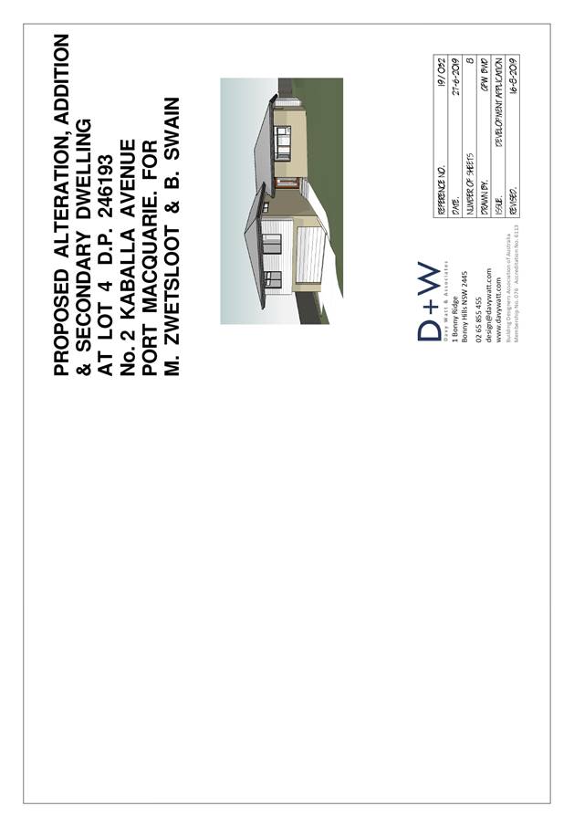
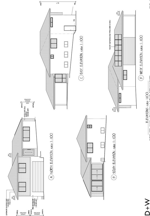
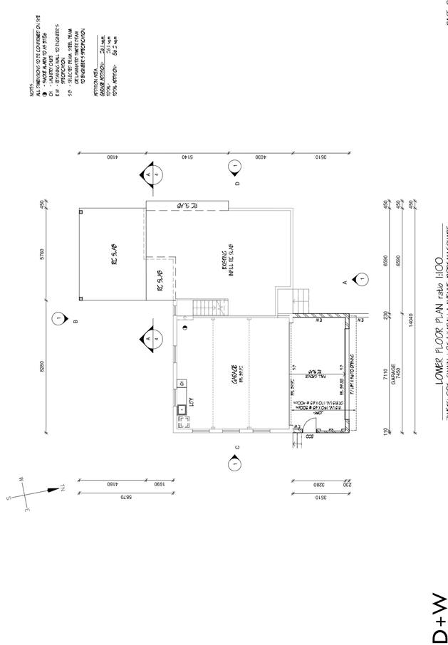
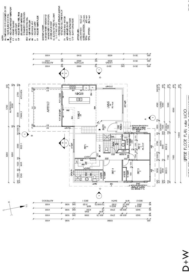

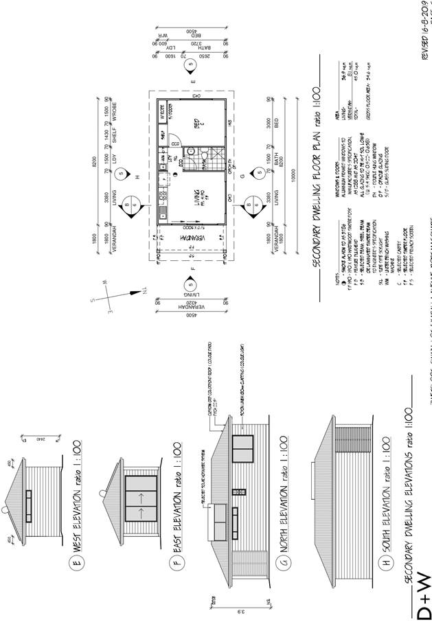
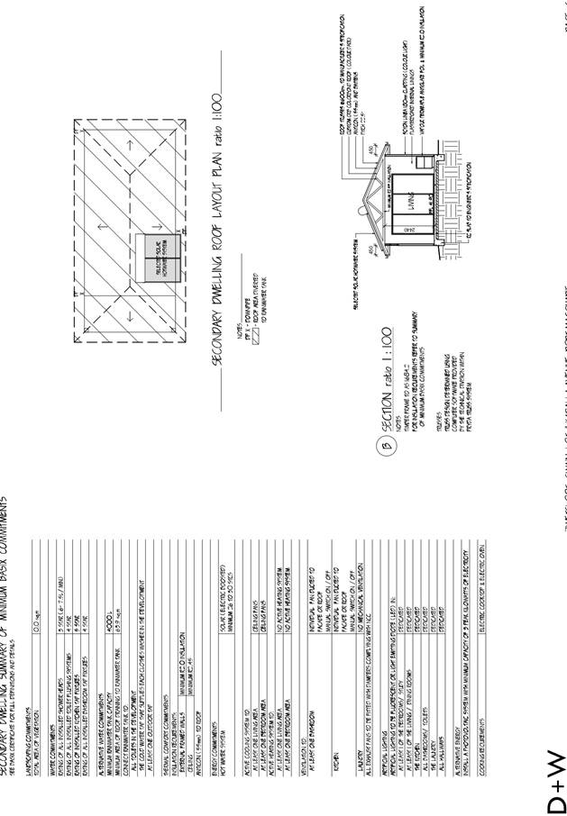
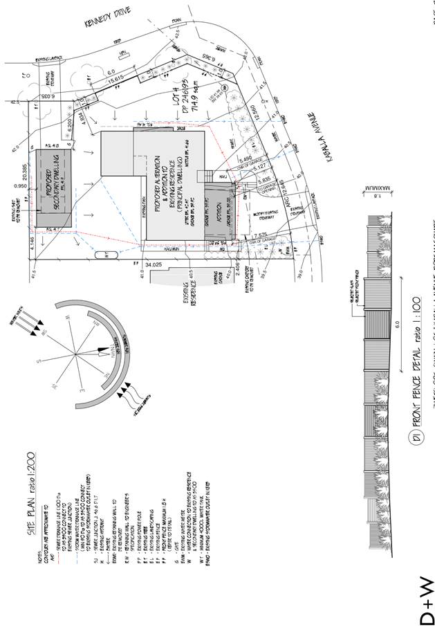
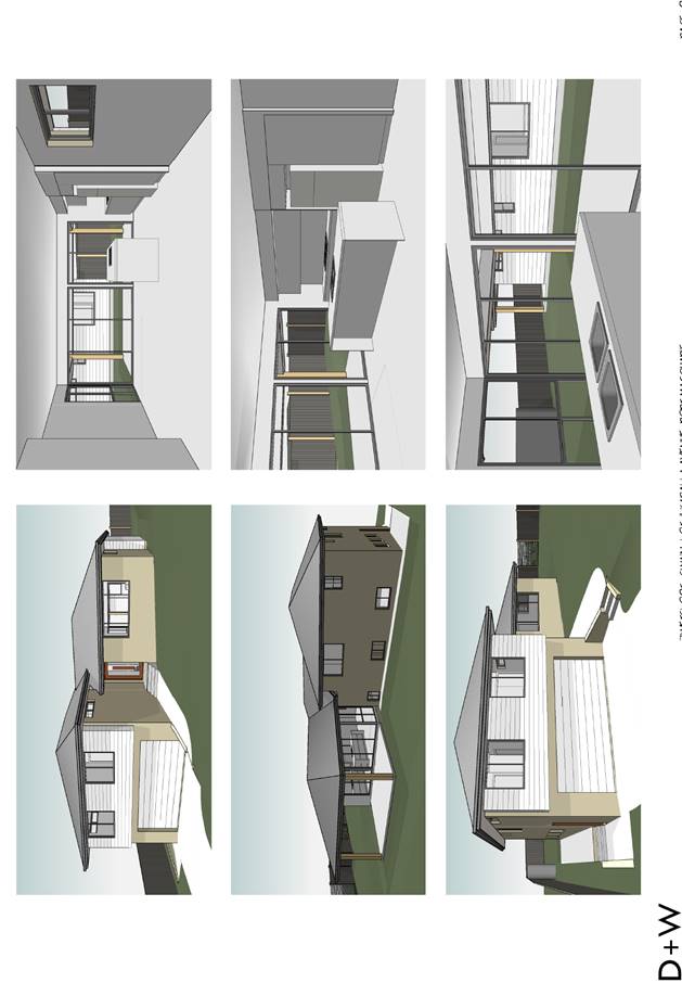
|
ATTACHMENT
|
Development Assessment Panel
11/09/2019
|