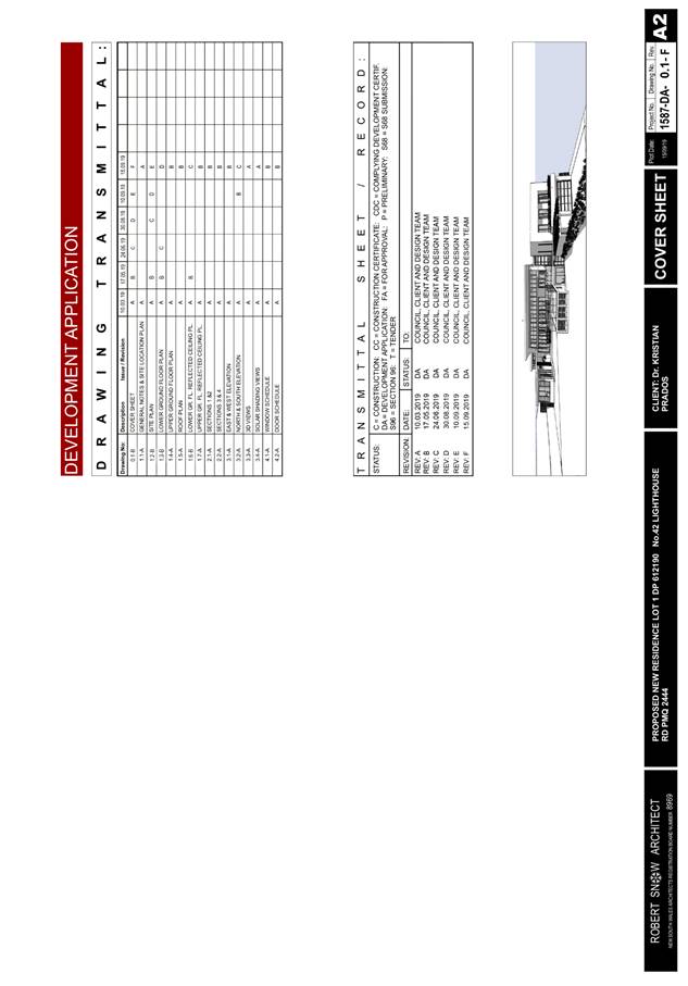
Business
Paper
|
date of meeting:
|
|
Wednesday 25
September 2019
|
|
location:
|
|
Function Room
Port
Macquarie-Hastings Council
17 Burrawan Street
Port Macquarie
|
|
time:
|
|
2:00pm
|
Development
Assessment Panel
CHARTER
1.0 OBJECTIVES
To assist in managing Council's development assessment
function by providing independent and expert determinations of development
applications that fall outside of staff delegations.
2.0 KEY FUNCTIONS
·
To review development application reports and conditions;
·
To determine development
applications outside of staff delegations;
·
To refer development applications
to Council for determination where necessary;
·
To provide a forum for objectors and applicants
to make submissions on applications
before the Development Assessment Panel
(DAP);
·
To maintain transparency in the determination of development
applications.
Delegated Authority of Panel
Pursuant to
Section 377 of the Local Government Act, 1993 delegation to:
·
Determine development applications under Part 4
of the Environmental Planning and Assessment
Act 1979 having
regard to the relevant environmental planning instruments,
development control plans and Council policies.
·
Vary, modify or release restrictions as to use
and/or covenants created by Section 88B instruments under the Conveyancing Act
1919 in relation to development applications for subdivisions being considered
by the panel.
·
Determine Koala Plans of Management under State
Environmental Planning Policy 44 - Koala Habitat Protection associated with
development applications being considered by the Panel.
Noting the trigger to escalate
decision making to Council as highlighted in section 5.2.
3.0
MEMBERSHIP
3.1
Voting
Members
·
Two independent external members. One of the
independent external members to be the Chairperson.
·
Group Manager Development Assessment (alternate
- Director Development & Environment or Development Assessment Planner)
The independent external members shall have expertise in
one or more of the following areas: planning, architecture, heritage, the
environment, urban design, economics, traffic and transport, law, engineering,
government and public administration.
3.2
Non-Voting Members
·
Not applicable
3.3 Obligations
of members
·
Members must act faithfully and diligently and
in accordance with this Charter.
·
Members must comply with Council's Code of Conduct.
·
Except as required to properly perform their
duties, DAP members must not
disclose any confidential information (as advised by Council) obtained in connection with the DAP functions.
·
Members will have read and be familiar with the
documents and information provided by Council prior
to attending a DAP meeting.
·
Members must act in accordance with Council's
Workplace Health and Safety Policies and Procedures
·
External members of the Panel are not authorised
to speak to the media on behalf of Council. Council officers that are members
of the Committee are bound by the
existing operational delegations in relation to speaking to the media.
·
Staff members shall not vote on matters before
the Panel if they have been the principle author of the development assessment report.
3.4
Member Tenure
·
The independent external members will be
appointed for the term of four (4) years
maximum in which the end of the tenure of these members would occur in a
cascading arrangement.
3.5 Appointment
of members
·
The independent external members (including the
Chair) shall be appointed by the General Manager following an external
Expression of Interest process.
·
Staff members of the Panel are in accordance
with this Charter.
4.0 TIMETABLE
OF MEETINGS
·
The Development Assessment Panel will generally
meet on the 1st and 3rd Wednesday each month at 2.00pm at the Port Macquarie
offices of Council.
·
Special Meetings of the Panel may be convened by
the Director Development & Environment Services with three (3) days notice.
5.0
MEETING PRACTICES
5.1
Meeting
Format
·
At all Meetings of the Panel the Chairperson
shall occupy the Chair and preside. The Chair will be responsible for keeping
of order at meetings.
·
Meetings shall be open to the public.
·
The Panel will hear from applicants
and objectors or their r e p r e s e n t a t i v e s .
·
Where considered necessary, the Panel will
conduct site inspections which will
be open to the public.
5.2
Decision Making
·
Decisions are to be made by consensus. Where
consensus is not possible on any item, that item is to be referred to Council
for a decision.
·
All development applications involving a
proposed variation to a development standard
greater than 10% under Clause
4.6 of the Local Environmental Plan will be
considered by the Panel and recommendation made to the Council for a decision.
5.3
Quorum
·
All members (2 independent external members and
1 staff member) must be present at a
meeting to form a quorum.
5.4
Chairperson and Deputy Chairperson
·
Independent Chair (alternate, second independent member)
5.5
Secretariat
·
The Director Development &n Environment is
to be responsible for ensuring that the Panel has adequate secretariat support.
The secretariat will ensure that the business paper and supporting papers are
circulated at least three (3) days prior to
each meeting. Minutes shall be appropriately approved and circulated to each
member within three (3) weeks of a meeting being held.
·
The format of and the preparation and publishing
of the Business Paper and Minutes shall be similar to the format for Ordinary
Council Meetings.
5.6
Recording of decisions
·
Minutes will record decisions and how each
member votes for each item before the Panel.
6.0 CONVENING
OF “OUTCOME SPECIFIC” WORKING GROUPS
Not applicable.
7.0 CONFIDENTIALITY
AND CONFLICT OF INTEREST
·
Members of the Panel must comply with the
applicable provisions of Council’s Code of Conduct. It is the personal
responsibility of members to comply with the standards in the Code of Conduct
and regularly review their personal circumstances with this in mind.
·
Panel members must declare any conflict of
interests at the start of each meeting or before discussion of a relevant item
or topic. Details of any conflicts of interest should be appropriately minuted.
Where members are deemed to have a real or perceived conflict of interest, it
may be appropriate they be excused from deliberations on the issue where the
conflict of interest may exist. A Panel meeting may be postponed where there is
no quorum.
8.0 LOBBYING
·
All members and applicants are to adhere to Council’s
Lobbying policy. Outside of
scheduled Development Assessment Panel meetings, applicants, their
representatives, Councillors, Council staff and the general public are not to
lobby Panel members via meetings, telephone conversations, correspondence and
the like. Adequate opportunity will be provided at Panel inspections or
meetings for applicants, their representatives and the general public to make
verbal submissions in relation to Business Paper items.
Development Assessment Panel
ATTENDANCE
REGISTER
|
Member
|
24/04/19
|
22/05/19
|
12/06/19
|
24/07/19
|
28/08/19
|
11/09/19
|
|
Paul Drake
|
P
|
P
|
P
|
P
|
P
|
P
|
|
Robert Hussey
|
P
|
P
|
|
|
P
|
P
|
|
David Crofts
(alternate member)
|
|
|
P
|
P
|
|
|
|
Dan Croft
(Group Manager Development
Assessment)
(alternates)
- Director Development & Environment
- Development Assessment Planner
|
P
|
P
|
P
|
P
|
P
|
A
P
|
Key: P = Present
A
= Absent With Apology
X
= Absent Without Apology
Development
Assessment Panel Meeting
Wednesday 25
September 2019
Items of Business
01 Acknowledgement
of Country............................................................................. 8
02 Apologies.......................................................................................................... 8
03 Confirmation
of Minutes..................................................................................... 8
04 Disclosures
of Interest..................................................................................... 13
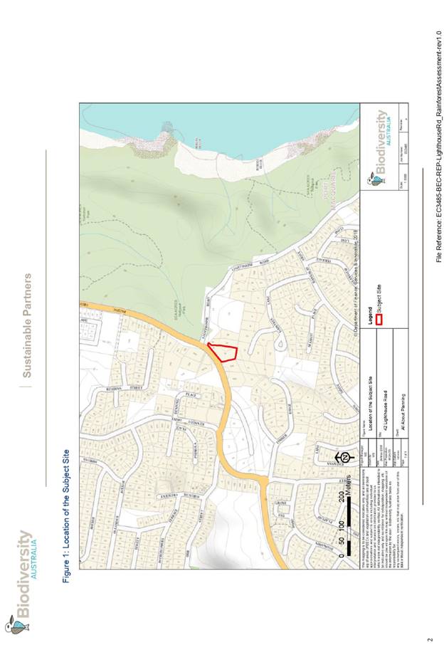
05 DA2019
- 154.1 Demolition of Existing Dwelling and Construction of New Dwelling and
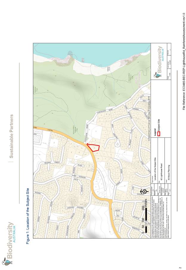
Swimming Pool Lot 1 DP 612190 42 Lighthouse Road, Port Macquarie............................... 17
06 DA2019
- 200.1 Change of Use - Dwelling to Medical Centre at Lot 28 DP 264025, No. 14
Siren Road, Port Macquarie.................................................................................... 156
07 DA2019
- 422.1 Medical Centre at Lot 3 DP827711, Cnr of Botanic Drive and Sirius
Drive, Lakewood...................................................................................................... 202
08 DA2019
- 440.1 - Dwelling at Lot 613 DP 1228345, No. 30 Richwood Ridge, Port Macquarie..................................................................................................................... 291
09 DA
2019 - 388.1, Boarding House at Lot 334 DP 216093, No. 14 The Jib, Port
Macquarie..................................................................................................................... 317
10 General
Business
AGENDA Development Assessment Panel 25/09/2019
Subject: ACKNOWLEDGEMENT
OF COUNTRY
"I acknowledge that we are
gathered on Birpai Land. I pay respect to the Birpai Elders both past and
present. I also extend that respect to all other Aboriginal and Torres Strait
Islander people present."
RECOMMENDATION
That the apologies received be
accepted.
Subject: CONFIRMATION
OF PREVIOUS MINUTES
Recommendation
That the Minutes of the Development
Assessment Panel Meeting held on 11 September 2019 be confirmed.
MINUTES
Development Assessment Panel Meeting
11/09/2019
PRESENT
Members:
Paul
Drake
Robert Hussey
Pat Galbraith-Robertson
(alternate)
Other Attendees:
Michael Roberts
Jesse
Dick
Mark
Edenborough
Grant
Burge
Anna
Stricker
|
The meeting opened at 2:05pm.
|
|
01 ACKNOWLEDGEMENT
OF COUNTRY
|
|
The
Acknowledgement of Country was delivered.
|
|
02 APOLOGIES
|
|
CONSENSUS:
That
the apology received from Dan Croft be accepted.
|
|
03 CONFIRMATION
OF MINUTES
|
|
CONSENSUS:
That
the Minutes of the Development Assessment Panel Meeting held on 28 August
2019 be confirmed.
|
|
04 DISCLOSURES
OF INTEREST
|
|
There were no disclosures of interest presented.
|
|
05 DA2019 - 154.1
Demolition of Existing Dwelling and Construction of New Dwelling and Swimming
Pool Lot 1 DP 612190 42 Lighthouse Road, Port Macquarie
|
|
Speakers:
Rob
Snow
Kristian
Lee Prados
Peter
Chapman (applicant)
CONSENSUS:
That the determination by the Development Assessment
Panel (DAP) of DA2019 - 154 for demolition of existing dwelling and
construction of a new dwelling and swimming pool at Lot 1 DP 612190, No.42
Lighthouse Road, Port Macquarie, be deferred to address the following:
1.
The Applicant submit a more definitive stormwater management plan
including details of any swales which satisfactorily addresses management of
stormwater on the site and demonstrates that the proposal will not be
adversely impacted by the stormwater overland flow path traversing the
property or cause adverse impacts to the neighbouring properties.
2.
The Applicant submit written details to provide a detailed explanation
of how the stormwater management plan will work.
3.
The Applicant submit updated amended development plans to reflect all
details of the stormwater management proposed.
4.
Council specialist stormwater assessment staff provide
assessment comments of the review of the stormwater details to be submitted
by the Applicant.
|
|
06 DA2018
- 365.1 Demolition of Dwelling and Erection of New Dwelling and Shed - Lot 4
DP 538813, No 160 Settlement Point Road, Port Macquarie
|
|
Speakers:
Andrew
Crane (opposed)
Scott
and Danny Chapman (applicant)
CONSENSUS:
That DA 2018 - 365.1 for the demolition of existing
Dwelling, construction of a new Dwelling, Shed and Earthworks at Lot 4, DP
538813, No. 160 Settlement Point Road, Port Macquarie, be determined by
granting consent subject to the recommended conditions and as amended below:
- Amend
condition B(7) point (e) to state:
The location of a drainage system through the site for upstream
stormwater run-off from neighbouring properties may be varied (but not
located closer to the neighbouring boundaries) from the Stormwater Drainage
Layout Plan, drawing number 11578, to allow for best use of the Lot. This is
subject to providing sufficient evidence that any proposed design and / or
location proposal has 1% AEP storm event capacity, does not negatively impact
neighbouring Lots, and meets AUSPEC D5 requirements.
|
|
07 DA2018 - 507.1
3 Lot Subdivision including Clause 4.6 Variation to Clause 4.1 (Minimum Lot
Size) of Port Macquarie Hastings Local Environmental Plan 2011 - Lot 41 and
Lot 42 DP 75403 and Lot 8 DP 114360, No. 434 and 440 Herons Creek Road,
Herons Creek
|
|
CONSENSUS:
That
the Development Assessment Panel (DAP) endorse the report of the Development
Assessment Planner and recommended to Council that DA 2018/507 for a 3 Lot Subdivision including a clause 4.6
variation of clause 4.1 (minimum lot size) of the Port Macquarie Hastings
Local Environmental Plan 2011 at Lots 41 & 42
DP 754403 and Lot 8 DP 114360, No. 434 & 440 Herons Creek Rd, Herons Creek, be
determined by granting consent subject to the recommended conditions.
|
|
08 DA2019
- 465.1 Alterations and Additions to Dwelling and Construction of a Secondary
Dwelling, Lot 4 DP 246193, No. 2 Kaballa Avenue Port Macquarie
|
|
Speaker:
George Watt
RECOMMENDATION
That DA 2019 - 465.1 for
Alterations and additions to dwelling and construction of a secondary
dwelling at Lot 4,
DP 246193, No. 2 Kaballa Avenue, Port
Macquarie, be determined by granting consent
subject to the recommended conditions, including the deletion of condition
B(2).
|
|
The meeting closed at 3:34pm.
|
AGENDA Development Assessment Panel 25/09/2019
Subject: DISCLOSURES
OF INTEREST
RECOMMENDATION
That Disclosures of Interest be presented
DISCLOSURE OF
INTEREST DECLARATION
|
Name of Meeting:
|
|
Meeting
Date:
|
|
Item
Number:
|
|
Subject:
|
|
I,
the undersigned, hereby declare the following interest:
Pecuniary:
 Take no part
in the consideration and voting and be out of sight of the meeting. Take no part
in the consideration and voting and be out of sight of the meeting.
Non-Pecuniary
– Significant Interest:
Take no part
in the consideration and voting and be out of sight of the meeting.
Non-Pecuniary
– Less than Significant Interest:
May
participate in consideration and voting.
|
|
For
the reason that:
|
|
Name:
Signed:
|
Date:
|
|
Please submit to the
Governance Support Officer at the Council Meeting.
|
 (Refer
to next page and the Code of Conduct)
(Refer
to next page and the Code of Conduct)
Pecuniary Interest
4.1
A pecuniary interest is an interest
that you have in a matter because of a reasonable likelihood or expectation of
appreciable financial gain or loss to you or a person referred to in clause
4.3.
4.2
You will not have a pecuniary
interest in a matter if the interest is so remote or insignificant that it
could not reasonably be regarded as likely to influence any decision you might
make in relation to the matter, or if the interest is of a kind specified in
clause 4.6.
4.3
For the purposes of this Part, you
will have a pecuniary interest in a matter if the pecuniary interest is:
(a)
your interest, or
(b)
the interest of your spouse or de
facto partner, your relative, or your partner or employer, or
(c)
a company or other body of which
you, or your nominee, partner or employer, is a shareholder or member.
4.4
For the purposes of clause 4.3:
(a)
Your “relative” is any
of the following:
(b)
“de facto partner” has
the same meaning as defined in section 21C of the Interpretation Act 1987.
4.5
You will not have a pecuniary
interest in relation to a person referred to in subclauses 4.3(b) or (c)
(a)
if you are unaware of the relevant
pecuniary interest of your spouse, de facto partner, relative, partner,
employer or company or other body, or
(b)
just because the person is a member
of, or is employed by, a council or a statutory body, or is employed by the
Crown, or
(c)
just because the person is a member
of, or a delegate of a council to, a company or other body that has a pecuniary
interest in the matter, so long as the person has no beneficial interest in any
shares of the company or body.
Non-Pecuniary
5.1
Non-pecuniary interests are private
or personal interests a council official has that do not amount to a pecuniary
interest as defined in clause 4.1 of this code. These commonly arise out of
family or personal relationships, or out of involvement in sporting, social, religious
or other cultural groups and associations, and may include an interest of a
financial nature.
5.2
A non-pecuniary conflict of
interest exists where a reasonable and informed person would perceive that you
could be influenced by a private interest when carrying out your official
functions in relation to a matter.
5.3
The personal or political views of
a council official do not constitute a private interest for the purposes of
clause 5.2.
5.4
Non-pecuniary conflicts of interest
must be identified and appropriately managed to uphold community confidence in
the probity of council decision-making. The onus is on you to identify any
non-pecuniary conflict of interest you may have in matters that you deal with,
to disclose the interest fully and in writing, and to take appropriate action
to manage the conflict in accordance with this code.
5.5
When considering whether or not you
have a non-pecuniary conflict of interest in a matter you are dealing with, it
is always important to think about how others would view your situation.
Managing non-pecuniary conflicts of interest
5.6
Where you have a non-pecuniary
conflict of interest in a matter for the purposes of clause 5.2, you must
disclose the relevant private interest you have in relation to the matter fully
and in writing as soon as practicable after becoming aware of the non-pecuniary
conflict of interest and on each occasion on which the non-pecuniary conflict
of interest arises in relation to the matter. In the case of members of council
staff other than the general manager, such a disclosure is to be made to the
staff member’s manager. In the case of the general manager, such a
disclosure is to be made to the mayor.
5.7
If a disclosure is made at a
council or committee meeting, both the disclosure and the nature of the
interest must be recorded in the minutes on each occasion on which the
non-pecuniary conflict of interest arises. This disclosure constitutes
disclosure in writing for the purposes of clause 5.6.
5.8
How you manage a non-pecuniary
conflict of interest will depend on whether or not it is significant.
5.9
As a general rule, a non-pecuniary
conflict of interest will be significant where it does not involve a pecuniary
interest for the purposes of clause 4.1, but it involves:
a)
a relationship between a council
official and another person who is affected by a decision or a matter under
consideration that is particularly close, such as a current or former spouse or
de facto partner, a relative for the purposes of clause 4.4 or another person
from the council official’s extended family that the council official has
a close personal relationship with, or another person living in the same
household
b)
other relationships with persons
who are affected by a decision or a matter under consideration that are
particularly close, such as friendships and business relationships. Closeness
is defined by the nature of the friendship or business relationship, the frequency
of contact and the duration of the friendship or relationship.
c)
an affiliation between the council
official and an organisation (such as a sporting body, club, religious,
cultural or charitable organisation, corporation or association) that is
affected by a decision or a matter under consideration that is particularly
strong. The strength of a council official’s affiliation with an
organisation is to be determined by the extent to which they actively
participate in the management, administration or other activities of the
organisation.
d)
membership, as the council’s
representative, of the board or management committee of an organisation that is
affected by a decision or a matter under consideration, in circumstances where
the interests of the council and the organisation are potentially in conflict
in relation to the particular matter
e)
a financial interest (other than an
interest of a type referred to in clause 4.6) that is not a pecuniary interest
for the purposes of clause 4.1
f)
the conferral or loss of a personal
benefit other than one conferred or lost as a member of the community or a
broader class of people affected by a decision.
5.10
Significant non-pecuniary conflicts
of interest must be managed in one of two ways:
a)
by not participating in
consideration of, or decision making in relation to, the matter in which you
have the significant non-pecuniary conflict of interest and the matter being
allocated to another person for consideration or determination, or
b)
if the significant non-pecuniary
conflict of interest arises in relation to a matter under consideration at a
council or committee meeting, by managing the conflict of interest as if you
had a pecuniary interest in the matter by complying with clauses 4.28 and 4.29.
5.11
If you determine that you have a
non-pecuniary conflict of interest in a matter that is not significant and does
not require further action, when disclosing the interest you must also explain
in writing why you consider that the non-pecuniary conflict of interest is not
significant and does not require further action in the circumstances.
5.12
If you are a member of staff of
council other than the general manager, the decision on which option should be
taken to manage a non-pecuniary conflict of interest must be made in
consultation with and at the direction of your manager. In the case of the
general manager, the decision on which option should be taken to manage a
non-pecuniary conflict of interest must be made in consultation with and at the
direction of the mayor.
5.13
Despite clause 5.10(b), a councillor
who has a significant non-pecuniary conflict of interest in a matter, may
participate in a decision to delegate consideration of the matter in question
to another body or person.
5.14 Council committee members are not required to declare
and manage a non-pecuniary conflict of interest in accordance with the
requirements of this Part where it arises from an interest they have as a
person chosen to represent the community, or as a member of a non-profit
organisation or other community or special interest group, if they have been
appointed to represent the organisation or group on the council committee.
SPECIAL
DISCLOSURE OF PECUNIARY INTEREST DECLARATION
This
form must be completed using block letters or typed.
If
there is insufficient space for all the information you are required to
disclose,
you
must attach an appendix which is to be properly identified and signed by you.
|
By
[insert full name of councillor]
|
|
|
In the
matter of
[insert name of environmental planning instrument]
|
|
|
Which is
to be considered at a meeting of the
[insert name of meeting]
|
|
|
Held on
[insert date of meeting]
|
|
|
PECUNIARY
INTEREST
|
|
Address of
the affected principal place of residence of the councillor or an associated
person, company or body (the identified land)
|
|
|
Relationship
of identified land to councillor
[Tick or cross one box.]
|
The councillor has interest in the land (e.g. is owner or has other
interest arising out of a mortgage, lease, trust, option or contract, or
otherwise).
An associated person of the councillor has an interest in the land.
An associated company or body of the councillor has interest in the land.
|
|
MATTER
GIVING RISE TO PECUNIARY INTEREST
|
|
Nature of
land that is subject to a change
in
zone/planning control by proposed
LEP (the
subject land
[Tick or cross one box]
|
The identified land.
Land that adjoins or is adjacent to or is in proximity to the identified
land.
|
|
Current
zone/planning control
[Insert name of current planning instrument and
identify relevant zone/planning control applying to the subject land]
|
|
|
Proposed
change of zone/planning control
[Insert name of proposed LEP and identify proposed
change of zone/planning control applying to the subject land]
|
|
|
Effect of
proposed change of zone/planning control on councillor or associated person
[Tick or cross one box]
|
Appreciable financial gain.
Appreciable financial loss.
|
|
|
|
[If more than one pecuniary interest is to be
declared, reprint the above box and fill in for each additional interest]
Councillor’s Signature:
……………………………….
Date: ………………..
This form is to be retained
by the council’s general manager and included in full in the minutes of
the meeting
Last Updated: 3 June 2019
Important Information
This information is being collected for the purpose of
making a special disclosure of pecuniary interests under clause 4.36(c) of the
Model Code of Conduct for Local Councils in NSW (the Model Code of Conduct).
The special disclosure must relate only to a pecuniary
interest that a councillor has in the councillor’s principal place of
residence, or an interest another person (whose interests are relevant under
clause 4.3 of the Model Code of Conduct) has in that person’s principal
place of residence.
Clause 4.3 of the Model Code of Conduct states that you
will have a pecuniary interest in a matter because of the pecuniary interest of
your spouse or your de facto partner or your relative or because your business
partner or employer has a pecuniary interest. You will also have a pecuniary
interest in a matter because you, your nominee, your business partner or your
employer is a member of a company or other body that has a pecuniary interest
in the matter.
“Relative” is defined by clause 4.4 of the Model
Code of Conduct as meaning your, your spouse’s or your de facto
partner’s parent, grandparent, brother, sister, uncle, aunt, nephew,
niece, lineal descendant or adopted child and the spouse or de facto partner of
any of those persons.
You
must not make a special disclosure that you know or ought reasonably to know is
false or misleading in a material particular. Complaints about breaches
of these requirements are to be referred to the Office of Local Government and
may result in disciplinary action by the Chief Executive of the Office of Local
Government or the NSW Civil and Administrative Tribunal.
This form must be completed by you before the commencement
of the council or council committee meeting at which the special disclosure is
being made. The completed form must be tabled at the meeting. Everyone is
entitled to inspect it. The special disclosure must be recorded in the minutes
of the meeting.
A pecuniary interest may arise by way of a change of
permissible use of land adjoining, adjacent to or in proximity to land in which
a councillor or a person, company or body referred to in clause 4.3 of the
Model Code of Conduct has a proprietary interest
AGENDA Development Assessment Panel 25/09/2019
Item: 05
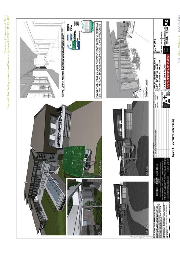
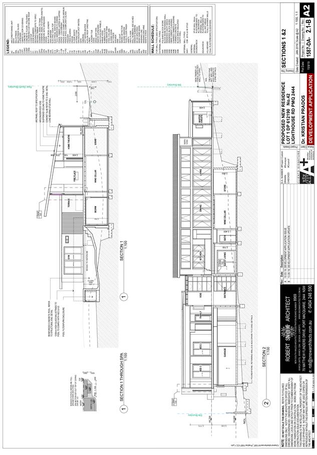
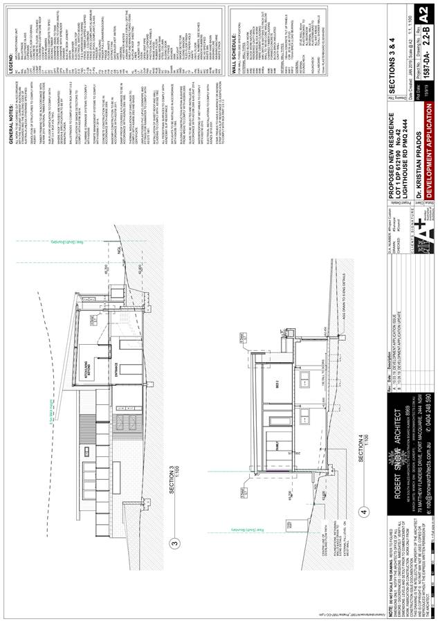
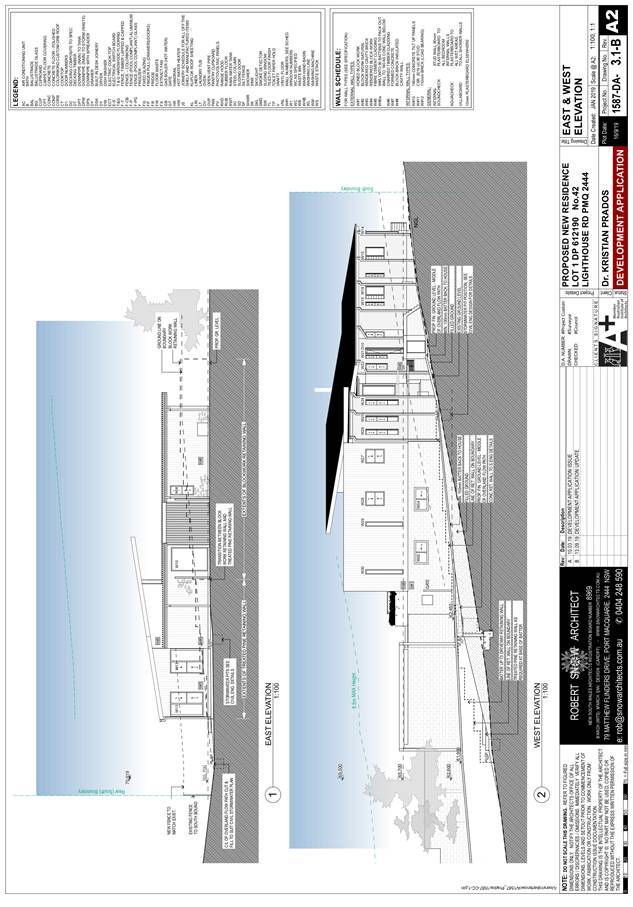
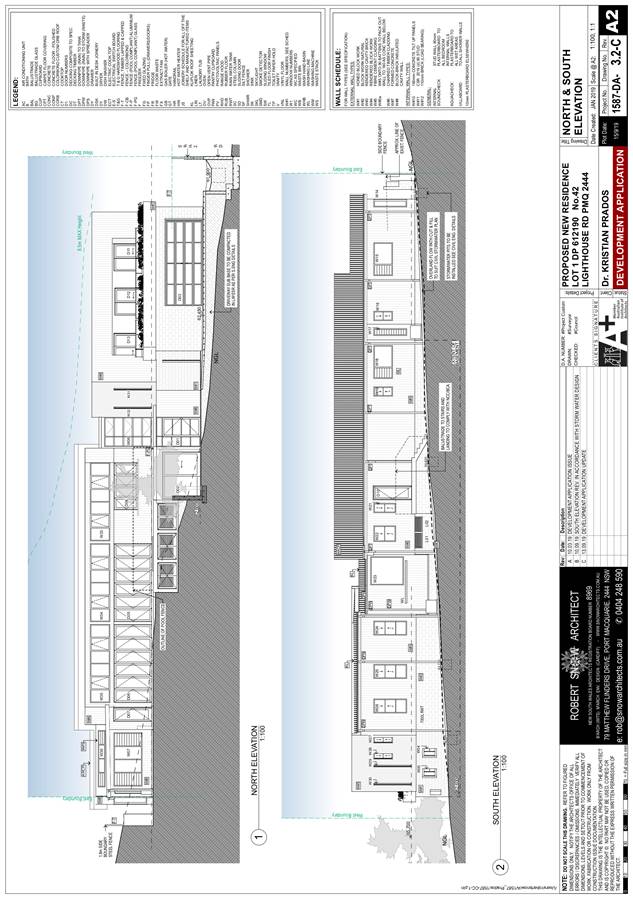
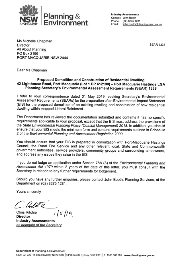
Subject: DA2019 - 154.1 Demolition of Existing Dwelling
and Construction of New Dwelling and Swimming Pool Lot 1 DP 612190 42
Lighthouse Road, Port Macquarie
Report
Author: Development Assessment Planner, Benjamin Roberts
|
Applicant: K
L Prados
Owner: K
L Prados
Estimated Cost: $1,350,000
Alignment with Delivery
Program
4.3.1 Undertake transparent
and efficient development assessment in accordance with relevant legislation.
|
|
RECOMMENDATION
That
DA 2019 - 154 for demolition of
existing dwelling and construction of new dwelling and swimming pool at Lot 1, DP
612190, No. 42 Lighthouse Road, Port Macquarie, be determined by granting
consent subject to the recommended conditions.
|
Executive
Summary
This
report considers a development application for a demolition of existing
dwelling and construction of new dwelling and swimming pool at the subject site and provides an assessment of the
application in accordance with the Environmental Planning and Assessment Act
1979.
Following exhibition of the
application, one (1) submission was
received.
The application was considered by
Council’s Development Assessment Panel (DAP) on 28 August 2019 and 11
September 2019 where the following was resolved:
CONSENSUS:
“That the determination by the
Development Assessment Panel (DAP) of DA2019 - 154 for demolition of existing
dwelling and construction of a new dwelling and swimming pool at Lot 1 DP
612190, No.42 Lighthouse Road, Port Macquarie, be deferred to address the
following:
1. The
Applicant submit a more definitive stormwater management plan including
details of
any swales which satisfactorily addresses management of stormwater on the site
and demonstrates that the proposal will not be adversely impacted by the
stormwater overland flow path traversing the property or cause adverse impacts
to the neighbouring properties.
2. The
Applicant submit written details to provide a detailed explanation of how the
stormwater
management plan will work.
3. The
Applicant submit updated amended development plans to reflect all details of
the stormwater management proposed.
4. Council
specialist stormwater assessment staff provide assessment comments of the
review of the stormwater details to be submitted by the Applicant.”
Subsequent to the DAP meeting of 11 September 2019, in
response to the above resolution the following comments are provided:
1. The
Applicant has submitted an updated stormwater management plan details which
satisfactorily demonstrates that stormwater can be managed on-site and not
adversely impact neighbouring properties.
2. The
Applicant has submitted supportive written documentation details to
satisfactorily demonstrate that stormwater can be managed on-site and not
adversely impact neighbouring properties.
3. The
Applicant has submitted updated amended plans to reflect the amened stormwater
management proposed.
4. Council
specialist stormwater assessment staff have reviewed the additional stormwater
details submitted by the Applicant. Updated assessment comments are provided
under the ‘Stormwater’ section later in this report.
This report recommends that the
subject development application as amended be approved subject to the
conditions included in attachments.
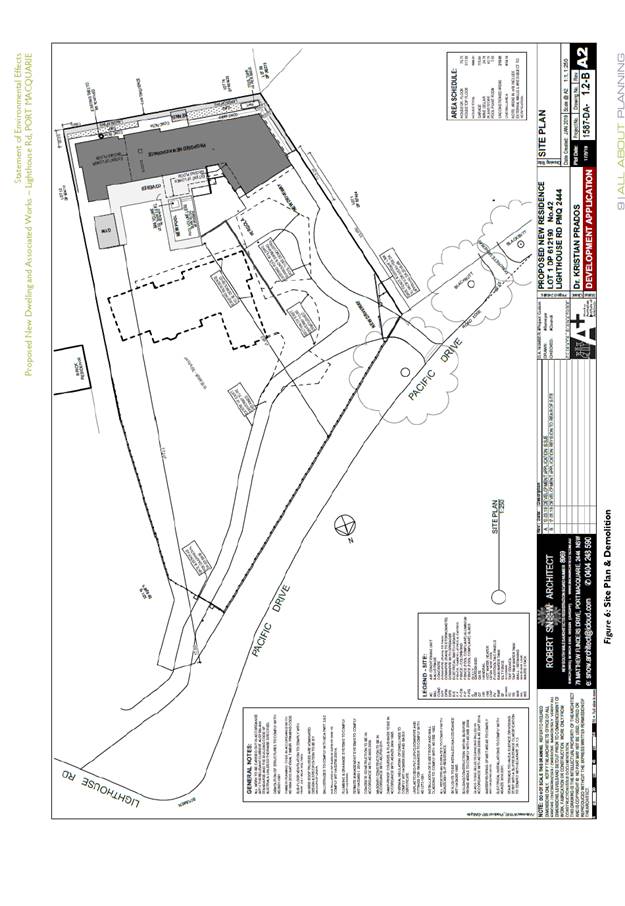
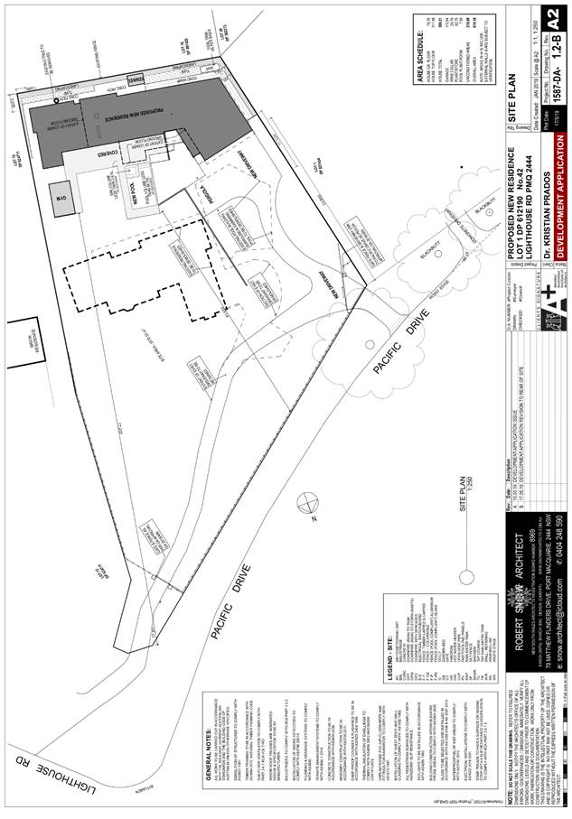
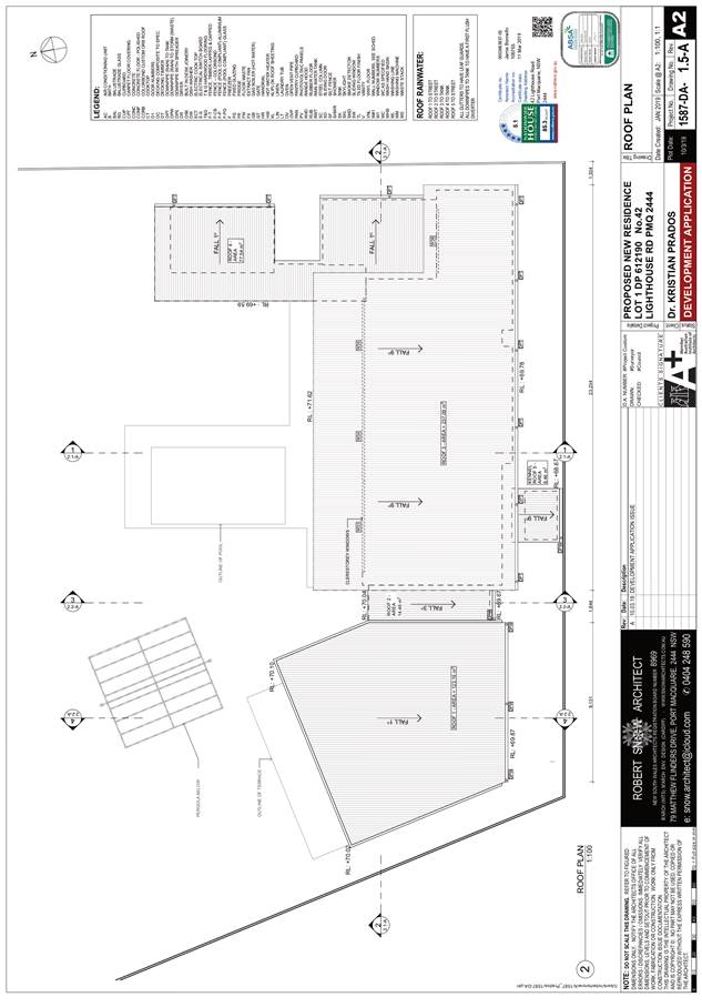
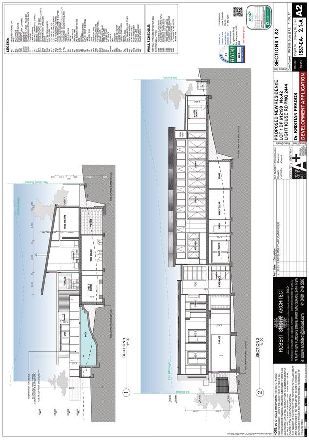
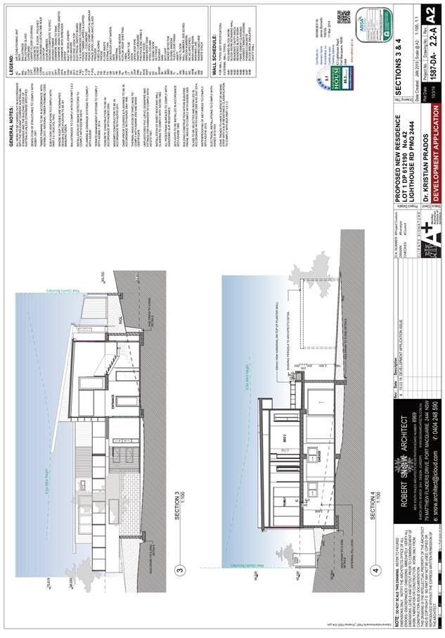
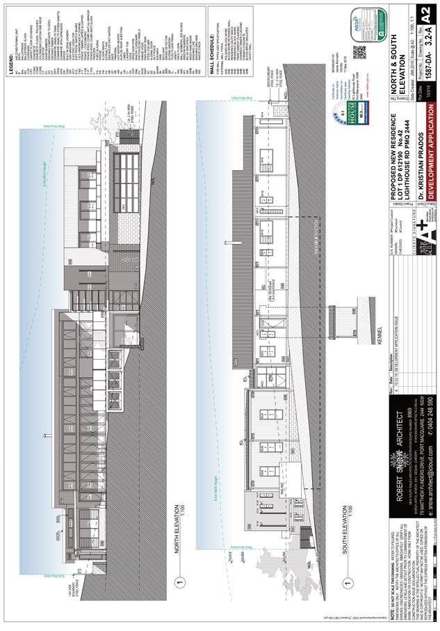
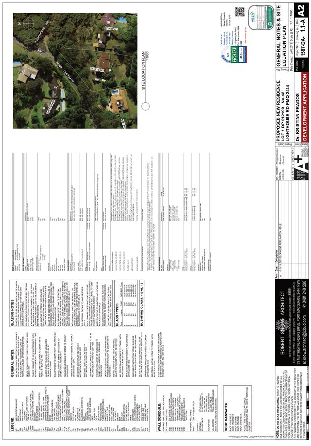
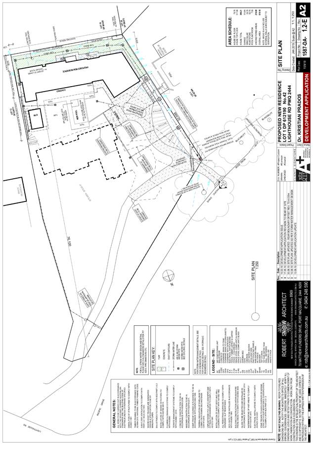
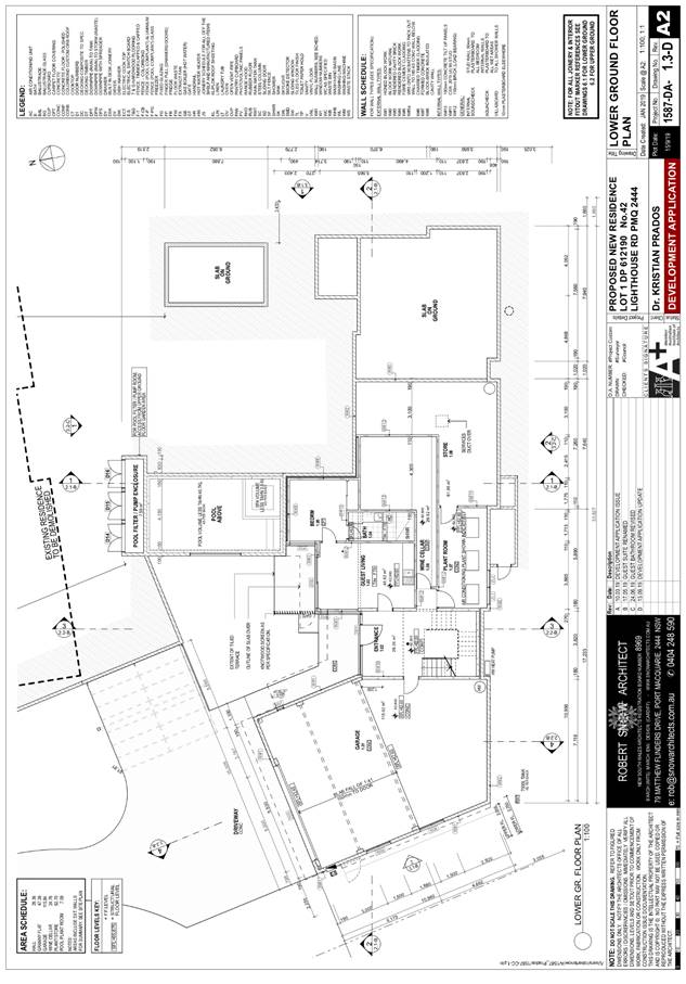
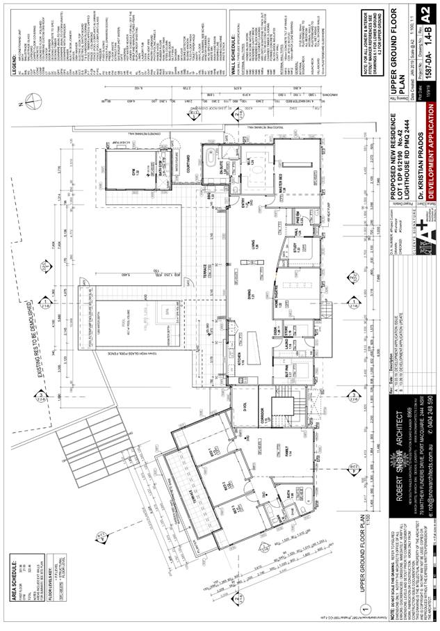
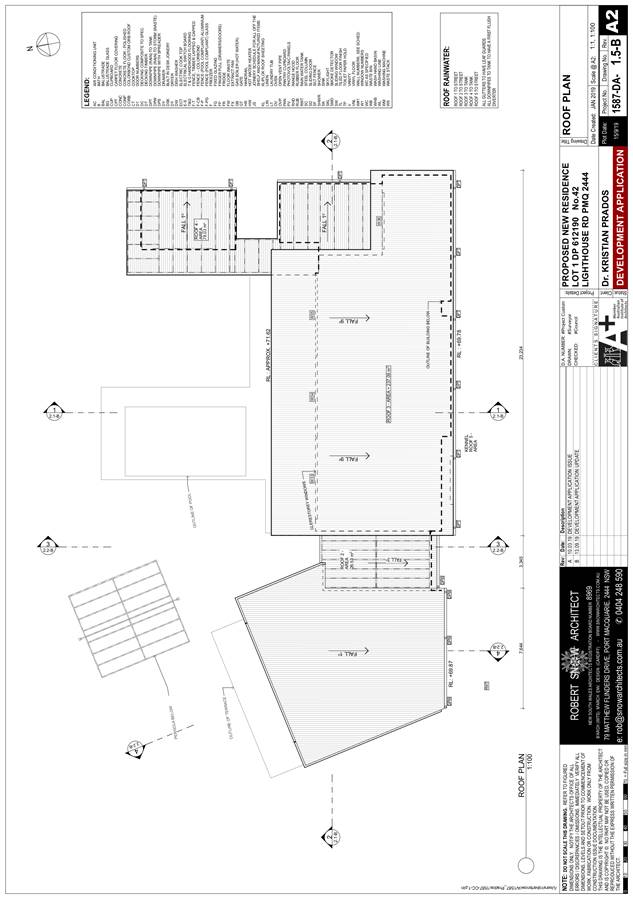
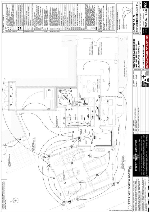
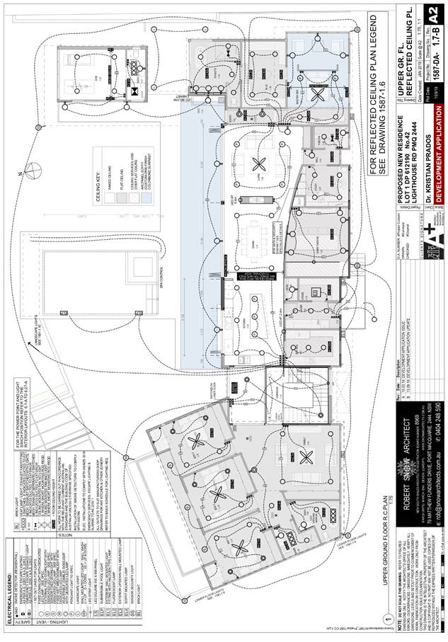
1. BACKGROUND
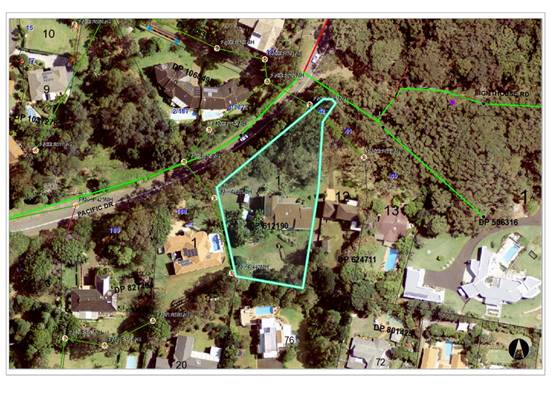
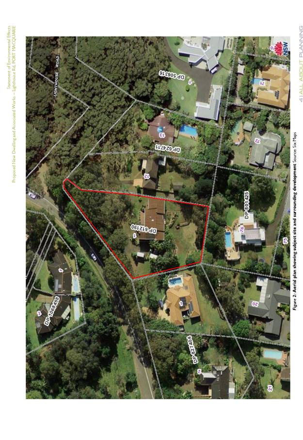
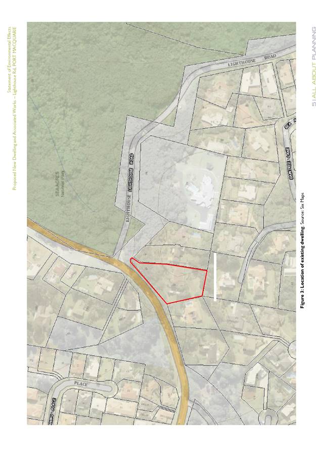
Existing Sites Features and Surrounding Development
The site has an area of 3578m2.
The site is zoned E4 Environmental Living in accordance with the Port Macquarie-Hastings Local
Environmental Plan 2011, as shown in the following zoning plan:
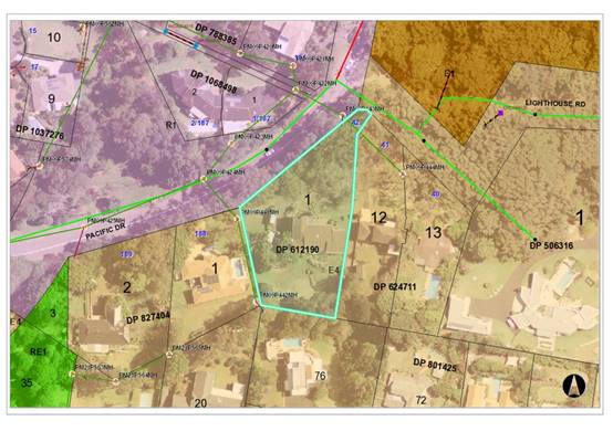
The existing subdivision pattern and location of existing
development within the locality is shown in the following aerial photograph:
2. DESCRIPTION OF
DEVELOPMENT
Key aspects of the proposal include the following:
· Demolition
of existing dwelling and tree removal
· Construction
of new dwelling and swimming pool
Refer
to attachments at the end of this report for further details.
Application Chronology
· 11
March 2019 - Application lodged.
· 21
March to 3 April 2019 - Public exhibition via neighbour notification.
· 3
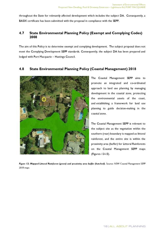
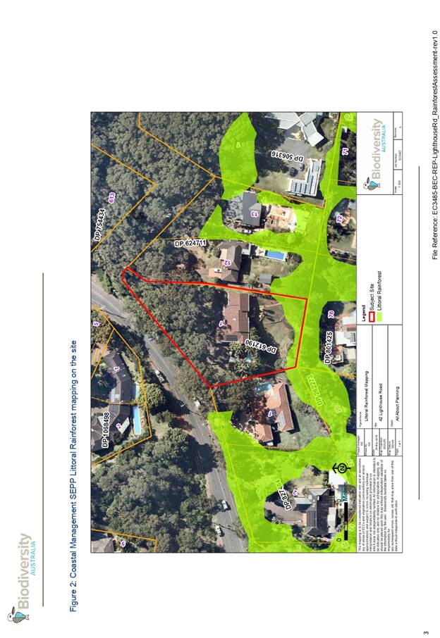
April 2019 - Additional information request. Site mapped as littoral rainforest
under Coastal Management SEPP. Application is designated development.
Environmental Impact Statement (EIS) and additional fees required.
· 2 May 2019 - Additional fees paid.
· 22 June 2019 - Environmental Impact Statement and revised
plans received. Secondary dwelling and dog kennel removed from proposal.
· 4 July to 2 August 2019 - Re-exhibition as designated
development via advertising and neighbour notification.
· 28 August 2019 - application considered by DAP and deferred
for further information.
· 11 September 2019 - application considered by DAP and deferred
for further information.
· 16 September 2019 - amended plans and additional
information received
3. STATUTORY ASSESSMENT
Section 4.15(1) Matters for Consideration
In determining the application, Council is required to take
into consideration the following matters as are relevant to the development
that apply to the land to which the development application relates:
(a) The provisions (where
applicable) of:
(i) Any Environmental
Planning Instrument
State Environmental Planning Policy No. 44 - Koala
Habitat Protection
There is no Koala Plan of Management on the site.
Additionally, the site is less than 1ha in area therefore no further
investigations are required.
State Environmental Planning Policy No. 55 –
Remediation of Land
Following an inspection of the site and a search of Council
records, the subject land is not identified as being potentially contaminated
and is suitable for the intended use.
State Environmental Planning Policy (Coastal Management)
2018
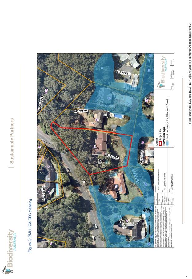
The site is partially mapped as littoral rainforest and
within a proximity area to littoral rainforest under this policy.
In accordance with clause 7, this SEPP prevails over the
Port Macquarie-Hastings LEP 2011 in the event of any inconsistency.
In accordance with clause 10, the proposal is declared to be
designated development. The application was accompanied by an Environmental
Impact Statement (EIS) which is consistent with the issued Secretary’s
Environmental Assessment Requirements (SEARs). A copy of the issued SEARs and
EIS are provided as attachments to this report.
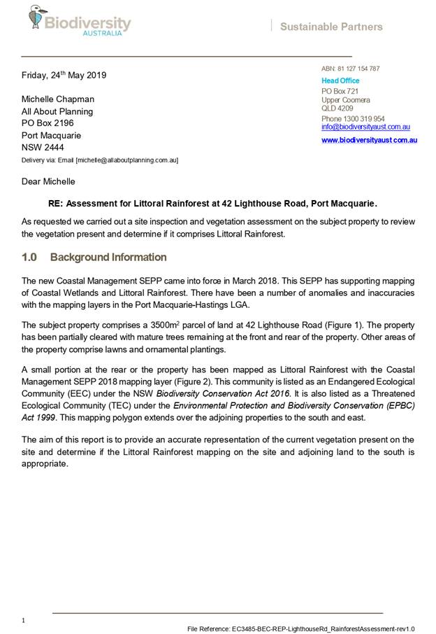
The application was also supported by a site vegetation
assessment, prepared by Biodiversity Australia, dated 24 May 2019. The
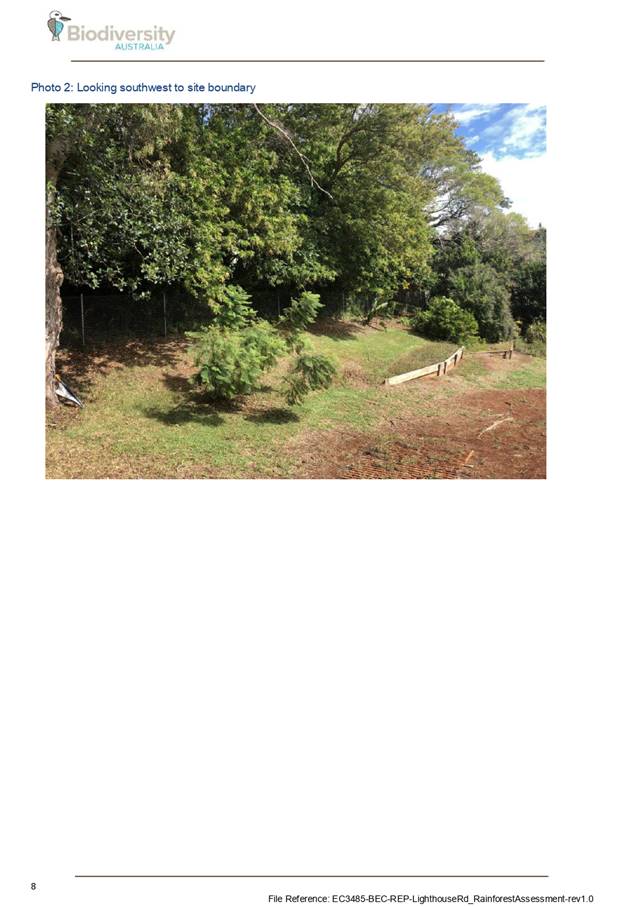
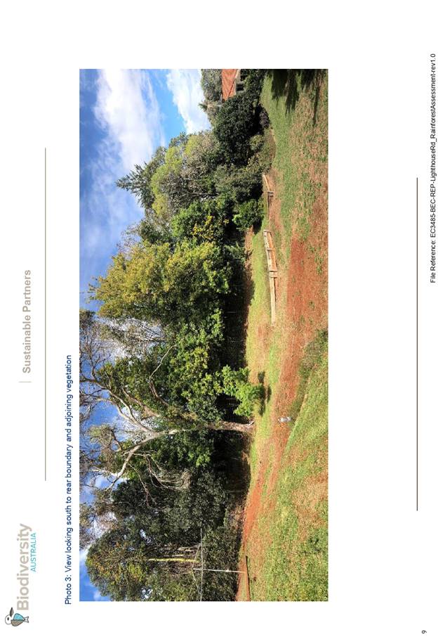
assessment concluded:
“that the vegetation
does not comprise Littoral Rainforest as it lacks key floristic and structural
attributes. Vegetation on adjoining land to the south is also unlikely to
qualify as Littoral Rainforest at present, however it would have the potential
to regenerate into Littoral Rainforest if weeds are removed.
It is recommended that the
Coastal SEPP mapping layer is amended to remove the Littoral Rainforest mapping
from both the subject site and the adjoining land to the south.”
In accordance with clause 11, the proposal will not
significantly impact on:
(a) the
biophysical, hydrological or ecological integrity of the adjacent coastal
wetland or littoral rainforest, or
(b) the
quantity and quality of surface and ground water flows to and from the adjacent
coastal wetland or littoral rainforest.
In accordance with clause 15, the proposed development is
not likely to cause increased risk of coastal hazards on that land or other
land.
In accordance with clause 16, there is no certified coastal
management program that applies to the land.
The bulk, scale and size of the proposed development is
compatible with the surrounding coastal and built environment. The site is
predominately cleared and located within an area with established residential
properties.
State Environmental Planning Policy (Building
Sustainability Index: BASIX) 2004
A BASIX certificate has been submitted demonstrating that
the proposal will comply with the requirements of the SEPP. It is recommended
that a condition be imposed to ensure that the commitments are incorporated
into the development and certified at Occupation Certificate stage.
Port Macquarie-Hastings Local Environmental
Plan 2011
The proposal is consistent with the LEP having regard to the
following:
· Clause 2.2 - The
subject site is zoned E4 Environmental Living. In accordance with clause 2.3(1)
and the E4 zone landuse table, the new dwelling and ancillary swimming pool is
a permissible landuse with consent.
The objectives of the E4 zone are as
follows:
o To provide for low-impact
residential development in areas with special ecological, scientific or
aesthetic values.
o To ensure that
residential development does not have an adverse effect on those values.
· Clause 2.3(2) - The
proposal is consistent with the zone objectives as it is a permissible landuse
and demonstrated no adverse impact on ecological values.
· Clause 2.7 - The
demolition of the existing dwelling requires consent as it does not fit within
the provisions of SEPP (Exempt and Complying Development Codes) 2008.
· Clause 4.3 - The maximum
overall height of the building above ground level complies with the standard
height limit of 8.5m applying to the site. Refer to architectural plans with
maximum building height envelope shown.
· Clause 5.10 - The site
does not contain or adjoin any known heritage items or sites of significance.
· Clause 7.13 -
Satisfactory arrangements are in place for provision of essential services
including water supply, electricity supply, sewer infrastructure, stormwater
drainage and suitable road access to service the development.
(ii) Any
draft instruments that apply to the site or are on exhibition
No draft
instruments apply.
(iii) Any
Development Control Plan (DCP) in force
Port
Macquarie-Hastings Development Control Plan 2013
|
DCP 2013: Dwellings, Dual
occupancies, Dwelling houses, Multi dwelling houses & Ancillary
development
|
|
|
Requirements
|
Proposed
|
Complies
|
|
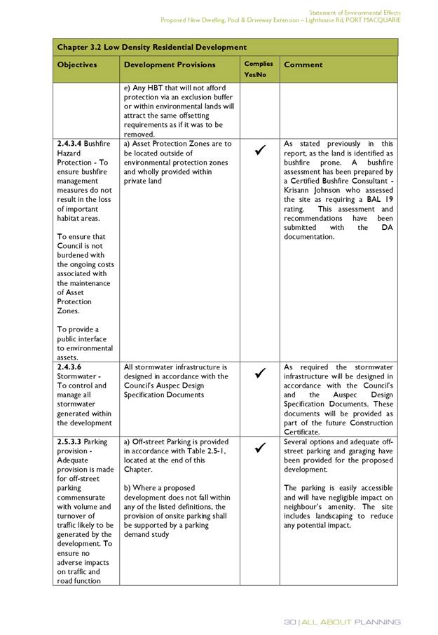
3.2.2.1
|
Ancillary development:
• 4.8m max. height
• Single storey
• 60m2 max. area
• 100m2 for lots
>900m2
• 24 degree max.
roof pitch
• Not located in
front setback
|
Rainwater tank is located behind
building line. Swimming pool is generously setback 41m from the Pacific Drive
boundary.
|
Yes
|
|
3.2.2.2
|
Articulation zone:
• Min. 3m front
setback
• An entry feature
or portico
• A balcony, deck,
patio, pergola, terrace or verandah
• A window box
treatment
• A bay window or
similar feature
• An awning or other
feature over a window
• A sun shading
feature
|
Pergola and swimming pool
structures are within the front setback. The structures are well setback from
the Pacific Drive boundary.
|
Yes
|
|
3.2.2.3
|
Garage 5.5m min. and 1m behind
front façade.
Garage door recessed behind
building line or eaves/overhangs provided
|
Garage door setback is compliant
with the minimum front setback requirements.
Garage door recessed.
|
No. The pergola appears to be a
form of off-street parking similar to a carport. It is considered acceptable
given the generous setback to Pacific Drive, existing vegetation and open
nature of the structure.
|
|
6m max. width of garage door/s
and 50% max. width of building
|
Width of garage door is compliant
with the maximum width requirements
|
Yes
|
|
Driveway crossover 1/3 max. of
site frontage and max. 5.0m width
|
Driveway crossing width is
compliant with the maximum width requirements
|
Yes
|
|
3.2.2.4
|
4m min. rear setback. Variation
subject to site analysis and provision of private open space
|
A minimum 5m rear setback is now
proposed with the amended proposal.
|
Yes
|
|
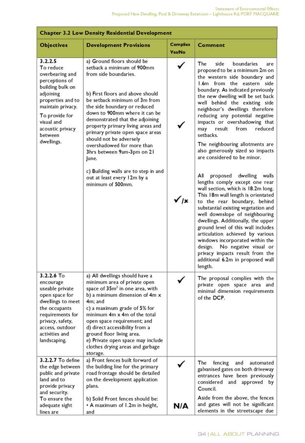
3.2.2.5
|
Side setbacks:
• Ground floor =
min. 0.9m
• First floors &
above = min. 3m setback or where it can be demonstrated that overshadowing
not adverse = 0.9m min.
• Building wall set
in and out every 12m by 0.5m
|
The site slopes away from the
east and having regard to the proposed cut and fill will present as single
storey along the eastern boundary and two storey along the western boundary.
The eastern side setback is 1.66m. The western side setback is 2m. The
reduced western side setback is acceptable. Given the block orientation no
adverse overshadowing impact will result to the adjoining property at 188
Pacific Drive.
The building wall articulation is
compliant and/or satisfactory to address the objective intent of the
development provision.
|
Yes
|
|
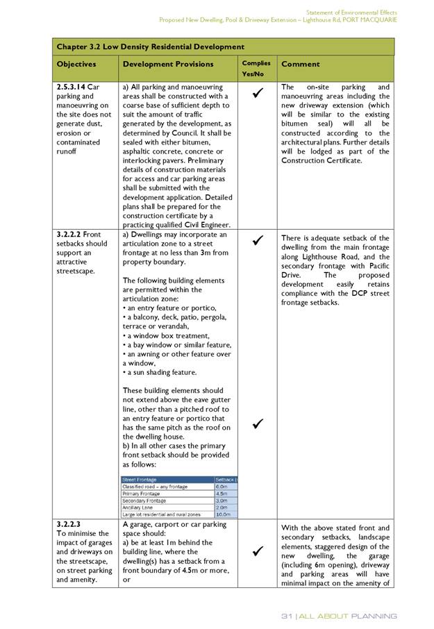
3.2.2.6
|
35m2 min. private open space area
including a useable 4x4m min. area which has 5% max. grade
|
The dwelling contains >35m² open space in one area
including a useable 4m x 4m space.
|
Yes
|
|
3.2.2.7
|
Front fences:
• If solid 1.2m max
height and front setback 1.0m with landscaping
• 3x3m min. splay
for corner sites
• Fences >1.2m to
be 1.8m max. height for 50% or 6.0m max. length of street frontage with 25%
openings
• 0.9x0.9m splays
adjoining driveway entrances
|
Detail of fencing not provided.
Condition has been recommended requiring fencing details consistent with DCP
be illustrated on building Construction Certificate plans.
|
Yes
|
|
3.2.2.8
|
Front fences and walls to have
complimentary materials to context
No chain wire, solid timber,
masonry or solid steel front fences
|
Refer comments above.
|
Yes
|
|
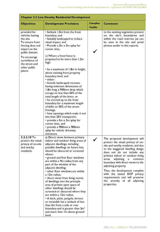
3.2.2.10
|
Privacy:
• Direct views
between living areas of adjacent dwellings screened when within 9m radius of
any part of window of adjacent dwelling and within 12m of private open space
areas of adjacent dwellings. ie. 1.8m fence or privacy screening which has
25% max. openings and is permanently fixed
• Privacy screen
required if floor level > 1m height, window side/rear setback (other than
bedroom) is less than 3m and sill height less than 1.5m
• Privacy screens
provided to balconies/verandahs etc which have <3m side/rear setback and
floor level height >1m
|
The two storey component along the western boundary
contains bedroom and bathroom windows only.
The upper floor north facing terrace is within 3m of the
western boundary. No privacy screen is illustrated. The adjoining property at
188 Pacific Drive has a pool and outdoor living area orientated east which is
partly within a 12m radius of the proposed upper terrace. To protect privacy
between these areas a condition has been recommenced requiring a privacy
screen to the west facing part of the upper floor terrace. Alternatively,
increasing the planter box to achieve a minimum width of 1.8m
will provide sufficient privacy.
|
Yes subject to the imposition of
condition requiring privacy screen to west facing upper floor terrace or
increasing the width of the planter box to a minimum of 1.8m Subject to the
imposition of the recommended condition the proposal will not compromise
privacy in the area due to the generous building separation and orientation
of primary living and outdoor areas to the north.
|
|
DCP 2013: General
Provisions
|
|
|
Requirements
|
Proposed
|
Complies
|
|
2.7.2.2
|
Design addresses generic principles of Crime Prevention
Through Environmental Design guideline
|
No concealment or entrapment areas proposed. Adequate
casual surveillance available.
|
Yes
|
|
2.3.3.1
|
Cut and fill 1.0m max. 1m outside the perimeter of the
external building walls
|
Cut of approximately 1.5m proposed.
|
No but considered acceptable in this instance.
|
|
2.3.3.2
|
1m max. height retaining walls along road frontage
|
None proposed along road frontage.
|
N/A
|
|
Any retaining wall >1.0 in height to be certified by
structure engineer
|
Retaining wall over 1m proposed.
|
Yes
Condition recommended to require engineering certification
|
|
Combination of retaining wall and front fence height max
1.8m, max length 6.0m or 30% of frontage, fence component 25% transparent,
and splay at corners and adjacent to driveway
|
No retaining wall front fence combination proposed.
|
N/A
|
|
2.3.3.8
|
Removal of hollow bearing trees
|
The Narrow-leaved Scribbly Gum was identified as
containing some hollow bearing potential by the ecologist. The ecologist
scored the tree as having a likely medium value of 12 in the hollow bearing
tree assessment protocol. The ecologist noted the large dead branches and
described the tree as looking dangerous. Consistent with the DCP provisions
the ecologist recommends that if removed two replacement fauna nesting boxes
ideally located on existing mature trees at the front of the property should
be installed. The ecologist recommends these boxes be installed by an
ecologist prior to removal of the tree and the tree removal also supervised by
an ecologist.
|
The tree is in poor condition and is best characterised as
dangerous. The best outcome would be for it to be removed and offsets
measures be implemented as per the ecologist advice. Suitable conditions have
been recommended.
|
|
2.6.3.1
|
Tree removal (3m or higher with 100m diameter trunk at 1m
above ground level and 3m from external wall of existing dwelling)
|
The Narrow-leaved scribbly gum is a tree identified in as
a Koala food tree. The tree is identified as dangerous and is proposed to be
removed.
|
Consistent with the plan compensatory Koala habitat trees
shall be provided at a ratio of 2:1. Suitable area and locations exist on
site to accommodate replants. Conditions have been recommended.
|
|
2.4.3
|
Bushfire risk, Acid sulphate soils, Flooding,
Contamination, Airspace protection, Noise and Stormwater
|
Refer to main body of report.
|
Yes
|
|
2.5.3.2
|
New accesses not permitted from arterial or distributor
roads
|
No new access proposed to arterial or distributor roads.
|
N/A
|
|
Driveway crossing/s minimal in number and width including
maximising street parking
|
Driveway crossing minimal in width
|
Yes
|
|
2.5.3.3
|
Parking in accordance with Table 2.5.1.
1 space per single dwelling (behind building line)
|
Ample off-street parking is proposed.
|
Yes
|
|
2.5.3.11
|
Section 94 contributions
|
Refer to main body of report.
|
N/A
|
|
2.5.3.12 and 2.5.3.13
|
Landscaping of parking areas
|
Single dwelling only. No specific landscaping requirements
recommended.
|
N/A
|
|
2.5.3.14
|
Sealed driveway surfaces unless justified
|
Sealed driveway proposed.
|
Yes
|
|
2.5.3.15 and 2.5.3.16
|
Driveway grades first 6m or ‘parking area’
shall be 5% grade with transitions of 2m length
|
Driveway grades capable of satisfying Council standard
driveway crossover requirements. Condition recommended for section 138 Roads
Act permit
|
Yes
|
|
2.5.3.17
|
Parking areas to be designed to avoid concentrations of
water runoff on the surface.
|
Single dwelling only. Stormwater drainage is capable of
being managed as part of plumbing construction.
|
Yes
|
(iii) Any
planning agreement that has been entered into under section 7.4, or any draft
planning agreement that a developer has offered to enter into under section
7.4:
No planning
agreement has been offered, or entered into.
(iv) Any matters prescribed by the
Regulations
Clause 92
- Demolition of buildings
Demolition
of the existing dwelling onsite is capable of compliance with Australian
Standard 2601-1991: The Demolition of Structures.
(b) The
likely impacts of that development, including environmental impacts on both the
natural and built environments, social and economic impacts in the locality
The proposal will be unlikely to have any adverse impacts to
existing adjoining properties and satisfactorily addresses the public domain.
The proposal is considered to be compatible with other
residential development in the locality and adequately addresses planning
controls for the area.
The proposal does not have a significant adverse impact on
existing view sharing.
The proposal does not have significant adverse lighting
impacts.
There are no significant adverse privacy impacts. The
adjoining dwelling to south (12 Daintree Lane) is setback approximately 20m
from the boundary. The 20m setback is well vegetated with mature trees. The
removal of the single Narrow-leaved scribbly gum from the rear of the property
will not result in any adverse privacy impacts.
There is no adverse overshadowing impacts. The adjoining
dwelling to south (12 Daintree Lane) is setback approximately 20m from the
boundary. The proposal does not prevent adjoining properties from receiving 3
hours of sunlight to private open space and primary living areas on 21 June.
Access, Traffic and Transport
A new driveway is proposed in the south-western corner of
the property directly onto Pacific Drive. This new driveway formed part of a
previous application for alterations and additions to the existing dwelling
that was approved 13 November 2018. A survey report and Arborist report
supported this application, which subject to recommendations validated
retention of a large Blackbutt tree within the Pacific Drive road reserve close
to the new driveway. Conditions have been recommended (that were applied to the
prior consent for alterations and additions) requiring tree protection for
driveway works near the Blackbutt tree and a change to the title restriction,
which currently prohibits direct vehicular access to Pacific Drive. It is also
recommended that the prior consent (DA2018/489) be surrendered prior to issue
of any building construction certificate to ensure there is no conflict between
consents.
The proposal will be unlikely to have any adverse impacts in
terms access, transport and traffic.
Water Supply Connection
Service available. Details
required with section 68 application.
Sewer Connection
Service available. Details
required with section 68 application.
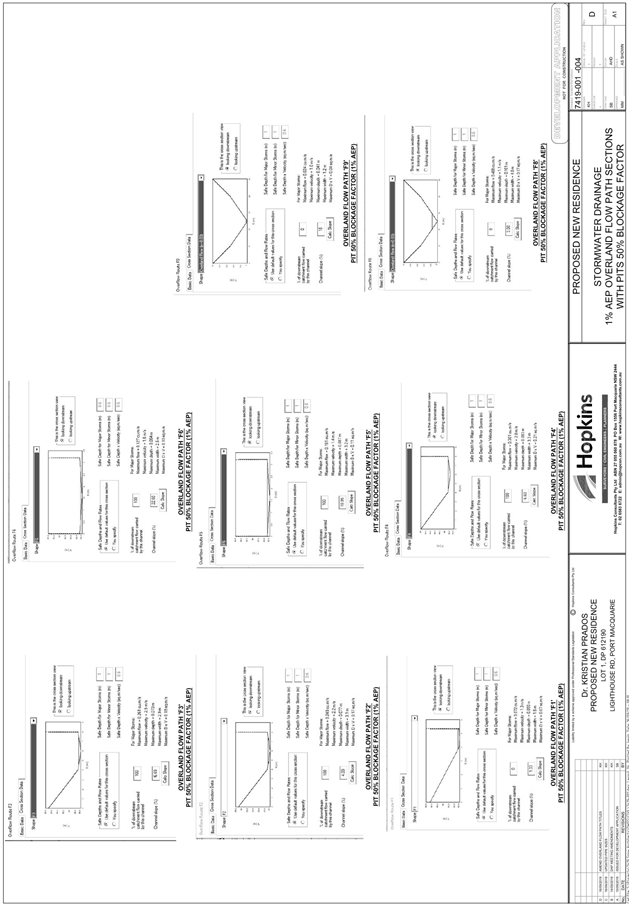
Stormwater
There is no stormwater infrastructure available for direct
connection to the development. The site is traversed by an existing natural
gully and flowpath and the existing dwelling is drained to Pacific Drive via a
dilapidated small diameter stormwater outlet.
Following the DAP resolution on 28 August 2019 to provide
more information on stormwater management, the proponent’s architect met
with Council’s Senior Stormwater Engineer on site. It was confirmed that
an overland flow path was required around/through the site to allow for the
conveyance of stormwater runoff from the existing natural gully traversing the
site. In addition, the method via which stormwater flows flowing within the
gully needed to be managed in such a way to not increase the volume, rate or
location of discharge into the lower section of the gully on the adjoining
downstream property. The rationale for this advice was to ensure that the
development did not result in any negative impacts on adjoining properties.
This approach was also a means of ensuring that the stormwater flows from
upstream could be safely conveyed through the development site.
An amended concept plan was subsequently prepared and
submitted to DAP on 11 September 2019 and included (amongst others), the
relocation of the dwelling to provide an overland flowpath, an overland flow
swale around the dwelling and an extensive piped drainage system to capture and
convey flows through the site. The application was further deferred at the DAP
meeting on 11 September 2019 generally on the basis that the submitted
stormwater plan did not include enough detail to demonstrate the specifics of
flows were captured and safely conveyed through the site. At this time, the
plans were also inconsistent with the architectural details accompanying the
submission. A written report summarising the stormwater concept was also sought
at this time.
Following the DAP meeting, Council’s Senior Stormwater
Engineer met with the Applicant’s Engineer to discuss
options/requirements for the safe and efficient drainage of the site and the
submission requirements.
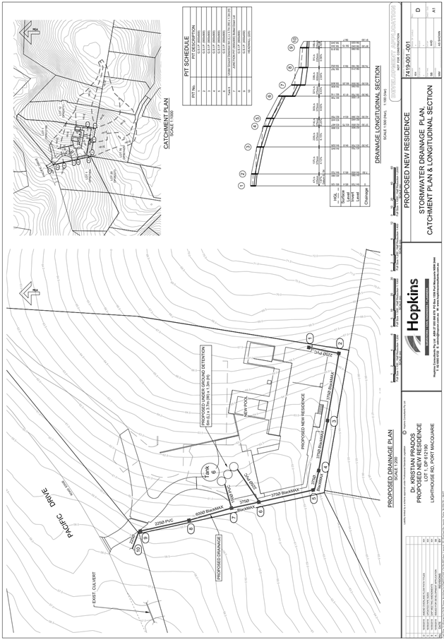
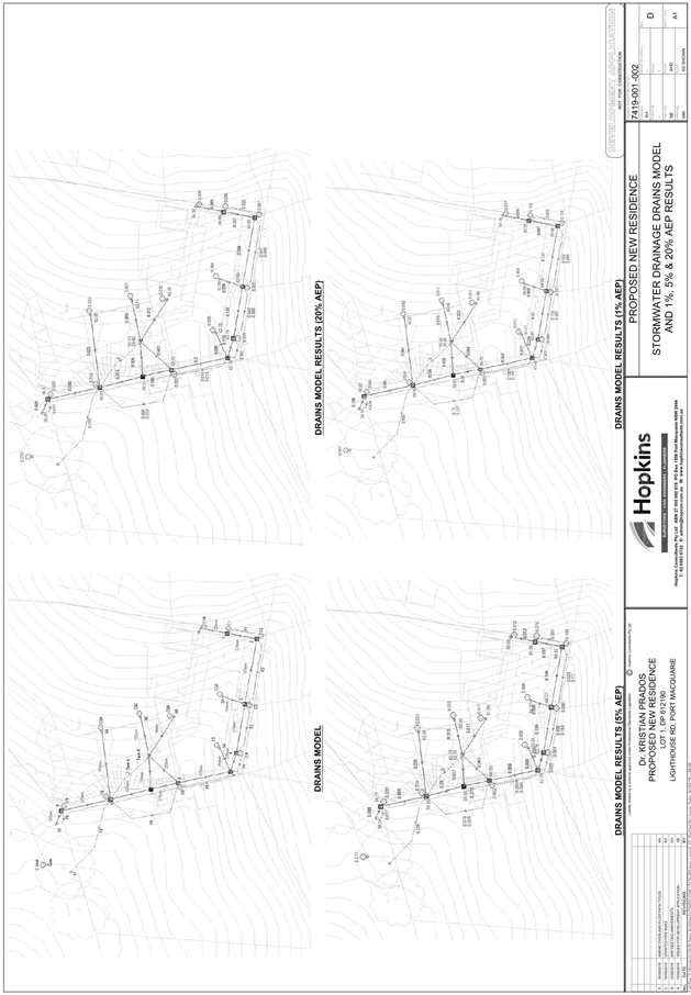
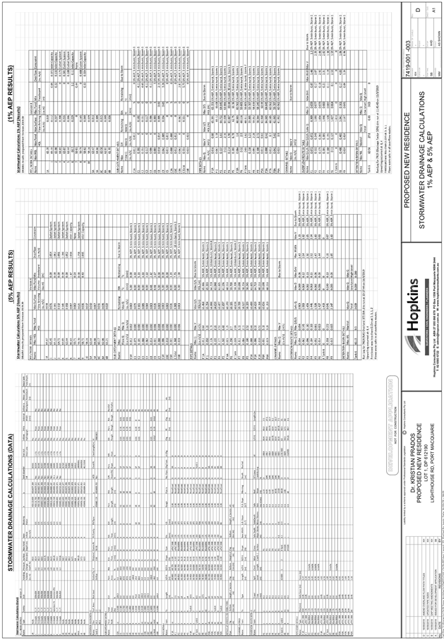
An amended stormwater drainage plan and accompanying report
was submitted to Council on Monday 16 September 2019. The amended stormwater
drainage plan incorporates the following features:
· Provision of an
extensive piped drainage system and overland flow swale to capture and convey
flows generated by the natural gully traversing the site. The overland flowpath
component includes a ‘v shaped swale’ located within the 5m
building setback to the south and demonstrates that freeboard of 240mm is
available to the adjoining floor levels. This freeboard is considered
acceptable on the basis that it represents 275% of the depth of flows modelled
to occur in the 1% AEP event.
· On-site stormwater
detention facilities, designed to limit post development discharge to
pre-development rates.
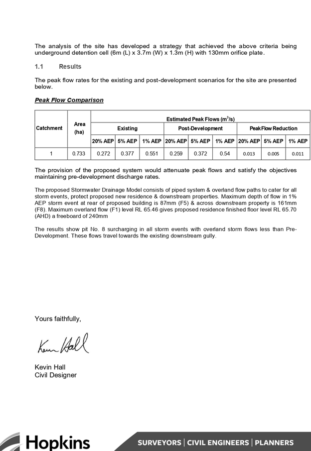
· Twin outlets, with
one being a low-flow outlet to Pacific Dr via a 225mm diameter pipeline, and a
second outlet being a surcharge pit (shown as pit 8 on the plans), discharging
larger flows into the downstream part of the gully traversing the adjoining
property. Modelling submitted within the plans and the accompanying report
indicates that discharge from the site will be marginally less than the
pre-development scenario for all storm events modelled.
Subject to detailed design and modelling at S.68 application
stage, the proposal would result in a lessening of the volume and rate of
runoff entering the natural gully traversing the adjoining downstream property,
whilst also providing for the safe conveyance of stormwater flows from the
upstream gully through the site.
The proposed drainage strategy is considered acceptable and
no objections are raised with respect to the proposal from a stormwater
perspective subject to the submission of detailed plans and calculations at
S.68 application stage.
Other Utilities
Telecommunication and electricity
services are available to the site.
Heritage
This site does not contain or
adjoin any known heritage item or site of significance.
Other land resources
The proposal will not sterilise
any significant mineral or agricultural resource.
Water cycle
The proposed development will be
unlikely to have any adverse impacts on water resources and the water cycle.
Soils
The proposed development will be
unlikely to have any adverse impacts on soils in terms of quality, erosion,
stability and/or productivity subject to a standard condition requiring erosion
and sediment controls to be in place prior to and during construction.
Air and microclimate
The construction and/or operations
of the proposed development will be unlikely to result in any adverse impacts
on the existing air quality or result in any pollution. Standard precautionary
site management condition recommended.
Flora and fauna
The proposed development
includes removal of some exotic/ornamental plants and one Narrow-leaved
Scribbly Gum in the south-eastern corner of the site. The Biodiversity Offset
Scheme does not apply for the following reasons:
· The
land wasn’t identified on the Biodiversity Values Map at the time the
application was made;
· The
extent of clearing is below the thresholds in Clause 7.2 of the Biodiversity
Conservation Regulation 2017;
· The
application of test of significance (5 part test) demonstrates that the
development will not have a significant impact on biodiversity values.
The application was supported by a site vegetation
assessment, prepared by Biodiversity Australia, dated 24 May 2019. The onsite
assessment concludes:
“that the vegetation
does not comprise Littoral Rainforest as it lacks key floristic and structural
attributes. Vegetation on adjoining land to the south is also unlikely to
qualify as Littoral Rainforest at present, however it would have the potential
to regenerate into Littoral Rainforest if weeds are removed.
It is recommended that the
Coastal SEPP mapping layer is amended to remove the Littoral Rainforest mapping
from both the subject site and the adjoining land to the south.”
This advice also formed part of the correspondence sent to
the Department when seeking the Planning Secretary’s Environmental
Assessment Requirements (SEARs). It is noted that the SEARs issued by the
Department have no specific requirements surrounding flora and fauna impacts. A
copy of the issued SEARs is provided as an attachment this report.
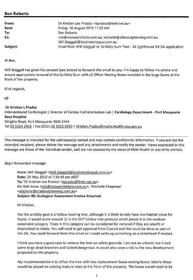
The Narrow-leaved Scribbly Gum while recognised as dangerous
does contain some hollowing bearing potential. Refer to comments in DCP table
earlier within report.
Subsequent advice from the ecologist has confirmed that this
tree is likely to have low habitat value and that its removal should be offset
by the installation of two nest boxes within the existing mature eucalypts at
the front of the property. The ecologist also recommends the nest boxes be
installed by an ecologist prior to removal of the tree and that the tree
removal be supervised by an ecologist. In addition and consistent with the DCP
provisions two compensatory Koala food trees are to be provided on the site.
Suitable conditions have been recommended.
Waste
Satisfactory arrangements are in
place for proposed storage and collection of waste and recyclables. No adverse
impacts anticipated. Standard precautionary site management condition
recommended.
Energy
The proposal includes measures to
address energy efficiency and will be required to comply with the requirements
of BASIX.
Noise and vibration
No adverse impacts anticipated.
Condition recommended to restrict construction to standard construction hours.
Bushfire
The site is identified as being
bushfire prone. The applicant has submitted a Bushfire Attack Level (BAL)
certificate prepared by a qualified professional.
A review of the certificate and
assessment of bushfire risk having regard to section 4.3.5 of Planning for
Bushfire Protection 2006 including vegetation classification and slope
concludes that a Bushfire Attack Level 19 shall be required.
Management of bushfire risk is
acceptable subject to BAL construction levels being implemented and APZ being
maintained. An appropriate condition has been recommended.
Safety, security and crime
prevention
The proposed development will be
unlikely to create any concealment/entrapment areas or crime spots that would
result in any identifiable loss of safety or reduction of security in the
immediate area.
Social impacts in the locality
Given the nature of the proposed
development and its’ location the proposal is unlikely to result in any
adverse social impacts.
Economic impact in the locality
No adverse impacts. A likely
positive impact is that the development will maintain employment in the
construction industry, which will lead to flow impacts such as expenditure in
the area.
Site design and internal design
The proposed development design
satisfactorily responds to the site attributes and will fit into the locality.
No adverse impacts likely.
Construction
No potential adverse impacts
identified to neighbouring properties with the construction of the proposal.
Cumulative Impacts
The proposed development is not expected to have any
adverse cumulative impacts on the natural or built environment or the social
and economic attributes of the locality.
(c) The suitability of the site for
the development
The proposal will fit into the locality and
the site attributes are conducive to the proposed development.
Site
constraints have been adequately addressed and appropriate conditions of
consent recommended.
(d) Any submissions made in
accordance with this Act or the Regulation
One (1) written submission has been received following public
exhibition of the application.
Key issues raised in the submission received and comments
in response to these issues are provided as follows:
|
Submission
Issue/Summary
|
Planning
Comment/Response
|
|
The setback to the rear
boundary is too close and should be increased by a further 2m and established
as a green buffer zone.
|
Refer to DCP table and
comments. The dwelling setback at the rear has been increased to a minimum 5m
setback and is now compliant with the DCP.
|
|
Responsibility for trimming vegetation on the common
boundary.
|
Any existing or proposed vegetation removal or pruning is
subject to the provisions of the adopted Development Control Plan 2013. The Trees
(Disputes between neighbours) Act 2006 covers any disputes between
neighbours involving trees.
|
|
There have been numerous complaints from neighbours
regarding barking dogs at night. It is requested the proposed kennel be
relocated north of the dwelling.
|
The kennel is no longer proposed under this application.
|
|
It is requested that the large gum tree proposed to be
removed be retained. It provides privacy and is part of the local Koala
habitat. If this is not possible then replacement plantings should be
undertaken.
|
Refer to comments in flora and fauna and DCP table
section of this report. Two nest boxes have been recommended by the ecologist
to be provided onsite. Two replacement Koala tree plantings shall also be
required consistent with DCP 2013 provisions.
No adverse privacy impacts would result from the tree
removal that would warrant refusal of this application.
|
|
It is requested that the rainwater tank abut the wall of
the proposed building as opposed to being on the boundary fence.
|
The rainwater tank location will not have any adverse
impacts to the southern neighbouring dwelling to warrant requesting
relocation. The tank is set much lower that the southern neighbour and there
is a significant separation distance between the tank and this adjacent
dwelling.
|
(e) The Public Interest
The proposed
development satisfies relevant planning controls and will not adversely impact
on the wider public interest.
4. DEVELOPMENT
CONTRIBUTIONS APPLICABLE
Not applicable.
5. CONCLUSION AND
STATEMENT OF REASON
The application has been assessed
in accordance with Section 4.15 of the Environmental Planning and Assessment
Act 1979.
Issues raised during assessment
and public exhibition of the application have been considered in the assessment
of the application. Where relevant, conditions have been recommended to manage
the impacts attributed to these issues.
The site is considered suitable
for the proposed development and the proposal adequately addresses relevant
planning controls. The development is not considered to be contrary to the
public's interest and will not result a significant adverse social,
environmental or economic impact. It is recommended that the application be
approved, subject to the recommended conditions of consent provided in the
attachment section of this report.
|
Attachments
1View. DA2019
- 154. Recommended DA Conditions.
2View. DA2019
- 154.1 Environmental Impact Statement
3View. DA2019
- 154.1 Amended DA Plans.
4View. DA2019
- 154.1 Stormwater Management Plan.
5View. DA2019
- 154.1 Amended Stormwater Details
6View. DA2019
- 154.1 Email Steggall - Scribbbly Gum Tree - HBT Potential and Recommended
Nest Box Offsetting
7View. DA2019
- 154.1 Ecology Advice - Vegetation Classification - Will Steggall
8View. DA2019
- 154.1 SEARs Local Secretary - Environmental Assessment Requirements
|
|
ATTACHMENT
|
Development Assessment Panel
25/09/2019
|
|
ATTACHMENT
|
Development Assessment Panel
25/09/2019
|


|
ATTACHMENT
|
Development Assessment Panel
25/09/2019
|

|
ATTACHMENT
|
Development Assessment Panel
25/09/2019
|
|
ATTACHMENT
|
Development Assessment Panel
25/09/2019
|
|
ATTACHMENT
|
Development Assessment Panel
25/09/2019
|


|
ATTACHMENT
|
Development Assessment Panel
25/09/2019
|


|
ATTACHMENT
|
Development Assessment Panel
25/09/2019
|
AGENDA Development Assessment Panel 25/09/2019
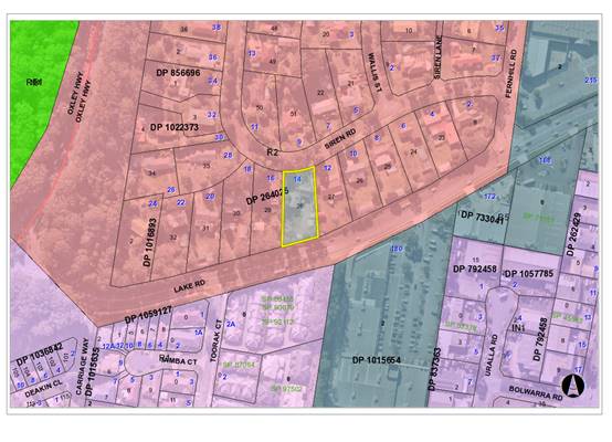
Item: 06
Subject: DA2019 - 200.1 Change of Use - Dwelling to
Medical Centre at Lot 28 DP 264025, No. 14 Siren Road, Port Macquarie
Report
Author: Development Assessment Planner, Chris Gardiner
|
Applicant: Encompass
Drafting
Owner: J
N & P J Cullen
Estimated Cost: $100,000
Alignment with Delivery
Program
4.3.1 Undertake transparent
and efficient development assessment in accordance with relevant legislation.
|
|
RECOMMENDATION
That
DA2018 - 200.1 for a Change of
Use - Dwelling to Medical Centre at Lot 28, DP 264025, No. 14 Siren Road, Port
Macquarie, be determined by granting consent
subject to the recommended conditions.
|
Executive
Summary
This
report considers a development application for a change of use from
dwelling to medical centre at the subject site and
provides an assessment of the application in accordance with the Environmental
Planning and Assessment Act 1979.
The proposal has been amended
during the assessment of the application.
Following exhibition of the
application, 38 submissions have been
received.
This report recommends that the
development application be approved subject to the attached conditions.
1. BACKGROUND
Existing Sites Features and Surrounding Development
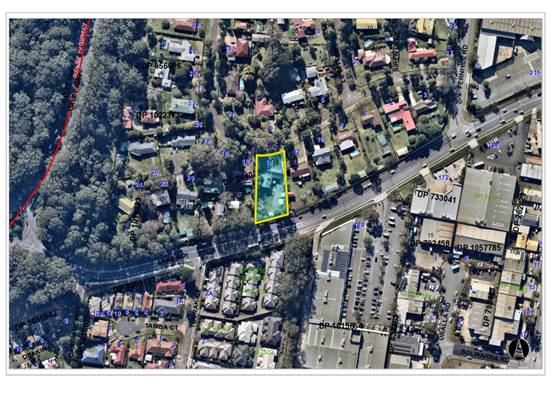
The site has an area of 2193m2.
The site is zoned R2 Low Density Residential in accordance with the Port Macquarie-Hastings Local
Environmental Plan 2011, as shown in the following zoning plan:
The existing subdivision pattern and location of existing
development within the locality is shown in the following aerial photograph:
2. DESCRIPTION OF
DEVELOPMENT
Key aspects of the proposal include the following:
· Change
of use from dwelling to medical centre;
· Alterations
to existing building;
· Construction
of associated access and car parking facilities.
Refer
to attachments at the end of this report for further details.
Application Chronology
· 21
March 2019 - Application lodged.
· 1 April 2019 to 15 April 2019 - Neighbour notification.
· 15 May 2019 - Additional information requested from
Applicant.
· 8 July 2019 - Additional information and amended plans
submitted by Applicant.
· 24 July 2019 to 6 August 2019 - Application re-notified
with amended plans and additional information.
3. STATUTORY ASSESSMENT
Section 4.15(1) Matters for Consideration
In determining the application, Council is required to take
into consideration the following matters as are relevant to the development
that apply to the land to which the development application relates:
(a) The provisions (where
applicable) of:
(i) Any Environmental
Planning Instrument
State Environmental Planning Policy No. 55 –
Remediation of Land
Following an inspection of the site and a search of Council
records, the subject land is not identified as being potentially contaminated
and is suitable for the intended use.
State Environmental Planning Policy No. 64 –
Advertising and Signage
The proposed development includes proposed signage in the
form of two business identification signs (a 1.2m x 1.2m sign adjacent to the
driveway, and a 1.2m x 1.2m sign fixed to the rear fence facing Lake Road).
In accordance with clause 7, this SEPP prevails over the
Port Macquarie-Hastings LEP 2011 in the event of any inconsistency.
The following assessment table provides an assessment
checklist against the Schedule 1 requirements of this SEPP:
|
Applicable clauses for consideration
|
Comments
|
Satisfactory
|
|
Clause 8(a) Consistent with
objectives of the policy as set out in Clause 3(1)(a).
|
The proposal is considered to be
consistent with the aims and objectives of the SEPP.
|
Yes
|
Schedule
1(1) Character of the area.
|
The area is characterised by low
density residential uses and there are no other examples of signage in the
immediate area. The signage could be considered to be compatible with the
character of the area if it is of appropriate scale and any amenity impacts
(such as illumination) can be appropriately managed.
In this regard SEPP (Exempt and Complying Development
Codes) 2008 permits wall signs up to 2.5m2 without consent in a
residential zone and this could be used as a guide for what should be
considered appropriate.
The proposal is for a business identification sign
adjacent to the site access and having dimensions of 1.2m x 1.2m (1.44m2)
and an additional business identification sign also having dimensions of 1.2m
x 1.2m (1.44m2) fixed to the rear fence facing Lake Road. The
plans do not specify the height of the sign structure adjacent to Siren Road,
and a condition is recommended restricting the height to 1.2m to ensure that
the scale of the sign is compatible with the residential character of the locality.
Neither sign is proposed to be illuminated.
|
Yes
|
|
Schedule 1(2) Special areas.
|
The site is located in a
residential area. As noted above, the signage is considered to be compatible
with the residential setting.
|
Yes
|
|
Schedule 1(3) Views and vistas.
|
The signage would not adversely
affect any views or vistas.
|
Yes
|
|
Schedule 1(4) Streetscape,
setting or landscape.
|
The scale and proportions of the
signage are appropriate for the streetscape setting. The signs would not
protrude above buildings or the tree canopy.
|
Yes
|
|
Schedule 1(5) Site and building.
|
The scale and proportions of the
signage are appropriate to the scale of the building.
|
Yes
|
|
Schedule 1(6) Associated devices
and logos with advertisements and advertising structures.
|
None proposed.
|
N/A
|
|
Schedule 1(7) Illumination.
|
Neither sign is proposed to be
illuminated.
|
N/A
|
|
Schedule 1(8) Safety.
|
The signage is not expected to adversely affect vehicular,
cyclist, or pedestrian safety.
|
Yes
|
State Environmental Planning Policy (Infrastructure) 2007
Clause 57(1) - Health services facilities are permitted with
consent by any person as the land is in a prescribed zone.
Port Macquarie-Hastings Local Environmental
Plan 2011
The proposal is consistent with the LEP having regard to the
following:
· Clause
2.2 - the subject site is zoned R2 Low Density Residential.
· Clause
2.3(1) and the R2 zone landuse table - The proposed development for a medical
centre is a prohibited land use in the zone. However, the proposal is
permissible in accordance with Clause 57(1) of State Environmental Planning
Policy (Infrastructure) 2007.
The objectives of the R2 zone are as
follows:
o To provide for
the housing needs of the community within a low density residential
environment.
o To enable other
land uses that provide facilities or services to meet the day to day needs of
residents.
o To provide for
low density housing that does not compromise the environmental, scenic or
landscape qualities of land.
Clause 2.3(2) - The proposal is
consistent with the zone objectives having regard to the following:
o The proposal provides a
medical service to meet the day to day needs of residents.
o The proposal would not
increase the density of the existing development on the site.
· Clause
4.3 - The maximum overall height of the building above ground level (existing)
is 6.3m which complies with the standard height limit of 8.5m applying to the
site.
· Clause
5.10 - The site does not contain or adjoin any known heritage items or sites of
significance.
· Clause
7.13 - Satisfactory arrangements are in place for provision of essential
services including water supply, electricity supply, sewer infrastructure,
stormwater drainage and suitable road access to service the development.
(ii) Any
draft instruments that apply to the site or are on exhibition
No draft
instruments apply to the site.
(iii) Any
Development Control Plan in force
Port
Macquarie-Hastings Development Control Plan 2013
|
DCP
2013: General Provisions
|
|
DCP
Objective
|
Development
Provisions
|
Proposed
|
Complies
|
|
2.2.2.1
|
Signs primarily identifying
products or services are not acceptable, even where relating to products or services
available on that site.
|
Sign proposed to identify
business name.
|
Yes
|
|
Signage is not permitted
outside property boundaries except where mounted upon buildings and clear of
pedestrians and road traffic. No signage is permitted upon light or power
poles or upon the nature strip (the area between the property boundary and
constructed roadway). Limited directional
signage and “A”
frame signage may separately be approved by Council under the Roads Act
1993 or section 68 of the Local government Act 1993.
|
No signage proposed outside
property boundaries.
|
Yes
|
|
An on-building 'chalkboard'
sign, for the purpose of describing services or goods for sale which vary on
a regular basis generally should not be any larger than 1.5m2, and should
contain a sign written heading indicating the premises to which it refers.
|
N/A
|
N/A
|
|
On-premise signs should not
project above or to the side of building facades
|
N/A
|
N/A
|
|
2.2.2.2
|
Where there is potential for
light spill from signage in a non residential zone adjoining or adjacent to
residential development, illuminated signage is to be fitted with a time
switch to dim by 50% or turn off the light by 11pm each night, depending on
the nature of the development.
|
No illumination of signage
proposed.
|
|
|
2.7.2.2
|
Design addresses generic
principles of Crime Prevention Through Environmental Design guideline:
· Casual
surveillance and sightlines
· Land use mix and
activity generators
· Definition of
use and ownership
· Lighting
· Way finding
· Predictable
routes and entrapment locations
|
The proposed development is
unlikely to create any concealment/entrapment areas or crime spots that would
result in any identifiable loss of safety or reduction of security in the
immediate area.
|
Yes
|
|
2.3.3.1
|
Cut and fill 1.0m max. 1m
outside the perimeter of the external building walls
|
1.2m of cut identified for
retaining wall at front of car park. The excavation would not result in any
adverse privacy, stormwater, or stability issues, subject to appropriate
engineering of the retaining wall. The excavation would assist in reducing
the visual impact of the proposed parking area.
|
No, but acceptable
|
|
2.3.3.2
|
1m max. height retaining walls
along road frontages
|
Retaining wall up to 1.2m
high. The retaining wall is proposed to support excavation for the car park
and would not be visible from the street. Considered consistent with the
objective of the provision.
|
No, but acceptable
|
|
Any retaining wall >1.0 in
height to be certified by structural engineer
|
Condition recommended
requiring engineering certification of retaining wall
|
|
|
Combination of retaining wall
and front fence height
|
No retaining wall front fence
combination proposed.
|
Yes
|
|
2.3.3.8 onwards
|
Removal of hollow bearing
trees
|
None proposed to be removed.
|
Yes
|
|
2.6.3.1
|
Tree removal (3m or higher
with 100mm diameter trunk and 3m outside dwelling footprint
|
The proposal includes removal
of a number of existing trees that require consent. No Koala food trees are
proposed to be removed, and offsets are not required.
|
Yes
|
|
2.4.3
|
Bushfire risk, Acid sulphate
soils, Flooding, Contamination, Airspace protection, Noise and Stormwater
|
Refer to main body of report.
|
|
|
2.5.3.2
|
New accesses not permitted
from arterial or distributor roads. Existing accesses rationalised or removed
where practical
|
Access to local road.
|
Yes
|
|
Driveway crossing/s minimal in
number and width including maximising street parking
|
Single driveway of acceptable
width. Minimal reduction in existing street parking.
|
Yes
|
|
2.5.3.3
|
Off-street parking in
accordance with Table 2.5.1.
(Provision to consider reduced
parking where supported by parking demand study)
|
For medical centres Table
2.5.1 requires 3 spaces per consultant, plus 1 space per 2 employees.
The Statement of Environmental
Effects indicates that the development would have 5 consultants and 2
employees, which would require a minimum of 16 off street parking spaces.
The submitted proposal
includes 21 spaces, which satisfies this requirement.
Spaces 11 and 12 do not have
sufficient aisle width and are not usable without demolition of the existing
shed. Even with the loss of these spaces the development would provide 19
spaces, which is in excess of the DCP requirement.
|
Yes
|
|
2.5.3.4
|
Parking credits to be
calculated for redevelopment or change of use
|
N/A
|
N/A
|
|
2.5.3.5
|
On-street parking permitted
subject to justification
|
N/A
|
N/A
|
|
2.5.3.6
|
On street parking will not be
permitted unless it can be demonstrated that:
· that streetscape
improvement works, such as landscaped bays and street trees are provided.
· parking does not
detract from the streetscape; and
|
N/A
|
N/A
|
|
2.5.3.7
|
Visitor parking to be easily
accessible
|
Majority of customer parking
located at the front of the site and easily accessible from Siren Road.
Signage will be required to identify that additional parking is available at
the rear of the site.
|
Yes
|
|
Stacked parking permitted for
medium density where visitor parking and 5.5m length achieved
|
N/A
|
N/A
|
|
Parking layout in accordance
with AS/NZS 2890.1 and AS/NZS 2890.2
|
See comments under Parking and
Manoeuvring later in this report.
|
|
|
Parking spaces generally
located behind building line
|
Part of the parking provision
proposed forward of the building line. See comments under 2.5.3.12 and
2.5.3.13 below.
|
|
|
2.5.3.8
|
Accessible parking provided in
accordance with AS/NZS 2890.1, AS/NZS 2890.2 and AS 1428
|
One accessible space proposed.
|
Yes
|
|
Additional accessible spaces
where development would have high volume of aged or disabled traffic
|
N/A
|
N/A
|
|
2.5.3.9
|
Bicycle and motorcycle parking
considered and designed generally in accordance with the principles of
AS2890.3
|
None proposed.
|
N/A
|
|
2.5.3.10
|
Parking concessions possible
for conservation of heritage items
|
N/A
|
N/A
|
|
2.5.3.11
|
Section 94 contributions
|
Refer to main body of report.
|
|
|
2.5.3.12 and 2.5.3.13
|
Landscaping of parking areas
|
The proposal includes a
landscaped strip with a width of between 600mm and 850mm, which is less than
the minimum of 3m recommended in the DCP.
|
No*
|
|
2.5.3.14
|
Sealed driveway surfaces
unless justified
|
Condition recommended
confirming this requirement.
|
Yes
|
|
2.5.3.15
|
Driveway grades for first 6m
of ‘parking area’ shall be 5% grade (Note AS/NZS 2890.1 allows
for steeper grades)
|
Capable of complying. Details
to be submitted with the Section 138 and Construction Certificate
applications.
|
Yes
|
|
2.5.3.16
|
Transitional grades min. 2m
length
|
Capable of complying. Details
to be submitted with the Section 138 and Construction Certificate
applications.
|
Yes
|
|
2.5.3.17
|
Parking areas to be designed
to avoid concentrations of water runoff on the surface.
|
See comments under Stormwater
later in this report.
|
|
|
Vehicle washing facilities
– grassed area etc available.
|
|
No direct discharge to K&G
or swale drain
|
|
2.5.3.18
|
Car parking areas drained to
swales, bio retention, rain gardens and infiltration areas
|
Capable of complying. Detailed
design to be submitted at the Section 68/ Construction Certificate
application stage.
|
Yes
|
|
2.5.3.19
|
Commercial development having
a floor space less than 500m² need not provide a loading bay.
|
The proposal has a floor area
of less than 500m2 and does not require a loading bay.
|
Yes
|
The proposal
seeks to vary Development Provision 2.5.3.12 in relation to the minimum width
of landscaping for parking areas located forward of the building line.
The relevant
objectives of the provision are as follows:
· Parking
areas are visually pleasing and easily accessible;
· Parking
areas shall be landscaped to:
- Provide shade;
- Improve the visual amenity of
large, unrelieved hard stand areas;
- Provide a buffer between the road
and neighbouring land uses.
The proposal
is considered to be consistent with the objectives of the control for the
following reasons:
· The
width of the landscaped area is sufficient to provide visually pleasing
landscaping of sufficient scale to soften the visual impact of the parking
area.
· The
proposal will retain mature shade trees, and the parking area is not of a scale
that would warrant planting of additional large trees.
· The
parking area would be excavated up to 1.2m below the existing ground level,
which would also contribute to reducing the visual impact.
Based on the
above assessment, the variations proposed to the provisions of the DCP are
considered acceptable and the relevant objectives have been satisfied.
Cumulatively, the variations do not amount to an adverse impact of a
significance that would justify refusal of the application.
(iiia) Any
planning agreement that has been entered into under section 7.4, or any draft
planning agreement that a developer has offered to enter into under section 7.4
No planning
agreement has been offered or entered into relating to the site.
iv) Any matters prescribed by the
Regulations:
Clause 92
- Demolition of buildings
Demolition
work on the site is capable of compliance with this Australian Standard 2601
and is recommended to be conditioned.
(b) The
likely impacts of that development, including environmental impacts on both the
natural and built environments, social and economic impacts in the locality:
The site has
a general northerly street frontage orientation to Siren Road and a southerly
orientation to Lake Road. The site and other properties on the southern side of
Siren Road are not permitted vehicular access to Lake Road and have been
designed with access off Siren Road.
Adjoining the
site to the north, east, and west are low density residential uses typically
consisting of single dwellings on lots with an area of approximately 2000m2.
Adjoining the
site to the south is multi dwelling housing and bulky goods premises on the
southern side of Lake Road.
The proposal
is considered to be compatible with other development in the locality and
adequately addresses planning controls for the area.
Roads
The site has
road frontage to Siren Road. Adjacent to the site, Siren Road is a sealed
public road under the care and control of Council. Siren Road is a local street
with a 7.5m wide road pavement within a 19m road reserve. There is SE kerb and
gutter present, with on-street parking currently being utilised in the street.
Traffic
and Transport
The site is
currently approved for residential use and is expected on average to generate 9
daily trips.
The
application includes a Traffic Impact Assessment (TIA) from StreetWise Road
Safety & Traffic Services Pty Ltd and dated 4 July 2019. The TIA estimates
that the development would generate between 26 and 32 daily trips, based on
data collected at the current premises where the business is being operated.
An assessment
of the intersection of Fernhill Road and Siren Road found that traffic volumes
warrant an upgrade to a channelised right turn CHR(s) intersection in
accordance with Figure 2.26c of the Austroads Guide to Traffic Management, Part
6 – Intersections, Interchanges and Crossings. The traffic consultants
consider that the existing intersection is acceptable for the following
reasons:
· Sidra
Modelling for the existing intersection based on 10 years traffic growth, the
re-development of the old Bunnings site, plus the Medical Centre development,
found that all scenarios resulted in a Level of Service (LOS) A and the
intersection will continue operate within capacity.
· The
existing intersection already exceeds the warrants for upgrade to CHR, and the
development would only result in a minor increase in traffic.
· Council
did not require the intersection to be upgraded as part of the re-development
of the former Bunnings site.
It is
considered that the traffic generation has been underestimated and the proposal
would be more likely to generate in the order of 100 daily trips (based upon 5
consulting rooms, with 1 patient per hour from 8.30am to 5.00pm, and 7
employees). The addition in traffic associated with the development is likely
to have some impact on the existing road network within the immediate locality,
with some turning movements at the Siren Road / Fernhill Road intersection
already impeded at current peak traffic volumes.
The
redevelopment of the former Bunnings site at 215 Lake Road, under DA2018 -
1110.1 did not trigger the requirement for any upgrades to the intersection of
the site access and Fernhill Road due to the proposed development having lower
traffic generation than the existing approved use. There was no increase in
traffic turning from Fernhill Road into Siren Road associated with this
development.
The current
proposal would create a clear increase in traffic turning right and left from
Fernhill Road into Siren Road, as noted in the TIA (even with the low traffic
generation rates assumed by the traffic consultant). It is considered that
there is a clear nexus to require appropriate mitigation of traffic impacts
based upon the increased traffic volumes at the intersection. It is recommended
that the intersection be upgraded to a channelised right turn CHR(s)
intersection in accordance with Figure 2.26c of the Austroads Guide to Traffic
Management, Part 6 – Intersections, Interchanges and Crossings. The
upgrade could be achieved with changes to the existing line marking and would
not require widening of the road carriageway in Fernhill Road. A condition has
been recommended confirming this requirement.
Siren Road is
a local street in the Auspec classification, and has a design volume of up to
2000 vehicles per day. The street has capacity for the additional traffic
generation anticipated for the development.
Site
Frontage and Access
Vehicle access to the site is proposed though a single 6m
wide access driveway to Siren Road. Access shall comply with Council
AUSPEC and Australian Standards, and conditions have been imposed to reflect
these requirements.
Due to the type and size of
development, additional works are required to include:
· Concrete footpath paving
(minimum 1.2m wide) along the full frontage
·
·
Refer to recommended relevant conditions of consent.
Parking
and Manoeuvring
Parking and
driveway widths on site can comply with relevant Australian Standards (AS 2890)
and conditions have been imposed to reflect these requirements. There is a
non-conformance for the minimum aisle width down the eastern side of the
building (AS2890.1 requires 3.6m, while 2.9m is available). This is considered
acceptable only on the basis of the proposed staff only usage of the parking
area, and the low traffic volumes anticipated.
Due to the
restricted aisle width, a condition is recommended to restrict staff parking to
the rear car park only with the front parking bays kept free for patients. This
would assist in minimising the traffic flow down the side of the building.
Convex mirrors and give way signage are also recommended.
The parking
spaces numbered 11 and 12 will need to either be deleted, or the existing
storage shed demolished to provide adequate aisle width.
Due to the
type of development, car park circulation is required to enable vehicles to
enter and exit the site in a forward manner. Site plans show adequate area is
available and conditions have been imposed to reflect these requirements. The
plans submitted with the Construction Certificate application will need to
demonstrate the functionality of the turning bay in the front parking area, and
also provide for a turning bay in the rear parking area.
Refer to
relevant recommended conditions of consent.
Water
Supply Connection
Council
records indicate that the development site has an existing 20mm metered water
service. Final water service sizing will need to be determined by a hydraulic
consultant to suit the domestic and commercial components of the development,
as well as fire service and backflow protection requirements in accordance with
AS3500. Minimum backflow protection for a medical centre is a Reduced Pressure
Zone Device (RPZ) at the boundary.
Detailed
plans will be required to be submitted for assessment with the S.68
application.
Refer to
relevant recommended conditions of consent.
Sewer
Connection
Council
records indicate that the development site is connected to Sewer via junction
to the existing sewer manhole in the south eastern corner of the development
site. The proposed development may discharge all sewage to the existing point
of connection to Council’s sewer system. No additional loads are to be
imposed on the existing sewer main, which runs inside the southern property
boundary.
Refer to
relevant recommended conditions of consent.
Stormwater
The site
naturally grades towards the rear of the property and is currently un-serviced
via the public piped drainage system.
The legal
point of discharge for the proposed development is defined as either:
· a
suitably sized transpiration pit, which can be demonstrated to effectively
accommodate the runoff generated by the site; or
· a
direct connection to Council’s stormwater pit/pipeline, which would
involve an extension of the existing network within Lake Road.
A detailed
site stormwater management plan will be required to be submitted for assessment
with the Section 68 application and prior to the issue of a Construction
Certificate.
In accordance
with Councils AUSPEC requirements, the following must be incorporated into the
stormwater drainage plan:
· On
site stormwater detention facilities to limit site stormwater discharge to pre
development flow rates for all storm events up to and including the 100 year
ARI event. Note that pre development discharge shall be calculated assuming
that the site is a ‘greenfield’ development site as per AUSPEC
requirements.
Refer to
relevant recommended conditions of consent.
Other
Utilities
Telecommunication
and electricity services are available to the site.
Heritage
No known
items of Aboriginal or European heritage significance exist on the property. No
adverse impacts anticipated.
Other land
resources
The site is
within an established urban context and will not sterilise any significant
mineral or agricultural resource.
Water
cycle
The proposed
development is unlikely to have any adverse impacts on water resources and the
water cycle.
Soils
The proposed
development is unlikely to have any adverse impacts on soils in terms of
quality, erosion, stability and/or productivity subject to a standard condition
requiring erosion and sediment controls to be in place prior to and during
construction.
Air and
microclimate
The
construction and/or operations of the proposed development are unlikely to
result in any adverse impacts on the existing air quality or result in any
pollution. Standard precautionary site management condition recommended.
Flora and
fauna
The
Biodiversity Offset Scheme doesn’t apply for the following reasons:
· The
land isn’t identified on the Biodiversity Values Map;
· The
extent of clearing is below the thresholds in Clause 7.2 of the Biodiversity
Conservation Regulation 2017;
· The
application of test of significance (5 part test) demonstrates that the
development will not have a significant impact on biodiversity values.
Waste
Adequate area
is available at the rear of the site for storage of waste bins out of public
view. The Applicant has indicated that they intend to use Council’s
kerbside waste collection service for the development. If waste volumes
increase in the future a private waste service will be required.
Medical/clinical
waste shall be removed from the site by an approved waste contractor for
disposal at an appropriately licenced facility and a condition is recommended
confirming this requirement.
Standard
precautionary site management condition recommended for construction
activities.
Energy
The proposal
includes measures to address energy efficiency and will be required to comply
with the requirements of Section J of the Building Code of Australia. No
adverse impacts anticipated.
Noise and
vibration
The submitted
Statement of Environmental Effects indicates that the proposed hours of
operation for the medical centre would be 7.00am to 5.30pm Monday to Friday,
and 9.00am to 12.00pm Saturdays. The application has not been supported by a
noise impact assessment.
Given the
nature and location of the proposed development, it is considered that noise
impacts can be adequately managed through restriction of hours of operation and
fencing adjacent to parking and circulation areas. It is noted that the site
adjoins Lake Road and has relatively high background noise levels.
A condition
has been recommended requiring provision of 1.8m high solid boundary fencing to
the eastern and western sides of the parking area and internal access roads
prior to the issue of an Occupation Certificate.
As the site
is located in a low density residential context and noting significant concerns
regarding noise impacts have been raised by nearby residents, it is recommended
that the hours of operation be further restricted to 8.30am to 5.00pm Monday to
Friday and 9.00am to 12.00pm Saturdays.
A condition
is recommended restricting construction to standard construction hours.
Bushfire
The site is
identified as being bushfire prone.
In accordance
with Planning for Bushfire Protection 2006, construction to the Deemed to
Satisfy provisions of the Building Code of Australia is an acceptable
construction solution for Class 5 to 8 buildings. The proposal is considered to
be consistent with the aims and objectives of Planning for Bushfire Protection
2006 as it provides adequate road access, water supply, and utility services,
and a defendable space around the perimeter of the building.
Safety,
security and crime prevention
The proposed
development will be unlikely to create any concealment/entrapment areas or
crime spots that would result in any identifiable loss of safety or reduction
of security in the immediate area.
Social
impacts in the locality
Given the
nature of the proposed development and its location the proposal is unlikely to
result in any adverse social impacts.
Economic
impact in the locality
No adverse
impacts expected. A likely positive impact is that the development will
maintain employment in the construction industry, which will lead to flow
impacts such as expenditure in the area. Ongoing employment opportunities would
also have an economic benefit.
Site
design and internal design
The proposed
development design satisfactorily responds to the site attributes and will fit
into the locality. No adverse impacts are likely.
Construction
No potential
adverse impacts identified to neighbouring properties with the construction of
the proposal.
Cumulative
impacts
The proposed
development is not expected to have any adverse cumulative impacts on the
natural or built environment or the social and economic attributes of the
locality.
(c) The suitability of the site for
the development
The proposal
will fit into the locality and the site attributes are conducive to the
proposed development.
Site
constraints have been adequately addressed and appropriate conditions of
consent recommended.
(d) Any submissions made in
accordance with this Act or the Regulations
38 written submissions have been received following public
exhibition of the application.
Key issues raised in the submissions received and comments
are provided as follows:
|
Submission
Issue/Summary
|
Planning
Comment/Response
|
|
The proposal is inconsistent
with the character of the area.
|
It is noted that the proposed
use is different to the established residential uses in the locality.
However, a variety of land uses are permitted in the R2 Low Density
Residential zone that are considered capable of being compatible with each
other.
|
|
The site is large and it is of
concern that the business my expand in the future.
|
Any future expansion would be subject to a separate
application.
|
|
The site access is located on a
blind corner and is not safe for the additional traffic.
|
The parking layout provides for vehicles to enter and
exit the site driving forwards and the driveway location has safe sight
distance in both directions.
|
|
The proposal does not adequately
cater for service vehicles.
|
The applicant has indicated that the site is not expected
to be serviced by a vehicle larger than a commercial van, which would be
capable of utilising the parking spaces. Waste collection is proposed via
Council’s kerbside collection service.
|
|
If the application is approved,
hours should be restricted to 9.00am to 4.00pm Monday to Friday, with a
maximum of 1-2 consultants. This would be more compatible with the
residential environment.
|
More restrictive hours than those proposed by the
Applicant have been recommended in the conditions of consent. It is not
considered that there is sufficient grounds to further restrict the hours of
operation or consultant numbers to those suggested.
|
|
The development would result in
an increased generation of waste, which will result in amenity and
environmental issues.
|
Waste from the proposed development is expected to be
within the capacity of the existing waste service and the site has sufficient
area for waste to be stored out of public view between collections. Medical
waste will need to be collected by an appropriately licenced contractor.
|
|
Illumination of signage should
not be permitted in a residential area.
|
The submitted plans have been amended to remove illumination
from the signage.
|
|
Concern that the estate will
turn into another medical precinct similar to Highfields Circuit and the area
surrounding the Port Macquarie Private Hospital.
|
Given that medical centres are permissible in the R2 zone
under State legislation, this possibility cannot be ruled out. However, the
current examples of clustering of medical uses in Port Macquarie appear to be
driven by proximity to the Base Hospital and Private Hospital. There are a
number of examples of isolated medical uses in residential areas that have
not resulted in similar clustering.
|
|
Vehicles parking on both sides
of the road would result in a single traffic lane at a blind corner where it
is difficult to see a vehicle travelling in the opposite direction.
|
Parking is already possible on both sides of the street
as there are no parking restrictions in place. The proposed development
provides off-street parking consistent with the DCP requirements and it
cannot be assumed that the development would have a significant impact on
street parking.
|
|
The poor layout of the proposed
car park will result in people parking in the street rather than on the site.
|
The parking layout has been improved and the public
component of the parking area is capable of complying with AS2890.
|
|
Patients of the service are
likely to suffer from a range of mental health and behavioural issues.
Erratic and aggressive behaviour, and inappropriate language would have adverse
social impacts on nearby residents.
|
Considering the separation distance and recommended
fencing, it is not considered that there is significant potential for such
impacts.
|
|
Information provided by the
proponent prior to lodging the application was misleading.
|
Noted.
|
|
The Applicant’s Statement
of Environmental Effects has not adequately considered the likely noise
impacts of the development.
|
Noted. The staff assessment has considered the likely
noise impacts and recommended conditions accordingly.
|
|
If the development is approved,
would there be a need to get further approval for future changes to the
activities?
|
If the development is granted consent, it would be
necessary to either modify the consent or lodge a new application for any
future expansion, change of the approved use, and changes to conditions of
consent.
|
|
The Applicant’s Statement
of Environmental Effects has not characterised the development for the
purpose of determining whether it is a permissible land use in the R2 zone
Land Use Table.
|
The proposed use has not been clearly characterised in
the Statement of Environmental Effects, but the use is considered to be best
defined as a medical centre.
medical centre means premises that are used for the purpose of
providing health services (including preventative care, diagnosis, medical or
surgical treatment, counselling or alternative therapies) to out-patients
only, where such services are principally provided by health care
professionals. It may include the ancillary provision of other health
services.
As noted earlier in this report, medical centres are
prohibited in the R2 zone under the LEP Land Use Table, but are permitted
with consent under State Environmental Planning Policy (Infrastructure) 2007.
|
|
The application does not include
any detailed assessment of the expected traffic impacts from the development.
|
A Traffic Impact Assessment (TIA) has subsequently been
submitted by the Applicant. The TIA was included in the re-notification of
the proposal.
|
|
Community consultation was not
carried out by the Applicant prior to lodging the application.
|
While Council encourages proponents to carry out their
own community consultation prior to lodging an application, it is not a
statutory requirement for a development of this nature.
|
|
There is no established need for
the facility in the location proposed. An existing medical centre if
available in Jindalee Road within a 5 minute walk for residents in the
estate.
|
The need for the facility and its likely viability are
not matters for consideration in the assessment of the application.
It is noted that there are a broad range of medical
disciplines, and it is generally not possible to provide all relevant
services in a single location.
|
|
Siren Road was designed and
built as a residential road. The width of the road does not for an increased
volume of traffic. Two way traffic flow would be restricted if vehicles park
in the street at the front of the site.
|
Siren Road
has a 7.5m wide road pavement within a 19m road reserve and is classified
under Auspec as a local street. Local streets are designed to accommodate up
to 2000 vehicles per day, and the proposed development is well within the
design capacity of the road.
Parking of vehicles
in residential streets provides natural traffic calming and reduces vehicle
speeds.
|
|
The proposed one-way driveway is
inadequate for the development and does not comply with AS 2890.2.
|
The driveway has been widened to 6.0m wide between the
front car park and Siren Road to provide for two-way traffic flow.
The single width (and non-compliant) part of the driveway
to the eastern side of the building is limited in length and considered
suitable for its intended use, as discussed earlier in this report.
|
|
The extent of Council’s
notification was inadequate as the broader estate will be impacted by the
proposal.
|
The extent of notification is considered to be consistent
with the DCP requirements.
|
|
The stated number of deliveries
to the facility is extremely underestimated.
|
Noted. The staff assessment of traffic impacts has not
relied on the Applicant’s statement in this regard.
|
|
Good town planning should
encourage developments of similar nature to concentrate in selected areas and
not spread throughout established residential estates.
|
The planning controls provide for a range of compatible
land uses in each zone. State legislation considers that health services
facilities (including medical centres) are capable of being compatible with
residential land uses.
|
|
Proposal will result in
destruction of Koala habitat. The submitted plans do not show all existing
trees on the site.
|
The plans have been amended to clearly identify all
vegetation proposed to be removed for the development. No Koala food trees
are proposed to be removed.
|
|
Loss of property value for
nearby properties.
|
This is not a relevant matter for consideration in the
assessment of the application.
|
|
Loss of neighbourhood
connections and sense of community.
|
The hours of operation are generally outside the key
times where social interactions in the community would be expected to occur
(before and after work, and on weekends). The proposal would not sever any
existing pedestrian or vehicular connections through the estate.
|
|
Excavation in the north-west
corner of the site could affect the stability of boundary fencing and affect
the health of the street tree.
|
The proposed excavation is outside the Tree Protection
Zone of the street tree.
A condition has been recommended requiring engineering
certification of the proposed retaining wall to ensure that there is no
impact on the stability of neighbouring property. The existing fence will be
required to be replaced with a 1.8m high fence to manage acoustic and visual
privacy impacts of the development.
|
|
The proposal is inconsistent
with title restrictions registered on the land under DP 264025, which
restrict development to a single dwelling only, except with the consent of
Midway Marine Pty Ltd. The application does not include the required consent
to release or vary the restriction.
|
In accordance with Clause 1.9A of the LEP any agreement, covenant or other similar
instrument that restricts the carrying out of that development does not apply
to the extent necessary to allow development to be carried out in accordance
the Plan. The consent authority therefore doesn’t need to consider this
restriction in making a decision on the application.
|
|
Loss of privacy to adjoining
properties.
|
Conditions have been recommended requiring appropriate
fencing adjacent to the parking areas and internal access to manage potential
privacy impacts.
|
|
Inadequate amount of off-street
parking. Medical practitioners often have multiple patients waiting at a
time.
|
The proposal satisfies the DCP requirements for parking
and the consent authority cannot impose a more onerous requirement.
|
|
The permeable surface for the
rear parking area is not suitable for the proposed use.
|
Agreed. A condition has been recommended requiring a
sealed surface for the rear parking area.
|
|
Medical centres should be
located where there is a regular bus service to alleviate parking demand.
|
Given the nature of the medical services proposed, it is
not expected that there would be a high utilisation of public transport even
if a regular service was available.
|
|
Don’t want medical waste
stored in the area. Concern about smell, vandalism, and needles on the
ground.
|
Medical waste is proposed to be stored in a secure area
in the building and collected by a licenced contractor.
|
|
The Applicant’s Statement
of Environmental Effects includes numerous examples of false or misleading
information.
|
The likely impacts of the development have been carefully
considered by staff, including aspects of the development that the Applicant
stated that there would be no impact.
|
|
The submitted traffic assessment
significantly underestimates the volume of traffic likely to be generated by
the development. The report estimates that the number of visits to the site
will equate to between 9 and 12 visits to the site per day (1.8 to 2.5 visits
to each consultant per day). Based on 1 hour appointment times, there is
expected to be approximately 50 visits to the site each day.
The traffic impacts could be
even greater if there are shorter appointment times or independent use of the
gym.
|
Staff have considered the traffic generation for the
development to be approximately 100 daily trips on weekdays, and made
recommendations accordingly.
The gym will not be permitted to operate independently of
the medical centre, and therefore would not be anticipated to generate any
additional traffic.
|
|
The design and layout of the car
park does not comply with AS2890. Aisle widths are too narrow and some
parking spaces require reversing manoeuvres and/or three point turns.
|
See comments under Parking and Manoeuvring earlier in
this report demonstrating acceptability of the proposal.
|
|
Given the nature of the proposed
use, it is expected that patients will include a high proportion of children
with disabilities. The single accessible parking spaces proposed will be
inadequate and lead to people parking off-site.
|
The proposal provides accessible car parking consistent
with the minimum ratio specified in D3.5 of the National Construction Code. While
additional accessible spaces can be encouraged given the nature of the use,
it is not considered that the consent authority could require this.
|
|
The proposal is out of character
with the established landscaped front setbacks in the locality and the visual
impact on the streetscape is unacceptable. A minimum 2m wide landscaped
buffer between the parking area and the front boundary should be provided.
|
The existing development in the locality includes a range
of different landscape treatments to the front setback area. The majority of
properties on the southern side of Siren Road have grassed front yards with
limited landscaping and some mature trees (generally located in the road
reserve). Other properties in the locality have more substantial landscaping.
The overall character of the estate is defined by the retained mature native
trees.
The proposal involves construction of a parking area
forward of the building line and landscaping is required to soften the visual
impact of the hard stand area and integrate the development into the
streetscape.
The parking area forward of the building is proposed to
be provided with a landscaped strip having a width of between 600mm and
850mm. This is considered appropriate to accommodate landscaping which will
effectively soften the visual impact of the parking area in the streetscape.
The parking area will be excavated up the 1.2m below existing ground level
adjacent to the western boundary, which will also assist in screening the
parking area.
Having regard to the many concerns in the submissions
regarding the potential impacts of vehicles parking in the street in the site
frontage, it is not recommended that dense landscaping screen the parking
area entirely from view. Patients are more likely to use the off-street
parking is they can see that it is available.
|
|
The application includes very
limited information in relation to the proposed use of the ‘gym’
shown on the plans. Depending on the proposed use, the gym there could be
implications for traffic generation, parking and the permissibility of the
development.
|
The gym is proposed to be used for physiotherapy and
occupational therapy, which are part of the proposed medical centre use. A
condition is recommended confirming that the gym cannot to operated
independently.
|
|
The proposal would be better
co-located with other medical services.
|
The benefits of co-location are a matter for the
proponent to consider in their site selection. There is no planning
requirement for medical services to be provided in clusters.
|
|
Concerned about comments in the
traffic assessment that the intersection of Siren Road and Fernhill Road does
not conform with standards.
|
A condition has been recommended requiring the
intersection of Fernhill Road and Siren Road to be upgraded to provide a
channelised right turn treatment into Siren Road.
|
|
The traffic assessment does not
consider the impacts of the development on properties to the west of the
site.
|
With the exception of any local residents to the west of
the site using the service, all traffic will come from the east via Fernhill
Road. The parking area provides for vehicles to turn around and exit the site
driving forwards. It is considered that there is limited potential for
vehicles to miss the site and continue driving west. No significant traffic
impacts are expected west of the site.
|
|
Lack of street lighting in the
locality will result in vehicles potentially colliding with pedestrians after
hours.
|
The recommended hours of operation for the proposal would
result in the use generally operating during daylight hours. There may be a
short period during winter where the staff would exit the site at 5.00pm
while it is dark. There is not considered to be justification to warrant any
improvements to existing street lighting.
|
|
The estate has characteristics
that make it unsuitable for future conversion to a commercial area.
|
Noted. The proposal relates to a permissible use under
the current zoning. The estate is outside the Health and Education Precinct
investigation area identified in Council’s Urban Growth Management
Strategy, and is not identified for future investigation for commercial
zoning.
|
|
The site is in a bushfire prone
area and would be a hazard to clients of the centre.
|
Planning for Bush Fire Protection 2006 has been
considered earlier in this assessment.
|
|
The traffic surveys for the
existing business were carried out over a period including school holidays
and a number of public holidays and are misleading in relation to real
traffic volumes.
|
Refer to assessment comments earlier in this report,
including consideration that higher traffic generation rates are anticipated.
|
|
The provision of convex mirrors
will be inadequate to ensure safety of the access to the staff car park.
|
The proposed treatment is considered satisfactory for the
low volume of traffic movements to and from the rear car park. As the parking
area is for staff only, it is expected that vehicles would generally be
travelling in the same direction (arriving in the morning and leaving at
close of business) and there is limited potential for traffic conflicts.
Appropriate signage and a give way treatment have been recommended for the
access road.
|
|
There is only one way in and out
of the estate in an emergency.
|
This is an existing situation and the risk would not be
significantly increased by the proposal.
|
|
The proposed 1.2m x 1.2m sign at
the site frontage would restrict sight distance for exiting vehicles.
|
The proposed sign would not affect sight distance to
vehicles in the road as the driver would be beyond the sign prior to entering
Siren Road. To improve pedestrian safety, a condition is recommended
requiring the sign to be a minimum of 900mm from the edge of the driveway.
This would achieve a similar outcome to the splay requirements for front fences.
|
|
The increased hours of operation
proposed in the amended Statement of Environmental Effects are not considered
acceptable for a residential area.
|
Agreed. A condition has been recommended restricting
hours of operation to what staff consider acceptable for a residential area.
|
(e) The Public Interest
The proposed
development satisfies the objectives of the relevant planning controls and will
not adversely impact on the wider public interest.
4. CONCLUSION AND
STATEMENT OF REASON
The application has been assessed
in accordance with Section 4.15 of the Environmental Planning and Assessment
Act 1979.
Issues raised during assessment
and public exhibition of the application have been considered in the assessment
of the application. Where relevant, conditions have been recommended to manage
the impacts attributed to these issues.
The site is considered suitable
for the proposed development and the proposal adequately addresses relevant
planning controls. The development is not considered to be contrary to the
public's interest and will not result a significant adverse social,
environmental or economic impact. It is recommended that the application be
approved, subject to the recommended conditions of consent provided in the
attachment section of this report.
|
Attachments
1View. DA2019
- 200.1 Recommended DA Conditions.
2View. DA2019
- 200.1 Plans
|
|
ATTACHMENT
|
Development Assessment Panel
25/09/2019
|
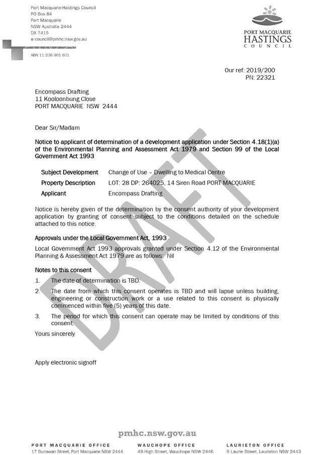
|
ATTACHMENT
|
Development Assessment Panel
25/09/2019
|
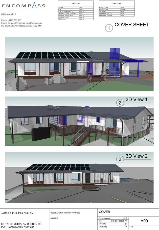
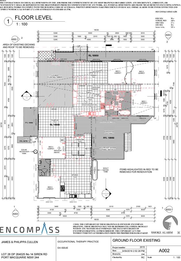
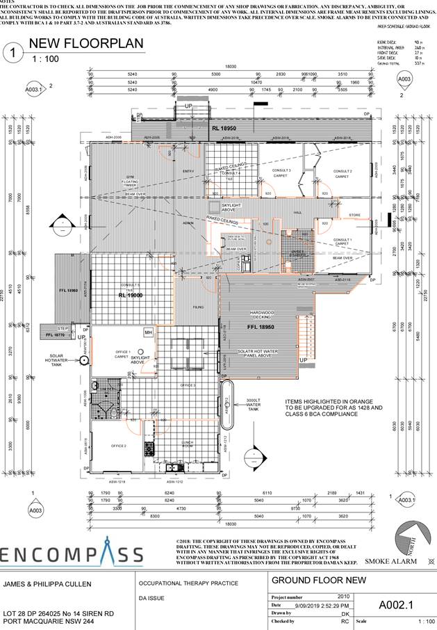
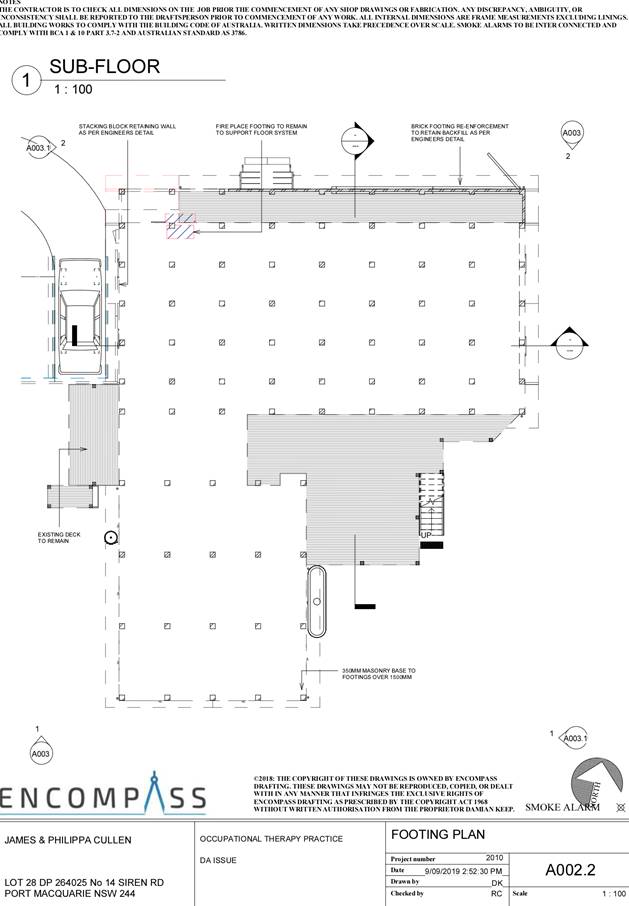
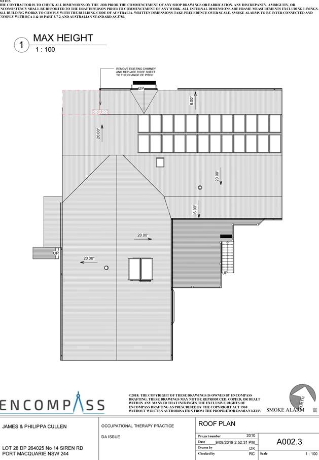
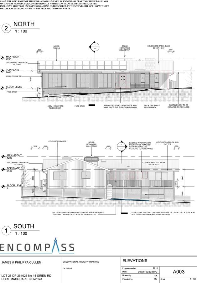
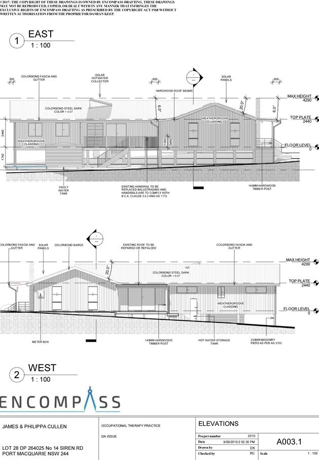

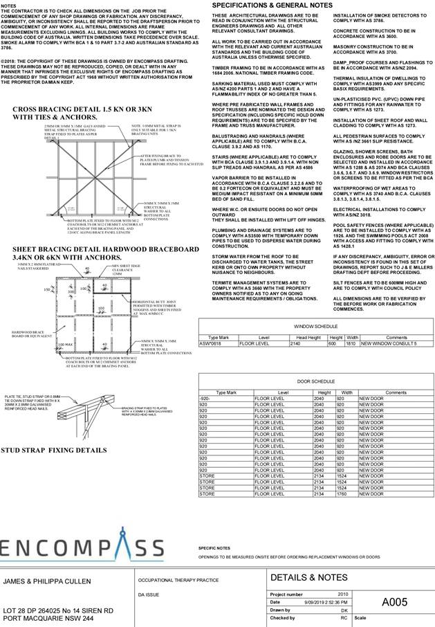
AGENDA Development Assessment Panel 25/09/2019
Item: 07
Subject: DA2019 - 422.1 Medical Centre at Lot 3 DP827711, Cnr of Botanic
Drive and Sirius Drive, Lakewood.
Report Author: Development
Assessment Planner, Steven Ford
|
Applicant: Encompass
Drafting
Owner: CDM
Futures Pty Ltd
Estimated Cost: $1,280,000
Alignment with Delivery Program
4.3.1 Undertake transparent
and efficient development assessment in accordance with relevant legislation.
|
|
RECOMMENDATION
That
DA 2019 - 422.1 for a Medical
Centre at Lot 3, DP 827711, Cnr
of Botanic Drive and Sirius Drive, Lakewood, be determined by granting consent subject to the
recommended conditions.
|
Executive
Summary
This
report considers a development application for a Medical Centre at the subject site and provides an assessment of the
application in accordance with the Environmental Planning and Assessment Act
1979.
Following exhibition of the
application, one (1) submission was received.
The proposal has been amended
during the assessment of the application.
This report recommends that the
subject application be approved subject to the attached conditions.
1. BACKGROUND
Existing Sites Features and Surrounding Development
The site has an area of 2870m2.
The site is zoned B2 Local Centre in accordance with the Port Macquarie-Hastings Local
Environmental Plan 2011, as shown in the following zoning plan:
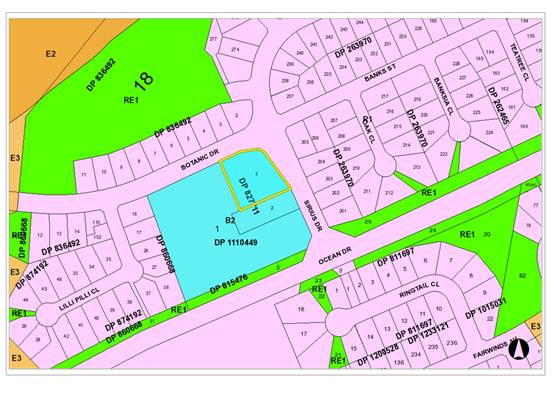
The existing subdivision pattern and location of existing
development within the locality is shown in the following aerial photograph:
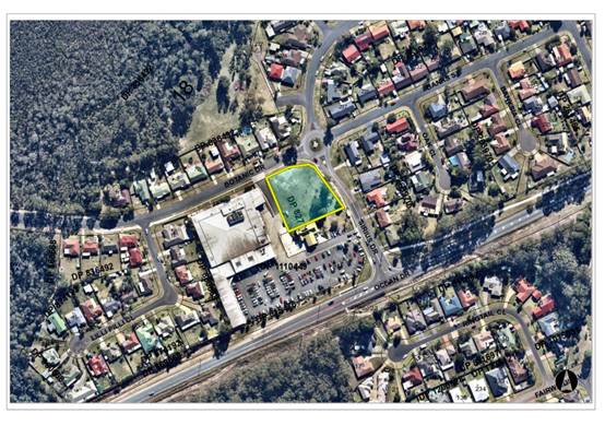
2. DESCRIPTION OF
DEVELOPMENT
Key aspects of the proposal include the following:
· Subject
land is currently vacant
· Proposed
development is for a Medical Centre
· Unit
1 proposes 9 consultation rooms and 5 treatment rooms shared between 9
consultants
· Unit
2 and 3 proposes a Radiology and X-ray with 3 consultants.
· Access
will be via 2 one-way driveways entering from Sirius Dr and exiting at Botanic
Dr, as well as maintaining pedestrian links.
Refer
to attachments at the end of this report for further details.
Application Chronology
· 15
May 2019 Pre-lodgement Meeting
· 14
June 2019 Application Lodged
· 25 June 2019 to 08 July 2019 Public Notification
· 27 June 2019 Submission received
· 08 August 2019 Traffic Impact Assessment, Engineering Plans
and Subdivision Plans submitted
· 12 August 2019 Additional information received from
Applicant - regarding assessment and submission concerns
· 14 August 2019 Site inspection
· 19 August 2019 Additional information and amended plans
received
3. STATUTORY ASSESSMENT
Section 4.15(1) Matters for Consideration
In determining the application, Council is required to take
into consideration the following matters as are relevant to the development
that apply to the land to which the development application relates:
(a) The provisions (where
applicable) of:
(i) Any Environmental
Planning Instrument
State Environmental Planning Policy No. 44 - Koala Habitat
Protection
The policy does not apply. The land is less than 1 hectare
in size and not subject to a Koala Plan of Management (KPoM).
State Environmental Planning Policy No. 55 –
Remediation of Land
Following an inspection of the site and a search of Council
records, the subject land is not identified as being potentially contaminated
and is suitable for the intended use.
State Environmental Planning Policy No. 64 –
Advertising and Signage
The proposed development includes proposed advertising
signage in the form of business/building identification.
In accordance with clause 7, this SEPP prevails over the
Port Macquarie-Hastings LEP 2011 in the event of any inconsistency.
The following assessment table provides an assessment
checklist against the Schedule 1 requirements of this SEPP:
|
Applicable clauses for consideration
|
Comments
|
Satisfactory
|
|
Clause 8(a) Consistent with objectives of the policy as
set out in Clause 3(1)(a).
|
Building identification signage only which addressed
Schedule 1 criteria
|
Yes
|
|
Schedule 1(1) Character of the area.
|
Business identification signage is consist with the B2
Local Centre zoning.
|
Yes
|
|
Schedule 1(2) Special areas.
|
Proposed signage will not detract from the adjoining
developments amenity
|
Yes
|
|
Schedule 1(3) Views and vistas.
|
Will not impact any views
|
Yes
|
|
Schedule 1(4) Streetscape, setting or landscape.
|
The proposed signage is appropriate for this type of
development.
|
Yes
|
|
Schedule 1(5) Site and building.
|
The proposed signage is appropriate scale to the proposed
building.
|
Yes
|
|
Schedule 1(6) Associated devices and logos with
advertisements and advertising structures.
|
N/A
|
Yes
|
|
Schedule 1(7) Illumination.
|
Appropriate illumination of signage will be conditioned
to opening hours as well as avoidance of unacceptable glare/intensity.
|
Yes
|
|
Schedule 1(7) Safety.
|
No adverse safety impacts apparent
|
Yes
|
State Environmental Planning Policy (Coastal Management)
2018
The site is located within a coastal environment area.
In accordance with clause 7, this SEPP prevails over the
Port Macquarie-Hastings LEP 2011 in the event of any inconsistency.
Having regard to clauses 13 and 14 of the SEPP the proposed
development is not considered likely to result in any of the following:
a) any adverse
impact on integrity and resilience of
the biophysical, hydrological (surface and groundwater) and ecological
environment;
b) any
adverse impacts coastal environmental
values and natural coastal processes;
c) any
adverse impact on marine vegetation,
native vegetation and fauna and their habitats, undeveloped headlands and rock
platforms;
d) any
adverse impact on Aboriginal cultural
heritage, practices and places;
e) any
adverse impacts on the cultural and
built environment heritage;
f) any
adverse impacts the use of the surf
zone;
g) any adverse impact on the visual amenity and scenic
qualities of the coast, including coastal headlands;
h) overshadowing, wind funneling and the loss of views
from public places to foreshores;
i) any
adverse impacts on existing public
open space and safe access to and along the foreshore, beach, headland or rock
platform for members of the public, including persons with a disability;
In accordance with Clause 15, the proposal is not likely to
cause increased risk of coastal hazards on the land or other land.
The bulk, scale and size of the proposed development is
compatible with the surrounding coastal and built environment. The site is
predominately cleared and located within an area zoned for residential
purposes.
State Environmental Planning Policy (Infrastructure) 2007
Clause 57(1) - Health services facilities are permitted
with consent by any person as the land is in a prescribed zone.
Port Macquarie-Hastings Local Environmental Plan
2011
The proposal is consistent with the LEP having regard to
the following:
· Clause 2.2 - The subject site is zoned B2 Local Centre.
· Clause 2.3(1) and the B2 zone landuse table The proposed
development for a medical centre is a permissible landuse with consent.
· The objectives of the B2 zone are as follows:
o To provide a range of retail, business,
entertainment and community uses that serve the needs of people who live in,
work in and visit the local area
o To encourage employment opportunities in accessible
locations
o To maximise public transport patronage and
encourage walking and cycling
o To ensure that new developments make a positive
contribution to the streetscape and contribute to a safe public environment.
· Clause 2.3(2) - The proposal is consistent with the zone
objectives having regard to the following:
o The proposal is a permissible landuse;
o Provides community services and local employment
opportunities
· Clause 4.3 - The maximum overall height of the building
above ground level (existing) is 5.3m, which complies with the standard height
limit of 8.5m applying to the site.
· Clause 4.4 - The floor space ratio of the proposal complies
with the maximum 1:1 floor space ratio applying to the site.
· Clause 5.10 - The site does not contain or adjoin any known
heritage items or sites of significance.
· Clause 7.13 - Satisfactory arrangements are in place for
provision of essential services including water supply, electricity supply,
sewer infrastructure, stormwater drainage and suitable road access to service
the development.
(ii) Any proposed instrument that
is or has been placed on exhibition
No draft instruments apply to the site.
(iii) Any Development Control Plan (DCP)
in force
Port Macquarie-Hastings Development Control Plan 2013
|
DCP 2013: General Provisions
|
|
DCP Objective
|
Development Provisions
|
Proposed
|
Complies
|
|
2.2.2.1
|
Signs
primarily identifying products or services are not acceptable, even where
relating to products or services available on that site.
|
Proposal
includes business identification signs associated with the proposed
buildings.
|
Yes
|
|
Signage
is not permitted outside property boundaries except where mounted upon
buildings and clear of pedestrians and road traffic. No signage is permitted
upon light or power poles or upon the nature strip (the area between the
property boundary and constructed roadway). Limited directional
signage
and “A” frame signage may separately be approved by Council under
the Roads Act 1993 or section 68 of the Local government Act 1993.
|
None
proposed outside property boundary.
|
Yes
|
|
An
on-building 'chalkboard' sign, for the purpose of describing services or
goods for sale which vary on a regular basis generally should not be any
larger than 1.5m2, and should contain a sign written heading indicating the
premises to which it refers.
|
N/A
|
N/A
|
|
On-premise
signs should not project above or to the side of building facades
|
Signage
does not project above or to the sides of the building.
|
Yes
|
|
2.2.2.2
|
Where
there is potential for light spill from signage in a non residential zone
adjoining or adjacent to residential development, illuminated signage is to
be fitted with a time switch to dim by 50% or turn off the light by 11pm each
night, depending on the nature of the development.
|
No
information has been provided regarding illumination controls.
Providing the design and separation from the proposed building to adjoining
dwellings there are no adverse impacts apparent. However, for clarity a
condition has been recommended regarding illumination for all signage.
|
Yes
|
|
2.7.2.2
|
Design
addresses generic principles of Crime Prevention Through Environmental Design
guideline:
· Casual surveillance and sightlines
· Land use mix and activity generators
· Definition of use and ownership
· Lighting
· Way finding
· Predictable routes and entrapment locations
|
The
proposed development is unlikely to create any concealment/entrapment areas
or crime spots that would result in any identifiable loss of safety or
reduction of security in the immediate area.
|
Yes
|
|
2.3.3.1
|
Cut
and fill 1.0m max. 1m outside the perimeter of the external building walls
|
Less
than 1m cut or fill proposed.
|
Yes
|
|
2.3.3.2
|
1m
max. height retaining walls along road frontages
|
None
proposed at 1m.
|
N/A
|
|
Any
retaining wall >1.0 in height to be certified by structural engineer
|
A
condition has been recommended regarding the maximum height of retaining wall.
|
Yes
|
|
Combination
of retaining wall and front fence height
|
N/A
|
N/A
|
|
2.3.3.8 onwards
|
Removal
of hollow bearing trees
|
No
hollow bearing trees present on the site.
|
Yes
|
|
2.6.3.1
|
Tree
removal (3m or higher with 100mm diameter trunk and 3m outside dwelling
footprint
|
9
trees to be removed from the proposed entry driveway. No significant trees
identified, appropriate condition has been recommended to have a qualified
arborist onsite during tree clearing works.
|
Yes
|
|
2.4.3
|
Bushfire
risk, Acid sulphate soils, Flooding, Contamination, Airspace protection,
Noise and Stormwater
|
Refer
to main body of report.
|
|
|
2.5.3.2
|
New
accesses not permitted from arterial or distributor roads. Existing accesses
rationalised or removed where practical
|
Proposed
driveways are rationalised. See Traffic Impact Assessment.
|
Yes
|
|
Driveway
crossing/s minimal in number and width including maximising street parking
|
2 one-way
driveways are proposed. Considering the size of the site and frontage, impacts
on the street parking are limited.
|
Yes
|
|
2.5.3.3
|
Off-street
parking in accordance with Table 2.5.1.
Medical
centres = 3 spaces per consultant + 1 per 2 employees
|
The
proposed medical centre is to include 9 consultants and 6 employees, which
requires 30 parking spaces in accordance with Table 2.5.1.
The
X-Ray tenancy will have 3 consultants and 3 admin staff, requiring 10.5
parking spaces in accordance with Table 2.5.1.
Minimum
number of 41 parking spaces required.
42
parking spaces are proposed inclusive of a disabled space.
A
condition is recommended limiting the number of practicing consultants and
staff to reflect the available parking.
Stage
2 of the development proposes formalising the easement along the western
boundary to have 17 additional car parking spaces benefitting the adjoining
Lakewood Shops.
|
Yes
|
|
2.5.3.11
|
Section 94 contributions
|
Refer to main body of report.
|
|
(iii) Any planning agreement or draft planning
agreement
No planning agreement has been offered or entered into
relating to the site.
(iv) The regulations
n/a
(b) The
likely impacts of that development, including environmental impacts on both the
natural and built environments and the social and economic impacts in the
locality
Context and Setting
The site has a general north-east street frontage
orientation to Botanic and Sirius Drives.
Adjoining the site to the north are residential dwellings.
Adjoining the site to the east are residential dwellings.
Adjoining the site to the south is a service station.
Adjoining the site to the west is a shopping centre and
loading bays.
The proposal is not anticipated to have any significant
adverse impacts on existing adjoining properties and satisfactorily addresses
the public domain.
The proposal is considered compatible with other business
and residential development in the locality and adequately addresses planning
controls for the area.
The proposal would not have a significant adverse impact on
existing view sharing.
The proposal would not have significant adverse lighting
impacts however a condition of consent is recommended to ensure impacts are
minimised.
There are no significant adverse privacy impacts likely.
Adequate building separation and tenancy is proposed/existing.
There would be no significant adverse overshadowing
impacts. The proposal does not prevent adjoining properties from receiving 3
hours of sunlight to private open space and primary living areas on 21 June
between the hours of 9am and 3pm.
Roads
The site has road frontage to Sirius and Botanic Drive.
Adjacent to the site, Sirius and Botanic Drive are a sealed public road under
the care and control of Council. Both roads are Local roads and includes
kerb and gutter, footpath paving/shareways.
Traffic and Transport
The additional traffic associated with the development is
unlikely to have any adverse impacts on the existing road network within the
immediate locality. Council’s development engineering staff have reviewed
the application and are satisfied with the finding of the supporting Traffic
Impact Statement prepared by StreetWise Road Safety & Traffic Pty Ltd, July
2019.
Site Frontage and Access
Vehicle access to the site is proposed though two (one way)
driveways entering at Sirius Drive and exiting on Botanic Drive. A Traffic
Impact Assessment was provided. The assessment has determined that Ocean Drive,
Sirius Drive and the local road network has the capacity to cater for the
current volumes and future traffic volumes generated by the proposed
development, with regard to safety, efficiency and with minimal delays and
queues. All accesses shall comply with Council AUSPEC and Australian Standards,
and conditions have been recommended to reflect these requirements.
Parking and Manoeuvring
A total of 42 parking spaces have been provided
on-site. Parking and driveway widths on site can comply with relevant
Australian Standards (AS 2890) and conditions have been imposed to reflect
these requirements.
Due to the type of development, car park circulation is
required to enable vehicles to enter and exit the site in a forward manner.
Site plans show adequate area is available and conditions have been recommended
to reflect these requirements and delineate traffic direction.
Note: Stage 2 will formalise additional 17 car parking
spaces over the eastern right of carriageway easement once negotiations with
adjoining landowner has been finalised. This is additional car parking to
service adjoining developments and is not critical to this assessment, however,
is a positive outcome for resolving any potential existing parking issues.
Water Supply Connection
Council records indicate that the development site is not
currently serviced with water. Final water service sizing will need to be
determined by a hydraulic consultant to suit the domestic and commercial
components of the development, as well as fire service and backflow protection
requirements in accordance with AS3500. Minimum backflow protection for a
medical centre is a Reduced Pressure Zone Device (RPZ) at the boundary. Plans
shall be provided to the Water & Sewer Section for approval. Conditions are
recommended to ensure that these requirements are met.
Sewer Connection
Council records indicate that the development site is
connected to Sewer via junction to the existing sewer main which runs inside of
the western boundary of the development site. The proposed development is
required to discharge all sewage to a new or proposed sewer manhole. Any
abandoned sewer junctions are to be capped off at Council’s sewer main
and Council notified to carry out an inspection prior to backfilling of this
work. Plans shall be provided to the Water and Sewer Section for approval.
Appropriate conditions have been recommended in this regard.
Stormwater
The site naturally grades towards the Botanic Drive street
frontage and is currently serviced via a direct connection to the public piped
drainage system.
The legal point of discharge for the proposed development
is defined as a direct connection to Council’s existing piped stormwater
system at northern corner of the site.
Stormwater from the proposed development is planned to be
disposed via direct connection to an existing pit along the Botanic Drive
frontage. Which is consistent with the above requirements.
A detailed site stormwater management plan will be required
to be submitted for assessment with the S.68 application and prior to the issue
of a CC.
In accordance with Councils AUSPEC requirements, the
following must be incorporated into the stormwater drainage plan:
· On site stormwater detention facilities
· Water quality
Appropriate conditions have been recommended in this
regard.
Other Utilities
Telecommunication and electricity services are available to
the site.
Heritage
Following a site inspection (and a search of Council
records), no known items of Aboriginal or European heritage significance exist
on the property. No adverse impacts anticipated.
As a precaution, a condition of consent has been
recommended that works are to cease in the unexpected event heritage items are
found. Works can only recommence when appropriate approvals are obtained for
management and/or removal of the heritage item.
Other land resources
The site is within an established urban context and will
not sterilise any significant mineral or agricultural resource.
Water cycle
The proposed development will not have any significant
adverse impacts on water resources and the water cycle.
Soils
The proposed development will not have any significant
adverse impacts on soils in terms of quality, erosion, stability and/or
productivity subject to compliance with the recommended standard condition
requiring erosion and sediment controls to be in place prior to and during
construction.
Air and microclimate
The construction and/or operations of the proposed
development will not result in any significant adverse impacts on the existing
air quality or result in any pollution. Standard precautionary site management
condition is recommended.
Flora and fauna
The proposed development includes clearing of 9 trees. The
Biodiversity Offset Scheme doesn’t apply for the following reasons:
· Given the location of the site in an established urban
environment, and the nature of the proposal being acceptable by SEPP, LEP and
DCP standards, the removal of the trees and their offset to a more suitable
location was considered acceptable.
· The land isn’t identified on the Biodiversity Values
Map;
· The extent of clearing is below the thresholds in Clause
7.2 of the Biodiversity Conservation Regulation 2017.
|
Minimum lot size of land (LEP Lot Size Map)
|
Area of Clearing
|
|
Less than 1 hectare
|
0.25 hectare or more
|
Waste
Satisfactory arrangements are in place for proposed storage
and collection of waste and recyclables. No adverse impacts anticipated.
Standard precautionary site management condition has been recommended.
Energy
The proposal includes measures to address energy efficiency
and will be required to comply with the requirements of Section J of the
Building Code of Australia. No adverse impacts anticipated.
Noise and vibration
Any development of vacant land will increase noise and
vibration. The construction and/or operations of the proposed development will
not result in any significant adverse impacts on the existing air quality or
result in any pollution providing the land zoning and potential demand.
Standard precautionary site management condition recommended. Hours of
operation conditions have been recommended to 8am to 7pm Monday to Saturday.
Bushfire
The site is identified as being bushfire prone. The
proposal includes no residential component and is not identified as a special
fire protection purpose. The aims and objectives of the RFS Planning for
Bushfire Protection 2006 guidelines are satisfied.
Safety, security and crime prevention
The proposed development will be unlikely to create any
concealment/entrapment areas or crime spots that would result in any
identifiable loss of safety or reduction of security in the immediate area.
Social impacts in the locality
Given the nature of the proposed development and its
location, the proposal is not considered to have any significant adverse social
impacts.
Economic impact in the locality
The proposal is not considered to have any significant
adverse economic impacts on the locality. A likely positive impact is that the
development will maintain employment in the construction industry, local
employment and specialist medical services to the local area.
Site design and internal design
The proposed development design satisfactorily responds to
the site attributes and will fit into the locality.
Construction
Construction impacts are considered capable of being
managed, standard construction and site management conditions have been
recommended.
Cumulative impacts
The proposed development is not considered to have any
significant adverse cumulative impacts on the natural or built environment or
the social and economic attributes of the locality.
(c) The suitability of the site for
the development
The proposal will fit into the locality and the site
attributes are conducive to the proposed development.
Site constraints of access and traffic generation have been
adequately addressed and appropriate conditions of consent recommended.
(d) Any submissions made in
accordance with this Act or the Regulation
One written submission was received following public exhibition
of the application.
Key issues raised in the submissions and comments in
response are provided as follows:
|
Submission Issue/Summary
|
Planning Comment/Response
|
|
Traffic issues; there has been
numerous near misses and accidents at the Woolworths entry and the Ocean
Drive/Sirius Drive intersection, due to the already increased traffic volume
from Woolworths & looking at the plans for the Proposed Development, it
is only going to worsen.
|
The Applicant has provided a
Traffic Impact Assessment for the proposal, which is attached to this report.
The report suggests that increased traffic will not have adverse impacts to
Sirius and Botanic Drive, and considers the impact on road safety as a low
risk. The report confirms that Ocean Drive, Sirius Drive and Botanic Drive
are adequate to cater for the future traffic volumes proposed by this
development regarding safety, efficiency and queuing.
The details submitted are
considered acceptable.
|
|
There are already issues with
speeding vehicles in Botanic Drive/Sirius Drive.
|
Noted. It is not anticipated
that the proposed development will adversely impact existing traffic issues
within the vicinity.
|
|
There is a Bus Stop adjacent to
the proposed Sirius Drive entry where at school drop offs & pickups one
lane of Sirius Drive is virtually blocked by the bus, with schoolchildren
everywhere.
|
The proposed entry driveway will
be approximately 20m from the existing bus stop. The Traffic Impact
Assessment identifies that there may be some sight distance issues when buses
are picking up or dropping off passengers but given the small number of bus
trips per day, the potential for conflict is low. To further mitigate this,
the driveway off Sirius Drive will be an entry only and not allow traffic to
exit at this driveway and not turn right.
|
|
Botanic Drive entrance, plans
indicate that this will be a dual entry for the Medical Centre and
Woolworths, Botanic Drive is fully residential housing area, children &
elderly residents have been nearly ran over by vehicles using the existing
entry (Cars/Trucks exiting this one way only entry) to which the
Council ensured residents it would only be used for entry and was noted on
the Woolworths Development Application. (No Council enforcement of
this, even though complaints have been made)
|
The proposed Botanic Drive
driveway is an exit only. This is proposed to be conditioned to be delineated
by appropriate signage and line marking. The traffic impact assessment
suggests that the road network is capable of supporting the proposed
development and both access points have adequate sight distance available.
|
|
Increased vehicle noise to
residential area, operating 12 hours a day, 7 days a week.
|
The subject site is zoned B2 -
Local Centre, and Medical Centres are a permissible use in the zone. Vehicle
traffic will increase with any appropriate level of development within this
zoning. The anticipate demand will not adversely impact the efficiency or
safety of the local road network.
An appropriate condition
regarding noise is recommended including restricting hours of operation.
|
(e) The Public Interest
The proposed
development satisfies relevant planning controls and will not adversely impact
on the wider public interest.
4. DEVELOPMENT CONTRIBUTIONS
APPLICABLE
· Development contributions will be required towards
augmentation of town water supply and sewerage system head works under Section
64 of the Local Government Act 1993.
· Development contributions will be required under Section 7.12
contributions of the Environmental Planning and Assessment Act 1979 towards
roads, open space, community cultural services, emergency services and
administration buildings.
5. CONCLUSION AND
STATEMENT OF REASON
The application has been assessed
in accordance with Section 4.15 of the Environmental Planning and Assessment
Act 1979.
Issues raised during assessment
and public exhibition of the application have been considered in the assessment
of the application. Where relevant, conditions have been recommended to manage
the impacts attributed to these issues.
The site is considered suitable
for the proposed development and the proposal adequately addresses relevant
planning controls. The development is not considered to be contrary to the
public's interest and will not result a significant adverse social,
environmental or economic impact. It is recommended that the application be
approved, subject to the recommended conditions of consent provided in the
attachment section of this report.
|
Attachments
1View. DA2019
- 422.1 Recommended Conditions.
2View. DA2019
- 422.1 Plans.
3View. DA2019
- 422.1 Engineering Plans
4View. DA2019
- 422.1 Proposed Strata Subdivision Plan
5View. DA2019
- 422.1 Traffic Impact Assessment
6View. DA2019
- 422.1 Contributions Quote
|
|
ATTACHMENT
|
Development Assessment Panel
25/09/2019
|

|
ATTACHMENT
|
Development Assessment Panel
25/09/2019
|
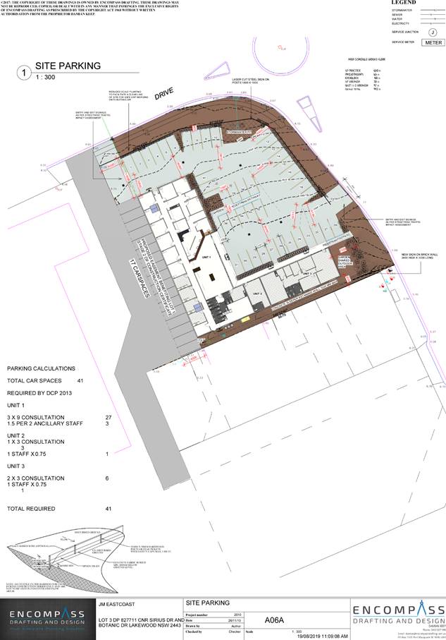
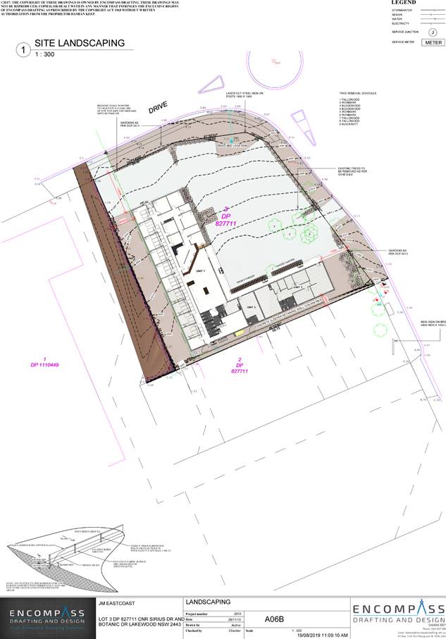
|
ATTACHMENT
|
Development Assessment Panel
25/09/2019
|
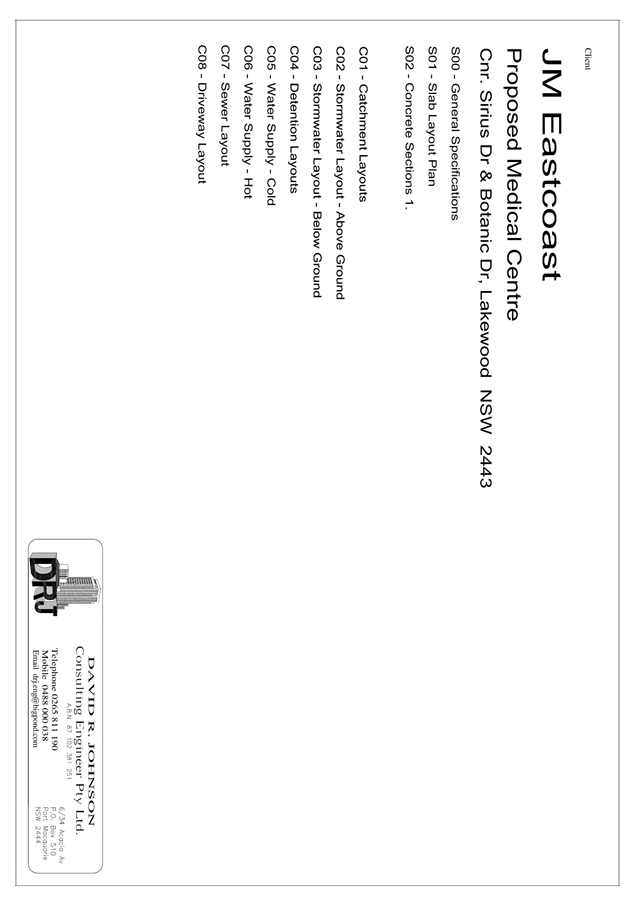
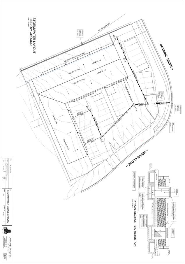
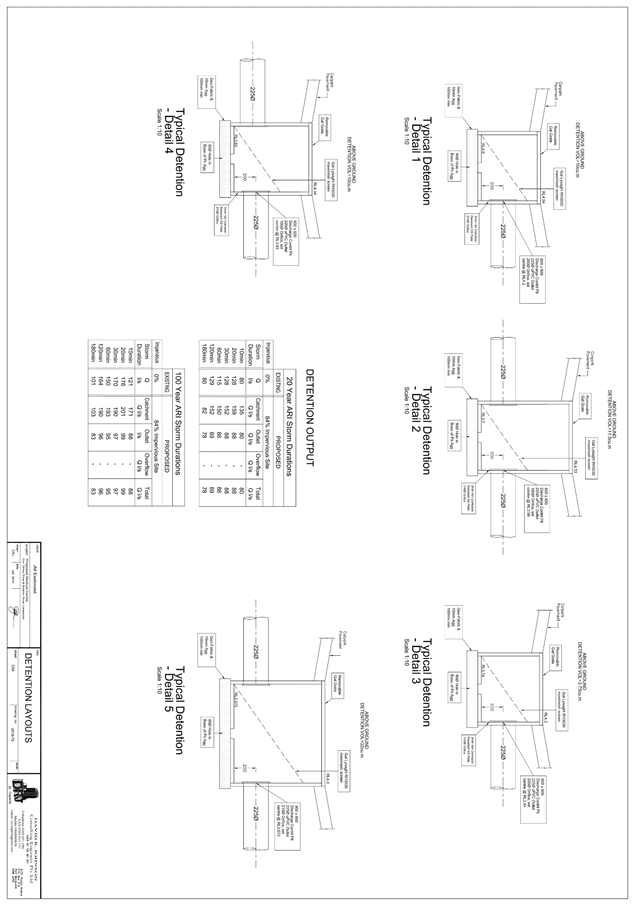
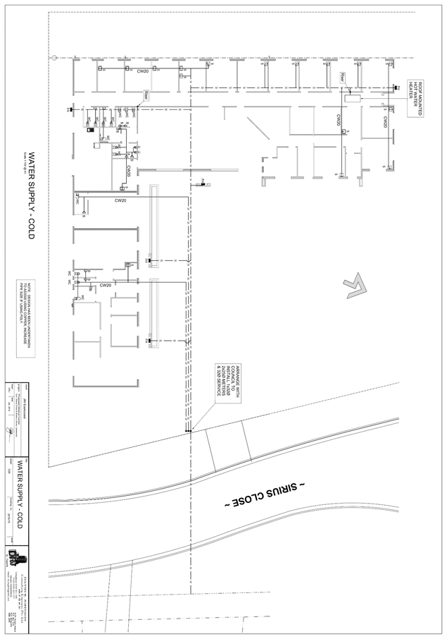
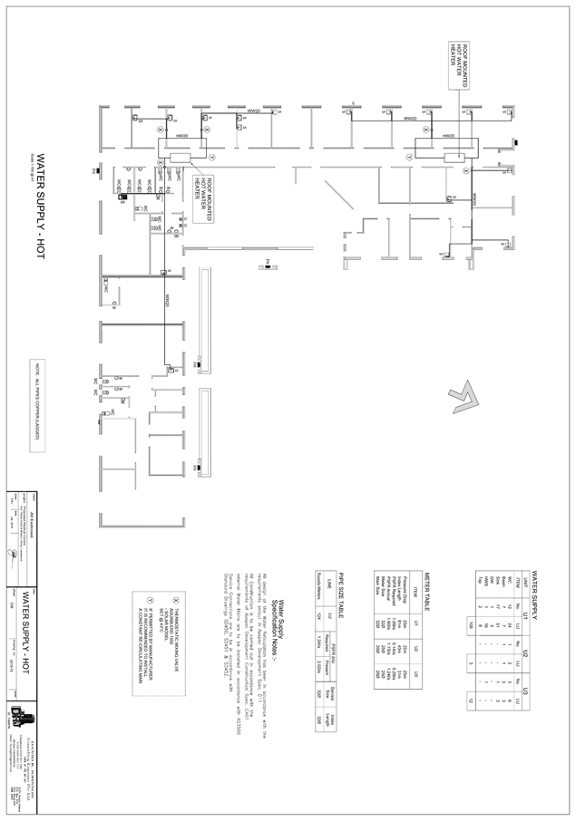
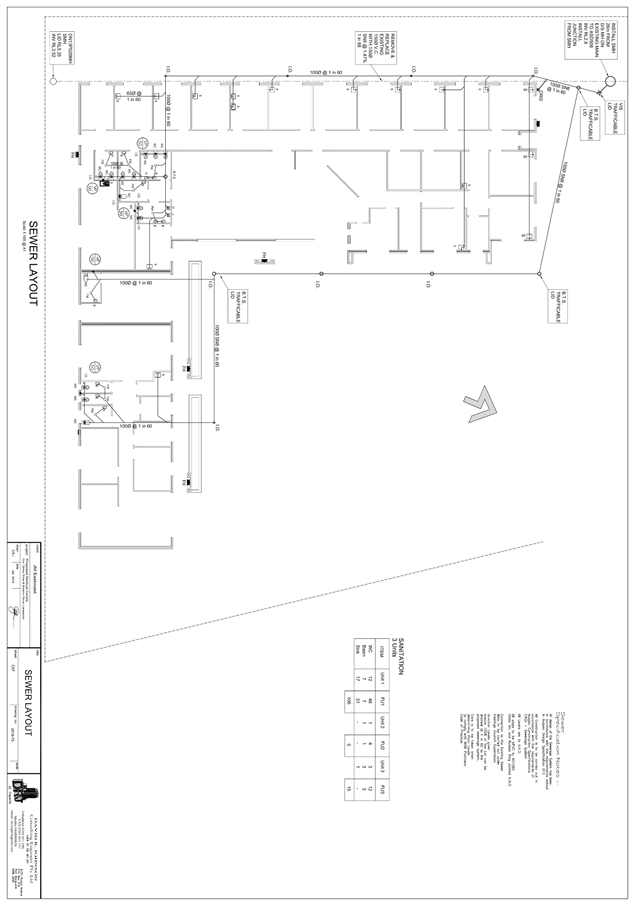
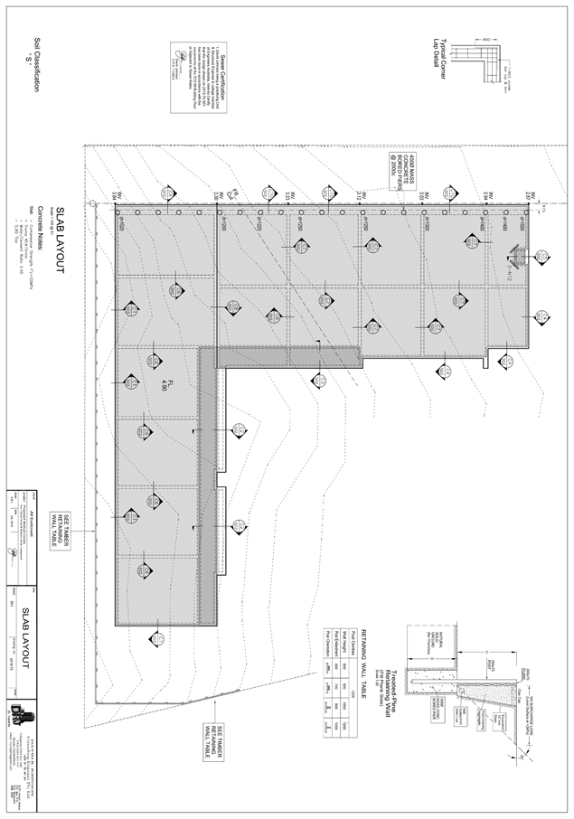
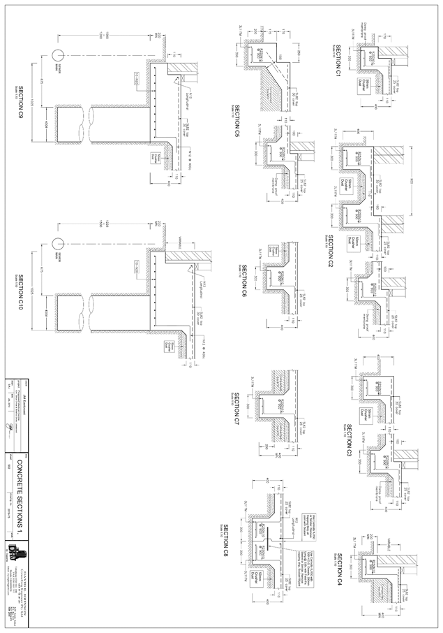
|
ATTACHMENT
|
Development Assessment Panel
25/09/2019
|
|
ATTACHMENT
|
Development Assessment Panel
25/09/2019
|
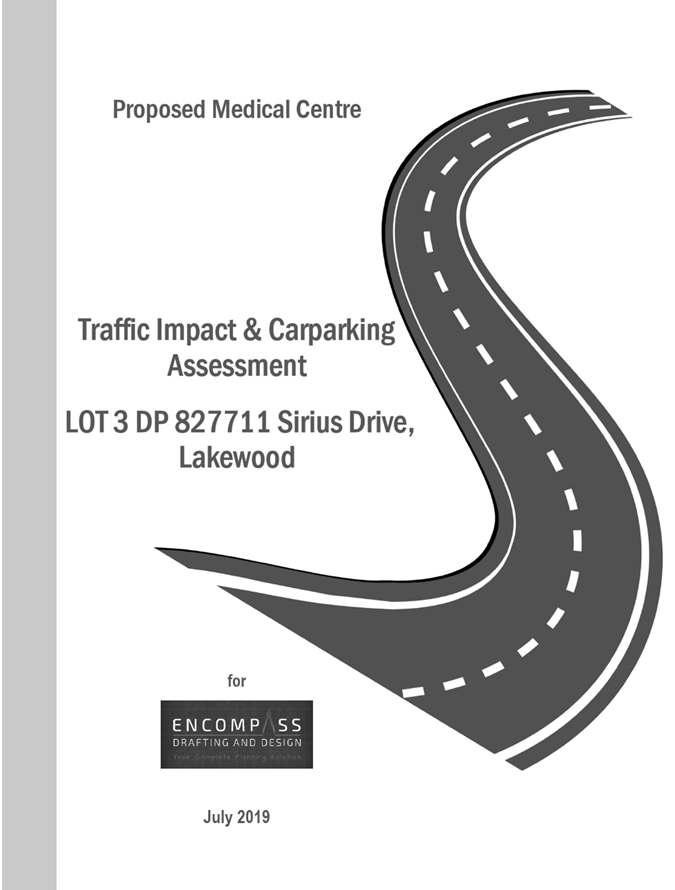
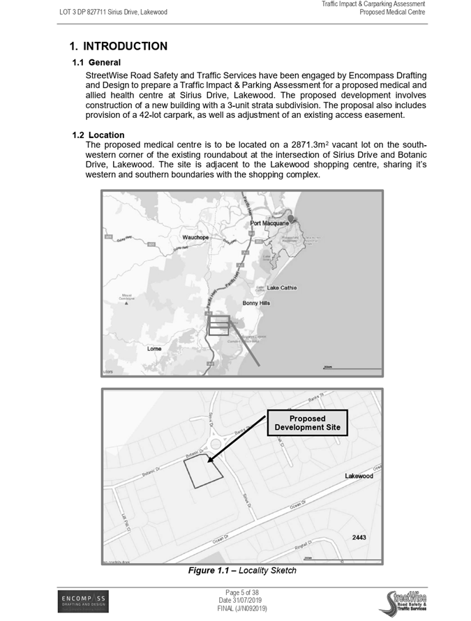
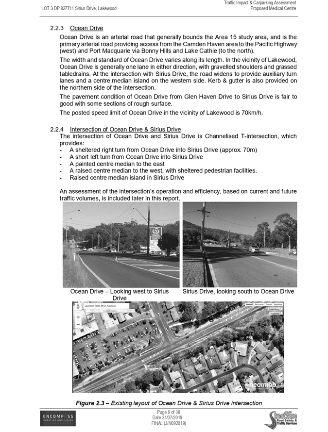
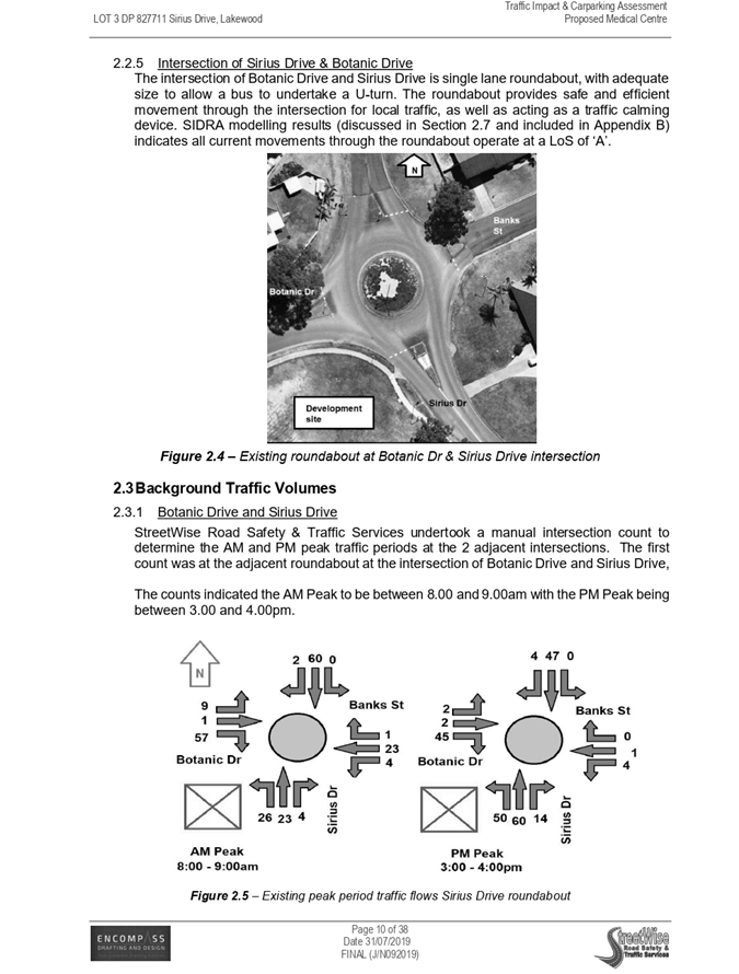
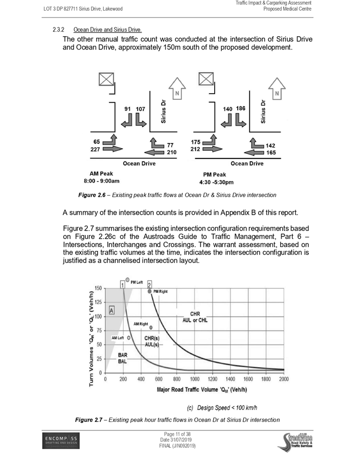
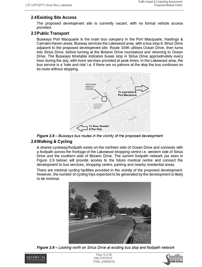
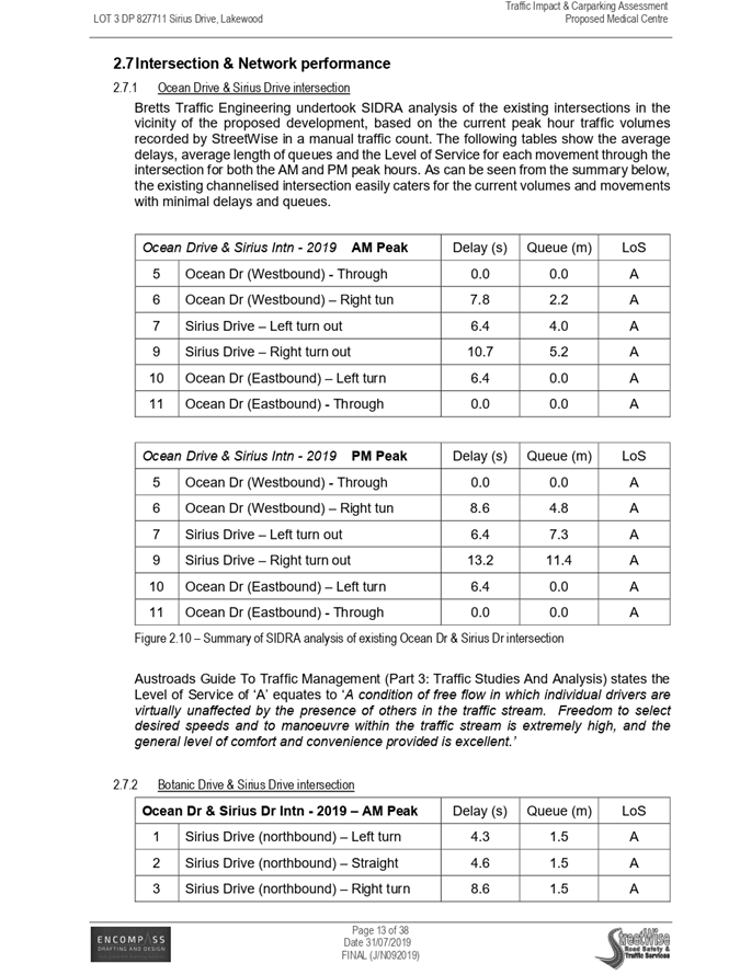
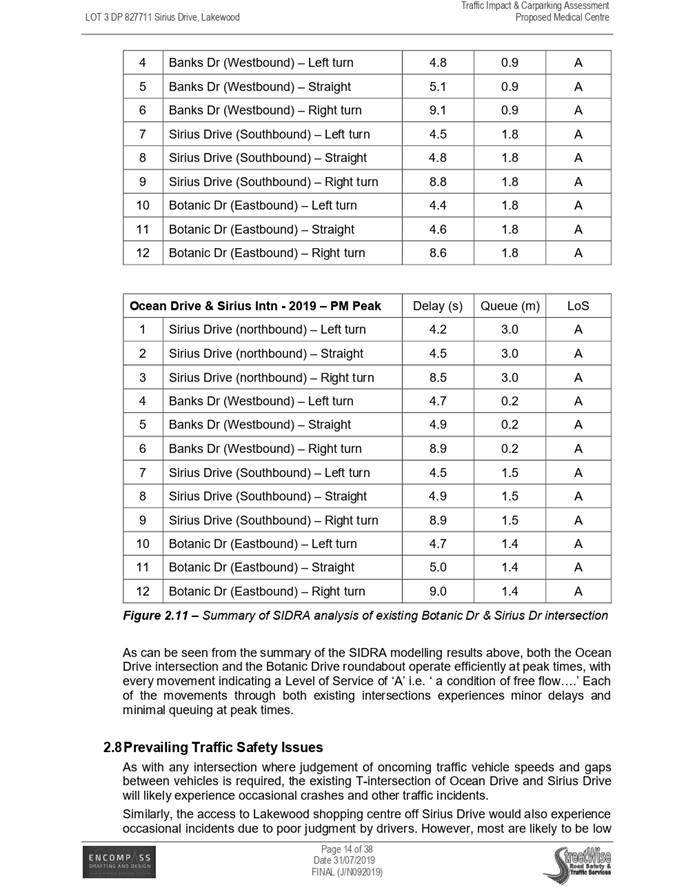
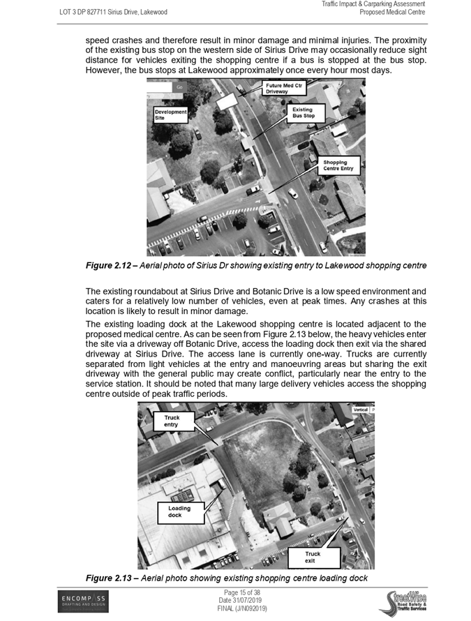
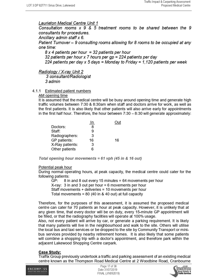
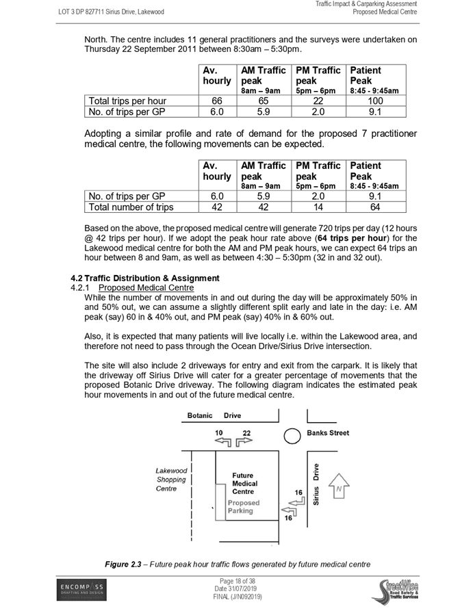
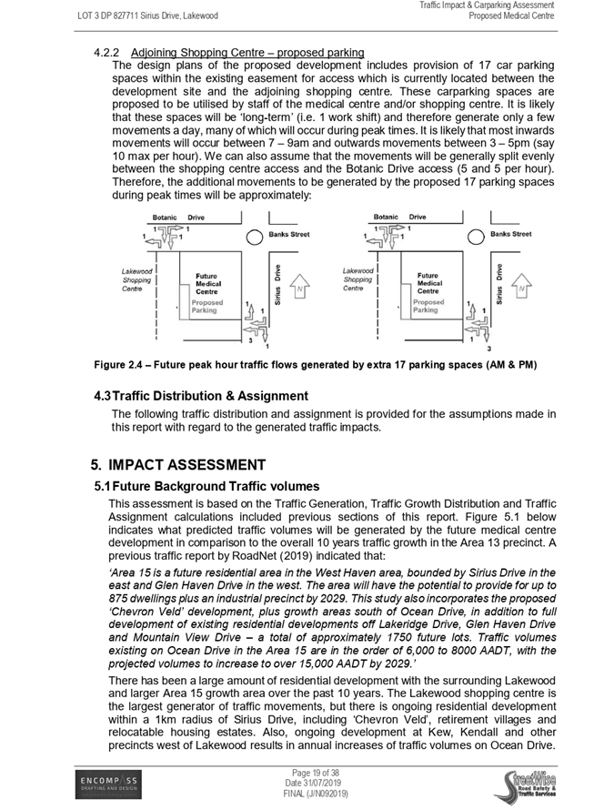
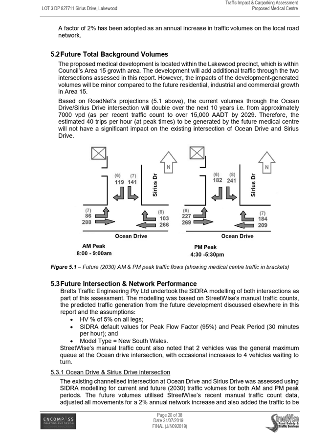
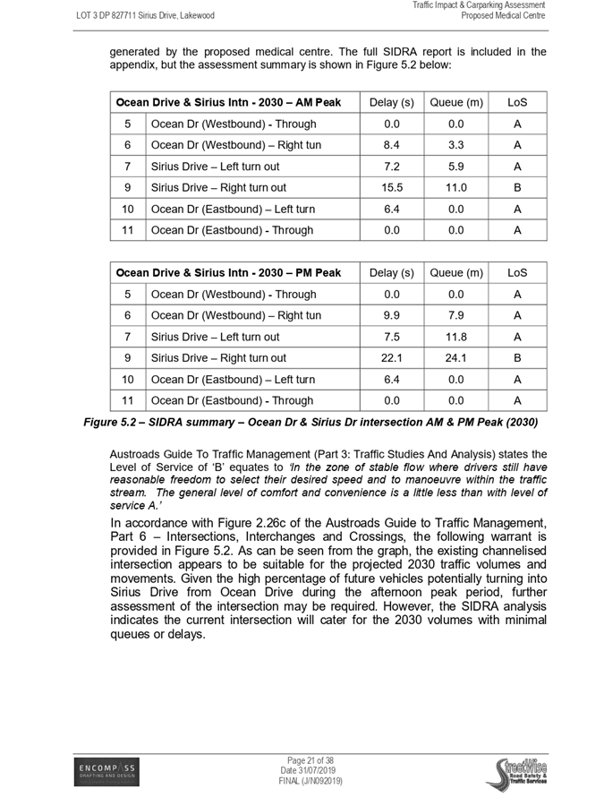
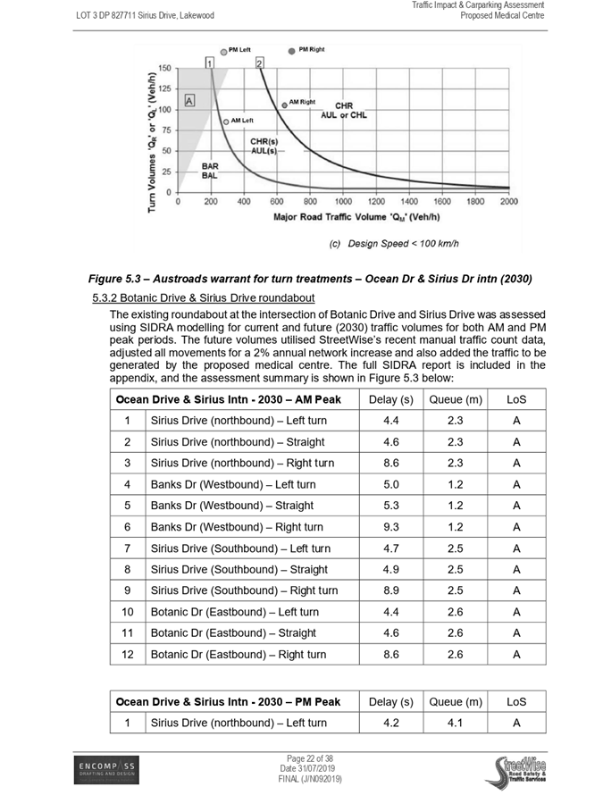
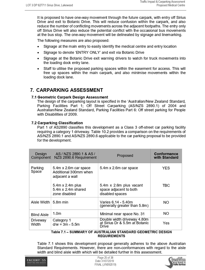
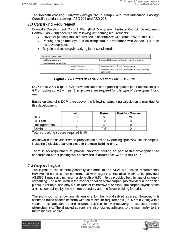
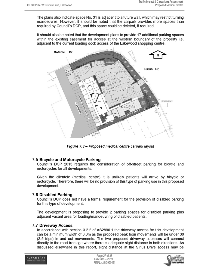

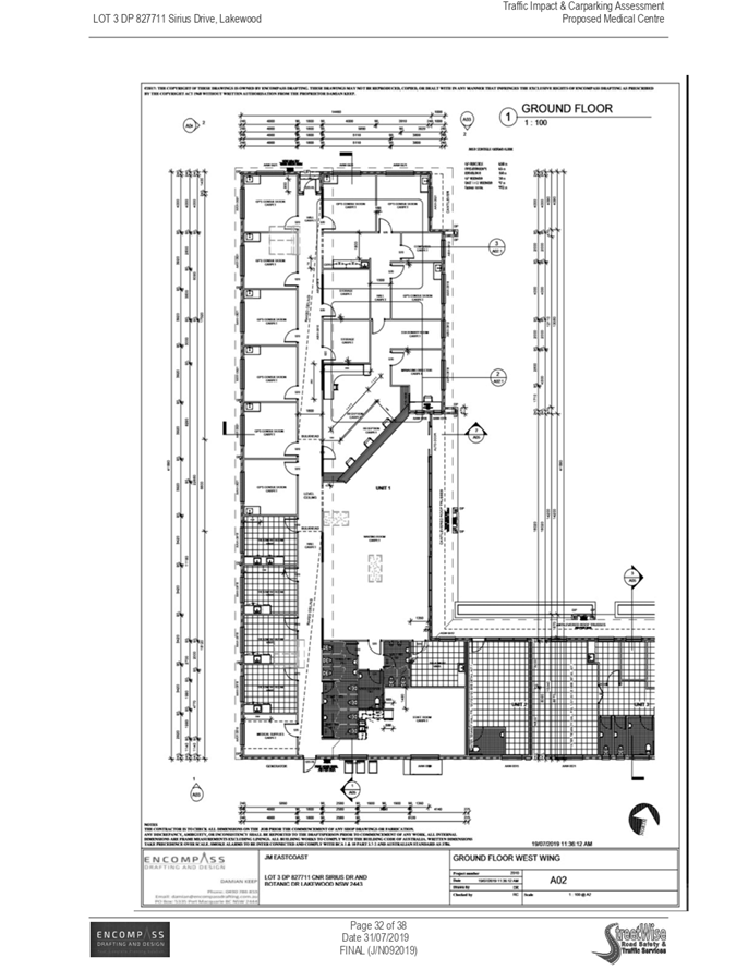
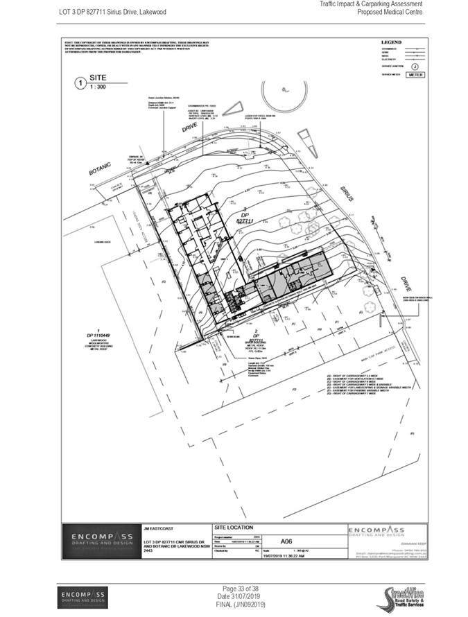
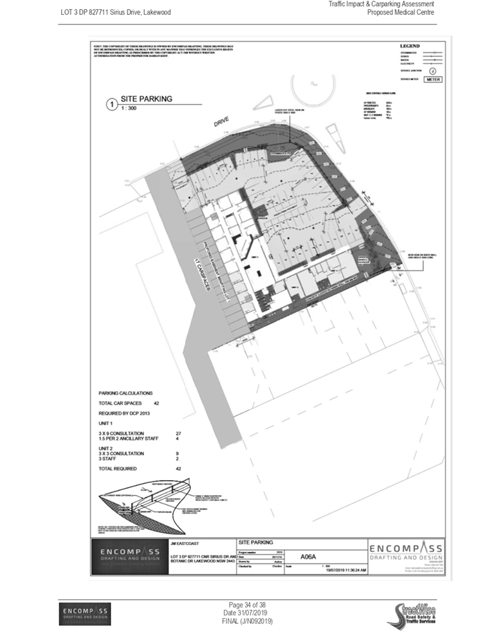

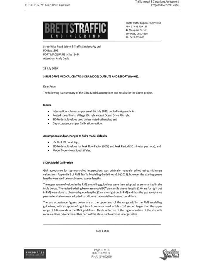
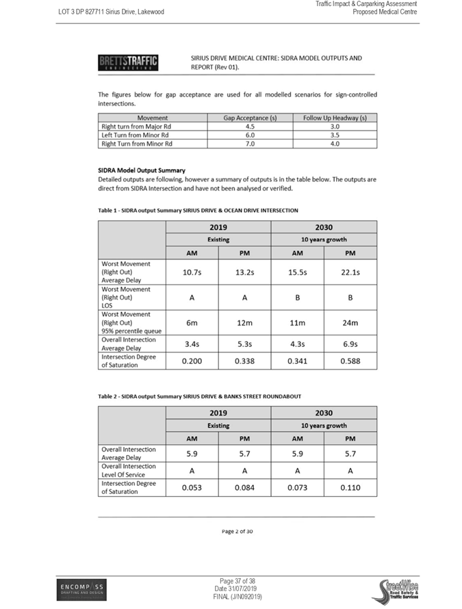
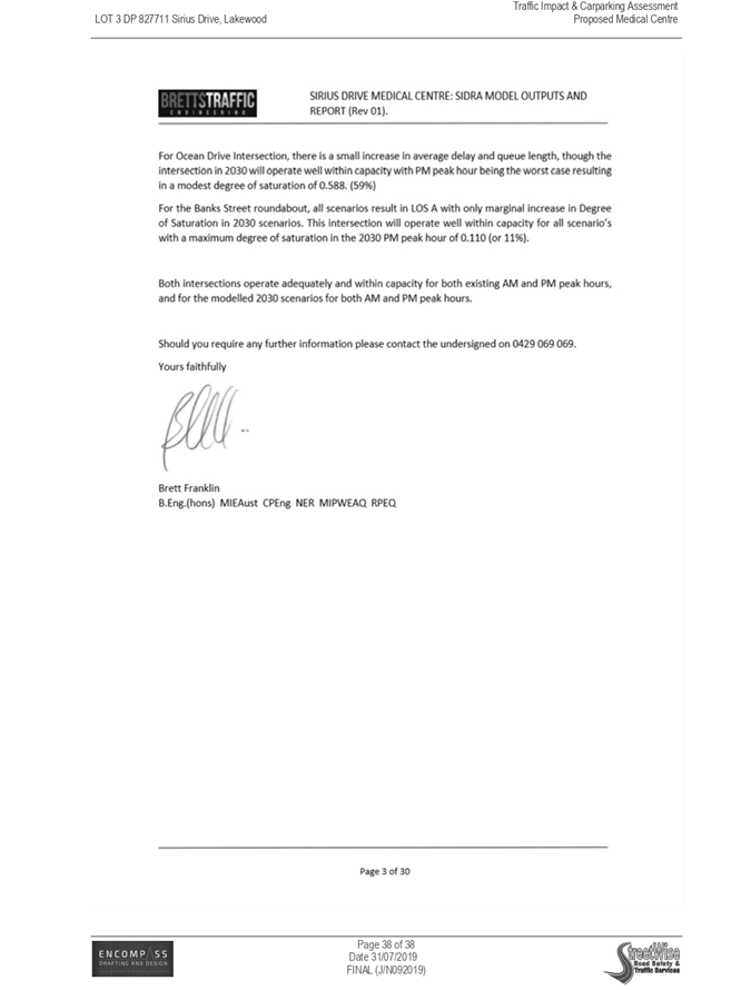
|
ATTACHMENT
|
Development Assessment Panel
25/09/2019
|
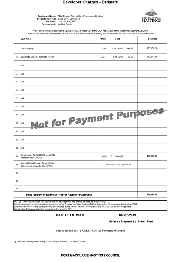
AGENDA Development Assessment Panel 25/09/2019
Item: 08
Subject: DA2019 - 440.1 - Dwelling at Lot 613 DP 1228345, No. 30 Richwood
Ridge, Port Macquarie
Report Author: Development
Assessment Planner, Steven Ford
|
Applicant: Pycon
Homes & Construction Pty Ltd
Owner: P
F & C C Mare
Estimated Cost: $430,000
Alignment with Delivery Program
4.3.1 Undertake transparent
and efficient development assessment in accordance with relevant legislation.
|
|
RECOMMENDATION
That
DA 2019 - 440.1 for a single
dwelling at Lot 613, DP 1228345, No.
30 Richwood Ridge, Port Macquarie,
be determined by granting consent subject to the recommended conditions.
|
Executive
Summary
This
report considers a development application for a Single Dwelling at the subject site and provides an assessment of the
application in accordance with the Environmental Planning and Assessment Act
1979.
Following exhibition of the
application, 3 submissions have been received.
This report recommends that the
development application be approved subject to the attached conditions.
1. BACKGROUND
Existing Sites Features and Surrounding Development
The site has an area of 600.3m2.
The site is zoned R1 General Residential in accordance with the Port Macquarie-Hastings Local
Environmental Plan 2011, as shown in the following zoning plan:
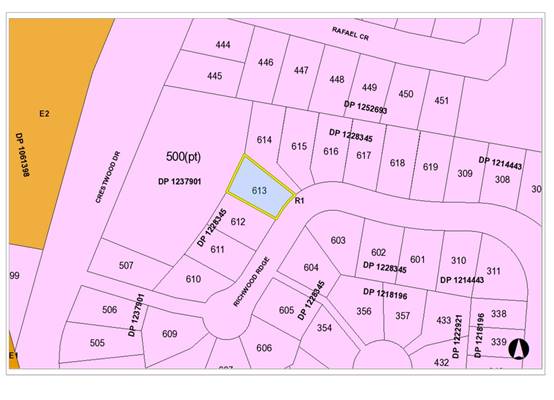
The existing subdivision pattern and location of existing
development within the locality is shown in the following aerial photograph:
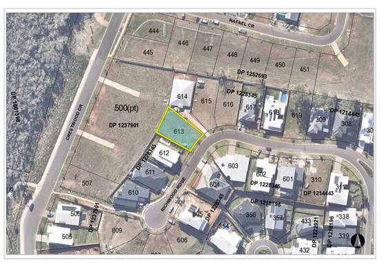
2. DESCRIPTION OF
DEVELOPMENT
Key aspects of the proposal include the following:
· DA
originally proposed a Dwelling, swimming pool and maximum 1.25m retaining wall
above the existing retaining wall along the north-west corner boundaries.
· Applicant
has deleted the swimming pool and proposed north-east retaining walls
· DA
is only for a single dwelling
Refer
to attachments at the end of this report for details.
Application Chronology
· 24
June 2019 - Application Lodged
· 27 June 2019 to 10/07/2019 - Public Notification with 3
submissions received
· 16 July 2019 - Request for Information sent to Applicant
(Assessment and Submission issues)
· 14 August 2019 - Revised plans and response received from
Applicant. (deleted proposed swimming pool and lowered proposed retaining
walls)
· 25 August 2019 - Objection to revised plans received
· 05 September 2019 - Revised Plans received by Applicant.
(deletion of proposed retaining walls to along north-east boundary)
3. STATUTORY ASSESSMENT
Section 4.15(1) Matters for Consideration
In determining the application, Council is required to take
into consideration the following matters as are relevant to the development
that apply to the land to which the development application relates:
(a) The provisions (where
applicable) of:
(i) Any Environmental
Planning Instrument
State Environmental Planning Policy No. 44 - Koala
Habitat Protection
There is no Koala Plan of Management on the site.
Additionally, the site is less than 1ha in area therefore no further
investigations are required.
State Environmental Planning Policy No. 55 –
Remediation of Land
Following an inspection of the site and a search of Council
records, the subject land is not identified as being potentially contaminated
and is suitable for the intended use.
State Environmental Planning Policy (Coastal Management)
2018
The site is located within a proximity to a coastal wetland
to the west.
In accordance with clause 7, this SEPP prevails over the
Port Macquarie-Hastings LEP 2011 in the event of any inconsistency.
Having regard to clauses 13 and 14 of the SEPP the proposed
development is not considered likely to result in any of the following:
a) any
adverse impact on integrity and resilience of the biophysical,
hydrological (surface and groundwater) and ecological environment;
b) any
adverse impacts coastal environmental values and natural coastal
processes;
c) any
adverse impact on marine vegetation, native vegetation and fauna
and their habitats, undeveloped headlands and rock platforms;
d) any
adverse impact on Aboriginal cultural heritage, practices and
places;
e) any
adverse impacts on the cultural and built environment heritage;
f) any
adverse impacts the use of the surf zone;
g) any adverse impact on the visual amenity and scenic qualities of the
coast, including coastal headlands;
h) overshadowing, wind funnelling and the loss of views from public places
to foreshores;
i) any
adverse impacts on existing public open space and safe access to
and along the foreshore, beach, headland or rock platform for members of the
public, including persons with a disability;
The bulk, scale and size of the proposed development is
compatible with the surrounding coastal and built environment. The site is
cleared and located within an area zoned for residential purposes.
State Environmental Planning Policy (Building
Sustainability Index: BASIX) 2004
A BASIX certificate has been submitted demonstrating that
the proposal will comply with the requirements of the SEPP. It is recommended
that a condition be imposed to ensure that the commitments are incorporated
into the development and certified at Occupation Certificate stage.
Port Macquarie-Hastings Local Environmental
Plan 2011
The proposal is consistent with the LEP having regard to the
following:
· Clause
2.2 - the subject site is zoned R1 General Residential.
· Clause
2.3(1) and the R1 zone landuse table - A dwelling is a permissible landuse with
consent.
The objectives of the R1 zone are
as follows:
o To provide for the housing
needs of the community.
o To provide for a variety of
housing types and densities.
o To enable other land uses
that provide facilities or services to meet the day to day needs of residents.
· Clause
2.3(2) - The proposal is consistent with the zone objectives as it is a
permissible landuse and consistent with the established residential locality.
The proposal contributes to the range of housing options in the locality.
· Clause
4.3 - The maximum overall height of the building above ground level (existing)
is approximately 6.2 m which complies with the standard height limit of 8.5 m
applying to the site.
· Clause
4.4 - The floor space ratio of 0.45:1 for the proposal complies with the
maximum 0.65:1 floor space ratio applying to the site.
· Clause
7.13 - Satisfactory arrangements are in place for provision of essential
services including water supply, electricity supply, sewer infrastructure,
stormwater drainage and suitable road access to service the development.
(ii) Any proposed instrument that is or has been placed
on exhibition
No draft instruments apply to the site.
(iii) Any Development Control Plan (DCP) in force
Port Macquarie-Hastings Development Control Plan 2013
|
DCP 2013: Dwellings, Dual
occupancies, Dwelling houses, Multi dwelling houses & Ancillary
development
|
|
|
Requirements
|
Proposed
|
Complies
|
|
3.2.2.1
|
Ancillary development:
• 4.8m max. height
• Single storey
• 60m2 max. area
• 100m2 for lots
>900m2
• 24 degree max.
roof pitch
• Not located in
front setback
|
Water tank along southern
boundary location is behind the building line and is acceptable.
|
Yes
|
|
3.2.2.2
|
Articulation zone:
• Min. 3m front
setback
• An entry feature
or portico
• A balcony, deck,
patio, pergola, terrace or verandah
• A window box
treatment
• A bay window or
similar feature
• An awning or other
feature over a window
• A sun shading
feature
|
The dwelling contains a portico in front of the building
line. The portico does not exceed 25% of the articulation zone and is
setback over 3.6m from the front boundary. This is consistent with other
dwellings within the vicinity.
|
Yes
|
|
Front setback (Residential not R5
zone):
• Min. 6.0m
classified road
• Min. 4.5m local
road
• Min. 3.0m
secondary road
• Min. 2.0m Laneway
|
Front building line setback is 4.97m
, which is compliant with the minimum 4.5m front setback requirements.
|
Yes
|
|
3.2.2.3
|
Garage 5.5m min. and 1m behind
front façade.
Garage door recessed behind
building line or eaves/overhangs provided
|
Garage door setback is 5.56m and
behind the front building line.
Garage door recessed.
|
Yes
|
|
6m max. width of garage door/s
and 50% max. width of building
|
Width of garage door are
compliant with the maximum width requirements
|
Yes
|
|
Driveway crossover 1/3 max. of
site frontage and max. 5.0m width
|
Driveway crossing width are
compliant with the maximum width requirements
|
Yes
|
|
3.2.2.4
|
4m min. rear setback. Variation
subject to site analysis and provision of private open space
|
Minimum 5.55m rear setback. The
rear setback requirements are complied with.
|
Yes
|
|
3.2.2.5
|
Side setbacks:
• Ground floor =
min. 0.9m
• First floors &
above = min. 3m setback or where it can be demonstrated that overshadowing
not adverse = 0.9m min.
• Building wall set
in and out every 12m by 0.5m
|
The minimum side setback
requirements are complied with a minimum 1.2m to the south and minimum 1.5m
side setback to the northern boundary.
The building wall articulation is
compliant and satisfactory to address the objective intent of the development
provision.
|
Yes
|
|
3.2.2.6
|
35m2 min. private open space area
including a useable 4x4m min. area which has 5% max. grade
|
The dwelling contains a total of 170m2 with
>35m² open space in the one location including a useable 4m x 4m
space.
|
Yes
|
|
3.2.2.7
|
Front fences:
• If solid 1.2m max
height and front setback 1.0m with landscaping
• 3x3m min. splay
for corner sites
• Fences >1.2m to
be 1.8m max. height for 50% or 6.0m max. length of street frontage with 25%
openings
• 0.9x0.9m splays
adjoining driveway entrances
|
No fences proposed
|
N/A
|
|
3.2.2.8
|
Front fences and walls to have
complimentary materials to context
No chain wire, solid timber,
masonry or solid steel front fences
|
N/A
|
|
|
3.2.2.10
|
Privacy:
• Direct views
between living areas of adjacent dwellings screened when within 9m radius of
any part of window of adjacent dwelling and within 12m of private open space
areas of adjacent dwellings. ie. 1.8m fence or privacy screening which has
25% max. openings and is permanently fixed
• Privacy screen
required if floor level > 1m height, window side/rear setback (other than
bedroom) is less than 3m and sill height less than 1.5m
• Privacy screens
provided to balconies/verandahs etc which have <3m side/rear setback and
floor level height >1m
|
No direct views between living
areas of adjacent dwellings. Direct views are adequately screened or obscured
when within 9m radius of any part of window of adjacent dwelling and within
12m of private open space areas of adjacent dwellings.
Proposed primary living areas do
not directly adjoin or overlook existing living areas. No privacy screens are
recommended. Boundary fencing will provide adequate screening and privacy.
|
Yes
|
|
DCP 2013: General
Provisions
|
|
|
Requirements
|
Proposed
|
Complies
|
|
2.7.2.2
|
Design addresses generic principles of Crime Prevention
Through Environmental Design guideline
|
No concealment or entrapment areas proposed. Adequate
casual surveillance available.
|
Yes
|
|
2.3.3.1
|
Cut and fill 1.0m max. 1m outside the perimeter of the
external building walls
|
Proposed fill greater than 1m has been deleted from plans.
No cut and fill greater than 1.0m change 1m outside the
perimeter of the external building walls
|
Yes
|
|
2.3.3.2
|
1m max. height retaining walls along road frontage
|
Proposed retaining walls over 1m have been removed from
the proposed plans.
No retaining wall greater than 1 m proposed.
|
Yes
|
|
Any retaining wall >1.0 in height to be certified by
structure engineer
|
No retaining wall proposed greater than 1m.
|
N/A
|
|
Combination of retaining wall and front fence height max
1.8m, max length 6.0m or 30% of frontage, fence component 25% transparent,
and splay at corners and adjacent to driveway
|
No retaining wall front fence combination proposed.
|
N/A
|
|
2.3.3.8
|
Removal of hollow bearing trees
|
No trees proposed to be removed
|
N/A
|
|
2.6.3.1
|
Tree removal (3m or higher with 100m diameter trunk at 1m
above ground level and 3m from external wall of existing dwelling)
|
No trees proposed to be removed
|
N/A
|
|
2.4.3
|
Bushfire risk, Acid sulphate soils, Flooding,
Contamination, Airspace protection, Noise and Stormwater
|
Refer to main body of report.
|
|
|
2.5.3.2
|
New accesses not permitted from arterial or distributor
roads
|
No new access proposed to arterial or distribution road.
|
N/A
|
|
Driveway crossing/s minimal in number and width including
maximising street parking
|
Driveway crossing is 5m and will not impact available street
parking
|
Yes
|
|
2.5.3.3
|
Parking in accordance with Table 2.5.1.
1 space per single dwelling (behind building line)
|
Capacity for more than 1 parking space behind the building
line has been provided for.
|
Yes
|
|
2.5.3.11
|
Section 94 contributions
|
Refer to main body of report.
|
N/A
|
|
2.5.3.12 and 2.5.3.13
|
Landscaping of parking areas
|
Single dwelling only with 1 domestic driveway. No specific
landscaping requirements recommended.
|
N/A
|
|
2.5.3.14
|
Sealed driveway surfaces unless justified
|
Sealed driveway proposed
|
Yes
|
|
2.5.3.15 and 2.5.3.16
|
Driveway grades first 6m or ‘parking area’
shall be 5% grade with transitions of 2m length
|
Driveway grades capable of satisfying Council standard
driveway crossover requirements. Condition recommended for section 138 Roads
Act permit
|
Yes
|
|
2.5.3.17
|
Parking areas to be designed to avoid concentrations of
water runoff on the surface.
|
Single dwelling only with 1 domestic driveway. Stormwater
drainage is capable of being managed as part of plumbing construction.
|
Yes
|
Based on the above assessment, cumulatively, there are no
adverse impacts or a significance that would justify refusal of the
application.
(iii) Any planning agreement or draft planning agreement
No planning agreement has been offered or entered into
relating to the site.
(iv) The Regulation
Nil
(b) The likely impacts of that
development, including environmental impacts on both the natural and built
environments and the social and economic impacts in the locality
Context and Setting
The proposal will not have any significant adverse impacts
on existing adjoining properties and satisfactorily addresses the public
domain.
The proposal is considered to be compatible with other
residential development in the locality and adequately addresses planning
controls for the area.
The proposal does not have any identifiable significant
adverse impact on existing view sharing.
The proposal does not have significant adverse lighting
impacts.
There are no significant adverse privacy impacts.
There are no significant adverse overshadowing impacts. The
proposal does not prevent adjoining properties from receiving 3 hours of
sunlight to private open space and primary living areas on 21 June.
Access, Traffic and Transport
The proposal will not have any significant adverse impacts
in terms access, transport and traffic. The existing road network will
satisfactorily cater for any increase in traffic generation as a result of the
development.
Water Supply Connection
Service available – details required with S.68
application. Appropriate condition recommended.
Sewer Connection
Service available – details required with S.68
application. Appropriate condition recommended.
Stormwater
Proposed impacts of stormwater for the development can be
managed, with roof water and landscaping diverted to either onsite water tanks
or stormwater drainage.
Service available – details required with S.68
application. Appropriate condition recommended.
Other Utilities
Telecommunication and electricity services are available to
the site.
Heritage
This site does not contain or adjoin any known heritage item
or site of significance. The site is considered to be disturbed land.
Other land resources
The site is within an established urban context and will not
sterilise any significant mineral or agricultural resource.
Water cycle
The proposed development will not have any significant
adverse impacts on water resources and the water cycle.
Soils
The proposed development will not have any adverse impacts
on soils in terms of quality, erosion, stability and/or productivity subject to
a recommended standard condition requiring erosion and sediment controls to be
in place prior to and during construction.
Air and microclimate
The construction and/or operations of the proposed
development will not result in any significant adverse impacts on the existing
air quality or result in any pollution. Standard precautionary site management
condition recommended.
Flora and fauna
Construction of the proposed development will not require
any removal/clearing of any native vegetation and therefore does not trigger
the biodiversity offsets scheme. Part 7 of the Biodiversity Conservation
Act 2016 is considered to be satisfied.
Waste
Satisfactory arrangements are in place for proposed storage
and collection of waste and recyclables. No adverse impacts anticipated.
Standard precautionary site management condition recommended.
Energy
The proposal includes measures to address energy efficiency
and will be required to comply with the requirements of BASIX.
Noise and vibration
The construction of the proposed development will not result
in any significant adverse impacts on the existing air quality or result in any
pollution. Standard precautionary site management condition recommended.
Bushfire
The site is identified as being bushfire prone.
The Applicant has submitted a bushfire report prepared by a
Certified Consultant.
An assessment of bushfire risk having regard to section
4.3.5 of Planning for Bushfire Protection 2006 including vegetation
classification and slope concludes that a Bushfire Attack Level 12.5 shall be
required.
Management of bushfire risk is acceptable subject to BAL
construction levels being implemented and APZ being maintained. An appropriate
condition is recommended.
Safety, security and crime prevention
The proposed development will be unlikely to create any
concealment/entrapment areas or crime spots that would result in any
identifiable loss of safety or reduction of security in the immediate area. The
increase in housing density will improve natural surveillance within the
locality and openings from the dwelling overlooking common and private areas.
Social impacts in the locality
Given the nature of the proposed development and its
location the proposal is not considered to have any significant adverse social
impacts.
Economic impact in the locality
The proposal is not considered to have any significant
adverse economic impacts on the locality. A likely positive impact is that the
development will maintain employment in the construction industry, which will
lead to flow impacts such as expenditure in the area.
Site design and internal design
The proposed development design satisfactorily responds to
the site attributes and will fit into the locality.
Construction
Construction impacts are considered capable of being
managed, standard construction and site management conditions have been
recommended.
Cumulative impacts
The proposed development is not considered to have any
significant adverse cumulative impacts on the natural or built environment or
the social and economic attributes of the locality.
(c) The
suitability of the site for the development
The proposal will fit into the locality and the site
attributes are conducive to the proposed development.
Site constraints have been adequately addressed and
appropriate conditions of consent recommended.
(d) Any submissions made in
accordance with this Act or the Regulations
Three (3)
Objectors written submissions were received following
public exhibition of the application and during the assessment period.
Key issues raised in the submissions received and comments
in response to these issues are provided as follows:
|
Submission Issue/Summary
|
Planning Comments/Response
|
|
Final height of dividing fence and retaining wall on the
original DA plans was 3960mm, being a 1.25m retaining wall extension and 1.8m
boundary fence above the existing boundary retaining wall along the
north-east corner. Concerns with are overshadowing, reduction of
views/natural light, structural concerns and visually prominent from
adjoining properties and the streetscape.
|
Concerns have been acknowledged by the Applicant and
revised plans submitted deleting the proposed retaining wall extensions along
the rear boundary and the north west corner of the site.
It is noted that the 1.8m high fence has been constructed
above the existing retaining wall and will not be changed by the proposed
development. A 1.8m high dividing fence above the existing retaining wall is
considered reasonable as it will ensure adequate screening and privacy
to adjoining properties from the developments elevated position, or adversely
impact solar access to adjoining properties.
Concerns regarding the north-west corner and rear boundary
have been satisfied.
|
|
Excessive cut and fill, no engineering plans or consent
from adjoining landowners.
|
Noted. Structural engineering plans are usually
conditioned to be supplied before the release of the Construction
Certificate.
However, there is no proposed cut or fill greater than 1m
shown on the latest revised plans. The cut and fill greater than 1m has been
deleted from the plans. The remaining retaining wall proposed at the front of
the northern boundary is maximum 600mm high and approximately 3m in length.
No apparent adverse impacts other than the proximity to the boundary are
anticipated. This can be resolved on engineering plans for clarity and can be
conditioned as part of the consent.
Concerns regarding excessive cut and fill has been
satisfied by the revised plans.
|
|
The proposed development does not comply with the Contract
for the Purchase and Sale of Land 2016 dated 22 December 2016 over Lot 613
|
Noted.
Notwithstanding, the extension to the rear retaining wall
has been removed and has satisfied the Developer’s concerns. This
concern has been resolved.
|
|
The proponents design is not consistent with Fence Detail
Plan by the Developer either in design, height or material.
|
Noted. This issue has been resolved by removing the
proposed block retaining wall extension at the rear boundary and north-east
corner, as well as, including timber building materials.
|
|
The wall of the house to the boundary is only setback
900mm to the southern boundary and contains the air conditioning unit which
is loud and noisy. Concerns with overshadowing of pool at No. 32 and it
requires full sun.
|
The proposed setback is a minimum 1.2m and stepped to
1.9m. Additionally, the proposed development is a single storey dwelling and
is not elevated along the southern boundary elevation meeting the objectives
of the DCP 2013 with regards to side setbacks, articulation, solar access and
height controls of the LEP 2011. Therefore there does not appear to be any
adverse impacts to adjoining private open space.
|
|
There is no southern elevation plan to see any plans for
the perimeter fence adjoining lot 613. There is currently a 1800mm fence. Concerns
if there were any plans to alter this fence in any way and object to any
increase in height from the existing 1800mm.
|
Noted. The Applicant has confirmed that no changes to the
existing southern boundary fence height are proposed.
|
|
The proposed elevation and fill at the rear of their house
is significant and such that privacy to adjoining properties will be impacted
and the integrity of my fence may be impacted if fill is placed over the
existing fence. Occupants will effectively be able to look over into my yard
and the noise will also carry over
|
Noted. The proposed rear fill has been removed from the
revised plans. The existing boundary fence along the southern elevation will
satisfactorily provide adequate screening and privacy within the context of
adjoining properties and private open space.
|
(e) The Public Interest
The proposed
development satisfies relevant planning controls and is not anticipated to
adversely impact the wider public interest.
4. DEVELOPMENT
CONTRIBUTIONS APPLICABLE
Single dwelling only, therefore additional contributions do
not apply.
5. CONCLUSION AND
STATEMENT OF REASON
The application has been assessed
in accordance with Section 4.15 of the Environmental Planning and Assessment
Act 1979.
Issues raised during assessment
and public exhibition of the application have been considered in the assessment
of the application. Where relevant, conditions have been recommended to manage
the impacts attributed to these issues.
The site is considered suitable
for the proposed development and the proposal adequately addresses relevant
planning controls. The development is not considered to be contrary to the
public's interest and will not result a significant adverse social,
environmental or economic impact. It is recommended that the application be
approved, subject to the recommended conditions of consent provided in the
attachment section of this report.
|
Attachments
1View. DA2019
- 440.1 Plans
2View. DA2019
- 440.1 Recommended Conditions
|
|
ATTACHMENT
|
Development Assessment Panel
25/09/2019
|

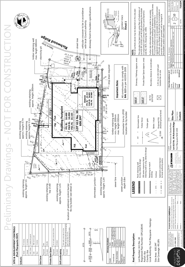
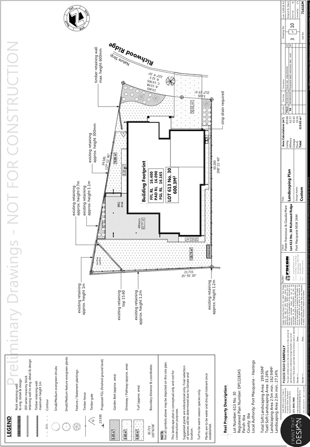
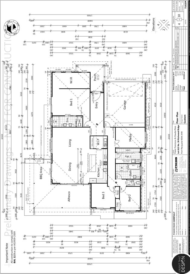
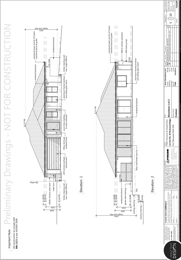
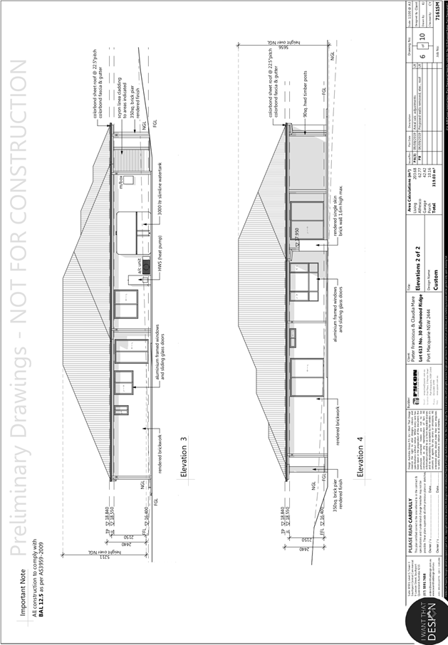
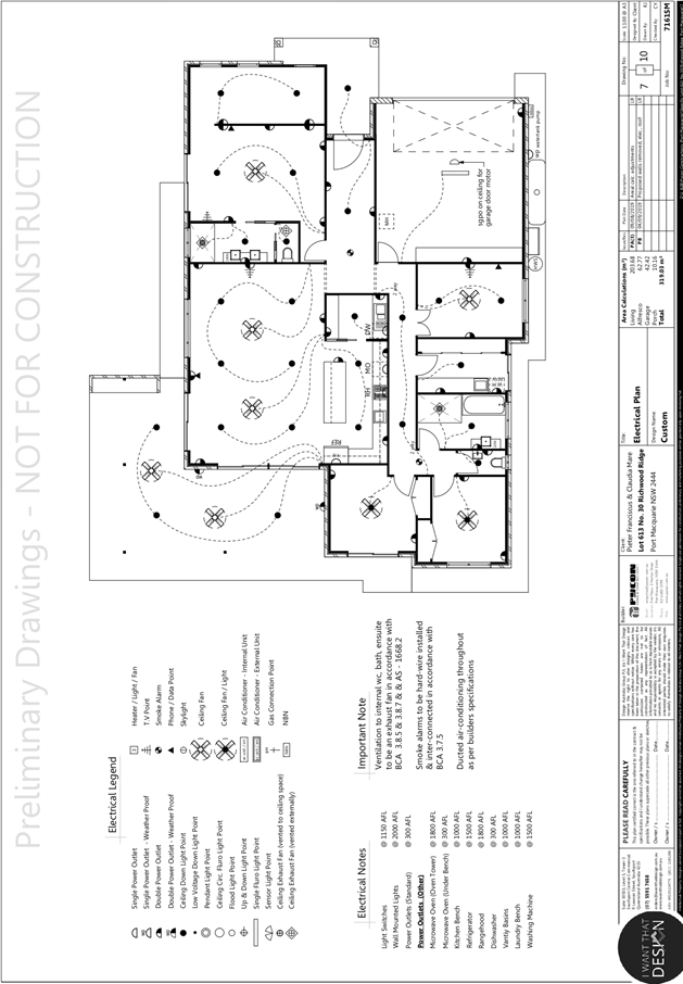
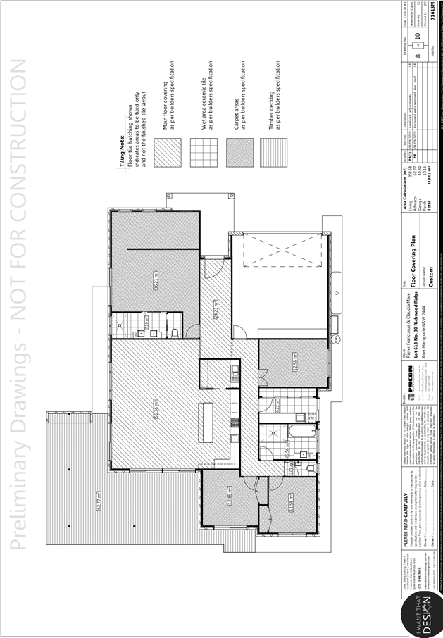
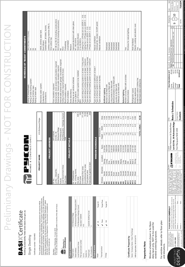
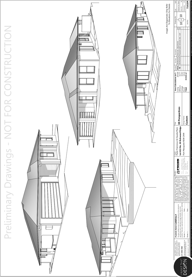
|
ATTACHMENT
|
Development Assessment Panel
25/09/2019
|
AGENDA Development Assessment Panel 25/09/2019
Item: 09
Subject: DA 2019 - 388.1, Boarding House at Lot 334 DP 216093, No. 14 The
Jib, Port Macquarie
Report Author: Development
Assessment Planner, Beau Spry
|
Applicant: Mr Matthew Morris & Mr Nathan Shields C/- King
& Campbell Pty Ltd
Owner: Matthew
Morris and Nathan Shields
Estimated Cost: $350,000
Alignment with Delivery Program
4.3.1 Undertake transparent and
efficient development assessment in accordance with relevant legislation.
|
|
RECOMMENDATION
That
DA 2019-388.1 for a Boarding
House at Lot 334, DP 216093, No. 14 The Jib, Port
Macquarie, be determined by granting consent
subject to the recommended conditions.
|
Executive
Summary
This
report considers a development application for a boarding house at the subject site and provides an assessment of the
application in accordance with the Environmental Planning and Assessment Act
1979.
Following exhibition of the
application, one (1) submission was received.
This report recommends that the
development application be approved subject to the attached conditions.
1. BACKGROUND
Existing Sites Features and Surrounding Development
The site has an area of 767.8
m2.
The site has frontage to The Jib and slopes gently towards
the north.
There are existing dwellings to the north, east and south
and a vacant block and existing dwellings to the west.
The site is traversed at the
southern end by an existing stormwater pipeline. There is an existing
stormwater junction towards the south-eastern corner of the site.
The site is zoned R1 general residential in accordance with the Port Macquarie-Hastings Local Environmental
Plan 2011, as shown in the following zoning plan:
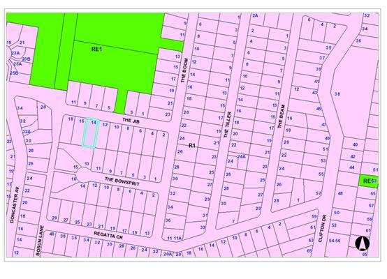
The existing subdivision pattern and location of existing
development within the locality is shown in the following aerial photograph:
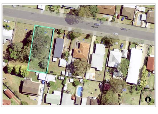
The area
surrounding the site comprises a mix of single and two storey residential
development with a small number of medium density developments (two-storey
units) occurring within the locality.
2. DESCRIPTION OF
DEVELOPMENT
Key aspects of the proposal include the following:
· Tree removal and proposed offset planting on a Council
reserve; and
· Construction of a single-storey boarding house
including 7 boarding rooms
Refer
to attachments at the end of this report for further details.
Application Chronology
· 30 May 2019 - Application lodged with Council
· 5 - 21 June 2019 - Neighbour Notification
· 26 June 2019 - Site inspection
· 19 July - 20 August 2019 - Additional information
requested and received
3. STATUTORY ASSESSMENT
Section 4.15(1) Matters for Consideration
In determining the application, Council is required to take
into consideration the following matters as are relevant to the development
that apply to the land to which the development application relates:
(a) The provisions (where
applicable) of:
(i) Any Environmental Planning
Instrument
State Environmental Planning Policy No. 44 - Koala
Habitat Protection
There is no Koala Plan of Management on the site.
Additionally, the site is less than 1ha in area therefore no further
investigations are required. Fourteen (14) koala food trees are proposed to be
removed and offset as part of the proposal, the detail of which are discussed
elsewhere in this report.
State Environmental Planning Policy No. 55 –
Remediation of Land
Following an inspection of the site and a search of Council
records, the subject land is not identified as being potentially contaminated
and is suitable for the intended use.
State Environmental Planning Policy (Coastal Management)
2018
The site is not located within a coastal use area or coastal
environment area.
State Environmental Planning Policy (Affordable Rental
Housing) 2009
The proposal includes a seven (7)-bedroom boarding house and
Division 3 of the SEPP applies. The following assessment table provides an
assessment checklist against the Division 3 requirements of this SEPP:
|
Applicable
clauses for consideration
|
Comments
|
Satisfactory
|
|
Clause 26 Land to which Division applies
|
The land is zoned R1 General Residential and the Division
applies.
|
Yes
|
|
Clause 27 Development to which Division applies
|
In accordance with subclause (1) the land is in an R1 zone
and the development is a boarding house.
|
Yes
|
|
Clause 28
|
Consent is required for the boarding house and has been
sought in this application.
|
Yes
|
|
Clause 29(1)(a) Standards that cannot be used to refuse
consent – density and scale
|
(a) The maximum floor space
ratio specified for the site under the PMH LEP 2011 is 0.65:1. The proposed
floor space ratio at 0.47:1 is compliant with this requirement.
(b) Not relevant – the
site is zoned R1 General Residential.
|
Yes
|
|
Clause 29(2)(a) Standards that cannot be used to refuse
consent – building height
|
Consent cannot be refused on the grounds of building
height if the building height of all proposed buildings
is not more than the maximum building height permitted under another
environmental planning instrument for any building on the land. The LEP
Height of Buildings Map identifies a maximum building height of 8.5m above
existing ground level for the site.
A maximum building height of
8.5m applies to the site under the PMH LEP 2011. The proposed boarding house
is single storey with max 5.4m building height. Accordingly, the proposed
development will not exceed the maximum building height of 8.5m permitted
under the PMH LEP 2011.
|
Yes
|
|
Clause 29(2)(b) Standards that cannot be used to refuse
consent – landscaped area
|
Consent cannot be refused on the grounds of landscaped
area if the landscape treatment of the front setback
area is compatible with the streetscape in which the building is located.
The proposal includes a
stepped, decorative front entry wall, which is setback 1m from the front
boundary. On the street-side of this will be landscape plantings. This
setback treatment will provide an attractive visual screen for the car park
and bin storage area.
Additionally the proposed
front entry wall will be consistent in scale and character to the front fence
on adjoining Lot 335 DP216093 (12 The Jib).
On this basis, the proposed landscape
treatment is considered to be compatible with the streetscape.
|
Yes
|
|
Clause 29(2)(c) Standards that cannot be used to refuse
consent – solar access
|
Consent cannot be refused on the grounds of solar
access where the development provides for one or more
communal living rooms, if at least one of those rooms receives a minimum of 3
hours direct sunlight between 9am and 3pm in mid-winter.
The proposed boarding house
provides one communal living room within the south-western corner that is
directly accessible to the rear yard and drying area, and will receive
adequate solar access.
|
Yes
|
|
Clause 29(2)(d) Standards that cannot be used to refuse
consent – private open space
|
Consent cannot be refused on the grounds of private
open space if at least the following private open space
areas are provided (other than the front setback area):
(i) one area of at least 20
square meters with a minimum dimension of 3 meters is provided for the use of
the lodgers,
(ii) if accommodation is
provided on site for a boarding house manager—one area of at least 8
square meters with a minimum dimension of 2.5 meters is provided adjacent to
that accommodation,
The proposed private open space (POS) is provided to the
rear of the Boarding House, directly accessible from the internal common
room. The POS has minimum dimensions of 5.5m x 18m and an area of
approximately 99m2. An on-site manager is not proposed.
|
Yes
|
|
Clause 29(2)(e) Standards that cannot be used to refuse
consent – parking
|
Consent cannot be refused on the grounds of parking if:
(iia) in the case of development not carried out by or on
behalf of a social housing provider—at least 0.5 parking spaces are
provided for each boarding room, and
(iii) in the case of any development—not more than 1
parking space is provided for each person employed in connection with the
development and who is resident on site.
The proposed boarding house is
not being carried out by or on behalf of a social housing provider. Therefore,
0.5 parking spaces are required to be provided for each boarding room
(bedroom).
The proposal is for 7 boarding rooms and requires 3.5
(rounded to 4) spaces.
The application proposes 4 car parking spaces (including 1
accessible space), and 1 motorcycle parking space. The development therefore
satisfies the minimum parking requirements and consent cannot be refused on
this basis.
|
Yes
|
|
Clause 29(2)(f) Standards that cannot be used to refuse
consent – accommodation size.
|
Consent cannot be refused on the grounds of
accommodation size if each boarding room has a gross
floor area (excluding any area used for the purposes of private kitchen or
bathroom facilities) of at least:
(i) 12 square metres in the case
of a boarding room intended to be used by a single lodger, or
(ii) 16 square metres in any
other case.
The proposed boarding rooms
are proposed to permit use by a maximum of 2 adult lodgers at any one time.
Each unit has a gross floor area (GFA) of greater than 41m2
including kitchen and bathroom facilities or 23m2 excluding the
private kitchen and bathroom facilities (as a restrictive requirement of this
SEPP). The accommodation therefore exceed the minimum size for
two adult lodgers. Consent cannot be refused on the basis of accommodation
size.
|
Yes
|
|
Clause 29(3) A boarding house may have
private kitchen or bathroom facilities in each boarding room but is not
required to have those facilities in any boarding room.
|
Each proposed boarding room has private bathroom and
kitchen facilities.
|
Yes
|
|
Clause 29(4) A consent authority may consent
to development to which this Division applies whether or not the development
complies with the standards set out in subclause (1) or (2).
|
Noted.
|
n/a
|
|
Clause 30 - Standards for boarding houses
(1) A consent authority must not
consent to development to which this Division applies unless it is satisfied
of each of the following:
(a) if a boarding house has 5
or more boarding rooms, at least one communal living room will be provided,
(b) no boarding room will have
a gross floor area (excluding any area used for the purposes of private
kitchen or bathroom facilities) of more than 25 square metres,
(c) no boarding room will be
occupied by more than 2 adult lodgers,
(d) adequate bathroom and
kitchen facilities will be available within the boarding house for the use of
each lodger,
(e) if the boarding house has
capacity to accommodate 20 or more lodgers, a boarding room or on site
dwelling will be provided for a boarding house manager,
(f) (Repealed)
(g) if the boarding house is
on land zoned primarily for commercial purposes, no part of the ground floor
of the boarding house that fronts a street will be used for residential
purposes unless another environmental planning instrument permits such a use,
(h) at least one parking space
will be provided for a bicycle, and one will be provided for a motorcycle,
for every 5 boarding rooms.
|
(a) The proposal includes 7
bedrooms and provides 1 communal living area satisfying the minimum
dimensions of 29(2)(d).
(b) The proposed boarding
rooms have a GFA of approximately 23m2, with this area excluding
the private kitchen and bathroom areas, thus not exceeding the 25m2
GFA limit.
(c) The Statement of Environmental Effects indicates that
not more than two adult lodgers are proposed per room. A condition is
recommended confirming this restriction.
(d) Private bathroom and kitchen facilities are proposed
for each boarding room. The facilities are considered satisfactory for the
number of lodgers proposed.
(e) The proposal includes 7
bedrooms, each with a maximum capacity of 2 adult lodgers, or 14 lodgers in
total.
(g) The site is not on land zoned for commercial purposes.
(h) A suitable area has been
set aside within the parking area to enable 2 bicycle and 1 motorcycle spaces
to be accommodated.
|
Yes
|
|
Clause 30A - Character of local
area
A consent authority must not consent to
development to which this Division applies unless it has taken into
consideration whether the design of the development is compatible with the
character of the local area.
|
The area surrounding the site
comprises a mix of single and two storey residential development with a small
number of medium density developments occurring within the locality (two
storey units at 4 The Jib and 30 The Boom).
The proposed building has been
limited to single storey construction and provided within an articulated
frontage that includes a front entry wall, similar in height to the
front fence on the adjoining
site (12 The Jib). The front elevation also includes a mix of building
materials to ensure visual interest. Landscaping is proposed in front of the
proposed entry wall as well as the front of the boarding house.
In addition, the proposal is
consistent with the floor space ratio requirements for the residential
locality and is permissible with consent in the zone.
Based on the above, it is
submitted that the proposed boarding house is sufficiently compatible with
the character of the surrounding locality.
|
Yes
|
|
Clause 52 – No subdivision of boarding
houses
A consent authority must not grant consent
to the strata subdivision or community title subdivision of a boarding house.
|
The application does not propose strata or community title
subdivision of the boarding house.
|
Yes
|
State Environmental Planning Policy (Building
Sustainability Index: BASIX) 2004
A BASIX certificate is not
required for the proposed boarding house as it has an area greater than 300m2.
Accordingly, the proposed Boarding House is a Class 3 building. Building
Classes 3 and 5 to 9 buildings are not subject to BASIX, BCA sub-section J(B)
applies the provisions of the national BCA Section J relevant to class 3 and
Class 5 to 9 buildings.
Port Macquarie-Hastings Local Environmental
Plan 2011
The proposal is consistent with the LEP having regard to the
following:
· Clause
2.2 - The subject site is zoned R1 General Residential.
· Clause
2.3(1) and the R1 zone landuse table - The dwelling (or ancillary structure to
a dwelling) is a permissible landuse with consent.
The objectives of the R1 zone are as
follows:
o To provide for the housing
needs of the community.
o To provide for a variety of
housing types and densities.
o To enable other land uses that
provide facilities or services to meet the day to day needs of residents.
· Clause
2.3(2) - The proposal is consistent with the zone objectives having regard to
the following:
o the proposal is a permissible
landuse;
· Clause
4.3 - The maximum overall height of the building above ground level (existing)
is 6.30m which complies with the standard height limit of 8.50m applying to the
site.
· Clause
4.4 - The floor space ratio of the proposal is 0.47:1.0 which complies with the
maximum 0.65:1 floor space ratio applying to the site.
· Clause
5.10 –The site does not contain or adjoin any known heritage items or
sites of significance.
· Clause
6.2 - Satisfactory arrangements are in place for provision of essential public
utility infrastructure including stormwater, water and sewer infrastructure to
service the development within an urban release area.
· Clause
7.13 - Satisfactory arrangements are in place for provision of essential
services including water supply, electricity supply, sewer infrastructure,
stormwater drainage and suitable road access to service the development.
(ii) Any
draft instruments that apply to the site or are on exhibition
No draft
instruments apply to the site.
(iii) Any
Development Control Plan (DCP) in force
Port
Macquarie-Hastings Development Control Plan 2013
|
DCP 2013: General
Provisions
|
|
DCP Objective
|
Development Provisions
|
Proposed
|
Complies
|
|
2.7.2.2
|
Design addresses generic
principles of Crime Prevention Through Environmental Design guideline:
· Casual surveillance and sightlines
· Land use mix and activity generators
· Definition of use and ownership
· Lighting
· Way finding
· Predictable routes and entrapment locations
|
The proposed building design
includes access to boarding rooms from ground level to each unit which would
minimise opportunities for entrapment and concealment. Good casual
surveillance is available for the car park and communal open space areas from
the boarding rooms and communal living rooms.
Boundary fencing is proposed to
be well defined and would limit access to the driveway and pedestrian path
from The Jib.
Lighting is proposed within the
development to improve safety at night and a condition is recommended to
ensure that the lighting does not cause nuisance to neighbouring property.
|
Yes
|
|
2.3.3.1
|
Cut and fill 1.0m max. 1m
outside the perimeter of the external building walls
|
The proposed cut and fill will
not exceed 1m.
|
Yes
|
|
2.3.3.2
|
1m max. height retaining walls
along road frontages
|
No retaining walls proposed
along road frontage.
|
n/a
|
|
Any retaining wall >1.0 in
height to be certified by structural engineer
|
Condition recommended requiring
certification of retaining walls.
|
Yes
|
|
Combination of retaining wall
and front fence height
|
No retaining wall and front
fence combination proposed.
|
n/a
|
|
2.3.3.8 onwards
|
Removal of hollow bearing trees
|
The Arborist report did not identify any Hollow Bearing
Trees.
|
n/a
|
|
2.6.3.1
|
Tree removal (3m or higher with
100mm diameter trunk and 3m outside dwelling footprint
|
Proposal includes removal of 19
Trees surveyed on lot 334, including:
13
Melaleuca quinquenervia (Secondary koala browse spp.)
1
Melaleuca linariifolia
1 Eucalyptus tereticornis
(Primary koala browse spp.) High ISA Risk/ TPZ SRZ incursion.
1 Casuarina
glauca
2 Corymbia intermedia
1
Ficus elastic
Compensatory
replanting is required at a minimum 1:1 ratio for Primary and Secondary trees removed at
proposed Council owned sites at Lot 30 DP 263203 Lady Nelson Drive and Lot 46
DP 733281 The Jib.
Refer to more
specific details later in this report.
|
Yes
|
|
2.4.3
|
Bushfire risk, Acid sulphate
soils, Flooding, Contamination, Airspace protection, Noise and Stormwater
|
Refer to main body of report.
|
|
|
2.5.3.2
|
New accesses not permitted from
arterial or distributor roads. Existing accesses rationalised or removed
where practical
|
No access to arterial or
collector road proposed.
|
Yes
|
|
Driveway crossing/s minimal in
number and width including maximising street parking
|
Driveway crossing of acceptable
width with maximised retention of street parking.
|
Yes
|
|
2.5.3.3
|
Off-street parking in accordance
with Table 2.5.1.
|
Table 2.5.1 requires boarding
houses to have a minimum of 1 space per 2 bedrooms.
This is the same rate as
required by SEPP (Affordable Rental Housing) 2009 and adequate parking is
proposed.
|
Yes
|
|
2.5.3.7
|
Visitor parking to be easily
accessible
|
Parking for residents and
visitors considered to be easily accessible.
|
Yes
|
|
Parking in accordance with AS
2890.1
|
Parking capable of complying
with AS2890. Conditions recommended requiring design and certification of
parking areas to this standard.
|
Yes
|
|
2.5.3.9
|
Bicycle and motorcycle parking
considered and designed generally in accordance with the principles of
AS2890.3
|
Bicycle and motorcycle parking
proposed as part of the development. Conditions recommended requiring design
and certification of parking areas to this standard.
|
Yes
|
|
2.5.3.11
|
Section 94 contributions
|
Refer to main body of report.
|
|
|
2.5.3.12
|
Landscaping of parking areas
|
Landscaping of the proposed
car park has been provided to the front of the car park and around the edges.
|
Yes
|
|
2.5.3.14
|
Sealed driveway surfaces unless
justified
|
Driveway and parking areas
proposed to be sealed.
|
Yes
|
|
2.5.3.15
|
Driveway grades for first 6m of
‘parking area’ shall be 5% grade
(Note AS/NZS 2890.1 permits
steeper grades)
|
Driveway grades capable of
complying. Condition recommended requiring details with the Construction
Certificate and Section 138 applications.
|
Yes
|
|
2.5.3.16
|
Transitional grades min. 2m
length
|
|
2.5.3.17
|
Parking areas to be designed to
avoid concentrations of water runoff on the surface.
|
Details of proposed stormwater
management have been submitted with the application. See comments under
‘Stormwater’ later in this report.
|
Yes
|
|
No direct discharge to K&G
or swale drain
|
|
2.5.3.18
|
Car parking areas drained to
swales, bio retention, rain gardens and infiltration areas
|
(iiia) Any
planning agreement that has been entered into under section 7.4, or any draft
planning agreement that a developer has offered to enter into under section 7.4
No planning agreement has been offered or entered into
relating to the site.
(iv) Any matters prescribed by the
Regulations
None prescribed
(b) The
likely impacts of that development, including environmental impacts on both the
natural and built environments, social and economic impacts in the locality:
Context and Settings
The site has a frontage to The Jib. Adjoining the site are
further R1 residential uses. The proposal is considered to be sufficiently
compatible with other residential development in the locality and adequately
addresses planning controls for the area.
The proposal does not have significant adverse lighting
impacts.
The proposal will be unlikely to have any adverse impacts to
existing adjoining properties and satisfactorily addresses the public domain.
The proposal is considered to be consistent with other
residential development in the locality and adequately addresses planning
controls for the area.
The proposal does not have a significant adverse impact on
existing view sharing.
The proposal does not have significant adverse lighting
impacts.
There are no significant adverse privacy impacts. Adequate
building separation and tenancy is proposed/existing.
There are no significant adverse overshadowing impacts. The
proposal does not prevent adjoining properties from receiving 3 hours of
sunlight to private open space and primary living areas on 21 June between the
hours of 9am and 3pm.
Access, Traffic and Transport
The site has road frontage to The Jib. The Jib is a sealed
public collector road under the care and control of Council. The proposal will
be unlikely to have any adverse impacts in terms access, transport and traffic.
The existing road network will satisfactorily cater for any increase in traffic
generation as a result of the development.
Parking and Manoeuvring
A total of 4 parking spaces, including 1 accessible space,
have been provided on-site in a carpark to the front of the proposal.
Additionally motorcycle and bicycle parking is also provided. Parking and
driveway widths on site are capable of complying with relevant Australian
Standards (AS 2890) and conditions are recommended to reflect these
requirements.
Due to the type of development, car park circulation is
required to enable vehicles to enter and exit the site in a forward
manner. Site plans show adequate area is available and conditions have
been imposed to reflect these requirements.
Water Supply Connection
Council records indicate that
the development site has no existing metered water service. The site is fronted
by a 100mm AC water main on the same side of street.
Final water service sizing will
need to be determined by a hydraulic consultant to suit the domestic and
commercial components of the development. Fire service and backflow protection
requirements must be addressed in accordance with AS 3500.
A condition has been recommended
to reflect these requirements.
Sewer Connection
Council
records indicate that the development site is connected to sewer via junction
to the existing sewer line that runs outside the northern property boundary. The
proposed development must discharge sewage to an existing or proposed sewer
manhole.
A condition has been recommended
to reflect these requirements.
Stormwater
The site naturally grades towards the street and is
currently unserviced.
The legal point of discharge for the proposed development is
defined as a direct connection to Council’s stormwater pipeline within
the proposed stormwater easement.
Stormwater from the proposed development is planned to be
disposed mainly to the existing stormwater pipe (with easement to be created
over) and the front portion to drain to a kerb outlet.
A detailed site stormwater management plan will be required
to be submitted for assessment with the S.68 application and prior to the issue
of a CC.
In accordance with Councils AUSPEC requirements, the
following must be incorporated into the stormwater drainage plan:
· On
site stormwater detention
· As
the site is traversed by an existing stormwater pipeline, a dilapidation report
is required to be undertaken pre and post works to ensure that the structural
integrity of the public stormwater infrastructure is not impacted upon by the
proposed development. In this regard an easement will be required to be created
over this pipe.
Appropriate conditions have been
recommended in this regard to reflect these requirements.
Other Utilities
Telecommunication and electricity services are available to
the site.
Heritage
No known items of Aboriginal or European heritage
significance exist on the property. No adverse impacts anticipated.
Other land resources
The site is within an established urban context and will not
sterilise any significant mineral or agricultural resource.
Water cycle
The proposed development will not have any significant
adverse impacts on water resources and the water cycle.
Soils
The proposed development will not have any significant
adverse impacts on soils in terms of quality, erosion, stability and/or
productivity subject to a standard condition requiring erosion and sediment controls
to be in place prior to and during construction.
Air and microclimate
The construction and/or operations of the proposed
development will not result in any significant adverse impacts on the existing
air quality or result in any pollution. Standard precautionary site management
condition recommended.
Flora and fauna
Construction of the proposed development will require
removal/clearing of nineteen (19) trees as detailed on the Arborists Report
dated 14 May 2019 attached to this report. The following comments are provided
to justify the appropriateness of recommending support to the removal of the
subject trees:
· The
site is zoned residential and surrounded by existing urban development.
· The
existing vegetation is an isolated patch and is not mapped in biodiversity
values mapping.
· Given
the location of the site in an established urban environment, and the nature of
the proposal being acceptable by SEPP, LEP and DCP standards, the removal of
the trees and their offset to a more suitable location was considered
acceptable.
· It is considered more appropriate to require planting of
appropriate habitat plantings in a more suitable location as detailed shown
below. The recommended condition is to require:
o (B195) Prior to
the issue of a Construction Certificate, a suitably experienced Bush
Regeneration Contractor shall arrange for planting of fourteen (14) trees
across Lot 30 DP 263203 Lady Nelson Drive and Lot 46 DP 733281 The Jib, Port
Macquarie to the satisfaction of Council. Evidence of plantings being completed
shall be provided to the Principal Certifying Authority prior to the issue of a
Construction Certificate. Eucalyptus robusta
and/or Eucalyptus microcorys can be planted in
the eastern end at 8m centres, with stems no closer than 20m to private
property boundaries to the east. Trees are to be mulched and deer-proof
guarded.
· The
location of the proposed offset on Council land is detailed below:
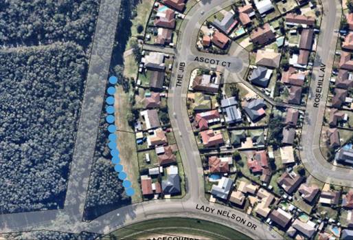
Subject to requiring the offset planting to be completed
prior to construction commencing, the proposal will be unlikely to have any
significant adverse impacts on biodiversity or threatened species of flora and
fauna subject to the recommended consent condition. Part 7 of the Biodiversity
Conservation Act is considered to be satisfied.
Waste
Satisfactory arrangements are in place for proposed storage
and collection of waste and recyclables. No adverse impacts anticipated.
Standard precautionary site management condition recommended.
Energy
The proposal includes measures to address energy efficiency
and will be required to comply with the requirements of Section J of the
Building Code of Australia. No adverse impacts anticipated.
Noise and vibration
The construction and/or operations of the proposed
development will not result in any significant adverse impacts on the existing
air quality or result in any pollution. Standard precautionary site management
condition recommended.
Bushfire
The site is not identified as being bushfire prone.
Safety, security and crime prevention
The proposed development will be unlikely to create any
concealment/entrapment areas or crime spots that would result in any
identifiable loss of safety or reduction of security in the immediate area.
The increase in housing density will improve natural surveillance within the
locality and openings from each dwelling overlook common and private areas.
Social impacts in the locality
Given the nature of the proposed development and its
location the proposal is not considered to have any significant adverse social
impacts.
Economic impact in the locality
The proposal is not considered to have any significant
adverse economic impacts on the locality. A likely positive impact is that the
development will maintain employment in the construction industry, which will
lead to flow impacts such as expenditure in the area.
Site design and internal design
The proposed development design satisfactorily responds to
the site attributes and will fit into the locality.
Construction
Construction impacts are considered capable of being
managed, standard construction and site management conditions have been
recommended.
Cumulative impacts
The proposed development is not considered to have any
significant adverse cumulative impacts on the natural or built environment or
the social and economic attributes of the locality.
(c) The suitability of the site for
the development
The proposal will fit into the locality and the site attributes
are conducive to the proposed development.
(d) Any submissions made in
accordance with this Act or the Regulations
One
(1) written submission has been received following neighbour notification of
the application.
Key issues raised in the
submissions received and comments in response are provided as follows:
|
Submission Issue
|
Planning Comment/Response
|
|
Impact on character of the street, noise and disturbance
to all existing homes along the street are single / double family per
house.
|
For a new development to be
visually compatible with its context, it should contain, or at least respond
to, the essential elements that make up the character of the surrounding
urban environment. The most important contributor to urban character is the
relationship of built form to surrounding space, a relationship that is
created by building height, setbacks and landscaping.
In this regard the proposed
building height is compliant with the maximum building height of 8.5m and the
front and side setbacks satisfy the planning controls. Satisfactory
landscaping is proposed, and the frontage has been designed to complement
existing neighbouring frontages.
It should be noted that the area surrounding the site also
comprises a mix of single and two storey residential development with a
number of medium density developments occurring within the locality (two
storey units at 4 The Jib and 30 The Boom).
|
|
Parking and traffic:
· Traffic increase if 14
adults do move in. Where will the residents park their cars?
· Where will visitors /
maintenance workers park?
· The street is a very
narrow street that already has trouble accommodating the bus that runs
through the Jib, especially when there are cars parked out on the street;
· Addition to the
already current congestion of traffic in the street, which is another
potential safety hazard.
|
The proposed parking complies with the minimum required by
parking requirements of the State Environmental Planning Policy (Affordable Rental
Housing) 2009.
The
existing street has capacity for the anticipated additional traffic having
regard to Council’s AUSPEC road design requirements.
The
street is considered wide enough to park cars on either side of the driveway,
should it be necessary.
|
|
The Removal of mature trees:
· Concerns around the
amount of tree clearing with no attempt to retain any trees;
· Potential impact on
birdlife;
|
The site is zoned residential
and surrounded by existing urban development. The existing vegetation is an
isolated patch not having any identifiable significant ecological value.
The proposal includes a
significant amount of tree offset planting on Council land. Council’s
Natural Resources Section have reviewed and supported the proposal on the
basis of the tree offset proposal.
Given the location of the site in an established urban
environment, and the nature of the proposal being acceptable by SEPP, LEP and
DCP standards, the removal of the trees ad their offset was considered
acceptable.
|
|
Social and safety concerns:
· Capacity
and supervision concerns;
· Need for
manager to be onsite;
|
Given the proposed capacity of the boarding house, a
manager is not required as per the Affordable Rental Housing SEPP.
The proposal has identified a maximum of 2 adults per room
and this is reflected in the conditions.
|
(e) The Public Interest
The proposed development will be in the wider public
interest with provision of appropriate additional alternate forms of housing.
The proposed development satisfies relevant planning
controls and will not have any significant adverse impacts on the wider public
interest.
Ecologically Sustainable Development and Precautionary
Principle
Ecologically sustainable development requires the effective integration
of economic and environmental considerations in decision-making processes.
The four principles of ecologically sustainable development
are:
· the
precautionary principle,
· intergenerational
equity,
· conservation
of biological diversity and ecological integrity,
· improved
valuation, pricing and incentive mechanisms.
The principles of ESD require that a balance needs to be
struck between the man-made development and in this case, the need to
appropriately offset the natural vegetation. Based on the assessment provided
in the report and with recommended conditions of consent, it is considered an
appropriate balance has been struck.
4. DEVELOPMENT
CONTRIBUTIONS APPLICABLE
· Development contributions will be required towards
augmentation of town water supply and sewerage system head works under Section 64
of the Local Government Act 1993.
· Development
contributions will be required under Section 7.11 of the Environmental Planning
and Assessment Act 1979 towards roads, open space, community cultural services,
emergency services and administration buildings.
5. CONCLUSION AND
STATEMENT OF REASON
The application has been assessed
in accordance with Section 4.15 of the Environmental Planning and Assessment
Act 1979.
Issues raised during assessment
and public exhibition of the application have been considered in the assessment
of the application. Where relevant, conditions have been recommended to manage
the impacts attributed to these issues.
The site is considered suitable
for the proposed development and the proposal adequately addresses relevant
planning controls. The development is not considered to be contrary to the
public's interest and will not result a significant adverse social,
environmental or economic impact. It is recommended that the application be
approved, subject to the recommended conditions of consent provided in the
attachment section of this report.
|
Attachments
1View. DA2019
- 388.1 Plans
2View. DA2019
- 388.1 Recommended DA Conditions
|
|
ATTACHMENT
|
Development Assessment Panel
25/09/2019
|
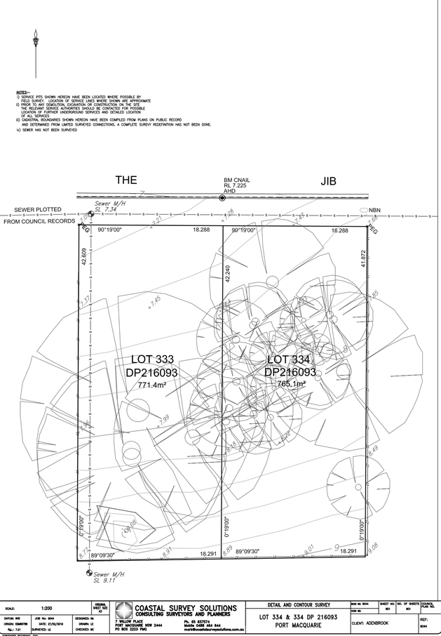
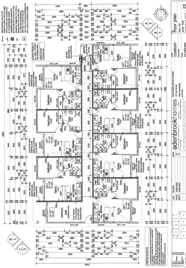
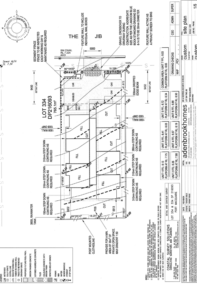
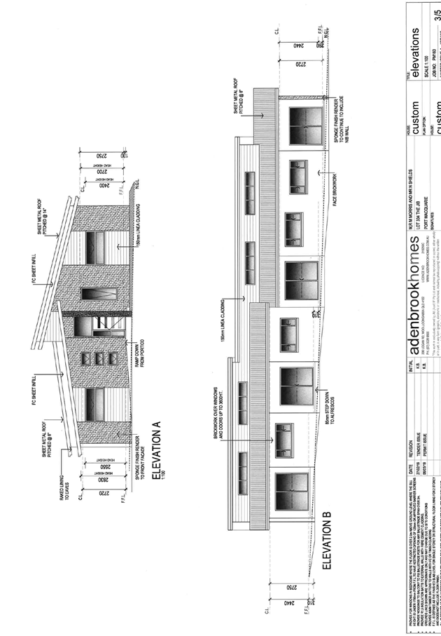
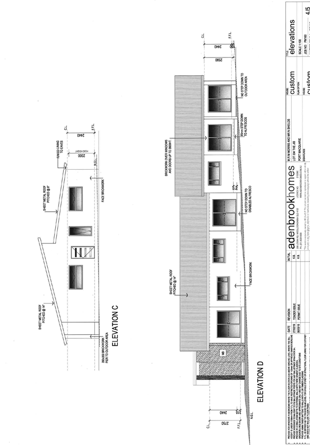
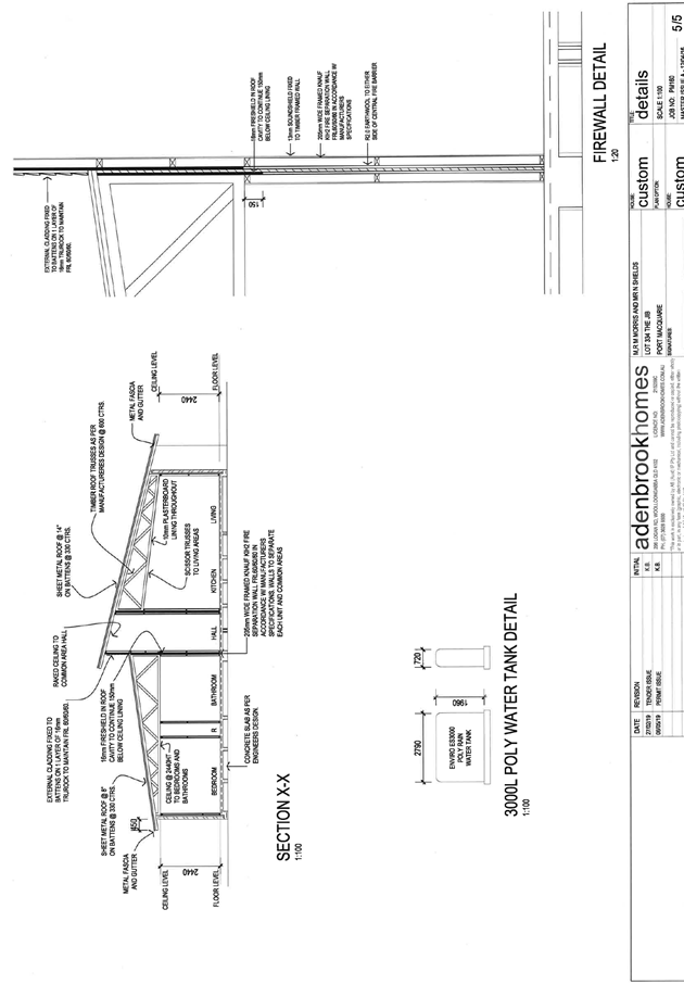
|
ATTACHMENT
|
Development Assessment Panel
25/09/2019
|