Business
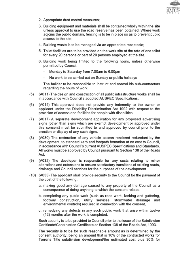
Paper
|
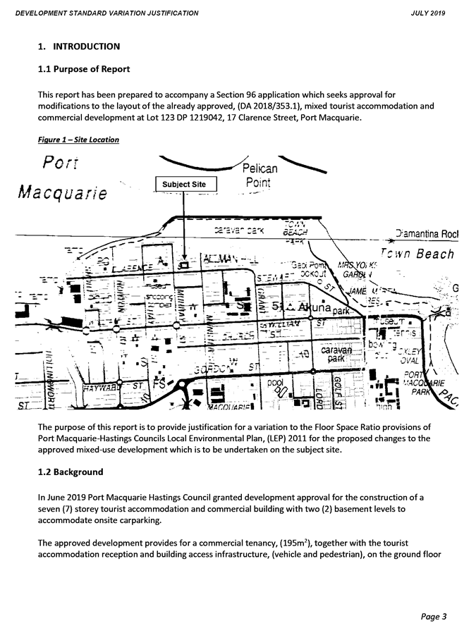
date of meeting:
|
|
Wednesday 27
November 2019
|
|
location:
|
|
Function Room
Port
Macquarie-Hastings Council
17 Burrawan Street
Port Macquarie
|
|
time:
|
|
2:00pm
|
Development
Assessment Panel
CHARTER
1.0 OBJECTIVES
To assist in managing Council's development assessment
function by providing independent and expert determinations of development
applications that fall outside of staff delegations.
2.0 KEY FUNCTIONS
·
To review development application reports and conditions;
·
To determine development
applications outside of staff delegations;
·
To refer development applications
to Council for determination where necessary;
·
To provide a forum for objectors and applicants
to make submissions on applications
before the Development Assessment Panel
(DAP);
·
To maintain transparency in the determination of development
applications.
Delegated Authority of Panel
Pursuant to
Section 377 of the Local Government Act, 1993 delegation to:
·
Determine development applications under Part 4
of the Environmental Planning and Assessment
Act 1979 having
regard to the relevant environmental planning instruments,
development control plans and Council policies.
·
Vary, modify or release restrictions as to use
and/or covenants created by Section 88B instruments under the Conveyancing Act
1919 in relation to development applications for subdivisions being considered
by the panel.
·
Determine Koala Plans of Management under State
Environmental Planning Policy 44 - Koala Habitat Protection associated with
development applications being considered by the Panel.
Noting the trigger to escalate
decision making to Council as highlighted in section 5.2.
3.0
MEMBERSHIP
3.1
Voting
Members
·
Two independent external members. One of the
independent external members to be the Chairperson.
·
Group Manager Development Assessment (alternate
- Director Development & Environment or Development Assessment Planner)
The independent external members shall have expertise in
one or more of the following areas: planning, architecture, heritage, the
environment, urban design, economics, traffic and transport, law, engineering,
government and public administration.
3.2
Non-Voting Members
·
Not applicable
3.3 Obligations
of members
·
Members must act faithfully and diligently and
in accordance with this Charter.
·
Members must comply with Council's Code of Conduct.
·
Except as required to properly perform their
duties, DAP members must not
disclose any confidential information (as advised by Council) obtained in connection with the DAP functions.
·
Members will have read and be familiar with the
documents and information provided by Council prior
to attending a DAP meeting.
·
Members must act in accordance with Council's
Workplace Health and Safety Policies and Procedures
·
External members of the Panel are not authorised
to speak to the media on behalf of Council. Council officers that are members
of the Committee are bound by the
existing operational delegations in relation to speaking to the media.
·
Staff members shall not vote on matters before
the Panel if they have been the principle author of the development assessment report.
3.4
Member Tenure
·
The independent external members will be
appointed for the term of four (4) years
maximum in which the end of the tenure of these members would occur in a
cascading arrangement.
3.5 Appointment
of members
·
The independent external members (including the
Chair) shall be appointed by the General Manager following an external
Expression of Interest process.
·
Staff members of the Panel are in accordance
with this Charter.
4.0 TIMETABLE
OF MEETINGS
·
The Development Assessment Panel will generally
meet on the 1st and 3rd Wednesday each month at 2.00pm at the Port Macquarie
offices of Council.
·
Special Meetings of the Panel may be convened by
the Director Development & Environment Services with three (3) days notice.
5.0
MEETING PRACTICES
5.1
Meeting
Format
·
At all Meetings of the Panel the Chairperson
shall occupy the Chair and preside. The Chair will be responsible for keeping
of order at meetings.
·
Meetings shall be open to the public.
·
The Panel will hear from applicants
and objectors or their r e p r e s e n t a t i v e s .
·
Where considered necessary, the Panel will
conduct site inspections which will
be open to the public.
5.2
Decision Making
·
Decisions are to be made by consensus. Where
consensus is not possible on any item, that item is to be referred to Council
for a decision.
·
All development applications involving a
proposed variation to a development standard
greater than 10% under Clause
4.6 of the Local Environmental Plan will be
considered by the Panel and recommendation made to the Council for a decision.
5.3
Quorum
·
All members (2 independent external members and
1 staff member) must be present at a
meeting to form a quorum.
5.4
Chairperson and Deputy Chairperson
·
Independent Chair (alternate, second independent member)
5.5
Secretariat
·
The Director Development &n Environment is
to be responsible for ensuring that the Panel has adequate secretariat support.
The secretariat will ensure that the business paper and supporting papers are
circulated at least three (3) days prior to
each meeting. Minutes shall be appropriately approved and circulated to each
member within three (3) weeks of a meeting being held.
·
The format of and the preparation and publishing
of the Business Paper and Minutes shall be similar to the format for Ordinary
Council Meetings.
5.6
Recording of decisions
·
Minutes will record decisions and how each
member votes for each item before the Panel.
6.0 CONVENING
OF “OUTCOME SPECIFIC” WORKING GROUPS
Not applicable.
7.0 CONFIDENTIALITY
AND CONFLICT OF INTEREST
·
Members of the Panel must comply with the
applicable provisions of Council’s Code of Conduct. It is the personal
responsibility of members to comply with the standards in the Code of Conduct
and regularly review their personal circumstances with this in mind.
·
Panel members must declare any conflict of
interests at the start of each meeting or before discussion of a relevant item
or topic. Details of any conflicts of interest should be appropriately minuted.
Where members are deemed to have a real or perceived conflict of interest, it
may be appropriate they be excused from deliberations on the issue where the
conflict of interest may exist. A Panel meeting may be postponed where there is
no quorum.
8.0 LOBBYING
·
All members and applicants are to adhere to Council’s
Lobbying policy. Outside of
scheduled Development Assessment Panel meetings, applicants, their
representatives, Councillors, Council staff and the general public are not to
lobby Panel members via meetings, telephone conversations, correspondence and
the like. Adequate opportunity will be provided at Panel inspections or
meetings for applicants, their representatives and the general public to make
verbal submissions in relation to Business Paper items.
Development Assessment Panel
ATTENDANCE
REGISTER
|
Member
|
28/08/19
|
11/09/19
|
25/09/19
|
09/10/19
|
23/10/19
|
13/11/19
|
|
Paul Drake
|
P
|
P
|
P
|
P
|
P
|
Cancelled
|
|
Robert Hussey
|
P
|
P
|
|
P
|
|
|
|
David Crofts
(alternate member)
|
|
|
P
|
|
P
|
|
|
Dan Croft
(Group Manager Development
Assessment)
(alternates)
- Director Development & Environment
- Development Assessment Planner
|
P
|
A
P
|
P
|
A
P
|
P
|
|
Key: P = Present
A
= Absent With Apology
X
= Absent Without Apology
Development
Assessment Panel Meeting
Wednesday 27 November
2019
Items of Business
01 Acknowledgement
of Country............................................................................. 8
02 Apologies.......................................................................................................... 8
03 Confirmation
of Minutes..................................................................................... 8
04 Disclosures
of Interest..................................................................................... 10
05 DA
2018 - 353.2 Modification to Commercial Premises and Tourist and Visitor
Accommodation with Clause 4.6 Variation to Clause 4.3 (Height of Building) and
Clause 4.4 (Floor Space Ratio) of the Port Macquarie-Hastings Local
Environmental Plan 2011 at Lot 123 DP 1219042, No.15 Clarence Street, Port
Macquarie ...................................................................... 14
06 DA
2019 - 71.1 for Multi Dwelling Housing and Strata Title Subdivision at LOT: 2
DP: 713669, 11 Kemp Street, Port Macquarie........................................................................... 88
07 DA
2019 - 254.1 Industrial Building and Caretaker’s Residence - Lot 2 DP
1084479, No. 3 Production Drive, Wauchope.......................................................................... 196
08 DA
2019 - 285.1 Service Station and Take Away Food and Drink Premises at Lots 1 -
3 DP 407749 and Lot D DP 376568. 15 Ocean Drive Port Macquarie and 39 -
43 Ackroyd Street Port Macquarie..................................................................................................... 238
09 DA
2019 - 529.1 2 Lot Torrens Title Subdivision at Lot 1 DP 1129200, No. 104
Greenmeadows Drive, Port Macquarie.................................................................................... 379
10 DA
2019 - 652.1 Animal Training Establishment at Lot 11 DP 1043006, No. 34 Isabel
Place, Wauchope .................................................................................................... 401
11 General
Business
AGENDA Development Assessment Panel 27/11/2019
Subject: ACKNOWLEDGEMENT
OF COUNTRY
"I acknowledge that we are
gathered on Birpai Land. I pay respect to the Birpai Elders both past and
present. I also extend that respect to all other Aboriginal and Torres Strait
Islander people present."
RECOMMENDATION
That the apologies received be
accepted.
Subject: CONFIRMATION
OF PREVIOUS MINUTES
Recommendation
That the Minutes of the Development
Assessment Panel Meeting held on 13 November 2019 be confirmed.
MINUTES
Development Assessment Panel Meeting
13/11/2019
|
This meeting was cancelled
due to the bushfire state of
emergency
declared for this day.
|
AGENDA Development Assessment Panel 27/11/2019
Subject: DISCLOSURES
OF INTEREST
RECOMMENDATION
That Disclosures of Interest be presented
DISCLOSURE OF
INTEREST DECLARATION
|
Name of Meeting:
|
|
Meeting
Date:
|
|
Item
Number:
|
|
Subject:
|
|
I,
the undersigned, hereby declare the following interest:
Pecuniary:
 Take no part
in the consideration and voting and be out of sight of the meeting. Take no part
in the consideration and voting and be out of sight of the meeting.
Non-Pecuniary
– Significant Interest:
Take no part
in the consideration and voting and be out of sight of the meeting.
Non-Pecuniary
– Less than Significant Interest:
May
participate in consideration and voting.
|
|
For
the reason that:
|
|
Name:
Signed:
|
Date:
|
|
Please submit to the
Governance Support Officer at the Council Meeting.
|
 (Refer
to next page and the Code of Conduct)
(Refer
to next page and the Code of Conduct)
Pecuniary Interest
4.1
A pecuniary interest is an interest
that you have in a matter because of a reasonable likelihood or expectation of
appreciable financial gain or loss to you or a person referred to in clause
4.3.
4.2
You will not have a pecuniary
interest in a matter if the interest is so remote or insignificant that it
could not reasonably be regarded as likely to influence any decision you might
make in relation to the matter, or if the interest is of a kind specified in
clause 4.6.
4.3
For the purposes of this Part, you
will have a pecuniary interest in a matter if the pecuniary interest is:
(a)
your interest, or
(b)
the interest of your spouse or de
facto partner, your relative, or your partner or employer, or
(c)
a company or other body of which
you, or your nominee, partner or employer, is a shareholder or member.
4.4
For the purposes of clause 4.3:
(a)
Your “relative” is any
of the following:
(b)
“de facto partner” has
the same meaning as defined in section 21C of the Interpretation Act 1987.
4.5
You will not have a pecuniary
interest in relation to a person referred to in subclauses 4.3(b) or (c)
(a)
if you are unaware of the relevant
pecuniary interest of your spouse, de facto partner, relative, partner,
employer or company or other body, or
(b)
just because the person is a member
of, or is employed by, a council or a statutory body, or is employed by the
Crown, or
(c)
just because the person is a member
of, or a delegate of a council to, a company or other body that has a pecuniary
interest in the matter, so long as the person has no beneficial interest in any
shares of the company or body.
Non-Pecuniary
5.1
Non-pecuniary interests are private
or personal interests a council official has that do not amount to a pecuniary
interest as defined in clause 4.1 of this code. These commonly arise out of
family or personal relationships, or out of involvement in sporting, social,
religious or other cultural groups and associations, and may include an interest
of a financial nature.
5.2
A non-pecuniary conflict of
interest exists where a reasonable and informed person would perceive that you
could be influenced by a private interest when carrying out your official
functions in relation to a matter.
5.3
The personal or political views of
a council official do not constitute a private interest for the purposes of
clause 5.2.
5.4
Non-pecuniary conflicts of interest
must be identified and appropriately managed to uphold community confidence in
the probity of council decision-making. The onus is on you to identify any
non-pecuniary conflict of interest you may have in matters that you deal with,
to disclose the interest fully and in writing, and to take appropriate action
to manage the conflict in accordance with this code.
5.5
When considering whether or not you
have a non-pecuniary conflict of interest in a matter you are dealing with, it
is always important to think about how others would view your situation.
Managing non-pecuniary conflicts of interest
5.6
Where you have a non-pecuniary
conflict of interest in a matter for the purposes of clause 5.2, you must
disclose the relevant private interest you have in relation to the matter fully
and in writing as soon as practicable after becoming aware of the non-pecuniary
conflict of interest and on each occasion on which the non-pecuniary conflict
of interest arises in relation to the matter. In the case of members of council
staff other than the general manager, such a disclosure is to be made to the
staff member’s manager. In the case of the general manager, such a
disclosure is to be made to the mayor.
5.7
If a disclosure is made at a
council or committee meeting, both the disclosure and the nature of the
interest must be recorded in the minutes on each occasion on which the non-pecuniary
conflict of interest arises. This disclosure constitutes disclosure in writing
for the purposes of clause 5.6.
5.8
How you manage a non-pecuniary
conflict of interest will depend on whether or not it is significant.
5.9
As a general rule, a non-pecuniary
conflict of interest will be significant where it does not involve a pecuniary
interest for the purposes of clause 4.1, but it involves:
a)
a relationship between a council
official and another person who is affected by a decision or a matter under
consideration that is particularly close, such as a current or former spouse or
de facto partner, a relative for the purposes of clause 4.4 or another person
from the council official’s extended family that the council official has
a close personal relationship with, or another person living in the same
household
b)
other relationships with persons
who are affected by a decision or a matter under consideration that are
particularly close, such as friendships and business relationships. Closeness
is defined by the nature of the friendship or business relationship, the
frequency of contact and the duration of the friendship or relationship.
c)
an affiliation between the council
official and an organisation (such as a sporting body, club, religious,
cultural or charitable organisation, corporation or association) that is
affected by a decision or a matter under consideration that is particularly
strong. The strength of a council official’s affiliation with an
organisation is to be determined by the extent to which they actively
participate in the management, administration or other activities of the
organisation.
d)
membership, as the council’s
representative, of the board or management committee of an organisation that is
affected by a decision or a matter under consideration, in circumstances where
the interests of the council and the organisation are potentially in conflict
in relation to the particular matter
e)
a financial interest (other than an
interest of a type referred to in clause 4.6) that is not a pecuniary interest
for the purposes of clause 4.1
f)
the conferral or loss of a personal
benefit other than one conferred or lost as a member of the community or a
broader class of people affected by a decision.
5.10
Significant non-pecuniary conflicts
of interest must be managed in one of two ways:
a)
by not participating in
consideration of, or decision making in relation to, the matter in which you
have the significant non-pecuniary conflict of interest and the matter being
allocated to another person for consideration or determination, or
b)
if the significant non-pecuniary
conflict of interest arises in relation to a matter under consideration at a
council or committee meeting, by managing the conflict of interest as if you
had a pecuniary interest in the matter by complying with clauses 4.28 and 4.29.
5.11
If you determine that you have a
non-pecuniary conflict of interest in a matter that is not significant and does
not require further action, when disclosing the interest you must also explain
in writing why you consider that the non-pecuniary conflict of interest is not
significant and does not require further action in the circumstances.
5.12
If you are a member of staff of
council other than the general manager, the decision on which option should be
taken to manage a non-pecuniary conflict of interest must be made in
consultation with and at the direction of your manager. In the case of the
general manager, the decision on which option should be taken to manage a
non-pecuniary conflict of interest must be made in consultation with and at the
direction of the mayor.
5.13
Despite clause 5.10(b), a
councillor who has a significant non-pecuniary conflict of interest in a
matter, may participate in a decision to delegate consideration of the matter
in question to another body or person.
5.14 Council committee members are not required to declare
and manage a non-pecuniary conflict of interest in accordance with the
requirements of this Part where it arises from an interest they have as a
person chosen to represent the community, or as a member of a non-profit organisation
or other community or special interest group, if they have been appointed to
represent the organisation or group on the council committee.
SPECIAL
DISCLOSURE OF PECUNIARY INTEREST DECLARATION
This
form must be completed using block letters or typed.
If
there is insufficient space for all the information you are required to
disclose,
you
must attach an appendix which is to be properly identified and signed by you.
|
By
[insert full name of councillor]
|
|
|
In the
matter of
[insert name of environmental planning instrument]
|
|
|
Which is
to be considered at a meeting of the
[insert name of meeting]
|
|
|
Held on
[insert date of meeting]
|
|
|
PECUNIARY
INTEREST
|
|
Address of
the affected principal place of residence of the councillor or an associated
person, company or body (the identified land)
|
|
|
Relationship
of identified land to councillor
[Tick or cross one box.]
|
The councillor has interest in the land (e.g. is owner or has other
interest arising out of a mortgage, lease, trust, option or contract, or
otherwise).
An associated person of the councillor has an interest in the land.
An associated company or body of the councillor has interest in the land.
|
|
MATTER
GIVING RISE TO PECUNIARY INTEREST
|
|
Nature of
land that is subject to a change
in zone/planning
control by proposed
LEP (the
subject land
[Tick or cross one box]
|
The identified land.
Land that adjoins or is adjacent to or is in proximity to the identified
land.
|
|
Current
zone/planning control
[Insert name of current planning instrument and
identify relevant zone/planning control applying to the subject land]
|
|
|
Proposed
change of zone/planning control
[Insert name of proposed LEP and identify proposed
change of zone/planning control applying to the subject land]
|
|
|
Effect of
proposed change of zone/planning control on councillor or associated person
[Tick or cross one box]
|
Appreciable financial gain.
Appreciable financial loss.
|
|
|
|
[If more than one pecuniary interest is to be
declared, reprint the above box and fill in for each additional interest]
Councillor’s Signature:
……………………………….
Date: ………………..
This form is to be retained
by the council’s general manager and included in full in the minutes of
the meeting
Last Updated: 3 June 2019
Important Information
This information is being collected for the purpose of
making a special disclosure of pecuniary interests under clause 4.36(c) of the
Model Code of Conduct for Local Councils in NSW (the Model Code of Conduct).
The special disclosure must relate only to a pecuniary
interest that a councillor has in the councillor’s principal place of
residence, or an interest another person (whose interests are relevant under
clause 4.3 of the Model Code of Conduct) has in that person’s principal
place of residence.
Clause 4.3 of the Model Code of Conduct states that you
will have a pecuniary interest in a matter because of the pecuniary interest of
your spouse or your de facto partner or your relative or because your business
partner or employer has a pecuniary interest. You will also have a pecuniary
interest in a matter because you, your nominee, your business partner or your
employer is a member of a company or other body that has a pecuniary interest
in the matter.
“Relative” is defined by clause 4.4 of the Model
Code of Conduct as meaning your, your spouse’s or your de facto
partner’s parent, grandparent, brother, sister, uncle, aunt, nephew,
niece, lineal descendant or adopted child and the spouse or de facto partner of
any of those persons.
You
must not make a special disclosure that you know or ought reasonably to know is
false or misleading in a material particular. Complaints about breaches
of these requirements are to be referred to the Office of Local Government and
may result in disciplinary action by the Chief Executive of the Office of Local
Government or the NSW Civil and Administrative Tribunal.
This form must be completed by you before the commencement
of the council or council committee meeting at which the special disclosure is
being made. The completed form must be tabled at the meeting. Everyone is
entitled to inspect it. The special disclosure must be recorded in the minutes
of the meeting.
A pecuniary interest may arise by way of a change of
permissible use of land adjoining, adjacent to or in proximity to land in which
a councillor or a person, company or body referred to in clause 4.3 of the
Model Code of Conduct has a proprietary interest
AGENDA Development Assessment Panel 27/11/2019
Item: 05
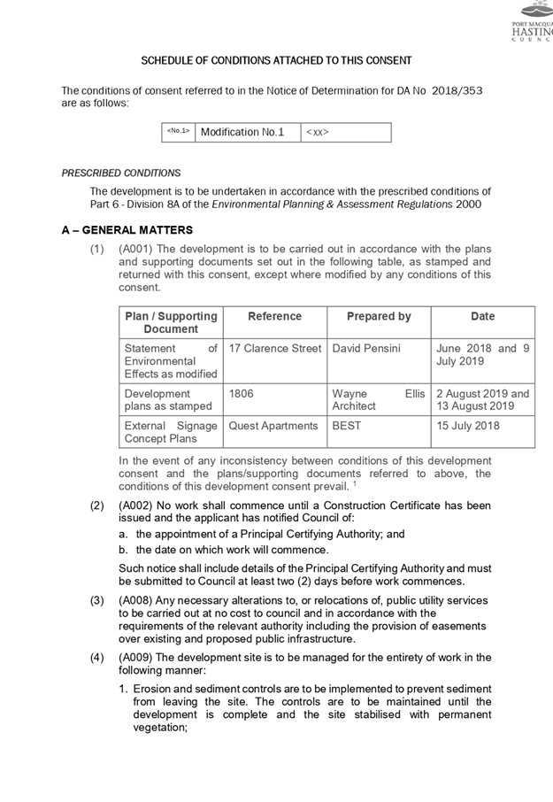
Subject: DA 2018 - 353.2 Modification to Commercial
Premises and Tourist and Visitor Accommodation with Clause 4.6 Variation to
Clause 4.3 (Height of Building) and Clause 4.4 (Floor Space Ratio) of the Port
Macquarie-Hastings Local Environmental Plan 2011 at Lot 123 DP 1219042, No.15
Clarence Street, Port Macquarie
Report
Author: Development Assessment Planner, Benjamin Roberts
|
Applicant: Bamford
Engineering
Owner: Yogi
Bear Holdings Pty Ltd
Estimated Cost: $14,733,000
Alignment with Delivery
Program
4.3.1 Undertake transparent
and efficient development assessment in accordance with relevant legislation.
|
|
RECOMMENDATION
That
modification to DA2018 - 353.2 for a commercial premises and tourist
and visitor accommodation with clause 4.6 variation to clause 4.3 (height of
building) and clause 4.4 (floor space ratio) of the Port Macquarie-Hastings
Local Environmental Plan 2011 at Lot 11, DP 1219042, No. 15 Clarence Street, Port Macquarie, be
determined by granting consent subject to the recommended conditions.
|
Executive
Summary
This
report considers a modification to the development application for a commercial
premises and tourist and visitor accommodation with clause 4.6 variation to
clause 4.3 (height of building) and clause 4.4 (floor space ratio) of the Port
Macquarie-Hastings Local Environmental Plan at the
subject site and provides an assessment of the application in accordance with
the Environmental Planning and Assessment Act 1979.
Following exhibition of the
application, three (3) submissions were
received.
The site is considered suitable for the proposed development
and the proposal adequately addresses relevant planning controls. The
development is not considered to be contrary to the public's interest and will
not result a significant adverse social, environmental or economic impact.
This report recommends that the modification to the
development application be approved subject to the amended conditions included
in Attachment 1.
1. BACKGROUND
Previous consideration of the application
The development application was reported to the Development
Assessment Panel on 23 January 2019 where the Panel was unable to reach
consensus as follows:
“That DA2018 – 353 be refused on the
grounds that:
1. Insufficient on-site car parking has been provided (deficit of 21
spaces) as
required
by the Port Macquarie-Hastings Development Control Plan 2013. In
the
context of this proposed tourist development located within an area with
time
limited parking the public interest would not be well served by allowing
such a
significant shortfall in parking spaces on site, or offsetting this number
of spaces
via the contribution plan.
2. The
proposed turning movements at the reception area are unreasonably
compromised
and should be redesigned to avoid regular interruption to the in-out vehicular
movements by the 3-point
turn.”
For:
Robert Hussey
Against:
Paul Drake and Dan Croft.
The
dissenting recommendation was:
“That DA2018 – 353 be
deferred to allow the applicant to readdress noncompliance with development
standards and provide further evidence to support parking provision on site so
as to avoid significant dependence on contribution
offsets.”
Given
the Development Assessment Panel was unable to reach consensus at its meeting
on 23 January 2019 the matter was reported to Council in accordance with
the
DAP charter on 20 February 2019 with the following recommendation from staff:
“That DA2018 - 353 for a commercial
premises and tourist and visitor
accommodation with clause 4.6
variation to clause 4.3 (Height of Buildings) and
clause 4.4 (Floor Space
Ratio) of the Port Macquarie-Hastings Local Environmental
Plan 2011 at Lot 123, DP
1219042, No. 17 Clarence Street, Port Macquarie, be
determined
by granting consent subject to the recommended conditions.”
In
considering the matter at its meeting on 20 February 2019 Council resolved as
follows:
RESOLVED: Intemann/Alley
That DA2018 – 353 be
deferred to allow the applicant to readdress noncompliance with development
standards and provide further car parking provision on site so as to avoid
dependence on parking offsets.
CARRIED: 6/1
FOR: Alley, Cusato, Dixon,
Hawkins, Intemann and Turner
AGAINST: Levido
The
applicant subsequently lodged revised plans on 19 April 2019 to include a
further
level of basement parking to the proposed
development.
The
revised application was re-considered by the Development Assessment Panel
on 22 May 2019 where it was again unable to reach
consensus as follows:
The
following motion was put to the panel:
“That it be recommended to Council
that DA2018 - 353.1 for a commercial premises
and tourist and visitor
accommodation with clause 4.6 variation to clause 4.3 (Height
of Buildings) and clause 4.4
(Floor Space Ratio) of the Port Macquarie-Hastings
Local Environmental Plan 2011
at Lot 123, DP 1219042, No. 17 Clarence Street,
Port Macquarie, be determined
by granting consent subject to the recommended
conditions.”
For:
Paul Drake and Dan Croft
Against: Robert Hussey
The
dissenting recommendation was:
“That DA2018 - 353.1
for a commercial premises and tourist and visitor
accommodation with clause 4.6
variation to clause 4.3 (Height of Buildings) and
clause 4.4 (Floor Space
Ratio) of the Port Macquarie-Hastings Local Environmental
Plan 2011 at Lot 123, DP
1219042, No. 17 Clarence Street, Port Macquarie, be
determined by refusing
consent for the following reason:
1. Insufficient
car parking is provided on site. To vary the Development Control Plan (DCP) car
parking provisions by 18% has significant implications on parking in the CBD,
will lead to an undesirable precedent and undermine the DCP. Council should
consider amending the DCP if such variations are to be considered acceptable.”
Given
the Development Assessment Panel was unable to reach consensus at its
meeting
on 22 May 2019 the matter was reported to Council in accordance with the DAP
charter on 19 June 2019. The extent of the Clause 4.6 variation also required
the application to be determined by Council.
In
considering the matter at its meeting on 19 June 2019 Council resolved as
follows:
RESOLVED: Hawkins/Turner
That DA2018 - 353.1 for a commercial
premises and tourist and visitor accommodation with clause 4.6 variation to
clause 4.3 (Height of Buildings) and clause 4.4 (Floor Space Ratio) of the Port
Macquarie-Hastings Local Environmental Plan 2011 at Lot 123, DP 1219042, No. 17
Clarence Street, Port Macquarie, be determined by granting consent subject to
the recommended conditions.
CARRIED: 8/0
FOR: Alley, Dixon, Griffiths, Hawkins, Intemann, Levido,
Pinson and Turner
AGAINST: Nil
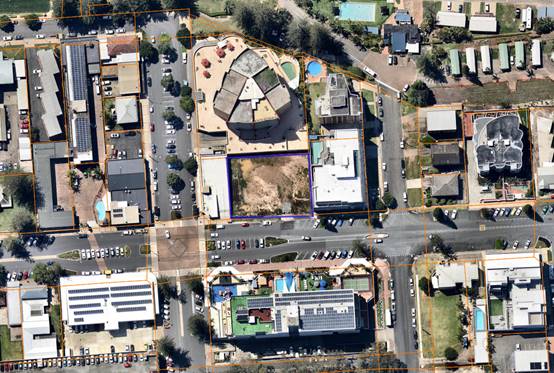
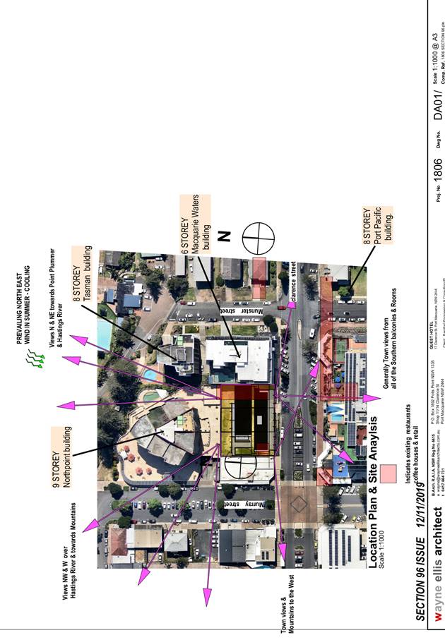
Existing Sites Features and Surrounding Development
The site has an area of 1518m2.
The site is zoned B3 Commercial Core in accordance with the Port Macquarie-Hastings Local
Environmental Plan 2011, as shown in the following zoning plan:
The existing subdivision pattern and location of existing
development within the locality is shown in the following aerial photograph:
2. DESCRIPTION OF
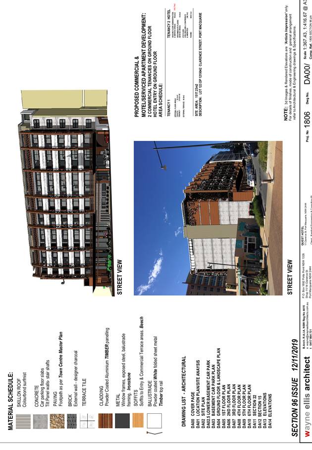
DEVELOPMENT
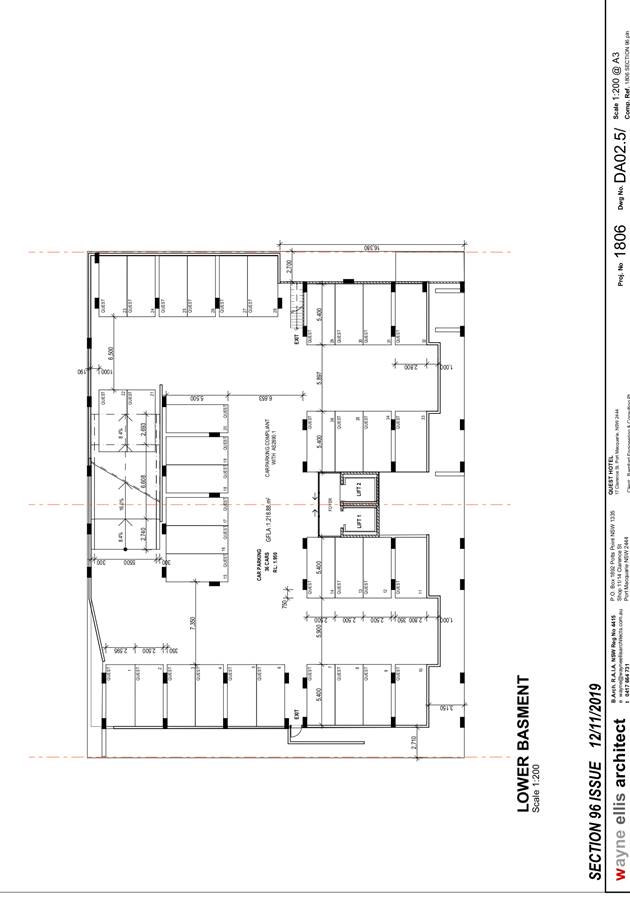
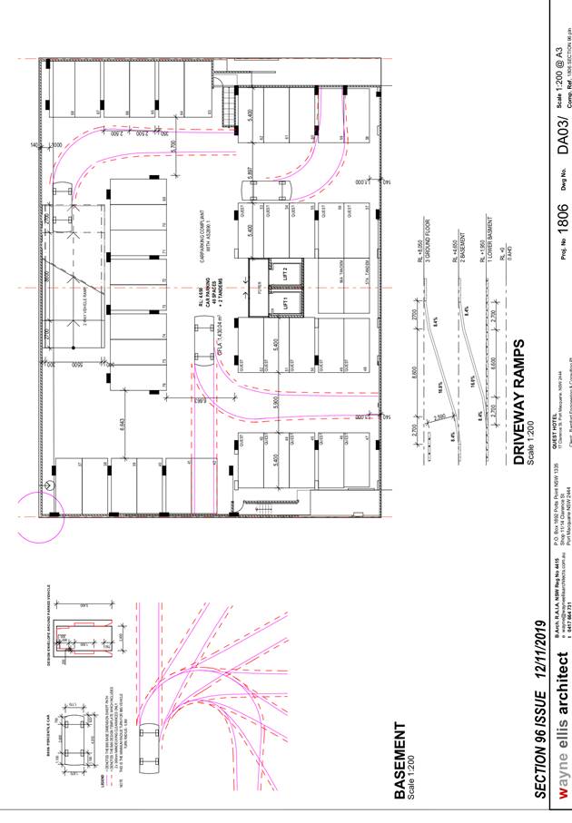
Key aspects of the proposed modification include the
following:
· Increase
to ground floor commercial floor space from 195.3m2
to 347.73m2, which also includes a reduction in parking at the
ground floor level from 20 spaces to 10 spaces;
· Increase to lower level basement area to provide for 13
additional parking spaces;
· Increase to the conference room area on the sixth floor
from 96.2m2 to 105.4m2;
· Relocation
and reconfiguration of amenities and gymnasium areas on sixth floor;
· Incorporation
of external signage to the building;
· Request
to modify consent condition A13 which requires each unit to be individually
metered;
· Request
to amend consent condition F4. The condition currently restricts the motel
reception hours to 7am to 9pm seven days a week. The request is to extend the
reception hours to 11pm in the evening.
Refer
to Attachment 2 at the end of this report for plans of the proposed modified
development.
Application Chronology
· 8
August 2019 - Application lodged.
· 15 to 28 August 2019 - Public exhibition via neighbour
notification.
3. STATUTORY ASSESSMENT
Section 4.55 of the Environmental
Planning and Assessment Act 1979 enables the modification of consents and
categorises modification into three categories - 4.55(1) for modifications
involving minor error, mis-description or miscalculation; 4.55(1A) for modifications
involving minimal environmental impact; and 4.55(2) for other modifications.
Each type of modification must be considered as being substantially the same to
that which was originally consented to.
Is the
proposal substantially the same?
The subject application is being
considered under the provisions of Section 4.55(1A). The proposal is considered
to be substantially the same development to that which was originally consented
to and will have minimal environmental impact. Specifically the use of the site
as a commercial premises and tourist and visitor accommodation and building
footprint remains relatively unchanged. The fundamental characteristics and
essence of the development remains essentially the same.
Does the application
require notification/advertising in accordance with the regulations and/or any
Development Control Plan?
Neighbour notification has been
undertaken.
Any
submissions made concerning the modification?
Three (3) submissions were
received following completion of the neighbour notification period. The
submissions are considered later in this report.
Any
matters referred to in section 4.15(1) relevant to the modification?
Section 4.15(1) Matters for Consideration
In determining the application, Council is required to take
into consideration the following matters as are relevant to the development
that apply to the land to which the development application relates:
(a) The provisions (where
applicable) of:
(i) Any Environmental
Planning Instrument:
State Environmental Planning Policy 64 - Advertising and
Signage
The application proposes the introduction of business
identification signage to the building. The proposed signage comprises:
- Identification sign to the front façade of the building;
- Identification cantilever sign above the footpath;
- Carpark identification signage on the front wall at the
carpark entry;
- Identification sign on the western elevation of the
building.
The proposal satisfies
the applicable requirements of this SEPP. The assessment table provided below
provides consideration of the proposal in accordance with schedule 1 of the
policy.
|
Applicable clauses for consideration
|
Comments
|
Satisfactory
|
|
Clause 8(a) Consistent with objectives of the policy as
set out in Clause 3(1)(a).
|
The proposed business identification signage is consistent
with the objectives of this policy. Specifically the signage is compatible
with the desired amenity and visual character of central business district
area and the signage appears to be of a high quality design and finish.
|
Yes
|
Schedule 1(1) Character of
the area.
|
The signage is compatible with
the existing and desired character of the central business district area in
which it is to be located.
|
Yes
|
|
Schedule 1(2) Special areas.
|
The signage will not detract
from the amenity or visual quality of any special areas
|
Yes
|
|
Schedule 1(3) Views and vistas.
|
The signage will not compromise
any important views or vistas. The signage is well placed below the roof of
the building and will not dominate the skyline.
|
Yes
|
|
Schedule 1(4) Streetscape,
setting or landscape.
|
The signage is of a suitable
form and scale that is appropriate for the streetscape. The signage does not
protrude above the building and the number of signs proposed is not
excessive.
|
Yes
|
|
Schedule 1(5) Site and
building.
|
The signage has been
strategically placed and compliments the building design.
|
Yes
|
|
Schedule 1(6) Associated
devices and logos with advertisements and advertising structures.
|
No safety devices, platforms or logos proposed.
|
N/A
|
|
Schedule 1(7) Illumination.
|
The signage is proposed to be illuminated and fitted with
a time switch to dim by 50% or turn off by 11pm each night. Subject to the
imposition of a consent condition requiring the fitting of the time switch
and 11pm curfew the impacts of illumination would not adversely affect the
amenity of nearby residential receivers.
|
Yes
|
|
Schedule 1(7) Safety.
|
The signage will not adversely
affect road or pedestrian user safety.
|
Yes
|
Port Macquarie-Hastings Local
Environmental Plan 2011 (LEP 2011)
· Clause 4.3 -
The maximum overall building height of 23.65m remains unchanged under this
modification application.
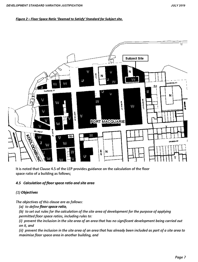
· Clause 4.4 -
The floor space ratio of the modified proposal is 3.61:1. The maximum floor
space ratio standard applicable to the site is 3.5:1. As a result, the
applicant has submitted a Clause 4.6 variation to the standard. The variation
represents a 3.14% variation from the standard. This equates to an additional
floor area of 176.18m2 above the standard for the site.
· Clause
4.6(3) - Consent must not be granted for a proposal that contravenes a development
standard unless the consent authority has considered a written request from the
applicant that justifies the variation by showing that the subject standard is
unreasonable or unnecessary and that there are sufficient environmental
planning grounds to justify the contravening of the standard.
As a result of
the above, the applicant submitted a Clause 4.6 variation to the standard based
on the following reasons:
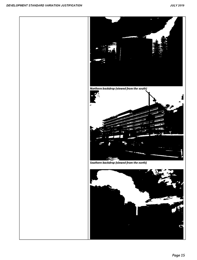
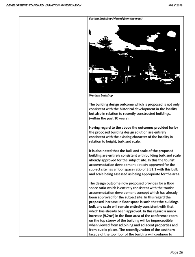
o The extent of the
floor space variation is minor.
o The building
design is consistent with the existing and future character of the locality in
relation to building height, bulk and scale.
o The proposal is
consistent with the floor space ratio objectives.
Having
consideration to the above the applicant has demonstrated the proposal is consistent
with the performance objectives of the floor space ratio clause. In addition,
it is also considered that the proposal is unlikely to have any implications on
State related issues or the broader public interest.
As per
Planning Circulars PS 18-003, Council can assume the Director-General’s
Concurrence for variations to floor space ratios. The floor space ratio
variation is less than a 10% deviation from the standard and may be determined
by staff and or the Development Assessment Panel under delegation.
(ii) Any
draft instruments that apply to the site or are on exhibition
No draft
instruments apply to the site.
(iii) Any
Development Control Plan in force
Port
Macquarie-Hastings Development Control Plan 2013
Applicable
general provisions
|
Requirements
|
Proposed
|
Complies
|
|
· Advertising & Signage
- Signs primarily identifying
products or services are not acceptable;
- Signage is not permitted
outside property boundaries except where mounted upon buildings and clear of
pedestrians and road traffic;
- On-premise signs should not
project above or to the side of building facades;
- Where there is potential for
light spill from signage in a non residential zone adjoining or adjacent to
residential development, illuminated signage is to be fitted with a time
switch to dim by 50% or turn off the light by 11pm each night, depending on
the nature of the development.
|
Proposed
signage is to advertise the proposed tourist accommodation business.
All
signage is mounted on the building.
Signage
does not project above the building.
The signage is proposed to be illuminated and there is the
potential for light spill to adjacent residential development. The signage is
proposed to be fitted with a time switch to dim by 50% or turn off by 11pm
each night consistent with the provisions. A consent condition has been
recommended to ensure fitment of the time switch and 11pm curfew.
|
Yes
|
|
· Off-street
parking in accordance with Table 2.5.1:
- Motel accommodation requires 1.1 per
unit + 1 per 2 employees (onsite at any one time) + 1 for on-site manager.
- Commercial premises require 1 per 30m2
of Gross Leasable Floor Area (GLFA).
- Function room requires 1 per 30m2
serviced floor area in commercial zones.
|
Motel accommodation with dual key arrangement:
- 79
units = 86.9
- No
onsite manager = 0
- 6
employees = 3
Total for motel = 89.9 spaces.
Commercial
premises:
- 347.73m2
= 11.59 spaces.
Function
Room
- 105.4m2 = 3.51 spaces.
Total
required parking for dual key arrangement = 105 spaces.
Total parking proposed = 88
spaces.
|
No*
|
The modified proposal seeks a
variation to clause 2.5.3 which requires onsite parking to be provided in
accordance with Table 2.5.1. In accordance with the table above 105 spaces are
required to serve the development with 100% occupancy of all units inclusive of
32 dual key units. The modified proposal includes 88 spaces. Thus resulting in
a parking shortfall of 17 spaces.
The DCP provides that Council may
consider a reduced level of parking where it is supported by a parking demand
study that assesses the peak parking demands for the overall development and
completed by a suitably qualified and experienced person.
The relevant objectives of the
plan are:
- Adequate
provision is made for off-street parking commensurate with volume and turnover
of traffic likely to be generated by the development.
- To
ensure no adverse impacts on traffic and road function.
The application was supported by a
traffic impact assessment that included a parking demand analysis. The
assessment included a dual occupancy (i.e. dual key) parking sensitivity
assessment with an assumed 80% occupancy rate which was considered reasonable
and adopted in determining off-street parking demand for the development.
Calculations of parking demand for
the modified proposal based on the adopted 80% occupancy rate is provided as
follows:
· 79 lettable units at 80% occupancy equates to 63.2 units
(i.e. 79 x 0.8 = 63.2). 63.2 units x 1.1 spaces per unit = 69.52 spaces.
· Employees: 6 at 1 per 2 employees (6/2) = 3 spaces.
· Commercial premises: 347.73m2 (1 per 30m2)
= 11.59 spaces.
· Function Room: 105.4m2 (1 per 30m2) =
3.51 spaces.
· Total parking demand required = 87.62 spaces.
Parking proposed is 88 spaces. Having
regard to the overall findings of the traffic impact assessment, prepared by a
suitably qualified professional, it is considered the proposal as modified will
not result in any significant adverse impacts to traffic, parking or road
function.
(iiia) Any
planning agreement that has been entered into under section 7.4, or any draft
planning agreement that a developer has offered to enter into under section 7.4
No planning
agreement has been offered or entered into.
(iv) Any matters prescribed by the
Regulations
No matters
prescribed by the regulations apply.
(b) The
likely impacts of that development, including environmental impacts on both the
natural and built environments, social and economic impacts in the locality:
Having regard to existing
development with the locality and adopted building height and floor space ratio
controls, the proposal as modified is considered to be consistent with the
locality and adequately addresses planning controls for the area.
The proposal is considered
appropriate in terms of density and will be unlikely to have any adverse
impacts to existing adjoining properties and satisfactorily addresses the
public domain. The proposal is considered to be consistent with other higher
density developments in the locality.
Water Supply
As there is no subdivision or
residential occupancy proposed individual water metering to each apartment and
commercial tenancy is not required under Councils Water Supply Policy.
Condition A13 is proposed to be amended as per revised draft conditions in
attachment 1.
Noise
The proposed extension to the motel reception hours from
9pm to 11pm each evening will not result in any significant increased noise
impacts. Specifically the number of ‘check ins’ after 9pm is
expected to be minimal and given the ground floor reception is enclosed and
drop off area located under the main building any noise from ‘check
ins’ between 9pm and 11pm is anticipated to be insignificant. Condition
F4 is proposed to be amended as per revised draft conditions in attachment
1.
(c) The suitability of the site for
the development
The proposal as modified will
fit into the locality. Site constraints have been adequately addressed and
appropriate conditions of consent recommended.
(d) Any submissions made in
accordance with this Act or the Regulations
Three (3) written submissions were received following public
exhibition of the application. Copies of the written submissions have been
provided separately to members of the DAP.
Key issues raised in the submissions received and comments
are provided as follows:
|
Submission
Issue/Summary
|
Planning
Comment/Response
|
|
The modification to the
already approved application will have negative visual, environmental, and
economic impact on surrounding businesses, properties and investments.
|
There is no change to the
approved building height, scale or external footprint and design proposed
under this modification. No adverse visual or environmental impact would
result. The minor increase to the gross floor area proposed and construction
of the development will provide a positive economic impact to the central
business locality.
|
|
Allowing further increase in floor space provides no benefit
to the community and just satisfies commercial greed.
|
Refer to comments under LEP 2011 heading addressing the
objectives of the floor space ratio clause and objectives of the exception to
development standard clause 4.6.
|
|
The impact of an oversized development on surrounding
properties and streetscape would be devastating.
|
There is no change to the approved building height, scale
or external footprint and design proposed under this modification.
|
|
The building will dominate the streetscape and restrict
visibility of the Macquarie Waters building.
|
There is no change to the approved building height, scale
or external footprint and design proposed under this modification.
|
|
The further variation to the floor space ratio is
unjustified and will lead to oversized development. The planning controls are
in place for a reason.
|
Refer to comments under LEP 2011 heading addressing the
objectives of the floor space ratio clause and objectives of the exception to
development standard clause 4.6. There is no change to the approved building
height, scale or external footprint and design proposed under this
modification.
|
|
The repetitive pushing of the boundaries is only to the developers
benefit and not the community.
|
The application has been assessed against the relevant
planning controls and specifically the objectives of the floor space ratio
standard to which the variation is sought. The minor increase to the gross
floor area proposed development will provide a positive economic impact to
the central business locality and wider community.
|
|
There will be increased overshadowing and view impacts to
existing buildings due to the oversize nature of the building.
|
There is no change to the approved building height, scale
or external footprint and design proposed under this modification. There will
be no further overshadowing or view impacts.
|
|
Adverse noise, dust and dirt impacts during construction
to adjoining building residents and guests.
|
Like all development there will be building noise and
associated building activity during construction. Standard building
construction times apply as per the standard site management consent
condition. No changes proposed under the modification.
|
|
Impacts to solar panels on the Macquarie Waters building
should be undertaken for the summer months. The panels were installed based
on the adopted building height controls.
|
There is no change to the approved building height, scale
or external footprint and design proposed under this modification. There will
be no further overshadowing impact.
|
|
The proposed reception/parking area layout will become a
fiasco during peak hours of check in and out.
|
Vehicular access was considered in assessment of the
original application. There is no change to the vehicular entry, exit or
drop-off proposed under this modification.
|
|
How is storm to be managed pre and post construction?
|
There is no increase/change to impervious areas under
this modification. Stormwater remains capable of being managed pre and post
construction. Consent conditions apply regarding full stormwater design
details being approved by Council prior to any construction.
|
|
What is the
electricity and energy sourcing plan for construction and post construction?
|
Electricity is currently provided to the site. Upgrading
arrangements will be regulated by the service provider (Essential Energy).
The plans nominate an indicative area at ground floor for a substation.
|
|
How will the
building design and height impact the vista, view and sunlight on the
southern area of Northpoint
|
There is no change to the approved building height, scale
or external footprint and design proposed under this modification. There will
be no further overshadowing or view impact.
|
|
What is Port
Macquarie Hastings-Council’s procedure in relation to noise management
and permitted hours of construction, in accordance with Office of Environment
& Heritage
|
As outlined in consent condition A4 the permitted
building construction hours are Monday to Saturday from 7.00am to 6.00pm with
no work to be carried out on Sundays or public holidays.
|
|
How will the
building design and height impact the privacy of occupants of Northpoint with
people being able to look from Clarence Street directly into living areas and
bedrooms of Northpoint
|
There is no change to the approved building height, scale
or external footprint and design proposed under this modification. There will
be no further privacy impact.
|
|
How will the
building design and height impact sunlight on the common terrace area where
clotheslines are located (and subsequently impact the drying time of clothes)
|
There is no change to the approved building height, scale
or external footprint and design proposed under this modification. There will
be no further overshadowing impact.
|
|
From
previous experiences the developer is extremely challenging to deal with,
threatening to go to Land Environment Court on numerous occasions when
requesting access via an easement, to Northpoint’s substation and water
services costing the Strata a great deal of money.
|
Noted.
|
(e) The Public Interest
The proposed
development satisfies relevant planning controls and will not adversely impact
on the wider public interest.
4. DEVELOPMENT
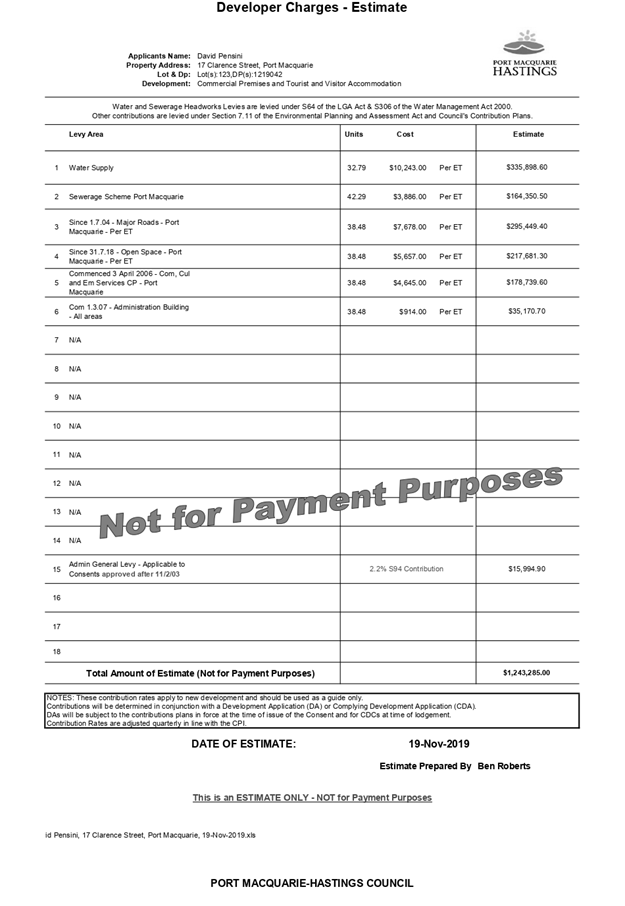
CONTRIBUTIONS APPLICABLE
· Development contributions will be required towards
augmentation of town water supply and sewerage system head works under Section
64 of the Local Government Act 1993.
· Development contributions will be required in accordance
with Section 7.11 of the Environmental Planning and Assessment Act 1979 towards
roads, open space, community cultural services, emergency services and
administration buildings.
·
· A copy of the revised contributions estimate is included as
Attachment 3.
·
5. CONCLUSION AND
STATEMENT OF REASON
The application has been assessed
in accordance with Section 4.15 of the Environmental Planning and Assessment
Act 1979.
Issues raised during assessment
and public exhibition of the application have been considered in the assessment
of the application. Where relevant, conditions have been recommended to manage
the impacts attributed to these issues.
The site is considered suitable
for the proposed development and the proposal adequately addresses relevant
planning controls. The development is not considered to be contrary to the
public's interest and will not result a significant adverse social,
environmental or economic impact. It is recommended that the application be
approved, subject to the recommended conditions of consent provided in the
attachment section of this report.
|
Attachments
1View. DA2018
- 353.2 Recommended Modification Conditions
2View. DA2018
- 353.2 Clause 4.6 Justification of Variation Report
3View. DA2018
- 353.2 Contributions Estimate
4View. DA2018
- 353.2 Section 96 Letter
5View. DA2018
- 353.2 Amended Plans
6View. DA2018
- 353.2 Revised Signage Plans.
|
|
ATTACHMENT
|
Development Assessment Panel
27/11/2019
|
|
ATTACHMENT
|
Development Assessment Panel
27/11/2019
|

|
ATTACHMENT
|
Development Assessment Panel
27/11/2019
|
|
ATTACHMENT
|
Development Assessment Panel
27/11/2019
|
|
ATTACHMENT
|
Development Assessment Panel
27/11/2019
|
|
ATTACHMENT
|
Development Assessment Panel
27/11/2019
|


AGENDA Development Assessment Panel 27/11/2019
Item: 06
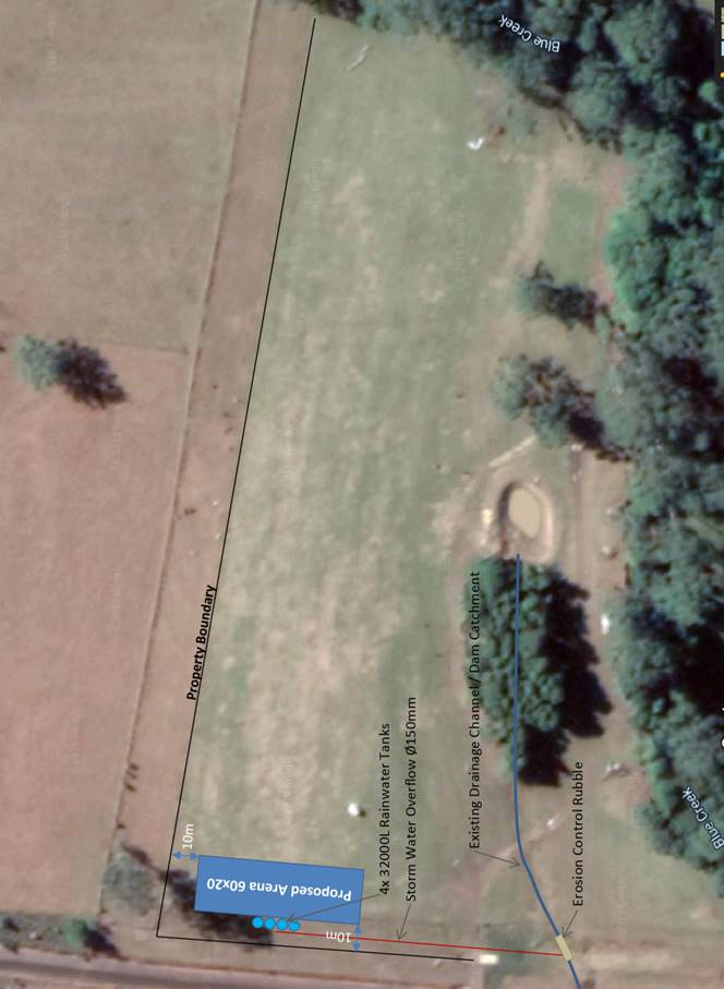
Subject: DA 2019 - 71.1 for Multi Dwelling Housing and
Strata Title Subdivision at LOT: 2 DP: 713669, 11 Kemp Street, Port Macquarie
Report
Author: Development Assessment Planner, Beau Spry
|
Applicant: 11 Kemp Street Pty. Ltd. As Trustee for the Kemp Trust
Owner: Barry Robert Byrne, Josianne Ohrynowsky, Daniel James
Dowd
Estimated Cost: $1,080,000
Alignment with Delivery
Program
4.3.1 Undertake transparent and
efficient development assessment in accordance with relevant legislation.
|
|
RECOMMENDATION
That DA 2019 - 71.1 for Multi Dwelling Housing
and Strata Title Subdivision at Lot 2 DP 713669, No. 11 Kemp Street, Port
Macquarie, be determined by granting consent subject to the recommended
conditions.
|
Executive
Summary
This
report considers a development application for a multi-dwelling housing
and strata title subdivision at the subject site and
provides an assessment of the application in accordance with the Environmental
Planning and Assessment Act 1979.
Following exhibition of the
application, two (2) submissions were
received.
The site is considered suitable for the proposed development
and the proposal adequately addresses relevant planning controls. The
development is not considered to be contrary to the public's interest and will
not result a significant adverse social, environmental or economic impact.
This report recommends that
the development application be approved subject to the attached conditions.
1. BACKGROUND
Existing Sites Features and Surrounding Development
The site has an area of 4543.78
m2.
The site has frontage to Kemp Street and slopes gently
towards the west.
There are existing dwellings to the east, a tennis facility
and tourist accommodation to the north, church to the south and motor vehicle
storage and/or repair facility to the west.
The site is zoned R1 General residential in accordance with the Port Macquarie-Hastings Local
Environmental Plan 2011, as shown in the following zoning plan:
The existing subdivision pattern and location of existing
development within the locality is shown in the following aerial photograph:
2. DESCRIPTION OF
DEVELOPMENT
Key aspects of the proposal include the following:
· Filling of site to meet flood planning level requirements;
· Construction of 17x two-bedroom dwellings.
Refer
to Attachment 2 at the end of this report for plans of the proposed
development.
Application Chronology
· 12 February 2019 - Application lodged
· 15 February 2019 - Public exhibition via neighbour notification
· 12
March 2019 - Additional information request.
· 14 April 2019 - Site inspection
· 18 October 2019 - Additional information received
3. STATUTORY ASSESSMENT
Section 4.15(1) Matters for Consideration
In determining the application, Council is required to take
into consideration the following matters as are relevant to the development
that apply to the land to which the development application relates:
(a) The provisions (where
applicable) of:
(i) Any Environmental
Planning Instrument
State Environmental Planning Policy No. 44 - Koala
Habitat Protection
There is no Koala Plan of Management on the site. Additionally,
the site is less than 1ha in area therefore no further investigations are
required.
State Environmental Planning Policy No. 55 –
Remediation of Land
Following an inspection of the site and a search of Council
records, the subject land is not identified as being potentially contaminated
and is suitable for the intended use.
State Environmental Planning Policy No. 62 –
Sustainable Aquaculture
Given the nature of the proposed development and proposed
stormwater controls the proposal will be unlikely to have any adverse impact on
existing aquaculture industries.
State Environmental Planning Policy (Coastal Management)
2018 and Clause 5.5 of Port Macquarie-Hastings Local Environmental Plan 2011
The site is located within a coastal use area and coastal
environment area.
In accordance with clause 7, this SEPP prevails over the
Port Macquarie-Hastings LEP 2011 in the event of any inconsistency.
Having regard to clauses 13 and
14 of the SEPP and clause 5.5 of the Port Macquarie-Hastings LEP 2011 the
proposed development is not considered likely to result in any of the
following:
a) any
adverse impact on integrity and resilience of the biophysical,
hydrological (surface and groundwater) and ecological environment;
b) any
adverse impacts coastal environmental values and natural coastal
processes;
c) any
adverse impacts on marine vegetation, native vegetation and fauna
and their habitats, undeveloped headlands and rock platforms;
d) any
adverse impact on marine vegetation, native vegetation and fauna
and their habitats, undeveloped headlands and rock platforms;
e) any
adverse impact on Aboriginal cultural heritage, practices and
places;
f) any
adverse impacts on the cultural and built environment heritage;
g) any
adverse impacts the use of the surf zone;
h) any adverse impact on the visual amenity and scenic qualities of the
coast, including coastal headlands, and
i) overshadowing, wind funnelling and the loss of views from public places
to foreshores.
The bulk, scale and size of the proposed development is
compatible with the surrounding coastal and built environment. The site is
located within an area zoned for residential purposes.
State Environmental Planning Policy (Building
Sustainability Index: BASIX) 2004
A BASIX certificate (0003576700) has been submitted
demonstrating that the proposal will comply with the requirements of the
SEPP. It is recommended that a condition be imposed to ensure that the
commitments are incorporated into the development and certified at Occupation
Certificate stage.
Port Macquarie-Hastings Local Environmental
Plan 2011
The proposal is consistent with the LEP having regard to the
following:
· Clause 2.2 - The
subject site is zoned R1 General Residential.
· Clause 2.3(1) and
the R1 zone landuse table - The proposed development for a multi-dwelling
housing development is a permissible landuse with consent.
· The objectives of
the R1 zone are as follows:
o To provide for the housing needs of the community.
o To provide for a variety of housing types and densities.
o To enable other land uses that provide facilities
or services to meet the day to day needs of residents.
· Clause 2.3(2) -
The proposal is consistent with the zone objectives having regard to the
following:
o The
proposal is a permissible landuse.
o The proposal provides for suitable
alternative housing types;
· Clause
4.3 - Including site filling, the maximum overall height of the building above
ground level (existing) is 7.1m which complies with the standard height limit
of 8.5m applying to the site.
· Clause
4.4 - The floor space ratio of the proposal is 0.25:1.0 which complies with the
maximum 0.65:1 floor space ratio applying to the site.
· Clause
5.5 - Development within the coastal zone (relevant objectives of this clause
are addressed by SEPP (Coastal Management) 2018 section - see above).
· Clause
5.10 - The site does not contain or adjoin any known heritage items or sites of
significance.
· Clause
7.1 - The site is mapped as potentially containing class 3 and class 5 acid
sulfate soils. The proposed development includes introducing fill across the
site to 3.45m AHD and no excavation extending 1m below the natural surface
level is proposed, therefore no adverse impacts are expected to occur to
potential acid sulphate soils found on site.
· Clause
7.3 - The site is land within a mapped “flood planning area” (Land
subject to flood discharge of 1:100 annual recurrence interval flood event
(plus the applicable climate change allowance and relevant freeboard). The
proposal has been reviewed by Council’s Environmental Projects Officer
and conditions recommended accordingly. In this regard, the following comments
are provided which incorporate consideration of the objectives of Clause 7.3,
Council’s Flood Policy 2015, the NSW Government’s Flood Prone Lands
Policy and the NSW Government’s Floodplain Development Manual
(2005):
o The
proposal is compatible with the flood hazard of the land taking into account
projected changes as a result of climate change;
o The
proposal will not result in a significant adverse affect on flood behaviour
that would result in detrimental increases in the potential flood affectation
of other development or properties;
o The
proposal incorporates measures to minimise & manage the flood risk to life
and property associated with the use of land;
o The
proposal is not likely to significantly adversely affect the environment or
cause avoidable erosion, siltation, destruction of riparian vegetation or a
reduction in the stability of river banks or watercourses, and
o The
proposal is not likely to result in unsustainable social and economic costs to
the community as a consequence of flooding.
· Clause
7.13 - Satisfactory arrangements are in place for provision of essential
services including water supply, electricity supply, on-site sewage
management/sewer infrastructure, stormwater drainage and suitable road access
to service the development.
(ii) Any
draft instruments that apply to the site or are on exhibition
No draft instruments apply to the site.
(iii) Any
Development Control Plan in force
Port
Macquarie-Hastings Development Control Plan 2013
|
DCP 2013: Dwellings, Dual occupancies, Dwelling
houses, Multi dwelling houses & Ancillary development
|
|
|
Requirements
|
Proposed
|
Complies
|
|
3.2.2.1
|
Ancillary development:
• 4.8m
max. height
• Single
storey
• 60m2
max. area
• 100m2
for lots >900m2
• 24
degree max. roof pitch
• Not
located in front setback
|
The water tanks are appropriately located.
|
Yes
|
|
3.2.2.2
|
Articulation zone:
• Min.
3m front setback
• An
entry feature or portico
• A
balcony, deck, patio, pergola, terrace or verandah
• A
window box treatment
• A
bay window or similar feature
• An
awning or other feature over a window
• A
sun shading feature
|
No elements within the articulation zone.
|
N/A
|
|
Front setback (Residential not R5 zone):
• Min.
6.0m classified road
• Min.
4.5m local road or within 20% of adjoining dwelling if on corner lot
• Min.
3.0m secondary road
• Min.
2.0m Laneway
|
The proposal has a minimum setback of 4.90m from the front
boundary fronting Kemp Street.
|
Yes
|
|
3.2.2.3
|
Garage 5.5m min. and 1m behind front façade.
Garage door recessed behind building line or
eaves/overhangs provided
|
Single carports are proposed for all units and the
majority are setback >1m behind front façades.
The carports for units 1 and 17 fronting Kemp Street are
setback 50cm, however this is considered acceptable in the context were they
are still 5.5m behind the front boundary and where many neighbouring
properties have no setback garage setback at all.
|
Yes
|
|
6m max. width of garage door/s and 50% max. width of
building
|
The single carport widths are approx. max 2.9m and <50%
width of the units fronting Kemp Street.
|
Yes
|
|
Driveway crossover 1/3 max. of site frontage and max. 5.0m
width
|
The proposed driveway crossovers total 11.5m max width and
approximately 27% of site frontage.
|
Acceptable
|
|
3.2.2.4
|
4m min. rear setback. Variation subject to site analysis
and provision of private open space
|
The minimum rear setback is approximately 14.5m at the
northern end and 30m towards the southern end.
|
Yes
|
|
3.2.2.5
|
Side setbacks:
• Ground
floor = min. 0.9m
• First
floors & above = min. 3m setback or where it can be demonstrated that
overshadowing not adverse = 0.9m min.
• Building
wall set in and out every 12m by 0.5m
|
The minimum side setback requirements are complied with.
No adverse overshadowing impacts identified to
neighbouring property owners having regard to select dwellings having a
setback less than 3m to existing side boundaries.
The wall articulation of all dwellings are compliant and
satisfies the objectives of the development provision.
|
Yes
|
|
3.2.2.6
|
35m2 min. private open space area including a useable 4x4m
min. area which has 5% max. grade
|
Each occupancy contains a minimum of 35m² open space
in one area including a useable 4m x 4m area.
|
Yes
|
|
3.2.2.10
|
Privacy:
• Direct
views between living areas of adjacent dwellings screened when within 9m
radius of any part of window of adjacent dwelling and within 12m of private
open space areas of adjacent dwellings. ie. 1.8m fence or privacy screening
which has 25% max. openings and is permanently fixed
• Privacy
screen required if floor level > 1m height, window side/rear setback
(other than bedroom) is less than 3m and sill height less than 1.5m
• Privacy
screens provided to balconies/verandahs etc which have <3m side/rear
setback and floor level height >1m
|
The majority of the development will not compromise
privacy in the area due to a combination of lack of windows on side/rear
boundaries, having high sill windows that face side/rear boundaries, limiting
living areas that face adjoining living areas/open space, compliant
separation and use of screening/fencing.
|
Yes
|
|
DCP 2013: General Provisions
|
|
|
Requirements
|
Proposed
|
Complies
|
|
2.7.2.2
|
Design addresses generic principles of Crime Prevention
Through Environmental Design guideline
|
Good casual surveillance is available from the carpark and
open space areas.
No concealment or entrapment areas proposed. Adequate
casual surveillance available.
|
Yes
|
|
2.3.3.1
|
Cut and fill 1.0m max. 1m outside the perimeter of the
external building walls
|
Fill >1m proposed across the site, including 1m outside
the perimeter of the external building walls.
Fill is required across the site to raise the habitable
floor areas above the flood planning level (FPL), grading from a front/east
high point to a rear/west low. Approximately 1.6m high fill is required to
raise the at the rear/western end of the property.
A standard condition is recommended to require engineering
certification for all retaining walls proposed.
|
No, variation sought below
|
|
2.3.3.2
|
1m max. height retaining walls along road frontage
|
None proposed
|
N/A
|
|
Any retaining wall >1.0 in height to be certified by
structure engineer
|
Retaining walls exceeding 1m proposed.
Condition recommended to require engineering
certification.
|
Yes
|
|
Combination of retaining wall and front fence height max
1.8m, max length 6.0m or 30% of frontage, fence component 25% transparent,
and splay at corners and adjacent to driveway
|
No retaining wall front fence combination proposed.
|
N/A
|
|
2.3.3.8
|
Removal of hollow bearing trees
|
Ecology report prepared by Biodiversity Australia has
concluded no hollow bearing trees were found onsite.
|
N/A
|
|
2.6.3.1
|
Tree removal (3m or higher with 100m diameter trunk at 1m
above ground level and 3m from external wall of existing dwelling)
|
Applicant has submitted an arborists report and an ecology
report.
There are 16 trees identified for removal onsite.
Following provisions of amended plans, no koala browse
species trees are proposed to be impacted.
|
Yes
|
|
2.4.3
|
Bushfire risk, Acid sulphate soils, Flooding,
Contamination, Airspace protection, Noise and Stormwater
|
Refer to main body of report.
|
|
|
2.5.3.2
|
New accesses not permitted from arterial or distributor
roads
|
No new access proposed to arterial or distributor road.
|
N/A
|
|
Driveway crossing/s minimal in number and width including
maximising street parking
|
Driveway crossings of acceptable
width with maximised retention of street parking.
|
Yes
|
|
2.5.3.3
|
Parking in accordance with Table 2.5-1
Multi dwelling
1 space per 1 & 2 bedroom occupancies
1.5 spaces per 3+ bedroom occupancies
0.25 spaces per occupancy for visitor parking.
|
Proposal includes:
2 bedroom units: 17
Therefore, parking requirements are:
2 bedroom units: 17
Visitor parking: 4.25
(5)
Total Required: 22 spaces
The overall parking demand of the development is therefore
22 spaces.
The submitted plan identifies 24 parking spaces and
exceeds the minimum requirement.
|
Yes
|
|
2.5.3.11
|
Section 94 contributions
|
Contributions apply - refer to ET calc and NOP.
|
Yes
|
|
2.5.3.12 and 2.5.3.13
|
Landscaping of parking areas
|
Suitable landscaping proposed around driveway/parking
locations.
|
Yes
|
|
2.5.3.14
|
Sealed driveway surfaces unless justified
|
Sealed driveway areas proposed.
|
Yes
|
|
2.5.3.15 and 2.5.3.16
|
Driveway grades first 6m or ‘parking area’
shall be 5% grade with transitions of 2m length
|
Driveway grades capable of
complying. Condition recommended requiring details with the Construction
Certificate and Section 138 applications.
|
Yes
|
|
2.5.3.17
|
Parking areas to be designed to avoid concentrations of
water runoff on the surface.
|
Details of proposed stormwater
management have been submitted with the application. See comments under
‘Stormwater’ later in this report.
|
Yes
|
The proposal seeks to vary
Development Provision relating to 2.3.3.1
The relevant objectives are: To
ensure that design of any building or structure integrates with the topography
of the land to.
· Minimise
the extent of site disturbance caused by excessive cut and fill to the site;
· Ensure
there is no damage or instability to adjoining properties caused by excavation
or filling;
· Ensure
that there is no adverse alteration to the drainage of adjoining properties;
· Ensure
the privacy of adjoining dwellings and private open space are protected;
· Ensure
that adequate stormwater drainage is provided around the perimeter of buildings
and that overflow paths are provided;
Having regard for the
development provisions and relevant objectives, the variation is considered
acceptable for the following reasons:
· The
site topography slopes gently down from east to west by approximately 2m;
· The
site currently has a natural ground level that is lower than its neighbouring
properties and below the flood planning level;
· Fill
is proposed to raise the ground level above the flood planning level and will
be retained by max 1.6m high retaining wall;
· No
adverse impacts are identified to neighbouring properties to north and south.
Based on the above assessment, the variation proposed to the
provision of the DCP is considered acceptable and the relevant objectives have
been satisfied.
(iiia) Any
planning agreement that has been entered into under section 7.4, or any draft
planning agreement that a developer has offered to enter into under section 7.4
No planning
agreement has been offered or entered into relating to the site
(iv) Any matters prescribed by the
Regulations
None prescribed
(b) The
likely impacts of that development, including environmental impacts on both the
natural and built environments, social and economic impacts in the locality:
The site has a general easterly street frontage orientation
to Kemp Street. Adjoining the site to the north is a tourist use and tennis
centre, north-west, east and south are R1 General Residential zoned premises
with a mix of single and multi-dwelling building types, and to the west is E2
Environmental Conservation.
· The proposal will
be unlikely to have any adverse impacts to existing adjoining properties and
satisfactorily addresses the public domain.
· The proposal is considered consistent with other
residential development in the locality and adequately addresses planning
controls for the area.
· There
are no adverse impacts on existing view sharing.
· There are no adverse privacy impacts.
· There are no adverse overshadowing impacts. The proposal
does not prevent adjoining properties from receiving 3 hours of sunlight to
private open space and primary living areas on 21 June.
Access, Traffic and Transport
The site has road frontage to Kemp Street. Kemp Street is a
sealed public local road under the care and control of Council, with a 10.5m
road formation within a 20m road reserve. The proposal will not have any
adverse impacts within the immediate locality in terms access, transport and
traffic. The existing road network will satisfactorily cater for any potential
increase in traffic generation as a result of the development. Vehicle access
to the site will be via a proposed driveway location fronting Kemp Street. All
accesses shall comply with Council AUSPEC and Australian Standards, and
conditions have been recommended to reflect these requirements.
Parking and Manoeuvring
A total of 24 parking spaces have been provided
on-site. Parking and driveway widths on site can comply with relevant
Australian Standards (AS 2890) and conditions have been imposed to reflect
these requirements. Due to the type of development, car park circulation
is required to enable vehicles to enter and exit the site in a forward manner
for all dwellings other than for dwellings 1 and 17 fronting Kemp Street.
Site plans show adequate area is available and conditions have been recommended
to reflect these requirements.
Water Supply Connection
Council
records indicate that the development site has existing potable water service
from the 150mm diameter water main on the opposite of Kemp Street.
A hydraulic strategy and plans are required from
a hydraulic consultant for the whole of the development on the site.
Water service sizing is then to be determined by the hydraulic consultant to
suit the proposed development, as well as addressing fire service requirements
to AS 2419 and backflow protection requirements.
Detailed plans will be required to be submitted for
assessment with the S.68 application.
Refer to relevant recommended conditions of consent.
Sewer Connection
Council
records indicate that the development site is connected to sewer via a sideline
in the north eastern corner of the site. All units shall drain to a new manhole
constructed on the existing sewer main in Kemp Street. The abandoned sewer side
line shall be removed and capped off at Council’s sewer main.
The hydraulic designer is to
confer with Council sewer section prior to submitting sewer design plans. The
DA plans have no indication of how the development site will be serviced for
sewer. Consideration will need to be given to the fact that the existing sewer
main is located at the high end of long development lot.
Detailed plans will be required to be submitted for
assessment with the S.68 application.
Refer to relevant recommended conditions of consent.
Stormwater
The site naturally grades towards the west and is currently
un-serviced. Current site stormwater discharge is mainly in the form of sheet
flows onto the adjoining downstream undeveloped environmental zoned land,
before concentrating within an existing gully at the rear of downstream Lot 2
DP601094. The site is also subject to stormwater flows from the adjoining
upstream lot at Lot 1 DP 713669.
The legal point of discharge for the proposed development is
defined as an onsite system, which is required to limit the rate, volume and
frequency of stormwater discharge from the site to be no greater than the
pre-developed conditions of the site. The rationale for this arrangement is
that there is no formal piped point of connection available, the downstream
environmental conditions need to be maintained and protected, and negotiations with
the adjoining downstream landowner failed to obtain an easement to do so.
Hence, a design was required to mimic that natural flow of discharge from the
undeveloped existing site. The design is also required to include a level
spreader / energy dissipation arrangement so that flows off the site are in
sheet flow consistent with the current conditions of the site.
A stormwater drainage plan has been submitted in support of
the development application and includes a large above ground on-site
stormwater detention/ absorption system at the rear of the site. Calculations
submitted with the development application indicate that the system functions
to limit the rate of discharge from the site to pre-development rates,
indicating that the development will not exacerbate or create any new
downstream flooding issues. Further modelling and rainwater storage is required
on site above that proposed in order to limit the total volume of runoff to
pre-development flow rates however. It is anticipated that this could be
achieved by the provision of rainwater storage tanks to service each of the
proposed residential units. Refer to relevant conditions of consent.
A detailed site stormwater management plan will be required
to be submitted for assessment with the S.68 application and prior to the issue
of a Construction Certificate.
In accordance with
Council’s AUSPEC requirements, the following must also be incorporated
into the stormwater drainage plan:
· On
site stormwater detention and retention facilities
· Water
quality controls
· Level
spreader / energy dissipation system outfall.
In addition, the stormwater plan
does not include detail of the surface drainage system designed to collect and
manage stormwater runoff that is currently directed onto the development site
form the adjoining lot to the north. The CC submission will be required to
include detail of such systems.
Refer to relevant recommended conditions of consent.
Other Utilities
Telecommunication and electricity services are available to
the site.
Heritage
No known items of Aboriginal or European heritage
significance exist on the property. No adverse impacts anticipated.
Other land resources
The site is within an established urban context and will not
sterilise any significant mineral or agricultural resource.
Water cycle
The proposed development will not have any significant
adverse impacts on water resources and the water cycle.
Soils
The proposed development will not have any significant
adverse impacts on soils in terms of quality, erosion, stability and/or
productivity subject to a standard condition being recommended requiring
erosion and sediment controls to be in place prior to and during construction.
Air and microclimate
The construction and/or operations of the proposed
development will not result in any significant adverse impacts on the existing
air quality or result in any pollution. Standard precautionary site management
condition recommended.
Flora and fauna
An arborists and ecology report has been submitted as part
of the application. Following amended plans, construction of the proposed
development will not require any removal/clearing of any significant native
vegetation and therefore does not trigger the biodiversity offsets
scheme. Part 7 of the Biodiversity Conservation Act 2016 is considered to
be satisfied.
Waste
Satisfactory arrangements are in place for proposed storage
and collection of waste and recyclables. No adverse impacts anticipated.
Standard precautionary site management condition recommended.
Energy
The proposal includes measures to address energy efficiency
and will be required to comply with the requirements of BASIX.
Noise and vibration
No adverse impacts. Condition recommended to restrict
construction to standard construction hours.
Bushfire
The site is identified as being bushfire prone.
The Applicant has submitted a bushfire report prepared by a
Certified Consultant.
An assessment of bushfire risk having regard to section
4.3.5 of Planning for Bushfire Protection 2006 including vegetation
classification and slope concludes that a Bushfire Attack Level 12.5, 19 and 29
as per the Bushfire Assessment dated 17 December 2018 shall be required.
In accordance with Section 100B - Rural Fires Act 1997 - the
application proposes subdivision of bush fire prone land that could lawfully be
used for residential purposes. As a result, the applicant has submitted a
bushfire report prepared by a Certified Consultant. The report was forwarded to
the NSW Rural Fire Service who have since issued a Bushfire Safety Authority,
which will be incorporated into the consent.
Safety, security and crime prevention
The proposed development will be unlikely to create any
concealment/entrapment areas or crime spots that would result in any
identifiable loss of safety or reduction of security in the immediate
area. The increase in housing density will improve natural surveillance
within the locality and openings from each dwelling overlook common and private
areas.
Social impacts in the locality
Given the nature of the proposed development and its
location, the proposal is not considered to have any significant adverse social
impacts.
Economic impact in the locality
The proposal is not considered to have any significant
adverse economic impacts on the locality. A likely positive impact is that the
development will maintain employment in the construction industry, which will
lead to flow impacts such as expenditure in the area.
Site design and internal design
The proposed development design satisfactorily responds to
the site attributes and will fit into the locality.
Construction
Construction impacts are considered capable of being
managed, standard construction and site management conditions have been
recommended.
Cumulative Impacts
The proposed development is not considered to have any
significant adverse cumulative impacts on the natural or built environment or
the social and economic attributes of the locality.
(c) The suitability of the site for
the development
The proposal
will fit into the locality and the site attributes are conducive to the
proposed development.
(d) Any submissions made in
accordance with this Act or the Regulations
Two (2) written submissions were received following public
exhibition of the application. Copies of the written submissions have been
provided separately to members of the DAP.
Key issues raised in the submissions received and comments
are provided as follows:
|
Submission
Issue/Summary
|
Planning
Comment/Response
|
|
Flooding, stormwater and
surface drainage concerns, including nature of the fill proposed.
|
Amended
plans have been submitted to clarify the extent of fill proposed.
Council’s Engineers and Environmental Project’s Officers
(flooding) have reviewed the proposal and have addressed the concerns through
amended plans and conditions.
Condition B072 regards
stormwater and requires detail drainage design to be submitted and approved
by Council prior to the issue of Construction Certificate
Condition E046 references the
need for a positive covenant to be created prior to issue of the Occupation
Certificate burdening the owner(s) with the requirement to maintain on-site
stormwater detention facilities within the site.
Condition E048 references the
need for a positive covenant to be created prior to issue of the Occupation
Certificate burdening the owner(s) with the requirement to maintain the water
quality control facilities within the site.
Condition
B067, E044 and B070 relate to flooding and requires floor level of all
habitable areas to be a minimum of 500mm above the 1 in 100 year flood level
including the applicable climate change allowance; that these levels be
certified by a registered surveyor prior to issue of the Construction
Certificate.
Condition
B039 require detailed drawings and specifications submitted for retaining
walls prior to issue of Construction Certificate.
|
|
Impact on character of the
street, with the perception that the development is in high contrast to the
area’s neighbourhood character which can generally be described as one
dwelling on large blocks with lots of open space and landscaping
|
For
a new development to be visually compatible with the area surrounding the site
comprises a mix of single and two storey development, including mixed-use
tourist and visitor accommodation adjacent to the north that comprises a
number of two-storey buildings.
In
this regard, the frontage of the proposal has been designed to reference the
cottage-like appearance of existing neighbouring frontages. The proposed
building height of 5.5m is compliant with the maximum building height of 8.5m
and is reflective of the surrounding neighbourhood that is typically
residential of varying bulks and height. The front, rear and side setbacks
comply with DCP provisions and is also compatible with nearby development in
scale.
|
|
Lack of private open space and
visual privacy concerns owing to a perceived extreme overdevelopment of this
site.
|
Each occupancy contains a minimum of 35m² open space
in one area including a useable 4m x 4m area.
The
proposed dwellings are 5.5m in height with loft-style accommodation. There
are no rear facing windows above 2.4m.
|
(e) The Public Interest
The proposed
development satisfies relevant planning controls and will not adversely impact
on the wider public interest.
4. DEVELOPMENT
CONTRIBUTIONS APPLICABLE
· Development contributions will be required towards
augmentation of town water supply and sewerage system head works under Section
64 of the Local Government Act 1993.
· Development contributions will be required in accordance
with Section 7.11 of the Environmental Planning and Assessment Act 1979 towards
roads, open space, community cultural services, emergency services and
administration buildings.
1.
· A copy of the contributions estimate is included as
Attachment 3.
5. CONCLUSION AND
STATEMENT OF REASON
The application has been assessed
in accordance with Section 4.15 of the Environmental Planning and Assessment
Act 1979.
Issues raised during assessment
and public exhibition of the application have been considered in the assessment
of the application. Where relevant, conditions have been recommended to manage
the impacts attributed to these issues.
The site is considered suitable
for the proposed development and the proposal adequately addresses relevant
planning controls. The development is not considered to be contrary to the
public's interest and will not result a significant adverse social,
environmental or economic impact. It is recommended that the application be
approved, subject to the recommended conditions of consent provided in the
attachment section of this report.
|
Attachments
1View. DA2019
- 71.1 Plans.
2View. DA2019
- 71.1 Recommended Conditions
3View. DA2019
- 71.1 Contributions Estimate
4View. DA2019
- 71.1 Engineering and Stormwater Management
5View. DA2019
- 71.1 Arborist Report
6View. DA2019
- 71.1 Bushfire Report
7View. DA2019
- 71.1 RFS response and conditions
|
|
ATTACHMENT
|
Development Assessment Panel
27/11/2019
|

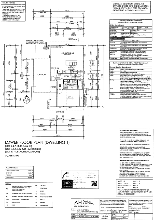
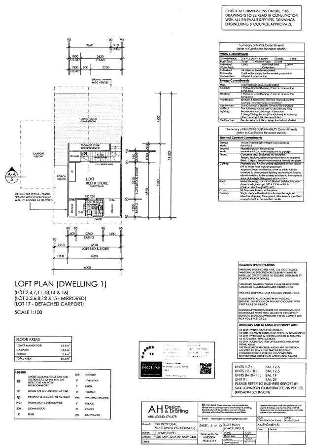
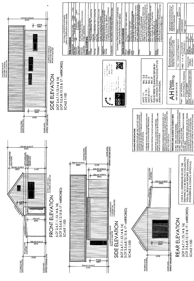
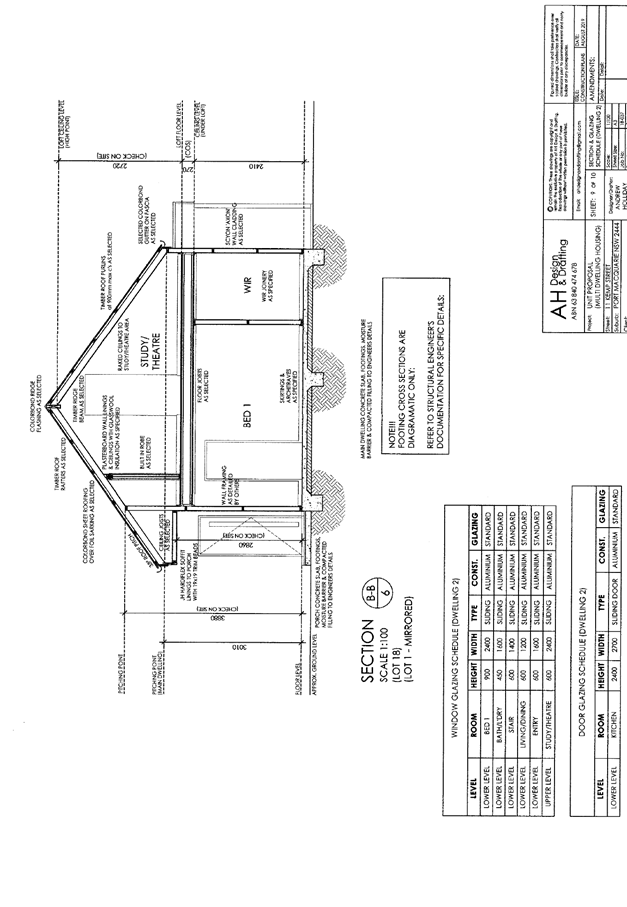
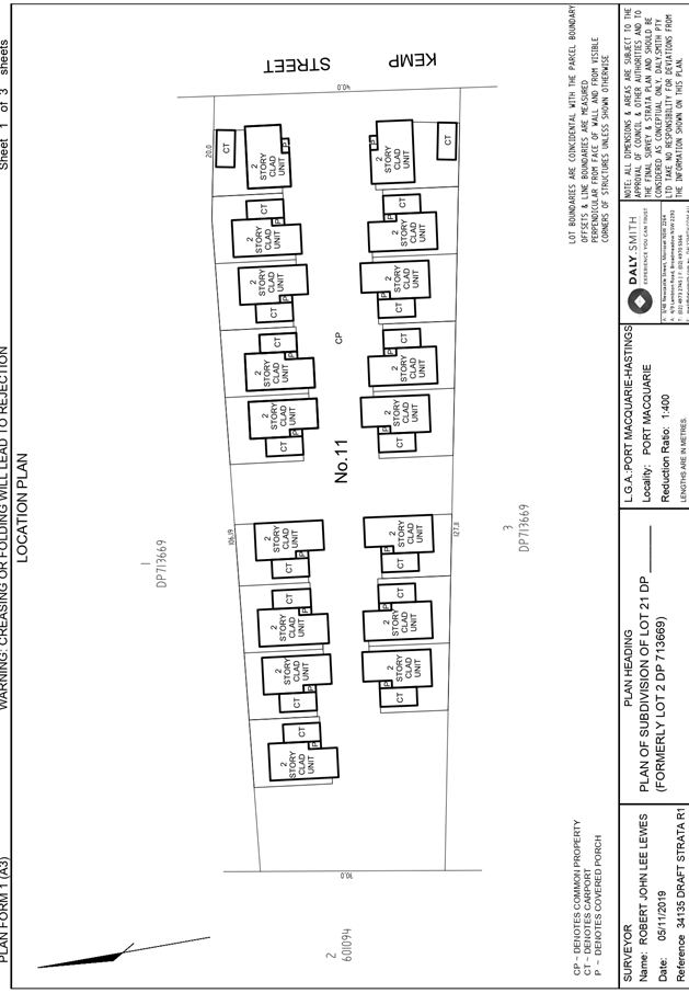
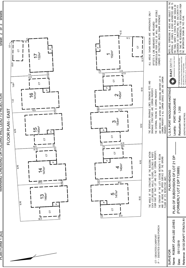
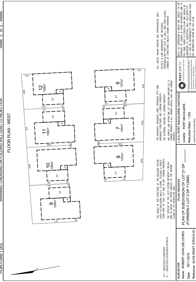
|
ATTACHMENT
|
Development Assessment Panel
27/11/2019
|
|
ATTACHMENT
|
Development Assessment Panel
27/11/2019
|
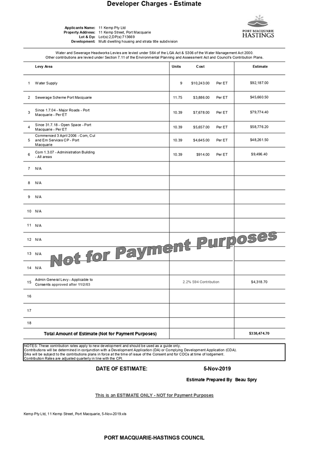
|
ATTACHMENT
|
Development Assessment Panel
27/11/2019
|
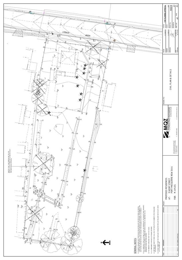
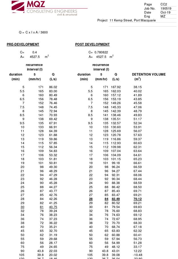
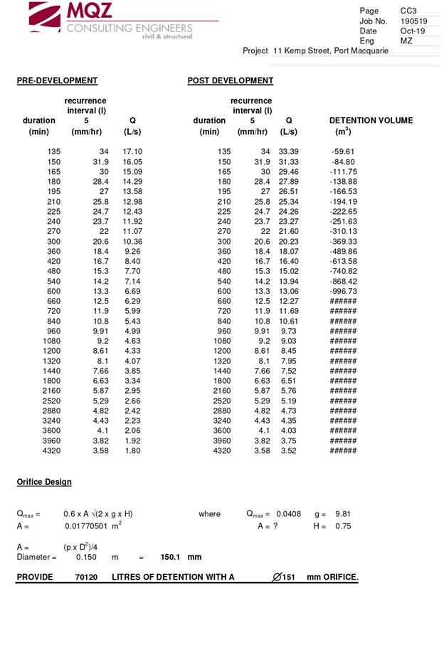
|
ATTACHMENT
|
Development Assessment Panel
27/11/2019
|
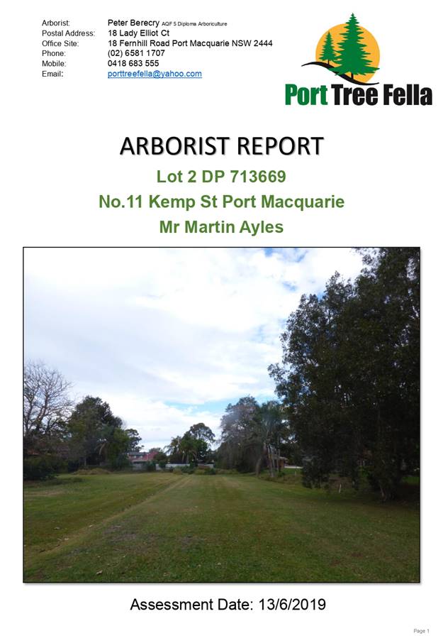
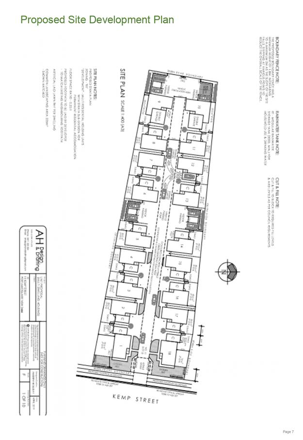
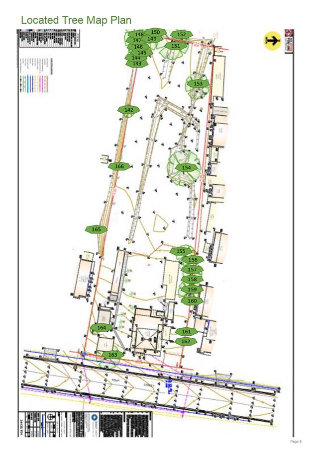
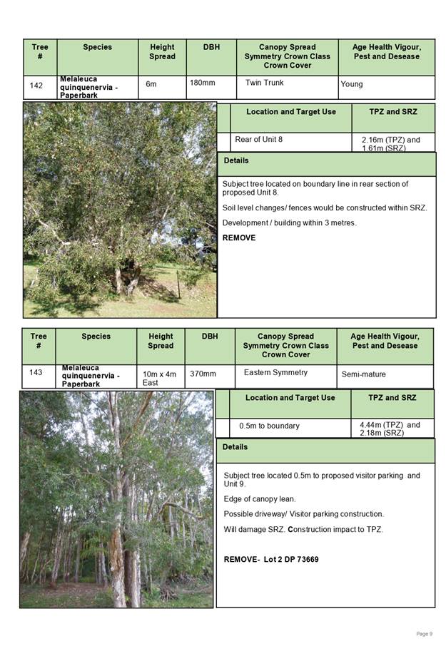
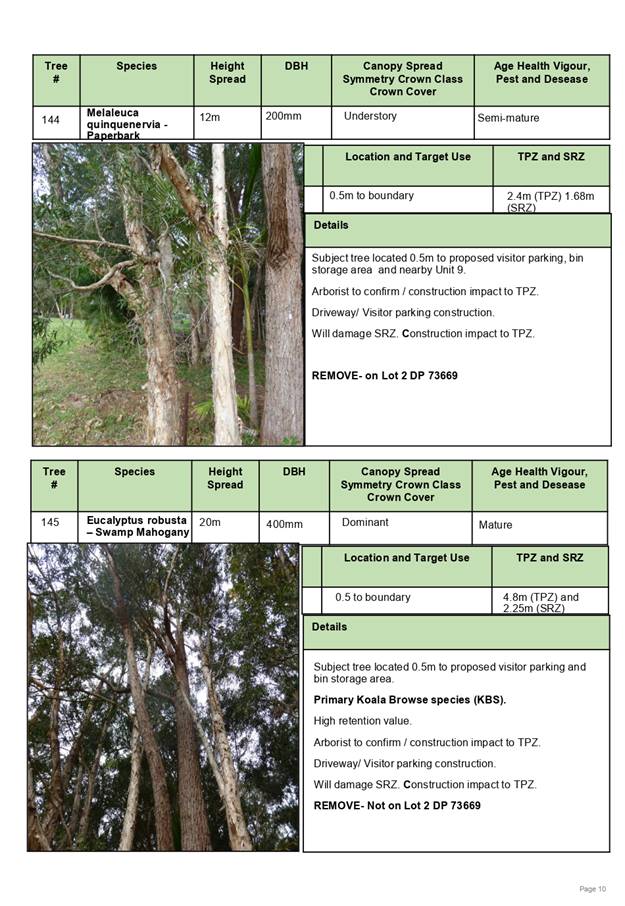
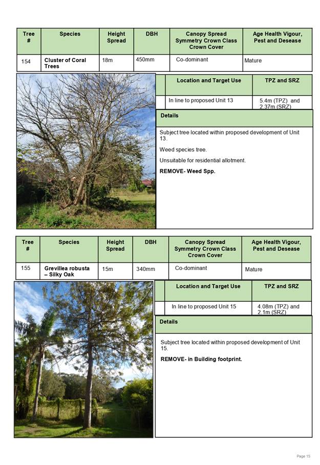
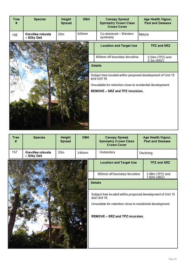
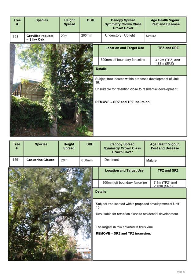
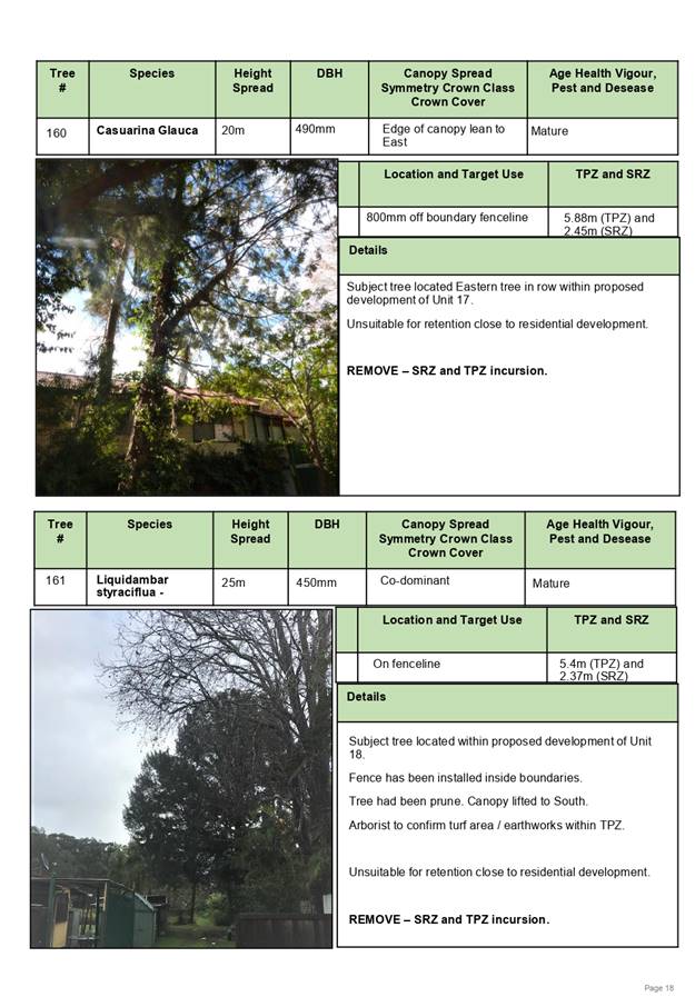
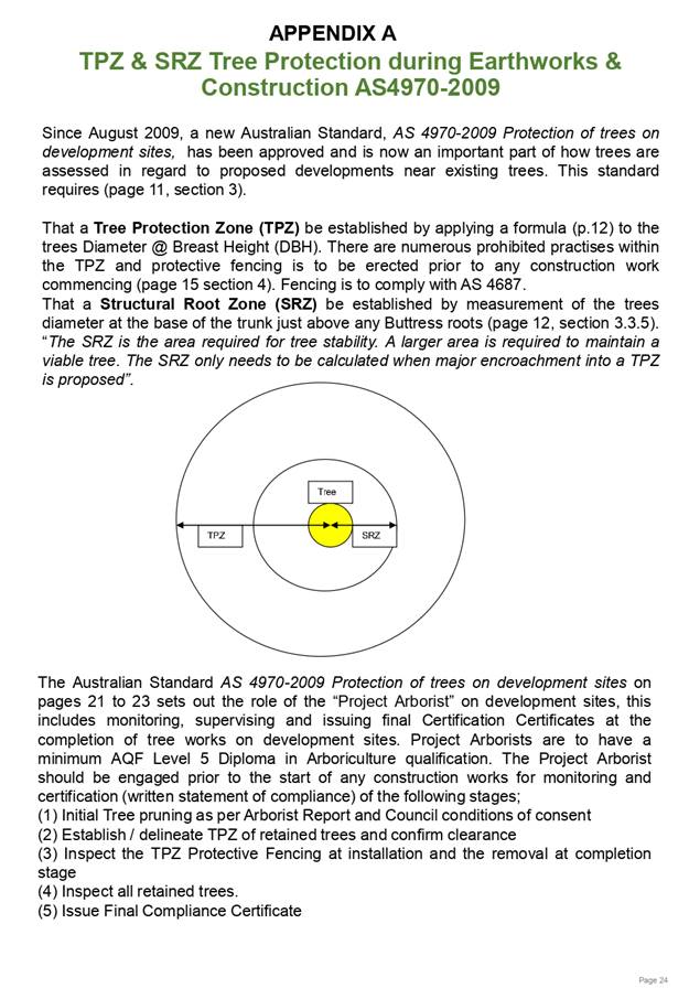
|
ATTACHMENT
|
Development Assessment Panel
27/11/2019
|
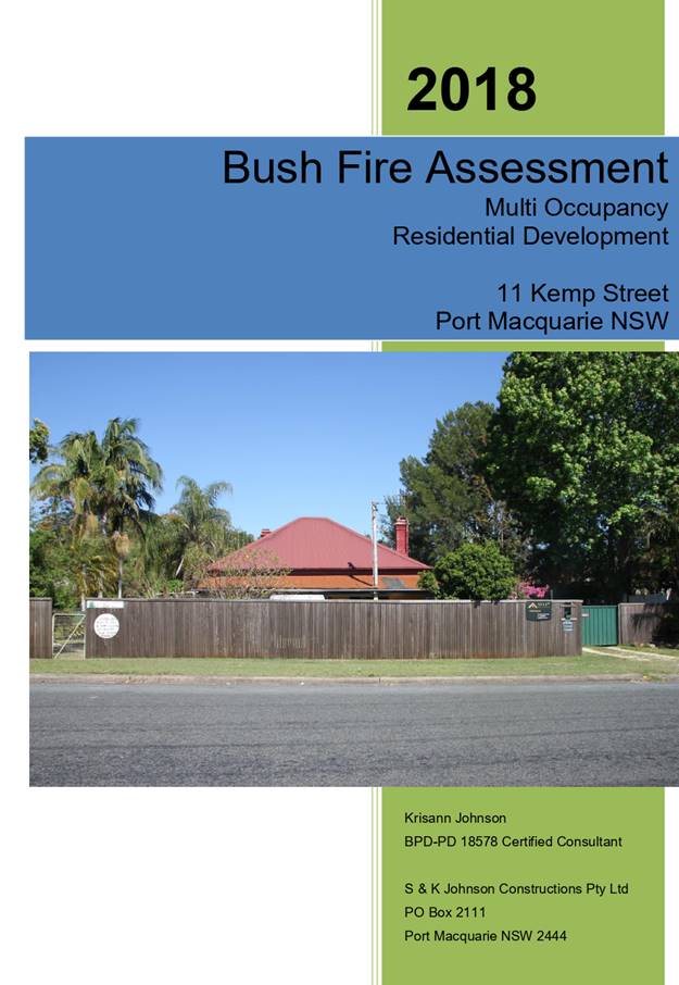
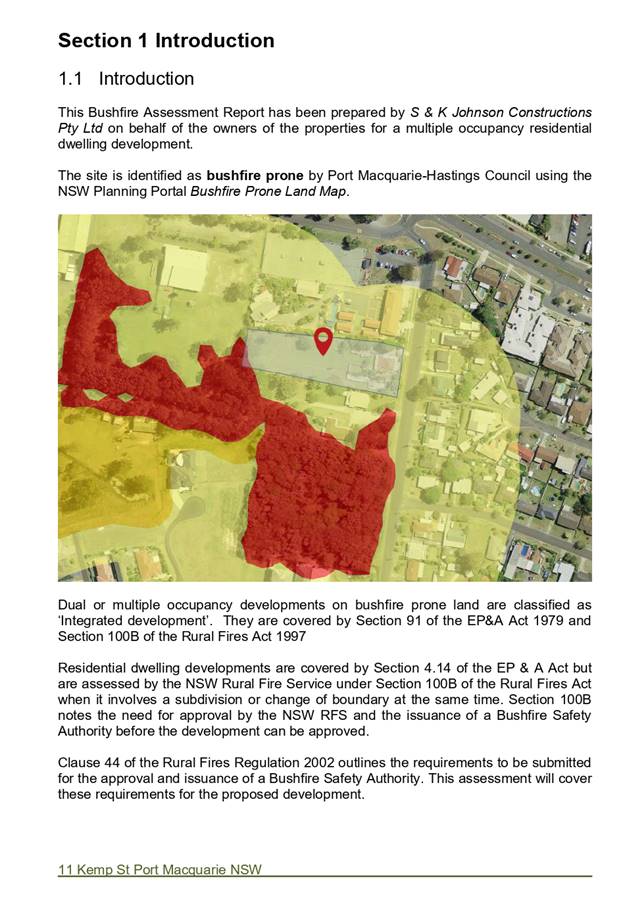
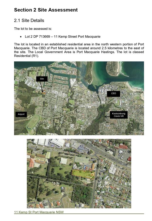
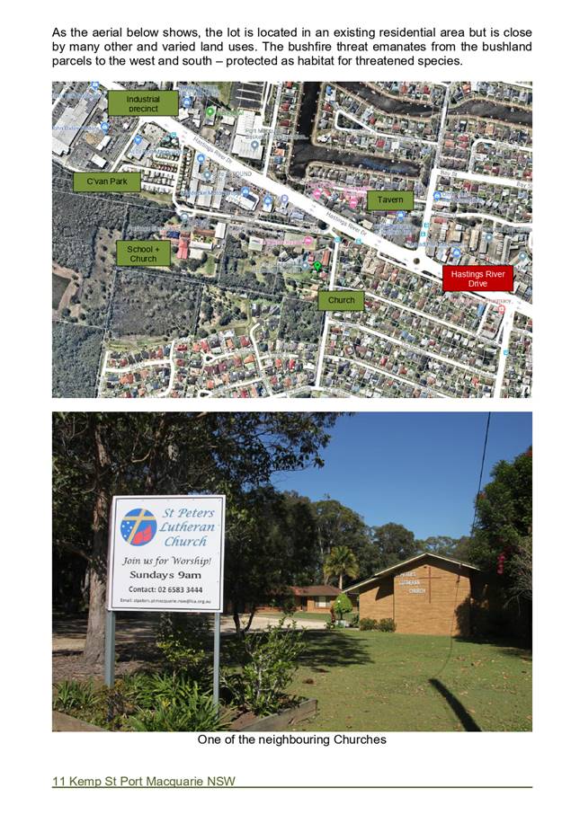
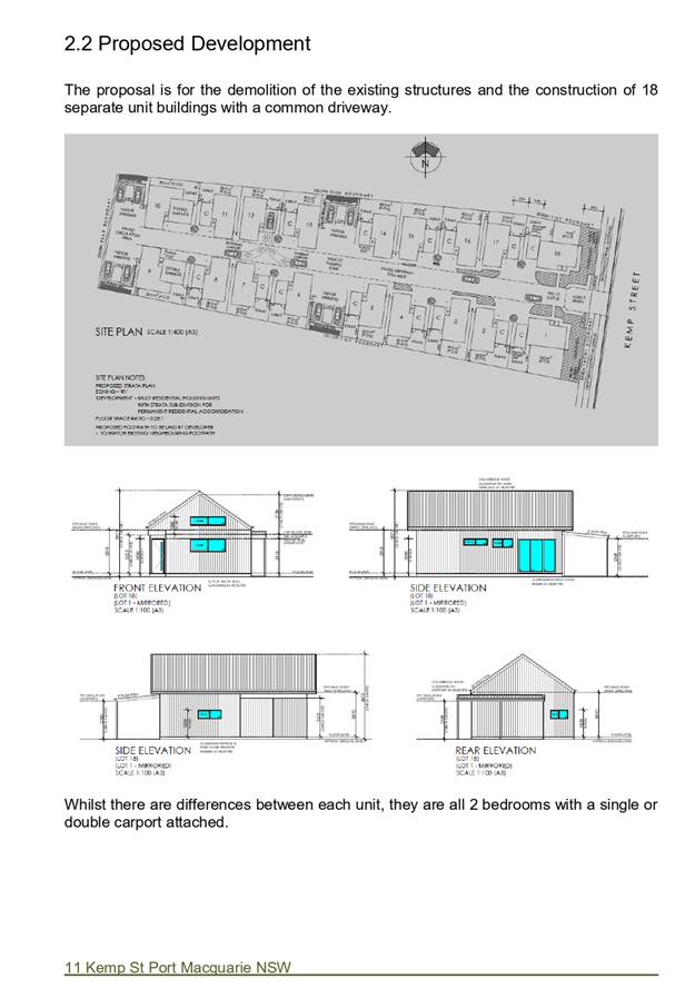
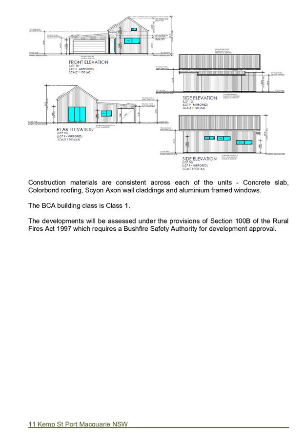
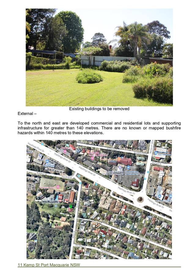
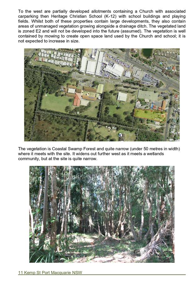
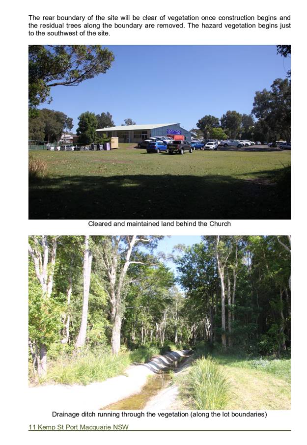
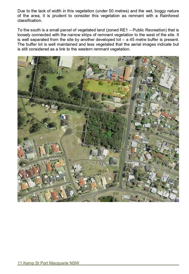
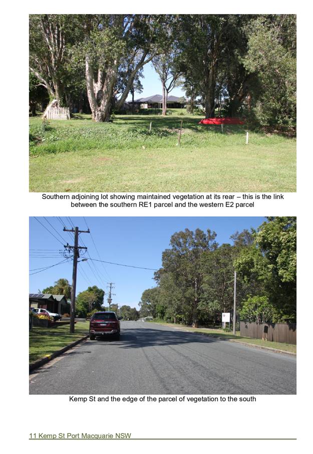
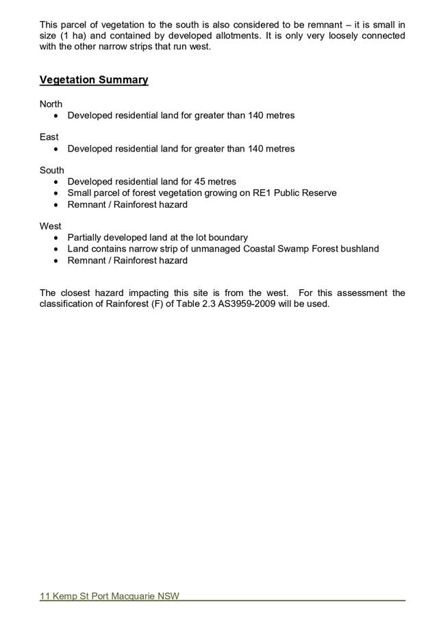
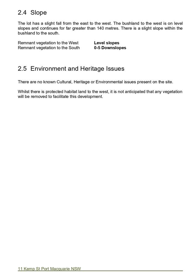
|
ATTACHMENT
|
Development Assessment Panel
27/11/2019
|
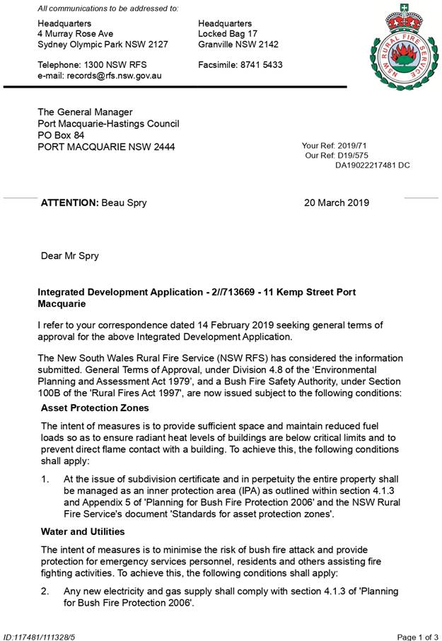

AGENDA Development Assessment Panel 27/11/2019
Item: 07
Subject: DA 2019 - 254.1 Industrial Building and
Caretaker’s Residence - Lot 2 DP 1084479, No. 3 Production Drive,
Wauchope.
Report
Author: Development Assessment Planner, Beau Spry
|
Applicant: Mark
Donney C/- Collins W Collins Pty Ltd
Owner: Mark
Donney
Estimated Cost: $430,000
Alignment with Delivery
Program
4.3.1 Undertake transparent
and efficient development assessment in accordance with relevant legislation.
|
|
RECOMMENDATION
That
DA2019 - 254.1 for an Industrial
building and caretaker’s residence at
Lot 2 DP 1084479 No. 3 Production Drive, Wauchope, be
determined by granting consent subject to the recommended conditions.
|
Executive
Summary
This
report considers a development application for an industrial building and
caretaker’s residence at the subject site and provides an assessment of
the application in accordance with the Environmental Planning and Assessment
Act 1979.
Following exhibition of the original application, one (1)
submission was received.
The original proposal was amended
during the assessment of application.
This application was previously referred to the Development
Assessment Panel on 9 October 2019 with a recommendation that the development application be approved subject to the
conditions. Determination of the application was deferred by the
DAP to address a number of issues. The DAP resolution and commentary on the
applicant’s response is provided below:
ITEM: 06 DA2019-254.1 INDUSTRIAL BUILDING AND
CARETAKER’S RESIDENCE - LOT 2 DP 1084479, NO. 3 PRODUCTION DRIVE,
WAUCHOPE.
Speakers: Derek Collins (applicant)
CONSENSUS:
That the determination by the Development
Assessment Panel (DAP) of DA2019 - 254 for an industrial building and
caretaker’s residence at Lot 2 DP1084479, be deferred to address the following:
1. The
Applicant give consideration to an amended layout which better satisfies
section 3.5.3.3 of Development Control Plan 2013 to require open storage areas
at the rear.
Comment:
The proposed layout has
been amended to situate open storage and work areas to the rear of the managers
residence, and specific landscaping detail is proposed for the site frontage.
2. The
Applicant rationalise the parking layout to be a safe and minimise potential
for conflict between workers and customers.
Comment:
The parking layout has
been revised as per the recommendation, the details of which are provided later
in this report and in Attachment 2.
3. The
Applicant submit a more detailed landscaping plan inclusive of species of
plantings.
Comment:
A detailed landscaping
plan has been submitted as part of the revised application.
4. The Applicant relocate the
parking spaces beside the storage containers
Comment:
The parking layout has
been revised as per the recommendation, the details of which are provided later
in this report and in Attachment 2.
This report considers the
amended/additional details as included in Attachment 2 and recommends that the
development be approved subject to the conditions included in Attachment 1
1. BACKGROUND
Existing Sites Features and Surrounding Development
The site has an area of 2088.123m2.
The site is zoned IN1 General Industrial in accordance with the Port Macquarie-Hastings Local
Environmental Plan 2011, as shown in the following zoning plan:
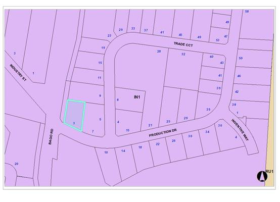
The industrial estate precinct comprises of a mix of large
and small scale sheds of both single and two storeys.
The existing subdivision pattern and location of existing
development within the locality is shown in the following aerial photograph:
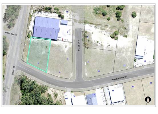
2. DESCRIPTION OF
DEVELOPMENT
Key aspects of the proposal include the following:
· Industrial building for the manufacture of pre-fabricated
structures (i.e. barn-style dwellings) and sheds;
· Open storage areas to accommodate storage containers for
the purpose of storing materials to be used for the pre-fabricated structures;
· Caretaker’s residence for on-site manager;
· Caretaker’s residence incorporates an office and
showroom for display purposes only.
Refer
to attachments at the end of this report for further details
Application Chronology
· 10 April 2019 - Application lodged
· 11 April 2019 - Application notified
· 29 April 2019 - Submission received
· 14 May 2019 - Site inspection
· 29 May - 13 September - Further information requested
and submitted
· 9 October 2019 - Referred to DAP
· 23 October 2019 - Additional information and amended plans
received
3. STATUTORY ASSESSMENT
Section 4.15(1) Matters for Consideration
In determining the application, Council is required to take
into consideration the following matters as are relevant to the development
that apply to the land to which the development application relates:
(a) The provisions (where
applicable) of:
(i) Any Environmental
Planning Instrument
State Environmental Planning Policy No. 33 - Hazardous
and Offensive Development
The subject SEPP was introduced to clarify the definitions
for hazardous and offensive industries and to apply guidelines for the
assessment of industries that have the potential to create hazards or an
offence. In this case, the use of the site is nominated as predominately storage and supply of pre-fabricated barn-style
dwellings with an ancillary caretaker’s residence dwelling.
Given the nature of the proposal it is unlikely that the proposal will create
any hazard or offence. The development can be assessed as submitted rather than
as a hazardous or offensive industry.
State Environmental Planning Policy No. 44 - Koala
Habitat Protection
There is no Koala Plan of Management on the site.
Additionally, the site is less than 1ha in area therefore no further
investigations are required. The application has demonstrated that no habitat
will be removed or modified therefore no further investigations are required.
State Environmental Planning Policy No. 55 –
Remediation of Land
Following an inspection of the site and a search of Council records,
the subject land is not identified as being potentially contaminated and is
suitable for the intended use.
State Environmental Planning Policy No. 62 –
Sustainable Aquaculture
Given the nature of the proposed development and proposed
stormwater controls, the proposal will be unlikely to have any adverse impact
on existing aquaculture industries.
State Environmental Planning Policy (Coastal Management)
2018
The site is not located within a coastal use area or coastal
environment area.
State Environmental Planning Policy (Building
Sustainability Index: BASIX) 2004
A BASIX certificate (995669S_02) has been submitted
demonstrating that the caretaker’s residence proposal will comply with
the requirements of the SEPP. It is recommended that a condition be
imposed to ensure that the commitments are incorporated into the development
and certified at Occupation Certificate stage.
State Environmental Planning Policy (Infrastructure) 2007
The proposed development does not trigger any relevant
clauses in relation to roads in the SEPP and is unlikely to create any conflict
in terms of traffic or noise.
Port Macquarie-Hastings Local Environmental
Plan 2011
The proposal is consistent with the LEP having regard to the
following:
· Clause
2.2 - The subject site is zoned IN1 General Industrial.
· Clause
2.3(1) and the IN1 zone landuse table - The proposed development for storage and supply of pre-fabricated barn-style
dwellings with an ancillary managers residence dwelling is a
permissible landuse with consent. While dwellings are normally prohibited, it
is considered that dwelling acts as a site office and display example of the
product. These reasons coupled with conditions ensures the managers residence
will remain ancillary/subordinate use is permissible.
· The
objectives of the IN1 zone are as follows:
o To provide a wide range of industrial and warehouse
land uses.
o To encourage employment opportunities.
o To minimise any adverse effect of industry on other
land uses.
o To support and protect industrial land for
industrial uses.
o To enable other land uses that provide facilities
or services to meet the day-to-day needs of workers in the area.
· Clause
2.3(2) - The proposal is consistent with the zone objectives having regard to
the following:
o The proposal is a
permissible landuse;
o The development is for an industrial use on industrial
land;
o The development would encourage employment opportunities;
o The proposal has demonstrated that impacts on other land
uses can be satisfactorily managed.
· Clause
4.3 and 4.4 - There is no maximum height or floor space ratio applicable to the
site.
· Clause
5.9 - No significant trees listed in Development Control Plan 2013 are proposed
to be removed. In addition, site as permitted to be cleared under the subdivision
that creates the property.
· Clause
5.10 - The site does not contain or adjoin any known heritage items or sites of
significance.
· Clause7.13
- Satisfactory arrangements are in place for provision of essential services
including water supply, electricity supply, sewer infrastructure, stormwater
drainage and suitable road access to service the development.
(ii) Any
draft instruments that apply to the site or are on exhibition
No draft
instruments apply to the site.
(iii) Any
Development Control Plan in force
Port
Macquarie-Hastings Development Control Plan 2013
|
DCP 2013: Chapter 3.5 - Industrial Development
|
|
DCP Objective
|
Development Provisions
|
Proposed
|
Complies
|
|
3.5.3.1
|
Minimum setbacks are provided as follows:
· 10m from a classified road;
· 7.6m from any other road
boundary;
· 3m from any secondary road
frontage.
|
Minimum setback of 35m to Production Drive from industrial
shed component.
Minimum setback of 7.6m to Production Drive from
caretaker’s residence component.
|
Yes
|
|
3.5.3.2
|
Elevations of building which are visible from a public
road, reserve or adjacent or adjoining residential areas are to be
constructed using:
· brick, masonry, pre-coloured
metal cladding, or
· appropriately finished
‘tilt-slab’ concrete; or
· a combination of a number of
these materials.
|
Pre-coloured metal cladding.
|
Yes
|
|
Large unrelieved expanses of wall or building mass are not
favoured, and as such should be broken up by the use of suitable building
articulation, fenestration or alternative architectural enhancements.
|
Front elevation broken up with door openings and provided
with some articulation with managers residence to the front with balcony.
|
Yes
|
|
3.5.3.3
|
Material storage/work areas and volumes to be provided
with application.
|
Storage and work areas have been shown.
The proposed storage areas will
accommodate storage containers for the purpose of storing materials to be
used for the pre-fabricated structures. No work areas are proposed.
|
Yes
|
|
Open work and storage areas to be located at rear of
premises and screen from view by landscaping and/or fencing minimum 2m high.
|
Onsite
storage is proposed to be located behind the managers residence.
The
proposed development is to be used primarily for the manufacture of
pre-fabricated structures (i.e. barn-style dwellings) and sheds. The proposed
storage areas will accommodate storage containers for the purpose of storing
materials to be used for the pre-fabricated structures as well as providing
storage area for machinery and vehicles.
The
development frontage is proposed to be fenced and landscaped.
|
Yes
|
|
3.5.3.4
|
Detailed landscaping plan submitted.
|
A satisfactory landscaping plan submitted including
planting species has been provided.
|
Yes
|
|
Landscaped strip 3m wide for 2/3 of each road frontage.
|
3m wide landscaping strip to Production Drive boundary.
|
Yes
|
|
No fencing in front setback unless for display items. High
quality fencing and landscaping.
|
No fence proposed in front setback.
1.8m high metal mesh fence proposed for front boundary.
|
Yes
|
|
3.5.3.5
|
An onsite
recreation area is provided for staff that:
· Includes seating,
tables and rubbish bin.
· If outside, is
adequately protected from the weather
· Is safely accessible
to all staff.
· Is separate private
from public areas.
· Is located away from
noisy or odorous activities.
|
Outdoor staff recreational area indicated.
There are also facilities located in the ancillary office
available for staff use.
|
Yes
|
|
3.5.3.6
|
Provide onsite facilities for changing, showering and
secure bike storage.
|
2x toilet/change room facilities provided in the
industrial component.
The manager’s residence will also provide for
changing/showering facilities.
|
Yes
|
|
3.5.3.7
|
Development complies with NSW Industrial Noise Policy.
|
Capable of complying. The site
is within an established industrial context and separated from the nearest
residential uses by approx. 500m. Condition recommended restricting noise
generation.
|
Yes
|
|
Building openings located to minimise noise impacts if
within 400m of residential zone.
|
Building openings oriented towards adjoining industrial
activities.
|
Yes
|
|
External plant such as generators, air conditioning plant
and the like, should be enclosed to minimise noise nuisance and located away
from residences.
|
None proposed.
|
n/a
|
|
External and security lighting should be directed and
shielded to avoid light spillage to adjoining residential areas.
|
No lighting proposed that is directed at residential
receivers. This is recommended to be reinforced via conditions.
|
n/a
|
|
Driveways should be arranged or screened to avoid
headlight glare on residential windows.
|
Properties opposite the driveway are industrial uses and
would not be impacted by headlight glare.
|
Yes
|
|
3.5.3.8
|
Office space ancillary to the industrial use is
permissible with consent, subject to satisfaction of the following matters:
· That the office component of
a proposed development is ancillary to the functions carried out in the
factory, warehouse or other industrial use.
· That the office area is not
leased to a separate company or entity.
· That parking facilities are
adequate to cater for the size of the office development.
|
The caretaker’s residence
incorporates an office and showroom for display purposes only to promote the
pre-fabricated structures/sheds. The proposal does not include any retailing.
The proposed caretaker’s residence, office and showroom are ancillary uses to the primary industrial use and
are not proposed to be separately leased. Conditions are recommended to
reinforce that it is not to be used as a separate business.
Parking calculations for the development have accounted for
the ancillary components.
|
Yes
|
|
3.5.3.9
|
The site should be serviced by reticulated water (and dual
reticulation where this is available), sewer and telecommunications.
|
Yes
|
Yes
|
|
3.5.3.10
|
Garbage storage areas are not visible from a public place.
|
Garbage is capable of being stored out of public view.
Condition recommended confirming this requirement.
|
Yes
|
|
3.5.3.11
|
Stormwater management strategy prepared.
|
Conditions recommended to be imposed to address stormwater
management.
|
|
|
Rainwater tank and dual reticulation for non-potable uses
on the site.
|
Rainwater tank proposed. Dual reticulation not available
to the site.
|
Yes
|
|
DCP 2013: General Provisions
|
|
DCP Objective
|
Development Provisions
|
Proposed
|
Complies
|
|
2.7.2.2
|
Design addresses generic principles of Crime Prevention
Through Environmental Design guideline:
· Casual surveillance and
sightlines
· Land use mix and activity
generators
· Definition of use and
ownership
· Lighting
· Way finding
· Predictable routes and
entrapment locations
|
The proposed development will be unlikely to create any
concealment/entrapment areas or crime spots that would result in any
identifiable loss of safety or reduction of security in the immediate area.
The caretaker’s residence provides supervision and casual surveillance
of the site.
|
Yes
|
|
2.3.3.1
|
Cut and fill 1.0m max. 1m outside the perimeter of the
external building walls
|
Cut of up to 2m proposed more than 1m outside the external
wall. Considered acceptable having regard to the scale of the building.
Conditions recommended requiring engineering certification of the proposed
retaining wall and detailed design of stormwater drainage.
|
No, but acceptable
Variation sought below.
|
|
2.3.3.2
|
1m max. height retaining walls along road frontages
|
None proposed.
|
Yes
|
|
Any retaining wall >1.0 in height to be certified by
structural engineer
|
Max retaining proposed 2.0m adjacent the northern
boundary.
Condition recommended confirming this requirement.
|
Yes
|
|
2.3.3.8 onwards
|
Removal of hollow bearing trees
|
None proposed to be removed.
|
Yes
|
|
2.6.3.1
|
Tree removal (3m or higher with 100mm diameter trunk and
3m outside dwelling footprint
|
No trees proposed to be removed.
|
n/a
|
|
2.4.3
|
Bushfire risk, Acid sulphate soils, Flooding,
Contamination, Airspace protection, Noise and Stormwater
|
Refer to main body of report.
|
|
|
2.5.3.2
|
New accesses not permitted from arterial or distributor
roads. Existing accesses rationalised or removed where practical
|
Access to Production Drive.
|
Yes
|
|
Driveway crossing/s minimal in number and width including maximising
street parking.
|
Single crossing of acceptable width.
|
Yes
|
|
2.5.3.3
|
Off-street parking in accordance with Table 2.5.1.
Industry: 1 space per 70m2 gross floor area
Office: 1 space per 30m2
Storage: 1 space per 100m2
Reduction possible if supported by parking demand study.
|
Proposal includes:
Industrial workspace: 478m2 GFA.
Storage: 444m2 GFA.
Showroom: 1
Managers Residence: 1
Therefore, parking requirements are:
Industrial workspace: 6.8 (7)
Storage: 4.4
(5)
Showroom: 1.0
Managers Residence: 1.0
Total Required: 14
spaces
The overall parking demand of the development is therefore
14 spaces. The submitted plan identifies 14 parking spaces and complies with
the minimum requirement.
|
Yes
|
|
2.5.3.7
|
Customer parking to be easily accessible.
|
Parking at front of the site and easily accessible.
|
Yes
|
|
Parking in accordance with AS 2890.1.
|
Capable of complying. Certification of compliance required
prior to Construction Certificate and Occupation Certificate.
|
Yes
|
|
2.5.3.8
|
Aged and disabled persons and persons wheeling prams or
trolleys are provided with suitable access and parking in accordance with AS
2890.1 and AS 2890.2.
|
One accessible parking space proposed.
|
Yes
|
|
2.5.3.9
|
Bicycle and motorcycle parking considered and designed generally
in accordance with the principles of AS 2890.3
|
Motorcycles can utilise car spaces and area exists onsite
to cater for informal bicycle spaces.
|
Yes
|
|
2.5.3.10
|
Parking concessions possible for conservation of heritage
items
|
No heritage exists onsite.
|
Yes
|
|
2.5.3.11
|
Section 94 contributions
|
Refer to main body of report.
|
|
|
2.5.3.12 and 2.5.3.13
|
Landscaping of parking areas
|
Appropriate perimeter landscaping proposed.
|
Yes
|
|
2.5.3.14
|
Sealed driveway surfaces unless justified
|
Condition recommended confirming requirement for sealed
surface.
|
Yes
|
|
2.5.3.15
|
Driveway grades for first 6m of ‘parking area’
shall be 5% grade
(Note AS/NZS 2890.1 permits steeper grades)
|
Capable of complying. Details to be submitted with CC/S138
applications.
|
Yes
|
|
2.5.3.16
|
Transitional grades min. 2m length
|
Capable of complying. Details to be submitted with CC/S138
applications.
|
Yes
|
|
2.5.3.17
|
Parking areas to be designed to avoid concentrations of
water runoff on the surface.
|
Stormwater management plan to be submitted prior to the
issue of a Construction Certificate.
|
Yes
|
|
No direct discharge to K&G or swale drain
|
Development required to be connected to the piped drainage
in Production Place. Stormwater management plan to be submitted prior to the
issue of a Construction Certificate.
|
Yes
|
|
2.5.3.19
|
Off street commercial vehicles facilities are provided in
accordance with AS/NZS 2890.2
|
Capable of complying.
|
Yes
|
|
Loading bays will be provided in accordance with the
following requirements;
· Minimum dimensions to be
3.5m wide x 6m long. (This may increase according to the size and type of
vehicle).
· Vertical clearance shall be
a minimum of 5m.
· Adequate provision shall be
made on-site for the loading, unloading and manoeuvring of delivery vehicles
in an area separate from any customer car parking area.
· A limited number of
‘employee only’ car parking spaces may be combined with loading
facilities.
· Loading areas shall be
designed to accommodate appropriate turning paths for the maximum design
vehicle using the site.
· Vehicles are to be capable
of manoeuvring in and out of docks without causing conflict with other street
or on-site traffic.
· Vehicles are to stand wholly
within the site during such operations.
|
73m2
loading bay proposed, approximately 16m x 6m.
The submitted plans demonstrate that delivery vehicles are
able to manoeuvre within the site and exit driving forwards.
|
Yes
|
|
Other commercial development shall provide one loading bay
for the first 1,000m² floor space and one additional bay for each
additional 2,000m².
|
One loading bay proposed.
|
Yes
|
|
2.5.3.20
|
The location and design of loading bays should integrate
into the overall design of the building and car parking areas.
|
Satisfactory integration.
|
Yes
|
|
Where visible from the public domain, loading bays are
located behind the building.
|
Loading bay will be visible from the public road, but is
enclosed with a roller door. Landscaping in the site frontage would also
screen the loading area to some extent. Considered acceptable.
|
Yes
|
|
2.5.3.21
|
Plans to confirm vehicular access, circulation and
manoeuvring in accordance with AUSTROADS and AS 2890.
|
Submitted plans demonstrate that satisfactory circulation
and manoeuvring areas are available.
|
Yes
|
|
Adequate area provided for loading/unloading and
manoeuvring of B-Doubles where access is available from approved B-Double
routes.
|
B-Double access not proposed. Proposal
is for 1 industrial shed, and it is unlikely that B-doubles will utilise the
site.
|
n/a
|
|
Ingress and egress in a forward direction.
|
Site allows ingress and egress of vehicles in a forward
direction.
|
Yes
|
|
Driveways >6m from tangent point of kerb radius and
>1.5m from common side boundary with another lot.
|
Driveway design acceptable.
|
Yes
|
|
Driveways not located within intersection or restricted
areas, and adequate sight distance available.
|
Driveway location acceptable.
|
Yes
|
|
DCP 2013: Dwellings, Dual
occupancies, Dwelling houses, Multi dwelling houses & Ancillary
development
|
|
|
Requirements
|
Proposed
|
Complies
|
|
3.2.2.2
|
Front setback (Residential not R5
zone):
· Min. 6.0m classified road
· Min. 4.5m local road or within 20%
of adjoining dwelling if on corner lot
· Min. 3.0m secondary road
Min. 2.0m Laneway
|
Minimum 17.3m front setback to
caretaker’s residence.
|
Yes
|
|
3.2.2.5
|
Side setbacks:
· Ground floor = min. 0.9m
· First floors & above =
min. 3m setback or where it can be demonstrated that overshadowing not
adverse = 0.9m min.
· Building wall set in and out
every 12m by 0.5m
|
First floor setback minimum 3m.
|
Yes
|
|
3.2.2.6
|
35m2 min. private open space area
including a useable 4x4m min. area which has 5% max. Grade and directly
accessible from ground floor living area.
|
Proposed caretaker’s
residence is located at ground floor level and has a private open space of
approximately 37m2 and is therefore considered acceptable for the
proposed use.
The
on-site manager to provide 24/7 surveillance of the open storage area and
premises generally. It should be noted that the office/managers
residence is considered ancillary to the primary use of the site.
|
Yes
|
|
3.2.2.10
|
Privacy:
· Direct views between living
areas of adjacent dwellings screened when within 9m radius of any part of
window of adjacent dwelling and within 12m of private open space areas of
adjacent dwellings. ie. 1.8m fence or privacy screening which has 25% max.
openings and is permanently fixed
· Privacy screen required if
floor level > 1m height, window side/rear setback (other than bedroom) is
less than 3m and sill height less than 1.5m
· Privacy screens provided to
balconies/verandahs etc. which have <3m side/rear setback and floor level
height >1m
|
Privacy adequately addressed
through building design and separation.
Primary living spaces located on
the ground floor, with site boundaries fenced at 1.8m high and site
landscaping proposed.
|
Yes
|
The proposal seeks to vary
Development Provision Clause 2.3.3.1 relating to maximum recommended cut levels
outside the building.
The relevant objectives are: To
ensure that design of any building or structure integrates with the topography
of the land to:
· Minimise
the extent of site disturbance caused by excessive cut and fill to the site.
· Ensure
there is no damage or instability to adjoining properties caused by excavation
or filling.
· Ensure
that there is no adverse alteration to the drainage of adjoining properties.
· Ensure
the privacy of adjoining dwellings and private open space are protected.
· Ensure
that adequate stormwater drainage is provided around the perimeter of buildings
and that overflow paths are provided.
Having regard for the development provisions and relevant
objectives, the variation is considered acceptable for the following reasons:
· The
subject site has an approximate 3.5m fall from north to south. The proposed cut
is required to achieve compliant grades for vehicle access and car parking.
· The
proposal includes the construction of a retaining wall of varying heights with
the maximum height being 2.0m adjacent the northern boundary. This has been
reviewed by Council’s engineering staff and conditioned for engineering
certification taking note of any potential risk to neighbouring properties.
· The
proposal incorporates stormwater drainage measures via a stormwater drainage
plan which has been reviewed by Council’s Engineering staff and
conditions recommended accordingly.
Based on the above assessment, the variations proposed to
the provisions of the DCP are considered acceptable and the relevant objectives
have been satisfied. Cumulatively, the variations do not amount to an adverse
impact or a significance that would warrant refusal of the application.
(iiia) Any
planning agreement that has been entered into under section 7.4, or any draft
planning agreement that a developer has offered to enter into under section 7.4
No planning
agreement has been offered or entered into relating to the site.
iv) Any matters prescribed by the
Regulations
None prescribed.
(b) The
likely impacts of that development, including environmental impacts on both the
natural and built environments, social and economic impacts in the locality
Context and Setting
The site has a general easterly street frontage orientation
to Production Drive. The site is located within an industrial area that will
eventually be surrounded by similar industrial uses and adjoining the site to
the north, east, south and west are further IN1 General Industrial zoned
premises of a similar building type.
· The
proposal will be unlikely to have any adverse impacts to existing adjoining
properties and satisfactorily addresses the public domain.
· The
proposal does not have a significant adverse impact on existing view sharing.
· The
proposal does not have significant adverse lighting impacts.
· There
are no significant adverse privacy impacts. Adequate building separation
and tenancy is existing.
Roads, Traffic and
Transport
The proposal has frontage to Production Drive. Production
Drive is a sealed public local road under the care and control of Council. The
proposal will be unlikely to have any adverse impacts within the immediate
locality in terms access, transport and traffic. The existing road network will
satisfactorily cater for any potential increase in traffic generation as a
result of the development.
Vehicle access to Lot 2 is proposed
via a driveway location fronting Production Drive.
Parking and Manoeuvring
A total of 14 parking spaces have been provided
on-site. Parking and driveway widths on site can comply with relevant
Australian Standards (AS 2890) and conditions have been imposed to reflect
these requirements.
Due to the type of development, car
park circulation is required to enable vehicles to enter and exit the site in a
forward manner. The amended site plans submitted after the 9 October DAP
meeting show adequate area is available and conditions have been recommended to
reflect these requirements.
Refer to relevant recommended conditions of consent.
Water Supply Connection
Council records indicate that the development site has an
existing sealed water service from the 150 DICL water main on the same side of
Bago Road. Each proposed unit requires an individual metered
water service. Final water service sizing will need to be determined by
a hydraulic consultant to suit the domestic and commercial components of the
development, as well as fire service and backflow protection requirements in
accordance with AS3500.
Detailed plans will be required to
be submitted for assessment with the S.68 application. Refer to relevant
recommended conditions of consent.
Sewer Connection
Council records indicate that the development site is
connected to sewer via junction to the existing sewer line that runs along the
southern property boundary. The site may discharge all sewage to this existing
point of connection. Details are to be shown on the engineering plans.
Detailed plans will be required to be submitted for assessment
with the S.68 application. Refer to relevant recommended conditions of
consent.
Stormwater
The site naturally grades towards the Production Drive
street frontage and is currently un-serviced. Along the street frontage within
the road reserve there is the existing public piped system.
The legal point of discharge for
the proposed development is defined as a direct connection to Council’s
stormwater pipeline within Production Drive.
A detailed site stormwater
management plan will be required to be submitted for assessment with the S.68
application and prior to the issue of a CC.
In accordance with Councils AUSPEC requirements, the
following must be incorporated into the stormwater drainage plan:
· The
design is to make provision for the natural flow of stormwater runoff from
uphill/upstream properties and lands. The design must include the collection of
such waters and discharge to the Councils drainage system.
· Connection
into the existing kerb inlet pit is to be at an angle greater than 45 degrees from
the existing pipeline alignment, if this cannot be achieved an extension of the
existing system will be required to allow suitable connection of the
development site to the piped public system.
Refer to relevant
recommended conditions of consent.
Other Utilities
Telecommunication and electricity services are available to
the site.
Heritage
Following a site inspection and a search of Council records,
no known items of Aboriginal or European heritage significance exist on the
property. No adverse impacts anticipated.
Other land resources
The site is within an established urban context and will not
sterilise any significant mineral or agricultural resource.
Water cycle
The proposed development will be unlikely to have any
adverse impacts on water resources and the water cycle.
Soils
The proposed development will be unlikely to have any
adverse impacts on soils in terms of quality, erosion, stability and/or
productivity subject to a standard condition requiring erosion and sediment
controls to be in place prior to and during construction.
Air and microclimate
The construction and/or operations of the proposed
development will be unlikely to result in any adverse impacts on the existing
air quality or result in any pollution. Standard precautionary site management
condition recommended.
Flora and fauna
Construction of the proposed development will not require
any removal/clearing of any native vegetation and therefore does not trigger
the biodiversity offsets scheme. Part 7 of the Biodiversity Conservation
Act 2016 is considered to be satisfied.
Waste
Satisfactory arrangements are in place for proposed storage
and collection of waste and recyclables. No adverse impacts anticipated.
Standard precautionary site management condition recommended.
Energy
The proposal includes measures to address energy efficiency
and will be required to comply with the requirements of BASIX or Section J of
the Building Code of Australia. No adverse impacts anticipated.
Noise and vibration
No adverse impacts anticipated. Condition recommended to
restrict construction to standard construction hours.
Bushfire
The site is identified as being bushfire prone.
The Applicant has submitted a
bushfire BAL certificate for the caretaker’s dwelling prepared by a
Certified Consultant.
An assessment of bushfire risk
having regard to section 4.3.5 of Planning for Bushfire Protection 2006
including vegetation classification and slope concludes that a Bushfire Attack
Level 19 shall be required.
Safety, security and crime prevention
The proposed development will be unlikely to create any
concealment/entrapment areas or crime spots that would result in any
identifiable loss of safety or reduction of security in the immediate
area. The increase in housing density will improve natural surveillance
within the locality and openings from each dwelling overlook common and private
areas.
Social impacts in the locality
Given the nature of the proposed development and its’
location the proposal is unlikely to result in any adverse social impacts.
Economic impact in the locality
No adverse impacts. A likely positive impact is that the
development will maintain employment in the construction industry, which will
lead to flow impacts such as expenditure in the area.
Site design and internal design
The proposed development design satisfactorily responds to
the site attributes and will fit into the locality. No adverse impacts likely.
Construction
No potential adverse impacts identified to neighbouring properties
with the construction of the proposal.
Cumulative Impacts
The proposed development is not expected to have any adverse
cumulative impacts on the natural or built environment or the social and
economic attributes of the locality.
(c) The suitability of the site for
the development
The proposed development is not expected to have any adverse
cumulative impacts on the natural or built environment or the social and
economic attributes of the locality.
(d) Any submissions made in
accordance with this Act or the Regulations
One (1) written submission was received following public exhibition
of the application.
Key issues raised in the submission and comments in
response to these issues are provided as follows:
|
Submission
Issue/Summary
|
Planning
Comment/Response
|
|
Adjacent
property zone of influence and impacts of proposed works on neighbouring
properties.
|
Council’s
engineers have reviewed the proposal and have addressed the concerns through
conditions.
Condition B3 requires detailed plans for retaining walls to be
submitted prior to issue of Construction Certificate.
Condition B39 regards earthworks and requires detailed drawings and
specifications to be prepared by a professional engineer prior to issue of
Construction Certificate.
Condition D11 requires earthworks to be supported during construction.
|
|
Impacts of stormwater from
upstream properties.
|
A detailed site stormwater management plan will be
required to be submitted for assessment with the S.68 application and prior
to the issue of a Construction Certificate.
Condition
B072 regards stormwater and requires detail design to be submitted and
approved by Council prior to the issue of Construction Certificate.
This
condition also references the need for approved provisions for collection and
discharge of natural flow of stormwater runoff from uphill/upstream
properties/lands.
|
(e) The Public Interest
The proposed
development satisfies relevant planning controls including justified variations
and will not adversely impact on the wider public interest.
4. DEVELOPMENT
CONTRIBUTIONS APPLICABLE
· Development contributions will be required towards augmentation
of town water supply and sewerage system head works under Section 64 of the
Local Government Act 1993.
· Development contributions will be required under Section
7.12 of the Environmental Planning and Assessment Act 1979.
5. CONCLUSION AND
STATEMENT OF REASON
The application has been assessed
in accordance with Section 4.15 of the Environmental Planning and Assessment
Act 1979.
Issues raised during assessment
and public exhibition of the application have been considered in the assessment
of the application. Where relevant, conditions have been recommended to manage
the impacts attributed to these issues.
The site is considered suitable
for the proposed development and the proposal adequately addresses relevant
planning controls. The development is not considered to be contrary to the
public's interest and will not result a significant adverse social,
environmental or economic impact. It is recommended that the application be
approved, subject to the recommended conditions of consent provided in the attachment
section of this report.
|
Attachments
1View. DA2019
- 254.1 Recommended conditions
2View. DA2019
- 254.1 Plans
3View. DA2019
- 254 - Contributions estimate
|
|
ATTACHMENT
|
Development Assessment Panel
27/11/2019
|

|
ATTACHMENT
|
Development Assessment Panel
27/11/2019
|
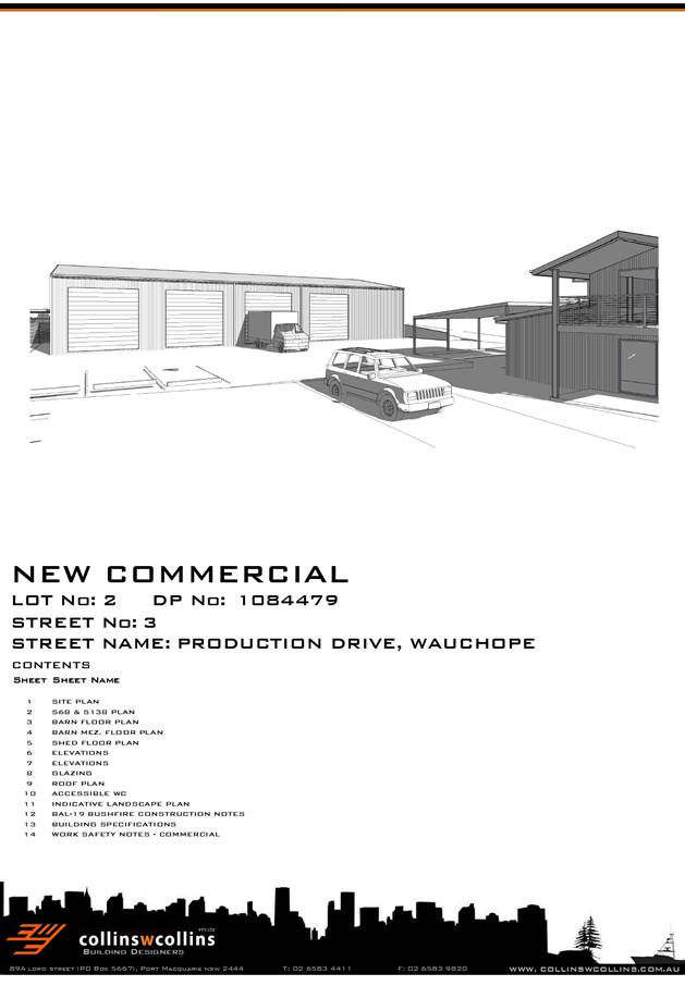
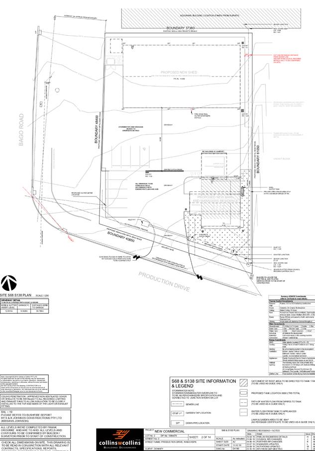
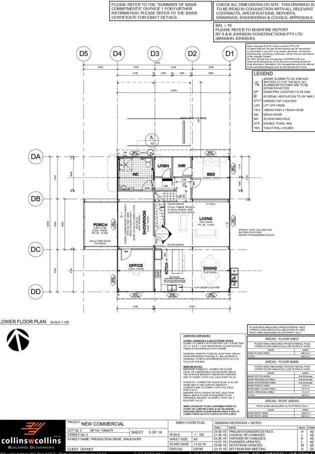
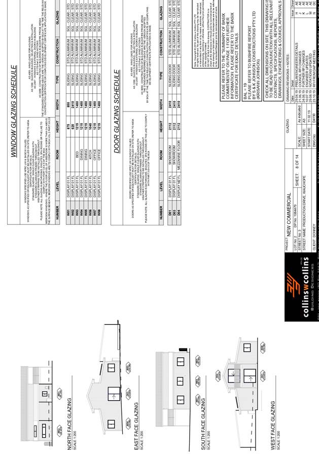
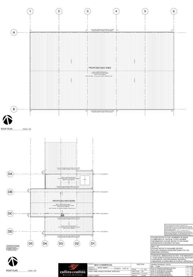
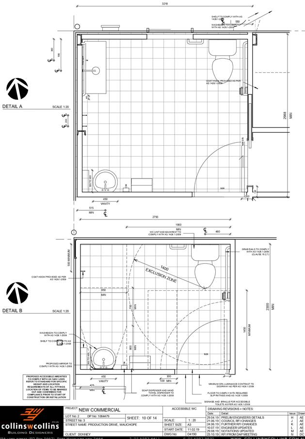
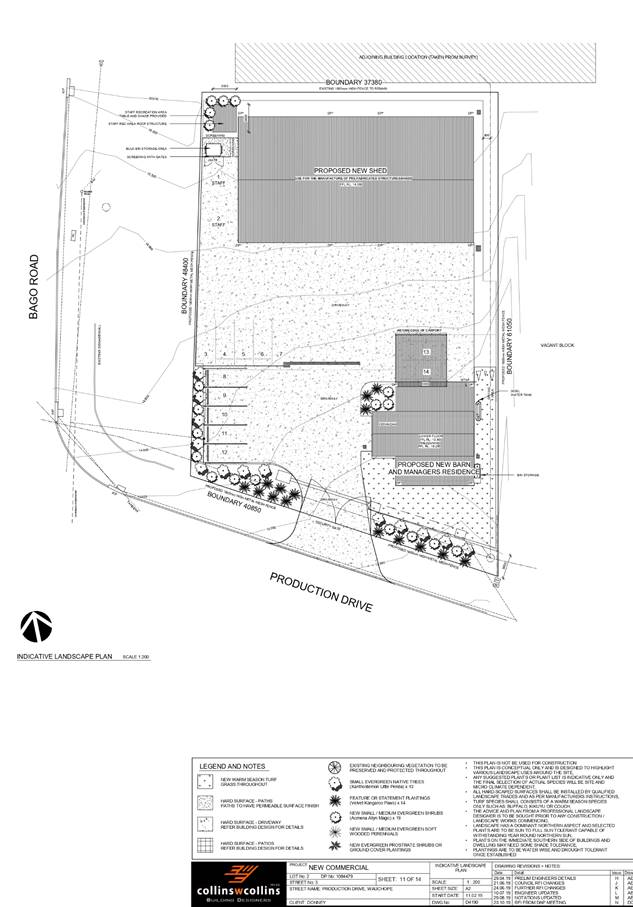
|
ATTACHMENT
|
Development Assessment Panel
27/11/2019
|
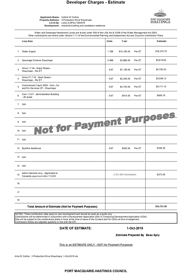
AGENDA Development Assessment Panel 27/11/2019
Item: 08
Subject: DA 2019 - 285.1 Service Station and Take Away
Food and Drink Premises at Lots 1 - 3 DP 407749 and Lot D DP 376568. 15 Ocean
Drive Port Macquarie and 39 - 43 Ackroyd Street Port Macquarie
Report
Author: Development Assessment Planner, Beau Spry
|
Applicant: RCI
Group
Owner: Judy
Plunket Pty. Ltd; Ghawdex Pty. Ltd.
Estimated Cost: $2,020,000
Alignment with Delivery
Program
4.3.1 Undertake transparent and
efficient development assessment in accordance with relevant legislation.
|
|
RECOMMENDATION
That
DA 2019 - 285.1 for a Service
Station and Take Away Food & Drink Premises at Lots 1- 3 DP 407749 and Lot D DP 376568.
15 Ocean Drive Port Macquarie and 39 - 43 Ackroyd Street Port Macquarie be determined by granting consent subject to the
recommended conditions.
|
Executive
Summary
This
report considers a development application for a service station and
take away food and drink premises at the subject site
and provides an assessment of the application in accordance with the
Environmental Planning and Assessment Act 1979.
Following exhibition of the
application, two (2) submissions were
received.
The proposal has been amended
during the assessment of the application.
The site is considered suitable for the proposed development
and the proposal adequately addresses relevant planning controls. The
development is not considered to be contrary to the public's interest and will
not result a significant adverse social, environmental or economic impact.
This report recommends that
the development application be approved subject to the attached conditions
(Attachment 1).
1. BACKGROUND
Existing Sites Features and Surrounding Development
The combined site has an area of 2983.95m2.
The site is zoned B2 Local Centre in accordance with the Port Macquarie-Hastings Local
Environmental Plan 2011, as shown in the following zoning plan:
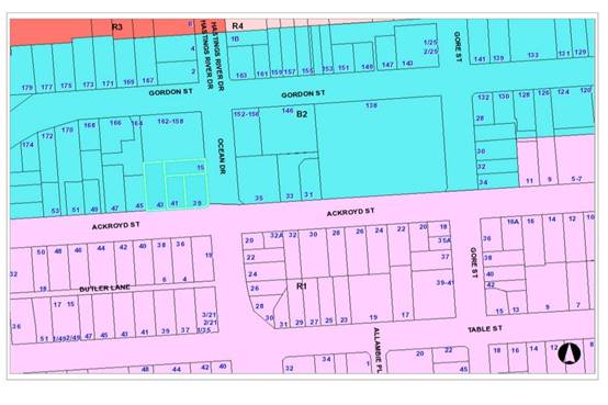
The existing subdivision pattern and location of existing
development within the locality is shown in the following aerial photograph:
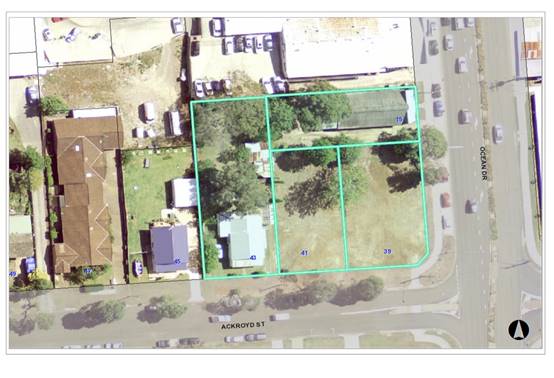
2. DESCRIPTION OF
DEVELOPMENT
Key aspects of the proposal include the following:
· Stage 1: Service Station
· Installation of underground fuel tanks (1 x 50,000 litre
diesel, 1 x 30,000 litre Ethanol 10, 1 x 30,000 litre Premium Unleaded 98, 1 x
40,000 litre Unleaded 91 and 1 x 30,000 litre Premium 95);
· Installation of four (4) double sided fuel dispensers
(appropriately bunded) and overhead canopy their related infrastructure;
· Construction of 16 car parking spaces, including one
accessible space and x 1 air / water bay;
· Installation of x 1 freestanding 8m high
‘Mobil’ internally illuminated pylon sign, located within
south-eastern corner;
· Construction of an underground Puraceptor and Stomscak
system for waste water discharge management;
· Construction of an underground OSD tank (22.5m3) for
stormwater discharge control;
· Installation of indicative business identification signage
on the south face of the convenience store;
· ‘Mobil’ pylon sign – 8m in height, 1.9m
in width and 0.4m in depth;
· Two (2) illuminated ‘Mobil’ signs on the
‘south’ and ‘east’ faces of the car refuelling canopy;
· Landscaping around the perimeter of the service station and
adjacent to the proposed building;
· Landscaping between the Stage 1 and Stage 2 buildings;
· Screened waste storage area;
· Loading zone adjacent to waste storage area;
· Minor excavations to accommodate vehicle accesses/exits.
· 24 hour operation, 7 days a week.
Stage 2: Food and Drink
Premises
· Two tenancies for future food and drink premises;
· Development comprises x 2 units 100m2 of GFA, plus 4
internal seats for each and shared 12 external seats;
· New hard stand and parking area for an additional 17 car
parking spaces, including 1 disabled car parking space;
· Indicative location of internally illuminated business
identification signs on the southern elevation of the proposed outlets;
· Screened waste storage area;
· Loading Zone adjacent to waste storage area;
· Excavations to accommodate vehicle accesses/exits.
· Operating hours 6am to midnight, 7 days a week.
Refer
to Attachment 2 at the end of this report for plans of the proposed
development.
Application Chronology
· 18 April 2019 - Application lodged
· 2 May 2019 - Application notified
· 10 - 15 May 2019 - Submissions received
· 22 June 2019 - Site inspection
· 22 June - 11 November - Further information requested
and submitted.
3. STATUTORY ASSESSMENT
Section 4.15(1) Matters for Consideration
In determining the application, Council is required to take
into consideration the following matters as are relevant to the development
that apply to the land to which the development application relates:
(a) The provisions (where
applicable) of:
(i) Any Environmental
Planning Instrument
State Environmental Planning Policy No. 33 - Hazardous
and Offensive Development
The subject SEPP was introduced to clarify
the definitions for hazardous and offensive industries and to apply guidelines
for the assessment of industries that have the potential to create hazards or
an offence.
Clause 12 of SEPP 33 requires that a
Development Application for the purposes of a potentially hazardous industry
must include a preliminary hazard analysis (PHA) in accordance with the current
circulars or guidelines published by the Department of Planning, Industry and
Environment.
The Department has published Hazardous and Offensive Development
Application
Guidelines – Applying to SEPP 33 (January
2011). Appendix 3 of The Guideline
identifies Petrol Stations as
industries, which may be potentially hazardous. The primary sources of hazard
is identified as liquid fuel leaks/spills resulting in possible impacts such as
fire and explosions.
Appendix 2 of The Guideline
includes a list of information required in
relation to the SEPP 33 risk
screening method as follows:
- Hazardous
Materials involved in the Proposed Development;
- Dangerous
Goods classifications for all Dangerous Goods held on site;
- Quantities
of dangerous goods and otherwise hazardous materials involved in
the proposed development;
- Distance
from the boundary for each hazardous substance;
- Weekly and
annual number of deliveries (and the quantities) of dangerous
goods
and otherwise hazardous materials to and from the facility;
- Site Layout
plan showing proposed development and any existing
development
on site; and
- Locality
Plan showing immediate neighbours and their activities and also
showing
the nearest residential property.
In this case, the development
has the potential to be hazardous given the proposal to store petrol, diesel
and ethanol on the site and the provisions of the SEPP apply.
The above information has been
satisfactorily addressed in the SEPP 33 Preliminary Hazards Analysis and
Summary and the Multi-Level Risk Assessment included in submitted information
with the application. Having considered the SEPP, the Multi-Level Risk
Assessment, the Preliminary Hazard Analysis, and with the imposition of
conditions, the consideration of the SEPP is satisfied.
State Environmental Planning Policy No. 44 - Koala
Habitat Protection
There is no Koala Plan of Management on the site.
Additionally, the site is less than 1ha in area therefore no further
investigations are required. The application has demonstrated that no habitat
will be removed or modified therefore no further investigations are required.
State Environmental Planning Policy No. 55 –
Remediation of Land
Following an inspection of the site and a search of Council
records, the subject land is not identified as being potentially contaminated
and is suitable for the intended use.
State Environmental Planning Policy No. 62 –
Sustainable Aquaculture
Given the nature of the proposed development and proposed
stormwater controls the proposal will be unlikely to have any adverse impact on
existing aquaculture industries
State Environmental Planning Policy (Coastal Management)
2018
The site is not located within a coastal use area or coastal
environment area.
State Environmental Planning
Policy No. 64 – Advertising and Signage
The proposed development involves the erection of signage
across two (2) stages in the form of business/building identification,
advertising and wayfinding signage, including;
Stage 1
· ‘Mobil’
pylon sign – 8m in height, 1.9m in width and 0.4m in depth.
· x 2
illuminated ‘Mobil’ signs on the ‘south’ and
‘east’ faces of the car refuelling canopy.
· x 1
indicative internally illuminated sign on the south façade of the
service store.
· x 1 tower sign
with x 2 indicative internally illuminated business signs (south face).
Stage 1
· x 2
indicative internally illuminated business signs on the southern fascia of the
take away/cafes.
In accordance with clause 7, this SEPP prevails over the
Port Macquarie-Hastings LEP 2011 in the event of any inconsistency.
The following assessment table provides an assessment
checklist against the Schedule 1 requirements of this SEPP:
|
Applicable
clauses for consideration
|
Comments
|
Satisfactory
|
|
Clause 8(a) Consistent with
objectives of the policy as set out in Clause 3(1)(a).
|
The B2 Local Centre zone contains a variety of commercial
land uses. The proposed signage is considered to be compatible with the
existing and future character of the locality.
Proposal is considered consistent with the objectives of
the SEPP.
|
Yes
|
Schedule
1(1) Character of the area.
|
In assessing signage and
compatibility with character of an area, elements such as scale and any
amenity impacts should be considered.
In this case the proposal is consistent with the
established character of the local centre area. Similar scale signage is
evident nearby and potential amenity impacts (such as illumination) can be
appropriately managed via conditions.
|
Yes
|
|
Schedule 1(2) Special areas.
|
The proposed signage does not
detract from any areas of environmental or cultural importance. There are no
such areas in direct proximity to the subject land.
|
Yes
|
|
Schedule 1(3) Views and vistas.
|
The proposed signage does not
obscure or compromise important views, dominate the skyline or reduce the
quality of any views or vistas.
The proposed signage has no
impact on existing signage in close proximity to the site.
|
Yes
|
|
Schedule 1(4) Streetscape,
setting or landscape.
|
The signage is considered to
be acceptable in terms of scale, height, and appearance, and is compatible
with the streetscape setting. Similar scale signage is evident nearby at
Gordon Street.
|
Yes
|
|
Schedule 1(5) Site and building.
|
The signage is seen to be
standard for a service centre and is considered to be acceptable in terms of
scale, height, and appearance.
The proposed signage is not
considered to detract from important features of the site, proposed building
or surrounding development. The location of the proposed signage is
considered suitable for the proposed use and appropriate given the proposed
service stations position, proposed access arrangements and parking.
|
Yes
|
|
Schedule 1(6) Associated devices
and logos with advertisements and advertising structures.
|
The proposal includes signage
which is
Intended to ultimately include
logos and symbols representing facilities and services offered.
|
Yes
|
|
Schedule 1(7) Illumination.
|
Low impact lighting is
proposed to illuminate the signage at night.
These signs will be required
to be illuminated at appropriate LUX levels so as to ensure that the signage
will not result in unacceptable glare. The proposed illuminated signage
is not considered likely to provide a significant safety concern for pedestrians,
vehicles or aircraft.
Condition recommended
requiring lighting to comply with AS4282 - Control of the obtrusive
effects of outdoor lighting.
|
Yes
|
|
Schedule 1(7) Safety.
|
The proposed service station
signage is not considered likely to reduce road safety for pedestrians,
cyclists or any
vehicles utilising a public
road.
Sightlines to and from the
site are
not considered likely to be
affected.
|
Yes
|
State Environmental Planning Policy (Infrastructure) 2007
Clause 104(3)(b)(ii) and (iii) -
The DA has been referred to the NSW Roads and
Maritime Service (RMS). The
RMS’ advice and other matters requiring
consideration are considered in
the assessment of access, traffic and parking
impacts addressed later in this report.
Port Macquarie-Hastings Local Environmental
Plan 2011
The proposal is consistent with the LEP having regard to the
following:
· Clause
2.2 - The subject site is zoned B2 Local Centre.
· Clause
2.3(1) and the B2 zone landuse table - The proposed development for a service
station & take away food and drink premises are a permissible landuse with
consent.
The following landuses in the
LEP are relevant to determine and characterise the
proposed use:
service
station means a building or place used for the sale by retail of
fuels and lubricants for motor vehicles, whether or not the building or place
is also used for any one or more of the following:
(a) the ancillary sale by retail of spare parts and accessories for
motor vehicles,
(b) the cleaning of motor vehicles,
(c) installation of accessories,
(d) inspecting, repairing and servicing of motor vehicles (other than
body
building,
panel beating, spray painting, or chassis restoration),
(e) the ancillary retail selling or hiring of general merchandise or
services or
both.
food and drink premises means premises that are used for the preparation
and retail sale of food or drink (or both) for immediate consumption on or off
the premises, and includes any of the following -
(a) a restaurant or cafe,
(b) take away food and drink premises,
(c) a pub,
(d) a small bar.
The objectives of the B2 zone are
as follows:
o To provide a range of retail, business,
entertainment and community uses that serve the needs of people who live in,
work in and visit the local area.
o To encourage employment opportunities in accessible
locations.
o To maximise public transport patronage and
encourage walking and cycling.
o To ensure that new developments make a positive
contribution to the streetscape and contribute to a safe public environment.
Clause 2.3(2) - The proposal is consistent with the zone
objectives having regard to the following:
o The proposal is a permissible
landuse;
o The service station will
encourage employment opportunities;
o The proposal will not have any
noticeable adverse impacts on other developments in the precinct;
o The proposal will
satisfactorily address the public domain;
o The proposal will provide
facilities to meet the day-to-day needs of the surrounding workers/residents.
· Clause
4.3 - The maximum overall height of the building above ground level (existing)
is 8m for the pylon, 5.5m for the canopy and 4.8m for the building. The
building heights complies with the standard height limit of 14.5m applying to
the site.
·
· Clause
4.4 - The floor space ratio of the proposal is 0.13:1.0, which complies with
the maximum 1.50:1 floor space ratio applying to the site.
· Clause
5.10 - Heritage. The site does not contain or adjoin any known heritage items
or sites of significance.
·
· Clause
7.13 - Satisfactory arrangements are in place for provision of essential
services including water supply, electricity supply, sewer infrastructure,
stormwater drainage and suitable road access to service the development.
(ii) Any
draft instruments that apply to the site or are on exhibition
No draft
instruments apply to the site.
(iii) Any
Development Control Plan in force
Port
Macquarie-Hastings Development Control Plan 2013
|
DCP 2013: Business & Commercial Development
|
|
DCP Objective
|
Development Provisions
|
Proposed
|
Complies
|
|
3.4.3.8
|
Active Frontages:
Ground floor levels shall not be used for residential
purposes in B1, B2, B3 and B4 zones.
|
Proposal does not include any ground floor residential
use.
|
Yes
|
|
3.4.3.9
|
A minimum of 50% of the ground floor level front facade is
to be clear glazed.
|
More than 50% clear glazing.
|
Yes
|
|
Active frontages must consist of one or more of the
following:
· A shop front.
· Commercial and residential
lobbies.
· Café or restaurant if
accompanied by an entry from the street.
· Public building if
accompanied by an entry from the street.
|
Active frontage consistent with these requirements.
|
Yes
|
|
Restaurants, cafés and the like shall provide
openable shop fronts to the footpath but must not encroach into footpath.
|
Proposal includes takeaway food premises within the site
boundaries. It does not include cafes opening onto street frontage/footpaths.
|
Yes
|
|
3.4.3.22
|
The
development complies with AS1428—Design for Access and Mobility.
|
Capable of complying. Details to be submitted with the Construction
Certificate application.
|
Yes
|
|
DCP 2013: General Provisions
|
|
DCP Objective
|
Development Provisions
|
Proposed
|
Complies
|
|
2.7.2.2
|
Design addresses generic principles of Crime Prevention
Through Environmental Design guideline:
· Casual surveillance and
sightlines
· Land use mix and activity
generators
· Definition of use and
ownership
· Lighting
· Way finding
· Predictable routes and
entrapment locations
|
The proposed development will be unlikely to create any
concealment/entrapment areas or crime spots that would result in any
identifiable loss of safety or reduction of security in the immediate area.
|
Yes
|
|
2.3.3.1
|
Cut and fill 1.0m max. 1m outside the perimeter of the
external building walls
|
A bulk earthworks plan has been supplied with the
application. This plan indicates a cut/fill factor of 1:1 across the site
with a maximum 2m cut in localised parts.
The above is considered acceptable having regard to the
scale of the buildings. Conditions recommended requiring engineering certification
of the proposed retaining wall and detailed design of stormwater drainage.
|
No, but acceptable
Variation sought below.
|
|
2.3.3.2
|
1m max. height retaining walls along road frontages
|
None proposed.
|
Yes
|
|
Any retaining wall >1.0 in height to be certified by
structural engineer
|
Max retaining proposed 2.0m adjacent the northern
boundary.
Condition recommended confirming this requirement.
|
Yes
|
|
2.3.3.8 onwards
|
Removal of hollow bearing trees
|
None proposed to be removed.
|
N/A
|
|
2.6.3.1
|
Tree removal (3m or higher with 100mm diameter trunk and
3m outside dwelling footprint
|
11 trees proposed to be
removed across the site. These include 2x Melaleuca Quinquinervia which are
listed as ‘Other Browse’ species on Table 2.6-1 Koala Food Trees
of DCP 2013, and are required to be replaced at a ratio of 1:1.
The 11 removed trees are
proposed to be replaced by 15 medium mature trees, including:
· 8x
Bush Cherry
· 5x
Water Gum
· 2x
Weeping Lilly Pilly
These 15 replacement trees
also include the replacement KFT species.
|
Yes
|
|
2.4.3
|
Bushfire risk, Acid sulphate soils, Flooding,
Contamination, Airspace protection, Noise and Stormwater.
|
Refer to main body of report.
|
|
|
2.5.3.2
|
New accesses not permitted from arterial or distributor
roads. Existing accesses rationalised or removed where practical.
|
The site currently has 1x shared driveway existing from
Ocean Drive and 1x shared driveway existing from Ackroyd Street.
The proposal seeks:
· Entry only
on Ocean Drive- (northbound – new access point).
· Exit only
on Ocean Drive - (northbound – includes expansion of existing access).
· A combined
entry / exit to Ackroyd Street – (east and west bound - includes
expansion of existing access).
|
No * Refer to traffic assessment details later this
report.
|
|
Driveway crossing/s minimal in number and width including
maximising street parking.
|
Driveway crossings are minimal to the site which proposes
a circular functioning driveway.
|
Yes
|
|
2.5.3.3
|
Off-street parking in accordance with Table 2.5.1.
Service Station: 3 per workbay + 1 per employee
+ min 2 customer
Takeaway onsite seating with no drive through: 1
per 5 seats (int/ext) or 1 per 2 seats (int).
|
The application is accompanied
by a Traffic and Parking Impact Study.
The proposal comprises two
components:
Service Station = 3
per workbay + 1 per employee + 2 customer spaces:
Workbays = 0
Employees = 1
Customer = 2 (min)
Total req 3 spaces
Take-Away food and Drink
for onsite seating with no drive through, 1 per 5 seats (int/ext) or 1 per
2 seats (int). The specific tenancy of each food premise is unknown so
the high rate ‘take away’ will be applied at 12 per 100m2 GFA +
seating at 1 per 2 seats.
200m2 GFA = 24 spaces
internal for 8 = 4 seats
Total required = 28
The overall parking demand of
the development is therefore 31 spaces. The submitted plan identifies 32
parking spaces, including 2x disabled spaces, and complies with the minimum
requirement.
|
Yes
|
|
2.5.3.7
|
Customer parking to be easily accessible.
|
Parking design proposed is at the front of the site and is
easily accessible.
|
Yes
|
|
Parking in accordance with AS 2890.1.
|
Capable of complying. Certification of compliance required
prior to Construction Certificate and Occupation Certificate.
|
Yes
|
|
2.5.3.8
|
Aged and disabled persons and persons wheeling prams or
trolleys are provided with suitable access and parking in accordance with AS
2890.1 and AS 2890.2.
|
Two (2) accessible parking spaces proposed.
|
Yes
|
|
2.5.3.9
|
Bicycle and motorcycle parking considered and designed
generally in accordance with the principles of AS 2890.3
|
Motorcycles can utilise car spaces and area exists onsite
to cater for informal bicycle spaces.
|
Yes
|
|
2.5.3.10
|
Parking concessions possible for conservation of heritage
items
|
No heritage exists onsite.
|
Yes
|
|
2.5.3.11
|
Section 94 contributions
|
Refer to main body of report.
|
|
|
2.5.3.12 and 2.5.3.13
|
Landscaping of parking areas
|
Satisfactory perimeter landscaping proposed.
|
Yes
|
|
2.5.3.14
|
Sealed driveway surfaces unless justified
|
Condition recommended confirming requirement for sealed
surface.
|
Yes
|
|
2.5.3.15
|
Driveway grades for first 6m of ‘parking area’
shall be 5% grade
(Note AS/NZS 2890.1 permits steeper grades)
|
Capable of complying with Council driveway standards.
Details to be submitted with CC/S138 applications.
|
Yes
|
|
2.5.3.16
|
Transitional grades min. 2m length
|
Capable of complying. Details to be submitted with CC/S138
applications.
|
Yes
|
|
2.5.3.17
|
Parking areas to be designed to avoid concentrations of
water runoff on the surface.
|
Concept plans provided. Detailed stormwater management
plan to be submitted prior to the issue of a Construction Certificate.
|
Yes
|
|
No direct discharge to K&G or swale drain
|
Development required to be connected to the piped drainage
in Ackroyd Street. Detailed stormwater management plan to be submitted prior
to the issue of a Construction Certificate.
|
Yes
|
|
2.5.3.19
|
Off street commercial vehicles facilities are provided in
accordance with AS/NZS 2890.2
|
Capable of complying.
|
Yes
|
|
Loading bays will be provided in accordance with the
following requirements;
· Minimum dimensions to be
3.5m wide x 6m long. (This may increase according to the size and type of
vehicle).
· Vertical clearance shall be
a minimum of 5m.
· Adequate provision shall be
made on-site for the loading, unloading and manoeuvring of delivery vehicles
in an area separate from any customer car parking area.
· A limited number of
‘employee only’ car parking spaces may be combined with loading
facilities.
· Loading areas shall be
designed to accommodate appropriate turning paths for the maximum design
vehicle using the site.
· Vehicles are to be capable
of manoeuvring in and out of docks without causing conflict with other street
or on-site traffic.
· Vehicles are to stand wholly
within the site during such operations.
|
There are 2x loading bays proposed, one each for the
Service Station and the Take Away.
The loading bay for the Service Station measures 8.8 x 4m,
with the Take Away measuring 8.8 x 3.5m.
The submitted plans demonstrate that delivery vehicles are
able to manoeuvre within the site and exit driving forwards.
|
Yes
|
|
Other commercial development shall provide one loading bay
for the first 1,000m² floor space and one additional bay for each
additional 2,000m².
|
There are 2x loading bays proposed, one each for the
Service Station and the Take Away.
|
Yes
|
|
2.5.3.20
|
The location and design of loading bays should integrate
into the overall design of the building and car parking areas.
|
The location and design of the loading bay integrates into
the overall design of the building and car parking areas.
|
Yes
|
|
Where visible from the public domain, loading bays are
located behind the building.
|
The nature of the proposal as a service station that
traditionally has an open well surveilled carpark
area, as well as the integration of the loading bays into the overall
carparking design mean this is considered acceptable.
|
Yes
|
|
2.5.3.21
|
Plans to confirm vehicular access, circulation and
manoeuvring in accordance with AUSTROADS and AS 2890.
|
Submitted plans demonstrate that satisfactory circulation
and manoeuvring areas are available.
|
Yes
|
|
Adequate area provided for loading/unloading and
manoeuvring of B-Doubles where access is available from approved B-Double
routes.
|
B-Double access not proposed. Fuel
deliveries will be via articulated vehicle.
|
n/a
|
|
Ingress and egress in a forward direction.
|
Site allows ingress and egress of vehicles in a forward
direction.
|
Yes
|
|
Driveways >6m from tangent point of kerb radius and
>1.5m from common side boundary with another lot.
|
Driveway design acceptable.
|
Yes
|
|
Driveways not located within intersection or restricted
areas, and adequate sight distance available.
|
Driveway location acceptable.
|
Yes
|
The proposal seeks to vary
Development Provision relating to 2.3.3.1 - Cut and Fill
The relevant objectives are: To
ensure that design of any building or structure integrates with the topography
of the land to.
· Minimise
the extent of site disturbance caused by excessive cut and fill to the site;
· Ensure
there is no damage or instability to adjoining properties caused by excavation
or filling;
· Ensure
that there is no adverse alteration to the drainage of adjoining properties;
· Ensure
the privacy of adjoining dwellings and private open space are protected;
· Ensure
that adequate stormwater drainage is provided around the perimeter of buildings
and that overflow paths are provided;
Having regard for the
development provisions and relevant objectives, the variation is considered
acceptable for the following reasons:
· The
site topography slopes gently down from west to east by approximately 2m.
· The
cut/fill is required to level the site appropriately for the proposal with a
cut/fill factor of 1:1 across the site;
· The
bulk of the site requires minimal cut/fill or cut/fill not exceeding 1m;
· No
adverse impacts are identified to neighbouring properties to north and south.
Based on the above assessment, the variation proposed to the
provision of the DCP is considered acceptable and the relevant objectives have
been satisfied.
(iiia) Any
planning agreement that has been entered into under section 7.4 or any draft
planning agreement that a developer has offered to enter into under section 7.4
No planning
agreement has been offered or entered into relating to the site.
(iv) Any matters prescribed by the
Regulations
Demolition
of buildings AS 2601 - Clause 92
Demolition of the existing buildings on the site are capable
of compliance with this Australian Standard. An appropriate standard consent
condition is recommended.
(b) The
likely impacts of that development, including environmental impacts on both the
natural and built environments, social and economic impacts in the locality:
Context and Setting
The site is a corner block and has a general easterly street
frontage orientation to Ocean Drive and southerly street frontage orientation
to Ackroyd Street. The site is located within an established B2 local centre
area and adjoining the site to the north, east, and west are further B2 local
centre zoned premises and to the south are R1 general residential.
· The
proposal will be unlikely to have any adverse impacts to existing adjoining
properties and satisfactorily addresses the public domain.
· The
proposal does not have a significant adverse impact on existing view sharing.
· The
proposal does not have significant adverse lighting impacts subject to
complying with recommended conditions;
· There
are no significant adverse privacy impacts.
Roads, Traffic and
Transport
The proposal has frontage to Ocean Drive and Ackroyd Street.
These roads are sealed public roads under the care and control of Council.
Ocean Drive is classified as an Arterial road while Ackroyd Street is
classified as a Local road.
The site currently has 1x shared driveway existing from
Ocean Drive and 1x shared driveway existing from Ackroyd Street. The proposal
seeks:
· Entry
only on Ocean Drive- (northbound – new access point).
· Exit
only on Ocean Drive - (northbound – includes expansion of existing access).
· A
combined entry / exit to Ackroyd Street – (east and west bound - includes
expansion of existing access).
The application includes a Traffic Impact Assessment from
Intersect Traffic Pty Ltd on 17 April 2019. Findings of the study
determined:
· The local and
state road network is currently operating within its two-way mid-block
technical capacity therefore has spare capacity to cater for development in the
area.
· The proposed
development could generate up to 144 vtph to and from the site during peak
periods of which 75 % of this traffic would be passing trade.
· The local and
state road network will not reach its two-way mid-block technical capacity
resulting from this development and it is reasonable to conclude the
development will not adversely impact on the state and local road network
subject to satisfactory intersection performance.
· The proposal
will not adversely impact on the operation of intersections within the local
and state road network as additional traffic volumes on the road network are
less than 2 % of existing traffic flows therefore are considered insignificant.
· The access
points are sufficient to allow safe access and manoeuvring for all vehicles.
Deliveries are
proposed to be restricted to be form 5am to 12am (midnight) only.
Key issues or recommendations are to be addressed by
conditions.
Consistent with RMS requirements, the proposal was referred
to the RMS on 13/05/2019. RMS’ review of the proposal determined:
|
RMS
Comment
|
Response
|
|
Ocean
Drive is an approved B-Double Route. The site has not been designed to cater
for these larger fuel tankers.
|
The proposal is not aimed at
catering to truck stop / highway service centre traffic, of which significant
large-truck movements occur.
|
|
The site
does not provide any parking for longer light vehicles with trailers.
|
The proposal is aimed at
catering to refuelling vehicles predominantly. There is sufficient room under
the canopy for longer vehicles to park temporarily.
|
|
The area used to unload fuel
by a semi-trailer will need to be coned-off during these operations. This
will block traffic entering and exiting to Ocean Drive and could result in
queuing.
|
Refuel movement times are
capable of being conditioned to occur in off-peak periods.
|
|
The swept
paths for a semi-trailer will require the use of all three lanes of Ocean
Drive. The site should be designed so a service vehicle can enter and leave
from the kerbside lane of Ocean Drive.
|
Revised entry and exit layout
provided and swept paths demonstrating entry and exit is achievable from
within the kerbside lane of Ocean Drive.
|
|
Any
regulatory facility will need to be referred to Council’s Traffic
Committee for a recommendation prior to installation.
|
No regulatory facility
proposed.
|
|
Council should be satisfied
the site will operate safely and efficiently for the density of development
being proposed.
|
Reviewed by Council’s
Engineering team and noted.
|
|
The Statement of Environmental
Effects indicates a Section 138 of the Roads Act will be triggered.
Concurrence from Roads and Maritime will need to be obtained prior to the
approval of Construction Plans. The above matters will be considered and
influence Roads and Maritimes decision in respect to issuing a concurrence.
|
Reviewed by Council’s
Engineering team and noted.
|
Key issues or recommendations to be addressed by conditions.
The proposal will be unlikely to have any adverse impacts
within the immediate locality in terms access, transport and traffic. The
existing road network will satisfactorily cater for any potential increase in
traffic generation as a result of the development.
Parking and Manoeuvring
A total of 32 parking spaces, including 2 disabled spaces
have been provided on-site. Parking and driveway widths on-site can
comply with relevant Australian Standards (AS 2890) and conditions have been
imposed to reflect these requirements.
Due to the type of development, car park circulation is
required to enable vehicles to enter and exit the site in a forward
manner. Site plans show adequate area is available and conditions have
been imposed to reflect these requirements.
Refer to relevant conditions of consent.
Water Supply Connection
Council records indicate that two of the development sites
each have a 20mm sealed water service. Final water service sizing will need to
be determined by a hydraulic consultant to suit the domestic and commercial
components of the development, as well as fire service and backflow protection
requirements in accordance with AS3500. Existing water services no longer
required are to be disconnected at the main and a request for this is to
accompany the application for water meter hire. Any water main fittings
(hydrants, stop valves etc.) shall be moved clear of driveways if required, at
no cost to Council.
Detailed plans will be required to be submitted for
assessment with the S.68 application. Refer to relevant recommended
conditions of consent.
Sewer Connection
Council records indicate that the development sites are
traversed by a 150mm AC sewer line with four existing junctions. The AC sewer
main within the development site shall be removed and replaced with a PVC main
in accordance with Council’s Auspec engineering specifications at no cost
to Council. Any other abandoned sewer junctions are to be capped off at
Council’s sewer main. Footings and/or concrete slabs adjacent to sewer
lines are to be designed so that no loads are imposed on the infrastructure.
Detailed plans will be required to be submitted for
assessment with the S.68 application. Refer to relevant recommended
conditions of consent.
Stormwater
The site naturally grades towards Ocean Drive street
frontage and is currently serviced by a drainage system to piped public
infrastructure at 15 Ocean Drive for an existing building, and on-site disposal
for existing dwelling at 43 Ackroyd Street.
The legal point of discharge for the proposed development is
defined as a direct connection to Council’s stormwater pit/pipeline
within Ocean Drive, near the north-eastern extent of the development site. The
public drainage system drains to the south east, via a mixture of pipe,
culvert, and swale systems, eventually into Koolonbung Creek. Throughout the
downstream catchment are known stormwater related issues.
Stormwater from the proposed development is planned to be
disposed via a 375mm pipeline to an existing surface inlet pit located on Ocean
Drive, at the north eastern corner of the development site, which is consistent
with the above requirements.
On-site detention (OSD) is required to limit total site
discharge for the proposed development to pre-development (Greenfield)
conditions. The development site currently has two buildings, which are
impervious areas. Existing stormwater related issues are known throughout the
downstream catchment area, therefore, providing on-site detention for the
development site to limit discharge to greenfield conditions will provide a
positive effect to downstream catchment systems.
The proposed design demonstrates that a below ground OSD
tank (38.4m3 volume) will be used. Submitted pre versus post
development flow calculations indicate that post development site discharge is
less than greenfield conditions, conforming to the requirements of AUSPEC D5.
Water quality provisions for the development site are
required, as the site area is greater than 2500m2. The proposed
design demonstrates that water quality modelling using MUSIC software has been
conducted. The results from MUSIC modelling demonstrate that proposed treatment
systems, which include internal sand filtration in OSD tank and SPEL storm
sacks in surface inlet pits, meet the water quality targets set out in AUSPEC
D7.
Treatment of stormwater captured from high risk (refuelling)
areas is required, which typically utilises a SPEL Puraceptor oil separation
system (or equivalent), prior to water entering the stormwater system.
A SPEL Puraceptor oil separation system has been proposed to
treat water captured within the refuelling area prior to the water being
discharged to the stormwater system. The refuelling area is roofed, and
plans indicate that surrounding hardstand areas are grading away from the
refuelling catchment, therefore minimising expected flows to the oil separation
unit. The SPEL Puraceptor unit is typical for service station applications.
Interallotment drainage is required to provide a legal point
of connection for neighbouring upstream properties 45 Ackroyd Street and 164
Gordon Street, which naturally grade towards this development.
Interallotment drainage has been proposed in the design,
which is demonstrated in stormwater plans to traverse the western and northern
boundaries of the development site as a piped system, as per interallotment
specification in AUSPEC D5.
As the proposed development will consist of two separate
Torrens Lots (Food outlet one Lot, Service station second Lot), the creation of
appropriate easement to drain water is required over the downstream Lot.
Other Utilities
Telecommunication and electricity services are available to
the site.
Heritage
Following a site inspection and a search of Council records,
no known items of Aboriginal or European heritage significance exist on the
property. No adverse impacts anticipated.
Other land resources
The site is within an established urban context and will not
sterilise any significant mineral or agricultural resource.
Water cycle
The proposed development will be unlikely to have any adverse
impacts on water resources and the water cycle.
Soils
The proposed development will be unlikely to have any
adverse impacts on soils in terms of quality, erosion, stability and/or
productivity subject to a standard condition requiring erosion and sediment
controls to be in place prior to and during construction.
Air and microclimate
The construction and/or operations of the proposed
development will be unlikely to result in any adverse impacts on the existing
air quality or result in any pollution. Standard precautionary site management
condition recommended.
Flora and fauna
Construction of the proposed development will require
removal/clearing of eleven (11) trees. The following comments are provided to
justify the appropriateness of recommending support to the removal of the
subject trees:
· The
site is zoned B2 local centre and surrounded by existing urban and commercial
development. The existing vegetation is an isolated patch and is not mapped in
biodiversity values mapping. Given the location of the site in an established
urban environment, and the nature of the proposal being acceptable by SEPP, LEP
and DCP standards, the removal of the existing trees is considered acceptable.
Subject to the offset planting to be completed prior to
occupation commencing; the proposal will be unlikely to have any significant
adverse impacts on biodiversity or threatened species of flora and fauna
subject to the recommended consent condition. Part 7 of the Biodiversity
Conservation Act is considered to be satisfied.
Waste
Satisfactory arrangements are in place for proposed storage
and collection of waste and recyclables by private waste collection. No adverse
impacts anticipated. Standard precautionary site management condition
recommended.
Energy
The proposal includes measures to address energy efficiency
and will be required to comply with the requirements of Section J of the
Building Code of Australia. No adverse impacts anticipated.
Noise and vibration
The Acoustic Report provided
undertaken by Reverb Acoustics recommends acoustic barriers to be erected at
the perimeter of roof-top exhaust plant of the food tenancies; a 2100mm high
acoustic fence to be erected on the west site boundary and solid fencing required
for the service yards. These are incorporated into the conditions.
No adverse impacts anticipated. Condition recommended to
restrict construction to standard construction hours.
Bushfire
The site is not identified as being bushfire prone.
Safety, security and crime prevention
The proposed development will be unlikely to create any
concealment/entrapment areas or crime spots that would result in any
identifiable loss of safety or reduction of security in the immediate area. The
nature, orientation and design of the proposal will improve natural
surveillance within the locality.
Social impacts in the locality
Given the nature of the proposed development and its’
location the proposal is unlikely to result in any adverse social impacts.
Economic impact in the locality
No adverse impacts. A likely positive impact is that the
development will maintain employment in the construction industry, which will
lead to flow impacts such as expenditure in the area.
Site design and internal design
The proposed development design satisfactorily responds to
the site attributes and will fit into the locality. No adverse impacts likely.
Construction
No potential adverse impacts identified to neighbouring
properties with the construction of the proposal.
Cumulative Impacts
The proposed development is not expected to have any adverse
cumulative impacts on the natural or built environment or the social and
economic attributes of the locality.
(c) The suitability of the site for
the development
The proposed development is not expected to have any adverse
cumulative impacts on the natural or built environment or the social and
economic attributes of the locality.
(d) Any submissions made in
accordance with this Act or the Regulations
Two (2) written submissions were received following public
exhibition of the application. Copies of the written submissions have been
provided separately to members of the DAP.
Key issues raised in the submissions received and comments
are provided as follows:
|
Submission
Issue/Summary
|
Planning
Comment/Response
|
|
Concern
regarding potential for polluting elements including noise pollution, air
pollution and light pollution.
|
Noise considerations and the
Noise Impact Assessment were reviewed by Council’s Environmental Health
Officer, with concerns addressed via conditions.
Condition D037 regards
restrictions on noise during construction.
Condition E197 references the
need for noise certification of the site operations in line with the endorsed
Noise Impact Assessment Report No.19-2288-R1, to be
supplied prior to issue of Occupation Certificate.
Condition F024 references
restrictions noise generation as part of the ongoing operation of the
development.
Condition A197 requires the that the design, installation, testing and commissioning
of the Underground Petroleum Storage System (UPSS) is carried out by Duly
Qualified Person(s) in accordance to relevant Australian Standard(s),
UPSS
Regulation 2019, Clean Air Regulation, 2010 - VR1, relevant NSW EPA
requirements, guidelines, codes of practice, etc., and industry best
practice.
Condition E196 requires the
Stage 1 Vapour Recovery (VR1) system to be certified by a qualified
practitioner to requirements set out under the POEO
(Clean Air) Regulation 2010 and relevant EPA standards prior to issue of
Occupation Certificate.
Condition
F036 restricts the impact of exterior lighting on the amenity of the surrounding area by light overspill.
Condition
F037 regards the illumination of signage and prohibits flashing and requires
signage illumination to dim by 50% at 9pm.
|
|
Traffic congestions,
particularly associated with Ackroyd and Ocean Drive intersections.
|
Council’s Engineers and the RMS have reviewed the
proposal and have addressed the concerns through both revised plans and
conditions.
|
|
Concerns around perceived
inadequacy of landscaping.
|
The
proposal includes a detailed landscaping plan prepared by a landscaping
consultant. The proposal includes landscaping along perimeters and within the
site including screening service areas.
The plan
proposes >500 plantings of varying sizes including a high proportion of
native species and native medium mature trees as well as the required 2x KFT
replacements.
Condition
E061 requires landscaping to be completed prior to issue of Occupation
Certificate.
|
(e) The Public Interest
The proposed
development satisfies relevant planning controls and will not adversely impact
on the wider public interest.
4. DEVELOPMENT
CONTRIBUTIONS APPLICABLE
· Development contributions will be required in accordance
with Section 7.12 of the Environmental Planning and Assessment Act 1979.
· A copy of the contributions estimate is included as
Attachment 3.
5. CONCLUSION AND
STATEMENT OF REASON
The application has been assessed
in accordance with Section 4.15 of the Environmental Planning and Assessment
Act 1979.
Issues raised during assessment
and public exhibition of the application have been considered in the assessment
of the application. Where relevant, conditions have been recommended to manage
the impacts attributed to these issues.
The site is considered suitable
for the proposed development and the proposal adequately addresses relevant
planning controls. The development is not considered to be contrary to the
public's interest and will not result a significant adverse social,
environmental or economic impact. It is recommended that the application be
approved, subject to the recommended conditions of consent provided in the
attachment section of this report.
|
Attachments
1View. DA2019
- 285.1 Plans
2View. DA2019
- 285.1 Contributions Estimate
3View. DA2019
- 285.1 Acoustic Report
4View. DA2019
- 285.1 SoEE
5View. DA2019
- 285.1 Recommended Conditions
|
|
ATTACHMENT
|
Development Assessment Panel
27/11/2019
|
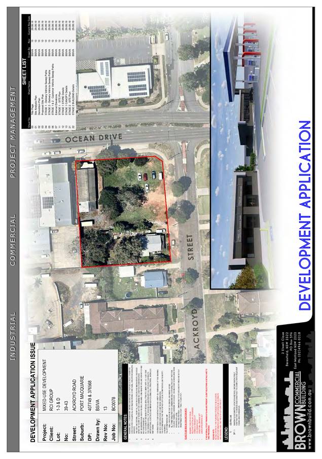
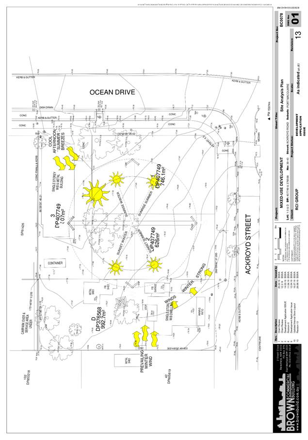
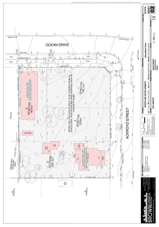
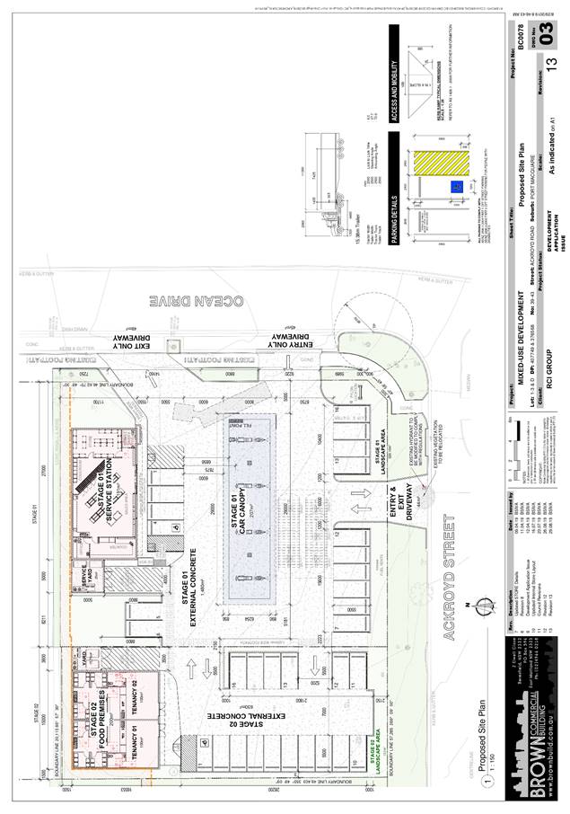
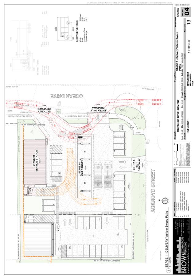
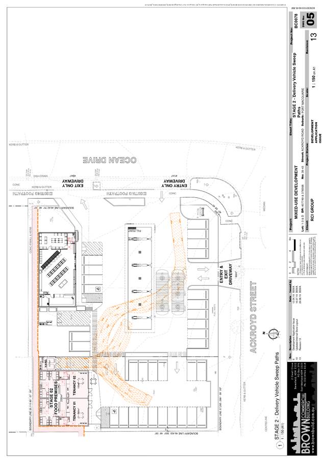
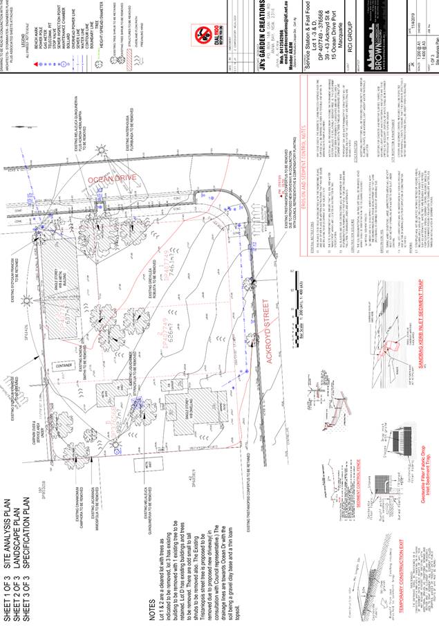
|
ATTACHMENT
|
Development Assessment Panel
27/11/2019
|
|
ATTACHMENT
|
Development Assessment Panel
27/11/2019
|
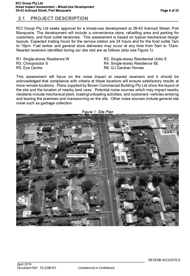

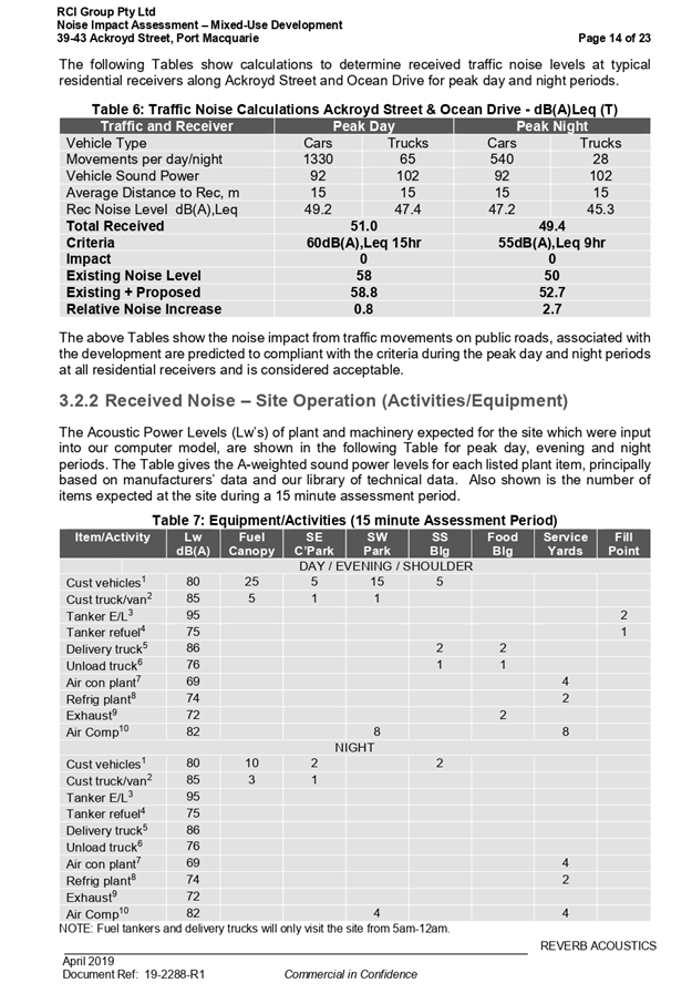
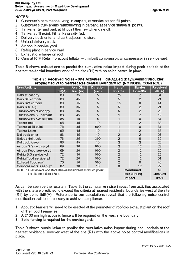
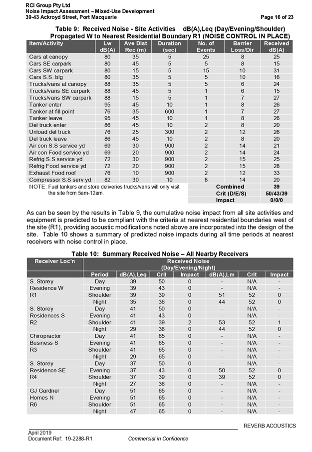
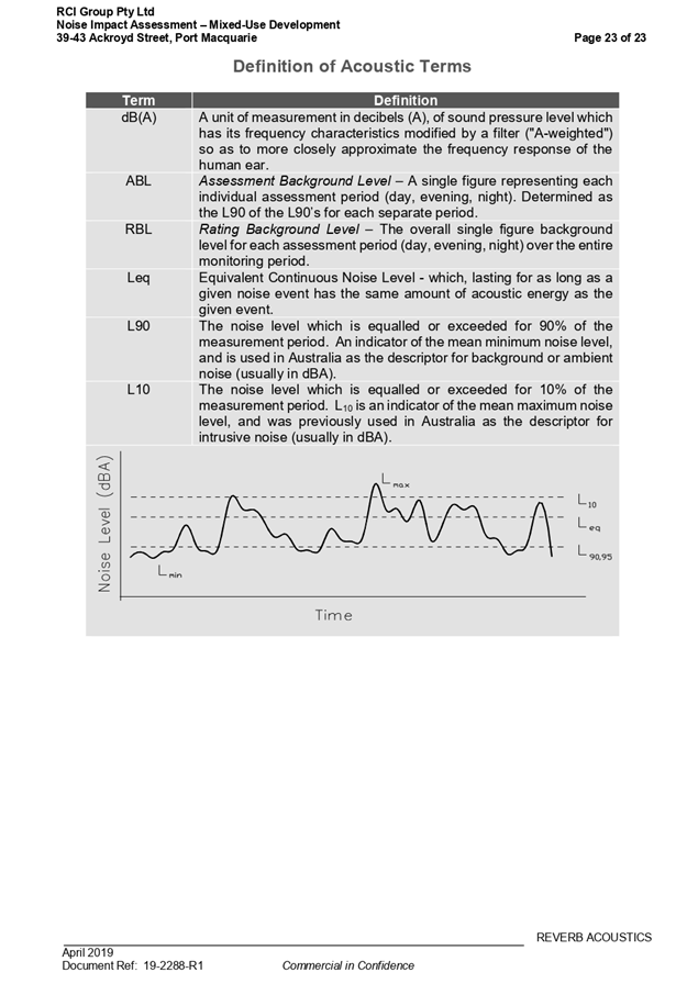
|
ATTACHMENT
|
Development Assessment Panel
27/11/2019
|


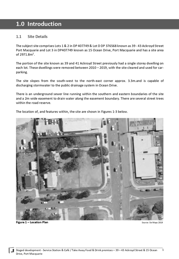
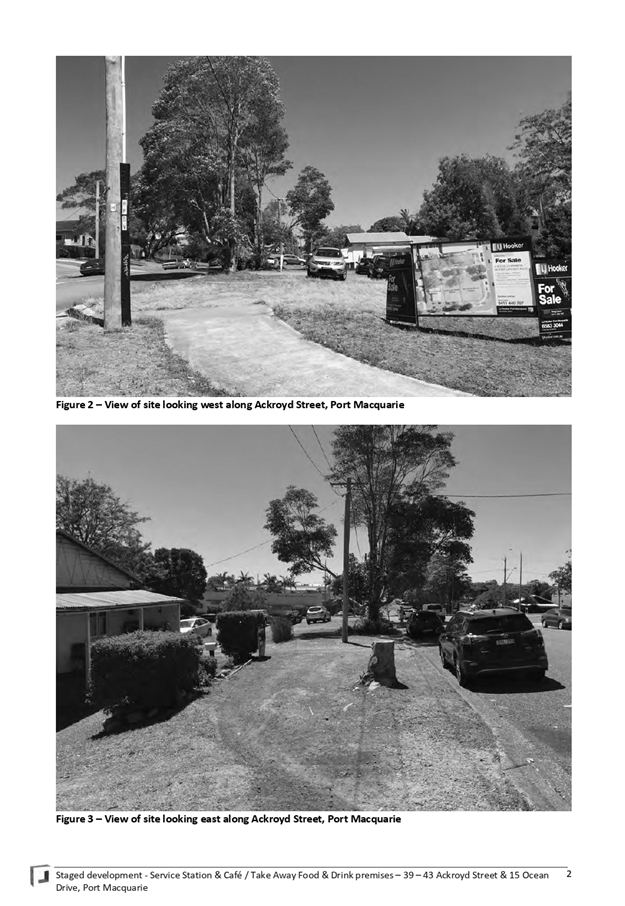
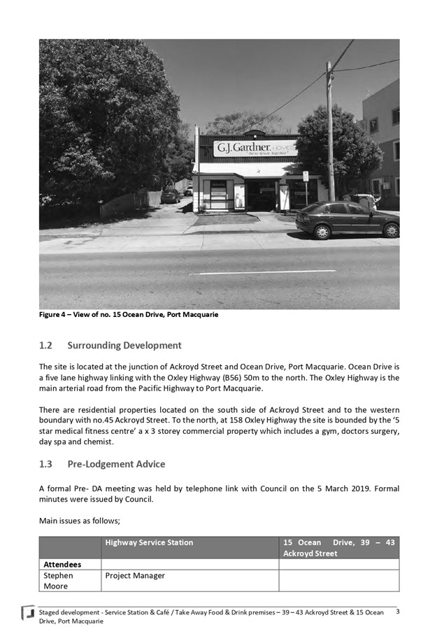
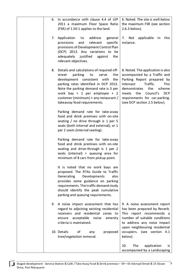
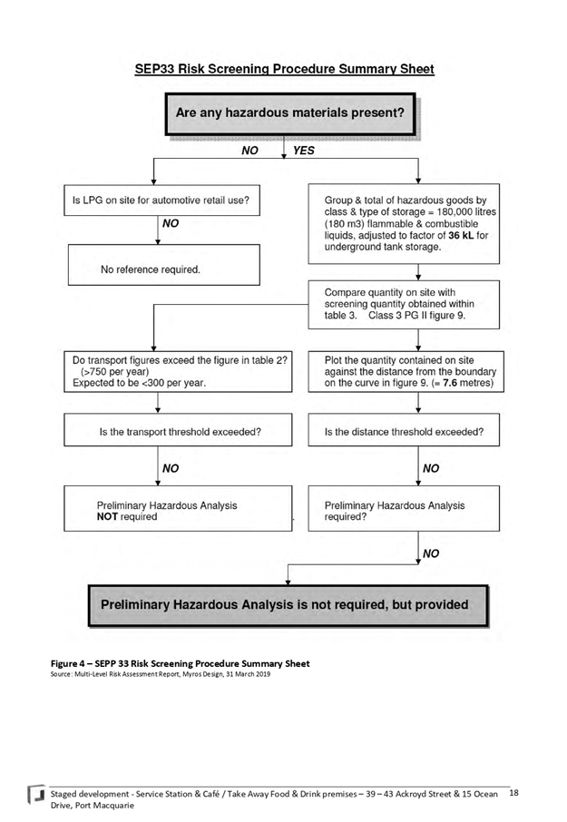
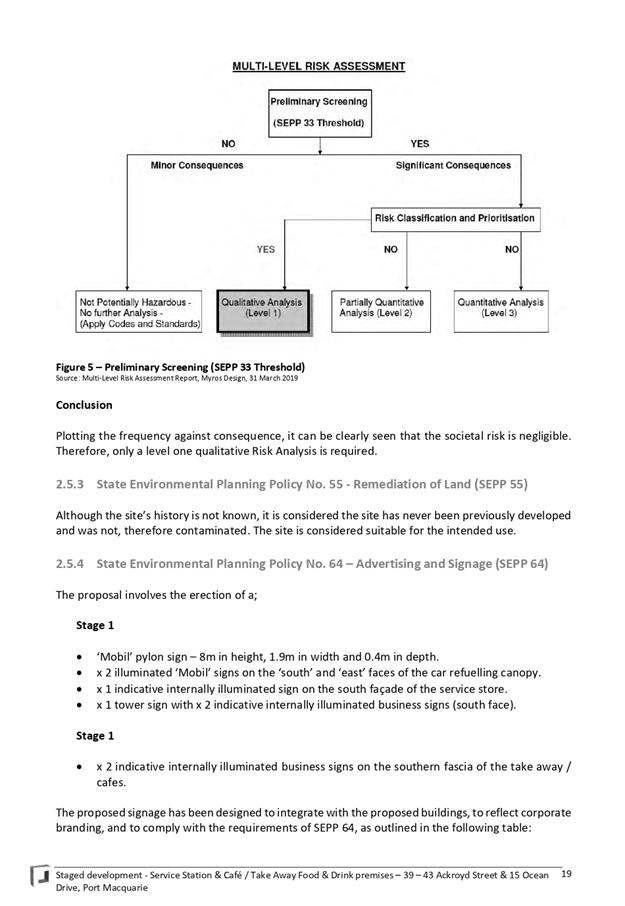
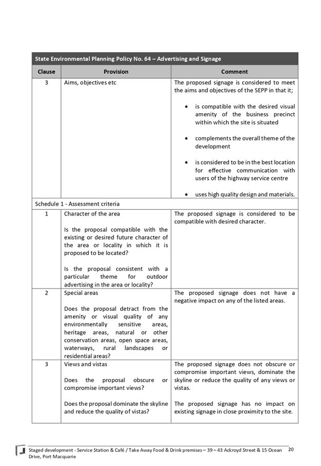
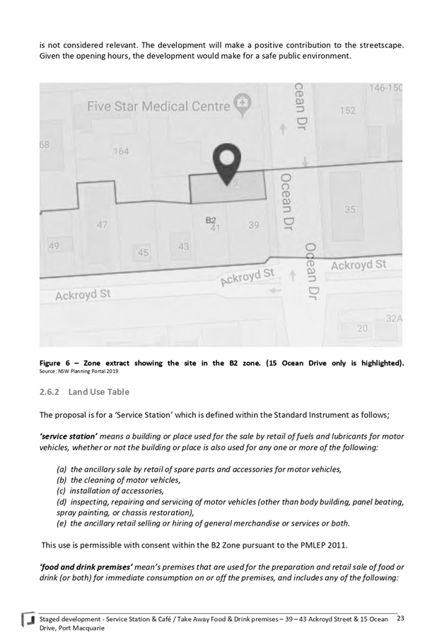
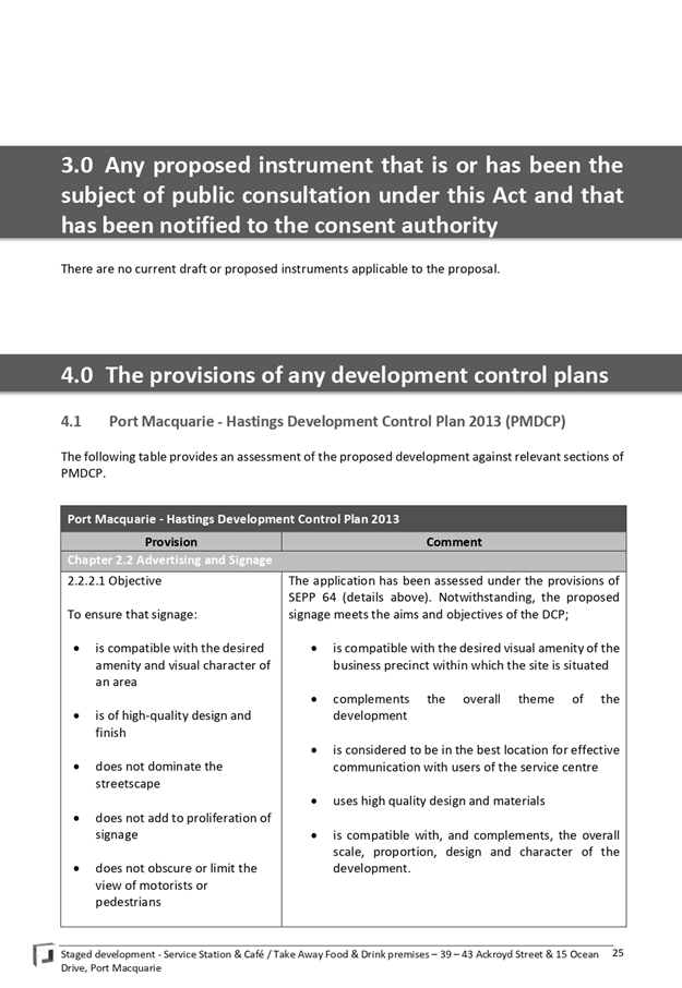
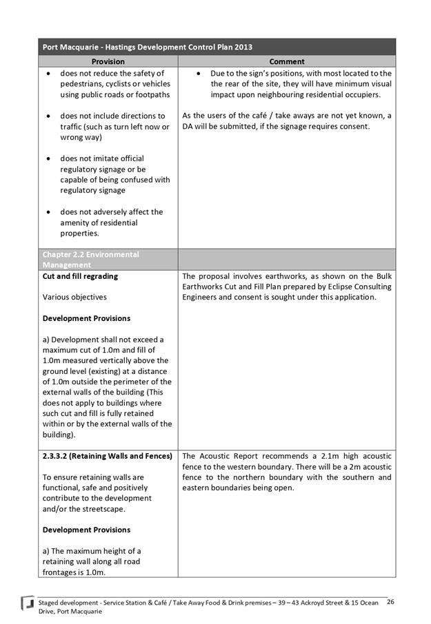
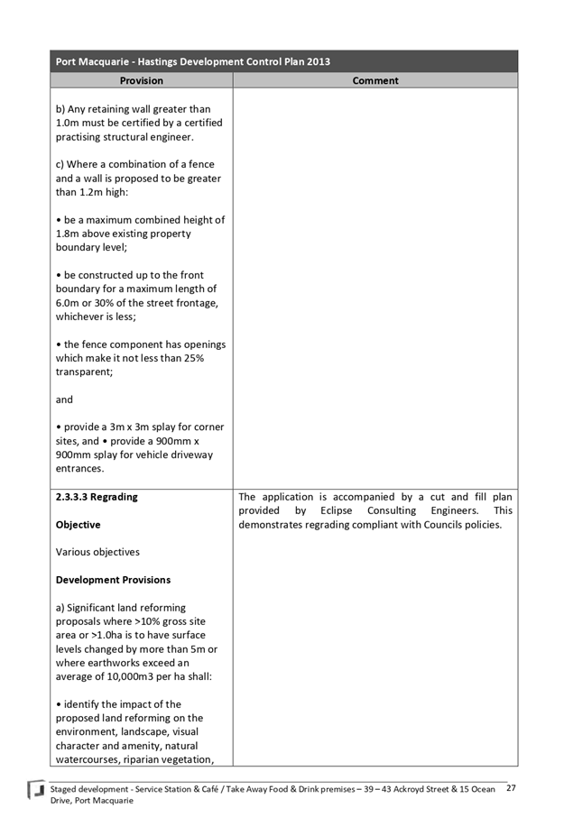
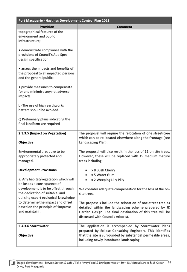
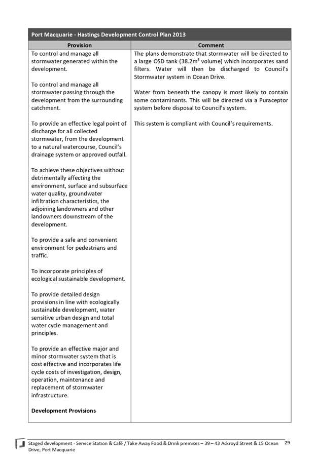
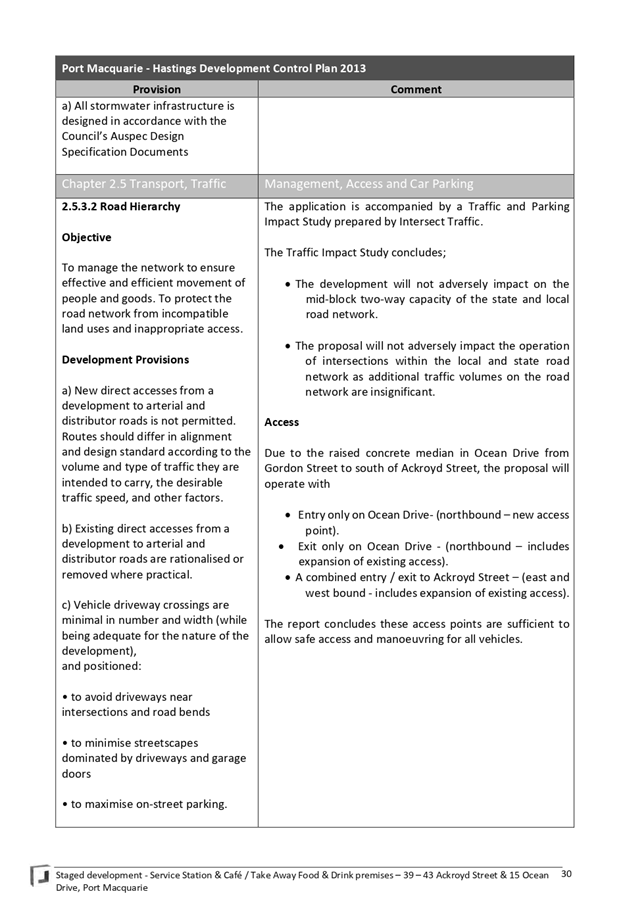
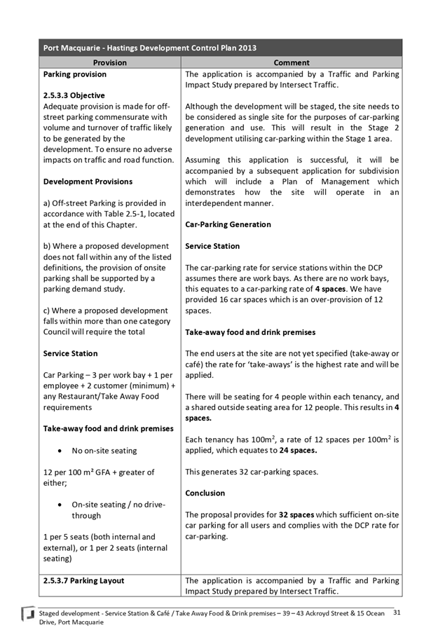
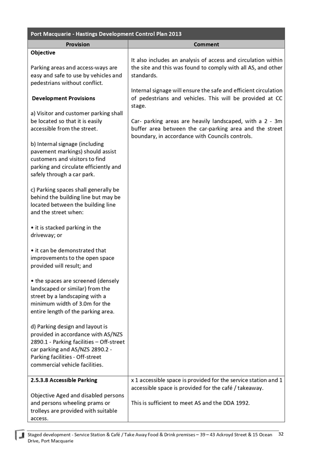
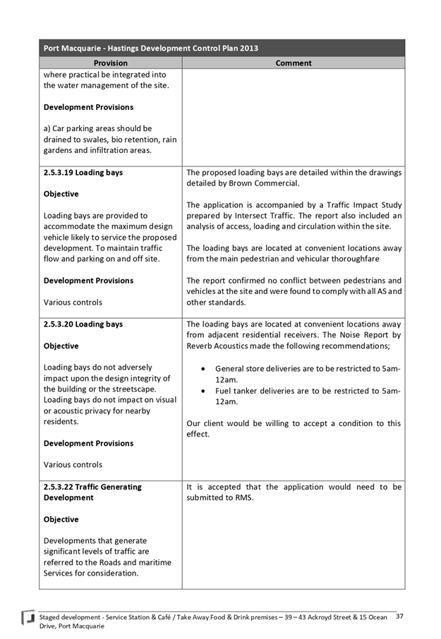
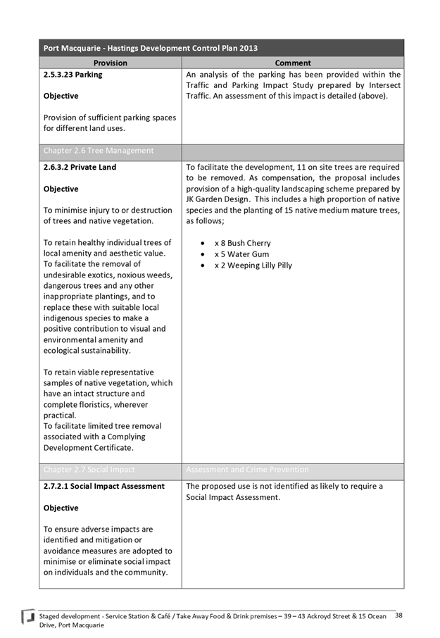
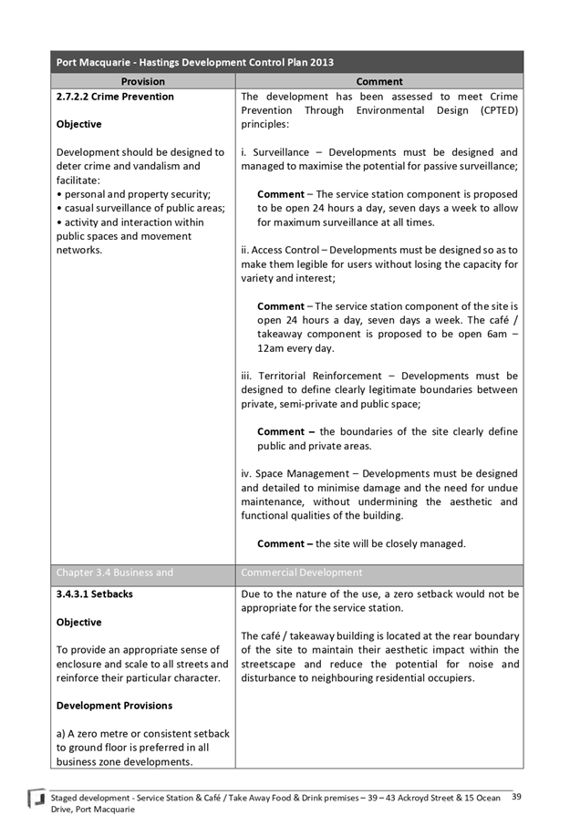
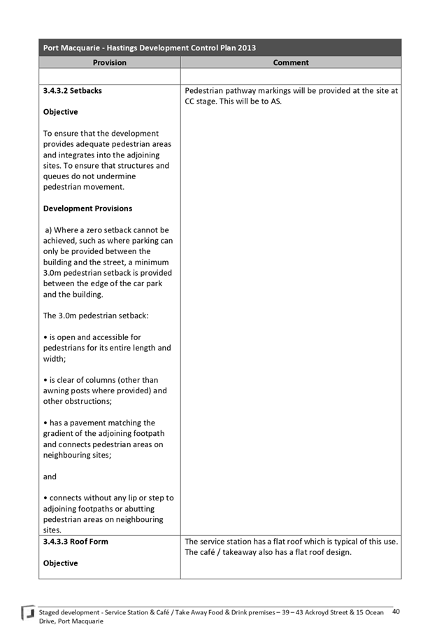

|
ATTACHMENT
|
Development Assessment Panel
27/11/2019
|
AGENDA Development Assessment Panel 27/11/2019
Item: 09
Subject: DA 2019 - 529.1 2 Lot Torrens Title
Subdivision at Lot 1 DP 1129200, No. 104 Greenmeadows Drive, Port Macquarie
Report
Author: Development Assessment Planner, Chris Gardiner
|
Applicant: B
R Development Consulting Pty Ltd
Owner: P
A & K M Daly
Estimated Cost: Nil
Alignment with Delivery Program
4.3.1 Undertake transparent and
efficient development assessment in accordance with relevant legislation.
|
|
RECOMMENDATION
That
DA2019 - 529.1 for a 2 Lot
Torrens Title Subdivision at Lot 1, DP 1129200, No.
104 Greenmeadows Drive, Port Macquarie,
be determined by granting consent subject to the recommended conditions.
|
Executive
Summary
This
report considers a development application for a 2 lot Torrens title
subdivision at the subject site and provides an
assessment of the application in accordance with the Environmental Planning and
Assessment Act 1979.
Following exhibition of the
application, one submission was received.
The site is considered suitable for the proposed development
and the proposal adequately addresses relevant planning controls. The
development is not considered to be contrary to the public's interest and will
not result a significant adverse social, environmental or economic impact.
This report recommends that the
development application be approved subject to the attached conditions
(Attachment 1).
1. BACKGROUND
Existing Sites Features and Surrounding Development
The site has an area of 2255m2.
The site is zoned R1 General Residential in accordance with the Port Macquarie-Hastings Local
Environmental Plan 2011, as shown in the following zoning plan:
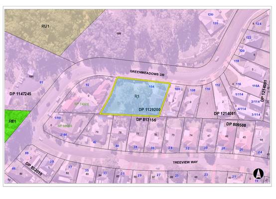
The existing subdivision pattern and location of existing
development within the locality is shown in the following aerial photograph:
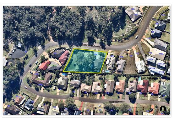
2. DESCRIPTION OF
DEVELOPMENT
Key aspects of the proposal include the following:
· Subdivision
of the land into 2 Torrens title lots.
Refer
to Attachment 2 at the end of this report for plans of the proposed
development.
Application Chronology
· 23
July 2019 - Application lodged.
· 29 July 2019 to 12 August 2019 - Neighbour notification.
· 20 August 2019 - Bushfire Safety Authority issued by NSW
Rural Fire Service.
· 26 August 2019 - Additional information requested from
Applicant.
· 3 October 2019 - Further additional information requested
from Applicant.
· 22 October 2019 - Additional information submitted.
3. STATUTORY ASSESSMENT
Section 4.15(1) Matters for Consideration
In determining the application, Council is required to take
into consideration the following matters as are relevant to the development
that apply to the land to which the development application relates:
(a) The provisions (where
applicable) of:
(i) Any Environmental
Planning Instrument
State Environmental Planning Policy No. 55 –
Remediation of Land
Following an inspection of the site and a search of Council
records, the subject land is not identified as being potentially contaminated
and is suitable for the intended use.
Port Macquarie-Hastings Local Environmental Plan
2011
The proposal is consistent with the LEP having regard to
the following:
· Clause 2.2 - The subject site is zoned R1 General
Residential.
The objectives of the R1 zone are as follows:
o To provide for the housing needs of the community.
o To provide for a variety of housing types and
densities.
o To enable other land uses that provide facilities
or services to meet the day to day needs of residents.
Clause 2.3(2) - The proposal is consistent with
the zone objectives having regard to the following:
o The proposal would provide an additional residential lot to
meet the housing needs of the community.
· Clause 4.1 - The lot sizes within the proposed subdivision
range from 1059m2 to 1202m2. All proposed lots comply
with the minimum lot size of 450m2 identified in the Lot Size Map
relating to the site.
· Clause 5.10 - Heritage. The site does not contain or adjoin
any known heritage items or sites of significance.
· Clause 7.13 - Satisfactory arrangements are in place for
provision of essential services including water supply, electricity supply,
sewer infrastructure, stormwater drainage and suitable road access to service
the development. Provision of electricity will be subject to obtaining
satisfactory arrangements certification prior to the issue of a Subdivision
Certificate as recommended by a condition of consent.
(ii) Any
draft instruments that apply to the site or are on exhibition
No draft
instruments apply to the site.
(iii) Any
Development Control Plan in force
Port
Macquarie-Hastings Development Control Plan 2013
|
DCP
2013: Chapter 3.6 - Subdivision
|
|
DCP
Objective
|
Development
Provisions
|
Proposed
|
Complies
|
|
3.6.3.1
|
A site analysis is required
for all development and shall illustrate:
· microclimate;
· lot
dimensions;
· north
point;
· existing
contours and levels to AHD;
· flood
affected areas;
· overland
flow patterns, drainage and services;
· any
contaminated soils or filled areas, or areas of unstable land;
· easements
and/or connections for drainage and utility services;
· identification
of any existing trees and other significant vegetation;
· any
existing buildings and other structures, including their setback distances;
· heritage
and archaeological features;
· fences;
· existing
and proposed road network, including connectivity and access for all
adjoining land parcels;
· pedestrian
and vehicle access;
· views
to and from the site;
· overshadowing
by neighbouring structures; and
· any
other notable features or characteristics of the site.
|
Adequate site analysis plan
submitted.
|
Yes
|
|
3.6.3.2
|
Torrens title lots minimum
width of 15m when measured at a distance of 5.5m from front property
boundary.
|
Both lots greater than 15m
wide.
|
Yes
|
|
Minimum width of 7m when
boundaries are extended to kerb line.
|
Both lots wider than 7m when
boundaries are extended to the kerb line.
|
Yes
|
|
Minimum depth of 25m.
|
Both lots greater than 25m
deep.
|
Yes
|
|
For lots where average slope
of the site is equal to, or exceeds 16%, indicative road and driveway grades
are required demonstrating satisfactory access.
|
N/A
|
N/A
|
|
Subdivision of dual occupancy
development or multi dwelling housing where permissible in the LEP may create
allotments smaller than 450m2 if:
· Each
lot to be created is part of a community or strata title scheme, or
· Is
part of an integrated Torrens title housing development.
|
N/A
|
N/A
|
|
3.6.3.3
|
Battleaxe lots discouraged in
greenfield development.
|
None proposed.
|
Yes
|
|
Council may consider
permitting Torrens Title battleaxe allotments for ―infill development
where it is demonstrated that;
· a
Torrens Title lot, that is not a battleaxe lot, cannot be
achieved; and
· the
number of crossovers do not reduce the amenity of the street or on street
parking; and
· the
impact of noise, dust and headlights on the land owners adjoining the
driveway is addressed by the construction of an acoustic fence for the full
length of the driveway; and
· addresses
privacy between the rear lot and the rear open space of the front lot by the
provision of
· adequate
screening, larger lot size and setbacks; and
· extends
utilities to the end of the axe handle; and
· there is
sufficient space for garbage collection on the frontage.
|
|
|
|
3.6.3.4
|
Lots are to be designed to
allow the construction of a dwelling, which does not involve more than 1m
cut, or fill, measured from natural ground level, outside the dwellings
external walls.
|
Lot 2 capable of accommodating
a dwelling without excessive cut/fill
|
Yes
|
|
Lot sizes increased for
sloping sites in accordance with Table 3.6.1.
|
Lot size complies with minimum
area for slope category.
|
Yes
|
|
Additional information
provided for slope categories in accordance with Table 3.6.2.
|
Adequate information provided.
|
Yes
|
|
3.6.3.5
|
Wherever possible orientate
streets to maximise the number of east, west and south facing lots and to
minimise the number of narrow north facing lots.
Residential street blocks
should preferably be orientated north-south with dimensions generally limited
to 60-80m by 120-150m as illustrated in Figure 3.6-2.
|
N/A - Existing street.
|
N/A
|
|
Lot size and shape are to
reflect orientation to ensure future dwelling construction has optimal
opportunity for passive solar design.
|
Lot sizes comply.
|
Yes
|
|
3.6.3.6
|
Kerb and guttering, associated
street drainage, pavement construction and foot paving across the street
frontages should be constructed as part of the subdivision works where these
do not exist (may be varied subject to criteria in this clause)
|
Existing kerb and gutter and
street drainage.
Footpath is not required as
proposal is for 2 lot subdivision only.
|
Yes
|
|
3.6.3.13
|
Development for the
subdivision for land or major residential development should provide
footpaths on both sides of all collector and arterial roads.
|
Footpath is not required as
proposal is for 2 lot subdivision only.
|
|
|
3.6.3.17 -
3.6.3.19
|
An application for subdivision
should be accompanied by a Stormwater Management Strategy prepared by a
certified practicing engineer and in accordance with Council’s adopted
Aus-Spec design specification documents.
The finished floor level of
buildings should be above the 100 year ARI flood level (plus freeboard) and
in accordance with the council’s current flood policy.
|
Concept stormwater plan submitted.
|
Yes
|
|
3.6.3.20
|
Water supply to meet
Council’s design specifications.
|
See comments under Water
Supply Connection later in this report.
|
|
|
3.6.3.21 -
3.6.3.22
|
All lots connected to
reclaimed water if available.
|
Not available.
|
N/A
|
|
3.6.3.24
|
Separate sewer junction
provided for each lot.
|
See comments under Sewer
Connection later in this report.
|
|
|
3.6.3.25
|
Extension of sewer
infrastructure at cost of developer.
|
|
3.6.3.26 -
3.6.3.27
|
Erosion and sediment control
plan to be provided.
|
Standard condition recommended
requiring erosion and sediment control.
|
Yes
|
|
3.6.3.34
|
All service infrastructure
should be underground unless otherwise approved by Council.
|
Standard condition recommended
requiring satisfactory arrangements certification from service providers.
|
Yes
|
|
All service infrastructure
should be installed in a common trench.
|
|
Conduits for the main
technology network system should be provided in all streets.
|
|
Conduits are to be installed
in accordance with the National Broadband Network Company Limited’s
‘Guidelines for Fibre
to the Premises Underground Deployment’.
|
|
Access pits are to be
installed at appropriate intervals along all streets.
|
|
DCP
2013: General Provisions
|
|
DCP
Objective
|
Development
Provisions
|
Proposed
|
Complies
|
|
2.7.2.2
|
Design addresses generic
principles of Crime Prevention Through Environmental Design guideline:
· Casual
surveillance and sightlines
· Land
use mix and activity generators
· Definition
of use and ownership
· Lighting
· Way
finding
· Predictable
routes and entrapment locations
|
The proposed development will
be unlikely to create any concealment/entrapment areas or crime spots that
would result in any identifiable loss of safety or reduction of security in
the immediate area.
|
Yes
|
|
2.3.3.1
|
Cut and fill 1.0m max. 1m
outside the perimeter of the external building walls
|
Less than 1m of cut or fill
proposed.
|
Yes
|
|
2.3.3.2
|
1m max. height retaining walls
along road frontages
|
N/A
|
N/A
|
|
Any retaining wall >1.0 in
height to be certified by structural engineer
|
N/A
|
N/A
|
|
2.3.3.8
onwards
|
Removal of hollow bearing
trees
|
None proposed to be removed.
|
N/A
|
|
2.6.3.1
|
Tree removal (3m or higher
with 100mm diameter trunk and 3m outside dwelling footprint
|
None proposed to be removed.
|
N/A
|
|
2.4.3
|
Bushfire risk, Acid sulphate
soils, Flooding, Contamination, Airspace protection, Noise and Stormwater
|
Refer to main body of report.
|
|
|
2.5.3.2
|
New accesses not permitted
from arterial or distributor roads. Existing accesses rationalised or removed
where practical
|
Access to local road.
|
Yes
|
|
2.5.3.11
|
Section 94 contributions
|
Refer to main body of report.
|
|
Based on the
above assessment, the variations proposed to the provisions of the DCP are
considered acceptable and the relevant objectives have been satisfied.
Cumulatively, the variations do not amount to an adverse impact or a
significance that would justify refusal of the application.
(iiia) Any
planning agreement that has been entered into under section 7.4, or any draft
planning agreement that a developer has offered to enter into under section 7.4
No planning
agreement has been offered or entered into relating to the site.
(iv) Any matters prescribed by the
Regulations
No matters
prescribed by the regulations are applicable to the proposal.
(b) The
likely impacts of that development, including environmental impacts on both the
natural and built environments, social and economic impacts in the locality:
The site has a general northerly street frontage
orientation to Greenmeadows Drive.
Adjoining the site to the north is a seniors housing
development. Adjoining the site to the east, south, and west are residential
uses.
The proposal will not have any significant adverse impacts
to existing adjoining properties.
The proposal is considered to be compatible with other
residential development in the locality and adequately addresses planning
controls for the area.
Roads
The site has road frontage to Greenmeadows Drive. Adjacent
to the site, Greenmeadows Drive is a sealed public road under the care and
control of Council. Greenmeadows Drive is a Collector road with a 9m road
width within a 20m road reserve. Directly in front of the property there
is road calming, where the road width narrows to 7m for approximately 10m. A
1.2m footpath terminates at the western boundary of the property. There is SE
kerb and gutter in the street, a kerb inlet pit directly out the front and a
street light pole on the western side of the traffic calming.
Traffic and Transport
The site is currently approved for residential use
permitted to generate 9 daily trips. This development proposes to generate an
additional 9 daily trips. The addition in traffic associated with the
development is unlikely to have any adverse impacts to the existing road
network within the immediate locality.
Site Frontage and Access
There is site frontage onto Greenmeadows Drive. Driveway
location can be determined with future applications relating to dwelling
construction.
Parking and Manoeuvring
Parking and driveway widths on site are capable of
complying with relevant Australian Standards (AS 2890) and conditions will be
imposed to reflect these requirements, on future applications relating to
dwelling construction. The subdivision would not compromise the parking and
manoeuvring areas for the existing dwelling on proposed Lot 1.
Water Supply Connection
Council records indicate an existing 150mm PVC water main
on the same side of Greenmeadows Drive. Each proposed lot is to be provided
with a sealed water service, final water service sizing will need to be
determined by a hydraulic consultant to suit the domestic and commercial
components of the development, as well as fire service and backflow protection
requirements in accordance with AS3500.
Detailed engineering plans are required to be submitted to
Council’s Water and Sewer Section with the Section 68 application.
Sewer Connection
Council records indicate that the development site is
currently connected to Sewer via a junction to the existing sewer main, which
runs inside the northern development lot boundary. Detailed engineering plans
are required to be submitted to Council’s Water and Sewer Section with
the Section 68 application.
A separate sewer connection to Councils main is required
for each Torrens title lot.
Stormwater
The site naturally grades towards the north-west of the
property and is currently serviced via a direct connection to the public piped
drainage system.
The legal point of discharge for the proposed development
is defined as a kerb adapter discharging to Greenmeadows Drive. The existing
trees positioned within proposed Lot 2, which are required to be retained, may
cause issues for a pit and pipe system traversing through the root zone of
these trees, therefore, kerb discharge towards the north-western edge of
proposed Lot 2 is considered appropriate. The provision of a stormwater
junction discharging to the kerb along Greenmeadows Drive is required as part
of the subdivision works.
The likely location for a driveway access to proposed Lot 2
is towards the north-western edge to avoid trees and appropriate entry to
dwelling area. With consideration to drainage of the driveway, it is likely
that driveway runoff could be contained within a private piped drainage system
discharging to the kerb, or driveway runoff directed towards the existing
natural depression in the site, away from neighbouring private property.
Details of how natural surface runoff from upstream neighbouring
properties will managed shall be required for future dwelling DA proposals.
The natural depression on the site cannot be filled due to
retained trees. Works will be required to ensure the existing headwall
structure, which currently drains the depression to the public piped system,
provides a child safe inlet structure.
A detailed site stormwater management plan will be required
to be submitted for assessment with the S.68 application and prior to the issue
of a CC.
Other Utilities
Telecommunication and electricity services are available to
the site. Evidence of satisfactory arrangements with the relevant utility
authorities for provision to each proposed lot will be required prior to
Subdivision Certificate approval.
Heritage
No known items of Aboriginal or European heritage
significance exist on the property. No adverse impacts anticipated. The site is
considered to be disturbed land.
As a precaution, a condition of consent has been
recommended that works are to cease in the unexpected event heritage items are
found. Works can only recommence when appropriate approvals are obtained for
management and/or removal of the heritage item.
Other land resources
The site is within an established urban context and will
not sterilise any significant mineral or agricultural resource.
Water cycle
The proposed development will not have any significant
adverse impacts on water resources and the water cycle.
Soils
The proposed development will not have any significant
adverse impacts on soils in terms of quality, erosion, stability and/or
productivity subject to a standard condition requiring erosion and sediment
controls to be in place prior to and during construction.
Air and microclimate
The construction and/or operations of the proposed development
will not result in any significant adverse impacts on the existing air quality
or result in any pollution. Standard precautionary site management condition
recommended.
Flora and fauna
Construction of the proposed development will not require
any removal/clearing of any native vegetation and therefore does not trigger
the biodiversity offsets scheme. Part 7 of the Biodiversity Conservation
Act 2016 is considered to be satisfied.
Proposed Lot 2 is currently subject to a title restriction
as follows:
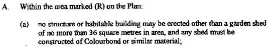
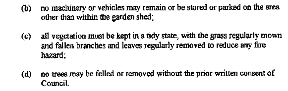
The restriction was put in place to ensure that the
subdivision that created the lot was consistent with the Koala Plan of
Management (KPoM) prepared by Eco Pro as part of DA1997 - 257. The provisions
of this Plan have since been superseded by a new KPoM prepared as part DA2012 -
3 for residential aged care facility on adjoining land to the north. The latest
KPoM no longer includes any operational provisions relating to the land on the
southern side of Greenmeadows Drive.
Council has also granted consent in 2010 under tree consent
400.2010.56.1 for the removal of some of the trees originally protected by this
restriction and only part of the vegetation remains on site.
The Applicant has demonstrated that a suitable building
envelope is available on proposed Lot 2 that would allow for protection of all
the existing trees. On this basis, it is considered reasonable to vary parts
(a) and (b) of the restriction to allow for a dwelling to be constructed within
the designated building envelope, and also allow access and parking for
vehicles associated with a dwelling. The Development Assessment Panel has
delegation to authorise variation of a Section 88B instrument in determining a
development application for subdivision of land.
Waste
Satisfactory arrangements are in place for proposed storage
and collection of waste and recyclables. No adverse impacts anticipated.
Standard precautionary site management condition recommended.
Energy
No adverse impacts anticipated. The proposed subdivision
would create a lot capable of accommodating an energy efficient dwelling in the
future.
Noise and vibration
The construction and/or operations of the proposed
development will not result in any significant adverse impacts on the existing
air quality or result in any pollution. Standard precautionary site management
condition recommended.
Bushfire
The site is identified as being bushfire prone.
In accordance with Section 100B - Rural Fires Act 1997 -
the application proposes subdivision of bush fire prone land that could
lawfully be used for residential purposes. As a result, the applicant has
submitted a bushfire report prepared by a Certified Consultant. The report was
forwarded to the NSW Rural Fire Service who have since issued a Bushfire Safety
Authority, which will be incorporated into the consent.
Safety, security and crime prevention
The proposed development will be unlikely to create any
concealment/entrapment areas or crime spots that would result in any
identifiable loss of safety or reduction of security in the immediate area.
Social impacts in the locality
Given the nature of the proposed development and its
location, the proposal is not considered to have any significant adverse social
impacts.
Economic impact in the locality
The proposal is not considered to have any significant
adverse economic impacts on the locality. A likely positive impact is that the
development will maintain employment in the construction industry, which will
lead to flow impacts such as expenditure in the area.
Site design and internal design
The proposed development design satisfactorily responds to
the site attributes and will fit into the locality.
Construction
Construction impacts are considered capable of being
managed, standard construction and site management conditions have been
recommended.
Cumulative impacts
The proposed development is not considered to have any
significant adverse cumulative impacts on the natural or built environment or
the social and economic attributes of the locality.
(c) The suitability of the site for
the development
The proposal
will fit into the locality and the site attributes are conducive to the
proposed development.
Site
constraints have been adequately addressed and appropriate conditions of
consent recommended.
(d) Any submissions made in
accordance with this Act or the Regulations
One written submission was received following public exhibition
of the application. A copy of the written submission has been provided
separately to members of the DAP.
Key issues raised in the submission and comments are
provided as follows:
|
Submission
Issue/Summary
|
Planning
Comment/Response
|
|
There is an easement through
the rear of No. 42 Treeview Way that does not permit erection of structures.
Assume that the easement will extend through the subject site.
|
The inter-allotment stormwater
drainage easement through the rear of No. 42 Treeview Way does not extend
through the subject site.
|
|
Concerns about overland flow impacting neighbouring
properties when Lot 2 is developed.
|
Proposed Lot 2 is capable of being drained to
Greenmeadows Drive. Any application for future development on Lot 2 would
need to accommodate natural surface runoff from upstream neighbouring
properties and drain it to a legal point of discharge. It is considered that
this would provide an improved outcome for neighbouring properties.
|
|
Removal of trees from the site will be detrimental to the
local Koala population. When the site was originally subdivided no trees were
permitted to be removed.
|
The proposal has been amended to retain all of the
existing trees.
|
(e) The Public Interest
The proposed
development satisfies relevant planning controls and will not adversely impact
on the wider public interest.
4. DEVELOPMENT
CONTRIBUTIONS APPLICABLE
· Development contributions will be required towards
augmentation of town water supply and sewerage system head works under Section
64 of the Local Government Act 1993.
· Development contributions will be required in accordance
with Section 7.11 of the Environmental Planning and Assessment Act 1979 towards
roads, open space, community cultural services, emergency services and
administration buildings.
·
· A copy of the contributions estimate is included as
Attachment 3.
5. CONCLUSION AND
STATEMENT OF REASON
The application has been assessed
in accordance with Section 4.15 of the Environmental Planning and Assessment
Act 1979.
Issues raised during assessment
and public exhibition of the application have been considered in the assessment
of the application. Where relevant, conditions have been recommended to manage
the impacts attributed to these issues.
The site is considered suitable
for the proposed development and the proposal adequately addresses relevant
planning controls. The development is not considered to be contrary to the
public's interest and will not result a significant adverse social,
environmental or economic impact. It is recommended that the application be
approved, subject to the recommended conditions of consent provided in
Attachment 1.
|
Attachments
1View. DA2019
- 529.1 Recommended conditions
2View. DA2019
- 529.1 Plan
3View. DA2019
- 529.1 Contributions estimate
|
|
ATTACHMENT
|
Development Assessment Panel
27/11/2019
|
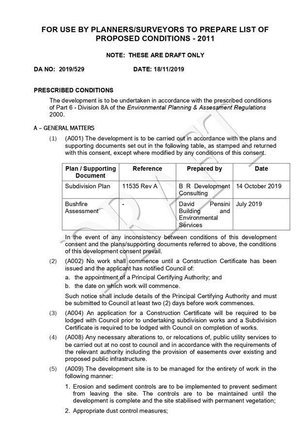
|
ATTACHMENT
|
Development Assessment Panel
27/11/2019
|
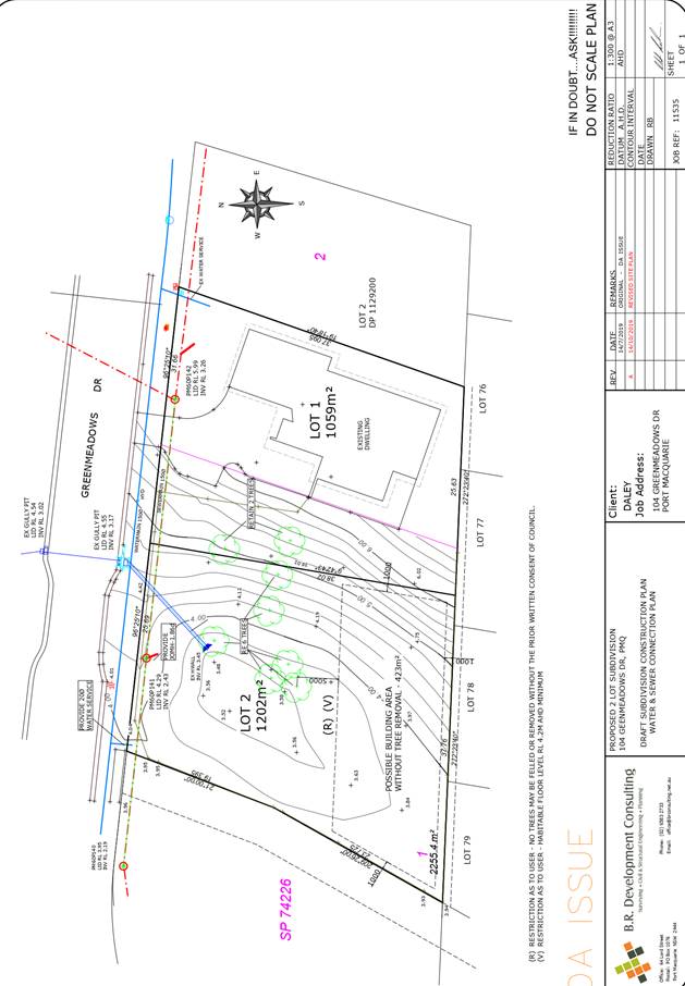
|
ATTACHMENT
|
Development Assessment Panel
27/11/2019
|
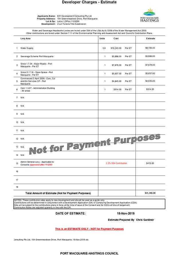
AGENDA Development Assessment Panel 27/11/2019
Item: 10
Subject: DA 2019 - 652.1 Animal Training Establishment
at Lot 11 DP 1043006, No. 34 Isabel Place, Wauchope
Report
Author: Development Assessment Planner, Beau Spry
|
Applicant: Scott
Wallis, Jade Wallis
Owner: Scott Wallis, Jade Wallis
Estimated Cost: $98,
327
Alignment with Delivery
Program
4.3.1 Undertake transparent and
efficient development assessment in accordance with relevant legislation.
|
|
RECOMMENDATION
That DA 2019 - 652.1 for an Animal Training
Establishment at Lot 11 DP 1043006, 34 Isabel Place Wauchope, be
determined by granting consent subject to the recommended conditions.
|
Executive
Summary
This
report considers a Development Application for an animal training establishment
at the subject site and provides an assessment of the
application in accordance with the Environmental Planning and Assessment Act
1979.
Following exhibition of the
application, two (2) submissions were
received.
The site is considered suitable for the proposed development
and the proposal adequately addresses relevant planning controls. The
development is not considered to be contrary to the public's interest and will
not result a significant adverse social, environmental or economic impact.
This report recommends that the development application be
approved subject to the attached conditions.
1. BACKGROUND
Existing Sites Features and Surrounding Development
The site has an area of 414860.56m2.
The site is zoned RU1 primary production in accordance with the Port Macquarie-Hastings Local
Environmental Plan 2011, as shown in the following zoning plan:
The existing subdivision pattern and location of existing
development within the locality is shown in the following aerial photograph:
The site is rural and has access to Isabel Place and slopes
gently towards the east.
There are existing large lot dwellings to the west and east,
and further RU1 land to the north and south. The site adjoins the North Coast
Railway to the west and E2 environmental conservation land to the east, which
also partially bisects the site to the south.
The proposal is not considered exempt under Subdivision 16
owing to its proximately to the rail corridor and its proximity to coastal
wetlands.
2. DESCRIPTION OF
DEVELOPMENT
Key aspects of the proposal include the following:
· Erection of a 60 x 20m steel shed with reinforced concrete
floor for use as a domestic horse training facility.
Refer
to Attachment 2 at the end of this report for plans of the proposed
development.
Application Chronology
· 18 September 2019 - Application lodged
· 19 September 2019 - Further information requested
· 24 September 2019 - Application notified
· 25 September 2019 - Submission received
· 11 October 2019 - Submission received
· 18 October 2019 - Site inspection
3. STATUTORY ASSESSMENT
Section 4.15(1) Matters for Consideration
In determining the application, Council is required to take
into consideration the following matters as are relevant to the development
that apply to the land to which the development application relates:
(a) The provisions (where
applicable) of:
(i) Any Environmental
Planning Instrument
State Environmental Planning Policy No. 44 - Koala
Habitat Protection
With reference to clauses 6 and 7, the subject land is
greater than 1 hectare (including any adjoining land under same ownership) and
therefore the provisions of SEPP must be considered.
The application has demonstrated that no habitat will be
removed or modified therefore no further investigations are required.
State Environmental Planning Policy No. 55 –
Remediation of Land
Following an inspection of the site and a search of Council
records, the subject land is not identified as being potentially contaminated
and is suitable for the intended use.
State Environmental Planning Policy No. 64 –
Advertising and Signage
Application is for private operation only, there is no
advertising proposed.
State Environmental Planning Policy (Coastal Management)
2018
The site is located within a proximity area to coastal
wetlands.
In accordance with clause 7, this SEPP prevails over the
Port Macquarie-Hastings LEP 2011 in the event of any inconsistency.
Having regard to clauses 11 of the SEPP the proposed
development is not considered likely to result in any of the following:
(a) the biophysical,
hydrological or ecological integrity of the adjacent coastal
·
wetland or littoral rainforest;
or
(b) the quantity and quality of
surface and ground water flows to and from the
·
adjacent coastal wetland or
littoral rainforest.
The development proposes a 60m x 20m arena shed with 4x
32000L rainwater tanks. The overflow pathway is an existing drainage channel terminating
into an existing farm dam and supported by onsite rubble erosion control. Given
the size of the hardstand space, the proposed tank capacity and the rural
nature of the block, the overflow run offs are expected to be limited and the
onsite mitigation is considered adequate.
The bulk, scale and size of the proposed development is
compatible with the surrounding rural environment. The site is predominately
cleared and located within an area zoned for rural purposes.
State
Environmental Planning Policy (Infrastructure) 2007
Relevant clauses from the SEPP that
require consideration are included below along with comment from Council staff:
Clause 84: Development
involving access via level crossings
(1) This clause applies to development that involves:
(a) a new level crossing, or
(b) the conversion into
a public road of a private access road across a level crossing, or
(c) a likely significant
increase in the total number of vehicles or the number of trucks using a level
crossing as a result of the development.
(2) Before determining a development
application for development to which this clause applies, the consent authority
must:
(a) within 7 days after
the application is made, give written notice of the application to the rail
authority for the rail corridor, and
(b) take into consideration:
(i) any response to the
notice that is received within 21 days after the notice is given, and
(ii) the implications of
the development for traffic safety including the costs of ensuring an
appropriate level of safety, having regard to existing traffic characteristics
and any likely change in traffic at level crossings as a result of the
development, and
(iii) the feasibility of
access for the development that does not involve use of level crossings.
(3) Subject to subclause (5), the consent
authority must not grant consent to development to which this clause applies
without the concurrence of the rail authority for the rail corridor.
(4) In determining whether to
provide concurrence, the rail authority must take into account:
(a) any rail safety or
operational issues associated with the aspects of the development, and
(b) the implications of
the development for traffic safety including the cost of ensuring an
appropriate level of safety, having regard to existing traffic and any likely
change in traffic at level crossings as a result of the development.
(5) The consent authority may grant consent
to development to which this clause applies without the concurrence of the rail
authority for the rail corridor if 21 days have passed since the consent
authority gave notice under subclause (2) (a) and the rail authority has not
granted or refused to grant concurrence.
(6) The consent authority must provide the
rail authority for the rail corridor with a copy of the determination of the
application within 7 days after the determination is made.
(7) In this clause:
level crossing means a level crossing over railway
lines.
traffic includes rail, road and
pedestrian traffic.
Comment: The proposal
is for a private domestic horse training facility. The proposal does not
involve a new level crossing, conversion into
a public road of a private access road across a level crossing and will not
likely significant increase in the total number of vehicles or the number of
trucks using a level crossing as a result of the development. No further
consideration required.
Clause 85: Development
immediately adjacent to rail corridors
(1) This
clause applies to development on land that is in or immediately adjacent to a rail
corridor, if the development:
(a) is
likely to have an adverse effect on rail safety, or
(b) involves
the placing of a metal finish on a structure and the rail corridor concerned is
used by electric trains, or
(c) involves
the use of a crane in air space above any rail corridor.
(2)
Before determining a development application for development to which this
clause applies, the consent authority must:
(a) within
7 days after the application is made, give written notice of the application to
the chief executive officer of the rail authority for the rail corridor, and
(b) take
into consideration:
(i) any
response to the notice that is received within 21 days after the notice is
given, and
(ii) any
guidelines that are issued by the Director-General for the purposes of this
clause and published in the Gazette.
Comment: The proposed
development will not impact on rail safety, place a metal finish or use cranes
over the rail corridor. No further consideration required.
86 Excavation in, above, below or adjacent
to rail corridors
(1) This clause applies to
development (other than development to which clause 88 applies) that involves
the penetration of ground to a depth of at least 2m below ground level
(existing) on land:
(a) within, below or
above a rail corridor, or
(b) within 25m (measured
horizontally) of a rail corridor, or
(b1) within 25m
(measured horizontally) of the ground directly below a rail corridor, or
(c) within 25m (measured
horizontally) of the ground directly above an underground rail corridor.
(2) Before determining a development
application for development to which this clause applies, the consent authority
must:
(a) within 7 days after
the application is made, give written notice of the application to the rail
authority for the rail corridor, and
(b) take into
consideration:
(i) any response to the
notice that is received within 21 days after the notice is given, and
(ii) any guidelines
issued by the Secretary for the purposes of this clause and published in the
Gazette.
(3) Subject to subclause (5), the consent
authority must not grant consent to development to which this clause applies
without the concurrence of the rail authority for the rail corridor to which
the development application relates.
(4) In deciding whether to provide
concurrence, the rail authority must take into account:
(a) the potential
effects of the development (whether alone or cumulatively with other
development or proposed development) on:
(i) the safety or
structural integrity of existing or proposed rail infrastructure facilities in
the rail corridor, and
(ii) the safe and
effective operation of existing or proposed rail infrastructure facilities in
the rail corridor, and
(b) what measures are
proposed, or could reasonably be taken, to avoid or minimise those potential
effects.
(5) The consent authority may grant consent
to development to which this clause applies without the concurrence of the rail
authority concerned if:
(a) the rail corridor is
owned by or vested in ARTC or is the subject of an ARTC arrangement, or
(b) in any other case,
21 days have passed since the consent authority gave notice under subclause (2)
(a) and the rail authority has not granted or refused to grant concurrence.
Comment: The proposal
does not propose penetration of ground to a
depth of at least 2m below ground level (existing) on land. No further
consideration required.
Clause 87 Impact of rail noise or vibration on non-rail
development
(1) This clause applies to
development for any of the following purposes that is on land in or adjacent to
a rail corridor and that the consent authority considers is likely to be
adversely affected by rail noise or vibration:
(a) a building for
residential use,
(b) a place of public worship,
(c) a hospital,
(d) an educational establishment or child care centre.
(2) Before determining a development application for
development to which this clause applies, the consent authority must take into
consideration any guidelines that are issued by the Director-General for the
purposes of this clause and published in the Gazette.
(3) If the development is for the purposes of a
building for residential use, the consent authority must not grant consent to
the development unless it is satisfied that appropriate measures will be taken
to ensure that the following LAeq levels are not exceeded:
(a) in
any bedroom in the building—35 dB(A) at any time between 10.00 pm and
7.00 am,
(b) anywhere
else in the building (other than a garage, kitchen, bathroom or
hallway)—40 dB(A) at any time.
Comment: The proposal
is for a private dressage riding practice arena and does not trigger the
criteria of (1a, b, c, d, e) or (3). No further consideration required.
In addition, the development does not trigger any of the
traffic generating development thresholds of Clause 104. Referral to the NSW
Roads and Maritime Services is not required.
Based on the above, the proposed development addresses relevant
clauses in the SEPP and is unlikely to create any conflict in terms of traffic,
noise or rail corridor impacts.
State Environmental Planning Policy (Primary Production
and Rural Development) 2019
The property is zoned RU1 Primary Production and is boarded
by further rural zones to the north and south, and large lot residential to the
east and west.
· The proposal is not considered to adversely
effect the existing use of the land and surrounding property, which will
continue to be utilised for farming and/or large lot residential in a rural
setting.
· The proposal is considered consistent with zone
objectives and is not expected to result in fragmentation or de-intensification
of the agricultural land.
· The proposal is not considered to have a significant
impact on existing neighboring land uses, which can also best be considered as farming and/or large
lot residential in a rural setting.
Considering the above, the elements of SEPP are considered
satisfied.
Port Macquarie-Hastings Local Environmental
Plan 2011
The proposal is consistent with the LEP having regard to the
following:
· Clause
2.2 - The subject site is zoned RU1 Primary Production.
· Clause
2.3(1) and the RU1 zone landuse table - The proposed development for an animal
training establishment is a permissible landuse with consent.
The objectives of the RU1 zone are as
follows:
· To encourage sustainable primary industry
production by maintaining and enhancing the natural resource base.
· To encourage diversity in primary industry
enterprises and systems appropriate for the area.
· To minimise the fragmentation and alienation of
resource lands.
· To minimise conflict between land uses within this
zone and land uses within adjoining zones.
· Clause
2.3(2) - The proposal is consistent with the zone objectives having regard to
the following:
· The proposal is a
permissible landuse;
· The proposal will
not have any adverse impacts on agricultural landuse potential and/or lead to
identifiable landuse conflicts;
· Clause
5.10 - Heritage. The site does not contain or adjoin any known heritage items
or sites of significance.
· Clause
7.1 - Part of the site to the north-east is mapped as potentially containing
class 5 acid sulfate soils, although the area of the proposal is located to the
north-west and is not expected to be within the affected area. Regardless, the
proposed development includes concrete slab and piers and no excavation
extending 1.5m below the natural surface level is proposed, therefore no
adverse impacts are expected.
(ii) Any
draft instruments that apply to the site or are on exhibition
No draft instruments apply to the site.
(iii) Any
Development Control Plan in force
Port
Macquarie-Hastings Development Control Plan 2013
|
DCP 2013: Dwellings, Dual
occupancies, Dwelling houses, Multi dwelling houses & Ancillary
development
|
|
|
Requirements
|
Proposed
|
Complies
|
|
3.2.2.1
|
Ancillary development:
• 4.8m max. height
• Single storey
• 60m2 max. area
• 100m2 for lots
>900m2
• 24 degree max.
roof pitch
• Not located in
front setback
|
Development comprises a steel
shed on concrete slab to accommodate horse dressage animal training.
Overall height of the development
is 6.04m
and is located a minimum distance
of approximately 10m from the northern and western property boundaries and
approximately 200m from Isobel Place to the west.
|
Acceptable considering
established rural property, onsite boundary setbacks and generous distance
from adjacent R5 zone to west, no detrimental effects to general amenity of
the area.
|
(iiia) Any
planning agreement that has been entered into under section 7.4, or any draft
planning agreement that a developer has offered to enter into under section 7.4
No planning agreement has been offered or entered into
relating to the site.
(iv) Any matters prescribed by the
Regulations
None prescribed
(b) The
likely impacts of that development, including environmental impacts on both the
natural and built environments, social and economic impacts in the locality:
Context and
setting
The site is a rural RU1 allotment
with access from Isabel Place. To the north and south are further RU1 lots. To
the east is band of approximately 80m wide E2 buffering R5 large lot
residential. To the west is predominantly also R5 large lot residential
buffered by the North Coast Railway corridor. The proposal will be unlikely to
have any adverse impacts to existing adjoining properties or the public domain.
· The
proposal is considered to be consistent with other rural development in the
locality and adequately addresses planning controls for the area.
· The
proposal does not have a significant adverse impact on existing view sharing.
· There
are no significant adverse privacy impacts.
· There
are no significant adverse overshadowing impacts. The proposal does not prevent
adjoining properties from receiving 3 hours of sunlight to private open space
and primary living areas on 21 June between the hours of 9am and 3pm.
Roads, Traffic and Transport
The site is rural in location and nature and has access from
Isabel Place, a sealed local road under the care of Council. The traffic
associated with the development is unlikely to have any adverse impacts to the
existing road network within the immediate locality. The access traverses
the North Coast Railway and has been addressed under the SEPP Infrastructure
section of this report.
Site Frontage and Access
No new roads, access or parking proposed. The development
does not change the existing situation.
Parking and Manoeuvring
The proposal has indicated a maximum of six (6) horses to
kept on the property with one (1) utilising the arena at any one time. Therefore,
the proposal requires a minimum of 2x spaces. The development does not propose
any permanent parking area, however being a 41.5ha rural property there is
ample room onsite for informal/temporary parking areas to cater for the
proposal.
Water Supply Connection
Town Water not available. Proposal is for a horse training
shed only. 4x 32,000L rainwater tanks are proposed as part of the development.
Sewer Connection
Town Sewer Reticulation not available. Proposal is for a
horse training shed only and no new toilet facilities proposed.
Stormwater
Proposal includes provision for 4x 32,000L rainwater tanks.
Stormwater overflow is proposed to be discharged into an existing drainage
channel and dam catchment.
Other Utilities
Telecommunication and electricity services are available to
the site.
Heritage
Following a site inspection and a search of Council records,
no known items of Aboriginal or European heritage significance exist on the
property. No adverse impacts anticipated. Additionally.
Other land resources
The site is within an established rural context and will not
sterilise any significant mineral or agricultural resource.
Water cycle
The proposed development will not have any significant
adverse impacts on water resources and the water cycle.
Soils
The proposed development will not have any significant
adverse impacts on soils in terms of quality, erosion, stability and/or
productivity subject to a standard condition requiring erosion and sediment
controls to be in place prior to and during construction.
Air and microclimate
The construction and/or operations of the proposed
development will not result in any significant adverse impacts on the existing
air quality or result in any pollution. Standard precautionary site management
condition recommended.
Flora and fauna
Construction of the proposed development will not require
any removal/clearing of any native vegetation and therefore does not trigger
the biodiversity offsets scheme. Part 7 of the Biodiversity Conservation
Act 2016 is considered to be satisfied.
Waste
Satisfactory arrangements are in place for proposed storage
and collection of waste and recyclables. No adverse impacts anticipated.
Standard precautionary site management condition recommended.
Noise and vibration
The construction and/or operations of the proposed
development will not result in any significant adverse impacts on the existing
air quality or result in any pollution. Standard precautionary site management
condition recommended.
The proposal is for a private domestic horse training
facility. Noise to adjoining properties is not considered an issue owing to
adequate separation between the proposed shed and neighbouring properties and
the private non-commercial nature of the proposal.
Bushfire
The site is identified as being bushfire prone. However, the
proposal is for a horse training shed only (class 10a). The site is well
separated from any bushfire threat by existing roads and buildings.
Safety, security and crime prevention
The proposed development will be unlikely to create any
concealment/entrapment areas or crime spots that would result in any
identifiable loss of safety or reduction of security in the immediate
area.
Social impacts in the locality
Given the nature of the proposed development and its
location the proposal is not considered to have any significant adverse social
impacts.
Economic impact in the locality
The proposal is not considered to have any significant
adverse economic impacts on the locality. A likely positive impact is that the
development will maintain employment in the construction industry, which will
lead to flow impacts such as expenditure in the area.
Site design and internal design
The proposed development design satisfactorily responds to
the site attributes and will fit into the locality.
Construction
Construction impacts are considered capable of being
managed, standard construction and site management conditions have been
recommended.
Cumulative impacts
The proposed development is not considered to have any
significant adverse cumulative impacts on the natural or built environment or
the social and economic attributes of the locality.
(c) The suitability of the site for
the development
The proposal will fit into the locality and the site
attributes are conducive to the proposed development.
(d) Any submissions made in
accordance with this Act or the Regulations
Two (2) written submissions were received following public
exhibition of the application. Copies of the written submissions have been
provided separately to members of the DAP.
Key issues raised in the submissions received and comments
are provided as follows:
|
Submission Issue
|
Planning
Comment/Response
|
|
Permissibility and suitability of the proposal, including:
· Nature of the
proposal as a commercial or private operation;
· Nature of the
animal training to be undertaken and noise from music or public address
systems;
· Hours of
operation, proposed number of clients and staff;
· Noise generated
by activities on the existing property;
|
The proposed use is
permissible with consent. The site is zoned RU1 and ‘animal boarding or training establishments’ are
permissible under the Port Macquarie-Hastings LEP 2011.
The proponent has indicated
that the proposal is for private use only for dressage riding practice for
horses (1 at a time with approximately 6 kept on the farm).
No music or public address
systems are proposed as part of this application. Condition (F024) relates to
the limitation of offensive noise.
|
|
Site suitability and impact on surrounding neighbours,
including:
· The rural
amenity of the area;
· Loss of privacy;
· Obstruction of
views;
·
|
The
proposed use is permissible with consent. The site is zoned RU1 and ‘animal boarding or training establishments’
are permissible under the Port Macquarie-Hastings LEP 2011. The property is currently a working farm with
approximately 60 head of cattle existing and the proposed horses.
In
regards to privacy, amenity, and obstruction of views; the proposed structure
is setback approximately 100m from the nearest dwelling, across the North
Coast Railway train line and a stand of established trees on the eastern
boundary the nearby dwellings. The shed is a frame-structure with open sides
and ends, minimising the appearance of bulk in the landscape.
Condition
(F036) restricts exterior light so as not to cause nuisance or overspill to
neighbouring properties.
|
|
Concerns related to access, traffic and utilities,
including;
· Dust and
deterioration of Isobel Place roadway;
· Issues and
potential hazard related to the railway crossing;
· Onsite parking;
· Rainwater
collection;
· Current increase
in water truck deliveries;
|
Isabel Place is the designated access to serve Lot 11
DP1043006. It should be expected that the nature of traffic will be more
diverse than what could simply be expected for a standard residential zone.
Assessment related to the proximity of the North Coast
Rail line was considered elsewhere in this report.
The site is rural in nature and is approximately 41ha in
size; it is considered there is ample availability of parking on site to
accommodate the private horse dressage training shed.
The proponent has indicated that the current truck
deliveries are whey deliveries to support the stock during the drought
period.
|
(e) The Public Interest
The proposed
development satisfies relevant planning controls and will not adversely impact
on the wider public interest.
4. DEVELOPMENT
CONTRIBUTIONS APPLICABLE
· Development contributions will not be required under
S64/S7.11 for the following reasons:
· Cost of works is under $100,000;
5. CONCLUSION AND
STATEMENT OF REASON
The application has been assessed
in accordance with Section 4.15 of the Environmental Planning and Assessment
Act 1979.
Issues raised during assessment
and public exhibition of the application have been considered in the assessment
of the application. Where relevant, conditions have been recommended to manage
the impacts attributed to these issues.
The site is considered suitable
for the proposed development and the proposal adequately addresses relevant
planning controls. The development is not considered to be contrary to the
public's interest and will not result a significant adverse social,
environmental or economic impact. It is recommended that the application be
approved, subject to the recommended conditions of consent provided in the
attachment section of this report.
|
Attachments
1View. DA2019
- 652.1 Recommended Conditions
2View. DA2019
- 652.1 Plans
|
|
ATTACHMENT
|
Development Assessment Panel
27/11/2019
|
|
ATTACHMENT
|
Development Assessment Panel
27/11/2019
|