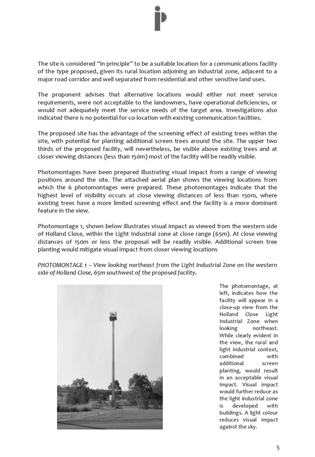
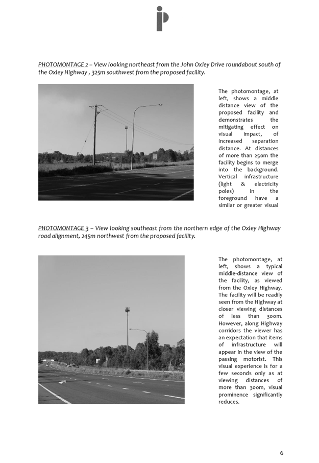
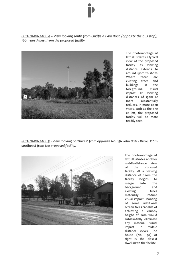
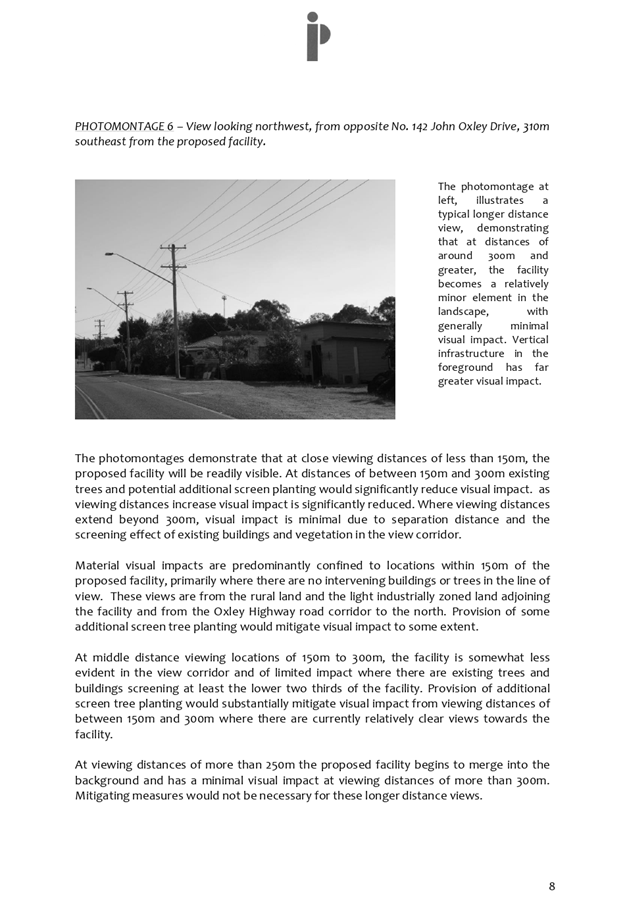
Business
Paper
|
date of meeting:
|
|
Wednesday 11
December 2019
|
|
location:
|
|
Committee Room
|
|
time:
|
|
2:00pm
|
Development
Assessment Panel
CHARTER
1.0 OBJECTIVES
To assist in managing Council's development assessment
function by providing independent and expert determinations of development
applications that fall outside of staff delegations.
2.0 KEY FUNCTIONS
·
To review development application reports and conditions;
·
To determine development
applications outside of staff delegations;
·
To refer development applications
to Council for determination where necessary;
·
To provide a forum for objectors and applicants
to make submissions on applications
before the Development Assessment Panel
(DAP);
·
To maintain transparency in the determination of development
applications.
Delegated Authority of Panel
Pursuant to
Section 377 of the Local Government Act, 1993 delegation to:
·
Determine development applications under Part 4
of the Environmental Planning and Assessment
Act 1979 having
regard to the relevant environmental planning instruments,
development control plans and Council policies.
·
Vary, modify or release restrictions as to use
and/or covenants created by Section 88B instruments under the Conveyancing Act
1919 in relation to development applications for subdivisions being considered
by the panel.
·
Determine Koala Plans of Management under State
Environmental Planning Policy 44 - Koala Habitat Protection associated with
development applications being considered by the Panel.
Noting the trigger to escalate
decision making to Council as highlighted in section 5.2.
3.0
MEMBERSHIP
3.1
Voting
Members
·
Two independent external members. One of the
independent external members to be the Chairperson.
·
Group Manager Development Assessment (alternate
- Director Development & Environment or Development Assessment Planner)
The independent external members shall have expertise in
one or more of the following areas: planning, architecture, heritage, the
environment, urban design, economics, traffic and transport, law, engineering,
government and public administration.
3.2
Non-Voting Members
·
Not applicable
3.3 Obligations
of members
·
Members must act faithfully and diligently and
in accordance with this Charter.
·
Members must comply with Council's Code of Conduct.
·
Except as required to properly perform their
duties, DAP members must not
disclose any confidential information (as advised by Council) obtained in connection with the DAP functions.
·
Members will have read and be familiar with the
documents and information provided by Council prior
to attending a DAP meeting.
·
Members must act in accordance with Council's
Workplace Health and Safety Policies and Procedures
·
External members of the Panel are not authorised
to speak to the media on behalf of Council. Council officers that are members
of the Committee are bound by the
existing operational delegations in relation to speaking to the media.
·
Staff members shall not vote on matters before
the Panel if they have been the principle author of the development assessment report.
3.4
Member Tenure
·
The independent external members will be
appointed for the term of four (4) years
maximum in which the end of the tenure of these members would occur in a
cascading arrangement.
3.5 Appointment
of members
·
The independent external members (including the
Chair) shall be appointed by the General Manager following an external
Expression of Interest process.
·
Staff members of the Panel are in accordance
with this Charter.
4.0 TIMETABLE
OF MEETINGS
·
The Development Assessment Panel will generally
meet on the 1st and 3rd Wednesday each month at 2.00pm at the Port Macquarie
offices of Council.
·
Special Meetings of the Panel may be convened by
the Director Development & Environment Services with three (3) days notice.
5.0
MEETING PRACTICES
5.1
Meeting
Format
·
At all Meetings of the Panel the Chairperson
shall occupy the Chair and preside. The Chair will be responsible for keeping
of order at meetings.
·
Meetings shall be open to the public.
·
The Panel will hear from applicants
and objectors or their r e p r e s e n t a t i v e s .
·
Where considered necessary, the Panel will
conduct site inspections which will
be open to the public.
5.2
Decision Making
·
Decisions are to be made by consensus. Where
consensus is not possible on any item, that item is to be referred to Council
for a decision.
·
All development applications involving a
proposed variation to a development standard
greater than 10% under Clause
4.6 of the Local Environmental Plan will be
considered by the Panel and recommendation made to the Council for a decision.
5.3
Quorum
·
All members (2 independent external members and
1 staff member) must be present at a
meeting to form a quorum.
5.4
Chairperson and Deputy Chairperson
·
Independent Chair (alternate, second independent member)
5.5
Secretariat
·
The Director Development &n Environment is
to be responsible for ensuring that the Panel has adequate secretariat support.
The secretariat will ensure that the business paper and supporting papers are
circulated at least three (3) days prior to
each meeting. Minutes shall be appropriately approved and circulated to each
member within three (3) weeks of a meeting being held.
·
The format of and the preparation and publishing
of the Business Paper and Minutes shall be similar to the format for Ordinary
Council Meetings.
5.6
Recording of decisions
·
Minutes will record decisions and how each
member votes for each item before the Panel.
6.0 CONVENING
OF “OUTCOME SPECIFIC” WORKING GROUPS
Not applicable.
7.0 CONFIDENTIALITY
AND CONFLICT OF INTEREST
·
Members of the Panel must comply with the
applicable provisions of Council’s Code of Conduct. It is the personal
responsibility of members to comply with the standards in the Code of Conduct
and regularly review their personal circumstances with this in mind.
·
Panel members must declare any conflict of
interests at the start of each meeting or before discussion of a relevant item
or topic. Details of any conflicts of interest should be appropriately minuted.
Where members are deemed to have a real or perceived conflict of interest, it
may be appropriate they be excused from deliberations on the issue where the
conflict of interest may exist. A Panel meeting may be postponed where there is
no quorum.
8.0 LOBBYING
·
All members and applicants are to adhere to
Council’s Lobbying policy. Outside of
scheduled Development Assessment Panel meetings, applicants, their
representatives, Councillors, Council staff and the general public are not to
lobby Panel members via meetings, telephone conversations, correspondence and
the like. Adequate opportunity will be provided at Panel inspections or
meetings for applicants, their representatives and the general public to make
verbal submissions in relation to Business Paper items.
Development Assessment Panel
ATTENDANCE
REGISTER
|
Member
|
11/09/19
|
25/09/19
|
09/10/19
|
23/10/19
|
13/11/19
|
27/11/19/19
|
|
Paul Drake
|
P
|
P
|
P
|
P
|
Cancelled
|
P
|
|
Robert Hussey
|
P
|
|
P
|
|
|
|
|
David Crofts
(alternate member)
|
|
P
|
|
P
|
|
P
|
|
Dan Croft
(Group Manager Development
Assessment)
(alternates)
- Director Development & Environment
- Development Assessment Planner
|
A
P
|
P
|
A
P
|
P
|
|
P
|
Key: P = Present
A
= Absent With Apology
X
= Absent Without Apology
Development
Assessment Panel Meeting
Wednesday 11 December
2019
Items of Business
01 Acknowledgement
of Country............................................................................. 8
02 Apologies.......................................................................................................... 8
03 Confirmation
of Minutes..................................................................................... 8
04 Disclosures
of Interest..................................................................................... 13
05 DA2019
- 248.1 Telecommunications Facility (Tower) - Lot 1 DP 834401, No. 10 Holland
Close Port Macquarie................................................................................................ 17
06 DA1991
- 485.2 Modification to Residential Subdivision at Lot 3 & 4 DP 205451, Lot
X, Y & Z DP409518, Lot 28 DP 23418, No 211-213 High Street and Pead Street,
Wauchope 110
07 DA2019
- 651.1 Additional Dwelling to Create Dual Occupancy and Strata Title at Lot 1
DP 570012,No. 6 Home Street, Port Macquarie..................................................... 157
08 DA2019
- 324.1 Industrial Subdivision at Lot 21 DP 811254, Bago Road, Wauchope 208
09 DA
2019 - 285.1 Service Station and Take Away Food and Drink Premises at Lots 1 -
3 DP 407749 and Lot D DP 376568. 15 Ocean Drive Port Macquarie and 39 -
43 Ackroyd Street Port Macquarie..................................................................................................... 439
10 DA2007
- 74.2 - Modification to Previous Approved Staged Alterations and Additions to
Motel at Lot 2 DP 1107888, No. 1 Stewart Street, Port Macquarie................................. 581
11 General
Business
AGENDA Development Assessment Panel 11/12/2019
Subject: ACKNOWLEDGEMENT
OF COUNTRY
"I acknowledge that we are
gathered on Birpai Land. I pay respect to the Birpai Elders both past and
present. I also extend that respect to all other Aboriginal and Torres Strait
Islander people present."
RECOMMENDATION
That the apologies received be
accepted.
Subject: CONFIRMATION
OF PREVIOUS MINUTES
Recommendation
That the Minutes of the Development
Assessment Panel Meeting held on 27 November 2019 be confirmed.
MINUTES
Development Assessment Panel Meeting
27/11/2019
PRESENT
Members:
Paul
Drake
David Crofts
Dan Croft
Other Attendees:
Pat Galbraith-Robertson
Grant
Burge
Chris
Gardiner
Beau
Spry
Stephanie
Baker
Ben
Roberts
|
The meeting opened at 2:00pm.
|
|
01 ACKNOWLEDGEMENT
OF COUNTRY
|
|
The
Acknowledgement of Country was delivered.
|
|
03 CONFIRMATION
OF MINUTES
|
|
CONSENSUS:
That
the Minutes of the Development Assessment Panel Meeting held on 23 October
2019 be confirmed.
|
|
04 DISCLOSURES OF INTEREST
|
|
There were no disclosures of interest
presented.
|
|
05 DA 2018 -
353.2 Modification to Commercial Premises and Tourist and Visitor
Accommodation with Clause 4.6 Variation to Clause 4.3 (Height of Building)
and Clause 4.4 (Floor Space Ratio) of the Port Macquarie-Hastings Local
Environmental Plan 2011 at Lot 123 DP 1219042, No.15 Clarence Street, Port
Macquarie
|
|
Speaker:
David Pensini (applicant)
CONSENSUS:
That
modification to DA2018 - 353.2 for a commercial premises and tourist
and visitor accommodation with clause 4.6 variation to clause 4.3 (height of
building) and clause 4.4 (floor space ratio) of the Port Macquarie-Hastings
Local Environmental Plan 2011 at Lot 11, DP 1219042, No. 15 Clarence Street, Port Macquarie, be
determined by granting consent subject to the recommended conditions.
|
|
06 DA 2019 - 71.1
for Multi Dwelling Housing and Strata Title Subdivision at LOT: 2 DP: 713669,
11 Kemp Street, Port Macquarie
|
|
Speaker:
Martin Ayles (applicant)
CONSENSUS:
That DA 2019 - 71.1 for Multi
Dwelling Housing and Strata Title Subdivision at Lot 2 DP 713669, No. 11 Kemp
Street, Port Macquarie, be determined by granting consent subject to the
recommended conditions.
|
|
07 DA
2019 - 254.1 Industrial Building and Caretaker’s Residence - Lot 2 DP
1084479, No. 3 Production Drive, Wauchope.
|
|
Speaker:
Derek
Collins (applicant)
CONSENSUS:
That DA2019 - 254.1 for
an Industrial building and caretaker’s residence at Lot 2 DP 1084479 No. 3 Production Drive,
Wauchope, be determined by granting consent
subject to the recommended conditions.
|
|
08 DA 2019 -
285.1 Service Station and Take Away Food and Drink Premises at Lots 1 - 3 DP
407749 and Lot D DP 376568. 15 Ocean Drive Port Macquarie and 39 - 43
Ackroyd Street Port Macquarie
|
|
Speakers:
Margie Kimba (o)
Vanessa Kaurin (o)
CONSENSUS:
That
DA2019 - 285 be deferred to enable the applicant to further address and
better manage residential zoning interface impacts by reviewing:
- Hours of operation.
- Hours of deliveries.
- Landscaping and treatments to
better manage privacy, noise and lighting impacts arising from the car
parking area servicing the food and drink premises.
- Ackroyd St access.
|
|
09 DA 2019 -
529.1 2 Lot Torrens Title Subdivision at Lot 1 DP 1129200, No. 104
Greenmeadows Drive, Port Macquarie
|
|
Speaker:
Rob Beukers (applicant)
CONSENSUS:
That DA2019
- 529.1 for a 2 Lot Torrens Title
Subdivision at Lot 1,
DP 1129200, No. 104 Greenmeadows Drive, Port
Macquarie, be determined by granting consent
subject to the recommended conditions.
|
|
|
|
10 DA 2019 -
652.1 Animal Training Establishment at Lot 11 DP 1043006, No. 34 Isabel
Place, Wauchope
|
|
Speaker:
Mark Minor (applicant)
A
submission from ARTC dated 15 November was tabled at the meeting and
considered by the Panel.
CONSENSUS:
That DA 2019 - 652.1 for an Animal
Training Establishment at Lot 11 DP 1043006, 34 Isabel Place Wauchope,
be determined by granting consent subject to the recommended conditions. And
as amended below:
(1)
Amend condition F(3) to read:
‘Any exterior lighting on the site shall be designed and
installed so as not to cause a nuisance or adverse impact on the amenity or safety of the
surrounding area by light overspill. The lighting shall be the minimum
level of illumination necessary for safe operation and must be designed,
installed and used in accordance with AS 4282 control of the obtrusive
effects of outdoor lighting. No flashing, moving or
intermittent lighting is permitted on the site.’
|
|
The meeting closed at 2:50pm.
|
AGENDA Development Assessment Panel 11/12/2019
Subject: DISCLOSURES
OF INTEREST
RECOMMENDATION
That Disclosures of Interest be presented
DISCLOSURE OF
INTEREST DECLARATION
|
Name of Meeting:
|
|
Meeting
Date:
|
|
Item
Number:
|
|
Subject:
|
|
I,
the undersigned, hereby declare the following interest:
Pecuniary:
 Take no part
in the consideration and voting and be out of sight of the meeting. Take no part
in the consideration and voting and be out of sight of the meeting.
Non-Pecuniary
– Significant Interest:
Take no part
in the consideration and voting and be out of sight of the meeting.
Non-Pecuniary
– Less than Significant Interest:
May
participate in consideration and voting.
|
|
For
the reason that:
|
|
Name:
Signed:
|
Date:
|
|
Please submit to the
Governance Support Officer at the Council Meeting.
|
 (Refer
to next page and the Code of Conduct)
(Refer
to next page and the Code of Conduct)
Pecuniary Interest
4.1
A pecuniary interest is an interest
that you have in a matter because of a reasonable likelihood or expectation of
appreciable financial gain or loss to you or a person referred to in clause
4.3.
4.2
You will not have a pecuniary
interest in a matter if the interest is so remote or insignificant that it
could not reasonably be regarded as likely to influence any decision you might
make in relation to the matter, or if the interest is of a kind specified in
clause 4.6.
4.3
For the purposes of this Part, you
will have a pecuniary interest in a matter if the pecuniary interest is:
(a)
your interest, or
(b)
the interest of your spouse or de
facto partner, your relative, or your partner or employer, or
(c)
a company or other body of which
you, or your nominee, partner or employer, is a shareholder or member.
4.4
For the purposes of clause 4.3:
(a)
Your “relative” is any
of the following:
(b)
“de facto partner” has
the same meaning as defined in section 21C of the Interpretation Act 1987.
4.5
You will not have a pecuniary
interest in relation to a person referred to in subclauses 4.3(b) or (c)
(a)
if you are unaware of the relevant
pecuniary interest of your spouse, de facto partner, relative, partner,
employer or company or other body, or
(b)
just because the person is a member
of, or is employed by, a council or a statutory body, or is employed by the
Crown, or
(c)
just because the person is a member
of, or a delegate of a council to, a company or other body that has a pecuniary
interest in the matter, so long as the person has no beneficial interest in any
shares of the company or body.
Non-Pecuniary
5.1
Non-pecuniary interests are private
or personal interests a council official has that do not amount to a pecuniary
interest as defined in clause 4.1 of this code. These commonly arise out of
family or personal relationships, or out of involvement in sporting, social, religious
or other cultural groups and associations, and may include an interest of a
financial nature.
5.2
A non-pecuniary conflict of
interest exists where a reasonable and informed person would perceive that you
could be influenced by a private interest when carrying out your official
functions in relation to a matter.
5.3
The personal or political views of
a council official do not constitute a private interest for the purposes of
clause 5.2.
5.4
Non-pecuniary conflicts of interest
must be identified and appropriately managed to uphold community confidence in
the probity of council decision-making. The onus is on you to identify any
non-pecuniary conflict of interest you may have in matters that you deal with,
to disclose the interest fully and in writing, and to take appropriate action
to manage the conflict in accordance with this code.
5.5
When considering whether or not you
have a non-pecuniary conflict of interest in a matter you are dealing with, it
is always important to think about how others would view your situation.
Managing non-pecuniary conflicts of interest
5.6
Where you have a non-pecuniary
conflict of interest in a matter for the purposes of clause 5.2, you must
disclose the relevant private interest you have in relation to the matter fully
and in writing as soon as practicable after becoming aware of the non-pecuniary
conflict of interest and on each occasion on which the non-pecuniary conflict
of interest arises in relation to the matter. In the case of members of council
staff other than the general manager, such a disclosure is to be made to the
staff member’s manager. In the case of the general manager, such a
disclosure is to be made to the mayor.
5.7
If a disclosure is made at a
council or committee meeting, both the disclosure and the nature of the
interest must be recorded in the minutes on each occasion on which the
non-pecuniary conflict of interest arises. This disclosure constitutes
disclosure in writing for the purposes of clause 5.6.
5.8
How you manage a non-pecuniary
conflict of interest will depend on whether or not it is significant.
5.9
As a general rule, a non-pecuniary
conflict of interest will be significant where it does not involve a pecuniary
interest for the purposes of clause 4.1, but it involves:
a)
a relationship between a council
official and another person who is affected by a decision or a matter under
consideration that is particularly close, such as a current or former spouse or
de facto partner, a relative for the purposes of clause 4.4 or another person
from the council official’s extended family that the council official has
a close personal relationship with, or another person living in the same
household
b)
other relationships with persons
who are affected by a decision or a matter under consideration that are
particularly close, such as friendships and business relationships. Closeness
is defined by the nature of the friendship or business relationship, the frequency
of contact and the duration of the friendship or relationship.
c)
an affiliation between the council
official and an organisation (such as a sporting body, club, religious,
cultural or charitable organisation, corporation or association) that is
affected by a decision or a matter under consideration that is particularly
strong. The strength of a council official’s affiliation with an
organisation is to be determined by the extent to which they actively
participate in the management, administration or other activities of the
organisation.
d)
membership, as the council’s
representative, of the board or management committee of an organisation that is
affected by a decision or a matter under consideration, in circumstances where
the interests of the council and the organisation are potentially in conflict
in relation to the particular matter
e)
a financial interest (other than an
interest of a type referred to in clause 4.6) that is not a pecuniary interest
for the purposes of clause 4.1
f)
the conferral or loss of a personal
benefit other than one conferred or lost as a member of the community or a
broader class of people affected by a decision.
5.10
Significant non-pecuniary conflicts
of interest must be managed in one of two ways:
a)
by not participating in
consideration of, or decision making in relation to, the matter in which you
have the significant non-pecuniary conflict of interest and the matter being
allocated to another person for consideration or determination, or
b)
if the significant non-pecuniary
conflict of interest arises in relation to a matter under consideration at a
council or committee meeting, by managing the conflict of interest as if you
had a pecuniary interest in the matter by complying with clauses 4.28 and 4.29.
5.11
If you determine that you have a
non-pecuniary conflict of interest in a matter that is not significant and does
not require further action, when disclosing the interest you must also explain
in writing why you consider that the non-pecuniary conflict of interest is not
significant and does not require further action in the circumstances.
5.12
If you are a member of staff of
council other than the general manager, the decision on which option should be
taken to manage a non-pecuniary conflict of interest must be made in
consultation with and at the direction of your manager. In the case of the
general manager, the decision on which option should be taken to manage a
non-pecuniary conflict of interest must be made in consultation with and at the
direction of the mayor.
5.13
Despite clause 5.10(b), a councillor
who has a significant non-pecuniary conflict of interest in a matter, may
participate in a decision to delegate consideration of the matter in question
to another body or person.
5.14 Council committee members are not required to declare
and manage a non-pecuniary conflict of interest in accordance with the
requirements of this Part where it arises from an interest they have as a
person chosen to represent the community, or as a member of a non-profit
organisation or other community or special interest group, if they have been
appointed to represent the organisation or group on the council committee.
SPECIAL
DISCLOSURE OF PECUNIARY INTEREST DECLARATION
This
form must be completed using block letters or typed.
If
there is insufficient space for all the information you are required to
disclose,
you
must attach an appendix which is to be properly identified and signed by you.
|
By
[insert full name of councillor]
|
|
|
In the
matter of
[insert name of environmental planning instrument]
|
|
|
Which is
to be considered at a meeting of the
[insert name of meeting]
|
|
|
Held on
[insert date of meeting]
|
|
|
PECUNIARY
INTEREST
|
|
Address of
the affected principal place of residence of the councillor or an associated
person, company or body (the identified land)
|
|
|
Relationship
of identified land to councillor
[Tick or cross one box.]
|
The councillor has interest in the land (e.g. is owner or has other
interest arising out of a mortgage, lease, trust, option or contract, or
otherwise).
An associated person of the councillor has an interest in the land.
An associated company or body of the councillor has interest in the land.
|
|
MATTER
GIVING RISE TO PECUNIARY INTEREST
|
|
Nature of
land that is subject to a change
in
zone/planning control by proposed
LEP (the
subject land
[Tick or cross one box]
|
The identified land.
Land that adjoins or is adjacent to or is in proximity to the identified
land.
|
|
Current
zone/planning control
[Insert name of current planning instrument and
identify relevant zone/planning control applying to the subject land]
|
|
|
Proposed
change of zone/planning control
[Insert name of proposed LEP and identify proposed
change of zone/planning control applying to the subject land]
|
|
|
Effect of
proposed change of zone/planning control on councillor or associated person
[Tick or cross one box]
|
Appreciable financial gain.
Appreciable financial loss.
|
|
|
|
[If more than one pecuniary interest is to be
declared, reprint the above box and fill in for each additional interest]
Councillor’s Signature:
……………………………….
Date: ………………..
This form is to be retained
by the council’s general manager and included in full in the minutes of
the meeting
Last Updated: 3 June 2019
Important Information
This information is being collected for the purpose of
making a special disclosure of pecuniary interests under clause 4.36(c) of the
Model Code of Conduct for Local Councils in NSW (the Model Code of Conduct).
The special disclosure must relate only to a pecuniary
interest that a councillor has in the councillor’s principal place of
residence, or an interest another person (whose interests are relevant under
clause 4.3 of the Model Code of Conduct) has in that person’s principal
place of residence.
Clause 4.3 of the Model Code of Conduct states that you
will have a pecuniary interest in a matter because of the pecuniary interest of
your spouse or your de facto partner or your relative or because your business
partner or employer has a pecuniary interest. You will also have a pecuniary
interest in a matter because you, your nominee, your business partner or your
employer is a member of a company or other body that has a pecuniary interest
in the matter.
“Relative” is defined by clause 4.4 of the Model
Code of Conduct as meaning your, your spouse’s or your de facto
partner’s parent, grandparent, brother, sister, uncle, aunt, nephew,
niece, lineal descendant or adopted child and the spouse or de facto partner of
any of those persons.
You
must not make a special disclosure that you know or ought reasonably to know is
false or misleading in a material particular. Complaints about breaches
of these requirements are to be referred to the Office of Local Government and
may result in disciplinary action by the Chief Executive of the Office of Local
Government or the NSW Civil and Administrative Tribunal.
This form must be completed by you before the commencement
of the council or council committee meeting at which the special disclosure is
being made. The completed form must be tabled at the meeting. Everyone is
entitled to inspect it. The special disclosure must be recorded in the minutes
of the meeting.
A pecuniary interest may arise by way of a change of
permissible use of land adjoining, adjacent to or in proximity to land in which
a councillor or a person, company or body referred to in clause 4.3 of the
Model Code of Conduct has a proprietary interest
AGENDA Development Assessment Panel 11/12/2019
Item: 05
Subject: DA2019 - 248.1 Telecommunications Facility
(Tower) - Lot 1 DP 834401, No. 10 Holland Close Port Macquarie
Report
Author: Development Assessment Planner, Steven Ford
|
Applicant: Catalyst
ONE Pty Ltd
Owner: Formarcus
Pty Ltd
Estimated Cost: $250,000
Alignment with Delivery
Program
4.3.1 Undertake transparent and
efficient development assessment in accordance with relevant legislation.
|
|
RECOMMENDATION
That
DA 2019/248.01 for a Telecommunications
Facility at Lot 1, DP 834401, No. 10 Holland Close, Port
Macquarie, be determined by granting consent
subject to the recommended conditions.
|
Executive
Summary
This
report considers a development application for a Telecommunications
Facility (Tower) at the subject site and provides an
assessment of the application in accordance with the Environmental Planning and
Assessment Act 1979.
Following exhibition of the
application, one submission was received.
The site is considered suitable for the proposed development
and the proposal adequately addresses relevant planning controls. The
development is not considered to be contrary to the public's interest and will
not result a significant adverse social, environmental or economic impact.
This report recommends that the
development application be approved subject to the attached conditions.
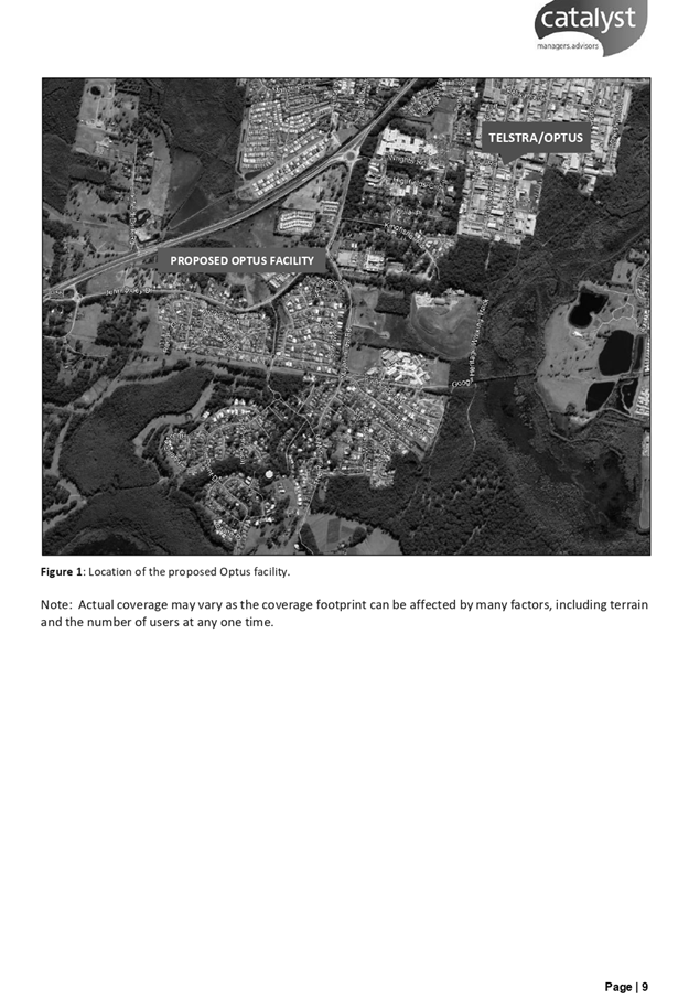
1. BACKGROUND
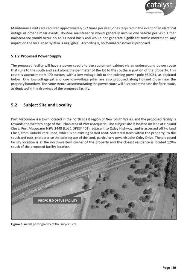
Existing Sites Features and Surrounding Development
The site has an area of 2.23
hectares.
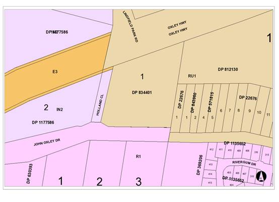
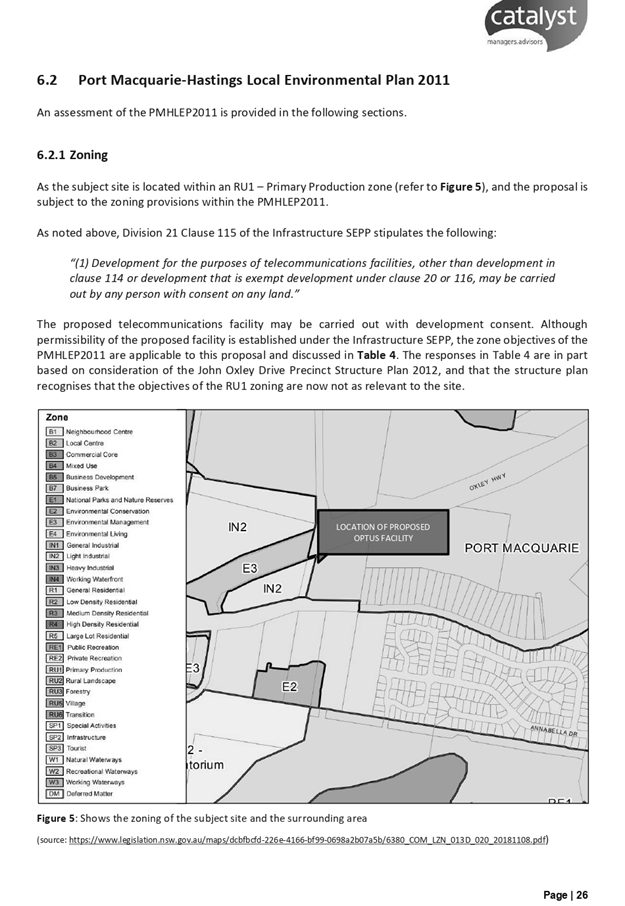
The site is zoned RU1 Primary Agriculture in accordance with the Port Macquarie-Hastings Local
Environmental Plan 2011, as shown in the following zoning plan:
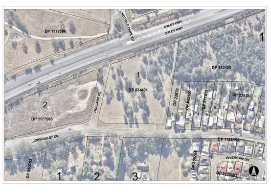
The existing subdivision pattern and location of existing
development within the locality is shown in the following aerial photograph:
2. DESCRIPTION OF
DEVELOPMENT
Key
aspects of the proposal include the following:
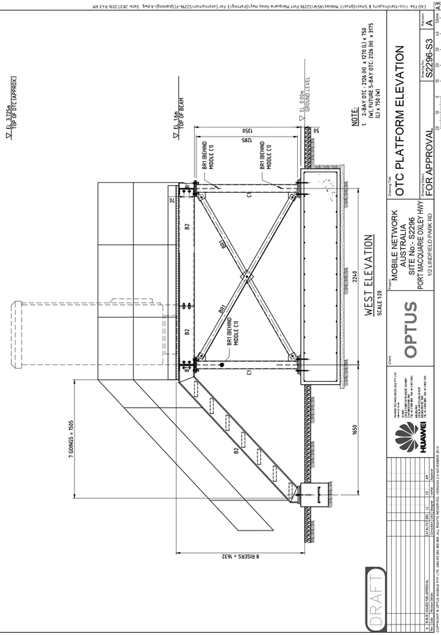
· A
42.73m high monopole telecommunications tower and ancillary equipment shelter
and security fence around base of tower.
Refer
to Attachment 2 at the end of this report for plans of the proposed
development.
Application Chronology
· 04
April 2019 - Application Lodged.
· 16 April 2019 to 02 May 2019 - Public notification period.
One submission received.
· 23 October 2019 - Additional information received including
Amended Statement of Environmental Effects, Amended Plans, and Visual Impact
Assessment.
· 11 November 2019 - Additional information received
including Amended Plans, Landscaping Plan, and Amended Statement of
Environmental Effects.
3. STATUTORY ASSESSMENT
Section 4.15(1) Matters for Consideration
In
determining the application, Council is required to take into consideration the
following matters as are relevant to the development that apply to the land to
which the development application relates:
(a) The
provisions (where applicable) of:
(i) Any
Environmental Planning Instrument
State
Environmental Planning Policy No. 44 - Koala Habitat Protection
With
reference to clauses 6 and 7, the subject land has is greater than 1 hectare
and therefore the provisions of SEPP must be considered.
The
Department of Planning and Infrastructure’s Circular No. B35, Section 1.5
states that “In relation to affected development applications it is the
intention of the policy that investigations for ‘potential’ and
‘core’ koala habitats be limited to those areas in which it is
proposed to disturb habitat”.
The
application has demonstrated that no habitat will be removed or modified
therefore no further investigations are required.
State
Environmental Planning Policy No. 55 – Remediation of Land
Following
an inspection of the site and a search of Council records, the subject land is
not identified as being potentially contaminated and is suitable for the
intended use.
State
Environmental Planning Policy (Coastal Management) 2018
The
site is located within proximity to a coastal environment area.
In
accordance with clause 7, this SEPP prevails over the Port Macquarie-Hastings
LEP 2011 in the event of any inconsistency.
Having
regard to clauses 13 and 14 of the SEPP the proposed development is not
considered likely to result in any of the following:
a) any adverse impact on integrity and resilience of the biophysical,
hydrological (surface and groundwater) and ecological environment.
b) any adverse impacts coastal environmental values and natural coastal
processes.
c) any adverse impacts on marine vegetation, native vegetation and fauna and
their habitats, undeveloped headlands and rock platforms.
d) any adverse impact on marine vegetation, native vegetation and fauna and
their habitats, undeveloped headlands and rock platforms.
e) any adverse impact on Aboriginal cultural heritage, practices and places.
f) any adverse impacts on the
cultural and built environment
heritage.
g) any adverse impacts the use of the surf zone.
h) any adverse impact on the visual amenity and scenic
qualities of the coast, including coastal headlands.
i) overshadowing, wind funnelling and the loss of views from
public places to foreshores.
j) any adverse impacts on existing public open space and safe access to and
along the foreshore, beach, headland or rock platform for members of the
public, including persons with a disability.
State Environmental Planning Policy (Infrastructure) 2007
Clause
115(1). In accordance with this clause, telecommunications facilities are
permissible in all zones within Port Macquarie-Hastings Council area with
consent. The proposed telecommunications facility is consistent with the
Infrastructure SEPP definition and is considered as development permitted with
consent.
Clause
115(3). Determining a development application for development to which this
clause applies, the consent authority must take into consideration any
guidelines concerning site selection, design, construction or operating
principles for telecommunications facilities that are issued by the
Director-General for the purposes of this clause and published in the Gazette.
The
NSW Department of Planning and Infrastructure has prepared the NSW
Telecommunications Facilities Guideline (2010) to:
(a) provide a guide to the State wide
planning provisions and development controls for telecommunications facilities
in NSW contained in the SEPP;
(b) provide guidance to assist the
facilitation of the roll-out of broadband in NSW.
The
detailed principles of the Guideline are under the following broad headings:
· Principle 1: A telecommunications facility is to be
designed and sited to minimise visual impact.
· Principle 2: Telecommunications facilities should be
co-located wherever practical.
· Principle 3: Health standards for exposure to radio
emissions must be met.
· Principle 4: Minimise disturbance and risk and maximise
compliance.
The
proposal is compliant with the Site Selection, Design, Construction and
Operation Principles for Telecommunications Facilities based on the above
information. In particular, the Applicant has provided the following details to
demonstrate satisfactory consideration of this guideline:
· Detailed planning response to each planning principle,
satisfactorily demonstrating compliance with the guideline (See Section 6 of
the Statement of Environmental Effects (SOEE) attached).
· An analysis of other potentially suitable sites concluded
that the site chosen is the most suitable. Co-location of the equipment on
existing structures in the locality was not achievable technically or
structurally at the required height to meet the coverage objectives of the
facility and proximity to existing dwellings without adverse impacts. (Section
4 of the SOEE attached).
· The estimated calculated radio frequency electromagnetic
energy (EME) levels are well below the mandatory standards set by the
Australian Communications and Media Authority. The maximum cumulative EME level
at 1.5m above ground level for all carriers at this site is 0.36% of the
ARPANSA exposure limits.
· The Visual Impact Assessment adequately supports the
preferred location. The site provides a significant setback from existing residential
buildings and undeveloped residential zoned land in the locality. (See Visual
Impact Statement attached).
Refer
also to further additional comments under visual impact, context and setting
later in this report. It is important to also note from this guideline that
'the considered scientific opinion about possible health effects from this type
of infrastructure is that the weight of national and international scientific
opinion is that there is no substantiated evidence that radio frequency emissions
associated with living near mobile phone base station of telecommunications
towers poses a health risk' (Australian Communications and Media Authority).
Port Macquarie-Hastings Local Environmental Plan
2011
The
proposal is consistent with the LEP having regard to the following:
· Clause 2.2. The subject site is zoned RU1 Primary
Production.
· Clause 2.3(1) and the RU1 zone land use table.
The proposed development for a Telecommunications Facility is permissible land
use with consent. The objectives of the RU1 zone are as follows:
o To encourage sustainable primary industry production by
maintaining and enhancing the natural resource base.
o To encourage diversity in primary industry enterprises and
systems appropriate for the area.
o To minimise the fragmentation and alienation of resource
lands.
o To minimise conflict between land uses within this zone and
land uses within adjoining zones.
· Clause 2.3(2). The proposal is consistent with the zone
objectives having regard to the following:
·
o The proposal is a permissible land use.
o The proposal will not interrupt the natural resource value
of the site.
o Potential perceived conflicts have been minimised with
separation and landscaping.
o The proposal will provide valued telecommunication coverage
to adjoining areas.
· Clause 5.10. The site does not contain or adjoin any known
heritage items or sites of significance.
· Clause 7.1. The site is mapped as potentially containing
Class 5 acid sulphate soils. The proposed development is unlikely to expose any
such soils therefore no adverse impacts are expected to occur.
· Clause 7.3. The site is land within a mapped “flood
planning area” (Land subject to flood discharge of 1:100 annual
recurrence interval flood event (plus the applicable climate change allowance
and relevant freeboard). In this regard the following comments are provided
which incorporate consideration of the objectives of Clause 7.3,
Council’s Flood Policy 2015, the NSW Government’s Flood Prone Lands
Policy and the NSW Government’s Floodplain Development Manual (2005):
o The proposal is compatible with the flood hazard of the
land taking into account projected changes as a result of climate change.
o The proposal will not result in a significant adverse
effect on flood behaviour that would result in detrimental increases in the
potential flood affectation of other development or properties.
o The proposal incorporates measures to minimise & manage
the flood risk to life and property associated with the use of land.
o The proposal is not likely to significantly adversely
affect the environment or cause avoidable erosion, siltation, destruction of
riparian vegetation or a reduction in the stability of river banks or
watercourses.
o The proposal is not likely to result in unsustainable
social and economic costs to the community as a consequence of flooding.
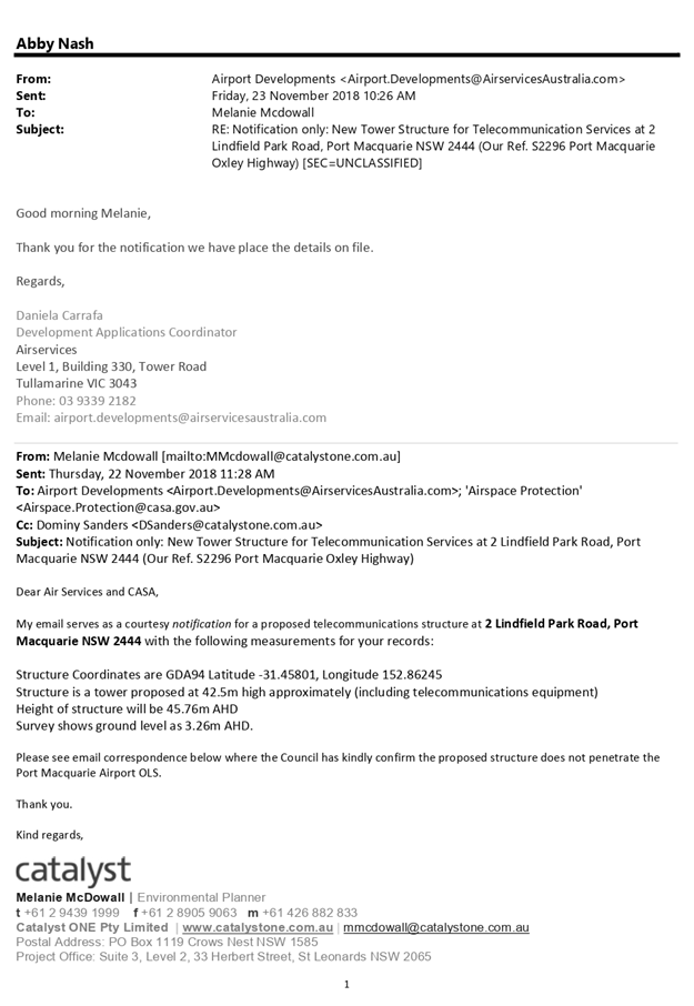
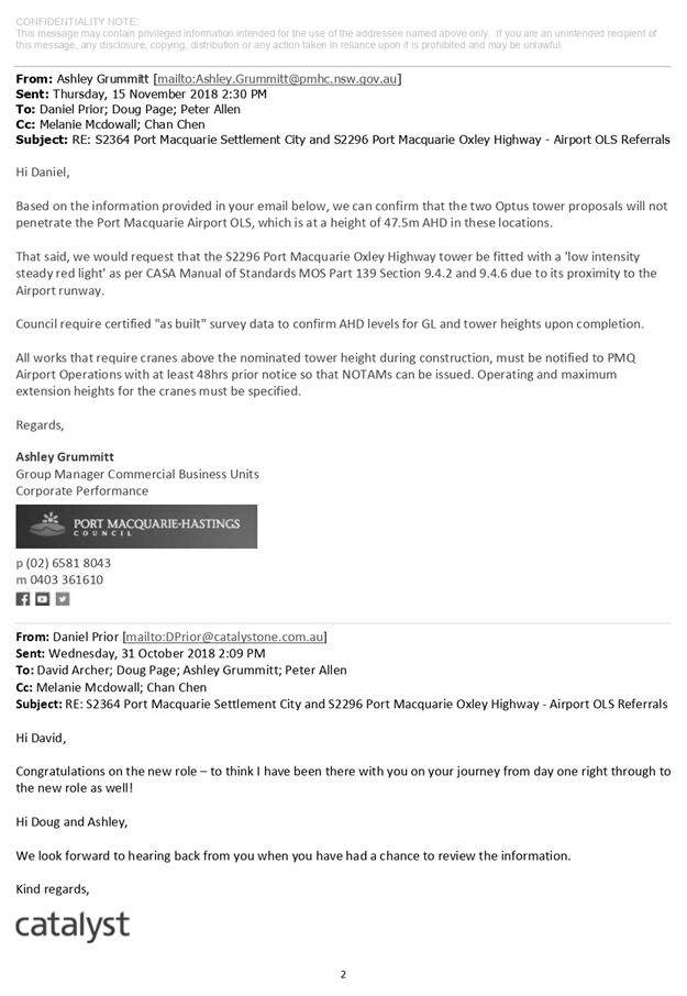
· Clause 7.7. Airspace operations. The site is located
approximately 1.8km from the site. Correspondence from Port Macquarie airport
operator confirmed the facility will not penetrate the Obstacle Limitation
Surface (OLS) contour. Council’s airport staff have recommended a
condition requiring a survey of the ‘as built’ structure and a
precautionary condition regarding the use of cranes during construction.
· Clause7.13. Satisfactory arrangements are in place for
provision of essential services to service the development.
(a)(ii) Any proposed instrument that is or has been placed
on exhibition
No draft instruments apply to the site.
(a)(iii) Any DCP in force
Port Macquarie-Hastings Development Control
Plan 2013:
|
DCP 2013: General
Provisions
|
|
|
Requirements
|
Proposed
|
Complies
|
|
2.7.2.2
|
Design addresses generic principles of Crime Prevention
Through Environmental Design guideline
|
Adequate access proposed for the facility from Holland
Close. The utility area / yard will be adequately fenced to secure the site
from trespassers. Security lighting and video surveillance can be installed
if required.
|
Yes
|
|
2.3.3.1
|
Cut
and fill 1.0m max. 1m outside the perimeter of the external building walls
|
Less
than 1m cut/fill proposed.
|
Yes
|
|
2.5.3.23
|
Parking
to be provided as per table 2.5.1.
|
The
proposal will not generate any parking demand. The site is accessible for
maintenance purposes without any identifiable traffic impacts.
|
Yes
|
(a)(iii)(a)
Any planning agreement or draft planning agreement
No
planning agreement has been offered or entered into relating to the site.
(a)(iv)
The regulations
No
matters prescribed by the regulations apply.
(b)
The likely impacts of that development, including environmental impacts on both
the natural and built environments and the social and economic impacts in the
locality
The
site is a corner block with a primary orientation to Holland Close. Adjoining
the site to the north is the Oxley Highway. Adjoining the site to the east are
residential dwellings. Adjoining the site to the south is John Oxley Drive and
undeveloped R1 General Residential zoned land. Adjoining the site to the west
is undeveloped IN2 Light Industrial land.
The
proposal will be unlikely to have any adverse impacts to existing adjoining
properties and satisfactorily addresses the public domain.
The
proposal is considered to be consistent with other residential development in
the locality and adequately addresses planning controls for the area.
The
proposal does not have a significant adverse impact on existing view sharing.
Specifically, there are no identified iconic or special views that would be
impacted by the proposed structure.
The proposal
does not have significant adverse lighting impacts. A consent condition has
also has been recommended surrounding anticipated security lighting.
There
are no adverse overshadowing impacts. The proposal does not prevent adjoining
properties from receiving 3 hours of sunlight to private open space and primary
living areas on 21 June.
Roads,
Traffic and Transport
No
change to existing access proposed from Holland Close or John Oxley Drive. The
proposal will not result in any increase in traffic generation to the site.
Sewer
Connection
No
sewer connection proposed.
Stormwater
The
proposed structure will not generate any additional stormwater to that which
the current hardstand area it is being placed upon.
Other
Utilities
Telecommunication
and electricity services are available to the site.
Heritage
No
known items of Aboriginal or European heritage significance exist on the
property. No adverse impacts anticipated.
Other
land resources
The
site is within an established urban context and will not sterilise any
significant mineral or agricultural resource.
Water
cycle
The
proposed development will be unlikely to have any adverse impacts on water
resources and the water cycle.
Soils
The
proposed development will be unlikely to have any adverse impacts on soils in
terms of quality, erosion, stability and/or productivity subject to a standard
condition requiring erosion and sediment controls to be in place prior to and
during construction.
Air
and microclimate
The
construction and/or operations of the proposed development will be unlikely to
result in any adverse impacts on the existing air quality or result in any
pollution. Standard precautionary site management condition recommended.
Flora
and fauna
Construction
of the proposed development will not require any removal/clearing of any native
vegetation and therefore does not trigger the biodiversity offsets
scheme. Part 7 of the Biodiversity Conservation Act 2016 is considered to
be satisfied.
Waste
Satisfactory
arrangements are in place for proposed storage and collection of waste and
recyclables. No adverse impacts anticipated. Standard precautionary site
management condition recommended.
Energy
The
proposal includes measures to address energy efficiency and will be required to
comply with the requirements of Section J of the Building Code of Australia. No
adverse impacts anticipated.
Noise
and vibration
No
adverse impacts anticipated. Condition recommended to restrict construction to
standard construction hours.
Bushfire
The
site is identified as being bushfire prone.
The
Applicant has addressed a proposed Asset Protection Zone in the Statement of
Environmental Effects and by the site design. In line with RFS
recommendations for telecommunications infrastructure, a 10m asset protection
zone (APZ) is proposed around the monopole and equipment cabinet. The
establishment and maintenance of the APZ will not require the removal of any
trees.
Safety,
security and crime prevention
The
proposed development will be unlikely to create any concealment/entrapment
areas or crime spots that would result in any identifiable loss of safety or
reduction of security in the immediate area.
Social
impacts in the locality
Given
the nature of the proposed development and its’ location the proposal is
unlikely to result in any adverse social impacts.
The
perceived health risks associated with RF EME are not substantiated by
‘the weight of national and international scientific opinion’
(ARPANSA 2008). Further, the Land and Environment Court has previously ruled in
favour of telecommunications base stations where residents raised concerns
regarding RF EME (Telstra Corporation Limited v Hornsby Shire Council [2006]
NSWLEC 133, Telstra Corporation Limited v City of Ryde Council [2009] NSWLEC
1130).
The proposal
would also have likely positive social impacts, which can be attributed to the
delivery of improved mobile phone and broadband coverage/services for existing
and developing residential areas.
Economic
impact in the locality
No
adverse impacts. A likely positive impact is that the development will maintain
and/or improve telecommunication coverage to the broader community, which will
lead to flow impacts for personal or business use of technology.
Site
design and internal design
The
proposed development design satisfactorily responds to the site attributes,
adjoining land uses and will fit into the locality.
Construction
No
potential adverse impacts identified to neighbouring properties with the
construction of the proposal.
Cumulative
impacts
The
proposed development is not expected to have any adverse cumulative impacts on
the natural or built environment or the social and economic attributes of the
locality.
Natural
Hazards
No
identifiable impacts apparent.
(c)
The suitability of the site for the development
The
proposal will fit into the locality and the site attributes are conducive to
the proposed development.
Site
constraints have been adequately addressed and appropriate conditions of
consent recommended.
(d)
Any submissions made in accordance with this Act or the regulations
Following
exhibition of the application in accordance with DCP 2013, one submission was
received.
|
Submission Issue/Summary
|
Planning Comment/Response
|
|
There are multiple errors in the Statement of Environment
report. This would indicate that due diligence may not have been done and
lends argument as to the accuracy of their report.
|
Original Statement of Environmental Effects (SOEE)
incorrectly referred to another Local Government Area. However, the report
had the correct address references to the subject site and adjoining
investigation sites. This reference was a minor miss description only. Errors
in the original reports have been corrected in the current SOEE attached to
this report. (Attachment 6)
|
|
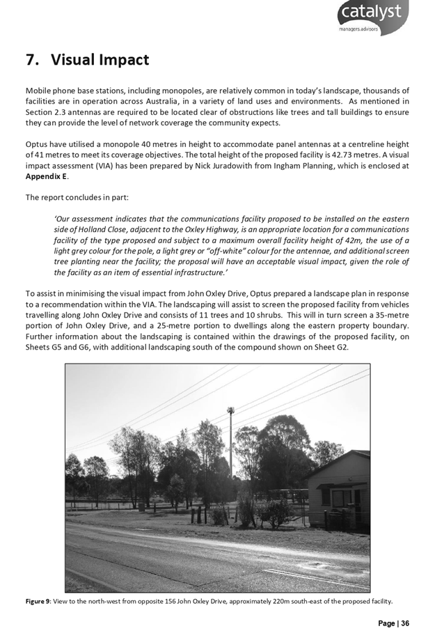
The vegetation identified in figure 9 (page 35) with a
large note "Vegetation Screening" and figure 10 (page 36) will
shortly be removed as part of long standing consultation with council to
subdivide several properties in close proximity of this proposed tower. The
vegetation will shortly be replaced with dwellings, leaving little or no
screening of the proposed tower.
|
At the time of lodgement, there was no Development
Application approving the clearing of the mentioned vegetation screening. A
residential subdivision has since been lodged and approved on adjoining land
to the South, impacting the vegetation screening mentioned in the Statement
of Environmental Effects and Visual Impact Assessment.
The Applicant has acknowledged the difficulty in balancing
the need for the telecommunication facilities, and the broader community
benefit, a location with minimal identifiable impacts and personal reward
preferences. The attached Visual Impact Assessment provided as additional
information, adequately demonstrates a detailed review of potential visual
amenity impacts and provides sufficient justification as a preferred location
with site attributes to justify the proposed land use.
It is noted that no iconic, panoramic or landmark views
will be impacted by this proposal.
It is also noted by the Applicant that it is not always
possible to locate this type of facility in visually sympathetic locations
when also considering telecommunication coverage requirements.
The Applicant has demonstrated the subject location,
adjacent to the Oxley Highway, adjoining light industrial zoned land and
maximum setback from adjoining residential land, is considered to be the most
appropriate location for the proposed development given the sights
constraints and other available investigation locations to service the
northwest vicinity of Port Macquarie.
The supportive documentation provided adequately
information to remove any ground of refusal based on visual amenity.
|
|
Other
sites have been discarded as being too close to residential premises. We ask
that the same consideration be given to existing dwellings and the imminent
residential subdivisions.
|
The
revised Statement of Environmental Effects (SOEE) has outlined the site
selection process. See Clause 4.2 of the attached SOEE for the reasons
justifying the selection of Holland Close as the preferred site.
|
|
Where
exactly would this tower be built?
|
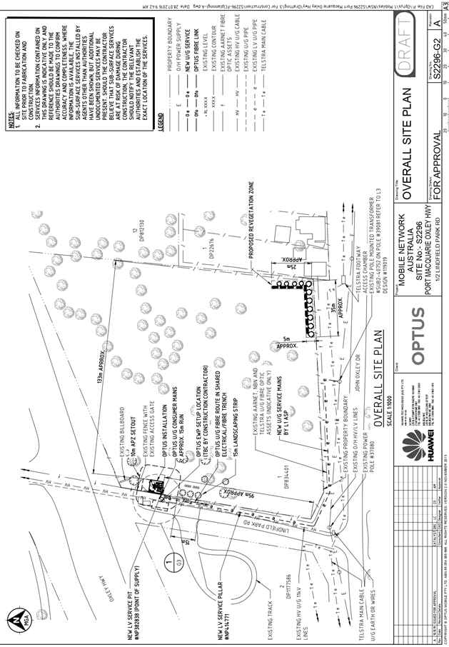
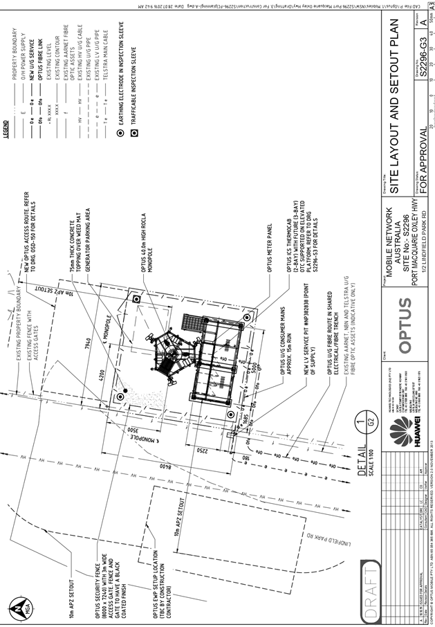
See
Overall Site Plan (Drawing No. S2296-G2) attached to this report. (Attachment
2)
|
|
Reference
to benefit to community is very bland on facts, who are the beneficiaries of
such a project and at what detriment to local amenity?
|
Clause
2 of the attached Statement of Environmental Effects has satisfactorily
demonstrated the purpose of the development, broader community need to
accommodate adequate telecommunication coverage and demand.
|
(e)
The public interest
The
proposed development will be in the wider public interest servicing additional
housing.
The
proposed development satisfies relevant planning controls and will not
adversely impact on the wider public interest.
Ecologically
Sustainable Development and Precautionary Principle
Ecologically
sustainable development requires the effective integration of economic and
environmental considerations in decision-making processes. The four
principles of ecologically sustainable development are:
· the precautionary principle
· intergenerational equity
· conservation of biological diversity and ecological
integrity
· improved valuation, pricing and incentive mechanisms.
The
principles of ESD require that a balance needs to be struck between the
man-made development and the need to retain the natural vegetation. Based on
the assessment provided in the report and with recommended conditions of
consent, it is considered an appropriate balance has been struck.
Additional
Comments
Technological
Hazards – Radio Frequency (RF) Electromagnetic Energy (EME)
The
Australian Radiation Protection and Nuclear Safety Agency (ARPANSA), is a
Federal Government agency charged with responsibility for protecting the health
and safety of people, and the environment, from the harmful effects of ionising
and non-ionising radiation.
The
Australian Communications and Media Authority (ACMA) also mandates exposure
limits for continuous exposure of the general public to radio frequency (RF)
electromagnetic energy (EME) from mobile phone base stations.
The
levels of electromagnetic fields from mobile phone telecommunication base
stations must comply with safety limits imposed by the ACMA. The limits are
given in the Radio communications (Electromagnetic Radiation — Human
Exposure) Standard 2003.These limits are based on the Australian Radiation
Protection Standard for Maximum Exposure Levels to Radiofrequency Fields - 3khz
to 300GHz which sets public and occupational limits for exposure to EME fields.
The
maximum EME levels from the proposed telecommunications facility have been
estimated in 360 degree circular bands at a distance up to 500 metres away from
the proposed site and at 1.5m above ground level. These estimates have been
made in accordance with the procedures developed by ARPANSA and are represented
as a percentage of the maximum ARPANSA public exposure limit which equates to
100%.
The
maximum level of EME generated by the proposal, which occurs at distance of
250.18 metres from the proposed location of the antennas, was estimated as
equivalent to 0.36% of the ARPANSA public exposure limits. Calculations of EME
closer to the tower were estimated to be lower.
As a
result, the proposed telecommunications facility complies with the Australian
Radiation Protection Standard for Maximum Exposure Levels to Radiofrequency
Fields - 3khz to 300GHz.
Site
inspection date: November 2019
4. DEVELOPMENT
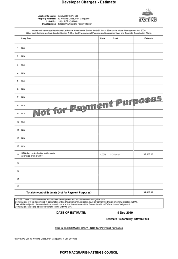
CONTRIBUTIONS APPLICABLE
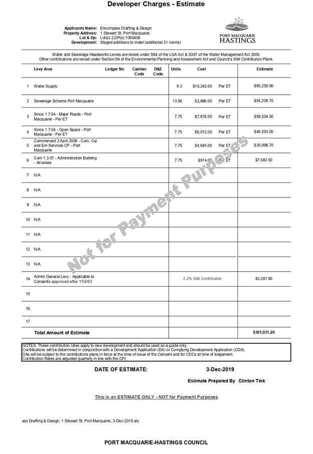
· Development contributions will be required in accordance
with Section 7.12 of the Environmental Planning and Assessment Act 1979.
· A copy of the contributions estimate is included as
Attachment 3.
5. CONCLUSION
AND STATEMENT OF REASON
The application has been assessed in accordance with Section
4.15 of the Environmental Planning and Assessment Act 1979.
Issues raised during assessment and public exhibition of the
application have been considered in the assessment of the application. Where
relevant, conditions have been recommended to manage the impacts attributed to
these issues.
The site is considered suitable for the proposed development
and the proposal adequately addresses relevant planning controls. The
development is not considered to be contrary to the public's interest and will
not result a significant adverse social, environmental or economic impact. It
is recommended that the application be approved, subject to the recommended
conditions of consent provided in the Attachment 1 of this report.
|
Attachments
1View. DA2019
- 248.1 Recommended Conditions
2View. DA2019
- 248.1 Plans
3View. DA2019
- 248.1 Contributions Estimate
4View. DA2019
- 248.1 Correspondence from Airport Manager & Airservices
5View. DA2019
- 248.1 EME Report
6View. DA2019
- 248.1 SOEE
7View. DA2019
- 248.1 Visual Impact Assessment
|
|
ATTACHMENT
|
Development Assessment Panel
11/12/2019
|
|
ATTACHMENT
|
Development Assessment Panel
11/12/2019
|
|
ATTACHMENT
|
Development Assessment Panel
11/12/2019
|
|
ATTACHMENT
|
Development Assessment Panel
11/12/2019
|
|
ATTACHMENT
|
Development Assessment Panel
11/12/2019
|
|
ATTACHMENT
|
Development Assessment Panel
11/12/2019
|


|
ATTACHMENT
|
Development Assessment Panel
11/12/2019
|
AGENDA Development Assessment Panel 11/12/2019
Item: 06
Subject: DA1991 - 485.2 Modification to Residential
Subdivision at Lot 3 & 4 DP 205451, Lot X, Y & Z DP409518, Lot 28 DP
23418, No 211-213 High Street and Pead Street, Wauchope
Report
Author: Development Assessment Planner, Chris Gardiner
|
Applicant: Land
Dynamics Australia
Owner: Horizon
Beach Development Corp Pty
Estimated Cost: Nil
Parcel no: 8863,
9062, 20302, 20303, 36140, 9064
Alignment with Delivery
Program
4.3.1 Undertake transparent
and efficient development assessment in accordance with relevant legislation.
|
|
RECOMMENDATION
That
DA1991 - 485.2 for Modification of
Residential Subdivision at Lot 3
& 4 DP 205451, Lot X, Y & Z DP 409518, and Lot 28 DP 23418, No. 211-213 High Street and Pead Street, Wauchope, be
determined by granting consent subject to the recommended modified
conditions.
|
Executive
Summary
This
report considers a development application for modification to an approved
residential subdivision at the subject site
and provides an assessment of the application in accordance with the
Environmental Planning and Assessment Act 1979.
Following exhibition of the
application, three (3) submissions were
received.
The site is considered suitable for the proposed development
and the proposal adequately addresses relevant planning controls. The
development is not considered to be contrary to the public's interest and will
not result a significant adverse social, environmental or economic impact.
This report recommends that the
development consent be modified as detailed in the
attached modified conditions.
1. BACKGROUND
Existing Sites Features and Surrounding Development
The site has an area of 8.9
hectares.
The site is zoned R1 General Residential in accordance with the Port Macquarie-Hastings Local
Environmental Plan 2011, as shown in the following zoning plan:
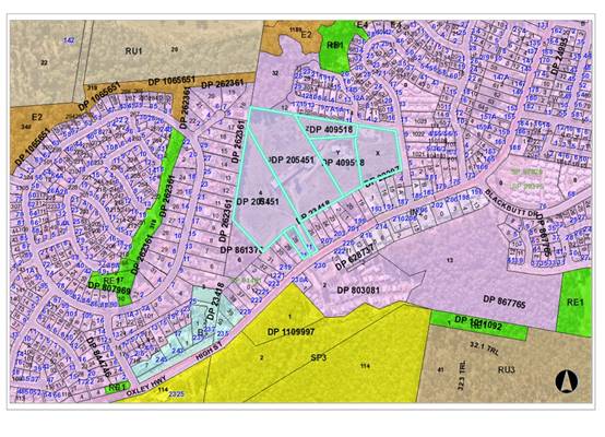
The existing subdivision pattern and location of existing
development within the locality is shown in the following aerial photograph:
2. DESCRIPTION OF
DEVELOPMENT
Development consent for DA1991 - 485 was originally granted
on 18 February 1992 by Hastings Municipal Council and permitted residential
subdivision containing 82 lots, plus a public reserve. A copy of the approved
subdivision plan is included below.
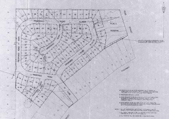
Key aspects of the proposed modification include the
following:
· Changes
to road and lot layout, including a new road connection to Leaders Way.
· Reduction in minimum lot size.
· Introduction of staging:
o Stage 1 - 1 lot, plus residue;
o Stage 2 - 25 lots, plus residue;
o Stage 3 - 33 lots, plus residue;
o Stage 4 - 24 lots.
· Payment of a monetary contribution in lieu of dedication of
a public reserve.
· Removal of Lot 28 DP 23418 and Lot X DP 409518 from the
development.
· Modification to conditions of consent.
Refer
to Attachment 2 at the end of this report for plans of the proposed
development.
Application Chronology
· 1
April 2019 - Application lodged.
· 5 April 2019 to 18 April 2019 - Neighbour notification.
· 17 May 2019 - Applicant response to submissions received.
· 20 May 2019 - Sewer Strategy received.
· 7 June 2019 - Additional information requested from
Applicant.
· 11 June 2019 - Comments and conditions from NSW Rural Fire
Service received.
· 28 June 2019 - Comments from NSW Roads and Maritime
Services received.
· 20 September 2019 - Additional information submitted by Applicant.
· 15 October 2019 - Further comments from NSW Roads and
Maritime Services received.
· 26 November 2019 - Amended plans received.
· 2 December 2019 - Additional stormwater modelling received.
3. STATUTORY ASSESSMENT
Section 4.55(2)(a) Is the proposal substantially the same?
Section 96 (now Section 4.55)
has been described as “beneficial and facultative” in Houlton v Woollahra
Municipal Council (1997) 95 LGERA 201 at [213] and North Sydney
Council v Michael Standley & Associates Pty Ltd (1998) 97
LGERA 433 at [440]. Accordingly, the provisions of s 96 (4.55)
should not be artificially constrained by allowing a narrow construction.
In Vasic Pty
Ltd v Penrith City Council [1992] NSWLEC 8, Stein J held
that "substantially" meant "essentially all material or having
the same essence."
In Moto Projects (No 2)
Pty Ltd v North Sydney Council (1999) 106 LGERA 298 at [56]
Bignold J held that the task for determining whether a development as
proposed to be modified is substantially the same as the consent granted was as
follows:
"The
comparative task does not merely involve a comparison of the physical features
or components of the development as currently approved and modified where that
comparative exercise is undertaken in some type of sterile vacuum. Rather, the
comparison involves an appreciation, qualitative, as well as quantitative, of
the developments being compared in their proper contexts (including the
circumstances in which the development consent was granted)."
In the context of the current
application, the proposal can be considered to be substantially the same as the
development to which consent was originally granted for the following reasons:
· The modified development occupies substantially the same
footprint as the subdivision originally granted consent.
· The modified development would not result in any increase
in the overall number of lots approved for the original development
· The modified proposal remains as a subdivision for the
purpose of residential uses and is consistent with the essence of the original
development.
· The impacts of the modified development, including the
extent of vegetation clearing, earthworks, demolition, and remediation of land
remain similar to the approved development.
· The modified development would not create any increased
demand on public infrastructure or services compared with the original approved
development.
· The payment of a monetary contribution for any shortfall in
land dedicated for the purpose of public reserve is envisaged in the conditions
of the original consent.
Section
4.55(2)(b) Are there any condition(s) of consent imposed by a Minister,
government or public authority that require modification?
The consent does not include any
conditions imposed by a public authority. However, further consultation has
been carried out with the NSW Rural Fire
Service and NSW Roads and Maritime Services in relation to the modified
proposal.
Section
4.55(2)(c) Does the application require notification/advertising in accordance
with the regulations and/or any Development Control Plan?
Neighbour
notification has been undertaken in accordance with the regulations and Council’s
DCP.
Section 4.55(2)(d) Any submissions made concerning the
modification
Three (3) written submissions were received following public
exhibition of the application. Copies of the written submissions have been
provided separately to members of the DAP.
Key issues raised in the submissions received and comment
are provided in the table below:
|
Submission Issue/Summary
|
Planning Comment/Response
|
|
Oppose deletion/modification of condition 3 of the
consent, which restricts minimum lot size to 600m2. Studies have
shown that smaller lot sizes result in congestion, pollution, road safety
issues, pressure on infrastructure, devaluation of adjoining properties,
impact on wildlife or trees, character and design, insufficient landscaping
or recreational areas, and general lack of amenity.
|
Since the consent was originally granted, the planning
controls for the area have changed and the land is now subject to a minimum
lot size of 450m2. The LEP zone objectives for the R1 General
Residential zone include providing for a variety of housing types and
densities, and the proposal in consistent with this objective.
The impacts of the development, including traffic
impacts, infrastructure servicing, environmental impacts, and amenity have
been considered in the assessment of the application and considered capable
of being appropriately managed.
|
|
Request confirmation that Council will enforce compliance
with issues such as noise pollution, dust accumulation and working hours.
|
Condition
22 of the current consent includes a requirement for erosion and sediment
control during the construction phase. It is recommended that this condition
be expanded to cover standard construction site management, including the
issues noted in the submission. The condition would be enforceable by
Council’s Compliance staff.
|
|
Tree removal/lopping in this desirable area should be
kept to a minimum and with Council and resident approval.
|
A tree
removal plan has been approved by Council under the existing consent, and the
majority of tree removal completed.
|
|
It is understood that payment of a contribution for
reserves will be made. Request for plan of public reserves, play areas,
landscaping and tree planting to be provided, including details of the timing
of works.
|
The contribution referred to in the current conditions of
consent were levied under an earlier contributions scheme and do not relate
to any of the scheduled works in the current Open Space Contributions Plan.
The funds received could therefore be spent on projects deemed to be of
broader benefit to residents in the locality.
The timing of works will depend upon the progress of the
subdivision, as the contributions will be collected in stages, based on the
number of lots released.
There is also an option for the developer to make an
offer to Council for works as material public benefit to be carried out as an
offset to the development contributions.
|
|
Loss of property values for adjoining properties.
|
Case
law has confirmed that loss of property value is not a relevant matter for
consideration in the assessment of a development application.
|
|
Adjoining properties to the south along High Street slope
towards the site and have no formal drainage. What is proposed to be
implemented within the subdivision to manage stormwater runoff from these
properties?
|
The
application proposes interallotment drainage servicing the lots along High
Street.
|
|
The proposal is not substantially the same as the
development that was originally granted consent for the following reasons:
· Average lot size reduced from 600m2 to 500m2,
which will increase housing density and associated noise and traffic impacts.
· While the development does not include addition lots, it
will result in an increase in the number of dwellings.
· Potential future commercial developments on Lot 101 and
Lot X have not been disclosed or considered in the application.
· A bio-retention basin has been added to the application,
which will result in additional tree removal and health risks associated with
vermin and mosquitos.
· Additional street access to Leaders Way and significant
realignment of all the roads within the subdivision.
· Removal/deletion of proposed public reserve.
· Significant changes to the staging of the development.
· Removal of various restrictions stated in the original
consent including but not limited to 88B instruments.
A new development application should be required.
|
See comments earlier in this report for reasons that the
development can be considered to be substantially the same as the original
development having regard to relevant case law.
The Section 4.55 application provides for the consent
authority to consider the relevant impacts of the modified development in the
same way that they would be considered under a new development application.
|
|
The proposed bio-retention basin will increase the bush
fire hazard to buildings recently constructed at No. 5 Kookaburra Place,
Wauchope. The buildings were constructed on the assumption that the site
would be cleared residential lots. The submitted bushfire assessment notes
that the basin would have vegetation similar to grassland.
|
The existing site adjoining the eastern boundary of No. 5
Kookaburra Place is currently grassland and would remain as such if the
development does not proceed. A bio-retention basin has the same
specification as grassland would therefore not increase the risk to the
buildings on No. 5 Kookaburra Place compared with the current situation.
The bushfire assessment submitted with DA2017 - 999.2 for
the construction of a new shed at No. 5 Kookaburra Place did not identify the
neighbouring land as being ‘managed land’ and there are no
easements in place for the maintenance of an asset protection zone on Lot 3
DP 205451 for the purpose of protecting the shed. As part of the assessment
of DA2017 - 999.2 the NSW Rural Fire Service agreed to an alternative
solution and allowed the shed to be constructed with no BAL rating on the
basis that it is separated by more than 6m from the dwelling.
The NSW Rural Fire Service has also reviewed the bushfire
assessment for the modified proposal and did not raise any concern regarding
impacts on neighbouring property.
|
Section
4.55(3) Any matters referred to in section 4.15 (1) relevant to the
modification, and the reasons given by the consent authority for the grant of
the consent sought to be modified.
(a) The provisions (where
applicable) of:
(i) Any Environmental
Planning Instrument
State Environmental Planning Policy No. 44 - Koala Habitat
Protection
With reference to clauses 6 and 7, the subject land is
greater than 1 hectare (including any adjoining land under same ownership) and
therefore the provisions of SEPP must be considered.
The land has been cleared in accordance with the original
development consent and does not contain the required composition of Schedule 2
food trees to be considered potential koala habitat. No further consideration
of the SEPP is required.
State Environmental Planning Policy No. 55 –
Remediation of Land
The site was previously used as a plywood factory that was
developed post World War 2 (late 1940’s to early 1950’s) and
operated through until approximately the early 1980’s. The previous land
use is a potentially contaminating activity in accordance with the Contaminated
Land Planning Guidelines.
The original assessment of the application did not included
detailed consideration of potential land contamination, but the consent
currently includes the following conditions relating to the investigation and
remediation of the site:
4. The submission of
a report prepared in consultation with and endorsed by the State Pollution
Control Commission indicating that the land is not contaminated by any chemical
residue or any other substances as a result of previous activities on the site.
8. Completion of any
remedial works necessary to comply with condition 4.
Legislation regarding the management of contaminated land
has changed since the original consent was granted, and it is now necessary to
consider the provisions in Clause 7 of SEPP 55.
The Applicant has submitted a Stage 2 Site Contamination
Assessment prepared by Regional Geotechnical Solutions and dated 20 August
2019. The investigations revealed concentrations of chemicals of concern
(including asbestos, lead, hydrocarbons, nickel, copper and formaldehyde)
exceeding the adopted health investigation criteria for a Residential A site in
several locations.
The report concludes that the site is able to be made
suitable for the proposed residential use, subject to appropriate remediation
of the contaminated parts of the site. A Remediation Action Plan (RAP) will be
required to be submitted prior to remediation commencing, and a Validation
Report will be required to be submitted to Council prior to the issue of the
first Subdivision Certificate.
It is recommended that conditions 4 and 8 of the consent be
modified accordingly.
State Environmental Planning Policy (Infrastructure) 2007
Clause 104 - The application has been referred to the NSW
Roads and Maritime Service (RMS).
The RMS advice and other matters requiring consideration
under clause 104(3)(b)(ii) and (iii) are considered in the assessment of
access, traffic and parking impacts later in this report.
Hastings Local Environmental Plan 1987
At the time of determination of the original
development application the Hastings Local Environmental Plan 1987 (LEP)
applied. The subject site was zoned 2(v) Village under the LEP and the original
development was considered to be consistent with the LEP provisions.
Clause 26 required a minimum lot size of 450m2
for the erection of a dwelling.
For comparison the proposal has also been assessed
against the provisions of the current Port Macquarie-Hastings Local
Environmental Plan 2011 below.
Port Macquarie-Hastings Local Environmental Plan
2011
The proposal is consistent with the LEP having regard to
the following:
· Clause 2.2 - The subject site is zoned R1 General
Residential.
The objectives of the R1 zone are as follows:
o To provide for the housing needs of the community.
o To provide for a variety of housing types and
densities.
o To enable other land uses that provide facilities
or services to meet the day to day needs of residents.
· Clause 2.3(2) - The proposal is consistent with the zone
objectives having regard to the following:
o The proposal would provide lots for a variety of housing
types and densities to meet the needs of the community.
· Clause 2.7 - The demolition of the former mill buildings
requires consent as it does not fit within the provisions of SEPP (Exempt and
Complying Development Codes) 2008.
· Clause 4.1 - The lot sizes within the proposed subdivision
range from 500.9m2 to 1799.9m2. All proposed lots comply
with the minimum lot size of 450m2 identified in the Lot Size Map
relating to the site. In accordance with subclause (3A), the lot sizes have
been calculated excluding the area of the battleaxe handle for proposed Lots
203 and 309.
· Clause 5.10 – The site does not contain or adjoin any
mapped heritage items or sites of significance.
· Clause 7.13 - satisfactory arrangements are in place for
provision of essential services including water supply, electricity supply,
sewer infrastructure, stormwater drainage and suitable road access to service
the overall development. Provision of electricity will be subject to obtaining
satisfactory arrangements certification prior to the issue of a Subdivision
Certificate as recommended by a condition of consent.
Stage 1 of the development proposes to create 2
lots that will not be connected to sewer infrastructure, or stormwater
drainage. Access to one of the lots is proposed via a right of access. The
Applicant has provided evidence of a contractual arrangement to connect all
relevant services following registration of the plan of subdivision, and
easements are proposed to ensure that both lots will have the legal right to
access and construct such services. Both lots are also of sufficient area to
accommodate on-site wastewater management. On this basis, it is considered that
satisfactory arrangements are in place for essential services to the Stage 1
development.
(ii) Any
draft instruments that apply to the site or are on exhibition
No draft
instruments apply to the site.
(iii) Any
Development Control Plan in force
Hastings
Development Control Plan No. 17 - Subdivision Code
This DCP applied at the time of the determination of the
original development application. The original assessment report did not
include a detailed analysis of the DCP controls and addressed compliance
through the conditions of consent.
The modified proposal remains generally consistent with the
provisions of DCP No. 17, with the exception of provision 4.2.1, which required
lots in residential zones to have a minimum lot size of 600m2 and a
minimum width of 19m. Condition 3 of the original development consent confirmed
this requirement. The modification application seeks to vary this DCP provision
(and delete the consent condition) on the basis that the modified proposal is
consistent with the provisions of the current DCP 2013.
A detailed analysis of the current DCP provisions is
included below, and it is recommended that the variation to DCP No. 17 be
supported on this basis.
Port
Macquarie-Hastings Development Control Plan 2013
|
DCP 2013: Chapter 3.6 -
Subdivision
|
|
DCP Objective
|
Development Provisions
|
Proposed
|
Complies
|
|
3.6.3.1
|
A site analysis is required for all development and shall
illustrate:
· microclimate;
· lot dimensions;
· north point;
· existing contours and levels to AHD;
· flood affected areas;
· overland flow patterns, drainage and services;
· any contaminated soils or filled areas, or areas of
unstable land;
· easements and/or connections for drainage and utility
services;
· identification of any existing trees and other
significant vegetation;
· any existing buildings and other structures, including
their setback distances;
· heritage and archaeological features;
· fences;
· existing and proposed road network, including
connectivity and access for all adjoining land parcels;
· pedestrian and vehicle access;
· views to and from the site;
· overshadowing by neighbouring structures; and
· any other notable features or characteristics of the site.
|
Adequate site analysis provided
with subdivision plan.
|
Yes
|
|
3.6.3.2
|
Torrens title lots minimum width
of 15m when measured at a distance of 5.5m from front property boundary.
|
Lots 223, 310-321 less than 15m
wide at a distance of 5.5m
Lots 310 - 321 include minor
variations (14.7m to 14.8m wide), which are not likely to affect the ability
for the lots to accommodate a future dwelling.
Lot 223 is a wedge-shaped lot
and is approximately 10m wide at 5.5m from the front boundary. The lot widens
to 15m wide at a setback of approximately 14m from the front boundary. The
lot provides for a suitable building envelope for a future dwelling.
|
No, but acceptable
|
|
Minimum width of 7m when
boundaries are extended to kerb line.
|
All proposed lots comply with
this requirement.
|
Yes
|
|
Minimum depth of 25m.
|
All proposed lots comply with
minimum depth requirement.
|
Yes
|
|
For lots where average slope of
the site is equal to, or exceeds 16%, indicative road and driveway grades are
required demonstrating satisfactory access.
|
No proposed lots exceed 16%
grade.
|
N/A
|
|
Subdivision of dual occupancy
development or multi dwelling housing where permissible in the LEP may create
allotments smaller than 450m2 if:
· Each lot to be created is part of a community or strata
title scheme, or
· Is part of an integrated Torrens title housing
development.
|
N/A
|
N/A
|
|
3.6.3.3
|
Battleaxe lots discouraged in
greenfield development.
|
The proposal includes 2
battleaxe lots, which is consistent with the number of battleaxe lots in the
original approval.
|
No, but acceptable
|
|
3.6.3.4
|
Lots are to be designed to allow
the construction of a dwelling, which does not involve more than 1m cut, or
fill, measured from natural ground level, outside the dwellings external
walls.
|
The site is gently sloping and
the lots are not likely to require substantial cut or fill for future
dwellings.
|
Yes
|
|
Lot sizes increased for sloping
sites in accordance with Table 3.6.1.
|
All proposed lots are Slope
Category A and comply with the minimum lot size and dimensions.
|
Yes
|
|
Additional information provided
for slope categories in accordance with Table 3.6.2.
|
Satisfactory information
submitted.
|
Yes
|
|
3.6.3.5
|
Wherever possible orientate
streets to maximise the number of east, west and south facing lots and to
minimise the number of narrow north facing lots.
Residential street blocks should
preferably be orientated north-south with dimensions generally
limited to 60-80m by 120-150m as
illustrated in Figure 3.6-2.
|
Road and lot layout considered
generally satisfactory having regard to the original approved subdivision.
|
Yes
|
|
Lot size and shape are to
reflect orientation to ensure future dwelling construction has optimal
opportunity for passive solar design.
|
Lot sizes and shapes are
suitable for future passive solar design.
|
Yes
|
|
3.6.3.6
|
Kerb and guttering, associated
street drainage, pavement construction and foot paving across the
street frontages should be
constructed as part of the subdivision works where these do not exist (may be
varied subject to criteria in this clause)
|
Conditions require such work.
|
Yes
|
|
3.6.3.20
|
Water supply to meet
Council’s design specifications.
|
See comments under Water Supply
Connection
|
Yes
|
|
3.6.3.21
|
All lots connected to reclaimed
water if available.
|
Not available.
|
N/A
|
|
3.6.3.24
|
Separate sewer junction provided
for each lot.
|
See comments under Sewer
Connection
|
Yes
|
|
3.6.3.27
|
Erosion and sediment control
plan to be provided.
|
Condition recommended requiring
erosion and sediment control plan.
|
Yes
|
|
3.6.3.34
|
All service infrastructure
should be underground unless otherwise approved by Council.
|
Condition recommended requiring
confirmation of satisfactory arrangements from relevant authorities.
|
Yes
|
|
All service infrastructure
should be installed in a common trench.
|
|
Conduits for the main technology
network system should be provided in all streets.
|
|
Conduits are to be installed in
accordance with the National Broadband Network Company Limited’s
‘Guidelines for Fibre
to the Premises Underground Deployment’.
|
|
Access pits are to be installed
at appropriate intervals along all streets.
|
|
3.6.3.51
|
Street trees should be provided
along all road frontages generally at a rate of 1 per 20m interval.
|
Condition recommended requiring
street trees to Council’s standards.
|
Yes
|
|
Street trees should not affect
solar access.
|
|
3.6.3.52
|
Street trees from
Council’s list.
|
|
DCP 2013: General
Provisions
|
|
DCP Objective
|
Development Provisions
|
Proposed
|
Complies
|
|
2.7.2.2
|
Design addresses generic
principles of Crime Prevention Through Environmental Design guideline:
· Casual surveillance and sightlines
· Land use mix and activity generators
· Definition of use and ownership
· Lighting
· Way finding
· Predictable routes and entrapment locations
|
The proposed development will be unlikely to create any
concealment/entrapment areas or crime spots that would result in any
identifiable loss of safety or reduction of security in the immediate
area. The subdivision and road layout will provide for dwellings that
overlook public spaces.
|
Yes
|
|
2.3.3.8 onwards
|
Removal of hollow bearing trees
|
Existing consent permits
clearing of all existing trees on the site. No additional clearing is
proposed as part of the modified development.
|
Yes
|
|
2.6.3.1
|
Tree removal (3m or higher with
100mm diameter trunk and 3m outside dwelling footprint
|
Existing consent permits
clearing of all existing trees on the site. No additional clearing is
proposed as part of the modified development.
|
Yes
|
|
2.4.3
|
Bushfire risk, Acid sulphate
soils, Flooding, Contamination, Airspace protection, Noise and Stormwater
|
Refer to main body of report.
|
|
|
2.5.3.2
|
New accesses not permitted from
arterial or distributor roads. Existing accesses rationalised or removed
where practical
|
The previously approved
subdivision provided for access via a single access road from the Oxley
Highway. The modified proposal includes a second road connection to Leaders
Way on the northern side of the site and is considered an improved access
arrangement.
|
Yes
|
|
2.5.3.11
|
Section 94 contributions
|
Refer to main body of report.
|
|
Based on the
above assessment, the variations proposed to the provisions of the DCP are
considered acceptable and the relevant objectives have been satisfied.
Cumulatively, the variations do not amount to an adverse impact or a
significance that would justify refusal of the application.
(iiia) Any
planning agreement that has been entered into under section 7.4, or any draft
planning agreement that a developer has offered to enter into under section 7.4
No planning
agreement has been offered or entered into relating to the site.
(iv) Any matters prescribed by the
Regulations
Clause
92 - Demolition of buildings (AS 2601)
Demolition of
all the existing buildings on the site has been approved under the existing
consent. It is recommended that the existing conditions of consent be modified
to require demolition to comply with the Australian Standard and relevant
practices relating to the management of asbestos.
(b) The
likely impacts of that development, including environmental impacts on both the
natural and built environments, social and economic impacts in the locality:
Roads
The site has road frontage to High Street and Leaders Way.
High Street is an RMS classified road under the care and
control of RMS. High Street is an Arterial, with a road formation width of
approximately 12m within a road reserve width of approximately 21m. There is
parallel parking available both sides of the road. The road includes SA kerb
and gutter, with 1.2m wide footpath along part of the southern side of the
road.
Leaders Way is a relatively new local road under the care
and control of Council. Leaders Way has a road formation width of approximately
6.5 - 7m within a road reserve width of approximately 15m. The road includes SE
kerb and gutter.
Traffic and Transport
The application includes a Traffic Impact Assessment from
SECA Solution dated 13 September 2019. The study addressed the combined
residential development with the aged housing. Findings of the study
determined:
“From the site work
completed and the above assessment, the additional traffic generated by the
residential subdivision and proposed residential aged care facility will have a
minimal and acceptable impact upon the surrounding road network with no change
to the existing level of service or operation of High Street, or its
intersection with Pead Street.
Whilst no turn treatments are
proposed at the intersection of High Street / Pead Street or the new access off
High Street, given the low speed environment, adequate sight lines on each
approach, consistency with other intersections along this corridor and no
history of rear end crashes involving right turning vehicles slowing or
stopping within the through lanes on High Street, it is concluded that these
are not required on road safety or capacity grounds.”
Council staff noted that the report did not examine the
warrants of intersection treatments adequately. A comparison of the traffic
consultant’s assessment and the staff assessment in included below:
Traffic Counts:
|
SECA Traffic Counts (two-way flow)
|
Council Traffic Counts (two-way flow)
|
|
Peak Hour Traffic =714vph morning
730 vph evening
|
8500AADT (Year 2016)
Using 1.5% growth the
AADT for 2019 = 8888AADT
Peak Hour Traffic = 1155vph
(i.e. 13% of AADT according to AUSTROADS)
|
Traffic Generated from Development:
|
SECA
|
Council (RMS Guide to Traffic Generating
Development)
|
|
Residential
0.71 vph (vehicles per hour) AM peak
0.78 vph (vehicles per hour) PM Peak
7.4 vpd (vehicles per dwelling)
Original DA = 82 lots (traffic generated
from development)
· Peak Traffic
82 x 0.78 = 63.96 vph, and
· Daily Traffic
82 x 7.4 = 606.8 vpd
|
Residential
0.71 vph (vehicles per hour) AM peak
0.78 vph (vehicles per hour) PM Peak
7.4 vpd (vehicles per dwelling)
Original DA = 82 lots (traffic generated
from development)
· Peak Traffic
82 x 0.78 = 63.96 vph, and
· Daily Traffic
82 x 7.4 = 606.8 vpd
|
The SECA report has assessed the turning movements into and
out of the development as follows, assuming 100% traffic through the new road
off High Street. Refer to Figure 5 below:
Assessing the SECA traffic counts of 714vph morning / 730vph
evening, with the turn movements into and out of the development (Figure 5
above) the warrants for turn treatments can be assessed. The left and right
turn movement were assessed using the information below:
|
|
SECA
|
COUNCIL
|
|
2019
|
730vph
|
8888 AADT (i.e. 8500 x 1.5% growth factor)
|
|
2029
|
981vph
|
10315 AADT (assuming 1.5% growth factor)
|
|
Peak Hour 2029 (approx.. 10% AADT with a 50:50 split)
|
981vph
|
1340vph (i.e. 13% of AADT according to AUSTROADS)
|
The warrants for intersection treatments are therefore:
|
QM right turn
|
= QT1 + QT2
= 981vph SECA (Green line)
= 1340 vph Council (RED line)
|
|
QL
|
=12vph
|
|
QR
|
=36vph
|
|
QT2
|
= 302vph SECA
= 670vph Council (50:50 split in the traffic)
|
Transposing the details onto Figure A10: Warrants for
turn treatments on the major road at un-signalised intersections Austroads Part
4, it is clear that the development requires turn treatments; a channelised
right turn and an auxiliary left turn treatment on High Street, refer to the
diagram below (SECA Green and Council Red).
The warrants for this development indicate that a CHR
(agreement between SECA report and Council) and an AUL (according to Council
traffic counts) are required on High Street to manage the traffic generated by
the development. Given that Council traffic counts are taken over a longer
period of time, they are more representative of the actual traffic on the road.
On this basis, the application is recommended to be conditioned for both a CHR
and an AUL(s) intersection treatment. Detailed plans will be required to be
submitted for assessment. These works shall require a Works Authorisation Deed
(WAD) with RMS.
Refer to recommended conditions of consent.
Roads and Maritime Services (RMS)
Consistent with RMS requirements, the proposal was referred
to the RMS on 2/04/2019. RMS’ review of the proposal determined:
· The proposed
modification will amend the subdivision layout, including the configuration of
lots and internal roads, with no increase in the approved number of allotments.
The amendment is not an enlargement or extension of the development pursuant to
Clause 104 of the ISEPP, however it is noted that the approved subdivision is
of a scale considered to be traffic generating development. Whilst the
development has commenced, it has been 28 years since the approval was granted
and it is recommended that Council take into consideration any potential
traffic safety, road congestion or parking implications of the development
under current and future conditions.
· It is
understood that the design of internal roads will be consistent with
Council’s Subdivision Code. We note that connection of Road 1 to the
Oxley Highway will require approval under Section 138 of the Roads Act for
works within the Oxley Highway road reserve. Roads and Maritime will require
the Developer to enter into a Works Authorisation Deed (WAD) to obtain approval
of the detailed design and construction of these works.
· The proposed
amendments to the approved subdivision include a secondary access connection to
Pead Street, which generates changes in the distribution of trips generated by
the subdivision. It is recognised that trips via the Pead Street and Oxley
Highway intersection are likely to be a small proportion of overall development
traffic, and are likely to contribute a small minor increase in peak hourly
movements at the intersection. The majority of traffic generated by the
approved subdivision will access the Oxley Highway via Road No.1 and future
dwellings will be reliant on this connection.
· Roads and Maritime
support Council’s proposal to include a condition clarifying the required
scope of treatment at the Oxley Highway and Road No. 1 intersection, having
regard for the likely opening and future traffic volumes at the intersection.
The assessment of recent traffic count data identifies that a channelised
right-turn (CHR) and an auxiliary left-turn (AUL) treatments are warranted in
accordance with the Austroads Guidelines. The installation of this treatment
will require suitable pavement in the existing parking lanes to carry through
traffic movements, sufficient storage length for vehicles turning during peak
periods and all associated lighting, signage and delineation. The design will
need to have consideration for existing driveway accesses and changes to
on-street parking. We understand that development is to provide connectivity
for active and public transport users. We recommend the intersection design
incorporate a suitable pedestrian refuge linking footpaths to public transport
services travelling in both directions along the Oxley Highway.
· For all works
required in the Oxley Highway road reserve, the Developer will be required to
enter into a Works Authorisation Deed (WAD) with Roads and Maritime prior to
the issue of any Civil Construction Certificate. All works under the WAD are to
be completed to the satisfaction of Roads and Maritime. Written advice from
Roads and Maritime of practical completion of all works under the WAD is to be
provided to Council prior to issue of any Subdivision Certificate. All works under
the WAD are to be designed and constructed in accordance with current Austroads
Guidelines, Australian Standards and Roads and Maritimes Supplements. The
Developer will be responsible for all costs associated with the works and
administration for the WAD. It is recommended that developers familiarise
themselves with the requirements of the WAD process. Further information
can be accessed using the following link: http://www.rms.nsw.gov.au/projects/planning-principles/index.html
Site Frontage & Access
There are two proposed accesses to the site, via High Street
and Leaders Way, both of which are serviced by proposed Road 1. This main road
runs generally north-south through the development site with a number of local
internal roads branching off this road. The minimum width of this pavement to
permit 2-way traffic flow, and parking to the residential side would be 9m
wide.
In accordance with bushfire requirements, the local roads
need to comply with Planning for Bush Fire Protection 2006, which stipulates a
minimum 8m wide road.
|
Road Name
|
Pavement / Reserve Width
|
Road Standard
|
|
Road 1
|
9/16m
|
Local
|
|
Road 2
|
8/16m
|
Local
|
|
Road 3
|
7/15m
|
Local
|
|
Road 4
|
8/16m
|
Local
|
|
Road 5
|
7/15m
|
Local
|
High Street is a Roads and Maritime Services (RMS)
classified road and will require a Works Authorisation Deed (WAD) from the RMS
prior to works on this road. Details shall be provided as part of a Roads
Act (Section 138) application to Council.
Due to the type and size of development, additional works
are required to include:
· Footpath paving
providing connection to local bus stops in High Street.
· concrete footpath paving
(minimum 1.2m wide) along Leaders Way to provide connection to the existing
footpath on Pead Street, including pram ramps.
Refer to recommended conditions of consent.
Water Supply Connection
Condition 27 of the current consent requires provision of
reticulated water supply to each lot within the proposed subdivision. A
conceptual water supply strategy has been submitted with the modified proposal,
which includes extension of water mains from the existing mains in High Street
and Leaders Way. The strategy is acceptable in principle to Council’s
Water & Sewer Section.
Detailed water reticulation plans will be required to be
submitted for assessment with the Section 68 / Subdivision Works Certificate
application for each stage of the development.
Refer to recommended conditions of consent.
Sewer Connection
Condition 28 of the current consent requires provision of
sewerage to each lot within the proposed subdivision. A sewer strategy has been
submitted with the modified proposal, which includes extension of sewer mains
from the existing sewer pump station in Leaders Way. The strategy is acceptable
in principle to Council’s Water & Sewer Section.
Detailed sewer reticulation plans will be required to be
submitted for assessment with the Section 68 / Subdivision Works Certificate
application for each stage of the development. Refer to recommended conditions
of consent.
Stage 1 of the development proposes a boundary adjustment
and consolidation of the four existing lots to create two lots having areas of
2.195 hectares and 5.284 hectares. The modified proposal does not include
connection of sewer to the two lots, but proposes the creation of an easement
to drain sewage, which would allow either lot to be connected to sewer in the
future if the subsequent stages of the development do not proceed.
Council’s Environmental Health Officers are satisfied that both lots have
sufficient area to accommodate an on-site wastewater management system for a single
dwelling.
It is recommended that condition 28 of the consent be
modified to clarify that sewer connection is not require for Stage 1 of the
development.
Stormwater
The site naturally grades towards the northwest and is
currently un-serviced by a formal point of discharge. In this regard,
stormwater runoff from the current undeveloped site would likely discharge as
sheet flow across the width of the northern property boundary, with existing
adjoining fence lines concentrating a portion of this flow to the vegetated
reserve downstream of the northwest corner of the site.
The original development application (DA1991 - 485) did not
include any details of the proposed stormwater servicing strategy for the
development; however the site topography would dictate that a strategy similar
to that employed by the current modification would have been required to manage
stormwater runoff from the site, in that the site and internal roads/flowpaths
all naturally grade to the northwest corner of the site.
In particular, the development proposes to construct a new
stormwater drainage basin in the northwest corner of the development lot. This
basin serves to perform two functions, being to manage the risks associated
with water quality and the quantity of stormwater discharge from the site.
Concept plans have been provided indicating that all road drainage and lot
drainage is directed to this proposed basin. All lots are proposed to be
provided with a direct connection to the piped system.
A stormwater model (prepared using the DRAINS software
program) has been prepared by the applicant in support of the sizing of the
proposed stormwater detention basin and demonstrates that the basin
conceptually has capacity to limit peak post development stormwater flows to
rates less than pre-development. Furthermore, a conceptual water quality model
has also been prepared (using MUSIC) to demonstrate that the quality of
stormwater discharge from the development site achieves compliance with
Council’s AUSPEC specifications.
Detailed review of these models has revealed that the volume
and rate of discharge from the proposed stormwater basin had potential to
inundate a portion of the road reserve downstream of the site in Whipcrack
Terrace and a small portion of an adjoining lot (Lot12 DP 1228142). When made
aware of these concerns, the Applicant prepared a 2D model of the overland
flowpath from the proposed stormwater basin utilising the HEC-RAS software
program, which confirmed that the development and basin discharge had potential
to inundate the downstream road reserve and private property as feared. It is
noted, however, that this flowpath is existing and the rate of discharge from
the basin is less than pre-development rates, indicating that the identified
flooding is an existing previously un-identified downstream issue.
Following identification of this downstream issue, the
Applicant undertook further modelling to identify options to mitigate the risks
associated with flooding downstream of the site. In this regard, an updated
model has demonstrated that a low earthen berm (40m in length and max 500mm in
height) can conceptually function to restrict proposed stormwater discharges to
the existing vegetated reserve located downstream of the site. Council’s
Senior Stormwater Engineer has inspected the location of the proposed berm and
confirms that this is a feasible solution that can be readily accommodated
within the existing road reserve area at this location, subject to detailed
design.
A detailed site stormwater management plan and updated
stormwater models will be required to be submitted for assessment with the
application for a Subdivision Works Certificate.
Refer to recommended conditions of consent.
Other Utilities
Telecommunication and electricity services are available to
the site. Evidence of satisfactory arrangements with the relevant utility
authorities for provision to each proposed lot will be required prior to
Subdivision Certificate approval.
Heritage
No known items of Aboriginal or European heritage
significance exist on the property.
At the time of the original Development Application the site
was identified in a Draft Heritage LEP as being of potential heritage
significance. The assessment at the time determined that the land was unlikely
to be of a significance that would warrant listing of the site as a heritage
item. However, to ensure that the historical importance of the mill and its
relationship with rainforest logging in the region was recorded, a condition of
consent was imposed requiring archival recording of the buildings prior to
their demolition by an Industrial Archaeologist.
The Applicant has requested that the wording of the
condition be broadened to allow for the archival work to be carried out by an
appropriately qualified Heritage Consultant, and that the number of hard copies
required to be submitted is reduced.
Council’s Heritage Advisor has reviewed the modified
proposal and provided the following comments:
“It is agreed that it is
possible that a suitable Heritage Consultant could provide a suitable Archival
Record of the site.
The need for copies should be
as follows – one (1) hard copy to be provided for inclusion in the Local
Studies section of the Port Macquarie Library and an electronic copy provided
in PDF format be provided either on DVD or USB storage device. Photos accompanying
the report should be referenced by number on an accurate key plan of the site
and be provided in a TIFF format.”
The condition of consent is recommended to be modified
accordingly.
Other land resources
The site is within an established urban context and will not
sterilise any significant mineral or agricultural resource.
Water cycle
The proposed development will be unlikely to have any
adverse impacts on water resources and the water cycle.
Soils
The proposed development will be unlikely to have any
adverse impacts on soils in terms of quality, erosion, stability and/or
productivity subject to a standard condition requiring erosion and sediment
controls to be in place prior to and during construction.
Air and microclimate
The construction and/or operations of the proposed
development will be unlikely to result in any adverse impacts on the existing
air quality or result in any pollution. Standard precautionary site management
condition recommended.
Flora and fauna
The modified proposal does not include any significant
additional clearing to that authorised by the original consent.
In accordance with Clause 30A(2)(c) of the Biodiversity
Conservation (Savings and Transitional) Regulation 2017, a
biodiversity development assessment report is not required to be submitted if
the consent authority is satisfied that the modification will not increase the
impact on biodiversity values. As the majority of clearing authorised by the
original consent has been completed, and the extent of vegetation removal for
the sewer extension is to the minimum extent necessary to comply with the
existing conditions of consent, it is considered that there would be no
increase in impact.
Waste
Satisfactory arrangements are in place for proposed storage
and collection of waste and recyclables.
Contaminated waste and asbestos containing material will
need to be appropriately managed on site and disposed of at an appropriately
licenced waste facility, and conditions have been recommended confirming this
requirement.
Energy
The proposed subdivision layout would provide for a range of
lots that are suitable for the construction of future energy efficient
buildings.
Noise and vibration
The approved subdivision included a landscaped acoustic
mound along the rear of adjoining light industrial uses in High Street as part
of the public reserve. The modified proposal does not include the landscaped
acoustic mound or the buffer that was originally provided by the public
reserve.
The Applicant has submitted acoustic advice prepared by
Matrix Thornton Consulting Engineers. The advice confirms that a similar
acoustic outcome could be provided by constructing a 1.8m high Colorbond steel
or timber lapped and capped fence on the boundary of the adjoining light
industrial land.
A condition is recommended requiring a suitable fence to be
constructed on the boundary between proposed Lot 101 and Lot 1 DP 1239847 prior
to the issue of the Stage 4 Subdivision Certificate.
Condition also recommended restricting construction to
standard construction hours.
Bushfire
At the time that the original development application was
determined, the land was not mapped as being bushfire prone. However,
subsequent changes to legislation and bushfire mapping have resulted in the
land now being identified as bushfire prone.
The applicant has submitted a bushfire report prepared by a
bushfire consultant. The report was forwarded to the NSW Rural Fire Service who
have provided recommended conditions. These conditions are recommended to be
incorporated into the modified consent.
Safety, security and crime prevention
The proposed development will be unlikely to create any
concealment/entrapment areas or crime spots that would result in any
identifiable loss of safety or reduction of security in the immediate area. The
subdivision and road layout will provide for dwellings that overlook public
spaces.
Social impacts in the locality
The modified proposal is unlikely to result in any
additional social impacts to the development originally granted consent.
Economic impact in the locality
Economic impacts of the modified proposal are expected to be
similar to the development originally granted consent.
Site design and internal design
The proposed development design satisfactorily responds to
the site attributes and will fit into the locality. No adverse impacts likely.
(c) The suitability of the site for
the development
The proposal
will fit into the locality and the site attributes are conducive to the
proposed development.
Site
constraints have been adequately addressed and appropriate conditions of
consent recommended.
(d) Any submissions made in
accordance with this Act or the Regulations
Three (3) written submissions were received following public
exhibition of the application. Copies of the written submissions have been
provided separately to members of the DAP.
Key issues raised in the submissions received are addressed
earlier n this report.
(e) The Public Interest
The proposed
development will be in the wider public interest with provision of appropriate
serviced land for future housing. The proposed development satisfies relevant
planning controls and is not expected to impact on the wider public interest.
The
development originally granted consent included dedication to Council of a
public reserve having an area of approximately 0.91 hectares. The modified
proposal includes removal of the proposed public reserve and payment of a
development contribution, as provided for in condition 30 of the original
consent.
In
determining an appropriate value for the contribution, consideration has been
given to a Valuation Report prepared by IPN Valuers submitted by the Applicant,
and a peer review prepared by First State Property Valuers Pty Ltd obtained by
Council staff.
Funds
collected from the development contributions will be able to be spent on works
that are of benefit to residents in the locality. While no works are scheduled
at this stage, it would be intended to prioritise improvements to public open
space access and/or facilities that would be in the broader public interest.
4. DEVELOPMENT
CONTRIBUTIONS APPLICABLE
· Development contributions will be required towards
augmentation of town water supply and sewerage system head works under Section
64 of the Local Government Act 1993.
· Development contributions will be required in accordance
with Section 7.11 of the Environmental Planning and Assessment Act 1979 towards
roads, open space, community cultural services, emergency services and
administration buildings.
·
Development contributions for public open space
have been calculated on the basis specified in condition 30 of the original
consent. The condition provides that the contribution is to be calculated as
the value, on the current land value as determined by the Valuer General at the
date of release of the linen plan for each stage of the subdivision, of the
deficiency assessed using a requirement of 3ha per 1,000 head of population generated
by the subdivision.
In determining an appropriate value for the
contribution, consideration has been given to a Valuation Report prepared by
IPN Valuers submitted by the Applicant, and a peer review prepared by First
State Property Valuers Pty Ltd obtained by Council staff.
The valuation report prepared by IPN Valuers
for the Applicant has been reviewed along with the assessed value of $35 per m2
(Page 22 & 23). The IPN value would equate to a monetary of
contribution of $4,200 per lot for the purposes of condition 30 of the consent.
The methodology used by IPN relies heavily on Valuer General assessments
for open space zoned land. The value of open space land is lower than could be
expected for residential zoned land. The IPN value has not been accepted.
Based on a peer review and advice from
Council’s valuer, a value of $49.50 per m2, which equates to a
contribution of $5,940 per lot is considered acceptable in the case that
condition 29 (requiring dedication of the public reserve) is removed from the
consent.
In order to provide clarity for the developer
and Council in the future, it is recommended that condition 30 be amended to
include the contribution amount per lot at the date of determination of the
modification application and to provide for indexation of the amount in
accordance with CPI movements.
·
· A copy of the contributions estimate is included as
Attachment 3.
·
5. CONCLUSION AND
STATEMENT OF REASON
The application has been assessed
in accordance with Section 4.55 of the Environmental Planning and Assessment
Act 1979.
Issues raised during assessment
and public exhibition of the application have been considered in the assessment
of the application. Where relevant, conditions have been recommended to manage
the impacts attributed to these issues.
The site is considered suitable
for the proposed development and the proposal adequately addresses relevant
planning controls. The development is not considered to be contrary to the
public's interest and will not result a significant adverse social,
environmental or economic impact. It is recommended that the application be
approved, subject to the recommended conditions of consent provided in the
attachment section of this report.
|
Attachments
1View. DA1991
- 485.2 Recommended Modification to Consent
2View. DA1991
- 485.2 Plans
3View. DA1991
- 485.2 Contributions Estimate
|
|
ATTACHMENT
|
Development Assessment Panel
11/12/2019
|

|
ATTACHMENT
|
Development Assessment Panel
11/12/2019
|
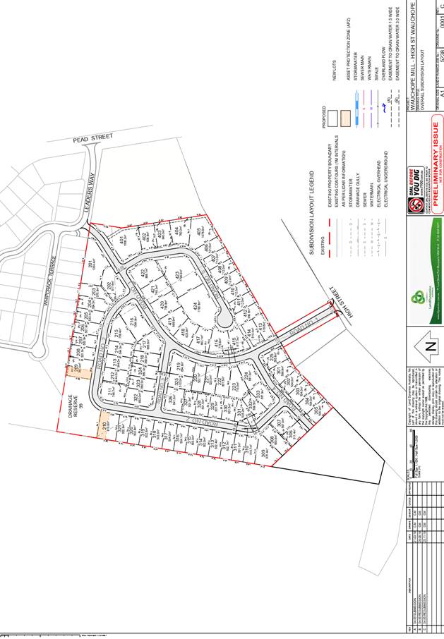
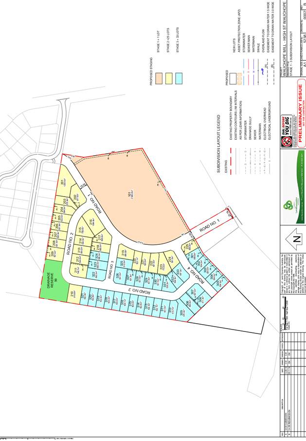
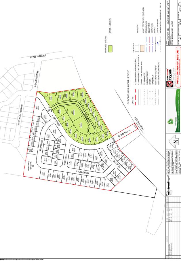
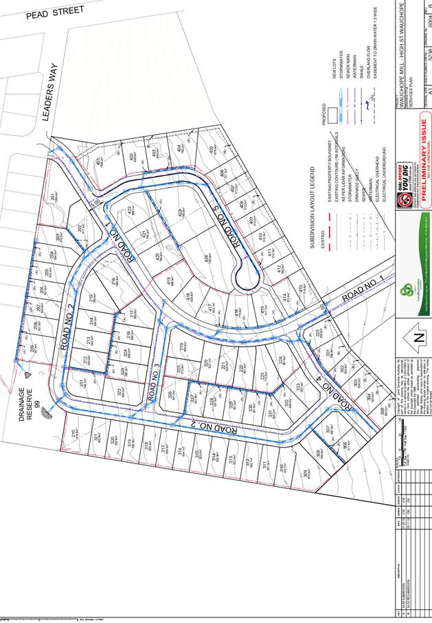
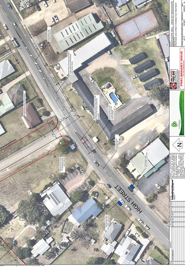
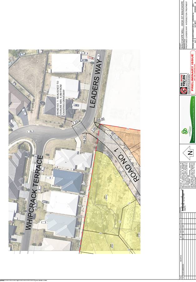
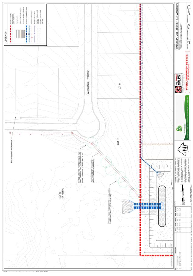
|
ATTACHMENT
|
Development Assessment Panel
11/12/2019
|
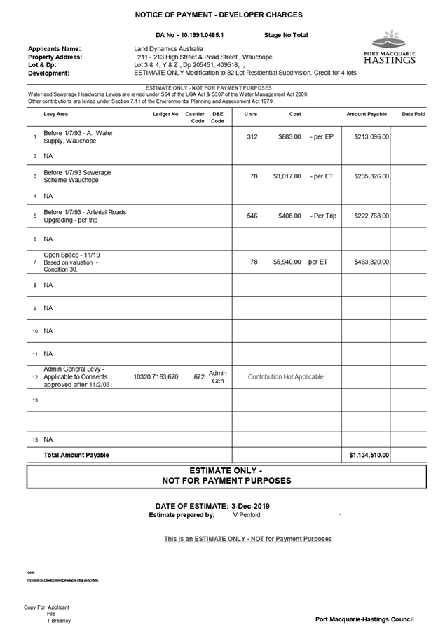
AGENDA Development Assessment Panel 11/12/2019
Item: 07
Subject: DA2019 - 651.1 Additional Dwelling to Create
Dual Occupancy and Strata Title at Lot 1 DP 570012,No. 6 Home Street, Port
Macquarie
Report
Author: Development Assessment Planner, Fiona Tierney
|
Applicant: J
& G MIDDLEBROOK
Owner: J
& G MIDDLEBROOK
Estimated Cost: $330,000
Alignment with Delivery
Program
4.3.1 Undertake transparent
and efficient development assessment in accordance with relevant legislation.
|
|
RECOMMENDATION
That
DA 2019 - 651 for an additional
dwelling to create a dual occupancy and strata title subdivision at Lot 1, DP 570012, No. 6 Home
Street, Port Macquarie, be determined by granting consent subject to the
recommended conditions.
|
Executive
Summary
This
report considers a development application for a dual occupancy and
strata title subdivision at the subject site and
provides an assessment of the application in accordance with the Environmental
Planning and Assessment Act 1979.
Following exhibition of the
application, one submission was received.
The site is considered suitable for the proposed development
and the proposal adequately addresses relevant planning controls. The
development is not considered to be contrary to the public's interest and will
not result a significant adverse social, environmental or economic impact.
This report recommends that the
development application be approved subject to the attached conditions
(Attachment 1).
1. BACKGROUND
Existing
Sites Features and Surrounding Development
The site has an area of 795.4m2.
The
site is zoned R1- General Residential in
accordance with the Port Macquarie-Hastings Local Environmental Plan 2011, as
shown in the following zoning plan:
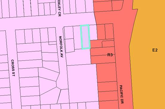 The existing subdivision pattern and location of existing
development within the locality is shown in the following aerial photograph:
The existing subdivision pattern and location of existing
development within the locality is shown in the following aerial photograph:
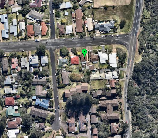
2. DESCRIPTION
OF DEVELOPMENT
Key
aspects of the proposal include the following:
· Construction
of an additional two storey dwelling in the rear yard
· Strata
title subdivision.
Refer
to Attachment 2 for plans of the proposed development.
Application
Chronology
· 12
September 2019 - Application lodged.
· 30 September -15 October 2019 - Neighbour notification
· 2 October 2019 - Additional information request. Profile
and Shadow diagrams.
· 6 November 2019 - Additional information received.
3. STATUTORY
ASSESSMENT
Section
4.15(1) Matters for Consideration
In
determining the application, Council is required to take into consideration the
following matters as are relevant to the development that apply to the land to
which the development application relates:
(a) The
provisions (where applicable) of:
(i) Any
Environmental Planning Instrument
State Environmental Planning Policy No. 44 - Koala
Habitat Protection
There is no Koala Plan of Management on the site.
Additionally, the site is less than 1ha in area therefore no further
investigations are required.
State Environmental Planning Policy No. 55 –
Remediation of Land
Following an inspection of the site and a search of Council
records, the subject land is not identified as being potentially contaminated
and is suitable for the intended use.
State Environmental Planning Policy (Coastal Management)
2018
The site is located within a coastal use area / coastal
environment area.
In accordance with Clause 7, this SEPP prevails over the
Port Macquarie-Hastings LEP 2011 in the event of any inconsistency.
Having regard to Clauses 13 and 14 of the SEPP the proposed
development is not considered likely to result in any of the following:
a) any
adverse impact on integrity and resilience of the biophysical,
hydrological (surface and groundwater) and ecological environment;
b) any
adverse impacts coastal environmental values and natural coastal
processes;
c) any
adverse impact on marine vegetation, native vegetation and fauna
and their habitats, undeveloped headlands and rock platforms;
d) any
adverse impact on Aboriginal cultural heritage, practices and
places;
e) any
adverse impacts on the cultural and built environment heritage;
f) any
adverse impacts the use of the surf zone;
g) any adverse impact on the visual amenity and scenic qualities of the
coast, including coastal headlands;
h) overshadowing, wind funnelling and the loss of views from public places
to foreshores;
i) any
adverse impacts on existing public open space and safe access to
and along the foreshore, beach, headland or rock platform for members of the
public, including persons with a disability.
In accordance with Clause 15 the proposal is not likely to
cause increased risk of coastal hazards on that land or other land.
The bulk, scale and size of the proposed development is compatible
with the surrounding coastal and built environment. The site is predominately
cleared and located within an area zoned for residential purposes.
State Environmental Planning Policy (Building
Sustainability Index: BASIX) 2004
A BASIX certificate has been submitted demonstrating that
the proposal will comply with the requirements of the SEPP. It is recommended
that a condition be imposed to ensure that the commitments are incorporated
into the development and certified at Occupation Certificate stage.
Port Macquarie-Hastings Local Environmental
Plan 2011
The proposal is consistent with the LEP having regard to the
following:
· Clause
2.2. The subject site is zoned R1 General Residential.
· Clause
2.3(1) and the R1 zone land use table. The (dwelling or ancillary structure to
a dwelling) is a permissible land use with consent. The objectives of the R1
zone are as follows:
o To provide for the
housing needs of the community.
o To provide for a
variety of housing types and densities.
o To enable other land
uses that provide facilities or services to meet the day to day needs of
residents.
· Clause
2.3(2). The proposal is consistent with the zone objectives as it is a
permissible land use and consistent with the established residential locality.
The proposal contributes to the range of housing options in the locality.
· Clause
4.3. The maximum overall height of the building above ground level (existing)
is 6.161m which complies with the standard height limit of 11.5m applying to
the site.
· Clause
4.4. The floor space ratio of the proposal is 0.3:1.0 which complies with the
maximum 0.65:1 floor space ratio applying to the site.
· Clause
4.6. Exceptions to development standards.
· Clause
5.10. The site does not contain or adjoin any known heritage items or sites of
significance.
· Clause
7.13. Satisfactory arrangements are in place for provision of essential
services including water supply, electricity supply, sewer infrastructure,
stormwater drainage and suitable road access to service the development.
(ii) Any draft
instruments that apply to the site or are on exhibition
No draft instruments apply to the site.
(iii) Any Development
Control Plan in force
Port
Macquarie-Hastings Development Control Plan 2013
|
DCP 2013: Dwellings, Dual
occupancies, Dwelling houses, Multi dwelling houses & Ancillary
development
|
|
|
Requirements
|
Proposed
|
Complies
|
|
3.2.2.1
|
Ancillary development:
• 4.8m max. height
• Single storey
• 60m2 max. area
• 100m2 for lots
>900m2
• 24 degree max.
roof pitch
• Not located in
front setback
|
Water tank is appropriately
located.
No other ancillary development
proposed.
|
Yes
|
|
3.2.2.2
|
Articulation zone:
• Min. 3m front
setback
• An entry feature
or portico
• A balcony, deck,
patio, pergola, terrace or verandah
• A window box
treatment
• A bay window or
similar feature
• An awning or other
feature over a window
• A sun shading
feature
|
No elements within the
articulation zone.
The dwelling is located at the rear of the site.
|
N/A
|
|
Front setback (Residential not R5
zone):
• Min. 6.0m
classified road
• Min. 4.5m local
road
• Min. 3.0m
secondary road
• Min. 2.0m Laneway
|
Front building line setback is
existing.
|
Existing
|
|
3.2.2.3
|
Garage 5.5m min. and 1m behind
front façade.
Garage door recessed behind
building line or eaves/overhangs provided
|
|
Yes
|
|
6m max. width of garage door/s
and 50% max. width of building
|
Width of garage door/s are
compliant with the maximum width requirements
|
Yes
|
|
Driveway crossover 1/3 max. of
site frontage and max. 5.0m width
|
Existing
|
Yes
|
|
3.2.2.4
|
4m min. rear setback. Variation
subject to site analysis and provision of private open space
|
4m.
|
Yes
|
|
3.2.2.5
|
Side setbacks:
• Ground floor =
min. 0.9m
• First floors &
above = min. 3m setback or where it can be demonstrated that overshadowing
not adverse = 0.9m min.
• Building wall set
in and out every 12m by 0.5m
|
The minimum side setback
requirements are complied with.
The building is setback 1.5m and
the applicant has demonstrated through shadow diagrams that overshadowing is
not adverse given the North/South orientation and existing shading from
fencing.
|
Yes
|
|
3.2.2.6
|
35m2 min. private open space area
including a useable 4x4m min. area which has 5% max. grade
|
The dwelling contains 35m² of open space in one area
including a useable 4m x 4m space.
|
Yes
|
|
3.2.2.7
|
Front fences:
• If solid 1.2m max
height and front setback 1.0m with landscaping
• 3x3m min. splay
for corner sites
• Fences >1.2m to
be 1.8m max. height for 50% or 6.0m max. length of street frontage with 25%
openings
• 0.9x0.9m splays
adjoining driveway entrances
|
No fences proposed
|
N/A
|
|
3.2.2.8
|
Front fences and walls to have
complimentary materials to context
No chain wire, solid timber,
masonry or solid steel front fences
|
N/A
|
|
|
3.2.2.10
|
Privacy:
• Direct views
between living areas of adjacent dwellings screened when within 9m radius of
any part of window of adjacent dwelling and within 12m of private open space
areas of adjacent dwellings. ie. 1.8m fence or privacy screening which has
25% max. openings and is permanently fixed
• Privacy screen
required if floor level > 1m height, window side/rear setback (other than
bedroom) is less than 3m and sill height less than 1.5m
• Privacy screens
provided to balconies/verandahs etc which have <3m side/rear setback and
floor level height >1m
|
The development will not compromise privacy in the area
due to a combination of lack of windows on side/rear boundaries, having high
sill windows that face side/rear boundaries, limiting living areas that face
adjoining living areas/open space, compliant separation and use of
screening/fencing. It is however recommended that the kitchen window
adjoining the eastern boundary be provided with a privacy screen as there is
potential for overlooking of private open space areas. An appropriate
condition is recommended.
|
Yes
|
|
DCP 2013: General
Provisions
|
|
|
Requirements
|
Proposed
|
Complies
|
|
2.7.2.2
|
Design addresses generic principles of Crime Prevention
Through Environmental Design guideline
|
No concealment or entrapment areas proposed. Adequate
casual surveillance available.
|
Yes
|
|
2.3.3.1
|
Cut and fill 1.0m max. 1m outside the perimeter of the
external building walls
|
Cut >1.0m change 1m outside the perimeter of the
external building walls. A 1.4m retaining wall ( Max 1.84m level change) is
proposed well inside boundaries to the south and east of the proposed
dwelling.
|
No- however considered acceptable, reduces impact to
adjoining properties.
|
|
2.3.3.2
|
1m max. height retaining walls along road frontage
|
None proposed
|
N/A
|
|
Any retaining wall >1.0 in height to be certified by
structure engineer
|
Condition recommended to require engineering certification
|
Yes
|
|
Combination of retaining wall and front fence height max
1.8m, max length 6.0m or 30% of frontage, fence component 25% transparent,
and splay at corners and adjacent to driveway
|
No retaining wall front fence combination proposed.
|
N/A
|
|
2.3.3.8
|
Removal of hollow bearing trees
|
No hollow bearing trees proposed to be removed
|
N/A
|
|
2.6.3.1
|
Tree removal (3m or higher with 100m diameter trunk at 1m
above ground level and 3m from external wall of existing dwelling)
|
A few small trees/bushes proposed to be removed and a
Mango tree.
|
Yes
|
|
2.4.3
|
Bushfire risk, Acid sulphate soils, Flooding,
Contamination, Airspace protection, Noise and Stormwater
|
Refer to main body of report.
|
|
|
2.5.3.2
|
New accesses not permitted from arterial or distributor
roads
|
No new access proposed to arterial or distribution road.
|
N/A
|
|
Driveway crossing/s minimal in number and width including
maximising street parking
|
There are 2 existing driveway crossings. The street is
very wide with low demand for on street parking.
|
Yes
|
|
2.5.3.3
|
Parking in accordance with Table 2.5.1.
1 space per single dwelling (behind building line)
|
1 or capacity for more than 1 parking space behind the
building line has been provided for.
|
Yes
|
|
2.5.3.11
|
Section 94 contributions
|
Refer to main body of report.
|
|
|
2.5.3.12 and 2.5.3.13
|
Landscaping of parking areas
|
Dual occupancy and strata only with 2 domestic driveways.
No specific landscaping requirements recommended.
|
N/A
|
|
2.5.3.14
|
Sealed driveway surfaces unless justified
|
Sealed driveway proposed
|
Yes
|
|
2.5.3.15 and 2.5.3.16
|
Driveway grades first 6m or ‘parking area’
shall be 5% grade with transitions of 2m length
|
Driveway grades capable of satisfying Council standard
driveway crossover requirements. Condition recommended for section 138 Roads
Act permit
|
Yes
|
|
2.5.3.17
|
Parking areas to be designed to avoid concentrations of
water runoff on the surface.
|
Stormwater drainage is capable of being managed as part of
plumbing construction.
|
Yes
|
|
|
|
|
|
|
The proposal seeks to vary Development Provision relating to
cut and fill.
The relevant objectives are:
· Minimise the
extent of site disturbance caused by excessive cut and fill to the site.
· Ensure there is no
damage or instability to adjoining properties caused by excavation or filling.
· Ensure there is no
adverse alteration to the drainage of adjoining properties.
· Ensure that the
privacy of the adjoining dwellings and private open space are protected.
· Ensure that
adequate stormwater drainage is provided around the perimeter of buildings and
that overflow paths are provided.
Having regard for the development provisions and relevant
objectives, the variation is considered acceptable for the following reasons:
· The retaining wall
is proposed at a maximum of 1.4m (1.84m maximum cut) and reduces along the
length of the site. A significant block retaining wall exists along the eastern
boundary with a boundary fence erected above.
· The cut is
proposed close to the external walls of the proposed dwelling and over 1.5m
from any side boundaries. The retaining wall is to be designed by a structural
engineer and surface inlet pit drainage is proposed.
· Council’s
engineer has recommended conditions to ensure the integrity of the sewer is
maintained.
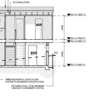
Based on the above assessment, the variation proposed to the
provisions of the DCP are considered acceptable and the relevant objectives
have been satisfied. The variation does not amount to an adverse impact of
significance that would justify refusal of the application.
(iiia) Any planning agreement that has
been entered into under section 7.4, or any draft planning agreement that a
developer has offered to enter into under section 7.4
No planning agreement has been offered or entered into
relating to the site.
(iv) Any
matters prescribed by the Regulations
New
South Wales Coastal Policy:
The proposed development is consistent with the objectives
and strategic actions of this policy.
(b) The likely
impacts of that development, including environmental impacts on both the
natural and built environments, social and economic impacts in the locality:
The proposal will not have any significant adverse impacts
on existing adjoining properties and satisfactorily addresses the public
domain.
The proposal is considered to be compatible with other
residential development in the locality and adequately addresses planning
controls for the area.
The proposal does not have a significant adverse impact on
existing view sharing.
The proposal does not have significant adverse lighting
impacts.
There are no significant adverse privacy impacts.
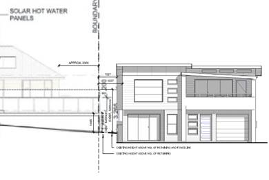
There are no significant adverse overshadowing impacts. The
proposal does not prevent adjoining properties from receiving 3 hours of
sunlight to private open space and primary living areas on 21 June.
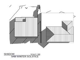
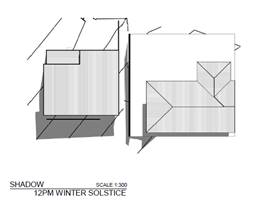
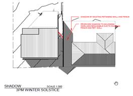
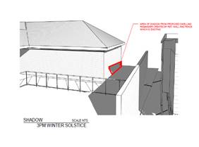
Access, Traffic and Transport
The proposal will not have any significant adverse impacts
in terms access, transport and traffic. The existing road network will
satisfactorily cater for any increase in traffic generation as a result of the
development.
Water Supply Connection
Service available – details required with S.68 application.
Sewer Connection
Service available – details required with S.68
application.
Stormwater
Service available – details required with S.68
application.
Other Utilities
Telecommunication and electricity services are available to
the site.
Heritage
This site does not contain or adjoin any known heritage item
or site of significance. The site is considered to be disturbed land.
Other land resources
The site is within an established urban context and will not
sterilise any significant mineral or agricultural resource.
Water cycle
The proposed development will not have any significant
adverse impacts on water resources and the water cycle.
Soils
The proposed development will not have any adverse impacts
on soils in terms of quality, erosion, stability and/or productivity subject to
a standard condition requiring erosion and sediment controls to be in place
prior to and during construction.
Air and microclimate
The construction and/or operations of the proposed
development will not result in any significant adverse impacts on the existing
air quality or result in any pollution. Standard precautionary site management
condition recommended.
Flora and fauna
Construction of the proposed development will not require
any removal/clearing of any native vegetation and therefore does not trigger
the biodiversity offsets scheme. Part 7 of the Biodiversity Conservation
Act 2016 is considered to be satisfied.
Waste
Satisfactory arrangements are in place for proposed storage
and collection of waste and recyclables. No adverse impacts anticipated.
Standard precautionary site management condition recommended.
Energy
The proposal includes measures to address energy efficiency
and will be required to comply with the requirements of BASIX.
Noise and vibration
The construction of the proposed development will not result
in any significant adverse impacts on the existing air quality or result in any
pollution. Standard precautionary site management condition recommended.
Bushfire
The site is identified as being bushfire prone.
The Applicant has submitted a bushfire report and the NSW
RFS have issued a Bushfire Safety Authority, which has been incorporated in the
recommended conditions of consent.
An assessment of bushfire risk having regard to section 4.3.5
of Planning for Bushfire Protection 2006 including vegetation classification
and slope concludes that a Bushfire Attack Level 12.5 shall be required.
Safety, security and crime prevention
The proposed development will be unlikely to create any
concealment/entrapment areas or crime spots that would result in any
identifiable loss of safety or reduction of security in the immediate area. The
increase in housing density will improve natural surveillance within the
locality and openings from each dwelling overlook common and private areas.
Social impacts in the locality
Given the nature of the proposed development and its
location the proposal is not considered to have any significant adverse social
impacts.
Economic impact in the locality
The proposal is not considered to have any significant
adverse economic impacts on the locality. A likely positive impact is that the
development will maintain employment in the construction industry, which will
lead to flow impacts such as expenditure in the area.
Site design and internal design
The proposed development design satisfactorily responds to
the site attributes and will fit into the locality.
Construction
Construction impacts are considered capable of being
managed, standard construction and site management conditions have been
recommended.
Cumulative impacts
The proposed development is not considered to have any
significant adverse cumulative impacts on the natural or built environment or
the social and economic attributes of the locality.
(c) The
suitability of the site for the development
The proposal will fit into the locality and the site
attributes are conducive to the proposed development.
Site constraints of bushfire have been adequately addressed
and appropriate conditions of consent recommended.
(d) Any
submissions made in accordance with this Act or the Regulations
One written
submission was received following public exhibition of the application. Copies
of the written submissions have been provided separately to members of the DAP.
Key
issues raised in the submissions received and comments are provided as follows:
|
Submission Issue/Summary
|
Planning Comment/Response
|
|
Height of building
|
The dwelling is a two storey
building that is significantly below (>5m) the 11.5m height limit
allowable under the LEP. The upper level of the neighbouring dwelling is well
above the roofline of the proposed dual occupancy.
|
|
Overshadowing
|
The applicant has submitted shadow diagrams that indicate
the additional shadowing as a result of the dwelling is minimal given the
existing fence and the proposed dwelling will be set well below the adjoining
building.
|
|
Loss of privacy
|
The upper level windows are highlight windows and the
applicant has agreed to install a louvre privacy screen to the kitchen
window.
|
|
Noise from rumpus room- request sound proofing to rumpus
room
|
The
proposed rumpus room is not proposed for any commercial or industrial use and
is not anticipated to result in undue noise issues. It is most appropriate to
deal with nuisance noise issues on a case by case basis when and if they
occur.
|
|
Request building be moved
|
The
siting of the building complies with the setback provisions of the DCP and
does not give rise to an unacceptable privacy or overshadowing impact.
|
(e) The
Public Interest
The proposed development
satisfies relevant planning controls and will not adversely impact on the wider
public interest.
4. DEVELOPMENT
CONTRIBUTIONS APPLICABLE
· Development contributions will be required towards
augmentation of town water supply and sewerage system head works under Section
64 of the Local Government Act 1993.
· Development contributions will be required in accordance with
Section 7.11 of the Environmental Planning and Assessment Act 1979 towards
roads, open space, community cultural services, emergency services and
administration buildings.
·
· A copy of the contributions estimate is included as
Attachment 3.
·
5. CONCLUSION
AND STATEMENT OF REASON
The application has been assessed
in accordance with Section 4.15 of the Environmental Planning and Assessment
Act 1979.
Issues raised during assessment
and public exhibition of the application have been considered in the assessment
of the application. Where relevant, conditions have been recommended to manage
the impacts attributed to these issues.
The site is considered suitable
for the proposed development and the proposal adequately addresses relevant
planning controls. The development is not considered to be contrary to the
public's interest and will not result a significant adverse social,
environmental or economic impact. It is recommended that the application be
approved, subject to the recommended conditions of consent provided in the
attachment section of this report.
|
Attachments
1View. DA2019
- 651.1 Recommended Conditions
2View. DA2019
- 651.1 Plans
3View. DA2019
- 651.1 Contributions Estimate
4View. DA2019
- 651 SOEE
|
|
ATTACHMENT
|
Development Assessment Panel
11/12/2019
|
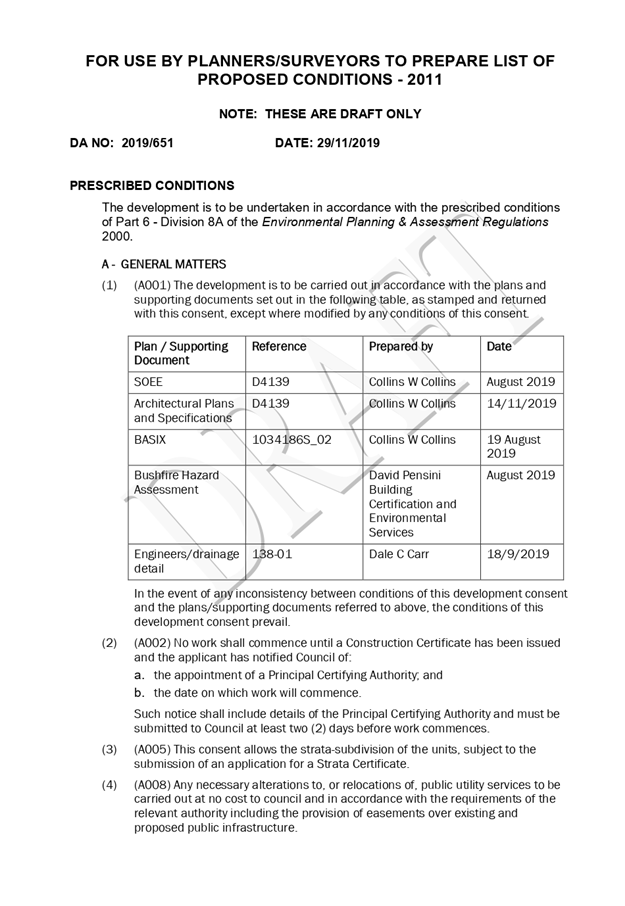
|
ATTACHMENT
|
Development Assessment Panel
11/12/2019
|
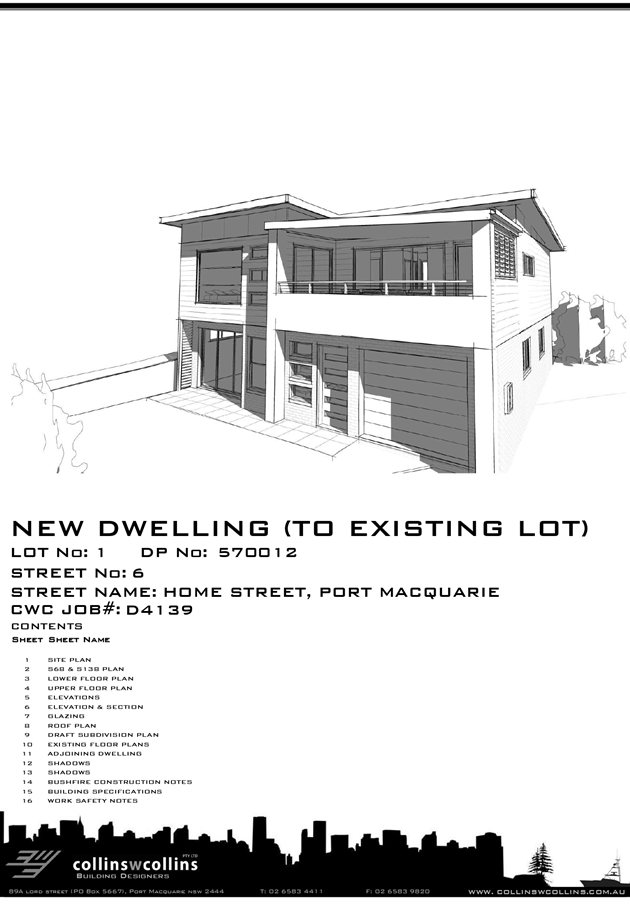
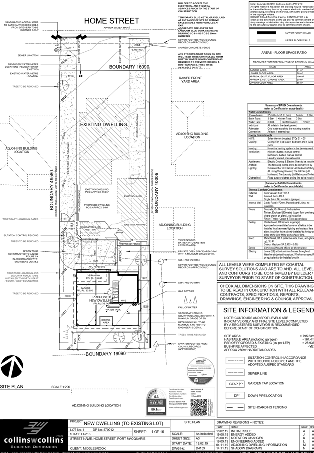
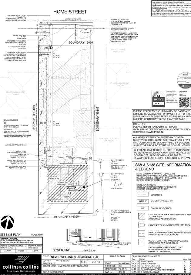
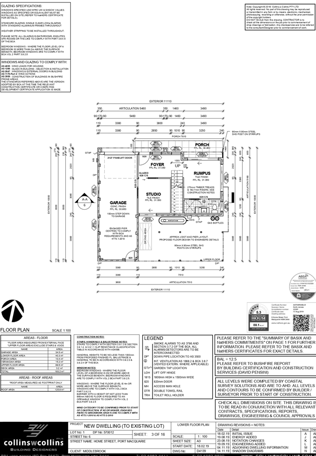
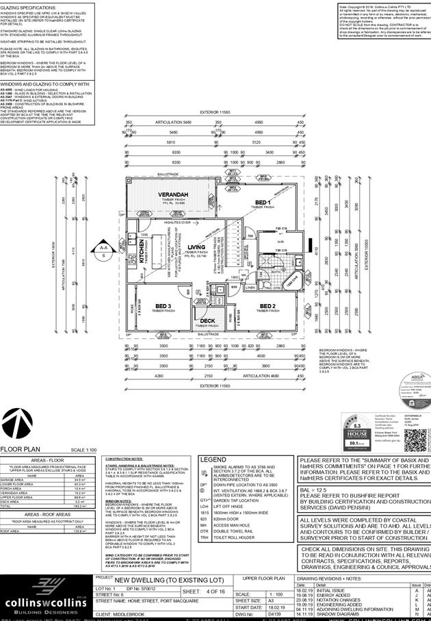
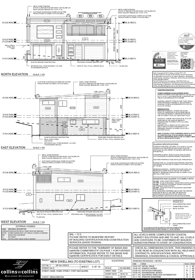
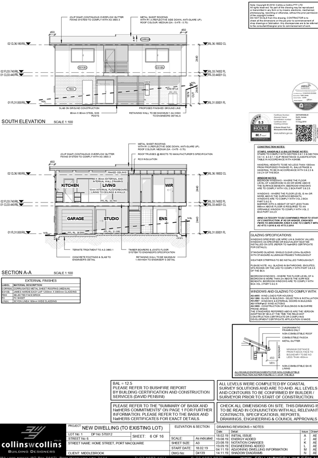
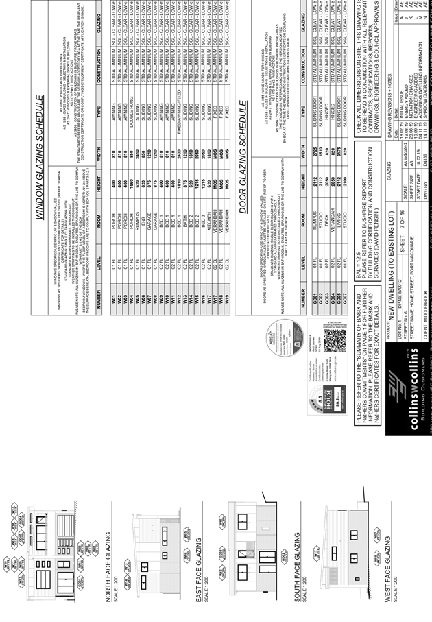
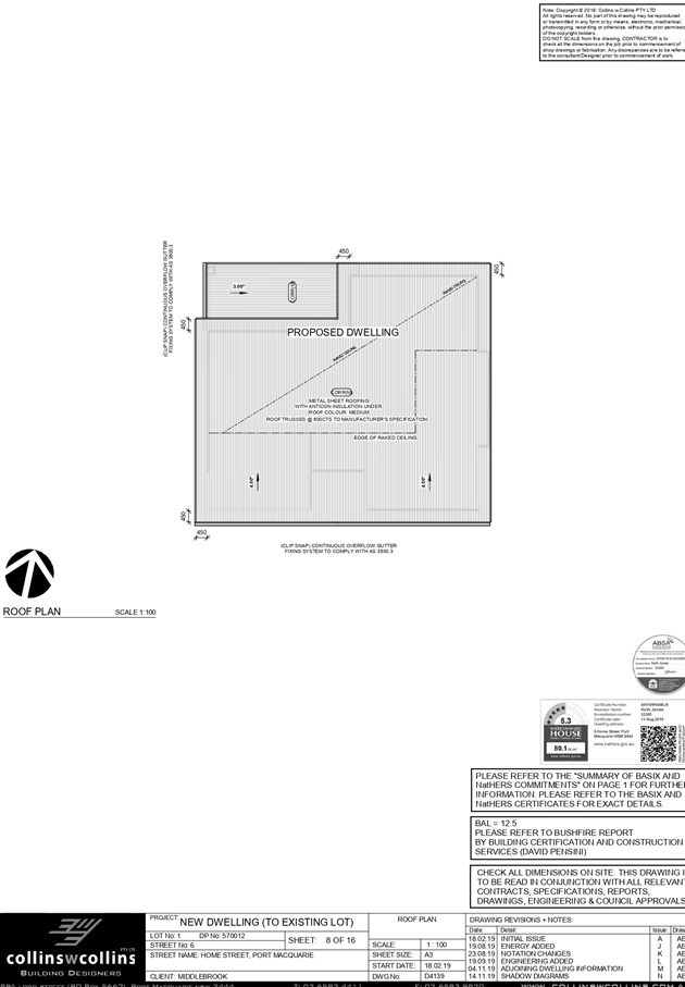
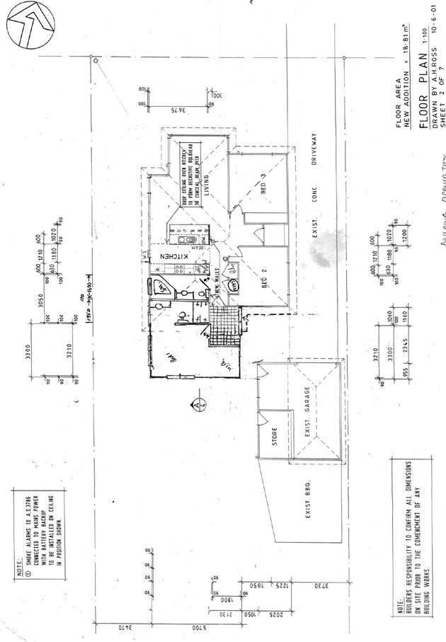
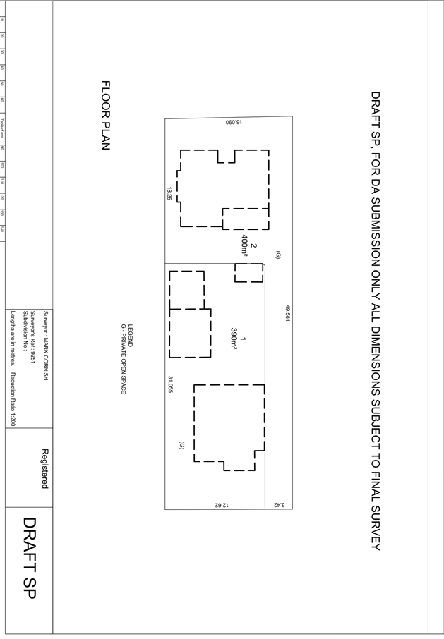
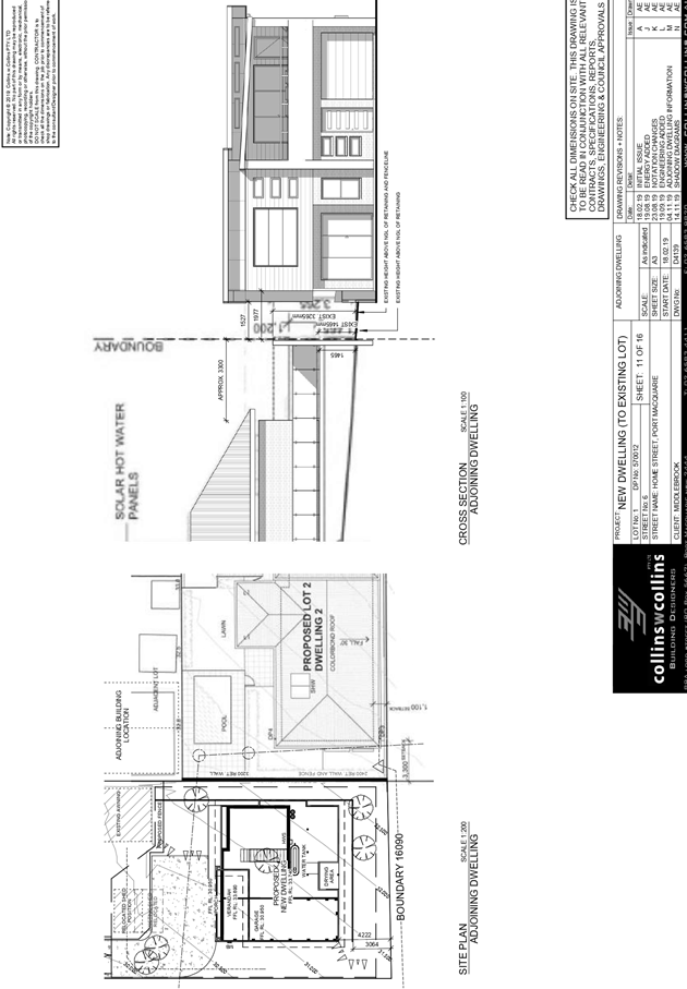
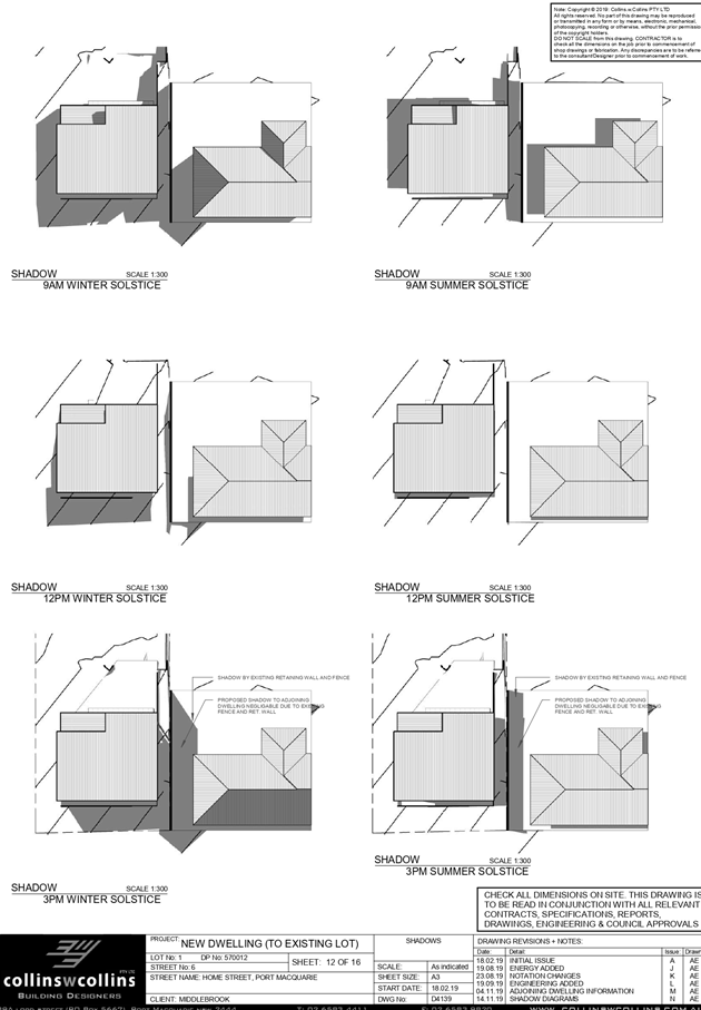
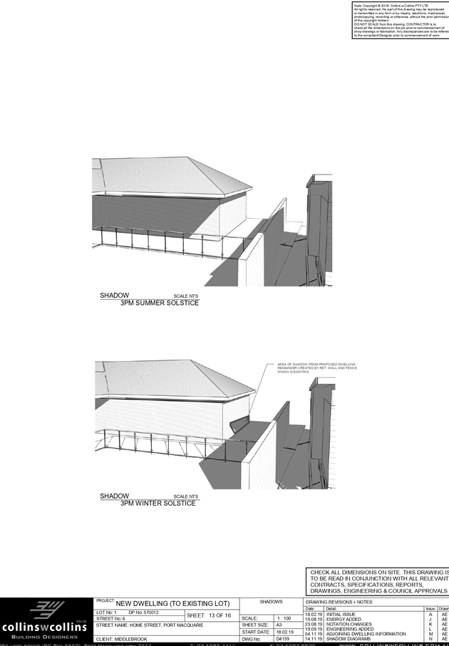
|
ATTACHMENT
|
Development Assessment Panel
11/12/2019
|
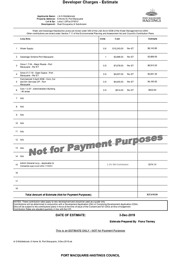
|
ATTACHMENT
|
Development Assessment Panel
11/12/2019
|

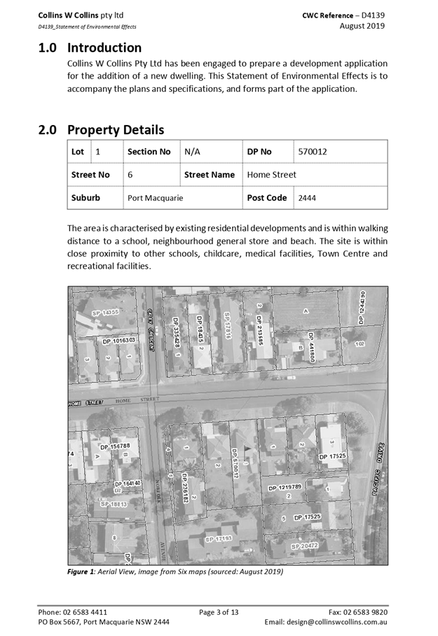
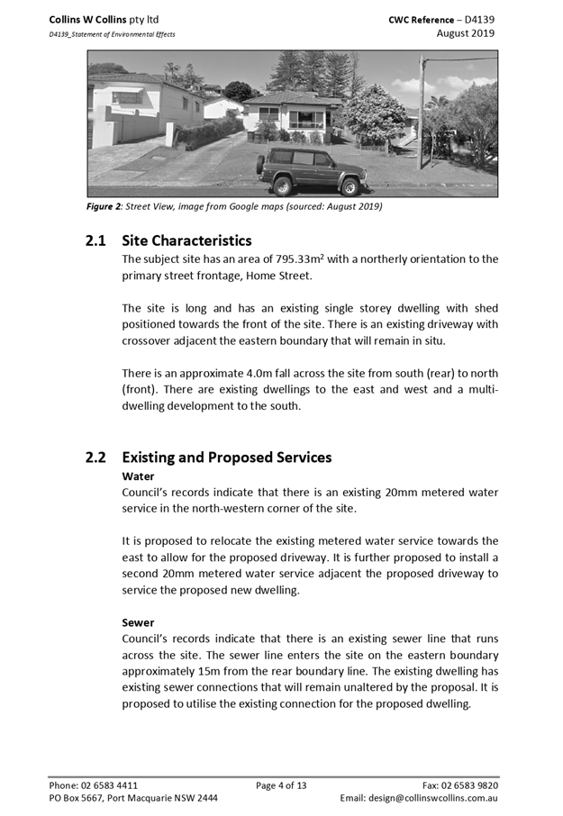
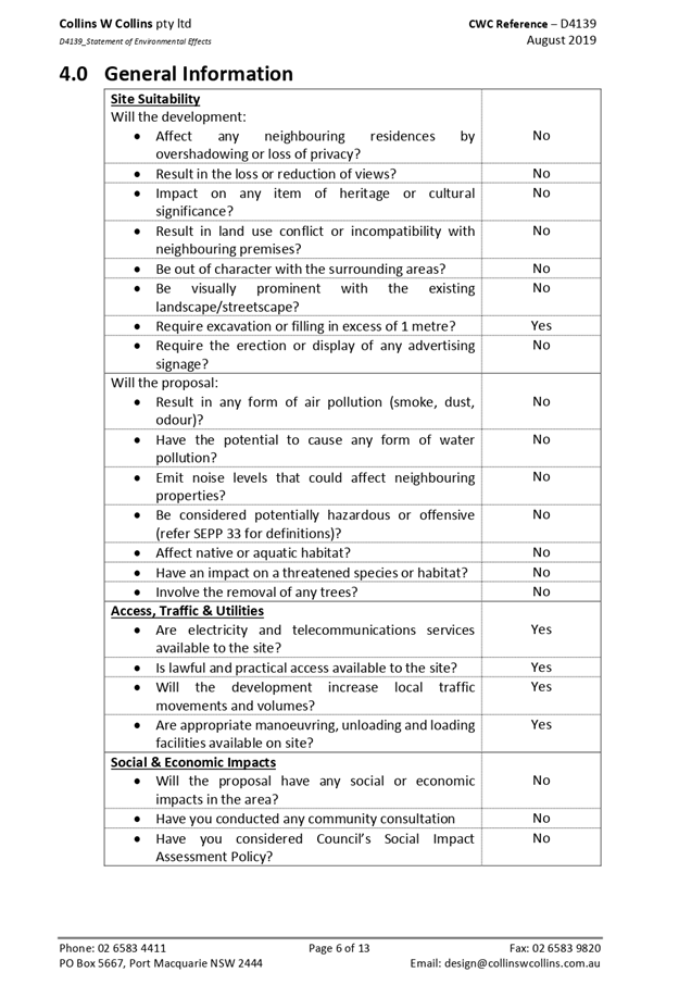
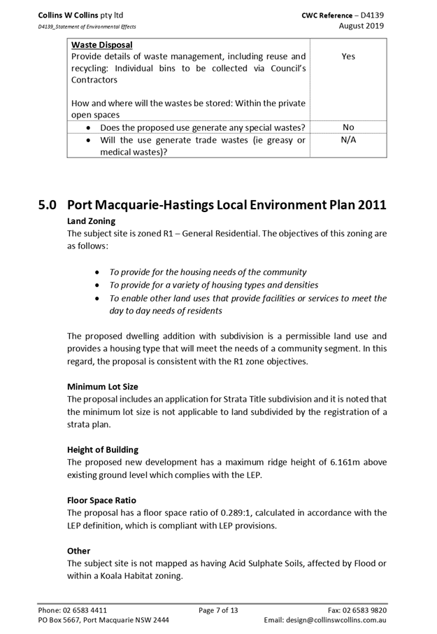
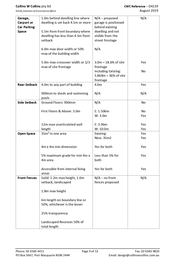
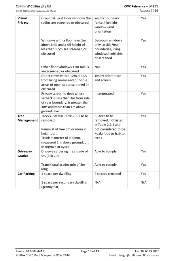
AGENDA Development Assessment Panel 11/12/2019
Item: 08
Subject: DA2019 - 324.1 Industrial Subdivision at Lot
21 DP 811254, Bago Road, Wauchope
Report
Author: Development Assessment Planner, Fiona Tierney
|
Applicant: HOPKINS
CONSULTANTS
Owner: KEMPSEY
TIMBERS (SAWMILLING) PTY LTD
Estimated Cost: $2,500,000
Alignment with Delivery
Program
4.3.1 Undertake transparent
and efficient development assessment in accordance with relevant legislation.
|
|
RECOMMENDATION
That
DA 2019 - 324 for an industrial
subdivision at Lot 21, DP 811254, Bago
Road, Wauchope, be determined by
granting consent subject to the recommended conditions.
|
Executive
Summary
This
report considers a development application for an industrial subdivision
at the subject site and provides an assessment of the
application in accordance with the Environmental Planning and Assessment Act
1979.
Following exhibition of the
application, four (4) submissions were
received.
The site is considered suitable for the proposed development
and the proposal adequately addresses relevant planning controls. The
development is not considered to be contrary to the public's interest and will
not result a significant adverse social, environmental or economic impact.
This report recommends that the
development application be approved subject to the attached conditions
(Attachment 1).
1. BACKGROUND
Existing
Sites Features and Surrounding Development
The site has an area of 8.097Ha.
The site is zoned IN1-General Industrial in accordance with the Port Macquarie-Hastings Local
Environmental Plan 2011, as shown in the following zoning plan:
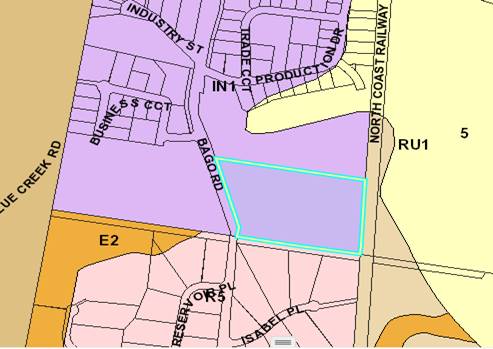
The existing subdivision pattern and location of existing
development within the locality is shown in the following aerial photograph:
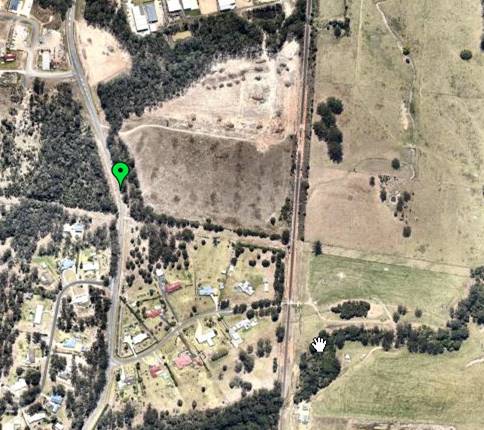
2. DESCRIPTION
OF DEVELOPMENT
Key
aspects of the proposal include the following:
· Staged
Industrial Subdivision- Stage 1- Lots 1-16, Stage 2- Lots 17-29, Stage 3- Lots
30-35, Stage 4- Lots 36-40.
· Construction
of acoustic wall southern boundary.
Refer
to Attachment 2 at the end of this report for plans of the proposed
development.
Application
Chronology
· 7
May 2019 - Application lodged.
· 16-29 May 2019 - Neighbour notification.
· 12 June 2019 - Response to submissions.
· 11 July 2019 - BDAR Review received NSW Planning, Industry
and Environment
· 15 July 2019 - Additional information noise barrier
requested.
· 2 August 2019 - Discounted offset request denied
· 11 September 2019 - Amended Traffic Impact Assessment
received - sight distances.
· 1 October 2019 - Amended fence detail received.
· 9 October 2019 - Amended BDAR response Hopkins.
3. STATUTORY
ASSESSMENT
Section
4.15(1) Matters for Consideration
In
determining the application, Council is required to take into consideration the
following matters as are relevant to the development that apply to the land to
which the development application relates:
(a) The
provisions (where applicable) of:
(i) Any
Environmental Planning Instrument
State Environmental Planning Policy No. 44 - Koala
Habitat Protection
In accordance with clauses 6 and 7,
the subject land
has
an area of more than
1 hectare in
size (including any adjoining
land under same ownership)
and therefore the provisions
of SEPP must be considered.
SEPP 44 defines “core
koala habitat”, as “an area of land with a resident
population of koalas, evidenced by attributes such as breeding females (that
is, females with young) and recent sightings of and historical records of a
population”.
A report prepared by
Biodiversity Australia has been submitted that identifies that the site
contains Tallowwood which is listed as a locally preferred Koala primary browse
tree. Tallowwoods comprise >15% of the canopy species on the site. As such
the site qualifies as Potential Koala Habitat and a Core Koala Habitat
Assessment was required.
The ecology report identifies
the site contains potential foraging resources for Koalas. A field survey
including scat searches, spotlighting and call playback were undertaken within
the site which failed to identify any evidence of Koalas or Koala scats. No
recent sightings or historical recordings were identified. The area is
therefore not defined as Core Koala Habitat.
State Environmental Planning Policy No. 55 – Remediation
of Land
Following an inspection of the site and a search of Council
records, the subject land is not identified as being potentially contaminated
and is suitable for the intended use.
State Environmental Planning Policy No. 62 –
Sustainable Aquaculture
Given the nature of the proposed development and proposed
stormwater controls the proposal will be unlikely to have any adverse impact on
existing aquaculture industries.
State
Environmental Planning Policy (Infrastructure) 2007
The application does not have frontage to a classified road
and does not trigger any relevant clauses under the SEPP.
Port Macquarie-Hastings Local Environmental
Plan 2011
The proposal is consistent with the LEP having regard to the
following:
· Clause
2.2. The subject site is zoned IN1-General Industrial.
· Clause
2.3(1) and the IN1 zone land use table.
The proposed development for a staged industrial subdivision is a permissible
land use with consent. The objectives of the IN1 zone are as follows:
o To provide a wide range of
industrial and warehouse land uses.
o To encourage employment
opportunities.
o To minimise any adverse effect
of industry on other land uses.
o To support and protect
industrial land for industrial uses.
o To enable other land uses that
provide facilities or services to meet the day to day needs of workers in the
area.
· Clause
2.3(2). The proposal is consistent with the zone objectives having regard to
the following:
o the proposal is a permissible
land use.
o the proposal will provide
additional land for industrial use and economic benefits to the community.
· Clause
4.1. The lot sizes within the proposed subdivision range from 1000m2 to 2130m2.
All proposed lots comply with the minimum lot sizes identified in the Lot Size
Map relating to the site.
· Clause
5.10. The site does not contain or adjoin any known heritage items or sites of
significance.
o the site does not contain any
known items of aboriginal or other cultural significance.
o appropriate conditions of consent
are proposed to manage the impact of the works.
· Clause
7.13. Satisfactory arrangements are in place for provision of essential
services including water supply, electricity supply, on-site sewage
management/sewer infrastructure, stormwater drainage and suitable road access
to service the development. Provision of electricity will be subject to
obtaining satisfactory arrangements certification prior to the issue of a
Subdivision Certificate as recommended by a condition of consent.
(ii) Any draft instruments
that apply to the site or are on exhibition
No draft instruments apply to the site.
(iii) Any Development
Control Plan in force
Port
Macquarie-Hastings Development Control Plan 2013
|
Chapter 3.6 Subdivision
|
|
Objective
|
Provisions
|
Comments
|
Complies
|
|
3.6.3.38
|
Any
industrial allotment created by Torrens title subdivision should satisfy the
following standards:
•
Comply with minimum subdivision requirements of clause 4.1 of LEP 2011.
•
Minimum width of 20m.
•
Minimum depth of 40m.
•
The depth to width ratio should not exceed 3 to 1.
|
Minimum subdivision lots and
sizes and dimensions generally complies with the requirements.
|
Variations considered acceptable.
|
|
Lots
are to be generally rectangular in shape and lot boundaries should have
regard to the landform and the character of the site.
|
Lots are generally rectangular in
shape and boundaries have regard to the landform and character of the site,
including existing access locations.
|
Yes
|
|
Battleaxe
allotments should not be permitted.
|
There are no battle-axe lots
proposed.
|
Yes
|
|
3.6.3.39
|
All
water and sewer services are to be constructed in accordance with
Council’s Aus-Spec design specifications.
Subsequent development of the
land may require the installation of a larger water service when the
potential water demand is known.
|
See comments later in this report
under Water Supply Connection.
|
|
|
Industrial
subdivision should not be supported on land with slope greater than 15%.
|
The slope of the lot is less than
15%.
|
Yes
|
|
3.6.3.40
|
Lots
are to front constructed, dedicated roads.
|
The lots will front a
constructed, dedicated road.
|
Yes
|
|
Street
layout and design should be in accordance with current Council’s
Aus-Spec design specifications.
|
|
Yes
|
|
Cul-de-Sacs
in industrial estates should not be approved unless a 5 metre wide laneway
with a minimum 4 metre wide carriageway is provided to a public road, to
permit through vehicular access.
|
N/A
|
N/A
|
|
DCP 2013: General Provisions
|
|
DCP Objective
|
Development Provisions
|
Proposed
|
Complies
|
|
2.7.2.2
|
Design addresses generic principles of Crime Prevention
Through Environmental Design guideline:
· Casual
surveillance and sightlines
· Land use mix and
activity generators
· Definition of
use and ownership
· Lighting
· Way finding
· Predictable
routes and entrapment locations
|
The proposed development will be
unlikely to create any concealment/entrapment areas or crime spots that would
result in any identifiable loss of safety or reduction of security in the
immediate area.
|
Yes
|
|
2.3.3.1
|
Cut and fill 1.0m max. 1m outside the perimeter of the
external building walls
|
The site may require up to 1.5m of cut to obtain suitable
levels.
|
No- however considered acceptable in industrial location
and well away from any other boundaries with suitable drainage proposed.
|
|
2.3.3.8 onwards
|
Removal of hollow bearing trees
|
The ecological assessment identifies that 2 hollow bearing
trees are present on site and the trees scored 10 & 11.5 in accordance
with the HBT assessment protocol. Both trees are identified within the
development footprint and so are impractical to retain. The Applicant has
proposed to provide 2 Glider nest boxes and 2 Microbat nest boxes within the
remaining buffer vegetation on the site.
Conditions requiring compliance with the recommendations
of the ecology report are recommended.
|
Yes
|
|
2.6.3.1
|
Tree removal (3m or higher with 100mm diameter trunk and
3m outside building footprint
|
The proposal includes removal of existing trees to
establish practical building envelopes for future development on each of the
lots. The tree removal includes 22 Koala food trees, all of which have DBH
> 150mm and are required to be offset in accordance with the DCP (2:1
ratio). Compliance with the biodiversity scheme is considered to justify
variation to the DCP.
Conditions are recommended confirming these requirements.
|
Variation considered acceptable noting conditions of
consent requiring compliance with biodiversity offset scheme.
|
|
2.4.3
|
Bushfire risk, Acid sulphate soils, Flooding,
Contamination, Airspace protection, Noise and Stormwater
|
Refer to main body of report.
|
|
|
2.5.3.2
|
New accesses not permitted from arterial or distributor
roads. Existing accesses rationalised or removed where practical
|
No excessive new accesses proposed.
|
Yes
|
|
2.5.3.11
|
Section 94 contributions
|
Refer to main body of report.
|
|
(iiia) Any planning agreement that has
been entered into under section 7.4, or any draft planning agreement that a
developer has offered to enter into under section 7.4
No planning agreement has been offered or entered into
relating to the site.
(iv) Any
matters prescribed by the Regulations
Not
applicable.
(b) The likely
impacts of that development, including environmental impacts on both the
natural and built environments, social and economic impacts in the locality:
The existing site has a general western street frontage
orientation to Bago Road.
Adjoining the site to the north and east are industrial
subdivisions.
Adjoining the site to the south is a rural residential
subdivision
Adjoining the site to the west is the north coast railway and
rural land.
The proposal will be unlikely to have any adverse impacts to
existing adjoining properties and satisfactorily addresses the public domain.
The proposal is considered to be consistent with other
development in the locality and adequately addresses planning controls for the
area.
There are no significant adverse privacy impacts.
Roads
The site has road frontage to Bago Road. Adjacent to the
site Bago Road is a sealed public road under the care and control of Council.
Bago road is a Sub-arterial road with a 6.5m road formation within a 25m road
reserve.
Traffic and Transport
The application includes a Traffic Impact Assessment from
Streetwise Road Safety & Traffic Services on 23/4/2019. Findings of
the study determined:
“This assessment has determined that Bago Road
and the local road network has the capacity to cater for the future traffic
volumes generated by the proposed industrial development, with safety,
efficiency and with minimal impacts. The following recommendations should be
considered to further improve road safety in the vicinity of the future
industrial development:
· Construct the proposed intersection
as prepared by Hopkins Consultants and
included in Appendix B of this
report. Ensure the layout caters for vehicles up
to and, including, semi-trailers.
Ensure the intersection is well delineated with
appropriate line-marking and
reflectors. Monitor the intersection regularly and
refresh line-marking regularly.
· Provide signage on Bago Road, at
both north and south approaches, to ensure drivers are aware of the upcoming
intersection.
· Bago Road should be monitored and
maintained regularly to ensure roadside
vegetation that may reduce sight
distance in the vicinity of the development is
removed or otherwise controlled.
· To maximise sight distance and
improve awareness of vehicles utilising the
future intersection, it is
recommended that:
1. The
grass and other vegetation on the opposite side of Bago Road be
removed or regularly
maintained
2. The
existing Bago Road be widened to include a minimum 1m wide sealed shoulder
3. Signage
be provided on Bago Road, on both approaches to the future
intersection, to warn
motorists of the upcoming intersection.
· Consideration should also be given
to reducing the current 80kmh speedzone
on Bago Road to 60 or 70kmh, to
reduce the sight distance requirements, but
also in regard to:
1. The
current alignment with multiple curves and undulations in the vicinity of the industrial
precinct
2. The
number of existing roadside hazards within the 80kmh clear-zone
3. The
number of intersections within the existing industrial precinct, particularly
the sub-standard intersection with King Creek Road
4. The
minimal width of Bago Road, and lack of edge-lines and other delineation.
In summary, StreetWise recommend that the proposed
industrial development
as being a suitable development, given that the number
of vehicle trips to be
generated by the development will not have a
significant impact on the efficiency
or safety of the local road network, and that the local
roads and intersections
have the
capacity to cater for the additional trips generated by the development.”
In this regard appropriate conditions have been included in
Attachment 1 to provide for the intersection line marking and signage. Roadside
vegetation will be managed by Councils Road Maintenance department and
scheduled with the rest of Bago Road. Speed limit reduction is a matter for
review by Councils Traffic Engineer and is not considered part of this
application.
Site Frontage & Access
Site frontage to Bago Road requires the construction of an
intersection. Preliminary designs have been included and appear satisfactory
and are consistent with the existing intersection located at Production Drive.
Sight distance in both directs exceeds the 181m required under Austroads
requirements for intersections. Appropriate conditions have been included.
Water Supply Connection
Council records indicate the proposed development can be
serviced by the 150mm PVC water main on Bago Road. The required extension of
the water main to supply the development site is to be at no cost to Council.
A new metered water service will be required for each
allotment as part of the Torrens Title Subdivision.
Final water service sizing will need to be determined by a
hydraulic consultant to suit the development as well as addressing fire service
coverage to AS 2419 and backflow protection.
Detailed plans will be required to be submitted for
assessment with the S.68 application.
Refer to relevant conditions of consent included in
Attachment 1.
Sewer Connection
Council records indicate that a new sewer main extension is
required to drain the proposed subdivision through Lot 11 DP 1084479 and Lot 32
DP 1084479. It is recommended that a deferred commencement consent be issued
requiring the respective owner’s consent to be provided before the final
and operational consent is issued. Works to be at no cost to Council. Details
to be provided on the Engineering plans.
A separate sewer connection to Councils main is required for
each Torrens Title lot.
Refer to relevant conditions of consent included in
Attachment 1.
Stormwater
The site naturally grades towards the north-west and south
eastern corners and has a crest traversing the site. It is currently unserviced
and drains out to Bago Road and to North Coast Rail Corridor at the rear.
The legal point of discharge for the proposed development is
defined as discharge (not exceeding pre development flows) to Bago Road and
North Coast Rail Corridor.
Stormwater from the proposed development is planned to be
disposed via two retention basins, which is consistent with the above
requirements.
A detailed site stormwater management plan will be required
to be submitted for assessment with the S.68 application and prior to the issue
of a CC.
In accordance with Councils AUSPEC requirements, the
following must be incorporated into the stormwater drainage plan:
· On
site stormwater detention facilities.
· Water
quality controls.
· Provision
of inter-allotment drainage to allow the proposed development to drain to the
nominated point of discharge via a single suitably sized conduit.
Other Utilities
Telecommunication and electricity services are available to
the site.
Heritage
Following a site inspection and review of council records,
no known items of Aboriginal or European heritage significance exist on the
property. No adverse impacts anticipated.
Other land resources
The site is within an established urban context and will not
sterilise any significant mineral or agricultural resource.
Water cycle
The proposed development will be unlikely to have any
adverse impacts on water resources and the water cycle.
Soils
The proposed development will be unlikely to have any
adverse impacts on soils in terms of quality, erosion, stability and/or
productivity subject to a standard condition requiring erosion and sediment
controls to be in place prior to and during construction.
Air and microclimate
The construction and/or operations of the proposed
development will be unlikely to result in any adverse impacts on the existing
air quality or result in any pollution. Standard precautionary site management
condition recommended.
Flora and fauna
The proposed development
includes clearing of approximately 7.8 ha. hectares of native vegetation. The
Biodiversity Offset Scheme applies for the following reasons:
· The
extent of clearing is above the thresholds in Clause 7.2 of the Biodiversity
Conservation Regulation 2017;
|
Minimum lot size of land (LEP Lot Size Map)
|
Area of Clearing
|
|
Less than 1 hectare
|
0.25 hectare or more
|
The Applicant has submitted a Biodiversity Development
Assessment Report prepared by an authorised person. The report has been
reviewed and it is considered that adequate measures have been taken to avoid
or minimise impacts, and the development would not result in serious and
irreversible impacts on biodiversity.
The development will require the retirement of the following
ecosystem credits and/or species credits to offset the impacts of the
development:
|
Impacted plant community type
|
Number of ecosystem credits
|
IBRA sub-region
|
Plant community type(s) that can be used to offset the
impacts from development
|
|
1268-Tallowwood open forest
of the coastal ranges of the NSW North Coast Bioregion
|
15
|
Macleay Hastings,Carrai
Plateau, Coffs Coast and Escarpment, Comboyne Plateau, Karuah Manning,
Macleay Gorges, Mummel Escarpment and Upper Manning. or Any IBRA subregion
that is within 100 kilometers of the outer edge of the impacted site.
|
Northern Hinterland Wet
Sclerophyll Forests (including PCT's 690, 697, 698, 755, 1092, 1262, 1267,
1268, 1281, 1385, 1548, 1549, 1550, 1556, 1557, 1558, 1564, 1565, 1580, 1582,
1584, 1585, 1845, 1846, 1847, 1914 )
And in any of below trading
groups
Northern Hinterland Wet
Sclerophyll Forests - < 50% cleared group (including Tier 7 or higher).
|
Conditions have been recommended requiring evidence of
retirement of the relevant credits prior to the commencement of any clearing on
the land.
Waste
Satisfactory arrangements are in place for proposed storage
and collection of waste and recyclables. No adverse impacts anticipated.
Standard precautionary site management condition recommended.
Energy
The proposal includes measures to address energy efficiency
and will be required to comply with the requirements of BASIX or Section J of
the Building Code of Australia. No adverse impacts anticipated.
Noise and vibration
It
is proposed to construct a forty (40) lot industrial estate on a largely
cleared lot on Bago Road adjacent to other industrial areas to the North &
NW (Business Circuit & Production Drive) and residential development in
Reservoir & Isabel Places to the South & SW.
There
is an easement approximately 20m wide along the southern boundary with the
residences in Isabel Place. Lots have been constructed with designated building
envelopes that provide for additional buffer distance between the industrial
and residentially zoned land. It was proposed to construct a 3m high noise
attenuation barrier (ie fence) along the southern boundary as part of the
development, as soon as possible/practical after the necessary site
establishment and earthworks have been completed. During the advertising
process concerns were raised in relation to the height of the retaining wall
and the visual impact this would have within the landscape. Discussions with
the applicant and the acoustic consultant showed that the excavation within the
site would lower the requirements for the noise wall to 1.5-2m.The acoustic
engineer has verified and modified his report.
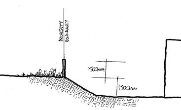
SEPP
(Exempt & Complying) Schedule 8 “Conditions applying to complying
development certificates under the Commercial and Industrial (New Buildings and
Additions) Code” has Operational Requirements relating to hours of
operation and noise which should, in theory, ensure required/relevant noise
levels are achieved at the adjoining or nearby residences, and hours of operation
are appropriate
Details
of the noise barrier, including any landscaping or treatments should be
submitted at CC stage.
It
is considered unlikely that the proposed development will have any significant
adverse environmental health impacts, subject to the imposition of conditions
of consent as recommended.
Bushfire
The site is identified as being bushfire prone. Given the
industrial nature of the subdivision, impacts are considered manageable.
Adequate access and defendable space is available to the site.
Safety, security and crime prevention
The proposed development will be unlikely to create any
concealment/entrapment areas or crime spots that would result in any
identifiable loss of safety or reduction of security in the immediate
area. Future development on the allotments will require security
consideration.
Social impacts in the locality
Given the nature of the proposed development and its’
location the proposal is unlikely to result in any adverse social impacts.
Economic impact in the locality
No adverse impacts. A likely positive impact is that the
development will maintain employment in the construction industry, which will
lead to flow impacts such as expenditure in the area. The development will
facilitate future employment opportunities by providing industrial land.
Site design and internal design
The proposed development design satisfactorily responds to
the site attributes and will fit into the locality. No adverse impacts likely.
Construction
No potential adverse impacts identified to neighbouring
properties with the construction of the proposal.
Cumulative
Impacts
The proposed development is not expected to have any adverse
cumulative impacts on the natural or built environment or the social and
economic attributes of the locality.
(c) The
suitability of the site for the development
The
proposal will fit into the locality and the site attributes are conducive to
the proposed development.
Site
constraints have been adequately addressed and appropriate conditions of
consent recommended.
(d) Any
submissions made in accordance with this Act or the Regulations
Four written
submissions were received following public exhibition of the application.
Copies of the written submissions have been provided separately to members of
the DAP.
Key
issues raised in the submissions received and comments are provided as follows:
|
Submission Issue/Summary
|
Planning Comment/Response
|
|
Oversupply of industrial units
exists in the locality.
|
The proposed development is
permissible in the zone to be constructed in four stages to cater to demand
in an orderly manner.
|
|
3m high wall is an eyesore.
|
Applicant has lowered fencing to 2m from existing ground
level. The proposed sites will be excavated up to 1.5m and the acoustic
engineer has supported this with a revised assessment.
|
|
Access for B doubles inappropriate.
|
The Traffic Impact Assessment prepared by Streetwise Road
Safety and Traffic Services concludes that “vehicles turning in and out
of the future industrial subdivision should be able to do so safely and
efficiently”. The intersection has been designed in accordance with
Austroads guidelines and the proposed sight distances are acceptable.
|
|
Previous stage had issues with compliance.
|
Whilst
it is noted concerns are raised, suitable conditions are proposed to be
applied and appropriate compliance action is available.
|
|
Noise assessment inaccurate because of train component.
|
No allowance has been factored into the acoustic
assessment for the train component. Section 3.1.2 of the Acoustic Report
states that the noise criteria specified for industrial sources
“relate only to other continuous industrial-type noise and do not
include road, rail or community noise”.
|
|
Sewer is not available to the site.
|
Applicant is proposing to provide sewer to the site from
the north. It is understood an agreement is yet to be finalised with the
property owners to the north. Given this, it is recommended that a deferred
commencement consent be issued to requiring owner’s consent to be
provided before the final and operative consent is issued.
|
(e) The
Public Interest
The proposed development
satisfies relevant planning controls and will not adversely impact on the wider
public interest.
4. DEVELOPMENT
CONTRIBUTIONS APPLICABLE
·
Development
contributions will not be required under S64/S7.11 for the following reasons:
· The site is for an industrial subdivision. Water and sewer
contributions are applied at development stage for each of the lots based on
approved use.
5. CONCLUSION
AND STATEMENT OF REASON
The application has been assessed in accordance with Section
4.15 of the Environmental Planning and Assessment Act 1979.
Issues raised during assessment and public exhibition of the
application have been considered in the assessment of the application. Where
relevant, conditions have been recommended to manage the impacts attributed to
these issues.
The site is considered suitable for the proposed development
and the proposal adequately addresses relevant planning controls. The
development is not considered to be contrary to the public's interest and will
not result a significant adverse social, environmental or economic impact. It
is recommended that the application be approved, subject to the recommended
conditions of consent provided in the attachment section of this report.
|
Attachments
1View. DA2019
- 324.1 Plans
2View. DA2019
- 324.1 SOEE
3View. DA2019
- 324.1 Ecology
4View. DA2019
- 324.1 Acoustic Report
5View. DA2019
- 324.1 - Recommended conditions
|
|
ATTACHMENT
|
Development Assessment Panel
11/12/2019
|
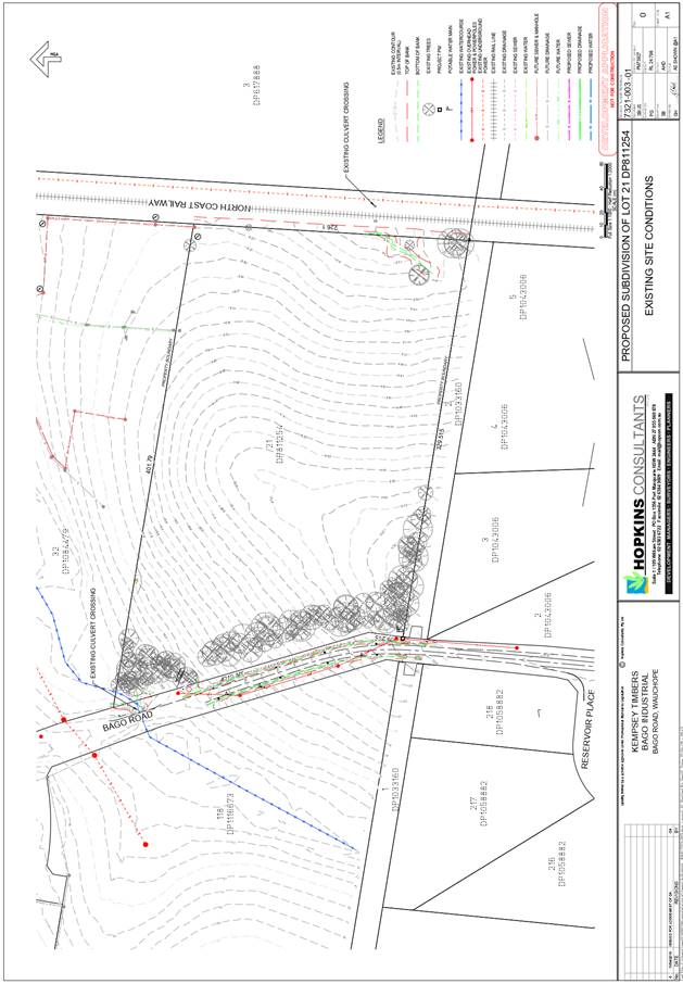
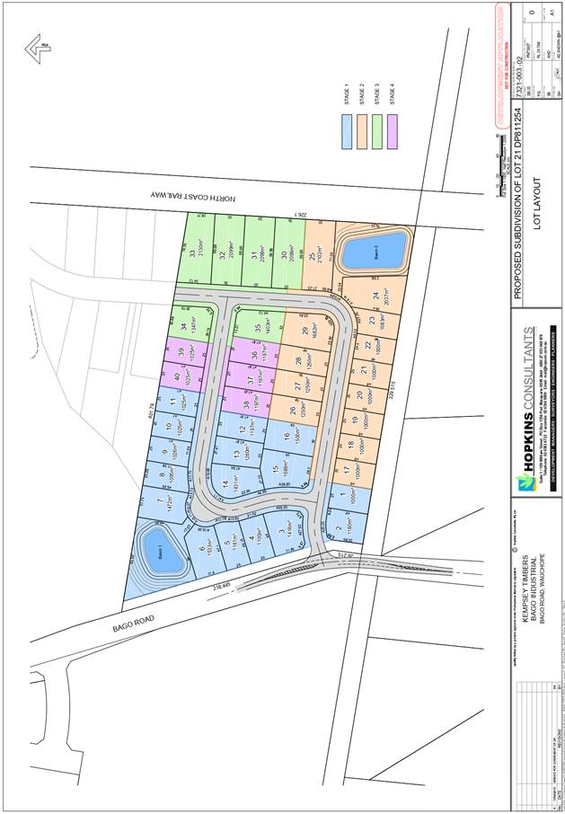
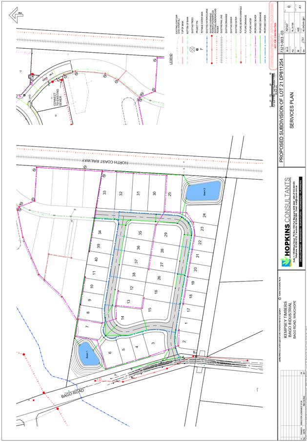
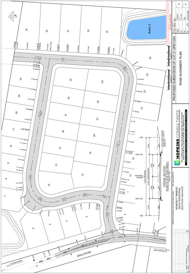
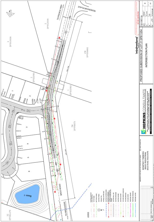
|
ATTACHMENT
|
Development Assessment Panel
11/12/2019
|
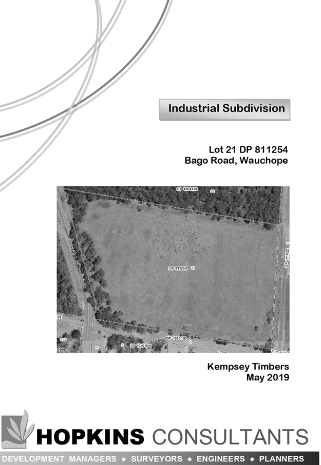
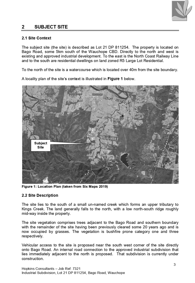
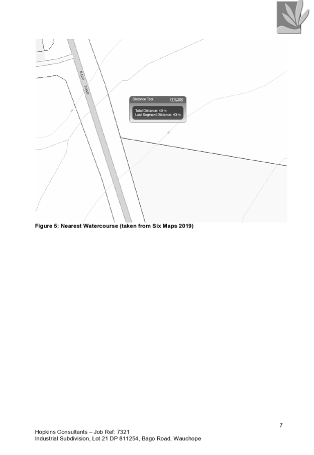
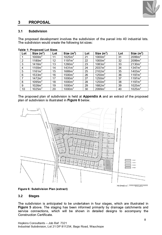
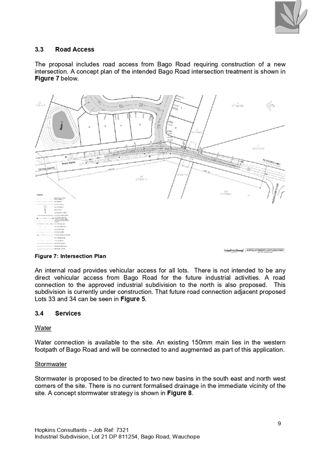
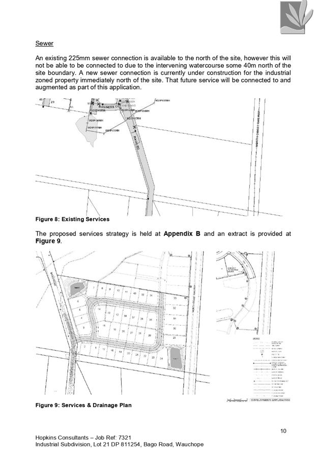
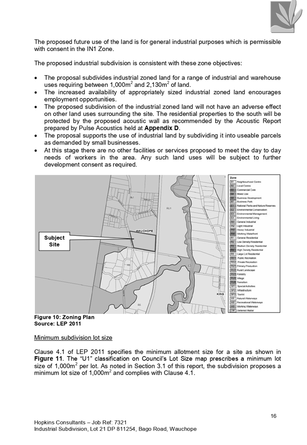
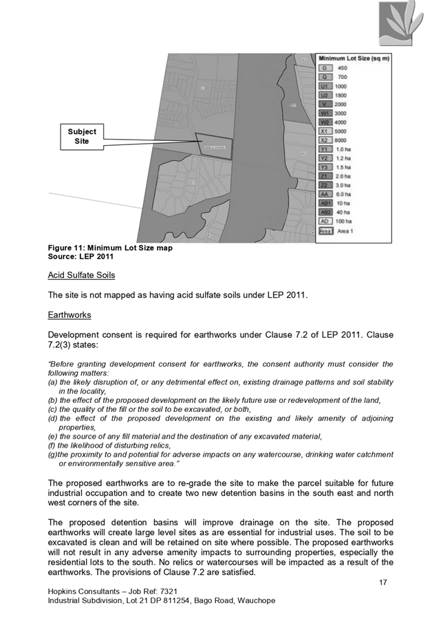
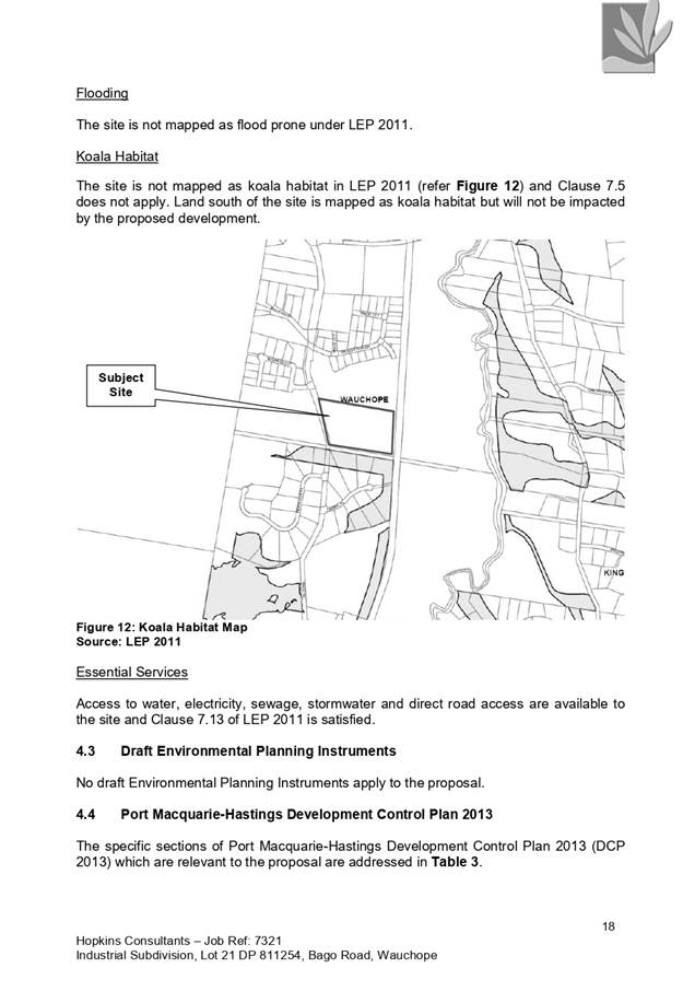
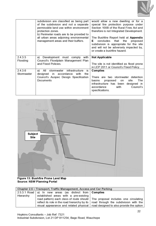
|
ATTACHMENT
|
Development Assessment Panel
11/12/2019
|
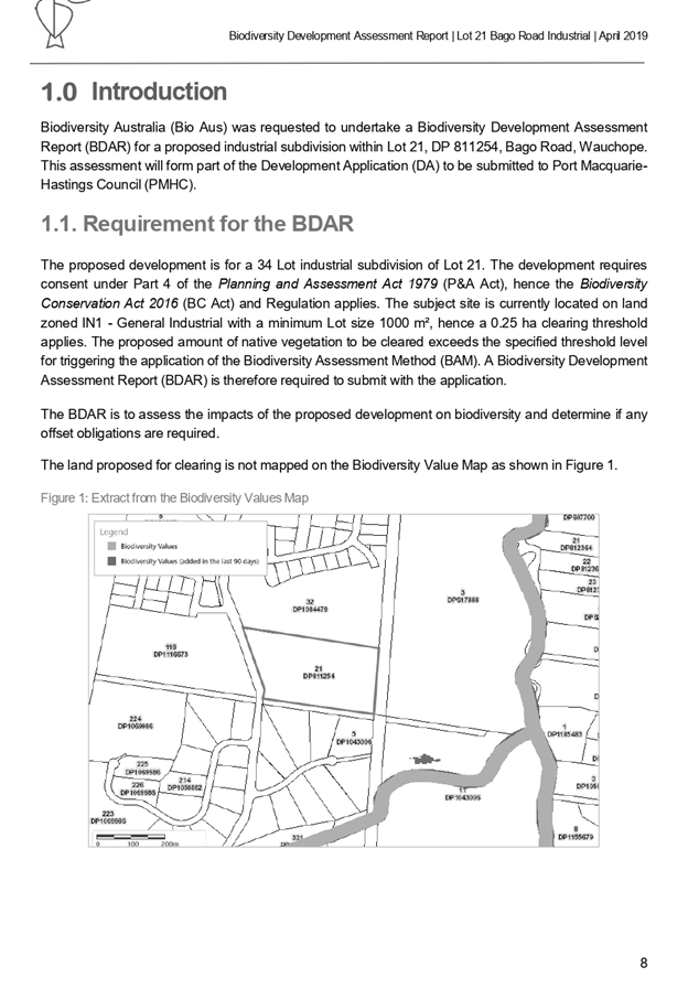
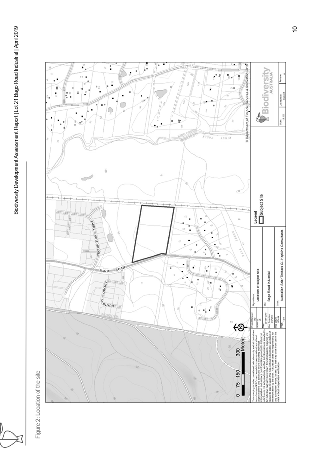
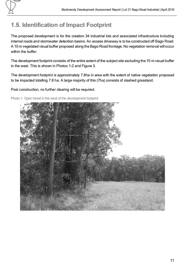
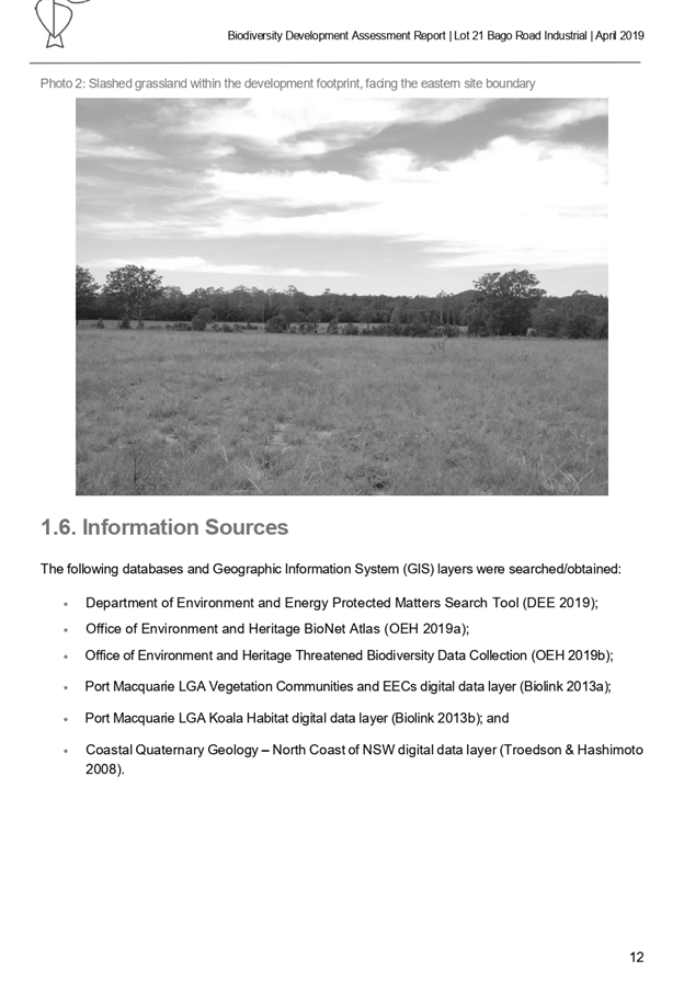
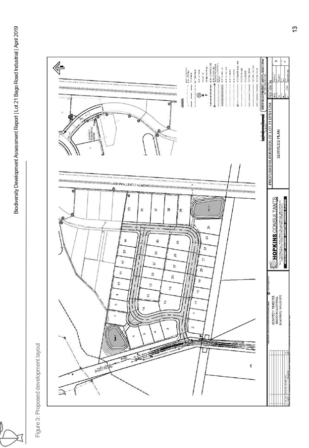
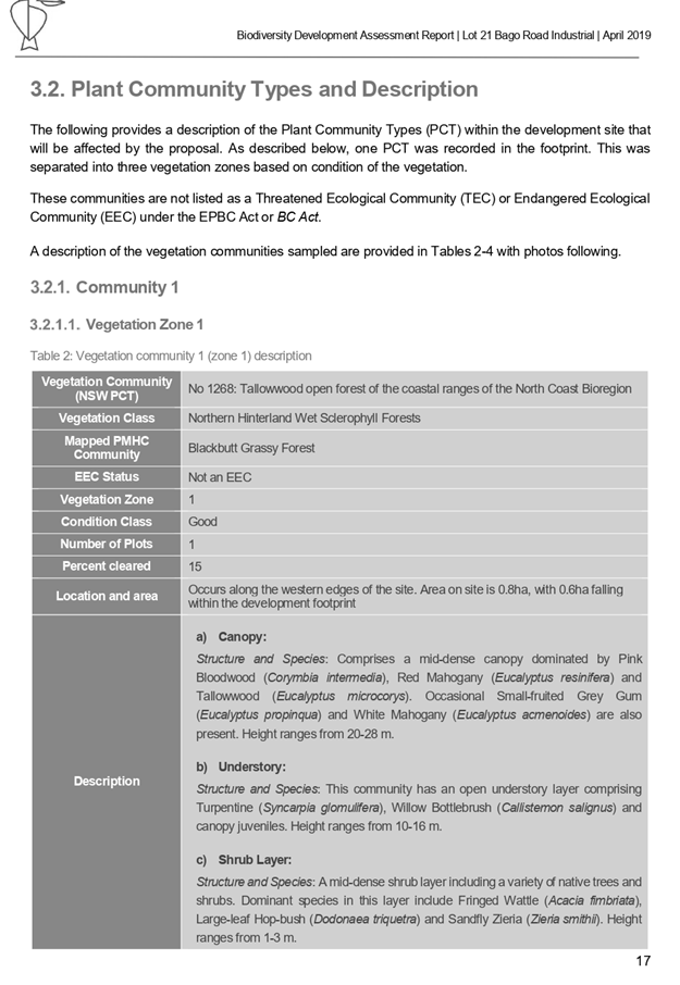
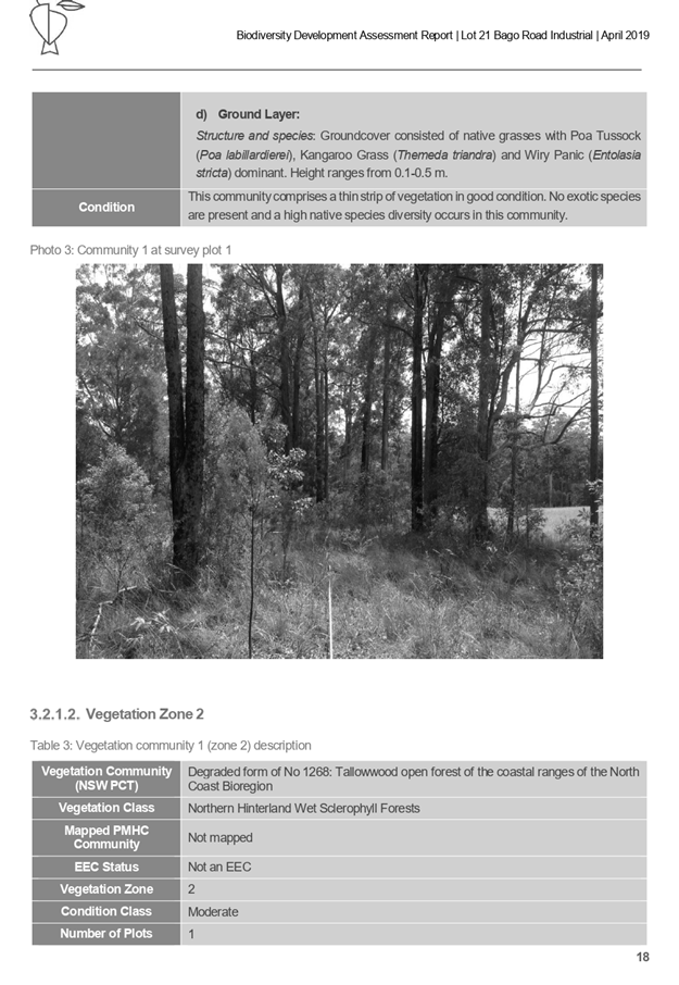
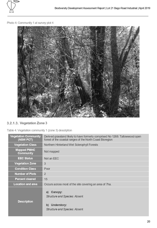
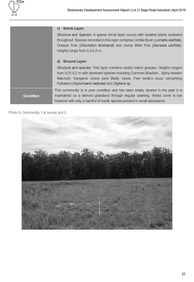
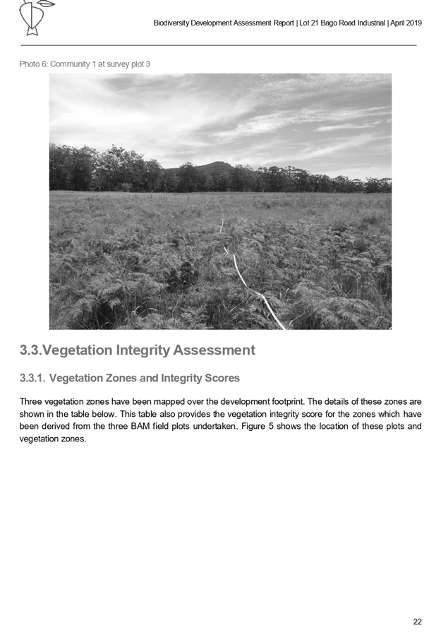
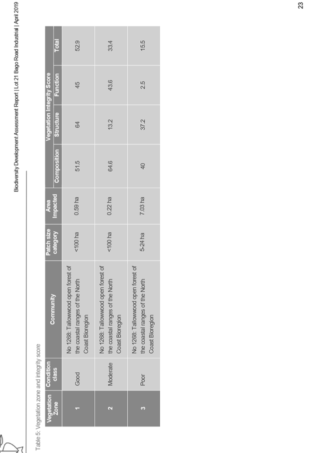
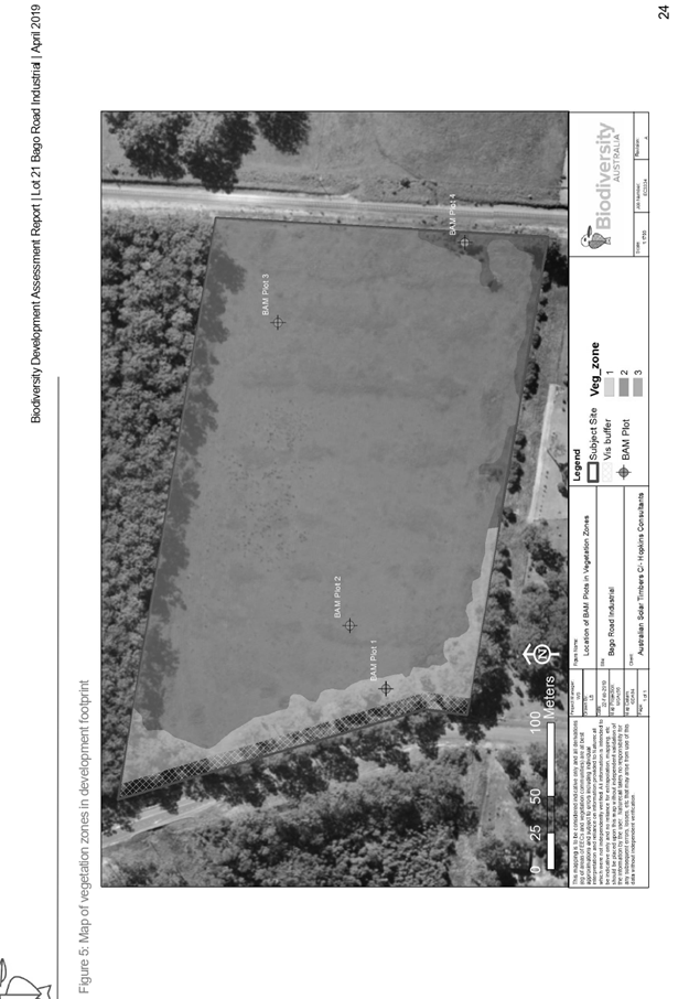
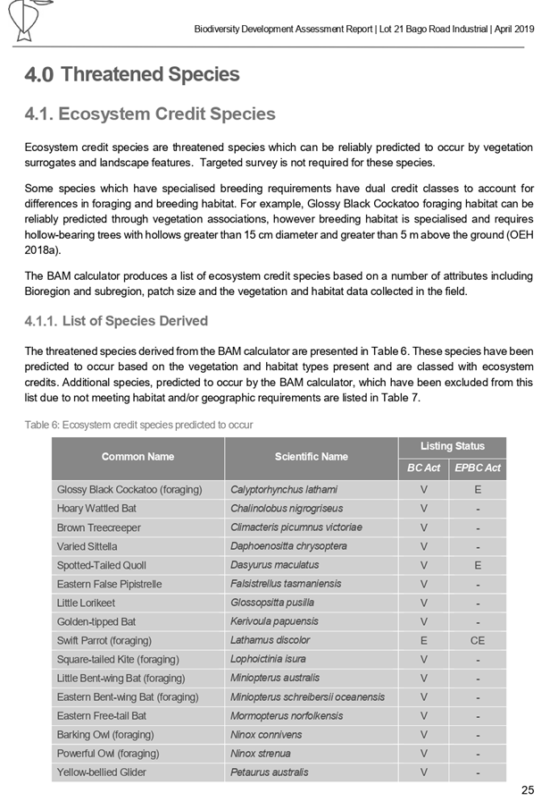
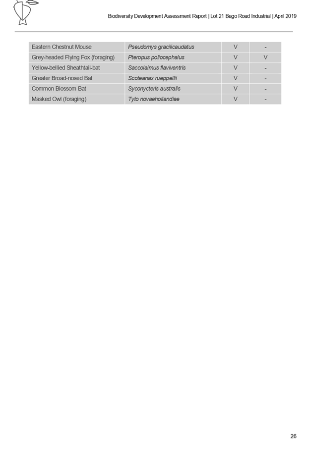
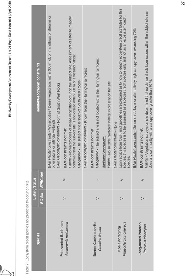
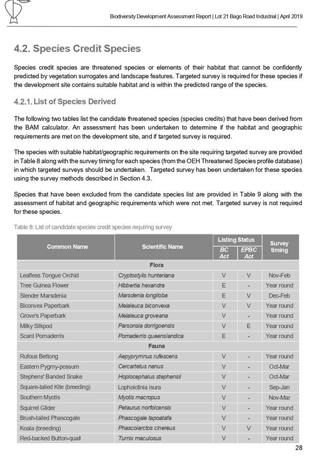
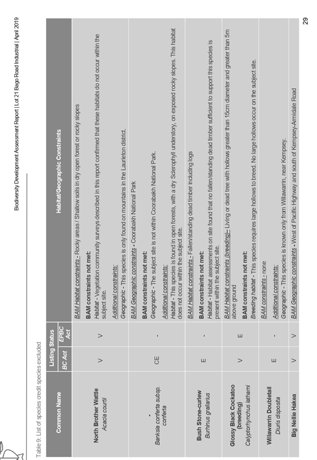
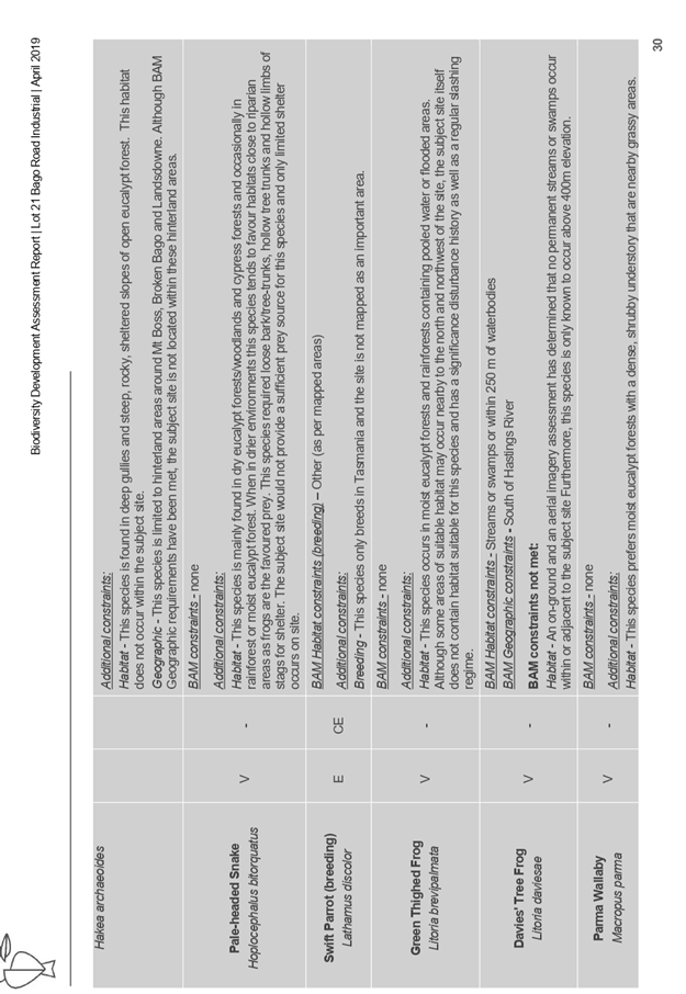
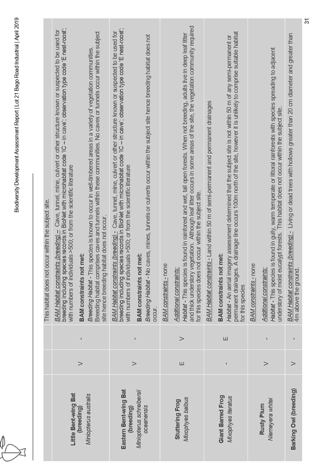
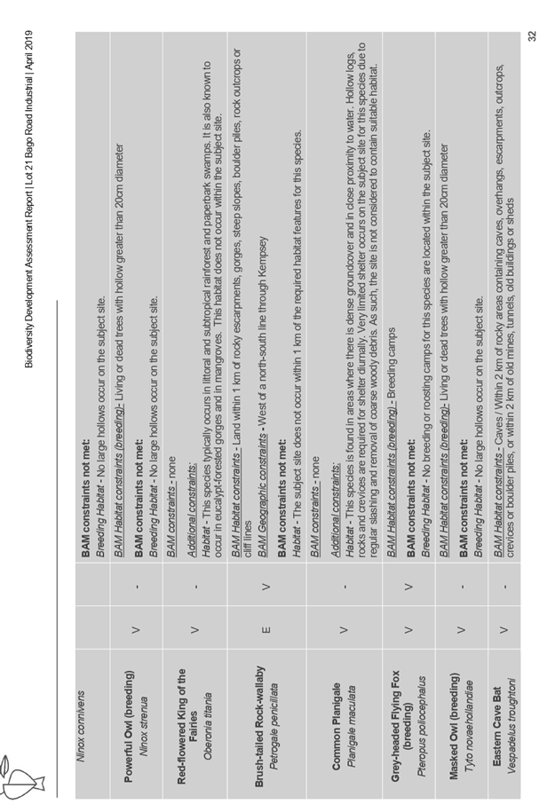
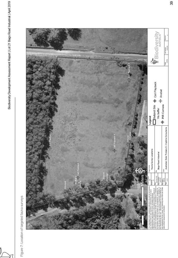
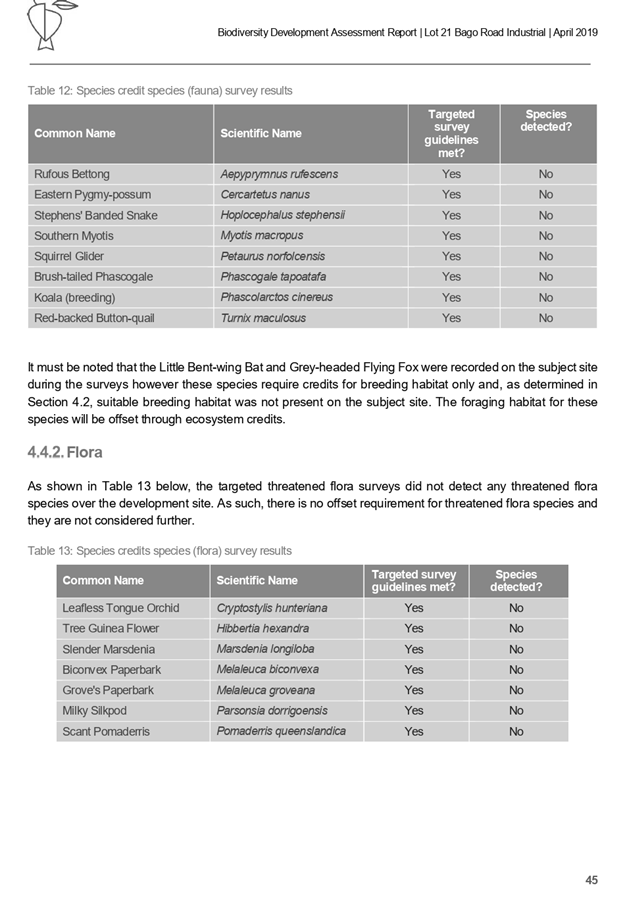
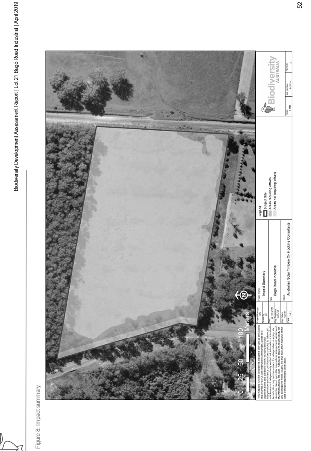
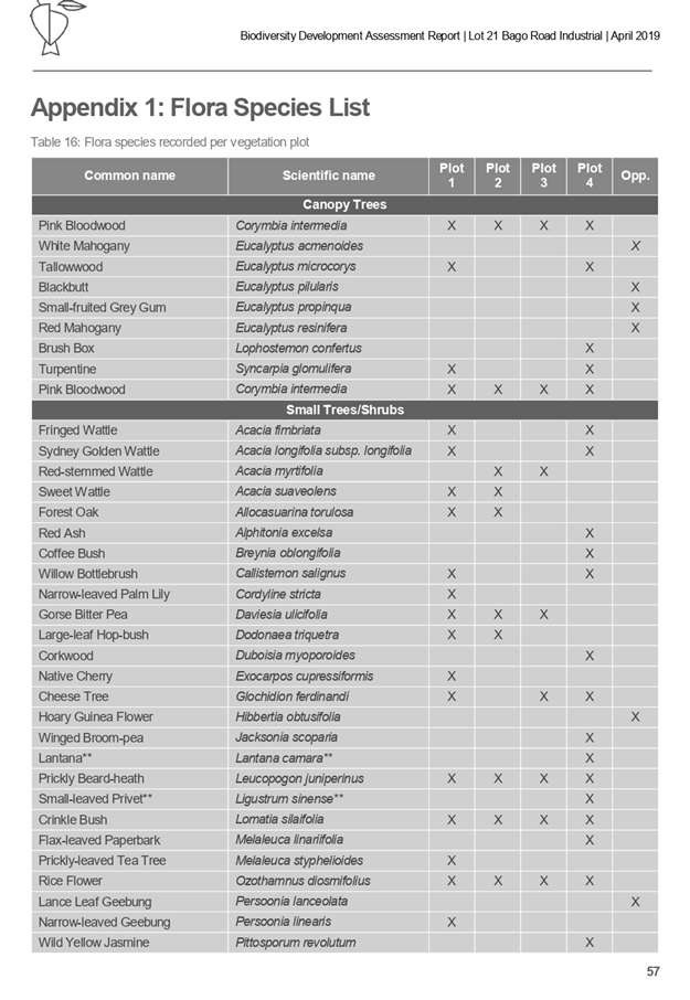
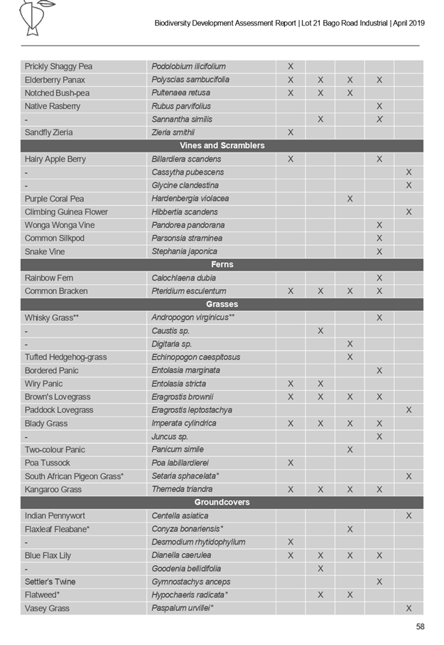
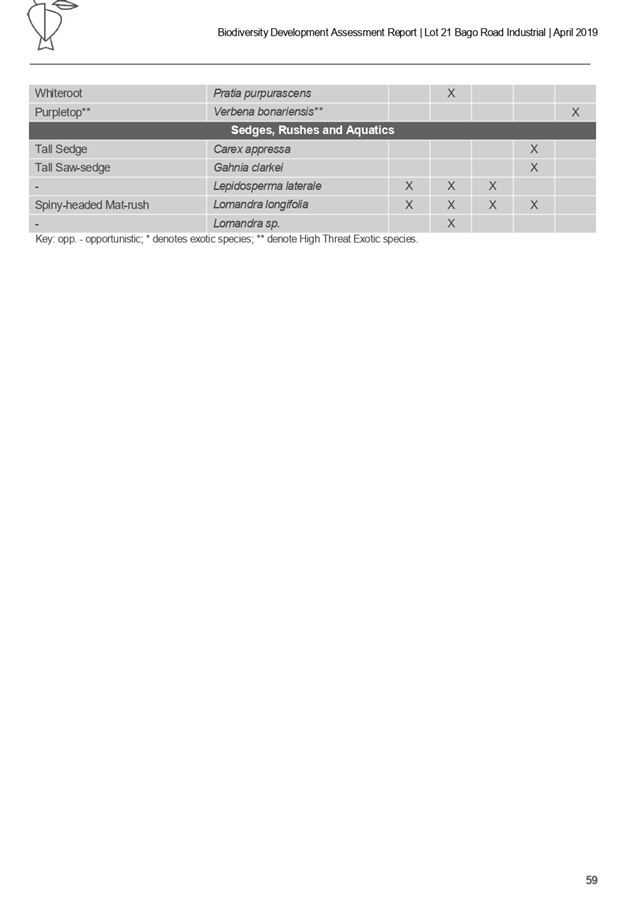
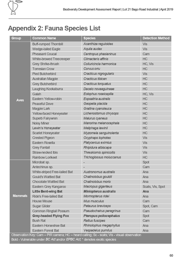

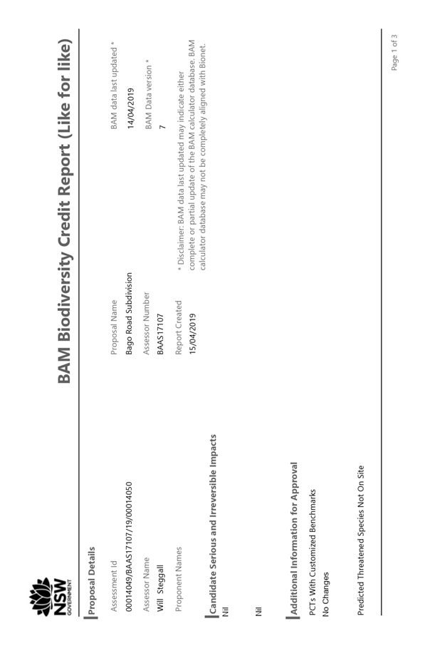
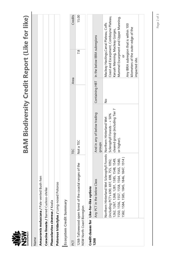
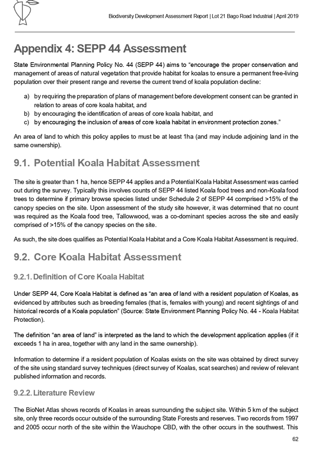
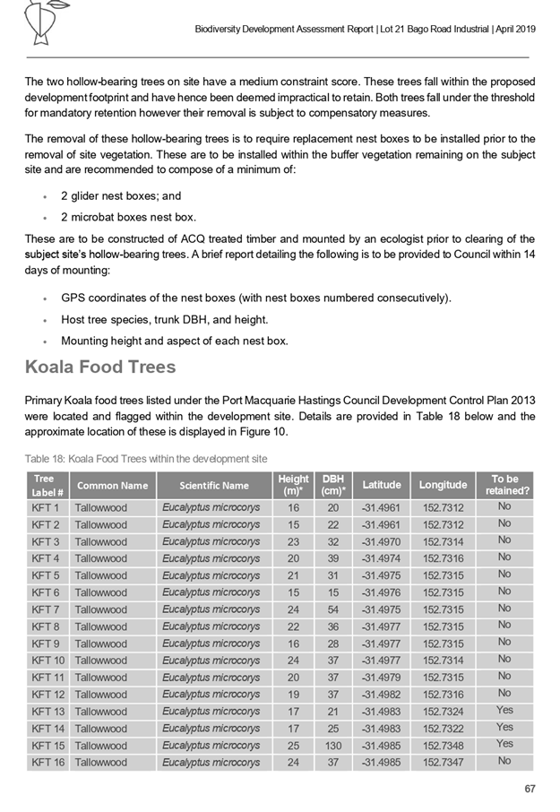
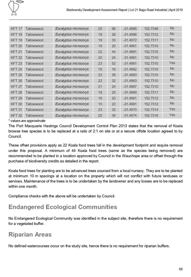
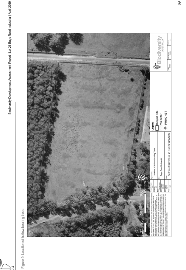
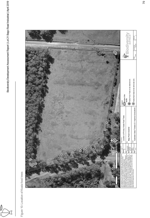

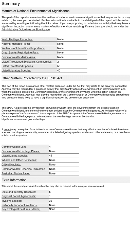
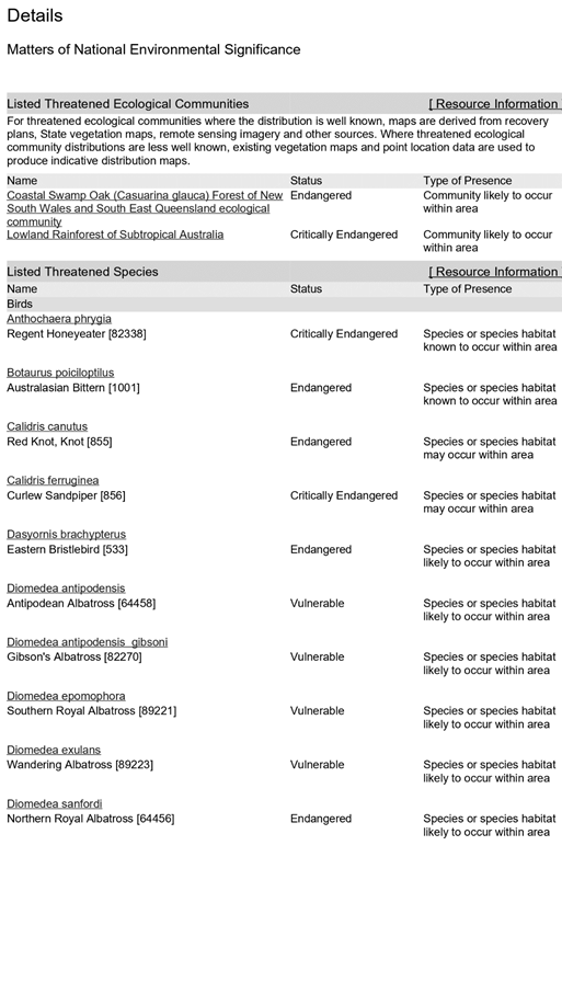
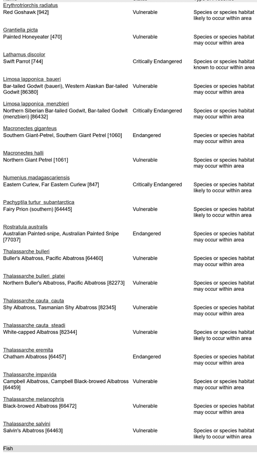
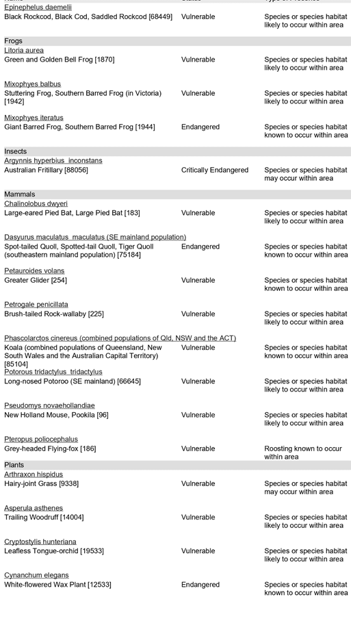
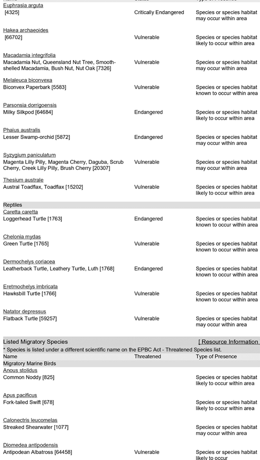
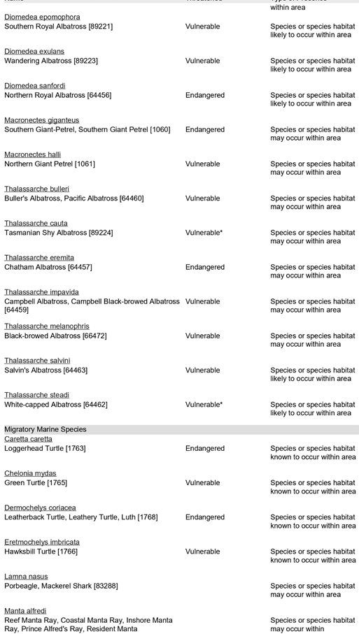
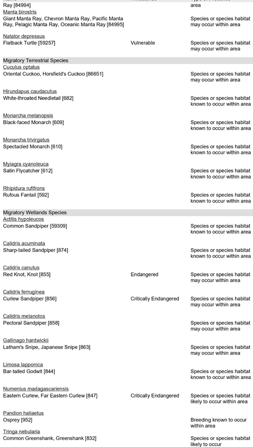
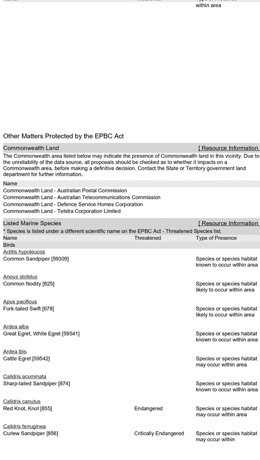


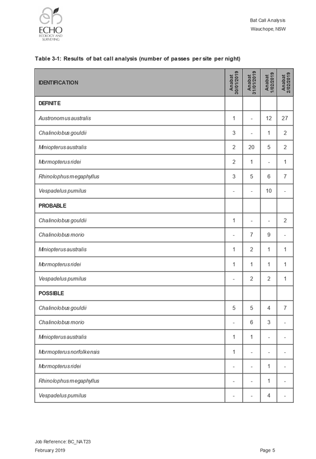
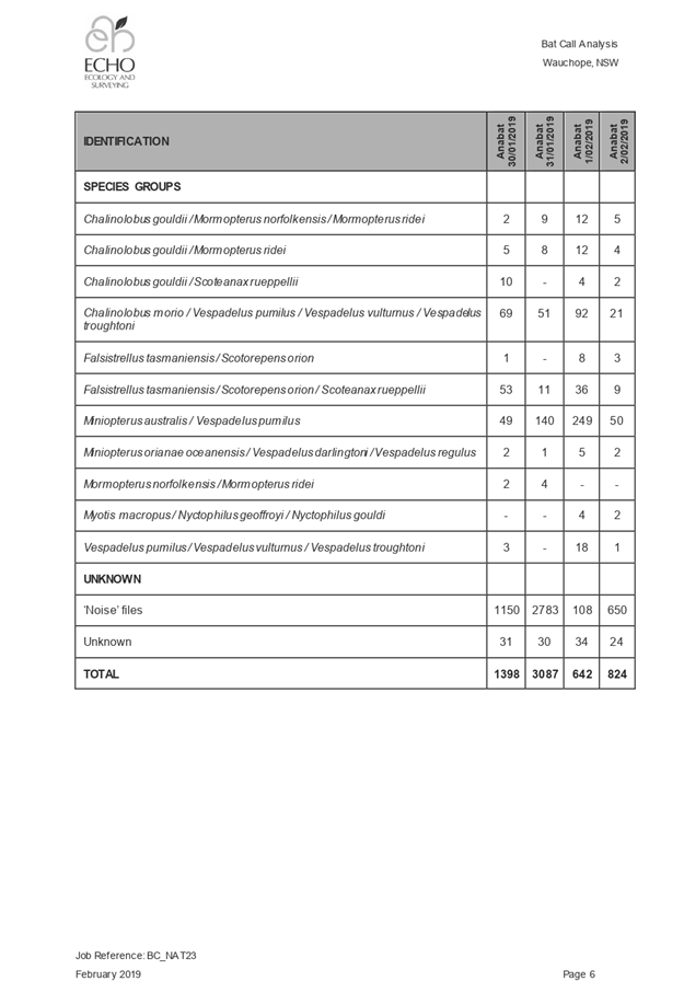
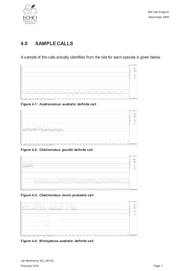
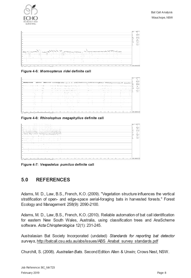
|
ATTACHMENT
|
Development Assessment Panel
11/12/2019
|
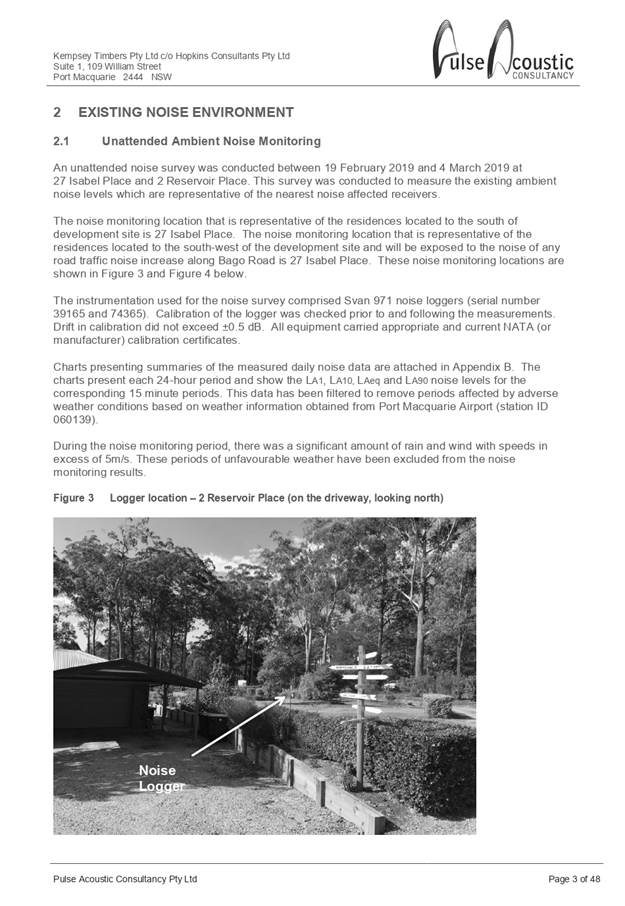
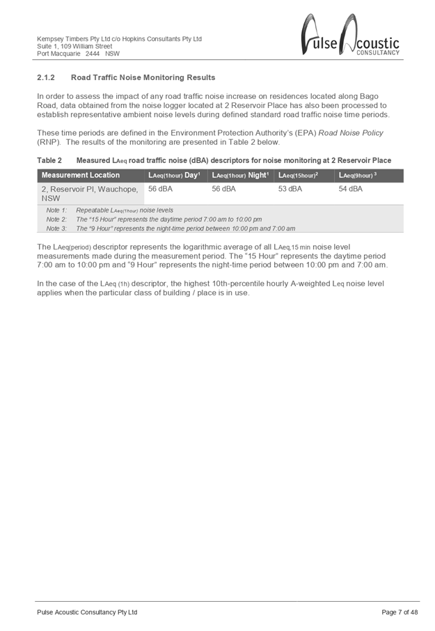
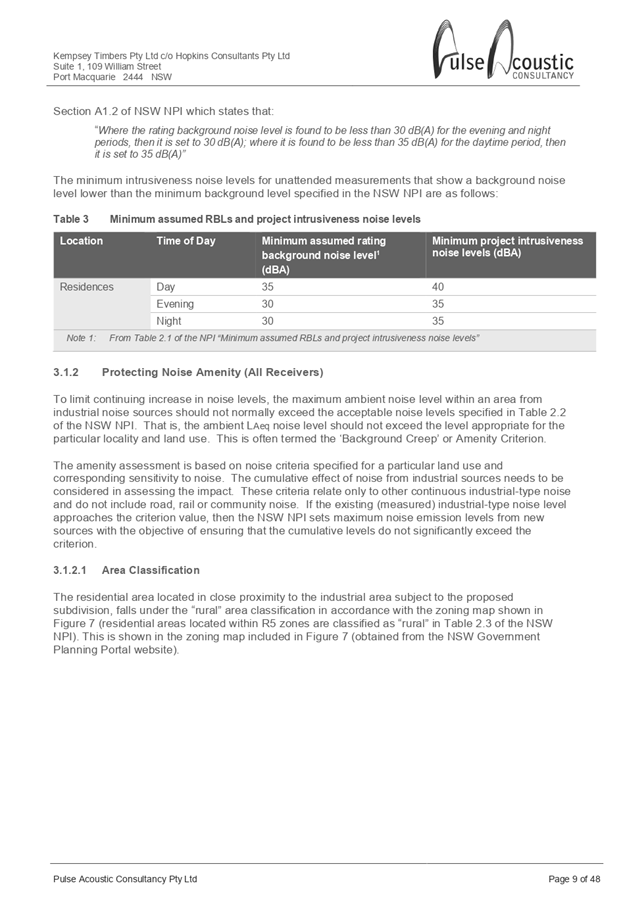
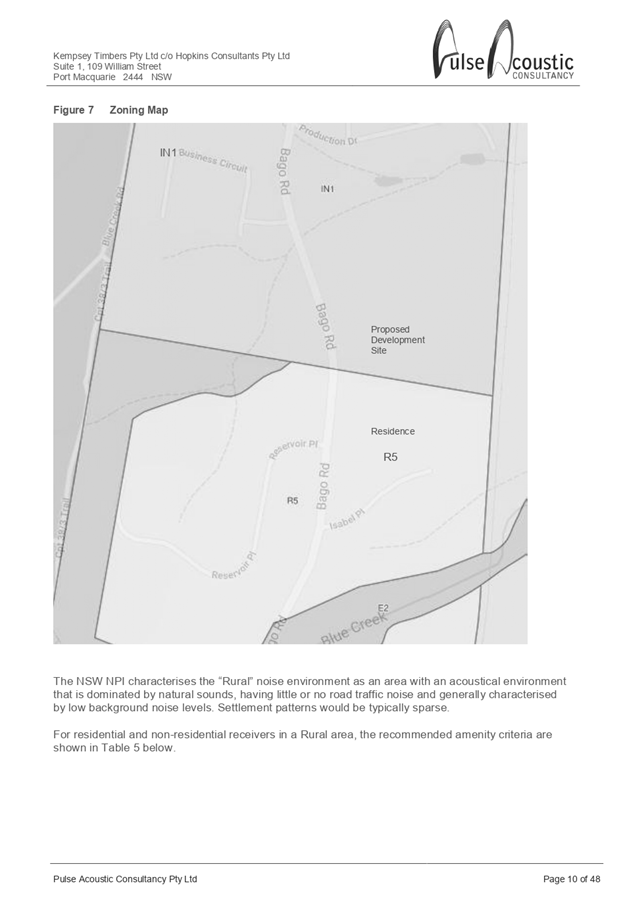
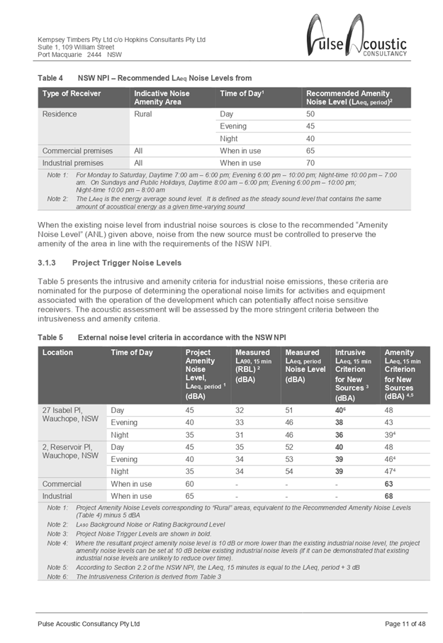
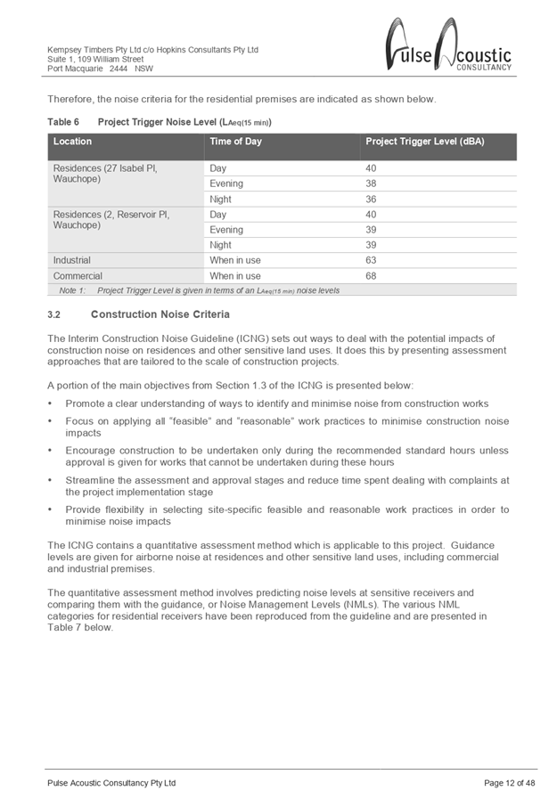
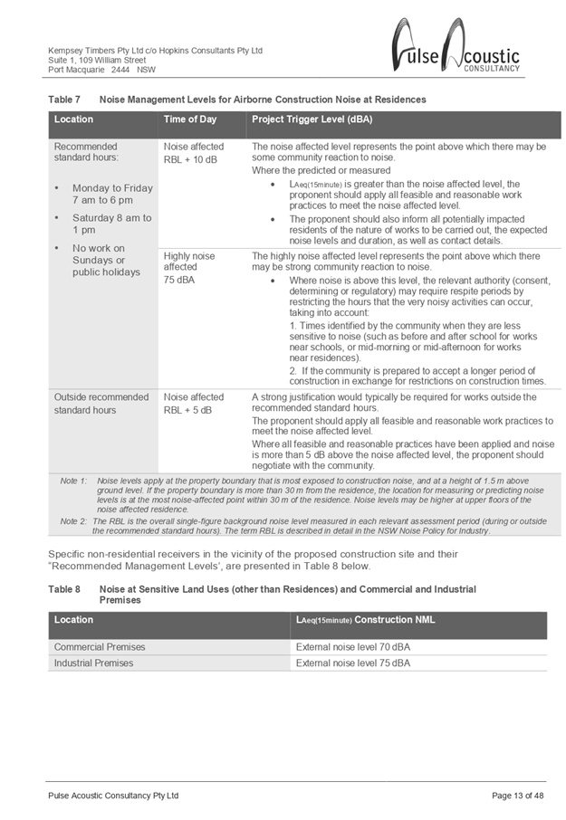
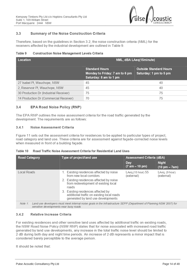
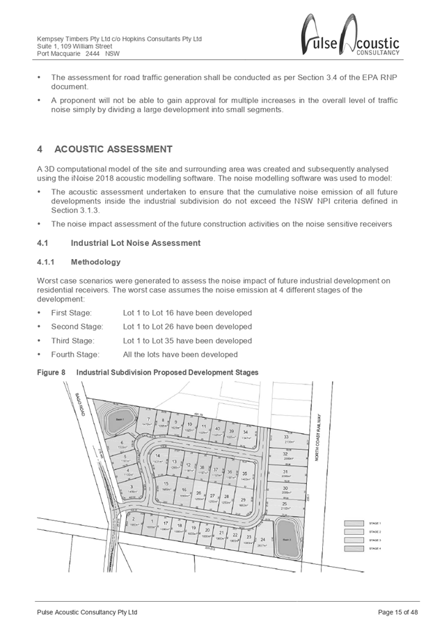
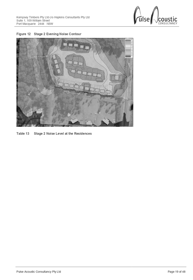
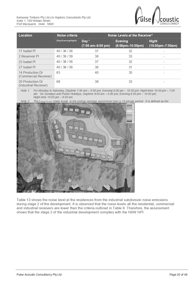
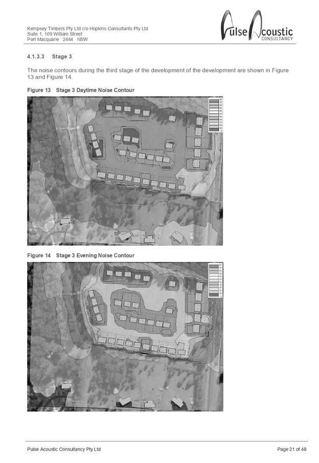
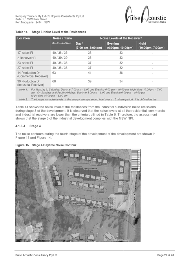
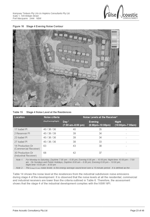
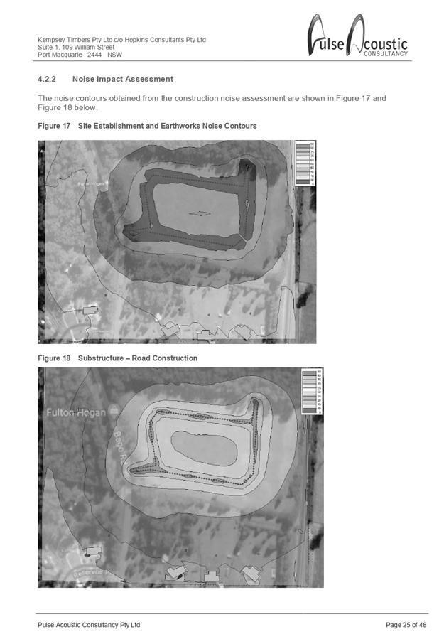
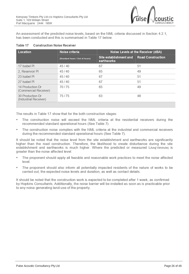
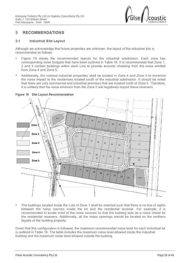
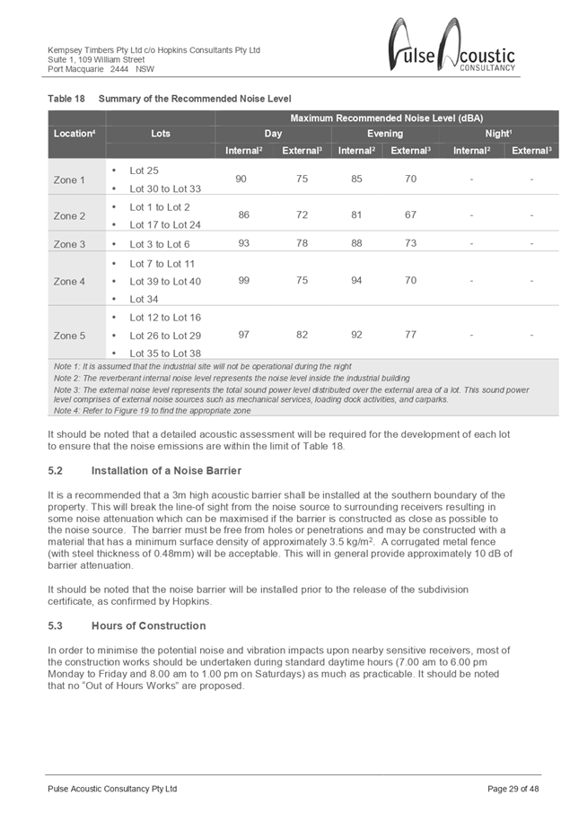

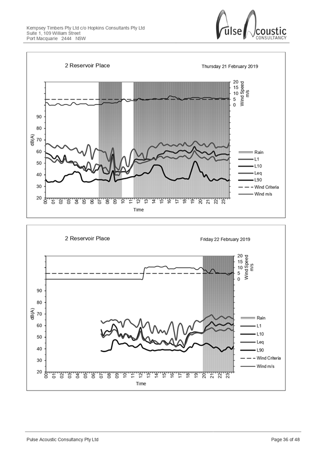
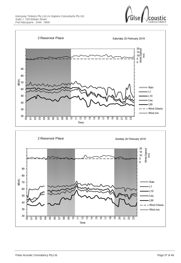
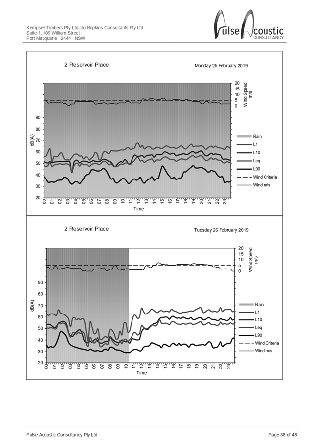

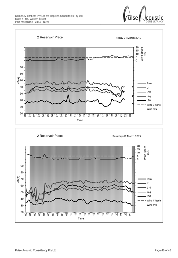
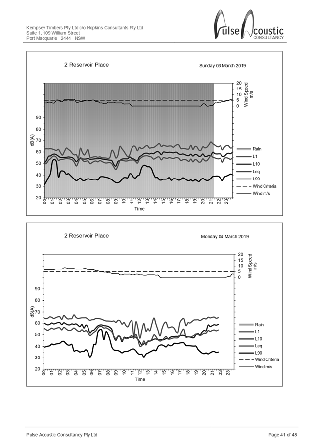
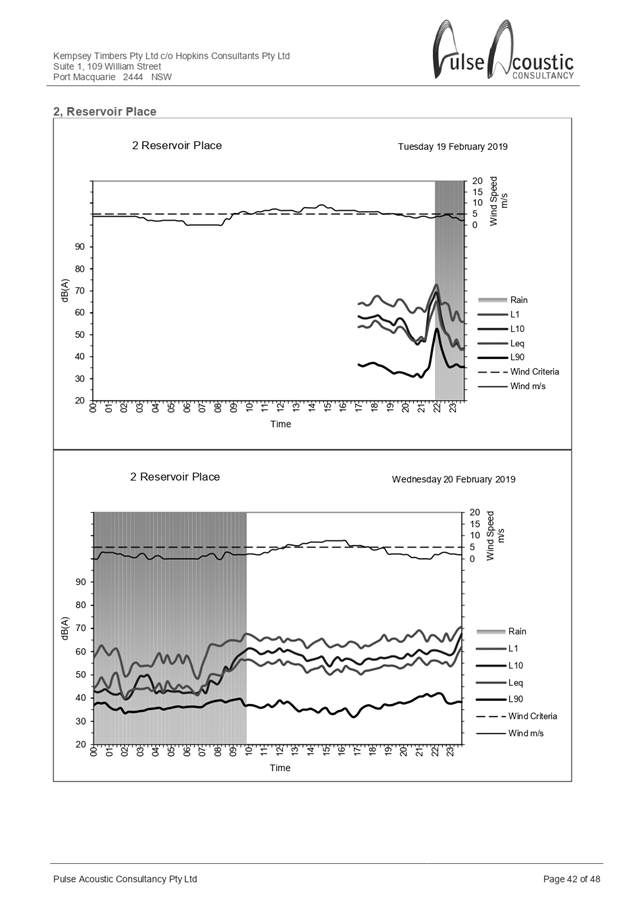
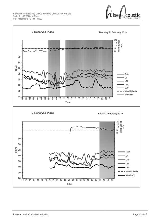
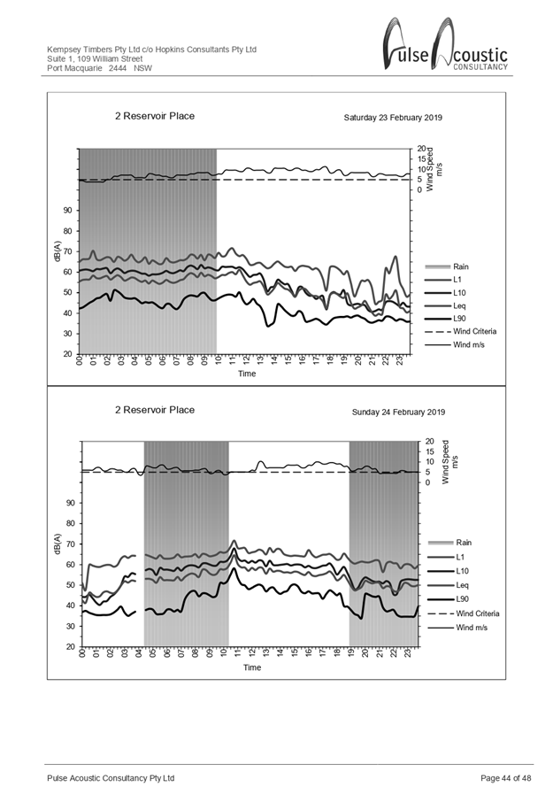

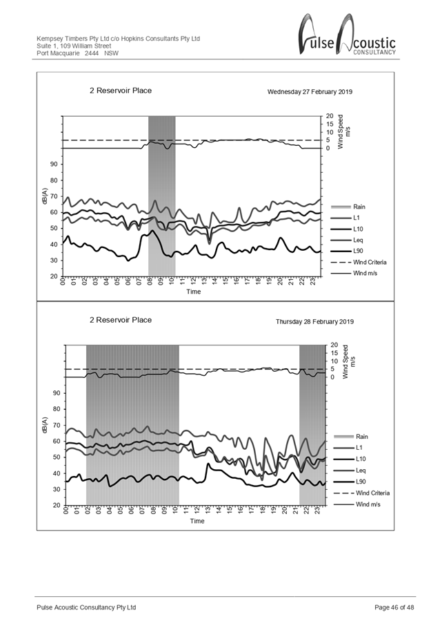
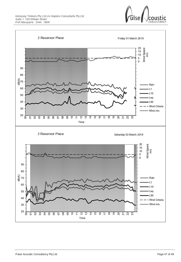
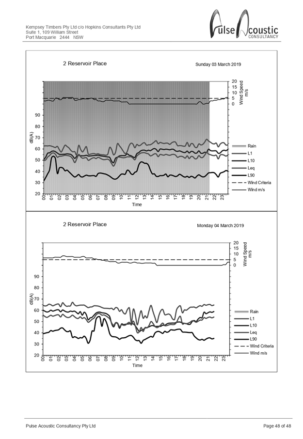
|
ATTACHMENT
|
Development Assessment Panel
11/12/2019
|
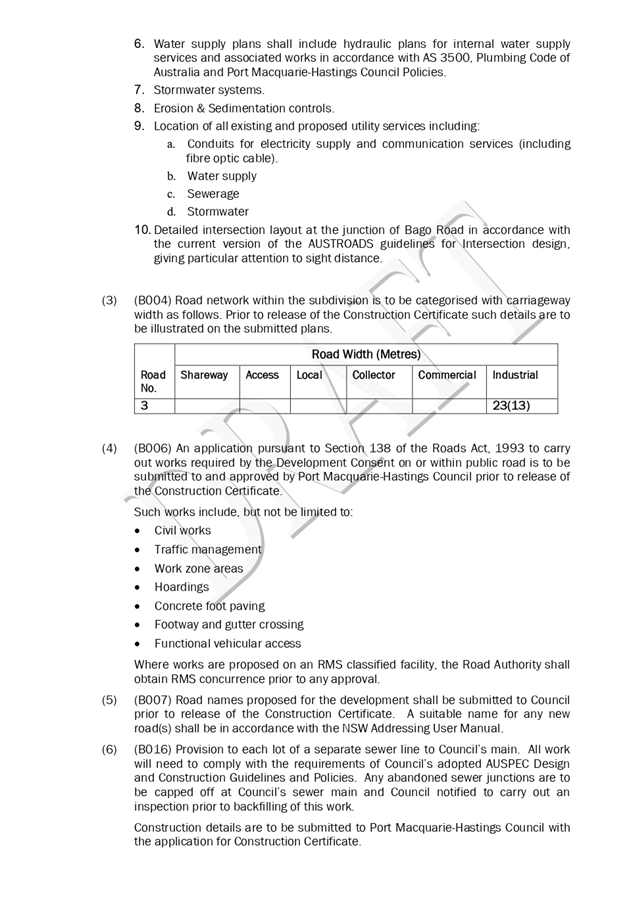
AGENDA Development Assessment Panel 11/12/2019
Item: 09
Subject: DA 2019 - 285.1 Service Station and Take Away
Food and Drink Premises at Lots 1 - 3 DP 407749 and Lot D DP 376568. 15 Ocean
Drive Port Macquarie and 39 - 43 Ackroyd Street Port Macquarie
Report
Author: Development Assessment Planner, Beau Spry
|
Applicant: RCI
Group
Owner: Judy
Plunket Pty. Ltd; Ghawdex Pty. Ltd.
Estimated Cost: $2,020,000
Alignment with Delivery
Program
4.3.1 Undertake transparent and
efficient development assessment in accordance with relevant legislation.
|
|
RECOMMENDATION
That
DA 2019 - 285.1 for a Service
Station and Take Away Food & Drink Premises at Lots 1- 3 DP 407749 and Lot D DP 376568.
15 Ocean Drive Port Macquarie and 39 - 43 Ackroyd Street Port Macquarie be determined by granting consent subject to the
recommended conditions.
|
Executive
Summary
This
report considers a development application for a service station and
take away food and drink premises at the subject site
and provides an assessment of the application in accordance with the
Environmental Planning and Assessment Act 1979.
Following exhibition of the
application, two (2) submissions were
received.
The proposal has been amended
during the assessment of the application.
The site is considered suitable for the proposed development
and the proposal adequately addresses relevant planning controls. The
development is not considered to be contrary to the public's interest and will
not result a significant adverse social, environmental or economic impact.
This application was previously referred to the Development
Assessment Panel on 27 November 2019 with a recommendation that the development
application be approved subject to the conditions. Determination of the
application was deferred by the DAP to address a number of issues. The DAP
resolution and commentary on the applicant’s response is provided below:
CONSENSUS:
That DA2019 - 285 be deferred
to enable the applicant to further address and better
manage residential zoning
interface impacts by reviewing:
1. Hours of operation.
·
Comment:
Revised hours of operation from 5am-12
midnight seven (7) days a week has been proposed for the service station
component. The food & drink premises component is
still proposed for 6am to 12-midnight seven (7) days a week.
·
2. Hours of deliveries.
·
Comment:
Hours of
deliveries are proposed from 5am-12 midnight with no
parking permissible in adjoining streets outside these hours. This is in line
with the supplied acoustic report and the Council Environmental Officer review,
which concludes that noise from the site will be either within the
criterion or generally below the existing noise levels in the area for the
majority of the time, as well as the preference for
fuel tanker deliveries to take place outside of peak times.
3. Landscaping and treatments to better manage privacy,
noise and lighting impacts arising from the car parking area servicing the food
and drink premises.
Comment:
It is noted that the landscape
plans indicate a series of dense semi-mature native trees are proposed to be
established on the southern boundary of both the Stage 1 and Stage 2 carpark
fronting Ackroyd Street, with mature sizes estimated at 5x9m. The eastern and
northern boundary is also subject to a 2m high acoustic fence. In addition, the
Ackroyd St driveway access is sited predominantly opposite 19 Ocean Drive which
is currently Chiropractic Consulting rooms that is set well back from its
Ackroyd Street frontage.
The Ackroyd Street landscaping
also slopes down from south to north, with the proposal siting considerably
lower than the properties situated on the southern side of Ackroyd Street. The
properties at No. 36 opposite the proposal are also setback approximately 15m
from Ackroyd Street and front the street with a fenced courtyard. Adequate
landscaping and separation is considered to be provided.
4. Ackroyd St access.
Comment:
Its noted that the Ackroyd St
driveway exists predominantly opposite 19 Ocean Drive which is currently
Chiropractic Consulting rooms. The building on this site is setback
approximately 11m from its Ackroyd Street boundary and approximately 24m from
the southern side of Ackroyd Street, with the Ackroyd street frontage a yard
space with a large dense well-established tree in the northwest corner opposite
the anticipated driveway access. It should also be noted that Ocean Drive is
anticipated to be the primary access to the site, and also the designated
access for fuel trucks to enter and exit in a forward manner.
The proponent has indicated that
they are amenable to a reviewable condition restricting Ackroyd street access
to entry only.
This report recommends that
the development application be approved subject to the attached conditions
(Attachment 1).
1. BACKGROUND
Existing
Sites Features and Surrounding Development
The combined site has an area of 2983.95m2.
The
site is zoned B2 Local Centre in accordance
with the Port Macquarie-Hastings Local Environmental Plan 2011, as shown in the
following zoning plan:
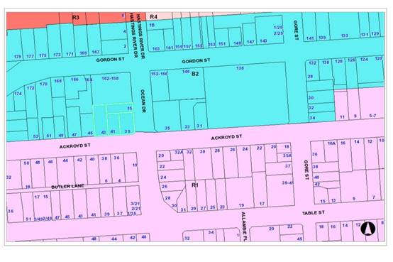
The
existing subdivision pattern and location of existing development within the
locality is shown in the following aerial photograph:
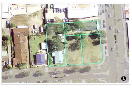
2. DESCRIPTION
OF DEVELOPMENT
Key
aspects of the proposal include the following:
Stage
1: Service Station
· Installation of underground fuel tanks (1 x 50,000 litre
diesel, 1 x 30,000 litre Ethanol 10, 1 x 30,000 litre Premium Unleaded 98, 1 x
40,000 litre Unleaded 91 and 1 x 30,000 litre Premium 95);
· Installation of four (4) double sided fuel dispensers
(appropriately bunded) and overhead canopy their related infrastructure;
· Construction of 16 car parking spaces, including one
accessible space and x 1 air / water bay;
· Installation of x 1 freestanding 8m high
‘Mobil’ internally illuminated pylon sign, located within
south-eastern corner;
· Construction of an underground Puraceptor and Stomscak
system for waste water discharge management;
· Construction of an underground OSD tank (22.5m3) for stormwater
discharge control;
· Installation of indicative business identification signage
on the south face of the convenience store;
· ‘Mobil’ pylon sign – 8m in height, 1.9m
in width and 0.4m in depth;
· Two (2) illuminated ‘Mobil’ signs on the
‘south’ and ‘east’ faces of the car refuelling canopy;
· Landscaping around the perimeter of the service station and
adjacent to the proposed building;
· Landscaping between the Stage 1 and Stage 2 buildings;
· Screened waste storage area;
· Loading zone adjacent to waste storage area;
· Minor excavations to accommodate vehicle accesses/exits.
· Hours of operation 5am to 12 Midnight, 7 days a week for
the service station and 6am to 12 midnight 7 days a week for the food and drink
premises.
Stage 2: Food and Drink
Premises
· Two tenancies for future food and drink premises;
· Development comprises x 2 units 100m2 of GFA, plus 4
internal seats for each and shared 12 external seats;
· New hard stand and parking area for an additional 17 car parking
spaces, including 1 disabled car parking space;
· Indicative location of internally illuminated business
identification signs on the southern elevation of the proposed outlets;
· Screened waste storage area;
· Loading Zone adjacent to waste storage area;
· Excavations to accommodate vehicle accesses/exits.
· Operating hours 6am to midnight, 7 days a week.
Refer
to Attachment 2 for plans of the proposed development.
Application
Chronology
· 18 April 2019 - Application lodged.
· 2 May 2019 - Application notified.
· 10 - 15 May 2019 - Submissions received.
· 22 June 2019 - Site inspection.
· 22 June - 11 November - Further information requested and
submitted.
3. STATUTORY
ASSESSMENT
Section
4.15(1) Matters for Consideration
In
determining the application, Council is required to take into consideration the
following matters as are relevant to the development that apply to the land to
which the development application relates:
(a) The
provisions (where applicable) of:
(i) Any
Environmental Planning Instrument
State Environmental Planning Policy No. 33 - Hazardous
and Offensive Development
The subject SEPP was introduced to clarify the definitions for
hazardous and offensive industries and to apply guidelines for the assessment
of industries that have the potential to create hazards or an offence.
Clause 12 of SEPP 33 requires that a Development Application
for the purposes of a potentially hazardous industry must include a preliminary
hazard analysis (PHA) in accordance with the current circulars or guidelines
published by the Department of Planning, Industry and Environment.
The Department has published Hazardous and Offensive Development
Application
Guidelines – Applying to SEPP 33 (January
2011). Appendix 3 of The Guideline
identifies Petrol Stations as
industries, which may be potentially hazardous. The primary sources of hazard
is identified as liquid fuel leaks/spills resulting in possible impacts such as
fire and explosions.
Appendix 2 of The Guideline
includes a list of information required in
relation to the SEPP 33 risk
screening method as follows:
- Hazardous
Materials involved in the Proposed Development;
- Dangerous
Goods classifications for all Dangerous Goods held on site;
- Quantities
of dangerous goods and otherwise hazardous materials involved in
the proposed development;
- Distance
from the boundary for each hazardous substance;
- Weekly and
annual number of deliveries (and the quantities) of dangerous
goods
and otherwise hazardous materials to and from the facility;
- Site Layout
plan showing proposed development and any existing
development
on site; and
- Locality
Plan showing immediate neighbours and their activities and also
showing
the nearest residential property.
In this case, the development
has the potential to be hazardous given the proposal to store petrol, diesel
and ethanol on the site and the provisions of the SEPP apply.
The above information has been
satisfactorily addressed in the SEPP 33 Preliminary Hazards Analysis and
Summary and the Multi-Level Risk Assessment included in submitted information
with the application. Having considered the SEPP, the Multi-Level Risk
Assessment, the Preliminary Hazard Analysis, and with the imposition of
conditions, the consideration of the SEPP is satisfied.
State Environmental Planning Policy No. 44 - Koala
Habitat Protection
There is no Koala Plan of Management on the site.
Additionally, the site is less than 1ha in area therefore no further
investigations are required. The application has demonstrated that no habitat
will be removed or modified therefore no further investigations are required.
State Environmental Planning Policy No. 55 –
Remediation of Land
Following an inspection of the site and a search of Council
records, the subject land is not identified as being potentially contaminated
and is suitable for the intended use.
State Environmental Planning Policy No. 62 –
Sustainable Aquaculture
Given the nature of the proposed development and proposed
stormwater controls the proposal will be unlikely to have any adverse impact on
existing aquaculture industries
State Environmental Planning Policy (Coastal Management)
2018
The site is not located within a coastal use area or coastal
environment area.
State Environmental Planning
Policy No. 64 – Advertising and Signage
The proposed development involves the erection of signage
across two (2) stages in the form of business/building identification,
advertising and wayfinding signage, including;
Stage 1
· ‘Mobil’
pylon sign – 8m in height, 1.9m in width and 0.4m in depth.
· x
2 illuminated ‘Mobil’ signs on the ‘south’ and
‘east’ faces of the car refuelling canopy.
· x
1 indicative internally illuminated sign on the south façade of the
service store.
· x 1
tower sign with x 2 indicative internally illuminated business signs (south
face).
Stage 2
Two indicative internally
illuminated business signs on the southern fascia of the take away/cafes.
In accordance with clause 7, this SEPP prevails over the
Port Macquarie-Hastings LEP 2011 in the event of any inconsistency.
The following assessment table provides an assessment
checklist against the Schedule 1 requirements of this SEPP:
|
Applicable clauses for consideration
|
Comments
|
Satisfactory
|
|
Clause 8(a) Consistent with
objectives of the policy as set out in Clause 3(1)(a).
|
The B2 Local Centre zone contains a variety of commercial
land uses. The proposed signage is considered to be compatible with the
existing and future character of the locality.
Proposal is considered consistent with the objectives of
the SEPP.
|
Yes
|
Schedule
1(1) Character of the area.
|
In assessing signage and
compatibility with character of an area, elements such as scale and any
amenity impacts should be considered.
In this case the proposal is consistent with the
established character of the local centre area. Similar scale signage is
evident nearby and potential amenity impacts (such as illumination) can be
appropriately managed via conditions.
|
Yes
|
|
Schedule 1(2) Special areas.
|
The proposed signage does not
detract from any areas of environmental or cultural importance. There are no
such areas in direct proximity to the subject land.
|
Yes
|
|
Schedule 1(3) Views and vistas.
|
The proposed signage does not
obscure or compromise important views, dominate the skyline or reduce the
quality of any views or vistas.
The proposed signage has no
impact on existing signage in close proximity to the site.
|
Yes
|
|
Schedule 1(4) Streetscape,
setting or landscape.
|
The signage is considered to
be acceptable in terms of scale, height, and appearance, and is compatible
with the streetscape setting. Similar scale signage is evident nearby at
Gordon Street.
|
Yes
|
|
Schedule 1(5) Site and building.
|
The signage is seen to be
standard for a service centre and is considered to be acceptable in terms of
scale, height, and appearance.
The proposed signage is not
considered to detract from important features of the site, proposed building
or surrounding development. The location of the proposed signage is
considered suitable for the proposed use and appropriate given the proposed
service stations position, proposed access arrangements and parking.
|
Yes
|
|
Schedule 1(6) Associated devices
and logos with advertisements and advertising structures.
|
The proposal includes signage
which is
Intended to ultimately include
logos and symbols representing facilities and services offered.
|
Yes
|
|
Schedule 1(7) Illumination.
|
Low impact lighting is
proposed to illuminate the signage at night.
These signs will be required
to be illuminated at appropriate LUX levels so as to ensure that the signage
will not result in unacceptable glare. The proposed illuminated signage
is not considered likely to provide a significant safety concern for
pedestrians, vehicles or aircraft.
Condition recommended
requiring lighting to comply with AS4282 - Control of the obtrusive
effects of outdoor lighting.
|
Yes
|
|
Schedule 1(7) Safety.
|
The proposed service station
signage is not considered likely to reduce road safety for pedestrians,
cyclists or any
vehicles utilising a public
road.
Sightlines to and from the
site are
not considered likely to be
affected.
|
Yes
|
State Environmental Planning Policy (Infrastructure) 2007
Clause 104(3)(b)(ii) and (iii).
The DA has been referred to the NSW Roads and
Maritime Service (RMS). The
RMS’ advice and other matters requiring
consideration are considered in
the assessment of access, traffic and parking
impacts addressed later in this report.
Port Macquarie-Hastings
Local Environmental Plan 2011
The proposal is consistent
with the LEP having regard to the following:
· Clause
2.2. The subject site is zoned B2 Local Centre.
· Clause
2.3(1) and the B2 zone land use table. The proposed development for a service
station and take away food and drink premises are a permissible land use with
consent.
The following
land uses in the LEP are relevant to determine and characterise the proposed
use:
service
station means a building or place used for the sale by retail of
fuels and lubricants for motor vehicles, whether or not the building or place
is also used for any one or more of the following:
(a) the ancillary sale by retail of spare parts and
accessories for motor vehicles,
(b) the cleaning of motor vehicles,
(c) installation of accessories,
(d) inspecting, repairing and servicing of motor
vehicles (other than body building, panel beating, spray painting, or chassis
restoration),
(e) the ancillary retail selling or hiring of
general merchandise or services or both.
food and drink premises means premises that are used for the preparation
and retail sale of food or drink (or both) for immediate consumption on or off
the premises, and includes any of the following:
(a) a restaurant or cafe,
(b) take away food and drink premises,
(c) a pub,
(d) a small bar.
The objectives of the B2 zone are as
follows:
o To provide a range of retail, business,
entertainment and community uses that serve the needs of people who live in,
work in and visit the local area.
o To encourage employment opportunities in accessible
locations.
o To maximise public transport patronage and
encourage walking and cycling.
o To ensure that new developments make a positive
contribution to the streetscape and contribute to a safe public environment.
· Clause
2.3(2). The proposal is consistent with the zone objectives having regard to
the following:
o The proposal is a permissible
land use;
o The service station will
encourage employment opportunities;
o The proposal will not have any
noticeable adverse impacts on other developments in the precinct;
o The proposal will
satisfactorily address the public domain;
o The proposal will provide
facilities to meet the day-to-day needs of the surrounding workers/residents.
· Clause
4.3. The maximum overall height of the building above ground level (existing)
is 8m for the pylon, 5.5m for the canopy and 4.8m for the building. The
building heights complies with the standard height limit of 14.5m applying to
the site.
·
· Clause
4.4. The floor space ratio of the proposal is 0.13:1.0, which complies with the
maximum 1.50:1 floor space ratio applying to the site.
· Clause
5.10. The site does not contain or adjoin any known heritage items or sites of
significance.
·
· Clause
7.13. Satisfactory arrangements are in place for provision of essential
services including water supply, electricity supply, sewer infrastructure,
stormwater drainage and suitable road access to service the development.
(ii) Any draft
instruments that apply to the site or are on exhibition
No draft instruments apply to
the site.
(iii) Any Development
Control Plan in force
Port
Macquarie-Hastings Development Control Plan 2013
|
DCP 2013: Business & Commercial Development
|
|
DCP Objective
|
Development Provisions
|
Proposed
|
Complies
|
|
3.4.3.8
|
Active Frontages:
Ground floor levels shall not be used for residential
purposes in B1, B2, B3 and B4 zones.
|
Proposal does not include any ground floor residential
use.
|
Yes
|
|
3.4.3.9
|
A minimum of 50% of the ground floor level front facade is
to be clear glazed.
|
More than 50% clear glazing.
|
Yes
|
|
Active frontages must consist of one or more of the
following:
· A shop front.
· Commercial and residential
lobbies.
· Café or restaurant if
accompanied by an entry from the street.
· Public building if
accompanied by an entry from the street.
|
Active frontage consistent with these requirements.
|
Yes
|
|
Restaurants, cafés and the like shall provide
openable shop fronts to the footpath but must not encroach into footpath.
|
Proposal includes takeaway food premises within the site
boundaries. It does not include a cafe opening onto street
frontage/footpaths.
|
Yes
|
|
3.4.3.22
|
The
development complies with AS1428—Design for Access and Mobility.
|
Capable of complying. Details to be submitted with the
Construction Certificate application.
|
Yes
|
|
DCP 2013: General Provisions
|
|
DCP Objective
|
Development Provisions
|
Proposed
|
Complies
|
|
2.7.2.2
|
Design addresses generic principles of Crime Prevention Through
Environmental Design guideline:
· Casual surveillance and
sightlines
· Land use mix and activity
generators
· Definition of use and
ownership
· Lighting
· Way finding
· Predictable routes and
entrapment locations
|
The proposed development will be unlikely to create any
concealment/entrapment areas or crime spots that would result in any
identifiable loss of safety or reduction of security in the immediate area.
|
Yes
|
|
2.3.3.1
|
Cut and fill 1.0m max. 1m outside the perimeter of the
external building walls
|
A bulk earthworks plan has been supplied with the
application. This plan indicates a cut/fill factor of 1:1 across the site
with a maximum 2m cut in localised parts.
The above is considered acceptable having regard to the
scale of the buildings. Conditions recommended requiring engineering
certification of the proposed retaining wall and detailed design of
stormwater drainage.
|
No, but acceptable
Variation sought below.
|
|
2.3.3.2
|
1m max. height retaining walls along road frontages
|
None proposed.
|
Yes
|
|
Any retaining wall >1.0 in height to be certified by
structural engineer
|
Max retaining proposed 2.0m adjacent the northern
boundary.
Condition recommended confirming this requirement.
|
Yes
|
|
2.3.3.8 onwards
|
Removal of hollow bearing trees
|
None proposed to be removed.
|
N/A
|
|
2.6.3.1
|
Tree removal (3m or higher with 100mm diameter trunk and
3m outside dwelling footprint
|
11 trees proposed to be
removed across the site. These include 2x Melaleuca Quinquinervia which are
listed as ‘Other Browse’ species on Table 2.6-1 Koala Food Trees
of DCP 2013, and are required to be replaced at a ratio of 1:1.
The 11 removed trees are
proposed to be replaced by 15 medium mature trees, including:
· 8x
Bush Cherry
· 5x
Water Gum
· 2x
Weeping Lilly Pilly
These 15 replacement trees
also include the replacement KFT species.
|
Yes
|
|
2.4.3
|
Bushfire risk, Acid sulphate soils, Flooding,
Contamination, Airspace protection, Noise and Stormwater.
|
Refer to main body of report.
|
|
|
2.5.3.2
|
New accesses not permitted from arterial or distributor
roads. Existing accesses rationalised or removed where practical.
|
The site currently has 1x shared driveway existing from
Ocean Drive and 1x shared driveway existing from Ackroyd Street.
The proposal seeks:
· Entry only
on Ocean Drive- (northbound – new access point).
· Exit only
on Ocean Drive - (northbound – includes expansion of existing access).
· A combined
entry / exit to Ackroyd Street – (east and west bound - includes
expansion of existing access).
|
No * Refer to traffic assessment details later this
report.
|
|
Driveway crossing/s minimal in number and width including
maximising street parking.
|
Driveway crossings are minimal to the site which proposes
a circular functioning driveway.
|
Yes
|
|
2.5.3.3
|
Off-street parking in accordance with Table 2.5.1.
Service Station: 3 per workbay + 1 per employee
+ min 2 customer
Takeaway onsite seating with no drive through: 1
per 5 seats (int/ext) or 1 per 2 seats (int).
|
The application is accompanied
by a Traffic and Parking Impact Study.
The proposal comprises two
components:
Service Station = 3
per workbay + 1 per employee + 2 customer spaces:
Workbays = 0
Employees = 1
Customer = 2 (min)
Total req 3 spaces
Take-Away food and Drink
for onsite seating with no drive through, 1 per 5 seats (int/ext) or 1 per
2 seats (int). The specific tenancy of each food premise is unknown so
the high rate ‘take away’ will be applied at 12 per 100m2 GFA +
seating at 1 per 2 seats.
200m2 GFA = 24 spaces
internal for 8 = 4 seats
Total required = 28
The overall parking demand of
the development is therefore 31 spaces. The submitted plan identifies 32
parking spaces, including 2x disabled spaces, and complies with the minimum
requirement.
|
Yes
|
|
2.5.3.7
|
Customer parking to be easily accessible.
|
Parking design proposed is at the front of the site and is
easily accessible.
|
Yes
|
|
Parking in accordance with AS 2890.1.
|
Capable of complying. Certification of compliance required
prior to Construction Certificate and Occupation Certificate.
|
Yes
|
|
2.5.3.8
|
Aged and disabled persons and persons wheeling prams or
trolleys are provided with suitable access and parking in accordance with AS
2890.1 and AS 2890.2.
|
Two (2) accessible parking spaces proposed.
|
Yes
|
|
2.5.3.9
|
Bicycle and motorcycle parking considered and designed
generally in accordance with the principles of AS 2890.3
|
Motorcycles can utilise car spaces and area exists onsite
to cater for informal bicycle spaces.
|
Yes
|
|
2.5.3.10
|
Parking concessions possible for conservation of heritage
items
|
No heritage exists onsite.
|
Yes
|
|
2.5.3.11
|
Section 94 contributions
|
Refer to main body of report.
|
|
|
2.5.3.12 and 2.5.3.13
|
Landscaping of parking areas
|
Satisfactory perimeter landscaping proposed.
|
Yes
|
|
2.5.3.14
|
Sealed driveway surfaces unless justified
|
Condition recommended confirming requirement for sealed
surface.
|
Yes
|
|
2.5.3.15
|
Driveway grades for first 6m of ‘parking area’
shall be 5% grade
(Note AS/NZS 2890.1 permits steeper grades)
|
Capable of complying with Council driveway standards.
Details to be submitted with CC/S138 applications.
|
Yes
|
|
2.5.3.16
|
Transitional grades min. 2m length
|
Capable of complying. Details to be submitted with CC/S138
applications.
|
Yes
|
|
2.5.3.17
|
Parking areas to be designed to avoid concentrations of
water runoff on the surface.
|
Concept plans provided. Detailed stormwater management
plan to be submitted prior to the issue of a Construction Certificate.
|
Yes
|
|
No direct discharge to K&G or swale drain
|
Development required to be connected to the piped drainage
in Ackroyd Street. Detailed stormwater management plan to be submitted prior
to the issue of a Construction Certificate.
|
Yes
|
|
2.5.3.19
|
Off street commercial vehicles facilities are provided in
accordance with AS/NZS 2890.2
|
Capable of complying.
|
Yes
|
|
Loading bays will be provided in accordance with the
following requirements;
· Minimum dimensions to be
3.5m wide x 6m long. (This may increase according to the size and type of
vehicle).
· Vertical clearance shall be
a minimum of 5m.
· Adequate provision shall be
made on-site for the loading, unloading and manoeuvring of delivery vehicles
in an area separate from any customer car parking area.
· A limited number of
‘employee only’ car parking spaces may be combined with loading
facilities.
· Loading areas shall be
designed to accommodate appropriate turning paths for the maximum design
vehicle using the site.
· Vehicles are to be capable
of manoeuvring in and out of docks without causing conflict with other street
or on-site traffic.
· Vehicles are to stand wholly
within the site during such operations.
|
There are 2x loading bays proposed, one each for the
Service Station and the Take Away.
The loading bay for the Service Station measures 8.8 x 4m,
with the Take Away measuring 8.8 x 3.5m.
The submitted plans demonstrate that delivery vehicles are
able to manoeuvre within the site and exit driving forwards.
|
Yes
|
|
Other commercial development shall provide one loading bay
for the first 1,000m² floor space and one additional bay for each
additional 2,000m².
|
There are 2x loading bays proposed, one each for the
Service Station and the Take Away.
|
Yes
|
|
2.5.3.20
|
The location and design of loading bays should integrate
into the overall design of the building and car parking areas.
|
The location and design of the loading bay integrates into
the overall design of the building and car parking areas.
|
Yes
|
|
Where visible from the public domain, loading bays are
located behind the building.
|
The nature of the proposal as a service station that
traditionally has an open well surveilled carpark
area, as well as the integration of the loading bays into the overall
carparking design mean this is considered acceptable.
|
Yes
|
|
2.5.3.21
|
Plans to confirm vehicular access, circulation and
manoeuvring in accordance with AUSTROADS and AS 2890.
|
Submitted plans demonstrate that satisfactory circulation
and manoeuvring areas are available.
|
Yes
|
|
Adequate area provided for loading/unloading and
manoeuvring of B-Doubles where access is available from approved B-Double
routes.
|
B-Double access not proposed. Fuel
deliveries will be via articulated vehicle.
|
n/a
|
|
Ingress and egress in a forward direction.
|
Site allows ingress and egress of vehicles in a forward
direction.
|
Yes
|
|
Driveways >6m from tangent point of kerb radius and
>1.5m from common side boundary with another lot.
|
Driveway design acceptable.
|
Yes
|
|
Driveways not located within intersection or restricted
areas, and adequate sight distance available.
|
Driveway location acceptable.
|
Yes
|
The proposal seeks to vary Development Provision relating to
2.3.3.1 - Cut and Fill. The relevant objectives are: To ensure that design
of any building or structure integrates with the topography of the land to:
· Minimise
the extent of site disturbance caused by excessive cut and fill to the site;
· Ensure
there is no damage or instability to adjoining properties caused by excavation
or filling;
· Ensure
that there is no adverse alteration to the drainage of adjoining properties;
· Ensure
the privacy of adjoining dwellings and private open space are protected;
· Ensure
that adequate stormwater drainage is provided around the perimeter of buildings
and that overflow paths are provided;
Having regard for the development
provisions and relevant objectives, the variation is considered acceptable for
the following reasons:
· The
site topography slopes gently down from west to east by approximately 2m.
· The
cut/fill is required to level the site appropriately for the proposal with a
cut/fill factor of 1:1 across the site;
· The
bulk of the site requires minimal cut/fill or cut/fill not exceeding 1m;
· No
adverse impacts are identified to neighbouring properties to north and south.
Based on the above assessment, the variation proposed to the
provision of the DCP is considered acceptable and the relevant objectives have
been satisfied.
(iiia) Any
planning agreement that has been entered into under section 7.4 or any draft
planning agreement that a developer has offered to enter into under section 7.4
No
planning agreement has been offered or entered into relating to the site.
(iv) Any
matters prescribed by the Regulations
Demolition
of buildings AS 2601 - Clause 92
Demolition of the existing buildings on the site are capable
of compliance with this Australian Standard. An appropriate standard consent
condition is recommended.
(b) The likely
impacts of that development, including environmental impacts on both the natural
and built environments, social and economic impacts in the locality:
Context and Setting
The site is a corner block and has a general easterly street
frontage orientation to Ocean Drive and southerly street frontage orientation
to Ackroyd Street. The site is located within an established B2 local centre
area and adjoining the site to the north, east, and west are further B2 local
centre zoned premises and to the south are R1 general residential.
· The
proposal will be unlikely to have any adverse impacts to existing adjoining
properties and satisfactorily addresses the public domain.
· The
proposal does not have a significant adverse impact on existing view sharing.
· The
proposal does not have significant adverse lighting impacts subject to
complying with recommended conditions;
· There
are no significant adverse privacy impacts.
Roads, Traffic and
Transport
The proposal has frontage to Ocean Drive and Ackroyd Street.
These roads are sealed public roads under the care and control of Council.
Ocean Drive is classified as an Arterial road while Ackroyd Street is
classified as a Local road.
The site currently has 1x shared driveway existing from
Ocean Drive and 1x shared driveway existing from Ackroyd Street. The proposal
seeks:
· Entry
only on Ocean Drive- (northbound – new access point).
· Exit
only on Ocean Drive - (northbound – includes expansion of existing
access).
· A
combined entry / exit to Ackroyd Street – (east and west bound - includes
expansion of existing access).
The application includes a Traffic Impact Assessment from
Intersect Traffic Pty Ltd on 17 April 2019. Findings of the study
determined:
· The
local and state road network is currently operating within its two-way
mid-block technical capacity therefore has spare capacity to cater for
development in the area.
· The proposed
development could generate up to 144 vtph to and from the site during peak
periods of which 75 % of this traffic would be passing trade.
· The local and
state road network will not reach its two-way mid-block technical capacity
resulting from this development and it is reasonable to conclude the
development will not adversely impact on the state and local road network
subject to satisfactory intersection performance.
· The proposal
will not adversely impact on the operation of intersections within the local
and state road network as additional traffic volumes on the road network are
less than 2 % of existing traffic flows therefore are considered insignificant.
· The access
points are sufficient to allow safe access and manoeuvring for all vehicles.
Deliveries are
proposed to be restricted to be form 5am to 12am (midnight) only.
Key issues or recommendations are to be addressed by
conditions.
Consistent with RMS requirements, the proposal was referred
to the RMS on 13/05/2019. RMS’ review of the proposal determined:
|
RMS Comment
|
Response
|
|
Ocean
Drive is an approved B-Double Route. The site has not been designed to cater
for these larger fuel tankers.
|
The proposal is not aimed at
catering to truck stop / highway service centre traffic, of which significant
large-truck movements occur.
|
|
The site
does not provide any parking for longer light vehicles with trailers.
|
The proposal is aimed at
catering to refuelling vehicles predominantly. There is sufficient room under
the canopy for longer vehicles to park temporarily.
|
|
The area used to unload fuel
by a semi-trailer will need to be coned-off during these operations. This
will block traffic entering and exiting to Ocean Drive and could result in
queuing.
|
Refuel movement times are
capable of being conditioned to occur in off-peak periods.
|
|
The swept
paths for a semi-trailer will require the use of all three lanes of Ocean
Drive. The site should be designed so a service vehicle can enter and leave
from the kerbside lane of Ocean Drive.
|
Revised entry and exit layout
provided and swept paths demonstrating entry and exit is achievable from
within the kerbside lane of Ocean Drive.
|
|
Any
regulatory facility will need to be referred to Council’s Traffic
Committee for a recommendation prior to installation.
|
No regulatory facility proposed.
|
|
Council should be satisfied
the site will operate safely and efficiently for the density of development
being proposed.
|
Reviewed by Council’s
Engineering team and noted.
|
|
The Statement of Environmental
Effects indicates a Section 138 of the Roads Act will be triggered.
Concurrence from Roads and Maritime will need to be obtained prior to the
approval of Construction Plans. The above matters will be considered and
influence Roads and Maritimes decision in respect to issuing a concurrence.
|
Reviewed by Council’s
Engineering team and noted.
|
Key issues or recommendations to be addressed by conditions
included in Attachment 1.
The proposal will be unlikely to have any adverse impacts
within the immediate locality in terms access, transport and traffic. The
existing road network will satisfactorily cater for any potential increase in
traffic generation as a result of the development.
Parking and Manoeuvring
A total of 32 parking spaces, including 2 disabled spaces
have been provided on-site. Parking and driveway widths on-site can
comply with relevant Australian Standards (AS 2890) and conditions have been
imposed to reflect these requirements.
Due to the type of development, car park circulation is
required to enable vehicles to enter and exit the site in a forward
manner. Site plans show adequate area is available and conditions have
been imposed to reflect these requirements.
Refer to relevant conditions of consent.
Water Supply Connection
Council records indicate that two of the development sites
each have a 20mm sealed water service. Final water service sizing will need to
be determined by a hydraulic consultant to suit the domestic and commercial
components of the development, as well as fire service and backflow protection
requirements in accordance with AS3500. Existing water services no longer
required are to be disconnected at the main and a request for this is to
accompany the application for water meter hire. Any water main fittings
(hydrants, stop valves etc.) shall be moved clear of driveways if required, at
no cost to Council.
Detailed plans will be required to be submitted for
assessment with the S.68 application. Refer to relevant recommended
conditions of consent.
Sewer Connection
Council records indicate that the development sites are
traversed by a 150mm AC sewer line with four existing junctions. The AC sewer
main within the development site shall be removed and replaced with a PVC main
in accordance with Council’s Auspec engineering specifications at no cost
to Council. Any other abandoned sewer junctions are to be capped off at
Council’s sewer main. Footings and/or concrete slabs adjacent to sewer
lines are to be designed so that no loads are imposed on the infrastructure.
Detailed plans will be required to be submitted for
assessment with the S.68 application. Refer to relevant recommended
conditions of consent.
Stormwater
The site naturally grades towards Ocean Drive street
frontage and is currently serviced by a drainage system to piped public
infrastructure at 15 Ocean Drive for an existing building, and on-site disposal
for existing dwelling at 43 Ackroyd Street.
The legal point of discharge for the proposed development is
defined as a direct connection to Council’s stormwater pit/pipeline
within Ocean Drive, near the north-eastern extent of the development site. The
public drainage system drains to the south east, via a mixture of pipe,
culvert, and swale systems, eventually into Koolonbung Creek. Throughout the
downstream catchment are known stormwater related issues.
Stormwater from the proposed development is planned to be
disposed via a 375mm pipeline to an existing surface inlet pit located on Ocean
Drive, at the north eastern corner of the development site, which is consistent
with the above requirements.
On-site detention (OSD) is required to limit total site
discharge for the proposed development to pre-development (Greenfield)
conditions. The development site currently has two buildings, which are
impervious areas. Existing stormwater related issues are known throughout the
downstream catchment area, therefore, providing on-site detention for the
development site to limit discharge to greenfield conditions will provide a
positive effect to downstream catchment systems.
The proposed design demonstrates that a below ground OSD
tank (38.4m3 volume) will be used. Submitted pre versus post
development flow calculations indicate that post development site discharge is
less than greenfield conditions, conforming to the requirements of AUSPEC D5.
Water quality provisions for the development site are
required, as the site area is greater than 2500m2. The proposed
design demonstrates that water quality modelling using MUSIC software has been
conducted. The results from MUSIC modelling demonstrate that proposed treatment
systems, which include internal sand filtration in OSD tank and SPEL storm
sacks in surface inlet pits, meet the water quality targets set out in AUSPEC
D7.
Treatment of stormwater captured from high risk (refuelling)
areas is required, which typically utilises a SPEL Puraceptor oil separation
system (or equivalent), prior to water entering the stormwater system.
A SPEL Puraceptor oil separation system has been proposed to
treat water captured within the refuelling area prior to the water being
discharged to the stormwater system. The refuelling area is roofed, and
plans indicate that surrounding hardstand areas are grading away from the
refuelling catchment, therefore minimising expected flows to the oil separation
unit. The SPEL Puraceptor unit is typical for service station applications.
Interallotment drainage is required to provide a legal point
of connection for neighbouring upstream properties 45 Ackroyd Street and 164
Gordon Street, which naturally grade towards this development.
Interallotment drainage has been proposed in the design,
which is demonstrated in stormwater plans to traverse the western and northern
boundaries of the development site as a piped system, as per interallotment
specification in AUSPEC D5.
As the proposed development will consist of two separate
Torrens Lots (Food outlet one Lot, Service station second Lot), the creation of
appropriate easement to drain water is required over the downstream Lot.
Other Utilities
Telecommunication and electricity services are available to
the site.
Heritage
Following a site inspection
and a search of Council records, no known items of Aboriginal or European
heritage significance exist on the property. No adverse impacts anticipated.
Other land resources
The site is within an established urban context and will not
sterilise any significant mineral or agricultural resource.
Water cycle
The proposed development will be unlikely to have any adverse
impacts on water resources and the water cycle.
Soils
The proposed development will be unlikely to have any
adverse impacts on soils in terms of quality, erosion, stability and/or
productivity subject to a standard condition requiring erosion and sediment
controls to be in place prior to and during construction.
Air and microclimate
The construction and/or operations of the proposed
development will be unlikely to result in any adverse impacts on the existing
air quality or result in any pollution. Standard precautionary site management
condition recommended.
Flora and fauna
Construction of the proposed development will require
removal/clearing of eleven (11) trees. The following comments are provided to
justify the appropriateness of recommending support to the removal of the
subject trees:
· The
site is zoned B2 local centre and surrounded by existing urban and commercial
development. The existing vegetation is an isolated patch and is not mapped in
biodiversity values mapping. Given the location of the site in an established
urban environment, and the nature of the proposal being acceptable by SEPP, LEP
and DCP standards, the removal of the existing trees is considered acceptable.
Subject to the offset planting to be completed prior to
occupation commencing; the proposal will be unlikely to have any significant
adverse impacts on biodiversity or threatened species of flora and fauna
subject to the recommended consent condition. Part 7 of the Biodiversity
Conservation Act is considered to be satisfied.
Waste
Satisfactory arrangements are in place for proposed storage
and collection of waste and recyclables by private waste collection. No adverse
impacts anticipated. Standard precautionary site management condition
recommended.
Energy
The proposal includes measures to address energy efficiency
and will be required to comply with the requirements of Section J of the
Building Code of Australia. No adverse impacts anticipated.
Noise and vibration
The Acoustic Report provided
undertaken by Reverb Acoustics recommends acoustic barriers to be erected at
the perimeter of roof-top exhaust plant of the food tenancies; a 2100mm high
acoustic fence to be erected on the west site boundary and solid fencing required
for the service yards. These are incorporated into the conditions.
No adverse impacts anticipated. Condition recommended to
restrict construction to standard construction hours.
Bushfire
The site is not identified as being bushfire prone.
Safety, security and crime prevention
The proposed development will be unlikely to create any
concealment/entrapment areas or crime spots that would result in any
identifiable loss of safety or reduction of security in the immediate area. The
nature, orientation and design of the proposal will improve natural
surveillance within the locality.
Social impacts in the locality
Given the nature of the proposed development and its’
location the proposal is unlikely to result in any adverse social impacts.
Economic impact in the locality
No adverse impacts. A likely positive impact is that the
development will maintain employment in the construction industry, which will
lead to flow impacts such as expenditure in the area.
Site design and internal design
The proposed development design satisfactorily responds to
the site attributes and will fit into the locality. No adverse impacts likely.
Construction
No potential adverse impacts identified to neighbouring
properties with the construction of the proposal.
Cumulative
Impacts
The proposed development is not expected to have any adverse
cumulative impacts on the natural or built environment or the social and
economic attributes of the locality.
(c) The
suitability of the site for the development
The proposed development is not expected to have any adverse
cumulative impacts on the natural or built environment or the social and
economic attributes of the locality.
(d) Any
submissions made in accordance with this Act or the Regulations
Two (2) written
submissions were received following public exhibition of the application.
Copies of the written submissions have been provided separately to members of
the DAP.
Key issues raised in the submissions received and comments
are provided as follows:
|
Submission Issue/Summary
|
Planning Comment/Response
|
|
Concern
regarding potential for polluting elements including noise pollution, air
pollution and light pollution.
|
Noise
considerations and the Noise Impact Assessment were reviewed by
Council’s Environmental Health Officer, with concerns addressed via
conditions.
Condition
D037 regards restrictions on noise during construction.
Condition
E197 references the need for noise certification of the site operations in
line with the endorsed Noise Impact Assessment Report
No.19-2288-R1, to be supplied prior to issue of Occupation Certificate.
Condition
F024 references restrictions noise generation as part of the ongoing
operation of the development.
Condition A197
requires the that the design, installation, testing
and commissioning of the Underground Petroleum Storage System (UPSS) is
carried out by Duly Qualified Person(s) in accordance to relevant Australian
Standard(s),
UPSS Regulation 2019, Clean Air Regulation, 2010 - VR1,
relevant NSW EPA requirements, guidelines, codes of practice, etc., and
industry best practice.
Condition
E196 requires the Stage 1 Vapour Recovery (VR1) system to be certified by a
qualified practitioner to requirements set out
under the POEO (Clean Air) Regulation 2010 and relevant EPA standards prior
to issue of Occupation Certificate.
Condition F036 restricts the impact of exterior lighting
on the amenity of the surrounding area by
light overspill.
Condition F037 regards the illumination of signage and
prohibits flashing and requires signage illumination to dim by 50% at 9pm.
|
|
Traffic congestions,
particularly associated with Ackroyd and Ocean Drive intersections.
|
Council’s Engineers and the RMS have reviewed the
proposal and have addressed the concerns through both revised plans and
conditions.
|
|
Concerns around perceived
inadequacy of landscaping.
|
The
proposal includes a detailed landscaping plan prepared by a landscaping
consultant. The proposal includes landscaping along perimeters and within the
site including screening service areas.
The plan
proposes >500 plantings of varying sizes including a high proportion of
native species and native medium mature trees as well as the required 2x KFT
replacements.
Condition
E061 requires landscaping to be completed prior to issue of Occupation
Certificate.
|
(e) The
Public Interest
The proposed development
satisfies relevant planning controls and will not adversely impact on the wider
public interest.
4. DEVELOPMENT
CONTRIBUTIONS APPLICABLE
Development
contributions will be required in accordance with Section 7.12 of the Environmental
Planning and Assessment Act 1979. A copy of the contributions estimate is
included as Attachment 3.
5. CONCLUSION
AND STATEMENT OF REASON
The application has been assessed in accordance with Section
4.15 of the Environmental Planning and Assessment Act 1979.
Issues raised during assessment and public exhibition of the
application have been considered in the assessment of the application. Where
relevant, conditions have been recommended to manage the impacts attributed to
these issues.
The site is considered suitable for the proposed development
and the proposal adequately addresses relevant planning controls. The
development is not considered to be contrary to the public's interest and will
not result a significant adverse social, environmental or economic impact. It
is recommended that the application be approved, subject to the recommended
conditions of consent provided in the attachment section of this report.
|
Attachments
1View. DA2019
- 285.1 Recommended Conditions.
2View. DA2019
- 285.1 Plans
3View. DA2019
- 285.1 Contributions Estimate
4View. DA2019
- 285.1 Acoustic Report
5View. DA2019
- 285.1 SoEE
|
|
ATTACHMENT
|
Development Assessment Panel
11/12/2019
|
|
ATTACHMENT
|
Development Assessment Panel
11/12/2019
|
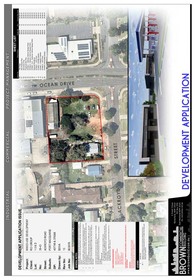
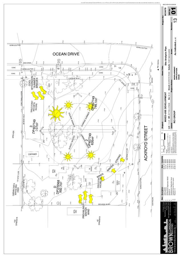
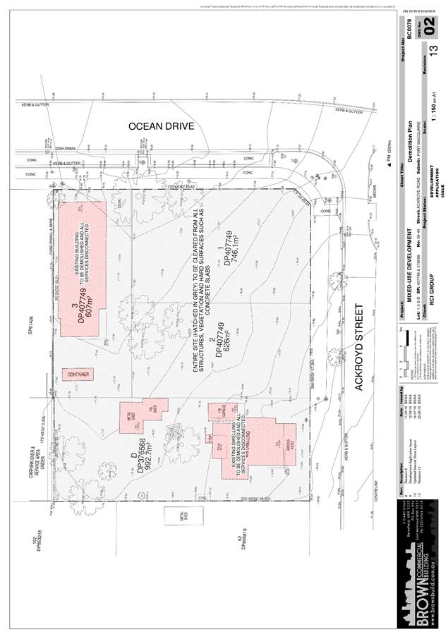
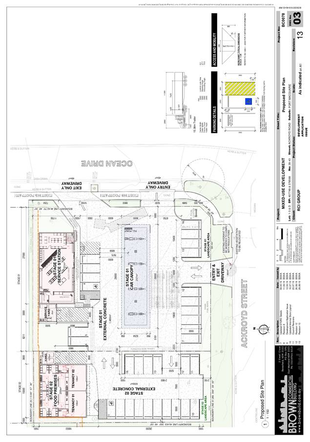
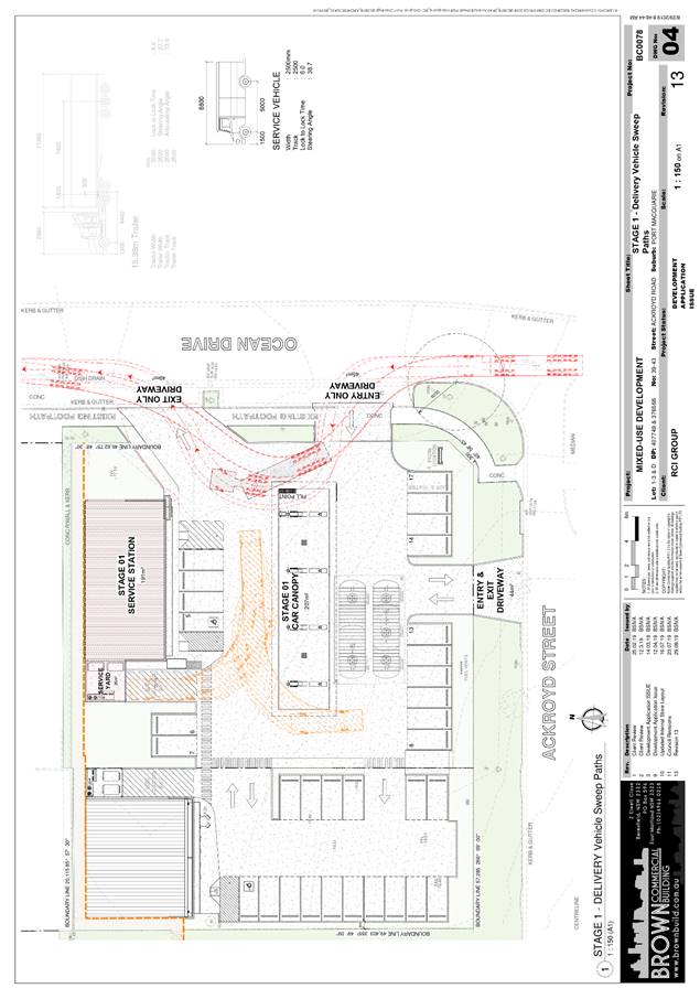
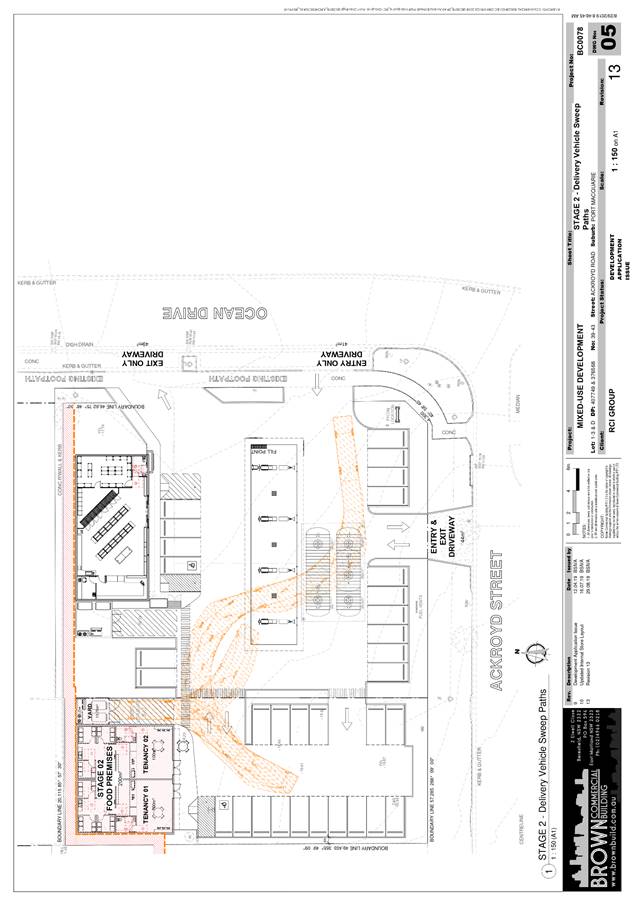
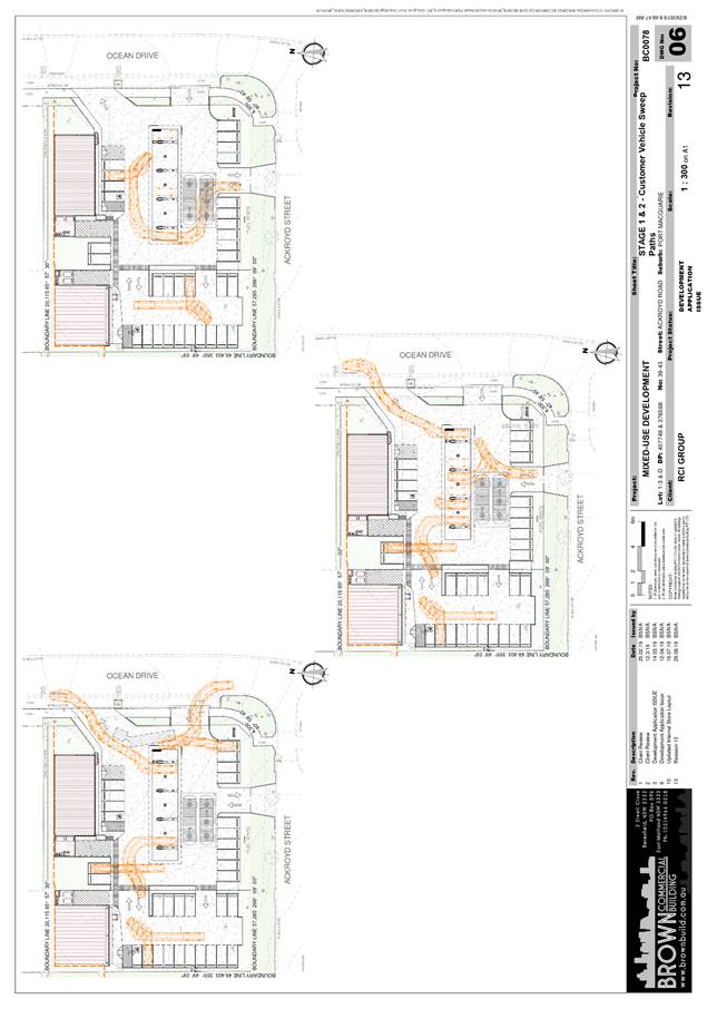
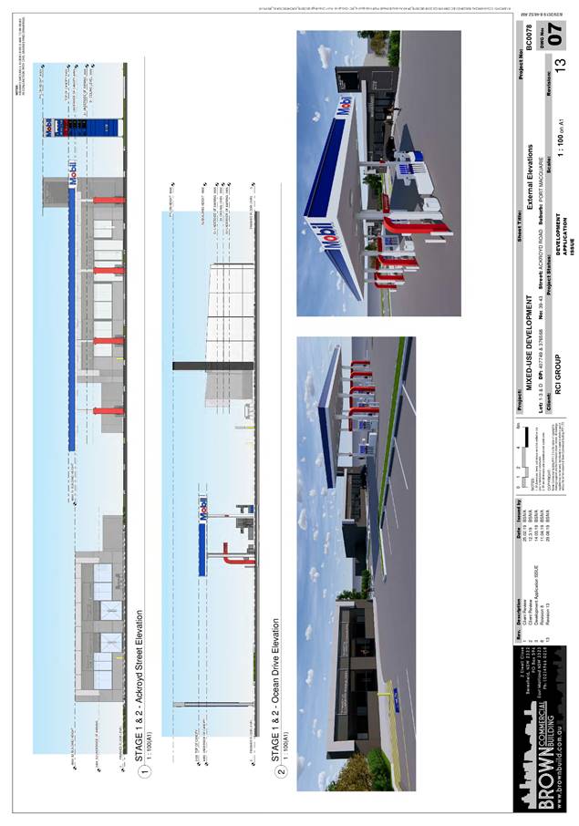
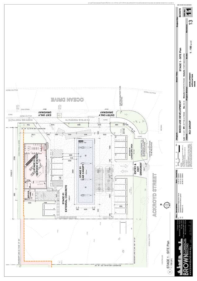
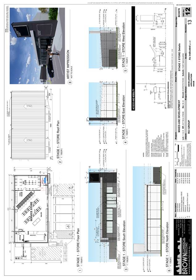
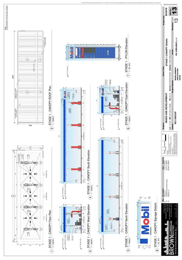
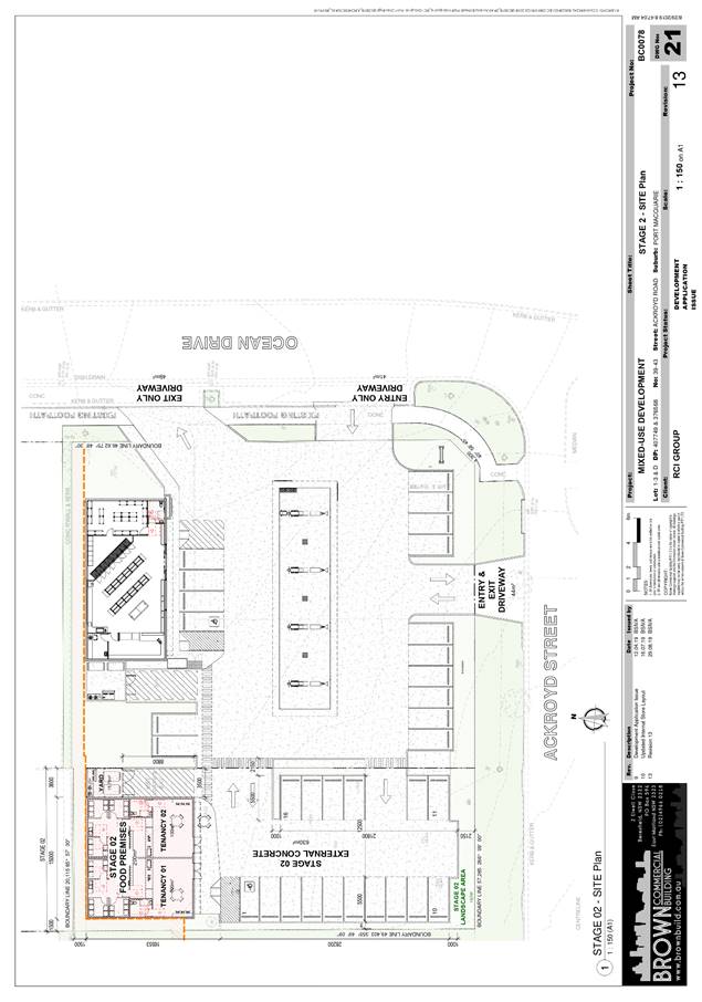
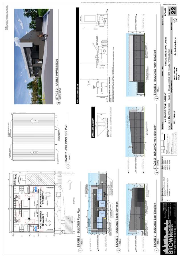
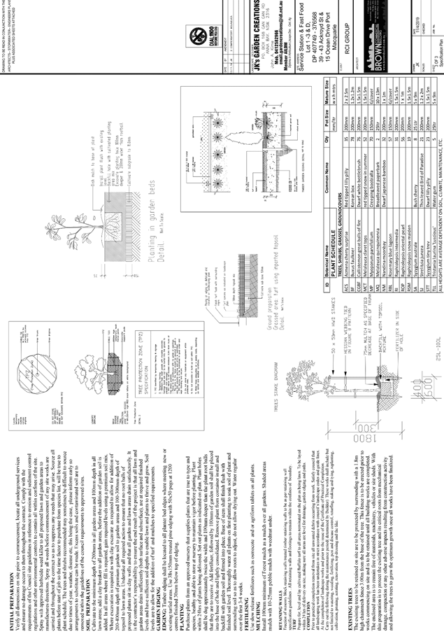
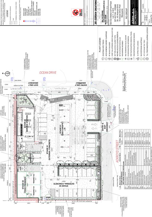
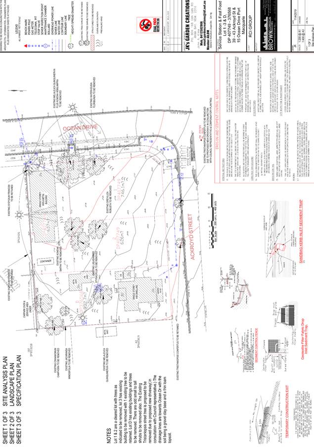
|
ATTACHMENT
|
Development Assessment Panel
11/12/2019
|
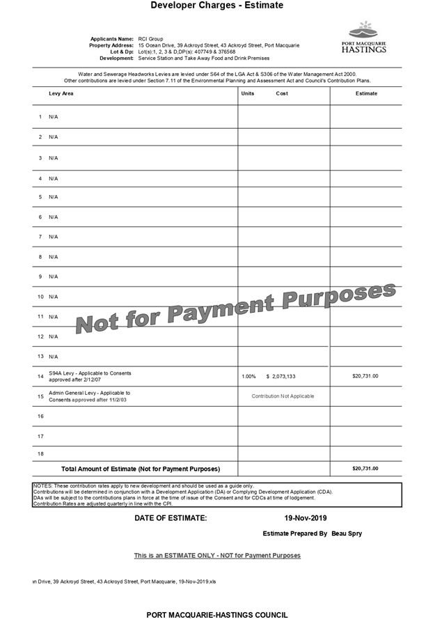
|
ATTACHMENT
|
Development Assessment Panel
11/12/2019
|
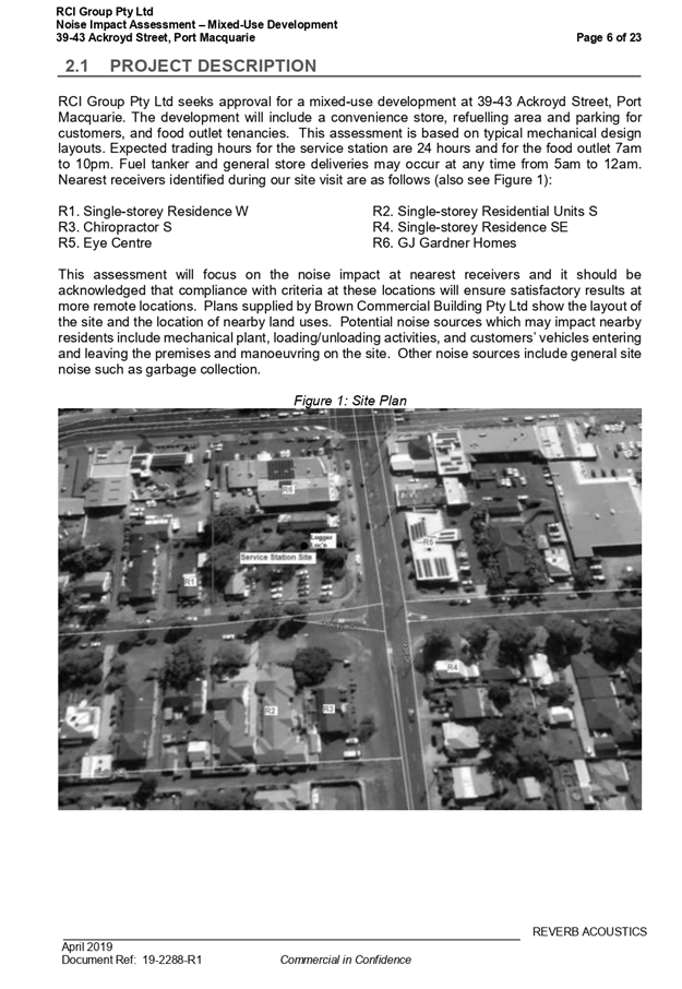
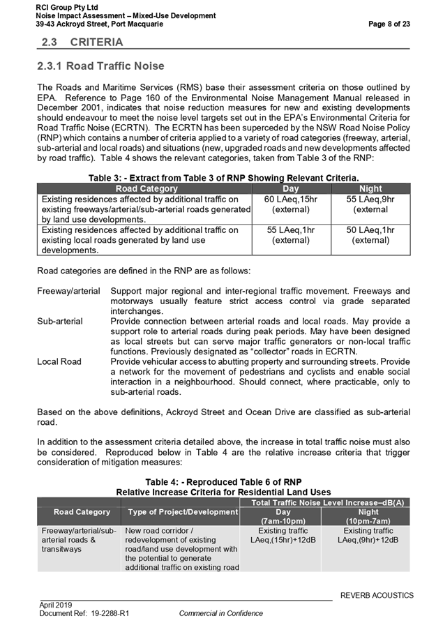
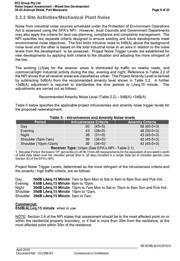
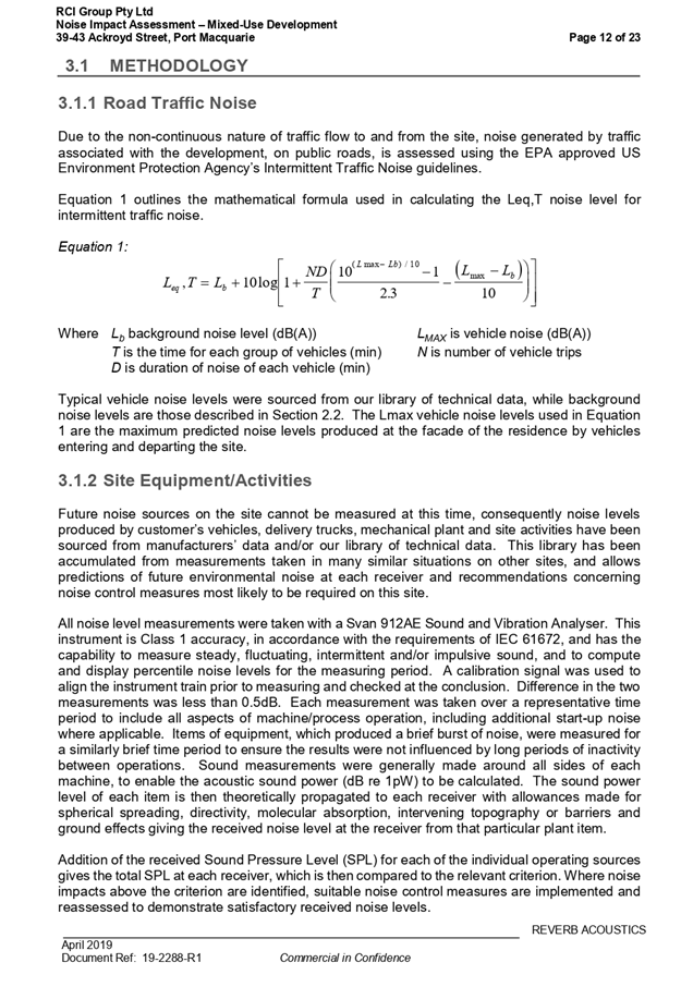
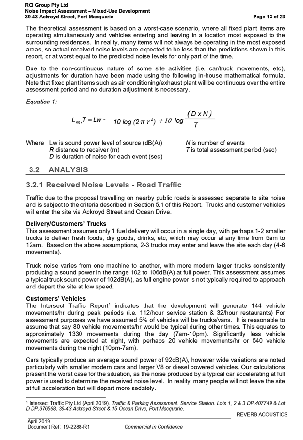
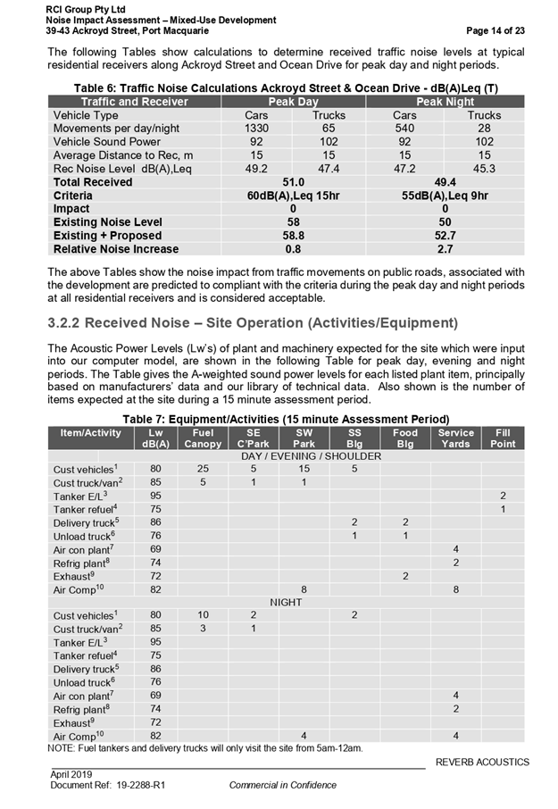
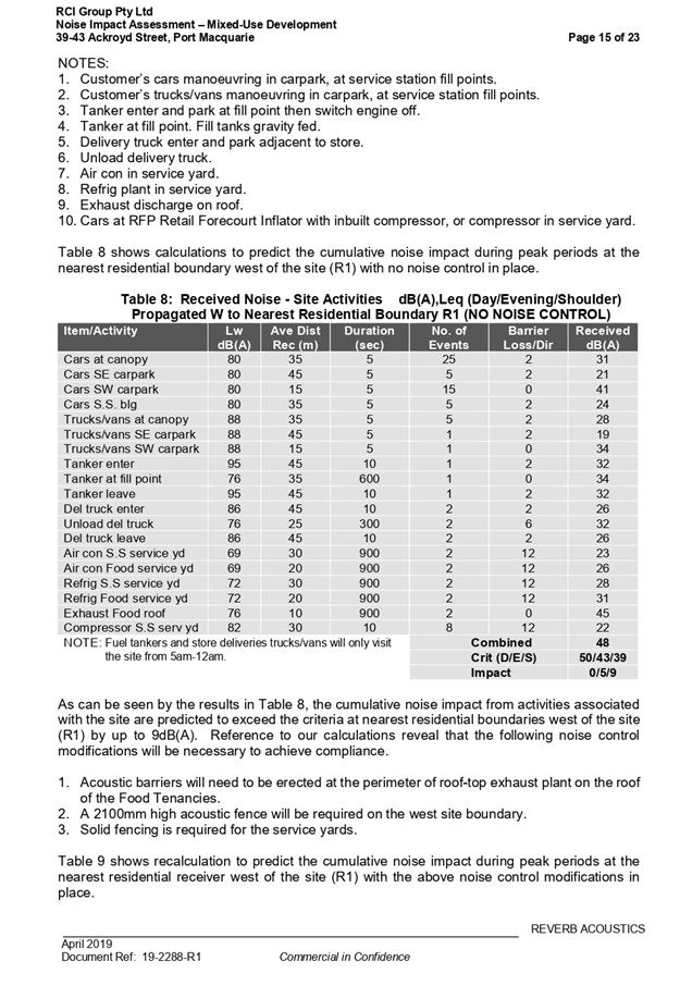
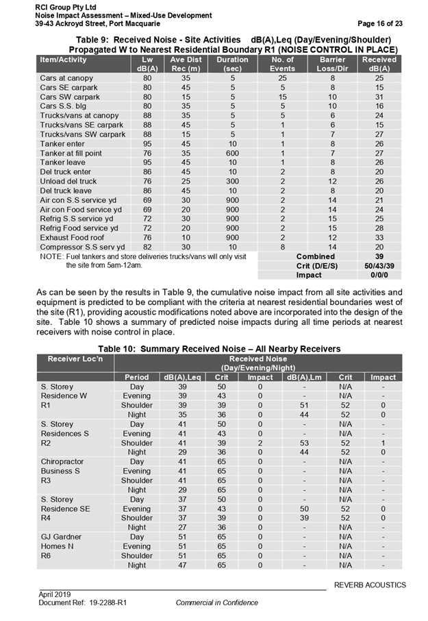

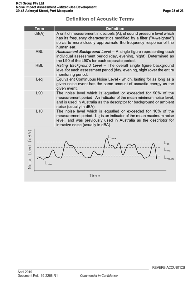
|
ATTACHMENT
|
Development Assessment Panel
11/12/2019
|


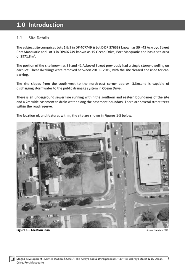
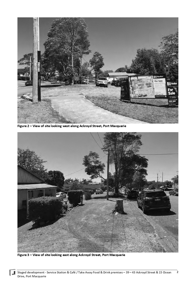
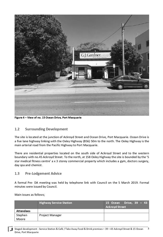
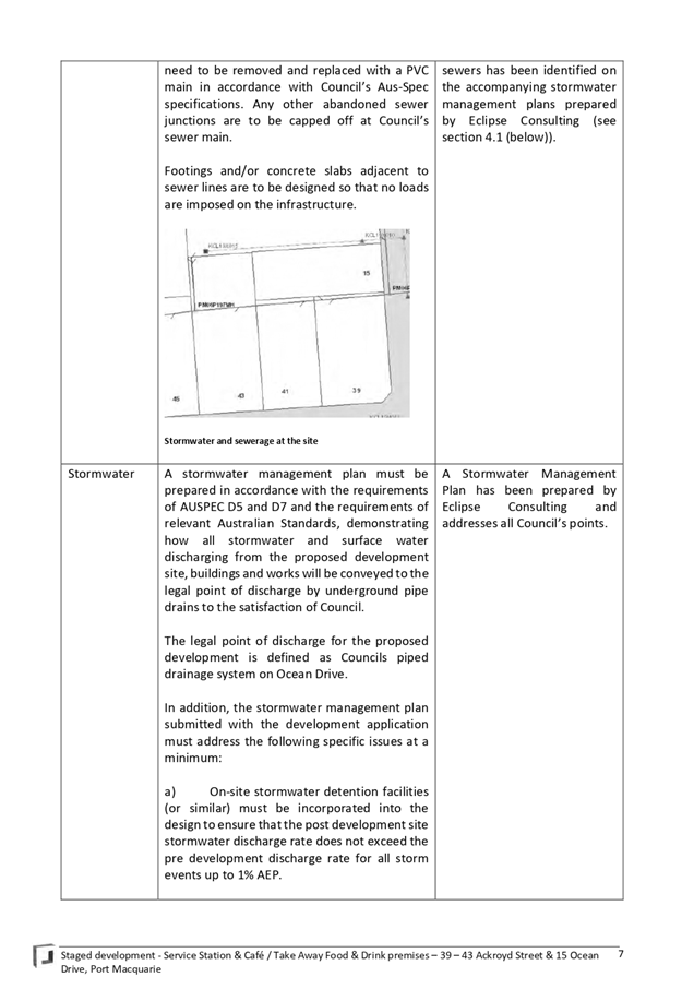
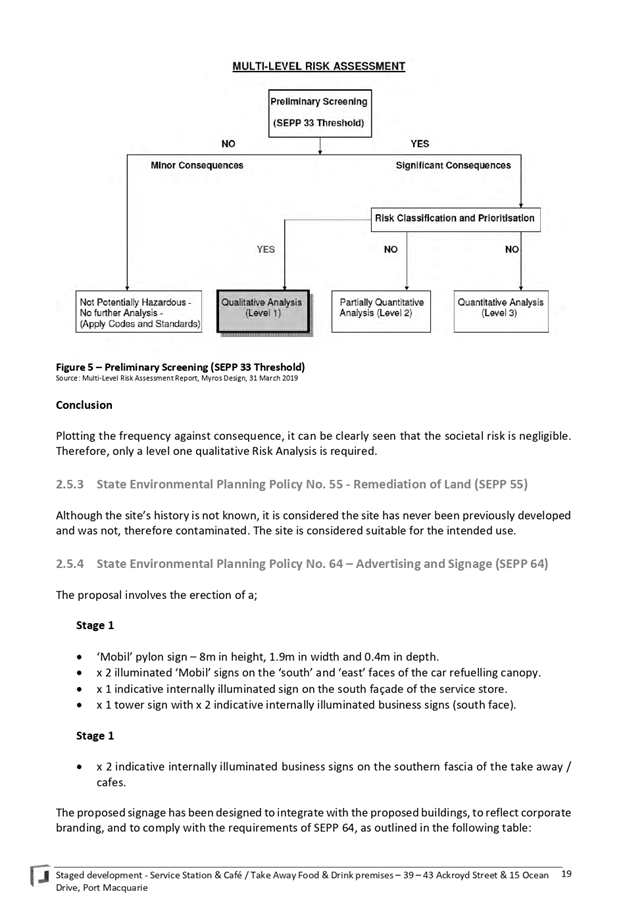
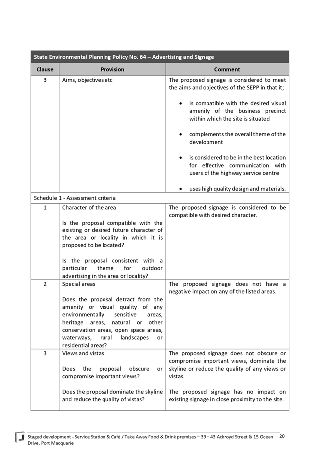
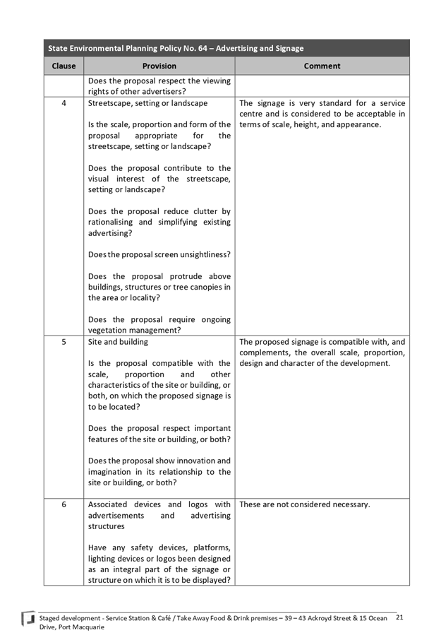
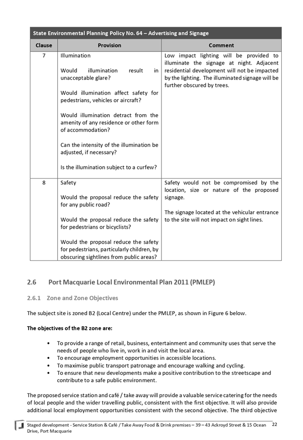
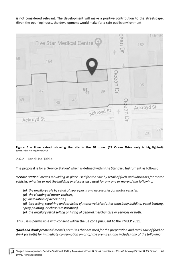
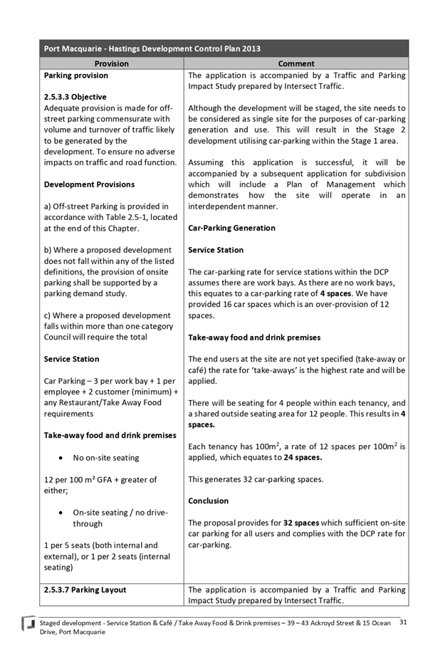
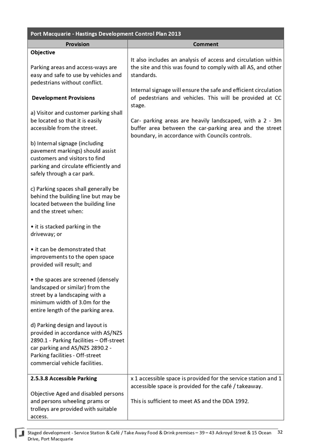
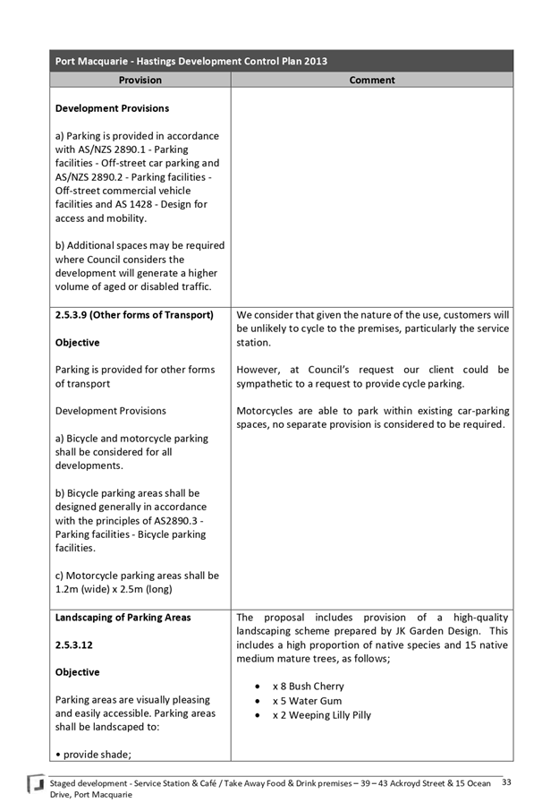
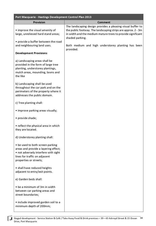
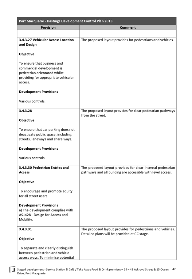
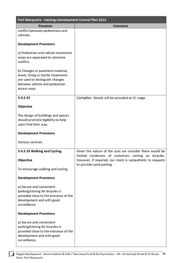
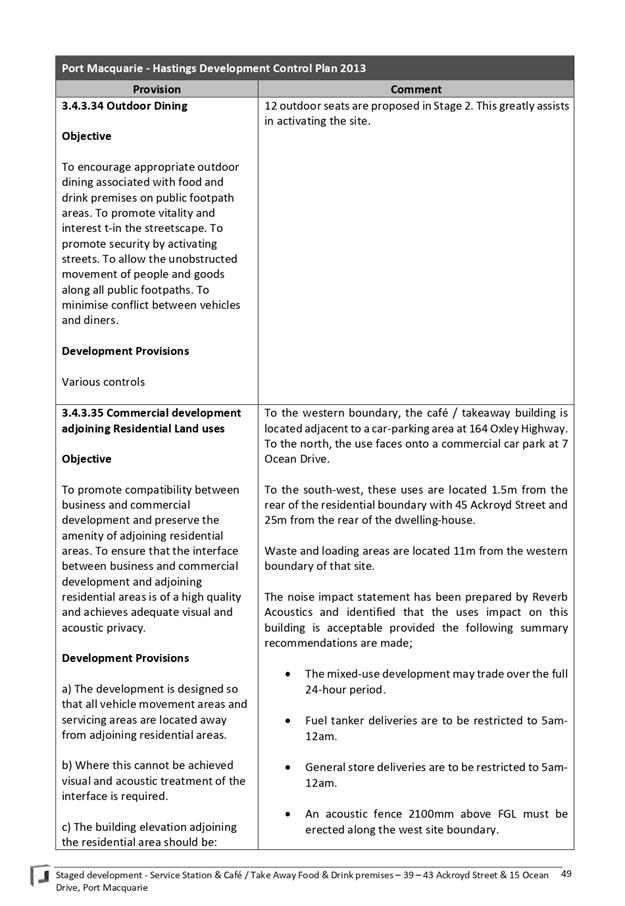
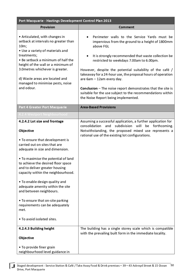

AGENDA Development Assessment Panel 11/12/2019
Item: 10
Subject: DA2007 - 74.2 - Modification to Previous Approved Staged Alterations
and Additions to Motel at Lot 2 DP 1107888, No. 1 Stewart Street, Port
Macquarie
Report Author: Development
Assessment Planning Coordinator, Patrick Galbraith-Robertson
|
Applicant: Encompass
Drafting
Owner: Elanor
Funds Management
Estimated Cost: $75,000
Alignment with Delivery Program
4.3.1 Undertake transparent and
efficient development assessment in accordance with relevant legislation.
|
|
RECOMMENDATION
That
DA2007 - 74.2 for a modification to previous approved staged
alterations and additions to motel at Lot 2, DP 1107888, No.
1 Stewart Street, Port Macquarie,
be determined by granting consent subject to the recommended modified
conditions.
|
Executive
Summary
This
report considers an application for a modification to previous approved
staged alterations and additions to a motel at the
subject site. This report provides an assessment of the application in
accordance with the Environmental Planning and Assessment Act 1979.
Following exhibition of the
application, fourteen (14) submissions were
received with one (1) of these withdrawn during the assessment of the
application.
The site is considered suitable for the proposed development
and the proposal adequately addresses relevant planning controls. The
development is not considered to be contrary to the public's interest and will
not result a significant adverse social, environmental or economic impact.
This report recommends that the modification application be
approved subject to the attached modified conditions.
1. BACKGROUND
Existing
Sites Features and Surrounding Development
The site has an area of 1806.5m2.
The
subject DA was originally approved by Council’s Development Assessment
Panel on 14 May 2007. The approval permitted a nett increase of 30 motel units
over 2 stages. ‘Stage One’ is approved to include a nett increase
of 20 rooms and ‘Stage Two’ is approved to include a nett increase
of 10 rooms.
‘Stage
One’ has been previously detailed to include (as currently approved):
· Retention of 42 of the existing 44 motel rooms.
· Construction of 5 storey west wing containing 22 motel
units.
· Refurbishment of existing kitchen and laundry facilities.
· Construction of 2 level basement carpark and retention of
archaeological remains.
‘Stage
Two’ has been previously detailed to include (as currently approved):
· Additional 2 levels of motel units (16 units) on existing
eastern wing.
· Alteration to Stewart Street elevation.
· Guest lounge and dining room (breakfast only).
· Internal refurbishment (decrease) of existing motel units
on levels 2 and 3 to create 7 ‘family’ sized motel rooms.
· Reconfiguration of parking on Lord Street and associated
landscaping.
· Building identification signage.
The
total number of motel units was detailed to be 74 as currently approved in the
description of the development. However, it has been identified during the
assessment of the modification application that 75 motel units were approved.
‘Stage
One and Stage Two’ of the approved development have not been yet
completed.
The
proposal is for a modification to propose an initial ‘substage 1A’
within ‘Stage One’ of the approved development, which will bring
forward two (2) motel units to be constructed within the eastern-most existing
motel building. The proposed ‘substage 1A’ will reduce the
‘Stage One’ west wing from 22 motel units down to 20 units.
The
modification application does not propose to change the nett total number of 75
motel units as currently approved.
The
modification application proposes the following staging of the development:
· Stage 1A: 2 additional motel units or 46 motel
units in total.
· Stage One: 18 new additional motel units or 64
motel units in total.
· Stage Two: 11 new additional motel units or 75
motel units in total.
In
2007, at the time of lodgement of the original DA, the site was zoned
2(t1) residential tourist in accordance with the Hastings
Local Environmental Plan 2001. The zoning of the site and immediate locality is
shown in the following zoning plan:
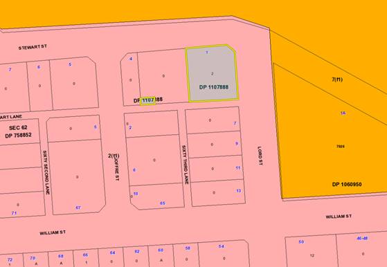
The
existing subdivision pattern and location of existing development within the
locality is shown in the following aerial photograph (Nearmap 21 June 2019):
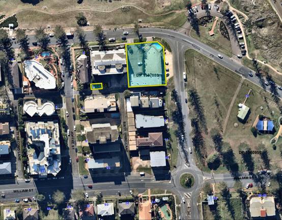
2. DESCRIPTION
OF DEVELOPMENT
Key
aspects of the proposal include the following:
· Modify
the staging of previous approved alterations and additions to introduce an additional
‘Sub-Stage 1A’ (currently 2 stages approved) to construction 2
motel units within an existing Level 3 common room area.
· Removal
of two (2) motel units from a section of the ‘Stage Two’ to be
proposed to be a gymnasium instead of accommodation rooms. The total number of
approved motel rooms remains the same as currently approved.
Refer to Attachment 2 at the end of this report for plans
of the proposed development.
The
proposal has been ‘physically commenced’ by way of refurbishment of
the existing kitchen as part of Stage 1 prior to 15 May 2012 (the 5 year
lapsing date for the consent).
Application
Chronology
· 11
September 2019 - Modification application lodged with Council.
· 24
September to 7 October 2019 - Neighbour notification of proposal.
· 15 October 2019 - Assessing Officer meeting with 2
neighbours to discuss concerns.
· 28 October 2019 - Copies of submissions forwarded to
Applicant for consideration and additional information requested to address
staging implications.
· 5 November 2019 - Clarification of physical commencement
with Applicant.
· 7 November 2019 - Clarification provided from Applicant on
staging and intentions for completion of remainder of stage works under
approval.
· 8 November 2019 - Site inspection by Assessing Officer.
3. STATUTORY
ASSESSMENT
Section
4.15(1) Matters for Consideration
In
determining the application, Council is required to take into consideration the
matters as are relevant to the development that apply to the land to which the development
application relates.
Section 4.55 of the Environmental Planning and Assessment
Act 1979 enables the modification of consents and categorises modification into
three categories - 4.55(1) for modifications involving minor error,
mis-description or miscalculation; 4.55(1A) for modifications involving minimal
environmental impact; and 4.55(2) for other modifications. Each type of
modification must be considered as being substantially the same to that which
was originally consented to.
Is the proposal
substantially the same?
The subject application is being considered under the
provisions of Section 4.55(1A). The proposal is considered to be substantially
the same development to that which was originally consented to and the changes will
have minimal environmental impact. Specifically, the use of the site as a motel
with the footprint and building envelope of the approved alterations remaining
relatively unchanged. The fundamental characteristics and essence of the
development remains essentially the same notwithstanding the internal design
changes and changes to staging. The total nett number of 75 motel units will
remain.
Does the application require notification/advertising
in accordance with the regulations and/or any Development Control Plan?
Neighbour notification has been completed in accordance with
Development Control Plan 2013.
Any submissions made
concerning the modification?
Fourteen (14) submissions have
been received with one (1) being withdrawn following completion of the
neighbour notification period. The issues raised in the submissions received
are considered later in this report.
Any matters referred to in
section 4.15(1) relevant to the modification?
(a) The
provisions (where applicable) of:
(i) Any
Environmental Planning Instrument:
State
Environmental Planning Policy No.71 - Coastal Protection
The
original approved development was assessed and approved against the matters for
consideration under clauses 8, 13, 14, 15 and 16. The assessment details
provided as part of the original assessment remain acceptable to address the
modified proposal. The modified proposal remains to be unlikely to adversely
affect the amenity of the coastal environment. The modified proposal remains to
adequately respond to the existing and planned development in the precinct.
The
requirements of this SEPP remain satisfied.
North
Coast Regional Environmental Plan
The
modified proposal does not include any change to the approved building heights
of both ‘Stage One’ and ‘Stage Two’. No tall building
concurrence is required from the Department of Planning, Industry and
Environment.
The
requirements of this REP remain satisfied.
Hastings
Local Environmental Plan 2001
In
2007, at the time of lodgement of the original DA, the site was zoned two(t1)
residential tourist in accordance with the Hastings
Local Environmental Plan 2001.
Motels
are permissible in the two (t1) zone as originally assessed and approved.
Essential
services remain available to the site pursuant to clause 13 of this LEP.
The
modified proposal does not trigger any reassessment of any potential impacts to
the heritage item (historic well) and archaeological features of the site
(historic Port Macquarie Gaol).
The
requirements of this LEP remain satisfied.
(iii) Any Development
Control Plan in force
Development
Control Plan No. 18 - Off Street Parking Code
The
following assessment comments were provided in the Council assessment report in
2007:
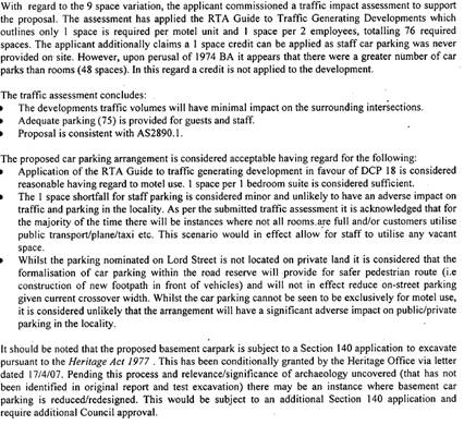
Having
regard to the above, the following assessment comments are provided:
· The total number of motel units resulting from the
completion of ‘Stage One’ and ‘Stage Two’ will remain
the same at 75 units with the introduction of the new ‘Sub-Stage
1A’.
· There will be no nett increase in total parking
demand at the completion of the development based upon what has been approved.
75 parking spaces remain (as detailed in the original assessment report).
· The objectives of the DCP will not be contravened as
a result of the modification changes.
· The above assessment details that there are currently 48
parking spaces approved for the 44 motel rooms approved on-site under BA1969 -
193 and BA1974 - 131. Using the 1 parking space requirement per motel unit
approach rate (RTA Guide to Traffic Generating Development) there is parking
capacity for the additional 2 x motel units with the same number of staff being
4 staff (1 parking space per 2 staff). The calculated parking capacity is
considered acceptable as the overall nett development has effectively approved
the 2 parking space shortfall which the modification proposal can utilise for
the new Sub Stage 1A.
· There is no nett increase in any calculated parking
shortfalls at the completion of the development.
The
requirements of this DCP (as in force at the time) remain satisfied.
Development
Control Plan No.46 - Town Beach Precinct
The
modified proposal does not include any changes which require reassessment
against the development provisions as originally considered. The floor space
ratio remains the same.
The requirements of this DCP remain satisfied.
(iiia) Any planning agreement that has
been entered into under section 7.4, or any draft planning agreement that a
developer has offered to enter into under section 7.4
No planning agreement has been
offered or entered into.
(iv)
Any matters prescribed by the Regulations
No matters prescribed by the
regulations apply.
(b) The likely
impacts of that development, including environmental impacts on both the
natural and built environments, social and economic impacts in the locality:
Context and Setting
The proposal as modified will be
consistent with the locality and adequately addresses planning controls (as in
force at the time) for the area.
The density of the modified proposal
is appropriate and will be unlikely to have any adverse impacts to existing
adjoining properties or the public domain. The proposal remains sufficiently compatible
with other higher density developments in the locality.
Traffic
The
assessment of the original proposal detailed that the increase in traffic
(estimated to be 90 vehicles per day) will not have a significant impact on the
surrounding road infrastructure or traffic volumes.
The
modified proposal does not propose any increase in the total nett number of the
75 motel units therefore the traffic assessment implications remain
satisfactory.
Water Supply and Sewer servicing
A detailed site water supply
and sewer servicing plan will be required to be submitted for assessment with
the Section 68 Local Government Act 1993 application and prior to the issue of
a Construction Certificate for this ‘Substage 1A’.
(c) The
suitability of the site for the development
The modified proposal will fit
into the locality. Site constraints including heritage have been adequately
addressed and appropriate conditions of consent maintained as originally
consented to.
(d) Any
submissions made in accordance with this Act or the Regulations
Fourteen (14) written submissions (one withdrawn) were been received
following public exhibition of the application. Copies of the written
submissions have been provided separately to members of the DAP.
Key
issues raised in the submissions received and comments are provided as follows:
|
Submission Issue/Summary
|
Planning Comment/Response
|
|
General objection to current
approved 5 storey building and 2 level underground carpark.
|
The proposal is for a
modification previously approved alterations and additions which includes the
two main stages of redevelopment. This component of the development approval
is unable to be revisited as this was approved and is not the subject of this
modified DA.
|
|
Query whether substantial
commencement has occurred under the 2007 approval.
|
Whilst not substantial,
‘physical commencement’ has occurred with refurbishment of the
existing kitchen. This is sufficient physical works to keep the consent
active as recognised under the Environmental Planning and Assessment Act
1979.
|
|
The Historic Well located on this 1840 gaol site should
be preserved and protected.
|
The proposal is for a modification to previous approved
alterations and additions where the original application assessed the
potential impacts on the Historic Well heritage item. The modification does
not change any of the potential impacts on this Historic Well heritage item.
|
|
There is insufficient parking for the conversion of
common room to two motel units.
|
Refer to consideration of parking demand impacts
addressed earlier in this report. The modification proposal will, at
completion of the development not change the approved nett increase in
parking demand under this DA at completion of ‘Stage Two’. The
existing motel provides for a minimum acceptable amount of parking which can
address the majority of peak demands as previously addressed.
|
|
Cars park frequently on the nature strip and roadside in
front of the Motel.
|
|
An increase in demand for parking will be hazardous on
the corner of Stewart and Lord Streets.
|
|
Stewart Lane is not built to carry two-way traffic for
the planned underground two level car park entrance and exit for the motel.
There will be an increase in noise and congestion on units behind the IBIS
motel.
|
The proposal is for a modification to previous approved
alterations and additions where the original application assessed traffic
impacts. The modification does not change any of the likely traffic impacts
as the nett number of motel units at the completion of the development is not
proposed to change. The Norfolk Island tree referred to is not proposed to be
removed as part of this application.
|
|
A unique tree is positioned at the eastern end of Stewart
Lane, behind the Motel, which would be negatively
impacted by a significant increase in traffic accessing a
two level underground carpark for the Motel.
|
|
A new DA should be lodged.
|
The Applicant has chosen to lodge a modification
application to change a previous approval which has not yet been completed.
The subject application is consistent with S4.55 of the EP&A Act.
|
|
Neighbours were not notified of kitchen works completed
in 2012.
|
There is no requirement for community consultation to
renotify the proposal to neighbours at construction stage.
|
|
Loss of views and privacy to owner of Unit 1/2 Joffree
Street.
|
The proposal is for a modification previously approved
alterations and additions. The modification proposal does not propose to
change any extent of the building footprint as currently approved or what is
currently existing on-site. No further consideration or reconsideration of
view sharing impacts is required.
|
|
Delivery vehicles to the Motel have limited access now
and this will reduce with the proposed improvements.
|
The modification proposal does not change the existing
and approved access and parking arrangements to the site. Formalised bus
parking is not available on-site.
|
|
Several bus tours are using the Motel and always park on
the street when the carpark is full. The
new units will cause buses to have to use the street which
is unsafe as the passengers and luggage are
unloaded.
|
(e) The
Public Interest
The proposed development
satisfies relevant planning controls and will not adversely impact on the wider
public interest.
4. DEVELOPMENT
CONTRIBUTIONS APPLICABLE
Contribution
payments will be required to reflect the amended staging. A copy of the
contributions estimates are included as Attachments 4 and 5.
5. CONCLUSION AND
STATEMENT OF REASON
The application has been
assessed in accordance with Section 4.15 of the Environmental Planning and
Assessment Act 1979.
Issues raised during
assessment and public exhibition of the application have been considered in the
assessment of the application. Where relevant, conditions have been recommended
to manage the impacts attributed to these issues.
The site is considered suitable for the proposed development
and the proposal adequately addresses relevant planning controls. The
development is not considered to be contrary to the public's interest and will
not result a significant adverse social, environmental or economic impact. It
is recommended that the application be approved, subject to the recommended
conditions of consent provided in the attachment section of this report.
|
Attachments
1View. DA2007
- 74.2 Recommended Modification of Consent
2View. DA2007
- 74.2 Plans
3View. DA2007
- 74.1 Original Approved Plans
4View. DA2007
- 74.1 Contributions Estimate Stage 1A
5View. DA2007
- 74.2 Contributions Estimate - Total
|
|
ATTACHMENT
|
Development Assessment Panel
11/12/2019
|
|
ATTACHMENT
|
Development Assessment Panel
11/12/2019
|
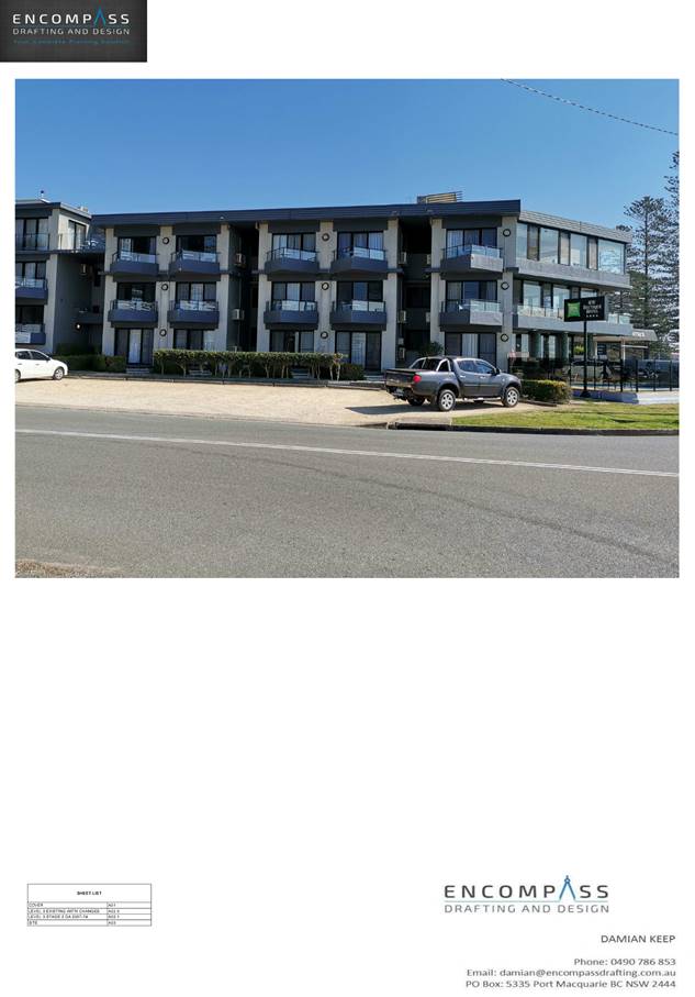
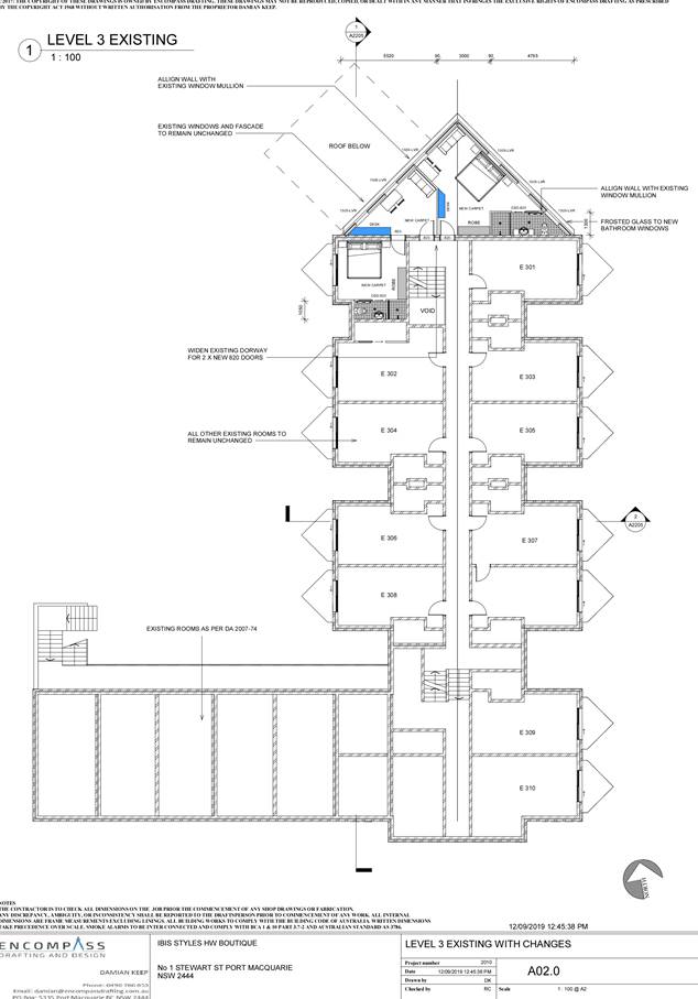
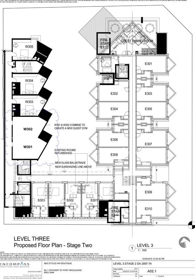
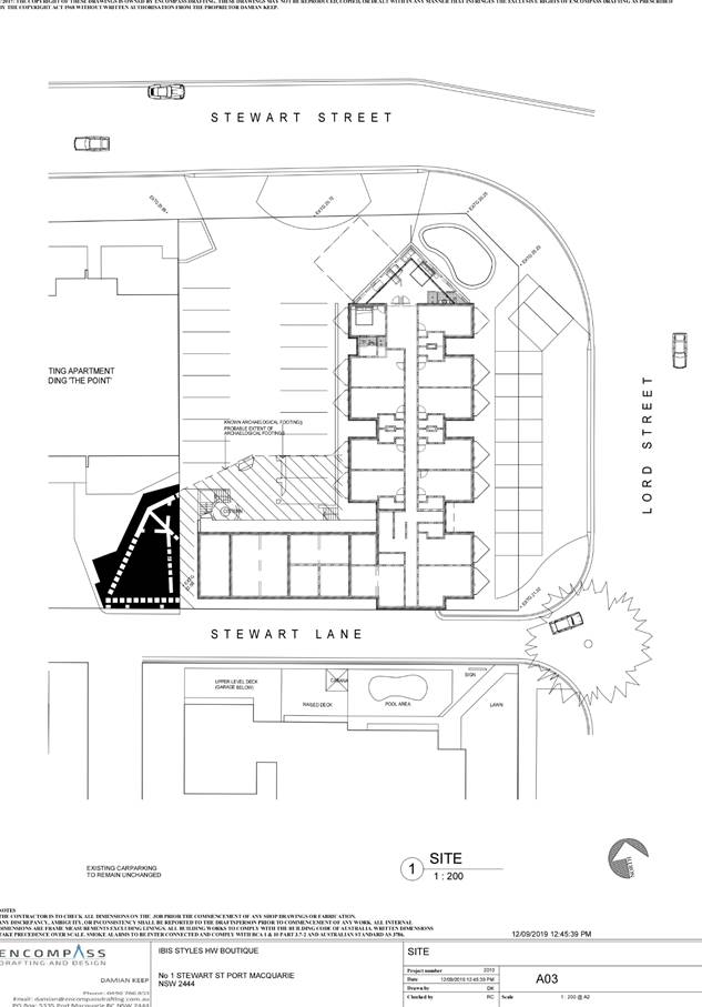
|
ATTACHMENT
|
Development Assessment Panel
11/12/2019
|
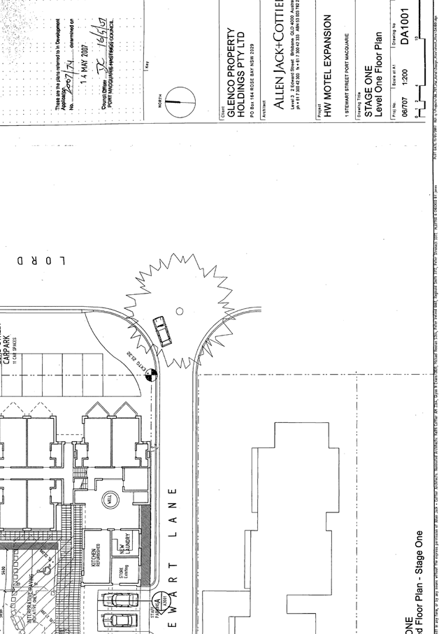
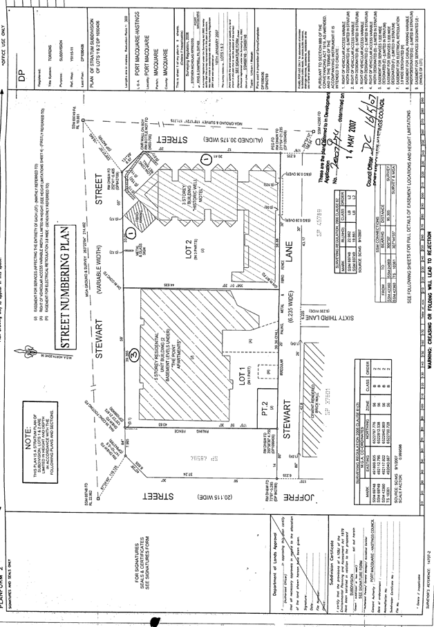
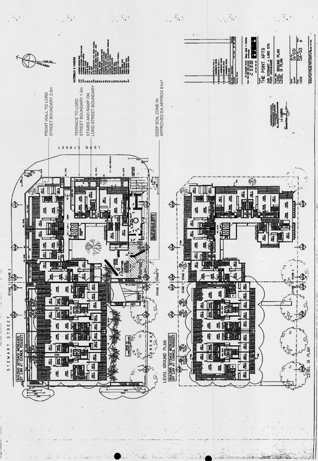
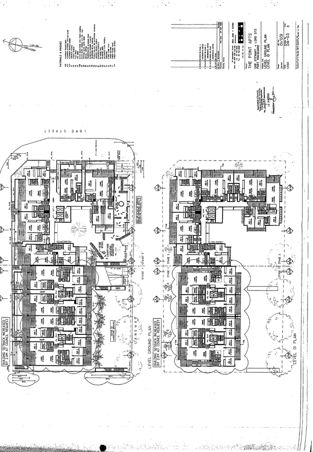
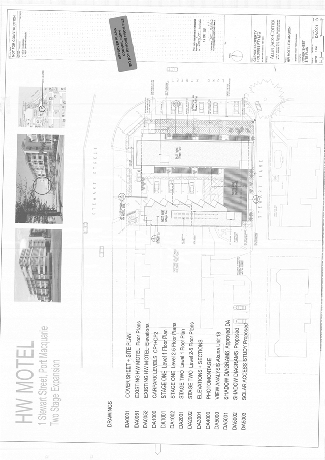
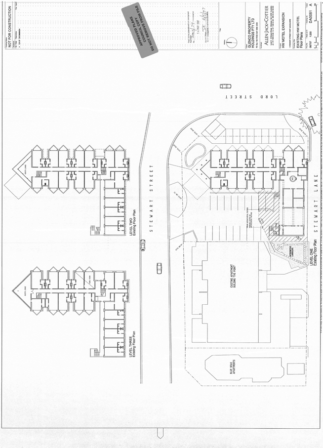
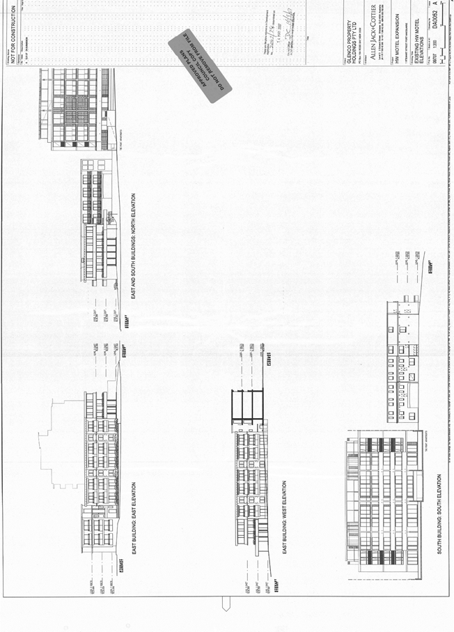
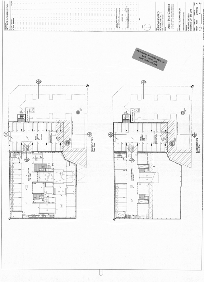
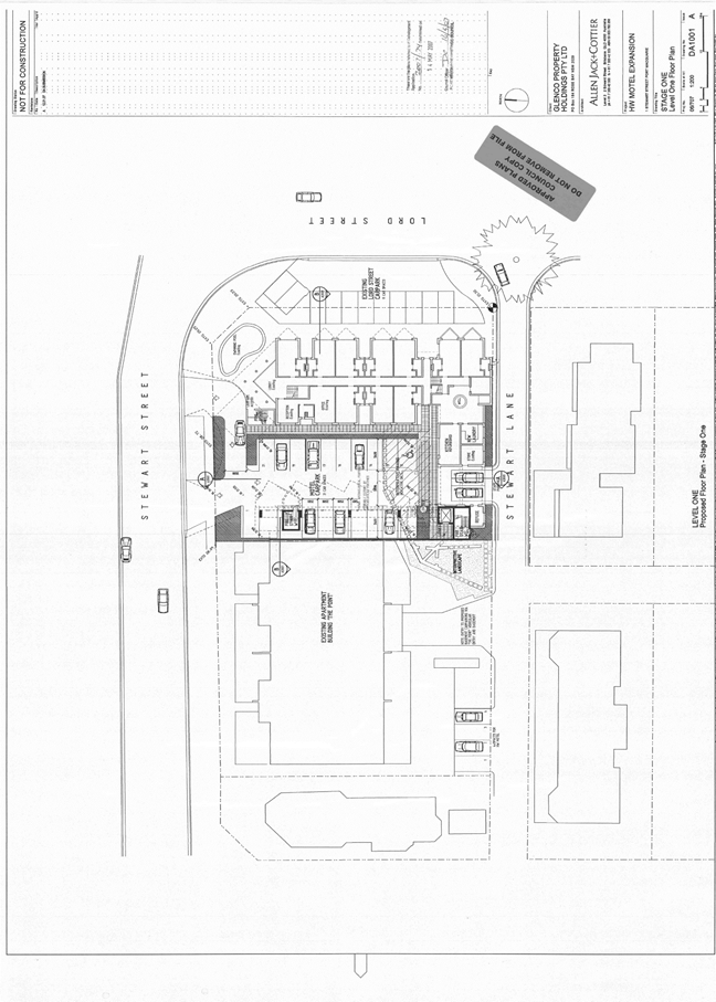
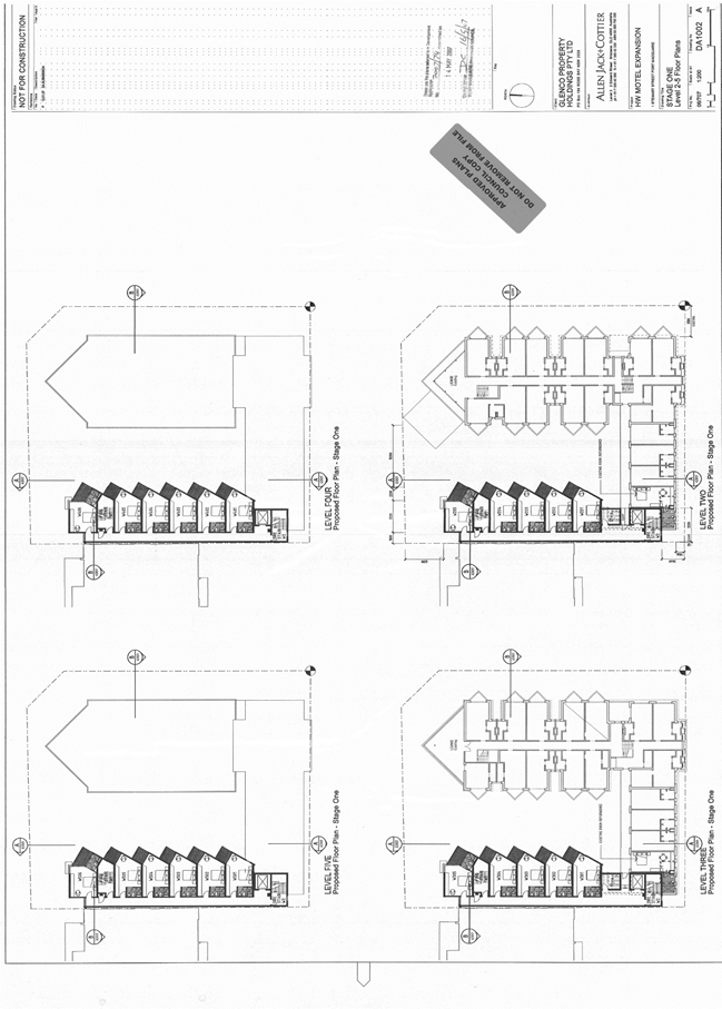
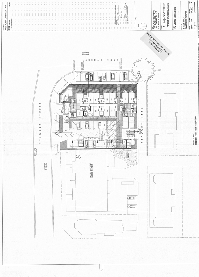
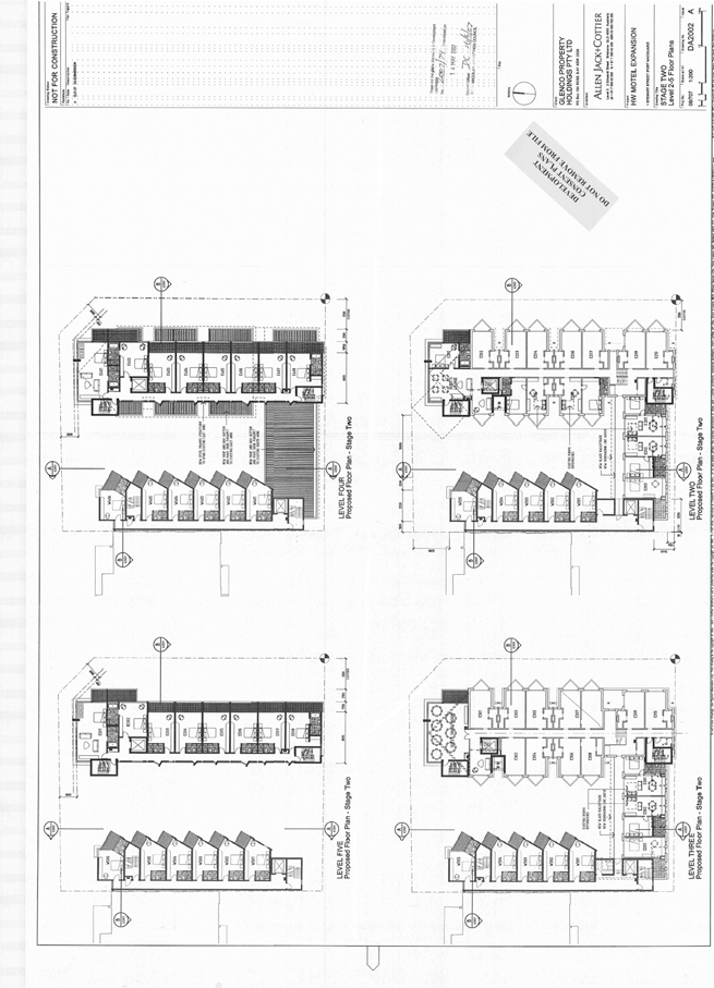
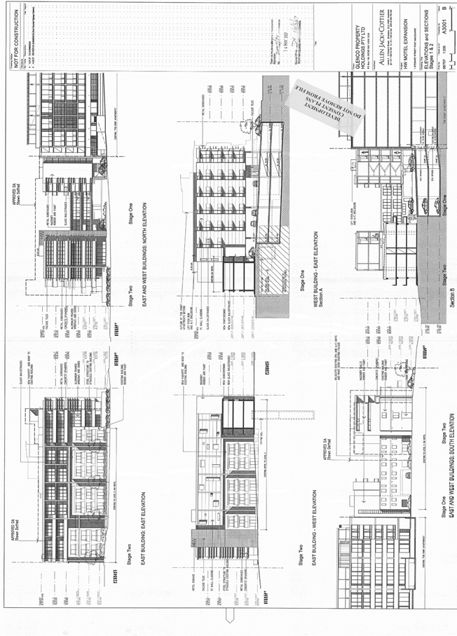
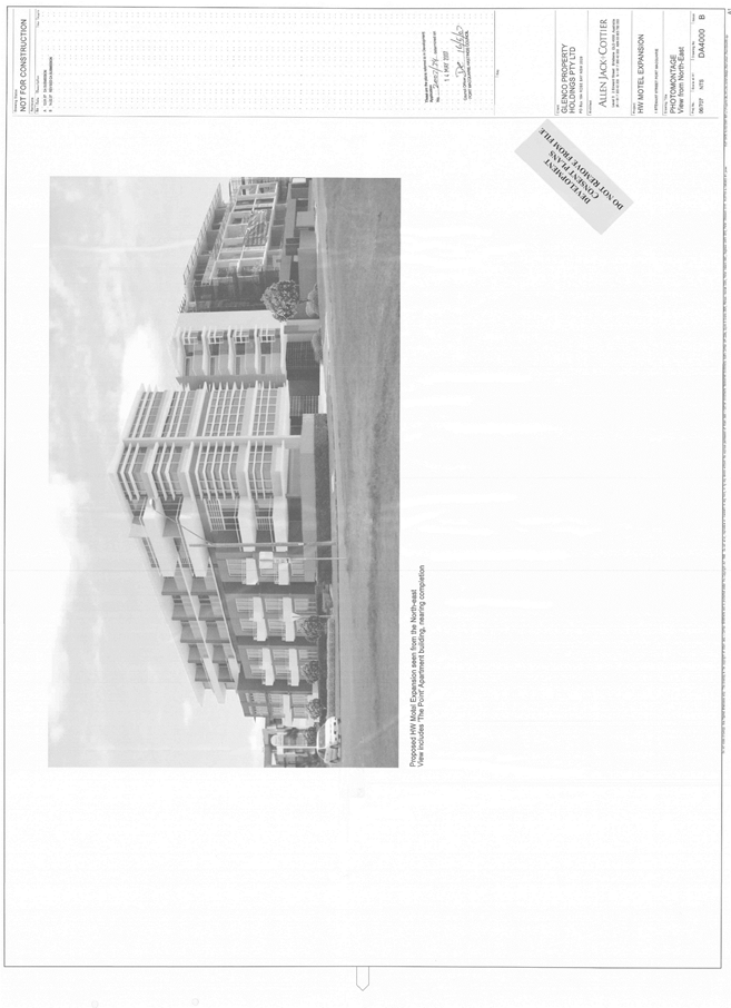
|
ATTACHMENT
|
Development Assessment Panel
11/12/2019
|

|
ATTACHMENT
|
Development Assessment Panel
11/12/2019
|