Coast,
Estuary & Floodplain Advisory Sub-Committee
Business
Paper
|
date of meeting:
|
|
Thursday 30 January
2020
|
|
location:
|
|
Function Room
Port
Macquarie-Hastings Council
17 Burrawan Street
Port Macquarie
|
|
time:
|
|
2:00pm
|
Coast, Estuary &
Floodplain Sub-Committee
CHARTER
Adopted: OC
21/08/19
1.0 OBJECTIVES
·
Assist
Council in undertaking coast, estuary and floodplain management and planning.
·
Assist
Council in reviewing coast, estuary and floodplain studies, plans, and
policies.
·
Engage
with and provide input to Council on other coast, estuary and floodplain
matters and issues which are relevant to the Local Government Area.
·
Provide
and receive two-way feedback from the community.
2.0 KEY
FUNCTIONS
·
Advise Council on conditions and
management issues for the coast, estuaries and floodplains of the Port
Macquarie-Hastings Local Government Area.
·
Advise Council on the development
of coastal, estuary and floodplain management plans for the Port
Macquarie-Hastings Local Government Area.
·
Advise Council on the
implementation of adopted coastal, estuary and floodplain management plans.
·
Act as a Sub- Committee for the
purpose of relevant NSW guidelines as they relate to coastal, estuary and
floodplain management.
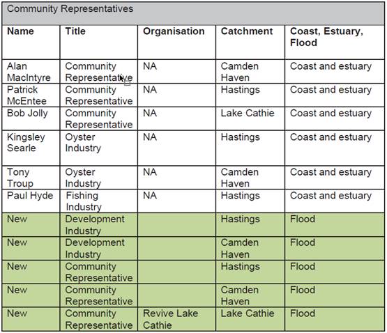
3.0 MEMBERSHIP
3.1 Members
Community
Representatives
|
Name
|
Title
|
Catchment
|
Coast, estuary, flood
|
|
Alan MacIntyre
|
Community Representative
|
Camden Haven
|
Coast and estuary
|
|
Vacant
|
Community Representative
|
Hastings
|
Coast and estuary
|
|
Bob Jolly
|
Community Representative
|
Lake Cathie
|
Coast and estuary
|
|
Kingsley Searle
|
Oyster Industry
|
Hastings
|
Coast and estuary
|
|
Tony Troup
|
Oyster Industry
|
Camden Haven
|
Coast and estuary
|
|
Paul Hyde
|
Fishing
Industry
|
Hastings
|
Coast and estuary
|
|
Vacant
|
Development Industry
|
Hastings
|
Flood
|
|
Vacant
|
Development Industry
|
Camden Haven
|
Flood
|
|
Vacant
|
Community Representative
|
Hastings
|
Flood
|
|
Vacant
|
Community Representative
|
Camden Haven
|
Flood
|
|
Vacant
|
Community Representative
Revive Lake Cathie (RLC)
|
Lake Cathie
|
Flood
|
Council
Representatives
|
Name
|
Title
|
|
Michael Cusato (Chairperson)
|
Councillor
|
|
|
Director, Development & Environment
|
|
|
Manager, Environmental Services
|
|
|
Natural Resources Manager
|
|
|
Environmental Projects Officer
|
Agency
Representatives
|
|
Name
|
Title
|
Organisation
|
Coast, estuary, flood
|
|
Tina Clemens
|
NRM Project Officer
|
DPI - Lands
|
All
|
|
Mick Northam
Scott Anderson (alternative)
|
Fisheries Officer
|
DPI - Fisheries
|
Coast and estuary
|
|
Shane Robinson
Geoff James (alternative)
|
Manager, Hastings Macleay
Area
North Coast Branch
|
DPIE - NPWS
|
Coast and estuary
|
|
John Schmidt
Toong Chin (alternative)
|
Natural Resource Officer -
Water, Floodplains & Coast
|
DPIE - Biodiversity and
Conservation Division
|
Coast and estuary
|
|
Nic Denshire
Toong Chin (alternative)
|
Principal Floodplain
Officer - Water, Floodplains & Coast
|
DPIE - Biodiversity and
Conservation Division
|
Flood
|
|
Paul Burg
Maria Frazer (alternative)
|
Local Commander, Hastings
Cluster
|
SES
|
Flood
|
|
Matt Dawson
Andre Uljee (alternative)
|
Boating Safety Officer
|
RMS
|
Coast and estuary
|
3.2 Obligations
of Members
·
Act
honestly and in good faith.
·
To
act professionally and respectfully.
·
Act
impartially at all times.
·
Participate
actively in the work of the Sub-Committee.
·
Exercise
the care, diligence and skill that would be expected of a reasonable person in
comparable circumstances.
·
Comply
with this Charter at all times.
·
Facilitate
and encourage community engagement with the Sub-Committee and Council.
·
As
per Section 226 (c) of the NSW Local Government Act 1993, the Mayor is the
principal spokesperson for the governing body and Councillors that are members
of a Sub-Committee are to obtain the Mayor’s agreement to make media and
other statements. Further, only the Mayor, or a Councillor with the
Mayor’s agreement and otherwise in accordance with Council policies and
procedures, may release Council information through media statements or
otherwise, and the release of such information must be lawful under the Council
adopted Code of Conduct.
·
A
Councillor as a member of a Sub-Committee or the Sub-Committee itself has no
delegation or authority to make decisions on behalf of Council, nor to direct
the business of Council. The only decision making power open to Councillors is
through formal resolutions of Council.
·
A
Councillor as a member of a Sub-Committee or the Sub-Committee itself cannot
direct staff and must abide by the decisions of Council and the policies of
Council.
·
Councillors,
Council staff and members of this Sub-Committee must comply with the applicable
provisions of Council’s Code of Conduct in carrying out the functions as
Council officials. It is the personal responsibility of Council officials to
comply with the standards in the Code of Conduct and regularly review their
personal circumstances with this in mind.
3.3 Member
Tenure
Sub-Committee members will serve for a period of five (5)
years after which Council will call expressions of interest for the next five (5)
year period. Existing Sub-Committee members will be eligible to re-apply for a
position and serve additional terms. Any changes in the composition of the Sub-Committee
requires the approval of Council.
3.4
Appointment of Members
·
A
formal Expression of Interest process will be undertaken across the Local
Government Area as a way of determining the independent representatives on the Sub-Committee.
·
Applications
from individuals and representatives from interest groups, and who meet the
selection criteria will be encouraged.
·
Council,
by resolution duly passed, will appoint members to the Sub-Committee.
4.0 TIMETABLE
OF MEETINGS
Meetings will be held quarterly as a minimum or more
regularly if required. Meetings will generally be held at the main
administration office of Port Macquarie-Hastings Council.
5.0 MEETING
PRACTICES
5.1 Decision
Making
·
Recommendations of the
Sub-Committee shall be by majority of the members present at each Meeting and
each member shall have one (1) vote.
·
The Chairperson shall not have a
casting vote.
·
In the event of an equality of
votes on any matter, the matter shall be referred directly to Council’s
Executive Group and then to Council.
·
Recommendations from the
Sub-Committee are to be made through the relevant Director, who will determine
under delegation, the process for implementation.
·
The Sub-Committee has no
delegation to allocate funding on behalf of Council. The Sub-Committee may make
recommendations to Council about how funding should be spent in relation to the
above-mentioned objectives, however those funds will only be applied and
expended following a formal resolution of Council.
·
The Sub-Committee may establish
working groups to support actions and activities within the strategies or to
assist in the delivery of projects and events as deemed appropriate. All
projects are to be aligned with Council’s suite of Integrated Planning
and Reporting documents.
5.2 Quorum
The quorum for the Sub-Committee will be half of the members
plus one. A quorum must include a minimum of one (1) Councillor and one (1)
Council staff member being present.
5.3 Chairperson
and Deputy Chairperson
·
The
Chairperson shall be the Councillor, Chair Coast, Estuary and Floodplain
Sub-Committee
·
At
all Meetings of the Sub-Committee, the Chairperson shall occupy the Chair and
preside. In the absence of the Chairperson the Director will act as Chairperson
for that meeting.
5.4
Secretariat
·
The
Director is responsible for ensuring the Sub-Committee has adequate secretariat
support.
·
The
secretariat will ensure that the business paper and supporting papers are
circulated at least three (3) days prior to each meeting.
·
Minutes
shall be appropriately approved and circulated to each member within three (3)
weeks of a meeting being held.
·
All
Sub-Committee agendas and minutes will be made available to the public via
Council’s web site, unless otherwise restricted by legislation.
5.5 Recording
of decisions and explicit discussions on risks
The Secretariat shall record all discussions
that relate to risks.
6.0 CONVENING
OF “OUTCOME SPECIFIC” WORKING GROUPS
·
The
Sub-Committee can at times request a working group to be convened, for a
limited period of time, for a specific action, these specifics will be minuted
clearly. The working group will report back to the Sub-Committee with outcomes.
·
Any
working groups established under this Sub-Committee will be responsible for
providing updates to the Sub-Committee. The working groups will be an informal
gathering with notes collected and managed by the senior staff member in
attendance and will be tabled at the Sub-Committee meetings.
7.0 CONFIDENTIALITY
AND CONFLICT OF INTEREST
·
Any
independent members of the Sub-Committee will be required to complete a
confidentiality agreement that will cover the period of their membership of the
Sub-Committee.
·
Sub-Committee
members must declare any conflict of interests at the start of each meeting or
before discussion of a relevant item or topic. Details of any conflicts of
interest should be appropriately minuted.
·
Where
members or invitees at Sub-Committee meetings are deemed to have a real or
perceived conflict of interest, it may be appropriate that they be excused from
Sub-Committee deliberations on the issue where the conflict of interest may
exist
Coast, Estuary & Floodplain Sub-Committee
ATTENDANCE
REGISTER
|
Community
Representatives
|
Representing
|
Catchment
|
Expertise Area
|
Date
|
Date
|
Date
|
|
Alan MacIntyre
|
Community
|
Camden Haven
|
Coast, Estuary
|
|
|
|
|
Bob Jolly
|
Community
|
Lake Cathie
|
Coast, Estuary
|
|
|
|
|
Kingsley Searle
|
Oyster Industry
|
Hastings
|
Coast & Estuary
|
|
|
|
|
Tony Troup
|
Oyster Industry
|
Camden Haven
|
Coast & Estuary
|
|
|
|
|
Paul Hyde
|
Fishing Industry
|
Hastings
|
Coast & Estuary
|
|
|
|
|
Vacant
|
Development Industry
|
Hastings
|
Flood
|
|
|
|
|
Vacant
|
Development Industry
|
Camden Haven
|
Flood
|
|
|
|
|
Vacant
|
Community
|
Hastings
|
Flood
|
|
|
|
|
Vacant
|
Community
|
Camden Haven
|
Flood
|
|
|
|
|
Vacant
|
Community -
Revive Lake Cathie
|
Lake Cathie
|
Flood
|
|
|
|
|
Council Representatives
|
|
|
|
|
Councillor Peter Alley
(Chair)
|
|
|
|
|
Councillor Lisa
Intemann (Deputy Chair)
|
|
|
|
|
Director Development &
Environment - Melissa Watkins
|
|
|
|
|
Group Manager Regulatory
& Environment Services - Debbie Archer
|
|
|
|
|
Natural Resources Manager
- Blayne West
|
|
|
|
|
Environmental Projects
Officer - Jesse Dick
|
|
|
|
|
Agency Representatives
|
Title
|
Organisation
|
Expertise Area
|
|
|
|
|
Tina Clemens
|
NRM Project Officer
|
DPI - Lands
|
Coast, Estuary, Flood
|
|
|
|
|
Michael Northam
Scott Anderson (alt.)
|
Fisheries Officer
|
DPI - Fisheries
|
Coast, Estuary
|
|
|
|
|
Shane Robinson
Geoffrey James (alt.)
|
Manager, Hastings Macleay
Area North Coast Branch
|
DPIE - NPWS
|
Coast, Estuary
|
|
|
|
|
John Schmidt
|
Natural Resource Officer -
Water, Floodplains & Coast
|
DPIE - Biodiversity &
Conservation Division
|
Coast, Estuary
|
|
|
|
|
Nic Denshire
|
Principal Floodplain
Officer - Water, Floodplains & Coast
|
DPIE - Biodiversity &
Conservation Division
|
Flood
|
|
|
|
|
Paul Burg
Maria Fraser (alt.)
|
Local Commander, Hastings
Cluster
|
SES
|
Flood
|
|
|
|
|
Matt Dawson
Andre Uljee (alt.)
|
Boating Safety Officer
|
RMS
|
Coast, Estuary
|
|
|
|
Key: P = Present
A
= Absent With Apology
X
= Absent Without Apology
Coast,
Estuary & Floodplain Advisory Sub-Committee Meeting
Thursday 30 January
2020
Items of Business
01 Acknowledgement
of Country............................................................................. 8
02 Apologies.......................................................................................................... 8
03 Confirmation
of Minutes..................................................................................... 8
04 Disclosures
of Interest..................................................................................... 14
05 Business
Arising from Previous Minutes............................................................ 18
06 Membership
of the Coast, Estuary and Floodplain Advisory Sub-Committee....... 19
07 Floodplain
Management................................................................................... 37
08 North
Brother Local Catchments Flood Study - Stage 2 - Floodplain Risk Management
Study - Initial Options Assessment Report.................................................................... 51
09 Active
Coast, Estuary & Floodplain Projects Status Update.............................. 136
10 Lake
Innes / Lake Cathie Estuarine System - Update....................................... 146
11 Passing
of Patrick McEntee and Laurie Lardner............................................... 289
12 Proposed
Coast, Estuary & Floodplain Advisory Sub-Committee Meeting Dates for
Endorsement..................................................................................................................... 290
13 General
Business
AGENDA Coast, Estuary & Floodplain Advisory
Sub-Committee 30/01/2020
Subject: ACKNOWLEDGEMENT
OF COUNTRY
"I acknowledge that we are
gathered on Birpai Land. I pay respect to the Birpai Elders both past and
present. I also extend that respect to all other Aboriginal and Torres Strait
Islander people present."
RECOMMENDATION
That the apologies received be accepted.
Subject: CONFIRMATION
OF PREVIOUS MINUTES
Recommendation
That the Minutes of the Coast,
Estuary & Floodplain Advisory Sub-Committee Meeting held on 28 March 2019
be confirmed.
MINUTES
Coast, Estuary & Floodplain Advisory
Sub-Committee Meeting
28/03/2019
PRESENT
Members:
Councillor Mike Cusato (Chair)
Alan MacIntyre (Community Rep.)
Bob Jolly (Community Rep. - Lake
Cathie)
Kingsley Searle (Oyster Industry
& Community Rep – North Shore)
Laurie Lardner (Community Rep.)
Patrick McEntee (Community Rep.)
Staff:
Melissa Watkins (PMHC)
Blayne West (PMHC)
Gordon Cameron (PMHC)
Jesse Dick (PMHC)
Agencies:
Michael Northam (DPI - Fisheries)
John Schmidt/Nicholas Denshire (Office of Environment &
Heritage)
Andre Uljee (Maritime Division - RMS)
Maria Frazer (State Emergency
Services)
Michael Stubbs represented Paul Burg (State Emergency
Services)
Michael Barberie represented Tina Clemens (Lands
Department)
Geoffrey James represented Shane Robinson (National Parks
Wildlife Service)
Other Attendees:
Chris Thomas (Advisian - consultant)
Lih Chong (Jacobs - consultant)
Mark Edenborough (PMHC -
Stormwater)
Caroline Ortel (Office of Environment & Heritage)
|
The meeting opened at 2.00pm.
|
|
01 ACKNOWLEDGEMENT
OF COUNTRY
|
|
The
Acknowledgement of Country was not delivered.
|
|
02 APOLOGIES
|
|
That
the following apologies be accepted:
Councillor Rob Turner (Deputy
Chair)
Maria Doherty (PMHC)
Paul Burg (State Emergency
Services)
Tony Troup (Oyster Industry)
Tina Clemens (Lands Department)
Shane Robinson (National Parks Wildlife Service)
Matt Dawson (Maritime Division - RMS)
Council staff to follow up with Paul Hyde and Adrian
Button to confirm whether they still wish to be active members of the
committee noting that Adrian Button has recently moved to Queensland and the
Hastings Fisherman’s Co-op has closed.
|
|
03 CONFIRMATION
OF MINUTES
|
|
CONSENSUS
That
the Minutes of the Coast, Estuary & Floodplain Advisory Sub-Committee
Meeting held on 31 July 2018 be confirmed.
|
|
04 DISCLOSURES
OF INTEREST
|
|
There were no disclosures of interest presented.
|
|
05 BUSINESS
ARISING FROM PREVIOUS MINUTES
|
|
Nil.
|
|
09 Impacts
of the Recent Climate Change Decision of Council on Floodplain Management
|
|
Committee
members agreed to bring Item 9 forward for discussion.
There was
robust discussion on various aspects of the report.
Committee members strongly disagreed with the new policy
direction on the basis the 900mm sea level rise requirement has been in place
for many years and change will create uncertainty. The committee noted that
there will be many wide ranging implications as a result of the new policy
direction.
Chair Cusato proposed to discuss the recent decision with
Councillors and Staff.
Mellissa Watkins proposed a further briefing with
Councillors and Staff.
CONSENSUS
That the
Committee recommend Council review the decision/report.
|
|
|
|
06 Hibbard
Precinct Flood Study - Draft Report
|
|
Chris Thomas (Advisian) provided
a detailed presentation on the report. The
presentation was well received by the committee.
Kingsley
Searle noted importance of Connection Creek on flooding in the lower Hastings
catchment.
Gordon
Cameron discussed the next stage of the project after the flood study (ie.
The management study).
CONSENSUS
That the Committee recommend to
Council, that the draft Hibbard Precinct Flood Study (2019) be placed on
public exhibition for not less than 28 days.
|
|
|
|
08 Lake Cathie
Fish Kill
|
|
Committee members agreed to bring
Item 8 forward for discussion.
There was general discussion on
various aspects of the report.
Bob
Jolly queried whether Council had been in contact with the media to explain
the current situation, especially considering the formulation of the new
community action group. Melissa Watkins confirmed that Council had been
contacted by the media on numerous occasions and Council had provided
information on the management issues of the lake system.
Kingsley
Searle questioned how quickly Council can initiate an opening if required.
Gordon Cameron confirmed that machinery can be mobilised within days, however
optimum conditions are unlikely to be present for a low level opening
regardless of how quickly an opening can occur.
CONSENSUS
That the Committee note the
report on the Lake Cathie Fish Kill.
|
|
|
|
07 North Brother
Local Catchments Flood Study - Draft Report
|
|
Mark Edenborough (PMHC –
stormwater) provided a background to the project.
Lih Chong (Jacobs) provided a
detailed presentation on the report. The
presentation was well received by the committee.
Gordon
Cameron discussed the next stage of the project after the flood study (ie.
The management study).
CONSENSUS
That the Committee recommend to
Council that the draft North Brother Local Catchments Flood Study (2019) be
placed on public exhibition.
|
|
|
Item - 08 Lake Cathie Fish Kill -
has been moved to another part of the document.
Item - 09 Impacts of the Recent
Climate Change Decision of Council on Floodplain Management - has been moved to
another part of the document.
|
10 Active Coast,
Estuary & Floodplain Projects Status Update
|
|
Jesse
Dick presented the report.
CONSENSUS
That the Committee note the
status of the active Coast, Estuary and Floodplain projects.
|
|
|
|
11.01 Committee Membership
|
|
Patrick McEntee and Alan MacIntyre
both advised the committee of poor health
and confirmed their wish to continue on the committee.
Laurie Lardner noted Thor Aaso’s resignation from
Council and queried whether a new Acid Sulphate Soils (ASS) officer would be
employed to replace Thor. Gordon Cameron confirmed that Blayne West has taken
this role.
Laurie Lardner confirmed that this would be his last
meeting and would be resigning from the committee. Laurie Lardner spoke
highly of the committee and its achievements for the community over the past
years. Specifically the ASS program and the change to dredging activities in
the estuaries. Laurie Lardner also commended Councillor Lisa Intemann for her
work in this area and her contribution on previous committees. Councillor
Cusato & Gordon Cameron both thanked Laurie Lardner for his attendance
over many years and confirmed that his contribution was greatly valued and
that his resignation will be a loss for both the committee and the community
as a whole.
Jesse Dick noted that new memberships to the committee
may be required due to absences created since the Coast & Estuary and
Floodplain committees merged in 2015. Gordon Cameron noted a good spread of
members across the main estuary areas, however more experience in flooding
would be useful. Council will consider the membership of the Committee and will
advertise for expressions of interest for new committee members with an
interest in floodplain management – ie. one each from the Camden Haven
and Hastings floodplains in particular.
|
|
11.02 Forestry Operations, Lorne State Forest
|
|
Gordon
Cameron at the request of Tony Troup noted the Forestry operations occurring
within the Lorne State Forest, particularly at Cold Nob Road. Gordon Cameron
confirmed that Blayne West has raised this issue with NSW Forestry and a
response will be provided at the next meeting.
|
|
11.03 Personal Watercraft Use in Local Waterways
|
|
Gordon
Cameron noted that there has been reports from the community about personal
watercraft use (Jet Ski’s) within local waterways. Andre Uljee (RMS)
requested that Council ensure that state government agencies be made aware
when issues arise that they are responsible for managing. Melissa Watkins
confirmed that Council aims to contact agencies as soon as issues arise so
that they can be involved. However this issue stemmed from a Councillor
request on a matter that had occurred over 12 months ago which only came to
light via a community strategic planning meeting held earlier in the year.
|
|
The meeting closed at 4.51pm.
|
AGENDA Coast, Estuary & Floodplain Advisory
Sub-Committee 30/01/2020
Subject: DISCLOSURES
OF INTEREST
RECOMMENDATION
That Disclosures of Interest be presented
DISCLOSURE OF
INTEREST DECLARATION
|
Name of Meeting:
|
|
Meeting
Date:
|
|
Item
Number:
|
|
Subject:
|
|
I,
the undersigned, hereby declare the following interest:
Pecuniary:
 Take no part
in the consideration and voting and be out of sight of the meeting. Take no part
in the consideration and voting and be out of sight of the meeting.
Non-Pecuniary
– Significant Interest:
Take no part
in the consideration and voting and be out of sight of the meeting.
Non-Pecuniary
– Less than Significant Interest:
May
participate in consideration and voting.
|
|
For
the reason that:
|
|
Name:
Signed:
|
Date:
|
|
Please submit to the
Governance Support Officer at the Council Meeting.
|
 (Refer
to next page and the Code of Conduct)
(Refer
to next page and the Code of Conduct)
Pecuniary Interest
4.1
A pecuniary interest is an interest
that you have in a matter because of a reasonable likelihood or expectation of
appreciable financial gain or loss to you or a person referred to in clause
4.3.
4.2
You will not have a pecuniary
interest in a matter if the interest is so remote or insignificant that it
could not reasonably be regarded as likely to influence any decision you might
make in relation to the matter, or if the interest is of a kind specified in
clause 4.6.
4.3
For the purposes of this Part, you
will have a pecuniary interest in a matter if the pecuniary interest is:
(a)
your interest, or
(b)
the interest of your spouse or de
facto partner, your relative, or your partner or employer, or
(c)
a company or other body of which
you, or your nominee, partner or employer, is a shareholder or member.
4.4
For the purposes of clause 4.3:
(a)
Your “relative” is any
of the following:
(b)
“de facto partner” has
the same meaning as defined in section 21C of the Interpretation Act 1987.
4.5
You will not have a pecuniary
interest in relation to a person referred to in subclauses 4.3(b) or (c)
(a)
if you are unaware of the relevant
pecuniary interest of your spouse, de facto partner, relative, partner,
employer or company or other body, or
(b)
just because the person is a member
of, or is employed by, a council or a statutory body, or is employed by the
Crown, or
(c)
just because the person is a member
of, or a delegate of a council to, a company or other body that has a pecuniary
interest in the matter, so long as the person has no beneficial interest in any
shares of the company or body.
Non-Pecuniary
5.1
Non-pecuniary interests are private
or personal interests a council official has that do not amount to a pecuniary
interest as defined in clause 4.1 of this code. These commonly arise out of
family or personal relationships, or out of involvement in sporting, social,
religious or other cultural groups and associations, and may include an
interest of a financial nature.
5.2
A non-pecuniary conflict of
interest exists where a reasonable and informed person would perceive that you
could be influenced by a private interest when carrying out your official
functions in relation to a matter.
5.3
The personal or political views of
a council official do not constitute a private interest for the purposes of
clause 5.2.
5.4
Non-pecuniary conflicts of interest
must be identified and appropriately managed to uphold community confidence in
the probity of council decision-making. The onus is on you to identify any
non-pecuniary conflict of interest you may have in matters that you deal with,
to disclose the interest fully and in writing, and to take appropriate action
to manage the conflict in accordance with this code.
5.5
When considering whether or not you
have a non-pecuniary conflict of interest in a matter you are dealing with, it
is always important to think about how others would view your situation.
Managing non-pecuniary conflicts of interest
5.6
Where you have a non-pecuniary
conflict of interest in a matter for the purposes of clause 5.2, you must
disclose the relevant private interest you have in relation to the matter fully
and in writing as soon as practicable after becoming aware of the non-pecuniary
conflict of interest and on each occasion on which the non-pecuniary conflict
of interest arises in relation to the matter. In the case of members of council
staff other than the general manager, such a disclosure is to be made to the staff
member’s manager. In the case of the general manager, such a disclosure
is to be made to the mayor.
5.7
If a disclosure is made at a
council or committee meeting, both the disclosure and the nature of the
interest must be recorded in the minutes on each occasion on which the
non-pecuniary conflict of interest arises. This disclosure constitutes
disclosure in writing for the purposes of clause 5.6.
5.8
How you manage a non-pecuniary
conflict of interest will depend on whether or not it is significant.
5.9
As a general rule, a non-pecuniary
conflict of interest will be significant where it does not involve a pecuniary
interest for the purposes of clause 4.1, but it involves:
a)
a relationship between a council
official and another person who is affected by a decision or a matter under
consideration that is particularly close, such as a current or former spouse or
de facto partner, a relative for the purposes of clause 4.4 or another person
from the council official’s extended family that the council official has
a close personal relationship with, or another person living in the same
household
b)
other relationships with persons
who are affected by a decision or a matter under consideration that are
particularly close, such as friendships and business relationships. Closeness
is defined by the nature of the friendship or business relationship, the
frequency of contact and the duration of the friendship or relationship.
c)
an affiliation between the council
official and an organisation (such as a sporting body, club, religious,
cultural or charitable organisation, corporation or association) that is
affected by a decision or a matter under consideration that is particularly
strong. The strength of a council official’s affiliation with an
organisation is to be determined by the extent to which they actively
participate in the management, administration or other activities of the
organisation.
d)
membership, as the council’s
representative, of the board or management committee of an organisation that is
affected by a decision or a matter under consideration, in circumstances where
the interests of the council and the organisation are potentially in conflict
in relation to the particular matter
e)
a financial interest (other than an
interest of a type referred to in clause 4.6) that is not a pecuniary interest
for the purposes of clause 4.1
f)
the conferral or loss of a personal
benefit other than one conferred or lost as a member of the community or a
broader class of people affected by a decision.
5.10
Significant non-pecuniary conflicts
of interest must be managed in one of two ways:
a)
by not participating in
consideration of, or decision making in relation to, the matter in which you
have the significant non-pecuniary conflict of interest and the matter being
allocated to another person for consideration or determination, or
b)
if the significant non-pecuniary
conflict of interest arises in relation to a matter under consideration at a
council or committee meeting, by managing the conflict of interest as if you
had a pecuniary interest in the matter by complying with clauses 4.28 and 4.29.
5.11
If you determine that you have a
non-pecuniary conflict of interest in a matter that is not significant and does
not require further action, when disclosing the interest you must also explain
in writing why you consider that the non-pecuniary conflict of interest is not
significant and does not require further action in the circumstances.
5.12
If you are a member of staff of
council other than the general manager, the decision on which option should be
taken to manage a non-pecuniary conflict of interest must be made in
consultation with and at the direction of your manager. In the case of the
general manager, the decision on which option should be taken to manage a
non-pecuniary conflict of interest must be made in consultation with and at the
direction of the mayor.
5.13
Despite clause 5.10(b), a
councillor who has a significant non-pecuniary conflict of interest in a
matter, may participate in a decision to delegate consideration of the matter
in question to another body or person.
5.14 Council committee members are not required to declare
and manage a non-pecuniary conflict of interest in accordance with the
requirements of this Part where it arises from an interest they have as a
person chosen to represent the community, or as a member of a non-profit
organisation or other community or special interest group, if they have been
appointed to represent the organisation or group on the council committee.
SPECIAL
DISCLOSURE OF PECUNIARY INTEREST DECLARATION
This
form must be completed using block letters or typed.
If
there is insufficient space for all the information you are required to
disclose,
you
must attach an appendix which is to be properly identified and signed by you.
|
By
[insert full name of councillor]
|
|
|
In the matter
of
[insert name of environmental planning instrument]
|
|
|
Which is
to be considered at a meeting of the
[insert name of meeting]
|
|
|
Held on
[insert date of meeting]
|
|
|
PECUNIARY
INTEREST
|
|
Address of
the affected principal place of residence of the councillor or an associated
person, company or body (the identified land)
|
|
|
Relationship
of identified land to councillor
[Tick or cross one box.]
|
The councillor has interest in the land (e.g. is owner or has other
interest arising out of a mortgage, lease, trust, option or contract, or
otherwise).
An associated person of the councillor has an interest in the land.
An associated company or body of the councillor has interest in the land.
|
|
MATTER
GIVING RISE TO PECUNIARY INTEREST
|
|
Nature of
land that is subject to a change
in
zone/planning control by proposed
LEP (the
subject land
[Tick or cross one box]
|
The identified land.
Land that adjoins or is adjacent to or is in proximity to the identified
land.
|
|
Current
zone/planning control
[Insert name of current planning instrument and
identify relevant zone/planning control applying to the subject land]
|
|
|
Proposed
change of zone/planning control
[Insert name of proposed LEP and identify proposed
change of zone/planning control applying to the subject land]
|
|
|
Effect of
proposed change of zone/planning control on councillor or associated person
[Tick or cross one box]
|
Appreciable financial gain.
Appreciable financial loss.
|
|
|
|
[If more than one pecuniary interest is to be
declared, reprint the above box and fill in for each additional interest]
Councillor’s Signature:
……………………………….
Date: ………………..
This form is to be retained
by the council’s general manager and included in full in the minutes of
the meeting
Last Updated: 3 June 2019
Important Information
This information is being collected for the purpose of
making a special disclosure of pecuniary interests under clause 4.36(c) of the
Model Code of Conduct for Local Councils in NSW (the Model Code of Conduct).
The special disclosure must relate only to a pecuniary
interest that a councillor has in the councillor’s principal place of
residence, or an interest another person (whose interests are relevant under
clause 4.3 of the Model Code of Conduct) has in that person’s principal
place of residence.
Clause 4.3 of the Model Code of Conduct states that you
will have a pecuniary interest in a matter because of the pecuniary interest of
your spouse or your de facto partner or your relative or because your business
partner or employer has a pecuniary interest. You will also have a pecuniary
interest in a matter because you, your nominee, your business partner or your
employer is a member of a company or other body that has a pecuniary interest
in the matter.
“Relative” is defined by clause 4.4 of the Model
Code of Conduct as meaning your, your spouse’s or your de facto
partner’s parent, grandparent, brother, sister, uncle, aunt, nephew,
niece, lineal descendant or adopted child and the spouse or de facto partner of
any of those persons.
You
must not make a special disclosure that you know or ought reasonably to know is
false or misleading in a material particular. Complaints about breaches
of these requirements are to be referred to the Office of Local Government and
may result in disciplinary action by the Chief Executive of the Office of Local
Government or the NSW Civil and Administrative Tribunal.
This form must be completed by you before the commencement
of the council or council committee meeting at which the special disclosure is
being made. The completed form must be tabled at the meeting. Everyone is
entitled to inspect it. The special disclosure must be recorded in the minutes
of the meeting.
A pecuniary interest may arise by way of a change of
permissible use of land adjoining, adjacent to or in proximity to land in which
a councillor or a person, company or body referred to in clause 4.3 of the
Model Code of Conduct has a proprietary interest
AGENDA Coast, Estuary & Floodplain Advisory
Sub-Committee 30/01/2020
Subject: BUSINESS
ARISING FROM PREVIOUS MINUTES
|
Item:
|
11.02
|
Date:
|
28/03/2019
|
|
Subject:
|
Forestry Operations, Lorne State Forest
|
|
Action Required:
|
Tony Troup expressed his
concern over the management of land under the control of NSW State Forests,
particularly within the Lorne State Forest.
|
|
Current Status:
|
Blayne West contacted NSW State Forests regarding this
matter but no response was received.
|
|
Item:
|
11.03
|
Date:
|
28/03/2019
|
|
Subject:
|
Personal Watercraft use in local waterways
|
|
Action Required:
|
Gordon Cameron noted that
there have been reports from the community about personal watercraft
use (Jet Ski’s) within local waterways. Andre Uljee (RMS) requested
that Council ensure that state government agencies be made aware when issues
arise that they are responsible for managing.
|
|
Current Status:
|
Melissa Watkins confirmed that
Council aims to contact agencies as soon as issues arise so that they can be
involved. However this issue stemmed from a Councillor request on a matter
that had occurred over 12 months ago which only came to light via a community
strategic planning meeting held earlier in the year.
|
AGENDA Coast, Estuary & Floodplain Advisory
Sub-Committee 30/01/2020
Item: 06
Subject: Membership of the Coast, Estuary and
Floodplain Advisory Sub-Committee
Presented
by: Development and Environment, Melissa Watkins
|
RECOMMENDATION
That the Committee:
1. Note
the report; and
2. Note
that Councillor Peter Alley has been appointed as Chair and Deputy Mayor Lisa
Intemann has been appointed as Alternate Chair.
|
Discussion
At the March 2019 meeting of the Coast, Estuary and
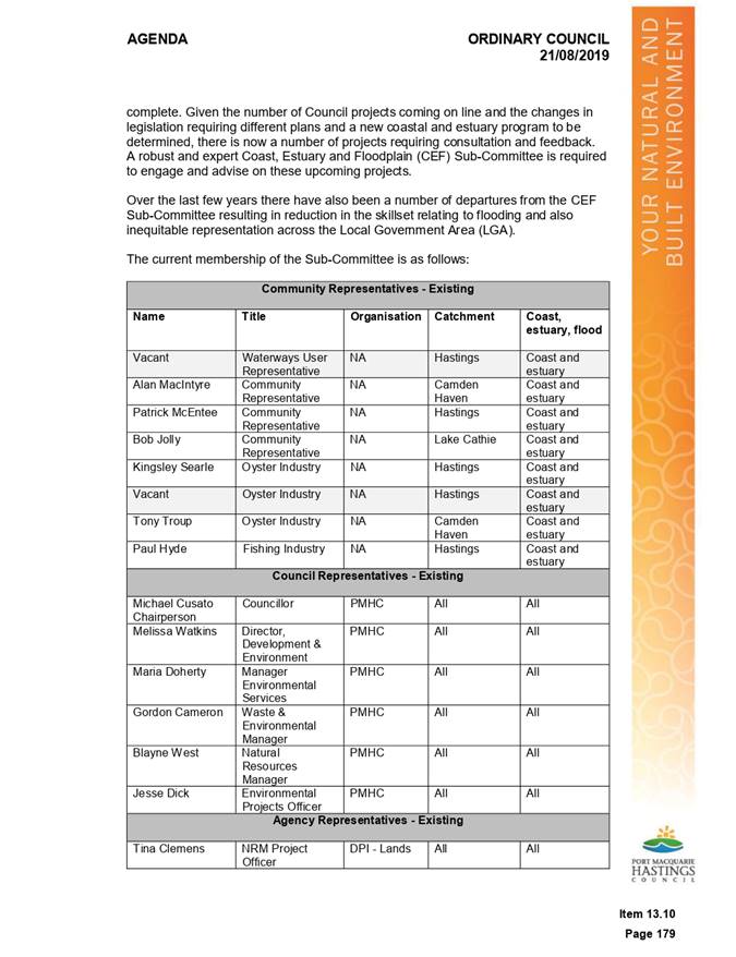
Floodplain Advisory Sub-Committee (CE&F) it was noted that new memberships
may be required due to vacancies that have been created since the Coast and
Estuary and Floodplain committees merged in 2015.
In addition to recruiting new members, staff took the
opportunity to revise and update the committee’s charter. The objectives
of this review were to ensure:
· that the Charter
is consistent with other committees of Council and Council’s adopted Code
of Conduct and Code of Meeting Practice
· equitable
community representation for the main catchments within the PMHC LGA
· an equitable
representation of members with skills and knowledge in floodplain management,
coastal management and estuary management.
At
the 21 August 2019 meeting, Council resolved to adopt a new CE&F charter, a
revised membership composition and proceed to seek formal Expressions of
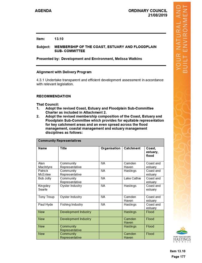
Interest for recruitment of new members as follows.
RESOLVED: Cusato/Turner
That Council:
1. Adopt
the revised Coast, Estuary and Floodplain Sub-Committee Charter as included in
Attachment 2 to the report.
2. Adopt
the revised membership composition of the Coast, Estuary and Floodplain
Sub-Committee which provides for equitable representation for key catchment
areas and an even spread across the flood management, coastal management and
estuary management disciplines as follows:
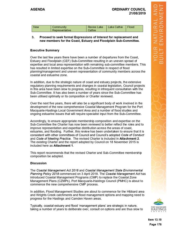
3. Proceed
to seek formal Expressions of Interest for replacement and new members for the
Coast, Estuary and Floodplain Sub-Committee.
Following
the August 2019 Ordinary Council meeting staff initiated an Expression of
Interest
(EOI) process in order to recruit suitable new members to the CEF Sub-
Committee.
At
the close of the EOI period there was an insufficient pool of applications to
progress
to appointments of representatives of both industry and general community
members.
Accordingly,
a report was prepared for Council in December which provided an update on the
recruitment process. At the 12 December 2019 meeting Council resolved to
re-initiate the recruitment process.
RESOLVED: Intemann/Turner
That Council:
1. Note
the information contained in the report.
2. Write
to people who have submitted an application (Expression of Interest) and advise
of Council’s decision to re-initiate
the recruitment process next year and that they do not need to re-apply.
3. Appoint
Councillor Peter Alley as the Chair of the Coast, Estuary and Floodplain
Sub-Committee and Deputy Mayor Intemann as Alternate Chair.
4. Recognise
the highly valued and significant contribution to this Sub-Committee
continuously since 1995 of Laurie Lardner and Patrick McEntee, sadly deceased
during 2019, and report this resolution to the next meeting of the
Sub-Committee.
5. Council
receive an update report on recruitment at the April 2020 Ordinary Council
meeting.
Note: Refer to separate
agenda item in relation to point 4 of the above resolution.
Accordingly,
staff will recommence the EOI procedure in February 2020. During the new
recruitment phase existing Coast, Estuary and Floodplain Sub-Committee members
will be consulted with to ensure a wide audience is reached when recruiting for
the positions.
Council
also propose to recruit for the Fishing Industry - Hastings - Coast &
Estuary position, as the current member has not attended meetings for some time
and is not contactable.
At
the recently held Lake Cathie key community stakeholder and agency meetings it
was identified that a representative from the Biripi Local Aboriginal Land
Council (LALC) could should attend future Coast, Estuary and Floodplain
Advisory Sub-Committee meetings. As the August 2019 Council meeting did not
include a position for the attendance of a LALC representative, it is proposed
that the Biripi LALC be invited to attend meetings as a guest. The committee is
requested to consider this proposal and discuss the potential to include a
Biripi LALC rep as a regular member to CE&F meetings in the future.
In
addition, due to the ongoing significant concerns with the condition of the
Lake Cathie/Lake Innes Estuarine system and the time taken to recruit new
members to the sub-committee it was agreed at the Community Stakeholder meeting
in December 2019 that a member from that forum be nominated to attend the
sub-committee on behalf of the community stakeholders until membership is
confirmed. The Community Stakeholder forum nominated Mr David Curry of
Revive Lake Cathie to attend.
Council
staff will undertake the extended EOI process immediately following the
CE&F sub-committee meeting in order to report back to Council at the April
2020 meeting.
An update on the EOI
process will be provided to CE&F committee members at a future meeting.
|
Attachments
1⇩. Council Meeting -
AGENDA, August 2019
2⇩. Council Meeting -
MINUTES - August 2019
3⇩. Committee CHARTER -
Adopted August 2019
4⇩. Council Meeting -
AGENDA - December 2019
5⇩. Council Meeting -
MINUTES - December 2019
|
|
ATTACHMENT
|
Coast, Estuary & Floodplain Advisory
Sub-Committee
30 Jan 2020
|
|
ATTACHMENT
|
Coast, Estuary & Floodplain Advisory
Sub-Committee
30 Jan 2020
|
|
ATTACHMENT
|
Coast, Estuary & Floodplain Advisory
Sub-Committee
30 Jan 2020
|
|
ATTACHMENT
|
Coast, Estuary & Floodplain Advisory Sub-Committee
30 Jan 2020
|
|
ATTACHMENT
|
Coast, Estuary & Floodplain Advisory
Sub-Committee
30 Jan 2020
|
AGENDA Coast, Estuary & Floodplain Advisory
Sub-Committee 30/01/2020
Item: 07
Subject: Floodplain Management
Presented
by: Development and Environment, Melissa Watkins
|
RECOMMENDATION
That the Committee note the Floodplain Management
report.
|
Discussion
At the December 2018 Council meeting, Council made the
decision to adopt climate change ‘Scenario 3’ (400mm SLR plus 10%
increase in rainfall) for the basis of the Flood Planning Area (FPA) in the
Hastings River & Wrights Creek Catchments rather than the recommended ‘Scenario
1’ (900mm SLR plus 10% increase in rainfall).
This decision represented a significant change in flood
policy direction and was a
departure from Port Macquarie-Hastings Council’s
(PMHC) historical approach to
floodplain management. This policy change has, and will,
have impacts on current and ongoing flood projects.
Staff considered the implications of these changes and
provided an options report to Council to consider in November 2019 (Attachment
1).
Council, at the meeting held on 20 November 2019 considered
the report and resolved as follows:
RESOLVED: Intemann/Alley
That Council:
1. Reconsider
the adoption of Climate Change ‘Scenario 3’ (400mm SLR plus 10%
increase in rainfall) as the basis of the Flood Planning Area (FPA) and adopt
‘Scenario 1’ (900mm SLR plus 10% increase in rainfall).
2. Note
that the Floodplain Risk Management Study phase of the Wrights Creek and
Hibbard Precinct projects will not be undertaken at this time.
3. Note
that the next phase of both projects will be subject to a future Operational
Plan budget process.
4. Write
to people who made a submission on both projects and advise them that the
Floodplain Risk Management Study phase will not be undertaken at this time.
This decision repeals the resolution from December 2018
where Climate Change ‘Scenario 3’ (400mm SLR plus 10% increase in
rainfall) was adopted for the basis of the Flood Planning Area (FPA) in the
Hastings River & Wrights Creek catchments.
This decision now ensures that all major catchments within
the LGA have the same FPA provisions thereby ensuring consistency in planning
decisions and adequately future proofing developments against the impacts of
climate change.
However, the December 2018
decision along with delays from consultants has prevented Council proceeding to
the next phase of the Wrights Creek Floodplain Management Plan and the Hibbard
Precinct Flood Study in a timely manner. These delays have impacted
Councils ability to deliver the projects within the timeframes agreed to under
the grant program (ie. the NSW Floodplain Management Program).
The OEH grant unit (now part of
DPIE) have adopted new strict funding rules that have reduced the flexibility
of these types of long duration and variable scope projects.
As a result, the Wrights
Creek Floodplain Management Plan project has been
terminated and the Hibbard
Floodway Investigation project has been suspended for a
minimum of 18 months.
As a result of the termination
and suspension of these projects, without additional
funding Council cannot proceed
with the Floodplain Risk Management Study (FRMS)
phases for both projects, as
resolved by Council on 12 December 2018.
Note: refer to separate report for additional information on
items 2 and 3 of the above resolution.
Council staff are now working on producing the final mapping
and GIS data for the Hastings River, Hibbard & Wrights Creek projects and
aims to have this mapping finalised mid-year.
|
Attachments
1⇩. 20 November 2019
Council Meeting - AGENDA
2⇩. 20 November 2019
Council Meeting - MINUTES
|
|
ATTACHMENT
|
Coast, Estuary & Floodplain Advisory
Sub-Committee
30 Jan 2020
|
|
ATTACHMENT
|
Coast, Estuary & Floodplain Advisory
Sub-Committee
30 Jan 2020
|

AGENDA Coast, Estuary & Floodplain Advisory
Sub-Committee 30/01/2020
Item: 08
Subject: North Brother Local Catchments Flood Study -
Stage 2 - Floodplain Risk Management Study - Initial Options Assessment Report
Presented
by: Development and Environment, Melissa Watkins
|
RECOMMENDATION
That the Committee:
1. Note the progress made
in commencing the North Brother Local Catchments Floodplain Risk Management
Study
2. Endorse the North
Brother Local Catchments Flood Study Working Draft Options Report.
3. Recommend that the North
Brother Local Catchments Flood Study Working Draft Options Report be
placed on public exhibition for 28 days.
4. Provide feedback on any
preferences for location/options to be included in the detailed assessment
and prioritisation of options, which will ultimately be utilised to inform
the Floodplain Risk Management Study phase of the project.
|
Discussion
Following the adoption of the North
Brother Local Catchments Flood Study by Council in July 2019, Council has
entered Phase 2 of this ongoing project, being the completion of the North
Brother Local Catchments Floodplain Risk Management Study (FRMS).
In this regard, the development of
Floodplain Management Plans follow guidelines established in the NSW Government’s
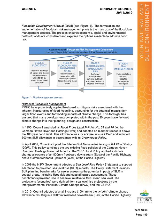
Floodplain Development Manual (2005).
The manual outlines the steps
involved in the process, and the activities required to develop a Floodplain
Management Plan in flood affected areas.
The Floodplain Risk Management
process involves the following stages:
|
STAGE
|
DESCRIPTION
|
|
1. Flood Study - Adopted by Council 19 July 2019
|
Determines
the nature and extent of the flood problem.
|
|
2. Floodplain Risk Management Study - Presently Underway
|
Evaluates
management options for the floodplain in respect of both existing and
proposed developments.
|
|
3. Floodplain Risk Management Plan
|
Involves
formal adoption by Council of a plan of management for the floodplain.
|
|
4. Implementation of Plan
|
Results
in construction of flood mitigation works to protect existing development and
the application of environmental and planning controls to ensure that new
development is compatible with the hazard.
|
Following the completion of the
Flood Study Phase and in commencing the FRMS phase of this project, Council,
via consultants Jacobs Pty Ltd have completed the following:
Flood Level
Survey
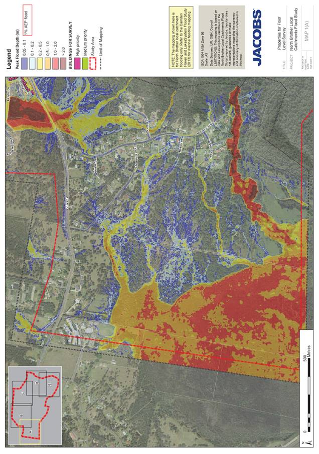
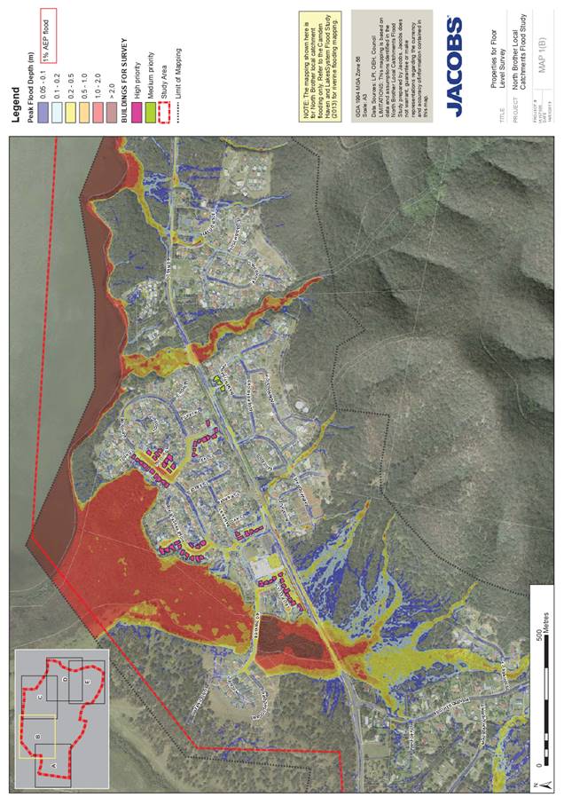
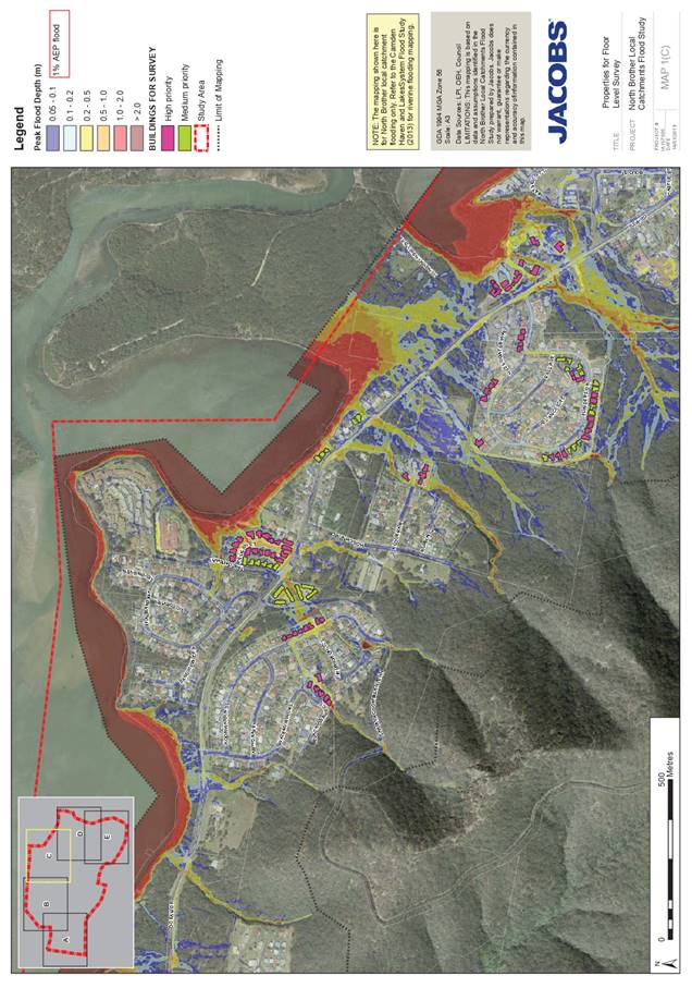
Based on an analysis of the impacts
of the flooding identified by the Flood Study, a floor level survey was
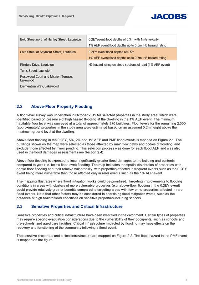
undertaken in October 2019 for selected properties in the study area. This
involved the survey of the minimum habitable floor level of some 270 buildings
which were identified based on the presence of potential high hazard flooding
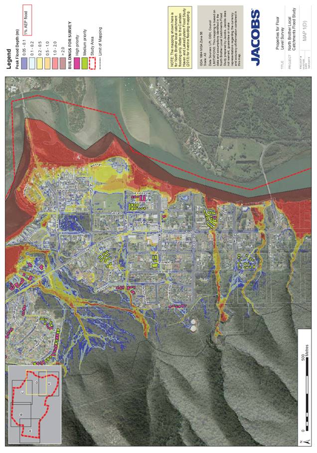
to the dwelling in the modelled 1% AEP storm event. A map of the surveyed
propertied is included at Attachment 1.
The floor level of remaining
properties (those located clear of modelled high hazard flooding to the
dwelling in the modelled 1% AEP) were estimated to be 200mm above the height of
the ground level at the dwelling.
Determination of Above Flood
Level Flooding
Utilising the floor level
information obtained above, mapping of above floor level flooding in the 0.2EY,
5%, 2%, 1%AEP and PMF flood events was undertaken to visually identify those
properties impacted by flooding of varying magnitudes. A copy of the
‘above-floor flooding at dwellings’ mapping is included within the
attached North Brother Local Catchments Flood Study Working Draft Options
Report, Attachment 2.
The mapping illustrates priorities
for flood mitigation works by identifying vulnerable properties and areas
within the catchment.
Of particular interest, the mapping
illustrates the following:
· 462
residential properties are at risk of habitable floor flooding during a 1%
AEP storm event in the catchment,
· A
further 27 non-residential/commercial properties are also modelled to be
subject to inundation of habitable floor levels during a 1% AEP storm
event.
· If the
required freeboard height is added to the flood levels, those figures jump to
834 and 89 respectively.
· More
significantly and in reflection of the scale of inadequacy of existing
infrastructure and controls, 161 residential properties and 10
non-residential/properties are identified as being at risk of over floor
level flooding during a comparatively common 20% AEP storm event (334
and 31 respectively when the required freeboard height is added to the flood
levels).
· Properties
identified as being at risk of above floor level flooding are not confined to
one area, and are spread throughout the catchment, demonstrating that multiple
solutions of varying scales will be required.
Whilst only a snapshot of the
figures presented in the report, the mapping and above figures clearly outlines
the scale of the significant stormwater related issues impacting the catchment.
Identification of Sensitive
Properties and Critical Infrastructure
In addition to determining the
quantum of properties impacted by above floor level flooding generally,
sensitive properties and critical infrastructure within the study area were
also identified and mapped. Sensitive properties and critical infrastructure includes
schools, pre-schools, aged care facilities, emergency services and the like.
Utilising the mapping, Flood Study
phase outcomes and floor level data, the sensitive properties and critical
infrastructure identified as being directly affected by overland flooding are
summarised below:
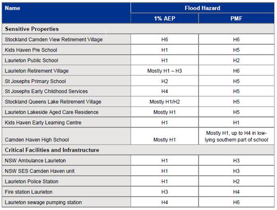
For reference, the flood hazard
categories are as follow:
o H1 –
Generally safe for people, vehicles and buildings
o H2 – Unsafe
for small vehicles
o H3 - Unsafe for
vehicles, children and the elderly
o H4 - Unsafe for
people and vehicles
o H5 - Unsafe for
people and vehicles. Buildings require special engineering design and
construction
o H6 – Unsafe
for people or vehicles. All buildings types considered vulnerable to failure.
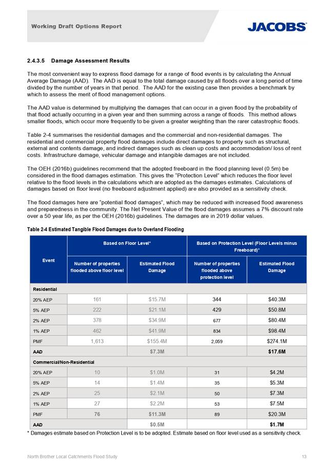
Flood Damages Assessment
Jacobs then undertook a Flood
Damages Assessment in accordance with the procedures outlined in the Floodplain
Development Manual, NSW Government, 2005. Details of the procedures
followed can be found in the attached Working Draft Options Report, however the
table below summarises the estimated tangible flood damages due to overland
flooding as identified by the North Brother Local Catchments Flood Study:
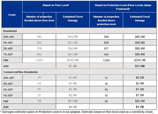
The values in the table above
reflect the Annual Average Damage (AAD). The AAD is equal to the total damage
caused by all floods over a long period of time divided by the number of years
in that period. The AAD for the existing case then provides a benchmark by
which to assess the merit of flood management options.
Key findings are:
· The
residential AAD for the study area is $17.6 million.
· The
commercial/non-residential AAD is $1.7 million.
·
While flood damage estimates for
the study area are indicative only, they are useful in the evaluation of flood
management options, aimed at reducing flood damage estimates while being
economically viable to implement.
Identification of Floodplain
Risk Management Measures
Following completion of the Damages
Assessment the next stage of the project is to identify, assess and compare
various floodplain risk management options to deal with the identified flood
risks in the study area considering and assessing their social, economic,
ecological and cultural impacts and their ability to mitigate flood impacts.
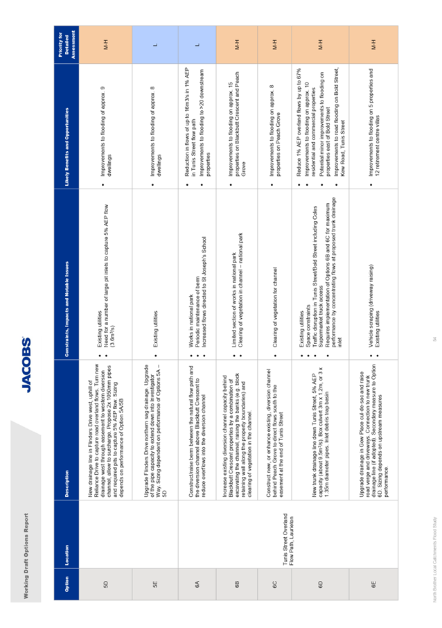
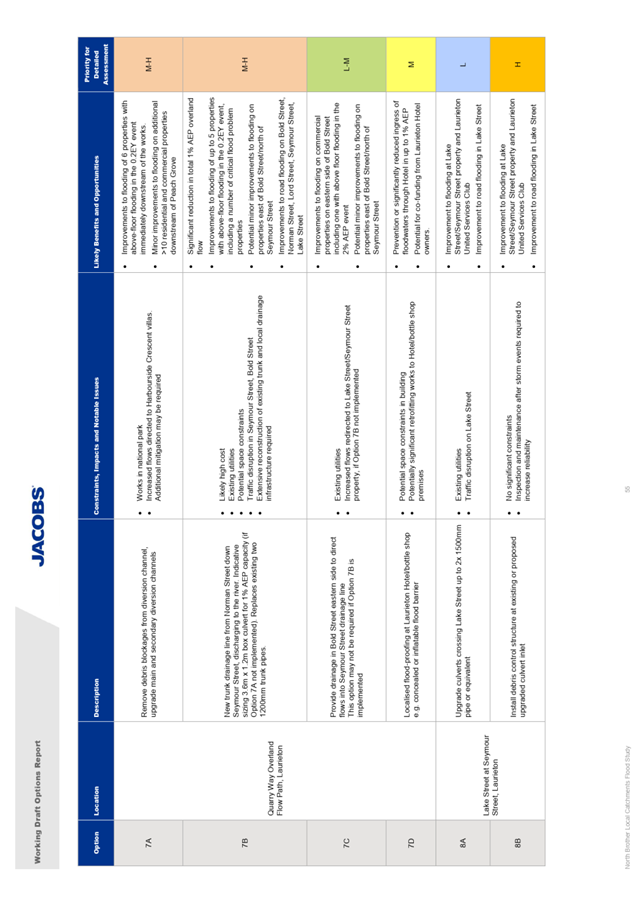
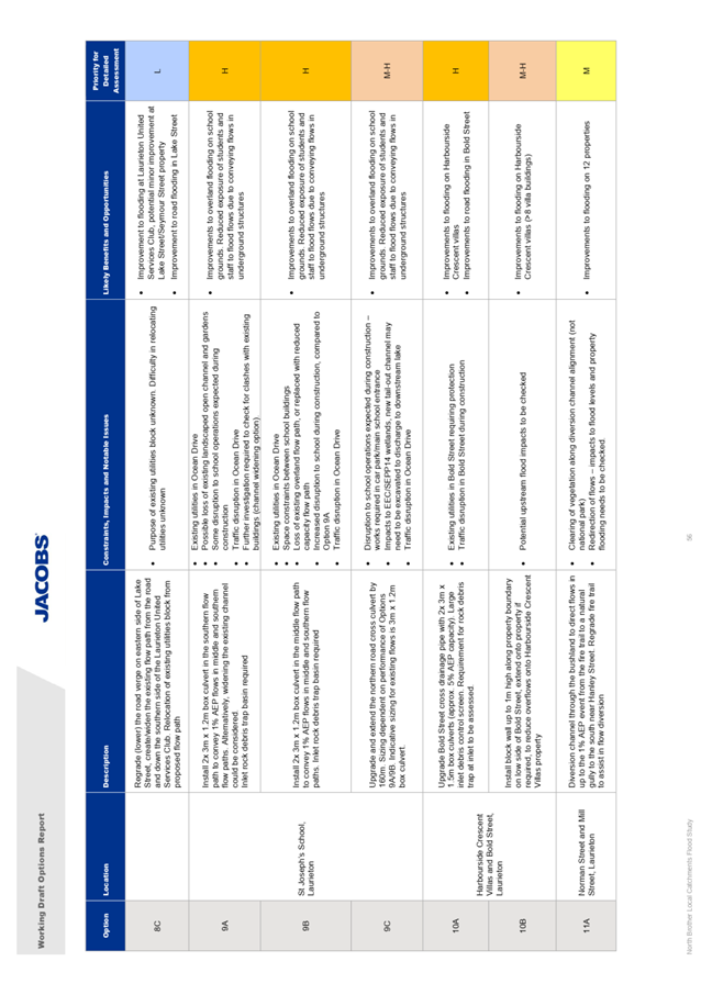
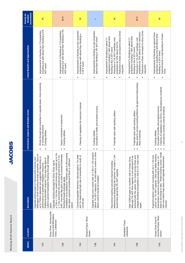
Utilising the list of flooding
hotspots identified by the Flood Study in combination with the information
summarised above, Jacobs have identified an initial priority list of 16 key
locations for flood mitigation works as outlined below:
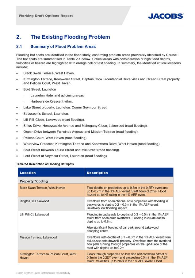
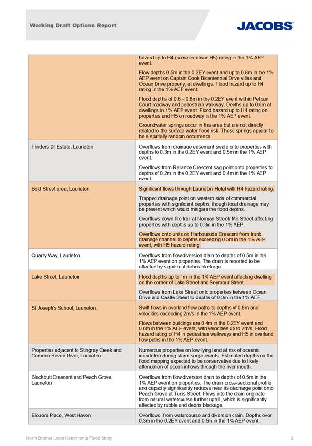
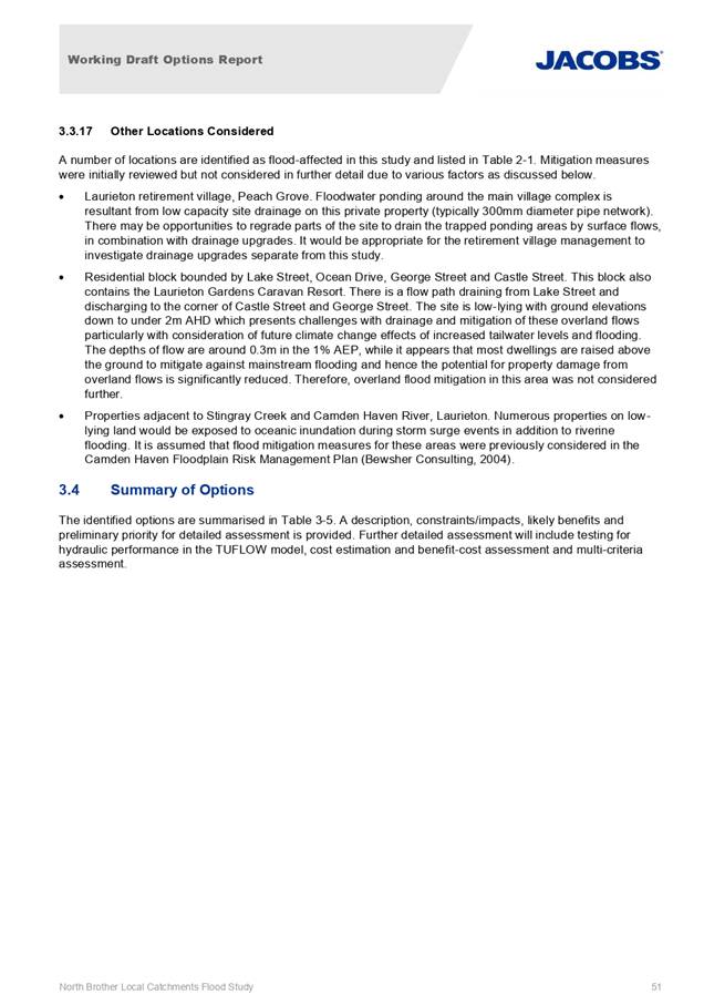
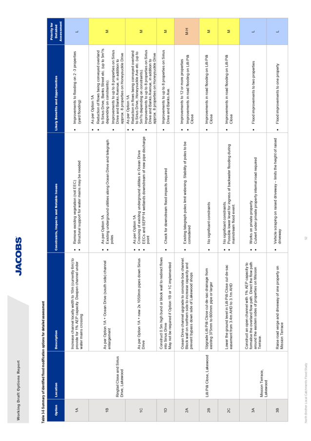
1. Black Swan Terrace, West Haven
2. Ringtail Close and Sirius Drive, Lakewood
3. Lilli Pilli Close, Lakewood
4. Mission Terrace, Lakewood
5. Kirmington Terrace to Pelican Court, West Haven
6. Flinders Drive Estate, West Haven
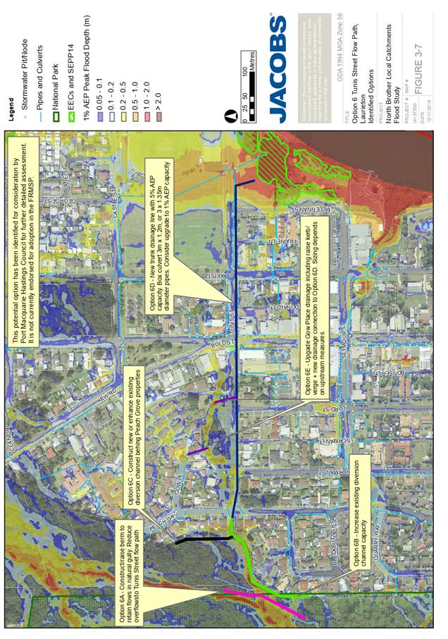
7. Tunis Street Overland Flow Path, Laurieton
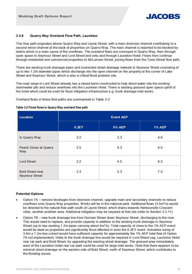
8. Quarry Way Overland Flow Path, Laurieton
9. Lake Street at Seymour Street, Laurieton
10. St Joseph’s School, Laurieton
11. Harbourside Crescent Villas and Bold Street, Laurieton
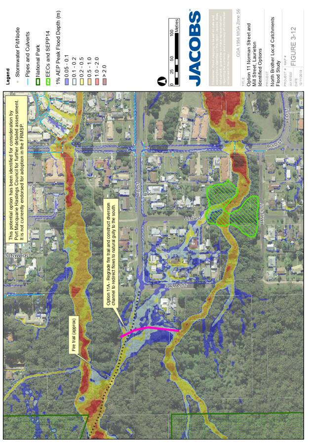
12. Norman Street and Mill Street, Laurieton
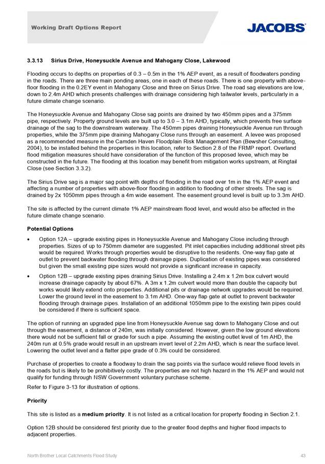
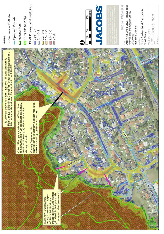
13. Sirius Drive, Honeysuckle Avenue and Mahogany Close, Lakewood
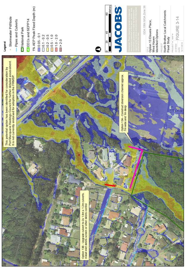
14. Elouera Place, West Haven
15. Sandpiper Close, Lakewood
16. Ocean Drive East of Hoschke Road, West Haven
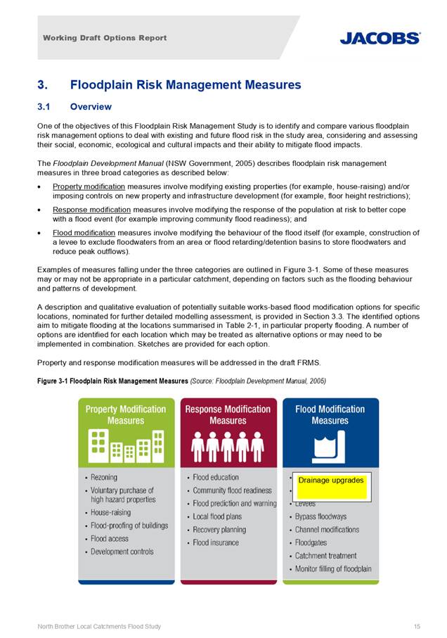
Conceptual mitigation options at
each of these locations vary, however generally include such measures as open
channel construction and augmentation, provision of new/upgraded stormwater
pipe/culvert infrastructure, provision of protection berms/bunds upstream of
property, stormwater detention facilities, verge modifications to deflect water
and kerb inlet improvements.
Furthermore, and specifically with
reference to potential private property impact, there are two locations where
voluntary property acquisitions are identified as potential options (Pelican
Court and Kermington Terrace), and three locations where block walls,
structural works and flood proofing is an option within allotments (Harbourside
Crescent Villas, Laurieton RSL and Laurieton Hotel/Bottle Shop).
Each of the identified preliminary
options identified has also been assessed, with a priority assigned based on
factors including:
· Identification
of locations as critical flood problem areas
· Areas
of high flood hazard
· Areas
with above-floor flooding of dwellings particularly in more frequent events
· Presence
of flood problems on sensitive properties
· Perceived
difficulties or constraints in implementing the options e.g. environmental
constraints, works required on private property, presence/conflicts with
existing structures and utilities, etc.
· Lower
priority sites could potentially be raised in priority if low-cost options are
identified for flood mitigation.
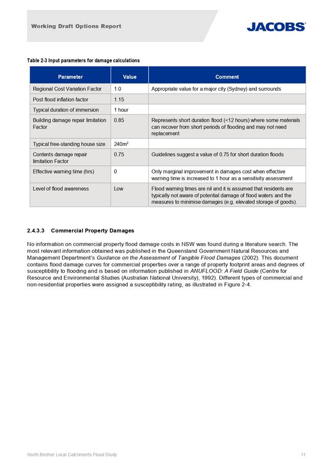
Table 3-5 of the attached
“North Brother Local Catchments Flood Study - Working Draft Options
Report” summarises the options identified, any constraints, benefits,
opportunities and defines the preliminary priority assigned for detailed
assessment.
Preliminary High Priority
Options
As can be seen in the attached
report, options identified at four of the 16 locations have been
assigned a preliminary High priority for further assessment. The report
also notes that Council is currently designing and planning to implement flood
mitigation measures at Black Swan Terrace as the highest priority site,
in addition to the four listed in the report.
Those High priority options
are defined further below for reference.
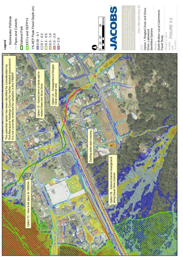
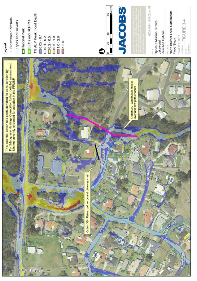
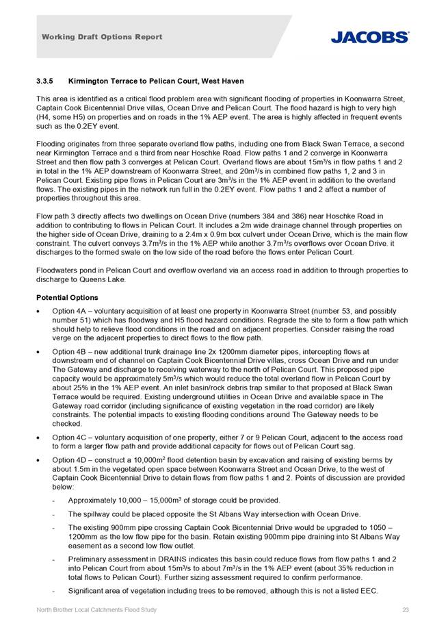
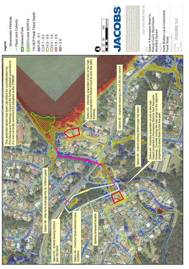
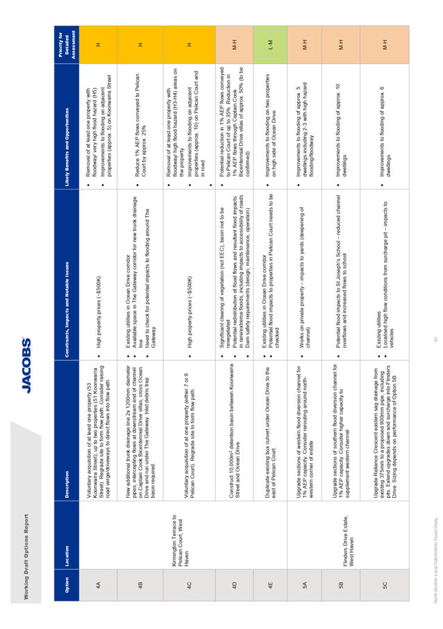
a. Kirmington Terrace to Pelican Court, West Haven
This area is identified as a
critical flood problem area with significant flooding of properties in
Koonwarra Street, Captain Cook Bicentennial Drive villas, Ocean Drive and
Pelican Court. The flood hazard is high to very high (H4, some H5) on
properties and on roads in the 1% AEP event. The area is highly affected in
frequent events such as the 0.2EY event.
Five options have been identified
to mitigate the flooding and risks at this location, with three of those
assessed as a high priority, being:
· Option
4A - voluntary acquisition of at least one property in Koonwarra Street (number
53, and possibly number 51) which has floodway and H5 flood hazard conditions.
o High property
prices are listed as a constraint for this option, however proceeding with this
option would realise the removal of at least one property from a high hazard
floodway and result in substantial improvements to five other nearby properties
in Koonwarra Terrace.
· Option
4B - new additional trunk drainage pipelines (2x 1200mm diameter), intercepting
flows at the downstream end of the channel on Captain Cook Bicentennial Drive
villas, running across Ocean Drive and under The Gateway, discharging to
receiving waterway to the north of Pelican Court.
o Potential service
clashes and conflicts with existing infrastructure will constrain the
development of this option, however the proposal would result in a reduction in
1%AEP flows in Pelican Court by 25%.
· Option
4C - voluntary acquisition of one property, either 7 or 9 Pelican Court,
adjacent to the access road to form a larger flow path and provide additional
capacity for flows out of Pelican Court sag.
o Similarly, to
Option 4A, high property prices are listed as a constraint for this option,
however proceeding with this option would realise the removal of at least one
property from a high hazard floodway and result in substantial improvements to
ten other nearby properties in Pelican Court.
·
See Attachment 2 for more detail.
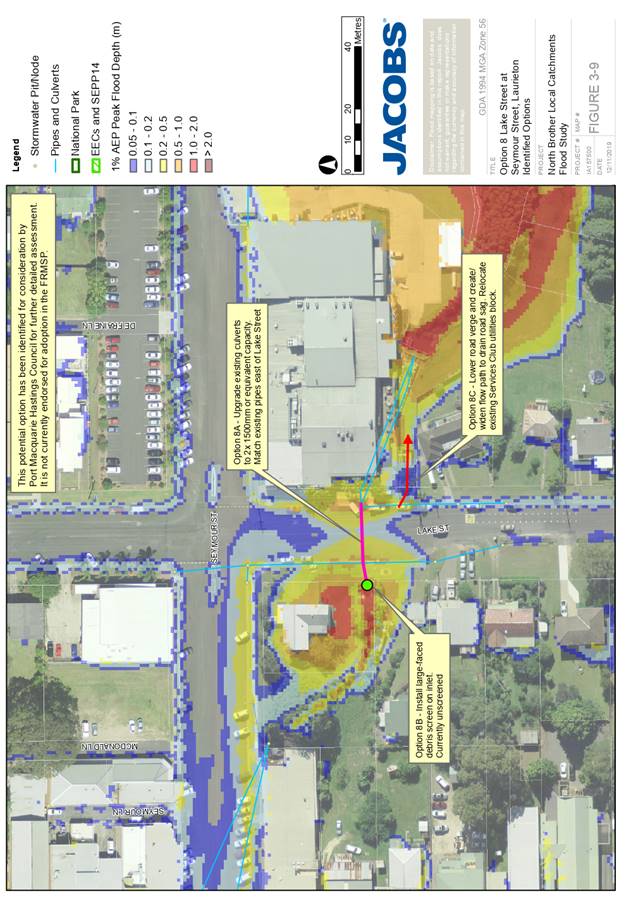
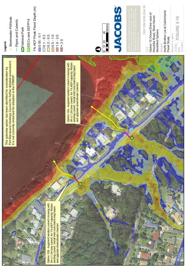
b. Lake Street at Seymour Street, Laurieton
This corner property receives
significant overland flows and trunk drainage flows from the Quarry Way flow
path. There is an open channel and flow path through this property, where the
dwelling is surrounded by high hazard flooding to depths of over 1m in the 1%
AEP event. The floodwaters pond behind the raised road crest in Lake Street
before overflowing over the road and around the southern side of the Laurieton
United Services Club. It is identified as being affected by above-floor
flooding.
Three options have been identified
to mitigate the flooding and risks at this location, with one of which being
assessed as a preliminary high priority:
· Option
8B – Installation of a debris inlet control structure at the culvert
inlet.
o There are no
significant constraints to the implementation of this option, however as with
any inlet protection, regular inspection and maintenance is required to ensure
reliability. This option results in a lowering of the floor levels over Lake
Street and resultant reduction in flooding within the upstream private
property.
·
See Attachment 2 for more detail.
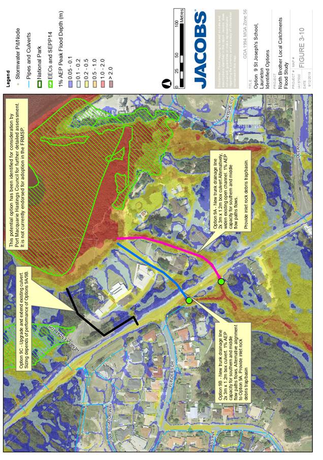
c. St Joseph’s School, Laurieton
Flooding at the school results from
a number of natural flow paths being directed down to Ocean Drive to three
culvert crossings and into the school property. Flows exceed 0.5m deep in the
1% AEP event with areas of very high (H5) flood hazard.
Three options have been identified
to mitigate the flooding and risks at this location, with two options, assessed
as a preliminary high priority:
· In
this scenario, both Options 9A and 9B consist of the same scope of works at
alternate alignments some 60m apart - being the construction of new trunk
drainage culverts along the length of the flow path (2x 3m x 1.2m box culvert)
OR works to widen an existing open channel at each location.
o Both of these
options are constrained by service/utility clashes in upstream Ocean Dr and
disruptions to traffic and school operations during works, however bot also
result in significant reductions in overland flooding within the school and
reduced exposure of students and staff to flood flows.
See Attachment 2 for more detail.
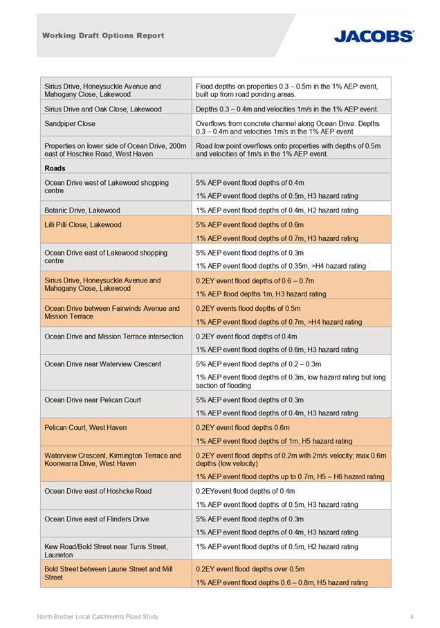
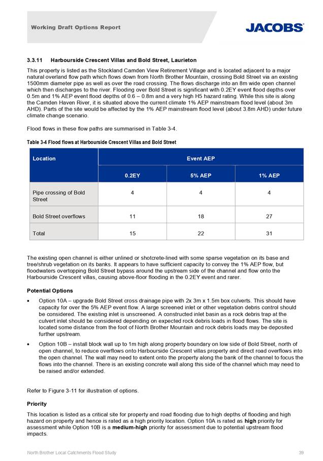
d. Harbourside Crescent Villas and Bold Street, Laurieton
This property is listed as the
Stockland Camden View Retirement Village and is located adjacent to a major
natural overland flow path which flows down from North Brother Mountain,
crossing Bold Street via an existing 1500mm diameter pipe. Flooding over Bold
Street is significant with 0.2EY event flood depths over 0.5m and 1% AEP event
flood depths of 0.6 – 0.8m and a very high H5 hazard rating.
Two options have been identified to
mitigate the flooding and risks at this location, with one of which identified
as a preliminary high priority:
· Option
10A - Upgrade existing 1500mm diameter cross drainage pipe to 2x 3m x 1.5m box
culverts and provision of debris control screen upstream.
o These works are
constrained by potential service clashes in Bold Street and the potential for significant
traffic disruptions to that road during construction. However, the works do
result in the provision of a 5% AEP capacity road drainage system and a
significant reduction in risk to flooding of downstream villas within the
Harbourside Crescent Villas.
See Attachment 2 for more detail.
In addition to the above and as
noted, Black Swan Terrace has also been identified as a high priority location
for investigation and concept design, however this location has been excluded
from the assessment on the basis that it is currently the subject of a
separately funded design and construction project being coordinated by Council.
The works proposed by Council at this location include the construction of a
stormwater basin, inlet protection device and diversion bund that function to
both increase the capacity of the existing downstream piped drainage network
and divert any remaining overland flows around those flood impacted propertied
in Black Swan Terrace.
Conclusions and Next Steps
The committee is requested to:
1. Consider both the long list of options and locations
nominated in the attached report and the preliminary high priority options
listed for potential mitigation works.
2. Select a short list of options for further detailed
assessment with the assistance of Jacobs.
3. Request Jacobs to undertake assessment of the short-listed
options in the TUFLOW flood hydraulic model in addition to cost-benefit and
multi-criteria analyses for evaluation of the options. Final testing of options
will include combinations of options, which are likely to complement each
other.
·
Accordingly, the Coast, Estuary and
Floodplain Advisory Sub-Committees endorsement of the Working Draft Options
Report (Attachment 2) and any feedback on the committee’s preferences for
additional locations/options to be included, or current locations/options to be
excluded from the detailed assessment and prioritisation of options are now
sought.
Pending no objections to the
report, the Committees endorsement to place the identified options on public
exhibition for shortlisting is requested.
|
Attachments
1⇩. Map of Properties for
Floor Level Survey
2⇩. North Brother Local
Catchments Flood Study - Working Draft Options Report
|
|
ATTACHMENT
|
Coast, Estuary & Floodplain Advisory
Sub-Committee
30 Jan 2020
|

|
ATTACHMENT
|
Coast, Estuary & Floodplain Advisory
Sub-Committee
30 Jan 2020
|


AGENDA Coast, Estuary & Floodplain
Advisory Sub-Committee 30/01/2020
Item: 09
Subject: Active Coast, Estuary & Floodplain
Projects Status Update
Presented
by: Development and Environment, Melissa Watkins
|
RECOMMENDATION
That the Committee note the status of the active Coast,
Estuary & Floodplain projects.
|
Discussion
This report provides an update
on active PMHC Coast, Estuary and Floodplain projects. Where applicable, each
project has been listed with the current project cost and corresponding grant
amount provided by DPIE (formerly OEH).
FLOODPLAIN MANAGEMENT
1. Hibbard Floodway Investigation - Current
status - Suspended
Financial Breakdown
|
Items
|
Cost
|
|
Former total project cost
|
$114,650
|
|
Former OEH grant funding
component
|
$76,433.33
|
|
Amount of money returned to
OEH (November 2019)
|
$46,223.33
|
|
Council funding spent
|
$40,200
|
|
OEH grant funding spent
|
$30,210
|
|
Total amount of money spent
|
$70,410
|
Milestones completed to date
· Successful
grant application under 2015-16 Floodplain Management funding round.
· This
project was reported to the July 2019 Council Meeting. The flood study
component (Stage 1) was completed in July 2019.
Identified issues to date
A range of issues have impacted
Councils ability to deliver the project within the timeframes agreed to under
the grant program (i.e. the NSW Floodplain Management Program). As a
result, the Hibbard Floodway Investigation project has been suspended.
The main issues impacting this
project include:
· This
grant was initially placed on a ‘reserve list’ in December 2015 and
from OEH’s perspective the grant commenced on this date, however the
grant was not officially awarded until March 2016.
· The
project budget was originally $50,000 based on estimates within the Hastings
River Floodplain Risk Management Plan (2014). The accepted tendered price
was ultimately $115,000 and while a grant variation/increase was approved by
OEH, Council was advised that no further increase to funding would be approved.
· The
December 2018 climate change decision delayed the project and diverted
resources elsewhere, and when a time variation was subsequently approved by OEH
(after awarding the tender), they advised Council that further increases to time would be unlikely.
· In
January 2019, Council submitted a variation to extend the time by 14 months to
July 2020. This was due to the complexities experienced in the floodway
definition phase. When this variation was approved by OEH, Council was advised
that no further extension to the time would be approved.
In addition to the above, the
OEH grant unit have adopted new strict funding rules that reduces the
flexibility of these types of long duration and variable scope projects.
Ramifications of issues
Council staff have discussed various way to maintain the Hibbard project,
however the OEH grant unit have advised Council that given the current state of
the project the grant should be terminated. As such, Council returned the
unspent grant funds totalling $46,223.33.
Future works
Due to the development pressures
in the Hibbard precinct and community expectations, it is proposed to commence
the Floodplain Risk Management Study (FRMS) phase (stages 2 & 3) for this projects as
soon as possible. It is expected a minimum delay of 18 months is likely. A new
grant application may be made under the next grant funding round, however this
will depend on the capacity of Council considering existing projects and
resources.
2. Hastings River Climate Change
Modelling - Current status - Completed
Financial Breakdown
|
Items
|
Cost
|
|
OEH grant funding component
|
$42,533.33
|
|
Council funded
|
$26,186.67
|
|
Total project cost
|
$68,720
|
Milestones
· Successful
grant application under 2015-16 Floodplain Management funding round.
· This
project was finalised with OEH in 2017.
· This
project was reported to the December 2018 Council meeting and then to the
November 2019 Council Meeting.
Refer to separate report titled ‘Floodplain management’ for
further details.
3. Wrights Creek Flood Study Update,
Climate Change Modelling & Floodplain Risk Management Study & Plan
- Current status - Terminated
Financial Breakdown
|
Items
|
Cost
|
|
Former total project cost
|
$110,310
|
|
Former OEH grant funding
component
|
$73,540
|
|
Amount of money returned to
OEH (October 2019)
|
$52,060
|
|
Council funding spent
|
$22,566.67
|
|
OEH grant funding spent
|
$21,480
|
|
Total amount of money spent
|
$44,046.67
|
Milestones completed to date
· Successful
grant application under 2015-16 Floodplain Management funding round.
· This
project was reported to the December 2018 Council meeting.
· The
flood study component (Stage 1) was completed in December 2018.
Identified issues to date
A range of issues have impacted
Councils ability to deliver the project within the timeframes agreed to under
the grant program (ie. the NSW Floodplain Management Program). As a result, the
Wrights Creek Floodplain Management Plan project has been terminated.
The main issues impacting this
project include:
· This
grant was initially placed on a ‘reserve list’ in December 2015 and
from OEH’s perspective the grant commenced on this date, however the
grant was not officially awarded until March 2016.
· The December
2018 climate change decision delayed the project, by diverting resource
elsewhere, and when a time variation was subsequently approved by OEH (after
awarding the tender), Council was advised that further increases to time would
be unlikely.
· Significant
costs were wholly borne by Council after OEH did not agree to fund a share of
the detailed feature survey due to a minor error by Council in the grant
reporting process. This resulted in Council’s budget being adversely
impacted.
Ramifications of issues
On 12 December 2018, Council also resolved to proceed to the
next phase of the project, the Floodplain Risk Management Study and Plan (FRMP)
(stages 2 & 3), however due to the termination of the project, the FRMP
cannot proceed at this time. The FRMP phase involved investigating ways to
improve the flood problem (ie. via road raising, bridge and culvert upgrades,
levees etc.) within the Wrights Creek catchment.
Council returned the unspent grant funds totalling $52,000.
Future works
A new grant application may be made in the future to
complete the final phase of the project, however this will depend on the
capacity of council considering existing projects and resources.
4. North Brother Local Catchments Flood
Study - Current status - Ongoing
Financial Breakdown
|
Items
|
Cost
|
|
Total project cost
|
$153,820
|
|
OEH grant funding component
|
$102,546.67
|
|
Council funding spent (to
date)
|
$14,847.33
|
|
OEH grant funding spent (to
date)
|
$29,694.67
|
|
Total amount of money spent
(to date)
|
$44,542
|
Milestones completed to date
· Successful
grant application under 2016-17 Floodplain Management funding round.
· Project
is underway with the flood study component (Stage 1) adopted by Council at the
July 2019 Council meeting.
· The
Floodplain Risk Management Study - Options Assessment phase (stage 2) is now
underway.
Refer to separate report for further details.
5. Hastings River Gauge Network Upgrades
- Current status - Completed
Financial
Breakdown
|
Items
|
Cost
|
|
Total
project cost
|
$50,000
|
|
OEH
grant funding component
|
$33,333
|
|
Council
funding spent
|
$16,667
|
|
Total amount of money spent
|
$50,000
|
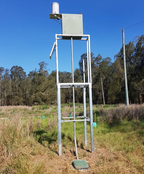
New flood gauge at Mundays Lane
Milestones completed to date
· Successful
grant application under 2017-18 Floodplain Management funding round.
· This
project is now complete, with Manly Hydraulics Laboratory (MHL) undertaking
installation of the gauge in November 2019.
· The
gauge is now operational and live data can be found at the following location: http://new.mhl.nsw.gov.au/Site-2074127
. The gauge provides instantaneous water level and hourly rainfall data. The
data from this gauge is collected primarily to provide improved data for future
flood studies however can be utilised by BOM for forecasting purposes and SES
for emergency management.
This was the first gauge to be
installed or upgraded within the Hastings Catchment. Several other gauges
within the catchment (rainfall and/or river level and/or streamflow) been
identified for installation or upgrade by MHL. Refer to below image.
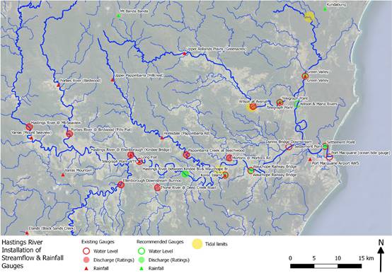
MHL Hastings River catchment
gauge network showing existing and proposed gauges.
Future works
Additional water level and
rainfall gauges are proposed to be installed within the Hastings River
catchment, including upstream of Koree Island, within the upper Maria River
catchment (near Kundabung) and in the upper Wilson River catchment (near Mt
Banda Banda). Upgrades to existing gauges to improve their functionality are
also recommended, including the Wauchope Gauge, the Settlement Point Gauge, the
Telegraph Point Gauge and the Green Valley gauge. New grant applications may be
made under future grant funding rounds for the additional gauges, however this
will depend on the capacity of Council considering existing projects and
resources.
Dunbogan
Flood Access Road – Construction - Current status -
Ongoing
Financial
Breakdown
|
Items
|
Cost
|
|
Total
project cost
|
$1,500,000
|
|
OEH
grant funding component
|
$1,000,000
|
|
Council
funded
|
$500,000
|
|
Total
amount of money spent to date
|
$nil (however contract has been awarded for road
construction work worth $1,114,057.80 (ex GST)
|
Milestones completed to date
· Successful
grant application under 2018-19 Floodplain Management funding round.
· Council
has commenced work to upgrade the final stage of the Dunbogan Flood Access Road
project with stage 1A works commencing on 6 January 2020.
· Works
are being undertaken by EIRE constructions and are scheduled to be completed by
late March 2020.
COASTAL MANAGEMENT
Illaroo Road Stormwater
Redirection – Construction - Current Status - Ongoing
Financial Breakdown
|
Items
|
Cost
|
|
Total project cost
|
$865,803.93
|
|
OEH grant funding component
|
$432,901.97
|
|
Council funded
|
$432,901.97
|
|
Total amount of money spent
(to date)
|
$nil (however contract has
been awarded for archaeology work worth $24,450 (ex GST)
|
Milestones
· Successful
grant application under 2017-18 Coastal Management funding round. Council
applied for grant funding in early 2018 and were notified of our successful
grant application in late October.
Identified issues to date
· The
discovery of dumped asbestos and aboriginal archaeological deposits at the
proposed outlet location has complicated matters and has delayed the project
significantly.
Council
have been successful in obtaining grant funding to remediate the asbestos and
carry out initial investigations into the aboriginal archaeology. A consultant
was engaged to carry out aboriginal investigation works which are due to
commence early 2020.
Middle Rock and Chepana
Street Stormwater Outlet – Maintenance Works - Current Status -
Completed
Financial Breakdown
|
Items
|
Cost
|
|
Total project cost
|
$114,000
|
|
OEH grant funding component
|
$57,000
|
|
Council funding spent
|
$57,000
|
|
Total amount of money spent
|
$114,000
|
Milestones
· Successful
grant application under 2016-17 Coastal Management funding round.
· Construction
works have been completed on two southernmost outlets (i.e at the Middle Rock
Carpark and at the southern end of Chepana Street). These works were completed
in late 2018/early 2019.
· This
project is complete and the final grant funding claim forms were submitted in
early 2019.
Lake Cathie CZMP –
Funding Model - Current Status - Ongoing
Financial Breakdown
|
Items
|
Cost
|
|
Total project cost
|
$87,500
|
|
OEH grant funding component
|
$68,700
|
|
Council funded
|
$18,800
|
|
Total amount of money spent to
date
|
$70,575.99
|
Milestones
· Successful
grant application under 2016-17 Coastal Management funding round.
· Project
is underway with Marsden Jacob Pty Ltd engaged.
Future works
In addition to the Funding
Model, this project now involves a review of the cost benefit analysis (CBA)
previously completed by OEH in 2016. There have been significant delays in
completing this project for numerous reasons. Primarily Council has been
reliant on technical advice from DPIE which is still yet to be provided.
Flynns
Beach Retaining Wall Replacement (Stage 1) - Current Status - Completed
Financial
Breakdown
|
Items
|
Cost
|
|
Total project cost
|
$2,568,096
|
|
OEH grant funding component
|
$1,167,851.90
|
|
Council funded
|
$1,400,244.10
|
|
Total amount of money spent to
date
|
$2,568,096
|
Milestones
· Successful
grant application under 2015-16 Coastal Management funding round.
· The
procurement and tendering phase was finalised with a ‘Design and
Construct’ methodology being adopted by the successful contractor.
· The
project was assessed by Council’s Development Assessment team with
approval granted in April 2019. Construction works commenced in May 2019 and
were completed in November 2019.
ESTUARY MANAGEMENT
Estuarine Lake Linkages:
Protecting the Islands & Foreshores of the Camden Haven - Current Status
- Completed
Financial Breakdown
|
Items
|
Cost
|
|
Total project cost
|
$372,049
|
|
OEH grant funding component
|
$186,047
|
|
Council funded
|
$186,002
|
|
Total amount of money spent to
date
|
$372,049
|
Milestones
· Successful
grant application under 2015-16 Estuary Management funding round.
· The
project officer position was filled and two years of management works were
completed.
· Six
months of management works were carried out by contractors.
· This
project was completed in mid-2019.
Lake
Innes Acid Sulphate Soil Management Options Study - Current Status - Ongoing
This study has been initiated
after consultation with key stakeholders, including NPWS, DPIE, Fisheries &
Crown Lands. The project consists of specialist studies that quantify the Acid
Sulphate Soil (ASS) risk to the lake system. The findings from these studies
will then be used to inform the review of the 2013 Lake Innes Reversion Study
in order to determine if the currently listed management actions are applicable
or if new management actions are appropriate in lieu of the new information and
the second outcome will be to provide Council with a list of management options
to address the ASS risk in the immediate future to deal with emergency
containment works.
Financial Breakdown
|
Items
|
Cost
|
|
Estimated total project cost
|
$295,000
|
|
Requested DPIE grant funding
|
$147,500
|
|
Council funded
|
$147,500
|
|
Total amount of money spent to
date
|
$nil (awaiting grant notification)
|
Milestones
· Council recently
made an application to DPIE under the 2019-20 Coast and Estuary Management
funding round to undertake this project.
Future works
· Council hopes to
receive notification on whether the grant application has been successful in
the near future.
AGENDA Coast, Estuary & Floodplain Advisory
Sub-Committee 30/01/2020
Item: 10
Subject: Lake Innes / Lake Cathie Estuarine System -
Update
Presented
by: Development and Environment, Melissa Watkins
|
RECOMMENDATION
That the Committee:
1. Note
the Lake Innes / Lake Cathie Estuarine System - Update report.
2. Note
the Lake Cathie and Lake Innes Acid Sulphate Soil Risk Assessment (2019).
3. Note
the Coastal Management in the Port Macquarie-Hastings timeline document.
|
Discussion
Since the last CE&F committee meeting held in March
2019, there have been five separate Council reports regarding the Lake Innes,
Lake Cathie estuarine system. These reports were presented to the Council
meetings in 2019 held on 15 May, 19 June, 21 September, 16 October and a
Mayoral Minute was presented to the 20 November meeting. Refer to attached
reports for further detailed information (Attachment 1).
An Acid Sulphate Soil (ASS) study was also commissioned and
completed during this time period. A copy of this report has been provided as Attachment
2.
There have also been five separate meetings, three of which
have been with key government stakeholder agencies (i.e. NPWS, DPIE, Fisheries,
Crown Lands, Soil Conservation, etc) and two with key community groups (i.e.
Revive Lake Cathie, Camden Haven Chamber of Commerce and Lake Cathie Progress
Association). As a result of these meetings, Council meetings and the ASS
report, a timeline and flowchart has been developed which provides a pathway
for the Coastal Management Program (CMP) and environmental approvals which a
required for Council to re-commence it’s management of the lake system.
Refer to Attachment 3.
Summary of Council Meetings:
15 May 2019 Council Meeting:
A Notice of Motion was put forward by Councillor Hawkins for
Council to consider a submission by the community group known as Revive Lake
Cathie (RLC). This submission also included 787 signed letters of support from
community members. The RLC submission proposed a way forward to improve the
condition of Lake Cathie. In light of this submission, Council resolved to
provide a range of state agencies and members of Parliament with a copy of the
submission from RLC. Council also resolved to seek advice from the State
Government on whether a review of the Lake Cathie Opening Strategy
should be initiated and to also give consideration in the 2019-2020
Operational Plan (OP) to undertake such actions as were deemed necessary.
Refer to Attachment 1 for further details.
19 June 2019 Council Meeting:
In response to consideration of Council’s draft
2019-2020 Operational Plan (OP) and budget, Council resolved to undertake a
review of the existing Lake Cathie Opening Strategy in consultation with
the National Parks and Wildlife Services (NPWS); the Office of Environment and
Heritage (OEH); NSW Fisheries and Department of Industry (DPI - Lands); and the
community, including the RLC community group.
It is noted that the June resolution came before responses
from the State Government agencies had been received in respect of the
resolution from the 15 May 2019 ordinary meeting.
While the OP submission from RLC was not adopted by Council
at the June meeting, the May 2019 resolution aimed to address and highlight
that the management of the Lake Cathie and Lake Innes estuary system is complex
and is the responsibility of a number of stakeholders.
Refer to Attachment 1 for further details.
21 September 2019 Council Meeting:
A notice of Motion was put forward by Councillor Levido at
this meeting for, among other things, Council to borrow $1M for improvements to
the Lake Innes, Lake Cathie Estuarine System. This funding would be sought
through borrowings. The resolution requested that a further report be brought
back to the October 2019 Council meeting for consideration.
Refer to Attachment 1 for further details.
16 October 2019 Council Meeting:
At this meeting, two separate reports were considered by
Council on the lake system. An update was provided on the Notice of Motion from
the May Council meeting and a resolution was provided on the Notice of Motion
from the October Council meeting.
At the October meeting Council resolved to provide $147,500
towards undertaking initial background studies into the lake system whilst
seeking a matching contribution of $147,500 from the State Government ($295,000
total project cost).
The background studies stemmed
from meetings which were held with the key
government agencies involved in the management of the Lake Cathie and Lake
Innes estuarine system. These stakeholders being, National Parks and Wildlife
Services (NPWS), Department of Primary Industries - Fisheries (DPI Fisheries),
Department of Primary Industries - Crown lands (DPI Crown Land). Soil
Conservation Services (SCS) was also involved in the meetings.
The
Background Studies agreed upon include:
· A digestion model of the Acid Sulphate Soil (ASS)
recently uncovered as a result of a study commissioned by Council and NPWS in
May 2019 - $185,000
· A review of 2013 Lake Innes Reversion Study -
$50,000
· An ecological condition assessment of the saltmarsh
community within Lake Innes - $10,000. NB: The Australian Government has listed Subtropical
and Temperate Coastal Saltmarsh as vulnerable in the Environment Protection and Biodiversity Conservation
Act 1999 (EPBC Act).
· Review of possible short term emergency ASS
containment works - $50,000.
Councils funding
contribution for these projects (i.e. $147,500) was ultimately provided by
borrowings from the original $1M that was proposed by Councillor Levido at the
September Council meeting.
Refer to Attachment 1 for further details.
20 November 2019 Council Meeting:
Mayor Pinson provided a Mayoral Minute which proposed to
initiate an opening of Lake Cathie to the ocean, noting that the Opening
Strategy trigger conditions had been met.
A Crown Land licence application was submitted in late
November but was not granted citing shortfalls in the Environmental Approval
documents which date from 1995. Additional information was requested by
Crown Lands.
Refer to Attachment 1 for further details.
Crown Land Advice:
Council submitted a Short Term Licence (STL) application
with Crown Lands for the purpose of opening Lake Cathie to the ocean.
As part of the STL application, Council:
• Relied
upon the 1994 Estuary Management Plan (EMP) and Opening Strategy, and;
• Relied
upon the 1995 Environmental Review (environmental approval), which was based on
the 1994 EMP and Opening Strategy.
On 27 November 2019, Council received confirmation from
Crown Land that as the environmental approval was more than 5 years old the STL
could not be issued.
The main issues that have become apparent based on this
advice include:
• The
1994 EMP is no longer considered relevant.
• The
1994 Opening Strategy is redundant.
• The
1995 Environmental Approval is redundant.
The above 3 documents were the main reports that contained
Council’s key management responsibilities and approval to undertake works
within the lake system. The Crown Lands advice now virtually renders these
documents obsolete.
As a result, in order to undertake any form of opening for
recreational or estuary management purposes a significant environmental
assessment must be undertaken and approved by all stakeholders. Council may be
able to undertake emergency stormwater works to open the lake to the ocean by
utilising the Local Government Act should infrastructure be at risk due to
flooding.
Council staff have undertaken initial investigations into
the environmental approval pathway and a new Review of Environmental Factors
(REF) will need to be prepared to undertake opening works. Due to the
complexity of the REF, this is not likely to be completed until 2022. However,
this is heavily dependent on additional Council resources and is likely to be a
best case scenario timeframe given the extreme complexity of the management of
the lake system. Provided attached is a summary document which outlines
options, processes and timeframes for three (3) lake opening options
(Attachment 3).
As a result of the recent advice from Crown Land it is now
apparent that Council’s main involvement in the management of the lake
system no longer exists. Until this advice was received, Council was working on
the assumption that the 1994 Estuary Management Plan and Opening Strategy and
the 1995 Environmental Approval was still relevant.
Note: the Lake Cathie Coastal Zone Management Plan (CZMP)
is still relevant and will remain in force until December 2021. Under this plan
Council can still dredge the creek mouth for recreational purposes and place
the dredged sand in front of Illaroo Road.
Whilst the Crown Land advice is quite simplistic in
requiring a new environmental approval, there is much more work that needs to
be undertaken before this can be completed, including, ideally, adoption of a
new Coastal Management Program (CMP) (Attachment 3).
Coastal Management Program:
The 2016 Coastal Management Act (adopted late 2018) is the
new state government mandated plan which all Council’s should follow in
order to manage coastal and estuarine areas. The new CM Act is the key driver
behind the 1994 EMP becoming superseded.
The CM Act has technically made all Council adopted
EMP’s obsolete (including the Hastings and Camden Haven EMP’s which
were adopted in 2001 and 2002 respectively). Critically the CM Act did not
contain any savings or transitional arrangements. However, Council was working
off the assumption that the old EMP’s were still relevant given the
complexity of adopting a new CMP and the significant amount of time that this
would take to complete, (e.g. the Crown Land licence application relying on the
1994 EMP information).
Ideally, the Coastal Management Program (CMP) process should
be completed or at least significantly commenced before undertaking a detailed
environmental approval for lake openings.
The CMP process has been designed to gather input and
community sentiment on the overall management of coastal and estuarine areas of
the LGA.
A CMP for the lake system would have a broad focus and would
look into:
• How
the lake system should be managed,
• How
the land around the lake system should be managed,
• How
lake openings should occur,
• How
the bridges should be managed,
• Whether
Lake Innes should be reverted to freshwater,
• How
the fishing licences in Lake Innes should be managed,
Note: this list is not exhaustive and is quite simplistic,
but gives an indication on the breadth of matters that ideally should be
considered before undertaking an environmental approval to undertake future
lake openings.
Until the CMP process is significantly commenced there is a
risk that an environmental approval for a lake opening for recreational or
environmental purposes may be quickly superseded. For example, the CMP process
may confirm that Lake Innes be reverted to freshwater, however Council has
resolved to proceed with this work.
Input is sought from the committee on this matter.
Initial Acid Sulphate Soil (ASS) Investigation:
In early April 2019, Council in partnership with NPWS,
engaged Soil Conservation Services (SCS) to undertake soil sampling and testing
in various areas of the lake system to confirm (or otherwise) the presence of
ASS.
This report was finalised in July 2019 and provided managing
stakeholders with ASS risk results and management recommendations.
Whilst the report was limited to an initial investigation
into the ASS landscape within the lake system, the findings of the report sheds
new light on the ASS risk to wetting and drying cycles driven by the (now
redundant) Lake Cathie Opening Strategy. Further to this, the report
highlighted the fact that the ASS risk was underestimated in the Lake Innes
Environmental Assessment which was completed for the Federal Government in
2013.
Since the ASS report was finalised in July, Council and NPWS
have increased the frequency of water quality monitoring within the lake system
and samples are now being tested for acidity and aluminium within the water
column.
The detailed ASS investigation project (that Council has
recently applied for state government funding to complete) was a direct
recommendation from the initial ASS report. Similarly, as per the
recommendation of the initial ASS report, the 2013 Lake Innes Environmental
Assessment report will be reviewed.
Until the ASS risk is fully quantified appropriate
management decisions on the lake system cannot be made.
Refer to Attachment 2 for further information.
Council Management:
Historically, Council primary involvement in the management
of the Lake System, including surrounding lands, has been via:
|
Management Area
|
Management Responsibility
|
Management Plan/Approval to Manage document
|
Current Status
|
|
Foreshore Reserve
|
Council appointed as trustee manager
|
19 May 1933 Gazettal
|
Unchanged, Council remains trustee manager
|
|
Jabiru Reserve
|
Council appointed as trustee manager
|
19 May 1933 Gazettal
|
Unchanged, Council remains trustee manager
|
|
Aqua Reserve
|
Council manager (informally)
|
No formal management plans or approvals
|
Unchanged, Council remains informal manager
|
|
Illaroo Road
|
Council manager (informally)
|
No formal management plans or approvals however Lake
Cathie Coastal Zone Management Plan (2016) applies
|
Unchanged, Council remains informal manager, 2016 CZMP
contains relevant management actions
|
|
Lake Mouth/Entrance/Lagoon (i.e. Area downstream of Ocean
Drive Bridge)
|
Council responsible for lake opening works &
recreational dredging works
|
Lake Cathie Coastal Zone Management Plan (2016),
|
Unchanged, 2016 CZMP contains relevant management actions
including dredging and beach nourishment.
|
|
Lake Cathie Estuary Management Plan (1994)
|
1994 EMP now out of date. No approvals in place to open
Lake mouth to ocean as a result of 2019 Crown Land advice.
|
Council is now in a position whereby it is at the very
beginning of the process in the management of the lake system. The commencement
of the CMP and the recent Crown Land advice has significantly impacted on
previous Council management responsibilities and associated environmental
approvals to work within the estuarine system (aside from the dredging under
the 2016 CZMP and 2007 dredging strategy). Council may however be able to
undertake emergency stormwater works utilising the Local Government Act should
infrastructure be at risk due to flooding.
Obtaining approval for Council to re-commence openings (i.e.
via an REF) is likely to cost around $300,000 - 400,000, with 50% possibly
available via the Coast and Estuary Grants Program.
Key Government Stakeholder Meetings & Community group
Meetings:
Council staff have held three meetings with Key State
Government Stakeholder Agencies and two meetings with community groups (Revive
Lake Cathie, Lake Cathie Progress Association and Camden Haven Chamber of
Commerce). The local member for Port Macquarie, the Honourable Leslie Williams
MP and a number of Councillors also attended meetings.
The government stakeholders in attendance at these meetings
have consistently supported a minimal impact approach to the management of the
lake. Government agencies were supportive of the monitoring that Council was
undertaking and the position to keep the lake system closed to the ocean due to
the potential risks associated with an opening.
Government stakeholders were keen to see Council progress
the Coastal Management Program as a priority, either for the whole LGA or
specifically for the lake system.
Recent staff changes, heightened community interest and
severe drought conditions have impacted on Council’s ability to focus on
initiating the CMP. Instead Council staff have been focussed on:
· Responding to the
resolutions of Council,
· Responding to
community interest and suggested solutions,
· Facilitating the
stakeholder and community meetings,
· Project managing
the initial ASS study,
· Preparing the
grant application for the detailed ASS study,
· Responding to
customer enquiries,
· Managing the
remaining coasts, estuaries and floodplains of the LGA.
Regardless, the main output from these meetings has been the
commencement of the four detailed investigation projects (see Current Projects
section below) primarily focussing on the ASS risk, freshwater reversion of
Lake Innes and impacts to saltmarsh communities found throughout the lake system.
These projects are the key focus stemming from the government stakeholder group
meetings.
As a result of the recent Crown Land advice, options for
opening the lake to the ocean were also discussed at the final meeting held
with community groups in December. At this meeting various potential options
for lake openings were discussed and recommended for further investigation.
These projects are the key focus stemming from the community group meetings.
Refer to Attachment 3 for the options that have been investigated for
assessment.
Current Projects:
Council staff have been working on the Scoping Study phase
of the CMP process over the past 12 months. This is phase one and the
‘first draft’ stage of this project.
As a result of the government stakeholder meetings, Council
initiated the process to undertake numerous detailed investigations into the
lake system. These being:
· A digestion model of the Acid Sulphate Soil (ASS)
recently uncovered as a result of a study commissioned by Council & NPWS in
May 2019.
· A review of 2013 Lake Innes Reversion Study.
· An ecological condition assessment of the saltmarsh
community within Lake Innes.
· Review of possible short term emergency ASS
containment works.
Council has submitted a grant application to the State
Government under the Coast and Estuary Grant Management Program for
$147,500. This will match Council’s contribution of $147,500.
Council is still awaiting the outcome of this application.
It is noted that the results of these reports are required
before the environmental impacts assessment or review of environmental factors
can be completed and a lake opening considered.
Environmental Approval for lake openings
Council have commenced investigation works into the
environmental approval pathway in order to gain permission to undertake opening
works.
There are options available to Council on the approval
pathway, depending on the reason for the opening, the works proposed and the
location of these works. These will continue to be investigated over coming
months.
The environmental approval pathway will run in parallel with
the Coastal Management Program.
Refer to Attachment 3.- Coastal Management Program
timeline document for further information.
|
Attachments
1⇩. Council Meeting
Reports & Resolutions
2⇩. Lake Cathie Lake Innes
ASS Report
3⇩. PMHC Coastal
Management Plan Scoping Study Timeline
|
|
ATTACHMENT
|
Coast, Estuary & Floodplain Advisory
Sub-Committee
30 Jan 2020
|
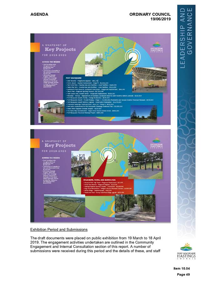
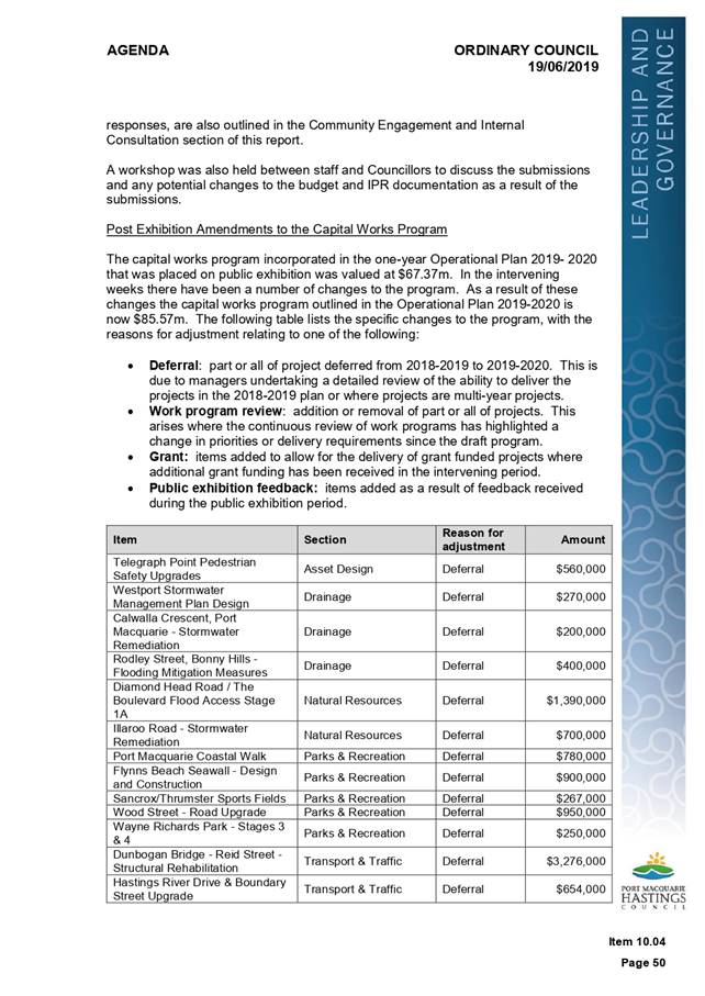
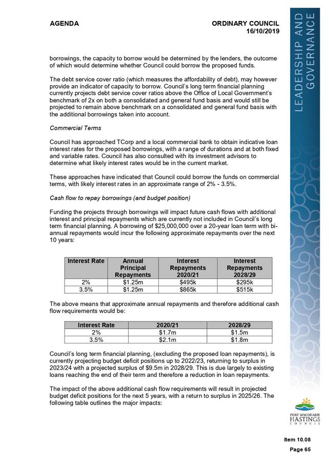
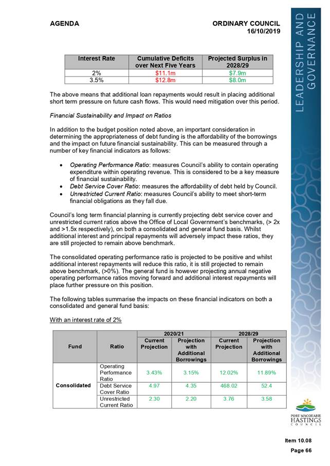
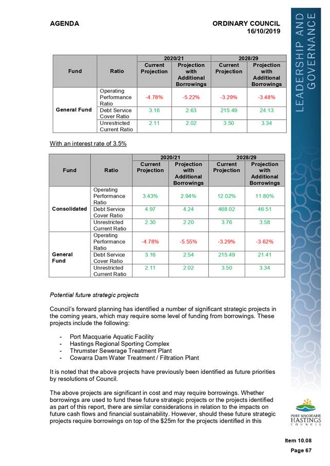
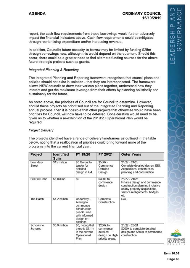
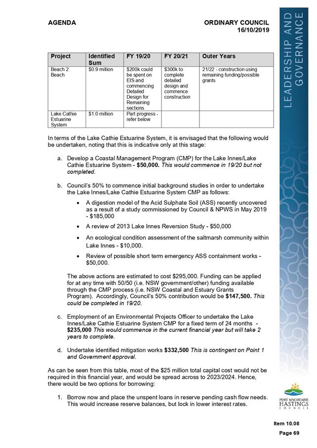
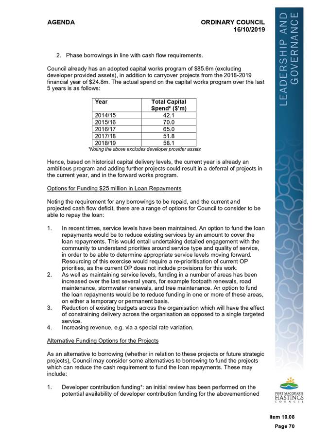
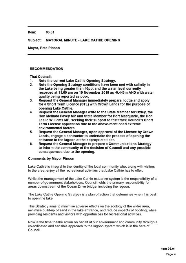

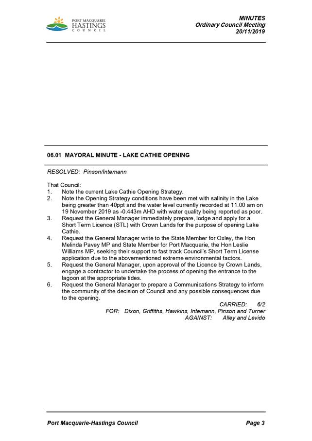
|
ATTACHMENT
|
Coast, Estuary & Floodplain Advisory
Sub-Committee
30 Jan 2020
|
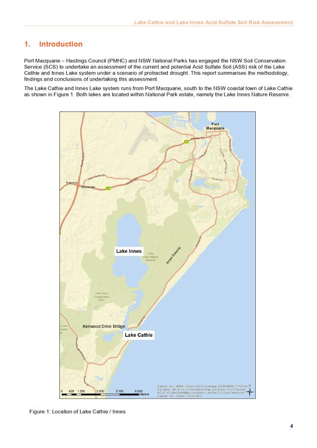
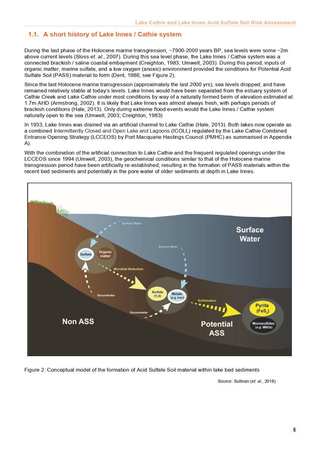
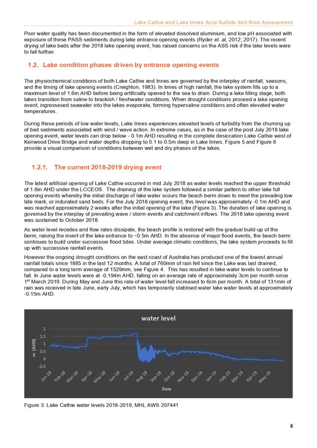
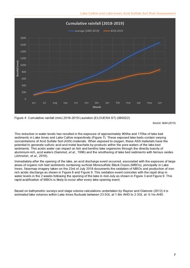
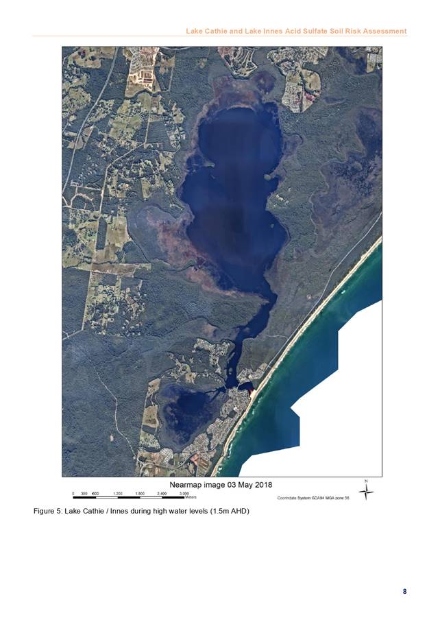
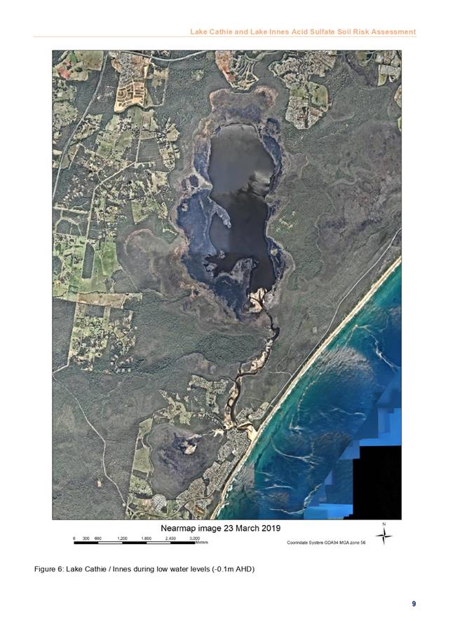
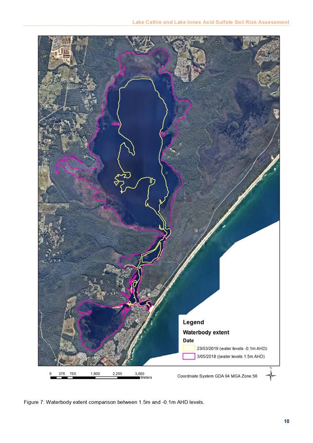
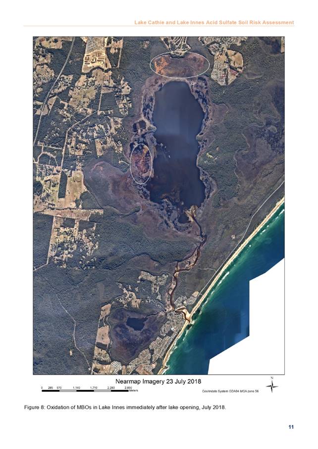
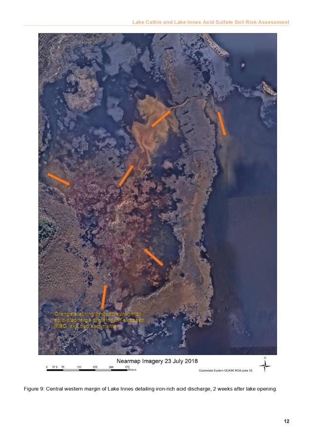
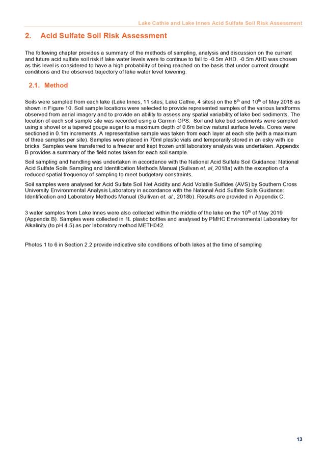
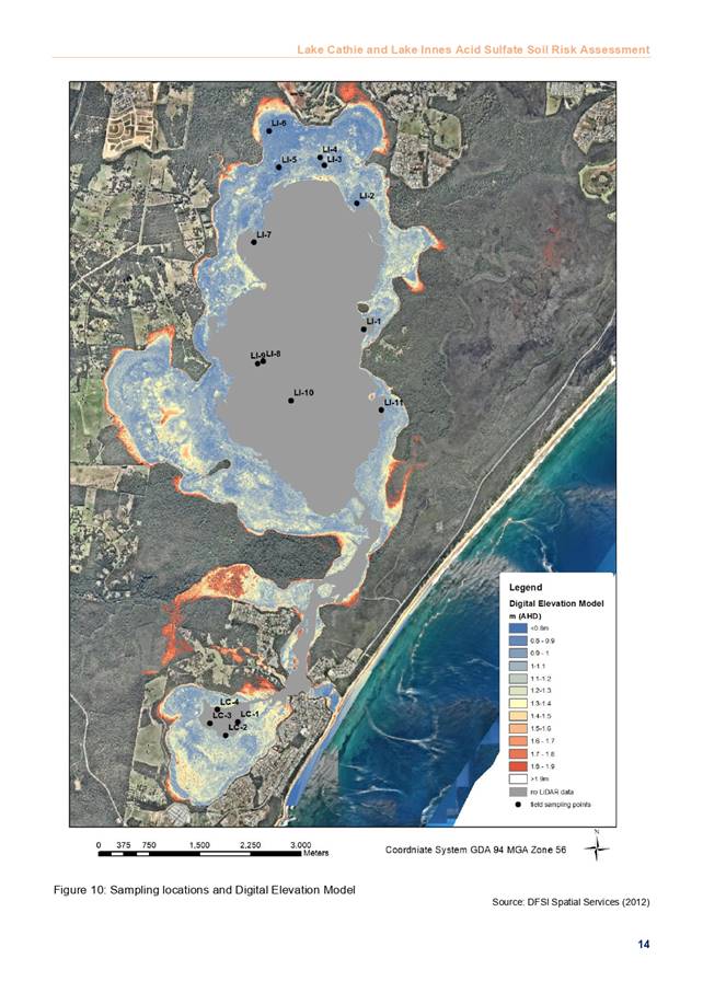
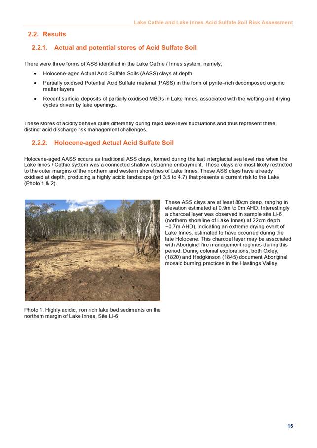

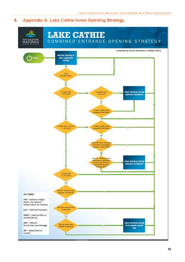
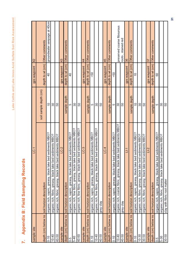
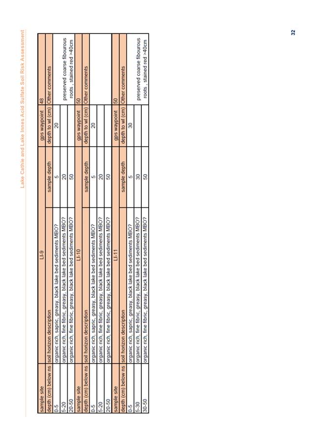
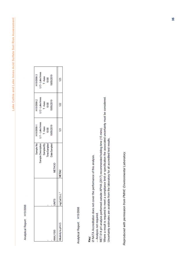

|
ATTACHMENT
|
Coast, Estuary & Floodplain Advisory
Sub-Committee
30 Jan 2020
|
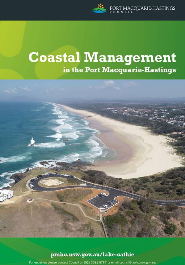
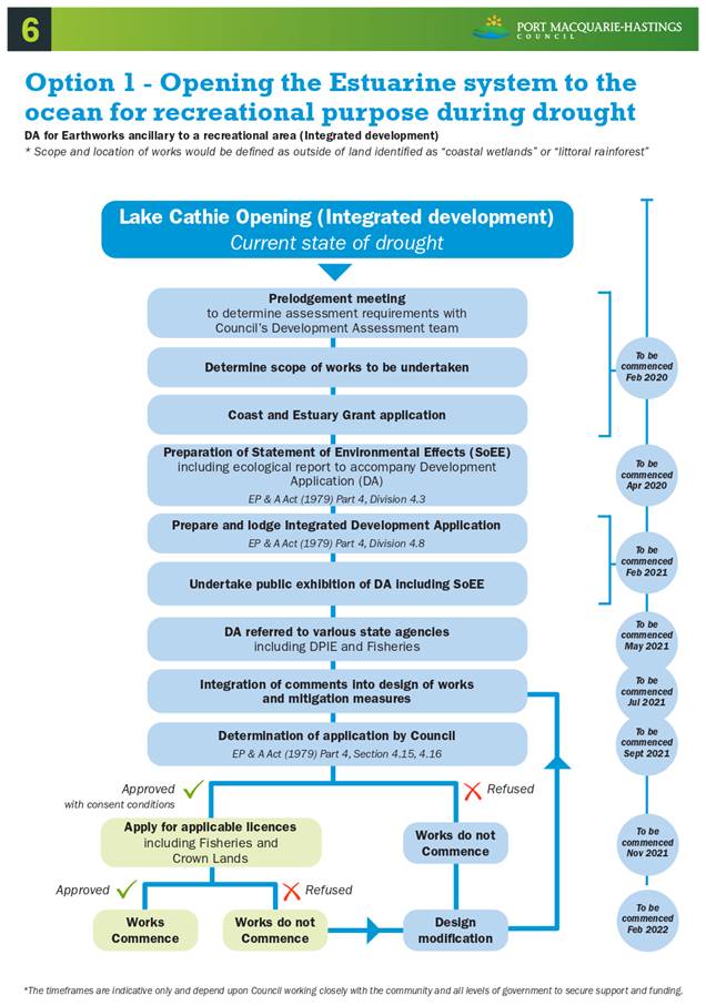
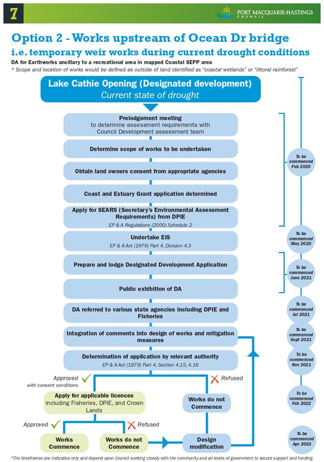
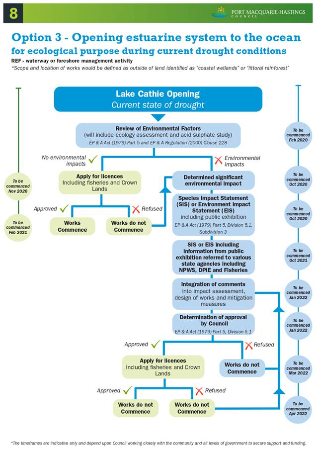
AGENDA Coast, Estuary &
Floodplain Advisory Sub-Committee 30/01/2020
Item: 11
Subject: Passing of Patrick McEntee and Laurie Lardner
Presented
by: Development and Environment, Melissa Watkins
|
RECOMMENDATION
That the Committee:
1. Acknowledge
the important contribution of the late Mr Patrick McEntee and the late Mr
Laurie Lardner to the Coast, Estuary and Floodplain advisory subcommittee.
2. Request
Council write to the families of Mr McEntee and Mr Lardner to express the
appreciation of the committee for their contribution.
|
Discussion
Two long standing members of the Coast, Estuary and
Floodplain advisory subcommittee, Mr Patric McEntee and Mr Laurie Lardner sadly
passed away in 2019.
Both Patrick and Laurie’s contribution to the Coast,
Estuary and Floodplain advisory subcommittee have been significant. The passing
of Patrick and Laurie will be a loss for both the committee and the community
as a whole.
Patrick and Laurie were long standing members of the
committee and provided significant value to the environment and oyster industry
during their many years on the Coast and Estuary and Floodplain committees.
The time, efforts, knowledge and passion of Patrick and
Laurie while serving on this committee over the past two decades needs to be
acknowledged and it is recommended that Council write to the McEntee and
Lardner families to express our appreciation and respect for these two former
long serving members.
AGENDA Coast, Estuary & Floodplain Advisory
Sub-Committee 30/01/2020
Item: 12
Subject: Proposed Coast, Estuary & Floodplain
Advisory Sub-Committee Meeting Dates for Endorsement
Presented
by: Development and Environment, Melissa Watkins
|
RECOMMENDATION
That the Committee endorse the proposed Coast, Estuary
and Floodplain Advisory Sub-Committee meeting dates for 2020.
|
Discussion
The following dates are proposed for the Coast, Estuary and
Floodplain Advisory Sub-Committee to meet this calendar year.
· Thursday 28 May
2020, Function Room, 2.00 - 4.00pm Reports prepared by 14 May, Distribution of
Agenda 21st May.
· Thursday 31 August
2020, Function Room, 2.00 - 4.00pm Reports prepared by 17 August, Distribution
of Agenda 24th August.
· Thursday 26
November 2020, Function Room, 2.00 - 4.00pm Reports prepared by 12 November,
Distribution of Agenda 19th November.