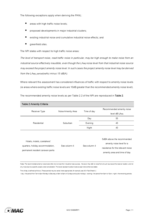
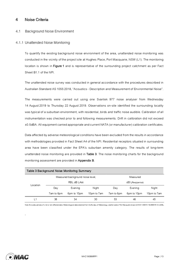
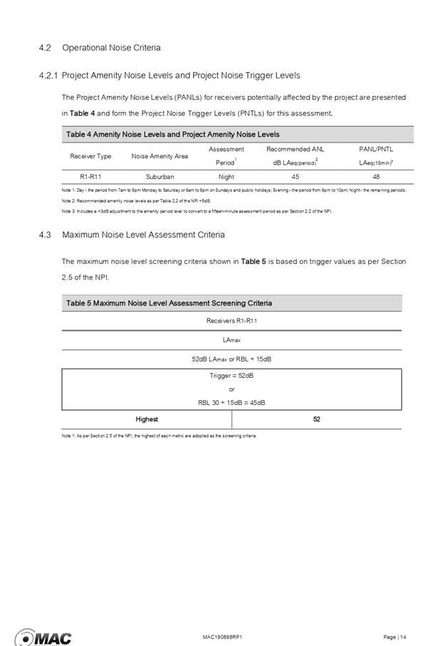
Business
Paper
|
date of meeting:
|
|
Wednesday 22 January
2020
|
|
location:
|
|
Function Room
|
|
time:
|
|
2:00pm
|
Development
Assessment Panel
CHARTER
1.0 OBJECTIVES
To assist in managing Council's development assessment
function by providing independent and expert determinations of development
applications that fall outside of staff delegations.
2.0 KEY FUNCTIONS
·
To review development application reports and conditions;
·
To determine development
applications outside of staff delegations;
·
To refer development applications
to Council for determination where necessary;
·
To provide a forum for objectors and applicants
to make submissions on applications
before the Development Assessment Panel
(DAP);
·
To maintain transparency in the determination of development
applications.
Delegated Authority of Panel
Pursuant to
Section 377 of the Local Government Act, 1993 delegation to:
·
Determine development applications under Part 4
of the Environmental Planning and Assessment
Act 1979 having
regard to the relevant environmental planning instruments,
development control plans and Council policies.
·
Vary, modify or release restrictions as to use
and/or covenants created by Section 88B instruments under the Conveyancing Act
1919 in relation to development applications for subdivisions being considered
by the panel.
·
Determine Koala Plans of Management under State
Environmental Planning Policy 44 - Koala Habitat Protection associated with
development applications being considered by the Panel.
Noting the trigger to escalate
decision making to Council as highlighted in section 5.2.
3.0
MEMBERSHIP
3.1
Voting
Members
·
Two independent external members. One of the
independent external members to be the Chairperson.
·
Group Manager Development Assessment (alternate
- Director Development & Environment or Development Assessment Planner)
The independent external members shall have expertise in
one or more of the following areas: planning, architecture, heritage, the
environment, urban design, economics, traffic and transport, law, engineering,
government and public administration.
3.2
Non-Voting Members
·
Not applicable
3.3 Obligations
of members
·
Members must act faithfully and diligently and
in accordance with this Charter.
·
Members must comply with Council's Code of Conduct.
·
Except as required to properly perform their
duties, DAP members must not
disclose any confidential information (as advised by Council) obtained in connection with the DAP functions.
·
Members will have read and be familiar with the
documents and information provided by Council prior
to attending a DAP meeting.
·
Members must act in accordance with Council's
Workplace Health and Safety Policies and Procedures
·
External members of the Panel are not authorised
to speak to the media on behalf of Council. Council officers that are members
of the Committee are bound by the
existing operational delegations in relation to speaking to the media.
·
Staff members shall not vote on matters before
the Panel if they have been the principle author of the development assessment report.
3.4
Member Tenure
·
The independent external members will be
appointed for the term of four (4) years
maximum in which the end of the tenure of these members would occur in a
cascading arrangement.
3.5 Appointment
of members
·
The independent external members (including the
Chair) shall be appointed by the General Manager following an external
Expression of Interest process.
·
Staff members of the Panel are in accordance
with this Charter.
4.0 TIMETABLE
OF MEETINGS
·
The Development Assessment Panel will generally
meet on the 1st and 3rd Wednesday each month at 2.00pm at the Port Macquarie
offices of Council.
·
Special Meetings of the Panel may be convened by
the Director Development & Environment Services with three (3) days notice.
5.0
MEETING PRACTICES
5.1
Meeting
Format
·
At all Meetings of the Panel the Chairperson
shall occupy the Chair and preside. The Chair will be responsible for keeping
of order at meetings.
·
Meetings shall be open to the public.
·
The Panel will hear from applicants
and objectors or their r e p r e s e n t a t i v e s .
·
Where considered necessary, the Panel will
conduct site inspections which will
be open to the public.
5.2
Decision Making
·
Decisions are to be made by consensus. Where
consensus is not possible on any item, that item is to be referred to Council
for a decision.
·
All development applications involving a
proposed variation to a development standard
greater than 10% under Clause
4.6 of the Local Environmental Plan will be
considered by the Panel and recommendation made to the Council for a decision.
5.3
Quorum
·
All members (2 independent external members and
1 staff member) must be present at a
meeting to form a quorum.
5.4
Chairperson and Deputy Chairperson
·
Independent Chair (alternate, second independent member)
5.5
Secretariat
·
The Director Development &n Environment is
to be responsible for ensuring that the Panel has adequate secretariat support.
The secretariat will ensure that the business paper and supporting papers are
circulated at least three (3) days prior to
each meeting. Minutes shall be appropriately approved and circulated to each
member within three (3) weeks of a meeting being held.
·
The format of and the preparation and publishing
of the Business Paper and Minutes shall be similar to the format for Ordinary
Council Meetings.
5.6
Recording of decisions
·
Minutes will record decisions and how each
member votes for each item before the Panel.
6.0 CONVENING
OF “OUTCOME SPECIFIC” WORKING GROUPS
Not applicable.
7.0 CONFIDENTIALITY
AND CONFLICT OF INTEREST
·
Members of the Panel must comply with the
applicable provisions of Council’s Code of Conduct. It is the personal
responsibility of members to comply with the standards in the Code of Conduct
and regularly review their personal circumstances with this in mind.
·
Panel members must declare any conflict of
interests at the start of each meeting or before discussion of a relevant item
or topic. Details of any conflicts of interest should be appropriately minuted.
Where members are deemed to have a real or perceived conflict of interest, it
may be appropriate they be excused from deliberations on the issue where the
conflict of interest may exist. A Panel meeting may be postponed where there is
no quorum.
8.0 LOBBYING
·
All members and applicants are to adhere to
Council’s Lobbying policy. Outside of
scheduled Development Assessment Panel meetings, applicants, their
representatives, Councillors, Council staff and the general public are not to
lobby Panel members via meetings, telephone conversations, correspondence and
the like. Adequate opportunity will be provided at Panel inspections or
meetings for applicants, their representatives and the general public to make
verbal submissions in relation to Business Paper items.
Development Assessment Panel
ATTENDANCE
REGISTER
|
Member
|
25/09/19
|
09/10/19
|
23/10/19
|
13/11/19
|
27/11/19
|
11/12/19
|
|
Paul
Drake
|
P
|
P
|
P
|
Cancelled
|
P
|
P
|
|
Robert
Hussey
|
|
P
|
|
|
|
|
|
David
Crofts
(alternate member)
|
P
|
|
P
|
|
P
|
P
|
|
Dan
Croft
(Group Manager Development Assessment)
(alternates)
- Development Assessment Planner
|
P
|
A
P
|
P
|
|
P
|
P
|
Key: P = Present
A
= Absent With Apology
X
= Absent Without Apology
Development
Assessment Panel Meeting
Wednesday 22 January
2020
Items of Business
01 Acknowledgement
of Country............................................................................. 8
02 Apologies.......................................................................................................... 8
03 Confirmation
of Minutes..................................................................................... 8
04 Disclosures
of Interest..................................................................................... 14
05 DA2019
- 513.1 Demolition of Existing Buildings and Construction of New Service
Station - Lots 5, 6 and 7 DP 18259, 34 and 36 Munster Street and 59 Gordon
Street, Port Macquarie 18
06 DA2019
- 761.1 Dwelling and Swimming Pool including Clause 4.6 Objection to Clause 4.3
(Height of Buildings) of the Port Macquarie-Hastings Local Environmental Plan
2011, Lot 60 DP 261991, No 14 Phoenix Crescent, Port Macquarie........................................... 301
07 DA2019
- 713.1 Torrens Title Subdivision 2 Lots into 3 - Lots 705 and 706 DP 1228141,
Nos. 41 and 43 Yaluma Drive, Port Macquarie............................................................. 336
08 DA2019
- 694.1 Home Business - Hair Salon, Lot 108 DP 1214480, No. 4 Sunrise
Place, King Creek............................................................................................................ 378
09 DA2019
- 673.1 Modification to General Store (Aldi) - Altered Delivery Hours - Lot 701
DP 1151916,No 3 Hughes Place, Port Macquarie.................................................. 398
10 General
Business
AGENDA Development Assessment Panel 22/01/2020
Subject: ACKNOWLEDGEMENT
OF COUNTRY
"I acknowledge that we are
gathered on Birpai Land. I pay respect to the Birpai Elders both past and
present. I also extend that respect to all other Aboriginal and Torres Strait
Islander people present."
RECOMMENDATION
That the apologies received be
accepted.
Subject: CONFIRMATION
OF PREVIOUS MINUTES
Recommendation
That the Minutes of the Development
Assessment Panel Meeting held on 11 December 2019 be confirmed.
MINUTES
Development Assessment Panel Meeting
11/12/2019
PRESENT
Members:
Paul
Drake
David Crofts
Dan Croft
Other Attendees:
Pat Galbraith-Robertson
Grant
Burge
Chris
Gardiner
Beau
Spry
Steven
Ford
Fiona
Tierney
|
The meeting opened at 2:00pm.
|
|
01 ACKNOWLEDGEMENT
OF COUNTRY
|
|
The
Acknowledgement of Country was delivered.
|
|
03 CONFIRMATION
OF MINUTES
|
|
CONSENSUS:
That
the Minutes of the Development Assessment Panel Meeting held on 27 November
2019 be confirmed.
|
|
04 DISCLOSURES OF INTEREST
|
|
There were no disclosures of interest
presented.
|
|
05 DA2019 - 248.1
Telecommunications Facility (Tower) - Lot 1 DP 834401, No. 10 Holland Close
Port Macquarie
|
|
Speakers:
Tricia Mann (o),
James McIver (applicant)
CONSENSUS:
That DA
2019/248.01 for a Telecommunications
Facility at Lot 1,
DP 834401, No. 10 Holland Close, Port
Macquarie, be determined by granting consent
subject to the recommended conditions and as amended below:
- Additional
condition in Section B of the consent to read: “Prior to the issue
of a construction certificate amended landscaping plans are to be
submitted to Council for approval providing for an extension of the 5m
strip of landscaping for the full length of John Oxley Drive to the
intersection with Holland Close.”
|
|
06 DA1991 - 485.2
Modification to Residential Subdivision at Lot 3 & 4 DP 205451, Lot X, Y
& Z DP409518, Lot 28 DP 23418, No 211-213 High Street and Pead Street,
Wauchope
|
|
Speakers:
Tony Haydon (o)
Brad Maggs (applicant)
CONSENSUS:
That DA1991
- 485.2 for Modification of Residential Subdivision
at Lot 3 & 4
DP 205451, Lot X, Y & Z DP 409518, and
Lot 28 DP 23418, No. 211-213 High
Street and Pead Street, Wauchope, be determined by granting consent subject to the
recommended modified conditions and as amended below:
- Amend
condition 30 to read: “Payment of a cash contribution in lieu of
the provision of land for public reserves; such contribution to be
calculated as the value, on the current land value as determined by
Council on the advice of a Certified Practicing Valuer, or as determined
by the Valuer General, of the deficiency assessed using a requirement of
3ha per 1,000 head of population generated by the subdivision. The
developer shall meet all costs incurred in obtaining the necessary
valuation.
The
above requirement equates to a contribution amount of $5,940 per lot created
in each stage of the subdivision, as at 30 November 2019, or such other
amount agreed by Council or determined by the Valuer General. The amount is
to be paid on release of the relevant Subdivision Certificate (linen plan)
and is to be indexed quarterly in accordance with movements in the Consumer
Price Index (All Groups - Sydney), published by the Australian Bureau of
Statistics, until the time of payment of the contribution.1
“
|
|
07 DA2019 - 651.1
Additional Dwelling to Create Dual Occupancy and Strata Title at Lot 1 DP
570012,No. 6 Home Street, Port Macquarie
|
|
Speakers:
Michelle Love (applicant)
CONSENSUS:
That DA
2019 - 651 for an additional dwelling to
create a dual occupancy and strata title subdivision at Lot 1, DP 570012, No. 6 Home
Street, Port Macquarie, be determined by granting consent subject to the
recommended conditions and as amended below:
- Amend condition B(15) to read:
“A privacy screen is to be provided to the proposed kitchen window
which restricts direct line of sight to adjoining private open space
areas or alternatively, the kitchen window sill height is to be raised
to a minimum of 1.5m above the finished floor level. Details are to be
submitted with the application for the construction certificate.”
|
|
08 DA2019 - 324.1
Industrial Subdivision at Lot 21 DP 811254, Bago Road, Wauchope
|
|
Speakers:
Nik Sandeman Allen (o)
Mark hammer (o)
CONSENSUS:
That DA
2019 - 324 for an industrial subdivision at Lot 21, DP 811254, Bago Road,
Wauchope, be deferred to enable the applicant to address the following:
1.
Provide the relevant owner’s
consent for sewer infrastructure required to service the development.
2.
Provide additional information on traffic
safety relating to the intersection with Bago Road and sight lines for
entering and egressing the property.
|
|
09 DA
2019 - 285.1 Service Station and Take Away Food and Drink Premises at Lots 1
- 3 DP 407749 and Lot D DP 376568. 15 Ocean Drive Port Macquarie and 39 -
43 Ackroyd Street Port Macquarie
|
|
Speakers:
Stephen
Moore (applicant)
CONSENSUS:
That DA 2019 - 285.1 for
a Service Station and Take Away Food & Drink Premises at Lots 1- 3 DP 407749 and Lot D DP 376568. 15
Ocean Drive Port Macquarie and 39 - 43 Ackroyd Street Port Macquarie be determined by granting consent subject to the
recommended conditions and as amended below:
- Amend
condition F (14 to read: “Hours of operation of the development
are permitted as follows:
§ Service station = 5am to midnight, 7 days a week.
§ Food and drink premises = 7am to 10pm Sunday to Thursday
and 7am to 11pm Friday and Saturday, 7 days a week.
- Additional condition in Section
B of the consent to read: “ prior to release of the construction
certificate, amended plans are to be provided to relocate the customer
air pump and water service to the vicinity of parking space number
6.”
- Additional
condition in Section F of the consent to read: “ The air pump
beeper is to be silenced after 8pm each night.”
|
|
10 DA2007 - 74.2
- Modification to Previous Approved Staged Alterations and Additions to Motel
at Lot 2 DP 1107888, No. 1 Stewart Street, Port Macquarie
|
|
Speakers:
John Thompson (o)
Mike Mongan (o)
Damien Keep (applicant)
CONSENSUS:
That
DA2007 - 74.2 for a modification to previous approved staged
alterations and additions to motel at Lot 2, DP 1107888, No. 1 Stewart Street, Port
Macquarie, be determined by granting consent
subject to the recommended modified conditions.
|
|
The meeting closed at 3:45pm.
|
AGENDA Development Assessment Panel 22/01/2020
Subject: DISCLOSURES
OF INTEREST
RECOMMENDATION
That Disclosures of Interest be presented
DISCLOSURE OF
INTEREST DECLARATION
|
Name of Meeting:
|
|
Meeting
Date:
|
|
Item
Number:
|
|
Subject:
|
|
I,
the undersigned, hereby declare the following interest:
Pecuniary:
 Take no part
in the consideration and voting and be out of sight of the meeting. Take no part
in the consideration and voting and be out of sight of the meeting.
Non-Pecuniary
– Significant Interest:
Take no part
in the consideration and voting and be out of sight of the meeting.
Non-Pecuniary
– Less than Significant Interest:
May
participate in consideration and voting.
|
|
For
the reason that:
|
|
Name:
Signed:
|
Date:
|
|
Please submit to the
Governance Support Officer at the Council Meeting.
|
 (Refer
to next page and the Code of Conduct)
(Refer
to next page and the Code of Conduct)
Pecuniary Interest
4.1
A pecuniary interest is an interest
that you have in a matter because of a reasonable likelihood or expectation of
appreciable financial gain or loss to you or a person referred to in clause
4.3.
4.2
You will not have a pecuniary
interest in a matter if the interest is so remote or insignificant that it
could not reasonably be regarded as likely to influence any decision you might
make in relation to the matter, or if the interest is of a kind specified in
clause 4.6.
4.3
For the purposes of this Part, you
will have a pecuniary interest in a matter if the pecuniary interest is:
(a)
your interest, or
(b)
the interest of your spouse or de
facto partner, your relative, or your partner or employer, or
(c)
a company or other body of which
you, or your nominee, partner or employer, is a shareholder or member.
4.4
For the purposes of clause 4.3:
(a)
Your “relative” is any
of the following:
(b)
“de facto partner” has
the same meaning as defined in section 21C of the Interpretation Act 1987.
4.5
You will not have a pecuniary
interest in relation to a person referred to in subclauses 4.3(b) or (c)
(a)
if you are unaware of the relevant
pecuniary interest of your spouse, de facto partner, relative, partner,
employer or company or other body, or
(b)
just because the person is a member
of, or is employed by, a council or a statutory body, or is employed by the
Crown, or
(c)
just because the person is a member
of, or a delegate of a council to, a company or other body that has a pecuniary
interest in the matter, so long as the person has no beneficial interest in any
shares of the company or body.
Non-Pecuniary
5.1
Non-pecuniary interests are private
or personal interests a council official has that do not amount to a pecuniary
interest as defined in clause 4.1 of this code. These commonly arise out of
family or personal relationships, or out of involvement in sporting, social,
religious or other cultural groups and associations, and may include an interest
of a financial nature.
5.2
A non-pecuniary conflict of
interest exists where a reasonable and informed person would perceive that you
could be influenced by a private interest when carrying out your official
functions in relation to a matter.
5.3
The personal or political views of
a council official do not constitute a private interest for the purposes of
clause 5.2.
5.4
Non-pecuniary conflicts of interest
must be identified and appropriately managed to uphold community confidence in
the probity of council decision-making. The onus is on you to identify any
non-pecuniary conflict of interest you may have in matters that you deal with,
to disclose the interest fully and in writing, and to take appropriate action
to manage the conflict in accordance with this code.
5.5
When considering whether or not you
have a non-pecuniary conflict of interest in a matter you are dealing with, it
is always important to think about how others would view your situation.
Managing non-pecuniary conflicts of interest
5.6
Where you have a non-pecuniary
conflict of interest in a matter for the purposes of clause 5.2, you must
disclose the relevant private interest you have in relation to the matter fully
and in writing as soon as practicable after becoming aware of the non-pecuniary
conflict of interest and on each occasion on which the non-pecuniary conflict
of interest arises in relation to the matter. In the case of members of council
staff other than the general manager, such a disclosure is to be made to the
staff member’s manager. In the case of the general manager, such a
disclosure is to be made to the mayor.
5.7
If a disclosure is made at a
council or committee meeting, both the disclosure and the nature of the
interest must be recorded in the minutes on each occasion on which the non-pecuniary
conflict of interest arises. This disclosure constitutes disclosure in writing
for the purposes of clause 5.6.
5.8
How you manage a non-pecuniary
conflict of interest will depend on whether or not it is significant.
5.9
As a general rule, a non-pecuniary
conflict of interest will be significant where it does not involve a pecuniary
interest for the purposes of clause 4.1, but it involves:
a)
a relationship between a council
official and another person who is affected by a decision or a matter under
consideration that is particularly close, such as a current or former spouse or
de facto partner, a relative for the purposes of clause 4.4 or another person
from the council official’s extended family that the council official has
a close personal relationship with, or another person living in the same
household
b)
other relationships with persons
who are affected by a decision or a matter under consideration that are
particularly close, such as friendships and business relationships. Closeness
is defined by the nature of the friendship or business relationship, the
frequency of contact and the duration of the friendship or relationship.
c)
an affiliation between the council
official and an organisation (such as a sporting body, club, religious,
cultural or charitable organisation, corporation or association) that is
affected by a decision or a matter under consideration that is particularly
strong. The strength of a council official’s affiliation with an
organisation is to be determined by the extent to which they actively
participate in the management, administration or other activities of the
organisation.
d)
membership, as the council’s
representative, of the board or management committee of an organisation that is
affected by a decision or a matter under consideration, in circumstances where
the interests of the council and the organisation are potentially in conflict
in relation to the particular matter
e)
a financial interest (other than an
interest of a type referred to in clause 4.6) that is not a pecuniary interest
for the purposes of clause 4.1
f)
the conferral or loss of a personal
benefit other than one conferred or lost as a member of the community or a
broader class of people affected by a decision.
5.10
Significant non-pecuniary conflicts
of interest must be managed in one of two ways:
a)
by not participating in
consideration of, or decision making in relation to, the matter in which you
have the significant non-pecuniary conflict of interest and the matter being
allocated to another person for consideration or determination, or
b)
if the significant non-pecuniary
conflict of interest arises in relation to a matter under consideration at a
council or committee meeting, by managing the conflict of interest as if you
had a pecuniary interest in the matter by complying with clauses 4.28 and 4.29.
5.11
If you determine that you have a
non-pecuniary conflict of interest in a matter that is not significant and does
not require further action, when disclosing the interest you must also explain
in writing why you consider that the non-pecuniary conflict of interest is not
significant and does not require further action in the circumstances.
5.12
If you are a member of staff of
council other than the general manager, the decision on which option should be
taken to manage a non-pecuniary conflict of interest must be made in
consultation with and at the direction of your manager. In the case of the
general manager, the decision on which option should be taken to manage a
non-pecuniary conflict of interest must be made in consultation with and at the
direction of the mayor.
5.13
Despite clause 5.10(b), a
councillor who has a significant non-pecuniary conflict of interest in a
matter, may participate in a decision to delegate consideration of the matter
in question to another body or person.
5.14 Council committee members are not required to declare
and manage a non-pecuniary conflict of interest in accordance with the
requirements of this Part where it arises from an interest they have as a
person chosen to represent the community, or as a member of a non-profit organisation
or other community or special interest group, if they have been appointed to
represent the organisation or group on the council committee.
SPECIAL
DISCLOSURE OF PECUNIARY INTEREST DECLARATION
This
form must be completed using block letters or typed.
If
there is insufficient space for all the information you are required to
disclose,
you
must attach an appendix which is to be properly identified and signed by you.
|
By
[insert full name of councillor]
|
|
|
In the
matter of
[insert name of environmental planning instrument]
|
|
|
Which is
to be considered at a meeting of the
[insert name of meeting]
|
|
|
Held on
[insert date of meeting]
|
|
|
PECUNIARY
INTEREST
|
|
Address of
the affected principal place of residence of the councillor or an associated
person, company or body (the identified land)
|
|
|
Relationship
of identified land to councillor
[Tick or cross one box.]
|
The councillor has interest in the land (e.g. is owner or has other
interest arising out of a mortgage, lease, trust, option or contract, or
otherwise).
An associated person of the councillor has an interest in the land.
An associated company or body of the councillor has interest in the land.
|
|
MATTER
GIVING RISE TO PECUNIARY INTEREST
|
|
Nature of
land that is subject to a change
in zone/planning
control by proposed
LEP (the
subject land
[Tick or cross one box]
|
The identified land.
Land that adjoins or is adjacent to or is in proximity to the identified
land.
|
|
Current
zone/planning control
[Insert name of current planning instrument and
identify relevant zone/planning control applying to the subject land]
|
|
|
Proposed
change of zone/planning control
[Insert name of proposed LEP and identify proposed
change of zone/planning control applying to the subject land]
|
|
|
Effect of
proposed change of zone/planning control on councillor or associated person
[Tick or cross one box]
|
Appreciable financial gain.
Appreciable financial loss.
|
|
|
|
[If more than one pecuniary interest is to be
declared, reprint the above box and fill in for each additional interest]
Councillor’s Signature:
……………………………….
Date: ………………..
This form is to be retained
by the council’s general manager and included in full in the minutes of
the meeting
Last Updated: 3 June 2019
Important Information
This information is being collected for the purpose of
making a special disclosure of pecuniary interests under clause 4.36(c) of the
Model Code of Conduct for Local Councils in NSW (the Model Code of Conduct).
The special disclosure must relate only to a pecuniary
interest that a councillor has in the councillor’s principal place of
residence, or an interest another person (whose interests are relevant under
clause 4.3 of the Model Code of Conduct) has in that person’s principal
place of residence.
Clause 4.3 of the Model Code of Conduct states that you
will have a pecuniary interest in a matter because of the pecuniary interest of
your spouse or your de facto partner or your relative or because your business
partner or employer has a pecuniary interest. You will also have a pecuniary
interest in a matter because you, your nominee, your business partner or your
employer is a member of a company or other body that has a pecuniary interest
in the matter.
“Relative” is defined by clause 4.4 of the Model
Code of Conduct as meaning your, your spouse’s or your de facto
partner’s parent, grandparent, brother, sister, uncle, aunt, nephew,
niece, lineal descendant or adopted child and the spouse or de facto partner of
any of those persons.
You
must not make a special disclosure that you know or ought reasonably to know is
false or misleading in a material particular. Complaints about breaches
of these requirements are to be referred to the Office of Local Government and
may result in disciplinary action by the Chief Executive of the Office of Local
Government or the NSW Civil and Administrative Tribunal.
This form must be completed by you before the commencement
of the council or council committee meeting at which the special disclosure is
being made. The completed form must be tabled at the meeting. Everyone is
entitled to inspect it. The special disclosure must be recorded in the minutes
of the meeting.
A pecuniary interest may arise by way of a change of
permissible use of land adjoining, adjacent to or in proximity to land in which
a councillor or a person, company or body referred to in clause 4.3 of the
Model Code of Conduct has a proprietary interest
AGENDA Development Assessment Panel 22/01/2020
Item: 05
Subject: DA2019 - 513.1 Demolition of Existing
Buildings and Construction of New Service Station - Lots 5, 6 and 7 DP 18259,
34 and 36 Munster Street and 59 Gordon Street, Port Macquarie
Report
Author: Development Assessment Planner, Benjamin Roberts
|
Applicant: RCI
Group
Owner: V
I Trotter and C J Pickering
Estimated Cost: $1,870,000
Parcel no: 35857,
35856, 14335
Alignment with Delivery
Program
4.3.1 Undertake transparent and efficient
development assessment in accordance with relevant legislation.
|
|
RECOMMENDATION
That
DA2019 - 513.1 for demolition of
existing buildings and construction of new service station at Lots 5, 6 and
7, DP 18259, No. 34 and 36 Munster Street and 59 Gordon Street, Port
Macquarie, be determined by granting consent subject to the recommended
conditions.
|
Executive
Summary
This
report considers a development application for demolition of existing buildings
and construction of new service station at the
subject site and provides an assessment of the application in accordance with
the Environmental Planning and Assessment Act 1979.
Following exhibition of the
application, three (3) submissions have been
received.
The site is considered suitable for the proposed development
and the proposal adequately addresses relevant planning controls. The
development is not considered to be contrary to the public's interest and will
not result a significant adverse social, environmental or economic impact.
This report recommends that the
development application be approved subject to the conditions included as
Attachment 1.
1. BACKGROUND
Existing Sites Features and Surrounding Development
The site has an area of 1,834m2.
The site is zoned B4 Mixed Use in accordance with the Port Macquarie-Hastings Local
Environmental Plan 2011, as shown in the following zoning plan:
The existing subdivision pattern and location of existing
development within the locality is shown in the following aerial photograph:
2. DESCRIPTION OF
DEVELOPMENT
Key aspects of the proposal include the following:
· Demolition
of existing buildings.
· Construction of a new service station, including a 193m2
convenience store building containing customer service counter, retail floor
space, office, store room, cool room, amenities, and service yard.
· Installation of underground fuel tanks (1 x 50,000 litre
diesel, 1 x 30,000 litre Ethanol 10, 1 x 30,000 litre Premium Unleaded 98, 1 x
40,000 litre Unleaded 91 and 1 x 30,000 litre Premium 95) and their related
infrastructure.
· Installation of four (4) double sided fuel dispensers
(appropriately bunded) and overhead canopy.
· Construction of 13 car parking spaces, including one
accessible space and x 1 air / water bay.
· Installation of x 1 freestanding 6m high
‘Mobil’ internally illuminated pylon sign, located within
south-western corner. 1.9m in width and 0.4m in depth.
· Construction of an underground Puraceptor and Stomscak
system for wastewater discharge management.
· Construction of an underground OSD tank (47.7m3) for
stormwater discharge control.
· Installation of a signage tower and indicative business
identification signage on the south-west face of the convenience store.
· Two (2) illuminated ‘Mobil’ signs on the
‘south’ and ‘west’ faces of the car refuelling canopy.
· Planting of landscaping around the perimeter of the service
station and adjacent to the proposed building.
· Screened waste storage area.
· Loading Zone adjacent to waste storage area.
· Minor excavations to accommodate vehicle accesses/exits.
· The service station is proposed to operate 24 hours a day,
seven days/week and employ 2 staff Mon-Friday and 1 staff for night and weekend
shifts.
Refer
to attachments at the end of this report for details of the proposal.
Application Chronology
· 12
July 2019 - Application lodged.
· 22 July to 5 August 2019 - Public exhibition via neighbour
notification.
· 7 August 2019 - Additional information request.
· 9 August 2019 - Additional information response.
· 20 August 2019 - Additional information request.
· 27 August 2019 - Additional information response.
· 10
October 2019 - Additional information request.
· 14
November 2019 - Additional information response.
· 18
November 2019 - Additional information request.
· 29
November 2019 - Additional information response.
3. STATUTORY ASSESSMENT
Section 4.15(1) Matters for Consideration
In determining the application, Council is required to take
into consideration the following matters as are relevant to the development
that apply to the land to which the development application relates:
(a) The provisions (where applicable)
of:
(i) Any Environmental
Planning Instrument
State Environmental Planning Policy No. 33 - Hazardous
and Offensive Development
This policy was introduced to clarify the definitions for
hazardous and offensive industries and to apply guidelines for the assessment
of industries that have the potential to create hazards or an offence.
Clause 12 of the policy requires that a development
application for the purposes of a potentially hazardous industry must include a
preliminary hazard analysis (PHA) in accordance with the current circulars or
guidelines published by the Department of Planning, Industry and Environment.
The Department has published Hazardous and Offensive Development
Application
Guidelines – Applying to SEPP 33 (January
2011). Appendix 3 of The Guideline
identifies Petrol Stations as
industries, which may be potentially hazardous. The primary sources of hazard
are identified as liquid fuel leaks/spills resulting in possible impacts such
as fire and explosions.
Appendix 2 of The Guideline
includes a list of information required in relation to the SEPP 33 risk
screening method as follows:
- Hazardous
Materials involved in the Proposed Development;
- Dangerous
Goods classifications for all Dangerous Goods held on site;
- Quantities
of dangerous goods and otherwise hazardous materials involved in
the proposed development;
- Distance
from the boundary for each hazardous substance;
- Weekly and
annual number of deliveries (and the quantities) of dangerous
goods
and otherwise hazardous materials to and from the facility;
- Site Layout
plan showing proposed development and any existing
development
on site; and
- Locality
Plan showing immediate neighbours and their activities and also
showing
the nearest residential property.
In this case, the development
has the potential to be hazardous given the proposal to store petrol, diesel
and ethanol on the site and the provisions of the SEPP apply.
The above information has been satisfactorily addressed in
the SEPP 33 Preliminary Hazards Analysis and Summary and the Multi-Level Risk
Assessment included in submitted information with the application. Having
considered the SEPP, the Multi-Level Risk Assessment, the Preliminary Hazard
Analysis, and with the imposition of conditions, the consideration of the SEPP
is satisfied.
State Environmental Planning Policy No. 44 - Koala
Habitat Protection
There is no Koala Plan of Management on the site.
Additionally, the site is less than 1ha in area therefore no further
investigations are required. The application has demonstrated that no habitat
will be removed or modified therefore no further investigations are required.
State Environmental Planning Policy No. 55 –
Remediation of Land
The site is mapped as a potentially contaminated site based
on previous historic use as a service station.
The application is accompanied by an environmental site
assessment, prepared by NEO Consulting, dated 20 May 2019. The report found no
evidence of any soil or water contamination from the historic use of the site
as a service station.
In accordance with clause 9 of this policy and based on the
findings of the environmental site assessment the site is suitable for the
intended use.
State Environmental Planning Policy No. 62 –
Sustainable Aquaculture
Given the nature of the proposed development, proximity to
waterways and proposed stormwater controls the proposal will be unlikely to
have any adverse impact on existing aquaculture industries.
State Environmental Planning Policy (Coastal Management)
2018
The site is located within a coastal environment area.
In accordance with clause 7, this policy prevails over the
Port Macquarie-Hastings LEP 2011 in the event of any inconsistency.
Having regard to clause 14 of the SEPP the proposed
development is not considered likely to result in any of the following:
a) any
adverse impact on integrity and resilience of the biophysical,
hydrological (surface and groundwater) and ecological environment;
b) any
adverse impacts coastal environmental values and natural coastal
processes;
c) any
adverse impact on marine vegetation, native vegetation and fauna
and their habitats, undeveloped headlands and rock platforms;
d) any
adverse impact on Aboriginal cultural heritage, practices and
places;
e) any
adverse impacts on the cultural and built environment heritage;
f) any
adverse impacts the use of the surf zone;
g) any adverse impact on the visual amenity and scenic qualities of the
coast, including coastal headlands;
h) overshadowing, wind funnelling and the loss of views from public places
to foreshores;
i) any
adverse impacts on existing public open space and safe access to
and along the foreshore, beach, headland or rock platform for members of the
public, including persons with a disability.
In accordance with clause 15, the
proposal will not cause increased risk of coastal hazards on that land or other
land.
The bulk, scale and size of the proposed development is compatible
with the surrounding coastal and built environment. The site is located within
an area zoned for mixed use purposes.
State
Environmental Planning Policy No 64 - Advertising and Signage
The proposed
development includes the erection of the following signage:
· ‘Mobil’
pylon sign – 6m in height, 1.8m in width and 0.4m in depth.
· Two
(2) illuminated ‘Mobil’ signs on the ‘south’ and
‘west’ faces of the car refuelling canopy.
· One
(1) indicative internally illuminated sign on the west façade of the
service store.
· One
(1) tower sign with two (2) indicative internally illuminated business signs
(south-west face).
In accordance with clause 7, this policy prevails over the
Port Macquarie-Hastings LEP 2011 in the event of any inconsistency.
The following assessment table provides an assessment
checklist against the Schedule 1 requirements of this SEPP:
|
Applicable clauses for
consideration
|
Comments
|
Satisfactory
|
|
Clause
8(a) Consistent with objectives of the policy as set out in Clause 3(1)(a).
|
The B4 Mixed Use zone contains a
variety of commercial land uses. The proposed signage is considered to be
compatible with the existing and future character of the locality.
Proposal is considered
consistent with the objectives of the SEPP.
|
Yes
|
Schedule 1(1) Character of the area.
|
In
assessing signage and compatibility with character of an area, elements such
as scale and any amenity impacts should be considered.
In this case the proposal is consistent with the established character of
the area. Similar scale signage is provided on other service stations in the
area and potential amenity impacts (such as
illumination) can be appropriately managed via conditions.
|
Yes
|
|
Schedule
1(2) Special areas.
|
The
proposed signage does not detract from any areas of environmental or cultural
importance. There are no such areas in direct proximity to the subject land.
|
Yes
|
|
Schedule
1(3) Views and vistas.
|
The
proposed signage does not obscure or compromise important views, dominate the
skyline or reduce the quality of any views or vistas. The proposed signage
has no impact on existing signage in close proximity to the site.
|
Yes
|
|
Schedule
1(4) Streetscape, setting or landscape.
|
The
proposal incorporates an illuminated signage panel on a tower building
element on the south-western part of the convenience store building. This
element extends well above the roofline of the building and while the
building element itself provides some architectural interest it is not
considered appropriate for an illuminated signage panel to be located upon it
well above the roof line. Other signage proposed which includes a 6m pylon
sign and forecourt canopy signage clearly identifies the site. Subject to the
illuminated signage panel shown above the roof line on the tower building element
being removed the signage is considered to be acceptable in terms of scale,
height, and appearance, and is compatible
with the streetscape setting. Similar scale signage is evident on a nearby
service station on the corner of Lord Street.
|
Yes, subject to no illuminated signage panel on the tower
building element. Consent condition recommended.
|
|
Schedule
1(5) Site and building.
|
The
signage is seen to be standard for a service centre and is considered to be
acceptable in terms of scale, height, and appearance.
The
proposed signage is not considered to detract from important features of the
site, proposed building or surrounding development. The location of the
proposed signage is considered suitable for the proposed use and appropriate
given the proposed service stations position, proposed access arrangements
and parking.
|
Yes, subject to no illuminated signage panel on the tower
building element. Consent condition recommended.
|
|
Schedule
1(6) Associated devices and logos with advertisements and advertising
structures.
|
The
proposal includes signage, which is intended to ultimately include logos and
symbols representing facilities and services offered.
|
Yes
|
|
Schedule
1(7) Illumination.
|
Low
impact lighting is proposed to illuminate the signage at night.
These
signs will be required to be illuminated at appropriate levels so as to
ensure that the signage will not result in unacceptable glare. The proposed
illuminated signage is not considered likely to provide a significant safety
concern for pedestrians, vehicles or aircraft.
Condition
recommended requiring lighting to comply with AS4282 - Control of the
obtrusive effects of outdoor lighting.
|
Yes
|
|
Schedule 1(7) Safety.
|
The
proposed service station signage is not considered likely to reduce road
safety for pedestrians, cyclists or any vehicles utilising a public road.
Sightlines
to and from the site are not considered likely to be affected.
|
Yes
|
State Environmental Planning
Policy (Infrastructure) 2007
In
accordance with clause 104 of this policy the proposal is not considered to be
traffic generating development. Specifically, the proposed service station does
not contain any heavy vehicle refuelling or maintenance services and does not
have access to a classified road.
Port
Macquarie-Hastings Local Environmental Plan 2011
The proposal is consistent
with the LEP having regard to the following:
· Clause
2.2 - The subject site is zoned B4 Mixed Use.
· Clause
2.3(1) and the B4 zone land use table - The proposed development for a service
station is a permissible land use with consent.
The following
land use in the LEP is relevant to determine and characterise the proposed use:
service
station means a building or place used for the sale by retail of
fuels and lubricants for motor vehicles, whether or not the building or place
is also used for any one or more of the following:
(a)
the ancillary sale by retail of spare parts and accessories
for motor vehicles,
(b) the cleaning of motor vehicles,
(c) installation of accessories,
(d) inspecting, repairing and servicing of motor
vehicles (other than body building, panel beating, spray painting, or chassis
restoration),
(e) the ancillary retail selling or hiring of
general merchandise or services or both.
· The
objectives of the B4 zone are as follows:
o To provide a mixture of compatible land uses.
o To integrate suitable business, office,
residential, retail and other development in accessible locations so as to
maximise public transport patronage and encourage walking and cycling.
o To ensure that new developments make a positive
contribution to the public domain and streetscape.
· Clause
2.3(2) - The proposal is consistent with the zone objectives having regard to
the following:
o The proposal is a permissible
land use;
o The service station will
provide a mixture of compatible land uses in the area;
o The proposal will
satisfactorily address the public domain and streetscape.
· Clause 4.3 - The overall height of the building and
forecourt structures are below the 19m maximum building height control
applicable to the site.
1.
· Clause 4.4 - The floor space ratio of the proposal is
0.105:1.0, which complies with the maximum 2:1 floor space ratio applicable to
the site.
· Clause
5.10 - The site does not contain or adjoin any known heritage items or sites of
significance.
2.
· Clause 7.3 - The site is located within the mapped flood
planning area. The application was accompanied by a Water Cycle Management Plan
prepared by Eclipse Consulting Engineers, dated 11 July 2019. This plan has
regard to the flood impacts of the proposal and specifically the development
has been designed to meet minimum finished floor levels. Councils’ flood
engineers have reviewed the proposal and supporting report and are satisfied
that the development:
(a) is
compatible with the flood hazard of the land, and
(b) is not likely
to significantly adversely affect flood behaviour resulting in detrimental
increases in the potential flood affectation of other development or
properties, and
(c)
incorporates appropriate measures to manage risk to life from flood, and
(d) is not likely
to significantly adversely affect the environment or cause avoidable erosion,
siltation, destruction of riparian vegetation or a reduction in the stability
of river banks or watercourses, and
(e) is not likely
to result in unsustainable social and economic costs to the community as a
consequence of flooding.
3.
· Clause
7.13 - Satisfactory arrangements are in place for provision of essential
services including water supply, electricity supply, sewer infrastructure,
stormwater drainage and suitable road access to service the development.
(ii) Any
draft instruments that apply to the site or are on exhibition
No draft instruments
apply.
(iii) Any
Development Control Plan in force
Port
Macquarie-Hastings Development Control Plan 2013
The
relevant provisions of the plan are addressed as follows:
|
DCP 2013: Business & Commercial Development
|
|
DCP Objective
|
Development Provisions
|
Proposed
|
Complies
|
|
|
3.4.3.1
|
Setbacks:
A zero metre setback to ground floor is preferred in all
business zone developments.
|
The convenience store building is setback 15m from the
Gordon Street boundary and approximately 35m from the Munster Street
boundary. This is preferable having regard to the nature of the use proposed.
|
No but considered
appropriate for the proposed use.
|
|
|
3.4.3.2
|
Where
a zero setback cannot be achieved, such as where parking can only be provided
between the building and the street, a minimum 3.0m pedestrian setback is
provided between the edge of the car park and the building.
· The 3.0m pedestrian setback must be: open and accessible
for pedestrians for its entire length and width;
· clear of columns (other than awning posts where provided)
and other obstructions;
· has a pavement matching the gradient of the adjoining
footpath and connects pedestrian areas on neighbouring sites; and
· connects without any lip or step to adjoining footpaths
or abutting pedestrian areas on neighbouring sites.
|
Parking is proposed between the building and the street.
The building is setback 15m from Gordon Street. Adequate pedestrian pavement
and thoroughfare is provided.
|
Yes
|
|
|
Steps,
escalators, ramps or lifts are set back a further 1.2m to maximise pedestrian
flow and safety and allow for adequate waiting space.
|
None proposed.
|
N/A
|
|
|
Automatic
Teller machine within front Setback:
· Must be set back 1.5m in addition to the building line;
· Must be well illuminated at all times.
|
No ATM proposed.
|
N/A
|
|
|
3.4.3.3
|
Roof Form:
Variations
in roof form including the use of skillions, gables and hips are to be
provided in the development.
|
Roof form considered appropriate.
|
Yes
|
|
|
Variations
in roof materials shall be used.
|
Roof material considered appropriate.
|
Yes
|
|
|
Parapets
and flat roofs should be avoided.
|
Flat roof proposed.
|
No but considered
acceptable for the use.
|
|
|
In
an established street, roof form and materials shall be consistent or
complementary to those developments in that street.
|
Roof form and materials appropriate.
|
Yes
|
|
|
Lift
over-runs and service plant shall be concealed within roof structures. All
roof plant must be represented on plans and elevations.
|
None proposed.
|
N/A
|
|
|
Outdoor
recreation areas on flat roofs shall be landscaped and incorporate shade
structures and wind screens to encourage use.
|
None proposed.
|
N/A
|
|
|
Roof design shall generate an interesting skyline and be
visually interesting when viewed from adjoining developments.
|
Roof form and materials appropriate.
|
Yes
|
|
|
3.4.3.4
|
Colours, construction materials and finishes should
respond in a positive manner to the existing built
form, character and architectural qualities of the street
|
Colours and materials proposed are appropriate.
|
Yes
|
|
|
3.4.3.5
|
Shopfront widths are to be between 15 and 20 m.
|
No shop front adjoining the street proposed.
|
N/A
|
|
|
Widths up to a maximum of 30 may be considered where the
building achieves superior built design and streetscape outcomes.
|
No shop front adjoining the street proposed.
|
N/A
|
|
|
The maximum length of any similar façade treatment
is 22m.
|
No shop front adjoining the street proposed.
|
N/A
|
|
|
Side and rear facades are to be treated with equivalent
materials and finishes to the front façade.
|
The side and rear facades are to be treated with
appropriate materials.
|
Yes
|
|
|
Building facades should be designed to reflect the
orientation of the site incorporating environmental control devices, e.g. sun
shades, ventilation vents, overhangs, building recesses, eaves, as an
integrated design feature of the building.
|
Building facades appropriately designed.
|
Yes
|
|
|
An articulation zone of between 1.8-4.0m is provided for
the front façade of all floors containing residential and tourist
uses.
|
No residential or tourist use proposed.
|
N/A
|
|
|
3.4.3.6
|
Any security grilles shall be provided inside the
building, behind glazing and designed to ensure transparency to the interior.
|
No security grilles proposed.
|
N/A
|
|
|
3.4.3.7
|
Infill development or alterations should respect the form,
scale and massing of existing traditional buildings.
|
Scale and form of building appropriate.
|
Yes
|
|
|
Where traditional frontages and facades set the architectural
theme for parts of a Centre, infill buildings or alterations respect and
reflect the architectural qualities and traditional materials of those
buildings, but do not necessarily imitate historical architectural styles.
|
There is no historic or architectural theme established in
this area.
|
N/A
|
|
|
3.4.3.8
|
Active Frontages:
(Note: An active street frontage if all premises on the
ground floor of the building facing the street are used for the purposes of
business premises or retail premises.)
Ground floor levels shall not be used for residential
purposes in B1, B2, B3 and B4 zones.
|
No residential use proposed.
|
N/A
|
|
|
3.4.3.9
|
A minimum of 50% of the ground floor level front facade is
to be clear glazed.
|
Adequate glazing is proposed to the convenience store
facades facing the street.
|
Yes
|
|
|
Active frontages must consist of one or more of the
following:
· A shop front.
· Commercial and residential
lobbies.
· Café or restaurant if
accompanied by an entry from the street.
· Public building if
accompanied by an entry from the street.
|
The layout proposed provides sufficient activation for the
nature of the use proposed.
|
Yes
|
|
|
Active ground floor uses are to be accessible and at the
same level as the footpath.
|
Convenience store directly accessible form street level.
|
Yes
|
|
|
Restaurants, cafés and the like shall provide
openable shop fronts to the footpath but must not encroach into footpath.
|
Forecourt area and convenience store directly accessible
form footpath.
|
Yes
|
|
|
Colonnade structures shall not be used unless it is
demonstrated that the design would not restrict visibility into the shop or
commercial premise or limit natural daylight along footpaths and do not
create opportunities for concealment.
|
None proposed.
|
N/A
|
|
|
3.4.3.15
|
Landscaping:
A
landscape plan shall be submitted with the development application and
include:
· Existing vegetation; and
· Existing vegetation proposed to be removed; and
· Proposed general planting and landscape treatment; and
· Design details of hard landscaping elements and major
earth cuts, fills and any mounding; and
· Street trees; and
· Existing and proposed street furniture including proposed
signage.
|
Landscaping plan provided which is acceptable and
appropriate. It is noted that minimal to nil landscaping currently exists on
the site.
|
Yes
|
|
|
Vegetation
is provided on top of podium levels, on tops of car parks, and on balconies
and verandas fronting the street below podium level.
|
No podium levels proposed.
|
N/A
|
|
|
3.4.3.16
|
All
street plantings are to be selected from Council's Indigenous Street
and Open Space Planting List from the relevant vegetation community adjacent
to the Development.
|
No street tree plantings proposed or required.
|
N/A
|
|
|
3.4.3.17
|
Large
trees and spreading ground covers are provided in all landscape areas within
the site.
|
Appropriate species selected in landscaping plan.
|
Yes
|
|
|
Large
screening shrubs of an appropriate density and size to complement the scale
and bulk of the subject building are provided in areas where screening is a
priority.
|
No screening required.
|
N/A
|
|
|
Where
car parking cannot be provided under or behind the building and Council has
agreed to permit some or all of the parking in the front setback, a
landscaped strip with a minimum width of 3.0m is provided along the entire
frontage/s of the site.
|
A 2m wide landscaping perimeter is proposed around the
corner of the site to which customer parking is located behind.
|
No but 2m is consider
acceptable having regard to the nature of the use and visibility required for
safe traffic movement.
|
|
|
3.4.3.18
|
At
grade car parking incorporate water sensitive urban design principles to
drain pavement areas.
|
At grade parking and water management acceptable.
|
Yes
|
|
|
3.4.3.19
|
Fencing
for security or privacy shall not be erected between the building line and
the front boundary of a site.
|
No fencing is required or proposed along street frontages.
The existing black diplomat style security fencing surrounding the site will
be removed.
|
Yes
|
|
|
3.4.3.22
|
Any
ramps are to be integrated into the overall building and landscape design.
|
Given the level nature of the site, no ramps are proposed
or required.
|
N/A
|
|
|
The
development complies with AS1428—Design for Access and Mobility.
|
Disabled access can be provided. Details will be
illustrated on Construction Certificate plans.
|
Yes
|
|
|
3.4.3.23
|
Gateways
& Landmark Sites:
The
design of buildings on corner sites or at the ends of business or commercial
zones shall emphasise the importance of the corner as a focal point.
|
The design and location of the buildings is appropriate
having regard to the nature of the use proposed.
|
Yes
|
|
|
Corner
sites or at the ends of business or commercial zones shall be constructed to
boundary or with a minimal setback with no car parking or servicing between
the site boundary and the building.
|
The design and location of the buildings and car parking
is appropriate having regard to the nature of the use proposed.
|
Yes
|
|
|
Design
devices such as;
· increased wall heights,
· splayed corner details,
· expression of junction of building planes,
· contrasting building materials; and
· other architectural features;
shall
be used to reinforce the way finding attributes and significance of focal
points.
|
The building design, siting and materials are appropriate.
|
Yes
|
|
|
Shopfronts
shall wrap around corners and entrances located centrally to the corner.
|
No shopfronts at boundary.
|
N/A
|
|
|
The
tallest portion of the building shall be on the corner.
|
This is not appropriate given the nature of the use.
|
N/A
|
|
|
3.4.3.24
|
Waste
management:
A
waste management plan for the construction and/or occupation of the
development is provided that:
· Recycles and reuses demolished materials where possible;
· Integrates waste management processes into all stages of
the project;
· Specifies building materials that can be reused and
recycled at the end of their life;
· Uses standard components and sizes to reduce waste and
facilitate update in the future.
|
A waste management plan supported the application. A
private collection services is proposed and adequate bin storage area is
available onsite.
|
Yes
|
|
|
3.4.3.25
|
Separate
storage bins for collection for organic waste and recyclable waste are
provided in the development.
|
Capable of being provided and condition recommended.
|
Yes
|
|
|
3.4.3.26
|
Bulk
waste facilities must be stored in a designated area that is physically and
visually integrated into the development at ground or sub-basement level
that:
· is not visible from the street or public domain;
· is easily accessible to businesses;
· may be serviced by collection vehicles;
· has water and drainage facilities for cleaning and
maintenance; and
· does not immediately adjoin onsite employee recreation
area; and
· be maintained to be free of pests.
|
Adequate bin storage area is available onsite.
|
Yes
|
|
|
Cardboard
compactors are provided for large retail and commercial developments.
|
Not a large retail or commercial development.
|
N/A
|
|
|
Where
waste facilities cannot be collected at the street, evidence that the site
can be serviced by a waste collection service must be provided.
|
Private waste collection can be provided.
|
Yes
|
|
|
3.4.3.27
|
Vehicular
Access Location and Design:
No
direct vehicular access to at grade or basement car parking from the active
street frontage will be permitted in B1 zones.
|
The site is not within a B1 zone.
|
N/A
|
|
|
The
number of vehicular crossovers shall be kept to a minimum and appropriate
sight lines provided to ensure safe integration of pedestrian and vehicular
movement.
|
Number of vehicular crossovers is being rationalised
onsite from the 4 existing down to 2. The proposed layout provides for safe
pedestrian and vehicular movement.
|
Yes
|
|
|
Any
car park ramps are located largely within the building footprint.
|
No car park ramps are proposed.
|
N/A
|
|
|
Underground
car parks must be designed to enable all vehicles to access and egress in a
forward direction.
|
No underground car parking proposed.
|
N/A
|
|
|
Vehicular
entrances to underground car parks are to be;
· Located on minor streets;
· Have a maximum crossover of 6.0m;
· Shall be signed and lit appropriately;
· Shall be designed so that exiting vehicles have clear
sight of pedestrians and cyclists.
|
No underground car parking proposed.
|
N/A
|
|
|
At-grade
/ surface car parking areas adjacent to streets shall be generally avoided or
at least adequately softened by appropriate landscaping.
|
At grade parking adjoining the street frontages is
proposed to be adequately landscaped.
|
Yes
|
|
|
All
stairs and elevators in the parking structure are clearly visible.
|
No stairs or elevators proposed.
|
N/A
|
|
|
3.4.3.28
|
The
street level frontage of car parking structures (including multi-level car
parks) where adjoining public places, including streets, share ways and
laneways, shall present an active frontage along the entire frontage less any
car park entry.
|
The proposal will provide an active frontage to both
Gordon and Munster streets.
|
Yes
|
|
|
3.4.3.30
|
Pedestrian
Entries & Access:
The
development complies with AS1428—Design for Access and Mobility.
|
Disabled access can be provided. Details will be
illustrated on Construction Certificate plans.
|
Yes
|
|
|
3.4.3.31
|
Pedestrian
and vehicle movement areas are separated to minimise conflict.
|
Number of vehicular crossovers is being rationalised
onsite from the 4 existing down to 2. The proposed layout provides for safe
pedestrian and vehicular movement.
|
Yes
|
|
|
Changes
in pavement material, levels, lining or tactile treatments are used to
distinguish changes between vehicle and pedestrian access ways.
|
Driveways and footpaths will be clearly distinguished.
|
Yes
|
|
|
3.4.3.32
|
Parking
areas are adequately illuminated (naturally and/or artificially) during the
time period the centre is open.
|
Adequate lighting will be provided to the site and parking
areas.
|
Yes
|
|
|
Signage
is provided at the entries to the development detailing the services
available within the centre and where they are located.
|
Adequate signage is proposed that clearly identifies the
business and services available.
|
Yes
|
|
|
Signage
to key public spaces accessible from the centre such as car parks, food
courts must be provided within the centre.
|
The development is not of a scale or nature that warrants
such signage.
|
N/A
|
|
|
Signage
to key facilities such as rest rooms, Centre Management, baby change rooms
must be provided within the centre.
|
The development is not of a scale or nature that warrants
such signage.
|
N/A
|
|
|
3.4.3.35
|
Commercial
Development Adjoining Residential Land uses:
The
development is designed so that all vehicle movement areas and servicing
areas are located away from adjoining residential areas.
|
The proposed layout, access and design has regard to
adjoining residential land to the north.
|
Yes
|
|
|
Where
this cannot be achieved, visual and acoustic treatment of the interface is
required.
|
Acoustic fencing treatment recommended and required along
northern boundary of the site.
|
Yes
|
|
|
The
building elevation adjoining the residential area must be;
· Articulated, with changes in setback at intervals no
greater than 10m;
· Use a variety of materials and treatments;
· Be setback a minimum of half the height of the wall or a
minimum of 3.0metres whichever is greater.
|
The convenience store building is single storey in nature,
193m2 in area and setback 17m from the northern boundary. Suitable
materials and finish is proposed.
|
Yes
|
|
|
Waste
areas are located and managed to minimise pests, noise and odour.
|
Suitable area exists onsite for waste/bin storage.
|
Yes
|
|
|
DCP 2013: General Provisions
|
|
DCP Objective
|
Development Provisions
|
Proposed
|
Complies
|
|
2.7.2.2
|
Design addresses generic principles of Crime Prevention
Through Environmental Design guideline:
· Casual surveillance and
sightlines
· Land use mix and activity
generators
· Definition of use and
ownership
· Lighting
· Way finding
· Predictable routes and
entrapment locations
|
The proposed development will be unlikely to create any
concealment/entrapment areas or crime spots that would result in any identifiable
loss of safety or reduction of security in the immediate area.
|
Yes
|
|
2.3.3.1
|
Cut and fill 1.0m max. 1m outside the perimeter of the
external building walls
|
The site is relatively flat and minimal cut and fill is
required or proposed. While the civil plans indicate a retaining wall across
the Gordon Street frontage the applicant indicated during assessment that the
wall was picked on survey and is existing. The applicant also confirmed the
retaining wall would be removed as part of the proposal. Site inspection
indicated that no retaining wall actually exists along the Gordon Street
frontage.
|
Yes
|
|
2.3.3.2
|
1m max. height retaining walls along road frontages
|
None proposed.
|
N/A
|
|
Any retaining wall >1.0 in height to be certified by
structural engineer
|
No retaining wall >1m in height proposed.
|
N/A
|
|
2.3.3.8 onwards
|
Removal of hollow bearing trees
|
None proposed to be removed.
|
N/A
|
|
2.6.3.1
|
Tree removal (3m or higher with 100mm diameter trunk and
3m outside dwelling footprint
|
No trees to be removed.
|
N/A
|
|
2.4.3
|
Bushfire risk, Acid sulphate soils, Flooding,
Contamination, Airspace protection, Noise and Stormwater.
|
Refer to main body of report.
|
Yes
|
|
2.5.3.2
|
New accesses not permitted from arterial or distributor
roads. Existing accesses rationalised or removed where practical.
|
The site currently has two driveway crossovers from the
Gordon Street frontage and two driveway crossovers from Munster Street.
The proposal seeks to rationalise access to the site by:
· Reconstructing and
widening the existing driveway to Munster Street adjoining the northern
boundary. This will be an entry and exit driveway. The existing driveway
closest to the roundabout becoming redundant.
· Reconstructing and
widening the existing driveway to Gordon Street adjoining the eastern
boundary. This will be a left in and out driveway only. The existing driveway
closest to the roundabout becoming redundant.
|
Yes
|
|
Driveway crossing/s minimal in number and width including
maximising street parking.
|
Driveway crossings are being rationalised which will
provide additional street parking opportunity.
|
Yes
|
|
2.5.3.3
|
Off-street parking in accordance with Table 2.5.1.
Service Station: 3 per workbay + 1 per employee
+ min 2 customer
|
The application is accompanied
by a Traffic and Parking Impact Study.
The proposal comprises no work
bays and 2 employees only. With the additional of the required minimum 2
customer spaces a total of 4 spaces is required under this plan to serve the
development.
The plans identify 13 parking
spaces, including one disabled space, which comply with relevant Australian
Standards (AS2890) and therefore exceed the numerical DCP requirements by 9
spaces.
The RTA Guide to Traffic
Generating Developments (2002) includes a further recommendation for
convenience stores associated with service stations to provide additional
parking at a rate of 5 space per 100m2 of gross floor area. The
proposed convenience store is 193m2 in area, which would equate to
10 additional parking spaces.
Incorporating the
recommendations of the RTA guide with DCP requirements a total of 14 spaces
would be required to serve the development. Having regard to the RTA guide
being a ‘guide’ only and compliance with DCP provisions the 13
spaces proposed is considered sufficient to accommodate the proposed development.
|
Yes
|
|
2.5.3.7
|
Customer parking to be easily accessible.
|
Customer parking is easily accessible.
|
Yes
|
|
Parking in accordance with AS 2890.1.
|
Capable of complying. Certification of compliance required
prior to issue of any Construction Certificate.
|
Yes
|
|
2.5.3.8
|
Aged and disabled persons and persons wheeling prams or
trolleys are provided with suitable access and parking in accordance with AS
2890.1 and AS 2890.2.
|
One accessible parking space proposed.
|
Yes
|
|
2.5.3.9
|
Bicycle and motorcycle parking considered and designed
generally in accordance with the principles of AS 2890.3
|
Motorcycles can utilise car spaces and area exists onsite
to cater for informal bicycle spaces.
|
Yes
|
|
2.5.3.10
|
Parking concessions possible for conservation of heritage
items
|
No heritage exists onsite.
|
Yes
|
|
2.5.3.11
|
Section 94 contributions
|
Refer to main body of report.
|
|
|
2.5.3.12 and 2.5.3.13
|
Landscaping of parking areas
|
Satisfactory perimeter landscaping proposed.
|
Yes
|
|
2.5.3.14
|
Sealed driveway surfaces unless justified
|
Condition recommended confirming requirement for sealed
surface.
|
Yes
|
|
2.5.3.15
|
Driveway grades for first 6m of ‘parking area’
shall be 5% grade
(Note AS/NZS 2890.1 permits steeper grades)
|
Capable of complying with Council driveway standards.
Details to be submitted with CC/S138 applications.
|
Yes
|
|
2.5.3.16
|
Transitional grades min. 2m length
|
Capable of complying. Details to be submitted with CC/S138
applications.
|
Yes
|
|
2.5.3.17
|
Parking areas to be designed to avoid concentrations of
water runoff on the surface.
|
Stormwater management plan provided and stormwater can be
adequately managed onsite.
|
Yes
|
|
No direct discharge to K&G or swale drain
|
Development will contain onsite detention with discharge
via the piped drainage system in Gordon Street.
|
Yes
|
|
2.5.3.19
|
Off street commercial vehicles facilities are provided in
accordance with AS/NZS 2890.2
|
Capable of complying.
|
Yes
|
|
Loading bays will be provided in accordance with the
following requirements;
· Minimum dimensions to be
3.5m wide x 6m long. (This may increase according to the size and type of
vehicle).
· Vertical clearance shall be
a minimum of 5m.
· Adequate provision shall be
made on-site for the loading, unloading and manoeuvring of delivery vehicles
in an area separate from any customer car parking area.
· A limited number of
‘employee only’ car parking spaces may be combined with loading
facilities.
· Loading areas shall be
designed to accommodate appropriate turning paths for the maximum design
vehicle using the site.
· Vehicles are to be capable of
manoeuvring in and out of docks without causing conflict with other street or
on-site traffic.
· Vehicles are to stand wholly
within the site during such operations.
|
The proposed loading bay for the Service Station measures
8.8 x 3.5m.
The submitted plans demonstrate that delivery vehicles are
able to manoeuvre within the site and exit driving forwards.
|
Yes
|
|
Other commercial development shall provide one loading bay
for the first 1,000m² floor space and one additional bay for each
additional 2,000m².
|
No additional commercial development proposed.
|
N/A
|
|
2.5.3.20
|
The location and design of loading bays should integrate
into the overall design of the building and car parking areas.
|
The location and design of the loading bay integrates into
the overall design of the building and car parking areas.
|
Yes
|
|
Where visible from the public domain, loading bays are
located behind the building.
|
By their nature, service stations contain open style
hardstand and parking areas. The loading zone is incorporated into the
hardstand area and located back from the main covered forecourt area.
|
Yes
|
|
2.5.3.21
|
Plans to confirm vehicular access, circulation and
manoeuvring in accordance with AUSTROADS and AS 2890.
|
Submitted plans demonstrate that satisfactory circulation
and manoeuvring areas are available.
|
Yes
|
|
Adequate area provided for loading/unloading and
manoeuvring of B-Doubles where access is available from approved B-Double
routes.
|
B-Double access not proposed. Fuel
deliveries will be via articulated vehicle.
|
N/A
|
|
Ingress and egress in a forward direction.
|
Site allows ingress and egress of vehicles in a forward
direction.
|
Yes
|
|
Driveways >6m from tangent point of kerb radius and
>1.5m from common side boundary with another lot.
|
Driveway design acceptable.
|
Yes
|
|
Driveways not located within intersection or restricted
areas, and adequate sight distance available.
|
Driveway location acceptable.
|
Yes
|
(iiia) Any planning agreement that has
been entered into under section 7.4, or any draft planning agreement that a
developer has offered to enter into under section 7.4
No planning agreement has been
offered or entered into.
iv) Any
matters prescribed by the Regulations
Demolition
of buildings AS 2601
Demolition of the existing
buildings is capable of compliance with AS2601. A condition of consent has been
recommended.
(b) The likely
impacts of that development, including environmental impacts on both the
natural and built environments, social and economic impacts in the locality
Context and Setting
The site is a corner block with primary street frontage to
Gordon Street and a secondary frontage to Munster Street. The site is located
within an established area and primarily adjoins a mixture of commercial land
uses to the south, west and east. The site also adjoins high-density
residential zoned land to the north. This land currently contains single
dwellings with two storey residential units diagonally adjacent to the
north-west.
· The
proposal will be unlikely to have any adverse impacts to existing adjoining
properties and satisfactorily addresses the public domain.
· The
proposal does not have a significant adverse impact on existing view sharing.
· The
proposal does not have significant adverse lighting impacts subject to
complying with recommended conditions;
· There
are no significant adverse privacy impacts.
Roads,
Traffic and Transport
The
site has road frontage to Gordon Street and Munster Street. Gordon &
Munster Streets are sub-arterial roads that are both under the care and control
of Council.
Gordon
Street is dual carriageway with street parking both sides of the road and a
median strip separating east and westbound traffic. Gordon Street is a sealed
road with upright kerb and a pavement width of approximately 22m.
Munster
Street is single carriageway with angle parking both sides of the road. Munster
Street is a sealed road with upright kerb and a pavement width of approximately
22m.
The
application includes a Traffic Impact Assessment prepared by Intersect Traffic
dated, July 2019. This assessment made the following conclusions:
· The local and state road network is currently operating
within its two-way mid-block technical capacity therefore has spare capacity to
cater for development in the area.
· The proposed development could generate up to 112 vtph to
and from the site during peak periods of which 75 % of this traffic would be
passing trade.
· The local and state road network will not reach its two-way
mid-block technical capacity resulting from this development and it is
reasonable to conclude the development will not adversely impact on the state
and local road network subject to satisfactory intersection performance.
· The proposal will not adversely impact on the operation of
intersections within the local and state road network as additional traffic
volumes on the road network are less than 2% of existing traffic flows
therefore are considered insignificant.
· Sidra modelling of the Gordon Street / Munster Street
roundabout has shown continued satisfactory operation post development and
through to and beyond 2029.
· The proposed access arrangements for the development are
satisfactory and compliant with Australian Standard AS 2890.1 – 2004
Parking facilities – Part 1: Off-street car parking and the Port
Macquarie Hastings DCP (2013).
· The proposed access arrangements for the development which
reduces the number of accesses to the site will have a positive safety effect
on the road network by reducing potential vehicle and pedestrian conflict
points on the road network and giving Council the opportunity to provide
additional on-street car parking in Munster Street.
· Suitable queuing areas exist from the bowsers to the site
accesses such that the risk of vehicles queuing back onto the road network is
minimal.
· The proposed development by providing 13 on-site car parks
including an accessible car space provides sufficient and suitable car parking
to meet the requirements of the Port Macquarie Hastings DCP (2013), NSW RMS and
Australian Standard AS 2890.1-2004 “Parking Facilities Part 1 – Off
street car parking”.
· The servicing facilities provided within the site are
satisfactory and allow convenient servicing of the site with forward entry and
exit from the site for the fuel tankers and service vehicles. This has been
demonstrated with the provision of swept turning paths on the plans.
· No additional public transport facilities will be needed
resulting from the development as little demand for such services will be
generated by the development and suitable public transport services and
infrastructure already exists within the vicinity of the site.
· Whilst this type of development may generate a very small
amount of pedestrian and cycleway traffic, it would not be sufficient to
require additional infrastructure.
Council’s
development engineering staff have reviewed the traffic assessment and consider
the proposal will be unlikely to have any adverse impacts within the immediate
locality in terms access, transport and traffic. It is anticipated that the
existing road network will satisfactorily cater for any potential increase in traffic
generation from the development.
Council’s
development engineering staff have concluded due to the nature, scale, location
and condition of public infrastructure surrounding the site that the following
additional works are required as part of the proposed development:
· Restoration of kerb and gutter at unused driveways along
the Munster and Gordon Street frontages of the site;
· Provision of kerb ramps to existing pedestrian crossing
refuges along the Munster and Gordon Street frontages of the site;
· Landscaping to match into existing along the Munster Street
frontage;
· Line marking of on-street parking spaces along the Munster
and Gordon Street frontages of the site;
· Upgrading of concrete foot paving (minimum 1.5m wide) along
the Munster and Gordon Street frontages of the site.
Conditions
of consent have been recommended requiring these additional works.
Parking and Manoeuvring
A total of 13 parking spaces, including 1 disabled space are
proposed on-site. Parking and driveway widths on-site can comply with
relevant Australian Standards (AS 2890) and conditions have been imposed to
reflect these requirements.
Due to the type of development, car park circulation is
required to enable vehicles to enter and exit the site in a forward manner.
Site plans show adequate area is available and conditions have been imposed to
reflect these requirements. (Refer to relevant conditions of consent.)
In terms of on-street parking it
is noted the site currently contains 4 driveway crossovers. The proposal is to
utilise two existing driveways and remove the other two. The existing driveway
to be utilised in Munster Street is proposed to be widened to 9m (currently
5m). There are no marked on-street parking spaces along the Munster Street
frontage. However, a review of historic aerial photography indicates that rear
to kerb angled parking typically occurs along this frontage, which typically
provides for 4 vehicles. The proposed increased driveway width would result in
loss of at least 2 of these informal on-street angled parking spaces. The
removal of the other existing driveway on Munster Street, closest to the
roundabout, will not provide any increased on-street parking opportunity. This
is due to proximity to the intersection and associated safety issues. The
existing driveway to be used in Gordon Street is currently approximately 9m in
width and therefore no loss in on-street parking will result. The removal of
the other driveway crossover in Gordon Street closest to the roundabout and
approximately 10m in width will provide for at least one additional parallel
space. The proposal will therefore result in a net loss to informal on-street
public parking along the street frontages of the site. This net loss to
informal on-street parking is acceptable on the premise of the following:
· The on-street parking is not formalised or line marked;
· Surplus off-street parking (9 spaces beyond DCP provisions)
is proposed;
· Rationalisation of the 4 existing driveways down to 2
provides a safer traffic and access outcome for the site;
· Required upgrade works to kerb and gutter, footpaths, kerb
ramps, landscaping and line marking of on-street spaces will provide a better public
benefit.
Water Supply
Council records indicate that the development site has
multiple 20mm sealed water services to each lot. Final water service sizing
will need to be determined by a hydraulic consultant to suit the commercial
components of the development, as well as fire service and backflow protection
requirements in accordance with AS3500. Existing water services no longer
required are to be disconnected. Suitable conditions of consent have been
recommended.
Sewer Supply
Council records indicate that the development site is
traversed by a 150mm AC sewer line with four existing junctions. The AC sewer
main within the development site shall be removed and replaced with a PVC main
in accordance with Council’s Auspec engineering specifications at no cost
to Council. Any other abandoned sewer junctions are to be capped off at
Council’s sewer main. Suitable conditions of consent have been
recommended.
Stormwater
The site naturally grades towards the Gordon Street frontage
and is currently serviced via an existing direct connection to the public piped
drainage system.
The legal point of discharge for the proposed development is
defined as a direct connection to Council’s stormwater pit located on the
corner of Gordon Street and Munster Street.
Stormwater from the proposed development is planned to be
disposed via Councils piped network on Gordon Street, which is consistent with
the above requirements.
A detailed site stormwater management plan will be required
to be submitted for assessment with the section 68 application and prior to the
issue of a building Construction Certificate.
Gordon Street has known
localised catchment stormwater related issues, which includes ponding and
overland flows along the Gordon Street frontage of the development site. The
stormwater flows are generated in the localised catchment area, and are
separate to the Wrights Creek flood extents.
Council requires hydrological
modelling (DRAINS) to be provided demonstrating that adequate freeboard be
provided between top water level reached during the 100-year storm event and
FFL’s of proposed building and refuel area.
Councils Eastport catchment area
stormwater concept DRAINS model was provided to the applicant, following their
request to attain a copy of the existing model. The model was updated by the
applicant to the latest Australian Rainfall and Runoff 2019 methods,
requirements, ground proofed to match existing conditions, and latest rainfall
data, as requested by Council. The applicant stated that the model was updated
to reflect proposed site frontage levels used to determine the extent of
inundation from Gordon Street overland flows. The applicant has provided DRAINS
modelling demonstrating that the re-fuel areas and proposed building finished floor
areas are above the modelled 100-year top water level.
Additional modelling will be
required prior to construction certificate demonstrating that refuelling areas
have freeboard consistent with Councils Flood Policy FPL2, which is the
100-year level plus 10% rainfall increase (for climate change).
The development site does not
trigger standard water quality treatments as per AUSPEC D7, for areas excluding
refuelling areas, due to being smaller than 2500m2 proposed
impervious area, however, refuelling areas require specifically designed oil
separation treatment systems, following the EPA Best Practise Guidelines.
A SPEL water quality device has
been proposed to treat any captured stormwater in high risk / refuelling areas,
prior to discharge to the public piped system. This system has been
indicatively shown on the plans submitted. Further detail is required for S68
and Construction Certificate for this system, which must include the specific
make and model, size of storage, pipe sizing, and maintenance requirements set
out by the manufacturer. The applicant has proposed that all surface inlet pits
within the development will be provided with a filtration sleeve / sack for
additional water quality treatment, to collect debris prior to discharge to the
public piped system.
On-site detention (OSD) is
required by Council for this development, unless it can be demonstrated that
there is no improvement to downstream catchments. The applicants engineer
demonstrated by DRAINS modelling that there is only a very small improvement to
downstream conditions if OSD were provided for the site. In addition, due to
the high tailwater levels modelled in Gordon Street during major storm events,
the likely location of the OSD (south-western corner of the site) will not function
due to high tailwater levels, therefore, being inoperable.
The site has an existing
interallotment drainage system, which benefits Council and private properties
upstream of the development site. Council requires that no enclosed structures
be built over this easement to permit unrestricted access if required for
future maintenance. The development proposed has indicated that the existing
interallotment pipe system will be relocated, including the easement, which is
demonstrated on the plans submitted. The proposed interallotment system is
AUSPEC D5 compliant.
Council requires that the
applicant demonstrate how the management of upstream catchment flows and any
associated risks to inundation be shown on DA plans.
Private properties located on the
north side of the development site, naturally grade towards the site. The
applicant has shown on DA submitted plans that a drain be installed on the
northern boundary to capture natural (grassed, unconcentrated) overland runoff
from upstream catchments directed into the interallotment pipe drainage system.
Other Utilities
Telecommunication and electricity services are available to
the site. Evidence of satisfactory arrangements with the relevant utility
authority for provision and or upgrade of services is required prior to
occupation or issue of any occupation certificate. Refer to recommended
conditions of consent.
Heritage
Following a site inspection
and a search of Council records, no known items of Aboriginal or European
heritage significance exist on the property. No adverse impacts anticipated.
Other land resources
The site is within an established urban context and will not
sterilise any significant mineral or agricultural resource.
Water cycle
The proposed development will be unlikely to have any
adverse impacts on water resources and the water cycle.
Soils
The proposed development will be unlikely to have any
adverse impacts on soils in terms of quality, erosion, stability and/or
productivity subject to a standard condition requiring erosion and sediment
controls to be in place prior to and during construction. Refer to recommended
conditions of consent.
Air and microclimate
The proposal is consistent with the Protection of the
Environment Operations (Clean Air) Regulation 2010. Specifically, a
multi-level risk assessment supported the application. While not required by
the regulation stage 1 Vapour Recovery (VR1) is proposed to manage fuel vapours
from the underground storage tanks during fuel delivery. Given the proximity to
residential receivers adopting VR1 measures is supported by Council staff.
Conditions of consent are recommended to re-inforce VR1 measures and ensure
they are in place prior to any occupation or issue of any occupation
certificate. It is noted that stage 2 vapour recovery (VR2) is not required in
this region by the regulation and is not proposed under this
application.
The construction and/or operations of the proposed
development will be unlikely to result in any adverse impacts on the existing
air quality or result in any pollution. Standard precautionary site management
condition recommended.
Flora and fauna
The site does not contain any trees or vegetation and
subsequently construction of the development will not require removal/clearing
of any vegetation. There is also no impact to any public landscaping or street
trees.
The application was supported by a landscaping plan, which
proposes landscaping within and along all boundaries of the site including a
variety of shrubs and 4 medium mature water gums.
Waste
Satisfactory arrangements are in place for proposed storage
and collection of waste and recyclables by private waste collection. No adverse
impacts anticipated. Standard precautionary site management condition
recommended.
Energy
The proposal will be required to comply with the
requirements of Section J of the Building Code of Australia. No adverse impacts
anticipated.
Noise and vibration
The
application was accompanied by a Noise Impact Assessment prepared by Reverb
Acoustics, dated June 2019. The assessment concluded and recommended the
following noise control measures to meet suitable noise amenity criteria:
· The service station and convenience store may trade over
the full 24 hour period;
· Fuel tanker deliveries are to be restricted to 5am-12am;
· General store deliveries are to be restricted to 5am-12am;
· Preference should be given to installing a RFP Retail
Forecourt Inflator with inbuilt compressor, in preference to a separate
compressor. If a separate compressor is preferred it must be located in the
service yard;
· Acoustic fences are to be erected along the northern
boundary at the nominated heights:
4.
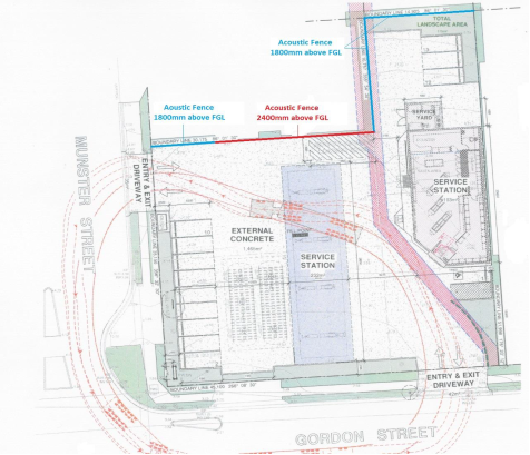
5.
A gap of 50-75mm is permitted at ground level to aid in
drainage. An acoustic fence is one which is impervious from the ground to the
recommended height, and is typically constructed from lapped and capped timber,
Hebel Powerpanel, or similar. No significant gaps should remain in the fence to
allow the passage of sound below the recommended height. Other construction
options are available if desired, providing the fence or wall is impervious and
of equivalent or greater surface mass than the above construction options.
· Perimeter walls to the service yard must be impervious from
the ground to a height of 2200mm above FGL. Construction may consist of
Colorbond or similar. A gap of 50-75mm may be left at ground level to aid in
drainage, cleaning, etc. The entry gate must be constructed similar to walls.
· Any proposed or future roof-top exhaust plant that produces
a sound pressure level (SPL) in excess of 65dB(A) at a distance of 1 metre must
have acoustic barriers constructed at the fan discharge. The barriers must
fully enclose at least three sides towards any residence. In our experience, a
more efficient and structurally secure barrier is one that encloses all four
sides. The barrier must extend at least 600mm above and below the fan centre
and/or the highest point of the discharge outlet. The barrier must be no closer
than 500mm and no further than 1200mm from the edges of the exhaust. Barrier
construction should consist of Acoustisorb panels (available through Modular
Walls). Note that variations to barrier construction or alternate materials are
not permitted without approval from the acoustical consultant. Barrier
construction is based solely on acoustic issues. Visual, wind load issues must
be considered and designed by appropriately qualified engineers.
· No acoustic modifications are required to plant that is
located within the service yard.
· The contractor responsible for supplying and installing
mechanical plant must provide evidence that installed plant meets this noise
emission limit, or that noise control included with the plant is effective in
reducing the sound level to the specified limit. Once the plant layout has been
finalised, details should be forwarded to the acoustic consultant for approval.
· It is strongly recommended that waste collection be
restricted to weekdays 7.00am to 6.00pm.
· Construction Certificate documentation must be forwarded to
Reverb Acoustics to ensure all recommendations within this report have been
incorporated into the design of the site.
Subject to the installation of the
recommended noise control measures and restrictions surrounding both fuel/store
delivery and waste collection times no significant adverse noise impacts are
anticipated to nearby receivers. Conditions of consent have been recommended
requiring installation of the noise control measures and operational
restrictions surrounding fuel and store delivery hours and waste collection
hours.
Bushfire
The site is not identified as being bushfire prone.
Safety, security and crime prevention
The proposed development will be unlikely to create any
concealment/entrapment areas or crime spots that would result in any
identifiable adverse loss of safety or reduction of security in the immediate
area. The nature, orientation and design of the proposal will improve natural
surveillance within the locality.
Social impacts in the locality
Given the nature of the proposed development and its’
location the proposal is unlikely to result in any adverse social impacts.
Economic impact in the locality
No adverse impacts. A likely positive impact is that the
development will maintain employment in the construction industry, which will
lead to flow impacts such as expenditure in the area.
Site design and internal design
The proposed development design satisfactorily responds to
the site attributes and will fit into the locality. No adverse impacts likely.
Construction
Subject to appropriate site management measures no potential
adverse impacts identified to neighbouring properties with the construction of
the proposal.
Cumulative
Impacts
The proposed development is not expected to have any adverse
cumulative impacts on the natural or built environment or the social and
economic attributes of the locality.
(c) The
suitability of the site for the development
The proposed development is not expected to have any adverse
cumulative impacts on the natural or built environment or the social and
economic attributes of the locality.
(d) Any submissions made in
accordance with this Act or the Regulations
Three (3) written submissions have been received following public
exhibition of the application.
Key issues raised in the submissions received and comments
in response to these issues are provided as follows:
|
Submission
Issue/Summary
|
Planning
Comment/Response
|
|
There are currently pedestrian
and vehicular conflicts at the Munster Street crossing and intersection. The
proposal will result in further traffic and pedestrian impacts.
|
Refer to assessment comment
under roads, traffic and transport heading within this report.
|
|
The convenience store will deprive from adjoining local
businesses.
|
Business competition is not a relevant planning
consideration.
|
|
Safety concerns for the Port Macquarie Community
Preschool with no substantial safety barriers protecting the children’s
outdoor play area from vehicles.
|
The proposal will not increase any vehicular risk to the
outdoor play area of the preschool.
|
|
Safety concerns for children in the outdoor playground at
the preschool that may be subject to fumes from the petrol bowsers and
vehicles.
|
The front boundary of the preschool is located
approximately 60m from the proposed forecourt and fuel vents. Vapour recovery
(VR1) is proposed for fuel deliveries. Given the separation distance to the
preschool, vapour recovery and that tank filling is unlikely to coincide with
the opening hours of the preschool there no significant adverse vapour
impacts anticipated.
|
|
Safety concerns for children, the elderly, pedestrians
and residents within proximity from fire, explosions, noise and traffic
associated with the development.
|
As addressed throughout this report the impacts have been
assessed and the site is considered suitable for the proposed development.
There are no significant adverse impacts that would warrant refusal of this
application.
|
|
Environmental impacts of petroleum leaks into nearby
creek.
|
Wrights Creek is located approximately 150m from the
site. Refer to details comments under stormwater heading of this report. The
proposal is also required to comply with the Protection of the Environment
Operations (Underground Petroleum Storage Systems (Regulation 2019) which
contains specific installation, leak detection and monitoring requirements
for underground fuel storage tanks. Subject to compliance with legislation,
no significant adverse environmental impacts are anticipated.
|
|
Loss of on-street parking.
|
Refer to specific comments under parking and manoeuvring heading of this report. The
proposal will result in no net loss to on-street public
parking.
|
|
Oversupply of service stations in Gordon Street.
|
Business competition is not a relevant planning
consideration.
|
(e) The Public Interest
The proposed
development satisfies relevant planning controls and will not adversely impact
on the wider public interest.
4. DEVELOPMENT CONTRIBUTIONS
APPLICABLE
· Due to existing contribution credit for previous uses
approved on the site contributions are not required towards augmentation of
town water supply and sewerage system head works under Section 64 of the Local
Government Act 1993.
· Development contributions will be required under Section
7.12 of the Environmental Planning and Assessment Act 1979.
· A copy of the contributions estimate is included as
Attachment 3.
5. CONCLUSION AND
STATEMENT OF REASON
The application has been assessed
in accordance with Section 4.15 of the Environmental Planning and Assessment
Act 1979.
Issues raised during assessment
and public exhibition of the application have been considered in the assessment
of the application. Where relevant, conditions have been recommended to manage
the impacts attributed to these issues.
The site is considered suitable
for the proposed development and the proposal adequately addresses relevant
planning controls. The development is not considered to be contrary to the public's
interest and will not result a significant adverse social, environmental or
economic impact. It is recommended that the application be approved, subject to
the recommended conditions of consent provided in the attachment section of
this report.
|
Attachments
1View. DA2019
- 531.1 Recommended Conditions
2View. DA2019
- 513.1 Revised Architectural Plans
3View. DA2019
- 513.1 Development Contribution Estimate
4View. DA2019
- 513.1 Revised Stormwater Concept Plan
5View. DA2019
- 513.1 Dangerous Goods Site Layout Plan
6View. DA2019
- 513.1 Water Cycle Management Plan
7View. DA2019
- 513.1 Landscape Plan
8View. DA2019
- 513.1 Landscape Specifications
9View. DA2019
- 513.1 Environmental Site Assessment Report - Contamination
10View. DA2019
- 513.1 Multi Level Risk Assessment Report
11View. DA2019
- 513.1 Multi Level Risk Assessment Screening Threshold Summary.
12View. DA2019
- 513.1 Noise Impact Assessment
13View. DA2019
- 513.1 Preliminary Hazards Analysis and Summary
14View. DA2019
- 513.1 SEPP 33 Risk Screening Summary
15View. DA2019
- 513.1 SoEE
16View. DA2019
- 513.1 Traffic and Parking Assessment
|
|
ATTACHMENT
|
Development Assessment Panel
22/01/2020
|

|
ATTACHMENT
|
Development Assessment Panel
22/01/2020
|
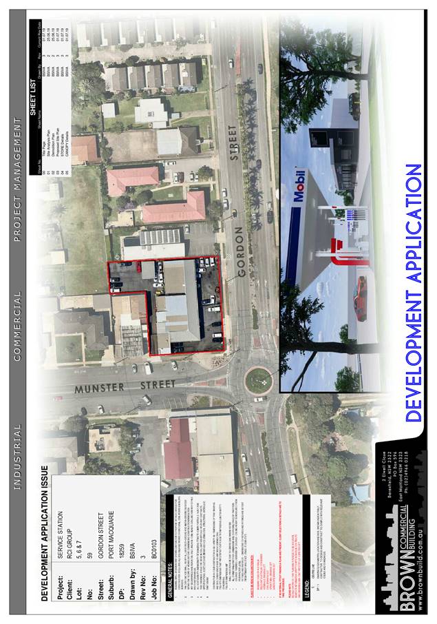
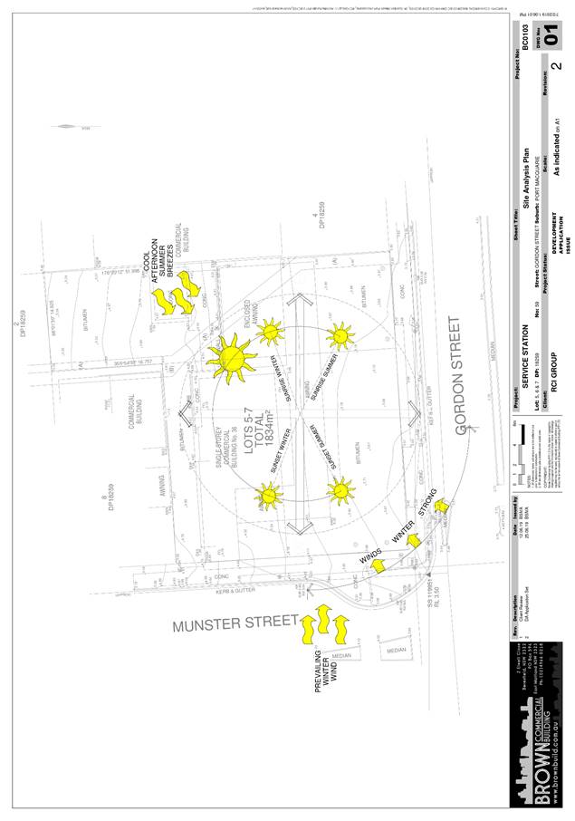
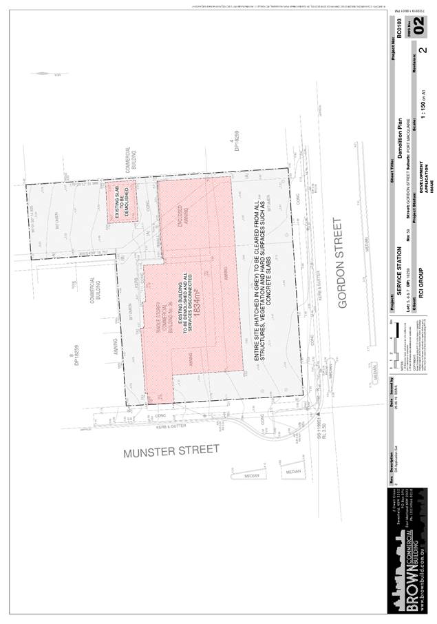
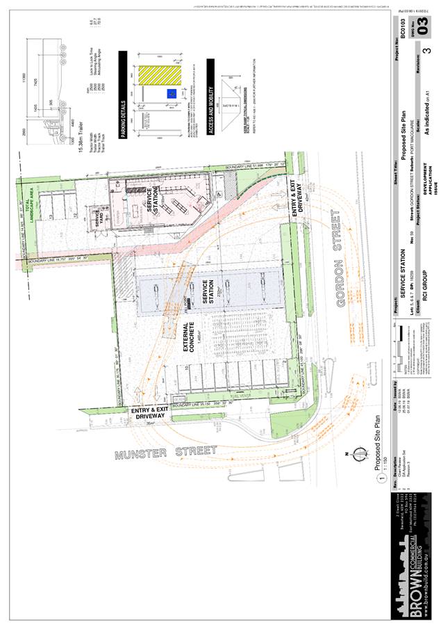
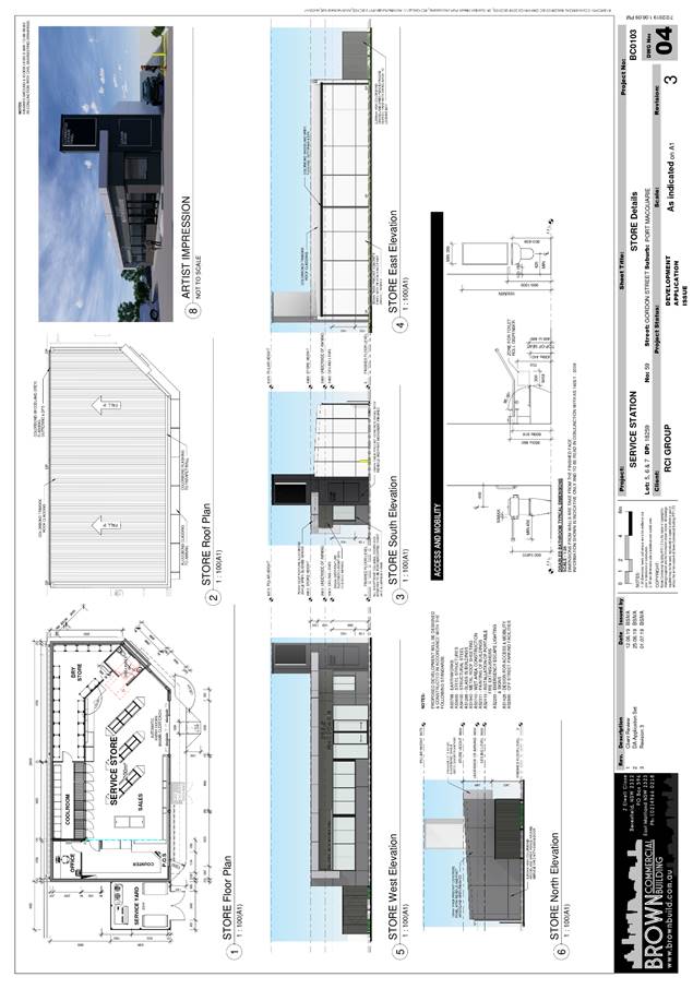
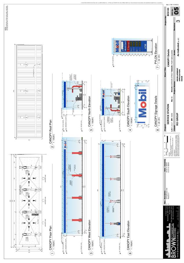
|
ATTACHMENT
|
Development Assessment Panel
22/01/2020
|
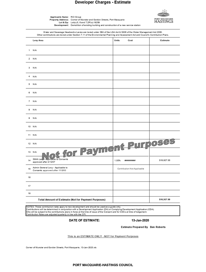
|
ATTACHMENT
|
Development Assessment Panel
22/01/2020
|
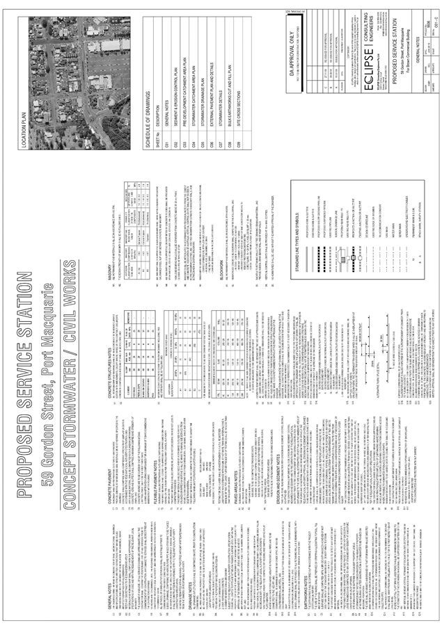
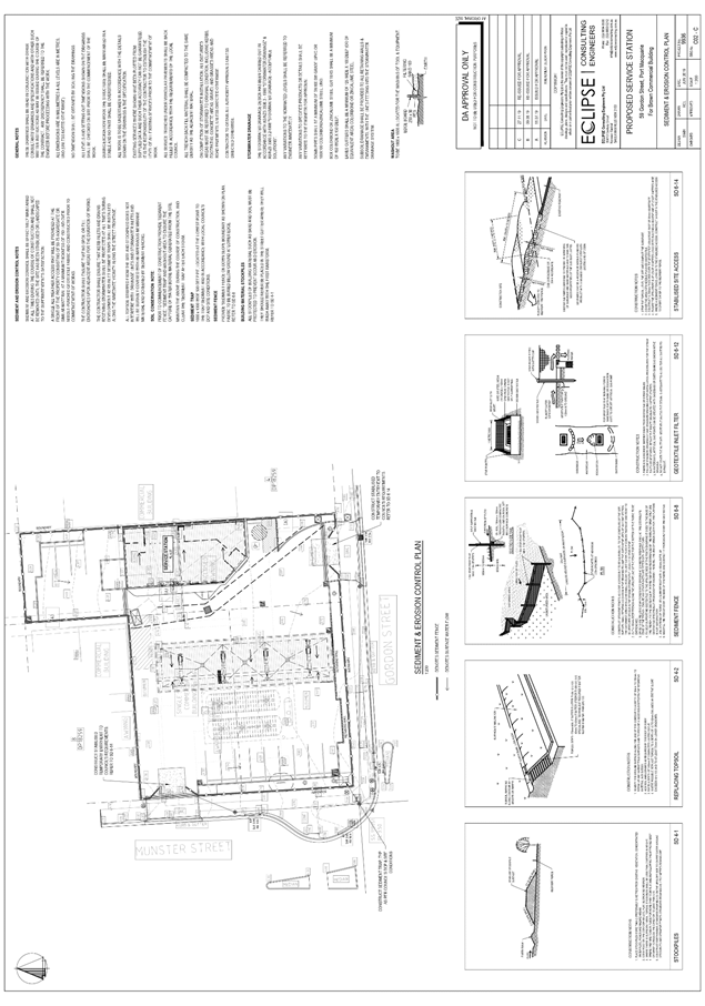
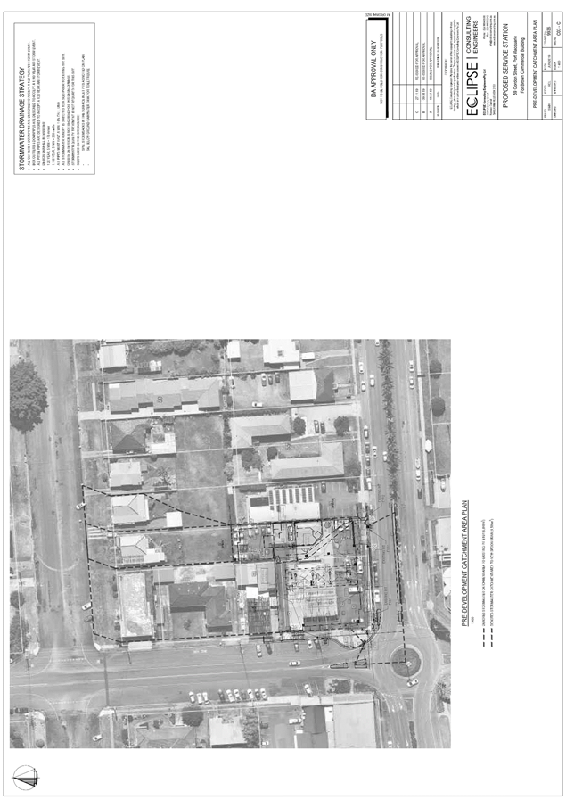
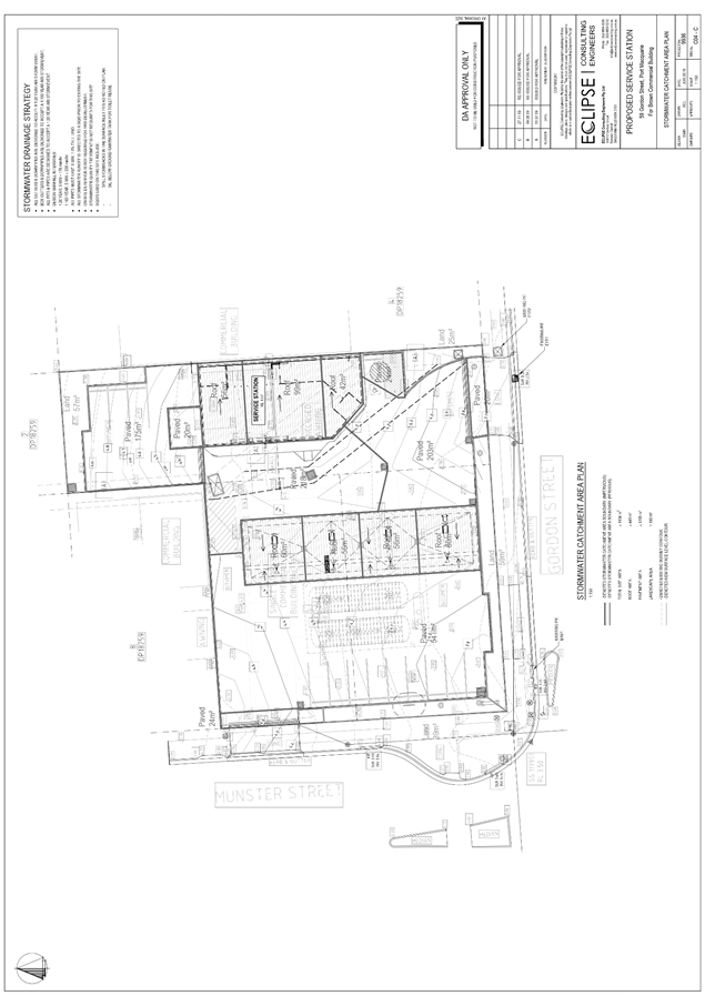
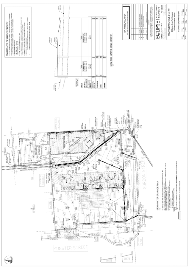
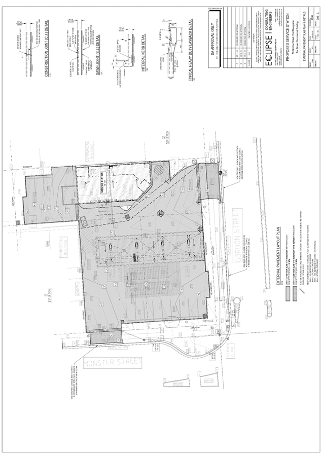
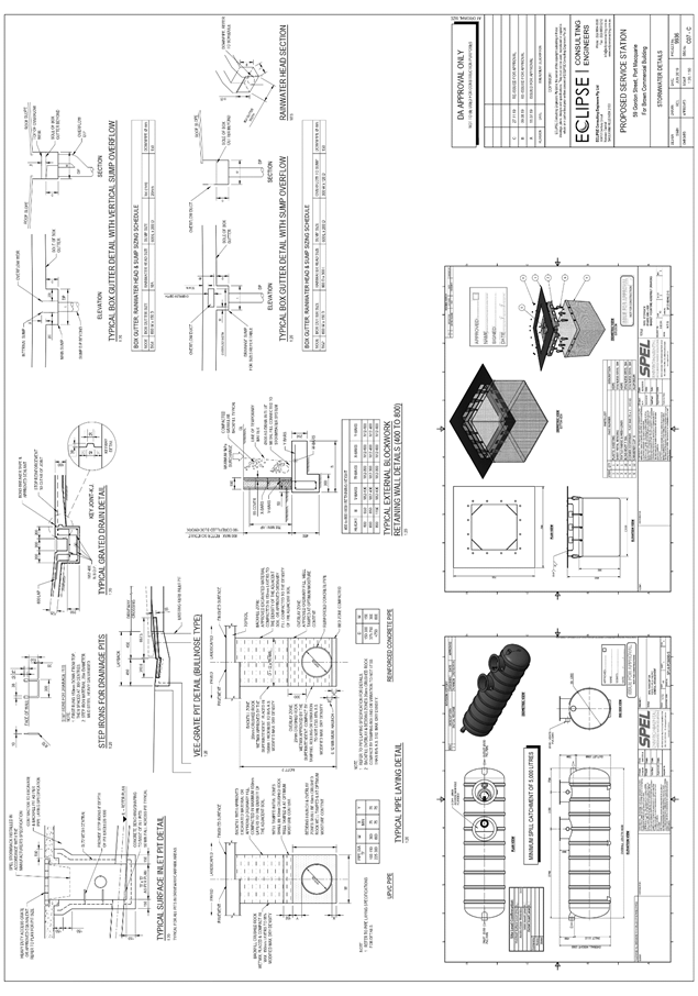
|
ATTACHMENT
|
Development Assessment Panel
22/01/2020
|
|
ATTACHMENT
|
Development Assessment Panel
22/01/2020
|
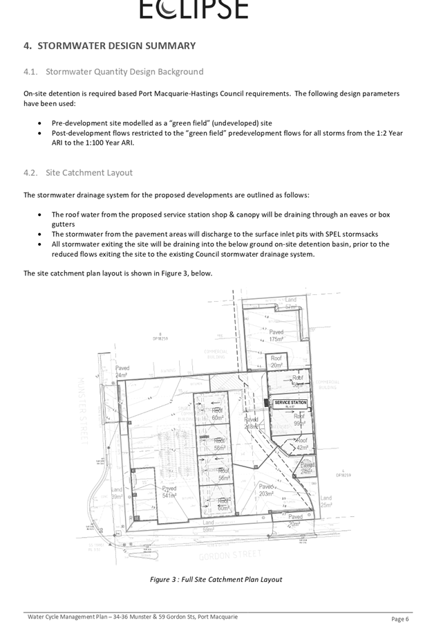
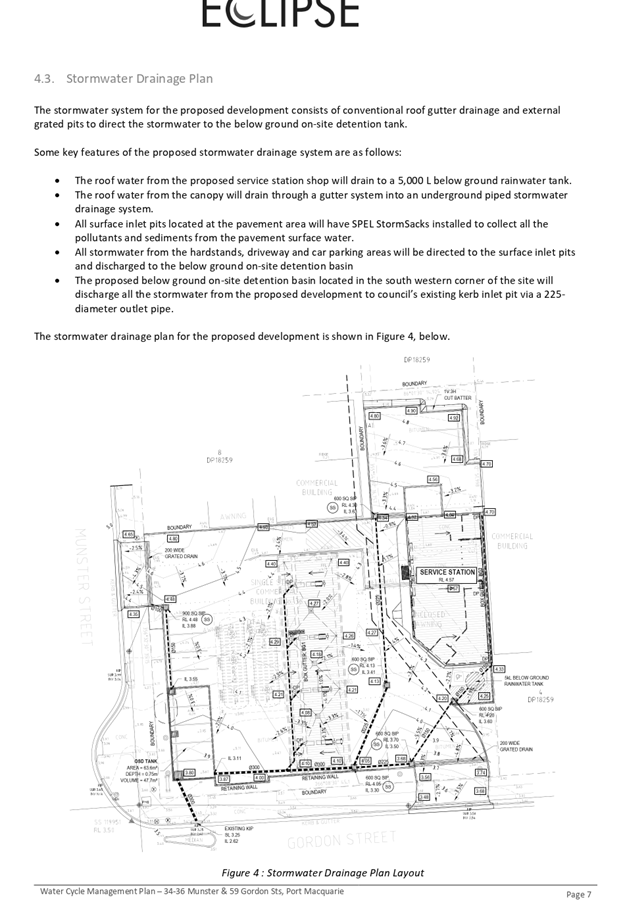
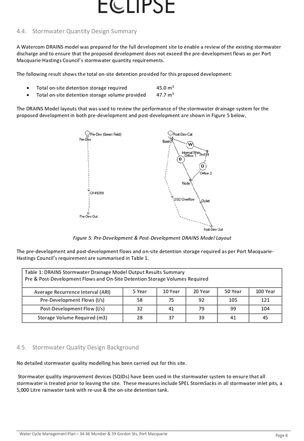
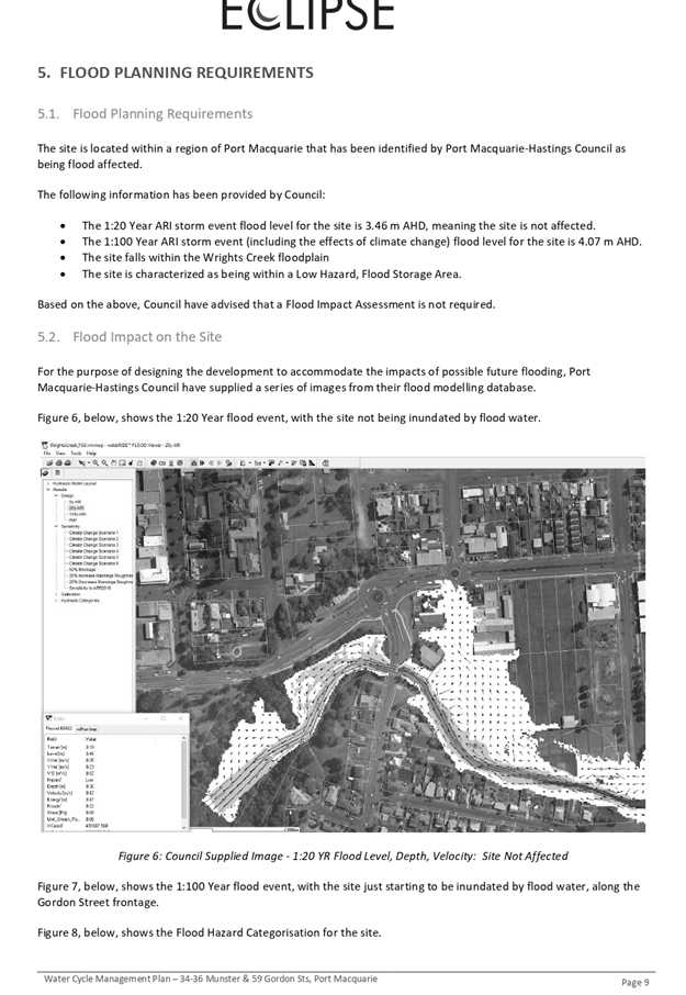
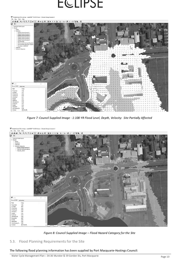
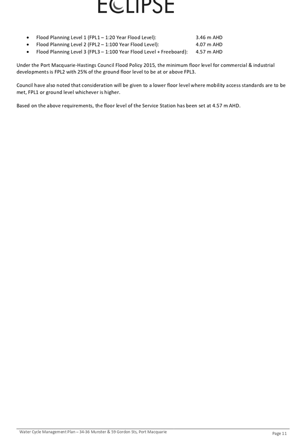

|
ATTACHMENT
|
Development Assessment Panel
22/01/2020
|
|
ATTACHMENT
|
Development Assessment Panel
22/01/2020
|
|
ATTACHMENT
|
Development Assessment Panel
22/01/2020
|
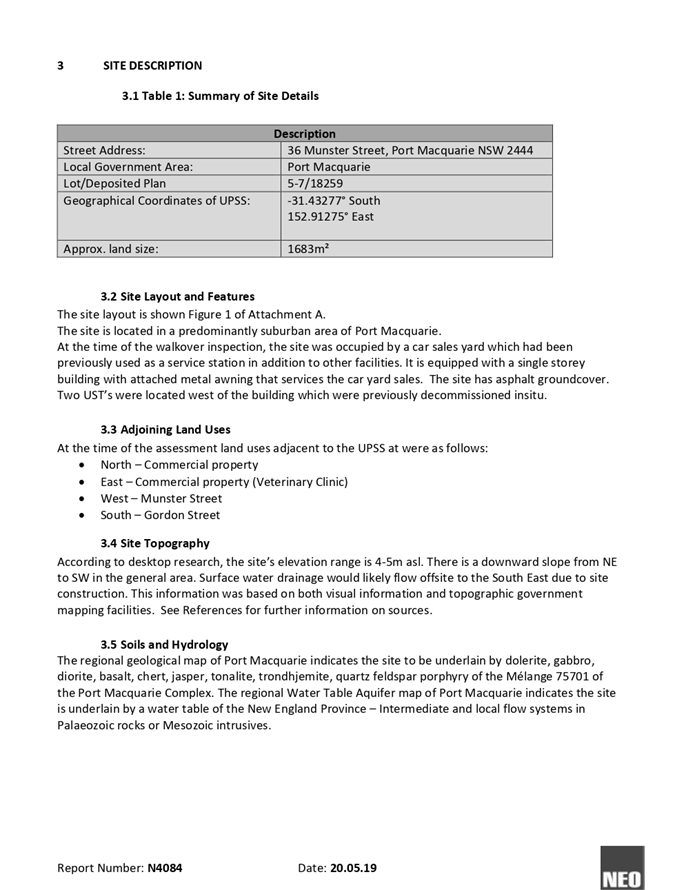
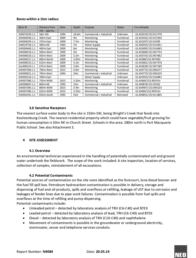
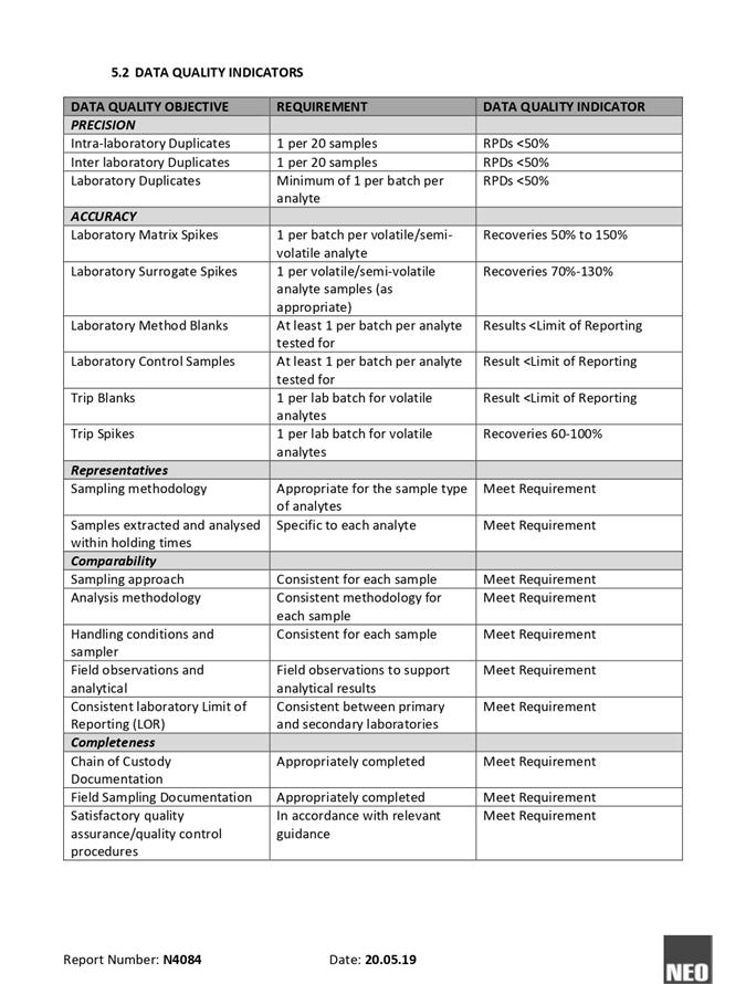
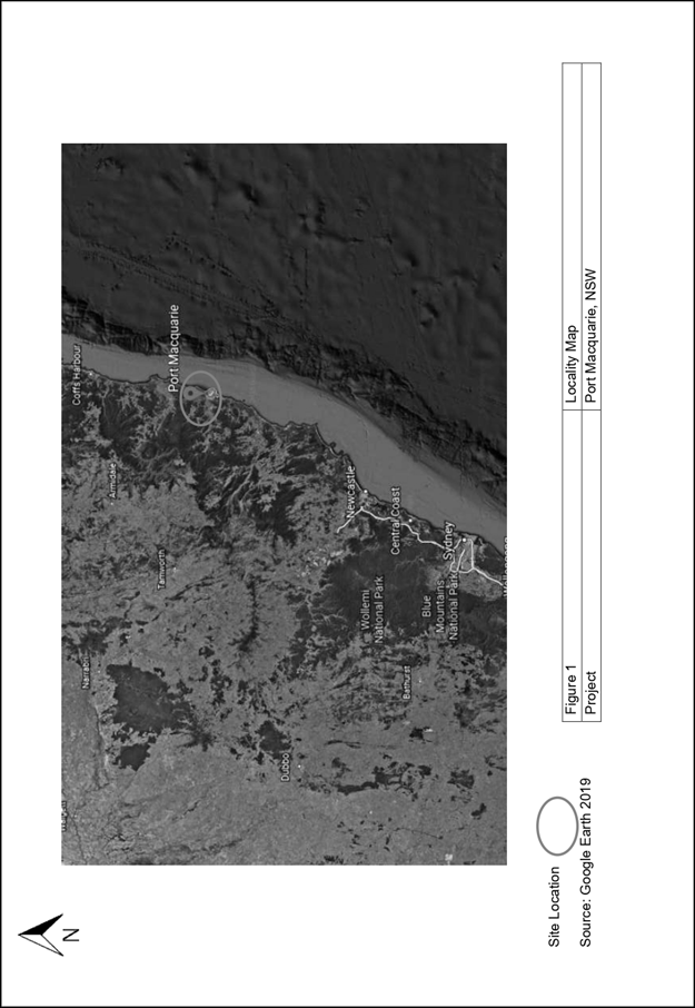
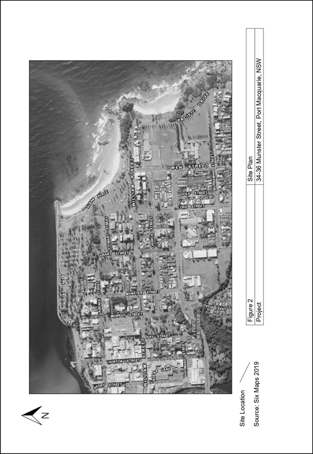
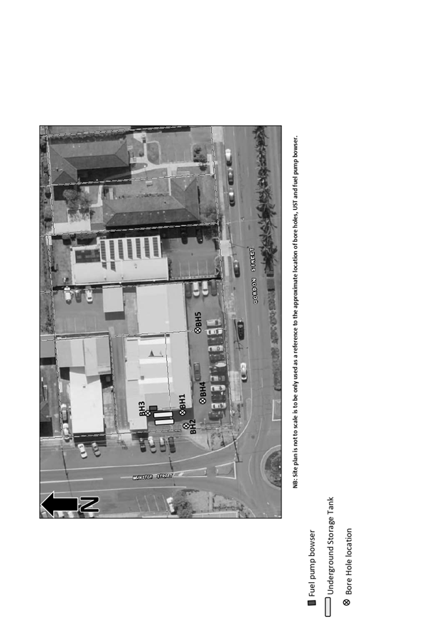
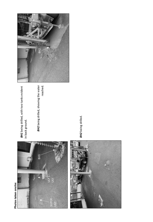
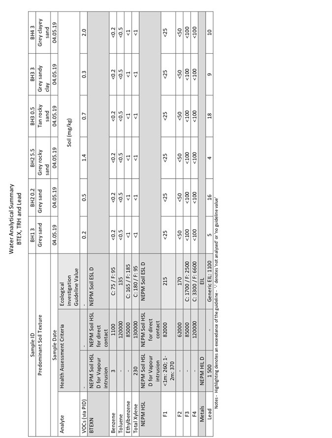
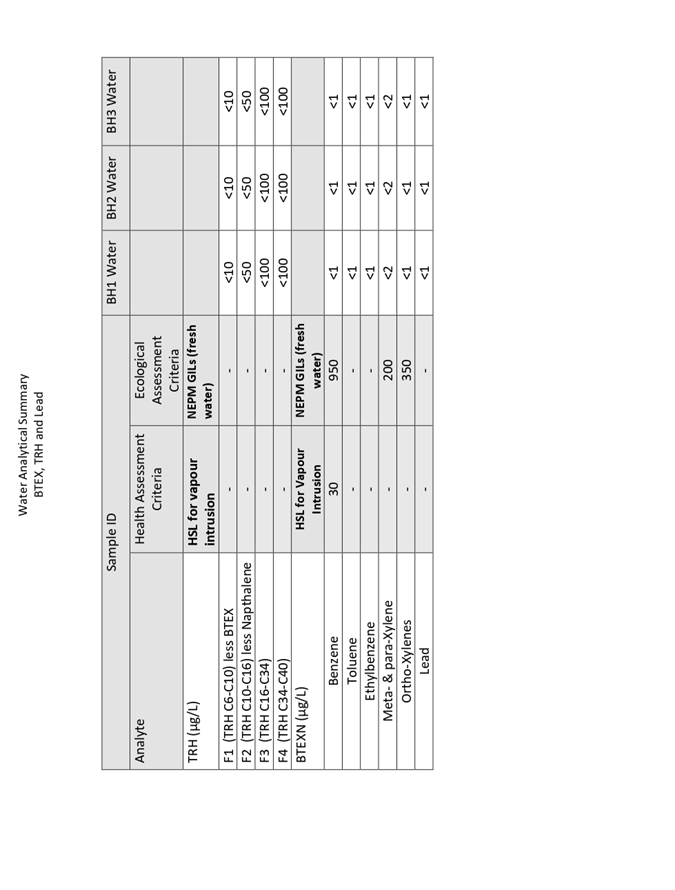

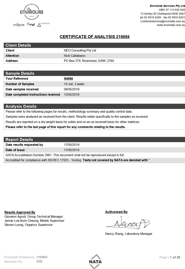
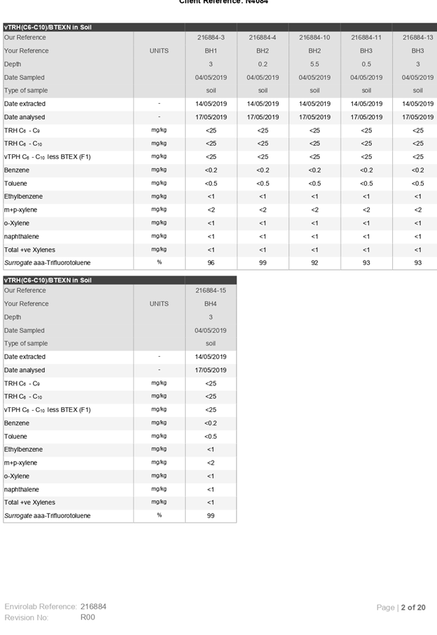
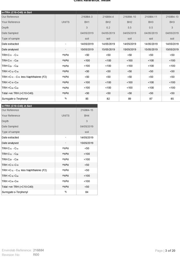
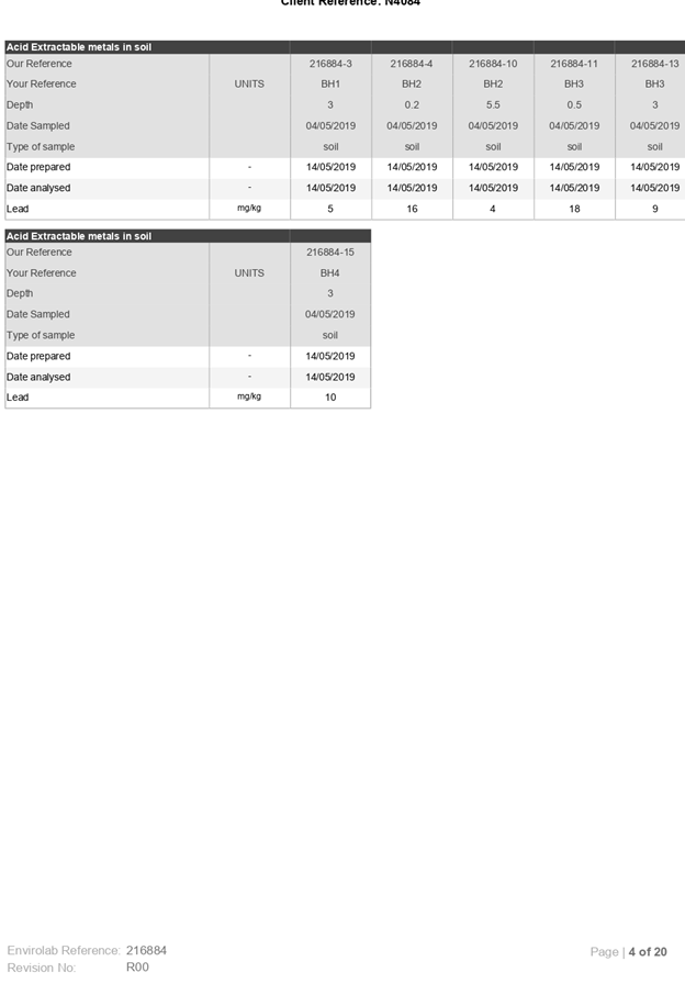
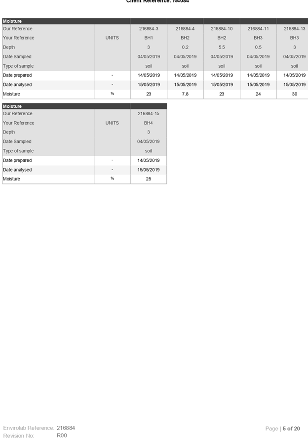
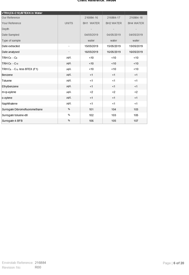
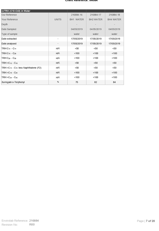
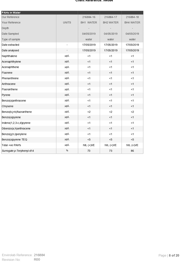
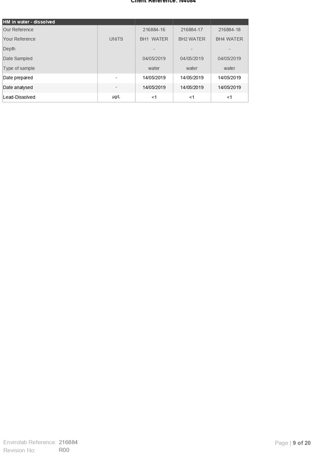
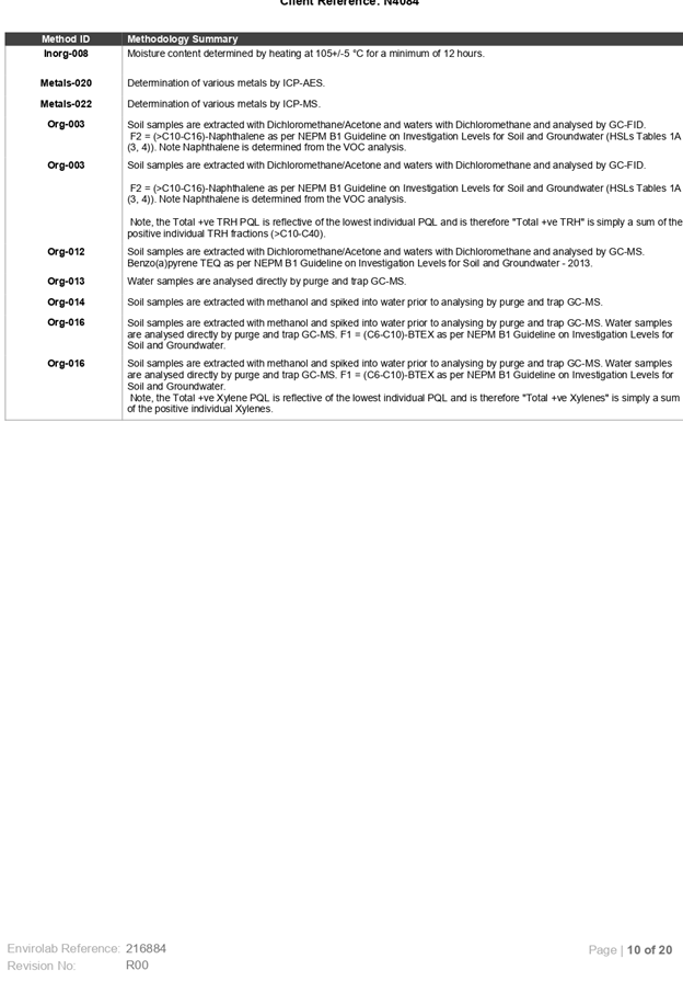
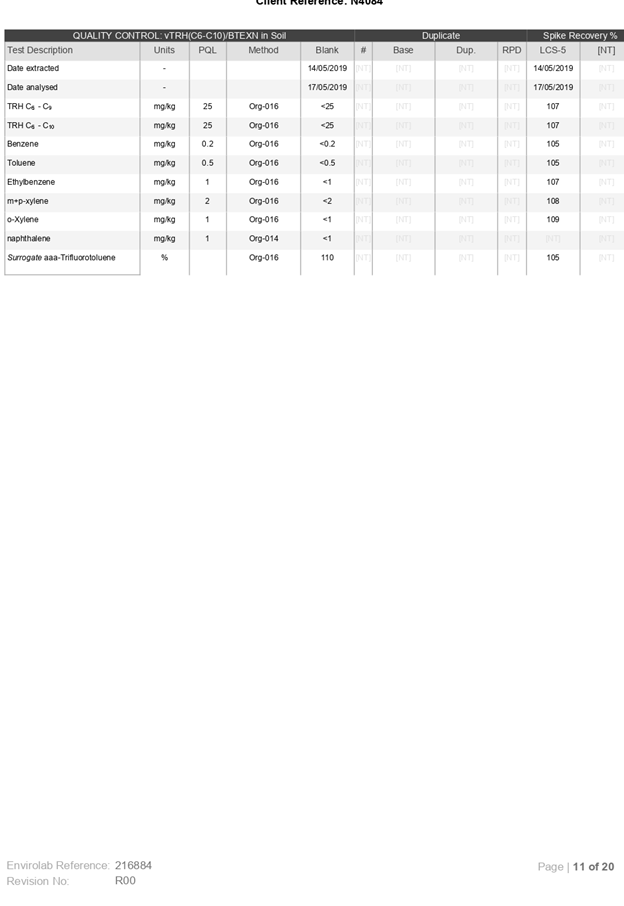


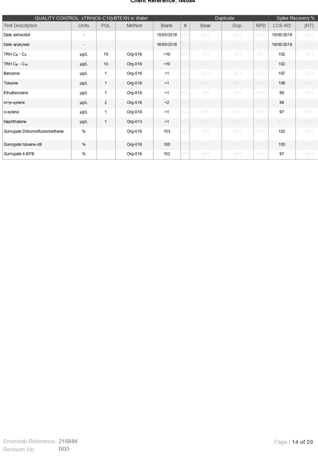

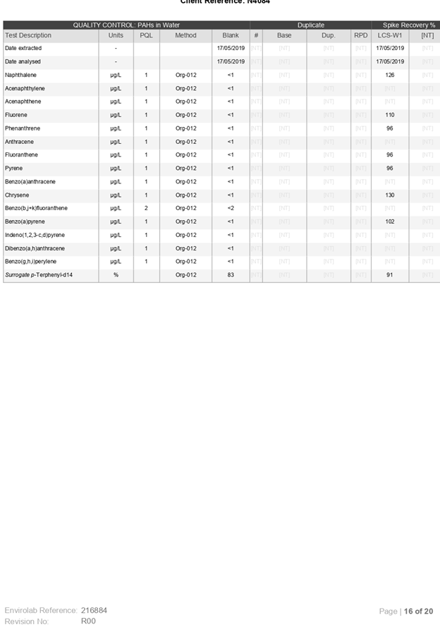

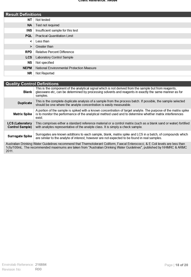


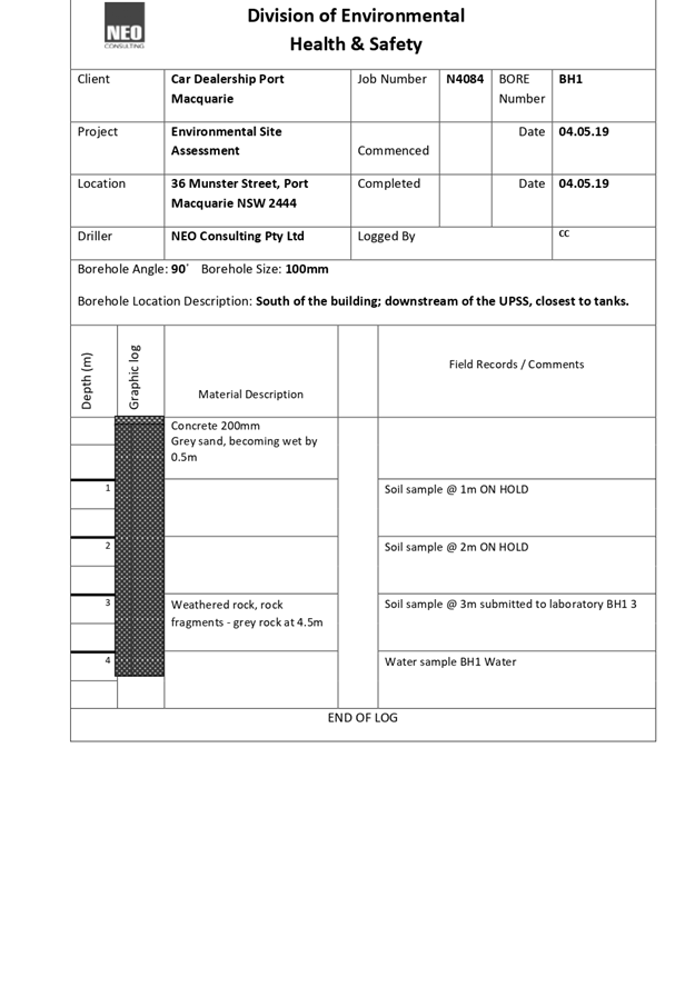

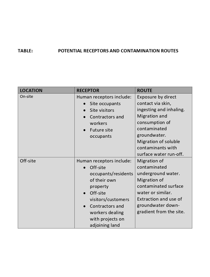
|
ATTACHMENT
|
Development Assessment Panel
22/01/2020
|
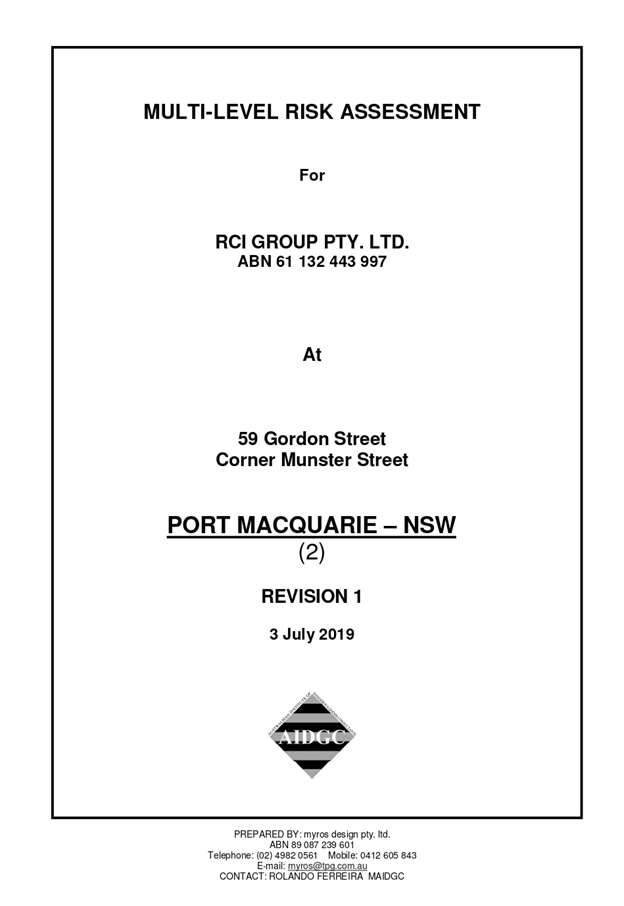
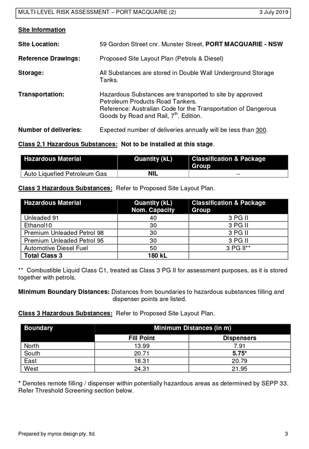
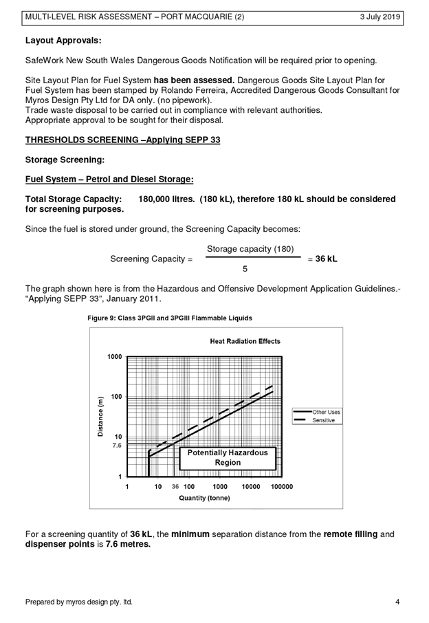
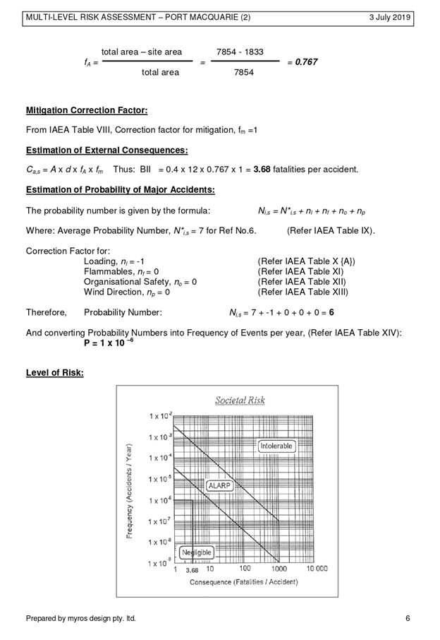
|
ATTACHMENT
|
Development Assessment Panel
22/01/2020
|
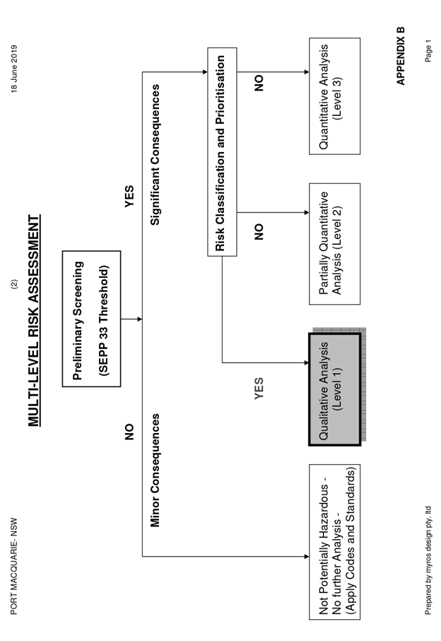
|
ATTACHMENT
|
Development Assessment Panel
22/01/2020
|

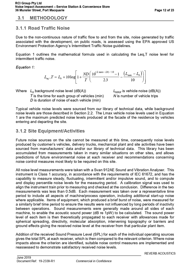
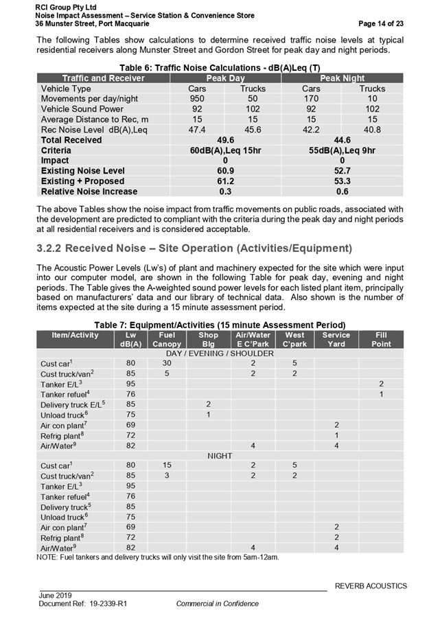
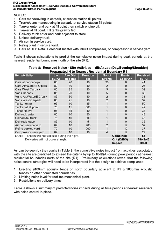
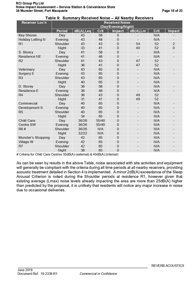

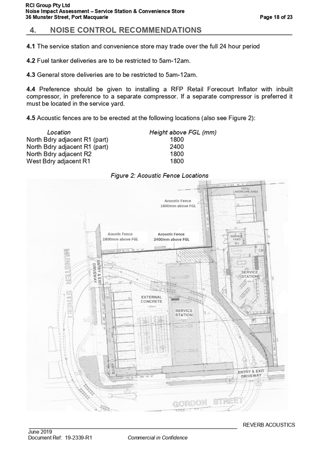
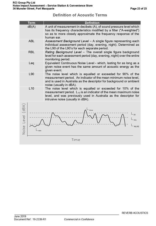
|
ATTACHMENT
|
Development Assessment Panel
22/01/2020
|
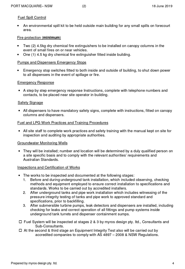
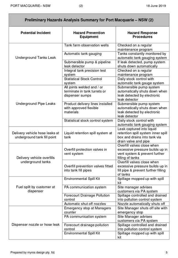
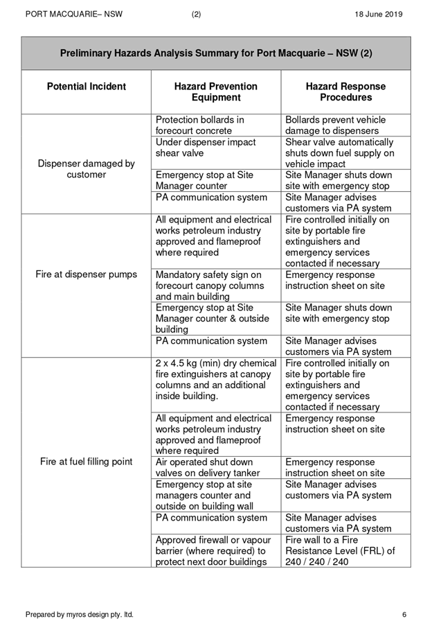
|
ATTACHMENT
|
Development Assessment Panel
22/01/2020
|
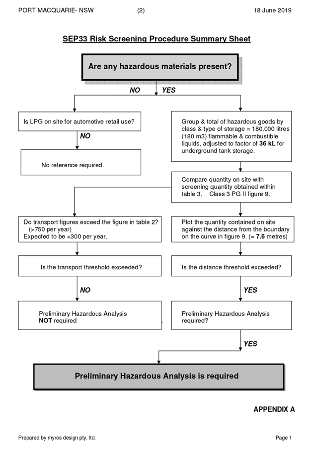
|
ATTACHMENT
|
Development Assessment Panel
22/01/2020
|
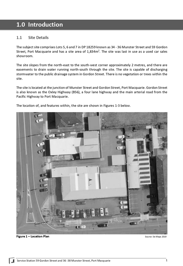
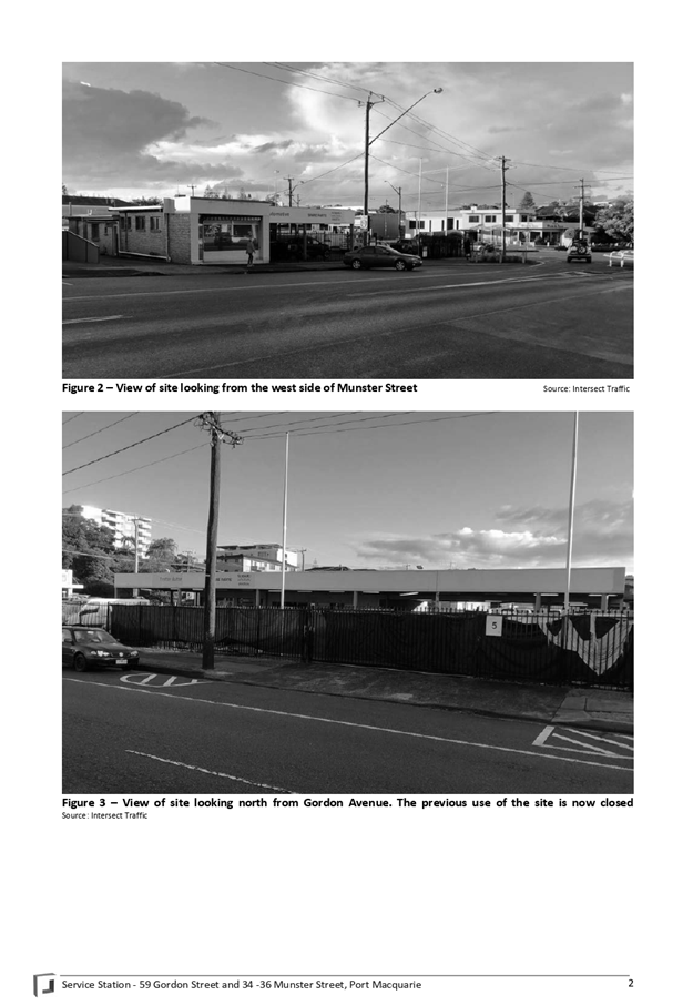
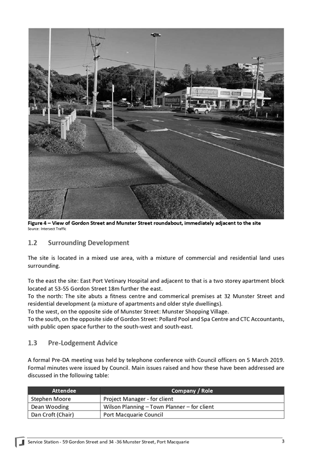
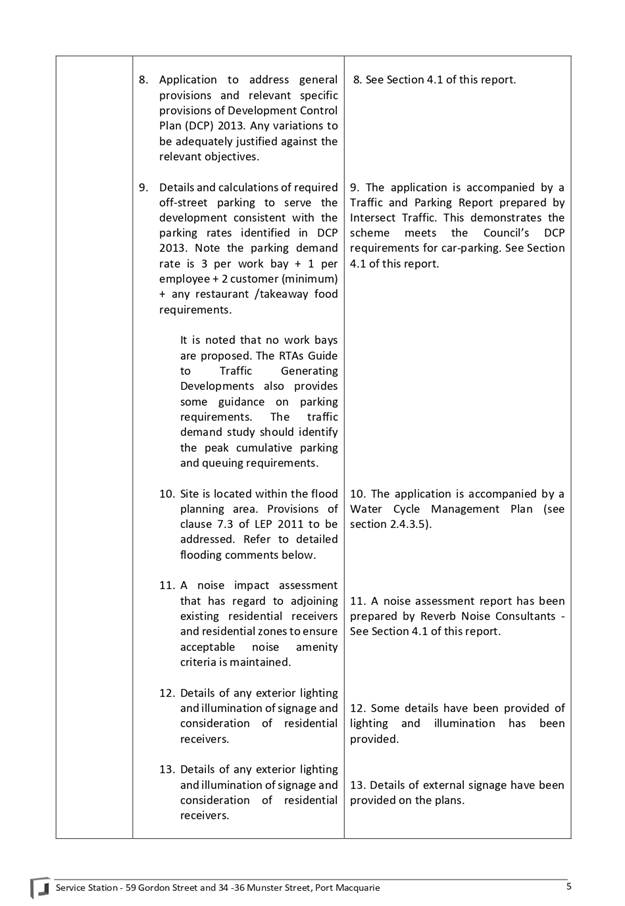
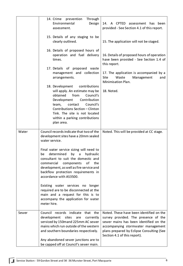
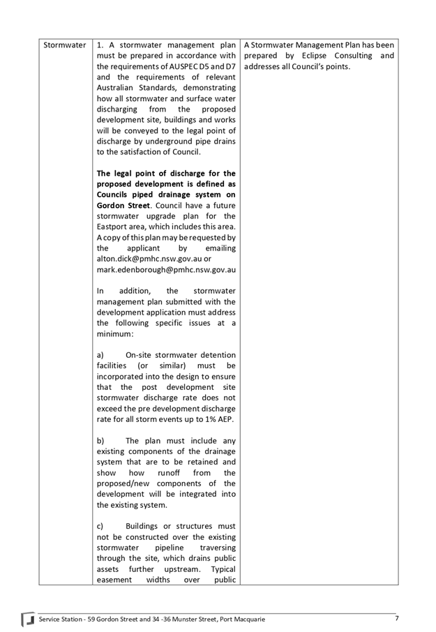
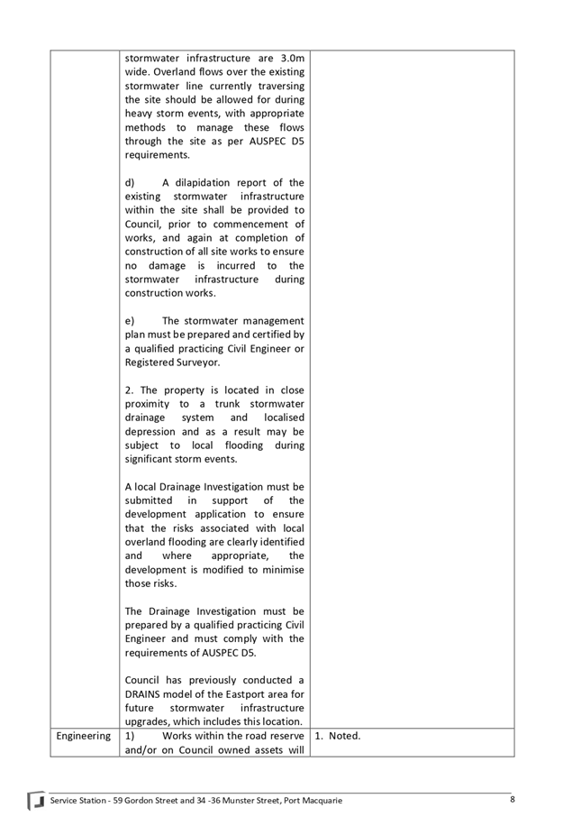
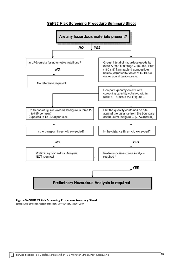
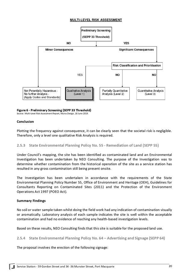
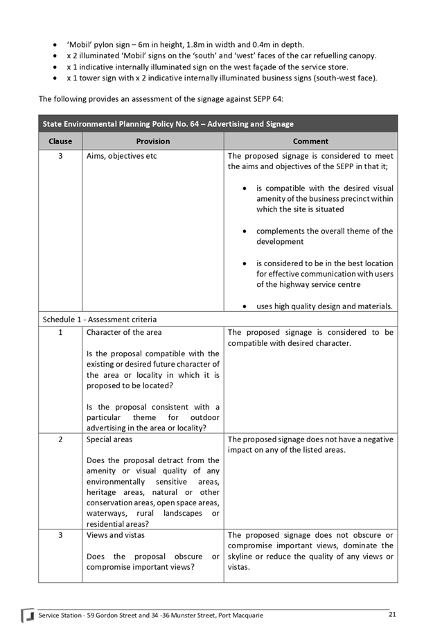
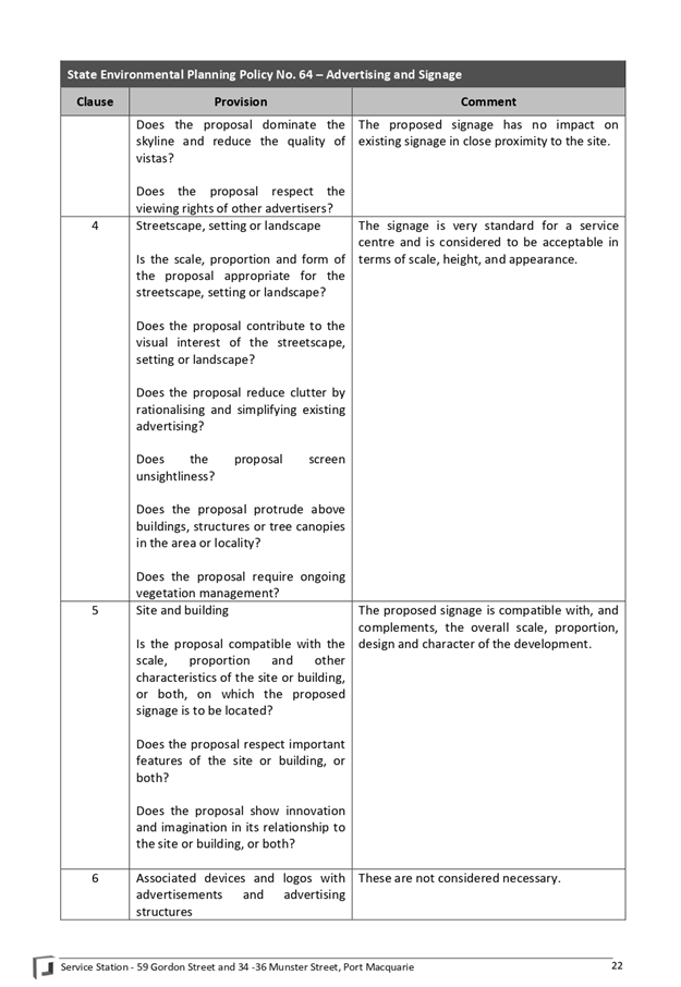
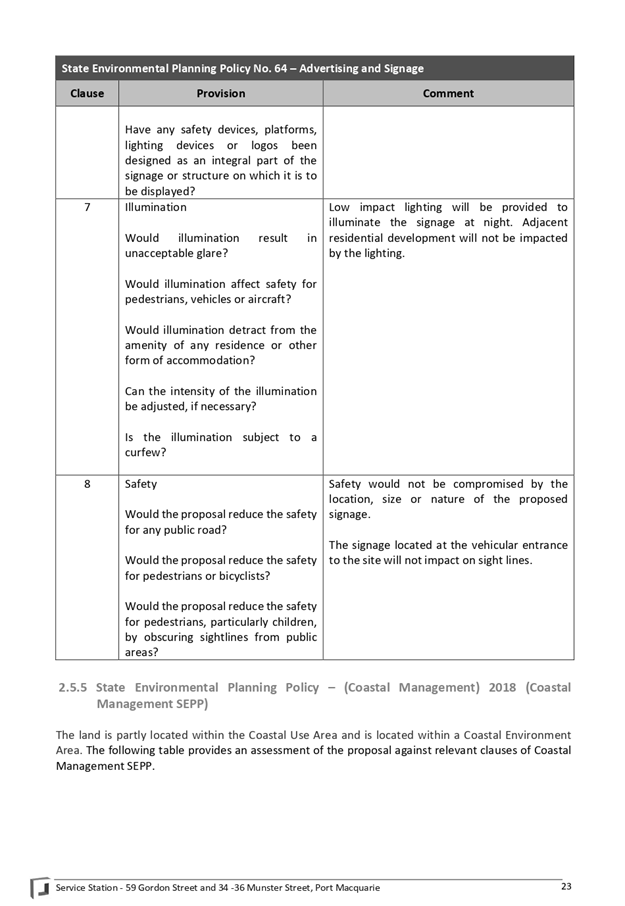
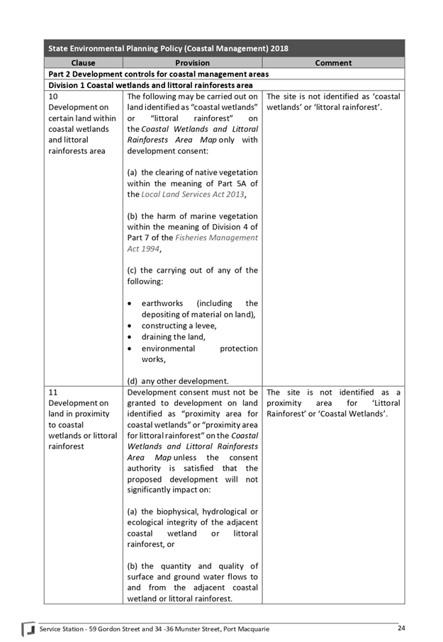
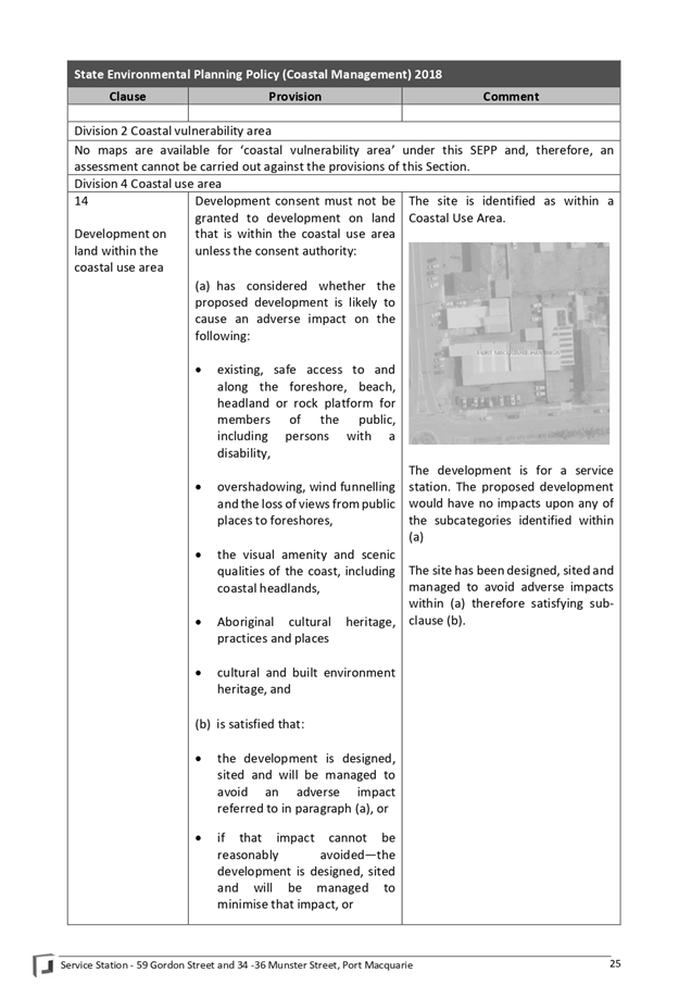
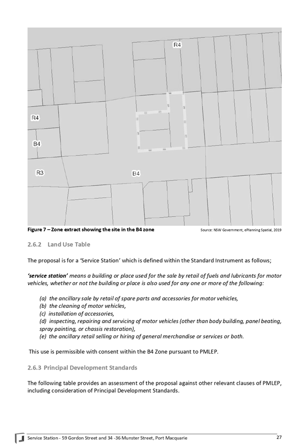
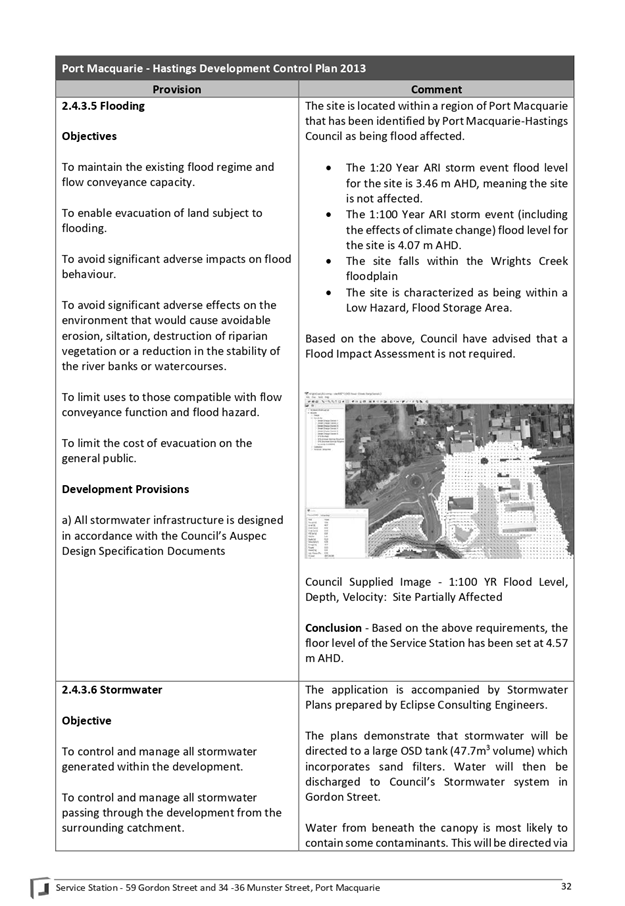
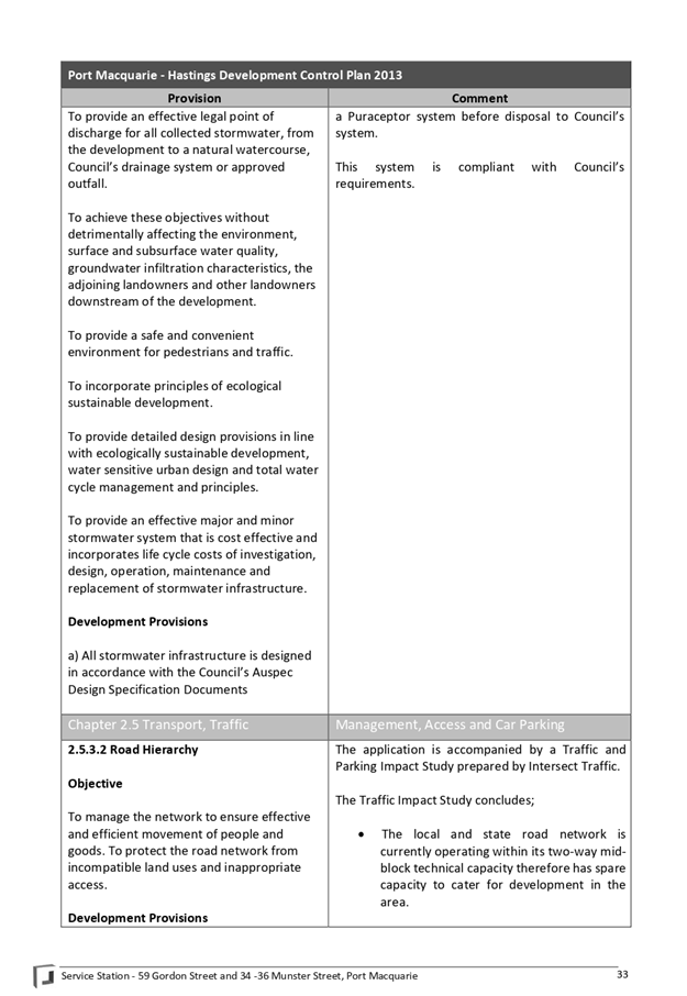
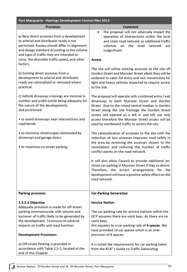
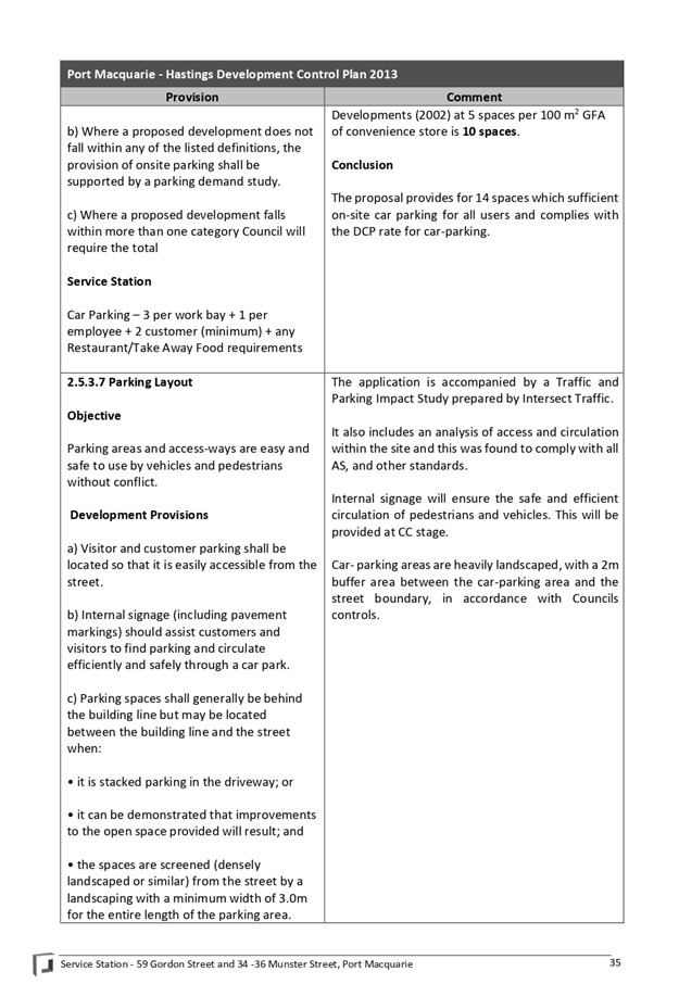
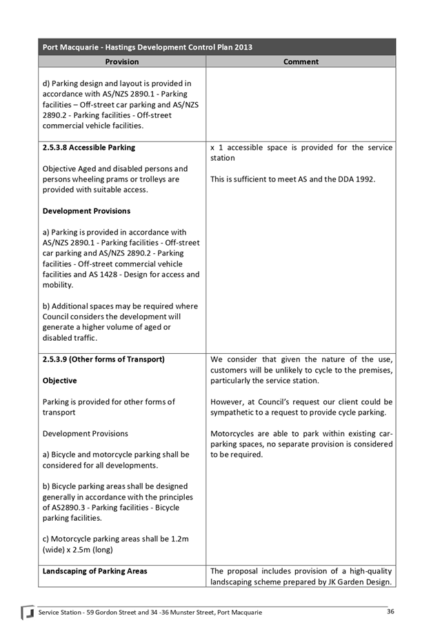
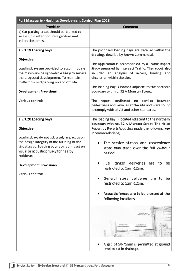
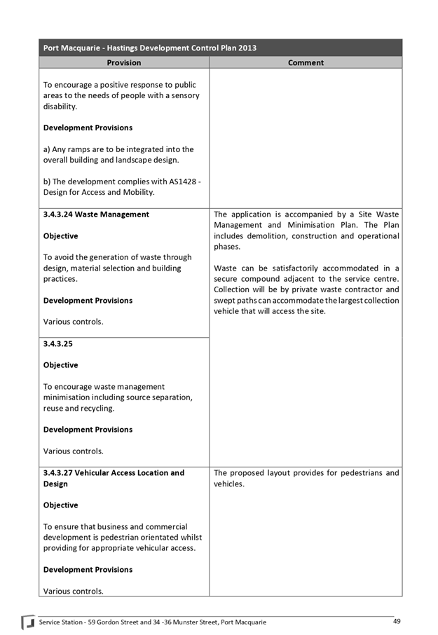
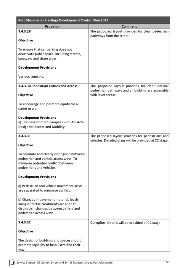
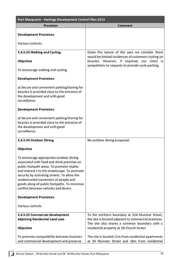
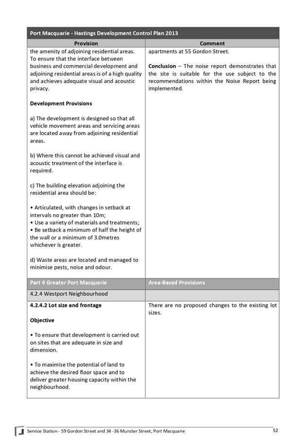
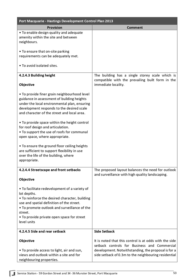
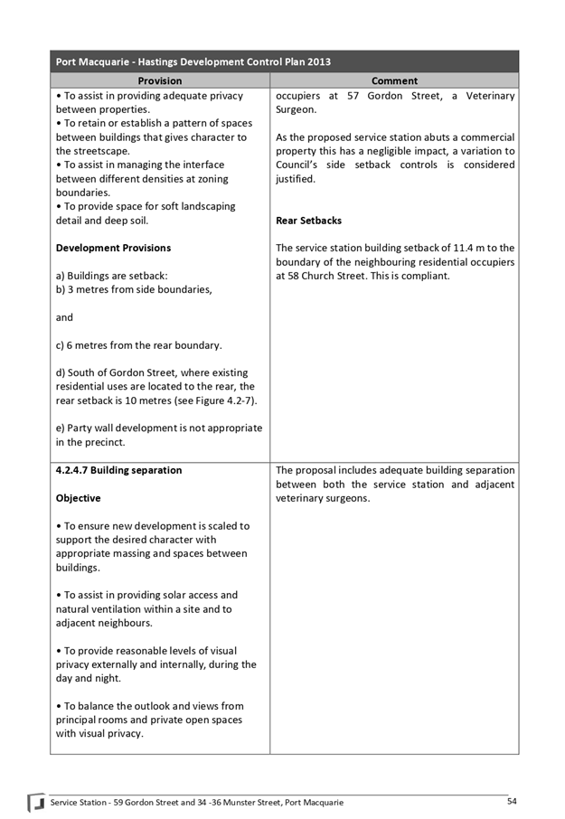
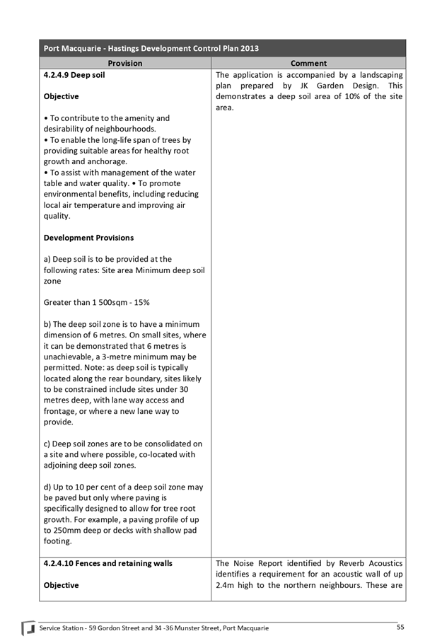
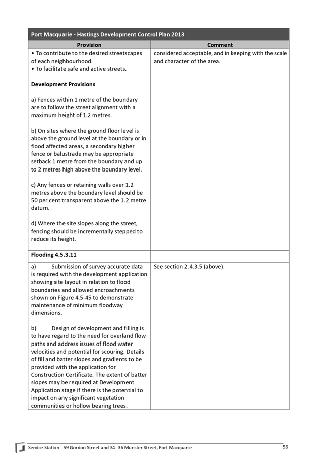
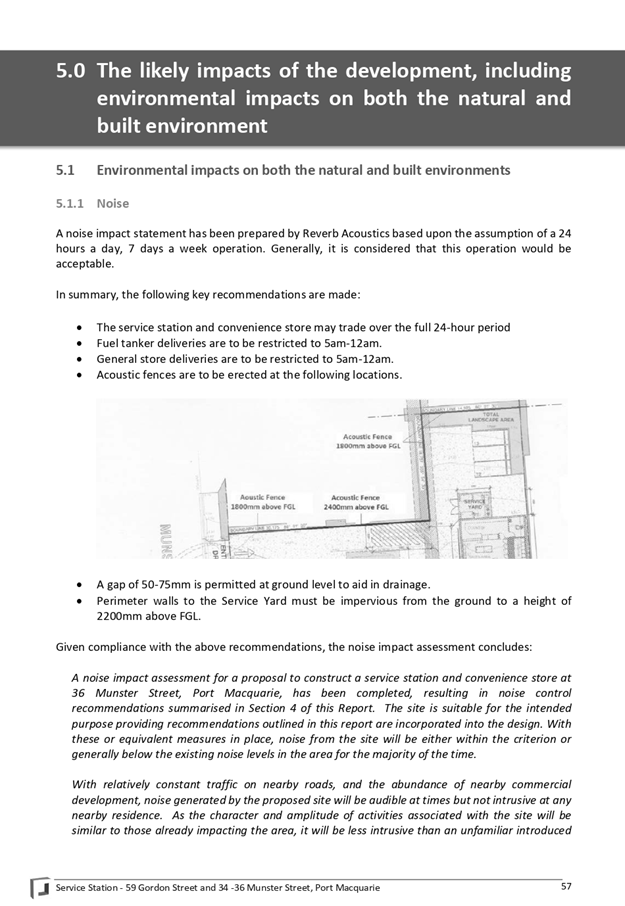


|
ATTACHMENT
|
Development Assessment Panel
22/01/2020
|
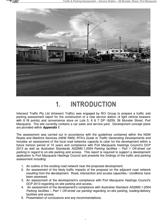
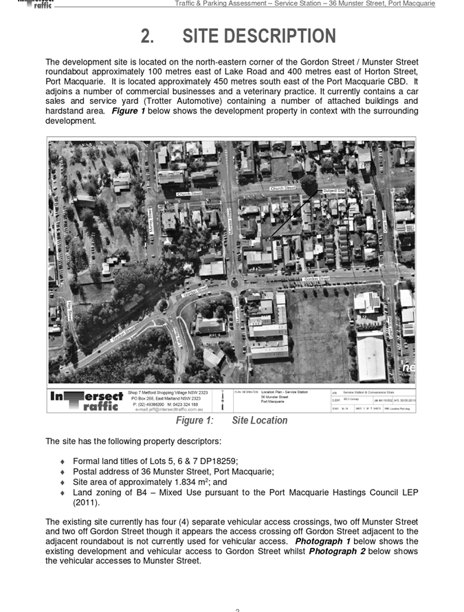
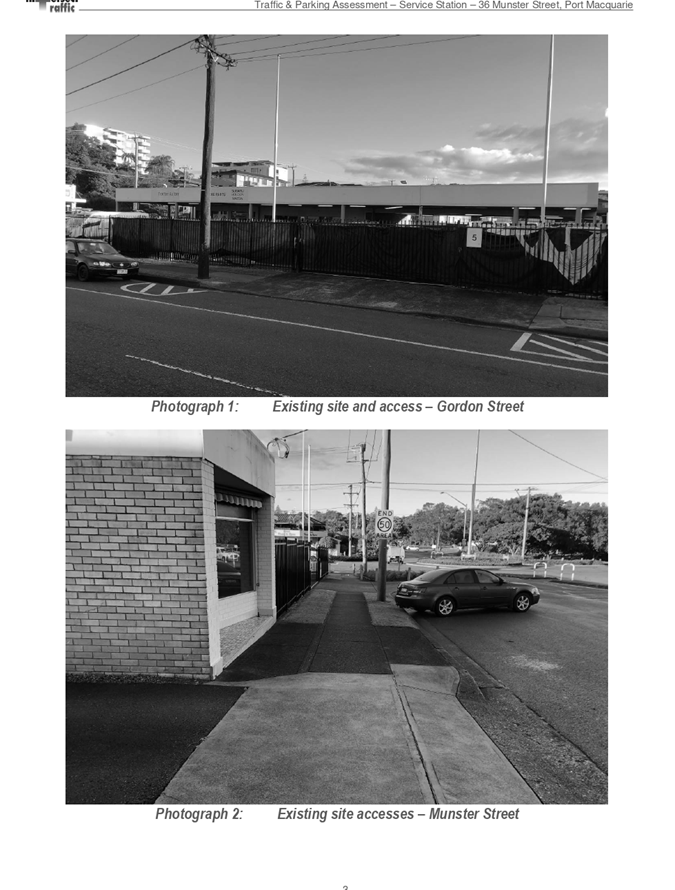
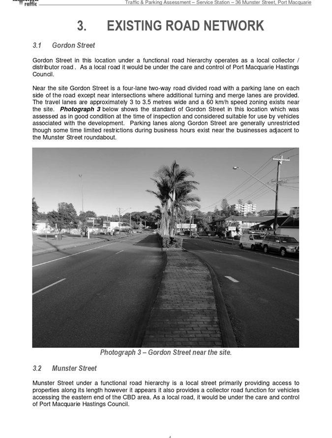
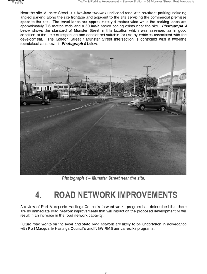
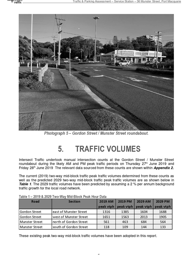
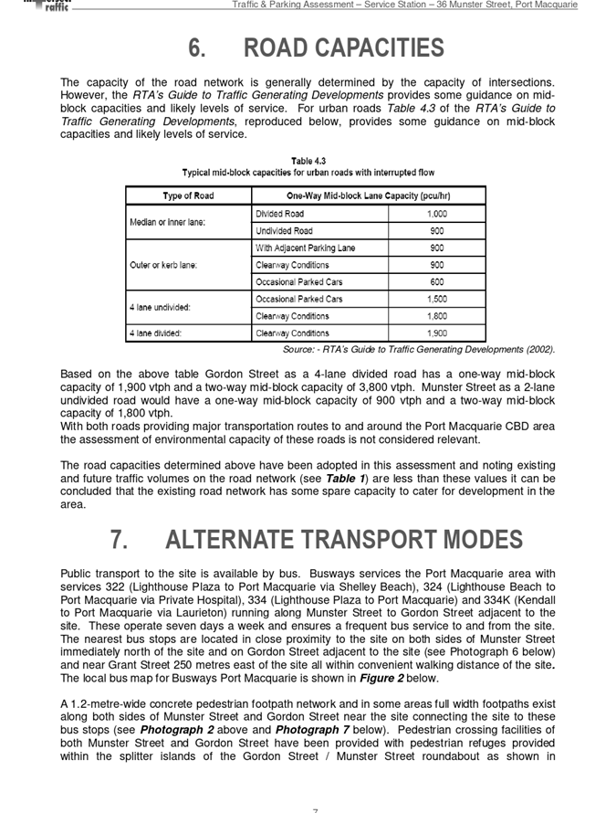
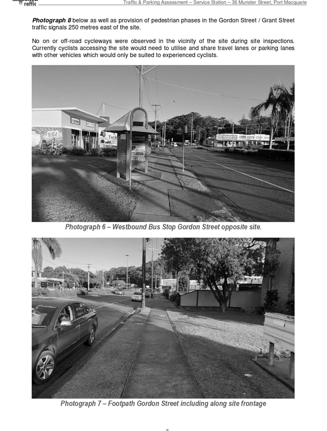
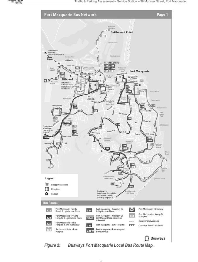
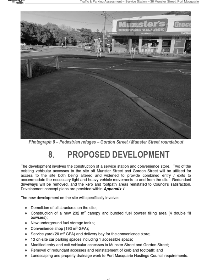
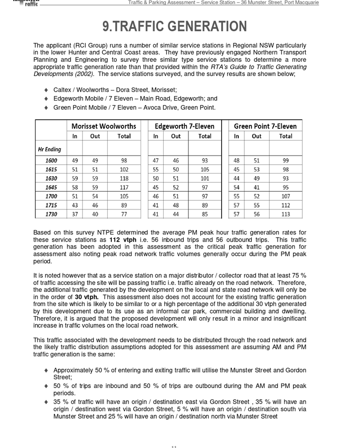
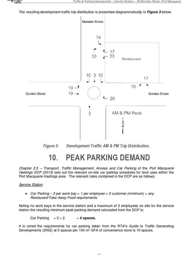
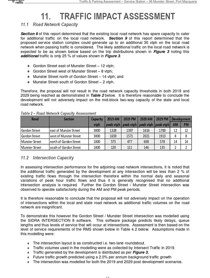
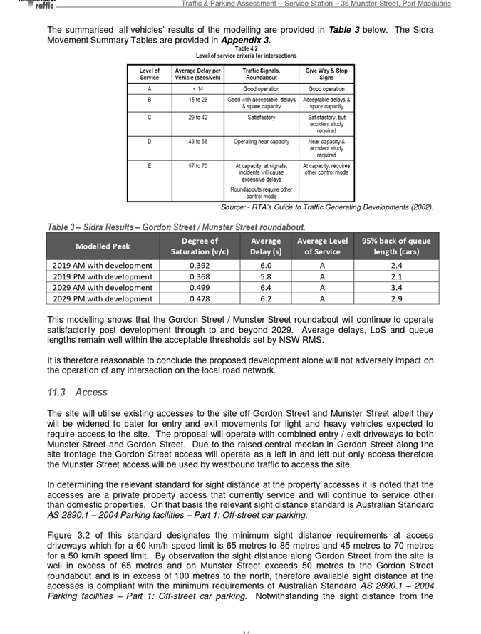
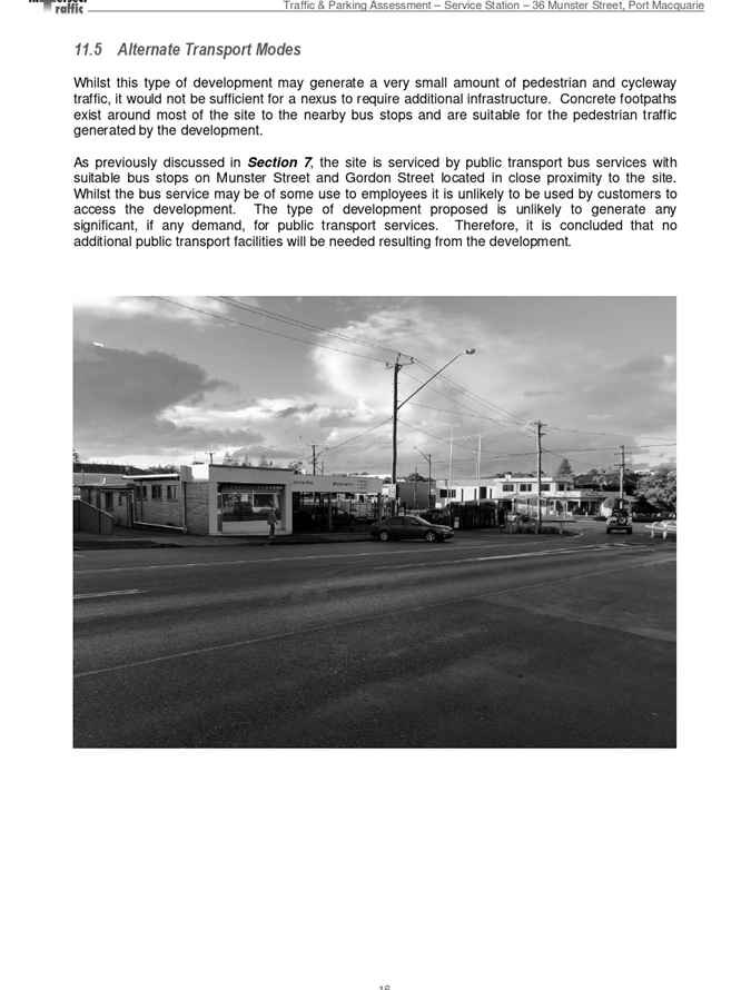
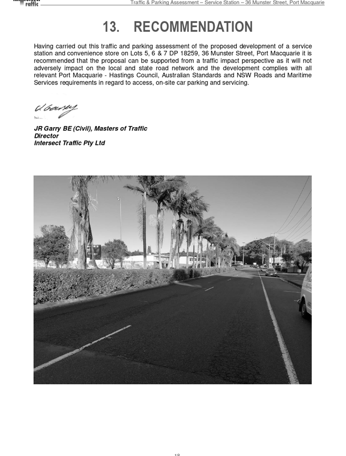
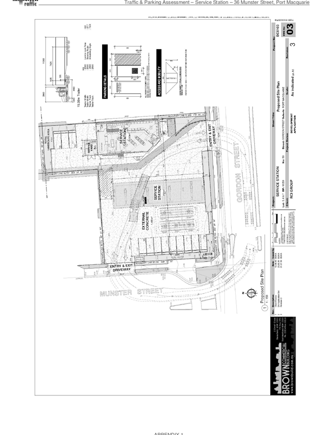
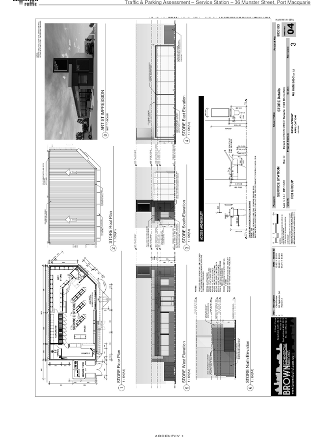
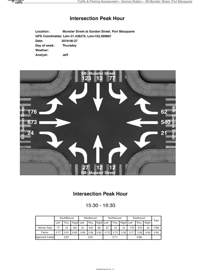
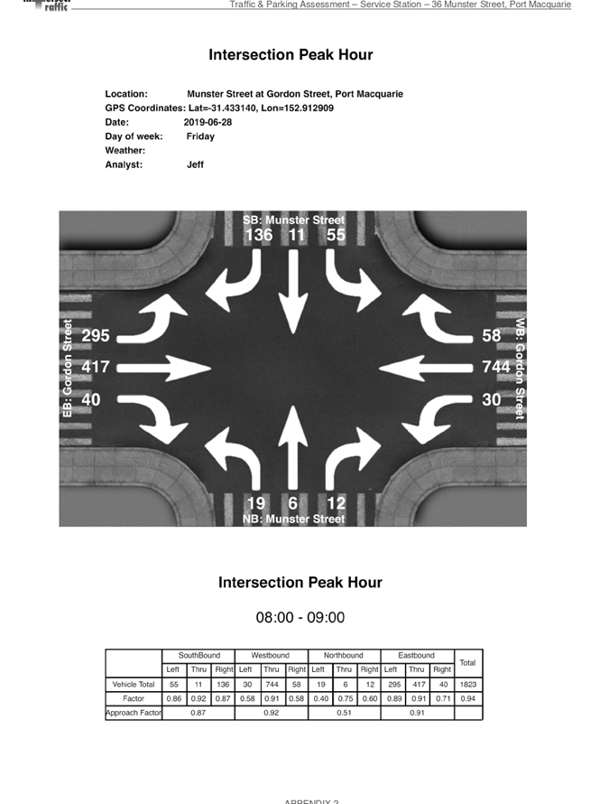
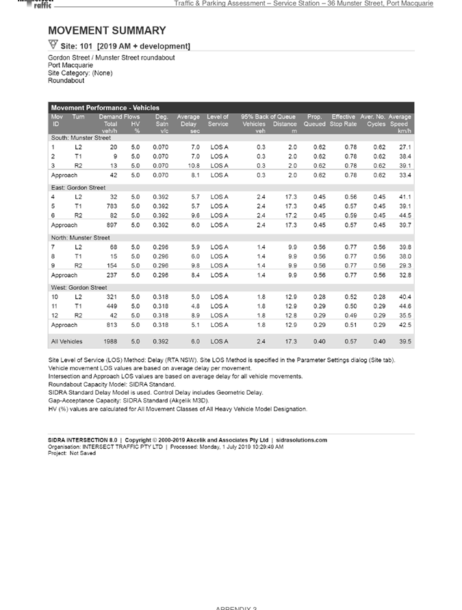
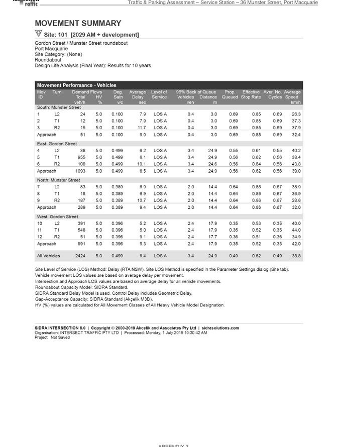
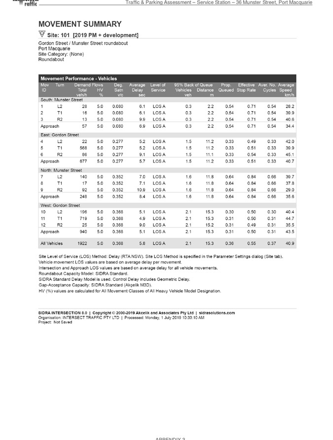
AGENDA Development Assessment Panel 22/01/2020
Item: 06
Subject: DA2019 - 761.1 Dwelling and Swimming Pool
including Clause 4.6 Objection to Clause 4.3 (Height of Buildings) of the Port
Macquarie-Hastings Local Environmental Plan 2011, Lot 60 DP 261991, No 14
Phoenix Crescent, Port Macquarie
Report
Author: Development Assessment Planner, Robert Slater
|
Applicant: Morr
Constructions Pty Ltd
Owner: C
J Hamilton
Estimated Cost: $900,000
Alignment with Delivery
Program
4.3.1 Undertake transparent
and efficient development assessment in accordance with relevant legislation.
|
|
RECOMMENDATION
That
DA 2019 - 761.1 for a dwelling and swimming pool including Clause 4.6
Objection to Clause 4.3 (Height of Buildings) of the Port Macquarie-Hastings
Local Environmental Plan 2011 at Lot 60, DP
261991, No. 14 Phoenix Crescent, Port Macquarie by determined by granting
consent subject to the recommended conditions.
|
Executive
Summary
This
report considers a development application for a dwelling and swimming
pool at the subject site and provides an assessment
of the application in accordance with the Environmental Planning and Assessment
Act 1979.
Following exhibition of the
application, two (2) submissions were
received.
The site is considered suitable for the proposed development
and the proposal adequately addresses relevant planning controls. The
development is not considered to be contrary to the public's interest and will
not result a significant adverse social, environmental or economic impact.
This report recommends that the
development application be approved subject to the attached conditions.
1. BACKGROUND
Existing Sites Features and Surrounding Development
The site has an area of 2602m2.
The site is zoned R1 General Residential in accordance with the Port Macquarie-Hastings Local
Environmental Plan 2011, as shown in the following zoning plan:
The existing subdivision pattern and location of existing
development within the locality is shown in the following aerial photograph:
2. DESCRIPTION OF
DEVELOPMENT
Key aspects of the proposal include the following:
Three (3) storey dwelling and swimming pool
1.
2. Refer to Attachment 2 at the end of this report for plans
of the proposed development.
Application Chronology
· 18
October 2019 - Application lodged
· 4
November 2019 - Public notification of application
· 4
November 2019 - External referral to RFS
· 7
November 2019 to 20 November 2019 - Notification period
· 14
November 2019 - RFS submission acknowledgement
· 14
November 2019 - Submission received
· 14 November 2019 - Submission acknowledgement
· 20
November 2019 - Access request to 42 Ocean view Tce
· 20
November 2019 - Additional information request
· 21
November 2019 - Late submission received
· 21 November 2019 - Late submission acknowledgement
· 9
October 2019 - Additional information request
· 2 December 2019 - Site inspection
· 9 December 2019 - Revised Plans / SOEE Received
3. STATUTORY ASSESSMENT
Section 4.15(1) Matters for Consideration
In determining the application, Council is required to take
into consideration the following matters as are relevant to the development
that apply to the land to which the development application relates:
(a) The provisions (where
applicable) of:
(i) Any Environmental
Planning Instrument
State Environmental Planning Policy No. 44 - Koala
Habitat Protection
There is no Koala Plan of Management on the site.
Additionally, the site is less than 1ha in area therefore no further
investigations are required.
State Environmental Planning Policy No. 55 –
Remediation of Land
Following an inspection of the site and a search of Council
records, the subject land is not identified as being potentially contaminated
and is suitable for the intended use.
State Environmental Planning Policy (Coastal Management)
2018
The site is located within a coastal use area.
In accordance with clause 7, this SEPP prevails over the
Port Macquarie-Hastings LEP 2011 in the event of any inconsistency.
Having regard to clause 11 of the SEPP and clause 5.5 of the
Port Macquarie-Hastings LEP 2011 the proposed development is on land identified
as “proximity area” for coastal wetlands. The proposed residential
development is not considered likely to result in any of the following:
1. Any adverse impact on the biophysical, hydrological or ecological
integrity of the adjacent coastal wetland or littoral rainforest, or
2. Any adverse impact on the
quantity and quality of surface and ground water flows to and from the adjacent
coastal wetland or littoral rainforest.
The dwelling has been located in
the north-western corner of the development site to avoid the mapped littoral
rainforest. Recommendations have been included within the submitted ecological
impact assessment prepared by Biodiversity Australia to ensure impacts are
minimised and avoided.
The proposed on-site
stormwater management measures are considered to be adequate to direct roof and
surface waters from the site to the existing street stormwater infrastructure.
Having regard to clauses 13 and 14 of the SEPP the proposed
development is not considered likely to result in any of the following:
1. Any
adverse impact on integrity and resilience of the biophysical,
hydrological (surface and groundwater) and ecological environment;
2. Any
adverse impacts coastal environmental values and natural coastal processes;
3. Any
adverse impact on marine vegetation, native vegetation and fauna
and their habitats, undeveloped headlands and rock platforms;
4. Any
adverse impact on Aboriginal cultural heritage, practices and
places;
5. Any
adverse impacts on the cultural and built environment heritage;
6. Any
adverse impacts the use of the surf zone;
7. Any adverse impact on the visual amenity and scenic qualities of the
coast, including coastal headlands;
8. Overshadowing, wind funnelling and the loss of views from public places
to foreshores;
9. Any
adverse impacts on existing public open space and safe access to
and along the foreshore, beach, headland or rock platform for members of the
public, including persons with a disability;
In accordance with Clause 15, the proposal is not likely to
cause increased risk of coastal hazards on that land or other land.
The bulk, scale and size of the proposed development is
compatible with the surrounding coastal and built environment. The site is
predominately cleared and located within an area zoned for residential
purposes.
State Environmental Planning Policy (Building
Sustainability Index: BASIX) 2004
A BASIX certificate has been submitted demonstrating that
the proposal will comply with the requirements of the SEPP. It is recommended
that a condition be imposed to ensure that the commitments are incorporated
into the development and certified at Occupation Certificate stage.
Port Macquarie-Hastings Local Environmental
Plan 2011
Clause 2.2 - The subject site is zoned R1 General
Residential.
3. The objectives
of the R1 zone are as follows:
· To
provide for the housing needs of the community.
· To
provide for a variety of housing types and densities.
· To
enable other land uses that provide facilities or services to meet the day to
day needs of residents.
Clause 2.3(2) - The proposal is
consistent with the zone objectives as it is a permissible landuse and
consistent with the established residential locality. The proposal contributes
to the range of housing options in the locality.
Clause 4.3 - This clause establishes the maximum “height of a
building” (or building height) that a building may be built to on any
parcel of land. The term “building height (or height of building)”
is defined in the LEP to mean “the vertical distance between ground
level (existing) and the highest point of the building, including plant and
lift overruns, but excluding communication devices, antennae, satellite dishes,
masts, flagpoles, chimneys, flues and the like”. The term
“ground level (existing)” is also defined in the LEP to mean
“the existing level of a site at any point”.
The building
height limit for the site is identified on the Height of Buildings Map as being
8.5m. The proposed development exceeds the numerical height standard by 0.5m,
which represents a variation of 5.8 %.
Figure1: Map
HOB_013FA of the Port Macquarie-Hastings Local Environmental Plan 2011 (LEP
2011
The submitted
plans have identified which areas of the building that exceed the height limit.
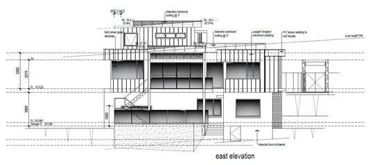
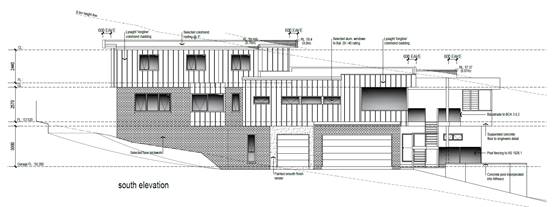
Figure 2:
Elevation indicating height exceedances.
Figure
3: Height poles in the location of the
two proposed height exceedances. The pole to the right of frame has a total
height of 9m (0.5m or 5.8% exceedance), whilst the pole to the left has a total
height of 8.76m (0.26m or 3% exceedance).
Clause 4.6 -
This clause establishes a degree of flexibility for certain development
standards in certain circumstances, which have demonstrated that a better
planning outcome will occur from that flexibility.
In this
regard, the proposal seeks a variation to the building height standard as
identified under clause 4.3 of this report. Assistance on the approach to
variation to this standard is also taken from NSW Land and Environment Court
and NSW Court of Appeal decisions in:
§ Wehbe v Pittwater Council
(2007) NSW LEC 827 (Wehbe);
§ Four2Five Pty Ltd v Ashfield
Council (2015) NSWLEC 1009; and
§ Al Maha Pty Ltd v Huajun
Investments Pty Ltd (2018) NSWCA 245
Having regard
to specific requirements of clause 4.6(3) and 4.6(4) the following assessment
comments are provided:
(3) Development
consent must not be granted for development that contravenes a development
standard unless the consent authority has considered a written request from the
applicant that seeks to justify the contravention of the development standard
by demonstrating:
a) that
compliance with the development standard is unreasonable or unnecessary in the
circumstances of the case, and
b) that
there are sufficient environmental planning grounds to justify contravening the
development standard.
Comments: The Applicant has submitted a request in writing
to justify the contravention of the building height standard for the following
reasons (as summarised):
§ The
proposed height exceedances are considered minimal, occurring only in the south
eastern corner of the proposed rooves on the third storey;
§ The site
slopes consistently from west to east at a grade of approximately 24 degrees;
§ The
proposed dwelling has been designed to generally match the slope of the site,
stepping down in sections as the building moves to the east;
§ The
proposed roof pitch has been minimised, 3 degree skillion, to ensure that the
proposed overall height of the building is reduced;
§ Due to
the dwellings position, it will not have a detrimental impact by manner of over
shadowing on any structures to the south or east;
§ Due to the dwellings elevation below adjoining Lot
42 (west) it will not have a detrimental impact by manner of overshadowing on
the existing adjoining dwelling;
§ The proposed height encroachment is not considered
to have a detrimental impact on broader views or vistas towards the coastline
(east of the site);
(4) Development consent must not
be granted for development that contravenes a development standard unless:
a) the consent
authority is satisfied that:
i) the
applicant’s written request has adequately addressed the matters required
to be demonstrated by sub clause (3),
Comments: Having regard to: 3(a) that
compliance with the development standard is unreasonable or unnecessary in the
circumstances of the case:
In Wehbe ‘five methods’ have been
developed to test whether a compliance with
the standard is unreasonable or unnecessary. Having regard to the ‘five methods’,
any of which could support consideration of the variation, the following
comments are provided:
§ The objectives of the height standard are achieved
notwithstanding the non- compliance with the numerical 8.5m
height standard.
§ The underlying objective or purpose of the standard
is not relevant to the development and therefore compliance is unnecessary.
§ The underlying object or purpose would not be
defeated or thwarted if compliance was required and therefore compliance is
unreasonable.
§ The development standard hasn’t been
virtually abandoned or destroyed by the Council’s own actions in granting
a consent to the proposal departing from the 8.5m standard and hence compliance
is unreasonable or unnecessary.
§ The zoning of the particular land is reasonable or
appropriate so that a development standard appropriate for that zoning is also
reasonable and necessary as it applies to the land.
§ There is no detrimental impact by manner of
overshadowing on the existing adjoining dwelling
Having
regard to 3(b) that there are sufficient environmental planning grounds to
justify contravening the development standard of the basis of the following:
§ The proposed development will meet the objectives
of maximum building height discussed above. The building will not have any
identifiable adverse impacts to adjoining properties. The proposed variation
will not result in a development that is out of character with that envisioned
for the locality.
On
this basis, it is considered that the Applicant’s clause 4.6 variation
has adequately addressed the matters required to be demonstrated by clause
4.6(3).
(ii) the
proposed development will be in the public interest because it is consistent
with the objectives of the particular standard and the objectives for
development within the zone in which the development is proposed to be carried
out, and
Comments: Consideration of the proposal’s consistency with the
objectives of height of buildings standard is provided as follows:
a) to ensure that
buildings are compatible with the height, bulk and scale of the existing and
desired future character of the locality,
4.
5.
Comments: Several buildings in the immediate
vicinity of the site are characterised as being two and three storey having with
similar overall heights above ground level, due mainly to the steepness of the
land. Additionally, there a number precedents where Council has approved
a variation to the standard height limit of 8.5m. Three such examples are to be
found at 40 Oceanview Terrace and number 9 and 12 Phoenix Crescent, Port
Macquarie.
6.
7.
A key aspect of this proposal is that it still presents as a two-storey
dwelling to the street/public domain.
8.
9.
Based on the above, the proposed
height, bulk and scale of the development is considered compatible with the
existing and future character of the locality.
10.
b) to minimise visual impact, disruption of views,
loss of privacy and loss of solar access to existing development,
Comments:
The visual impact of the building is considered satisfactory
for the following reasons:
§ The variation in the height limit will not be readily
visible from the public domain or neighbouring properties as it is only minor
in nature i.e. 5.8% variation only affects a small section of the upper storey
in the south eastern corner.
§ The main variations are located behind the facade of the
building and are therefore less distinctive.
§ The building height is similar to the existing dwellings in
the area and will therefore not be visually dominant.
§ The variation is created by the land sloping steeply away
from the street.
§ Potential privacy impacts are considered under the relevant
DCP provisions below and have been satisfactorily addressed in the building
design.
§ The
floor to ceiling heights are not excessive, in fact the Department of
Planning’s Apartment Design Guide – Part 4C -1 recommends a minimum
ceiling height of 2700mm for habitable rooms.
§ The
shadow diagrams demonstrate that the property immediately to the south of the
subject property receives adequate mid-winter solar access. The proposed height
variation will have negligible effect on shadows cast on the property.
In
conclusion, the proposed development and minor height
variation do not create any adverse overshadowing to the adjoining properties.
View impacts is considered elsewhere in this report under
‘View Sharing’.
c) to minimise the
adverse impact of development on heritage conservation
areas and heritage items,
11.
Comments: The site does not contain any known
heritage items or sites of significance.
12.
d) to nominate
heights that will provide a transition in built form and land use
intensity within the area covered by this Plan.
13.
14. Comments:
The proposed height is consistent with other
dwellings in the area. The minor variation does not compromise this intent of
the standard.
15.
16. The development is
consistent with the zoning and height objectives of the LEP 2011 and is
unlikely to have any implications on State related issues or the broader public
interest.
e) the concurrence of
the Secretary has been obtained.
Comments:
As per the Planning Circular PS 08-003, Council can assume the
Director’s Concurrence for variations to building height standards. In
addition, the variations are less than 10% and able to be determined under
delegated authority of DAP
Having regard to the above requirements it is recommended that the
height variation using clause
4.6 be supported.
17. Clause 4.4 - The floor space
ratio of the proposal is approximately 0.21:1, which complies with the maximum
0.65:1 floor space ratio applying to the site.
18.
Clause 5.10 – The site does not contain or
adjoin any known heritage items or sites of
significance.
19.
20. Clause 7.5 – Koala
Habitat applies to the site. Refer to comments under SEPP 44 heading.
21.
22. Clause 7.13 - Satisfactory
arrangements are in place for provision of essential services including water
supply, electricity supply, sewer infrastructure, stormwater drainage and
suitable road access to service the development.
(ii) Any
draft instruments that apply to the site or are on exhibition
No draft instruments apply to the site.
(iii) Any
Development Control Plan in force
Port Macquarie-Hastings Development Control Plan 2013
|
DCP 2013: Dwellings, Dual
occupancies, Dwelling houses, Multi dwelling houses & Ancillary
development
|
|
|
Requirements
|
Proposed
|
Complies
|
|
3.2.2.1
|
Ancillary development:
• 4.8m max. height
• Single storey
• 60m2 max. area
• 100m2 for lots
>900m2
• 24 degree max.
roof pitch
• Not located in
front setback
|
No ancillary development proposed
|
Yes
|
|
3.2.2.2
|
Front setback (Residential not R5
zone):
• Min. 4.5m local
road
|
Front building line setback is
5.5m and compliant with the minimum 4.5m front setback requirements.
Note Phoenix Crescent is a private access road.
|
Yes
|
|
3.2.2.3
|
Garage 5.5m min. and 1m behind
front façade.
Garage door recessed behind
building line or eaves/overhangs provided
|
Garage door setback is compliant
with the minimum front setback requirements.
Garage door recessed.
|
Yes
|
|
6m max. width of garage door/s
and 50% max. width of building
|
Width of garage door/s are
compliant with the maximum width requirements
|
Yes
|
|
Driveway crossover 1/3 max. of
site frontage and max. 5.0m width
|
Driveway crossing/s width are
compliant with the maximum width requirements
|
Yes
|
|
3.2.2.4
|
4m min. rear setback. Variation
subject to site analysis and provision of private open space
|
37m
|
Yes
|
|
3.2.2.5
|
Side setbacks:
• Ground floor =
min. 0.9m
• First floors &
above = min. 3m setback or where it can be demonstrated that overshadowing
not adverse = 0.9m min.
• Building wall set
in and out every 12m by 0.5m
|
4.9m
4.9m
The building wall articulation is
satisfactory to address the objective intent of the development provision.
|
Yes
Yes
Yes
|
|
3.2.2.6
|
35m2 min. private open space area
including a useable 4x4m min. area, which has 5% max. grade
|
The dwelling contains > 35m² open space in one
area including a useable 4m x 4m space.
|
Yes
|
|
3.2.2.10
|
Privacy:
• Direct views
between living areas of adjacent dwellings screened when within 9m radius of
any part of window of adjacent dwelling and within 12m of private open space areas
of adjacent dwellings. i.e. 1.8m fence or privacy screening which has 25%
max. openings and is permanently fixed
• Privacy screen
required if floor level > 1m height, window side/rear setback (other than
bedroom) is less than 3m and sill height less than 1.5m
• Privacy screens
provided to balconies/verandahs etc. which have <3m side/rear setback and
floor level height >1m
|
No direct views between living
areas of adjacent dwellings screened when within 9m radius of any part of
window of adjacent dwelling and within 12m of private open space areas of
adjacent dwellings.
No privacy screens are
recommended.
|
Yes
|
|
DCP 2013: General
Provisions
|
|
|
Requirements
|
Proposed
|
Complies
|
|
2.7.2.2
|
Design addresses generic principles of Crime Prevention
Through Environmental Design guideline
|
No concealment or entrapment areas proposed. Adequate
casual surveillance available.
|
Yes
|
|
2.3.3.1
|
Cut and fill 1.0m max. 1m outside the perimeter of the
external building walls
|
The site preparation and earthworks will require cut and
fill > 1m outside the perimeter of the external building walls
|
No
|
|
2.3.3.2
|
1m max. height retaining walls along road frontage
|
None proposed
|
N/A
|
|
|
Any retaining wall >1.0 in height to be certified by
structure engineer
|
No retaining wall likely >1m
Condition recommended to require engineering certification
if one is required.
|
Yes
|
|
Combination of retaining wall and front fence height max
1.8m, max length 6.0m or 30% of frontage, fence component 25% transparent,
and splay at corners and adjacent to driveway
|
No retaining wall front fence combination proposed.
|
N/A
|
|
2.3.3.8
|
Removal of hollow bearing trees
|
One hollow bearing tree (small leaved Fig) was identified
on-site. The HBT was assessed under the DCP HBT protocol determined that the
HBT is located outside the development footprint and will be retained in
situ.
|
Yes
|
|
2.6.3.1
|
Tree removal (3m or higher with 100m diameter trunk at 1m
above ground level and 3m from external wall of existing dwelling)
|
Six trees are proposed to be removed.
· 1 Norfolk Island Pine
· 4 Bangalow Palm
· 1 Cheese Tree
(refer comments under Flora and Fauna)
|
yes
|
|
2.4.3
|
Bushfire risk, Acid sulphate soils, Flooding,
Contamination, Airspace protection, Noise and Stormwater
|
Refer to main body of report.
|
|
|
2.5.3.2
|
New accesses not permitted from arterial or distributor
roads
|
No new access proposed to arterial or distribution road.
|
N/A
|
|
Driveway crossing/s minimal in number and width including
maximising street parking
|
Driveway crossing minimal in width including maximising
street parking
|
Yes
|
|
2.5.3.3
|
Parking in accordance with Table 2.5.1.
1 space per single dwelling (behind building line)
|
1 or capacity for more than 1 parking space behind the
building line has been provided for.
|
Yes
|
|
2.5.3.11
|
Section 94 contributions
|
Refer to main body of report.
|
|
|
2.5.3.12 and 2.5.3.13
|
Landscaping of parking areas
|
Single dwelling only with 1 domestic driveway. No specific
landscaping requirements recommended.
|
N/A
|
|
2.5.3.14
|
Sealed driveway surfaces unless justified
|
Sealed driveway proposed
|
Yes
|
|
2.5.3.15 and 2.5.3.16
|
Driveway grades first 6m or ‘parking area’
shall be 5% grade with transitions of 2m length
|
Driveway grades capable of satisfying Council standard
driveway crossover requirements. Condition recommended for section 138 Roads
Act permit
|
Yes
|
|
2.5.3.17
|
Parking areas to be designed to avoid concentrations of
water runoff on the surface.
|
Single dwelling only with 1 domestic driveway. Stormwater
drainage is capable of being managed as part of plumbing construction.
|
Yes
|
|
|
|
|
|
|
(iiia) Any
planning agreement that has been entered into under section 7.4, or any draft
planning agreement that a developer has offered to enter into under section 7.4
No planning agreement has been offered or entered into
relating to the site.
(iv) Any matters prescribed by the
Regulations
NSW Coastal Policy 1997 - The proposal does not conflict
with the strategic intent of the Policy. The site is zoned for residential use.
(v) Any coastal zone
management plan (within the meaning of the Coastal Protection Act 1979), that apply to the land to which the development
application relates.
None relevant
(b) The likely impacts of that development,
including environmental impacts on both the natural and built environments and
the social and economic impacts in the locality
Context and Setting
The development site is zoned
R1 General Residential and has an area of 2,602m2 which is adjoined
by dwelling houses to the west and north and vegetated public reserves to the
east and south. The site slopes from west to east towards the vegetated public
reserve (Littoral Rainforest), with a fall of 16.5m or 24%.
The site is
accessed via Phoenix Crescent which is a private road access extending from the
cul-de-sac head of Oceanview Terrace and transverse the north-western corner of
the site.
The proposal is considered to be consistent with other residential
development in the locality and while variations are proposed, the design
adequately addresses planning controls for the area.
View Sharing
During
the public exhibition period two submissions were received from the adjoining
owners of 42 Phoenix Crescent and 40 Oceanview Terrace who raised concerns
regarding the proposed development including loss of views, predominantly
towards Tacking Point Lighthouse and Lighthouse Beach.
Views have been assessed from key areas within
the subject properties. The attached photos are taken from primary
living areas include decks.
Photo 1 View looking south east
from the deck of 40 Oceanview Tce
Photo 2: View looking east from
the deck of 42 Phoenix Crescent
Photo 3: View from dining room
of 42 Phoenix Crescent
The overall notion of view sharing is invoked
when a property enjoys existing views and a proposed development would share
that view by taking some of it away for its own enjoyment. Taking all the view
away cannot be called view sharing, although it may, in some circumstances, be
quite reasonable.
Using the principles of NSW Land and
Environment Court Case law - Tenacity Consulting v Warringah 2004 NSW LEC
140, the following comments are provided in regards to the view impacts
using the 4 step process to establish whether the view sharing is acceptable.
Step 1
Assessment of views to be affected. Water views are valued
more highly than land views. Iconic views (e.g. of the Opera House, the Harbour
Bridge or North Head) are valued more highly than views without icons. Whole
views are valued more highly than partial views, e.g. a water view in which the
interface between land and water is visible is more valuable than one in which
it is obscured.
Comments:
The impacted view corridor is situated to the north - north east and south east
of the Tacking Point lighthouse including the Lighthouse itself which is
situated approximately 686m and 680m from the respective properties.
Both 40 Oceanview Tce and 42 Phoenix Cres
currently enjoy 180 degree Ocean views. The views include the Tacking
Point lighthouse. Tacking Point Lighthouse is considered to be a local
landmark. The view of the lighthouse will lost completely from the primary
livings area of 42 phoenix Crescent and to a lesser extent from 40 Oceanview
Tce. Both properties have distance views that show a direct interface with the
land and ocean.
Step 2
Consider from what part of the property the views are
obtained. For example the protection of views across side boundaries is more
difficult than the protection of views from front and rear boundaries. In
addition, whether the view is enjoyed from a standing or sitting position may
also be relevant. Sitting views are more difficult to protect than standing views.
The expectation to retain side views and sitting views is often unrealistic.
Comments:
The ocean and lighthouse views including the land/ocean interface are enjoyed
from the eastern elevation of 42 Phoenix Crescent and the south eastern and
north eastern elevation of 40 Oceanview Terrace albeit across their rear and
side boundaries respectively. The views are enjoyed from both standing and
sitting positions from various living areas of both residences.
Step 3
Assess the extent of the impact. This should be done for
the whole of the property, not just for the view that is affected. The impact
on views from living areas is more significant than from bedrooms or service
areas (though views from kitchens are highly valued because people spend so
much time in them). The impact may be assessed quantitatively, but in many
cases this can be meaningless. For example, it is unhelpful to say that the
view loss is 20% if it includes one of the sails of the Opera House. It is
usually more useful to assess the view loss qualitatively as negligible, minor,
moderate, severe or devastating.
Comments: The extent of the impact upon the views enjoyed from 42
Oceanview Terrace are considered to be moderate. The views from 40 Oceanview
Terrace is considered to be minor. The existing views of the Tacking Point
Lighthouse will be virtually lost from key living areas and balcony areas
currently enjoyed by 42 Phoenix Crescent, while the view of lighthouse is
retained by 40 Oceanview Tce. Additionally, views to the Taking Point Lighthouse
and the Ocean views beyond are already partially obscured from both dwellings,
due to the existing vegetation, which limits the scale of the view available.
The existing views of the land and water interface will be retained from
key living areas and verandah/decks from both properties. Substantial views of
the ocean will be retained by both properties, however views to the south east
will be partially obscured from 40 Oceanview Terrace. While view loss will
occur, it is not considered to be of such a significance where it adversely
impacts on the overall vista or land/water interface. Substantial ocean views
will be retained from primary living areas of both properties.
The proposed variations to the numerical height standards do not
exponentially impact on view loss. It is considered that a building with a
compliant ridge height would have a similar impact on views. Additionally, the
majority of the proposed dwelling is below the height limit on the higher
section of the property.
Step 4
Assess the
reasonableness of the proposal that is causing the impact. A development that
complies with all planning controls would be considered more reasonable than
one that breaches them. Where an impact on views arises as a result of
non-compliance with one or more planning controls, even a moderate impact may
be considered unreasonable. With a complying proposal, the question should be
asked whether a more skilful design could provide the applicant with the same
development potential and amenity and reduce the impact on the views of
neighbours. If the answer to that question is no, then the view impact of a
complying development would probably be considered acceptable and the view
sharing reasonable.
Comments: The proposal contains variation to the numerical height
standard. However, it is considered that the variation is minor (maximum 0.5m
or 5.8%) and does not result in any adverse loss of broader ocean views. As
detailed above, key ocean views from primary living areas will stll be retained
from both dwellings.
A compliant
or re-designed development would have minimal improvement if any to that which
is proposed. In addition, the variation has been addressed in this report and
deemed to be acceptable and in keeping with previously approved variations to
building heights in the immediate vicinity. There is considered to be
insufficient grounds to refuse the application on view loss impacts.
Figure 4:Looking
west from 14 Phoenix Crescent
Figure 5:
Looking south east from Phoenix Cres
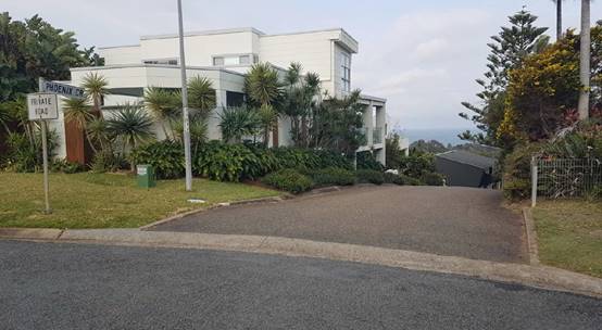
Figure 6: Phoenix Crescent as viewed from Oceanview Tce,
looking east
Access, Traffic and Transport
The proposal will not have any significant adverse impacts
in terms access, transport and traffic. The existing road network will
satisfactorily cater for any increase in traffic generation as a result of the
development.
Water Supply Connection
Service available – details required with S.68
application.
Sewer Connection
Service available – details required with S.68
application.
Stormwater
Service available – details required with S.68
application.
Other Utilities
Telecommunication and electricity services are available to
the site.
Heritage
This site does not contain or adjoin any known heritage item
or site of significance. The site is considered to be disturbed land.
Other land resources
The site is within an established urban context and will not
sterilise any significant mineral or agricultural resource.
Water cycle
The proposed development will not have any significant
adverse impacts on water resources and the water cycle.
Soils
The proposed development will not have any adverse impacts
on soils in terms of quality, erosion, stability and/or productivity subject to
a standard condition requiring erosion and sediment controls to be in place
prior to and during construction.
Air and microclimate
The construction and/or operations of the proposed
development will not result in any significant adverse impacts on the existing
air quality or result in any pollution. Standard precautionary site management
condition recommended.
Flora and fauna
The site is within the Biodiversity Values Map. However,
Clause 7.3(4) of the Biodiversity Regulations turns off the Biodiversity Values
Map for lots created before the Act commenced and where the test of
significance is acceptable.
A 5-part test has been carried out
by Biodiversity Australia and determined that it is unlikely to result in a
significant impact on the Littoral Rainforest. Recommendations have been
provided by Biodiversity Australia to minimise edge effects.
In this case, the test of
significance has revealed no adverse impact and a BDAR is not required.
A total of six trees are proposed
to be removed to establish the development. These comprise the following:
· 1
Norfolk Island Pine
· 4
Bangalow Palm
· 1
Cheese Tree
The removal of these trees is
unlikely to result in any adverse impacts on potential occurring threatened
fauna species.
No Koala Food Trees were identified
on the site and therefore no replacement replanting’s are required.
The site is <1ha and therefore
the PMHC DCP provisions for EECs and riparian buffers do not apply.
Waste
Satisfactory arrangements are in place for proposed storage
and collection of waste and recyclables. No adverse impacts anticipated.
Standard precautionary site management condition recommended.
Energy
The proposal includes measures to address energy efficiency
and will be required to comply with the requirements of BASIX.
Noise and vibration
The construction of the proposed development will not result
in any significant adverse impacts on the existing air quality or result in any
pollution. Standard precautionary site management condition recommended.
Bushfire
The site is identified as being bushfire prone.
The Applicant has submitted a BAL
Certificate prepared by a Certified Consultant.
As the assessment has determined
that a BAL 40 construction is required, referral to the Local Rural Fire has
been made. The RFS have reviewed the proposal and made recommendations which
will be required to be imposed via conditions of consent.
Management of bushfire risk is acceptable subject to BAL 40
construction levels being implemented and APZ being maintained. An appropriate
condition is recommended.
Safety, security and crime
prevention
The proposed development will be unlikely to create any
concealment/entrapment areas or crime spots that would result in any
identifiable loss of safety or reduction of security in the immediate area. The
increase in housing density will improve natural surveillance within the
locality and openings from each dwelling overlook common and private areas.
Social impacts in the locality
Given the nature of the proposed development and its
location the proposal is not considered to have any significant adverse social
impacts.
Economic impact in the locality
The proposal is not considered to have any significant
adverse economic impacts on the locality. A likely positive impact is that the
development will maintain employment in the construction industry, which will
lead to flow impacts such as expenditure in the area.
Site design and internal design
The proposed development design satisfactorily responds to
the site attributes and will fit into the locality.
Construction
While there may be some standard short term impacts
associated with a construction site (i.e. loss of off street parking due to
construction workers, construction noise etc.), no long term impacts to
neighbouring properties will occur. In addition, standard conditions will be
recommended to restrict hours of construction and protection of adjoining
properties during construction.
Construction impacts are considered
capable of being managed, standard construction and site management conditions
have been recommended.
Cumulative impacts
The proposed development is not considered to have any
significant adverse cumulative impacts on the natural or built environment or
the social and economic attributes of the locality.
As detailed in the report above, the area along Oceanview Terrace and
Phoenix Crescent contains a unique mixture of single and two-three storey
development. In particular, there are a number of two storey developments which
include minimal setbacks to Phoenix Crescent being a private access road.
The unique character of the immediate area is bound by the aforementioned
streets. It is considered that any future development beyond the intersections
would be outside the unique precinct and therefore unlikely to create a large
scale cumulative impact on development controls within the overall Port
Macquarie area.
(c) The
suitability of the site for the development
While there
are a number of variations proposed, it is considered that suitable
justification has been provided in this case to ensure the development is
consistent with other development in the area. In this regard, the development
is considered to still satisfy relevant planning controls for the area and is
not expected to impact adversely on the wider public interest.
The proposal will fit into the locality and the site
attributes are conducive to the proposed development.
Site constraints
have been adequately addressed and appropriate conditions of consent
recommended.
(d) Any submissions made in
accordance with this Act or the Regulations
Two written submissions were received following public
exhibition of the application. Copies of the written submissions have been
provided separately to members of the DAP.
Key issues raised in the submissions received and comments
are provided as follows:
|
Submission
Issue/Summary
|
Planning
Comment/Response
|
|
Concerns about the building
exceeding the maximum height limits in the DCP
|
The applicant has submitted an
application for a Clause 4.6 variation to Clause 4.3 (Height of Buildings) of
the PMHC LEP 2011 for Council’s consideration. (refer body of report)
|
|
Lack of information on the plans with particular regard
to AHD levels to show the particular height of building location on the site
and what the final overall height will be
|
The applicant has erected height profiles on the site to
AHD that relate to proposed overall height of the proposed building.
|
|
A view plan should be provided taken from 42 Ocean view
Terrace with particular emphasis given to the eastern verandah and living
room to show potential impacts the proposed development will on the existing
primary view corridor the iconic light house.
|
The issue of potential loss view has been dealt with in
detail under the heading of “View Sharing” in the body of the
report.
|
|
Concerns relating to height and impact on view have been
underestimated
|
There is no evidence to suggest that the applicant has
under estimated impacts relating to building height and view loss in relation
to the proposed dwelling.
As mentioned above height profiles have been erected to
AHD relative to the roof heights and View loss has been addressed under
separate heading “View Sharing” in the body of the report.
|
|
Potential impact of roof structures such as antennas,
dishes, solar panels, hot water.
|
Roof
structures would need to satisfy the exempt provisions of the codes SEPP or
alternatively be applied for via a development application (DA). Impacts
would need to be assessed as part of any future DA.
|
(e) The
public interest
As detailed
throughout the above report, the proposed development suitably satisfies relevant
planning controls and is unlikely to impact on the wider public interest.
4. DEVELOPMENT
CONTRIBUTIONS APPLICABLE
Contributions do not apply as the site has credit from the
existing residential zoned property.
5. CONCLUSION AND
STATEMENT OF REASON
The application has been assessed
in accordance with Section 4.15 of the Environmental Planning and Assessment
Act 1979.
Issues raised during assessment
and public exhibition of the application have been considered in the assessment
of the application. Where relevant, conditions have been recommended to manage
the impacts attributed to these issues.
The site is considered suitable
for the proposed development and the proposal adequately addresses relevant
planning controls. The development is not considered to be contrary to the
public's interest and will not result a significant adverse social,
environmental or economic impact. It is recommended that the application be
approved, subject to the recommended conditions of consent provided in
Attachment 1.
|
Attachments
1View. DA2019
- 761.1 Recommended Conditions
2View. DA2019
- 761.1 Plans
|
|
ATTACHMENT
|
Development Assessment Panel
22/01/2020
|
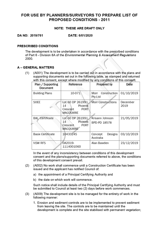
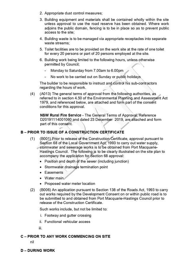
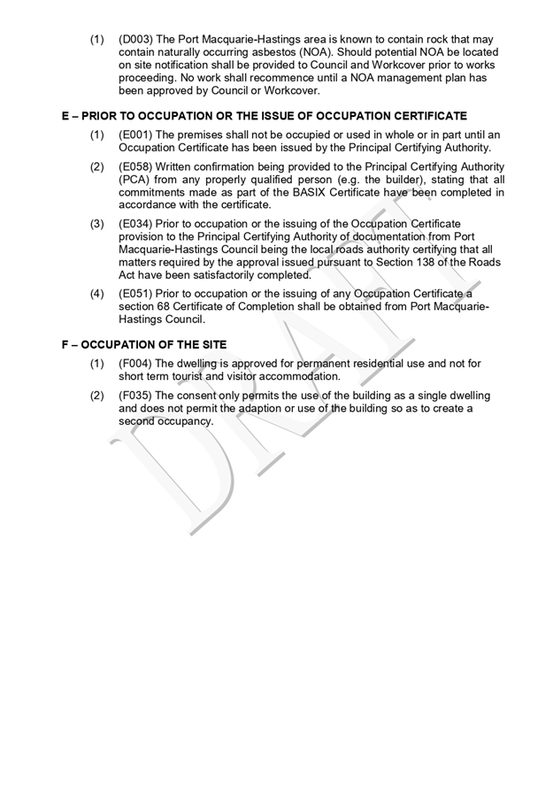
|
ATTACHMENT
|
Development Assessment Panel
22/01/2020
|
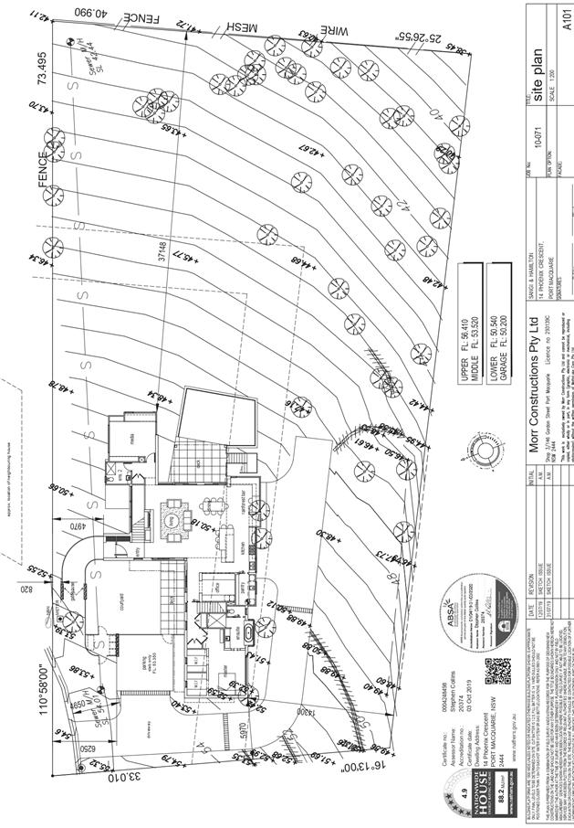
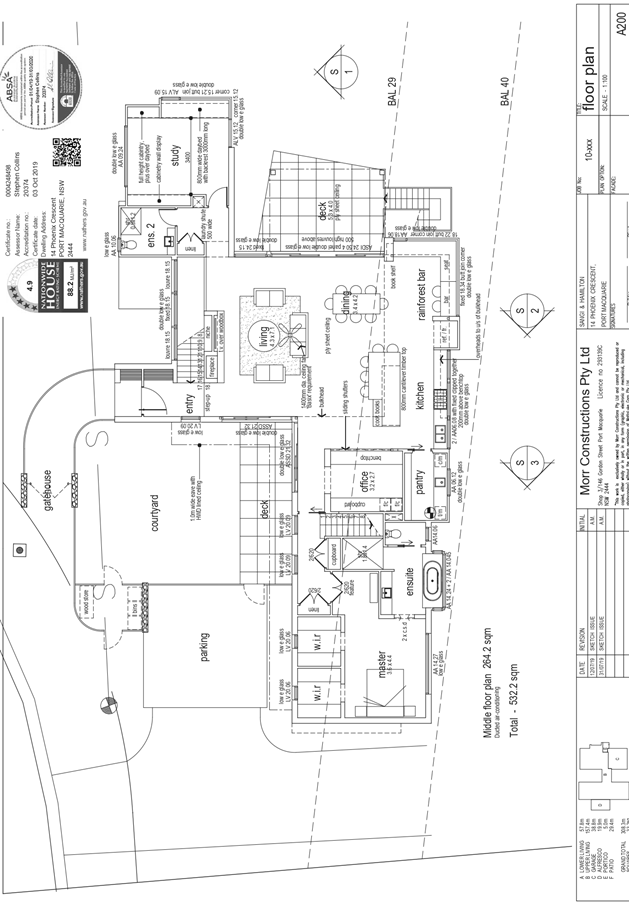
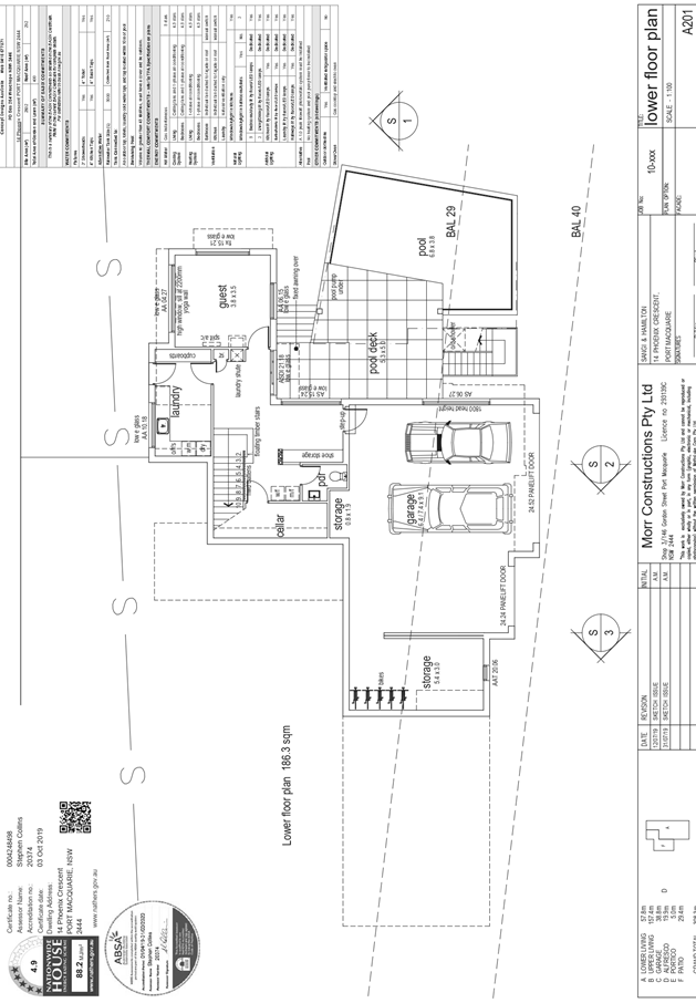
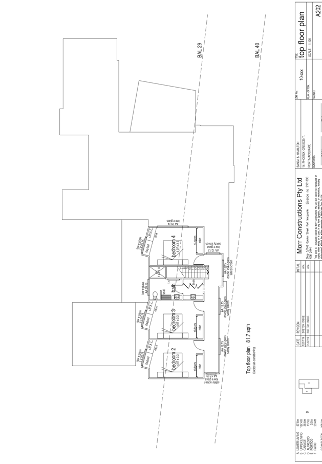
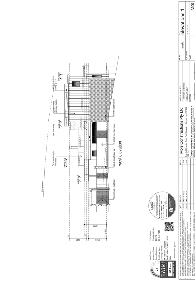
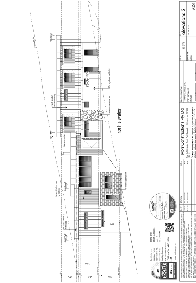
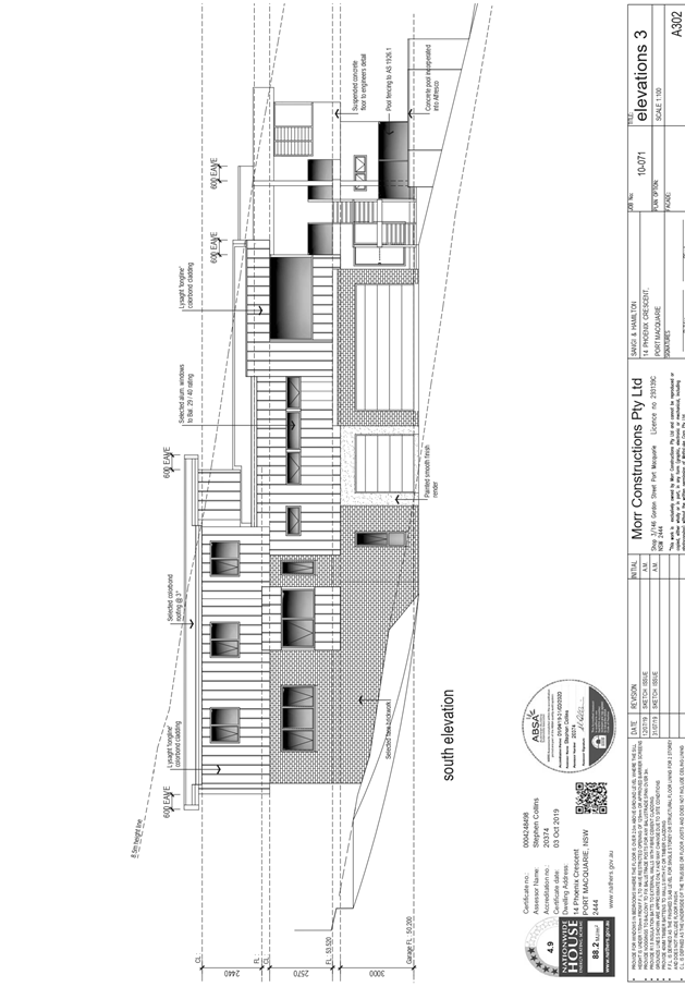
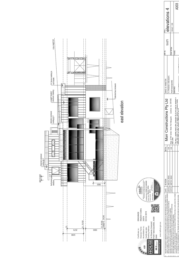
AGENDA Development Assessment Panel 22/01/2020
Item: 07
Subject: DA2019 - 713.1 Torrens Title Subdivision 2
Lots into 3 - Lots 705 and 706 DP 1228141, Nos. 41 and 43 Yaluma Drive,
Port Macquarie
Report
Author: Development Assessment Planner, Steven Ford
|
Applicant: Love
Project Management
Owner: Pearr
Corp Pty Ltd & Richmond Horizons Pty Ltd
Estimated Cost: $0
Alignment with Delivery
Program
4.3.1 Undertake transparent
and efficient development assessment in accordance with relevant legislation.
|
|
RECOMMENDATION
That
DA 2019 - 713.1 for a 2 into 3
lot Torrens Title Subdivision at Lot 705
and 706, DP 1228141, No. 41 and 43 Yaluma Drive, Port Macquarie,
be determined by granting consent subject to the recommended conditions.
|
Executive
Summary
This
report considers a development application for a 2 into 3 Lot Torrens
Title Subdivision at the subject site and provides an
assessment of the application in accordance with the Environmental Planning and
Assessment Act 1979.
Following exhibition of the
application, 3 submissions were received.
The site is considered suitable for the proposed development
and the proposal adequately addresses relevant planning controls. The
development is not considered to be contrary to the public's interest and will not
result a significant adverse social, environmental or economic impact.
This report recommends that the
development application be approved subject to the attached conditions
(Attachment 1)
1. BACKGROUND
Existing
Sites Features and Surrounding Development
The site has an area of 1,609m2.
The
site is zoned R1 General Residential in
accordance with the Port Macquarie-Hastings Local Environmental Plan 2011, as
shown in the following zoning plan:
The
existing subdivision pattern and location of existing development within the
locality is shown in the following aerial photograph:
2. DESCRIPTION
OF DEVELOPMENT
Key
aspects of the proposal include the following:
· 2
into 3 lot Torrens Title Subdivision
· Proposed
lot sizes vary from 524.5m2 to 548.9m2
Refer
to Attachment 2 at the end of this report for plans of the proposed
development.
Application
Chronology
· 4
October 2019 - Application Lodged
· 24 October to 06 November 2019 - Public Notification
Period, 3 submissions received
· 5 December 2019 - Additional information received
· 6 December 2019 - Developer offered to hold meetings with
adjoining landowners to alleviate concerns
3. STATUTORY
ASSESSMENT
Section
4.15(1) Matters for Consideration
In
determining the application, Council is required to take into consideration the
following matters as are relevant to the development that apply to the land to
which the development application relates:
(a) The
provisions (where applicable) of:
(i) Any
Environmental Planning Instrument
State Environmental Planning Policy No. 44 - Koala
Habitat Protection
With reference to clauses 6 and 7, the subject land is less
than 1 hectare (including any adjoining land under same ownership) and therefore
the provisions of SEPP not apply to the development proposal.
State Environmental Planning Policy (Coastal Management)
2018
The site is located within a coastal environment area.
In accordance with clause 7, this SEPP prevails over the
Port Macquarie-Hastings LEP 2011 in the event of any inconsistency.
Having regard to clauses 13 and 14 of the SEPP the proposed
development is not considered likely to result in any of the following:
a) any
adverse impact on integrity and resilience of the biophysical,
hydrological (surface and groundwater) and ecological environment;
b) any
adverse impacts coastal environmental values and natural coastal
processes;
c) any
adverse impact on marine vegetation, native vegetation and fauna
and their habitats, undeveloped headlands and rock platforms;
d) any
adverse impact on Aboriginal cultural heritage, practices and
places;
e) any
adverse impacts on the cultural and built environment heritage;
f) any
adverse impacts the use of the surf zone;
g) any adverse impact on the visual amenity and scenic qualities of the
coast, including coastal headlands;
h) overshadowing, wind funnelling and the loss of views from public places
to foreshores;
i) any
adverse impacts on existing public open space and safe access to
and along the foreshore, beach, headland or rock platform for members of the
public, including persons with a disability.
In accordance with Clause 15 the proposal is not likely to
cause increased risk of coastal hazards on the land or any other land.
The bulk, scale and size of the proposed development is
compatible with the surrounding coastal and built environment. The site is
predominately cleared and located within an area zoned for residential
purposes.
Port Macquarie-Hastings Local Environmental
Plan 2011
The proposal is consistent with the LEP having regard to the
following:
· Clause
2.2 - The subject site is zoned R1 General Residential.
The objectives of the R1 zone are as
follows:
o To provide for
the housing needs of the community.
o To provide for a
variety of housing types and densities.
o To enable other
land uses that provide facilities or services to meet the day to day needs of
residents.
· Clause
2.3(2) - The proposal is consistent with the zone objectives having regard to
the following:
o The proposal will provide an
additional residential lot to meet the housing needs of the community.
· Clause
4.1 - The lot sizes within the proposed subdivision range from 524.5m2, 537.2m2
and 548.9m2. All proposed lots comply with the minimum lot sizes identified in
the Lot Size Map relating to the site.
· Clause
5.10 - Heritage. The site does not contain or adjoin any known heritage items
or sites of significance.
· Clause
7.13 - Satisfactory arrangements are in place for provision of essential
services including water supply, electricity supply, sewer infrastructure,
stormwater drainage and suitable road access to service the development.
Provision of electricity will be subject to obtaining satisfactory arrangements
certification prior to the issue of a Subdivision Certificate as recommended by
a condition of consent.
(ii) Any draft
instruments that apply to the site or are on exhibition
No draft instruments apply to the site.
(iii) Any Development
Control Plan in force
Port
Macquarie-Hastings Development Control Plan 2013
|
DCP 2013: Chapter 3.6 - Subdivision
|
|
DCP Objective
|
Development Provisions
|
Proposed
|
Complies
|
|
3.6.3.1
|
A site analysis is required for all development and shall
illustrate:
· microclimate;
· lot dimensions;
· north point;
· existing contours and levels
to AHD;
· flood affected areas;
· overland flow patterns,
drainage and services;
· any contaminated soils or
filled areas, or areas of unstable land;
· easements and/or connections
for drainage and utility services;
· identification of any
existing trees and other significant vegetation;
· any existing buildings and
other structures, including their setback distances;
· heritage and archaeological
features;
· fences;
· existing and proposed road
network, including connectivity and access for all adjoining land parcels;
· pedestrian and vehicle
access;
· views to and from the site;
· overshadowing by
neighbouring structures; and
· any other notable features
or characteristics of the site.
|
Adequate site analysis plan submitted.
|
Yes
|
|
3.6.3.2
|
Torrens title lots minimum width of 15m when measured at a
distance of 5.5m from front property boundary.
|
All proposed lots vary between 15.335m to 15.305m in width
on the front boundary
|
Yes
|
|
Minimum width of 7m when boundaries are extended to kerb
line.
|
N/A
|
N/A
|
|
Minimum depth of 25m.
|
Minimum depth of 33m
|
Yes
|
|
For lots where average slope of the site is equal to, or
exceeds 16%, indicative road and driveway grades are required demonstrating satisfactory
access.
|
Slope of the land is consistent in the locality,
orientation of the existing frontages and driveway grades have been
achievable on adjoining lots.
|
Acceptable
|
|
Subdivision of dual occupancy development or multi
dwelling housing where permissible in the LEP may create allotments smaller
than 450m2 if:
· Each lot to be created is
part of a community or strata title scheme, or
· Is part of an integrated
Torrens title housing development.
|
N/A
|
N/A
|
|
3.6.3.3
|
Battleaxe lots discouraged in greenfield development.
|
None proposed.
|
N/A
|
|
Council may consider permitting Torrens Title battleaxe
allotments for ―infill development where it is demonstrated that;
· a Torrens Title lot, that is
not a battleaxe lot, cannot be achieved; and
· the number of crossovers do
not reduce the amenity of the street or on street parking; and
· the impact of noise, dust
and headlights on the land owners adjoining the driveway is addressed by the
construction of an acoustic fence for the full length of the driveway; and
· addresses privacy between
the rear lot and the rear open space of the front lot by the provision of
· adequate screening, larger
lot size and setbacks; and
· extends utilities to the end
of the axe handle; and
· there is sufficient space
for garbage collection on the frontage.
|
N/A
|
N/A
|
|
3.6.3.4
|
Lots are to be designed to allow the construction of a
dwelling, which does not involve more than 1m cut, or fill, measured from
natural ground level, outside the dwellings external walls.
|
Proposed lots are capable of accommodating a dwelling
without excessive cut/fill.
|
Yes
|
|
Lot sizes increased for sloping sites in accordance with
Table 3.6.1.
|
Lot size complies with minimum area for slope category.
|
Yes
|
|
Additional information provided for slope categories in
accordance with Table 3.6.2.
|
Adequate information provided.
|
Yes
|
|
3.6.3.5
|
Wherever possible orientate streets to maximise the number
of east, west and south facing lots and to minimise the number of narrow
north facing lots.
Residential street blocks should preferably be orientated
north-south with dimensions generally
limited to 60-80m by 120-150m as illustrated in Figure
3.6-2.
|
N/A - Existing street.
|
N/A
|
|
Lot size and shape are to reflect orientation to ensure
future dwelling construction has optimal opportunity for passive solar
design.
|
Lot orientation and width provides opportunity for passive
solar design.
|
Yes
|
|
3.6.3.6
|
Kerb and guttering, associated street drainage, pavement
construction and foot paving across the
street frontages should be constructed as part of the
subdivision works where these do not exist (may be varied subject to criteria
in this clause)
|
Existing kerb and gutter and street drainage.
|
Yes
|
|
3.6.3.13
|
Development for the subdivision for land or major
residential development should provide footpaths on both sides of all
collector and arterial roads.
|
Development does not have frontage to a collector road
|
N/A
|
|
3.6.3.17 - 3.6.3.19
|
An application for subdivision should be accompanied by a
Stormwater Management Strategy prepared by a certified practicing engineer
and in accordance with Council’s adopted Aus-Spec design specification
documents.
The finished floor level of buildings should be above the
100 year ARI flood level (plus freeboard) and in accordance with the
council’s current flood policy.
|
Existing stormwater easement along rear of lot capable of
servicing proposed lots.
|
Yes
|
|
3.6.3.20
|
Water supply to meet Council’s design
specifications.
|
See comments under Water Supply Connection later in this
report.
|
|
|
3.6.3.21 - 3.6.3.22
|
All lots connected to reclaimed water if available.
|
Not available.
|
N/A
|
|
3.6.3.24
|
Separate sewer junction provided for each lot.
|
See comments under Sewer Connection later in this report.
|
|
|
3.6.3.25
|
Extension of sewer infrastructure at cost of developer.
|
|
3.6.3.26 - 3.6.3.27
|
Erosion and sediment control plan to be provided.
|
Minimal works anticipated. Standard condition recommended
requiring erosion and sediment control.
|
Yes
|
|
3.6.3.34
|
All service infrastructure should be underground unless
otherwise approved by Council.
|
Standard condition recommended requiring satisfactory
arrangements certification from service providers.
|
Yes
|
|
All service infrastructure should be installed in a common
trench.
|
|
Conduits for the main technology network system should be
provided in all streets.
|
|
Conduits are to be installed in accordance with the
National Broadband Network Company Limited’s
‘Guidelines for Fibre to the Premises Underground
Deployment’.
|
|
Access pits are to be installed at appropriate intervals
along all streets.
|
|
DCP 2013: General Provisions
|
|
DCP Objective
|
Development Provisions
|
Proposed
|
Complies
|
|
2.7.2.2
|
Design addresses generic principles of Crime Prevention
Through Environmental Design guideline:
· Casual surveillance and
sightlines
· Land use mix and activity
generators
· Definition of use and
ownership
· Lighting
· Way finding
· Predictable routes and
entrapment locations
|
The proposed development is unlikely to create any
concealment/entrapment areas or crime spots that would result in any
identifiable loss of safety or reduction of security in the immediate area.
All lots have street frontage.
|
Yes
|
|
2.3.3.1
|
Cut and fill 1.0m max. 1m outside the perimeter of the
external building walls
|
No earthworks proposed for this subdivision
|
Yes
|
|
2.3.3.2
|
1m max. height retaining walls along road frontages
|
N/A
|
N/A
|
|
Any retaining wall >1.0 in height to be certified by
structural engineer
|
N/A
|
N/A
|
|
2.3.3.8 onwards
|
Removal of hollow bearing trees
|
None present
|
Yes
|
|
2.6.3.1
|
Tree removal (3m or higher with 100mm diameter trunk and
3m outside dwelling footprint
|
No clearing required
|
Yes
|
|
2.4.3
|
Bushfire risk, Acid sulphate soils, Flooding,
Contamination, Airspace protection, Noise and Stormwater
|
Refer to main body of report.
|
|
|
2.5.3.2
|
New accesses not permitted from arterial or distributor
roads. Existing accesses rationalised or removed where practical
|
Access to local road.
|
Yes
|
|
2.5.3.11
|
Section 94 contributions
|
Refer to main body of report.
|
|
(iiia) Any planning agreement that has
been entered into under section 7.4, or any draft planning agreement that a
developer has offered to enter into under section 7.4
No planning agreement has been
offered or entered into relating to the site.
(iv) Any
matters prescribed by the Regulations
N/A
(b) The likely
impacts of that development, including environmental impacts on both the
natural and built environments, social and economic impacts in the locality
Context and Setting
The site has a general northern street frontage orientation
to Yaluma Drive.
Adjoining the site to the north is E3 Environmental
Management zoned land.
Adjoining the site to the east and west is vacant
residential land
Adjoining the site to the south are residential dwellings.
The proposal will not have any significant adverse impacts
to existing adjoining or the public domain.
The proposal is considered to be consistent with other
residential development in the locality and adequately addresses planning
controls for the area.
Roads
The site has road frontage to Yaluma Drive. Adjacent to the
site, Yaluma Drive is a sealed public road under the care and control of
Council. Yaluma Drive is a local road with a 5.5m formation within a
variable Road Reserve Width with SE kerb and gutter adjacent to the development
site.
Traffic and Transport
The site is approved for two (2) residential lots permitted
to generate approximately 14 daily trips. This development proposes to add one
(1) additional lot, which will generate seven (7) additional daily trips. The
addition in traffic associated with the development is unlikely to have any
adverse impacts to the existing road network within the immediate locality.
Site Frontage and Access
Direct access is available to all proposed lots to Yaluma
Drive.
Water Supply Connection
Council
records indicate that the development site has two existing 20mm sealed water
services from the 100 PVC water main on the same side of Yaluma Drive. Each proposed lot requires an individual metered water
service. Any alterations to Council’s water supply infrastructure
including relocation of water services and hydrants, shall occur at no cost to
Council. Details are to be shown on the engineering plans.
Sewer Connection
Council records indicate that the development site has two
connections to Councils sewer system. Each proposed lot shall be individually
connected to sewer. Existing sewer manholes that will be located within the
proposed driveways shall be upgraded to facilitate trafficable conditions at no
cost to Council.
Stormwater
The site naturally grades towards the rear and is currently
serviced via an existing interallotment drainage system. The legal point
of discharge for the proposed development is a direct connection to the
existing interallotment drainage system servicing the site.
Stormwater from the proposed development can be accommodated
via direct connections to the interallotment system. With proposed lot boundary
changes, existing easements will need to reformed along new lot
boundaries. Conditions have been imposed to address.
A detailed site stormwater management plan will be required
to be submitted for assessment as part of any subdivision works construction
certificate application.
Other Utilities
Telecommunication and electricity services are available to
the site. Evidence of satisfactory arrangements with the relevant utility
authorities for provision to each proposed lot will be required prior to
Subdivision Certificate approval.
Heritage
Following a site inspection and Council’s records, no
known items of Aboriginal or European heritage significance exist on the
property. No adverse impacts anticipated.
As a precaution, a condition of consent has been recommended
that works are to cease in the unexpected event heritage items are found. Works
can only recommence when appropriate approvals are obtained for management
and/or removal of the heritage item.
Other land resources
The site is within an established urban context and will not
sterilise any significant mineral or agricultural resource.
Water cycle
The proposed development will not have any significant
adverse impacts on water resources and the water cycle.
Soils
The proposed development will not have any significant
adverse impacts on soils in terms of quality, erosion, stability and/or productivity
subject to a standard condition requiring erosion and sediment controls to be
in place prior to and during construction.
Air and microclimate
The construction of the proposed development will not result
in any significant adverse impacts on the existing air quality or result in any
pollution. Standard precautionary site management condition recommended.
Flora and fauna
Construction of the proposed development will not require
any removal/clearing of any native vegetation and therefore does not trigger
the biodiversity offsets scheme. Part 7 of the Biodiversity Conservation
Act 2016 is considered to be satisfied.
Waste
Satisfactory arrangements are in place for proposed storage
and collection of waste and recyclables. No adverse impacts anticipated.
Standard precautionary site management condition recommended.
Energy
Future development will address energy efficiency and will
be required to comply with the requirements of BASIX. No adverse impacts
anticipated.
Noise and vibration
The construction of the proposed development will not result
in any significant adverse impacts on the existing air quality or result in any
pollution. Standard precautionary site management condition recommended.
Bushfire
The site is identified as being bushfire prone.
In accordance with Section 100B - Rural Fires Act 1997, the
application proposes subdivision of bush fire prone land that could lawfully be
used for residential purposes. As a result, the applicant has submitted a
bushfire report prepared by a Certified Consultant. The report was forwarded to
the NSW Rural Fire Service who have since issued a Bushfire Safety Authority
subject to conditions, which will be incorporated into the consent.
Safety, security and crime prevention
The proposed development will be unlikely to create any
concealment/entrapment areas or crime spots that would result in any
identifiable loss of safety or reduction of security in the immediate
area. The increase in likely future housing density will improve natural
surveillance within the locality.
Social impacts in the locality
Given the nature of the proposed development and its
location, the proposal is not considered to have any significant adverse social
impacts.
Economic impact in the locality
The proposal is not considered to have any significant
adverse economic impacts on the locality. A likely positive impact is that the
development will maintain employment in the construction industry, which will
lead to flow impacts such as expenditure in the area.
Site design and internal design
The proposed development design satisfactorily responds to
the site attributes and will fit into the locality.
Construction
Construction impacts are considered capable of being
managed, standard construction and site management conditions have been
recommended.
Cumulative impacts
The proposed development is not
considered to have any significant adverse cumulative impacts on the natural or
built environment or the social and economic attributes of the locality.
(c) The
suitability of the site for the development
The proposal will fit into the locality and the site
attributes are conducive to the proposed development.
Site constraints have been adequately addressed and
appropriate conditions of consent recommended.
(d) Any
submissions made in accordance with this Act or the Regulations
Two (2) written
submissions were received following public exhibition of the application.
Subsequently one (1) submission was formerly withdrawn after consultation with
the Developer. Copies of the written submissions have been provided separately
to members of the DAP.
Key
issues raised in the submissions received and comments are provided as follows:
|
Submission Issue/Summary
|
Planning Comment/Response
|
|
Purchased block on the basis of a particular development
approach that had been accepted by Council. This established a standard of
residence that justified the price of the blocks. A variation of the DA to
enable smaller blocks (and residences) appears, to compromise the integrity of
the planning and approval system.
|
All proposed lots comply with
the minimum lot sizes identified in the Lot Size Map in the Port Macquarie
Hastings Environmental Plan 2011 and subdivision design requirements of
Development Control Plan 2013 relating to the site.
|
|
Understood that Council will not consider covenants on
the land. However, it should be noted that Council is currently named as the
person empowered to
release, vary or modify restriction firstly and secondly
referred to in the plan" on
our sales contract. This contract stipulates the various
covenants put in place to
preserve the integrity, look and feel of Lots 701 to 772
Yaluma Drive. On this
basis, Council should be interested to ensure that it
maintains a consistent
approach to its earlier position on this subdivision and
its responsibilities in
terms of the existing covenants on contracts.
|
Council is empowered to release, vary or modify
restrictions firstly and secondly referred to in the S88b instrument, which
relates to Part 1 and Part 1A, which refers to Easements to Drain Water.
The Developer is the named person(s) empowered to
release, vary or modify restrictions or positive covenants thirdly referred
to in the plan in Part 2. This is the section of the instruments created to
control amenity of the original subdivision.
In this instance, the Developer is the current owner and
has provided consent to the proposed development.
The Applicant has demonstrated that the reduced size of
the lots are capable of complying with the current covenants and restrictions
as referred to in the s88b instrument.
|
|
Lot shape and size - The development application does not
show the fall of the land. Impact of future retaining walls and Fences have
not been adequately considered. There will be engineering difficulties for
future residential buildings.
|
Site contours have been demonstrated on the proposed
plans. The lots will have the capability for suitable future dwellings, which
has been discussed in the DCP section of this report and is considered to be
consistent with the residential pattern of the area.
|
|
The narrow frontage of each block would pose issues
providing for sufficient car parking off street.
|
Road, traffic and Access have been discussed in Part
(iv)(b) of this report and considered to not have any identifiable adverse
impacts.
Each lot has capability to provide dwellings in the
future with compliant off street parking.
|
|
There has
been real concern among the residents of the whole Crestwood Estate
about the
adequacy of exit points in case of an emergency evacuation. This is fresh in
our minds after the recent fires.
|
The additional lot does not pose any significant increase
risk to future occupants and the NSW Rural Fire Service has issued bushfire
safety comments. Traffic and transport has been satisfactorily address
earlier in this report.
|
|
Concerns
regarding Section 88B Instrument…
Street trees
planted by the developers shall not be removed, interfered or "fall into
a state of disrepair." And followed by no waste or garbage receptacle
shall be permitted to be visible from the public street.
These covenants were created to avoid an unsightly street and living
conditions for the residents of Crestwood neighbourhood and Yaluma Drive that
purchased from Richmond Horizons.
|
No street trees are proposed to be removed as part of
this Application. This can be satisfied by a standard condition protecting
the existing street trees along the sites street frontage.
|
(e) The
Public Interest
The proposed development
satisfies relevant planning controls and will not adversely impact on the wider
public interest.
4. DEVELOPMENT
CONTRIBUTIONS APPLICABLE
· Development contributions will be required towards
augmentation of town water supply and sewerage system head works under Section
64 of the Local Government Act 1993.
· Development contributions will be required in accordance
with Section 7.11 of the Environmental Planning and Assessment Act 1979 towards
roads, open space, community cultural services, emergency services and
administration buildings.
·
· A copy of the contributions estimate is included as
Attachment 3.
5. CONCLUSION
AND STATEMENT OF REASON
The application has been assessed in accordance with Section
4.15 of the Environmental Planning and Assessment Act 1979.
Issues raised during assessment and public exhibition of the
application have been considered in the assessment of the application. Where
relevant, conditions have been recommended to manage the impacts attributed to
these issues.
The site is considered suitable for the proposed development
and the proposal adequately addresses relevant planning controls. The
development is not considered to be contrary to the public's interest and will
not result a significant adverse social, environmental or economic impact. It
is recommended that the application be approved, subject to the recommended
conditions of consent provided in the attachment section of this report.
|
Attachments
1View. DA2019
- 713.1 Recommended Conditions
2View. DA2019
- 713.1 Plan
3View. DA2019
- 713.1 Contributions Estimate
4View. DA2019
- 713.1 SoEE
|
|
ATTACHMENT
|
Development Assessment Panel
22/01/2020
|
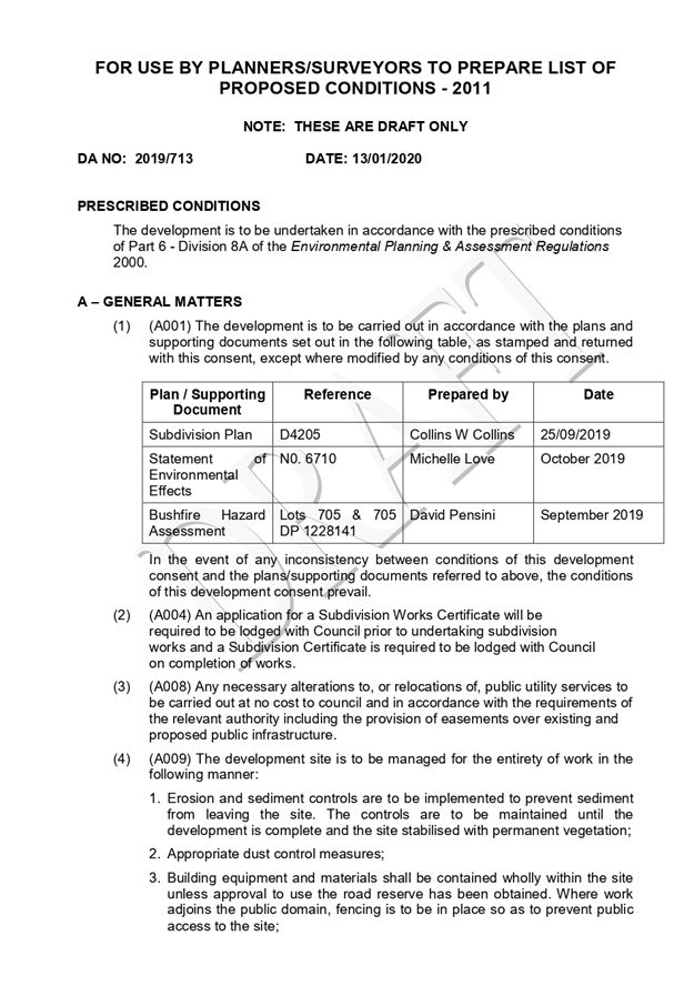

|
ATTACHMENT
|
Development Assessment Panel
22/01/2020
|
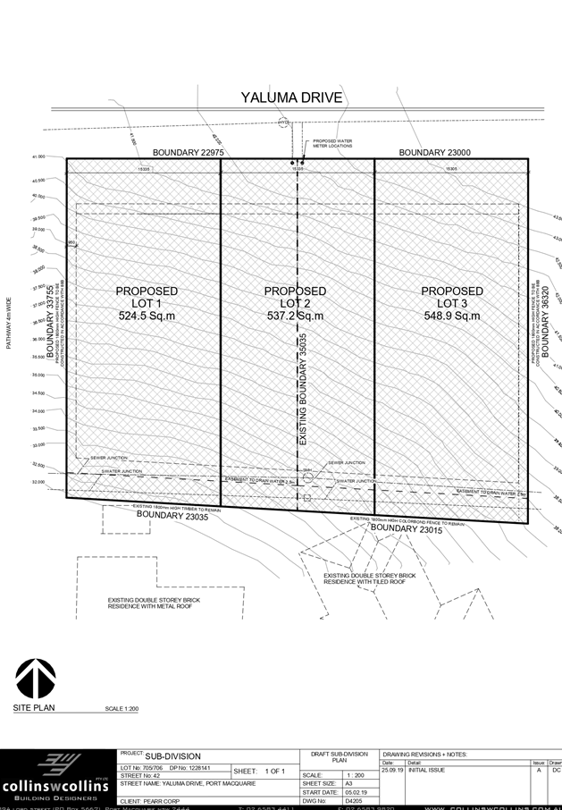
|
ATTACHMENT
|
Development Assessment Panel
22/01/2020
|
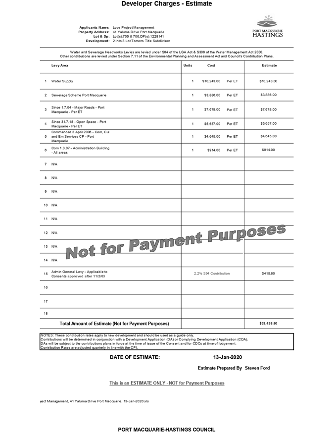
|
ATTACHMENT
|
Development Assessment Panel
22/01/2020
|
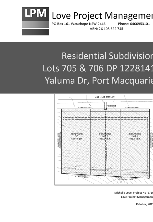

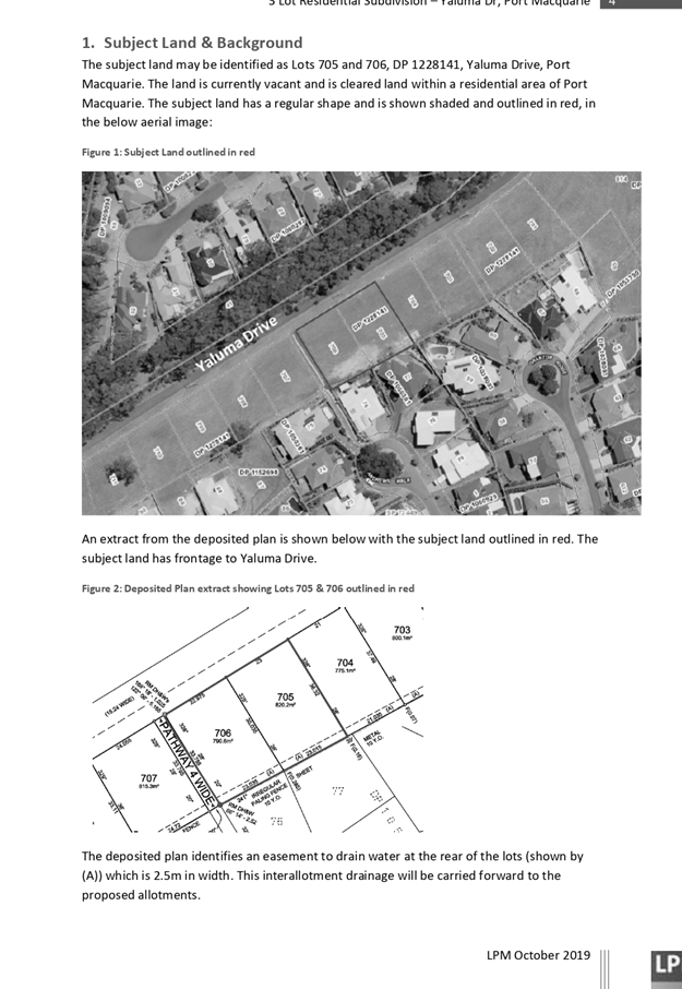
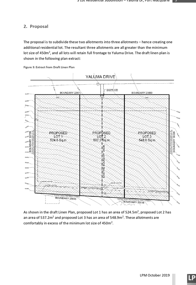
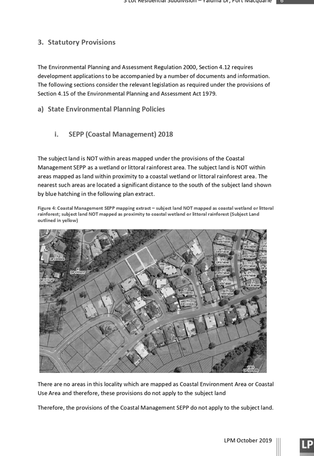
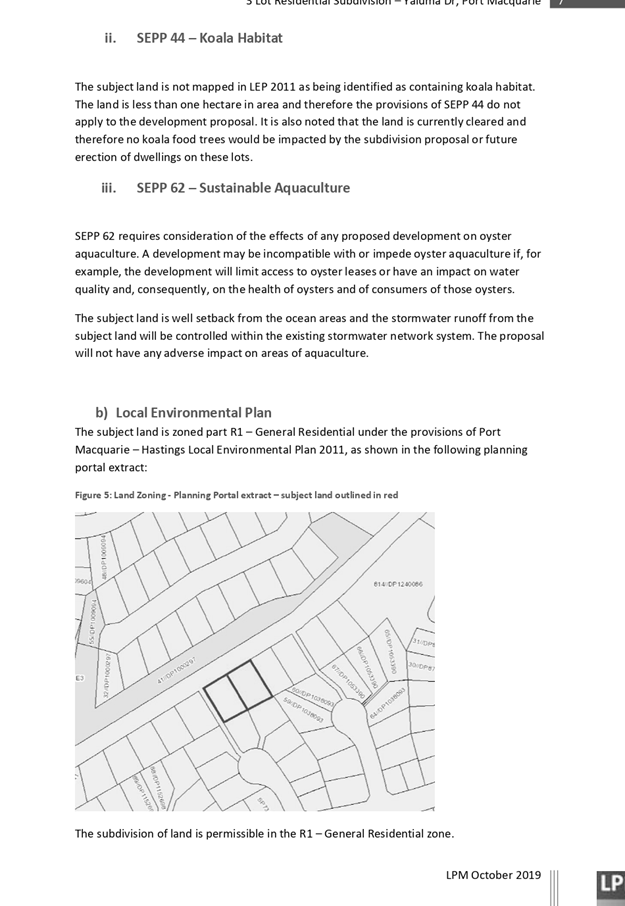
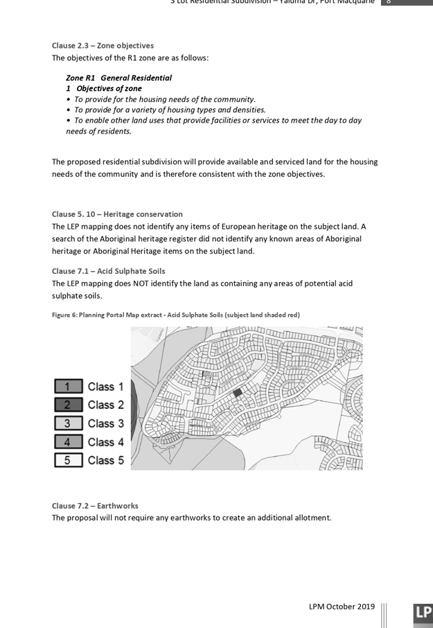
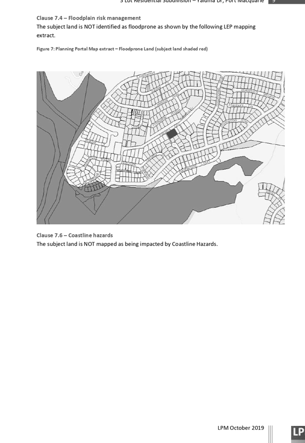
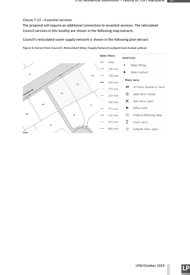
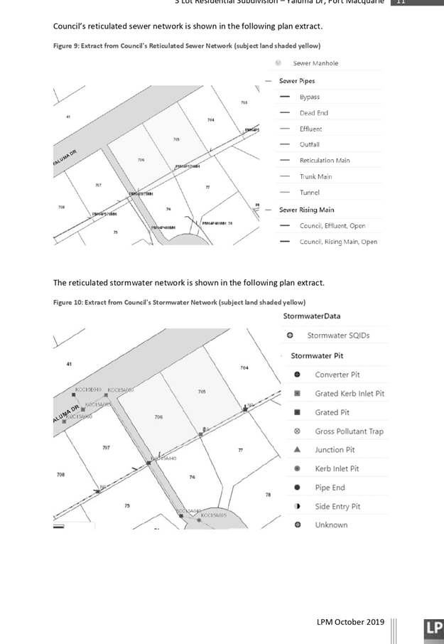
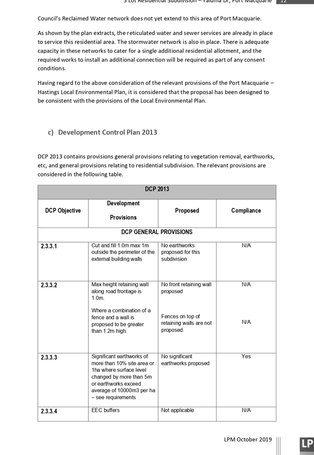
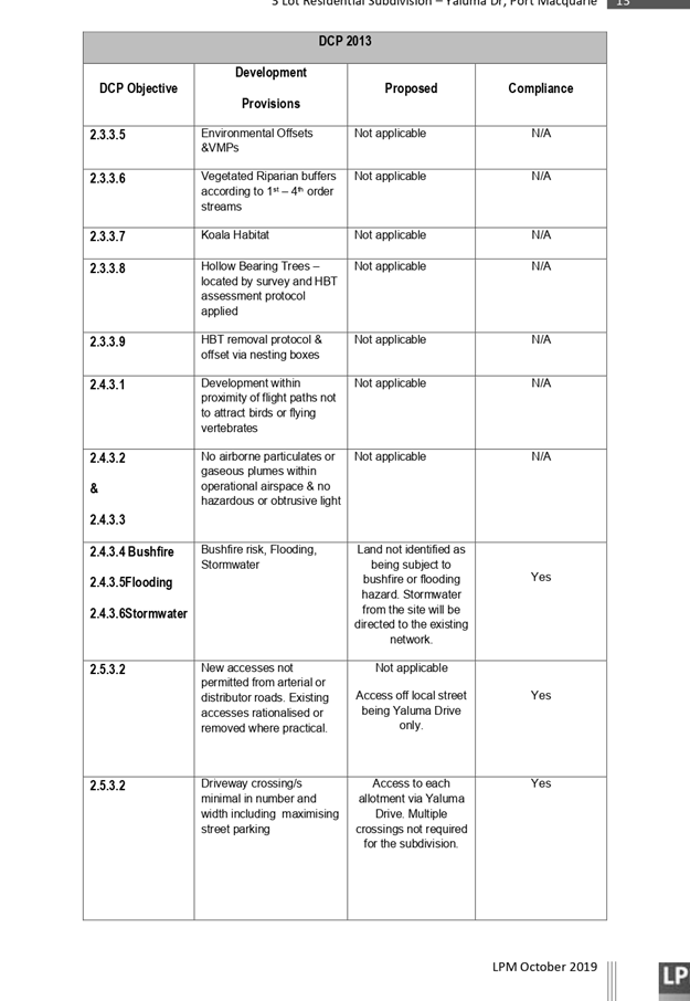
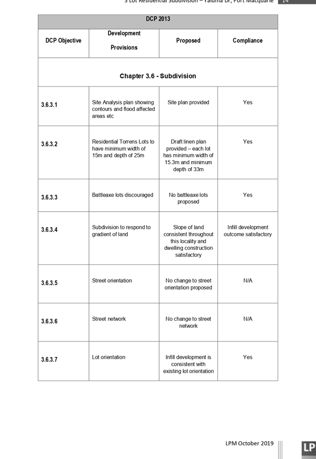
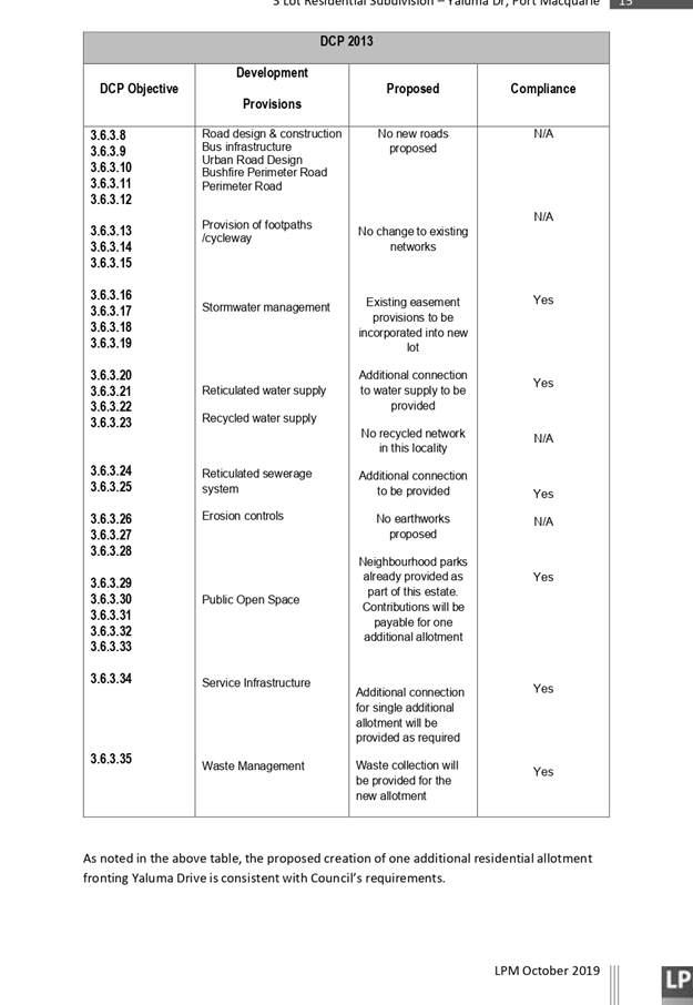
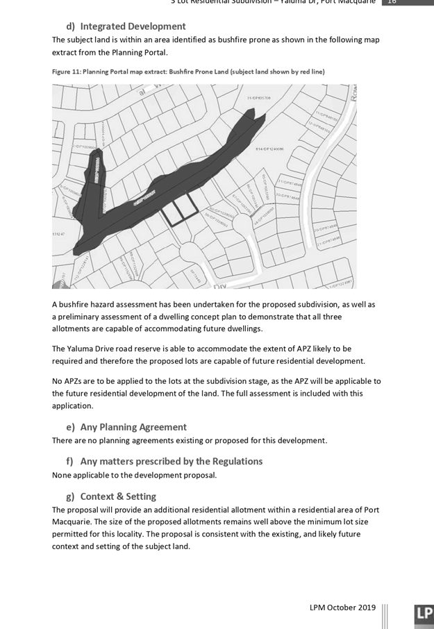
AGENDA Development Assessment Panel 22/01/2020
Item: 08
Subject: DA2019 - 694.1 Home Business - Hair Salon,
Lot 108 DP 1214480, No. 4 Sunrise Place, King Creek
Report
Author: Development Assessment Planner, Steven Ford
|
Applicant: S
& S Mitchell
Owner: S
Mitchell
Estimated Cost: $8000
Alignment with Delivery
Program
4.3.1 Undertake transparent and
efficient development assessment in accordance with relevant legislation.
|
|
RECOMMENDATION
That
DA 2019 - 694.1 for a Home
Business - Hair Salon, at Lot 108, DP 1214480, No.
4 Sunrise Place, King Creek, be
determined by granting consent subject to the recommended conditions.
|
Executive
Summary
This
report considers a development application for a Home Business - Hair
Salon, at the subject site and provides an assessment
of the application in accordance with the Environmental Planning and Assessment
Act 1979.
Following exhibition of the
application, 2 submissions were received.
The site is considered suitable for the proposed development
and the proposal adequately addresses relevant planning controls. The
development is not considered to be contrary to the public's interest and will
not result a significant adverse social, environmental or economic impact.
This report recommends that the
development application be approved subject to the attached conditions
(Attachment 1).
1. BACKGROUND
Existing
Sites Features and Surrounding Development
The site has an area of 4,623m2.
The
site is zoned R5 - Large Lot Residential in
accordance with the Port Macquarie-Hastings Local Environmental Plan 2011, as
shown in the following zoning plan:
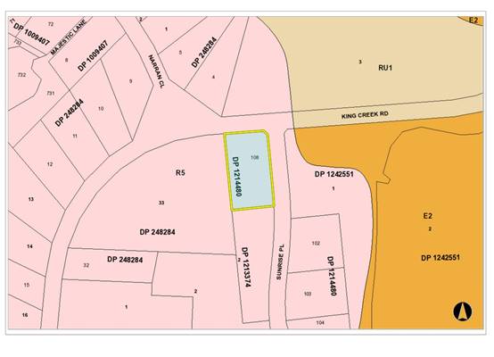
The
existing subdivision pattern and location of existing development within the
locality is shown in the following aerial photograph:
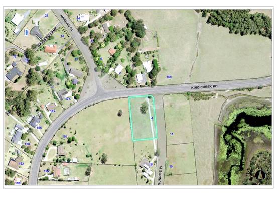
2. DESCRIPTION
OF DEVELOPMENT
Key
aspects of the proposal include the following:
· Applicant
seeking development approval for a home business - hair salon.
· 1
garage bay of the attached 3 bay garage has been converted into a hair salon.
Refer
to Attachment 2 at the end of this report for plans of the proposed
development.
Application
Chronology
· 29
September 2019 - Application submitted
· 18
October to 30 October 2019 - Public Notification Period, 2 Submissions received
· 15
November 2019 - Additional Information Requested
· 26
November 2019 - Additional information and revised plans received
3. STATUTORY
ASSESSMENT
Section
4.15(1) Matters for Consideration
In
determining the application, Council is required to take into consideration the
following matters as are relevant to the development that apply to the land to
which the development application relates:
(a) The
provisions (where applicable) of:
(i) Any
Environmental Planning Instrument
State Environmental Planning
Policy No. 64 – Advertising and Signage
The proposed development includes a business identification
sign. For the purposes of this policy, the proposed signage is considered
consistent with Division 2 Advertising and Signage Exempt Development Code of
the SEPP (Exempt and Complying development codes) 2008. One sign displayed to
the street frontage, total area less than 2.5m2 and mounted against the
existing retaining wall adjacent to the driveway. Conditions of consent have
been recommended to ensure compliance with the SEPP.
Port Macquarie-Hastings Local Environmental
Plan 2011
The proposal is consistent with the LEP having regard to the
following:
· Clause
2.2 - The subject site is zoned R5 Large Lot Residential.
· Clause
2.3(1) and the R5 zone landuse table - The proposed development for a Home
Business is a permissible landuse with consent.
home business means a business that is carried on in a dwelling, or
in a building ancillary to a dwelling, by one or more permanent residents of
the dwelling and that does not involve:
(a) the employment of more than 2
persons other than those residents, or
(b) interference with the amenity of
the neighbourhood by reason of the emission of noise, vibration, smell, fumes,
smoke, vapour, steam, soot, ash, dust, waste water, waste products, grit or
oil, traffic generation or otherwise, or
(c) the exposure to view, from any
adjacent premises or from any public place, of any unsightly matter, or
(d) the exhibition of any signage
(other than a business identification sign), or
(e) the sale of items (whether
goods or materials), or the exposure or offer for sale of items, by retail,
except for goods produced at the dwelling or building,
but does
not include bed and breakfast accommodation, home occupation (sex services) or
sex services premises.
Conditions have been recommended
restricting the business to the relevant criteria above so that the use remains
compatible with the residential locality.
The objectives of the R5 zone are as
follows:
o To provide residential housing in a rural setting while
preserving, and minimising impacts on, environmentally sensitive locations and
scenic quality.
o To ensure that large residential lots do not hinder the
proper and orderly development of urban areas in the future
o To ensure that development in the area does not
unreasonably increase the demand for public services or public facilities.
o To minimise conflict between land uses within this zone and
land uses within adjoining zones
Clause 2.3(2) - The proposal is
consistent with the zone objectives having regard to the following:
o The proposal is a permissible
landuse.
o The proposal does not have an
identifiable adverse impacts on the existing amenity. Impacts are considered
minor and manageable.
· Clause
5.4 – The home business is less than 60m2 in area and
therefore complies with this Clause.
· Clause
7.13 - Satisfactory arrangements are in place for provision of essential
services including water supply, electricity supply, on-site sewage management,
stormwater drainage and suitable road access to service the development.
·
(ii) Any draft
instruments that apply to the site or are on exhibition
No draft instruments apply to the site.
(iii) Any Development
Control Plan in force
Port
Macquarie-Hastings Development Control Plan 2013
|
DCP 2013: General Provisions
|
|
DCP Objective
|
Development Provisions
|
Proposed
|
Complies
|
|
2.7.2.2
|
Design addresses generic principles of Crime Prevention
Through Environmental Design guideline:
· Casual surveillance and
sightlines
· Land use mix and activity
generators
· Definition of use and
ownership
· Lighting
· Way finding
· Predictable routes and
entrapment locations
|
The proposed development will be unlikely to create any
concealment/entrapment areas or crime spots that would result in any
identifiable loss of safety or reduction of security in the immediate area.
|
Yes
|
|
2.5.3.3
|
Off-street parking in accordance with Table 2.5.1
|
Required:
Table 2.5-1 requires 1 space per dwelling + 1 visitor
space + 1 space per 2 employees for home businesses.
The proposal includes one employee and therefore 2.5
parking spaces are required.
Proposed:
The site plan contains 4 useable garage parking spaces as
well as 4 hardstand spaces within the driveway. No employees are presently
proposed.
Overall, the parking provision onsite exceeds the minimum
required and allows for cars to enter and exit in a forward direction.
Appropriate signage will be conditioned
|
Yes
|
|
2.5.3.11
|
Section 94 contributions
|
Refer to main body of report.
|
|
|
2.5.3.14
|
Sealed driveway surfaces unless justified
|
Existing concrete driveway.
|
Yes
|
Based on the above assessment, the proposal satisfies the
provision of the DCP.
(iiia) Any planning agreement that has
been entered into under section 7.4, or any draft planning agreement that a
developer has offered to enter into under section 7.4
No planning agreement has been offered or entered into
relating to the site.
(iv) Any
matters prescribed by the Regulations
Nil
(b) The likely
impacts of that development, including environmental impacts on both the
natural and built environments, social and economic impacts in the locality:
The site has a general western street frontage orientation
to Sunrise Place.
The proposal will not have any significant adverse impacts
to existing adjoining properties and satisfactorily addresses the public
domain.
The proposal is considered to be compatible with other
residential development in the locality and adequately addresses planning
controls for the area.
The proposal does not have significant adverse lighting
impacts.
There are no significant adverse privacy impacts.
Adequate building separation is existing.
Access, Traffic and Transport
The site has road frontage to Sunrise Place. The street is a
sealed public road under the care and control of Council. The proposal will be
unlikely to have any adverse impacts in terms access, transport and traffic.
The existing road network will satisfactorily cater for any increase in traffic
generation as a result of the development.
Parking and Manoeuvring
A total of four (4) parking spaces have been provided
on-site. Parking and driveway widths on site can comply with relevant
Australian Standards (AS 2890) and conditions have been imposed to reflect
these requirements.
Due to the type of development, car park circulation is
required to enable vehicles to enter and exit the site in a forward
manner. Site plans show adequate area is available and conditions have
been imposed to reflect these requirements.
Water Supply Connection
No Change to Existing
Sewer Connection
No new sewerage works proposed.
Stormwater
No change to existing
Other Utilities
Telecommunication and electricity services are available to
the site.
Heritage
Following a site inspection, no known items of Aboriginal or
European heritage significance exist on the property. No adverse impacts
anticipated.
Other land resources
The site is within an established urban context and will not
sterilise any significant mineral or agricultural resource.
Water cycle
The proposed development will not have any significant
adverse impacts on water resources and the water cycle.
Waste
Satisfactory arrangements are in place for proposed storage
and collection of waste and recyclables. No adverse impacts anticipated.
Standard precautionary site management condition recommended.
Noise and vibration
The construction and/or operations of the proposed
development will not result in any significant adverse impacts on the existing
air quality or result in any pollution. Condition of consent proposed to manage
hours of operation.
Bushfire
The site is identified as being bushfire prone however the
proposal does not increase the risk of bushfire. Adequate defendable space and
egress from the property is available in the event of a bushfire.
Safety, security and crime prevention
The proposed development will be unlikely to create any
security/crime risk.
Social impacts in the locality
Given the nature of the proposed development and its
location the proposal is not considered to have any significant adverse social
impacts.
Economic impact in the locality
The proposal is not considered to have any significant
adverse economic impacts on the locality.
Site design and internal design
The proposed development design satisfactorily responds to
the site attributes and will fit into the locality by not being visually
dominate from the street.
Cumulative impacts
The proposed development is not considered to have any
significant adverse cumulative impacts on the natural or built environment or
the social and economic attributes of the locality. Standard conditions are
considered adequate to control main concerns of hours of operation, off street
car parking and noise.
(c) The
suitability of the site for the development
The proposal will fit into the locality and the site
attributes are conducive to the proposed development.
Site constraints have been adequately addressed and
appropriate conditions of consent recommended.
(d) Any
submissions made in accordance with this Act or the Regulations
Two (2) written
submissions were received following public exhibition of the application.
Copies of the written submissions have been provided separately to members of
the DAP.
Key
issues raised in the submissions received and comments are provided as follows:
|
Submission Issue/Summary
|
Planning Comment/Response
|
|
The objective of R5 zoning is to "provide residential
housing in a rural setting while preserving, and minimising impacts
on.....scenic quality." The operation of a hairdressing salon and the
associated increased traffic will impact on our scenic quality and is not in
keeping with the objectives of the zoning.
There are only nine residences in our cul de sac. If
Council allow this business to operate, thereby setting a precedent, the
street would no longer be residential in a very short space of time once
other people started to operate a business from home.
|
Home Businesses/Occupations and Business identification
signage are permitted with consent within R5 large lot residential zoned
land.
The home business is proposed to be only staffed by the
home occupant.
|
|
The applicants are already advertising the business as
operating from 9.00am to 9.00pm Monday to Friday. This is outrageous. How can
a business, that has not even been approved, be operating as late as 9.00pm
each week night?
|
The Statement of Environmental Effects provided with this
application identifies proposed hours of operation to be 9am to 5 pm Monday
to Friday. Concern can be addressed with appropriate standard condition
restricting hours of operation.
|
|
The intersection of Sunrise Pl and King Creek Rd is poorly
lit, on a sweeping bend and quite dangerous at best of times. Increased
traffic leaving our cul de sac at night increases public risk and noise.
|
Applicant has confirmed hours of operation will be between
9am and 5pm, there will be no impacts during night periods. Operating
outside the approved hours can be the subject of enforcement by Council.
The home business will only have one staff, which will
restrict the number of clients and frequency of traffic movements during
operating hours. Due to the scale of the home business, there is likely to be
no adverse traffic generation and the applicant has demonstrated that there
is opportunity for more than the required off street car parking within the
driveway, which will be available at all times for customers to ensure no on
street car parking.
|
|
The intersection of Sunrise Pl and King Creek Rd is on a
sweeping bend and quite dangerous. Vehicles parked in Sunrise Place often
make entering the cul de sac dangerous as they create a blind spot to
vehicles leaving the cul de sac. Vehicles leaving the cul de sac need to
drive on the wrong side of the road around parked vehicles and a head on
accident could occur as a result.
|
The Applicant has demonstrated sufficient off street car
parking is available within the site and proposes directional signage to
indicated off street customer car parking is available.
Standard condition requiring off street car parking and
customer parking signage is considered adequate to ensure no additional
impact to the street amenity and existing traffic movement issues.
|
|
The developer has constructed a very aesthetically
pleasing stone wall greeting residents and visitors to our cul de sac. This
wall belongs to everyone in our cul de sac not the owners of number 4.
Consequently, any signage placed on or near the street will detract from our
scenic quality and breach the objectives of R5 zoning. And, because it's a
cul de sac, there is no other entry point that other residents can use to
enter the street in order to avoid an unsightly sign.
|
The mentioned sign has been removed and was not present at
the time of the site inspection.
The Applicant agreed to locate a business identification
sign with parking directions adjacent to the existing driveway against the
existing masonry retaining wall. The size of the proposed sign will be
consistent with what is considered exempt development under the State
Environmental Planning Policy (Exempt and Complying Development Codes) 2008.
The subject stone wall and entrance signage will not be
obstructed.
|
|
This business should not be allowed to operate, as it will
set a precedent. The street only has 9 residences and if each one wished to
operate a home business, we may as well be zoned retail / commercial. There
are many opportunities to operate a hair salon in Wauchope town centre with a
large number of vacant retail sites.
|
Home Businesses are permitted with consent within R5 large
lot residential zoned land and are compatible with the residential use of the
land and the neighbourhood.
|
|
We have major concerns about the ability of the sites
septic system to handle the additional effluent/chemicals from a hair salon.
The existing septic system was designed to handle effluent from a 5-bedroom
house. Already the residents have increased the number of rooms by building a
separate 3 bedroom "flat" (without consent) which is fully
occupied. The same system is being expected to also manage waste from a
business.
|
The onsite waste management system has the capacity handle
the Home Business requirements. The Applicant has statement that the chemical
waste will be similar to standard domestic usage and they are conscious of
the impact chemicals may have on the operation cycles of the septic system
and want to avoid overloading and the system failing.
The regular maintenance program of the septic system
should be sufficient to ensure it is working efficiently.
Note: During the onsite inspection, the Applicant explained
the ancillary shed was part used as a temporary residence during construction
of the primary dwelling. The area continued to be used from time to time for
family to stay. The bedrooms have now been removed to make more available
workshop space and storage. The kitchen and bathroom are still connected to
services, as it is convenient when working in the shed. The area was not
furnished or appeared to be occupied. The Applicant was undecided of the
future of the space and was going to seek further private advice over
potentially submitting a future Development Application to formalise the use
of the space. This space or ancillary use is not part of the current
assessment.
|
(e) The
Public Interest
The proposed development
satisfies relevant planning controls and will not adversely impact on the wider
public interest.
4. DEVELOPMENT
CONTRIBUTIONS APPLICABLE
Development
contributions will not be required under S64/S7.11 for the following reasons:
Cost of works are not greater than $100,000 and due to the small floor area S64
water headworks charges are under the $2,000.00 cap and considered exempt.
5. CONCLUSION
AND STATEMENT OF REASON
The application has been assessed in accordance with Section
4.15 of the Environmental Planning and Assessment Act 1979.
Issues raised during assessment and public exhibition of the
application have been considered in the assessment of the application. Where
relevant, conditions have been recommended to manage the impacts attributed to
these issues.
The site is considered suitable for the proposed development
and the proposal adequately addresses relevant planning controls. The
development is not considered to be contrary to the public's interest and will
not result a significant adverse social, environmental or economic impact. It
is recommended that the application be approved, subject to the recommended
conditions of consent provided in the attachment section of this report.
|
Attachments
1View. DA2019
- 694.1 Recommended Conditions
2View. DA2019
- 694.1 Plans
3View. DA2019
- 694.1 SOEE
|
|
ATTACHMENT
|
Development Assessment Panel
22/01/2020
|
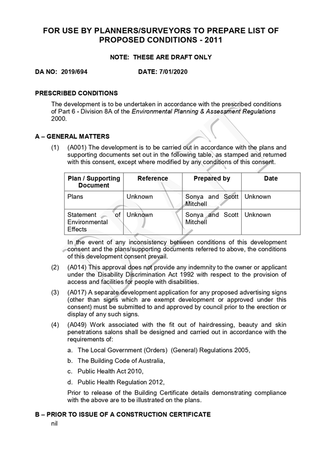

|
ATTACHMENT
|
Development Assessment Panel
22/01/2020
|
|
ATTACHMENT
|
Development Assessment Panel
22/01/2020
|
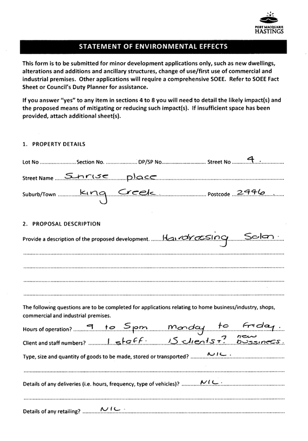
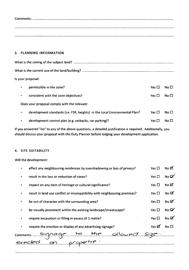
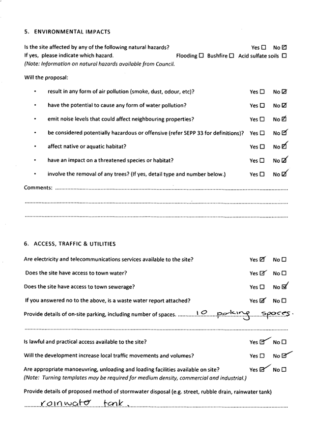
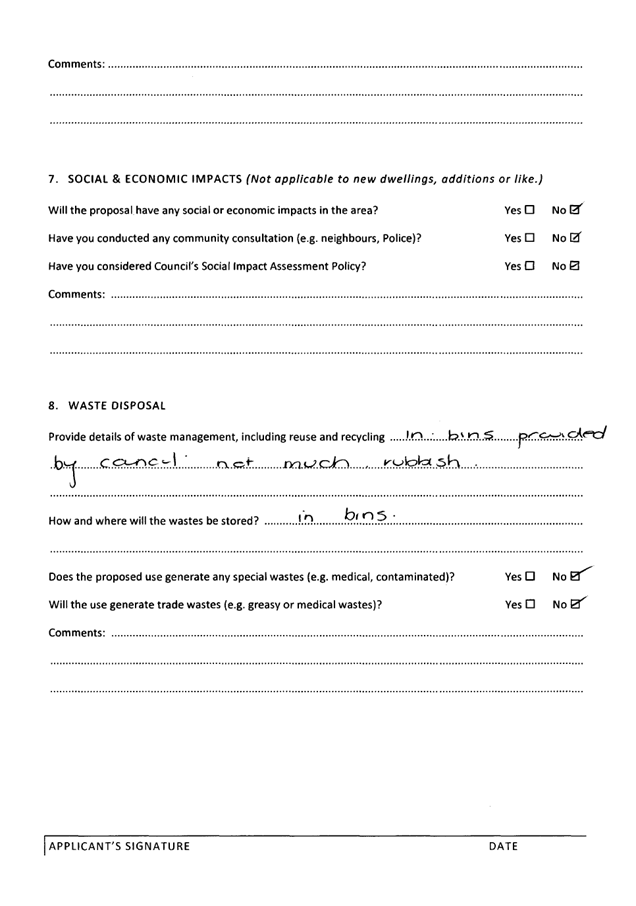
AGENDA Development Assessment Panel 22/01/2020
Item: 09
Subject: DA2019 - 673.1 Modification to General Store
(Aldi) - Altered Delivery Hours - Lot 701 DP 1151916,No 3 Hughes Place, Port
Macquarie
Report
Author: Development Assessment Planner, Fiona Tierney
|
Applicant: ALDI
Stores
Owner: ALDI
Stores
Estimated Cost: Nil
Alignment with Delivery
Program
4.3.1 Undertake transparent and
efficient development assessment in accordance with relevant legislation.
|
|
RECOMMENDATION
That
DA 2019 - 673.1 for a change
to delivery hours at an existing general store at Lot 701, DP 1151916, No. 3 Hughes
Place, Port Macquarie, be determined by granting consent subject to the
recommended conditions.
|
Executive
Summary
This
report considers a development application for a change to delivery hours at
the subject site and provides an assessment of the application in accordance
with the Environmental Planning and Assessment Act 1979.
Following exhibition of the
application, three (3) submissions were
received.
The site is considered suitable for the proposed development
and the proposal adequately addresses relevant planning controls. The
development is not considered to be contrary to the public's interest and will
not result a significant adverse social, environmental or economic impact.
This report recommends that the
development application be approved subject to the conditions included as
Attachment 1.
1. BACKGROUND
Existing
Sites Features and Surrounding Development
The site has an area of 5925m2.
The
site is zoned B5- Business Development in
accordance with the Port Macquarie-Hastings Local Environmental Plan 2011, as
shown in the following zoning plan:
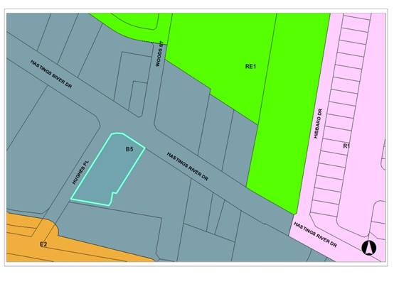
The
existing subdivision pattern and location of existing development within the
locality is shown in the following aerial photograph:
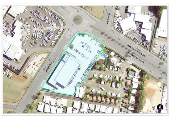
2. DESCRIPTION
OF DEVELOPMENT
Key
aspects of the proposal include the following:
· Change
of delivery hours from existing 7am to 10pm to allow 24 hours per day/ 7 days
per week
Refer
to Attachment 2 at the end of this report for plans of the proposed
development.
Application
Chronology
· 19
September 2019 - Application submitted.
· 30 September 2019 to 15 October 2019 - Public Notification
period - 3 Submissions.
· 23 October 2019 - additional information request for noise
assessment and acoustic fence.
· 18 November 2019 - additional information received.
· November/December 2019 - Clarification on noise levels and
mitigation measures.
3. STATUTORY
ASSESSMENT
Section
4.15(1) Matters for Consideration
In
determining the application, Council is required to take into consideration the
following matters as are relevant to the development that apply to the land to
which the development application relates:
(a) The
provisions (where applicable) of:
(i) Any
Environmental Planning Instrument
Port Macquarie-Hastings Local Environmental
Plan 2011
The existing development was approved as a ‘General
Store’ under the Hastings Local Environmental Plan 2001 and is therefore
an ‘existing use’ under the Act. The proposed modification to
delivery hours is consistent with the current LEP having regard to the
following.
· Clause
2.2 - The subject site is zoned B5 Business Development.
·
The objectives of the B5 zone are as follows:
o To enable a mix of business and warehouse uses, and bulky
goods premises that require a large floor area, in locations that are close to,
and the support the viability of, centres.
o To minimise conflict between land uses within the zone and
with adjoining zones.
o To ensure that new developments make a positive
contribution to the public domain and streetscape.
· Clause
2.3(2) - The proposal is consistent with the zone objectives having regard to
the following:
o The proposal is a permissible
landuse noting the existing use.
o With proposed conditions of
consent, the development will be callable of minimising conflict with neighbouring
land uses.
o The proposal represents a
minor change to the existing development.
(ii) Any draft
instruments that apply to the site or are on exhibition
No draft instruments apply to the site.
(iii) Any Development
Control Plan in force
Port
Macquarie-Hastings Development Control Plan 2013
No relevant clauses apply to
change in delivery hours.
(iiia) Any planning agreement that has
been entered into under section 7.4, or any draft planning agreement that a
developer has offered to enter into under section 7.4
No planning agreement has been offered or entered into
relating to the site.
(iv) Any
matters prescribed by the Regulations
Nil
(b) The likely
impacts of that development, including environmental impacts on both the
natural and built environments, social and economic impacts in the locality:
The site has a general western street frontage orientation
to Hughes Place with a secondary frontage to Hastings River Drive.
Deliveries are made via an existing driveway along the
southern boundary.
The proposal is considered to be consistent with other
commercial development in the locality and adequately addresses planning
controls for the area.
Access, Traffic and Transport
The site has road frontage to Hughes Place. The street is a
sealed public road under the care and control of Council. The proposal will be
unlikely to have any adverse impacts in terms access, transport and traffic.
The existing road network will satisfactorily cater for any increase in traffic
generation as a result of the development.
Parking and Manoeuvring
Existing.
Water Supply Connection
No Change to Existing
Sewer Connection
No new sewerage works proposed.
Stormwater
No change to existing
Other Utilities
Telecommunication and electricity services are available to
the site.
Noise and vibration
There is currently a history of non-compliance with
permitted delivery hours and complaints in relation to noise. Council’s
Environmental Health Officer has reviewed the noise impact assessment and
considers that the proposal is capable of meeting the requirements of the NSW
EPA Noise policy for industry (which is a guideline only for assessment, not a
legislative instrument or standard). Discussions were held with the EPA Noise
Team, who confirmed that the appropriate methodology was applied in the
assessment.
There are some concerns that even though the report states
that the site will meet the requirements of the Policy once the controls are in
place, that it is still may cause sleep disturbance of sensitive caravan park
residents. In an attempt to reduce the disturbance caused by this development,
it is recommended that the following be included in any conditions of consent:
· That
the trucks are to turn off the refrigeration units prior to entering the site and
‘quacker’ type reversing beepers are to be installed on trucks.
· That
the number of trucks between 7pm and 7am is limited to two. Aldi is to keep
record of the delivery arrival and departures during this time, and make it
available to council on request.
· That
the predicted noise measurements be validated by an appropriately qualified
person within 6 months of consent, and a report sent to council confirming that
it meets or the noise level is lower the predictions. If the predicted noise
levels cannot be met, additional attenuation is to be added and no deliveries
between 10pm and 7am can be made until it is at or below the predicted noise
levels in the MAC Report.
· The
noise control measures indicated in the acoustic report are to be installed
prior to any deliveries occurring between 10pm and 7am
· An
additional RW28 acoustic lining be provided to the existing southern boundary
fence which adjoins the loading area and the permanent residents of the caravan
park.
Safety, security and crime prevention
The proposed development will be unlikely to create any
increase security/crime risk. The increase in activity will improve
natural surveillance within the locality.
Social impacts in the locality
With appropriate noise management measures as recommended,
the proposal is not considered to have any significant adverse social impacts.
Economic impact in the locality
The proposal is not considered to have any significant
adverse economic impacts on the locality.
Cumulative
Impacts
The proposed development is not considered to have any
significant adverse cumulative impacts on the natural or built environment or
the social and economic attributes of the locality. Standard and specific
conditions are considered adequate to control main concerns of hours of
operation and noise.
(c) The
suitability of the site for the development
The proposal will fit into the locality and the site
attributes are conducive to the proposed development.
Site constraints have been adequately addressed and
appropriate conditions of consent recommended.
(d) Any
submissions made in accordance with this Act or the Regulations
Three written
submissions were received following public exhibition of the application.
Copies of the written submissions have been provided separately to members of
the DAP.
Key
issues raised in the submissions received and comments are provided as follows:
|
Submission Issue/Summary
|
Planning Comment/Response
|
|
Noise issues, paling fence has
no noise cancelling construction, refrigeration unit left going and noise and
vibration disturbing whilst unloading.
|
Noted. A condition of consent
is proposed recommending:
-Compliance with the acoustic
report
-Turning off refrigeration
units prior to entering the site
-The installation of an
acoustic lined panelling to the existing fence or a solid masonry fence for
the full length of the southern boundary
- Use of quacker reversing
beepers on trucks
- Limitation to 2 deliveries
to the site per night
- Lining of the delivery dock
With the above mitigation
measures in place, impacts are considered to be acceptable and not of a
significance that would justify refusal of the application.
|
|
History of non-compliance with delivery hours and noise
limitations.
|
It is acknowledged that there is some history of non-
compliances and that the proposed conditions will establish clear controls.
|
|
Current deliveries are disturbing to neighbours- even
within approved times.
|
It is considered that the recommended conditions will
minimise the impacts to the residents within the caravan park.
|
(e) The
Public Interest
The proposed development
satisfies relevant planning controls and will not adversely impact on the wider
public interest.
4. DEVELOPMENT
CONTRIBUTIONS APPLICABLE
Not
applicable- change to delivery times only
5. CONCLUSION
AND STATEMENT OF REASON
The application has been assessed in accordance with Section
4.15 of the Environmental Planning and Assessment Act 1979.
Issues raised during assessment and public exhibition of the
application have been considered in the assessment of the application. Where
relevant, conditions have been recommended to manage the impacts attributed to
these issues.
The site is considered suitable for the proposed development
and the proposal adequately addresses relevant planning controls. The
development is not considered to be contrary to the public's interest and will
not result a significant adverse social, environmental or economic impact. It
is recommended that the application be approved, subject to the recommended
conditions of consent provided in the attachment section of this report.
|
Attachments
1View. DA2019
- 673.1 Recommended Conditions
2View. DA2019
- 673.1 SoEE
3View. DA2019
- 673.1 Noise Impact Assessment
|
|
ATTACHMENT
|
Development Assessment Panel
22/01/2020
|

|
ATTACHMENT
|
Development Assessment Panel
22/01/2020
|
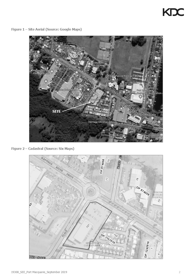
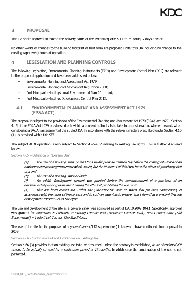
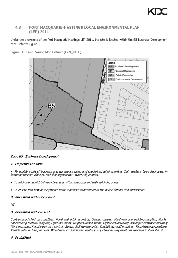
|
ATTACHMENT
|
Development Assessment Panel
22/01/2020
|