Development
Assessment Panel
Business
Paper
|
date of meeting:
|
|
Wednesday 6 May 2020
|
|
location:
|
|
Via Skype
|
|
time:
|
|
2:00pm
|
Development
Assessment Panel
CHARTER
1.0 OBJECTIVES
To assist in managing Council's development assessment
function by providing independent and expert determinations of development
applications that fall outside of staff delegations.
2.0 KEY FUNCTIONS
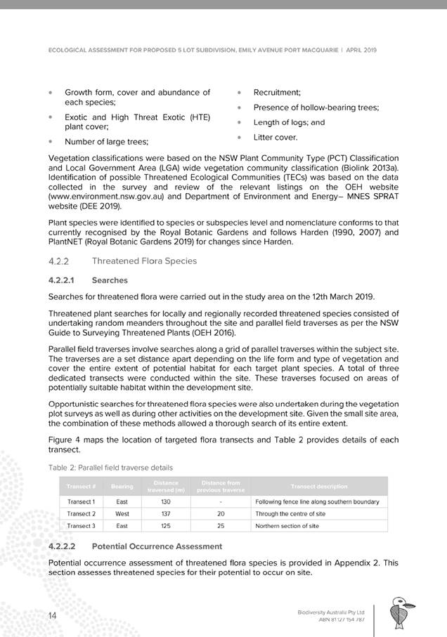
·
To review development application reports and conditions;
·
To determine development
applications outside of staff delegations;
·
To refer development applications
to Council for determination where necessary;
·
To provide a forum for objectors and applicants
to make submissions on applications
before the Development Assessment Panel
(DAP);
·
To maintain transparency in the determination of development
applications.
Delegated Authority of Panel
Pursuant to
Section 377 of the Local Government Act, 1993 delegation to:
·
Determine development applications under Part 4
of the Environmental Planning and Assessment
Act 1979 having
regard to the relevant environmental planning instruments,
development control plans and Council policies.
·
Vary, modify or release restrictions as to use and/or
covenants created by Section 88B instruments under the Conveyancing Act 1919 in
relation to development applications for subdivisions being considered by the panel.
·
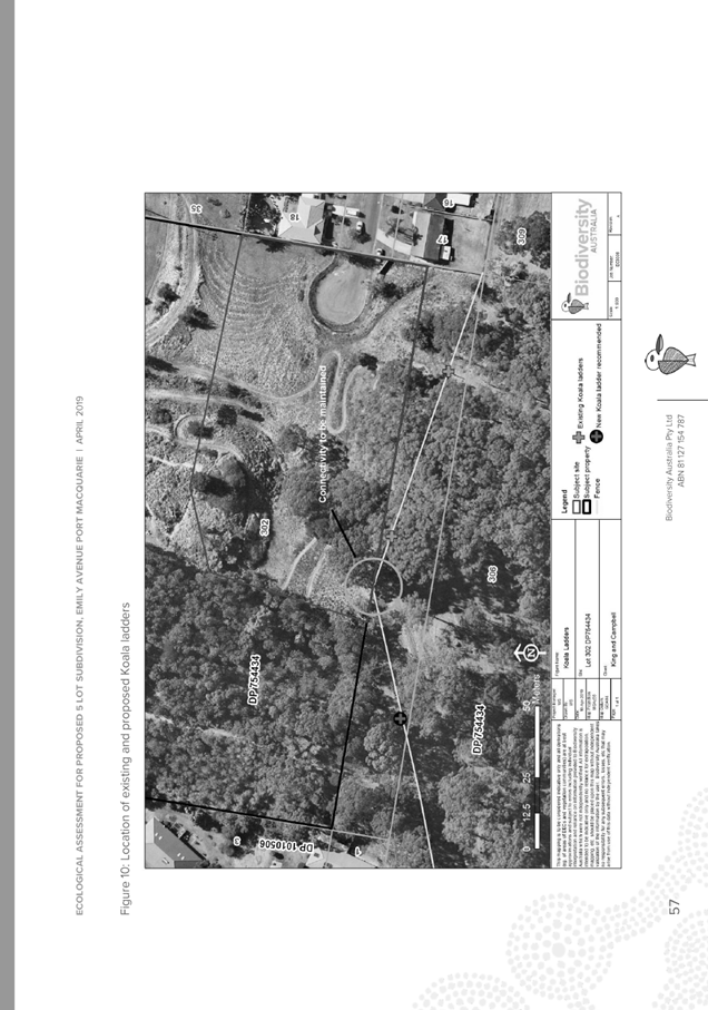
Determine Koala Plans of Management under State
Environmental Planning Policy 44 - Koala Habitat Protection associated with
development applications being considered by the Panel.
Noting the trigger to escalate
decision making to Council as highlighted in section 5.2.
3.0
MEMBERSHIP
3.1
Voting
Members
·
Two independent external members. One of the
independent external members to be the Chairperson.
·
Group Manager Development Assessment (alternate
- Director Development & Environment or Development Assessment Planner)
The independent external members shall have expertise in
one or more of the following areas: planning, architecture, heritage, the
environment, urban design, economics, traffic and transport, law, engineering,
government and public administration.
3.2
Non-Voting Members
·
Not applicable
3.3 Obligations
of members
·
Members must act faithfully and diligently and
in accordance with this Charter.
·
Members must comply with Council's Code of Conduct.
·
Except as required to properly perform their
duties, DAP members must not
disclose any confidential information (as advised by Council) obtained in connection with the DAP functions.
·
Members will have read and be familiar with the
documents and information provided by Council prior
to attending a DAP meeting.
·
Members must act in accordance with Council's
Workplace Health and Safety Policies and Procedures
·
External members of the Panel are not authorised
to speak to the media on behalf of Council. Council officers that are members
of the Committee are bound by the
existing operational delegations in relation to speaking to the media.
·
Staff members shall not vote on matters before
the Panel if they have been the principle author of the development assessment report.
3.4
Member Tenure
·
The independent external members will be
appointed for the term of four (4) years
maximum in which the end of the tenure of these members would occur in a
cascading arrangement.
3.5 Appointment
of members
·
The independent external members (including the
Chair) shall be appointed by the General Manager following an external
Expression of Interest process.
·
Staff members of the Panel are in accordance
with this Charter.
4.0 TIMETABLE
OF MEETINGS
·
The Development Assessment Panel will generally
meet on the 1st and 3rd Wednesday each month at 2.00pm at the Port Macquarie
offices of Council.
·
Special Meetings of the Panel may be convened by
the Director Development & Environment Services with three (3) days notice.
5.0
MEETING PRACTICES
5.1
Meeting
Format
·
At all Meetings of the Panel the Chairperson
shall occupy the Chair and preside. The Chair will be responsible for keeping
of order at meetings.
·
Meetings shall be open to the public.
·
The Panel will hear from applicants
and objectors or their r e p r e s e n t a t i v e s .
·
Where considered necessary, the Panel will
conduct site inspections which will
be open to the public.
5.2
Decision Making
·
Decisions are to be made by consensus. Where
consensus is not possible on any item, that item is to be referred to Council
for a decision.
·
All development applications involving a
proposed variation to a development standard
greater than 10% under Clause
4.6 of the Local Environmental Plan will be
considered by the Panel and recommendation made to the Council for a decision.
5.3
Quorum
·
All members (2 independent external members and
1 staff member) must be present at a
meeting to form a quorum.
5.4
Chairperson and Deputy Chairperson
·
Independent Chair (alternate, second independent member)
5.5
Secretariat
·
The Director Development &n Environment is
to be responsible for ensuring that the Panel has adequate secretariat support.
The secretariat will ensure that the business paper and supporting papers are
circulated at least three (3) days prior to
each meeting. Minutes shall be appropriately approved and circulated to each
member within three (3) weeks of a meeting being held.
·
The format of and the preparation and publishing
of the Business Paper and Minutes shall be similar to the format for Ordinary
Council Meetings.
5.6
Recording of decisions
·
Minutes will record decisions and how each
member votes for each item before the Panel.
6.0 CONVENING
OF “OUTCOME SPECIFIC” WORKING GROUPS
Not applicable.
7.0 CONFIDENTIALITY
AND CONFLICT OF INTEREST
·
Members of the Panel must comply with the
applicable provisions of Council’s Code of Conduct. It is the personal
responsibility of members to comply with the standards in the Code of Conduct
and regularly review their personal circumstances with this in mind.
·
Panel members must declare any conflict of
interests at the start of each meeting or before discussion of a relevant item
or topic. Details of any conflicts of interest should be appropriately minuted.
Where members are deemed to have a real or perceived conflict of interest, it
may be appropriate they be excused from deliberations on the issue where the conflict
of interest may exist. A Panel meeting may be postponed where there is no quorum.
8.0 LOBBYING
§ All members and applicants are to adhere to Council’s Lobbying
policy. Outside of scheduled
Development Assessment Panel meetings, applicants, their representatives,
Councillors, Council staff and the general public are not to lobby Panel
members via meetings, telephone conversations, correspondence and the like.
Adequate opportunity will be provided at Panel inspections or meetings for
applicants, their representatives and the general public to make verbal
submissions in relation to Business Paper items.
Development Assessment Panel
ATTENDANCE
REGISTER
|
Member
|
22/01/20
|
12/02/20
|
26/02/20
|
11/03/20
|
25/03/20
|
08/04/20
|
|
Paul
Drake
|
P
|
P
|
P
|
P
|
P
|
P
|
|
Robert
Hussey
|
|
P
|
P
|
P
|
|
P
|
|
David
Crofts
(alternate member)
|
P
|
|
|
|
P
|
|
|
Dan
Croft
(Group Manager Development Assessment)
(alternates)
- Development Assessment Planner
|
P
|
P
|
P
|
P
|
P
|
P
|
Key: P = Present
A
= Absent With Apology
X
= Absent Without Apology
Meeting Dates for
2020
|
22/01/2020
|
Function Room
|
2:00pm
|
|
12/02/2020
|
Function Room
|
2:00pm
|
|
26/02/2020
|
Function Room
|
2:00pm
|
|
11/03/2020
|
Function Room
|
2:00pm
|
|
25/03/2020
|
Function Room
|
2:00pm
|
|
8/04/2020
|
Function Room
|
2:00pm
|
|
6/05/2020
|
Function Room
|
2:00pm
|
|
27/05/2020
|
Function Room
|
2:00pm
|
|
10/06/2020
|
Function Room
|
2:00pm
|
|
24/06/2020
|
Function Room
|
2:00pm
|
|
8/07/2020
|
Function Room
|
2:00pm
|
|
22/07/2020
|
Function Room
|
2:00pm
|
|
12/08/2020
|
Function Room
|
2:00pm
|
|
26/08/2020
|
Function Room
|
2:00pm
|
|
9/09/2020
|
Function Room
|
2:00pm
|
|
30/09/2020
|
Function Room
|
2:00pm
|
|
14/10/2020
|
Function Room
|
2:00pm
|
|
28/10/2020
|
Function Room
|
2:00pm
|
|
11/11/2020
|
Function Room
|
2:00pm
|
|
25/11/2020
|
Function Room
|
2:00pm
|
|
16/12/2020
|
Function Room
|
2:00pm
|
Development
Assessment Panel Meeting
Wednesday 6 May 2020
Items of Business
01 Acknowledgement
of Country............................................................................. 6
02 Apologies.......................................................................................................... 6
03 Confirmation
of Minutes..................................................................................... 6
04 Disclosures
of Interest....................................................................................... 6
05 DA2019
- 309.1 Residential Subdivision at Lot 302 DP 754434 Emily Avenue, Port
Macquarie 6
06 DA2019
- 883.1 Dwelling at Lot 14 DP 28743, No. 24 Coral Street, North Haven... 6
07 DA2020
- 122.1 Alterations and Additions to Dwelling at Lot 20 DP 262273, No 11 Timber
Ridge Port Macquarie.................................................................................................. 6
08 DA2020
- 63.1 Dwelling at Lot 2 DP 1143498, No. 4A Hibiscus Cresent, Port Macquarie 6
09 DA2019
- 277.1 Cafe and Associated Car Parking at Lot 5 DP 524972, Parklands Close,
Port Macquarie......................................................................................................... 6
10 Section
4.55 DA2004 - 526.3 Modification to Hours of Operation and Conditions of
Consent Associated with Previous Approved Industrial Building/Workshop at 10
Glen Ewan Road, Sancrox........................................................................................................................ 6
11 General
Business
AGENDA Development Assessment Panel 06/05/2020
Subject: ACKNOWLEDGEMENT
OF COUNTRY
"I acknowledge that we are
gathered on Birpai Land. I pay respect to the Birpai Elders both past and
present. I also extend that respect to all other Aboriginal and Torres Strait
Islander people present."
RECOMMENDATION
That the apologies received be
accepted.
Subject: CONFIRMATION
OF PREVIOUS MINUTES
Recommendation
That the Minutes of the Development Assessment Panel Meeting
held on 8 April 2020 be confirmed.
MINUTES
Development Assessment Panel Meeting
08/04/2020
PRESENT
Members:
Paul
Drake
Robert Hussey
Dan Croft
Other Attendees:
Grant Burge
Pat
Galbraith-Robertson
Ben
Roberts
Cheryl
Lowe
|
The meeting opened at 2:00pm.
|
|
01 ACKNOWLEDGEMENT
OF COUNTRY
|
|
The
Acknowledgement of Country was delivered.
|
|
03 CONFIRMATION
OF MINUTES
|
|
CONSENSUS:
That
the Minutes of the Development Assessment Panel Meeting held on 25 March 2020
be confirmed.
|
|
04 DISCLOSURES
OF INTEREST
|
|
There were no disclosures of interest presented.
|
|
05 DA2019 - 676.1
Residential Flat Building including Clause 4.6 Objection to Clause 4.3
(Height of Buildings) of the Port Macquarie-Hastings Local Environmental Plan
2011 at Lot 1 DP 1211682, 5 Drew Close, Port Macquarie
|
|
Speakers:
Wayne Ellis (applicant)
David Pensini (applicant)
Chris Lloyd (applicant)
The Panel was unable to reach consensus.
MOTION: Paul Drake:
That it be recommended to Council that DA 2019 - 676.1
for a residential flat building including clause 4.6 objection to clause 4.3
(height of buildings) of the Port Macquarie-Hastings Local Environmental Plan
2011 at Lot 1, DP 1211682, No. 5 Drew Close, Port Macquarie, be determined by
granting consent subject to the recommended conditions with the following
amendment:
- Condition B2
be amended to include point 11 stating: ‘If warranted by Council,
a give way sign is to be installed at the intersection drew Close and
Warlters St.’
FOR: Paul Drake and Dan Croft
AGAINST: Robert Hussey
DISSENTING MOTION: Robert Hussey:
That it be recommended to Council that DA 2019 - 676.1
for a residential flat building including clause 4.6 objection to clause 4.3
(height of buildings) of the Port Macquarie-Hastings Local Environmental Plan
2011 at Lot 1, DP 1211682, No. 5 Drew Close, Port Macquarie, be determined by
refusing consent for the following reasons:
1.
That the application does not
adequately satisfy the design guidelines in SEPP 65 and the ADG, where the
provisions of Section 3H – Vehicle access, requires such access to
achieve safety and minimise conflicts between pedestrians and vehicles
…
2.
The designated main pedestrian
access on the 1st floor passes very close to the entry to Unit
101,then past the garage openings for garages 22 and 23, turning a blind
corner to the lift lobby area, where a number of residents/ visitors could be
waiting.
3.
This waiting area is also on the
entry/exit path for garages 24 and 24A, which are in tandem configuration
that generally involves more manoeuvring space. And it will pass over part of
the lift lobby area and conflicts with garages 22 and 23 manoeuvring.
4.
Consequently, the lift waiting
area is not safe with the anticipated level of conflicting car movements in
close proximity to pedestrians waiting and exiting the lift. Those exiting
pedestrians, both residents and visitors then have to traverse the path via a
blind corner walking past the garage openings for Spaces 23 and 22 to safely
exit the building.
5.
Also, the proposal does not
adequately satisfy the 3 D Communal Open Space and associated Principle 6
guidelines for amenity for residents. In particular, the side wall of Unit
203 is adjacent to the swimming pool and it has screened window opening along
the common wall. The acoustic and privacy amenity will not achieve a
satisfactory outcome for this unit.
|
|
06 DA2019 -
867.1- Multi Dwelling Housing and Strata Title Subdivision at Lot 110
DP788310, No.18 Montague Street, Port Macquarie
|
|
Speakers:
James Collins (applicant)
Stephen Johnson (applicant)
CONSENSUS:
That
DA2019 - 867 for a multi dwelling housing and strata title subdivision
at Lot 110, DP 788310, No. 18 Montague
Street, Port Macquarie, be determined by granting consent subject to the
recommended conditions and as amended below:
- Additional
condition in Section B of the consent to read: ‘Prior to release
of the construction certificate amended plans are to be submitted
providing for opaque balustrades for the first floor western facing
balconies of units 1 and 2.’
- Additional
condition in Section B of the consent to read: ‘Prior to release
of the construction certificate amended plans are to be submitted
providing for the raising of the window sill height of the kitchen and
dining room western facing window of unit 3 by one third (i.e
removal of the bottom window pane for the full length of the
window)’.
- Additional
condition in Section B of the consent to read: ‘Prior to release
of the construction certificate amended plans are to be submitted for
Council approval providing for the front courtyard fences of Units 1 and
2 to be constructed with alternative treatments (i.e not solely timber
paling). Landscaping is to be provided in the recessed and 900mm setback
areas of the fence and include the provision of mature trees.’
|
|
The meeting closed at 3:50pm.
|
AGENDA Development Assessment Panel 06/05/2020
Subject: DISCLOSURES
OF INTEREST
RECOMMENDATION
That Disclosures of Interest be presented
DISCLOSURE OF
INTEREST DECLARATION
|
Name of Meeting:
|
|
Meeting
Date:
|
|
Item
Number:
|
|
Subject:
|
|
I,
the undersigned, hereby declare the following interest:
Pecuniary:
 Take no part
in the consideration and voting and be out of sight of the meeting. Take no part
in the consideration and voting and be out of sight of the meeting.
Non-Pecuniary
– Significant Interest:
Take no part
in the consideration and voting and be out of sight of the meeting.
Non-Pecuniary
– Less than Significant Interest:
May
participate in consideration and voting.
|
|
For
the reason that:
|
|
Name:
Signed:
|
Date:
|
|
Please submit to the
Governance Support Officer at the Council Meeting.
|
 (Refer
to next page and the Code of Conduct)
(Refer
to next page and the Code of Conduct)
Pecuniary Interest
4.1
A pecuniary interest is an interest
that you have in a matter because of a reasonable likelihood or expectation of
appreciable financial gain or loss to you or a person referred to in clause
4.3.
4.2
You will not have a pecuniary
interest in a matter if the interest is so remote or insignificant that it
could not reasonably be regarded as likely to influence any decision you might
make in relation to the matter, or if the interest is of a kind specified in
clause 4.6.
4.3
For the purposes of this Part, you
will have a pecuniary interest in a matter if the pecuniary interest is:
(a)
your interest, or
(b)
the interest of your spouse or de
facto partner, your relative, or your partner or employer, or
(c)
a company or other body of which
you, or your nominee, partner or employer, is a shareholder or member.
4.4
For the purposes of clause 4.3:
(a)
Your “relative” is any
of the following:
(b)
“de facto partner” has
the same meaning as defined in section 21C of the Interpretation Act 1987.
4.5
You will not have a pecuniary
interest in relation to a person referred to in subclauses 4.3(b) or (c)
(a)
if you are unaware of the relevant
pecuniary interest of your spouse, de facto partner, relative, partner,
employer or company or other body, or
(b)
just because the person is a member
of, or is employed by, a council or a statutory body, or is employed by the
Crown, or
(c)
just because the person is a member
of, or a delegate of a council to, a company or other body that has a pecuniary
interest in the matter, so long as the person has no beneficial interest in any
shares of the company or body.
Non-Pecuniary
5.1
Non-pecuniary interests are private
or personal interests a council official has that do not amount to a pecuniary
interest as defined in clause 4.1 of this code. These commonly arise out of
family or personal relationships, or out of involvement in sporting, social,
religious or other cultural groups and associations, and may include an
interest of a financial nature.
5.2
A non-pecuniary conflict of
interest exists where a reasonable and informed person would perceive that you
could be influenced by a private interest when carrying out your official functions
in relation to a matter.
5.3
The personal or political views of
a council official do not constitute a private interest for the purposes of
clause 5.2.
5.4
Non-pecuniary conflicts of interest
must be identified and appropriately managed to uphold community confidence in
the probity of council decision-making. The onus is on you to identify any
non-pecuniary conflict of interest you may have in matters that you deal with,
to disclose the interest fully and in writing, and to take appropriate action
to manage the conflict in accordance with this code.
5.5
When considering whether or not you
have a non-pecuniary conflict of interest in a matter you are dealing with, it
is always important to think about how others would view your situation.
Managing non-pecuniary conflicts of interest
5.6
Where you have a non-pecuniary
conflict of interest in a matter for the purposes of clause 5.2, you must
disclose the relevant private interest you have in relation to the matter fully
and in writing as soon as practicable after becoming aware of the non-pecuniary
conflict of interest and on each occasion on which the non-pecuniary conflict
of interest arises in relation to the matter. In the case of members of council
staff other than the general manager, such a disclosure is to be made to the
staff member’s manager. In the case of the general manager, such a
disclosure is to be made to the mayor.
5.7
If a disclosure is made at a
council or committee meeting, both the disclosure and the nature of the
interest must be recorded in the minutes on each occasion on which the
non-pecuniary conflict of interest arises. This disclosure constitutes
disclosure in writing for the purposes of clause 5.6.
5.8
How you manage a non-pecuniary
conflict of interest will depend on whether or not it is significant.
5.9
As a general rule, a non-pecuniary
conflict of interest will be significant where it does not involve a pecuniary
interest for the purposes of clause 4.1, but it involves:
a)
a relationship between a council
official and another person who is affected by a decision or a matter under
consideration that is particularly close, such as a current or former spouse or
de facto partner, a relative for the purposes of clause 4.4 or another person
from the council official’s extended family that the council official has
a close personal relationship with, or another person living in the same
household
b)
other relationships with persons
who are affected by a decision or a matter under consideration that are
particularly close, such as friendships and business relationships. Closeness
is defined by the nature of the friendship or business relationship, the
frequency of contact and the duration of the friendship or relationship.
c)
an affiliation between the council
official and an organisation (such as a sporting body, club, religious,
cultural or charitable organisation, corporation or association) that is
affected by a decision or a matter under consideration that is particularly
strong. The strength of a council official’s affiliation with an
organisation is to be determined by the extent to which they actively
participate in the management, administration or other activities of the
organisation.
d)
membership, as the council’s
representative, of the board or management committee of an organisation that is
affected by a decision or a matter under consideration, in circumstances where
the interests of the council and the organisation are potentially in conflict
in relation to the particular matter
e)
a financial interest (other than an
interest of a type referred to in clause 4.6) that is not a pecuniary interest
for the purposes of clause 4.1
f)
the conferral or loss of a personal
benefit other than one conferred or lost as a member of the community or a
broader class of people affected by a decision.
5.10
Significant non-pecuniary conflicts
of interest must be managed in one of two ways:
a)
by not participating in
consideration of, or decision making in relation to, the matter in which you
have the significant non-pecuniary conflict of interest and the matter being
allocated to another person for consideration or determination, or
b)
if the significant non-pecuniary
conflict of interest arises in relation to a matter under consideration at a
council or committee meeting, by managing the conflict of interest as if you
had a pecuniary interest in the matter by complying with clauses 4.28 and 4.29.
5.11
If you determine that you have a
non-pecuniary conflict of interest in a matter that is not significant and does
not require further action, when disclosing the interest you must also explain
in writing why you consider that the non-pecuniary conflict of interest is not
significant and does not require further action in the circumstances.
5.12
If you are a member of staff of
council other than the general manager, the decision on which option should be
taken to manage a non-pecuniary conflict of interest must be made in
consultation with and at the direction of your manager. In the case of the
general manager, the decision on which option should be taken to manage a
non-pecuniary conflict of interest must be made in consultation with and at the
direction of the mayor.
5.13
Despite clause 5.10(b), a
councillor who has a significant non-pecuniary conflict of interest in a
matter, may participate in a decision to delegate consideration of the matter
in question to another body or person.
5.14 Council committee members are not required to declare
and manage a non-pecuniary conflict of interest in accordance with the
requirements of this Part where it arises from an interest they have as a
person chosen to represent the community, or as a member of a non-profit
organisation or other community or special interest group, if they have been
appointed to represent the organisation or group on the council committee.
SPECIAL
DISCLOSURE OF PECUNIARY INTEREST DECLARATION
This
form must be completed using block letters or typed.
If
there is insufficient space for all the information you are required to
disclose,
you
must attach an appendix which is to be properly identified and signed by you.
|
By
[insert full name of councillor]
|
|
|
In the
matter of
[insert name of environmental planning instrument]
|
|
|
Which is
to be considered at a meeting of the
[insert name of meeting]
|
|
|
Held on
[insert date of meeting]
|
|
|
PECUNIARY
INTEREST
|
|
Address of
the affected principal place of residence of the councillor or an associated
person, company or body (the identified land)
|
|
|
Relationship
of identified land to councillor
[Tick or cross one box.]
|
The councillor has interest in the land (e.g. is owner or has other
interest arising out of a mortgage, lease, trust, option or contract, or
otherwise).
An associated person of the councillor has an interest in the land.
An associated company or body of the councillor has interest in the land.
|
|
MATTER
GIVING RISE TO PECUNIARY INTEREST
|
|
Nature of
land that is subject to a change
in
zone/planning control by proposed
LEP (the
subject land
[Tick or cross one box]
|
The identified land.
Land that adjoins or is adjacent to or is in proximity to the identified
land.
|
|
Current
zone/planning control
[Insert name of current planning instrument and
identify relevant zone/planning control applying to the subject land]
|
|
|
Proposed
change of zone/planning control
[Insert name of proposed LEP and identify proposed
change of zone/planning control applying to the subject land]
|
|
|
Effect of
proposed change of zone/planning control on councillor or associated person
[Tick or cross one box]
|
Appreciable financial gain.
Appreciable financial loss.
|
|
|
|
[If more than one pecuniary interest is to be declared,
reprint the above box and fill in for each additional interest]
Councillor’s Signature:
……………………………….
Date: ………………..
This form is to be retained
by the council’s general manager and included in full in the minutes of
the meeting
Last Updated: 3 June 2019
Important Information
This information is being collected for the purpose of
making a special disclosure of pecuniary interests under clause 4.36(c) of the
Model Code of Conduct for Local Councils in NSW (the Model Code of Conduct).
The special disclosure must relate only to a pecuniary
interest that a councillor has in the councillor’s principal place of
residence, or an interest another person (whose interests are relevant under
clause 4.3 of the Model Code of Conduct) has in that person’s principal
place of residence.
Clause 4.3 of the Model Code of Conduct states that you
will have a pecuniary interest in a matter because of the pecuniary interest of
your spouse or your de facto partner or your relative or because your business
partner or employer has a pecuniary interest. You will also have a pecuniary
interest in a matter because you, your nominee, your business partner or your
employer is a member of a company or other body that has a pecuniary interest
in the matter.
“Relative” is defined by clause 4.4 of the Model
Code of Conduct as meaning your, your spouse’s or your de facto
partner’s parent, grandparent, brother, sister, uncle, aunt, nephew,
niece, lineal descendant or adopted child and the spouse or de facto partner of
any of those persons.
You
must not make a special disclosure that you know or ought reasonably to know is
false or misleading in a material particular. Complaints about breaches
of these requirements are to be referred to the Office of Local Government and
may result in disciplinary action by the Chief Executive of the Office of Local
Government or the NSW Civil and Administrative Tribunal.
This form must be completed by you before the commencement
of the council or council committee meeting at which the special disclosure is
being made. The completed form must be tabled at the meeting. Everyone is
entitled to inspect it. The special disclosure must be recorded in the minutes
of the meeting.
A pecuniary interest may arise by way of a change of
permissible use of land adjoining, adjacent to or in proximity to land in which
a councillor or a person, company or body referred to in clause 4.3 of the
Model Code of Conduct has a proprietary interest
AGENDA Development Assessment Panel 06/05/2020
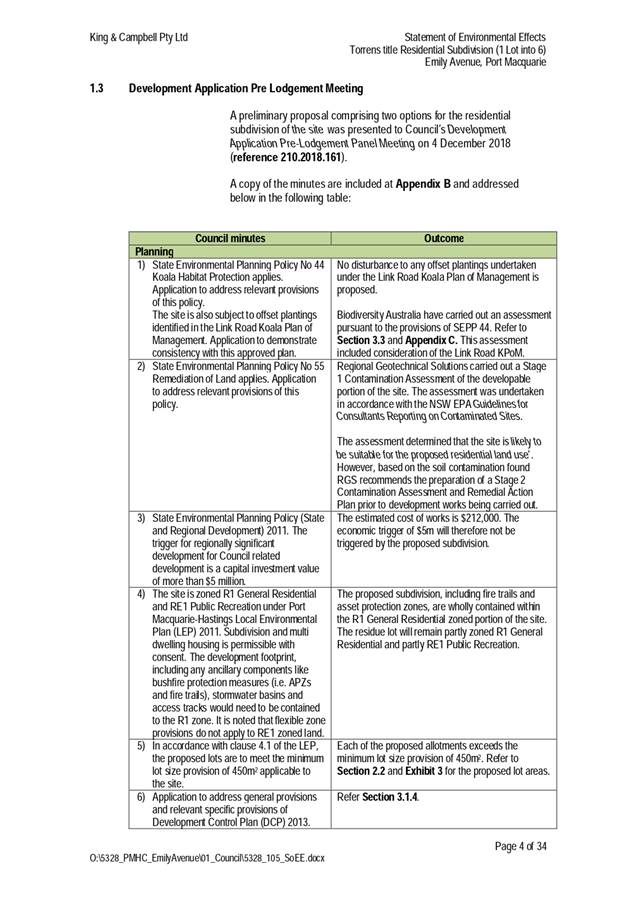
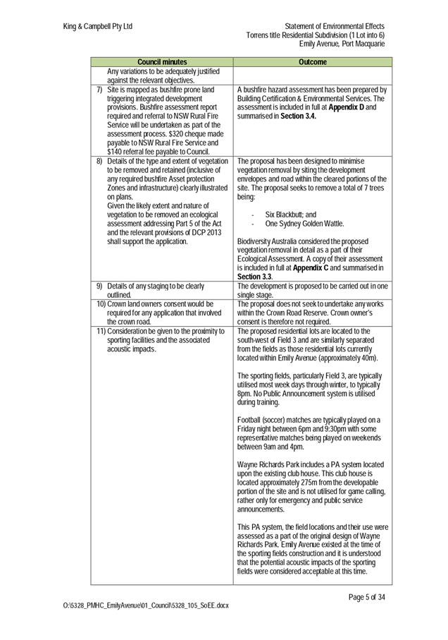
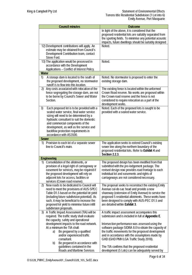
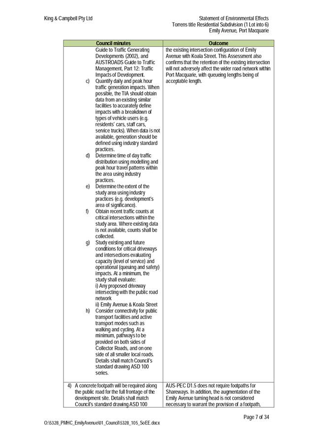
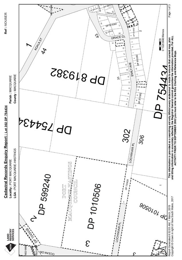
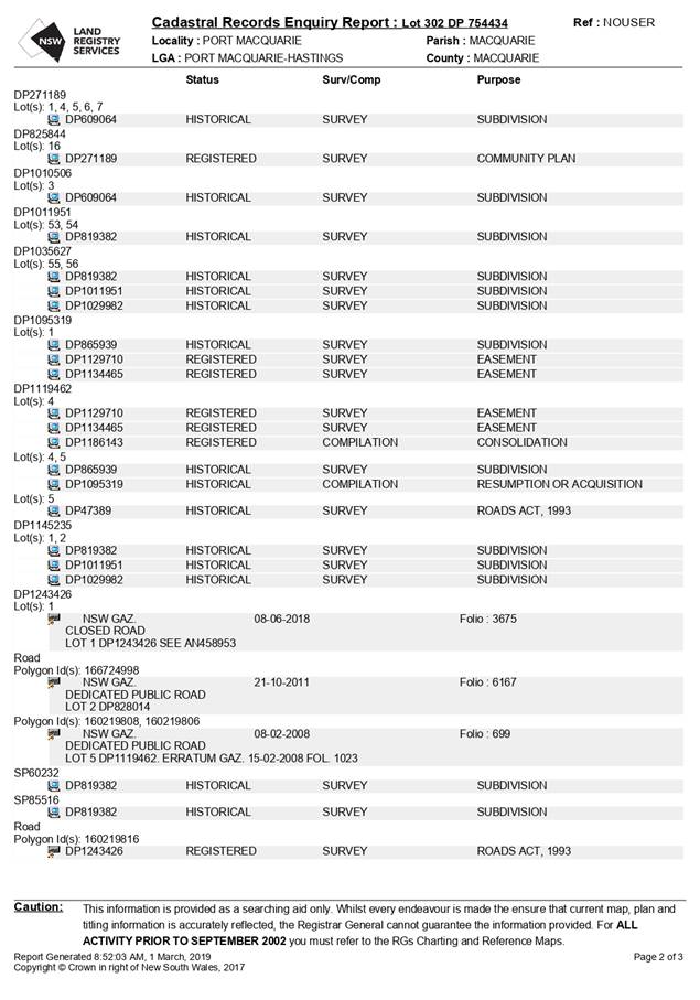
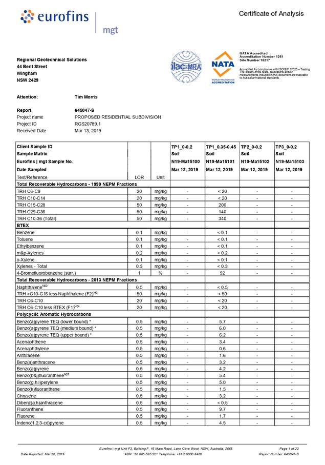
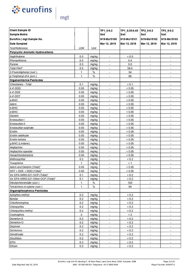
Item: 05
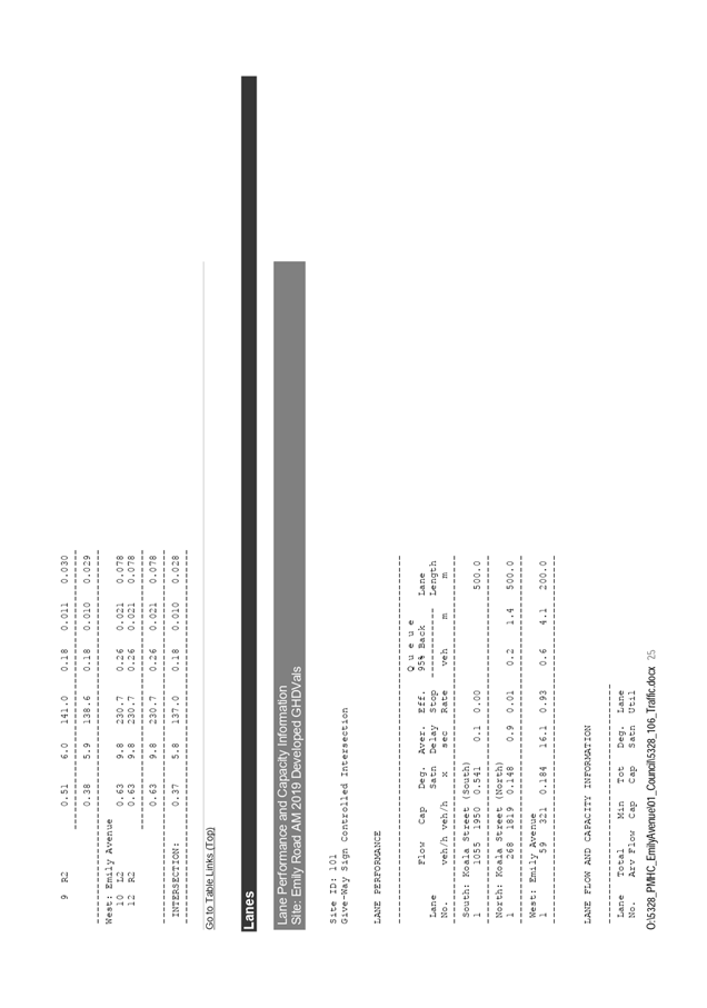
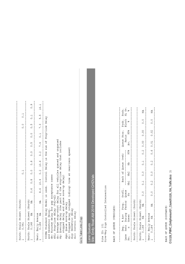
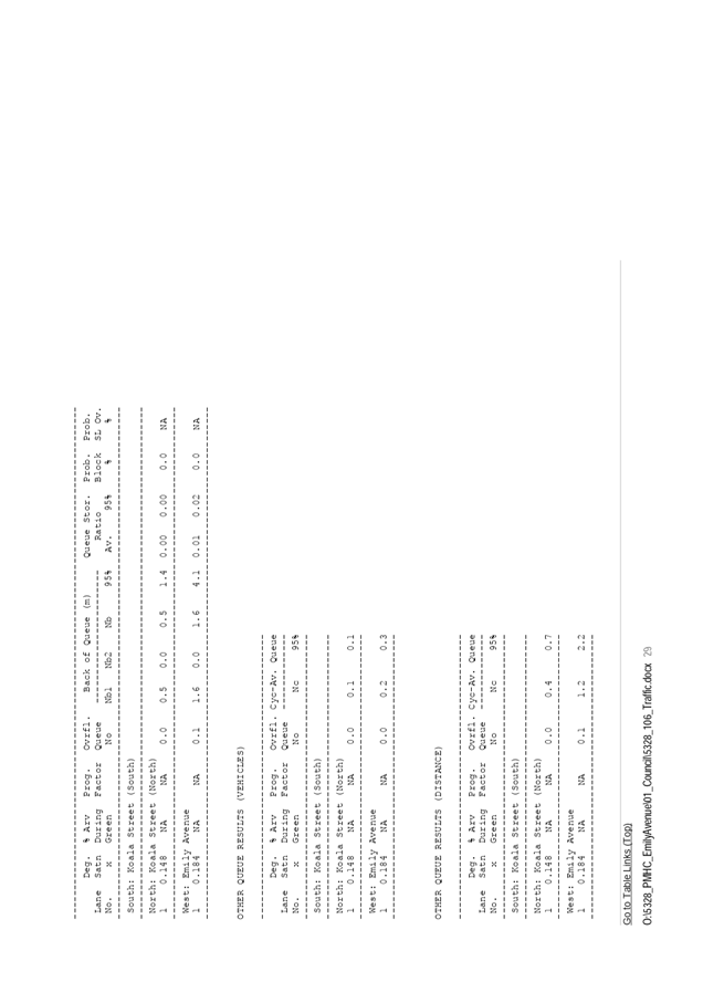
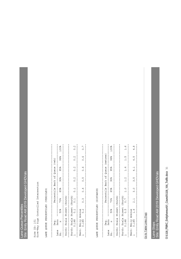
Subject: DA2019 - 309.1 Residential Subdivision at Lot
302 DP 754434 Emily Avenue, Port Macquarie
Report
Author: Development Assessment Planner, Benjamin Roberts
|
Applicant: King
and Campbell Pty Ltd
Owner: Port
Macquarie-Hastings Council
Estimated Cost: $212,000
Alignment with Delivery
Program
4.3.1 Undertake transparent
and efficient development assessment in accordance with relevant legislation.
|
RECOMMENDATION
That
it be recommended to Council that DA2019 - 307 for a residential subdivision at Lot 302, DP 754434,
Emily Avenue, Port Macquarie, be determined by granting consent subject to the
recommended conditions.
Executive
Summary
This
report considers a development application for a five (5) lot residential
subdivision at the subject site and provides an
assessment of the application in accordance with the Environmental Planning and
Assessment Act 1979.
Following exhibition of the
application, three (3) submissions were
received.
The site is located on Council
owned land. Council’s Conflict of Interest - Development Applications
Policy applies. The conflict of interest policy requires that all development
applications on Council land where objections have been received be referred to
Council for determination. In accordance with this policy the General Manager
also determined that an external consultant be engaged to report on the
application. Kempsey Council were engaged to undertake an independent
assessment of the application and provide a recommendation. The assessment and
recommendation is provided as Attachment 1.
This report recommends that the development
application be recommended to Council for approval subject to the conditions
included as Attachment 2.
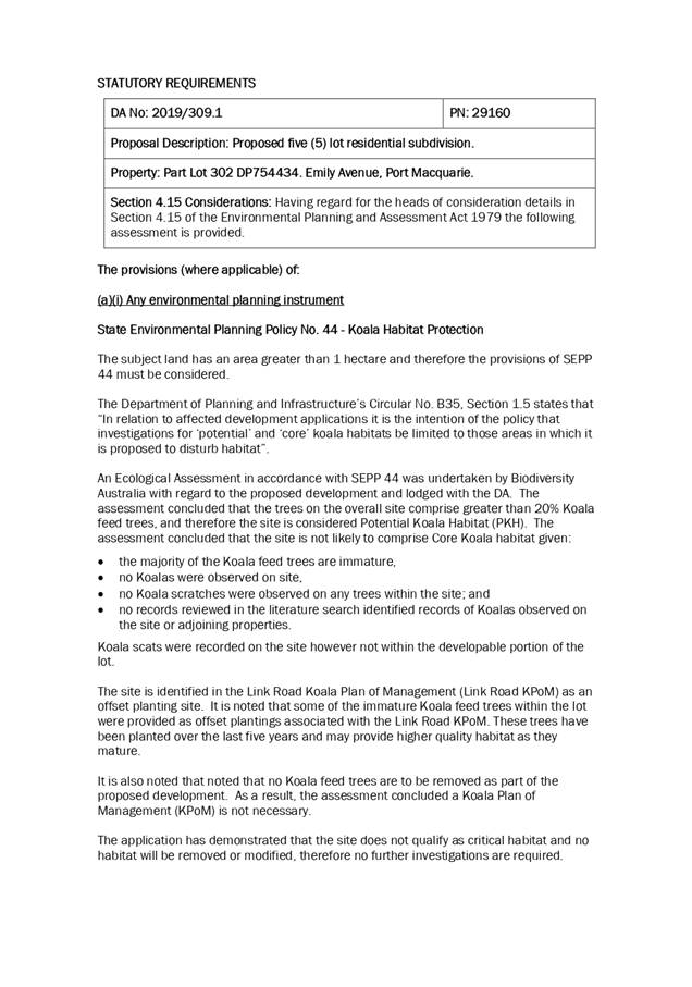
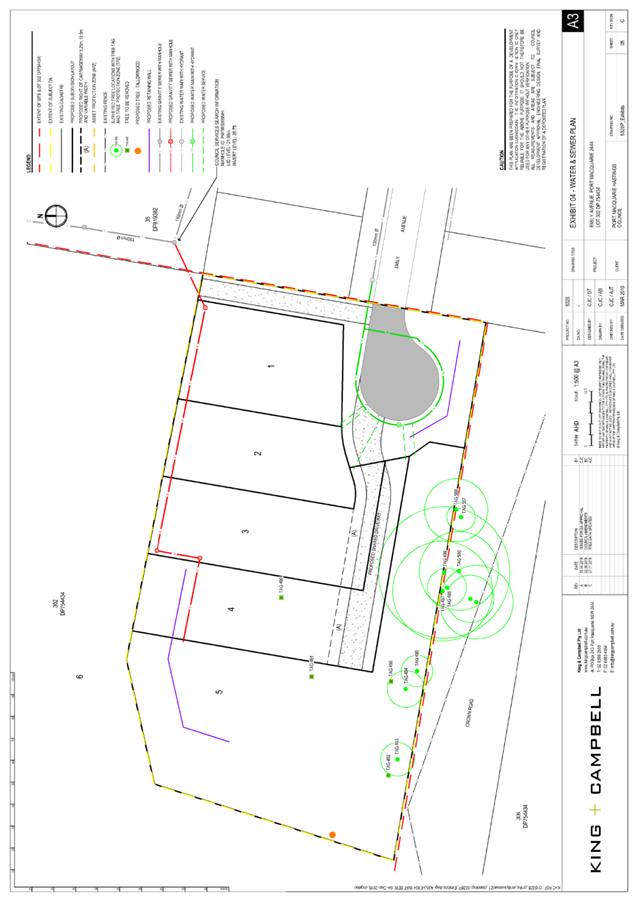
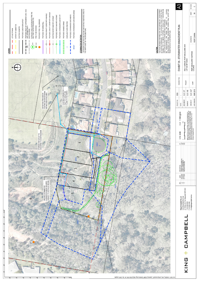
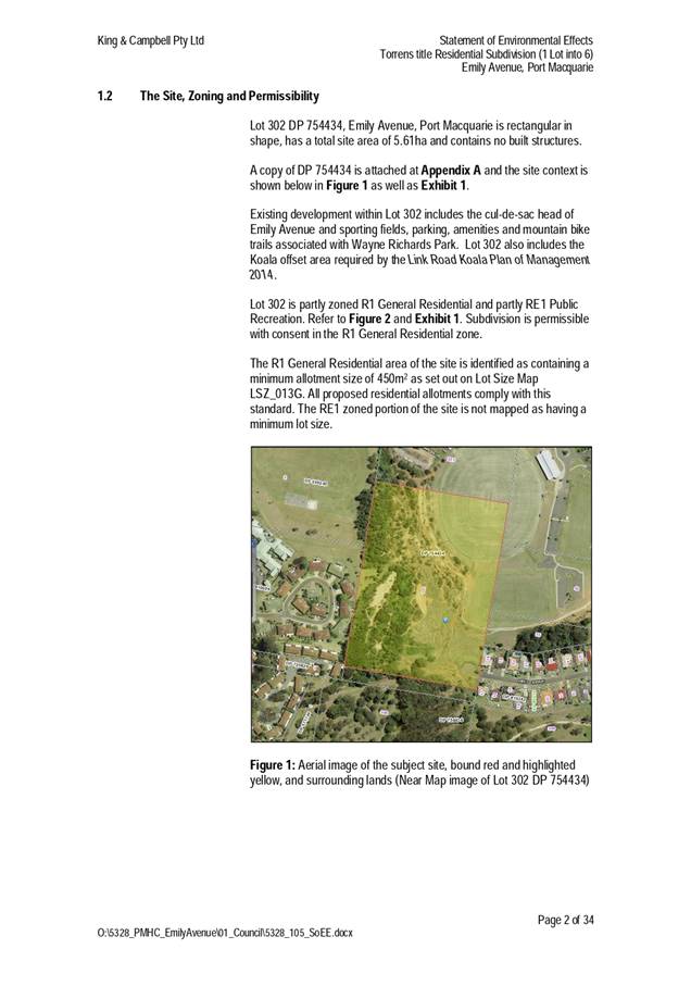
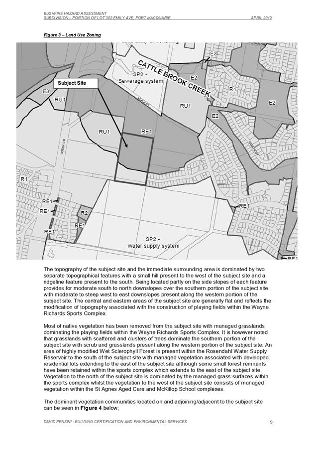
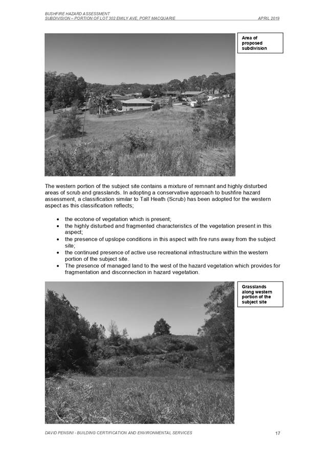
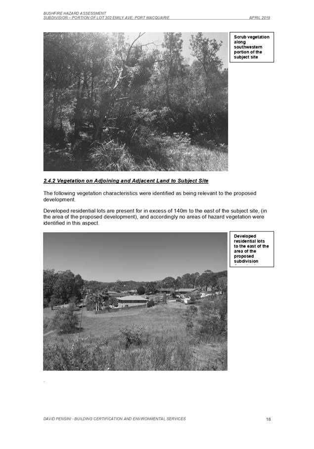
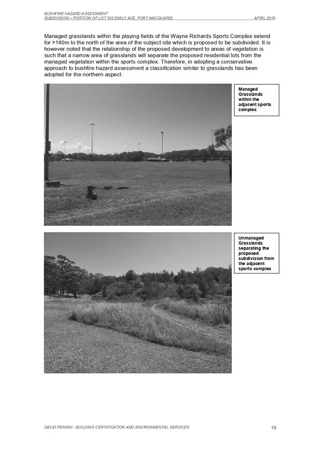
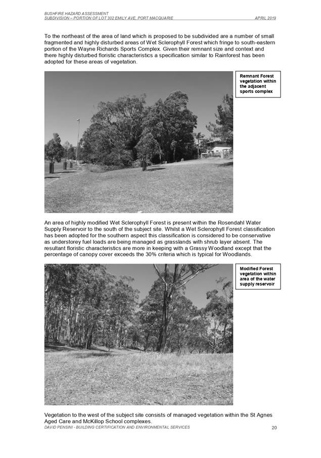
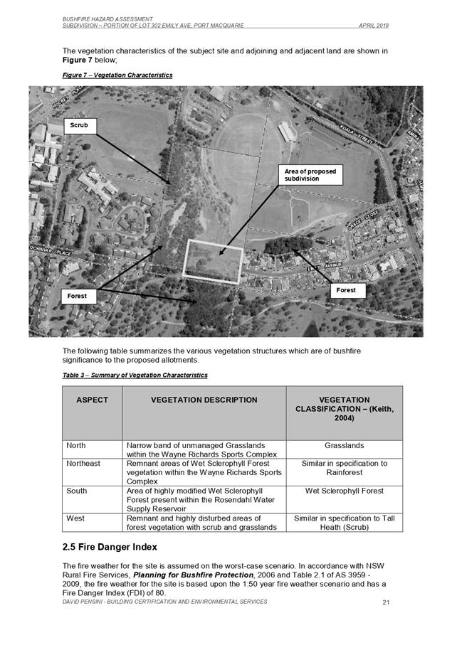
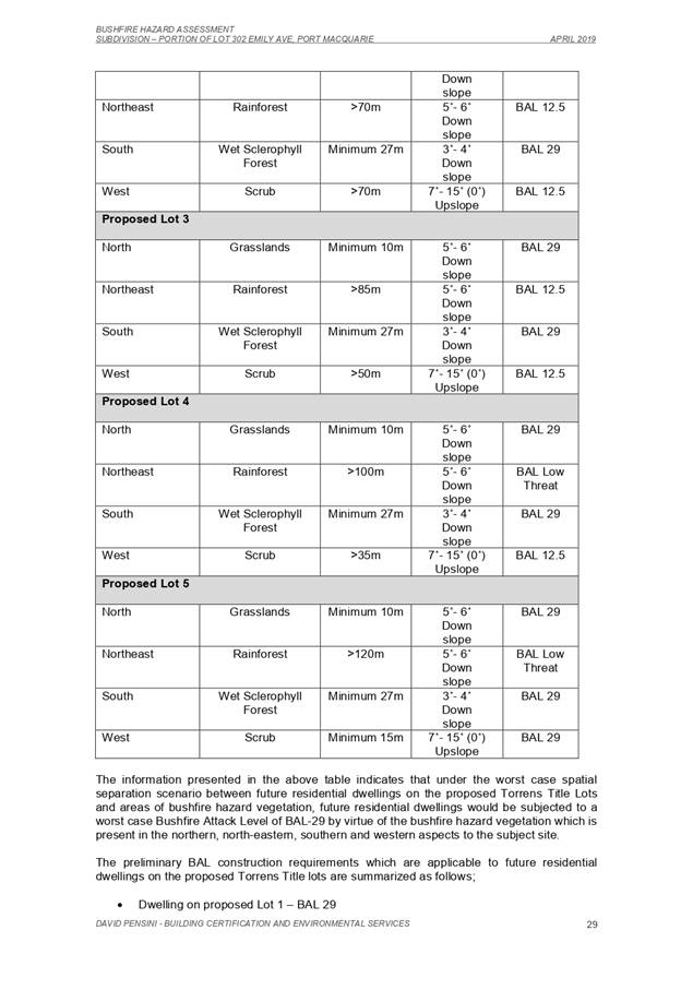
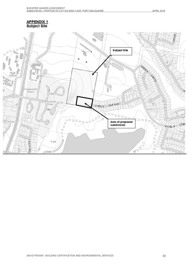
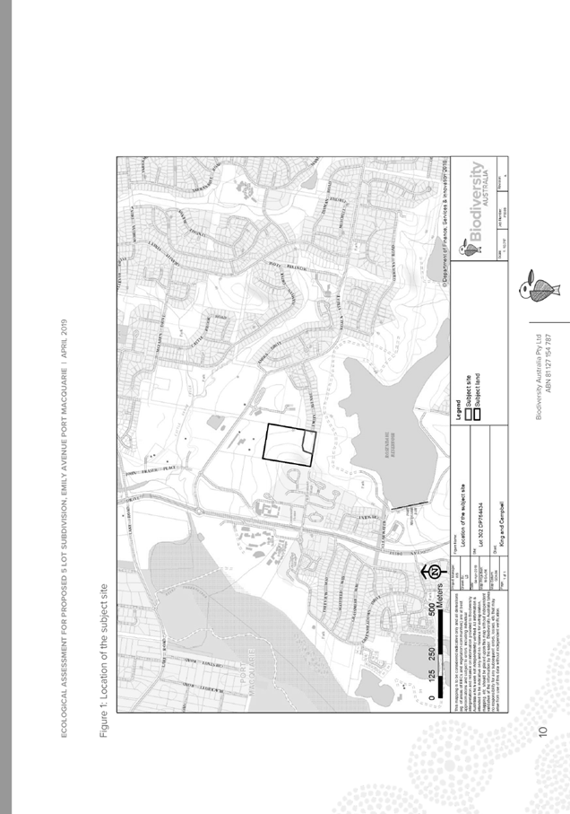
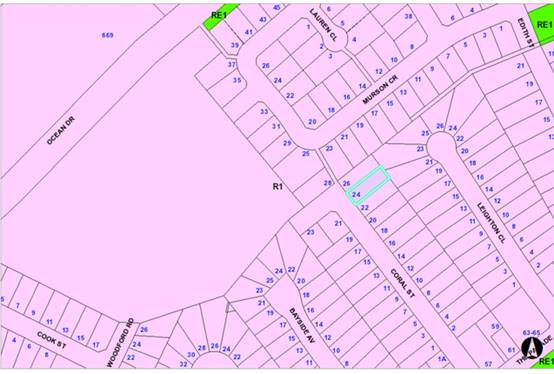
1. BACKGROUND
Existing
Sites Features and Surrounding Development
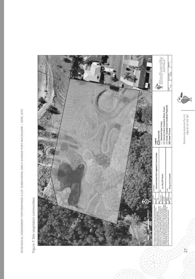
The site has an area of 5.61
hectares.
The
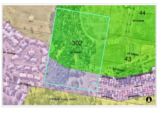
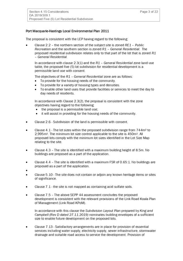
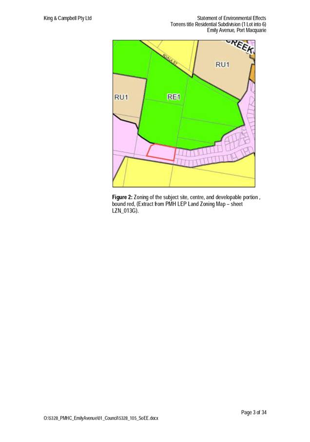
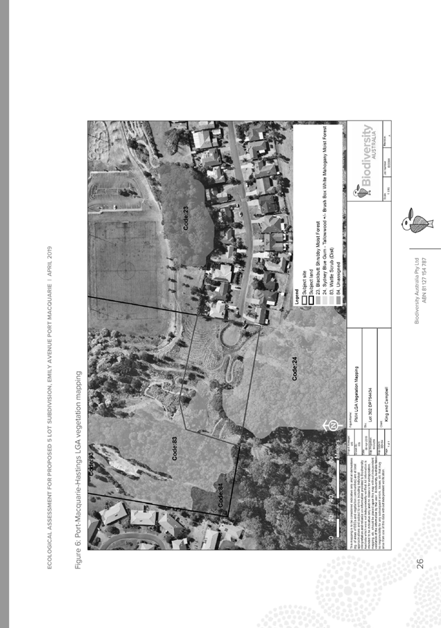
site is zoned R1 General Residential and partly RE1 Public Recreation in accordance with the Port Macquarie-Hastings Local
Environmental Plan 2011, as shown in the following zoning plan:
The
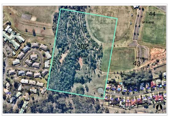
existing subdivision pattern and location of existing development within the
locality is shown in the following aerial photograph:
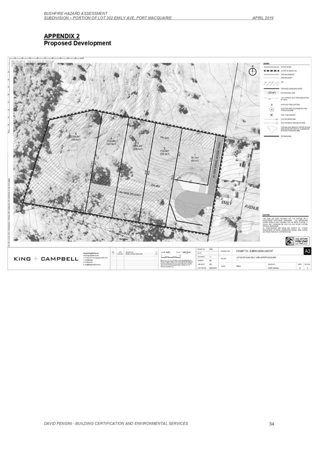
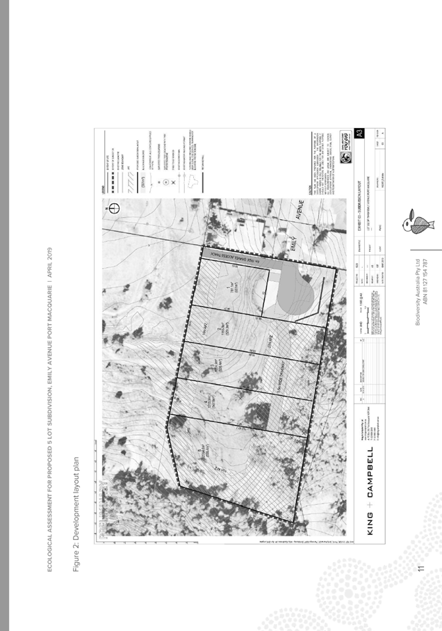
2. DESCRIPTION
OF DEVELOPMENT
Key
aspects of the proposal include the following:
· Five (5) lot residential subdivision and associated
infrastructure.
Refer
to Attachment 4 for plans of the
proposed development.
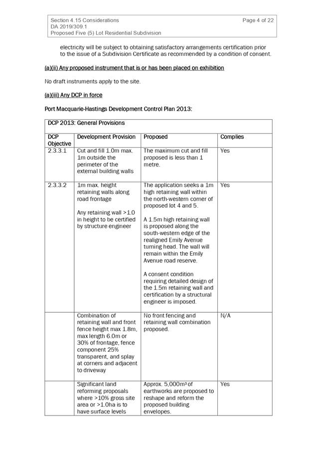
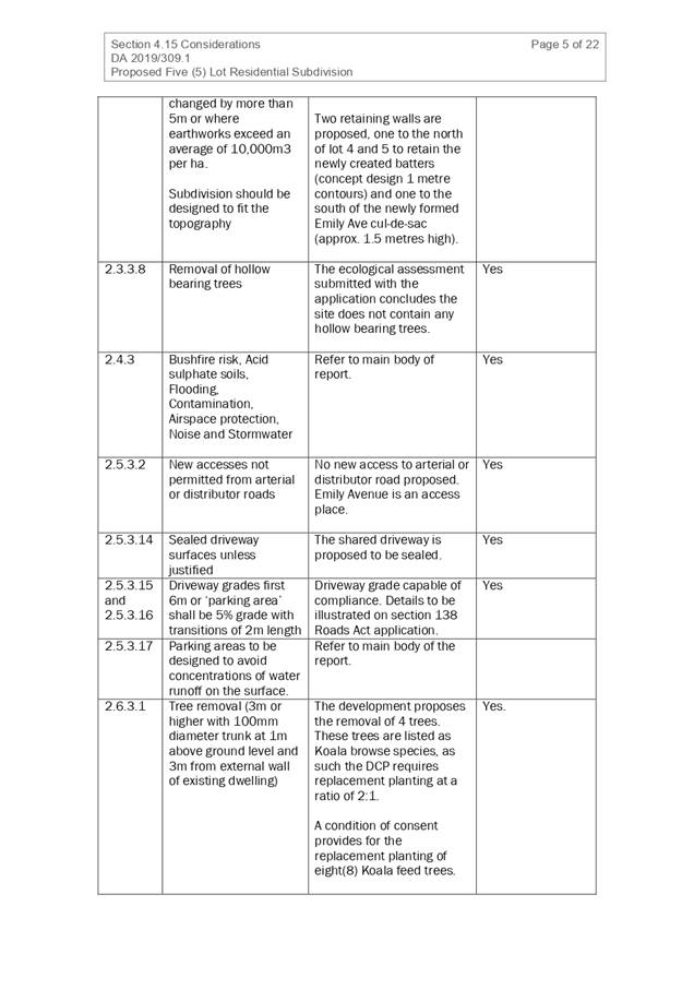
3. STATUTORY ASSESSMENT
Refer to Attachment 1.
4. DEVELOPMENT
CONTRIBUTIONS
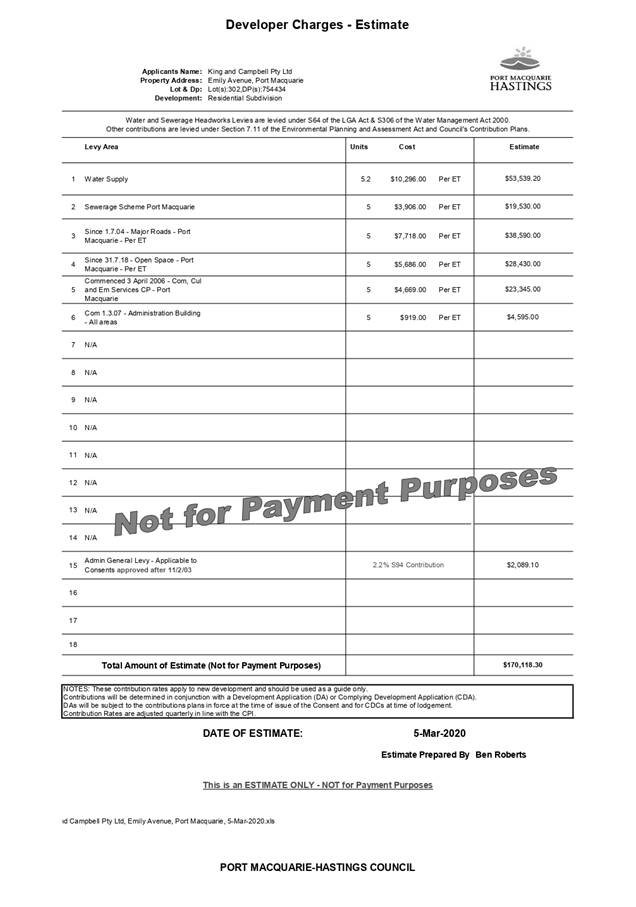
Section 7.11 Contributions
· Development
contributions will be required in accordance with Section 7.11 of the
Environmental Planning and Assessment Act 1979 towards roads, open space,
community cultural services, emergency services and administration buildings.
· A
copy of the contributions estimate is included as Attachment 3.
·
Section 7.12 Contributions
No - The development does not contain any
commercial/industrial component.
Section 64 Water and Sewer Contributions
· Development
contributions will be required towards augmentation of town water supply and
sewerage system head works under Section 64 of the Local Government Act 1993.
· A
copy of the contributions estimate is included as Attachment 3.
5. CONCLUSION AND STATEMENT
OF REASON
The application has been assessed in accordance with Section
4.15 of the Environmental Planning and Assessment Act 1979.
Issues raised during assessment and public exhibition of the
application have been considered in the assessment of the application. Where
relevant, conditions have been recommended to manage the impacts attributed to
these issues.
The site is considered suitable for the proposed development
and the proposal adequately addresses relevant planning controls. The development
is not considered to be contrary to the public's interest and will not result a
significant adverse social, environmental or economic impact. It is recommended
that the application be approved, subject to the recommended conditions of
consent provided in the attachment section of this report.
|
Attachments
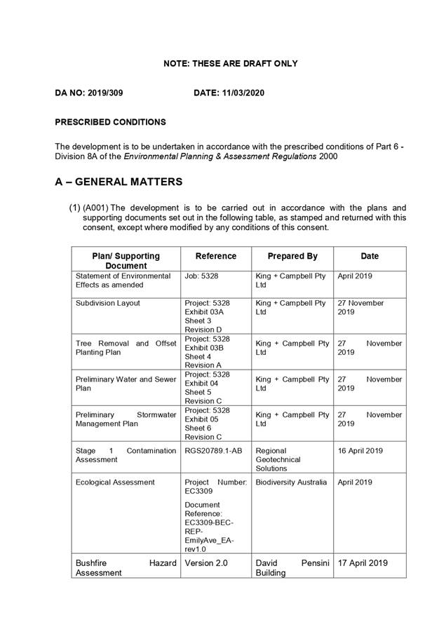
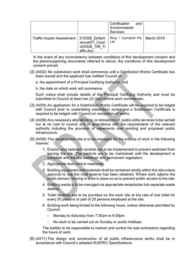
1⇩. DA2019 - 309.1 4.15
Assessment Report by Kempsey Council
2⇩. DA2019 - 309.1
Recommended Conditions by Kempsey Council
3⇩. DA2019 - 309.1
Development Contributions Estimate
4⇩. DA2019 - 309.1 Plans
5⇩. DA2019 - 309.1 SOEE
6⇩. DA2019 - 309.1 Phase 1
Contamination Assessment
7⇩. DA2019 - 309.1
Bushfire Hazard Assessment
8⇩. DA2019 - 309.1
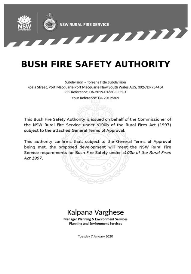
Bushfire Safety Authority conditions - NSW RFS
9⇩. DA2019 - 309.1
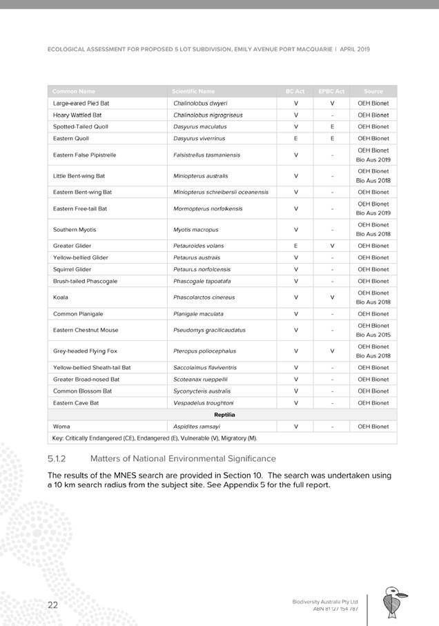
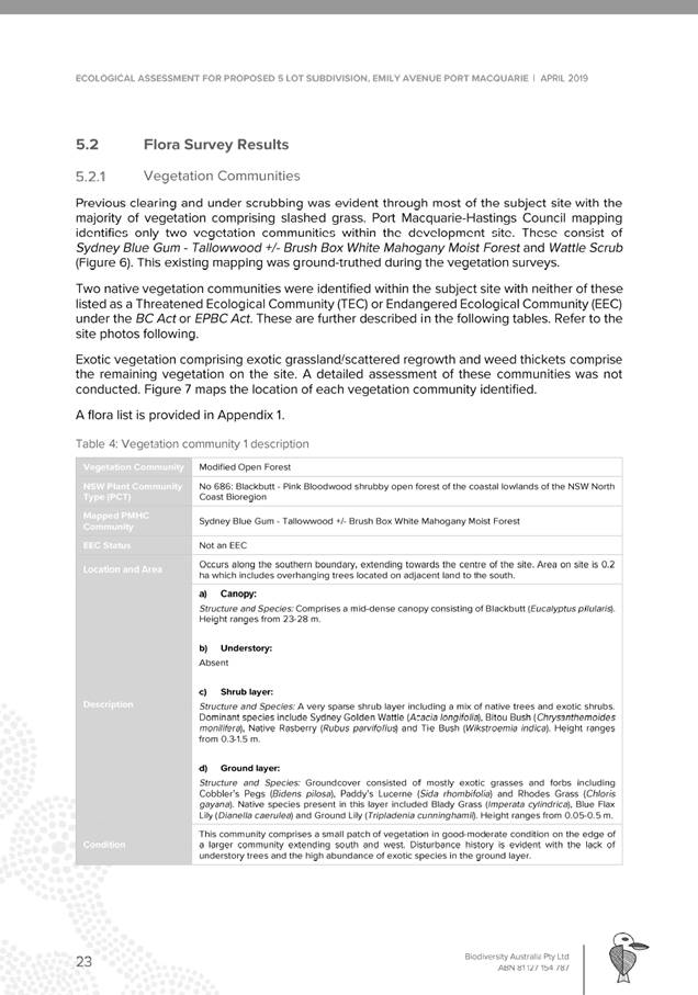
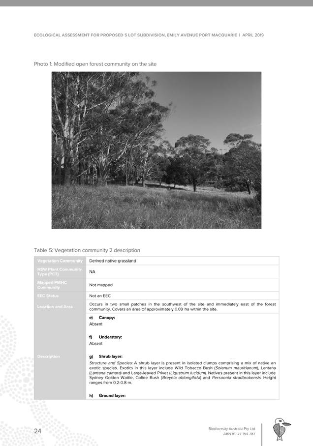
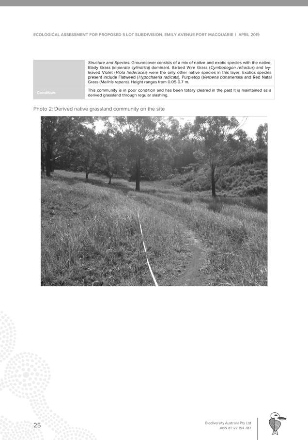
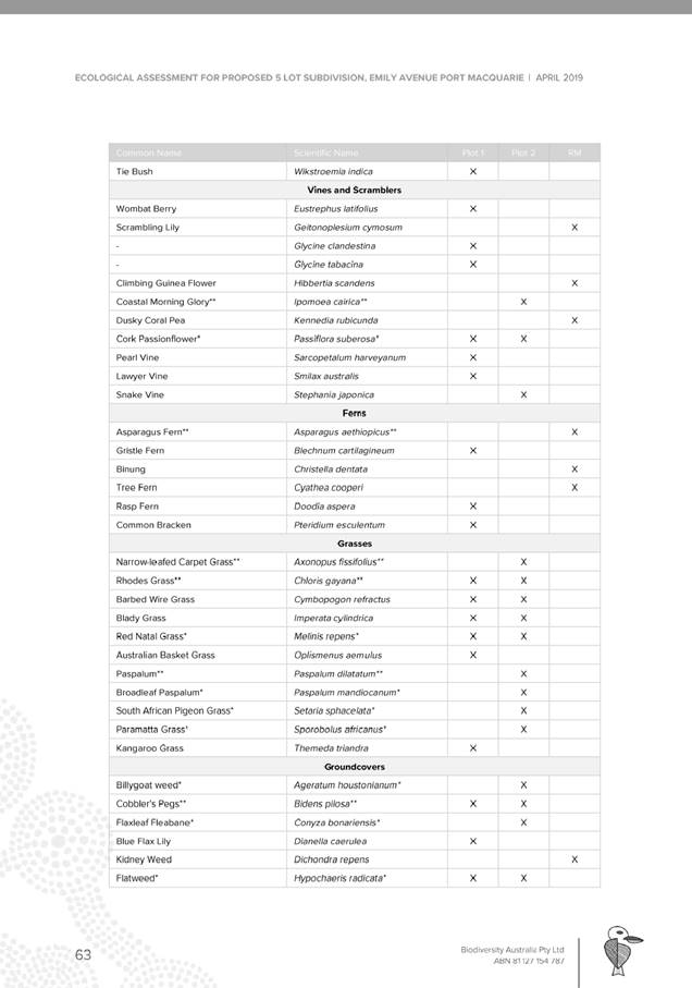
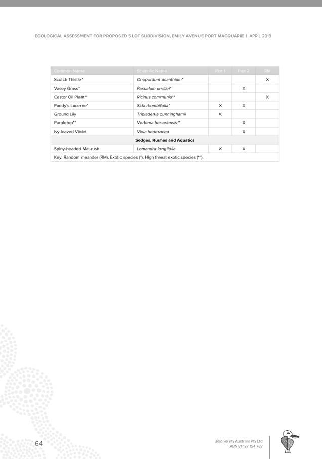
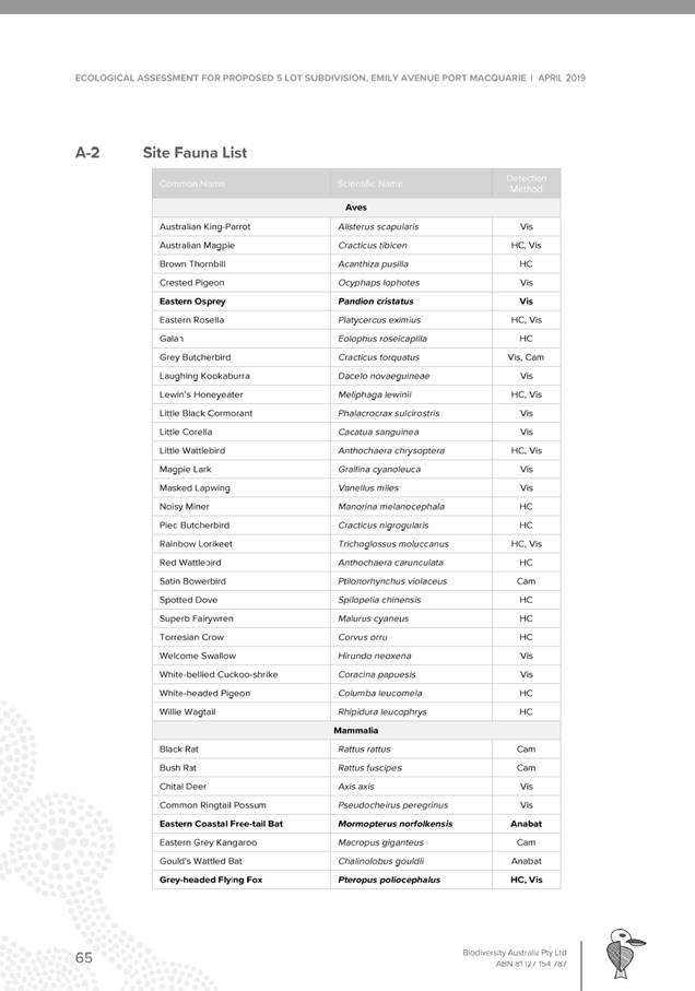
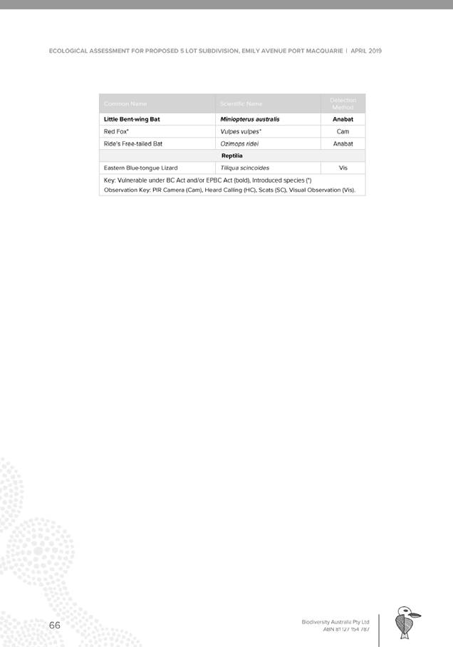
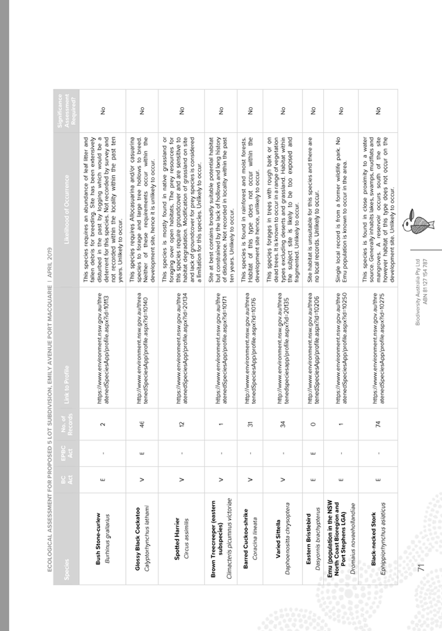
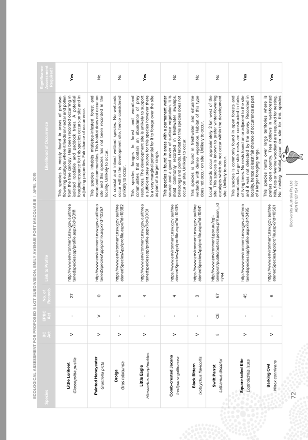
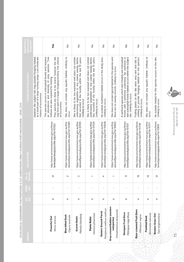
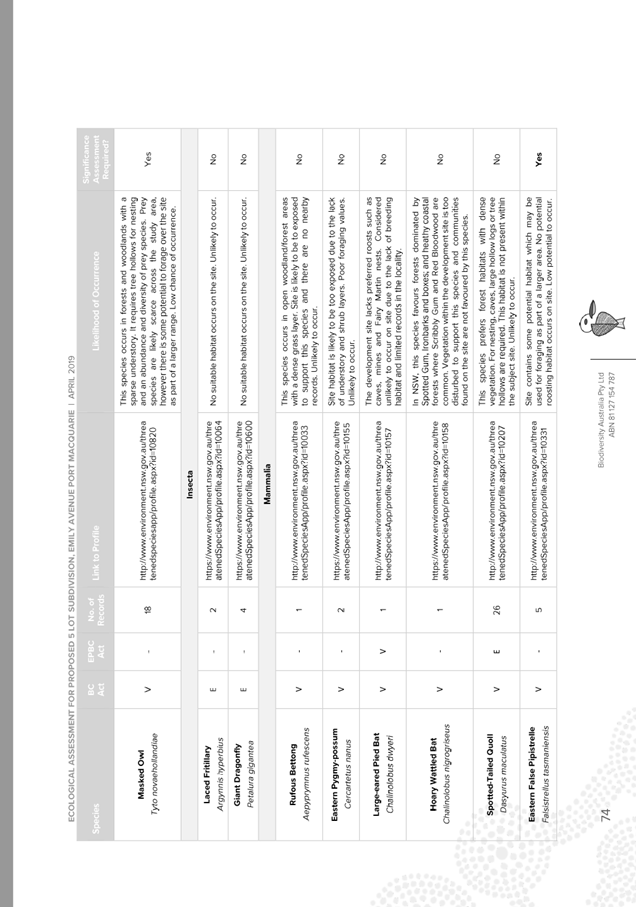
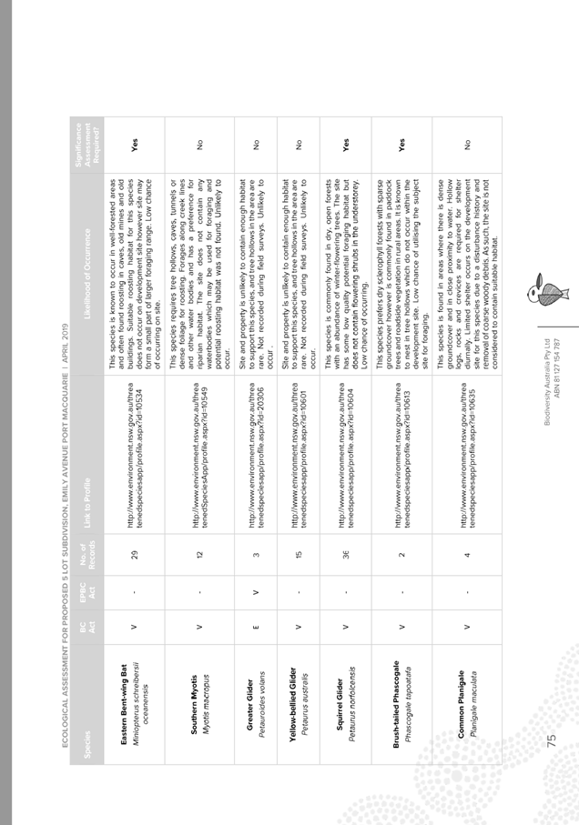
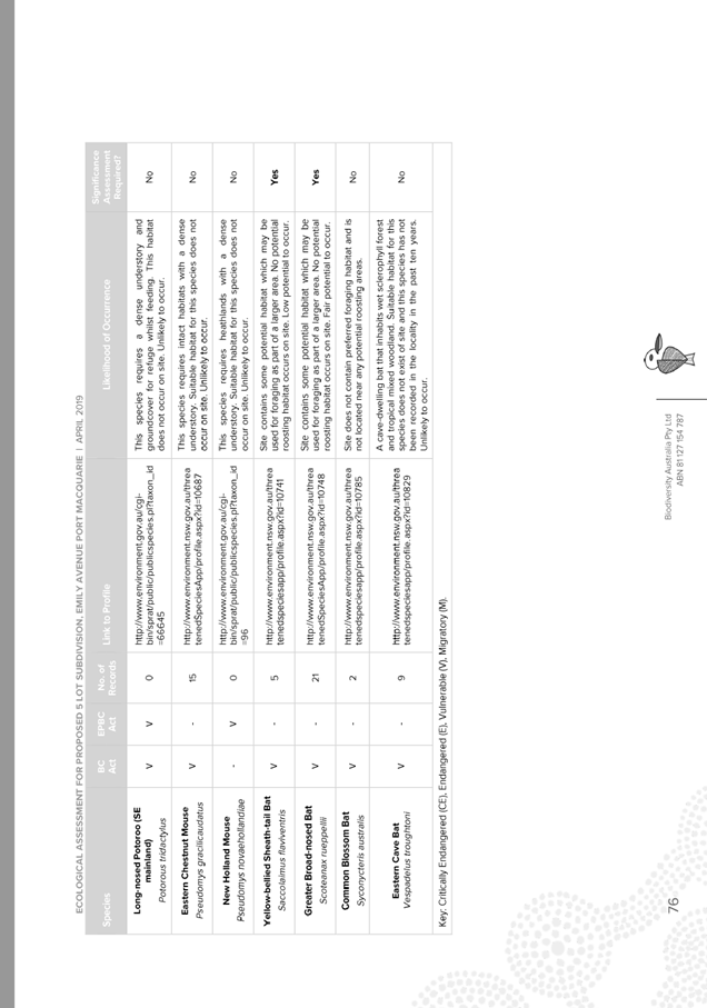
Ecological Impact Assessment.
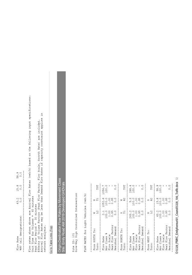
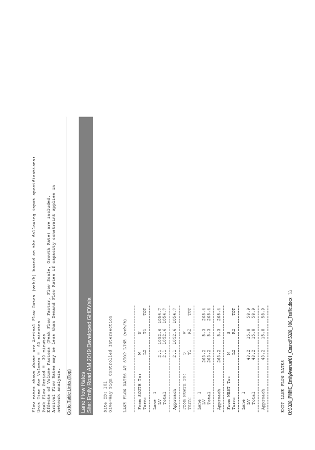
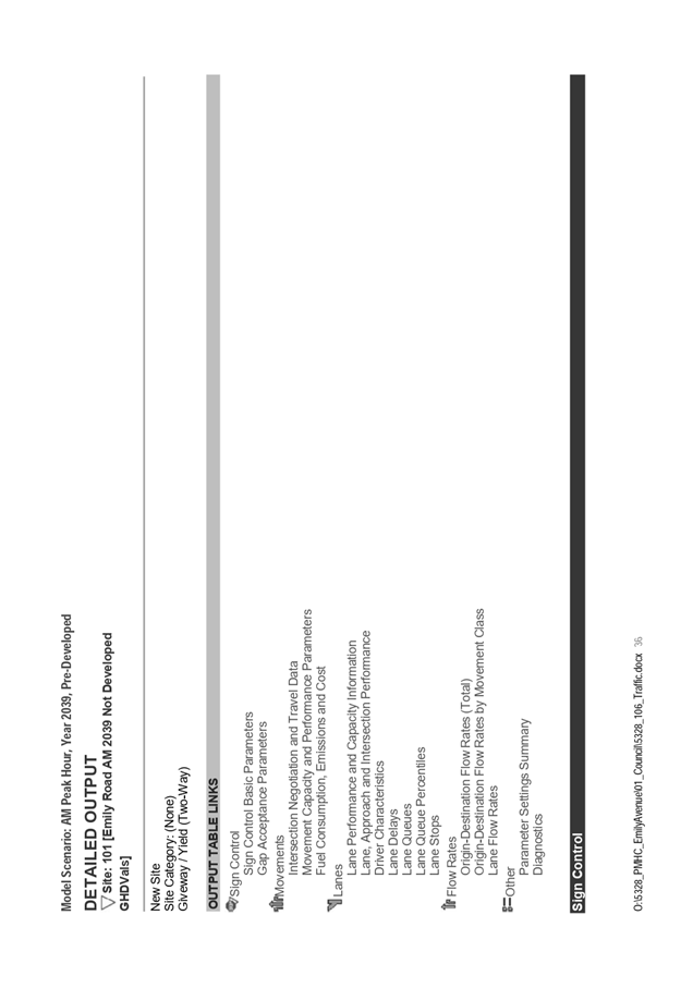
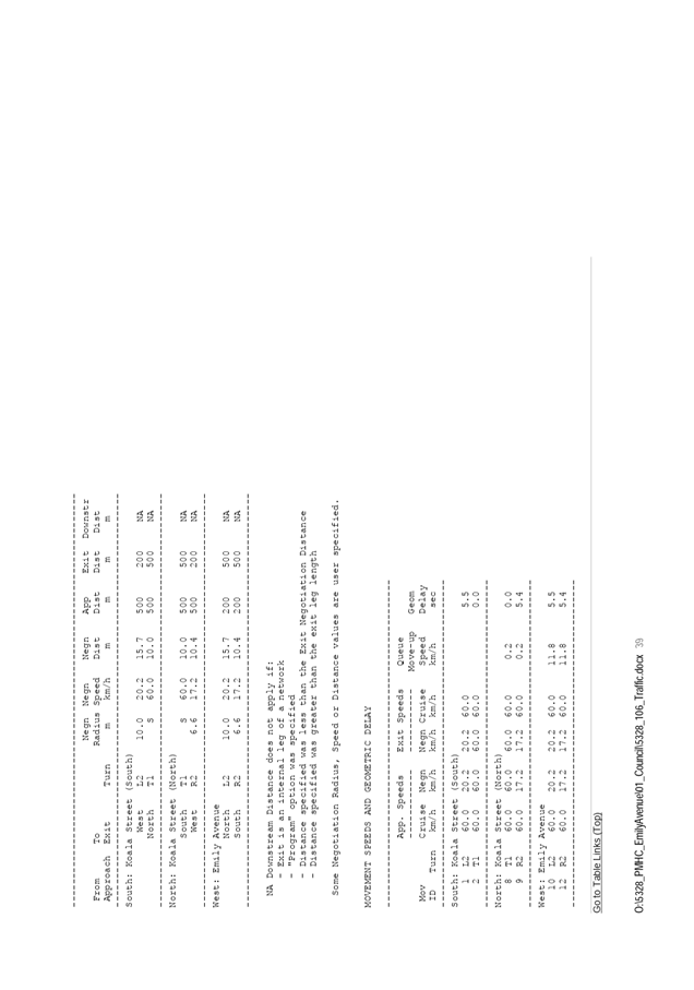
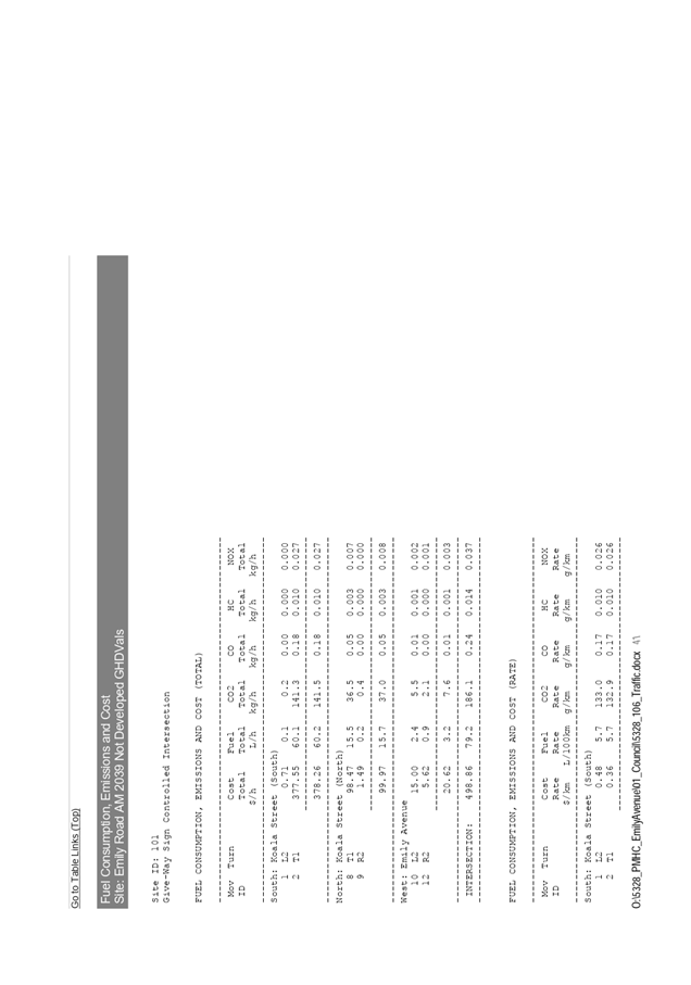
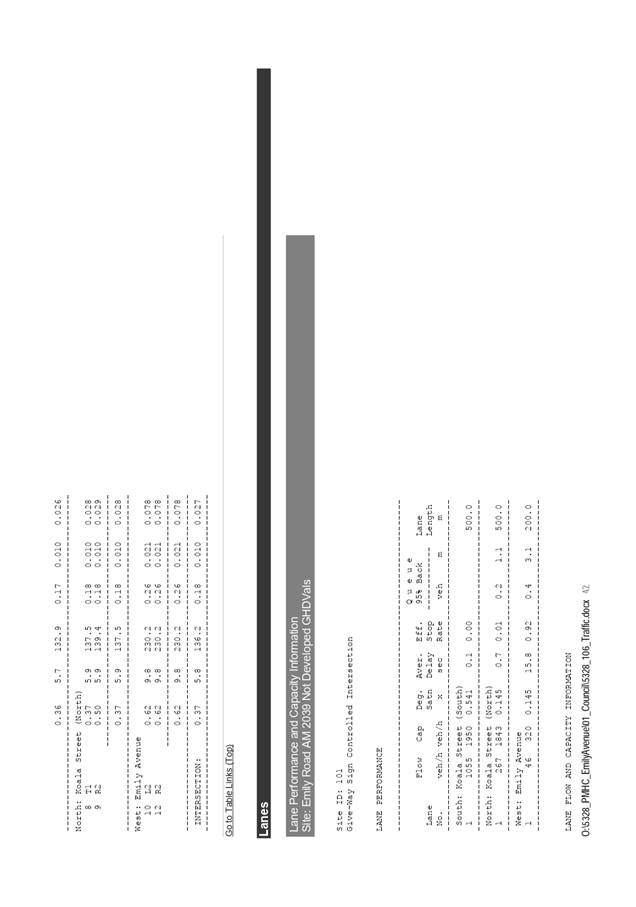
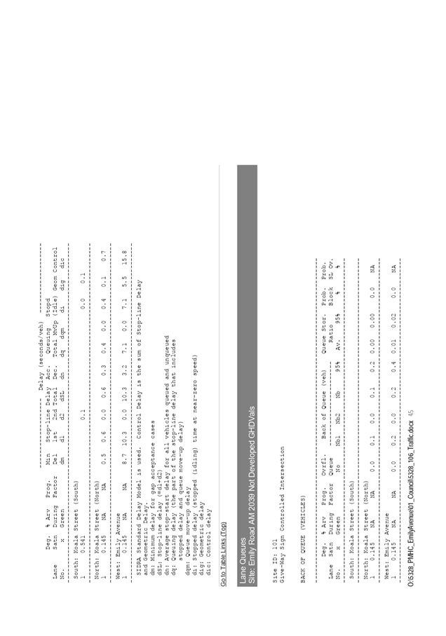
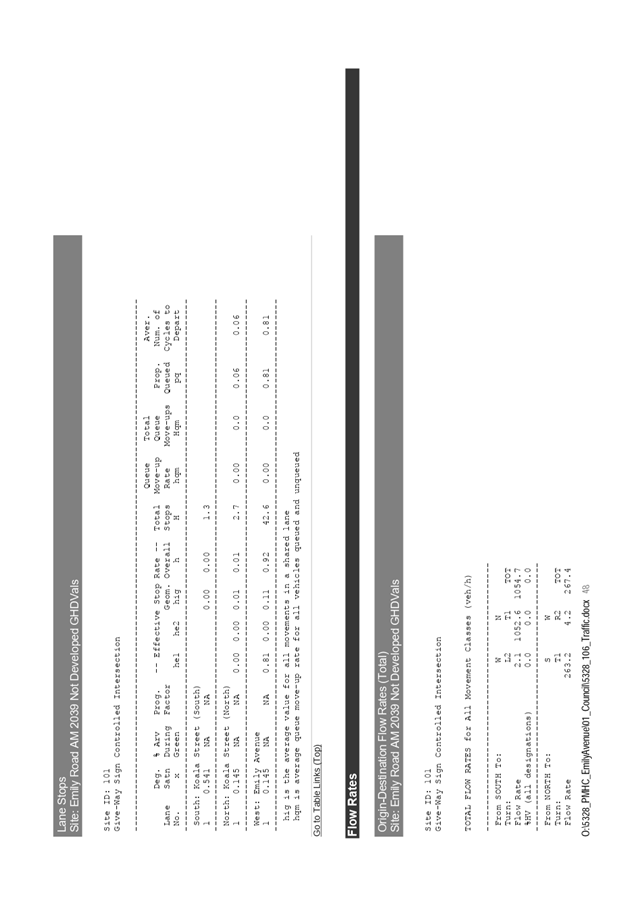
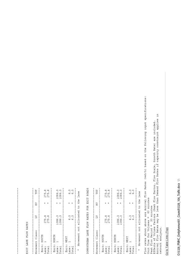
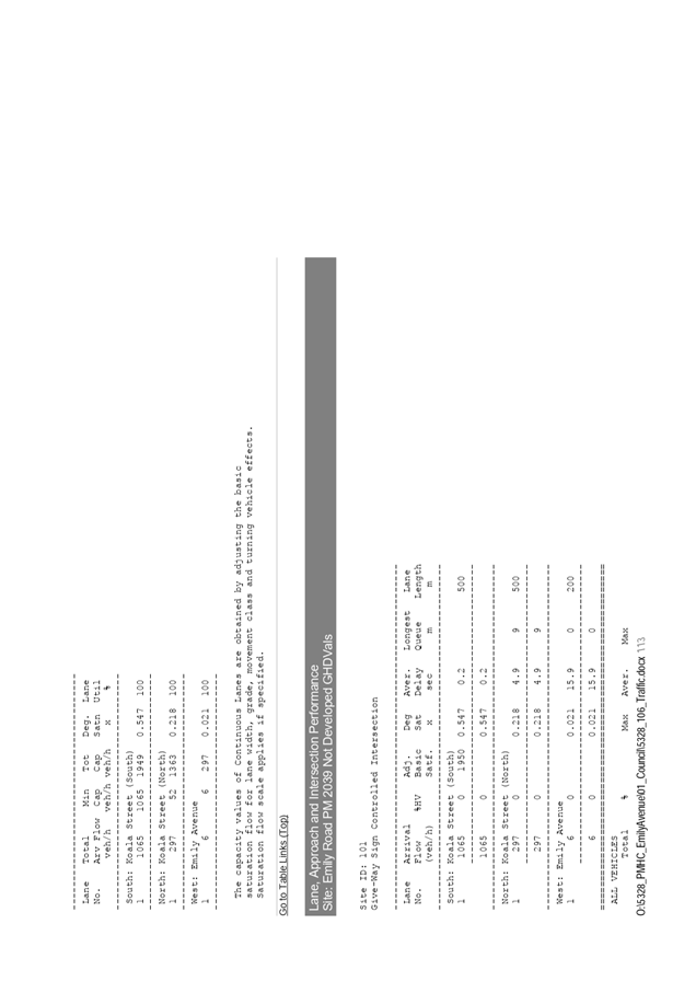
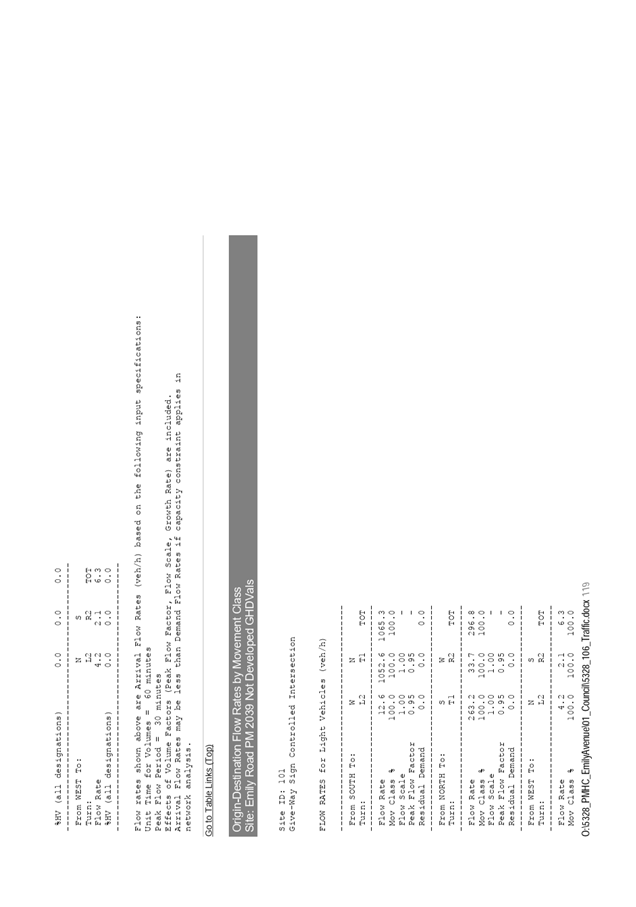
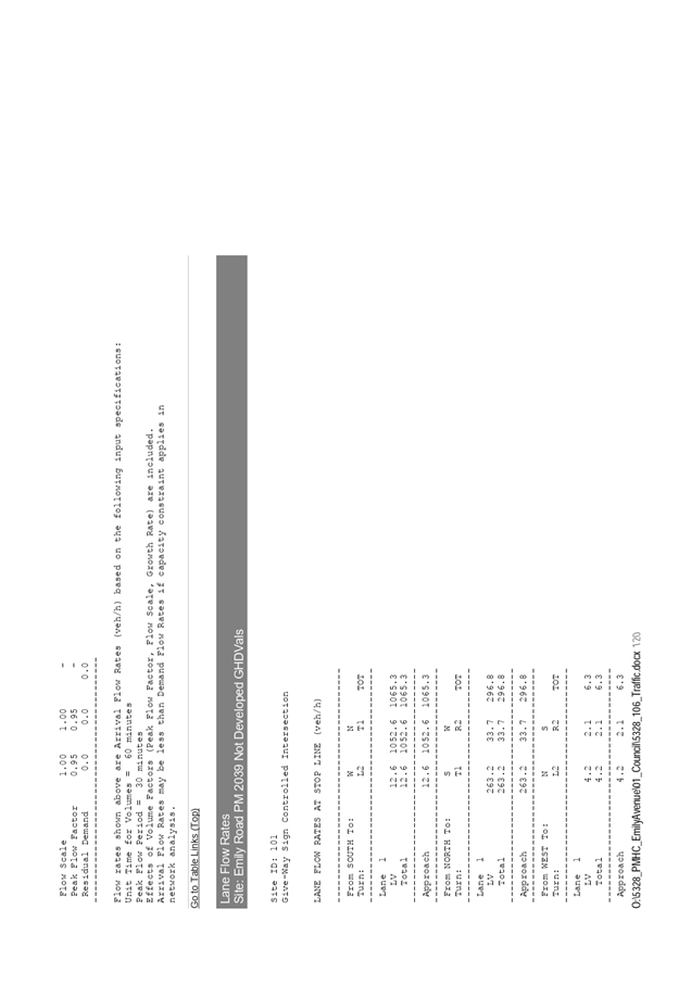
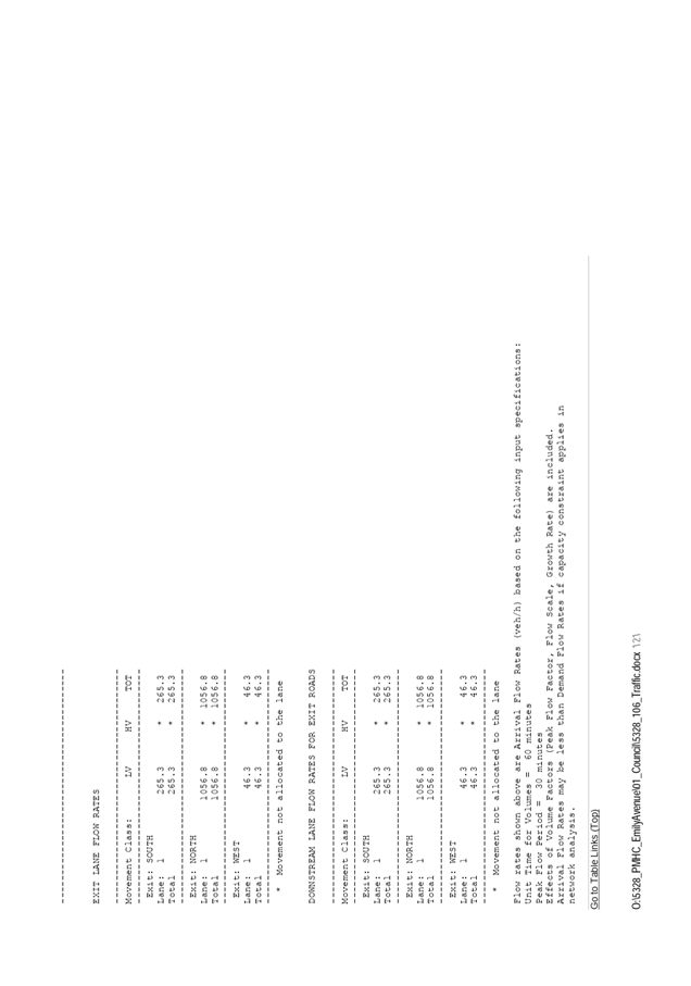
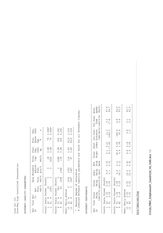
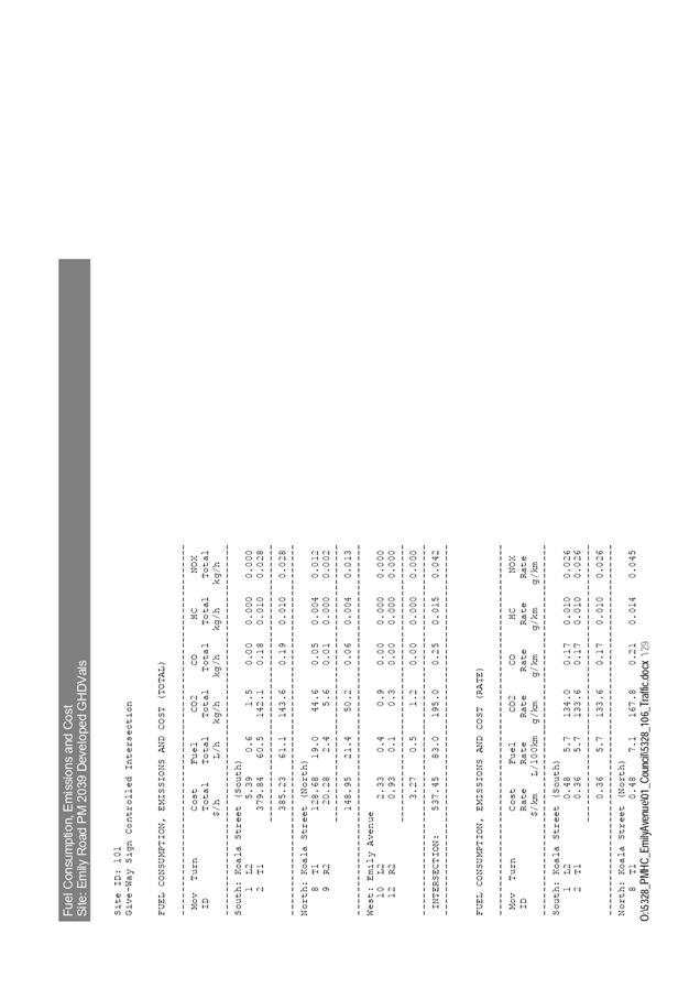
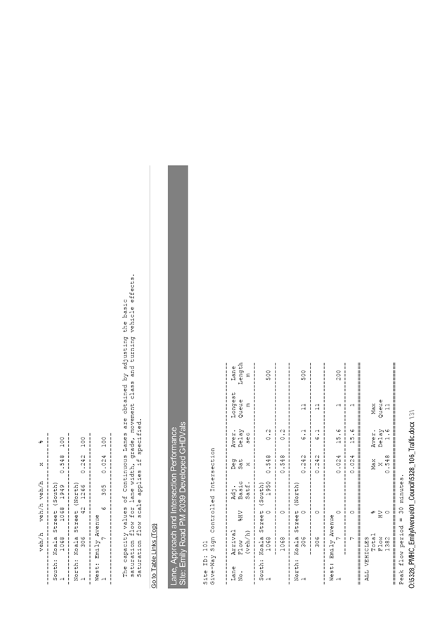
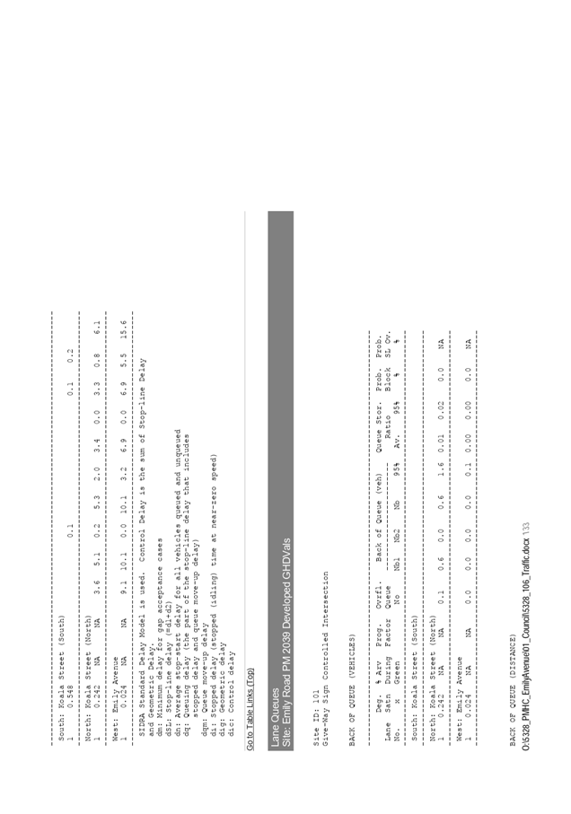
10⇩. DA2019 - 309.1 Traffic Impact
Assessment
|
|
ATTACHMENT
|
Development Assessment Panel
06/05/2020
|
|
ATTACHMENT
|
Development Assessment Panel
06/05/2020
|
|
ATTACHMENT
|
Development Assessment Panel
06/05/2020
|
|
ATTACHMENT
|
Development Assessment Panel
06/05/2020
|
|
ATTACHMENT
|
Development Assessment Panel
06/05/2020
|
|
ATTACHMENT
|
Development Assessment Panel
06/05/2020
|


|
ATTACHMENT
|
Development Assessment Panel
06/05/2020
|

|
ATTACHMENT
|
Development Assessment Panel
06/05/2020
|
|
ATTACHMENT
|
Development Assessment Panel
06/05/2020
|


|
ATTACHMENT
|
Development Assessment Panel
06/05/2020
|


AGENDA Development Assessment Panel 06/05/2020
Item: 06
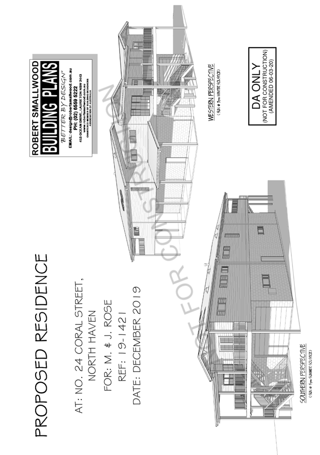
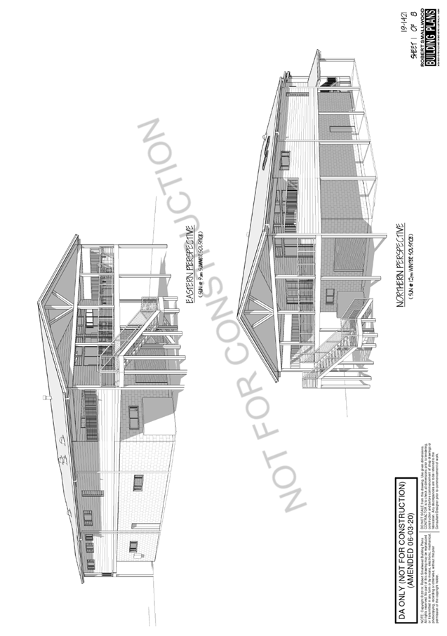
Subject: DA2019 - 883.1 Dwelling at Lot 14 DP 28743,
No. 24 Coral Street, North Haven
Report
Author: Building Surveyor, Ross Frazier
|
Applicant: J
M & M A Rose
Owner: J
M & M A Rose
Estimated Cost: $559,000
Alignment with Delivery
Program
4.3.1 Undertake transparent and
efficient development assessment in accordance with relevant legislation.
|
RECOMMENDATION
That
DA2019 - 883.1 for a dwelling at
Lot 14, DP 28743, No. 24 Coral Street, North Haven be determined by granting
consent subject to the recommended conditions.
Executive
Summary
This
report considers a development application for the construction of a new 2
storey dwelling with attached garage at the
subject site and provides an assessment of the application in accordance with
the Environmental Planning and Assessment Act 1979.
Following exhibition of the application
one (1) submission was received.
The site is considered suitable for the proposed development
and the proposal adequately addresses relevant planning controls. The
development is not considered to be contrary to the public's interest and will
not result a significant adverse social, environmental or economic impact.
This report recommends that the
development application be approved subject to the attached included in Attachment
1.
1. BACKGROUND
Existing
Sites Features and Surrounding Development
The site has an area of 682.9m2.
The
site is zoned R1 General Residential in
accordance with the Port Macquarie-Hastings Local Environmental Plan 2011, as
shown in the following zoning plan:
The
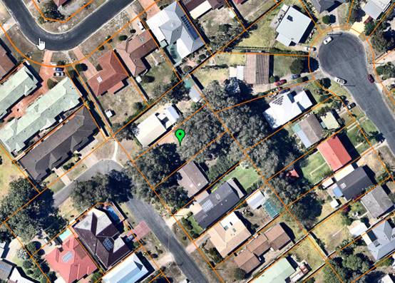
existing subdivision pattern and location of existing development within the
locality is shown in the following aerial photograph:
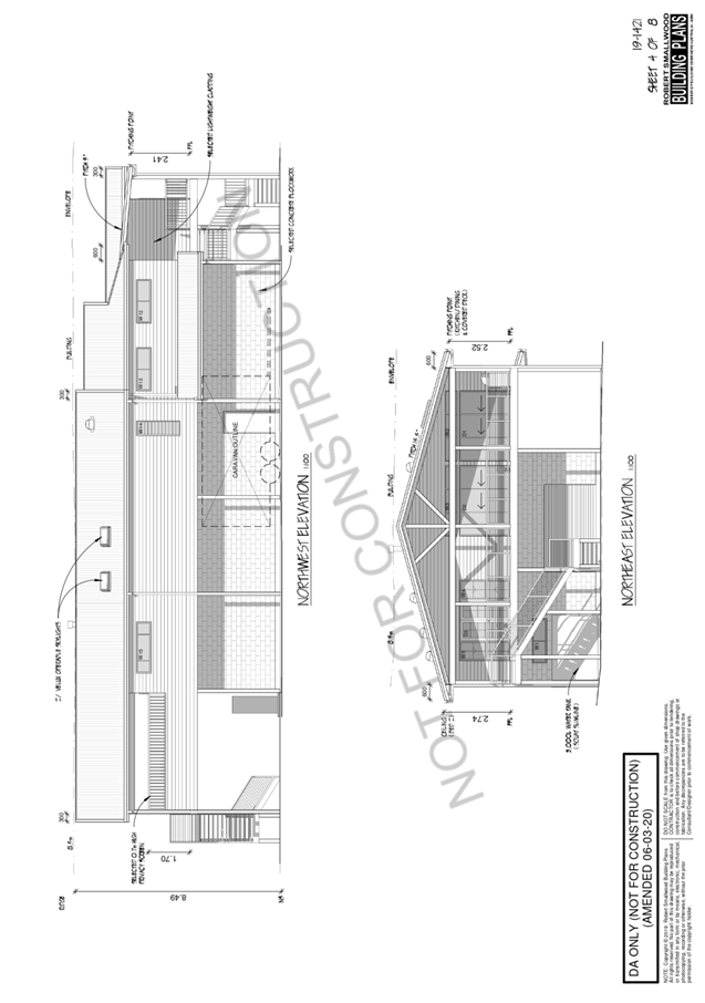
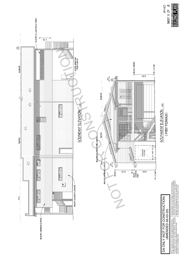
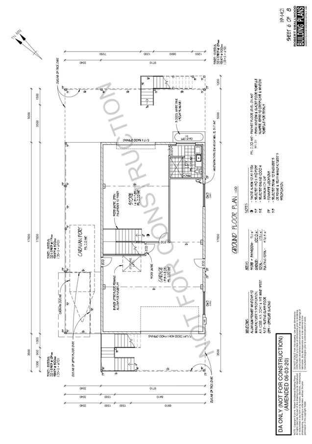
2. DESCRIPTION
OF DEVELOPMENT
Key
aspects of the proposal include the following:
· Construction
of new 2 storey dwelling and attached garage
Refer
to Attachment 2 at the end of this report for plans of the proposed
development
Application
Chronology
· 2
December 2019 - Application lodged.
· 13
December 2019 Application placed on notification.
· 5
January 2020 - Additional information required (ecological report; Shadow
diagrams)
· 31 January 2020 - Site inspection - 31/1/2020
· 9 March 2020 -Amended plans received to address concerns in
submissions.
· 17 March 2020 - Amended plans re-notified.
3. STATUTORY
ASSESSMENT
Section
4.15(1) Matters for Consideration
In
determining the application, Council is required to take into consideration the
following matters as are relevant to the development that apply to the land to
which the development application relates:
(a) The
provisions (where applicable) of:
(i) Any
Environmental Planning Instrument
State Environmental Planning Policy No. 44 - Koala
Habitat Protection
There is no Koala Plan of Management on the site. There are
a number of trees indicated on the plans to be removed. An ecological report
and impact statement has been completed to address the effect of removal of
these trees. The report was reviewed by council’s Natural resource team
and found to be satisfactory in its content. It was recommended that the trees
be approved for removal with no provision for compensatory planting required
due to the inability to provide suitable areas.
State Environmental Planning Policy No. 55 –
Remediation of Land
Following an inspection of the site and a search of Council
records, the subject land is not identified as being potentially contaminated
and is suitable for the intended use.
State Environmental Planning Policy (Coastal Management)
2018
The site is located within a coastal environment area.
In accordance with clause 7, this SEPP prevails over the
Port Macquarie-Hastings LEP 2011 in the event of any inconsistency.
Having regard to clauses 13 and 14 of the SEPP the proposed
development is not considered likely to result in any of the following:
a) any
adverse impact on integrity and resilience of the biophysical,
hydrological (surface and groundwater) and ecological environment;
b) any
adverse impacts coastal environmental values and natural coastal
processes;
c) any
adverse impact on marine vegetation, native vegetation and fauna
and their habitats, undeveloped headlands and rock platforms;
d) any
adverse impact on Aboriginal cultural heritage, practices and
places;
e) any
adverse impacts on the cultural and built environment heritage;
f) any
adverse impacts the use of the surf zone;
g) any adverse impact on the visual amenity and scenic qualities of the
coast, including coastal headlands;
h) overshadowing, wind funneling and the loss of views from public places
to foreshores;
i) any
adverse impacts on existing public open space and safe access to
and along the foreshore, beach, headland or rock platform for members of the
public, including persons with a disability;
In accordance with Clause 15, the proposal is not likely to
cause increased risk of coastal hazards on that land or other land.
The site is located within an area zoned for residential
purposes.
State Environmental Planning Policy (Building
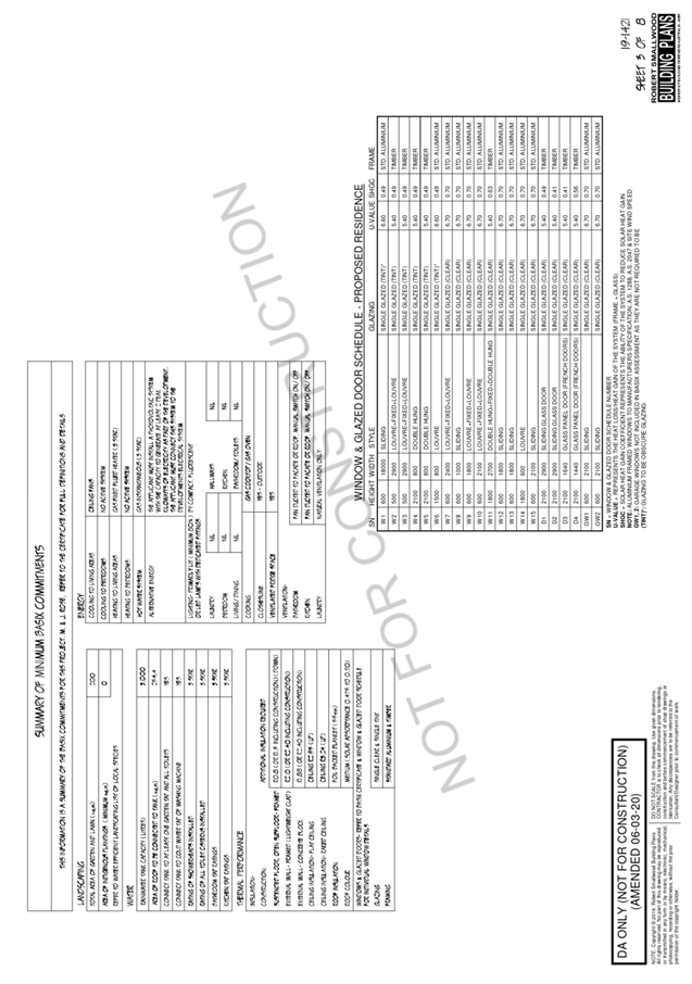
Sustainability Index: BASIX) 2004
A BASIX certificate has been submitted demonstrating that
the proposal will comply with the requirements of the SEPP. It is recommended
that a condition be imposed to ensure that the commitments are incorporated
into the development and certified at Occupation Certificate stage.
State Environmental Planning Policy (Infrastructure) 2007
Clause 45 – Development in proximity to electricity
infrastructure – the development appears clear of infrastructure.
Overhead power lines are located on the opposite street frontage.
Clause 101 refers to development with frontage to a
classified road. In this case, the clause does not apply
The development does not trigger any of the traffic
generating development thresholds. Referral to the RTA is not required.
Based on the above, the proposed development addresses
relevant clauses in the SEPP and will not to create any significant adverse
conflict in terms of traffic or noise.
Port Macquarie-Hastings Local Environmental
Plan 2011
Except as indicated in Cl 4.3, the proposal is consistent
with the LEP. A variation application under Cl 4.6 has been sought.
· Clause
2.2 - The subject site is zoned R1 General Residential.
· Clause
2.3(1) and the R1 zone landuse table - The proposed new dwelling is a
permissible landuse with consent.
The objectives of the R1 zone are as
follows:
o To provide for the housing
needs of the community.
o To provide for a variety of
housing types and densities.
o To enable other land uses
that provide facilities or services to meet the day to day needs of residents.
· Clause
2.3(2) - The proposal is consistent with the zone objectives as it is a
permissible landuse and consistent with the established residential locality.
The proposal contributes to the range of housing options in the locality.
· Clause
2.7 - No demolition proposed.
· Clause
4.3 - The maximum overall height of the building above ground level is 8.5m and
complies with the 8.5m height limit applying to the site.
· Clause
4.4 - The floor space ratio of the proposal is 57.8 %, which complies with the
maximum 65 % floor space ratio applying to the site.
· Clause
4.6 – Exceptions to development standards. Nil proposed.
· Clause
5.10 – Heritage. The site does not contain or adjoin any known heritage
items or sites of significance.
· Clause
7.1 - The site is mapped as potentially containing class 3 acid sulphate soils.
The proposed development includes the construction of a new dwelling which may
require excavation extending more than 1m below the natural surface level is
proposed. Works to be undertaken in accordance with Councils policy for minor
works.
· Clause
7.3 - The site is land within a mapped “flood planning area” (Land
subject to flood discharge of 1:100 annual recurrence interval flood event
(plus the applicable climate change allowance and relevant freeboard). The
flood planning level for the site is 3.83m AHD. The proposed first floor level
of 5.7m AHD therefore provides sufficient flood immunity, noting that the
ground floor is limited to a laundry, which is permitted under the Flood
Policy. The following comments are provided which incorporate consideration of
the objectives of Clause 7.3, Council’s Flood Policy 2015, the NSW
Government’s Flood Prone Lands Policy and the NSW Government’s
Floodplain Development Manual (2005):
o The proposal is compatible
with the flood hazard of the land taking into account projected changes as a
result of climate change;
o The
proposal will not result in a significant adverse effect on flood behaviour
that would result in detrimental increases in the potential flood affectation
of other development or properties;
o The
proposal incorporates measures to minimise & manage the flood risk to life
and property associated with the use of land;
o The
proposal is not likely to significantly adversely affect the environment or
cause avoidable erosion, siltation, destruction of riparian vegetation or a
reduction in the stability of river banks or watercourses;
o The
proposal is not likely to result in unsustainable social and economic costs to
the community as a consequence of flooding;
· Clause
7.13 - Satisfactory arrangements are in place for provision of essential
services including water supply, electricity supply, sewer infrastructure,
stormwater drainage and suitable road access to service the development.
(ii) Any draft
instruments that apply to the site or are on exhibition
No draft instruments apply to the site.
(iii) Any Development
Control Plan in force
Port
Macquarie-Hastings Development Control Plan 2013
|
DCP 2013: Dwellings, Dual
occupancies, Dwelling houses, Multi dwelling houses & Ancillary
development
|
|
|
Requirements
|
Proposed
|
Complies
|
|
3.2.2.1
|
Ancillary development:
• 4.8m max. height
• Single storey
• 60m2 max. area
• 100m2 for lots >900m2
• 24 degree max.
roof pitch
• Not located in
front setback
|
Water tank is appropriately
located.
|
Yes
|
|
3.2.2.2
|
Articulation zone:
• Min. 3m front
setback
• An entry feature
or portico
• A balcony, deck,
patio, pergola, terrace or verandah
• A window box
treatment
• A bay window or
similar feature
• An awning or other
feature over a window
• A sun shading
feature
|
No elements within the
articulation zone.
The dwelling is setback 4.5m from the front boundary to
the stairs servicing the dwelling
|
N/A
|
|
Front setback (Residential not R5
zone):
• Min. 4.5m local
road
|
4.5m setback proposed
|
Yes
|
|
3.2.2.3
|
Garage 5.5m min. and 1m behind
front façade.
Garage door recessed behind
building line or eaves/overhangs provided
|
8m setback proposed
Garage door recessed.
|
Yes
|
|
6m max. width of garage door/s
and 50% max. width of building
|
Width of garage door/s are
compliant with the maximum width requirements
|
Yes
|
|
Driveway crossover 1/3 max. of
site frontage and max. 5.0m width
|
Driveway crossing/s width are
compliant with the maximum width requirements
|
Yes
|
|
3.2.2.4
|
4m min. rear setback. Variation
subject to site analysis and provision of private open space
|
12.24m setback proposed
|
Yes
|
|
3.2.2.5
|
Side setbacks:
• Ground floor =
min. 0.9m
• First floors &
above = min. 3m setback or where it can be demonstrated that overshadowing
not adverse = 0.9m min.
• Building wall set
in and out every 12m by 0.5m
|
The minimum side setback
requirements are not complied with.
Proposed setback 1.2m each side.
Includes upper level setback at same distance. Shadow diagrams provided to
demonstrate overshadowing is not adverse.
Wall length - 17.83m. No
articulation. Use of materials / textures in upper and lower levels creates
variation and separation and is seen to meet the objectives of the clause.
|
DCP Variation
|
|
3.2.2.6
|
35m2 min. private open space area
including a useable 4x4m min. area which has 5% max. grade
|
The dwelling contains 35m² open space in one area
including a useable 4m x 4m space.
|
Yes
|
|
3.2.2.7
|
Front fences:
• If solid 1.2m max height
and front setback 1.0m with landscaping
• 3x3m min. splay
for corner sites
• Fences >1.2m to
be 1.8m max. height for 50% or 6.0m max. length of street frontage with 25%
openings
• 0.9x0.9m splays
adjoining driveway entrances
|
No fences proposed
|
N/A
|
|
3.2.2.8
|
Front fences and walls to have
complimentary materials to context
No chain wire, solid timber,
masonry or solid steel front fences
|
N/A
|
|
|
3.2.2.10
|
Privacy:
• Direct views
between living areas of adjacent dwellings screened when within 9m radius of
any part of window of adjacent dwelling and within 12m of private open space
areas of adjacent dwellings. ie. 1.8m fence or privacy screening which has
25% max. openings and is permanently fixed
• Privacy screen
required if floor level > 1m height, window side/rear setback (other than
bedroom) is less than 3m and sill height less than 1.5m
• Privacy screens
provided to balconies/verandahs etc which have <3m side/rear setback and
floor level height >1m
|
No privacy screens are
recommended.
The development will not compromise privacy in the area
due to windows on side boundaries being high sill windows that face side
boundaries. Main living areas that face front and rear areas and open space.
Rear deck provided with 1m high wall with 700mm louvres
above. This provides screening to 1.7m on side elevations of rear deck.
Setback of deck to rear boundary indicated at 13.44m.
|
Yes
|
|
DCP 2013: General
Provisions
|
|
|
Requirements
|
Proposed
|
Complies
|
|
2.7.2.2
|
Design addresses generic principles of Crime Prevention Through
Environmental Design guideline
|
No concealment or entrapment areas proposed. Adequate
casual surveillance available.
|
Yes
|
|
2.3.3.1
|
Cut and fill 1.0m max. 1m outside the perimeter of the
external building walls
|
Cut and fill <1.0m change 1m outside the perimeter of
the external building walls
|
Yes
|
|
2.3.3.2
|
1m max. height retaining walls along road frontage
|
None proposed
|
N/A
|
|
Any retaining wall >1.0 in height to be certified by
structure engineer
|
No retaining wall likely >1m
|
Yes
|
|
Combination of retaining wall and front fence height max
1.8m, max length 6.0m or 30% of frontage, fence component 25% transparent,
and splay at corners and adjacent to driveway
|
No retaining wall front fence combination proposed.
|
N/A
|
|
2.3.3.8
|
Removal of hollow bearing trees
|
No hollow bearing tree proposed to be removed
|
Yes
|
|
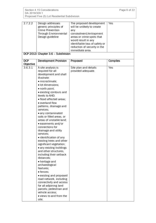
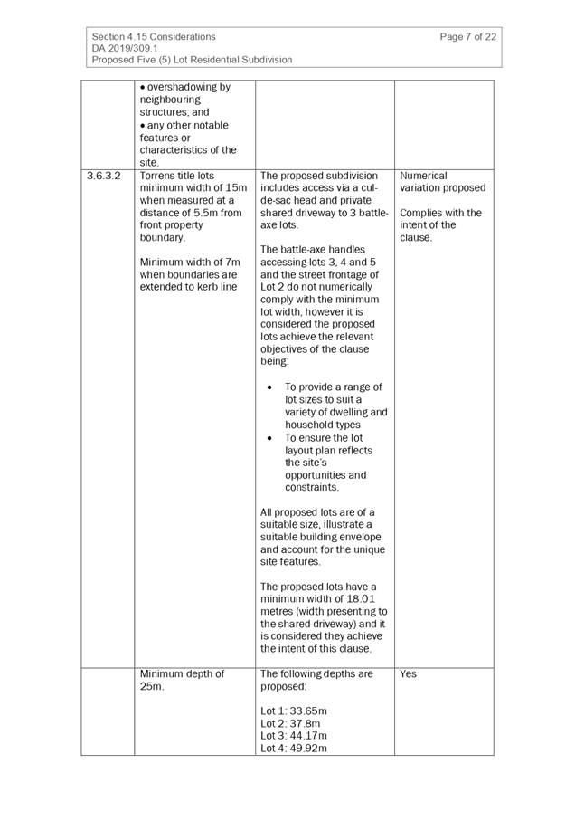
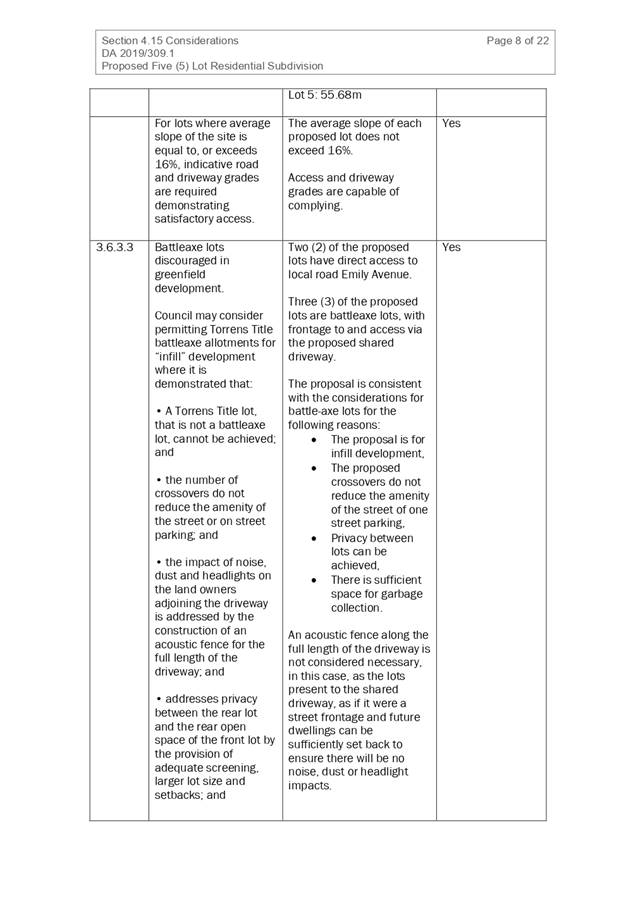
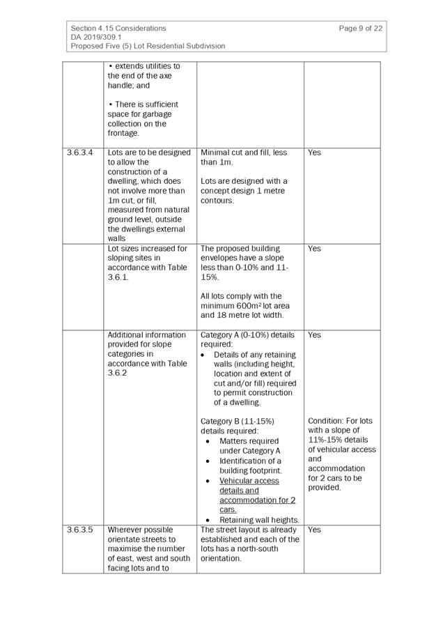
2.6.3.1
|
Tree removal (3m or higher with 100m diameter trunk at 1m
above ground level and 3m from external wall of existing dwelling)
|
Trees are proposed to be removed. Ecological report
prepared and submitted. Natural resource team have assessed and provided
approval for removal.
|
|
|
2.4.3
|
Bushfire risk, Acid sulphate soils, Flooding,
Contamination, Airspace protection, Noise and Stormwater
|
Acid sulphate soil class 3 indicated on site.
No engineer designs provided. Unsure of need for deep
excavation. Condition to be placed on DA to comply council ASS policy for
minor works
|
Yes
|
|
2.5.3.2
|
New accesses not permitted from arterial or distributor
roads
|
No new access proposed to arterial or distribution road.
|
N/A
|
|
Driveway crossing/s minimal in number and width including
maximising street parking
|
Driveway crossing minimal in width including maximising
street parking
|
Yes
|
|
2.5.3.3
|
Parking in accordance with Table 2.5.1.
1 space per single dwelling (behind building line)
|
1 or capacity for more than 1 parking space behind the
building line has been provided for.
|
Yes
|
|
2.5.3.11
|
Section 94 contributions
|
Refer to main body of report.
|
|
|
2.5.3.12 and 2.5.3.13
|
Landscaping of parking areas
|
Single dwelling only with 1 domestic driveway. No specific
landscaping requirements recommended.
|
N/A
|
|
2.5.3.14
|
Sealed driveway surfaces unless justified
|
Sealed driveway proposed
|
Yes
|
|
2.5.3.15 and 2.5.3.16
|
Driveway grades first 6m or ‘parking area’
shall be 5% grade with transitions of 2m length
|
Driveway grades capable of satisfying Council standard
driveway crossover requirements. Condition recommended for section 138 Roads
Act permit
|
Yes
|
|
2.5.3.17
|
Parking areas to be designed to avoid concentrations of
water runoff on the surface.
|
Single dwelling only with 1 domestic driveway. Stormwater
drainage is capable of being managed as part of plumbing construction.
|
Yes
|
The proposal seeks to vary Development Provisions relating
to:
· Clause 3.2.2.5 (b)
- Setback of first floors from side boundaries to be a minimum of 3m unless it
can be demonstrated that adjoining properties are not adversely affected by
overshadowing.
· Clause 3.2.2.5 (c)
- Walls are to step in and out at least every 12m by a minimum of 500mm
The relevant objectives are:
· To reduce
overbearing and perceptions of building bulk on adjoining properties and to
maintain privacy.
· To provide for
visual and acoustic privacy between dwellings.
Having regard for the development provisions and relevant
objectives, the variation is considered acceptable for the following reasons:
· Proposed
construction and located 1200mm from side boundaries. Shadow diagrams provided
indicate that the shadow effect is not dissimilar to the shadow provided by
existing trees.
· No windows are
located in affected wall of the adjacent property. Privacy will be maintained.
· Use of materials /
textures in upper and lower levels creates variation and separation and is seen
to meet the objectives of the clause.
· Insulation is
required within the external wall to meet BASIX requirements. This insulation
will assist with noise attenuation.
Based on the above assessment, the variations proposed to
the provisions of the DCP are considered acceptable and the relevant objectives
have been satisfied. Cumulatively, the variations do not amount to an adverse
impact or a significance that would justify refusal of the application.
(iiia) Any planning agreement that has
been entered into under section 7.4, or any draft planning agreement that a
developer has offered to enter into under section 7.4
No planning agreement has been
offered or entered into relating to the site.
(iv) Any
matters prescribed by the Regulations
New
South Wales Coastal Policy
The proposed development is
consistent with the objectives and strategic actions of this policy
Demolition
of buildings AS 2601 - Clause 92
No demolition proposed.
(b) The likely
impacts of that development, including environmental impacts on both the
natural and built environments, social and economic impacts in the locality:
The proposal will not have any significant adverse impacts
on existing adjoining properties and satisfactorily addresses the public
domain.
The proposal is considered to be compatible with other
residential development in the locality and adequately addresses planning
controls for the area.
The proposal does not have a significant adverse impact on
existing view sharing.
The proposal does not have significant adverse lighting
impacts.
There are no significant adverse privacy impacts.
Due to the height and extent of existing trees within the
immediate locality the provision of natural sunlight to the affected properties
is limited. The proposal is not considered to significantly worsen the ability
for the adjoining property to receive 3 hours of sunlight to private open space
areas between 9am and midday on 21 June. It is acknowledged that overshadowing
will be increased between midday and 3pm. It is additionally noted that the
adjoining property does not have any primary living room windows on the
northern elevation of the building.
Access, Traffic and Transport
The proposal will not have any significant adverse impacts
in terms access, transport and traffic. The existing road network will
satisfactorily cater for any increase in traffic generation as a result of the
development.
Water Supply Connection
Service available – details required with S.68
application.
Sewer Connection
Service available – details required with S.68
application.
Stormwater
Service available – details required with S.68
application.
Other Utilities
Telecommunication and electricity services are available to
the site.
Heritage
This site does not contain or adjoin any known heritage item
or site of significance. The site is considered to be disturbed land.
Other land resources
The site is within an established urban context and will not
sterilise any significant mineral or agricultural resource.
Water cycle
The proposed development will not have any significant
adverse impacts on water resources and the water cycle.
Soils
The proposed development will not have any adverse impacts
on soils in terms of quality, erosion, stability and/or productivity subject to
a standard condition requiring erosion and sediment controls to be in place
prior to and during construction.
Management of acid sulphate soils will need to be
implemented as Class 3 soils are indicated as being present. A condition of
consent is recommended to ensure the excavation complies with Council Acid
Sulphate Soil Minor Works Policy
Air and microclimate
The construction and/or operations of the proposed
development will not result in any significant adverse impacts on the existing
air quality or result in any pollution. Standard precautionary site management
condition recommended.
Flora and fauna
The proposed development will require removal of 2 small
groves of broad leaf paperbark melaleuca. Additionally, a tree located on the
road reserve may be impacted by the proposed driveway. An ecological report has
been prepared and submitted with the application. Council natural resource team
have evaluated the report and confirmed that the requirements of the
Biodiversity Conservation Act have been satisfied and the impacts are
acceptable.
Waste
Satisfactory arrangements are in place for proposed storage
and collection of waste and recyclables. No adverse impacts anticipated.
Standard precautionary site management condition recommended.
Energy
The proposal includes measures to address energy efficiency
and will be required to comply with the requirements of BASIX.
Noise and vibration
The construction of the proposed development will not result
in any significant adverse impacts on the existing air quality or result in any
pollution. Standard precautionary site management condition recommended.
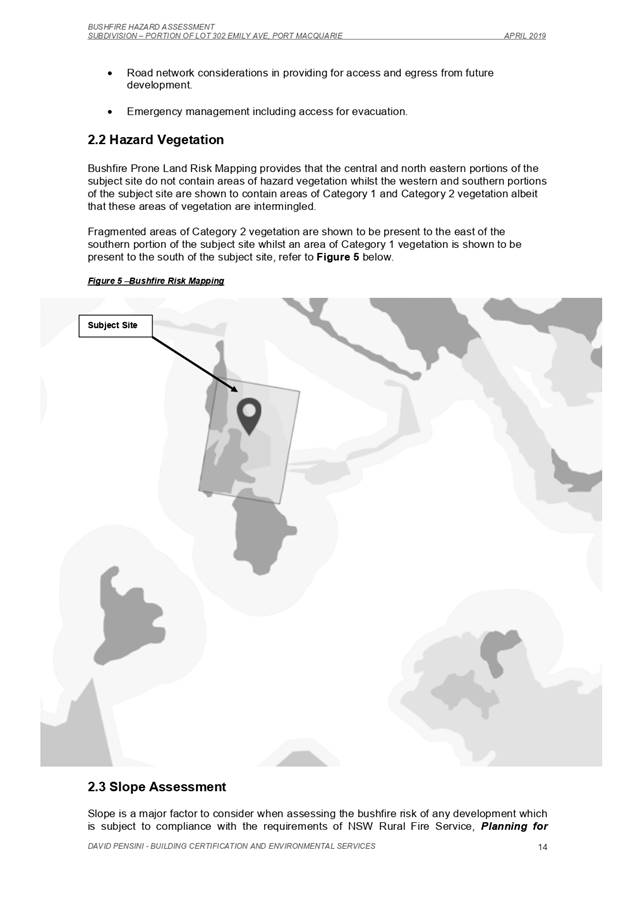
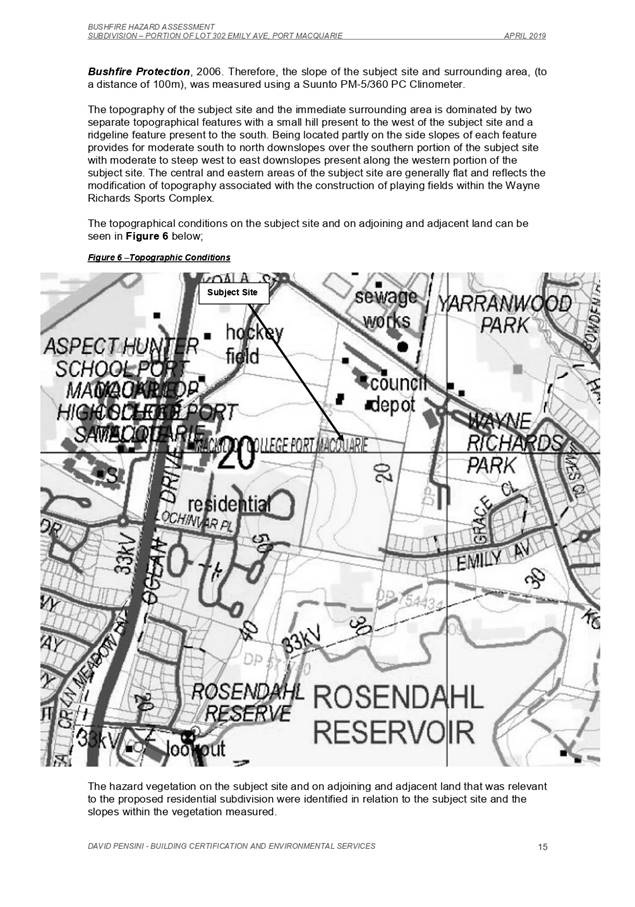
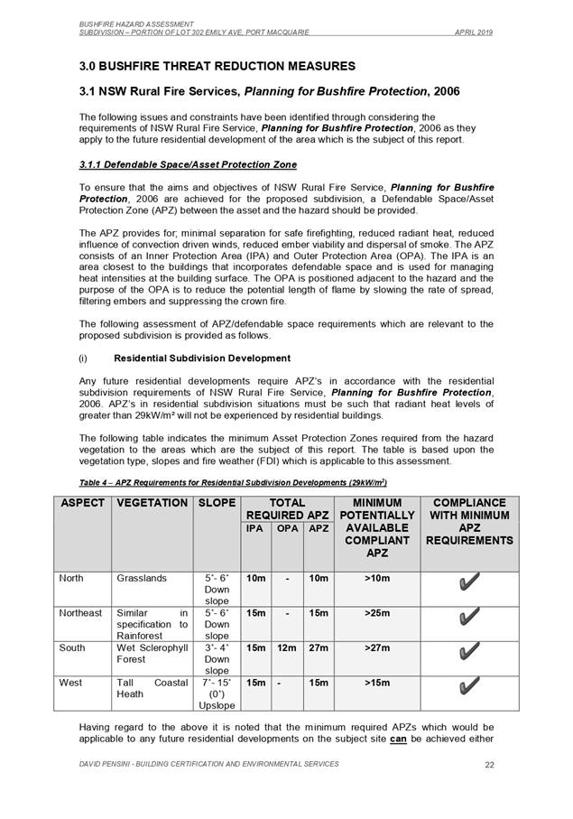
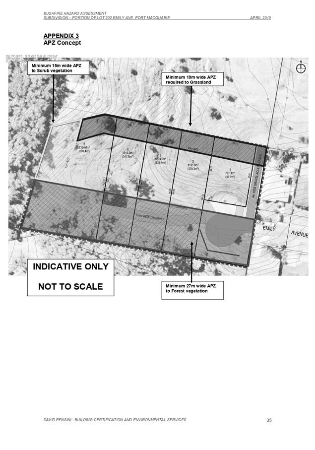
Bushfire
The site is identified as being bushfire prone.
The Applicant has submitted a bushfire report prepared as a
self-assessment.
An assessment of bushfire risk having regard to section
4.3.5 of Planning for Bushfire Protection 2006 including vegetation
classification and slope concludes that a Bushfire Attack Level 12.5 shall be
required. Any external timber used in decks, stairs, landings and the like will
be required to comply with Appendix 3 of Planning for Bushfire Protection.
Management of bushfire risk is acceptable subject to BAL
construction levels being implemented and APZ being maintained. An appropriate
condition is recommended.
Safety, security and crime prevention
The proposed development will be unlikely to create any
concealment/entrapment areas or crime spots that would result in any
identifiable loss of safety or reduction of security in the immediate area. The
increase in housing density will improve natural surveillance within the
locality and openings from each dwelling overlook common and private areas.
Social impacts in the locality
Given the nature of the proposed development and its
location, the proposal is not considered to have any significant adverse social
impacts.
Economic impact in the locality
The proposal is not considered to have any significant
adverse economic impacts on the locality. A likely positive impact is that the
development will maintain employment in the construction industry, which will
lead to flow impacts such as expenditure in the area.
Site design and internal design
The proposed development design satisfactorily responds to
the site attributes and will fit into the locality.
Construction
Construction impacts are considered capable of being
managed, standard construction and site management conditions have been
recommended.
Cumulative Impacts
The proposed development is not considered to have any
significant adverse cumulative impacts on the natural or built environment or
the social and economic attributes of the locality.
(c) The
suitability of the site for the development
The proposal will fit into the locality and the site
attributes are conducive to the proposed development.
Site constraints of bushfire/flooding have been adequately
addressed and appropriate conditions of consent recommended.
(d) Any
submissions made in accordance with this Act or the Regulations
One (1) written
submissions was received following public exhibition of the application. Copies
of the written submissions have been provided separately to members of the DAP.
Key
issues raised in the submissions received and comments are provided as follows:
|
Submission
Issue/Summary
|
Planning
Comment/Response
|
|
The bulk, scale and size of the dwelling, which is
considerably larger and not in keeping with existing residential development
|
Excepting for Cl 3.2.2.5 -
Side setbacks, the proposed development meets the criteria of PMHC DCP 2013.
Shadow diagrams have been prepared to assess overshadowing and have
satisfactorily demonstrated that impacts are not significantly worsened. Side
setbacks to ground floor has been increased to 1200mm.
|
|
The removal of all 40 trees on the site and the impact it
will have on the local environment;
|
The lot is an existing infill lot. An ecological
assessment has been prepared and reviewed by council natural resource team.
Although unfortunate, the removal is acceptable.
|
|
The impact of the proposed development and associated
tree removal on the large paperbark trees within our backyard;
|
The construction zone will be approx.13m from the rear
boundary. The ecological report did consider the trees on adjoining lots and
found no concerns.
|
|
Privacy concerns relating to the design of the dwelling
overlooking private open space within our backyard.
|
The proposed dwelling will be located approx. 13m from
the rear boundary. This distance exceeds Council DCP requirement of 4m for
rear building setback and 12m radius between primary living areas. It is
considered that there will be no adverse privacy impacts.
|
(e) The Public Interest
The proposed development
satisfies relevant planning controls and will not adversely impact on the wider
public interest.
4. DEVELOPMENT
CONTRIBUTIONS APPLICABLE
Development
contributions will not be required under S64/S7.11 for the following reason:
Single dwelling located on existing approved lot.
5. CONCLUSION AND
STATEMENT OF REASON
The application has been assessed in accordance with Section
4.15 of the Environmental Planning and Assessment Act 1979.
Issues raised during assessment and public exhibition of the
application have been considered in the assessment of the application. Where
relevant, conditions have been recommended to manage the impacts attributed to
these issues.
The site is considered to be suitable for the proposed
development and the proposal adequately addresses relevant planning controls.
The development is not considered to be contrary to the public's interest and
will not result a significant adverse social, environmental or economic impact.
It is recommended that the application be approved, subject to the recommended
conditions of consent provided in the attachment section of this report. Attachment 1
|
Attachments
1⇩. DA2019 - 883.1
Recommended Conditions
2⇩. DA2019 - 883.1 Plans
|
|
ATTACHMENT
|
Development Assessment Panel
06/05/2020
|
|
ATTACHMENT
|
Development Assessment Panel
06/05/2020
|
AGENDA Development Assessment Panel 06/05/2020
Item: 07
Subject: DA2020 - 122.1 Alterations and Additions to
Dwelling at Lot 20 DP 262273, No 11 Timber Ridge Port Macquarie
Report
Author: Development Assessment Planner, Robert Slater
|
Applicant: A
Wilcox
Owner: A
Wilcox
Estimated Cost: $950K
Alignment with Delivery
Program
4.3.1 Undertake transparent and
efficient development assessment in accordance with relevant legislation.
|
RECOMMENDATION
That
DA2020 - 122 for dwelling additions and
alterations at Lot 20, DP 262273, No. 11 Timber
Ridge, Port Macquarie, be determined by granting consent subject to the
recommended conditions.
Executive
Summary
This
report considers a development application for a dwelling additions and
alterations at the subject site and provides an
assessment of the application in accordance with the Environmental Planning and
Assessment Act 1979.
Following exhibition of the
application, 2 submissions were received.
The site is considered suitable for the proposed development
and the proposal adequately addresses relevant planning controls. The
development is not considered to be contrary to the public's interest and will
not result a significant adverse social, environmental or economic impact.
This report recommends that the
development application be approved subject to the conditions included
in Attachment 1.
1. BACKGROUND
Existing
Sites Features and Surrounding Development
The site has an area of 2633m2.
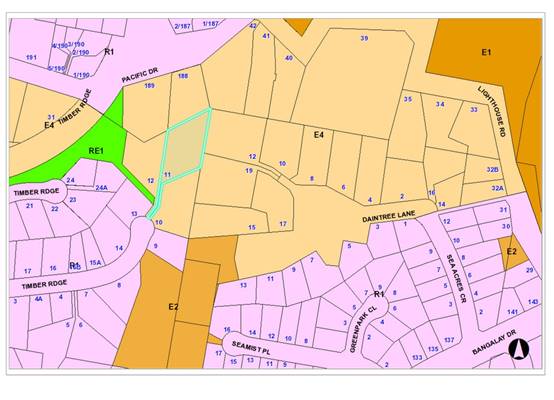
The
site is zoned E4 Environmental Living in accordance with the Port Macquarie-Hastings Local
Environmental Plan 2011, as shown in the following zoning plan:
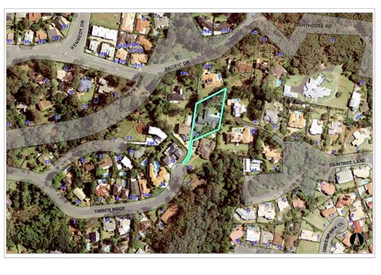
 The existing subdivision pattern and location of existing
development within the locality is shown in the following aerial photograph:
The existing subdivision pattern and location of existing
development within the locality is shown in the following aerial photograph:
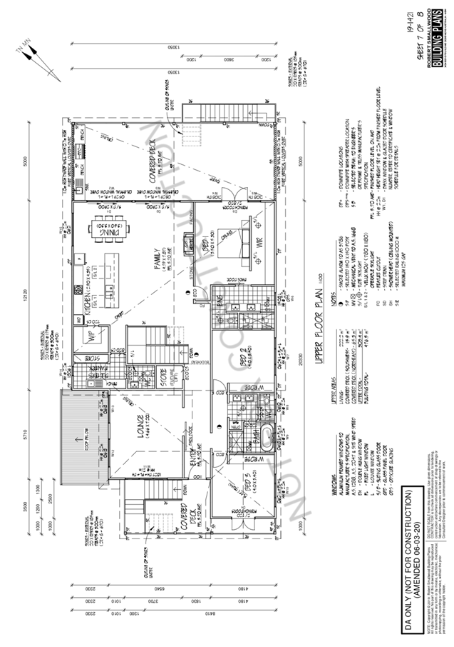
 2. DESCRIPTION OF DEVELOPMENT
Key
aspects of the proposal include the following:
· Alterations
and additions to existing dwelling
Refer
to Attachment 2 at the end of this report for plans of the proposed
development.
Application
Chronology
· 24
February 2020 - Application lodged
· 4 March 20202 - Application notified
· 25 March 2020 Window boundary offset plan details provided
3. STATUTORY
ASSESSMENT
Section
4.15(1) Matters for Consideration
In
determining the application, Council is required to take into consideration the
following matters as are relevant to the development that apply to the land to
which the development application relates:
(a) The
provisions (where applicable) of:
(i) Any
Environmental Planning Instrument
State Environmental Planning Policy No. 44 - Koala
Habitat Protection
There is no Koala Plan of Management on the site.
Additionally, the site is less than 1ha in area therefore no further
investigations are required.
State Environmental Planning Policy No. 55 –
Remediation of Land
Following an inspection of the site and a search of Council
records, the subject land is not identified as being potentially contaminated
and is suitable for the intended use.
State Environmental Planning Policy (Coastal Management)
2018
The site is not located within a coastal use area / coastal
environment area.
The site has part mapped littoral rainforest and proximity
mapping applying to the property.
Having regard to clause 11 of the SEPP and clause 5.5 of the
Port Macquarie-Hastings LEP 2011 the proposed development is on land identified
as “proximity area” for littoral rainforest. The
proposed residential development is not considered likely to result in any of
the following:
(a) any adverse impact on the biophysical, hydrological or
ecological integrity of the adjacent
coastal wetland or littoral rainforest, or
(b) any
adverse impact on the quantity and quality of surface and ground water flows
to and from the adjacent coastal wetland or littoral rainforest.
The existing and proposed
on-site stormwater management measures are considered to be adequate to direct
roof and surface waters from the site to the existing street stormwater
infrastructure.
The bulk, scale and size of the proposed development is
compatible with the surrounding coastal and built environment. The site is
developed and located within an established residential setting.
State Environmental Planning Policy (Building
Sustainability Index: BASIX) 2004
A BASIX certificate has been submitted demonstrating that
the proposal will comply with the requirements of the SEPP. It is recommended
that a condition be imposed to ensure that the commitments are incorporated
into the development and certified at Occupation Certificate stage.
Port Macquarie-Hastings Local Environmental
Plan 2011
The proposal is consistent with the LEP having regard to the
following:
· Clause
2.2 - The subject site is zoned E4 Environmental Living.
· Clause
2.3(1) and the E4 zone landuse table - The alterations and additions to
the dwelling is a permissible landuse with consent, being development ancillary
to a dwelling.
· The
objectives of the E4 zone are as follows:
o To provide for low-impact residential development
in areas with special ecological, scientific or aesthetic values.
o To ensure that residential development does not
have an adverse effect on those values.
· Clause
2.3(2) - The proposal is consistent with the zone objectives as it is a
permissible landuse and consistent with the established residential locality.
The proposal will not result in any identifiable adverse ecological, scientific
or aesthetic impacts.
· Clause
2.7 - The demolition requires consent as it does not fit within the provisions
of SEPP (Exempt and Complying Development Codes) 2008.
· Clause
4.3 - The maximum overall height of the building above ground level (existing)
is 7.7m which complies with the standard height limit of 8.5m applying to the
site.
· Clause
4.4 - The maximum floor space ratio of 0.65:1 does not apply to the site.
· Clause
5.10 – Heritage. The site does not contain or adjoin any known heritage
items or sites of significance.
· Clause
7.13 - Satisfactory arrangements are in place for provision of essential
services including water supply, electricity supply, sewer infrastructure,
stormwater drainage and suitable road access to service the development.
(ii) Any draft
instruments that apply to the site or are on exhibition
No draft instruments apply to the site.
(iii) Any Development
Control Plan in force
Port
Macquarie-Hastings Development Control Plan 2013
|
Port Macquarie-Hastings Development Control Plan 2013:
|
|
DCP 2013: Dwellings, Dual
occupancies, Dwelling houses, Multi dwelling houses & Ancillary
development
|
|
|
Requirements
|
Proposed
|
Complies
|
|
3.2.2.1
|
Ancillary development:
• 4.8m max. height
• Single storey
• 60m2 max. area
• 100m2 for lots
>900m2
• 24 degree max.
roof pitch
• Not located in
front setback
|
The proposed water tanks and
swimming pool are appropriately located
|
Yes
|
|
3.2.2.2
|
Articulation zone:
• Min. 3m front
setback
• An entry feature
or portico
• A balcony, deck, patio,
pergola, terrace or verandah
• A window box
treatment
• A bay window or
similar feature
• An awning or other
feature over a window
• A sun shading
feature
|
No elements within the
articulation zone.
|
N/A
|
|
|
Front setback (Residential not R5
zone):
• Min. 4.5m local
road
|
Front building line setback is
compliant with the minimum 4.5m front setback requirements.
Battle-axe block with long access
handle.
|
Yes
|
|
3.2.2.3
|
Garage 5.5m min. and 1m behind
front façade.
Garage door recessed behind
building line or eaves/overhangs provided
|
Being on a battle-axe allotment,
garage door setback is compliant with the minimum front setback requirements.
Garage door recessed.
|
Yes
|
|
6m max. width of garage door/s
and 50% max. width of building
|
Width of garage door/s are
compliant with the maximum width requirements
|
Yes
|
|
Driveway crossover 1/3 max. of
site frontage and max. 5.0m width
|
No change to existing driveway.
|
Yes
|
|
3.2.2.4
|
4m min. rear setback. Variation
subject to site analysis and provision of private open space
|
The rear setback requirements are
complied with.
|
Yes
|
|
3.2.2.5
|
Side setbacks:
• Ground floor =
min. 0.9m
• First floors &
above = min. 3m setback or where it can be demonstrated that overshadowing
not adverse = 0.9m min.
• Building wall set
in and out every 12m by 0.5m
|
The minimum side setback
requirements are complied with.
Western Elevation:4.988m
Eastern Elevation: Approx. 9.5m
The building wall articulation is
satisfactory to address the objective intent of the development provision.
|
Yes
Yes
Yes
|
|
3.2.2.6
|
35m2 min. private open space area
including a useable 4x4m min. area which has 5% max. grade
|
The dwelling contains 35m² open space in one area
including a useable 4m x 4m space.
|
Yes
|
|
3.2.2.10
|
Privacy:
• Direct views
between living areas of adjacent dwellings screened when within 9m radius of
any part of window of adjacent dwelling and within 12m of private open space
areas of adjacent dwellings. i.e. 1.8m fence or privacy screening which has
25% max. openings and is permanently fixed
• Privacy screen
required if floor level > 1m height, window side/rear setback (other than
bedroom) is less than 3m and sill height less than 1.5m
• Privacy screens
provided to balconies/verandahs etc. which have <3m side/rear setback and
floor level height >1m
|
The development will not compromise privacy in the area
due to a combination of living spaces having high sill windows that face
side/rear boundaries, limiting living areas that face adjoining living
areas/open space, compliant separation and use of boundary fencing and
vegetative screens.
See window schedule and window to boundary offset plan
below this table*.
No privacy screens are
recommended.
|
Yes
|
|
DCP 2013: General
Provisions
|
|
|
Requirements
|
Proposed
|
Complies
|
|
2.7.2.2
|
Design addresses generic principles of Crime Prevention
Through Environmental Design guideline
|
No concealment or entrapment areas proposed. Adequate
casual surveillance available.
|
Yes
|
|
2.3.3.1
|
Cut and fill 1.0m max. 1m outside the perimeter of the
external building walls
|
Cut and fill <1.0m change 1m outside the perimeter of
the external building walls
|
N/A
|
|
2.3.3.2
|
1m max. height retaining walls along road frontage
|
None proposed
|
N/A
|
|
Any retaining wall >1.0 in height to be certified by
structure engineer
|
No retaining wall likely >1m
|
Yes
|
|
Combination of retaining wall and front fence height max
1.8m, max length 6.0m or 30% of frontage, fence component 25% transparent,
and splay at corners and adjacent to driveway
|
No retaining wall front fence combination proposed.
|
N/A
|
|
2.5.3.3
|
Parking in accordance with Table 2.5.1.
1 space per single dwelling (behind building line)
|
1 or capacity for more than 1 parking space behind the
building line has been provided for.
|
Yes
|
|
2.5.3.11
|
Section 94 contributions
|
Refer to main body of report.
|
|
|
2.5.3.14
|
Sealed driveway surfaces unless justified
|
No change to existing driveway.
|
Yes
|
|
2.5.3.15 and 2.5.3.16
|
Driveway grades first 6m or ‘parking area’
shall be 5% grade with transitions of 2m length
|
No change to existing driveway.
|
Yes
|
|
2.5.3.17
|
Parking areas to be designed to avoid concentrations of
water runoff on the surface.
|
Single dwelling only with 1 domestic driveway. Stormwater
drainage is capable of being managed as part of plumbing construction.
|
Yes
|
|
|
|
|
|
|
*Window boundary offset plan detail:
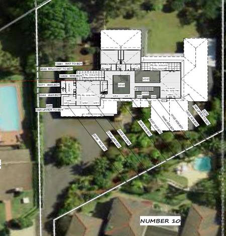
(iv) Any
matters prescribed by the Regulations
New
South Wales Coastal Policy
The proposed development is
consistent with the objectives and strategic actions of this policy
Demolition
of buildings AS 2601 - Clause 92
None prescribed.
(b) The likely
impacts of that development, including environmental impacts on both the
natural and built environments, social and economic impacts in the locality:
Context and Setting
The proposal will not have any significant adverse impacts
on existing adjoining properties and satisfactorily addresses the public
domain.
The proposal is considered to be compatible with other
residential development in the locality and adequately addresses planning
controls for the area.
The proposal does not have a significant adverse impact on
existing view sharing.
The proposal does not have significant adverse lighting
impacts.
There are no significant adverse privacy impacts.
There are no significant adverse overshadowing impacts. The
proposal does not prevent adjoining properties from receiving 3 hours of
sunlight to private open space and primary living areas on 21 June.
Access, Traffic and Transport
The proposal will not have any significant adverse impacts
in terms access, transport and traffic. The existing road network will
satisfactorily cater for any increase in traffic generation as a result of the
development.
Water Supply Connection
Service available – details required with S.68
application.
Sewer Connection
Service available – details required with S.68
application.
Stormwater
Service available – details required with S.68
application.
Other Utilities
Telecommunication and electricity services are available to
the site.
Heritage
This site does not contain or adjoin any known heritage item
or site of significance. The site is considered to be disturbed land.
Other land resources
The site is within an established urban context and will not
sterilise any significant mineral or agricultural resource.
Water cycle
The proposed development will not have any significant
adverse impacts on water resources and the water cycle.
Soils
The proposed development will not have any adverse impacts
on soils in terms of quality, erosion, stability and/or productivity subject to
a standard condition requiring erosion and sediment controls to be in place
prior to and during construction.
Air and microclimate
The construction and/or operations of the proposed
development will not result in any significant adverse impacts on the existing
air quality or result in any pollution. Standard precautionary site management
condition recommended.
Flora and fauna
Construction of the proposed development will not require
any removal/clearing of any native vegetation and therefore does not trigger
the biodiversity offsets scheme. Part 7 of the Biodiversity Conservation
Act 2016 is considered to be satisfied.
Waste
Satisfactory arrangements are in place for proposed storage
and collection of waste and recyclables. No adverse impacts anticipated. Standard
precautionary site management condition recommended.
Energy
The proposal includes measures to address energy efficiency
and will be required to comply with the requirements of BASIX.
Noise and vibration
The construction of the proposed development will not result
in any significant adverse impacts on the existing air quality or result in any
pollution. Standard precautionary site management condition recommended.
Bushfire
The site is identified as being bushfire prone.
The Applicant has submitted a BAL Certificate prepared by a
Certified Consultant.
An assessment of bushfire risk having regard to section
4.3.5 of Planning for Bushfire Protection 2006 including vegetation
classification and slope concludes that a Bushfire Attack Level 12.5 shall be
required.
Management of bushfire risk is acceptable subject to BAL
construction levels being implemented and APZ being maintained. An appropriate
condition is recommended.
Site design and internal design
The proposed development design satisfactorily responds to
the site attributes and will fit into the locality.
Construction
Construction impacts are considered capable of being
managed, standard construction and site management conditions have been
recommended.
Safety, security and crime prevention
The proposed development will be unlikely to create any
concealment/entrapment areas or crime spots that would result in any
identifiable loss of safety or reduction of security in the immediate area.
Social impacts in the locality
Given the nature of the proposed development and its
location the proposal is not considered to have any significant adverse social
impacts.
Economic impact in the locality
The proposal is not considered to have any significant
adverse economic impacts on the locality. A likely positive impact is that the
development will maintain employment in the construction industry, which will
lead to flow impacts such as expenditure in the area.
Cumulative Impacts
The proposed development is not considered to have any
significant adverse cumulative impacts on the natural or built environment or
the social and economic attributes of the locality.
(c) The
suitability of the site for the development
The bulk, scale and size of the proposed development is
compatible with the surrounding coastal and built environment. The site is
developed and located within an area zoned for residential purposes.
Site constraints of bushfire have been adequately addressed
and appropriate conditions of consent recommended.
(d) Any
submissions made in accordance with this Act or the Regulations
Two (2) written
submissions were received following public exhibition of the application.
Copies of the written submissions have been provided separately to members of
the DAP.
Key
issues raised in the submissions received and comments are provided as follows:
|
Submission
Issue/Summary
|
Planning
Comment/Response
|
|
No. 10 Timber Ridge
Upper south facing windows
W34, W35, W36, W37, and W38, will directly overlook the rear of our property.
The identified windows will
look directly on to the swimming pool area and into our private courtyard,
rear garden, bedrooms and main living and dining area
|
Window schedule provided below
for information.
W34 (1418) is situated in a
first floor wall which is setback 13.025m from the side boundary and is
situated above a living room sink.
To address the potential for
overlooking into the adjoining property’s private open space and living
areas the applicant has submitted amended plans which show W34 being replaced
with a (0918) highlight window having a minimum sill height above the floor
level of 1500mm.
W35 (1418) and W36 (1418) are situated in a first floor
wall having a setback 15.12m and 16.4m respectively from the side boundary.
The windows are so positioned as to provide natural light via a
non-trafficable void to the ground floor living areas
W37 (1418) and W38 (1418) are situated in a first floor
wall which is setback 18.257m and 19.676m respectively from the side
boundary. The windows provide natural light to the corridor which provides a
path of travel to a bedroom
W39 (1209) and W40 (1418) are situated in a first floor
wall which is setback 20.630m and 22.146m respectively from the side boundary
and situated in a bedroom.
|
|
|
W41 (1409) is situated in a
first floor wall which is setback 24.156m from the side boundary and located
in the wake-in-robe.
Based on the above assessment
of the window to boundary offset the DCP objective to protect the visual
privacy of on-site and nearby residents the applicant has adequately
addressed the objective.
|
|
The proposed development will negatively impact our
privacy and is an invasion of it.
|
It is conceded that the protection of complete privacy in
this situation is made the more difficult as the development site being a
battle axe block with a long access handle sharing a common boundary with
seven (7) other adjoining properties.
Therefore, greater emphasis is placed on maintaining
privacy between and in living areas and private open space than for bedrooms.
The hours of occupancy and the ability of the occupant to
exercise some control of the extent of overlooking when indoors, through
their choice of such window screening as curtains or blinds offset the
priority for privacy.
In combination with the proposed treatment to
W34(0918) and compliant separation distances to the adjoining southern
boundary, it is considered that the applicant has successfully addressed the
issue/s of direct overlooking of main internal living areas and private open
spaces of property adjoining the southern boundary
|
|
Timber Ridge is a prestigious road with large individual
homes built on large lots to maximise privacy.
|
This issue is not a
matter for consideration under section 4.15. The issue of privacy has been
addressed previously.
The proposal is permissible with consent in the zone and
has satisfactorily responded to relevant planning controls.
|
|
The proposed development will negatively affect the value
of our property due to a lack of privacy.
|
Property values are not a matter for consideration under
section 4.15. The proposal is permissible with consent in the zone and has
satisfactorily responded to relevant planning controls.
|
|
The proposed development will negatively impact the quiet
peace privacy and enjoyment we currently have by overlooking and removing the
privacy.
|
The proposal is permissible with consent and complies
with Council’s planning controls. There are considered to be
insufficient grounds to refuse the application.
|
|
No. 12 Timber Ridge
Whilst the designer has limited the size of the windows
overlooking our pool area there does not seem to be a privacy screen of the
western side of the balcony on the northern side of the bedroom.
|
The first floor balcony has a compliant boundary setback
of 8.530m and is off the main bedroom.
In accordance with the EP&A Act 1979 No 203 - 4.15
Evaluation Clause (3A) Development Control Plans
(a) if those provisions
set standards with respect to an aspect of the development and the
development application complies with those standards—is not to require
more onerous standards with respect to that aspect of the development.
A privacy screen to the western end of the first floor
balcony is not recommended.
|
|
The bedroom area adjacent to the pool area that
consideration be given to creating additional sound proofing in this area.
The privacy screen may need to have acoustic qualities.
|
No privacy screens are recommended as the separation
distance from the bedroom window to the boundary is compliant with the DCP.
|
|
WINDOW
SCHEDULE& 1st floor Balcony
|
|
No:
|
Room
|
Orientation
|
Dimensions
|
Distance Off
Boundary
|
|
W41
|
WIR
|
South
|
1409
|
24.156m
|
|
W40
|
Bed 1
|
South
|
1418
|
22.146m
|
|
W39
|
Bed 1
|
South
|
1209
|
20.630m
|
|
W38
|
Void
|
South
|
1418
|
19.676m
|
|
W37
|
Void
|
South
|
1418
|
18.257m
|
|
W36
|
Void
|
South
|
1418
|
16.440m
|
|
W35
|
Void
|
South
|
1418
|
15.120m
|
|
W34
|
Lounge
|
South
|
0918
|
13.025m
|
|
W47
|
Ensuite
|
West
|
0915
|
13.981m
|
|
W46
|
Void
|
West
|
1818
|
14.809m
|
|
W45
|
Shower
|
West
|
0918
|
5.071m
|
|
W44
|
WC
|
West
|
0912
|
5.044m
|
|
W43
|
Living
|
West
|
0621
|
14.743m - Ground Floor
|
|
W42
|
Living
|
West
|
0621
|
14.699m - Ground Floor
|
|
Balcony
|
bedroom
|
West
|
16.1m²
|
8.530m
|
|
Balcony
|
living
|
East
|
19.5m²
|
10.0m approx.
|
(e) The Public Interest
The proposed development
satisfies relevant planning controls and will not adversely impact on the wider
public interest.
4. DEVELOPMENT
CONTRIBUTIONS APPLICABLE
•
Development
contributions are not applicable for this development under S64Policy /S7.11
Plans.
5. CONCLUSION AND
STATEMENT OF REASON
The application has been assessed in accordance with Section
4.15 of the Environmental Planning and Assessment Act 1979.
Issues raised during assessment and public exhibition of the
application have been considered in the assessment of the application. Where
relevant, conditions have been recommended to manage the impacts attributed to
these issues.
The site is considered suitable for the proposed development
and the proposal adequately addresses relevant planning controls. The
development is not considered to be contrary to the public's interest and will
not result a significant adverse social, environmental or economic impact. It
is recommended that the application be approved, subject to the recommended
conditions of consent provided in the attachment section of this report (Attachment
1).
|
Attachments
1⇩. DA2020 - 122.1
Recommended Conditions.
2⇩. DA2020 - 122.1 Plans.
|
|
ATTACHMENT
|
Development Assessment Panel
06/05/2020
|
|
ATTACHMENT
|
Development Assessment Panel
06/05/2020
|
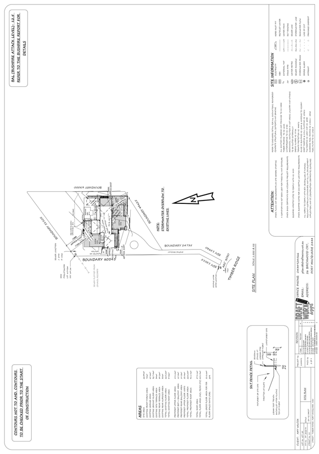
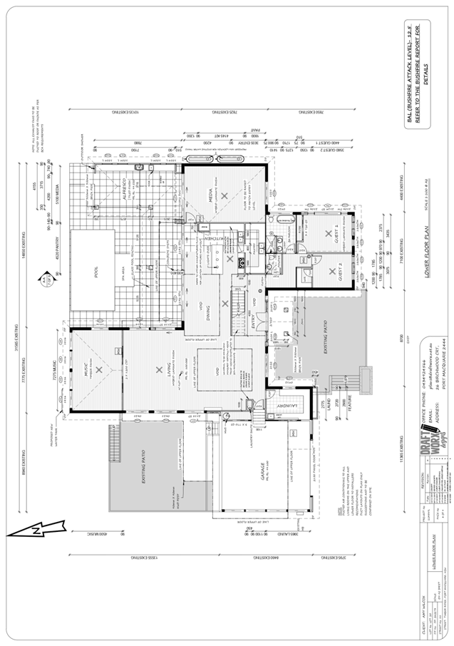
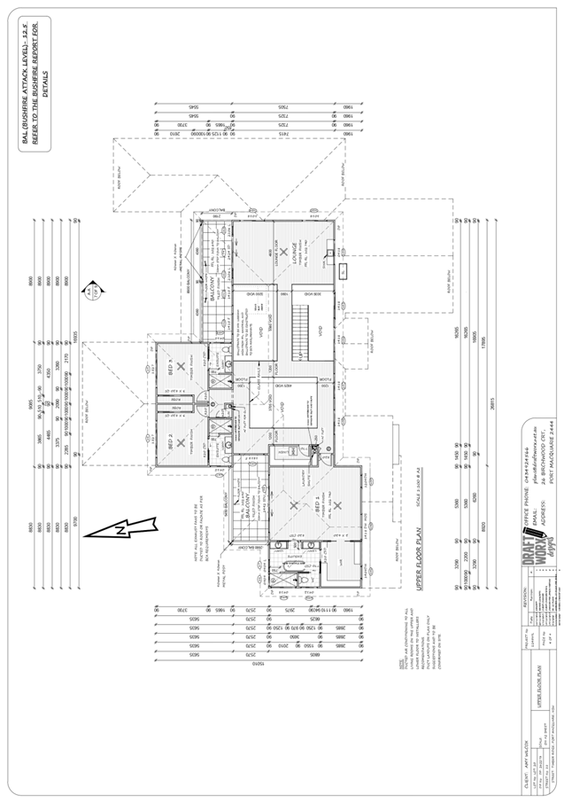
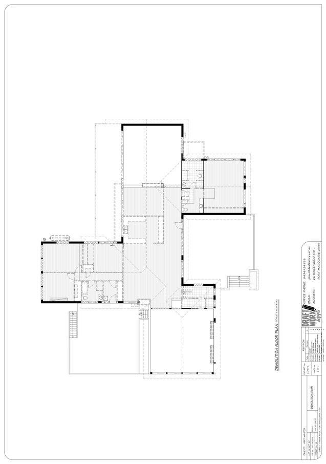
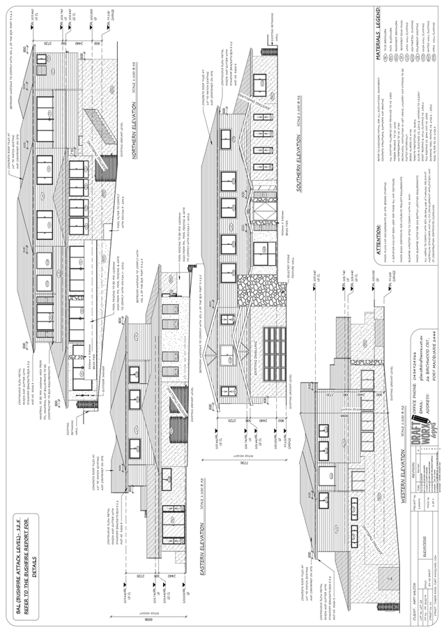
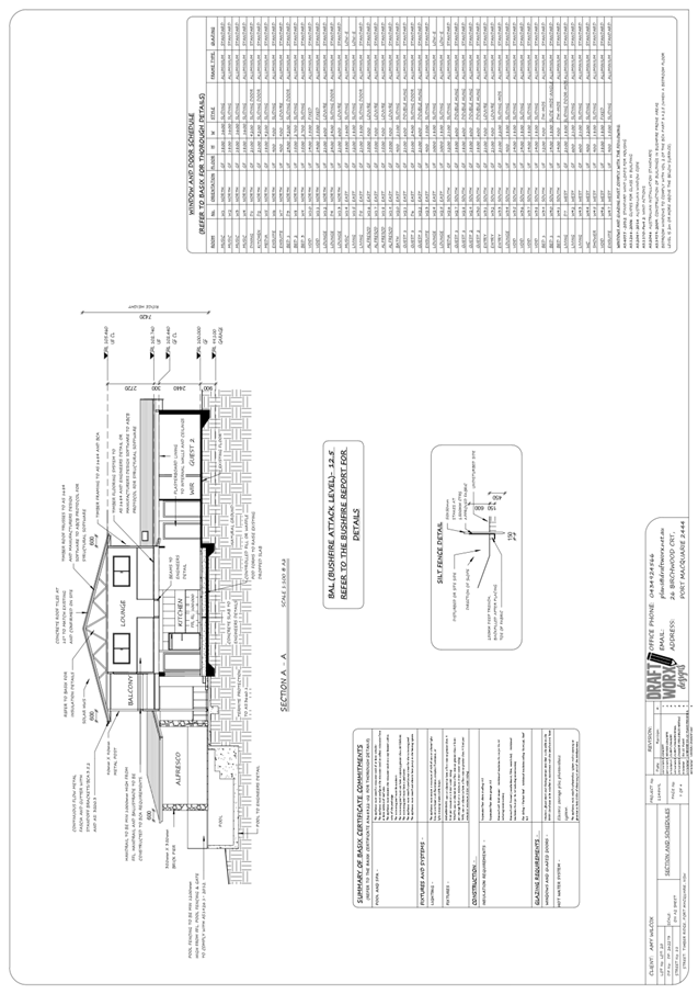
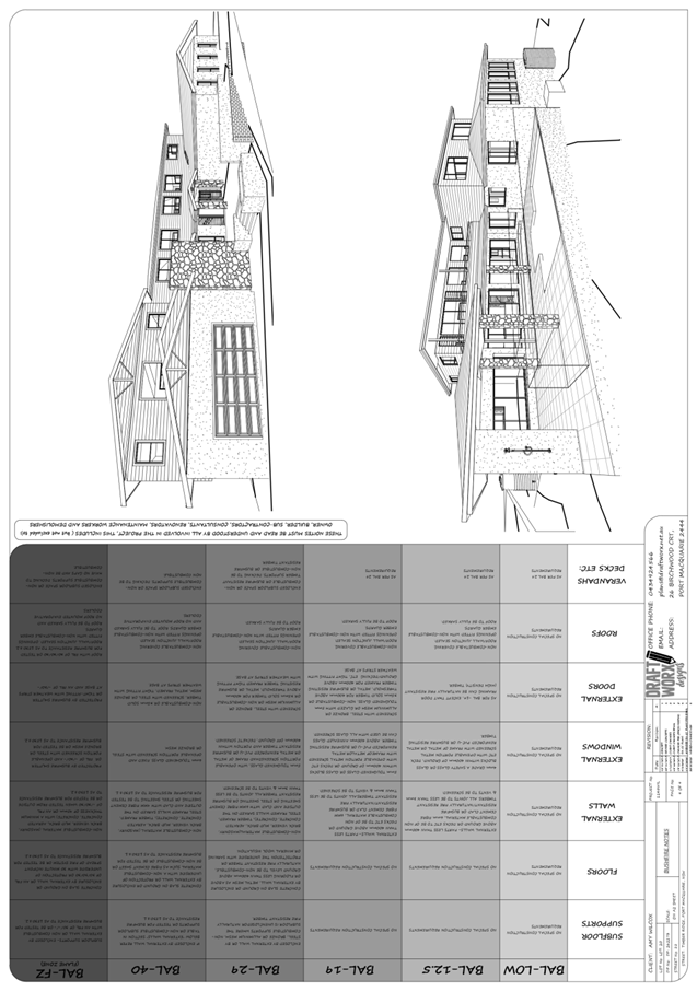
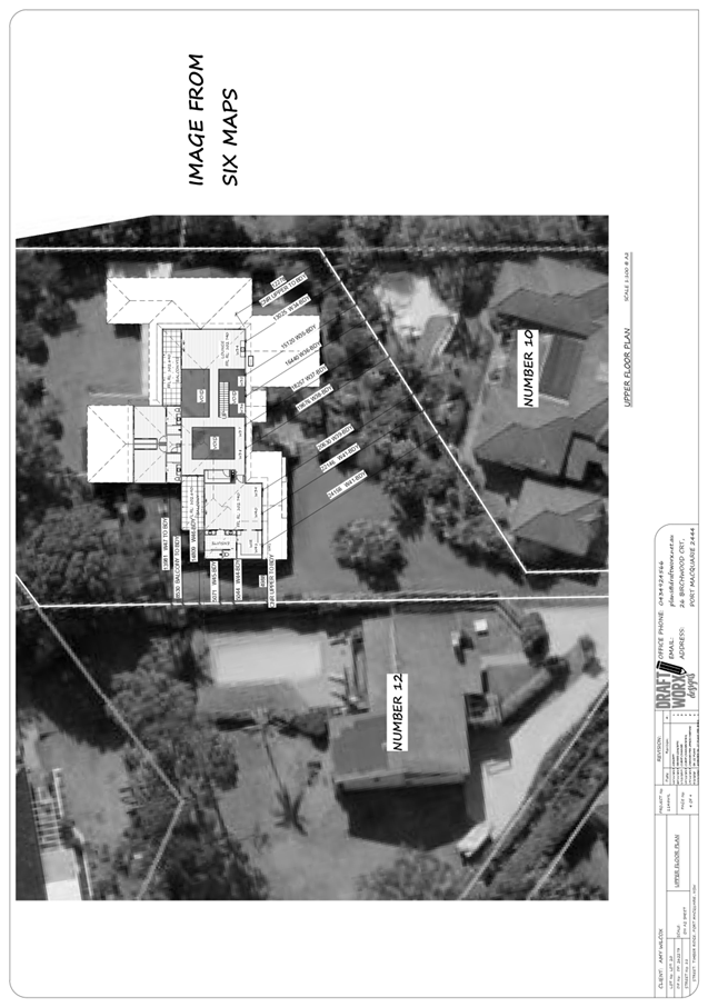
AGENDA Development Assessment Panel 06/05/2020
Item: 08
Subject: DA2020 - 63.1 Dwelling at Lot 2 DP 1143498,
No. 4A Hibiscus Cresent, Port Macquarie
Report
Author: Development Assessment Planner, Steven Ford
|
Applicant: A
N Webb & R Topschij C/- Collins W Collins
Owner: A
N Webb & R Topschij
Estimated Cost: $537,425.00
Alignment with Delivery
Program
4.3.1 Undertake transparent
and efficient development assessment in accordance with relevant legislation.
|
RECOMMENDATION
That
DA2020 - 63.1 for a dwelling at Lot 2, DP 1143498, No. 4A Hibiscus
Crescent, Port Macquarie, be determined by granting consent subject to the
recommended conditions.
Executive Summary
This report considers a development application for a single
dwelling at the subject site and provides an assessment of the application in
accordance with the Environmental Planning and Assessment Act 1979.
Following exhibition of the application, two (2) submissions
were received.
Following the notification period, amended plans were
received in consideration of the submissions.
The site is considered suitable for the proposed development
and the proposal adequately addresses relevant planning controls. The
development is not considered to be contrary to the public's interest and will
not result a significant adverse social, environmental or economic impact.
This report recommends that the development application be
approved subject to the attached conditions (Attachment 1).
1. BACKGROUND
Existing Sites Features and
Surrounding Development
The site has an area of 451m2
The site is zoned R1 General
Residential in accordance with the Port Macquarie-Hastings Local Environmental
Plan 2011, as shown in the following zoning plan:
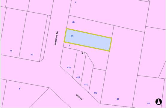
The existing subdivision pattern
and location of existing development within the locality is shown in the
following aerial photograph:
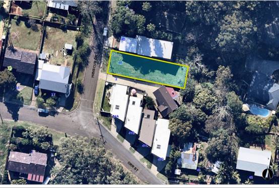
2. DESCRIPTION
OF DEVELOPMENT
Key aspects of the proposal
include the following:
· Single
dwelling
Refer to Attachment 2 at
the end of this report for plans of the proposed development.
Application Chronology
· 04
February 2020 - Application lodged
· 17
February to 02 March 2020 - Public notification period. 2 submissions received
· 03
March 2020 - Additional information requested
· 20
March 2020 - Revised plans submitted
3. STATUTORY
ASSESSMENT
Section 4.15(1) Matters for
Consideration
In determining the application,
Council is required to take into consideration the following matters as are
relevant to the development that apply to the land to which the development
application relates:
(a) The
provisions (where applicable) of:
(i) Any
Environmental Planning Instrument
State Environmental Planning Policy (Koala Habitat
Protection) 2019
Clause 15 - A Development Application made,
but not finally determined, before the commencement of this Policy in relation
to land to which this Policy applies must be determined as if this Policy had
not commenced. The application was made and not finally determined prior to the
commencement of this policy, and the application is therefore required to be
assessed under the relevant provisions of State Environmental Policy No 44 -
Koala Habitat Protection. See assessment comments below.
State Environmental Planning Policy No. 44 - Koala
Habitat Protection
There is no Koala Plan of Management on the site.
Additionally, the site is less than 1ha in area therefore no further
investigations are required.
State Environmental Planning Policy No. 55 –
Remediation of Land
Following an inspection of the site and a search of Council
records, the subject land is not identified as being potentially contaminated
and is suitable for the intended use.
State Environmental Planning Policy (Coastal Management)
2018
The site is not located within a coastal use area/coastal
environment area.
State Environmental Planning Policy (Building
Sustainability Index: BASIX) 2004
A BASIX certificate has been submitted demonstrating that
the proposal will comply with the requirements of the SEPP. It is recommended
that a condition be imposed to ensure that the commitments are incorporated
into the development and certified at Occupation Certificate stage.
Port Macquarie-Hastings Local Environmental
Plan 2011
The proposal is consistent with the LEP having regard to the
following:
· Clause
2.2 - The subject site is zoned R1 General Residential.
· Clause
2.3(1) and the R1 zone landuse table - The dwelling and ancillary structures to
a dwelling are permissible with consent.
The objectives of the R1 zone are as
follows:
o To provide for the housing
needs of the community.
o To provide for a variety of
housing types and densities.
o To enable other land uses
that provide facilities or services to meet the day to day needs of residents.
· Clause
2.3(2) - The proposal is consistent with the zone objectives as it is a
permissible landuse and consistent with the established residential character
of the locality. The proposal contributes to the range of housing options in
the locality.
· Clause
4.3 - The maximum overall height of the building above ground level (existing)
is 7.65m, which complies with the standard height limit of 8.5 m applying to
the site.
· Clause
4.4 - The floor space ratio of the proposal is 0.55:1 which complies with the
maximum 0.65:1 floor space ratio applying to the site.
· Clause
5.10 – Heritage. The site does not contain or adjoin any known heritage
items or sites of significance.
· Clause
7.13 - Satisfactory arrangements are in place for provision of essential
services including water supply, electricity supply, sewer infrastructure,
stormwater drainage and suitable road access to service the development.
(ii) Any draft instruments that apply to the
site or are on exhibition
No draft instruments apply to the site.
(iii) Any Development Control Plan in force
Port Macquarie-Hastings
Development Control Plan 2013
|
DCP 2013: Dwellings, Dual
occupancies, Dwelling houses, Multi dwelling houses & Ancillary
development
|
|
|
Requirements
|
Proposed
|
Complies
|
|
3.2.2.1
|
Ancillary development:
• 4.8m max. height
• Single storey
• 60m2 max. area
• 100m2 for lots
>900m2
• 24 degree max.
roof pitch
• Not located in
front setback
|
Water tank is appropriately
located
|
Yes
|
|
3.2.2.2
|
Articulation zone:
• Min. 3m front
setback
• An entry feature
or portico
• A balcony, deck,
patio, pergola, terrace or verandah
• A window box
treatment
• A bay window or
similar feature
• An awning or other
feature over a window
• A sun shading
feature
|
The dwelling contains a deck within the articulation zone.
The deck does not exceed 25% of the articulation zone and is still setback
over 3m.
|
Yes
|
|
Front setback (Residential not R5
zone):
• Min. 4.5m local
road
|
Front building setback is 4.526m
|
Yes
|
|
3.2.2.3
|
Garage 5.5m min. and 1m behind
front façade.
Garage door recessed behind
building line or eaves/overhangs provided
|
Garage door setback is setback
4.526m, which encroaches the minimum front setback requirements and is not
recessed. See justification below*.
|
No*
|
|
6m max. width of garage door/s
and 50% max. width of building
|
Width of garage door, 5m wide, is
compliant with the maximum width requirements
However, it is 60% of the width
of the building. Due to site constraints of the block being only 11.5m wide,
garage opening being no greater than a standard double garage, and consist
with the neighbouring property to the north, this variation is acceptable in
this instance. There are no identifiable adverse impacts
|
Acceptable
|
|
Driveway crossover 1/3 max. of
site frontage and max. 5.0m width
|
Driveway crossover is 43%, but no
larger than a standard double garage driveway crossover, provides stacked
offstreet car parking in front of the garage doors, this variation is
considered acceptable and consistent with the objectives of this clause.
|
Acceptable
|
|
3.2.2.4
|
4m min. rear setback. Variation
subject to site analysis and provision of private open space
|
Rear setback 8.517m.
|
Yes
|
|
3.2.2.5
|
Side setbacks:
• Ground floor =
min. 0.9m
• First floors &
above = min. 3m setback or where it can be demonstrated that overshadowing
not adverse = 0.9m min.
• Building wall set
in and out every 12m by 0.5m
|
Ground Floor:
N: 3.15m
S: 1.8m
First Floor
N: 2.34m
S: 1.7m
12m max. unarticulated wall
length
N:12.2
S:23.79
Adequate justification,
demonstrating that consideration has been provided to meet the objectives of
this clause. See justification below.
|
No, but acceptable- no
adverse impacts identifiable
|
|
3.2.2.6
|
35m2 min. private open space area
including a useable 4x4m min. area which has 5% max. grade
|
The dwelling contains 35m² open space to the main
balcony, with dimensions of 3m x 8.2m space. There will be access to the rear
yard which contains an additional area greater than 35m2 with a 4m
x 4m area, however, due to the slope it is impracticable to achieve a level
area within the yard. The area on the balcony achieves the objectives of this
clause.
|
Yes
|
|
3.2.2.10
|
Privacy:
• Direct views
between living areas of adjacent dwellings screened when within 9m radius of any
part of window of adjacent dwelling and within 12m of private open space
areas of adjacent dwellings. ie. 1.8m fence or privacy screening which has
25% max. openings and is permanently fixed
• Privacy screen
required if floor level > 1m height, window side/rear setback (other than
bedroom) is less than 3m and sill height less than 1.5m
Privacy screens provided to
balconies/verandahs etc which have <3m side/rear setback and floor level
height >1m
|
The proposed dwelling has no primary living area directly
adjoining or overlooking neighbouring primary living areas. The proposed Bed
3/Study south facing windows is will be approximately 7.2m from an adjoining
secondary living area, being the first level bedroom and balcony.
The amended plans have provided privacy screening between
the proposed study and the adjoining first level balconies. The development
will not compromise privacy in the area and adjoining private open space or
living areas due to a combination of positioning of windows not overlooking
side boundaries, having high sill windows or highlight windows that face side
boundaries, limiting living areas that face adjoining living areas/open space
and use of privacy screening over adjoining windows.
|
Yes
|
|
DCP 2013: General
Provisions
|
|
|
Requirements
|
Proposed
|
Complies
|
|
2.7.2.2
|
Design addresses generic principles of Crime Prevention
Through Environmental Design guideline
|
No concealment or entrapment areas proposed. Adequate
casual surveillance available.
|
Yes
|
|
2.3.3.1
|
Cut and fill 1.0m max. 1m outside the perimeter of the
external building walls
|
Cut and fill <1.0m change 1m outside the perimeter of
the external building walls
|
Yes
|
|
2.3.3.2
|
1m max. height retaining walls along road frontage
|
Maximum of 1m
|
Yes
|
|
Any retaining wall >1.0 in height to be certified by
structure engineer
|
Condition recommended to require engineering certification
|
Yes
|
|
Combination of retaining wall and front fence height max
1.8m, max length 6.0m or 30% of frontage, fence component 25% transparent,
and splay at corners and adjacent to driveway
|
No retaining wall front fence combination proposed.
|
N/A
|
|
2.3.3.8
|
Removal of hollow bearing trees
|
Cleared building envelope. No trees proposed to be removed
|
N/A
|
|
2.6.3.1
|
Tree removal (3m or higher with 100m diameter trunk at 1m
above ground level and 3m from external wall of existing dwelling)
|
No trees proposed to be removed
|
N/A
|
|
2.4.3
|
Bushfire risk, Acid sulphate soils, Flooding,
Contamination, Airspace protection, Noise and Stormwater
|
Refer to main body of report.
|
|
|
2.5.3.2
|
New accesses not permitted from arterial or distributor
roads
|
No new access proposed to arterial or distribution road.
|
N/A
|
|
Driveway crossing/s minimal in number and width including
maximising street parking
|
Driveway crossing minimal in width including maximising
street parking
|
Yes
|
|
2.5.3.3
|
Parking in accordance with Table 2.5.1.
1 space per single dwelling (behind building line)
|
1 or capacity for more than 1 parking space behind the
building line has been provided for.
|
Yes
|
|
2.5.3.11
|
Section 94 contributions
|
Refer to main body of report.
|
|
|
2.5.3.12 and 2.5.3.13
|
Landscaping of parking areas
|
Single dwelling only with 1 domestic driveway. No specific
landscaping requirements recommended.
|
N/A
|
|
2.5.3.14
|
Sealed driveway surfaces unless justified
|
Sealed driveway proposed
|
Yes
|
|
2.5.3.15 and 2.5.3.16
|
Driveway grades first 6m or ‘parking area’
shall be 5% grade with transitions of 2m length
|
Driveway grades capable of satisfying Council standard
driveway crossover requirements. Condition recommended for section 138 Roads
Act permit
|
Yes
|
|
2.5.3.17
|
Parking areas to be designed to avoid concentrations of
water runoff on the surface.
|
Single dwelling only with 1 domestic driveway. Stormwater
drainage is capable of being managed.
|
Yes
|
The proposal seeks to vary Development Provision relating to
3.2.2.3 Garage door setback.
The relevant objectives are:
· To minimise the
impact of garages and driveways on the streetscape, on street parking and
amenity.
· To minimise the
visual dominance of garages in the streetscape.
Having regard for the development provisions and relevant
objectives, the variation is considered acceptable for the following reasons:
· Due to the narrow
width and the slope of the site the location of the garage is considered to be
acceptable.
· The proposed
garage is positioned in line with the front building line. The positioning and
width of the garage and driveway are standard dimensions for a double garage
and driveway.
· Whilst the
proposed garage and driveway are inconsistent with the DCP provisions, the
proposal is consistent with the neighbouring property to the north.
· The proposed
design minimises the visual dominance of the garage to the street frontage
through the integration of materials and finishes on the façade, along
with feature window treatment.
The proposal seeks to vary Development Provision relating to
3.2.2.5 Side setback variations.
The relevant objectives are:
· To reduce
overbearing and perceptions of building bulk on adjoining properties and to
maintain privacy.
· To provide for
visual and acoustic privacy between dwellings.
Having regard for the development provisions and relevant
objectives, the variation is considered acceptable for the following reasons:
· The proposal
provides a minimum setback of 2.34m from the proposed upper floor to the
northern boundary, increasing to 3.154m.
· The proposed
setback to the southern boundary is 1.7m minimum, increasing to 1.8m.
· The subject area
of dwelling encroaching the northern side setback is adjacent the neighbouring
property’s garage and will have minimal visual impacts to the
neighbouring property. The subject wall contains no windows and as such, will
have no impacts on residential privacy.
· The neighbouring
property to the south has their driveway positioned adjacent the common
boundary line with the dwelling positioned towards the rear south-eastern
corner.
· The proposed
setback to the southern boundary will have minimal impact on the neighbouring
property as the subject wall, for the majority, will be along the battle-axe
driveway.
· There is a
multi-dwelling development on the southern side of the development. It is noted
these dwellings have a second storey balcony and floor to ceiling windows
directly overlooking the battle-axe driveway and the subject development site.
· Shadow diagrams
demonstrate that no adverse overshadow will occur of any private open space or
main living areas of any adjoining dwelling.
· The proposed
southern wall has an unarticulated length of 23.79m. Visually, the southern
elevation has varying heights, integrates varying materials which will soften
the bulk and scale.
· The existing
boundary fence will provide an element of screening and no proposed living
areas will open to or overlook the southern boundary.
Based on the above assessment,
the variations proposed to the provisions of the DCP are considered acceptable
and the relevant objectives have been satisfied. Cumulatively, the variations
do not amount to an adverse impact or a significance that would justify refusal
of the application.
(iiia) Any planning agreement that has been entered into under
section 7.4, or any draft planning agreement that a developer has offered to
enter into under section 7.4
No planning agreement has been offered or entered into
relating to the site.
(iv) Any
matters prescribed by the Regulations
Demolition of buildings AS
2601 - Clause 92
N/A
(b) The likely impacts of that development,
including environmental impacts on both the natural and built environments,
social and economic impacts in the locality
Context and Setting
The proposal will not have any significant adverse impacts
on existing adjoining properties and satisfactorily addresses the public
domain.
The proposal is considered to be compatible with other
residential development in the locality and adequately addresses planning
controls for the area.
The proposal does not have a significant adverse impact on
existing view sharing.
The proposal does not have significant adverse lighting
impacts.
There are no significant adverse privacy impacts.
There are no significant adverse overshadowing impacts. The
proposal does not prevent adjoining properties from receiving 3 hours of
sunlight to private open space and primary living areas on 21 June.
Access, Traffic and Transport
The proposal will not have any significant adverse impacts
in terms access, transport and traffic. The existing road network will
satisfactorily cater for any increase in traffic generation as a result of the
development.
Water Supply Connection
Service available – details required with S.68
application.
Sewer Connection
Service available – details required with S.68
application.
Condition included regards proximity to exist sewer line,
engineering details noted on plans.
Stormwater
Service available at the rear of the property –
details required with S.68 application.
Other Utilities
Telecommunication and electricity services are available to
the site.
Heritage
This site does not contain or adjoin any known heritage item
or site of significance. The site is considered to be disturbed land.
Other land resources
The site is within an established urban context and will not
sterilise any significant mineral or agricultural resource.
Water cycle
The proposed development will not have any significant
adverse impacts on water resources and the water cycle.
Soils
The proposed development will not have any adverse impacts
on soils in terms of quality, erosion, stability and/or productivity subject to
a standard condition requiring erosion and sediment controls to be in place
prior to and during construction.
Air and microclimate
The construction and/or operations of the proposed
development will not result in any significant adverse impacts on the existing
air quality or result in any pollution. Standard precautionary site management
condition recommended.
Flora and fauna
Construction of the proposed development will not require
any removal/clearing of any native vegetation and therefore does not trigger
the biodiversity offsets scheme. Part 7 of the Biodiversity Conservation
Act 2016 is considered to be satisfied.
Waste
Satisfactory arrangements are in place for proposed storage
and collection of waste and recyclables. No adverse impacts anticipated.
Standard precautionary site management condition recommended.
Energy
The proposal includes measures to address energy efficiency
and will be required to comply with the requirements of BASIX.
Noise and vibration
The construction of the proposed development will not result
in any significant adverse impacts on the existing air quality or result in any
pollution. Standard precautionary site management condition recommended.
Bushfire
The site is identified as being bushfire prone.
The Applicant has submitted a BAL certificate prepared by a
Certified Consultant.
An assessment of bushfire risk having regard to section
4.3.5 of Planning for Bushfire Protection 2006 including vegetation
classification and slope concludes that a Bushfire Attack Level 29 shall be
required.
Safety, security and crime prevention
The proposed development will be unlikely to create any
concealment/entrapment areas or crime spots that would result in any
identifiable loss of safety or reduction of security in the immediate area. The
increase in housing density will improve natural surveillance within the
locality and openings from each dwelling overlook common and private areas.
Social impacts in the locality
Given the nature of the proposed development and its
location the proposal is not considered to have any significant adverse social
impacts.
Economic impact in the locality
The proposal is not considered to have any significant
adverse economic impacts on the locality. A likely positive impact is that the
development will maintain employment in the construction industry, which will
lead to flow impacts such as expenditure in the area.
Site design and internal design
The proposed development design satisfactorily responds to
the site attributes and will fit into the locality.
Construction
Construction impacts are considered capable of being
managed, standard construction and site management conditions have been recommended.
Cumulative impacts
The proposed development is not considered to have any
significant adverse cumulative impacts on the natural or built environment or
the social and economic attributes of the locality.
(c) The
suitability of the site for the development
The proposal will fit into the locality and the site
attributes are conducive to the proposed development.
Site constraints of bushfire have been adequately addressed
and appropriate conditions of consent recommended.
(d) Any
submissions made in accordance with this Act or the Regulations
Two (2) written submissions were
received following public exhibition of the application. Copies of the written
submissions have been provided separately to members of the DAP.
Key issues raised in the submissions
received and comments are provided as follows:
|
Submission Issue/Summary
|
Planning Comment/Response
|
|
The size and bulk of the proposed study above the
garage, given its location and height.
|
The maximum overall height of the building above ground
level (existing) is 7.65 m which complies with the standard height limit of
8.5 m applying to the site. Sheet 5 of the plan set demonstrates the height
compliance.
|
|
Providing
the southern adjoining property is a narrow battle-axe, no consideration has
been provided to the adjoining Multi Dwelling Units on the other side of the
battle-axe handle with regards to overshadowing.
|
Sheet 13 and
14 of the revised plans demonstrates the proposed overshadowing indicating
the building outline of the adjoining multi dwelling housing. The shadow
diagrams do not indicate the existing 1.8m high fence line, which appears
would have an overshadowing impact. From review of the overshadowing
diagrams, there are no identifiable adverse impacts caused by the proposed
development shadow path.
|
|
There are a
number of windows on the Southern Elevation directly overlooking into
bedrooms. Which will be intrusive and significantly raise lifestyle and
amenity issues.
|
The
Applicant has provided revised plans reducing the amount of windows on the
upper floor above garage and provided directional privacy screening panels to
avoid viewing towards the townhouses and the overlooking balconies and floor
to ceiling windows.
It is also
noted that the adjoining neighbouring balcony and windows are secondary
living areas and the rooms that face towards the proposal are bedrooms not
main living areas.
The revised
plans also indicate the existing fence line elevation which demonstrates the
current fence line will provide some privacy screening. This eliminates the
need for screening of the bed 2 as requested.
A reduction
in size and providing fixed directional screening will provide adequate
privacy.
|
|
The bulk and
scale of the development.
|
Adequate
justification has been discussed earlier in this report. In regards to the
articulation of the southern side for the house, consideration should be
given to the restrictive nature of this block being only 11.5m wide and
having significant fall from front to back. The revised plans indicate that
the majority of the subject wall will be screened by the existing fence and
varying heights will soften the impact. No adverse impacts are identifiable.
|
(e) The
Public Interest
The proposed development
satisfies relevant planning controls and will not adversely impact on the wider
public interest.
4. DEVELOPMENT
CONTRIBUTIONS APPLICABLE
· Development
contributions will not be required under S64/S7.11 for the following reasons:
The subject lot was a Council approved lot. The proposal will not create more
than one single dwelling.
5. CONCLUSION
AND STATEMENT OF REASON
The application has been assessed in accordance with Section
4.15 of the Environmental Planning and Assessment Act 1979.
Issues raised during assessment and public exhibition of the
application have been considered in the assessment of the application. Where
relevant, conditions have been recommended to manage the impacts attributed to
these issues.
The site is considered suitable for the proposed development
and the proposal adequately addresses relevant planning controls. The
development is not considered to be contrary to the public's interest and will
not result a significant adverse social, environmental or economic impact. It
is recommended that the application be approved, subject to the recommended
conditions of consent provided in the attachment section of this report (Attachment
1).
|
Attachments
1⇩. DA2020 - 63.1
Recommended Conditions
2⇩. DA2020 - 63.1 Plans
|
|
ATTACHMENT
|
Development Assessment Panel
06/05/2020
|
|
ATTACHMENT
|
Development Assessment Panel
06/05/2020
|
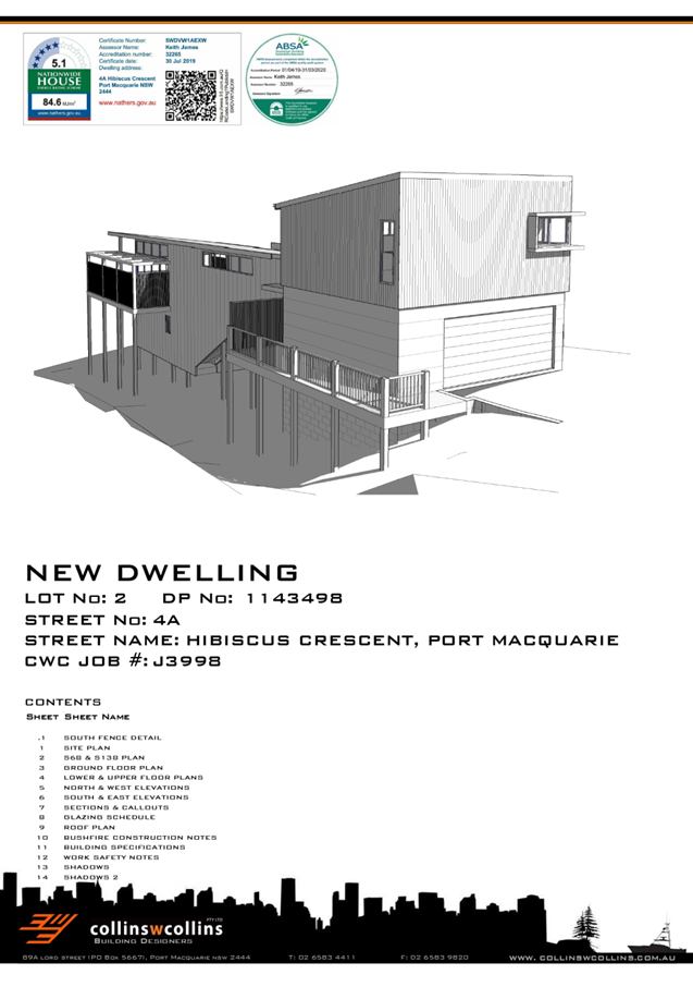
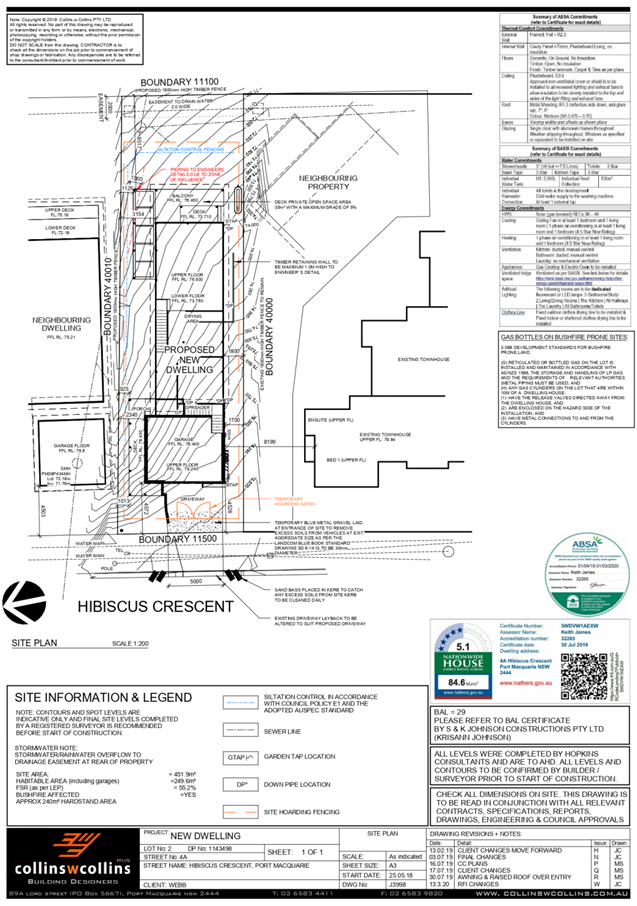
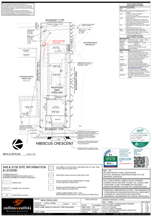
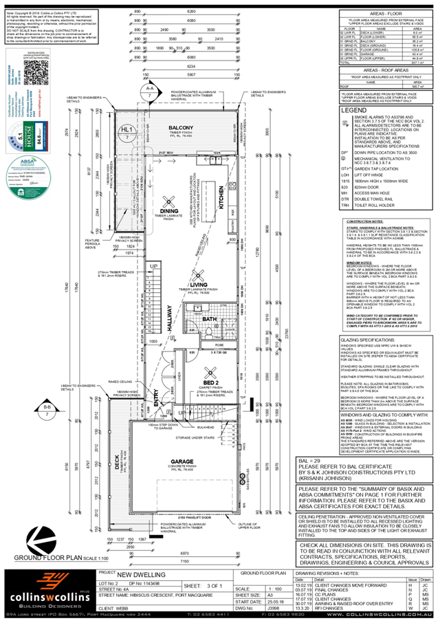
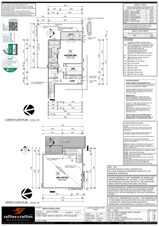
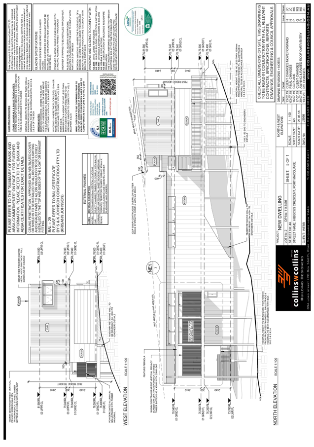
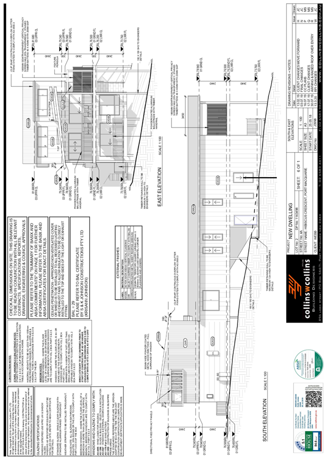
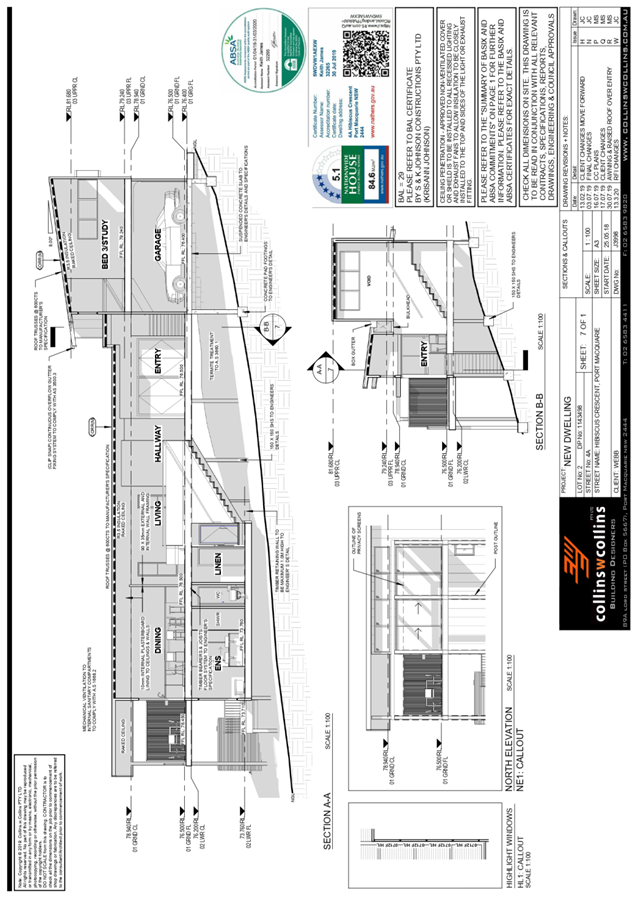
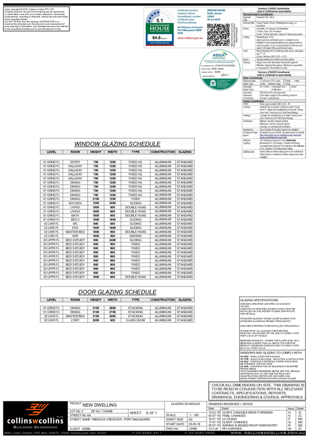
AGENDA Development Assessment Panel 06/05/2020
Item: 09
Subject: DA2019 - 277.1 Cafe and Associated Car Parking
at Lot 5 DP 524972, Parklands Close, Port Macquarie
Report
Author: Development Assessment Planner, Chris Gardiner
|
Applicant: Land
Dynamics Australia
Owner: J
W Crowe
Estimated Cost: $120,000
Alignment with Delivery
Program
4.3.1 Undertake transparent
and efficient development assessment in accordance with relevant legislation.
|
RECOMMENDATION
1. That the Koala Plan of Management prepared by Biodiversity
Australia (Rev 1.2, dated January 2020) be approved.
2. That DA2019 - 277.1
for a Café and Associated Car Parking at Lot 5, DP 524972, Parklands Close, Port
Macquarie, be determined by granting consent
subject to the recommended conditions.
Executive
Summary
This
report considers a development application for a café and
associated car parking at the subject site and
provides an assessment of the application in accordance with the Environmental
Planning and Assessment Act 1979.
Following exhibition of the
application on two separate occasions, 40 submissions
were received.
The site is core koala habitat and
the application includes a Koala Plan of Management (KPoM). The report
recommends that the KPoM be approved and that appropriate conditions be imposed
to ensure consistency with the Plan.
The proposal has been amended
during the assessment of the application in response to assessment and
submission issues.
The site is considered suitable for the proposed development
and the proposal adequately addresses relevant planning controls. The
development is not considered to be contrary to the public's interest and will
not result a significant adverse social, environmental or economic impact.
This report recommends that the
development application be approved subject to the conditions in Attachment
1.
1. BACKGROUND
Existing
Sites Features and Surrounding Development
The site has an area of 1.683
hectares.
The
site is zoned RE2 Private Recreation, R1 General Residential, and E2
Environmental Conservation in accordance with the
Port Macquarie-Hastings Local Environmental Plan 2011, as shown in the
following zoning plan:
The existing subdivision pattern and location of existing
development within the locality is shown in the following aerial photograph:
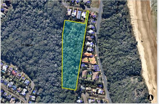
2. DESCRIPTION
OF DEVELOPMENT
Key
aspects of the proposal include the following:
· Convert
existing castle building from former Fantasy Glades amusement park into a café,
including outdoor dining; and
· Construction
of a new access road connecting to the end of Wandella Drive and off-street car
parking.
Refer
to Attachment 2 at the end of this report for plans of the proposed
development.
Application
Chronology
· 16
April 2019 - Application lodged.
· 30 April 2019 to 13 May 2019 - Neighbour notification.
· 13 June 2019 - Response to submissions received from
Applicant.
· 1 July 2019 - Additional information requested from
Applicant.
· 9 October 2019 - Additional information and amended plans
submitted by Applicant.
· 31 October 2019 to 13 November 2019 - Amended proposal
re-notified.
· 3 December 2019 - Amendments to ecological assessment and
Draft Koala Plan of Management (KPoM) requested.
· 10 December 2019 - Amended Koala Plan of Management and
ecological assessment submitted.
· 17 December 2019 - Koala Plan of Management forwarded to
NSW Department of Planning, Industry & Environment for approval in
accordance with SEPP 44.
· 30 January 2020 - Amended Koala Plan of Management
submitted in response to queries from NSW Department of Planning, Industry
& Environment.
· 1 April 2020 - Correspondence received from NSW Department
of Planning, Industry & Environment confirming approval of Koala Plan of
Management.
3. STATUTORY
ASSESSMENT
Section
4.15(1) Matters for Consideration
In
determining the application, Council is required to take into consideration the
following matters as are relevant to the development that apply to the land to
which the development application relates:
(a) The
provisions (where applicable) of:
(i) Any
Environmental Planning Instrument
State
Environmental Planning Policy (Koala Habitat Protection) 2019
Clause
15 - A development application made,
but not finally determined, before the commencement of this Policy in relation
to land to which this Policy applies must be determined as if this Policy had
not commenced. The application was made and not finally determined prior to the
commencement of this policy, and the application is therefore required to be
assessed under the relevant provisions of State Environmental Policy No 44 -
Koala Habitat Protection. See assessment comments below.
State
Environmental Planning Policy No. 44 - Koala Habitat Protection
With
reference to clauses 6 and 7, the subject land is greater than 1 hectare and
therefore the provisions of SEPP must be considered.
The
Applicant has submitted an Ecological Impact Assessment prepared by
Biodiversity Australia and dated March 2019. The assessment includes consideration
of SEPP 44.
The
vegetation on the site consists of greater than 15% Schedule 2 Koala food trees
and therefore meets the definition of ‘potential koala habitat’.
The
ecologist carried out further investigations to determine whether the site is
‘core koala habitat’, including:
· Koala Spot Assessment Technique (SAT) surveys;
· Passive Infrared Camera sampling;
· Spotlighting and torch surveys;
· Call Playback and detection; and
· Active Searches.
The
investigations identified scats under two of the Tallowwood trees and a passive
infrared camera recorded a Koala passing through the site. The caretaker at the
site has also observed Koala activity on the site. The report concludes that
due to the extent of recent Koala sightings and the availability of KFTs within
the property, it is considered that the site forms part of a larger area of
Core Koala Habitat. The figure below shows the extent of the Core Koala Habitat
within the subject site:
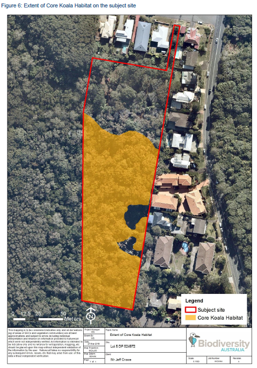
In
accordance with Clause 9 of the SEPP, a Koala Plan of Management (KPoM)
prepared by Biodiversity Australia has been submitted with the Application. The
KPoM is included at Attachment 4 and includes the following recommended
ameliorative measures:
· General clearing measures including tree identification and
tree protection fencing;
· Pre-clearing survey and clearing supervision;
· Retention of all primary/preferred Koala food trees, with
only ‘other browse species’ (Flooded Gum and Broad-leaf Paperbark)
proposed to be removed for the development;
· Habitat replacement at a ratio of 1:1 primary/preferred
Koala food tree for each ‘other browse species’ proposed to be
removed;
· Prohibition of domestic pets, with signage to inform
café patrons not to bring pets onto the property;
· Management of food waste disposal to discourage feral
animals from entering the site;
· Road signage and speed controls for the proposed new
internal road and parking area;
· Control of artificial lighting;
· Processes for reporting sick or injured Koalas; and
· Removal of barbed wire fencing.
In
accordance with Clause 13(2) of the SEPP, the Secretary of the NSW Department
of Planning, Industry & Environment has approved the KPoM in a letter dated
1 April 2020. The KPoM has also been reviewed by Council’s Natural
Resources staff and is considered satisfactory. Accordingly, it is recommended
that the KPoM be approved by Council’s Development Assessment Panel.
Conditions
of consent have been recommended to ensure that the proposed development is
consistent with the approved KPoM.
State
Environmental Planning Policy No. 55 – Remediation of Land
Following
an inspection of the site and a search of Council records, the subject land is
not identified as being potentially contaminated and is suitable for the
intended use.
State
Environmental Planning Policy No. 64 – Advertising and Signage
The
proposed development does not include any advertising or signage. Standard
condition recommended requiring separate consent for any future signage that is
not Exempt Development.
State
Environmental Planning Policy (Coastal Management) 2018
The
site is located within a coastal use area, and partly within a coastal
environment area. The part of the site within the coastal environment area is
limited to the access handle from Parklands Close, and the proposed development
does not include any works in this location.
Parts
of the site are also mapped as coastal wetland, and proximity area to both
coastal wetland and littoral rainforest (as shown below). The works associated
with the development are clear of the coastal wetland and its proximity area,
but the proposed café car park will be partly within the proximity area
for littoral rainforest.
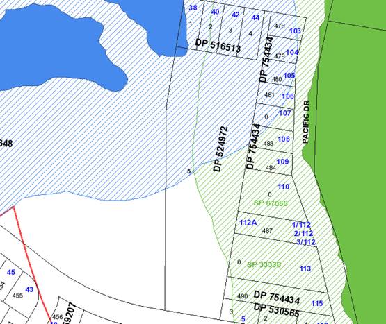
In
accordance with clause 7, this SEPP prevails over the Port Macquarie-Hastings
LEP 2011 in the event of any inconsistency.
Having
regard to clause 11 of the SEPP, the proposed development is not likely to
significantly impact the biophysical,
hydrological or ecological integrity of the adjacent coastal wetland or
littoral rainforest, or affect the quantity and quality of surface and ground
water flows to and from the adjacent coastal wetland or littoral rainforest.
The mapped littoral rainforest is located on the eastern side of Pacific Drive
and separated from the site by the road corridor and a row of residential uses
fronting Pacific Drive. Stormwater from the site drains generally to the west
(away from the littoral rainforest) and adequate measures are proposed to
manage stormwater quality and quantity from the development.
Having
regard to clause 14 of the SEPP the proposed development is not considered
likely to result in any of the following:
a) any adverse impact on integrity and resilience of the biophysical,
hydrological (surface and groundwater) and ecological environment;
b) any adverse impacts coastal environmental values and natural coastal
processes;
c) any adverse impacts on marine vegetation, native vegetation and fauna and
their habitats, undeveloped headlands and rock platforms;
d) any adverse impact on Aboriginal cultural heritage, practices and places;
e) any adverse impacts on the cultural and built environment heritage;
f) any adverse impacts the use of the surf zone;
g) any adverse impact on the visual amenity and scenic
qualities of the coast, including coastal headlands;
h) overshadowing, wind funnelling and the loss of views from
public places to foreshores; and
i) any adverse impacts on existing public open space and safe access to and
along the foreshore, beach, headland or rock platform for members of the
public, including persons with a disability.
The
bulk, scale and size of the proposed development is compatible with the
surrounding coastal and built environment.
In
accordance with Clause 15, the proposal is not likely to cause increased risk
of coastal hazards on the land or other land.
Port Macquarie-Hastings Local Environmental Plan 2011
The
proposal is consistent with the LEP having regard to the following:
· Clause 2.2 - The subject site is zoned RE2 Private
Recreation, R1 General Residential, and E2 Environmental Conservation. The main
aspects of the development including buildings, parking areas and internal
access roads are located within the RE2 zone. However, the proposal relies on
an access road through the E2 zone in the Wandella Drive road reserve.
· Clause 2.3(1) and the RE2 zone landuse table - The proposed
development for a cafe is permitted with consent.
Development for the purpose of roads is permissible in the
E2 zone land use table. Relevant case law in Site Plus Pty Ltd v Wollongong
City Council [2014] NSWLEC 125 confirms that public roads are able to be
characterised as roads, while private access roads should be characterised as
being part of the associated land use. The proposed road works in Wandella
Drive are therefore considered to be permissible in the E2 zone.
The objectives of the R1 zone are as follows:
o To provide for the housing needs of the community.
o To provide for a variety of housing types and densities.
o To enable other land uses that provide facilities or
services to meet the day to day needs of residents.
The objectives of the RE2 zone are as follows:
o To enable land to be used for private open space or
recreational purposes.
o To provide a range of recreational settings and activities
and compatible land uses.
o To protect and enhance the natural environment for
recreational purposes.
The objectives of the E2 zone are as follows:
o To protect, manage and restore areas of high ecological,
scientific, cultural or aesthetic values.
o To prevent development that could destroy, damage or
otherwise have an adverse effect on those values.
o To protect coastal wetlands and littoral rainforests.
o To protect land affected by coastal processes and
environmentally sensitive land.
o To prevent development that adversely affects, or would be
adversely affected by, coastal processes.
o To enable development of public works and environmental
facilities where such development would not have an overall detrimental impact
on ecological, scientific, cultural or aesthetic values.
Clause 2.3(2) - The proposal is consistent with the zone
objectives having regard to the following:
o The development does not include any works in the R1
General Residential zone and is therefore not inconsistent with the zone
objectives for this part of the site.
o The proposed café and carpark have a small footprint
in the context of the overall site area and would not significantly affect the
potential for the land to be used for a range of recreational uses in the
future.
o The ecological assessment has demonstrated that the impact
of the development on the natural environment is satisfactory.
o The proposed public works at the western end of Wandella
Drive have been designed to minimise impact on existing vegetation and the
Wrights Creek riparian zone.
o The proposal does not impact areas of mapped coastal
wetland.
· Clause 4.3 - The proposal would not result in any increase
in the overall height of the building above ground level (existing).
· Clause 5.10 – Heritage. The site does not contain or
adjoin any known heritage items or sites of significance.
· Clause 7.3 - The site is land within a mapped “flood
planning area” (land subject to flood discharge of 1:100 annual
recurrence interval flood event, plus the applicable climate change allowance
and relevant freeboard). In this regard the following comments are provided
which incorporate consideration of the objectives of Clause 7.3,
Council’s Flood Policy 2015, the NSW Government’s Flood Prone
Lands Policy and the NSW Government’s Floodplain Development
Manual (2005):
o The proposal is compatible with the flood hazard of the
land taking into account projected changes as a result of climate change;
o The proposal will not result in a significant adverse
effect on flood behaviour that would result in detrimental increases in the
potential flood affectation of other development or properties;
o The proposal incorporates measures to minimise & manage
the flood risk to life and property associated with the use of land;
o The proposal is not likely to significantly adversely
affect the environment or cause avoidable erosion, siltation, destruction of
riparian vegetation or a reduction in the stability of river banks or watercourses;
and
o The proposal is not likely to result in unsustainable
social and economic costs to the community as a consequence of flooding.
· Clause 7.13 - Satisfactory arrangements are in place for
provision of essential services including water supply, electricity supply,
sewer infrastructure, stormwater drainage and suitable road access to service
the development.
(ii) Any draft
instruments that apply to the site or are on exhibition:
No draft instruments apply to
the site.
(iii) Any Development
Control Plan in force
Port
Macquarie-Hastings Development Control Plan 2013
|
DCP 2013: Business &
Commercial Development
|
|
DCP Objective
|
Development Provisions
|
Proposed
|
Complies
|
|
3.4.3.18
|
At grade car parking
incorporate water sensitive urban design principles to drain pavement areas.
|
Concept design provided in
stormwater management plan.
|
Yes
|
|
3.4.3.22
|
Any ramps are to be integrated
into the overall building and landscape design.
|
No ramps proposed.
|
N/A
|
|
The development complies with
AS1428—Design for Access and Mobility.
|
The application includes a BCA
assessment, which indicates that the current building does not comply with
the Australian Standard. The report provides a number of recommendations for
works required to bring the building into compliance. Details will be
required to be submitted with the Construction Certificate application.
|
Yes
|
|
3.4.3.25
|
Separate storage bins for
collection for organic waste and recyclable waste are provided in the development.
|
Statement of Environmental
Effects indicates that waste will be stored in the storage area at the rear
of the building and collected from the loading area by a private waste
contractor. A condition is recommended requiring the waste to be collected in
the three different waste streams.
The Koala Plan of Management
requires bins containing food waste to be sealed and locked to prevent access
by feral animals.
|
Yes
|
|
3.4.3.26
|
Where waste facilities cannot
be collected at the street, evidence that the site can be serviced by a waste
collection service must be provided.
|
Condition recommended
confirming requirement for private waste collection service.
|
Yes
|
|
3.4.3.27
|
The number of vehicular
crossovers shall be kept to a minimum and appropriate sight lines provided to
ensure safe integration of pedestrian and vehicular movement.
|
One crossover to Wandella
Drive.
|
Yes
|
|
At-grade / surface car parking
areas adjacent to streets shall be generally avoided or at least adequately
softened by appropriate landscaping.
|
Majority of off-street parking
located behind the building, with the exception of 2 spaces. These 2 spaces
are setback 25m from the front boundary and adequately screened by existing
landscaping.
|
Yes
|
|
3.4.3.30
|
Pedestrian Entries &
Access:
The development complies with
AS1428—Design for Access and Mobility.
|
Capable of complying. The
application includes a BCA assessment, which indicates that the current
building does not comply with the Australian Standard. The report provides a
number of recommendations for works required to bring the building into
compliance. Details will be required to be submitted with the Construction
Certificate application.
|
Yes
|
|
3.4.3.32
|
Parking areas are adequately
illuminated (naturally and/or artificially) during the time period the centre
is open.
|
The proposed hours of
operation are 6.00am to 6.00pm, which will generally be in daylight hours.
Some minor lighting of the parking area is expected during the winter months,
but is unlikely to affect the amenity of adjoining residents given the short
period.
|
Yes
|
|
3.4.3.35
|
Commercial Development
Adjoining Residential Land uses:
The development is designed so
that all vehicle movement areas and servicing areas are located away from
adjoining residential areas.
|
Loading dock proposed on
eastern side of the building closest to residential properties.
|
No (see below)
|
|
Where this cannot be achieved
visual and acoustic treatment of the interface is required.
|
Submitted plans show
‘mass planted landscape beds’ between loading area and the
eastern boundary. A condition is recommended requiring the plantings in this
location to be of sufficient height to visually screen the loading area.
An acoustic assessment has
been submitted with the application, which concluded that the development can
comply with relevant noise criteria without any additional mitigation
measures.
|
Yes
|
|
Waste areas are located and
managed to minimise pests, noise and odour.
|
Screened waste storage area
located adjacent to loading bay.
|
Yes
|
|
DCP 2013: General
Provisions
|
|
DCP Objective
|
Development Provisions
|
Proposed
|
Complies
|
|
2.7.2.2
|
Design addresses generic
principles of Crime Prevention Through Environmental Design guideline:
· Casual
surveillance and sightlines
· Land
use mix and activity generators
· Definition
of use and ownership
· Lighting
· Way
finding
· Predictable
routes and entrapment locations
|
The proposed development will
be unlikely to create any concealment/entrapment areas or crime spots that
would result in any identifiable loss of safety or reduction of security in
the immediate area.
The increased activity and
supervision of the area is likely to improve safety and reduce the potential
for anti-social behaviour. Lighting will be required for internal access
roads and parking areas for short periods during winter. The Statement of
Environmental Effects indicates that the Applicant intends to install CCTV
for the cafe building and car parking area.
|
Yes
|
|
2.3.3.1
|
Cut and fill 1.0m max. 1m
outside the perimeter of the external building walls
|
Maximum 0.9m cut along eastern
side of parking area.
|
Yes
|
|
2.3.3.2
|
1m max. height retaining walls
along road frontages
|
No significant retaining
proposed along the road frontage.
|
Yes
|
|
Any retaining wall >1.0 in
height to be certified by structural engineer
|
N/A
|
N/A
|
|
Combination of retaining wall
and front fence height
|
No front fence and retaining
wall combination exceeding the maximum height proposed.
|
Yes
|
|
2.3.3.4
|
a) For coastal floodplain
endangered ecological communities a minimum, fully vegetated buffer of 35m
must be provided.
b) For Freshwater Wetland on
Coastal Floodplain endangered ecological community a fully vegetated buffer
of 100m is to be provided.
c) For all other endangered
ecological communities, a fully vegetated buffer of 50m must be provided.
d) Stormwater management
facilities may be considered within buffer areas only where the applicant can
demonstrate the proposal is justified on the basis of practical engineering
related site constraints and where it is adequately demonstrated that the
applicable objectives are achieved.
e) Fully vegetated buffers
cannot contain road infrastructure or an asset protection zone.
f) Where different buffers
(including riparian buffers) apply to an area, the greater of the buffer
widths applies.
|
The proposal would not satisfy
the minimum EEC buffer. However, the development relates to an existing
building and managed land that are already located within the buffer area.
The proposal includes appropriate access control to the EEC and a
regeneration area to improve the existing buffer.
|
No, but acceptable
|
|
2.3.3.5
|
a) Any habitat/vegetation
which will be lost as a consequence of development is to be offset through
the dedication of suitable land utilising expert ecological knowledge to
determine the impact and offset based on the principle of ‘improve and
maintain’.
b) Improvement and maintenance
of existing habitat and corridors and the consolidation of fragmented
bushland are to be considered as the first preference for any development
offset.
c) A Vegetation Management
Plan (VMP) is to be prepared for any environmental land that is to be
retained or used to offset development impacts.
d) VMPs are required to
address Council’s VMP “Heads of Consideration”
|
Conceptual details of the
offset planting have been provided in the application. A condition is
recommended requiring approval of a detailed Vegetation Management Plan prior
to the issue of a Construction Certificate and prior to the removal of any of
the existing vegetation on the site.
|
Yes
|
|
2.3.3.6
|
a) A minimum, fully vegetated
buffer from the top of bank to both sides of a watercourse is to be provided
in accordance with the following:
• 10m for 1st order streams that flow intermittently.
• 30m for 1st order streams that flow permanently.
• 40m for 2nd order streams.
• 50m for 3rd order streams.
• 65m for 4th order streams.
b) Stormwater management
facilities may be considered within buffer areas only where the applicant can
demonstrate the proposal is justified on the basis of practical engineering
related site constraints and where it is adequately demonstrated that the applicable
objectives are achieved.
c) Fully vegetated buffers
cannot contain road infrastructure or an asset protection zone.
|
The proposal is located
adjacent to a 2nd order stream and would maintain a vegetated
buffer of approximately 45m.
|
Yes
|
|
2.3.3.7
|
For koala habitat refer to
clause 7.5 of the Port Macquarie-Hastings LEP 2011.
|
See comments under SEPP 44.
Clause 7.5 of the LEP does not apply to the land.
|
N/A
|
|
2.3.3.8 onwards
|
Removal of hollow bearing
trees
|
A hollow bearing tree (HBT)
assessment has been included in the submitted ecology report.
HBT #16 will be impacted by
the proposed bio-retention basin and has been recommended for removal. The
tree scores 8.5 in accordance with Council’s HBT protocol and removal
is permitted where retention is impractical.
Offsets with recruitment trees
and nest boxes are required, and appropriate conditions have been
recommended.
|
Yes
|
|
2.6.3.1
|
Tree removal (3m or higher
with 100mm diameter trunk and 3m outside dwelling footprint
|
The proposal includes clearing
of 0.22 hectares of native vegetation, including six Flooded Gum and two
Broad-leaf Paperbark, which are listed as other browse species in Table
2.6-1. The Applicant is proposing to offset the removal of these trees at a
ratio of 1:1, as recommended in the Koala Plan of Management for the site.
The offset plantings will be required to be primary koala food trees, and a
Vegetation Management Plan will be required for the establishment and
maintenance of these plantings.
|
Yes
|
|
2.4.3
|
Bushfire risk, Acid sulphate soils,
Flooding, Contamination, Airspace protection, Noise and Stormwater
|
Refer to main body of report.
|
|
|
2.5.3.2
|
New accesses not permitted
from arterial or distributor roads. Existing accesses rationalised or removed
where practical
|
Access from local road.
|
Yes
|
|
Driveway crossing/s minimal in
number and width including maximising street parking
|
Single driveway from Wandella
Drive. No significant loss of street parking.
|
Yes
|
|
2.5.3.3
|
Off-street parking in
accordance with Table 2.5.1.
(Provision to consider reduced
parking where supported by parking demand study)
|
The proposed cafe/restaurant
will require a minimum of 1 space per 6m2 of serviced floor area
as the site is located outside a commercial zone.
The building has an internal
serviced floor area of 34.7m2, and an additional outdoor dining
area of approximately 66m2 (total serviced floor area of 100.7m2).
The total parking requirement for the development is therefore 16.8 (rounded
to 17) spaces.
The submitted plans include 24
off-street parking spaces, which exceeds the minimum requirement.
One of the spaces is likely to
be lost to create the shared zone for the accessible parking space in
accordance with AS2890. However, a total of 23 parking spaces would still
exceed the minimum parking requirements.
|
Yes
|
|
2.5.3.4
|
Parking credits to be
calculated for redevelopment or change of use
|
n/a
|
n/a
|
|
2.5.3.7
|
Visitor parking to be easily
accessible
|
n/a
|
n/a
|
|
Parking layout in accordance
with AS/NZS 2890.1 and AS/NZS 2890.2
|
See comments later in this
report under Parking and Manoeuvring.
|
|
|
Parking spaces generally
located behind building line
|
Two parking spaces for
proposed cafe located forward of the building line. See comments under
3.4.3.27 and 2.5.3.12 regarding landscaping of the parking area.
The majority of the parking is
located behind the building line.
|
Yes
|
|
2.5.3.8
|
Accessible parking provided in
accordance with AS/NZS 2890.1, AS/NZS 2890.2 and AS 1428
|
One accessible parking space
proposed that is capable of complying with these standards. One of the spaces
is likely to be lost to create the shared zone for the accessible parking
space.
|
Yes
|
|
Additional accessible spaces
where development would have high volume of aged or disabled traffic
|
n/a
|
n/a
|
|
2.5.3.11
|
Section 94 contributions
|
Refer to main body of report.
|
|
|
2.5.3.12 and 2.5.3.13
|
Landscaping of parking areas
|
Landscaping proposed between
Wandella Drive and the 2 parking spaces located forward of the building line.
|
Yes
|
|
2.5.3.14
|
Sealed driveway surfaces
unless justified
|
Condition recommended requiring
sealed surfaces for car park and internal access road.
|
Yes
|
|
2.5.3.15
|
Driveway grades for first 6m
of ‘parking area’ shall be 5% grade (Note AS/NZS 2890.1 allows
for steeper grades)
|
Capable of complying.
|
Yes
|
|
2.5.3.16
|
Transitional grades min. 2m length
|
Capable of complying.
|
Yes
|
|
2.5.3.17
|
Parking areas to be designed
to avoid concentrations of water runoff on the surface.
|
Detailed to be provided as
part of stormwater management plan prior to the issue of a Section 68
approval.
|
Yes
|
|
No direct discharge to K&G
or swale drain
|
|
2.5.3.18
|
Car parking areas drained to
swales, bio retention, rain gardens and infiltration areas
|
|
2.5.3.19
|
Off street commercial vehicles
facilities are provided in accordance with AS/NZS 2890.2
|
Loading bay proposed.
|
Yes
|
|
2.5.3.20
|
The location and design of
loading bays should integrate into the overall design of the building and car
parking areas.
|
Location considered
satisfactory.
|
Yes
|
|
Where visible from the public
domain, loading bays are located behind the building.
|
Loading bay not prominent from
the public domain.
|
|
|
Where loading bays are located
close to a sensitive land use, adequate visual and acoustic screening is
provided.
|
See comments earlier under
3.4.3.35.
|
|
Based on the above assessment,
the variations proposed to the provisions of the DCP are considered acceptable
and the relevant objectives have been satisfied. Cumulatively, the variations
do not amount to an adverse impact or a significance that would justify refusal
of the application.
(iiia) Any planning agreement that has
been entered into under section 7.4, or any draft planning agreement that a
developer has offered to enter into under section 7.4
No planning agreement has been
offered or entered into relating to the site.
(iv) Any
matters prescribed by the Regulations
Consent authority may require
buildings to be upgraded – Clause 94
The application includes a
NCC/BCA Compliance and Fire Safety Upgrading Report prepared by David Pensini -
Building Certification and Environmental Services and dated March 2019. The
report has been reviewed by Council’s Building Surveyors and the
recommendation for upgrades to the building are considered generally
acceptable.
In addition to the
recommendations in the report, the following additional upgrades are
recommended:
· The
upper floor level to be used for storage should be inspected and assessed by a
structural engineer to determine a safe loading capacity and signage is to be
placed within the area to that effect.
· Lighting
within the stairwell is to be upgraded as required to ensure adequate
illumination of the area.
Condition have been recommended
requiring the relevant building and fire safety upgrades to be completed prior
to the issue of an Occupation Certificate.
(b) The likely impacts
of that development, including environmental impacts on both the natural and
built environments, social and economic impacts in the locality:
Context
and Setting
The
site has a general southerly street frontage orientation to an unformed section
of Wandella Drive and a northerly frontage to Parklands Close via an access
handle approximately 6m wide.
Adjoining
the site to the north is four residential dwellings, which share their rear
boundary with the site.
Adjoining
the site to the east is a mix of residential uses of varying height and
density, generally sharing their rear boundary with the site.
Adjoining
the site to the south and west is a public reserve along the Wrights Creek
corridor. A public boardwalk runs along the southern boundary of the site and
connects to Calwalla Crescent.
The
proposal is considered to be compatible with other development in the locality
and adequately addresses planning controls for the area.
The
proposal does not have a significant adverse impact on existing view sharing.
The
proposal is not expected to have significant adverse lighting impacts given the
proposed hours of operation. A condition is recommended requiring all exterior
lighting to comply with AS4282 - Control of the obtrusive effects of
outdoor lighting.
There
is no adverse overshadowing impacts. The proposal does not prevent adjoining
properties from receiving 3 hours of sunlight to private open space and primary
living areas on 21 June.
Privacy
The
closest part of the proposed outdoor dining area is located approximately 4.5m
from the rear boundary of No. 113 Pacific Drive. The dining area is located at
a substantially lower level than the neighbouring property and the current
boundary treatment is a retaining wall approximately 2m high with a solid fence
on top. From a standing position in the outdoor dining area part of the upper
floor windows and balcony of the rear units are visible above the top of the
fence. The closest part of the outdoor dining area is separated by
approximately 18m from the balcony of the nearest unit, and the Applicant has
proposed additional landscaping between the dining area and the property
boundary. Most customers are likely to be seated in the outdoor dining area,
which would further improve the privacy screening provided by the boundary
fence.
The
combination of separation distance, boundary fencing and landscaping is
considered to maintain adequate visual privacy.
Roads
The
site has road frontage to Wandella Drive, which is a Council public road with a
road formation width of approximately 11.5m in a 20m road reserve. Adjacent to
the site the pavement is incomplete, and there is no kerb and gutter.
Traffic
and Transport
The
application includes a Traffic Impact Assessment from Alan Taylor &
Associates on 12 April 2019. Findings of the study determined that the
additional traffic generated by the development would have minimal impact on
the intersections of Pacific Drive, with Parklands Close and Wandella Drive.
Site
Frontage and Access
Vehicle
access to the site is proposed though one access driveway to Wandella Drive.
The access shall comply with Council AUSPEC and Australian Standards, and
conditions have been recommended to reflect these requirements.
Due to
the type and size of development, additional works are required to include:
· Kerb and gutter works on Wandella Drive, (including some
pavement works);
· Concrete footpath paving (minimum 1.2m wide) connecting the
existing footpath/boardwalk to Wandella Drive;
· Roundabout to the intersection of Wandella Drive and
Karalee Parade;
· Threshold treatments.
Parking
and Manoeuvring
A
total of 24 parking spaces (including 1 disabled space) have been proposed
on-site. Parking and driveway widths on site can comply with relevant
Australian Standards (AS 2890) and conditions have been recommended to reflect
these requirements. One of the spaces is likely to be lost for the shared zone
of the accessible space in order to comply with AS 2890, but the number of
spaces will still satisfy the minimum requirements of the DCP.
Due to
the type of development, car park circulation is required to enable vehicles to
enter and exit the site in a forward manner. Site plans show adequate area is
available and conditions have been recommended to reflect these requirements.
Water
Supply Connection
Council
records indicate that the development site has an existing metered water
service from the 100mm AC water main on the opposite side of the Parklands
Close.
A
hydraulic strategy and plans are required from a hydraulic consultant for the
whole of the development on the site stage by stage. Water service sizing is
then to be determined by the hydraulic consultant to suit the proposed
commercial components of the development, as well as addressing fire service
requirements to AS 2419 and backflow protection requirements.
Detailed
plans will be required to be submitted for assessment with the Section 68
application.
Sewer
Connection
Council
records indicate that the development site discharges to sewer via an existing
junction connection to the 225mm AC sewer main traversing the site. The site
may discharge all sewage to this existing point of connection.
Detailed
plans will be required to be submitted for assessment with the Section 68
application.
Stormwater
The
site naturally grades towards the creek and is currently not serviced by
stormwater infrastructure.
Stormwater
from the proposed development is planned to be discharged to Wrights Creek via
a bio-retention basin. The submitted Stormwater Management Plan has been
reviewed by Council’s Senior Stormwater Engineer and is considered
acceptable in principle.
Adjoining
properties to the east have no formal drainage system and currently drain
towards the subject site. To protect the development from stormwater impacts
from upstream properties, it is recommended that a piped inter-allotment
drainage system be constructed with a junction for each property adjoining the
eastern boundary between Wandella Drive and the northern extent of the proposed
parking area.
A
detailed site stormwater management plan will be required to be submitted for
assessment with the Section 68 application and prior to the issue of a
Construction Certificate. In accordance with Council’s AUSPEC
requirements, the following must be incorporated into the stormwater drainage
plan:
· On site stormwater detention facilities;
· Water quality controls;
· Provision of interallotment drainage to provide a junction
for the SW drainage of existing lots located on the eastern side of the site.
Other
Utilities
Telecommunication
and electricity services are available to the site.
Heritage
No
known items of Aboriginal or European heritage significance exist on the
property. The site has previously been used as an amusement park and is
considered to be disturbed land.
As a
precaution, a condition of consent has been recommended that works are to cease
in the unexpected event heritage items are found. Works can only recommence
when appropriate approvals are obtained for management and/or removal of the heritage
item.
Other
land resources
The
site is within an established urban context and will not sterilise any
significant mineral or agricultural resource.
Water
cycle
The
proposed development will be unlikely to have any adverse impacts on water resources
and the water cycle.
Soils
The
proposed development will be unlikely to have any adverse impacts on soils in
terms of quality, erosion, stability and/or productivity subject to a standard
condition requiring erosion and sediment controls to be in place prior to and
during construction.
Air
and microclimate
The
construction and/or operations of the proposed development will be unlikely to
result in any adverse impacts on the existing air quality or result in any
pollution. Standard precautionary site management condition recommended.
Flora
and fauna
The
proposed development includes clearing of 0.22 hectares of native vegetation.
The Biodiversity Offset Scheme doesn’t apply for the following reasons:
· The land proposed to be cleared isn’t identified on
the Biodiversity Values Map (see extract below);
· The extent of clearing is below the thresholds in Clause
7.2 of the Biodiversity Conservation Regulation 2017;
· The application of a test of significance (5 part test)
demonstrates that the development will not have a significant impact on
biodiversity values.
|
Minimum
lot size of land (LEP Lot Size Map)
|
Area
of Clearing
|
|
Less
than 1 hectare
|
0.25
hectare or more
|
|
Less
than 40 hectares but not less than 1 hectare
|
0.5
hectare or more
|
|
Less
than 1,000 hectares but not less than 40 hectares
|
1
hectare or more
|
|
1,000
hectares or more
|
2
hectares or more
|
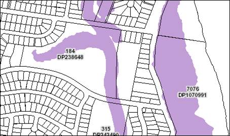
The
Applicant has submitted an Ecological Impact Assessment prepared by
Biodiversity Australia. The report has been reviewed and it is considered that
adequate measures have been taken to avoid or minimise impacts, and the
development would not result in serious and irreversible impacts on
biodiversity.
The
ecological assessment makes the following recommendations to mitigate the
biodiversity impacts of the development:
· Survey and identification of trees prior to removal.
· Retention of habitat features (hollow bearing trees and
koala food trees) within asset protection zones.
· Pre-clearing surveys and supervision of clearing by an
ecologist.
· Hollow bearing tree removal protocol.
· Replacement nest boxes (1 small glider/phascogale nest box,
and 1 parrot nest box).
· Restrictions on domestic pets.
· Food waste disposal protocols to discourage wild dogs,
foxes, and feral cats and reduce predation.
· Approval and implementation of a Vegetation Management Plan
for offset plantings and the identified regeneration area.
· Restrictions on patron access to the retained residual
habitat area through edge plantings and appropriate signage.
· Implementation of sedimentation and erosion control
measures.
· Weed control.
· Road signage and speed controls.
· Exterior lighting to be designed not to direct light
towards the retained vegetation.
· New landscaping to use native plant species.
Appropriate
conditions have been recommended incorporating these requirements.
Waste
The
Statement of Environmental Effects indicates that waste will be stored in a
secure and screened area adjacent to the loading area and collected by a
private waste contractor. A condition is recommended confirming the requirement
for a private waste service and requiring the waste to be collected in the
three different waste streams.
The
Koala Plan of Management requires bins containing food waste to be sealed and
locked to prevent access by feral animals, and a condition is also recommended
confirming this requirement.
Standard
precautionary site management condition also recommended for construction
phase.
Energy
No
adverse impacts anticipated.
Noise
and vibration
The submitted
Statement of Environmental Effects indicates that the café is proposed
to operate between the hours of 6.00am and 6.00pm, 7 days per week.
The
application includes a Noise Impact Assessment prepared by Matrix Thornton and
dated 10 July 2019. The assessment considers likely noise impacts of the
development associated with patrons and music, vehicle access and parking
(including deliveries and waste collection), and mechanical plant. The report
notes that the proposed café would operate between 7.00am and 6.00pm,
but acknowledges that staff would arrive in the hour prior to 7.00am and has
considered the potential for sleep disturbance during this period.
The
report concludes that:
“Noise
is predicted to be below the noise trigger levels at all receivers during the
daytime at the NPfI assessment point at ground level.
Considering
the upper floor level of the nearest receiver, noise is predicted to be below
the trigger level for the majority of the time. During the occasional delivery
or waste collection events, a marginal 3 dBA exceedances of the trigger level
is predicted. Given the infrequency of these events, and that the level is
significantly below the amenity level for a daytime, no noise mitigation is
considered necessary.
Noise
from traffic generated by the development will comply with the traffic noise
criteria.”
The
noise report has been assessed as being acceptable and appropriate conditions
are recommended.
Bushfire
The
site is identified as being bushfire prone.
The
Applicant has submitted a bushfire report prepared by David Pensini Building
Certification and Environmental Services and dated March 2019.
The
proposal relates to a Class 6 building and the provisions under the Building
Code of Australia for fire safety will be accepted for bushfire purposes where
the aims and objectives of Planning for Bushfire Protection 2006. The relevant
aims and objectives are as follows:
(i) afford occupants of any building
adequate protection from exposure to a bush fire;
(ii) provide for a defendable space to be
located around buildings;
(iii) provide appropriate separation between
a hazard and buildings which, in combination with other measures, prevent
direct flame contact and material ignition;
(iv) ensure that safe operational access and
egress for emergency service personnel and residents is available;
(v) provide for ongoing management and
maintenance of bush fire protection measures, including fuel loads in the asset
protection zone (APZ); and
(vi) ensure that utility services are
adequate to meet the needs of firefighters (and others assisting in bush
firefighting).
The
proposed development would substantially improve protection of the existing
building and includes the following measures to meet the above objectives:
· A defendable space of minimum 10m around the building,
which is to be managed as an Inner Protection Area (IPA);
· A new access road and parking area will be constructed
between the building and the hazard;
· The new internal access road will be constructed to comply
with Section 4.1.3 of Planning for Bush Fire Protection 2006;
· Water supply and utility services will be constructed to
comply with Section 4.1.3 of Planning for Bush Fire Protection 2006;
· Site landscaping shall comply with Appendix 5 of Planning
for Bush Fire Protection 2006;
· The site has alternative access/egress to Parklands Close
for emergency services personnel.
A
condition is recommended requiring retaining walls within the IPA to be
constructed of non-combustible materials, and the timber decking noted on the
internal driveway to also be replaced with a non-combustible material.
The
proposal also includes offset plantings on the eastern side of the proposed car
park, which have the potential to increase bushfire risk to adjoining
properties in Pacific Drive. A condition is recommended requiring certification
from a bushfire consultant that the new plantings meet the specifications for
an Inner Protection Area and will not increase bushfire risk to adjoining
properties. Details of the offset plantings will be confirmed in the Vegetation
Management Plan.
Safety,
security and crime prevention
The
proposed development will be unlikely to create any concealment/entrapment
areas or crime spots that would result in any identifiable loss of safety or
reduction of security in the immediate area.
The
increased activity and supervision of the area is likely to improve safety and
reduce the potential for anti-social behaviour. Lighting will be required for
internal access roads and parking areas for short periods during winter. The
Statement of Environmental Effects indicates that the Applicant intends to
install CCTV for the cafe building and car parking area.
Social
impacts in the locality
Given
the nature of the proposed development and its location the proposal is
unlikely to result in any adverse social impacts.
Economic
impact in the locality
No
adverse impacts anticipated. A likely positive impact is that the development
will maintain employment in the construction industry, which will lead to flow
impacts such as expenditure in the area. Additionally, the business would
create employment opportunities in the area.
Site
design and internal design
The
proposed development design satisfactorily responds to the site attributes and
will fit into the locality. No adverse impacts likely.
Construction
Construction
impacts are considered capable of being managed. Standard construction and site
management conditions have been recommended.
Cumulative
impacts
The
proposed development is not expected to have any adverse cumulative impacts on
the natural or built environment or the social and economic attributes of the
locality.
(c) The
suitability of the site for the development
The proposal will fit into the
locality and the site attributes are conducive to the proposed development.
Site constraints of bushfire
risk, ecology, stormwater and access have been adequately addressed and
appropriate conditions of consent recommended.
(d) Any
submissions made in accordance with this Act or the Regulations
Forty (40) written submissions were received following public
exhibition of the application on two occasions. Copies of the written
submissions have been provided separately to members of the DAP.
Key
issues raised in the submissions received and comments are provided as follows:
|
Submission
Issue/Summary
|
Planning
Comment/Response
|
|
Access is not permitted to Parklands Close via the Council
reserve and the owner has been unlawfully using this access.
|
The development does not propose access in this location.
Formalising access from Wandella Drive should discourage future use of other
access points.
|
|
Frequency of garbage truck access and associated noise
impacts have not been addressed in the application.
|
An amended noise assessment has been submitted, which
appropriately considers the impacts of private garbage collection.
|
|
Building equipment access is not fully described.
|
It is not necessary for details of construction management
to be submitted at the DA stage. Standard site management conditions have
been recommended and the contractors will be responsible for implementing the
conditions during the construction phase.
|
|
Past behaviour of the owner suggests that they would not
comply with any conditions of consent.
|
This cannot be considered in the assessment of the
application.
|
|
Adverse noise impacts from outdoor dining and vehicles
using the parking area.
|
The Applicant’s acoustic consultant has demonstrated
that noise generated by the car parking area and the outdoor dining area will
be below the acceptable criteria determined in accordance with the
EPA’s Noise Policy for Industry without any additional noise mitigation
measures.
|
|
Operating hours are too long for the residential context.
Nearby residents will be woken up at 6.00am, 7 days per week.
|
The amended noise assessment has confirmed that the
proposed café will operate between 7.00am and 6.00pm, but acknowledges
that staff will likely arrive between 6.00am and 7.00am to prepare for
opening. The noise assessment has considered the sleep disturbance criteria
for this period and determined that the predicted maximum noise level of
53dBA is below the level likely to cause awakening reactions (typically
60dBA).
Conditions have been recommended confirming the opening
hours of the business and also preventing any deliveries to the site or
garbage collection prior to 7.00am.
|
|
Impacts of headlight glare from proposed car park.
|
The proposed café will largely operate during
daylight hours and headlight are only expected to be used at some times of
year for morning staff access, or customers leaving the site in the evening
during winter.
The proposed car park is excavated into the site and is at
a substantially lower level than the windows of the adjoining residential
buildings to the east. It is not expected that headlights would shine
directly into windows, even during the infrequent periods that they are
likely to be used.
|
|
A number of mating Koalas regularly use the site.
|
The site has been confirmed to be core koala habitat and a
Koala Plan of Management has been submitted.
|
|
Safety impacts on the public using the boardwalk between
Calwalla Crescent and Wandella Drive from the proposed access to the
development.
|
The proposal has been amended to include realignment of
the boardwalk/footpath to the southern side of Wandella Drive and clear of
the driveway access to the development.
|
|
The first floor of the castle building is being occupied
by the owner. Residential use is not permitted under the zoning.
|
The application does not include any residential use of
the first floor of the building, and the Statement of Environmental Effect
indicates that the space would be used for storage associated with the
café.
A condition has been recommended prohibiting the building
from being used for habitable purposes.
|
|
Why does the café need a shower?
|
It is reasonable for a business to provide a shower for
staff use, particularly where the business involves food preparation. The
provision of shower facilities encourages employees to walk or cycle to work.
As noted above, a condition has been recommended
prohibiting the building from being used for habitable purposes.
|
|
A high Colorbond fence would be required along the rear
boundary adjoining No. 112A Pacific Drive.
|
The car park is located at the rear of 112A Pacific Drive,
and the current boundary treatment is a wire mesh security fence. The
proposed carpark is setback between 7.5m and 10.5m from the rear boundary of
the property and the finished level of the car park will be approximately 2m
below ground level at the property boundary. The Applicant has proposed
landscaping between the parking area and the property boundary including 2 of
the replacement Tallowwood plantings.
Having regard to the use of the area, separation distance,
landscaping, and difference in levels, a solid boundary fence is not
considered necessary to achieve satisfactory privacy.
|
|
The proposal paves the way for future development of the
site.
|
Any future proposal for the land will need to be
considered on its merits, and the determination of this application would not
prejudice any future decisions.
|
|
The traffic impact assessment is outdated and
doesn’t address the impacts of traffic on a quiet street of a
café operating 12 hours per day, 7 days per week.
|
The traffic impact assessment has been reviewed by
Council’s Development Engineer and considered to be adequate for
assessment of the application.
|
|
Adverse impacts on traffic safety in Pacific Drive and the
intersection with Wandella Drive from additional traffic associated with the
proposed café.
|
The traffic impact assessment adequately addresses the
impacts of the anticipated increase in traffic associated with the
development on the intersection of Pacific Drive and Wandella Drive. The
volume of traffic will not meet or exceed the warrants for intersection
upgrades.
|
|
The reports submitted with the application are outdated in
relation to the ‘Koala corridor’. It should include the RE2 zoned
land as well as the E2 land.
|
The ecological assessment and Koala Plan of Management identify
core koala habitat across both the RE2 and E2 zones. The Koala Plan of
Management includes appropriate measures for the protection of koalas and
their habitat in both zones.
|
|
Shipping container stored on the premises is set up as a
makeshift residence with dangerous electricity supply via a number of koala
food trees. The shipping container has been witnessed to be occupied on
occasions and creates a privacy issue for No. 108 Pacific Drive.
|
A condition has been recommended requiring the shipping container
to be removed prior to the issue of an Occupation Certificate.
|
|
The size of the car park is excessive for the development.
Only 6 spaces are required instead of the 24 proposed. The car park appears
to have been primarily proposed to meet APZ requirements.
|
The proposal requires 17 off-street parking spaces to
satisfy the Development Control Plan requirements. The additional parking
spaces proposed are considered sensible given that the site has limited
street frontage and cannot rely upon a proportion of vehicles utilising
street parking.
|
|
Adverse ecological impacts of proposed development.
|
See comments under Flora and Fauna section in this report.
|
|
The application does not identify the existing fireplace
that has been installed in the castle building, and whether it is proposed to
remain. Wood smoke is causing health and amenity impacts on nearby residents.
|
A condition has been recommended requiring the existing
fireplace to be removed prior to the issue of an Occupation Certificate.
|
|
The application doesn’t include details of the staff
numbers.
|
Details of staff numbers are not required to assess the
impacts of the development. The DCP parking rates for cafes/restaurants are
calculated as a proportion of the floor area of the business and account for both
staff and customers.
|
|
The ecological report suggests that the hollow bearing
tree should be retained and there needs to be assurance that this will
happen.
|
One hollow bearing tree is proposed to be removed, and
consistent with the DCP requirements, appropriate nest boxes will need to be
installed in retained trees to offset the loss of habitat. All other hollow
bearing trees would be protected through the recommended conditions of
consent and Vegetation Management Plan.
|
|
Disagree with the Applicant’s assertion that the
site has been regularly slashed. The land has been maintained by a lawn
mower.
|
Noted.
|
|
The owner has a cattle dog on the site, which is a danger
to the Koala population.
|
The Koala Plan of Management includes a restriction
prohibiting café patrons from entering the subject site with domestic
pets. It is considered reasonable that this restriction should apply to the
owner of the land, or any other person. A condition has been recommended
confirming this restriction.
|
|
Privacy impacts for residents adjacent to the outdoor
dining area.
|
The outdoor dining area is set at a significantly lower
level than the adjoining residential property at 113 Pacific Drive. The
current boundary treatment is a retaining wall approximately 2m high with
Colorbond fence above. From the outdoor dining area, only the upper floor
balcony on the western elevation of the neighbouring building is visible. The
separation distance between the balconies and the outdoor dining area is
approximately 18m at the closest point. In an urban context, 12m separation
is generally considered adequate to maintain privacy.
The Applicant has also established landscaping between the
outdoor dining area and the neighbouring property that would further protect
privacy of residents and café patrons.
|
|
The owner has installed an aviary at the rear of the
castle building. The birds kept in the aviary have caused noise impacts in
the past and will be a public health problem for the café.
|
If the development is granted consent, the keeping of birds
would not be permitted in proximity to the food premises. The recommended
conditions include a requirement for a final inspection by Council’s
Environmental Health Officer prior to the issue of an Occupation Certificate.
This would provide the opportunity to confirm that the aviary is no longer
present.
|
|
The land is subject to flooding.
|
Flooding impacts have been considered in accordance with
Clause 7.3 of the LEP.
|
|
Access to the site should not be permitted through E2
zoned land.
|
Access to the development is proposed via a dedicated (but
unformed) section of Wandella Drive, which is located within the E2 zone.
Roads are permitted with consent in the E2 zone and the proposal has been
demonstrated to be consistent with the zone objectives.
The site has alternative access via a battleaxe handle to
Parklands Close. However, this is not considered to be feasible as there is
insufficient width to safely accommodate two-way traffic flow. The access
handle is also zoned R1 General Residential and access for the purpose of
many of the forms of development permitted in the RE2 part of the site would
be prohibited.
On this basis, it is considered reasonable to permit
access via the E2 zoned land in Wandella Drive.
|
|
Proposal will devalue nearby properties.
|
NSW Land and Environment Court case law has established
that this is not a relevant planning consideration.
|
|
The proposed carpark is located too close to the rear
boundary of adjoining residential property. Will result in adverse impacts in
relation to lighting, noise, and exhaust fumes.
|
A detailed acoustic assessment has been submitted, which
demonstrates that the proposal will operate with acceptable noise levels
determined in accordance with the Noise Policy for Industry.
Conditions have been recommended to ensure that all
external lighting is installed in accordance with Australian Standards, and
that no light is directed towards the vegetation to the west.
Having regard to the size and location of the car park
relative to the adjoining residential uses, it is not considered that exhaust
fumes from vehicles would result in any unacceptable air quality impacts.
|
|
Oppose the tree removal proposed for road access and the
parking area.
|
It is not possible to provide access and car parking in a
manner that would retain all existing vegetation on the site.
The tree removal has been assessed in accordance with the
provisions of the Biodiversity Conservation Act 2016, SEPP 44, and
Council’s Development Control Plan 2013. Impacts on the most
significant vegetation on the site have been avoided or minimised and the
residuals impacts are proposed to be appropriately offset. Replacement
plantings are required for koala food trees impacted by the development, and
nest boxes are required to replace the habitat lost from the single hollow
bearing tree proposed to be removed.
|
|
The application does not clarify what the proposed use of
the first floor of the building will be. Concern that the owner will use the
first floor as a residence.
|
A condition has been recommended restricting the use of
the first floor of the building to storage for the purpose of the
café, and prohibiting its use for habitable purposes.
|
|
How will café visitors be prevented from walking
through the property and exiting via Parklands Close?
|
The access to Parklands Close is currently gated.
|
|
How will neighbours be protected from people jumping over
back fences?
|
Neighbours have the ability to negotiate an appropriate
boundary treatment with the property owner in accordance with the Dividing
Fences Act 1991.
|
|
How will the café reduce their environmental
footprint and manage waste?
|
The development includes facilities for the storage and
collection of waste consistent with Council’s Draft Waste Minimisation
and Management Policy.
|
|
Does the area need another café, and will the
business be viable?
|
The viability of a proposed business is not a relevant
consideration in the assessment of a development application.
|
|
The required 10m APZ should not remove any important trees
or habitat.
|
The submitted ecological assessment make provision for
retention of important habitat features within the APZ.
|
|
Oppose the removal of a Koala food tree for the car park.
Parking should be relocated to retain the tree.
|
The amended proposal provides for retention of the primary
koala food tree (Tallowwood) located adjacent to the car park. It is noted
that 8 ‘other browse species’ would be impacted by the
development, which are proposed to be appropriately offset.
|
|
Concerned about future development for caravan park or
mobile homes.
|
This is not part of the proposal and will be subject to a
separate development application.
|
|
Request for residents to have a tour of the property to
view the extent of tree removal.
|
This request has been provided to the Applicant for
consideration.
|
|
Request for ecologist to meet with local residents and
hear reports of wildlife at the site.
|
This request has been provided to the Applicant for
consideration.
|
|
Some trees have already been removed without Council
approval. What was the consequence?
|
A separate tree removal permit was issued by Council in
2017. There is no other record of investigations into unauthorised clearing
that have resulted in penalties or prosecution.
|
|
What guarantee will nearby residents have that further
tree removal is not carried out during construction work?
|
Trees authorised for removal have been clearly identified
on the application plans and in the ecological assessment. The recommended
conditions of consent require survey and identification of trees to be
removed, supervision of clearing by an ecologist, and certification that the
clearing has been carried out in accordance with the conditions of consent.
|
|
Has the State government been consulted in relation to
protecting Koala habitat on the site?
|
The draft Koala Plan of Management (KPoM) has been
referred to the NSW Department of Planning, Industry & Environment in
accordance with SEPP 44. The Department have approved the KPoM.
|
|
How does Council work with State government in acquiring
koala habitat and protecting littoral rainforest?
|
Council does not currently have a policy for
purchasing/acquiring koala habitat directly. However, as part of the planning
for new urban areas environmentally sensitive land is typically required to
be dedicated to Council as public reserves.
Council has a good relationship with relevant State
agencies including the Biodiversity Conservation Trust and provides advice in
relation to State Government land acquisitions.
Littoral rainforest is protected through the provisions of
State Environmental Planning Policy (Coastal Management) 2018.
|
|
How will Wrights Creek be protected from pollution and run
off?
|
The proposal includes a bio-retention basin, which will
manage water quality in accordance with Aus-Spec requirements. All stormwater
from the development will be piped to the basin prior to discharge to Wrights
Creek.
|
|
What is the management plan for Koalas?
|
A summary of the Koala Plan of Management is provided
earlier in this report under State Environmental Policy No 44 - Koala Habitat
Protection.
|
|
How will the public be prevented from using the site as a
through road between Wandella Avenue and Parklands Close or accessing the
site if they are not visiting the cafe?
|
The application proposes a boom gate at the northern end
of the car park to prevent vehicles accessing Parklands Close. Unauthorised
access to the site by persons not visiting the café would need to be
managed by the café operator and/or property owner.
|
|
How is overflow parking proposed to be catered for?
|
Overflow parking would be accommodated in nearby public
roads. It is noted that the application proposes parking in excess of the
minimum requirements of the DCP and a degree of overflow parking is able to
be accommodated within the property.
|
|
Object to use of Parklands Close driveway as an exit.
|
The application has been amended to include a boom gate at
the northern end of the car park to prevent vehicles accessing Parklands
Close.
|
|
The noise assessment relies on unqualified predictions and
does not include any actual noise readings at the affected properties.
|
The noise assessment has used EPA approved methods for
noise modelling.
|
|
The proposed development is inconsistent with 3 of the 5
aims of the Port Macquarie-Hastings Koala Recovery Strategy 2018.
|
The relevant aims of the strategy that can be influenced
through the development assessment process are:
· Reduce road
strike;
· Reduce domestic
dog strikes;
· Assist in
managing developments in aspects including design, habitat fragmentation and
fire management.
These aims are considered to be adequately
addressed in the submitted Koala Plan of Management. Restrictions have been
recommended to reduce vehicle speeds, prohibit domestic pets, and provide for
protection and offsetting of habitat.
|
|
Many café customers are likely to use Karalee
Parade as an alternative access and not just Wandella Drive as noted in the
traffic assessment. Karalee Parade is not designed to handle the extra
traffic volumes.
|
Other than for local residents, it is not expected that
Karalee Parade would be viewed as a convenient means of assess to the site.
It is not considered that there would be a significant increase in traffic on
Karalee Parade or impacts on the intersection with Shelly Beach Road.
|
|
The proposal will make it more dangerous to perform a
U-turn at the intersection of Karalee Parade and Wandella Drive.
|
The proposal has been amended to include a painted
roundabout treatment at the intersection of Karalee Parade and Wandella
Drive. This will improve the safety of U-turns, as well as other turning
movements.
|
|
Council should be looking to buy the site.
|
This is a matter for broader consideration by Council and
cannot be determined in the role as consent authority for development.
|
|
Limited street parking is available in the area for
overflow parking from the business.
|
Noted. The proposal includes off street parking in excess
of the minimum requirements of the DCP. This will provide for 6 overflow
spaces within the site, which is a greater extent than the parking that would
be available on the street for a site with regular frontage to a public road.
|
|
Access should be provided from Parklands Close as it was
for the former Fantasy Glades.
|
Access is not permissible from Parklands Close due the R1
General Residential zoning of the access handle.
|
|
If the hours proposed are 6.00am to 6.00pm, staff and
deliveries are likely to arrive outside these hours.
|
The proposed hours of operation have been amended to
7.00am to 6.00pm, 7 days. However, the acoustic assessment acknowledges that
staff are likely to arrive in the hour prior to 7.00am to prepare for
business. The acoustic assessment has considered the sleep disturbance
criteria for the morning shoulder period (6.00am to 7.00am).
A condition is recommended
requiring all deliveries to the site, and any waste collection to be carried
out during the operational hours of the business.
A condition is also recommended
restricting staff access to one hour prior to opening and one hour after
closing.
|
|
Will residents be consulted in relation to any future
requests to extend trading hours or change the use?
|
Any future applications will be notified in accordance
with Port Macquarie-Hastings Council Community Participation Plan 2019.
|
|
Request for independent traffic assessment including use
of pressure counters on Pacific Drive and at the Karalee Parade/Wandella
Drive intersection over a more substantial period.
|
The traffic assessment has been reviewed by
Council’s Development Engineer, including a review of traffic data and
previous traffic counts for the relevant streets. The assumptions and data
used in the traffic assessment were considered to be satisfactory.
|
|
Even with the proposed Koala Plan of Management being
implemented, the development would still increase the risk to the Koala
population compared with the current situation.
|
This is true in the sense that
the proposal includes clearing of vegetation in an area known to be used by
Koalas. However, implementation of the Koala Plan of Management would result
in significant improvements to the current risk to the existing Koala population
in the following areas:
· Decrease in risk
of koalas being attacked by domestic pets. There are currently no controls on
the keeping of domestic pets on the property.
· Removal of
barbed wire fencing that currently poses a risk of injury/entanglement.
· Long term
increase in food resources for koalas on the site. Other browse species
proposed to be offset with primary food trees.
|
|
Wandella Drive is very slippery when wet and vehicles
often skid or spin their wheels using the road.
|
The proposed access is located on the lower section of
Wandella Drive where the grades can meet relevant engineering standards.
|
|
Limited sight distance for vehicles exiting the site and
pedestrians using the boardwalk due to existing vegetation and topography.
|
The proposal has been amended to include diversion of the
existing boardwalk/pedestrian path to the southern side of Wandella Drive and
clear of the access road. This will appropriately manage conflict between
vehicles associated with the development and pedestrians/cyclists using the
connection to nearby residential areas.
|
|
Adverse impacts on water quality in Wrights Creek.
|
The proposal includes a bio-retention basin and conditions
have been recommended to ensure that discharge will meet the water quality
targets in Aus-Spec.
|
|
The noise assessment has not accounted for traffic noise
from the proposed emergency/maintenance access connecting to Parklands Close.
|
The access to Parklands Close has been deleted from the
proposal.
|
|
The café is likely to be a family business and is
unlikely to create substantial additional employment opportunities.
|
The number of people employed is likely to be the same,
whether it is a family or otherwise.
|
|
The café should be prevented from operating on
public holidays, or the hours further restricted.
|
Given the location and nature of the proposed café,
it is expected that the peak periods for use will be weekends, holidays, and
public holidays. This is similar to the historical use of the land for an
amusement park.
While the site is at the interface to the R1 General
Residential zone and adjoins residential uses, the acoustic assessment has
demonstrated that the business can operate within acceptable noise levels for
the hours of operation proposed. It is therefore considered that there is not
sufficient nexus to further restrict the hours/days of operation.
|
|
Noise impacts from patrons with dogs.
|
The Koala Plan of Management prohibits patrons from having
dogs on the premises.
|
|
No controls to prevent children from straying.
|
Parents/carers will be responsible for supervision of
children in their care.
|
|
Social impact study was carried out via Survey Monkey and
the results have not been submitted.
|
This survey related to the Social Impact Assessment for a
separate development application (DA2019 - 934.1) recently lodged for the
site. It is not applicable to the subject application.
|
|
Concern that emergency/maintenance access will still be
used by service vehicles, even with the boom gate in place.
|
A condition has been recommended restricting vehicular
access (including service vehicles to Wandella Drive only).
|
|
Impacts of bio-retention basin on flood fringe area, and
potential failure of the basin in major flood events.
|
The minor encroachment of the basin into the flood fringe
area has been considered acceptable in term of flood impacts. The bank of the
basin will be above the relevant flood level and the submitted plans show the
headwall discharging at a location above the flood waters in a 1:100 event.
Detailed design will be required to be submitted prior to the issue of a
Construction Certificate.
|
|
Loss of hollow bearing tree for detention basin is
unacceptable and will result in loss of shelter, roosting, and nesting for
threatened species.
|
The loss of the hollow bearing tree is required to be offset
with nest boxes in accordance with the DCP requirements.
|
|
Appears to remain an intention clear the E2 land in the
northern part of the site. Object to clearing of any trees in this area as it
is a key koala corridor.
|
No clearing is proposed in the E2 zoned part of the site.
The only works in the E2 zone are within the Wandella Drive road reserve for
the proposed new access.
|
|
Potential impacts of inter-allotment drainage along
eastern boundary have not been considered in the application. Drainage is not
shown in the Stormwater Management Plan.
|
The recommended conditions include a requirement for
provision of inter-allotment drainage for the properties east of the
café and associated car park. The required 1.5m wide easement could be
accommodated adjacent to the boundary without any additional tree removal.
|
|
The access arrangement prioritises vehicle traffic to the
development at the expense of pedestrians and cyclists currently using the
boardwalk.
|
The recommended access arrangements are considered to achieve
a satisfactory balance between vehicular and pedestrian/cyclist safety.
|
|
The proposed alterations to the boardwalk/footpath will
push pedestrians onto the wrong side of the Wandella Drive. Most pedestrians
using this path head towards Harry’s Lookout and cross Pacific Drive at
the northern side of the Wandella Drive intersection. Moving the
boardwalk/footpath to the southern side of Wandella Drive will create
additional unsafe road crossings.
|
Given the traffic volumes in Wandella Drive, it is considered
that there are a number of safe locations to cross the street. The proposed
painted medians on the approach to the Wandella Drive/Karalee Parade would
also act as informal pedestrian refuges.
|
|
The proposed roundabout treatment at the intersection of Karalee
Parade and Wandella Drive will create a burn-out spot.
|
There is no evidence that roundabouts exacerbate this type
of behaviour.
|
|
The proposed 10km/h speed limit is unlikely to be adhered
to due to the steep slope.
|
The part of Wandella Drive west of Karalee Parade is not
significantly steep. The proposed 10km/h speed limit is consistent with the
recommendations of the Koala Plan of Management.
|
|
The proposed roundabout treatment at the intersection of
Karalee Parade and Wandella Drive will increase vehicle noise.
|
The proposed roundabout is not expected to alter the
extent of acceleration and deceleration compared with the existing
T-intersection. Having regard to the volume of traffic in the street, it is
not expected that the changes to the intersection configuration would result
in unacceptable traffic noise in the locality.
For context, State Environmental Planning Policy
(Infrastructure) 2007 only requires consideration of road traffic noise
impacts for classified roads and roads having traffic volumes of 40,000
vehicles per day or greater.
|
|
The development will increase bushfire risk to residents
near the Calwalla reserve due to smoking, cars, and machinery.
|
The development is not considered to create any greater
risk than existing uses adjoining the reserve. Residential uses adjoining a
reserve can include all these activities and smoking is possible on the
public boardwalk through the reserve.
The development proposes paved surfaces to the outdoor
dining area and a sealed road is proposed to be constructed between the
castle building and the reserve, which would create a buffer to the spread of
fire.
|
|
Council has a duty of care regarding business competition.
|
The NSW Land and Environment Court has established that
competition impacts are not able to be considered in the assessment of a
development application.
|
|
Who will be responsible for maintenance of the new access
from Wandella Drive - the owner or ratepayers?
|
The proposal includes some modifications to the public
road at the end of Wandella Drive, including realignment of the
boardwalk/footpath, kerb and gutter construction, and roundabout treatment.
Following the defects liability period, these will become Council assets and
Council will be responsible for future maintenance.
The proposed driveway off the end of Wandella Drive will
be private infrastructure maintained by the property owner. Conditions have
been recommended to ensure that the driveway is constructed in a manner that
clearly defines the public and private assets.
|
|
Lighting of the car park will affect amenity of
neighbours.
|
A condition is recommended requiring external lighting to
be switched off between 7.00pm and 6.00am.
All external lighting will also be required to comply with
AS 4282 - control of the obtrusive effects of external lighting. With
the hours of operation proposed, lighting of the car park would only be
required for short periods (mostly during winter) and is not expected to
significantly affect the amenity of residential neighbours.
|
|
The repositioning of the bio-retention basin will result
in swamp-like smells and will become a mosquito breeding area.
|
The bio-retention basin operates as a sand filter and
allows for the infiltration of water. The basin will not hold water outside
periods of heavy rainfall, and is not expected to result in the type of
impacts suggested.
|
|
Illuminated signage will further impact neighbouring
properties.
|
The application does not include any details of signage,
and any future proposal for illuminated signage will be subject to a separate
application. The signage would need to be assessed in accordance with the
provisions of State Environmental Planning Policy No. 64 - Advertising and
Signage and Council’s Development Control Plan. As the proposed hours
of operation are predominantly during daylight hours, it would be difficult
to justify that illuminated signage is necessary.
|
|
The development should be required to meet the bushfire
requirements applicable to residential use as the owner is occupying the
first floor of the castle building.
|
The proposal has been assessed as a commercial use. A
condition has been recommended prohibiting the use of the building for
residential/habitable purposes.
|
|
The proposal is inconsistent with zone objectives for the
RE2 zone.
|
See comment earlier under LEP regarding consistency with
the relevant zone objectives.
|
(e) The Public Interest
The proposed development
satisfies relevant planning controls and will not adversely impact on the wider
public interest.
4. DEVELOPMENT
CONTRIBUTIONS APPLICABLE
· Development contributions will be required towards
augmentation of town water supply and sewerage system head works under Section
64 of the Local Government Act 1993.
· Development contributions will be required in accordance
with Section 7.12 of the Environmental Planning and Assessment Act 1979 towards
the provision, extension or
augmentation of public amenities or public services (or towards recouping the
cost of their provision, extension or augmentation).
·
· A copy of the contributions estimate is included as Attachment
3.
5. CONCLUSION AND
STATEMENT OF REASON
The application has been assessed in accordance with Section
4.15 of the Environmental Planning and Assessment Act 1979.
Issues raised during assessment and public exhibition of the
application have been considered in the assessment of the application. Where
relevant, conditions have been recommended to manage the impacts attributed to
these issues.
The site is considered suitable for the proposed development
and the proposal adequately addresses relevant planning controls. The
development is not considered to be contrary to the public's interest and will
not result a significant adverse social, environmental or economic impact. It
is recommended that the application be approved, subject to the recommended
conditions of consent provided in the attachment section of this report.
|
Attachments
1⇩. DA2019 - 277.1
Recommended Conditions
2⇩. DA2019 - 277.1 Plans
3⇩. DA2019 - 277.1
Contributions Estimate
4⇩. DA2019 - 277.1 Koala
Plan of Management - Rev 1.2
|
|
ATTACHMENT
|
Development Assessment Panel
06/05/2020
|
|
ATTACHMENT
|
Development Assessment Panel
06/05/2020
|
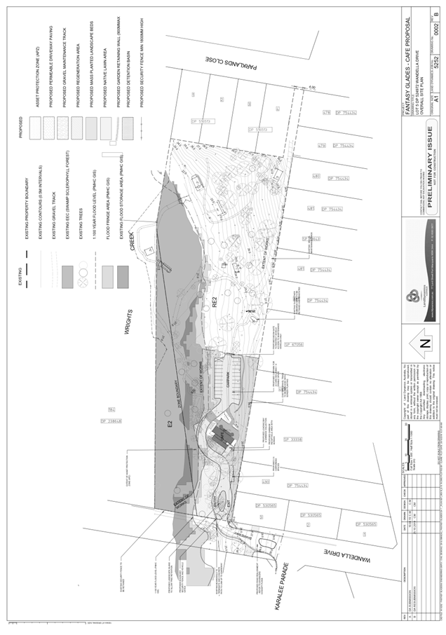
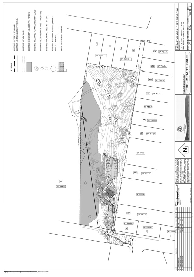
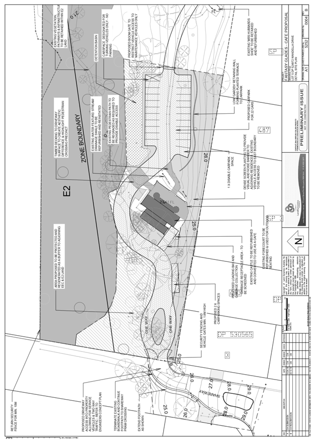
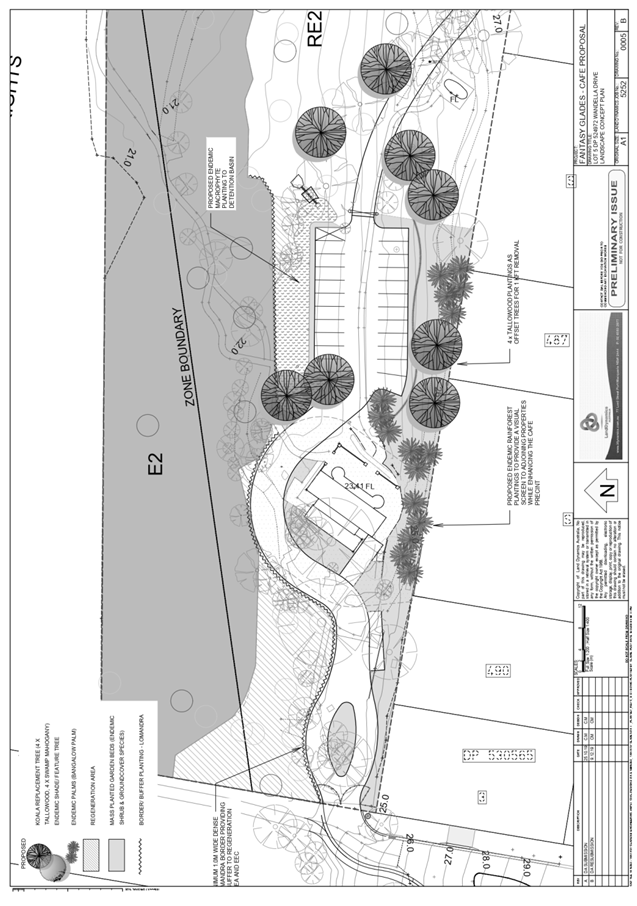
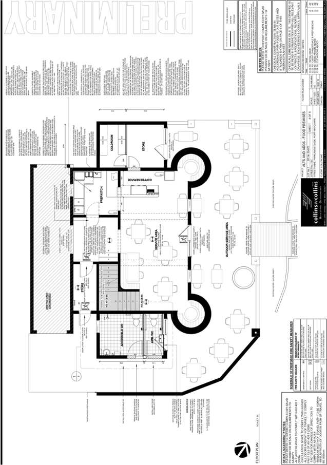
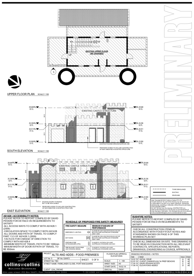
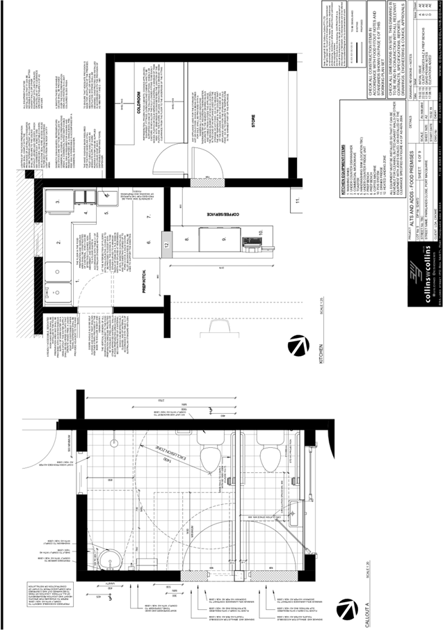
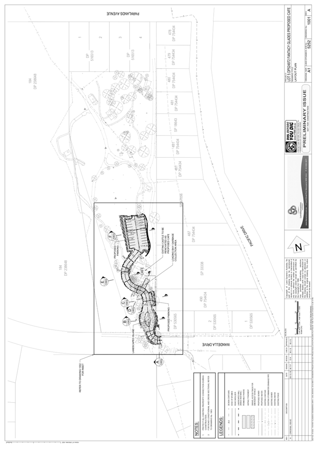
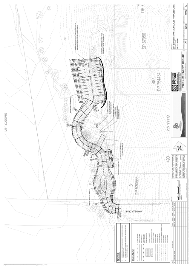
|
ATTACHMENT
|
Development Assessment Panel
06/05/2020
|
|
ATTACHMENT
|
Development Assessment Panel
06/05/2020
|

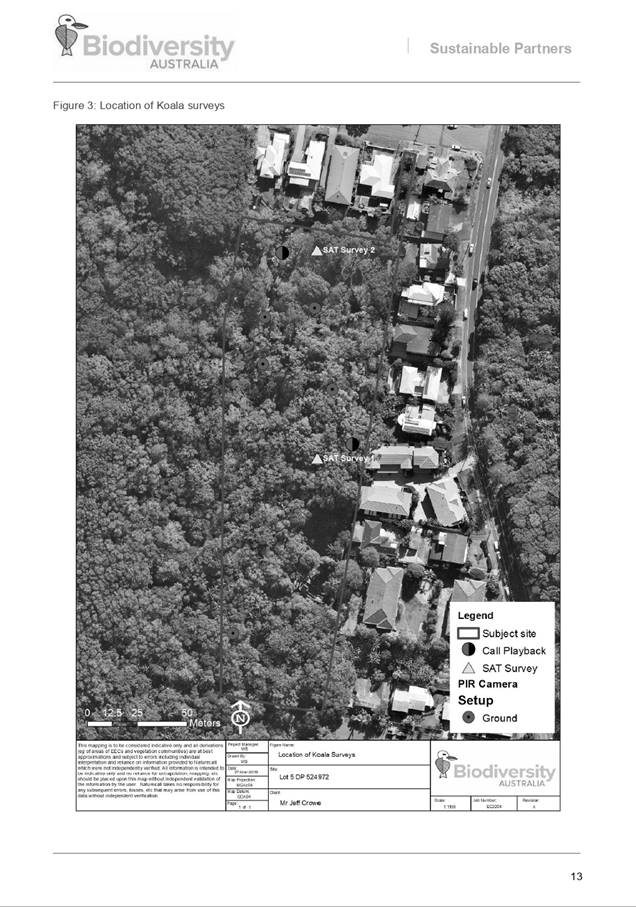
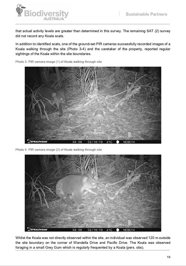
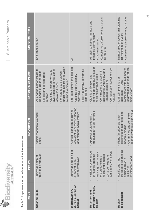
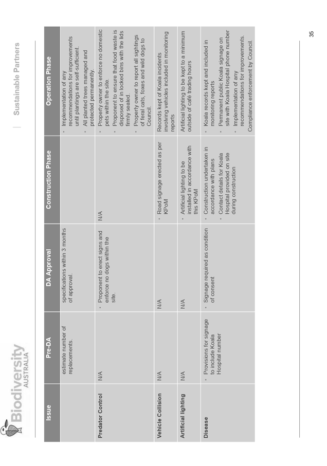

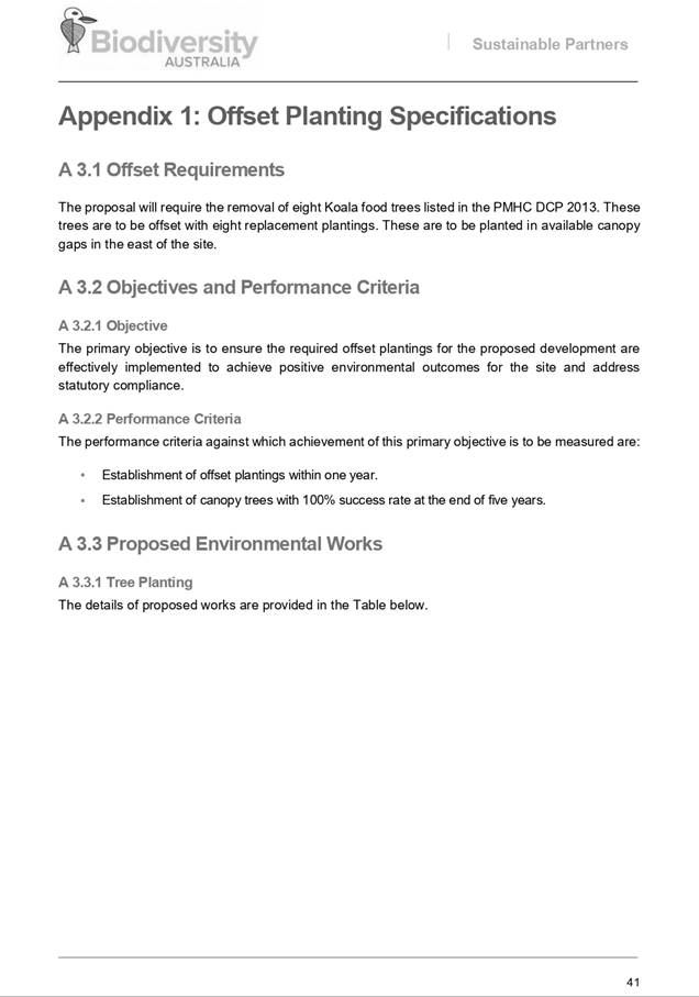
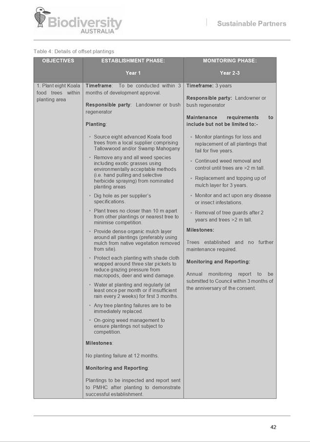
AGENDA Development Assessment Panel 06/05/2020
Item: 10
Subject: Section 4.55 DA2004 - 526.3 Modification to
Hours of Operation and Conditions of Consent Associated with Previous Approved
Industrial Building/Workshop at 10 Glen Ewan Road, Sancrox
Report
Author: Development Assessment Planning Coordinator, Patrick
Galbraith-Robertson
|
Applicant: Birdon
Marine CARE King & Campbell
Owner: Birdon
Holdings Pty Ltd
Estimated Cost: N/A
Alignment with Delivery
Program
4.3.1 Undertake transparent and
efficient development assessment in accordance with relevant legislation.
|
RECOMMENDATION
That
DA2004 - 526.3 for a modification to hours of operation and conditions
of consent associated with previous approved industrial building/workshop at Lot 17, DP 1191370, No. 10 Glen Ewan Road, Sancrox, be
determined by granting consent subject to the recommended modified conditions.
Executive
Summary
This
report considers an application for modification to a previous approved
industrial building workshop at the subject
site and provides an assessment of the application in accordance with the
Environmental Planning and Assessment Act 1979.
Following exhibition of the
application, eleven (11) submissions were
received.
Amendments have been made to the proposal during assessment,
which primarily include the following:
· Proposed installation of approximately 500m2 of 100mm thick
R1.5 polyester acoustic absorption/thermal blanket hung vertically on the
internal face of the shed walls around the fabrication area; and
· A proposed additional carparking area for relocation of
parking for worker’s vehicles during the evening and night-time periods.
·
Subject to the recommended modified conditions, the site is
considered suitable for the proposed modified development and the proposal
adequately addresses relevant planning controls. The development is not
considered to be contrary to the public's interest and will not result a
significant adverse social, environmental or economic impact.
This report recommends that
the modification application be approved subject to the attached conditions (Attachment
1).
1. BACKGROUND
Existing
Sites Features and Surrounding Development
The site has an area of 3.93
hectares.
The
site is zoned IN4 working waterfront and RU6 transition in accordance with the Port Macquarie-Hastings Local
Environmental Plan 2011, as shown in the following zoning plan:
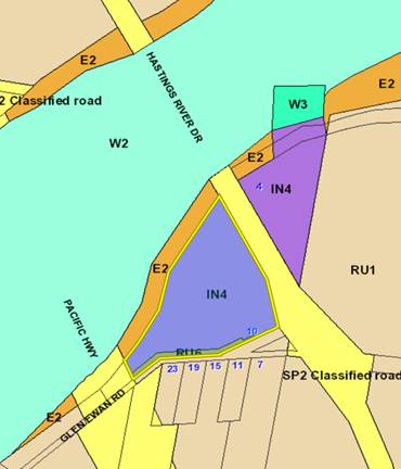
The site is
located on the corner of Hastings River Drive (formerly the Pacific Highway)
and Glen Ewan Road. The re-aligned Pacific Highway is located
Immediately
to the west of the site.
Birdon Pty Ltd operate a marine
industry on the subject site as well as the adjoining
Lot 1 DP 225413, which is
located on the eastern side of Hastings River Drive. A dwelling also occupies
the site close to the workshop.
Hastings River Drive is located
immediately east of the subject site. Glen Ewan Road
is located immediately south of
the subject site.
Five (5) small RU1 Primary
Production lots - four (4) of which contain a dwelling are located on the
southern side of Glen Ewan Road.
The Pacific Highway is located
to the west of the subject site. The Hastings River
crown reserve is located to the
north of the subject site and the Hastings River is located immediately north
of the Crown reserve.
The
location of existing development within the locality is shown in the following
aerial photograph:
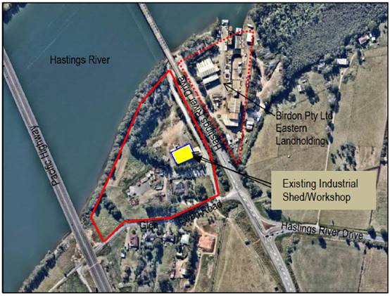
2. DESCRIPTION
OF DEVELOPMENT
Key
aspects of the proposal (as amended) include the following:
· Extend
the approved hours of operation of the
existing western shed (industrial building) to 24 hours a day;
· Sealing the existing gap around the western door with a 6mm
loaded vinyl fabric or a 10mm thick rubber strip. It is proposed that the
western door will remain sealed and closed during the extended hours of
operation;
· Proposed installation of approximately 500m2 of
100mm thick R1.5 polyester acoustic absorption/thermal blanket hung vertically
on the internal face of the shed walls around the fabrication area;
· At the completion of the acoustic sealing work, a
certificate of acoustic compliance is to be provided to Council to confirm that
the noise trigger levels in the Matrix Thornton Noise Report dated 30 August
2019 are not exceeded and comply with the relevant standards specified by NSW
Noise Policy for Industry; and
· A proposed additional carparking area, which will provide a
relocation of parking arrangements for workers during the evening and
night-time periods to be on the northern side of the building.
The
Applicant has proposed to modify conditions E(7) and F(8).
Refer
to Attachment 2 at the end of this report for plans of the current
approved development and noise assessment details.
Development
Approval and Rezoning History
The
existing industrial shed/workshop was granted development consent under DA2004
- 526 on 2 September 2004. The originally approved shed had dimensions of 29m
by 50m (1,000m2) and a height of 12m.
In
March 2016, a modification application was lodged by Birdon to modify the size
of
the
approved industrial shed/workshop to be 21.8m by 42m (915m2) and
increase the height to 15m.The modified consent was granted on 27 April 2016.
Since
this time the industrial shed/workshop has been utilised as a part of
Birdon’s
marine
industrial undertakings including the maintenance, refurbishment and
construction of boats and associated marine facilities.
In
2015, the subject site, Lot 17 DP1191370, was rezoned from RU1 Primary
Production
to IN4 Working Waterfront.
Application
Chronology
· 19
November 2019 - Modification application lodged with Council.
· 13 December 2019 to 10 January 2020 (extended 1 month to
permit late submissions) - Neighbour notification of proposal.
· 15 January 2020 - Assessment update provided to Applicant.
· 21 January 2020 - Redacted copies of submissions (at the
time) provided to Applicant for consideration and advised extension to
neighbour notification period.
· 30 January 2020 - Site visit by assessing officer and
Council Environmental Health Officer.
· 19 February 2020 - Redacted copies of submissions provided
to Applicant for consideration.
· 24 March 2020 - Follow up to Applicant on status of
responding to assessment issues.
· 30 March 2020 - Additional information received from
Applicant in response to assessment and submission issues.
· 23 and 24 April 2020 - Discussion with Applicant on draft conditions.
3. STATUTORY
ASSESSMENT
Section
4.55 Matters for Consideration
In
determining the application, Council is required to take into consideration the
matters as are relevant to the development that apply to the land to which the
development application relates.
Section 4.55 of the Environmental Planning and Assessment
Act 1979 enables the modification of consents and categorises modification into
three categories - 4.55(1) for modifications involving minor error,
mis-description or miscalculation; 4.55(1A) for modifications involving minimal
environmental impact; and 4.55(2) for other modifications.
Each type of modification must be considered as being
substantially the same to that which was originally consented to.
The proposal is proposed to be assessed as a Section
4.55(1A) application.
Is the proposal
substantially the same?
The subject application is being considered under the
provisions of Section 4.55(1A). The proposal is considered to be substantially
the same development to that which was originally consented to and the changes
will have minimal environmental impact as justified and subject to recommended
conditions.
Specifically, the proposed extension of hours will not
modify the nature or type of industrial activity currently undertaken on-site
and the development will therefore be substantially the same as the development
for which the consent was originally granted. The changes to additional car
parking arrangements is considered to be minor and will not fundamentally
change the essence of the development.
Does the application require notification/advertising
in accordance with the regulations and/or any Development Control Plan?
Neighbour notification has been completed in accordance with
Development Control Plan 2013 and Council’s Community Participation Plan.
Any submissions made
concerning the modification?
11 submissions have been received following
completion of the neighbour notification period. The issues raised in the
submissions received are considered later in this report.
Any matters referred to in
section 4.15(1) relevant to the modification?
(a) The
provisions (where applicable) of:
(i) Any
Environmental Planning Instrument
State
Environmental Planning Policy (Coastal Management) 2018
The subject land and the
properties within Glen Ewan Road are within the “proximity area for
coastal wetlands” under the SEPP (Coastal Management) 2018. The
modification application seeks approval for the extension of hours of operation
of current industrial activities within an existing industrial shed. The
extended hours carpark will make use of an existing gravel area. The proposed
application to modify the hours of operation will not result in any
identifiable adverse impacts to:
· The
biophysical, hydrological or ecological integrity of the mapped coastal wetland
within proximity of the land; and
· The
quantity and quality of surface and ground water flows to and from the mapped
coastal wetland within proximity of the land.
Port
Macquarie-Hastings Local Environmental Plan 2011
The subject site is partly zoned
IN4 Working Waterfront and RU6 Transition under the provisions of the Port
Macquarie-Hastings Local Environmental Plan 2011.
The existing industrial
shed/workshop is wholly located within that part of the site
zoned IN4 Working Waterfront.
The industrial shed/workshop was
granted consent under DA2004 - 526 (as currently modified) and is utilised by
Birdon as a part of the existing marine industry.
(iii) Any Development
Control Plan in force
Development
Control Plan No. 18 - Off Street Parking Code
The
proposal (as amended) includes a proposed additional carparking area with
relocation of current parking arrangements for workers during the evening and
night-time periods. The new location of the carpark is to be on the northern
side of the building and to a gravel standard. This carparking area can satisfy
the requirements of this DCP and is surplus to the original requirements as
approved.
The
requirements of this DCP (as in force at the time) remain satisfied.
(iiia) Any planning agreement that has
been entered into under section 7.4, or any draft planning agreement that a
developer has offered to enter into under section 7.4
No planning agreement has been
offered or entered into.
(iv)
Any matters prescribed by the Regulations
No matters prescribed by the
regulations apply.
(b) The likely
impacts of that development, including environmental impacts on both the
natural and built environments, social and economic impacts in the locality:
Context and Setting
The proposal as modified will be
consistent with the locality and adequately addresses planning controls (as in
force at the time) for the area.
The modified proposal is
appropriate and will be unlikely to have any adverse impacts to existing
adjoining properties or the public domain.
Traffic
The modified proposal with
extended operating hours will not have any identifiable significant adverse
impact on the surrounding road infrastructure or traffic volumes.
Noise
The modification proposal
primarily proposes to extend the approved hours of operation of the existing western shed (industrial building)
to 24 hours a day - 7 days a week. The current approved hours are limited to
the following.
(8)
(DDOCC00630) Hours of operation of the development are restricted the following
times:
-
7.00 am to 6.00 pm – Mondays to Saturdays
No
work is to be carried out on Sundays and Public Holidays.
With the proposed extended
hours, the Applicant has originally submitted a specialist Noise Impact
Assessment prepared by Matrix Thornton. During the assessment of the
application, assessment and submission issues were raised with the Applicant.
In response, additional specialist acoustic advice has been submitted from
Matrix Thornton and the Applicant. All information submitted has been carefully
considered in consultation with a Council’s Environment Health Officer.
The following assessment
points are made in relation to noise/acoustic impacts:
· The
Noise Impact Assessment Report centres on the proposed extended trading hours
past 6pm till 7am and concludes that noise from the shed will not adversely
impact on the residents across the Glen Ewan Road, provided an acoustic seal is
installed around the Western door and the door is kept shut and sealed after
6pm until after 7am. Small personnel access doors in the shed were also assumed
to be kept closed.
· The
noise from the carpark was assessed on there being 3 noise sources in the
carpark, ie cars arriving and leaving at the same time, people talking and door
slams. The Report indicates that there’ll be a 75dB(A) equivalent noise
level, which will comply with the Trigger levels at the residential receivers.
· A
worst case scenario of a car accelerating from/into the carpark at 95dB(A) was
used for the sleep disturbance assessment and the Report concludes that the
maximum level of 52LAMax won’t be exceeded at the windows of the
residences and no further noise mitigation is required.
· Matrix
Thornton have revised the initial acoustic assessment and have identified two
further noise attenuation measures that can be implemented to address some of
the concerns raised in the submissions, which are:
- Install
sheets of insulation material to the southern wall of the shed near the
fabrication area which will reduce noise from the shed by two decibels, 2dB(A);
and
- Provide an
extended operating hours carpark for staff at the rear of the shed on the
Hastings River side, which will increase the separation distance to the
residences on Glen Ewan Road.
· Matrix
Thornton conclude that overall noise will be further reduced by an additional
two (2) decibels with the addition of the insulation to the southern wall and
will comply with all relevant noise criteria at the residences on Glen Ewan
Road.
The primary mitigation
measures (conditions) are recommended to be as follows:
(1) Prior to any commencement/occupation for
operations of extended hours (between 6pm and 7am), the following shall be
completed:
a)
Installation of 100mm thick R1.5 polyester acoustic absorption/thermal blanket
or equivalent on the internal face of the southern wall of the existing shed;
b)
Installation of the door seal as detailed in Section 6.2.2 of the Matrix
Thornton “Impact Noise Assessment Report’, dated August 30, 2019;
Report reference M19054.02; and
c) At
the completion of the acoustic sealing works, as detailed in the modification
approved 7 May 2020, a certificate of acoustic compliance prepared by a
suitably qualified and practising acoustic consultant shall be submitted to
Council to certify that all of the Project Noise Trigger Levels are being
complied with during full operating capacity. Refer to the Matrix Thornton
Noise Reports dated 30 August 2019 and 27 March 2020. The acoustic
certification shall comply with all relevant Australian Standards and NSW EPA
requirements, including the NSW Noise Policy for Industry.2
(2) (F196) Provision is to be made
during extended operational hours (6pm to 7am) of an additional car park on the
existing hard stand area located on the northern side of the existing western
shed as shown on the plan Birdon Marine Extended Hours Carpark (King &
Campbell plan 6300P_Site – Revision A dated 25 March 2020). The
carparking area shall have capacity for 12 cars and is to be provided for
employees working in the existing shed on Lot 17 during the extended hours of
operation from 6pm to 7am.
(3) The western sliding door of the western
shed (as indicated in Figure 3-2 of the Matrix Thornton Noise Report for DA,
dated 30 August 2019) shall be kept shut at all time when the processes of
manufacturing and fabrication are being carried out within the western shed.
The western
sliding door is permitted to be opened and closed for reasons of deliveries and
boat/hull flipping only when no manufacturing and/or fabrication
works/processes are being carried out or are occurring within the western shed.
The door may
remain open during times of a flood risk emergency.
(4) No deliveries of goods or operation of
transport vehicles including forklifts or the like, external to the western
shed shall be permitted to occur on the lot during the extended hours from 6pm
and 7am.
(5) (F199) Two months following the
commencement of the extended hours of operation (from 6pm to 7am), a
certificate of acoustic compliance, prepared by a suitably qualified and
practising acoustic consultant, shall be submitted to Council to certify that
all of the Project Noise Trigger Levels are being complied with during full operating
capacity. Refer to the Matrix Thornton Noise Reports dated 30 August 2019 and
27 March 2020. The acoustic certification shall comply with all relevant
Australian Standards and NSW EPA requirements, including the NSW Noise Policy
for Industry.
Based upon compliance with
the above, it is considered unlikely that the proposed development will have
any significant adverse environmental health or noise/acoustic impacts. It
should be noted that the above conditions are above what is proposed by the
Applicant to ensure landuse compatibility in the existing context.
The modified consent
conditions are considered to be practical mitigation measures to ensure a
balance of operation needs of an approved industrial business and ensuring
compatibility with nearby residences/residential landuses.
(c) The
suitability of the site for the development
Subject to compliance with the
consent conditions proposed to be modified, the modified proposal will fit into
the locality.
(d) Any
submissions made in accordance with this Act or the Regulations
Eleven (11) written submissions were been received following public
exhibition of the application. Copies of the written submissions have been
provided separately to members of the DAP.
Key issues raised in the
submissions received (by property location) and comments are provided as
follows:
|
Submission Issue/Summary
|
Planning Comment/Response
|
|
63, 79, 69 & 47 Glen Ewan Road
|
|
|
Noise Levels will be 80-90+ decibels.
|
The predicted noise levels detailed by the specialist
Noise Consultant comply with the night-time, evening and daytime trigger
levels at all residential receivers, which are the closest receivers to the
existing shed.
|
|
Noise will
funnel under the Hastings Bridge and travel up river and across the floodplain.
|
The acoustic
report from Matrix Thornton details that noise levels provided in the report
include any reflections from topography. In the
case of 7
Glen Ewan Road there could be a small component of noise reflected from the
bridge abutment. However, because the abutment is low, not vertical, shielded
by vegetation, and 40m from the noise source, any increase at houses on Glen
Ewan Road due to reflections would be less than 0.3dBA and would not make any
audible difference at the dwellings.
|
|
This development
will devalue property.
|
Any
perceived impacts on land value are unable to be considered as part of the
assessment of a Development Application under the Environmental Planning and
Assessment Act 1979. An assessment of the likely impacts is the focus of this
assessment.
|
|
This
Colourbond shed where Birdon Marine wants to carry out metal fabrication and
boatbuilding does not have any sound installation.
|
The existing
Colourbond shed is proposed to be insulated through the installation of 100mm
thick R1.5 polyester acoustic absorption/thermal blanket or equivalent on the
internal face of the southern wall of the existing shed.
|
|
Sandblasting,
fibre glassing, toxic air pollution will travel in an easterly wind to our
house.
|
There is no
sandblasting or fibre glassing undertaken or proposed to be undertaken in the
existing shed.
|
|
15 Glen
Ewan Road
|
|
|
Objection to
acoustic impacts, installation of the door only, sound rating of Colourbond
sheds and that the sound produced will be 80-90 dBA.
No sound
insulation proposed.
|
The Updated
Acoustic Report confirms that the predicted noise levels comply with the
night-time, evening and daytime trigger levels at all residential receivers
which are the closest receivers to the existing shed the subject of the
modification application. Table 6-1 confirms that the Total Noise Levels are
2-5 dBA below the night-time Trigger Levels.
As outlined
above, the existing Colourbond shed is proposed (as amended) to be insulated
through the installation of 100mm thick R1.5 polyester acoustic
absorption/thermal blanket or equivalent on the internal face of the southern
wall of the existing shed.
|
|
The distance
from house to shed 2 is approximately 110m or less.
|
The existing shed is in
excess of 140m
from the
existing residences at 7-15 Glen Ewan Road.
|
|
The car park
approximately less than 65m from boundary will create noise levels of 95dBA
with 10 cars arriving and leaving in any 15-minute period. The report does
not mention the effects of truck and machinery noise/forklifts and crane
noise that will affect property.
|
The
Applicant has been requested to address this issue and provided satisfactory
additional information to confirm that the typical source noise level of car
park events such as car doors slamming and cars accelerating is LAmax 95dBA.
The
Applicant’s consultant Matrix Thornton has then provided satisfactory
confirmation that the modelling shows that the predicted level of Maximum
Noise Levels at the four receivers included in the original report (9-15 Glen
Ewan Road) are below the screening level at all the receivers.
Table 6.2
(p.10) shows that the Predicted Level at 15 Glen Ewan Road is LAmax 38dBA
being 14dBA below the Screening Level, Night Shoulder.
The proposed
extended hours car park within the existing gravel area on the northern side
of the existing shed and approximately 195m from the residences on Glen Ewan
Road.
|
|
11 Glen
Ewan Road
|
|
|
The distance
from house to shed 2 is approximately 90m or less.
|
The distance
between the SW corner of the existing shed and the existing residences on
7-15 Glen Ewan Road is in excess of 140m. The extended hours car park is
approximately 195m from the existing residences.
|
|
The
development will devalue my property.
|
Any
perceived impacts on land value are unable to be considered as part of the
assessment of a Development Application under the Environmental Planning and
Assessment Act 1979. An assessment of the likely impacts is the focus of this
assessment.
|
|
The eastern
door of this shed will be left open with the noise levels which will be 80-90
+ decibels.
|
The
prediction of noise is assumed that the door in the eastern end would remain
open and the door on the western end would remain fully closed. The predicted
total noise levels comply with the night-time, evening and daytime trigger
levels at all residential receivers. Table 6-1in particular of the report
confirms that the Total Noise Levels are 2-5 dBA below the night-time Trigger
Levels.
|
|
The car park
approximately 65 m from my boundary will generate noise levels of 95 dBA with
10 cars arriving and leaving in any 15-minute period. The report does not
mention the effects of truck and machinery noise/forklifts and crane noise
that will affect property.
|
There is no
work proposed outside of the existing shed including the operation of trucks,
forklifts and cranes during the proposed extended hours of operation.
|
|
The
headlights at night from trucks and cars will light up house and the bedroom
windows where children and family are living.
|
The amended
plans show the location of the internal driveway from the extended hours car
park in relation to the residences on 7-11 Glen Ewan Road. The plan shows
that the
headlights
of cars exiting the driveway will not be directed towards the existing
residences.
|
|
The sound
bounces off the Dennis Bridge abutment and is directed straight at house.
|
The
specialist report from Matrix Thornton details that noise levels provided in
the report include any reflections from topography. In the
case of 7
Glen Ewan Road there could be a small component of noise reflected from the
bridge abutment. However, because the abutment is low, not vertical, shielded
by vegetation, and 40m from the noise source, any increase at houses on Glen
Ewan Road due to reflections would be less than 0.3dBA and would not make any
audible difference at the houses.
|
|
This large
colour bond shed where Birdon Marine wants to carry out metal fabrication and
boatbuilding does not have any sound insulation.
|
The proposal
has been amended to include a proposed installation of 100mm thick R1.5
polyester acoustic absorption/thermal blanket or equivalent on the internal
face of the southern wall of the existing shed.
|
|
19 Glen
Ewan Road
|
|
|
The
monitoring for the baseline sound in the area was contaminated by Birdon
producing large amount of noise from shed two and sandblasting, grinding and
hammering steel with both doors open. The sound monitoring that was
undertaken is inaccurate and should be redone.
|
There is no
sandblasting undertaken or proposed to be undertaken in the existing shed.
The Matrix
Thornton Report was a noise assessment of the proposed extended operating
hours of the Birdon Marine facility at Sancrox. It has been confirmed that
all noise modelling and monitoring performed for that report was done in
accordance with the NSW Noise Policy for Industry (2017), the current policy
in NSW.
|
|
Concern
raised with respect to the acoustic rating of Colourbond.
|
The results
of the acoustic modelling contained in the Noise Impact report prepared by
Matrix Thornton are based on the existing shed constructed of Colourbond.
|
|
The existing
house on 19 Glen Ewan Road is approximately 110 m from the existing shed and
less than 50m from the western car park.
|
The existing
shed is in excess of 140 m from all existing houses.
The amended
plans also show that the proposed extended hours car park on the gravel hard
stand area north of the existing shed is approximately 195 m from the
existing houses in Glen Ewan Road.
|
|
Noise
associated with metal fabrication, hammering steel plating grinding can be
heard and will be far greater if sandblasting is also done.
|
There is no
sandblasting proposed to be undertaken in the existing shed.
|
|
Noise levels
for the car park is reported at 95dBA with 10 cars arriving and leaving in
any 15 minute period. The report does not mention the distances to the
closest residence from the car parking areas or the effects of truck and
machinery noise/forklifts and crane noise.
|
The
specialist noise reports from Matrix Thornton confirm that the predicted
total noise levels (which includes noise associated with the proposed
extended hours carpark) comply with the night-time, evening and daytime
trigger levels at all residential receivers. Table 6-1 confirms that the
Total Noise Levels are 2-5 dBA below the night-time Trigger Levels.
|
|
Concerns raised
with respect to the noise impacts associated with carpark, truck loading and
unloading, dragging chains, slamming doors.
|
There is no
work proposed outside of the existing shed including the operation of trucks,
forklifts and cranes during the proposed extended hours of operation.
A new
consent condition is recommended to ensure this is complied with.
|
|
Cars and
trucks coming and going with their headlights on at night will light up house
and bedrooms.
|
The amended
plans show the location of the internal driveway from the extended hours car
park in relation to the residences on 7-11 Glen Ewan Road. The plan shows
that the
headlights
of cars exiting the driveway will not be directed towards the existing
residences.
|
|
King &
Campbell and Matrix reports indicate the industrial noise policy was from
1997.
The current
policy relating to industrial noise policy is 2017.
|
Matrix
Thornton Report was a noise assessment of the proposed extended operating
hours of the Birdon Marine facility at Sancrox. It was confirmed that all
noise modelling and monitoring performed for that report was done in
accordance with the NSW Noise Policy for Industry (2017), the current policy
in NSW.
|
|
The sealing
of the western doors will mean there is no cross ventilation and be in breach
of Work Safety Australia guidelines if the shed is used for activities such
as welding, grinding Marine/metal fabrication.
|
Birdon has
undertaken a review of the current working environment within the existing
shed and confirm that the existing ventilation arrangements meet their WHS
statutory obligations with the western door shut.
|
|
The
construction of the shed and distance to the river according to BlueScope
Steel guidelines indicates that the distance to the river is non-compliant
and the material used is insufficient.
|
The subject
modification application seeks to extend the hours of operation of existing
industrial activities within the existing industrial shed is approved and
development consent DA2004 -526. The BlueScope Steel guidelines are not a
relevant matter to the subject modification application.
The proposal
has been amended during the assessment of the application to now include
proposed installation of 100mm thick R1.5 polyester acoustic
absorption/thermal blanket or equivalent on the internal face of the southern
wall of the existing shed.
|
|
The
residential receiver category used in the acoustic assessment should be
rural.
|
Matrix
Thorton have advised that as they understand the issue in the submissions
there is a question as to whether the surrounding residences should be
considered "Rural residential" or "Suburban residential”
as described in Table 2.3 of the Noise Policy for Industry. From the point of
view of noise assessment, we note that it makes no difference to the outcome.
This is because the noise trigger levels were based on the night-time and
evening amenity levels are the same for suburban and rural receivers (40dBA)
and
were only
considering activity during evening and night-time. Hence the choice of
"Suburban residential" or "Rural residential" makes no
difference to the outcome.
|
|
Concerned
how sound levels will be capped at the expected level being 50 dBA during the
day, 45dBA in the evening and 40dBA in the night. The noise policy contains
certain measures such as a contact line for affected receivers or measures
for the monitoring and reduction of noise levels. None of this has been
supplied in the proposal.
|
The
predicted total noise levels comply with the night-time, evening and daytime
trigger levels at all residential receivers. Table 6-1 confirms that the
Total Noise Levels are 2-5 dBA below the night-time Trigger Levels.
The
submitted modification application includes measures to reduce potential
noise impacts as detailed earlier in report. The mitigation measures are to
be achieved and maintained via compliance with consent conditions as
recommended.
|
|
7 Glen
Ewan Road
|
|
|
The distance
from my house to shed 2 is approximately 85 m.
|
The distance
between the SW corner of the existing shed and the existing residences on 7-15
Glen Ewan Road is in excess of 140m. The extended hours car park is
approximately 195m from the existing residences.
|
|
Five
registered home-schooled children, this noise will affect children’s
education.
|
The proposal
relates to extended hours of operation and the current approved day time
business hours will also be maintained.
The noise
assessment submitted confirms no adverse impacts to neighbouring properties
based upon the Industrial Noise Policy guidelines. The predicted total noise
levels comply with the night-time, evening and daytime trigger levels at all
residential receivers.
The proposal
has however been conditioned to require the western door now to be closed at
all times with the exception of delivery times and boat flipping which will
assist with mitigation of any potential noise impacts particularly in regards
to children and general amenity.
|
|
The eastern
door of this shed will be left open, the noise levels will be 80 to 90+
decibels.
|
The
prediction of noise is assumed that the door in the eastern end would remain
open and the door on the western end would remain fully closed.
|
|
The car park
approximately 65 m from boundary will result in noise levels in of 95 dBA
with 10 cars arriving and leaving in any 15 minute period. The report does
not mention the effects of truck and machinery noise/forklifts and crane
noise that will affect property.
|
The amended
plans show the location of the internal driveway from the extended hours car
park in relation to the residences on Glen Ewan Road. The proposed extended
hours car park within the existing gravel area on the northern side of the
existing shed and approximately 195m from the residences on Glen Ewan Road. The
plan shows that the headlights of cars exiting the driveway will not be
directed towards the existing residences.
There is no
work proposed outside of the existing shed including the operation of trucks,
forklifts and cranes during the proposed extended hours of operation.
The
Applicant was requested to address this issue and has provided satisfactory
additional information to confirm that the typical source noise level of car
park events such as car doors slamming and cars accelerating is LAmax 95dBA.
The
Applicant’ consultant Matrix Thornton has then provided satisfactory
confirmation that the modelling shows that the predicted level of Maximum
Noise Levels at the four receivers included in the original report (9-15 Glen
Ewan Road) are below the screening level at all the receivers.
Table 6.2
(p.10) shows that the Predicted Level at 15 Glen Ewan Road is LAmax 38dBA
being 14dBA below the Screening Level, Night Shoulder.
|
|
The
headlights at night from trucks and cars will light up house and the bedroom
windows where my children and family are living.
|
The amended
plans show the location of the internal driveway from the extended hours car
park in relation to the residences on 7-11 Glen Ewan Road. The plan shows
that the
headlights
of cars exiting the driveway will not be directed towards the existing
residences.
|
|
The sound
bounces of the Dennis Bridge abutment and is directed straight at house.
|
The
specialist report from Matrix Thornton details that noise levels provided in
the report include any reflections from topography. In the
case of 7
Glen Ewan Road there could be a small component of noise reflected from the
bridge abutment. However, because the abutment is low, not vertical, shielded
by vegetation, and 40m from the noise source, any increase at houses on Glen
Ewan Road due to reflections would be less than 0.3dBA and would not make any
audible difference at the houses.
|
|
This large
colour bond shed where Birdon Marine wants to carry out metal fabrication and
boatbuilding does not have any sound installation.
|
The existing
Colourbond shed is proposed (as amended) to be insulated through the
installation of 100mm thick R1.5 polyester acoustic absorption/thermal
blanket or equivalent on the internal face of the southern wall of the
existing shed.
|
|
7 Glen Ewan
Road property including the house is not mentioned in this proposal.
|
No
dwelling/structure was present at 7 Glen Ewan Drive at the time of lodgement.
Table 6-1 of Attachment 2 shows that 7 Glen Ewan Road has now been included
in the acoustic assessment. The predicted total noise levels comply with the
night-time, evening and daytime trigger levels at all residential receivers.
Table 6-1 confirms that the Total Noise Levels are 2-5 dBA below the
night-time Trigger Levels.
|
|
4 Glen
Ewan Road
|
|
|
No
description of the activities, plant, equipment, machinery or numbers of
staff working in the shed on any given shift.
|
The subject
modification is seeking approval to modify the hours of operation of existing
boat building and maintenance activities in the existing shed. The statement
of environmental effects lodged with the application confirmed the purpose of
the proposed workshop and storage building at that time as a new workshop and
storage building for the purposes of consolidating existing uses occurring on
the site, namely boat building and dredge construction and maintenance in
addition to storage for dredge components and equipment. In the short term
the current army construction project underway in the storage shed on lot 1
could also be relocated to the new shed that is the subject of this
application.
The existing
activities within the existing shed are as per the originally submitted
DA2004-526. No change to the nature of those activities is proposed as part
of the subject modification application.
|
|
A single
noise mitigation measures are being the sealing of the existing gap around
the western door. The proposal does not address how the shed will be
ventilated nor how work health and safety requirements would be met with the
end door closed and
significantly
reduce crossflow ventilation for workers in an uninsulated tin shed.
|
Refer to
comments above regarding the Total Noise Levels being 2-5 dBA below the
night-time Trigger Levels and the proposed installation of 100mm thick R1.5
polyester acoustic absorption/thermal blanket or equivalent on the internal
face of the southern wall of the existing shed.
The Applicant
has confirmed that Birdon has undertaken a review of the current working
environment within the existing shed and confirm that the existing
ventilation arrangements meet their WHS statutory obligations with the
western door shut.
|
|
The
information does not articulate what the nature of existing work is to enable
Council to clearly determine the impacts of the extended hours operation.
There is insufficient explanation of evening and night-time activity proposed
to be undertaken.
|
The works
proposed to be undertaken within the existing shed during the evening and
night-time periods are identical to those activities undertaken within the
existing shed during the daytime period. There will be no works undertaken
external of the existing shed during the evening and night-time periods.
|
|
This
submission raises historical compliance issues with respect to the operation
of the side on the eastern side of the Pacific Highway which the suggests
gives Council genuine grounds for not accepting as reasonable or feasible the
Applicant’s compliance based approach to the proposed unrestricted
hours of operation.
|
The
historical compliance issues raised in this submission are not relevant to
the subject modification application of DA2004- 526 to change the proposed
hours of operation.
|
|
Fishburn
Watson O’Brien on behalf of Ms Fleming
|
|
|
The
application is not an application involving minor environmental impact
capable of approval under s. 4.55 (1A) of the Environmental Planning &
Assessment Act 1979 (EP
& A
Act).
|
On the basis
of compliance with the relevant acoustic criteria, the proposed modification
of DA2004 - 526 to extend the hours of operation of the existing use of the
existing shed is consistent with Section 4.55(1A) of the EP & A Act as
the modification will be of minimal environmental impact.
|
|
Significant
intensification of use associated with the proposed extension of hours.
Council
requires sufficient detail to be satisfied that any impacts are minimal.
|
The total
noise from the ongoing operation of the existing shed for boat building and
dredge construction and maintenance in addition to storage for dredge
components within the proposed extended hours complies with the trigger level
at all receivers during the daytime, evening and night periods.
|
|
The present
application to modify DA 2004/526 to seal the shed and to extend operating
hours to 24 hours a day. The application does not seek any change to the
approve use of the building from sand processing and maintenance workshop.
Birdon does
not have development consent for the use of Lot 17 in shipbuilding and
maintenance. We are instructed, based on Birdon’s well publicised
expansion and new
contracts,
the shed will be used for more than sand processing and dredge maintenance.
Any grinding and other shipbuilding activities are new uses for the shed that
must carefully assessed.
|
Development
Application 2004 - 526 was originally lodged with PMHC in July 2004 seeking
consent for a Proposed Workshop & Storage Building. The statement of
environmental effects lodged in support of the application outlined the
stated purpose of the proposed workshop and storage building as:
‘construction
of a new workshop and storage building for the purposes of consolidating
existing uses occurring on the site, namely boat building and dredge construction
and maintenance in addition to storage for dredge components and equipment.
In the short term the current army construction project underway in the
storage shed
on lot 1 could also be relocated to the new shed that is the subject of this
application.’
A
modification of DA2004 - 526 was lodged with Council in 2016 to change the
dimensions and height of the workshop and storage building. This modification
was considered and
subsequently
approved by Council’s Development Assessment Panel (DAP) meeting on 27
April 2016. The Council staff report to the DAP meeting re-confirmed the
originally stated purpose of the shed as follows:
‘…The
shed included use as an industrial workshop/storage area associated with the
existing dredging/boat building business. The development was permissible as
an addition to an existing use’.
The workshop
and storage building construction commenced shortly after the granting of
modification consent and was finalised in late 2016. The workshop and storage
building have been in continuous operation since.
This
modification application seeks to change the hours of operation approved
pursuant DA2004 - 526. No changes are proposed to the originally stated
purpose of the existing shed,
being boat
building and dredge construction and maintenance in addition to storage for
dredge components and equipment.
|
|
Noise
monitoring and modelling of noise impact occurred against a superseded noise
policy
(Noise Policy for Industry, EPA 1997). The current policy is dated 2017.
|
Matrix
Thornton Report have confirmed that the noise assessment of the proposed
extended operating hours of the Birdon Marine facility at Sancrox. I confirm
that all noise modelling and monitoring performed for that report was done in
accordance with the NSW Noise Policy for Industry (2017), the current policy
in NSW.”
|
|
There is no
detail of the air management within the sealed shed and the emissions from
any ventilation.
|
The
modification application confirms that the western door of the existing shed
is proposed to be sealed. Birdon has undertaken a review of the current
working environment within the existing shed and confirm that the existing
ventilation arrangements meet their WHS statutory obligations with the
western door shut.
The Matrix
Thornton noise assessment confirms it has been undertaken based on the
western door being closed and sealed and the other doors remaining open.
|
|
The
application of the SEPP (Coastal Management) 2018 has not been considered.
Again we
would expect this would weigh against the application being considered under
s.4.55 (1A).
|
The subject
land and the properties within Glen Ewan Road are within the “proximity
area for coastal wetlands” under the SEPP (Coastal Management) 2018.
The modification application seeks approval for the extension of hours of
operation of current industrial activities within an existing industrial
shed. The extended hours carpark will make use of an existing gravel area.
The proposed application to modify the hours of operation will not result in
any impact on:
· the
biophysical, hydrological or ecological integrity of the mapped coastal
wetland within proximity of the land.
· the
quantity and quality of surface and ground water flows to and from the mapped
coastal wetland within proximity of the land.
|
|
The application
may be for designated development or integrated development
|
The subject
application is for the modification of DA2004 - 526 to extend the hours of
operation of existing industrial activities within the approved industrial
shed. DA2004 - 526
was neither
integrated nor designated development.
|
|
The
application is not substantially the same development
|
The
submission compares the subject application to modify DA 2004/526 with
another development consent being DA208/98.
The subject
application to modify development consent DA2004 - 526 is agreed to be
substantially the same development as that approved by PMHC. The proposed
modification seeks to extend the hours of operation (approved under DA2004 -
526) of the existing industrial activities within the existing industrial
shed. Potential environmental impacts associated with the proposed
modification of the operating hours have been identified, assessed and
adequately mitigated.
The total
noise from the ongoing operation of the existing shed for boat building and
dredge construction and maintenance in addition to storage for dredge
components within the proposed extended hours complies with the trigger level
at all receivers during the daytime, evening and night periods.
|
(e) The
Public Interest
The proposed development
satisfies relevant planning controls and will not adversely impact on the wider
public interest.
4. DEVELOPMENT
CONTRIBUTIONS APPLICABLE
No
development contributions are applicable to the modified proposal.
5. CONCLUSION AND STATEMENT
OF REASON
The application has been assessed in accordance with Section
4.15 of the Environmental Planning and Assessment Act 1979.
Issues raised during assessment and public exhibition of the
application have been considered in the assessment of the application. Where
relevant, conditions have been recommended to manage the impacts attributed to
these issues.
The site is considered suitable for the proposed development
and the proposal adequately addresses relevant planning controls. The
development is not considered to be contrary to the public's interest and will
not result a significant adverse social, environmental or economic impact. It
is recommended that the application be approved, subject to the recommended
conditions of consent provided in the attachment (Attachment 1) section
of this report.
|
Attachments
1⇩. DA2004 - 526.3
Recommend Modified Consent
2⇩. DA2004 - 526.3 Birdon
Marine Proposed Extended Hours Carpark revA
3⇩. DA2004 - 526.3 Matrix
Thornton Letter 200130
4⇩. DA2004 - 526.3
Acoustic Impact Assessment - Aug 2019
5⇩. DA2004 - 526.3 Email
from Matrix Thornton 20200124
6⇩. DA2004 - 526.3 Email
from Matrix Thornton 20200318
|
|
ATTACHMENT
|
Development Assessment Panel
06/05/2020
|
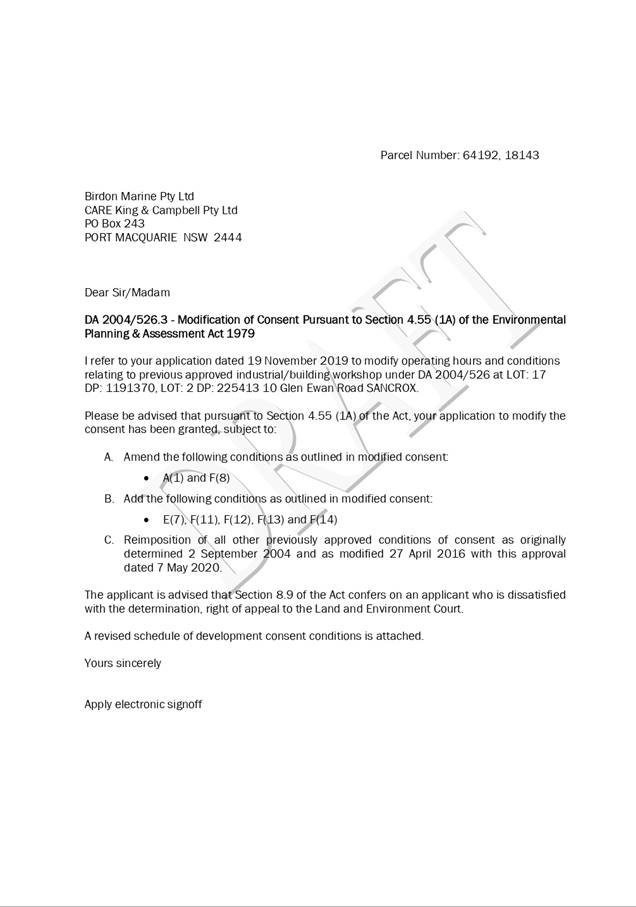
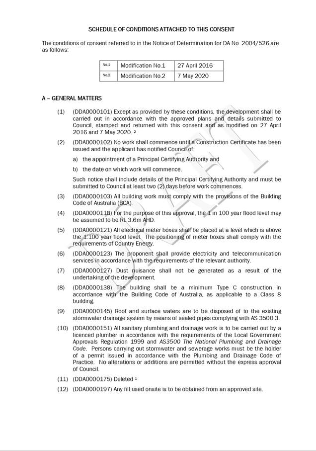
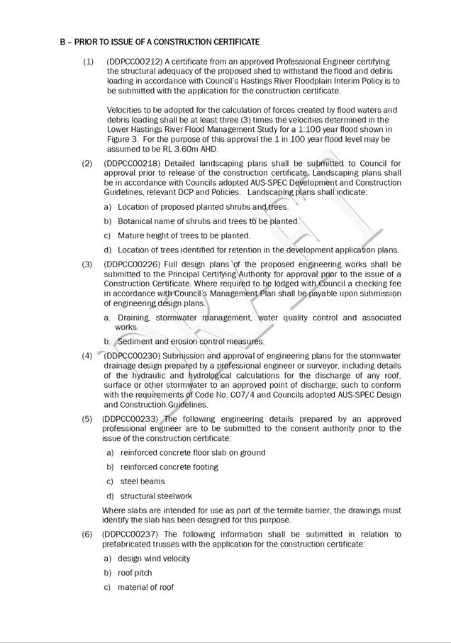
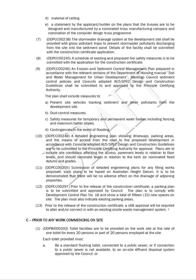
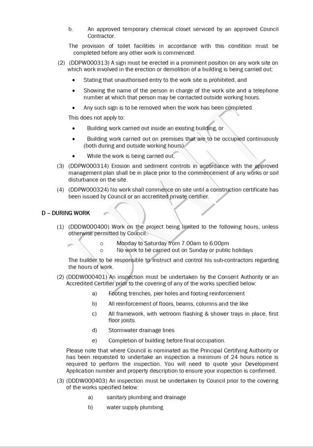

|
ATTACHMENT
|
Development Assessment Panel
06/05/2020
|
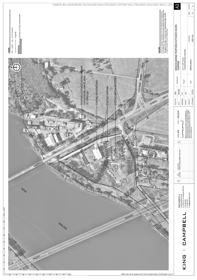
|
ATTACHMENT
|
Development Assessment Panel
06/05/2020
|
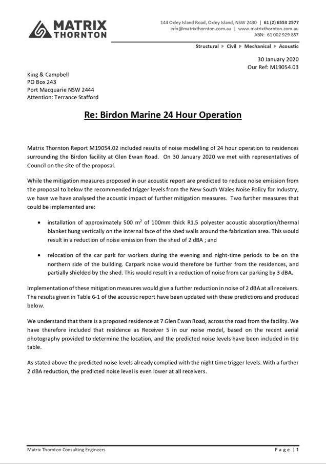
|
ATTACHMENT
|
Development Assessment Panel
06/05/2020
|
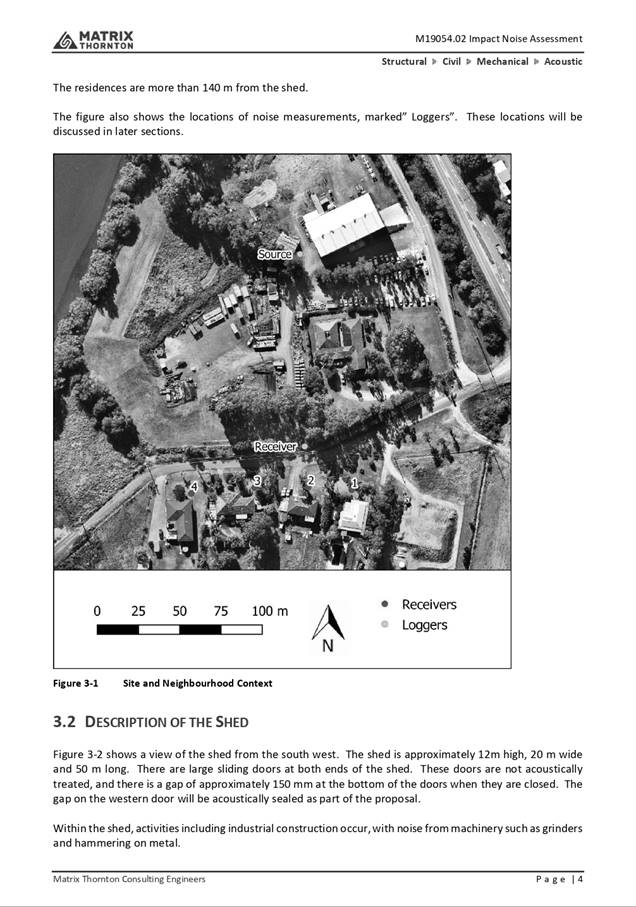
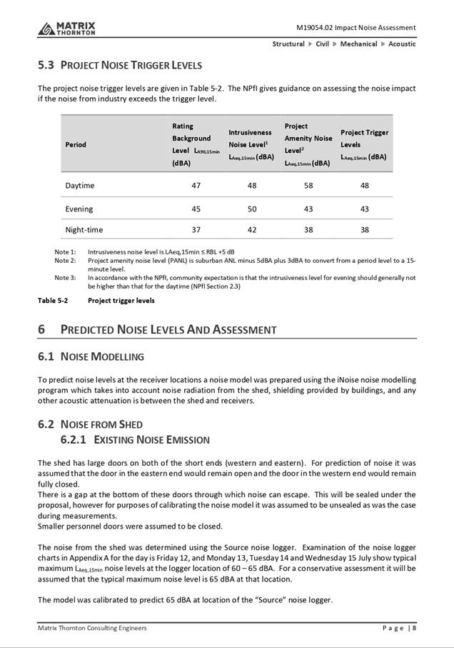
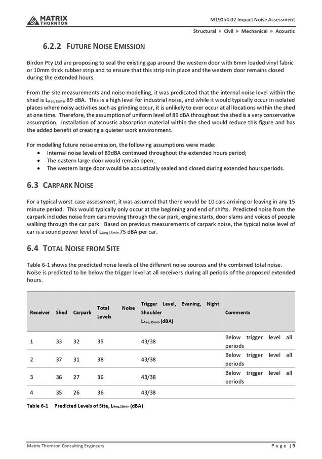
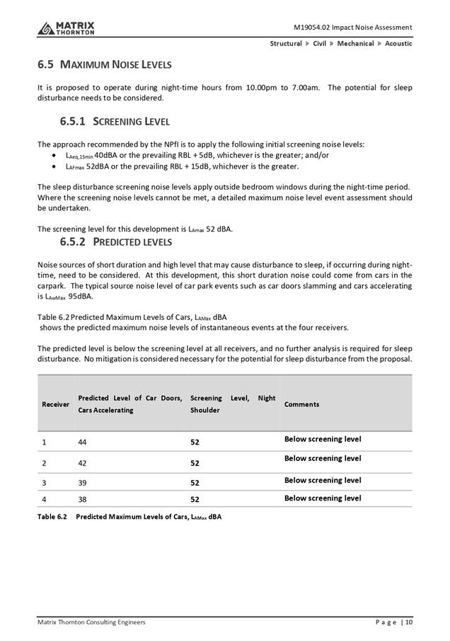
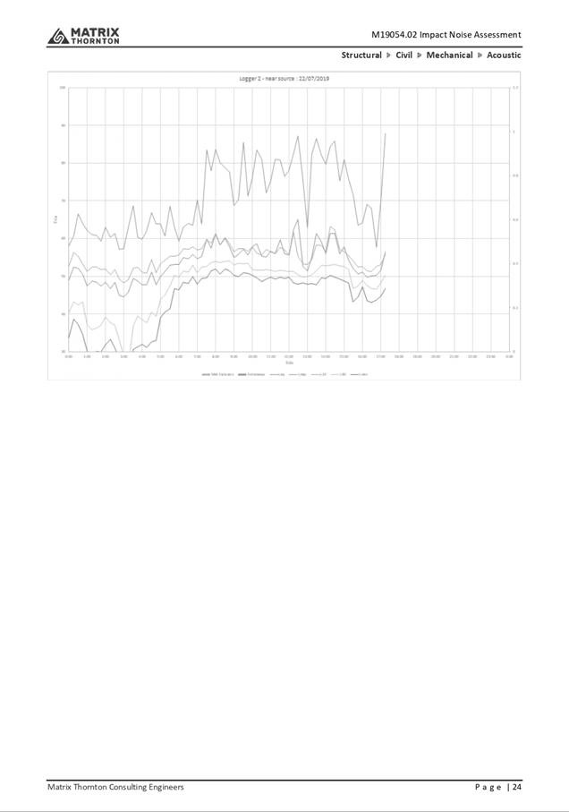
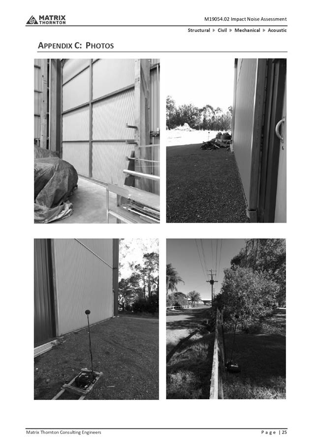
|
ATTACHMENT
|
Development Assessment Panel
06/05/2020
|

|
ATTACHMENT
|
Development Assessment Panel
06/05/2020
|