Development
Assessment Panel
Business
Paper
|
date of meeting:
|
|
Wednesday 27 May
2020
|
|
location:
|
|
Via Skype
|
|
time:
|
|
2:00pm
|
Development
Assessment Panel
CHARTER
1.0 OBJECTIVES
To assist in managing Council's development assessment
function by providing independent and expert determinations of development
applications that fall outside of staff delegations.
2.0 KEY FUNCTIONS
·
To review development application reports and conditions;
·
To determine development
applications outside of staff delegations;
·
To refer development applications
to Council for determination where necessary;
·
To provide a forum for objectors and applicants
to make submissions on applications
before the Development Assessment Panel
(DAP);
·
To maintain transparency in the determination of development
applications.
Delegated Authority of Panel
Pursuant to
Section 377 of the Local Government Act, 1993 delegation to:
·
Determine development applications under Part 4
of the Environmental Planning and Assessment
Act 1979 having
regard to the relevant environmental planning instruments,
development control plans and Council policies.
·
Vary, modify or release restrictions as to use and/or
covenants created by Section 88B instruments under the Conveyancing Act 1919 in
relation to development applications for subdivisions being considered by the panel.
·
Determine Koala Plans of Management under State
Environmental Planning Policy 44 - Koala Habitat Protection associated with
development applications being considered by the Panel.
Noting the trigger to escalate
decision making to Council as highlighted in section 5.2.
3.0
MEMBERSHIP
3.1
Voting
Members
·
Two independent external members. One of the
independent external members to be the Chairperson.
·
Group Manager Development Assessment (alternate
- Director Development & Environment or Development Assessment Planner)
The independent external members shall have expertise in
one or more of the following areas: planning, architecture, heritage, the
environment, urban design, economics, traffic and transport, law, engineering,
government and public administration.
3.2
Non-Voting Members
·
Not applicable
3.3 Obligations
of members
·
Members must act faithfully and diligently and
in accordance with this Charter.
·
Members must comply with Council's Code of Conduct.
·
Except as required to properly perform their
duties, DAP members must not
disclose any confidential information (as advised by Council) obtained in connection with the DAP functions.
·
Members will have read and be familiar with the
documents and information provided by Council prior
to attending a DAP meeting.
·
Members must act in accordance with Council's
Workplace Health and Safety Policies and Procedures
·
External members of the Panel are not authorised
to speak to the media on behalf of Council. Council officers that are members
of the Committee are bound by the
existing operational delegations in relation to speaking to the media.
·
Staff members shall not vote on matters before
the Panel if they have been the principle author of the development assessment report.
3.4
Member Tenure
·
The independent external members will be appointed
for the term of four (4) years
maximum in which the end of the tenure of these members would occur in a
cascading arrangement.
3.5 Appointment
of members
·
The independent external members (including the
Chair) shall be appointed by the General Manager following an external
Expression of Interest process.
·
Staff members of the Panel are in accordance
with this Charter.
4.0 TIMETABLE
OF MEETINGS
·
The Development Assessment Panel will generally
meet on the 1st and 3rd Wednesday each month at 2.00pm at the Port Macquarie
offices of Council.
·
Special Meetings of the Panel may be convened by
the Director Development & Environment Services with three (3) days notice.
5.0
MEETING PRACTICES
5.1
Meeting
Format
·
At all Meetings of the Panel the Chairperson
shall occupy the Chair and preside. The Chair will be responsible for keeping
of order at meetings.
·
Meetings shall be open to the public.
·
The Panel will hear from applicants
and objectors or their r e p r e s e n t a t i v e s .
·
Where considered necessary, the Panel will
conduct site inspections which will
be open to the public.
5.2
Decision Making
·
Decisions are to be made by consensus. Where
consensus is not possible on any item, that item is to be referred to Council
for a decision.
·
All development applications involving a
proposed variation to a development standard
greater than 10% under Clause
4.6 of the Local Environmental Plan will be
considered by the Panel and recommendation made to the Council for a decision.
5.3
Quorum
·
All members (2 independent external members and
1 staff member) must be present at a
meeting to form a quorum.
5.4
Chairperson and Deputy Chairperson
·
Independent Chair (alternate, second independent member)
5.5
Secretariat
·
The Director Development &n Environment is
to be responsible for ensuring that the Panel has adequate secretariat support.
The secretariat will ensure that the business paper and supporting papers are
circulated at least three (3) days prior to
each meeting. Minutes shall be appropriately approved and circulated to each
member within three (3) weeks of a meeting being held.
·
The format of and the preparation and publishing
of the Business Paper and Minutes shall be similar to the format for Ordinary
Council Meetings.
5.6
Recording of decisions
·
Minutes will record decisions and how each
member votes for each item before the Panel.
6.0 CONVENING
OF “OUTCOME SPECIFIC” WORKING GROUPS
Not applicable.
7.0 CONFIDENTIALITY
AND CONFLICT OF INTEREST
·
Members of the Panel must comply with the
applicable provisions of Council’s Code of Conduct. It is the personal
responsibility of members to comply with the standards in the Code of Conduct
and regularly review their personal circumstances with this in mind.
·
Panel members must declare any conflict of
interests at the start of each meeting or before discussion of a relevant item
or topic. Details of any conflicts of interest should be appropriately minuted.
Where members are deemed to have a real or perceived conflict of interest, it
may be appropriate they be excused from deliberations on the issue where the
conflict of interest may exist. A Panel meeting may be postponed where there is
no quorum.
8.0 LOBBYING
§ All members and applicants are to adhere to Council’s Lobbying
policy. Outside of scheduled
Development Assessment Panel meetings, applicants, their representatives,
Councillors, Council staff and the general public are not to lobby Panel
members via meetings, telephone conversations, correspondence and the like.
Adequate opportunity will be provided at Panel inspections or meetings for
applicants, their representatives and the general public to make verbal
submissions in relation to Business Paper items.
Development Assessment Panel
ATTENDANCE
REGISTER
|
Member
|
12/02/20
|
26/02/20
|
11/03/20
|
25/03/20
|
08/04/20
|
06/05/20
|
|
Paul
Drake
|
P
|
P
|
P
|
P
|
P
|
P
|
|
Robert
Hussey
|
P
|
P
|
P
|
|
P
|
|
|
David
Crofts
(alternate member)
|
|
|
|
P
|
|
P
|
|
Dan
Croft
(Group Manager Development Assessment)
(alternates)
- Development Assessment Planner
|
P
|
P
|
P
|
P
|
P
|
P
|
Key: P = Present
A
= Absent With Apology
X
= Absent Without Apology
Meeting Dates for
2020
|
22/01/2020
|
Function Room
|
2:00pm
|
|
12/02/2020
|
Function Room
|
2:00pm
|
|
26/02/2020
|
Function Room
|
2:00pm
|
|
11/03/2020
|
Function Room
|
2:00pm
|
|
25/03/2020
|
Function Room
|
2:00pm
|
|
8/04/2020
|
Function Room
|
2:00pm
|
|
6/05/2020
|
Function Room
|
2:00pm
|
|
27/05/2020
|
Function Room
|
2:00pm
|
|
10/06/2020
|
Function Room
|
2:00pm
|
|
24/06/2020
|
Function Room
|
2:00pm
|
|
8/07/2020
|
Function Room
|
2:00pm
|
|
22/07/2020
|
Function Room
|
2:00pm
|
|
12/08/2020
|
Function Room
|
2:00pm
|
|
26/08/2020
|
Function Room
|
2:00pm
|
|
9/09/2020
|
Function Room
|
2:00pm
|
|
30/09/2020
|
Function Room
|
2:00pm
|
|
14/10/2020
|
Function Room
|
2:00pm
|
|
28/10/2020
|
Function Room
|
2:00pm
|
|
11/11/2020
|
Function Room
|
2:00pm
|
|
25/11/2020
|
Function Room
|
2:00pm
|
|
16/12/2020
|
Function Room
|
2:00pm
|
Development
Assessment Panel Meeting
Wednesday 27 May 2020
Items of Business
01 Acknowledgement
of Country............................................................................. 8
02 Apologies.......................................................................................................... 8
03 Confirmation
of Minutes..................................................................................... 8
04 Disclosures
of Interest..................................................................................... 15
05 DA2019
- 137.2 Modification to alterations and additions to Dwelling at Lot 33 DP
18138, No 7 Arncliffe Avenue, Port Macquarie...................................................................... 19
06 DA2019
- 655.1 Land Filling and Farm Buildings at Lot 16 and Lot 17 DP 855941 Oxley
Highway, Wauchope...................................................................................................... 44
07 DA2019
- 740.1 Development Ancillary to Agriculture (Frost Fans) at Lot 13, DP 754420,
293 Innes View Road, Innes View......................................................................... 154
08 DA2019
- 568.1 Demolition of Multi Dwelling Housing and Construction of Residential
Flat Building Including Clause 4.6 Variation to Clause 4.3 (Height of
Buildings) of the Port Macquarie-Hastings Local Environmental Plan 2011 at Lot
101 DP 1122606, No 3 Clarence Street, Port Macquarie..................................................................................................... 188
09 DA2016
- 88.5 - Section 4.55 Modification to Existing Subdivision Layout at Lot 2 DP
1263561 and Lot 99 DP 1246122, South Atlantic Drive, Lake Cathie............................... 337
10 General
Business
AGENDA Development Assessment Panel 27/05/2020
Subject: ACKNOWLEDGEMENT
OF COUNTRY
"I acknowledge that we are
gathered on Birpai Land. I pay respect to the Birpai Elders both past and
present. I also extend that respect to all other Aboriginal and Torres Strait
Islander people present."
RECOMMENDATION
That the apologies received be
accepted.
Subject: CONFIRMATION
OF PREVIOUS MINUTES
Recommendation
That the Minutes of the Development Assessment Panel Meeting
held on 6 May 2020 be confirmed.
MINUTES
Development Assessment Panel Meeting
06/05/2020
PRESENT
Members:
Paul
Drake
David Crofts
Dan Croft
Other Attendees:
Grant Burge
Pat
Galbraith-Robertson
Ben
Roberts
Ross
Frazier
Chris
Gardiner
Robert
Slater
Steven
Ford
Michelle
McLennan
|
The meeting opened at 2:00pm on
6 May 2020.
|
|
01 ACKNOWLEDGEMENT
OF COUNTRY
|
|
The
Acknowledgement of Country was delivered.
|
|
03 CONFIRMATION
OF MINUTES
|
|
CONSENSUS:
That
the Minutes of the Development Assessment Panel Meeting held on 8 April 2020
be confirmed.
|
|
04 DISCLOSURES
OF INTEREST
|
|
There were no disclosures of interest presented.
|
|
05 DA2019 - 309.1
Residential Subdivision at Lot 302 DP 754434 Emily Avenue, Port Macquarie
|
|
Speakers:
Tony Thorne
CONSENSUS:
That it be recommended to Council that DA2019 - 309 for a
residential subdivision at Lot 302, DP 754434, Emily Avenue, Port Macquarie,
be determined by granting consent subject to the recommended conditions with
the following amendments:
- Amend Condition B(2), Point 1 to read: ‘Road works along
the frontage of the development including extension of Emily Avenue to
‘Access Place’ standard (AUSPEC D1.5) joining smoothly with
the existing section of road with a minimum carriage way width of six
(6) metres ending in a sealed nine (9) metre radii cul-de-sac with
reflectorised posts.’
Amend
condition B(10), Point a) to read: The legal point of discharge for the
proposed development is defined as the existing downstream informal vegetated
stormwater basin. In this regard, a suitably sized piped drainage system
(minimum 375mm diameter) shall be extended from the basin to the site. The
pipeline must be designed to have capacity to convey flows that would be
collected within the development as generated by a 5% AEP storm event.
Furthermore,
in difference to the concept pipeline alignment illustrated on the Stormwater
Management Plan prepared by King and Campbell, Drawing No, 5328P_Exhibits
Sheet 6 Revision C and dated 27-11-19, the location of the pipeline
discharging to the existing ‘basin’ should be relocated to the
north so that is located beneath the invert of the existing swale drain, or
other such location with the agreement of Council’s stormwater
engineer, to assist in draining that area. The change of direction/inlet pit
can also then function to capture runoff from the upstream swale to the west.
|
|
06 DA2019
- 883.1 Dwelling at Lot 14 DP 28743, No. 24 Coral Street, North Haven
|
|
A written submission from Naomi Leo was
circulated to panel members prior to the meeting.
Speakers:
Naomi Leo (opposing application)
Robert Smallwood (applicant)
CONSENSUS:
That DA2019 - 883.1 for a dwelling at Lot 14, DP 28743, No. 24 Coral Street, North Haven be
determined by granting consent subject to the recommended conditions and as
amended below:
- Additional condition in Section B of the consent to read: Prior
to release of the Construction Certificate a landscaping plan is to be
submitted providing for a 2m width landscape strip of vegetation along
the rear boundary so as to achieve a minimum 2m high vegetation screen
at maturity. An additional 1.5 x 1.5m landscape splay (i.e resulting in
a 3.5m x 3.5m triangle) of vegetation is to be provided in the north
western corner of the rear boundary. This splay area is to include a
minimum of 3 mature paperbark plantings (Melaleuca quinquenervia).’
- Additional condition in
Section D of the consent to read: ‘No excavation, building or
storage of materials is to occur within the structural root zones of
trees on adjoining properties. Structural root zones of trees on
adjoining properties affecting the subject site are to be plotted on the
development site and are to be determined in accordance with AS
4970-2009 Protection of trees on Development Sites.’
|
|
07 DA2020 - 122.1
Alterations and Additions to Dwelling at Lot 20 DP 262273, No 11 Timber Ridge
Port Macquarie
|
|
A written submission from Gary King was circulated to
panel members prior to the meeting.
Speakers:
Gary King (opposing application)
Craig Maltman (applicant)
CONSENSUS:
That DA2020
- 122 for dwelling additions and alterations at Lot
20, DP 262273,
No. 11 Timber Ridge, Port Macquarie, be
determined by granting consent subject to the recommended conditions.
|
|
08 DA2020
- 63.1 Dwelling at Lot 2 DP 1143498, No. 4A Hibiscus Cresent, Port Macquarie
|
|
A written submission from Grahame Kennedy was circulated
to panel members prior to the meeting.
Speakers:
Jacqui
Eller (opposing application)
Grahame
Kennedy (opposing application)
CONSENSUS:
That DA2020 - 63.1 for a
dwelling at Lot 2, DP 1143498, No. 4A Hibiscus Crescent, Port
Macquarie, be determined by granting consent
subject to the recommended conditions.
|
|
09 DA2019 - 277.1
Cafe and Associated Car Parking at Lot 5 DP 524972, Parklands Close, Port
Macquarie
|
|
A written submission from Katy and Geoffrey Pollard was
circulated to panel members prior to the meeting.
Speakers:
Caron Robinson (opposing
application)
Warwick Mason (opposing
application)
Mark Robertson (opposing
application)
Donna Clark (applicant)
CONSENSUS:
1. That the Koala Plan of Management prepared by
Biodiversity Australia (Rev 1.2, dated January 2020) be approved.
2. That DA2019 - 277.1 for
a Café and Associated Car Parking at
Lot 5, DP 524972, Parklands Close, Port
Macquarie, be determined by granting consent
subject to the recommended conditions and as amended below:
- Amend
condition A(15) to read: (15) ‘Roadworks on Wandella Drive, at
the full cost of the proponent, shall include the following in
accordance with Aus-Spec:
·
A concrete roundabout structure at the intersection of
Karalee Parade and Wandella Drive, including painted medians and signage
·
A concrete threshold to the west of the roundabout
delineating the entry to the development
·
Kerb and gutter to the west of the proposed roundabout, and
associated pavement and stormwater works.
Details of the construction
are to be provided with the application for approval pursuant to Section 138
of the Roads Act.
·
Amend condition B(2) to read: ‘Submission to the
Principal Certifying Authority prior to the issue of a Construction
Certificate detailed design plans for the following works associated with the
developments. Public infrastructure works shall be constructed in accordance
with Port Macquarie-Hastings Council’s current AUSPEC specifications and
design plans are to be accompanied by AUSPEC DQS:
1. Road
works along the frontage of the development.
2. Public
parking areas including;
o
Driveways and access aisles;
o
Parking bays
o
Delivery vehicle service bays & turning areas
in accordance with AS 2890.
3. Sewerage
reticulation.
4. Water
supply plans shall include hydraulic plans for internal water supply services
and associated works in accordance with AS 3500, Plumbing Code of Australia
and Port Macquarie-Hastings Council Policies.
5. Stormwater
systems.
6. Erosion
& Sedimentation controls.
7. Traffic
management control plan.
8. Detailed
driveway profile in accordance with Australian Standard 2890, AUSPEC D1, and
ASD202, Port Macquarie-Hastings Council current version.
9. Provision
of a 1.5m (unless varied in writing by Council) concrete footpath along the
northern side of Wandella Drive connecting to the existing footpath/boardwalk
including a suitable road crossing to Council satisfaction.
10. A ‘Give Way
to pedestrians’ sign at the driveway exit point on the property.
11. Detailed roundabout
layout at the junction of Wandella Drive and Karalee Parade in accordance
with the current version of the AUSTROADS guidelines for Intersection design,
giving particular attention to sight distance.
·
Additional condition in Section B of the consent to read:
‘ Prior to release of the construction certificate plans are to be
provided detailing a 1.8m high colourbond fence along the common boundary
with 112 Pacific Dr (i.e for the length of the boundary that has an open
style fence at present). The fence is not required if both parties provide
written agreement to such.’
·
Amend condition E(3) of the consent to read: ‘Driveways,
access aisles and parking areas shall be provided with an approved
surface. Such a surface shall be on a suitable pavement, constructed
and maintained in accordance with Council's Development, Design and
Construction Manuals (as amended).’
|
The meeting was adjourned at 4:45pm on 6/5/20.
Item 10 was deferred to 4:00pm on 7/5/20.
The meeting resumed at 4:00pm on 7/5/20
|
10 Section 4.55
DA2004 - 526.3 Modification to Hours of Operation and Conditions of Consent
Associated with Previous Approved Industrial Building/Workshop at 10 Glen
Ewan Road, Sancrox
|
|
Speakers:
Louise Flemming (opposing
application)
Tony Thorne (applicant)
Philip Thornton (applicant)
CONSENSUS:
That
DA2004 - 526.3 for a modification to hours of operation and conditions
of consent associated with previous approved industrial building/workshop at Lot 17, DP 1191370, No. 10 Glen Ewan Road,
Sancrox, be determined by granting consent
subject to the recommended modified conditions and as amended below:
·
Amend condition F(11) to read: ‘Provision is to be made
during extended operational hours (6pm to 7am) of an additional car park on
the existing hard stand area located on the northern side of the existing
western shed as shown on the plan Birdon Marine Extended Hours Carpark (King
& Campbell plan 6300P_Site – Revision A dated 25 March 2020). The
carparking area shall have capacity for 12 cars and is to be provided and
used by all employees working in the existing shed on Lot 17 during the
extended hours of operation from 6pm to 7am.
·
Additional condition in Section F of the consent to read:
‘No work is to be carried out on the site between 6pm Saturday to
7am Sunday and from 6pm Sunday to 7am Monday.’
|
|
The meeting closed at 5:15pm on
07 May 2020.
|
AGENDA Development Assessment Panel 27/05/2020
Subject: DISCLOSURES
OF INTEREST
RECOMMENDATION
That Disclosures of Interest be presented
DISCLOSURE OF
INTEREST DECLARATION
|
Name of Meeting:
|
|
Meeting
Date:
|
|
Item
Number:
|
|
Subject:
|
|
I,
the undersigned, hereby declare the following interest:
Pecuniary:
 Take no part
in the consideration and voting and be out of sight of the meeting. Take no part
in the consideration and voting and be out of sight of the meeting.
Non-Pecuniary
– Significant Interest:
Take no part
in the consideration and voting and be out of sight of the meeting.
Non-Pecuniary
– Less than Significant Interest:
May
participate in consideration and voting.
|
|
For
the reason that:
|
|
Name:
Signed:
|
Date:
|
|
Please submit to the Governance
Support Officer at the Council Meeting.
|
 (Refer
to next page and the Code of Conduct)
(Refer
to next page and the Code of Conduct)
Pecuniary Interest
4.1
A pecuniary interest is an interest
that you have in a matter because of a reasonable likelihood or expectation of
appreciable financial gain or loss to you or a person referred to in clause
4.3.
4.2
You will not have a pecuniary
interest in a matter if the interest is so remote or insignificant that it
could not reasonably be regarded as likely to influence any decision you might
make in relation to the matter, or if the interest is of a kind specified in
clause 4.6.
4.3
For the purposes of this Part, you
will have a pecuniary interest in a matter if the pecuniary interest is:
(a)
your interest, or
(b)
the interest of your spouse or de
facto partner, your relative, or your partner or employer, or
(c)
a company or other body of which
you, or your nominee, partner or employer, is a shareholder or member.
4.4
For the purposes of clause 4.3:
(a)
Your “relative” is any
of the following:
(b)
“de facto partner” has
the same meaning as defined in section 21C of the Interpretation Act 1987.
4.5
You will not have a pecuniary
interest in relation to a person referred to in subclauses 4.3(b) or (c)
(a)
if you are unaware of the relevant
pecuniary interest of your spouse, de facto partner, relative, partner,
employer or company or other body, or
(b)
just because the person is a member
of, or is employed by, a council or a statutory body, or is employed by the
Crown, or
(c)
just because the person is a member
of, or a delegate of a council to, a company or other body that has a pecuniary
interest in the matter, so long as the person has no beneficial interest in any
shares of the company or body.
Non-Pecuniary
5.1
Non-pecuniary interests are private
or personal interests a council official has that do not amount to a pecuniary
interest as defined in clause 4.1 of this code. These commonly arise out of
family or personal relationships, or out of involvement in sporting, social,
religious or other cultural groups and associations, and may include an
interest of a financial nature.
5.2
A non-pecuniary conflict of
interest exists where a reasonable and informed person would perceive that you
could be influenced by a private interest when carrying out your official
functions in relation to a matter.
5.3
The personal or political views of
a council official do not constitute a private interest for the purposes of
clause 5.2.
5.4
Non-pecuniary conflicts of interest
must be identified and appropriately managed to uphold community confidence in
the probity of council decision-making. The onus is on you to identify any
non-pecuniary conflict of interest you may have in matters that you deal with,
to disclose the interest fully and in writing, and to take appropriate action
to manage the conflict in accordance with this code.
5.5
When considering whether or not you
have a non-pecuniary conflict of interest in a matter you are dealing with, it
is always important to think about how others would view your situation.
Managing non-pecuniary conflicts of interest
5.6
Where you have a non-pecuniary
conflict of interest in a matter for the purposes of clause 5.2, you must
disclose the relevant private interest you have in relation to the matter fully
and in writing as soon as practicable after becoming aware of the non-pecuniary
conflict of interest and on each occasion on which the non-pecuniary conflict
of interest arises in relation to the matter. In the case of members of council
staff other than the general manager, such a disclosure is to be made to the
staff member’s manager. In the case of the general manager, such a
disclosure is to be made to the mayor.
5.7
If a disclosure is made at a
council or committee meeting, both the disclosure and the nature of the
interest must be recorded in the minutes on each occasion on which the
non-pecuniary conflict of interest arises. This disclosure constitutes
disclosure in writing for the purposes of clause 5.6.
5.8
How you manage a non-pecuniary
conflict of interest will depend on whether or not it is significant.
5.9
As a general rule, a non-pecuniary
conflict of interest will be significant where it does not involve a pecuniary
interest for the purposes of clause 4.1, but it involves:
a)
a relationship between a council
official and another person who is affected by a decision or a matter under
consideration that is particularly close, such as a current or former spouse or
de facto partner, a relative for the purposes of clause 4.4 or another person
from the council official’s extended family that the council official has
a close personal relationship with, or another person living in the same
household
b)
other relationships with persons
who are affected by a decision or a matter under consideration that are
particularly close, such as friendships and business relationships. Closeness
is defined by the nature of the friendship or business relationship, the
frequency of contact and the duration of the friendship or relationship.
c)
an affiliation between the council
official and an organisation (such as a sporting body, club, religious,
cultural or charitable organisation, corporation or association) that is
affected by a decision or a matter under consideration that is particularly
strong. The strength of a council official’s affiliation with an organisation
is to be determined by the extent to which they actively participate in the
management, administration or other activities of the organisation.
d)
membership, as the council’s
representative, of the board or management committee of an organisation that is
affected by a decision or a matter under consideration, in circumstances where
the interests of the council and the organisation are potentially in conflict
in relation to the particular matter
e)
a financial interest (other than an
interest of a type referred to in clause 4.6) that is not a pecuniary interest
for the purposes of clause 4.1
f)
the conferral or loss of a personal
benefit other than one conferred or lost as a member of the community or a
broader class of people affected by a decision.
5.10
Significant non-pecuniary conflicts
of interest must be managed in one of two ways:
a)
by not participating in
consideration of, or decision making in relation to, the matter in which you
have the significant non-pecuniary conflict of interest and the matter being allocated
to another person for consideration or determination, or
b)
if the significant non-pecuniary
conflict of interest arises in relation to a matter under consideration at a
council or committee meeting, by managing the conflict of interest as if you
had a pecuniary interest in the matter by complying with clauses 4.28 and 4.29.
5.11
If you determine that you have a
non-pecuniary conflict of interest in a matter that is not significant and does
not require further action, when disclosing the interest you must also explain
in writing why you consider that the non-pecuniary conflict of interest is not
significant and does not require further action in the circumstances.
5.12
If you are a member of staff of
council other than the general manager, the decision on which option should be
taken to manage a non-pecuniary conflict of interest must be made in
consultation with and at the direction of your manager. In the case of the
general manager, the decision on which option should be taken to manage a
non-pecuniary conflict of interest must be made in consultation with and at the
direction of the mayor.
5.13
Despite clause 5.10(b), a
councillor who has a significant non-pecuniary conflict of interest in a
matter, may participate in a decision to delegate consideration of the matter
in question to another body or person.
5.14 Council committee members are not required to declare
and manage a non-pecuniary conflict of interest in accordance with the
requirements of this Part where it arises from an interest they have as a
person chosen to represent the community, or as a member of a non-profit
organisation or other community or special interest group, if they have been
appointed to represent the organisation or group on the council committee.
SPECIAL
DISCLOSURE OF PECUNIARY INTEREST DECLARATION
This
form must be completed using block letters or typed.
If
there is insufficient space for all the information you are required to
disclose,
you
must attach an appendix which is to be properly identified and signed by you.
|
By
[insert full name of councillor]
|
|
|
In the
matter of
[insert name of environmental planning instrument]
|
|
|
Which is
to be considered at a meeting of the
[insert name of meeting]
|
|
|
Held on
[insert date of meeting]
|
|
|
PECUNIARY
INTEREST
|
|
Address of
the affected principal place of residence of the councillor or an associated
person, company or body (the identified land)
|
|
|
Relationship
of identified land to councillor
[Tick or cross one box.]
|
The councillor has interest in the land (e.g. is owner or has other
interest arising out of a mortgage, lease, trust, option or contract, or
otherwise).
An associated person of the councillor has an interest in the land.
An associated company or body of the councillor has interest in the land.
|
|
MATTER
GIVING RISE TO PECUNIARY INTEREST
|
|
Nature of
land that is subject to a change
in
zone/planning control by proposed
LEP (the
subject land
[Tick or cross one box]
|
The identified land.
Land that adjoins or is adjacent to or is in proximity to the identified
land.
|
|
Current
zone/planning control
[Insert name of current planning instrument and
identify relevant zone/planning control applying to the subject land]
|
|
|
Proposed
change of zone/planning control
[Insert name of proposed LEP and identify proposed
change of zone/planning control applying to the subject land]
|
|
|
Effect of
proposed change of zone/planning control on councillor or associated person
[Tick or cross one box]
|
Appreciable financial gain.
Appreciable financial loss.
|
|
|
|
[If more than one pecuniary interest is to be
declared, reprint the above box and fill in for each additional interest]
Councillor’s Signature:
……………………………….
Date: ………………..
This form is to be retained
by the council’s general manager and included in full in the minutes of
the meeting
Last Updated: 3 June 2019
Important Information
This information is being collected for the purpose of
making a special disclosure of pecuniary interests under clause 4.36(c) of the
Model Code of Conduct for Local Councils in NSW (the Model Code of Conduct).
The special disclosure must relate only to a pecuniary
interest that a councillor has in the councillor’s principal place of
residence, or an interest another person (whose interests are relevant under
clause 4.3 of the Model Code of Conduct) has in that person’s principal
place of residence.
Clause 4.3 of the Model Code of Conduct states that you
will have a pecuniary interest in a matter because of the pecuniary interest of
your spouse or your de facto partner or your relative or because your business
partner or employer has a pecuniary interest. You will also have a pecuniary
interest in a matter because you, your nominee, your business partner or your
employer is a member of a company or other body that has a pecuniary interest
in the matter.
“Relative” is defined by clause 4.4 of the Model
Code of Conduct as meaning your, your spouse’s or your de facto
partner’s parent, grandparent, brother, sister, uncle, aunt, nephew,
niece, lineal descendant or adopted child and the spouse or de facto partner of
any of those persons.
You
must not make a special disclosure that you know or ought reasonably to know is
false or misleading in a material particular. Complaints about breaches
of these requirements are to be referred to the Office of Local Government and
may result in disciplinary action by the Chief Executive of the Office of Local
Government or the NSW Civil and Administrative Tribunal.
This form must be completed by you before the commencement
of the council or council committee meeting at which the special disclosure is
being made. The completed form must be tabled at the meeting. Everyone is
entitled to inspect it. The special disclosure must be recorded in the minutes
of the meeting.
A pecuniary interest may arise by way of a change of
permissible use of land adjoining, adjacent to or in proximity to land in which
a councillor or a person, company or body referred to in clause 4.3 of the
Model Code of Conduct has a proprietary interest
AGENDA Development Assessment Panel 27/05/2020
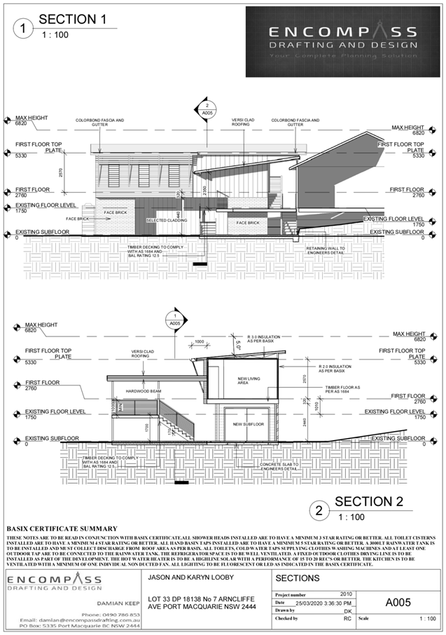
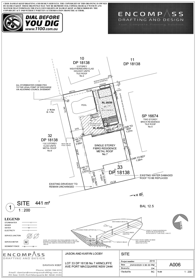
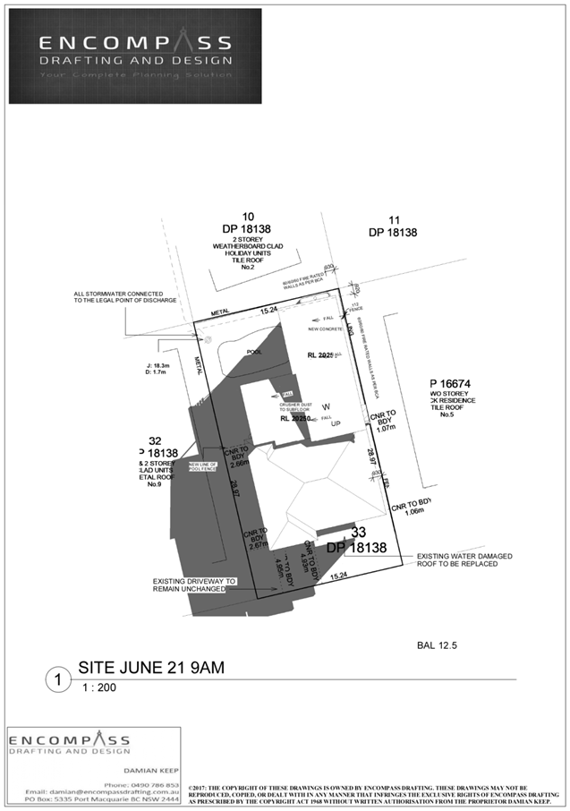
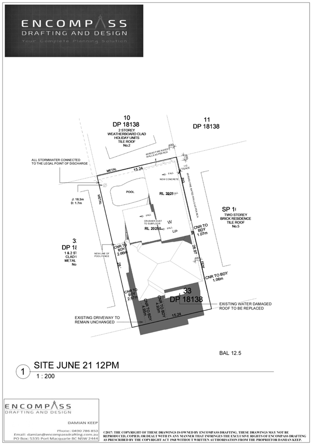
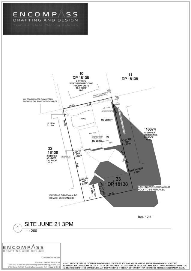
Item: 05
Subject: DA2019 - 137.2 Modification to alterations and
additions to Dwelling at Lot 33 DP 18138, No 7 Arncliffe Avenue, Port Macquarie
Report
Author: Development Assessment Planner, Steven Ford
|
Applicant: Encompass
Drafting
Owner: J
A & K L Looby
Estimated Cost: $140,000
Alignment with Delivery
Program
4.3.1 Undertake transparent
and efficient development assessment in accordance with relevant legislation.
|
RECOMMENDATION
That
DA 2019 - 137.2 for modification to
consent conditions for alterations and additions to dwelling at Lot 33, DP 18138, No. 7 Arncliffe
Avenue, Port Macquarie, be determined by
granting consent subject to the recommended modified conditions.
Executive
Summary
This
report considers an application for a modification to consent conditions
for previous approved alterations and additions to dwelling at the subject site and provides an assessment of the
application in accordance with the Environmental Planning and Assessment Act
1979.
Following exhibition of the
application, one (1) submission was received.
The site is considered suitable for the proposed modified
development and the proposal adequately addresses relevant planning controls.
The development is not considered to be contrary to the public's interest and
will not result a significant adverse social, environmental or economic impact.
This report recommends that the
development consent be modified as detailed in the attached (Attachment 1)
modified conditions.
1. BACKGROUND
Existing
Sites Features and Surrounding Development
The site has an area of 441m2.
The
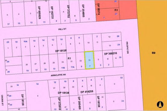
site is zoned R1 general residential in
accordance with the Port Macquarie-Hastings Local Environmental Plan 2011, as shown
in the following zoning plan:
The
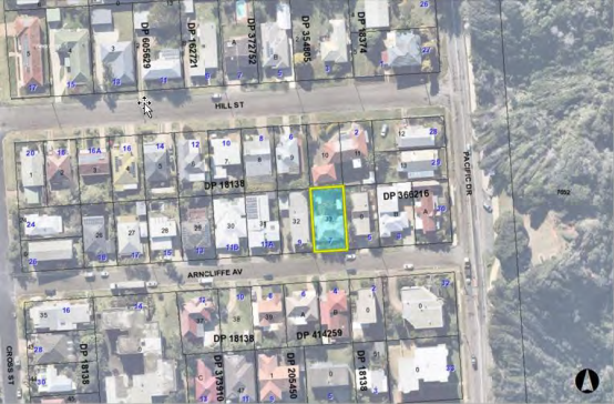
existing subdivision pattern and location of existing development within the
locality is shown in the following aerial photograph:
2. DESCRIPTION
OF DEVELOPMENT
Key
aspects of the proposal include the following:
· Development
consent for DA2019 - 137 was originally granted on 26 February 2020, subject to
the recommended conditions and as amended below:
“B(4) Prior to release of the construction
certificate amended plans are to be submitted to provide for a minimum 2m
building setback to the rear property boundary.”
· The
modification requests Council consider the deletion of condition B(4) which was
imposed by the Development Assessment Panel.
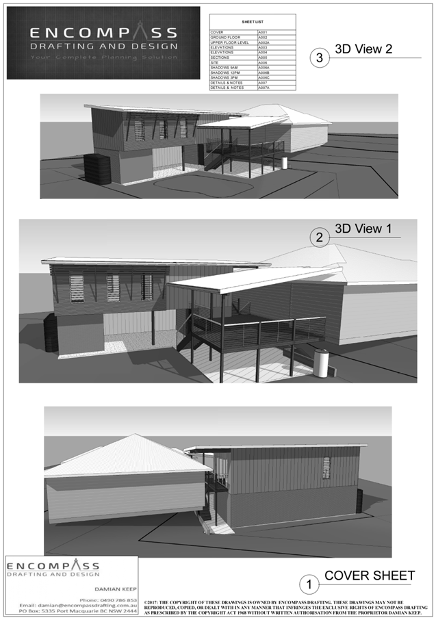
Refer
to Attachment 2 at the end of this report for plans of the proposed
development.
Application
Chronology
· 25
March 2020 - Application Lodged
· 8 April 2020 to 23 April 2020 - Neighbourhood notification
· 30 April 2020 - Redacted Submission sent to Applicant for
consideration
3. STATUTORY
ASSESSMENT
Section
4.55(2)(a) Is the proposal substantially the same?
In
determining the application, Council is required to take into consideration the
following matters as are relevant to the development that apply to the land to
which the development application relates:
In Vasic
Pty Ltd v Penrith City Council [1992] NSWLEC 8, Stein J held that
"substantially" meant "essentially all material or having the
same essence."
In
Moto Projects (No 2) Pty Ltd v North Sydney Council (1999) 106 LGERA 298 at
[56] Bignold J held that the task for determining whether a development as
proposed to be modified is substantially the same as the consent granted was as
follows:
"The comparative task does not merely involve a
comparison of the physical features or components of the development as
currently approved and modified where that comparative exercise is undertaken
in some type of sterile vacuum. Rather, the comparison involves an
appreciation, qualitative, as well as quantitative, of the developments being
compared in their proper contexts (including the circumstances in which the
development consent was granted)."
In the
context of the current application, the proposal can be considered to be
substantially the same as the development to which consent was originally
granted for the following reasons:
· The modified development is the same proposed plans as the
original proposal.
· The modification proposes provide the original 900mm rear
setback, seeking similar setbacks as the
existing building rear lot alignments and reduced setbacks within the locality
at 3 and 11A and 11B Arncliffe avenue and No 30 Pacific Drive.
· The impacts of the modification by deleting condition B(4),
including solar access, bulk and scale, and privacy remain similar to the
approved development.
· The proposal meets the development provisions of 3.2.2.4 of
the DCP, where Council may consider varying rear setback requirements where it
is demonstrated that the private open space could achieve better solar access
between the building and the side setback.
Section 4.55(2)(b) Are
there any condition(s) of consent imposed by a Minister, government or public
authority that require modification?
The
consent does not include any conditions imposed by a public authority.
Section
4.55(2)(c) Does the application require notification/advertising in accordance
with the regulations and/or any Development Control Plan?
Neighbour notification has been
undertaken in accordance with the regulations and Council’s DCP.
Section 4.55(2)(d) Any
submissions made concerning the modification
One (1) written
submission was received following public exhibition of the application. A copy
of the written submission has been provided separately to members of the DAP.
Key
issues raised in the submission and comments are provided as follows:
|
Submission Issue/Summary
|
Planning Comment/Response
|
|
Object to any variation to the
minimum setback of 2m previously conditioned by Council which is to provide
neighbours space, privacy and most importantly protects from the noise into
neighbouring properties.
|
The objectives and development
provisions of section 3.2.2.5 of the DCP 2013, which allows for variations to
the minimum rear setbacks have been adequately addressed.
The bulk and scale, and
privacy impacts of reducing the approved 2m rear setback to 900mm will remain
similar. There are no adverse impacts identifiable of reducing the rear
setback from 2m to 900mm.
It should be noted that there
are no windows in the northern elevation on either the ground or first floor
levels of the additions.
|
|
Concern of increased noise
|
The area of building encroaching the minimum rear setback
is a walk in robe with no windows facing the rear boundary and adjoining a
master bedroom. As this is not a primary living area, it is unlikely to
create any identifiable adverse noise impacts.
Additionally, the existing pool and verandah will remain
the same and are compliant with the development provisions of the DCP 2013.
|
|
This will affecting future developments of properties
along Hill Street which border this property.
|
The proposed development does not impact solar access to
the adjoining Hill Street properties. From the site inspection, many
adjoining properties overlook the proposed development site currently. The
proposed additions are considered to have been satisfactorily designed to
provide privacy to adjoining properties as well as create solutions for
privacy impacts from adjoining properties towards 7 Arncliffe Ave.
|
Section 4.55(3) Any
matters referred to in section 4.15 (1) relevant to the modification, and the
reasons given by the consent authority for the grant of the consent sought to
be modified.
In
determining the application, Council is required to take into consideration the
following matters as are relevant to the modification that apply to the land to
which the development application relates:
(a) The provisions (where applicable) of:
(i) any Environmental Planning Instrument
State Environmental Planning Policy (Coastal Management) 2018
The site is located within a
coastal environment area.
In accordance with clause 7,
this SEPP prevails over the Port Macquarie-Hastings
LEP 2011 in the event of any
inconsistency.
Having regard to clauses 13 of
the SEPP the proposed development is not
considered likely to result in
any of the following:
a) any
adverse impact on integrity and resilience of the biophysical, hydrological
(surface and groundwater) and ecological environment;
b) any adverse impacts coastal
environmental values and natural coastal processes;
c) any adverse impacts on marine
vegetation, native vegetation and fauna and their habitats, undeveloped
headlands and rock platforms;
d) any adverse impact on marine vegetation,
native vegetation and fauna and their habitats, undeveloped headlands and rock
platforms;
e) any adverse impact on Aboriginal
cultural heritage, practices and places;
f) any adverse impacts on the
cultural and built environment heritage;
g) any adverse impacts the use of the surf
zone;
h) any adverse impact on the visual amenity
and scenic qualities of the coast, including coastal headlands;
i) overshadowing, wind
funnelling and the loss of views from public places
-
to foreshores;
j) any adverse impacts on
existing public open space and safe access to and along the foreshore, beach,
headland or rock platform for members of the public, including persons with a
disability.
-
The bulk, scale and size of the
proposed development is compatible with the
surrounding coastal and built
environment. The site is predominately cleared and
located within an area zoned for
residential purposes.
(ii) Any Development
Control Plan in force
Port
Macquarie-Hastings Development Control Plan 2013 (as relevant to the
modification)
|
DCP 2013: Dwellings, Dual
occupancies, Dwelling houses, Multi dwelling houses & Ancillary
development
|
|
|
Requirements
|
Proposed
|
Complies
|
|
3.2.2.1
|
Ancillary development:
• 4.8m max. height
• Single storey
• 60m2 max. area
• 100m2 for lots
>900m2
• 24 degree max.
roof pitch
• Not located in
front setback
|
Water tank is appropriately
located.
Proposed ground floor storage and
laundry area is not greater than 60m2
|
Yes
|
|
3.2.2.4
|
4m min. rear setback. Variation
subject to site analysis and provision of private open space
|
920mm rear setback proposed.
Which is considered a 76% variation. See justification below.
|
No* Considered to be acceptable
|
|
3.2.2.5
|
Side setbacks:
• Ground floor =
min. 0.9m
• First floors &
above = min. 3m setback or where it can be demonstrated that overshadowing
not adverse = 0.9m min.
• Building wall set
in and out every 12m by 0.5m
|
The minimum side setback
requirements are complied with, see justification below.
The building wall is a maximum
11.2m long, satisfactorily addressing the objective of this development
provision.
|
Yes
|
|
3.2.2.6
|
35m2 min. private open space area
including a useable 4x4m min. area which has 5% max. grade
|
The dwelling contains 35m²
open space in one area including a useable 4m x 4m space.
|
Yes
|
|
3.2.2.10
|
Privacy:
• Direct views
between living areas of adjacent dwellings screened when within 9m radius of
any part of window of adjacent dwelling and within 12m of private open space
areas of adjacent dwellings. ie. 1.8m fence or privacy screening which has
25% max. openings and is permanently fixed
• Privacy screen
required if floor level > 1m height, window side/rear setback (other than
bedroom) is less than 3m and sill height less than 1.5m
• Privacy screens
provided to balconies/verandahs etc which have <3m side/rear setback and
floor level height >1m
|
The development will not compromise privacy in the area
due to a combination of lack of windows overlooking both side and rear
boundaries, having high sill windows that face side boundaries, limiting living
areas that face adjoining living areas and open space.
|
Yes
|
|
DCP 2013: General
Provisions
|
|
|
Requirements
|
Proposed
|
Complies
|
|
2.7.2.2
|
Design addresses generic principles of Crime Prevention
Through Environmental Design guideline
|
No concealment or entrapment areas proposed. Adequate
casual surveillance available.
|
Yes
|
The proposal seeks to vary Development Provision relating to
3.2.2.4 - 4m minimum rear setback. Variation subject to site analysis and
provision of private open space
The relevant objectives are:
· To allow adequate
natural light and ventilation between dwellings/buildings and to private open
space areas.
· To provide useable
yard areas and open space.
Having regard for the development
provisions and relevant objectives, the variation is considered acceptable for
the following reasons:
· Council may
consider varying rear setback requirements where it is demonstrated that the
private open space could achieve better solar access between the building and
the side setback.
· The existing
private open space, including both rear verandah and pool area, maintains solar
access.
· The proposed rear
setback is 900mm which encroaches the standard rear setback provision for 4.65m
(30%) of the rear boundary.
· A 4m setback for
the eastern side setback for the equivalent length of the rear boundary has
been provided to achieve solar access, natural ventilation and separation.
· The proposed rear
setback variation does not adversely overshadow neighbouring primary living
areas and private open space.
· The proposed
additions, at a height of 5.7m, are well under the zone’s maximum
building height standard of 11.5m.
· There are no
windows proposed overlooking the rear boundary, which could result in adverse
privacy impacts to the northern neighbouring properties.
· The proposal does
not result in any adverse impact on views enjoyed by neighbouring properties.
Based on the above assessment, the variation proposed to the
provisions of the DCP are considered acceptable and the relevant objectives
have been satisfied.
(b) The likely
impacts of that development, including environmental impacts on both the
natural and built environments, social and economic impacts in the locality:
Context and Setting
The modification proposal will be unlikely to have any
adverse impacts to existing adjoining properties and satisfactorily addresses
the public domain.
The proposal is considered to be compatible with other
residential development in the locality and adequately addresses planning
controls for the area.
The proposal does not have a significant adverse impact on
existing view sharing.
The proposal does not have significant adverse lighting
impacts.
There are no significant adverse privacy impacts.
There are no adverse overshadowing impacts. The proposal
does not prevent adjoining properties from receiving 3 hours of sunlight to
private open space and primary living areas on 21 June.
Cumulative impacts
The proposed development is not expected to have any adverse
cumulative impacts on the natural or built environment or the social and
economic attributes of the locality.
(c) The
suitability of the site for the development
The modification proposal will fit into the locality and the
site attributes are conducive to the proposed development.
Site constraints have been
adequately addressed and appropriate conditions of consent recommended
(d) Any
submissions made in accordance with this Act or the Regulations
Following
exhibition of the application in accordance with DCP 2013, 1 submission was
received.
(e) The Public Interest
The proposed development
satisfies relevant planning controls and will not adversely impact on the wider
public interest.
4. DEVELOPMENT
CONTRIBUTIONS APPLICABLE
Development
contributions will not be required under S64/S7.11 as no additional residential
occupancies are being proposed.
5. CONCLUSION AND
STATEMENT OF REASON
The application has been assessed in accordance with Section
4.55 of the Environmental Planning and Assessment Act 1979.
Issues raised during assessment and public exhibition of the
application have been considered in the assessment of the application. Where
relevant, conditions have been recommended to manage the impacts attributed to
these issues.
The site is considered suitable for the proposed modified
development and the proposal adequately addresses relevant planning controls.
The development is not considered to be contrary to the public's interest and
will not result a significant adverse social, environmental or economic impact.
It is recommended that the application be approved, subject to the recommended
conditions of consent provided in the attachment section of this report.
|
Attachments
1⇩. DA2019 - 137.2 Draft
Modified Consent
2⇩. DA2019 - 137.2 Plans
|
|
ATTACHMENT
|
Development Assessment Panel
27/05/2020
|

|
ATTACHMENT
|
Development Assessment Panel
27/05/2020
|
AGENDA Development Assessment Panel 27/05/2020
Item: 06
Subject: DA2019 - 655.1 Land Filling and Farm Buildings
at Lot 16 and Lot 17 DP 855941 Oxley Highway, Wauchope
Report
Author: Development Assessment Planner, Benjamin Roberts
|
Applicant: Land
Dynamics Australia
Owner: M
A Roche Group Pty Ltd
Estimated Cost: $150,000
Alignment with Delivery
Program
4.3.1 Undertake transparent
and efficient development assessment in accordance with relevant legislation.
|
RECOMMENDATION
That
DA 2019 - 655.1 for land filling
and farm buildings at Lot 16 and Lot 16, DP 855941, Oxley Highway, Wauchope, be determined by
granting consent subject to the recommended conditions.
Executive
Summary
This
report considers a development application for land filling and farm buildings
at the subject site and provides an assessment of the
application in accordance with the Environmental Planning and Assessment Act
1979.
Following exhibition of the
application, one (1) submission was received.
The site is considered suitable for the proposed development
and the proposal adequately addresses relevant planning controls. The
development is not considered to be contrary to the public's interest and will
not result a significant adverse social, environmental or economic impact.
This report recommends that the development
application be approved subject to the conditions in Attachment 1.
1. BACKGROUND
Existing
Sites Features and Surrounding Development
Lot 16 is 3.9 hectares in area and
Lot 17 is 8 hectares in area. The combined total area being 11.9 hectares.
The
site is zoned RU1 Primary Production in
accordance with the Port Macquarie-Hastings Local Environmental Plan 2011, as
shown in the following zoning plan:
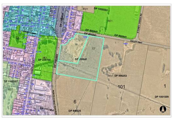 The existing subdivision pattern and location of existing
development within the locality is shown in the following aerial photograph:
The existing subdivision pattern and location of existing
development within the locality is shown in the following aerial photograph:
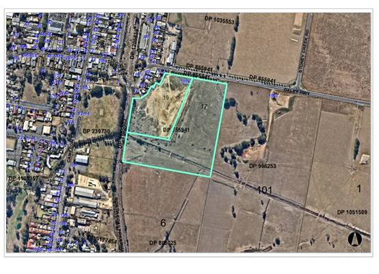
The
site already contains a significant amount of fill as illustrated on the above
aerial photograph.
Development
and Application History
The
site has been subject to a number of development applications. A brief
description and status of those applications is provided as follows:
· Development Application 2003 - 392 for land filling
approved by Council on 24 May 2004. Copy of stamped plan provided below. This
approval has physically commenced. The fill was primarily contained to Lot 16
DP 855941 and provided for finished surfaces levels of between 5.5m and 6.35m
AHD.
·
·
· Development Application 2006 - 669 for a retail nursery and
ancillary landscaping supplies approved by Council on 4 June 2007. The proposal
was primarily contained to Lot 17 DP 855941 with access via lot 17. Copy of
stamped site plan provided below. This consent never commenced and has
subsequently lapsed.
· Development Application 2008 - 426 for a caravan park and manufactured
home estate approved by Council on 2 March 2011. This consent also provided for
filling of the site. This consent has physically commenced. A copy of the
approved site plan is provided below. This consent provided for filling of the
site to a height of 7.15m AHD to meet required flood levels.
·
·
·
2. DESCRIPTION
OF DEVELOPMENT
Key
aspects of this development proposal include the following:
· Retrospective
approval for land filling beyond existing development consents.
· Spreading
of existing unapproved fill material.
· Proposed
new land filling.
· Construction
of a farm building and stock yard.
The
fill as currently exists on the site is illustrated on the site plans and
typical cross-section plans supporting this application. The existing fill
mound sits at a height of 12m AHD in locations and the proposal is to spread
the existing fill out and import additional fill to a height of 7.12 AHD. The
spreading and importation of fill is proposed eastward and small section southward
of the existing fill mound.
The
site plans also illustrate the extent of fill beyond existing development
consents and to which retrospective consent is also sought under this
application.
Refer
to Attachment 2 at the end of this report for plans of the proposed
development.
Application
Chronology
· 13
September 2019 - Application lodged.
· 24 September 2019 - Additional information request to
applicant - land owners consent, fees and plans of farm building.
· 24 September 2019 - Application referred to Essential
Energy.
· 27 September 2019 - Farm building plans provided.
· 1 October 2019 - Land owners consent provided.
· 3 to 17 October 2019 - Public exhibition via neighbour
notification.
· 16 October 2019 - Application referred to Roads and Maritime
Services.
· 16 October 2019 - Applicant advised not supportive of
application in current form and request for additional information and
integrated application fees if proceeding.
· 7 November 2019 - Roads and Maritime Services comments
received.
· 28 November 2019 - Additional information lodged.
· 10 January 2020 - Integrated referral to Natural Resources
Access Regulator.
· 22 January 2020 - Response to submissions received from
applicant.
· 11 February 2020 - Applicant advised of concerns surrounding
application in current form and likely to be recommended for refusal suggest
consider withdrawing application.
· 4 March 2020 - General Terms of Approval (GTAs) received
from Natural Resource Access Regulator.
· 5 March 2020 - Meeting with applicant and land owner to
discuss key assessment issues to progress the application.
· 1 April 2020 - Revised plans lodged.
3. STATUTORY
ASSESSMENT
Section
4.15(1) Matters for Consideration
In
determining the application, Council is required to take into consideration the
following matters as are relevant to the development that apply to the land to
which the development application relates:
(a) The
provisions (where applicable) of:
(i) any
Environmental Planning Instrument
State
Environmental Planning Policy (Koala Habitat Protection) 2019
Clause
15 - A development application made,
but not finally determined, before the commencement of this Policy in relation
to land to which this Policy applies must be determined as if this Policy had
not commenced. The application was made and not finally determined prior to the
commencement of this policy, and the application is therefore required to be
assessed under the relevant provisions of State Environmental Policy No 44 -
Koala Habitat Protection. See assessment comments below.
State
Environmental Planning Policy No. 44 - Koala Habitat Protection
With
reference to clauses 6 and 7, the subject land is greater than 1 hectare
(including any adjoining land under same ownership) and therefore the
provisions of SEPP must be considered.
The Department of Planning and Infrastructure’s
Circular No. B35, Section 1.5 states that “In relation to affected
development applications it is the intention of the policy that investigations
for ‘potential’ and ‘core’ koala habitats be limited to
those areas in which it is proposed to disturb habitat”.
The application has demonstrated that no Koala habitat will
be removed or modified therefore no further investigations are required.
State
Environmental Planning Policy No. 55 – Remediation of Land
Following
an inspection of the site and a search of Council records, the subject land is
not identified as being potentially contaminated.
State Environmental Planning
Policy (Infrastructure) 2007
In accordance with clause 45 of this policy written notice
is required to the electricity supply authority for any development in
proximity to electricity infrastructure. Specifically, for any of the
following:
(a) the
penetration of ground within 2m of an underground electricity power line or an
electricity distribution pole or within 10m of any part of an electricity
tower,
(b) development
carried out:
(i) within
or immediately adjacent to an easement for electricity purposes (whether or not
the electricity infrastructure exists), or
(ii) immediately
adjacent to an electricity substation, or
(iii) within
5m of an exposed overhead electricity power line,
It was identified that the
proposed development is within and immediately adjacent an easement for
electricity purposes.
The electricity supply authority
(Essential Energy) was given written notice inviting comments. Before
determining a development application, the consent authority must take into
consideration any response to the notice that is received within 21 days after the
notice is given.
The comments below were provided
by the electricity supply authority:
“Strictly based on the documents submitted, and
provided the new ground clearances meet with Essential Energy’s
guidelines, then Essential Energy has no comments to make as to potential
safety risks arising from the proposed development.
Essential Energy makes the following general comments:
· If
the proposed development changes, there may be potential safety risks and it is
recommended that Essential Energy is consulted for further comment;
· Any
existing encumbrances in favour of Essential Energy (or its predecessors) noted
on the title of the above property should be complied with; and
· In
addition, Essential Energy’s records indicate there is electricity infrastructure
located within the property. Any activities within this location must be
undertaken in accordance with the latest industry guideline currently known as
ISSC 20 Guideline for the Management of Activities within Electricity Easements
and Close to Infrastructure.
· Prior
to carrying out any works, a “Dial Before You Dig” enquiry should
be undertaken in accordance with the requirements of Part 5E (Protection of
Underground Electricity Power Lines) of the Electricity Supply Act 1995 (NSW).
· Given
there is electricity infrastructure in the area, it is the responsibility of
the person/s completing any works around powerlines to understand their safety
responsibilities. SafeWork NSW (www.safework.nsw.gov.au) has
publications that provide guidance when working close to electricity
infrastructure. These include the Code of Practice – Work near Overhead
Power Lines and Code of Practice – Work near Underground Assets.”
At the time of site inspection,
it was evident that no overhead transmission lines existed in the easement.
Following receipt of the above comments further verbal discussion with
Essential Energy confirmed that overhead lines that once existed in the
easement were relocated some time ago. Essential Energy subsequently advised of
overhead lines located in the western portion of the site. They are not located
within any easement. A plan was subsequently provided showing the location of
electricity infrastructure on the property. A screenshot of the plan is
provided below:
Consistent with clause
45(1)(b)(iii) the application does not propose any development or filling
within 5m of the exposed overhead electricity power lines located on the
property.
With reference to clause 101 the
site has frontage to the Oxley Highway which is a classified road. The consent
authority must not grant consent to development on such land unless it is
satisfied that:
(a) where practicable and safe, vehicular access to the land is
provided by a road other than the classified road, and
·
(b) the safety, efficiency and ongoing operation of the classified
road will not be adversely affected by the development as a result of—
(i)
the design of the vehicular access to the land, or
(ii)
the emission of smoke or dust from the development, or
(iii) the nature, volume or frequency of vehicles using the classified
road to gain access to the land, and
(c) the development is of a type that is not sensitive to traffic
noise or vehicle emissions, or is appropriately located and designed, or
includes measures, to ameliorate potential traffic noise or vehicle emissions
within the site of the development arising from the adjacent classified road.
Comments: While the development is not of a size or capacity
triggering referral to Roads and Maritime Services (RMS) under this policy
comment was sought to inform Council staff in assessment of the above noting
that vehicular access to the classified road would trigger a subsequent
concurrence under the Roads Act, 1993. The
comments provided by RMS are provided below:
“We understand that
council is seeking advice to inform their assessment and any conditions of
consent relating to access to the Oxley Highway. It is emphasised that the
comments provided below are based on the current proposal and the information
provided at this time. They are not to be interpreted as binding upon Roads and
Maritime and may change following the receipt of a formal Section 138 Roads Act
application:
1. The proposed development will need to construct a new
access onto the Oxley Highway for Lots 16 and 17. This will require a Section
138 Application to be made to Council and a concurrence from Roads and
Maritime. It is recommended that a S138 concurrence should be sought prior to a
consent being issued.
2. Access is to be designed and constructed in accordance
with the attached Typical Rural Property Access standard to accommodate the
largest design vehicle requiring access to the site. It should be sealed, meet
the highway at grade and provide for drainage. The gate should be set back
sufficiently to accommodate the largest vehicle.
3. It is noted that DA 2008/426 for a Manufactured Home
Estate and Caravan Park on Lot 16 has commenced. The proposed development will
share access with the approved development and Council should take this into
consideration in making their determination. It is recommended access to all
developments be consolidated on a single entry/exit point and that any
redundant access points be legally and physically closed.
4. Detailed plans of the access
should be submitted to Council in accordance with Section 138 of the Roads Act
and a copy of the application forwarded to Roads and Maritime for concurrence
prior to plans being approved.
5. Construction of the access
is to be undertaken in accordance with Roads and Maritimes latest version of Traffic
Control at Worksites Manual and a Road Occupancy Licence (ROL) from
https://myrta.com/oplinc2 must be obtained from Roads and Maritime prior to the
implementation of any traffic control on this road.
All
works on the classified (State) road will need to be designed and constructed
in accordance with the current Austroads Guidelines, Australian Standards and
Roads and Maritime Supplements.
The
developer will be required to enter into a Works Authorisation Deed (WAD) with
Roads and Maritime for any road work deemed necessary on the classified (State)
road. The developer will be responsible for all costs associated with the works
and administration for the WAD. It is recommended that developers familiarise
themselves with the requirements of the WAD process. Further information can be
accessed using the following link:
http://www.rms.nsw.gov.au/projects/planning-principles/index.html”
Further
to the assessment comments and advice provided under the access, traffic and
parking heading later in this report, Council staff are satisfied that an
appropriate vehicular access can be provided that will not adversely impact on
safety and operation of the classified road.
With
reference to clause 121 development for the purposes of clean fill may be
carried out by any person with consent on land to which development for the
purpose of industries, extractive industries or mining maybe carried out with
consent under any environmental planning instrument. The site is zoned RU1
Primary Production under the Port Macquarie-Hastings Local Environmental Plan
2011 to which extractive industries and mining are permissible with consent.
Port Macquarie-Hastings Local Environmental Plan 2011
The
proposal is consistent with the LEP having regard to the following:
· Clause 1.9 - For the avoidance of any doubt the provisions
of State Environmental Planning Policy (Infrastructure) 2007 prevail over this
plan. Specifically, clause 121 of that policy provides that development for the
purposes of clean fill may be carried out with consent on the land.
· Clause 2.2 - The subject site is zoned RU1 Primary
Production.
·
· Clause 2.3(1) and the RU1 zone landuse table -
Development for the purposes of farm buildings is permitted with consent. The
application proposes that the continued and proposed land filling is ancillary
to the agricultural land use undertaken on the site and is therefore
permissible with consent. The ancillary nature of the fill could potentially be
disputed however clean fill alone is permitted via SEPP Infrastructure (2007).
Refer to prior comments under clause 1.9 above.
The objectives of the RU1 zone are as follows:
o To encourage sustainable primary industry production by
maintaining and enhancing the natural resource base.
o To encourage diversity in primary industry enterprises and
systems appropriate for the area.
o To minimise the fragmentation and alienation of resource
lands.
o To minimise conflict between land uses within this zone and
land uses within adjoining zones.
· Clause
2.3(2) - The proposal is consistent with the zone objectives having regard to
the following:
o The proposal will
maintain the agricultural viability and productivity of the land.
o The proposal will
provide for farm buildings and stockyards for agricultural use of the land.
· Clause 7.1 - The site is mapped as containing class 4 and 5
acid sulfate soils on the acid sulfate soils map. The proposal does not include
any excavation extending below the natural surface level therefore no adverse
impacts are expected to occur to any acid sulfate soils that may exist on the
site.
· Clause 7.2 - Before granting consent for earthworks the
following matters must be considered:
(a) the likely disruption of, or any
detrimental effect on, existing drainage patterns and soil stability in the
locality,
(b) the effect of the proposed
development on the likely future use or redevelopment of the land,
(c) the quality of the fill or the soil
to be excavated, or both,
(d) the effect of the proposed
development on the existing and likely amenity of adjoining properties,
(e) the source of any fill material and
the destination of any excavated material,
(f) the likelihood of disturbing relics,
(g) the proximity to and potential for
adverse impacts on any watercourse, drinking water catchment or environmentally
sensitive area.
Comments: The works
will not lead to any adverse impact upon existing drainage patterns, soil
stability of the site or adjoining/adjacent sites, any nearby water course or
known environmental sensitive area within the immediate locality. The works
will be unlikely to adversely affect potential additional future land uses on
the site. The soil quality and structure will not present a constraint to the
construction of the farm shed on the site. The applicant indicates that
fill to be imported to the site will be clean virgin fill. A suitable consent condition has been recommended to ensure
compliance with this commitment. The likely change in levels associated
with the proposed development will not have an adverse effect on the amenity of
adjoining/adjacent properties to the site. Specifically, the proposal will
result in the levelling out and reduction in height of the current stockpile
evident on the site. The site does not contain any known items of aboriginal or
other cultural significance. Appropriate conditions of consent are proposed to
manage the impact of the filling and spreading works.
· Clause 7.3 - The site is land within a mapped “flood
planning area” (land subject to flood discharge of 1:100 annual
recurrence interval flood event, plus the applicable climate change allowance
and relevant freeboard).
The application was supported by a flood impact and risk
assessment report. The report was prepared by Advisian and is dated 19 August
2019, revision B which is provided as an attachment to this report.
The following comments are provided which incorporate
consideration of the objectives of Clause 7.3, Council’s Flood Policy
2018, the NSW Government’s Flood Prone Lands Policy and the NSW
Government’s Floodplain Development Manual (2005):
o The proposal and flood report are considered to meet the
provisions of the flood policy 2018.
o The flood report
demonstrates that the fill will not have any adverse impacts to the floodplain,
does not have any measurable impact on flood levels, and only crates a minor
velocity increase of 0.02m /s, which less than the 0.1m/s permitted under the
flood policy.
o The fill will
provide a level which can be used for stock and cattle (noting there is no
specific level for stock refuge mounds), and the shed will be above the 1:20
year flood level, which for this site is 5.84m AHD. The shed FFL is approx.
1.3m above this level;
o The application has demonstrated compatibility with the
flood hazard of the land taking into account projected changes as a result of
climate change;
o The application has demonstrated that the proposal will not
result in a significant adverse effect on flood behaviour that would result in
detrimental increases in the potential flood affectation of other development
or properties;
o The proposal incorporates measures to minimise & manage
the flood risk to life and property associated with the use of land;
o The proposal is not likely to significantly adversely
affect the environment or cause avoidable erosion, siltation, destruction of
riparian vegetation or a reduction in the stability of river banks or
watercourses; and
o The proposal is not likely to result in unsustainable
social and economic costs to the community as a consequence of flooding.
· Clause 7.13 - Having regard to the nature of the proposed
development the provision of water, electricity and sewer are not considered
essential services. Stormwater drainage is capable of being managed onsite and
suitable road access available to service the development.
(ii) Any draft
instruments that apply to the site or are on exhibition
No draft instruments apply.
(iii) Any Development Control
Plan in force
Port
Macquarie-Hastings Development Control Plan 2013
The
relevant general provisions of the plan considered in the following table:
|
DCP 2013: General Provisions
|
|
DCP Objective
|
Development Provisions
|
Proposed
|
Complies
|
|
1.3.2
|
Community participation
|
The application is notifiable local development and was
notified consistent with provisions of this plan.
|
Yes
|
|
2.3.3.3
|
a) Significant land reforming proposals where >10%
gross site area or >1.0ha is to have surface levels changed by more than
5m or where earthworks exceed an average of 10,000m3 per ha shall:
• identify the impact of the proposed land reforming
on the environment, landscape, visual character and amenity, natural
watercourses, riparian vegetation, topographical features of the environment
and public infrastructure;
• demonstrate compliance with the provisions of
Council’s Aus-Spec design specification;
• assess the impacts and benefits of the proposal to
all impacted persons and the general public;
• provide measures to compensate for and minimise
any net adverse impacts.
(b) The use of high earthworks batters should be avoided.
(c) Preliminary plans indicating the final landform are
required to be submitted with any master plan or subdivision application.
(d) The subdivision should be designed to fit the
topography rather than altering the topography to fit the subdivision.
|
The proposal is considered a significant land forming
proposal.
The proposed filling and spreading of existing fill
material to a height of 7.12m and commitment for grass establishment within
12 months will actually improve the visual amenity and landscape across the
site form that to which currently exists.
No subdivision associated civil work is proposed.
The application has identified the potential flood impacts
from the filling of the site and demonstrated that no adverse impact will
result consistent with Council’s flood policy.
The batters proposed are not considered significant in
height.
The plans provided illustrate final landform levels.
No subdivision proposed.
|
Yes
N/A
Yes
Yes
Yes
N/A
|
|
2.4.3.5
|
Development must comply with Council’s Floodplain
Management Plan and Flood Policies.
|
The proposal was supported by a flood impact assessment
and has demonstrated compliance with Council’s flood policy.
|
Yes
|
|
2.5.3.2
|
a) New direct accesses from a development to arterial and
distributor roads is not permitted. Routes should differ in alignment and
design standard according to the volume and type of traffic they are intended
to carry, the desirable traffic speed, and other factors.
b) Existing direct accesses from a development to arterial
and distributor roads are rationalised or removed where practical.
c) Vehicle driveway crossings are minimal in number and
width (while being adequate for the nature of the development), and
positioned:
• to avoid driveways near intersections and road
bends, and
• to minimise streetscapes dominated by driveways
and garage doors, and
• to maximise on-street parking.
|
The proposal is to use approved vehicular access (under
DA2008/426) onto the Oxley Highway. Details shall be provided as part of a
Roads Act (Section 138) application to Council.
No additional access points to the Oxley Highway are proposed
or required.
Single access point proposed.
|
Yes
Yes
Yes
|
|
2.6.3.2
|
Tree removal (3m or higher with 100mm diameter trunk and
3m outside dwelling footprint
|
No tree removal is proposed.
|
N/A
|
(iiia) Any planning agreement that has
been entered into under section 7.4, or any draft planning agreement that a
developer has offered to enter into under section 7.4
No planning agreement has been
offered or entered into relating to the site.
(iv) Any
matters prescribed by the Regulations
No matters prescribed by the
regulations apply.
(b) The likely
impacts of that development, including environmental impacts on both the
natural and built environments, social and economic impacts in the locality:
Context and setting
The site is located on the southern side of the Oxley
Highway road entry to the township of Wauchope. Adjoining the site to the east
is agricultural farmland. Adjoining the site to the south is agricultural
farmland. Adjoining the site to the west is the railway and cluster of
residential dwellings in the north-western corner.
Subject to the imposition of the recommended site management
conditions the proposal will not have any significant adverse impacts to
existing adjoining properties.
The proposal is considered to satisfactorily address the
public domain. Specifically, the levelling out of the current fill stockpile
and commitment for grass establishment within 12 months will improve the visual
amenity across the site from the public domain (i.e. the Oxley Highway).
The proposal will still allow for agricultural use of the
land consistent with other rural development in the locality. The proposal
adequately addresses planning controls for the area.
The proposal does not have a significant adverse impact on
existing view sharing.
There are no significant adverse overshadowing impacts. The
proposal does not prevent adjoining properties from receiving 3 hours of
sunlight to private open space and primary living areas on 21 June between the
hours of 9am and 3pm.
Roads
The site has road frontage to the Oxley Highway. Oxley
Highway is a sealed public road under the care and control of Roads and
Maritime Services. Oxley Highway is a state highway with a 7m Road Formation
within a 20m road reserve.
Traffic and Transport
The addition in traffic associated with the development is
unlikely to have any adverse impacts to the existing road network within the
immediate locality.
The development proposes substantial fill material to be
imported to the site. To protect existing road facilities, the existing road
conditions shall be evaluated and bond securities held prior to any earthworks
commencing. Details shall be provided as part of a Roads Act (Section 138)
application. Suitable consent conditions have been recommended.
Site Frontage and Access
Vehicle access to the site is proposed through the approved
driveway entrance provided under DA2008/426. This is also noted in Roads and
Maritime Services comments. Oxley Highway is a Roads and Maritime Services
(RMS) state highway and will require concurrence and a Works Authorisation Deed
(WAD) from the RMS prior to works on this road. Details shall be provided as
part of a Roads Act (Section 138) application to Council. Suitable consent
conditions are recommended.
Water Supply Connection
Council records indicate that
Lot 17 DP 855941 currently has a 20mm metered water service. No fixture or
fittings are proposed in the farm building and no change to the existing water
supply service arrangements are proposed or required.
Council has water supply
easements and water mains running across the site. There is a 300mm cast iron
water main running diagonally across the site and part of the fill is proposed
over this water main and easement. A 525mm asbestos cement water main and a
750mm steel water main run across the rear of the site. These are not impacted
by the proposal.
Buildings and structures are not
permitted over water main easements or within 2.5 metres of the water main
centreline. The farm building is proposed well clear of the water supply
easements. The stockyards are proposed over the water supply easement that
diagonally traverses the site. A consent condition has been recommended
requiring the stockyards to relocated south clear of this easement.
There is to be no vehicular or
plant and machinery activity over the 525mm AC or the 750mm steel water mains
across the rear of the lot. A consent condition is recommended advising of this
requirement.
Filling and spreading work over
the 300mm water main running diagonally across the site (within the easement)
shall only be carried out under the supervision of Port Macquarie-Hastings
Council. The costs of this supervision will be borne by the proponent. An
appropriate consent condition is recommended.
Sewer Connection
The site is not currently
connected to Council’s sewer network and no facilities are proposed in
the farm building.
Stormwater
The site naturally grades towards the south and is currently
serviced via an existing open drainage system.
The legal point of discharge for the proposed development is
defined as overland flow. It is not considered that the proposed fill will have
any adverse effect on the existing stormwater.
The proposed access should provide appropriate drainage to
ensure safe access and appropriate conditions have been recommended.
Other
Utilities
Telecommunication
and electricity services are capable of being provided to the site.
Heritage
No
known items of Aboriginal or European heritage significance exist on the property.
No excavation is proposed beyond natural ground level. No adverse impacts
anticipated.
Other
land resources
The
site is within an established rural context and the proposal will not sterilise
any significant mineral or agricultural resource.
Water
cycle
The
proposed development will be unlikely to have any adverse impacts on water
resources and the water cycle.
Soils
Subject
to appropriate erosion and sediment controls being in place prior to and during
filling works the proposed development will be unlikely to have any adverse
impacts on soils in terms of quality, erosion, stability and/or productivity.
Standard precautionary site management condition is recommended. The condition
requires appropriate erosion and sediment controls to be in place until the
site is stabilised with vegetation.
Air and microclimate
Standard precautionary site
management condition is recommended which requires appropriate dust control
measures. Subject to the implementation of such measures the fill and spreading
work is unlikely to result in any adverse impacts on the existing air quality
or result in any pollution.
Flora
and fauna
The
site comprises non-native grassland and contains no significant vegetation. The
proposed development does not include any removal/clearing of any significant
native vegetation and therefore does not trigger the biodiversity offsets
scheme. Part 7 of the Biodiversity Conservation Act 2016 is considered to be
satisfied.
Under
the NSW Biosecurity Act 2015 all landowners have a duty to prevent, eliminate
or minimise any biosecurity risk, which includes weed management. There is a
risk with the proposed development that weeds could be imported to or exported
from the site from heavy vehicular movements.
A consent condition has been
recommended reminding the landowner of weed management responsibilities under
this legislation and specifically advising that adequate decontamination of
vehicles and equipment need to be undertaken for any vehicles entering and
leaving the site as part of the development.
Waste
No
waste will be generate from the proposed development. No adverse impacts are
anticipated.
Energy
No
adverse impacts anticipated.
Noise and vibration
The landfill and spreading work will involve heavy machinery
and given the proximity of the site and vehicular access to adjoining
residential receivers it is considered important that any fill or spreading
work be limited to what would otherwise be normal construction work hours.
Those being 7am to 6pm Monday to Saturday with no work on Sundays or Public
Holidays. An appropriate consent condition has been recommended. Subject to
work being confined to these hours the proposal will not result in any
significant adverse noise impacts.
The proposed farm shed and holding yards are located over
150m from the existing residential receivers. This setback is considered more
than adequate in minimising any potential land use conflict with any
agricultural use of these structures.
Bushfire
The site is identified as being bushfire prone. However, no
form of residential development is proposed. An assessment of bushfire risk
having regard to Planning for Bushfire Protection guidelines concludes that no
bushfire measures are required for the proposed structures.
Safety, security and crime prevention
The proposed development will be unlikely to create any
concealment/entrapment areas or crime spots that would result in any
identifiable loss of safety or reduction of security in the immediate
area.
Social impacts in the locality
Given the nature of the proposed development and its
location the proposal is not considered to have any significant adverse social
impacts.
Economic impact in the locality
The proposal is not considered to have any significant
adverse economic impacts on the locality.
Site design and internal design
The proposed development design satisfactorily responds to
the site attributes and will fit into the locality.
Construction
Construction impacts are considered capable of being
managed, standard construction and site management conditions have been
recommended.
Cumulative impacts
The proposed development is not considered to have any
significant adverse cumulative impacts on the natural or built environment or
the social and economic attributes of the locality.
(c) The
suitability of the site for the development
The proposal will fit into the locality and the site
attributes are conducive to the proposed development.
Site constraints of flooding have been adequately addressed
and appropriate conditions of consent recommended.
(d) Any
submissions made in accordance with this Act or the Regulations
One (1) written
submission was received following public exhibition of the application. Copies
of the written submission have been provided separately to members of the DAP.
Key
issues raised in the submission received and comments are provided as follows:
|
Submission
Issue/Summary
|
Planning
Comment/Response
|
|
Application is incorrect and
does not detail the owners “full intentions”. The application is
a false statement of the owners ultimate intention and use of the land.
|
Noted. Council can only assess
the application at hand and the proposed use. Irrespective of land use, clean
fill alone is permissible with consent under State Environmental Planning Policy
(Infrastructure) 2007.
|
|
The fill currently onsite is significant. It equates to
approximately 50,000m3 and extends to the western boundary with
the railway line.
|
Noted. Refer to development and application history
heading of this report regarding extent of already approved fill.
|
|
The fill height to 7.12m is overkill and no 100 year
flood will ever reach that height.
|
Refer to flood assessment comments provided under clause
7.3 of Port Macquarie-Hastings 2011 of this report.
|
|
The proposal will impact the farming ability of the
adjoining property to the south being 2A Guy Street (Lot 6 DP 808025). In
flood the water will be diverted and spread onto neighbouring properties.
|
Refer to flood assessment comments provided under clause
7.3 of Port Macquarie-Hastings 2011 of this report.
|
|
The area proposed for the shed, cattle yards and stock
refuge only takes up a very small percentage of the proposal fill area. If
the proposal is genuinely for agricultural purposes then why fill good
pasture land and to this extent? A lot smaller area would be just as
effective.
|
Noted. Irrespective of land use clean fill alone is
permissible with consent under State Environmental Planning Policy
(Infrastructure) 2007.
|
|
The mitigation drain running through the rear of the site
is not being maintained. This prevents flows to King Creek and effective
stormwater dispersion from Wauchope township. It should be cleaned out
whether this be Council or the land owners responsibility.
|
This matter is not considered relevant to the
application. However, the maintenance of this drain is the land owners
responsibility.
|
|
There is no genuine agricultural need for more fill. The
12 steers on the property would only have 4 hectares left to graze of the
8-hectare property.
|
Noted. Irrespective of land use clean fill alone is
permissible with consent under State Environmental Planning Policy
(Infrastructure) 2007.
|
|
Is the fill that has already been placed on site clean
and free from contamination? Where is the bio security documentation
confirming trucks and machinery entering the site where contaminate and weed
free?
|
A consent condition has been recommended requiring a
validation certificate be provided from an appropriately qualified person for
the existing fill. The certificate amongst other things will need to
demonstrate the fill is free of contamination. A condition has also been
recommended reminding the landowner of biosecurity obligations and weed
management.
|
|
Wind-blown dust has already been a problem on the site
especially in dry times.
|
Noted. A site management consent condition is recommended
which includes the requirement for appropriate dust control measures.
|
(e) The Public Interest
The proposed development
satisfies relevant planning controls and will not adversely impact on the wider
public interest.
4. DEVELOPMENT
CONTRIBUTIONS APPLICABLE
A
fixed development consent levy will apply under s7.12 of the Act. Consistent
with Council’s S94A (now s7.12) plan the development is not for
residential purposes and the cost of the development exceeds $100,000 in value.
A consent condition has been recommended requiring payment of the levy prior to
issue of the construction certificate for the farm shed. An estimate of the
amount payable is provided as Attachment 3 to this report.
Development contributions will
not be required under S64 for the following reasons:
- The development
will not propose or require augmentation of the water or sewer network.
·
5. CONCLUSION AND
STATEMENT OF REASON
The application has been assessed in accordance with Section
4.15 of the Environmental Planning and Assessment Act 1979.
Issues raised during assessment and public exhibition of the
application have been considered in the assessment of the application. Where
relevant, conditions have been recommended to manage the impacts attributed to
these issues.
The site is considered suitable for the proposed development
and the proposal adequately addresses relevant planning controls. The
development is not considered to be contrary to the public's interest and will
not result a significant adverse social, environmental or economic impact. It
is recommended that the application be approved, subject to the recommended
conditions of consent provided in the attachment section of this report.
|
Attachments
1⇩. DA2020 - 655.1
Recommend Conditions
2⇩. DA2019 - 655.1 Plans
3⇩. DA2019 - 655.1
Contributions Quote
4⇩. DA2019 - 655.1 NRAR General
Terms of Approval
5⇩. DA2019 - 655.1 RMS
response letter
6⇩. DA2019 - 655.1 SOEE
7⇩. DA2019 - 655.1 Flood
Assessment
|
|
ATTACHMENT
|
Development Assessment Panel
27/05/2020
|

|
ATTACHMENT
|
Development Assessment Panel
27/05/2020
|
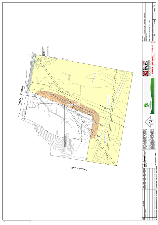
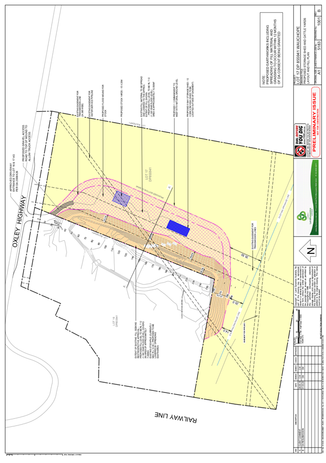
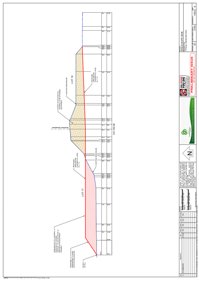
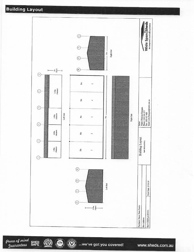
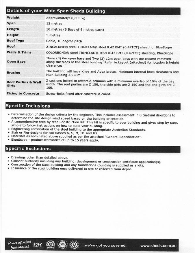
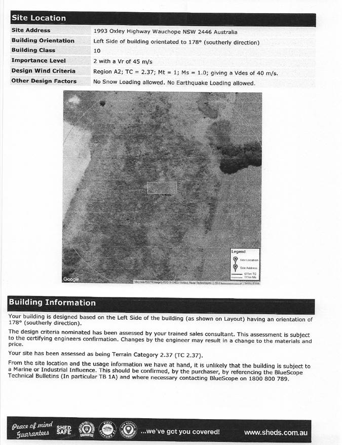
|
ATTACHMENT
|
Development Assessment Panel
27/05/2020
|
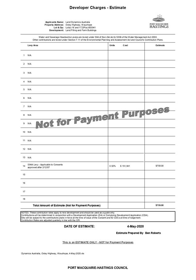
|
ATTACHMENT
|
Development Assessment Panel
27/05/2020
|
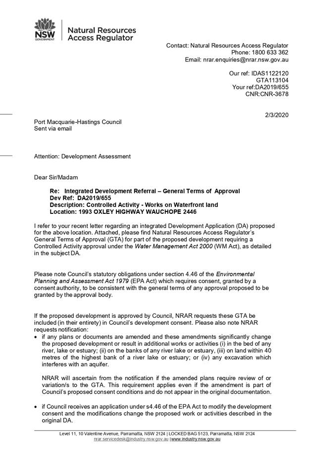
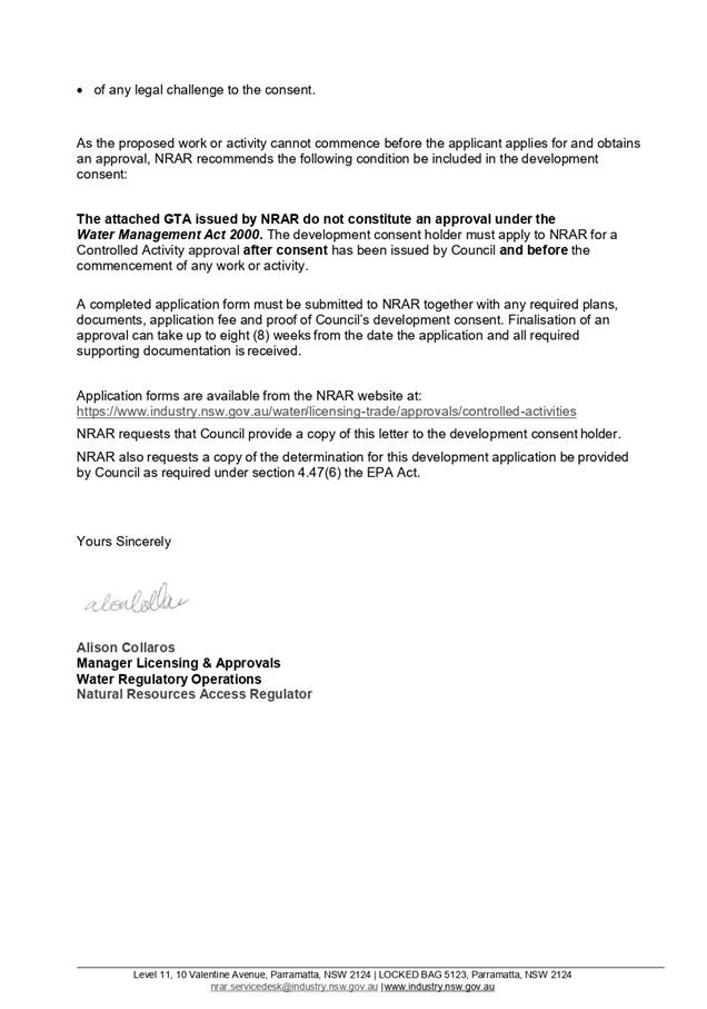
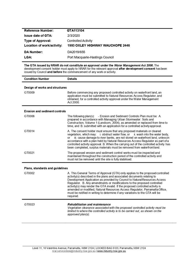
|
ATTACHMENT
|
Development Assessment Panel
27/05/2020
|
|
ATTACHMENT
|
Development Assessment Panel
27/05/2020
|

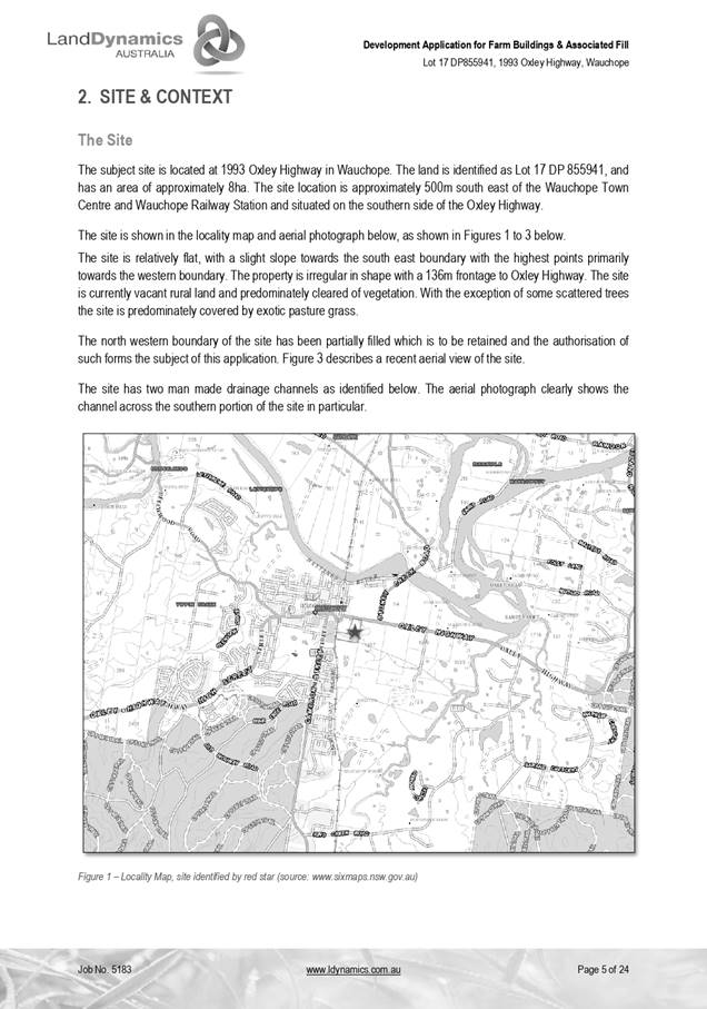
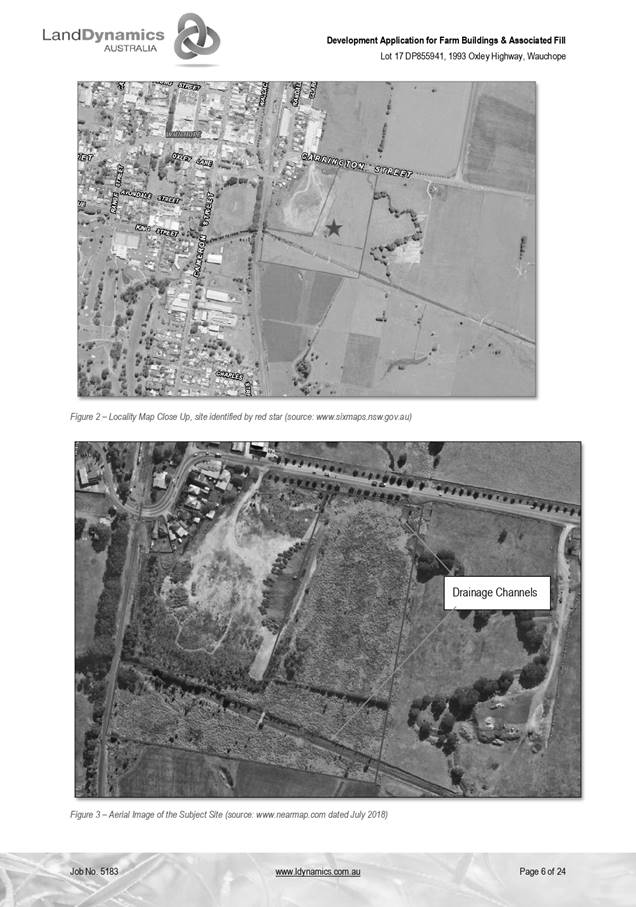
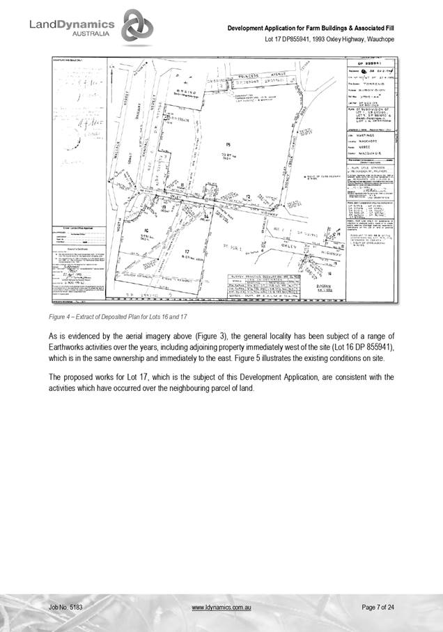
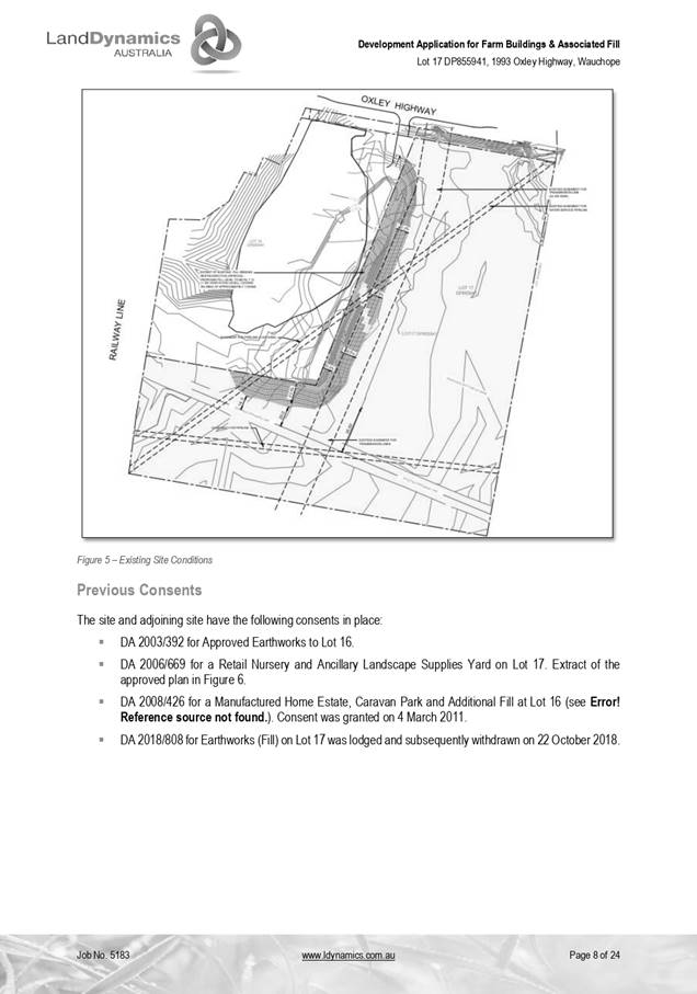
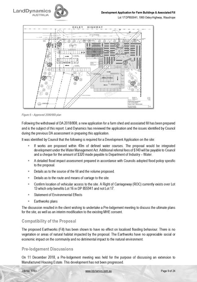

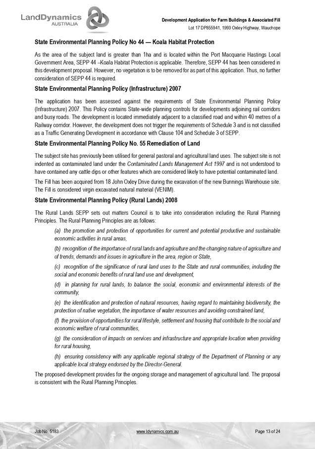
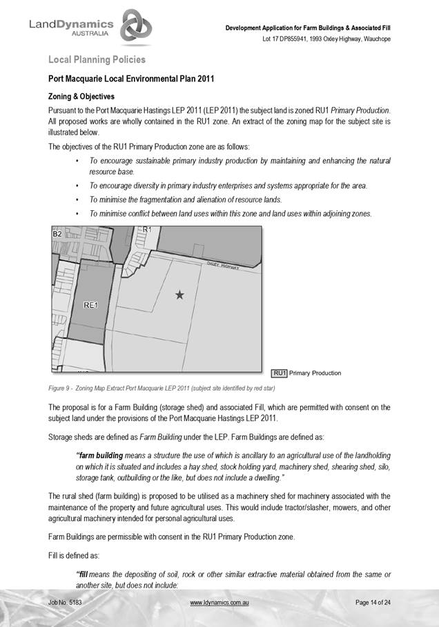
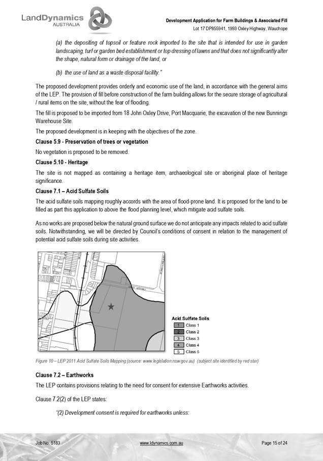

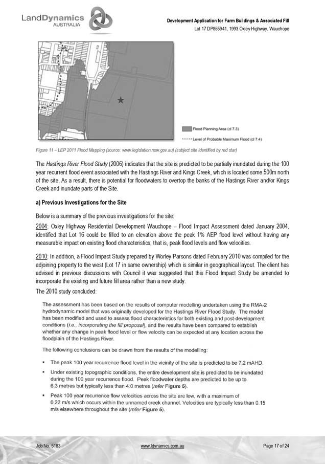
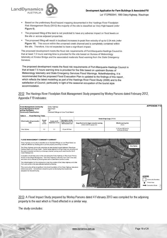

|
ATTACHMENT
|
Development Assessment Panel
27/05/2020
|
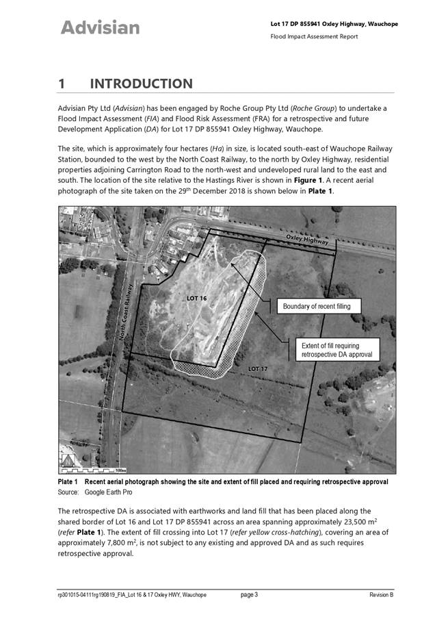
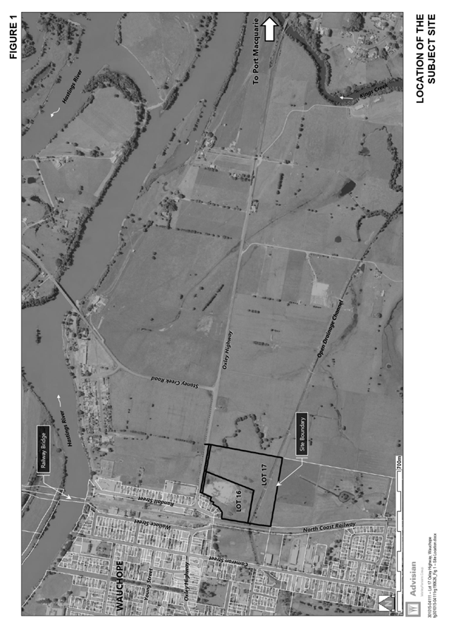

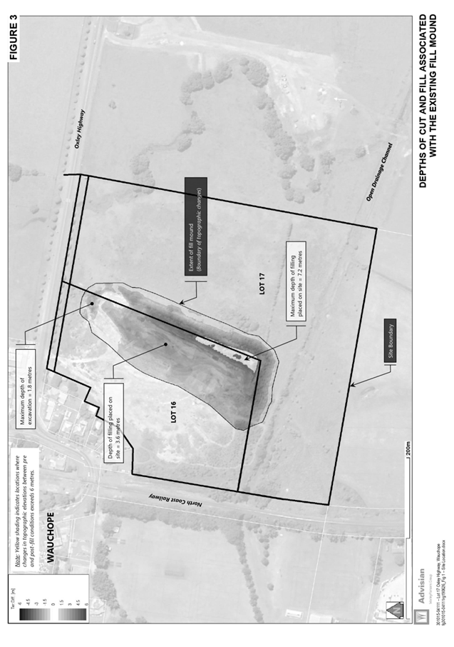
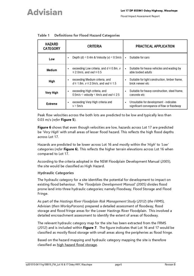
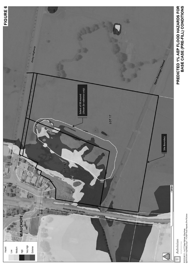
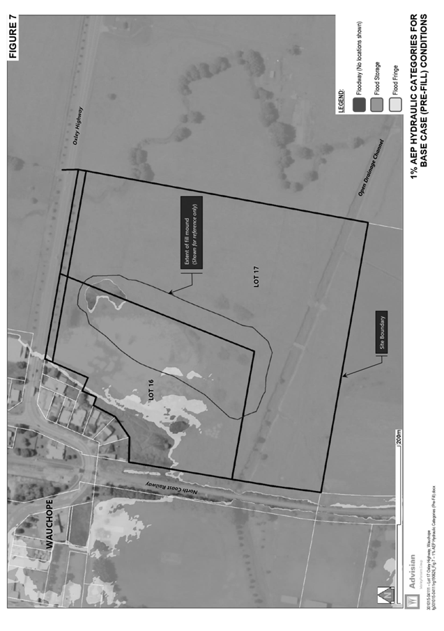
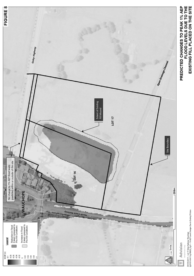

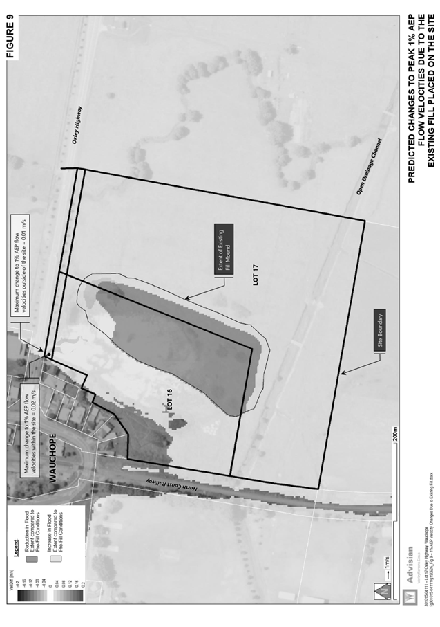
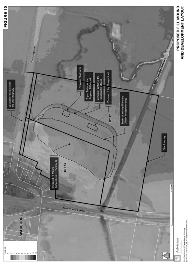
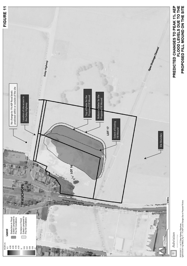
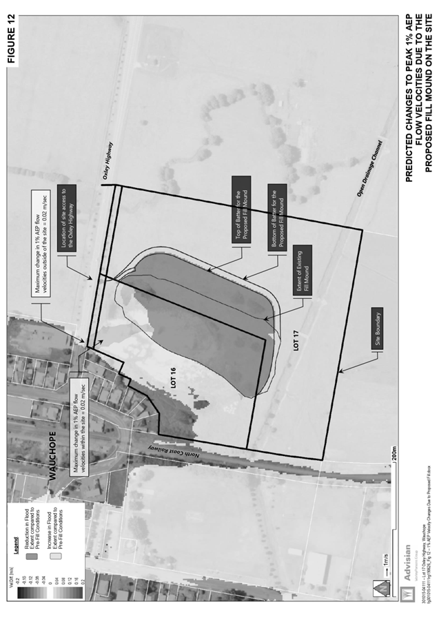
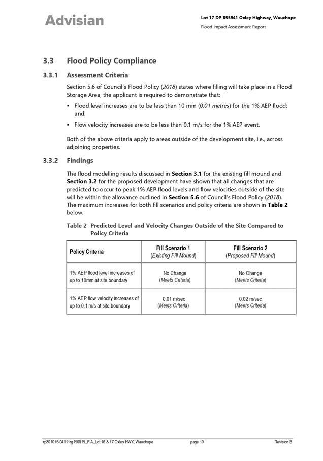
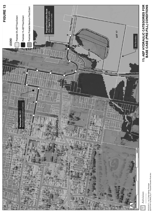
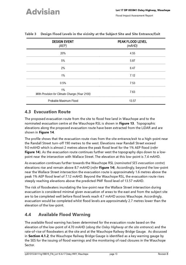
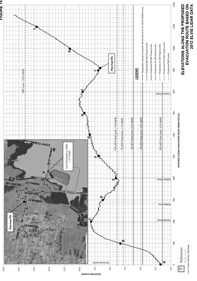
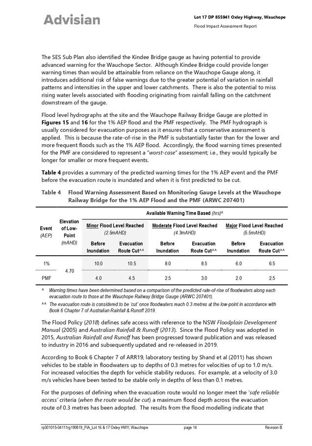
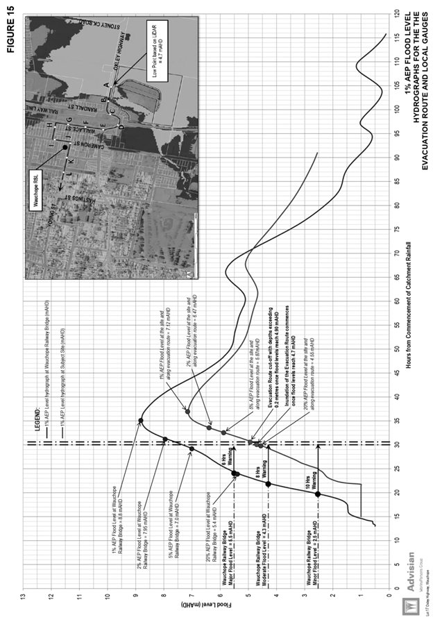
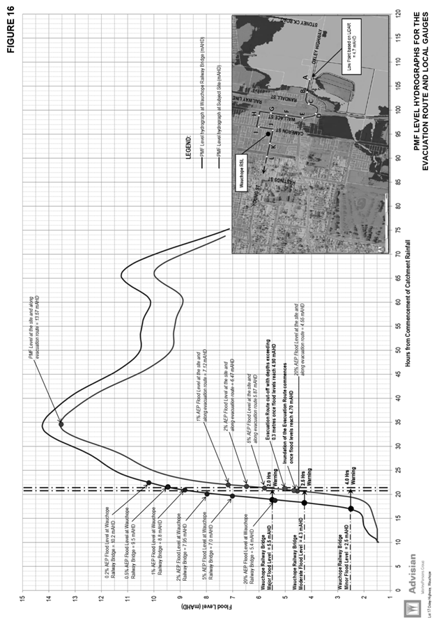
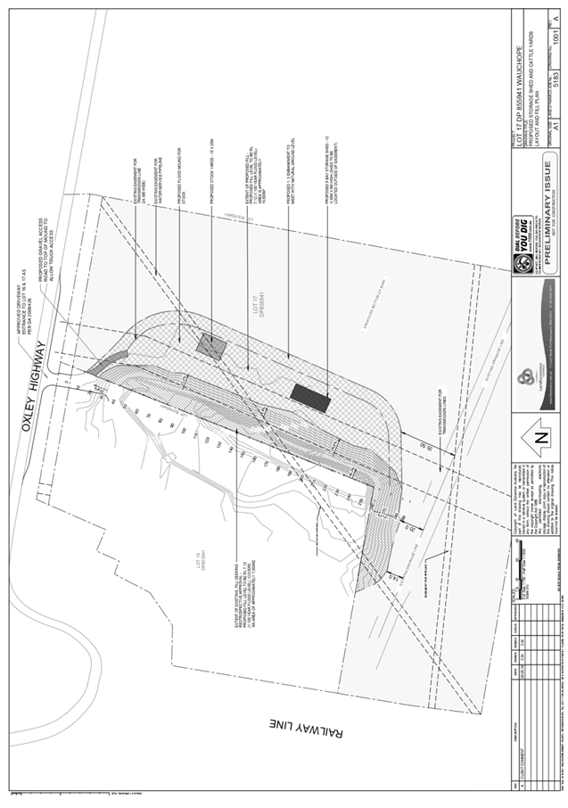
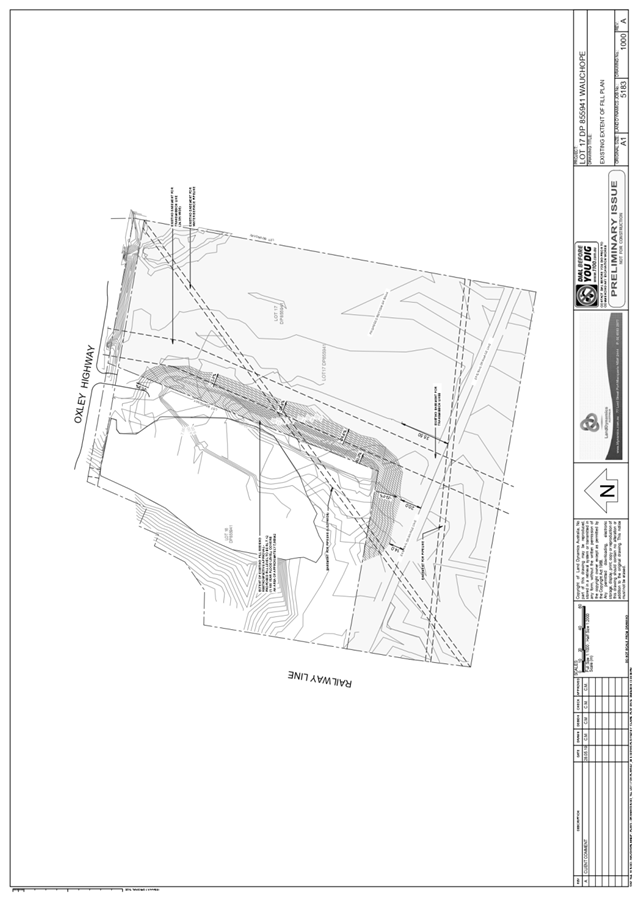
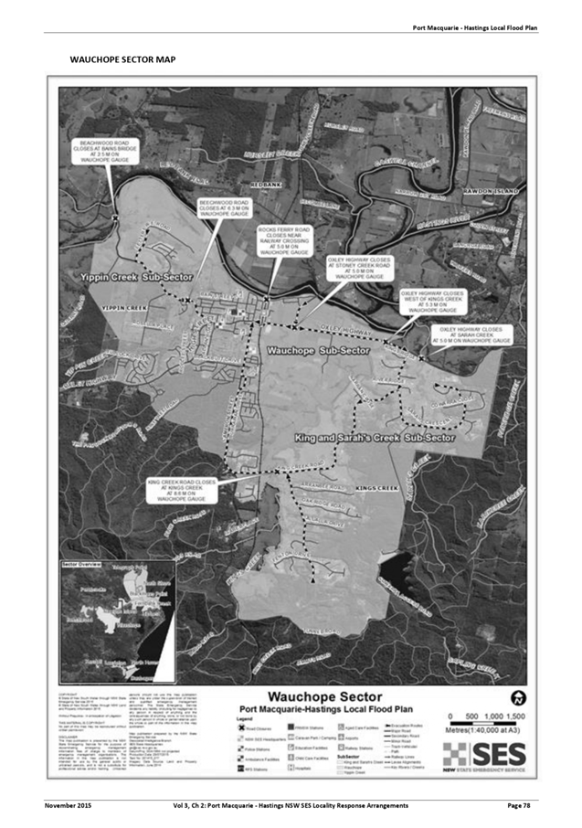
AGENDA Development Assessment Panel 27/05/2020
Item: 07
Subject: DA2019 - 740.1 Development Ancillary to
Agriculture (Frost Fans) at Lot 13, DP 754420, 293 Innes View Road, Innes View
Report
Author: Development Assessment Planner, Benjamin Roberts
|
Applicant: I
H and A L Tolson
Owner: I
H and A L Tolson
Estimated Cost: $140,000
Alignment with Delivery
Program
4.3.1 Undertake transparent
and efficient development assessment in accordance with relevant legislation.
|
RECOMMENDATION
That
DA 2019 - 740 for development ancillary
to agriculture (frost fans) at
Lot 13, DP 754420, No. 293 Innes
View Road, Innes View, be determined by granting consent subject to the
recommended conditions.
Executive
Summary
This
report considers a development application for development ancillary to
agriculture (frost fans) at the subject site
and provides an assessment of the application in accordance with the
Environmental Planning and Assessment Act 1979.
Following exhibition of the
application, one (1) submission was received.
The site is considered suitable for the proposed development
and the proposal adequately addresses relevant planning controls. The
development is not considered to be contrary to the public's interest and will
not result a significant adverse social, environmental or economic impact.
This report recommends that the
development application be approved subject to the conditions in Attachment
1.
1. BACKGROUND
Existing
Sites Features and Surrounding Development
The site has an area of 51.09
hectares.
The
site is zoned RU1 Primary Production in accordance
with the Port Macquarie-Hastings Local Environmental Plan 2011, as shown in the
following zoning plan:
 The existing subdivision pattern and location of existing
development within the locality is shown in the following aerial photograph:
The existing subdivision pattern and location of existing
development within the locality is shown in the following aerial photograph:
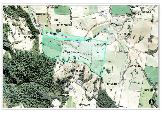
2. DESCRIPTION
OF DEVELOPMENT
Key
aspects of the proposal include the following:
· Erection
of two frost fans each with a tower height of 10.5m and 5.5m fan diameter.
Refer
to Attachment 2 at the end of this report for plans of the proposed
development.
Application
Chronology
· 14
October 2019 - Application lodged.
· 25
October 2019 - Additional information requested.
· 28 October 2019 - Additional information lodged.
· 30 October 2019 - Additional information requested.
· 1 to 14 November 2019 - Public exhibition via neighbour
notification.
· 17 January 2020 - Additional information lodged.
· 13 February 2020 - Additional information requested.
· 14 April 2020 - Additional information lodged.
3. STATUTORY
ASSESSMENT
Section
4.15(1) Matters for Consideration
In
determining the application, Council is required to take into consideration the
following matters as are relevant to the development that apply to the land to
which the development application relates:
(a) The
provisions (where applicable) of:
(i) any
Environmental Planning Instrument
State Environmental Planning Policy (Koala Habitat
Protection) 2019
Clause 15 - A development application made,
but not finally determined, before the commencement of this Policy in relation
to land to which this Policy applies must be determined as if this Policy had
not commenced. The application was made and not finally determined prior to the
commencement of this policy, and the application is therefore required to be
assessed under the relevant provisions of State Environmental Policy No 44 -
Koala Habitat Protection. See assessment comments below.
State Environmental Planning Policy No. 44 - Koala
Habitat Protection
With reference to clauses 6 and 7, the subject land is
greater than 1 hectare (including any adjoining land under same ownership) and
therefore the provisions of SEPP must be considered.
The Department of Planning and Infrastructure’s
Circular No. B35, Section 1.5 states that “In relation to affected
development applications it is the intention of the policy that investigations
for ‘potential’ and ‘core’ koala habitats be limited to
those areas in which it is proposed to disturb habitat”.
The application has demonstrated that no habitat will be
removed or modified therefore no further investigations are required.
State Environmental Planning Policy No. 55 –
Remediation of Land
Following an inspection of the site and a search of Council
records, the subject land is not identified as being potentially contaminated
and is suitable for the intended use.
State Environmental Planning Policy (Infrastructure) 2007
In accordance with clause 45 of this policy written notice
is required to the electricity supply authority for any development in
proximity to electricity infrastructure. Specifically, for any of the
following:
(a) the
penetration of ground within 2m of an underground electricity power line or an
electricity distribution pole or within 10m of any part of an electricity
tower,
(b) development
carried out:
(i) within
or immediately adjacent to an easement for electricity purposes (whether or not
the electricity infrastructure exists), or
(ii) immediately
adjacent to an electricity substation, or
(iii) within
5m of an exposed overhead electricity power line,
Following a site inspection, it
was evident that overhead electricity lines exist on the property. They are not
located within any easement. Subsequent advice was sought from Essential Energy
as to the location of overhead electricity power lines on the property. A plan was
provided by Essential Energy showing the location of electricity infrastructure
on the property. A screenshot of the plan is provided below:
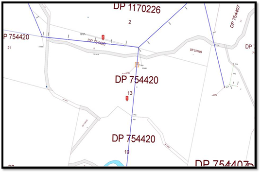
The proponent was requested to
illustrate the location of the fans in relation to the power line infrastructure.
The marked up plan was provided below which illustrates the fans are proposed
to be located well in excess of 5m from the power lines and therefore no formal
written notice to the supply authority is required.
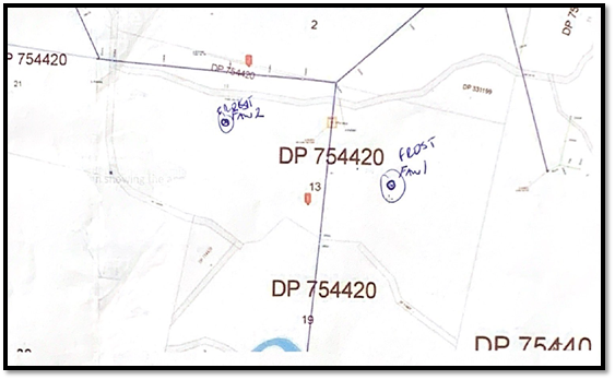
Port Macquarie-Hastings Local Environmental
Plan 2011
The proposal is consistent with the LEP having regard to the
following:
· Clause
2.2 - The subject site is zoned RU1 Primary Production. I
· Clause
2.3(1) and the RU1 zone landuse table - The proposed development is considered to
be ancillary to the agricultural use of the land. Specifically, the site is
currently operating as an avocado farm and the fans would be used as a means of
keeping frost from settling on the avocado plants. Agriculture is permitted
with consent in the RU1 zone.
The objectives of the RU1 zone are as
follows:
o To encourage sustainable primary
industry production by maintaining and enhancing the natural resource base.
o To encourage diversity in primary
industry enterprises and systems appropriate for the area.
o To minimise the fragmentation and
alienation of resource lands.
o To minimise conflict between land
uses within this zone and land uses within adjoining zones.
· Clause
2.3(2) - The proposal is consistent with the zone objectives having regard to
the following:
o the proposal is a permissible
landuse;
o the proposal will encourage
sustainable primary industry;
o the proposal will encourage a
diverse primary industry enterprise;
o the proposal will not fragment
or alienate resource lands; and
o the proposal will not result
in any zone interface land use conflicts.
·
· Clause
5.10 – The site does not contain or adjoin any known heritage items or
sites of significance.
·
· Clause
7.13 - Water, sewer, electricity and stormwater are not considered essential
services for the proposed development. Existing suitable road access currently
serves the site.
(ii) Any draft
instruments that apply to the site or are on exhibition
No draft instruments apply to the site.
(iii) Any Development
Control Plan in force
Port
Macquarie-Hastings Development Control Plan 2013
The
plan does not contain specific provisions for this form of development. The
relevant general provisions of the plan considered in the following table:
|
DCP 2013: General Provisions
|
|
DCP Objective
|
Development Provisions
|
Proposed
|
Complies
|
|
1.3.2
|
Community participation
|
The application is notifiable local development and was
notified consistent with provisions of this plan.
|
Yes
|
|
2.6.3
|
Tree removal (3m or higher with 100mm diameter trunk and
3m outside dwelling footprint
|
No tree removal is proposed.
|
N/A
|
(iiia) Any planning agreement that has
been entered into under section 7.4, or any draft planning agreement that a
developer has offered to enter into under section 7.4
No planning agreement has been offered or entered into
relating to the site.
(iv) Any
matters prescribed by the Regulations
No matters prescribed by the
regulations apply.
(b) The likely
impacts of that development, including environmental impacts on both the
natural and built environments, social and economic impacts in the locality:
Context and setting
The property is located approximately 4km west of the
village of Comboyne. The property is traversed by Innes View Road along its
northern portion and adjoining the site to the north, east and south are rural
properties. Adjoining the site to the southwest is National Park, known as the
Boorgana Nature Reserve.
The proposal has demonstrated that it will not have any
significant adverse impacts to existing adjoining properties.
The proposal is considered to be consistent with rural
development in the locality and adequately addresses planning controls for the
area.
The proposal does not have a significant adverse impact on
existing view sharing.
There are no adverse overshadowing impacts.
Roads, Traffic and
Transport
The installation of the two frost fans will not result in
any increase to traffic generation from the property.
Site Frontage and Access
The site has road frontage to and existing access from Innes
View Road. There is no change proposed or required to the existing property
access arrangement.
Parking and Manoeuvring
The installation of the two frost fans will not result in
any increased parking demand.
Stormwater
Stormwater generated from the structures will be minimal and
not considered to require any specific capture or treatment measures.
Other Utilities
Electricity services are available to the site. It is not
clear whether telecommunication service is provided however is not considered
necessary for the proposed development.
Heritage
No known items of Aboriginal or European heritage
significance exist on the property. No adverse impacts anticipated. The site is
considered to be disturbed land.
Other land resources
The proposal will not sterilise any significant mineral or
agricultural resource.
Water cycle
The proposed development will not have any significant
adverse impacts on water resources and the water cycle.
Soils
The proposed development will not have any significant
adverse impacts on soils in terms of quality, erosion, stability and/or
productivity subject to a standard condition requiring erosion and sediment
controls to be in place prior to and during construction.
Air and microclimate
The construction and/or operations of the proposed
development will not result in any significant adverse impacts on the existing
air quality or result in any pollution. Standard precautionary site management
condition recommended.
Flora and fauna
Construction of the proposed development will not require
any removal/clearing of any native vegetation and therefore does not trigger
the biodiversity offsets scheme. Part 7 of the Biodiversity Conservation
Act 2016 is considered to be satisfied.
Waste
No adverse impacts anticipated. Standard precautionary site
management condition recommended.
Energy
No adverse impacts anticipated.
Noise and vibration
The operations of the proposed development have the
potential to generate noise impacts. Specifically, as the frost fans will be
operational within the early hours of the morning.
The application was supported by an environmental noise
assessment. The assessment was prepared by Sonus and is dated January 2020 and
is provided as an attachment to this report.
The noise assessment provides the following conclusion:
“The noise from two new
Frost Boss "C49" frost control fans has been predicted at the closest
non-associated dwellings. The predictions have used the CONCAWE noise
propagation model under weather conditions which correspond to a frost.
Appropriate noise criteria
have been established with reference to the Griffith and Leeton Shire Councils
policies for frost control fans.
Based on the predictions, the
adopted criterion of 55 dB(A) will be easily achieved at all non-associated
dwellings in the vicinity of the installation where the new frost control fans
are operated in the “normal” operating mode.”
Following a review of the noise assessment additional
information was requested from the applicant which sought advice clarification
on expected internal noise levels at the residential receivers. Additional
information was provided by the author of the noise assessment in an email
dated 14 April 2020. A copy of this email is provided as an attachment to this
report.
The following assessment comments are provided with regard
to the environmental noise assessment and additional information received:
· The noise
assessment is based on frost fan noise levels measured by Heggies for another
development. It is understood that Sonus has previous experience in noise
modelling predictions for frost fans in the Leeton area.
· The noise
assessment has used the noise criteria set out under the Griffith Policy for
Frost Control Fans and Leeton Shire Council Policy for Frost Control Fans. The
policies “recognise the special circumstances associated with frost
control fans and have specific criteria for the noise that they produce”.
· The Noise Guide
for Local Government cites the Griffith City Council’s Frost Fans Policy
and the Victorian Governments publication: “Guidelines on Noise from
Frost Fans”. That being the case, the 55dB(A) external criterion adopted
is considered appropriate to determine potential noise impacts on surrounding
residents.
· Based on the
55dB(A) external criterion for a dwelling in a ‘Non-noise sensitive
zone’, i.e. in an agricultural area, the modelled noise levels from the
two frost fans will comply at all the potentially noise-affected dwellings. The
potentially noise-affected dwellings are illustrated in appendix A of the noise
assessment. The predicted outdoor noise levels at the dwellings range from
between 42dB(A) to 48dB(A).
·
· The modelled
internal noise levels for each of the surrounding residences was when both of
the frost fans would be in operation i.e. the cumulative worst-case scenario.
The appropriate internal noise level criterion for a bedroom during the night
is 35dB(A).
·
· The
consultant’s assumption that standard dwelling construction reduces noise
from outside to inside by between 20 to 25 decibels is not justified. The
general rule is a reduction of 10 decibels. This being the case the expected
internal noise levels within the residential receivers would actually range
from 32 to 38dB(A) and not 22 to 28dB(A) as claimed. Noting that an increase in
noise of 3dB(A) is generally inaudible to most people the expected internal
noise levels will not adversely impact on the surrounding residents.
·
· The applicant
anticipates the expected number of frost days and subsequent days the fans
would be in operation as being between 10 to 15 days and the anticipated
maximum number of days each year being 30 days.
The application has adequately demonstrated that the
proposed development will not result in any significant adverse noise impacts.
A consent condition has been recommended advising of further acoustic reporting
requirements should Council receive justified noise complaints during
operation.
Bushfire
The site is identified as being bushfire prone. However, no
form of residential development is proposed. An assessment of bushfire risk
having regard to Planning for Bushfire Protection guidelines concludes that no
bushfire measures are required for the proposed structures.
Safety, security and crime prevention
The proposed development will be unlikely to create any loss
of safety or reduction of security in the immediate area.
Social impacts in the locality
Given the nature of the proposed development and its
location the proposal is not considered to have any significant adverse social
impacts.
Economic impact in the locality
The proposal is not considered to have any significant
adverse economic impacts on the locality. The proposal will enhance the
agricultural use of the land.
Site design and internal design
The proposed development design satisfactorily responds to
the site attributes and will fit into the locality.
Construction
Construction impacts are considered capable of being managed,
standard construction and site management conditions have been recommended.
Cumulative impacts
The proposed development is not considered to have any
significant adverse cumulative impacts on the natural or built environment or
the social and economic attributes of the locality.
(c) The
suitability of the site for the development
The proposal will fit into the locality and the site
attributes are conducive to the proposed development.
(d) Any
submissions made in accordance with this Act or the Regulations
One (1) written
submission was received following public exhibition of the application. Copies
of the written submission have been provided separately to members of the DAP.
Key
issues raised in the submission received and comments are provided as follows:
|
Submission
Issue/Summary
|
Planning
Comment/Response
|
|
Noise impacts to the residence
at 162 Colling Road.
|
Refer to detailed assessment
comments under noise and vibration heading of this report. In summary
the application has adequately demonstrated that the proposal will not result
in any significant adverse noise impacts that would warrant refusal of this
application. A consent condition has also been recommended advising of
further acoustic reporting requirements should Council receive justified
noise complaints during operation.
|
|
The application is supported by a noise report for a
property in Hastings, New Zealand and not this site.
|
Following a request for additional information the
applicant subsequently provided a site-specific noise assessment report. Upon
receipt a copy of the site-specific noise assessment was provided to the
objector. The site-specific noise assessment is provided as an attachment to
this report.
|
|
Can further information be provided on how loud the fans
will be and whether they will be audible during quite nights?
|
The site-specific noise assessment provides details of
the fans noise output levels and anticipated noise levels at the dwelling of
162 Colling Road.
|
(e) The Public Interest
The proposed development
satisfies relevant planning controls and will not adversely impact on the wider
public interest.
4. DEVELOPMENT
CONTRIBUTIONS APPLICABLE
A
fixed development consent levy will apply under s7.12 of the Act. Consistent
with Council’s S94A (now s7.12) plan the development is not for
residential purposes and the cost of the development exceeds $100,000 in value.
A consent condition has been recommended requiring payment of the levy prior to
issue of the construction certificate. An estimate of the amount payable is
provided as Attachment 3 to this report.
Development
contributions will not be required under s64 for the following reasons:
· There is no reticulated water or sewer supply network
available.
5. CONCLUSION AND
STATEMENT OF REASON
The application has been assessed in accordance with Section
4.15 of the Environmental Planning and Assessment Act 1979.
Issues raised during assessment and public exhibition of the
application have been considered in the assessment of the application. Where
relevant, conditions have been recommended to manage the impacts attributed to
these issues.
The site is considered suitable for the proposed development
and the proposal adequately addresses relevant planning controls. The
development is not considered to be contrary to the public's interest and will
not result a significant adverse social, environmental or economic impact. It
is recommended that the application be approved, subject to the recommended
conditions of consent provided in the attachment section of this report.
|
Attachments
1⇩. DA2019 - 740.1
Recommended Conditions
2⇩. DA2019 - 740.1 Plans
& SOEE
3⇩. DA2019 - 740.1
Contributions Quote
4⇩. DA2019 - 740.1
Additional Information from Accoustic Consultant
5⇩. DA2019 - 740.1 Noise
Impact Assessment Report.
|
|
ATTACHMENT
|
Development Assessment Panel
27/05/2020
|
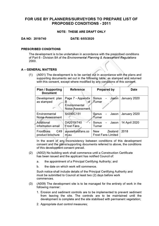

|
ATTACHMENT
|
Development Assessment Panel
27/05/2020
|
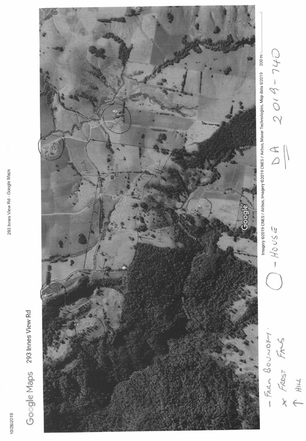
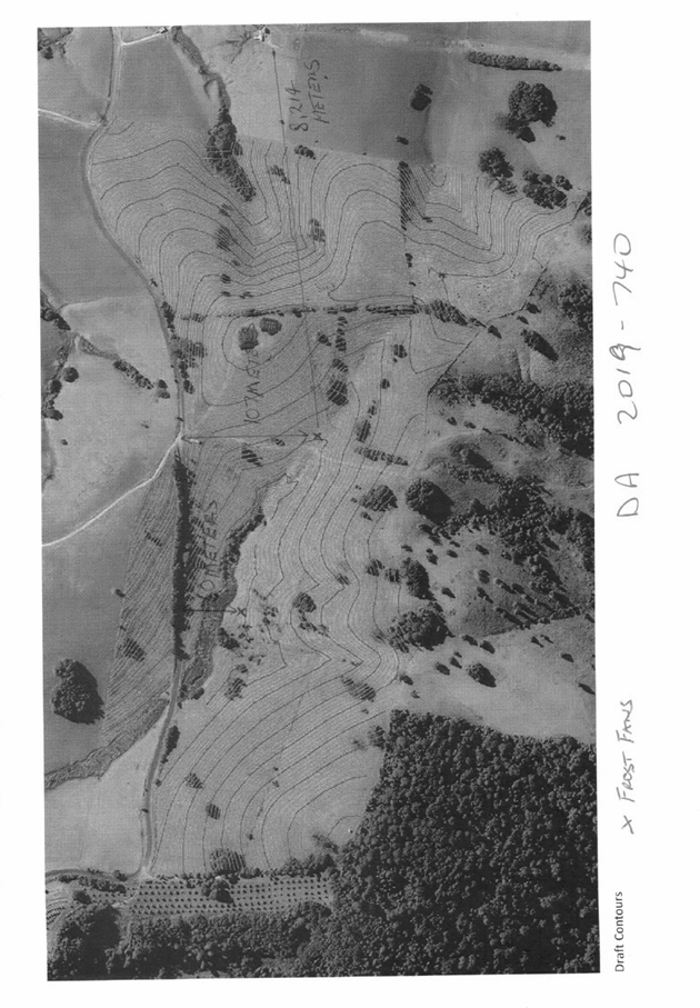
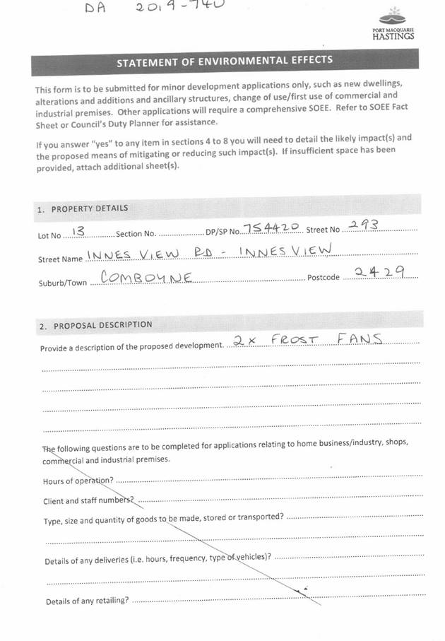
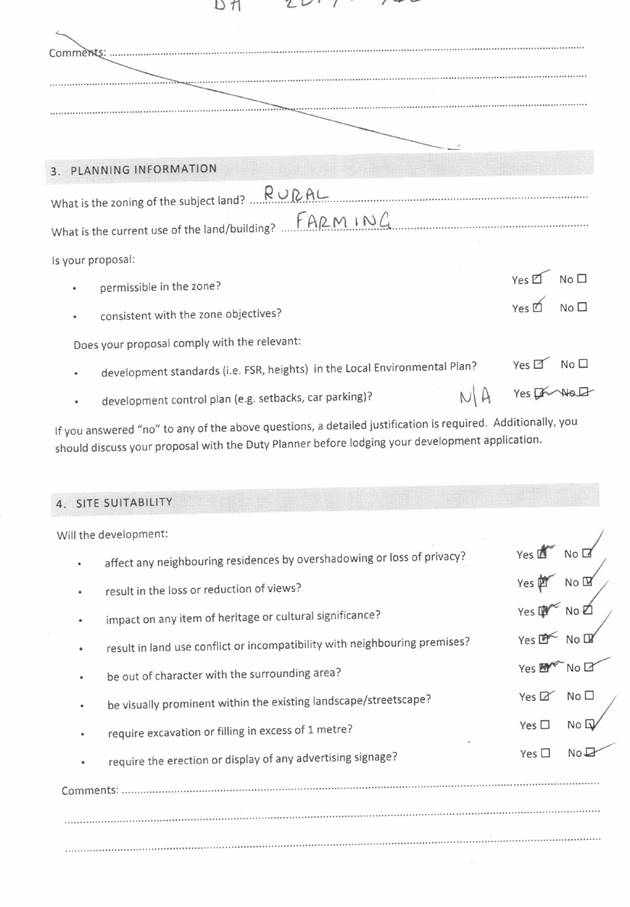
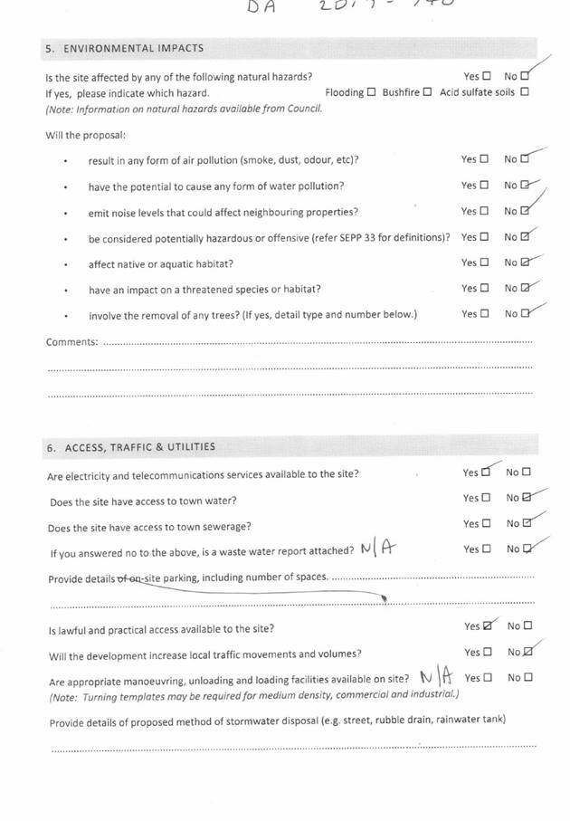
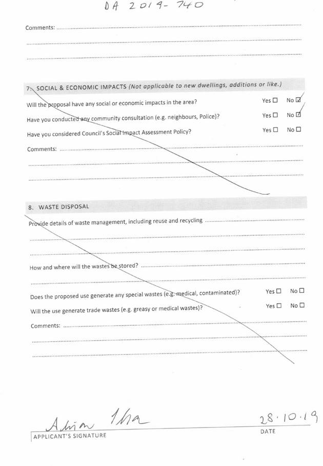
|
ATTACHMENT
|
Development Assessment Panel
27/05/2020
|
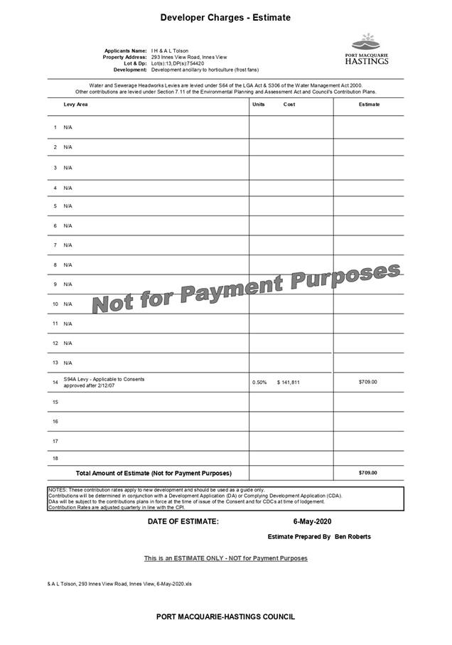
|
ATTACHMENT
|
Development Assessment Panel
27/05/2020
|
|
ATTACHMENT
|
Development Assessment Panel
27/05/2020
|
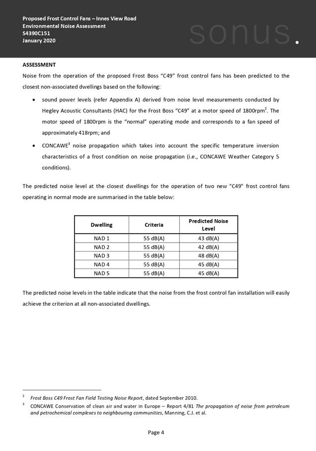
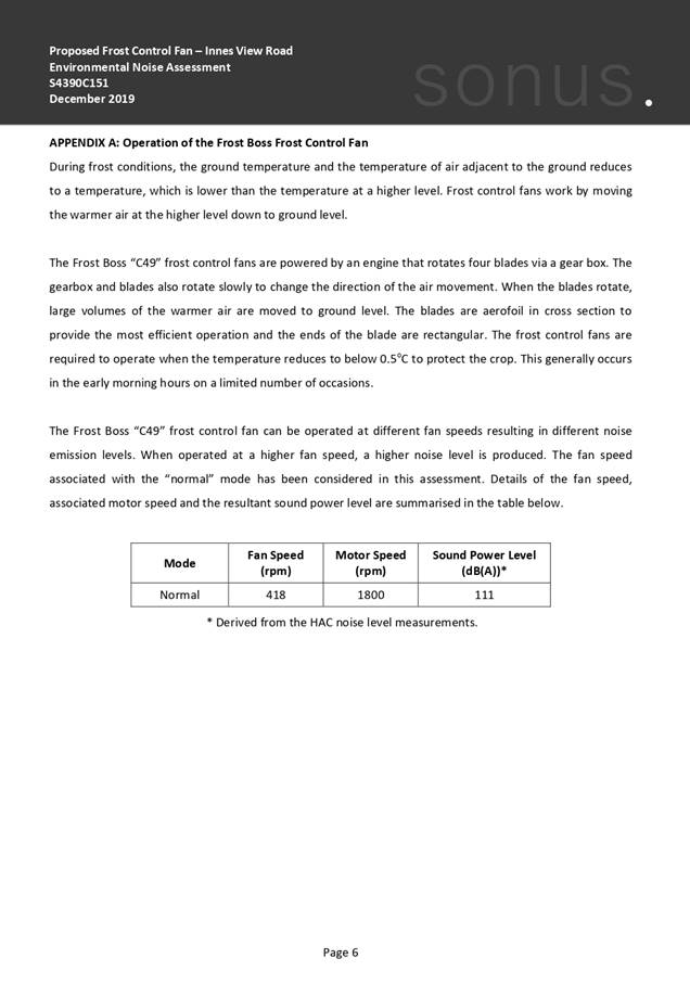
AGENDA Development Assessment Panel 27/05/2020
Item: 08
Subject: DA2019 - 568.1 Demolition of Multi Dwelling
Housing and Construction of Residential Flat Building Including Clause 4.6
Variation to Clause 4.3 (Height of Buildings) of the Port Macquarie-Hastings
Local Environmental Plan 2011 at Lot 101 DP 1122606, No 3 Clarence Street, Port
Macquarie
Report
Author: Development Assessment Planner, Chris Gardiner
|
Applicant: Wayne
Ellis Architect
Owner: Swadling
Developments Pty Ltd
Estimated Cost: $4,373,700
Alignment with Delivery
Program
4.3.1 Undertake transparent
and efficient development assessment in accordance with relevant legislation.
|
RECOMMENDATION
That
DA2019 - 568.1 for demolition of Multi
Dwelling Housing and construction of a Residential Flat Building
Including Clause 4.6 Variation to Clause 4.3 (Height of Buildings) of the Port
Macquarie-Hastings Local Environmental Plan 2011 at Lot 101 DP 1122606 No. 3 Clarence
Street, Port Macquarie, be determined by granting consent subject to the
recommended conditions.
Executive
Summary
This
report considers a development application for demolition of multi dwelling
housing and construction of a residential flat building at the subject site and provides an assessment of the
application in accordance with the Environmental Planning and Assessment Act
1979.
The proposal includes a Clause 4.6
variation to the height of buildings development standard in Clause 4.3 of the
Port Macquarie-Hastings Local Environmental Plan 2011. The maximum extent of
the variation is 0.9m (6.2%) and the Development Assessment Panel has
delegation to determine the application.
Following exhibition of the
application, one (1) submission was received.
The proposal has been amended
during the assessment including improvements to privacy screening on balconies
and internal reconfiguration of some apartments to address the Apartment Design
Guide
The site is considered suitable for the proposed development
and the proposal adequately addresses relevant planning controls. The
development is not considered to be contrary to the public's interest and will
not result a significant adverse social, environmental or economic impact.
This report recommends that the
development application be approved subject to the conditions in Attachment
1.
1. BACKGROUND
Existing
Sites Features and Surrounding Development
The site has an area of 751.25m2.
The
site is zoned R4 High Density Residential in
accordance with the Port Macquarie-Hastings Local Environmental Plan 2011, as
shown in the following zoning plan:
 The existing subdivision pattern and location of existing
development within the locality is shown in the following aerial photograph:
The existing subdivision pattern and location of existing
development within the locality is shown in the following aerial photograph:
Previous
Development Consent
Council
has previously granted consent to DA2016 - 661.1 on the subject site. The
approved development includes similar variations to the building height (15.81m
building height with 1.31m or 9% height variation) and DCP provisions as are
being sought in the current application. An image of the approved development
is included below:
A
condition has been recommended requiring DA2016 - 661.1 to be surrendered if
the current proposal is granted consent and proceeds to a Construction
Certificate.
2. DESCRIPTION
OF DEVELOPMENT
Key
aspects of the proposal include the following:
· Demolition
of existing buildings on the site comprising 3 x 1 bedroom units and 1 x 3
bedroom unit.
· Construction
of a residential flat building containing 7 x 3 bedroom apartments and 1 x 2
bedroom apartment.
The Applicant is seeking for
construction of the building to be carried out in 2 stages, as follows:
· Stage 1 - Demolition of existing buildings, piling, bulk
excavation, and construction of basement levels (including ground floor slab);
· Stage 2 - Completion of building above ground floor slab.
Refer
to Attachment 2 at the end of this report for plans of the proposed
development.
Application
Chronology
· 6
August 2019 - Application lodged.
· 19 August 2019 to 2 September 2019 - Neighbour
notification.
· 26 August 2019 - Additional information requested.
· 26 August 2019 - Comments received from Heritage Council of
NSW.
· 4 November 2019 - Further additional information requested.
· 10 November 2019 - Additional information submitted by
Applicant.
· 4 December 2019 - Additional information submitted by
Applicant.
· 5 February 2020 - Additional information submitted by
Applicant.
· 28 February 2020 - Additional information submitted by
Applicant.
3. STATUTORY
ASSESSMENT
Section
4.15(1) Matters for Consideration
In determining
the application, Council is required to take into consideration the following
matters as are relevant to the development that apply to the land to which the
development application relates:
(a) The
provisions (where applicable) of:
(i) any
Environmental Planning Instrument
State Environmental Planning Policy No. 55 –
Remediation of Land
Following an inspection of the site and a search of Council
records, the subject land is not identified as being potentially contaminated
and is suitable for the intended use.
State Environmental Planning Policy No. 65 – Design
Quality of Residential Apartment Development
This Policy
applies to development for the purpose of a residential flat building, shop top
housing or mixed use development with a residential accommodation component if:
(a) the
development consists of any of the following:
(i) the
erection of a new building,
(ii) the
substantial redevelopment or the substantial refurbishment of an existing
building,
(iii) the
conversion of an existing building, and
(b) the
building concerned is at least 3 or more storeys (not including levels below
ground level (existing) or levels that are less than 1.2 metres above ground
level (existing) that provide for car parking), and
(c) the
building concerned contains at least 4 or more dwellings.
Based on the above, the SEPP must be considered.
Clause 6A - This clause applies in respect of the
objectives, design criteria and design guidance set out in Parts 3 and 4 of the
Apartment Design Guide for the following:
(a) visual
privacy,
(b) solar
and daylight access,
(c) common
circulation and spaces,
(d) apartment
size and layout,
(e) ceiling
heights,
(f) private
open space and balconies,
(g) natural
ventilation,
(h) storage.
If a development control plan contains provisions that
specify requirements, standards or controls in relation to a matter to which
this clause applies, those provisions are of no effect.
This clause applies regardless of when the development
control plan was made.
Clause 28(2)(b) - The proposal has adequately addressed the
design principles contained in the Apartment Design Guide. The following table
provides an assessment against the design quality principles:
|
Requirement
|
Architect’s
Response
|
Comment
|
|
Principle 1: Context and neighbourhood character
Good design responds and
contributes to its context. Context is the key natural and built features of
an area, their relationship and the character they create when combined. It
also includes social, economic, health and environmental conditions.
Responding to context involves
identifying the desirable elements of an area’s existing or future
character. Well-designed buildings respond to and enhance the qualities and
identity of the area including the adjacent sites, streetscape and
neighbourhood.
Consideration of local context
is important for all sites, including sites in established areas, those
undergoing change or identified for change.
|
The
proposal is for a 5 – 6 storey residential flat building including part
basement car parking. The area is characterised by a mixture of low rise and
for tourist and permanent residential accommodation. A number of larger flat
buildings exist in the immediate area, with some including ground floor
commercial activities. Encouraging higher density in proximity to the CBD is
desirable for the area.
The
design responds to the site’s slope and steps down in height to the
north of the site. The design also provides for all apartments to benefit
from significant water views to the north.
The proposed building design
is compatible with existing development and the desired future character of
the area as stated in the relevant planning and design policies.
It is considered the building
will contribute positively to the quality and identity of the area.
|
The
Applicant’s comments are considered to adequately address the context
and neighbourhood character.
|
|
Principle 2: Built form and
scale
Good design achieves a scale,
bulk and height appropriate to the existing or desired future character of
the street and surrounding buildings.
Good design also achieves an
appropriate built form for a site and the building’s purpose in terms
of building alignments, proportions, building type, articulation and the
manipulation of building elements.
Appropriate built form defines
the public domain, contributes to the character of streetscapes and parks,
including their views and vistas, and provides internal amenity and outlook.
|
The
scale is determined by the height and bulk parameters.
The
proposal is compliant with the relevant height and floor space ratio
requirements for the subject site and locality and sits comfortably as an
infill development between 2 existing Residential Flat Buildings being
‘Headlands’ to the east (built in the 1970’s) and
‘Flightdeck’ to the west (completed in 2004).
The roof form is designed to
visually cap the verticality and relate the building back to the sloping site
that falls moderately to the north.
|
It is noted that the comment
regarding the building having a compliant height is technically not correct.
However, it is noted that the proposal for the majority of the building is
compliant. The proposal includes a variation to the height controls, which is
discussed under Clause 4.6 of the LEP.
The height and scale of the
building is considered to be appropriate having regard to the desired future
character of the area and existing buildings in the locality.
The building incorporates a
ground floor 3m front setback to Clarence Street, which is consistent with
the desired character for the area. Satisfactory articulation and variation
in building colours and materials are proposed.
The site is visible from
public space on the Hastings River foreshore and would provide a satisfactory
contribution to the existing vista from this location.
Impacts on
existing views from nearby properties are considered in detail later in this
report under ‘View Sharing’.
|
|
Principle 3: Density
Good design achieves a high
level of amenity for residents and each apartment, resulting in a density
appropriate to the site and its context.
Appropriate densities are
consistent with the area’s existing or projected population.
Appropriate densities can be sustained by existing or proposed
infrastructure, public transport, access to jobs, community facilities and
the environment.
|
The
design has adopted an appropriate density that is sustainable and consistent
with surrounding densities.
Having
regard to existing densities in the locality, the adjoining
‘Flightdeck’ apartments at 5 Clarence Street have a FSR of 1.8:1,
and the adjacent ‘Focus’ apartments at 2 Clarence Street have an
FSR of 2.3:1. The proposed development is considered to be consistent with these
densities.
The proposed density is also
considered to be sustainable having regard to availability of infrastructure,
and public transport, proximity to services and community facilities and the
environmental quality of the area.
|
The Applicant’s comments
are considered to adequately address density.
|
|
Principle 4: Sustainability
Good design combines positive
environmental, social and economic outcomes.
Good sustainable design
includes use of natural cross ventilation and sunlight for the amenity and liveability
of residents and passive thermal design for ventilation, heating and cooling
reducing reliance on technology and operation costs. Other elements include
recycling and reuse of materials and waste, use of sustainable materials and
deep soil zones for groundwater recharge and vegetation.
|
The
north – south orientation of the block has been utilised.
All
units contain north facing balconies and opportunities for natural
ventilation.
BASIX
certificates have been provided demonstrating that the design satisfies
acceptable energy and water efficiency measures.
Suitable
waste management arrangements, including, recycling and reuse facilities have
been integrated into the construction and occupation of the proposed
development.
Ground floor landscaping and a
deep soil zone are proposed.
|
The Applicant’s comments
are considered to adequately address sustainability.
|
|
Principle 5: Landscape
Good design recognises that
together landscape and buildings operate as an integrated and sustainable
system, resulting in attractive developments with good amenity. A positive
image and contextual fit of well-designed developments is achieved by
contributing to the landscape character of the streetscape and neighbourhood.
Good landscape design enhances
the development’s environmental performance by retaining positive
natural features which contribute to the local context, co-ordinating water
and soil management, solar access, micro-climate, tree canopy, habitat values
and preserving green networks.
Good landscape design
optimises useability, privacy and opportunities for social interaction,
equitable access, respect for neighbours’ amenity and provides for
practical establishment and long term management.
|
This
site provides for a 6-metre-wide deep soil zone (approx. 89.5m2) along
the northern boundary that will support landscaping as well as the communal
active recreation space.
Other
opportunities for landscaping on the site are maximised by the use of
planters and significant open space areas which will support various
landscape elements and treatments. This approach assists in softening of the
building together with acting as privacy screening.
The communal open space
provides for equitable access and social interaction.
|
A concept landscaping plan has
been submitted with the application, including landscaping of the rear deep
soil zone, ground floor area, planter boxes, roof top garden, and green
walls.
The communal open space
provides for equitable access and social interaction.
Further comments on the extent
of landscaping are provided later in this report in the Apartment Design
Guide and Development Control Plan sections.
|
|
Principle 6: Amenity
Good design positively
influences internal and external amenity for residents and neighbours.
Achieving good amenity contributes to positive living environments and
resident wellbeing.
Good amenity combines
appropriate room dimensions and shapes, access to sunlight, natural
ventilation, outlook, visual and acoustic privacy, storage, indoor and
outdoor space, efficient layouts and service areas and ease of access for all
age groups and degrees of mobility.
|
The
design incorporates generous unit layouts which optimise the northern
orientation. Adequate storage and outdoor space are proposed.
The
layout of the units has taken advantage of the northern orientation with an
emphasis on natural sunlight and ventilation via extensive north facing
glazing and balconies.
The
design and layout will provide a high level of resident amenity.
All
units are accessible from the ground floor via lifts.
Building
depth is satisfactory.
All units include a sufficient
amount of private open space. Communal space is available at ground level at
the rear of the site.
|
The
Applicant’s comments are considered to adequately address amenity.
|
|
Principle 7: Safety
Good design optimises safety
and security within the development and the public domain. It provides for
quality public and private spaces that are clearly defined and fit for the
intended purpose. Opportunities to maximise passive surveillance of public
and communal areas promote safety.
A positive relationship
between public and private spaces is achieved through clearly defined secure
access points and well lit and visible areas that are easily maintained and
appropriate to the location and purpose.
|
This
is achieved by maximising overlooking of communal space on the site whilst
internal privacy is maintained. Lighting will be strategically located to
avoid dark areas.
Access
to the site is controlled to a common entry point from Clarence Street and
electronic access control is proposed for the building.
The
interface between public and private/communal space is clearly defined at the
site frontage.
The proposal adequately
addresses the principles of Crime Prevention Through Environmental Design.
|
The
Applicant’s comments are considered to adequately address safety.
|
|
Principle 8: Housing
diversity and social interaction
Good design achieves a mix of
apartment sizes, providing housing choice for different demographics, living
needs and household budgets.
Well-designed apartment
developments respond to social context by providing housing and facilities to
suit the existing and future social mix.
Good design involves practical
and flexible features, including different types of communal spaces for a
broad range of people and providing opportunities for social interaction
among residents.
|
The
site and design provide for the maximization of ocean and river views in an
area of Port Macquarie that promotes a contemporary lifestyle that itself
provides for a high level of social interaction.
The
proposed development includes a mix of 2- and 3-bedroom apartments to suit a
variety of budgets and housing needs.
The
proposal adequately addresses social dimensions and housing affordability.
The proposal provides
opportunity for social interaction in the communal open space area.
|
The Applicant’s comments
are considered to adequately address housing diversity and social
interaction.
|
|
Principle 9: Aesthetics
Good design achieves a built
form that has good proportions and a balanced composition of elements,
reflecting the internal layout and structure. Good design uses a variety of
materials, colours and textures.
The visual appearance of a
well-designed apartment development responds to the existing or future local
context, particularly desirable elements and repetitions of the streetscape.
|
As
indicated on the Colour Materials/ Finishes Sample Sheet prepared by Wayne
Ellis Architects, (included in the development proposal plans), the proposed
development will be finished in contemporary tone colours.
The
variety of textures apparent on the elevations are designed with a horizontal
emphasis to limit any perceived verticality of the built form.
The aesthetics of the building
will respond appropriately to the surrounding environment and context of the
existing and desired character of the locality.
|
The plans provide examples of
the colours, textures and finishes.
It is considered that the
aesthetics of the building will respond appropriately to the surrounding
environment and context of the existing and desired future character of the
locality.
|
Clause 28(2)(c) - The proposal has
adequately addressed the Apartment Design Guide. The following table provides
an assessment against the Apartment Design Guide with assessment comments
considering the design criteria and design objectives where applicable:
|
Apartment Design Guide (ADG)
Objective
|
Design Guidance/Design
Criteria (Italics)
|
Proposed
|
Complies
|
|
3A Site analysis
|
|
3A - 1 Site analysis illustrates
that design decisions have been based on opportunities and constraints of the
site conditions and their relationship to the surrounding context.
|
Each element in the Site Analysis
Checklist should be addressed (Appendix 1 of ADG).
|
Satisfactory site analysis
submitted.
|
Yes
|
|
3B Orientation
|
|
3B - 1 Building types and layouts
respond to the streetscape and site while optimising solar access within the
development.
|
Buildings along the street
frontage define the street, by facing it and incorporating direct access from
the street (see figure 3B.1).
Where the street frontage is to
the east or west, rear buildings should be orientated to the north.
Where the street frontage is to
the north or south, overshadowing to the south should be minimised and
buildings behind the street frontage should be orientated to the east and
west (see figure 3B.2).
|
The proposed building faces the
street and incorporates direct access from the street.
The site has street frontage to
the south and overshadowing to the south is minimised by the width of
Clarence Street.
The narrow lot width makes the
rear part of the building difficult to orient east-west, but the building
design with two towers connected by terraces is consistent with the principle
of maximising northern solar orientation.
|
Yes
|
|
3B - 2 Overshadowing of
neighbouring properties is minimised during mid-winter.
|
Living areas, private open space
and communal open space should receive solar access in accordance with
sections 3D Communal and public open space and 4A Solar and daylight access.
Solar access to living rooms,
balconies and private open spaces of neighbours should be considered.
Where an adjoining property does
not currently receive the required hours of solar access, the proposed
building ensures solar access to neighbouring properties is not reduced by
more than 20%.
If the proposal will
significantly reduce the solar access of neighbours, building separation
should be increased beyond minimums contained in section 3F Visual privacy.
Overshadowing should be minimised
to the south or downhill by increased upper level setbacks.
It is optimal to orientate
buildings at 90 degrees to the boundary with neighbouring properties to
minimise overshadowing and privacy impacts, particularly where minimum
setbacks are used and where buildings are higher than the adjoining
development.
A minimum of 4 hours of solar
access should be retained to solar collectors on neighbouring buildings.
|
See comments under sections 3D
and 4A regarding solar access to living rooms and open space.
The submitted shadow diagrams
demonstrate that the proposal would retain solar access to private open space
and living areas of adjoining properties in accordance with the provisions of
4A of the ADG.
Overshadowing to the south is
contained within Clarence Street and would not affect adjacent properties.
The proposal would not affect
solar collectors on adjoining/adjacent buildings.
|
Yes
|
|
3C Public domain interface
|
|
3C - 1 Transition between private
and public domain is achieved without compromising safety and security
|
Terraces, balconies and courtyard
apartments should have direct street entry, where appropriate.
Changes in level between private
terraces, front gardens and dwelling entries above the street level provide
surveillance and improve visual privacy for ground level dwellings (see
figure 3C.1).
Upper level balconies and windows
should overlook the public domain.
Front fences and walls along
street frontages should use visually permeable materials and treatments. The
height of solid fences or walls should be limited to 1m.
Length of solid walls should be
limited along street frontages.
Opportunities should be provided
for casual interaction between residents and the public domain. Design
solutions may include seating at building entries, near letter boxes and in
private courtyards adjacent to streets.
In developments with multiple
buildings and/or entries, pedestrian entries and spaces associated with
individual buildings/entries should be differentiated to improve legibility
for residents, using a number of the following design solutions:
- architectural
detailing
- changes
in materials
- plant
species
- colours
Opportunities for people to be
concealed should be minimised
|
No direct ground level access to
individual units is proposed given the narrow lot width and the need to
provide vehicular and pedestrian access.
Upper level (bedroom) windows and
balconies on the southern elevation of the building overlook the public
domain.
The main balcony/terrace areas
and living area windows are oriented to the north (rear).
No fencing is proposed in the
street frontage.
The design provides opportunities
for seating in the entry passage.
The building has a single
pedestrian access.
Opportunities for concealment are
minimised.
|
Yes
|
|
3C - 2 Amenity of the public
domain is retained and enhanced.
|
Planting softens the edges of any
raised terraces to the street, for example above sub-basement car parking.
Mail boxes should be located in
lobbies, perpendicular to the street alignment or integrated into front
fences where individual street entries are provided.
The visual prominence of
underground car park vents should be minimised and located at a low level
where possible.
Substations, pump rooms, garbage
storage areas and other service requirements should be located in basement car
parks or out of view.
Ramping for accessibility should
be minimised by building entry location and setting ground floor levels in
relation to footpath levels.
Durable, graffiti resistant and
easily cleanable materials should be used.
Where development adjoins public
parks, open space or bushland, the design positively addresses this interface
and uses a number of the following design solutions:
- street
access, pedestrian paths and building entries which are clearly defined
- paths,
low fences and planting that clearly delineate between communal/private open
space and the adjoining public open space
- minimal
use of blank walls, fences and ground level parking.
On sloping sites protrusion of
car parking above ground level should be minimised by using split levels to
step underground car parking
|
Planting proposed forward of Unit
2 southern courtyard.
Mailboxes located in wall
adjacent to entry ramp.
Underground car park vents are
not located at the street frontage and would not be visually prominent.
Plant room and waste storage
proposed to be located in basement car park.
Hydrant booster is located in the
Clarence Street frontage in a screened enclosure.
The entry floor level would not
require access ramps in the site frontage.
The building materials are
durable.
The site slopes towards the rear
(north) and part of the underground parking protrudes above ground level at
the northern end. The building has been designed with a gym and BBQ area to
reduce the impact at the interface of the basement parking.
|
Yes
|
|
3D Communal and public open
space
|
|
3D - 1 An adequate area of
communal open space is provided to enhance residential amenity and to provide
opportunities for landscaping
|
Design Criteria
1. Communal open space has a
minimum area equal to 25% of the site (see figure 3D.3)
2. Developments achieve a
minimum of 50% direct sunlight to the principal usable part of the communal
open space for a minimum of 2 hours between 9 am and 3 pm on 21 June
(mid-winter).
Communal open space should be
consolidated into a well-designed, easily identified and usable area.
Communal open space should have a
minimum dimension of 3m, and larger developments should consider greater
dimensions.
Communal open space should be
co-located with deep soil areas.
Direct, equitable access should
be provided to communal open space areas from common circulation areas,
entries and lobbies.
Where communal open space cannot
be provided at ground level, it should be provided on a podium or roof.
Where developments are unable to
achieve the design criteria, such as on small lots, sites within business
zones, or in a dense urban area, they should:
- provide
communal spaces elsewhere such as a landscaped roof top terrace or a common room
- provide
larger balconies or increased private open space for apartments
- demonstrate
good proximity to public open space and facilities and/or provide
contributions to public open space
|
Communal open space proposed at
the rear of the site with an area of approximately 121m2 (16% of
site area).
At least 50% of useable part of
the communal open space could achieve 2 hours of solar access.
The communal open space has
equitable access from the basement car park, and is proposed to include a BBQ
area, gym, swimming pool and spa. The space has a minimum dimension of
approximately 8m.
All apartments within the
proposed development provide larger balconies and private open space areas
than the minimum requirements.
The site also has good proximity
to public open space and facilities, and the developer would be required to
make a Section 94 development contribution towards public open space.
|
No, but acceptable
|
|
3D - 2 Communal open space is
designed to allow for a range of activities, respond to site conditions and
be attractive and inviting
|
Facilities are provided within
communal open spaces and common spaces for a range of age groups (see also 4F
Common circulation and spaces), incorporating some of the following elements:
- seating
for individuals or groups
- barbecue
areas
- play
equipment or play areas
- swimming
pools, gyms, tennis courts or common rooms.
The location of facilities
responds to microclimate and site conditions with access to sun in winter,
shade in summer and shelter from strong winds and down drafts.
Visual impacts of services should
be minimised, including location of ventilation duct outlets from basement
car parks, electrical substations and detention tanks
|
Communal open space includes a
BBQ area, gym, swimming pool and spa.
The communal open space is well
located at ground level on the northern side of the site.
Ventilation outlets from the
basement car park can be screened with appropriate landscaping.
|
Yes
|
|
3D - 3 Communal open space is
designed to maximise safety
|
Communal open space and the
public domain should be readily visible from habitable rooms and private open
space areas while maintaining visual privacy. Design solutions may include:
- bay
windows
- corner
windows
- balconies.
Communal open space should be
well lit.
Where communal open
space/facilities are provided for children and young people they are safe and
contained.
|
Communal open space area visible
from north-facing balconies of the rear ‘tower’. The area would
be contained and only accessible from the basement car park.
The Statement of Environmental
Effects indicates that appropriate lighting is proposed to be provided.
|
Yes
|
|
3D - 4 Public open space, where
provided, is responsive to the existing pattern and uses of the neighbourhood
|
The public open space should be
well connected with public streets along at least one edge.
The public open space should be
connected with nearby parks and other landscape elements.
Public open space should be
linked through view lines, pedestrian desire paths, termination points and
the wider street grid.
Solar access should be provided
year round along with protection from strong winds.
Opportunities for a range of
recreational activities should be provided for people of all ages.
A positive address and active frontages
should be provided adjacent to public open space.
Boundaries should be clearly
defined between public open space and private areas
|
No public open space proposed.
|
n/a
|
|
3E Deep soil zones
|
|
3E - 1 Deep soil zones provide
areas on the site that allow for and support healthy plant and tree growth.
They improve residential amenity and promote management of water and air
quality
|
Design Criteria
1. Deep soil zones are to meet
the following minimum requirements:
a) <
650m², no min dimension, 7% site area deep soil zone.
b) 650-1500m²,
3m dimension, 7% site area deep soil zone.
c) >1500m²,
6m dimension, 7% site area deep soil zone.
On some sites it may be possible
to provide larger deep soil zones, depending on the site area and context:
- 10%
of the site as deep soil on sites with an area of 650m² - 1,500m²
- 15%
of the site as deep soil on sites greater than 1,500m².
Deep soil zones should be located
to retain existing significant trees and to allow for the development of
healthy root systems, providing anchorage and stability for mature trees.
Design solutions may include:
- basement
and sub-basement car park design that is consolidated beneath building
footprints
- use
of increased front and side setbacks
- adequate
clearance around trees to ensure long term health
- co-location
with other deep soil areas on adjacent sites to create larger contiguous
areas of deep soil.
Achieving the design criteria may
not be possible on some sites including where:
- the
location and building typology have limited or no space for deep soil at
ground level (e.g. central business district, constrained sites, high density
areas, or in centres)
- there
is 100% site coverage or non-residential uses at ground floor level.
Where a proposal does not achieve
deep soil requirements, acceptable stormwater management should be achieved
and alternative forms of planting provided such as on structure.
|
The site has an area of 750.8m2
and requires deep soil zone 7% of site area and with minimum dimension of 3m.
Proposal includes an area consistent with these requirements. There are no
existing significant trees that need to be retained in the deep soil zone.
|
Yes
|
|
3F Visual privacy
|
|
3F - 1 Adequate building
separation distances are shared equitably between neighbouring sites, to achieve
reasonable levels of external and internal visual privacy
|
Design Criteria
1. Separation between windows
and balconies is provided to ensure visual privacy is achieved. Minimum
required separation distances from buildings to the side and rear boundaries
are as follows:
a) Building
height up to 12m (4 storey) need 6m setback to habitable and 3m to
non-habitable.
b) Buildings
up to 25m (5-8 storeys) need 9m to habitable and 4.5m to non-habitable.
c) Buildings
over 25m (9+ storeys) need 12m to habitable and 6m to non-habitable.
Note: Separation distances
between buildings on the same site should combine required building
separations depending on the type of room (see figure 3F.2).
Gallery access circulation
should be treated as habitable space when measuring privacy separation
distances between neighbouring properties
Generally, one step in the built
form as the height increases due to building separations is desirable.
Additional steps should be careful not to cause a 'ziggurat' appearance.
For residential buildings next to
commercial buildings, separation distances should be measured as follows:
- for
retail, office spaces and commercial balconies use the habitable room
distances
- for
service and plant areas use the non-habitable room distances.
New development should be located
and oriented to maximise visual privacy between buildings on site and for
neighbouring buildings. Design solutions include:
- site
layout and building orientation to minimise privacy impacts (see also section
3B Orientation)
- on
sloping sites, apartments on different levels have appropriate visual
separation distances (see figure 3F.4).
Apartment buildings should have
an increased separation distance of 3m (in addition to the requirements set
out in design criteria 1) when adjacent to a different zone that permits
lower density residential development to provide for a transition in scale
and increased landscaping (figure 3F.5).
Direct lines of sight should be
avoided for windows and balconies across corners.
No separation is required between
blank walls
|
The proposal is technically in
the 5-8 storey category, but in general only contains 4 storeys above the
basement parking (with the exception of part of the building above the gym at
the northern end).
The proposal includes variations
to the minimum separation distances for balconies, habitable and
non-habitable room windows due to the narrow lot width. Compliant separation
distances would essentially sterilise the site.
As an alternative to separation
distances, the Applicant has proposed to provide privacy screening in all
locations with a reduced separation distance.
No unscreened habitable or
non-habitable room windows are located within the relevant separation
distances. It is noted that the Apartment Design Guide does not require any
separation for blank walls.
It is considered that reasonable
levels of external and internal visual privacy would be achieved in
accordance with the objectives of these controls.
|
No, but acceptable.
|
|
3F - 2 Site and building design elements
increase privacy without compromising access to light and air and balance
outlook and views from habitable rooms and private open space
|
Communal open space, common areas
and access paths should be separated from private open space and windows to apartments,
particularly habitable room windows. Design solutions may include:
- setbacks
- solid
or partially solid balustrades to balconies at lower levels
- fencing
and/or trees and vegetation to separate spaces
- screening
devices
- bay
windows or pop out windows to provide privacy in one direction and outlook in
another
- raising
apartments/private open space above the public domain or communal open space
- planter
boxes incorporated into walls and balustrades to increase visual separation
-
pergolas or shading devices to limit overlooking of lower apartments or
private open space
- on
constrained sites where it can be demonstrated that building layout
opportunities are limited, fixed louvers or screen panels to windows and/or
balconies.
Bedrooms, living spaces and other
habitable rooms should be separated from gallery access and other open
circulation space by the apartment’s service areas.
Balconies and private terraces
should be located in front of living rooms to increase internal privacy.
Windows should be offset from the
windows of adjacent buildings.
Recessed balconies and/or
vertical fins should be used between adjacent balconies
|
All private open space areas are
separated from communal areas.
The rear communal open space is
set well below the level of the balconies of the floors above.
Windows are offset from those of
adjoining development as far as practical.
No bedroom windows are located
adjacent to common circulation areas.
|
Yes
|
|
3G Pedestrian access and
entries
|
|
3G - 1 Building entries and
pedestrian access connects to and addresses the public domain
|
Multiple entries (including
communal building entries and individual ground floor entries) should be
provided to activate the street edge.
Entry locations relate to the
street and subdivision pattern and the existing pedestrian network.
Building entries should be
clearly identifiable and communal entries should be clearly distinguishable
from private entries.
Where street frontage is limited
and multiple buildings are located on the site, a primary street address
should be provided with clear sight lines and pathways to secondary building
entries.
|
Communal entry from the street
frontage. The communal entry is identifiable from the street.
No individual unit entries from
the street are proposed.
|
Yes
|
|
3G - 2 Access, entries and
pathways are accessible and easy to identify
|
Building access areas including
lift lobbies, stairwells and hallways should be clearly visible from the
public domain and communal spaces.
The design of ground floors and
underground car parks minimise level changes along pathways and entries.
Steps and ramps should be
integrated into the overall building and landscape design.
For large developments ‘way
finding’ maps should be provided to assist visitors and residents (see
figure 4T.3).
For large developments electronic
access and audio/video intercom should be provided to manage access
|
Building entry is visible from
the public domain. The lift lobby in the basement car park is visible from
communal areas in the basement. Lift lobbies on the upper floors are
essentially private space for access to individual units.
Ramps and steps have been
satisfactorily incorporated into the building design.
The Applicant has indicated that
the building will have electronic access control.
|
Yes
|
|
3G - 3 Large sites provide
pedestrian links for access to streets and connection to destinations
|
Pedestrian links through sites
facilitate direct connections to open space, main streets, centres and public
transport.
Pedestrian links should be direct,
have clear sight lines, be overlooked by habitable rooms or private open
spaces of dwellings, be well lit and contain active uses, where appropriate
|
The site is not a large site with
pedestrian links through the property.
|
n/a
|
|
3H Vehicle access
|
|
3H - 1 Vehicle access points are
designed and located to achieve safety, minimise conflicts between
pedestrians and vehicles and create high quality streetscapes
|
Car park access should be
integrated with the building’s overall facade. Design solutions may include:
- the
materials and colour palette to minimise visibility from the street
- security
doors or gates at entries that minimise voids in the facade
- where
doors are not provided, the visible interior reflects the facade design and
the building services, pipes and ducts are concealed.
Car park entries should be
located behind the building line.
Vehicle entries should be located
at the lowest point of the site minimising ramp lengths, excavation and
impacts on the building form and layout.
Car park entry and access should
be located on secondary streets or lanes where available.
Vehicle standing areas that
increase driveway width and encroach into setbacks should be avoided.
Access point locations should
avoid headlight glare to habitable rooms.
Adequate separation distances
should be provided between vehicle entries and street intersections.
The width and number of vehicle
access points should be limited to the minimum.
Visual impact of long driveways
should be minimised through changing alignments and screen planting.
The need for large vehicles to
enter or turn around within the site should be avoided.
Garbage collection, loading and
servicing areas are screened.
Clear sight lines should be
provided at pedestrian and vehicle crossings.
Traffic calming devices such as
changes in paving material or textures should be used where appropriate.
Pedestrian and vehicle access
should be separated and distinguishable. Design solutions may include:
- changes
in surface materials
- level
changes
- the
use of landscaping for separation
|
The car park entry is located
well behind the building facade.
The vehicle entry is located at
the lowest point of the site frontage.
The site does not have dual
frontage and access from a secondary street is not possible.
The access location would not
create unacceptable headlight glare for habitable rooms.
The driveway crossover is located
a satisfactory distance from street intersections and is the minimum width
possible to facilitate safe passing of vehicles at the site access.
Sight lines are available where
the vehicular access crosses pedestrian areas. Pedestrian and vehicular
accesses are separated.
|
Yes
|
|
3J Bicycle and car parking
|
|
3J - 1 Car parking is provided
based on proximity to public transport in metropolitan Sydney and centres in
regional areas
Notes
Port Macquarie is a nominated
regional centre.
In terms of using Guide to
Traffic Generating Developments, Port Macquarie is a “sub-regional
centre” as by definition it does not have access to rail.
Medium density is 2 - <20
dwellings.
High Density is 20 or more
dwellings
|
Design Criteria
1. For
development in the following locations:
a) on
sites that are within 800 metres of a railway station or light rail stop in
the Sydney Metropolitan Area; or
b) on
land zoned, and sites within 400 metres of land zoned, B3 Commercial Core, B4
Mixed Use or equivalent in a nominated regional centre
the minimum car parking
requirement for residents and visitors is set out in the Guide to Traffic
Generating Developments, or the car parking requirement prescribed by the
relevant council, whichever is less
The car parking needs for a
development must be provided off street.
Where a car share scheme operates
locally, provide car share parking spaces within the development. Car share
spaces, when provided, should be on site.
Where less car parking is
provided in a development, council should not provide on street resident
parking permits
Guide to Traffic Generating
Developments
Medium density residential flat
buildings require:
- 1
space per unit +
- 1
space for every 5 x 2 bedroom unit +
- 1
space for every 2 x 3 bedroom unit +
- 1
space for 5 units (visitor parking).
High density residential flat
buildings for metropolitan sub-regional centres require:
- 0.6
spaces per 1 bedroom unit
- 0.9
spaces per 2 bedroom unit
- 1.40
spaces per 3 bedroom unit +
- 1
space per 5 units (visitor parking)
|
The subject site is within 400m
of a B3 zone in a nominated regional centre and parking can be provided in
accordance with the Guide to Traffic Generating Developments, or the car
parking requirement prescribed by the relevant Council, whichever is less.
The Guide requires a minimum of 1
space for each unit, plus an additional 1 space per each 5 x 2 bedroom unit
or part thereof, plus an additional 1 space per each 2 x 3 or more bedroom
unit or part thereof.
An additional one space per each
five units for visitor parking or part thereof is also required.
The development includes 1 x 2
bed units, and 7 x 3 bed unit.
A total of 15 spaces (13 resident
spaces and 2 visitor spaces) would be required under the Guide.
Council’s DCP requires 1
space per 1 or 2 bedroom unit, plus 1.5 spaces per 3 or 4 bedroom unit, plus
1 visitor space per 4 units.
A total of 14 spaces (12 resident
spaces and 2 visitor spaces) is required under Council’s DCP and is
therefore the lesser of the two rates.
The development proposes 14 off street
parking spaces including 2 nominated visitor spaces and therefore satisfies
this requirement.
|
Yes
|
|
3J - 2 Parking and facilities are
provided for other modes of transport
|
Conveniently located and
sufficient numbers of parking spaces should be provided for motorbikes and
scooters.
Secure undercover bicycle parking
should be provided that is easily accessible from both the public domain and
common areas.
Conveniently located charging
stations are provided for electric vehicles, where desirable
|
There is not considered to be a
particular demand for motorbikes, scooters, or electric vehicles in the
locality.
The basement carpark includes
storage space for each resident that would be suitable for bicycles, as well
as a common bicycle parking area in the basement car park.
|
Yes
|
|
3J - 3 Car park design and access
is safe and secure
|
Supporting facilities within car
parks, including garbage, plant and switch rooms, storage areas and car wash
bays can be accessed without crossing car parking spaces.
Direct, clearly visible and well
lit access should be provided into common circulation areas.
A clearly defined and visible
lobby or waiting area should be provided to lifts and stairs.
For larger car parks, safe
pedestrian access should be clearly defined and circulation areas have good
lighting, colour, line marking and/or bollards
|
Access to plant room/bin storage
does not conflict with vehicles using the parking area.
Lift lobbies are visible from
within the basement car park and do not provide any opportunities for
concealment.
|
Yes
|
|
3J - 4 Visual and environmental
impacts of underground car parking are minimised
|
Excavation should be minimised
through efficient car park layouts and ramp design.
Car parking layout should be well
organised, using a logical, efficient structural grid and double loaded
aisles.
Protrusion of car parks should
not exceed 1m above ground level. Design solutions may include stepping car
park levels or using split levels on sloping sites.
Natural ventilation should be
provided to basement and sub-basement car parking areas.
Ventilation grills or screening
devices for car parking openings should be integrated into the facade and
landscape design
|
Excavation is proposed to be
minimised to the extent possible. The site has a steep slope and a split
level parking area that steps down with the slope.
The rear of the B3 car park
protrudes up to approximately 3m above existing ground level. Lowering the
level of the basement car park would cause the access ramp to exceed the
maximum permitted grade and also potentially impact on significant
archaeology. Appropriate building detailing and landscaping has been proposed
to reduce the impact of these parts of the building.
|
Yes
|
|
3J - 5 Visual and environmental
impacts of on-grade car parking are minimised
|
On-grade car parking should be
avoided.
Where on-grade car parking is
unavoidable, the following design solutions are used:
- parking
is located on the side or rear of the lot away from the primary street
frontage
- cars
are screened from view of streets, buildings, communal and private open space
areas
- safe
and direct access to building entry points is provided
- parking
is incorporated into the landscape design of the site, by extending planting
and materials into the car park space
- stormwater
run-off is managed appropriately from car parking surfaces •
bio-swales, rain gardens or on site detention tanks are provided, where
appropriate
- light
coloured paving materials or permeable paving systems are used and shade
trees are planted between every 4-5 parking spaces to reduce increased
surface temperatures from large areas of paving
|
No on grade parking proposed.
|
n/a
|
|
3J - 6 Visual and environmental
impacts of above ground enclosed car parking are minimised
|
Exposed parking should not be
located along primary street frontages
Screening, landscaping and other
design elements including public art should be used to integrate the above
ground car parking with the facade. Design solutions may include:
- car
parking that is concealed behind the facade, with windows integrated into the
overall facade design (approach should be limited to developments where a
larger floor plate podium is suitable at lower levels)
- car
parking that is ‘wrapped’ with other uses, such as retail,
commercial or two storey Small Office/Home Office (SOHO) units along the
street frontage (see figure 3J.9).
Positive street address and
active frontages should be provided at ground level
|
No on grade parking proposed.
|
n/a
|
|
4A Solar and daylight access
|
|
4A - 1 To optimise the number of
apartments receiving sunlight to habitable rooms, primary windows and private
open space
|
Design Criteria
1. Living rooms and private
open spaces of at least 70% of apartments in a building receive a minimum of
2 hours direct sunlight between 9 am and 3 pm at mid-winter in the Sydney
Metropolitan Area and in the Newcastle and Wollongong local government areas.
2. In all other areas, living
rooms and private open spaces of at least 70% of apartments in a building
receive a minimum of 3 hours direct sunlight between 9 am and 3 pm at
mid-winter.
3. A maximum of 15% of
apartments in a building receive no direct sunlight between 9 am and 3 pm at
mid-winter
The design maximises north aspect
and the number of single aspect south facing apartments is minimised.
Single aspect, single storey
apartments should have a northerly or easterly aspect.
Living areas are best located to
the north and service areas to the south and west of apartments.
To optimise the direct sunlight
to habitable rooms and balconies a number of the following design features
are used:
- dual
aspect apartments
- shallow
apartment layouts
- two
storey and mezzanine level apartments
- bay
windows
To maximise the benefit to
residents of direct sunlight within living rooms and private open spaces, a
minimum of 1m² of direct sunlight, measured at 1m above floor level, is
achieved for at least 15 minutes.
Achieving the design criteria may
not be possible on some sites. This includes:
- where
greater residential amenity can be achieved along a busy road or rail line by
orientating the living rooms away from the noise source
- on
south facing sloping sites
- where
significant views are oriented away from the desired aspect for direct
sunlight
Design drawings need to
demonstrate how site constraints and orientation preclude meeting the design
criteria and how the development meets the objective.
|
All apartments receive a minimum
of 3 hours direct sunlight between 9am and 3pm at mid-winter.
All apartments receive a minimum
of 1m² of direct sunlight, measured at 1m above floor level, for at
least 15 minutes.
The design maximises the number
of north facing apartments, with all apartments having at least one north
facing living room and balcony.
No single aspect south-facing
apartments are proposed.
All apartments have been designed
with minimal building depth and multiple aspects.
The site has a north facing slope
oriented towards the views and there is not considered to be any site
constraints that should prevent the development from being able to achieve
the minimum requirements for solar access.
|
Yes
|
|
4A - 2 Daylight access is
maximised where sunlight is limited
|
Courtyards, skylights and high
level windows (with sills of 1,500mm or greater) are used only as a secondary
light source in habitable rooms.
Where courtyards are used:
- use
is restricted to kitchens, bathrooms and service areas
- building
services are concealed with appropriate detailing and materials to visible
walls
- courtyards
are fully open to the sky
- access
is provided to the light well from a communal area for cleaning and
maintenance
- acoustic
privacy, fire safety and minimum privacy separation distances (see section 3F
Visual privacy) are achieved.
Opportunities for reflected light
into apartments are optimised through:
- reflective
exterior surfaces on buildings opposite south facing windows
- positioning
windows to face other buildings or surfaces (on neighbouring sites or within
the site) that will reflect light
- integrating
light shelves into the design
- light
coloured internal finishes
|
The proposal includes some
secondary lighting through courtyards and high level windows.
|
Yes
|
|
4A - 3 Design incorporates
shading and glare control, particularly for warmer months
|
A number of the following design
features are used:
- balconies
or sun shading that extend far enough to shade summer sun, but allow winter
sun to penetrate living areas
- shading
devices such as eaves, awnings, balconies, pergolas, external louvers and
planting
- horizontal
shading to north facing windows
- vertical
shading to east and particularly west facing windows
- operable
shading to allow adjustment and choice
- high
performance glass that minimises external glare off windows, with
consideration given to reduced tint glass or glass with a reflectance level
below 20% (reflective films are avoided)
|
Shading devices for northern
windows/glass doors proposed in the form of balconies and wide eaves.
Vertical screens are also proposed for east and west facing windows.
|
Yes
|
|
4B Natural ventilation
|
|
4B - 1 All habitable rooms are
naturally ventilated
|
The building's orientation
maximises capture and use of prevailing breezes for natural ventilation in
habitable rooms.
Depths of habitable rooms support
natural ventilation.
The area of unobstructed window
openings should be equal to at least 5% of the floor area served.
Light wells are not the primary
air source for habitable rooms.
Doors and openable windows
maximise natural ventilation opportunities by using the following design
solutions:
- adjustable
windows with large effective openable areas
- a
variety of window types that provide safety and flexibility such as awnings
and louvers
- windows
which the occupants can reconfigure to funnel breezes into the apartment such
as vertical louvers, casement windows and externally opening doors
|
The orientation of the building
and its openings would capture prevailing breezes, particularly cooling
summer sea breezes from the north-east.
The depth of habitable rooms
would support natural ventilation.
The minimum area of window
openings complies.
|
Yes
|
|
4B - 3 The number of apartments
with natural cross ventilation is maximised to create a comfortable indoor
environment for residents
|
Design Criteria
1. At least 60% of apartments
are naturally cross ventilated in the first nine storeys of the building.
Apartments at ten storeys or greater are deemed to be cross ventilated only
if any enclosure of the balconies at these levels allows adequate natural ventilation
and cannot be fully enclosed.
2. Overall depth of a
cross-over or cross-through apartment does not exceed 18m, measured glass
line to glass line.
The building should include dual
aspect apartments, cross through apartments and corner apartments and limit
apartment depths.
In cross-through apartments
external window and door opening sizes/areas on one side of an apartment
(inlet side) are approximately equal to the external window and door opening
sizes/areas on the other side of the apartment (outlet side) (see figure
4B.4).
Apartments are designed to
minimise the number of corners, doors and rooms that might obstruct airflow.
Apartment depths, combined with
appropriate ceiling heights, maximise cross ventilation and airflow
|
All apartments are naturally
cross ventilated.
The depth of apartments does not
exceed 18m from glass line to glass line.
All proposed apartments have
multiple aspects.
The proposal includes acceptable
internal configuration to minimise the number of corners, doors and rooms that
might obstruct airflow.
|
Yes
|
|
4C Ceiling heights
|
|
4C - 1 Ceiling height achieves
sufficient natural ventilation and daylight access
|
Design Criteria
1. Measured from finished
floor level to finished ceiling level, minimum ceiling heights are:
Minimum ceiling height for
apartment and mixed use buildings
Habitable rooms = 2.7m
Non-habitable = 2.4m
For 2 storey apartments
= 2.7m for main living area floor and 2.4m for second floor, where its
area does not exceed 50% of the apartment area
Attic spaces = 1.8m at edge of
room with a 30 degree minimum ceiling slope
If located in mixed use areas
= 3.3m for ground and first floor to promote future flexibility of use
These minimums do not preclude
higher ceilings if desired.
Ceiling height can accommodate use
of ceiling fans for cooling and heat distribution.
|
Ceiling heights for habitable and
non-habitable rooms proposed to be 2.7m.
The ceiling height would
accommodate the use of ceiling fans.
The site is not located in a
mixed use zone.
|
Yes
|
|
4C - 2 Ceiling height increases
the sense of space in apartments and provides for well-proportioned rooms
|
A number of the following design
solutions can be used:
- the
hierarchy of rooms in an apartment is defined using changes in ceiling
heights and alternatives such as raked or curved ceilings, or double height
spaces
- well-proportioned
rooms are provided, for example, smaller rooms feel larger and more spacious
with higher ceilings
- ceiling
heights are maximised in habitable rooms by ensuring that bulkheads do not
intrude. The stacking of service rooms from floor to floor and coordination
of bulkhead location above non-habitable areas, such as robes or storage, can
assist
|
Ceiling heights proposed to be
2.7m throughout the apartments, including non-habitable rooms.
|
Yes
|
|
4D Apartment size and layout
|
|
4D - 1 The layout of rooms within
an apartment is functional, well organised and provides a high standard of
amenity
|
Design Criteria
1. Apartments are required to
have the following minimum internal areas:
Studio = 35m²
1 bedroom = 50m²
2 bedroom = 70m²
3 bedroom = 90m²
The minimum internal areas
include only one bathroom. Additional bathrooms increase the minimum internal
area by 5m² each.
A fourth bedroom and further
additional bedrooms increase the minimum internal area by 12m² each.
2. Every habitable room must
have a window in an external wall with a total minimum glass area of not less
than 10% of the floor area of the room. Daylight and air may not be borrowed
from other rooms.
Kitchens should not be located as
part of the main circulation space in larger apartments (such as hallway or
entry space).
A window should be visible from
any point in a habitable room.
Where minimum areas or room
dimensions are not met apartments need to demonstrate that they are well
designed and demonstrate the usability and functionality of the space with
realistically scaled furniture layouts and circulation areas. These
circumstances would be assessed on their merits
|
All proposed apartments have
floor areas significantly larger than the minimum permitted. Apartment sizes
have been considered including the additional internal area required for a
second bathroom.
All habitable rooms have a
minimum glass area of 10% of the floor area of the room.
A window is visible from any
point in all habitable rooms in the development.
|
Yes
|
|
4D - 2 Environmental performance
of the apartment is maximised
|
Design Criteria
1. Habitable room depths are
limited to a maximum of 2.5 x the ceiling height.
2. In open plan layouts (where
the living, dining and kitchen are combined) the maximum habitable room depth
is 8m from a window.
Greater than minimum ceiling
heights can allow for proportional increases in room depth up to the
permitted maximum depths.
All living areas and bedrooms
should be located on the external face of the building.
Where possible:
- bathrooms
and laundries should have an external openable window.
- main
living spaces should be oriented toward the primary outlook and aspect and
away from noise sources
|
Habitable room depths of all
rooms in the development comply with the design criteria.
All living areas and bedrooms are
located on the external face of the building.
All bathroom/laundry windows are
openable.
Main living spaces are oriented
north towards the water views and away from noise in Clarence Street.
|
Yes
|
|
4D - 3 Apartment layouts are
designed to accommodate a variety of household activities and needs
|
Design Criteria
1. Master bedrooms have a
minimum area of 10m² and other bedrooms 9m² (excluding wardrobe
space).
2. Bedrooms have a minimum
dimension of 3m (excluding wardrobe space).
3. Living rooms or combined
living/dining rooms have a minimum width of:
• 3.6m for studio and 1
bedroom apartments
• 4m for 2 and 3 bedroom
apartments
4. The width of cross-over or
cross-through apartments are at least 4m internally to avoid deep narrow
apartment layouts.
Access to bedrooms, bathrooms and
laundries is separated from living areas minimising direct openings between
living and service areas.
All bedrooms allow a minimum length
of 1.5m for robes.
The main bedroom of an apartment
or a studio apartment should be provided with a wardrobe of a minimum 1.8m
long, 0.6m deep and 2.1m high.
Apartment layouts allow
flexibility over time, design solutions may include:
- dimensions
that facilitate a variety of furniture arrangements and removal
- spaces
for a range of activities and privacy levels between different spaces within
the apartment
- dual
master apartments
- dual
key apartments Note: dual key apartments which
are separate but on the same title are regarded as two sole occupancy units
for the purposes of the Building Code of Australia and for calculating the
mix of apartments
- room
sizes and proportions or open plans (rectangular spaces (2:3) are more easily
furnished than square spaces (1:1))
- efficient
planning of circulation by stairs, corridors and through rooms to maximise
the amount of usable floor space in rooms
|
Bed 3 in Unit 5 and Bed 2 in Unit
7 have a minimum dimension slightly less than 3m. However, these are the
third bedroom in 3 bedroom apartments and the plans demonstrate that the room
is capable of comfortably accommodating a single bed and appropriate amount
of wardrobe space. The minor variation is considered acceptable. All other
bedrooms satisfy the minimum dimensions.
Living room and combined
living/dining room widths comply with the minimum requirements for all
apartments.
Service areas are appropriately
separated from living areas.
Wardrobe dimensions comply with
the minimum requirements.
Unit 2 provides flexibility in
conversion to dual master bedrooms.
|
Yes and No, but acceptable
|
|
4E Private open space and
balconies
|
|
4E - 1 Apartments provide
appropriately sized private open space and balconies to enhance residential
amenity
|
Design Criteria
1. All apartments are required
to have primary balconies as follows:
a) Studio
apartments = 4m²
b) 1
bedroom apartments = 8m² and 2m min depth.
c) 2
bedroom apartments = 10m² and 2m min depth.
d) 3+
bedroom apartments = 12m² and 2.4m min depth.
The minimum balcony depth to
be counted as contributing to the balcony area is 1m.
2. For apartments at ground
level or on a podium or similar structure, a private open space is provided
instead of a balcony. It must have a minimum area of 15m² and a minimum
depth of 3m.
Increased communal open space
should be provided where the number or size of balconies are reduced.
Storage areas on balconies is
additional to the minimum balcony size.
Balcony use may be limited in
some proposals by:
- consistently
high wind speeds at 10 storeys and above
- close
proximity to road, rail or other noise sources
- exposure
to significant levels of aircraft noise
- heritage
and adaptive reuse of existing buildings
In these situations, juliet
balconies, operable walls, enclosed wintergardens or bay windows may be
appropriate, and other amenity benefits for occupants should also be provided
in the apartments or in the development or both. Natural ventilation also
needs to be demonstrated
|
Minimum balcony and private open
space areas and dimensions satisfied for all apartments.
|
Yes
|
|
4E - 2 Primary private open space
and balconies are appropriately located to enhance liveability for residents
|
Primary open space and balconies
should be located adjacent to the living room, dining room or kitchen to
extend the living space.
Private open spaces and balconies
predominantly face north, east or west.
Primary open space and balconies
should be orientated with the longer side facing outwards or be open to the
sky to optimise daylight access into adjacent rooms.
|
Primary open spaces areas are
located adjacent to living areas and face predominantly to the north and
east.
Smaller balconies off bedrooms
are proposed on the southern elevation of Unit 4, 6, & 8.
Balconies have been designed with
the longer side facing outwards, although the eastern side of the balconies
of Units 1, 3, 5, & 7 include vertical louvres for privacy reasons.
|
Yes
|
|
4E - 3 Private open space and
balcony design is integrated into and contributes to the overall
architectural form and detail of the building
|
Solid, partially solid or
transparent fences and balustrades are selected to respond to the location.
They are designed to allow views and passive surveillance of the street while
maintaining visual privacy and allowing for a range of uses on the balcony.
Solid and partially solid balustrades are preferred.
Full width full height glass
balustrades alone are generally not desirable.
Projecting balconies should be
integrated into the building design and the design of soffits considered.
Operable screens, shutters, hoods
and pergolas are used to control sunlight and wind.
Balustrades are set back from the
building or balcony edge where overlooking or safety is an issue.
Downpipes and balcony drainage
are integrated with the overall facade and building design.
Air-conditioning units should be
located on roofs, in basements, or fully integrated into the building design.
Where clothes drying, storage or
air conditioning units are located on balconies, they should be screened and
integrated in the building design.
Ceilings of apartments below
terraces should be insulated to avoid heat loss.
Water and gas outlets should be
provided for primary balconies and private open space
|
Full height glass balustrades are
limited to the northern end of the balconies of Units 1, 3, 5, & 7 where
significant water views are available. Other balconies generally include
solid balustrades and/or vertical louvre privacy screens.
Individual air conditioning
systems can be provided in screened location on service balconies. Central
systems can be accommodated within the basement plant room.
Clothes drying area on service
balcony off bathrooms will be screened.
Impacts on thermal comfort
associated with the proposed roof terraces has been considered in the BASIX
Certificate.
|
Yes
|
|
4E - 4 Private open space and
balcony design maximises safety.
|
Changes in ground levels or
landscaping are minimised.
Design and detailing of balconies
avoids opportunities for climbing and falls.
|
No climbing hazards identified.
Where landscaping is proposed, it is located on the outside of the
balustrade.
|
Yes
|
|
4F Common circulation and
spaces
|
|
4F - 1 Common circulation spaces
achieve good amenity and properly service the number of apartments
|
Design Criteria
1. The maximum number of
apartments off a circulation core on a single level is eight.
2. For buildings of 10 storeys
and over, the maximum number of apartments sharing a single lift is 40.
Greater than minimum requirements
for corridor widths and/ or ceiling heights allow comfortable movement and
access particularly in entry lobbies, outside lifts and at apartment entry
doors.
Daylight and natural ventilation
should be provided to all common circulation spaces that are above ground.
Windows should be provided in
common circulation spaces and should be adjacent to the stair or lift core or
at the ends of corridors.
Longer corridors greater than 12m
in length from the lift core should be articulated. Design solutions may
include:
- a
series of foyer areas with windows and spaces for seating
- wider
areas at apartment entry doors and varied ceiling heights
Design common circulation spaces
to maximise opportunities for dual aspect apartments, including multiple core
apartment buildings and cross over apartments.
Achieving the design criteria for
the number of apartments off a circulation core may not be possible. Where a
development is unable to achieve the design criteria, a high level of amenity
for common lobbies, corridors and apartments should be demonstrated,
including:
- sunlight
and natural cross ventilation in apartments
- access
to ample daylight and natural ventilation in common circulation spaces
- common
areas for seating and gathering
- generous
corridors with greater than minimum ceiling heights
- other
innovative design solutions that provide high levels of amenity
Where design criteria 1 is not
achieved, no more than 12 apartments should be provided off a circulation
core on a single level.
Primary living room or bedroom
windows should not open directly onto common circulation spaces, whether open
or enclosed. Visual and acoustic privacy from common circulation spaces to
any other rooms should be carefully controlled
|
Each apartment has access off a
single access core.
The entry corridor at ground
floor level is greater than 12m long to the rear lift. The corridor has been
widened to accommodate furniture, and includes articulation and landscaping.
No apartment windows open
directly onto a lift lobby.
|
Yes
|
|
4F - 2 Common circulation spaces
promote safety and provide for social interaction between residents
|
Direct and legible access should
be provided between vertical circulation points and apartment entries by
minimising corridor or gallery length to give short, straight, clear sight
lines.
Tight corners and spaces are
avoided.
Circulation spaces should be well
lit at night.
Legible signage should be
provided for apartment numbers, common areas and general wayfinding.
Incidental spaces, for example
space for seating in a corridor, at a stair landing, or near a window are
provided.
In larger developments, community
rooms for activities such as owners corporation meetings or resident use
should be provided and are ideally co-located with communal open space.
Where external galleries are
provided, they are more open than closed above the balustrade along their
length.
|
Lifts provide direct access to
the entrance of the individual apartments.
There are no narrow spaces or
tight corners in the circulation areas.
|
Yes
|
|
4G Storage
|
|
4G - 1 Adequate, well designed
storage is provided in each apartment
|
Design Criteria
1. In addition to storage in
kitchens, bathrooms and bedrooms, the following storage is provided:
a) Studio
apartments = 4m³.
b) 1
bedroom apartments = 6m³.
c) 2
bedroom apartments 8m³.
d) 3+
bedroom apartments = 10m³.
At least 50% of the required
storage is to be located within the apartment.
Storage is accessible from either
circulation or living areas.
Storage provided on balconies (in
addition to the minimum balcony size) is integrated into the balcony design,
weather proof and screened from view from the street.
Left over space such as under
stairs is used for storage
|
All apartments provide more than
the minimum storage requirements, with at least 50% located within the
apartment.
|
Yes
|
|
4G - 2 Additional storage is
conveniently located, accessible and nominated for individual apartments
|
Storage not located in apartments
is secure and clearly allocated to specific apartments.
Storage is provided for larger
and less frequently accessed items.
Storage space in internal or
basement car parks is provided at the rear or side of car spaces or in cages
so that allocated car parking remains accessible.
If communal storage rooms are
provided they should be accessible from common circulation areas of the
building.
Storage not located in an
apartment is integrated into the overall building design and is not visible
from the public domain.
|
Storage areas in basement carpark
are clear of parking spaces. The plans do not specifically allocate the
storage areas in the basement to individual apartments, but there is a
sufficient number to allow for this to occur and the allocation could be
confirmed in any future strata subdivision.
No storage areas are visible from
the public domain.
|
Yes
|
|
4H Acoustic privacy
|
|
4H - 1 Noise transfer is
minimised through the siting of buildings and building layout
|
Adequate building separation is
provided within the development and from neighbouring buildings/adjacent uses
(see also section 2F Building separation and section 3F Visual privacy).
Window and door openings are
generally orientated away from noise sources.
Noisy areas within buildings
including building entries and corridors should be located next to or above
each other and quieter areas next to or above quieter areas.
Storage, circulation areas and
non-habitable rooms should be located to buffer noise from external sources.
The number of party walls (walls
shared with other apartments) are limited and are appropriately insulated.
Noise sources such as garage
doors, driveways, service areas, plant rooms, building services, mechanical
equipment, active communal open spaces and circulation areas should be
located at least 3m away from bedrooms.
|
Acoustic privacy considered
acceptable. Access cores and circulation spaces are not located above or
below apartments.
Bedrooms in Units 3 to 8
inclusive are located adjoining a lift However, given the small number of
apartments in the building and the fact that each lift lobby provides access
to only a single apartment, it is not expected that there would be adverse
acoustic impacts on these bedrooms.
No party walls are shared between
apartments.
The northern balcony balustrade
of Unit 1 is partially solid and would improve visual and acoustic privacy
between the balcony and the communal space below.
|
No, but acceptable
|
|
4H - 2 Noise impacts are
mitigated within apartments through layout and acoustic treatments
|
Internal apartment layout
separates noisy spaces from quiet spaces, using a number of the following
design solutions:
- rooms
with similar noise requirements are grouped together
- doors
separate different use zones
- wardrobes
in bedrooms are co-located to act as sound buffers
Where physical separation
cannot be achieved noise conflicts are resolved using the following design
solutions:
- double
or acoustic glazing
- acoustic
seals • use of materials with low noise penetration properties
- continuous
walls to ground level courtyards where they do not conflict with streetscape
or other amenity requirements
|
Internal grouping of activities
and use of doors considered satisfactory.
|
Yes
|
|
4J Noise and pollution
|
|
4J - 1 In noisy or hostile
environments the impacts of external noise and pollution are minimised
through the careful siting and layout of buildings
|
To minimise impacts the following
design solutions may be used:
- physical
separation between buildings and the noise or pollution source
- residential
uses are located perpendicular to the noise source and where possible
buffered by other uses
- non-residential
buildings are sited to be parallel with the noise source to provide a
continuous building that shields residential uses and communal open spaces
- non-residential
uses are located at lower levels vertically separating the residential
component from the noise or pollution source. Setbacks to the underside of
residential floor levels should increase relative to traffic volumes and
other noise sources
- buildings
should respond to both solar access and noise. Where solar access is away
from the noise source, nonhabitable rooms can provide a buffer
- where
solar access is in the same direction as the noise source, dual aspect
apartments with shallow building depths are preferable (see figure 4J.4)
- landscape
design reduces the perception of noise and acts as a filter for air pollution
generated by traffic and industry.
Achieving the design criteria in
this Apartment Design Guide may not be possible in some situations due to
noise and pollution. Where developments are unable to achieve the design
criteria, alternatives may be considered in the following areas:
- solar
and daylight access
- private
open space and balconies
- natural
cross ventilation
|
No significant noise or pollution
sources adjacent to the site.
|
n/a
|
|
4J - 2 Appropriate noise
shielding or attenuation techniques for the building design, construction and
choice of materials are used to mitigate noise transmission
|
Design solutions to mitigate
noise include:
- limiting
the number and size of openings facing noise sources
- providing
seals to prevent noise transfer through gaps
- using
double or acoustic glazing, acoustic louvers or enclosed balconies
(wintergardens)
- using
materials with mass and/or sound insulation or absorption properties e.g.
solid balcony balustrades, external screens and soffits
|
No significant noise sources
adjacent to the site.
|
n/a
|
|
4K Apartment mix
|
|
4K - 1 A range of apartment types
and sizes is provided to cater for different household types now and into the
future
|
A variety of apartment types is
provided The apartment mix is appropriate, taking into consideration:
- the
distance to public transport, employment and education centres
- the
current market demands and projected future demographic trends
- the
demand for social and affordable housing
- different
cultural and socioeconomic groups
Flexible apartment configurations
are provided to support diverse household types and stages of life including
single person households, families, multi-generational families and group
households.
|
The proposal includes a mix of 2
and 3 bedroom apartments.
|
Yes
|
|
4K - 2 The apartment mix is
distributed to suitable locations within the building
|
Different apartment types are
located to achieve successful facade composition and to optimise solar access
(see figure 4K.3).
Larger apartment types are
located on the ground or roof level where there is potential for more open
space and on corners where more building frontage is available.
|
Distribution of apartment types
is considered acceptable. The larger 3 bedroom apartments have multiple
aspects and generous private open space areas.
|
Yes
|
|
4L Ground floor apartments
|
|
4L - 1 Street frontage activity
is maximised where ground floor apartments are located
|
Direct street access should be
provided to ground floor apartments.
Activity is achieved through
front gardens, terraces and the facade of the building. Design solutions may
include:
- both
street, foyer and other common internal circulation entrances to ground floor
apartments
- private
open space is next to the street
- doors
and windows face the street
Retail or home office spaces
should be located along street frontages.
Ground floor apartment layouts
support small office home office (SOHO) use to provide future opportunities
for conversion into commercial or retail areas. In these cases provide higher
floor to ceiling heights and ground floor amenities for easy conversion.
|
The proposal does not include any
apartments with direct street frontage due to the narrow lot frontage and
requirements for pedestrian and vehicular access. The exit from the basement
car park in front of Unit 2 has been designed to present to the street as an individual
apartment access.
|
No, but acceptable
|
|
4L - 2 Design of ground floor
apartments delivers amenity and safety for residents
|
Privacy and safety should be
provided without obstructing casual surveillance. Design solutions may
include:
- elevation
of private gardens and terraces above the street level by 1-1.5m (see figure
4L.4)
- landscaping
and private courtyards
- window
sill heights that minimise sight lines into apartments
- integrating
balustrades, safety bars or screens with the exterior design
Solar access should be maximised
through:
- high
ceilings and tall windows
- trees
and shrubs that allow solar access in winter and shade in summer
|
No ground level units proposed
fronting Clarence Street.
|
n/a
|
|
4M Facades
|
|
4M - 1 Building facades provide
visual interest along the street while respecting the character of the local
area
|
Design solutions for front
building facades may include:
- a
composition of varied building elements
- a
defined base, middle and top of buildings
- revealing
and concealing certain elements
- changes
in texture, material, detail and colour to modify the prominence of elements
Building services should be
integrated within the overall façade.
Building facades should be well
resolved with an appropriate scale and proportion to the streetscape and
human scale. Design solutions may include:
- well
composed horizontal and vertical elements
- variation
in floor heights to enhance the human scale
- elements
that are proportional and arranged in patterns
- public
artwork or treatments to exterior blank walls
- grouping
of floors or elements such as balconies and windows on taller buildings
Building facades relate to key
datum lines of adjacent buildings through upper level setbacks, parapets,
cornices, awnings or colonnade heights.
Shadow is created on the facade
throughout the day with building articulation, balconies and deeper window
reveals.
|
The building façade consists of horizontal and
vertical elements.
The
form and building materials will give the building some individuality whilst
it provides a building of similar function.
Horizontal louvres will contrast to development on
adjoining land but in a more delicate understated way. The form of the north
façade is less articulated, but still incorporates massing that
defines the base middle and top of the building. The vertical louvres are
primarily to provide control over privacy and determine view access.
Windows and openings are proposed to be generally full
height to maximise ventilation and sun access.
The front building facade includes varied building
materials and colours.
Shadows would be created on the
building facade by balconies and building articulation.
|
Yes
|
|
4M - 2 Building functions are
expressed by the facade
|
Building entries should be
clearly defined.
Important corners are given
visual prominence through a change in articulation, materials or colour, roof
expression or changes in height.
The apartment layout should be
expressed externally through facade features such as party walls and floor slabs
|
Building entry is clearly defined
and the apartment layout is able to be read by the façade features.
|
Yes
|
|
4N Roof design
|
|
4N - 1 Roof treatments are
integrated into the building design and positively respond to the street
|
Roof design relates to the
street. Design solutions may include:
- special
roof features and strong corners
- use
of skillion or very low pitch hipped roofs
- breaking
down the massing of the roof by using smaller elements to avoid bulk
- using
materials or a pitched form complementary to adjacent buildings
Roof treatments should be
integrated with the building design. Design solutions may include:
- roof
design proportionate to the overall building size, scale and form
- roof
materials compliment the building
- service
elements are integrated
|
Roof design is flat. The lift
overruns project slightly above the main roof line, but their location would
not make them prominent in the streetscape. Roof terraces and landscaping
would also serve to conceal the lift overruns.
|
Yes
|
|
4N - 3 Roof design incorporates
sustainability features
|
Roof design maximises solar
access to apartments during winter and provides shade during summer. Design
solutions may include:
- the
roof lifts to the north
- eaves
and overhangs shade walls and windows from summer sun.
Skylights and ventilation systems
should be integrated into the roof design
|
Satisfactory shading and weather
protection would be provided to balconies and living room windows.
|
Yes
|
|
4O Landscape design
|
|
4O - 1 Landscape design is viable
and sustainable
|
Landscape design should be
environmentally sustainable and can enhance environmental performance by
incorporating:
- diverse
and appropriate planting
- bio-filtration
gardens
- appropriately
planted shading trees
- areas
for residents to plant vegetables and herbs
- composting
- green
roofs or walls
Ongoing maintenance plans should
be prepared.
Microclimate is enhanced by:
- appropriately
scaled trees near the eastern and western elevations for shade
- a
balance of evergreen and deciduous trees to provide shading in summer and
sunlight access in winter
- shade
structures such as pergolas for balconies and courtyards
Tree and shrub selection
considers size at maturity and the potential for roots to compete (see Table
4)
Table 4 requires
- For
site area up to 850m² = 1 medium tree per 50m² of deep soil zone
- Between
850 - 1,500m² = 1 large tree or 2 medium trees per 90m² of deep
soil zone
- Greater
than 1,500m² = 1 large tree or 2 medium trees per 80m² of
deep soil zone
|
A landscape plan has been
submitted with the application and includes green walls and landscaping on
the roof top and terrace areas. The species selection is considered suitable
for the context and the landscape plan includes appropriate consideration of
future maintenance.
|
Yes
|
|
4O - 2 Landscape design
contributes to the streetscape and amenity
|
Landscape design responds to the
existing site conditions including:
- changes
of levels
- views
- significant
landscape features including trees and rock outcrops
Significant landscape features
should be protected by:
- tree
protection zones (see figure 4O.5)
- appropriate
signage and fencing during construction
Plants selected should be endemic
to the region and reflect the local ecology
|
The proposal does not include
retention of existing trees that require consideration of construction
impacts.
Given that significant views
exist across the top of the building; it is recommended that the landscaping
in the proposed roof garden be maintained to a maximum height of 0.5m above
the roof level. A condition has been recommended in this regard.
|
Yes
|
|
4P Planting on structures
|
|
4P - 1 Appropriate soil profiles
are provided
|
Structures are reinforced for
additional saturated soil weight.
Soil volume is appropriate for
plant growth; considerations include:
- modifying
depths and widths according to the planting mix and irrigation frequency
- free
draining and long soil life span
- tree
anchorage
Minimum soil standards for plant
sizes should be provided in accordance with Table 5.
Table 5 requires
- Large
trees 12-18m high, up to 16m crown spread at maturity = need 150m³ of
soil at a depth of 1,200mm and area of 10m x 10m or equivalent.
- Medium
trees 8-12m high, up to 8m crown spread at maturity = need 35m³ of soil
at a depth of 1,000mm and area of 6m x 6m or equivalent.
-
Small trees 6-8m high, up to 4m crown spread at maturity = need
9m³ of soil at a depth of 800mm and area of 3.5m x 3.5m or
equivalent.
- Shrubs
need soil depth of 500-600mm
- Ground
cover needs soil depth of 300-450mm
- Turf
needs soil depth of 200mm
|
The structure will be required to
be engineered to accommodate the proposed terrace and roof top landscaping.
Appropriate soil volumes for
different planting types are capable of being provided.
|
Yes
|
|
4P - 2 Plant growth is optimised
with appropriate selection and maintenance
|
Plants are suited to site
conditions; considerations include:
- drought
and wind tolerance
- seasonal
changes in solar access
- modified
substrate depths for a diverse range of plants
- plant
longevity
A landscape maintenance plan is
prepared.
Irrigation and drainage systems
respond to:
- changing
site conditions
- soil
profile and the planting regime
- whether
rainwater, stormwater or recycled grey water is used
|
The submitted landscape plan has
appropriately considered species selection and irrigation.
|
Yes
|
|
4P - 3 Planting on structures
contributes to the quality and amenity of communal and public open spaces
|
Building design incorporates
opportunities for planting on structures. Design solutions may include:
- green
walls with specialised lighting for indoor green walls
- wall
design that incorporates planting
- green
roofs, particularly where roofs are visible from the public domain
- planter
boxes
Note: structures designed to
accommodate green walls should be integrated into the building facade and
consider the ability of the facade to change over time
|
Landscape plan includes green
walls, green roof, and planter boxes.
|
Yes
|
|
4Q Universal design
|
|
4Q - 1 Universal design features
are included in apartment design to promote flexible housing for all
community members
|
Developments achieve a benchmark
of 20% of the total apartments incorporating the Liveable Housing Guideline's
silver level universal design features
|
The submitted proposal
demonstrates equitable access to the parking areas and all apartments in the
development. A condition is recommended requiring the Construction
Certificate documentation to demonstrate that 20% of the apartments will
incorporate the Liveable Housing Guideline's silver level universal design
features.
|
Acceptable subject to condition
|
|
4Q - 2 A variety of apartments
with adaptable designs are provided
|
Adaptable housing should be
provided in accordance with the relevant council policy Design solutions for
adaptable apartments include:
- convenient
access to communal and public areas
- high
level of solar access
- minimal
structural change and residential amenity loss when adapted
- larger
car parking spaces for accessibility
- parking
titled separately from apartments or shared car parking arrangements
|
Council’s DCP requires
barrier free access to at least 20% of apartments. The proposal complies with
this requirement.
Council’s DCP does not
include any provisions regarding a minimum proportion of adaptable housing.
|
Yes
|
|
4Q - 3 Apartment layouts are
flexible and accommodate a range of lifestyle needs
|
Apartment design incorporates
flexible design solutions which may include:
- rooms
with multiple functions
- dual
master bedroom apartments with separate bathrooms
- larger
apartments with various living space options
- open
plan ‘loft’ style apartments with only a fixed kitchen, laundry
and bathroom
|
Proposal includes larger
apartments with various living space options.
Unit 2 includes dual master
bedrooms with separate bathroom options.
|
Yes
|
|
4R Adaptive reuse
|
|
4R - 1 New additions to existing
buildings are contemporary and complementary and enhance an area's identity
and sense of place
|
Design solutions may include:
- new
elements to align with the existing building
- additions
that complement the existing character, siting, scale, proportion, pattern,
form and detailing
- use
of contemporary and complementary materials, finishes, textures and colours
Additions to heritage items
should be clearly identifiable from the original building.
New additions allow for the
interpretation and future evolution of the building.
|
Proposal is for a new building.
|
n/a
|
|
4R - 2 Adapted buildings provide
residential amenity while not precluding future adaptive reuse
|
Design features should be
incorporated sensitively into adapted buildings to make up for any physical
limitations, to ensure residential amenity is achieved. Design solutions may
include:
- generously
sized voids in deeper buildings
- alternative
apartment types when orientation is poor
- using
additions to expand the existing building envelope
Some proposals that adapt
existing buildings may not be able to achieve all of the design criteria in
this Apartment Design Guide. Where developments are unable to achieve the
design criteria, alternatives could be considered in the following areas:
- where
there are existing higher ceilings, depths of habitable rooms could increase
subject to demonstrating access to natural ventilation, cross ventilation
(when applicable) and solar and daylight access (see also sections 4A Solar
and daylight access and 4B Natural ventilation)
- alternatives
to providing deep soil where less than the minimum requirement is currently
available on the site
- building
and visual separation – subject to demonstrating alternative design
approaches to achieving privacy
- common
circulation
- car
parking
- alternative
approaches to private open space and balconies
|
Proposal is for a new building.
|
n/a
|
|
4U Energy efficiency
|
|
4U - 1 Development incorporates
passive environmental design
|
Adequate natural light is
provided to habitable rooms (see 4A Solar and daylight access).
Well located, screened outdoor
areas should be provided for clothes drying
|
Adequate natural light is
provided to habitable rooms. See comments under 4A.
All apartments have screened
balconies and/or courtyards that are suitable for clothes drying.
|
Yes
|
|
4U - 2 Development incorporates
passive solar design to optimise heat storage in winter and reduce heat
transfer in summer
|
A number of the following design
solutions are used:
- the
use of smart glass or other technologies on north and west elevations
- thermal
mass in the floors and walls of north facing rooms is maximised
- polished
concrete floors, tiles or timber rather than carpet
- insulated
roofs, walls and floors and seals on window and door openings
- overhangs
and shading devices such as awnings, blinds and screens
Provision of consolidated heating
and cooling infrastructure should be located in a centralised location (e.g.
the basement)
|
Proposal meets BASIX requirements
for thermal performance.
|
Yes
|
|
4U - 3 Adequate natural
ventilation minimises the need for mechanical ventilation
|
A number of the following design
solutions are used:
- rooms
with similar usage are grouped together
- natural
cross ventilation for apartments is optimised
- natural
ventilation is provided to all habitable rooms and as many non-habitable
rooms, common areas and circulation spaces as possible
|
Satisfactory grouping of like
uses and natural cross ventilation.
|
Yes
|
|
4V Water management and
conservation
|
|
4V - 1 Potable water use is
minimised
|
Water efficient fittings,
appliances and wastewater reuse should be incorporated.
Apartments should be individually
metered.
Rainwater should be collected,
stored and reused on site.
Drought tolerant, low water use
plants should be used within landscaped areas
|
The development includes a BASIX
Certificate with adequate water efficiency commitments.
Apartments will be required to be
individually metered.
|
Yes
|
|
4W Waste management
|
|
4W - 1 Waste storage facilities
are designed to minimise impacts on the streetscape, building entry and
amenity of residents
|
Adequately sized storage areas
for rubbish bins should be located discreetly away from the front of the
development or in the basement car park.
Waste and recycling storage areas
should be well ventilated.
Circulation design allows bins to
be easily manoeuvred between storage and collection points.
Temporary storage should be
provided for large bulk items such as mattresses.
A waste management plan should be
prepared
|
Bin storage room located in the
basement car park with adequate ventilation and circulation areas. The
capacity of the bin storage room is sufficient based on a weekly private
waste collection service.
The Applicant has consulted with
a waste contractor and has been advised that a private waste collection
service could be provided for the development.
|
Yes
|
|
4W - 2 Domestic waste is
minimised by providing safe and convenient source separation and recycling
|
All dwellings should have a waste
and recycling cupboard or temporary storage area of sufficient size to hold
two days worth of waste and recycling.
Communal waste and recycling rooms
are in convenient and accessible locations related to each vertical core.
For mixed use developments,
residential waste and recycling storage areas and access should be separate
and secure from other uses.
Alternative waste disposal
methods such as composting should be provided
|
Temporary waste storage for
individual apartments capable of being accommodated. Waste recycling provided
for in bin storage area in basement car park. Location of bin storage area
near front lift would be conveniently accessible to residents.
|
Yes
|
|
4X Building maintenance
|
|
4X - 1 Building design detail
provides protection from weathering
|
A number of the following design
solutions are used:
- roof
overhangs to protect walls
- hoods
over windows and doors to protect openings
- detailing
horizontal edges with drip lines to avoid staining of surfaces
- methods
to eliminate or reduce planter box leaching
- appropriate
design and material selection for hostile locations
|
Building design includes roof
overhangs and apartments have been designed to provide balcony access for
ongoing maintenance of windows and part of the external walls of the
building.
The building materials noted in
the schedule on the plans are considered to be durable and suitable for the
conditions.
|
Yes
|
|
4X - 2 Systems and access enable
ease of maintenance
|
Window design enables cleaning
from the inside of the building.
Building maintenance systems
should be incorporated and integrated into the design of the building form,
roof and façade.
Design solutions do not require
external scaffolding for maintenance access.
Manually operated systems such as
blinds, sunshades and curtains are used in preference to mechanical systems.
Centralised maintenance, services
and storage should be provided for communal open space areas within the
building.
|
Building design allows for
cleaning of windows from balconies and within the building.
Services are located in central
locations that can be accessed from within the building.
No mechanically operated blinds
or sunshades are proposed.
|
Yes
|
|
4X - 3 Material selection reduces
ongoing maintenance costs
|
A number of the following design
solutions are used:
- sensors
to control artificial lighting in common circulation and spaces
- natural
materials that weather well and improve with time such as face brickwork
- easily
cleaned surfaces that are graffiti resistant
- robust
and durable materials and finishes are used in locations which receive heavy
wear and tear, such as common circulation areas and lift interiors
|
Materials noted on the plans are
robust and durable and are expected not to require significant maintenance to
the exterior of the building in the future.
|
Yes
|
Clause 30(1) - Consent cannot be
refused on the following grounds if the development satisfies the relevant
design criteria:
(a) if
the car parking for the building will be equal to, or greater than, the
recommended minimum amount of car parking specified in Part 3J of the Apartment
Design Guide,
(b) if
the internal area for each apartment will be equal to, or greater than, the
recommended minimum internal area for the relevant apartment type specified in
Part 4D of the Apartment Design Guide,
(c) if
the ceiling heights for the building will be equal to, or greater than, the
recommended minimum ceiling heights specified in Part 4C of the Apartment
Design Guide.
Clause 30(2) - Development consent must not be granted if,
in the opinion of the consent authority, the development or modification does
not demonstrate that adequate regard has been given to:
(a) the
design quality principles, and
(b) the
objectives specified in the Apartment Design Guide for the relevant design
criteria.
As noted in the above assessment
table, it is considered that satisfactory regard has been given to the design
quality principles and the objectives specified in the Apartment Design Guide.
In accordance with Clause 143A of the Environmental Planning
and Assessment Regulation 2000, a certifying authority must not
issue a Construction Certificate for the development unless the certifying
authority has received the statement by the qualified designer verifying that
the plans and specifications achieve or improve the design quality of the
development for which development consent was granted, having regard to the
design quality principles.
In accordance with Clause 154A of the Environmental Planning
and Assessment Regulation 2000, a certifying authority must not
issue an occupation certificate to authorise a person to commence occupation or
use of the development unless the certifying authority has received the
statement by the qualified designer verifying that the development achieves the
design quality of the development as shown in the plans and specifications in
respect of which the construction certificate was issued, having regard to the
design quality principles.
Conditions have been recommended requiring the
design verification statements noted above.
State Environmental Planning Policy (Coastal Management)
2018
The site is located within a coastal use area and coastal
environment area.
In accordance with clause 7, this SEPP prevails over the
Port Macquarie-Hastings LEP 2011 in the event of any inconsistency.
Having regard to clauses 13 and 14 of the SEPP the proposed
development is not considered likely to result in any of the following:
a) any
adverse impact on integrity and resilience of the biophysical,
hydrological (surface and groundwater) and ecological environment;
b) any
adverse impacts coastal environmental values and natural coastal
processes;
c) any
adverse impact on marine vegetation, native vegetation and fauna
and their habitats, undeveloped headlands and rock platforms;
d) any
adverse impact on Aboriginal cultural heritage, practices and
places;
e) any
adverse impacts on the cultural and built environment heritage;
f) any
adverse impacts the use of the surf zone;
g) any adverse impact on the visual amenity and scenic qualities of the
coast, including coastal headlands;
h) overshadowing, wind funnelling and the loss of views from public places
to foreshores; and
i) any
adverse impacts on existing public open space and safe access to
and along the foreshore, beach, headland or rock platform for members of the
public, including persons with a disability.
In accordance with Clause 15 the proposal is not likely to
cause increased risk of coastal hazards on the land or other land.
The bulk, scale and size of the proposed development is
compatible with the surrounding coastal and built environment. The site is
predominately cleared and located within an area zoned for high density
residential purposes.
State Environmental Planning Policy (Building
Sustainability Index: BASIX) 2004
A BASIX certificate has been submitted demonstrating that
the proposal will comply with the requirements of the SEPP. It is recommended
that a condition be imposed to ensure that the commitments are incorporated
into the development and certified at Occupation Certificate stage.
Port Macquarie-Hastings Local Environmental
Plan 2011
The proposal is consistent with the LEP having regard to the
following:
· Clause
2.2 - The subject site is zoned R4 High Density Residential.
· Clause
2.3(1) and the R4 zone landuse table - The proposed development for a
residential flat building is a permissible landuse with consent.
The objectives of the R4 zone are as
follows:
o To provide for the housing
needs of the community within a high density residential environment.
o To provide a variety of
housing types within a high density residential environment.
o To enable other land uses that
provide facilities or services to meet the day to day needs of residents.
o To provide for tourist and
visitor accommodation in key tourist precincts of urban areas of the Council
area, while also encouraging increased population levels.
o To encourage development that
has regard to the desired future character of streets and supports active and
safe uses at pedestrian level.
· Clause
2.3(2) - The proposal is consistent with the zone objectives having regard to
the following:
o The proposal is a permissible
landuse;
o The development would provide
high density residential apartments to meet the housing needs of the community;
o The proposal has satisfactory
regard to the desired character of the street and supports safe use at the
pedestrian level.
-
· Clause
2.7 - The demolition requires consent as it does not fit within the provisions
of SEPP (Exempt and Complying Development Codes) 2008.
-
· Clause
4.3 - This clause establishes the maximum “height of a building”
(or building height) that a building may be built to on any parcel of land. The
term “building height (or height of building)” is defined in the
LEP to mean “the vertical distance between ground level (existing) and
the highest point of the building, including plant and lift overruns, but
excluding communication devices, antennae, satellite dishes, masts, flagpoles,
chimneys, flues and the like”. The term “ground level
(existing)” is also defined in the LEP to mean “the existing
level of a site at any point”.
-
-
In this instance, the maximum overall height of the building above
ground level (existing) is 15.40m at its highest, which exceeds the height
limit of 14.5m applying to the site by 0.9m (6.2%). The part of the building
exceeding the height limit is represented in the below extracts from the plans:
-
-

-
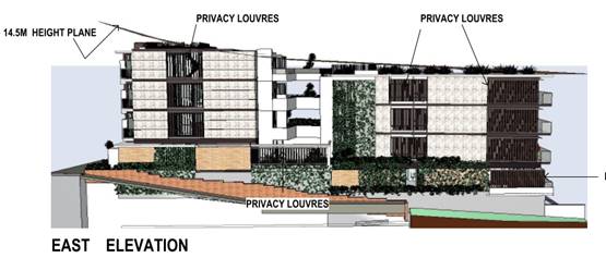
-
-
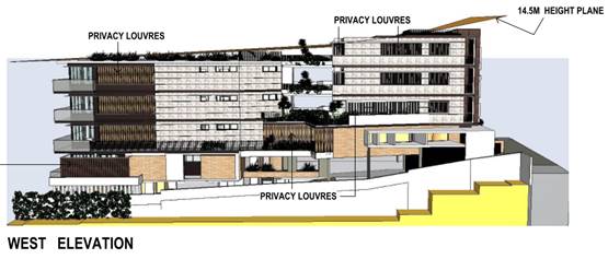
-
-
The Applicant has requested an exception to the height of building
development standard in accordance with Clause 4.6 of the LEP, which is
discussed below.
-
· Clause
4.4 - The floor space ratio of the proposal is 1.34:1 which complies with the
maximum 1.5:1 floor space ratio applying to the site.
-
· Clause
4.6 – This clause establishes a degree of flexibility for certain
development standards in certain circumstances which have demonstrated that a
better planning outcome will occur from that flexibility. In this regard, the
proposal seeks a variation to the building height standard as identified under
clause 4.3 of this report. Assistance on the approach to variation to this
standard is also taken from NSW Land and Environment Court and NSW Court of
Appeal decisions in:
-
o Wehbe v Pittwater Council
(2007) NSW LEC 827 (Wehbe);
o Four2Five Pty Ltd v
Ashfield Council (2015) NSWLEC 1009; and
o Al Maha Pty Ltd v Huajun
Investments Pty Ltd (2018) NSWCA 245
-
-
Having regard to specific requirements of clause 4.6(3) and 4.6(4) the
following assessment comments are provided:
-
-
(3) Development consent must not be
granted for development that contravenes a development standard unless the
consent authority has considered a written request from the applicant that
seeks to justify the contravention of the development standard by demonstrating:
-
(a) that compliance with the
development standard is unreasonable or unnecessary in the circumstances of the
case, and
-
(b) that there are sufficient
environmental planning grounds to justify contravening the development
standard.
-
-
The Applicant has submitted a request in writing (Attachment
4) to justify the contravention of the building height standard for the
following reasons (as summarised):
-
· Compliance with the development standard is unnecessary as the proposal
has been demonstrated to be consistent with the objectives of the height of
buildings standard.
· Compliance with the development standard is unreasonable as the actions
of Council have virtually abandoned the standard. Substantial height variations
have been approved for nearby developments at No 2, 4, and 5 Clarence Street,
and also the previous consent for the subject site.
· The height variation would not adversely affect internal amenity within
the development.
· The height variation would not adversely affect privacy or amenity of
adjoining properties.
· The height variation would not result in increased overshadowing of
adjoining properties compared with a compliant proposal.
· The height variation does not result in any increase in the number of
apartments able to be accommodated on the site.
· The height variation would not result in any additional loss of views
across the site compared with a compliant proposal.
· Pedestrian access and amenity will not be adversely impacted by the
proposed height variation.
· The part of the building at the site frontage in Clarence Street is
substantially lower than the height limit and the building would not appear
higher in the streetscape. The height exceedance occurs generally at the rear
of the front tower where the site slopes down, and this part of the building
will not be highly visible in the streetscape.
· The development is considered to be a good contextual fit for an infill
development and is consistent with the streetscape and bulk and scale outcomes
envisaged for the area.
-
-
(4) Development consent must not be
granted for development that contravenes a development standard unless:
-
(a) the consent authority is
satisfied that:
- (i) the applicant’s written request has adequately
addressed the matters required to be demonstrated by subclause (3), and
-
-
The Applicant’s written request is considered to
have adequately addressed the matter required to be demonstrated in subclause
(3) for the following reasons.
-
-
In Wehbe ‘five methods’ have
been developed to test whether a compliance with the standard is unreasonable
or unnecessary. Having regard to the ‘five methods’, the following
comments are provided:
-
· The objectives of the height standard are achieved notwithstanding the
non-compliance with the numerical 14.5m height standard, as discussed in more
detail below. Compliance with the development standard is therefore considered
unnecessary.
· It is not considered that the development standard has been virtually
abandoned or destroyed by the Council’s own actions in granting a consent
to other proposals departing from the standard, as claimed by the Applicant.
While it is acknowledged that consent has been granted for other buildings in
the precinct that exceeded the height controls at the date of determination,
the developments at No 2 & 5 Clarence Street pre-date the current height
controls that have been adopted for the precinct. More recent consents relating
to the subject site and No 4 Clarence Street, have been appropriately tested on
merit in accordance with the provisions of Clause 4.6 and found to be
acceptable. It is not considered that these decisions have abandoned or
destroyed the integrity of the development standard. The decisions do, however,
provide some context for how the development will fit into the locality.
-
-
The first method is sufficient to establish that
compliance with the development standard is unnecessary in the circumstances of
the case.
-
-
The environmental planning grounds submitted by the
Applicant are considered reasonable and adequately justify contravening the
development standard.
-
-
On the basis of the above, it is considered that
the Applicant’s clause 4.6 variation has adequately addressed the matters
required to be demonstrated by clause 4.6(3).
-
-
(ii) the proposed development will be
in the public interest because it is consistent with the objectives of the
particular standard and the objectives for development within the zone in which
the development is proposed to be carried out, and
-
The objectives of the R4 zone are
as follows:
o To provide for the housing
needs of the community within a high density residential environment.
o To provide a variety of
housing types within a high density residential environment.
o To enable other land uses that
provide facilities or services to meet the day to day needs of residents.
o To provide for tourist and
visitor accommodation in key tourist precincts of urban areas of the Council
area, while also encouraging increased population levels.
o To encourage development that
has regard to the desired future character of streets and supports active and
safe uses at pedestrian level.
The proposal is considered to be
consistent with the zone objectives having regard to the following:
o The development would provide
high density residential apartments to meet the housing needs of the community;
and
o The proposal has regard to the
desired character of the street and supports safe use at the pedestrian level.
-
-
Consideration of the proposal’s consistency with the objectives of
height of buildings standard in Clause 4.3 of the LEP is provided as follows:
-
-
To ensure that buildings are compatible with the
height, bulk and scale of the existing and desired future character of the
locality,
-
-
The proposed building height varies from 13.2m at the site frontage to
15.40m at its highest point at the top of the balustrade for the Unit 8 roof
terrace.
-
-
The locality is characterised by a number of other residential flat
buildings ranging in height from three to six storeys above ground level. To
the west of Munster Street, a number of other residential flat buildings higher
than six storeys also exist. The subject site currently contains single storey
units.
-
-
Directly adjoining the site, the Headlands building has a height 1.34m
lower than the proposed development, and the Flightdeck building has a height
3.07m lower than the proposed development.
-
-
The floor space ratio for the proposal is below the maximum of 1.5:1
permitted for the area.
-
-
The proposed height, bulk and scale of the development are considered
compatible with the character of the locality in this regard.
-
-
To minimise visual impact, disruption of views,
loss of privacy and loss of solar access to existing development,
-
-
The visual presentation and design of the building have been considered
having regard to the Apartment Design Guide. It is also noted that the part of
the building exceeding the 14.5 height limit is located behind the building
frontage to Clarence Street and would not be visually dominant, particularly at
street level.
-
-
View impacts and solar access are considered in detail later in this
report under ‘View Sharing’ and ‘Overshadowing’.
-
-
Potential privacy impacts are considered under the relevant Apartment
Design Guide and DCP provisions elsewhere in this report and have been
satisfactorily addressed in the building design. It is noted that the part of
the building above the height standard is roof, lift overruns, and the
balustrade of the roof top terrace of Unit 8. Of these items only the roof top
terrace has the potential to result in any privacy impacts. As the level of the
terrace is above the roof of the two adjoining apartment buildings and the
balustrade is set in from the edge of the building, it is considered that the
privacy impacts are acceptable.
-
-
To minimise the adverse impact of development on
heritage conservation areas and heritage items,
-
-
The site does not contain any known heritage items or sites of
significance.
-
-
To nominate heights that will provide a
transition in built form and land use intensity within the area covered by this
Plan.
-
-
The adopted 14.5m height provides a transition to the lower 8.5m height
standard for adjoining property to the north of the site. The height variation
is at the southern (Clarence Street) end of the building, and the compliant
northern end of the building would still provide for an appropriate transition
in built form.
-
-
The development is consistent with the zoning and height objectives of
the LEP 2011 and is unlikely to have any implications on State related issues
or the broader public interest.
-
-
(b) the concurrence of the Secretary
has been obtained.
-
-
In accordance with Planning Circular PS 18-003, Council can assume the
Director’s Concurrence for variations to the height of buildings
development standard. As the variation is less than 10%, the application can be
determined by a delegate of Council. The decision must be reported to Council
for their information, a public register of variations maintained, and details
of the proposal included in quarterly reporting to the Department of Planning,
Industry and Environment.
-
-
Having regard to the above requirements it is recommended that the
height variation using Clause 4.6 be supported.
-
· Clause
5.10 – The site is listed in Schedule 5, Part 3 of the LEP as
archaeological item A111 - Archaeology of early European settlement.
-
-
The site is identified as part of a former lumber yard, prisoner’s
barracks and asylum belonging to the penal settlement of Port Macquarie between
1821 and 1831.
-
-
The Applicant has submitted a Historical and Archaeological Assessment
prepared by Edward Higginbotham & Associates Pty Ltd dated March 2013. A
further Report on Test-Excavation for Proposed Development prepared by Edward
Higginbotham & Associates Pty Ltd dated 31 May 2016 has also been provided.
-
-
The test excavations revealed the presence of a brick barrel drain and
headwall in the Clarence Street frontage of the site. The barrel drain is
believed by the author to have been constructed c.1830 using convict labour.
-
-
The report includes the following recommendations aimed at conserving
the significant archaeological material on the site:
-
-
1. The brick barrel drain and headwall should be conserved in situ,
within the proposed development.
-
2. The brick barrel drain and headwall should be placed on display in
the proposed basement area of the car park and should be accessible for
inspection by the general public at least on selected dates.
-
3. The proposed development should be allowed to proceed on the
evidence that there are few significant remains of the Convict Barracks and
Lumber Yard located on this site. (The test-trenches may not be representative
of the archaeological remains on the rest of the site).
-
4. An excavation permit should be obtained for the purpose of an
archaeological monitoring programme.
-
5. The bulk excavation of fill layers for the proposed development
should be supervised by the archaeologist, so that any archaeological remains
can be investigated, recorded, planned and photographed. Some manual
archaeological excavation may be required, around the brick barrel drain and if
any remains are located.
-
-
In accordance with Clause 5.10(7) the proposal was referred to the
Heritage Council of NSW for review. The Heritage Council provided comments on
the proposal in a letter dated 26 August 2019. The retention of the brick
barrel drain is supported by the Heritage Council and archaeological monitoring
of the works is considered to be an appropriate precautionary approach to the
management of potential additional archaeological relics on the site.
-
-
The Heritage Council have recommended that the following conditions be
included in any consent:
-
-
1. Prior to commencement of works an exception permit
under Section 139(1C) will be obtained from the Heritage Council. This will
include a work method statement detailing how the brick barrel drain and bulk
fill removal for the site will be subject to on-site monitoring by a suitably
qualified archaeologist.
-
-
Reason: While there is minimal potential for archaeological relics as
demonstrated by the archaeological test excavation, archaeological monitoring
will ensure that unexpected archaeological relics are managed appropriately.
-
-
2. At the completion of bulk excavation works and
during all other construction works on the site, appropriate barriers or
coverings will be put in place around the brick barrel drain to ensure it is
protected during development and interpretation works.
-
-
Reason: Protection of the brick barrel drain during construction
works will ensure it is able to be preserved and clearly interpreted.
-
3. Final
design details for on-site interpretation, including information on any display
and housing for the brick barrel drain, is to be submitted to Port
Macquarie-Hastings Council for approval and is to be completed and implemented
within the redevelopment prior to the release of the occupation certificate for
the site.
-
-
Reason: As the brick barrel drain is to be preserved and interpreted
within the development, details should be provided to Council for approval.
-
-
4. Information must be provided to Port Macquarie-Hastings
Council confirming that the requirements of any endorsed S139(4) of other
permit from the Heritage Council of NSW have been satisfied prior to the
release of the occupation certificate for the site.
-
-
Reason: To ensure statutory compliance.
-
-
Conditions are recommended to ensure that the development is carried out
in accordance with the above requirements.
-
· Clause
7.13 - Satisfactory arrangements are in place for provision of essential
services including water supply, electricity supply, sewer infrastructure,
stormwater drainage and suitable road access to service the development.
(ii) Any draft
instruments that apply to the site or are on exhibition
No draft instruments apply to
the site.
(iii) Any Development
Control Plan in force
Port
Macquarie-Hastings Development Control Plan 2013
Clause 6A of SEPP 65 applies in
respect of the objectives, design criteria and design guidance set out in Parts
3 and 4 of the Apartment Design Guide for the following:
(a) visual privacy,
(b) solar and
daylight access,
(c) common
circulation and spaces,
(d) apartment size
and layout,
(e) ceiling heights,
(f) private open
space and balconies,
(g) natural
ventilation,
(h) storage.
If a development control plan
contains provisions that specify requirements, standards or controls in
relation to a matter to which this clause applies, those provisions are of no
effect.
This clause applies regardless
of when the development control plan was made.
Accordingly, the below
assessment table excludes consideration of any matters relating to the above
items.
|
DCP 2013: Residential
Flat Development, Tourist and Visitor Accommodation and Mixed Use Development
|
|
DCP Objective
|
Development Provisions
|
Proposed
|
Complies
|
|
3.3.2.4
|
Streetscape and front setback:
· Within
20% of the average setback of the adjoining buildings.
· 3m
setback to all frontages if no adjoining development.
· 2m
setback to secondary frontages.
· Max.
9m setback for tourist development to allow for swimming pool.
|
3m front setback.
The average setback of the two
adjoining buildings is 13.3m.
However, site specific front
setback controls have been adopted for this site is Chapter 4.3 of the DCP.
|
See 4.3.2.4 of DCP
|
|
3.3.2.5
|
Balconies and building
extrusions can encroach up to 600mm into setback.
|
Marble tile extrusions on
front façade project up to 300mm into front setback.
|
Yes
|
|
Buildings generally aligned to
street boundary.
|
Yes
|
Yes
|
|
Primary openings aligned to
street boundary or rear of site.
|
Yes
|
Yes
|
|
3.3.2.6
|
Side setbacks comply with
Figure 3.3-1:
· Min.
Side setback 1.5m for 75% of building depth.
· Windows
on side walls min. 3m from side boundary.
· 3m
minimum where adjacent to existing strata titled building.
|
Zero side setback for part of
the basement car park, eastern wall of Unit 2, balconies of Unit 1, entry
passage, and landscaped terraces.
1.5m setback to side
boundaries for less than 75% of the length of the building (with the
exception of the reduced setbacks noted above).
All windows on side walls are
setback a minimum of 3m from side boundaries.
Adjoining the site to both the
east and west are strata titled buildings.
|
No*
|
|
Side walls adjacent to
existing strata-titled buildings should be articulated and modulated to
respond to the existing buildings.
|
The building has been designed
to ensure that openings are offset from those in the adjacent strata-titled
buildings.
|
Yes
|
|
Min. 6m rear setback
(including sub basements)
|
6.3m rear setback to wall of
building. Upper floor balconies project to 5.2m from rear boundary.
|
No*
|
|
3.3.2.7
|
A party wall development may
be required if site amalgamation is not possible and higher density
development is envisaged by these controls.
|
Part of the basement car park
and the eastern wall of Unit 1 is proposed to be constructed on the boundary.
Site amalgamation is not possible in this instance due to existing strata
title buildings on adjoining land and higher density development is envisaged
by these controls.
|
Yes
|
|
3.3.2.8
|
Party wall development can
occur only with the agreement and consent of the adjoining property owner.
Exposed party walls should be finished in a quality comparable to front
facade finishes.
|
Condition recommended
requiring exposed party walls to be finished in a quality comparable to front
facade finishes.
|
Yes
|
|
3.3.2.11
|
Deep soil zones:
· Extend
the width of the site and have minimum depth of 6m.
· Are
contiguous across sites and within sites (see Fig 3.3-4).
|
Minimum 6m wide deep soil zone
for the full width of the site and extends to join with the deep soil zone at
the rear of 1 Clarence Street.
Additional 3m wide deep soil
zone across site frontage.
|
Yes
|
|
3.3.2.12
|
Deep soil zones accommodate
existing advanced trees, and allow for advanced tree planting.
|
No existing advanced trees.
Deep soil zones would allow for advanced tree planting.
|
Yes
|
|
3.3.2.13
|
Deep soil zones integrated
with stormwater management measures.
|
Details to be provided at
Construction Certificate stage.
|
Yes
|
|
3.3.2.15
|
Internal clothes drying space
provided (not mechanical).
|
Clothes drying area provided
on terraces with appropriate screening.
|
Yes
|
|
Ceiling fans provided in
preference to air conditioning.
|
Air conditioning identified on
BASIX Certificate. Proposal satisfies BASIX energy efficiency requirements
and is considered acceptable.
|
No, but acceptable
|
|
Solar hot water systems (or
equivalent technology) provided.
|
Heat pump hot water systems
identified on BASIX Certificate. Proposal satisfies BASIX energy efficiency
requirements and is considered acceptable.
|
No, but acceptable
|
|
Photovoltaic arrays installed
where practical.
|
Photovoltaic array (minimum
6.0kW) identified on BASIX Certificate.
|
Yes
|
|
3.3.2.16
|
Landscape plan provided
including:
· 35% soft
landscaping with minimum width of 3m.
· Existing
vegetation and proposed treatment.
· Details of hard landscaping.
· Location of
communal recreational facilities.
· Species not to
obscure doors, paths, etc.
· Street trees in
accordance with Council’s list.
|
Greater than 35% soft
landscaping proposed, but only 22% soft landscaping with minimum width of 3m.
Additional soft landscaping is
proposed in the form of green walls, roof garden and planter boxes on
terraces.
Overall landscaping provision
considered acceptable in the context of a narrow site in a high density
residential zone.
|
No, but acceptable
|
|
3.3.2.18
|
Landscape plan to demonstrate
how trees and vegetation contribute to energy efficiency and prevent winter
shading on neighbouring properties.
|
Proposed landscaping will not
result in winter shading of neighbouring properties.
|
Yes
|
|
3.3.2.23
|
Solid fences should be:
· Max. 1.2m high,
· Setback 1m,
· Suitably
landscaped,
· Provide 3m x 3m
splay.
|
Solid front fencing not
proposed.
|
n/a
|
|
Where front fences higher than
1.2m:
· Max. 1.8m high,
· Landscaped
recesses for 50% of frontage, or length of fence not more than 6m or 50% of
street frontage.
· Min. 25%
transparent,
· 3m x 3m splay
for corner sites.
· 900mm x 900mm
splay at vehicle driveways.
|
No front fence proposed.
|
Yes
|
|
3.3.2.24
|
Fencing materials consistent
with or complimentary to existing fencing in the street.
|
N/A
|
N/A
|
|
3.3.2.26
|
Building to be designed so
that:
· Busy, noisy
areas face the street.
· Quiet areas face
the side or rear of the lot.
· Bedrooms have
line of site separation of at least 3m from parking areas, streets and shared
driveways.
|
Bedrooms face Clarence Street
and living areas are oriented to the rear of the site for better solar access
and views. The majority of bedrooms on the southern elevation are located
above ground level, where they would be less affected by traffic and pedestrian
activity in Clarence Street and limited window openings are proposed for the
southern facade.
Bedrooms have appropriate line
of sight separation from the driveway and parking areas.
|
No, but acceptable.
|
|
Openings of adjacent dwellings
separated by at least 6m.
|
Yes
|
Yes
|
|
3.3.2.27
|
Building designed so noise
transmission between apartments is minimised.
|
Each floor contains only a
single unit off each access core and the two towers are separated by central
terraces. No adverse noise transmission between units expected.
|
Yes
|
|
Uses are to be coupled
internally and between apartments i.e. noisy internal and noisy external
spaces should be placed together. (See Figure 3.3-6).
|
Not applicable. Each floor
contains only a single unit off each access core and the two towers are
separated by central terraces.
|
N/A
|
|
3.3.2.28
|
Development complies with
AS/NZS2107:2000 Acoustic – Recommended design sound levels and
reverberation times for building interiors for residential development.
|
Details of compliance will be
required at Construction Certificate stage.
|
Yes
|
|
3.3.2.29
|
Impact of noise from key
public places to be considered.
|
Site located in proximity to
Town Beach reserve. This space is used for events on an infrequent basis and
is unlikely to cause regular disruption to residents of the development.
|
Yes
|
|
3.3.2.31
|
Developments to be designed in
accordance with AS 1428.
|
Development capable of
complying. Details will be required at Construction Certificate stage.
|
Yes
|
|
3.3.2.32
|
Barrier free access to at
least 20% of dwellings provided.
|
Yes
|
Yes
|
|
3.3.2.33
|
Developments located close to
open space, recreation, entertainment and employment.
|
Yes
|
Yes
|
|
Where LEP permits FSR >
1:1, FSR not less than 1:1 should be achieved.
|
Proposed FSR greater than 1:1.
|
Yes
|
|
3.3.2.34
|
Variety of types - studio, 1,
2, 3 and 3+ bedroom apartments
|
The proposal includes a mix of
2 and 3 bedroom apartments.
|
Yes
|
|
Studio and 1 bedroom
apartments not > 20% of total number of apartments.
|
None proposed.
|
Yes
|
|
Mix of 1 and 3 bedroom
apartments at ground level.
|
Proposal does not include any
apartments with ground level access.
|
N/A
|
|
3.3.2.36
|
Lift over-runs and plant
integrated within roof structures.
|
Lift over-runs project
slightly above the roof structure, but are integrated with the design of the
roof terrace and landscaping.
|
Yes
|
|
Roof design to generate
interesting skyline.
|
Roof design considered
acceptable.
|
Yes
|
|
3.3.2.37
|
Facade composition should:
· Have balance of
horizontal and vertical elements.
· Respond to
environmental and energy needs.
· Incorporate wind
mitigation.
· Reflect uses
within the buildings.
· Include
combination of building elements.
|
Façade composition
satisfactory.
|
Yes
|
|
3.3.2.38
|
Building elements, materials
and colours consistent or complimentary to those existing in the street.
|
Proposed colours and materials
considered satisfactory.
|
Yes
|
|
3.3.2.42
|
Secure open air clothes drying
facilities that are:
· easily
accessible,
· screened from
public domain and communal spaces,
· located with
high degree of solar access.
|
Open air clothes drying
facilities available to each apartment on screened terrace/balcony areas.
|
Yes
|
|
3.3.2.43
|
Mailboxes integrated into
building design and sighted to ensure accessibility and security.
|
Mailboxes integrated into
front of building.
|
Yes
|
|
3.3.2.44
|
Public and private space
clearly defined.
|
Yes
|
Yes
|
|
Entrances:
· oriented to
public street,
· provide direct
and well lit access between car parks, lift lobbies and unit entrances,
· optimise
security by grouping clusters (max. 8) around a common lobby
|
Entrance visible from the
street. Basement car park provides secure access to the lift lobby. Only one
apartment accessed from each lift lobby.
|
Yes
|
|
Surveillance facilitated by:
· views over
public space from living areas,
· casual views of
common internal areas,
· provision of
windows and balconies,
· separate entries
to ground level apartments.
|
Balconies oriented to
facilitate views over Clarence Street and communal open space.
|
Yes
|
|
Concealment avoided by:
· preventing dark
or blind alcoves,
· providing
lighting in all common areas,
· providing graded
car parking illumination (greater at entrances).
|
No concealment or entrapment
locations identified. Adequate lighting is proposed to common areas.
|
Yes
|
|
Access to all parts of the
building to be controlled.
|
Yes
|
Yes
|
|
3.3.2.46
|
Communal bulk waste required
where:
· > 6
dwellings, or
· Number of bins
wouldn’t fit in street frontage, or
Topography would make street
collection difficult.
|
Waste storage room proposed in
basement car park.
|
Yes
|
|
Communal bulk waste facilities
integrated into development and located at ground or sub-basement level.
· Not visible from
street,
· Easily
accessible,
· Can be serviced
by collection vehicles,
· Not adjoining
private or communal space, windows or clothes drying areas,
· Has water and
drainage facilities for cleaning,
· Maintained free
of pests.
|
|
Evidence provided that site
can be serviced by waste collection service.
|
The Applicant has obtained
advice from a waste contractor that collection from the development is achievable.
Condition recommended requiring evidence of the waste collection arrangement.
|
Yes
|
|
3.3.2.47
|
Common trenching of utility
services where possible.
|
Capable of complying.
|
Yes
|
|
Above ground utility
infrastructure integrated with building design.
|
Hydrant booster cabinet at
site frontage integrated with the design of the building.
|
Yes
|
|
Site and individual units
numbered.
|
Capable of complying.
|
Yes
|
|
Common aerials and satellite
dishes provided.
|
Condition recommended
confirming this requirement.
|
Yes
|
|
DCP 2013: General
Provisions
|
|
DCP Objective
|
Development Provisions
|
Proposed
|
Complies
|
|
2.7.2.2
|
Design addresses generic
principles of Crime Prevention Through Environmental Design guideline:
· Casual
surveillance and sightlines
· Land use mix and
activity generators
· Definition of
use and ownership
· Lighting
· Way finding
· Predictable
routes and entrapment locations
|
Casual surveillance of
communal open space available from apartments. Private and public space
appropriately defined. Casual surveillance of street and communal space
available from apartments.
|
Yes
|
|
2.3.3.1
|
Cut and fill 1.0m max. 1m
outside the perimeter of the external building walls
|
Less than 1m of cut and fill
outside building walls.
|
Yes
|
|
2.3.3.2
|
1m max. height retaining walls
along road frontages
|
No retaining walls in frontage
greater than 1m high
|
Yes
|
|
2.3.3.8 onwards
|
Removal of hollow bearing
trees
|
None proposed to be removed.
|
Yes
|
|
2.6.3.1
|
Tree removal (3m or higher
with 100m diameter trunk and 3m outside dwelling footprint
|
None proposed to be removed.
|
Yes
|
|
2.4.3
|
Bushfire risk, Acid sulphate
soils, Flooding, Contamination, Airspace protection, Noise and Stormwater
|
Refer to main body of report.
|
|
|
2.5.3.2
|
New accesses not permitted
from arterial or distributor roads. Existing accesses rationalised or removed
where practical
|
Access from local road.
|
Yes
|
|
Driveway crossing/s minimal in
number and width including maximising street parking
|
Single driveway of appropriate
width for two vehicles to pass at the site frontage. One existing angled
parking space in Clarence Street would be lost as a result of the driveway
widening. Considered acceptable in the context of the site.
|
Yes
|
|
2.5.3.3
|
Off-street parking in
accordance with Table 2.5.1:
· 1 space = single
dwelling (behind building line) and dual occupancy
· Medium density
– 1 per 1 or 2 bed dwelling or 1.5 per 3-4 bed dwelling + 1 visitor/4
dwellings
|
Table 2.5.1 requires 1 space
per 1 or 2 bedroom unit, plus 1.5 spaces per 3 or 4 bedroom unit, plus 1
visitor space per 4 units.
The proposal includes 1 x 2
bedroom apartment, and 7 x 3 bedroom apartments.
A total of 14 spaces (12
resident spaces and 2 visitor spaces) are required under Council’s DCP.
The development proposes 14 off street including 2 visitor parking spaces,
and therefore satisfies this requirement.
|
Yes
|
|
2.5.3.7
|
Visitor parking to be easily
accessible
|
Visitor parking located near
the access ramp and lift in the upper level of the basement car park.
|
Yes
|
|
Parking in accordance with AS
2890.1
|
See comments under Parking and
Manoeuvring later in this report.
|
Yes
|
|
2.5.3.11
|
Section 94 contributions
|
Refer to main body of report.
|
|
|
2.5.3.14
|
Sealed driveway surfaces
unless justified
|
Concrete.
|
Yes
|
|
DCP 2013: Chapter 4.3 -
Port Macquarie East
|
|
DCP Objective
|
Development Provisions
|
Proposed
|
Complies
|
|
4.3.2.1
|
Development is generally in
accordance with the precinct structure plans shown in the previous section.
|
Yes
|
Yes
|
|
4.3.2.2
|
The minimum lot width for
residential apartment buildings is:
• 18 metres where -
• the proposed building height
is not greater than 14.5 metres and minimum side setbacks are
satisfied, or
• the site has multiple
street frontages, or
• requirements for
on-site parking, setbacks, separation and deep soil can be achieved
or
• 22 metres.
Note: Where minimum lot width
cannot be achieved, applicants are encouraged to consider amalgamation with
an adjoining lot. Where amalgamation is not possible, the maximum height of
building and floor space ratio denoted in the local environmental plan may
not be achieved.
|
14.945m wide.
|
No*
|
|
4.3.2.3
|
Buildings do not exceed the
maximum height of buildings shown in the local environmental plan maps.
|
Part of the building exceeds
the maximum height specified on the LEP Height of Buildings Map. See comments
earlier in this report under clauses 4.3 and 4.6 of the LEP.
|
No
|
|
4.3.2.4
|
Northern side of Clarence
Street, east of Munster Street
• Setback to Clarence
Street is 3 metres.
|
3m
|
Yes
|
|
4.3.2.5
|
Party wall development is to
be used along the south side of Clarence Street where within the Town Beach
Precinct.
Party wall development is not
appropriate in other areas within the East Port Neighbourhood.
|
A party wall is proposed for
part of the basement car park and ground floor of the building.
|
No*
|
The proposal seeks to vary
Development Provision 3.3.2.6 in relation to the minimum rear setback of the
upper floor balconies.
The relevant objectives are:
· To
allow flexibility in the siting of buildings while limiting the extent to which
any building overshadows or overlooks adjacent properties;
· To
allow adequate natural light and ventilation between dwellings/buildings and to
private open space areas;
· To
provide acoustic and visual privacy;
Having regard for the
development provisions and relevant objectives, the variation is considered
acceptable for the following reasons:
· The
proposal is a minor variation (0.4m) at the upper floor levels and complies
with the minimum 6m rear setback at ground floor level.
· Visual
and acoustic privacy between buildings would be maintained as the rear
balconies provide for views outwards to the water views to the north, rather
than downwards into the open space area.
· The
proposal would retain solar access to the adjoining development in accordance
with the design criteria in 4A-1 of the SEPP 65 Apartment Design Guide, despite
the reduced setback.
· The
reduced rear setback would not adversely affect natural light or ventilation to
adjoining private open space areas.
· Adequate
natural light and ventilation would be retained within the building as the rear
boundary is oriented to the north.
The proposal seeks to vary
Development Provision 3.3.2.6 and 4.3.2.5 in relation to the minimum side
setback of the building at the ground floor and basement level.
The relevant objectives are:
· To
allow flexibility in the siting of buildings while limiting the extent to which
any building overshadows or overlooks adjacent properties;
· To
allow adequate natural light and ventilation between dwellings/buildings and to
private open space areas;
· To
provide acoustic and visual privacy;
Having regard for the
development provisions and relevant objectives, the variation is considered
acceptable for the following reasons:
· Visual
and acoustic privacy between buildings would be maintained through the building
design. The proposal has no window openings directed towards the eastern
boundary and balcony areas adjacent to the eastern boundary will be provided
with privacy screening.
· The
proposal would retain solar access to the adjoining development in accordance
with the design criteria in 4A-1 of the SEPP 65 Apartment Design Guide, despite
the reduced setback.
· The
reduced side setback would not adversely affect natural light or ventilation to
adjoining private open space areas.
· Adequate
natural light and ventilation would be retained between the buildings.
The proposal seeks to vary
Development Provision 3.3.2.16 in relation to the minimum proportion of soft
landscaping for the development.
The relevant objective is to
encourage useable and attractive open space that enhances the appearance and
amenity of the development when viewed from public open space areas, especially
from street frontages.
Having regard for the
development provisions and relevant objectives, the variation is considered
acceptable for the following reasons:
· The
site characteristics make it logical to orient the majority of open space areas
towards the northern aspect and significant views to the rear of the site. This
part of the site is not highly visible from the street frontage and public open
space areas. Increasing the proportion of soft landscaping at the rear of the
site would do little to enhance the appearance of the development from the
public domain.
· Soft
landscaping is not a prominent feature of existing development in the locality
fronting Clarence Street. The proposed landscaping to the south of the building
would be visible in the streetscape and increase the amount of soft landscaping
that currently exists in the locality.
· The
proposal includes green walls, landscaped terraces, and a roof top garden,
which would all contribute to the landscape setting.
· The
development would provide useable open space areas that satisfy the
requirements of the Apartment Design Guide and DCP.
The proposal seeks to vary
Development Provision 4.3.2.2 in relation to the minimum lot width for
residential flat buildings in the Port Macquarie East Precinct.
The relevant objectives are:
· To
ensure that development is carried out on sites that are of adequate size and
dimension;
· To maximise
the potential of land to achieve the desired floor space and to deliver greater
housing capacity within the neighbourhood;
· To
enable design quality and adequate amenity within the site and between
neighbours;
· To
ensure that on-site parking requirements can be adequately met;
· To
avoid isolated sites.
Having regard for the
development provisions and relevant objectives, the variation is considered
acceptable for the following reasons:
· Adequate
design quality and amenity within the site and between neighbours has been
demonstrated to be achieved, as detailed in the SEPP 65 and DCP sections of
this report, despite the narrow lot width.
· The
proposal delivers greater housing capacity within the neighbourhood at the
density envisaged for the area.
· On-site
parking complies with the requirements of the Apartment Design Guide and DCP.
· The
site is isolated by the adjoining strata titled developments. There is limited
opportunity for site amalgamation to achieve a greater lot width.
Based on the above assessment,
the variations proposed to the provisions of the DCP are considered acceptable
and the relevant objectives have been satisfied. Cumulatively, the variations
do not amount to an adverse impact or a significance that would justify refusal
of the application.
(iiia) Any planning agreement that has
been entered into under section 7.4, or any draft planning agreement that a
developer has offered to enter into under section 7.4
No planning agreement has been
offered or entered into relating to the site.
(iv) Any
matters prescribed by the Regulations
Demolition
of buildings AS 2601 – Clause 92
Demolition
of the existing buildings on the site is capable of compliance with this
Australian Standard and is recommended to be conditioned.
(b) The likely
impacts of that development, including environmental impacts on both the
natural and built environments, social and economic impacts in the locality
Context and Setting
The site has a general southerly street frontage
orientation to Clarence Street.
Adjoining the site to the north is the Sundowner Tourist
Park, containing single storey tourist accommodation.
Adjoining the site to the east is the Headland apartment
building, being four storeys above ground level at the Clarence Street frontage
and five storeys at the rear of the site. The top of the building is identified
as having a height of 29.86m AHD.
Adjoining the site to the south are Clarence Street and
School Street. On the southern side of Clarence Street adjacent to the site is
the Focus apartment building, being six to seven storeys above ground level at
the site frontage.
Adjoining the site to the west is the Flightdeck apartment
building, being five storeys above ground level. The top of the building is
identified as having a height of 28.13m AHD.
Other residential apartment buildings and holiday
accommodation exist on Clarence Street between Munster Street and Grant Street,
with building heights ranging from two storeys to four storeys.
View Sharing
The notion of view sharing is invoked when a property
enjoys existing views and a proposed development would share that view by
taking some of it away for its own enjoyment. Taking it all away cannot be
called view sharing, although it may, in some circumstances, be quite
reasonable.
A detailed view sharing assessment was carried out for a
previous development proposal for a residential flat building on the site under
DA2016 - 661.1. The assessment considered impacts from a number of nearby
properties, which are included in the tables below. As part of the notification
of the current proposal only the owners of 12/2 Clarence Street have raised
concerns about loss of views. It is noted that the height and scale of the
current proposal is similar to the development approved under DA2016 - 661.1.
Using the planning principles of NSW Land and Environment
Court in Tenacity Consulting v Warringah 2004 NSW LEC 140, the following
comments are provided in regard to the view impacts using the 4 step process to
establish whether the view sharing is acceptable.
Step 1
Assessment of views to be affected. Water views are valued
more highly than land views. Iconic views (e.g. of the Opera House, the Harbour
Bridge or North Head) are valued more highly than views without icons. Whole
views are valued more highly than partial views, e.g. a water view in which the
interface between land and water is visible is more valuable than one in which
it is obscured.
Comments: The below table summarises the extent of existing
views from the affected properties.
|
Property
|
Hastings River
|
Ocean & North Beach
|
Point Plomer and Queens Head
|
Breakwall
|
Hinterland
|
|
15/2 Clarence Street
|
Yes
|
Yes
|
Yes
|
Yes
|
Yes
|
|
18/2 Clarence Street
|
Yes
|
Yes
|
Yes
|
Yes
|
Yes
|
|
9/2 Clarence Street
|
Yes
|
Yes
|
Yes
|
Yes
|
Yes
|
|
12/2 Clarence Street
|
Yes
|
Yes
|
No
|
Yes
|
Yes
|
|
14/2 Clarence Street
|
Yes
|
Yes
|
Yes
|
Yes
|
Yes
|
|
13/2 Clarence Street
|
Yes
|
Yes
|
Yes
|
Yes
|
Yes
|
|
5/2 Clarence Street
|
Yes
|
Yes
|
Yes
|
Yes
|
No
|
|
11/2 Clarence Street
|
Yes
|
Yes
|
Yes
|
Yes
|
Yes
|
|
11/1 Clarence Street
|
Yes
|
No
|
No
|
No
|
Yes
|
The above views include the interface between land and
water. The affected views are therefore considered to be of high value.
Step 2
Consider from what part of the property the views are
obtained. For example the protection of views across side boundaries is more
difficult than the protection of views from front and rear boundaries. In
addition, whether the view is enjoyed from a standing or sitting position may
also be relevant. Sitting views are more difficult to protect than standing
views. The expectation to retain side views and sitting views is often
unrealistic.
Comments: The above views are generally obtained from
living areas, kitchens and principal areas of private open space across a front
property boundary. Views from 5/2 Clarence Street are only available from a
balcony. All other views from 2 Clarence Street are obtained from both the
sitting and standing position in living areas, kitchens and/or balconies.
Views from 11/1 Clarence Street are obtained from a kitchen
window and the view is across a side boundary. The expectation for the view
across the side boundary to be retained is unrealistic in this instance.
Step 3
Assess the extent of the impact. This should be done for
the whole of the property, not just for the view that is affected. The impact
on views from living areas is more significant than from bedrooms or service
areas (though views from kitchens are highly valued because people spend so
much time in them). The impact may be assessed quantitatively, but in many
cases this can be meaningless. For example, it is unhelpful to say that the
view loss is 20% if it includes one of the sails of the Opera House. It is
usually more useful to assess the view loss qualitatively as negligible, minor,
moderate, severe or devastating.
Comments: The below table summarises the extent of the
impact in terms of the views that would wholly or partially be lost as a result
of the development and those that would be retained.
|
Property
|
Hastings River
|
Ocean & North Beach
|
Point Plomer and Queens Head
|
Breakwall
|
Hinterland
|
|
15/2 Clarence Street
|
Partially Lost
|
Retained
|
Retained
|
Retained
|
Retained
|
|
18/2 Clarence Street
|
Retained
|
Retained
|
Retained
|
Retained
|
Retained
|
|
9/2 Clarence Street
|
Partially Lost
|
Lost
|
Lost
|
Lost
|
Retained
|
|
12/2 Clarence Street
|
Partially Lost
|
Partially Lost
|
n/a
|
Lost
|
Retained
|
|
14/2 Clarence Street
|
Partially Lost
|
Retained
|
Retained
|
Partially Lost
|
Retained
|
|
13/2 Clarence Street
|
Partially Lost
|
Retained
|
Retained
|
Partially Lost
|
Retained
|
|
5/2 Clarence Street
|
Lost
|
Partially Lost
|
Retained
|
Lost
|
n/a
|
|
11/2 Clarence Street
|
Partially Lost
|
Partially Lost (ocean only)
|
Retained
|
Lost
|
Retained
|
|
11/1 Clarence Street
|
Lost
|
n/a
|
n/a
|
n/a
|
Lost
|
The impacts on views from the more elevated apartments (top
two floors) in the Focus building are considered negligible.
Apartments 11, 13 and 14 of the Focus building would
experience moderate impacts including partial loss of views to the Hastings
River, breakwall, and some ocean views in the case of apartment 11. In the
context of the broader view available from these apartments, the reduction is
not substantial.
Lower level apartments 5, 9 and 12 in the Focus building
would experience severe to devastating impacts with loss of views to the ocean,
Point Plomer, Queens Head, North Beach and the breakwall.
Apartment 12 would retain partial views of the ocean and
North Beach, and the existing views to the Hastings River and hinterland to the
north-west. Apartment 9 would also retain existing views of the Hastings River
and hinterland to the north-west.
Apartment 11 in the Headlands building would also
experience severe impacts with loss of views to the Hastings River and
hinterland.
Step 4
Assess the reasonableness of the proposal that is causing
the impact. A development that complies with all planning controls would be
considered more reasonable than one that breaches them. Where an impact on
views arises as a result of non-compliance with one or more planning controls,
even a moderate impact may be considered unreasonable. With a complying
proposal, the question should be asked whether a more skilful design could
provide the applicant with the same development potential and amenity and
reduce the impact on the views of neighbours. If the answer to that question is
no, then the view impact of a complying development would probably be
considered acceptable and the view sharing reasonable.
Comments: The majority of the built form is located within
the adopted building height and setback controls for the area.
However, the proposal includes variations to the LEP Height
of Buildings standard and the DCP side and rear setback controls, as discussed
earlier in this report.
In relation to the non-compliance with building height
controls, part of the roof of the front tower, lift over-run, and balustrade of
the Unit 8 roof terrace exceeds the LEP height limit by up to 0.9m. The part of
the building exceeding the height controls would not be visible from a number
of the lower level apartments in the Focus building. Where visible from the
more elevated apartments, this part of the building does not have a significant
additional impact on views compared to a compliant proposal.
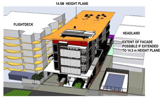
The reduced eastern side setback would have negligible
impact on view loss as no development exists on the opposite side of Clarence
Street that could take advantage of a view corridor between the development and
the existing Headlands building.
The other DCP variations discussed in this report would not
contribute to any view loss.
Overall, the proposed development is considered to be
reasonable having regard to the planning controls.
It is acknowledged that the development would have
significant impacts on existing views. This is particularly the case for
owners/residents in the Focus apartments at 2 Clarence Street where the loss of
views would be severe or devastating in the worst affected apartments. However,
considering the reasonableness of the development discussed under ‘Step
4’ above, it is considered that there are not sufficient grounds for refusal
of the application on this basis.
Overshadowing
The SEPP 65 Apartment Design Guide (Section 3B-2) requires
that living areas, private open space and communal open space of neighbouring
properties should receive solar access in accordance with sections 3D Communal
and public open space and 4A Solar and daylight access.
Section 3D of the Guide requires a minimum of 50% direct
sunlight to the principal usable part of the communal open space for a minimum
of 2 hours between 9am and 3pm on 21 June (midwinter). The submitted shadow
analysis demonstrates that the proposed development would not reduce solar
access to neighbouring communal open space below this specification.
Section 4A of the Guide requires that living rooms and
private open spaces of at least 70% of apartments in a building receive a
minimum of 3 hours direct sunlight between 9am and 3pm at midwinter.
The adjoining Headlands building contains 16 apartments, of
which 4 apartments (5, 8, 11, and 15) currently receive less than 3 hours direct
sunlight between 9am and 3pm at midwinter. The adjoining development therefore
has 75% of apartments that received the minimum solar access requirements of
Section 4A.
The proposed development would reduce direct sunlight to
the kitchen windows of Apartment 5 and 8 in the Headlands building at
midwinter. The proposal would start overshadowing Apartments 5 and 8 between
1pm and 2pm. While there would be a loss of solar access to these two
apartments, 75% of apartments in the building would still receive a minimum of
3 hours direct sunlight between 9am and 3pm at midwinter. The proposal is
therefore consistent with the provisions of the Apartment Design Guide.
The proposal would reduce direct sunlight to kitchen
windows and balconies of the ground, first and second floor units on the
eastern side of the adjoining Flightdeck building at 9am midwinter. The
overshadowing is for a short period and none the units are affected by 10am.
Roads
The site has road frontage to Clarence Street, being a
sealed public road under the care and control of Council. Clarence Street is a
collector road with a 16m road formation width near the frontage of the site,
within a 30m road reserve. Near the locality of the subject site,
Clarence Street has upright SA type kerb and gutter which accommodates angled
parking towards the west, and parallel kerbside parking to the east. Footpath
paving directly east and west of the site is full width footpath paving, the
current frontage of the site only has 1.2m wide footpath paving.
Traffic and Transport
The site is currently approved for high density residential
use, and the proposed development is considered consistent with this zoning.
Assuming an approximate 7 vehicle movements per day per unit, this equates to
an additional 28 vehicle movements per day 8. This additional traffic
associated with this development is unlikely to have any adverse impacts to the
existing road network within the immediate locality.
Site Frontage and Access
Vehicle access to the site is proposed though one access
driveway to Clarence Street. All accesses shall comply with Council
AUSPEC and Australian Standards, and conditions have been imposed to reflect
these requirements. Due to the type and size of development, additional works
are required to include full width footpath paving along the full frontage of
the site.
Parking and Manoeuvring
A total of 14 parking spaces have been provided on-site
within the basement parking. Parking and driveway widths on site are
capable of complying with relevant Australian Standards (AS 2890) and
conditions have been recommended to reflect these requirements.
Due to the type of development, car park circulation is
required to enable vehicles to enter and exit the site in a forward manner.
Site plans show adequate area is available and conditions have been recommended
to reflect these requirements.
Water Supply Connection
Council records indicate that the development site has an
existing 20mm metered water service from the 150mm PVC water main on the same
side of Clarence Street.
Each individual unit shall be individually metered with the
meters either located at an easily accessible location or there’s the
option for utilizing remotely read electronic meters. Details are to be
provided on the hydraulic plans.
Final water service sizing will need to be determined by a
hydraulic consultant to suit the domestic and commercial components of the
development, as well as fire service and backflow protection requirements.
Sewer Connection
Council records indicate that the development site is
currently connected to sewer via a junction to the sewer line that runs outside
the northern property boundary of the subject lot. The proposed development
shall drain all sewage to a new or existing sewer manhole approved by the Water
& Sewer Planning Manager. The hydraulic designer is to confer with Council
sewer section prior to submitting sewer design plans.
Stormwater
The site naturally grades towards the rear and is currently
traversed by an existing Council piped drainage system that is proposed to be
removed and diverted around the site as part of the development.
No objections are raised towards this approach in general
subject to the submission of detailed stormwater drainage plans for the pipe
diversion as part of the future Construction Certificate/Section 68
applications. The stormwater pipeline diversion must be designed to ensure that
the diversion does not increase the incidences of downstream flooding or
surcharge and must be accompanied by suitable road and footpath restoration
works to ensure the negative aesthetic impacts of trenching are mitigated.
The Statement of Environmental Effects and stormwater
drainage plans submitted in support of the proposed development demonstrates
conceptually how the stormwater management system designed to service the
development will achieve compliance with AUSPEC specifications. In this regard:
· On site stormwater detention is not proposed on the basis
that the development results in a reduction in site stormwater runoff when
compared to the existing site and land use.
· Water quality controls will be provided to achieve the
targets of Council’s AUSPEC D7 specifications.
A detailed site stormwater management plan will be required
to be submitted for assessment with the Section 68 application and prior to the
issue of a Construction Certificate. Conditions have been recommended to
reflect these requirements.
Other Utilities
Telecommunication and electricity services are available to
the site.
Heritage
See comments earlier under Clause 5.10 regarding European
heritage.
No known items of Aboriginal cultural heritage significance
exist on the property. The site is considered to be disturbed land, and it is
unlikely that any relics would remain.
As a precaution, a condition of consent has been
recommended that works are to cease in the unexpected event heritage items are
found. Works can only recommence when appropriate approvals are obtained for
management and/or removal of the heritage item.
Other land resources
The site is within an established urban context and will
not sterilise any significant mineral or agricultural resource.
Water cycle
The proposed development will not have any significant
adverse impacts on water resources and the water cycle.
Soils
The proposed development will not have any significant
adverse impacts on soils in terms of quality, erosion, stability and/or
productivity subject to a standard condition requiring erosion and sediment
controls to be in place prior to and during construction.
Air and microclimate
The construction and/or operations of the proposed
development will not result in any significant adverse impacts on the existing
air quality or result in any pollution. Standard precautionary site management
condition recommended.
Flora and fauna
Construction of the proposed development will not require
any removal/clearing of any native vegetation and therefore does not trigger
the biodiversity offsets scheme. Part 7 of the Biodiversity Conservation
Act 2016 is considered to be satisfied.
Waste
A common bin storage area has been identified in the
basement car park. In relation to bin collection, the subject site has a narrow
frontage to Clarence Street and there is angled street parking in the site
frontage. It is not considered that bins for 8 units could be placed in the
site frontage for kerb-side collection without causing impacts on amenity and
traffic and pedestrian safety. A condition is recommended requiring
satisfactory arrangements for a private waste collection service.
A standard precautionary site management condition is also
recommended for the construction phase of the development.
Energy
The proposal includes measures to address energy efficiency
and will be required to comply with the requirements of BASIX. No adverse
impacts anticipated.
Noise and vibration
The construction and/or operations of the proposed development
will not result in any significant adverse impacts on the existing air quality
or result in any pollution. Standard precautionary site management condition
recommended.
Bushfire
The site is not identified as being bushfire prone.
Safety, security and crime prevention
The proposed development will be unlikely to create any
concealment/entrapment areas or crime spots that would result in any
identifiable loss of safety or reduction of security in the immediate area. The
increase in housing density will improve natural surveillance within the
locality and openings from each dwelling overlook common and private areas.
Social impacts in the locality
Given the nature of the proposed development and its
location the proposal is not considered to have any significant adverse social
impacts.
Economic impact in the locality
The proposal is not considered to have any significant
adverse economic impacts on the locality. A likely positive impact is that the
development will maintain employment in the construction industry, which will
lead to flow impacts such as expenditure in the area.
Site design and internal design
The proposed development design satisfactorily responds to
the site attributes and will fit into the locality.
Construction
Construction impacts are considered capable of being
managed, standard construction and site management conditions have been
recommended.
The development includes significant excavation for
basement car parking adjacent to existing multi storey buildings. Prescribed
condition in accordance with clause 98E of the Environmental Planning and
Assessment Regulation requires that the developer protect and support adjoining
structures if excavation extends below the footings of the structure, building
or work.
A condition is also recommended requiring dilapidation
reports to be prepared for adjoining properties, to allow for monitoring and
rectification works (if necessary) of any damage caused by construction
activities.
Cumulative impacts
The proposed development is not considered to have any
significant adverse cumulative impacts on the natural or built environment or
the social and economic attributes of the locality.
Natural Hazards
No natural hazards identified that would impact on the
proposed development.
(c) The
suitability of the site for the development
The proposal will fit into the
locality and the site attributes are conducive to the proposed development.
Site constraints have been
adequately addressed and appropriate conditions of consent recommended.
(d) Any
submissions made in accordance with this Act or the Regulations
One (1) written
submission was received following public exhibition of the application. A copy
of the written submission has been provided separately to members of the DAP.
Key
issues raised in the submission received and comments are provided as follows:
|
Submission
Issue/Summary
|
Planning
Comment/Response
|
|
The proposal does not satisfy 4.3.2.2 of Development
Control Plan 2013 in relation to minimum site frontage.
|
The proposal does not comply
with the numerical development provision, but has been assessed against the
objectives of the provision as discussed earlier in this report in the DCP
section.
|
|
The building height exceeds the maximum height specified
on the LEP maps. The accuracy of the levels shown on the plans should be
checked.
|
The Applicant has submitted an
objection to the building height development standard in accordance with
Clause 4.6 of the LEP, which is discussed earlier in this report.
The height of the building
represented in the plans has been checked using the levels on the site survey
submitted with the application. The maximum building height has been assessed
to be 15.4m (northern side of balustrade for the roof terrace of Unit 8),
which is slightly higher than the 15m calculated by the Applicant. It is
noted that the balustrade of the Unit 8 roof terrace is shown on the plans to
be 700mm high. The balustrade will be required to be 1m high to comply with
the BCA, and this additional height has been accounted for in the assessment.
|
|
The building will be out of character in the streetscape.
Existing buildings on the northern side of Clarence Street step down in
height from The Heritage apartments. The proposed building is higher than the
adjoining Headlands and Flightdeck apartment buildings and will not fit in.
|
The proposed building is 1.34m
higher than the Headlands building and 3.07m higher than the Flightdeck
building. The proposed building is consistent with the height controls at the
street frontage and is compatible with the desired future character of the
area.
|
|
The proposed 3m setback and steep driveway would reduce
pedestrian safety in an area of high usage near a school.
|
The proposed driveway will
comply with appropriate engineering standards and is not considered likely to
significantly impact pedestrian safety. The proposed development will only
generate an additional 28 vehicle movements per day, of which half would be
entering the site from Clarence Street rather than exiting from the basement
parking.
|
|
The impact on views from 12/2 Clarence Street will be
devastating.
|
The view sharing assessment
earlier in this report has characterised the impact on this property as being
severe to devastating, with partial loss of views to the Hastings River and
North Beach.
|
|
The view corridor that the Applicant has suggested would
be retained between the proposed development and the adjoining Flightdeck
building would be of no use to the residents of 12/2 Clarence Street due to
the location of the existing Norfolk Pine in Clarence Street.
|
This statement is correct for
the majority of the balcony and internal living areas. However, a view
corridor between the buildings would be retained from the western end of the
deck where the view is not obstructed by the Norfolk Pine. These facts have been
given due regard in the view sharing assessment.
|
|
Loss of privacy to 12/2 Clarence Street.
|
The buildings are separated by
approximately 35m and the separation is considered sufficient to preserve
privacy in a high density residential context. The front elevation of the
building contains a bedroom window fitted with a privacy screen, two small
balconies (off bedrooms) and high sill height windows for bathrooms and
bedrooms. All living rooms are oriented to the north, away from the Focus
apartments.
|
|
The proposed development is inconsistent with DCP
provisions requiring the front setback to be within 20% of adjoining
buildings.
|
Area based setback provisions
apply to this site, which prevail over the general provisions in Chapter 3.3
of the DCP. Development provision 4.3.2.4 permits a 3m front setback for the
northern side of Clarence Street, east of Munster Street.
|
|
The required FSR is 1.5:1 and the proposed FSR is 1.32:1
which is 20% over the allowable.
|
The proposed FSR is 1.34:1,
which is 11% less than the maximum permitted FSR of 1.5:1.
|
|
There is potential for roof terrace plantings to adversely
affect views from the Focus apartments.
|
A condition has been recommended
requiring landscaping to be maintained to a maximum height of 0.5m to prevent
adverse impacts on views.
|
|
Parking is insufficient for the proposed development,
despite complying with the DCP requirements. It is impossible to allocate
half parking spaces, and purchasers of 3 bedroom units will be expecting 2
parking spaces.
|
If the proposal complies with
the DCP provisions, the consent authority cannot impose a more onerous
requirement.
In practical terms the DCP
requirement of 1.5 spaces per 3 bedroom apartment would result in half the 3
bedroom apartments having 2 parking spaces, and half having 1 parking space.
|
|
The proposal does not comply with the DCP side setback
provisions.
|
The proposed variation to the
side setback provisions has been discussed earlier in this report in the DCP
section. While the proposal does not comply with the numerical standard, it
is still considered to satisfy the objectives of the provision.
|
(e) The Public Interest
The proposed development
satisfies the relevant objectives of the planning controls and will not
adversely impact on the wider public interest.
4. DEVELOPMENT
CONTRIBUTIONS APPLICABLE
· Development contributions will be required towards
augmentation of town water supply and sewerage system head works under Section
64 of the Local Government Act 1993.
· Development contributions will be required in accordance
with Section 7.11 of the Environmental Planning and Assessment Act 1979 towards
roads, open space, community cultural services, emergency services and
administration buildings.
-
· A copy of the contributions estimate is included as Attachment
3.
-
5. CONCLUSION AND
STATEMENT OF REASON
The application has been assessed in accordance with Section
4.15 of the Environmental Planning and Assessment Act 1979.
Issues raised during assessment and public exhibition of the
application have been considered in the assessment of the application. Where
relevant, conditions have been recommended to manage the impacts attributed to
these issues.
The site is considered suitable for the proposed development
and the proposal adequately addresses relevant planning controls. The
development is not considered to be contrary to the public's interest and will
not result a significant adverse social, environmental or economic impact. It
is recommended that the application be approved, subject to the recommended
conditions of consent provided in the attachment section of this report.
|
Attachments
1⇩. DA2019 - 568.1
Recommended Conditions
2⇩. DA2019 - 568.1 Plans
3⇩. DA2019 - 568.1
Contribution Estimate
4⇩. DA2019 - 568.1 Clause
4.6 Variation Report.
|
|
ATTACHMENT
|
Development Assessment Panel
27/05/2020
|
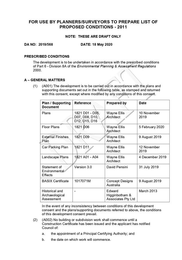
|
ATTACHMENT
|
Development Assessment Panel
27/05/2020
|
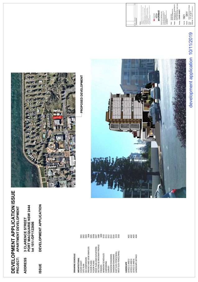
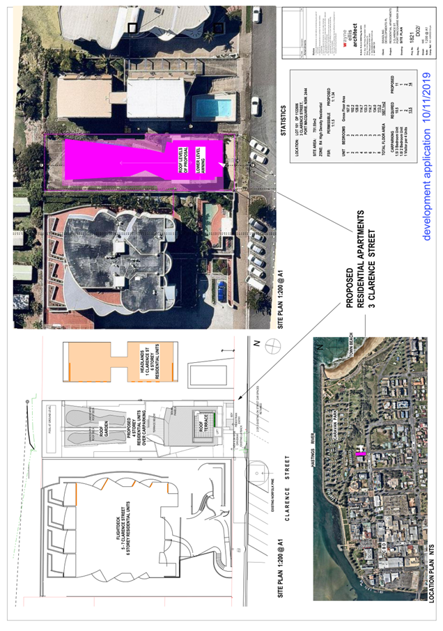
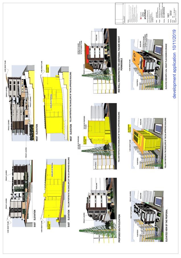
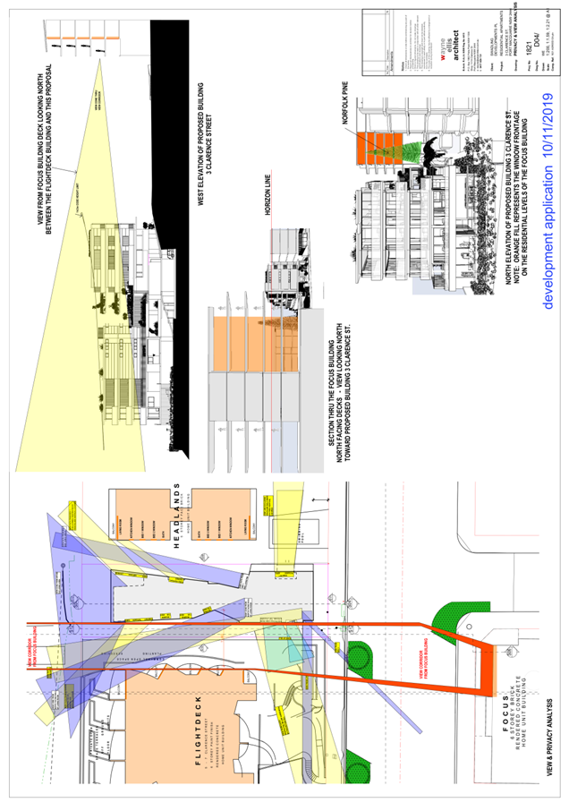
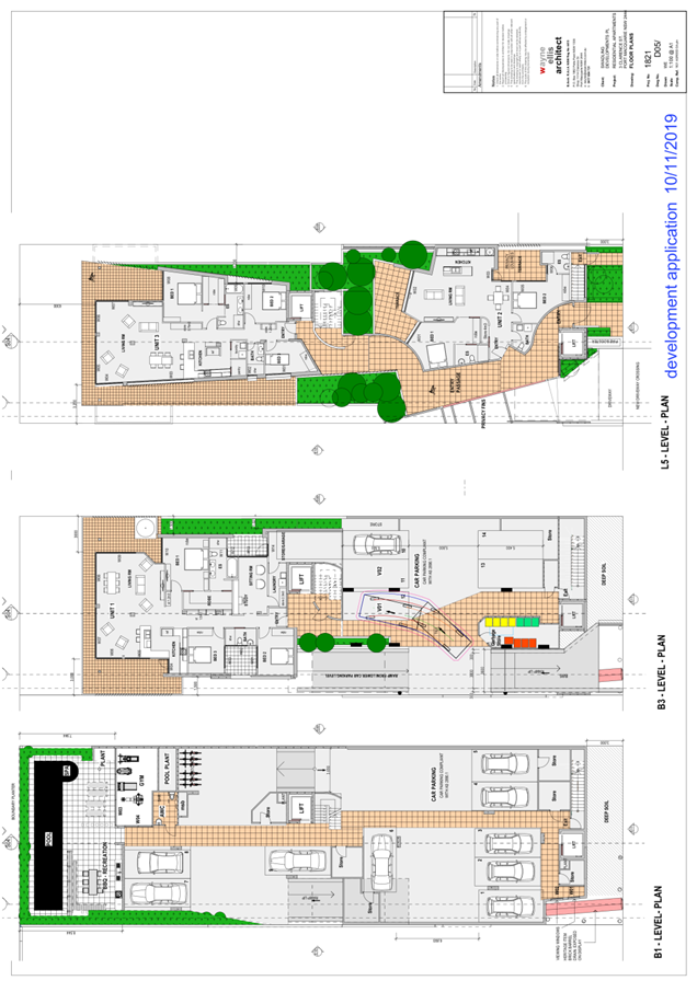
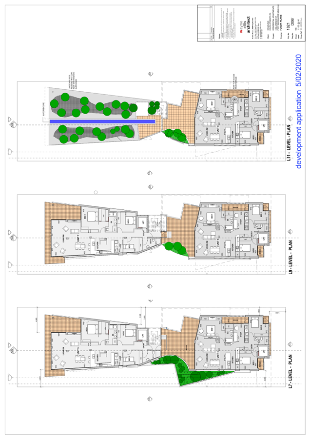
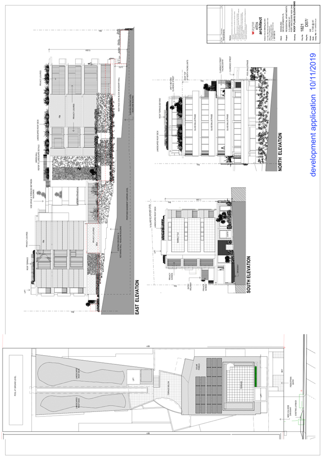
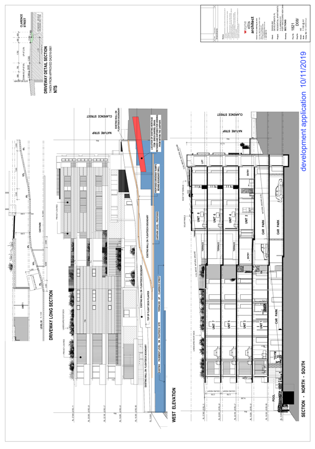
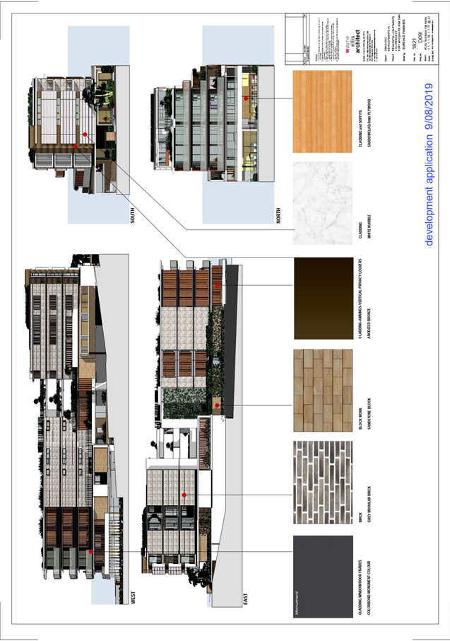
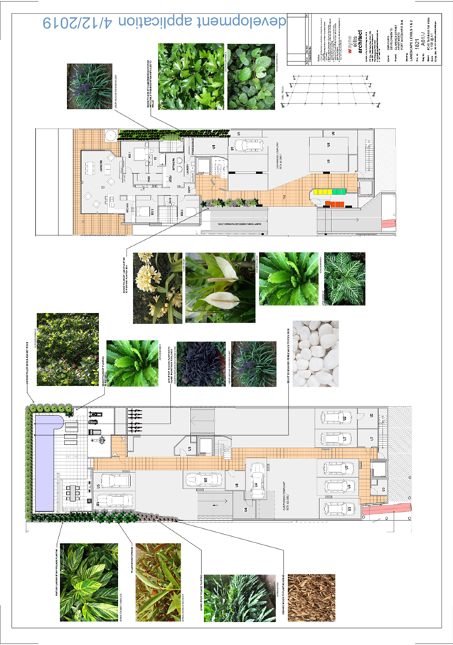
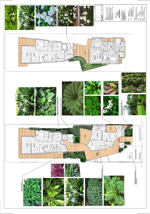
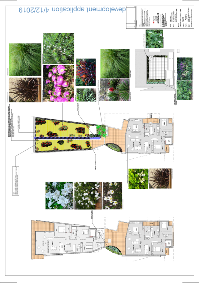
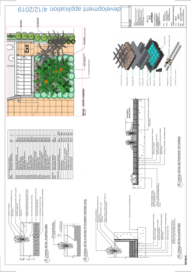
|
ATTACHMENT
|
Development Assessment Panel
27/05/2020
|

|
ATTACHMENT
|
Development Assessment Panel
27/05/2020
|

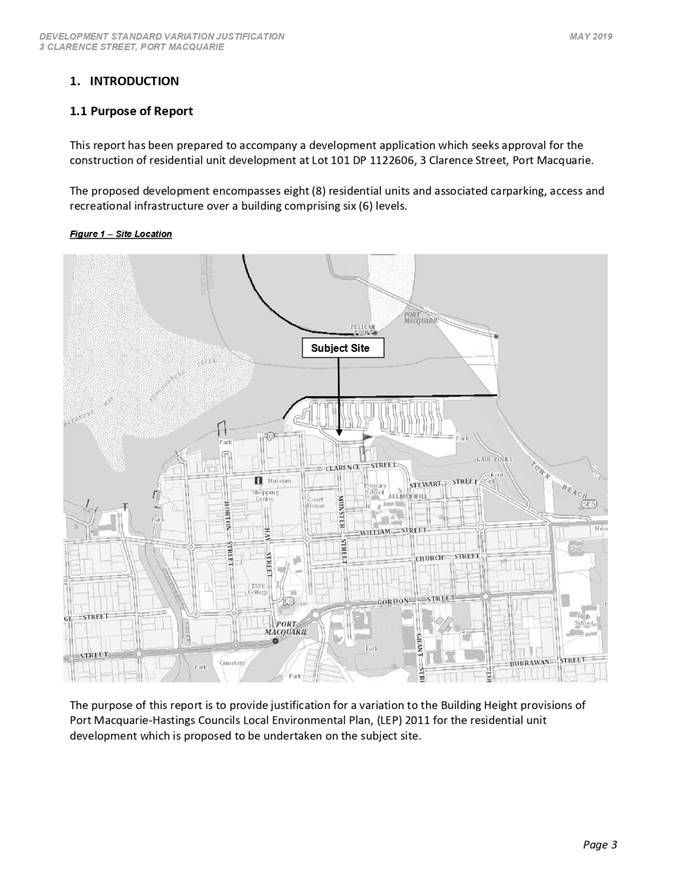
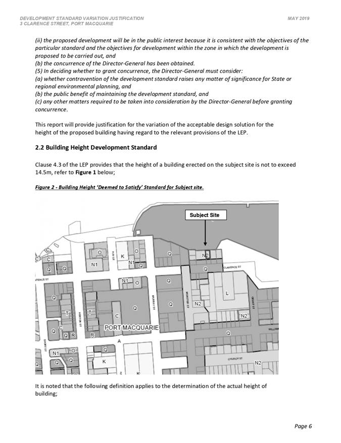
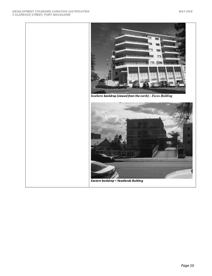
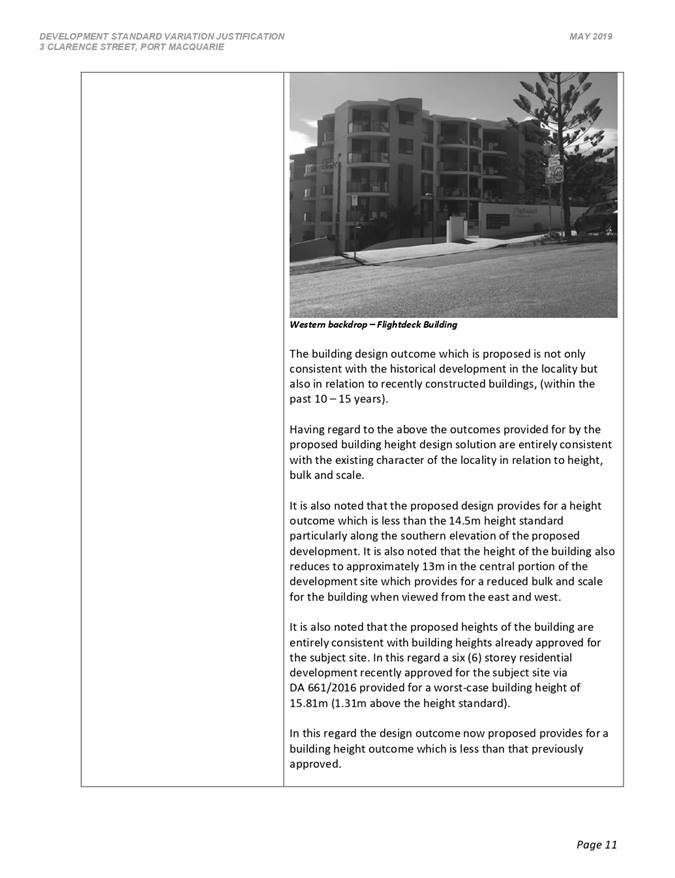
AGENDA Development Assessment Panel 27/05/2020
Item: 09
Subject: DA2016 - 88.5 - Section 4.55 Modification to
Existing Subdivision Layout at Lot 2 DP 1263561 and Lot 99 DP 1246122, South
Atlantic Drive, Lake Cathie
Report
Author: Development Assessment Planner, Clint Tink
|
Applicant: Land
Dynamics Australia
Owner: RTS
Super Pty Ltd & Stacks Super Pty Ltd & TJS Super Pty Ltd and Port
Macquarie-Hastings Council (by virtue of Lot 99 DP 1246122 having been
dedicated to Council as part of an earlier stage but yet containing existing
drainage works that need to be extended)
Estimated Cost: N/A
Alignment with Delivery
Program
4.3.1 Undertake transparent
and efficient development assessment in accordance with relevant legislation.
|
RECOMMENDATION
That
the Development Assessment Panel recommend to Council that the Section 4.55
modification to DA2016 - 88.5 being a modification
to the layout of the previous approved staged subdivision at Lot 2, DP 1263561
and Lot 99, DP 1246122, South Atlantic Drive,
Lake Cathie, be determined by granting consent, subject to the recommended
modified conditions.
Executive
Summary
This
report considers a s4.55(1A) modification of consent to amend the layout of an
existing approved staged subdivision at the subject site and provides an
assessment of the application in accordance with the Environmental Planning and
Assessment Act 1979.
Being a
s4.55 modification, the amended proposal has been assessed against the relevant
legislation in place at the time of the original assessment, unless
specifically revoked by subsequent legislation.
Following exhibition of the
application, two (2) submissions were
received.
Overall, the site is considered suitable for the proposed
modified development and the proposal adequately addresses relevant planning
controls. The development is not considered to be contrary to the public's
interest and will not result a significant adverse social, environmental or
economic impact.
This report recommends that the
development application be approved subject to the attached conditions (Attachment
1).
The application is required to be determined by full Council
in accordance with Council’s Development Application - Conflict of
Interest Policy as part of the land (Lot 9 DP 1246122) is owned by Council and
submissions have been received following exhibition of the application. It
should be noted however that Lot 99 only relates to stormwater infrastructure
necessary to serve the development.
1. BACKGROUND
Existing
Sites Features and Surrounding Development
The
original overall site area to which DA2016 - 88.1 applied was 21.16ha. However,
since being approved, several stages under DA2016 - 88.1 have been completed
leaving a residual area of 12.81ha to which the modified changes relate.
The site is zoned R1 General Residential, E2 Environmental
Conservation, E3 Environmental Management and E4 Environmental Living in
accordance with the Port Macquarie-Hastings Local Environmental Plan 2011, as
shown in the following zoning plan:
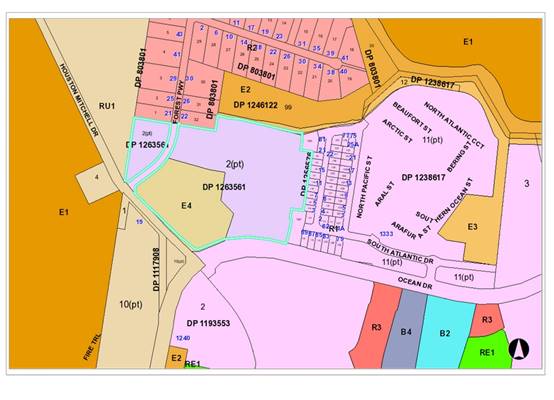
The site is located on the corner of Ocean Drive, Houston
Mitchell Drive and Forest Parkway, Lake Cathie. The land subject to the
modification is vacant and contains sections of cleared and timbered land. The
site gently slopes downwards to the north.
Adjoining the site to the north is an existing large lot
residential subdivision with associated housing and section of E(2) Environment
Conservation and E(3) Environmental Management zoned land in Council ownership.
Further north is the Lake Innes Nature Reserve and land approved under
DA2016 - 87 for 68 residential lots.
Adjoining the site to the east are the initial completed
stages of DA2016 - 88 with associated housing. Further east is an approved
manufactured housing estate that is partially complete with further sites to be
created.
Adjoining the site to the west is timbered rural land.
Adjoining the site to the south is the Lake Cathie Primary
School and the remaining Area 14 residential area.
The
existing subdivision pattern and location of existing development within the
locality is shown in the following aerial photograph:
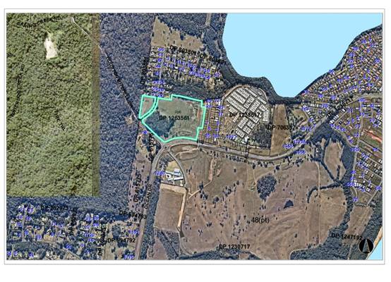
2. DESCRIPTION
OF DEVELOPMENT
Key
aspects of the modification include the following:
· The
Northern Joint Regional Planning Panel (JRPP) approved the original 151
residential lot subdivision on 17 August 2016. The JRPP report and
recommendation are attached to this report.
· The
modification retains the same footprint and perimeter road network. The main
changes are occurring to the central layout of roads and lots within Stages 2C
and 5, which has resulted in an increase in total lot numbers from 151 to 166
(ie 15 extra lots - 9.9% increase). In addition, the original central north
south habitat corridor has been moved from within the road reserve (Road 8) to
private land. This minimises the number of road crossings for fauna utilising
the link.
· Lots
sizes will now range from 450m² to 2384.4m² within the R1 zoned land
and 2000.4m²
to 2518m²
within the E4 zoned land.
· Access
to the development will still occur from Forest Parkway to the west and Solomon
Drive and South Atlantic Drive to the east (as originally planned).
· A voluntary planning agreement and amended vegetation
management plan will continue to direct compensatory plantings throughout the
subdivision.
· The
development was referred back to the NSW RFS for an amended Bushfire Safety
Authority under section 100B of the Rural Fires Act 1997.
· As
the modification is being considered under s4.55(1A), the Council is the
consent authority under Clause 123BA of the Environmental Planning and
Assessment Regulation 2000, rather than the JRPP.
· Two
(2) submissions received.
Refer
to Attachments 2 - 5 for plans of the proposed development, original
approved subdivision and JRPP documentation.
Application
Chronology for the Site
· 17/8/2016
- DA2016 - 88.1 originally determined by the Northern Joint Regional Planning
Panel.
· 27/4/2017 - Modification DA2016 - 88.2 approved by Council
to clarify conditions pertaining to kerb design.
· 20/11/2017 - Modification DA2016 - 88.3 approved by Council
to amend the road reserve width being dedicated to Council along Ocean Drive
and the associated road setback/buffer.
· 24/1/2018 - Modification DA2016 - 88.4 withdrawn.
· 4/10/2018 - Modification DA2016 - 88.5 lodged with Council.
See chronology specific to this modification later in the report.
· 2/9/2019 - Modification DA2016 - 88.6 approved by Council
to amend the Ocean Drive fence design.
· 24/10/2019 - DA2019 - 780.1 for a Manufactured Housing
Estate (MHE) lodged over part of the site the subject of DA2016 - 88. DA2019 -
780.1 has not been determined and is subject to separate consideration. DA2019
- 780.1 has been included in the chronology for context only. The assessment
and determination of DA2019 - 780.1 will need to have regard to DA2016 - 88 as
it sits over the subdivision. If DA2019 - 780.1 were to be approved, the
developer/owner would need to decide whether they will proceed with the
remaining stages of DA2016 - 88 or opt to replace part of them with the MHE.
· 5/2/2020 - Modification DA2016 - 88.7 approved by Council
to amend staging associated with part of the original site/staging not being
considered under modification DA2016 - 88.5.
· 1/4/2020 - Modification to DA2016 - 88.9 lodged with
Council to essentially amend the access/egress for Stage 6 (E4 zoned lots). In
particular, the modification proposes access/egress for the Stage 6 area
directly onto Forest Parkway. This modification has not been determined and is
subject to separate consideration.
· 20/4/2020 - Modification DA2016 - 88.8 approved by Council
to amend a condition pertaining to staging requirements.
Based
on the above chronology for the site, there have been a number of minor
modifications approved for the site. In more recent times, there are changes
that have either been approved or are still being considered that are designed
to allow the owner/developer options to develop the remainder of the site being
developed under DA2016 - 88.
Application
Chronology for DA2016 - 88.5
· 4/10/2018 - Modification DA2016 - 88.5 lodged with Council.
· 11/10/2018 - Modification referred to NSW Rural Fire
Service (RFS) and Essential Energy.
· 11/10/2018 - Council staff requested additional information
on the modification type, ecology & Vegetation Management Plan (VMP),
stormwater design, proposed playground and proposed battle axe lots.
· 12/10/2018 to 25/10/2018 - Notification period.
· 13/10/2018 - Public submission received.
· 18/10/2018 - Response from Essential Energy received
raising no objection to the amended design. Standard consent requirements
suggested.
· 22/10/2018 - Public submission received.
· 30/10/2018 - Applicant responded to additional information
request from 11/10/2018.
· 7/11/2018 - Council staff reviewed additional information
and sought clarification on responses ecological impacts, stormwater design,
playground and revised plans. Applicant acknowledged the request for additional
information.
· 16/11/2018 - Council’s Group Manager Recreation &
Buildings confirmed that the new proposed park (not part of the original DA2016
- 88) was not supported due to lack of casual surveillance, the non-central
location of the park to the area and connectivity issues.
· 21/11/2018 - Applicant acknowledged response from Group
Manager Recreation & Buildings and would consider options.
· 3/12/2018 - Applicant responded to additional information
request from 7/11/2018. In particular, amended layout received removing the
park, updated bushfire report, response to stormwater design and letter from Ecologist.
· 3/12/2018 - Revised information sent to NSW RFS.
· 12/12/2018 - NSW RFS initial acknowledgment letter
received.
· 13/12/2018 - Council staff provided clarification to NSW
RFS on information to consider.
· 13/12/2018 - Council staff requested clarification on a
number of engineering matters such as stormwater design, road design,
management of green space within the road reserve and sewer design.
Acknowledged by the applicant on 14/12/2018.
· 13/12/2018 - Updated Bushfire Safety Authority received
from the NSW RFS. Copy provided to the applicant on 14/12/2018.
· 3/7/2019 - Council staff sent follow up on outstanding
information. On 4/7/2019 and 24/7/2019, the applicant provided updates.
· 26/7/2019 - Applicant provided amended plans responding to
engineering issues from 13/12/2018.
· 30/8/2019 - Amended information sent to NSW RFS.
· 30/8/2019 - Update on review of additional information
provided to the applicant.
· 6/9/2019 - NSW RFS acknowledged additional information.
· 1/10/2019 - Applicant submitted amended staging plan.
· 8/10/2019 - Council staff sent follow up email to NSW RFS
on status of amended Bushfire Safety Authority. Preliminary response received
10/10/2019.
· 14/10/2019 - Applicant requested to clarify staging.
· 18/10/2019 - Update on the status of the modification
provided to the applicant. Council staff also sought clarification on a number
of engineering matters.
· 25/10/2019 - Discussion on engineering matters and amended
plan with copy received on 29/10/2019.
· 28/10/2019 - Council staff requested update on stormwater
details.
· 28/10/2019 - Council staff emailed the NSW RFS and advised
that a further amended plan was to be received. NSW RFS advised to hold off
finalising referral until Council staff had accepted the design.
· 31/10/2019 - As a result of works being proposed on Lot 99
DP 1246122, owner’s consent and sign off on Conflict of Interest Policy
process sought by Council staff.
· 1/11/2019 - Amended stormwater detail provided and
acknowledged by Council staff.
· 12/11/2019 - Discussion between Council staff and applicant
on status of the modification. Copies of redacted submissions provided to the
applicant.
· 18/11/2019 - Discussion between Council staff and the
applicant on content of submissions.
· 18/11/2019 - Council staff advised that the proposed public
reserve areas on the amended plan were not supported.
· 28/11/2019 to 2/12/2019 - Discussion with the applicant on
removing the proposed public reserves with the north south habitat corridor to
be located on private land (rather than within the road reserve as originally
approved).
· 20/1/2020 - Incorrect plan sent to NSW RFS.
· 11/2/2020 - Council staff followed up discussions from
28/11/2019 to 2/12/2019 and need for amended plans/details. Applicant
acknowledged request on 13/2/2020.
· 18/2/2020 to 25/2/2020 - Council staff discussed share way
issues with applicant.
· 27/2/2020 - Amended plans received in response to issues
raised between 28/11/2019 and 2/12/2019.
· 12/3/2020 - Amended plans agreed in principle by staff.
Copy provided to NSW RFS to allow the Bushfire Safety Authority to be
updated/finalised.
· 17/3/2020 - NSW RFS acknowledged amended plans.
· 6/4/2020 - Update on status of the modification provided to
the applicant and discussion on process of the modification being reported to
DAP and Council.
· 17/4/2020 - Council staff follow up with the NSW RFS on
status of referral.
· 28/4/2020 - Updated Bushfire Safety Authority received from
NSW RFS.
3. STATUTORY
ASSESSMENT
The
application has been lodged as Section 4.55(1A) on the basis that it is
substantially the same development to that which was originally lodged and
consented and will have minimal environmental impact.
Section
4.55 of the Environmental Planning and Assessment Act 1979 enables the
modification of consents and categorises modifications into Section 4.55(1) for
modifications involving minor error, mis-description or miscalculation, Section
4.55(1A) for modifications involving minimal environmental impact and Section
4.55(2) for other modifications. Each type of modification must be considered
as being substantially the same to that which was originally consented.
In
looking at modifications, the Courts consistently see s4.55 as
“beneficial and facultative” and that there are essentially two
separate legal tests that apply to a s.4.55 application, before the consent
authority can ultimately determine the application on merit.
The
first is that the modification cannot result in a radical transformation (Sydney
City Council v Ilenace Pty Ltd [1984]). The term “radical
transformation” is very broad, leaving significant scope to change a
development.
In this
case, whilst there are changes proposed to the subdivision layout, they are not
considered radical in terms of the overall approved layout. In particular, the
key elements of the subdivision (ie the footprint, servicing, key road
connections, habitat protection, environmental impact etc) remain relatively
unchanged. Furthermore, the increase in the number of lots is less than 10%
(Note: it is not uncommon for the Courts to approve modifications that
numerically change components, such as the number of storeys, height, floor
area etc, by more than 10%).
The
second test deals with Council being satisfied
that the modification is “substantially the same development” as
authorised by the original development consent. The Council must compare the
modified development/potential modified consent against the original approval
(Note: it is the consent that is being modified, not just the plans, so the
consent authority must have regard to the conditional changes as well). Once
Council is satisfied that the modification is substantially the same, the
remainder of the assessment is dealt with on merit.
It
should be noted that some environmental impacts and merit issues can link back
to the “substantially the same test”, if significant. In
particular, for a modification to have a significant environmental impact, one
might question whether it is a result of a significant change to the original
approval.
In this
case, the modification is considered “substantially the same” and
there are no significant environmental or merit issues - refer to comments on
s4.55(1A)(b) later in this report.
In
summary, Council needs to consider the numerical differences, non-numerical
aspects (eg in visual impact, traffic impacts or changed land uses) and any
changes relating to a key/essential feature of the approved development. Having
considered the above comments and the more detailed review below, it is
considered that the modification can be considered and the changes are
acceptable.
The
specific provisions of Section 4.55 are considered in more detail below.
Section 4.55(1A)(a) Satisfied that the proposed modification is of minimal
environmental impact?
While
the proposed subdivision layout is being amended and creating fifteen (15)
additional lots, minimal environmental impact is considered to be occurring as
a result of the changes. In particular, the proposal is considered to be having
minimal environmental impact for the following reasons:
· The modified development occupies the same footprint as the
subdivision originally granted consent.
· The development will still present as a low to medium
density residential subdivision from outside the site.
· Location of key perimeter roads and through connections
remain unchanged.
· The impacts of the modified development, including the
extent of vegetation clearing (ie no additional clearing proposed), earthworks,
and revegetation remain similar to the original approved development.
· The modified development will not create any adverse demand
on public infrastructure or services when compared with the original approved
development.
· There will be no material change on amenity as a result of
the changes.
· The revised north south habitat corridor retains the
original intent of the subdivision, whilst creating added benefits of reduced
road crossings for fauna.
· The numerical change represents less than 10% increased
change to the original subdivision, whilst still maintaining compliance with
minimum lot sizes provisions. It should be noted that a number of the lots (due
to their size) are likely to be further developed as medium density housing
once the subdivision proceeds. In this regard, the number of lots and density
of development is still considered below the future potential for the overall
site.
Section 4.55(1A)(b) Is the proposal substantially the same?
Section 4.55 has been
described as “beneficial and facultative” in Houlton v Woollahra
Municipal Council (1997) 95 LGERA 201 at [213] and North Sydney
Council v Michael Standley & Associates Pty Ltd (1998) 97
LGERA 433 at [440]. Accordingly, the provisions of s4.55 should not be
artificially constrained by allowing a narrow construction.
In Vasic Pty
Ltd v Penrith City Council [1992] NSWLEC 8, Stein J held
that "substantially" meant "essentially all material or having
the same essence."
In Moto Projects (No 2)
Pty Ltd v North Sydney Council (1999) 106 LGERA 298 at [56]
Bignold J held that the task for determining whether a development as
proposed to be modified is substantially the same as the consent granted was as
follows:
"The
comparative task does not merely involve a comparison of the physical features
or components of the development as currently approved and modified where that
comparative exercise is undertaken in some type of sterile vacuum. Rather, the
comparison involves an appreciation, qualitative, as well as quantitative, of
the developments being compared in their proper contexts (including the
circumstances in which the development consent was granted)."
In the context of the current
application, the proposal can be considered to be substantially the same as the
development to which consent was originally granted for the following reasons:
· The modified proposal remains as a subdivision for the
purpose of residential uses and is consistent with the essence of the original
development.
· The reasons listed above under s4.55(1A)(a) for
demonstrating minimal environmental impact are conducive to the development
being substantially the same.
· The payment of monetary contributions can still apply to
the additional lots created from the modification.
Section
4.55(1A)(c) Does the application require notification/advertising in accordance
with the regulations and/or any Development Control Plan?
Neighbour
notification has been undertaken in accordance with the regulations and
Council’s DCP (as in force at the time).
Section 4.55(1A)(d) Any submissions made concerning the
modification
Two (2) written submissions were received following public
exhibition of the application. Copies of the written submissions have been
provided separately to members of the DAP.
Key issues raised in the submissions received and comment
are provided in the table below:
|
Submission Issue/Summary
|
Planning Comment/Response
|
|
A park has been proposed near No. 22 Forest Parkway.
Concern about security as people can hide and loiter, noise and anti-social
behaviour.
Consider relocating the park.
|
Park has since been removed from the modification and the
area reverted back to residential lots as originally planned/approved.
|
|
General opposition to Stage 3 and the small properties
backing onto existing property in Springhill Place and intrusive impacts.
|
The
number of lots in Stage 3 (and the modification) backing onto the adjoining
property to the north/north east in Springhill Place remains the same (ie 7
lots). No change or impact to that already approved.
|
|
Concern with walkway through the nature reserve or at
least ensure it is close to the development boundary and not Springhill Place
properties. Concerns with environmental Impacts on reserve.
|
Pathway
has been relocated alongside the roadway and no longer goes through the
reserve.
|
Section
4.55(3) Any matters referred to in section 4.15(1) relevant to the
modification, and the reasons given by the consent authority for the grant of
the consent sought to be modified.
Overall,
the modification remains consistent with the original s4.15(1) assessment and a
revised summary follows the Section 4.55(4) comment below. It should be noted
that the revised s4.15(1) comments focus on compliance with relevant
legislation and whether there has been any change or impact to comments
provided on the original assessment.
A copy
of the original s4.15(1) JRPP assessment is also attached to this report for
context.
Section
4.55(4) The modification
of a development consent in accordance with this section is taken not to be the
granting of development consent under this Part, but a reference in this or any
other Act to a development consent includes a reference to a development
consent as so modified.
Noted.
Section
4.15(1) Matters for Consideration
In
determining the application, Council is required to take into consideration the
following matters as are relevant to the development that apply to the land to
which the development application relates:
(a) The
provisions (where applicable) of:
(i) any
Environmental Planning Instrument
State
Environmental Planning Policy (Koala Habitat Protection) 2019
Clause 15 - A modification application
made, but not finally determined, before the commencement of this Policy in
relation to land to which this Policy applies must be determined as if this
Policy had not commenced. The application was made and not finally determined
prior to the commencement of this policy, and the application is therefore
required to be assessed under the relevant provisions of State Environmental
Policy No 44 - Koala Habitat Protection. See assessment comments below.
State Environmental Planning Policy No.
44 - Koala Habitat Protection
The site is
subject to an existing Koala Plan of Management (Area 14 KPOM). Having regard
to the original approval and provisions of the KPOM, the modification is
considered to remain sufficiently consistent with its requirements. This was
reiterated by comments from an ecologist and peer review by Council’s
Natural Resources Team. In summary, the modification will still comply with the
following:
· Use koala food
trees throughout the site and be implemented via a Vegetation Management Plan
(VMP).
· Separation of key
koala areas from busier residential development/roads.
· Retention of koala
food trees where possible.
· Buffering of koala
habitat areas.
· Revegetation of
buffers/habitat linkages that are devoid of vegetation.
· Conditions being
imposed to manage fauna/koalas during clearing process.
· Covenants being
placed on the title of properties regarding pool design being koala friendly.
· Standard street
lighting being conditioned.
· Compensatory
plantings in accordance with the KPOM.
· A VPA being in
place for the management of environmental land and vegetation management.
· Core koala habitat
areas being retained/untouched.
· Creation of
habitat linkages consistent with the KPOM. In particular, the north south
habitat linkage will be moved from the road reserve to private properties. This
change will ensure the linkage is retained but involves less dangerous road
crossings for fauna.
State Environmental Planning
Policy (Infrastructure) 2007
Clause 45, no objection was raised
from the relevant electricity supplier regarding the modification.
No other change
from original assessment.
State
Environmental Planning Policy (State and Regional Development) 2011
No change from original assessment.
As the modification is being
considered under s4.55(1A), the Council is the consent authority under Clause
123BA of the Environmental Planning and Assessment Regulation 2000.
Modification is not required to be determined by the JRPP.
Port
Macquarie-Hastings Local Environmental Plan 2011
Unless specified below, no change
from original assessment.
· Whilst the E2 and
E3 zones will still be used primarily for vegetation planting/retention, it is
noted that existing stormwater works (ancillary to the road/subdivision) do sit
partially within the E3 zone. The modification proposes to continue the
existing stormwater works (comprising a vegetated swale) partially within the
E3 zone. No additional vegetation removal is anticipated and conditions have
been applied to reinforce this aspect. The ancillary stormwater works are
considered permissible and remain consistent with the approved original plan
(Note: the original plan envisaged the road and ancillary drainage swale would
be located in the subject area).
· Clause 4.1, the
proposed R1 zoned residential lots comply with the 450m² minimum lot size
standard and the E4 lots comply with the 2000m² minimum lot size.
· Clause 7.13,
satisfactory arrangements are in place for provision of essential services
including water supply, electricity supply, sewer infrastructure, stormwater
drainage and suitable road access to service the development. Provision of
electricity and telecommunications will be subject to obtaining satisfactory
arrangements certification prior to the issue of a Subdivision Certificate as
recommended by the original condition of consent.
(ii) Any draft
instruments that apply to the site or are on exhibition
None relevant.
(iii) Any Development
Control Plan in force
Port
Macquarie-Hastings Development Control Plan 2013
Unless specified below, no
change from original assessment.
|
DCP 2013: Chapter 3.6 - Subdivision
|
|
DCP Objective
|
Development Provisions
|
Proposed
|
Complies
|
|
3.6.3.2
|
Torrens title lots minimum width of 15m when measured at a
distance of 5.5m from front property boundary.
|
Except for the addition of four (4) battle-axe lots, all
lots within the modification remain compliant with the minimum of 15m width
requirement.
Battle-axe lots are addressed later.
|
Yes
|
|
|
Minimum depth of 25m.
|
All lots generally comply with the minimum 25m depth
requirement.
|
Yes
|
|
3.6.3.3
|
Battleaxe lots discouraged in greenfield development.
|
There were three (3) battleaxe lots identified with the
original approval. Four (4) additional battleaxe lots have been provided,
bringing the total to seven (7). This represents 4% of total lots. This is
still considered a low and acceptable number. Furthermore, the location of
the battleaxe lots will maximize the development potential of the land whilst
creating no adverse impact on vegetation, servicing costs or impacts on
amenity.
|
No, but still acceptable
|
|
DCP 2013: General Provisions
|
|
DCP Objective
|
Development Provisions
|
Proposed
|
Complies
|
|
2.7.2.2
|
Design addresses generic principles of Crime Prevention
Through Environmental Design guideline:
· Casual surveillance and
sightlines
· Land use mix and activity generators
· Definition of use and
ownership
· Lighting
· Way finding
· Predictable routes and
entrapment locations
|
The modified layout does not create any crime safety
issues. The design allows separation from potential habitat/concealment areas
and allows surveillance of the street.
|
Yes
|
|
DCP 2013 - Rainbow Beach
|
|
DCP Objective
|
Development Provisions
|
Proposed
|
Complies
|
|
1.1
|
Development consistent with layout on Figures 62 to 64.
|
Modification remains consistent with the layout
requirements. Some internal roads have been amended to run east west rather
than north south. No impact foreseen with the changes with key perimeter
roads to be retained.
|
Yes
|
|
5.1
|
Cycleways, shareways etc requirements
|
Provided in accordance with DCP.
|
Yes
|
|
5.2
|
Pedestrian link requirements.
|
Provided in accordance with DCP.
|
Yes
|
|
6-8
|
Noise, visual amenity, SEPP 26 buffer and urban design.
|
Remain unchanged and reinforced through existing
conditions.
|
Yes
|
|
12.1
|
North south streets to be in accordance with Figure 71.
|
The Stage 2C, 4 and 5 internal roads have been amended to
run east west rather than north south. No impact foreseen with the changes.
Key perimeter roads to be retained.
|
Yes
|
|
12.2
|
20m wide habitat link as per Figure 71.
|
An equivalent habitat link has been provided to the west
of Stage 2C and 5 in a location consistent with Figure 71.
|
Yes
|
|
13.1
|
Development considers existing rural residential areas,
KPOM requirements and linkages.
|
Development complies with the Area 14 KPOM and will be
installing/protecting key habitat links.
The development considers the existing rural residential
area by providing lots that will have rear boundaries to the existing rural
residential area. In most cases, future development will need to provide a 4m
rear setback (unless otherwise justified), which will help maintain a
suitable level of separation.
|
Yes
|
(iiia) Any planning agreement that has
been entered into under section 7.4, or any draft planning agreement that a
developer has offered to enter into under section 7.4
The proposed modification
remains compliant with relevant planning agreements subject to conditions.
iv) Any
matters prescribed by the Regulations
No change from original
assessment.
(b) The likely
impacts of that development, including environmental impacts on both the
natural and built environments, social and economic impacts in the locality
Roads, Traffic, Transport, Site Frontage & Access
The road layout and hierarchy remains consistent with the
Development Control Plan provisions, which connects in with the adjoining
properties/roads. Footpaths and street plantings will also be provided
throughout the subdivision to improve pedestrian connections and amenity.
Overall, the road layout, traffic impacts, frontages and access
associated with the modification were all reviewed by Council’s
Engineering Section and deemed to create no adverse impact, subject to
conditions.
Water Supply Connection
Council records indicate that the modification is still able
to be connected to water with details to be shown on the engineering plans at
the Subdivision Construction Certificate stage.
Sewer Connection
Council records indicate that the modification is still able
to be connected to sewer with details to be shown on the engineering plans at
the Subdivision Construction Certificate stage.
Stormwater
Council’s Stormwater Engineer has assessed the
modification/proposed stormwater design and deemed it acceptable, subject to
conditions and detailed design being submitted at the Subdivision Construction
Certificate stage. The system will utilise a combination of street drainage,
detention and swales to direct the water to the public reserve in a controlled
state.
Other Utilities
Telecommunication and electricity services are available to
the site and/or can be extended at the applicant’s expense.
Flora and fauna
The applicant had a suitably qualified ecologist review the
modified design. The ecologist provided the following comment:
As per request, we have reviewed the amended plan, the
UIA 14 Koala Plan of Management (Biolink 2012) and the Vegetation Management
Plan (King & Campbell 2016), and provide comment in regard to the
amendment’s consistency with these documents.
The KPoM only identifies Potential Koala Habitat on the
land, and the key planning provision relating to the plan is establishment of
Habitat Linkage C in Figure 5 of the KPoM. Part B (iii) states:
This minor linkage runs from
Houston Mitchell Drive to the Lake Innes Nature Reserve. Integration with
existing vegetation patches will be required, presumably via creation of larger
lot sizes. Linkage then continues in a north-south direction, again presumably
in the form of a suitably aligned streetscape, similar to that proposed above,
to link up with the drainage line running east west to the Lake Innes Nature
Reserve. This latter area also needs to be buffered by an APZ which could
contain a perimeter road, scattered vegetation, pedestrian access and/or
cycleway, along with low maintenance, shallow, water management devices.
The larger lot size provision is met in another stage as
shown in the plan.
The section of this linkage encapsulated within the
subdivision stage as a “suitably aligned streetscape” as per the
KPoM, has been designated as a planted corridor of Koala food trees on the
western side of the new road. In the VMP, it was originally proposed as a
median strip (King and Campbell 2016), but is now proposed to be consolidated
on one side of the road.
The proposed consolidation of the linkage on one side of the
road and directly linking to the adjoining larger lots (latter intended to
retained Koala food trees in situ) is clearly a better design than that
proposed in the VMP as it reduces Koala exposure to road crossings to reach
habitat (it provides a much superior link to retained trees on Lots 135-151);
and reduces the risk of trees impacting road stability with root zones.
The management provisions of the VMP for Management Unit
1 (which is Habitat Linkage C) are also readily adaptable to the new concept,
and hence amendment to the VMP is unlikely to be needed.
It is thus considered compliant with intent and outcomes
of the KPoM and the VMP.
The modification has been reviewed and accepted by
Council’s Natural Resources Section, subject to conditions on maintenance
of the linkage and an amended VMP.
In addition to the above, it is considered that the
provisions of the more recently adopted Biodiversity Conservation Act 2016
(commenced after DA2016 - 88.1 was approved) are not triggered in this case. In
particular, no additional vegetation removal is proposed or new impact on
existing/proposed habitat. Overall, the modification relates to the same
footprint as the original approval and associated work/impact could occur
regardless of the modification.
Noise and vibration
The original application was referred to Council’s
Environmental Health Officer to consider impacts of road noise from Ocean Drive
(classified road). In particular, potential existed for noise from road traffic
to adversely affect future dwelling occupants.
To negate noise impacts a 1.8m high fence on top of a 400mm
mound was approved along the Ocean Drive frontage, consistent with other
estates being developed to the east. Vegetation screening was also be included
to soften the appearance of the fence from Ocean Drive.
Even with the above, some lots were still identified as
being affected by road noise. To address this aspect, an 88B instrument was
conditioned, requiring future dwellings on the affected lots to have Category 2
construction with additional internal BCA compliant ventilation.
Given the modification impacts on the number of lots and lot
numbers, the condition has been amended to capture the relevant lots.
Bushfire
The site is identified as being bushfire prone.
In accordance with Section 100B - Rural Fires Act 1997 - the
original application proposed subdivision of bush fire prone land that could
lawfully be used for residential purposes.
The applicant has submitted an amended bushfire report
prepared by a Certified Consultant. The report assumes that the amended
subdivision can occur under Section 100B requirements.
The Commissioner has assessed the modification and has
issued a revised Bushfire Safety Authority, which will form part of the
modified conditions of consent.
Furthermore, the applicant has demonstrated that the
development can comply with the requirements of the Bushfire Safety Authority
as well as implementing the requirements of the VMP, without creating any long
term maintenance of vegetation burden on Council.
Social impacts in the locality
Given the strategic planning and development controls that
have been put in place governing the development of the Area 14 precinct and
the compliance of the subdivision with such controls; the modification is
unlikely to result in any adverse social impacts.
Economic impact in the locality
No adverse impacts. A likely positive impact is that the
development will maintain employment in the construction industry, which will
lead to flow impacts such as maintained employment and expenditure in the area.
(c) The
suitability of the site for the development
The modified remaining stages and the overall subdivision will fit
into the locality and the site attributes are conducive to the proposed
development.
Site constraints have been adequately addressed and appropriate
conditions of consent recommended.
Development Applications - Conflict of Interest Policy
The Policy applies to
development applications relating to Council land or where Council is the applicant.
In this case, the Policy is
triggered by virtue of part of the land (Lot 99 DP 1246122), being in the
ownership of Council at the time the modification was lodged. As part of the
modification, the applicant wishes to continue the stormwater works (already
commenced on Lot 99 DP 1246122 as part of previous stages) to cater for the
modification.
It should be noted that Lot 99
DP 1246122 previously formed part of the original parcel of land to which
DA2016 - 88.1 was approved and was subsequently dedicated to Council as part of
an early stage. Technically, if the applicant had completed all the necessary
stormwater works as part of the previous stage(s) and then dedicated the land
(Lot 99 DP 1246122), the Conflict of Interest Policy would not have been
triggered.
Being a development application
on Council land and with submissions having been received, the application was
referred to the Director of Development & Environment and General Manager
under the policy to determine whether the application should be assessed by
Council staff or whether an external consultant should be utilised.
As the submissions were not
alleging any conflict of interest, there was no Environmental Impact Statement
required and with Council only have a minor interest as the authority for
managing future public stormwater assets, it was determined that Council staff
continue with the assessment.
The application is also proposed
to be reported to Council, via the Development Assessment Panel.
Based on the above, it is considered
that the application has been processed in accordance with the Policy.
4. DEVELOPMENT
CONTRIBUTIONS APPLICABLE
· Development contributions will be required towards
augmentation of town water supply and sewerage system head works under Section
64 of the Local Government Act 1993.
· Development contributions will be required in accordance
with Section 7.11 of the Environmental Planning and Assessment Act 1979 towards
roads, open space, community cultural services, emergency services and administration
buildings.
1.
· A copy of the modified contributions estimate is included
as an Attachment 6.
2.
5. CONCLUSION AND
STATEMENT OF REASON
The application has been assessed
in accordance with Section 4.55 of the Environmental Planning and Assessment
Act 1979.
Issues raised during assessment
and public exhibition of the application have been considered in the assessment
of the application. Where relevant, conditions have been recommended to manage
the impacts attributed to these issues.
The site is considered suitable
for the proposed modified development and the proposal adequately addresses
relevant planning controls. The development is not considered to be contrary to
the public's interest and will not result a significant adverse social,
environmental or economic impact. It is recommended that the application be
approved, subject to the recommended conditions of consent provided in Attachment
1.
|
Attachments
1⇩. DA2016 - 88.5
Draft Modified Consent
2⇩. DA2016 - 88.1 JRPP
Assessment Report
3⇩. DA2016 - 88.1 JRPP
Determination
4⇩. DA2016 - 88.1 Original
approved Layout
5⇩. DA2016 - 88.5 Revised
Plans
6⇩. DA2016 - 88.5
Contribution Quote
|
|
ATTACHMENT
|
Development Assessment Panel
27/05/2020
|
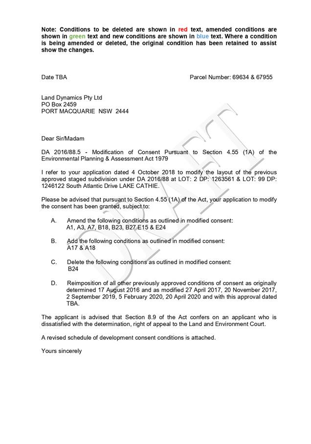
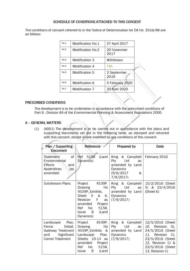

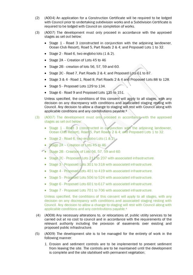
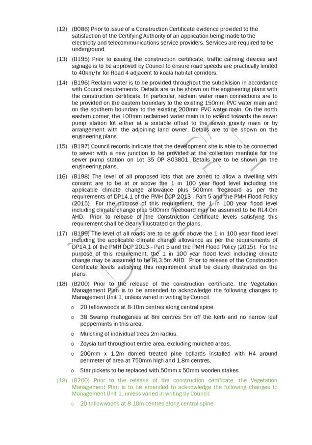
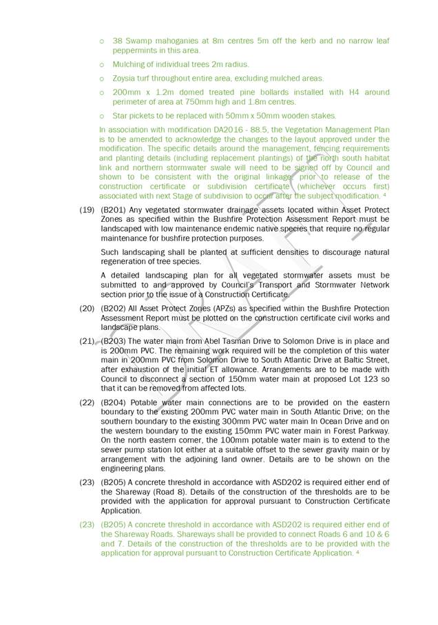
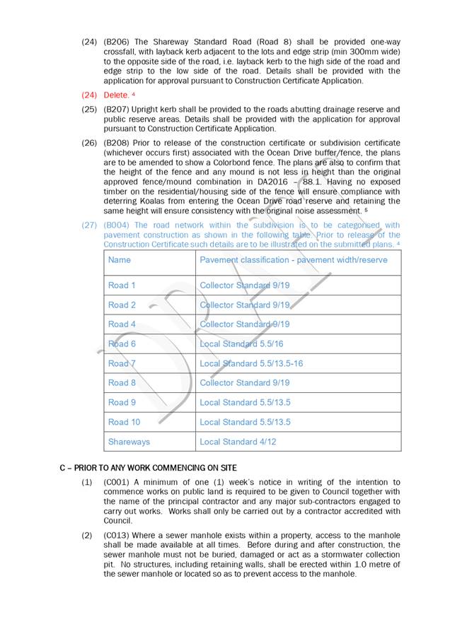
|
ATTACHMENT
|
Development Assessment Panel
27/05/2020
|
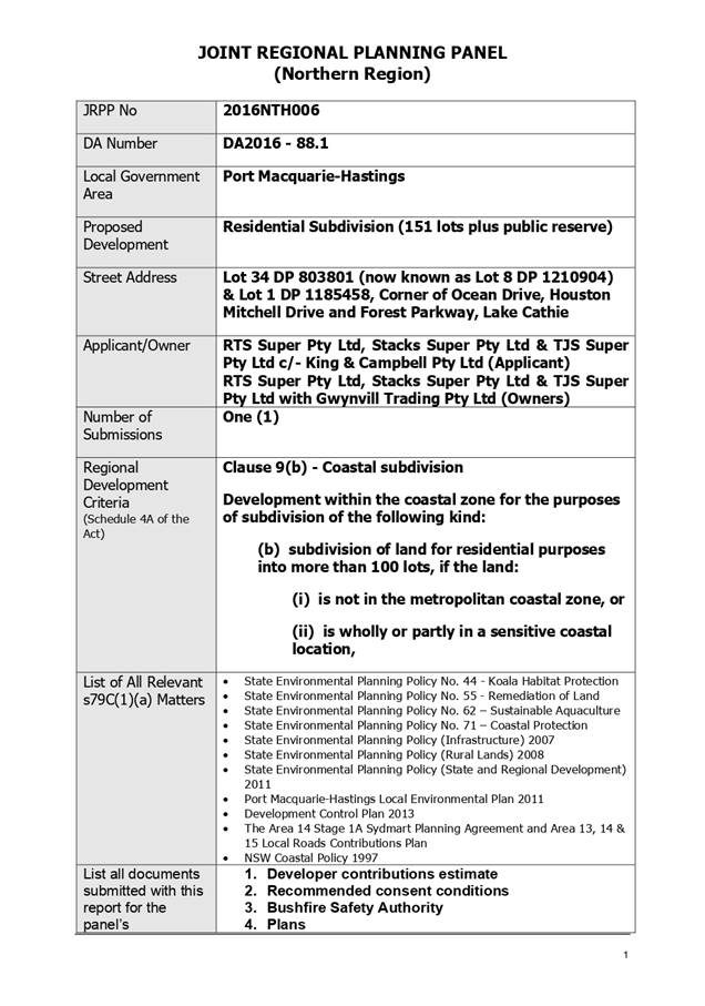
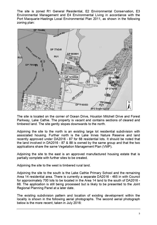
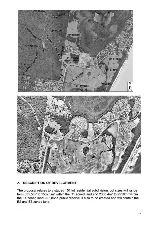
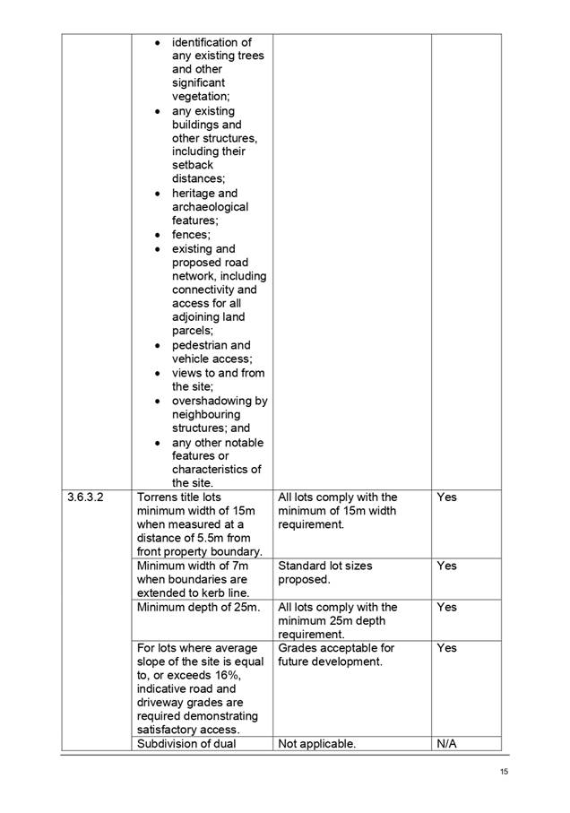
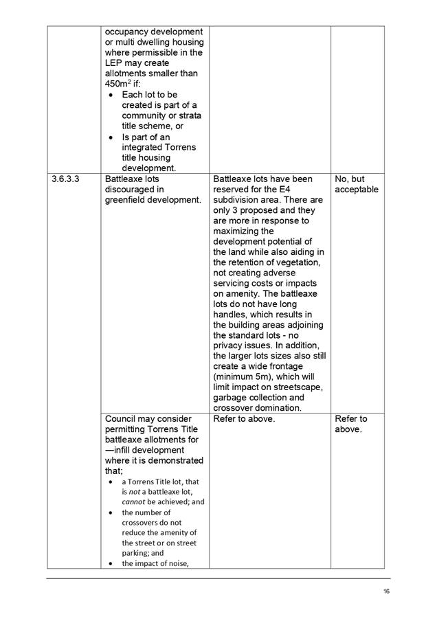
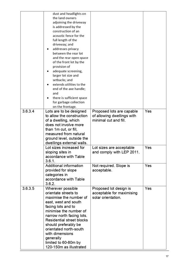
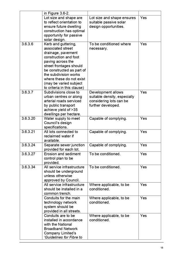
|
ATTACHMENT
|
Development Assessment Panel
27/05/2020
|
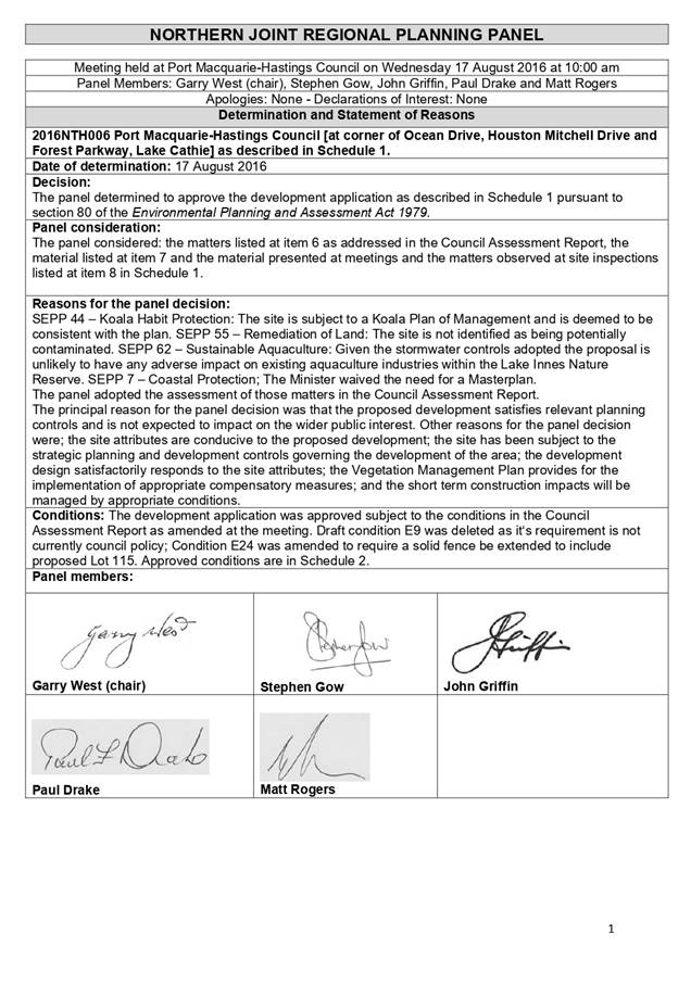
|
ATTACHMENT
|
Development Assessment Panel
27/05/2020
|
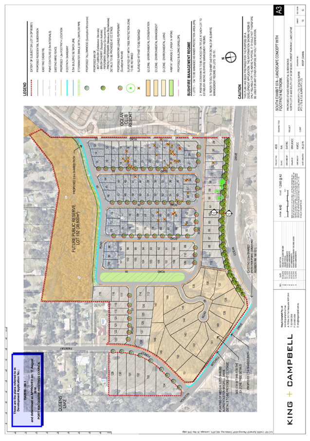
|
ATTACHMENT
|
Development Assessment Panel
27/05/2020
|
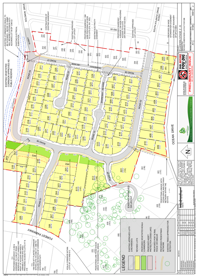
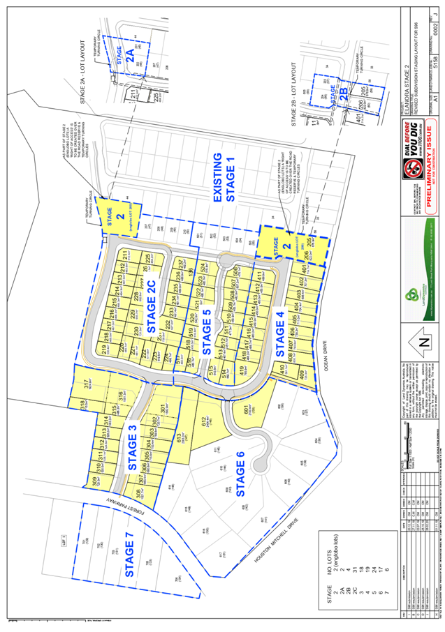
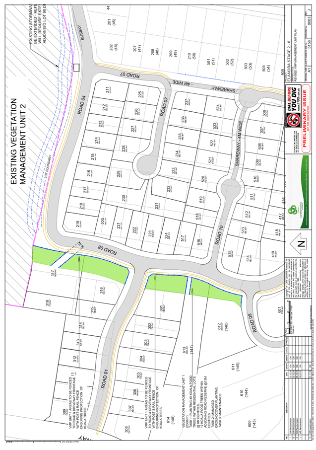
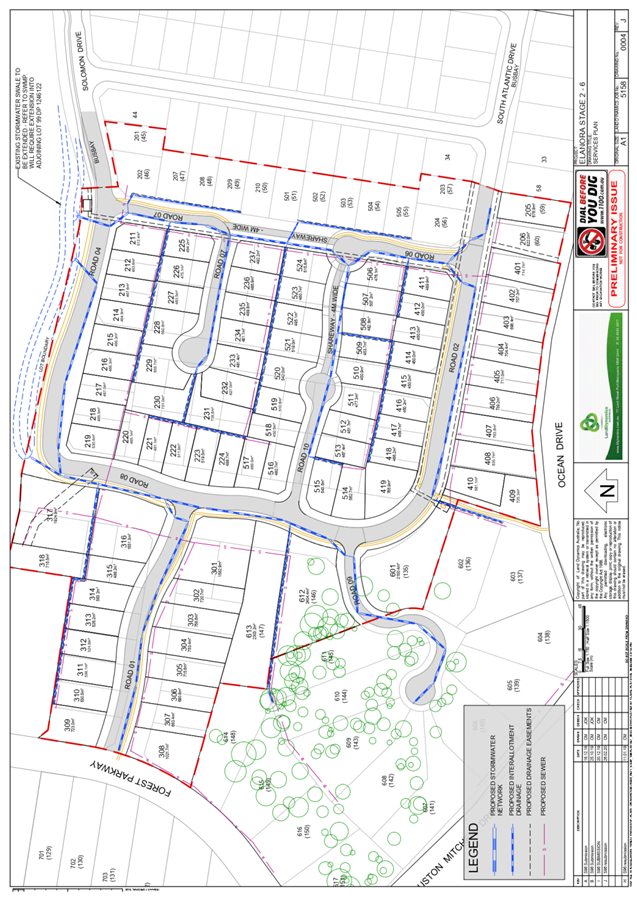
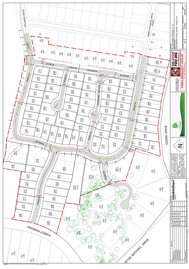
|
ATTACHMENT
|
Development Assessment Panel
27/05/2020
|