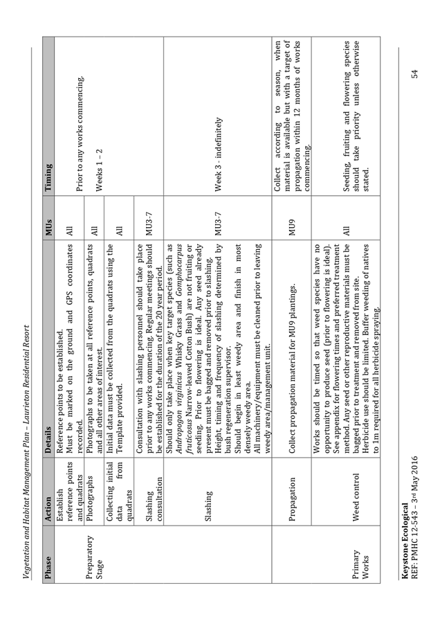
Development
Assessment Panel
Business
Paper
|
date of meeting:
|
|
Wednesday 10 June
2020
|
|
location:
|
|
Via Skype
|
|
time:
|
|
2:00pm
|
Development
Assessment Panel
CHARTER
1.0 OBJECTIVES
To assist in managing Council's development assessment
function by providing independent and expert determinations of development
applications that fall outside of staff delegations.
2.0 KEY FUNCTIONS
·
To review development application reports and conditions;
·
To determine development
applications outside of staff delegations;
·
To refer development applications
to Council for determination where necessary;
·
To provide a forum for objectors and applicants
to make submissions on applications
before the Development Assessment Panel
(DAP);
·
To maintain transparency in the determination of development
applications.
Delegated Authority of Panel
Pursuant to
Section 377 of the Local Government Act, 1993 delegation to:
·
Determine development applications under Part 4
of the Environmental Planning and Assessment
Act 1979 having
regard to the relevant environmental planning instruments,
development control plans and Council policies.
·
Vary, modify or release restrictions as to use and/or
covenants created by Section 88B instruments under the Conveyancing Act 1919 in
relation to development applications for subdivisions being considered by the panel.
·
Determine Koala Plans of Management under State
Environmental Planning Policy 44 - Koala Habitat Protection associated with
development applications being considered by the Panel.
Noting the trigger to escalate
decision making to Council as highlighted in section 5.2.
3.0
MEMBERSHIP
3.1
Voting
Members
·
Two independent external members. One of the
independent external members to be the Chairperson.
·
Group Manager Development Assessment (alternate
- Director Development & Environment or Development Assessment Planner)
The independent external members shall have expertise in
one or more of the following areas: planning, architecture, heritage, the
environment, urban design, economics, traffic and transport, law, engineering,
government and public administration.
3.2
Non-Voting Members
·
Not applicable
3.3 Obligations
of members
·
Members must act faithfully and diligently and
in accordance with this Charter.
·
Members must comply with Council's Code of Conduct.
·
Except as required to properly perform their
duties, DAP members must not
disclose any confidential information (as advised by Council) obtained in connection with the DAP functions.
·
Members will have read and be familiar with the
documents and information provided by Council prior
to attending a DAP meeting.
·
Members must act in accordance with Council's
Workplace Health and Safety Policies and Procedures
·
External members of the Panel are not authorised
to speak to the media on behalf of Council. Council officers that are members
of the Committee are bound by the
existing operational delegations in relation to speaking to the media.
·
Staff members shall not vote on matters before
the Panel if they have been the principle author of the development assessment report.
3.4
Member Tenure
·
The independent external members will be appointed
for the term of four (4) years
maximum in which the end of the tenure of these members would occur in a
cascading arrangement.
3.5 Appointment
of members
·
The independent external members (including the
Chair) shall be appointed by the General Manager following an external
Expression of Interest process.
·
Staff members of the Panel are in accordance
with this Charter.
4.0 TIMETABLE
OF MEETINGS
·
The Development Assessment Panel will generally
meet on the 1st and 3rd Wednesday each month at 2.00pm at the Port Macquarie
offices of Council.
·
Special Meetings of the Panel may be convened by
the Director Development & Environment Services with three (3) days notice.
5.0
MEETING PRACTICES
5.1
Meeting
Format
·
At all Meetings of the Panel the Chairperson
shall occupy the Chair and preside. The Chair will be responsible for keeping
of order at meetings.
·
Meetings shall be open to the public.
·
The Panel will hear from applicants
and objectors or their r e p r e s e n t a t i v e s .
·
Where considered necessary, the Panel will
conduct site inspections which will
be open to the public.
5.2
Decision Making
·
Decisions are to be made by consensus. Where
consensus is not possible on any item, that item is to be referred to Council
for a decision.
·
All development applications involving a
proposed variation to a development standard
greater than 10% under Clause
4.6 of the Local Environmental Plan will be
considered by the Panel and recommendation made to the Council for a decision.
5.3
Quorum
·
All members (2 independent external members and
1 staff member) must be present at a
meeting to form a quorum.
5.4
Chairperson and Deputy Chairperson
·
Independent Chair (alternate, second independent member)
5.5
Secretariat
·
The Director Development &n Environment is
to be responsible for ensuring that the Panel has adequate secretariat support.
The secretariat will ensure that the business paper and supporting papers are
circulated at least three (3) days prior to
each meeting. Minutes shall be appropriately approved and circulated to each
member within three (3) weeks of a meeting being held.
·
The format of and the preparation and publishing
of the Business Paper and Minutes shall be similar to the format for Ordinary
Council Meetings.
5.6
Recording of decisions
·
Minutes will record decisions and how each
member votes for each item before the Panel.
6.0 CONVENING
OF “OUTCOME SPECIFIC” WORKING GROUPS
Not applicable.
7.0 CONFIDENTIALITY
AND CONFLICT OF INTEREST
·
Members of the Panel must comply with the
applicable provisions of Council’s Code of Conduct. It is the personal
responsibility of members to comply with the standards in the Code of Conduct
and regularly review their personal circumstances with this in mind.
·
Panel members must declare any conflict of
interests at the start of each meeting or before discussion of a relevant item
or topic. Details of any conflicts of interest should be appropriately minuted.
Where members are deemed to have a real or perceived conflict of interest, it
may be appropriate they be excused from deliberations on the issue where the
conflict of interest may exist. A Panel meeting may be postponed where there is
no quorum.
8.0 LOBBYING
§ All members and applicants are to adhere to Council’s Lobbying
policy. Outside of scheduled
Development Assessment Panel meetings, applicants, their representatives,
Councillors, Council staff and the general public are not to lobby Panel
members via meetings, telephone conversations, correspondence and the like.
Adequate opportunity will be provided at Panel inspections or meetings for
applicants, their representatives and the general public to make verbal
submissions in relation to Business Paper items.
Development Assessment Panel
ATTENDANCE
REGISTER
|
Member
|
26/02/20
|
11/03/20
|
25/03/20
|
08/04/20
|
06/05/20
|
27/05/20
|
|
Paul
Drake
|
P
|
P
|
P
|
P
|
P
|
P
|
|
Robert
Hussey
|
P
|
P
|
|
P
|
|
|
|
David
Crofts
(alternate member)
|
|
|
P
|
|
P
|
P
|
|
Dan
Croft
(Group Manager Development Assessment)
(alternates)
- Development Assessment Planner
|
P
|
P
|
P
|
P
|
P
|
P
|
Key: P = Present
A
= Absent With Apology
X
= Absent Without Apology
Meeting Dates for
2020
|
22/01/2020
|
Function Room
|
2:00pm
|
|
12/02/2020
|
Function Room
|
2:00pm
|
|
26/02/2020
|
Function Room
|
2:00pm
|
|
11/03/2020
|
Function Room
|
2:00pm
|
|
25/03/2020
|
Function Room
|
2:00pm
|
|
8/04/2020
|
Function Room
|
2:00pm
|
|
6/05/2020
|
Function Room
|
2:00pm
|
|
27/05/2020
|
Function Room
|
2:00pm
|
|
10/06/2020
|
Function Room
|
2:00pm
|
|
24/06/2020
|
Function Room
|
2:00pm
|
|
8/07/2020
|
Function Room
|
2:00pm
|
|
22/07/2020
|
Function Room
|
2:00pm
|
|
12/08/2020
|
Function Room
|
2:00pm
|
|
26/08/2020
|
Function Room
|
2:00pm
|
|
9/09/2020
|
Function Room
|
2:00pm
|
|
30/09/2020
|
Function Room
|
2:00pm
|
|
14/10/2020
|
Function Room
|
2:00pm
|
|
28/10/2020
|
Function Room
|
2:00pm
|
|
11/11/2020
|
Function Room
|
2:00pm
|
|
25/11/2020
|
Function Room
|
2:00pm
|
|
16/12/2020
|
Function Room
|
2:00pm
|
Development
Assessment Panel Meeting
Wednesday 10 June
2020
Items of Business
01 Acknowledgement
of Country............................................................................. 8
02 Apologies.......................................................................................................... 8
03 Confirmation
of Minutes..................................................................................... 8
04 Disclosures
of Interest..................................................................................... 13
05 DA2020
- 118.1 Dwelling and Secondary Dwelling - Lot 12 DP 285493, No 17 Birramal
Drive, Dunbogan....................................................................................................... 17
06 DA2020
- 120.1 Dwelling-house and Two(2) Lot Strata Subdivision at Lot 15 DP 1228922,
Willow Dene Avenue Beechwood................................................................................ 49
07 DA2020
- 65.1 Staged Multi Dwelling Housing including Clause 4.6 Variation to Clause
4.3 (Height of Buildings) of Port Macquarie-Hastings Local Environmental Plan
2011 and Community Title Subdivision at Lot 2 DP 1188545, Pacific Drive, Port
Macquarie.................. 77
08 DA2019
- 552.1 Staged 136 Site Manufactured Home Estate at Lot 10 DP 1250178 No.11
Resort Rd, Kew........................................................................................................ 305
09 General
Business
AGENDA Development Assessment Panel 10/06/2020
Subject: ACKNOWLEDGEMENT
OF COUNTRY
"I acknowledge that we are
gathered on Birpai Land. I pay respect to the Birpai Elders both past and
present. I also extend that respect to all other Aboriginal and Torres Strait
Islander people present."
RECOMMENDATION
That the apologies received be
accepted.
Subject: CONFIRMATION
OF PREVIOUS MINUTES
Recommendation
That the Minutes of the Development Assessment Panel Meeting
held on 27 May 2020 be confirmed.
MINUTES
Development Assessment Panel Meeting
27/05/2020
PRESENT
Members:
Paul
Drake
David Crofts
Dan Croft
Other Attendees:
Grant Burge
Pat
Galbraith-Robertson
Ben
Roberts
Chris
Gardiner
Steven
Ford
|
The meeting opened at 2:00pm.
|
|
01 ACKNOWLEDGEMENT
OF COUNTRY
|
|
The Acknowledgement
of Country was delivered.
|
|
03 CONFIRMATION
OF MINUTES
|
|
CONSENSUS:
That
the Minutes of the Development Assessment Panel Meeting held on 6 and 7 May
2020 be confirmed.
|
|
04 DISCLOSURES OF INTEREST
|
|
There were no disclosures of interest
presented.
|
|
05 DA2019 - 137.2
Modification to alterations and additions to Dwelling at Lot 33 DP 18138, No
7 Arncliffe Avenue, Port Macquarie
|
|
Speakers:
Damien Keep (applicant)
CONSENSUS:
That DA
2019 - 137.2 for modification to consent
conditions for alterations and additions to dwelling at Lot 33, DP 18138, No. 7 Arncliffe
Avenue, Port Macquarie, be determined by granting
consent subject to the recommended modified conditions and as amended below:
- Additional condition in Section E of the consent to
read: ‘Prior to the issue of an occupation certificate, dense
screen landscaping achieving a minimum 3m height at maturity is to be
planted in the 920mm setback area between the proposed dwelling addition
and the rear boundary. The proposed rainwater tank is also to be sited
elsewhere on site.’
|
|
06 DA2019 - 655.1
Land Filling and Farm Buildings at Lot 16 and Lot 17 DP 855941 Oxley Highway,
Wauchope
|
|
Speakers:
Donna Clarke (applicant)
CONSENSUS:
That DA
2019 - 655.1 for land filling and
farm buildings at Lot 16 and Lot 16, DP 855941, Oxley Highway, Wauchope, be determined by
granting consent subject to the recommended conditions.
|
|
07 DA2019
- 740.1 Development Ancillary to Agriculture (Frost Fans) at Lot 13, DP
754420, 293 Innes View Road, Innes View
|
|
Speakers:
Ewan
Barlin (opposing application)
Ian
Tolson (applicant).
CONSENSUS:
That DA 2019 - 740 for
development ancillary to agriculture (frost fans) at Lot 13, DP
754420, No. 293 Innes View Road, Innes View, be determined by granting
consent subject to the recommended conditions and as amended below:
- Amend condition F(2) to read: ‘The
development must not cause a noise nuisance to any other person.
Following occupation, should complaints of a noise nuisance be
justified, to the satisfaction of Council, further acoustic assessments
may be requested to be undertaken by a qualified consultant and a Noise
Impact Assessment Report provided to Port Macquarie-Hastings Council.
The applicant shall then implement all recommendations provided under
the assessment within a timeframe set by Council, to the satisfaction of
Council and shall comply with any additional direction given by
Council.’
|
|
08 DA2019 - 568.1
Demolition of Multi Dwelling Housing and Construction of Residential Flat
Building Including Clause 4.6 Variation to Clause 4.3 (Height of Buildings)
of the Port Macquarie-Hastings Local Environmental Plan 2011 at Lot 101 DP
1122606, No 3 Clarence Street, Port Macquarie
|
|
Speakers:
Leonie Brown (opposing
application)
Wayne Ellis (applicant)
CONSENSUS:
That DA2019
- 568.1 for demolition of Multi Dwelling Housing
and construction of a Residential Flat Building Including Clause 4.6
Variation to Clause 4.3 (Height of Buildings) of the Port Macquarie-Hastings
Local Environmental Plan 2011 at Lot 101 DP 1122606 No. 3 Clarence Street, Port
Macquarie, be determined by granting consent
subject to the recommended conditions.
|
|
09 DA2016
- 88.5 - Section 4.55 Modification to Existing Subdivision Layout at Lot 2 DP
1263561 and Lot 99 DP 1246122, South Atlantic Drive, Lake Cathie
|
|
Speakers:
Donna Clark (applicant)
CONSENSUS:
That the Development Assessment Panel recommend to
Council that the Section 4.55 modification to DA2016 - 88.5 being a modification to the layout of the
previous approved staged subdivision at Lot 2, DP 1263561 and Lot 99, DP 1246122, South Atlantic Drive, Lake Cathie, be determined by
granting consent, subject to the recommended modified conditions.
|
|
The meeting closed at 4;15pm.
|
AGENDA Development Assessment Panel 10/06/2020
Subject: DISCLOSURES
OF INTEREST
RECOMMENDATION
That Disclosures of Interest be presented
DISCLOSURE OF
INTEREST DECLARATION
|
Name of Meeting:
|
|
Meeting
Date:
|
|
Item
Number:
|
|
Subject:
|
|
I,
the undersigned, hereby declare the following interest:
Pecuniary:
 Take no part
in the consideration and voting and be out of sight of the meeting. Take no part
in the consideration and voting and be out of sight of the meeting.
Non-Pecuniary
– Significant Interest:
Take no part
in the consideration and voting and be out of sight of the meeting.
Non-Pecuniary
– Less than Significant Interest:
May
participate in consideration and voting.
|
|
For
the reason that:
|
|
Name:
Signed:
|
Date:
|
|
Please submit to the Governance
Support Officer at the Council Meeting.
|
 (Refer
to next page and the Code of Conduct)
(Refer
to next page and the Code of Conduct)
Pecuniary Interest
4.1
A pecuniary interest is an interest
that you have in a matter because of a reasonable likelihood or expectation of
appreciable financial gain or loss to you or a person referred to in clause
4.3.
4.2
You will not have a pecuniary
interest in a matter if the interest is so remote or insignificant that it
could not reasonably be regarded as likely to influence any decision you might
make in relation to the matter, or if the interest is of a kind specified in
clause 4.6.
4.3
For the purposes of this Part, you
will have a pecuniary interest in a matter if the pecuniary interest is:
(a)
your interest, or
(b)
the interest of your spouse or de
facto partner, your relative, or your partner or employer, or
(c)
a company or other body of which
you, or your nominee, partner or employer, is a shareholder or member.
4.4
For the purposes of clause 4.3:
(a)
Your “relative” is any
of the following:
(b)
“de facto partner” has
the same meaning as defined in section 21C of the Interpretation Act 1987.
4.5
You will not have a pecuniary
interest in relation to a person referred to in subclauses 4.3(b) or (c)
(a)
if you are unaware of the relevant
pecuniary interest of your spouse, de facto partner, relative, partner,
employer or company or other body, or
(b)
just because the person is a member
of, or is employed by, a council or a statutory body, or is employed by the
Crown, or
(c)
just because the person is a member
of, or a delegate of a council to, a company or other body that has a pecuniary
interest in the matter, so long as the person has no beneficial interest in any
shares of the company or body.
Non-Pecuniary
5.1
Non-pecuniary interests are private
or personal interests a council official has that do not amount to a pecuniary
interest as defined in clause 4.1 of this code. These commonly arise out of
family or personal relationships, or out of involvement in sporting, social,
religious or other cultural groups and associations, and may include an
interest of a financial nature.
5.2
A non-pecuniary conflict of
interest exists where a reasonable and informed person would perceive that you
could be influenced by a private interest when carrying out your official
functions in relation to a matter.
5.3
The personal or political views of
a council official do not constitute a private interest for the purposes of
clause 5.2.
5.4
Non-pecuniary conflicts of interest
must be identified and appropriately managed to uphold community confidence in
the probity of council decision-making. The onus is on you to identify any
non-pecuniary conflict of interest you may have in matters that you deal with,
to disclose the interest fully and in writing, and to take appropriate action
to manage the conflict in accordance with this code.
5.5
When considering whether or not you
have a non-pecuniary conflict of interest in a matter you are dealing with, it
is always important to think about how others would view your situation.
Managing non-pecuniary conflicts of interest
5.6
Where you have a non-pecuniary
conflict of interest in a matter for the purposes of clause 5.2, you must
disclose the relevant private interest you have in relation to the matter fully
and in writing as soon as practicable after becoming aware of the non-pecuniary
conflict of interest and on each occasion on which the non-pecuniary conflict
of interest arises in relation to the matter. In the case of members of council
staff other than the general manager, such a disclosure is to be made to the
staff member’s manager. In the case of the general manager, such a
disclosure is to be made to the mayor.
5.7
If a disclosure is made at a
council or committee meeting, both the disclosure and the nature of the
interest must be recorded in the minutes on each occasion on which the
non-pecuniary conflict of interest arises. This disclosure constitutes
disclosure in writing for the purposes of clause 5.6.
5.8
How you manage a non-pecuniary
conflict of interest will depend on whether or not it is significant.
5.9
As a general rule, a non-pecuniary
conflict of interest will be significant where it does not involve a pecuniary
interest for the purposes of clause 4.1, but it involves:
a)
a relationship between a council
official and another person who is affected by a decision or a matter under
consideration that is particularly close, such as a current or former spouse or
de facto partner, a relative for the purposes of clause 4.4 or another person
from the council official’s extended family that the council official has
a close personal relationship with, or another person living in the same
household
b)
other relationships with persons
who are affected by a decision or a matter under consideration that are
particularly close, such as friendships and business relationships. Closeness
is defined by the nature of the friendship or business relationship, the
frequency of contact and the duration of the friendship or relationship.
c)
an affiliation between the council
official and an organisation (such as a sporting body, club, religious,
cultural or charitable organisation, corporation or association) that is
affected by a decision or a matter under consideration that is particularly
strong. The strength of a council official’s affiliation with an organisation
is to be determined by the extent to which they actively participate in the
management, administration or other activities of the organisation.
d)
membership, as the council’s
representative, of the board or management committee of an organisation that is
affected by a decision or a matter under consideration, in circumstances where
the interests of the council and the organisation are potentially in conflict
in relation to the particular matter
e)
a financial interest (other than an
interest of a type referred to in clause 4.6) that is not a pecuniary interest
for the purposes of clause 4.1
f)
the conferral or loss of a personal
benefit other than one conferred or lost as a member of the community or a
broader class of people affected by a decision.
5.10
Significant non-pecuniary conflicts
of interest must be managed in one of two ways:
a)
by not participating in
consideration of, or decision making in relation to, the matter in which you
have the significant non-pecuniary conflict of interest and the matter being allocated
to another person for consideration or determination, or
b)
if the significant non-pecuniary
conflict of interest arises in relation to a matter under consideration at a
council or committee meeting, by managing the conflict of interest as if you
had a pecuniary interest in the matter by complying with clauses 4.28 and 4.29.
5.11
If you determine that you have a
non-pecuniary conflict of interest in a matter that is not significant and does
not require further action, when disclosing the interest you must also explain
in writing why you consider that the non-pecuniary conflict of interest is not
significant and does not require further action in the circumstances.
5.12
If you are a member of staff of
council other than the general manager, the decision on which option should be
taken to manage a non-pecuniary conflict of interest must be made in
consultation with and at the direction of your manager. In the case of the
general manager, the decision on which option should be taken to manage a
non-pecuniary conflict of interest must be made in consultation with and at the
direction of the mayor.
5.13
Despite clause 5.10(b), a
councillor who has a significant non-pecuniary conflict of interest in a
matter, may participate in a decision to delegate consideration of the matter
in question to another body or person.
5.14 Council committee members are not required to declare
and manage a non-pecuniary conflict of interest in accordance with the
requirements of this Part where it arises from an interest they have as a
person chosen to represent the community, or as a member of a non-profit
organisation or other community or special interest group, if they have been
appointed to represent the organisation or group on the council committee.
SPECIAL
DISCLOSURE OF PECUNIARY INTEREST DECLARATION
This
form must be completed using block letters or typed.
If
there is insufficient space for all the information you are required to
disclose,
you
must attach an appendix which is to be properly identified and signed by you.
|
By
[insert full name of councillor]
|
|
|
In the
matter of
[insert name of environmental planning instrument]
|
|
|
Which is
to be considered at a meeting of the
[insert name of meeting]
|
|
|
Held on
[insert date of meeting]
|
|
|
PECUNIARY
INTEREST
|
|
Address of
the affected principal place of residence of the councillor or an associated
person, company or body (the identified land)
|
|
|
Relationship
of identified land to councillor
[Tick or cross one box.]
|
The councillor has interest in the land (e.g. is owner or has other
interest arising out of a mortgage, lease, trust, option or contract, or
otherwise).
An associated person of the councillor has an interest in the land.
An associated company or body of the councillor has interest in the land.
|
|
MATTER
GIVING RISE TO PECUNIARY INTEREST
|
|
Nature of
land that is subject to a change
in
zone/planning control by proposed
LEP (the
subject land
[Tick or cross one box]
|
The identified land.
Land that adjoins or is adjacent to or is in proximity to the identified
land.
|
|
Current
zone/planning control
[Insert name of current planning instrument and
identify relevant zone/planning control applying to the subject land]
|
|
|
Proposed
change of zone/planning control
[Insert name of proposed LEP and identify proposed
change of zone/planning control applying to the subject land]
|
|
|
Effect of
proposed change of zone/planning control on councillor or associated person
[Tick or cross one box]
|
Appreciable financial gain.
Appreciable financial loss.
|
|
|
|
[If more than one pecuniary interest is to be
declared, reprint the above box and fill in for each additional interest]
Councillor’s Signature:
……………………………….
Date: ………………..
This form is to be retained
by the council’s general manager and included in full in the minutes of
the meeting
Last Updated: 3 June 2019
Important Information
This information is being collected for the purpose of
making a special disclosure of pecuniary interests under clause 4.36(c) of the
Model Code of Conduct for Local Councils in NSW (the Model Code of Conduct).
The special disclosure must relate only to a pecuniary
interest that a councillor has in the councillor’s principal place of
residence, or an interest another person (whose interests are relevant under
clause 4.3 of the Model Code of Conduct) has in that person’s principal
place of residence.
Clause 4.3 of the Model Code of Conduct states that you
will have a pecuniary interest in a matter because of the pecuniary interest of
your spouse or your de facto partner or your relative or because your business
partner or employer has a pecuniary interest. You will also have a pecuniary
interest in a matter because you, your nominee, your business partner or your
employer is a member of a company or other body that has a pecuniary interest
in the matter.
“Relative” is defined by clause 4.4 of the Model
Code of Conduct as meaning your, your spouse’s or your de facto
partner’s parent, grandparent, brother, sister, uncle, aunt, nephew,
niece, lineal descendant or adopted child and the spouse or de facto partner of
any of those persons.
You
must not make a special disclosure that you know or ought reasonably to know is
false or misleading in a material particular. Complaints about breaches
of these requirements are to be referred to the Office of Local Government and
may result in disciplinary action by the Chief Executive of the Office of Local
Government or the NSW Civil and Administrative Tribunal.
This form must be completed by you before the commencement
of the council or council committee meeting at which the special disclosure is
being made. The completed form must be tabled at the meeting. Everyone is
entitled to inspect it. The special disclosure must be recorded in the minutes
of the meeting.
A pecuniary interest may arise by way of a change of
permissible use of land adjoining, adjacent to or in proximity to land in which
a councillor or a person, company or body referred to in clause 4.3 of the
Model Code of Conduct has a proprietary interest
AGENDA Development Assessment Panel 10/06/2020
Item: 05
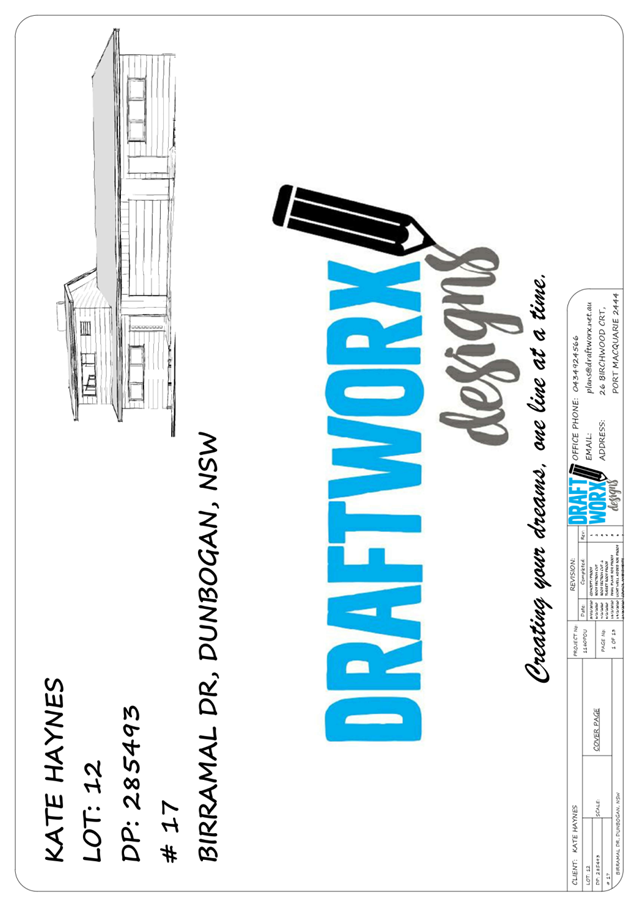
Subject: DA2020 - 118.1 Dwelling and Secondary Dwelling
- Lot 12 DP 285493, No 17 Birramal Drive, Dunbogan
Report
Author: Building Surveyor, Ross Frazier
|
Applicant: K
F Haynes
Owner: K
F Haynes
Estimated Cost: $292,000
Alignment with Delivery
Program
4.3.1 Undertake transparent and
efficient development assessment in accordance with relevant legislation.
|
RECOMMENDATION
That
DA 2020 - 118.1 for a dwelling and
secondary dwelling at Lot 12 DP 285493, No. 17 Birramal Drive, Dunbogan be
determined by granting consent subject to the recommended conditions.
Executive
Summary
This
report considers a development application for a dwelling and attached
secondary dwelling at the subject site and provides
an assessment of the application in accordance with the Environmental Planning
and Assessment Act 1979.
Following exhibition of the
application, 2 submissions were
received. A copy of the submissions has been provided separately to the
members of the Development Assessment Panel.
The site is considered suitable for the proposed development
and the proposal adequately addresses relevant planning controls. The
development is not considered to be contrary to the public's interest and will
not result a significant adverse social, environmental or economic impact.
This report recommends that the
development application be approved subject to the attached conditions (Attachment
1).
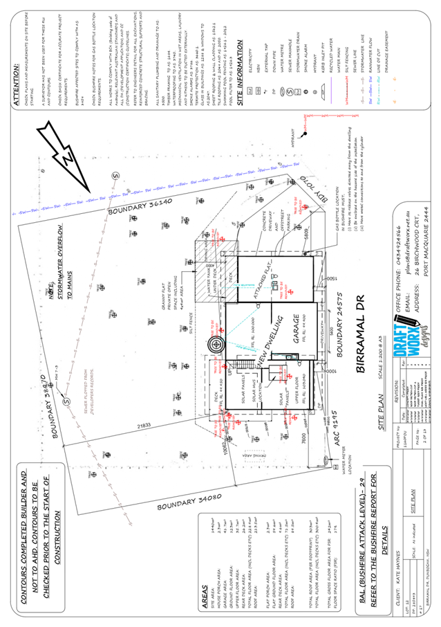
1. BACKGROUND
Existing
Sites Features and Surrounding Development
The site has an area of approximately
1439m2.
The
site is zoned R1 General Residential in
accordance with the Port Macquarie-Hastings Local Environmental Plan 2011, as
shown in the following zoning plan:
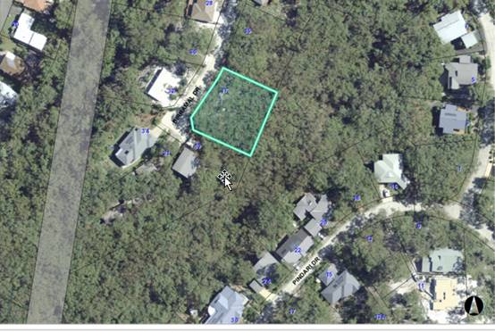
The
existing subdivision pattern and location of existing development within the
locality is shown in the following aerial photograph:
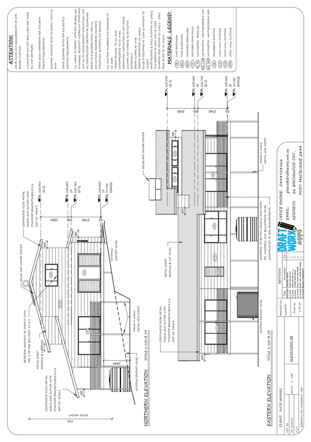
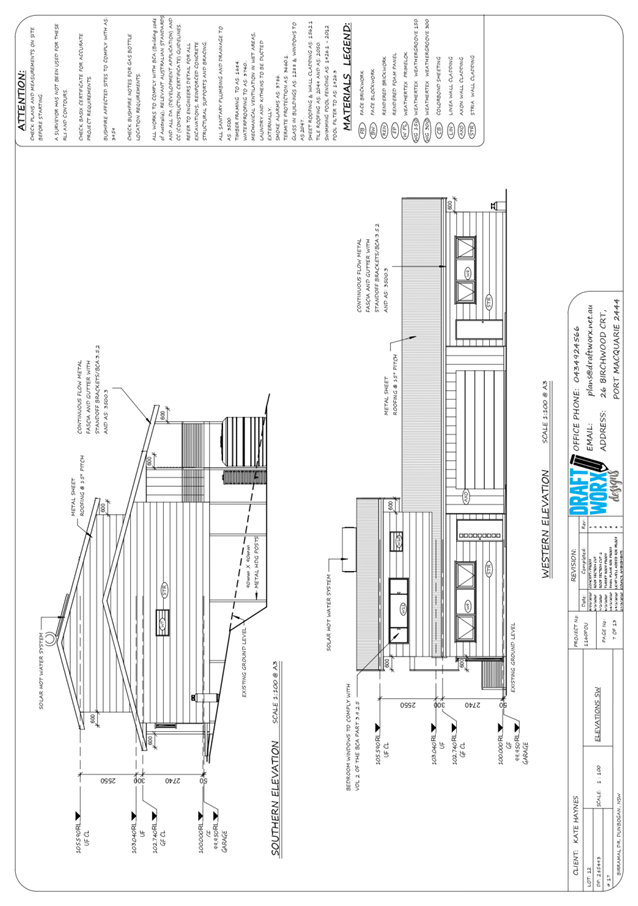
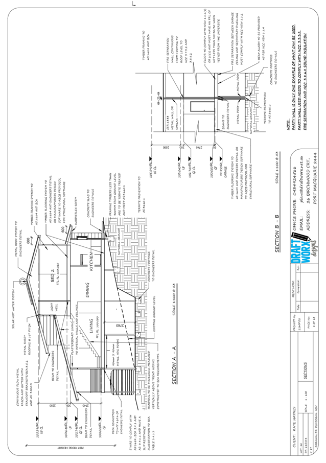
2. DESCRIPTION
OF DEVELOPMENT
Key
aspects of the proposal include the following:
· Removal
of several trees from the site in accordance with approved ecology report and
construction of a new 2 storey, 2 bedroom dwelling with attached single storey,
single bedroom secondary dwelling (Granny Flat).
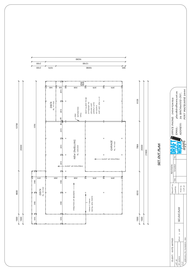
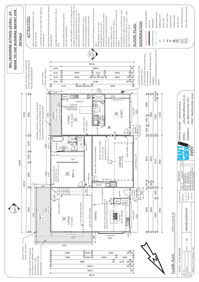
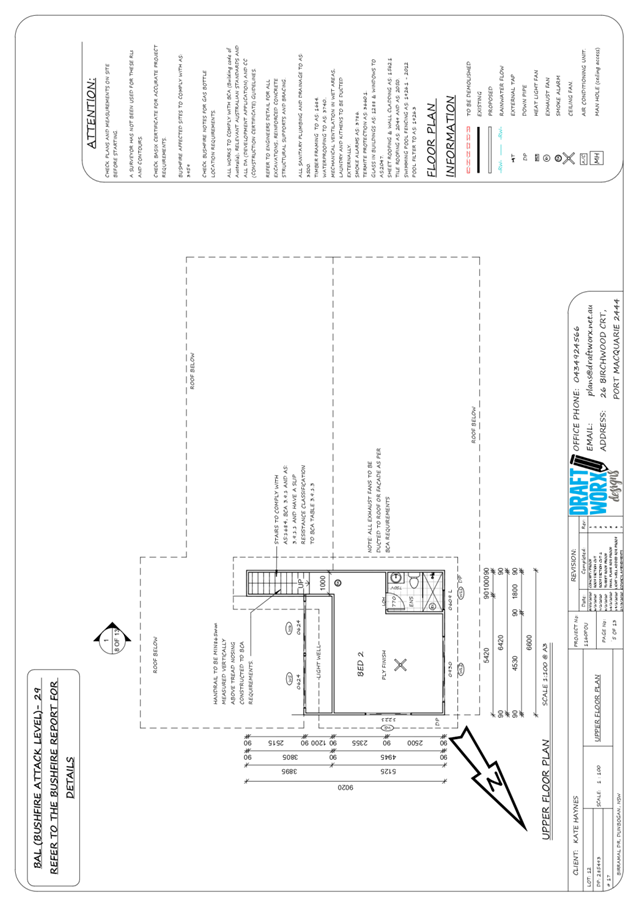
Refer
to Attachment 2 at the end of this report for plans of the proposed
development.
Application
Chronology
· 21
February 2020 - Application lodged.
· 9
March 2020 - Request for additional information - Arborist report/ecological
report.
· 19
March 2020 - Council arborist site visit at owner request.
· 25
March 2020 - Request for information in response to submission concerns.
· 23
March 2020 - Receipt of ecology report.
· 24
March 2020 - Amended plans received to address off-street carparking.
3. STATUTORY
ASSESSMENT
Section
4.15(1) Matters for Consideration
In
determining the application, Council is required to take into consideration the
following matters as are relevant to the development that apply to the land to
which the development application relates:
(a) The
provisions (where applicable) of:
(i) Any
Environmental Planning Instrument
State Environmental Planning Policy No. 44 - Koala
Habitat Protection
There is no Koala Plan of Management on the site.
Additionally, the site is less than 1ha in area. Some trees are indicated for
removal and an ecology report has been prepared. The report has been referred
to Councils Natural Resource team for assessment. Councils Natural resource
team approved the report for the removal of the identified trees and has
prepared conditions of consent as required.
State Environmental Planning Policy No. 55 –
Remediation of Land
Following an inspection of the site and a search of Council
records, the subject land is not identified as being potentially contaminated
and is suitable for the intended use.
State Environmental Planning Policy (Coastal Management)
2018
The site is located within a coastal environment area.
In accordance with clause 7, this SEPP prevails over the
Port Macquarie-Hastings LEP 2011 in the event of any inconsistency.
Having regard to clauses 13 and 14 of the SEPP the proposed
development is not considered likely to result in any of the following:
a) any
adverse impact on integrity and resilience of the biophysical,
hydrological (surface and groundwater) and ecological environment;
b) any
adverse impacts coastal environmental values and natural coastal
processes;
c) any
adverse impact on marine vegetation, native vegetation and fauna
and their habitats, undeveloped headlands and rock platforms;
d) any
adverse impact on Aboriginal cultural heritage, practices and
places;
e) any
adverse impacts on the cultural and built environment heritage;
f) any
adverse impacts the use of the surf zone;
g) any adverse impact on the visual amenity and scenic qualities of the
coast, including coastal headlands;
h) overshadowing, wind funnelling and the loss of views from public places
to foreshores;
i) any
adverse impacts on existing public open space and safe access to
and along the foreshore, beach, headland or rock platform for members of the
public, including persons with a disability;
In accordance with Clause 15 the
proposal is not likely to cause increased risk of coastal hazards on that land
or other land.
The bulk, scale and size of the proposed development is
compatible with the surrounding coastal and built environment. The site is part
of an existing residential subdivision located on a dune style beachfront with
natural bush surrounding. The land zoned for residential purposes.
State Environmental Planning Policy (Building
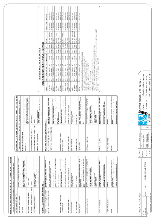
Sustainability Index: BASIX) 2004
A BASIX certificate has been
submitted demonstrating that the proposal will comply with the requirements of
the SEPP. It is recommended that a condition be imposed to ensure that the
commitments are incorporated into the development and certified at Occupation
Certificate stage.
State Environmental Planning Policy (Infrastructure) 2007
Clause 45 - Development in proximity to electricity
infrastructure – The development is clear of infrastructure.
State Environmental Planning Policy (Affordable Rental
Housing) 2009
Clause 20 - The site is in a prescribed zone and secondary
dwellings are permissible with consent pursuant to the SEPP.
Clause 22(2) - The development would not result in there
being a dwelling other than the primary dwelling and the secondary dwelling.
Clause 22(3) - The proposed secondary dwelling would not
have a floor area exceeding 60m2 and the combined floor area of the
primary and secondary dwelling would not exceed the maximum permitted under the
Port Macquarie-Hastings Local Environmental Plan 2011 (see comments below under
LEP).
Clause 22(4) - It is noted that consent cannot be refused on
the grounds of site area or parking.
Clause 24 - It is noted that the consent authority must not
consent to a development application that would result in any subdivision of a
lot on which development for the purposes of a secondary dwelling has been
carried out.
The requirements of this SEPP are therefore satisfied.
Port
Macquarie-Hastings Local Environmental Plan 2011
The proposal is consistent with the LEP having regard to the
following:
· Clause
2.2 - The subject site is zoned R1 General Residential.
· Clause
2.3(1) and the R1 zone landuse table - The dwelling and attached secondary
dwelling is a permissible landuse with consent.
The objectives of the R1 zone are as
follows:
· To provide for
the housing needs of the community.
· To provide for
a variety of housing types and densities.
· To
enable other land uses that provide facilities or services to meet the day to
day needs of residents.
· Clause
2.3(2) - The proposal is consistent with the zone objectives as it is a
permissible landuse and consistent with the established residential locality.
· Clause
2.7 - No demolition proposed. New construction.
· Clause
4.3 - The maximum overall height of the building above ground level (existing)
is approx. 7.728m which complies with the standard height limit of 8.5m
applying to the site.
· Clause
4.4 - The floor space ratio of the proposal complies with the maximum floor
space ratio applying to the site.
· Clause
4.6 - Exceptions to development standards. Nil proposed.
· Clause
5.4 - Controls relating to B&Bs, home business, industrial retail, farm
stay, kiosks, neighbourhood shops, secondary dwellings etc. Max floor of
secondary dwelling 60m2. The submitted plans indicate the
secondary dwelling has a floor area of 59.6m2. Appears to comply
· Clause
5.10 - Heritage. The site does not contain or adjoin any known heritage items
or sites of significance.
· Clause
7.1 - The site is mapped as potentially containing class 5 acid sulfate soils.
The proposed development includes a pole style dwelling however no excavation
extending more than 2m below the natural surface level or within other ASS
zones is proposed, therefore no adverse impacts are expected to occur in
respect of acid sulphate soils found on site.
· Clause
7.3 - The site is not land within a mapped “flood planning area”
(Land subject to flood discharge of 1:100 annual recurrence interval flood
event (plus the applicable climate change allowance and relevant freeboard). In
this regard the clause does not apply.
· Clause
7.5 - Koala Habitat - Applies to land that is shown as “Koala Habitat
area” on the Koala Habitat Map. A search of council mapping indicates
there is no current Koala Plan of Management applicable to the site.
· Clause
7.6 - Applies to land that is shown as Coastal Erosion Risk on the Coastal
Erosion Map (Lake Cathie/Town Beach). In this regard the site is clear of the
zone.
· Clause
7.9 - Development subject to acoustic controls. N/A
· Clause
7.13 - Satisfactory arrangements are in place for provision of essential
services including water supply, electricity supply, on-site sewage
management/sewer infrastructure, stormwater drainage and suitable road access
to service the development.
(ii) Any draft
instruments that apply to the site or are on exhibition
No draft instruments apply to the site.
(iii) Any Development
Control Plan in force
Port
Macquarie-Hastings Development Control Plan 2013
Note: The site is located within
a private gated estate under a Community Association Plan - Timbarra Estate.
This estate enjoys a private road network and private water and sewer
utilities. The road setback provisions of the DCP are considered to be more
relevant to a conventional torrens title subdivision with public road frontage.
Notwithstanding this, an assessment has been provided noting the provisions of
the DCP, the DCP objectives and the context of the estate.
Port Macquarie-Hastings
Development Control Plan 2013:
|
DCP 2013: Dwellings, Dual
occupancies, Dwelling houses, Multi dwelling houses & Ancillary
development
|
|
|
Requirements
|
Proposed
|
Complies
|
|
3.2.2.1
|
Ancillary development:
· 4.8m max. height
· Single storey
· 60m2 max.
area
· 100m2 for
lots >900m2
· 24 degree max. roof
pitch
· Not located in front
setback
|
Water tank is appropriately
located
|
Yes
|
|
3.2.2.2
|
Articulation zone:
· Min. 3m front setback
· An entry feature or
portico
· A balcony, deck,
patio, pergola, terrace or verandah
· A window box treatment
· A bay window or
similar feature
· An awning or other feature
over a window
· A sun shading feature
|
Due to the setback proposed for the dwelling and the
design layout, there is no construction proposed within an articulation zone.
|
N/A
|
|
Front setback (Residential not R5
zone):
· Min. 6.0m classified
road
· Min. 4.5m local road
or within 20% of adjoining dwelling if on corner lot
· Min. 3.0m secondary
road
· Min. 2.0m Laneway
|
1m setback from private road. Due
to the existing and extensive slope of the site, the setback of the proposed
dwelling has been maintained as close as practical to the front boundary
|
DCP Variation
|
|
3.2.2.3
|
Garage 5.5m min. and 1m behind
front façade.
Garage door recessed behind
building line or eaves/overhangs provided
|
Proposed main garage is forward
of the main dwelling and setback 1m from the private road.
As the dwelling is a pole style
construction additional carparking is proposed beneath the dwelling at the
side.
|
DCP Variation
|
|
6m max. width of garage door/s
and 50% max. width of building
|
Width of garage door/s are
compliant with the maximum width requirements
|
Yes
|
|
Driveway crossover 1/3 max. of
site frontage and max. 5.0m width
|
Main driveway crossing width is
proposed at 5.4m plus additional minor crossing to the side of the dwelling
proposed. The subdivision is within a private gated estate and the roads are
a private road. Council is not the consent authority for driveway crossovers
in these circumstances.
|
DCP Variation
|
|
3.2.2.4
|
4m min. rear setback. Variation
subject to site analysis and provision of private open space
|
The rear setback is 21m.
|
Yes
|
|
3.2.2.5
|
Side setbacks:
· Ground floor = min.
0.9m
· First floors &
above = min. 3m setback or where it can be demonstrated that overshadowing
not adverse = 0.9m min.
· Building wall set in
and out every 12m by 0.5m
|
The minimum side setback
requirements are complied with. 7.6m to the north and 5.6m to the south.
|
Yes
|
|
3.2.2.6
|
35m2 min. private open space area
including a useable 4x4m min. area which has 5% max. grade
The lot is steeply sloping.
Private open space is available within areas adjacent to the dwelling however
direct connection is only available through the front entrance as there is no
other entrance to the dwelling.
Both dwellings enjoy access to a
rear balcony. Although the floor areas of these balconies do not meet the
dimensions required they do offer direct access from the dwelling and will
enjoy the same benefits of such an area.
|
The primary dwelling contains 35m² open space in one
area including a useable 4m x 4m space. The secondary dwelling is provided a
lesser but useable open space area. However, given the nature of the
development, the occupants are likely to share the open space area.
The dwelling and secondary dwelling have a total of 3
bedrooms only and therefore the use of the required open space areas will be
minimal
|
Yes
|
|
3.2.2.10
|
Privacy:
· Direct views between
living areas of adjacent dwellings screened when within 9m radius of any part
of window of adjacent dwelling and within 12m of private open space areas of
adjacent dwellings. ie. 1.8m fence or privacy screening which has 25% max.
openings and is permanently fixed
· Privacy screen
required if floor level > 1m height, window side/rear setback (other than
bedroom) is less than 3m and sill height less than 1.5m
· Privacy screens
provided to balconies/verandahs etc which have <3m side/rear setback and
floor level height >1m
|
No privacy screens are recommended.
The development will not compromise privacy in the area
due to a combination of lack of windows on side/rear boundaries, having high
sill windows that face side/rear boundaries, limiting living areas that face
adjoining living areas/open space, compliant separation and use of
screening/fencing.
Balconies greater than 3m to side boundaries.
Recommend privacy screen to Southern end of deck on main
dwelling.
(Condition recommended)
|
Yes
Yes
|
|
DCP 2013: General
Provisions
|
|
|
Requirements
|
Proposed
|
Complies
|
|
2.7.2.2
|
Design addresses generic principles of Crime Prevention
Through Environmental Design guideline
|
No concealment or entrapment areas proposed. Adequate
casual surveillance available.
|
Yes
|
|
2.3.3.1
|
Cut and fill 1.0m max. 1m outside the perimeter of the
external building walls
|
Cut and fill <1.0m change 1m outside the perimeter of
the external building walls
|
Yes
|
|
2.3.3.2
|
1m max. height retaining walls along road frontage
|
None proposed
|
N/A
|
|
Any retaining wall >1.0 in height to be certified by
structure engineer
|
No retaining wall likely
|
Yes
|
|
Combination of retaining wall and front fence height max
1.8m, max length 6.0m or 30% of frontage, fence component 25% transparent,
and splay at corners and adjacent to driveway
|
No retaining wall front fence combination proposed.
|
N/A
|
|
2.3.3.8
|
Removal of hollow bearing trees
|
Trees indicated on site plan to be removed. An ecological
report has been prepared for the site. Council arborist has visited the site
and found no indications of concern to prevent the removal of the trees.
|
Yes
|
|
2.6.3.1
|
Tree removal (3m or higher with 100m diameter trunk at 1m
above ground level and 3m from external wall of existing dwelling)
|
Trees indicated on site plan to be removed. An ecological
report has been prepared for the site. Council arborist has visited the site
and found no indications of concern to prevent the removal of the trees.
|
Yes
|
|
2.4.3
|
Bushfire risk, Acid sulphate soils, Flooding,
Contamination, Airspace protection, Noise and Stormwater
|
Refer to main body of report.
|
|
|
2.5.3.2
|
New accesses not permitted from arterial or distributor
roads
|
No new access proposed to arterial or distributor road.
|
N/A
|
|
Driveway crossing/s minimal in number and width including
maximising street parking
|
Driveway crossing from private roads are not subject to
Sec 138 approval
|
N/A
|
|
2.5.3.3
|
Parking in accordance with Table 2.5.1.
1 space per single dwelling (behind building line).
Parking for secondary dwelling optional.
|
1 or capacity for more than 1 parking space behind the
building line has been provided for.
|
Yes
|
|
2.5.3.11
|
Section 7.11 contributions
|
Refer to main body of report.
|
|
|
2.5.3.12 and 2.5.3.13
|
Landscaping of parking areas
|
Development is for a secondary dwelling only with standard
driveway. No specific landscaping requirements recommended.
|
N/A
|
|
2.5.3.14
|
Sealed driveway surfaces unless justified
|
Sealed driveways indicated
|
Yes
|
|
2.5.3.15 and 2.5.3.16
|
Driveway grades first 6m or ‘parking area’
shall be 5% grade with transitions of 2m length
|
Driveway to be from private internal road and not subject
to Sec 138 approval.
|
N/A
|
|
2.5.3.17
|
Parking areas to be designed to avoid concentrations of
water runoff on the surface.
|
Development is for a primary and attached secondary
dwelling. Driveway stormwater drainage is capable of being managed as
part of plumbing construction.
|
Yes
|
The proposal seeks to vary the
following Development Provisions.
3.2.2.2 (b) - the primary
front setback should be 4.5m
Objective: Front setbacks
should support an attractive streetscape.
3.2.2.3 (c) - A garage should
be at least 5.5m from a front boundary where the dwelling has a setback of less
than 4.5m.
(f) - Driveway crossovers are a maximum of 1/3rd
of the site frontage and no greater than 5m in width.
Objective: To minimise the
impact of garages and driveways on the streetscape, on street parking and
amenity.
To minimise
the visual dominance of garages in the streetscape.
Discussion / Justification
The site is located within a
private gated community estate. The road network and services / utilities are
part of a private network. The site has been previously excavated and benched
to establish a dwelling construction site, with the remainder of the lot having
a steep grade.
Due to the grade of the site and
to allow economical access and construction, it is required to locate the
dwelling close to the front boundary.
Additionally, to provide access
to the attached garage, the garage is to be located proud of the front wall of
the dwelling.
The dwelling will be pole style
construction which will allow space beneath the main floor of the dwelling.
This will be utilised for additional off-street carparking / storage via a
secondary sealed driveway to the side of the dwelling with another 2 spaces
designated within this area and room for storage of vehicle accessories.
The DCP provides driveway width
to be a maximum of 5m. it is proposed to increase the driveway width to 5.4m to
allow for ease of access to the attached garage. Due to the relatively narrow
streets, additional driveway width will assist with entering and exiting the
garage. The road network is a private road and not subject to PMHC Sec 138
application.
3.2.2.6 (a) All dwellings
should have a minimum area of private open space of 35m2 in one area, with
(b) a minimum dimension of 4m x 4m; and
(c) a maximum grade of 5% for minimum 4m x 4m of
the total open space requirement; and
(d)
direct accessibility from a ground floor living area.
Objective: To encourage
useable private open space for dwellings to meet the occupant’s
requirements for privacy, safety, access, outdoor activities and landscaping.
Discussion / Justification
The lot has an area of some 1438m2
which will cater for the required open space for the dwelling and secondary
dwelling. Due to the slope of the site the design of the dwellings provides for
a single front door only. There is no rear access from the dwellings to the
external area.
The dwelling and secondary
dwelling are provided with attached balconies which will allow the occupants to
access open space directly from the dwellings. Although these areas do not have
the dimensions required by the DCP they will provide adequate amenity for the
occupants. The designated drying areas are located adjacent to the dwellings on
the site and will provide the occupants with the required open space
dimensions. These external areas will be accessed from the front door of the
dwellings by direct pathways.
Having regard for the development
provisions and relevant objectives, it is considered that the site constraints
require alternate design solutions outside the guidelines of the DCP and unique
design considerations for development.
Based on the above assessment,
the variations proposed to the provisions of the DCP are considered acceptable
and it is considered that the relevant objectives have been satisfied.
Cumulatively, the variations do
not amount to an adverse impact or a significance that would justify refusal of
the application.
(iiia) Any planning agreement that has
been entered into under section 7.4, or any draft planning agreement that a
developer has offered to enter into under section 7.4
No planning agreement has been
offered or entered into relating to the site.
iv) Any
matters prescribed by the Regulations
New
South Wales Coastal Policy
The proposed development is
consistent with the objectives and strategic actions of
this policy
Demolition
of buildings AS 2601 - Clause 92
No demolition proposed.
(b) The likely
impacts of that development, including environmental impacts on both the
natural and built environments, social and economic impacts in the locality
· The proposal will
not have any significant adverse impacts on existing adjoining properties and
satisfactorily addresses the public domain.
· The proposal is
considered to be compatible with other residential development in the locality
and adequately addresses planning controls for the area.
· The proposal does
not have a significant adverse impact on existing view sharing.
· The proposal does
not have significant adverse lighting impacts.
· There are no
significant adverse privacy impacts.
· There are no
significant adverse overshadowing impacts. The proposal does not prevent
adjoining properties from receiving 3 hours of sunlight to private open space
and primary living areas on 21 June.
Access, Traffic and Transport
The proposal will not have any significant adverse impacts
in terms access, transport and traffic. The existing road network will
satisfactorily cater for any increase in traffic generation as a result of the
development.
Water Supply Connection
Service available – details required with S.68
application.
Sewer Connection
Service available – details required with S.68
application.
Stormwater
Service available – details required with S.68
application.
Other Utilities
Telecommunication and electricity services are available to
the site.
Heritage
This site does not contain or adjoin any known heritage item
or site of significance. The site is considered to be disturbed land.
Other land resources
The site is within an established urban context and will not
sterilise any significant mineral or agricultural resource.
Water cycle
The proposed development will not have any significant
adverse impacts on water resources and the water cycle.
Soils
The proposed development will not have any adverse impacts
on soils in terms of quality, erosion, stability and/or productivity subject to
a standard condition requiring erosion and sediment controls to be in place
prior to and during construction.
Air and microclimate
The construction and/or operations of the proposed
development will not result in any significant adverse impacts on the existing
air quality or result in any pollution. Standard precautionary site management
condition recommended.
Flora and fauna
Construction of the proposed development will require
removal/clearing of native vegetation. An ecology report has been prepared and
referred onto Council Natural Resource team for assessment. This assessment has
confirmed that Part 7 of the Biodiversity Conservation Act 2016 is satisfied.
Additionally, Council’s arborist staff have attended the site and there
were no matters of concern raised which would prevent the trees indicated being
removed.
Waste
Satisfactory arrangements are in place for proposed storage
and collection of waste and recyclables. No adverse impacts anticipated.
Standard precautionary site management condition recommended.
Energy
The proposal includes measures to address energy efficiency
and will be required to comply with the requirements of BASIX.
Noise and vibration
The construction of the proposed development will not result
in any significant adverse impacts on the existing air quality or result in any
pollution. Standard precautionary site management condition recommended.
Bushfire
The site is identified as being bushfire prone.
The Applicant has submitted a bushfire report prepared by a
Certified Consultant.
An assessment of bushfire risk having regard to section
4.3.5 of Planning for Bushfire Protection 2006 including vegetation
classification and slope concludes that a Bushfire Attack Level 29 shall be
required.
Management of bushfire risk is acceptable subject to BAL
construction levels being implemented and APZ being maintained. An appropriate
condition is recommended.
Safety, security and crime prevention
The proposed development will be unlikely to create any
concealment/entrapment areas or crime spots that would result in any
identifiable loss of safety or reduction of security in the immediate area.
Social impacts in the locality
Given the nature of the proposed development and its
location the proposal is not considered to have any significant adverse social
impacts.
Economic impact in the locality
The proposal is not considered to have any significant
adverse economic impacts on the locality. A likely positive impact is that the
development will maintain employment in the construction industry, which will
lead to flow impacts such as expenditure in the area.
Site design and internal design
The proposed development design satisfactorily responds to
the site attributes and will fit into the locality. Adequate provisions have
been made for off-street carparking which will assist in reducing any impact
from vehicles on the street frontage including impacting such services as
garbage collection. No adverse impacts are likely.
Construction
Construction
impacts are considered capable of being managed, standard construction and site
management conditions have been recommended.
Cumulative Impacts
The proposed development is not considered to have any
significant adverse cumulative impacts on the natural or built environment or
the social and economic attributes of the locality.
(c) The
suitability of the site for the development
The proposal will fit into the locality and the site
attributes are conducive to the proposed development.
Site constraints of bushfire/flooding have been adequately
addressed and appropriate conditions of consent recommended.
(d) Any
submissions made in accordance with this Act or the Regulations
Two (2) written
submissions were received following public exhibition of the application. A
copy of the written submissions has been provided separately to members of the
DAP.
Key
issues raised in the submissions received and comments are provided as follows:
|
Submission
Issue/Summary
|
Planning
Comment/Response
|
|
|
|
|
Provision of adequate off-street carparking. It is
considered that the off-street carparking provided will not cater for the
proposed development and could hinder the movement of service vehicles within
the development.
|
The proposed dwelling and attached secondary dwelling
contains a maximum of 3 bedrooms. Councils DCP Table 2.5-1 requires 1 car
parking space per dwelling thus requiring a total of 2 spaces for this
development.
The proposed development includes an attached double
garage and additional carparking spaces at the side of the dwelling serviced
by a dedicated sealed driveway. A total of 4 off-street spaces have been
provided for the development.
Additional space beneath the proposed dwelling will also
be available for storage of trailers and the like.
It is considered that adequate off-street car parking has
been provided.
Further it is noted that the By-laws of the community
development provides inter alia that individual owners restrict parking
boats/ trailers on the community parcel except on their own lot or other
specifically designated place.
|
|
Bushfire assessment. It is considered that a BAL rating
of BAL29 is not an acceptable finding.
|
A bushfire assessment (BAL certificate) has been prepared
by a qualified BPAD accredited consultant. The BAL level has been indicated
to be BAL 29. This is consistent with other assessments within the locality.
Advice was sought from the consultant regarding the
classification of the vegetation on the site and the consultant advised that
in her opinion the classification is correct.
In viewing Table A2.1 of Appendix 2 of the Planning for
Bushfire Protection - 2006 document, there is little difference in the fuel
loads from Tall Coastal Heath - 25 F(r)/F(t) t/ha and that of a Dry
Sclerophyll Forest - 20/25 F(r)/F(t) t/ha.
It is considered that a rating of BAL 29 is acceptable.
|
|
Reduced setback of the proposed dwelling not allowing
off-street carparking.
|
The dwelling has been designed to cater for the existing
batter of the land. To allow for economical construction and reduce the need
for extensive clearing of the existing vegetation the dwelling has been
located close to the front carriageway. To offset the in-front-of-garage
parking normally achieved by a 5.5m standard setback the design incorporates
additional parking at the side of the dwelling serviced by a sealed driveway.
Timbarra Estate has no set building line requirements as
it is a private estate. Generally the setback distance for each lot is
individual to cater for the varying topography of the individual lots.
|
(e) The Public Interest
The proposed development
satisfies relevant planning controls and will not adversely impact on the wider
public interest.
4. DEVELOPMENT
CONTRIBUTIONS APPLICABLE
Development
contributions will not be required under S64/S7.11 as the development is for a
single dwelling and attached secondary dwelling. The secondary dwelling is
under the minimum floor area requiring contributions and the lot is an existing
lot.
5. CONCLUSION AND
STATEMENT OF REASON
The application has been assessed in accordance with Section
4.15 of the Environmental Planning and Assessment Act 1979.
Issues raised during assessment and public exhibition of the
application have been considered in the assessment of the application. Where
relevant, conditions have been recommended to manage the impacts attributed to
these issues.
The site is considered to be suitable for the proposed
development and the proposal adequately addresses relevant planning controls.
The development is not considered to be contrary to the public's interest and
will not result a significant adverse social, environmental or economic impact.
It is recommended that the application be approved, subject to the recommended
conditions of consent provided in the attachment section of this report. Attachment
1
|
Attachments
1⇩. DA2020 - 118.1
Recommended Conditions
2⇩. DA2020 - 118.1
Plans
|
|
ATTACHMENT
|
Development Assessment Panel
10/06/2020
|
|
ATTACHMENT
|
Development Assessment Panel
10/06/2020
|
AGENDA Development Assessment Panel 10/06/2020
Item: 06
Subject: DA2020 - 120.1 Dwelling-house and Two(2) Lot
Strata Subdivision at Lot 15 DP 1228922, Willow Dene Avenue Beechwood
Report
Author: Development Assessment Planner, Steven Ford
|
Applicant: P
R Auld
Owner: Holly
May Pty Ltd
Estimated Cost: $334,000
Alignment with Delivery
Program
4.3.1 Undertake transparent and efficient
development assessment in accordance with relevant legislation.
|
RECOMMENDATION
That
DA 2020 - 120.1 for a
Dwelling-House and Two (2) Lot Strata Subdivision at Lot 15, DP 1228922, Willow Dene Avenue,
Beechwood, be determined by granting
consent subject to the recommended conditions.
Executive
Summary
This
report considers a development application for a dwelling-house and two
(2) Lot Strata Subdivision at the subject site and
provides an assessment of the application in accordance with the Environmental
Planning and Assessment Act 1979.
Following exhibition of the
application, one submission was received. A
copy of the submission has been provided to the members of the DAP.
The proposal has been amended
during the assessment of the application. Changes have been made to the
driveway for the dwelling to enable vehicles to enter and leave the site in a
forward direction.
The site is considered suitable for the proposed development
and the proposal adequately addresses relevant planning controls. The
development is not considered to be contrary to the public's interest and will
not result a significant adverse social, environmental or economic impact.
This report recommends that the
development application be approved subject to the conditions in Attachment
1.
1. BACKGROUND
Existing
Sites Features and Surrounding Development
The site has an area of 1,117m2.
The
site is zoned RU5 - Village in accordance with
the Port Macquarie-Hastings Local Environmental Plan 2011, as shown in the following
zoning plan:
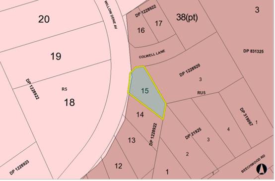
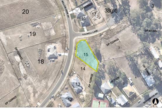
The
existing subdivision pattern and location of existing development within the
locality is shown in the following aerial photograph:
2. DESCRIPTION
OF DEVELOPMENT
Key
aspects of the proposal include the following:
· Proposed
dwelling on proposed Lot 2.
· One
into two lot strata subdivision, both lots
achieve the minimum lot size. Proposed Lots are 554m2 and 562m2.
· An
indicative future dwelling envelope on proposed Lot 1.
Refer
to Attachment 2 at the end of this report for plans of the proposed
development.
Application
Chronology
· 24
February 2020 - Application Received
· 5 March 2020 - Additional information received
· 16 March to 30 March 2020 - Public Notification
· 20 March 2020 - Revised plans and shadow diagrams received
· 24 April 2020 - RFS determination received
3. STATUTORY
ASSESSMENT
Section
4.15(1) Matters for Consideration
In
determining the application, Council is required to take into consideration the
following matters as are relevant to the development that apply to the land to
which the development application relates:
(a) The
provisions (where applicable) of:
(i) Any
Environmental Planning Instrument
State Environmental Planning Policy (Koala Habitat
Protection) 2019
Clause 5 - This SEPP applies to the Port Macquarie-Hastings
Local Government Area.
Clause 10 - The site is not identified on the
Koala Development Application Map and the land has an area less than 1 hectare
including adjoining land in the same ownership. The application has also
demonstrated that no habitat will be removed or modified therefore no further
investigations are required.
State Environmental Planning Policy No. 55 –
Remediation of Land
Following an inspection of the site and a search of Council
records, the subject land is not identified as being potentially contaminated
and is suitable for the intended use.
State Environmental Planning Policy (Coastal Management)
2018
The site is not located within a coastal use area / coastal
environment area.
State Environmental Planning Policy (Building
Sustainability Index: BASIX) 2004
A BASIX certificate (number 959517S) has been submitted
demonstrating that the proposal will comply with the requirements of the
SEPP. It is recommended that a condition be imposed to ensure that the
commitments are incorporated into the development and certified at Occupation
Certificate stage.
Port Macquarie-Hastings Local Environmental
Plan 2011
The proposal is consistent with the LEP having regard to the
following:
· Clause
2.2 - The subject site is zoned RU5 Village.
· Clause
2.3(1) and the RU5 zone landuse table - The proposed dwelling and strata
subdivision is a permissible landuse with consent.
The objectives of the RU5 zone are
as follows:
o To provide for a range of land
uses, services and facilities that are associated with a rural village
o To permit development that is
appropriate in scale and type with the characteristics of a rural village
o To minimise conflict between
land uses within the zone and land uses within adjoining zones
· Clause
2.3(2) - The proposal is consistent with the zone objectives having regard to
the following:
o the proposal is a permissible
landuse; and
o the subdivision will allow for
a variety of future housing types.
1.
· Clause
4.1 - Whilst the proposal is a strata subdivision, the lot sizes within the
proposed subdivision range from 554m2 to 562m2. All
proposed lots comply with the minimum lot sizes identified in the Lot Size Map
relating to the site.
· Clause
4.3 - The maximum overall height of the building above ground level (existing)
is 8.35 m. There is no maximum standard height limit applying to the site.
· Clause
4.4 - The floor space ratio of the proposal is 0.52:1.0 for proposed
lot 2. There is no maximum floor space ratio limit applying to the site.
· Clause
7.13 - Satisfactory arrangements are in place for provision of essential
services including water supply, electricity supply, sewer infrastructure,
stormwater drainage and suitable road access to service the development.
2.
(ii) Any draft
instruments that apply to the site or are on exhibition:
No draft instruments apply to
the site.
(iii) Any Development
Control Plan in force
Port
Macquarie-Hastings Development Control Plan 2013
|
DCP 2013: Dwellings, Dual occupancies, Dwelling
houses, Multi dwelling houses & Ancillary development
|
|
|
Requirements
|
Proposed
|
Complies
|
|
3.2.2.1
|
Ancillary development:
· 4.8m max. height
· Single storey
· 60m2 max.
area
· 100m2 for
lots >900m2
· 24 degree max. roof
pitch
· Not located in front
setback
|
Water tank is appropriately located to the side of the
dwelling
|
Yes
|
|
3.2.2.2
|
Articulation zone:
· Min. 3m front setback
· An entry feature or
portico
· A balcony, deck,
patio, pergola, terrace or verandah
· A window box treatment
· A bay window or
similar feature
· An awning or other
feature over a window
· A sun shading feature
|
No elements within the articulation zone.
The future dwelling on proposed Lot 1 is capable of
complying.
|
N/A
|
|
Front setback (Residential not R5 zone):
· Min. 6.0m classified
road
· Min. 4.5m local road
or within 20% of adjoining dwelling if on corner lot
· Min. 3.0m secondary
road
· Min. 2.0m Laneway
|
Front building line setback requirements are complied
with.
Lot 1 - future dwelling is capable of complying
Lot 2 - is characterised as a battle-axe lot.
|
Yes
|
|
3.2.2.3
|
Garage 5.5m min. and 1m behind front façade.
Garage door recessed behind building line or
eaves/overhangs provided
|
Garage door setback requirements are complied with.
|
Yes
|
|
6m max. width of garage door/s and 50% max. width of building
|
Width of garage door requirements are complied with.
|
Yes
|
|
Driveway crossover 1/3 max. of site frontage and max. 5.0m
width
|
Driveway crossing width requirements are complied with.
|
Yes
|
|
3.2.2.4
|
4m min. rear setback. Variation subject to site analysis
and provision of private open space
|
Min. 1.22 to 8.27m rear setback for proposed Lot 2.
|
No*
|
|
3.2.2.5
|
Side setbacks:
· Ground floor = min.
0.9m
· First floors &
above = min. 3m setback or where it can be demonstrated that overshadowing
not adverse = 0.9m min.
· Building wall set in
and out every 12m by 0.5m
|
The minimum side setback requirements are complied with.
Shadow diagrams have been provided demonstrating that the
minimum side setback on 1.95m from the southern side boundary for the first
floor will not adversely impact the solar access to future development on the
adjoining land.
The wall articulation softens the impact of the reduced
side setbacks and satisfies the objectives of the development provision.
|
Yes
|
|
3.2.2.6
|
35m2 min. private open space area including a
useable 4x4m min. area which has 5% max. grade
|
Each occupancy contains sufficient 35m² area to
utilise as open space in one area including a useable 4m x 4m area.
Lot 2 has approximately 180m2 of useable area
|
Yes
|
|
3.2.2.10
|
Privacy:
· Direct views between
living areas of adjacent dwellings screened when within 9m radius of any part
of window of adjacent dwelling and within 12m of private open space areas of
adjacent dwellings. ie. 1.8m fence or privacy screening which has 25% max.
openings and is permanently fixed
· Privacy screen
required if floor level > 1m height, window side/rear setback (other than
bedroom) is less than 3m and sill height less than 1.5m
· Privacy screens
provided to balconies/verandahs etc which have <3m side/rear setback and
floor level height >1m
|
No direct views between living areas of adjacent dwellings
screened when within 9m radius of any part of window of adjacent dwelling and
within 12m of private open space areas of adjacent dwellings.
A privacy screen is proposed along the side of the
north-eastern first floor deck.
No other privacy screens are recommended.
|
Yes
|
|
DCP 2013: General Provisions
|
|
|
Requirements
|
Proposed
|
Complies
|
|
2.7.2.2
|
Design addresses generic principles of Crime Prevention
Through Environmental Design guideline
|
No concealment or entrapment areas proposed. Adequate
casual surveillance available.
|
Yes
|
|
2.3.3.1
|
Cut and fill 1.0m max. 1m outside the perimeter of the
external building walls
|
Cut and fill <1.0m change 1m outside the perimeter of
the external building walls
|
Yes
|
|
2.3.3.2
|
1m max. height retaining walls along road frontage
|
None proposed
|
N/A
|
|
Any retaining wall >1.0 in height to be certified by
structure engineer
|
No retaining wall likely >1m
|
N/A
|
|
Combination of retaining wall and front fence height max
1.8m, max length 6.0m or 30% of frontage, fence component 25% transparent,
and splay at corners and adjacent to driveway
|
No retaining wall front fence combination proposed.
|
N/A
|
|
2.3.3.8
|
Removal of hollow bearing trees
|
No trees proposed to be removed
|
N/A
|
|
2.6.3.1
|
Tree removal (3m or higher with 100m diameter trunk at 1m
above ground level and 3m from external wall of existing dwelling)
|
No trees proposed to be removed
|
N/A
|
|
2.4.3
|
Bushfire risk, Acid sulphate soils, Flooding,
Contamination, Airspace protection, Noise and Stormwater
|
Refer to main body of report.
|
|
|
2.5.3.2
|
New accesses not permitted from arterial or distributor
roads
|
No new access proposed to arterial or distributor road.
|
N/A
|
|
Driveway crossing/s minimal in number and width including
maximising street parking
|
Driveway crossing is minimal in width including maximising
street parking.
Lot 1 - capable of complying as it has approximately a 31m
frontage to the road.
Lot 2 - driveway is minimal in width and will be a
battle-axe with a 3.6m crossover and a 5m wide access handle.
|
Yes
|
|
2.5.3.3
|
Parking in accordance with Table 2.5.1.
Dwelling/dual occupancies
1 space per dwelling/occupancy (behind building line).
Multi dwelling
1 space per 1 & 2 bedroom occupancies
1.5 spaces per 3+ bedroom occupancies
0.25 spaces per occupancy for visitor parking.
|
Lot 1 is capable of complying and Lot 2 has a proposed
double garage. No visitor parking is required.
|
Yes
|
|
2.5.3.11
|
Section 7.11 contributions
|
Contributions apply - refer to ET calc and NOP.
|
Yes
|
|
2.5.3.12 and 2.5.3.13
|
Landscaping of parking areas
|
Suitable landscaping is capable of being proposed around
driveway/parking locations.
|
Yes
|
|
2.5.3.14
|
Sealed driveway surfaces unless justified
|
Sealed driveway areas proposed.
|
Yes
|
|
2.5.3.15 and 2.5.3.16
|
Driveway grades first 6m or ‘parking area’
shall be 5% grade with transitions of 2m length
|
Driveway grades capable of satisfying Council standard
driveway crossover requirements.
Condition recommended for section 138 Roads Act permit.
|
Yes
|
|
2.5.3.17
|
Parking areas to be designed to avoid concentrations of
water runoff on the surface.
|
Stormwater drainage is capable of being managed as part of
plumbing construction.
|
Yes
|
The proposal seeks to vary Development Provision relating to
3.2.2.4 - 4m minimum rear setback. The proposal is seeking approval for a
minimum rear setback of 1.22m at the nearest point and varied to 8.27m
(perpendicular to the eastern rear boundary).
The relevant objectives are:
· To allow adequate
natural light and ventilation between dwellings/buildings and to private open
space areas.
· To provide useable
yard areas and open space.
Having regard for the development provisions and relevant
objectives, the variation is considered acceptable for the following reasons:
· It is acknowledged
that the site is situated on the corner of Willow Dene Avenue and Colwell Lane,
but due to the shape of the lot, there is a rear boundary.
· The rear eastern
boundary is at an irregular angle.
· The rear north-east
rear corner of the dwelling has a setback of 1.22m and the south west rear
corner is 8.27m to an open verandah, which softens the impact of the north-east
corner variation.
· Shadow diagrams
have demonstrated that there would be no adverse overshadowing due to the
variation on the adjoining developments and/or future developments.
· Although the
proposed private open space has not been positioned to achieve optimum solar
access for the development, there is approximately 180m2 of private
open space within the rear and side yard.
· The adjoining lots
to the north and south-east, are currently vacant and do not have any approved
developments or have a residential development being considered by Council. The
shadow diagrams indicate that the future development on the adjoining
properties will not be impacted.
· The existing
dwelling-house on No.736 Beechwood Road is positioned >12m from the subject
proposed dwelling and is no parallel to the rear eastern boundary. The
building line of the property adjoining the rear boundary is approximately 32m
from the encroachment on a slight elevation. Providing the separation and there
are no identifiable adverse impacts due the variation.
· The side setbacks
comply and are greater than 3m on the southern side setback for a large
proportion of the building footprint.
Cumulatively,
the variations do not amount to an adverse impact or a significance that would
justify refusal of the application.
(iiia) Any planning agreement that has
been entered into under section 7.4, or any draft planning agreement that a
developer has offered to enter into under section 7.4
No planning agreement has been
offered or entered into relating to the site.
(v) Any
matters prescribed by the Regulations
N/A
(b) The likely
impacts of that development, including environmental impacts on both the
natural and built environments, social and economic impacts in the locality
Context and
setting
· The
proposal will be unlikely to have any adverse impacts to existing adjoining
properties or the public domain.
· The proposal is considered to be consistent with other
residential development in the locality and adequately addresses planning
controls, as justified, for the area.
· There
are no adverse impacts on existing view sharing.
· There are no adverse privacy impacts.
· There are no adverse overshadowing impacts. The proposal
does not prevent adjoining properties from receiving 3 hours of sunlight to
private open space and primary living areas on 21 June.
· Proposed Lot 1 is of a sufficient size and design to
satisfactorily accommodate for a future single dwelling.
Access, Traffic and Transport
The proposal will be unlikely to have any adverse impacts in
terms access, transport and traffic. The existing road network will
satisfactorily cater for any increase in traffic generation as a result of the
development.
Water Supply Connection
Each proposed dwelling/lot will
need to be separately metered for water, meters may be either located at the
road frontage or internally with a master meter at the boundary. All
design & works shall be in accordance with Council’s adopted AUSPEC
Specifications.
Detailed plans will be required to be submitted for
assessment with the S.68 application. A standard condition has been
recommended in this regard.
Sewer Connection
The proposed development shall drain all sewage to the
existing sewer junction unless otherwise agreed by PMHC’s Water &
Sewer Planning Manager. All design & works shall be in accordance with
Council’s adopted AUSPEC Specifications.
Detailed plans will be required to be submitted for
assessment with the S.68 application. A standard condition has been
recommended in this regard.
Stormwater
Service available – details required with S.68
application. Drainage easement exists at the rear of the property. A
standard condition has been recommended in this regard.
Other Utilities
Telecommunication and electricity services are available to
the site.
Heritage
No known items of Aboriginal or European heritage significance
exist on the property. No adverse impacts anticipated. The site is in a
residential context, is part of a recent approved subdivision and considered to
be disturbed land.
Other land resources
The site is within an established and developing village context
and will not sterilise any significant mineral or agricultural resource.
Water cycle
The proposed development will not have any significant
adverse impacts on water resources and the water cycle.
Soils
The proposed development will not have any significant
adverse impacts on soils in terms of quality, erosion, stability and/or
productivity subject to a standard condition requiring erosion and sediment
controls to be in place prior to and during construction.
Air and microclimate
The construction and/or operations of the proposed
development will not result in any significant adverse impacts on the existing
air quality or result in any pollution. Standard precautionary site management
condition recommended.
Flora and fauna
Construction of the proposed development will not require
any removal/clearing of any native vegetation and therefore does not trigger
the biodiversity offsets scheme. Part 7 of the Biodiversity Conservation
Act 2016 is considered to be satisfied.
Waste
Satisfactory arrangements are in place for proposed storage
and collection of waste and recyclables. No adverse impacts anticipated.
Standard precautionary site management condition recommended.
Energy
The proposal includes measures to address energy efficiency
and will be required to comply with the requirements of BASIX.
Noise and vibration
The construction and/or operations of the proposed
development will not result in any significant adverse impacts on the existing
air quality or result in any pollution. Standard precautionary site management
condition recommended.
Bushfire
The site is identified as being bushfire prone. The
Applicant has submitted a bushfire report prepared by a Certified Consultant.
An assessment of bushfire risk having regard to section 4.3.5
of Planning for Bushfire Protection 2006 including vegetation classification
and slope concludes that a Bushfire Attack Level LOW shall be required.
Bushfire Safety Authority (BFSA) has been issued by the NSW
Rural Fire Service subject only to a condition to manage a satisfactory Asset
Protection Zone within the site. An appropriate condition is recommended to
require compliance with the BFSA.
Safety, security and crime prevention
The proposed development will be unlikely to create any
concealment/entrapment areas or crime spots that would result in any
identifiable loss of safety or reduction of security in the immediate
area. The increase in housing density will improve natural surveillance
within the locality and openings from each dwelling overlook common and private
areas.
Social impacts in the locality
Given the nature of the proposed development and its
location the proposal is not considered to have any significant adverse social
impacts.
Economic impact in the locality
The proposal is not considered to have any significant
adverse economic impacts on the locality. A likely positive impact is that the
development will maintain employment in the construction industry, which will
lead to flow impacts such as expenditure in the area.
Site design and internal design
The proposed development design satisfactorily responds to
the site attributes and will fit into the locality. No adverse impacts likely.
Construction
Construction impacts are considered capable of being
managed, standard construction and site management conditions have been
recommended.
Cumulative impacts
The proposed development is not considered to have any
significant adverse cumulative impacts on the natural or built environment or
the social and economic attributes of the locality.
(c) The
suitability of the site for the development
The proposal
will fit into the locality and the site attributes are conducive to the
proposed development.
Site constraints of bushfire
risk have been adequately addressed and appropriate conditions of consent
recommended.
(d) Any
submissions made in accordance with this Act or the Regulations
One written
submission was received following public exhibition of the application. A copy
of the written submission has been provided separately to members of the DAP.
Key
issues raised in the submissions received and comments are provided as follows:
|
Submission
Issue/Summary
|
Planning
Comment/Response
|
|
Impact on solar access the
proposed dwellings will have to adjoining properties.
|
Shadow diagrams have
demonstrated that there are no adverse overshadowing impacts due to the side
setback variation, as previously discussed, to the existing and future
adjoining developments.
|
|
The over-bearing nature of the two storey high roofed
dwellings proposed.
|
The proposed dwelling is 8.35m at the highest point. This
achieves the objectives of clause 4.3 of the Port Macquarie Hastings Local
Environmental Plan 2011, ensuring the proposed building is compatible with
the height, bulk and scale of existing and future character of the locality.
The building is considered to have good articulation
noting its orientation and building materials, which softens any perceived
bulk and scale.
The adjoining lots to the north and south-east, are
currently vacant and do not have any approved developments. The shadow
diagrams indicate that the future development on the adjoining properties
will not be impacted.
There are no adverse bulk and scale issues identifiable
to refuse this application.
|
|
Inconsistencies on the proposed Plans and Statement of
Environmental Effects
|
Amended plans have been provided during the assessment to
resolve the errors and provide additional plans to demonstrate how the
proposal complies with the Port Macquarie Hastings Development Control Plan
2013.
|
(e) The Public Interest
The proposed development
satisfies relevant planning controls, as justified, and will not adversely
impact on the wider public interest.
4. DEVELOPMENT
CONTRIBUTIONS APPLICABLE
· Development contributions will be required towards
augmentation of town water supply and sewerage system head works under Section
64 of the Local Government Act 1993.
· Development contributions will be required in accordance
with Section 7.11 of the Environmental Planning and Assessment Act 1979 towards
roads, open space, community cultural services, emergency services and
administration buildings.
3.
· A copy of the contributions estimate is included as Attachment
3.
4.
5. CONCLUSION AND
STATEMENT OF REASON
The application has been assessed in accordance with Section
4.15 of the Environmental Planning and Assessment Act 1979.
Issues raised during assessment and public exhibition of the
application have been considered in the assessment of the application. Where
relevant, conditions have been recommended to manage the impacts attributed to
these issues.
The site is considered suitable for the proposed development
and the proposal adequately addresses relevant planning controls. The
development is not considered to be contrary to the public's interest and will
not result a significant adverse social, environmental or economic impact. It
is recommended that the application be approved, subject to the recommended
conditions of consent provided in Attachment 1 of this report.
|
Attachments
1⇩. DA2020 - 120.1
Recommended Conditions
2⇩. DA2020 - 120.1 Plans
3⇩. DA2020 - 120.1
Contributions Estimate
|
|
ATTACHMENT
|
Development Assessment Panel
10/06/2020
|
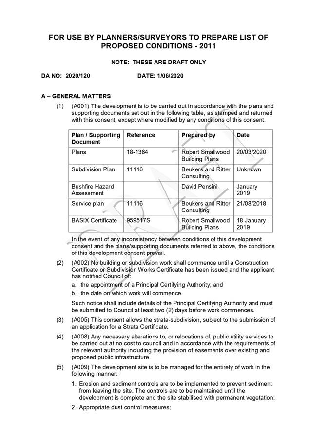
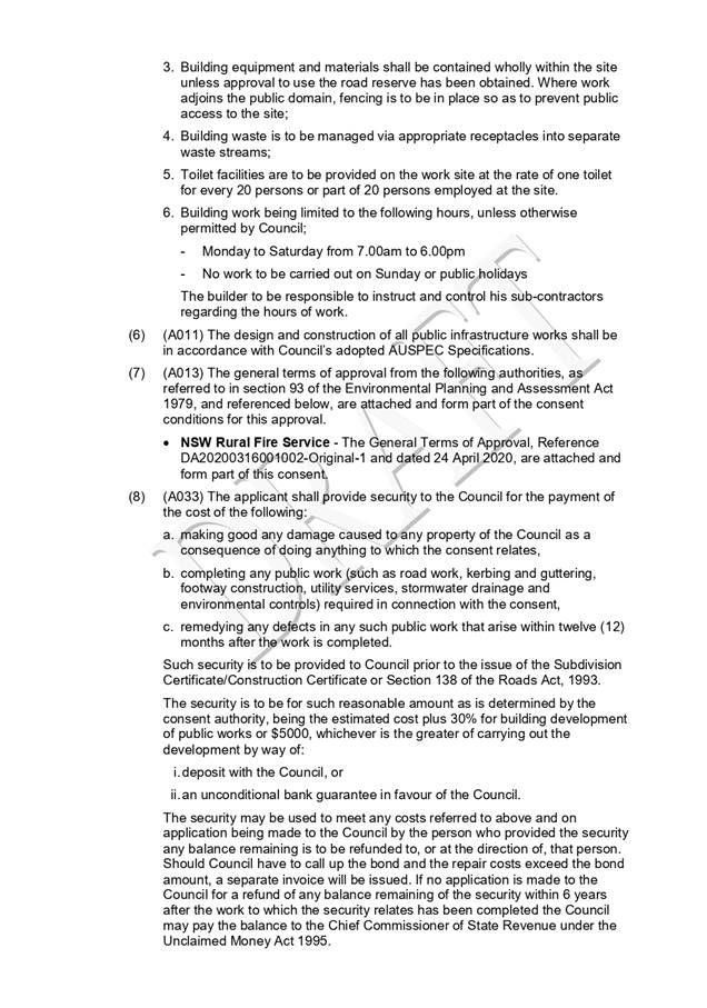

|
ATTACHMENT
|
Development Assessment Panel
10/06/2020
|
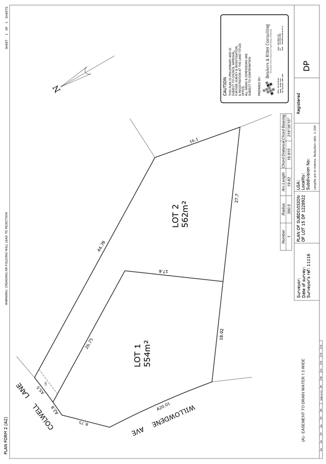
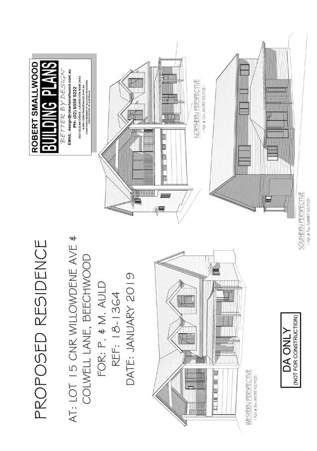
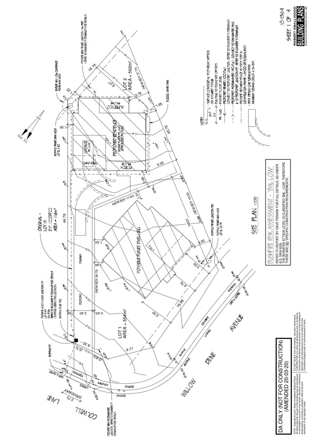
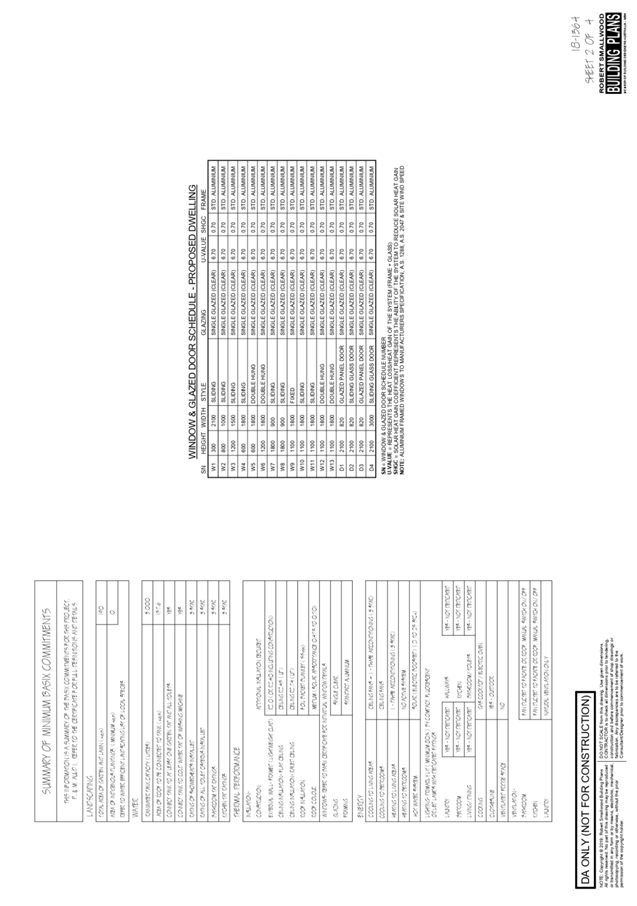
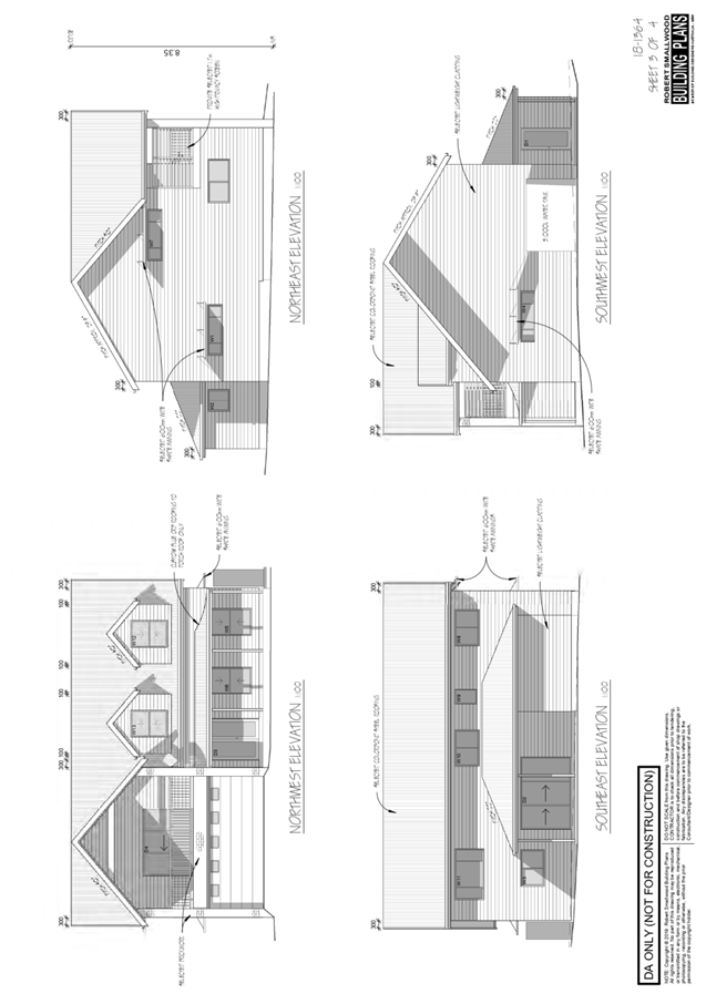
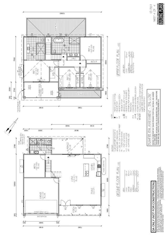
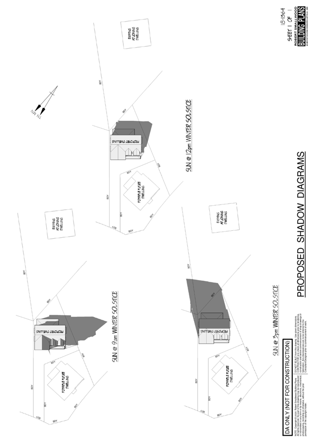
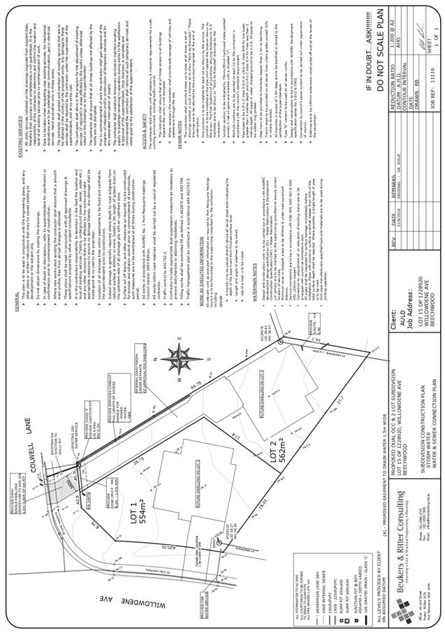
|
ATTACHMENT
|
Development Assessment Panel
10/06/2020
|
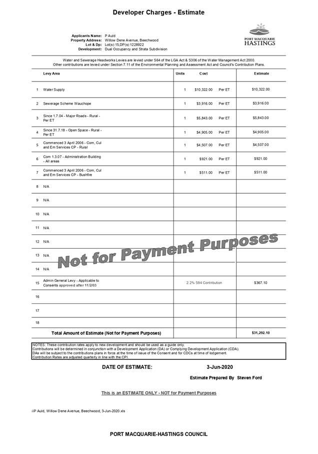
AGENDA Development Assessment Panel 10/06/2020
Item: 07
Subject: DA2020 - 65.1 Staged Multi Dwelling Housing
including Clause 4.6 Variation to Clause 4.3 (Height of Buildings) of Port
Macquarie-Hastings Local Environmental Plan 2011 and Community Title
Subdivision at Lot 2 DP 1188545, Pacific Drive, Port Macquarie
Report
Author: Development Assessment Planner, Benjamin Roberts
|
Applicant: Land
Dynamics Australia
Owner: Transit
Hill Estate Pty Ltd
Estimated Cost: $6,270,000
Alignment with Delivery
Program
4.3.1 Undertake transparent and
efficient development assessment in accordance with relevant legislation.
|
RECOMMENDATION
That
DA2020 - 65.1 for Staged Multi Dwelling Housing including a Clause 4.6
Variation to Clause 4.3 (Height of Buildings) of Port Macquarie-Hastings Local
Environmental Plan 2011 and Community Title Subdivision at Lot 2, DP
1188545, Pacific Drive, Port Macquarie, be determined by granting consent subject to the
recommended conditions.
Executive Summary
This report considers a development
application for staged multi dwelling housing including a clause 4.6 variation
to clause 4.3 (height of buildings) of Port Macquarie-Hastings Local
Environmental Plan 2011 and community title subdivision at the subject site and
provides an assessment of the application in accordance with the Environmental
Planning and Assessment Act 1979.
Following exhibition of the application, two (2) submissions
were received. A copy of the submissions has been provided separately to the
DAP members.
Amendments have been made to the proposal during assessment
which primarily include Lot 5 dwelling and Lot 9 dwelling driveways.
The site is considered suitable for the proposed development
and the proposal adequately addresses relevant planning controls as justified.
The development is not considered to be contrary to the public's interest and
will not result a significant adverse social, environmental or economic impact.
This report recommends that the development application be
approved subject to the conditions included in Attachment 1.
1. BACKGROUND
Existing Sites Features and
Surrounding Development
The subject land is described as
Lot 2 DP 1188545, Livingstone Road, Port Macquarie. However, the site primarily
fronts Pacific Drive and has an area of 7.688 hectares. The site is located on
the southern aspect of what’s commonly known as ‘Transit
Hill’ and slopes away significantly from north to south.
The site is vacant land (i.e.
contains no dwelling or building structures). The north western portion of the
site is heavily vegetated and the south eastern portion is partly cleared.
These areas of the site are zoned E2 Environmental Conservation and R1 General
Residential, respectively, in accordance with the Port Macquarie-Hastings Local
Environmental Plan 2011 as shown in the following zoning plan:
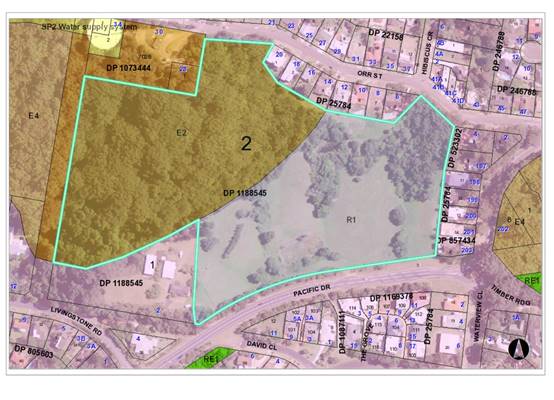 The
site is predominantly surrounded by residential dwelling houses to the south,
east and north which are typically two storey in nature having regard to the
slope.
The
site is predominantly surrounded by residential dwelling houses to the south,
east and north which are typically two storey in nature having regard to the
slope.
The site
adjoins Council road reservation (unconstructed) to the west and combination of
Crown and Council owned land to the north containing a water supply reservoir
and telecommunication infrastructure (i.e. towers).
The existing
subdivision pattern and location of existing development within the locality is
shown in the following aerial photograph:
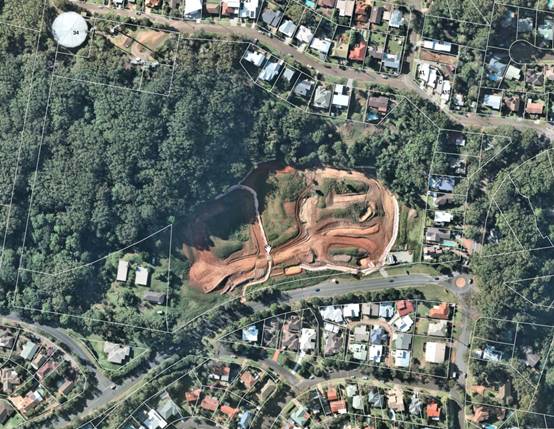
Background and Development
History
On 19 December 2018 a deferred
commencement consent (via DA2017/1049) was granted by Council for a staged
residential community title subdivision comprising 35 lots which included
earthworks and vegetation removal. The deferred commencement conditions were
satisfied and development consent issued on 3 September 2019.
Vegetation removal and
earthworks have commenced on the site.
The approved subdivision layout
and staging under DA2017/1049 is provided below:
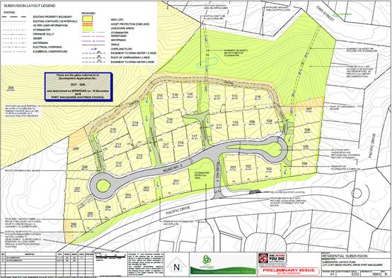
The approved staging plan is
provided as follows:
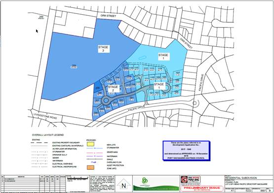
The approved concept landscaping
plan is provided as follows:
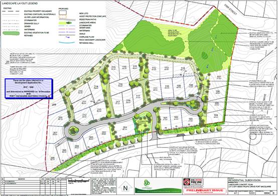
2. DESCRIPTION
OF DEVELOPMENT
Key aspects of the proposal
include the following:
· Construction
of nineteen (19) dwellings
· Community
Title subdivision and associated infrastructure
· Staging
The applicant has advised during
the assessment of the application that all civil works under this application
and DA2017/1049 are to be completed prior to the release of the linen
plan/subdivision certificate for the community title subdivision across this
section of the site.
Refer to Attachment 2 at
the end of this report for plans of the proposed development.
Application Chronology
· 4
February 2020 - Application lodged.
· 12
February 2020 - Referral to NSW Rural Fire Service.
· 14 to
27 February 2020 - Public exhibition via neighbour notification.
· 21
February 2020 - Additional information request.
· 30
March 2020 - Additional information response with revised SOEE and plans.
· 14
April 2020 - Bushfire Safety Authority received from NSW Rural Fire Service.
· 4 May
2020 - Additional information request.
· 19 May
2020 - Additional information response with revised plans.
3. STATUTORY
ASSESSMENT
Section 4.15(1) Matters for
Consideration
In determining the application,
Council is required to take into consideration the following matters as are
relevant to the development that apply to the land to which the development
application relates:
(a) The
provisions (where applicable) of:
(i) Any
Environmental Planning Instrument
State Environmental Planning
Policy (Koala Habitat Protection) 2019
Clause 5 - This SEPP applies to
the Port Macquarie-Hastings Local Government Area.
Clause 10 - The site is
identified on the Koala Development Application Map and the land has an area
greater than 1 hectare including adjoining land in the same ownership.
Clause 15 - A development
application made, but not finally determined, before the commencement of this
Policy in relation to land to which this Policy applies must be determined as
if this Policy had not commenced. The application was made and not finally
determined prior to the commencement of this policy, and the application is therefore
required to be assessed under the relevant provisions of State Environmental
Policy No 44 - Koala Habitat Protection. See assessment comments below.
State Environmental Planning
Policy No. 44 - Koala Habitat Protection
With reference to clauses 6 and
7, the subject land is greater than 1 hectare (including any adjoining land
under same ownership) and therefore the provisions of SEPP must be considered.
There is no Koala Plan of
Management on the site and no tree removal proposed. Therefore, no further
investigations are required.
It is noted that DA2017/1049 for
the subdivision was supported by a Koala Habitat assessment which concluded
that the site did not qualify as potential Koala habitat.
State Environmental Planning
Policy No.55 – Remediation of Land
Following an inspection of the
site and a search of Council records, the subject land is not identified as
being potentially contaminated and is suitable for the intended residential
use.
State Environmental Planning
Policy No. 62 – Sustainable Aquaculture
Given the nature and location of
the proposed development there will be no adverse impacts on any existing
aquaculture industries.
State Environmental Planning
Policy No. 64 – Advertising and Signage
The proposal does not
incorporate any signage.
State
Environmental Planning Policy (Infrastructure) 2007
Consistent with clause 102 and
taking into consideration the guideline titled “Development near rail
corridors and busy roads – Interim Guideline 2008” the daily
traffic volumes along Pacific Drive are not in the vicinity of 40,000 average
daily vehicles, rather approximately 7,000 based on Council traffic data
counts. Having regard to traffic volumes, approximate setback to kerb from
Pacific Drive and the 1.8m high timber fence approved along the rear of the
lots, the standard LAeq levels are expected to be met for residential
accommodation and no adverse impacts are anticipated by road noise or
vibration.
Pacific Drive is not a
classified road and the proposal is not a traffic generating development
identified in schedule 3 via clause 104 of this policy. Accordingly, the
application was not referred to Roads and Maritime Services. Refer roads,
transport and traffic heading later within this report for traffic impacts.
State Environmental Planning
Policy (State and Regional Development) 2011
The proposed development does
not have a capital investment value of more than $30 million and is therefore
not recognised regional development under this policy.
Port Macquarie-Hastings Local Environmental
Plan 2011
The proposal is consistent with the LEP having regard to the
following:
· Clause
2.2 - The site of the proposed development is zoned R1 General Residential.
Multi dwelling housing is permissible with consent in the R1 zone.
· Clause
2.3(2) - The objectives of the R1 zone are as follows:
o To provide for the housing needs
of the community.
o To provide for a variety of
housing types and densities.
o To enable other land uses that
provide facilities or services to meet the day to day needs of residents.
· Clause
2.3(2) - The proposal is consistent with the zone objectives specifically:
o the proposal is a permissible
landuse;
o the proposal will provide for
housing needs of the community;
· Clause
2.6 - Consistent with clause 2.6, land to which the LEP applies may be
subdivided with development consent.
· Clause
4.1 - Does not apply as the proposal is for community title subdivision.
·
· Clause
4.3 - This clause establishes the maximum "height of a building" (or
building height) that a building may be built to on any parcel of land. The
term "building height (or height of building)" is defined in the LEP
to mean "the vertical distance between ground level (existing) and the
highest point of the building, including plant and lift overruns, but excluding
communication devices, antennae, satellite dishes, masts, flagpoles, chimneys,
flues and the like". The term "ground level (existing)" is also
defined in the LEP to mean "the existing level of a site at any point".
·
The subject
site has a maximum building height of 8.5m identified on the height of
buildings map. The maximum building height proposed (dwelling 15) is 9.2m,
which represents a variation of 9%. Six (6) dwellings are proposed that would
exceed the height limit and they are as follows:
- Dwelling 2 at 8.8m, representing a 3.5%
variation
- Dwelling 3 at 8.9m representing a 4.7%
variation
- Dwelling 4 at 8.9m, representing a 4.7%
variation
- Dwelling 7 at 9.079m representing a 6.8%
variation
- Dwelling 8 at 8.55m representing a 0.5%
variation
- Dwelling 15 at 9.2m representing a 9% variation
The submitted
plans identify the parts of the buildings that exceed the height limit. The
applicant has submitted a clause 4.6 variation supporting the application,
which is addressed under the following clause 4.6 section of this report.
· Clause
4.4 - The floor space ratio of the proposal is 0.39:1 (residential zoned land
in eastern portion only). The maximum floor space ratio standard applicable to
the site is 0.65:1 and the proposal complies.
·
· Clause
4.6 - This clause establishes a degree of
flexibility for certain development standards in certain circumstances which
have demonstrated that a better planning outcome will occur from that
flexibility.
·
·
As illustrated on the plans the bulk of the dwellings exceeding
the height limit sit within the building height standard. Specifically, its
portions of the roof that protrude above the height plane.
·
Assistance on
the approach to variation of this standard is also taken from NSW Land and
Environment Court and NSW Court of Appeal decisions in:
1. Wehbe v Pittwater Council (2007) NSW LEC 827 (Wehbe);
2. Four2Five Pty Ltd v Ashfield Council (2015) NSWLEC
1009; and
3. Al Maha Pty Ltd v Huajun Investments Pty Ltd (2018)
NSWCA 245
·
·
Having regard to specific requirements
of clause 4.6(3) and 4.6(4) the following assessment comments are provided:
(3) Development consent
must not be granted for development that contravenes a development standard
unless the consent authority has considered a written request from the
applicant that seeks to justify the contravention of the development standard
by demonstrating:
(a) that compliance with
the development standard is unreasonable or unnecessary in the circumstances of
the case, and
(b) that there are sufficient
environmental planning grounds to justify contravening the development
standard.
Comments: The applicant has submitted a written request in
writing seeking justification for contravention of the building height standard
for the following reasons (as summarised):
· The steep slope (topography represents a
significant site constraint in providing strict compliance with the standard.
· The proposal is consistent with the height of
buildings objectives and zone objectives notwithstanding non-compliance with
the standard. Compliance
with the development standard in unnecessary in the circumstances of this case
notwithstanding the numerical variation.
·
(4) Development consent must not
be granted for development that contravenes a development standard unless:
(a) the consent authority is
satisfied that:
(i) the applicant’s
written request has adequately addressed the matters required to be
demonstrated by subclause (3)
In Wehbe ‘five methods’ have been
developed to test whether a compliance with the standard is unreasonable or
unnecessary:
1. The objectives of the
standard are achieved notwithstanding the non-compliance with the numerical
standard and therefore compliance is unnecessary.
2. The underlying
objective or purpose of the standard is not relevant to the development and
therefore compliance is unnecessary.
3. The underlying object
or purpose of the standard would be defeated or thwarted if compliance was
required and therefore compliance is unreasonable.
4. The development standard
has been virtually abandoned or destroyed by the Council’s own actions in
granting a consent to proposals departing from the standard and hence
compliance is unreasonable and unnecessary.
5. The zoning of the
particular land is unreasonable or inappropriate so that a development standard
appropriate for that zoning is also unreasonable and unnecessary as it applies
to the land.
The proposal relies upon the first test and it is
considered that the applicant’s written request has satisfactorily demonstrated
that the proposed development will achieve the objectives of the height of
building development standard despite numerical non-compliance.
There are considered to be sufficient environmental
planning grounds to justify a variation to the development standard on the
following basis:
· The site contains some steep topography. The building designs respond
to this constraint by stepping up the sites.
· The buildings have an appropriate built form and appearance envisaged
for the locality and the objectives of both the building height standard and R1
zone are achieved.
· The portions of the roofs that exceed the height limit are a small part
of the roof and generally located where the building steps to accommodate the
fall of the land.
· The building heights would not result in any adverse amenity impacts to
neighbouring properties.
· The height variation does not result in the development achieving any
additional floor area compared with a compliant proposal.
· The only dwellings with height variations fronting Pacific Drive are
Lot 2, 3 and 4. The southern sections of these dwellings are under the building
height limit and setback greater than the standard minimum 4.5m setback to
Pacific Drive. The Lot 5 and 6 dwellings fronting Pacific Drive comply with the
8.5m height limit.
·
On the basis of
the above, it is considered that the Applicant’s clause 4.6 variation has
adequately addressed the matters required to be demonstrated by clause 4.6(3).
(ii) the proposed development
will be in the public interest because it is consistent with the objectives of
the particular standard and the objectives for development within the zone in
which the development is proposed to be carried out,
The consistency of the
proposal with the zone objectives has been discussed above under clause 2.3.
Consideration of the proposal’s consistency with the objectives of the
building height standard (clause 4.3) is provided as follows:
·
(a) to
ensure that buildings are compatible with the height, bulk and scale of the
existing and desired future character of the locality,
·
·
Comments: The variations are
primarily for small portions of roofing in response to the site topography. The
majority of the buildings and their bulk sit beneath the 8.5m height limit. The
two-storey design is consistent with that of dwellings in the immediate
locality.
(b) to minimise visual
impact, disruption of views, loss of privacy and loss of solar access to
existing development,
Comments: The visual
impact of the buildings is minimal and considered satisfactory. There are no
adverse view or solar access impacts.
Visual privacy is
maintained by provision of landscape screen plantings along the eastern
boundaries of dwellings 6 to 10.
(c)
to minimise the adverse impact of development on heritage conservation areas
and heritage items,
Comments: The site does
not contain or adjoin and heritage conservation areas or heritage items. No
adverse impacts would result.
(d) to nominate heights that will
provide a transition in built form and land use intensity within the area
covered by this Plan.
Comments:
The proposal will provide for buildings that adequately respond to the site
constraints and provide built forms and land use intensity envisaged for the
area.
The development is consistent with the
building height and zone objectives of the LEP 2011 and is unlikely to have any
implications on State related issues or the broader public interest.
(a) the concurrence of the
Secretary has been obtained.
Comments: In accordance Planning Circular PS20-002
issued by NSW Planning and Environment, dated 5 May 2020, Council can assume
the Director’s concurrence for clause 4.6 variations to the height of
buildings standard. The proposed variations contravene the numerical standard
by less than 10% and therefore may be determined under delegation and does not
need to be determined at an Ordinary meeting of Council.
Having
regard to the above consideration and comments it is recommended that the building
height variations be supported.
·
· Clause
5.10 – Heritage. The site does not contain or adjoin any known heritage
items or sites of significance.
·
· Clause
7.13 - Development consent must not be granted to development unless the
consent authority is satisfied that any of the following services that are
essential for the proposed development are available or that adequate
arrangements have been made to make them available when required:
(a) The
supply of water
Comments: A preliminary services
plan supports the application which includes provision of water connections to
each lot and dwelling. Council’s water supply section are satisfied that
adequate arrangements will be made for the supply of water expected to be
generated from the development.
Specific consent conditions have
been recommended requiring final water service sizing to be determined by a
hydraulic consultant consistent with the requirements of Australian Standard
3500: Plumbing and Drainage with details to be provided as part of the
subdivision works certificate application and section 68 application.
(b) The
supply of electricity
Comments: Electricity supply is
available. Council is satisfied that satisfactory arrangements will be made
with the electricity service provider to accommodate the proposed
development.
(c) The
disposal and management of sewage
Comments: A preliminary services
plan supports the application which includes provision of sewer to each lot and
dwelling. Council’s sewer supply section are satisfied that adequate
capacity is available and arrangements will be made for connection and disposal
of sewage expected to be generated from the development. The internal sewerage
network shall be privately owned and outlined within a Community Management
Statement. The development will be required to discharge all sewage to a single
point of connection to Council’s sewerage system. Multiple connection
points may be permitted subject to the approval of the Water and Sewer Planning
Manager. Specifically consent conditions have been recommended requiring
sewerage reticulation details to be provided as part of the subdivision works
certificate application and section 68 application.
(d) Stormwater
drainage or on-site conservation
Comments: A preliminary services
plan supports the application which includes provision of stormwater
connections to each lot and dwelling. Council’s development and
stormwater engineers are satisfied that adequate arrangements will be made for
stormwater collection and disposal.
(e) Suitable
road access
Comments: Suitable road access is
capable of being provided directly from Pacific Drive.
Satisfactory arrangements are
available for the provision of essential services.
(ii) Any draft instruments that apply to the
site or are on exhibition
No draft instruments apply.
(iii) Any Development Control Plan in force
Port Macquarie-Hastings
Development Control Plan 2013
The proposal is for community
title subdivision and while the provisions of this plan are targeted at typical
Torrens title subdivisions it is appropriate that consideration be given to the
provisions to ensure the purpose and intent of the plan is achieved in the
development.
|
DCP 2013: Dwellings, Dual occupancies, Dwelling
houses, Multi dwelling houses & Ancillary development
|
|
|
Requirements
|
Proposed
|
Complies
|
|
3.2.2.1
|
Ancillary development:
• 4.8m
max. height
• Single
storey
• 60m2
max. area
• 100m2
for lots >900m2
• 24
degree max. roof pitch
• Not
located in front setback
|
No ancillary development located forward of the building
line.
|
Yes
|
|
3.2.2.2
|
Articulation zone:
• Min.
3m front setback
• An
entry feature or portico
• A
balcony, deck, patio, pergola, terrace or verandah
• A
window box treatment
• A
bay window or similar feature
• An
awning or other feature over a window
• A
sun shading feature
|
Dwellings 5 and 6 have elements within the articulation
zone to Pacific Drive closer than 3m.
|
No*
|
|
Front setback (Residential not R5 zone):
• Min.
6.0m classified road
• Min.
4.5m local road or within 20% of adjoining dwelling if on corner lot
• Min.
3.0m secondary road
• Min.
2.0m Laneway
|
Front building line setback to Pacific Drive less than
4.5m for dwellings 4, 5 and 6.
|
No*
|
|
3.2.2.3
|
Garage 5.5m min. and 1m behind front façade.
Garage door recessed behind building line or
eaves/overhangs provided
|
All garages and parking areas directly connect to the
proposed internal private road.
To the private road garage doors of dwellings 6, 7, 8, 9
and 10 closer than 5.5m.
The garages of dwellings 1, 2, 3 and 4 are not >1m
behind the building line.
Garage doors are recessed.
|
No*
No*
Yes
|
|
6m max. width of garage door/s and 50% max. width of
building
|
All garages and parking areas directly connect to the
proposed internal private road.
Width of garage doors are 6m or less.
The width of the garage doors are 50% of less of the
building width.
|
Yes
Yes
|
|
Driveway crossover 1/3 max. of site frontage and max. 5.0m
width
|
All garages and parking areas directly connect to the
proposed internal private road.
Driveway crossing width requirements are complied with.
|
Yes
|
|
3.2.2.4
|
4m min. rear setback. Variation subject to site analysis
and provision of private open space
|
The rear boundary is considered to be the northern
boundary adjoining the properties along Orr Street. Greater than 4m is
provided to the proposed dwellings.
The internal rear setback to the community title boundary
is less than 4m for dwellings 16, 17 and 20 to the proposed private fire
trail and common property.
|
Yes
No*
|
|
3.2.2.5
|
Side setbacks:
• Ground
floor = min. 0.9m
• First
floors & above = min. 3m setback or where it can be demonstrated that
overshadowing not adverse = 0.9m min.
• Building
wall set in and out every 12m by 0.5m
|
The boundary adjoining the existing dwellings to the east
is considered the eastern side boundary. Side setbacks to the eastern and
western side boundary comply.
The internal side setbacks of dwellings within the
community title lots vary and some are proposed with a zero lot line.
The wall articulation satisfies the objectives of the
development provision.
|
Yes
No*
Yes
|
|
3.2.2.6
|
35m2 min. private open space area including a useable 4x4m
min. area which has 5% max. grade
|
Each occupancy contains greater than 35m² open space.
Some dwellings do not contain a directly accessible 4m x
4m dimensioned area.
|
Yes
No*
|
|
3.2.2.7
|
Front fences:
• If
solid 1.2m max height and front setback 1.0m with landscaping
• 3x3m
min. splay for corner sites
• Fences
>1.2m to be 1.8m max. height for 50% or 6.0m max. length of street
frontage with 25% openings
• 0.9x0.9m
splays adjoining driveway entrances
|
No front fences proposed.
|
N/A
|
|
3.2.2.8
|
Front fences and walls to have complimentary materials to
context
No chain wire, solid timber, masonry or solid steel front
fences
|
No front fences proposed.
|
N/A
|
|
3.2.2.10
|
Privacy:
• Direct
views between living areas of adjacent dwellings screened when within 9m
radius of any part of window of adjacent dwelling and within 12m of private
open space areas of adjacent dwellings. ie. 1.8m fence or privacy screening
which has 25% max. openings and is permanently fixed
• Privacy
screen required if floor level > 1m height, window side/rear setback
(other than bedroom) is less than 3m and sill height less than 1.5m
• Privacy
screens provided to balconies/verandahs etc which have <3m side/rear
setback and floor level height >1m
|
The development will not compromise privacy in the area
due to a combination of having high sill windows that face side boundaries,
limiting living areas that face adjoining living areas/open space, compliant
separation and use of screening/fencing.
|
Yes
|
|
DCP 2013: General Provisions
|
|
|
Requirements
|
Proposed
|
Complies
|
|
2.7.2.2
|
Design addresses generic principles of Crime Prevention
Through Environmental Design guideline
|
No concealment or entrapment areas proposed. Adequate
casual surveillance available.
|
Yes
|
|
2.3.3.1
|
Cut and fill 1.0m max. 1m outside the perimeter of the
external building walls
|
Cut and fill proposed >1m outside the perimeter of the
external building walls
|
No*
|
|
2.3.3.2
|
1m max. height retaining walls along road frontage
|
None proposed
|
N/A
|
|
Any retaining wall >1.0 in height to be certified by
structure engineer
|
Condition recommended to require engineering certification
|
Yes
|
|
Combination of retaining wall and front fence height max
1.8m, max length 6.0m or 30% of frontage, fence component 25% transparent, and
splay at corners and adjacent to driveway
|
No combination proposed.
|
N/A
|
|
2.3.3.8
|
Removal of hollow bearing trees
|
No trees proposed to be removed.
|
N/A
|
|
2.6.3.1
|
Tree removal (3m or higher with 100m diameter trunk at 1m
above ground level and 3m from external wall of existing dwelling)
|
No trees proposed to be removed.
|
N/A
|
|
2.4.3
|
Bushfire risk, Acid sulphate soils, Flooding,
Contamination, Airspace protection, Noise and Stormwater
|
Refer to main body of report.
|
|
|
2.5.3.2
|
New accesses not permitted from arterial or distributor
roads
|
No new access proposed to arterial or distributor road.
|
N/A
|
|
Driveway crossing/s minimal in number and width including
maximising street parking
|
Driveway crossings are minimal in width including
maximising street parking.
|
Yes
|
|
2.5.3.3
|
Parking in accordance with Table 2.5.1.
Multi dwelling
1.5 spaces per 3+ bedroom occupancies
0.25 spaces per occupancy for visitor parking.
|
The proposal would result in 19 dwellings comprising 3 or
more bedrooms. Therefore, a total of 34 spaces is required. Each dwelling
comprises a double garage with additional stacked parking available in each
driveway for visitors i.e. 57 spaces proposed.
|
Yes
|
|
2.5.3.11
|
Section 94 contributions
|
Contributions apply - refer to ET calc and NOP.
|
Yes
|
|
2.5.3.12 and 2.5.3.13
|
Landscaping of parking areas
|
Suitable landscaping proposed around driveway/parking
locations.
|
Yes
|
|
2.5.3.14
|
Sealed driveway surfaces unless justified
|
Sealed driveway areas proposed.
|
Yes
|
|
2.5.3.15 and 2.5.3.16
|
Driveway grades first 6m or ‘parking area’
shall be 5% grade with transitions of 2m length
|
Driveway grades capable of satisfying Council standard
driveway crossover requirements. Condition recommended for section 138 Roads
Act permit
|
Yes
|
|
2.5.3.17
|
Parking areas to be designed to avoid concentrations of
water runoff on the surface.
|
Stormwater drainage is capable of being managed as part of
plumbing construction.
|
Yes
|
The proposal seeks to vary Development Provision 3.2.2.2
relating to dwelling incorporating an articulation zone to a street frontage of
no less than 3m. Proposed dwellings 4, 5 and 6 incorporate elements within 3m.
The relevant objectives are:
· Front setbacks should
support an attractive streetscape.
Having regard for the development provisions and relevant
objectives, the variation is considered acceptable for the following reasons:
· Lot 5 is oddly shaped
and the design and orientation of the proposed dwelling has responded to this
lot shape. The setback to Pacific Drive boundary for dwelling 5 is variable
with two sections being closest at 2.722m and 1.925m respectively.
· Lot 6 is angled and the
setback to the Pacific Drive boundary for dwelling 6 is variable with two
sections being closest at 2.018m and 1.526m which extends out to 2.503m.
· No boundary fencing is
proposed under this application but it’s assumed that 1.8m fencing will
follow as exempt development along the Pacific Drive frontage.
· Landscaping and screen
plantings are approved under DA2017/1049 and it has been recommended via
consent conditions that it be undertaken as part of this development to soften
the streetscape appearance from Pacific Drive. A screen shot from the approved
landscape concept plan is provided below for context:
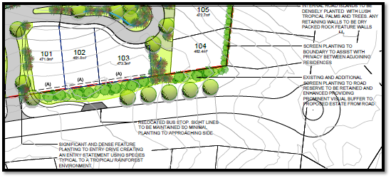
· The distance to the edge
of the Pacific Drive kerb is approximately 10m in this area which provides for
appropriate visual buffer and accommodation of landscaping that will support an
improved streetscape appearance from that which typical exists along this road
frontage and immediately opposite the site.
The proposal seeks to vary Development Provision relating to
3.2.2.2 relating to a minimum 4.5m setback to the primary road frontage.
Pacific Drive is considered to be the primary road frontage. Dwellings 4, 5 and
6 propose a reduced setback being a minimum 4.102m, 1.925m and 1.526m
respectively.
The relevant objectives are:
· Front setbacks should
support an attractive streetscape.
Having regard for the development provisions and relevant
objectives, the variation is considered acceptable for the following reasons:
· It is unique in that a
conventional Torrens subdivision would typically identify this boundary as
being the rear. Similar to existing lots along Pacific Drive a rear 1.8m
boundary fence presents to the frontage. No boundary fencing is proposed under
this application but it’s assumed that 1.8m fencing will follow as exempt
development along the boundary of these lots and dwellings.
· Landscaping and screen
plantings are approved under DA2017/1049 and it has been recommended via
consent conditions that it be undertaken as part of this development to soften
the streetscape appearance from Pacific Drive. A screen shot from the approved
landscape concept plan is provided below for context:
· Dwelling 5 has been
designed to respond to the odd lot shape and the open space and living areas
orientated north for better solar access which is considered to be a better
outcome and is what a normal reduced rear setback encourages within this plan.
· The distance to the edge
of the Pacific Drive kerb is approximately 10m in this area which provides for
appropriate visual buffer and accommodation of landscaping that will support an
improved streetscape appearance from that which typical exists along this road
frontage and immediately opposite the site.
The proposal seeks to vary Development Provision relating to
3.2.2.3 relating to garages being 1m behind the building line. The following variations have been identified:
· Dwellings 1, 2, 3, 4
garage is 600mm behind the building line.
· Dwelling 6, 7, 8, 9 and
10 portions of garages closer than 5.5m.
The relevant objectives are:
· Front setbacks should
support an attractive streetscape.
Having regard for the development provisions and relevant
objectives, the variation is considered acceptable for the following reasons:
· Dwellings 1, 2, 3 and 4
still incorporate an entry porch feature forward of the garage and first floor
extension over the garage which take away from any garage dominance.
· The portions of the
garages within 5.5m for dwellings 6, 7, 8, 9 and 10 is primarily a result of
the lot shape angle at the frontage. The garage setbacks extend beyond 5.5m as
the lot angle is followed. There will be sufficient length in the driveway to
accommodate off-street parking.
· The internal road
network is proposed as private under community title and the portions of the
garages closer than 5.5m and those with the garage only 600mm behind the
building line will not be visible from the public domain so will not impact
upon its streetscape appearance.
The proposal seeks to vary Development Provision relating to
3.2.2.4 relating to the rear boundary setback of 4m. Specifically the internal
rear setback to the community title boundary is less than 4m for dwellings 16,
17 and 20 to the north.
The relevant objectives are:
· To allow adequate
natural light and ventilation between dwellings/buildings and to private open
space areas.
· To provide useable
yard areas and open space.
Having regard for the development provisions and relevant
objectives, the variation is considered acceptable for the following reasons:
· For dwelling 16 it
is only a portion of building that is setback 1.56m from the internal community
title boundary. The main alfresco area and open space area has been position in
the north western part of the lot and is setback over 4m from that part of the
lot boundary.
· The design of
dwelling 16 and positioning of the private open space provides for usable yard
space and adequate natural light and ventilation.
· Only a small
portion of the wall to dwelling 17 is setback 3.781m. The setback extends out
to 5.2m given the angle of the rear boundary. The minor encroachment still
provides adequate light and ventilation to the private open space area and
useable yard area.
· The rear setback
of 2.923m for dwelling 20 still provides for adequate natural light and
ventilation to the open space area given the north orientation. Useable yard
area is limited noting the extent of cut and rock retaining proposed however it
does provide the 4x4 area with usable yard area in the front setback of the
dwelling.
The proposal seeks to vary Development Provision relating to
3.2.2.5 relating to side boundary setbacks. Specifically, the internal side
setbacks to the community title boundaries (assumed that subdivision will come
first) is less than 900mm for ground floor and 3m for first floor for some
dwellings. Specifically, the following variations are identified:
· Dwelling 2 zero
lot line to eastern boundary. First floors within 3m.
· Dwelling 3 zero
lot line to western boundary. First floors within 3m.
· Dwelling 4 first
floors within 3m.
· Dwelling 6 first
floors within 3m.
· Dwelling 7 first
floors within 3m.
· Dwelling 8 first
floors within 3m.
· Dwelling 9 first
floors within 3m.
· Dwelling 10 first
floors within 3m.
· Dwelling 11 first
floors within 3m.
· Dwelling 12 first
floors within 3m.
· Dwelling 13 first
floors within 3m.
· Dwelling 14 first
floors within 3m.
· Dwelling 15 first
floors within 3m.
· Dwelling 16 ground
floor 0.218m and first floors within 3m.
· Dwelling 17 first
floors within 3m.
· Dwelling 18 first floors
within 3m.
· Dwelling 19 first
floors within 3m.
· Dwelling 20 first
floors within 3m.
The relevant objectives are:
· To reduce
overbearing and perceptions of building bulk on adjoining properties and to
maintain privacy.
· To provide for
visual and acoustic privacy between dwellings.
Having regard for the development provisions and relevant
objectives, the variation is considered acceptable for the following reasons:
· The proposal is
for a community title arrangement with private internal road network and not
typical of a standard Torrens title subdivision and layout that would otherwise
provide separation between dwellings.
· The reduced
setback is primarily a result of the topography of the site. Specifically, the
split levels proposed which appear as two storey and above are a direct result
of stepping up the sites.
· The bulk and scale
impacts to adjoining properties outside of the development proposal is
considered minimal.
· The design of the
dwellings and location of primary open space areas accompanied with window
treatments maintains sufficient visual and acoustic privacy between proposed
dwellings and adjacent primary open space areas.
The proposal seeks to vary Development Provision 3.2.2.6
requiring a minimum dimensioned 4m x 4m area that is directly accessible from a
ground floor living area. Specifically, the following has been identified:
· Dwelling 2 ground
floor alfresco is dimensioned 3.75m x 5.17m.
· Dwelling 3 ground
floor alfresco is dimensioned 3.52m x 5.17m.
· Dwelling 4 ground
floor alfresco is dimensioned 3.75m x 5.17m.
· Dwelling 5 ground
floor alfresco is dimensioned 3.6m x 3.2m.
· Dwelling 6 ground floor
alfresco is dimensioned 4.5m x 3.55m.
· Dwelling 7 ground
floor alfresco is dimensioned 4.5m x 3.55m.
· Dwelling 8 ground
floor alfresco is dimensioned 4.5m x 3.55m.
· Dwelling 9 ground
floor alfresco is dimensioned 6m x 3.55m.
· Dwelling 10 ground
floor alfresco is dimensioned 6m x 3.5m.
· Dwelling 15 ground
floor alfresco is dimensioned 3.92m x 5.56m.
· Dwelling 17 ground
floor alfresco is dimensioned 3.9m x 4.3m.
· Dwelling 18 ground
floor alfresco is dimensioned 3.9m x 4.3m.
The relevant objectives are:
· To encourage
useable private open space for dwellings to meet the occupant’s
requirements for privacy, safety, access, outdoor activities and landscaping.
Having regard for the development provisions and relevant
objectives, the variation is considered acceptable for the following reasons:
· In most instances
the dimensioned area falls just short (being no more than 0.6m as the minimum)
of the 4m length along one dimension but provides extra length >4m on the
other dimension.
· In most cases additional
useable areas are provided either in the form of balconies or additional areas
joined to the direct accessible areas.
· The variation is
considered minor and the dwellings will be provided with useable directly
accessible open space.
The proposal seeks to vary Development Provision relating to
2.3.3.1 which provides that development shall not exceed a maximum cut of 1m
and fill of 1m outside the perimeter of the external walls of the building. The
proposal incorporates cut and fill over 1m. Specifically the following has been
identified:
· Fill over 1m to
the rear of lots 2 to 4 and side of lot 6.
· Cut and fill over
1m to southern and northern boundaries of lot 7.
· Cut over 1m along
the northern boundary of lot 8.
· Cut and fill over
1m to northern and southern boundaries of lot 9.
· Cut and fill over
1m to northern and southern boundaries of lot 10.
· Cut over 1m along
the northern boundary of lot 11.
· Cut over 1m along
the northern boundary of lot 12.
· Cut over 1m along
the northern boundary of lot 13.
· Cut over 1m along
the northern boundary of lot 14.
· Cut over 1m along
the northern boundary of lot 15.
· Cut over 1m along
the northern boundary of lot 16.
· Cut over 1m along
the northern boundary of lot 17.
· Cut over 1m along
the northern boundary of lot 18.
· Cut over 1m along
the northern boundary of lot 19.
· Cut over 1m along
the northern boundary of lot 20.
The relevant objectives are:
· Minimise
the extent of site disturbance caused by excessive cut and fill to the site.
· Ensure
there is no damage or instability to adjoining properties caused by excavation
or filling.
· Ensure
that there is no adverse alteration to the drainage of adjoining properties.
· Ensure
the privacy of adjoining dwellings and private open space are protected.
· Ensure
that adequate stormwater drainage is provided around the perimeter of buildings
and that overflow paths are provided.
Having regard for the development provisions and relevant
objectives, the variation is considered acceptable for the following reasons:
· The extent of cut
and fill proposed is a direct result of the steep topography of the site.
· The cut and fill
exceeding 1m is required to be engineer designed and certified. Suitable
consent condition is recommended.
· Stormwater drainage
is capable of being managed to ensure no adverse impacts to adjoining
properties.
· The privacy
between dwellings and adjoining open space areas is maintained.
Based on the above assessment, the variations proposed to
the provisions of the DCP are considered acceptable and the relevant objectives
have been satisfied.
Cumulatively, the variations do not amount to an adverse
impact or a significance that would justify refusal of the application.
Note: Subdivision provisions of the DCP are aimed at the
creation of vacant lots (i.e. not lots within an integrated housing proposal
such as this) and have therefore been excluded from the above assessment.
Servicing requirements are discussed later in this report.
(iiia) Any planning agreement that has been entered into under
section 7.4, or any draft planning agreement that a developer has offered to
enter into under section 7.4
No planning
agreement has been offered or entered into.
(iv) Any
matters prescribed by the Regulations
New South
Wales Coastal Policy
The proposed development is
consistent with the objectives and strategic actions of this policy.
(v) Any coastal zone management plan (within
the meaning of the Coastal Protection Act 1979),
that apply to the land to which the development application relates
No Coastal Zone Management Plan
applies to the subject site.
(b) The likely impacts of that development,
including environmental impacts on both the natural and built environments,
social and economic impacts in the locality
Context and setting
The site primarily fronts Pacific Drive and has an area of 7.688
hectares. The site is located on the southern aspect of what’s commonly
known as ‘Transit Hill’ and slopes away significantly from north to
south.
The site is vacant land (i.e.
contains no dwelling or building structures). The north western portion of the
site is heavily vegetated and the south eastern portion being the location of
this proposal is cleared with earthworks undertaken for internal roads and
infrastructure under DA2017/1049.
The site is
predominantly surrounded by residential dwelling houses to the south, east and
north which are typically two storey in nature having regard to the slope.
Having regard to existing
development within the locality the proposal is considered to be consistent
with the locality and adequately addresses planning controls for the area.
Roads
The site has road frontage to Pacific Drive.
Pacific Drive is a two-coat sealed
public road under the care and control of Council. It has a 2m wide sealed
shoulder for the frontage of the site. Pacific Drive is classified as an Urban
Distributor.
This development has proposed an
access to the site from Pacific Drive in the vicinity of the sag point along
Pacific Drive. The development has proposed a channelised right turn into the
development only. Review of the traffic impact statement would indicate that an
auxiliary left turn is also required, given the downward grade of the approach
and the sight distances from the crest of the road. The design of the
intersection will be required to comply with AustRoads. Road widening shall be
required to facilitate the additional lane widths to accommodate the turning
lanes whilst maintaining the 2.0m sealed shoulders. All road works have been
conditioned for AC finish to the surface.
Transport and Traffic
The application includes a Traffic Impact Assessment
prepared by Streetwise Road Safety, which was updated on the 3 October
2019.
This application includes an
additional 2 lots within Stage 1 (subject eastern section) of the site compared
to that of the original DA being 2017/1049. The additional traffic associated
with the development is unlikely to have any adverse impacts to the existing
road network within the immediate locality.
Traffic Impact Assessment from
Streetwise Road Safety suitably addresses this proposal and the previously
required intersection upgrades are still relevant and sufficient.
Site Frontage and Access
Vehicle access to the site is proposed though an individual
driveway to internal private roads. The accessway shall be provided in concrete
and compliant with Council’s heavy duty standard crossover. Access shall
comply with Council AUSPEC and Australian Standards, and conditions have been
imposed to reflect these requirements.
Due to the type and size of
development, additional works are required to include:
· Road
widening to accommodate turning lanes and maintain the existing sealed
shoulders.
· Concrete
footpath paving (minimum 1.5m wide) along the full frontage and including a
refuge to the existing network on Boonamin Road.
Stormwater
The site naturally grades towards Pacific Drive.
Council’s development engineer has reviewed the proposed development and
preliminary stormwater management plan and is satisfied that adequate details
and arrangements are proposed for effective stormwater management and drainage
of the proposed development. A more detailed stormwater management plan is
required prior to issue of any construction certificate. Refer to recommend
conditions of consent.
Water Supply Connection
Each proposed dwelling will need to be separately metered
for water, meters may be either located at the road frontage or internally with
a master meter at the boundary. All design and works shall be in accordance
with Council’s adopted AUSPEC Specifications. Final water service sizing
will need to be determined by a hydraulic consultant to suit the development as
well as addressing fire service coverage to AS 2419 and backflow protection.
Detailed plans will be required to be submitted for
assessment with the S.68 application. Refer to recommended conditions of
consent.
Sewer Connection
The proposed development shall
drain all sewage to a new junction out of the existing sewer manhole on Pacific
Drive road reserve unless otherwise agreed by Council’s Water and Sewer
Planning Manager.
All design and works shall be in
accordance with Council’s adopted AUSPEC Specifications. Detailed plans
will be required to be submitted for assessment with the S.68
application. Refer to recommended conditions of consent.
Other Utilities
Telecommunication and electricity services can be made
available to the site.
Evidence of satisfactory
arrangements with the relevant utility authorities for provision to each
proposed lot will be required prior to Subdivision Certificate approval.
Refer to recommended conditions of consent.
Heritage
No known items of Aboriginal or European heritage
significance exist on the property. No adverse impacts anticipated.
Other land resources
The site is within an urban context and will not sterilise
any significant mineral or agricultural resource.
Water cycle
The proposed development will be unlikely to have any
adverse impacts on water resources and the water cycle.
Soils
The proposed development will be unlikely to have any
adverse impacts on soils in terms of quality, erosion, stability and/or
productivity subject to a standard condition requiring erosion and sediment
controls to be in place prior to and during construction.
Air and microclimate
The construction and/or operations of the proposed
development will be unlikely to result in any adverse impacts on the existing
air quality or result in any pollution. Standard precautionary site management
condition recommended.
Flora and fauna
Construction of the proposed development will not require
any removal/clearing of any native vegetation and therefore does not trigger
the biodiversity offsets scheme. Part 7 of the Biodiversity Conservation
Act 2016 is considered to be satisfied.
Waste
Satisfactory arrangements can be made for proposed storage
and collection of waste and recyclables. A private waste collection service
will be necessary and conditions have been recommended to reinforce this. No
adverse impacts anticipated. Standard precautionary site management condition
recommended.
Energy
No adverse impacts anticipated. BASIX certificates
accompanied the application.
Noise and vibration
No adverse impacts anticipated. Condition recommended to
restrict construction to standard construction hours.
Bushfire
The site is identified as being bushfire prone. The
applicant has submitted a bushfire assessment report prepared by Building Code
& Bushfire Hazard Solutions Pty Ltd, dated 22 January 2020. In accordance
with Section 100B of the Rural Fires Act, 1997, the application proposes
development for a Special Fire Protection Purpose.
The Commissioner has assessed the
development and has issued a Bushfire Safety Authority consisting of General
Terms of Approval which form part of the recommended conditions of consent.
Safety, security and crime prevention
The proposed development will be unlikely to create any
concealment/entrapment areas or crime spots that would result in any
identifiable loss of safety or reduction of security in the immediate area. The
increase in housing density will improve natural surveillance within the
locality and openings from each dwelling overlook common and private areas.
Social impacts in the locality
Given the nature of the proposed development and its’
location the proposal is unlikely to result in any adverse social impacts.
Economic impact in the locality
No adverse impacts. A likely positive impact is that the
development will maintain employment in the construction industry, which will
lead to flow impacts such as expenditure in the area.
Site design and internal design
The proposed development design satisfactorily responds to
the site attributes and will fit into the locality. No adverse impacts likely.
Construction
No potential adverse impacts identified to neighbouring
properties with the construction of the proposal.
Cumulative
Impacts
The proposed development is not expected to have any adverse
cumulative impacts on the natural or built environment or the social and
economic attributes of the locality.
(c) The suitability of the site for
the development:
The proposal will fit into the
locality and site constraints have been adequately addressed and appropriate
conditions of consent recommended.
(d) Any
submissions made in accordance with this Act or the Regulations
Two (2) written
submissions were received following public exhibition of the application.
Copies of the written submissions have been provided separately to members of
the DAP.
Key
issues raised in the submissions received and comments are provided as follows:
|
Submission
Issue/Summary
|
Planning
Comment/Response
|
|
The addition of an extra lot
and dwelling along the eastern boundary will further diminish views from the
existing dwelling at 200 Pacific Drive.
|
The site has a residential
zoning and the impact to any views into and across this site is considered
negligible.
|
|
The screen plantings proposed to protect privacy will
further disrupt views from the existing dwelling at 200 Pacific Drive.
|
Refer to above comments surrounding view impact. The
addition of landscaped plantings will not only protect privacy but soften the
visual outlet looking west.
|
|
With the increased traffic it would be a good time to
install ‘concealed driveway’ signs on the north bound lead up to
the Pacific Drive roundabout to make it safer for existing residents along
Pacific Drive to enter the traffic flow.
|
This is not considered a relevant matter to this
development application. The existing road network has the capacity to
accommodate the increased traffic attributable to this development.
Appropriate intersection treatments are required at the entry point to
Pacific Drive.
|
|
The extent of the height variation sought is not clear.
No height variation should be granted as it will impact on ongoing
development and existing development. Especially those enjoying a southern
aspect.
|
The height variations sought to proposed dwellings 2, 3,
4, 7, 8 and 15 are clearly illustrated on the revised plans received during
assessment and attached to this report. Refer to assessment comments under
clause 4.6 of LEP heading within this report.
|
|
The proposed BAL 29 construction standard and APZs are
not considered enough due to expected fire behaviour. High density
development close to forest with high undergrowth is dangerous.
|
The proposed BAL construction and APZs are considered
appropriate, consistent with Planning for Bushfire Protection Guidelines and
have been reviewed by the NSW RFS.
|
|
Object to high density development with various roof
lines higher than normal. The roofs may not be wind tolerant and will add to
low sunlight in winter promoting mould growth.
|
The proposed density and roof lines are considered
appropriate and consistent with what could be expected in a residential zone
on a slopping site. Refer to LEP comments.
|
(e) The Public Interest
The proposed development
satisfies relevant planning controls as justified and will not adversely impact
on the wider public interest.
4. DEVELOPMENT
CONTRIBUTIONS APPLICABLE
· Development contributions will be required towards
augmentation of town water supply and sewerage system head works under Section
64 of the Local Government Act 1993.
· Development contributions will be required in accordance
with Section 7.11 of the Environmental Planning and Assessment Act 1979 towards
roads, open space, community cultural services, emergency services and
administration buildings.
·
· A copy of the contributions estimate is included as Attachment
3.
·
5. CONCLUSION AND
STATEMENT OF REASON
The application has been assessed in accordance with Section
4.15 of the Environmental Planning and Assessment Act 1979.
Issues raised during assessment and public exhibition of the
application have been considered in the assessment of the application. Where
relevant, conditions have been recommended to manage the impacts attributed to
these issues.
The site is considered suitable for the proposed development
and the proposal adequately addresses relevant planning controls as justified.
The development is not considered to be contrary to the public's interest and
will not result a significant adverse social, environmental or economic impact.
It is recommended that the application be approved, subject to the recommended
conditions of consent provided in the attachment section of this report.
|
Attachments
1⇩. DA2020 - 65.1
Recommended Conditions
2⇩. DA2020 - 65.1 Plans
3⇩. DA2020 - 65.1
Development Contributions Estimate
4⇩. DA2020 - 65.1 Bushfire
Safety Authority conditions NSW RFS
5⇩. DA2020 - 65.1 DCP
Compliance Table
6⇩. DA2020 - 65.1 SOEE
7⇩. DA2020 - 65.1 Bushfire
Report
8⇩. DA2020 - 65.1 Traffic
Assessment
|
|
ATTACHMENT
|
Development Assessment Panel
10/06/2020
|
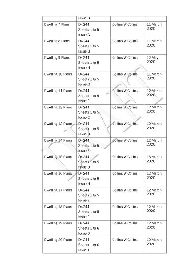
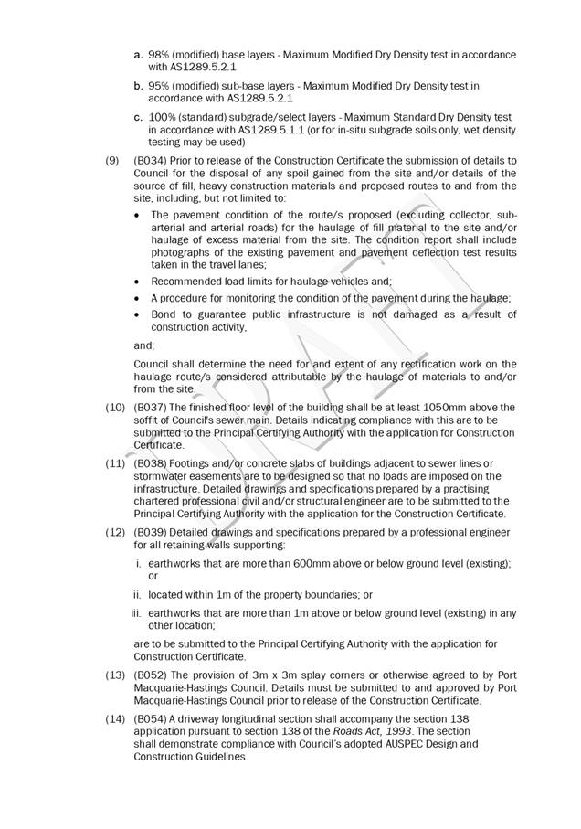
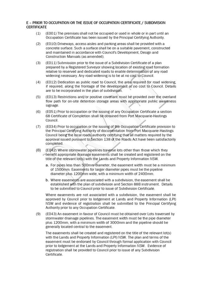
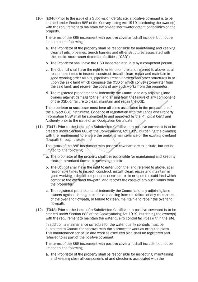
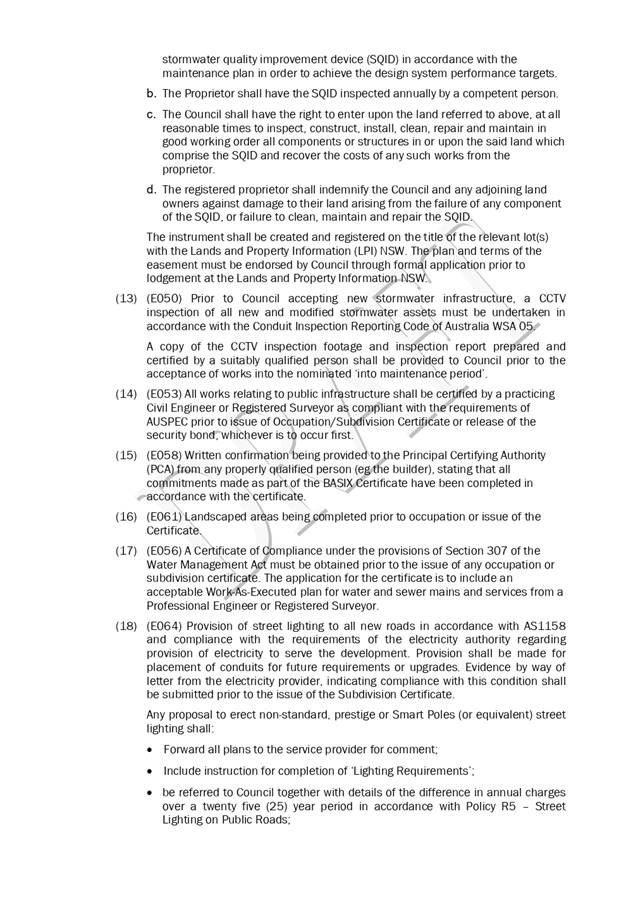
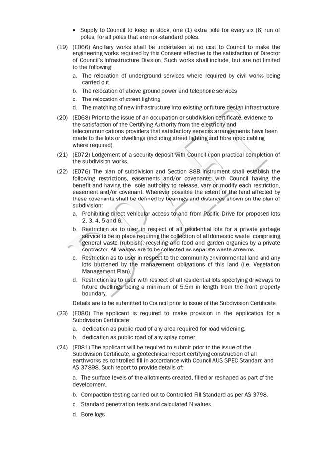
|
ATTACHMENT
|
Development Assessment Panel
10/06/2020
|
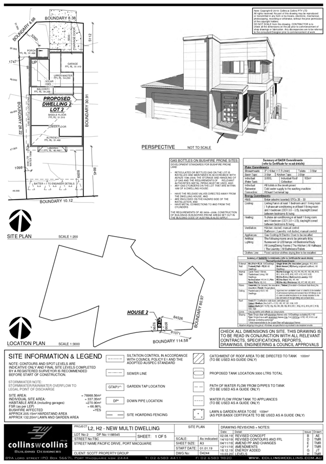
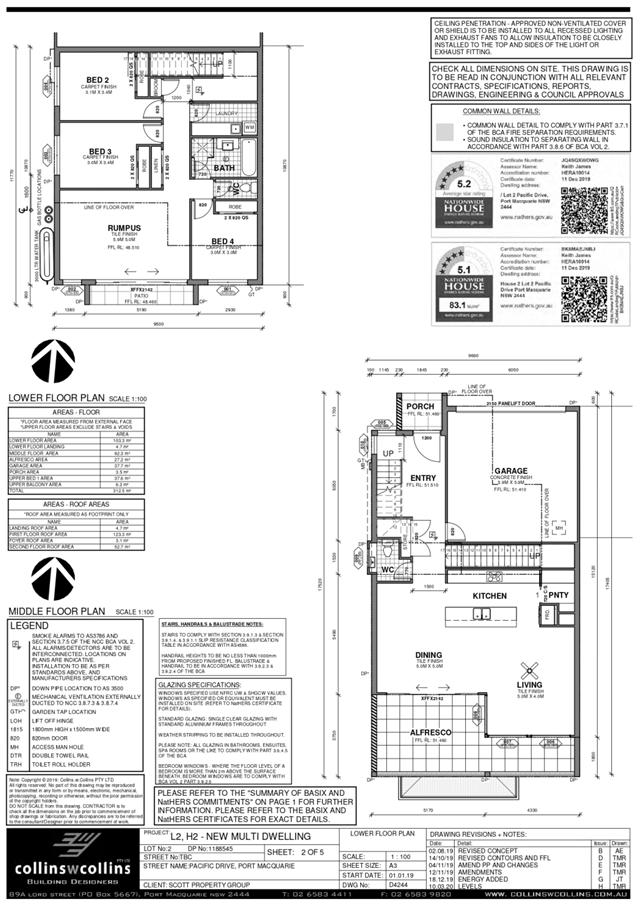
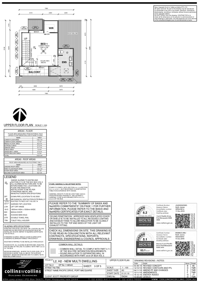
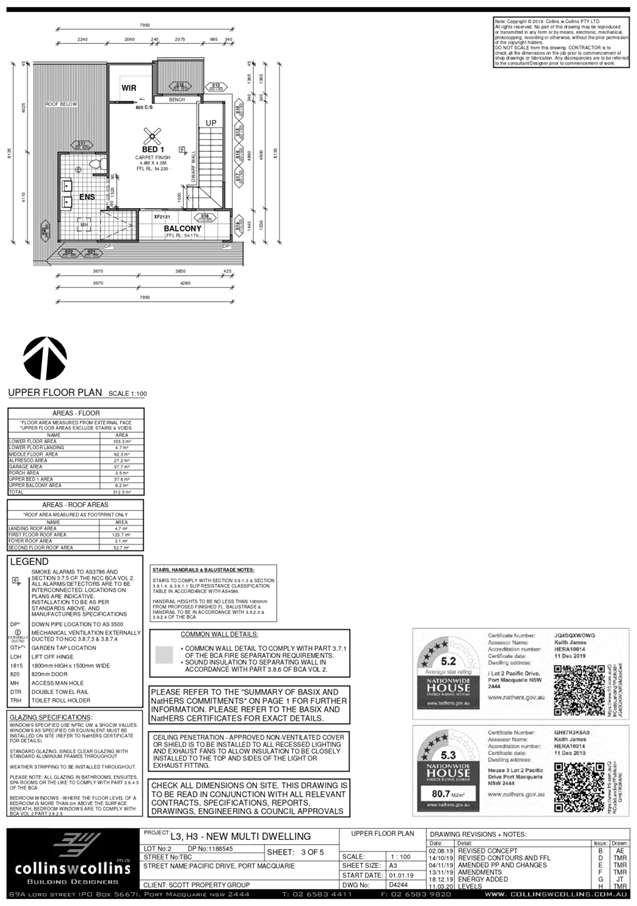
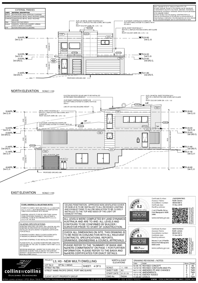
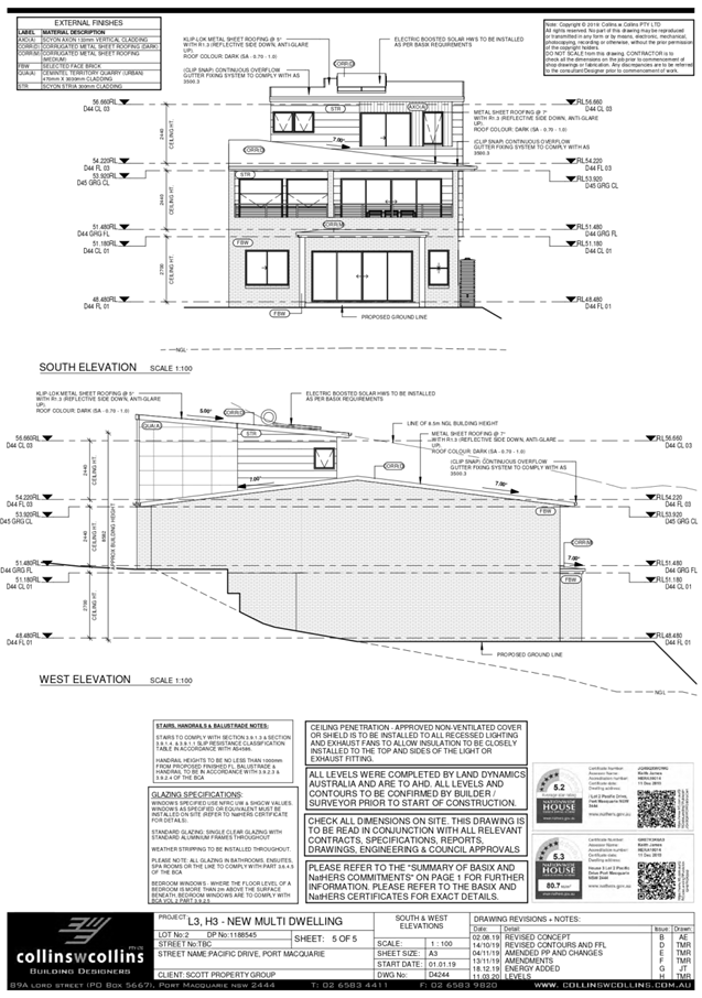
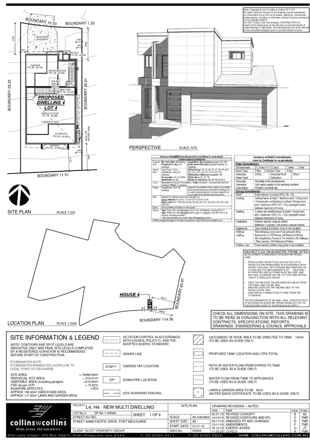
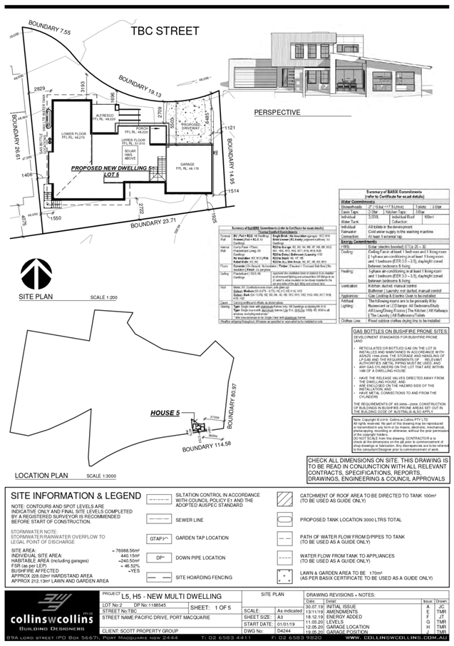
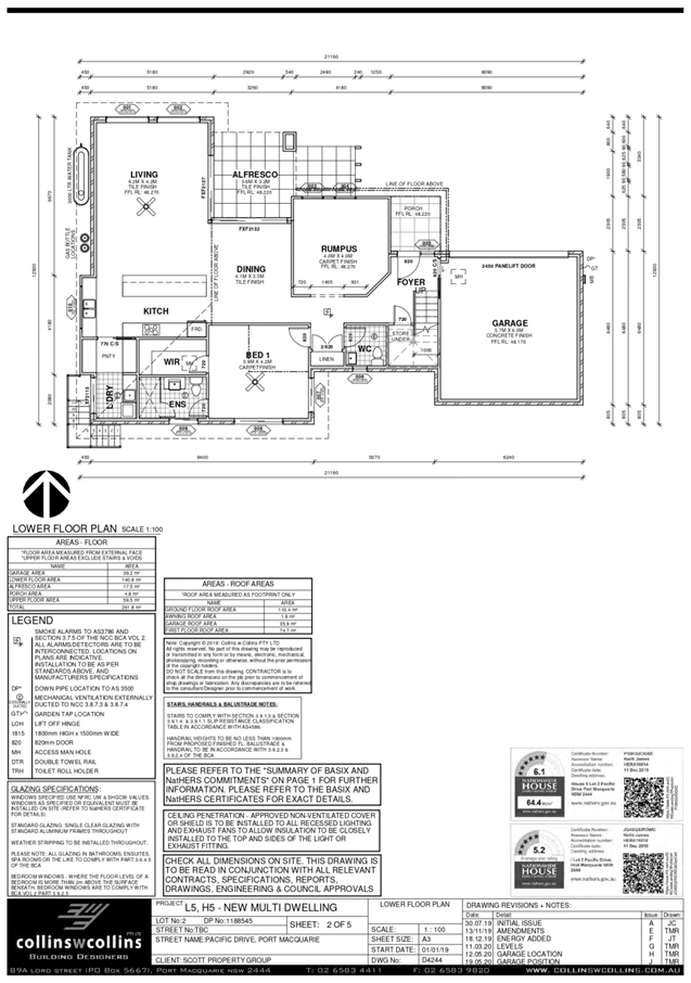
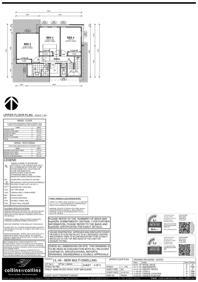
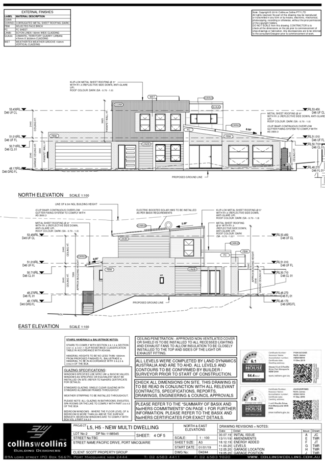
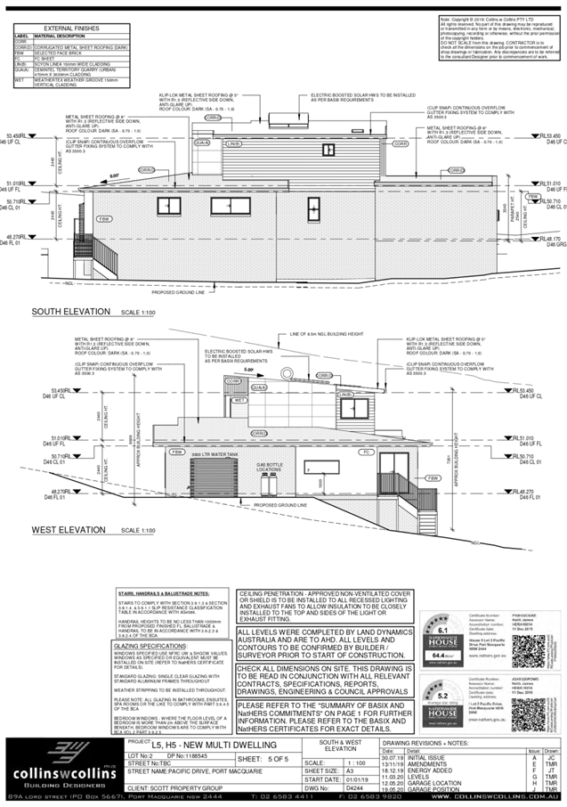
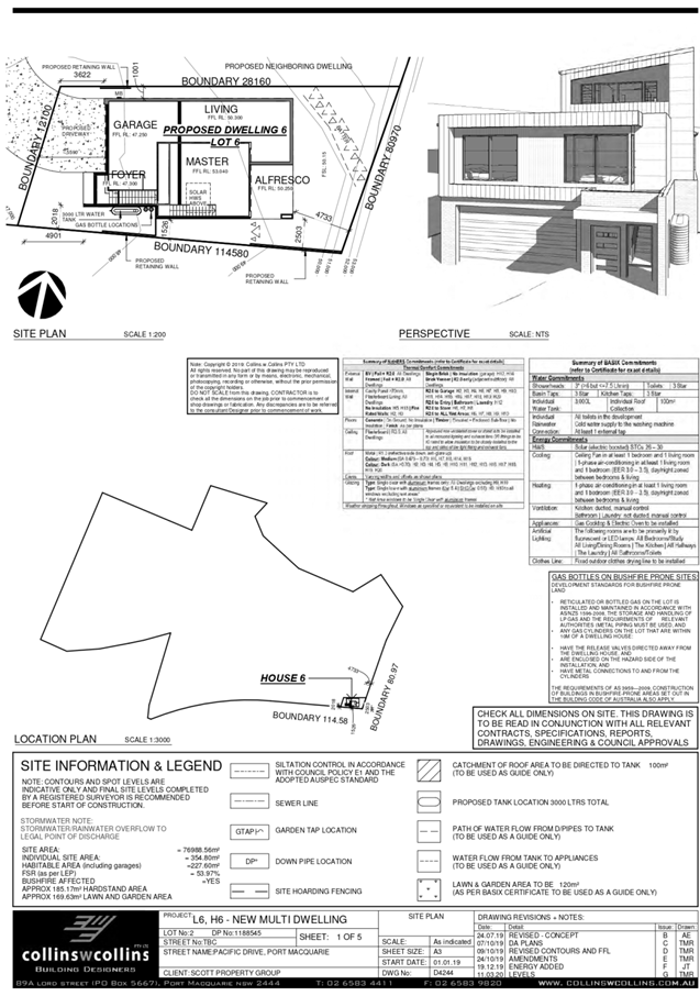
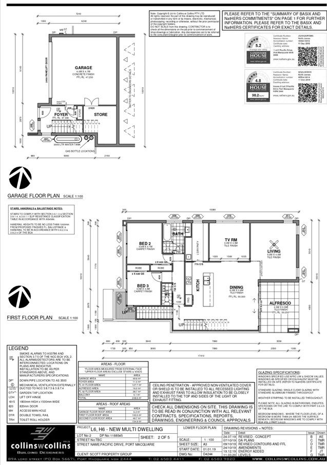
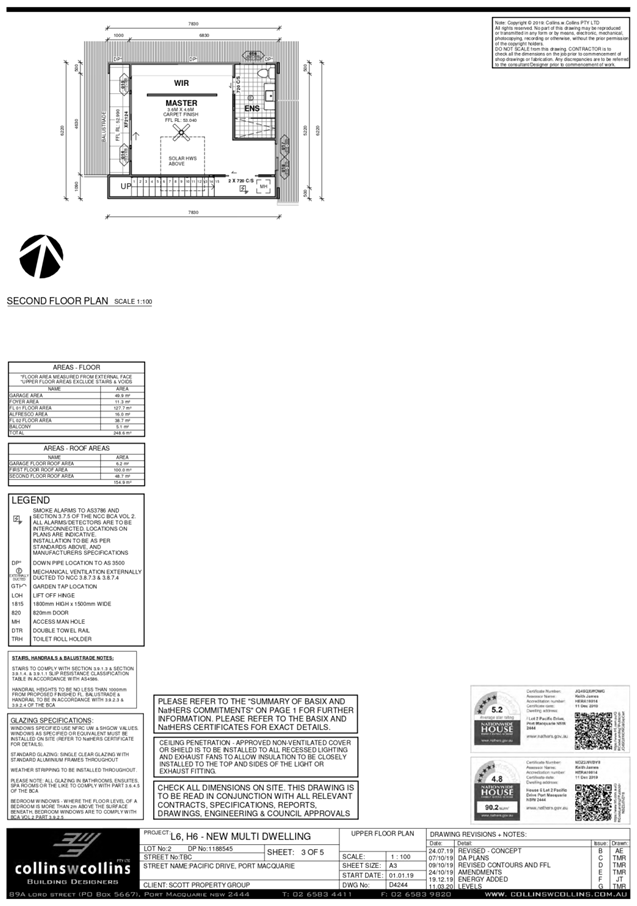
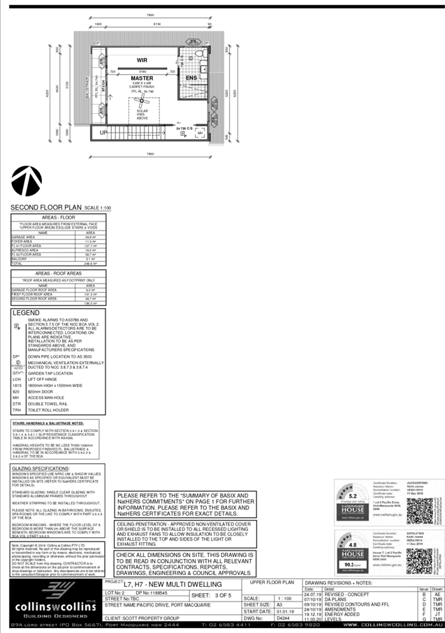
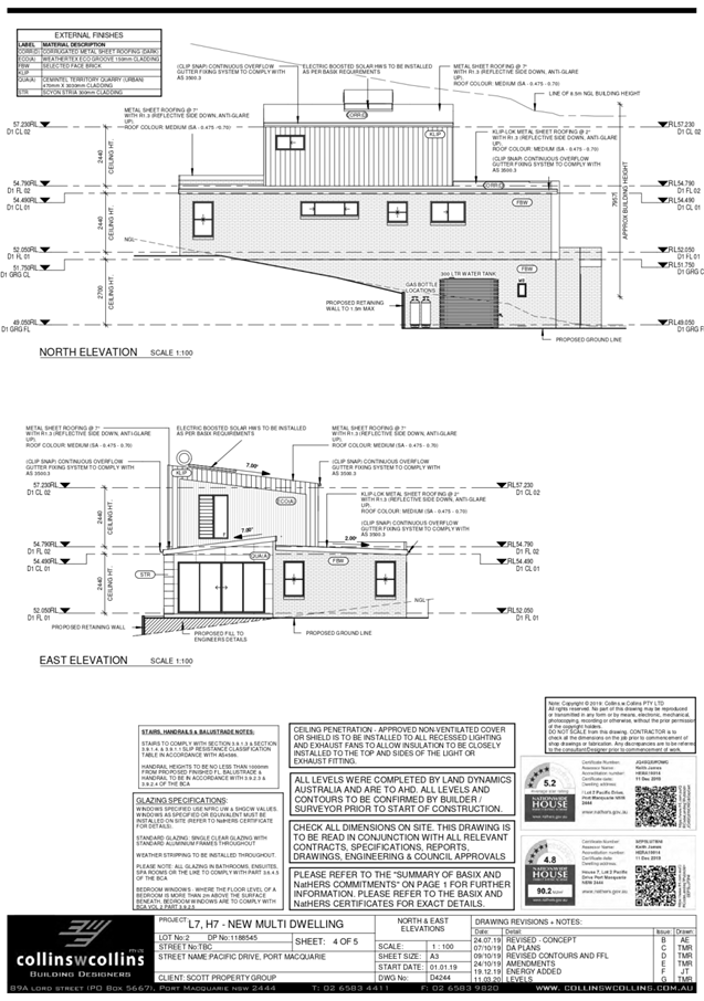
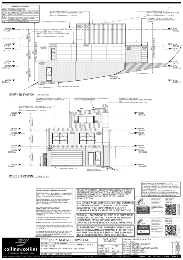
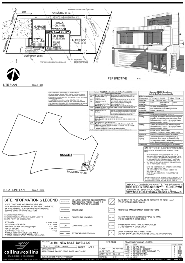
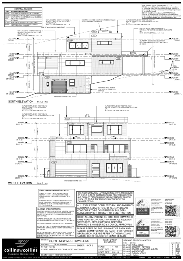
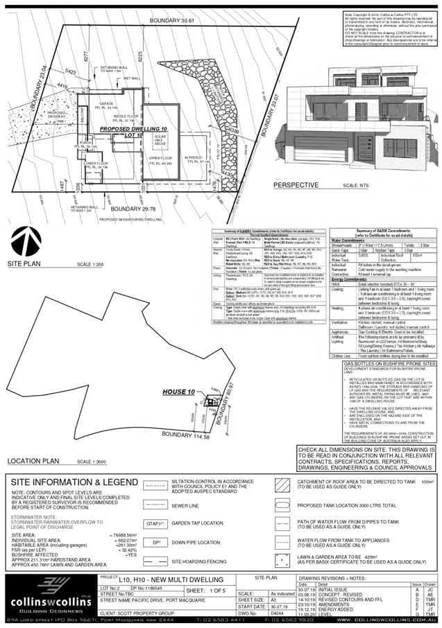
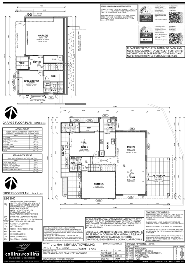
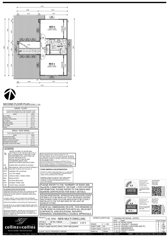
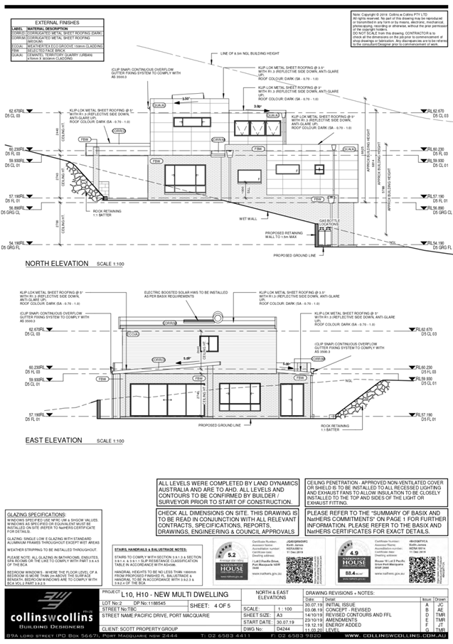
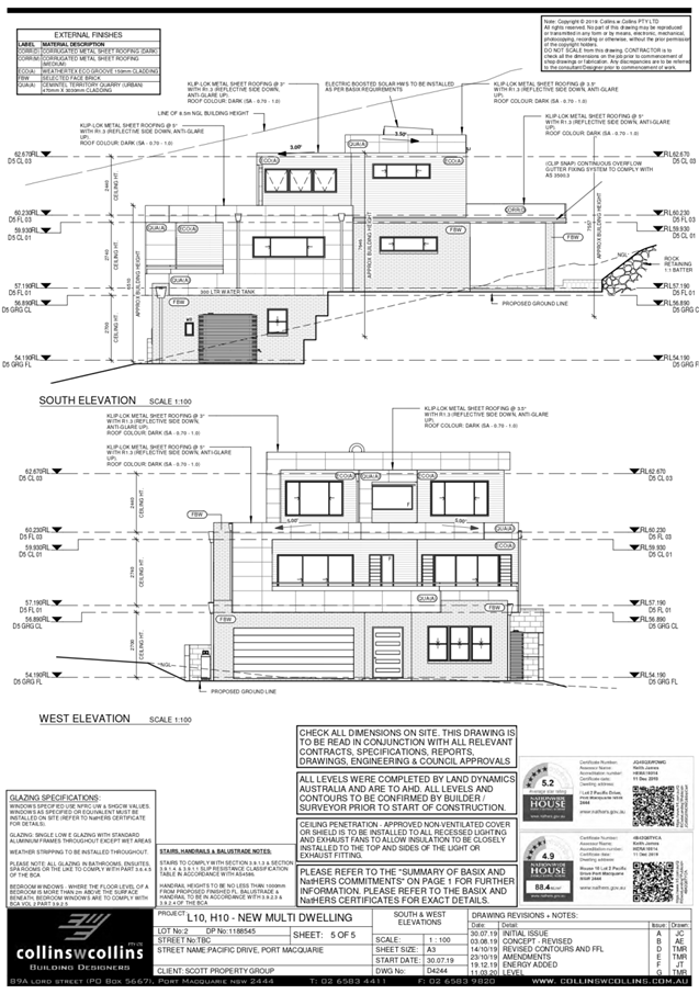
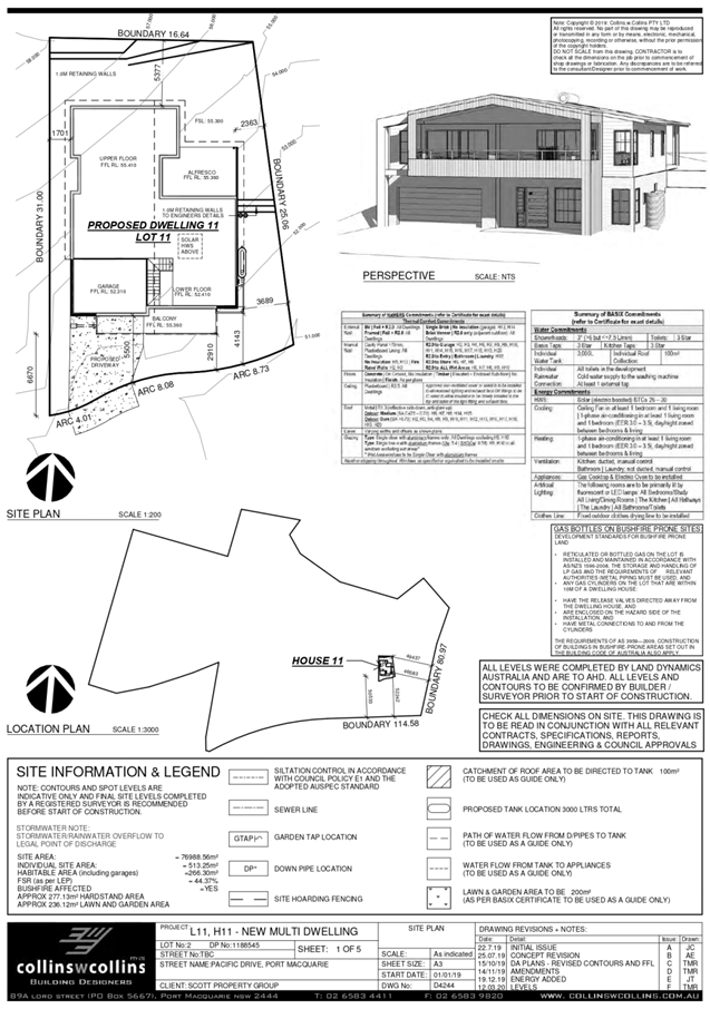
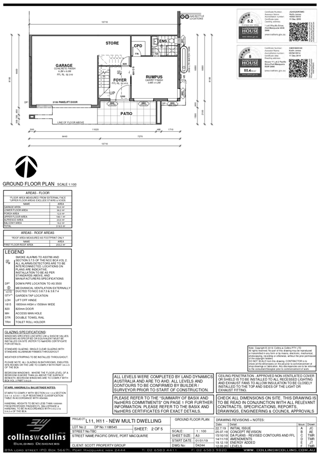
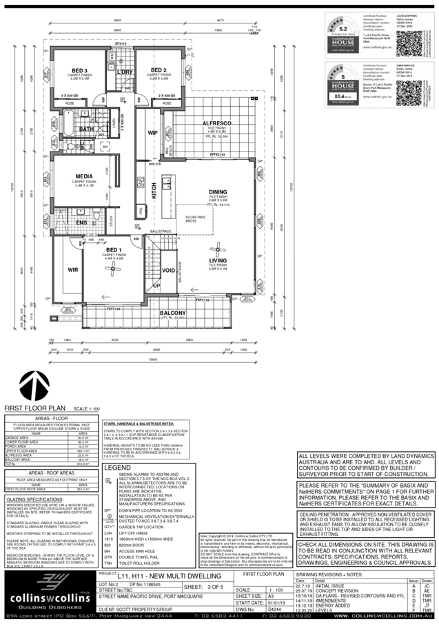
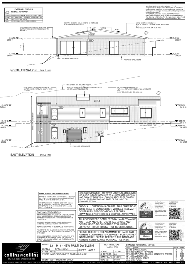
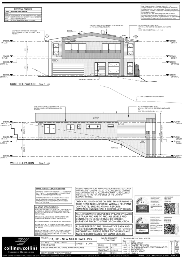
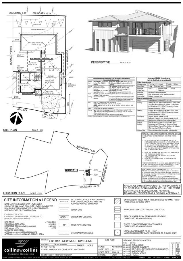
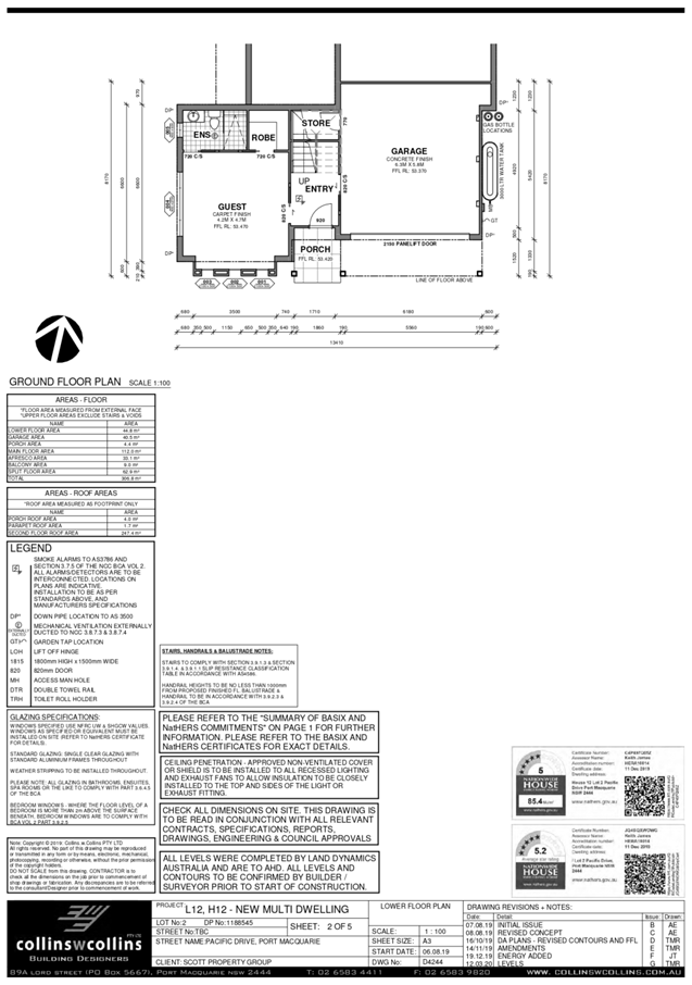
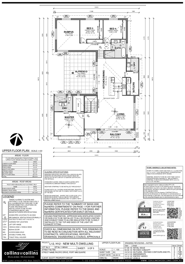
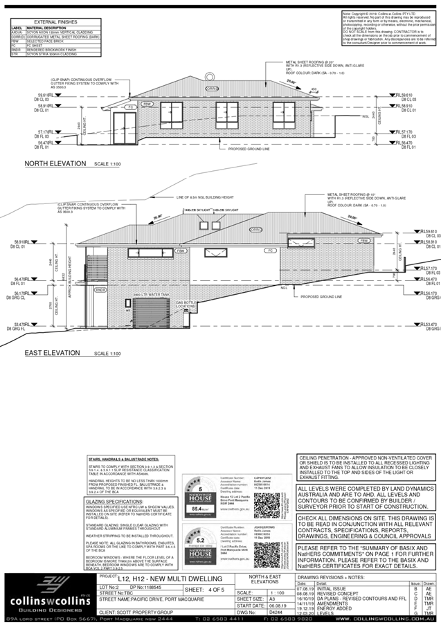
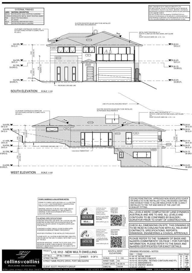


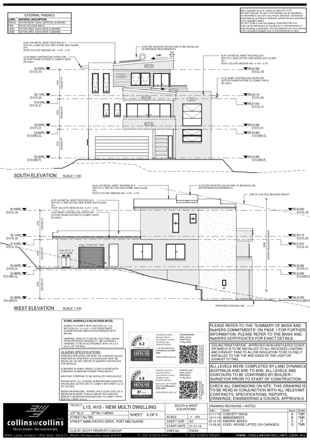
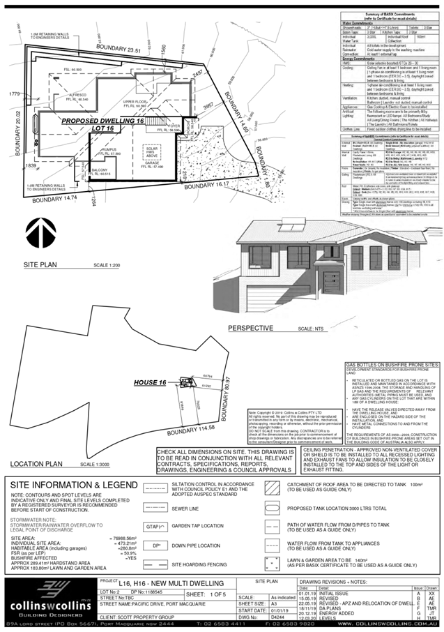
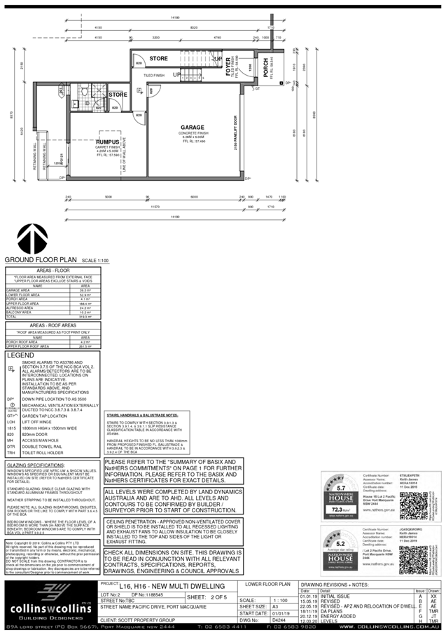
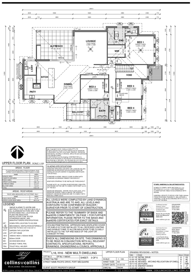
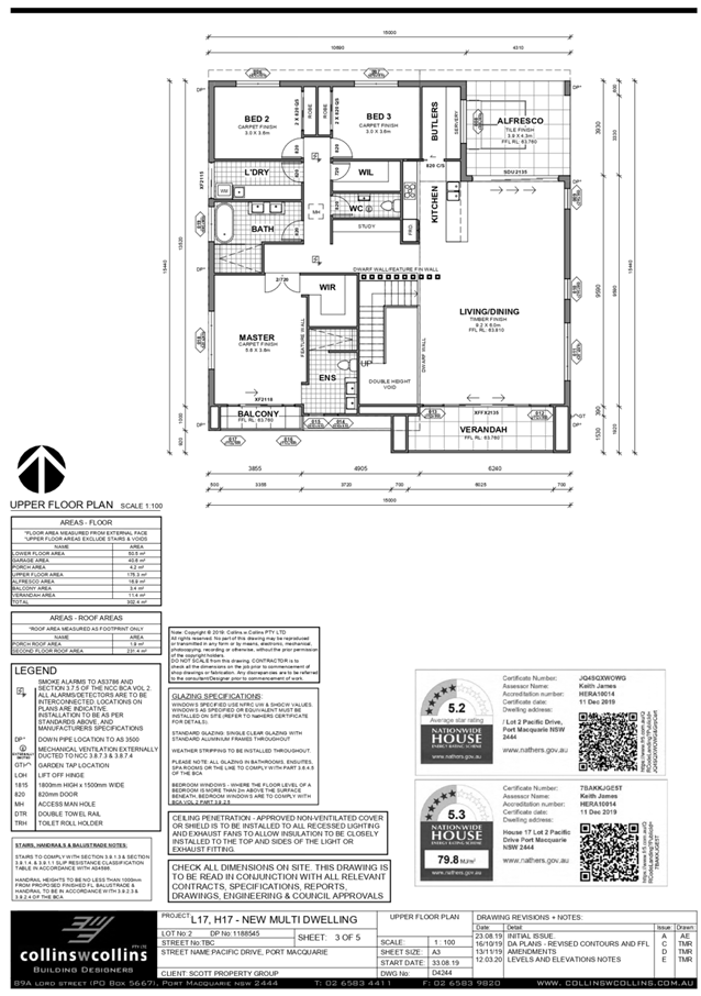
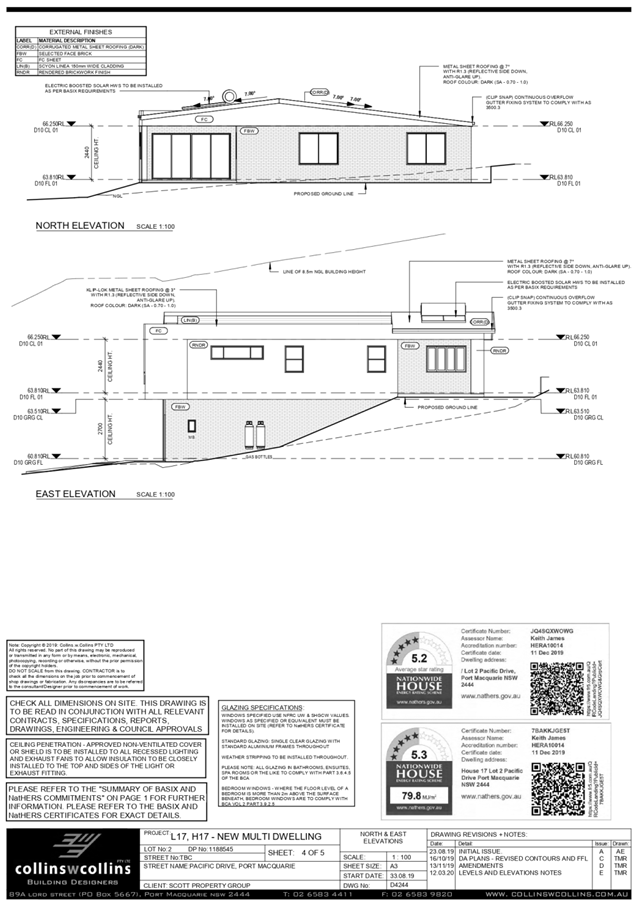
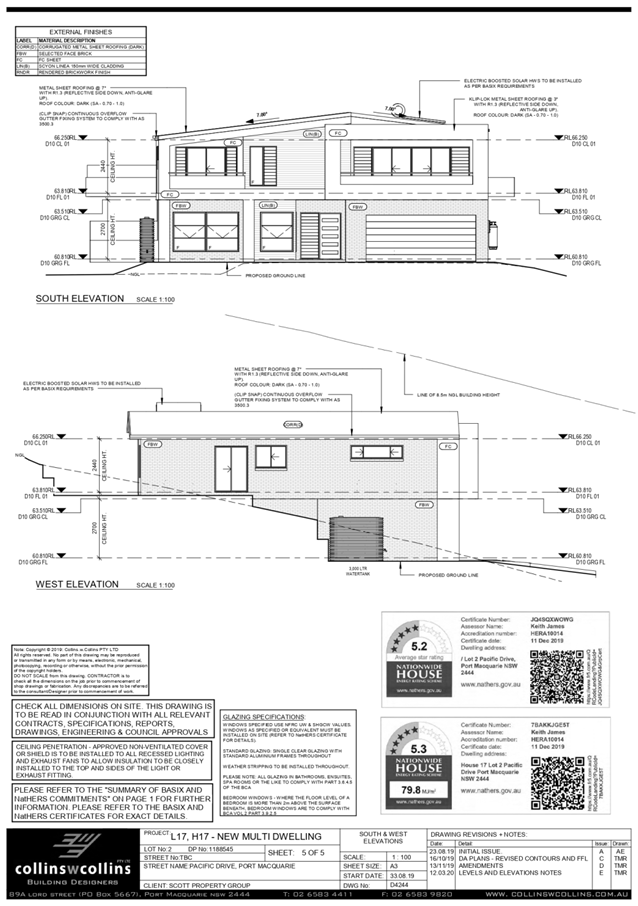
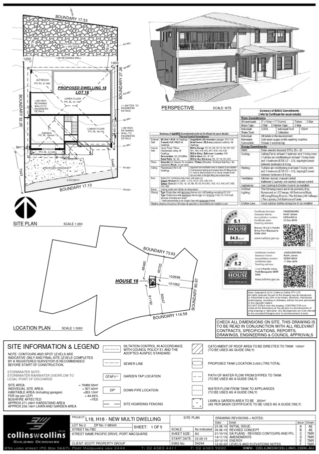
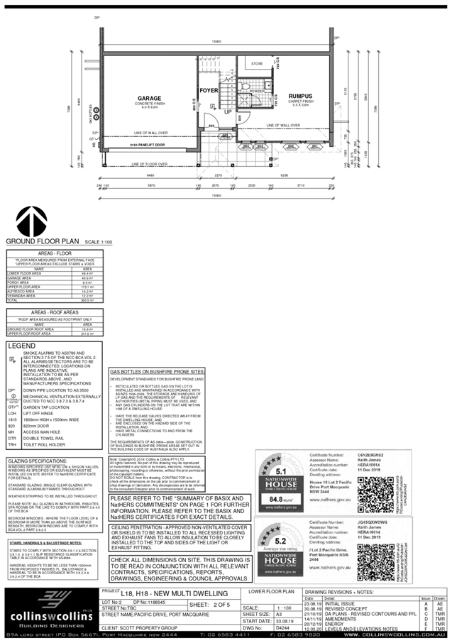
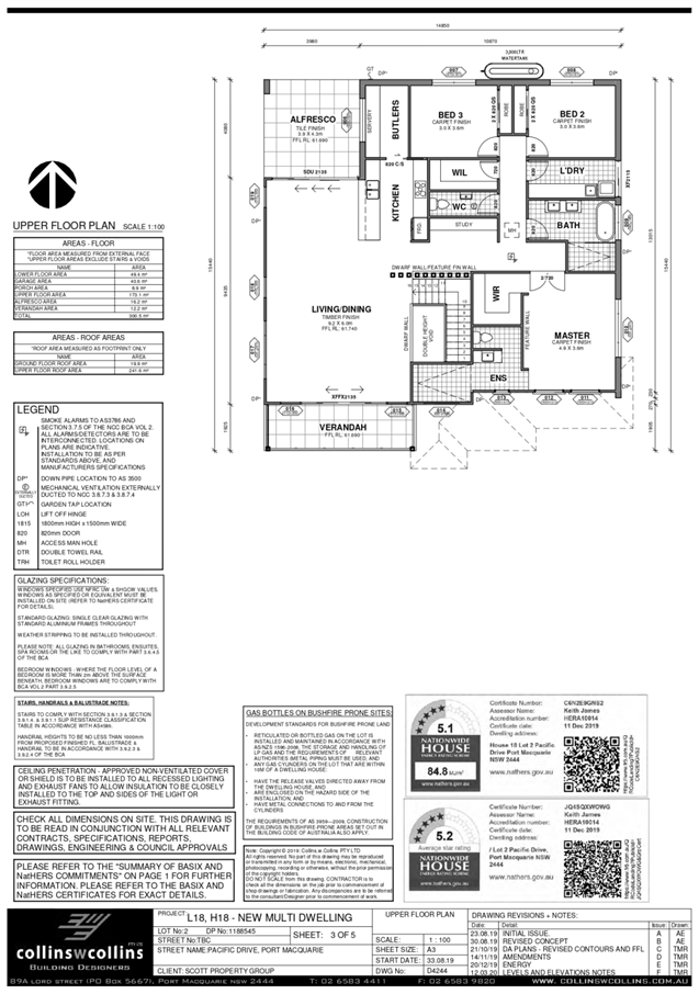
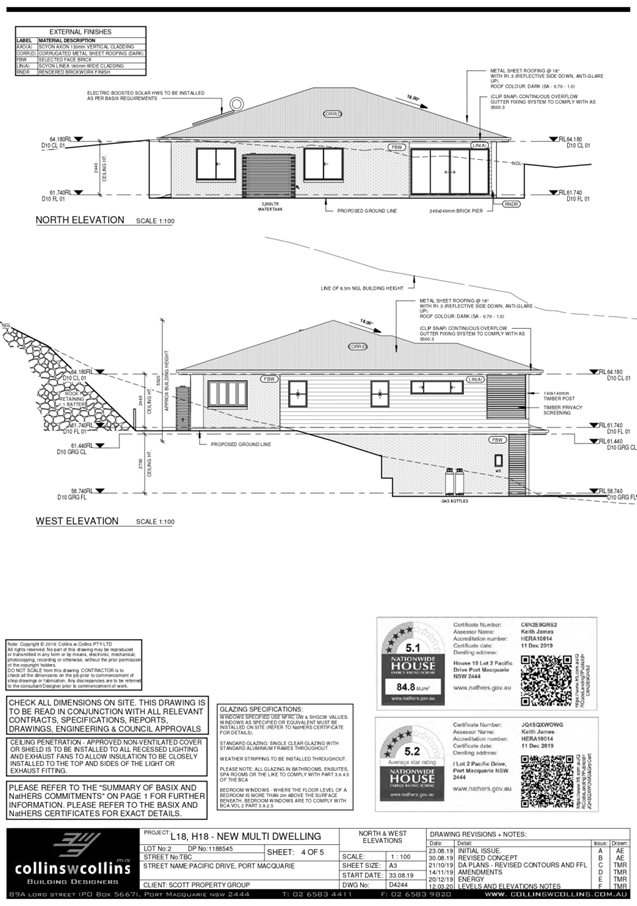
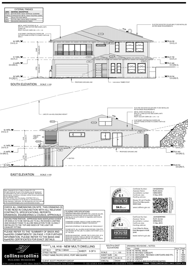
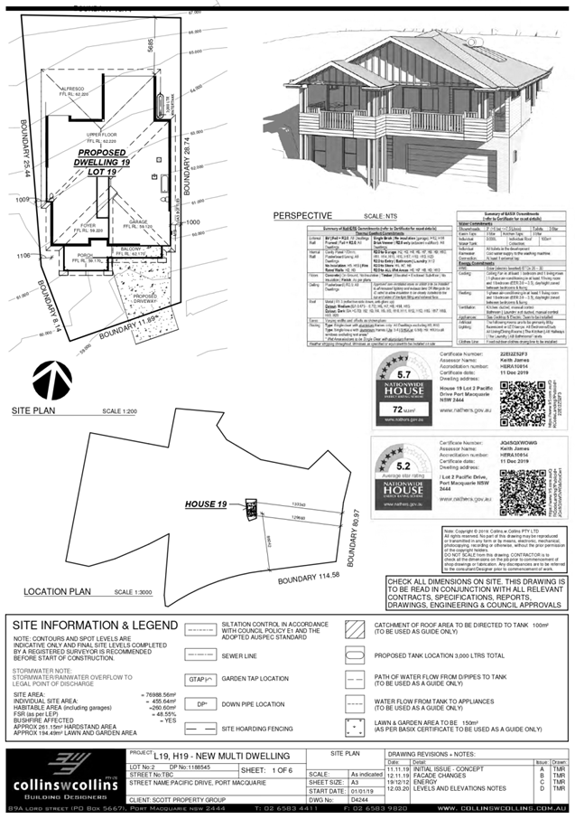
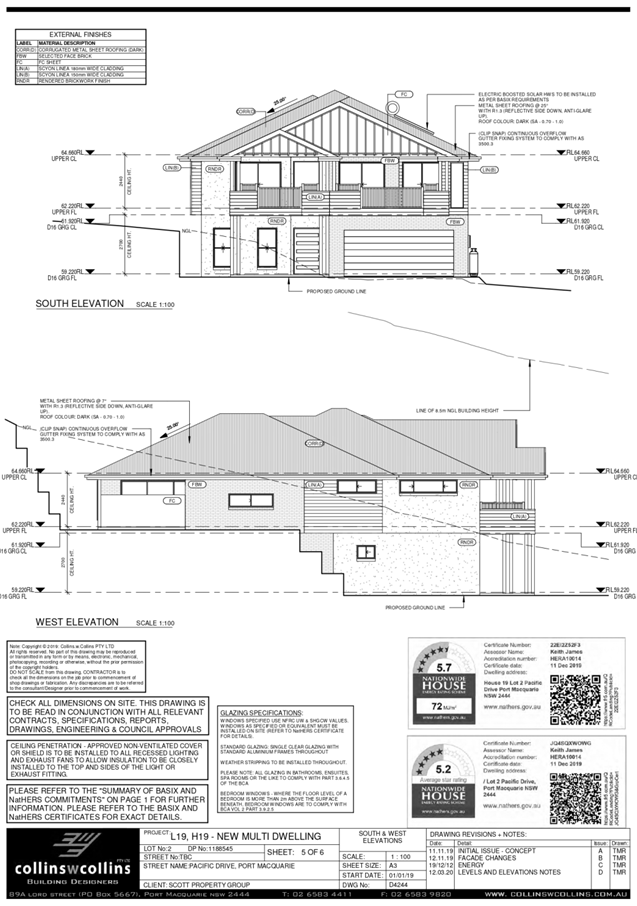
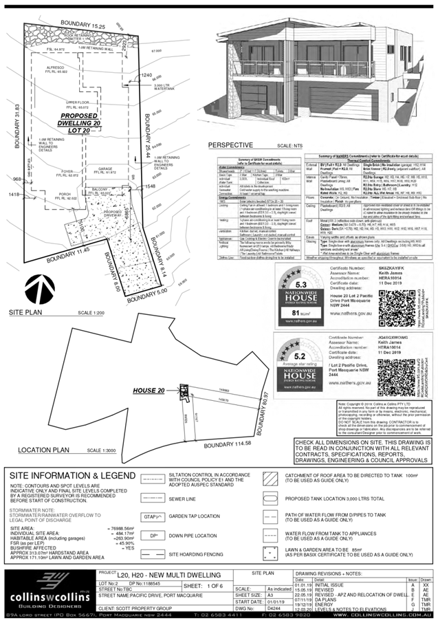
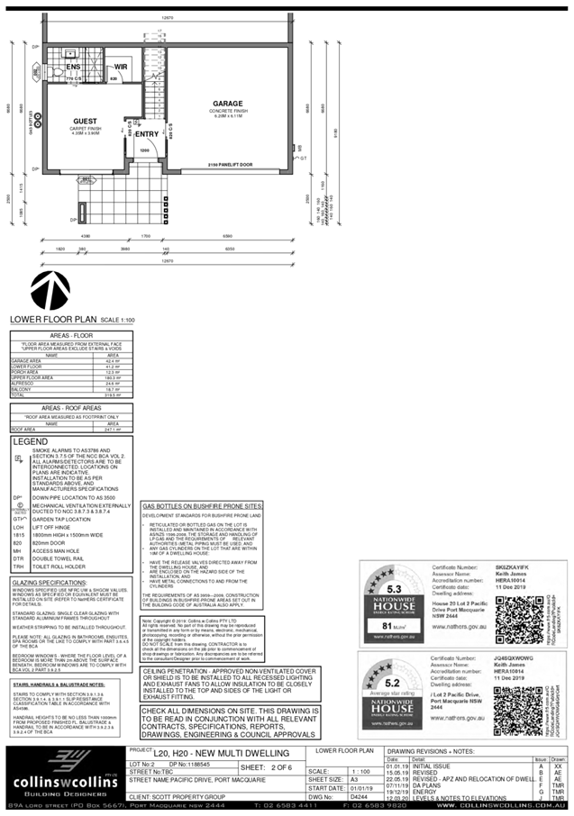
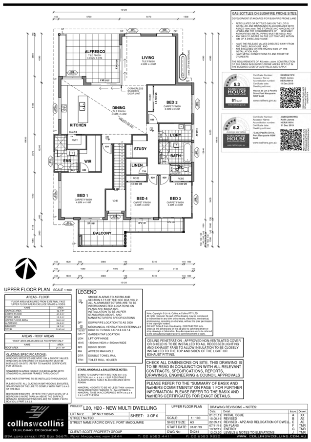
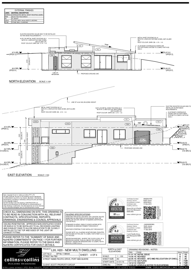
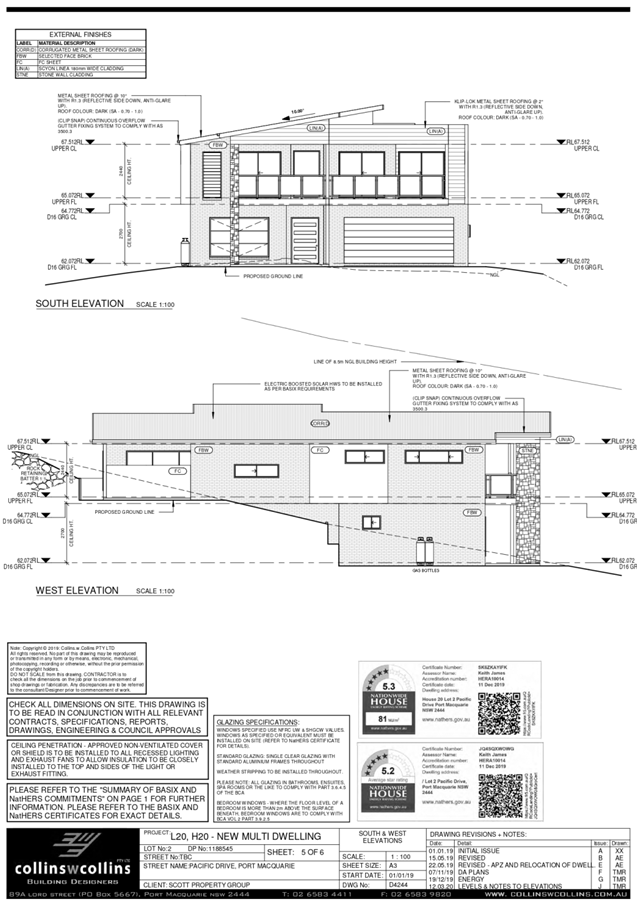
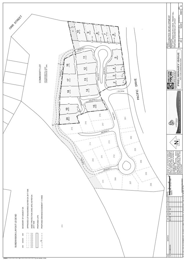
|
ATTACHMENT
|
Development Assessment Panel
10/06/2020
|
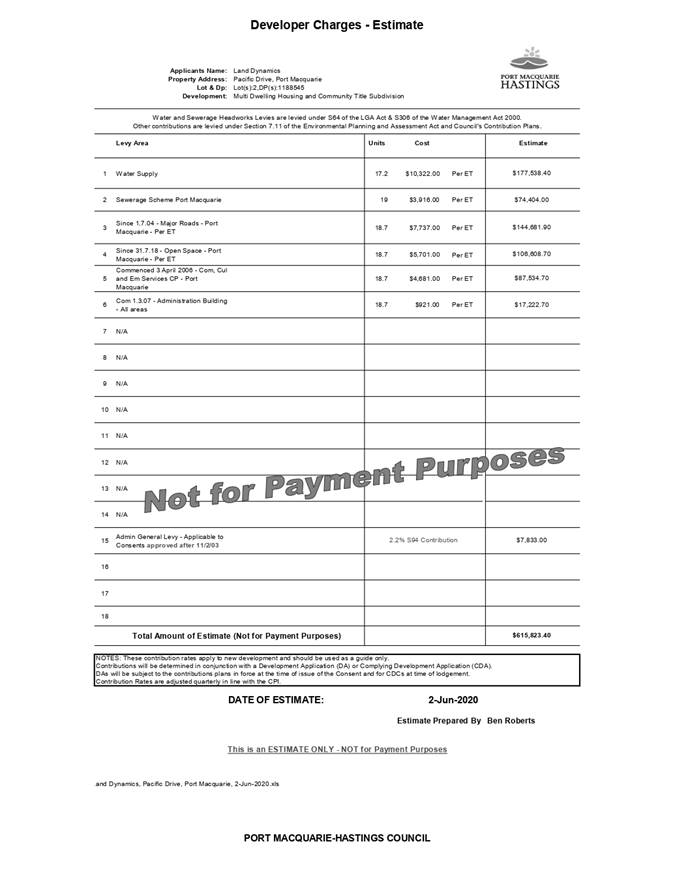
|
ATTACHMENT
|
Development Assessment Panel
10/06/2020
|
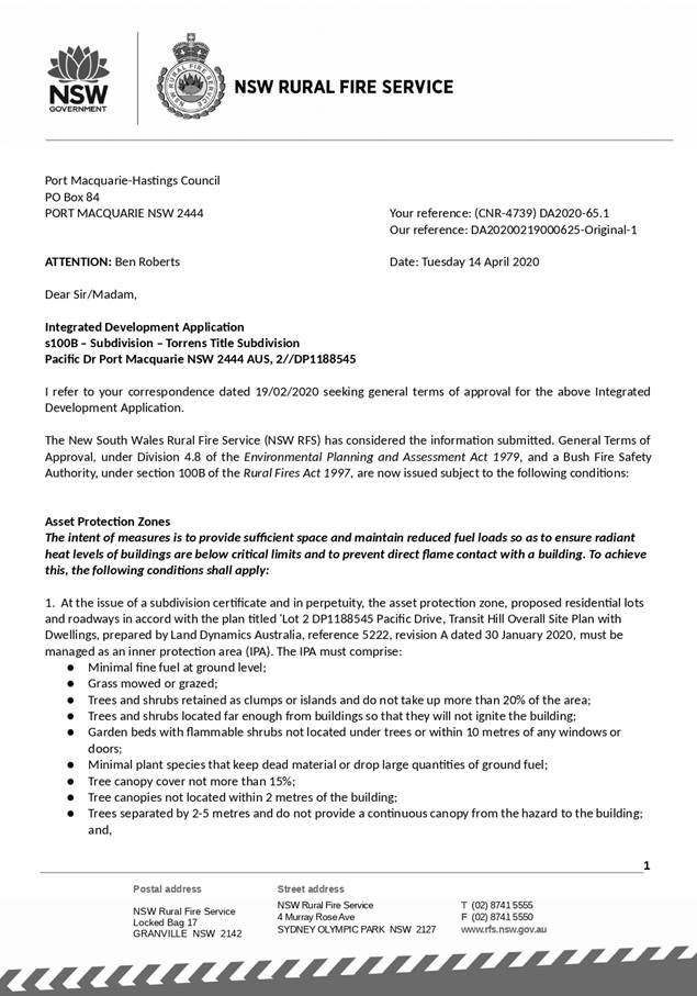
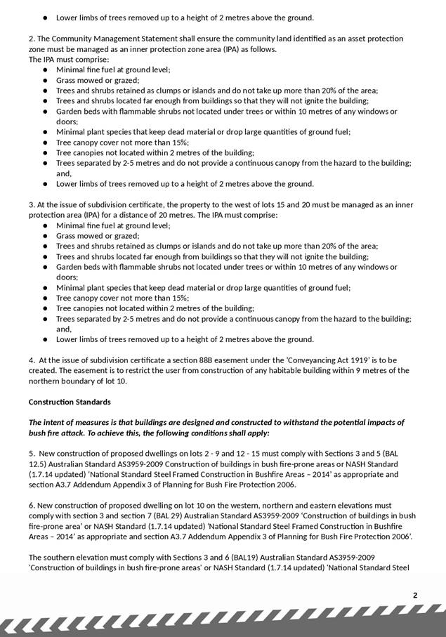
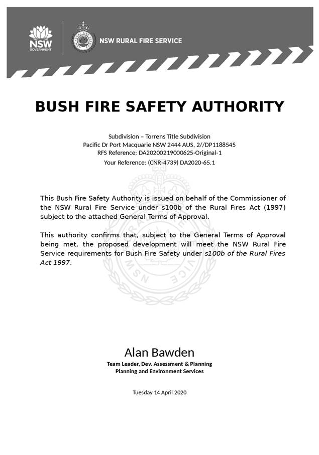
|
ATTACHMENT
|
Development Assessment Panel
10/06/2020
|
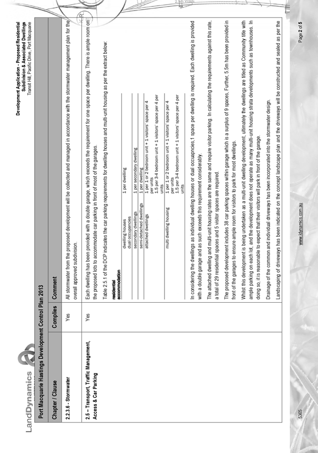
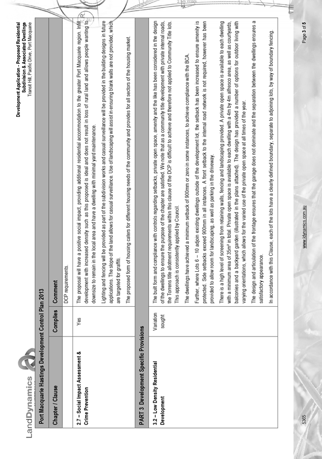
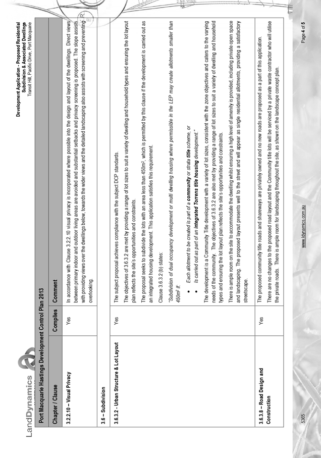
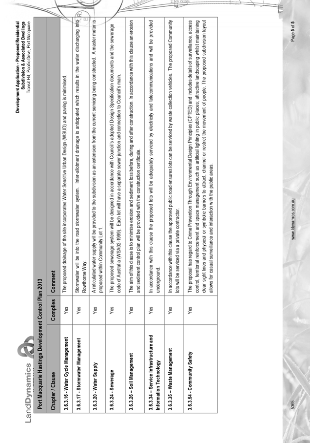
|
ATTACHMENT
|
Development Assessment Panel
10/06/2020
|
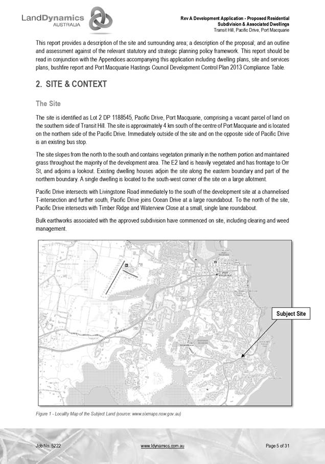
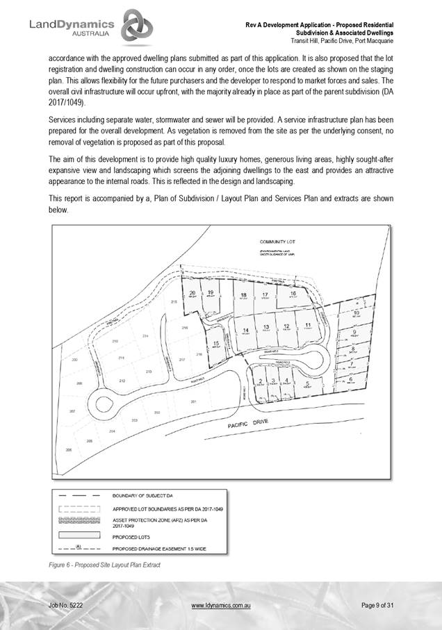
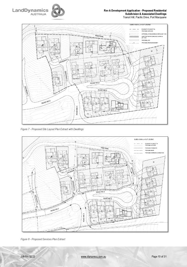
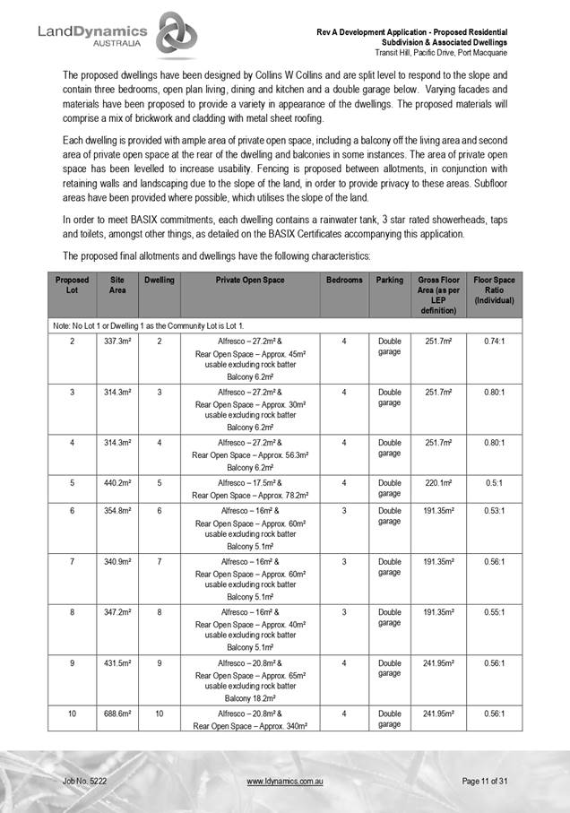
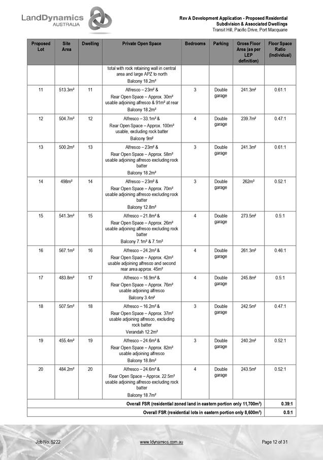
|
ATTACHMENT
|
Development Assessment Panel
10/06/2020
|
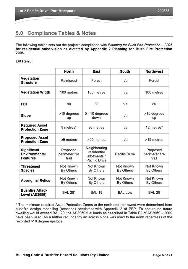
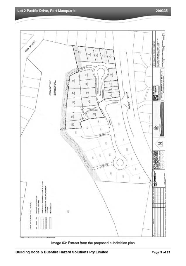
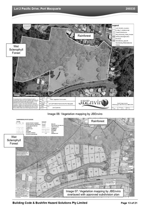
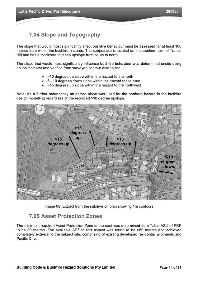
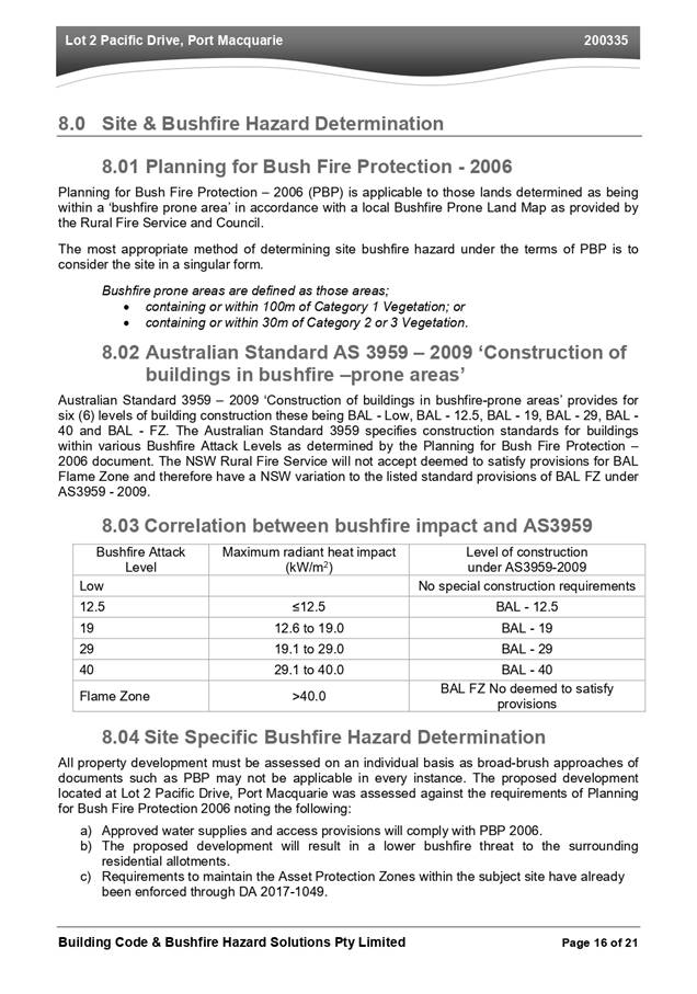
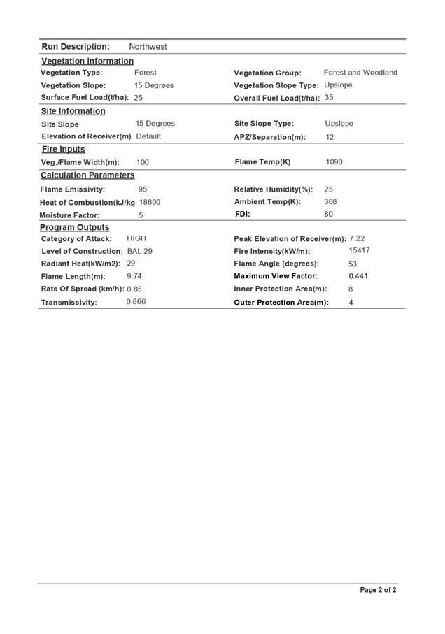
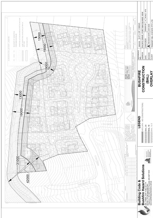

|
ATTACHMENT
|
Development Assessment Panel
10/06/2020
|

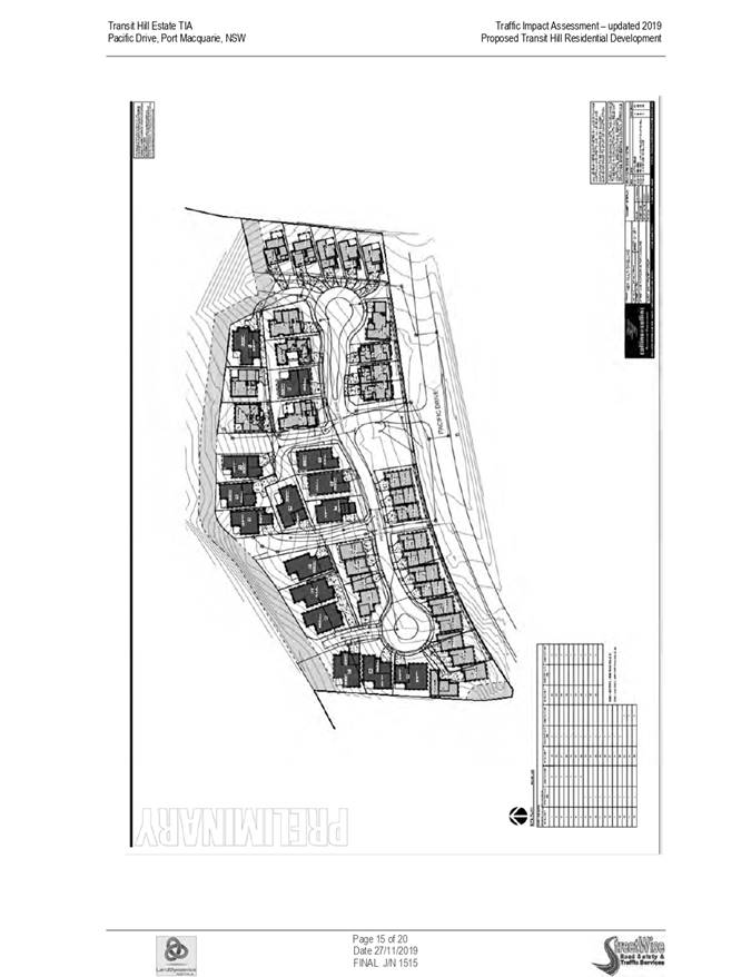
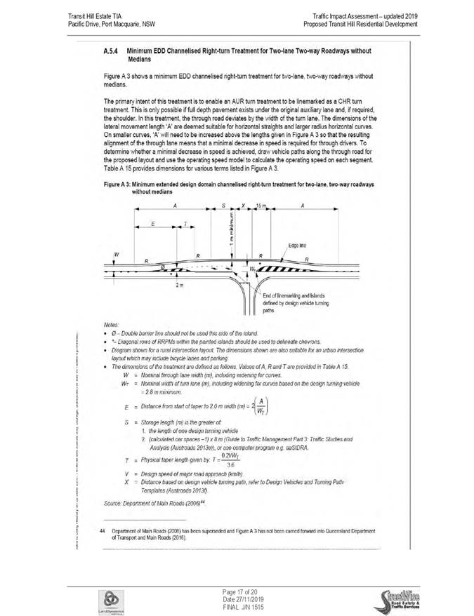

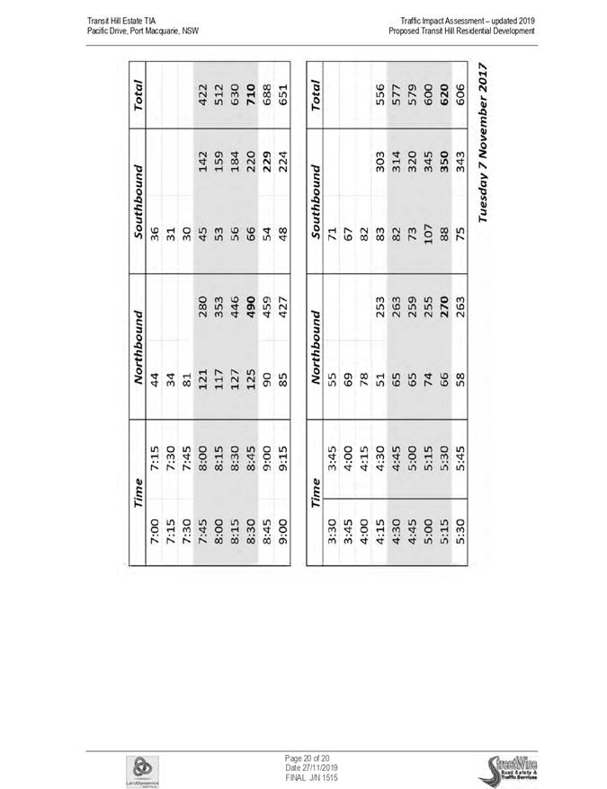
AGENDA Development Assessment Panel 10/06/2020
Item: 08
Subject: DA2019 - 552.1 Staged 136 Site Manufactured
Home Estate at Lot 10 DP 1250178 No.11 Resort Rd, Kew
Report
Author: Development Assessment Planner, Fiona Tierney
|
Applicant: ZW2
Pty Ltd
Owner: ZW2
Pty Ltd
Estimated Cost: $6,358,000
Alignment with Delivery
Program
4.3.1 Undertake transparent
and efficient development assessment in accordance with relevant legislation.
|
RECOMMENDATION
That
DA 2019 - 552.1 for a Staged 136
Site Manufactured Housing Estate at
Lot 10, DP 1250178, No. 11 Resort
Road, Kew, be determined by granting consent subject to the
recommended conditions.
Executive
Summary
This
report considers a development application for a Manufactured Housing
Estate at the subject site and provides an assessment
of the application in accordance with the Environmental Planning and Assessment
Act 1979.
Following exhibition of the
application, two (2) submissions were received.
The proposal has been amended
during the assessment of the application. The primary changes made to
the proposal include a passing bay on Road No.2, refinements to the layout of
the community building layout and carparking and deletion of reference to
proposed Area 15 collector road along western boundary.
The site is considered suitable for the proposed development
and the proposal adequately addresses relevant planning controls. The
development is not considered to be contrary to the public's interest and will
not result a significant adverse social, environmental or economic impact.
This report recommends that the
development application be approved subject to the attached conditions
included as Attachment 1.
1. BACKGROUND
Existing
Sites Features and Surrounding Development
The site has an area of 115.1Ha.
The
site is zoned R1 General Residential, RU1 Primary Production, E2
Environmental Conservation and E3 Environmental Management in accordance with the Port Macquarie-Hastings Local
Environmental Plan 2011, as shown in the following zoning plan:
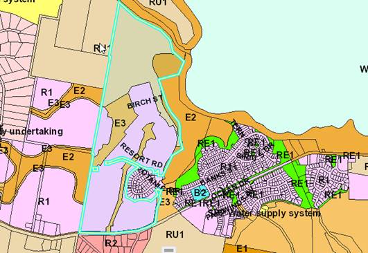
The
subject site is located on the northern side of Ocean Drive, Kew; bordering
onto
Lakewood.
The
development area is located within the south western corner of the subject
site, with frontage to Ocean Drive. The development area has previously been
cleared under the Laurieton Residential Resort development consent and
Vegetation & Habitat Management Plan.
Access to the site is currently
provided via the existing construction access from Ocean Drive.
The
subject site has a long low ridge running north south, with the foot of the
spur ending approximately in the centre of the site. The development area
occurs on a gentle and low north west facing slope.
The
existing subdivision pattern and location of existing development within the
locality is shown in the following aerial photographs:
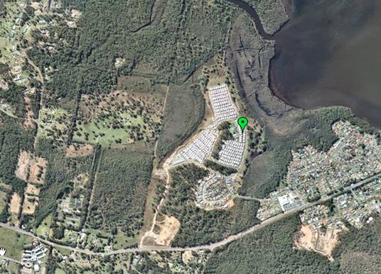
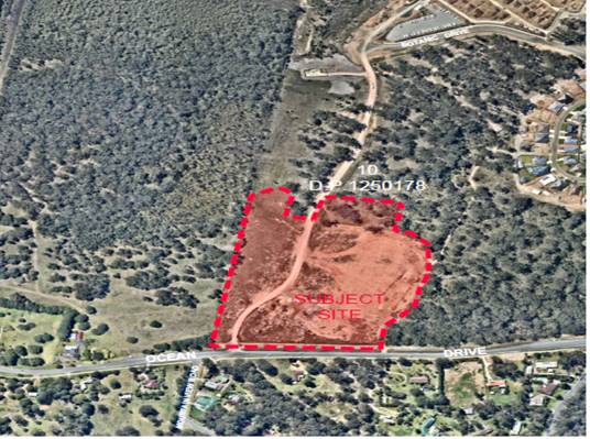
2. DESCRIPTION
OF DEVELOPMENT
Key
aspects of the proposal include the following:
· 136
Manufactured Home sites staged.
- Stage 1 - Lots 1 to 118
- Stage 2 - Lots 119 to 136
· Site
Office
· Multi-purpose
room
· Community
Centre
· Swimming
Pool
· Bocce
Green
· Signage
· Access
Roads
· Servicing
· Landscaping
· Relocation
of the existing right of carriageway
Refer
to Attachment 2 at the end of this report for plans of the proposed
development.
Application
Chronology
· 9
August 2019 - Application lodged.
· 22 August 2019 to 20 September 2019 - Neighbour
notification.
· 26 August 2019 - Additional information received intersection.
· 5 September 2019 - Request to vary existing Planning
Agreement (VPA) from applicant.
· 23 September 2019 - Response from Natural Resource Access
Regulator (NRAR) - No requirements for Activity Approval.
· 25 October 2019 - Request additional information -
Stormwater.
· 21 November 2019 - Comments received Roads and Maritime
Services.
· 22 November 2019 - Additional information request from
Rural Fire Service.
· 25 November 2019 - Request to vary VPA not supported.
· 19 February 2020 - Additional information submitted by
Applicant.
· 24 February 2020 - Additional information submitted by
Applicant.
· 12 May 2020 - Determination received Rural Fire Service
3. STATUTORY
ASSESSMENT
Section
4.15(1) Matters for Consideration
In
determining the application, Council is required to take into consideration the
following matters as are relevant to the development that apply to the land to
which the development application relates:
(a) The
provisions (where applicable) of:
(i) Any
Environmental Planning Instrument
State
Environmental Planning Policy No. 21 - Caravan Parks
The
proposal is not for a caravan park under this SEPP. The proposal is for a
manufactured home estate with the following SEPP 36 being applicable to
consider.
State
Environmental Planning Policy No. 36 - Manufactured Home Estates
The aims of this policy and comments are provided below:
a) to facilitate
the establishment of manufactured home estates as a contemporary form of medium
density residential development that provides an alternative to traditional
housing arrangements, and
Comment(s): Manufactured Home Estates are considered a
contemporary form of medium density housing. The proposed development will
provide an alternative to traditional housing.
(b) to provide immediate
development opportunities for manufactured home estates on the commencement of
this Policy, and
Comments: This policy was gazetted and commenced on 16 July
1993.
(c) to
encourage the provision of affordable housing in well designed estates, and
Comment(s): The proposal will provide a form of alternative
residential housing in a specifically designed estate. Adequate provision has
been made for on-site facilities, services and open space above minimum
standards of the Local Government (Manufactured Home Estates, Caravan Parks,
Camping Grounds and Moveable Dwellings) Regulation 2005.
(d) to ensure that
manufactured home estates are situated only in suitable locations and not on
land having important resources or having landscape, scenic or ecological
qualities that should be preserved, and
Comment(s): Assessment of the proposal having regard to
landscape, scenic and in particular ecological qualities have concluded the
site suitable for the proposed development.
(e) to ensure that
manufactured home estates are adequately serviced and have access to essential
community facilities and services; and
Comment(s): The proposed development will be capable of
being serviced by adequate infrastructure including reticulated water and sewer
facilities. The proposal will provide a number of community facilities within
the estate and access to social and health services is readily available from
the site.
(f) to protect the
environment surrounding manufactured home estates, and
Comment(s): Measures have been incorporated into the design
of the estate to provide adequate protection to the environment within and
surrounding the proposed estate. Additional measures have been incorporated
into the design in response to comments from statutory authorities.
(g) to provide measures
which will facilitate security of tenure for residents of manufactured home
estates.
Comment(s): Tenure is largely secured through the large
upfront capital required to establish supporting infrastructure. Conditions of
consent have been recommended to require community and recreational facilities
to be provided up front and before occupation of any sites particularly noting
the Staging of the proposal. Tenancy agreements are the other means for tenure
security for future residents.
The
proposed development is considered consistent with the aims of this policy.
Clause
6 - Where development for the purposes of a manufactured home estate may be
carried out
Clause
6 of this policy provides where development for the purposes of a manufactured
home estate maybe carried out.
The
proposed development is permissible with the consent of Council pursuant to
clause 6. In particular, the subject clause allows a manufactured home estate
on land where a ‘caravan park’ is permissible. The R1 residential
zoning of the subject land permits ‘caravan parks’ with development
consent. In addition, the proposed development is not subject to any of the
excluded areas contained in Schedule 2 of the SEPP.
Clause
7 - Development consent required for manufactured home estates
Clause
7(1) provides that development for the purposes of a manufactured home estate
permitted to be carried out by this Policy may be carried out only with the
development consent of the Council.
Comment(s):
Noted. This Development Application is seeking development consent.
Clause
7(2) provides that a Council must not consent to any such development unless it
imposes, as a condition of the consent, a requirement that an approval to
operate a manufactured home estate on the land on which the development is to
be carried out must be obtained under Part 1 of Chapter 7 of the Local
Government Act 1993.
Comment(s): Noted. A suitable condition is recommended in
this regard.
Clause
7(3) provides that nothing in this Policy requires a separate development
consent to authorise the placing of each manufactured home within a
manufactured home estate.
Comment(s):
Noted. The installation or construction of a dwellings on individual
manufactured home sites will not require separate development consent.
Clause
8 - Subdivision of manufactured home estates
(1) Land on which
development for the purposes of a manufactured home estate may be lawfully
carried out (whether or not because of a development consent granted pursuant
to this Policy) may be subdivided:
(a) under section 289K of the Local Government Act
1919 for lease purposes, or
(b) under the Community Land Development Act 1989,
only with the development consent of the council.
(2) A Council must not
grant a development consent for such a subdivision if any of the lots intended
to be created by the proposed subdivision would contravene a requirement of the
Local Government (Manufactured Home Estates) Transitional Regulation 1993.
(3) Any prohibition or
restriction on the subdivision of land imposed by any other environmental
planning instrument (whether made before or after this Policy) does not apply
to such a subdivision.
(4)
This Policy does not allow the subdivision of land within a Crown
reserve.
Comment(s):
No subdivision of the MHE for lease or community title purposes is proposed
with the subject development application.
Clause 9 - Matters to be considered by Councils
Clause 9(1) provides that Council may grant development
consent for the purposes of a manufactured home estate only if it satisfied:
(a) That each of the
sites on which a manufactured home is or will be installed within the
manufactured home is or will be installed within the manufactured home estate
is or will be adequately provided with reticulated water, a reticulated
sewerage system, drainage and electricity, and
Comment(s):
Each of the proposed sites within the proposed estate are capable of being
serviced by reticulated water, reticulated sewer, drainage and electricity
services. Appropriate conditions are recommended in this regard.
(b) that the
manufactured home estate is or will be provided with adequate transport
services, and
Comments(s):
The road network provided to and within the estate is considered appropriate
for the proposed development. Existing transport services are available to the
site.
(c) that
sufficient community facilities and services, whether situated within or
outside the estate, are or will be available and reasonably accessible to the
residents of the manufactured home estate, and
5.
Comment(s):
A range of community facilities are proposed within
the estate, which will be directly available and accessible to the residents
within the estate. The community facilities proposed include a clubhouse,
swimming pool, multi-purpose room and bocce green. Existing services and
transport are available to the site.
6.
(d) that
the development will not have an adverse effect on any:
· conservation area
· heritage item
· waterway or land having special landscape, scenic or
ecological qualities, which is identified in an environmental planning
instrument applicable to the land concerned.
Comment(s):
The proposed development will not have any identifiable adverse impacts on any
of the above.
Clause 9(2) provides that Council may grant development
consent for the purposes of a manufactured home estate only after it has
considered the following:
(a) the cumulative
impact of the proposed development and other manufactured home estates in the
locality,
7.
Comments: An assessment of the proposed development,
supporting documentation and legislative provisions suggests that there will be
no adverse cumulative impact on the locality or other manufactured home estates
in the area to warrant recommending refusing consent to the DA. The MHE is run
in conjunction with the existing MHE on the site.
8.
(b) any relevant
guidelines issued by the Director,
9.
Comment(s): No relevant guidelines identified.
10.
(c) the provisions
of the Local Government (Manufactured Home Estates) Transitional Regulation
1993.
11.
Comment(s): The above Regulation has since been repealed.
The Local Government (Manufactured Home Estates, Caravan Parks, Camping Grounds
and Moveable Dwellings) Regulation 2005 is the current Regulation
applicable. A detailed checklist of compliance with the Local Government
(Manufactured Home Estates, Caravan Parks, Camping Grounds and Moveable
Dwellings) Regulation 2005 is provided below:
Local
Government (Manufactured Home Estates, Caravan Parks, Camping Grounds and
Moveable Dwellings) Regulation 2005.
It is
noted the Development Application was accompanied by a section 82(1) objection
under the Local Government Act 1993. Specifically seeking an exemption to
clause 41 of this regulation which requires manufactured homes to be
constructed and assembled onsite.
The
relevant parts of the regulation are addressed below in the following table:
|
CLAUSE
|
REQUIREMENT
(in summary)
|
COMMENT/COMPLIANCE
|
|
Division 1 Application of
Part
|
|
Clause
1-4
|
No
specific requirements only information on the legislation in terms of
operation, definitions etc
|
Noted
|
|
5
Application of Part
|
This
part applies to both the operation of the manufactured home estate and the
installation of the home itself.
|
Noted
|
|
Division 2 Approvals and
exemptions
|
|
6
Factors for consideration before approval is granted
|
(1) Council must be satisfied that the estate will be
designed in accordance with Division 3; and
(2) Council must have regard to the Floodplain Development
Manual.
|
(1) The proposed development has been designed in
accordance with Division 3, refer to comments in Division 3;
(2) Consultation has been undertaken with Council’s
Flooding Engineer as part of the site is mapped as flood prone land. The works
are proposed well clear of the flood areas and no specific conditions are
proposed.
|
|
7
Matters to be specified in approval
|
Any
approval must specify the number, size and location of the dwelling sites.
|
For
consideration with the application for approval to operate.
|
|
8
Conditions of approval
|
The
approval must be conditioned to ensure the design, construction, maintenance
and operation of the estate is in accordance with Division 3.
|
For
consideration with the application for approval to operate
|
|
9 Conditional
exemption
|
(1) Council approval is not
required for:
(a) the installation of a home within the
estate, so long as it is designed, constructed and installed in accordance
with Division 4 and is only occupied after certificate of completion is issued;
or
(b) the associated structure is designed,
constructed and installed in accordance with Division 4.
(2) This exemption applies only of the installation is
carried out by the operator of the estate.
(3) This exemption does not apply to the installation of
a home on flood liable land.
(4) This exemption does not apply for homes or associated
structures of more than one storey.
|
For
consideration with the application for approval to operate
|
|
10
Installation on flood liable land
|
(1) Council must have regard to the Floodplain
Development Manual.
(2) The home must be designed, constructed and installed
in accordance with Division 4.
|
(1) As
detailed above part of the site is mapped as flood prone land. However, the
works are proposed to the southern part of the site and well clear of any
flood prone land.
(2)
Noted.
|
|
11
Installation of manufactured home or associated structure of more than one
storey
|
Council
assessment must have regard to the amenity of the adjoining occupiers.
|
For consideration
with the application for approval to operate. The plans provided indicate the
dwellings will be of single storey construction.
|
|
Division
3 Manufactured home estates
|
|
12
Minimum size of estate
|
Estate
must have an area of not less than 1 hectare.
|
Complies
- area is greater than 1Ha.
|
|
13
Community amenities
|
(1) 10% of total area of estate must be reserved for
recreation or other communal activities.
(2) If lesser proportion, Council must have regard to the
type and range of amenities proposed.
|
Approximately
12.6% of the site (as amended) during assessment is available for
recreational or communal activities which is in excess of the 10% minimum
standard.
|
|
14 Size
of dwelling sites
|
A
dwelling site must have an area of at least 130m².
|
Complies
– All proposed site have areas exceeding 130m². Minimum site area
is 221m2 to 348m2.
|
|
15 Site
identification
|
(1) Dwelling site to be numbered with clearly identified
boundaries.
(2) Site identification must be conspicuous.
|
Complies
– Each of the dwelling sites will be clearly numbered.
|
|
16
Dwelling sites to have road frontage
|
A
dwelling site must have vehicular access to a road.
|
Complies
– all proposed dwelling sites have frontage to a road
|
|
17
Setbacks of community
buildings
|
(1) Not to be located closer than 10m to boundary of
estate and dwelling sites.
(2) Any lesser distance to satisfy Council that building
has been properly screened, fenced, enclosed or otherwise treated.
(3) Must not in any case be closer than 2m to any
boundary.
|
The
community facility buildings are to be setback greater than 10m from
boundaries of the site.
|
|
18
Setbacks of dwelling sites from road frontages
|
(1) No closer than 10m to a public road or 3m to any
other boundary unless approved.
(2) Any lesser distance to satisfy Council
that the dwelling site has been properly screened, fenced, enclosed or
otherwise treated.
|
All
dwelling sites are located greater than 10m from a public road and 3m from
any other property boundary. To be confirmed prior to approval to operate.
|
|
19 Use
of buffer zones
|
Buffer
zones can be used for:
(a) community amenities, access roads, car parking,
footpaths or landscaping, or
(b) or any similar purpose.
|
Complies.
|
|
20
Entrance and exit roads
|
(1) Entrance to or exit from estate must be 8m wide.
(2) Divided roads to have at least 5m on either side.
(3) Tapers between entrance and access roads to be in the
approval.
|
Complies
as amended during assessment. The entrance and exit roads meet the
requirements.
|
|
21 Width
of roads
|
(1) Road reserve to be:
(a) 8.5m for major access road, and
(b) 6m for minor access road.
(2) Sealed portion of access road must be:
(a) 6m for major roads, and
(b) 4m for minor roads.
(3) Passing bays required for minor access
roads exceeding 80m in length
(4) Passing bays at intervals of 100m.
(5) Sealed portion of access road with a
passing bay to be:
(a) 8.5m for major road, and
(b) 6m for minor roads.
|
The
widths of all proposed internal roads are capable of compliance with the
requirements. Passing bays incorporated into amendments during assessment
process.
|
|
22 Speed
restrictions as part of road design
|
(a) 30 km/hr for major access roads, and
(b) 15 km/hr for minor access roads.
|
To be
sign-posted accordingly and suitable condition recommended.
|
|
23
Visitor parking
|
(1)(a) 8 spaces for an estate
with 35 sites.
(b) 12 spaces for 35 to 70 sites.
(c) 16 spaces for 70 to 105 sites.
(d) 20 spaces for 105, plus 1/7 sites over
140.
(2)(a) Minimum dimensions of 5.4m x 2.5m, and
(b) 6.1m x 2.5m.
(3) Visitor spaces to be clearly identified.
|
For the
136 sites proposed a total of 20 visitor car parking spaces are required and
provided.
All
spaces satisfy the minimum dimension requirements.
|
|
24
Visitor parking for people with disabilities
|
(1) 1 space for people with a disability.
(2) If more than 100 sites - 1 / 100 sites of fraction of
100 sites.
(3) In accordance with AS/NZS 2890.1:2004.
(4) Visitor and disabled spaces to be clearly marked.
(5) Visitor spaces to be counted under clause 23.
|
For the
136 sites proposed a total of 2 disabled visitor spaces are required and
provided.
|
|
25 Road
surfaces
|
Must
have all-weather sealed surface, allow for adequate drainage and eliminate
excessive grades.
|
All
proposed roads to and within the development will have all asphalt sealed
surface and will allow for adequate drainage.
|
|
26
Lighting
|
Roads to
be lit between sunset and sunrise.
|
All
roads proposed to be lit via fixed street lighting.
|
|
27 Water
supply
|
(1)(a) Estate must be connected to mains
water,
or
(b) provided with an alternative.
(2)(a) Dwelling site must be connected to the
estate water supply, and
(b) separately metered.
(3)(a) water supply to comply with the
Plumbing and Drainage Code of Practice, and
(b) Requirements of relevant statutory
bodies.
(4) Water for domestic requirements to comply
with 'Australian Drinking Water Guidelines.
|
Complies
– Estate is to be connected to mains water. Each dwelling site
is to be connected to the estate water supply and to be separately metered.
|
|
28
Sewerage
|
(1)(a) Estate must be
connected to main sewer, or
(b) alternative approved system.
(2) Dwelling site to be connected to estate
system.
(3)(a) System to comply with the Plumbing and
Drainage Code of Practice, and
(b) Requirements of relevant statutory
bodies.
|
Complies.
Estate to be connected to reticulated main sewer. A new sewer main is
required outside of the development site. Each dwelling site will be
required to be connected to the estate system.
|
|
29
Drainage
|
(1) Estate to comply with
specified and approved stormwater drainage system.
(2)(a) dwelling site to be connected with
estate system, or
(b) or provided with on-site drainage system.
(3)(a) System to comply with the Plumbing and
Drainage Code of Practice, and
(b) Requirements of relevant statutory
bodies.
|
Conceptual
stormwater management plan has been submitted and will be conditioned to
comply. Dwelling sites will be required to be directly connected to
the stormwater drainage system.
|
|
30
Electricity supply
|
(1) Dwelling site to be supplied with electricity and a
separate meter.
(2) Installation in accordance with AS/NZS 3000:2000.
(3) Electricity charge to comply with standard for
locality.
|
Electricity
supply is capable of being supplied to each dwelling site. Recommended
condition applied requiring letter from respective electricity authority
confirming satisfactory arrangement have been made.
|
|
31
Telephone lines
|
Must be
available to each dwelling site.
|
Each
dwelling site will capable of having a telephone service available.
|
|
32
Common trenches
|
Common
trench may be used.
|
Noted.
|
|
33
Garbage removal
|
Arrangements
to be specified and must be in a clean and sanitary condition.
|
All
proposed dwelling sites will be provided with a garbage collection service
via a private waste contractor.
|
|
34 Fire hydrants
|
(1) Dwelling site and community building to be no more
than 90m from fire hydrant.
(2)(a) hydrant to be a
double-headed pillar-type hydrant, and
(b) maintained to standard specified.
|
Fire
hydrants are proposed to meet the requirements.
|
|
35
Buildings
|
(1) A building must not be
erected in an estate unless the approval allows.
(2) Buildings allowed within an estate
include:
(a) community building,
(b) Brick or masonry separating walls or
external facades to homes.
(3) Brick or masonry external façade
permitted only if:
(a) the dwelling site is within a
'neighbourhood lot',
and
(b) the owner of the lot is also the
proprietor.
|
Complies.
No buildings, other than community/recreational buildings are proposed as
part of this proposal.
|
|
36 Use
of manufactured home
estates
|
(1)(a) estate must not be used for any other
commercial purpose, or
(b) manufacture, construction or
reconstruction of a moveable dwelling.
(2) Manufactured home may be used for
exhibition purposes.
(3) Renovation and maintenance permitted on
homes.
|
Noted.
|
|
37
Community map
|
Map to
be provided to Council.
|
Noted. A
community map will be provided to Council and will be a condition of any
approval to operate the MHE under a separate section 68 permit.
|
|
38
Access to approval and
community
map
|
Approval,
community map and this Regulation must be available for inspection.
|
Noted.
Will be condition as part of the approval to operate the MHE under a separate
section 68 permit.
|
State Environmental Planning Policy (Koala Habitat
Protection) 2019
Clause 15 - A development application made,
but not finally determined, before the commencement of this Policy in relation
to land to which this Policy applies must be determined as if this Policy had
not commenced. The application was made and not finally determined prior to the
commencement of this policy, and the application is therefore required to be
assessed under the relevant provisions of State Environmental Policy No 44 -
Koala Habitat Protection. See assessment comments below.
State Environmental Planning Policy (Coastal Management)
2018
The site is located within an area containing coastal
wetlands, coastal wetland proximity, coastal use area and coastal environment
area. The development area, however is only identified as containing a small
portion of coastal wetlands proximity.
The application has been referred under the Water Management
Act to the NSW Natural Resource Access Regulator. No requirement was specified
under the Act for a Controlled Activity Approval.
In accordance with clause 7, this SEPP prevails over the
Port Macquarie-Hastings LEP 2011 in the event of any inconsistency.
Having regard to clause 11 of the SEPP, the proposed development will not result in:
· identifiable significant adverse impacts on the biophysical,
hydrological or ecological integrity of the adjacent coastal wetland to the
development site; and
· any
identifiable significant reduction to the quantity and quality of surface and
ground water flows to and from the adjacent coastal wetland.
Having regard to clauses 13 and 14 of the SEPP, the proposed
development is not considered likely to result in any of the following:
a) any
adverse impact on integrity and resilience of the biophysical,
hydrological (surface and groundwater) and ecological environment;
b) any
adverse impacts coastal environmental values and natural coastal
processes;
c) any
adverse impact on marine vegetation, native vegetation and fauna
and their habitats, undeveloped headlands and rock platforms;
d) any
adverse impact on Aboriginal cultural heritage, practices and
places;
e) any
adverse impacts on the cultural and built environment heritage;
f) any
adverse impacts the use of the surf zone;
g) any adverse impact on the visual amenity and scenic qualities of the
coast, including coastal headlands;
h) overshadowing, wind funnelling and the loss of views from public places
to foreshores; and
i) any
adverse impacts on existing public open space and safe access to
and along the foreshore, beach, headland or rock platform for members of the
public, including persons with a disability.
In accordance with Clause 15 the proposal is not likely to
cause increased risk of coastal hazards on the land or other land.
The bulk, scale and size of the proposed development is
compatible with the surrounding coastal and built environment. The site is
predominately cleared and located within an area zoned for residential
purposes.
State Environmental Planning Policy No. 44 - Koala
Habitat Protection
With reference to clauses 6 and 7, the subject land is
greater than 1 hectare (including any adjoining land under same ownership) and
therefore the provisions of SEPP must be considered.
There is no Koala Plan of Management on the site. No
vegetation is proposed to be removed therefore no further investigations are
required.
State
Environmental Planning Policy No. 55 - Remediation of Land
In accordance with clause 7,
following an inspection of the site and a search of Council records, the
subject land is not identified as being potentially contaminated and is
suitable for the intended use.
The requirements of this SEPP
are therefore satisfied.
State Environmental Planning Policy No. 62 –
Sustainable Aquaculture
Given the nature of the proposed development, the
development site not being in close proximity to waterways and proposed
stormwater controls the proposal will be unlikely to have any adverse impact on
existing aquaculture industries.
State
Environmental Planning Policy No. 64 – Advertising and Signage
The proposal incorporates a
large feature two sided billboard signage and flag signage at the entry to the
proposed estate. The proposal satisfies the applicable requirements of this
policy. The assessment table provided below provides consideration of the
proposal in accordance with schedule 1 of the policy.
|
Applicable clauses for consideration
|
Comments
|
Satisfactory
|
|
Clause 8(a) Consistent with objectives of the policy
as set out in Clause 3(1)(a).
|
The signage is consistent with the objectives of this
policy.
|
Yes
|
Schedule 1(1) Character of the
area.
|
The entrance and flag signage to be
incorporated will not be out of character with the area.
|
Yes
|
|
Schedule 1(2) Special areas.
|
The entrance signage will not
adversely impact on any identifiable special areas.
|
Yes
|
|
Schedule 1(3) Views and vistas.
|
The entrance signage will not
adversely impact on any views or visas.
|
Yes
|
|
Schedule 1(4) Streetscape, setting
or landscape.
|
The entrance works and signage will
not adversely detract from the streetscape.
|
Yes
|
|
Schedule 1(5) Site and building.
|
This signage is compatible with the
size and scale of the estate to which it is to be located.
|
Yes
|
|
Schedule 1(6) Associated devices
and logos with advertisements and advertising structures.
|
None proposed.
|
N/A
|
|
Schedule 1(7) Illumination.
|
No internal illumination of the entrance signage is
proposed. Timed external upwards illumination proposed.
|
Yes
|
|
Schedule 1(7) Safety.
|
The signage will not adversely
impact on public safety matters.
|
Yes
|
State
Environmental Planning Policy (Housing for Seniors or People with a Disability)
2004
The Applicant has submitted that
the development is not age restricted although targeted to over 55. No
provisions of this SEPP require specific consideration in this regard.
State
Environmental Planning Policy (Infrastructure) 2007
With reference to clause 101,
the site has frontage to the Ocean Drive which is a classified road. The
consent authority must not grant consent to development on such land unless it
is satisfied that:
(a) where practicable and safe, vehicular access to the land is
provided by a road other than the classified road, and
12.
(b) the safety, efficiency and ongoing operation of the classified
road will not be adversely affected by the development as a result of—
(i)
the design of the vehicular access to the land, or
(ii)
the emission of smoke or dust from the development, or
(iii) the nature, volume or frequency of vehicles using the classified
road to gain access to the land, and
(c) the development is of a type that is not sensitive to traffic
noise or vehicle emissions, or is appropriately located and designed, or
includes measures, to ameliorate potential traffic noise or vehicle emissions
within the site of the development arising from the adjacent classified road.
The proposal has been referred
to NSW Roads and Maritime Services (RMS) during the assessment of the
application. The advice received from the RMS has been considered later in this
report.
Road noise/acoustic impacts are
considered later in this report.
State Environmental Planning
Policy (State and Regional Development) 2011
The proposed development does
not have a capital investment value of more than $20 million and is not
considered Regional Development (as per legislation in force at the time of lodgement
of the DA). No provisions of this SEPP require specific consideration in this
regard.
Port Macquarie-Hastings Local Environmental
Plan 2011
The proposal is consistent with the LEP having regard to the
following:
· Clause
2.2 - The subject site is zoned R1 General Residential, RU1 Primary Production,
E2 - Environmental Conservation and E3 - Environmental Management. The works
are located wholly within the R1 zone.
13.
14. In accordance the SEPP36 for
a Manufactured Home Estate to be permissible a ‘caravan park’ under
this LEP is to be permissible. In this regard, in accordance with clause 2.3(1)
and the R1 landuse table, the proposed development for a ‘caravan
park’ is a permissible landuse with consent in the R1 zone.
15.
16. The proposed recreation and
communal facilities are based upon the submitted details and locations best
characterised as being ancillary and subordinate to the primary landuse and
therefore permissible. The SEPP 36 requires communal facilities also which implies
permissibility also for such ancillary uses.
The objectives of the R1 zone are as follows:
o To provide for the housing needs
of the community.
o To provide for a variety of
housing types and densities.
o To enable other land uses that
provide facilities or services to meet the day to day needs of residents.
The objectives of the RU1 zone
are as follows:
o To
encourage sustainable primary industry production by maintaining and enhancing
the natural resource base.
o To
encourage diversity in primary industry enterprises and systems appropriate for
the area.
o To
minimise the fragmentation and alienation of resource lands.
o To
minimise conflict between land uses within this zone and land uses within
adjoining zones.
The
objectives of the E2 zone are as follows:
o To
protect, manage and restore areas of high ecological, scientific, cultural or
aesthetic values.
o To
prevent development that could destroy, damage or otherwise have an adverse
effect on those values.
o To
protect coastal wetlands and littoral rainforests.
o To
protect land affected by coastal processes and environmentally sensitive land.
17.
The objectives of the E3 zone are follows:
o To
protect, manage and restore areas with special ecological, scientific, cultural
or aesthetic values.
o To
provide for a limited range of development that does not have an adverse effect
on those values.
· Clause
2.3(2) - The proposal is consistent with the zone objectives having regard to
the following:
o The proposal is a permissible
landuse;
o The proposal will provide for an
alternative type of residential housing with a range of opportunities for
varied housing types; and
o The works are located wholly within
the R1 zone.
· Clause
4.4 - The floor space ratio of the component of proposal with permanent
community amenity buildings does not exceed and complies with the maximum
0.65:1 floor space ratio applying to the site.
· Clause
5.10 - Heritage. The site does not contain or adjoin any known heritage items
or sites of significance.
· Clause
7.3 - Part of the site is land within a mapped “flood planning
area” (Land subject to flood discharge of 1:100 annual recurrence
interval flood event (plus the applicable climate change allowance and relevant
freeboard) In this regard the following comments are provided which incorporate
consideration of the objectives of Clause 7.3 and 7.4, Council’s Flood
Policy 2015, the NSW Government’s Flood Prone Lands Policy and the
NSW Government’s Floodplain Development Manual (2005):
o The
proposal is compatible with the flood hazard of the land taking into account
projected changes as a result of climate change;
o The
proposal will not result in a significant adverse effect on flood behaviour
that would result in detrimental increases in the potential flood affectation
of other development or properties;
o The
proposal incorporates measures to minimise & manage the flood risk to life
and property associated with the use of land;
o The
proposal is not likely to significantly adversely affect the environment or
cause avoidable erosion, siltation, destruction of riparian vegetation or a
reduction in the stability of river banks or watercourses; and
o The
proposal is not likely to result in unsustainable social and economic costs to
the community as a consequence of flooding.
· Clause
7.9 Acoustic controls - An acoustic assessment has been submitted due to the
impact of noise from traffic on Ocean Drive. The assessment has found that some
living and bedroom windows will require an upgrade to glazing and ventilation.
Conditions of consent have been applied to require compliance with the
recommendations of the report.
· Clause
7.13 - Satisfactory arrangements are in place for provision of essential
services including water supply, electricity supply, sewer infrastructure,
stormwater drainage and suitable road access to service the development.
Provision of electricity and other services (NBN) will be subject to obtaining
satisfactory arrangements from the service providers as recommended by a
condition of consent.
(ii) Any draft instruments
that apply to the site or are on exhibition
No draft instruments apply to
the site
(iii) Any Development
Control Plan in force
Port
Macquarie-Hastings Development Control Plan 2013
|
DCP 2013: General Provisions
|
|
|
Requirements
|
Proposed
|
Complies
|
|
2.2.2.1
|
Signage to be building or business identification. Be
contained to within the property. Not project above building facades.
Potential for light spill from illumination to be subject to curfew.
|
Entrance signage on front wall identifying the estate
proposed. Curfew proposed.
|
Yes
|
|
2.3.3.3
|
Significant land reforming proposals shall not change
surface levels by more than 5m.
|
Landform change is less than 5m change proposed.
Maximum cut of 4m and maximum fill of 2m which tapers
down to natural ground level to Ocean Drive.
|
Yes
|
|
2.3.3.1
|
Cut and fill 1.0m max. 1m outside the perimeter of the
external building walls
|
Earthworks are proposed and capable of being managed.
Suitable site management conditions recommended.
|
Yes
|
|
2.3.3.2
|
1m max. height retaining walls along road frontage
|
No retaining walls along road frontage proposed.
|
N/A
|
|
Any retaining wall >1.0 in height to be certified
by structure engineer
|
Engineering certification capable.
|
Yes - capable
|
|
Combination of retaining wall and front fence height
max 1.8m, max length 6.0m or 30% of frontage, fence component 25%
transparent, and splay at corners and adjacent to driveway
|
No combination of retaining and front fence proposed.
|
N/A
|
|
2.3.3.8
|
Removal of hollow bearing trees
|
No hollow bearing trees are proposed to be removed.
|
Yes
|
|
2.6.3.1
|
Tree removal (3m or higher with 100m diameter trunk at
1m above ground level and 3m from external wall of existing dwelling)
|
No tree removal is proposed
|
Yes
|
|
2.4.3
|
Bushfire risk, Acid sulphate soils, Flooding, Contamination,
Airspace protection, Noise and Stormwater
|
Refer to main body of report.
|
Yes
|
|
2.5.3.2
|
New accesses not permitted from arterial or
distributor roads
|
Access proposed via proposed public road connection to
Ocean Drive.
|
Yes
|
|
Driveway crossing/s minimal in number and width
including maximising street parking
|
Single entry and exit point proposed via public road.
|
Yes
|
|
2.5.3.3
|
Parking in accordance with Table 2.5.1.
|
Adequate off-street parking is proposed consistent
with the requirement of the Local Government (Manufactured Home Estates,
Caravan Parks, Camping Grounds and Moveable Dwellings) Regulation 2005.
|
Yes
|
|
2.5.3.11
|
Section 94 contributions
|
Refer to main body of report.
|
Yes
|
|
2.5.3.12 and 2.5.3.13
|
Landscaping of parking areas
|
Suitable landscaping proposed.
|
Yes
|
|
2.5.3.14
|
Sealed driveway surfaces unless justified
|
Internal roads to be sealed.
|
Yes
|
|
2.5.3.15 and 2.5.3.16
|
Driveway grades first 6m or ‘parking area’
shall be 5% grade with transitions of 2m length
|
Internal roads can comply with requirements of the
Local Government (Manufactured Home Estates, Caravan Parks, Camping Grounds
and Moveable Dwellings) Regulation 2005.
|
Yes
|
|
2.5.3.17
|
Parking areas to be designed to avoid concentrations
of water runoff on the surface.
|
Parking areas will be adequately drained.
|
Yes
|
|
Vehicle washing facilities – grassed area etc.
available.
|
Suitable areas available for car washing.
|
Yes
|
|
2.7.2.1
|
Social impact assessment shall be submitted in
accordance with Council’s Social Impact Assessment Policy
|
A Social Impact Assessment has been submitted with the
DA that is considered later in this report.
|
Yes
|
|
2.7.2.2
|
Design addresses generic principles of Crime
Prevention Through Environmental Design guideline
|
Adequate casual surveillance will be available for all
community amenities within the development.
|
Yes
|
(iiia) Any planning agreement that has
been entered into under section 7.4, or any draft planning agreement that a
developer has offered to enter into under section 7.4
An existing planning agreement exists for the site more
broadly from the first stage of Laurieton Residential Resort. The Planning
Agreement was between Port Macquarie-Hastings Council and ZW2 Pty Ltd (Trading
as Laurieton Residential Resort) dated 22 February 2017. Amongst other things,
the existing Planning Agreement allowed for the manufactured homes associated
with DA2009 - 302 (approval for a manufactured home estate) to be charged at an
aged unit rate and set requirements around ensuring a similar usage.
A request to vary the existing Planning Agreement was
received from the applicant in relation to DA2019 - 552. The request was to
seek an extended agreement across this development site to formalise how the
contributions were calculated for the manufactured homes associated with DA2019
- 552. In particular, the applicant was seeking to have the manufactured homes
assessed at the same aged unit rate for contribution purposes.
Council staff have considered the offer and do not support
amending the existing Planning Agreement to also include the manufactured home
estate proposed under DA2019 - 552. In assessing the most relevant contribution
rate applicable to DA2019 - 552, it is considered that the caravan park rates
in the Development Contributions Assessment Policy (DCAP) are the most
appropriate (Note: Caravan Park rates shift to the Flats, Units, Town Houses
etc rate under the DCAP where the sites are to be used as permanent
self-contained). This was the approach traditionally used with the exception of
some manufactured housing estates utilising Planning Agreements.
It was also acknowledged that the DCAP has an aged unit rate
for development approved under SEPP (Housing for Seniors or People with a
Disability). The DCAP further advises that the aged unit rate can be used where
“the applicant demonstrates to Council’s satisfaction that the
development will be occupied by older persons as defined in the SEPP and the
maximum occupancy for any unit is 2 persons”. However, it has not been
satisfied that the future dwellings in the manufactured housing estate will be
used as such and that ensuring compliance with such a requirement would prove
difficult to enforce and un-reasonable from a compliance perspective given the
nature of the development for which consent has been applied for.
In order to obtain reduced contributions as an aged unit, it
was suggested that consideration be given to amending the development
application (DA2019 - 552) from a manufactured home estate to seniors housing
with subsequent consideration of State Environmental Planning Policy (Housing
for Seniors or People with a Disability) 2004.
(iv) Any
matters prescribed by the Regulations
N/A
(b) The likely
impacts of that development, including environmental impacts on both the
natural and built environments, social and economic impacts in the locality
Context and Setting
· The proposal will
be unlikely to have any adverse impacts to existing adjoining properties or the
public domain.
· The proposal is
considered to adequately address the planning controls for the area. The site
is zoned for residential purposes and is adjoining an existing MHE.
· The proposal will
not have any identifiable adverse impacts on existing view sharing or
significant vistas.
· The proposal will
be unlikely to result in any significant adverse lighting impacts.
· There are no
identifiable adverse privacy impacts.
· There are no
identifiable adverse overshadowing impacts. The proposal (including future
manufactured homes and dwellings) will be unlikely to prevent adjoining
properties from receiving 3 hours of sunlight to private open space and primary
living areas on 21 June.
Roads
The site has road frontage to Ocean Drive, Kew.
Adjacent to the site, Ocean Drive is a sealed public road
under the care and control of RMS. Ocean Drive is a RMS Classified road with a
7m road width within a 20m road reserve. There is no kerb and gutter
along the frontage of Ocean Drive, however there is a table drain along the
northern (adjacent) side. There is a 2.5m wide cycle path along the southern
(opposite) side of Ocean Drive. There are also overhead power poles present on
both sides of the road.
Traffic and Transport
The site is currently approved for residential use. This
development proposes to generate 286 daily trips. The addition in traffic
associated with the development is likely to have an impact on the existing
local road network and will require an upgrade of the Ocean Drive frontage.
The application includes a Traffic Impact Assessment from
Intersect Traffic. Findings of the study determined:
· There
is sufficient spare capacity within the local road network to cater for the
proposed development, however, dedicated turning lanes will be required to
safely manage traffic entering and exiting the development.
· Subject
to the vehicular access off Ocean Drive being constructed to a CHR(s)/AUL(s)
standard the site access and internal road network would comply with the
requirements of the Local Government (Manufactured Home Estates, Caravan
Parks, Camping Grounds and Moveable Dwellings, 2005 and Austroads).
· Sufficient
room exists on the site to provide the required visitor car parking (at least
20 visitor car parks, two of which will be accessible spaces).
· The
report states that no additional external pedestrian or cycle paths will be
required as part of this development. However, it is a PMHC requirement that a
footpath be provided along the frontage for developments such as these. The
relocation of sections of the existing cycle path will also be required due to
the associated road widening of Ocean Drive.
· Internal
pedestrian and cycle facilities will need to be provided to the consent
authority requirements though it is considered sharing of the internal road
ways by pedestrian and cyclists would be satisfactory for the type and scale of
the development.
Key issues or recommendations to be addressed by conditions.
As such, the following is to be
incorporated in the conditions of consent.
Construction of a new, unsignalised intersection on Ocean
Drive at the entrance to the estate, within the first stage of the development,
in accordance with AUSTROADS and Council’s AUS-SPEC standards, at no cost
to Council, and the following items:
a) Design details shall be
approved by Council as part of a Roads Act (s138) application prior to
construction.
b) A detailed
Geotech report shall be provided to Council as part of the Roads Act
application and shall detail the pavement design for the Ocean Drive
intersection, as well as any reconstruction works along this length of road
that are required as a result of the new road design.
c) Any Regulatory signs and
devices proposed on public roads will require the endorsement of the Local
Traffic Committee prior to Council’s approval.
d) Any proposed changes to
speed zoning should be referred to Roads & Maritime Services (RMS) for
consideration prior to the issue of any Roads Act approval.
e) Any road
reserve widening to accommodate the intersection is to be dedicated at no cost
to Council.
f) All new roads
including private roads within the Manufactured Home Estate shall be lit
between sunset and sunrise. For any public roads deemed to require street
lighting, the lighting classification shall be nominated by Council prior to
any Construction Certificate, using Essential Energy’s prescribed form.
Details of lighting installation shall be shown on the Construction Certificate
plans for each relevant stage.
g) The
intersection shall include suitable stormwater drainage infrastructure designed
to meet the requirements of AUSPEC D5.
h) The provision
of additional civil works within Ocean Drive at no cost to Council necessary to
ensure satisfactory transitions to existing work as a result of work
conditioned for the development. Design plans are to be approved by Council
prior to issue of the Subdivision Construction Certificate.
Roads and Maritime Services (RMS)
Consistent with RMS requirements, the proposal was referred
to the RMS. RMS’ review of the proposal determined:
Roads and
Maritime has reviewed the referred information and provides the following
comments to assist the consent authority in making a determination:
1. Ocean
Drive is a classified regional road (MR600) and as such, concurrence form Roads
and Maritime is required under section 138 of the Roads Act for access onto
that road. The applicant should be advised of that requirement.
Comments: The
applicant has been advised of this requirement and conditions of consent will
be applied.
2. No
details have been provided of the size or location of the signage. It is noted
that he application classified the sign as ‘business identified
signage’ meaning it is not caught by referral to Roads and Maritime for
concurrence. Therefore, Council should be satisfied that the signage meets the
requirements of SEPP 64 and the Transport Corridor and Outdoor Advertising and
Signage Guidelines.
Comments: Details in relation to the size and location of signage
were provided within the Landscape Plans. A SEPP 64 Assessment was provided
with the application and Council is satisfied that this meets the requirements
of SEPP 64 and the Transport Corridor Outdoor Advertising and Signage
Guidelines.
3.
Site Regrade Plan Sheet 1 (in Appendix A) shows
a proposed Collector Road along the western boundary of the property for access
to a future adjoining urban release area. No other plans show this future road,
and nor is there any mention of connecting this development onto that road.
Comments: The applicant acknowledged that this collector road was an
error and the plans were updated to remove this reference.
4. It
appears that the road named Resort Road on maps may traverse/ sever the site.
This should be clarified as it has potential to impact the design and access
arrangements for the Home Park.
Comments: The applicant confirmed via NSW Six Map and a Certificate
of Title and Deposited Plan that Resort Road does not traverse/sever the site. The access through the site is not a public road, but is a
‘Right of Carriageway 20 wide’, and is proposed to be relocated as
part of the proposed development.
5. The
Traffic Impact Assessment (TIA) concluded on page 16 that a CHR(s) and an
AUL(s) were required for the new access. This is likely to require shifting the
eastbound carriageway and widening for AUL(s) on the northern side. However, no
Strategic Design for the proposed road works has been provided. Such design
will be required before any approval under section 138 can be considered.
Comments: The applicant acknowledged that a CHR(s) and AUL(s) will be
required and a draft intersection plan was provided. A detailed strategic design for the proposed road works will be
provided following development consent being issued, and prior to approval
under Section 138. This design will be forwarded to RMS for concurrence prior
to issue of that approval.
6. It
is understood that the existing temporary access track over the site will be
closed, and will not provide secondary access onto Ocean Drive. This should be
clarified, and the timing of that closure reflected in any approval granted. The proposed
development incorporates the continuation of the existing secondary access road
from the existing MHE in the northern portion of the site (Laurieton
Residential Resort). The existing secondary access road will be realigned to
connect with the internal access road infrastructure of the proposed MHE, with
the existing connection to Ocean Drive in the southern corner of the site to be
maintained. A gate (no lock) will be provided at the southern end of the
existing access road where it enters the proposed MHE with an RFS keyed gate/bollard
provided at the southern end of the internal road which discharges to Ocean
Drive.
7. Consideration
should be given to connectivity for public transport facilities and active
transport modes such as walking and cycling. In this regard, we note that there
is a shared path and bus stop located on the southern side of Ocean Drive. Any
road works on Ocean Drive should consider incorporating an appropriate facility
to assist in crossing the road.
Comments: It is noted that the
nearest bus stops are located opposite the site at the Mountain View Road
intersection for westbound buses and 100m west of the site for eastbound buses.
These are considered within easy walking distance from the development
location. In order to facilitate safe and convenient pedestrian access to the
facilities located on the southern side of Ocean Drive, the applicant has
proposed to incorporate a pedestrian refuge within the median (painted chevron
area). However, given the traffic volumes on Ocean Drive and the likely age
demographic of the MHE residents, it is recommended that a formalised
pedestrian refuge will be required and a DA condition has been included to
reflect this.
Pedestrians
This development is proposing effectively 136 new
residential sites for development. A footpath is a Council requirement to be
provided along the frontage for developments such as these to provide linkages
to existing infrastructure. Internal pedestrian and cycle facilities would need
to be provided to the consent authority requirements though it is considered
sharing of the internal road ways by pedestrian and cyclists would be
satisfactory for the type and scale of the development.
It is noted that the nearest bus stops are located opposite
the site at the Mountain View Road intersection for westbound buses and 100m
west of the site for eastbound buses. These are considered within easy walking
distance from the development location. In order to facilitate safe and
convenient pedestrian access to the facilities located on the southern side of
Ocean Drive, the applicant has proposed to incorporate a pedestrian refuge
within the median (painted chevron area). However, given the traffic volumes on
Ocean Drive and the likely age demographic of the MHE residents, it is
recommended that a formalised pedestrian refuge will be required and a DA
condition has been included to reflect this.
Parking and Manoeuvring
Resident parking will be able to be provided on each MHE
site. In addition, a total of 20 visitor parking spaces (including 2 disabled
spaces) have been provided on-site. Parking on site can comply with
relevant Australian Standards (AS 2890) and conditions have been imposed to
reflect these requirements.
Water Supply Connection
Council records indicate that the
development site has an existing 150/32mm combined metered water service. The
proposed development can be serviced for water supply from the existing
150/32mm combined meter. Final water service sizing will need to be
determined by a hydraulic consultant to suit the domestic and commercial components
of the development, as well as fire service and backflow protection
requirements in accordance with AS3500.
Sewer Connection
Council records indicate that the development site is
connected to Sewer via junction to the existing sewer line that traverses the
development site. The proposed development must discharge all sewage to a new
manhole. A gravity sewer connection from the new manhole shall be provided to
the western property boundary at no cost to Council.
The hydraulic designer is to confer with Council sewer
section prior to submitting sewer design plans.
Stormwater
The site naturally grades towards the north-west corner
(rear of the site) and is currently unserviced via the public piped drainage
system.
A stormwater management plan has been submitted in support
of the development application and demonstrates conceptually that the
development can achieve Council’s AUSPEC requirements with regard to
water quality and detention. In this regard, a stormwater basin is proposed to
be located to the north west of the development. The report demonstrates that
the basin and associated treatment train achieves compliance with Councils
water quality targets via the provision of a GPT, grassed swales and
bio-retention. MUSIC modelling output summaries have been submitted to
demonstrate compliance in this regard.
Amendments were made during the course of the assessment to
ensure the MUSIC model replicated the stormwater design.
Additionally, a summary of the modelling undertaken
utilising the RAFTS software demonstrates that the basin has capacity to detain
stormwater discharge to the extent that post development flows are less than
pre development rates. To achieve this, the basin provides a volume of 3616m3.
The plan indicates that no stormwater will be discharged to
the Ocean Drive frontage of the site.
A detailed site stormwater management plan will be required
to be submitted for assessment with the S.68 application and prior to the issue
of a Construction Certificate.
In accordance with Councils AUSPEC requirements, the
following must be incorporated into the stormwater drainage plan:
· Detailed
modelling and calculations to demonstrate that the designed system meets the
above objectives,
· Design
specifications for the detention and water quality facilities;
· Maintenance
plans/specifications for the detention and water quality facilities; and
· Design
specifications for the outlet form the stormwater basin to demonstrate that
flows are being discharged onto the surface of the land in a manner that
matches pre development discharge.
Other Utilities
Telecommunication and electricity services are available to
the site.
Evidence of satisfactory
arrangements with the relevant utility authorities for provision to each
proposed lot and the MHE will be required prior to final Section 68 permit to
operate the MHE being issued.
Heritage
Following a site inspection (and a search of Council
records), no known items of Aboriginal or European heritage significance exist
on the property. No adverse impacts anticipated.
Other land resources
The site is within an established urban context and will not
sterilise any significant mineral or agricultural resource.
Water cycle
The proposed development will be unlikely to have any
adverse impacts on water resources and the water cycle.
Soils
The proposed development will be
unlikely to have any adverse impacts on soils in terms of quality, erosion,
stability and/or productivity subject to a standard condition requiring erosion
and sediment controls to be in place prior to and during construction.
Air and microclimate
The construction and/or operations of the proposed
development will be unlikely to result in any adverse impacts on the existing
air quality or result in any pollution. Standard precautionary site management
condition recommended.
Flora and fauna
Construction of the proposed development will not require
additional removal/clearing of vegetation. The site is the subject of the
original Laurieton Residential Resort development and Vegetation Management
Plan (Keystone Ecological 2016).
Clearing of the land, offsets and management were evaluated
as part of the application and is subject to ongoing management strategies.
This included nest boxes, glider poles, weed management and regeneration of
vegetation communities. The applicant is to ensure the recommendations of the
VMP are implemented and maintained.
The proposal is located within the highly modified area
required to be low fuel for RFS purposes and is not within the area required to
be revegetated. Council’s ecologist has assessed the ecological report,
inspected the site and has no additional requirements.
Waste
With regards to the ongoing operational management of waste;
an Operational
Management Plan will be prepared with the appointed private
waste contractor, ensuring each moveable dwelling will have access to an
appropriate garbage collection service onsite.
Each moveable dwelling will have access to suitable garbage
and recycling bin facilities, allowing for waste to be sorted prior to
collection. No adverse impacts anticipated. An appropriate condition is
recommended in this regard.
A Waste Management Plan has been submitted which is
considered acceptable.
Standard precautionary site management condition
recommended.
Energy
The proposal includes measures to address energy efficiency
in the design of the on-site communal facilities and will be required to comply
with the requirements of Section J of the Building Code of Australia. No
adverse impacts anticipated.
Noise and vibration
The operation of the dwellings and community facilities are
proposed by the Applicant to not be restricted by hours of operation, but
rather by standard noise criteria under the Protection of the Environment
Operations Act 1997.
No other adverse
impacts are anticipated.
A standard condition recommended to restrict construction to
standard construction hours.
Bushfire
The site is identified as being bushfire prone.
In accordance with Section 100B - Rural
Fires Act 1997, whilst not technically integrated development the
application proposes an MHE that could lawfully be used for residential
purposes.
The Applicant has submitted a
bushfire report prepared by a Consultant. The report has carried out an
assessment under Section 100B requirements.
The Commissioner has assessed the
development and has issued a Bushfire Safety Authority subject to conditions. A
copy of the Authority is attached to this report.
Safety, security and crime prevention
A Crime Prevention Through Environmental Design (CPTED)
Report has been prepared for the proposed development.
The proposed development will be unlikely to create any
concealment/entrapment areas or crime spots that would result in any
identifiable loss of safety or reduction of security in the immediate
area.
The increase in housing density
will improve natural surveillance within the locality.
Social impacts in the locality
A Social Impact Assessment prepared by Aigis Group - Mark
Sargent Enterprises has been submitted with the DA as required by Council’s
Development Control Plan 2013 and Social Impact Assessment Policy.
The below is a list of the key recommendations from the Social
Impact Assessment, which the Applicant has justified that have been
incorporated into the site plan or are addressed in the accompanying expert
reports:
1. The
landscape buffer is to be maintained to enhance acoustic privacy and reduce
visual impacts.
2. A
Traffic Engineering Assessment is to be provided with the Development
Application.
3. Provision
of community facilities and landscaping.
Subject to the above being complied
with, the proposal has been assessed as being unlikely to result in adverse
social impacts which would warrant refusing the DA.
Residents of the MHE will have
access to Laurieton based medical facilities via the local bus transport.
Issues relating to impact on
character have been addressed above earlier in this report.
Economic impact in the locality
No adverse impacts. A likely positive impact is that the
development will maintain employment in the construction industry, which will
lead to flow impacts such as expenditure in the area.
Site design and internal design
The proposed development design satisfactorily responds to
the site attributes and will fit into the locality. No adverse impacts likely.
Construction
No potential adverse impacts identified to neighbouring
properties with the construction of the proposal.
Cumulative Impacts
The proposed
development is not expected to have any adverse cumulative impacts on the
natural or built environment or the social and economic attributes of the
locality.
(c) The
suitability of the site for the development
The proposal will adequately fit into the locality and the
site attributes are conducive to the proposed development to not warrant
recommending refusing consent to the application.
Site constraints of bushfire risk
and potential road noise have been adequately addressed and appropriate
conditions of consent recommended.
(d) Any
submissions made in accordance with this Act or the Regulations
Two (2) written
submissions were received following public exhibition of the application.
Copies of the written submissions have been provided separately to members of
the DAP.
Key
issues raised in the submissions received and comments are provided as follows:
|
Submission
Issue/Summary
|
Planning
Comment/Response
|
|
The area is well known for
Black Cockatoos and requests Casuarina Species be planted. Also request
Eucalypt Species and wildlife infrastructure.
|
As discussed earlier in this
report, the site is part of a broader scale Vegetation Management Plan that
includes this site and has ongoing works for regeneration of vegetation
communities that has been assessed under the original Laurieton Residential
Resort. Further revegetation is not considered appropriate and would have
broader implications for bushfire hazard management over the entire site. The
application has been assessed by Council’s ecologist who has advised
that the requirements of the VMP have been fulfilled and the planting
schedule proposed within the MHE is acceptable.
An amended landscaping plan
has also been submitted during the assessment of the application.
|
|
Traffic impact and safety concerns including road
widening at entry/exit, turning bays on Mountainview Road and lower speed
limit.
|
The application (including traffic report) has been
referred to the Roads and Maritime Services who have made recommendations in
relation to access. The applicant has modified the plans and provided
additional entry details that are acceptable to the RMS and conditions of
consent applied. See specific additional information above in relation to
traffic and RMS assessment. Lowering the speed limit is considered
unnecessary.
|
|
Noise Impact to proposed dwellings
|
Ocean Drive is a major collector road for access to
Laurieton. Whilst future development is subject to acoustic controls for dwellings
to be constructed, there is currently no ability to impose an upgrade to
existing dwellings or planned road works/noise mounds in this section of
road.
|
|
Noise and Dust Impact during construction
|
Standard condition of consent is to be imposed.
|
|
Pedestrian access-footpath required
|
Additional requirements have been imposed via conditions
for extension of footpaths and for pedestrian refuges.
|
|
Maintenance of existing shrubs along Ocean Drive
|
Additional monitoring will be conducted under the terms
of the Vegetation Management Plan
|
(e) The Public Interest
The proposed development
satisfies relevant planning controls and will not adversely impact on the wider
public interest.
4. DEVELOPMENT
CONTRIBUTIONS APPLICABLE
· Development contributions will be required towards
augmentation of town water supply and sewerage system head works under Section
64 of the Local Government Act 1993.
· Development contributions will be required in accordance
with Section 7.11 of the Environmental Planning and Assessment Act 1979 towards
roads, open space, community cultural services, emergency services and
administration buildings.
18.
· A copy of the contributions estimate is included as Attachment
3.
5. CONCLUSION AND
STATEMENT OF REASON
The application has been assessed in accordance with Section
4.15 of the Environmental Planning and Assessment Act 1979.
Issues raised during assessment and public exhibition of the
application have been considered in the assessment of the application. Where
relevant, conditions have been recommended to manage the impacts attributed to
these issues.
The site is considered suitable for the proposed development
and the proposal adequately addresses relevant planning controls. The
development is not considered to be contrary to the public's interest and will
not result a significant adverse social, environmental or economic impact. It
is recommended that the application be approved, subject to the recommended
conditions of consent provided in the attachment section of this report.
|
Attachments
1⇩. DA2019 - 552.1
Recommended Conditions
2⇩. DA2019 - 552.1 Plans
3⇩. DA2019 - 552.1
Contributions Estimate
4⇩. DA2019 - 552.1
Responce to RFI
5⇩. DA2019 - 552.1 SOEE
6⇩. DA2019 - 552.1
Stormwater Report
7⇩. DA2019 - 552.1 Traffic
Impact Assessment
8⇩. DA2019 - 552.1
Vegetation & Habitat Management Plan
|
|
ATTACHMENT
|
Development Assessment Panel
10/06/2020
|
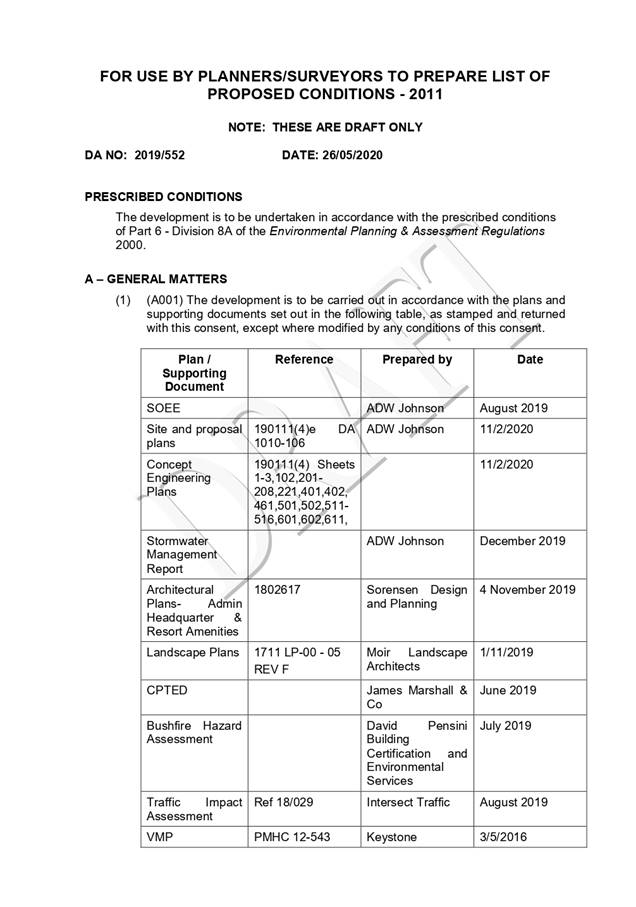
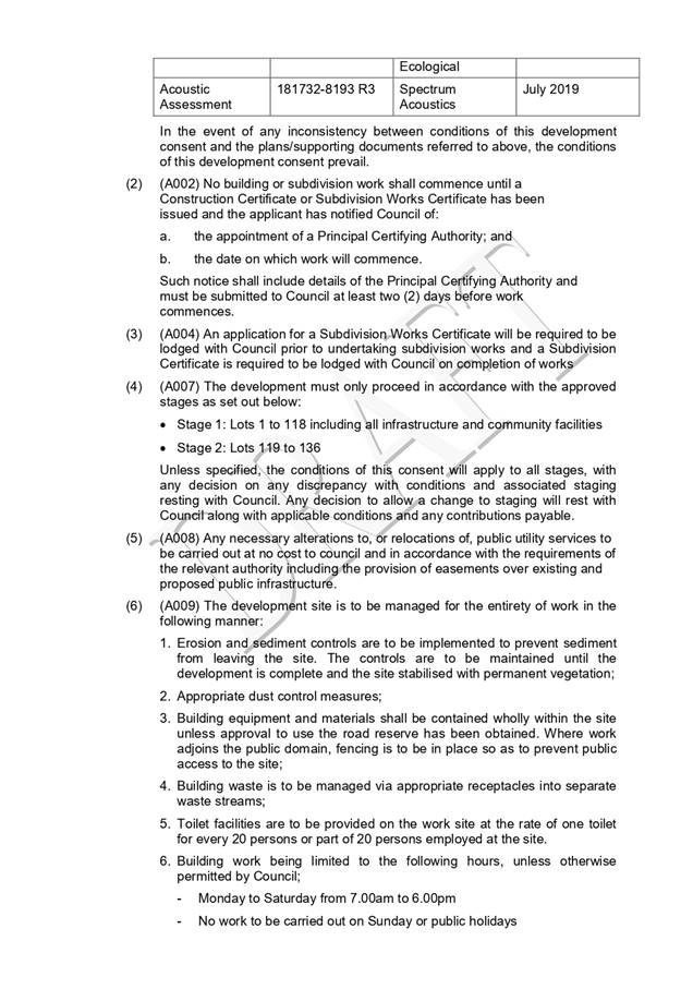
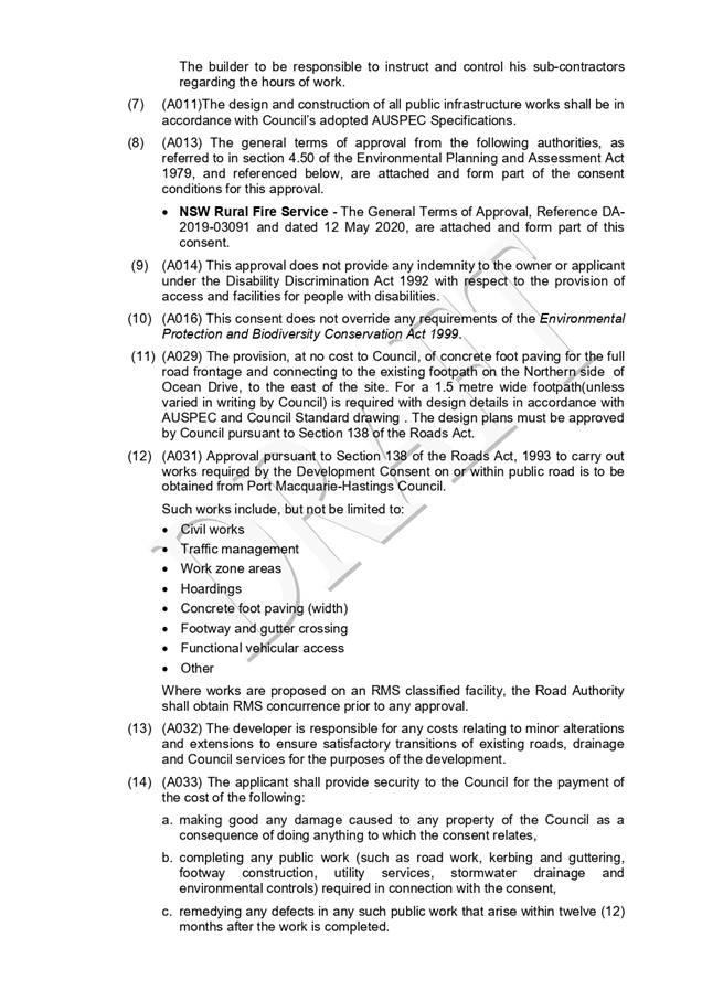
|
ATTACHMENT
|
Development Assessment Panel
10/06/2020
|


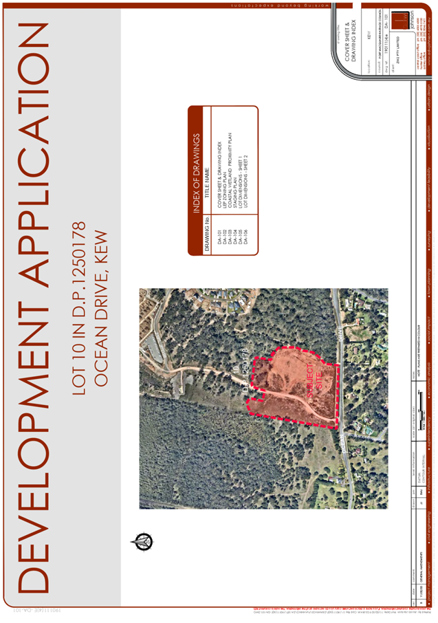
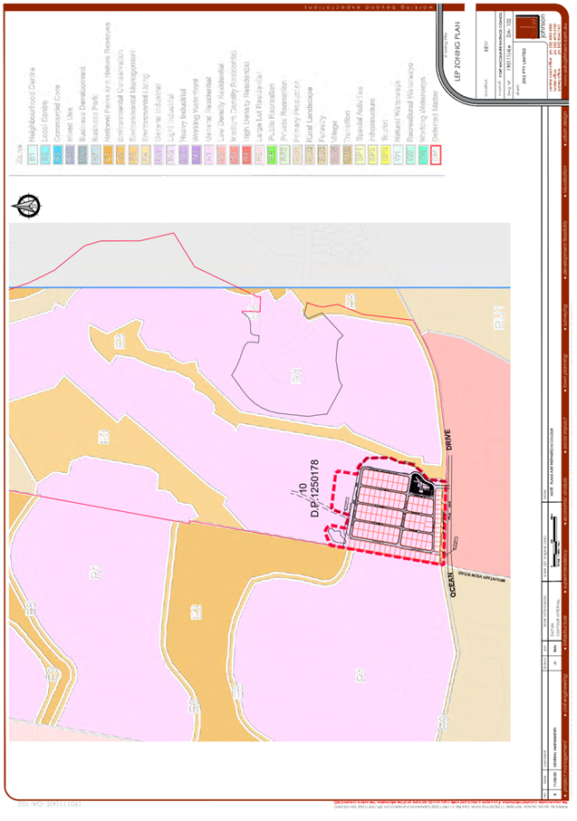
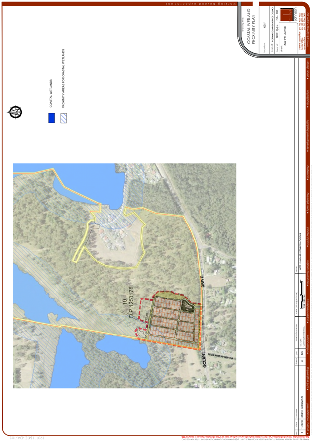
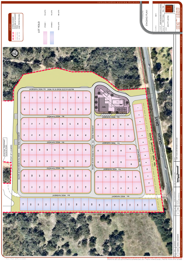
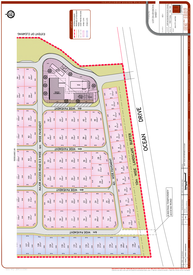
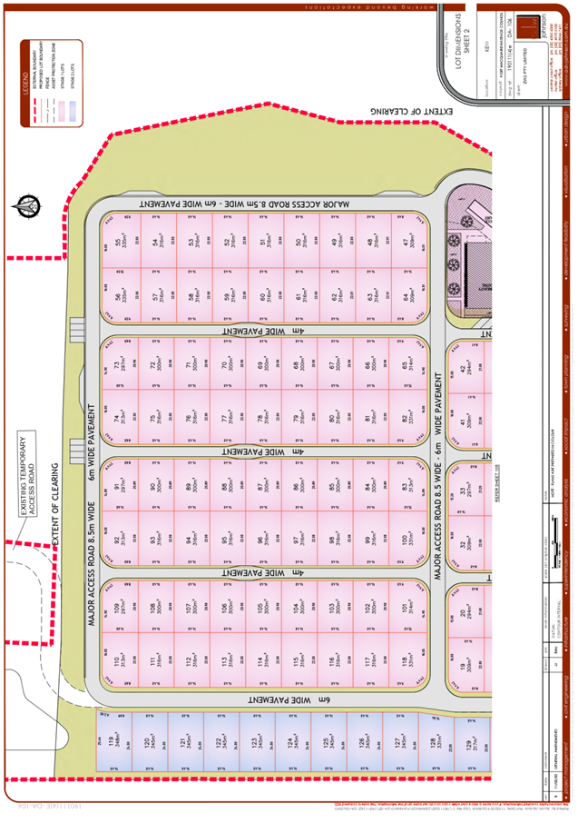
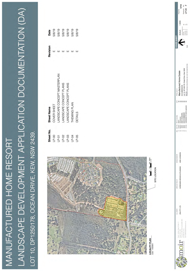
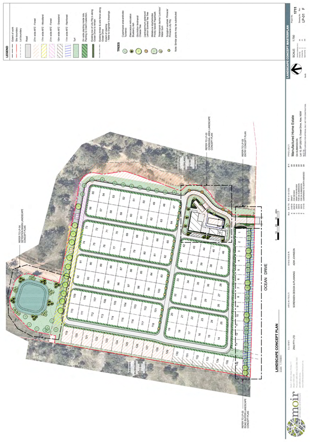
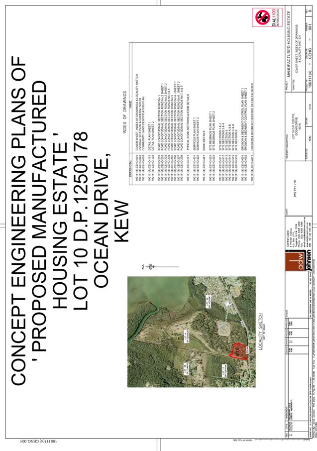
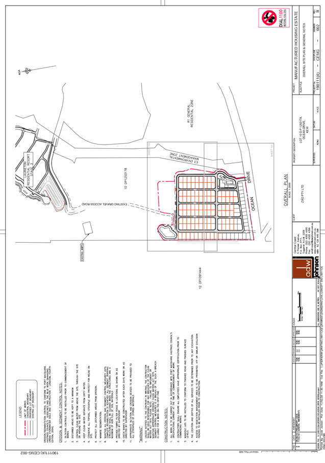
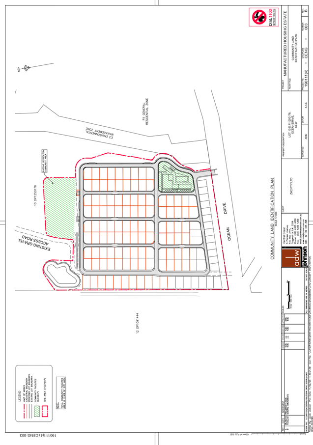
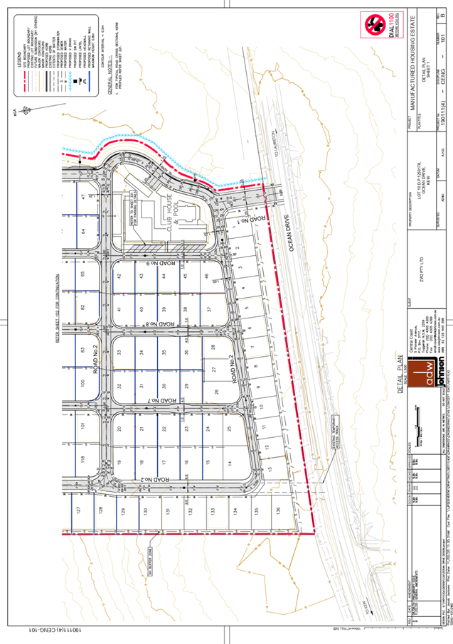
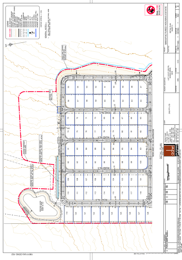
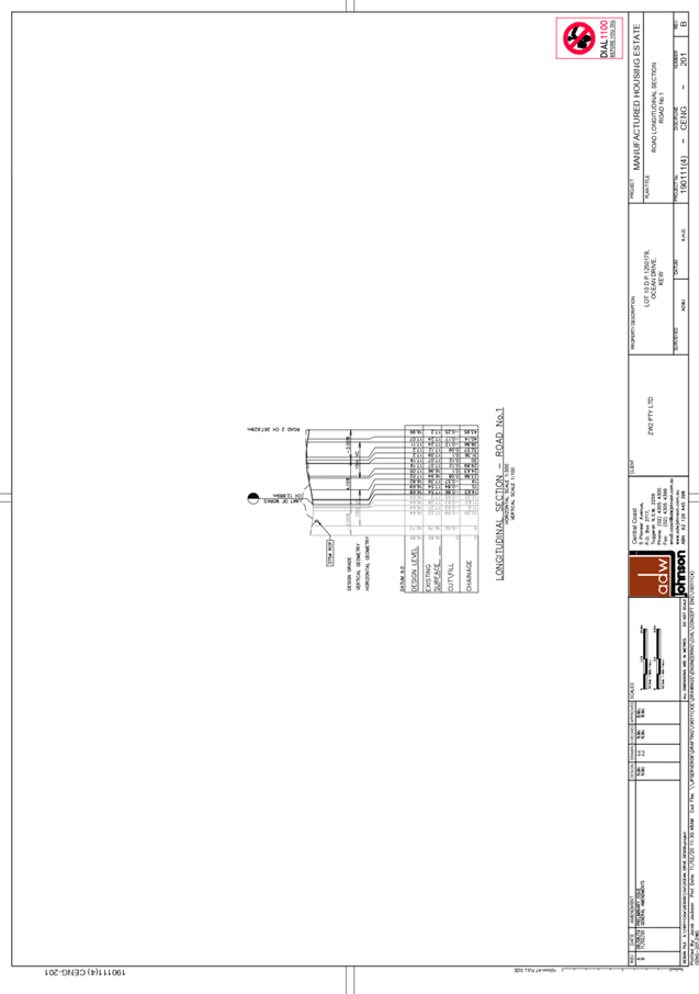
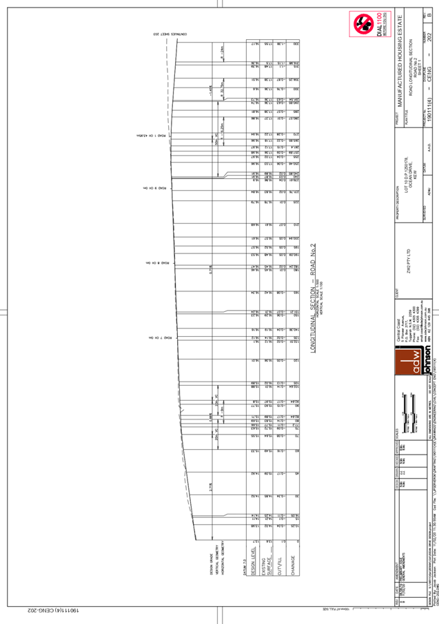
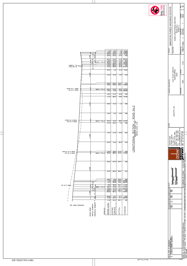
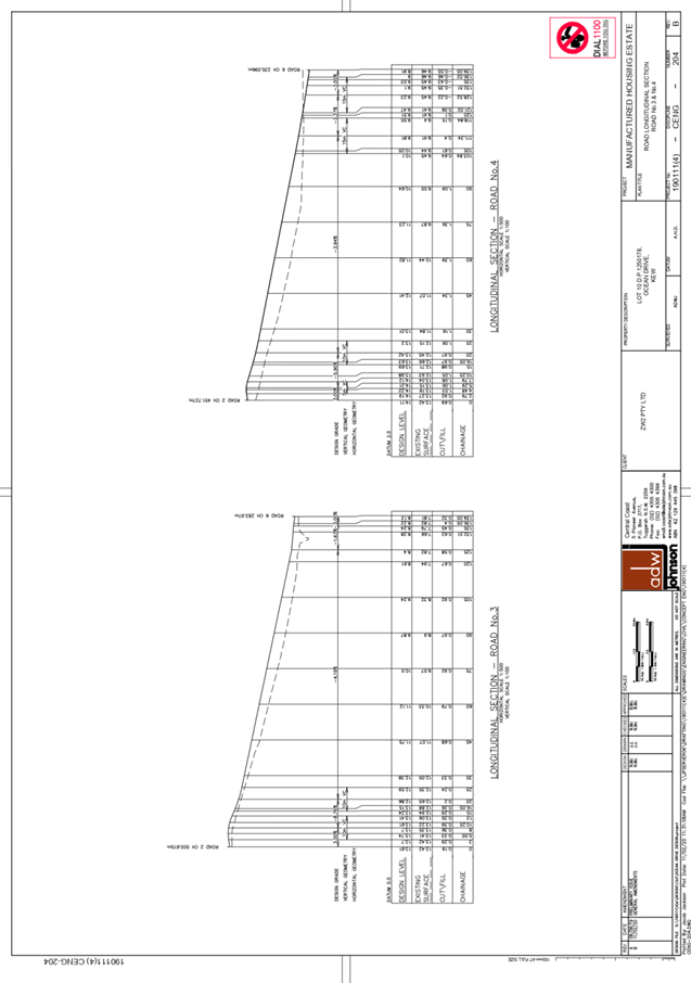
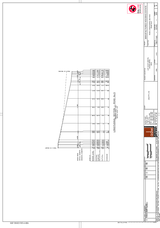
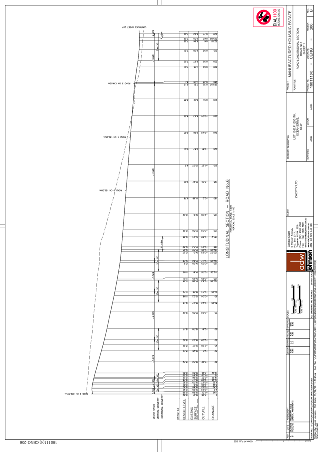
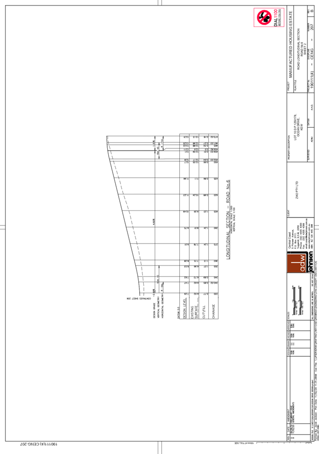
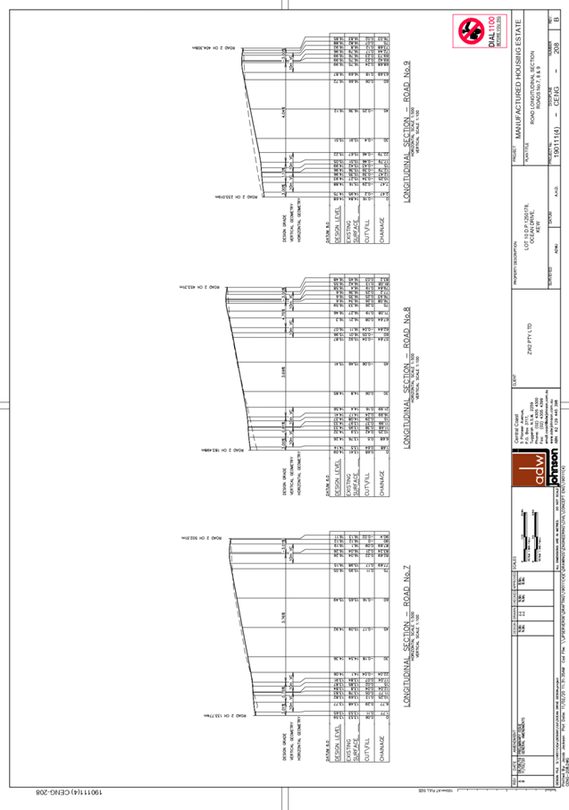
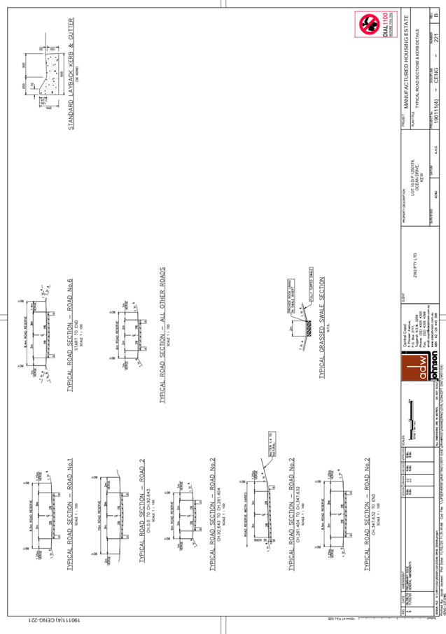
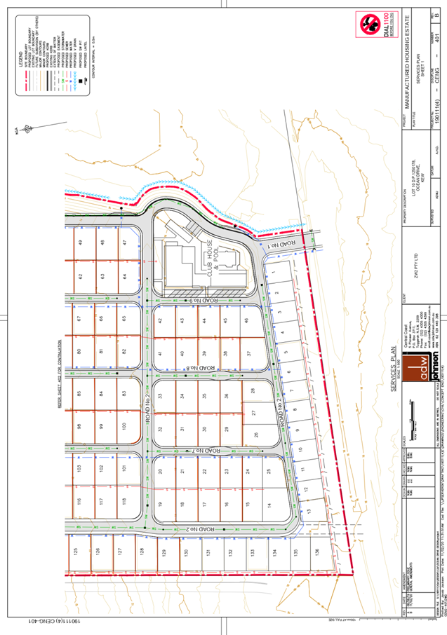
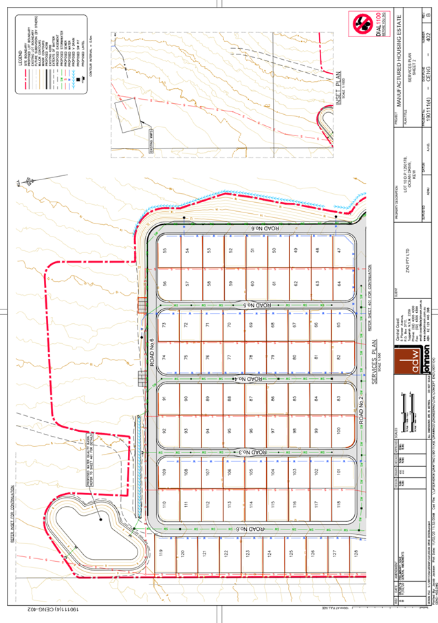
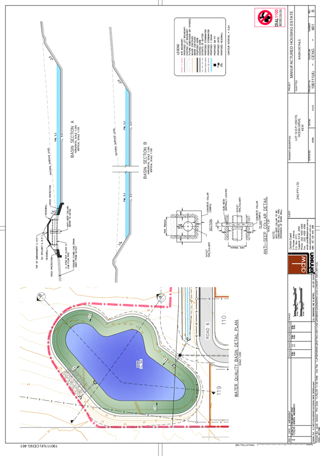
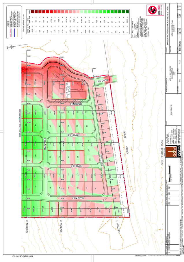
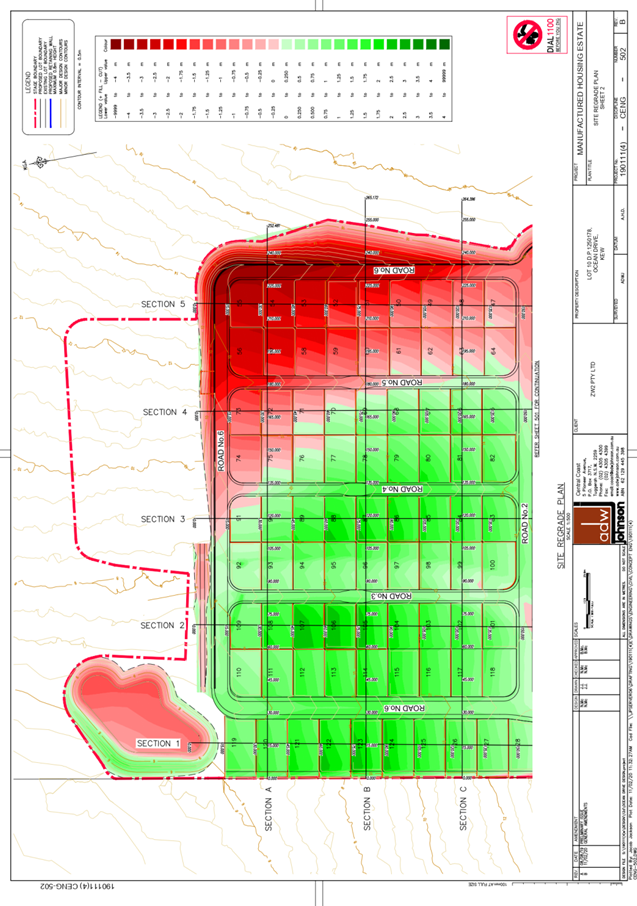
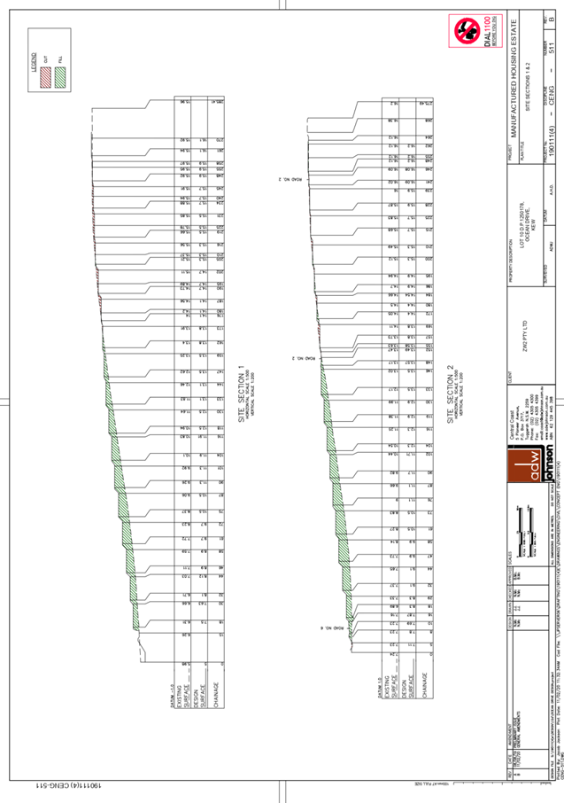
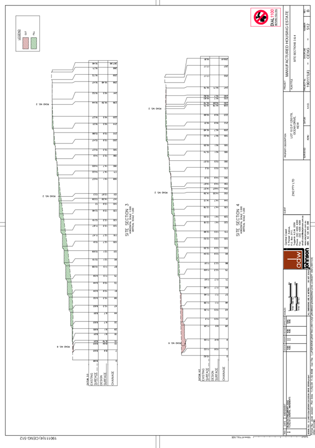
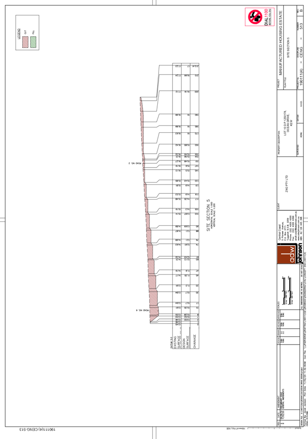
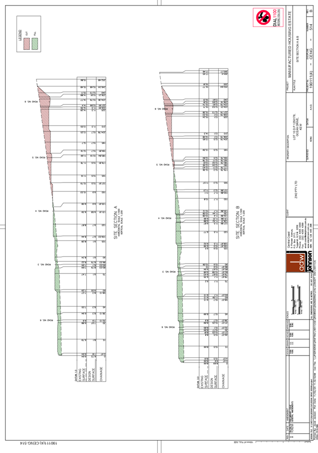
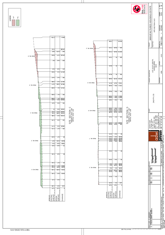
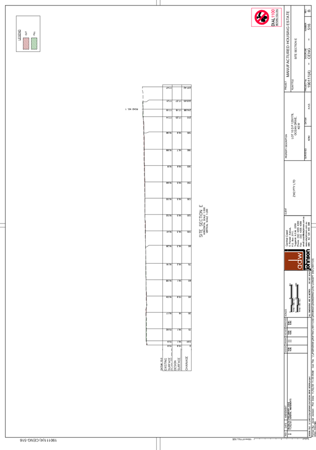
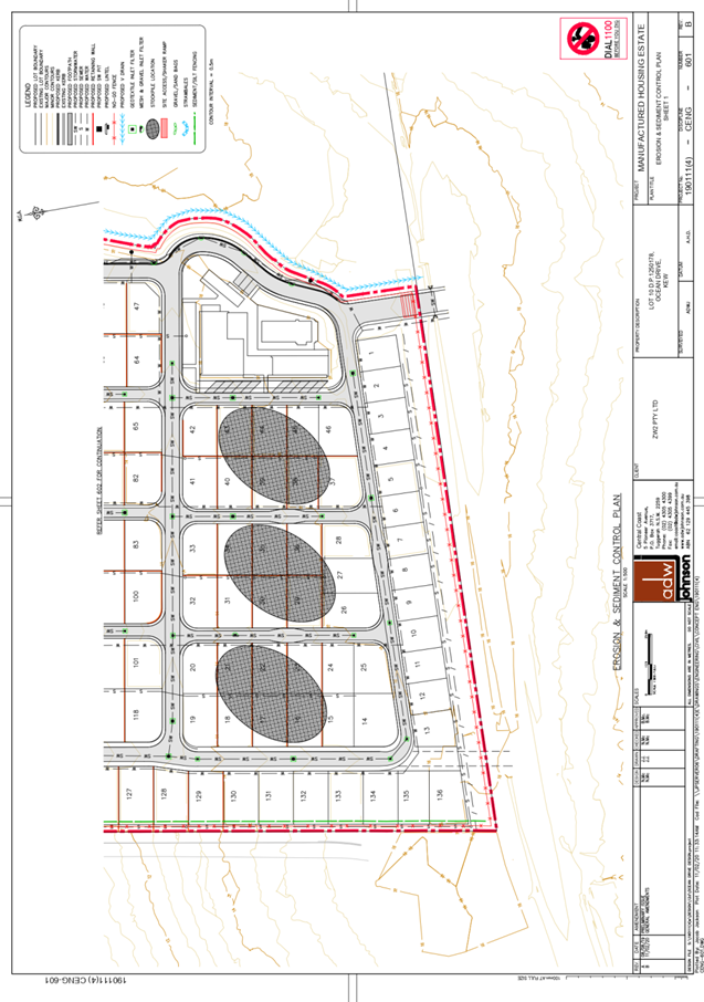
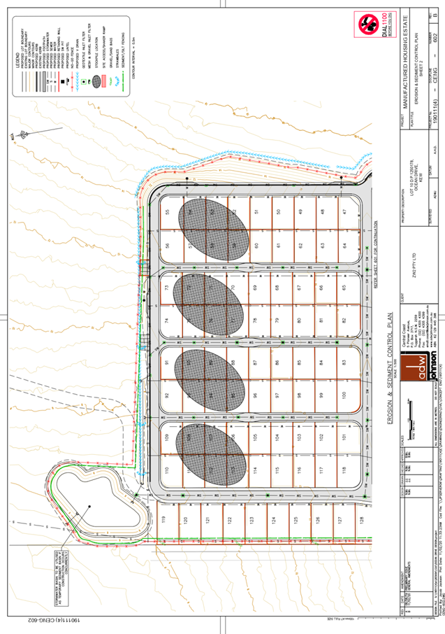
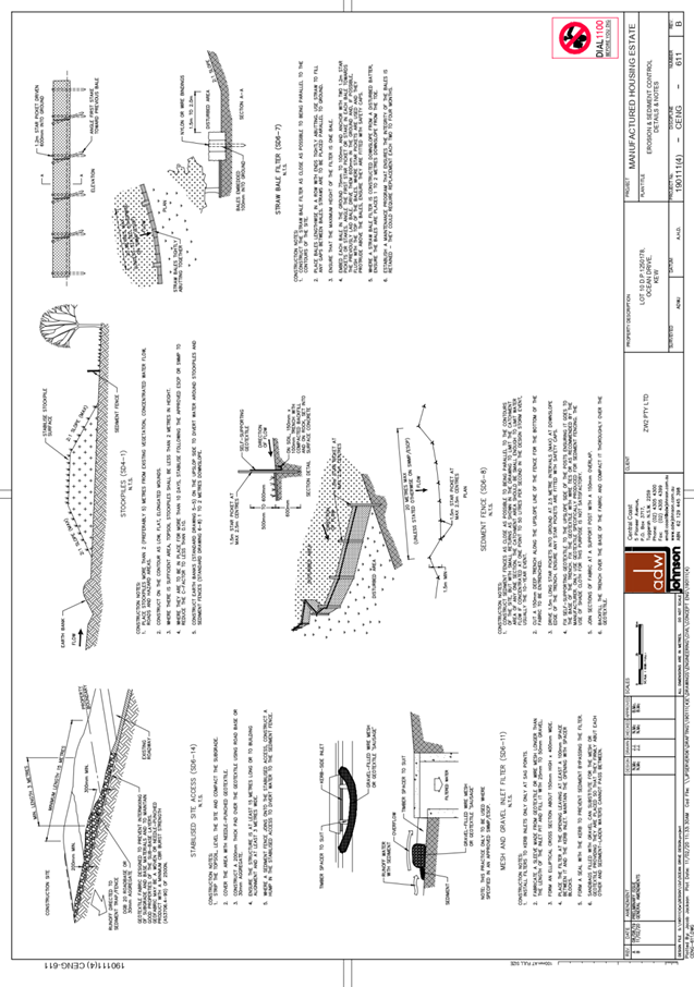
|
ATTACHMENT
|
Development Assessment Panel
10/06/2020
|
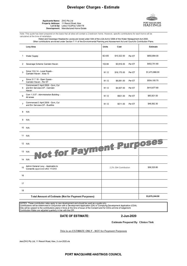
|
ATTACHMENT
|
Development Assessment Panel
10/06/2020
|
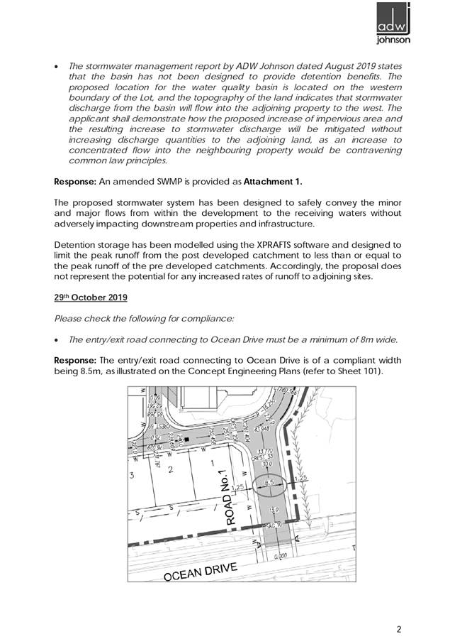
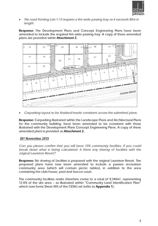

|
ATTACHMENT
|
Development Assessment Panel
10/06/2020
|
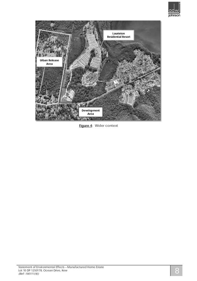
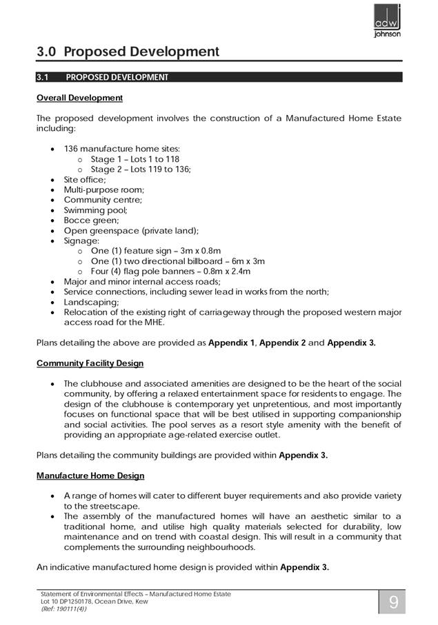
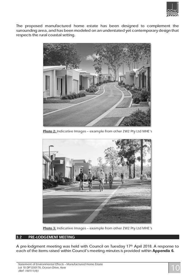
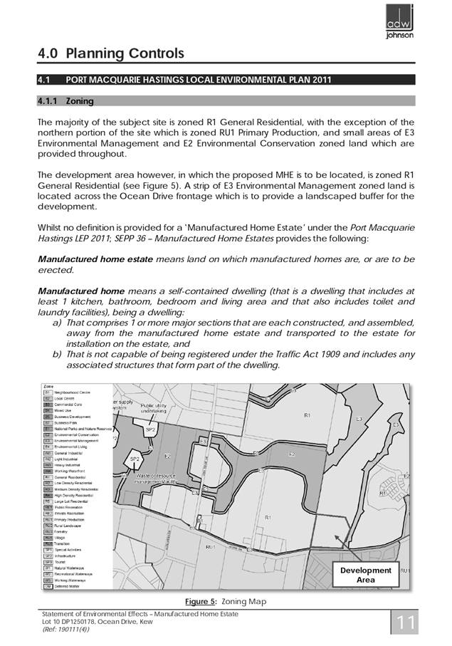
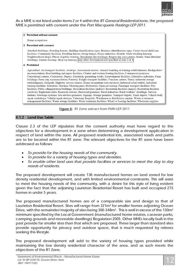
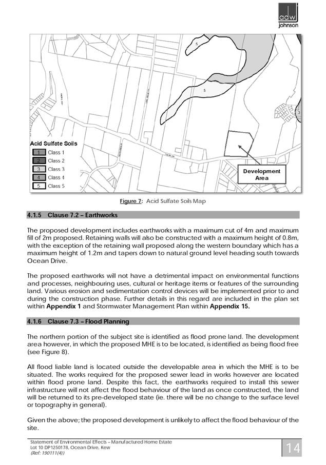
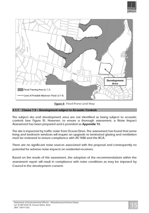
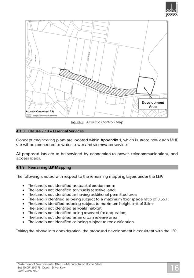
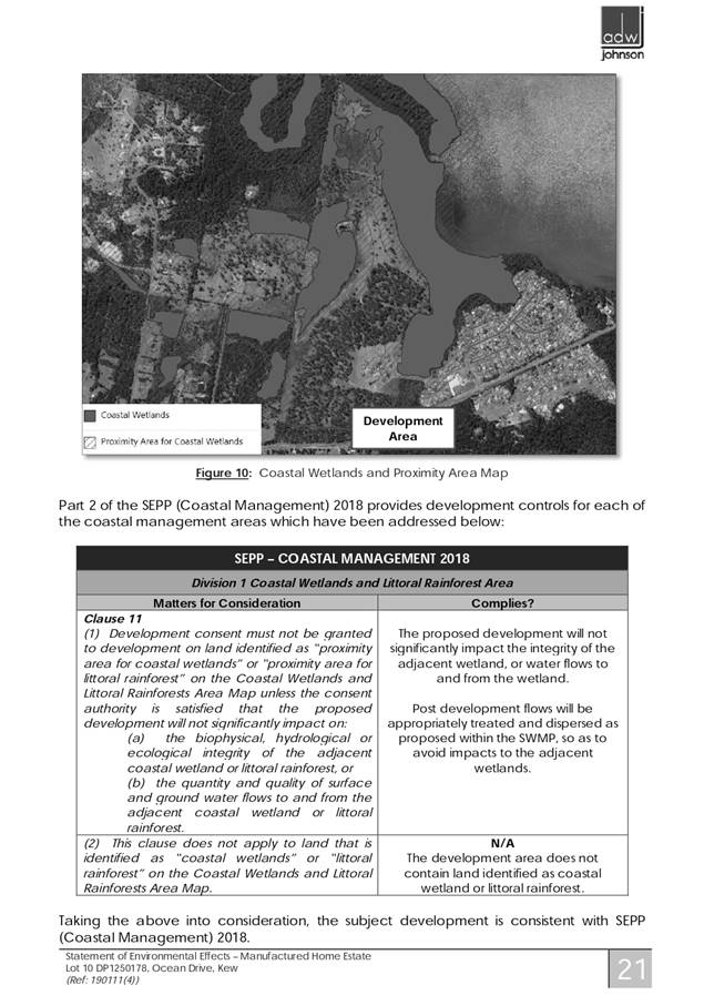
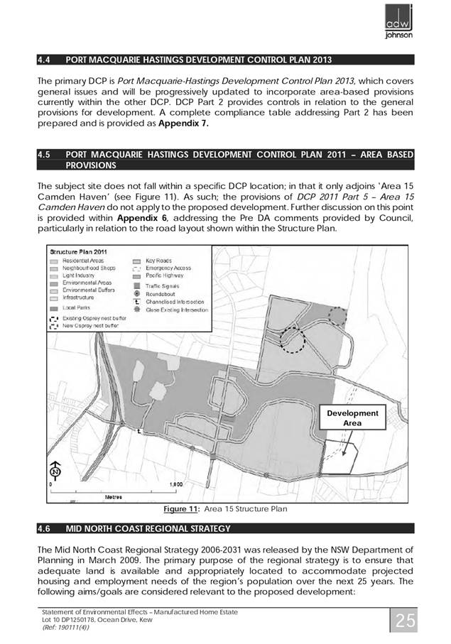
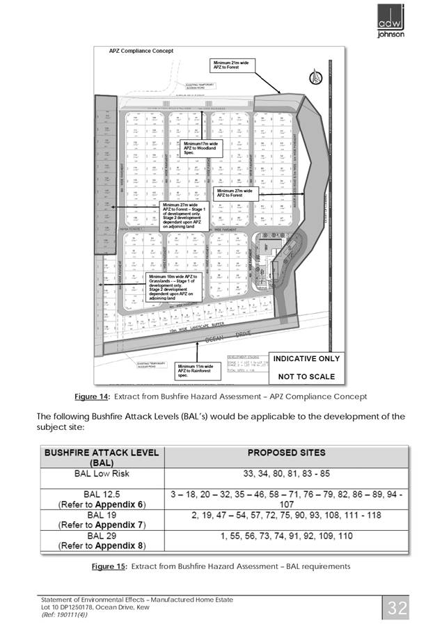


|
ATTACHMENT
|
Development Assessment Panel
10/06/2020
|


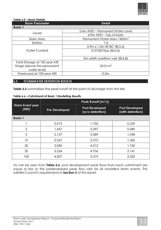
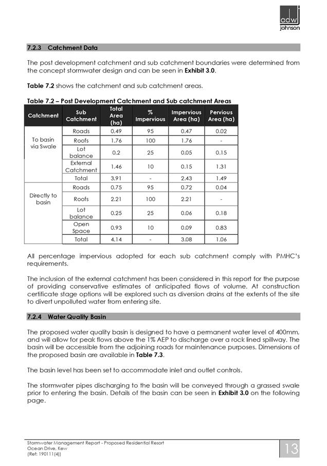
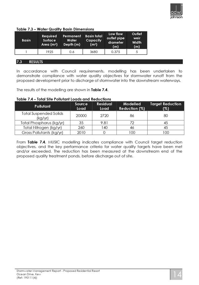
|
ATTACHMENT
|
Development Assessment Panel
10/06/2020
|
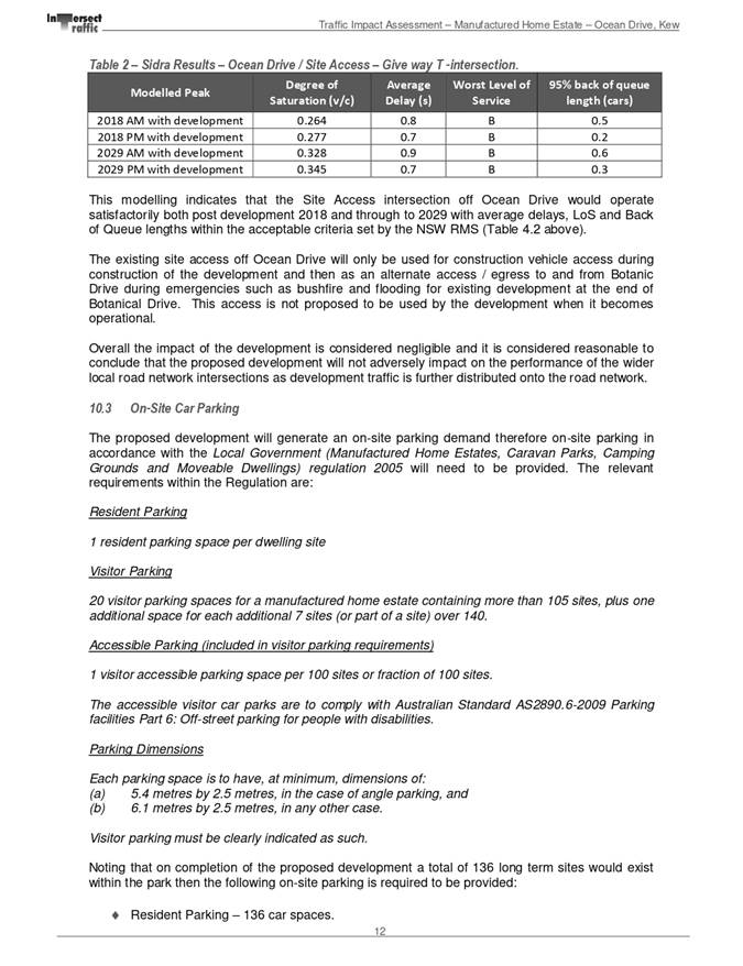
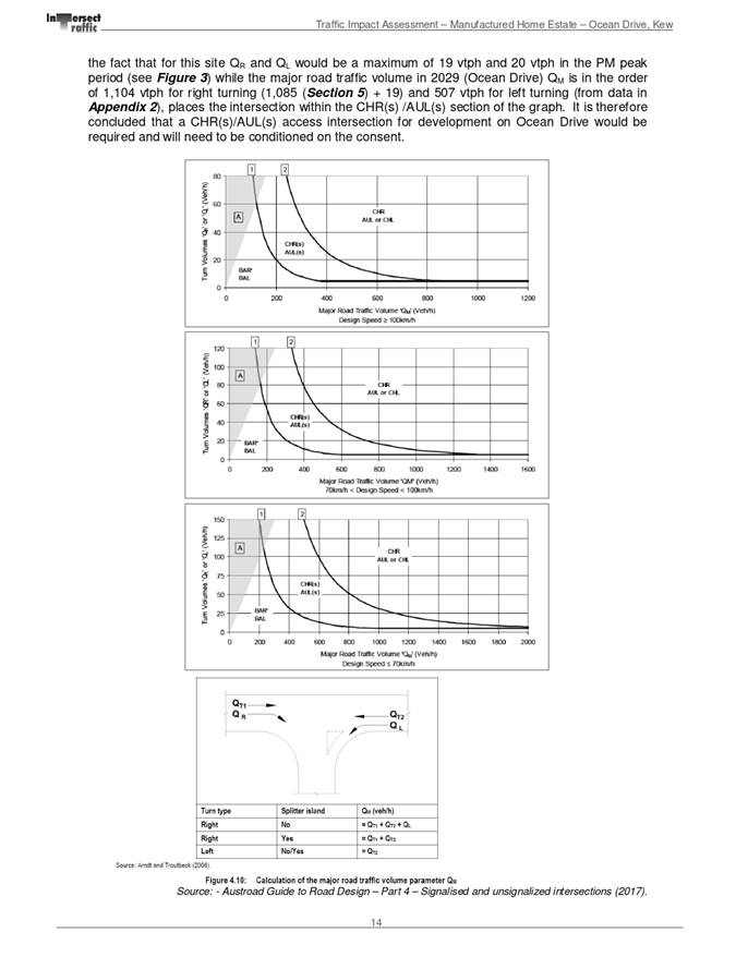
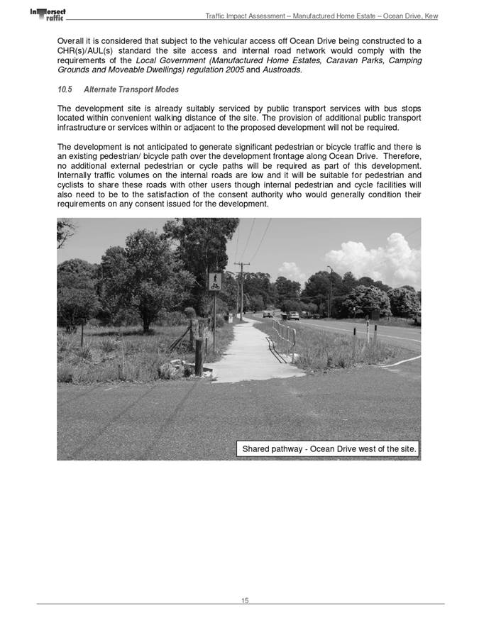
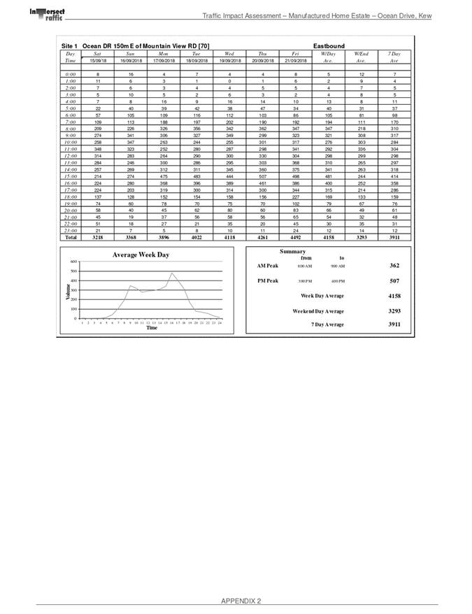
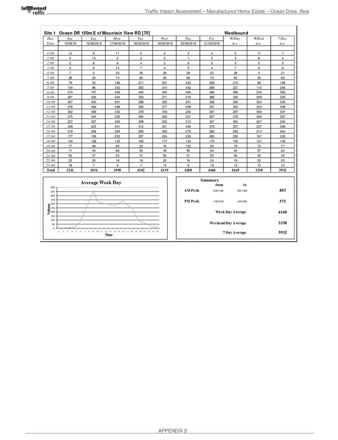

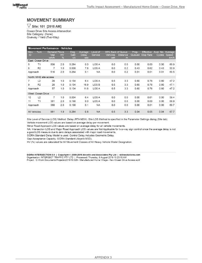
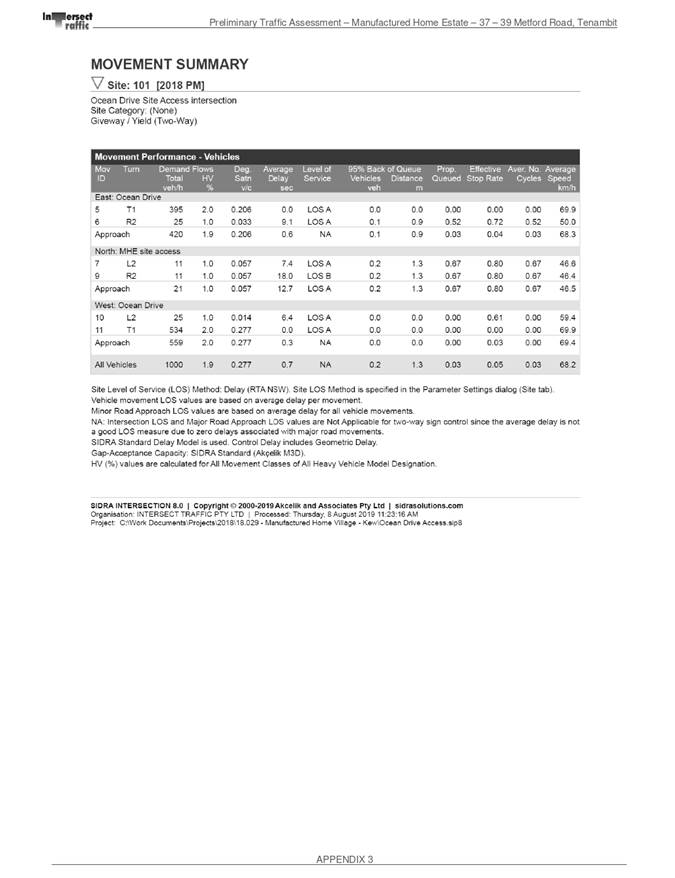
|
ATTACHMENT
|
Development Assessment Panel
10/06/2020
|