Development
Assessment Panel
Business
Paper
|
date of meeting:
|
|
Wednesday 14 October
2020
|
|
location:
|
|
Via Skype
|
|
time:
|
|
2:00pm
|
Development
Assessment Panel
CHARTER
1.0 OBJECTIVES
To assist in managing Council's development assessment
function by providing independent and expert determinations of development
applications that fall outside of staff delegations.
2.0 KEY FUNCTIONS
·
To review development application reports and conditions;
·
To determine development
applications outside of staff delegations;
·
To refer development applications
to Council for determination where necessary;
·
To provide a forum for objectors and applicants
to make submissions on applications
before the Development Assessment Panel
(DAP);
·
To maintain transparency in the determination of development
applications.
Delegated Authority of Panel
Pursuant to
Section 377 of the Local Government Act, 1993 delegation to:
·
Determine development applications under Part 4
of the Environmental Planning and Assessment
Act 1979 having
regard to the relevant environmental planning instruments,
development control plans and Council policies.
·
Vary, modify or release restrictions as to use
and/or covenants created by Section 88B instruments under the Conveyancing Act
1919 in relation to development applications for subdivisions being considered
by the panel.
·
Determine Koala Plans of Management under State
Environmental Planning Policy 44 - Koala Habitat Protection associated with
development applications being considered by the Panel.
Noting the trigger to escalate
decision making to Council as highlighted in section 5.2.
3.0
MEMBERSHIP
3.1
Voting
Members
·
Two independent external members. One of the
independent external members to be the Chairperson.
·
Group Manager Development Assessment (alternate
- Director Development & Environment or Development Assessment Planner)
The independent external members shall have expertise in
one or more of the following areas: planning, architecture, heritage, the
environment, urban design, economics, traffic and transport, law, engineering,
government and public administration.
3.2
Non-Voting Members
·
Not applicable
3.3 Obligations
of members
·
Members must act faithfully and diligently and
in accordance with this Charter.
·
Members must comply with Council's Code of Conduct.
·
Except as required to properly perform their
duties, DAP members must not
disclose any confidential information (as advised by Council) obtained in connection with the DAP functions.
·
Members will have read and be familiar with the
documents and information provided by Council prior
to attending a DAP meeting.
·
Members must act in accordance with Council's
Workplace Health and Safety Policies and Procedures
·
External members of the Panel are not authorised
to speak to the media on behalf of Council. Council officers that are members
of the Committee are bound by the
existing operational delegations in relation to speaking to the media.
·
Staff members shall not vote on matters before
the Panel if they have been the principle author of the development assessment report.
3.4
Member Tenure
·
The independent external members will be appointed
for the term of four (4) years
maximum in which the end of the tenure of these members would occur in a
cascading arrangement.
3.5 Appointment
of members
·
The independent external members (including the
Chair) shall be appointed by the General Manager following an external
Expression of Interest process.
·
Staff members of the Panel are in accordance
with this Charter.
4.0 TIMETABLE
OF MEETINGS
·
The Development Assessment Panel will generally
meet on the 1st and 3rd Wednesday each month at 2.00pm at the Port Macquarie
offices of Council.
·
Special Meetings of the Panel may be convened by
the Director Development & Environment Services with three (3) days notice.
5.0
MEETING PRACTICES
5.1
Meeting
Format
·
At all Meetings of the Panel the Chairperson
shall occupy the Chair and preside. The Chair will be responsible for keeping
of order at meetings.
·
Meetings shall be open to the public.
·
The Panel will hear from applicants
and objectors or their r e p r e s e n t a t i v e s .
·
Where considered necessary, the Panel will
conduct site inspections which will
be open to the public.
5.2
Decision Making
·
Decisions are to be made by consensus. Where
consensus is not possible on any item, that item is to be referred to Council
for a decision.
·
All development applications involving a
proposed variation to a development standard
greater than 10% under Clause
4.6 of the Local Environmental Plan will be
considered by the Panel and recommendation made to the Council for a decision.
5.3
Quorum
·
All members (2 independent external members and
1 staff member) must be present at a
meeting to form a quorum.
5.4
Chairperson and Deputy Chairperson
·
Independent Chair (alternate, second independent member)
5.5
Secretariat
·
The Director Development &n Environment is
to be responsible for ensuring that the Panel has adequate secretariat support.
The secretariat will ensure that the business paper and supporting papers are
circulated at least three (3) days prior to
each meeting. Minutes shall be appropriately approved and circulated to each
member within three (3) weeks of a meeting being held.
·
The format of and the preparation and publishing
of the Business Paper and Minutes shall be similar to the format for Ordinary
Council Meetings.
5.6
Recording of decisions
·
Minutes will record decisions and how each
member votes for each item before the Panel.
6.0 CONVENING
OF “OUTCOME SPECIFIC” WORKING GROUPS
Not applicable.
7.0 CONFIDENTIALITY
AND CONFLICT OF INTEREST
·
Members of the Panel must comply with the
applicable provisions of Council’s Code of Conduct. It is the personal
responsibility of members to comply with the standards in the Code of Conduct
and regularly review their personal circumstances with this in mind.
·
Panel members must declare any conflict of
interests at the start of each meeting or before discussion of a relevant item
or topic. Details of any conflicts of interest should be appropriately minuted.
Where members are deemed to have a real or perceived conflict of interest, it
may be appropriate they be excused from deliberations on the issue where the
conflict of interest may exist. A Panel meeting may be postponed where there is
no quorum.
8.0 LOBBYING
§ All members and applicants are to adhere to Council’s Lobbying
policy. Outside of scheduled
Development Assessment Panel meetings, applicants, their representatives,
Councillors, Council staff and the general public are not to lobby Panel
members via meetings, telephone conversations, correspondence and the like.
Adequate opportunity will be provided at Panel inspections or meetings for
applicants, their representatives and the general public to make verbal
submissions in relation to Business Paper items.
Development Assessment Panel
ATTENDANCE
REGISTER
|
Member
|
24/06/20
|
08/07/20
|
22/07/20
|
12/08/20
|
26/08/20
|
09/09/20
|
30/09/20
|
|
Paul
Drake
|
P
|
P
|
P
|
P
|
P
|
P
|
P
|
|
Robert
Hussey
|
|
|
P
|
|
P
|
P
|
|
|
David
Crofts
(alternate member)
|
P
|
P
|
|
P
|
|
|
P
|
|
Dan
Croft
(Group Manager Development Assessment)
(alternates)
- Development Assessment Planner
|
P
|
P
|
P
|
P
|
P
|
P
|
P
|
Key: P = Present
A
= Absent With Apology
X
= Absent Without Apology
Meeting Dates for
2020
|
22/01/2020
|
Function Room
|
2:00pm
|
|
12/02/2020
|
Function Room
|
2:00pm
|
|
26/02/2020
|
Function Room
|
2:00pm
|
|
11/03/2020
|
Function Room
|
2:00pm
|
|
25/03/2020
|
Function Room
|
2:00pm
|
|
8/04/2020
|
Function Room
|
2:00pm
|
|
6/05/2020
|
Function Room
|
2:00pm
|
|
27/05/2020
|
Function Room
|
2:00pm
|
|
10/06/2020
|
Function Room
|
2:00pm
|
|
24/06/2020
|
Function Room
|
2:00pm
|
|
8/07/2020
|
Function Room
|
2:00pm
|
|
22/07/2020
|
Function Room
|
2:00pm
|
|
12/08/2020
|
Function Room
|
2:00pm
|
|
26/08/2020
|
Function Room
|
2:00pm
|
|
9/09/2020
|
Function Room
|
2:00pm
|
|
30/09/2020
|
Function Room
|
2:00pm
|
|
14/10/2020
|
Function Room
|
2:00pm
|
|
28/10/2020
|
Function Room
|
2:00pm
|
|
11/11/2020
|
Function Room
|
2:00pm
|
|
25/11/2020
|
Function Room
|
2:00pm
|
|
16/12/2020
|
Function Room
|
2:00pm
|
Development
Assessment Panel Meeting
Wednesday 14 October
2020
Items of Business
01 Acknowledgement
of Country............................................................................. 8
02 Apologies.......................................................................................................... 8
03 Confirmation
of Minutes..................................................................................... 8
04 Disclosures
of Interest..................................................................................... 11
05 DA2020
- 682.1 Staged Alterations and Additions to Dwelling at Lot 9 DP 18862, 18
Bartlett Street, Bonny Hills........................................................................................... 15
06 DA2020
- 600.1 Dual Occupancy and Strata Subdivision at Lot 410 DP 1244641 No.18
Octagonal Rise, Port Macquarie....................................................................... 41
07 DA2019
- 681.1 Farm Stay Accommodation at Lot 89 DP 754416, No. 2001 Toms Creek Road,
Toms Creek.................................................................................................... 90
08 DA2020
- 433.1 Alterations and Additions to Dwelling, Part Change of Use to Secondary
Dwelling and Construction of Swimming Pool Including Clause 4.6 Objection to
Clause 4.3 (Height of Buildings) of the Port Macquarie-Hastings Local
Environmental Plan 2011 at Lot 392 DP 236950, No. 1 Vendul Crescent, Port
Macquarie........................................................... 127
09 DA2016.88.9
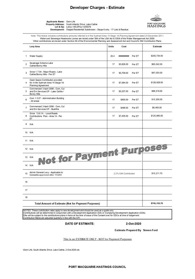
Subdivision Modification, Lot 146 DP 1256576 (now known as Lot 2 DP 1263561),
South Atlantic Drive, Lake Cathie.................................................................... 181
10 General
Business
AGENDA Development Assessment Panel 14/10/2020
Subject: ACKNOWLEDGEMENT
OF COUNTRY
"I acknowledge that we are
gathered on Birpai Land. I pay respect to the Birpai Elders both past and
present. I also extend that respect to all other Aboriginal and Torres Strait
Islander people present."
RECOMMENDATION
That the apologies received be
accepted.
Subject: CONFIRMATION
OF PREVIOUS MINUTES
Recommendation
That the Minutes of the Development Assessment Panel Meeting
held on 30 September 2020 be confirmed.
MINUTES
Development Assessment Panel Meeting
30/09/2020
PRESENT
Members:
Paul
Drake (Independent Chair)
David Crofts (Independent Member)
Group Manager Development
Assessment (Dan Croft)
Other Attendees:
Mayor Peta Pinson
Development
Assessment Planner (Robert Slater)
Acting
Development Engineer Coordinator (Grant Burge)
|
The meeting opened at 2:00pm.
|
|
01 ACKNOWLEDGEMENT
OF COUNTRY
|
|
The
Acknowledgement of Country was delivered.
|
|
03 CONFIRMATION
OF MINUTES
|
|
CONSENSUS:
That
the Minutes of the Development Assessment Panel Meeting held on 9 September
2020 be confirmed.
|
|
04 DISCLOSURES
OF INTEREST
|
|
There were no disclosures of interest presented.
|
|
05 DA2020-614.1
Dwelling and Carport at Lot 11, DP 22571, No. 37 Bell Street, Dunbogan
|
|
Speakers:
George Watt (applicant)
CONSENSUS:
That DA2020-614.1 for the construction of a Dwelling and Carport at Lot 11, DP 22571, No. 37 Bell Street Dunbogan be determined by granting
consent subject to the recommended conditions.
|
|
The meeting closed at 2:10pm.
|
AGENDA Development Assessment Panel 14/10/2020
Subject: DISCLOSURES
OF INTEREST
RECOMMENDATION
That Disclosures of Interest be presented
DISCLOSURE OF
INTEREST DECLARATION
|
Name of Meeting:
|
|
Meeting
Date:
|
|
Item
Number:
|
|
Subject:
|
|
I,
the undersigned, hereby declare the following interest:
Pecuniary:
 Take no part
in the consideration and voting and be out of sight of the meeting. Take no part
in the consideration and voting and be out of sight of the meeting.
Non-Pecuniary
– Significant Interest:
Take no part
in the consideration and voting and be out of sight of the meeting.
Non-Pecuniary
– Less than Significant Interest:
May
participate in consideration and voting.
|
|
For
the reason that:
|
|
Name:
Signed:
|
Date:
|
|
Please submit to the
Governance Support Officer at the Council Meeting.
|
 (Refer
to next page and the Code of Conduct)
(Refer
to next page and the Code of Conduct)
Pecuniary Interest
4.1
A pecuniary interest is an interest
that you have in a matter because of a reasonable likelihood or expectation of
appreciable financial gain or loss to you or a person referred to in clause
4.3.
4.2
You will not have a pecuniary
interest in a matter if the interest is so remote or insignificant that it
could not reasonably be regarded as likely to influence any decision you might
make in relation to the matter, or if the interest is of a kind specified in
clause 4.6.
4.3
For the purposes of this Part, you
will have a pecuniary interest in a matter if the pecuniary interest is:
(a)
your interest, or
(b)
the interest of your spouse or de
facto partner, your relative, or your partner or employer, or
(c)
a company or other body of which
you, or your nominee, partner or employer, is a shareholder or member.
4.4
For the purposes of clause 4.3:
(a)
Your “relative” is any
of the following:
(b)
“de facto partner” has
the same meaning as defined in section 21C of the Interpretation Act 1987.
4.5
You will not have a pecuniary
interest in relation to a person referred to in subclauses 4.3(b) or (c)
(a)
if you are unaware of the relevant
pecuniary interest of your spouse, de facto partner, relative, partner,
employer or company or other body, or
(b)
just because the person is a member
of, or is employed by, a council or a statutory body, or is employed by the
Crown, or
(c)
just because the person is a member
of, or a delegate of a council to, a company or other body that has a pecuniary
interest in the matter, so long as the person has no beneficial interest in any
shares of the company or body.
Non-Pecuniary
5.1
Non-pecuniary interests are private
or personal interests a council official has that do not amount to a pecuniary
interest as defined in clause 4.1 of this code. These commonly arise out of
family or personal relationships, or out of involvement in sporting, social,
religious or other cultural groups and associations, and may include an
interest of a financial nature.
5.2
A non-pecuniary conflict of
interest exists where a reasonable and informed person would perceive that you
could be influenced by a private interest when carrying out your official
functions in relation to a matter.
5.3
The personal or political views of
a council official do not constitute a private interest for the purposes of
clause 5.2.
5.4
Non-pecuniary conflicts of interest
must be identified and appropriately managed to uphold community confidence in
the probity of council decision-making. The onus is on you to identify any
non-pecuniary conflict of interest you may have in matters that you deal with,
to disclose the interest fully and in writing, and to take appropriate action
to manage the conflict in accordance with this code.
5.5
When considering whether or not you
have a non-pecuniary conflict of interest in a matter you are dealing with, it
is always important to think about how others would view your situation.
Managing non-pecuniary conflicts of interest
5.6
Where you have a non-pecuniary
conflict of interest in a matter for the purposes of clause 5.2, you must disclose
the relevant private interest you have in relation to the matter fully and in
writing as soon as practicable after becoming aware of the non-pecuniary
conflict of interest and on each occasion on which the non-pecuniary conflict
of interest arises in relation to the matter. In the case of members of council
staff other than the general manager, such a disclosure is to be made to the
staff member’s manager. In the case of the general manager, such a
disclosure is to be made to the mayor.
5.7
If a disclosure is made at a
council or committee meeting, both the disclosure and the nature of the
interest must be recorded in the minutes on each occasion on which the
non-pecuniary conflict of interest arises. This disclosure constitutes
disclosure in writing for the purposes of clause 5.6.
5.8
How you manage a non-pecuniary
conflict of interest will depend on whether or not it is significant.
5.9
As a general rule, a non-pecuniary
conflict of interest will be significant where it does not involve a pecuniary
interest for the purposes of clause 4.1, but it involves:
a)
a relationship between a council
official and another person who is affected by a decision or a matter under
consideration that is particularly close, such as a current or former spouse or
de facto partner, a relative for the purposes of clause 4.4 or another person
from the council official’s extended family that the council official has
a close personal relationship with, or another person living in the same
household
b)
other relationships with persons
who are affected by a decision or a matter under consideration that are
particularly close, such as friendships and business relationships. Closeness
is defined by the nature of the friendship or business relationship, the
frequency of contact and the duration of the friendship or relationship.
c)
an affiliation between the council
official and an organisation (such as a sporting body, club, religious,
cultural or charitable organisation, corporation or association) that is
affected by a decision or a matter under consideration that is particularly
strong. The strength of a council official’s affiliation with an
organisation is to be determined by the extent to which they actively
participate in the management, administration or other activities of the organisation.
d)
membership, as the council’s
representative, of the board or management committee of an organisation that is
affected by a decision or a matter under consideration, in circumstances where
the interests of the council and the organisation are potentially in conflict
in relation to the particular matter
e)
a financial interest (other than an
interest of a type referred to in clause 4.6) that is not a pecuniary interest
for the purposes of clause 4.1
f)
the conferral or loss of a personal
benefit other than one conferred or lost as a member of the community or a
broader class of people affected by a decision.
5.10
Significant non-pecuniary conflicts
of interest must be managed in one of two ways:
a)
by not participating in
consideration of, or decision making in relation to, the matter in which you
have the significant non-pecuniary conflict of interest and the matter being
allocated to another person for consideration or determination, or
b)
if the significant non-pecuniary
conflict of interest arises in relation to a matter under consideration at a
council or committee meeting, by managing the conflict of interest as if you
had a pecuniary interest in the matter by complying with clauses 4.28 and 4.29.
5.11
If you determine that you have a
non-pecuniary conflict of interest in a matter that is not significant and does
not require further action, when disclosing the interest you must also explain
in writing why you consider that the non-pecuniary conflict of interest is not
significant and does not require further action in the circumstances.
5.12
If you are a member of staff of
council other than the general manager, the decision on which option should be
taken to manage a non-pecuniary conflict of interest must be made in
consultation with and at the direction of your manager. In the case of the
general manager, the decision on which option should be taken to manage a
non-pecuniary conflict of interest must be made in consultation with and at the
direction of the mayor.
5.13
Despite clause 5.10(b), a
councillor who has a significant non-pecuniary conflict of interest in a
matter, may participate in a decision to delegate consideration of the matter
in question to another body or person.
5.14 Council committee members are not required to declare
and manage a non-pecuniary conflict of interest in accordance with the
requirements of this Part where it arises from an interest they have as a
person chosen to represent the community, or as a member of a non-profit
organisation or other community or special interest group, if they have been
appointed to represent the organisation or group on the council committee.
SPECIAL
DISCLOSURE OF PECUNIARY INTEREST DECLARATION
This
form must be completed using block letters or typed.
If
there is insufficient space for all the information you are required to disclose,
you
must attach an appendix which is to be properly identified and signed by you.
|
By
[insert full name of councillor]
|
|
|
In the
matter of
[insert name of environmental planning instrument]
|
|
|
Which is
to be considered at a meeting of the
[insert name of meeting]
|
|
|
Held on
[insert date of meeting]
|
|
|
PECUNIARY
INTEREST
|
|
Address of
the affected principal place of residence of the councillor or an associated
person, company or body (the identified land)
|
|
|
Relationship
of identified land to councillor
[Tick or cross one box.]
|
The councillor has interest in the land (e.g. is owner or has other
interest arising out of a mortgage, lease, trust, option or contract, or
otherwise).
An associated person of the councillor has an interest in the land.
An associated company or body of the councillor has interest in the land.
|
|
MATTER
GIVING RISE TO PECUNIARY INTEREST
|
|
Nature of
land that is subject to a change
in
zone/planning control by proposed
LEP (the
subject land
[Tick or cross one box]
|
The identified land.
Land that adjoins or is adjacent to or is in proximity to the identified
land.
|
|
Current
zone/planning control
[Insert name of current planning instrument and
identify relevant zone/planning control applying to the subject land]
|
|
|
Proposed
change of zone/planning control
[Insert name of proposed LEP and identify proposed
change of zone/planning control applying to the subject land]
|
|
|
Effect of
proposed change of zone/planning control on councillor or associated person
[Tick or cross one box]
|
Appreciable financial gain.
Appreciable financial loss.
|
|
|
|
[If more than one pecuniary interest is to be
declared, reprint the above box and fill in for each additional interest]
Councillor’s Signature:
……………………………….
Date: ………………..
This form is to be retained
by the council’s general manager and included in full in the minutes of
the meeting
Last Updated: 3 June 2019
Important Information
This information is being collected for the purpose of
making a special disclosure of pecuniary interests under clause 4.36(c) of the
Model Code of Conduct for Local Councils in NSW (the Model Code of Conduct).
The special disclosure must relate only to a pecuniary
interest that a councillor has in the councillor’s principal place of
residence, or an interest another person (whose interests are relevant under
clause 4.3 of the Model Code of Conduct) has in that person’s principal
place of residence.
Clause 4.3 of the Model Code of Conduct states that you
will have a pecuniary interest in a matter because of the pecuniary interest of
your spouse or your de facto partner or your relative or because your business
partner or employer has a pecuniary interest. You will also have a pecuniary
interest in a matter because you, your nominee, your business partner or your
employer is a member of a company or other body that has a pecuniary interest
in the matter.
“Relative” is defined by clause 4.4 of the Model
Code of Conduct as meaning your, your spouse’s or your de facto
partner’s parent, grandparent, brother, sister, uncle, aunt, nephew,
niece, lineal descendant or adopted child and the spouse or de facto partner of
any of those persons.
You
must not make a special disclosure that you know or ought reasonably to know is
false or misleading in a material particular. Complaints about breaches
of these requirements are to be referred to the Office of Local Government and
may result in disciplinary action by the Chief Executive of the Office of Local
Government or the NSW Civil and Administrative Tribunal.
This form must be completed by you before the commencement
of the council or council committee meeting at which the special disclosure is
being made. The completed form must be tabled at the meeting. Everyone is
entitled to inspect it. The special disclosure must be recorded in the minutes
of the meeting.
A pecuniary interest may arise by way of a change of
permissible use of land adjoining, adjacent to or in proximity to land in which
a councillor or a person, company or body referred to in clause 4.3 of the
Model Code of Conduct has a proprietary interest
AGENDA Development Assessment Panel 14/10/2020
Item: 05
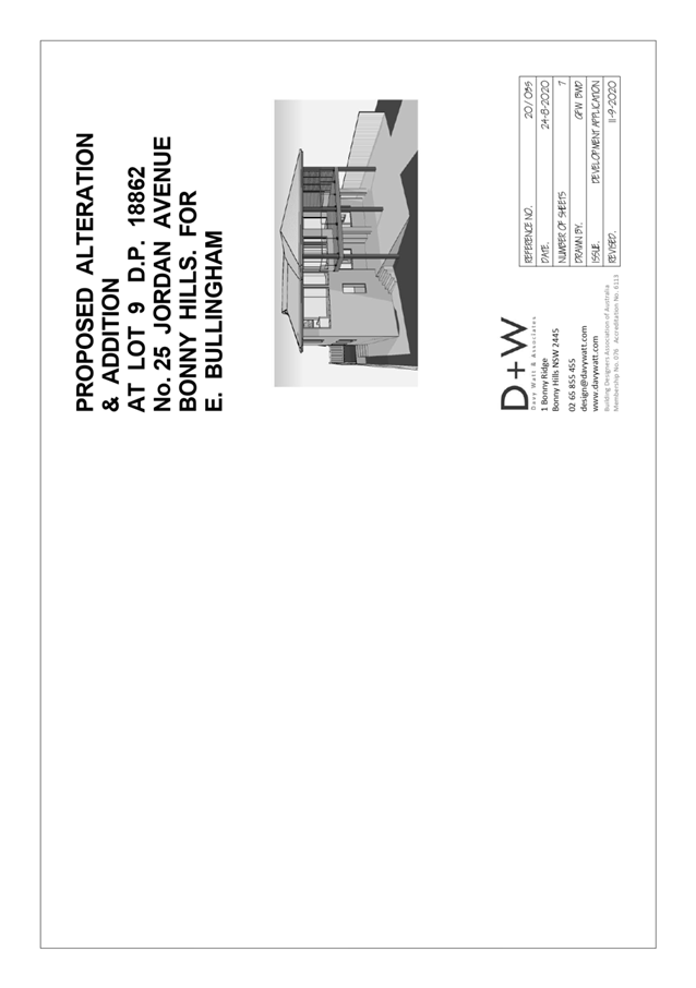
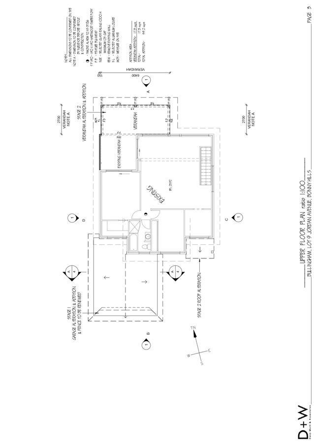
Subject: DA2020 - 682.1 Staged Alterations and
Additions to Dwelling at Lot 9 DP 18862, 18 Bartlett Street, Bonny Hills
Report
Author: Development Assessment Planner, Benjamin Roberts
|
Applicant: Davy
Watt and Associates
Owner: E
A Bullingham
Estimated Cost: $81,470
Alignment with Delivery
Program
4.3.1 Undertake transparent and
efficient development assessment in accordance with relevant legislation.
|
RECOMMENDATION
That
DA 2020 - 682.1 for Staged Alterations
and Additions to Dwelling at Lot 9, DP
18862, No. 18 Bartlett Street, Bonny Hills, be determined by granting consent
subject to the recommended conditions.
Executive
Summary
This
report considers a development application for alterations and additions to
dwelling at the subject site and provides an assessment of the application in
accordance with the Environmental Planning and Assessment Act 1979.
Following exhibition of the
application, one (1) submission was received.
The site is considered suitable for the proposed development
and the proposal adequately addresses relevant planning controls. The
development is not considered to be contrary to the public's interest and will
not result a significant adverse social, environmental or economic impact.
This report recommends that
the development application be approved subject to the attached conditions in Attachment
1.
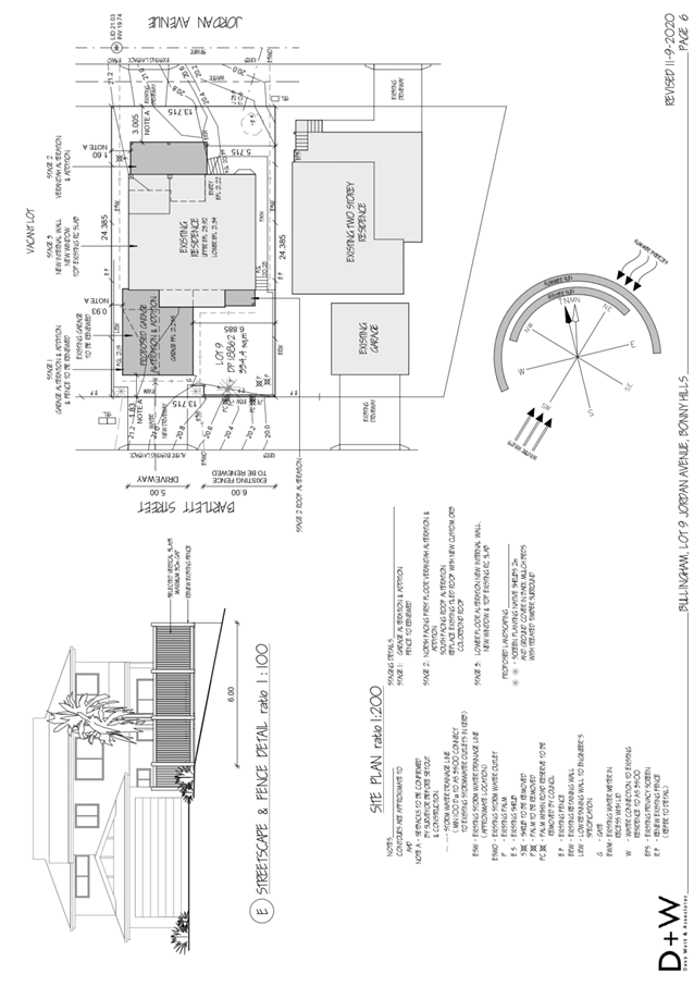
1. BACKGROUND
Existing
Sites Features and Surrounding Development
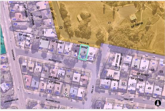
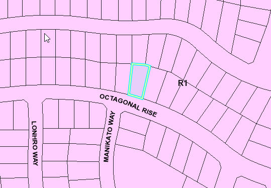
The site has an area of 328.8m2.
The
site is zoned R1 General Residential in
accordance with the Port Macquarie-Hastings Local Environmental Plan 2011, as
shown in the following zoning plan:
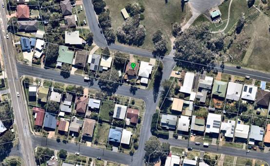
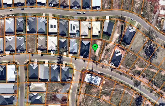
The
existing subdivision pattern and location of existing development within the
locality is shown in the following aerial photograph:
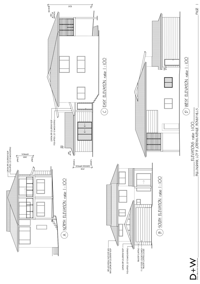
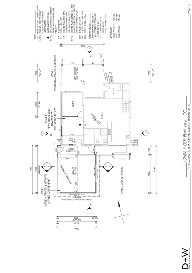
2. DESCRIPTION
OF DEVELOPMENT
Key
aspects of the proposal include the following:
· Staged
alterations and additions to existing dwelling.
· Stage
1 comprising garage alteration and addition.
· Stage
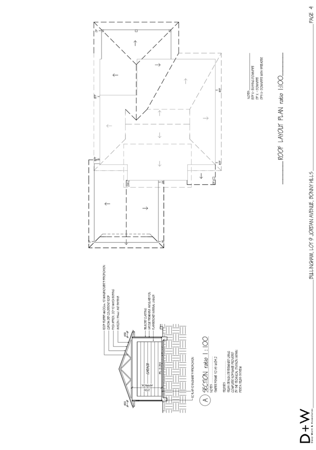
2 comprising north facing first floor verandah addition, south facing roof
addition, and replacement of tiled roofing with colourbond.
· Stage
3 comprising lower floor alteration including new wall, new window and top
existing slab.
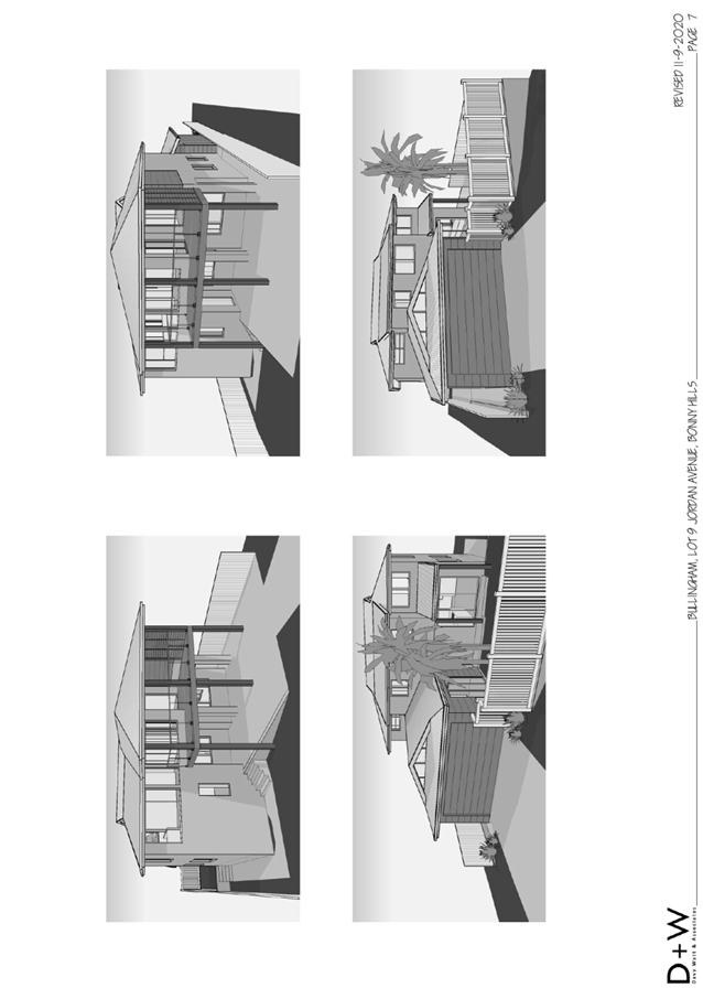
Refer
to Attachment 2 at the end of this report for plans of the proposed
development.
Application
Chronology
· 24
August 2020 - Application lodged.
· 1 to 14 September 2020 - Public exhibition via neighbour
notification.
· 3 September 2020 - Additional information request to
applicant.
· 14 September 2020 - Additional information response with
revised plans incorporating new fencing treatment to Bartlett Street frontage.
3. STATUTORY
ASSESSMENT
Section
4.15(1) Matters for Consideration
In determining
the application, Council is required to take into consideration the following
matters as are relevant to the development that apply to the land to which the
development application relates:
(a) The
provisions (where applicable) of:
(i) Any
Environmental Planning Instrument
State
Environmental Planning Policy (Koala Habitat Protection) 2019
Clause
5 - This SEPP applies to the Port Macquarie-Hastings Local Government Area.
Clause 10 - The site is identified on the
Koala Development Application Map. However, the site is not under a Koala
Plan of Management and the land has an area less than 1 hectare
including adjoining land in the same ownership. The SEPP does not prevent the
granting of consent on the land being less than 1 hectare in area. The
application has demonstrated that no habitat will be removed or modified
therefore no further investigations are required.
State
Environmental Planning Policy No. 55 – Remediation of Land
Following
an inspection of the site and a search of Council records, the subject land is
not identified as being potentially contaminated and is suitable for the
intended use.
State Environmental Planning Policy (Coastal Management)
2018
The site is located within a coastal use and coastal
environment area.
In accordance with clause 7, this SEPP prevails over the
Port Macquarie-Hastings LEP 2011 in the event of any inconsistency.
Having regard to clauses 13 and 14 of the SEPP the proposed
development is not considered likely to result in any of the following:
a) any
adverse impact on integrity and resilience of the biophysical,
hydrological (surface and groundwater) and ecological environment;
b) any
adverse impacts coastal environmental values and natural coastal
processes;
c) any
adverse impact on marine vegetation, native vegetation and fauna
and their habitats, undeveloped headlands and rock platforms;
d) any
adverse impact on Aboriginal cultural heritage, practices and
places;
e) any
adverse impacts on the cultural and built environment heritage;
f) any
adverse impacts the use of the surf zone;
g) any adverse impact on the visual amenity and scenic qualities of the
coast, including coastal headlands;
h) overshadowing, wind funnelling and the loss of views from public places
to foreshores; and
i) any
adverse impacts on existing public open space and safe access to
and along the foreshore, beach, headland or rock platform for members of the
public, including persons with a disability.
In accordance with Clause 15 the proposal is not likely to
cause increased risk of coastal hazards on that land or other land.
The bulk, scale and size of the
proposed development is compatible with the surrounding coastal and built
environment. The site is predominately cleared and located within an area zoned
for residential purposes.
State
Environmental Planning Policy (Building Sustainability Index: BASIX) 2004
A
BASIX certificate has been submitted demonstrating that the proposal will
comply with the requirements of the SEPP. It is recommended that a condition be
imposed to ensure that the commitments are incorporated into the development
and certified at Occupation Certificate stage.
State Environmental Planning Policy (Infrastructure) 2007
Clause 45 - Development in proximity to electricity
infrastructure - referral to Essential Energy required for any of the
following:
(a) the
penetration of ground within 2m of an underground electricity power line or an
electricity distribution pole or within 10m of any part of an electricity
tower,
(b) development
carried out:
(i) within
or immediately adjacent to an easement for electricity purposes (whether or not
the electricity infrastructure exists), or
(ii) immediately
adjacent to an electricity substation, or
(iii) within
5m of an exposed overhead electricity power line,
(c) installation
of a swimming pool any part of which is:
(i) within
30m of a structure supporting an overhead electricity transmission line,
measured horizontally from the top of the pool to the bottom of the structure
at ground level, or
(ii) within 5m of an overhead electricity power line, measured vertically
upwards from the top of the pool
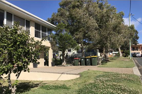
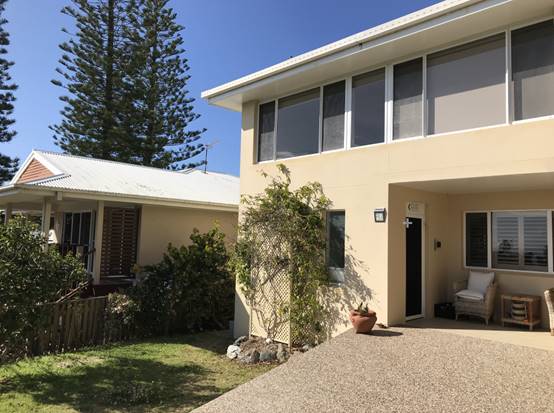
Site inspection revealed a single exposed overhead power
line running along the edge of Jordan Avenue. The line appeared to be
approximately 3m (conservatively) from the boundary. See site photo below:
Noting the proposed verandah extension is setback 3m it
would be well over 5m from the overhead line. No referral to Essential Energy
triggered.
Port Macquarie-Hastings Local Environmental
Plan 2011
The proposal is consistent with the LEP having regard to the
following:
· Clause
2.2 - The subject site is zoned R1 General Residential. In accordance with
clause 2.3(1) and the R1 zone landuse table, the alterations and additions to
the dwelling and ancillary garage structure are a permissible landuse with
consent.
The objectives of the R1 zone are as
follows:
o To provide for the housing
needs of the community.
o To provide for a variety of
housing types and densities.
o To enable other land uses
that provide facilities or services to meet the day to day needs of residents.
In accordance with Clause 2.3(2), the
proposal is consistent with the zone objectives as it is a permissible landuse
and consistent with the established residential locality. The proposal
contributes to the range of housing options in the locality.
· Clause
2.7 - The part demolition requires consent as it does not fit within the
provisions of SEPP (Exempt and Complying Development Codes) 2008.
· Clause
4.3 - The maximum overall height of the building above ground level remains
unchanged and complies with the standard height limit of 8.5m applying to the
site.
· Clause
4.4 - The floor space ratio of the proposal complies with the maximum 0.65:1
floor space ratio applying to the site.
· Clause
5.10 – Heritage. The site does not contain or adjoin any known heritage
items or sites of significance.
· Clause
7.13 - satisfactory arrangements are in place for provision of essential services
including water supply, electricity supply, sewer infrastructure, stormwater
drainage and suitable road access to service the development.
(ii) Any draft
instruments that apply to the site or are on exhibition
No draft instruments apply.
(iii) Any Development
Control Plan in force
Port
Macquarie-Hastings Development Control Plan 2013
|
DCP 2013: Dwellings, Dual
occupancies, Dwelling houses, Multi dwelling houses & Ancillary
development
|
|
|
Requirements
|
Proposed
|
Complies
|
|
3.2.2.2
|
Articulation zone:
• Min. 3m front
setback
• An entry feature
or portico
• A balcony, deck,
patio, pergola, terrace or verandah
• A window box
treatment
• A bay window or
similar feature
• An awning or other
feature over a window
• A sun shading
feature
|
The proposed extension incorporates a verandah within the
articulation zone. The verandah is setback over 3m and has the same pitch as
the roof of the dwelling.
|
Yes
|
|
Front setback (Residential not R5
zone):
• Min. 6.0m
classified road
• Min. 4.5m local road
• Min. 3.0m
secondary road
• Min. 2.0m Laneway
|
Front building line setback to
Jordan Avenue (being the road with the higher volume of traffic) remains
unchanged and complies with the minimum 4.5m front setback requirement.
|
Yes
|
|
3.2.2.3
|
Garage 5.5m min. and 1m behind
front façade.
Garage door recessed behind
building line or eaves/overhangs provided
|
Garage door setback to Bartlett
Street frontage is 1.83m.
Garage door recessed.
|
No*
|
|
6m max. width of garage door/s
and 50% max. width of building
|
Width of garage door is compliant
with the maximum width requirements
|
Yes
|
|
Driveway crossover 1/3 max. of
site frontage and max. 5.0m width
|
Driveway crossing width is
compliant with the maximum width requirements
|
Yes
|
|
3.2.2.4
|
4m min. rear setback. Variation
subject to site analysis and provision of private open space
|
The rear setback remains
unchanged.
|
N/A
|
|
3.2.2.5
|
Side setbacks:
• Ground floor =
min. 0.9m
• First floors &
above = min. 3m setback or where it can be demonstrated that overshadowing not
adverse = 0.9m min.
• Building wall set
in and out every 12m by 0.5m
|
The minimum side setback
requirements are complied with.
The building wall articulation is
compliant and/or satisfactory to address the objective intent of the
development provision.
|
Yes
|
|
3.2.2.6
|
35m2 min. private open space area
including a useable 4x4m min. area which has 5% max. grade
|
The dwelling contains 35m² open space in one area
including a useable 4m x 4m space.
|
Yes
|
|
3.2.2.7
|
Front fences:
• If solid 1.2m max
height and front setback 1.0m with landscaping
• 3x3m min. splay
for corner sites
• Fences >1.2m to
be 1.8m max. height for 50% or 6.0m max. length of street frontage with 25%
openings
• 0.9x0.9m splays
adjoining driveway entrances
|
No front fencing proposed
|
N/A
|
|
3.2.2.8
|
Front fences and walls to have
complimentary materials to context
No chain wire, solid timber,
masonry or solid steel front fences
|
N/A
|
N/A
|
|
3.2.2.10
|
Privacy:
• Direct views
between living areas of adjacent dwellings screened when within 9m radius of
any part of window of adjacent dwelling and within 12m of private open space
areas of adjacent dwellings. ie. 1.8m fence or privacy screening which has
25% max. openings and is permanently fixed
• Privacy screen
required if floor level > 1m height, window side/rear setback (other than
bedroom) is less than 3m and sill height less than 1.5m
• Privacy screens
provided to balconies/verandahs etc which have <3m side/rear setback and
floor level height >1m
|
The development will not
compromise privacy. Screening is proposed to the western elevation of the
front verandah being setback 1.6m from that side boundary. The eastern
elevation of the verandah is setback 5.715m from the eastern boundary and
does not require privacy screening.
|
Yes
|
|
DCP 2013: General
Provisions
|
|
|
Requirements
|
Proposed
|
Complies
|
|
2.7.2.2
|
Design addresses generic principles of Crime Prevention
Through Environmental Design guideline
|
No concealment or entrapment areas proposed. Adequate
casual surveillance available.
|
Yes
|
|
2.3.3.1
|
Cut and fill 1.0m max. 1m outside the perimeter of the
external building walls
|
Cut and fill <1.0m change 1m outside the perimeter of
the external building walls
|
Yes
|
|
2.3.3.2
|
1m max. height retaining walls along road frontage
|
None proposed
|
N/A
|
|
Any retaining wall >1.0 in height to be certified by
structure engineer
|
No retaining wall likely >1m
|
Yes
|
|
Combination of retaining wall and front fence height max
1.8m, max length 6.0m or 30% of frontage, fence component 25% transparent,
and splay at corners and adjacent to driveway
|
No retaining wall front fence combination proposed.
|
N/A
|
|
2.3.3.8
|
Removal of hollow bearing trees
|
No hollow bearing trees proposed to be removed
|
N/A
|
|
2.6.3.1
|
Tree removal (3m or higher with 100m diameter trunk at 1m
above ground level and 3m from external wall of existing dwelling)
|
Approval is sought for the removal of 4 bangalow palms. 2
within the property and 2 partly on the road reservation to Bartlett Street.
|
Yes. Council’s tree management section have no
objection to their removal without replacement.
|
|
2.4.3
|
Bushfire risk, Acid sulphate soils, Flooding,
Contamination, Airspace protection, Noise and Stormwater
|
Refer to main body of report.
|
Yes
|
|
2.5.3.2
|
New accesses not permitted from arterial or distributor
roads
|
No new access proposed to arterial or distribution road.
|
N/A
|
|
Driveway crossing/s minimal in number and width including
maximising street parking
|
Driveway crossing minimal in width including maximising
street parking
|
Yes
|
|
2.5.3.3
|
Parking in accordance with Table 2.5.1.
1 space per single dwelling (behind building line)
|
1 or capacity for more than 1 parking space behind the
building line has been provided for.
|
Yes
|
|
2.5.3.11
|
Section 94 contributions
|
Refer to main body of report.
|
N/A
|
|
2.5.3.12 and 2.5.3.13
|
Landscaping of parking areas
|
Single dwelling only with 1 domestic driveway. No specific
landscaping requirements recommended.
|
N/A
|
|
2.5.3.14
|
Sealed driveway surfaces unless justified
|
Sealed driveway proposed
|
Yes
|
|
2.5.3.15 and 2.5.3.16
|
Driveway grades first 6m or ‘parking area’
shall be 5% grade with transitions of 2m length
|
Driveway grades capable of satisfying Council standard
driveway crossover requirements. Condition recommended for section 138 Roads
Act permit
|
Yes
|
|
2.5.3.17
|
Parking areas to be designed to avoid concentrations of
water runoff on the surface.
|
Single dwelling only with 1 domestic driveway. Stormwater
drainage is capable of being managed as part of plumbing construction.
|
Yes
|
Development Provision 45 relates to garages and parking
spaces being setback at least 1m behind the building line, where the dwelling
has a setback from a front boundary of 4.5m or more. While the Bartlett Street
boundary is not the front boundary the objective of this clause is to minimise
garage impact and dominance upon the streetscape. The proposed double garage to
this frontage is setback 1.83m from this boundary and therefore considered a
variation and considered as follows.
The relevant objectives are:
· To minimise the
impact of garages and driveways on the streetscape, on street parking and amenity.
· To minimise the
visual dominance of garages in the streetscape.
· To provide safe
and functional vehicular access.
Having regard for the development provisions and relevant
objectives, the variation is considered acceptable for the following reasons:
· There is an
existing single garage building setback 1.83m from the Bartlett Street boundary
and this is considered to be a secondary frontage.
· The adjoining
property at No 20 Bartlett contains an existing double garage fronting Bartlett
Street with a similar setback which provides for some precedent.
· There is also an
existing driveway crossover off Jordan Avenue with an unrestricted (i.e. no
garage doors) secondary parking area available underneath the verandah
extension which is more than 5.5m in depth. Having regard to this arrangement,
requiring stacked parking in front of the Bartlett Street garage is not
considered necessary in this instance.
· The proposal
incorporates a new slatted timber fence with openings to replace the old solid
timber fence along the Bartlett Street frontage. The fence design helps soften
the appearance and dominance of the garage.
· There is also some
recessing provided in the new fence either side of the driveway providing for
further landscaping treatment.
· Having regard to
the existing garage and setback there is considered to be a slight improvement
to safety and functionality of the access.
Based on the above assessment, the variation proposed is
considered acceptable and the relevant objectives have been satisfied. The
variation does not amount to an adverse impact or of a significance that would
justify refusal of the application.
(iiia) Any planning agreement that has
been entered into under section 7.4, or any draft planning agreement that a
developer has offered to enter into under section 7.4
No planning agreement has been
offered or entered into relating to the site.
(iv) Any
matters prescribed by the Regulations
Demolition
of buildings AS 2601 - Clause 92
Part demolition of the existing
building is capable of compliance with the relevant Australian Standard and
suitable consent condition recommended.
(b) The likely
impacts of that development, including environmental impacts on both the
natural and built environments, social and economic impacts in the locality
Context and setting
The proposal will not have any significant adverse impacts
on existing adjoining properties and satisfactorily addresses the public
domain.
The proposal is considered to be compatible with other
residential development in the locality and adequately addresses planning
controls for the area.
The proposal does not have a significant adverse impact on
existing view sharing.
The proposal does not have significant adverse lighting
impacts.
There are no significant adverse privacy impacts. The extension of the first floor verandah north is setback
5.715m from the eastern side boundary. Consistent with the provisions of DCP
2013 (i.e. setback over 3m from the side boundary) the eastern elevation does
not require privacy screening. Given the slope of the land the proposed
verandah will be elevated well above the adjoining dwelling and deck. As a
result, views enjoyed north east from the verandah will extend over the roof of
the adjoining dwelling and associated deck underneath. It is also noted that
the adjoining deck at 20 Bartlett Street contains privacy screening on the
western elevation. Refers to site photos below for context:
There are no significant adverse overshadowing impacts. The
proposal does not prevent adjoining properties from receiving 3 hours of
sunlight to private open space and primary living areas on 21 June.
Access, traffic and transport
The proposal will not have any significant adverse impacts
in terms access, transport and traffic.
Water supply connection
Service existing and no changes proposed.
Sewer connection
Service existing and no changes proposed.
Stormwater
Service existing and available. Details of new roof
connections will be required with S.68 application. Appropriate standard condition
recommended.
Other utilities
Telecommunication and electricity services are available to
the site.
Heritage
This site does not contain or adjoin any known heritage item
or site of significance. The site is considered to be disturbed land.
Other land resources
The site is within an established urban context and will not
sterilise any significant mineral or agricultural resource.
Water cycle
The proposed development will not have any significant
adverse impacts on water resources and the water cycle.
Soils
The proposed development will not have any adverse impacts
on soils in terms of quality, erosion, stability and/or productivity subject to
a standard condition requiring erosion and sediment controls to be in place
prior to and during construction.
Air and microclimate
The construction and/or operations of the proposed
development will not result in any significant adverse impacts on the existing
air quality or result in any pollution. Standard precautionary site management
condition recommended.
Flora and fauna
Construction of the proposed development will not require
any removal/clearing of any significant native vegetation. The four (4)
bangalow palms to be removed are not considered to represent any ecological
value. The proposal does not trigger the biodiversity offsets scheme and part 7
of the Biodiversity Conservation Act 2016 is considered to be satisfied.
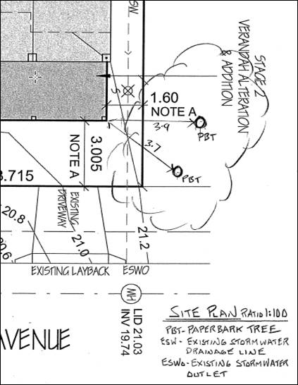
The proximity of the Paperbark trees located on the
adjoining western property were noted at the time of site inspection. The
applicant subsequently provided further details and measurements confirming no
impact would result from the proposed northward verandah extension.
Specifically, the verandah post footing is to be incorporated into the existing
driveway pavement and will not extend below ground or impact any root zones.
See screenshot below of measurements provided:
Waste
Satisfactory arrangements are in place for proposed storage
and collection of waste and recyclables. No adverse impacts anticipated.
Standard precautionary site management condition recommended.
Energy
The proposal includes measures to address energy efficiency
and will be required to comply with the requirements of BASIX.
Noise and vibration
The construction of the proposed development will not result
in any significant adverse impacts on the existing air quality or result in any
pollution. Standard precautionary site management condition recommended.
Bushfire
The site is identified as being bushfire prone. The
applicant has submitted a bushfire report. An assessment of bushfire risk
having regard to Planning for Bushfire Protection including vegetation
classification and slope concludes that a Bushfire Attack Level 12.5 shall be
required.
Management of bushfire risk is acceptable subject to BAL
construction levels being implemented and APZ being maintained. An appropriate
condition is recommended.
Safety, security and crime prevention
The proposed development will be unlikely to create any
concealment/entrapment areas or crime spots that would result in any
identifiable loss of safety or reduction of security in the immediate area.
Social impacts in the locality
Given the nature of the proposed development and its
location the proposal is not considered to have any significant adverse social
impacts.
Economic impact in the locality
The proposal is not considered to have any significant
adverse economic impacts on the locality. A likely positive impact is that the
development will maintain employment in the construction industry, which will
lead to flow impacts such as expenditure in the area.
Site design and internal design
The proposed development design satisfactorily responds to
the site attributes and will fit into the locality.
Construction
Construction impacts are considered capable of being
managed, standard construction and site management conditions have been
recommended.
Cumulative impacts
The proposed development is not considered to have any
significant adverse cumulative impacts on the natural or built environment or the
social and economic attributes of the locality.
(c) The
suitability of the site for the development
The proposal will fit into the locality and the site
attributes are conducive to the proposed development. Site constraint of
bushfire has been adequately addressed and appropriate condition of consent
recommended.
(d) Any
submissions made in accordance with this Act or the Regulations
One (1) written
submission was received following public exhibition of the application. Copies
of the written submission have been provided separately to members of the DAP.
Key
issues raised in the submission received and comments are provided as follows:
|
Submission
Issue/Summary
|
Planning
Comment/Response
|
|
Loss of amenity and privacy to
the deck of the adjoining dwelling at 20 Bartlett Street. Suggest that
privacy screening be provided to the eastern elevation of the proposed
verandah.
|
Refer to comment under context
and setting heading of this report. There are not considered to be any
adverse privacy or amenity impacts that would result from the proposal.
|
(e) The Public Interest
The proposed development
satisfies relevant planning controls and will not adversely impact on the wider
public interest.
Ecologically Sustainable Development and Precautionary
Principle
Ecologically sustainable development requires the effective
integration of economic and environmental considerations in decision-making
processes.
The four principles of ecologically sustainable development
are:
· the
precautionary principle,
· intergenerational
equity,
· conservation
of biological diversity and ecological integrity,
· improved
valuation, pricing and incentive mechanisms.
The principles of ESD require that a balance needs to be
struck between the man-made development and the need to retain the natural
vegetation. Based on the assessment provided in the report and with recommended
conditions of consent, it is considered an appropriate balance has been struck.
Climate change
The proposal is not considered to be vulnerable to any risks
associated with climate change.
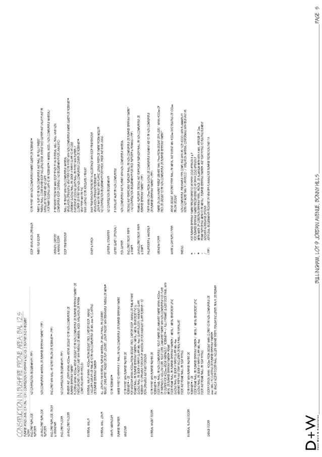
4. DEVELOPMENT
CONTRIBUTIONS APPLICABLE
Development
contributions will not be required under s64/s7.11 being for alterations and
additions to an existing dwelling and no additional residential components are
proposed.
5. CONCLUSION AND
STATEMENT OF REASON
The application has been assessed in accordance with Section
4.15 of the Environmental Planning and Assessment Act 1979.
Issues raised during assessment and public exhibition of the
application have been considered in the assessment of the application. Where
relevant, conditions have been recommended to manage the impacts attributed to
these issues.
The site is considered suitable for the proposed development
and the proposal adequately addresses relevant planning controls. The
development is not considered to be contrary to the public's interest and will
not result a significant adverse social, environmental or economic impact. It
is recommended that the application be approved, subject to the recommended
conditions of consent provided in the attachment section of this report.
|
Attachments
1⇩. DA2020 - 682.1
Recommended Conditions DA2020 - 682.1
Recommended Conditions
2⇩. DA2020 - 682.1 Plans
|
|
ATTACHMENT
|
Development Assessment Panel
14/10/2020
|
|
ATTACHMENT
|
Development Assessment Panel
14/10/2020
|
AGENDA Development Assessment Panel 14/10/2020
Item: 06
Subject: DA2020 - 600.1 Dual Occupancy and Strata Subdivision
at Lot 410 DP 1244641 No.18 Octagonal Rise, Port Macquarie
Report
Author: Development Assessment Planner, Fiona Tierney
|
Applicant: F
Wholohan & N McGregor
Owner: F
Wholohan & N McGregor
Estimated Cost: $566,500
Alignment with Delivery
Program
4.3.1 Undertake transparent and
efficient development assessment in accordance with relevant legislation.
|
RECOMMENDATION
That
DA 2020 - 600.1 for a Dual
Occupancy and Strata Subdivision at Lot 410, DP 1244641, No. 18 Octagonal Rise, Port
Macquarie, be determined by granting consent
subject to the recommended conditions.
Executive
Summary
This
report considers a development application for a Dual Occupancy and Strata
Subdivision at the subject site and provides
an assessment of the application in accordance with the Environmental Planning
and Assessment Act 1979.
Following exhibition of the
application, two (2) submissions were
received.
The site is considered suitable for the proposed development
and the proposal adequately addresses relevant planning controls. The
development is not considered to be contrary to the public's interest and will
not result a significant adverse social, environmental or economic impact.
This report recommends that the
development application be approved subject to the attached conditions
in Attachment 1.
1. BACKGROUND
Existing
Sites Features and Surrounding Development
The site has an area of 576m2.
The
site is zoned R1 General residential in
accordance with the Port Macquarie-Hastings Local Environmental Plan 2011, as
shown in the following zoning plan:
 The existing subdivision pattern and location of existing
development within the locality is shown in the following aerial photograph:
The existing subdivision pattern and location of existing
development within the locality is shown in the following aerial photograph:
2. DESCRIPTION
OF DEVELOPMENT
Key
aspects of the proposal include the following:
· Construction
of a single storey attached dual occupancy with 2 x 3 bedroom dwellings and 2
lot Strata title subdivision.
Refer
to Attachment 2 at the end of this report for plans of the proposed
development.
Application
Chronology
· 29
July 2020 - Application lodged.
· 10 August 2020 to 24 August 2020 - Neighbour notification.
· 9 September 2020 - Bush Fire Safety Authority issued by NSW
Rural Fire Service.
· 21 September 2020- Additional confirmation stormwater
inlets provided.
3. STATUTORY
ASSESSMENT
Section
4.15(1) Matters for Consideration
In
determining the application, Council is required to take into consideration the
following matters as are relevant to the development that apply to the land to
which the development application relates:
(a) The
provisions (where applicable) of:
(i) Any
Environmental Planning Instrument
State
Environmental Planning Policy (Koala Habitat Protection) 2019
Clause
5 - This SEPP applies to the Port Macquarie-Hastings Local Government Area.
Clause
8 - The site is subject to the adopted Mahers
Headland Koala Plan of Management.
Whilst
tree removal has been indicated, the removal has been addressed under a
separate application and consideration of KPOM matters. Trees were considered
dangerous.
Therefore,
no tree removal is proposed and the proposal is consistent with the adopted
plan of management.
State Environmental Planning Policy No. 55 - Remediation of
Land
Following an inspection of the site and a search of Council
records, the subject land is not identified as being potentially contaminated
and is suitable for the intended use.
State Environmental Planning Policy (Building
Sustainability Index: BASIX) 2004
A BASIX certificate (number 1116563M) has been submitted demonstrating
that the proposal will comply with the requirements of the SEPP. It is
recommended that a condition be imposed to ensure that the commitments are
incorporated into the development and certified at Occupation Certificate
stage.
Port Macquarie-Hastings Local Environmental Plan
2011
The proposal is consistent with the LEP having regard to
the following:
· Clause 2.2 - The subject site is zoned R1 General
Residential.
· Clause 2.3(1) and the R1 zone landuse table - The proposed
development for a dual occupancy (attached) and strata subdivision is a
permissible landuse with consent. Following subdivision, each lot will contain
a semi-detached dwelling.
The
objectives of the R1 zone are as follows:
o To provide for the housing needs of the community.
o To provide for a variety of housing types and
densities.
o To enable other land uses that provide facilities
or services to meet the day to day needs of residents.
· Clause 2.3(2) - The proposal is consistent with the zone
objectives having regard to the following:
o The development will contribute to the variety of
housing types and densities to meet the housing needs of the community.
· Clause 4.1(4) - The minimum 450m2 lot size for
subdivision does not apply to the proposal as it proposes a strata subdivision.
A satisfactory strata plans has been provided and dwellings are proposed as
part of this application.
· Clause 4.3 - The maximum overall height of the building above
ground level (existing) is 3.767m, which complies with the standard height
limit of 8.5m applying to the site.
· Clause 4.4 - The floor space ratio of the proposal is
0.44:1 which complies with the maximum 0.65:1 floor space ratio applying to the
site.
· Clause 5.10 - The site does not contain or adjoin any known
heritage items or sites of significance.
· Clause 7.13 - Satisfactory arrangements are in place for
provision of essential services including water supply, electricity supply,
sewer infrastructure, stormwater drainage and suitable road access to service
the development.
(ii) Any draft
instruments that apply to the site or are on exhibition
No draft instruments apply to the site.
(iii) Any Development
Control Plan in force
Port
Macquarie-Hastings Development Control Plan 2013
|
DCP 2013: Dwellings, Dual occupancies, Dwelling houses,
Multi dwelling houses & Ancillary development
|
|
|
Requirements
|
Proposed
|
Complies
|
|
3.2.2.2
|
Articulation
zone:
• Min. 3m front setback
• An entry feature or portico
• A balcony, deck, patio, pergola, terrace or verandah
• A window box treatment
• A bay window or similar feature
• An awning or other feature over a window
• A sun shading feature
|
None
proposed
|
N/A
|
|
Front
setback
• Min. 4.5m local road
•
|
5.572
minimum to posts.
|
Yes
|
|
3.2.2.3
|
Garage
5.5m min. and 1m behind front façade.
Garage
door recessed behind building line or eaves/overhangs provided
|
7.786m
garage door setback.
|
Yes
|
|
6m
max. width of garage door/s and 50% max. width of building
|
Width
of garage doors 6m and <50% width.
|
Yes
|
|
Driveway
crossover 1/3 max. of site frontage and max. 5.0m width
|
4m
wide driveway crossing width which is < 1/3 width of site.
|
Yes
|
|
3.2.2.4
|
4m
min. rear setback. Variation subject to site analysis and provision of
private open space
|
2.718m
min setback. Demonstrated site analysis POS and property at rear setback.
|
No-
but has provided satisfactory justification and site analysis.
|
|
3.2.2.5
|
Side
setbacks:
• Ground floor = min. 0.9m
• Building wall set in and out every 12m by 0.5m
|
0.95m
min
The
wall articulation is compliant and satisfies the objectives of the
development provision.
|
Yes
|
|
3.2.2.6
|
35m2
min. private open space area including a useable 4x4m min. area which has 5%
max. grade
|
Each
occupancy contains 35m² open space in one area including a useable 4m x
4m area.
|
Yes
|
|
3.2.2.10
|
Privacy:
• Direct views between living areas of adjacent dwellings
screened when within 9m radius of any part of window of adjacent dwelling and
within 12m of private open space areas of adjacent dwellings. ie. 1.8m fence
or privacy screening which has 25% max. openings and is permanently fixed
• Privacy screen required if floor level > 1m height,
window side/rear setback (other than bedroom) is less than 3m and sill height
less than 1.5m
• Privacy screens provided to balconies/verandahs etc which
have <3m side/rear setback and floor level height >1m
|
No
direct views between living areas of adjacent dwellings screened when within
9m radius of any part of window of adjacent dwelling and within 12m of
private open space areas of adjacent dwellings.
The
development will not compromise privacy in the area due to a combination of
building design and boundary fencing.
|
Yes
|
|
DCP 2013: General Provisions
|
|
|
Requirements
|
Proposed
|
Complies
|
|
2.7.2.2
|
Design
addresses generic principles of Crime Prevention Through Environmental Design
guideline
|
No
concealment or entrapment areas proposed. Adequate casual surveillance
available.
|
Yes
|
|
2.3.3.1
|
Cut
and fill 1.0m max. 1m outside the perimeter of the external building walls
|
Cut
and fill <1.0m change 1m outside the perimeter of the external building
walls
|
Yes
|
|
2.3.3.2
|
1m
max. height retaining walls along road frontage
|
None
proposed
|
N/A
|
|
Any
retaining wall >1.0 in height to be certified by structure engineer
|
No
retaining wall likely >1m
|
Yes
|
|
Combination
of retaining wall and front fence height max 1.8m, max length 6.0m or 30% of
frontage, fence component 25% transparent, and splay at corners and adjacent
to driveway
|
1.8m
high fence with 25% transparency.
|
Yes
|
|
2.4.3
|
Bushfire
risk, Acid sulphate soils, Flooding, Contamination, Airspace protection,
Noise and Stormwater
|
Refer
to main body of report.
|
|
|
2.5.3.2
|
New
accesses not permitted from arterial or distributor roads
|
No
new access proposed to arterial or distributor road.
|
N/A
|
|
Driveway
crossing/s minimal in number and width including maximising street parking
|
Driveway
crossing is minimal in width including maximising street parking.
|
Yes
|
|
2.5.3.3
|
Parking
in accordance with Table 2.5.1.
Dwelling/dual
occupancies
1
space per dwelling/occupancy (behind building line).
Multi
dwelling
1
space per 1 & 2 bedroom occupancies
1.5
spaces per 3+ bedroom occupancies
0.25
spaces per occupancy for visitor parking.
|
Proposal
involves dual occupancy, which will be 2 semi-detached dwellings following
subdivision. Each dwelling provides 1 parking space behind the building line.
|
Yes
|
|
2.5.3.11
|
Section
94 contributions
|
Contributions
apply - refer to ET calc and NOP.
|
Yes
|
|
2.5.3.12
and 2.5.3.13
|
Landscaping
of parking areas
|
Suitable
landscaping proposed around driveway/parking locations.
|
Yes
|
|
2.5.3.14
|
Sealed
driveway surfaces unless justified
|
Sealed
driveway areas proposed.
|
Yes
|
|
2.5.3.15
and 2.5.3.16
|
Driveway
grades first 6m or ‘parking area’ shall be 5% grade with
transitions of 2m length
|
Driveway
grades capable of satisfying Council standard driveway crossover
requirements. Condition recommended for section 138 Roads Act permit
|
Yes
|
|
2.5.3.17
|
Parking
areas to be designed to avoid concentrations of water runoff on the surface.
|
Stormwater
drainage is capable of being managed as part of plumbing construction.
|
Yes
|
Note: Subdivision provisions of the DCP (except battleaxe
handle width) are aimed at the creation of vacant lots (i.e. not lots within an
integrated housing proposal such as this) and have therefore been excluded from
the above assessment. Servicing requirements are discussed later in this
report.
(iiia) Any planning agreement that has
been entered into under section 7.4, or any draft planning agreement that a
developer has offered to enter into under section 7.4
No planning agreement has been
offered or entered into relating to the site.
(iv) Any
matters prescribed by the Regulations
No matters prescribed by the regulations are applicable to
the proposal.
(b) The likely
impacts of that development, including environmental impacts on both the
natural and built environments, social and economic impacts in the locality
Context and setting
• The
proposal will be unlikely to have any adverse impacts to existing adjoining
properties and satisfactorily addresses the public domain.
• The
proposal is considered to be consistent with other residential development in
the locality and adequately addresses planning controls for the area.
• There
are no adverse impacts on existing view sharing.
• There
are no adverse privacy impacts.
• There
are no adverse overshadowing impacts. The proposal does not prevent adjoining
properties from receiving 3 hours of sunlight to private open space and primary
living areas on 21 June.
Roads
The site has road frontage to Octagonal Rise. Adjacent to
the site, Octagonal Rise is a sealed public road under the care and control of
Council.
The addition in traffic associated with the development is unlikely
to have any adverse impacts to the existing road network within the immediate
locality.
Site frontage and access
Vehicle access to the site is proposed though a shared
driveway with direct frontage to Octagonal Rise. Access shall comply with Council
AUSPEC and Australian Standards, and conditions have been recommended to
reflect these requirements.
Parking and manoeuvring
A total of 2 parking spaces have been provided on-site
within garages with additional parking available within the driveway. Parking
and driveway widths on site can comply with relevant Australian Standards (AS
2890) and conditions have been recommended to reflect these requirements.
Water supply connection
Council records indicate that the development site is
currently serviced by a 100mm water main on the same side of Octagonal Rise.
Each Strata Title lot requires a separate metered water connection to
Council’s water main. All design & works shall be in accordance with
Council’s adopted AUSPEC Specifications.
Detailed plans will be required to be submitted for
assessment with the S.68 application.
Sewer connection
Both Strata Title lots can drain to the existing junction
provided in the north west corner of the site. All design & works shall be
in accordance with Council’s adopted AUSPEC Specifications.
Detailed plans will be required to be submitted for
assessment with the S.68 application.
Stormwater
The site can achieve floor level grades towards the front
and can drain to Council’s street drainage system. Surface inlets have
been provided on the site to suitable manage concentrated flows on the site.
A detailed site stormwater management plan will be required
to be submitted for assessment with the Section 68 application and prior to the
issue of a Construction Certificate.
Other utilities
Telecommunication and electricity services are available to
the site.
Heritage
No known items of Aboriginal or European heritage
significance exist on the property. No adverse impacts anticipated. The site is
in a residential context and considered to be disturbed land.
Other land resources
The site is within an established urban context and will
not sterilise any significant mineral or agricultural resource.
Water cycle
The proposed development will not have any significant
adverse impacts on water resources and the water cycle.
Soils
The proposed development will not have any significant
adverse impacts on soils in terms of quality, erosion, stability and/or
productivity subject to a standard condition requiring erosion and sediment
controls to be in place prior to and during construction.
Air and microclimate
The construction and/or operations of the proposed
development will not result in any significant adverse impacts on the existing
air quality or result in any pollution. Standard precautionary site management
condition recommended.
Flora and fauna
Construction of the proposed development will not require
any removal/clearing of any native vegetation and therefore does not trigger
the biodiversity offsets scheme. Part 7 of the Biodiversity Conservation
Act 2016 is considered to be satisfied.
Waste
Satisfactory arrangements are in place for proposed storage
and collection of waste and recyclables. No adverse impacts anticipated.
Standard precautionary site management condition recommended.
Energy
The proposal includes measures to address energy efficiency
and will be required to comply with the requirements of BASIX.
Noise and vibration
The construction and/or operations of the proposed
development will not result in any significant adverse impacts on the existing
air quality or result in any pollution. Standard precautionary site management
condition recommended.
Bushfire
The site is identified as being bushfire prone. In
accordance with Section 100B of the Rural Fires Act 1997, the
application proposes subdivision of bush fire prone land that could lawfully be
used for residential purposes. As a result, the applicant has submitted a
bushfire report prepared by a Certified Consultant. The report was forwarded to
the NSW Rural Fire Service who have since issued a Bushfire Safety Authority.
A condition has been recommended incorporating the
requirements of the Bushfire Safety Authority.
Safety, security and crime prevention
The proposed development will be unlikely to create any
concealment/entrapment areas or crime spots that would result in any
identifiable loss of safety or reduction of security in the immediate
area. The increase in housing density will improve natural surveillance
within the locality and openings from each dwelling overlook common and private
areas.
Social impacts in the locality
Given the nature of the proposed development and its
location the proposal is not considered to have any significant adverse social
impacts.
Economic impact in the locality
The proposal is not considered to have any significant
adverse economic impacts on the locality. A likely positive impact is that the
development will maintain employment in the construction industry, which will
lead to flow impacts such as expenditure in the area.
Site design and internal design
The proposed development design satisfactorily responds to
the site attributes and will fit into the locality. No adverse impacts likely.
Construction
Construction impacts are considered capable of being
managed, standard construction and site management conditions have been
recommended.
Cumulative impacts
The proposed development is not considered to have any
significant adverse cumulative impacts on the natural or built environment or
the social and economic attributes of the locality.
(c) The
suitability of the site for the development
The
proposal will fit into the locality and the site attributes are conducive to
the proposed development.
(d) Any
submissions made in accordance with this Act or the Regulations
Two (2) written
submissions were received following public exhibition of the application.
Copies of the written submissions have been provided separately to members of
the DAP.
Key
issues raised in the submissions received and comments are provided as follows:
|
Submission
Issue/Summary
|
Planning
Comment/Response
|
|
The
cumulative impact of this development and other similar proposals in the
street will result in a significant number of vehicles and congestion of
street parking, pedestrian access and degrade the amenity of the
neighbourhood.
|
The proposal is a permissible
landuse in the R1 general residential zone.
The proposal complies with
the minimum parking requirements in DCP 2013 (one off-street parking space
per dwelling for dual occupancies).
Other similar developments
within the area have been assessed as adequately addressing relevant
planning controls.
Section 4.15(3A) of the Environmental Planning and
Assessment Act 1979 provides that:
If a development
control plan contains provisions that relate to the development that is the
subject of a development application, the consent authority—
(a) if
those provisions set standards with respect to an aspect of the development
and the development application complies with those standards—is not
to require more onerous standards with respect to that aspect of the
development
Based on the merits of the
proposed development, the site is considered suitable for the proposed
development and the proposal adequately complies with relevant planning
controls.
|
|
Stormwater- issues with surface flows through property
at the rear. No stormwater drainage shown.
|
The applicant has submitted hydraulic engineering
details that proposes surface inlets and stormwater drainage to be directed
to Octagonal rise. Surface levels to the rear will be raised and a 600mm
retaining wall constructed. This will reduce the amount and velocity of
surface flows directed into the property to the rear.
|
(e) The Public Interest
The proposed development
satisfies relevant planning controls and will not adversely impact on the wider
public interest.
(f) Ecologically
Sustainable Development and Precautionary Principle
Ecologically sustainable development requires the effective
integration of economic and environmental considerations in decision-making
processes.
The four principles of ecologically sustainable development
are:
· the
precautionary principle,
· intergenerational
equity,
· conservation
of biological diversity and ecological integrity,
· improved
valuation, pricing and incentive mechanisms.
The principles of ESD require that a balance needs to be
struck between the man-made development and the need to retain the natural
vegetation. Based on the assessment provided in the report and with recommended
conditions of consent, it is considered an appropriate balance has been struck.
(g) Climate change
The proposal is not considered to be vulnerable to any risks
associated with climate change.
4. DEVELOPMENT
CONTRIBUTIONS APPLICABLE
· Development contributions will be required towards
augmentation of town water supply and sewerage system head works under Section
64 of the Local Government Act 1993.
· Development contributions will be required in accordance
with Section 7.11 of the Environmental Planning and Assessment Act 1979 towards
roads, open space, community cultural services, emergency services and
administration buildings.
·
· A copy of the contributions estimate is included as Attachment
3.
5. CONCLUSION AND
STATEMENT OF REASON
The application has been assessed in accordance with Section
4.15 of the Environmental Planning and Assessment Act 1979.
Issues raised during assessment and public exhibition of the
application have been considered in the assessment of the application. Where
relevant, conditions have been recommended to manage the impacts attributed to
these issues.
The site is considered suitable for the proposed development
and the proposal adequately addresses relevant planning controls. The
development is not considered to be contrary to the public's interest and will
not result a significant adverse social, environmental or economic impact. It
is recommended that the application be approved, subject to the recommended
conditions of consent provided in the attachment section of this report.
|
Attachments
1⇩. DA2020 - 600.1
Recommended Conditions
2⇩. DA2020 - 600.1 Plans DA2020 - 600.1 Plans
3⇩. DA2020 - 600.1
Contributions Estimate
4⇩. DA2020 - 600.1 SOEE
|
|
ATTACHMENT
|
Development Assessment Panel
14/10/2020
|
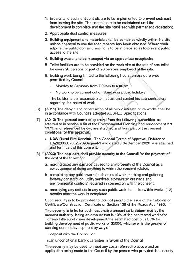
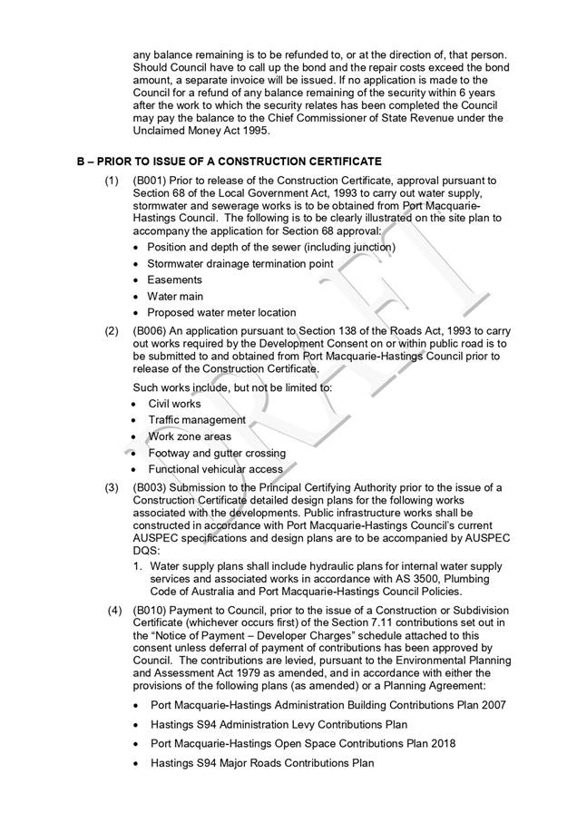
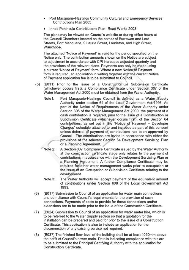
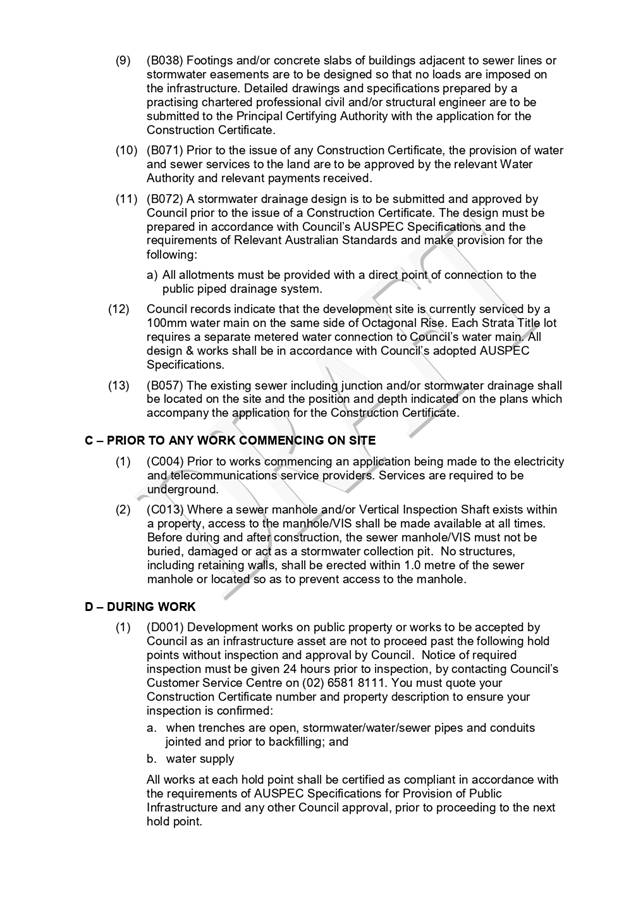
|
ATTACHMENT
|
Development Assessment Panel
14/10/2020
|
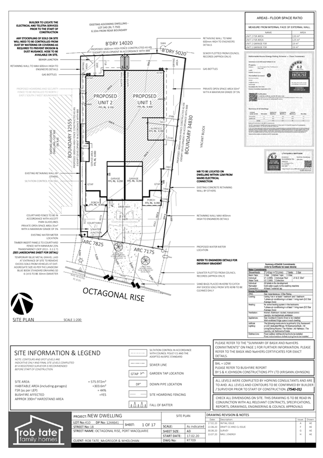
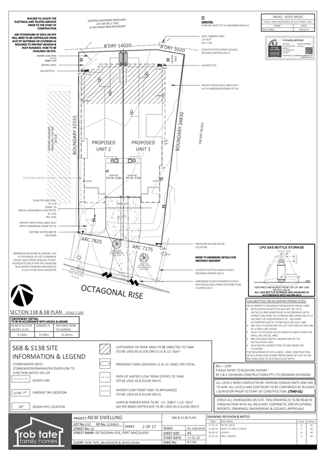
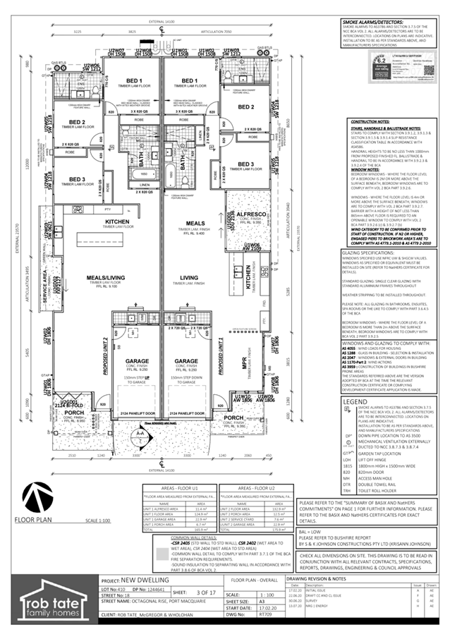
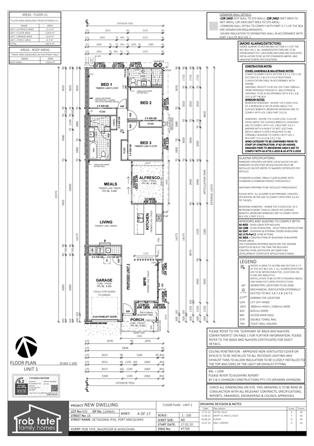
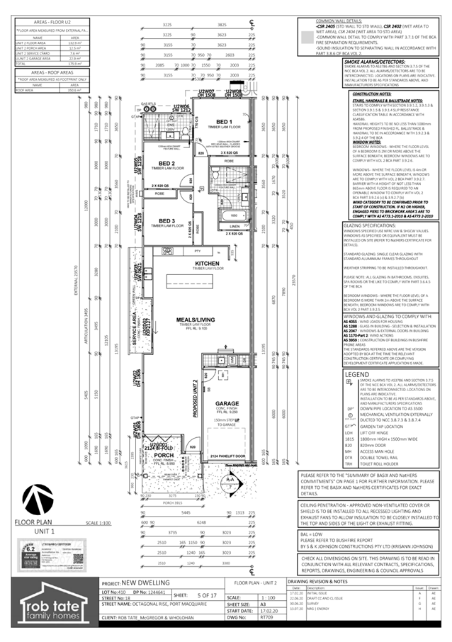
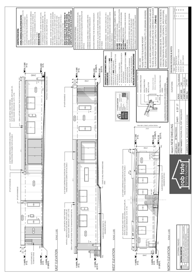
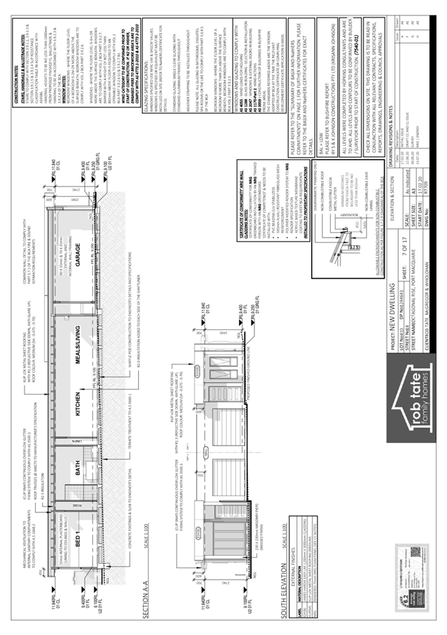
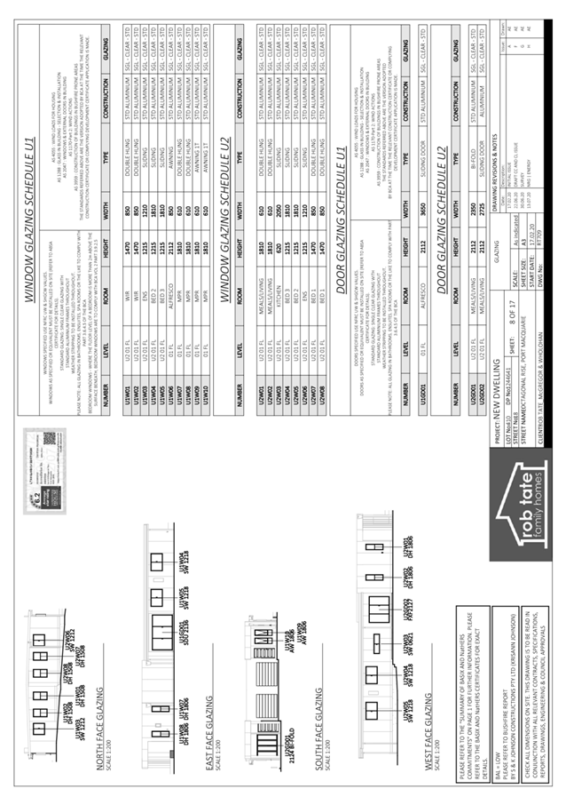
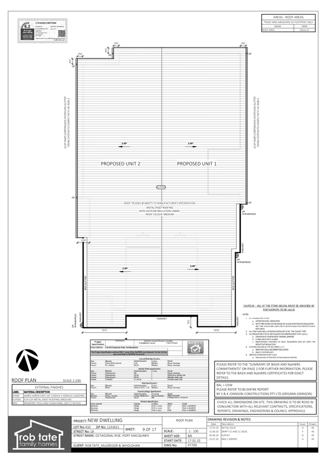
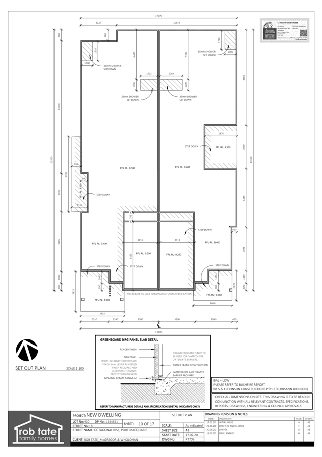
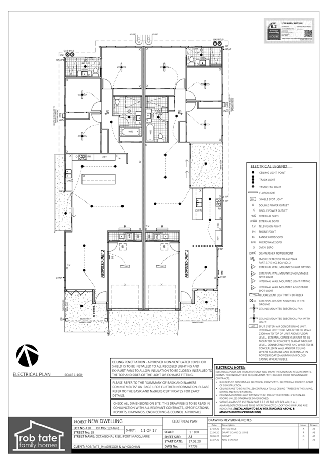
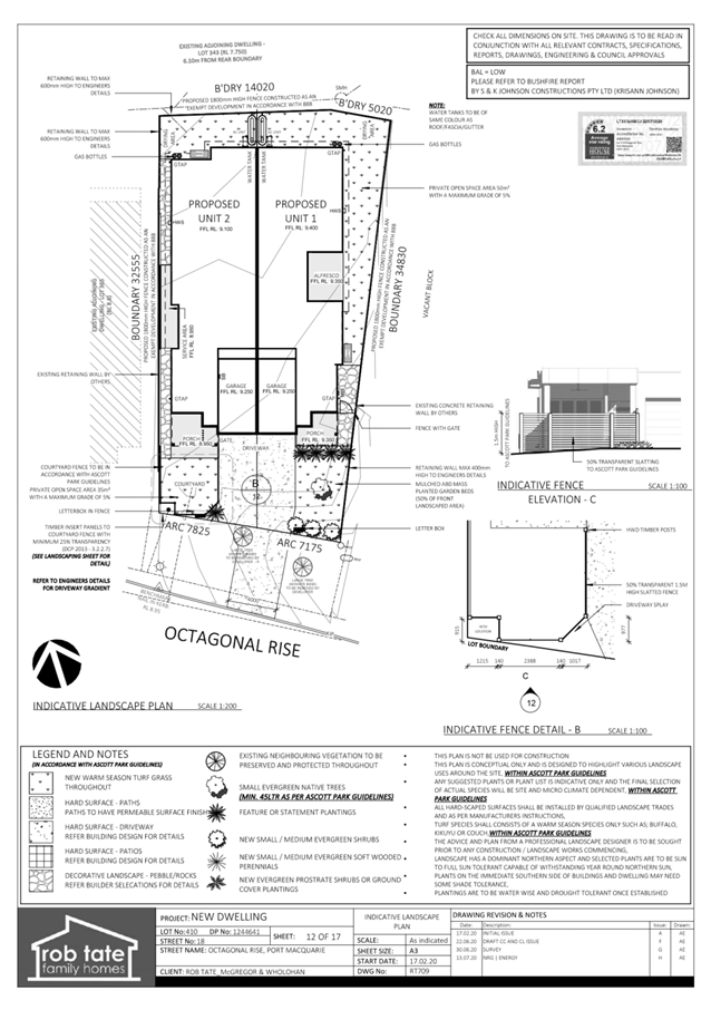
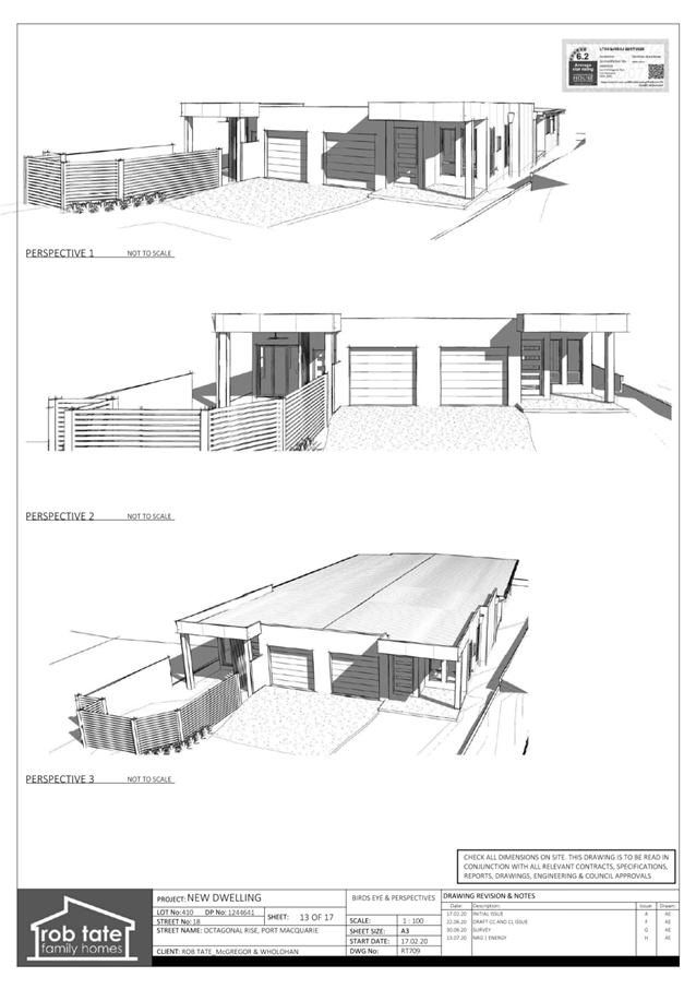
|
ATTACHMENT
|
Development Assessment Panel
14/10/2020
|
|
ATTACHMENT
|
Development Assessment Panel
14/10/2020
|

AGENDA Development Assessment Panel 14/10/2020
Item: 07
Subject: DA2019 - 681.1 Farm Stay Accommodation at Lot
89 DP 754416, No. 2001 Toms Creek Road, Toms Creek
Report
Author: Development Assessment Planner, Chris Gardiner
|
Applicant: C
Patterson
Owner: C
M Malvern
Estimated Cost: $98,000
Alignment with Delivery
Program
4.3.1 Undertake transparent and
efficient development assessment in accordance with relevant legislation.
|
RECOMMENDATION
That
DA2019 - 681.1 for Farm Stay
Accommodation at Lot 89, DP 754416, No. 2001 Toms Creek Road, Toms
Creek, be determined by granting deferred
commencement consent subject to the recommended conditions.
Executive
Summary
This
report considers a development application for farm stay accommodation at the subject site and provides an assessment of the
application in accordance with the Environmental Planning and Assessment Act
1979.
The application relates to
structures that have been erected without development consent, and background
on the compliance investigation is included in this report.
Following exhibition of the
application, five (5) submissions were
received, four (4) of which are in support of the development.
The proposal has been amended
through the assessment process including a reduction in the number of
accommodation and refuge buildings, changes to internal access roads, and
siting of buildings.
The site is considered suitable for the proposed development
and the proposal adequately addresses relevant planning controls. The
development is not considered to be contrary to the public's interest and will
not result in a significant adverse social, environmental or economic impact.
This report recommends that the
development application be approved subject to the attached conditions
in Attachment 1.
1. BACKGROUND
Existing
Sites Features and Surrounding Development
The site has an area of 42.5
hectares.
The
site is zoned RU2 Rural Landscape in
accordance with the Port Macquarie-Hastings Local Environmental Plan 2011, as
shown in the following zoning plan:
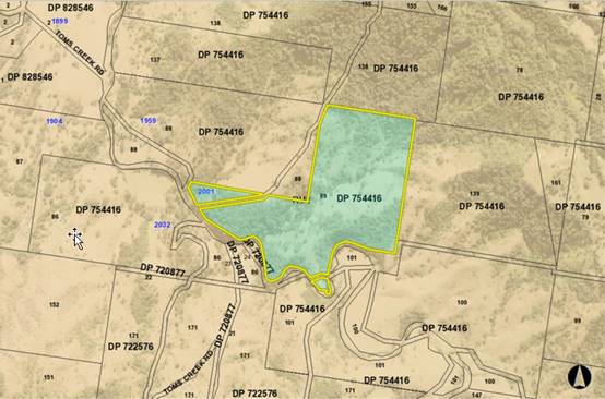
The
existing subdivision pattern and location of existing development within the
locality is shown in the following aerial photograph:
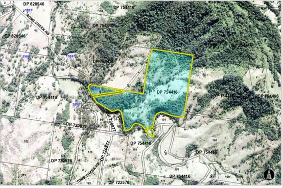
Buildings
Erected Without Consent
The
dome structures on the site have been erected without development consent and
are understood to have been previously used for tourist accommodation. In
response to a complaint, Council’s Compliance staff investigated the site
and subsequently issued an Order on 3 July 2019 to “Stop using the
property as an Eco-Tourist Facility. This includes use of the
‘dome’ as any form of accommodation i.e. short term or long term
accommodation.”
The unauthorised
use of the premises has ceased since the issue of the Order and further action
in relation to the dome structures has been deferred pending the outcome of
this development application. If consent is not granted to the development, it
is likely that the structures would be ordered to be demolished.
Given
that the dome structures have been erected without consent, it will not be
possible to issue a Construction Certificate for this aspect of the development
and the domes will require a Building Information Certificate. The BCA
Compliance Report submitted with the application includes insufficient
information to demonstrate that the domes will comply with the BCA/NCC in their
current form. On this basis, it is recommended that the requirement to obtain a
Building Information Certificate should be a deferred commencement condition.
2. DESCRIPTION
OF DEVELOPMENT
Key
aspects of the proposal include the following:
· Use
of the two existing dome structures as farm stay accommodation;
· Construction
of shelters with rainwater tanks adjacent to each of the domes for the purpose
of water supply;
· Construction
of a bushfire refuge building; and
· Use
of the existing farm shed as an amenities building for farm workers.
Refer
to Attachment 2 at the end of this report for plans of the proposed
development.
Application
Chronology
· 23
September 2019 - Application lodged.
· 8 October 2019 to 21 October 2019 - Neighbour notification.
· 20 December 2019 - Additional information requested from Applicant.
· 20 February 2020 - Additional information submitted by
Applicant.
· 11 March 2020 - Additional information requested by NSW
Rural Fire Service.
· 26 March 2020 - Further additional information requested by
Council staff.
· 1 April 2020 - Further additional information submitted by
Applicant.
· 14 April 2020 - Further additional information submitted by
Applicant.
· 2 June 2020 - Bush Fire Safety Authority issued by NSW
Rural Fire Service.
· 14 June 2020 - Further additional information requested by
Council staff.
· 5 August 2020 - Further additional information and amended
plans submitted by Applicant and provided to NSW Rural Fire Service for review.
· 10 September 2020 - Amended Bush Fire Safety Authority
issued by NSW Rural Fire Service.
3. STATUTORY
ASSESSMENT
Section
4.15(1) Matters for Consideration
In
determining the application, Council is required to take into consideration the
following matters as are relevant to the development that apply to the land to
which the development application relates:
(a) The
provisions (where applicable) of:
(i) Any
Environmental Planning Instrument
State
Environmental Planning Policy (Koala Habitat Protection) 2019
Clause
5 - This SEPP applies to the Port Macquarie-Hastings Local Government Area.
Clause
15 - A development application made,
but not finally determined, before the commencement of this Policy in relation
to land to which this Policy applies must be determined as if this Policy had
not commenced. The application was made and not finally determined prior to the
commencement of this policy, and the application is therefore required to be
assessed under the relevant provisions of State Environmental Policy No 44 -
Koala Habitat Protection. See assessment comments below.
State
Environmental Planning Policy No. 44 - Koala Habitat Protection
With
reference to clauses 6 and 7, the subject land is greater than 1 hectare
(including any adjoining land under same ownership) and therefore the
provisions of SEPP must be considered.
The
Applicant has submitted an assessment prepared by J B Enviro, which addresses
the requirements of SEPP 44. The vegetation survey identified that some
Tallowwood and Forest Red Gum exist on the property, but Flooded Gum is the
dominant species and the proportion of koala food trees does not exceed 15%.
The land therefore does not meet the definition of potential koala habitat and
no further investigation is required.
State
Environmental Planning Policy No. 55 – Remediation of Land
The
land has historically been used for grazing. Following an inspection of the
site and a search of Council records, the subject land is not identified as
being potentially contaminated and is suitable for the intended use.
State
Environmental Planning Policy No. 64 – Advertising and Signage
The
proposal does not include any details of signage. Standard condition
recommended requiring further consent for any future signage that is not Exempt
Development.
Port Macquarie-Hastings Local Environmental Plan 2011
The
proposal is consistent with the LEP having regard to the following:
· Clause 2.2 - The subject site is zoned RU2 Rural Landscape.
· Clause 2.3(1) and the RU2 zone landuse table - The proposed
development for farm stay accommodation is a permissible landuse with consent.
The land is also currently used for horticulture and extensive agriculture,
which are both permitted without consent in the zone.
farm stay accommodation means a building or place that provides temporary
or short-term accommodation to paying guests on a working farm as a secondary
business to primary production.
The owners are registered primary producers and sufficient
information has been submitted to demonstrate that the income from the working
farm will exceed the income anticipated to be generated by the farm stay
accommodation. Through the assessment process, the number of accommodation
buildings has been reduced from four (4) to two (2), to ensure that the working
farm remains the primary use of the land.
The objectives of the RU2 zone are as follows:
o To encourage sustainable primary industry
production by maintaining and enhancing the natural resource base.
o To maintain the rural landscape character of the
land.
o To provide for a range of compatible land uses,
including extensive agriculture.
o To provide for rural tourism that does not
compromise the primary industry capabilities of the land and is based on the
rural attributes of the land.
o To secure a future for agriculture in the area by
minimising loss of potential agricultural productivity and fragmentation of
rural land.
Clause 2.3(2) - The proposal is consistent with the zone
objectives having regard to the following:
o The proposal would maintain primary production, while also
providing rural tourism opportunities;
o The proposal would not fragment agricultural land;
o The character of the landscape is capable of being
appropriately retained with an alternative external finish to the accommodation
buildings. The white dome structures are currently dominant in the rural
landscape, and the Applicant has proposed to provide camouflage covers to
integrate development with the landscape. This treatment is considered
acceptable in principle, subject to the covers being able to meet the
requirements of the National Construction Code. A condition has been
recommended requiring an appropriate external finish.
· Clause 4.2A - The land does not satisfy any of the
provisions of this clause that would allow the erection of a dwelling. A
condition has been recommended requiring the ‘Amenities Farm Shed’
to be used by workers associated with the farm only, and prohibiting the use of
the building for overnight accommodation or conversion of the building to a dwelling.
· Clause 5.4 - If
development for the purposes of farm stay accommodation is permitted under this
Plan, the accommodation that is provided to guests must consist of no more than
4 bedrooms. The proposal includes two (2) separate buildings, each containing a
single bedroom for guests. The proposal is therefore consistent with this
clause.
· Clause 5.10 - The site does not contain or adjoin any known
heritage items or sites of significance.
· Clause 7.13 - Satisfactory arrangements are in place for
provision of essential services including water supply, electricity supply,
on-site sewage management, stormwater drainage and suitable road access to
service the development.
(ii) Any draft
instruments that apply to the site or are on exhibition
No draft instruments apply to
the site.
(iii) Any Development
Control Plan in force
Port
Macquarie-Hastings Development Control Plan 2013
|
DCP 2013: General
Provisions
|
|
DCP Objective
|
Development Provisions
|
Proposed
|
Complies
|
|
4
|
Cut and fill 1.0m max. 1m
outside the perimeter of the external building walls.
|
Less than 1m of cut/fill
proposed.
|
Yes
|
|
5
|
1m max. height retaining walls
along road frontages
|
None proposed.
|
N/A
|
|
Any retaining wall >1.0 in
height to be certified by structural engineer
|
None proposed.
|
N/A
|
|
Combination of retaining wall
and front fence height
|
No retaining wall and front
fence combination proposed.
|
N/A
|
|
7
|
a) For coastal floodplain
endangered ecological communities a minimum, fully vegetated buffer of 35m
must be provided.
b) For Freshwater Wetland on
Coastal Floodplain endangered ecological community a fully vegetated buffer
of 100m is to be provided.
c) For all other endangered
ecological communities, a fully vegetated buffer of 50m must be provided.
e) Fully vegetated buffers
cannot contain road infrastructure or an asset protection zone.
f) Where different buffers
(including riparian buffers) apply to an area, the greater of the buffer
widths applies.
|
Site includes Comboyne - Bulga
Plateau Cool Scrub - Forest EEC adjacent to refuge building location. The
required APZ for the refuge building can be accommodated within existing
cleared land.
|
Yes
|
|
13
|
Removal of hollow bearing
trees
|
None proposed to be removed.
|
N/A
|
|
11
|
Tree removal (3m or higher
with 100mm diameter trunk and 3m outside dwelling footprint
|
The proposal will involve a
small amount of clearing to widen the existing access road for passing bays.
No koala food trees are proposed to be removed.
|
Yes
|
|
18
|
Bushfire risk, Acid sulphate
soils, Flooding, Contamination, Airspace protection, Noise and Stormwater
|
Refer to main body of report.
|
|
|
23
|
New accesses not permitted
from arterial or distributor roads. Existing accesses rationalised or removed
where practical
|
Access to rural road.
|
Yes
|
|
Driveway crossing/s minimal in
number and width including maximising street parking
|
Rural road with no street
parking.
|
N/A
|
|
24
|
Off-street parking in
accordance with Table 2.5.1.
(Provision to consider reduced
parking where supported by parking demand study)
|
Table 2.5.1 doesn’t
include a specific parking rate for farm stay accommodation, but includes the
following rates under the tourist and visitor accommodation group:
· Hotel/motel/serviced
apartments - 1.1 space per unit + 1 per 2 employees + 1 for any on-site
manager.
· Bed and
breakfast accommodation - 1 space per bedroom + 1 for any manager.
The proposal includes 2 x 1
bedroom accommodation buildings and it is reasonable to assume that a single
vehicle would be used by the guests in each of the domes. Given the isolated
rural location, it is less likely that guests will have visitors to the
accommodation. There is sufficient area near each of the proposed domes for
informal visitor parking in the event that this occurs.
Each dome site is capable of
accommodating at least 1 parking space and this is considered to be adequate
for the development.
An additional 5 spaces have
been proposed at the refuge building.
|
Yes
|
|
25
|
Parking credits to be
calculated for redevelopment or change of use
|
N/A
|
N/A
|
|
26
|
On-street parking permitted
subject to justification
|
N/A
|
N/A
|
|
27
|
On street parking will not be
permitted unless it can be demonstrated that:
· that streetscape
improvement works, such as landscaped bays and street trees are provided.
· parking does not
detract from the streetscape; and
|
N/A
|
N/A
|
|
28
|
Parking layout in accordance
with AS/NZS 2890.1 and AS/NZS 2890.2
|
Capable of complying.
|
Yes
|
|
29
|
Accessible parking provided in
accordance with AS/NZS 2890.1, AS/NZS 2890.2 and AS 1428
|
Capable of being accommodated.
|
Yes
|
|
32
|
Section 94 contributions
|
Refer to main body of report.
|
|
|
35
|
Sealed driveway surfaces
unless justified
|
Unsealed gravel pavement
considered suitable given the rural location (with unsealed public road
access) and the separation distance from dwellings on nearby properties.
|
Yes
|
Based on the above assessment,
the variations proposed to the provisions of the DCP are considered acceptable
and the relevant objectives have been satisfied.
(iiia) Any planning agreement that has
been entered into under section 7.4, or any draft planning agreement that a
developer has offered to enter into under section 7.4
No planning agreement has been
offered or entered into relating to the site.
(iv) Any
matters prescribed by the Regulations
No matters prescribed by the
regulations are applicable to the proposal
(b) The likely
impacts of that development, including environmental impacts on both the
natural and built environments, social and economic impacts in the locality
Context
and setting
The
site has a general south-westerly street frontage orientation to Toms Creek
Road. Adjoining the site are other rural properties generally used for grazing
livestock.
Roads
The
site has road frontage to Toms Creek Road. Adjacent to the site, Toms Creek
Road is a gravel public road under the care and control of Council.
Traffic
and transport
The
addition in traffic associated with the development is unlikely to have any
adverse impacts to the existing road network within the immediate locality.
Site
frontage and access
Vehicle
access to the site is proposed via an existing access driveway to Toms Creek
Road. The existing driveway provides access for farming purposes only and the
proposed development will intensify the use of the access, including the
introduction of tourists, who would be less familiar with local road conditions.
The
application has not demonstrated that there is adequate sight distance
available at the driveway location. The Applicant has proposed to set back the
access gate to provide a standing area clear of the carriageway while the gate
is being opened, and to install a convex mirror to improve sight distance to
the east along Toms Creek Road for exiting vehicles.
There
does not appear to be a more suitable driveway location for the site due to
existing vegetation, steep topography, and the location of Toms Creek.
Given
the intensification of the use and the potential safety implications of the
access, it is recommended that the access be upgraded to comply with Council
AUSPEC and Australian Standards. A deferred commencement condition has been recommended
requiring approval of a Section 138 application for the driveway upgrades.
Internal
access roads will be required to comply with Planning for Bush Fire Protection.
This will involve sealing steeper sections of the access road and construction
of passing bays.
A
condition has also been recommended requiring amended plans to be provided
prior to the issue of a Construction Certificate, which show the loop road
around the refuge building being relocated to the northern side of Toms Creek
in a position that does not impact any existing vegetation. Furthermore, there
are two creek crossings in the locations shown on the current submitted plans,
which are not desirable and the environmental impacts have not been
appropriately assessed in the application.
Parking
and manoeuvring
See
comments under Clause 24 of DCP regarding parking.
Water
supply
Water
supply is proposed to be provided to the farm stay accommodation using
rainwater tanks. The water supply system includes a 15,000 litre rainwater tank
catching water off a 7m x 4m roof located adjacent to each of the 2 dome
structures. The Applicant has submitted a Private Water Supply Quality
Assurance Program for the development and appropriate conditions have been
recommended to ensure that the quality of drinking water is maintained.
In
addition to the potable water supply, the development will require 10,000 litre
dedicated fire-fighting supplies located at the refuge building and the
‘Amenities Shed’.
On-site
wastewater management
The
Applicant has submitted an On-site Domestic Wastewater Management Report
prepared by Rosewood Environmental Services Pty Ltd. The report has been
reviewed by Council’s Environmental Health Officer and it is considered
that wastewater is capable of being satisfactorily managed. Conditions have
been recommended requiring Section 68 approval for the installation, plumbing
work and operation of the system.
Stormwater
The
site naturally grades towards Toms Creek and is currently un-serviced with
stormwater infrastructure. On-site dispersal of stormwater is considered
appropriate in the rural context without any adverse impacts on neighbouring
property and the environment. Section 68 approval will be required for all new
stormwater drainage work, as recommended in the conditions.
Other
utilities
The
application proposes solar power for the development, and no telecommunications
service.
Heritage
No
known items of Aboriginal or European heritage significance exist on the
property. The site is considered to be partially disturbed land due to previous
agricultural activities, and the commencement of construction of two of the
accommodation buildings without consent.
As a
precaution, a condition of consent has been recommended that works are to cease
in the unexpected event heritage items are found. Works can only recommence
when appropriate approvals are obtained for management and/or removal of the
heritage item.
Other
land resources
The
site is within an established urban context and will not sterilise any
significant mineral or agricultural resource.
Water
cycle
The
proposed development will not have any significant adverse impacts on water
resources and the water cycle.
Soils
The
proposed development will not have any significant adverse impacts on soils in
terms of quality, erosion, stability and/or productivity subject to a standard
condition requiring erosion and sediment controls to be in place prior to and
during construction.
Air
and microclimate
The
construction and/or operations of the proposed development will not result in
any significant adverse impacts on the existing air quality or result in any
pollution. Standard precautionary site management condition recommended.
Flora
and fauna
The
proposed development includes clearing of approximately 80m2 of native
vegetation for passing bays on the existing access road, and approximately
2500m2 of grassland for asset protection zone around the refuge
building. The Biodiversity Offset Scheme doesn’t apply for the following
reasons:
· The parts of the site on which clearing and development are
proposed to be carried out aren’t identified on the Biodiversity Values
Map. An extract of the map is included below, which shows that the significant
parts of the site are the riparian corridor along Toms Creek and the EEC in the
south-east corner of the property. The development has been sited to allow
asset protection zones to be maintained in existing cleared areas.
· The extent of clearing is below the thresholds in Clause
7.2 of the Biodiversity Conservation Regulation 2017. Up to 1 hectare of
clearing is permitted before the threshold is exceeded.
· The application of test of significance (5 Part Test)
demonstrates that the development will not have a significant impact on
biodiversity values.
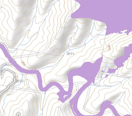
Waste
The Statement
of Environmental Effects indicates that guests will be encouraged to take
wastes with them when they leave the farm stay, but bins/receptacles will also
be provided on site. Organics will be composted on site and used on the
vegetable/fruit gardens. The cleaner will remove any recyclables and waste left
at the farm stay and take it to an approved waste facility for
disposal/recycling. Wastes are not to be buried or burnt on the premises.
Standard
precautionary site management conditions recommended for construction and
operational waste.
Energy
No
adverse impacts anticipated.
Noise
and vibration
The
construction and/or operations of the proposed development will not result in
any significant adverse impacts on the existing air quality or result in any
pollution. Standard precautionary site management condition recommended.
Bushfire
The
site is identified as being bushfire prone.
In
accordance with Section 100B of the Rural Fires Act 1997, the
application proposes development for a special fire protection purpose. The
applicant has submitted a bushfire report with the application. The report was
forwarded to the NSW Rural Fire Service (RFS) who have since issued a Bushfire
Safety Authority, subject to conditions. The RFS requirements include:
· Establishment and maintenance of an asset protection zone
around the refuge building;
· Construction of the refuge building in accordance with
AS3959;
· Vehicular access in accordance with Planning for Bush Fire
Protection;
· Water and utility services;
· Emergency and evacuation planning.
A
condition has been recommended incorporating the RFS requirements.
Safety,
security and crime prevention
The
proposed development will be unlikely to create any concealment/entrapment
areas or crime spots that would result in any identifiable loss of safety or
reduction of security in the immediate area.
Social
impacts in the locality
Given
the nature of the proposed development and its location the proposal is not
considered to have any significant adverse social impacts.
Economic
impact in the locality
The
proposal is not considered to have any significant adverse economic impacts on
the locality. A likely positive impact is that the development will maintain
employment in the construction industry, which will lead to flow impacts such
as expenditure in the area.
Site
design and internal design
The
proposed development design satisfactorily responds to the site attributes and
will fit into the locality.
Construction
Construction
impacts are considered capable of being managed, standard construction and site
management conditions have been recommended.
Cumulative
impacts
The
proposed development is not considered to have any significant adverse
cumulative impacts on the natural or built environment or the social and
economic attributes of the locality.
(c) The
suitability of the site for the development
The proposal will fit into the
locality and the site attributes are conducive to the proposed development.
Site constraints have been
adequately addressed and appropriate conditions of consent recommended.
(d) Any
submissions made in accordance with this Act or the Regulations
Five (5) written submissions were received following public exhibition of the
application. Copies of the written submissions have been provided separately to
members of the DAP.
Key
issues raised in the submissions received and comments are provided as follows:
|
Submission
Issue/Summary
|
Planning
Comment/Response
|
|
Support the proposed
development for the following reasons:
· Reason 1) The Project displays a unique design and
attraction to the region and area of the Hastings valleys. I love the
architecture design and landscape concept.
· Reason 2) The development outcome will positively
contribute to sustainability. The idea of people enjoying the local Toms
Creek and picnic spot provided by the development is consistent with the
overall outcomes of the neighbourhood plans which we are a community. Nature
Domes encourages the community to enjoy sleeping under the stars and with
nature. I support good development outcomes that lead to healthier and more
environmentally sustainable region.
· Reason
3) The Proposal is innovative. The Landscape concept plan includes native
species and an innovative nature and environment and healthy lifestyle. This
is a great opportunity to promote our area to the locals and to visitors this
allows Port Macquarie to offer innovative accommodation to travellers and
advanced design solution.
· Reason 4) The development will result in Community Extras
(including open picnic spot next to Toms Creek for Tourist to stop and rest,
public art classes in the rainforest, and much needed support for tourism to
increase revenue to a much need drought affected region. Local small
businesses in Long Flat and Comboyne and Byabarra will have increase in foot
traffic as guest are travelling for all areas of Australia and Overseas.
|
Noted.
|
|
Support the development for the following reasons:
· There is no or very little accommodation in the area.
· The community is very small and should there be something
exciting to visit and enjoy nature at the same time and well that’s
just so very positive on the Council and community in which all belong to.
· It’s very nice to see something new and effective
for tourist to enjoy and to share with people from out of town.
· It was all such a great concept to appreciate nature and
to have accommodation is just a bonus to sleep amongst the stars we miss out
on that in the city.
|
Noted.
|
|
Support the proposal for the following reasons:
· This vision will help coordinate local awareness of
farmers and demonstrate efforts to collaborate with nature.
· This is a specific idea, will boost a very tough area
with new money and will continue to show people the importance of this region
and habitat there are dedicated to building and ensuring great service to the
people of Port Macquarie and surrounding.
· It will bring an important resources and there is strong
customer focus and care to all involvement, professional with all
that’s been seen so far and hopefully for the future.
|
Noted.
|
|
Support the proposal for the following reasons:
· It’s a brilliant way to see the local landscape and
to experience an overnight stay in the hinterland with farmers.
· The development provides a compromise between camping and
other forms of accommodation.
· It is great for the community to show off its local
attractions and great recreation spots to visit and sight see. Nature Domes
is a peaceful alternative to the busy streets and great that there could be
an option to experience ocean and country all in one holiday.
|
Noted
|
|
What is Council doing about the illegal building which is
being used as permanent accommodation?
|
The building was erected as a farm shed, which did not
initially require development consent. However, it appeared from the site
inspection that the shed had been fitted out in a manner that would make it
capable of being occupied as a dwelling.
Clarification was sought as to the intended use of the
building through the assessment process, and the application now seeks to
retain the building as amenities for workers on the farm. A condition has
been recommended restricting the use of the building to this purpose, and
prohibiting overnight accommodation or conversion to a dwelling.
|
|
The dome accommodation is still in operation.
|
Council’s Compliance staff have been monitoring the
use of the site since the Order was issued in July 2019 and have not been
able to obtain any evidence of further use of the accommodation domes.
|
|
Income figures provided in the application are not
correct. The farm only has 6 weaner cattle and 2 pigs. The agistment of stock
referenced in the original farm business plan never actually occurred.
|
The farm business plan has been amended through the
assessment process to better reflect stocking rates consistent with NSW
Department of Primary Industries guidelines. The proposal no longer relies
upon income from agistment of stock.
|
|
The farm is not a viable rural property as a large
proportion is overgrown with weeds and dense vegetation.
|
The definition of farm stay accommodation in the LEP does
not require the consent authority to be satisfied that the farm is a viable
business. The relevant test is that the property is a working farm, and that
the income from the farm exceeds the income from the accommodation. The
Applicant has submitted sufficient information to satisfy this requirement.
|
|
If creek crossings are used, who maintains them with bridges
or causeways to Council approval?
|
With the amended proposal and recommended conditions of
consent, no new creek crossings will be required for the development.
|
|
Concerns about boundary gates being left open or guests
trespassing on adjoining property.
|
This is considered capable of being managed through
appropriate information for guest staying on the property, or through
agreement between the property owners for alterations to the existing
boundary fencing.
|
|
With the additional traffic generated by the proposal,
will it be necessary for the mountain section of Toms Creek road to be
upgraded? The road is currently sign posted as four wheel drive only.
|
The proposed development will only result in a minor
increase in the existing traffic on Toms Creek Road (6 trips per day
according to the Guide to Traffic Generating Development). Two-wheel drive
access to the site is available from the Oxley Highway end of Toms Creek
Road. It is not considered that the development creates a nexus for the
upgrade of section of Toms Creek Road south of the site (connecting to Innes
View Road).
|
(e) The Public Interest
The proposed development
satisfies relevant planning controls and will not adversely impact on the wider
public interest.
(f) Ecologically
Sustainable Development and Precautionary Principle
Ecologically sustainable development requires the effective
integration of economic and environmental considerations in decision-making
processes.
The four principles of ecologically sustainable development
are:
· the
precautionary principle,
· intergenerational
equity,
· conservation
of biological diversity and ecological integrity,
· improved
valuation, pricing and incentive mechanisms.
The principles of ESD require that a balance needs to be
struck between the man-made development and the need to retain the natural
vegetation. Based on the assessment provided in the report and with recommended
conditions of consent, it is considered an appropriate balance has been struck.
(g) Climate change
The proposal is not considered to be vulnerable to any risks
associated with climate change.
4. DEVELOPMENT
CONTRIBUTIONS APPLICABLE
· Development contributions will be required in accordance
with Section 7.11 of the Environmental Planning and Assessment Act 1979 towards
roads, open space, community cultural services, emergency services and
administration buildings.
·
· A copy of the contributions estimate is included as Attachment
3.
·
5. CONCLUSION AND
STATEMENT OF REASON
The application has been assessed in accordance with Section
4.15 of the Environmental Planning and Assessment Act 1979.
Issues raised during assessment and public exhibition of the
application have been considered in the assessment of the application. Where
relevant, conditions have been recommended to manage the impacts attributed to
these issues.
The site is considered suitable for the proposed development
and the proposal adequately addresses relevant planning controls. The
development is not considered to be contrary to the public's interest and will
not result a significant adverse social, environmental or economic impact. It
is recommended that the application be approved, subject to the recommended
conditions of consent provided in the attachment section of this report.
|
Attachments
1⇩. DA2019 - 681.1
Recommended Conditions DA2019 - 681.1
Recommended Conditions
2⇩. DA2019 - 681.1 Plans DA2019 - 681.1 Plans
3⇩. DA2019 - 681.1
Contributions Estimate
|
|
ATTACHMENT
|
Development Assessment Panel
14/10/2020
|
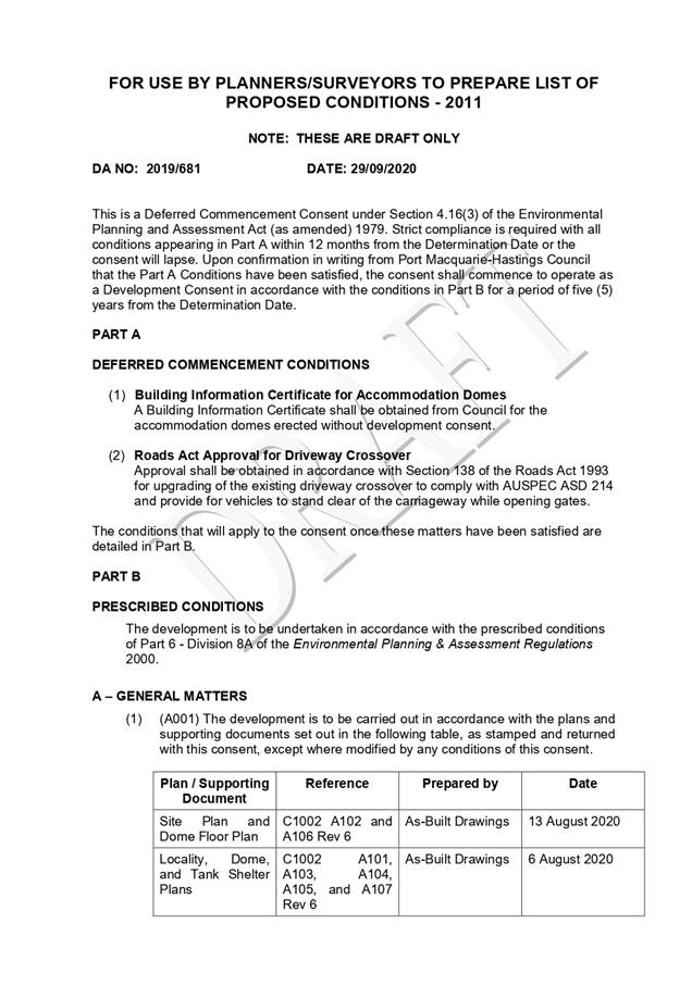
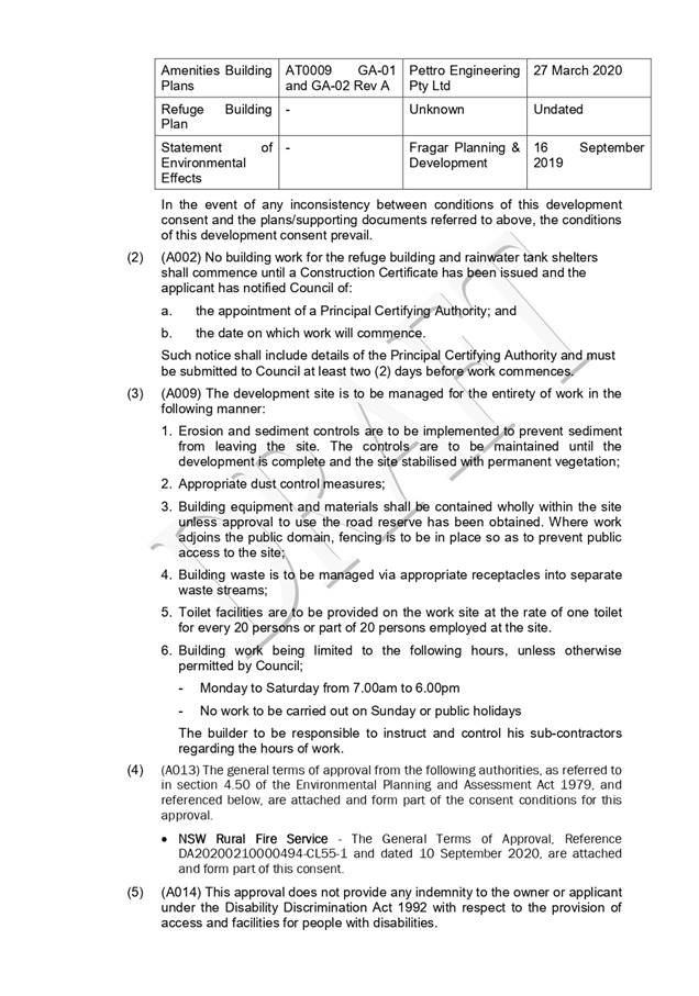
|
ATTACHMENT
|
Development Assessment Panel
14/10/2020
|
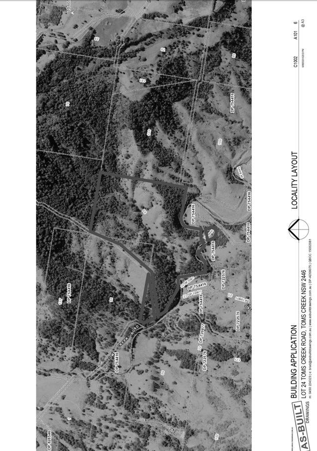
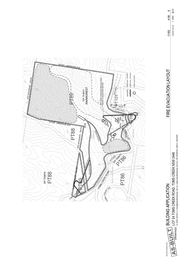
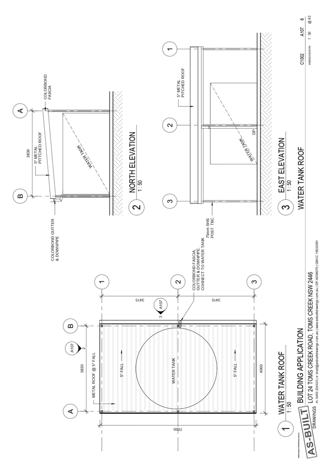
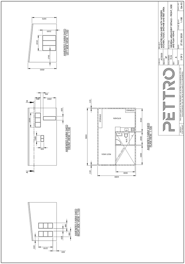
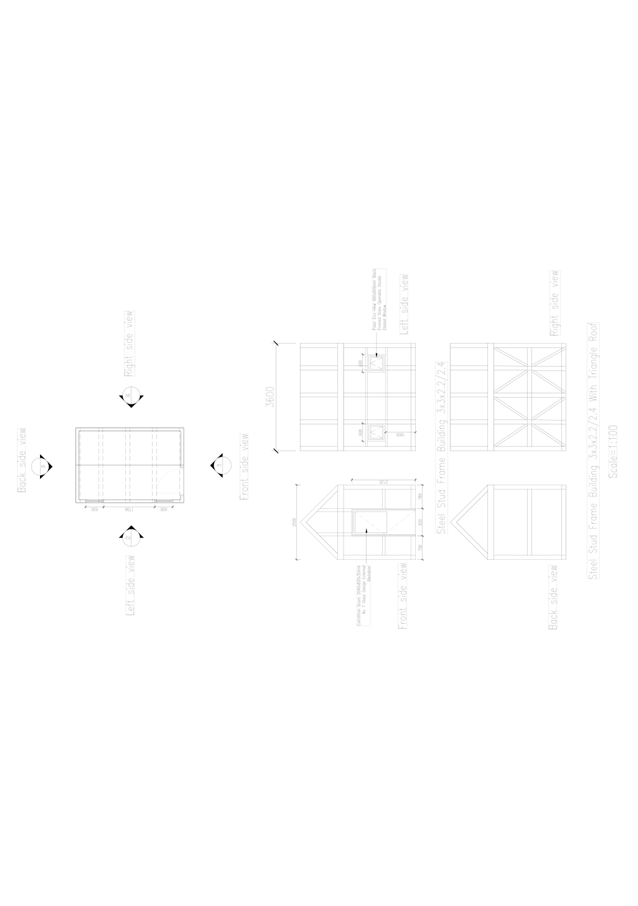
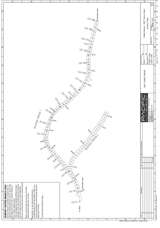
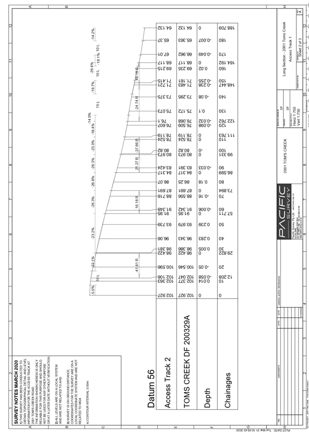
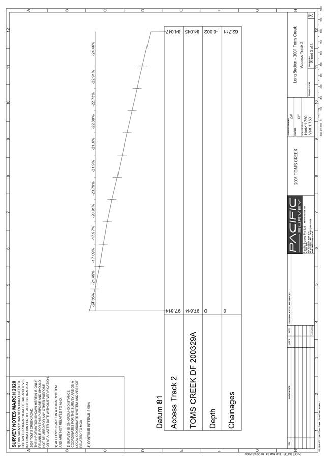
|
ATTACHMENT
|
Development Assessment Panel
14/10/2020
|
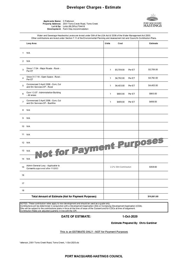
AGENDA Development Assessment Panel 14/10/2020
Item: 08
Subject: DA2020 - 433.1 Alterations and Additions to
Dwelling, Part Change of Use to Secondary Dwelling and Construction of Swimming
Pool Including Clause 4.6 Objection to Clause 4.3 (Height of Buildings) of the
Port Macquarie-Hastings Local Environmental Plan 2011 at Lot 392 DP 236950, No.
1 Vendul Crescent, Port Macquarie
Report
Author: Development Assessment Planner, Chris Gardiner
|
Applicant: D
J & J Weatherley
Owner: D
J & J Weatherley
Estimated Cost: $475,000
Alignment with Delivery
Program
4.3.1 Undertake transparent and
efficient development assessment in accordance with relevant legislation.
|
RECOMMENDATION
That
it be recommended to Council that DA2020 - 433.1 for alterations and additions to dwelling, part change of
use to secondary dwelling and construction of swimming pool including Clause
4.6 Objection to Clause 4.3 (Height of Buildings) of the Port Macquarie-Hastings
Local Environmental Plan 2011 at Lot 392, DP 236950, No. 1 Vendul Crescent, Port
Macquarie, be determined by granting consent
subject to the recommended conditions.
Executive
Summary
This
report considers a development application for alterations and additions
to the existing dwelling, part change of use to a secondary dwelling and
construction of a swimming pool at the subject site
and provides an assessment of the application in accordance with the
Environmental Planning and Assessment Act 1979.
Following exhibition of the
application, no submissions were received.
The application includes a Clause
4.6 objection to Clause 4.3 (Height of Buildings) of the Port
Macquarie-Hastings Local Environmental Plan 2011. The variation to the standard
exceeds 10% and the application is required to be determined by Council
following consideration by the Development Assessment Panel.
The site is considered suitable for the proposed development
and the proposal adequately addresses relevant planning controls. The
development is not considered to be contrary to the public's interest and will
not result in a significant adverse social, environmental or economic impact.
This report recommends that the
development application be approved subject to the conditions in Attachment
1.
1. BACKGROUND
Existing
Sites Features and Surrounding Development
The site has an area of 562.8m2.
The
site is zoned R1 General Residential in
accordance with the Port Macquarie-Hastings Local Environmental Plan 2011, as shown
in the following zoning plan:
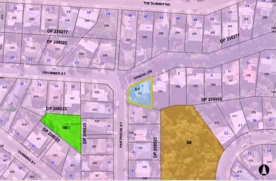
The
existing subdivision pattern and location of existing development within the
locality is shown in the following aerial photograph:
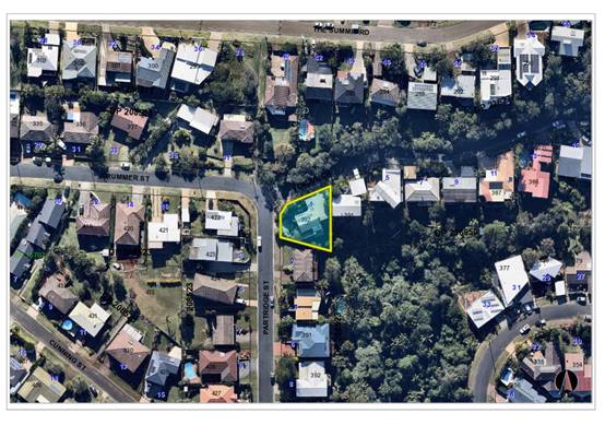
2. DESCRIPTION
OF DEVELOPMENT
Key
aspects of the proposal include the following:
· Alterations
and additions to dwelling;
· Conversion
of part of the ground floor area to a secondary dwelling; and
· Construction
of a new swimming pool and fencing.
Refer
to Attachment 2 at the end of this report for plans of the proposed
development.
Application
Chronology
· 1
June 2020 - Application lodged.
· 15 June 2020 to 29 June 2020 - Neighbour notification.
3. STATUTORY
ASSESSMENT
Section
4.15(1) Matters for Consideration
In
determining the application, Council is required to take into consideration the
following matters as are relevant to the development that apply to the land to
which the development application relates:
(a) The
provisions (where applicable) of:
(i) Any
Environmental Planning Instrument
State
Environmental Planning Policy (Koala Habitat Protection) 2019
Clause
10 - The site isn’t identified on the Koala Development Application Map
or under a Koala Plan of Management and the land has an area less than 1
hectare including adjoining land in the same ownership. The SEPP does not
prevent the granting of consent on the land being less than 1 hectare in area.
The application has also demonstrated that no habitat will be removed or
modified therefore no further investigations are required.
State
Environmental Planning Policy No. 55 – Remediation of Land
Following
an inspection of the site and a search of Council records, the subject land is
not identified as being potentially contaminated and is suitable for the
intended use.
State
Environmental Planning Policy (Coastal Management) 2018
The
site is not within areas mapped as a wetland or littoral rainforest area.
However, it is located within a proximity area for littoral rainforests. The
south-eastern tip of the site is mapped as Coastal Use Area.
In
accordance with clause 7, this SEPP prevails over the Port Macquarie-Hastings
LEP 2011 in the event of any inconsistency.
In
accordance with Clause 11, the proposed development is not expected to
significantly impact the biophysical, hydrological or ecological integrity of
the adjacent littoral rainforest, or the quality or quantity of water flows to
or from the adjacent littoral rainforest. The proposed works are contained
within the managed yard of an existing dwelling and conditions have been
recommended to ensure adequate stormwater management and erosions and sediment
control.
Having
regard to clause 14 of the SEPP, the proposed development is not considered
likely to result in any of the following:
a) any adverse impact on integrity and resilience of the biophysical,
hydrological (surface and groundwater) and ecological environment;
b) any adverse impacts coastal environmental values and natural coastal
processes;
c) any adverse impact on marine vegetation, native vegetation and fauna and
their habitats, undeveloped headlands and rock platforms;
d) any adverse impact on Aboriginal cultural heritage, practices and places;
e) any adverse impacts on the cultural and built environment heritage;
f) any adverse impacts the use of the surf zone;
g) any adverse impact on the visual amenity and scenic
qualities of the coast, including coastal headlands;
h) overshadowing, wind funnelling and the loss of views from
public places to foreshores;
i) any adverse impacts on existing public open space and safe access to and
along the foreshore, beach, headland or rock platform for members of the
public, including persons with a disability;
In
accordance with Clause 15 the proposal is not likely to cause increased risk of
coastal hazards on that land or other land.
The
bulk, scale and size of the proposed development is compatible with the
existing built form. The site has an existing dwelling on it and is located
within an area zoned for residential purposes.
State
Environmental Planning Policy (Building Sustainability Index: BASIX) 2004
A
BASIX certificate has been submitted demonstrating that the proposal will
comply with the requirements of the SEPP. It is recommended that a condition be
imposed to ensure that the commitments are incorporated into the development
and certified at Occupation Certificate stage.
State
Environmental Planning Policy (Affordable Rental Housing) 2009
Clause
20 - The site is in a prescribed zone and secondary dwellings are permissible
with consent pursuant to the SEPP.
Clause
22(2) - The development would not result in there being a dwelling other than
the primary dwelling and the secondary dwelling.
Clause
22(3) - The proposed secondary dwelling would not have a floor area exceeding
60m2 and the combined floor area of the primary and secondary
dwelling would not exceed the maximum permitted under the Port
Macquarie-Hastings Local Environmental Plan 2011 (see comments below under
LEP).
Clause
22(4) - It is noted that consent cannot be refused on the grounds of site area
or parking.
Clause
24 - It is noted that the consent authority must not consent to a development
application that would result in any subdivision of a lot on which development
for the purposes of a secondary dwelling has been carried out.
The
requirements of this SEPP are therefore satisfied.
Port Macquarie-Hastings Local Environmental Plan 2011
The
proposal is consistent with the LEP having regard to the following:
· Clause 2.2 - The subject site is zoned R1 General
Residential.
· Clause 2.3(1) and the R1 zone landuse table - The dwelling
house and secondary dwelling are permissible land uses with consent.
The objectives of the R1 zone are as follows:
o To provide for the housing needs of the community.
o To provide for a variety of housing types and densities.
o To enable other land uses that provide facilities or
services to meet the day to day needs of residents.
· Clause 2.3(2) - The proposal is consistent with the
zone objectives as it provides a variety of housing types to meet the housing
needs of the community.
· Clause 4.3 - The maximum overall height of the building
above ground level (existing) is 11.75m, which exceeds the standard height
limit of 8.5 m applying to the site by 38%. A Clause 4.6 assessment is provided
below, which concludes that the proposed roof extension over the rear deck is
minor, and retains open areas. The height is consistent with a number of other
dwellings in the neighbourhood and is a reflection of the steep topography of
the area.
· Clause 4.4 - The floor space ratio of the proposal is
0.55:1 which complies with the maximum 0.65:1 floor space ratio applying to the
site.
· Clause 4.6 - This clause establishes a degree of
flexibility for certain development standards in certain circumstances which
have demonstrated that a better planning outcome will occur from that
flexibility. In this regard, the proposal seeks a variation to the building
height standard. Assistance on the approach to variation to this standard is
also taken from NSW Land and Environment Court and NSW Court of Appeal decisions
in:
1. Wehbe
v Pittwater Council (2007) NSW LEC 827 (Wehbe);
2. Four2Five
Pty Ltd v Ashfield Council (2015) NSWLEC 1009; and
3. Al
Maha Pty Ltd v Huajun Investments Pty Ltd (2018) NSWCA 245
Having regard to
specific requirements of clause 4.6(3) and 4.6(4) the following assessment
comments are provided:
(3)
Development consent must not be granted for development that contravenes a
development standard unless the consent authority has considered a written
request from the applicant that seeks to justify the contravention of the
development standard by demonstrating:
(a) that compliance with the development standard is
unreasonable or unnecessary in the circumstances of the case, and
(b) that there are sufficient environmental planning grounds
to justify contravening the development standard.
Comments:
The Applicant has submitted a request in writing (Attachment 3) to
justify the contravention of the building height standard for the following
reasons (as summarised):
· Compliance with
the development standard in unnecessary in the circumstances of the case as the
proposal satisfies the objectives of Clause 4.3 notwithstanding the numerical
variation.
· Compliance with
the development standard is unreasonable and unnecessary due to other height
variations approved by Council in the locality. The Clause 4.6 written request
includes a number of examples of approved buildings exceeding the height limit
in the Lighthouse Beach area.
· The proposed roof
addition over the existing upper floor balcony has been designed to be
substantially open/openable to reflect the existing situation.
· The site slopes
steeply from north to south.
· The existing
building already exceeds the height limit and the proposed deck addition will
sit below the roof of the existing dwelling.
· The provision of
shade to an outdoor area will help reduce the incidence of skin cancer and
improve the welfare of the community.
(4)
Development consent must not be granted for development that contravenes a
development standard unless:
(a) the
consent authority is satisfied that:
(i) the
applicant’s written request has adequately addressed the matters required
to be demonstrated by subclause (3),
In Wehbe
five methods have been developed to test whether compliance with a development
standard is unreasonable or unnecessary:
1. The objectives of the standard are achieved
notwithstanding the non-compliance with the numerical standard and therefore
compliance is unnecessary.
2. The underlying objective or purpose of the standard is not
relevant to the development and therefore compliance is unnecessary.
3. The underlying object or purpose of the standard would
be defeated or thwarted if compliance was required and therefore compliance is
unreasonable.
4. The development standard has been virtually abandoned or
destroyed by the Council’s own actions in granting a consent to proposals
departing from the standard and hence compliance is unreasonable and
unnecessary.
5. The zoning of the particular land is unreasonable or
inappropriate so that a development standard appropriate for that zoning is
also unreasonable and unnecessary as it applies to the land.
The
proposal relies upon the first and fourth tests and it is considered that the
Applicant’s written request had satisfactorily demonstrated that that the
proposed development will achieve the objectives of the height of building
development standard despite the numerical non-compliance. Evidence has also
been provided of a history of departures from the height of building standard
on similar steeply sloping sites in the Lighthouse Beach area. However, the
number of departures is not considered to constitute a total abandonment of the
development standard by Council, particularly given that the variations have
been appropriately considered in accordance with Clause 4.6. Notwithstanding
this, the first test alone is sufficient to establish that compliance with the
standard is unnecessary.
The
written request also demonstrates that there are sufficient environmental
planning grounds for the variation, with the steep topography and height of the
existing dwelling being of particular merit. In relation to the comments
relating to providing shade to outdoor areas and reducing the incidence of skin
cancer in the community, this is an important message more broadly, but it is
not considered to add any weight to the case for varying the development
standard in this instance. The area is for private use and the shade
wouldn’t provide a broader public benefit to the community. There are also
a number of opportunities to provide shade to outdoor spaces on the site below
the height limit.
Overall,
it is considered that the Applicant’s clause 4.6 variation has adequately
addressed the matters required to be demonstrated by clause 4.6(3).
(ii) the
proposed development will be in the public interest because it is consistent
with the objectives of the particular standard and the objectives for
development within the zone in which the development is proposed to be carried
out,
The consistency of the
proposal with the zone objectives has been discussed above under Clause 2.3.
Consideration of the proposal’s consistency with the objectives of height
of buildings standard (Clause 4.3) is provided as follows:
(a) to ensure that buildings are compatible with the height, bulk
and scale of the existing and desired future character of the locality,
Comments:
The height of the proposed building is not out of character with
existing development in the area. There are a number of examples of buildings
on steeply sloping sites in the area, which are 3 to 4 storeys at the rear. The
height of the roof over the upper floor balcony is lower in terms of RL that
the ridge of the curved roof of the existing dwelling. The roof has been
designed to be largely open to reduce its bulk. The bulk and scale of the
proposal is considered to be acceptable and is below the maximum permitted FSR
for the area.
The building would
continue to present as a two-storey dwelling to the primary street frontage in
Vendul Crescent
(b) to minimise visual impact, disruption of views, loss of
privacy and loss of solar access to existing development,
Comments:
The impact of the building is considered satisfactory for the following
reasons:
1. The
development will not result in an increased loss of solar access to adjoining
property. The adjoining dwelling to the south of the site has no living area
windows on its northern elevation and has its main indoor and outdoor living
spaces oriented towards the views to the south and east.
2. The
proposal will not result in the disruption of any significant views. The roof
addition is located below the level of the top of the existing roof of the
dwelling and will not be visible from any angle where key views are obtained
across the property.
3. Potential
privacy impacts have been satisfactorily addressed in the building design. The
height variation would not contribute to any adverse privacy impacts, as it is
the deck that creates the potential privacy impact rather than the proposed
roof addition.
4. Neighbour
notification of the proposal did not identify any concerns regarding loss of
amenity to nearby properties.
(c) to
minimise the adverse impact of development on heritage conservation areas and
heritage items,
Comments: The site does not contain any known
heritage items or sites of significance.
(d) to
nominate heights that will provide a transition in built form and land use
intensity within the area covered by this Plan.
Comments: The site is
surrounded by land with similar zoning and building height controls and is not
in a location where development provides a transition in built form or land use
intensity.
The development is
consistent with the zoning and height objectives of the LEP 2011 and is
unlikely to have any implications on State related issues or the broader public
interest.
(b) the
concurrence of the Secretary has been obtained.
Comments: In
accordance with Planning Circular PS 20-002, the Secretary’s concurrence
can be assumed for variations to the height of buildings development standard.
However, as the extent of the variation exceeds 10% the application is required
to be determined by Council, to ensure that there is transparency in the
decision-making process.
Having regard to the
above requirements it is recommended that the height variation using Clause 4.6
be supported.
· Clause 5.4 - The proposed secondary dwelling has a floor
area of 60m2 and does not exceed 33% of the total floor area of the principal
dwelling.
· Clause 5.10 - Heritage. The site does not contain or adjoin
any known heritage items or sites of significance.
· Clause 7.1 - The site is not mapped as containing any areas
of potential acid sulfate soils.
· Clause 7.6 - The site is not mapped as being impacted by
Coastline Hazards.
· Clause 7.9 - The site is not mapped as being in an area
subject to acoustic controls.
· Clause 7.13 - Satisfactory arrangements are in place for
provision of essential services including water supply, electricity supply,
sewer infrastructure, stormwater drainage and suitable road access to service
the development.
(ii) Any draft
instruments that apply to the site or are on exhibition
No draft instruments apply to
the site.
(iii) Any Development
Control Plan in force
Port
Macquarie-Hastings Development Control Plan 2013
|
DCP 2013: Part C -
Development Specific Provisions - C1: Low Density Residential Development
|
|
DCP Objective
|
Development Provisions
|
Proposed
|
Complies
|
|
Front Setbacks
|
|
44
|
a) Dwellings may incorporate
an articulation zone to a street frontage at no less than 3m from property
boundary. The following building elements are permitted within the
articulation zone:
- an entry
feature or portico;
- a balcony,
deck, patio, pergola, terrace or verandah;
- a window
box treatment;
- a bay
window or similar feature;
- an awning
or other feature over a window;
- a sun
shading feature.
b) These building elements
should not extend above the eave gutter line, other than a pitched roof to an
entry feature or portico that has the same pitch as the roof on the dwelling
house.
|
No building works are proposed
within the 3m front articulation zone.
|
Yes
|
|
c) The primary road front
setback shall be:
Classified road = any frontage
6.0m
Primary frontage = 4.5m
Secondary frontage = 3.0m
Ancillary Lane = 2.0m
Large lot residential and
rural zones = 10.0m
|
Primary frontage - no
alteration to the existing garage setback to Vendul Crescent.
Secondary frontage - no
reduction to the secondary frontage setback is proposed.
|
N/A
|
|
45
|
a) A garage, carport or car
parking space should:
- be at least
1m behind the building line, where the dwelling(s) has a setback from a front
boundary of 4.5m or more, or
- be at least
5.5m from a front boundary, where the dwelling(s) has a setback of less than
4.5m.
|
There is no change proposed to
the location of the garage, garage door or driveway crossover.
|
N/A
|
|
b) The total width of the
garage/carport openings should not be more than 6m and not more than 50 per
cent of the width of the building.
|
There is no change proposed to
the location of the garage, garage door or driveway crossover.
|
N/A
|
|
c) Driveway crossovers are no
greater than 5.0m in width.
|
There is no change proposed to
the location of the garage, garage door or driveway crossover.
|
N/A
|
|
d) Where a dual occupancy or
attached dwelling is proposed on a corner lot a garage and driveway is
provided on each road frontage.
|
The granny flat is on the
ground level of the dwelling. It has a driveway onto Partridge Street. The
main dwelling has a driveway and garages onto Vendul Crescent.
|
Yes
|
|
Side and Rear Setbacks
|
|
46
|
a) A minimum rear boundary
setback of 4m is to be provided to dwellings (including verandahs, patios and
decks).
|
Minimum rear boundary does not
apply to corner lots.
|
N/A
|
|
b) A minimum rear boundary
setback of 900mm applies to sheds and swimming pools subject to achieving
minimum required private open space area.
|
N/A
|
N/A
|
|
c) Council may consider
varying rear setback requirements where it is demonstrated that the private
open space could achieve better solar access between the building and the
side setback. In that instance, one side setback should be a minimum 4m in
width (for an equivalent length of rear boundary, behind building line) and
the rear setback may be reduced to 900mm.
|
N/A
|
N/A
|
|
47
|
a) Ground floors (being <1m
above existing ground level) should be setback a minimum of 900mm from side
boundaries.
|
All side setbacks are greater
than 900mm from side boundary.
|
Yes
|
|
b) First floors and above
(including single storey with floor level >1m) should be setback a minimum
of 3m from the side boundary, or reduced down to 900mm where it can be
demonstrated that the adjoining property’s primary living rooms and
principal private open space areas are not adversely overshadowed for more
than 3hrs between 9am - 3pm on 21 June.
|
The existing north eastern
side setback is 1.485m from the side boundary (neighbouring Lot 391 DP
236950). This remains unchanged.
The south western most point
of the existing dwelling is 1.5m from the side boundary (neighbouring Lot 389
DP 208523).
The proposal is to provide a
roller shade cover over the balcony on the first floor (south east elevation)
and extended to full width of building at 10deg pitch. The corner of the roof
will be extended to the dwelling edge at 1.5m from the neighbouring boundary.
Due to the existing built form Lot 389 DP208523 is already overshadowed.
|
No, but
acceptable
|
|
c) First floors and above
should have building walls that step in and out at least every 12m by a
minimum of 500mm articulation. Where first floors and above are setback
>3m, wall articulation is not required.
|
No walls are unarticulated for
12m or greater.
|
Yes
|
|
Private Open Space
|
|
48.
|
a) All dwellings should have a
minimum area of private open space of 35m2, which includes a principal
private open space area with:
- a minimum
dimension of 4m x 4m, and
- a maximum
grade of 5% for minimum 4m x 4m of the total open space requirement, and
- direct
accessibility from a ground floor living area and orientated to maximise use.
|
Outdoor living space exceeds
35m2 and includes the pool area.
Granny flat has an existing
outdoor paved area to achieve the 4m x 4m area.
Proposal will provide better
connection from the main dwelling to the outdoor area on the southern side of
the dwelling.
|
Yes
|
|
|
b) Private open space may
include clothes drying areas and garbage storage.
|
Noted.
|
|
|
Public Domain and Fencing
|
|
49
|
a) Front fences built forward
of the building line for the primary road frontage should be detailed on the
development application plans.
|
Plan set includes fence
detail.
|
Yes
|
|
b) Solid Front fences up to
1.2m high should be:
- Setback
1.0m from the front boundary, and
- Suitably
landscaped to reduce visual impact, and
- Provide a
3m x 3m splay for corner sites.
|
Proposed fence 1.8m, refer to
provision below.
|
N/A
|
|
b) Front fences proposed to be
more than 1.2m high should be a maximum of 1.8m in height, above existing
front property boundary level, and either:
- Include
landscaped recesses having minimum dimensions of 1.8m long x 900mm deep which
occupy no less than 50% of the total length of the fence, or
- be erected
up to the front boundary for a maximum length of 6.0m or 50% of the street
frontage,
|
Vendul Crescent frontage will
include a pool fence and compliance for such.
Driveway is unfenced.
Fence is max 1.8m high and no
more than 50% of the length of the property boundary.
|
Yes
|
|
c) have openings which make it
not less than 25% transparent (no individual opening more than 30mm wide);
|
Fencing provides for
transparency and aligns with the splayed property boundary. The proposed
fencing will not fully comply with the requirement for 25% transparency, but
the fence is replacing an existing Colorbond fence that currently contains no
openings. The introduction of some transparency to the proposed fence is
considered to be an improvement to the current situation.
|
No, but acceptable
|
|
d) provide a 3m x 3m splay for
corner sites, and
|
Fence aligns with splayed
property boundary
|
Yes
|
|
e) provide a 900mm x 900mm
splay for vehicle driveway entrances.
|
Driveway is unfenced.
|
N/A
|
|
Bulk and Scale
|
|
51
|
a) Direct views between indoor
living rooms and principal private open space of adjacent dwellings,
including proposed dwellings approved on adjoining lots, including possible
dwellings on future lots, should be obscured or screened where:
- Ground and
first floor (and above) indoor living room windows are within a 9m radius.
- Direct
views between principal private open space areas where within a 12m radius.
- Direct
views between indoor living rooms of dwellings into the principal area of
private open space of other dwellings within a 12m radius.
|
Complies with ground and upper
floor privacy areas.
Lower areas to be screened by
fencing and orientation of windows.
|
Yes
|
|
b) A balcony, deck, patio,
pergola, terrace or verandah should have a privacy screen where there are
direct views of:
- Indoor
living room windows of adjacent dwellings, including proposed dwellings
approved on adjoining lots within 9m radius; or
- Principal
areas of private open space of adjacent dwellings, including proposed dwellings
approved on adjoining lots within a 12m radius.
|
Upper balcony area proposed to
include screening on the eastern end.
|
Yes
|
|
c) Privacy protection is not
required for:
- Any Indoor
living room windows with a sill height of greater than 1.5m above the finished
floor level of that room or where fixed non-openable translucent glass is
installed to the same height.
|
Noted.
|
|
|
d) Direct views described
above may be reduced or obscured by one of the following measures (details to
be submitted with the development application):
- 1.8m high
fence or wall between ground-floor level windows or between a dwelling and
principal private open space
- Screening
of minimum 1.7m height, that has 25% openings (max), with no individual
opening more than 30mm wide, is permanently fixed and is made of durable
materials.
- A window,
the whole of which has translucent glass and is not able to be opened.
|
Privacy screen on the eastern
end of the upper floor balcony complies with the screening requirements.
1.8m high fencing also
proposed for private open space areas of the primary and secondary dwellings.
|
Yes
|
|
DCP 2013: Part B -
General Provisions - B2: Environmental Management
|
|
|
DCP Objective
|
Development Provisions
|
Proposed
|
Complies
|
|
|
3
|
a) Development must comply
with Council’s Developments, Public Place & Events - Waste
Minimisation and Management Policy.
|
Kerbside collection will
remain unchanged.
|
Yes
|
|
|
Cut and Fill Regrading
|
|
|
4
|
a) Development shall not
exceed a maximum cut of 1.0m and fill of 1.0m measured vertically above the
ground level (existing) at a distance of 1.0m outside the perimeter of the
external walls of the building (This does not apply to buildings where such
cut and fill is fully retained within or by the external walls of the building).
|
Terraced landscaped areas are
proposed which exceed 1m of excavation outside the building footprint. The
works are below street level to Vendul Crescent and will not be prominent in
the streetscape. There are no adverse privacy impacts associated with the
earthworks, and appropriate conditions have been recommended to ensure the
stability of the retaining structures and appropriate stormwater management.
The proposal is considered to be consistent with the objectives of the
provision.
|
No, but acceptable.
|
|
|
5
|
a) A certified practicing
structural engineer must certify any retaining wall greater than 1.0m.
|
Condition recommended
requiring engineering certification of any retaining walls greater than 1m
high.
|
Yes
|
|
|
b) Where a combination of a
fence and a wall is proposed to be greater than 1.2m high:
- be a
maximum combined height of 1.8m above existing property boundary level;
- be
constructed up to the front boundary for a maximum length of 6.0m or 30% of
the street frontage, whichever is less;
− the
fence component has openings which make it not less than 25% transparent; and
− provide
a 3m x 3m splay for corner sites, and
- provide a
900mm x 900mm splay for vehicle driveway entrances.
|
The fencing along Vendul
Crescent will be on top of a retaining wall and the combination of the
retaining wall and fence will have a combined height that is greater than
1.8m. The proposal is considered acceptable as the wall is retaining cut
within the site and would not be visible in the streetscape. The fence will
still present as having a height of 1.8m when viewed from Vendul Crescent.
|
No, but acceptable
|
|
|
Bushfire Hazard Management
|
|
18
|
a) APZs are to be located
outside of environmental protection zones and wholly provided within private
land. Note perimeter roads provided as part of a residential subdivision are
classified as being part of the subdivision and not a separate permissible
land use within environment protection zones.
|
APZ for the dwelling does not
extend into any environmental protection zones.
|
Yes
|
|
b) Perimeter roads are to be
provided to all urban areas adjoining environmental management areas and
their buffers. Refer to Figure 2.
|
N/A
|
N/A
|
|
Road Hierarchy
|
|
23
|
a) New direct accesses from a
development to arterial and distributor roads is not permitted. Routes should
differ in alignment and design standard according to the volume and type of
traffic they are intended to carry, the desirable traffic speed, and other
factors.
|
N/A
|
N/A
|
|
b) Existing direct accesses
from a development to arterial and distributor roads are rationalised or
removed where practical.
|
N/A
|
N/A
|
|
c) Vehicle driveway crossings
are minimal in number and width (while being adequate for the nature of the
development), and positioned:
− to
avoid driveways near intersections and road bends, and
− to
minimise streetscapes dominated by driveways and garage doors, and
− to
maximise on-street parking.
|
Vehicular driveway crossings
remain unchanged.
|
Yes
|
|
Parking Provision
|
|
24
|
a) Off-street Parking is
provided in accordance with Table 3.
|
The existing dwelling has a
double garage accessed from Vendul Crescent.
The granny flat has an
existing separate off street parking space accessed from Partridge Street.
|
Yes
|
|
b) Where a proposed
development does not fall within any of the listed definitions, the provision
of on-site parking shall be supported by a parking demand study.
|
N/A
|
N/A
|
|
c) Where a proposed
development falls within more than one category Council will require the
total parking provision for each category.
|
N/A
|
N/A
|
|
Crime Prevention
|
|
43
|
a) The development addresses
the generic principles of crime prevention:
- Casual
surveillance and sightlines;
- Land use
mix and activity generators;
- Definition
of use and ownership;
- Basic
exterior building design;
- Lighting;
- Way-finding;
and
- Predictable
routes and entrapment locations;
- as
described in the Crime Prevention Through Environmental Design (CPTED)
principles.
|
No concealment or entrapment
areas proposed. Adequate casual surveillance available.
|
Yes
|
|
|
|
|
|
|
|
|
|
|
The
proposal seeks to vary Development Provision relating to earthworks, fencing,
and side building setbacks.
The
relevant objectives are:
Objective
4:
To
ensure that design of any building or structure integrates with the topography
of the land to:
- Minimise the extent of site disturbance caused by excessive
cut and fill to the site. Ensure there is no damage or instability to
adjoining properties caused by excavation or filling.
- Ensure that there is no adverse alteration to the drainage
of adjoining properties.
- Ensure the privacy of adjoining dwellings and private open
space are protected.
- Ensure that adequate stormwater drainage is provided around
the perimeter of buildings and that overflow paths are provided.
Having
regard for the development provisions and relevant objectives, the variation is
considered acceptable for the following reasons:
· The site has significant slope and it is difficult to
achieve usable outdoor spaces without large amounts of cut and fill.
· The variation relates to excavation adjacent to the Vendul
Crescent frontage and the retaining walls would not be visible from the public
domain.
· The excavation would not create any adverse privacy
impacts.
· The proposed excavation would not affect stormwater flows
around the building.
· Appropriate conditions have been recommended requiring
engineering certification of the retaining walls, to ensure that the land is
satisfactorily stabilised.
Objective
5:
To
ensure retaining walls are functional, safe and positively contribute to the
development and/or the streetscape.
Having
regard for the development provisions and relevant objectives, the variation is
considered acceptable for the following reasons:
· The retaining walls will requiring engineering certification
to ensure that they are functional and safe.
· The proposal the proposal includes excavation below street
level along the Vendul Crescent frontage. The retaining wall would not be
visible from the public domain and the fencing would present as 1.8m high when
view from the street.
Objective
47:
To
reduce overbearing and perceptions of building bulk on adjoining properties.
To
provide for visual and acoustic privacy between dwellings.
Having
regard for the development provisions and relevant objectives, the variation is
considered acceptable for the following reasons:
· The proposal would not significantly alter the bulk of the
existing dwelling, and includes only a minor increase to the existing floor
area of the building.
· The roof addition over the upper floor balcony has been
designed to be largely open (including pergola and retractable shade sail).
This addition will not present as adding to the bulk of the building.
· The proposal will improve privacy between the upper floor
balcony and the adjoining dwelling to the east, with provision of a full height
privacy screen at the eastern end.
Based
on the above assessment, the variations proposed to the provisions of the DCP
are considered acceptable and the relevant objectives have been satisfied.
Cumulatively, the variations do not amount to an adverse impact of a
significance that would justify refusal of the application.
(iiia) Any planning agreement that has
been entered into under section 7.4, or any draft planning agreement that a developer
has offered to enter into under section 7.4
No planning agreement has been
offered or entered into relating to the site.
(iv) Any
matters prescribed by the Regulations
Demolition
of buildings AS 2601 - Clause 92
Demolition of the existing building
elements on the site is capable of compliance with this Australian Standard and
is recommended to be conditioned.
(b) The likely
impacts of that development, including environmental impacts on both the
natural and built environments, social and economic impacts in the locality
Context
and setting
The
proposal will not have any significant adverse impacts on existing adjoining
properties and satisfactorily addresses the public domain.
The
topography in this area is such that dwellings are often stepped to match the
land, which results in multi-level housing that exceeds the height limit. The
existing dwelling and proposed alterations and additions are consistent with
the local context, which includes dwellings constructed over three to four levels
in places. The proposal adequately addresses the objectives of the planning
controls for the area.
The
proposal does not have a significant adverse impact on existing view sharing.
The
proposal does not have significant adverse lighting impacts.
There
are no significant adverse privacy impacts.
There
are no significant adverse overshadowing impacts. The existing dwelling already
substantially overshadows the adjoining property to the south, and given the
nature of the building additions below the highest part of the existing roof
line, it is not expected that the proposal would significantly change the
existing impacts. The adjoining dwelling has no windows in the northern
elevation and is generally oriented towards the views to the south-east.
Access,
traffic and transport
The
proposal will not have any significant adverse impacts in terms access,
transport and traffic. The existing road network will satisfactorily cater for
any increase in traffic generation as a result of the development.
Water
supply connection
The
site has an existing water supply connection. New plumbing associated with the
development will require a Section 68 application, as recommended in the
conditions.
Sewer
connection
The
site has an existing sewer connection. New plumbing associated with the
development will require a Section 68 application, as recommended in the
conditions.
Stormwater
The
building is currently drained to a kerb adaptor in Vendul Crescent. The
proposed building additions are capable of draining to the existing stormwater
system serving the site. Details will be required with the Section 68
application, as recommended in the conditions.
Other
utilities
Telecommunication
and electricity services are available to the site.
Heritage
This
site does not contain or adjoin any known heritage item or site of
significance. The site is considered to be disturbed land.
Other
land resources
The
site is within an established urban context and will not sterilise any
significant mineral or agricultural resource.
Water
cycle
The
proposed development will not have any significant adverse impacts on water
resources and the water cycle.
Soils
The
proposed development will not have any adverse impacts on soils in terms of
quality, erosion, stability and/or productivity subject to a standard condition
requiring erosion and sediment controls to be in place prior to and during
construction.
Air
and microclimate
The
construction and/or operations of the proposed development will not result in
any significant adverse impacts on the existing air quality or result in any
pollution. Standard precautionary site management condition recommended.
Flora
and fauna
Construction
of the proposed development will not require any removal/clearing of any native
vegetation and therefore does not trigger the biodiversity offsets
scheme. Part 7 of the Biodiversity Conservation Act 2016 is considered to
be satisfied.
Waste
Satisfactory
arrangements are in place for proposed storage and collection of waste and
recyclables. No adverse impacts anticipated. Standard precautionary site
management condition recommended.
Energy
The
proposal includes measures to address energy efficiency and will be required to
comply with the requirements of BASIX.
Noise
and vibration
The construction
of the proposed development will not result in any significant adverse impacts
on the existing air quality or result in any pollution. Standard precautionary
site management condition recommended.
Bushfire
The
site is identified as being bushfire prone.
The
Applicant has submitted a Section 4.14 bushfire certificate prepared by a
Certified Consultant. The certificate concludes that a Bushfire Attack Level 29
shall be required.
Management
of bushfire risk is acceptable subject to BAL construction levels being
implemented and APZ being maintained. An appropriate condition is recommended.
Safety,
security and crime prevention
The
proposed development will be unlikely to create any concealment/entrapment
areas or crime spots that would result in any identifiable loss of safety or
reduction of security in the immediate area.
Social
impacts in the locality
Given
the nature of the proposed development and its location the proposal is not
considered to have any significant adverse social impacts.
Economic
impact in the locality
The
proposal is not considered to have any significant adverse economic impacts on
the locality. A likely positive impact is that the development will maintain
employment in the construction industry, which will lead to flow impacts such
as expenditure in the area.
Site
design and internal design
The
proposed development design satisfactorily responds to the site attributes and
will fit into the locality. No adverse impacts likely.
Construction
Construction
impacts are considered capable of being managed, standard construction and site
management conditions have been recommended.
Cumulative
impacts
The
proposed development is not considered to have any significant adverse
cumulative impacts on the natural or built environment or the social and
economic attributes of the locality.
(c) The
suitability of the site for the development
The proposal will fit into the
locality and the site attributes are conducive to the proposed development.
Site constraints of bushfire have
been adequately addressed and appropriate conditions of consent recommended.
(d) Any
submissions made in accordance with this Act or the Regulations
No written
submissions were received following public exhibition of the application.
(e) The Public Interest
The proposed development
satisfies relevant planning controls and will not adversely impact on the wider
public interest.
(f) Ecologically
Sustainable Development and Precautionary Principle
Ecologically sustainable development requires the effective
integration of economic and environmental considerations in decision-making
processes.
The four principles of ecologically sustainable development
are:
· the
precautionary principle,
· intergenerational
equity,
· conservation
of biological diversity and ecological integrity,
· improved
valuation, pricing and incentive mechanisms.
The principles of ESD require that a balance needs to be
struck between the man-made development and the need to retain the natural
vegetation. Based on the assessment provided in the report and with recommended
conditions of consent, it is considered an appropriate balance has been struck.
(g) Climate change
The proposal is not considered to be vulnerable to any risks
associated with climate change.
4. DEVELOPMENT CONTRIBUTIONS
APPLICABLE
Development
contributions will not be required under S64/S7.11 for the following reasons:
· The proposed secondary dwelling has a floor area not
exceeding 60m2 and is exempt from development contributions in
accordance with Clause 2.5 of Council’s Development Contributions
Assessment Policy.
5. CONCLUSION AND
STATEMENT OF REASON
The application has been assessed in accordance with Section
4.15 of the Environmental Planning and Assessment Act 1979.
Issues raised during assessment and public exhibition of the
application have been considered in the assessment of the application. Where
relevant, conditions have been recommended to manage the impacts attributed to
these issues.
The site is considered suitable for the proposed development
and the proposal adequately addresses relevant planning controls. The
development is not considered to be contrary to the public's interest and will
not result a significant adverse social, environmental or economic impact. It
is recommended that the application be approved, subject to the recommended
conditions of consent provided in the attachment section of this report.
|
Attachments
1⇩. DA 2020 - 433.1
Recommended Conditions
2⇩. DA2020 - 433.1 Plans
3⇩. DA2020 - 433.1
Clause 4.6 Written Request
|
|
ATTACHMENT
|
Development Assessment Panel
14/10/2020
|
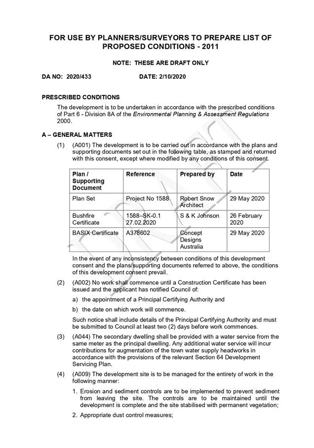
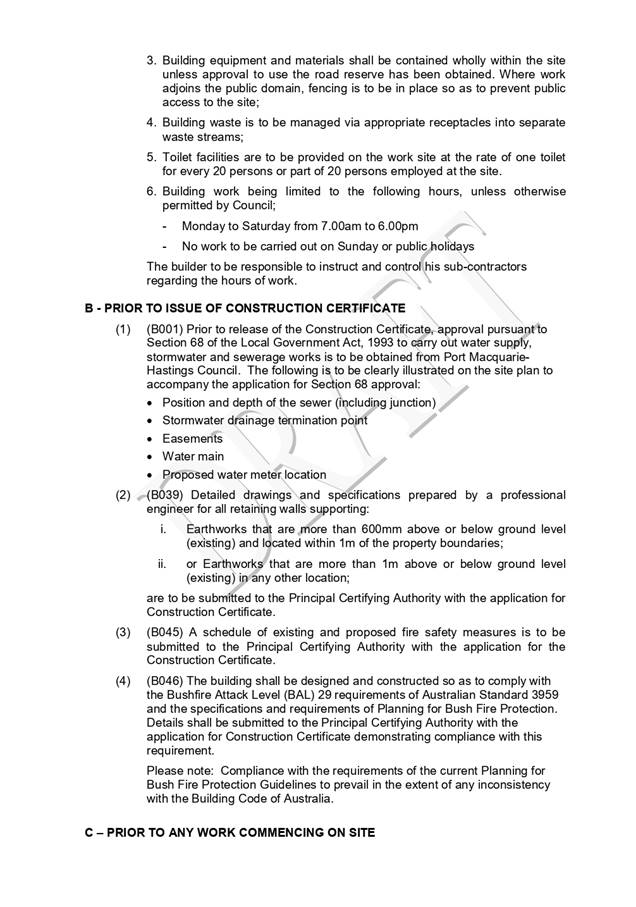
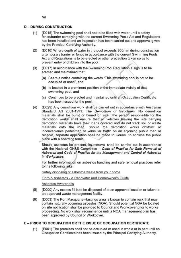
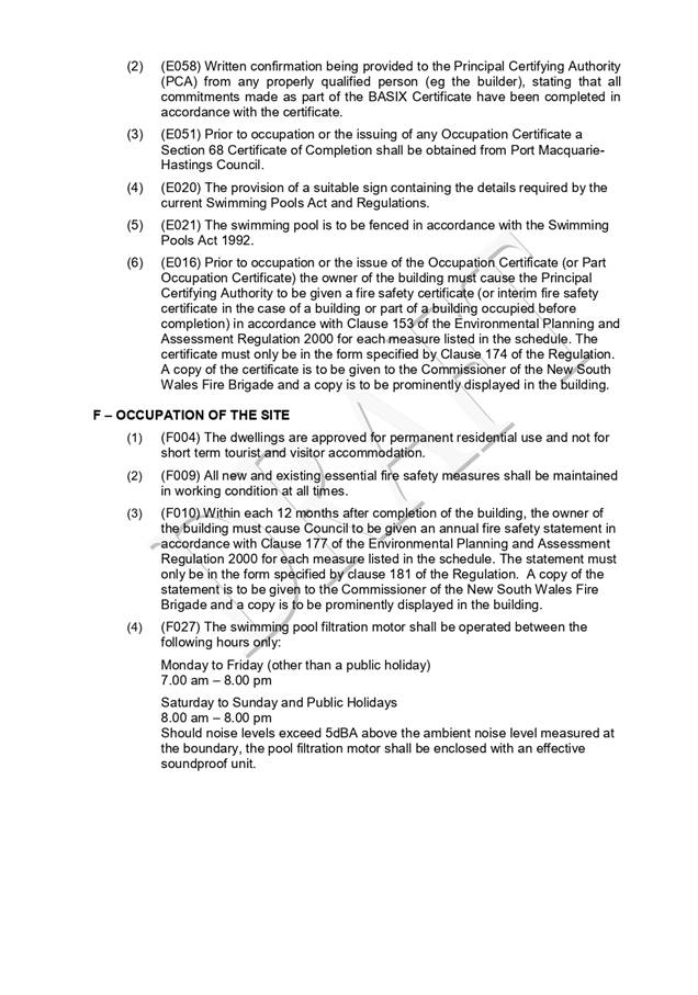
|
ATTACHMENT
|
Development Assessment Panel
14/10/2020
|
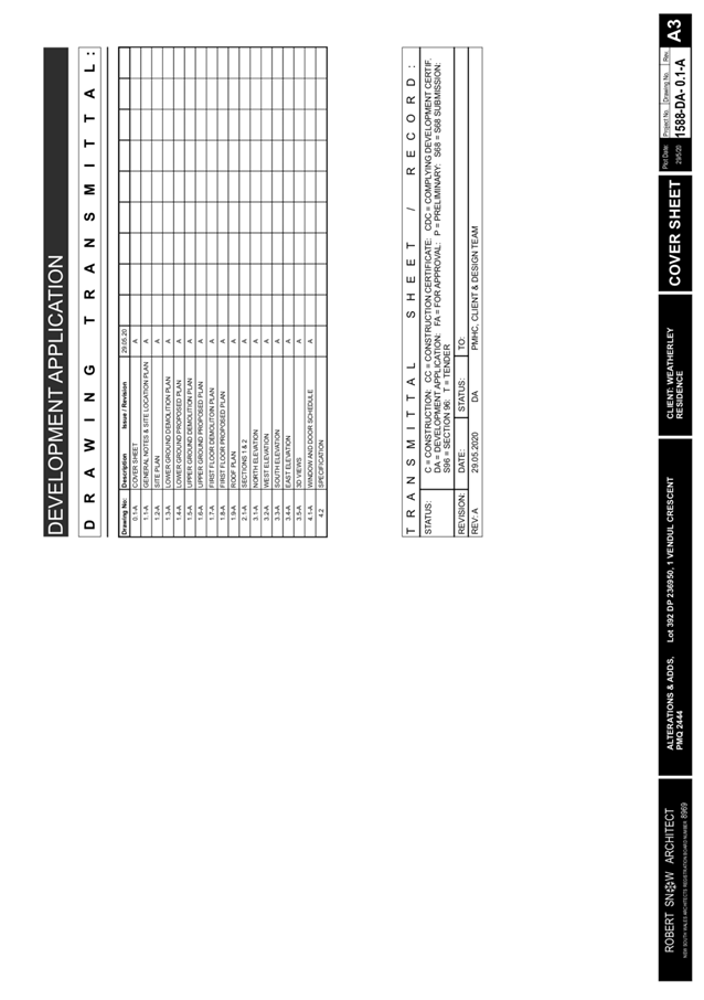
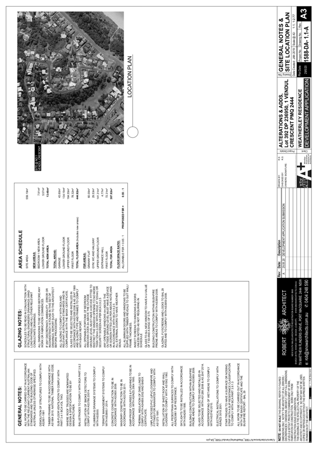
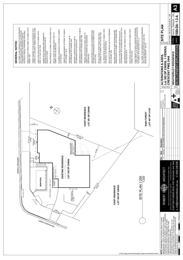
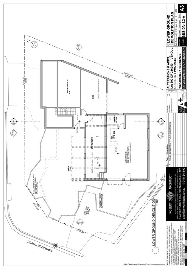
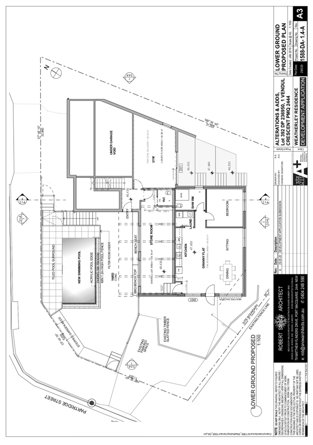
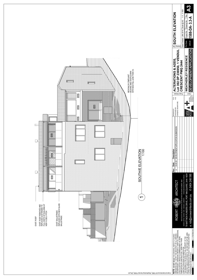
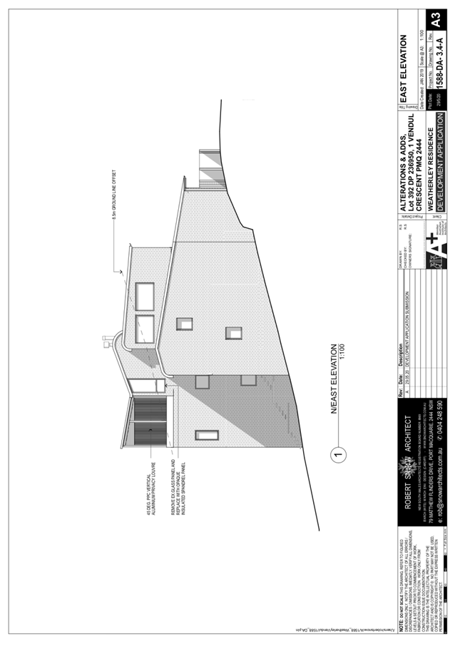
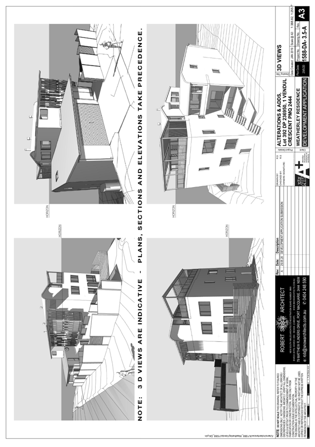
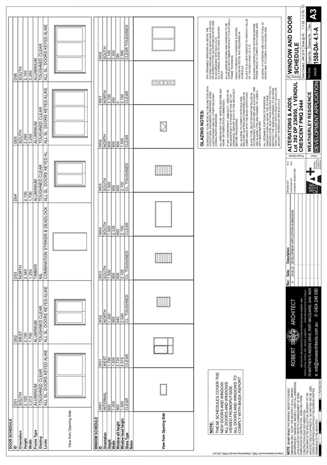
|
ATTACHMENT
|
Development Assessment Panel
14/10/2020
|
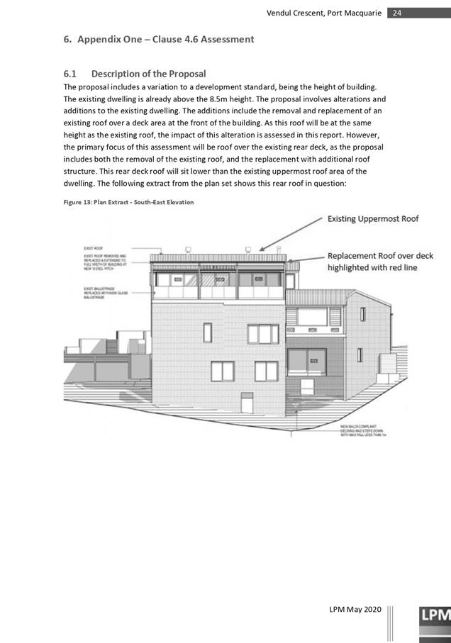
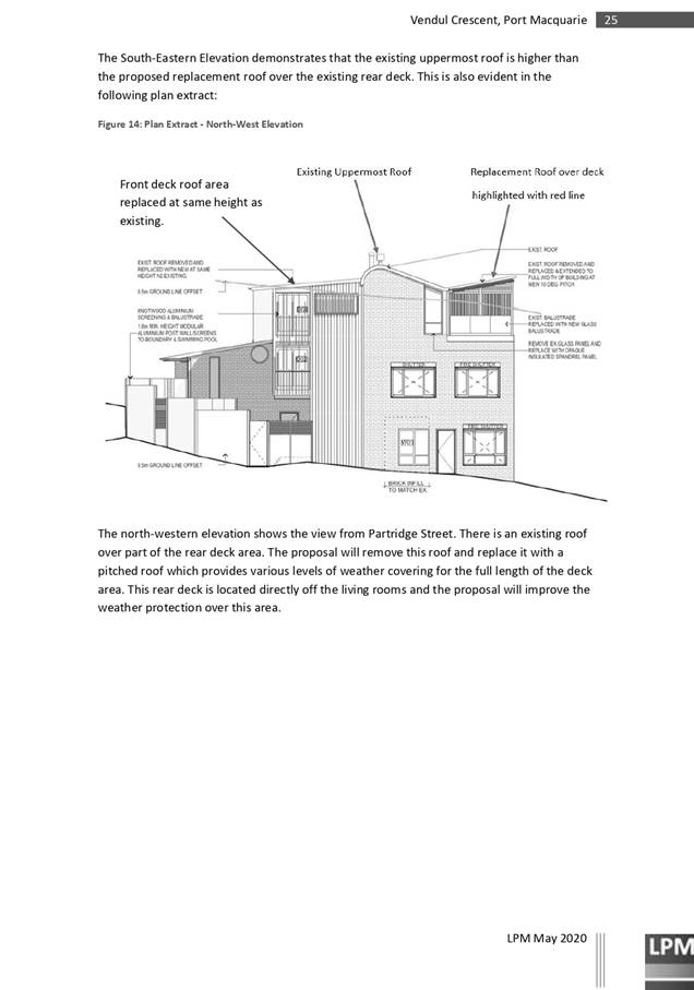
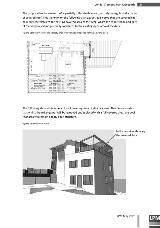

AGENDA Development Assessment Panel 14/10/2020
Item: 09
Subject: DA2016.88.9 Subdivision Modification, Lot 146
DP 1256576 (now known as Lot 2 DP 1263561), South Atlantic Drive, Lake Cathie
Report
Author: Development Assessment Planner, Steven Ford
|
Applicant: Gem
Life c/- Land Dynamics Australia
Owner: GTH
Resorts No 7 Pty Ltd
Estimated Cost: $0
Alignment with Delivery
Program
4.3.1 Undertake transparent and
efficient development assessment in accordance with relevant legislation.
|
RECOMMENDATION
That
the Section 4.55(1A) modification to DA 2016.88.9 being a modification to the subdivision layout of the
previously approved stage 6 at Lot 146, DP 1256576, South
Atlantic Drive, Lake Cathie, be determined by granting consent subject to the
recommended conditions.
Executive
Summary
This
report considers a s4.55(1A) modification of consent to amend the lot layout of
Stage 6 of an approved staged subdivision at
the subject site and provides an assessment of the application in accordance
with the Environmental Planning and Assessment Act 1979.
Being a
s4.55 modification, the amended proposal has been assessed against the relevant
legislation in place at the time of the original assessment, unless
specifically revoked by subsequent legislation.
Following exhibition of the
application, two (2) submissions were
received.
In
addition, the subject site has approval for a Manufactured Housing Estate (MHE)
and Ancillary structures under DA2019 - 780.1. The proposed MHE development
excluded the Stage 6 area of the subject land due to permissibility within the
E4 Environmental Living land zoning. Subsequently, it is noted that the consent
for DA2019 - 780.1 requires all previous approvals/stages of DA2016 - 88 to be
surrendered. However, at the time of writing this report, DA2019 - 780.1 has
not commenced.
Since the
modification was lodged, the property description has also changed to Lot 2 DP
1263561 as a result of earlier stages to DA2016 - 88.1 being completed.
However, the new lot description does not impact on the footprint of the
changes proposed under this modification.
Overall, the site is considered
suitable for the modified development and the proposal adequately addresses
relevant planning controls. The development is not considered to be contrary to
the public's interest and will not result in a significant adverse social,
environmental or economic impact.
This report recommends that the
development application be approved subject to the attached conditions (Attachment
1).
1. BACKGROUND
Existing
Sites Features and Surrounding Development
The original overall site area to
which DA2016 - 88.1 applied was 21.16ha. Since being approved, several stages
under DA2016 - 88.1, as modified, have been completed leaving a residual area
of 12.81ha to which the modified changes relate.
However, more specifically, this modification specifically relates to the E4
Environmental Living land being Stage 6 of DA2016 - 88.5
The
site is zoned R1 General Residential, E2 Environmental Conservation, E3
Environmental Management and E4 Environmental Living in accordance with the
Port Macquarie-Hastings Local Environmental Plan 2011, as shown in the
following zoning plan:
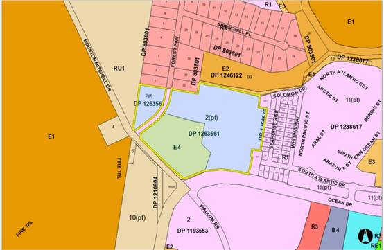
The
site is located on the corner of Ocean Drive, Houston Mitchell Drive and Forest
Parkway, Lake Cathie. The land subject to the modification is zoned E4 Environmental
Living, which is currently vacant and contains managed timbered land.
Adjoining
the subject area to the North and North/East is an approved Manufactured
Housing Estate and Ancillary buildings. The proposed MHE development excludes
the Stage 6 area of the subject land due to permissibility within the E4
Environmental Living land zoning.
Adjoining
the parent lot to the north is an existing large lot residential subdivision
with associated housing and a section of E(2) Environment Conservation and E(3)
Environmental Management zoned land in Council ownership. Further north is the
Lake Innes Nature Reserve and land approved under DA2016 - 87 for 68
residential lots.
Adjoining
the site to the east are the initial completed stages of DA2016 - 88 with
associated housing. Further east is an approved manufactured housing estate
that is partially complete with further sites to be created.
Adjoining
the site to the west is timbered rural land.
Adjoining
the site to the south is the Lake Cathie Primary School and the remaining Area
14 residential area.
The
existing subdivision pattern and location of existing development within the
locality is shown in the following aerial photograph:
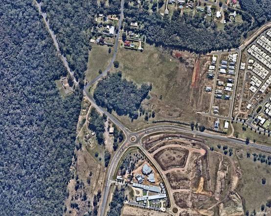
2. DESCRIPTION
OF DEVELOPMENT
Key
aspects of the proposal include the following:
· The
Northern Joint Regional Planning Panel (JRPP) approved the original 151
residential lot subdivision on 17 August 2016.
· The modification retains the same footprint of the Stage 6,
being the E4 Environmental Land, within the south-western corner of the
approved residential subdivision, on Lot 146 DP 1256576, Corner Forest Parkway
& Ocean Drive, Lake Cathie.
· The subject modification alters the approved lot layout and
public road in the E4 zoned portion of the site only.
· No additional lots are being proposed and Stage 6 will
retain 17 environmental living lots.
· Lots sizes will now range from 450m² to 2384.4m²
within the R1 zoned land and 2019.2m² to 2650.8m² within the E4 zoned
land.
· Access to the development will still occur from Forest
Parkway to the west.
· The development was referred back to the NSW RFS for an
amended Bushfire Safety Authority under section 100B of the Rural Fires Act
1997.
· As the modification is being considered under s4.55(1A),
the Council is the consent authority under Clause 123BA of the Environmental
Planning and Assessment Regulation 2000, rather than the JRPP.
· Amend conditions A(1), A(3), A(7), B(18) and E(15).
Refer
to (Attachments 2-5) at the end of this report for the applicant’s
s4.55 assessment report, plans of the proposed development, JRPP assessment
report and associated determination.
Application
Chronology for the Site
· 17/8/2016
- DA2016 - 88.1 originally determined by the Northern Joint Regional Planning
Panel.
· 27/4/2017 - Modification DA2016 - 88.2 approved by Council
to clarify conditions pertaining to kerb design.
· 20/11/2017 - Modification DA2016 - 88.3 approved by Council
to amend the road reserve width being dedicated to Council along Ocean Drive
and the associated road setback/buffer.
· 24/1/2018 - Modification DA2016 - 88.4 withdrawn.
· 4/10/2018 - Modification DA2016 - 88.5 lodged with Council.
· 2/9/2019 - Modification DA2016 - 88.6 approved by Council
to amend the Ocean Drive fence design.
· 24/10/2019 - DA2019 - 780.1 for a Manufactured Housing
Estate (MHE) lodged over part of the site the subject of DA2016 - 88. DA2019 -
780.1 has been determined and is subject to the developer/owner having to
decide whether they will proceed with the remaining stages of DA2016 - 88 or
opt to surrender the consent. DA2019 - 780.1 has been included in the
chronology for context only.
· 5/2/2020 - Modification DA2016 - 88.7 approved by Council
to amend staging associated with part of the original site/staging not being
considered under modification DA2016 - 88.5.
· 1/4/2020 - Modification to DA2016 - 88.9 lodged with
Council to essentially amend the access/egress for Stage 6 (E4 zoned lots). See
chronology specific to this modification later in the report.
· 20/4/2020 - Modification DA2016 - 88.8 approved by Council
to amend a condition pertaining to staging requirements.
· 27/5/2020 - Modification DA2016 - 88.5 approved by Council
to modify the number of lots from 151 to 166. In addition, move the central
north south habitat corridor.
Application
Chronology for DA2016 - 88.9
· 4/04/2020 - Modification DA2016 - 88.9 lodged with Council.
· 08/04/2020 to 23/04/2020 - Notification period. Two
submissions received.
· 20/08/2020 - Additional information received including
revised plans, and response to submissions.
· 27/08/2020 - Additional information received including
revised plans with footpaths and clarifications.
3. STATUTORY
ASSESSMENT
Section
4.15(1) Matters for Consideration
The
application has been lodged as a Section 4.55(1A) on the basis that it is
substantially the same development to that, which was originally lodged and
consented, and is considered to have minimal environmental impact.
Section
4.55 of the Environmental Planning and Assessment Act 1979 enables the
modification of consents and categorises modifications into Section 4.55(1) for
modifications involving minor error, mis-description or miscalculation, Section
4.55(1A) for modifications involving minimal environmental impact and Section
4.55(2) for other modifications. Each type of modification must be considered
as being substantially the same to that which was originally consented.
With
modifications, the Courts consistently see S4.55 as “beneficial and
facultative” and there are essentially two separate legal tests that
apply to a S4.55 application, before the consent authority can ultimately
determine the application on merit.
The
first is that the modification cannot result in a radical transformation. The
term “radical transformation” is very broad leaving significant
scope to change a development.
In
this case, whilst there are changes proposed, they are not considered radical
in terms of the land use and layout. The modification proposes access/egress
for the Stage 6 area directly onto Forest Parkway with a slightly different lot
layout but no additional lots. These changes allow the E4 land to be serviced
from Forest Parkway. The amended access/egress is now necessary as a result of
the remaining stages of DA2016 - 88 having an approved manufactured housing
estate. These changes are not considered radical in terms of the footprint of
Stage 6. In particular, the key elements of the development remain.
The
second test deals with council being satisfied that the modification is
“substantially the same development” as authorised by the original
development consent. Council must compare the modified development/potential
modified consent against the original approval (Note:
it is the consent that is being modified, not just the plans, so the consent
authority must have regard to the conditional changes as well). Once Council is
satisfied the modification is substantially the same, the remainder of the
assessment is dealt with on merit.
It
should be noted that some environmental impacts and merit issues can link back
to the “substantially the same test” if significant. In particular,
for a modification to have a significant environmental impact, one might
question whether it is a result of a significant change to the original
approval.
In
this case, the modification is considered “substantially the same”
and there are no significant environmental or merit issues - refer to comments
on s4.55(1A)(b) later in this report.
Below
is the original approved lot configuration of DA2016 - 88.1 - Stage 6.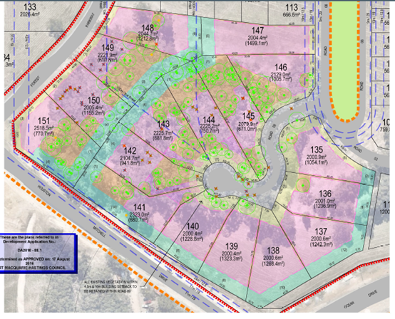
Section 4.55(1A)(a) Satisfied that the proposed modification is of minimal
environmental impact?
While
the proposed subdivision layout of stage 6 is being amended and a new
access/egress proposed, no additional environmental impact is considered to be
likrely as a result of the changes. In particular, the proposal is considered
to be having minimal environmental impact for the following reasons:
· The modified development occupies the same footprint as the
subdivision originally granted consent.
· The development will still present as a low density
residential subdivision from outside the site.
· The impacts of the modified development, including the
extent of vegetation clearing, earthworks and revegetation remain similar to
the original approved development.
· The modified development will not create any adverse demand
on public infrastructure or services when compared with the original approved
development.
· There will be no material change on amenity as a result of
the changes.
· The revised north south habitat corridor retains the
original intent of the subdivision, whilst creating added benefits of reduced
road crossings for fauna.
· There is no numerical change to the original subdivision
with regards to proposed residential lots and maintains compliance with minimum
lot size provisions.
Section 4.55(1A)(b) Is the proposal substantially the same?
Section 4.55 has been
described as “beneficial and facultative” in Houlton v Woollahra
Municipal Council (1997) 95 LGERA 201 at [213] and North Sydney
Council v Michael Standley & Associates Pty Ltd (1998) 97
LGERA 433 at [440]. Accordingly, the provisions of s4.55 should not be
artificially constrained by allowing a narrow construction.
In Vasic Pty
Ltd v Penrith City Council [1992] NSWLEC 8, Stein J held
that "substantially" meant "essentially all material or having
the same essence."
In Moto Projects (No 2)
Pty Ltd v North Sydney Council (1999) 106 LGERA 298 at [56]
Bignold J held that the task for determining whether a development as
proposed to be modified is substantially the same as the consent granted was as
follows:
"The
comparative task does not merely involve a comparison of the physical features
or components of the development as currently approved and modified where that
comparative exercise is undertaken in some type of sterile vacuum. Rather, the
comparison involves an appreciation, qualitative, as well as quantitative, of
the developments being compared in their proper contexts (including the
circumstances in which the development consent was granted)."
In the context of the current
application, the proposal can be considered to be substantially the same as the
development to which consent was originally granted for the following reasons:
· The modified proposal remains as a subdivision for the
purpose of residential uses and is consistent with the essence of the original
development.
· The reasons listed above under s4.55(1A)(a) for
demonstrating minimal environmental impact are conducive to the development
being substantially the same.
Section
4.55(1A)(c) Does the application require notification/advertising in accordance
with the regulations and/or any Development Control Plan?
Neighbour
notification has been undertaken in accordance with the regulations and
Council’s DCP (as in force at the time).
Section 4.55(1A)(d) Any submissions made concerning the
modification
Two (2) written submissions were received following public
exhibition of the application. Copies of the written submissions have been
provided separately to members of the DAP.
Key issues raised in the submissions received and comment
are provided in the table below:
|
Submission Issue/Summary
|
Planning Comment/Response
|
|
Traffic, pedestrian, cycleway and public transport
impacts.
|
There is no increase in lot numbers within Stage 6 (ie E4
zoned land component) of DA2016.88. It is considered that there are no
additional traffic generation concerns to the precinct from this
modification.
The new road connection to Forrest Parkway has been
suitably designed with respect to site distances. The approved layout had
individual lots fronting Forest Parkway and as such had more individual
driveway crossovers.
The connectivity of the precinct is still available by
way of the approved pathway network, which includes along Forest Parkway to
connect the future northern collector road and future investigation area to
the north.
This modification does not alter the ability for public
transport to service the proposed lots in the E4 zoned land.
|
|
Precinct becoming estates and land uses targeted for over
50s.
|
This
Modification relates to land, which is for residential lots, consistent with
that already approved on the site. The lots will not be age restricted. The
adjoining developments and MHE’s have been assessed based on individual
merit and do not relate to this modification.
|
|
No notification of the proposal was made to Gwynvill who
owns land adjoining the development that will be significantly affected by
the modification application as submitted due to the proposed deletion of a
Collector/Significant Road contained in the Area 14 and connectivity provided
for in the strategic planning for the area.
|
All
adjoining land owners were notified. At the time of notification, Stage 1 of
DA2016/88 had been completed which separates the subject land from Gwynvill’s
land.
It is
also noted that on Council’s records, Gwynvill Trading Pty Ltd was
notified with correspondence dated 3 April 2020.
This
modification has not deleted the southern collector road. The proposed
collector road concerns have been resolved under DA2019 - 780.1 Manufactured
Housing Estate and Ancillary Buildings, already approved to occur on the
subject land to the north and north east.
|
|
The proposed modification as submitted has not adequately
addressed Sections 4.15 &
4.55 of the Environmental Planning & Assessment Act
1979 and therefore cannot be approved.
|
The
information lodged has addressed the clauses of the Act. Refer to sections
earlier in this report.
|
|
The deletion of the Collector/Significant Road and the
associated inconsistency with the DCP and the original approved development
has been neither acknowledged nor addressed in the subject application to
modify DA 2016/88.
|
This
modification has not deleted the southern collector road. The Southern
Collector road has been reviewed separately under DA2019 - 780.1. DA2019 -
780.1 has been subsequently approved and proposes to delete the southern
collector road. The proposed modification has responded to adjoining
approvals in the area.
|
|
Inconsistency with Strategic Planning & Development Controls
for the Area 14 Lake
Cathie/Bonny Hills Urban Release Area.
|
With
regards to the LEP, there are no changes from the original assessment. The
Stage 6 lots are zoned E4 environmental living and the proposed lots vary
from 2019.2m2 to 26508m2 and comply with the
2000m² minimum lot size.
With
Regards to the DCP, this modification proposes to delete the reliance of the
southern collector road as the primary entrance and associated 4 driveway
crossovers to Forest Parkway. In lieu, the proposal now has one driveway
crossover to Forest Parkway and one intersection off Forest Parkway to
service the remaining proposed Stage 6 lots.
The
deletion of the southern collector road as referred to in the DCP, has been
dealt with separately in DA2019 - 780. This modification responds to the
adjoining approval and provides access from the most appropriate location
consistent with the Objectives of the DCP for Area 14 Lake Cathie/Bonny Hills
Urban Release Area.
|
|
Inconsistent with the Area 14 Voluntary Planning Agreements
|
As
part of the Lake Cathie Bonny Hills URA Stage 1A rezoning, all landowners
entered into a Voluntary Planning Agreement for payment of development
contributions, infrastructure works and dedication of land.
Based
on the advice received, there are no implications to the Sydmart VPA that
applies to the subject land.
|
|
Inconsistency with Existing Development Approvals within
the Lake Cathie Bonny Hills
URA.
|
The
proposed subdivision modification does not compromise existing development
connections to Collector/significant roads, being either Forest Parkway,
Solomon Drive or Houston Mitchell Drive.
|
Section
4.55(3) Any matters referred to in section 4.15(1) relevant to the
modification, and the reasons given by the consent authority for the grant of the
consent sought to be modified.
Overall,
the modification remains consistent with the original s4.15(1) assessment and a
revised summary follows the Section 4.55(4) comment below. It should be noted
that the revised s4.15(1) comments focus on compliance with relevant
legislation and whether there has been any change or impact to comments
provided on the original assessment.
A copy
of the original s4.15(1) JRPP assessment is also attached to this report for
context (Attachment 4).
Section
4.55(4) The modification
of a development consent in accordance with this section is taken not to be the
granting of development consent under this Part, but a reference in this or any
other Act to a development consent includes a reference to a development
consent as so modified.
Noted.
Section
4.15(1) Matters for Consideration
In
determining the application, Council is required to take into consideration the
following matters as are relevant to the development that apply to the land to
which the development application relates:
(a) The
provisions (where applicable) of:
(i) Any
Environmental Planning Instrument
State
Environmental Planning Policy (Koala Habitat Protection) 2019
As the development was lodged on 1 April
2020 and the SEPP commenced on the 1 March 2020, the legislation is to be
considered.
In this case, Clause 8 of the Policy
applies as there is an existing Koala Plan of Management (KPOM) in place (ie
Area 14 KPOM). The Policy requires the application to be consistent with the
approved KPOM.
Having regard to
the original approval and provisions of the KPOM, the modification is
considered to remain consistent. This was reiterated by comments from an
ecologist and peer review by Council’s Natural Resources Team. In
summary, the modification will still comply with the following:
· Use koala food
trees throughout the site and be implemented via a Vegetation Management Plan
(VMP).
· Separation of key
koala areas from busier residential development/roads.
· Retention of koala
food trees where possible.
· Buffering of koala
habitat areas.
· Revegetation of
buffers/habitat linkages that are devoid of vegetation.
· Conditions being
imposed to manage fauna/koalas during clearing process.
· Covenants being
placed on the title of properties regarding pool design being koala friendly.
· Standard street
lighting being conditioned.
· Compensatory
plantings in accordance with the KPOM.
· A VPA being in
place for the management of environmental land and vegetation management.
· Core koala habitat
areas being retained/untouched.
· Creation of
habitat linkages consistent with the KPOM.
State Environmental Planning
Policy (Infrastructure) 2007
Clause 45, no objection was raised
from the relevant electricity supplier regarding the modification.
No other change
from original assessment.
State
Environmental Planning Policy (State and Regional Development) 2011
No change from original assessment.
As the modification is being
considered under s4.55(1A), the Council is the consent authority under Clause
123BA of the Environmental Planning and Assessment Regulation 2000.
Modification is not required to be determined by the JRPP.
Port
Macquarie-Hastings Local Environmental Plan 2011
Unless specified below, no change
from original assessment.
· Clause 4.1, the E4
lots comply with the 2000m² minimum lot size.
· Clause 7.13,
satisfactory arrangements are in place for provision of essential services
including water supply, electricity supply, sewer infrastructure, stormwater
drainage and suitable road access to service the development. Provision of
electricity and telecommunications will be subject to obtaining satisfactory
arrangements certification prior to the issue of a Subdivision Certificate as
recommended by the original condition of consent.
(ii) Any draft instruments
that apply to the site or are on exhibition
None relevant.
(iii) Any Development
Control Plan in force
Port
Macquarie-Hastings Development Control Plan 2013
Unless specified below, no
change from original assessment.
|
DCP 2013: Chapter 3.6 - Subdivision
|
|
DCP Objective
|
Development Provisions
|
Proposed
|
Complies
|
|
3.6.3.2
|
Torrens title lots minimum width of 15m when measured at a
distance of 5.5m from front property boundary (excluding cul de sac and
battleaxe lots).
|
All lots within the modification remain compliant with the
minimum of 15m width requirement.
|
Yes
|
|
|
Minimum depth of 25m.
|
All lots generally comply with the minimum 25m depth
requirement.
|
Yes
|
|
3.6.3.3
|
Battleaxe lots discouraged in greenfield development.
|
There are two (2) battleaxe lots proposed. However, the
frontage of these lots is just less than the 15m requirement above (ie 14m
and 13.6m). As a result, they will still present as standard residential lots
to the street and no adverse impact will occur.
|
No, but acceptable.
|
|
DCP 2013: General Provisions
|
|
DCP Objective
|
Development Provisions
|
Proposed
|
Complies
|
|
2.7.2.2
|
Design addresses generic principles of Crime Prevention
Through Environmental Design guideline:
· Casual surveillance
and sightlines
· Land use mix and activity
generators
· Definition of use and
ownership
· Lighting
· Way finding
· Predictable routes and
entrapment locations
|
The modified layout does not create any crime safety
issues. The design allows separation from potential habitat/concealment areas
and allows surveillance of the street.
|
Yes
|
|
DCP 2013 - Rainbow Beach
|
|
DCP Objective
|
Development Provisions
|
Proposed
|
Complies
|
|
1.1
|
Development consistent with layout on Figures 62 to 64.
|
Modification remains consistent with the layout
requirements. No impact foreseen with the changes with key perimeter roads to
be retained.
|
Yes
|
|
5.1
|
Cycleways, shareways etc requirements
|
Provided in accordance with DCP.
|
Yes
|
|
5.2
|
Pedestrian link requirements.
|
Provided in accordance with DCP.
|
Yes
|
|
6-8
|
Noise, visual amenity, SEPP 26 buffer and urban design.
|
Remain unchanged and reinforced through existing
conditions.
|
Yes
|
|
12.1
|
North south streets to be in accordance with Figure 71.
|
No impact foreseen with the changes. Key perimeter roads
to be retained.
|
Yes
|
|
12.2
|
20m wide habitat link as per Figure 71.
|
An equivalent habitat link has been provided to the north
and also approved by DA2019 - 780. The connection is consistent with VMP
requirements.
|
Yes
|
|
13.1
|
Development considers existing rural residential areas,
KPOM requirements and linkages.
|
Development complies with the Area 14 KPOM and will be
installing/protecting key habitat links. The proposed building envelopes have
been reduced in size from the original proposal to maintain an increased
likelihood of vegetation retention within the E4 land.
|
Yes
|
(iiia) Any planning agreement that has
been entered into under section 7.4, or any draft planning agreement that a
developer has offered to enter into under section 7.4
The land owner has entered into The
Sydmart Area 14 Stage 1A Planning Agreement with Port Macquarie-Hastings
Council. In summary the agreement requires:
· Monetary
development contributions for water supply, roads, sewerage, open space, and
administration purposes
· Specific works by
the landowner for the purposes of providing water supply and roads.
· Dedication of
specified land to the Council by the landowner on which some works will be
situated
The proposed development complies
with relevant planning agreements subject to conditions.
(iv) Any
matters prescribed by the Regulations
None
relevant.
(b) The likely
impacts of that development, including environmental impacts on both the
natural and built environments, social and economic impacts in the locality:
Roads, traffic, transport, site frontage and access
The road layout and hierarchy remains consistent with the
objectives of the Development Control Plan provisions, which connects in with
the adjoining properties/roads. Footpaths and street plantings will also be
provided throughout the subdivision to improve pedestrian connections and
amenity.
Overall, the road layout, traffic impacts, frontages and
access associated with the modification were all reviewed by Council’s
Engineering Section and deemed to create no adverse impact, subject to conditions.
Conditions have been applied, which do not allow vehicle
access from Lots 1 and 17 onto Forest Parkway. Additionally, similar conditions
have been imposed restricting vehicle access for Lots 10 to 16 onto Houston
Mitchell Drive and Lots 8 & 9 onto Ocean Drive.
Water supply connection
Council records indicate that the modification is still able
to be connected to water with details to be shown on the engineering plans at
the Subdivision Construction Certificate stage.
Sewer connection
Council records indicate that the modification is still able
to be connected to sewer with details to be shown on the engineering plans at
the Subdivision Construction Certificate stage.
Stormwater
Council’s Stormwater Engineer has assessed the
modification/proposed stormwater design and deemed it acceptable, subject to
conditions and detailed design being submitted at the Subdivision Construction
Certificate stage. The system will utilise a combination of street drainage,
detention and swales to direct the water to the public reserve in a controlled
state.
Stage 6 is currently capable of connecting to infrastructure
within proposed South Atlantic Drive road reserve. It is noted that any changes
to the approved Elanora subdivision by a separate approval will have to resolve
any infrastructure issues that arise.
Other utilities
Telecommunication and electricity services are available to
the site and/or can be extended at the applicant’s expense.
Flora and fauna
The applicant had a suitably qualified ecologist review the
modified design. The ecologist provided the following comment regarding the
consistency with the existing VMP:
• n
Mod .05 Approved VMP Changes – The
green area is the Habitat Corridor referred to in KPOM
• Road
crossings to east, centre being Road 1 and to south.
• Connection
to E4 land was onto another road into the larger lots.
• Corridor
within private lots 612, 613, 301, 316 & 317.
• Fencing
to private lots as barrier.
Proposed MHE - The green area is the Habitat
Corridor referred to in KPOM
• Single
road crossing only.
• Connection
to E4 land is direct with fencing the only barrier between the MHE and E4 lots.
• Fencing
is far safer than road crossings and only one fence crossing as opposed to
numerous individual lots.
• Corridor
remains in private ownership of the MHE, without additional fences as per
.05 Mod
The modification has been reviewed and accepted by
Council’s Natural Resources Section, subject to conditions on maintenance
of the linkage and an amended VMP.
In addition to the above, it is considered that the
provisions of the more recently adopted Biodiversity Conservation Act 2016
(commenced after DA2016 - 88.1 was approved) are not triggered in this case. In
particular, no additional vegetation removal is proposed or new impact on
existing/proposed habitat. Overall, the modification relates to the same
footprint as the original approval and associated work/impact could occur
regardless of the modification.
Noise and vibration
The original application was referred to Council’s
Environmental Health Officer to consider impacts of road noise from Ocean Drive
(classified road). In particular, potential existed for noise from road traffic
to adversely affect future dwelling occupants.
To negate noise impacts a 1.8m high fence on top of a 400mm
mound was approved along the Ocean Drive frontage, consistent with other
estates being developed to the east. Vegetation screening was also included to
soften the appearance of the fence from Ocean Drive.
Even with the above, some lots were still identified as
being affected by road noise. To address this aspect, an 88B instrument was
conditioned, requiring future dwellings on the affected lots to have Category 2
construction with additional internal BCA compliant ventilation.
Given the modification impacts on the number of lots and lot
numbers, the condition has been amended to capture the relevant lots.
Bushfire
The site is identified as being bushfire prone.
In accordance with Section 100B - Rural Fires Act 1997 - the
original application proposed subdivision of bush fire prone land that could
lawfully be used for residential purposes.
The applicant has submitted an amended bushfire report
prepared by a Certified Consultant. The report assumes that the amended
subdivision can occur under Section 100B requirements.
The Commissioner has assessed the modification and has
issued a revised Bushfire Safety Authority, which will form part of the
modified conditions of consent.
Furthermore, the applicant has demonstrated that the
development can comply with the requirements of the Bushfire Safety Authority
as well as implementing the requirements of the VMP, without creating any long
term maintenance of vegetation burden on Council.
Social impacts in the locality
Given the strategic planning and development controls that
have been put in place governing the development of the Area 14 precinct and
the compliance of the subdivision with such controls; the modification is
unlikely to result in any adverse social impacts.
Economic impact in the locality
No adverse impacts. A likely positive impact is that the
development will maintain employment in the construction industry, which will
lead to flow impacts such as maintained employment and expenditure in the area.
(c) The
suitability of the site for the development
The modification of Stage 6 will fit into the locality and the site
attributes are conducive to the proposed development.
Site constraints have been adequately addressed and appropriate
conditions of consent recommended.
4. DEVELOPMENT
CONTRIBUTIONS APPLICABLE
· Development contributions will be required towards
augmentation of town water supply and sewerage system head works under Section
64 of the Local Government Act 1993.
· Development contributions will be required in accordance
with Section 7.11 of the Environmental Planning and Assessment Act 1979 towards
roads, open space, community cultural services, emergency services and
administration buildings.
·
· A copy of the contributions estimate is included as (Attachment
6).
5. CONCLUSION AND
STATEMENT OF REASON
The application has been assessed in accordance with Section
4.55 of the Environmental Planning and Assessment Act 1979.
Issues raised during assessment and public exhibition of the
application have been considered in the assessment of the application. Where
relevant, conditions have been recommended to manage the impacts attributed to
these issues.
The site is considered suitable for the proposed development
and the proposal adequately addresses relevant planning controls. The
development is not considered to be contrary to the public's interest and will
not result a significant adverse social, environmental or economic impact. It
is recommended that the application be approved, subject to the recommended
conditions of consent provided in the attachment section of this report.
|
Attachments
1⇩. DA2016 - 88.9
Recommended Modification of Consent Conditions DA2016 - 88.9
Recommended Modification of Consent Conditions
2⇩. DA2016 - 88.9 SOEE
3⇩. DA2016 - 88.9 Plans
4⇩. DA2016 - 88.1 JRPP
Assessment Report
5⇩. DA2016 - 88.1 JRPP
Determination
6⇩. DA2016 - 88.9
Contributions Estimate
|
|
ATTACHMENT
|
Development Assessment Panel
14/10/2020
|
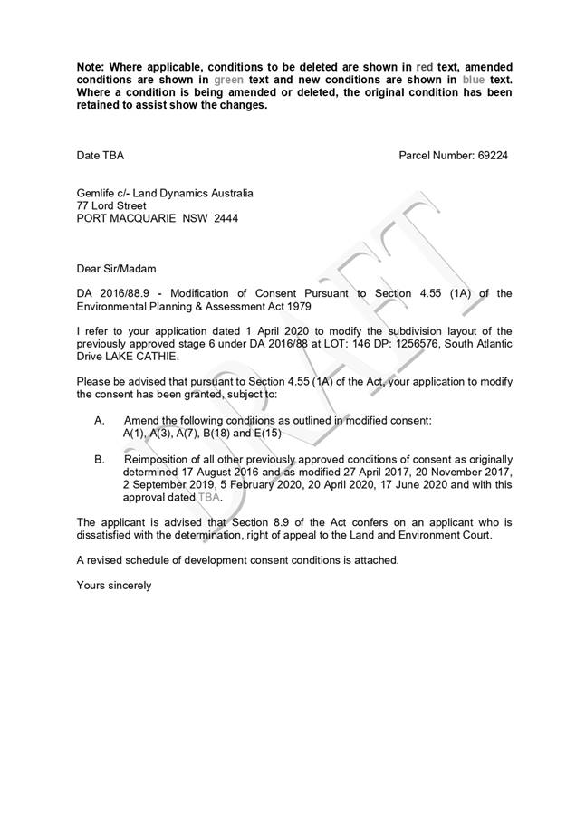
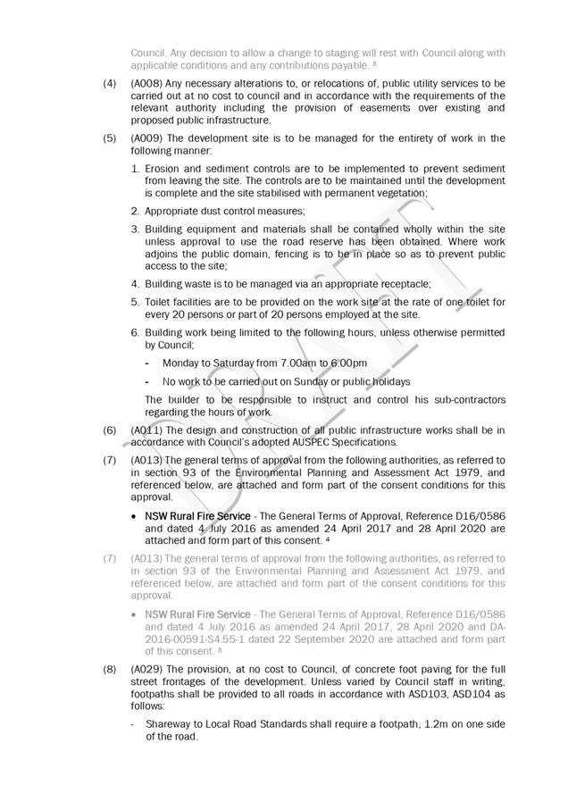
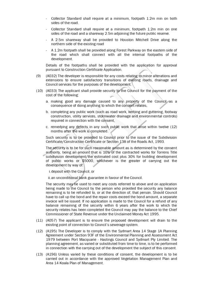
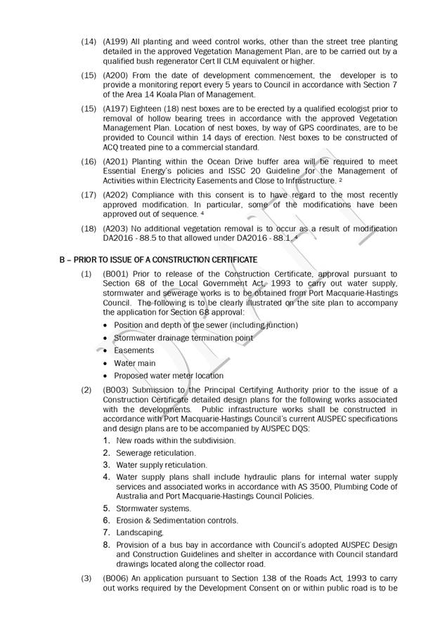
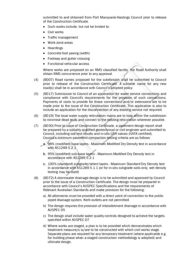
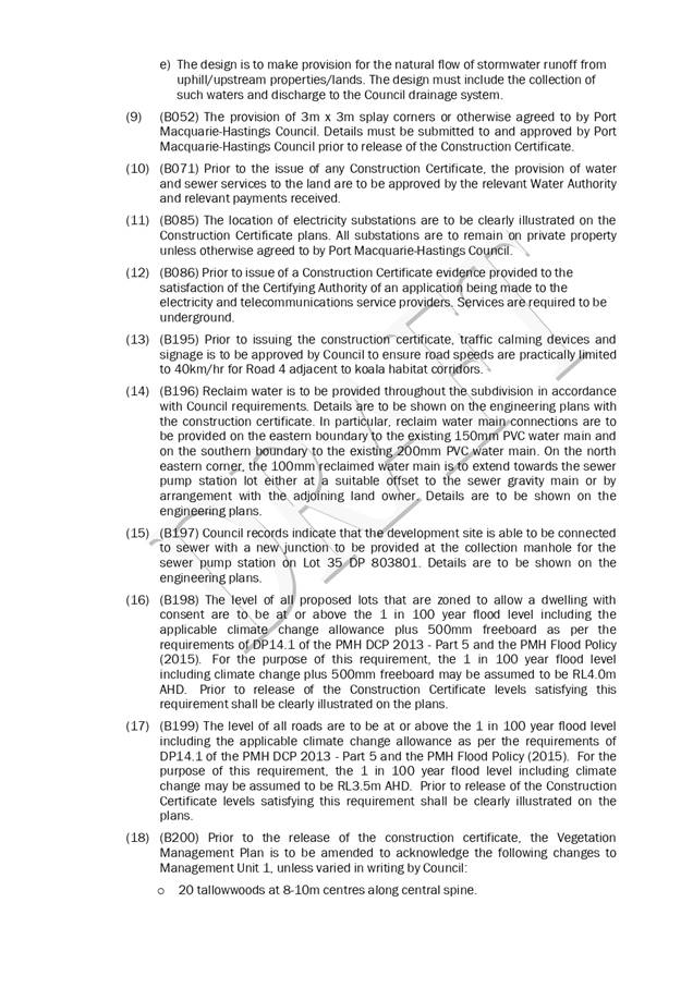
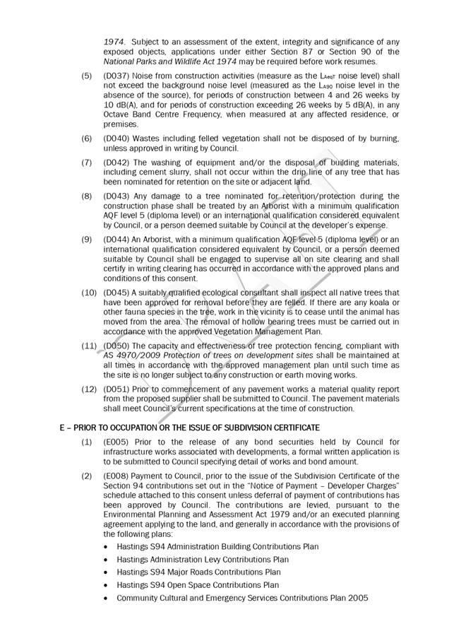
|
ATTACHMENT
|
Development Assessment Panel
14/10/2020
|
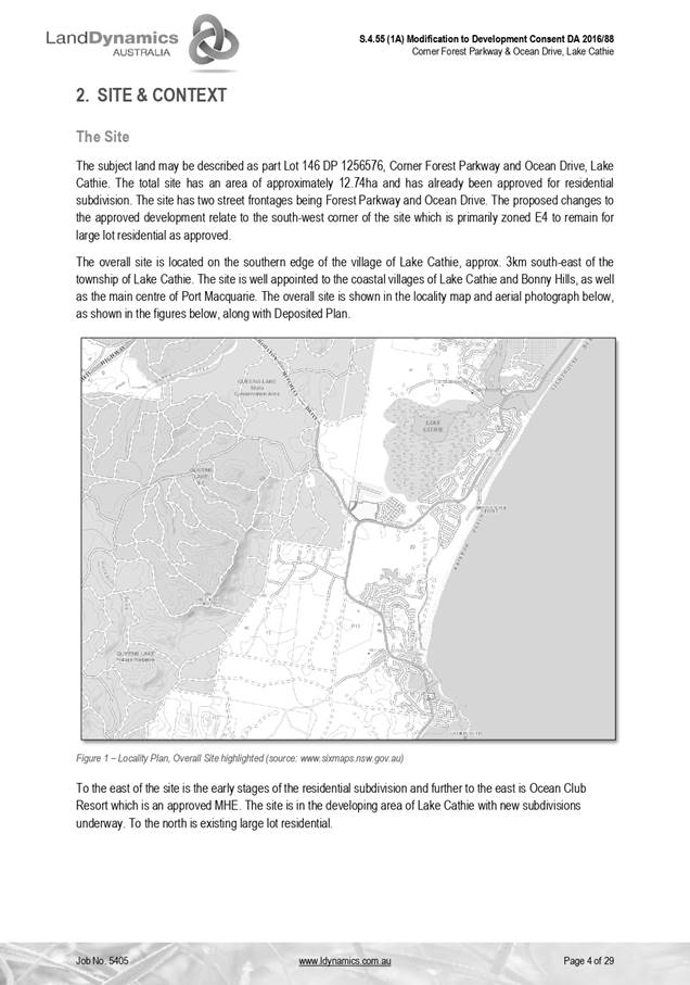
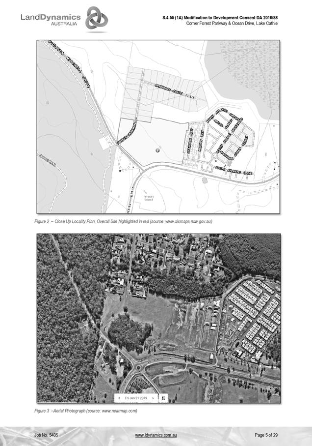
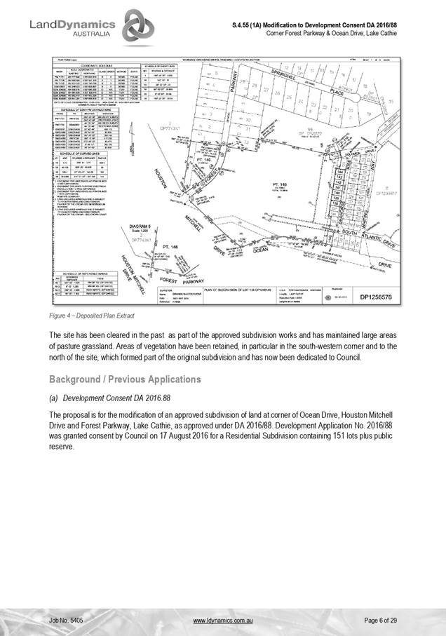
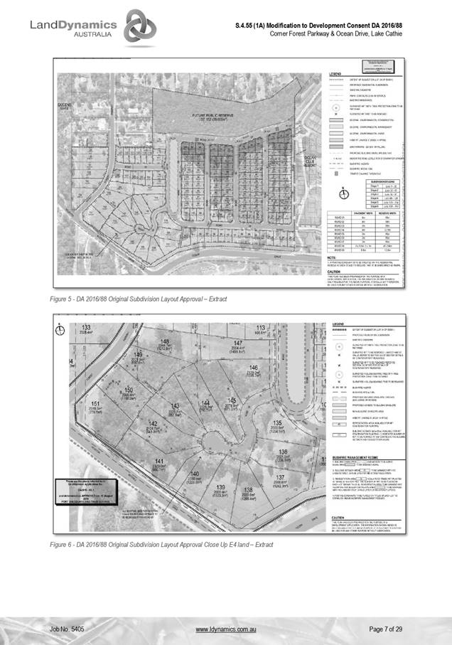
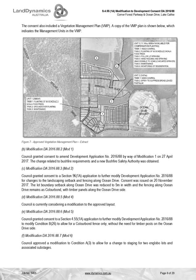
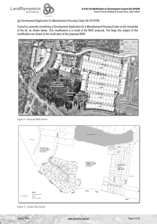
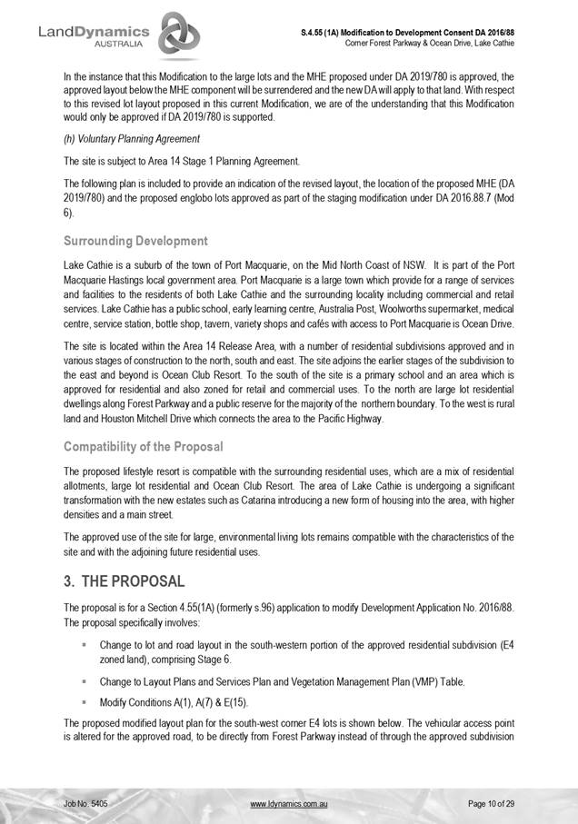
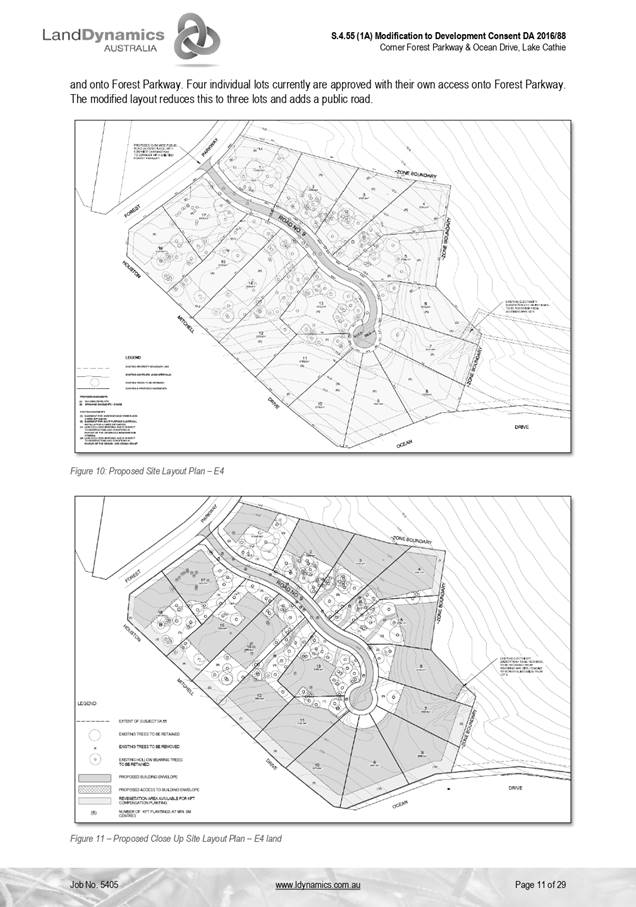
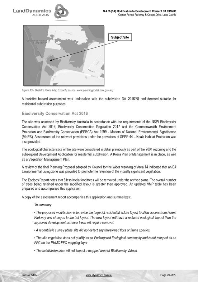
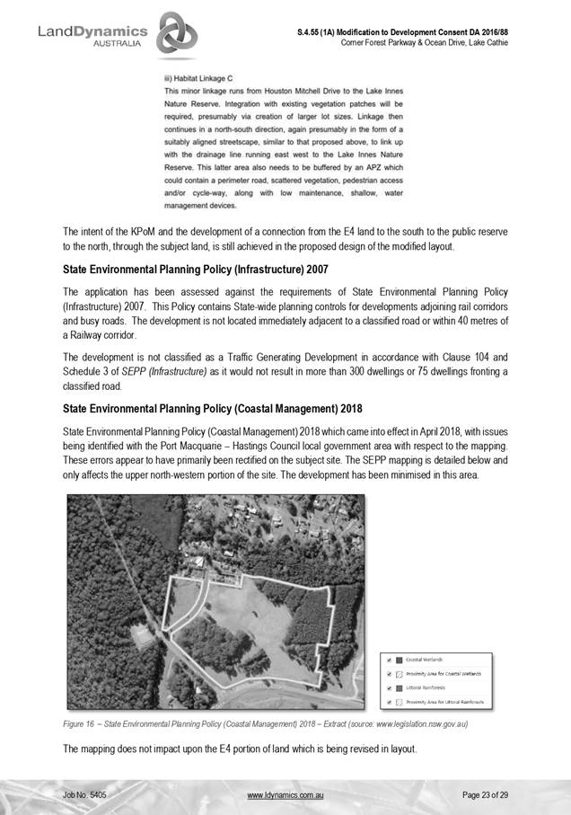
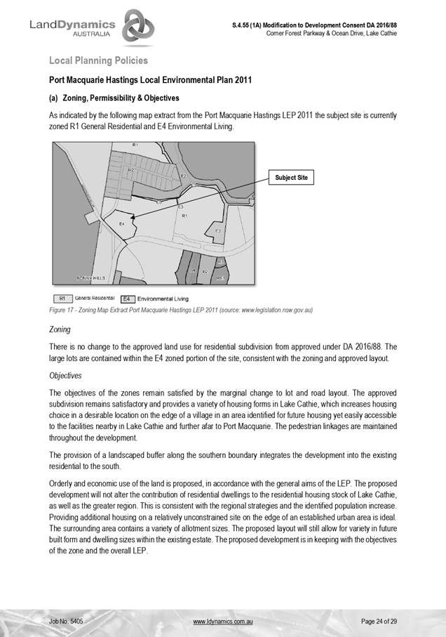
|
ATTACHMENT
|
Development Assessment Panel
14/10/2020
|
|
ATTACHMENT
|
Development Assessment Panel
14/10/2020
|
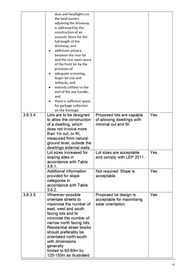
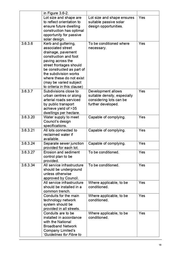
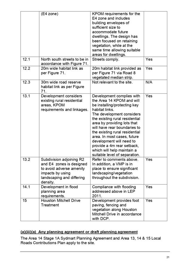
|
ATTACHMENT
|
Development Assessment Panel
14/10/2020
|
|
ATTACHMENT
|
Development Assessment Panel
14/10/2020
|