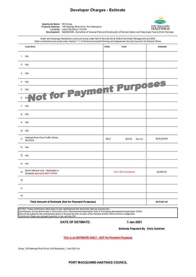
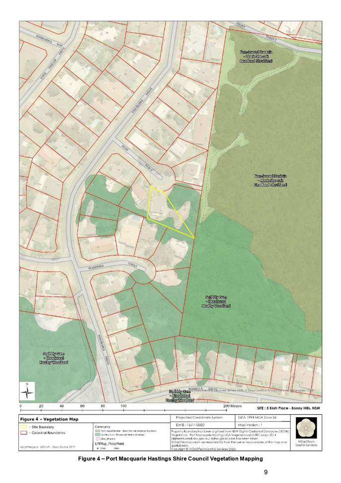
Development
Assessment Panel
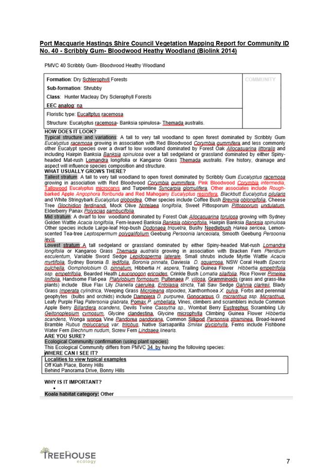
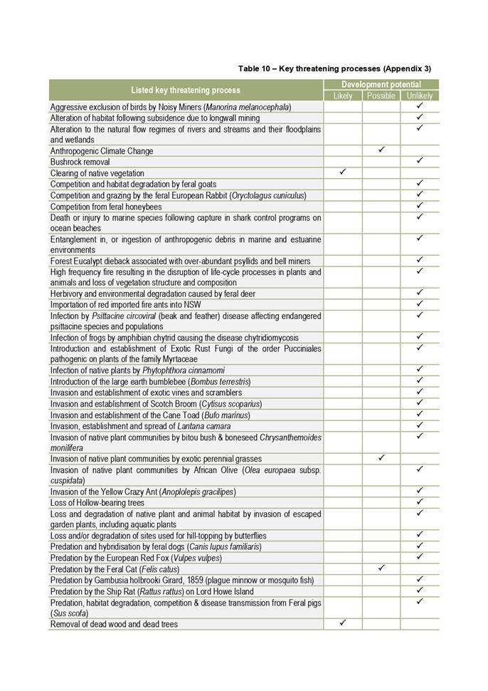
Business
Paper
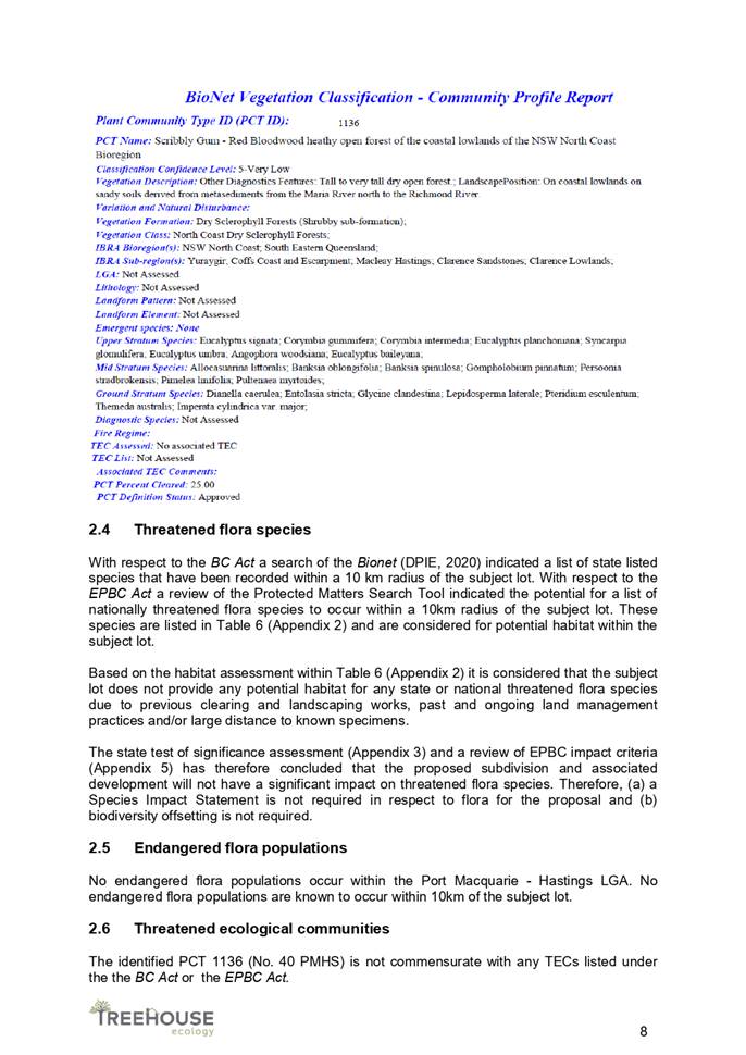
|
date of meeting:
|
|
Thursday 21 January
2021
|
|
location:
|
|
Via Skype
|
|
time:
|
|
2:00pm
|
Development
Assessment Panel
CHARTER
1.0 OBJECTIVES
To assist in managing Council's development assessment
function by providing independent and expert determinations of development
applications that fall outside of staff delegations.
2.0 KEY FUNCTIONS
·
To review development application reports and conditions;
·
To determine development
applications outside of staff delegations;
·
To refer development applications
to Council for determination where necessary;
·
To provide a forum for objectors and applicants
to make submissions on applications
before the Development Assessment Panel
(DAP);
·
To maintain transparency in the determination of development
applications.
Delegated Authority of Panel
Pursuant to
Section 377 of the Local Government Act, 1993 delegation to:
·
Determine development applications under Part 4
of the Environmental Planning and Assessment
Act 1979 having
regard to the relevant environmental planning instruments,
development control plans and Council policies.
·
Vary, modify or release restrictions as to use
and/or covenants created by Section 88B instruments under the Conveyancing Act
1919 in relation to development applications for subdivisions being considered
by the panel.
·
Determine Koala Plans of Management under State
Environmental Planning Policy 44 - Koala Habitat Protection associated with
development applications being considered by the Panel.
Noting the trigger to escalate
decision making to Council as highlighted in section 5.2.
3.0
MEMBERSHIP
3.1
Voting
Members
·
Two independent external members. One of the
independent external members to be the Chairperson.
·
Group Manager Development Assessment (alternate
- Director Development & Environment or Development Assessment Planner)
The independent external members shall have expertise in
one or more of the following areas: planning, architecture, heritage, the
environment, urban design, economics, traffic and transport, law, engineering,
government and public administration.
3.2
Non-Voting Members
·
Not applicable
3.3 Obligations
of members
·
Members must act faithfully and diligently and
in accordance with this Charter.
·
Members must comply with Council's Code of Conduct.
·
Except as required to properly perform their
duties, DAP members must not
disclose any confidential information (as advised by Council) obtained in connection with the DAP functions.
·
Members will have read and be familiar with the
documents and information provided by Council prior
to attending a DAP meeting.
·
Members must act in accordance with Council's
Workplace Health and Safety Policies and Procedures
·
External members of the Panel are not authorised
to speak to the media on behalf of Council. Council officers that are members
of the Committee are bound by the
existing operational delegations in relation to speaking to the media.
·
Staff members shall not vote on matters before
the Panel if they have been the principle author of the development assessment report.
3.4
Member Tenure
·
The independent external members will be
appointed for the term of four (4) years
maximum in which the end of the tenure of these members would occur in a
cascading arrangement.
3.5 Appointment
of members
·
The independent external members (including the
Chair) shall be appointed by the General Manager following an external
Expression of Interest process.
·
Staff members of the Panel are in accordance
with this Charter.
4.0 TIMETABLE
OF MEETINGS
·
The Development Assessment Panel will generally
meet on the 1st and 3rd Wednesday each month at 2.00pm at the Port Macquarie
offices of Council.
·
Special Meetings of the Panel may be convened by
the Director Development & Environment Services with three (3) days notice.
5.0
MEETING PRACTICES
5.1
Meeting
Format
·
At all Meetings of the Panel the Chairperson
shall occupy the Chair and preside. The Chair will be responsible for keeping
of order at meetings.
·
Meetings shall be open to the public.
·
The Panel will hear from applicants
and objectors or their r e p r e s e n t a t i v e s .
·
Where considered necessary, the Panel will
conduct site inspections which will
be open to the public.
5.2
Decision Making
·
Decisions are to be made by consensus. Where
consensus is not possible on any item, that item is to be referred to Council
for a decision.
·
All development applications involving a
proposed variation to a development standard
greater than 10% under Clause
4.6 of the Local Environmental Plan will be
considered by the Panel and recommendation made to the Council for a decision.
5.3
Quorum
·
All members (2 independent external members and
1 staff member) must be present at a
meeting to form a quorum.
5.4
Chairperson and Deputy Chairperson
·
Independent Chair (alternate, second independent member)
5.5
Secretariat
·
The Director Development &n Environment is
to be responsible for ensuring that the Panel has adequate secretariat support.
The secretariat will ensure that the business paper and supporting papers are
circulated at least three (3) days prior to
each meeting. Minutes shall be appropriately approved and circulated to each
member within three (3) weeks of a meeting being held.
·
The format of and the preparation and publishing
of the Business Paper and Minutes shall be similar to the format for Ordinary
Council Meetings.
5.6
Recording of decisions
·
Minutes will record decisions and how each
member votes for each item before the Panel.
6.0 CONVENING
OF “OUTCOME SPECIFIC” WORKING GROUPS
Not applicable.
7.0 CONFIDENTIALITY
AND CONFLICT OF INTEREST
·
Members of the Panel must comply with the
applicable provisions of Council’s Code of Conduct. It is the personal
responsibility of members to comply with the standards in the Code of Conduct
and regularly review their personal circumstances with this in mind.
·
Panel members must declare any conflict of
interests at the start of each meeting or before discussion of a relevant item
or topic. Details of any conflicts of interest should be appropriately minuted.
Where members are deemed to have a real or perceived conflict of interest, it
may be appropriate they be excused from deliberations on the issue where the
conflict of interest may exist. A Panel meeting may be postponed where there is
no quorum.
8.0 LOBBYING
§ All members and applicants are to adhere to Council’s Lobbying
policy. Outside of scheduled
Development Assessment Panel meetings, applicants, their representatives,
Councillors, Council staff and the general public are not to lobby Panel
members via meetings, telephone conversations, correspondence and the like.
Adequate opportunity will be provided at Panel inspections or meetings for
applicants, their representatives and the general public to make verbal
submissions in relation to Business Paper items.
Development Assessment Panel
ATTENDANCE
REGISTER
|
Member
|
30/09/20
|
14/10/20
|
28/10/20
|
11/11/20
|
25/11/20
|
02/12/20
|
16/12/20
|
|
Paul
Drake
|
P
|
P
|
P
|
P
|
P
|
P
|
P
|
|
Robert Hussey
|
|
|
P
|
|
P
|
|
|
|
David
Crofts
(alternate member)
|
P
|
P
|
|
P
|
|
P
|
P
|
|
Dan
Croft
(Group Manager Development Assessment)
(alternates)
- Development Assessment Planner
|
P
|
P
|
P
|
P
|
P
|
P
|
P
|
Key: P = Present
A
= Absent With Apology
X
= Absent Without Apology
Meeting Dates for
2021
|
21/01/2021
|
Function Room
|
2:00pm
|
|
11/02/2021
|
Committee Room
|
2:00pm
|
|
25/02/2021
|
Committee Room
|
2:00pm
|
|
11/03/2021
|
Committee Room
|
2:00pm
|
|
25/03/2021
|
Function Room
|
2:00pm
|
|
08/04/2021
|
Function Room
|
2:00pm
|
|
22/04/2021
|
Function Room
|
2:00pm
|
|
13/05/2021
|
Function Room
|
2:00pm
|
|
27/05/2021
|
Committee Room
|
2:00pm
|
|
10/06/2021
|
Function Room
|
2:00pm
|
|
24/06/2021
|
Function Room
|
2:00pm
|
|
15/07/2021
|
Function Room
|
2:00pm
|
|
29/07/2021
|
Function Room
|
2:00pm
|
|
12/08/2021
|
Function Room
|
2:00pm
|
|
26/08/2021
|
Committee Room
|
2:00pm
|
|
09/09/2021
|
Function Room
|
2:00pm
|
|
30/09/2021
|
Function Room
|
2:00pm
|
|
14/10/2021
|
Function Room
|
2:00pm
|
|
28/10/2021
|
Function Room
|
2:00pm
|
|
11/11/2021
|
Committee Room
|
2:00pm
|
|
25/11/2021
|
Committee Room
|
2:00pm
|
|
09/12/2021
|
Function Room
|
2:00pm
|
Development
Assessment Panel Meeting
Thursday 21 January
2021
Items of Business
01 Acknowledgement
of Country............................................................................. 8
02 Apologies.......................................................................................................... 8
03 Confirmation
of Minutes..................................................................................... 8
04 Disclosures
of Interest..................................................................................... 13
05 DA2020
- 701.1 Part Change of Use from Educational Establishment to Multi Dwelling
Housing including Tourist and Visitor Accommodation, 11 Mission Terrace
Lakewood, Lot 2 DP 771931...................................................................................................................... 17
06 DA2020
- 917.1 Ancillary Building Carport at Lot 44 DP 1078055, No 12 St Vincents Way,
Bonny Hills................................................................................................................ 89
07 DA2020
- 962.1 Dwelling-house at Lot 510 DP 1261705, No. 130 Crestwood Drive, Port
Macquarie..................................................................................................... 112
08 DA2020
- 430.1 Additional Dwelling to create Dual Occupancy with Torrens Title
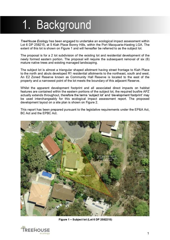
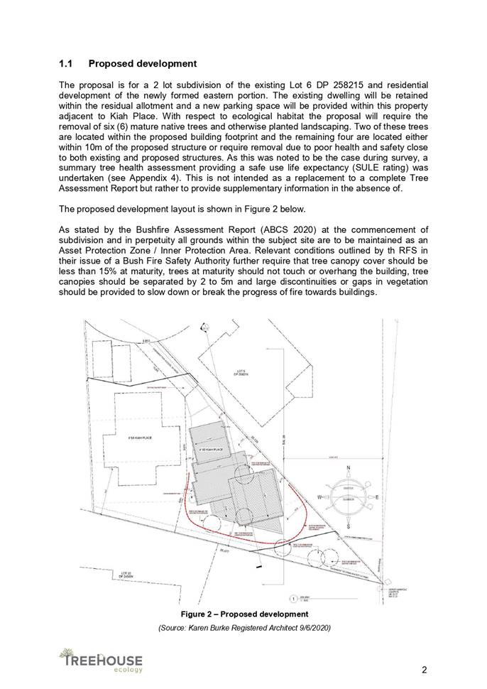
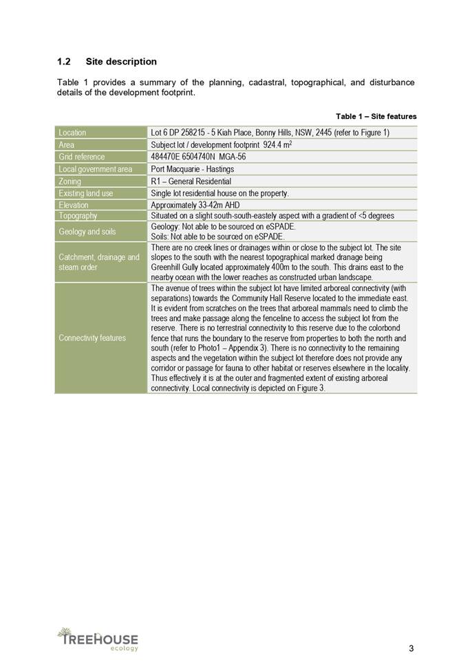
Subdivision, Lot 6 DP258215, 5 Kiah Place Bonny Hills, 11028................................................. 140
09 DA2020
- 713.1 Dwelling and Swimming Pool at Lot 33 DP 31187, No. 58 Watonga Street,
Port Macquarie..................................................................................................... 253
10 DA2020
- 606.1 Demolition of Caravan Park and Construction of Service Station,
Food and Drink Premises and Car Park at Lot 702 DP 1151916, No 128 Hastings
River Drive, Port Macquarie..................................................................................................................... 305
11 General
Business
AGENDA Development Assessment Panel 21/01/2021
Subject: ACKNOWLEDGEMENT
OF COUNTRY
"I acknowledge that we are
gathered on Birpai Land. I pay respect to the Birpai Elders both past and
present. I also extend that respect to all other Aboriginal and Torres Strait
Islander people present."
RECOMMENDATION
That the apologies received be
accepted.
Subject: CONFIRMATION
OF PREVIOUS MINUTES
Recommendation
That the Minutes of the Development Assessment Panel Meeting
held on 16 December 2020 be confirmed.
MINUTES
Development Assessment Panel Meeting
16/12/2020
PRESENT
Members:
Paul
Drake (Independent Chair)
David Crofts (Independent Member)
Group Manager Development
Assessment (Dan Croft)
Other Attendees:
Mayor Peta Pinson
Councillor
Sharon Griffiths
Development
Assessment Planner (Heather Fardy)
Development
Assessment Planner (Steven Ford)
Development
Assessment Planner (Ben Roberts)
Development
Assessment Planning Coordinator (Pat Galbraith-Robertson)
Acting
Development Engineering Coordinator (Grant Burge)
|
The meeting opened at 2:00pm.
|
|
01 ACKNOWLEDGEMENT
OF COUNTRY
|
|
The
Acknowledgement of Country was delivered.
|
|
03 CONFIRMATION
OF MINUTES
|
|
CONSENSUS:
That
the Minutes of the Development Assessment Panel Meeting held on 2 December
2020 be confirmed.
|
|
04 DISCLOSURES
OF INTEREST
|
|
There were no disclosures of interest presented.
|
|
05 DA2018 - 127.1
- 6 lot Torrens Title Subdivision at Lot 6 DP861376, High Street, Wauchope
|
|
Speakers:
Donna Clarke (applicant)
CONSENSUS:
That
DA2018 - 127.1 for a 6 lot torrens title subdivision at Lot 6, DP 861376, High Street, Wauchope,
be determined by granting a deferred commencement consent subject to the
following and the recommended conditions provided in Attachment 1:
- Owner’s
consent being obtained and provided to Council within 6 months of the
date of this consent for offset planting on the Wauchope Showground, Lot
22 DP 1147833, 93A High Street, Wauchope.
- Additional condition in Section E to read: ‘Prior
to release of the subdivision certificate a restriction is to be placed
on the title of the allotments identifying the nominated building
envelopes. Port Macquarie-Hastings Council is to be nominated as the
sole party to modify or release the restriction.’
|
|
06 DA2020 - 842.1
Dwelling at Lot 341 DP 1251842, No 40 Koel Crescent Port Macquarie
|
|
Speakers:
James Collins (applicant)
CONSENSUS:
That DA2020
- 842.1 for a Dwelling at Lot 341, DP 1251842, No. 40 Koel Crescent, Port Macquarie, be determined by granting consent subject to the
recommended conditions.
|
|
07 DA2016
- 87.2 Modification to Approved Subdivision Layout, at Lot 33 DP 803801,
Forest Parkway Lake Cathie
|
|
Speakers:
Donna Clarke (applicant)
Graham Burns (applicant)
John Kennewell (applicant)
CONSENSUS:
That DA 2016 - 87.2 for
a modification to subdivision at Lot 33, DP 803801, Forest
Parkway, Lake Cathie,
be determined by granting consent subject to the recommended modified
conditions and as amended below:
- Amend condition B(19) to read:
‘The pavement for Road 3 shall be 9m wide from Forest Parkway to
proposed Road 2 and 7m wide from proposed Road 2 to Springhill Place.
Details shall be shown on the engineering plans submitted as part of the
application for a Construction Certificate.’
|
|
08 DA2020 - 816.1
Staged Temporary Expansion of an Educational Establishment at Lot 2 DP
610860, Lot 2 DP 354804, Lot 1 DP 1254823, 8 Table Street and 54 Gore Street,
Port Macquarie
|
|
Speakers:
Scott Marchant (applicant)
CONSENSUS:
That DA
2020 - 816.1 for staged temporary
expansion of an educational establishment at Lot 2, DP 610860, Lot 2 DP 354804 and Lot 1 DP 1254823, No. 8
Table Street and No. 54 Gore Street, Port Macquarie, be determined by
granting consent subject to the recommended conditions and as amended below:
|
|
The meeting closed at 3:45pm.
|
AGENDA Development Assessment Panel 21/01/2021
Subject: DISCLOSURES
OF INTEREST
RECOMMENDATION
That Disclosures of Interest be presented
DISCLOSURE OF
INTEREST DECLARATION
|
Name of Meeting:
|
|
Meeting
Date:
|
|
Item
Number:
|
|
Subject:
|
|
I,
the undersigned, hereby declare the following interest:
Pecuniary:
 Take no part
in the consideration and voting and be out of sight of the meeting. Take no part
in the consideration and voting and be out of sight of the meeting.
Non-Pecuniary
– Significant Interest:
Take no part
in the consideration and voting and be out of sight of the meeting.
Non-Pecuniary
– Less than Significant Interest:
May
participate in consideration and voting.
|
|
For
the reason that:
|
|
Name:
Signed:
|
Date:
|
|
Please submit to the
Governance Support Officer at the Council Meeting.
|
 (Refer
to next page and the Code of Conduct)
(Refer
to next page and the Code of Conduct)
Pecuniary Interest
4.1
A pecuniary interest is an interest
that you have in a matter because of a reasonable likelihood or expectation of
appreciable financial gain or loss to you or a person referred to in clause
4.3.
4.2
You will not have a pecuniary
interest in a matter if the interest is so remote or insignificant that it
could not reasonably be regarded as likely to influence any decision you might
make in relation to the matter, or if the interest is of a kind specified in
clause 4.6.
4.3
For the purposes of this Part, you
will have a pecuniary interest in a matter if the pecuniary interest is:
(a)
your interest, or
(b)
the interest of your spouse or de
facto partner, your relative, or your partner or employer, or
(c)
a company or other body of which
you, or your nominee, partner or employer, is a shareholder or member.
4.4
For the purposes of clause 4.3:
(a)
Your “relative” is any
of the following:
(b)
“de facto partner” has
the same meaning as defined in section 21C of the Interpretation Act 1987.
4.5
You will not have a pecuniary
interest in relation to a person referred to in subclauses 4.3(b) or (c)
(a)
if you are unaware of the relevant
pecuniary interest of your spouse, de facto partner, relative, partner,
employer or company or other body, or
(b)
just because the person is a member
of, or is employed by, a council or a statutory body, or is employed by the
Crown, or
(c)
just because the person is a member
of, or a delegate of a council to, a company or other body that has a pecuniary
interest in the matter, so long as the person has no beneficial interest in any
shares of the company or body.
Non-Pecuniary
5.1
Non-pecuniary interests are private
or personal interests a council official has that do not amount to a pecuniary
interest as defined in clause 4.1 of this code. These commonly arise out of
family or personal relationships, or out of involvement in sporting, social,
religious or other cultural groups and associations, and may include an
interest of a financial nature.
5.2
A non-pecuniary conflict of
interest exists where a reasonable and informed person would perceive that you
could be influenced by a private interest when carrying out your official
functions in relation to a matter.
5.3
The personal or political views of
a council official do not constitute a private interest for the purposes of
clause 5.2.
5.4
Non-pecuniary conflicts of interest
must be identified and appropriately managed to uphold community confidence in
the probity of council decision-making. The onus is on you to identify any
non-pecuniary conflict of interest you may have in matters that you deal with,
to disclose the interest fully and in writing, and to take appropriate action
to manage the conflict in accordance with this code.
5.5
When considering whether or not you
have a non-pecuniary conflict of interest in a matter you are dealing with, it
is always important to think about how others would view your situation.
Managing non-pecuniary conflicts of interest
5.6
Where you have a non-pecuniary
conflict of interest in a matter for the purposes of clause 5.2, you must
disclose the relevant private interest you have in relation to the matter fully
and in writing as soon as practicable after becoming aware of the non-pecuniary
conflict of interest and on each occasion on which the non-pecuniary conflict
of interest arises in relation to the matter. In the case of members of council
staff other than the general manager, such a disclosure is to be made to the staff
member’s manager. In the case of the general manager, such a disclosure
is to be made to the mayor.
5.7
If a disclosure is made at a
council or committee meeting, both the disclosure and the nature of the
interest must be recorded in the minutes on each occasion on which the
non-pecuniary conflict of interest arises. This disclosure constitutes
disclosure in writing for the purposes of clause 5.6.
5.8
How you manage a non-pecuniary
conflict of interest will depend on whether or not it is significant.
5.9
As a general rule, a non-pecuniary
conflict of interest will be significant where it does not involve a pecuniary
interest for the purposes of clause 4.1, but it involves:
a)
a relationship between a council
official and another person who is affected by a decision or a matter under
consideration that is particularly close, such as a current or former spouse or
de facto partner, a relative for the purposes of clause 4.4 or another person
from the council official’s extended family that the council official has
a close personal relationship with, or another person living in the same
household
b)
other relationships with persons
who are affected by a decision or a matter under consideration that are
particularly close, such as friendships and business relationships. Closeness
is defined by the nature of the friendship or business relationship, the
frequency of contact and the duration of the friendship or relationship.
c)
an affiliation between the council
official and an organisation (such as a sporting body, club, religious,
cultural or charitable organisation, corporation or association) that is
affected by a decision or a matter under consideration that is particularly
strong. The strength of a council official’s affiliation with an
organisation is to be determined by the extent to which they actively
participate in the management, administration or other activities of the
organisation.
d)
membership, as the council’s
representative, of the board or management committee of an organisation that is
affected by a decision or a matter under consideration, in circumstances where
the interests of the council and the organisation are potentially in conflict
in relation to the particular matter
e)
a financial interest (other than an
interest of a type referred to in clause 4.6) that is not a pecuniary interest
for the purposes of clause 4.1
f)
the conferral or loss of a personal
benefit other than one conferred or lost as a member of the community or a
broader class of people affected by a decision.
5.10
Significant non-pecuniary conflicts
of interest must be managed in one of two ways:
a)
by not participating in
consideration of, or decision making in relation to, the matter in which you
have the significant non-pecuniary conflict of interest and the matter being
allocated to another person for consideration or determination, or
b)
if the significant non-pecuniary
conflict of interest arises in relation to a matter under consideration at a
council or committee meeting, by managing the conflict of interest as if you
had a pecuniary interest in the matter by complying with clauses 4.28 and 4.29.
5.11
If you determine that you have a
non-pecuniary conflict of interest in a matter that is not significant and does
not require further action, when disclosing the interest you must also explain
in writing why you consider that the non-pecuniary conflict of interest is not
significant and does not require further action in the circumstances.
5.12
If you are a member of staff of
council other than the general manager, the decision on which option should be
taken to manage a non-pecuniary conflict of interest must be made in
consultation with and at the direction of your manager. In the case of the
general manager, the decision on which option should be taken to manage a
non-pecuniary conflict of interest must be made in consultation with and at the
direction of the mayor.
5.13
Despite clause 5.10(b), a
councillor who has a significant non-pecuniary conflict of interest in a
matter, may participate in a decision to delegate consideration of the matter
in question to another body or person.
5.14 Council committee members are not required to declare
and manage a non-pecuniary conflict of interest in accordance with the
requirements of this Part where it arises from an interest they have as a
person chosen to represent the community, or as a member of a non-profit
organisation or other community or special interest group, if they have been
appointed to represent the organisation or group on the council committee.
SPECIAL
DISCLOSURE OF PECUNIARY INTEREST DECLARATION
This
form must be completed using block letters or typed.
If
there is insufficient space for all the information you are required to
disclose,
you
must attach an appendix which is to be properly identified and signed by you.
|
By
[insert full name of councillor]
|
|
|
In the matter
of
[insert name of environmental planning instrument]
|
|
|
Which is
to be considered at a meeting of the
[insert name of meeting]
|
|
|
Held on
[insert date of meeting]
|
|
|
PECUNIARY
INTEREST
|
|
Address of
the affected principal place of residence of the councillor or an associated
person, company or body (the identified land)
|
|
|
Relationship
of identified land to councillor
[Tick or cross one box.]
|
The councillor has interest in the land (e.g. is owner or has other
interest arising out of a mortgage, lease, trust, option or contract, or
otherwise).
An associated person of the councillor has an interest in the land.
An associated company or body of the councillor has interest in the land.
|
|
MATTER
GIVING RISE TO PECUNIARY INTEREST
|
|
Nature of
land that is subject to a change
in
zone/planning control by proposed
LEP (the
subject land
[Tick or cross one box]
|
The identified land.
Land that adjoins or is adjacent to or is in proximity to the identified
land.
|
|
Current
zone/planning control
[Insert name of current planning instrument and
identify relevant zone/planning control applying to the subject land]
|
|
|
Proposed
change of zone/planning control
[Insert name of proposed LEP and identify proposed
change of zone/planning control applying to the subject land]
|
|
|
Effect of
proposed change of zone/planning control on councillor or associated person
[Tick or cross one box]
|
Appreciable financial gain.
Appreciable financial loss.
|
|
|
|
[If more than one pecuniary interest is to be
declared, reprint the above box and fill in for each additional interest]
Councillor’s Signature:
……………………………….
Date: ………………..
This form is to be retained
by the council’s general manager and included in full in the minutes of
the meeting
Last Updated: 3 June 2019
Important Information
This information is being collected for the purpose of
making a special disclosure of pecuniary interests under clause 4.36(c) of the
Model Code of Conduct for Local Councils in NSW (the Model Code of Conduct).
The special disclosure must relate only to a pecuniary
interest that a councillor has in the councillor’s principal place of
residence, or an interest another person (whose interests are relevant under
clause 4.3 of the Model Code of Conduct) has in that person’s principal
place of residence.
Clause 4.3 of the Model Code of Conduct states that you
will have a pecuniary interest in a matter because of the pecuniary interest of
your spouse or your de facto partner or your relative or because your business
partner or employer has a pecuniary interest. You will also have a pecuniary
interest in a matter because you, your nominee, your business partner or your
employer is a member of a company or other body that has a pecuniary interest
in the matter.
“Relative” is defined by clause 4.4 of the Model
Code of Conduct as meaning your, your spouse’s or your de facto
partner’s parent, grandparent, brother, sister, uncle, aunt, nephew,
niece, lineal descendant or adopted child and the spouse or de facto partner of
any of those persons.
You
must not make a special disclosure that you know or ought reasonably to know is
false or misleading in a material particular. Complaints about breaches
of these requirements are to be referred to the Office of Local Government and
may result in disciplinary action by the Chief Executive of the Office of Local
Government or the NSW Civil and Administrative Tribunal.
This form must be completed by you before the commencement
of the council or council committee meeting at which the special disclosure is
being made. The completed form must be tabled at the meeting. Everyone is
entitled to inspect it. The special disclosure must be recorded in the minutes
of the meeting.
A pecuniary interest may arise by way of a change of
permissible use of land adjoining, adjacent to or in proximity to land in which
a councillor or a person, company or body referred to in clause 4.3 of the
Model Code of Conduct has a proprietary interest
AGENDA Development Assessment Panel 21/01/2021
Item: 05
Subject: DA2020 - 701.1 Part Change of Use from
Educational Establishment to Multi Dwelling Housing including Tourist and
Visitor Accommodation, 11 Mission Terrace Lakewood, Lot 2 DP 771931
Report
Author: Development Assessment Planner, Steven Ford
|
Applicant: Blueprint
Planning Consultants
Owner: CrossView
Australia Ltd
Estimated Cost: $0
Alignment with Delivery
Program
4.3.1 Undertake transparent
and efficient development assessment in accordance with relevant legislation.
|
RECOMMENDATION
That
DA2020 - 701 for a part Change
of Use from Educational Establishment to Multi Dwelling Housing including
Tourist and Visitor Accommodation at Lot 2, DP 771931, No. 11 Mission Terrace, Lakewood, be determined by granting consent subject to the
recommended conditions.
Executive
Summary
This
report considers a development application for a Part Change of Use from Educational
Establishment to Multi Dwelling Housing including Tourist and Visitor
Accommodation at the subject site and provides an
assessment of the application in accordance with the Environmental Planning and
Assessment Act 1979.
Following exhibition of the
application, one submission was received.
The site is considered suitable for the proposed development
and the proposal adequately addresses relevant planning controls. The
development is not considered to be contrary to the public's interest and will
not result a significant adverse social, environmental or economic impact.
This report recommends that the
development application be approved subject to the attached conditions
in Attachment 1.
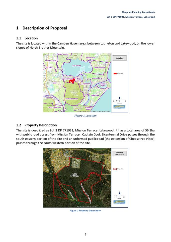
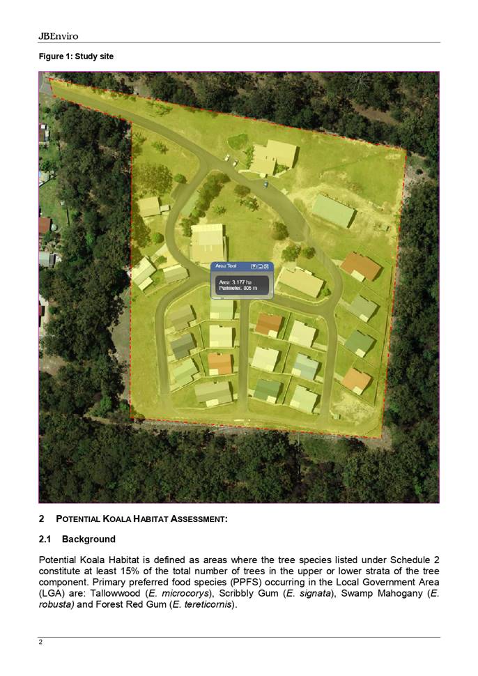
1. BACKGROUND
Existing
Sites Features and Surrounding Development
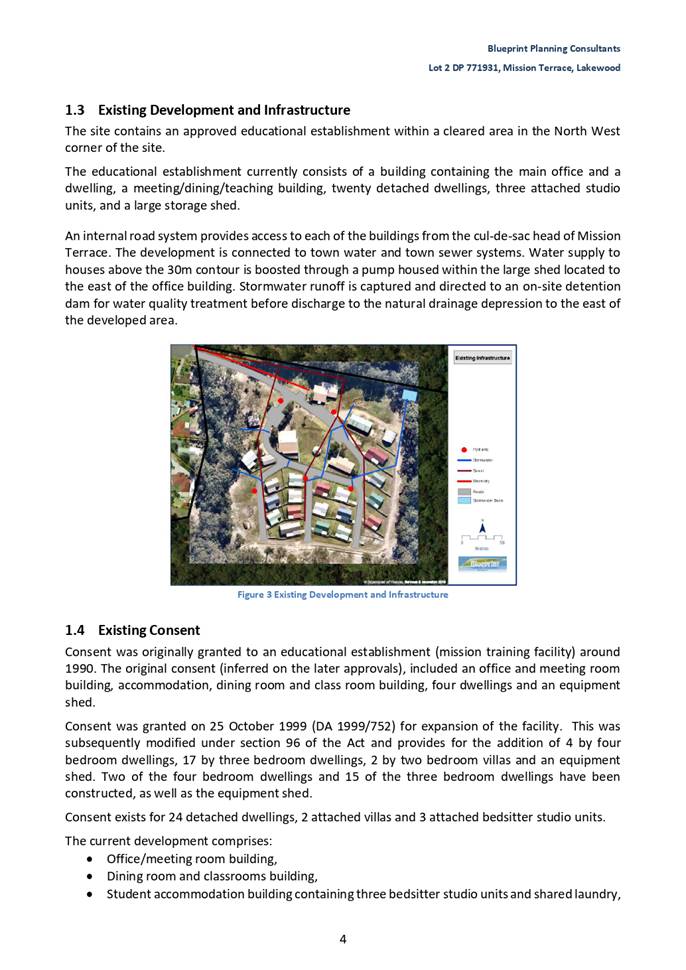
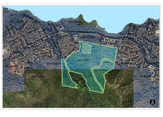
The site has an area of 56
Hectares.
Prior to
lodgement of this development application, the subject property was rezoned
from RU1 Primary Production to R1 General Residential and E3 Environmental
Management, amending the minimum lot size, building height and floor space
ratio provisions applying to part of Lot 2 DP 771931, Mission Terrace,
Lakewood. (PP2016 - 11.1)
The
site is now zoned R1 General Residential and E3 Environmental Management
in accordance with the Port Macquarie-Hastings Local
Environmental Plan 2011, as shown in the following zoning plan:
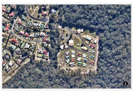
The
existing subdivision pattern and location of existing development within the
locality is shown in the following aerial photographs:
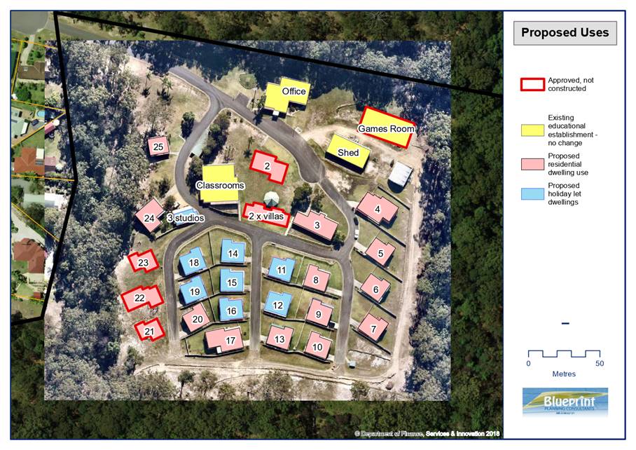
2. DESCRIPTION
OF DEVELOPMENT
Key
aspects of the proposal include the following:
· The
existing educational establishment with onsite accommodation was originally
approved by DA1999/752 and remains an active consent. This is to be partly
retained, namely the educational buildings, in conjunction with the residential
accommodation.
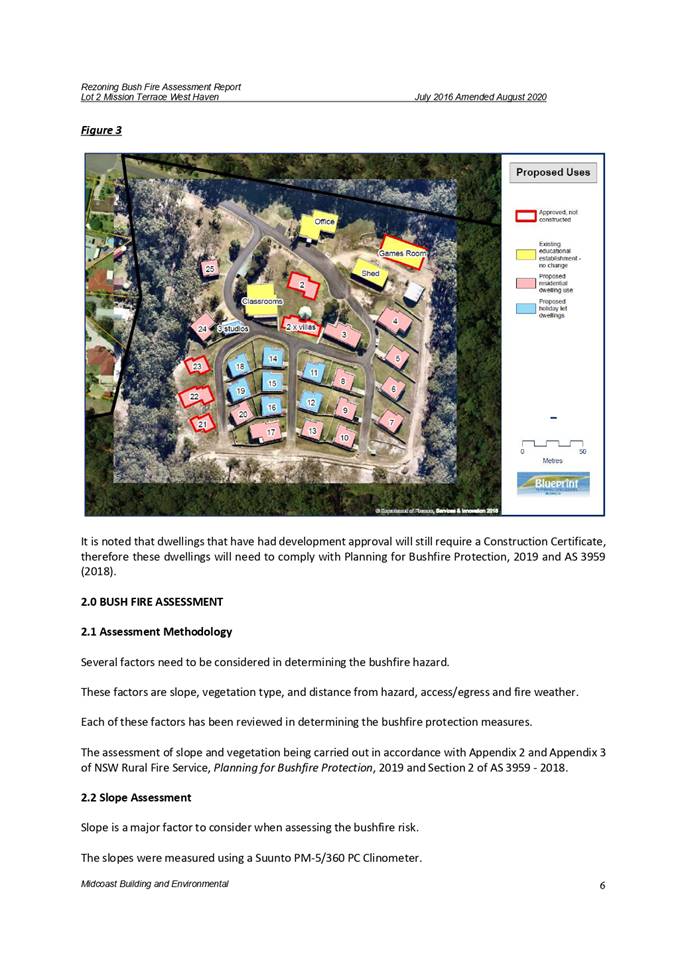
· Propose
change of use of all dwellings to multi dwelling housing. To allow flexibility
to rent out any or all dwellings to persons not associated with the educational
establishment.
· Allow tourist and visitor accommodation of dwellings
numbered 11, 12, 14, 15, 16 and 18 and 3 studios.
· All educational establishment buildings to remain as
previously approved by DA1999/752.
· No Building works are proposed other than bushfire
mitigation upgrades.
Refer
to Attachment 2 at the end of this report for plans of the proposed development.
Application
Chronology
· 27
August 2020 - Application Received
· 9 September to 22 September 2020 - Notification of Proposal
· 21 September 2020 - Submission received
· 24 September 2020 - Additional information received
· 28 October 2020 - Additional information request from Rural
Fire Service
· 6 November 2020 - Additional information received
· 4 December 2020 - Additional Information Request from Rural
Fire Service
· 17 December 2020 - General Terms of Approval received from
Rural Fire Service
3. STATUTORY
ASSESSMENT
Section
4.15(1) Matters for Consideration
In
determining the application, Council is required to take into consideration the
following matters as are relevant to the development that apply to the land to
which the development application relates:
(a) The provisions
(where applicable) of:
(i) Any
Environmental Planning Instrument
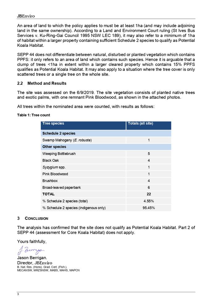
State Environmental Planning Policy (Koala Habitat
Protection) 2020
Clause 5 - This SEPP applies to the Port Macquarie-Hastings
Local Government Area.
Clause 7 - The property is over 1ha in size
and consideration of the site as potential koala habitat is required under
Clause 8.
Clause
8 - As per Circular B35, Clause 1.5, it is the intent of the Policy that
investigations for potential and core koala habitat be limited to those areas
in which it is proposed to disturb habitat. In this case, the
application has demonstrated that no habitat will be removed or disturbed in
relation to the change of use of the existing development to multi dwelling
housing. Therefore, the site is not considered to be potential
habitat and further consideration of the SEPP is not required.
Clause
9 - The Applicant has submitted an assessment by JB Enviro, which
satisfactorily demonstrates the site is not core
koala habitat. As the site is not considered to be core habitat,
further consideration of the SEPP is not required.
State Environmental Planning Policy (Coastal Management)
2018
The site is located within a coastal environment area.
Clause 7 - This SEPP prevails over the Port
Macquarie-Hastings LEP 2011 in the event of any inconsistency.
Clause 14 - The proposed development is not considered
likely to result in any of the following:
a. any
adverse impact on integrity and resilience of the biophysical,
hydrological (surface and groundwater) and ecological environment;
b. any
adverse impacts coastal environmental values and natural coastal
processes;
c. any
adverse impact on marine vegetation, native vegetation and fauna
and their habitats, undeveloped headlands and rock platforms;
d. any
adverse impact on Aboriginal cultural heritage, practices and
places;
e. any
adverse impacts on the cultural and built environment heritage;
f. any
adverse impacts the use of the surf zone;
g. any adverse impact on the visual amenity and scenic qualities of the
coast, including coastal headlands;
h. overshadowing, wind funnelling and the loss of views from public places
to foreshores; and
i. any
adverse impacts on existing public open space and safe access to
and along the foreshore, beach, headland or rock platform for members of the
public, including persons with a disability.
Clause 15 - The proposal is not likely to cause increased
risk of coastal hazards on the land or other land.
The bulk, scale and size of the proposed development remains
compatible with the surrounding coastal and built environment. The site for the
proposal is predominately cleared and located within an area zoned for
residential purposes.
Port Macquarie-Hastings Local Environmental
Plan 2011
The proposal is consistent with the LEP having regard to the
following:
· Clause
2.2 - The subject site is zoned R1 General Residential and E3 Environmental
Management.
· Clause
2.3(1) and the R1 zone landuse table - The proposed development for a Change of
use from Educational Establishment to Multi Dwelling Housing including part
Tourist and visitor accommodation is a permissible landuse with consent. (note
the footprint of the existing development is within the R1 zoned land only).
The objectives of the R1 zone are as
follows:
o To provide for the housing
needs of the community.
o To provide for a variety of
housing types and densities.
o To enable other land uses that
provide facilities or services to meet the day to day needs of residents.
The objectives of the E3 zone are as
follows:
o To protect, manage and restore areas with special ecological,
scientific, cultural or aesthetic values. To provide for a variety of
housing types and densities.
o To provide for a limited range of
development that does not have an adverse effect on those values.
Clause 2.3(2) - The proposal is
consistent with the zone objectives having regard to the following:
o the proposal is a permissible
landuse;
o no identifiable adverse impact
to the adjoining environmental management land in terms of special ecology,
cultural or aesthetic values.
· Clause
5.10 - The site does not contain or adjoin any known heritage items or
sites of significance.
· Clause
7.13 - Satisfactory arrangements are in place for provision of essential
services including water supply, electricity supply, sewer infrastructure,
stormwater drainage and suitable road access to service the development.
·
(ii) Any
draft instruments that apply to the site or are on exhibition
No draft instruments apply to the site.
(iii) Any Development
Control Plan in force
Port
Macquarie-Hastings Development Control Plan 2013
The
relevant general provisions of the plan considered in the following table:
|
DCP 2013: Part B - General Provisions - B2:
Environmental Management
|
|
DCP Objective
|
Development Provisions
|
Proposed
|
Complies
|
|
3
|
a) Development must comply
with Council’s Developments, Public Place & Events - Waste
Minimisation and Management Policy.
|
The existing storage and
collection of waste satisfies this clause and is to remain as private
collection. Standard condition recommended for construction waste management.
|
Yes
|
|
Cut and Fill Regrading
|
|
4
|
a) Development shall not
exceed a maximum cut of 1.0m and fill of 1.0m measured vertically above the
ground level (existing) at a distance of 1.0m outside the perimeter of the
external walls of the building (This does not apply to buildings where such
cut and fill is fully retained within or by the external walls of the
building).
|
The proposal involves no
additional earthworks beyond what has been approved under consent to DA
1999/752.
|
N/A
|
|
DCP 2013: Part B -
General Provision - B3: Hazards Management
|
|
Bushfire Hazard Management
|
|
18
|
a) APZs are to be located
outside of environmental protection zones and wholly provided within private
land. Note perimeter roads provided as part of a residential subdivision are
classified as being part of the subdivision and not a separate permissible
land use within environment protection zones.
|
The existing APZ is wholly
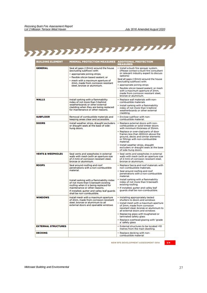
contained within the R1 zoned area. As stated in the Bushfire Assessment
Report, by Midcoast Building and Environmental, amended August 2020, the
proposed multi dwelling housing development is capable of complying.
|
Yes
|
|
DCP 2013: Part B- General Provisions- B4: Transport,
Traffic Management, Access and Car Parking
|
|
DCP Objective
|
Development Provisions
|
Proposed
|
Complies
|
|
Road Hierarchy
|
|
Parking Provision
|
|
24
|
a) Off-street Parking is
provided in accordance with Table 3:
- 1 parking space per each
dwelling for dwelling-house.
|
A parking study has been
submitted to support the existing development onsite parking adequately
addresses the DCP 2013 requirements.
All the dwellings (total of
30 separate occupancies) include a single carport and most provide for a stacked
parking space in the driveway from the internal access road to the garage.
Total of 30 residential car
spaces + opportunities for stacked car parking within driveways for visitors.
In addition, there is
visitor parking provided near the office building for 24 angled parking
spaces, and a further 12 angled parking spaces near the meeting/classroom
building. Resulting in adequate parking for the existing administration and
educational buildings to partly continue operation/use.
Providing the above comments,
location, the private road/driveways widths being 6.2m wide, existing
developments, there is no identifiable impact to on street car parking along
Mission Terrace.
In general the development
meets the objectives of this clause.
|
Yes
|
|
Parking Layout
|
|
28
|
c) Parking spaces shall
generally be behind the building line but may be located between the building
line and the street when:
− it
is stacked parking in the driveway; or
− it
can be demonstrated that improvements to the open space provided will result;
and
− the
spaces are screened (densely landscaped or similar) from the street by a
landscaping with a minimum width of 3.0m for the entire length of the parking
area.
|
No Changes proposed - see
Parking and Manoeuvring later in this report
|
N/A
|
|
d) Parking design and layout
is provided in accordance with AS/NZS 2890.1 - Parking facilities -
Off-street car parking.
|
No Changes proposed - see
Parking and Manoeuvring later in this report
|
N/A
|
|
34
|
a) All parking and manoeuvring
spaces must be designed to avoid concentrations of water runoff on the
surface.
|
No changes proposed
|
N/A
|
|
b) Council will not permit the
discharge of stormwater directly into kerbing and guttering or table drains
for any development other than that of a minor nature.
|
No Changes proposed
|
N/A
|
|
DCP 2013: Part B -
General Provisions - B5: Social Impact Assessment and Crime Prevention
|
|
DCP Objective
|
Development Provisions
|
Proposed
|
Complies
|
|
Crime Prevention
|
|
43
|
a) The development addresses
the generic principles of crime prevention:
− Casual
surveillance and sightlines;
− Land use mix
and activity generators;
− Definition of
use and ownership;
− Basic exterior
building design;
− Lighting;
− Way-finding;
and
− Predictable
routes and entrapment locations;
− as described in
the Crime Prevention Through Environmental Design (CPTED) principles.
|
No concealment or entrapment areas proposed. Adequate
casual surveillance available.
Note, buildings are existing onsite.
|
Yes
|
|
DCP 2013: Part C - Development Specific Provisions -
C1: Low Density Residential Development
|
|
DCP Objective
|
Development Provisions
|
Proposed
|
Complies
|
|
Front Setbacks
|
|
44
|
a) Dwellings may incorporate an articulation zone to a
street frontage at no less than 3m from property boundary. The
following building elements are permitted within the articulation zone:
− an entry
feature or portico;
− a balcony,
deck, patio, pergola, terrace or verandah;
− a window box
treatment;
− a bay window or
similar feature;
− an awning or
other feature over a window;
− a sun shading
feature.
b) These building elements should not extend above the
eave gutter line, other than a pitched roof to an entry feature or portico
that has the same pitch as the roof on the dwelling house.
|
N/A - the development is at the end of Mission Terrace and
considered to be inward facing to internal roads/driveways.
|
N/A
|
|
c) The primary road front setback shall be:
Classified road = any frontage 6.0m
Primary frontage = 4.5m
Secondary frontage = 3.0m
Ancillary Lane = 2.0m
Large lot residential and rural zones = 10.0m
|
N/A - No proposed changes
|
N/A
|
|
45
|
a) A garage, carport or car parking space should:
− be at least 1m behind
the building line, where the dwelling(s) has a setback from a front boundary
of 4.5m or more, or
− be at least 5.5m
from a front boundary, where the dwelling(s) has a setback of less than 4.5m.
|
N/A - no proposed changes.
|
N/A
|
|
b) The total width of the garage/carport openings should
not be more than 6m and not more than 50 per cent of the width of the
building.
|
N/A - no proposed changes to existing carports.
|
N/A
|
|
c) Driveway crossovers are no greater than 5.0m in width.
|
N/A - no proposed changes
|
N/A
|
|
d) Where a dual occupancy or attached dwelling is proposed
on a corner lot a garage and driveway is provided on each road frontage.
|
N/A - not considered a corner lot
|
N/A
|
|
Side and Rear Setbacks
|
|
46
|
a) A minimum rear boundary setback of 4m is to be provided
to dwellings (including verandahs, patios and decks).
|
All buildings are setback
not less than 10m from the nearest property boundary. There are no impacts on
adjoining properties from overshadowing.
|
Yes
|
|
47
|
a) Ground floors (being <1m above existing ground
level) should be setback a minimum of 900mm from side boundaries.
|
All dwellings are single
storey, although the floor may be elevated due to the fall of the site. No
dwelling encroaches 900mm from any boundary.
|
|
|
Private Open Space
|
|
48.
|
a) All dwellings should have a minimum area of private
open space of 35m2, which includes a principal private open space area
with:
− a minimum
dimension of 4m x 4m, and
− a maximum grade
of 5% for minimum 4m x 4m of the total open space requirement, and
− direct
accessibility from a ground floor living area and orientated to maximise use.
|
Each dwelling is provided with a fenced yard which
provides private open space. The private open spaces varies from 70m2
to 150m2, however, due to the natural slope of the site exceeds
the 5% maximum specified by the DCP, it is considered that this is
compensated by the large size of the yards providing more than the minimum
private open space and the provision of decks on each of the dwellings,
opening from the living room. The objectives of this clause have been
satisfied.
|
Yes
|
|
|
b) Private open space may include clothes drying areas and
garbage storage.
|
Appropriate area provided for each dwelling.
|
Yes
|
|
Public Domain and Fencing
|
|
49
|
a) Front fences built forward of the building line for the
primary road frontage should be detailed on the development application
plans.
|
N/A - no front fence proposed
|
N/A
|
|
Bulk and Scale
|
|
51
|
a) Direct views between indoor living rooms and principal
private open space of adjacent dwellings, including proposed dwellings
approved on adjoining lots, including possible dwellings on future lots,
should be obscured or screened where:
− Ground and first
floor (and above) indoor living room windows are within a 9m radius.
− Direct views
between principal private open space areas where within a 12m radius.
− Direct views
between indoor living rooms of dwellings into the principal area of private
open space of other dwellings within a 12m radius.
|
No adverse privacy impacts are identified to neighbouring
properties. It is also noted due to the natural fall of the site, and the
orientation of the internal floor areas towards the north, and with garages
on the southern side, good visual privacy is achieved between each of the
dwellings.
|
Yes
|
|
b) A balcony, deck, patio, pergola, terrace or verandah
should have a privacy screen where there are direct views of:
− Indoor living
room windows of adjacent dwellings, including proposed dwellings approved on
adjoining lots within 9m radius; or
− Principal areas
of private open space of adjacent dwellings, including proposed dwellings
approved on adjoining lots within a 12m radius.
|
As discussed above, adequate separation is provided
between adjoining dwellings to provide privacy.
|
Yes
|
|
c) Privacy protection is
not required for:
− Any Indoor
living room windows with a sill height of greater than 1.5m above the
finished floor level of that room or where fixed non-openable translucent
glass is installed to the same height.
|
No additional screening or increase sill height will be
required.
|
Yes
|
|
d) Direct views described above may be reduced or obscured
by one of the following measures (details to be submitted with the
development application):
− 1.8m high fence
or wall between ground-floor level windows or between a dwelling and
principal private open space
− Screening of
minimum 1.7m height, that has 25% openings (max), with no individual opening
more than 30mm wide, is permanently fixed and is made of durable materials.
− A
window, the whole of which has translucent glass and is not able to be
opened.
|
There are no privacy concerns between adjoining properties
externally or internally. No additional screening or increase sill height
will be required.
|
Yes
|
|
Ancillary Development
|
|
56
|
a) For ancillary development in R1 General Residential, R2
Low Density Residential, R3 Medium Density Residential, R4 High Density
Residential, R5 Large Lot Residential and RU5 Village zones:
− The height of
an outbuilding or the alterations and additions to an existing outbuilding on
a lot should not be more than 4.8m above ground level (existing).
− The building
should be single storey construction with a maximum roof pitch of 24 degrees.
− The maximum
area of the building should be 60m2 for lots less than 900m² and maximum
of 100m² for larger lots.
− Ancillary
development that is a garage, or an outbuilding, or a rainwater tank should
not be located in front of the main building line with the exception of
swimming pools.
|
N/A - No changes to existing and proposed Educational
building as approved under DA1999/752
|
N/A
|
(iiia) Any planning agreement that has
been entered into under section 7.4, or any draft planning agreement that a developer
has offered to enter into under section 7.4
No planning agreement has been offered or entered into
relating to the site.
(iv) Any
matters prescribed by the Regulations
Fire Safety and other considerations - Clause 93
The change of building use sought by a development
application is satisfied that the building complies (or will, when completed,
comply) with such of the Category 1 fire safety provisions as are applicable to
the building’s proposed use. It is considered that buildings are capable
of complying to that required by the BCA appropriate to all of the proposed
uses, both the existing dwellings and Tourist and Visitor Accommodation
buildings, on completion.
Appropriate consent conditions are recommended.
(b) The likely
impacts of that development, including environmental impacts on both the
natural and built environments, social and economic impacts in the locality
Context and Setting
· The site has a
general north west street frontage orientation to Mission Terrace.
· Adjoining the site
to the north is bushland zoned RU1 and further north is Ocean
Drive.
· Adjoining the site
to the east is E3 environmental Management land and further East is residential
subdivisions (West Haven).
· Adjoining the site
to the south is E3 Environmental Management land and National Park
land.
· Adjoining the site
to the west is a residential subdivision.
· The proposal will
not have any significant adverse impacts to existing adjoining properties or
the public domain.
· The proposal is
considered to be consistent with other residential development in the locality
and adequately addresses planning controls for the area.
· The proposal does
not have a significant adverse impact on existing view sharing.
· The proposal does not
have significant adverse lighting impacts.
· There are no
significant adverse privacy impacts. Adequate building separation and
tenancy is proposed/existing.
· There are no
significant adverse overshadowing impacts. The proposal does not prevent adjoining
properties from receiving 3 hours of sunlight to private open space and primary
living areas on 21 June between the hours of 9am and 3pm.
Roads
The site is at the end of Mission Terrace is characterised
as a cul-de-sac. Mission Terrace is a sealed public road under the care control
of Council and connects to a private sealed road/driveway to each dwelling.
Traffic and Transport
The additional traffic associated with the development is
unlikely to have any adverse impacts to the existing road network within the
immediate locality.
Site Frontage and Access
Vehicle access to the site is proposed though an individual
existing crossover with direct frontage to Mission Terrace, being a
Council-owned public road. Access complies with Council AUSPEC and Australian
Standards at the time of construction.
Parking and Manoeuvring
A total of 30 parking spaces have been provided on-site
within carports, with up to 24 additional parking provided existing educational
buildings and additional parking available within the internal
roads/driveways. Parking and driveway widths on site comply with relevant
Australian Standards (AS 2890).
The Application has provided supporting documentation
regarding parking and manoeuvring from Midcoast Consulting Engineers. The application
has satisfactorily demonstrated that the proposed development can provide
adequate parking and access for compliance with DCP 2013 and AS2890. Existing
private road carriageway widths are minimum 6.2m which complies with public
road standard for Shareway or Access Place (Auspec D1, Table D1.5), suitable
for servicing up to 30 dwellings.
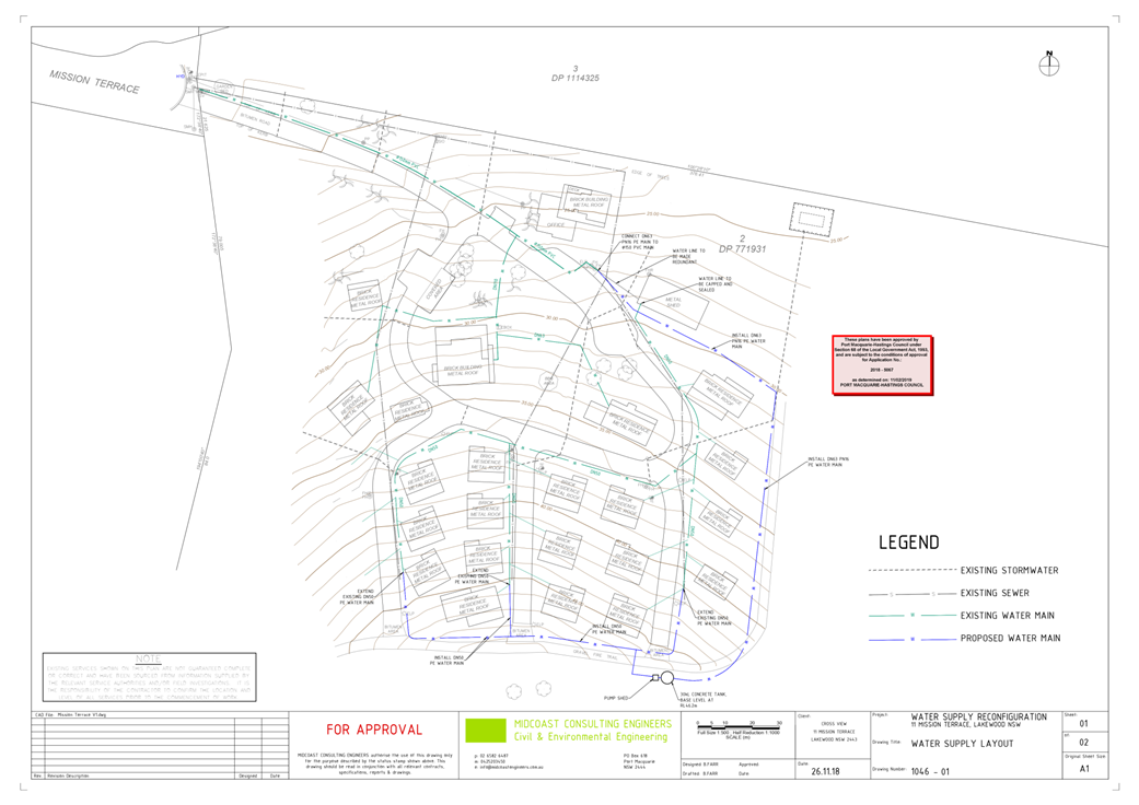
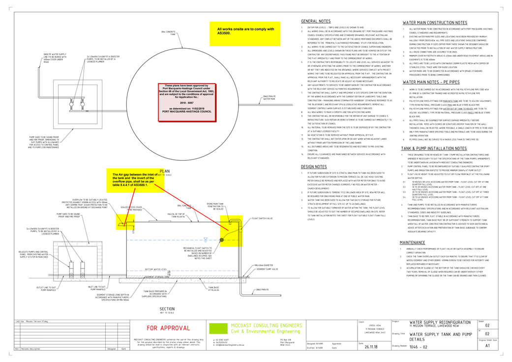
Water Supply Connection
Council records indicate that the
development site has an existing 100mm metered service to the 100mm diameter
PVC water main on the same side of Mission Terrace.
Each
proposed dwelling will need to be separately metered, meters may be either
located at the road frontage or internally with a master meter at the boundary.
A
hydraulic strategy and detailed plans are required from a hydraulic consultant
for the whole of the development on the site. Water service sizing is then to
be determined by the hydraulic consultant to suit the proposed development, as
well as addressing fire service requirements to AS 2419 and backflow protection
requirements.
Final water service sizing will need to be determined by a
hydraulic consultant to suit the development as well as addressing fire service
coverage to AS 2419 and backflow protection.
Detailed plans have previously been submitted and approved with
a S.68 application.
Sewer Connection
Council records indicate that the
development site is connected to Sewer via junction to the existing sewer
manhole outside the property frontage of the development lot. The site may
discharge all sewage to this point.
Detailed plans will be required to be submitted for
assessment with the S.68 application.
Appropriate consent conditions are recommended.
Stormwater
The site naturally grades towards North-East corner of the
lot and is currently serviced via an existing onsite detention. Detailed plans
have previously been submitted and approved with a S.68 application.
Other Utilities
Telecommunication and electricity services are available to
the site.
Heritage
Following a site inspection, no known items of Aboriginal or
European heritage significance exist on the property. No adverse impacts
anticipated. The site is considered to be disturbed land.
Other Land Resources
The site is within an established urban context and will not
sterilise any significant mineral or agricultural resource.
Water Cycle
The proposed development will not have any significant
adverse impacts on water resources and the water cycle.
Soils
The proposed development will not have any significant
adverse impacts on soils in terms of quality, erosion, stability and/or
productivity.
Air and Microclimate
The construction and/or operations of the proposed
development will not result in any significant adverse impacts on the existing
air quality or result in any pollution. Standard precautionary site management
condition recommended.
Flora and Fauna
Construction of the proposed development will not require
any removal/clearing of any native vegetation and therefore does not trigger
the biodiversity offsets scheme. Part 7 of the Biodiversity Conservation
Act 2016 is considered to be satisfied.
Waste
Satisfactory private waste collection arrangements are to be
retained. No adverse impacts anticipated. A consent condition is recommended in
this regard.
Energy
No adverse impacts anticipated. No change to buildings.
Noise and Vibration
The noise and amenity operations of the proposed development
will not result in any significant adverse impacts on the existing air quality
or result in any pollution.
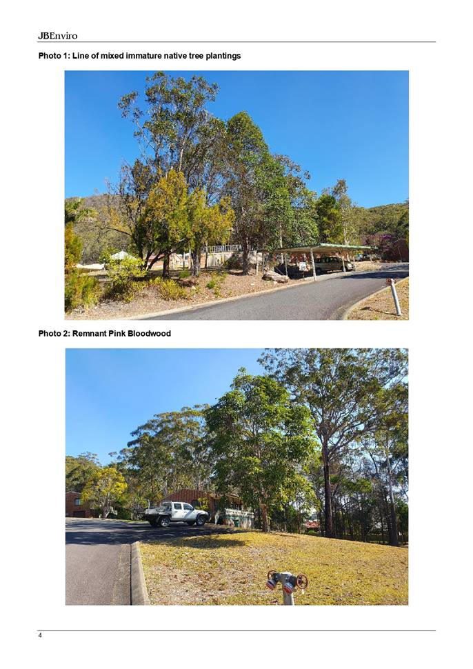
Bushfire
The site is identified as being bushfire prone.
The Applicant has submitted a bushfire report prepared by
Midcoast Building and Environmental, August 2020.
An assessment of bushfire risk having regard to section
4.3.5 of Planning for Bushfire Protection 2006 including vegetation
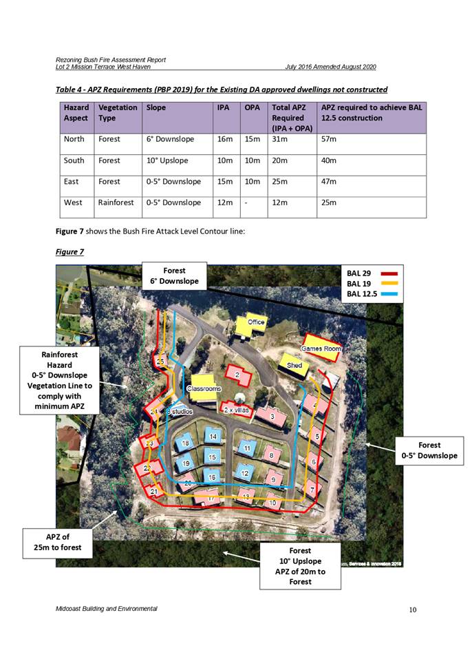
classification and slope concludes that a Bushfire Attack Level ranges from
12.5, 19 and 29 shall be required.
Management of bushfire risk is acceptable subject to BAL
construction levels being implemented and APZ being maintained. An appropriate
condition is recommended to require upgrade of the buildings prior to
Occupation Certificate.
In accordance with Section 100B - Rural Fires Act 1997 - the
application proposes development that is integrated development. As a result,
the applicant has submitted a bushfire report prepared by a Certified
Consultant. The report was forwarded to the NSW Rural Fire Service who have
since issued a Bushfire Safety Authority, which will be incorporated into the
consent.
Safety, Security and Crime Prevention
The proposed development will be unlikely to create any
concealment/entrapment areas or crime spots that would result in any
identifiable loss of safety or reduction of security in the immediate
area. The housing density will retain natural surveillance within the
locality and openings from each dwelling overlook common and private areas.
Social Impacts in the Locality
Given the nature of the proposed development and its
location the proposal is not considered to have any significant adverse social
impacts.
Economic Impacts in the Locality
The proposal is not considered to have any significant
adverse economic impacts on the locality.
Site Design and Internal Design
The proposed development design satisfactorily responds to
the site attributes and will fit into the locality.
Construction
Any construction impacts are considered capable of being
managed, standard construction and site management conditions have been
recommended.
Cumulative Impacts
The proposed
development is not considered to have any significant adverse cumulative
impacts on the natural or built environment or the social and economic
attributes of the locality.
(c) The
suitability of the site for the development
The proposal will fit into the locality and the site
attributes are conducive to the proposed development.
Site constraints of bushfire have been adequately addressed
and appropriate conditions of consent recommended.
(d) Any
submissions made in accordance with this Act or the Regulations
One (1) written
submission was received following public exhibition of the application. Copies
of the written submissions have been provided separately to members of the DAP.
Key
issues raised in the submission received and comments are provided as follows:
|
Submission
Issue/Summary
|
Planning
Comment/Response
|
|
The submission notes that it
does not entirely object. However, reserves the right to object because of
some of the issues raised and
consideration of adopting the proposed
enhancements as mitigation
measures.
|
The submission was forwarded
to the Applicant for consideration.
Issues raised have been noted.
|
|
Bushfire attack mitigation
|
The
submitted bushfire report sets out all the required works to comply with
Planning for Bushfire Protection 2019. There is no requirement to undertake
any works outside the property boundaries.
In accordance with Section 100B - Rural Fires Act
1997, the report was forwarded to the NSW Rural Fire Service who have
since issued concurrence as the Bushfire Safety Authority, which will be
incorporated into the consent.
|
|
Pedestrian access to Ocean Drive and Queens Lake.
Consideration is requested to enter into an amicable agreement for pedestrian
access for compensation or maintenance costs.
|
The proposed application does not indicate a pedestrian
route to Ocean Drive over the adjoining private land.
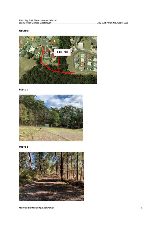
The use of the existing fire trail through 304 Ocean
Drive is not proposed to change. There is no planning justification
requiring such an arrangement. If the owner of the adjoining land wishes to
negotiate such an arrangement, this could be addressed as a civil matter, and
not be imposed on the development consent.
The
Development has access to Ocean Drive and Queens Lake via Mission Terrace.
Therefore, there no further comment is required at this time.
|
|
Stormwater discharge
|
There are
always alternative solutions to stormwater solutions, however the development
does not propose any new works and so any existing stormwater flow has been
approved by council in previous consents.
The existing
stormwater infrastructure appears consistent with the most recent Section 68
approval for the site, reference 680.2018.00005067.001 and the original
Engineering Works approved by DA1999/752 for the Educational Establishment.
This
application relates to the change of use of the approved residential
accommodation to allow long term accommodation. This will have no impact to
the existing storm water flow.
|
(e) The Public Interest
The proposed development
satisfies relevant planning controls and will not adversely impact on the wider
public interest.
Ecologically Sustainable Development and Precautionary
Principle
Ecologically sustainable development requires the effective
integration of economic and environmental considerations in decision-making
processes.
The four principles of ecologically sustainable development
are:
· the
precautionary principle,
· intergenerational
equity,
· conservation
of biological diversity and ecological integrity,
· improved
valuation, pricing and incentive mechanisms.
The principles of ESD require that a balance needs to be
struck between the man-made development and the need to retain the natural
vegetation. Based on the assessment provided in the report and with recommended
conditions of consent, it is considered an appropriate balance has been struck.
Climate change
The proposal is not considered to be vulnerable to any risks
associated with climate change.
4. DEVELOPMENT
CONTRIBUTIONS APPLICABLE
· Development contributions will not be required under
S64/S7.11 for the following reasons:
· The development does not propose the creation of any
additional dwellings
· The existing dwellings and proposed dwellings have been
approved by DA1999/752, as modified, and levied appropriate S64/S7.11 developer
charges that applied at the time of approval and payable prior to the release
of the Construction Certificate for each dwelling.
· The 3x
Existing Studios were approved by DA2005/301 and note that contributions were
satisfied with a site credit.
· Contributions
have been levied as dwellings, as required at the time, and not as tourist and
visitor accommodation.
· No subdivision is proposed (note, future development
involving subdivision might generate additional S64/7.11 charges to be levied).
· The dwelling yet to be constructed but approved under
DA1999/752 will be levied S64/7.11 charges prior to the Construction
Certificate as per the consent conditions.
5. CONCLUSION AND
STATEMENT OF REASON
The application has been assessed in accordance with Section
4.15 of the Environmental Planning and Assessment Act 1979.
Issues raised during assessment and public exhibition of the
application have been considered in the assessment of the application. Where
relevant and appropriate, conditions have been recommended to manage the impacts
attributed to these issues.
The site is considered suitable for the proposed development
and the proposal adequately addresses relevant planning controls. The
development is not considered to be contrary to the public's interest and will
not result a significant adverse social, environmental or economic impact. It
is recommended that the application be approved, subject to the recommended
conditions of consent provided in the attachment section of this report (Attachment
1).
|
Attachments
1⇩. DA2020 - 701.1
Recommended DA Conditions DA2020 - 701.1
Recommended DA Conditions
2⇩. 2020 - 701.1 Plans
and Supporting Reports
|
|
ATTACHMENT
|
Development Assessment Panel
21/01/2021
|

|
ATTACHMENT
|
Development Assessment Panel
21/01/2021
|
AGENDA Development Assessment Panel 21/01/2021
Item: 06
Subject: DA2020 - 917.1 Ancillary Building Carport at
Lot 44 DP 1078055, No 12 St Vincents Way, Bonny Hills
Report
Author: Building Surveyor, Ross Frazier
|
Applicant: C
A Xerri
Owner: C
A & L G Xerri
Estimated Cost: $5,000
Alignment with Delivery
Program
4.3.1 Undertake transparent and
efficient development assessment in accordance with relevant legislation.
|
RECOMMENDATION
That
DA2020 - 917.1 for ancillary building - carport at Lot 44 DP 1078055, No. 12 St
Vincents Way, Bonny Hills be determined by granting consent subject to the
recommended conditions.
Executive
Summary
This
report considers a development application for a detached open carport at the subject site and provides an assessment of the
application in accordance with the Environmental Planning and Assessment Act
1979.
Following exhibition of the
application, one submission was
received.
The site is considered suitable for the proposed development
and the proposal adequately addresses relevant planning controls. The
development is not considered to be contrary to the public's interest and will
not result a significant adverse social, environmental or economic impact.
This report recommends that the
development application be approved subject to the attached conditions
in Attachment 1.
1. BACKGROUND
Existing
Sites Features and Surrounding Development
The site has an area of 674.1m2.
The
site is zoned R 1 General Residential in accordance with the Port
Macquarie-Hastings Local Environmental Plan 2011, as shown in the following
zoning plan:
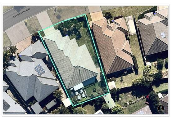
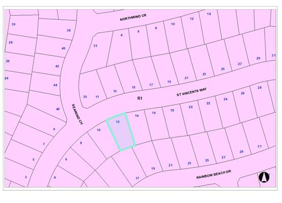 The existing subdivision pattern and location of existing
development within the locality is shown in the following aerial photograph:
The existing subdivision pattern and location of existing
development within the locality is shown in the following aerial photograph:
 2. DESCRIPTION OF DEVELOPMENT
Key
aspects of the proposal include the following:
· Proposed
open carport detached from existing dwelling and located to the side of the
existing dwelling.
· Carport
posts to be located approx. 625mm from side boundary in lieu of 900mm as per
DCP.
· Height
to ridge - 3550mm indicated
· Height
to eaves - 2650mm indicated.
Refer
to Attachment 2 for plans of the proposed development.
Application
Chronology
· 23/10/2020
Application lodged
· 25/11/2020
Notification of application completed. One (1) submission received
· 27/11/2020 Site inspection undertaken. Discussed side
setback requirements with owner/applicant. Applicant indicated that he may be
able to comply with DCP requirements
· 30/11/2020. Emailed objector to advise that posts setback
would comply with DCP
· 30/11/2020. Received e-mail confirmation submission would
be withdrawn if DCP requirements are met.
· 30/11/2020. Emailed applicant to confirm submission
withdrawn provided DCP requirements are met. Requested amended site plan to
indicate post location in accordance with DCP
· 7/12/2020. Received email from applicant they now wish to
contest the submission.
· 10/12/2020. Advised objector that the application will be forwarded
to DAP as the applicant has declined to relocate carport.
3. STATUTORY
ASSESSMENT
Section
4.15(1) Matters for Consideration
In
determining the application, Council is required to take into consideration the
following matters as are relevant to the development that apply to the land to
which the development application relates:
(a) The provisions
(where applicable) of:
(i) Any
Environmental Planning Instrument
State Environmental Planning Policy (Koala Habitat
Protection) 2020
Clause 5 - This SEPP applies to the Port Macquarie-Hastings
Local Government Area.
Clauses 7 and 8 - The site is not
subject to a Koala Plan of Management and is less than 1 hectare in size. No
tree removal is proposed.
State Environmental Planning Policy No. 55 - Remediation
of Land
Following an inspection of the site and a search of Council
records, the subject land is not identified as being potentially contaminated
and is suitable for the intended use.
State Environmental Planning Policy (Coastal Management)
2018
The site is not located within a coastal use area/ coastal
environment area.
State Environmental Planning Policy (Building
Sustainability Index: BASIX) 2004
A BASIX certificate is not required for the
development.
State Environmental Planning Policy (Infrastructure) 2007
Clause 45 - Development in proximity to electricity
infrastructure - appears clear of infrastructure.
Clause 102 refers to noise and vibration impacts from a
classified road on non-road development. The clause does not apply.
The development does not trigger any of the traffic
generating development thresholds of Clause 104. Referral to the NSW Roads and
Maritime Services (RMS) is not required.
Based on the above, the proposed development addresses
relevant clauses in the SEPP and will not to create any significant adverse
conflict in terms of traffic or noise.
Port Macquarie-Hastings Local Environmental
Plan 2011
The proposal is consistent with the LEP having regard to the
following:
· Clause
2.2 - The subject site is zoned R1 General Residential.
· Clause
2.3(1) and the R1 zone landuse table - The ancillary structure to a dwelling is
a permissible landuse with consent.
The objectives of the R1 zone are as
follows:
o To provide for the housing needs
of the community.
o To provide for a variety of
housing types and densities.
o To
enable other land uses that provide facilities or services to meet the day to
day needs of residents.
· Clause
2.3(2) - The proposal is consistent with the zone objectives as it is a
permissible landuse and consistent with the established residential locality.
The proposal contributes to the range of housing options in the locality.
· Clause
2.7 - No demolition proposed.
· Clause
4.3 - The maximum overall height of the building above ground level (existing)
is 3.5m which complies with the standard height limit applying to the site.
· Clause
4.4 - The floor space ratio of the site is unaltered as the proposal is for an
open carport.
· Clause
4.6 - Exceptions to development standards. Nil proposed.
· Clause
5.10 - The site does not contain or adjoin any known heritage items or sites of
significance.
· Clause
7.1 - The site is not mapped as potentially containing acid sulfate soils.
· Clause
7.3 - The site is not land within a mapped “flood planning area”
(Land subject to flood discharge of 1:100 annual recurrence interval flood
event (plus the applicable climate change allowance and relevant
freeboard).
· Clause
7.13 - Satisfactory arrangements are in place for provision of essential
services including water supply, electricity supply, sewer infrastructure,
stormwater drainage and suitable road access to service the development.
(ii) Any draft
instruments that apply to the site or are on exhibition
No draft instruments apply to
the site
(iii) Any Development
Control Plan in force
Port
Macquarie-Hastings Development Control Plan 2013
|
DCP 2013: Part B - General Provisions - B2:
Environmental Management
|
|
DCP Objective
|
Development Provisions
|
Proposed
|
Complies
|
|
3
|
a) Development must comply
with Council’s Developments, Public Place & Events - Waste
Minimisation and Management Policy.
|
Standard condition
recommended for construction waste management.
|
Yes
|
|
Cut and Fill Regrading
|
|
4
|
a) Development shall not
exceed a maximum cut of 1.0m and fill of 1.0m measured vertically above the
ground level (existing) at a distance of 1.0m outside the perimeter of the
external walls of the building (This does not apply to buildings where such
cut and fill is fully retained within or by the external walls of the
building).
|
Proposed open carport.
Generally Level Site.
|
Yes
|
|
5
|
a) A certified practicing
structural engineer must certify any retaining wall greater than 1.0m.
|
No retaining walls
proposed.
|
N/A
|
|
b) Where a combination of a fence
and a wall is proposed to be greater than 1.2m high:
- be a
maximum combined height of 1.8m above existing property boundary level;
- be
constructed up to the front boundary for a maximum length of 6.0m or 30% of
the street frontage, whichever is less;
− the
fence component has openings which make it not less than 25% transparent; and
− provide
a 3m x 3m splay for corner sites, and
- provide a
900mm x 900mm splay for vehicle driveway entrances.
|
|
N/A
|
|
DCP 2013: Part B -
General Provision - B3: Hazards Management
|
|
Bushfire Hazard Management
|
|
18
|
a) APZs are to be located
outside of environmental protection zones and wholly provided within private
land. Note perimeter roads provided as part of a residential subdivision are
classified as being part of the subdivision and not a separate permissible
land use within environment protection zones.
|
Not bushfire prone land
|
N/A
|
|
Flooding
|
|
19
|
a) Development must comply
with Council’s Floodplain Management Plan and Flood Policies.
|
Not flood prone land
|
N/A
|
|
DCP 2013: Part B- General Provisions- B4: Transport,
Traffic Management, Access and Car Parking
|
|
DCP Objective
|
Development Provisions
|
Proposed
|
Complies
|
|
Road Hierarchy
|
|
Parking Provision
|
|
24
|
a) Off-street Parking is
provided in accordance with Table 3:
- 1 parking space per each
dwelling for dwelling-house.
|
No alteration to existing
residential off-street carparking for dwelling.
|
N/A
|
|
Parking Layout
|
|
28
|
c) Parking spaces shall
generally be behind the building line but may be located between the building
line and the street when:
− it
is stacked parking in the driveway; or
− it
can be demonstrated that improvements to the open space provided will result;
and
− the
spaces are screened (densely landscaped or similar) from the street by a
landscaping with a minimum width of 3.0m for the entire length of the parking
area.
|
No alteration to existing
residential off-street carparking
|
N/A
|
|
d) Parking design and layout
is provided in accordance with AS/NZS 2890.1 - Parking facilities -
Off-street car parking.
|
No alteration to existing
residential off-street carparking
|
|
|
34
|
a) All parking and manoeuvring
spaces must be designed to avoid concentrations of water runoff on the
surface.
|
No alteration to existing
residential off-street carparking
|
N/A
|
|
b) Council will not permit the
discharge of stormwater directly into kerbing and guttering or table drains
for any development other than that of a minor nature.
|
Roof drainage connect to
existing.
|
Yes - acceptable
|
|
DCP 2013: Part B -
General Provisions - B5: Social Impact Assessment and Crime Prevention
|
|
DCP Objective
|
Development Provisions
|
Proposed
|
Complies
|
|
Crime Prevention
|
|
43
|
a) The development addresses
the generic principles of crime prevention:
− Casual
surveillance and sightlines;
− Land use mix
and activity generators;
− Definition of
use and ownership;
− Basic exterior
building design;
− Lighting;
− Way-finding;
and
− Predictable
routes and entrapment locations;
− as described in
the Crime Prevention Through Environmental Design (CPTED) principles.
|
No concealment or entrapment areas proposed. Adequate
casual surveillance available.
|
Yes
|
|
DCP 2013: Part C - Development Specific Provisions -
C1: Low Density Residential Development
|
|
DCP Objective
|
Development Provisions
|
Proposed
|
Complies
|
|
Front Setbacks
|
|
44
|
a) Dwellings may incorporate an articulation zone to a
street frontage at no less than 3m from property boundary. The
following building elements are permitted within the articulation zone:
− an entry
feature or portico;
− a balcony,
deck, patio, pergola, terrace or verandah;
− a window box
treatment;
− a bay window or
similar feature;
− an awning or
other feature over a window;
− a sun shading
feature.
b) These building elements should not extend above the
eave gutter line, other than a pitched roof to an entry feature or portico
that has the same pitch as the roof on the dwelling house.
|
No articulation proposed
|
N/A
|
|
c) The primary road front setback shall be:
Classified road = any frontage 6.0m
Primary frontage = 4.5m
Secondary frontage = 3.0m
Ancillary Lane = 2.0m
Large lot residential and rural zones = 10.0m
|
5.5m front setback to carport.
|
Yes
|
|
45
|
a) A garage, carport or car parking space should:
− be at least 1m behind
the building line, where the dwelling(s) has a setback from a front boundary
of 4.5m or more, or
− be at least 5.5m
from a front boundary, where the dwelling(s) has a setback of less than 4.5m.
|
Support posts of carport located 1m behind the building
line.
The dwelling has an existing front fence and gates which
will assist in screening the carport area.
|
Yes
|
|
b) The total width of the garage/carport openings should
not be more than 6m and not more than 50 per cent of the width of the
building.
|
Separate structure to main dwelling
|
N/A
|
|
c) Driveway crossovers are no greater than 5.0m in width.
|
No new crossover proposed.
|
N/A
|
|
d) Where a dual occupancy or attached dwelling is proposed
on a corner lot a garage and driveway is provided on each road frontage.
|
|
N/A
|
|
Side and Rear Setbacks
|
|
46
|
a) A minimum rear boundary setback of 4m is to be provided
to dwellings (including verandahs, patios and decks).
|
No change to existing setback on main dwelling. Carport
does not protrude past existing dwelling rear setback
|
Yes
|
|
b) A minimum rear boundary setback of 900mm applies to
sheds and swimming pools subject to achieving minimum required private open
space area.
|
|
N/A
|
|
c) Council may consider varying rear setback requirements
where it is demonstrated that the private open space could achieve better solar
access between the building and the side setback. In that instance, one side
setback should be a minimum 4m in width (for an equivalent length of rear
boundary, behind building line) and the rear setback may be reduced to 900mm.
|
|
N/A
|
|
47
|
a) Ground floors (being <1m above existing ground
level) should be setback a minimum of 900mm from side boundaries.
|
Support posts for carport proposed to be located approx.
625mm from the side boundary. The plans indicate the gutter location to be
500mm from side boundary. The gutter width is calculated to be 125mm in width
from measurements indicated on plans.
|
No*DCP variation request.
|
|
b) First floors and above (including single storey with
floor level >1m) should be setback a minimum of 3m from the side boundary,
or reduced down to 900mm where it can be demonstrated that the adjoining
property’s primary living rooms and principal private open space areas
are not adversely overshadowed for more than 3hrs between 9am - 3pm on 21
June.
|
|
N/A
|
|
c) First floors and above should have building walls that
step in and out at least every 12m by a minimum of 500mm articulation. Where
first floors and above are setback >3m, wall articulation is not required.
|
|
N/A
|
|
Private Open Space
|
|
48.
|
a) All dwellings should have a minimum area of private
open space of 35m2, which includes a principal private open space area
with:
− a minimum
dimension of 4m x 4m, and
− a maximum grade
of 5% for minimum 4m x 4m of the total open space requirement, and
− direct
accessibility from a ground floor living area and orientated to maximise use.
|
Private open space maintained
|
Yes
|
|
|
b) Private open space may include clothes drying areas and
garbage storage.
|
|
N/A
|
|
Public Domain and Fencing
|
|
49
|
a) Front fences built forward of the building line for the
primary road frontage should be detailed on the development application
plans.
|
Existing front fence and gates to remain
|
N/A
|
|
b) Solid Front fences up to 1.2m high should be:
− Setback 1.0m
from the front boundary, and
− Suitably
landscaped to reduce visual impact, and
− Provide a 3m x
3m splay for corner sites.
|
|
|
|
b) Front fences proposed to be more than 1.2m high should be
a maximum of 1.8m in height, above existing front property boundary level,
and either:
− Include
landscaped recesses having minimum dimensions of 1.8m long x 900mm deep which
occupy no less than 50% of the total length of the fence, or
− be
erected up to the front boundary for a maximum length of 6.0m or 50% of the
street frontage,
|
|
N/A
|
|
c) have openings which make it not less than 25%
transparent (no individual opening more than 30mm wide);
|
|
N/A
|
|
d) provide a 3m x 3m splay for corner sites, and
|
|
N/A
|
|
e) provide a 900mm x 900mm splay for vehicle driveway
entrances.
|
|
N/A
|
|
50
|
a) For tennis courts or other similar areas, chain wire
fences should be black or dark green plastic coated mesh.
|
|
N/A
|
|
b) Solid fences enclosing these facilities should not be
permitted over 1.8m.
|
|
|
|
Bulk and Scale
|
|
51
|
a) Direct views between indoor living rooms and principal
private open space of adjacent dwellings, including proposed dwellings
approved on adjoining lots, including possible dwellings on future lots,
should be obscured or screened where:
− Ground and first
floor (and above) indoor living room windows are within a 9m radius.
− Direct views
between principal private open space areas where within a 12m radius.
− Direct views
between indoor living rooms of dwellings into the principal area of private
open space of other dwellings within a 12m radius.
|
|
N/A
|
|
b) A balcony, deck, patio, pergola, terrace or verandah
should have a privacy screen where there are direct views of:
− Indoor living
room windows of adjacent dwellings, including proposed dwellings approved on
adjoining lots within 9m radius; or
− Principal areas
of private open space of adjacent dwellings, including proposed dwellings
approved on adjoining lots within a 12m radius.
|
|
N/A
|
|
c) Privacy protection is
not required for:
− Any Indoor
living room windows with a sill height of greater than 1.5m above the
finished floor level of that room or where fixed non-openable translucent
glass is installed to the same height.
|
|
N/A
|
|
d) Direct views described above may be reduced or obscured
by one of the following measures (details to be submitted with the
development application):
− 1.8m high fence
or wall between ground-floor level windows or between a dwelling and
principal private open space
− Screening of
minimum 1.7m height, that has 25% openings (max), with no individual opening
more than 30mm wide, is permanently fixed and is made of durable materials.
− A
window, the whole of which has translucent glass and is not able to be
opened.
|
|
N/A
|
|
Roof Terraces
|
|
52
|
a) Direct views between roof terraces and indoor living
room windows or principal areas of private open space of adjacent dwellings
should be screened where:
− Ground and
first floor (and above) indoor living room windows are within a 9m radius of
the trafficable area of the roof terrace;
Direct views between roof terraces principal areas of
private open space within a 12m radius of the trafficable are of the roof
terrace.
|
|
N/A
|
|
b) Screening should only be considered where:
− the height of
the screen does not exceed the maximum building height; and
− the screening
contributes to the building form, and
− the screening
is integrated into the design of the roof; and
− is constructed
and designed with materials complementary to the building.
|
|
N/A
|
|
c) Lighting installations on roof terraces should be:
- contained within the
roof terrace area and located at a low level, and
- appropriately shaded
and fixed in a non-adjustable manner so that light is projected downwards
onto the floor surface of the terrace.
− designed in
compliance with Australian Standards AS4282 - Control of obtrusive effects
of outdoor lighting.
|
|
N/A
|
|
Ancillary Development
|
|
56
|
a) For ancillary development in R1 General Residential, R2
Low Density Residential, R3 Medium Density Residential, R4 High Density
Residential, R5 Large Lot Residential and RU5 Village zones:
− The height of
an outbuilding or the alterations and additions to an existing outbuilding on
a lot should not be more than 4.8m above ground level (existing).
− The building
should be single storey construction with a maximum roof pitch of 24 degrees.
− The maximum
area of the building should be 60m2 for lots less than 900m² and maximum
of 100m² for larger lots.
− Ancillary
development that is a garage, or an outbuilding, or a rainwater tank should
not be located in front of the main building line with the exception of
swimming pools.
|
Proposed detached carport
Height of carport indicated to be 3.55m
Single storey
Roof pitch < 240.
Single carport < 60m2.
Support posts located behind building line
|
Yes
Yes
Yes
Yes
|
The applicant seeks approval to vary Development Provision
46 relating to side setback. Application is sought to locate the support posts
of the carport approx. 625mm from the side boundary.
Objectives:
• To
ensure no adverse overshadowing or privacy impacts to neighbouring properties.
• To
allow adequate natural light and ventilation between dwellings/buildings and to
private open space areas.
• To provide useable yard areas and open space.
It is considered that the
provisions of the DCP should be upheld in this instance to maintain the
objectives. In this regard, a consent condition is recommended to require the
carport to be setback a minimum 0.9m with the plans for construction
certificate to address compliance with the DCP.
(iiia) Any planning agreement that has
been entered into under section 7.4, or any draft planning agreement that a
developer has offered to enter into under section 7.4
No planning agreement has been
offered or entered into relating to the site.
(iv) Any
matters prescribed by the Regulations
Demolition
of buildings AS 2601 - Clause 92
No demolition proposed.
(b) The likely
impacts of that development, including environmental impacts on both the
natural and built environments, social and economic impacts in the locality
Context and Setting
· The proposal will
not have any significant adverse impacts on existing adjoining properties and
satisfactorily addresses the public domain.
· The proposal is
considered to be compatible with other residential development in the locality
and adequately addresses planning controls for the area.
· The proposal does
not have a significant adverse impact on existing view sharing.
· The proposal does
not have significant adverse lighting impacts.
· There are no
significant adverse privacy impacts.
· There are no
significant adverse overshadowing impacts. The proposal does not prevent
adjoining properties from receiving 3 hours of sunlight to private open space
and primary living areas on 21 June.
Access, Traffic and Transport
The proposal will not have any significant adverse impacts
in terms access, transport and traffic. The existing road network will
satisfactorily cater for any increase in traffic generation as a result of the
development.
Water Supply Connection
Service available – No proposed alteration to existing
service.
Sewer Connection
The proposed works are clear (>600mm) of the existing
sewer junction and main traversing the site.
Service available - No proposed alteration to existing
service
Stormwater
Service available - Stormwater disposed to existing system.
Other Utilities
Telecommunication and electricity services are available to
the site.
Heritage
This site does not contain or adjoin any known heritage item
or site of significance. The site is considered to be disturbed land.
Other Land Resources
The site is within an established urban context and will not
sterilise any significant mineral or agricultural resource.
Water Cycle
The proposed development will not have any significant
adverse impacts on water resources and the water cycle.
Soils
The proposed development will not have any adverse impacts
on soils in terms of quality, erosion, stability and/or productivity subject to
a standard condition requiring erosion and sediment controls to be in place
prior to and during construction.
Air and Microclimate
The construction and/or operations of the proposed
development will not result in any significant adverse impacts on the existing
air quality or result in any pollution. Standard precautionary site management
condition recommended.
Flora and Fauna
Construction of the proposed development will not require
any removal/clearing of any native vegetation and therefore does not trigger
the biodiversity offsets scheme. Part 7 of the Biodiversity Conservation
Act 2016 is considered to be satisfied.
Waste
Satisfactory arrangements are in place for proposed storage
and collection of waste and recyclables. No adverse impacts anticipated.
Standard precautionary site management condition recommended.
Energy
The proposal is not required to address BASIX commitments.
Noise and Vibration
The construction of the proposed development will not result
in any significant adverse impacts on the existing air quality or result in any
pollution. Standard precautionary site management condition recommended.
Bushfire
The site is not identified as being bushfire prone.
Safety, Security and Crime Prevention
The proposed development will be unlikely to create any
concealment/entrapment areas or crime spots that would result in any
identifiable loss of safety or reduction of security in the immediate area.
Social Impacts in the Locality
Given the nature of the proposed development and its
location the proposal is not considered to have any significant adverse social
impacts.
Economic Impacts in the Locality
The proposal is not considered to have any significant
adverse economic impacts on the locality. A likely positive impact is that the
development will maintain employment in the construction industry, which will
lead to flow impacts such as expenditure in the area.
Site Design and Internal Design
The proposed development design satisfactorily responds to the
site attributes and will fit into the locality.
Construction
Construction impacts are considered capable of being
managed, standard construction and site management conditions have been
recommended.
Cumulative Impacts
The proposed development is not considered to have any
significant adverse cumulative impacts on the natural or built environment or
the social and economic attributes of the locality.
(c) The
suitability of the site for the development
The proposal will fit into the locality and the site
attributes are conducive to the proposed development.
(d) Any
submissions made in accordance with this Act or the Regulations
One written
submission was received following public exhibition of the application. A copy
of the written submission has been provided separately to members of the DAP.
Key
issues raised in the submission and comments are provided as follows:
|
Submission
Issue/Summary
|
Planning
Comment/Response
|
|
Adverse effect on natural light to an existing bedroom
window
|
Proposed carport will be located on the Northern side of
the existing dwelling. Any construction close to the side boundary will
impact on the natural light to existing windows. Minimum setbacks are to be
maintained.
|
|
Visual appearance
|
An existing courtyard style fence located on the front
boundary and will assist to screen the carport from the street.
The front setback is compliant with the DCP controls.
|
|
Overcrowding
|
Maintaining the DCP requirements for the side setback
will assist in reducing the aspect of overcrowding
|
(e) The Public Interest
The proposed development
satisfies relevant planning controls and will not adversely impact on the wider
public interest.
Ecologically Sustainable Development and Precautionary
Principle
Ecologically sustainable development requires the effective
integration of economic and environmental considerations in decision-making
processes.
The four principles of ecologically sustainable development
are:
· the
precautionary principle,
· intergenerational
equity,
· conservation
of biological diversity and ecological integrity,
· improved
valuation, pricing and incentive mechanisms.
The principles of ESD require that a balance needs to be
struck between the man-made development and the need to retain the natural
vegetation. Based on the assessment provided in the report and with recommended
conditions of consent, it is considered an appropriate balance has been struck.
Climate Change
The proposal is not considered to be vulnerable to any risks
associated with climate change.
4. DEVELOPMENT
CONTRIBUTIONS APPLICABLE
Development
contributions will not be required under S64/S7.11.
5. CONCLUSION AND
STATEMENT OF REASON
The application has been assessed in accordance with Section
4.15 of the Environmental Planning and Assessment Act 1979.
Issues raised during assessment and public exhibition of the
application have been considered in the assessment of the application. Where
relevant, conditions have been recommended to manage the impacts attributed to
these issues.
The site is considered suitable for the proposed development
and the proposal adequately addresses relevant planning controls. The
development is not considered to be contrary to the public's interest and will
not result a significant adverse social, environmental or economic impact. It
is recommended that the application be approved, subject to the recommended
conditions of consent provided in the attachment section of this report (Attachment
1).
|
Attachments
1⇩. 2020 - 917.1
Recommended DA Conditions 2020 - 917.1
Recommended DA Conditions
2⇩. 2020 - 917.1 Plans 2020 - 917.1 Plans
|
|
ATTACHMENT
|
Development Assessment Panel
21/01/2021
|
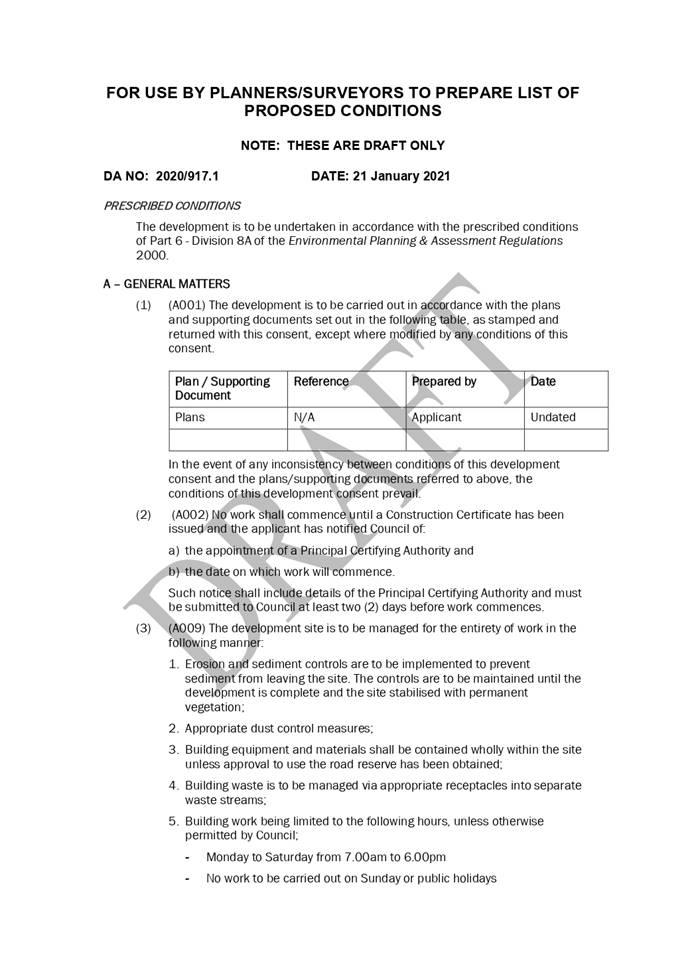
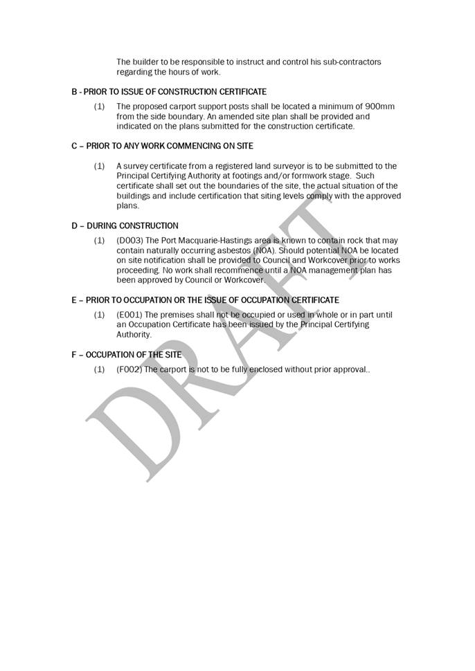
|
ATTACHMENT
|
Development Assessment Panel
21/01/2021
|
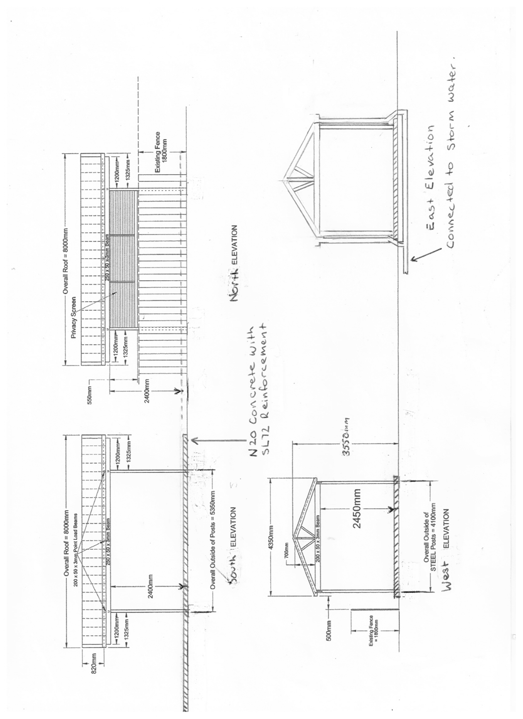
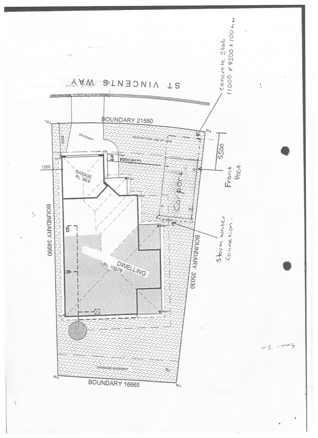
AGENDA Development Assessment Panel 21/01/2021
Item: 07
Subject: DA2020 - 962.1 Dwelling-house at Lot 510 DP
1261705, No. 130 Crestwood Drive, Port Macquarie
Report
Author: Development Assessment Planner, Fiona Tierney
|
Applicant: Adenbrook
Homes
Owner: D
Tabone
Estimated Cost: $450,000
Alignment with Delivery
Program
4.3.1 Undertake transparent
and efficient development assessment in accordance with relevant legislation.
|
RECOMMENDATION
That
DA2020 - 962 for a dwelling-house
at Lot 510, DP 1261705, No. 130
Crestwood Drive, Port Macquarie, be determined by granting consent subject to the
recommended conditions.
Executive
Summary
This
report considers a development application for a dwelling-house at the subject
site and provides an assessment of the application in accordance with the
Environmental Planning and Assessment Act 1979.
Following exhibition of the
application, one (1) submission was received.
The site is considered suitable for the proposed development
and the proposal adequately addresses relevant planning controls. The
development is not considered to be contrary to the public's interest and will
not result a significant adverse social, environmental or economic impact.
This report recommends that the
development application be approved subject to the attached conditions
in Attachment 1.
1. BACKGROUND
Existing
Sites Features and Surrounding Development
The site has an area of 602.3m2.
The
site is zoned R1 general Residential in
accordance with the Port Macquarie-Hastings Local Environmental Plan 2011, as
shown in the following zoning plan:
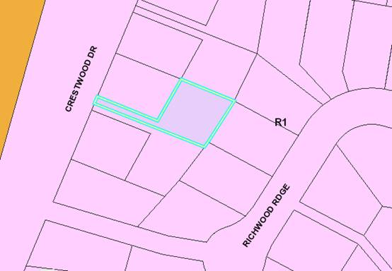
The
existing subdivision pattern and location of existing development within the
locality is shown in the following aerial photograph:
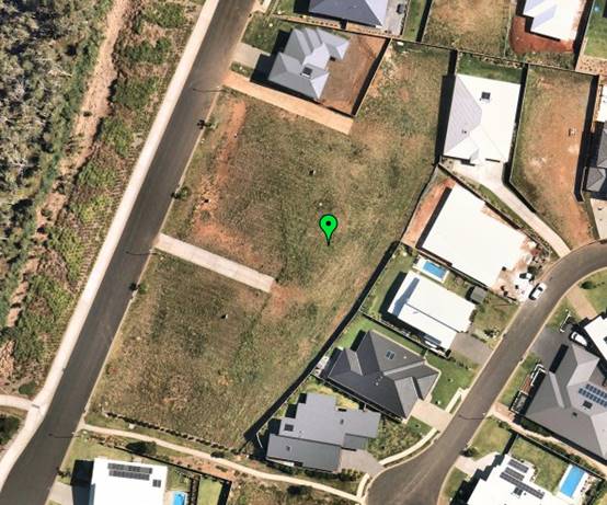
2. DESCRIPTION
OF DEVELOPMENT
Key
aspects of the proposal include the following:
· Construction
of a new two storey dwelling
Refer
to Attachment 2 at the end of this report for plans of the proposed
development.
Application
Chronology
· 5
November 2020 - Application lodged.
· 12 to 25 November 2020 - Public exhibition via neighbour
notification.
3. STATUTORY
ASSESSMENT
Section
4.15(1) Matters for Consideration
In
determining the application, Council is required to take into consideration the
following matters as are relevant to the development that apply to the land to
which the development application relates:
(a) The provisions
(where applicable) of:
(i) Any
Environmental Planning Instrument (EPI)
State
Environmental Planning Policy (Koala Habitat Protection) 2020
Clause
5 - This SEPP applies to the Port Macquarie-Hastings Local Government Area.
Clause 8 - The site is not under a Koala
Plan of Management and the land has an area less than 1 hectare
including adjoining land in the same ownership. The SEPP does not prevent the
granting of consent on the land being less than 1 hectare in area. The
application has demonstrated that no habitat will be removed or modified
therefore no further investigations are required.
State
Environmental Planning Policy No. 55 – Remediation of Land
Following
an inspection of the site and a search of Council records, the subject land is
not identified as being potentially contaminated and is suitable for the
intended use.
State
Environmental Planning Policy (Building Sustainability Index: BASIX) 2004
A
BASIX certificate has been submitted demonstrating that the proposal will
comply with the requirements of the SEPP. It is recommended that a condition be
imposed to ensure that the commitments are incorporated into the development
and certified at Occupation Certificate stage.
State Environmental Planning Policy (Infrastructure) 2007
Clause 45 - Development in proximity to electricity
infrastructure - referral to Essential Energy required for any of the
following:
(a) the
penetration of ground within 2m of an underground electricity power line or an
electricity distribution pole or within 10m of any part of an electricity
tower,
(b) development
carried out:
(i) within
or immediately adjacent to an easement for electricity purposes (whether or not
the electricity infrastructure exists), or
(ii) immediately
adjacent to an electricity substation, or
(iii) within
5m of an exposed overhead electricity power line,
(c) installation
of a swimming pool any part of which is:
(i) within
30m of a structure supporting an overhead electricity transmission line,
measured horizontally from the top of the pool to the bottom of the structure
at ground level, or
(ii) within 5m of an overhead electricity power line, measured vertically
upwards from the top of the pool
No infrastructure noted in proximity.
Port Macquarie-Hastings Local Environmental
Plan 2011
The proposal is consistent with the LEP having regard to the
following:
· Clause
2.2 - The subject site is zoned R1 General Residential.
· Clause
2.3(1) and the R1 zone landuse table - The dwelling is a permissible landuse
with consent.
· Clause
2.3(2) - The objectives of the R1 zone are as follows:
o To provide for the
housing needs of the community.
o To provide for a
variety of housing types and densities.
o To enable other land
uses that provide facilities or services to meet the day to day needs of
residents.
1.
The proposal is consistent with the zone objectives as it is a
permissible landuse and consistent with the established residential locality.
The proposal contributes to the range of housing options in the locality.
· Clause
4.3 - The proposed maximum overall height of the building above ground level is
7.428m and complies with the standard height limit of 8.5m applying to the
site.
· Clause
4.4 - The floor space ratio of the proposal is 0.25:1 and complies with the
maximum 0.65:1 floor space ratio applying to the site.
· Clause
5.10 – The site does not contain or adjoin any known heritage items or
sites of significance.
· Clause
7.13 - Satisfactory arrangements are in place for provision of essential
services including water supply, electricity supply, sewer infrastructure,
stormwater drainage and suitable road access to service the development.
(ii) Any draft
instruments that apply to the site or are on exhibition
No draft instruments apply.
(iii) Any Development
Control Plan in force
Port
Macquarie-Hastings Development Control Plan 2013
|
DCP 2013: Part C - Development Specific Provisions -
C1: Low Density Residential Development
|
|
DCP Objective
|
Development Provisions
|
Proposed
|
Complies
|
|
Front Setbacks
|
|
44
|
a) Dwellings may incorporate an articulation zone to a
street frontage at no less than 3m from property boundary. The
following building elements are permitted within the articulation zone.
|
No building elements proposed within the articulation
zone.
|
N/A
|
|
c) The primary road front setback shall be:
Primary frontage = 4.5m
|
Site is located on a battleaxe allotment.
|
N/A
|
|
45
|
a) A garage, carport or car parking space should:
- be at least 1m behind the
building line, where the dwelling(s) has a setback from a front boundary of
4.5m or more, or
- be at least 5.5m from a
front boundary, where the dwelling(s) has a setback of less than 4.5m.
|
Battleaxe allotment
|
N/A
|
|
b) The total width of the garage/carport openings should
not be more than 6m and not more than 50 per cent of the width of the building.
|
Width of garage door is compliant
with the maximum width requirements
|
Yes
|
|
c) Driveway crossovers are no greater than 5.0m in width.
|
No change to existing driveway
battle-axe access.
|
N/A
|
|
d) Where a dual occupancy or attached dwelling is proposed
on a corner lot a garage and driveway is provided on each road frontage.
|
No dual occupancy proposed or a corner lot.
|
N/A
|
|
Side and Rear Setbacks
|
|
46
|
a) A minimum rear boundary setback of 4m is to be provided
to dwellings (including verandahs, patios and decks).
|
The rear setback varies from 3m
to 6.578m.
|
No*
|
|
b) A minimum rear boundary setback of 900mm applies to
sheds and swimming pools subject to achieving minimum required private open
space area.
|
No ancillary development proposed in rear yard.
|
N/A
|
|
c) Council may consider varying rear setback requirements
where it is demonstrated that the private open space could achieve better
solar access between the building and the side setback. In that instance, one
side setback should be a minimum 4m in width (for an equivalent length of
rear boundary, behind building line) and the rear setback may be reduced to
900mm.
|
Proposal provides increased setbacks to all other
elevations and provides good solar access. Meets the average requirements and
intent of this clause.
|
Yes
|
|
47
|
a) Ground floors (being <1m above existing ground
level) should be setback a minimum of 900mm from side boundaries.
|
North side setback min. 2.5m
setback.
South side setback min. 3.0m
setback.
West side setback >3m setback.
|
Yes
|
|
b) First floors and above (including single storey with
floor level >1m) should be setback a minimum of 3m from the side boundary,
or reduced down to 900mm where it can be demonstrated that the adjoining
property’s primary living rooms and principal private open space areas
are not adversely overshadowed for more than 3hrs between 9am - 3pm on 21
June.
|
First floor north side setback is
varying with 2.673m minimum to wall. The remaining setbacks are 3m or more.
No adverse overshadowing impacts
to neighbouring properties identified.
|
Yes
|
|
c) First floors and above should have building walls that
step in and out at least every 12m by a minimum of 500mm articulation. Where
first floors and above are setback >3m, wall articulation is not required.
|
First floor is set back over 3m.
|
Yes
|
|
Private Open Space
|
|
48.
|
a) All dwellings should have a minimum area of private
open space of 35m2, which includes a principal private open space area
with:
- a minimum dimension of
4m x 4m, and
- a maximum grade of 5%
for minimum 4m x 4m of the total open space requirement, and
- direct accessibility
from a ground floor living area and orientated to maximise use.
|
The dwelling contains 35m² open space in one area
including a useable 4m x 4m space.
|
Yes
|
|
|
b) Private open space may include clothes drying areas and
garbage storage.
|
Noted. Clothes drying area nominated.
|
Yes
|
|
Public Domain and Fencing
|
|
49
|
a) Front fences built forward of the building line for the
primary road frontage should be detailed on the development application plans.
|
No front fence proposed.
|
N/A
|
|
b) Solid Front fences up to 1.2m high should be:
- Setback 1.0m from the
front boundary, and
- Suitably landscaped to
reduce visual impact, and
- Provide a 3m x 3m splay
for corner sites.
|
|
N/A
|
|
b) Front fences proposed to be more than 1.2m high should be
a maximum of 1.8m in height, above existing front property boundary level,
and either:
- Include landscaped
recesses having minimum dimensions of 1.8m long x 900mm deep which occupy no
less than 50% of the total length of the fence, or
- be erected up to the
front boundary for a maximum length of 6.0m or 50% of the street frontage.
|
|
N/A
|
|
c) have openings which make it not less than 25%
transparent (no individual opening more than 30mm wide);
|
|
N/A
|
|
d) provide a 3m x 3m splay for corner sites, and
|
Not a corner site.
|
N/A
|
|
e) provide a 900mm x 900mm splay for vehicle driveway
entrances.
|
No site line issues identified for driveway entrance.
|
Yes
|
|
Bulk and Scale
|
|
51
|
a) Direct views between indoor living rooms and principal
private open space of adjacent dwellings, including proposed dwellings
approved on adjoining lots, including possible dwellings on future lots,
should be obscured or screened where:
- Ground and first floor
(and above) indoor living room windows are within a 9m radius.
- Direct views between
principal private open space areas where within a 12m radius.
- Direct views between
indoor living rooms of dwellings into the principal area of private open
space of other dwellings within a 12m radius.
|
Window placements have been
carefully considered and where appropriate highlight windows nominated. i.e.
north facing windows on the first floor are bedroom windows and one is a
highlight window.
No direct views between living
rooms and principal private open space areas of adjoining properties within
9m and 12m radius.
|
Yes
|
|
b) A balcony, deck, patio, pergola, terrace or verandah
should have a privacy screen where there are direct views of:
- Indoor living room
windows of adjacent dwellings, including proposed dwellings approved on
adjoining lots within 9m radius; or
- Principal areas of
private open space of adjacent dwellings, including proposed dwellings
approved on adjoining lots within a 12m radius.
|
No upper level deck proposed
|
Yes
|
|
c) Privacy protection is
not required for:
- Any Indoor living room
windows with a sill height of greater than 1.5m above the finished floor
level of that room or where fixed non-openable translucent glass is installed
to the same height.
|
Noted refer to above comments.
|
Yes
|
|
d) Direct views described above may be reduced or obscured
by one of the following measures (details to be submitted with the
development application):
- 1.8m high fence or wall
between ground-floor level windows or between a dwelling and principal
private open space
- Screening of minimum
1.7m height, that has 25% openings (max), with no individual opening more
than 30mm wide, is permanently fixed and is made of durable materials.
- A window,
the whole of which has translucent glass and is not able to be opened.
|
Screening and other privacy
treatment measures are proposed where necessary.
|
Yes
|
|
DCP 2013: Part B - General Provisions - B2:
Environmental Management
|
|
DCP Objective
|
Development Provisions
|
Proposed
|
Complies
|
|
3
|
a) Development must comply
with Council’s Developments, Public Place & Events - Waste
Minimisation and Management Policy.
|
Satisfactory arrangements
can be put in place for storage and collection of waste.
Standard condition
recommended for construction waste management.
|
Yes
|
|
Cut and Fill Regrading
|
|
4
|
a) Development shall not
exceed a maximum cut of 1.0m and fill of 1.0m measured vertically above the
ground level (existing) at a distance of 1.0m outside the perimeter of the
external walls of the building (This does not apply to buildings where such
cut and fill is fully retained within or by the external walls of the
building).
|
Cut and fill >1m is proposed outside the perimeter of
the external building walls. Approx. 1.3m cut to east for a limited length
and battered up to fence line.
|
No*
|
|
5
|
a) A certified practicing
structural engineer must certify any retaining wall greater than 1.0m.
|
Noted. Suitable condition recommended for retaining wall
beside dwelling on south side.
|
Yes
|
|
b) Where a combination of a
fence and a wall is proposed to be greater than 1.2m high:
- be a
maximum combined height of 1.8m above existing property boundary level;
- be constructed
up to the front boundary for a maximum length of 6.0m or 30% of the street
frontage, whichever is less;
− the
fence component has openings which make it not less than 25% transparent; and
− provide
a 3m x 3m splay for corner sites, and
- provide a 900mm
x 900mm splay for vehicle driveway entrances.
|
No retaining wall and front fence combination is proposed.
Refer to front fencing comments surrounding masonry wall.
|
N/A
|
|
DCP 2013: Part B -
General Provision - B3: Hazards Management
|
|
Bushfire Hazard Management
|
|
18
|
a) APZs are to be located
outside of environmental protection zones and wholly provided within private
land. Note perimeter roads provided as part of a residential subdivision are
classified as being part of the subdivision and not a separate permissible
land use within environment protection zones.
|
APZ within property.
|
Yes
|
|
Flooding
|
|
19
|
a) Development must comply
with Council’s Floodplain Management Plan and Flood Policies.
|
Not flood prone land.
|
N/A
|
|
DCP 2013: Part B- General Provisions- B4: Transport,
Traffic Management, Access and Car Parking
|
|
DCP Objective
|
Development Provisions
|
Proposed
|
Complies
|
|
Road Hierarchy
|
|
Parking Provision
|
|
24
|
a) Off-street Parking is
provided in accordance with Table 3:
- 1 parking space per each
dwelling for dwelling-house.
|
Capacity for more than 1 parking space behind the building
line has been provided for.
|
Yes
|
|
Parking Layout
|
|
28
|
c) Parking spaces shall
generally be behind the building line but may be located between the building
line and the street when:
− it
is stacked parking in the driveway; or
− it
can be demonstrated that improvements to the open space provided will result;
and
− the
spaces are screened (densely landscaped or similar) from the street by a
landscaping with a minimum width of 3.0m for the entire length of the parking
area.
|
Proposed behind the
building line.
|
Yes
|
|
d) Parking design and layout
is provided in accordance with AS/NZS 2890.1 - Parking facilities -
Off-street car parking.
|
Parking design and layout appropriate.
|
Yes
|
|
34
|
a) All parking and manoeuvring
spaces must be designed to avoid concentrations of water runoff on the
surface.
|
Single dwelling only with 1 domestic driveway. Stormwater
drainage is capable of being managed as part of plumbing construction.
|
Yes
|
|
b) Council will not permit the
discharge of stormwater directly into kerbing and guttering or table drains
for any development other than that of a minor nature.
|
Single dwelling only with 1 domestic driveway. Stormwater
drainage is capable of being managed as part of plumbing construction.
|
Yes
|
|
|
|
|
|
|
DCP 2013: Part B -
General Provisions - B5: Social Impact Assessment and Crime Prevention
|
|
DCP Objective
|
Development Provisions
|
Proposed
|
Complies
|
|
Crime Prevention
|
|
43
|
a) The development addresses
the generic principles of crime prevention:
- Casual surveillance and
sightlines;
- Land use mix and
activity generators;
- Definition of use and
ownership;
- Basic exterior building
design;
- Lighting;
- Way-finding; and
- Predictable routes and
entrapment locations;
- as described in the
Crime Prevention Through Environmental Design (CPTED) principles.
|
No concealment or entrapment areas proposed. Adequate
casual surveillance available.
|
Yes
|
The proposal seeks to vary Development Provision 46 relating
to a minimum rear setback requirement of 4m. The rear setback proposed varies
from 3m to 6.578m.
The relevant objectives are:
· To
ensure no adverse overshadowing or privacy impacts to neighbouring properties.
· To
allow adequate natural light and ventilation between dwellings/buildings and to
private open space areas.
· To
provide useable yard areas and open space
Comments: Having regard for the development
provisions and relevant objectives, the variation is considered acceptable for
the following reasons:
· The
variation is minor and largely compliant. The minor variation is due to the
angle in the allotment boundary.
· No
adverse overshadowing or privacy impacts will result.
· Adequate
natural light and ventilation between dwellings and to private open space areas
will be achieved.
· Useable
yard and open space areas are provided.
The proposal seeks to vary Development Provision 4 which
provides that development shall not exceed a maximum cut of 1.0m and fill of
1.0m measured
vertically above the ground level (existing) at a distance
of 1.0m outside the perimeter of the external walls of the building (This does
not apply to buildings where such cut and fill is fully retained within or by
the external walls of the building). The proposal incorporates cut over 1m
outside the external walls of the building primarily in the front portion of
the site. A battered cut is proposed up to 1.3m in height in the rear portion
of the site.
The relevant objectives are:
· Minimise
the extent of site disturbance caused by excessive cut and fill to the site.
· Ensure
there is no damage or instability to adjoining properties caused by excavation
or filling.
· Ensure
that there is no adverse alteration to the drainage of adjoining properties.
· Ensure
the privacy of adjoining dwellings and private open space are protected.
· Ensure
that adequate stormwater drainage is provided around the perimeter of buildings
and that overflow paths are provided.
Comments: Having regard for the development
provisions and relevant objectives, the variation is considered acceptable for
the following reasons:
· The
extent of cut and retaining proposed s due to the drop in grade along the depth
of the site.
· Stormwater
is capable of being managed.
· Privacy
of adjoining dwellings is not compromised as a result of the cut.
Based on the above assessment, the variations proposed to
the provisions of the DCP are considered acceptable and the relevant objectives
have been satisfied. Cumulatively, the variations do not amount to an adverse
impact of any significance that would justify refusal of the application.
(iiia) Any planning agreement that has
been entered into under section 7.4, or any draft planning agreement that a
developer has offered to enter into under section 7.4
No planning agreement has been
offered or entered into relating to the site
iv) Any
matters prescribed by the Regulations
No
matters prescribed by the regulations apply.
(b) The likely
impacts of that development, including environmental impacts on both the
natural and built environments, social and economic impacts in the locality
Context and Setting
The proposed development
satisfactorily addresses the public domain.
The proposal is considered to be
compatible with other residential development in the locality and adequately
addresses planning controls for the area.
Privacy
The
design has had regard to positioning of the primary living and outdoor areas at
ground level and cut into the site. Where appropriate privacy protection
measures are proposed in the form of either privacy screening or highlight windows.
Bedroom windows are located on upper levels. There are no significant adverse
privacy impacts identified that would warrant refusal of the application.
Access, Traffic and Transport
The proposal will not have any significant adverse impacts
in terms access, transport and traffic.
Water Supply Connection
Water supply service is existing to the lot. Details of
connection and associated plumbing will be provided with section 68 application
under the Local Government Act. Appropriate condition recommended.
Sewer Connection
Sewer service is existing to the lot. Details of connection
and associated plumbing will be provided with section 68 application under the
Local Government Act. Appropriate condition recommended.
Stormwater
There is a stormwater pit and piped network in Watonga
Street. The proposal is capable of connection to this network. Details of
stormwater drainage and connection will be required with S.68 application.
Appropriate standard condition recommended.
Other Utilities
Telecommunication and electricity services are available to
the site.
Heritage
This site does not contain or adjoin any known heritage item
or site of significance. The site is considered to be disturbed land.
Other Land Resources
The site is within an established urban context and will not
sterilise any significant mineral or agricultural resource.
Water Cycle
The proposed development will not have any significant
adverse impacts on water resources and the water cycle.
Soils
The proposed development will not have any adverse impacts on
soils in terms of quality, erosion, stability and/or productivity subject to a
standard condition requiring erosion and sediment controls to be in place prior
to and during construction.
Air and Microclimate
The construction and/or operations of the proposed
development will not result in any significant adverse impacts on the existing
air quality or result in any pollution. Standard precautionary site management
condition recommended.
Flora and Fauna
Construction of the proposed development will not require
any removal/clearing of any significant native vegetation. The proposal does
not trigger the biodiversity offsets scheme and part 7 of the Biodiversity
Conservation Act 2016 is considered to be satisfied.
Waste
Satisfactory arrangements are in place for proposed storage
and collection of waste and recyclables. No adverse impacts anticipated.
Standard precautionary site management condition recommended.
Energy
The proposal includes measures to address energy efficiency
and will be required to comply with the requirements of BASIX.
Noise and Vibration
The construction of the proposed development will not result
in any significant adverse impacts on the existing air quality or result in any
pollution. Standard precautionary site management condition recommended.
Bushfire
The site is identified as being bushfire prone. The
applicant has submitted a bushfire report. An assessment of bushfire risk
having regard to Planning for Bushfire Protection including vegetation
classification and slope concludes that a Bushfire Attack Level 12.5 shall be
required.
Management of bushfire risk is acceptable subject to BAL
construction levels being implemented and APZ being maintained. An appropriate
condition is recommended.
Safety, Security and Crime Prevention
The proposed development will be unlikely to create any
concealment/entrapment areas or crime spots that would result in any
identifiable loss of safety or reduction of security in the immediate area.
Social Impacts in the Locality
Given the nature of the proposed development and its
location the proposal is not considered to have any significant adverse social
impacts.
Economic Impact in the Locality
The proposal is not considered to have any significant
adverse economic impacts on the locality. A likely positive impact is that the
development will maintain employment in the construction industry, which will
lead to flow impacts such as expenditure in the area.
Site Design and Internal Design
The proposed development design satisfactorily responds to
the site attributes and will fit into the locality.
Construction
Construction impacts are considered capable of being
managed, standard construction and site management conditions have been
recommended.
Cumulative Impacts
The proposed development is not considered to have any
significant adverse cumulative impacts on the natural or built environment or
the social and economic attributes of the locality.
(c) The
suitability of the site for the development
The proposal will fit into the locality. Site constraints of
slope and bushfire have been adequately addressed and appropriate conditions of
consent recommended.
(d) Any
submissions made in accordance with this Act or the Regulations
One (1) written
submission was received following public exhibition of the application. Copies
of the written submission have been provided separately to members of the DAP.
Key
issues raised in the submissions received and comments are provided as follows:
|
Submission
Issue/Summary
|
Planning
Comment/Response
|
|
Privacy - Bedroom windows of
proposed dwelling will sit 900mm below top of the boundary fence
|
Master bedroom window is a
highlight window with a sill height of 1.8m the remaining 2 bedroom windows
are set at 1.2m and located 3 to 6m from the rear boundary. Bedroom windows
under the DCP are not subject to the same privacy limitations and setbacks as
primary living areas. Given the sill heights casual overlooking is generally
not an issue in normal use of a bedroom.
|
(e) The Public Interest
The proposed development
satisfies relevant planning controls and will not adversely impact on the wider
public interest.
Ecologically Sustainable Development and Precautionary
Principle
Ecologically sustainable development requires the effective
integration of economic and environmental considerations in decision-making
processes.
The four principles of ecologically sustainable development
are:
· the
precautionary principle,
· intergenerational
equity,
· conservation
of biological diversity and ecological integrity,
· improved
valuation, pricing and incentive mechanisms.
The principles of ESD require that a balance needs to be
struck between the man-made development and the need to retain the natural
vegetation. Based on the assessment provided in the report and with recommended
conditions of consent, it is considered an appropriate balance has been struck.
Climate change
The proposal is not considered to be vulnerable to any risks
associated with climate change.
4. DEVELOPMENT
CONTRIBUTIONS APPLICABLE
Development
contributions will not be required under S64/S7.11 as the development is
located on an approved lot and development is for a single dwelling.
5. CONCLUSION AND
STATEMENT OF REASON
The application has been assessed in accordance with Section
4.15 of the Environmental Planning and Assessment Act 1979.
Issues raised during assessment and public exhibition of the
application have been considered in the assessment of the application. Where
relevant, conditions have been recommended to manage the impacts attributed to
these issues.
The site is considered suitable for the proposed development
and the proposal adequately addresses relevant planning controls. The
development is not considered to be contrary to the public's interest and will
not result a significant adverse social, environmental or economic impact. It
is recommended that the application be approved, subject to the recommended
conditions of consent provided in the attachment section of this report (Attachment
1).
|
Attachments
1⇩. 2020 - 962.1
Recommended DA Conditions 2020 - 962.1
Recommended DA Conditions
2⇩. 2020 - 962.1 Plans
|
|
ATTACHMENT
|
Development Assessment Panel
21/01/2021
|

|
ATTACHMENT
|
Development Assessment Panel
21/01/2021
|
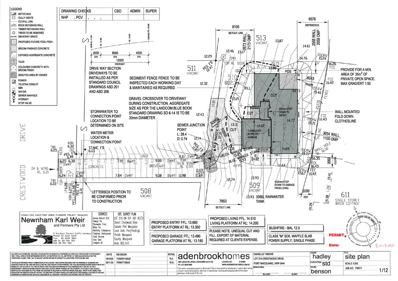
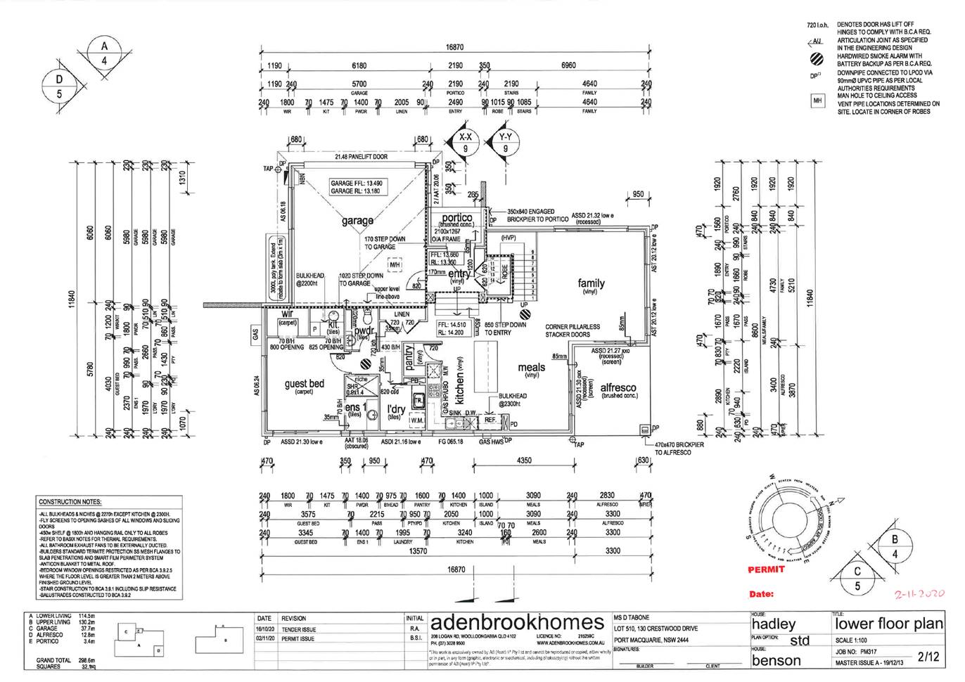
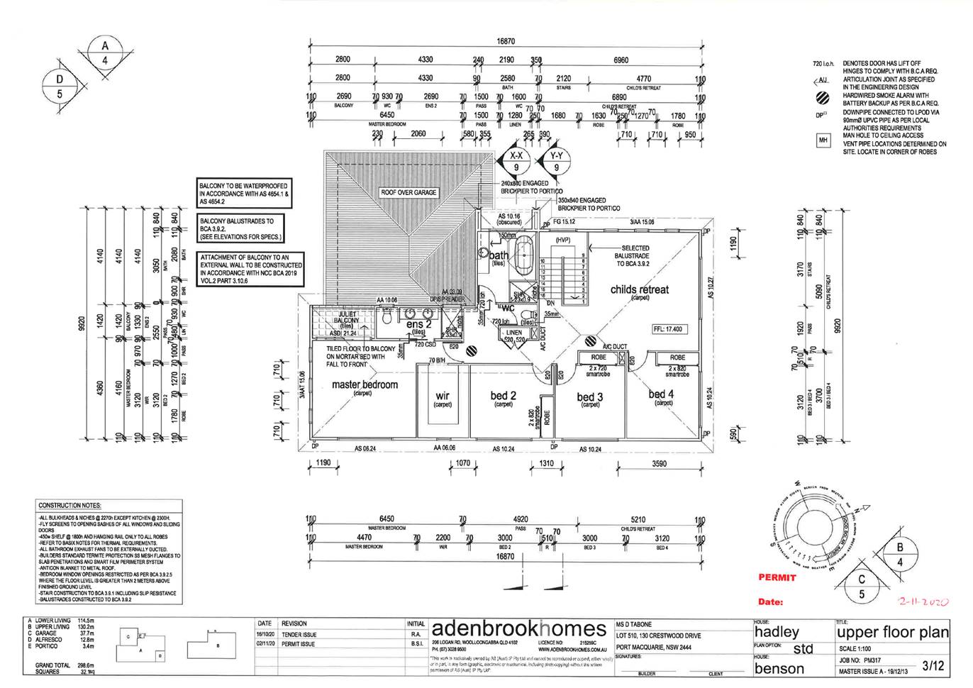
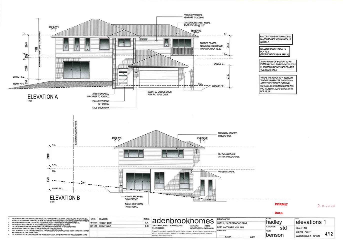
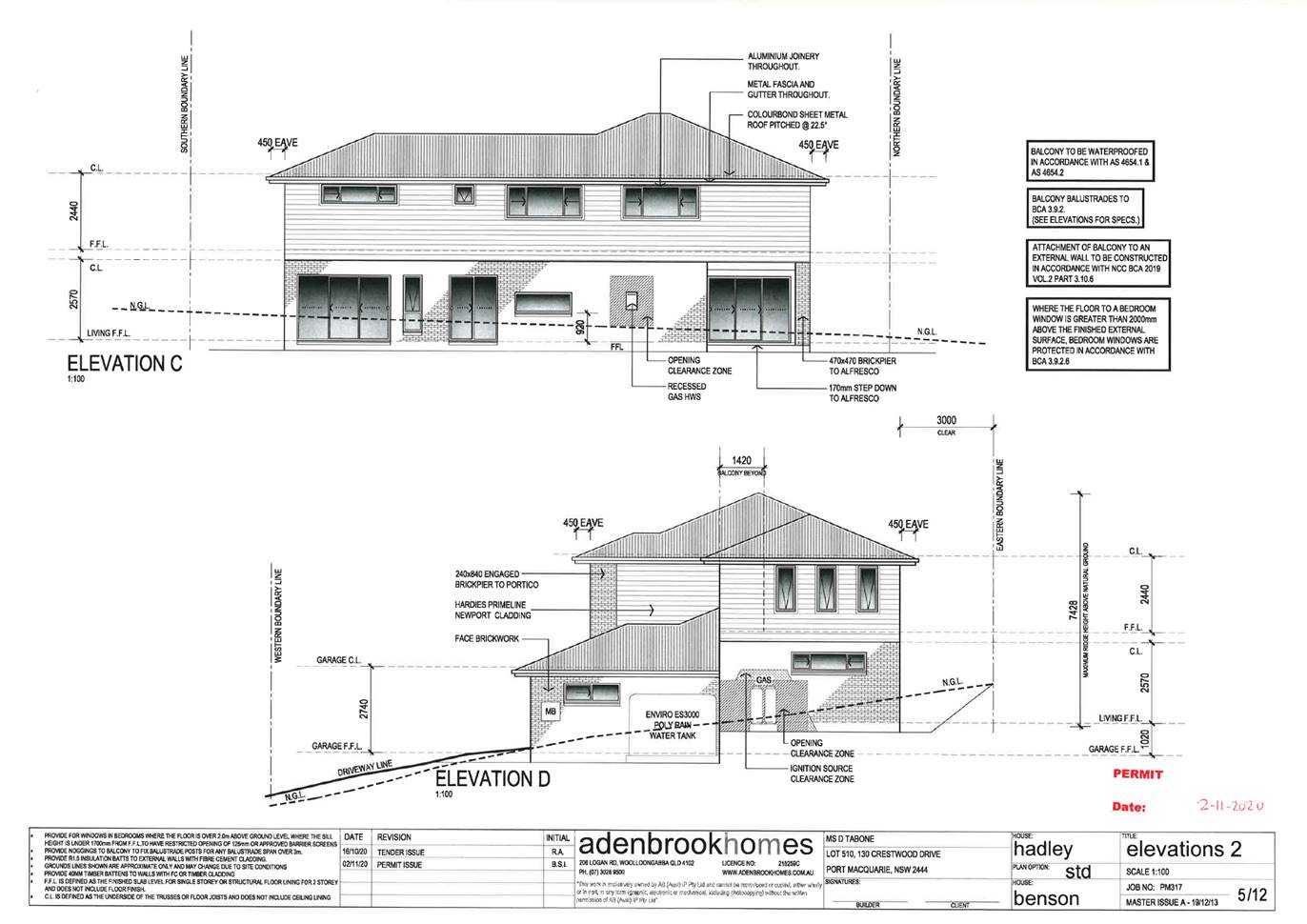
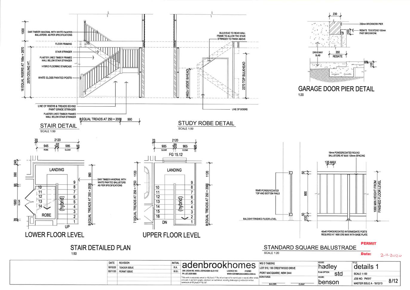
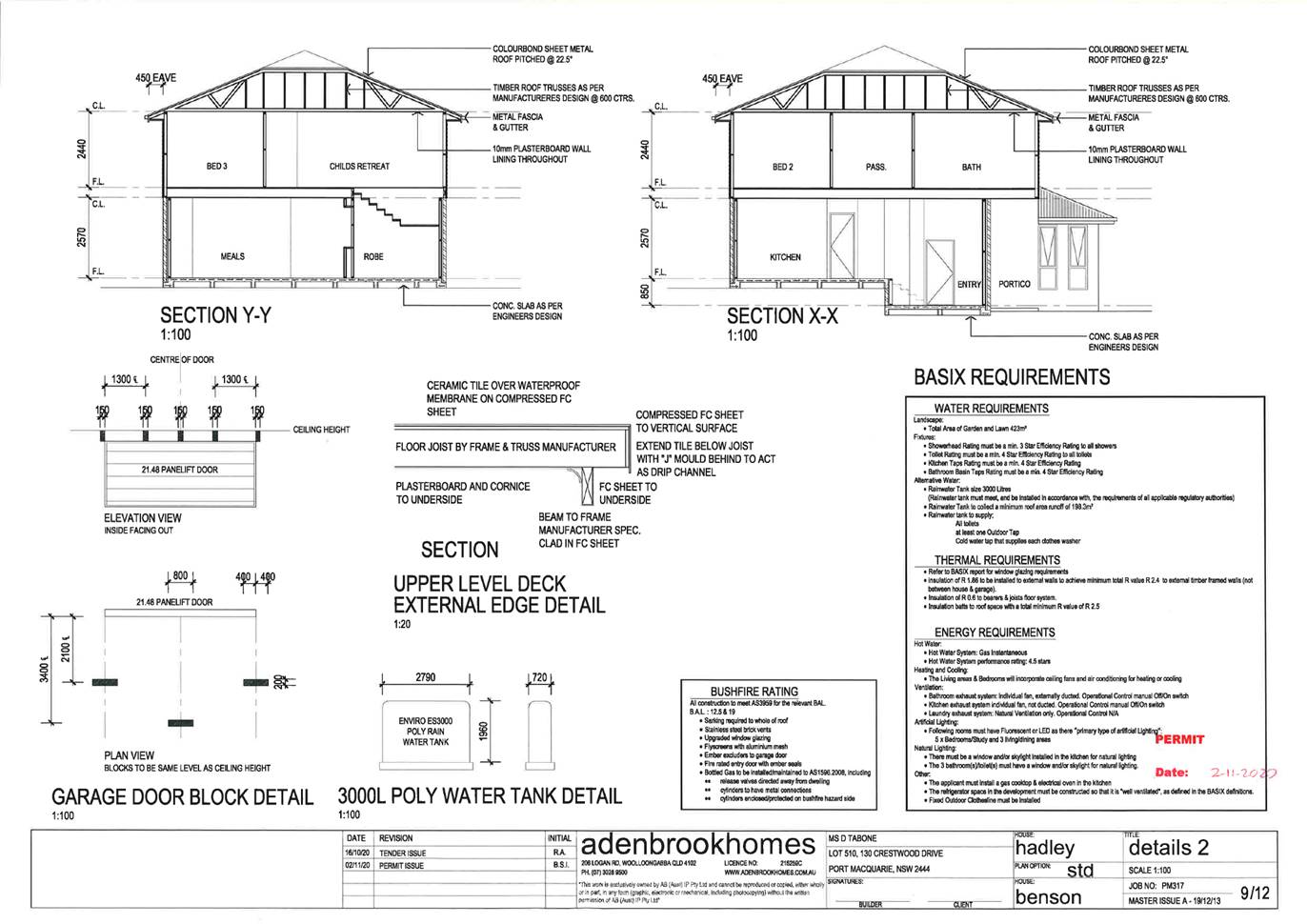
AGENDA Development Assessment Panel 21/01/2021
Item: 08
Subject: DA2020 - 430.1 Additional Dwelling to create
Dual Occupancy with Torrens Title Subdivision, Lot 6 DP258215, 5 Kiah Place
Bonny Hills, 11028
Report
Author: Development Assessment Planner, Steven Ford
|
Applicant: Karen
Burke Registered Architect
Owner: S
B Hollis & K N Burke
Estimated Cost: $330,000
Alignment with Delivery
Program
4.3.1 Undertake transparent and
efficient development assessment in accordance with relevant legislation.
|
RECOMMENDATION
That
DA2020 - 430.1 for Additional Dwelling
to create Dual Occupancy with Torrens Title Subdivision at Lot 6, DP 258215, No. 5 Kiah
Place, Bonny Hills, be determined by granting consent subject to the
recommended conditions.
Executive
Summary
This
report considers a development application for Additional Dwelling to create
Dual Occupancy with Torrens Title Subdivision at
the subject site and provides an assessment of the application in accordance with
the Environmental Planning and Assessment Act 1979.
Following exhibition of the
application, three (3) submissions were
received.
The site is considered suitable for the proposed development
and the proposal adequately addresses relevant planning controls. The
development is not considered to be contrary to the public's interest and will
not result a significant adverse social, environmental or economic impact.
This report recommends that the
development application be approved subject to the conditions proposed
in Attachment 1.
1. BACKGROUND
Existing
Sites Features and Surrounding Development
The site has an area of 924m2
and there is an existing single dwelling
located on the land.
The
site is zoned R1 General Residential in
accordance with the Port Macquarie-Hastings Local Environmental Plan 2011, as
shown in the following zoning plan:
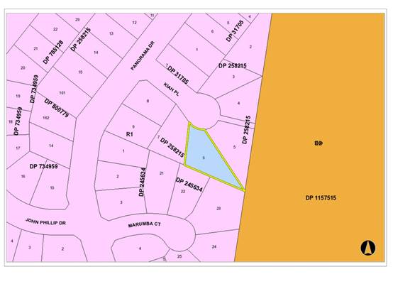
The
existing subdivision pattern and location of existing development within the
locality is shown in the following aerial photograph:
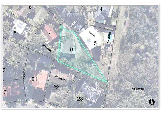
2. DESCRIPTION
OF DEVELOPMENT
Key
aspects of the proposal include the following:
· Additional dwelling to create dual occupancy
· Subdivision into 2 torrens title lots.
· Staging of the proposal.
· Removal
of six (6) mature native trees
Refer
to Attachment 2 for the plans and supporting reports of the proposed
development.
Application
Chronology
· 09
June 2020 - Application lodged.
· 16
June 2020 to 29 June 2020 - Neighbour notification.
· 20 July 2020 - Amended plans received.
· 28 July 2020 - Additional amended plans received.
· 06 August 2020 - Hollow bearing tree assessment received
· 20 August 2020 - Additional information requested
· 11 December 2020 - Ecological Impact Assessment received
· 11 January 2020 - Amended plans received
3. STATUTORY
ASSESSMENT
Section
4.15(1) Matters for Consideration
In
determining the application, Council is required to take into consideration the
following matters as are relevant to the development that apply to the land to
which the development application relates:
(a) The provisions (where
applicable) of:
-
(i)
Any Environmental Planning Instrument (EPI)
State Environmental Planning Policy (Koala Habitat
Protection) 2020
Clause 5 - This SEPP applies to the Port Macquarie-Hastings
Local Government Area.
Clause 8 - The site is less than 1 hectare
including adjoining land in the same ownership. The SEPP does not prevent
the granting of consent on the land being less than 1 hectare in area.
The Applicant has also submitted an Ecological
Impact Assessment to support the application for development of the site and
the proposal has been assessed by Council’s Arborist and Ecologist. The
Five Part test undertaken and an assessment of tree health also provided has
been confirmed to be satisfactory and that the recommendations for tree removal
were justified. Recommended mitigation measures have been appropriately applied
to the recommended conditions.
State Environmental Planning Policy No. 55 –
Remediation of Land
Following an inspection of the site and a search of Council
records, the subject land is not identified as being potentially contaminated
and is suitable for the intended use.
State Environmental Planning Policy (Coastal Management)
2018
The site is located within a coastal use area.
In accordance with clause 7, this SEPP prevails over the
Port Macquarie-Hastings LEP 2011 in the event of any inconsistency.
Having regard to clauses 13 and 14 of the SEPP the proposed
development is not considered likely to result in any of the following:
a) any
adverse impact on integrity and resilience of the biophysical,
hydrological (surface and groundwater) and ecological environment;
b) any
adverse impacts coastal environmental values and natural coastal
processes;
c) any
adverse impact on marine vegetation, native vegetation and fauna
and their habitats, undeveloped headlands and rock platforms;
d) any
adverse impact on Aboriginal cultural heritage, practices and
places;
e) any
adverse impacts on the cultural and built environment heritage;
f) any
adverse impacts the use of the surf zone;
g) any adverse impact on the visual amenity and scenic qualities of the
coast, including coastal headlands;
h) overshadowing, wind funneling and the loss of views from public places
to foreshores; and
i) any
adverse impacts on existing public open space and safe access to
and along the foreshore, beach, headland or rock platform for members of the
public, including persons with a disability.
In accordance with Clause 15 the proposal is not likely to
cause increased risk of coastal hazards on the land or other land.
The bulk, scale and size of the proposed development is
compatible with the surrounding coastal and built environment. The site is
located within an area zoned for residential purposes.
State Environmental Planning Policy (Building
Sustainability Index: BASIX) 2004
A BASIX certificate (number 1104815S) has been submitted
demonstrating that the proposal will comply with the requirements of the
SEPP. It is recommended that a condition be imposed to ensure that the
commitments are incorporated into the development and certified at Occupation
Certificate stage.
Port Macquarie-Hastings Local Environmental
Plan 2011
The proposal is consistent with the LEP having regard to the
following:
· Clause
2.2 - The subject site is zoned R1 General Residential. In accordance with
clause 2.3(1) and the R1 zone landuse table, the proposed development for an
additional Dwelling to create Dual Occupancy with Torrens Title Subdivision is
a permissible land uses with consent.
The objectives of the R1 zone are as
follows:
o To provide for the housing needs of
the community.
o To provide for a variety of housing
types and densities.
o To enable other land uses that
provide facilities or services to meet the day to day needs of residents.
· Clause
2.3(2) - The proposal is consistent with the zone objectives having regard to
the fact that the proposal would contribute to the range of housing types and
densities to meet the housing needs of the community.
· Clause
4.1A - The minimum lot sizes do not apply to the proposal as it is
characterised as a dual occupancy with subdivision development (integrated
housing). The proposal is 1 into 2 lot Torrens title subdivision, the existing
dwelling is located on proposed lot 1 with a total area of 441.3m2 and proposed
lot 2 has a total area of 483.1m2 with a proposed single dwelling.
· Clause
4.3 - The maximum overall height of the building above ground level (existing)
is 5.69 m which complies with the standard height limit of 8.5 m applying to
the site.
· Clause
4.4 - The floor space ratio of the proposal is 0.36:1.0 which complies with the
maximum 0.65:1 floor space ratio applying to the site.
· Clause
5.10 – The site does not contain or adjoin any known heritage items or
sites of significance.
· Clause
7.13 - Satisfactory arrangements are in place for provision of essential
services including water supply, electricity supply, sewer infrastructure,
stormwater drainage and suitable road access to service the development.
Provision of electricity will be subject to obtaining satisfactory arrangements
certification prior to the issue of a Subdivision Certificate as recommended by
a condition of consent.
(ii) Any
proposed instrument that is or has been placed on exhibition
No draft instruments apply to the site.
(iii) Any Development
Control Plan (DCP) in force
Port Macquarie-Hastings Development Control Plan 2013:
|
DCP 2013: Part B - General Provisions - B2:
Environmental Management
|
|
DCP Objective
|
Development Provisions
|
Proposed
|
Complies
|
|
3
|
a) Development must comply
with Council’s Developments, Public Place & Events - Waste
Minimisation and Management Policy.
|
Satisfactory arrangements
can be put in place for storage and collection of waste.
Standard condition
recommended for construction waste management.
|
Yes
|
|
Cut and Fill Regrading
|
|
4
|
a) Development shall not
exceed a maximum cut of 1.0m and fill of 1.0m measured vertically above the
ground level (existing) at a distance of 1.0m outside the perimeter of the
external walls of the building (This does not apply to buildings where such
cut and fill is fully retained within or by the external walls of the
building).
|
No cut or fill greater than
1m is proposed outside of the building footprint.
|
Yes
|
|
5
|
a) A certified practicing
structural engineer must certify any retaining wall greater than 1.0m.
|
N/A
|
N/A
|
|
b) Where a combination of a
fence and a wall is proposed to be greater than 1.2m high:
- be a
maximum combined height of 1.8m above existing property boundary level;
- be
constructed up to the front boundary for a maximum length of 6.0m or 30% of
the street frontage, whichever is less;
− the
fence component has openings which make it not less than 25% transparent; and
− provide
a 3m x 3m splay for corner sites, and
- provide a
900mm x 900mm splay for vehicle driveway entrances.
|
N/A - no front fences
proposed
|
N/A
|
|
DCP 2013: Part B -
General Provision - B3: Hazards Management
|
|
Bushfire Hazard Management
|
|
18
|
a) APZs are to be located
outside of environmental protection zones and wholly provided within private
land. Note perimeter roads provided as part of a residential subdivision are
classified as being part of the subdivision and not a separate permissible
land use within environment protection zones.
|
Capable of complying - see
bush fire comments later in this report
|
Yes
|
|
DCP 2013: Part B- General Provisions- B4: Transport,
Traffic Management, Access and Car Parking
|
|
DCP Objective
|
Development Provisions
|
Proposed
|
Complies
|
|
|
|
Parking Provision
|
|
24
|
a) Off-street Parking is
provided in accordance with Table 3.
1 parking space per each
dwelling for dwelling-houses/dual occupancies/semi-detached dwellings.
|
Both proposed lots are
capable of accommodating off street car parking areas.
The existing dwelling has a
hardstand area in front of the building line which is to be removed. The
existing dwelling is proposed to provide a primary hardstand space minimum 6m
from the front boundary and between the western boundary and the building.
The proposed new dwelling
will have a double carport behind the front building line of the existing
dwelling but forward of the proposed dwelling.
Total of 3 parking spaces
has been provided.
Objectives of this clause
have been satisfied.
|
Yes
|
|
Parking Layout
|
|
28
|
c) Parking spaces shall
generally be behind the building line but may be located between the building
line and the street when:
− it
is stacked parking in the driveway; or
− it
can be demonstrated that improvements to the open space provided will result;
and
− the
spaces are screened (densely landscaped or similar) from the street by a
landscaping with a minimum width of 3.0m for the entire length of the parking
area.
|
Residential parking only.
The development proposes to
have a new primary parking space 6m from the front boundary but partially in
front of the building line by 3m. Plan number DA-2B demonstrates the proposed
location in relationship to the existing dwelling.
Due to a large existing
front setback, and natural slope the car park position was difficult to be
located any further from the street.
The proposed location has
provided separation from the street, allowed for screening with front
landscaping and the property being at the end of a cul-de-sac. The objective
of this clause have been satisfied and considered to minimise conflict to the
street amenity.
|
No - for the front dwelling
5A* - see comments beside.
|
|
d) Parking design and layout
is provided in accordance with AS/NZS 2890.1 - Parking facilities -
Off-street car parking.
|
The development is capable
of complying.
|
Yes
|
|
|
|
|
|
|
DCP 2013: Part B -
General Provisions - B5: Social Impact Assessment and Crime Prevention
|
|
DCP Objective
|
Development Provisions
|
Proposed
|
Complies
|
|
Crime Prevention
|
|
43
|
a) The development addresses
the generic principles of crime prevention:
− Casual
surveillance and sightlines;
− Land use mix
and activity generators;
− Definition of
use and ownership;
− Basic exterior
building design;
− Lighting;
− Way-finding;
and
− Predictable
routes and entrapment locations;
− as described in
the Crime Prevention Through Environmental Design (CPTED) principles.
|
No concealment or entrapment areas proposed. Adequate
casual surveillance available.
|
Yes
|
|
DCP 2013: Part C - Development Specific Provisions -
C1: Low Density Residential Development
|
|
DCP Objective
|
Development Provisions
|
Proposed
|
Complies
|
|
Front Setbacks
|
|
44
|
a) Dwellings may incorporate an articulation zone to a
street frontage at no less than 3m from property boundary. The
following building elements are permitted within the articulation zone:
− an entry feature
or portico;
− a balcony,
deck, patio, pergola, terrace or verandah;
− a window box
treatment;
− a bay window or
similar feature;
− an awning or
other feature over a window;
− a sun shading
feature.
b) These building elements should not extend above the
eave gutter line, other than a pitched roof to an entry feature or portico
that has the same pitch as the roof on the dwelling house.
|
No building elements are proposed within the articulation
zone.
The proposed car park has been amended during the assessment
and is not within the articulation zone.
|
N/A
|
|
c) The primary road front setback shall be:
Classified road = any frontage 6.0m
Primary frontage = 4.5m
Secondary frontage = 3.0m
Ancillary Lane = 2.0m
Large lot residential and rural zones = 10.0m
|
Front setbacks.
Dwelling (Existing) 5A - 8.2m
Proposed Dwelling 5B - 15.5m
|
Yes
|
|
45
|
a) A garage, carport or car parking space should:
− be at least 1m behind
the building line, where the dwelling(s) has a setback from a front boundary
of 4.5m or more, or
− be at least 5.5m
from a front boundary, where the dwelling(s) has a setback of less than 4.5m.
|
Proposed Dwelling 5B, proposes a car port 6m behind the
front building line of the existing house but forward of the proposed
dwelling. The carport is setback 15.5m from the street frontage and the shape
of the proposed lot can be characterised similarly to a battleaxe.
The existing dwelling, due to the irregular shape and
narrowness of the site has a car space partially forward of the existing
building line, see a variation to the development provisions of this clause,
see justification below.
|
Yes and No* Acceptable, see justification below.
|
|
b) The total width of the garage/carport openings should
not be more than 6m and not more than 50 per cent of the width of the
building.
|
Proposed carport is 4.9m wide, and 38% of the total width
of the dwelling (13.1m).
|
Yes
|
|
c) Driveway crossovers are no greater than 5.0m in width.
|
Lot 5B - existing driveway crossover, 3m wide
Lot 5A - proposed width 3m wide
|
Yes
|
|
d) Where a dual occupancy or attached dwelling is proposed
on a corner lot a garage and driveway is provided on each road frontage.
|
N/A - not considered a corner lot.
|
N/A
|
|
Side and Rear Setbacks
|
|
46
|
a) A minimum rear boundary setback of 4m is to be provided
to dwellings (including verandahs, patios and decks).
|
Dwelling 5A - Rear building line is unchanged, 5.28m.
Dwelling 5B - minimum rear setback is 4m
|
Yes
|
|
b) A minimum rear boundary setback of 900mm applies to
sheds and swimming pools subject to achieving minimum required private open
space area.
|
None proposed
|
N/A
|
|
c) Council may consider varying rear setback requirements
where it is demonstrated that the private open space could achieve better
solar access between the building and the side setback. In that instance, one
side setback should be a minimum 4m in width (for an equivalent length of
rear boundary, behind building line) and the rear setback may be reduced to
900mm.
|
No variation proposed
|
N/A
|
|
47
|
a) Ground floors (being <1m above existing ground level)
should be setback a minimum of 900mm from side boundaries.
|
North East side setback, minimum 970mm.
Western boundary side setback unchanged.
Proposed internal boundary, minimum setback of 1m.
|
Yes
|
|
b) First floors and above (including single storey with
floor level >1m) should be setback a minimum of 3m from the side boundary,
or reduced down to 900mm where it can be demonstrated that the adjoining
property’s primary living rooms and principal private open space areas
are not adversely overshadowed for more than 3hrs between 9am - 3pm on 21
June.
|
Proposed first floor side setback of 970mm.
The Applicant has provided satisfactory shadow diagrams to
demonstrating no overshading impacts caused by the variation, and privacy
screening to provide privacy concerns raised from proposed Bed 1 eastern
facing windows to the adjoining private open space.
|
Yes
|
|
c) First floors and above should have building walls that
step in and out at least every 12m by a minimum of 500mm articulation. Where
first floors and above are setback >3m, wall articulation is not required.
|
The proposed dwelling is considered well-articulated. No
building walls are longer that 7m in length for a single span.
|
Yes
|
|
Private Open Space
|
|
48.
|
a) All dwellings should have a minimum area of private
open space of 35m2, which includes a principal private open space
area with:
− a minimum
dimension of 4m x 4m, and
− a maximum grade
of 5% for minimum 4m x 4m of the total open space requirement, and
− direct
accessibility from a ground floor living area and orientated to maximise use.
|
The proposal is well accounted for in regards to private
open space and site constraints. Due to natural slope, the grade of 5% is not
achievable at ground level. Both dwellings have a balcony accessible and
usable from primary living areas approximately 20m2 and rear yards
of over 150m2.
Providing the site constraints, the objectives of this
clause has been satisfied.
|
No, but minor variation considered acceptable.
|
|
|
b) Private open space may include clothes drying areas and
garbage storage.
|
The development is capable of having adequate drying and
storage facilities.
|
Yes
|
|
Public Domain and Fencing
|
|
49
|
a) Front fences built forward of the building line for the
primary road frontage should be detailed on the development application
plans.
|
No front fence proposed
|
N/A
|
|
b) Solid Front fences up to 1.2m high should be:
− Setback 1.0m
from the front boundary, and
− Suitably
landscaped to reduce visual impact, and
− Provide a 3m x
3m splay for corner sites.
|
N/A
|
N/A
|
|
b) Front fences proposed to be more than 1.2m high should be
a maximum of 1.8m in height, above existing front property boundary level,
and either:
− Include
landscaped recesses having minimum dimensions of 1.8m long x 900mm deep which
occupy no less than 50% of the total length of the fence, or
− be
erected up to the front boundary for a maximum length of 6.0m or 50% of the
street frontage,
|
N/A
|
N/A
|
|
c) have openings which make it not less than 25%
transparent (no individual opening more than 30mm wide);
|
N/A
|
N/A
|
|
d) provide a 3m x 3m splay for corner sites, and
|
N/A
|
N/A
|
|
e) provide a 900mm x 900mm splay for vehicle driveway
entrances.
|
N/A
|
N/A
|
|
|
|
|
|
|
Bulk and Scale
|
|
51
|
a) Direct views between indoor living rooms and principal
private open space of adjacent dwellings, including proposed dwellings
approved on adjoining lots, including possible dwellings on future lots,
should be obscured or screened where:
− Ground and first
floor (and above) indoor living room windows are within a 9m radius.
− Direct views
between principal private open space areas where within a 12m radius.
− Direct views
between indoor living rooms of dwellings into the principal area of private
open space of other dwellings within a 12m radius.
|
Adequate separation has been provided between the proposed
dwelling and the adjoining dwellings.
Elevated homes constructed on sloping blocks generally
overlook adjacent properties. As a mitigation measure the eastern facing
windows have been amended to include direction privacy screening. This
softens privacy concerns that have been raised in the submissions and
provides adequate screening to adjoining private open space.
There is considered to be more than adequate separation of
between 9m and 12m to adjoining principle private open space. However, as a
mitigation measure, screening plants have been proposed to be planted along
the rear boundary.
|
Yes
|
|
b) A balcony, deck, patio, pergola, terrace or verandah
should have a privacy screen where there are direct views of:
− Indoor living
room windows of adjacent dwellings, including proposed dwellings approved on
adjoining lots within 9m radius; or
− Principal areas
of private open space of adjacent dwellings, including proposed dwellings
approved on adjoining lots within a 12m radius.
|
There is considered to be more than adequate separation of
between 9m and 12m to adjoining principle private open space. However, as an
additional mitigation measure, screening plants have been proposed to be
planted along the rear boundary. The objectives of this clause are considered
to be satisfied.
|
|
|
c) Privacy protection is
not required for:
− Any Indoor
living room windows with a sill height of greater than 1.5m above the
finished floor level of that room or where fixed non-openable translucent
glass is installed to the same height.
|
Eastern facing windows with sill heights lower than 1.5m
have been provided with privacy screening to protect privacy were necessary.
This design elements will soften any adverse impacts.
|
Yes
|
|
d) Direct views described above may be reduced or obscured
by one of the following measures (details to be submitted with the
development application):
− 1.8m high fence
or wall between ground-floor level windows or between a dwelling and
principal private open space
− Screening of
minimum 1.7m height, that has 25% openings (max), with no individual opening
more than 30mm wide, is permanently fixed and is made of durable materials.
− A
window, the whole of which has translucent glass and is not able to be
opened.
|
Directional privacy screening has been provided to eastern
facing windows. The southern facing windows and balcony are considered to
have adequate separation and no additional fixed screening is necessary to
the balcony.
|
Yes
|
|
Ancillary Development
|
|
56
|
a) For ancillary development in R1 General Residential, R2
Low Density Residential, R3 Medium Density Residential, R4 High Density
Residential, R5 Large Lot Residential and RU5 Village zones:
− The height of
an outbuilding or the alterations and additions to an existing outbuilding on
a lot should not be more than 4.8m above ground level (existing).
− The building
should be single storey construction with a maximum roof pitch of 24 degrees.
− The maximum
area of the building should be 60m2 for lots less than 900m² and maximum
of 100m² for larger lots.
− Ancillary
development that is a garage, or an outbuilding, or a rainwater tank should
not be located in front of the main building line with the exception of
swimming pools.
|
Water tank for proposed new dwelling appropriately
located.
|
Yes
|
|
DCP 2013: PART C - Development Specific Provisions -
C5: Subdivision
|
|
DCP Objective
|
Development Provisions
|
Proposed
|
Complies
|
|
Site Analysis
|
|
139
|
a) A site analysis is required for all development and
should illustrate:
- microclimate including
the movement of the sun and prevailing winds;
- lot dimensions;
- north point;
- existing contours and
levels to AHD;
- flood affected areas;
- overland flow patterns,
drainage and services;
- any contaminated soils
or filled areas, or areas of unstable land;
- easements and/or
connections for drainage and utility services;
- identification of any
existing trees and other significant vegetation;
- any existing buildings
and other structures, including their setback distances;
- heritage and
archaeological features;
- fences, boundaries and
easements;
- existing and proposed
road network, including connectivity and access for all adjoining land
parcels;
- pedestrian and vehicle
access;
- views to and from the
site;
- overshadowing by
neighbouring structures; and
- any other notable
features or characteristics of the site.
|
Satisfactory site analysis plan details submitted.
|
Yes
|
|
Urban Structure and Lot Layout
|
|
140
|
a) Any residential allotments created by Torrens title
subdivision should satisfy the following standards:
- A minimum width of 15
metres when measured at a distance of 5.5 metres from the front property
boundary;
- A minimum width of 7
metres measured when side boundaries are extended to the kerb line; A minimum
depth of 25 metres;
- For lots where the
average slope of the development site is equal to, or exceeds 16%, indicative
road and driveway grades are required demonstrating satisfactory access.
|
Lot 1 - 9.15m at front boundary and side boundary of 31.5m
Lot 2 - 3.83m at front boundary and side boundary of 55m
but could be is characterised as a battleaxe lot. Due to the irregular shape
of the subject site, the applicant has demonstrated that a dwelling can fit
within the site and address the objectives of this clause.
|
Yes
No, but minor variation considered acceptable as
integrated development.
|
|
141
|
a) Battleaxe allotments are discouraged in greenfield
development.
|
Infill development, not considered a greenfield
development.
|
N/A
|
|
b) Council may consider permitting Torrens Title battleaxe
allotments for “infill” development where it is demonstrated
that:
- A Torrens Title lot,
that is not a battleaxe lot, cannot be achieved; and
- the number of crossovers
do not reduce the amenity of the street or on street parking; and
-
-
- the impact of noise,
dust and headlights on the land owners adjoining the driveway is addressed by
the construction of an acoustic fence for the full length of the driveway; and
-
-
- addresses privacy
between the rear lot and the rear open space of the front lot by the
provision of adequate screening, larger lot size and setbacks; and
- extends utilities to
the end of the axe handle; and
- There is sufficient
space for garbage collection on the frontage.
|
Proposed layout is considered satisfactory and consistent
with the objectives of this clause. The access handles for both Lots 2 are
capable of being provided with sealed driveway to the proposed carport.
Adequate privacy will be achieved with the installation of
a 1.8m height fence along the full length of the proposed boundaries.
The site is capable of being serviced by public utilies
and sufficient space for garbage collection at the frontage.
|
Yes
|
|
142
|
a) The subdivision of land with slopes exceeding 25% is
generally discouraged.
|
Land slope is less than 25%
|
Yes
|
|
143
|
a) Wherever possible orientate streets to maximise the
number of east, west and south facing lots and to minimise the number of
narrow north facing lots.
|
Orientation of lots is acceptable providing the existing
dwellings northern aspect will be relatively unchanged. And proposed Lot 2
will have a south eastern aspect
|
Yes
|
|
b) Residential street blocks should preferably be
orientated north-south with dimensions generally limited to 60 - 80 metres by
120 - 150 metres.
|
Noted. The proposed dwelling on lot 2 achieves an
acceptable BASIX rating.
|
Acceptable
|
|
c) Lot size and shape are to reflect orientation to ensure
future dwelling construction has optimal opportunity for passive solar
design.
|
Noted. The proposed dwelling on lot 2 achieves an
acceptable BASIX rating.
|
Acceptable
|
|
144
|
a) The site analysis, including the lot orientation,
layout, and natural topography should inform and aid the design of the street
pattern.
|
N/A
|
N/A
|
|
b) The street plan should provide:
- Street network,
including those existing (adjacent or opposite);
- Cycleways and pathway
network
- Indicative gradients
and cross-sections of roads, cycle ways and pathways, particularly those with
steep slopes that may present access and mobility constraints. Provide
notional road batters for steep areas
- General intersection
traffic dampening, related landscape features and constriction points;
- Notional drainage
pattern and works where affected by road works
- Car parking
- Consideration of
existing and proposed street trees
- Existing and proposed
fire trails
- Street and Service
Plans should need to show how the proposal should integrate with the existing
system.
|
N/A
|
N/A
|
|
145
|
a) Subdivision applications close to urban centres should
achieve a high-medium population yield (>35 dwellings per hectare).
|
N/A - minimal infill subdivision
|
N/A
|
|
b) Subdivisions along arterial roads and serviced by
public transport should achieve a high-medium population yield
(>35 dwellings per hectare).
|
N/A
|
N/A
|
|
Infrastructure - Integrated Water Cycle Management
|
|
150
|
a) An application for subdivision should include a WSUD
prepared by a certified practicing engineer and in accordance with
Council’s adopted design specification documents.
|
2 Lot subdivision only capable of complying - Concept
stormwater management plan submitted is satisfactory. Appropriate consent
conditions recommended.
|
Yes
|
|
Infrastructure - Stormwater Management
|
|
151
|
-
a) An application for subdivision should be accompanied by a
Stormwater Management Strategy prepared by a certified practicing engineer
and in accordance with Council’s adopted AUS-SPEC design specification
documents.
|
2 Lot subdivision only capable of complying - Concept
stormwater management plan submitted is satisfactory. Appropriate consent
conditions recommended.
|
Yes
|
|
-
b) The Designer should adopt the ‘major/minor’
approach to urban drainage systems as outlined in the current version of
Australian Rainfall and Runoff utilising local parameters and factors where
necessary and as defined in AUS-SPEC.
|
2 Lot subdivision only capable of complying - Concept
stormwater management plan submitted is satisfactory. Appropriate consent
conditions recommended.
|
Yes
|
|
-
c) The ‘Minor’ system generally refers to a
pipeline network with sufficient capacity to contain nuisance and low flows
from nominated storm events. These pipelines prevent stormwater damage to
properties and also limit the frequency and quantity of surface water to a
level that is acceptable to the community.
|
2 Lot subdivision only capable of complying - Concept
stormwater management plan submitted is satisfactory. Appropriate consent
conditions recommended.
|
Yes
|
|
-
d) A ‘Major’ drainage system caters for the runoff
from rarer storms of higher intensity than for which the minor drainage
system has been designed. refers to overland flow paths that are to be
designed to convey the major storm flows when the capacity of the minor
system is exceeded. The ‘Major’ drainage system generally refers
to a system of safe is designed to handle flows resulting from rare storm
events up to and including a 100-year ARI. These flows should follow a
designated overland flow paths that are to be designed to convey the major
storm flows when the capacity of the minor system is exceeded. The major
drainage system is designed to handle flows resulting from rare storm events
up to and including a 1% AEP event.
|
2 Lot subdivision only capable of complying - Concept
stormwater management plan submitted is satisfactory. Appropriate consent
conditions recommended.
|
Yes
|
|
-
e) The design AEP storm events are defined in AUS-SPEC D5
|
Proposal capable of compliance with AUS-SPEC. Appropriate
conditions recommended.
|
Yes
|
|
-
f) Freeboard to buildings, structures, property boundaries
above major stormwater flows shall be provided in accordance with the
council’s current flood policy.
|
Proposal capable of compliance with AUS-SPEC. Appropriate
conditions recommended.
|
Yes
|
|
152
|
a) All Council owned stormwater infrastructure is designed
in accordance with the Council’s AUS-SPEC Design Specification
Documents.
|
Proposal capable of compliance with AUS-SPEC. Appropriate
conditions recommended.
|
Yes
|
|
Infrastructure - Water Supply
|
|
153
|
-
a) A reticulated water supply should be required for all
subdivisions except rural zoned areas greater than 40 hectares or where
deemed financial unviable by the Water and Sewer Planning Manager or
equivalent.
|
Reticulated water supply proposed. Appropriate standard
conditions are recommended.
|
Yes
|
|
-
b) For all applicable subdivisions, provision is to be made to
provide a separate metered water connection to Council’s main for each
lot. All work will need to comply with the requirements of
Council’s adopted AUS-SPEC Design and Construction Guidelines and
Policies. Details to be provided on a hydraulic plan submitted to Council.
|
Provision can be made to provide a separate metered water
connection to Council’s main for each lot. All work will need to
comply with the requirements of Council’s adopted AUS-SPEC Design and
Construction Guidelines and Policies. Appropriate standard conditions are
recommended.
|
Yes
|
|
-
c) A water supply strategy should be required where there are
more than 20 lots and may be required for sub-divisions of less than 20 lots
as directed by the Water and Sewer Planning Manager or equivalent. The water
supply strategy is to detail any subdivision staging and the corresponding
water supply work (including augmentation) necessary to support each
stage. The strategy is to incorporate the latest changes in water
supply design requirements as well as being modelled on software compatible
with that used by Council.
|
N/A
|
N/A
|
|
-
d) All water supply systems should be designed to meet
Council’s design specification documents for infrastructure external to
the property.
|
All water supply systems can be designed to meet
Council’s design specification documents for infrastructure external to
the property.
Appropriate standard conditions are recommended.
|
Yes
|
|
-
f) Proponents are required to extend and meet full cost of
water reticulation.
|
Subdivision works at proponent’s cost.
|
Yes
|
|
Infrastructure - Sewerage
|
|
155
|
-
a) A sewer system is required for all subdivisions with
proposed lots smaller than 5000m 2, where Onsite Sewage Management
requirements cannot by demonstrated to Council or where deemed financial
viable by the Water and Sewer Planning Manager or equivalent.
|
Concept sewer management plan submitted is satisfactory.
Appropriate consent conditions recommended.
|
Yes
|
|
-
b) For all applicable subdivisions, provision is to be made to
provide a separate sewer junction and connection to Council’s main for
each lot. All work will need to comply with the requirements of
Council’s adopted AUS-SPEC Design and Construction Guidelines and
Policies. Details to be provided on an Engineering plan submitted to Council.
|
Concept sewer management plan submitted is satisfactory.
Appropriate consent conditions recommended.
|
Yes
|
|
-
c) A sewerage strategy should be provided for an application
for subdivision of 20 or more lots and may be required for subdivisions of
less than 20 lots as directed by the Water and Sewer Planning Manager or
equivalent. The sewer strategy is to detail any subdivision staging and
include the proposed method of servicing necessary to support each
stage. The strategy is to incorporate the latest changes in sewer
design requirements as well as being modelled on software compatible with
that used by Council.
|
N/A
|
N/A
|
|
-
d) All sewer systems to be designed to meet the NSW Code of
Practice Plumbing & Drainage and Australian Standard AS3500 and related
standards for infrastructure within property boundaries.
|
Sewer systems can be designed to meet the NSW Code of
Practice Plumbing & Drainage and Australian Standard AS3500 and related
standards for infrastructure within property boundaries.
|
Yes
|
|
-
e) All sewer systems to be designed to meet Council’s
AUS-SPEC specification documents for infrastructure external to the property.
|
All required sewer systems can be designed to meet
Council’s AUS-SPEC specification documents for infrastructure external
to the property.
|
Yes
|
|
-
f) Sewerage systems should be planned to provide for
anticipated future requirements over a period of at least twenty (20)
years.
|
All required sewer systems can be designed to meet
Council’s AUS-SPEC specification documents for infrastructure external
to the property.
|
Yes
|
|
-
g) Proponents should be required to extend and meet full cost
of sewerage systems.
|
Subdivision works at proponent’s cost.
|
Yes
|
|
Soil Management
|
|
156
|
-
a) An erosion and sediment control plan should be provided for
a development application to subdivide land in accordance with
Council’s adopted AUS-SPEC design specification documents
|
Minimal subdivision construction works proposed
-Appropriate conditions recommended to address erosion and sediment control
requirements in accordance with AUS-SPEC.
|
Yes
|
|
-
b) An erosion and sediment control plan should be provided for
a development application to subdivide land in accordance with
Council’s adopted AUS-SPEC design specification documents.
|
Appropriate conditions recommended to address erosion and
sediment control requirements in accordance with AUS-SPEC.
|
Yes
|
|
Service Infrastructure and Information Technology
|
|
161
|
-
a) All service infrastructure should be underground unless
otherwise approved by Council.
|
All service infrastructure will be underground.
|
Yes
|
|
-
b) All service infrastructure should be installed in a common
trench.
|
All service infrastructure can be installed in a common
trench.
|
Yes
|
|
-
c) Conduits for the main technology network system should be provided
in all streets.
|
Conduits for the main technology network system can be
provided in street.
|
Yes
|
|
-
d) Conduits are to be installed in accordance with the National
Broadband Network Company Limited’s ‘Guidelines for Fibre to the
Premises Underground Deployment’.
|
Conduits can be installed in accordance with the National
Broadband Network Company Limited’s ‘Guidelines for Fibre to the
Premises Underground Deployment’.
|
Yes
|
|
-
e) Access pits are to be installed at appropriate intervals
along all streets.
|
Access pits for information technology if required can be
installed at appropriate intervals along all streets.
|
Yes
|
The proposal seeks to vary Development Provision relating to
clause 45 - car parking spaces forward of the building line.
The relevant objectives are:
· To minimise the
impact of garages and driveways on the streetscape, on street parking and
amenity.
· To minimise the
visual dominance of garages in the streetscape.
· To provide safe
and functional vehicular access.
Having regard for the development provisions and relevant
objectives, the variation is considered acceptable for the following reasons:
· The development
does not intend or propose alterations and additions to the existing dwelling.
· If the dwelling
only had the minimum front setback of 4.5m, the car space would be more than
the minimum behind the front building line and is setback greater than the
minimum 5.5m required.
· Access to the
existing dwelling’s garage is impacted by the proposed subdivision.
· The site
constraints of slope and narrowness of the site must be considered, as the car
park space has been placed in the most practical position before impacting the
existing dwelling or neighbouring property.
· The hardstand
space is accessed from the head of a Cul-de-sac that has existing on street car
parking and manoeuvring issues, by providing additional off street car parking
this will soften existing impacts to the street amenity.
· The hard stand
space will be partially screened from traffic entering Kiah Place from Panorama
Drive by fencing and vegetation.
· Other dwellings
within Kiah Place have hard stand parking within the front setback.
· A hardstand space
in this location of is not anticipated to adversely impact the existing
amenity, eases on street car parking demand, allows for manoeuvring at the head
of the cul-de-sac.
· The site plan
provides a total of 3 off street car spaces, which is consistent with the
off-street car parking in accordance with the DCP.
Based on the above assessment, the variations proposed to
the provisions of the DCP are considered acceptable and the relevant objectives
have been satisfied.
Cumulatively, the variations do not amount to an adverse
impact or a significance that would justify refusal of the application.
(iiia) Any planning agreement that has
been entered into under section 7.4, or any draft planning agreement that a
developer has offered to enter into under section 7.4
No planning agreement has been offered or entered into
relating to the site.
(iv) Any
matters prescribed by the Regulations
N/A
(b) The likely impacts of that
development, including environmental impacts on both the natural and built
environments and the social and economic impacts in the locality
Context and
setting
• The
proposal will be unlikely to have any adverse impacts to existing adjoining
properties and satisfactorily addresses the public domain.
• The proposal is considered to be consistent with other
residential development in the locality and adequately addresses planning
controls for the area.
• There
are no adverse impacts on existing view sharing.
• There are no adverse privacy impacts.
• There are no adverse overshadowing impacts. The proposal
does not prevent adjoining properties from receiving 3 hours of sunlight to
private open space and primary living areas on 21 June.
Roads
The site has road frontage Kiah Place, which is a sealed
road under the care and control of Council. Kiah Place is a Cul-de-sac, with a
16m wide road reserve, and an 8m carriageway width.
Traffic and Transport
Any addition in traffic associated with the development is
unlikely to have any adverse impacts to the existing road network within the
immediate locality.
Site Frontage and Access
Vehicle access to the proposed new dwelling/lot site is
proposed via the existing driveway, which is proposed to be within an easement
for access for access to the road frontage.
Primary access for the existing dwelling is proposed to be
via the existing gravel crossover, which will be augmented to enable parking
for 2 vehicles with direct street frontage. It has been conditioned that a
section 138 consent for these works must be obtained prior to the issue of a
construction certificate.
Parking and Manoeuvring
A total of 3 parking spaces have been provided on-site
within Carports with additional parking provided available within the
driveway. Parking and driveway widths on site can comply with relevant
Australian Standards (AS 2890) and conditions have been imposed to reflect
these requirements.
Water Supply Connection
Council records indicate that the
development site is currently serviced by a 100mm potable water main. Each Torrens Title lot requires a separate metered water
connection to Council’s water main. Water meters shall be located on the
respective future lots. All design & works shall be in accordance
with Council’s adopted AUSPEC Specifications.
A new metered water service will be required for each
allotment as part of the Torrens Title Subdivision.
Final water service sizing will need to be determined by a
hydraulic consultant to suit the development as well as addressing fire service
coverage to AS 2419 and backflow protection.
Detailed plans will be required to be submitted for
assessment with the S.68 application.
An appropriate consent condition is recommended.
Sewer Connection
Each Torrens Title lot requires a
separate line to Council’s sewer main. A sewer main extension shall be
required from the existing manhole located to the rear of the lot, in the
neighbouring property. The sewer main extension shall require owners consent
from the adjoining property. All design & works shall be in
accordance with Council’s adopted AUSPEC Specifications.
A separate sewer connection to Councils main is required for
each Torrens Title lot.
A manhole will also be required at the high end of the line
as it will be more than 40m long.
As the development will exceed 2ET discharge, sewer
connection is to be made from a manhole.
The hydraulic designer is to confer with Council sewer
section prior to submitting sewer design plans.
Detailed plans will be required to be submitted for
assessment with the S.68 application.
An appropriate consent condition is recommended.
Stormwater
The site naturally grades towards the rear and is currently
serviced via an existing interallotment drainage system, being the legal point
of discharge for the subject site.
A detailed site stormwater management plan, demonstrating
compliance with AUSPEC, will be required to be submitted for assessment with
the S.68 application and prior to the issue of a CC.
An appropriate consent condition is recommended.
Other Utilities
Telecommunication and electricity services are available to
the site. Evidence of satisfactory arrangements with the relevant utility
authorities for provision to each proposed lot will be required prior to
Subdivision Certificate approval.
An appropriate consent condition is recommended.
Heritage
No known items of Aboriginal or European heritage
significance exist on the property. No adverse impacts anticipated. The site is
in a residential context and considered to be disturbed land.
Other Land Resources
The site is within an established urban context and will not
sterilise any significant mineral or agricultural resource.
Water Cycle
The proposed development will not have any significant
adverse impacts on water resources and the water cycle.
Soils
The proposed development will not have any significant
adverse impacts on soils in terms of quality, erosion, stability and/or
productivity subject to a standard condition requiring erosion and sediment
controls to be in place prior to and during construction.
Air and Microclimate
The construction and/or operations of the proposed
development will not result in any significant adverse impacts on the existing
air quality or result in any pollution. Standard precautionary site management
condition recommended.
Flora and Fauna
Construction of the proposed dwelling will require the
removal of six (6) mature native trees and otherwise planted landscaping. Two
of these trees are located within the proposed building footprint and the
remaining four are located either within 10m of the proposed structure or
require removal due to poor health and safety close to both existing and
proposed structures.
The Applicant has submitted an ecological assessment
prepared by TreeHouse Ecology. The ecological survey has been undertaken
in accordance with relevant legislation including the Environmental Planning
and Assessment Act 1979, the Biodiversity Conservation Act 2016 and
the commonwealth Environment Protection and Biodiversity Conservation Act
1999.
With
considerations to the Biodiversity Offsets Scheme (BOS):
· The
study area is not located on lands mapped as Biodiversity Values Land.
· The
proposed clearing of less than 0.06 ha of native vegetation is less than the
area clearing threshold of 0.25 ha.
· The
test of significance (5 Part Test) concludes a not-significant impact on state
listed biodiversity.
As assessment of the latest amended plans and key matters
within the TreeHouse Ecology report has identified the following:
· The
site contains 5 Scribbly Gums plus 1 Red Bloodwood.
· A
landscaping plan should be submitted to compensate for the biomass of removed
foraging foliage and seasonal floristics available to local fauna. This will
not compensate for the removal of potential habitat provided specifically by
the large mature trees, however it will otherwise aim to provide a more
positive ecological outcome for fauna species considered.
Having regard to the above, an assessment of the proposal,
including review by a Council Ecologist, has concluded that the proposal will
be unlikely to have any significant adverse impacts on biodiversity or
threatened species of flora and fauna.
Appropriate conditions are recommended to require the
mitigation measures to be implemented.
Waste
Satisfactory arrangements are in place for proposed storage
and collection of waste and recyclables. No adverse impacts anticipated.
Standard precautionary site management condition recommended.
Energy
The proposal includes measures to address energy efficiency
and will be required to comply with the requirements of BASIX.
Noise and Vibration
The construction and/or operations of the proposed
development will not result in any significant adverse impacts on the existing
air quality or result in any pollution. Standard precautionary site management
condition recommended.
Bushfire
The site is identified as being bushfire prone.
The Applicant has submitted a bushfire report prepared by
Australian Bushfire Consulting Services.
An assessment of bushfire risk having regard to section
4.3.5 of Planning for Bushfire Protection 2006 including vegetation
classification and slope concludes that a Bushfire Attack Level 29 and Bal 19
shall be required.
Management of bushfire risk is acceptable subject to BAL
construction levels being implemented and APZ being maintained. An appropriate
condition is recommended.
The site is identified as being bushfire prone.
In accordance with Section 100B - Rural Fires Act 1997 - the
application proposes subdivision of bush fire prone land that could lawfully be
used for residential purposes. As a result, the applicant has submitted a
bushfire report prepared by a Certified Consultant. The report was forwarded to
the NSW Rural Fire Service who have since issued a Bushfire Safety Authority,
which will be incorporated into the consent.
Safety, Security and Crime Prevention
The proposed development will be unlikely to create any
concealment/entrapment areas or crime spots that would result in any
identifiable loss of safety or reduction of security in the immediate
area. The increase in housing density will improve natural surveillance
within the locality and openings from each dwelling overlook common and private
areas.
Social Impacts in the Locality
Given the nature of the proposed development and its
location the proposal is not considered to have any significant adverse social
impacts.
Economic Impacts in the Locality
The proposal is not considered to have any significant
adverse economic impacts on the locality. A likely positive impact is that the
development will maintain employment in the construction industry, which will
lead to flow impacts such as expenditure in the area.
Site Design and Internal Design
The proposed development design satisfactorily responds to
the site attributes and will fit into the locality. No adverse impacts likely.
Construction
Construction impacts are considered capable of being
managed, standard construction and site management conditions have been
recommended.
Cumulative Impacts
The proposed development is not considered to have any
significant adverse cumulative impacts on the natural or built environment or
the social and economic attributes of the locality.
(c) The suitability
of the site for the development
The proposal will fit into the locality and the site
attributes are conducive to the proposed development.
Site constraints of bushfire and slope have been adequately
addressed and appropriate conditions of consent recommended.
(d) Any submissions
made in accordance with this Act or the Regulations
Three (3) written submissions were received following public
exhibition of the application. Copies of the written submissions have been provided
separately to members of the DAP.
Key
issues raised in the submissions received and comments are provided as follows:
|
Submission
Issue/Summary
|
Planning
Comment/Response
|
|
Privacy concerns
|
The proposed dwelling complies
with rear and side setback provisions as outlined in the DCP 2013. As a
mitigation measure the Applicant has provided detailed landscaping plans to
include screening plans along the rear boundary for sightlines over the
southern rear boundary.
For the eastern facing
windows, fixed privacy screens are proposed to protect the privacy of the
adjoining private open space. These screens are directional screens designed
to provide privacy to the northern property but still enjoy and eastern
aspect over adjoining bushland.
|
|
Solar Access
|
The Applicant has provided shadow diagrams. The diagrams
demonstrate that the proposed development does not adversely impact the
primary living areas of adjoining properties. Shadow diagrams have been
attached to this report.
It was also noted that the existing vegetation causes
significant overshadowing from the mature trees, which will be improved once
removed.
|
|
Torrens title subdivision of this site unsuitable and out
of character with surrounding area.
|
The land and adjoining area is zoned R1 General Residential.
The proposal is a permissible landuse in the R1 general residential
zone. The Applicant has satisfied the requirements of the Port
Macquarie Hastings Local Environmental Plan 2011, with regards to
permissibility, Floor Space Ratio, Height of Building and minimum lot size.
With regards to character of the streetscape, the
existing dwelling is retained and driveway crossings are existing.
Section 4.15(3A) of the Environmental Planning and
Assessment Act 1979 provides that:
If a development control
plan contains provisions that relate to the development that is the subject
of a development application, the consent authority—
(a) if
those provisions set standards with respect to an aspect of the development
and the development application complies with those standards—is not to
require more onerous standards with respect to that aspect of the development
Based on the merits of the proposed development, the site
is considered suitable for the proposed development and the proposal
adequately complies with relevant planning controls.
|
|
Bush Fire Impacts
|
The Applicant has submitted a bushfire report prepared by
Australian Bushfire Consulting Services. The report concludes that a Bushfire
Attack Level 29 (eastern elevation only) and BAL 19 shall be required.
In accordance with Section 100B - Rural Fires Act 1997
the Application and bushfire report was referred to the NSW Rural Fire
Service for comment. Who have since issued concurrence as the Bushfire Safety
Authority, which will be incorporated into the consent.
Subsequently, the removal of the subject trees will
improve the bushfire risk of to the adjoining properties.
|
(e) The Public Interest
The proposed development
satisfies relevant planning controls and will not adversely impact on the wider
public interest.
Ecologically Sustainable Development and Precautionary
Principle
Ecologically sustainable development requires the effective
integration of economic and environmental considerations in decision-making
processes.
The four principles of ecologically sustainable development
are:
· the
precautionary principle,
· intergenerational
equity,
· conservation
of biological diversity and ecological integrity,
· improved
valuation, pricing and incentive mechanisms.
The principles of ESD require that a balance needs to be
struck between the man-made development and the need to retain the natural vegetation.
Based on the assessment provided in the report and with recommended conditions
of consent, it is considered an appropriate balance has been struck.
Climate Change
The proposal is not considered to be vulnerable to any risks
associated with climate change.
4. DEVELOPMENT
CONTRIBUTIONS APPLICABLE
· Development contributions will be required towards
augmentation of town water supply and sewerage system head works under Section
64 of the Local Government Act 1993.
· Development contributions will be required in accordance
with Section 7.11 of the Environmental Planning and Assessment Act 1979 towards
roads, open space, community cultural services, emergency services and
administration buildings.
-
· A copy of the contributions estimate is included as Attachment
3.
5. CONCLUSION AND
STATEMENT OF REASON
The application has been assessed in accordance with Section
4.15 of the Environmental Planning and Assessment Act 1979.
Issues raised during assessment and public exhibition of the
application have been considered in the assessment of the application. Where
relevant, conditions have been recommended to manage the impacts attributed to
these issues.
The site is considered suitable for the proposed development
and the proposal adequately addresses relevant planning controls. The
development is not considered to be contrary to the public's interest and will
not result a significant adverse social, environmental or economic impact. It
is recommended that the application be approved, subject to the recommended
conditions of consent provided in Attachment 1 of this report.
|
Attachments
1⇩. DA2020 - 430.1
Recommended DA Conditions DA2020 - 430.1
Recommended DA Conditions
2⇩. DA2020 - 430.1 Plans DA2020 - 430.1 Plans
3⇩. DA2020 - 430.1
Contributions Estimate
|
|
ATTACHMENT
|
Development Assessment Panel
21/01/2021
|

|
ATTACHMENT
|
Development Assessment Panel
21/01/2021
|
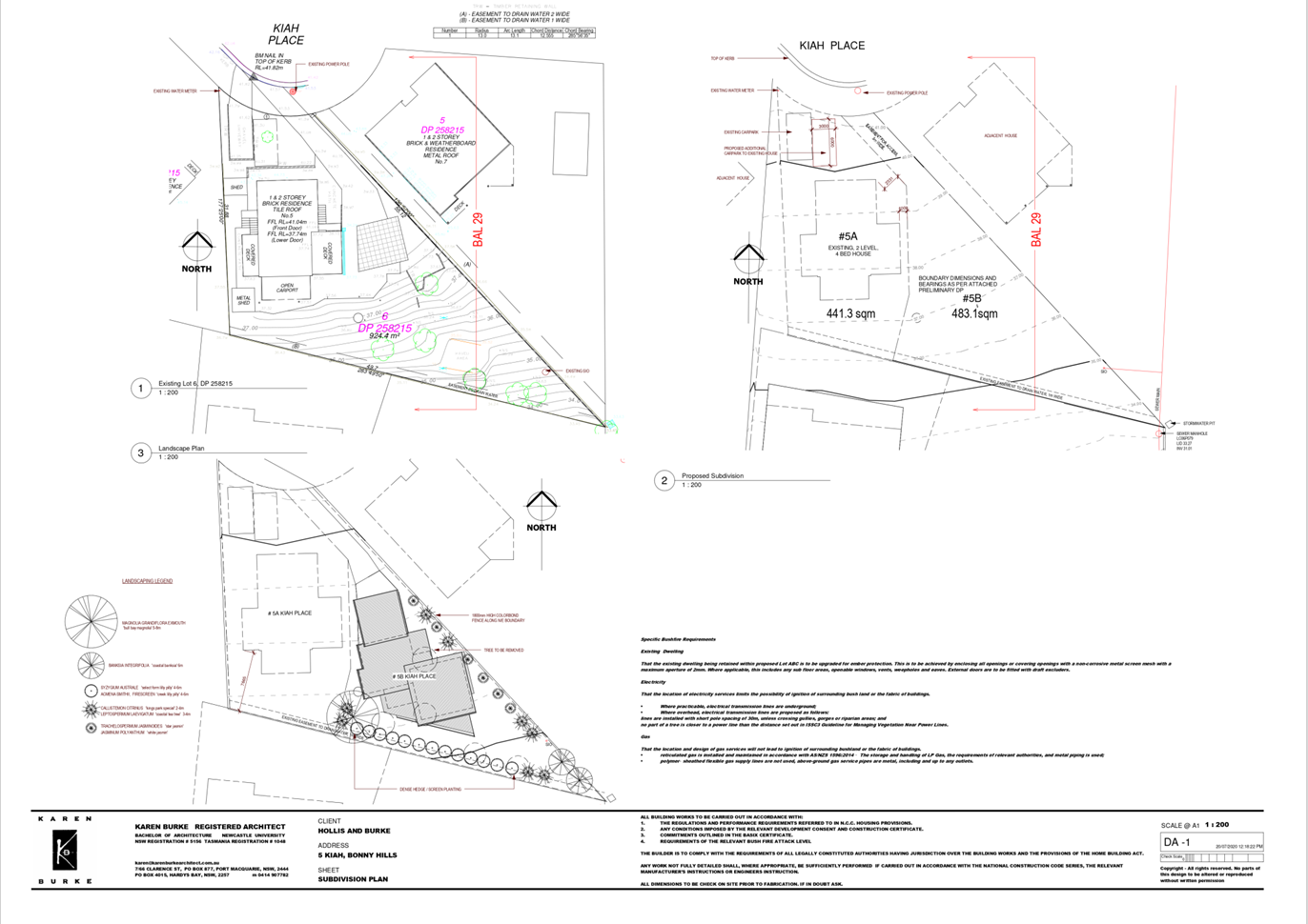
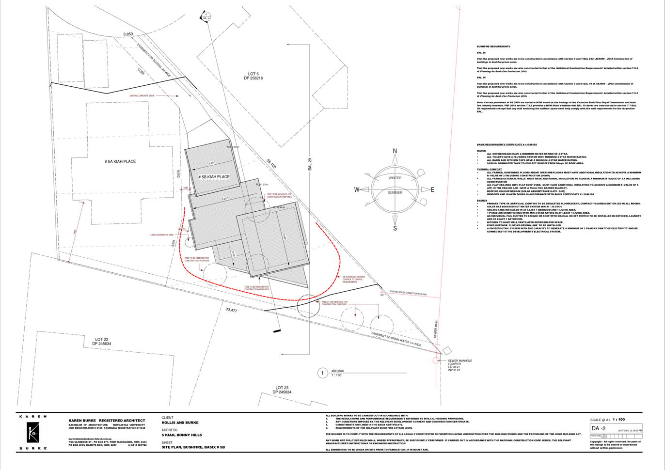
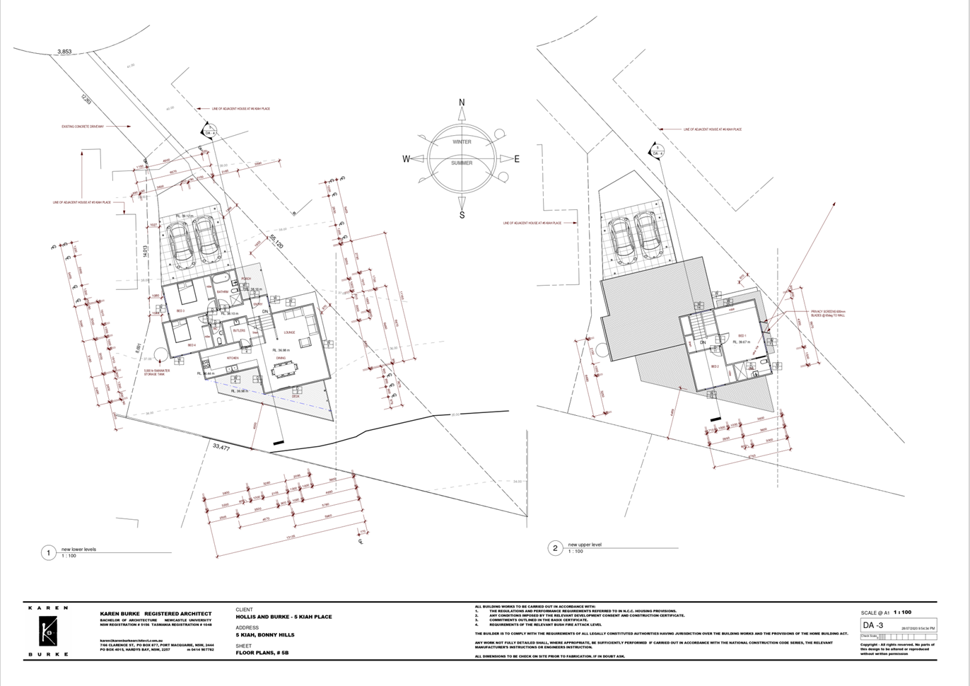
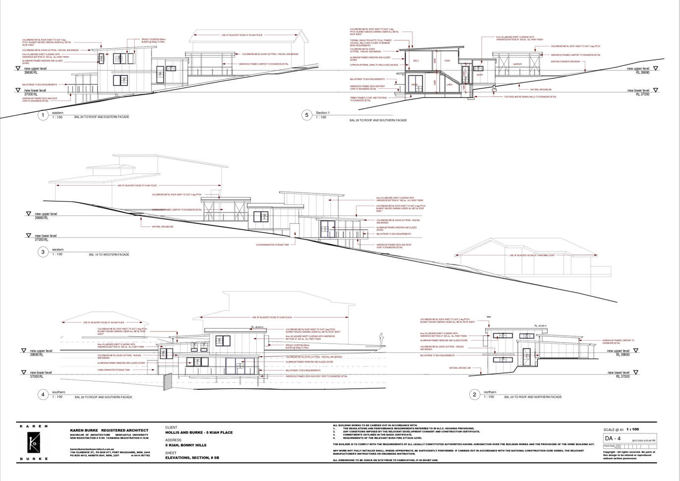
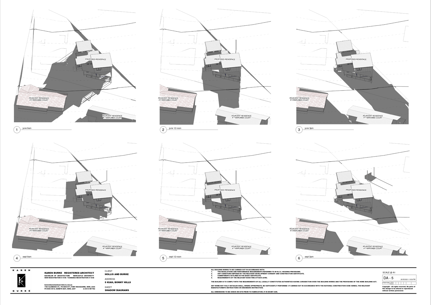
|
ATTACHMENT
|
Development Assessment Panel
21/01/2021
|
AGENDA Development Assessment Panel 21/01/2021
Item: 09
Subject: DA2020 - 713.1 Dwelling and Swimming Pool at
Lot 33 DP 31187, No. 58 Watonga Street, Port Macquarie
Report
Author: Development Assessment Planner, Benjamin Roberts
|
Applicant: Craig
Teasdell Architect
Owner: Reiter
Nominees Pty Ltd
Estimated Cost: $1,750,000
Alignment with Delivery
Program
4.3.1 Undertake transparent
and efficient development assessment in accordance with relevant legislation.
|
RECOMMENDATION
That
DA 2020 - 713.1 for a dwelling and
swimming pool at Lot 33, DP 31187, No.
58 Watonga Street, Port Macquarie, be determined by granting consent subject to
the recommended conditions.
Executive
Summary
This
report considers a development application for a dwelling and swimming pool
at the subject site and provides an assessment of the
application in accordance with the Environmental Planning and Assessment Act
1979.
Following initial exhibition of
the application, four (4) submissions were
received.
The application was considered by
the Development Assessment Panel on 25 November 2020 and was deferred with the
following resolution:
‘That DA 2020 - 713.1 for a dwelling and
swimming pool at Lot 33, DP 31187, No. 58
Watonga Street, Port Macquarie, be deferred to enable the applicant an
opportunity to amend plans so as to lower the building height and lessen the
impact on views of the Lighthouse from adjoining properties.’
In response to the resolution, the applicant submitted
revised plans on 7 December 2020. The revised plans result in a height
reduction of 400mm in the north-eastern corner of the proposed dwelling.
The revised plans were provided to previous submitters on 8
December 2020 and further comments requested up until 6 January 2012. Three (3)
additional responses were received in response to the amended plans.
The assessment of the application has been updated and
concludes that the site is considered suitable for the proposed development and
the proposal adequately addresses relevant planning controls. The development
is not considered to be contrary to the public's interest and will not result a
significant adverse social, environmental or economic impact.
This report recommends that the development application be
approved subject to the conditions in Attachment 1.
1. BACKGROUND
Existing
Sites Features and Surrounding Development
The site is vacant and has an area
of 569.1m2. The site falls toward
Watonga Street in two distinct sections. The first 7 metres within the boundary
is quite significant at approximately 30 degrees. Beyond this point, the slope
is approximately 10 degrees extending to the rear boundary.
The
site is zoned R1 General Residential in
accordance with the Port Macquarie-Hastings Local Environmental Plan 2011, as
shown in the following zoning plan:
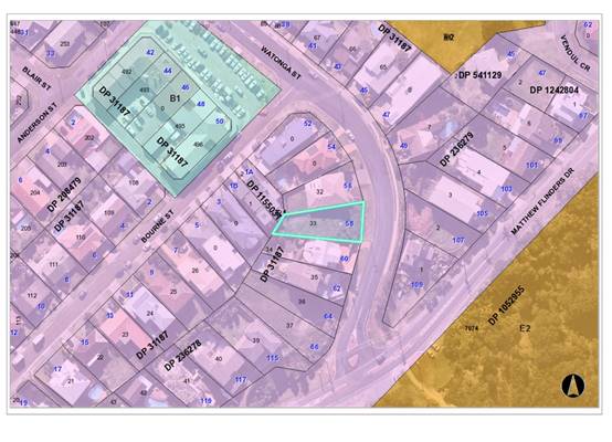
The
existing subdivision pattern and location of existing development within the
locality is shown in the following aerial photograph:
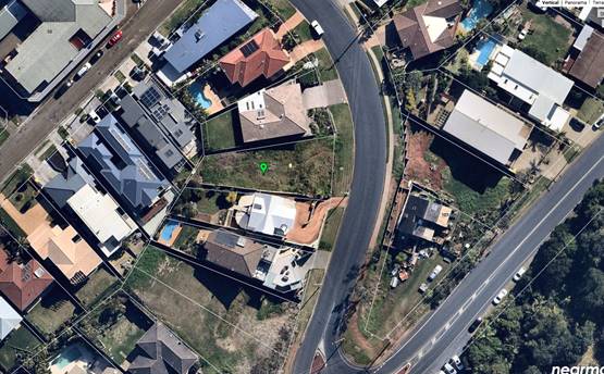
2. DESCRIPTION
OF DEVELOPMENT
Key
aspects of the proposal include the following:
· Construction
of a new dwelling house and swimming pool
Refer
to Attachment 2 at the end of this report for plans of the proposed
development.
Application
Chronology
· 1
September 2020 - Application lodged.
· 9 to 22 September 2020 - Public exhibition via neighbour notification.
· 23 September 2020 - Additional information request.
· 1 October 2020 - Additional information response.
· 7 October 2020 - Views inspected from at 1A Bourne Street.
· 9 October 2020 - Views inspected from 1B Bourne Street.
· 12 October 2020 - Views inspected from 2/3 Bourne Street.
· 16 October 2020 - Views inspected with applicant at 2/3
Bourne Street.
· 16 October 2020 - Views inspected from 56 Watonga Street.
· 16 October 2020 - Additional information request to
applicant.
· 26 October 2020 - Additional information response and
revised plans (change to roof window structure).
· 25 November 2020 - Deferred at Development Assessment Panel
meeting.
· 7 December 2020 - Revised plans lodged.
· 8 December 2020 to 6 January 2021 - Comments sought from
submitters on revised plans.
3. STATUTORY
ASSESSMENT
Section
4.15(1) Matters for Consideration
In
determining the application, Council is required to take into consideration the
following matters as are relevant to the development that apply to the land to
which the development application relates:
(a) The
provisions (where applicable) of:
(i) Any
Environmental Planning Instrument
State
Environmental Planning Policy (Koala Habitat Protection) 2019
Clause
5 - This SEPP applies to the Port Macquarie-Hastings Local Government Area.
Clause 10 - The site is not under a Koala
Plan of Management and the land has an area less than 1 hectare
including adjoining land in the same ownership. The SEPP does not prevent the
granting of consent on the land being less than 1 hectare in area. The
application has demonstrated that no habitat will be removed or modified
therefore no further investigations are required.
State
Environmental Planning Policy No. 55 – Remediation of Land
Following
an inspection of the site and a search of Council records, the subject land is
not identified as being potentially contaminated and is suitable for the
intended use.
State Environmental Planning Policy (Coastal Management)
2018
The site is located within a coastal use and coastal
environment area.
In accordance with clause 7, this SEPP prevails over the
Port Macquarie-Hastings LEP 2011 in the event of any inconsistency.
Having regard to clauses 13 and 14 of the SEPP the proposed
development is not considered likely to result in any of the following:
a) any
adverse impact on integrity and resilience of the biophysical,
hydrological (surface and groundwater) and ecological environment;
b) any
adverse impacts coastal environmental values and natural coastal
processes;
c) any
adverse impact on marine vegetation, native vegetation and fauna
and their habitats, undeveloped headlands and rock platforms;
d) any
adverse impact on Aboriginal cultural heritage, practices and
places;
e) any
adverse impacts on the cultural and built environment heritage;
f) any
adverse impacts the use of the surf zone;
g) any adverse impact on the visual amenity and scenic qualities of the
coast, including coastal headlands;
h) overshadowing, wind funneling and the loss of views from public places
to foreshores; and
i) any
adverse impacts on existing public open space and safe access to
and along the foreshore, beach, headland or rock platform for members of the
public, including persons with a disability.
In accordance with Clause 15 the proposal is not likely to
cause increased risk of coastal hazards on that land or other land.
The bulk, scale and size of the
proposed development is compatible with the surrounding coastal and built
environment. The site is predominately cleared and located within an area zoned
for residential purposes.
State
Environmental Planning Policy (Building Sustainability Index: BASIX) 2004
A
BASIX certificate has been submitted demonstrating that the proposal will
comply with the requirements of the SEPP. It is recommended that a condition be
imposed to ensure that the commitments are incorporated into the development
and certified at Occupation Certificate stage.
State Environmental Planning Policy (Infrastructure) 2007
Clause 45 - Development in proximity to electricity
infrastructure - referral to Essential Energy required for any of the
following:
(a) the
penetration of ground within 2m of an underground electricity power line or an
electricity distribution pole or within 10m of any part of an electricity
tower,
(b) development
carried out:
(i) within
or immediately adjacent to an easement for electricity purposes (whether or not
the electricity infrastructure exists), or
(ii) immediately
adjacent to an electricity substation, or
(iii) within
5m of an exposed overhead electricity power line,
(c) installation
of a swimming pool any part of which is:
(i) within
30m of a structure supporting an overhead electricity transmission line,
measured horizontally from the top of the pool to the bottom of the structure
at ground level, or
(ii) within 5m of an overhead electricity power line, measured vertically
upwards from the top of the pool
Site inspection revealed exposed overhead power lines
running along the western edge of Watonga Street. The ground floor terrace is
setback some 5.8m from the front boundary and be well over 5m from the overhead
lines. No referral to Essential Energy triggered.
Port Macquarie-Hastings Local Environmental
Plan 2011
The proposal is consistent with the LEP having regard to the
following:
· Clause
2.2 - The subject site is zoned R1 General Residential. In accordance with
clause 2.3(1) and the R1 zone landuse table, the dwelling and ancillary
swimming pool are a permissible landuse with consent.
· Clause
2.3(2) - The objectives of the R1 zone are as follows:
o To provide for the
housing needs of the community.
o To provide for a
variety of housing types and densities.
o To enable other land
uses that provide facilities or services to meet the day to day needs of
residents.
2. The proposal is
consistent with the zone objectives as it is a permissible landuse and
consistent with the established residential locality. The proposal contributes
to the range of housing options in the locality.
· Clause
4.3 - The proposed maximum overall height of the building above ground level is
8.45m and complies with the standard height limit of 8.5m applying to the site.
· Clause
4.4 - The floor space ratio of the proposal is 0.72:1 and complies with the
maximum 1:1 floor space ratio applying to the site.
· Clause
5.10 – The site does not contain or adjoin any known heritage items or
sites of significance.
· Clause
7.13 - Satisfactory arrangements are in place for provision of essential
services including water supply, electricity supply, sewer infrastructure,
stormwater drainage and suitable road access to service the development.
(ii) Any draft
instruments that apply to the site or are on exhibition
No draft instruments apply.
(iii) Any Development
Control Plan in force
Port
Macquarie-Hastings Development Control Plan 2013
|
DCP 2013: Part C - Development Specific Provisions -
C1: Low Density Residential Development
|
|
DCP Objective
|
Development Provisions
|
Proposed
|
Complies
|
|
Front Setbacks
|
|
44
|
a) Dwellings may incorporate an articulation zone to a
street frontage at no less than 3m from property boundary. The
following building elements are permitted within the articulation zone.
|
No building elements proposed within the articulation
zone.
|
N/A
|
|
c) The primary road front setback shall be:
Primary frontage = 4.5m
|
Front building line setback to Watonga Street varies but
closest point is 5.8m.
|
Yes
|
|
45
|
a) A garage, carport or car parking space should:
- be at least 1m behind the
building line, where the dwelling(s) has a setback from a front boundary of
4.5m or more, or
- be at least 5.5m from a
front boundary, where the dwelling(s) has a setback of less than 4.5m.
|
The garage is less than 1m behind
the building.
The garage setback varies but is
setback greater than 5.5m. Garage door is recessed.
|
No*
Yes
|
|
b) The total width of the garage/carport openings should
not be more than 6m and not more than 50 per cent of the width of the
building.
|
Width of garage door is compliant
with the maximum width requirements
|
Yes
|
|
c) Driveway crossovers are no greater than 5.0m in width.
|
Driveway crossing width is
compliant with the maximum width requirements
|
Yes
|
|
d) Where a dual occupancy or attached dwelling is proposed
on a corner lot a garage and driveway is provided on each road frontage.
|
No dual occupancy proposed or a corner lot.
|
N/A
|
|
Side and Rear Setbacks
|
|
46
|
a) A minimum rear boundary setback of 4m is to be provided
to dwellings (including verandahs, patios and decks).
|
The rear setback varies from 3m
to 5.48m.
|
No*
|
|
b) A minimum rear boundary setback of 900mm applies to
sheds and swimming pools subject to achieving minimum required private open
space area.
|
No ancillary development proposed in rear yard.
|
N/A
|
|
c) Council may consider varying rear setback requirements
where it is demonstrated that the private open space could achieve better
solar access between the building and the side setback. In that instance, one
side setback should be a minimum 4m in width (for an equivalent length of
rear boundary, behind building line) and the rear setback may be reduced to
900mm.
|
N/A
|
N/A
|
|
47
|
a) Ground floors (being <1m above existing ground
level) should be setback a minimum of 900mm from side boundaries.
|
Ground floor north side setback
is varying with 1.215m minimum. Ground floor south side 3m setback.
|
Yes
|
|
b) First floors and above (including single storey with
floor level >1m) should be setback a minimum of 3m from the side boundary,
or reduced down to 900mm where it can be demonstrated that the adjoining
property’s primary living rooms and principal private open space areas
are not adversely overshadowed for more than 3hrs between 9am - 3pm on 21
June.
|
First floor north side setback is
varying with 1.2m minimum. First floor south side is varying with 2.49m
minimum. The section of wall setback 2.49m is for a length of 4.5m. The
reminder of the southern side setback is 3m or more.
|
Yes. Refer to overshadowing assessment and analysis
section of this report.
|
|
c) First floors and above should have building walls that
step in and out at least every 12m by a minimum of 500mm articulation. Where
first floors and above are setback >3m, wall articulation is not required.
|
Section of south facing wall to sitting, dining and living
rooms is approximately 13m in length. Is setback 3.05m.
|
Yes
|
|
Private Open Space
|
|
48.
|
a) All dwellings should have a minimum area of private
open space of 35m2, which includes a principal private open space area
with:
- a minimum dimension of
4m x 4m, and
- a maximum grade of 5%
for minimum 4m x 4m of the total open space requirement, and
- direct accessibility
from a ground floor living area and orientated to maximise use.
|
The dwelling contains 35m² open space in one area
including a useable 4m x 4m space.
|
Yes
|
|
|
b) Private open space may include clothes drying areas and
garbage storage.
|
Noted.
|
Yes
|
|
Public Domain and Fencing
|
|
49
|
a) Front fences built forward of the building line for the
primary road frontage should be detailed on the development application
plans.
|
Front masonry wall detailed on
plans.
|
Yes
|
|
b) Solid Front fences up to 1.2m high should be:
- Setback 1.0m from the
front boundary, and
- Suitably landscaped to
reduce visual impact, and
- Provide a 3m x 3m splay
for corner sites.
|
2m high masonry wall proposed.
|
N/A
|
|
b) Front fences proposed to be more than 1.2m high should be
a maximum of 1.8m in height, above existing front property boundary level,
and either:
- Include landscaped
recesses having minimum dimensions of 1.8m long x 900mm deep which occupy no
less than 50% of the total length of the fence, or
- be erected up to the
front boundary for a maximum length of 6.0m or 50% of the street frontage.
|
2m high masonry wall proposed setback 3.1m from front
boundary.
|
No*
|
|
c) have openings which make it not less than 25%
transparent (no individual opening more than 30mm wide);
|
No openings proposed.
|
No*
|
|
d) provide a 3m x 3m splay for corner sites, and
|
Not a corner site.
|
N/A
|
|
e) provide a 900mm x 900mm splay for vehicle driveway entrances.
|
No site line issues identified for driveway entrance.
|
Yes
|
|
Bulk and Scale
|
|
51
|
a) Direct views between indoor living rooms and principal
private open space of adjacent dwellings, including proposed dwellings
approved on adjoining lots, including possible dwellings on future lots,
should be obscured or screened where:
- Ground and first floor
(and above) indoor living room windows are within a 9m radius.
- Direct views between
principal private open space areas where within a 12m radius.
- Direct views between
indoor living rooms of dwellings into the principal area of private open space
of other dwellings within a 12m radius.
|
Windows placements have been
carefully considered and where appropriate highlight windows nominated. i.e.
north facing windows on the first floor are highlight windows.
Elevated north facing ground
floor windows at the front of the block serve a bedroom and ensuite only.
South facing windows on the first
floor serving the living, dining, sitting rooms are setback 3.05m. No
screening of these windows is proposed. However due to the elevation and
eastern view aspect no direct views are identified to the primary living and
open spaces located on the first floor and front aspect front of 60 Watonga
Street.
No windows are proposed in the
first floor west facing wall of the study.
No windows are proposed on the
ground floor western elevation of the gym.
Elevated south facing windows on
the ground floor are to bedrooms and ensuites only.
The ground floor terrace and sitting room are setback
3.05m and 5.9m respectively. The lap pool and its fencing is setback 1m from
the southern side boundary. The restricted width along the southern and
eastern edges of the pool limit any ability for pedestrian use of the
poolside. A 6m length of obscured glazed pool fencing is proposed at ground
level along the southern boundary to protect privacy to the adjoining front
balcony of 60 Watonga Street from these areas.
|
Yes
|
|
b) A balcony, deck, patio, pergola, terrace or verandah
should have a privacy screen where there are direct views of:
- Indoor living room
windows of adjacent dwellings, including proposed dwellings approved on
adjoining lots within 9m radius; or
- Principal areas of
private open space of adjacent dwellings, including proposed dwellings
approved on adjoining lots within a 12m radius.
|
The first floor front balcony is
setback 1.9m from the northern boundary. The northern elevation of the
balcony is provided with a hard wall treatment. An opening in this wall 1.5m
from floor level is proposed above the BBQ area. However, given the elevation
difference, view angle out the opening and fixed BBQ bench against the
opening there is no direct view available into any adjoining primary living
or open space areas of 56 Watonga Street.
The first floor front balcony is
setback 5.985m from the southern boundary. It is provided with a solid lower
portion balustrade to maintain privacy to the adjoining front balcony of 60
Watonga Street.
A rear balcony off the master
bedroom on the first floor is setback 3.05m to the southern boundary. This
balcony is also setback a minimum of 4.2m that extends to 5.48m from the rear
boundary. The western elevation of this balcony is provided with privacy
louvres to maintain privacy between adjoining residences in Bourne Street.
There is no direct view to the primary living and outdoor areas of 60 Watonga
Street from this balcony and no screening is proposed along its southern
elevation.
|
Yes
|
|
c) Privacy protection is
not required for:
- Any Indoor living room
windows with a sill height of greater than 1.5m above the finished floor
level of that room or where fixed non-openable translucent glass is installed
to the same height.
|
Noted refer to above comments.
|
Yes
|
|
d) Direct views described above may be reduced or obscured
by one of the following measures (details to be submitted with the
development application):
- 1.8m high fence or wall
between ground-floor level windows or between a dwelling and principal
private open space
- Screening of minimum
1.7m height, that has 25% openings (max), with no individual opening more
than 30mm wide, is permanently fixed and is made of durable materials.
- A window,
the whole of which has translucent glass and is not able to be opened.
|
Screening and other privacy treatment
measures are proposed where necessary.
|
Yes
|
|
DCP 2013: Part B - General Provisions - B2:
Environmental Management
|
|
DCP Objective
|
Development Provisions
|
Proposed
|
Complies
|
|
3
|
a) Development must comply
with Council’s Developments, Public Place & Events - Waste
Minimisation and Management Policy.
|
Satisfactory arrangements
can be put in place for storage and collection of waste.
Standard condition
recommended for construction waste management.
|
Yes
|
|
Cut and Fill Regrading
|
|
4
|
a) Development shall not
exceed a maximum cut of 1.0m and fill of 1.0m measured vertically above the
ground level (existing) at a distance of 1.0m outside the perimeter of the
external walls of the building (This does not apply to buildings where such
cut and fill is fully retained within or by the external walls of the
building).
|
Cut and fill >1m is proposed outside the perimeter of
the external building walls.
|
No*
|
|
5
|
a) A certified practicing
structural engineer must certify any retaining wall greater than 1.0m.
|
Noted. Suitable condition recommended.
|
Yes
|
|
b) Where a combination of a
fence and a wall is proposed to be greater than 1.2m high:
- be a
maximum combined height of 1.8m above existing property boundary level;
- be
constructed up to the front boundary for a maximum length of 6.0m or 30% of
the street frontage, whichever is less;
− the
fence component has openings which make it not less than 25% transparent; and
− provide
a 3m x 3m splay for corner sites, and
- provide a
900mm x 900mm splay for vehicle driveway entrances.
|
No retaining wall and front fence combination is proposed.
Refer to front fencing comments surrounding masonry wall.
|
N/A
|
|
DCP 2013: Part B -
General Provision - B3: Hazards Management
|
|
Bushfire Hazard Management
|
|
18
|
a) APZs are to be located
outside of environmental protection zones and wholly provided within private
land. Note perimeter roads provided as part of a residential subdivision are
classified as being part of the subdivision and not a separate permissible
land use within environment protection zones.
|
APZ within property.
|
Yes
|
|
Flooding
|
|
19
|
a) Development must comply
with Council’s Floodplain Management Plan and Flood Policies.
|
Not flood prone land.
|
N/A
|
|
DCP 2013: Part B- General Provisions- B4: Transport,
Traffic Management, Access and Car Parking
|
|
DCP Objective
|
Development Provisions
|
Proposed
|
Complies
|
|
Road Hierarchy
|
|
Parking Provision
|
|
24
|
a) Off-street Parking is
provided in accordance with Table 3:
- 1 parking space per each
dwelling for dwelling-house.
|
Capacity for more than 1 parking space behind the building
line has been provided for.
|
Yes
|
|
Parking Layout
|
|
28
|
c) Parking spaces shall
generally be behind the building line but may be located between the building
line and the street when:
− it
is stacked parking in the driveway; or
− it
can be demonstrated that improvements to the open space provided will result;
and
− the
spaces are screened (densely landscaped or similar) from the street by a
landscaping with a minimum width of 3.0m for the entire length of the parking
area.
|
Proposed behind the
building line.
|
Yes
|
|
d) Parking design and layout
is provided in accordance with AS/NZS 2890.1 - Parking facilities -
Off-street car parking.
|
Parking design and layout appropriate.
|
Yes
|
|
34
|
a) All parking and manoeuvring
spaces must be designed to avoid concentrations of water runoff on the
surface.
|
Single dwelling only with 1 domestic driveway. Stormwater
drainage is capable of being managed as part of plumbing construction.
|
Yes
|
|
b) Council will not permit the
discharge of stormwater directly into kerbing and guttering or table drains
for any development other than that of a minor nature.
|
Single dwelling only with 1 domestic driveway. Stormwater
drainage is capable of being managed as part of plumbing construction.
|
Yes
|
|
|
|
|
|
|
DCP 2013: Part B - General
Provisions - B5: Social Impact Assessment and Crime Prevention
|
|
DCP Objective
|
Development Provisions
|
Proposed
|
Complies
|
|
Crime Prevention
|
|
43
|
a) The development addresses
the generic principles of crime prevention:
- Casual surveillance and
sightlines;
- Land use mix and
activity generators;
- Definition of use and
ownership;
- Basic exterior building
design;
- Lighting;
- Way-finding; and
- Predictable routes and
entrapment locations;
- as described in the
Crime Prevention Through Environmental Design (CPTED) principles.
|
No concealment or entrapment areas proposed. Adequate
casual surveillance available.
|
Yes
|
The proposal seeks to vary Development Provision 45 relating
to the garage being at least 1m behind the building. The garage is proposed at
an angle to the front boundary. Its distance behind the building line varies
from approximately 300mm in the southern part of the garage door to over 1m
toward the northern extent.
The relevant objectives are:
· To
minimise the impact of garages and driveways on the streetscape, on street
parking and amenity.
· To
minimise the visual dominance of garages in the streetscape.
· To
provide safe and functional vehicular access.
Comments: Having regard for the development
provisions and relevant objectives, the variation is considered acceptable for
the following reasons:
· The
variation is minor and largely compliant. The minor variation is due to the
angle provided in the building design and garage door.
· The
angle in the garage door combined with the feature window and balustrade
façade treatments to the east facing wall of the garage and above the
garage door minimise any dominance upon the streetscape.
· The
landscaping and retaining wall treatments will be the dominant features of the
immediate streetscape. These features will complement the streetscape and will
almost eliminate any view of the garage from street level.
· A
safe and functional vehicular access is still achieved.
The proposal seeks to vary Development Provision 46 relating
to a minimum rear setback requirement of 4m. The rear setback proposed varies
from 3m to 5.48m.
The relevant objectives are:
· To
ensure no adverse overshadowing or privacy impacts to neighbouring properties.
· To
allow adequate natural light and ventilation between dwellings/buildings and to
private open space areas.
· To
provide useable yard areas and open space
Comments: Having regard for the development
provisions and relevant objectives, the variation is considered acceptable for
the following reasons:
· The
variation is minor and largely compliant. The minor variation is due to the
angle in the allotment boundary.
· No
adverse overshadowing or privacy impacts will result. Appropriate privacy
screening and landscape plantings are proposed.
· Adequate
natural light and ventilation between dwellings and to private open space areas
will be achieved.
· Useable
yard and open space areas are provided.
The proposal seeks to vary Development Provision 49 which
provides that front fencing more than 1.2m in height be a maximum of 1.8m in
height and either:
- Include
landscaped recesses having minimum dimensions of 1.8m long x 900mm deep which
occupy no less than 50% of the total length of the fence, or
- Be
erected up to the front boundary for a maximum length of 6.0m or 50% of the
street frontage.
- Have
openings which make it not less than 25% transparent (no individual opening more
than 30mm wide)
The proposal incorporates a 2m high masonry wall setback
3.1m from the front boundary.
The relevant objectives are:
· To
define the edge between public and private land and to provide privacy and
security.
· To
ensure the adequate sight lines are provided for vehicles leaving the site.
· To
ensure front fencing does not impact on the public domain.
· To
encourage surveillance of the street and other public places.
Comments: Having regard for the development
provisions and relevant objectives, the variation is considered acceptable for
the following reasons:
· The
masonry wall helps to define the interface between public and private land and
provides for privacy and security to the dwelling.
· The
wall is setback 3.1m from the boundary and adequate sight lines are provided
from the driveway.
· A
garden bed is provided immediately in front of the wall to provide for
plantings that will soften its appearance and not impact upon the public
domain.
· The
elevated nature of the site and dwelling provides for sufficient casual
surveillance of the street and public domain.
The proposal seeks to vary Development Provision 4 which
provides that development shall not exceed a maximum cut of 1.0m and fill of
1.0m measured
vertically above the ground level (existing) at a distance
of 1.0m outside the perimeter of the external walls of the building (This does
not apply to buildings where such cut and fill is fully retained within or by
the external walls of the building). The proposal incorporates cut and fill
over 1m outside the external walls of the building primarily in the front
portion of the site. Retaining is also proposed up to 1.1m in height in the
rear portion of the site.
The relevant objectives are:
· Minimise
the extent of site disturbance caused by excessive cut and fill to the site.
· Ensure
there is no damage or instability to adjoining properties caused by excavation
or filling.
· Ensure
that there is no adverse alteration to the drainage of adjoining properties.
· Ensure
the privacy of adjoining dwellings and private open space are protected.
· Ensure
that adequate stormwater drainage is provided around the perimeter of buildings
and that overflow paths are provided.
Comments: Having regard for the development provisions
and relevant objectives, the variation is considered acceptable for the
following reasons:
· The
extent of cut and retaining proposed s due to the steep drop in grade along the
front of the site.
· Stormwater
is capable of being managed.
· Privacy
of adjoining dwellings is not compromised as a result of the cut and fill.
· Potential
damage or instability to adjoining properties can be appropriately managed. It
is a prescribed condition of any development consent.
Based on the above assessment, the variations proposed to
the provisions of the DCP are considered acceptable and the relevant objectives
have been satisfied. Cumulatively, the variations do not amount to an adverse
impact of any significance that would justify refusal of the application.
(iiia) Any planning agreement that has
been entered into under section 7.4, or any draft planning agreement that a
developer has offered to enter into under section 7.4
No planning agreement has been
offered or entered into relating to the site.
(iv) Any
matters prescribed by the Regulations
No
matters prescribed by the regulations apply.
(b) The likely
impacts of that development, including environmental impacts on both the
natural and built environments, social and economic impacts in the locality
Context and Setting
The proposed development
satisfactorily addresses the public domain.
The proposal is considered to be
compatible with other residential development in the locality and adequately
addresses planning controls for the area.
View Sharing
The notion of view sharing is invoked when a property
enjoys existing views and a proposed development would share that view by
taking some of it away for its own enjoyment. (Taking it all away cannot be
called view sharing, although it may, in some circumstances, be quite
reasonable.)
The judgement in Tenacity
Consulting v Waringah 2004 NSW LEC 140 is an established ‘planning
principle’ which provides an assessment methodology as to what
constitutes view sharing and what constitutes reasonable view sharing. To that
end, Commissioner Roseth SC developed a four step assessment process to assess
the impacts of views. The four steps are as follows:
Step 1
Assessment of views to be affected. Water
views are valued more highly than land views. Iconic views (e.g. of the Opera
House, the Harbour Bridge or North Head) are valued more highly than views
without icons. Whole views are valued more highly than partial views, e.g. a
water view in which the interface between land and water is visible is more
valuable than one in which it is obscured.
Step 2
Consider from what part of the property the
views are obtained. For example, the protection of views across side boundaries
is more difficult than the protection of views from front and rear boundaries.
In addition, whether the view is enjoyed from a standing or sitting position
may also be relevant. Sitting views are more difficult to protect than standing
views. The expectation to retain side views and sitting views is often
unrealistic.
Step 3
Assess the extent of the impact. This should
be done for the whole of the property, not just for the view that is affected.
The impact on views from living areas is more significant than from bedrooms or
service areas (though views from kitchens are highly valued because people
spend so much time in them). The impact may be assessed quantitatively, but in
many cases this can be meaningless. For example, it is unhelpful to say that
the view loss is 20% if it includes one of the sails of the Opera House. It is
usually more useful to assess the view loss qualitatively as negligible, minor,
moderate, severe or devastating.
Step 4
Assess the
reasonableness of the proposal that is causing the impact. A development that
complies with all planning controls would be considered more reasonable than
one that breaches them. Where an impact on views arises as a result of
non-compliance with one or more planning controls, even a moderate impact may
be considered unreasonable. With a complying proposal, the question should be
asked whether a more skilful design could provide the applicant with the same
development potential and amenity and reduce the impact on the views of
neighbours. If the answer to that question is no, then the view impact of a
complying development would probably be considered acceptable and the view
sharing reasonable.
Analysis of view impacts at four residences was undertaken
to establish whether the view sharing is acceptable. The four residences being
56 Watonga Street, 1A Bourne Street, 1B Bourne Street and 2/3 Bourne Street.
For the purposes of this assessment, the following was undertaken:
· Establishment of
height poles by proponent to indicate proposed maximum building height.
· Certification of
the height poles by a registered surveyor.
· Site inspections,
observations and photographs from all four residences.
Note the photos and height poles depicted in the photos
below are based on the original plans and do not reflect the further building
height reduction of 400mm in the north-eastern corner.
See aerial photo below showing location of adjoining
residences for context:
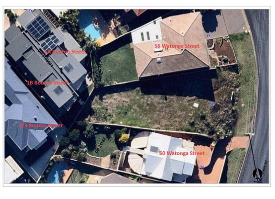
56 Watonga Street
This site contains an existing two-storey dwelling that
fronts Watonga Street. The site immediately adjoins the development site to the
north.
Step 1 - The dwelling enjoys extensive panoramic ocean and
land interface views extending to the northeast, east and southeast. The
elevated nature of the site provides uninterrupted highly valuable headland,
lighthouse and ocean views.
Step 2 - The orientation of the block and dwelling results
in the views primarily being enjoyed across the front boundary. These views are
from the secondary storey living room and balcony. There is also an ocean and
land interface view enjoyed from the living room window across the side
boundary to the southeast. Views are enjoyed from both standing and sitting
positions.
Step 3 - Sitting and standing views of the ocean, headland
and lighthouse across the front boundary from the living room and balcony will
not be impacted by the proposal. The standing and sitting view across the side
boundary to the south of the ocean and land interface from the living room
window and to some extent the southern aspect of the front balcony will be
impacted. However, a view corridor will still exist from the southern aspect of
the front balcony and living room window past the front of the new dwelling.
The view loss can be described as minor.
Site photos are provided below showing the location of the
front balcony and south facing living room window and southerly view enjoyed:
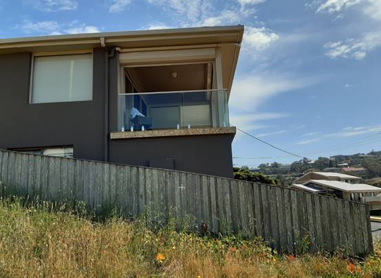
Southern aspect of front balcony and living room window.
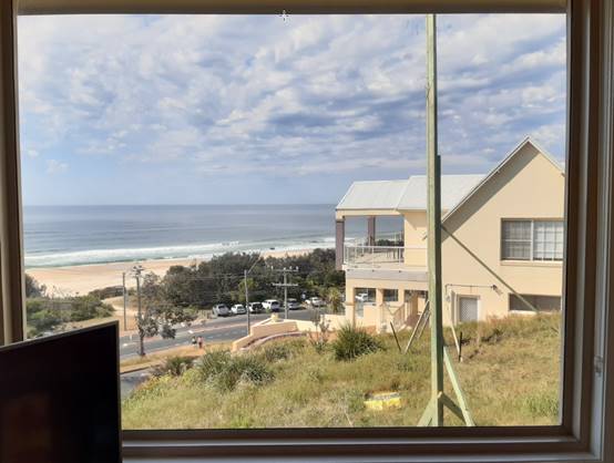
View from south facing living room window.
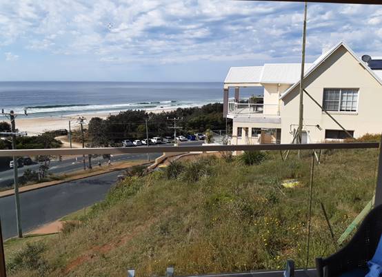
View from south facing aspect of front balcony.
Step 4 - The amended proposal is compliant with the
applicable building height and floor space controls. While there are minor
variations to the rear and south side setback standards of the development
control plan these variations do not impact on the extent of view loss from
this property. The proposed front setback exceeds the 4.5m minimum which aids
in the retention of some view corridor across the southern side
boundary.
1A Bourne Street
This site contains a two-storey dwelling that fronts Bourne
Street. The site partly adjoins the development site to the west.
Step 1 - At ground level the dwelling enjoys ocean and land
interface views across the development site. See site photo below for context:
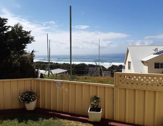
View from rear ground floor patio looking east across the
development site.
The elevated nature of the first floor provides
uninterrupted highly valuable headland, lighthouse and ocean views to the
north, east and south. The view is across the development site and above the
roofline of existing dwellings. Refer to site photo below context:
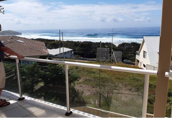
View from first floor balcony off master bedroom.
Step 2 - The orientation of the block and dwelling results
in the views primarily being enjoyed across the rear boundary. The primary
views are from the secondary storey balcony off the master bedroom and the
ground balcony off the living area. Views are enjoyed from both standing and
sitting positions. There is also views enjoyed from first floor north east
facing windows to a study and lounge area. See photo below for context:
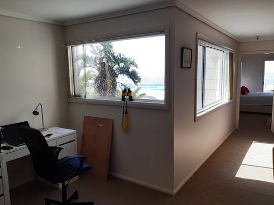
North and east facing first floor windows of study and
lounge area.
Step 3 - Sitting and standing views of the ocean and land
interface across the development site at ground level will be lost almost
completely. A small view corridor will be retained along the northern boundary
between the new dwelling and No 56 Watonga Street. The standing and sitting
views from the first floor balcony northeast of the headland, lighthouse and
ocean interface are not impacted as they are enjoyed across the roofline of No
56 Watonga Street. The same applies to the first floor north and east facing
windows to the study and lounge area. The sitting and standing view of the
ocean and its land interface immediately east across the development site will
be lost from the first floor balcony. Sitting and standing views of the ocean
and land interface north and south will be retained either side of the new
dwelling from the first floor balcony. The view loss can be described as
moderate.
Step 4 - The amended proposal is compliant with the
applicable building height and floor space controls. While there are minor
variations to the rear and south side setback standards of the development
control plan, these variations do not impact on the extent of view loss from
this property.
1B Bourne
This site contains a two-storey dwelling that fronts Bourne
Street. The site partly adjoins the development site to the west.
Step 1 - At ground level the dwelling enjoys ocean, headland
and land interface views east across the development site. Standing in the
southern corner of the rear yard the lighthouse is visible alongside the
roofline of No 36 Watonga Street. See site photos below for context:
View from rear ground floor patio looking east across the
development site.
View from southern corner of ground floor rear yard looking
north. Lighthouse adjoining roofline of No 36 Watonga Street.
The elevated nature of the first floor provides
uninterrupted highly valuable headland, lighthouse and ocean views to the
north, east and south. The view is across the development site and above the
roofline of existing dwellings. Refer to site photo below context:
View from first floor balcony off master bedroom.
Step 2 - The orientation of the block and dwelling results
in the views primarily being enjoyed across the rear boundary. The primary
views are from the secondary storey balcony off the master bedroom and the
ground balcony off the living area. Views are enjoyed from both standing and
sitting positions.
Step 3 - Sitting and standing views of the ocean and land
interface across the development site at ground level will be lost almost
completely. A small view corridor will be retained along the southern boundary
between the new dwelling and No 54 Watonga Street. The standing and sitting
views from the first floor balcony northeast of the headland, lighthouse and
ocean interface are not impacted as they are enjoyed across the roofline of No
56 Watonga Street and will remain over the roofline of the proposed dwelling.
The sitting and standing view of the ocean and its land interface immediately
east across the development site will be lost from the first floor balcony.
Sitting and standing views of the ocean and land interface north and south will
be retained either side of the new dwelling from the first floor balcony. The
view loss can be described as moderate.
Step 4 - The amended proposal is compliant with the
applicable building height and floor space controls. While there are minor
variations to the rear and south side setback standards of the development
control plan, these variations do not significantly impact on the extent of
view loss from this property. Notably the section of south facing wall setback
2.49m (as opposed to 3m) for a length of 4.6m.
2/3 Bourne Street
This site contains a first floor unit that fronts Bourne
Street. The site does not share a boundary with the development site.
Step 1 - The first floor unit enjoys ocean, headland,
lighthouse and land interface views northeast across the development site.
Panoramic ocean and land interface views are also enjoyed east and south. See
site photos below for context:
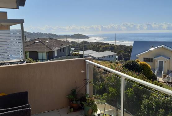
View from first floor balcony looking
northeast.
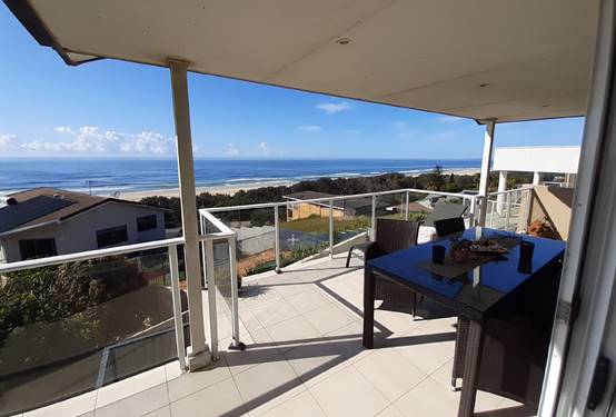
View from first floor balcony looking
southeast.
Step 2 - The orientation of the block and unit
results in the views primarily being enjoyed across the side and rear boundary.
The primary views are from the first floor balcony and living area. Views are
enjoyed from both standing and sitting positions. The lighthouse and headland
view is considered to be enjoyed across a side boundary.
Step 3 - Sitting views of the headland and lighthouse from
the living room window and balcony will be lost. See photos below for context:

View from living room window in siting position.
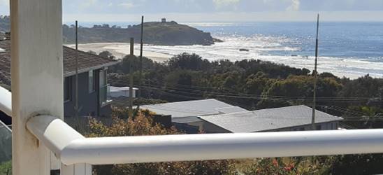
View from balcony in siting position.
Standing views of the headland and ocean interface would be
lost from both the living room window and balcony. A standing view of the
lighthouse would be retained immediately above the proposed roofline from both
the living room window and balcony. See photos below for context:
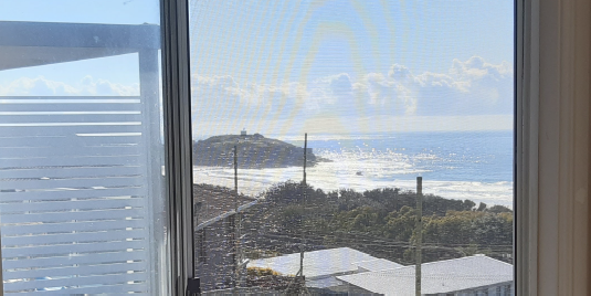
Standing view of lighthouse and headland from living room
window.
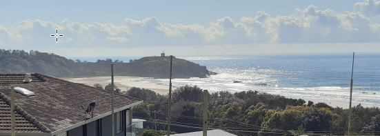
Standing view of lighthouse and headland from balcony.
The standing and sitting panoramic ocean and land interface
views from the living room and balcony east and south across the rear boundary
will not be impacted. See photos below for context:
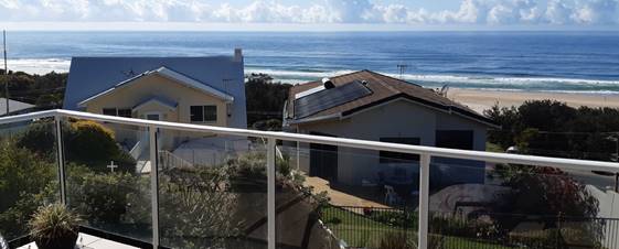
View east across rear boundary from balcony.
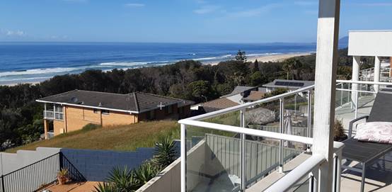
View southeast from balcony.
Views of the lighthouse are considered to be iconic in the
context of the area. The lighthouse view loss from a sitting position in
conjunction with the headland and ocean interface view impact from both a
sitting and standing position can be described as severe.
In response to view impact concerns, post exhibition, the
applicant lodged revised plans. The revised plans replaced the raised
clerestory window with a low pitched skylight window arrangement on the roof
top. The changes do soften the appearance of an element that would have
somewhat “stuck out” from the proposed roofline when viewed from
the residences in Bourne Street.
In terms of whether a more skilful design could provide the
same development potential and amenity and reduce the impact on the views of
neighbours, the applicant advised that numerous design options were explored
and offered the following comments:
· More
traditional roof pitches - but these proved too high;
· Stepped floor
levels - but these did not provide the accessibility via a lift required by the
landowner;
· Burying’
the primary habitable rooms deeper into the hill - however this was detrimental
to the amenity afforded to the landowner and resulted in substantial retaining
walls outside of the dwelling (and is poor design and completely undesirable in
any case.);
· Reducing side
setbacks and shifting the building mass towards Watonga Street – but this
has a greater view impact to the southern edge of the proposed design;
· If floor areas
were reduced then the building height would be unaffected as the main building
volume would shift towards Watonga street – this is a redundant point
however as the floor area is a result of the required functional design brief
(5 bedroom property, gym, two sitting rooms, lift access etc);
· Please note -
higher ceiling heights were originally proposed and shown to the neighbours
prior the development application. Ceiling heights were reduced in an effort to
maintain maximum height limits and improve the view sharing aspect to the
proposal.
Following
deferral of the application on 25 November 2020 the applicant submitted revised
plans. The revised plans reduce the building height by 400mm in the
north-eastern corner, which do lessen the impact on views of the Lighthouse
from 2/3 Bourne Street. This north-eastern portion of the building now sits
approximately 1.2m below the 8.5m maximum height control.
Having regard
to compliance with the adopted maximum building height and floor space ratio
controls it is considered that the amended development proposal is a realistic response
to the site conditions and view impacts not unreasonable in this instance. While
there is a minor variation to the rear setback standard of the development
control plan this variation does not impact on the extent of view loss from the
adjoining properties.
The proposal
will not have any significant adverse view sharing impact that would warrant
refusal of the application.
Overshadowing
The application was supported by a
set of shadow diagrams. The most impacted property being No 60 Watonga Street
immediately adjoining to the south.
This dwelling has a couple of
outdoor areas at the rear. The ground level outdoor area from the house is
heavily excavated into the site, bordered by a significant retaining wall and
currently covered by an awning structure. There is an upper rear yard area
accessed via a pedestrian bridge from the upper level of the house. This is
considered to be the secondary open space area of the dwelling. The shadow
diagrams demonstrate that this yard area is not adversely overshadowed for more
than 3 hours between 9am and 3pm on 22 June (winter solstice).
The primary living and outdoor
balcony area of the house is located on the first floor with an eastern aspect
taking advantage of the views. There are two north-facing windows on the
dwelling. One located on the upper level which serves the master bedroom and
one on the lower level, which appears to serve a bedroom or sitting room.
Access to within the dwelling could not be obtained to confirm the lower room.
Having regard to the elevated nature and east facing aspect of the primary
living and outdoor balcony area there will be no adverse overshadowing impacts.
The proposal does not have significant adverse overshadowing
impacts.
Privacy
The
design has had regard to positioning of the primary living and outdoor areas in
relation to that of adjoining primary living and outdoor areas. Where
appropriate privacy protection measures are proposed in the form of either
privacy screening or highlight windows. There are no significant adverse
privacy impacts identified that would warrant refusal of the application.
Bulk and Scale
In response to the steep topography and commanding views in
the area surrounding development is characterised by large two storey and to
some extent three storey homes. While the proposed building height does extend
slightly above those of the immediately adjoining dwellings, it does present of
a similar bulk and scale. The design of the roof is lower at the rear, which
aids in reducing the visual bulk of the dwelling when viewed from existing Bourne
Street residents.
The building design also provides for various building
elements and materials, which soften the visual impact and dominance of various
parts and levels of the dwelling, pool edge and basement garage.
Having regard to the topography, compliance with the adopted
planning controls, front and southern setback at ground and first floor,
reduction in building width heading back into the block and response to the
irregular lot shape the bulk and scale of the proposal is appropriate for the site.
Access, Traffic and Transport
The proposal will not have any significant adverse impacts
in terms access, transport and traffic.
Water Supply Connection
Water supply service is existing to the lot. Details of
connection and associated plumbing will be provided with section 68 application
under the Local Government Act. Appropriate condition recommended.
Sewer Connection
Sewer service is existing to the lot. Details of connection
and associated plumbing will be provided with section 68 application under the
Local Government Act. Appropriate condition recommended.
Stormwater
There is a stormwater pit and piped network in Watonga
Street. The proposal is capable of connection to this network. Details of
stormwater drainage and connection will be required with S.68 application.
Appropriate standard condition recommended.
Other Utilities
Telecommunication and electricity services are available to
the site.
Heritage
This site does not contain or adjoin any known heritage item
or site of significance. The site is considered to be disturbed land.
Other Land Resources
The site is within an established urban context and will not
sterilise any significant mineral or agricultural resource.
Water Cycle
The proposed development will not have any significant
adverse impacts on water resources and the water cycle.
Soils
The proposed development will not have any adverse impacts
on soils in terms of quality, erosion, stability and/or productivity subject to
a standard condition requiring erosion and sediment controls to be in place
prior to and during construction.
Air and Microclimate
The construction and/or operations of the proposed
development will not result in any significant adverse impacts on the existing
air quality or result in any pollution. Standard precautionary site management
condition recommended.
Flora and Fauna
Construction of the proposed development will not require
any removal/clearing of any significant native vegetation. The proposal does
not trigger the biodiversity offsets scheme and part 7 of the Biodiversity
Conservation Act 2016 is considered to be satisfied.
Waste
Satisfactory arrangements are in place for proposed storage
and collection of waste and recyclables. No adverse impacts anticipated.
Standard precautionary site management condition recommended.
Energy
The proposal includes measures to address energy efficiency
and will be required to comply with the requirements of BASIX.
Noise and Vibration
The construction of the proposed development will not result
in any significant adverse impacts on the existing air quality or result in any
pollution. Standard precautionary site management condition recommended.
Bushfire
The site is identified as being bushfire prone. The
applicant has submitted a bushfire report. An assessment of bushfire risk
having regard to Planning for Bushfire Protection including vegetation
classification and slope concludes that a Bushfire Attack Level 12.5 shall be
required.
Management of bushfire risk is acceptable subject to BAL
construction levels being implemented and APZ being maintained. An appropriate
condition is recommended.
Safety, Security and Crime Prevention
The proposed development will be unlikely to create any
concealment/entrapment areas or crime spots that would result in any
identifiable loss of safety or reduction of security in the immediate area.
Social Impacts in the Locality
Given the nature of the proposed development and its
location the proposal is not considered to have any significant adverse social
impacts.
Economic Impacts in the Locality
The proposal is not considered to have any significant
adverse economic impacts on the locality. A likely positive impact is that the
development will maintain employment in the construction industry, which will
lead to flow impacts such as expenditure in the area.
Site Design and Internal Design
The proposed development design satisfactorily responds to
the site attributes and will fit into the locality.
Construction
Construction impacts are considered capable of being
managed, standard construction and site management conditions have been recommended.
Cumulative Impacts
The proposed development is not considered to have any
significant adverse cumulative impacts on the natural or built environment or
the social and economic attributes of the locality.
(c) The
suitability of the site for the development
The proposal will fit into the locality. Site constraints of
slope and bushfire have been adequately addressed and appropriate conditions of
consent recommended.
(d) Any
submissions made in accordance with this Act or the Regulations
Four (4) written submissions were received following public exhibition of the
original application and plans. Three (3) additional responses were
received in response to the amended plans following notification to previous
submitters. Copies of all written submissions have
been provided separately to members of the DAP.
Key
issues raised in the submissions received and comments are provided as follows:
|
Submission
Issue/Summary
|
Planning
Comment/Response
|
|
Concerns over impacts to
dwelling and its foundations at 56 Watonga Street given the extent of
excavation proposed. No engineering details provided.
|
It is a prescribed condition
of any development consent that possible damage from any excavation extending
below the base of the footings of an adjoining building be protected and
supported. Engineering details will form part of the Construction Certificate
plans.
|
|
Potential impact of construction traffic on recent road
and infrastructure work in Watonga Street. Objection to relocation of power
pole.
|
Any damage to Council infrastructure will be managed by
Council. No relocation of power pole is proposed or noted on the plans.
|
|
View sharing impacts.
|
Refer to view sharing assessment and analysis within this
report.
|
|
Overshadowing impacts.
|
Refer to overshadowing impact assessment section of this
report.
|
|
Privacy impacts.
|
Refer to DCP assessment table and privacy heading of this
report.
|
|
The open cut out in the front balcony above the barbeque
area will impact on enjoyment of balcony at No 56 Watonga Street in the form
of barbeque smoke.
|
The first floor balcony is open to the east and south. No
adverse smoke or odour impacts are likely to result from the cut out in the
northern wall of this balcony.
|
|
The proposed front door lines up with a bedroom window at
No 56 Watonga Street. Privacy and noise impacts.
|
Aluminium louvres are proposed alongside the boundary
fence to maintain privacy to the entry. The use of this entry will be
infrequent and not create any significant adverse noise or privacy impact.
|
|
No consultation or prior plans discussed with No 56
Watonga Street.
|
Noted.
|
|
The proposal is not consistent with the height of
building objectives of the Port Macquarie-Hastings Local Environmental Plan
2011.
|
Refer to comments under Port Macquarie-Hastings Local
Environmental Plan 2011 heading of this report. The proposal complies with
the maximum building height limit.
|
|
Advice from planning organisation suggests view loss
could be minimised by reduction in garage height and removal of mezzanine
within.
|
Noted. The application as lodged is subject to this
assessment. Refer to comments under view sharing analysis indicating various
design options that were investigated.
|
|
The height of the dwelling is excessive and leads to the
impact upon views and outlook form Bourne Street residents.
|
Refer to view sharing and bulk and scale sections of this
report. The proposal complies with the maximum building height limit.
|
|
The proximity of the lap pool to the boundary will result
in noise, music, litter impacts.
|
Appropriate separation between adjoining primary living
and outdoor areas is achieved. Privacy measures are proposed where
appropriate. The swimming pool will be used by the residents and no adverse
noise or litter impacts are identified.
|
|
The bulk and amenity impacts to Bourne Street residences
from the rear facing wall.
|
The
section of building facing the rear boundary is approximately 5.2m in width.
The ground floor component contains no windows to the gym room. The first
floor contains a 2.6m unarticulated wall section to the study room and 2.6m
wide section of vertical louvres to the western elevation of the rear
balcony. Having regard to the elevated nature of the Bourne Street properties
and articulation proposed there are no adverse bulk and amenity impacts that
would warrant refusal of the application.
|
|
The clerestory roof window could be redesigned similar to
a skylight and be incorporated into the roof so as to minimise amenity and
view impact.
|
Changes were made to the design and orientation of the
rooftop window. Refer to view sharing assessment and analysis within this
report.
|
|
The solar panels could be placed closer to the southern
side of the roof and further minimise view impact.
|
Noted. The application as lodged is subject to this
assessment.
|
|
The size of the dwelling lends itself to be used for the
purposes of tourist and or visitor letting.
|
The proposal is for a residential use only. Recommended
consent condition to reinforce this.
|
(e) The Public Interest
The proposed development
satisfies relevant planning controls and will not adversely impact on the wider
public interest.
Ecologically Sustainable Development and Precautionary
Principle
Ecologically sustainable development requires the effective
integration of economic and environmental considerations in decision-making
processes.
The four principles of ecologically sustainable development
are:
· the
precautionary principle,
· intergenerational
equity,
· conservation
of biological diversity and ecological integrity,
· improved
valuation, pricing and incentive mechanisms.
The principles of ESD require that a balance needs to be
struck between the man-made development and environmental impacts. Based on the
assessment provided in the report and with recommended conditions of consent,
it is considered an appropriate balance has been struck.
Climate change
The proposal is not considered to be vulnerable to any risks
associated with climate change.
4. DEVELOPMENT
CONTRIBUTIONS APPLICABLE
Development
contributions will not be required under S64/S7.11 as the proposal is for a new
residential dwelling on an approved residential lot.
5. CONCLUSION AND
STATEMENT OF REASON
The application has been assessed in accordance with Section
4.15 of the Environmental Planning and Assessment Act 1979.
Issues raised during assessment and public exhibition of the
application have been considered in the assessment of the application. Where
relevant, conditions have been recommended to manage the impacts attributed to
these issues.
The site is considered suitable for the proposed development
and the proposal adequately addresses relevant planning controls. The
development is not considered to be contrary to the public's interest and will
not result a significant adverse social, environmental or economic impact. It
is recommended that the application be approved, subject to the recommended
conditions of consent provided in the attachment section (Attachment 1)
of this report.
|
Attachments
1⇩. DA2020 - 713.1
Recommended DA Conditions DA2020 - 713.1
Recommended DA Conditions
2⇩. DA2020 - 713.1
Covering letter to revised plans
3⇩. DA2020 - 713.1
Revised Plans
|
|
ATTACHMENT
|
Development Assessment Panel
21/01/2021
|
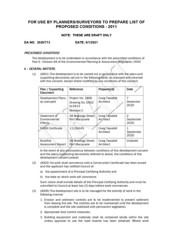
|
ATTACHMENT
|
Development Assessment Panel
21/01/2021
|
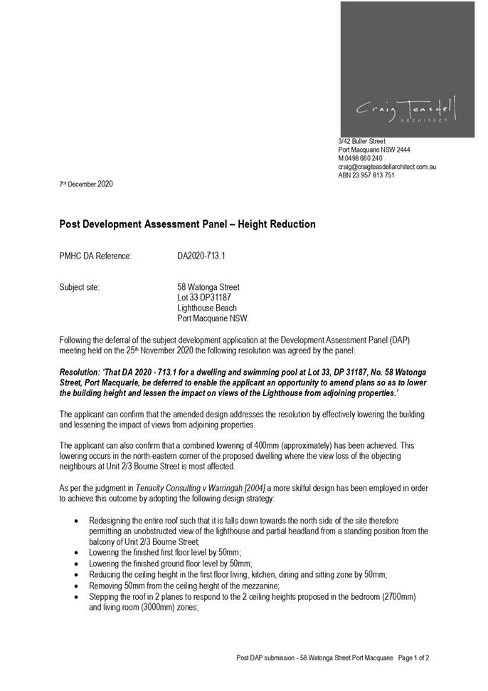
|
ATTACHMENT
|
Development Assessment Panel
21/01/2021
|
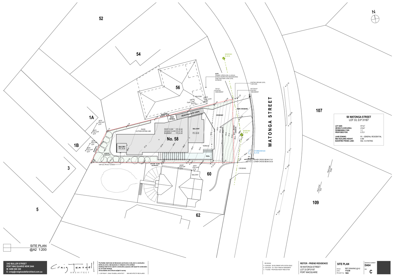
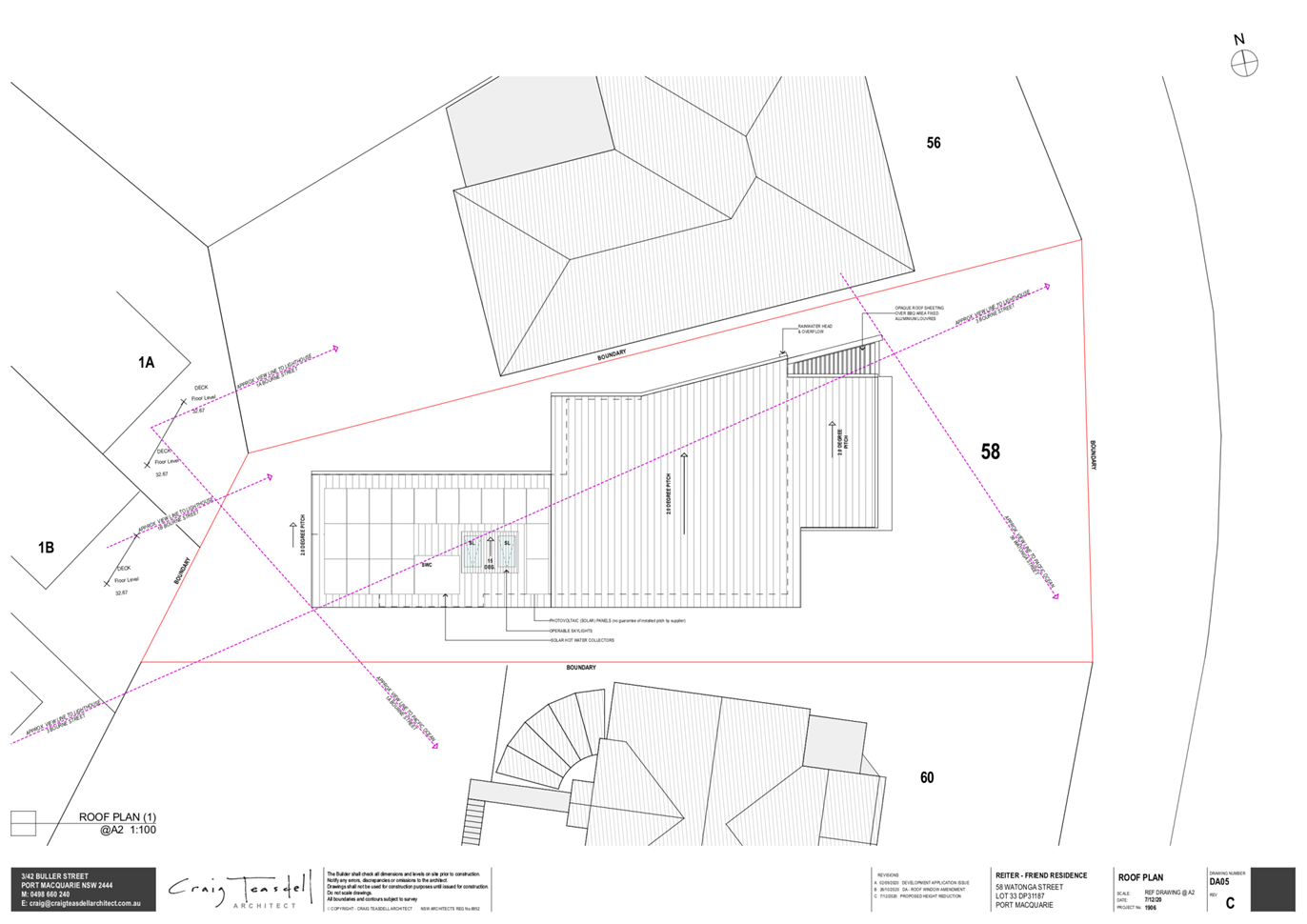
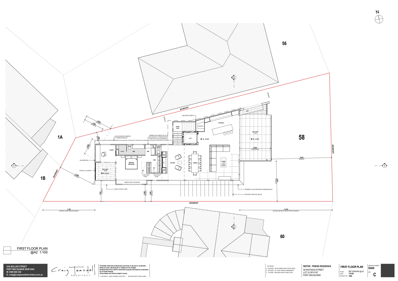
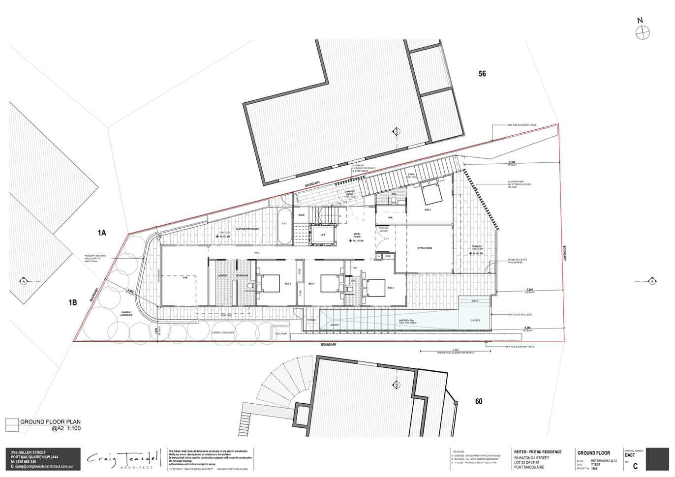
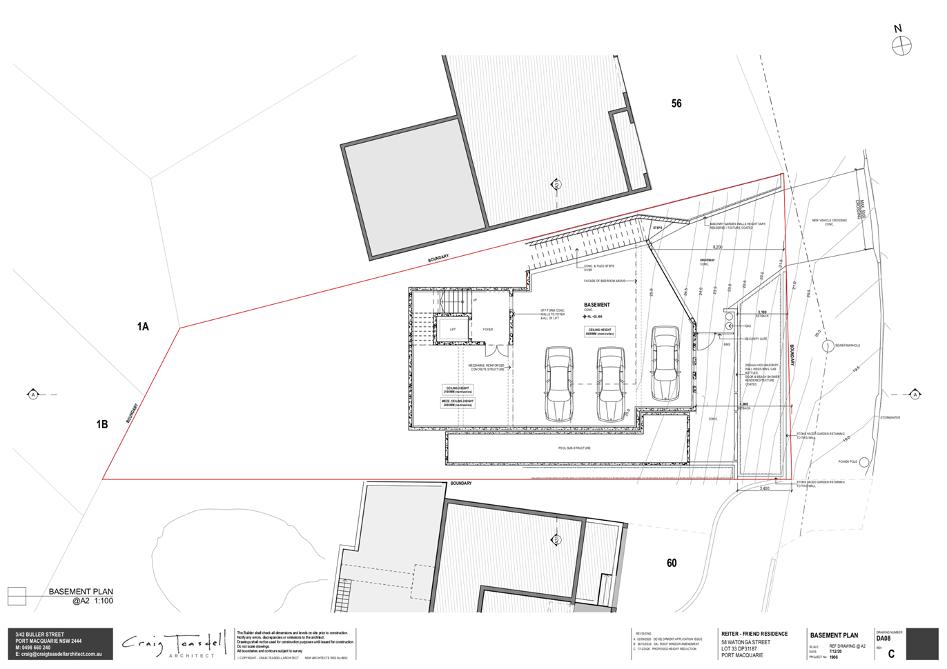
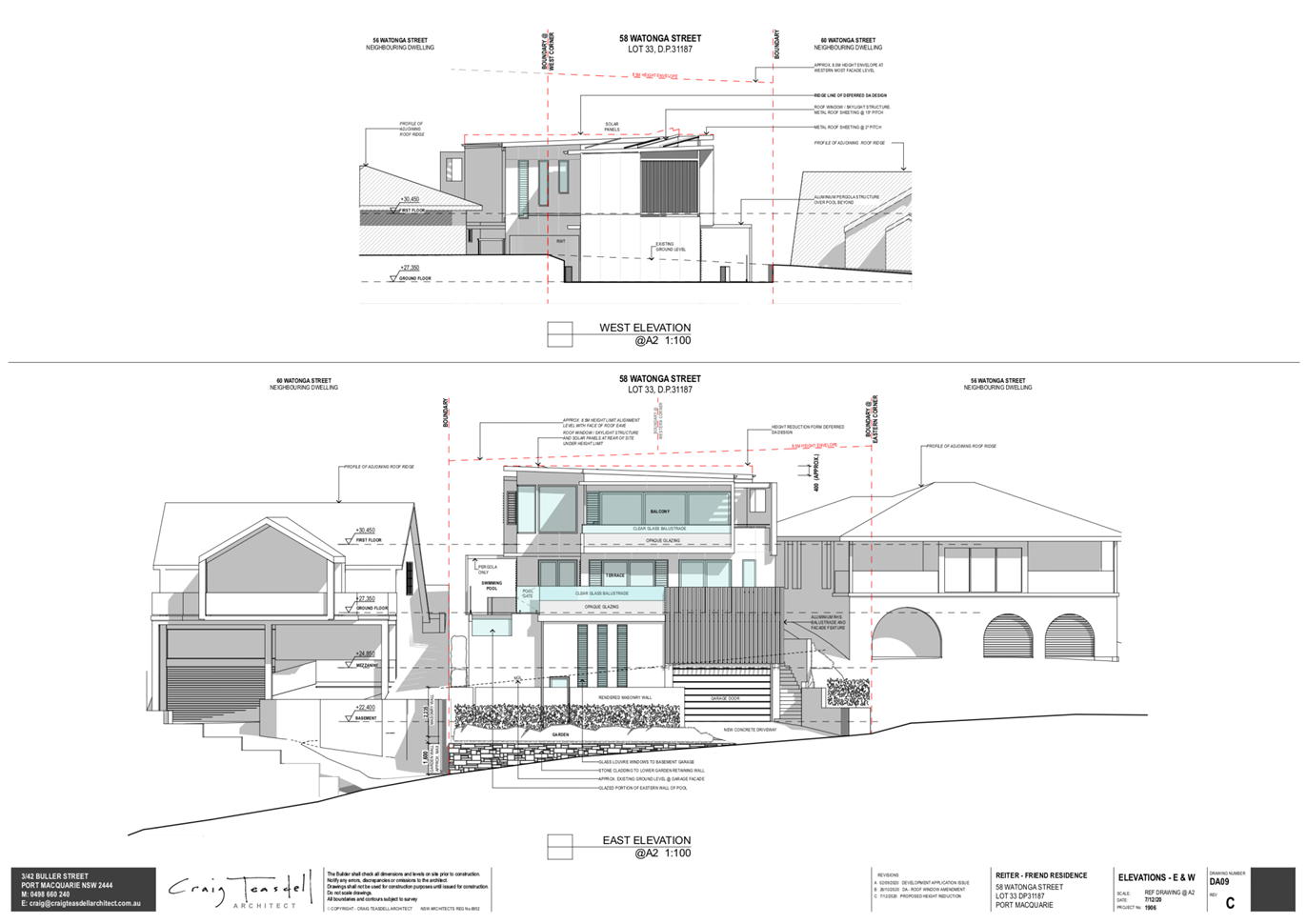
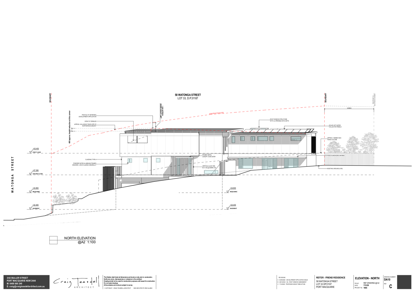
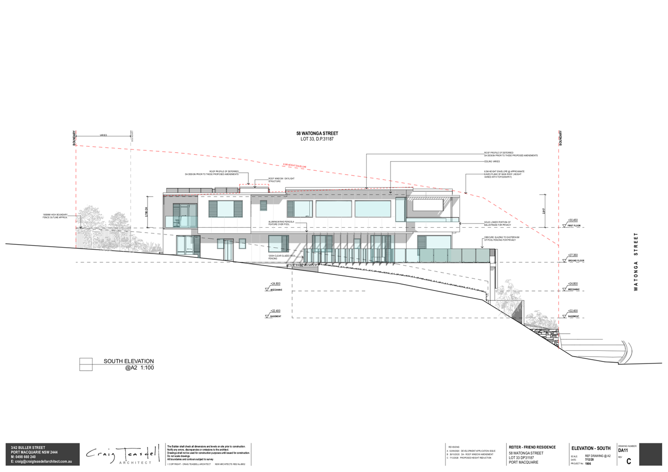
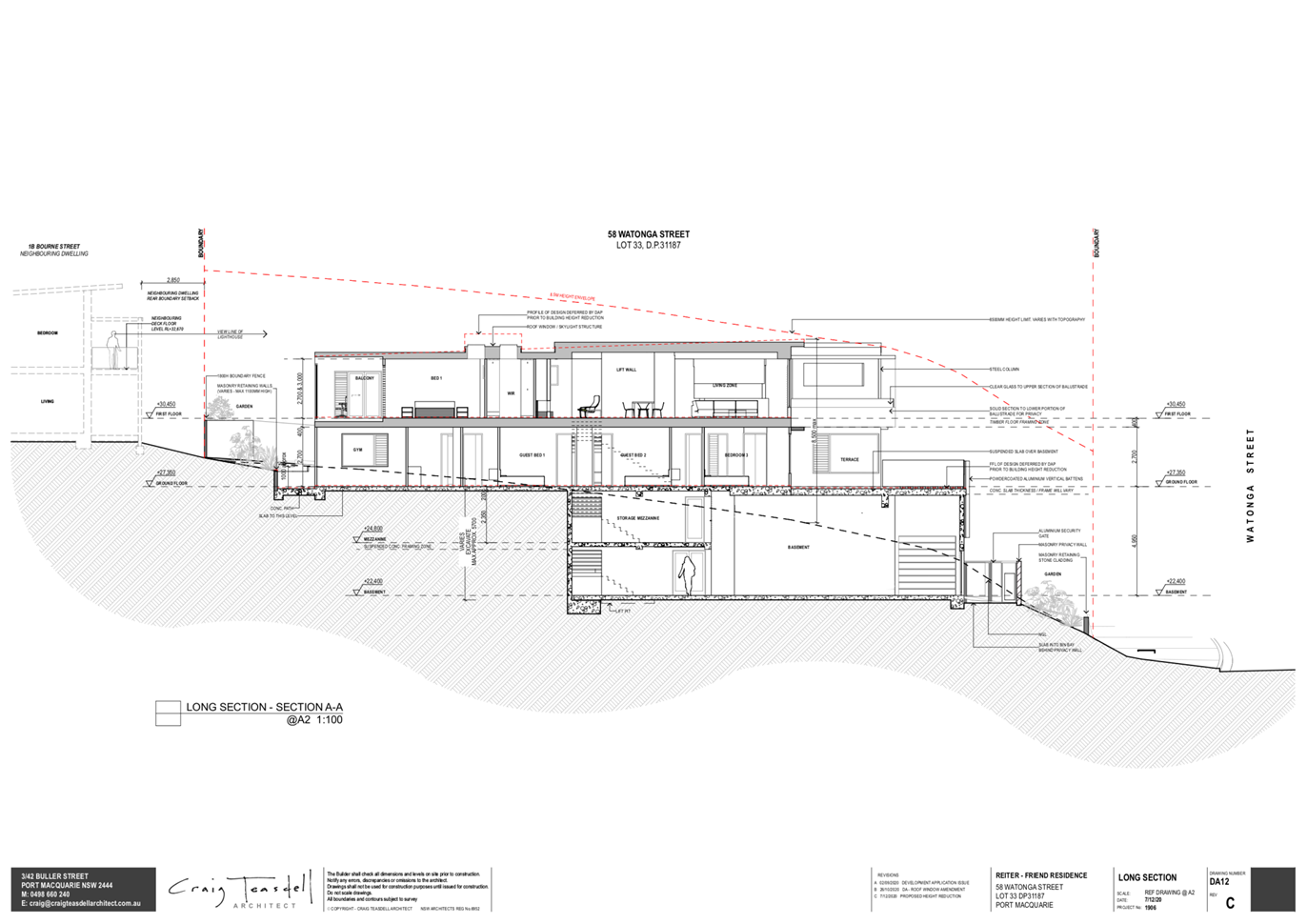
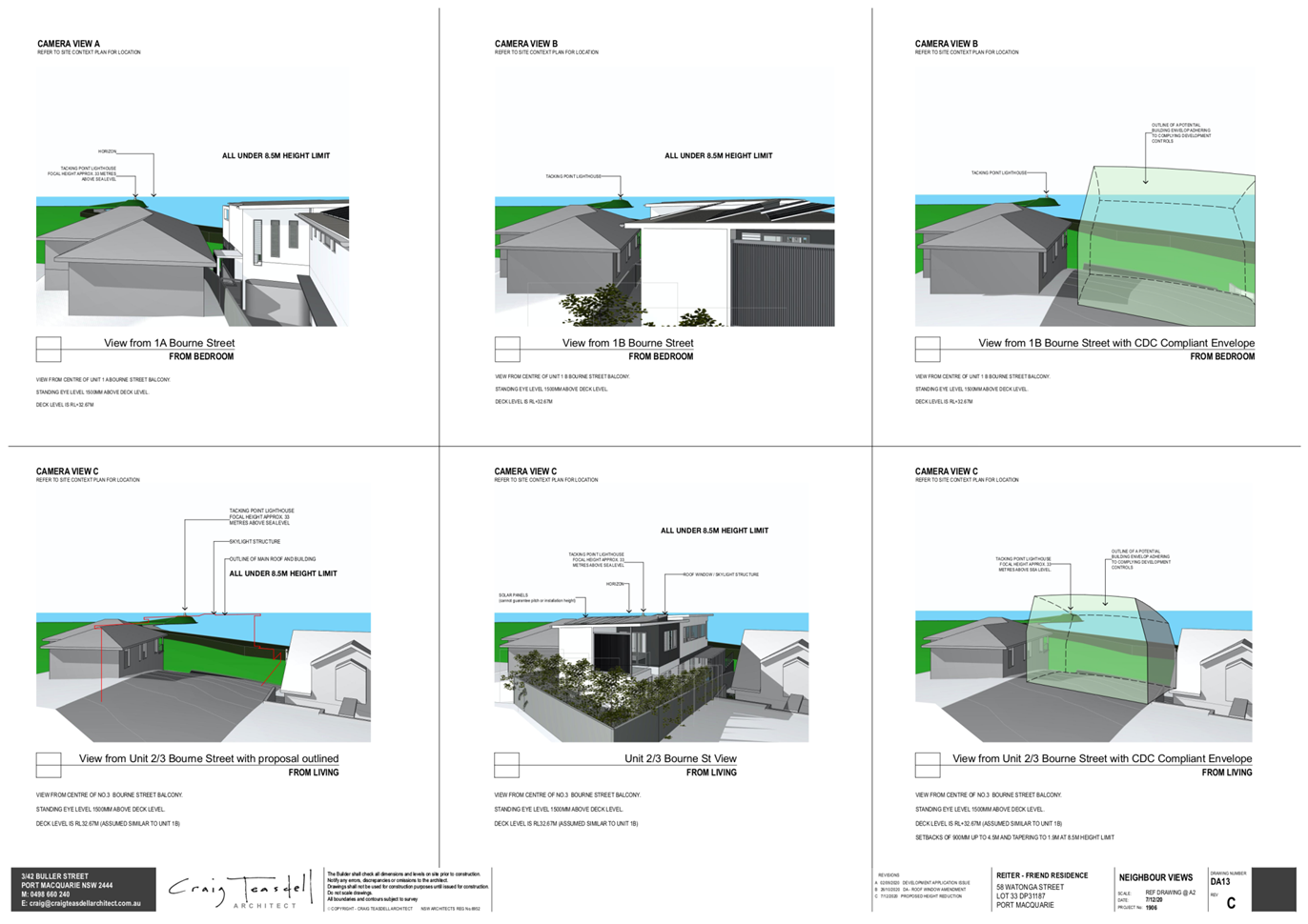
AGENDA Development Assessment Panel 21/01/2021
Item: 10
Subject: DA2020 - 606.1 Demolition of Caravan Park and
Construction of Service Station, Food and Drink Premises and Car Park at
Lot 702 DP 1151916, No 128 Hastings River Drive, Port Macquarie
Report
Author: Development Assessment Planner, Chris Gardiner
|
Applicant: RCI
Group
Owner: Stevens
Holdings Pty Ltd
Estimated Cost: $3,200,000
Alignment with Delivery
Program
4.3.1 Undertake transparent
and efficient development assessment in accordance with relevant legislation.
|
RECOMMENDATION
That
DA2020 - 606.1 for demolition of a
caravan park and construction of a service station, food and drink premises
and car park at Lot 702, DP 1151916, No. 128 Hastings River Drive,
Port Macquarie, be determined by
granting consent subject to the recommended conditions.
Executive
Summary
This
report considers a development application for demolition of a caravan park and
construction of a service station, food and drink premises and car park at the subject site and provides an assessment of the
application in accordance with the Environmental Planning and Assessment Act
1979.
Following exhibition of the
application, eight (8) submissions were
received.
The proposal has been amended through the assessment
process, including increase to the height of the acoustic fence to the southern
boundary, reduction in operational hours for the food and drink premises,
changes to illuminated signage, and access and circulation within the site.
The site is considered suitable for the proposed development
and the proposal adequately addresses relevant planning controls. The
development is not considered to be contrary to the public's interest and will
not result a significant adverse social, environmental or economic impact.
This report recommends that the
development application be approved subject to the attached conditions (Attachment
1).
1. BACKGROUND
Existing
Sites Features and Surrounding Development
The site has an area of 1.062
hectares.
The
site is zoned B5 Business Development in
accordance with the Port Macquarie-Hastings Local Environmental Plan 2011, as
shown in the following zoning plan:
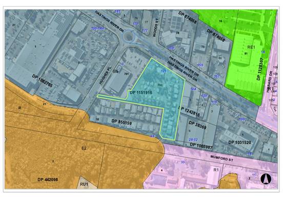
The
existing subdivision pattern and location of existing development within the
locality is shown in the following aerial photograph:
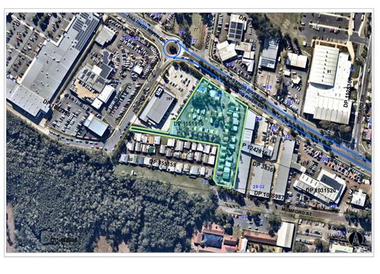
2. DESCRIPTION
OF DEVELOPMENT
Key
aspects of the proposal include the following:
· Demolition
of existing caravan park, including roads, swimming pool and community
buildings;
· Construction
of a service station including convenience shop, underground fuel tanks, and
fuelling canopy;
· Construction
of a food and drink premises with drive through facility;
· Construction
of associated car parking, landscaping and frontage works.
The
development is proposed to be staged to allow for each of the components to be
completed individually in any order.
Refer
to Attachment 2 at the end of this report for plans of the proposed
development.
Application
Chronology
· 31
July 2020 - Application lodged.
· 11 August 2020 to 24 August 2020 - Neighbour notification.
· 21 October 2020 - Additional information requested from
Applicant.
· 4 November 2020 - Comments on application received from
Transport for NSW.
· 24 November 2020 - Additional information and amended plans
submitted by Applicant.
· 16 December 2020 - Amended Waste Management Plan submitted.
· 17 December 2020 - Amended food and drink premises fit out
plans submitted.
· 6 January 2021 - Amended plans and noise impact assessment
submitted.
3. STATUTORY
ASSESSMENT
Section
4.15(1) Matters for Consideration
In
determining the application, Council is required to take into consideration the
following matters as are relevant to the development that apply to the land to
which the development application relates:
(a) The
provisions (where applicable) of:
(i) Any
Environmental Planning Instrument
State Environmental Planning Policy No. 21 - Caravan
Parks
The proposal involves demolition of an existing caravan
park. The SEPP does not contain any relevant provisions regarding the
closure/demolition of a caravan park. The retained caravan park (Melaleuca
Lifestyle Village) on adjoining Lot 32 DP 855159 has a separate approval to
operate and does not rely upon any of the roads or communal facilities on the
subject site (other than the section of road within the right of carriageway,
which is proposed to be retained).
State Environmental Planning Policy No. 33 - Hazardous
and Offensive Development
The subject SEPP was introduced to clarify the definitions
for hazardous and offensive industries and to apply guidelines for the
assessment of industries that have the potential to create hazards or an
offence. In this case, the development has the potential to be hazardous (risk
of fire/explosion) and offensive (odours) given the fuel storage component and
the provisions of the SEPP apply.
The proposal incorporates a total of approximately 115
kilolitres of flammable liquid and 65 kilolitres of combustible liquid stored
in underground tanks. The application includes a SEPP 33 Risk Screening Report
prepared by Hazkem Dangerous Goods Consulting. The report addresses the
Department of Planning’s Hazardous and Offensive Development
Application Guidelines - Applying SEPP 33 and considered the screening
tests to determine whether a preliminary hazard analysis is required.
The proposal includes the following breakdown of fuel types
and classifications:
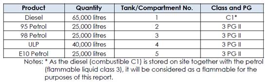
The total storage volume is 180,000 litres, but for the
purpose of the screening test the guideline allows the volume to be divided by
a factor of 5, due to all tanks being underground. This gives a total volume of
36,000 for the purpose of the screening test. Figure 9 in the guideline
provides the minimum separation distances required for a proposal to not be considered
hazardous. The proposal has been plotted on the figure below:
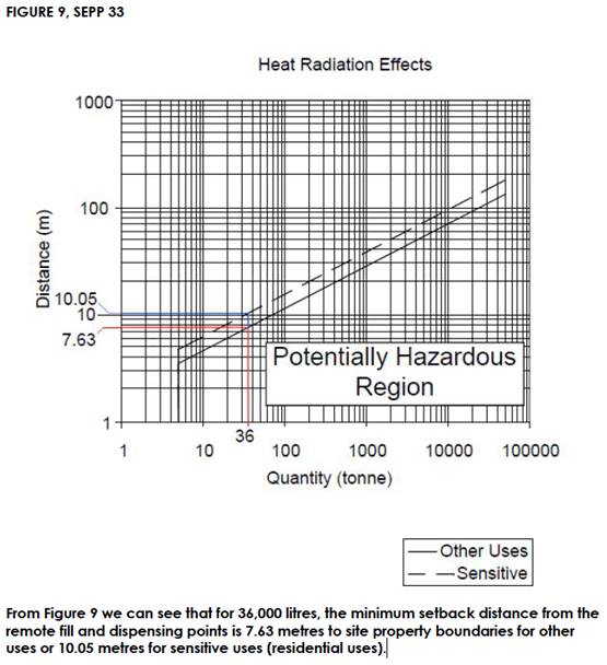
The only residential use adjoining the site is located to
the south, with other adjoining development being commercial. The proposal
satisfies the minimum setback requirements and therefore doesn’t require
a preliminary hazard analysis.
The proposal is also below the transport screening threshold
of up to 45 movements per week or 750 movements per year. The application
indicates that the site will receive approximately 3 deliveries per week (156
deliveries per year), which is well below the threshold.
State Environmental Planning Policy (Koala Habitat
Protection) 2020
Clause 5 - This SEPP applies to the Port Macquarie-Hastings
Local Government Area.
Clause 7 - The site has an area greater than 1 hectare and
Part 2 of the SEPP applies.
Clause 8 - The ecological assessment prepared by Narla
Environmental confirms that the land does contain any Schedule 2 food trees and
the site therefore does not meet the definition of potential koala habitat. No
further consideration of the SEPP is required.
State Environmental Planning Policy No. 55 - Remediation
of Land
Following an inspection of the site and a search of Council
records, the subject land is not identified as being potentially contaminated
and is suitable for the intended use. The land has previously been used as a
caravan park, which is not identified as a potentially contaminating use in the
contaminated land planning guidelines.
State Environmental Planning Policy No. 64 - Advertising
and Signage
The proposed development includes proposed signage in the
form of two 6m high pylon signs in the Hastings River Drive frontage and
various business identification signs on the fuel canopy, service station
building and food and drink premises.
In accordance with clause 7, this SEPP prevails over the
Port Macquarie-Hastings LEP 2011 in the event of any inconsistency.
The following assessment table provides an assessment
checklist against the Schedule 1 requirements of this SEPP:
|
Applicable clauses for consideration
|
Comments
|
Satisfactory
|
|
Clause 8(a) Consistent with
objectives of the policy as set out in Clause 3(1)(a).
|
The proposed signage is
consistent with the objectives of the Policy.
|
Yes
|
Schedule
1(1) Character of the area.
|
The area has a generally
commercial character along Hastings River Drive and the proposed signs are
considered to be compatible with the existing and desired future character of
the area.
|
Yes
|
|
Schedule 1(2) Special areas.
|
The site is not located in a special
area.
|
N/A
|
|
Schedule 1(3) Views and vistas.
|
The proposed signs would not
affect any significant views or vistas.
|
Yes
|
|
Schedule 1(4) Streetscape,
setting or landscape.
|
The scale of the signage is
appropriate to the setting and would not detract from the streetscape.
The pylon signs are below the top
of the service station buildings and consistent with the DCP height controls
for pylon signs in the precinct.
|
Yes
|
|
Schedule 1(5) Site and building.
|
The scale of the signs are in
proportion to the proposed buildings.
|
Yes
|
|
Schedule 1(6) Associated devices
and logos with advertisements and advertising structures.
|
N/A
|
N/A
|
|
Schedule 1(7) Illumination.
|
The proposal includes illuminated
signage. Given that the service station is intended to operate 24 hours, the signage
is not proposed to be subject to a curfew. It will be necessary for the
illuminated signs to comply with AS4282, and a condition has been recommended
in this regard.
The DCP recommends that
illuminated signage near residential uses be fitted with a time switch to dim
by 50% after 11.00pm and a condition is also recommended confirming this
requirement.
Illuminated signage associated
with the food and drink premises should be switched off outside the
operational hours of the business.
|
Yes
|
|
Schedule 1(7) Safety.
|
The signs are not considered to adversely affect traffic,
cyclist, or pedestrian safety.
|
Yes
|
State Environmental Planning Policy (Coastal Management)
2018
The site is located within a coastal use area, coastal
environment area and proximity area to coastal wetlands.
Clause 7 - This SEPP prevails over the Port
Macquarie-Hastings LEP 2011 in the event of any inconsistency.
Clause 11(1)(a) - The proposal is not expected to
significantly impact the biophysical, hydrological or ecological integrity of
the adjacent coastal wetland. The site is an existing developed caravan park
and is separated from the coastal wetland by the adjoining Melaleuca Village.
The proposal includes stormwater quality controls in accordance with
Council’s AUSPEC specifications.
Clause 11(1)(b) - The quality and quantity of surface water
entering the adjacent coastal wetland will be controlled in accordance with
Council’s AUSPEC specifications. The Applicant has submitted a Water
Cycle Management Plan, which demonstrates conceptually that on-site detention
and water quality controls are achievable. In relation to potential impacts on
groundwater entering the coastal wetland, the proposed underground fuel storage
tanks are located outside the proximity area and have been designed with leak,
detection and groundwater monitoring in accordance with the Protection of the
Environment Operations (Underground Petroleum Storage Systems) Regulation 2014.
Having regard to clauses 13 and 14 of the SEPP the proposed
development is not considered likely to result in any of the following:
a. any
adverse impact on integrity and resilience of the biophysical, hydrological
(surface and groundwater) and ecological environment;
b. any
adverse impacts coastal environmental values and natural coastal processes;
c. any
adverse impact on marine vegetation, native vegetation and fauna and their
habitats, undeveloped headlands and rock platforms;
d. any
adverse impact on Aboriginal cultural heritage, practices and places;
e. any
adverse impacts on the cultural and built environment heritage;
f. any
adverse impacts the use of the surf zone;
g. any
adverse impact on the visual amenity and scenic qualities of the coast,
including coastal headlands;
h. overshadowing,
wind funnelling and the loss of views from public places to foreshores; or
i. any
adverse impacts on existing public open space and safe access to and along the
foreshore, beach, headland or rock platform for members of the public,
including persons with a disability.
Clause 15 - The proposal is not likely to cause increased
risk of coastal hazards on the land or other land.
The bulk, scale and size of the proposed development is
compatible with the surrounding coastal and built environment.
State Environmental Planning Policy (Infrastructure) 2007
Clause 45 - The development is not in proximity to
electricity infrastructure and referral to Essential Energy was not required.
Clause 101 - The site has frontage to a classified road
(Hastings River Drive). The property also has frontage to Mumford Street and
Hughes Place. Access to the proposed development is proposed via a left-in
left-out divided driveway from Hastings River Drive. This is consistent with
the existing access arrangement for the caravan park. In this instance access via
Hughes Place or Mumford Street is not considered desirable due to traffic
impacts on the classified road at their intersections.
The design of the access to the land and the likely traffic
impacts on the classified road have been addressed in the submitted Traffic
Impact Assessment are discussed later in this report.
The development will not result in any emissions of smoke or
dust once operational.
A standard condition has been recommended in relation to
dust management during the construction phase.
The development is not of a nature that would be sensitive
to road traffic noise.
Clause 104 - The proposal is traffic-generating development
identified in Schedule 3 of the SEPP. The proposal has been referred to
Transport for NSW (TfNSW) in accordance with this clause. The comments received
from TfNSW are discussed later in this report.
Port Macquarie-Hastings Local Environmental Plan 2011
The proposal is consistent with the LEP having regard to the
following:
· Clause
2.2 - The subject site is zoned B5 Business Development.
· Clause
2.3(1) and the B5 zone landuse table - The proposed development for a service
station, food and drink premises and car park is permissible with consent.
The objectives of the B5 zone are as
follows:
o To enable a mix of business
and warehouse uses, and specialised retail premises that require a large floor
area, in locations that are close to, and that support the viability of,
centres.
o To minimise conflict between
land uses within the zone and with adjoining zones.
o To ensure that new
developments make a positive contribution to the public domain and streetscape.
· Clause
2.3(2) - The proposal is consistent with the zone objectives having regard to
the following:
o The development contributes to
the mix of business uses in the area.
o Land use conflict with nearby
uses is capable of being appropriately managed.
o The development will make an
acceptable contribution to the streetscape.
· Clause
2.7 - The demolition of existing buildings within the caravan park requires consent
as it does not fit within the provisions of SEPP (Exempt and Complying
Development Codes) 2008.
· Clause
4.3 - The maximum overall height of the buildings above ground level (existing)
is 8.0m, which complies with the height limit of 11.5m applying to the site.
· Clause
4.4 - No maximum floor space ratio applies to the site.
· Clause
5.10 - The site does not contain or adjoin any known heritage items or sites of
significance.
· Clause
7.1 - The site is mapped as potentially containing class 3 acid sulfate soils.
The proposed development includes underground fuel storage tanks, which will
involve excavation of more than 1m below ground level. An Acid Sulfate Soil
Management Plan prepared by Douglas Partners Pty Ltd has been submitted with
the application. The Plan recommends pre-construction confirmation of site
specific acid sulfate soil conditions. Excavated acid sulfate soils are to be
stored in a bunded area to contain leachate and neutralised using Grade 1
agricultural lime. The Acid Sulfate Soil Management Plan is considered
satisfactory and a condition is recommended requiring the Plan to be
implemented during construction.
· Clause
7.3 - The site is land within a mapped “flood planning area” (land
subject to flood discharge of 1:100 annual recurrence interval flood event,
plus the applicable climate change allowance and relevant freeboard). In this
regard the following comments are provided which incorporate consideration of
the objectives of Clause 7.3, Council’s Flood Policy 2015, the NSW
Government’s Flood Prone Lands Policy and the NSW
Government’s Floodplain Development Manual (2005):
o The proposal is compatible
with the flood hazard of the land taking into account projected changes as a
result of climate change;
o The proposal will not result
in a significant adverse effect on flood behaviour that would result in
detrimental increases in the potential flood affectation of other development
or properties;
o The
proposal incorporates measures to minimise & manage the flood risk to life
and property associated with the use of land;
o The proposal is not likely to
significantly adversely affect the environment or cause avoidable erosion,
siltation, destruction of riparian vegetation or a reduction in the stability
of river banks or watercourses;
o The proposal is not likely to
result in unsustainable social and economic costs to the community as a
consequence of flooding;
o The service station
convenience shop, fuel canopy, and food and drink premises are proposed to be
constructed to FPL2 (1:100 flood level, plus applicable climate change
allowance)
· Clause
7.13 - Satisfactory arrangements are in place for provision of essential
services including water supply, electricity supply, sewer infrastructure,
stormwater drainage and suitable road access to service the development.
(ii) Any draft
instruments that apply to the site or are on exhibition
No draft instruments apply to
the site.
(iii) Any Development
Control Plan in force
Port
Macquarie-Hastings Development Control Plan 2013
The relevant provisions of the
DCP are considered in the following table:
|
DCP 2013: Part B -
General Provisions - B1: Advertising and Signage
|
|
DCP Objective
|
Development Provisions
|
Proposed
|
Complies
|
|
1
|
a) Signs primarily identifying
products or services are not acceptable, even where relating to products or
services available on that site.
|
All proposed signage is
business identification with the exception of the fuel pricing information,
which is legally required to be displayed.
|
Yes
|
|
b) Signage is not permitted
outside property boundaries except where mounted upon buildings and clear of
pedestrians and road traffic. No signage is permitted upon light or power
poles or upon the nature strip (the area between the property boundary and
constructed roadway). Limited directional signage and “A” frame
signage may separately be approved by Council under the Roads Act 1993 or
section 68 of the Local Government Act 1993.
|
All proposed signs are
contained within the site boundaries.
|
Yes
|
|
c) An on-building 'chalkboard'
sign, for the purpose of describing services or goods for sale which vary on
a regular basis generally should not be any larger than 1.5m2, and should
contain a sign written heading indicating the premises to which it refers.
|
N/A
|
N/A
|
|
d) On-premise signs should not
project above or to the side of building facades
|
Signs are contained within the
walls of the buildings.
|
Yes
|
|
2
|
a) Where there is potential
for light spill from signage in a non-residential zone adjoining or adjacent
to residential development, illuminated signage is to be fitted with a time
switch to dim by 50% or turn off the light by 11pm each night, depending on
the nature of the development.
|
Condition recommended
requiring illuminated signage to be dimmed by 50% or turned off by 11pm each
night.
|
Yes
|
|
DCP 2013: Part B -
General Provisions - B2: Environmental Management
|
|
DCP Objective
|
Development Provisions
|
Proposed
|
Complies
|
|
3
|
a) Development must comply
with Council’s Developments, Public Place & Events - Waste
Minimisation and Management Policy.
|
The Applicant has submitted a
Waste Management Plan addressing Council’s Policy.
|
Yes
|
|
Cut and Fill Regrading
|
|
4
|
a) Development shall not
exceed a maximum cut of 1.0m and fill of 1.0m measured vertically above the
ground level (existing) at a distance of 1.0m outside the perimeter of the
external walls of the building (This does not apply to buildings where such
cut and fill is fully retained within or by the external walls of the
building).
|
The proposal includes
substantial earthworks across the site, the majority of which is located
outside the perimeter walls of the proposed buildings. The proposal includes
cut of less than 0.5m, and filling of up to 1.8m. The extent of filling is
necessary in this instance to achieve the required minimum floor/ground
levels in accordance with Council’s Flood Policy. The required levels
cannot be achieved within the DCP provisions. Relevant objectives of the
provision including, site stability, privacy impacts, and stormwater
management have been considered in the assessment and the proposal is
consistent with these objectives.
|
No, but acceptable
|
|
5
|
a) A certified practicing
structural engineer must certify any retaining wall greater than 1.0m.
|
Condition recommended
requiring engineering certification.
|
Yes
|
|
b) Where a combination of a
fence and a wall is proposed to be greater than 1.2m high:
- be a maximum combined
height of 1.8m above existing property boundary level;
- be constructed up to
the front boundary for a maximum length of 6.0m or 30% of the street frontage,
whichever is less;
− the fence component
has openings which make it not less than 25% transparent; and
− provide a 3m x 3m
splay for corner sites, and
- provide a 900mm x 900mm
splay for vehicle driveway entrances.
|
No front fence and retaining
wall combination proposed.
|
N/A
|
|
Tree Management –
Private Land
|
|
11
|
c) Where a tree listed in
Table 1 is approved for removal it must be compensated with 2 x koala habitat
trees. Significant large-scale development will require an advanced size
koala food tree or habitat tree (primary Koala browse species) that meets
AS2303:2015 Tree Stock for Landscape Use. The compensation tree is to be
planted in a suitable location as determined by the Director of Development
and Environment or their delegate.
|
The ecology report identifies
4 broad leaf paperbarks to be removed, which are listed as other browse
species in the DCP. Offset plantings are capable of being provided within the
site landscaping or on the vacant part of the site adjacent to Mumford
Street. A condition is recommended requiring offset plantings at a ratio of
2:1 in the same species, or 1:1 with primary koala food trees.
|
Yes
|
|
Tree Management - Hollow
Bearing Trees
|
|
13
|
a) All hollow bearing trees
within the development area are to be accurately located by survey and
assessed by an appropriately qualified ecologist in accordance with
Council’s Hollow-bearing tree assessment (HBT) protocol
|
No hollow bearing trees
identified for removal.
|
N/A
|
|
DCP 2013: Part B -
General Provision - B3: Hazards Management
|
|
DCP Objective
|
Development Provisions
|
Proposed
|
Complies
|
|
Airspace Protection
|
|
15
|
a) Development shall not
result in land use or activities that attract flying vertebrates such as
birds and bats within proximity of flight paths associated with airport
operations.
|
The proposed use is not
expected to attract flying vertebrates.
|
Yes
|
|
16
|
a) Development shall not
result in emission of airborne particulate or produce a gaseous plume with a
velocity exceeding 4.3m per second that penetrates operational airspace.
Refer Manual of Standards Part
139 – Aerodromes, Civil Aviation Safety Authority.
|
No emissions of this nature
proposed.
|
Yes
|
|
Flooding
|
|
19
|
a) Development must comply
with Council’s Floodplain Management Plan and Flood Policies.
|
See comments earlier under
Clause 7.3 of LEP regarding flooding.
|
|
|
DCP 2013: Part B-
General Provisions- B4: Transport, Traffic Management, Access and Car Parking
|
|
DCP Objective
|
Development Provisions
|
Proposed
|
Complies
|
|
Road Hierarchy
|
|
23
|
a) New direct accesses from a
development to arterial and distributor roads is not permitted. Routes should
differ in alignment and design standard according to the volume and type of
traffic they are intended to carry, the desirable traffic speed, and other
factors.
|
Site has existing entry and
exit to classified road.
|
N/A
|
|
b) Existing direct accesses
from a development to arterial and distributor roads are rationalised or
removed where practical.
|
The existing site access is
already left-in, left-out to Hastings River Drive, which is considered to be
the most practical means of access. Access from Mumford Street is not
desirable without improvements to the intersection of Hastings River Drive
and Mumford Street.
|
Yes
|
|
c) Vehicle driveway crossings
are minimal in number and width (while being adequate for the nature of the
development), and positioned:
− to
avoid driveways near intersections and road bends, and
− to
minimise streetscapes dominated by driveways and garage doors, and
− to
maximise on-street parking.
|
A single entry and exit
driveway are proposed with adequate width to accommodate heavy vehicles.
|
Yes
|
|
Parking Provision
|
|
24
|
a) Off-street Parking is
provided in accordance with Table 3.
Take away food and drink
premises - On-site seating and drive-through: 1 space per 2 seats, plus
queuing area for minimum of 8 cars from the pickup point.
Service station: 3 spaces per
work bay + 1 per employee + 2
customer (minimum) + any
Restaurant/Take
Away Food requirements
|
The service station is noted
to have no work bays and 2 employees, which requires a minimum of 4 parking
spaces. The convenience store component of the service station has a floor
area of approximately 98m2 and is considered to generate a parking
demand at the retail premises rate (1 space per 30m2). This
equates to an additional 3.27 (rounded to 4) spaces. The total parking demand
for the service station component is 8 spaces.
The takeaway food and drink
premises is proposed to have 42 indoor seats (21 spaces) and provided queuing
for 8 vehicles in the drive through.
The total parking required for
the development is therefore 29 spaces, plus queuing for 8 vehicles at the
drive through.
The proposal provides 148
spaces, which meets this requirement with 119 parking spaces surplus.
|
Yes
|
|
b) Where a proposed development
does not fall within any of the listed definitions, the provision of on-site
parking shall be supported by a parking demand study.
|
N/A
|
N/A
|
|
c) Where a proposed
development falls within more than one category Council will require the
total parking provision for each category.
|
Noted. Parking assessment has
considered all relevant land uses.
|
Yes
|
|
25
|
a) A development proposal to
alter, enlarge, convert or redevelop an existing building, whether or not
demolition is involved, shall provide the total number of parking spaces
calculated from the schedule for the proposed use, subject to a credit for
any existing deficiency, including any contributions previously accepted in
lieu of parking provision.
|
No parking credits applicable.
|
N/A
|
|
26
|
a) On street parking, for the
purposes of car parking calculations will not be included unless it can be
demonstrated that:
− there
is adequate on street space to accommodate peak and acute parking demands of
the area;
− parking
can be provided without compromising road safety or garbage collection
accessibility;
− parking
can be provided without jeopardising road function; and
− that
streetscape improvement works, such as landscaped bays and street trees are
provided to contribute to the streetscape.
|
N/A
|
N/A
|
|
b) On street parking is
provided in accordance with AS2890.5.
|
N/A
|
N/A
|
|
Parking Layout
|
|
28
|
a) Visitor and customer
parking shall be located so that it is easily accessible from the street.
|
Parking easily accessible.
|
Yes
|
|
b) Internal signage (including
pavement markings) should assist customers and visitors to find parking and
circulate efficiently and safely through a car park.
|
General directional pavement
markings included on architectural plans.
|
Yes
|
|
c) Parking spaces shall
generally be behind the building line but may be located between the building
line and the street when:
− it
is stacked parking in the driveway; or
− it
can be demonstrated that improvements to the open space provided will result;
and
− the
spaces are screened (densely landscaped or similar) from the street by a
landscaping with a minimum width of 3.0m for the entire length of the parking
area.
|
Parking in the north-west
corner of the site located forward of the building line with landscaping
approximately 1.5m wide.
This is consistent with the
adjoining car parking for the Aldi store to the west. Landscaping in this
location has been established in the 1.5m wide strip and successfully screens
the open parking area from Hastings River Drive. It is considered that a
similar landscape treatment for the subject site could achieve a similar
result.
|
No, but acceptable
|
|
d) Parking design and layout
is provided in accordance with AS/NZS 2890.1 - Parking facilities -
Off-street car parking and AS 2890.6 - Off-street parking for individuals
with a disability and AS/NZS 2890.2 - Parking facilities - Off-street
commercial vehicle facilities.
|
Parking layout capable of
complying. Conditions recommended requiring certification of design prior to
the issue of a Construction Certificate and certification of the completed
car park prior to the issue of an Occupation Certificate.
|
Yes
|
|
e) Stack or tandem parking
spaces will not be included in assessment of parking provision
except where:
− the
spaces are surplus to that required;
− in
motor showrooms;
− for
home business;
− for
exhibition homes;
− in
car repair stations;
− staff
parking spaces are separately identified and delineated;
− it
is visitor parking associated with a dual occupancy multi dwelling and/or
terrace housing, directly in front of the garage with a minimum depth of
5.5m.
|
None proposed.
|
Yes
|
|
29
|
a) Parking is provided in
accordance with AS/NZS 2890.1 - Parking facilities - Off-street car parking,
AS/NZS 2890.2 - Parking facilities - Off-street commercial vehicle
facilities, AS 1428 - Design for access and mobility and AS 2890.6 -
Off-street parking for individuals with a disability.
|
Parking layout capable of
complying. Conditions recommended requiring certification of design prior to
the issue of a Construction Certificate and certification of the completed
car park prior to the issue of an Occupation Certificate.
|
Yes
|
|
30
|
a) Bicycle and motorcycle
parking shall be considered for all developments.
|
The proposed uses of the land
for a service station and food and drink premises are not expected to
generate a significant demand for customer bicycle parking. A bicycle rack is
identified on the plans adjacent to the food and drink premises to cater for
the small volume of staff and customer parking anticipated.
Motorcycle parking can be accommodated
within the vehicle parking area, and there is significant surplus spaces for
this use.
|
Yes
|
|
b) Bicycle parking areas shall
be designed generally in accordance with the principles of AS2890.3 - Parking
facilities - Bicycle parking facilities.
|
Bicycle rack adjacent to the
food and drink is capable of complying with standard.
|
Yes
|
|
c) Motorcycle parking areas
shall be 1.2m (wide) x 2.5m (long).
|
N/A
|
N/A
|
|
Landscaping of Parking
Areas
|
|
33
|
a) Landscaping areas shall be
provided in the form of large tree planting, understorey plantings, mulch
areas, mounding, lawns and the like
|
The landscape plan includes
understorey plantings as well as 36 medium mature trees including:
- 5 Tuckeroo
- 4 Riberry
- 7 Watergum
- 20 Foxtail Palm
|
Yes
|
|
b) Landscaping areas shall be
used throughout the car park and on the perimeters of the property where it
addresses the public domain.
|
The landscape plan includes
landscaping within the parking areas and along the site frontage to the
public domain.
|
Yes
|
|
c) Garden beds shall be a
minimum of 3m in width between car parking areas and street boundaries.
|
Parking in the north-west
corner of the site located forward of the building line with landscaping
approximately 1.5m wide.
The suitability of this area
is discussed above under 28(c).
|
No, but acceptable
|
|
34
|
a) All plantings on public
lands are to be selected from Council’s Indigenous Street and Open
Space Planting List from the relevant vegetation community adjacent to the
Development.
|
Proposal will include
replacement of the existing street tree in Hastings River Drive.
|
Yes
|
|
b) Trees are to be grown and
installed in accordance with AS 2303:2015 Tree Stock for Landscape Use and
Council’s AUS-SPEC design specifications.
|
Noted. Replacement street tree
will need to meet these specifications.
|
Yes
|
|
|
Surface Finishes
|
|
|
|
35
|
a) All parking and manoeuvring
areas shall be constructed with a coarse base of sufficient depth to suit the
amount of traffic generated by the development, as determined by Council. It
shall be sealed with either bitumen, asphaltic concrete, concrete or
interlocking pavers.
Preliminary details of
construction materials for access and car parking areas shall be submitted
with the development application. Detailed plans shall be prepared for the
construction certificate by a practising qualified Civil Engineer.
|
Concrete surface proposed.
|
Yes
|
|
b) In special cases (e.g.
where traffic volumes are very low) Council may consider the use of
consolidated unsealed gravel pavement for car parks. However, this should not
be assumed and will need to be justified by the applicant at the Development
Application stage.
|
N/A
|
N/A
|
|
|
Drainage
|
|
|
|
36
|
a) All parking and manoeuvring
spaces must be designed to avoid concentrations of water runoff on the
surface.
|
Water Cycle Management Plan
submitted with application addressing these matters.
|
Yes
|
|
b) Council will not permit the
discharge of stormwater directly into kerbing and guttering or table drains
for any development other than that of a minor nature.
|
|
37
|
a) Car parking areas should be
drained to swales, bio retention, rain gardens and infiltration areas.
|
|
|
Loading Bays
|
|
|
|
38
|
a) Off street commercial
vehicle facilities are provided in accordance with AS/NZS 2890.2 - Parking
facilities - Off-street commercial vehicle facilities.
|
Separate loading facilities
proposed for the service station and food and drink premises.
|
Yes
|
|
b) Loading bays should be
provided in accordance with the following requirements;
- Minimum
dimensions to be 3.5m wide x 6m long. (This may increase according to the
size and type of vehicle).
- Vertical
clearance shall be a minimum of 5m.
- Adequate
provision shall be made on-site for the loading, unloading and manoeuvring of
delivery vehicles in an area separate from any customer car parking area.
- A limited
number of ‘employee only’ car parking spaces may be combined with
loading facilities.
- Loading
areas shall be designed to accommodate appropriate turning paths for the
maximum design vehicle using the site.
- Vehicles
are to be capable of manoeuvring in and out of docks without causing conflict
with other street or on-site traffic.
- Vehicles
are to stand wholly within the site during such operations.
|
Service station bay 8m x 3.5m.
Food and drink premises
loading bay 8m x 3.58m.
Neither loading bay is roofed
and both loading bays can accommodate the swept path of the design vehicle.
|
Yes
|
|
c) Industrial development
shall provide adequate heavy vehicle access to building entries, or
alternatively, external bays located appropriately for goods distribution.
|
N/A
|
N/A
|
|
d) For external bays, one bay
is required for 500m² of floor space or 1000m² of site area.
|
Two loading bays provided.
|
Yes
|
|
e) Commercial development
having a floor space less than 500m² need not provide a loading bay.
|
N/A
|
N/A
|
|
f) Other commercial
development shall provide one loading bay for the first 1,000m² floor
space and one additional bay for each additional 2,000m².
|
N/A
|
N/A
|
|
g) If parcel pickup facilities
are provided on-site they shall be located so as to avoid conflict with
general traffic flow within parking areas. Parcel pickup lanes shall be
separate from through traffic lanes in major shopping developments.
|
N/A
|
N/A
|
|
39
|
a) The location and design of
loading bays should integrate into the overall design of the building and car
parking areas.
|
Loading bay locations
acceptable.
|
Yes
|
|
b) Where visible from the
public domain, loading bays are located behind the building.
|
Service station loading bay
behind the building line and food and drink premises loading bay substantially
setback from site frontage.
|
Yes
|
|
c) Where loading bays are
located close to a sensitive land use, adequate visual and acoustic screening
is provided.
|
Food and drink premises
loading bay located approximately 20m from the boundary of the adjoining
Melaleuca Village. The loading bay is screened from the sensitive land use by
the screened plant area on the eastern side of the building and also the
proposed acoustic fencing on the property boundary.
|
Yes
|
|
Traffic Generating
Development
|
|
41
|
a) Traffic Generating
Development as defined under SEPP (Infrastructure) 2007 is referred to Roads
and Maritime Services. (Refer to Clause 104 and Schedule 3 of the
SEPP).
|
Proposal is traffic generating
development and has been referred to Transport for NSW.
|
Yes
|
|
|
|
|
|
|
DCP 2013: Part B -
General Provisions - B5: Social Impact Assessment and Crime Prevention
|
|
DCP Objective
|
Development Provisions
|
Proposed
|
Complies
|
|
Social Impact Assessment
|
|
42
|
a) A social impact assessment
shall be submitted in accordance with the Council’s Social Impact
Assessment Policy.
|
Social Impact Assessment has
been submitted and is considered later in this report.
|
|
|
Crime Prevention
|
|
43
|
a) The development addresses
the generic principles of crime prevention:
- Casual
surveillance and sightlines;
- Land use
mix and activity generators;
- Definition
of use and ownership;
- Basic
exterior building design;
- Lighting;
- Way-finding;
and
- Predictable
routes and entrapment locations;
- as
described in the Crime Prevention Through Environmental Design (CPTED)
principles.
|
The service station component
is proposed to be open 24 hours and will provide casual surveillance of the
site. The building surrounds and car parking areas are proposed to be
illuminated, which will also assist with casual surveillance and remove
concealment opportunities. There is no access control to the overall site and
parking area, but appropriate access control will be provided to buildings,
particularly during late night trading at the service station. The site
layout and proposed landscaping will define the public and private areas of
the site.
|
Yes
|
|
DCP 2013: Part C -
Development Specific Provisions - C3: Business and Commercial Development
|
|
DCP Objective
|
Development Provisions
|
Proposed
|
Complies
|
|
97
|
Setbacks
a) A zero metre setback to
ground floor is preferred for B1 Neighbourhood Centre, B2 Local Centre, B3
Commercial Centre and B4 Mixed Use zone developments.
|
Not applicable to B5 zone.
|
N/A
|
|
b) Any front setback for other
commercial zones to be considered on merit, having regard to existing
streetscape.
|
The proposed setback of 7.5m
to the service station building and fuelling canopy is considered
satisfactory for the nature of the use. There is no established character to
the existing building setbacks in the locality.
|
Yes
|
|
99
|
Roof Form
a) Variations in roof form
including the use of skillions, gables and hips are to be provided in the
development.
|
Roof form satisfactory having
regard to other buildings in the locality.
|
Yes
|
|
b) Variations in roof
materials shall be used.
|
|
c) Parapets and flat roofs
should be avoided.
|
|
d) In an established street,
roof form and materials shall be consistent or complementary to those
developments in that street.
|
Roof form and materials consistent
with other development in the locality.
|
Yes
|
|
e) Lift over-runs and service
plant shall be concealed within roof structures.
|
N/A
|
N/A
|
|
f) All roof plant must be
represented on plans and elevations.
|
Screened plant areas
identified on the plans to the side of each of the proposed buildings. No
roof plant proposed.
|
Yes
|
|
g) Outdoor recreation areas on
flat roofs shall be landscaped and incorporate shade structures and wind
screens to encourage use.
|
N/A
|
N/A
|
|
h) Roof design shall generate
an interesting skyline and be visually interesting when viewed from adjoining
developments.
|
No multi-storey buildings in
the locality that would have views across the rooftops.
|
No, but acceptable
|
|
100
|
a) Colours, construction
materials and finishes should respond in a positive manner to the existing
built
form, character and
architectural qualities of the street
|
Materials and finishes
satisfactory in the site context.
|
Yes
|
|
101
|
a) Shopfront widths are to be
between 15 and 20 m.
|
Maximum 20m shopfront width.
|
Yes
|
|
b) Widths up to a maximum of
30 may be considered where the building achieves superior built design and
streetscape outcomes.
|
N/A
|
N/A
|
|
c) The maximum length of any
similar façade treatment is 22m.
|
Neither façade is
longer than 22m.
|
Yes
|
|
d) Side and rear facades are
to be treated with equivalent materials and finishes to the front
façade.
|
Side and rear facades treated
in similar quality materials.
|
Yes
|
|
e) Building facades should be
designed to reflect the orientation of the site incorporating environmental
control devices, e.g. sun shades, ventilation vents, overhangs, building
recesses, eaves, as an integrated design feature of the building.
|
Features integrated into
building design.
|
Yes
|
|
f) An articulation zone of
between 1.8-4.0m is provided for the front façade of all floors
containing residential and tourist uses.
|
N/A
|
N/A
|
|
102
|
a) Any security grilles shall
be provided inside the building, behind glazing and designed to ensure
transparency to the interior.
|
None shown on plans.
|
N/A
|
|
103
|
a) Infill development or
alterations should respect the form, scale and massing of existing
traditional buildings.
|
N/A
|
N/A
|
|
b) Where traditional frontages
and facades set the architectural theme for parts of a Centre, infill
buildings or alterations respect and reflect the architectural qualities and
traditional materials of those buildings, but do not necessarily imitate
historical architectural styles.
|
N/A
|
N/A
|
|
104
|
Active Frontages
a) Ground floor levels should
not be used for residential purposes in zones B1 Neighbourhood Centre, B2
Local Centre, B3 Commercial core and B4 Mixed use.
|
Land is in B5 zone.
|
N/A
|
|
111
|
Landscaping
A landscape plan shall be
submitted with the development application and include:
− Existing
vegetation; and
− Existing
vegetation proposed to be removed; and
− Proposed
general planting and landscape treatment; and
− Design
details of hard landscaping elements and major earth cuts, fills and any
mounding; and
− Street
trees; and
− Existing
and proposed street furniture including proposed signage.
|
Landscape plan submitted
showing satisfactory detail of plantings.
|
Yes
|
|
b) Vegetation is provided on
top of podium levels, on tops of car parks, and on balconies and verandas
fronting the street below podium level.
|
N/A
|
N/A
|
|
112
|
a) All street plantings are to
be selected from Council's Indigenous Street and Open Space Planting List
from the relevant vegetation community adjacent to the Development.
|
Condition recommended
regarding replacement street tree plantings.
|
Yes
|
|
113
|
a) Large trees and spreading
ground covers are provided in all landscape areas within the site.
|
Proposed on landscape plan.
|
Yes
|
|
b) Large screening shrubs of
an appropriate density and size to complement the scale and bulk of the
subject building are provided in areas where screening is a priority.
|
Appropriate screening shrubs
proposed in the area forward of the parking area on the western side of the
service station building.
|
Yes
|
|
c) Where car parking cannot be
provided under or behind the building and Council has agreed to permit some
or all of the parking in the front setback, a landscaped strip with a minimum
width of 3.0m is provided along the entire frontage/s of the site.
|
1.5m wide landscaped strip
proposed between the parking area and Hastings River Drive. This is generally
consistent with the width of the landscaping for the adjoining Aldi car park
and can accommodate effective screen plantings.
|
No, but acceptable.
|
|
114
|
a) At grade car parking
incorporate water sensitive urban design principles to drain pavement areas.
|
See comments under Stormwater
section of this report.
|
|
|
115
|
a) Fencing for security or
privacy shall not be erected between the building line and the front boundary
of a site.
|
None proposed.
|
Yes
|
|
116
|
a) Where fences are erected,
landscaping of an appropriate height and scale shall be provided to screen
the fence and achieve an attractive appearance to the development when viewed
from the street or other public place.
|
N/A
|
N/A
|
|
117
|
a) Street furniture, including
seats, bollards, grates, grills, screens and fences, bicycle racks, flag
poles, banners, litter bins, telephone booths and drinking fountains are
coordinated with other elements of the streetscape.
|
None proposed.
|
N/A
|
|
118
|
a) Any ramps are to be
integrated into the overall building and landscape design.
|
No ramps proposed.
|
N/A
|
|
120
|
Vehicular Access Location
and Design
a) No direct vehicular access
to at grade or basement car parking from the active street
frontage should be permitted
in B1 Neighbourhood Centre, B2 Local Centre, B3 Commercial Core and B4 Mixed
Use zones.
|
Land is in B5 zone.
|
N/A
|
|
b) The number of vehicular
crossovers shall be kept to a minimum and appropriate sight lines provided to
ensure safe integration of pedestrian and vehicular movement.
|
Single entry and single exit
driveway proposed, which is consistent with the existing access arrangement
for the site.
|
Yes
|
|
c) Any car park ramps are
located largely within the building footprint.
|
N/A
|
N/A
|
|
d) Underground car parks must
be designed to enable all vehicles to access and egress in a forward
direction.
|
N/A
|
N/A
|
|
e) Vehicular entrances to
underground car parks are to be;
− Located
on minor streets;
− Have
a maximum crossover of 6.0m;
− Shall
be signed and lit appropriately;
− Shall
be designed so that exiting vehicles have clear sight of pedestrians and
cyclists.
|
N/A
|
N/A
|
|
f) At-grade / surface car
parking areas adjacent to streets shall be generally avoided or at least
adequately softened by appropriate landscaping.
|
Landscaping proposed between
car park and street.
|
Yes
|
|
g) All stairs and elevators in
the parking structure are clearly visible.
|
N/A
|
N/A
|
|
123
|
Pedestrian Entries &
Access
a) Pedestrian and vehicle
movement areas are separated to minimise conflict.
|
Separate pedestrian access
proposed from Hastings River Drive.
|
Yes
|
|
b) Changes in pavement
material, levels, lining or tactile treatments are used to distinguish
changes between vehicle and pedestrian access ways.
|
Submitted plans show line
marking to define pedestrian paths through the parking area.
|
Yes
|
|
124
|
a) Pedestrian and vehicle
movement areas are separated to minimise conflict.
|
Pedestrian and vehicle areas
separated between Hastings River Drive and the service station building.
Within the site dedicated pedestrian areas are provided between parking bays,
but crossing of traffic aisles is still required.
|
Yes
|
|
b) Changes in pavement
material, levels, lining or tactile treatments are used to distinguish
changes between vehicle and pedestrian access ways
|
Submitted plans show line
marking to define pedestrian paths through the parking area.
|
Yes
|
|
c) Parking areas are
adequately illuminated (naturally and/or artificially) during the time period
the centre is open.
|
Lighting proposed, but no
details shown on the plans. The Statement of Environmental Effects notes that
a detailed lighting design will be prepared as part of the Construction
Certificate documentation.
|
Yes
|
|
127
|
Commercial Development
Adjoining Residential Land Uses
a) The development is designed
so that all vehicle movement areas and servicing areas are located away from
adjoining residential areas.
|
Food and drink premises
loading area located on north-east corner of the building, away from the
residential use to the south. Service station loading area located on the
southern side of the building, but separated by approximately 50m from the
southern boundary.
|
Yes
|
|
b) Where this cannot be
achieved visual and acoustic treatment of the interface is required.
|
Acoustic fence proposed along
boundary of adjoining residential use in accordance with the recommendation
in the Noise Impact Assessment.
|
Yes
|
|
c) The building elevation
adjoining the residential area must be;
− Articulated,
with changes in setback at intervals no greater than 10m;
− Use
a variety of materials and treatments;
− Be
setback a minimum of half the height of the wall or a minimum of 3.0metres
whichever is greater.
|
Southern elevation of Food and
drink premises includes appropriate articulation and building materials.
Minimum setback from the boundary is approximately 11.5m for a building
having a maximum height of 7.0m.
|
Yes
|
|
d) Waste areas are located and
managed to minimise pests, noise and odour.
|
Waste storage located in
screened service yards.
|
Yes
|
|
132
|
Public Art - Additional
Requirements for Land Zoned for Business and Tourism
a) Development proposed on
land zoned Business or Tourist on sites over 5,000sqm, or where the total
project capital costs exceed $5M, is to provide a Public Art Strategy for
consideration as part of a Development Application.
|
Cost of works is less than $5
million.
|
N/A
|
|
b) The Strategy is to make
provision for quality artwork(s) within the development in publicly
accessible location(s) and take into account the links and connections
between the development and the area’s natural and cultural heritage.
|
N/A
|
N/A
|
|
c) The public art is to be 1%
of the total cost of the development to provide works of art for appreciation
from the public domain.
|
N/A
|
N/A
|
|
DCP 2013: Part D -
Locality Specific Provisions - D3 Port Macquarie West: D3.3 Hastings River
Drive
|
|
DCP Objective
|
Development Provisions
|
Proposed
|
Complies
|
|
229
|
a) Subdivision design shall
incorporate access roads generally in the location shown on Figure 76. New
building development shall be located to avoid the proposed access roads and
be designed to provide access to them, in preference to Hastings River Drive.
|
N/A
|
N/A
|
|
230
|
a) All development (including
minor works and change of use development) on land fronting Hastings River
Drive shall contribute to the improvement of the streetscape of Hastings
River Drive, and are required to incorporate landscaping works.
|
Proposal includes removal of
existing fencing and caravan park buildings, and landscaping has been
incorporated into the frontage of the proposed development.
|
Yes
|
|
b) Where development involves
subdivision, new buildings or major additions, and the development site has a
frontage greater than 40m, landscaped blisters shall be provided generally in
accordance with Figure 76 and Figure 77 and to the satisfaction of
Council’s engineers and Parks and Recreation Manager.
|
The proposal includes removal
of existing landscaped blisters adjacent to the proposed exit driveway and
for the deceleration lane in the frontage of adjoining land to the east at
No. 124 Hastings River Drive.
The concept plans submitted
for the frontage works in Hastings River Drive do not include any replacement
landscaped blisters, and there is not considered to be a suitable safe
location in the site frontage for these to be provided. However, there is
considered to be sufficient area for two new trees to be provided in the
central median of Hastings River Drive, and a condition has been recommended
requiring detailed design with the Section 138 application.
|
Yes
|
|
c) Land required for road
widening is to be dedicated to Council as a condition of consent.
|
No road widening required in
site frontage.
|
N/A
|
|
d) Development is to be
designed to be operational for both pre and post road widening.
|
Road widening has already been
carried out in the site frontage, and the proposal will be operational for
the existing widened road.
|
Yes
|
|
e) Flush wall signs and pole
or pylon signs are preferred signs in the precinct. Pylon or pole signs are
subject to the following:
− maximum
height of 6m;
− one
pylon (or pole) sign per property. Multiple signs may be attached to the one
pole.
− Where
a property has more than 50m frontage to Hastings River additional pylons may
be allowed, provided that there is a minimum separation of 40m between pylons;
− the
sign shall not overhang the boundary
|
The majority of proposed signs
are flush wall signs or pole/pylon signs. Some awning fascia signs are
proposed on the fuel canopy, which are also considered acceptable in the
context and are consistent with the signage at the nearby Caltex service
station at No. 92 Hastings River Drive.
The site has a frontage
greater than 50m and two pylons are permitted.
The proposed pylon signs are
each 6m high and separated by 40m.
|
Yes
|
|
f) For motor showrooms, the
application shall demonstrate that consideration has been given to the impact
of all signs and advertising techniques utilised on the site (including
flags, bunting etc), in respect to visual amenity and reduction of visual clutter,
integration of landscaping works, car display and signage.
|
N/A
|
N/A
|
|
g) Where multiple car
franchises are to operate from the one site, one corporate pole sign per
franchise may be allowed, provided the position, height and size of each sign
is integrated so that the overall impact is controlled, eg grouping of poles,
with differing heights, and different setbacks and stepping of signs. In
addition, there should be careful integration with landscaping works and car
display. No other pole signs will be allowed on site. If a dealer name
identification sign is required, this should appear on the building, or as
part of a franchise corporate sign. Directional signs eg visitor parking,
customer service, parts etc, should be either attached to a corporate franchise
“pylon” style sign, or a small entry way wall sign.
|
N/A
|
N/A
|
Based on the above assessment,
the variations detailed above to the provisions of the DCP are considered
acceptable and the relevant objectives have been satisfied. Cumulatively, the
variations do not amount to an adverse impact of a significance that would
justify refusal of the application.
(iiia) Any planning agreement that has
been entered into under section 7.4, or any draft planning agreement that a
developer has offered to enter into under section 7.4
No planning agreement has been
offered or entered into relating to the site.
(iv) Any
matters prescribed by the Regulations
Demolition
of buildings AS 2601 - Clause 92
Demolition of the existing
caravan park buildings on the site is capable of compliance with this
Australian Standard and is recommended to be conditioned.
(b) The likely
impacts of that development, including environmental impacts on both the
natural and built environments, social and economic impacts in the locality
Context and Setting
The site has a general northerly street frontage
orientation to Hastings River Drive. The site also has a narrow frontage to
Mumford Street for the part of the site shown as ‘Vacant Land’ on
the plans, and frontage via a battle-axe handle to Hughes Place to the west.
Adjoining the site to the north is Hastings River Drive. On
the northern side of Hastings River Drive are a car dealership and bowling
alley.
Adjoining the site to the east is bulky goods premises and
vehicle repair station, and some self-storage units.
Adjoining the site to the south is the remaining part of
the caravan park (known as Melaleuca Lifestyle Village) and the Heritage
Christian School.
Adjoining the site to the west is an Aldi supermarket.
The proposal has had regard for the context and
particularly potential amenity impacts on the adjoining caravan park to the
south.
Lighting
The Statement of Environmental Effects notes that the
proposal will include low impact illuminated signage and lighting to the car
park and vehicle fuelling area given the intended 24-hour operation. No details
of the lighting have been submitted with the application and it has been stated
that a detailed design will be prepared as part of the Construction Certificate
documentation.
A condition is recommended requiring the design and
installation of all exterior lighting to be certified by an appropriately
qualified person to comply with AS4282 - Control of the obtrusive effects of
outdoor lighting.
Overshadowing
The proposal is not expected to result in any adverse
overshadowing impacts to the adjoining caravan park. The acoustic fence and
retaining wall will have a combined height of up to approximately 4m in places.
The nearest caravan park sites are setback from the fence by 5m.
Roads
The site’s primary road frontage is onto Hastings
River Drive. Adjacent to the site, Hastings River Drive is a sealed public road
under the care and control of Council. It is a TfNSW Classified distributor
road with a 33m wide road reserve. There is a 10m wide road carriageway in the
western (outbound) direction, consisting of two through-traffic lanes, an
on-road bike lane and a left-hand slip lane providing access to the site. In
the eastern (inbound) direction, the road carriageway consists of two
through-traffic lanes, an on-road bike lane and a 2.5m wide parallel parking
bay.
Within Hastings River Drive, there is a 2.5m wide centre
median, consisting of trees, a garden bed and streetlights. Immediately
adjacent is a tree pit and a concrete pedestrian refuge, accommodating foot
traffic across Hastings Rive Drive. There is a bus bay in the road reserve,
adjacent to the north-west corner of the site. In the site frontage, there is
SA profile kerb & gutter, an established garden and an existing 1.2m wide
footpath.
The site also has road frontage to Hughes Place in the
west, via a 5m wide, bitumen-sealed right of carriageway on the access handle
and the adjoining land to the south. However, there is no driveway connection
from the end of the access handle to the public road. Hughes Place is a 9m
wide, sealed Local Street within a 22m wide road reserve. There is SA profile
kerb & gutter and an existing 1.2m wide footpath in the street.
The site also has access to Mumford Street to the south,
via a bitumen-sealed 5.5m wide private roadway (with boom gate). Mumford Street
is a 7.5 wide, sealed Local Street within a 20m wide road reserve. The
site’s private access road comes off the north-west edge of the turning
circle, which consists of a vegetated centre median and SA profile kerb &
gutter.
Traffic and Transport
The site is currently approved for use as a caravan park,
with 11 long-term sites and 39 short-term sites. Given the proposed change in
use of the site, the application includes a Traffic Impact Assessment from
Intersect Traffic dated July 2020. Findings of the study determined:
· The local and state road network is currently operating
within its two-way mid-block technical capacity therefore has spare capacity to
cater for development in the area.
· The proposed development could generate up to 162 vtph to
and from the site during peak periods of which 82 vtph will be passing trade.
· The local and state road network will not reach its two-way
mid-block technical capacity resulting from this development and it is
reasonable to conclude the development will not adversely impact on the state
and local road network subject to satisfactory intersection performance.
· Sidra Intersection modelling of the adjoining Hastings
River Drive / Hughes Place roundabout has shown the roundabout will continue to
operate satisfactorily post development during both the AM and PM peak periods
through to 2030 and beyond. No loss of LoS, with average delays and queue
lengths well within the acceptable intersection criteria set by TfNSW. It is
therefore reasonable to conclude that the proposal will not adversely impact on
the operation of intersections within the local and state road network.
· The proposed development will not adversely impact on the
Hastings River Drive / Wood Street intersection and the Hastings River Drive /
Mumford Street intersection.
· The proposed access arrangements for the development are
satisfactory and compliant with Australian Standard AS 2890.1 – 2004
Parking facilities – Part 1: Off-street car parking and the Port
Macquarie Hastings DCP (2013).
· The relocation of the Hastings River Drive entry driveway
will require the removal of some roadside furniture and loss of 2 – 3
on-street car parks with the lengthening of the No Stopping zone along the
adjoining business frontage to allow the existing parking lane on Hastings
River Drive to be utilised as a left turn deceleration lane into the site.
Whilst this will have a negative impact on the supply of on-street car parking
in the area it was noted during site observations and from an historical aerial
photograph survey of the site (Near Map) that the on-street car parking demand
in this area is not excessive and on-street car parking in Hastings River Drive
should not be encouraged due to the function of the road and the traffic
volumes on the road.
· Suitable queuing areas exist from the bowsers to the site
accesses such that the risk of vehicles queuing back onto the road network is
minimal.
· The proposed development provides sufficient and suitable
car parking to meet the requirements of the Port Macquarie Hastings DCP
(2013) and Australian Standard AS2890.1-2004 “Parking Facilities
Part 1 – Off street car parking”.
· The drive through service lane within the food and drink
premises also has queuing space for 9 vehicles behind the service point before
the queue would begin to impact on the operation of the on-site car parking.
This is compliant with the Port Macquarie Hastings DCP (2013) requirements
for drive through service lanes (minimum 8 spaces).
· The servicing facilities provided within the site are
satisfactory and allow convenient servicing of the site with forward entry and
exit from the site for the fuel tankers and service vehicles. This has been
demonstrated with the provision of swept turning paths on the plans.
· No additional public transport facilities will be needed
resulting from the development as little demand for such services will be
generated by the development and suitable public transport services and
infrastructure already exists within the vicinity of the site.
· Whilst this type of development may generate a small amount
of pedestrian and cycleway traffic, it would not be sufficient to require
additional infrastructure.
The findings of the traffic assessment have been assessed
by Council staff and are considered to be reasonable
Transport for NSW (TfNSW) Referral
The proposal was referred to TfNSW in accordance with
Clause 104 of State Environmental Planning Policy (Infrastructure) 2007.
Comments were received on 4 November 2020, which recommended consideration of
the following items:
· TfNSW recommends that the impact of turning traffic on the
safe and efficient operations of the Hastings River Drive should be assessed in
accordance with the Austroads Guide to Traffic Management Part 6 and Austroads
Guide to Road Design Part 4A to identify the appropriate type of left-turn
treatment that will be required for the accesses.
· Any proposed roadworks on Hastings River Drive will require
a S138 Application to be submitted to Council and referred to TfNSW for
Concurrence. This should include a 2D strategic design for consideration.
· The development proposes two connections to the Aldi
Supermarket and the vacant lot. The additional uses proposed as well as the
existing, have the potential to increase traffic generation through the site
and at the Hasting River Drive accesses. The potential additional traffic
generation should be taken into account.
· Traffic from the site and the proposed subdivision will
have to use the service stations forecourt area to exit the site. This area
will be used by pedestrians to access the shop. A separate exiting arrangement
for traffic should be provided to maintain a safe environment for pedestrians.
· The swept paths of the largest design vehicle entering and
leaving and movements through the development for each development should be
considered.
· The Fuel Plans indicate that the fuel tanker cannot turn
from the nearside lane and the prime mover will block the exit while unloading.
An alternative arrangement needs to be considered to ensure safety and
efficiency for all users of the site.
· No details were provided of the Pylon Sign. Please confirm
if SEPP 64 will be triggered.
· Consideration needs to be given to how the Mobile Home
Parks pedestrians will safely connect to the existing bus stop.
· Any new or changes to the regulatory controls should be
referred to Council’s Traffic Committee for a recommendation.
The Applicant has provided a response to these issues and
it is considered that they have been satisfactorily resolved through additional
information and amendments to the design of the development.
Site Frontage and Access
Vehicle access to the site is proposed though separate
left-in (entry) and left-out (exit) driveways onto Hastings River Drive. There
will also be an alternative access provided via the existing right of
carriageway over the Aldi driveway onto Hughes Place. All accesses shall comply
with Council AUSPEC and Australian Standards, and conditions have been
recommended to reflect these requirements.
Hastings River Drive is a Transport for NSW (TfNSW)
classified road and will require concurrence from the TfNSW prior to works on
this road. Details shall be provided as part of a Roads Act (Section 138)
application to Council.
Due to the type and size of development, additional works
are required to include:
· The reinstatement of SA profile kerb & gutter across
any redundant driveways.
· The planting of two additional street trees within the
centre median of Hastings River Drive, to compensate for the removal of the two
existing tree pits.
Appropriate consent conditions have been recommended.
Parking and Manoeuvring
A total of 148 parking spaces (including 2 disabled spaces)
have been provided on-site. This includes 10 dedicated on-site car parking
spaces for the service station convenience store (including 1 accessible space
and a loading / servicing area). The food and drink outlet will be serviced via
a drive-thru lane with a queuing capacity of 9 cars behind the service window
and 40 on-site car parking spaces including 2 waiting bays for the drive
through service lane as well as an accessible parking space. A loading /
service bay for the food and drink premises is provided beside the building
clear of any car parking provided for the business. The remaining parking spaced
will be shared between the two businesses. Parking and driveway widths on site
can comply with relevant Australian Standards (AS 2890) and conditions have
been recommended to reflect these requirements.
Due to the type of development, car park circulation is
required to enable vehicles to enter and exit the site in a forward manner.
Site plans show adequate area is available and conditions have been recommended
to reflect these requirements.
Water Supply Connection
Council records indicate that the development has a 40mm
and a 20mm metered water service. Final water service sizing will need to be
determined by a hydraulic consultant to suit the domestic and commercial
components of the development, as well as fire service and backflow protection
requirements in accordance with AS3500.
Existing water services no longer required are to be
disconnected at the main and a request for this is to accompany the application
for water meter hire.
Any water main fittings (hydrants, stop valves etc.) shall
be moved clear of driveways if required, at no cost to Council.
Detailed plans will be required to be submitted for
assessment with the S.68 application.
Appropriate consent conditions have been recommended.
Sewer Connection
Council records indicate that the development site is
traversed by a 150mm PVC sewer line. Any other abandoned sewer junctions are to
be capped off at Council’s sewer main. Due to the scale of the
development all sewage must discharge directly to a new or existing sewer manhole.
Footings and/or concrete slabs adjacent to sewer lines are
to be designed so that no loads are imposed on the infrastructure.
Detailed plans will be required to be submitted for
assessment with the S.68 application.
Appropriate consent conditions have been recommended.
Stormwater
The submitted application includes a Water Cycle Management
Plan prepared by Eclipse Consulting Engineers. The plan has been reviewed by
Council’s Senior Stormwater Engineer and considered to be satisfactory
subject to the recommended conditions.
The development includes water quality control facilities
that have been sized to achieve the water quality targets of AUSPEC D7. A
maintenance plan will be required at Section 68 stage to address the ongoing
maintenance of these facilities.
The proposed drainage system included on-site detention
(OSD) facilities that have been sized to restrict stormwater discharge to pre
development rates for all storm events up to and including the 10% AEP event.
This differs to Council’s usual requirements which would stipulate
detention of flows up to the 1% AEP event, however has been justified in this
instance on the basis that the downstream receiving waters are flood prone and
will be inundated in events larger than the design - hence there is no
downstream benefit to detaining those larger storm events.
Potential exists for discharge from the service station to
impact on receiving waters. A SPEL Puraceptor and Stomscak pre-treatment
devices/system is proposed to treat surface water/runoff wastewater from the
under canopy high risk area, prior to discharge to the stormwater system.
Conditions have been recommended in relation to the design and maintenance of
this system. Stormwater from the lower risk areas is to be diverted around/away
from the high-risk under canopy area.
Appropriate consent conditions have been recommended.
Other Utilities
Telecommunication and electricity services are available to
the site.
Heritage
No known items of Aboriginal or European heritage
significance exist on, or adjacent to, the property. The site is considered to
be disturbed land due to the previous development of the caravan park.
As a precaution, a condition of consent has been recommended
that works are to cease in the unexpected event heritage items are found. Works
can only recommence when appropriate approvals are obtained for management
and/or removal of the heritage item.
Other Land Resources
The site is within an established urban context and will
not sterilise any significant mineral or agricultural resource.
Water Cycle
The proposed development will not have any significant
adverse impacts on water resources and the water cycle. The application
includes a satisfactory Water Cycle Management Plan
Soils
The proposed development will not have any significant
adverse impacts on soils in terms of quality, erosion, stability and/or
productivity subject to a standard condition requiring erosion and sediment
controls to be in place prior to and during construction.
Air and Microclimate
The construction and/or operations of the proposed
development will not result in any significant adverse impacts on the existing
air quality or result in any pollution. Standard precautionary site management
condition recommended.
Flora and Fauna
The application includes an ecological assessment prepared
by Narla Environmental Pty Ltd. The proposed development includes clearing of
approximately 391m2of native vegetation (Broad-leaved Paperbark
Swamp Woodland) and 3,157m2 of urban native/exotic vegetation. The
Biodiversity Offset Scheme doesn’t apply for the following reasons:
· The land isn’t identified on the Biodiversity Values
Map;
· The extent of clearing is below the thresholds in Clause
7.2 of the Biodiversity Conservation Regulation 2017;
· The application of test of significance (5 Part Test)
demonstrates that the development will not have a significant impact on
biodiversity values.
Offset planting requirements in accordance with the DCP
have been recommended in the conditions
Waste
The Applicant has submitted a Waste Management Plan (WMP)
for the development. The WMP generally complies with the provisions of
Council’s Developments, Public Place & Events Waste Minimisation and
Management Policy and make appropriate provision for waste storage, private
waste collection, and manoeuvring for garbage collection vehicles. Some minor
changes to the operational provisions of the plan are recommended to
incorporate the following:
· Public place bins are to include side-by-side general waste
(red) and recyclables (yellow) bins;
· The food and drink premises is to provide 2 x 240L food
organics and garden organics (green) bins.
A condition has been recommended requiring these changes to
the WMP.
Standard precautionary site management condition also
recommended for the construction phase of the project.
Energy
The proposal includes measures to address energy efficiency
and will be required to comply with the requirements of Section J of the
Building Code of Australia. No adverse impacts anticipated.
Noise and Vibration
A Noise Impact Assessment prepared by Reverb Acoustics has
been submitted with the application. The assessment considers potential noise
impacts from a range of activities associated with the proposed development,
including:
· Cars entering, exiting, using the car park, and using the
drive through lane;
· Trucks entering, existing, manoeuvring to loading areas,
and making deliveries;
· Customers and staff in the drive through facility;
· Fuel tankers entering, exiting, and delivering fuel at the
fill point;
· Air conditioning, refrigeration, and exhaust plant; and
· Service station air compressor.
The assessment determined that with no mitigation measures,
noise levels would exceed the relevant criteria by up to 9dB(A) at the nearest
residential boundary and noise was also predicted to exceed sleep arousal
criterion.
The consultant has made a series of recommendations for
noise mitigation measures required to achieve the appropriate noise criteria as
follows:
4.1 The service station and take-away restaurant may trade over
the full 24-hour period.
4.2 Fuel tanker deliveries are to be restricted to 5am-12am.
4.3 General store deliveries are to be restricted to 5am-12am.
4.4 Acoustic fences 2400-2700mm above FGL must be erected along
the south site boundary. See Figure 2 for fence heights and locations. A gap of
50-75mm is permitted at ground level to aid in drainage. An acoustic fence is
one which is impervious from the ground to the recommended height, and is
typically constructed from lapped and capped timber, Hebel Powerpanel or
similar. No significant gaps should remain in the fence to allow the passage of
sound below the recommended height. Other construction options are available if
desired, providing the fence or wall is impervious and of equivalent or greater
surface mass than the above construction options.
4.5 Preference should be given to installing a RFP Retail
Forecourt Inflator with inbuilt compressor, in preference to a separate
compressor. If a separate compressor is preferred it must be located in the
service yard.
4.6
Perimeter walls to the Service
Yards must be impervious from the ground to a height of 1800mm above FGL.
Construction may consist of Colorbond or similar. A gap of 50-75mm may be left
at ground level to aid in drainage, cleaning, etc.
4.7 Exhaust plant that produces a sound pressure level (SPL) in
excess of 65dB(A) at a distance of 1 metre must have acoustic barriers constructed
at the fan discharge. The barriers must fully enclose at least three sides
towards any residence. In our experience, a more efficient and structurally
secure barrier is one that encloses all four sides. The barrier must extend at
least 600mm above and below the fan centre and/or the highest point of the
discharge outlet. The barrier must be no closer than 500mm and no further than
1200mm from the edges of the exhaust. Barrier construction should consist of
Acoustisorb panels (available through Modular Walls). Note that variations to
barrier construction or alternate materials are not permitted without approval
from the acoustical consultant. Barrier construction is based solely on
acoustic issues. Visual, wind load issues must be considered and designed by
appropriately qualified engineers.
4.8 All refrigeration must be located at ground level in
enclosed service yards.
4.9 No acoustic treatment is required for air
conditioning/refrigeration or exhaust plant (not located in service yards) that
satisfies the following noise emission limits:
|
|
Lw, dB(A)
|
SPL at 1m dB(A)
|
|
Exhaust plant
|
71
|
65
|
|
Air con Plant (behind parapet)
|
86
|
80
|
4.10 The contractor responsible for supplying and installing
mechanical plant must provide evidence that installed plant meets this noise
emission limit, or that noise control included with the plant is effective in
reducing the sound level to the specified limit. Once the plant layout has been
finalised, details should be forwarded to the acoustic consultant for approval.
4.11 It is strongly recommended that waste collection be
restricted to weekdays 7.00am to 6.00pm.
4.12 Construction Certificate documentation must be forwarded to
Reverb Acoustics to ensure all recommendations within this report have been
incorporated into the design of the site.
4.13 For both staff and customers, some form of education
campaign is suggested to ensure satisfactory noise levels at nearby residences.
For staff, the education can be part of in-service training, while for
visitor’s reminders may be included in promotional material and
reinforced with erection of appropriate signage.
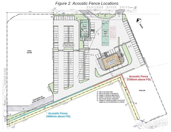
Conditions are recommended requiring implementation and
certification of the noise mitigation measures recommended in the report.
The height of the acoustic fence has been further increased
by the Applicant during the assessment process and is now proposed to be 3.3m
high above FGL for the section noted as 2.4m high in Figure 2 above.
Bushfire
The site is identified as being bushfire prone.
The Applicant has submitted a bushfire report prepared by a
BPAD Certified Consultant. The assessment concludes that the proposed
development will comply with the aims and objectives of Planning for Bush Fire
Protection subject to the following recommendations:
· The proposed building works shall comply with the NCC
(National Construction Code).
· The entire site shall be managed as an inner protection
area (IPA) as outlined in Appendix 4 of Planning for Bush Fire Protection 2019.
· An Emergency Management Plan shall be prepared in
accordance with AS3745-2010 with specific consideration for bushfire.
Conditions are recommended confirming these requirements.
Safety, Security and Crime Prevention
The service station component is proposed to be open 24
hours and will provide casual surveillance of the site. The building
surrounds and car parking areas are proposed to be illuminated, which will also
assist with casual surveillance and remove concealment opportunities. There is no access control to the overall site and parking
area, but appropriate access control will be provided to buildings,
particularly during late night trading at the service station. The site layout
and proposed landscaping will define the public and private areas of the site.
Social Impacts in the Locality
The application includes a Social Impact Assessment
Prepared by BB Professional Services. The assessment identifies potential
positive social impacts through the creation of employment (40-50 jobs during
construction and up to 30 ongoing jobs). The new car park will have a positive
social impact by filling a shortage of off-street parking in the locality for
existing businesses. If the displaced manufactured homes were able to be
relocated to serve as some form of affordable housing at another location, this
would also be a positive social impact.
There is also potential for some negative social impacts
on:
· evicted home-owners in the Melaleuca Caravan Park
· evicted renters in the Melaleuca Caravan Park
· neighbouring residents in the Melaleuca Lifestyle Village
· and to a small extent, on the availability of affordable
housing in Port Macquarie.
To mitigate the likely negative impacts of the proposed
development, the Social Impact Assessment makes the following recommendations:
· That residents of Melaleuca Caravan Park be kept informed;
· That renters be given longer than usual notice before
eviction and financial assistance towards relocation costs in two cases where tenants
will be most negatively impacted;
· If acceptable sites for relocation of owner-occupied homes
can be found at another park in Port Macquarie or another location acceptable
to the owners, that relocation expenses be paid, including any fee for securing
the new site;
· If no acceptable relocation sites can be found, that
home-owners be paid an agreed amount for their homes, so they can use the money
received to purchase a new home in another residential park in Port Macquarie
when one becomes available;
· That residents of Melaleuca Lifestyle Village be kept
informed;
· That Council conducts the intended 6 months’
inspection to ensure that Aldi complies with the noise reduction measures
specified as conditions of consent to extended operating hours given in January
2020;
· That the sound-proofing treatment of the perimeter fence
behind Aldi, required by Council but not complied with at the time of writing,
be extended along the perimeter fence behind the proposed development (car park
and fast food restaurant);
· That the tall shrub planting at the Hughes Place end of the
perimeter fence also be extended along the entire perimeter fence to reduce
fumes;
· That the current storm water run-off problem be rectified
with improved drainage;
· That a dilapidation assessment be conducted on houses in
the Melaleuca Residential Park for those residents who wish to participate;
· That the developer explores, with Council, the NSW
Department of Family and Community Services and community housing providers in
Port Macquarie, ways in which the displaced rental homes could be repurposed as
social housing elsewhere.
The Applicant has noted in the Statement of Environmental
Effects that they intend to implement the recommendations of the Social Impact
Assessment. It is recommended that the Social Impact Assessment be included in
the approved documents for the development to ensure that the commitments are
incorporated into any consent.
The recommendations regarding management of
eviction/relocation of existing residents and renters, as well as informing
existing residents of progress, are a matter for the property owners and it is
not considered that they can be linked to the building certification process.
It is noted that the same impacts could occur if the caravan park were to close
outside the development application process. A condition has been recommended
requiring all existing site agreements to be resolved prior to demolition of
construction work commencing.
The other recommendations that relate specifically to the
proposed development on the land have been addressed through the assessment and
recommended conditions.
Economic Impact in the Locality
The proposal is not considered to have any significant
adverse economic impacts on the locality. A likely positive impact is that the
development will create employment in the construction industry (40-50 jobs
during construction), which will lead to flow impacts such as expenditure in
the area. The operational development is also expected to create ongoing
employment opportunities for up to 30 people.
Underground Petroleum Storage System (UPSS)
The UPSS must comply with the various NSW requirements
including the Protection of the Environment Operations Act, the UPSS
Regulation, EPA requirements and relevant Australian Standards. Conditions have
been recommended to ensure that the system complies with these
requirements.
Site Design and Internal Design
The proposed development design satisfactorily responds to
the site attributes and will fit into the locality.
Construction
Construction impacts are considered capable of being
managed, standard construction and site management conditions have been
recommended.
Cumulative Impacts
The proposed development is not considered to have any
significant adverse cumulative impacts on the natural or built environment or
the social and economic attributes of the locality.
(c) The
suitability of the site for the development
The proposal will fit into the
locality and the site attributes are conducive to the proposed development.
Site constraints of flooding,
bushfire, and acid sulfate soils have been adequately addressed and appropriate
conditions of consent recommended.
(d) Any
submissions made in accordance with this Act or the Regulations
Eight (8) written submissions were received following public
exhibition of the application. Copies of the written submissions have been
provided separately to members of the DAP.
Key
issues raised in the submissions received and comments are provided as follows:
|
Submission Issue/Summary
|
Planning Comment/Response
|
|
Is another service station needed when there are already
8 service stations within approximately 5km, 4 of which operate 24 hours?
|
Supply and demand for a particular land use is not a
matter for consideration by the consent authority.
|
|
Viability of the proposal and potential impacts on
existing service stations in Port Macquarie. If other service stations are
forced to close it will result in abandoned properties with underground fuel
storage, resulting in potential pollution issues.
|
Viability and competition impacts are not matters for
consideration by the consent authority.
The Protection of the Environment Operations (Underground
Petroleum Storage Systems) Regulation 2019 contains provisions for the
ongoing monitoring and remediation of properties containing underground fuel
storage systems. These provisions would apply to service stations that are no
longer operational. It is not expected that any closure of existing service
stations would result in pollution issues.
|
|
Air quality impacts on adjoining caravan park, including
vapours from fuel bowsers and filling point, vehicle emissions, and odour
from fast food outlets.
|
The fuel system and service station has capability for
vapour recovery (ie VR1 & VR2). Vapour recovery is not required by the
EPA in regional NSW and is not mandatory in the Port Macquarie-Hastings LGA.
However, VR1 has been recommended to be installed in the fuel system in the
proposed conditions.
Potential exists for cooking odours to be generated from
the takeaway food and drink premises and a condition has been recommended
regarding the management offensive odours.
Vehicle emissions are managed through manufacturing
standards and are not a matter for consideration in individual development
proposals.
|
|
Noise impacts on adjoining caravan park from vehicles,
deliveries, waste collection, operation of fuel pumping equipment, air
compressor, refrigeration and air conditioning plant, conversations at the
drive through facility.
|
A Noise Impact Assessment has been submitted and the
likely noise impacts and mitigation measures are discussed earlier in this
report.
|
|
Increase in traffic noise impacts on Melaleuca Lifestyle
Village from Hastings River Drive due to the removal of existing caravan park
buildings, which currently provide some noise protection.
|
A part 3.3m and part 2.7m acoustic fence is proposed to
be constructed along the northern edge of the caravan park. The fence is
expected to provide better traffic noise reduction from Hastings River Drive
than the existing buildings as it is of a similar height and does not have
any gaps.
|
|
Proximity of the proposed service station to residential
uses may result in health impacts, particularly on the elderly vulnerable
residents of the Melaleuca Lifestyle Village and children attending the
nearby Heritage Christian School. Some international studies have recommended
a minimum separation distance of 50m, 100m, or 150m. The proposal shows the
nearest fuel bowser being approximately 47.5m from the closest residence.
There are also international studies showing links between proximity to
petrol stations and childhood leukaemia or cancer.
|
There have been no public health standards adopted in NSW
for the separation between residential uses and service stations. Safe
separation distances have been considered in terms of potential hazards
associated with fuel storage in accordance with the requirements of SEPP 33 -
Hazardous and Offensive Development.
|
|
If the development is approved the recommendations in the
Social Impact Assessment need to be implemented.
|
The recommend conditions of consent are consistent with
the SIA recommendations.
|
|
The survey accompanying the Social Impact Assessment did
not include any detail of the actual proposal, which limited the ability of
nearby residents to make informed comments.
|
Noted.
|
|
The developer has made no attempt to consult with
residents of the Melaleuca Lifestyle Village prior to, or since the lodgement
of the application. This is contrary to the recommendations of the Social
Impact Assessment to keep residents informed.
|
Noted.
|
|
Impacts of construction activities. It is recommended
that the developer have a liaison person responsible for informing residents
of the Melaleuca Lifestyle Village of key events, including:
· Notice of commencement of work on the site;
· Any work which would cause severe ground vibration;
· Internal road blockages;
· Pile driving equipment;
· Heavy excavation work;
· Excessive noise related events;
· Excessive dust and debris events.
|
A condition has been recommended requiring this to be
implemented as part of the construction site management.
|
|
Manufactured homes in the adjoining caravan park are
highly susceptible to vibration impacts. The construction activities should
adopt best management practice. A dilapidation report for existing homes
should be carried out in accordance with the recommendations of the Social
Impact Assessment.
|
Conditions have been recommended requiring the developer
to prepare a dilapidation report prior to commencing works and following
completion of the development.
|
|
Inaccuracies in previous background noise logging for
developments at the adjoining Aldi site.
|
Noted. The submission also notes that the location of the
noise logger for the current proposal is considered to be more appropriate.
|
|
Noise recommendations must not require residents to close
windows and doors to achieve required noise levels.
|
The mitigation measures proposed in the Noise Impact
Assessment do not require residents to close windows and doors to achieve
required internal noise levels.
|
|
Removal of the existing caravan park buildings and
replacement with a 2400mm high acoustic fence will expose residents to increased
noise levels from the Aldi loading dock.
|
The proposal has been amended to provide a 3.3m high
acoustic fence extending from the existing fence at the Aldi loading dock.
Advice from the acoustic consultant has been submitted, confirming that the proposal
would not result in an increase in noise from this source.
|
|
Question the effectiveness of the proposed additional
300mm fence height adjacent to the takeaway premises.
|
The acoustic consultant has modelled the expected noise
impacts in accordance with EPA guidelines and has recommended that the fence
height is appropriate to achieve the required noise reduction.
|
|
The proposal will replace an existing 3300mm acoustic
fence adjacent to the Aldi loading dock with a 2400mm high acoustic fence
along the road edge. This will reduce the level of noise protection from the
Aldi loading dock.
|
The proposal has been amended during the assessment
process to increase the fence height in this location to 3.3m.
|
|
The full length of the perimeter fence should be provided
with an additional acoustic treatment, similar to Council’s
requirements for the Aldi section of the fence under DA2019 - 673.1, as
recommended in the Social Impact Assessment.
|
The noise impact assessment has not determined that this
level of acoustic treatment to the full length of the fence is necessary to
achieve satisfactory noise levels in the adjoining caravan park. The
conditions of DA2019 - 673.1 only require this treatment for the
south-western boundary of the Aldi site prior to any deliveries occurring
between 10pm and midnight.
It is understood that the Aldi site is yet to act on
DA2019 - 673.1 and deliveries to the site are being carried out in accordance
with the Environmental Planning and Assessment (COVID-19 Development –
Construction Work Days) Order 2020.
|
|
The perimeter fence should be increased in height to a
minimum of 3.3m above finished ground level for its full length and have an
acoustic treatment/lining to a minimum of Rw28.
|
The fence height has been increased in height to 3.3m for
part of its length. The noise impact assessment has not determined that it is
necessary to provide the additional acoustic treatment/lining to achieve
appropriate noise levels in the adjoining caravan park.
|
|
The hours of operation for the service station should be
reduced to 5am to midnight, 7 days a week. This is consistent with the
developer’s other service station approved under DA2019 - 285.1 at the
corner of Ocean Drive and Ackroyd Street.
|
The noise impact assessment has demonstrated that the
proposed service station is capable of operating 24 hours without adverse
noise impacts on adjoining residents.
|
|
Request that the hours of operation for the take away
food and drink premises be reduced to:
- 7am
to 10pm Sunday to Thursday, and
- 7am
to 11pm Friday and Saturday.
|
The Applicant has amended the proposal to reduce the
hours of operation for the food and drink premises to:
- 7am to 10pm
Sunday to Thursday, and
- 7am to
midnight Friday and Saturday.
|
|
Request that deliveries be restricted to between 7am and
midnight, consistent with the adjoining Aldi store.
|
The noise impact assessment recommends that deliveries be
restricted to between 5am and midnight.
|
|
The proposed illuminated signage on the southern elevation
of the take away building will project above the proposed perimeter fence and
cause lighting and visual impacts on the adjoining caravan park residents.
|
The proposal has been amended to remove illuminated
signage from the southern elevation of the food and drink premises.
|
|
Request that the air pump beeper be silenced or turned
off after 8pm each night.
|
A condition has been recommended the air pump beeper to
be silenced after 8pm each night.
|
|
Request that illuminated signs be fitted with a time
switch to dim by 50% or turn off by 9pm each night.
|
The DCP requires illuminated signage to dim by 50% or
switch off after 11pm and a condition has been recommended accordingly.
A condition has also been recommended requiring the
illuminated signage for the takeaway food and drink premises to be switched
off outside the approved hours of operation. This would require the signage
illumination to be switched off from 10pm Sunday to Thursday.
|
|
Request that the developer provide a follow up noise
assessment after all buildings and the fence are completed.
|
A condition has been recommended requiring the noise
mitigation measures recommended in the noise impact assessment to be
completed and certified prior to the issue of an Occupation Certificate.
|
|
The submitted plans incorrectly label some of the
building elevations.
|
Amended plans have been submitted with the correct
orientation labelled on the elevations.
|
|
Request for ongoing monitoring of noise and air quality
impacts.
|
Ongoing monitoring of noise and air quality impacts is
typically only required for development subject to an Environment Protection
Licence (EPL) issued by the EPA. The proposed development does not require an
EPL and ongoing monitoring is not considered necessary.
If any operational noise impacts occur, Council’s
regulatory staff could address the issue in accordance with the Protection of
the Environment Operations Act 1997.
|
|
Concerns regarding negotiations with the developer over
relocation/compensation for existing impacted residents.
|
The Residential (Land Lease) Communities Act 2013
provides the relevant process for termination of site agreements and this is
not a matter for consideration by the consent authority in the assessment of
the development application.
A condition is recommended requiring any existing site
agreements to be terminated prior to works commencing.
|
|
Any increase in traffic on Mumford Street will reduce
safety for children at Heritage Christian School.
|
The application does not propose any access from Mumford
Street for the service station and food and drink premises. The existing
Mumford Street access to the Melaleuca Lifestyle Village will be retained,
but would not result in any increase in traffic generation.
|
|
Due to congestion on Hughes Place delivery vehicles are
likely to use Mumford Street for access.
|
All delivery vehicles are to access the site from
Hastings River Drive and a condition has been recommended confirming this
requirement.
|
|
The traffic assessment has not considered impacts on
Mumford Street or its intersection with Hastings River Drive, which is
already unsafe.
|
The application does not propose any access from Mumford
Street for the service station and take away food and drink premises and
therefore will not affect the volume of traffic turning onto Hastings River
Drive at the Mumford Street intersection.
|
|
The end of Mumford Street is used by school buses to turn
around. Any additional access points in this location will have safety and
congestion impacts.
|
No additional access points are proposed in this
location.
|
|
The proposal will increase pedestrian traffic past the
Heritage Christian School.
|
The application does not propose any pedestrian access to
Mumford Street.
|
|
The take away food and drink premises will encourage
students leaving the Heritage Christian School to cross the road in unsafe
locations.
|
There is no pedestrian access to the food and drink
premises proposed from Mumford Street.
|
|
Having a licenced premises so close to a school is of
concern and will result in intoxicated patrons walking through the school
grounds.
|
The application does not indicate that either the service
station or food and drink premises would be licenced.
|
|
Construction noise impacts on school.
|
Standard conditions have been recommended in relation to
construction hours and noise.
|
|
Concerns that fuel storage could contaminate surface
water during extreme flooding.
|
The service station canopy area has been designed to be
above 1:100 flood level (including climate change allowance). Modern fuel
storage systems are designed to be water tight, and compliance with current
Australian Standards will ensure that surface water is not able to enter the
fuel storage system during flood events more extreme than the 1:100 event.
|
|
The submitted plans don’t clearly indicate how/if
the development will connect to Mumford Street.
|
Clarification has been provided, confirming that there
will be no connection to Mumford Street for this development.
|
|
Request that no vehicle or pedestrian access to Mumford
Street be permitted during construction or operation of the development.
|
No access to Mumford Street is proposed for this
development.
A condition has been recommended confirming that access
is not permitted in this location.
|
|
Allegations that Council has historically failed to
enforce the requirements for the caravan park.
|
Noted, but not relevant to the assessment of the current
application.
|
|
The proposed fencing to the eastern side of the caravan
park should extend to the Mumford Street frontage, and the fence at the rear
of the take away food and drink premises should extend to the eastern
property boundary.
|
The fencing proposed in the application is to the extent
necessary to provide noise mitigation for the proposed uses. The vacant
portion of the site adjacent to Mumford Street could potentially be further
developed in the future and appropriate fencing could be considered as part
of any such proposal.
|
|
The parking area contains more spaces than will be
required for the customers of the service station and take away food and
drink premises. It is likely that these spaces will be used by customers of
the adjoining Aldi store.
|
As noted in the parking assessment earlier in this
report, the proposal provides 119 parking spaces more than the minimum
required under the DCP. Even if the parking is considered to be an
independent land use (rather than being ancillary to the service station or
food and drink premises), car parks are permitted with consent in the B5
zone.
The design of the car park appears to provide for
physical access to the adjoining Aldi site, but it would be possible for the
property owner/s to deny access for Aldi customers if they did not wish to
allow shared use. The proposal does not include any rights of carriageway or
parking easements in favour of the Aldi site.
|
|
Request for copies of studies relating to noise, air
quality impacts, and impacts on koalas.
|
The relevant studies submitted with the application were
made publicly available on Council’s online Application Tracker.
|
|
There are links between the proximity of fast food restaurants
to schools and adolescent obesity.
|
There have been no public health standards adopted in NSW
for the separation distance between take away food and drink premises and
schools.
|
|
Access to Hughes Place via the Aldi site does not appear
practical due to the narrow width of the access road adjacent to the loading
dock, one way direction of travel (entry only), and use of the area by
service vehicles.
|
It is agreed that access to Hughes Place on the southern
side of the Aldi building would not be possible with the current access
arrangements. However, it is possible that vehicles could exit the
development site and circulate via the northern side of the building to
Hughes Place. As noted in the traffic impact assessment, this is not expected
to be a common trip as it provides less convenient access to Hastings River
Drive. It is only anticipated that the Hughes Place exit would be used by
customers shopping at Aldi after visiting the service station or food and
drink premises.
|
|
The retained section of fence shown on the DA plans is
not in the same location as the fence exists on site. The existing fence is
located on the boundary of the Aldi lot and setback from the caravan park
road approximately 1.8m. The fence shown on the DA plans is located on the northern
edge of the caravan park road.
|
The plans have been amended to show the correct location
of the retained section of fence adjacent to Aldi.
|
|
The lack of fence for the full length of the western
boundary of the caravan park will result in a complete loss of privacy and
security. Vehicles will also be able to access the vacant lot from the rear
of the take away building.
|
The noise modelling indicated that acoustic fencing is
only required for part of the western boundary with the caravan park to
achieve satisfactory noise levels. An appropriate fencing treatment for the
remainder of the western edge would need to be negotiated between the
property owners. It is not considered that there is sufficient nexus to
require the developer to construct the fence given that there are no
development impacts created on the vacant part of the site.
Pedestrians are able to access to caravan park via the
access to Mumford Street and the proposal would not create any additional
security risks that do not already exist.
To prevent vehicles accessing the vacant part of the
site, a condition has been recommended requiring a temporary barrier to be
installed between the eastern end of the acoustic fence and the eastern
property boundary. The barrier is to be maintained until any future
development of the vacant part of the site. A barrier in this location would
also likely discourage pedestrian access between Mumford Street and the
proposed development.
|
|
Discrepancies between noise data in the submitted noise
impact assessment and a similar noise impact assessment prepared by the same
company for DA2019 - 285.1.
|
An amended noise impact assessment has been submitted,
which corrects these discrepancies. The result of the amended modelling found
that the overall noise level at the receiver increased by 0.3dB(A)
|
|
Request that waste collection hours be restricted to 7am
to 6pm, as strongly recommended in the noise impact assessment.
|
A condition has been recommended restricting waste
collection to these hours.
|
(e) The Public Interest
The proposed development
satisfies relevant planning controls and will not adversely impact on the wider
public interest.
Ecologically Sustainable Development and Precautionary
Principle
Ecologically sustainable development requires the effective integration
of economic and environmental considerations in decision-making processes.
The four principles of ecologically sustainable development
are:
· the
precautionary principle,
· intergenerational
equity,
· conservation
of biological diversity and ecological integrity,
· improved
valuation, pricing and incentive mechanisms.
The principles of ESD require that a balance needs to be
struck between the man-made development and the need to retain the natural vegetation.
Based on the assessment provided in the report and with recommended conditions
of consent, it is considered an appropriate balance has been struck.
Climate change
The proposal is not considered to be vulnerable to any risks
associated with climate change.
4. DEVELOPMENT
CONTRIBUTIONS APPLICABLE
· Development contributions will not be required towards
augmentation of town water supply and sewerage system head works under Section
64 of the Local Government Act 1993, as the site has sufficient credits from
the previous use as a caravan park.
· Development contributions will be required in accordance
with Section 7.11 of the Environmental Planning and Assessment Act 1979 towards
road works in Hastings River Drive.
·
· A copy of the contributions estimate is included as Attachment
3.
·
5. CONCLUSION AND
STATEMENT OF REASON
The application has been assessed in accordance with Section
4.15 of the Environmental Planning and Assessment Act 1979.
Issues raised during assessment and public exhibition of the
application have been considered in the assessment of the application. Where
relevant, conditions have been recommended to manage the impacts attributed to
these issues.
The site is considered suitable for the proposed development
and the proposal adequately addresses relevant planning controls. The
development is not considered to be contrary to the public's interest and will
not result a significant adverse social, environmental or economic impact. It
is recommended that the application be approved, subject to the recommended
conditions of consent provided in the attachment section of this report.
|
Attachments
1⇩. DA2020 - 606.1
Recommended DA Conditions DA2020 - 606.1
Recommended DA Conditions
2⇩. DA2020 - 606.1 Plans
3⇩. DA2020 - 606.1
Contributions Estimate DA2020 - 606.1
Contributions Estimate
|
|
ATTACHMENT
|
Development Assessment Panel
21/01/2021
|
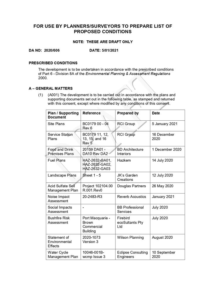
|
ATTACHMENT
|
Development Assessment Panel
21/01/2021
|
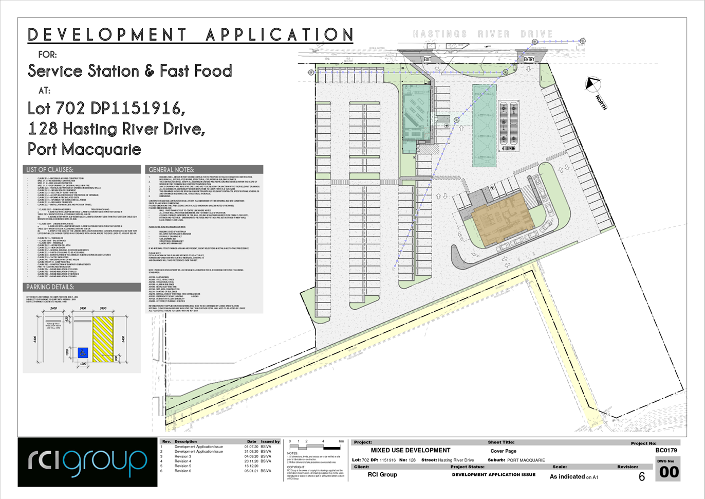
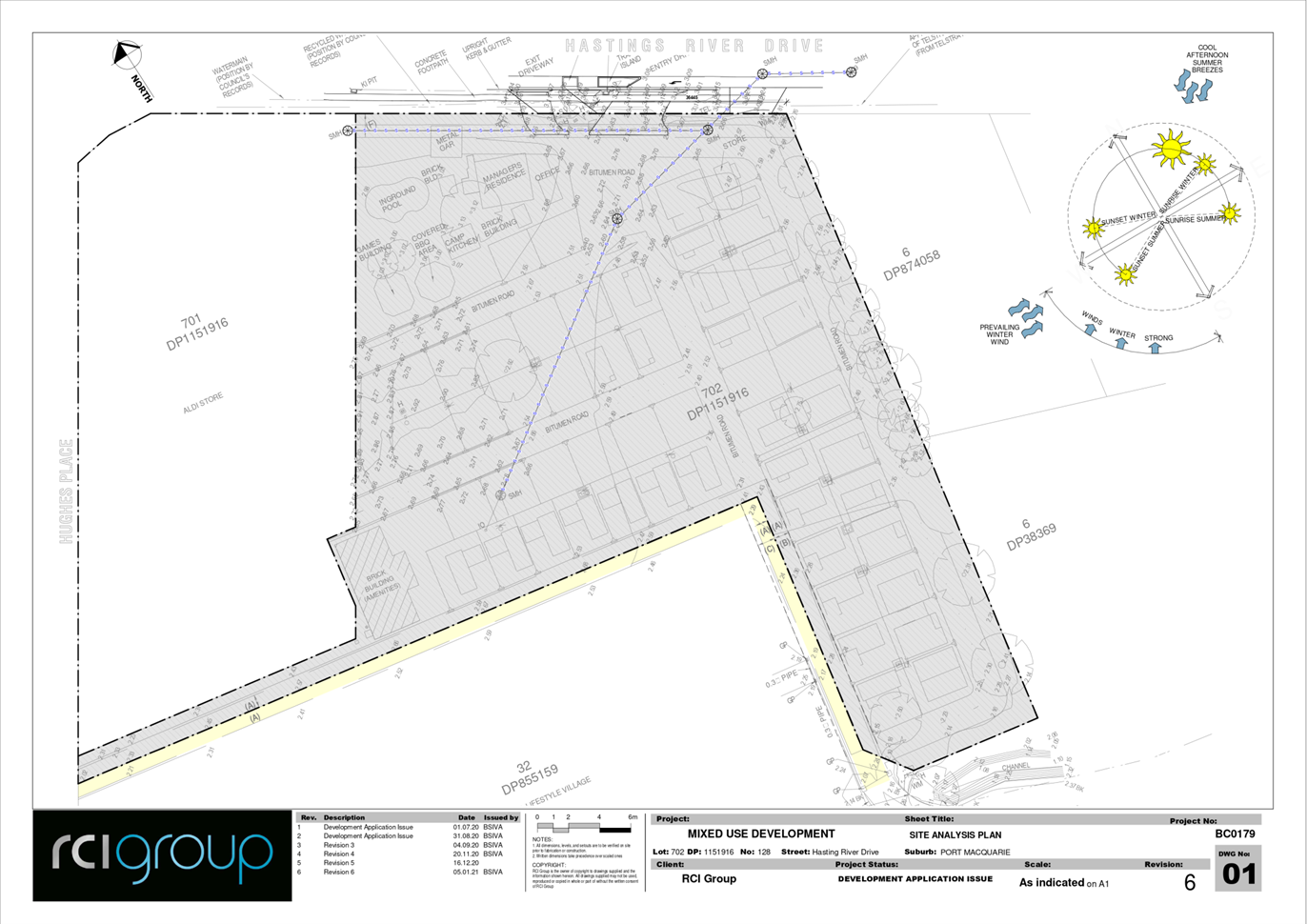
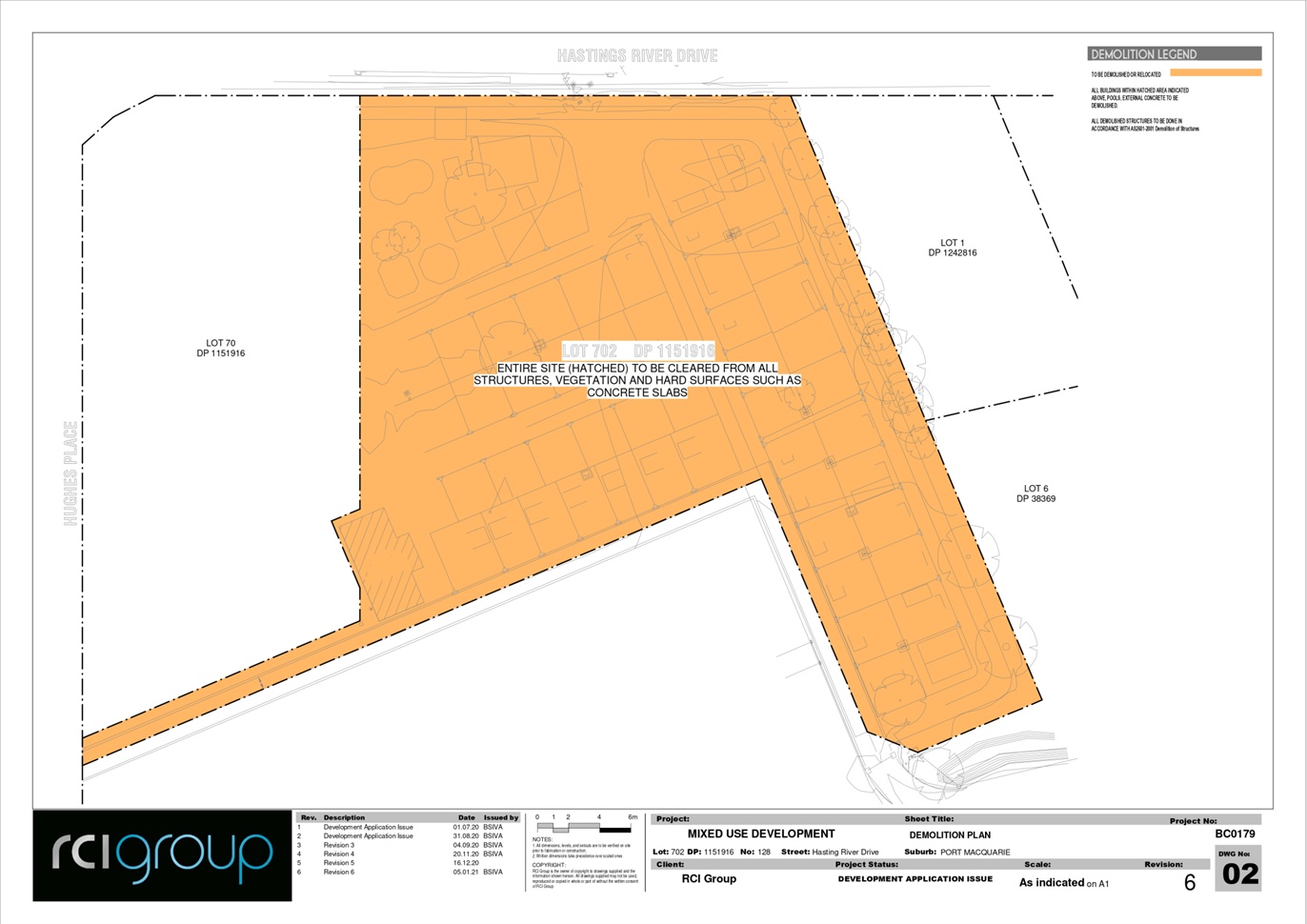
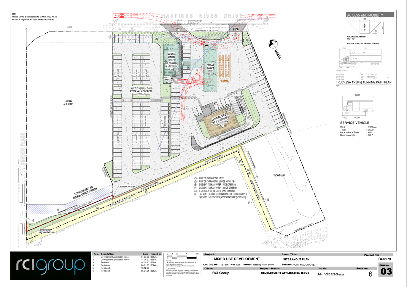
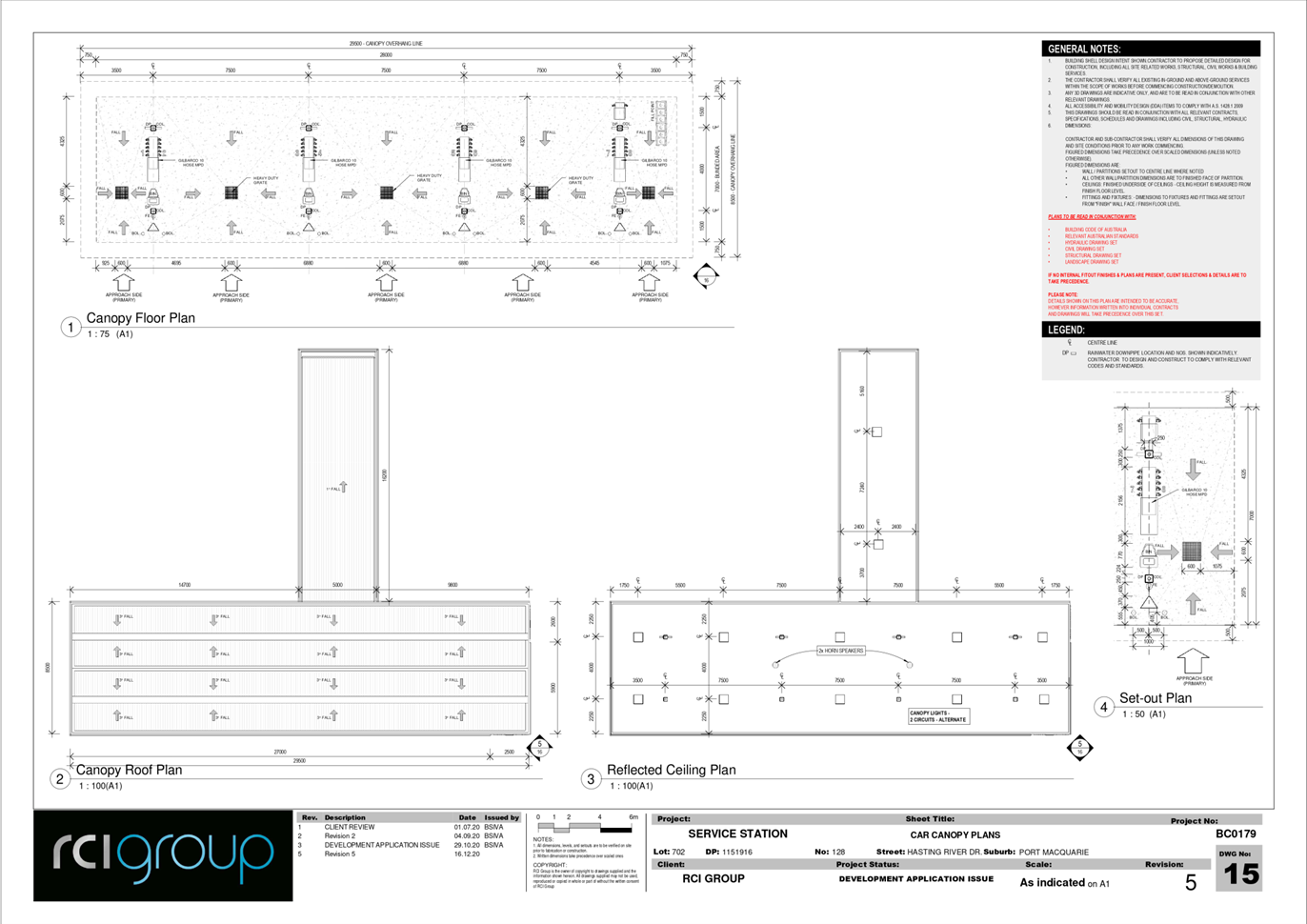
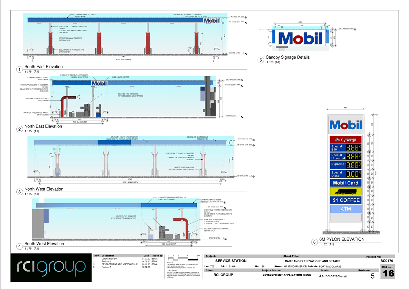
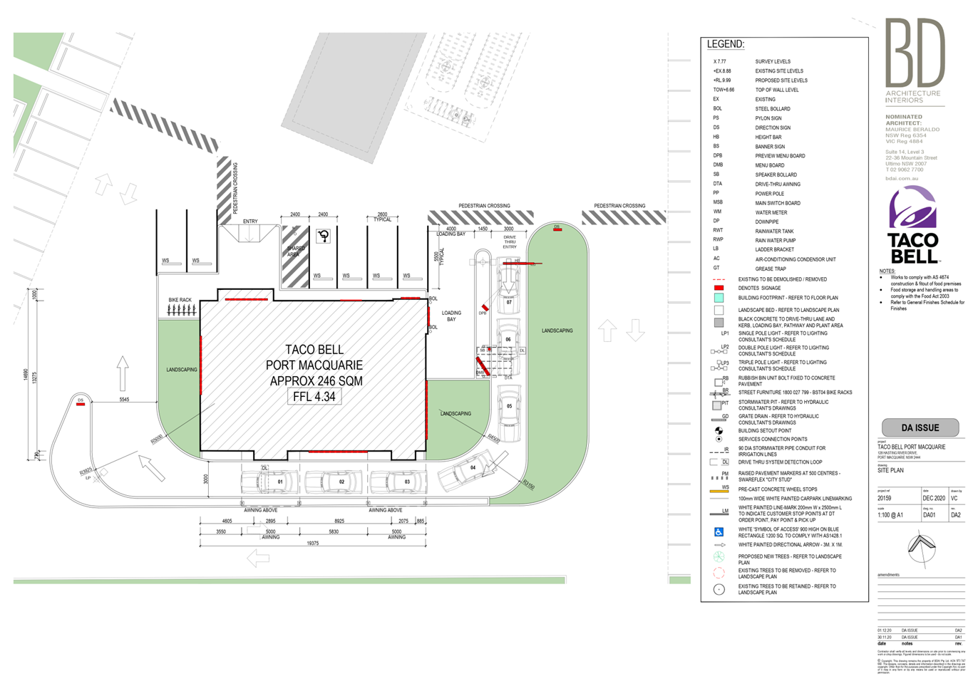
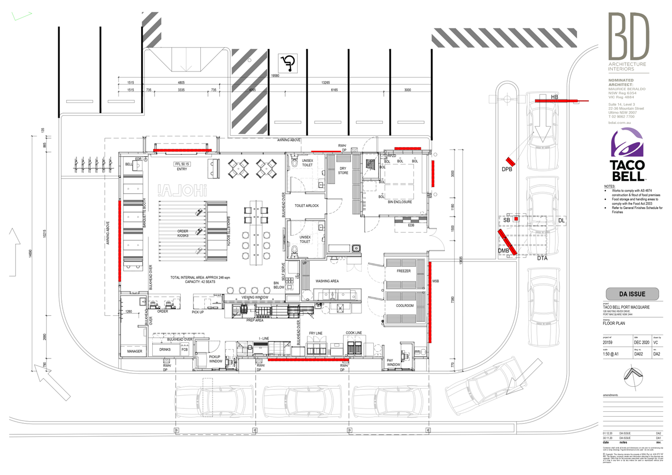
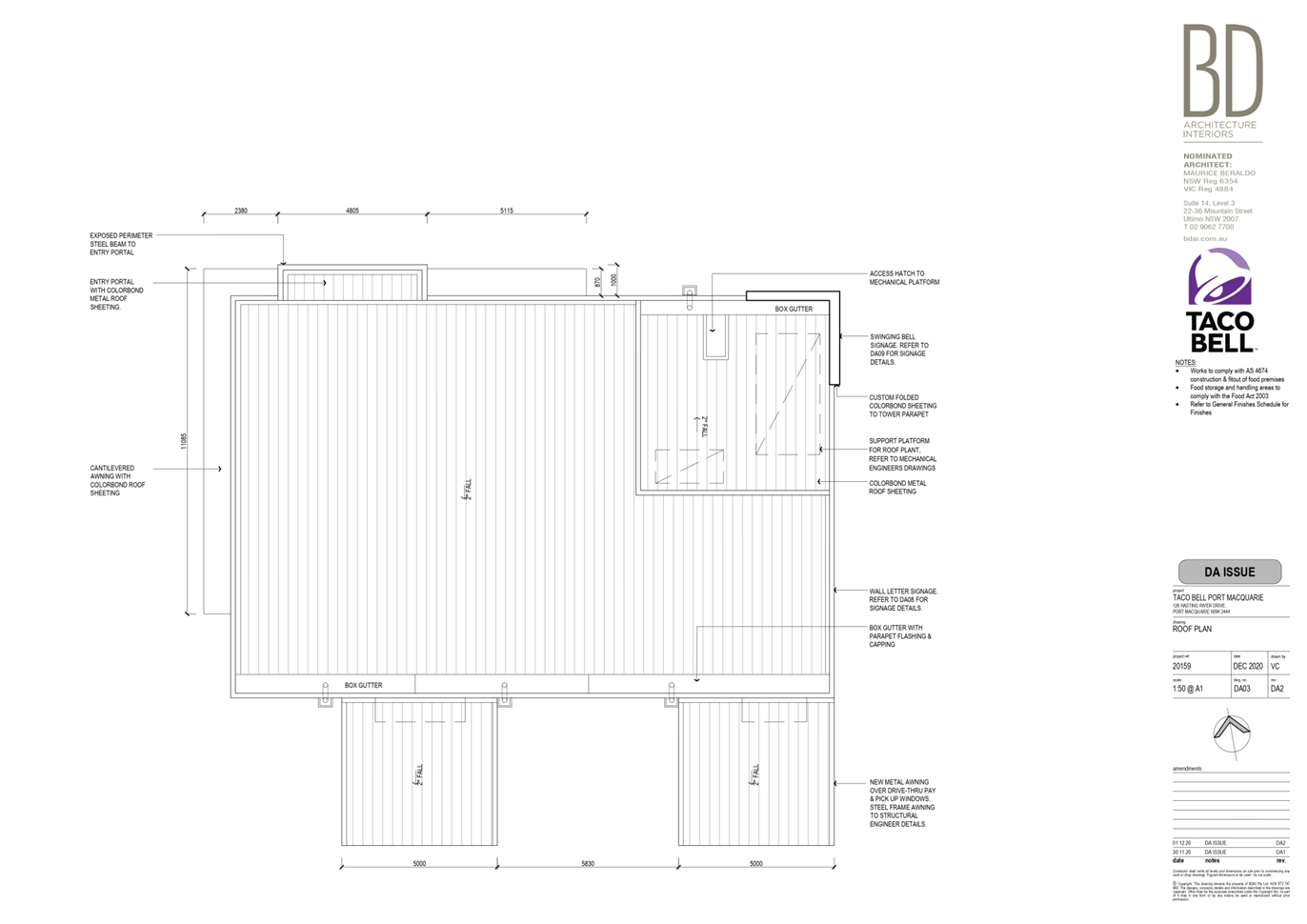
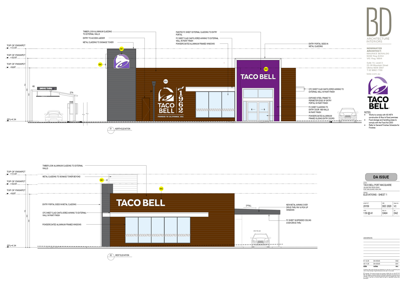
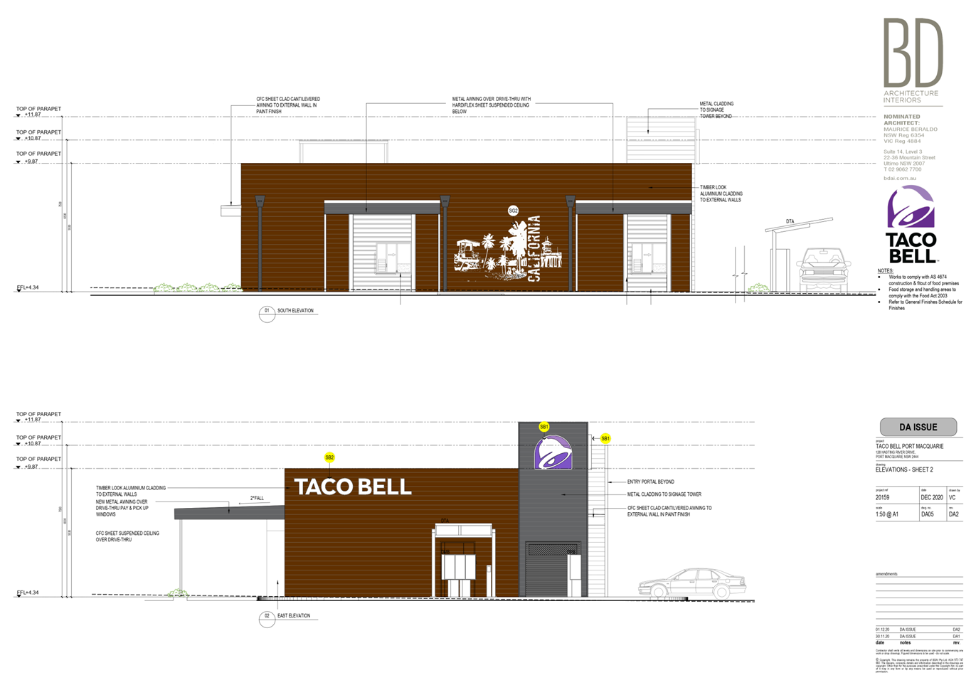
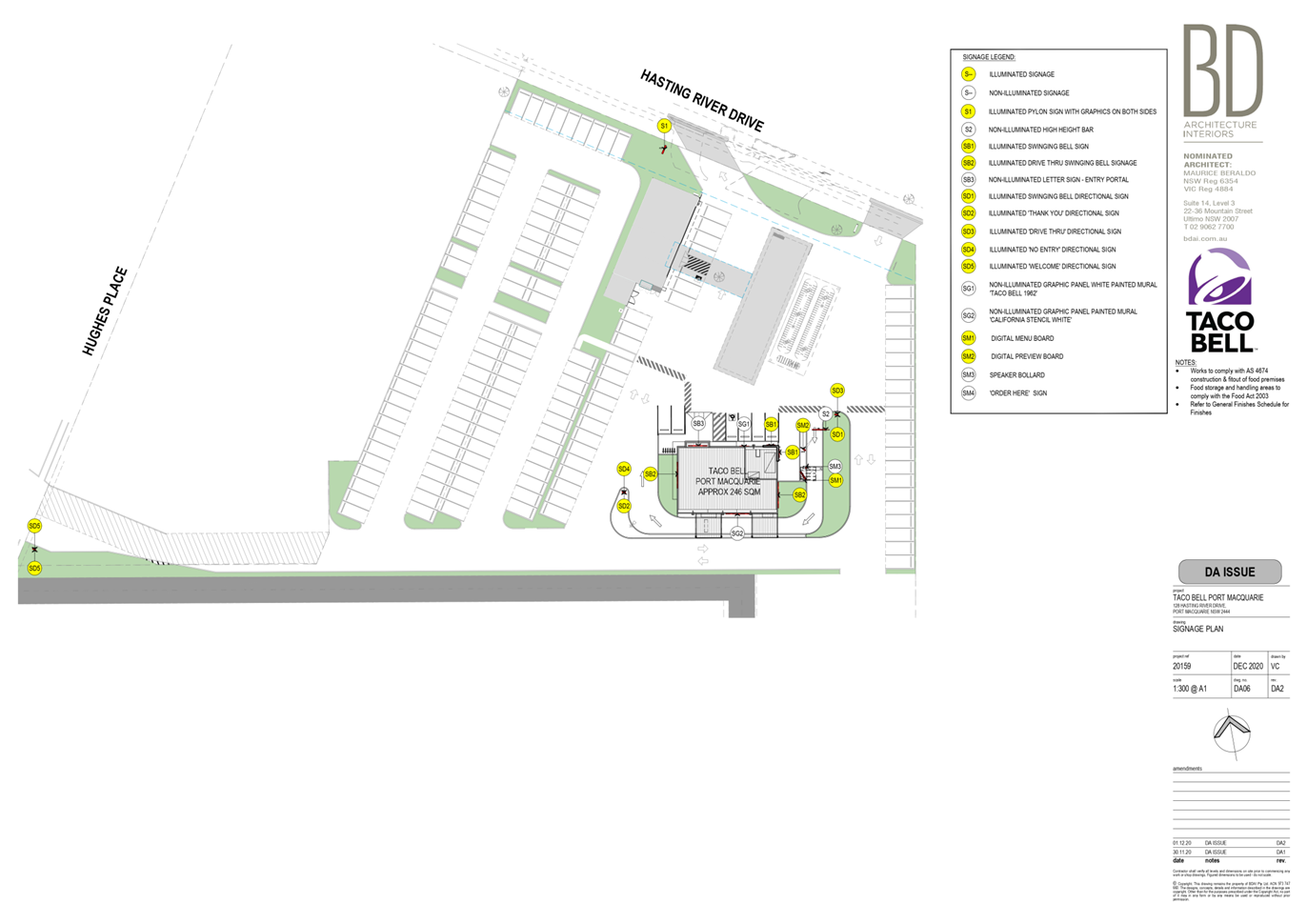
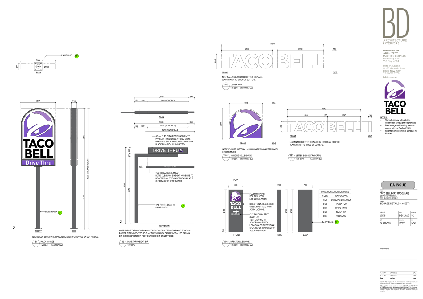
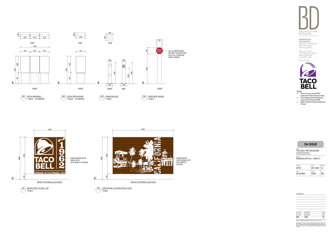
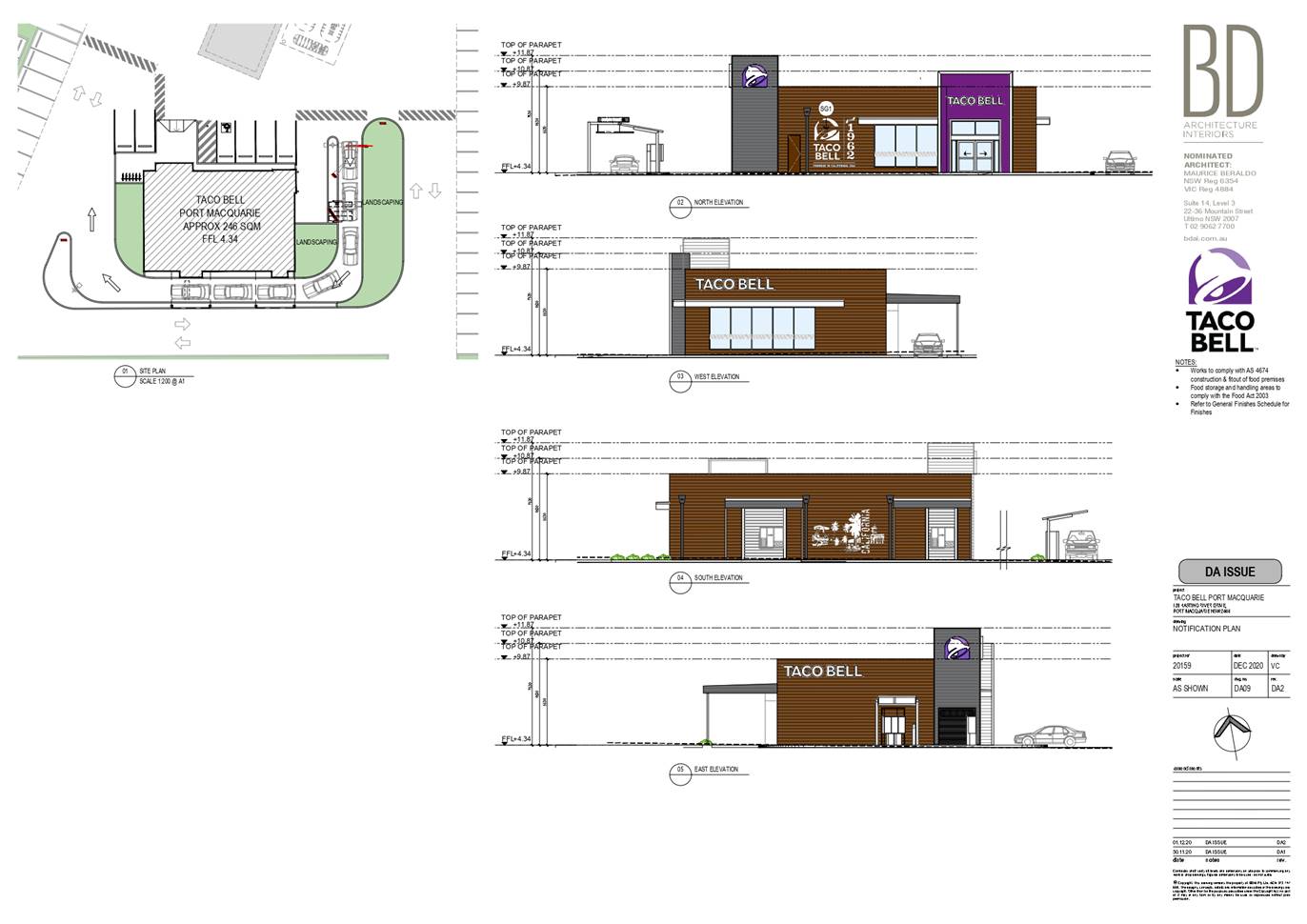
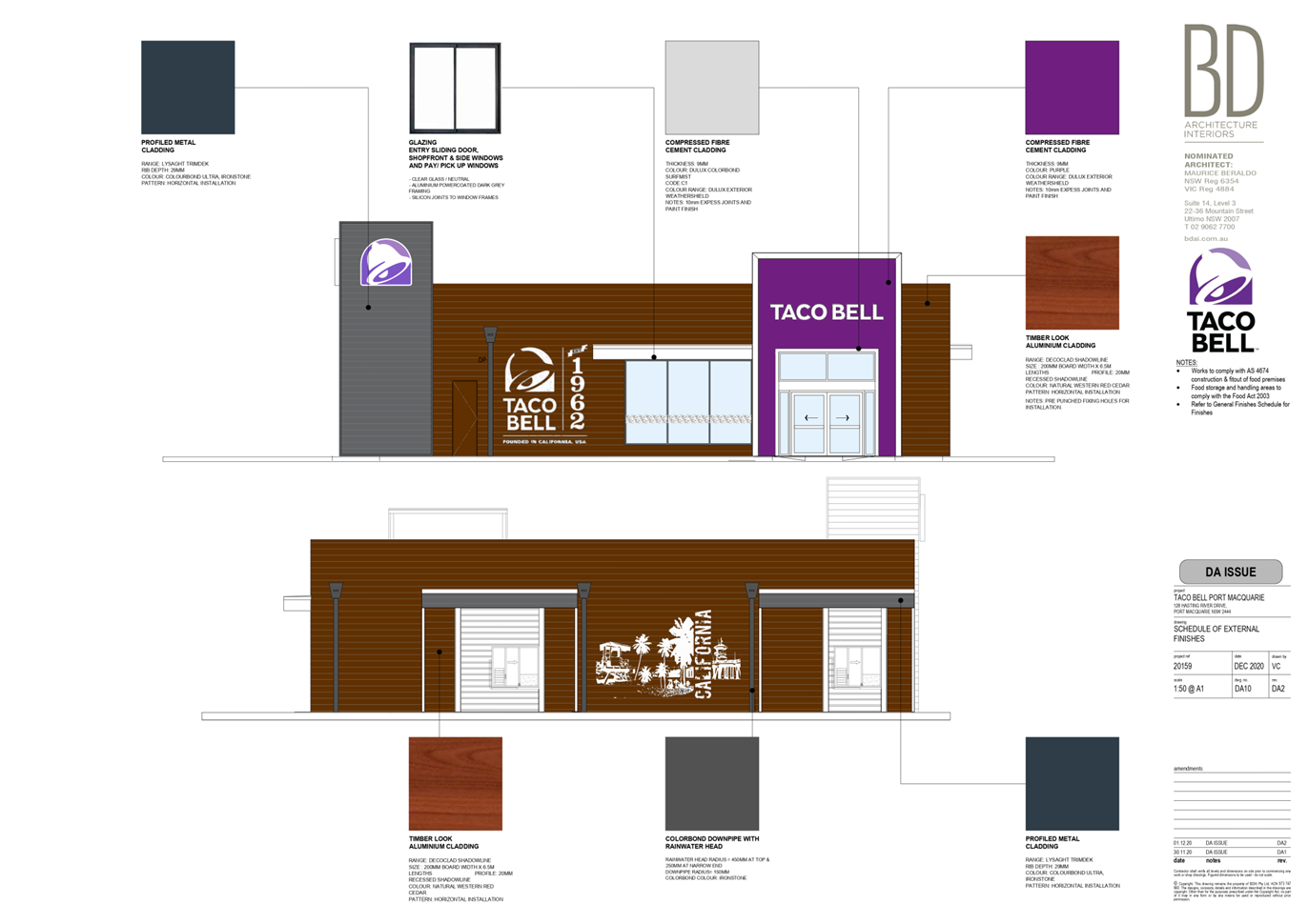
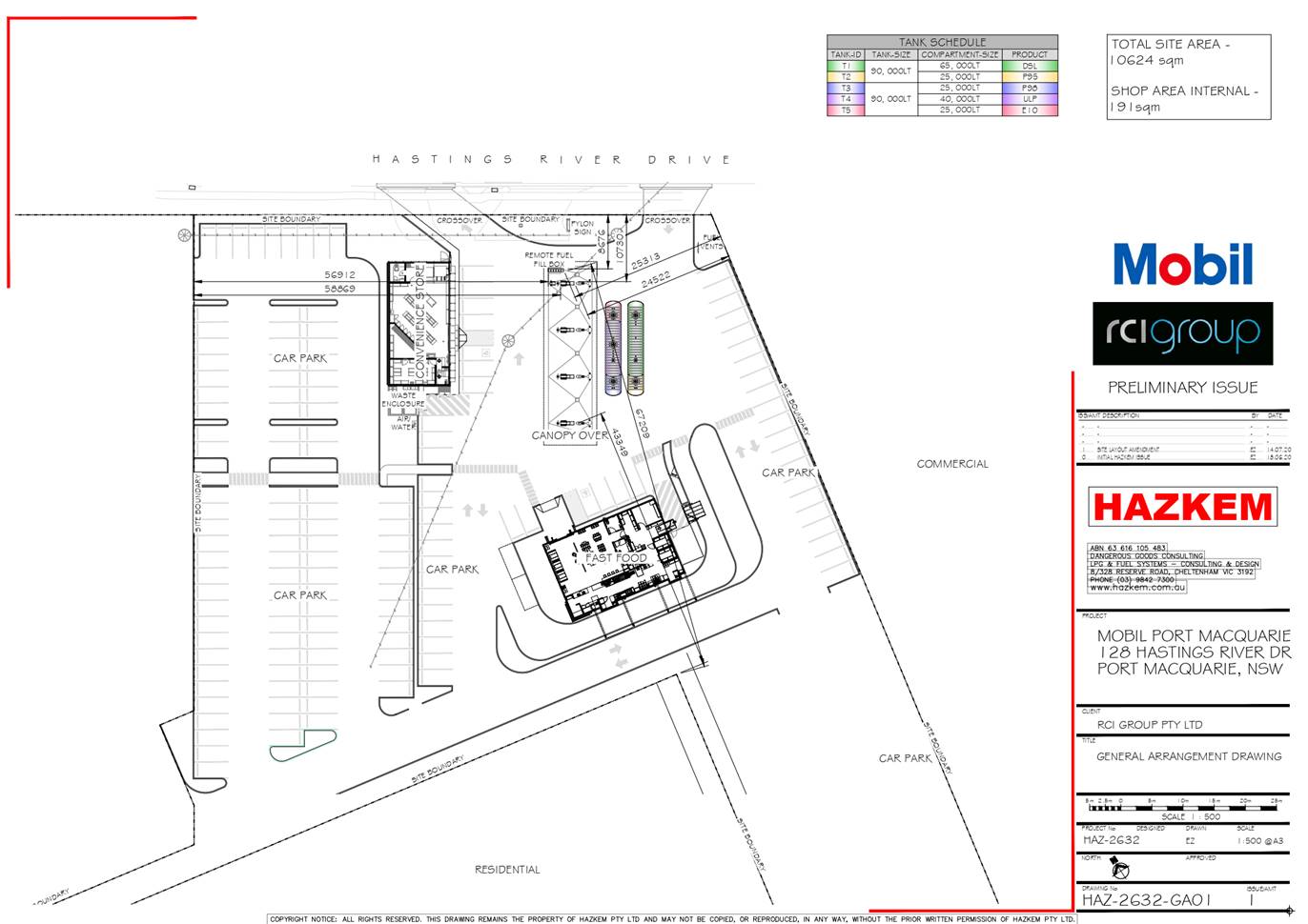
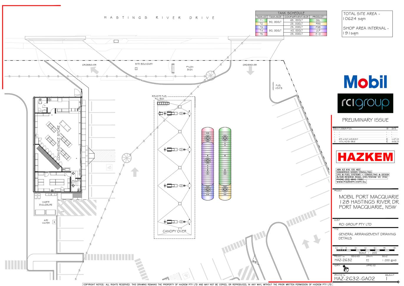
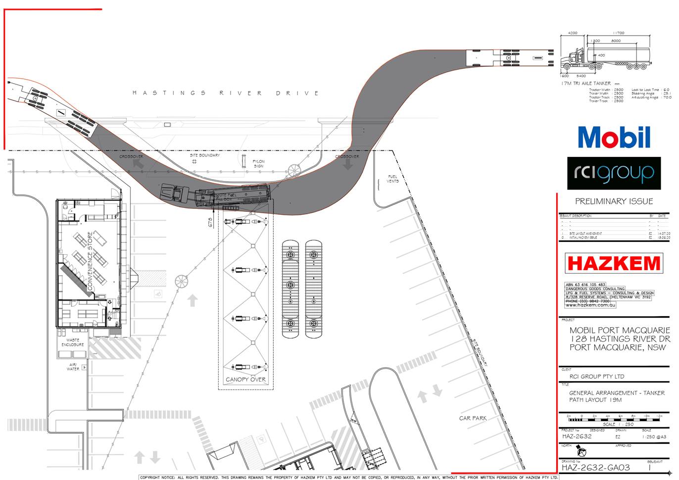
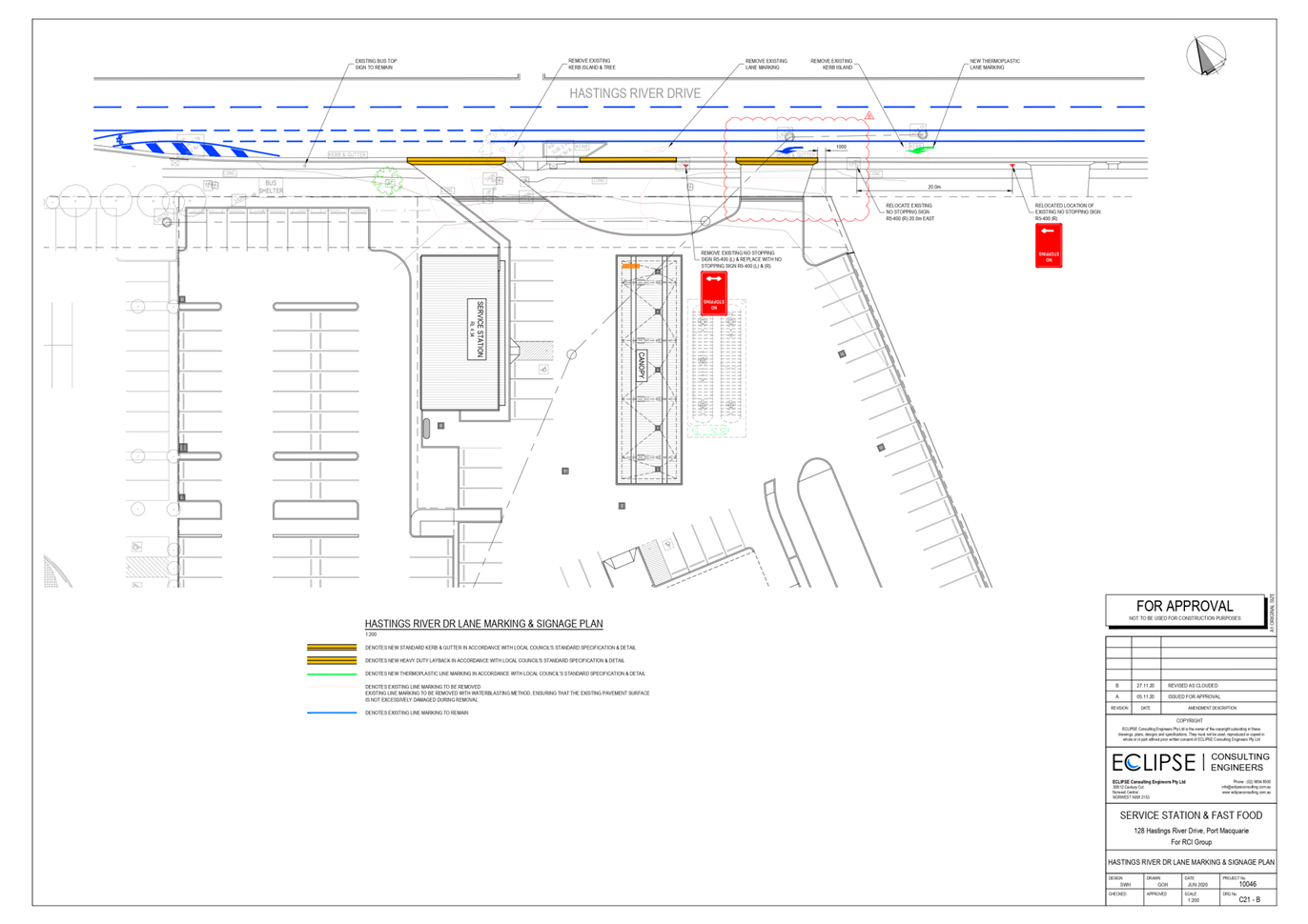
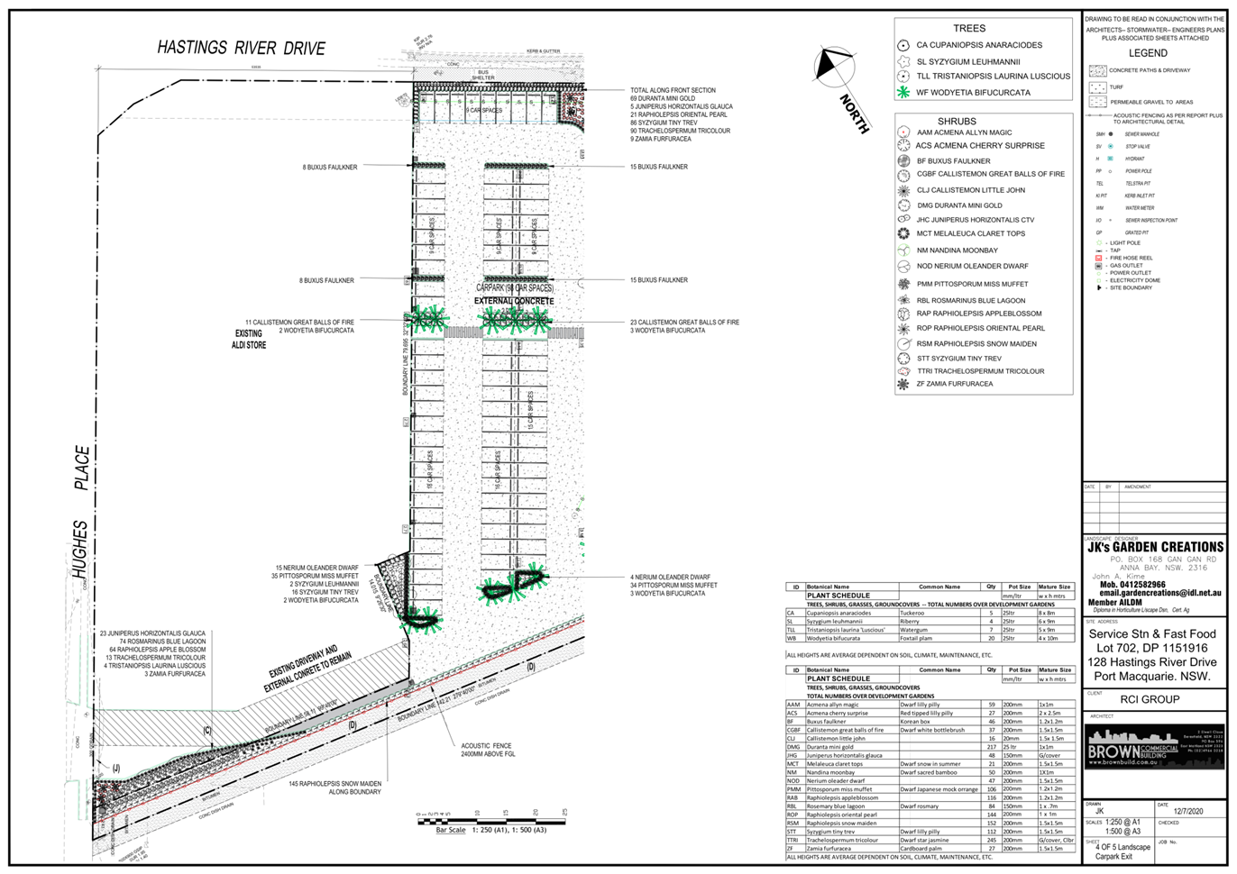
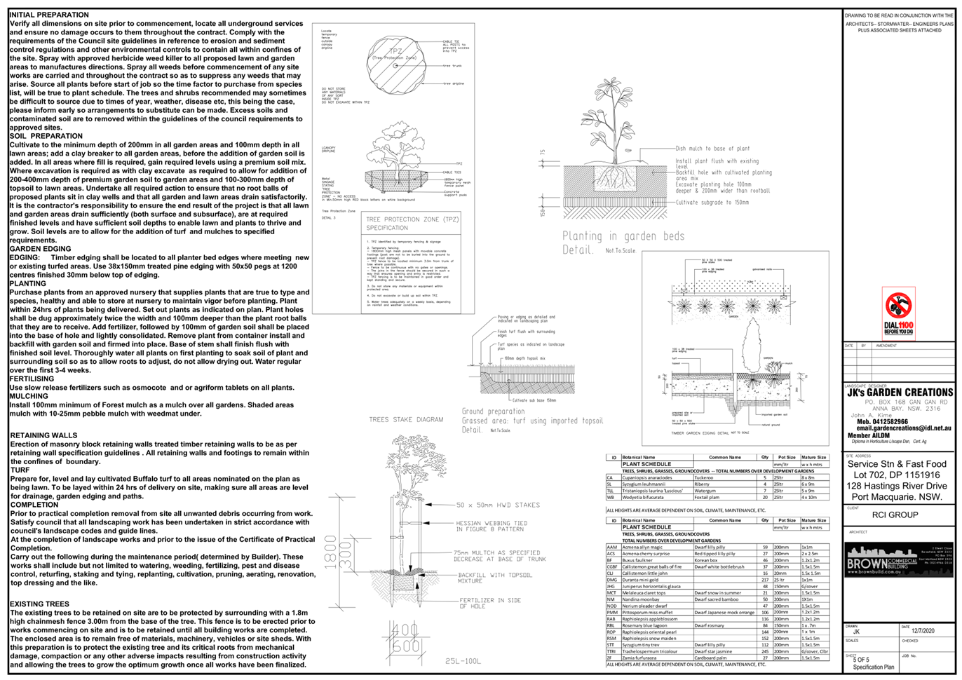
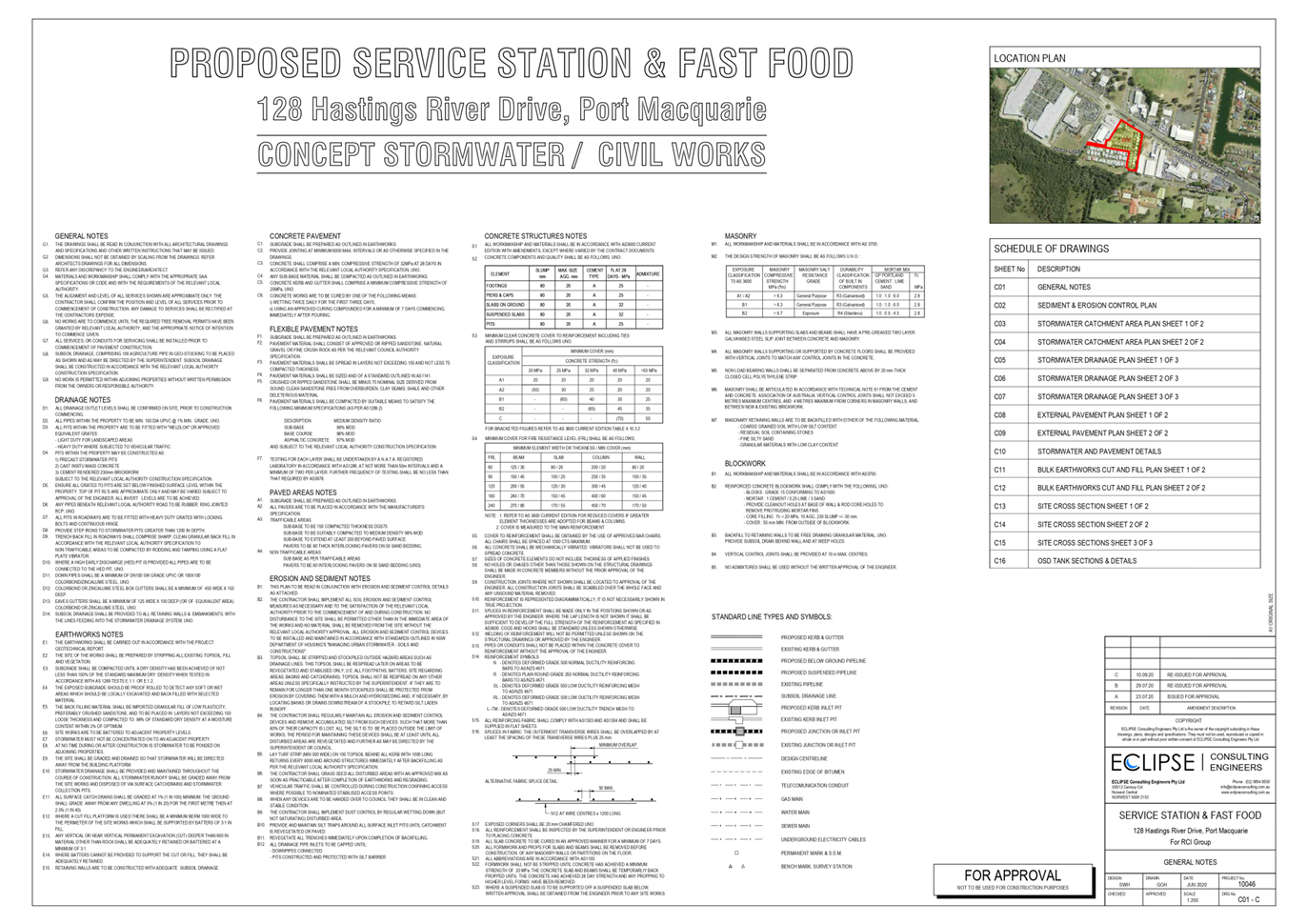
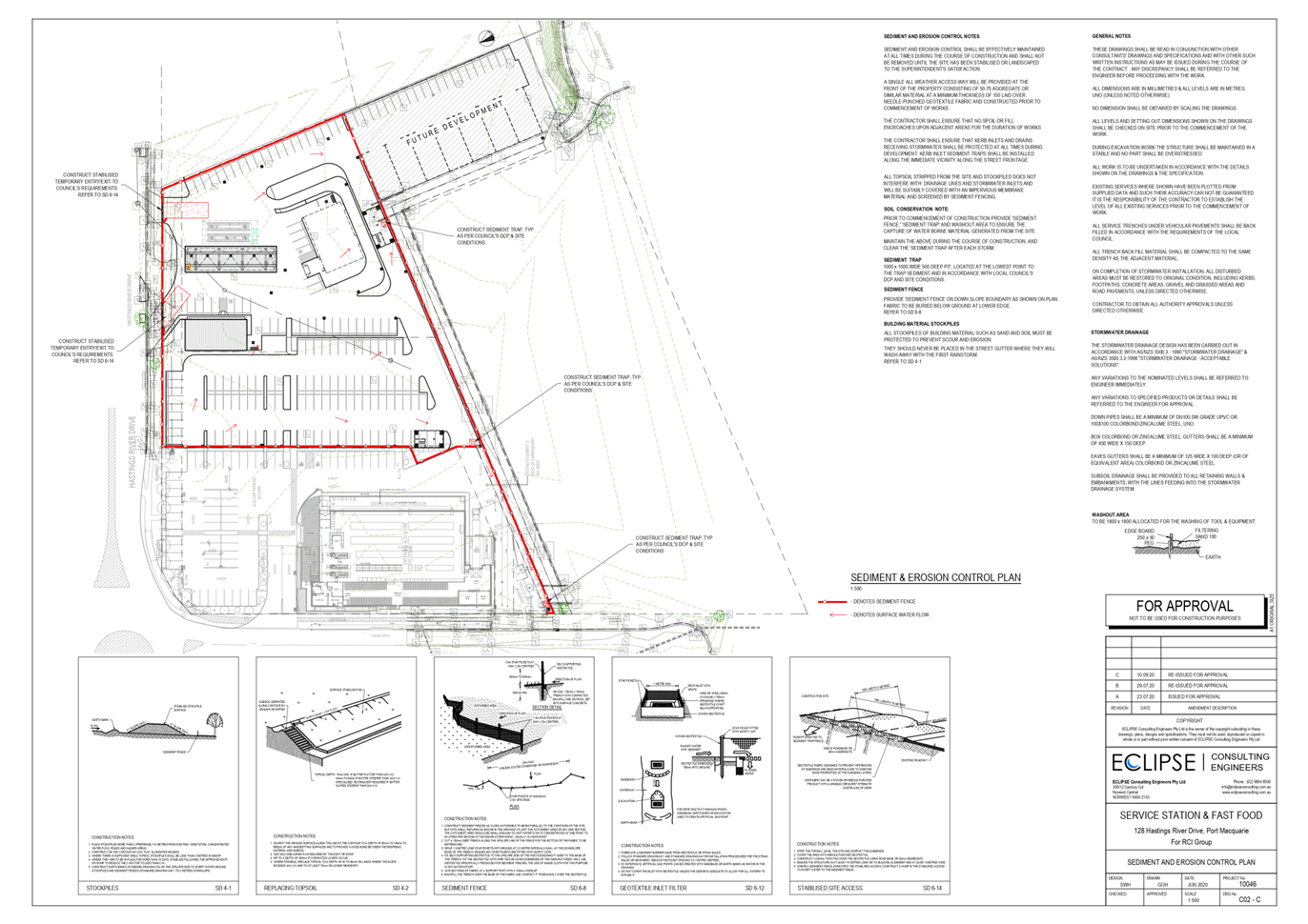
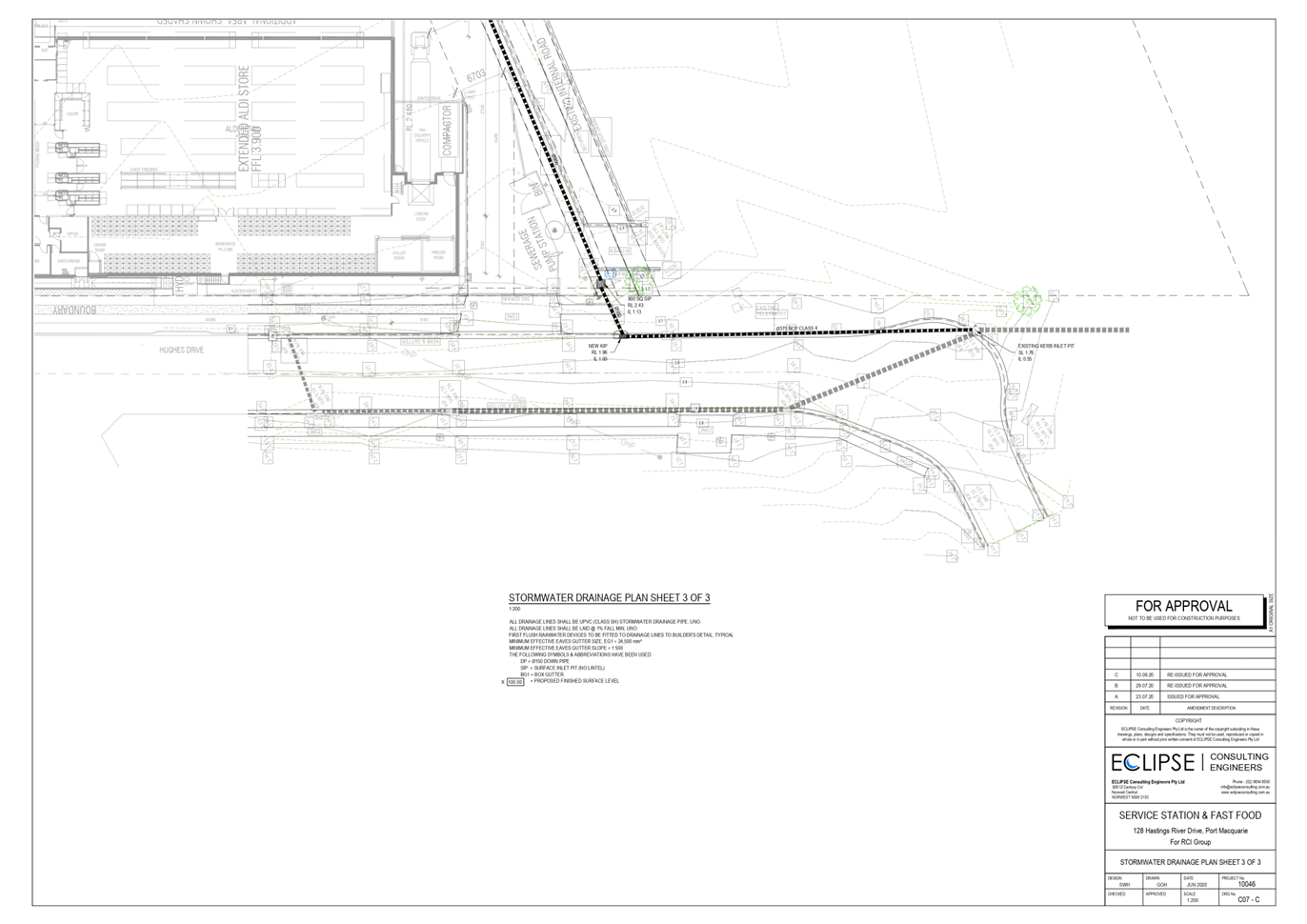
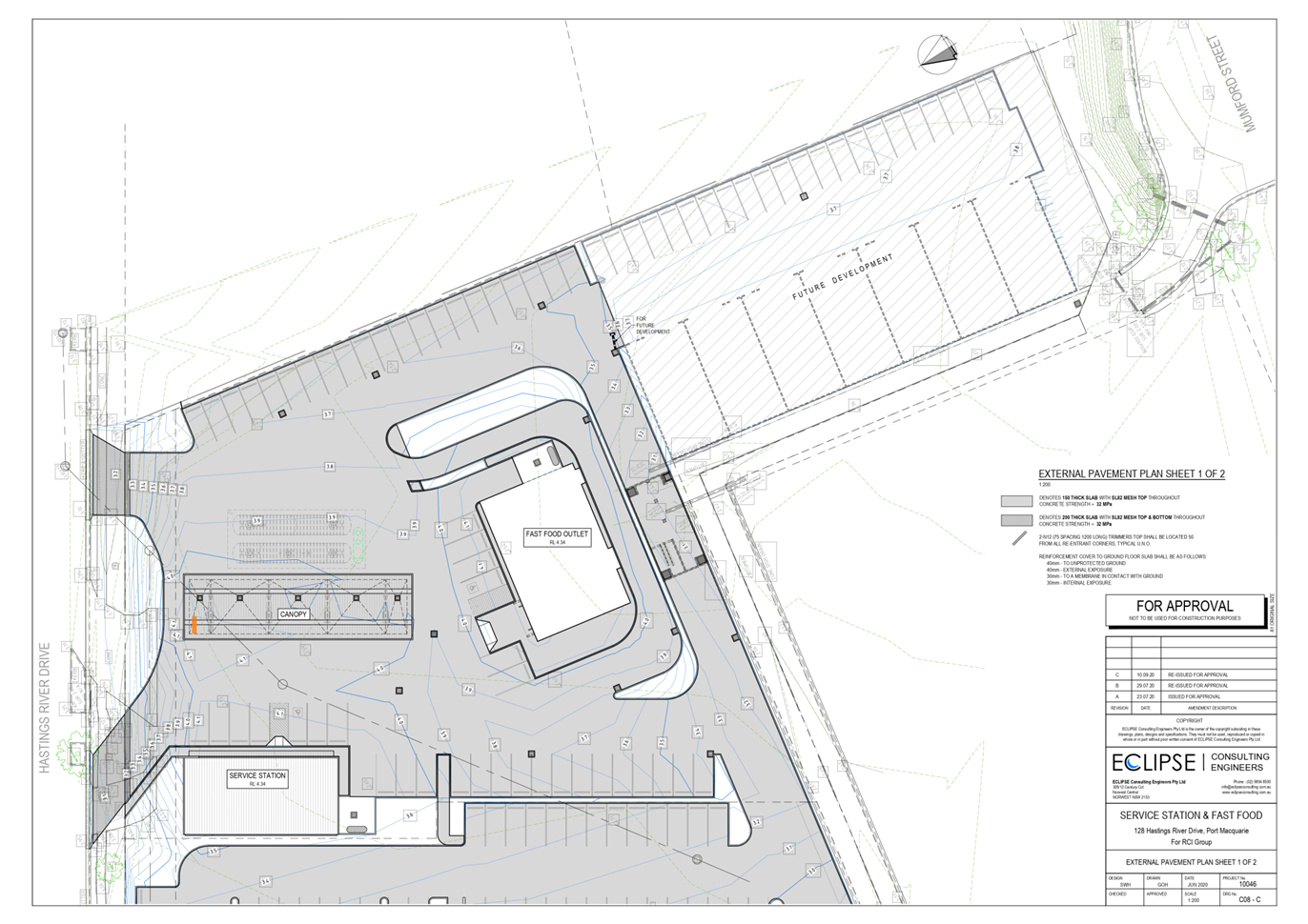
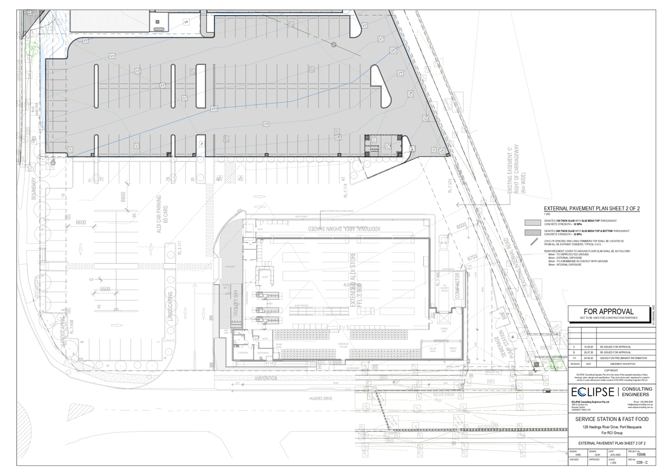
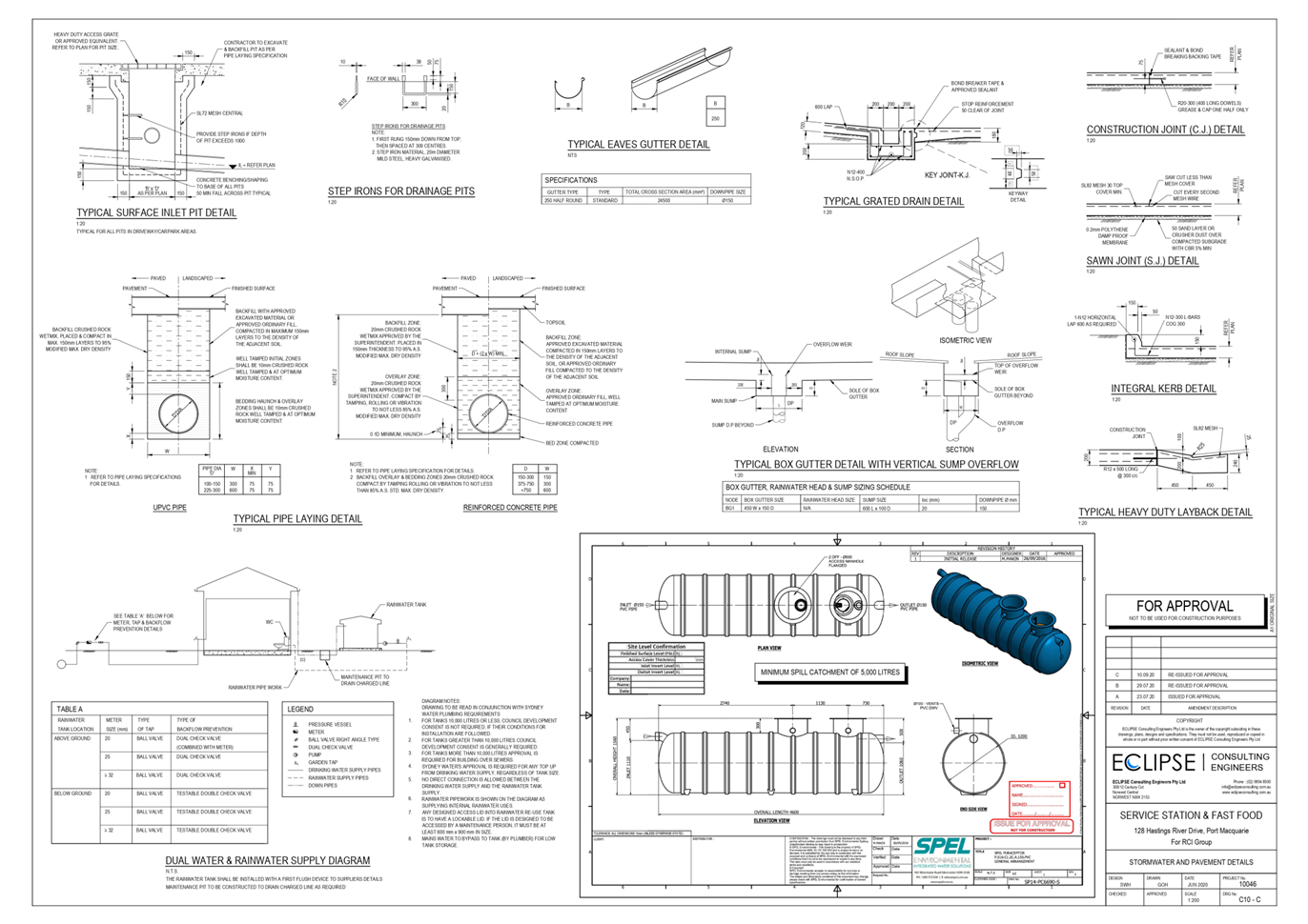
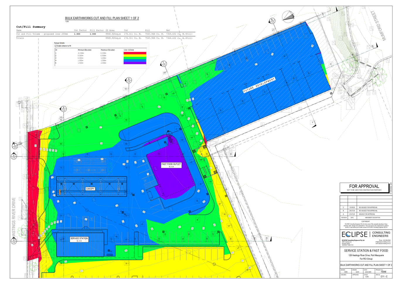
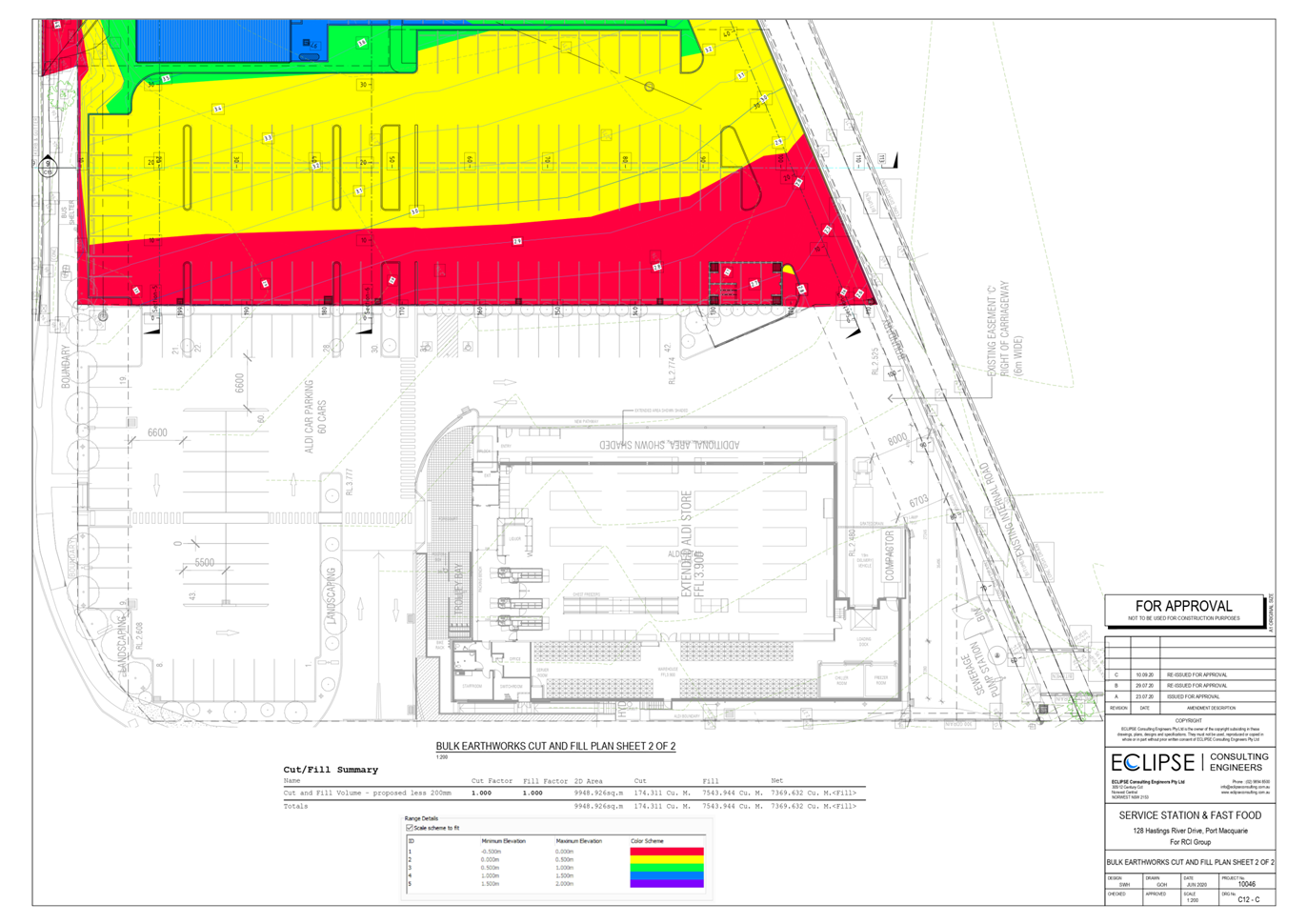
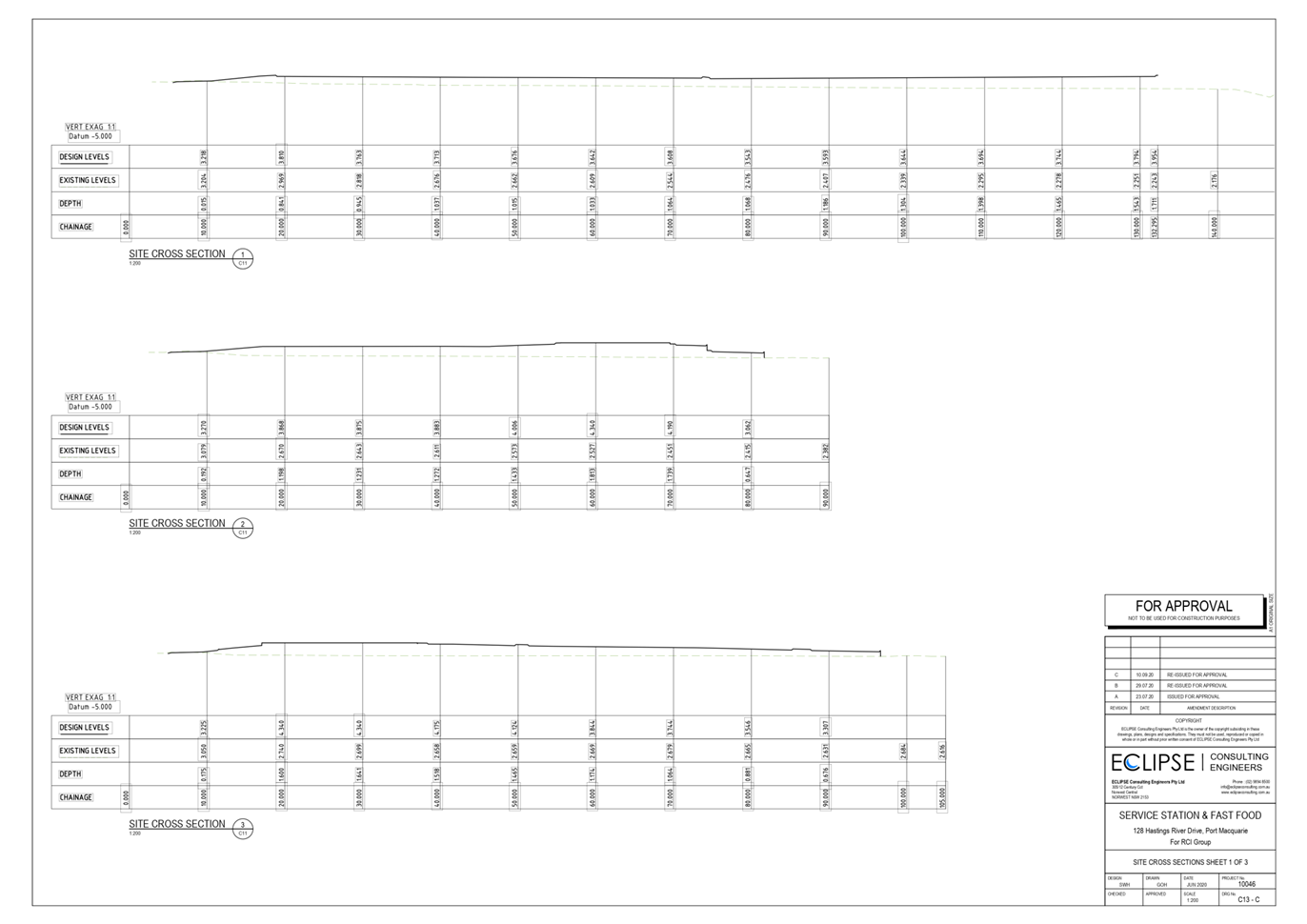
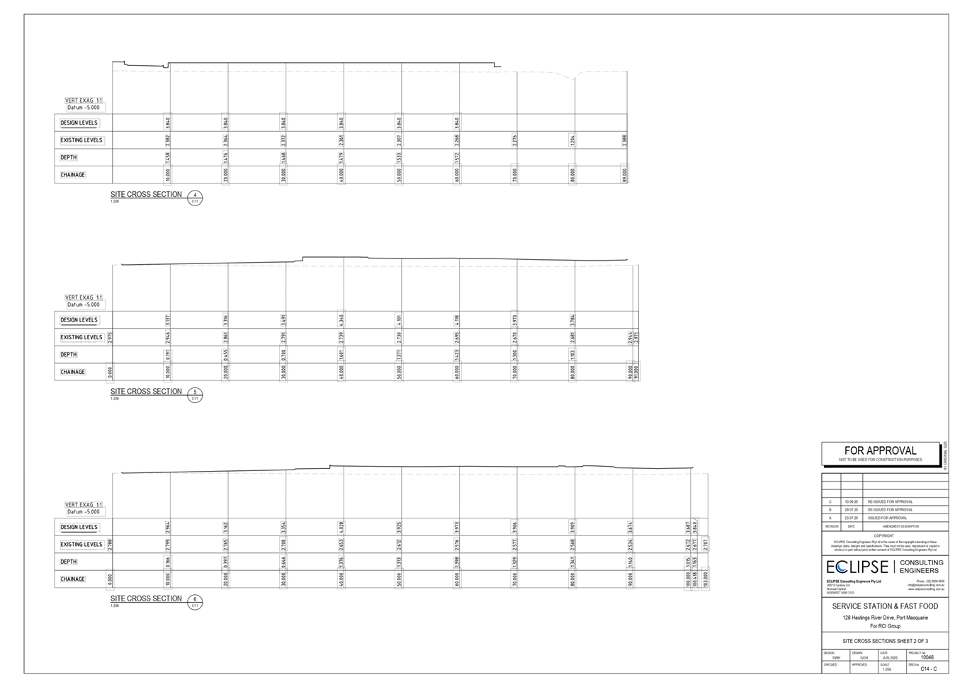
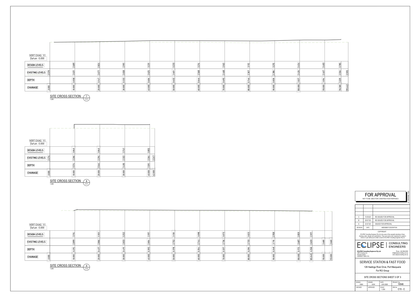
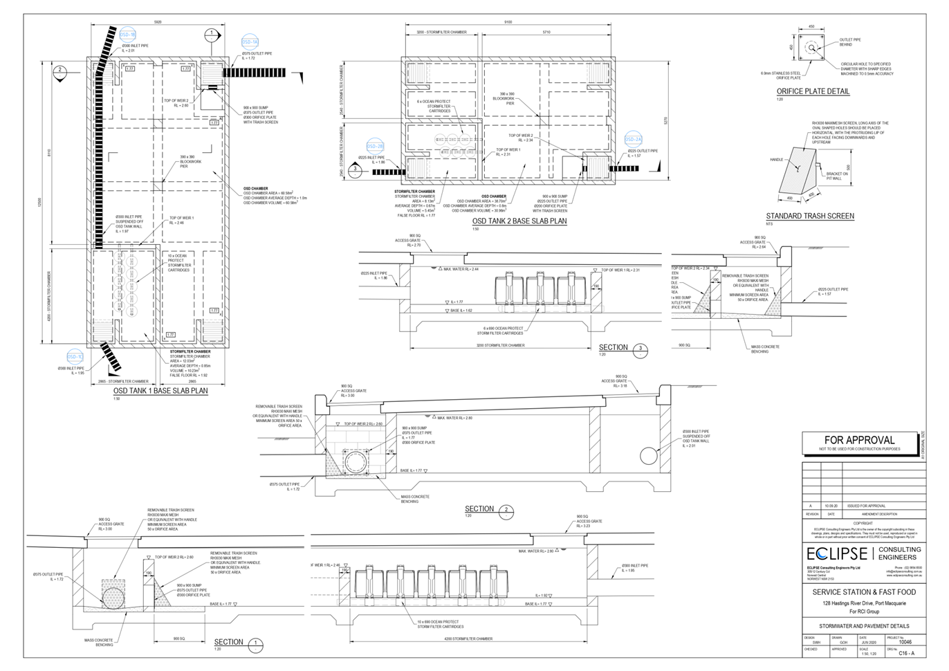
|
ATTACHMENT
|
Development Assessment Panel
21/01/2021
|