AGENDA Development Assessment Panel 07/10/2021
Item: 05
Subject: DA2020 - 958.01 Alterations and Additions to
Eco Tourist Facility, including Clause 4.6 exception to Development Standard
under Clause 7.14, Lot 100 & 101 DP 754444, 743 Ocean Drive, Grants Beach
Report
Author: Development Assessment Planner, Steven Ford
|
Applicant: P
S Mansfield C/- King & Campbell
Owner: P
S Mansfield
Estimated Cost: $710,000
Alignment with Delivery
Program
4.3.1 Undertake transparent
and efficient development assessment in accordance with relevant legislation.
|
RECOMMENDATION
That
it be recommended to Council that DA2020 - 958 for Alterations and Additions to EcoTourist
Facility, including Clause 4.6 exception to Development Standard under Clause
7.14 (exceeding the total gross floor area for an Eco-tourist Facility) at Lot 100 & 101,
DP 754444, No. 743 Ocean Drive, Grants
Beach, be determined by granting consent
subject to the recommended conditions.
Executive
Summary
This
report considers a development application for Alterations and Additions
to Eco Tourist Facility, including Clause 4.6 exception to Development Standard
under Clause 7.14 at the subject site and provides an
assessment of the application in accordance with the Environmental Planning and
Assessment Act 1979.
Following exhibition of the
application, no submissions were received.
The site is considered suitable for the proposed development
and the proposal adequately addresses relevant planning controls. The
development is not considered to be contrary to the public's interest and will
not result a significant adverse social, environmental or economic impact.
This report recommends that the
development application be approved subject to the attached conditions as
outlined in Attachment 1.
The reason for the application being referred to
Council’s Development Assessment Panel (DAP) is because the application
includes a Clause 4.6 exception to a development standard under the Port
Macquarie-Hastings Local Environmental Plan 2011. A copy of the DAP
Charter outlining the delegations and functions of the DAP is available on
Council’s website.
The application is required to be reported to a meeting of
the Ordinary Council following consideration of the application by the DAP.
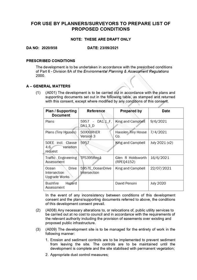
1. BACKGROUND
Existing
Sites Features and Surrounding Development
The site has a total area of 262.44
hectares.
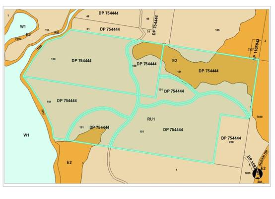
The
site is zoned RU1 Primary Agriculture and part E2 Environmental
Conservation in accordance with the Port
Macquarie-Hastings Local Environmental Plan 2011, as shown in the following
zoning plan:
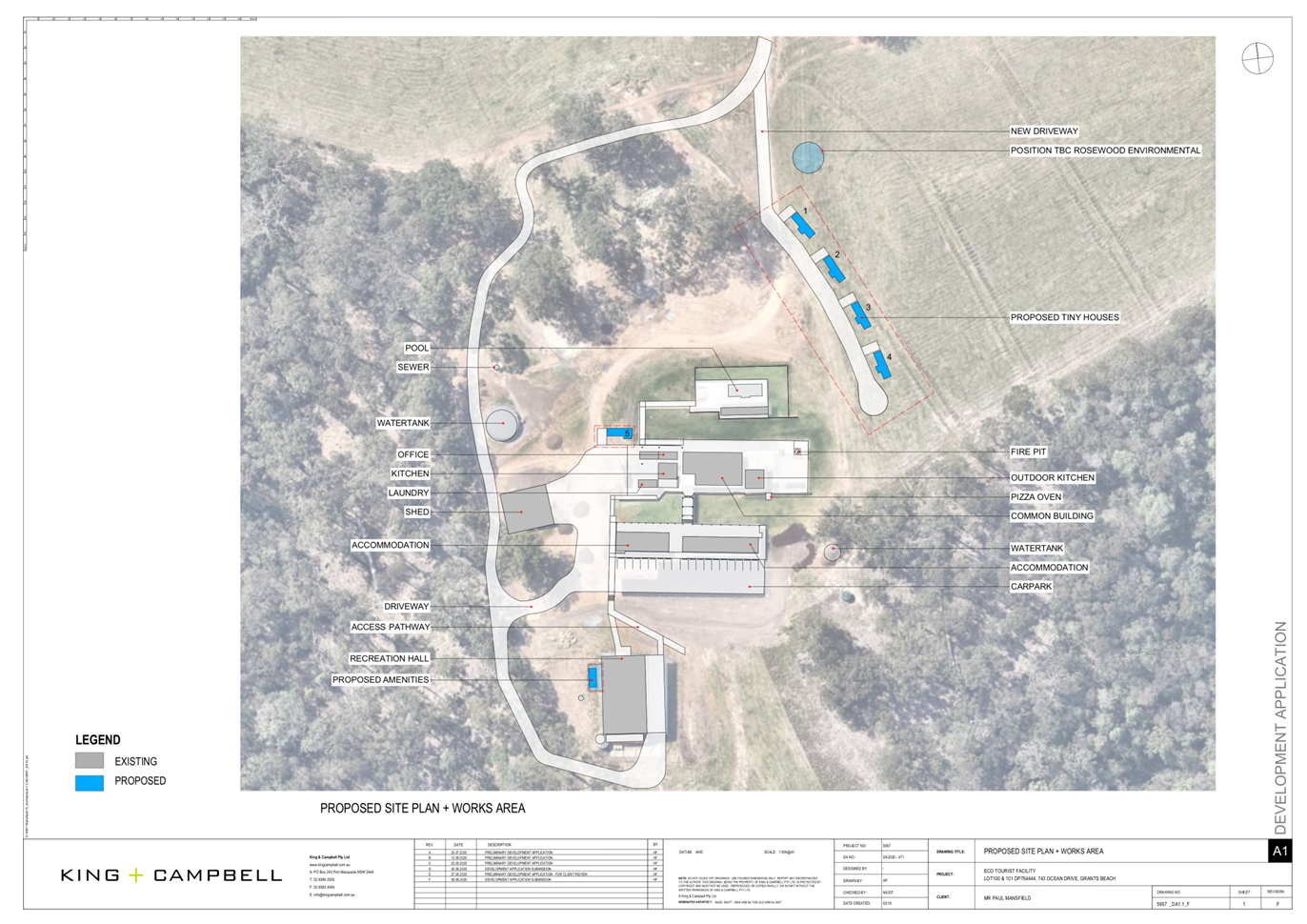
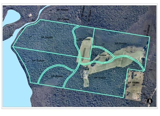
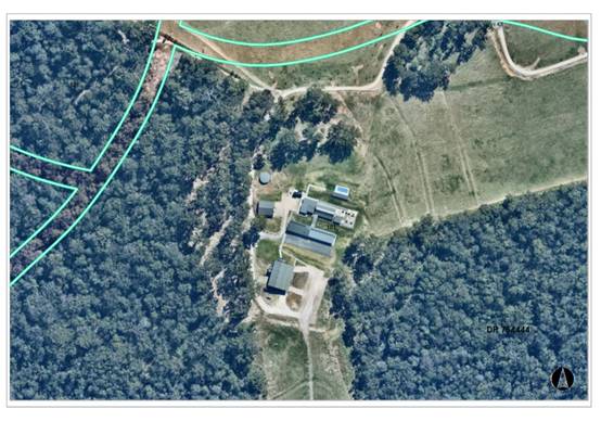
 The existing subdivision pattern and location of existing
development within the locality is shown in the following aerial photographs:
The existing subdivision pattern and location of existing
development within the locality is shown in the following aerial photographs:
2. DESCRIPTION
OF DEVELOPMENT
Key
aspects of the proposal include the following:
· Alterations
and Additions to existing Eco Tourist Facility (DA2016/700, as modified);
· This
Application seeks approval for 5 x single bedroom Tourist and Visitor Cabins
(Tiny Homes);
· Change
of use of existing southern shed to Recreation Hall with the additions of
amenities;
· The
application seeks to increase the maximum number of persons on site to;
o 50
overnight/short stay, and
o 150
on-site at any one time (excluding caretakers, staff, etc) during functions or
events; and
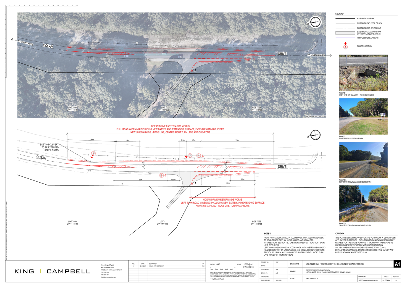
· Upgrade of Ocean Drive Intersection.
Refer
to Attachment 2 at the end of this report for plans of the proposed
development.
Application
Chronology
· 4/11/2020
- Development Application Lodged - Alterations and Additions to Eco Tourist
Facilities.
· 12/11/2020 to 25/11/2020 - Public Notification - No
submissions received.
· 26/11/2020 - Additional information requested.
· 24/02/2021 - NSW Rural Service (RFS) concurrence received.
· 2/08/2021 - Additional information received - updated
Statement of Environmental Effects, revised Cabin Plans, Bushfire Hazard
Assessment, Emergency and Evacuation Plan, AHIMS Search, Traffic Engineering
Assessment, Ocean Drive proposed intersection upgrade works.
· 26/08/2021 - Clause 4.6 variation request received.
· 27/08/2021 - Transport for NSW (tfNSW) concurrence
received.
· 09/09/2021 - Revised RFS concurrence received.
3. STATUTORY
ASSESSMENT
Section
4.15(1) Matters for Consideration
In
determining the application, Council is required to take into consideration the
following matters as are relevant to the development that apply to the land to
which the development application relates:
(a) The
provisions (where applicable) of:
(i) Any
Environmental Planning Instrument
State Environmental Planning Policy (Koala Habitat
Protection) 2019
Clause 5 - This SEPP applies to the Port Macquarie-Hastings
Local Government Area.
Clause 8 - An Approved Koala Plan of
Management (KPOM) applies to the site. Having considered the requirements of
the KPOM, the development is consistent with the KPOM for the following
reasons:
a) No
Additional clearing proposed;
b) Vegetation
Management Plan implemented, being works associated with the KPOM were
undertaken in 2019 including the planting of 188 Koala Food Trees and an annual
monitoring report finalised by Biodiversity Australia Pty Ltd in April 2020 and
May 2021; and
c) Compliant
fencing, no dogs and pool requirements met.
State Environmental Planning Policy No. 55 - Remediation
of Land
Following an inspection of the site and a search of Council
records, the subject land is not identified as being potentially contaminated
and is suitable for the intended use.
State Environmental Planning Policy (Coastal Management)
2018
The site is located within a coastal use area and coastal
environment area.
Clause 7 - This SEPP prevails over the Port
Macquarie-Hastings LEP 2011 in the event of any inconsistency.
Having
regard to clause 11 (proximity to coastal wetlands or littoral rainforest) of
this SEPP, the proposed development is not considered likely to result in any
of the following:
(a) identifiable
adverse impacts on the biophysical, hydrological and ecological integrity of
the nearby littoral rainforest/coastal wetland; and
(b) identifiable
impacts to water flows to the nearby littoral rainforest/coastal wetland.
Having regard to clauses 13 and 14
of the SEPP the proposed development is not considered likely to result in any
of the following:
a) any
adverse impact on integrity and resilience of the biophysical,
hydrological (surface and groundwater) and ecological environment;
b) any
adverse impacts coastal environmental values and natural coastal
processes;
c) any
adverse impact on marine vegetation, native vegetation and fauna
and their habitats, undeveloped headlands and rock platforms;
d) any
adverse impact on Aboriginal cultural heritage, practices and
places;
e) any
adverse impacts on the cultural and built environment heritage;
f) any
adverse impacts the use of the surf zone;
g) any adverse impact on the visual amenity and scenic qualities of the
coast, including coastal headlands;
h) overshadowing, wind funnelling and the loss of views from public places
to foreshores; and
i) any
adverse impacts on existing public open space and safe access to
and along the foreshore, beach, headland or rock platform for members of the
public, including persons with a disability.
Clause 15 - The proposal is not likely to cause increased
risk of coastal hazards on the land or other land.
The bulk, scale and size of the proposed development is
compatible with the surrounding coastal and built environment. The site is
predominately cleared and located within an area zoned for Eco-Tourist
Facility.
State Environmental Planning Policy (Infrastructure) 2007
Clause 101 refers to development with frontage to a
classified road. Ocean Drive is listed as a classified road and the provisions
of Clause 101 of this policy therefore apply and are addressed in the following
table:
|
Clause 101
|
Comments
|
|
(1) The objectives of this clause are—
(a) to ensure that new
development does not
compromise the effective and
ongoing operation and function of
classified roads, and
|
The existing driveway connection to Ocean Drive is
considered to require improvements to accommodate the increased demand
occurring as a result of the proposed population increase. The proposed
upgrade works are detailed in the plans included within this Application.
These works are
considered to ensure that the proposal does not compromise
the effective and ongoing operation of Ocean Drive.
These plans have been referred to tfNSW for review and
comments.
|
|
(b) to prevent or reduce the
potential impact of traffic noise
and vehicle emission on
development adjacent to
classified roads.
|
The site is located in an area in which large rural
allotments are common
with the nearest residential neighbour being some 700m
away, and on the
downside of a large ridge. The existing eco-tourist
facility and proposed
cabins are also approximately 1,200m from Ocean Drive.
No traffic noise or vehicle emission issues are therefore
anticipated.
|
|
(2) The consent authority must not grant consent to
development on land that has a frontage to a classified road
unless it is satisfied that—
(a) where practicable and safe,
vehicular access to the land is
provided by a road other than the
classified road, and
|
The site does not have frontage to any other road. It is
considered that
Ocean Drive is the only access option for vehicles to
enter the site.
Proposed intersection upgrade works are accompanied
by a traffic impact statement and have been referred to the TfNSW for
comments.
|
|
(b) the safety, efficiency and
ongoing operation of the classified
road will not be adversely affected
by the development as a result
of—
(i) the design of the vehicular access to the land, or
(ii) the emission of smoke or dust from the development,
or
(iii) the nature, volume or frequency of vehicles using
the classified road
to gain access to the land, and
|
The proposed driveway intersection upgrade works are
detailed in the
plans and traffic impact statement. These works are
considered to ensure
that the proposal does not compromise the effective and
ongoing operation
of Ocean Drive.
The upgrade works are not considered likely to result in
an adverse effect
to the vehicular access or generate any emission of smoke
or dust from
the development, noting that the existing driveway
connection is sealed.
In addition, the volume and frequencies of vehicles
utilising Ocean Drive is
not considered likely to increase as a result of the
proposed increase in
population. This has been considered and assessed within
the Traffic
Assessment prepared by TPS.
|
|
(c) the development is of a type that is not sensitive to
traffic noise or vehicle emissions, or is appropriately located and designed,
or includes measures,
to ameliorate potential traffic noise or vehicle emissions
within the site of the development arising from the adjacent classified road.
|
The eco-tourist facility is not considered to be a type of
development which is sensitive to traffic noise. Further, the facility is
located approximately 1,200 metres from Ocean Drive and is therefore
considered unlikely to be
detrimentally impacted by vehicle emissions or require any
ameliorative
measures.
|
Based on the above, the proposed development addresses
relevant clauses in the SEPP and will not to create any significant adverse
conflict in terms of traffic or noise.
State Environmental Planning Policy (Primary Production
and Rural Development) 2019
Division 4 - Having considered the provisions of Division 4
(clause 29-31), the proposed development will create no adverse impact on any
oyster aquaculture development or priority oyster aquaculture area.
Port Macquarie-Hastings Local Environmental
Plan 2011
The proposal is consistent with the LEP having regard to the
following:
· Clause
2.2 - The subject site is zoned RU1 Primary Production and Part E2
Environmental Conservation. The proposal is within the RU1 zone.
· Clause
2.3(1) and the RU1 zone landuse table - The proposed development for
Alterations and Additions to existing Eco-Tourist Facility is a permissible
landuse with consent.
The objectives of the RU1 zone are as
follows:
o To encourage sustainable primary
industry production by maintaining and enhancing the natural resource base.
o To encourage diversity in primary
industry enterprises and systems appropriate for the area.
o To minimise the fragmentation and
alienation of resource lands.
o To minimise conflict between land
uses within this zone and land uses within adjoining zones.
Clause 2.3(2) - The proposal is
consistent with the zone objectives having regard to the following:
o The proposal is a permissible
landuse;
o The proposal provides diversity
without adversely impacting primary production value and amenity for the area.
o The proposal does not conflict,
fragment or alienate any adjoining land uses.
· Clause
5.13 -Specifies matters to be considered in assessing development for
eco-tourist facilities. Having considered the Clause, the development achieves
compliance as follows:
o There is an existing Eco
Tourist Facility was approved by DA2016/700. The existing Development
Application Council granted consent to a total of 12 accommodation cabins, a
16-space car park and a large common room including kitchen, dining room with
amenities and swimming pool.
o DA2016/700 demonstrated
connection between the development and the ecology/environment on site. The
development is positioned to take advantage of key views from the site and
contains many trails and connections to areas to enjoy the ecology.
o Eco-Tourist Facilities are
permissible with consent in the RU1 Primary Production land use zone under the
provisions of the PM-H LEP 2011. The proposed buildings are considered
ancillary to the dominant use, being the existing eco-tourist facility.
o The site will utilise
predominately cleared areas for access and infrastructure. This limits the
impact on the environment.
o An existing Plan of Management
(POM) ensures protection and future maintenance of the site/environment. The
POM will deal with waste during operation. Standard waste controls will apply
during construction.
o The existing and proposed
buildings have been located on-site to ensure minimal impact. This includes
location on cleared (and within the existing bushfire asset protection zone,
thereby resulting in no tree removal being required).
o The proposed development is
considered to enhance the appreciation of the natural environment and coastal
attractions of the locality whilst being within close proximity to the villages
of North Haven and Bonny Hills.
o The existing Eco-Tourist
facility is off-grid in terms of water, electricity and sewerage services. The
proposed conference facility and recreation hall toilets shall be connected to
the existing on-site wastewater system. The new cabins are proposed to be
connected to a new separate wastewater system.
· Clause
7.1, parts of the property are mapped as potentially containing acid sulfate
soils. However, the mapped areas are on the lower sections of the property,
which are not to be disturbed.
· Clause
7.5 - The site is subject to an existing KPoM. The proposal is considered to be
consistent with existing Plan of Management implemented
on property and monitored by Council’s Natural Resources Team. There is
no additional clearing associated with this proposal.
· Clause
7.13 - Satisfactory arrangements are in place for provision of essential
services including water supply, electricity supply, on-site sewage management,
stormwater drainage and suitable road access to service the development.
· Clause
7.14 - Applies additional provisions applicable to eco-tourist facilities. The
proposed development complies with the provisions as follows:
o The buildings are proposed to
be located within proximity to the existing facility. Whilst the application
seeks to increase the potential number of persons on-site, it is seeking to do
so without substantially increasing the scale of the facility.
o No adverse impacts to mineral
resources are anticipated.
o The minimum lot size specified
by the PMHC LEP 2011 applying to the sites 40ha. The subject site contains a
total site area of 262.44ha and therefore exceeds the minimum lot size
required.
o The eco-tourist facility is
not considered ‘large scale’.
o The facility is
self-sufficient utilising solar and battery power for electricity, on-site
wastewater for sewerage, and tank water.
o The facility is not considered
likely to put pressure on existing infrastructure.
o Access to the site is via
Ocean Drive. The Intersection into the site is proposed to be upgraded as part
of this application to cater for the increased visitors and overnight
accommodation numbers.
o As a result of the additional
floor area proposed under this application including the conversion of the
large southern shed to a recreation hall, the total gross floor area on site
will exceed 1,000 square metres.
The total gross
floor area, excluding those areas used solely for farm storage and maintenance
purposes is 1,174m2, as detailed in table below.
|
Building
Description
|
DA
Reference, Approval Date
|
Use
|
GFA
(m2)
|
|
Accommodation
Cabins
|
2016/700,
24 May 2017
|
Accommodation
|
220
|
|
Common
Building
|
2016/700,
24 May 2017
|
Ancillary
|
76
|
|
Kitchen
|
2019/756,
23 March 2020
|
Ancillary
|
29
|
|
Office
|
2016/700,
24 May 2017
|
Ancillary
|
14.5
|
|
Pool
Room
|
2017/849,
10 November 2017
|
Ancillary
|
29.3
|
|
Caretaker’s
Residence
|
2020/471,
7 August 2020
|
Accommodation
|
139.5
|
|
Site
Office
|
2020/471,
7 August 2020
|
Ancillary
|
29.2
|
|
|
Sub-Total
|
537.5
|
|
Laundry
(Battery Storage)
|
2019/756,
23 March 2020
|
Ancillary
|
14.5
|
|
5
x Tiny Houses
|
2020/958,
subject to approval
|
Accommodation
|
122.5
|
|
Shed
(Recreation Hall – DA2020/958)
|
2016/411,
11 August 2016
|
Conferences
|
500
|
|
|
|
Total
|
1174.5
|
o A Clause 4.6 variation request
has been submitted and discussed next in this report regarding the maximum
1,000m2 gross floor area development standard being unreasonable and
unnecessary in this case.
· Clause
4.6 - A Clause 4.6 variation request has been included with this application to
vary clause 7.14 (maximum gross floor area of 1000m2 standard restriction). This
clause establishes a degree of flexibility for certain development standards in
certain circumstances which have demonstrated that a better planning outcome
will occur from that flexibility.
“development
standards means provisions of an environmental planning instrument
or the regulations in relation to the carrying out of development, being
provisions by or under which requirements are specified or standards are fixed
in respect of any aspect of that development, including, but without limiting
the generality of the foregoing, requirements or standards in respect of—
(a) the area,
shape or frontage of any land, the dimensions of any land, buildings or works,
or the distance of any land, building or work from any specified point,
(b) the
proportion or percentage of the area of a site which a building or work may
occupy,
(c) the
character, location, siting, bulk, scale, shape, size, height, density, design
or external appearance of a building or work,
(d) the cubic
content or floor space of a building,
(e) the
intensity or density of the use of any land, building or work,
(f) the
provision of public access, open space, landscaped space, tree planting or
other treatment for the conservation, protection or enhancement of the
environment,
(g) the
provision of facilities for the standing, movement, parking, servicing,
manoeuvring, loading or unloading of vehicles,
(h) the volume,
nature and type of traffic generated by the development,
(i) road
patterns,
(j) drainage,
(k) the
carrying out of earthworks,
(l) the effects
of development on patterns of wind, sunlight, daylight or shadows,
(m) the
provision of services, facilities and amenities demanded by development,
(n) the
emission of pollution and means for its prevention or control or mitigation,
and
(o) such other
matters as may be prescribed.”
Making reference to NSW
Land and Environment Court caselaw of Strathfield Municipal Council
v Poynting (2001) 116 LGERA 319, the Court considers the
recurring question of whether a specific planning control is prohibition or a
development standard. The Court applied the ‘two-step’ approach.
Firstly, a consideration of whether the proposed development is prohibited
under any circumstances pursuant to a planning instrument, and secondly, if it
is not prohibited, a consideration of whether clause of a planning instrument
specifies a requirement or imposes a standard in relation to an aspect of the
proposed development.
First step, clause 7.14
of the Port Macquarie Hastings Local Environmental Plan 2011, does not prohibit
developments, but rather outlines certain criteria to be met. Second step, the
Court highlighted that the definition of ‘development standards’ in
section 4 of the Environmental Planning and Assessment Act 1979 (NSW).
Given the numerical measurement of this clause, it is determined that this
specifies a requirement and set standard for the proposed development.
Therefore, clause 7.14 falls within the definition of “development
standard’ and meets both steps outlined.
In this regard, the proposal
seeks a variation to the development standard of clause 7.14(2) of the
PMHCLEP 2011, as outlined in this report for exceeding the numerical total
gross floor area prescribed for Eco-Tourist Facilities.
Having regard to
specific requirements of clause 4.6(3) and 4.6(4) the following assessment
comments are provided:
(3) Development consent must not be granted for development
that contravenes a development standard unless the consent authority has
considered a written request from the applicant that seeks to justify the
contravention of the development standard by demonstrating:
(a) that compliance with the development standard is unreasonable
or unnecessary in the circumstances of the case, and
(b) that there are sufficient environmental planning grounds to
justify contravening the development standard.
Comments: The Applicant has
submitted a request in writing to justify the contravention of Clause
7.14(2)(b) of the PMHC LEP 2011, which limits the gross floor area of the
eco-tourist facility and any ancillary permanent accommodation for owners or
managers does not exceed 1,000 square metres for the following reasons (as
summarised):
1. Compliance
with the development standard is unnecessary as the proposal has demonstrated
to be consistent with the objectives of the RU1 Primary Production land zoning,
clause 5.13 Eco-tourist facilities and clause 7.14 Eco-tourist
Facilities-additional provisions, notwithstanding the numerical variation to
the maximum floor area.
2. The
site has a total land area of 262.44 hectares and the gross floor area of all
buildings on site occupies 0.045% of the total site area.
3. The
numerical maximum floor area for an Eco-tourist Facility and ancillary
dwellings is 1,000m2. The proposed development has a total gross floor area of
1,174m2. This equates to a 17.4% variation, which is a very minor variation in
the context of the size of the land holding.
4. The
minimum lot size is 40ha. The area has a total land area of 262.44ha, therefore
land area has the potential of up to six (6) lots. In the context of site
potential, the 17.4% variation is considered minor with no adverse impacts
anticipated.
5. The additional floor area will not have any identifiable
adverse impacts to adjoining properties, natural resources or potential
agricultural uses.
(4)
Development consent must not be granted for development that contravenes a
development standard unless:
(a) the
consent authority is satisfied that:
(i) the
applicant’s written request has adequately addressed the matters required
to be demonstrated by subclause (3),
In Wehbe v
Pittwater Council (2007) NSWLEC 827, five-part test
has been developed to establish whether compliance with a development standard
is unreasonable or unnecessary:
1. The objectives of the standard are achieved
notwithstanding the non-compliance with the numerical standard and therefore
compliance is unnecessary.
2. The underlying objective or purpose of the standard is
not relevant to the development and therefore compliance is unnecessary.
3. The underlying object or purpose of the standard would
be defeated or thwarted if compliance was required and therefore compliance is
unreasonable.
4. The development standard has been virtually abandoned or
destroyed by the Council’s own actions in granting a consent to proposals
departing from the standard and hence compliance is unreasonable and
unnecessary.
5. The zoning of the particular land is unreasonable or
inappropriate so that a development standard appropriate for that zoning is
also unreasonable and unnecessary as it applies to the land.
The
proposal relies upon the first test and it is considered that the
Applicant’s written request had satisfactorily demonstrated that that the
proposed development will achieve the objectives of Clause 7.14 Eco-tourist
Facility - additional provisions standard despite the numerical
non-compliance.
PMH LEP 7.14(2)(b)
the gross floor area of the eco-tourist facility and any ancillary permanent
accommodation for owners or managers does not exceed 1,000 square metres,
Comment: The additional
provisions of providing a maximum 1,000m2 of gross floor area was to
intended to limit large scale eco-tourist facilities on small or remote lots,
put unnecessary pressure of infrastructure and/or conflict with the rural
amenity.
The subject site
consists of Lots 100 (190.81ha) and 101 in DP754444 (71.63ha). The combined
area of these allotments is 262.44 hectare. The minimum lot size within the RU1
zone is 40 hectares. Potentially, the property has capacity to be divided into
multiple properties, being up to 6 dwelling entitlements potentially could be
created and up to a total of 6,000m2 of gross floor area for
eco-tourist facilities across the potential yield. Therefore, the site is not
considered a small lot and the overall total gross floor area is only 0.045% of
the total site area. Within the context of the site, the total development is
not considered large scale.
The facility is
considered self-sufficient utilising solar and battery power for electricity,
on-site wastewater for sewerage and tank water. The only impact to public
infrastructure is the need to upgrade the existing access intersection from
Ocean Drive and alleviate any risk. The facility is therefore not considered
likely to put adverse pressure on existing or future infrastructure.
The site is not
considered as a remote location, as it is located within close proximity to
Bonny Hills and North Haven which provides accessibility for essential and
emergency services.
There are no
identifiable adverse impacts in addition to the Visual Impact Statement
prepared and reviewed under the original development application (DA2016/700).
The development is not visible from the public domain, therefore the numerical
variation does not add any additional impact to bulk and scale of the existing
facility.
The Eco-tourist facility
is condensed to a single location within the property and does not fragment the
site, impact the existing agricultural potential or detracted from any
environmental amenity.
(c) The concurrence of the Secretary has been obtained.
1.
Comments: In accordance with
Planning Circular PS 20-002, the Secretary’s concurrence cannot be
assumed for development contravenes a numerical standard by greater than 10%.
As the numerical variation being sort is 17.4%, as outlined in the Planning
Circular PS 20-002, this Application is required
to be reported to the Development Assessment Panel, which then needs to be
referred to an Ordinary meeting Council for determination. A public register of
variations is maintained and quarterly reporting made to the Department.
Having regard to the above
requirements it is recommended that the additional gross floor area of the
combined eco-tourist facility and ancillary permanent accommodation exceeding
1,000m2 using Clause 4.6 be supported.
(ii) Any draft
instruments that apply to the site or are on exhibition:
No draft instruments apply to
the site.
(iii) Any Development
Control Plan in force
Port
Macquarie-Hastings Development Control Plan 2013
|
DCP 2013: Part B - General
Provisions - B2: Environmental Management
|
|
DCP Objective
|
Development Provisions
|
Proposed
|
Complies
|
|
3
|
a) Development must comply with
Council’s Developments, Public Place & Events - Waste Minimisation
and Management Policy.
|
Satisfactory arrangements can be
made for storage of garbage bins on-site and collection of bins via private
waste collection.
|
Yes
|
|
Cut and Fill Regrading
|
|
4
|
a) Development shall not exceed
a maximum cut of 1.0m and fill of 1.0m measured vertically above the ground
level (existing) at a distance of 1.0m outside the perimeter of the external
walls of the building (This does not apply to buildings where such cut and
fill is fully retained within or by the external walls of the building).
|
Minor earthworks required for
new driveway and pad under the proposed Tiny Homes. It is anticipated that
earthworks greater than 1m will occur. However, there are no identifiable
impacts to adjoining property or environmental amenity.
Cut and fill is capable of being
contained within the site and either managed by a retaining wall or batter.
|
No, but considered acceptable
considering the location and context of the development.
|
|
5
|
a) A certified practicing
structural engineer must certify any retaining wall greater than 1.0m.
|
Retaining walls are central to
the development and capable of complying to engineering standards.
Suitable draft condition
recommended.
|
No, but considered to be capable
of complying.
|
|
b) Where a combination of a
fence and a wall is proposed to be greater than 1.2m high:
- be a maximum combined height of 1.8m above existing
property boundary level;
- be constructed up to the front boundary for a maximum
length of 6.0m or 30% of the street frontage, whichever is less;
− the fence component has openings which make it not less
than 25% transparent; and
− provide a 3m x 3m splay for corner sites, and
- provide a 900mm x 900mm splay for vehicle driveway
entrances.
|
No new works proposed.
|
N/A
|
|
6
|
a) Significant land reforming
proposals where >10% gross site area or >1.0ha is to have surface
levels changed by more than 5m or where earthworks exceed an average of
10,000m3 per ha shall:
− identify the impact of the proposed land reforming on the
environment, landscape,
- visual character and amenity, natural watercourses,
riparian vegetation, topographical features of the environment and public
infrastructure;
− demonstrate compliance with the provisions of
Council’s AUS-SPEC design specification;
− assess the impacts and benefits of the proposal to all
impacted persons and the general public;
- provide measures to compensate for and minimise any net
adverse impacts.
|
No significant land reforming
works proposed.
|
N/A
|
|
b) The use of high earthworks
batters should be avoided.
|
No high earthwork batters are
proposed.
|
N/A
|
|
c) Preliminary plans indicating
the final landform are required to be submitted with any master plan or
subdivision application.
|
No subdivision works proposed.
|
N/A
|
|
d) The subdivision should be
designed to fit the topography rather than altering the topography to fit the
subdivision.
|
No new works proposed.
|
N/A
|
|
Environmental Management
Areas and Buffers
|
|
7
|
a) For coastal floodplain
endangered ecological communities a minimum, fully vegetated buffer of 35m
must be provided.
|
No proximity issues identifiable
to unmanaged vegetable or endangered ecological communities.
Stormwater runoff is fully
contained within the site or captured for use.
|
Yes
|
|
b) For Freshwater Wetland on
Coastal Floodplain endangered ecological community a fully vegetated buffer
of 100m is to be provided.
|
|
c) For all other endangered
ecological communities, a fully vegetated buffer of 50m must be provided.
|
|
d) Stormwater management
facilities may be considered within buffer areas only where the applicant can
demonstrate the proposal is justified on the basis of practical engineering
related site constraints and where it is adequately demonstrated that the
applicable objectives are achieved.
|
|
e) Fully vegetated buffers
cannot contain road infrastructure or an asset protection zone.
|
|
f) Where different buffers
(including riparian buffers) apply to an area, the greater of the buffer
widths applies.
|
|
8
|
a) Any habitat/vegetation which
will be lost as a consequence of development is to be offset through the
dedication of suitable land utilising expert ecological knowledge to
determine the impact and offset based on the principle of ‘improve and
maintain’.
|
There is no impact to the
existing Vegetation Management Plan applying to the property. The proposal
does not included any clearing or fragmentation of existing vegetation
corridors. There is no variation to the existing KPoM or VMP proposed. No
adverse impacts identified.
|
Yes
|
|
b) Improvement and maintenance
of existing habitat and corridors and the consolidation of fragmented
bushland are to be considered as the first preference for any development
offset.
|
|
c) A Vegetation Management Plan
(VMP) is to be prepared for any environmental land that is to be retained or
used to offset development impacts.
|
|
d) VMPs are required to address Council’s
VMP “Heads of Consideration”
|
|
|
9
|
a) A minimum, fully vegetated
buffer from the top of bank to both sides of a watercourse is to be provided
in accordance with the following:
− 10m for 1st order streams that flow intermittently.
− 30m for 1st order streams that flow permanently.
− 40m for 2nd order streams.
− 50m for 3rd order streams.
− 65m for 4th order streams.
|
The Eco-tourist facility is not
located within close proximity to a identified stream. No adverse impacts
identified.
|
N/A
|
|
b) Stormwater management
facilities may be considered within buffer areas only where the applicant can
demonstrate the proposal is justified on the basis of practical engineering
related site constraints and where it is adequately demonstrated that the applicable
objectives are achieved.
|
No adverse impacts identified.
|
N/A
|
|
c) Fully vegetated buffers
cannot contain road infrastructure or an asset protection zone.
|
No adverse impacts identified.
|
N/A
|
|
Tree Management - Land to
which State Environmental Planning Policy SEPP (Vegetation in Non-Rural
Areas) 2017 Applies
|
|
10
|
a) Prescribed vegetation for the
purposes of the SEPP (Vegetation in Non-Rural Areas) 2017 is any tree
identified in Table 1 or is a mangrove or cycad and is:
- 3 metres or higher in height, or
- has a trunk diameter of 100mm measured at 1.0metre above
ground level; or
- a hollow bearing tree
|
No tree removal required for the
proposal.
|
N/A
|
|
b) The above criteria does not
apply to a tree where the nearside trunk is 3 metres from the nearest
external wall of an existing, permanent dwelling or manufactured home and is
located within the same property. Such trees may be removed without a permit
or development consent. This Provision does not apply to areas mapped as Core
Koala Habitat under the LEP. A permit will be required in these instances.
|
No tree removal required for the
proposal.
|
N/A
|
|
Tree Management –
Private Land
|
|
11
|
a) Pruning must be undertaken in
accordance with Australian Standard AS 4373 - Pruning of Amenity Trees.
|
No tree removal required for the
proposal.
|
N/A
|
|
b) An application for the
removal of a tree listed in Table 1 must be accompanied by an
Arborist’s report stating
that the tree:
- is dangerous; or
- is dying and remedial pruning would not improve the
deteriorated condition of the tree; or
- has a history of branch fall (documented or photographic
evidence to be provided); or
- is structurally unsound or;
- diseased.
- Advice on the requirement of an arborist report
associated with a tree removal permit can be obtained from Council’s
Tree Assessment staff.
- The requirement for an arborist report for tree removal
associated with a development application will be determined on merit by
Council’s Development Assessment.
|
No tree removal required for the
proposal.
|
N/A
|
|
c) Where a tree listed in Table
1 is approved for removal it must be compensated with 2 x koala habitat
trees. Significant large-scale development will require an advanced size
koala food tree or habitat tree (primary Koala browse species) that meets AS2303:2015
Tree Stock for Landscape Use. The compensation tree is to be planted in a
suitable location as determined by the Director of Development and
Environment or their delegate.
|
No tree removal required for the
proposal.
|
N/A
|
|
d) Removal of dead branches including
palm fronts and the selective removal of branches up to and including a
diameter of 50mm may be undertaken without a permit or development consent
where the removal:
- Does not alter the canopy of the tree, and
- Does not destroy the aesthetic appearance of the tree
canopy; and
- Does not alter the growth structure of the tree, and
- − Is carried out in accordance with Australian
Standard AS 4373 - Pruning of Amenity Trees.
|
No tree removal required for the
proposal.
|
N/A
|
|
e) The pruning of large garden
shrubs in excess of 3 metres in height for the purpose of ornamental shaping
is permitted without a permit or development consent.
|
No tree removal required for the
proposal.
|
N/A
|
|
f) Where a development is
proposed adjoining Council controlled land, the plans must identify all trees
that fall within 6.0m of the property boundary and any trees proposed to be
removed, identified on that plan.
|
No tree removal required for the
proposal.
|
N/A
|
|
g) Any pruning or removal of any
tree on private land must be undertaken in accordance with Council’s
tree management specifications.
|
No tree removal required for the
proposal.
|
N/A
|
|
h) A tree removal permit can be
sought for tree removal associated with a Complying Development Certificate
(CDC), subject to the tree removal meeting the following criteria:
- Must be associated with CDC and removal must not occur
until CDC issued.
- Application must identify and locate all trees within
proximity to the development.
- No more than 3 trees over 6m in height to be removed.
Trees taken to be impacted on by the development are to be determined in
accordance with AS 4970 - Protection of trees on development sites (i.e 12 x
DBH tree protection zone required for those trees to be retained).
- Must not involve removal of hollow bearing trees.
- The removal of any koala browse tree species are to be
replaced at a ratio of 2:1 on site or at a secure off site location agreed to
by Council. Any on site replanting is to have regard for services and
buildings and is to be agreed to by Council.
|
No tree removal required for the
proposal.
|
N/A
|
|
Tree Management - Hollow
Bearing Trees
|
|
13
|
a) All hollow bearing trees
within the development area are to be accurately located by survey and assessed
by an appropriately qualified ecologist in accordance with Council’s
Hollow-bearing tree assessment (HBT) protocol
|
No tree removal required for the
proposal.
|
N/A
|
|
b) Any tree that scores less
than 8 using the HBT assessment protocol may be considered for removal
subject to compensatory measures specified below.
|
|
c) Any tree that scores 8-12
using the HBT assessment protocol may be considered for removal if management
measures are ‘impractical to allow retention’
|
|
d) Any tree that scores more
than 12 using the HBT assessment protocol the assessment must be retained and
afforded a development exclusion buffer or located within environmental
lands.
|
|
e) Where a development exclusion
buffer is proposed it shall have a radius of 1.25 times the height of the
tree measured from its base.
|
|
14
|
a) A strategy for tree removal
(timing and methodology) that minimises impacts on native wildlife shall
accompany any development that proposes the removal of HBTs.
|
No tree removal required for the
proposal.
|
N/A
|
|
b) The removal of HBTs is to be
offset by the retention of recruitment trees. Compensatory recruitment trees
shall be provided at the rate of two for one for trees that scored 8-12,
Development Control Plan 2013 page 25 and at the rate of one for one for
trees that scored less than 8. A tree can be considered to be a compensatory
recruitment tree under the following criteria:
- Does not have any major structural defects or is
suffering from disease that would
- lead to premature death; and
- Is from the same vegetation community and same genus; and
- Are to be located within environmental lands and managed
in accordance with a VMP; and
- Have a DBH of 50cm or greater and do not possess hollows.
For Blackbutt Eucalyptus pilularis a DBH of 100cm or greater applies.
|
No tree removal required for the
proposal.
|
N/A
|
|
c) The removal of HBTs are to be
offset by the installation of nesting boxes of similar number and size as
those to be removed.
|
No tree removal required for the
proposal.
|
N/A
|
|
d) Nesting boxes are to be
installed like for like (both type and number, and host tree to genus level)
and must be located within proposed open space or environmental lands.
|
No tree removal required for the
proposal.
|
N/A
|
|
e) Nesting Boxes are to be
installed and maintained within environmental lands in accordance with a VMP.
|
No tree removal required for the
proposal.
|
N/A
|
|
f) Nesting Boxes to be inspected
and maintained by a qualified ecologist.
|
No tree removal required for the
proposal.
|
N/A
|
|
g) Any HBT that will not afford
protection via an exclusion buffer or within environmental lands will attract
the same offsetting requirements as if it was to be removed.
|
No tree removal required for the
proposal.
|
N/A
|
|
DCP 2013: Part B - General
Provision - B3: Hazards Management
|
|
DCP Objective
|
Development Provisions
|
Proposed
|
Complies
|
|
Bushfire Hazard Management
|
|
18
|
a) APZs are to be located
outside of environmental protection zones and wholly provided within private
land. Note perimeter roads provided as part of a residential subdivision are
classified as being part of the subdivision and not a separate permissible land
use within environment protection zones.
|
APZs are to be located outside
of environmental protection zones and wholly provided within private land.
|
Yes
|
|
b) Perimeter roads are to be
provided to all urban areas adjoining environmental management areas and
their buffers. Refer to Figure 2.
|
No perimeter roads proposed.
|
N/A
|
|
Flooding
|
|
19
|
a) Development must comply with
Council’s Floodplain Management Plan and Flood Policies.
|
The site is not subject to any
identifiable mapped or known flood risk.
|
N/A
|
|
DCP 2013: Part B- General
Provisions- B4: Transport, Traffic Management, Access and Car Parking
|
|
DCP Objective
|
Development Provisions
|
Proposed
|
Complies
|
|
23
|
a) New direct accesses from a
development to arterial and distributor roads is not permitted. Routes should
differ in alignment and design standard according to the volume and type of
traffic they are intended to carry, the desirable traffic speed, and other
factors.
|
No new access to the existing
facility is proposed. However, a Traffic Impact Statement has been provided.
It has been identified that an intersection upgrade would be beneficial to the safety
of entering and exiting the site, as well as not disrupting the traffic
movements of Ocean Drive. See Traffic Impact Statement and comment later in
this report.
|
Yes
|
|
b) Existing direct accesses from
a development to arterial and distributor roads are rationalised or removed
where practical.
|
|
c) Vehicle driveway crossings
are minimal in number and width (while being adequate for the nature of the
development), and positioned:
− to avoid driveways near intersections and road bends, and
− to minimise streetscapes dominated by driveways and
garage doors, and
− to maximise on-street parking.
|
|
Parking Provision
|
|
24
|
a) Off-street Parking is provided
in accordance with Table 3.
Tourist and Visitor
accommodation - 1.1 per unit + 1 per 2 employees (onsite at any one time) + 1
for on-site manager.
If public restaurant/function
room included - see restaurants.
For major developments, coach
parking may be provided in lieu of car spaces at a rate of 1 coach space per
5 car spaces.
Restaurants - outside commercial
zones @ 1 per 6m2 serviced floor area
|
Total of 17 car parking spaces
are currently available on-site for visitors, under the existing approval of
DA2016/700.
The current proposal is for an
additional 5 Cabins (Tiny Homes) and change of use of the large southern shed
to a recreation hall (existing farm shed of 25mx20m, plus additional
amenities 4.2m x 8.4m, total 535m2).
There are 5 additional formal
car parking spaces proposed adjacent to the Tiny Houses (Cabins), under this
proposal.
Recreation Hall total floor area
is 535m2. This requires a maximum total car parking demand of 89 spaces.
To cater for the Recreational
Hall car parking demand, an overflow car parking area with gravel driveways
for up to 100 additional vehicles to accommodate events held on site within
the Eco-tourist facility. It is also noted that this car park can also
provide Coach parking as well.
In addition, during these events
it is likely that guests staying in the accommodation will also be attending
the functions in the Recreation Hall.
Note: Concurrence from the TfNSW
(RMS) has been provided regarding the development generating over 50 car
parking spaces and the proposed Ocean Drive intersection upgrade.
|
Yes
|
|
b) Where a proposed development
does not fall within any of the listed definitions, the provision of on-site
parking shall be supported by a parking demand study.
|
N/A - It is considered the
Recreation Hall is defined as an Entertainment
Facility or Function room.
|
N/A
|
|
c) Where a proposed development
falls within more than one category Council will require the total parking provision
for each category.
|
Total of 23 car parking spaces
provided for tourist and visitor accommodation and capacity of 100 parking
spaces within the overflow car park for functions. This adequately addressed
this clause.
|
Yes
|
|
25
|
a) A development proposal to
alter, enlarge, convert or redevelop an existing building, whether or not
demolition is involved, shall provide the total number of parking spaces
calculated from the schedule for the proposed use, subject to a credit for
any existing deficiency, including any contributions previously accepted in
lieu of parking provision.
|
N/A
|
N/A
|
|
26
|
a) On street parking, for the
purposes of car parking calculations will not be included unless it can be
demonstrated that:
− there is adequate on street space to accommodate peak and
acute parking demands of the area;
− parking can be provided without compromising road safety
or garbage collection accessibility;
− parking can be provided without jeopardising road
function; and
− that streetscape improvement works, such as landscaped
bays and street trees are provided to contribute to the streetscape.
|
No on-street parking reliance.
|
N/A
|
|
b) On street parking is provided
in accordance with AS2890.5.
|
No on-street parking reliance.
|
N/A
|
|
27
|
a) On street parking will not be
permitted unless it can be demonstrated that:
− parking does not detract from the streetscape; and
− that streetscape improvement works, such as landscaped
bays and street trees are provided.
|
No on-street parking reliance.
|
N/A
|
|
Parking Layout
|
|
28
|
a) Visitor and customer parking
shall be located so that it is easily accessible from the street.
|
Parking area are considered to
be appropriately located for both uses.
|
Yes
|
|
b) Internal signage (including
pavement markings) should assist customers and visitors to find parking and
circulate efficiently and safely through a car park.
|
Due to the location of the
Eco-tourist facility centralised to the property signage and screening
isn’t considered necessary.
The area available for providing
parking on-site provides sufficient opportunity for manoeuvring of vehicles
on-site.
|
Yes
|
|
c) Parking spaces shall
generally be behind the building line but may be located between the building
line and the street when:
− it is stacked parking in the driveway; or
− it can be demonstrated that improvements to the open
space provided will result; and
− the spaces are screened (densely landscaped or similar)
from the street by a landscaping with a minimum width of 3.0m for the entire
length of the parking area.
|
|
d) Parking design and layout is
provided in accordance with AS/NZS 2890.1 - Parking facilities - Off-street
car parking and AS 2890.6 - Off-street parking for individuals with a
disability and AS/NZS 2890.2 - Parking facilities - Off-street commercial vehicle
facilities.
|
Proposed car parking is capable
of complying. The area available for providing parking on-site provides
sufficient opportunity for manoeuvring of vehicles on-site.
|
Yes - capable to be formalised
if required.
|
|
e) Stack or tandem parking spaces
will not be included in assessment of parking provision
except where:
− the spaces are surplus to that required;
− in motor showrooms;
− for home business;
− for exhibition homes;
− in car repair stations;
− staff parking spaces are separately identified and
delineated;
− it is visitor parking associated with a dual occupancy
multi dwelling and/or terrace housing, directly in front of the garage with a
minimum depth of 5.5m.
|
No stack parking proposed.
|
N/A
|
|
29
|
a) Parking is provided in
accordance with AS/NZS 2890.1 - Parking facilities - Off-street car parking,
AS/NZS 2890.2 - Parking facilities - Off-street commercial vehicle
facilities, AS 1428 - Design for access and mobility and AS 2890.6 -
Off-street parking for individuals with a disability.
|
Accessible car parking spaces
provided and additional opportunity in overflow car parking available.
The area available for providing
parking on-site provides sufficient opportunity for manoeuvring of vehicles
on-site.
|
Yes - capable to be formalised
if required.
|
|
30
|
a) Bicycle and motorcycle
parking shall be considered for all developments.
|
No bicycle or motorbike parking
indicated, however, it is considered capable of complying.
|
Yes
|
|
b) Bicycle parking areas shall
be designed generally in accordance with the principles of AS2890.3 - Parking
facilities - Bicycle parking facilities.
|
N/A
|
N/A
|
|
c) Motorcycle parking areas
shall be 1.2m (wide) x 2.5m (long).
|
N/A
|
N/A
|
|
Traffic Generating
Development
|
|
41
|
a) Traffic Generating
Development as defined under SEPP (Infrastructure) 2007 is referred to Roads
and Maritime Services. (Refer to Clause 104 and Schedule 3 of the
SEPP).
|
Due to the size of the proposed
Recreation Hall and overflow car parking area, this development is considered
traffic generating. A traffic Impact Statement was provided, along with plans
for the Ocean Drive intersection to be upgraded and the application was
referred to the RMS (TfNSW) under Clause 104 of the Infrastructure SEPP. See comments
earlier in this report.
|
Yes, concurrence was provided
from the RMS and Council’s Development Engineers have reviewed the
draft conditions.
|
|
|
|
|
|
|
DCP 2013: Part B - General
Provisions - B5: Social Impact Assessment and Crime Prevention
|
|
DCP Objective
|
Development Provisions
|
Proposed
|
Complies
|
|
Social Impact Assessment
|
|
42
|
a) A social impact assessment
shall be submitted in accordance with the Council’s Social Impact
Assessment Policy.
|
A social impact assessment is
not required.
|
N/A
|
|
Crime Prevention
|
|
43
|
a) The development addresses the
generic principles of crime prevention:
- Casual surveillance and sightlines;
- Land use mix and activity generators;
- Definition of use and ownership;
- Basic exterior building design;
- Lighting;
- Way-finding; and
- Predictable routes and entrapment locations;
- as described in the Crime Prevention Through
Environmental Design (CPTED) principles.
|
No adverse crime risk potential
exists with the nature of the design layout and intended uses of the site.
|
Yes
|
Based on the above assessment,
the variations proposed to the provisions of the DCP are considered acceptable
and the relevant objectives have been satisfied. Cumulatively, the
variations do not amount to an adverse impact or a significance that would justify
refusal of the application.
(iiia) Any planning agreement that has
been entered into under section 7.4, or any draft planning agreement that a
developer has offered to enter into under section 7.4
No planning agreement has been
offered or entered into relating to the site.
(iv) Any matters prescribed by the Regulations
Fire Safety and other considerations - Clause 93
The change of use of existing shed to ancillary recreation
hall sought by a development application is satisfied that the building can
comply (or will, when completed, comply) with such of the Category 1 fire
safety provisions as are applicable to the building’s proposed use. It is
considered that buildings are capable of complying to that required by the BCA
appropriate to all of the proposed uses, both the existing eco-tourist facility
and ancillary buildings, on completion.
(b) The likely
impacts of that development, including environmental impacts on both the
natural and built environments, social and economic impacts in the locality
Context and Setting
The site has distant frontage Ocean Drive to the east.
Adjoining the site is predominately timbered rural and
environmental zoned land. A quarry exists approximately 1.5km to the north
east.
The proposal will not have any significant adverse impacts
to existing adjoining properties or the public domain.
The proposal is considered to be consistent with other
development in the locality and adequately addresses planning controls for the
area as justified.
The proposal does not have a significant adverse impact on
existing view sharing.
The proposal does not have significant adverse lighting
impacts.
There are no significant adverse privacy impacts.
Adequate building separation to adjoining land uses.
Access, Traffic and Transport
The proposal intends to increase from 12 Cabins (DA2021/700)
to a total of 17 Cabins, with a total potential of 54 overnight guests and
function capacity of up to a maximum of 150 guests at any one time. A Traffic
Impact Statement (TIS) has been provided to support the proposal. The TIS,
based on the traffic demands likely to be generated at peak times, has
recommended that the Ocean Drive Access intersection should be upgraded to
included AUL(s) and CHR(s) left and right turn lanes. This would adequately
alleviate any significant adverse impacts and satisfactorily cater for any
increase in traffic generation as a result of the development.
Transport for NSW comments are as follows:
1. We
note the scale of expansion proposed and particularly the works proposed for
the Ocean Drive intersection, as shown in drawing 5957E_Ocean Drive
Intersection, Rev A, dated July 2021. Council will need to approve these works
under section 138 of the Roads Act, after obtaining concurrence from TfNSW. The
scope of works appears to be satisfactory for the intended expansion of the
eco-resort. However, Council should be satisfied that traffic analysis reflects
to growth proposed for the Ocean Drive area, particularly increases in traffic
between now and 2032.
2. It
is requested that the timing of the roadworks necessary to service the proposed
increase in use be clearly set out in any consent granted. Works should be in
place early to ensure the safety and efficiency of traffic and patrons
accessing the development.
3. A
Management Plan for the proposed development should have consideration for the
traffic and transport impacts generated from the temporary events (i.e., the
weddings, functions, conferences referred to in the Statement of Environmental
Effects – p1)
4. Any
roadwork on classified road/s is to be designed and constructed in accordance
with the current Austroads Guidelines, Australian Standards and TfNSW
Supplements.
Site Frontage and Access
Ocean Drive is a Roads and Maritime Services (RMS)
classified road and will require concurrence and/or a Works Authorisation Deed
(WAD) from the RMS prior to works on this road. Details shall be provided
as part of a Roads Act (Section 138) application to Council.
Due to the type and size of
development, additional works are required to include:
· Access
intersection should be upgraded to included AUL(s) and CHR(s) left and right
turn lanes.
· A
condition is recommended requiring construction of intersection upgrades to the
Ocean Drive access prior to occupation.
Parking and Manoeuvring
A total of 24 parking spaces for the tourist accommodation
and overflow car parking for up to 100 vehicles for functions have been
provided on-site. Parking and driveway widths on site can comply with
relevant Australian Standards (AS 2890) and conditions have been imposed to
reflect these requirements.
Due to the type of development, car park circulation is
required to enable vehicles to enter and exit the site in a forward
manner. Site plans show adequate area is available and conditions have
been imposed to reflect these requirements.
Water Supply Connection
No Council water supply to the proposed development.
Sewer Connection
Onsite sewerage management system. Council Environmental
Health Officers have reviewed the site and provided concurrence that the site
has sufficient area to satisfy onsite waste management facility requirements.
Detailed plans will be required to be submitted for
assessment with the S.68 application.
Appropriate conditions are recommended in this regard.
Stormwater
The site naturally grades towards the north and is currently
an unserviced rural lot. The site is reliant on rainwater
A detailed site stormwater management plan will be required
to be submitted for assessment with the S.68 application and prior to the issue
of a CC.
Appropriate conditions are recommended in this regard.
Other Utilities
Telecommunication and electricity services are available to
the site.
Heritage
Following a site inspection (and a search of Council/AHIMS
records), no known items of Aboriginal or European heritage significance exist
on the property. No adverse impacts anticipated.
As a precaution, a condition of consent has been recommended
that works are to cease in the unexpected event heritage items are found. Works
can only recommence when appropriate approvals are obtained for management
and/or removal of the heritage item.
Other Land Resources
The site is within an established urban context and will not
sterilise any significant mineral or agricultural resource.
Water Cycle
The proposed development will not have any significant adverse
impacts on water resources and the water cycle.
Soils
The proposed development will not have any significant
adverse impacts on soils in terms of quality, erosion, stability and/or
productivity subject to a standard condition requiring erosion and sediment
controls to be in place prior to and during construction.
Air and Microclimate
The construction and/or operations of the proposed
development will not result in any significant adverse impacts on the existing
air quality or result in any pollution. Standard precautionary site management
condition recommended.
Flora and Fauna
Construction of the proposed development will not require
any removal/clearing of any native vegetation and therefore does not trigger
the biodiversity offsets scheme. Part 7 of the Biodiversity Conservation
Act 2016 is considered to be satisfied.
Waste
Satisfactory arrangements are in place for proposed storage
and collection of waste and recyclables. No adverse impacts anticipated.
Standard precautionary site management condition recommended.
Energy
The proposal includes measures to address energy efficiency
and will be required to comply with the requirements of Section J of the
Building Code of Australia. No adverse impacts anticipated.
Noise and Vibration
The construction and/or operations of the proposed
development will not result in any significant adverse impacts. The nearest
residential property is approximately 750m and separated by a ridgeline. Noise
generated from the proposed recreation hall can be arbitrated through standard
conditions and the Protection of the Environmental Operations Regulation 2017
(POEO).
Standard precautionary site management condition
recommended.
Bushfire
The site is identified as being bushfire prone.
The Applicant has submitted a bushfire report prepared by a
Certified Consultant.
An assessment of bushfire risk having regard to section
4.3.5 of Planning for Bushfire Protection 2006 including vegetation
classification and slope concludes that a Bushfire Attack Level 29 shall be
required for the Accommodation Cabins.
In accordance with Section 100B - Rural Fires Act 1997 - the
application proposes a special fire protection purpose. As a result, the
applicant has submitted a bushfire report prepared by a Certified Consultant.
The report was forwarded to the NSW Rural Fire Service who have since issued a
Bushfire Safety Authority, which will be incorporated into the consent.
Safety, Security and Crime Prevention
The proposed development will be unlikely to create any
concealment/entrapment areas or crime spots that would result in any
identifiable loss of safety or reduction of security in the immediate
area. The increase in density will improve natural surveillance within
the locality.
Social Impacts in the Locality
Given the nature of the proposed development and its
location the proposal is not considered to have any significant adverse social
impacts.
Economic Impact in the Locality
The proposal is not considered to have any significant
adverse economic impacts on the locality. A likely positive impact is that the
development will maintain employment in the construction industry, which will
lead to flow impacts such as expenditure in the area.
Site Design and Internal Design
The proposed development design satisfactorily responds to
the site attributes and will fit into the locality.
Construction
Construction impacts are considered capable of being
managed, standard construction and site management conditions have been
recommended.
Cumulative Impacts
The proposed development is not considered to have any
significant adverse cumulative impacts on the natural or built environment or
the social and economic attributes of the locality.
(c) The
suitability of the site for the development
The proposal will fit into the locality and the site
attributes are conducive to the proposed development.
Site constraints of vehicular
access and bushfire have been adequately addressed and appropriate conditions
of consent recommended.
(d) Any
submissions made in accordance with this Act or the Regulations
No written
submissions were received following public exhibition of the application.
(e) The Public Interest
The proposed development
satisfies relevant planning controls and will not adversely impact on the wider
public interest.
Ecologically Sustainable Development and Precautionary
Principle
Ecologically sustainable development requires the effective
integration of economic and environmental considerations in decision-making
processes.
The four principles of ecologically sustainable development
are:
· the
precautionary principle,
· intergenerational
equity,
· conservation
of biological diversity and ecological integrity,
· improved
valuation, pricing and incentive mechanisms.
The principles of ESD require that a balance needs to be
struck between the man-made development and the need to retain the natural
vegetation. Based on the assessment provided in the report and with recommended
conditions of consent, it is considered an appropriate balance has been struck.
Climate Change
The proposal is not considered to be vulnerable to any risks
associated with climate change.
4. DEVELOPMENT
CONTRIBUTIONS APPLICABLE
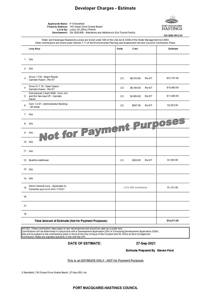
· Development
contributions will be required in accordance with Section 7.11 of the
Environmental Planning and Assessment Act 1979 towards roads, open space,
community cultural services, emergency services and administration buildings.
2.
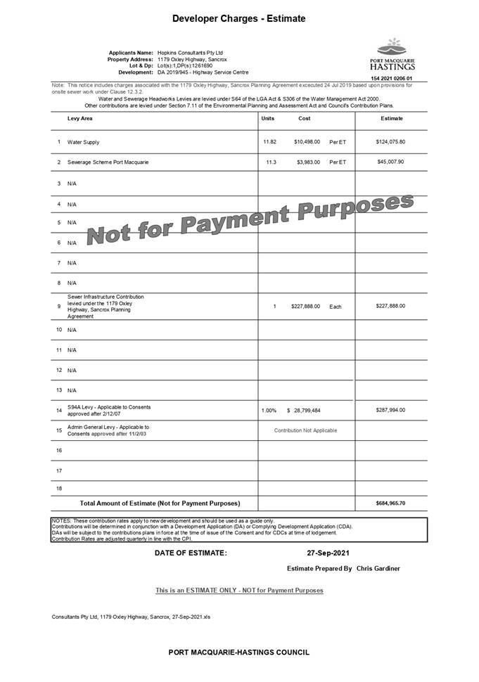
· A copy
of the contributions estimate is included as Attachment 3.
5. CONCLUSION AND
STATEMENT OF REASON
The application has been assessed in accordance with Section
4.15 of the Environmental Planning and Assessment Act 1979.
Issues raised during assessment of the application have been
considered in the assessment of the application. Where relevant, conditions
have been recommended to manage the impacts attributed to these issues.
The site is considered suitable for the proposed development
and the proposal adequately addresses relevant planning controls. The
development is not considered to be contrary to the public's interest and will
not result a significant adverse social, environmental or economic impact. It
is recommended that the application be approved, subject to the recommended
conditions of consent provided in the attachment section of this report.
|
Attachments
1⇩. Attachment 1 -
DA2020 - 958.1 Consent Conditions Attachment 1 -
DA2020 - 958.1 Consent Conditions
2⇩. Attachment 2 -
DA2020 - 958.1 Plans Attachment 2 -
DA2020 - 958.1 Plans
3⇩. Attachment 3 -
DA2020 - 958.1 Contributions Estimate
|
AGENDA Development Assessment Panel 07/10/2021
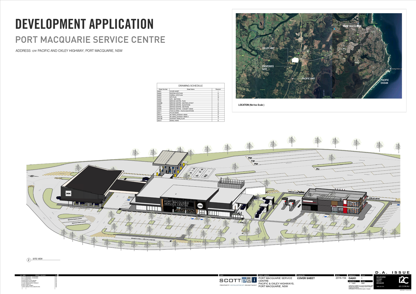
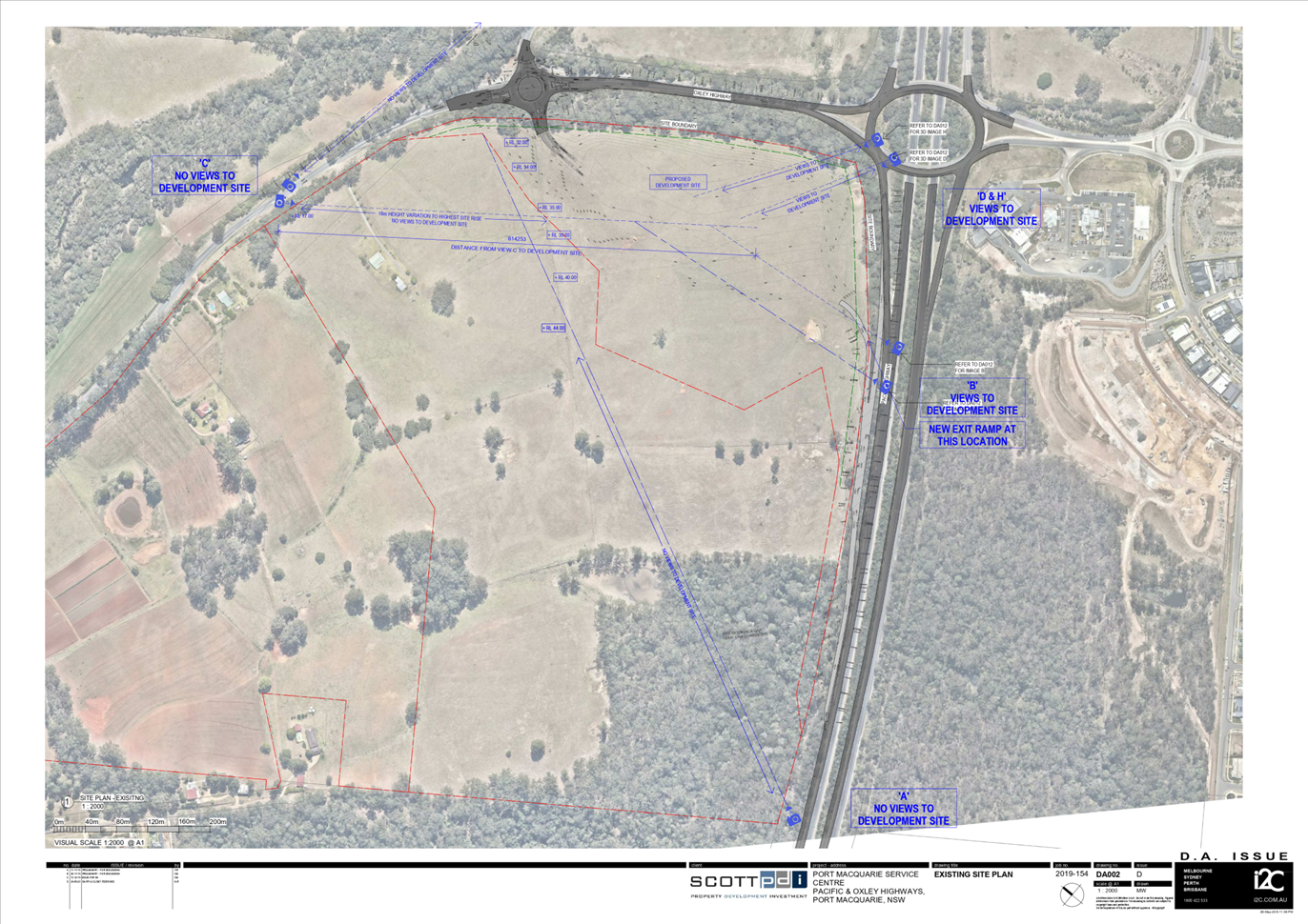
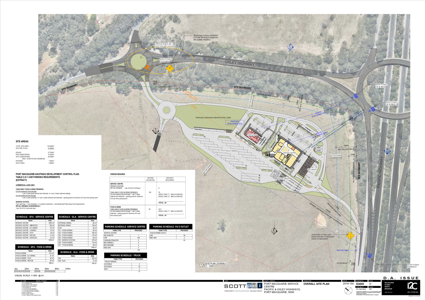
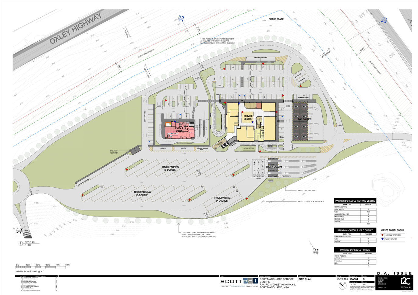
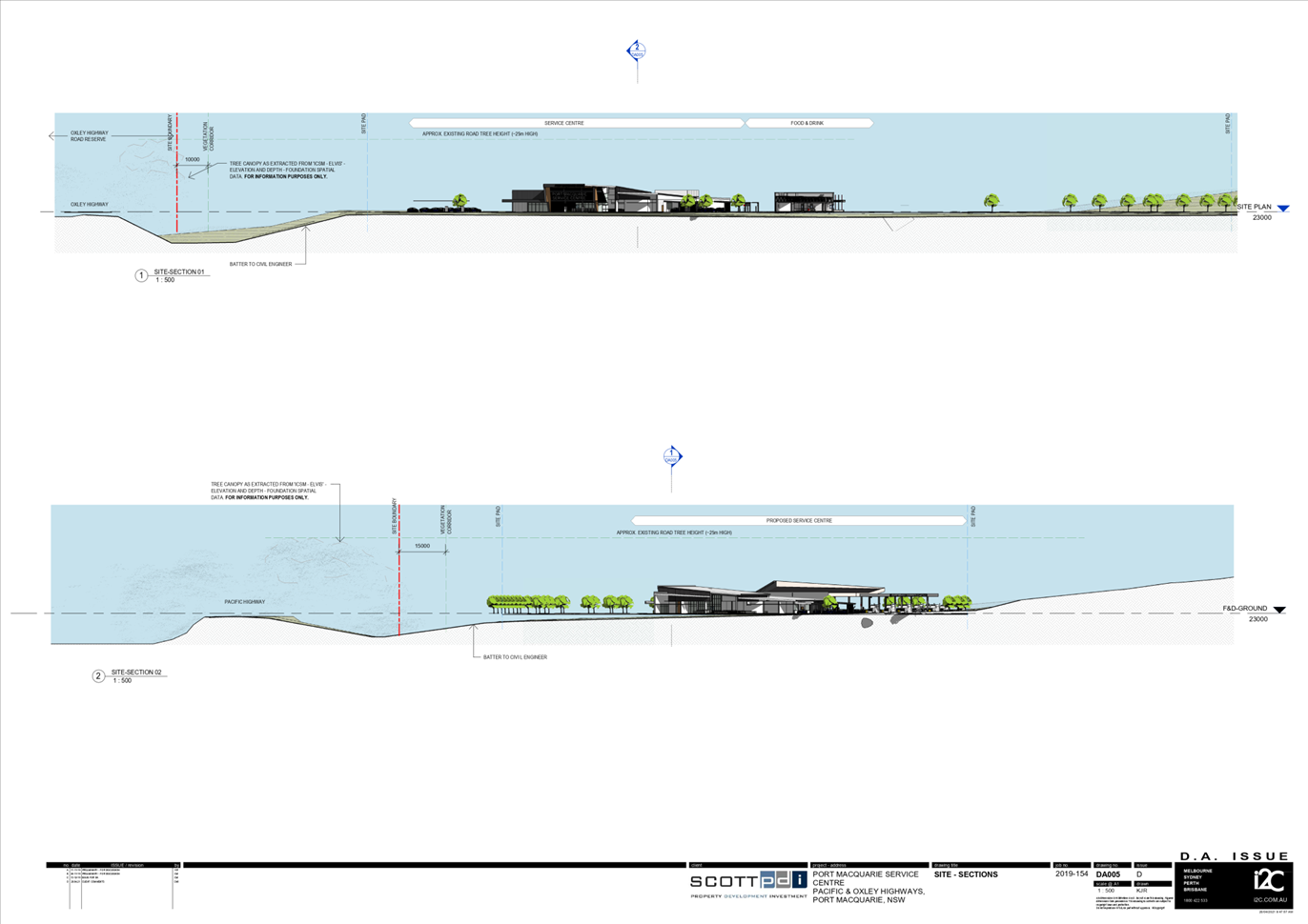
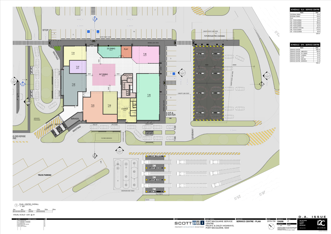
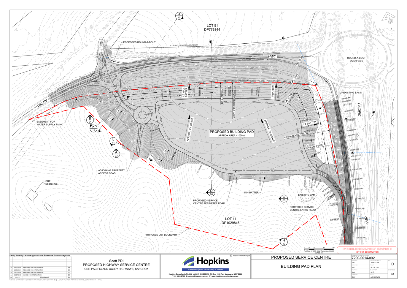
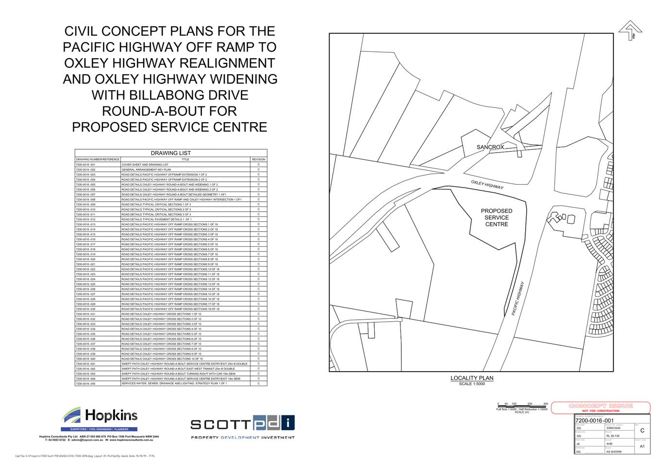
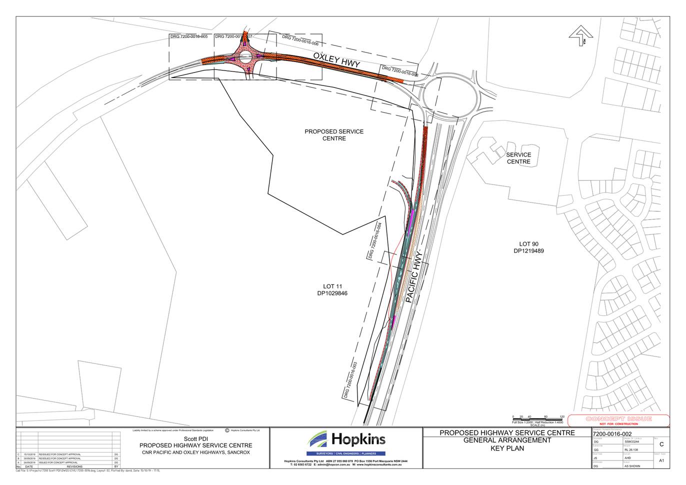
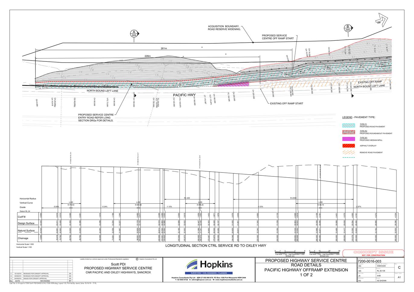
Item: 06
Subject: DA2019 - 945.1 Highway Service Centre at Lot
21 DP 1261690 Oxley Highway, Sancrox
Report
Author: Development Assessment Planner, Chris Gardiner
|
Applicant: Hopkins
Consultants Pty Ltd
Owner: Portcrox
Pty Ltd
Estimated Cost: $28,100,000
Alignment with Delivery
Program
4.3.1 Undertake transparent
and efficient development assessment in accordance with relevant legislation.
|
RECOMMENDATION
That
DA2019 - 945.1 for a Highway
Service Centre at Lot 1, DP 1261690, Oxley
Highway, Sancrox, be determined by granting consent subject to the recommended
conditions.
Executive
Summary
This
report considers a development application for a highway service centre at the subject site and provides an assessment of the
application in accordance with the Environmental Planning and Assessment Act
1979.
Following exhibition of the
application on three separate occasions, seven (7) written submissions were received.
The proposal has been amended
through the assessment process, including changes to access, signage,
landscaping, parking and circulation.
The site is considered suitable for the proposed development
and the proposal adequately addresses relevant planning controls. The
development is not considered to be contrary to the public's interest and will
not result a significant adverse social, environmental or economic impact.
This report recommends that the
development application be granted consent subject to the conditions in Attachment
1.
The reason for the application being referred to
Council’s Development Assessment Panel (DAP) is because three (3) or more
objections to the proposal have been received. A copy of the DAP Charter
outlining the delegations and functions of the DAP is available on
Council’s website.
1. BACKGROUND
Existing
Sites Features and Surrounding Development
The site has an area of 13.59
hectares.
The
site is zoned RU1 Primary Production in
accordance with the Port Macquarie-Hastings Local Environmental Plan 2011, as
shown in the following zoning plan:
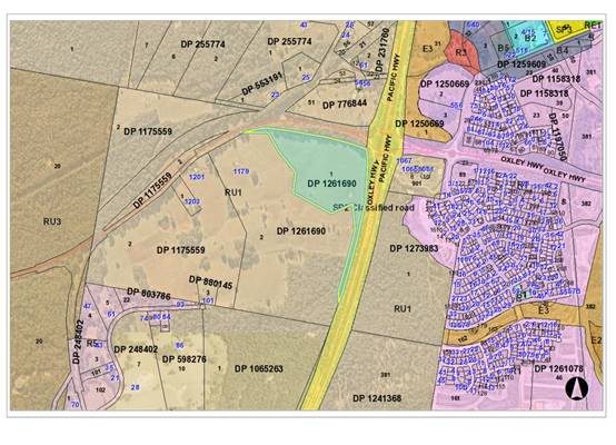
The
existing subdivision pattern and location of existing development within the
locality is shown in the following aerial photograph:
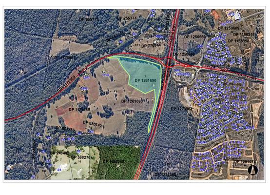
2. DESCRIPTION
OF DEVELOPMENT
Key
aspects of the proposal include the following:
· Service
station with separate fuelling facilities for cars and trucks;
· Seven
(7) food and drink premises, including three (3) with drive through facilities;
· A Trucker’s Lounge;
· Parking facilities including 148 car parking spaces, 25
truck parking spaces, 2 bus parking spaces, 8 caravan/trailer/motorhome parking
spaces, and 4 motorcycle parking spaces;
· Signage, including two pylon signs;
· Construction of an extension to the existing Pacific
Highway off-ramp to provide access to the development from the northbound lanes
of the Pacific Highway;
· Construction of a new roundabout providing access and
egress from the development on the Oxley Highway at the intersection of
Billabong Drive;
· Construction of a new road and roundabout connecting to the
Oxley Highway intersection and providing for future access to an urban
investigation area to the west of the site.
Refer
to Attachment 2 at the end of this report for plans of the proposed
development.
Application
Chronology
· 20
December 2019 - Application lodged.
· 30 January 2020 to 28 February 2020 - Neighbour
notification and advertising of application.
· 14 February 2020 - Comments on application received from
Transport for NSW.
· 9 March 2020 - Comments on application received from
Biodiversity Conservation Division.
· 12 March 2020, 23 March 2020, and 17 April 2020 -
Additional information requested from Applicant.
· 21 July 2020 - Additional information and amended plans
submitted.
· 3 August 2020 to 17 August 2020 - Application re-notified.
· 20 August 2020 - Comments on amended proposal received from
Transport for NSW.
· 14 September 2020 - Further additional information
requested from Applicant.
· 21 December 2020 - Further additional information and
amended plans submitted by Applicant.
· 7 January 2021 to 25 January 2021 - Application
re-notified.
· 13 January 2021 - Comments on amended proposal received
from Transport for NSW.
· 23 February 2021 - Further additional information requested
from Applicant.
· 6 May 2021 - Further additional information and amended
plans submitted by Applicant.
· 16 July 2021 - Comments on amended proposal received from
Biodiversity Conservation Division.
· 27 July 2021 - Comments on amended proposal received from
NSW Department of Primary Industries.
· 27 July 2021 - Comments on amended proposal received from
Transport for NSW.
· 11 August 2021 - Additional ecological assessment submitted
by Applicant.
3. STATUTORY
ASSESSMENT
Section
4.15(1) Matters for Consideration
In
determining the application, Council is required to take into consideration the
following matters as are relevant to the development that apply to the land to
which the development application relates:
(a) The
provisions (where applicable) of:
(i) Any
Environmental Planning Instrument
State Environmental Planning Policy No. 33 - Hazardous
and Offensive Development
SEPP 33 presents a systematic approach to planning and
assessing proposals for potentially hazardous and offensive development for the
purpose of industry or storage. The Policy ensures that only those proposals
which are suitably located, and able to demonstrate that they can be built and
operated with an adequate level of safety and pollution control, can proceed.
The Department of Planning’s Hazardous and
Offensive Development Application Guidelines - Applying SEPP 33 provides a
framework for assessing such proposals. The Applicant has submitted a SEPP 33
Assessment prepared by HMC Environmental Consulting Pty Ltd and dated February
2018. The assessment includes preliminary screening in accordance with the
Guideline to determine whether the fuel storage for the proposed highway
service centre make the proposal a potentially hazardous industry.
The screening test for fuel storage and dispensing has been
carried out based on a total storage volume of 640kL. As all fuel is stored
underground the volume is able to be divided by 5 for the purpose of the
screening test (128kL). Using the graph in Figure 9 of the Guideline, the
consultant has determined that a minimum separation distance of 13m is required
for the development not to be considered potentially hazardous (see below).
The screening thresholds for LPG are shown below:
The proposed development includes 15.3 tonnes stored
underground and 0.28 tonnes stored above ground, and does not exceed either of
the screening thresholds.
The transport movements associated with the development are
also below the screening threshold. The Applicant has estimated that the
expected number of deliveries will be less than 300 per annum. This is significantly
below the relevant threshold of 500 deliveries for Class 2.1 substances, and
1000 deliveries for Class 3PGIII substances.
As the proposed development falls below the relevant
screening thresholds, the Guideline provides that the development is not
considered potentially hazardous and a Preliminary Hazards Analysis is not
required.
State Environmental Planning Policy (Koala Habitat
Protection) 2020
With reference to clauses 6 and 7, the subject
land is greater than 1 hectare (including any adjoining land under same
ownership) and therefore the provisions of SEPP must be considered.
An ecological assessment prepared by
Naturecall Environmental has been submitted with the application, which
includes consideration of SEPP 44 (same methods as SEPP 2020). A survey of the
existing scattered trees on the site determined that the majority of trees were
Tallowwoods and the site therefore meets the definition of potential koala
habitat.
Further investigations determined that the
site does not constitute core koala habitat and therefore a koala plan of
management is not required.
State Environmental Planning Policy No. 55 –
Remediation of Land
A Stage 1 Contaminated Site Assessment prepared by Regional
Geotechnical Solutions has been submitted for the site. The land has previously
been used for agricultural purposes and the assessment investigated areas of
environmental concern including a spoil mound of unknown origin adjacent to the
eastern boundary and drainage lines and paddock areas potentially impacted by
pesticide and herbicide use.
Soil sampling concluded that contaminant concentrations did
not exceed adopted guidelines and the site was suitable in its current state
for future industrial/commercial land use. In accordance with clause 7(1) of
the SEPP, the land is therefore considered suitable for the intended use for a
highway service centre.
State Environmental Planning Policy No. 64 –
Advertising and Signage
The proposed development includes proposed advertising
signage in the form of business identification signs, including 2 pylon signs
to 20m high, and various signage for the individual businesses within the
highway service centre. None of the proposed signs are considered to be general
advertising, as the signage will relate to the businesses located on the land.
It is not considered necessary for Pylon Sign A (Pacific Highway frontage) to
include business signs on both sides as the development only provide access to
northbound traffic on the Pacific Highway. A condition is recommended
restricting business identification signs to the southern elevation of Pylon
Sign A.
In accordance with clause 7, this SEPP prevails over the
Port Macquarie-Hastings LEP 2011 in the event of any inconsistency.
The following assessment table provides an assessment
checklist against the Schedule 1 requirements of this SEPP:
|
Applicable clauses for consideration
|
Comments
|
Satisfactory
|
|
Clause 8(a) Consistent with
objectives of the policy as set out in Clause 3(1)(a).
|
The proposal is consistent with
the objectives of the policy subject to the recommended conditions
|
Yes
|
Schedule
1(1) Character of the area.
|
The site currently has a rural
character, but it is acknowledged that the LEP amendment to provide for a
highway service centre on the land has altered the desired future character
for the area.
Site specific DCP provisions
apply to the land, as discussed later in this report. As the proposal is
consistent with the DCP provisions, it is therefore considered compatible
with the desired future character for the area.
|
Yes
|
|
Schedule 1(2) Special areas.
|
The proposal will result in a
measurable change to the visual amenity of the existing rural landscape.
However, as noted above, the overall development of the site for a highway
service centre would alter the existing rural landscape. Signage of an
appropriate scale is considered to be appropriate for this use and would fit
into the landscape setting.
|
Yes
|
|
Schedule 1(3) Views and vistas.
|
Pylon Sign A would project into
the skyline when viewed by northbound traffic on the Pacific Highway and
would affect the existing rural vista.
Pylon Sign B would also project into the skyline when
viewed by eastbound traffic on the Oxley Highway and southbound traffic on
Billabong Drive.
A condition is recommended reducing the height of the
pylon signs to a maximum of 15m.
|
No
|
|
Schedule 1(4) Streetscape,
setting or landscape.
|
As noted above, pylon signs A and
B have significant scale, particularly vertically. As noted above, the signs
would extend above the top of buildings and tree canopies when viewed from
certain locations.
The precinct DCP includes performance based provisions
relating the maximum height of pylon signs, which are discussed later in this
report.
A condition is recommended reducing the height of the
pylon signs to a maximum of 15m.
|
No
|
|
Schedule 1(5) Site and building.
|
The scale and proportions of the
proposed wall signs are appropriate for the buildings and have been
integrated with the design to avoid any important building features.
|
Yes
|
|
Schedule 1(6) Associated devices
and logos with advertisements and advertising structures.
|
None proposed.
|
N/A
|
|
Schedule 1(7) Illumination.
|
The proposed signs, including
pylon signs, are proposed to be illuminated given that the highway service
centre would operate 24 hours. A preliminary lighting assessment has been
submitted with the application, which indicates that the development is
capable of complying with relevant Australian Standards controlling the
amenity and safety impacts of the illumination. Conditions have been
recommended requiring all illuminated signage to be installed and certified
in accordance with the recommendations of the report.
|
Yes
|
|
Schedule 1(8) Safety.
|
The proposed highway service centre is aimed at improving
road safety through reducing driver fatigue by providing regular resting
opportunities. The proposed pylon signs at the Pacific Highway and Oxley
Highway access points effectively identify the site’s use and would
assist in improving general road safety in this regard. The location of the
signs is not expected to have any traffic safety issues in terms of sight
distance or driver distraction.
The site is not expected to be a high pedestrian activity
area, with pedestrian movements limited to between parking areas and the
service centre buildings. The type and location of signs are not expected to
adversely impact pedestrian or cyclist safety.
|
Yes
|
State Environmental Planning Policy (Infrastructure) 2007
Clause 99 - The proposed highway service centre would not be
located within a road corridor.
Clause 101 - The site has frontage to the Pacific Highway
and Oxley Highway, both of which are classified roads. The land does not have
access to a road other than the classified road, and the development proposes
access from both the Pacific Highway and Oxley Highway. Egress from the
development is to the Oxley Highway only. Given the nature of the proposed use
as a highway service centre, access from the classified road network is
necessary for the development to serve its purpose.
The design of the vehicular access to the land and the
likely traffic impacts of the development are considered in detail later in
this report.
The proposed development is not of a type that is sensitive
to road traffic noise.
Clause 102 - The development is not of a nature that would
be sensitive to road noise or vibration.
Clause 104 - The proposal is traffic generating development
and the application has been referred to Transport for NSW (TfNSW) for comment.
The matters raised in the response from TfNSW have been considered in the
Traffic and Transport section later in this report.
State Environmental Planning Policy (Primary Production
and Rural Development) 2019
Clause 29 - The application was referred to NSW Department
of Primary Industries (DPI) in accordance with this clause given the large
scale of the proposed on-site sewage management system and the potential for a
significant failure of the system to affect oyster aquaculture downstream in
the Hastings River. DPI raised concerns about the significant potential for
failure of the on-site sewage management system, and/or a reduction in
treatment processes prior to discharge to sensitive receiving waters. The
quality of influent is critical to on-site treatment processes and commercial
waste of oil, grease and chemicals are likely to compromise on-site sewage
treatment processes. The higher level concept design of on-site sewage
management discussed in the On-site Sewage Management - Site Feasibility Report
does not provide specific details on the preferred system and it is therefore
not possible to thoroughly evaluate the impacts.
DPI recommends that the use of an on-site sewage management
system not be supported, and that the development be connected to reticulated
sewer.
Of relevance to this consideration, Council entered into a
Planning Agreement with the developer prior to the lodgement of this
application, which allows on-site sewage management providing that the developer
make a monetary contribution towards the longer term connection of the site to
sewer. On this basis, it is not considered possible to force the developer to
connect to sewer as the only option.
The installation of the on-site sewage management system
will require separate approval under Section 68 of the Local Government Act
1993. The detailed design as part of this application will need to address the
above concerns and particularly include appropriate measures for the management
of oil, grease and other commercial waste, and mitigation measures to contain
effluent within the site in the event of system failure. Appropriate conditions
have been recommended in this regard.
Port Macquarie-Hastings Local Environmental
Plan 2011
The proposal is consistent with the LEP having regard to the
following:
· Clause
2.2 - The subject site is zoned RU1 Primary Production. In accordance with
clause 2.3(1) and the RU1 zone landuse table, the proposed development for a
highway service centre is prohibited in the zone. However, Schedule 1 of the
LEP provides for additional permitted uses on the land and allows development for the purposes of a highway service centre and ancillary hotel or
motel accommodation with development consent.
The objectives of the RU1 zone are as
follows:
o To encourage
sustainable primary industry production by maintaining and enhancing the
natural resource base.
o To encourage
diversity in primary industry enterprises and systems appropriate for the area.
o To minimise the
fragmentation and alienation of resource lands.
o To minimise
conflict between land uses within this zone and land uses within adjoining
zones.
Clause 2.3(2) - The proposal is
consistent with the zone objectives having regard to the following:
o The value of the land for
primary production has been considered in a strategic context as part of the
LEP amendment that allowed the additional use of the land for a highway service
centre.
o The potential for land use
conflict between the proposal and adjoining land uses has been considered in
the assessment and it is considered that the potential conflicts can be
appropriately managed.
· Clause
2.5 - Schedule 1 of the LEP provides for additional permitted uses on the land
and allows development for the purposes of a highway service
centre and ancillary hotel or motel accommodation with development consent.
This clause has effect despite anything to the contrary in the Land Use Table
or any other provision of the Plan.
· Clause
4.3 - No maximum height of buildings applies to the site.
· Clause
4.4 - No maximum floor space ratio (FSR) applies to the site.
· Clause
5.10 – The site does not contain or adjoin any known heritage items or
sites of significance.
· Clause
7.7 – The obstacle limitation surface (OLS) at the location of the
development site is approximately 60m AHD. The highest part of the development
(top of pylon sign A) is approximately 43m AHD, and will be substantially below
the OLS. However, a precautionary condition is recommended in relation to the
use of cranes during construction.
· Clause
7.13 - Satisfactory arrangements can be made to make available essential
services including water supply, electricity supply, on-site sewage management,
stormwater drainage and suitable road access to service the development.
Provision of electricity will be subject to obtaining satisfactory arrangements
certification prior to the issue of an Occupation Certificate as recommended by
a condition of consent.
· Clause
7.17 - Subdivision of the land for the purpose of a highway service centre has
previously been granted in accordance with this clause under DA2019 - 680.1.
(ii) Any draft
instruments that apply to the site or are on exhibition
No draft instruments apply to
the site.
(iii) Any Development
Control Plan in force
Port
Macquarie-Hastings Development Control Plan 2013
|
DCP 2013: Part B - General
Provisions
|
|
DCP Objective
|
Development Provisions
|
Proposed
|
Complies
|
|
1
|
Signs primarily identifying
products or services are not acceptable, even where relating to products or
services available on that site.
|
Signs identify names of
businesses and not products or services.
|
Yes
|
|
Signage is not permitted outside
property boundaries except where mounted upon buildings and clear of
pedestrians and road traffic. No signage is permitted upon light or power
poles or upon the nature strip (the area between the property boundary and
constructed roadway). Limited directional
signage and “A”
frame signage may separately be approved by Council under the Roads Act
1993 or section 68 of the Local government Act 1993.
|
All signs located within
property boundaries.
|
Yes
|
|
An on-building 'chalkboard'
sign, for the purpose of describing services or goods for sale which vary on
a regular basis generally should not be any larger than 1.5m2, and should
contain a sign written heading indicating the premises to which it refers.
|
N/A
|
N/A
|
|
On-premise signs should not
project above or to the side of building facades
|
None of the proposed on-premises
signs project above or to the sides of building facades.
|
Yes
|
|
2
|
Where there is potential for
light spill from signage in a non residential zone adjoining or adjacent to
residential development, illuminated signage is to be fitted with a time
switch to dim by 50% or turn off the light by 11pm each night, depending on
the nature of the development.
|
The proposed signage, including pylon signs, is proposed
to be illuminated given that the highway service centre would operate 24
hours. A preliminary lighting assessment has been submitted with the
application, which indicates that the development is capable of complying
with relevant Australian Standards controlling the amenity and safety impacts
of the illumination. Conditions have been recommended requiring all
illuminated signage to be installed and certified in accordance with the
recommendations of the report.
|
Yes
|
|
3
|
Development must comply with
Council’s Developments, Public Place & Events - Waste
Minimisation and Management
Policy.
|
The Applicant has submitted a Waste Management Plan that
generally addresses the Policy. The Plan includes arrangements for the
management of construction and operational waste, facilities for waste
storage, and access for waste collection vehicles.
The construction waste management provides a template for
this aspect of the development, but seeks to provide full details of the
volumes and type of waste once the construction tender process has been
completed and this information can be provided more accurately. This is
considered acceptable and a condition has been recommended requiring an
amended Waste Management Plan to be approved prior to the issue of a
Construction Certificate.
The volume of organic waste generated by the take away
food and drink premises is also likely to be underestimated in the current
Waste Management Plan. The volume has been estimated using the rate in
Council’s Policy, which is based on the sale of pre-packaged food. This
is not considered to be a significant issue as there is sufficient storage
capacity to provide additional organic waste bins. Increasing the frequency
of waste collection would also be an alternative, as the development will
have a private waste collection service.
|
Yes
|
|
6
|
a) Significant land reforming
proposals where >10% gross site area or >1.0ha is to have surface
levels
changed by more than 5m or where
earthworks exceed an average of 10,000m3 per ha shall:
• identify the impact of the proposed land
reforming on the environment, landscape, visual character and amenity,
natural watercourses, riparian vegetation, topographical features of the
environment and public infrastructure;
• demonstrate compliance with the provisions of
Council’s Aus-Spec design specification;
• assess the impacts and benefits of the proposal
to all impacted persons and the general public;
• provide measures to compensate for and minimise
any net adverse impacts.
|
The submitted plans include
detailed earthworks plans and sections showing the proposed finished surface
levels.
|
Yes
|
|
b) The use of high earthworks
batters should be avoided.
|
The proposed development
includes some significant earthworks batters due to existing topography and
the required location of the intersection on the Oxley Highway. The site
specific DCP provisions include details of the height and treatment of
earthworks batters and are discussed later in this report.
|
No, but acceptable
|
|
9
|
a) A minimum, fully vegetated
buffer from the top of bank to both sides of a watercourse is to be
provided in accordance with the
following:
• 10m for 1st order streams that flow
intermittently.
• 30m for 1st order streams that flow permanently.
• 40m for 2nd order streams.
• 50m for 3rd order streams.
• 65m for 4th order streams.
b) Stormwater management
facilities may be considered within buffer areas only where the applicant
can demonstrate the proposal is
justified on the basis of practical engineering related site
constraints and where it is
adequately demonstrated that the applicable objectives are achieved.
c) Fully vegetated buffers
cannot contain road infrastructure or an asset protection zone.
|
The NSW Natural Resource Access
Regulator has reviewed the proposal and raised no objection to the existing
first order stream being built over and replaced with piped stormwater
drainage. As the stream is not required to be retained, there is no nexus for
a vegetated buffer.
|
No, but acceptable
|
|
11
|
Tree management on private land.
|
The ecological assessment found
that there are approximately 67 primary and secondary preferred food trees
along the eastern road reserve and 23 along the northern road reserve. These
comprise Tallowwood, Small-fruited Grey Gum and Red Mahogany. In addition to
these, there are three KFTs within the subject site that will require
removal.
As such, there are approximately
93 primary and secondary Koala food trees that will require removal and 186
offset plantings are required to meet the DCP ratio of 2:1.
The submitted landscape plan
indicates that 86 of the required offset planting can be provided within the
site at appropriate spacing. The additional planting can either be provided
in a secure off-site located agreed by Council, or through re-vegetation of
the on-site sewage irrigation area when the land is connected to the sewer in
the future.
A reduced number of offset
plantings could be accepted in the event that Transport for NSW carries out
clearing in the road reserve for road related purposes prior to the
development commencing.
A Vegetation Management Plan
will be required confirming the above details.
|
No, but acceptable
|
|
13
|
Removal of hollow bearing trees
|
The
Addendum Ecological Assessment for Proposed Highway Service Centre, Oxley
Highway, Sancrox identified that the following number of nest boxes per
category are to be sourced and installed in existing vegetation on or
adjacent to the site:
· eight microbat boxes
· four small glider/phascogale nest boxes
· four large possum boxes
· four parrot boxes
Consideration
to additional tree planting may be permitted in place of the nest box
installation if no available suitable locations. This has been detailed in
the conditions to prepare a Vegetation Management Plan.
|
Yes
|
|
18
|
APZs are to be located outside
of environmental protection zones and wholly provided within private land.
Note perimeter roads provided as part of a residential subdivision are
classified as being part of the subdivision and not a separate permissible
land use within environment protection zones.
|
All APZs are located outside
environmental zones.
|
Yes
|
|
23
|
New accesses not permitted from
arterial or distributor roads. Existing accesses rationalised or removed
where practical
|
Access from Pacific Highway and
Oxley Highway proposed in consultation with TfNSW.
|
No, but acceptable
|
|
Driveway crossing/s minimal in
number and width including maximising street parking
|
No street parking exists in
either street frontage, and it is unlikely that street parking will be
provided in the future given that both roads are classified roads. No loss of
street parking expected from proposed access points.
|
Yes
|
|
24
|
Off-street parking in accordance
with Table 2.5.1.
(Provision to consider reduced
parking where supported by parking demand study)
|
The proposal includes the
following components that generate parking demand:
· Service station - 1 space per employee, plus 2 customer
spaces (minimum), plus any restaurant/takeaway food requirements.
· Take-away food and drink premises:
o developments with on-site seating but no drive through
facilities:
§ 12 spaces per 100m2 GFA, or the greater of.
§ 1 space per 5 seats (both internal and external seating),
or.
§ 1 space per 2 seats (internal seating).
o developments with on-site seating and drive-through
facilities greater of
§ 1 space per 2 seats (internal), or.
§ 1 space per 3 seats (internal and external).
§ Plus queuing for minimum of 8 vehicles.
· Retail premises (service station shop - T05) - 1 space
per 30m2 GFA.
Service Centre Take-Away
For the purpose of the parking
assessment the take-away food and drink premises within the service
centre building have been considered as a single entity as there will be no
seating within the individual tenancies and they all rely upon a shared
internal and external seating area. The main service centre building includes
two drive-through facilities and has been assessed as a take-away food and drink
premises with drive through facility and internal and external parking.
The submitted plans show 113 internal seats and 52
external seat (total 165 seats). A 1 space per 3 seats the parking demand for
this component is 55 spaces.
Queuing for minimum of 8
vehicles at each drive-through facility has been provided.
T08 (take-away food and drink premises with 88 internal seats, and drive through) - 88
seats at 1 space per 2 seats = 44 spaces.
Queuing for minimum of 8
vehicles at drive-through facility provided for T08.
T05 (service station convenience shop with 270m2
GFA - 270m2 at 1 space per 30m2 = 9 spaces.
Service Centre (30 employees) - 30 employees at 1 spaces per employee =
30 spaces.
Minimum 2 customer spaces = 2
spaces.
Total Parking Demand
140 spaces
The submitted plans show 148 car
parking spaces for the development, with an additional 25 truck parking
spaces, 2 bus parking spaces, 8 caravan/trailer/motorhome spaces, and 4
motorcycle spaces.
The development therefore meets
the minimum parking requirements.
|
Yes
|
|
28
|
Parking layout in accordance
with AS/NZS 2890.1 and AS/NZS 2890.2
|
Capable of complying with
Australian Standard. Conditions recommended requiring certification of plans
with Construction Certificate, and certification of completed work prior to
the issue of an Occupation Certificate.
|
Yes
|
|
29
|
Accessible parking provided in
accordance with AS/NZS 2890.1, AS/NZS 2890.2 and AS 1428
|
Five (5) accessible parking
spaces proposed. Capable of complying with Australian Standard. Conditions recommended
requiring certification of plans with Construction Certificate, and
certification of completed work prior to the issue of an Occupation
Certificate.
|
Yes
|
|
30
|
Bicycle and motorcycle parking
considered and designed generally in accordance with the principles of
AS2890.3
|
Four (4) motorcycle parking
spaces proposed. Capable of complying with Australian Standard. Conditions
recommended requiring certification of plans with Construction Certificate,
and certification of completed work prior to the issue of an Occupation
Certificate.
|
Yes
|
|
33 - 34
|
Landscaping of parking areas
|
Landscaping generally provided
throughout parking areas in accordance with these provisions. Site specific
landscaping controls apply to this site and are addressed later in this assessment
table.
|
Yes
|
|
35
|
Sealed driveway surfaces unless
justified
|
Sealed surfaces proposed and
condition recommended confirming this requirement.
|
Yes
|
|
36
|
Parking areas to be designed to
avoid concentrations of water runoff on the surface.
|
A Stormwater Management Plan has
been submitted for the proposal. See comments later in this report under
stormwater.
|
Yes
|
|
Vehicle washing facilities
– grassed area etc available.
|
|
No direct discharge to K&G
or swale drain
|
|
37
|
Car parking areas drained to
swales, bio retention, rain gardens and infiltration areas
|
|
38
|
Off street commercial vehicles
facilities are provided in accordance with AS/NZS 2890.2
|
One loading bay provided for
service centre building with access via the truck parking area. An additional
bay is also proposed for the separate food and drink premises (T08).
|
Yes
|
|
Loading bays will be provided in
accordance with the following requirements;
• Minimum dimensions to be
3.5m wide x 6m long. (This may increase according to the size and type of
vehicle).
• Vertical clearance shall
be a minimum of 5m.
• Adequate provision shall
be made on-site for the loading, unloading and manoeuvring of delivery
vehicles in an area separate from any customer car parking area.
• A limited number of
‘employee only’ car parking spaces may be combined with loading
facilities.
• Loading areas shall be
designed to accommodate appropriate turning paths for the maximum design
vehicle using the site.
• Vehicles are to be
capable of manoeuvring in and out of docks without causing conflict with
other street or on-site traffic.
• Vehicles are to stand
wholly within the site during such operations.
|
|
Other commercial development
shall provide one loading bay for the first 1,000m² floor space and one
additional bay for each additional 2,000m².
|
|
39
|
The location and design of
loading bays should integrate into the overall design of the building and car
parking areas.
|
Location and design
satisfactory.
|
Yes
|
|
Where visible from the public
domain, loading bays are located behind the building.
|
Located behind the buildings.
|
Yes
|
|
Where loading bays are located
close to a sensitive land use, adequate visual and acoustic screening is
provided.
|
Not located in proximity to
sensitive land uses.
|
Yes
|
|
43
|
Design addresses generic
principles of Crime Prevention Through Environmental Design guideline:
· Casual surveillance and sightlines
· Land use mix and activity generators
· Definition of use and ownership
· Lighting
· Way finding
Predictable routes and
entrapment locations
|
The Applicant has provided the
following advice regarding CPTED principles.
Natural Access Control –
The design directs the flow of traffic, using signage, from the site access
to the relevant car park in the well-lit service centre.
Natural Surveillance –
Staff and customers of the highway service centre will passively overlook the
car park areas through large expanses of glazing. Mid level landscaping is
not proposed within the service centre to provide optimum visibility along
paths of travel. Lighting is proposed throughout the site to improve
visibility. Security cameras will be
provided where required by
tenancy operators.
Territoriality – The
internal road around the service centre building creates a sense of
territoriality on the site. Staff will be present on site at all times to
enforce territoriality. ‘Staff only’ areas will be clearly
labelled as such.
Maintenance – The highway
service centre will be subject to a maintenance schedule
which will include maintenance
of landscaping, cleaning of indoor and outdoor areas and removal of all
graffiti in a timely manner.
|
Yes
|
|
|
|
|
|
|
DCP 2013: Chapter D8
Highway Gateway Sites
|
|
DCP Objective
|
Development Provisions
|
Proposed
|
Complies
|
|
335
|
A formal urban design/landscape
analysis with a set of architectural diagrams explaining the design, and how
it responds to the site context. The site analysis is also to include an
evaluation of existing trees for protection and retention.
|
Urban Design and Landscape
Statement prepared by i2C submitted with the application.
|
Yes
|
|
Detailed cross-sections through
the entire site, including through the location of main access points and
across the highway boundaries. The cross-sections are to be of a scale that
can be clearly read and indicate:
− The existing and
proposed landform in separate colours and line form (e.g. use a dashed line
for proposed)
− Areas of cut and fill
− Reduced Levels (RLs) of
main features and heights of any buildings and structures such as signs
− Location of existing and
proposed vegetation, defining where any vegetation is proposed for removal.
|
Sufficient information provided
between the architectural and civil plans.
|
Yes
|
|
Photomontages to illustrate the
development proposal as accurately as possible and produced in accordance
with the NSW Land and Environment Court’s Use of Photomontages document
as available on their website. In addition, the photomontages are to:
− Be approximately from
the following locations indicated in Figure 4.7-2: Viewpoints B and D
applicable to the Southern Site and Viewpoints E and G applicable to the
Northern Site. In addition, a photomontage is to be included from wherever
the main access will be from the Oxley Highway, looking into the site.
− Photomontages are to
include an image of the development immediately following construction (i.e.
with any new landscaping shown as immature) and at approximately 5-7 years
post construction (i.e. showing new landscaping with estimated growth likely
to be achieved in that timeframe).
|
Adequate photomontages submitted
showing key viewpoints.
It is noted that the
photomontages have not strictly been prepared in accordance with the
recommended Land and Environment Court guidelines due to a lack of safe
locations along the classified road frontages to carry out the necessary
survey work. It is considered that the photomontages submitted provide an
accurate visual representation of the key aspects of the proposal.
|
No, but acceptable
|
|
336
|
In consultation with Council and
the Roads and Maritime Services, a four-way intersection will need to be
provided at the intersection of the Oxley Highway with Billabong Drive to
service the likely future needs of development to the north and south of the
Oxley Highway. The intersection design will need to be approved by the NSW
Roads and Maritime Services, and Council.
|
Details of the proposed four-way
intersection with Oxley Highway and Billabong Drive have been submitted.
Transport for NSW (formerly RMS) have been consulted in the assessment of the
application.
|
Yes
|
|
Prior to development of the
Southern Gateway Site, provide detailed information demonstrating that the
‘Access Land Dedication Land’ referred to in the Highway Service
Centre Planning Agreement is appropriately located and can be constructed to
current AUS SPEC standards.
|
The application has demonstrated
that a road consistent with Aus-Spec standards could be constructed to the
adjoining land to the west. It is noted that road construction would require
significant excavation and earthwork batters. The development has been
designed to ensure that there are no structures or environmental offsets
within the corridor required for construction of the future road.
|
Yes
|
|
337
|
Locate car and truck parking
areas so that extensive areas of hard pavement are broken-up and articulated
with landscaping, different materials/colours and level changes and sites
buildings so as to contribute to screening views of car parking from outside
views.
|
Car parking areas between the
buildings and public roads are appropriately landscaped. The truck parking
area contains limited landscaping within the extensive hardstand area.
However, the truck parking area is located behind the service centre buildings
and includes perimeter landscaping. It is considered that this area would be
appropriately screened from outside views.
|
Yes
|
|
Provide a 40m minimum setback to
all buildings from the Pacific Highway frontage, and 20m from the Oxley
Highway frontage.
The general requirements for
this setback in terms of landscaping and the siting of hard surface areas is
shown diagrammatically in Figures 4.7-3 and 4.7-4.
If it can be shown that the
Roads and Maritime Services can guarantee the retention of the majority of
large trees within the existing road reserves along the highway boundaries in
the long term (over 20 years) then consideration could be given to reducing
the requirement for the Pacific Highway boundary setback to 20m, including a
reduced landscape buffer to 10m. Such a scenario and its implications would
need to be negotiated with Council.
|
Proposal exceeds minimum setback
requirements, with all buildings setback more than 50m from both frontages.
|
Yes
|
|
In consultation with Council and
the Roads and Maritime Services, road access points from either the Pacific
Highway or Oxley Highway are to be designed, as far as possible, to maintain
the natural integrity of existing landform, vegetation and drainage systems.
Structural drainage elements should be used in preference to mass fill
embankments.
|
The proposal includes
significant landform change and vegetation removal at both the Pacific
Highway and Oxley Highway access points. The location of the access points
are constrained for traffic safety reasons and there is not any alternative
access arrangement that would reduce the extent of landform change and
vegetation removal. The impacts of these works will be offset through
terracing of batters and appropriate landscaping.
|
No, but acceptable
|
|
338
|
Any batters and retaining walls
must be treated to reduce visual impacts and stabilise the landform.
|
The submitted landscape plans
include plantings on batters.
|
Yes
|
|
As a general rule, batters
should be kept to a maximum gradient of 1V:2.5H (i.e. 1m vertical to 2.5m
horizontal) and terraced so as to avoid a high single batter and allow trees
of at least 5m mature height to be established on the terraces and base of
the batter. Total maximum vertical height of any batter to be 8m.
|
Batter grades and terracing
comply with this requirement.
|
Yes
|
|
Excessive retaining walls are to
be avoided, with a maximum height of 8m permitted.
|
No retaining walls greater than
8m high proposed.
|
Yes
|
|
Alternative batter and retaining
wall treatments may be considered providing that it is clearly shown that the
objective of this provision is achieved.
|
The proposal is consistent with
the batter provisions above and does not include an alternative solution.
|
N/A
|
|
339
|
Within the setback along the
Pacific Highway and Oxley Highway boundaries design for a corridor of
vegetation along the boundary of at least 15m wide (at ground level) for the
Pacific Highway frontage and 10m wide for the Oxley Highway frontage.
The corridor is to apply to at
least 60% of the length of the boundary with coverage of at least one plant
per m2.
Design for a mix of: 20% canopy
trees (with a mature height over 20m); 30% mid-storey shrubs/small trees
(mature heights 3–10m); and a 50% understorey of small
shrubs/groundcovers (mature heights under 3m).
Canopy trees are to be
relatively evenly spread; yet mid-storey shrubs/small trees may be grouped as
appropriate if a glimpse through vegetation from highways is desired.
|
Landscaping plan submitted which
includes minimum 15m wide landscaping to the Pacific Highway frontage
(excluding access road), and 10m wide landscaping to the Oxley Highway
frontage (excluding access road).
The landscaping includes canopy
trees, mid-storey, and understorey plantings and the landscape plan is noted
to confirm that the mix of plantings will be in accordance with the DCP.
|
Yes
|
|
Once plants are
well-established, if increased highway exposure is desired it should be
achieved by:
- Selective pruning of lower
tree limbs up to a maximum height of 6m
- Ongoing management of existing
and new vegetation.
|
Noted.
|
Yes
|
|
Design for a mix of garden
areas, tree groups (of 10-20m in mature height) and open grassed areas that
combined, produce pleasant spaces for public seating and use, shade,
separation of different use areas and variety.
Any proposal for a highway
service centre should include consideration of opportunities for public
recreation facilities in conjunction with the highway service centre use.
|
Satisfactory mix of landscaping
proposed, including shade trees around seating areas near the car and truck
parking.
No outdoor public recreation
facilities proposed. Indoor play areas proposed in the service centre and
also the separate food and drink premises.
|
Yes
|
|
Select plant species that are
suitable for the growing environment and relatively low maintenance. The
majority of plant species are to be locally native species. Exotic species
may be suitable in certain locations, particularly those with some cultural
relationship to the local area that can be used to draw attention to parts of
the site, or for playgrounds and public seating areas.
|
The selected plant species are
low maintenance natives. A mix of boundary, corridor and feature trees are
proposed.
|
Yes
|
|
Within parking areas,
development should include supply, installation and maintenance of at least
one advanced (minimum height of 2m at planting) clear trunked broad canopy
tree (with a minimum mature height of approx. 10m) for every eight at-grade
car parking spaces and one for every three truck parking spaces.
|
25 trees provided within the car
parking areas, which exceeds the 1 per 8 space requirement. 12 trees are
proposed within the truck parking, which also exceeds the minimum requirement
of one tree per 3 spaces.
A condition is recommended
confirming the requirement for plantings in the parking area to be a minimum
of 2m high at planting.
|
Yes
|
|
Each landscape planting area
should include at least one medium to large tree species with suitable ground
covers or low shrubs below and have a minimum width of 3m and include
measures to protect trees from vehicle damage.
|
Landscaped areas have been designed
to generally accommodate at least one medium to large tree. Some landscaped
areas within the service centre parking are less than 3m wide. These have
been designed to be equivalent to a single parking bay, which will provide a
more practical and usable parking area. The landscaped areas are still of
suitable dimensions to accommodate a medium to large trees and the proposal
is consistent with the objectives of the provision.
|
No, but acceptable
|
|
340
|
Design a suite of buildings and
structures with a complementary visual relationship that are of a
high-quality architectural design.
|
Design of buildings considered
satisfactory.
|
Yes
|
|
Consider the roof form,
particularly when viewed from the Pacific Highway and Oxley Highway. Design a
roof form that is aesthetically pleasing and of elegant form.
|
Roof form considered
satisfactory in the context.
|
Yes
|
|
Consider building articulation,
architectural features and the presentation of the façade. Buildings
with minimal articulation will not be accepted.
|
Buildings include satisfactory
articulation.
|
Yes
|
|
The location of loading bays,
garbage storage and collection should be such that these cannot be seen from
the Pacific or Oxley Highways.
|
Main loading bay located at rear
of service centre building and out of view from Pacific and Oxley Highways.
Loading bay for food and drink premises T08 is located on the eastern side of
the building and would be screened from view of the Pacific Highway by the
service centre building. It would also be largely screened from view from the
Oxley Highway by perimeter and carpark landscaping.
|
Yes
|
|
Buildings should not be visible
above the dominant existing and future tree-line (i.e. approx. 20m) when
viewed from the locations indicated in Figure 4.7-2: Viewpoints B, D and H applicable
to the Southern Site and Viewpoints E, F and G applicable to the Northern
Site.
|
Proposed buildings, including
pylon signs, are less than 20m high and would not project above the tree
line.
|
Yes
|
|
Signage is required to satisfy
State Environmental Planning Policy 64 - Advertising and Signage.
In addition, proposed signage
should be shown in the photomontages and be demonstrated to achieve the
objectives of this area based DCP.
|
See comments under SEPP 64
earlier in this report.
A condition has been recommended
requiring amendments to the pylon signs to satisfy SEPP 64 and the DCP
provisions.
|
No
|
|
In general, signs should not be
visible above the dominant existing tree-line (evident at the time of this
DCP commencing, i.e. mature trees in place alongside highway boundaries) when
viewed from the locations indicated in Figure 4.7-2: Viewpoints B and D
applicable to the Southern Site and Viewpoints E and G applicable to the
Northern Site. If the majority of trees within the highway reserve are
removed, then a maximum permitted height of 15m applies.
|
The proposal includes the
clearing of the majority of trees in the road reserve on both highway
frontages. Only a small amount of vegetation adjacent to the Pacific Highway
and Oxley Highway interchange is shown to be retained on the landscape plan.
Pylon signs A and B are proposed to be 20m high, which exceeds the maximum
permitted under this provision.
|
No
|
|
Balance the type and level of
lighting to address the safety and needs of users, the potential for negative
visual impact to surrounding viewpoints and any desire for highway exposure.
|
The Applicant has submitted a
preliminary lighting report demonstrating that the external lighting is
capable of complying with relevant Australian Standards. Conditions have been
recommended requiring all illuminated signage to be installed and
certified in accordance with the recommendations of the report.
|
Yes
|
|
Sensitively designed lighting
could be used to enhance the gateway role of the sites, particularly along
the highway edges, yet the effect and potential visual impact would need to
be demonstrated to be aesthetically pleasing and have a public benefit.
|
No particular lighting proposed
along the highway edges.
|
Yes
|
|
Avoid fencing where unnecessary;
and where unavoidable, use aesthetically pleasing alternatives in terms of
materials, colours, lower heights and integrated landscaping such as planting
and mounding.
|
The proposal does not include
any fencing forward of, or within, the highway service centre. A fauna fence
is proposed along the western perimeter of the development, which is not
considered to be inconsistent with this provision.
|
Yes
|
|
341
|
The development should provide
quality artwork(s) in publicly accessible location(s) and take into account
links and connections between the development and the area’s natural
and cultural heritage.
|
Indicative location/s for public
art identified on the submitted plans.
|
Yes
|
|
The public art is to be 1% of
the total cost of the development to provide works of art for appreciation
from the public domain, including the Pacific Highway and/or the Oxley
Highway (NSW Roads and Maritime Services approval may be required).
|
Condition recommended confirming
value of public art required.
|
Yes
|
|
Specifically designed lighting
may be appropriate as either an integral part of any public art or to
highlight it.
|
Noted. Details not provided at
this stage.
|
N/A
|
|
In consultation with Council,
develop an appropriate response to the Oxley Highway intersection that could
include specific landscape planting and/or a public art element.
|
A condition has been recommended
regarding the treatment of the new roundabout.
|
|
The application seeks to vary Clause 340 in relation to the
height of proposed pylon signs A and B adjacent to the Pacific Highway and
Oxley Highway accesses.
The relevant objective of the provision is to ensure signage
achieves a balance between providing appropriate directions and notification to
travellers yet not overly dominate the surrounding character of the local
landscape.
The Applicant has submitted that the proposed 20m high pylon
signs are acceptable for the following reasons:
· The applicant has
removed the two 5m high fuel price boards previously shown on the DA drawings.
· The RMS does not
object to the sign height of Pylon Signs A and B as per their letter dated 13
January.
· The 20m height
allows for adequately sized signage for all tenants.
· Pylon Sign A will
be visible from the approach to the Pacific Highway off ramp to allow motorists
to make safe decisions.
· Pylon Sign B will
be visible from the Oxley Highway roundabout to drivers from both directions.
· Pylon Signs A and B
will be in close proximity to existing tree canopy with a minimum height of
over 20m as shown in the submitted drawing “Elevation Sketch of Signage
Pylons Within the Proposed Landscape.” The pylon sign height is therefore
not intrusive on the landscape as it is not higher than the surrounding canopy.
· Nambucca Service
Centre has an approved pylon sign which is 25m tall.
It is not considered that the Applicant’s
justification provides sufficient grounds to support the increased sign height
having regard to the objectives of the provision. It is recommended that the
variation not be supported for the following reasons:
· The development
includes the clearing of the majority of the roadside vegetation in both
highway frontages, which will leave the two pylon signs very exposed and
prominent in the landscape. The submitted plans confirm that Pylon Sign B
(Oxley Highway frontage) will project into the skyline even 6-7 years after
completion of the development when new landscaping is becoming established (see
below).
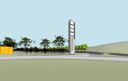
A similar photomontage
has not been provided for Pylon Sign A in the Pacific Highway frontage, but
from the views available through the roadside vegetation it is expected that
this pylon would also significantly project into the skyline.
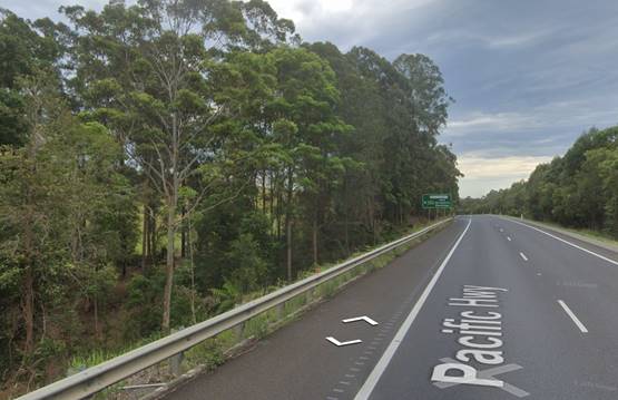
· SEPP 64 aims to
prevent signs from projecting above the top of the tree canopy into the skyline
in a rural context.
· The preparation of
the DCP controls included review of signage at a number of existing Highway
Service Centres and the 15m height limit was considered to provide the best
balance between providing sufficient exposure for the businesses and protecting
the visual amenity of the rural landscape.
· The pylon signs
could be easily altered to provide equitable display area for all businesses
within the 15m height limit. It is not considered necessary for the top two
panels of the pylon sign to be of larger dimensions as currently proposed and
fuel pricing could be provided within the site closer to the fuel outlets and
at a lower scale.
· A 15m sign will
provide sufficient visibility to allow motorists to make safe decisions about
exiting the Pacific and Oxley Highways. Transport for NSW have also advised
that they would provide advisory signs for motorists that they are approaching
an exit to a highway service centre.
· The signage
proposal relies upon landscaping that will be carried out as part of the
development, and this will not provide any effective screening for many years
and may not ultimately achieve a 20m height.
· Transport for NSW
have an interest in the traffic safety aspect of signs near transport corridors
and are not assessing visual and amenity impacts. The lack of objection from
TfNSW does not make the signs acceptable having regard to the DCP objectives as
a planning consideration for Council as the consent authority.
Having regard to the above unresolved signage
detail, a condition is recommended requiring amended plans of the pylon signs
to be submitted prior to the issue of a Construction Certificate. The height of
the structures are recommended to be specifically reduced to a maximum of 15m,
consistent with the DCP provisions.
(iiia) Any planning agreement that has
been entered into under section 7.4, or any draft planning agreement that a
developer has offered to enter into under section 7.4
The land is subject to the 1179
Oxley Highway, Sancrox Planning Agreement dated 24 July 2019 between Port
Macquarie Hastings Council, Scott PDI No.6 Pty Ltd and Margaret Mary Hore. The
following provisions of the Planning Agreement are applicable to the proposal:
Clause 9 - Requires payment of
the Sewerage Infrastructure Contribution prior to the release of the first
Construction Certificate if the developer elects to use on-site wastewater
management. An appropriate condition is recommended requiring payment of the
relevant contribution.
Clause 10 - Requires payment of
monetary DSP contributions immediately prior to connection to reticulated sewer
or the issue of a Section 307 certificate, whichever occurs first. The
application does not propose connection to reticulated sewer.
Clause 11 - Requires dedication
of land associated with the new road off the Oxley Highway. An appropriate
condition has been recommended requiring dedication of public road in
accordance with the agreement.
Clause 12 - If the developer
elects to use on-site wastewater management, they are required to carry out the
Sewerage Infrastructure Connection Works (a sewer connection from the subject
site to the northern side of the Oxley Highway). Appropriate conditions have
been recommended in relation to the design and construction of this
infrastructure.
Clause 15 - Provides for the
adjoining landowner to enter the HSC land for the purpose of constructing a
public road on the Adjoining Land Access Land.
Clause 30 - The Deed has already
been registered on the title of the HSC land as part of the previous
subdivision.
(iv) Any
matters prescribed by the Regulations
No matters prescribed by the regulations
are applicable to the proposal.
(b) The likely
impacts of that development, including environmental impacts on both the
natural and built environments, social and economic impacts in the locality
The site (Lot 1) has a general northerly street frontage
orientation to the Oxley Highway and an easterly frontage to the Pacific
Highway. Adjoining the site to the south and west is the rural property from
which the proposed highway service centre has been subdivided under DA2019 -
680 (Lot 2, No. 1179 Oxley Highway). Further to the south-west is a rural
residential estate in Birralee Drive.
On the eastern side of the Pacific Highway is another
highway service centre and a residential subdivision known as Stirling Green.
On the northern side of the Oxley Highway are a mix of rural
residential and tourist uses in Billabong Drive and Bushlands Drive. An aerial
image showing the site context is included below:
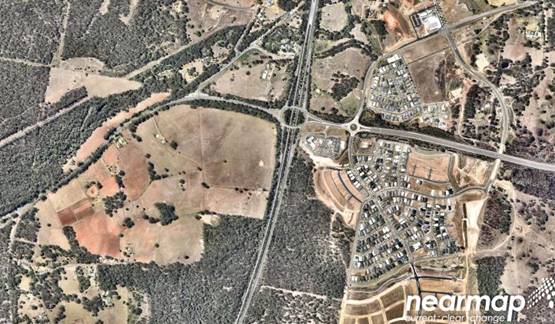
The proposal has had appropriate regard to the surrounding
land uses in the assessment of impacts.
Roads
The site has road frontage to the Pacific Highway to the
east and the Oxley Highway to the north. Both of these roads are classified
(State) roads and are controlled access roads along the frontages of the
subject site.
Vehicular access to and from the site is proposed though a
new four-way intersection at the existing Billabong Drive intersection
location, in the form of a 2 lane roundabout. The public road network will be
extended off the new intersection to the highway service centre access, include
a new roundabout designed to accommodate future access to the urban
investigation area to the west of the site. This new road shall comply with
AUSPEC requirements and conditions are recommended in this regard. Access into
the site will also be achieved from the Pacific Highway via a new entry lane
off the existing highway off-ramp, with works including the extension of the
existing highway off-ramp.
The Pacific Highway and Oxley Highway are both classified
(State) roads and consent from TfNSW under the terms of a Works Authorisation
Deed (WAD) will be required prior to any works being undertaken on the
classified roads.
Traffic and Transport
The application includes a Traffic Impact Assessment from
TTM Consulting, reference 9486R7622C.DOC, which includes Traffic Modelling from
Bitzios Consulting. Key findings of the study and modelling determined the
following:
“Overall, the proposed
service centre is not considered to have a significant impact on the efficiency
of the road network based on the modelling undertaken. This is as a result of
typical trip types associated with highway service station developments being
predominantly pass-by trips. Provided that the mitigation works including the
extension of the northbound off-ramp, intersection upgrade at Billabong Drive,
and frontage capacity improvements on the Oxley Highway are undertaken. Refer
to Civil Concept Plans of such works on these highways where these improvements
are shown.”
The development proposes significant earthworks to be
undertaken on the site. To protect existing road facilities, existing road
conditions shall be evaluated and bond securities held prior to any earthworks,
details shall be provided as part of a Roads Act (Section 138) application as
recommended in the proposed conditions of consent.
Transport for NSW
The application was referred to Transport for NSW (TfNSW) on
a number of occasions in accordance with SEPP (Infrastructure) 2007. TfNSW
provided the following key comments for consideration in the assessment of the
application:
14 February 2020:
1. The
Statement of Environmental Effects addresses clause 101 of the ISEPP, but does
not deal with the provisions of clause 104(3) requiring consideration be given
to ‘(ii) the efficiency of movement of people and freight to and from
the site…’ and (iii) any potential traffic safety, road
congestion or parking implications of the development.
In respect to traffic efficiency
and safety, and pedestrian movements and safety both into and within the site;
the following observations are made:
· It is difficult to
ascertain if topography adjacent the ramp entering from the Pacific Highway
constrains available sight distance for drivers approaching the initial
decision point within the development. Vehicles entering the development will
transition from a 110k/h speed environment to 80k/h (and less) when entering
the ramp, and drivers will require sufficient time to identify and respond to
any conflict at the initial decision point.
Site distance along
the off-ramp to the decision point appears to be constrained. Any conflict or
collision at this decision point has the potential to impact adversely on the
safety and/or efficiency of the Pacific Highway off-ramp. It is recommended
that the decision point be moved further back into the property to improve
sight lines and increase time for drivers to anticipate the decision point.
This may require refuelling canopies and buildings to be set back further into
the site.
· Vehicles wishing
to access refuelling canopies from the Oxley Highway are required to circulate
to the Pacific Highway entry and must give way to vehicles entering from the
highway off-ramp. In particular, heavy vehicles must slow or stop to give-way
and cross the flow of entering vehicles at a 90-degree angle increasing the
risk of a side-impact if vehicle fails to give way to entering traffic.
It is recommended that
further consideration should be given to simplifying the design of this
decision point to direct all entering vehicles towards their respective
canopies in a legible manner. Consideration could be given to pavement
differentiation to reinforce vehicle paths all entering vehicles should ideally
progress to the canopies and then onward to parking areas. The option for
vehicles entering from the Pacific Highway to turn immediately into the
circulating road to the Oxley Highway is considered unnecessary.
· The inclusion of
drive-thru facilities located adjacent to the refuelling canopies increases the
complexity of movement paths, limits space for vehicle manoeuvring and directs
light vehicles into the truck parking and servicing area.
It is recommended that
consideration be given to rationalising the number of proposed drive-thru
facilities to encourage highway users to stop and rest. The need for a facility
in the refuelling area should be reconsidered and available space used to
maximise safety for the interactions between vehicles and pedestrians. All
facilities intended for light vehicles should enter and leave via the
respective parking areas.
· Refuelling points
for underground tanks are not clearly demonstrated on the plans. Drawing no. 94867713
– Vehicle Paths sheet 3 shows the swept path of a truck manoeuvring
through the light vehicle refuelling canopy. It is unclear why this movement is
demonstrated and what impact such a movement may have on operation of the
canopy.
It is recommended that
Council seek clarification of the refuelling points and associated servicing
arrangements. Appropriate measures should be identified to minimise any
potential for queuing from the refuelling canopies and/or conflict between
vehicles and pedestrians.
· It is noted there
is limited parking options for longer vehicles such as buses, campers, small
rigid trucks or vehicles towing caravans or boats. The proposed long vehicle
parking is significantly separated from the main building and parking areas,
and requires vehicles to ‘parallel’ park along the primary
circulation road.
It is recommended that
further consideration be given to provision of long vehicle parking bays in an
area close to the main building and separated from the perimeter road to ensure
that manoeuvring vehicles are clear of circulating traffic.
· The internal
intersection arrangement on approach to the Oxley Highway should be further
considered. The intersection design should be clearly delineated to minimise
conflict between vehicles entering and leaving the site. Any potential
collision at this location has the potential to impact on the safety and
efficiency of the highway.
· There is limited
detail of the proposed use of the area marked for ‘future
development’ on the plans. It is unclear how any future use will interact
with the proposed site access, circulation roads, parking and servicing areas.
Further consideration could be given to the use of this space to adjust the
overall site layout, to prioritise vehicular circulation paths and to allow
greater setbacks between the refuelling canopies and the site entry.
2. The
Statement of Environmental Effects and supporting Traffic Impact Assessment
(TIA) propose upgrades to the Pacific Highway and Oxley Highway to facilitate
access to the proposed development. The supporting plans provide limited detail
of the proposed works and it is difficult to confirm the reliability of the TIA
conclusions with respect to the modelling outputs.
It is recommended that Council
seek sufficient detail to clarify the scope of road works proposed, the
associated environmental impacts and the potential costing of road works prior
to making a determination. At a minimum, strategic design drawings should be
requested to confirm the scope of proposed road works and to satisfy the
Consent Authority that the impacts of the development on the safely and
efficiency of the surrounding road network have been addressed.
All works on classified (State)
road are to be designed and constructed in accordance with Austroads
Guidelines, Australian Standards and TfNSW Supplements. In particular, the
design of the proposed Billabong Drive roundabout should enable a car to pass
on the inside of the current design vehicle permitted on the highway with a
minimum one metre offset. The relevant design vehicle currently approved for
the Oxley Highway is a 26m B-double.
3. Any
on-site advertising signs deemed by Council to trigger the requirements of
Clauses 17 and 18 of SEPP 64 are to be referred to TfNSW for concurrence. TfNSW
will provide concurrence to a maximum of two (2) pylon advertising signs,
designed and located in accordance with the current TSOAC Guidelines. In
particular, consideration should be given to Part 3 of the guidelines
pertaining to road safety and the location of signs adjacent to a roundabout
and/or decision points such as the diverge from the highway off-ramp.
It is recommended that one pylon
structure fronting each State road frontage be suitably located to inform
drivers of the development location and clear of decision points. Each pylon
sign should provide equitable exposure to all tenants located within the site.
TfNSW highlights that the
proposed development, if approved will be eligible for TfNSW white-on-blue
service signposting on both the Oxley Highway and Pacific Highway, which will
inform highway users of the developments location and the opportunity to stop.
TfNSW considers pylons C and D
are surplus to building identification signage and should be of a suitable
scale for wayfinding purposes, to guide customers within the site and aligned
with internal sight lines. They should not be directed to external road frontages.
4. All
internal access, parking, manoeuvring and servicing areas should be designed
and constructed in accordance with AS2890.
5. The
Highway Service Centre will be a road related area. Any regulatory controls
will need to be referred to Council’s Local Traffic Committee for a
recommendation prior to installation.
6. Discharged
stormwater from the development must not increase demand on the stormwater
drainage system of adjacent classified roads. It is requested that the Consent
Authority be satisfied that the development has catered appropriately for any
increase in stormwater flows.
7. Consideration
should be given to measures to minimise litter transfer from the site to the
wider road network. Adequate supply of on-site waste bins and signage to
discourage patrons from littering should be provided.
20 August 2020:
1. It
is this Agency’s position that the submission has not provided sufficient
evidence to address a number of matters raised in our previous response; and
further, it introduces assumptions related to sites external to this project
which have no relevance. In particular, the following issues are noted:
· Detailed strategic
design plans are required to enable full assessment of the development. TfNSW
requested these in our previous correspondence, and Council has also asked for
them (point 3 Council email dated 23 March). Please refer to point 2 of
TfNSW’s letter dated 17 February 2020 (copy attached).
· In respect to
sight lines at the proposed intersection of the site with the Oxley Highway,
there appears to be an issue with sight distance triangles for exiting vehicles
looking right. Further, the applicable sight distance for 60km/h is 114m and
for 80km/h it is 170m. Only 104m is being provided. It is important that drivers
have good sight distance on the approach to a facility, so that they can begin
to identify the various elements available, and clearly identify entry and exit
routes. The applicant should demonstrate how the applicable sight distance can
be achieved and the Consent Authority may wish to require an independent Road
Safety Audit, prepared by a qualified person, to address any risk associated
with the shortfall.
·
· The amended plans
provided do not provide a bypass lane at the refueling bowsers, for trucks
entering the site that may not wish to refuel. This could result in queuing and
delays at the entry point during peak operational periods. It would seem that
the relocation of the bus parking bays may have introduced/added to this
potential for conflict.
· Our letter of 17
February 2020 recommended one pylon sign fronting each State controlled road.
That advice is confirmed, and an extract is provided as follows: ‘Any
on-site advertising signs deemed by Council to trigger the requirements of
Clauses 17 and 18 of SEPP 64 are to be referred to TfNSW for concurrence. TfNSW
will provide concurrence to a maximum of two (2) pylon advertising signs,
designed and located in accordance with the current TSOAC Guidelines. In
particular, consideration should be given to Part 3 of the guidelines
pertaining to road safety and the location of signs adjacent to a roundabout
and/or decision points such as the diverge from the highway
off-ramp…’
TfNSW considers that
two (2) appropriately placed pylons, providing equitable displays for all
tenancies, will provide sufficient exposure for highway users. All other signs
should be consistent with our previous comments with respect to internal
wayfinding purposes.
· The above points
should be read in conjunction with the TfNSW letter dated 17 February 2020.
2. In
respect to the Hopkins’ response to points 2 to 4 of Council’s
email dated 12 March 2020, please be advised that the vegetation management
plans and landscape plans need to be submitted to Council to inform the
environmental approvals required by that entity. They are NOT a matter to be
dealt with by TfNSW through the WAD process, and nor is the proposed removal of
koala food trees from within the road reserve. TfNSW supports Council in their
advice that the DCP provisions apply to all land in the Council area, including
vegetation in the road reserve.
When determining an application
under the Environmental Planning and Assessment Act 1979, it is the
Consent Authority's responsibility to consider the environmental impacts of any
roadworks, which are ancillary to the development. This includes any works,
which form part of the proposal, and/or any works which are deemed necessary to
include as requirements in the conditions of project approval.
3. In
respect to the amended plans provided, the following points are noted:
· The stacked
parking for longer vehicles shown is not considered to be an efficient parking
configuration as spaces should be a drive-thru arrangement. Long trailered
vehicles will find it difficult to use these spaces and they may be
underutilised during peak periods.
· The internal
intersection at the Oxley Highway end needs to allow exiting traffic the option
to circulate rather than having to use the roundabout and external road network
to undertake a U-turn.
· The pedestrian
crossing point for bus passengers and truck drivers is shown to traverse the
‘ordering point’ for the drive-through. This has potential for
conflict between vehicles and pedestrians.
· Vehicles exiting
the drive-through are directed into the heavy vehicle parking area at a point
where heavy vehicles will reverse into a loading bay. There is not parking
located downstream of the same drive-through to enable occupants to access
other facilities during peak periods.
4. It
is requested that a provision be included into an Operational Management Plan
requiring that TfNSW be contacted should an incident occur on the site that
will have an impact on traffic movements on the State road network.
13 January 2021:
1. It
is noted that a set of concept strategic design plans were provided. While we
welcomed the plans to inform the project, we note they were provided for
information only, and as such detailed assessment has not been undertaken.
2. In
respect to the amended plans, TfNSW raises the following points that need
further consideration/clarification:
· DwDA0006 shows bus
stops within the truck bypass lane. This is not reflected on other plans.
Stopping buses (to unload/reload passengers) at that point has the potential to
restrict the passage of heavy vehicles wishing to bypass the bowsers. It should
not be supported.
· The Eastern
pedestrian crossing for the old bus stop is unlikely to be required.
· Point 5 states
that caravan and trailer parking will be ‘drive-through’. However,
site plans show parallel parking. Our experience is that
caravan/trailers/commercial vehicles are not designed to reverse into parallel
spaces. If parallel parking is proposed, the spaces need to be much longer then
10m so vehicles can safely manoeuvre in and out.
· We note that two
(only) pylon signs will be provided as requested in TfNSW previous
correspondence. This is supported. However, there appears to be some inconsistency
in plans in respect to the location of the signs – DwDA0003 shows both
signs at the respective entrances from the Pacific Highway and the Oxley
Highway. This is acceptable. However, DwDA0006 shows a sign on the bowser
entrance blister. The location of the signs should be consistent on all plans.
3. It
is noted in point 5 of the response to Council that caravan and trailer parking
has been reduced. Council should be satisfied that sufficient parking spaces
are available for caravans and motor homes, particularly at a time where there
appears to be an increase in popularity for such modes of travel.
4. Point
3 in the response to Council refers to the amended design showing an internal
roundabout. It is agreed that this facility should improve internal traffic
flow and is supported.
5. In
respect to the intention that delivery vehicles will unload during off peak
periods, it is agreed that the management of that activity should be dealt with
by conditions of approval.
27 July 2021:
1. We
note that the anomalies identified in our previous correspondence appear to be
corrected in respect to the number and location of signs; there being two (2)
only pylon signs as previously requested by TfNSW. We also note that the bus
stop in the truck passing lane has been removed.
2. In
point 2 (dot point 3) of our January letter we raised the issue of caravan and
trailer parking. We note that the parking has been relocated to the southern
side of the OSSM area. This does not appear to resolve the issue of such
vehicles being able to safely manoeuver into the parking spaces. Further, by
placement of the caravan/trailer parking spaces as now proposed, additional
conflict points could be created by virtue of the proximity to truck
parking/exit routes and the intention that all other vehicles exit past that
point.
3. The
plans now show the northern loop road as one-way, thereby necessitation all
vehicles to exit southward, past the parking spaces mentioned above, onto the
roundabout. It is unclear why this change has been promoted, given that
previous plans showed less conflict points and greater separation of light and
heavy vehicles.
4. In
summary, Council should be satisfied that the changes proposed are an
improvement on the previous design plans. The above matters have been raised to
assist in your assessment.
Having regard to the above feedback from TfNSW, the majority
of the concerns have been satisfactorily addressed with amendments and
additional information provided through the assessment process. In relation to
items 2 and 3 of the final comments from 27 July 2021 the following comments
are provided:
The minimum number of caravan and trailer parking spaces for
this type of development is not specified in the DCP, and the spaces proposed
have been determined to be suitable by the Applicant’s traffic consultant.
The detailed design of these spaces is subject to compliance with AS2890 at the
Construction Certificate stage. The site plans show that there is sufficient
space available at this location for any changes to these spaces including for
manoeuvrability to achieve compliance with this standard. Refer to recommended
conditions of consent.
The changes identified in item 3 were promoted by Council
staff to reduce the number of conflict points for traffic using the western
roundabout and improve the approach leg separation. The original design
included separate exit legs to the roundabout for cars and trucks, which
resulted in these traffic streams converging at the public roundabout with
limited separation. While it is acknowledged that the amended design would
increase the potential conflict between light and heavy vehicles within the
highway service centre, it would remove this conflict from the public road
network.
Parking and Manoeuvring
A total of 148 car parking spaces,
25 truck parking spaces, 2 bus parking spaces, 8 caravan/trailer/motorhome
parking spaces, and 4 motorcycle parking spaces have been provided
on-site. Parking and driveway widths on site can comply with relevant
Australian Standards (AS 2890) and conditions have been imposed to reflect
these requirements.
Due to the size and nature of the development, car parking
and site circulation is required to enable all vehicles to enter and exit the
site in a forward manner, without impacting on the broader highway network.
Site plans show that this has been achieved and adequate area is available.
Water Supply Connection
Council’s water main shall be extended from the
intersection of Billabong Drive and Oxley Highway to service the development at
no cost to Council. Design and works shall be in accordance with
Council’s adopted Aus-Spec Specifications.
Final water service sizing will need to be determined by a
hydraulic consultant to suit the domestic and commercial components of the
development, as well as fire service and backflow protection requirements in
accordance with AS3500.
The existing 525mm and 600mm water trunk main which runs
along the northern boundary of the development lot shall be reconstructed to
accommodate finished surface levels of the site, with details to be shown on
the construction plans.
Appropriate conditions are recommended in this regard.
Sewer Connection
The site is not currently connected to reticulated sewer and
is proposed to be serviced for sewer by an on-site sewage management system.
In accordance with the Planning Agreement,
gravity sewer main shall be constructed from the development site to the
northern side of the Oxley Highway for future connection to reticulated sewer
at no cost to Council. Design and works shall be in accordance with
Council’s adopted Aus-Spec Specifications.
Appropriate conditions are recommended in this regard.
On-site Sewage Management
An On-site Sewage Management - Site
Feasibility Report prepared by HMC Environmental has been submitted with the
application. The report concludes that the capacity of the proposed
development site to sustainably manage the wastewater generated by the proposed
development has been adequately demonstrated by a site and soil assessment, and
calculation of the projected wastewater flow volumes and quality.
The on-site sewage strategy includes the following minimum
recommendations:
1. Install
a modular, minimum secondary quality Commercial Sewage Treatment Facility,
capable of treating the maximum design peak wastewater flow of 90kL/day and a
minimum regular flow of 60kL/day. Detailed design to be provided at
installation and construction approval stage.
2. The
CSTF is to be capable of treating the expected variables in wastewater flow and
concentration due to peaking factors, and to consistently achieve the following
effluent quality criteria:
|
Constituent
|
Concentration
|
|
Total Suspended Solids (non-filterable residue)
|
< 30mg/L
|
|
Turbidity
|
<5NTU
|
|
Biological Oxygen Demand 5 Day(BOD5)
|
< 20
mg/L
|
|
Disinfection
Criteria
|
<10 cfu/100mL
|
|
pH
|
6.5-8.5
|
|
Dissolved
Oxygen (DO)
|
>2mg/L
|
|
Total
Nitrogen (TN)
|
< 40
mg/L
|
|
Total
Phosphorus (TP)
|
< 7 mg/L
|
|
Chlorine
(residual disinfection)
|
0.2-2.0mg/L
|
3. Install
a minimum of 3 hectares of pressure-compensating sub-surface dripperline
subject to detailed design approval at construction and installation approval.
4. An
Effluent Irrigation Management Plan is to be prepared and submitted at the time
of installation and construction approval and is not within the scope of this
report.
5. It
is recommended that influent monitoring via flow meter and laboratory analysis
be carried out to obtain representative loading information to assist the
operation of the sewage treatment plant in regard to contaminant and hydraulic
loads, and surge control. The monitoring and review are to commence during
initial establishment phase and continue on a regular and representative basis
through the operational stages and remain subject to review.
Council’s Environmental Health team
have assessed the proposal and have concerns about the suitability of on-site
sewage management for a development of this nature. There is a history of
failure of some on-site sewage management systems serving highway service
centres both in Port Macquarie and also other LGA’s on the Mid North
Coast. While the Planning Agreement provides for Council to accept a monetary
contribution towards the future connection of the site to sewer, there is
currently no timeline for the sewer extension to the site and it is not clear
how long the on-site sewage management system would need to operate
effectively.
The installation of the on-site sewage management system
will require separate approval under Section 68 of the Local Government Act
1993. The detailed design as part of this application will need to address the
above concerns and particularly include appropriate measures for the management
of oil, grease and other commercial waste, and mitigation measures to contain
effluent within the site in the event of system failure. Appropriate conditions
have been recommended in this regard.
Stormwater
The total stormwater catchment contributing to the
development area is 16.57ha & comprises of the development site &
upstream area to the south. The natural/existing surface falls generally to the
north-east. An unnamed watercourse drains toward the northern boundary. The
overland flow paths are currently along the base of high batters adjacent to
highway carriageways and directed to a single 1200mm diameter pipe crossing
under the Oxley Highway at the north-eastern corner of the site.
A Stormwater Management Plan prepared by Hopkins Consultants
has been submitted for the development.
A stormwater quantity strategy for the existing catchment
was modelled in DRAINS software then the development proposal was assessed
similarly adopting area percentages pervious and impervious based on
architectural layouts and establishing multiple sub catchments. The stormwater
quantity strategy was prepared to satisfy the following criteria:
· Maintain
pre-development discharge rates post development;
· Provided adequate
stormwater detention areas;
· Safely convey
flows to a piped system;
· Maintain
downstream Ephemeral Watercourse flow rates.
The proposed strategy for achieving the above criteria is
for the use of a large scale above ground detention basin.
The construction of an above ground Biofiltration system has
been proposed for general site water quality treatment. SPEL Stormsack, SPEL
Hydrosystem & SPEL Puraceptor (or equivalent) are proposed for the service
station water quality treatment.
The MUSIC software package has been used to estimate average
annual pollutant exports for the existing and post-development scenarios. In
order to achieve NSW Office of Water pollutant reduction targets, as well as
Port Macquarie-Hastings Council Engineering Specification D7 conditions
requiring no net increase in average annual pollutant discharge, the proposed
stormwater treatment train effectiveness has been assessed by comparing the
average annual load of TSS, TP and TN:
• Existing (pre-development)
• Post-development (with treatment)
The MUSIC model results indicate that the proposed
stormwater treatment measures will achieve the relevant water quality targets.
Detailed design of the stormwater systems in accordance with
Aus-Spec requirements will be required as part of the Section 68 application
and prior to the issue of a Construction Certificate. Appropriate conditions
have been recommended in this regard.
Other uilities
The site is currently un-serviced and the Section 88B
instrument for the subdivision creating the lot notes that satisfactory
arrangements for servicing will be required at the time the land is developed.
Condition recommended requiring evidence of satisfactory arrangements with the
relevant utility authorities including electricity prior to the issue of an
Occupation Certificate.
Heritage
No known items of European heritage
significance exist on the property.
An Aboriginal Cultural Heritage Assessment
prepared by Birpai Local Aboriginal Land Council was submitted with the
previous Planning Proposal for the site. The report made the following
conclusion:
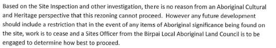
A condition of consent has been recommended
that works are to cease in the unexpected event heritage items are found. Works
can only recommence when appropriate approvals are obtained for management
and/or removal of the heritage item.
Other land resources
The proposal will not sterilise any significant mineral or
agricultural resource.
Water cycle
The proposed development will not have any significant
adverse impacts on water resources and the water cycle.
Soils
The proposed development will not have any significant
adverse impacts on soils in terms of quality, erosion, stability and/or
productivity subject to a standard condition requiring erosion and sediment
controls to be in place prior to and during construction.
Air and microclimate
The construction and/or operations of the proposed
development will not result in any significant adverse impacts on the existing
air quality or result in any pollution. Given the extensive volume of
earthworks proposed it will be important for the developer to appropriately
manage dust during the construction phase. Standard precautionary site
management condition recommended.
Flora and fauna
The proposed development includes clearing of approximately
3.3 hectares of native vegetation within the site and the adjoining road
reserves. The Biodiversity Offset Scheme applies for the following reasons:
· The extent of
clearing is above the thresholds in Clause 7.2 of the Biodiversity Conservation
Regulation 2017;
|
Minimum lot size of land (LEP Lot Size Map)
|
Area of Clearing
|
|
Less than 40 hectares but not less than 1 hectare
|
0.5 hectares or more
|
The Applicant has submitted a Biodiversity Development
Assessment Report (BDAR) prepared by an authorised person. The report has been
reviewed and it is considered that adequate measures have been taken to avoid
or minimise impacts, and the development would not result in serious and
irreversible impacts on biodiversity.
The development will require the retirement of the following
ecosystem credits to offset the impacts of the development:
|
Impacted plant community type
|
Number of ecosystem credits
|
IBRA sub-region
|
Plant community type(s) that can be used to offset the
impacts from development
|
|
1569-Flooded Gum - Brush Box -
Tallowwood mesic tall open forest on ranges of the lower North Coast
|
65
|
Macleay Hastings, Carrai
Plateau,
Coffs Coast and Escarpment,
Comboyne Plateau, Karuah
Manning,
Macleay Gorges, Mummel
Escarpment and Upper Manning.
or
Any IBRA subregion that is
within 100
kilometers of the outer edge
of the
impacted site.
|
North Coast Wet
Sclerophyll Forests
This includes PCT's:
487, 613, 661, 684, 686, 692,
693, 694, 695, 699, 747, 748, 752, 812, 826, 827, 1073, 1208, 1217, 1222,
1237, 1244, 1245, 1257, 1259, 1260, 1261, 1265, 1266, 1282, 1284, 1285, 1504,
1561, 1562, 1563, 1566, 1567, 1568, 1569, 1572, 1573, 1575, 1579, 1841, 1843,
1915
|
Conditions have been recommended requiring evidence of
retirement of the relevant credits prior to the commencement of any clearing on
the land.
Section 5.2 of the BDAR also include a series of mitigation
measures to minimise the impacts of the development, including:
· General clearing
measures;
· Pre-clearing
survey and clearing supervision;
· Pre-clearing koala
food tree count;
· Donation of
foliage;
· Weed control;
· Controls on
external lighting;
· Soil erosion and sedimentation
control.
A condition has been recommended requiring these mitigation
measures to be implemented at the relevant stages of the development.
Waste
See comments earlier in this report under the DCP regarding
waste management.
Energy
The proposal includes measures to address energy efficiency
and will be required to comply with the requirements of Section J of the
Building Code of Australia. No adverse impacts anticipated.
Noise and vibration
The highway service centre is proposed to operate 24 hours,
7 days per week. The application includes an Acoustic Assessment prepared by
Matrix Thornton and dated 17 December 2019, and an amended Acoustic Assessment
and cover letter dated 20 July 2020. The assessment has been carried out in
accordance with the NSW Noise Policy for Industry and EPA Road Noise Policy
using EPA approved modelling methods.
The assessment has considered noise impacts associated with
vehicles within the development site, mechanical services, and traffic noise
associated with additional vehicles using the Oxley Highway between Billabong
Drive and the Pacific Highway.
The report concludes that noise is predicted to comply with
day-time and night-time noise trigger levels at all residential receivers
potentially impacted by the development (see extract below). The report further
concludes that noise levels are below the screening thresholds for sleep
disturbance.
In relation to road traffic noise on the Oxley Highway, the
modelling has determined that there would be no increase in the predicted noise
level at any of the affected receivers (see below). The report notes that
traffic volumes on the Oxley Highway would need to double before there was any
significant impact on any of the residential receivers.
The amended report acknowledges that the construction of a
new roundabout at the intersection of the Oxley Highway and Billabong Drive
will change vehicle speeds and the characteristics of traffic noise at this
location. The following comments are provided in the report in relation to the
changes to traffic noise.
“Studies of noise at
roundabouts and intersections has shown that the deceleration and acceleration
of vehicles does not significantly change the overall LAeq output of the
traffic stream. Although there is some change in character of the noise close
to the roundabout because noise is assessed in terms of LAeq, the roundabout
will not significantly change the assessment.”
The details have been assessed as being acceptable.
Bushfire
The site is identified as being bushfire prone.
The Applicant has submitted a bushfire report prepared by
Midcoast Building and Environmental. As the Application was lodged, but not
finally determined, on 1 March 2020 and in accordance with Clause 273B of the
Environmental Planning and Assessment Regulation 2000, the proposal is to be
assessed under the provisions of Planning for Bush Fire Protection 2006 (not
the 2019 version).
The assessment concludes that the development is appropriate
from a bushfire perspective providing that the following recommendations are
implemented:
1. The
proposed development lot (with the exception of the vegetated corridors along
the Oxley Highway and Pacific Highway frontages) is to be managed as Asset
Protection Zone.
2. Services
as detailed in Section 3.1.3 of this report are to be provided.
3. Adopt
landscaping principals in accordance with Section 3.1.4 of this report.
4. That
appropriate Emergency Management Systems are implemented.
5. That
the six key Bush Fire Protection Measures as detailed in Table 5 of
the report are considered.
The details have been assessed as being acceptable.
Conditions have been recommended incorporating the above recommendations.
Safety, security and crime prevention
As the proposed highway service
centre will operate 24 hours, consideration of crime prevention principles and
the safety of staff and customers is important, particularly at night. The
Applicant’ Statement of Environmental Effects includes the following
comments regarding CPTED principles:
Natural Access Control – The
design directs the flow of traffic, using signage, from the site access to the
relevant car park in the well-lit service centre.
Natural Surveillance – Staff
and customers of the highway service centre will passively overlook the car
park areas through large expanses of glazing. Mid-level landscaping is not
proposed within the service centre to provide optimum visibility along paths of
travel. Lighting is proposed throughout the site to improve visibility.
Security cameras will be provided where required by tenancy operators.
Territoriality – The
internal road around the service centre building creates a sense of
territoriality on the site. Staff will be present on site at all times to
enforce territoriality. ‘Staff only’ areas will be clearly labelled
as such.
Maintenance – The highway
service centre will be subject to a maintenance schedule
which will include maintenance of
landscaping, cleaning of indoor and outdoor areas and removal of all graffiti
in a timely manner.
The key safety issue for customers
and staff will be access between parking areas (including the fuelling canopy)
and the service centre buildings at night. The public parking is generally
located in proximity to the buildings and in a location where passive
surveillance is available from within the buildings, and the same is the case
for the fuelling canopy. The Statement of Environmental Effects indicates that
appropriate lighting will be provided to the parking areas and pedestrian
paths.
Social impacts in the locality
Given the nature of the proposed development and its
location the proposal is not considered to have any significant adverse social
impacts.
Economic impact in the locality
The application includes an Economic Impact Assessment
prepared by Foresight Partners Pty Ltd and dated December 2019. The assessment
identifies the need for a highway service centre in this location, consistent
with the North Coast Regional Plan 2036, and relevant Ministerial directions.
While competition impacts on other fuel retailers and take
away food and drink premises are not a relevant consideration in the assessment
of the application, the report also notes that the primary function of the
service centre is to provide services to passing traffic on the Pacific
Highway, and therefore is not expected to directly compete with other local
services in Port Macquarie and Wauchope.
The assessment identifies the following positive economic
impacts associated with the proposed development:
· 60-70 job years
during construction;
· Operational
employment in the order of 250 people in full-time, part-time, or casual
positions.
Site design and internal design
The proposed development design satisfactorily responds to
the site attributes and will fit into the locality.
Construction
Construction impacts are considered capable of being
managed. All works on the Pacific Highway and Oxley Highway will require a
Works Authorisation Deed with Transport for NSW to ensure appropriate traffic
management during construction. Standard construction and site management
conditions have been recommended.
Cumulative impacts
The proposed development is not considered to have any
significant adverse cumulative impacts on the natural or built environment or
the social and economic attributes of the locality.
(c) The
suitability of the site for the development
The suitability of the site for
the proposed highway service centre has been considered at a strategic level by
both Council and the State Government. Specific site constraints have been
considered in this assessment and are capable of being appropriately managed.
(d) Any
submissions made in accordance with this Act or the Regulations
Seven (7) written submissions were received following public exhibition
of the application. Copies of the written submissions have been provided
separately to members of the DAP.
Key
issues raised in the submissions received and comments are provided as follows:
|
Submission
Issue/Summary
|
Planning
Comment/Response
|
|
The application has not adequately addressed the noise
impacts of the additional traffic on the Oxley Highway as a result of the
development. The proposed roundabout at the Billabong Drive intersection will
also result in increased noise due to acceleration and deceleration of heavy
vehicles. Noise barriers should be installed along the Oxley Highway.
|
The proposed development does not have direct access to
the Oxley Highway. The highway service centre will access a proposed new
public road on the western side of the site, which then connects to the Oxley
Highway and Billabong Drive intersection with a proposed roundabout. It is
not practical to assess traffic noise impacts on the broader road network
once vehicles leave the development site, as the volume and nature of traffic
on these roads can influenced by many factors beyond the control of the
development. The Oxley Highway is a classified road designed to accommodate
large volumes of traffic, and the numbers will continue to increase with
general growth in the region even if the highway service centre doesn’t
proceed. It is the responsibility of the roads authority to continually
monitor and manage traffic noise impacts from major roads.
|
|
The highway service centre would be better suited to a
location further north near Expressway Spares.
|
The consent authority is required to consider the
development in the location proposed, and cannot consider alternative sites.
The highway service centre is permissible on the subject site.
|
|
The development should not compromise the broader
strategic planning investigations for the Sancrox area.
|
The broader strategic planning investigations for the
Sancrox area are continuing and will not be affected by the determination of
this application. The proposal specifically includes provision for extension
of road access and sewer to adjoining land within the Sancrox investigation
area.
|
|
Loss of value for properties in Billabong Drive.
|
This is not a relevant matter for consideration in the
assessment of the application.
|
|
The proposed new intersection at Billabong Drive will
further congest traffic flow on the Oxley Highway.
|
The application includes appropriate modelling of traffic
flows at the proposed new roundabout. Transport for NSW have also reviewed
the application and are satisfied with the impact of the development on the
safety and efficiency of the classified road network.
|
|
Object to the removal of any vegetation in the frontage of
No 23 Billabong Drive for the proposed new intersection.
|
No vegetation removal in the frontage of 23 Billabong
Drive is proposed.
|
|
The traffic data in the Bitzios report was collected in
2016, and the Traffic Impact Assessment prepared by TTM should be updated to
reflect current traffic volumes.
|
The amended Traffic Impact Assessment includes adequate assumptions
for traffic growth since the submission of the Bitzios report.
|
|
If the development is approved it should include a noise
monitoring program.
|
Noise monitoring programs are typically only required for
developments requiring an Environment Protection Licence from the EPA. It is
considered that current legislation provides sufficient avenues for Council
to investigate any future noise complaints, and no specific conditions are
required in this regard.
|
|
Details of noise mitigation options should be provided
with the application.
|
No noise mitigation measures are proposed for the
development.
|
|
It would also be appropriate to ban the current practice
of overnight truck parking on Billabong Drive as a more appropriate location
with adequate facilities will be provided for freight companies.
|
This is a separate matter and is not relevant to the
assessment of the application.
|
|
Consideration needs to be given to the effect that the
removal of existing vegetation and roadside cuttings to facilitate a
roundabout will have on natural sound absorption.
|
The removal of the embankment and roadside vegetation on
the southern side of the Oxley Highway would only reduce the traffic noise
protection to the subject site. Having regard to the topography of the land
in the area, it is not anticipated that the embankment would currently be
providing any reduction of Pacific Highway road noise for residents on the
northern side of the Oxley Highway.
|
|
Impacts on water quality and pollution implications for
downstream properties given the known challenges of on-site wastewater
management for highway service centres. Concerns include:
· Suitability of steep slope
for irrigation;
· Potential additional
earthworks to achieve appropriate slopes for irrigation;
· Potential leeching of
wastewater into the stormwater drainage network during heavy rainfall;
· Impacts of ‘shock
loading’ during holiday periods.
The exhibited proposal does not include sufficient
information to assess the effectiveness of the proposed on-site sewage
management.
|
Separate approval will be required under Section 68 of the
Local Government Act 1993 for the installation and operation of the on-site
sewage management system. An appropriate level of detail to assess these
matters will be required with this application. The recommended conditions
prevent the issue of a Construction Certificate until a Section 68 approval
has been issued for the on-site sewage management system.
|
|
Potential stormwater quality and quantity impacts on
downstream properties. Specific concerns include:
· Characterisation of
pre-development node in MUSIC modelling;
· No details of fuel spills
management and potential impacts on the stormwater drainage system;
· Impacts of litter from fast
food restaurants and need for gross pollutant trap;
· Management of erosion during
earthworks phase.
|
An amended Stormwater Management Plan has been submitted
and is considered acceptable in principle by Council’s Senior
Stormwater Engineer. The recommended conditions will ensure that these issues
are appropriately managed in the detailed design.
|
|
The application includes insufficient detail of the extent
of earthworks proposed for the development.
|
Additional details have been submitted through the assessment
process confirming the extent of earthworks.
|
|
The Geotechnical Assessment in Appendix E refers to a
superseded layout of the proposed highway service centre.
|
While the lot configuration in the Geotechnical Assessment
differs slightly from the current property boundaries, the investigation
still broadly covers the location of the works in the current application.
None of the recommended conditions rely upon this
assessment, and the document is not referenced in the proposed conditions.
|
|
Given the location of Port Macquarie between Sydney and
Brisbane and the need for heavy vehicle driver to stop for a break every 6
hours to manage fatigue, the volume of heavy vehicles using the facility is
expected to be higher than modelled.
|
The assumptions made in the traffic assessment regarding
heavy vehicle volumes are based on data from other highway service centres on
the Pacific Highway and in consultation with Transport for NSW. The report
has been based on the best available information and is considered
appropriate for the purpose of the modelling.
|
|
The proposal needs to give adequate consideration to
providing for future access to the urban investigation area to the west of
the site.
|
The proposed roundabout on the new road off the Oxley
Highway includes a proposed public road leg that will provide future access
for the urban investigation area to the west. The submitted plans have
considered the extent of earthworks that would be required to construct a
future road to Aus-Spec standards, as required by the DCP. The Planning
Agreement between the landowners and Council includes provisions that
facilitate the construction and dedication of a public road connecting to
this roundabout.
|
|
The layout shown on the landscape plan conflicts with the
architectural plans.
|
Noted. The proposed conditions include a recommendation
that an amended landscape plan be submitted that is consistent with the
layout on the architectural plans.
|
|
The application should include sufficient details of the
extent of landform change and the volume of cut and fill.
|
Amended plans have been submitted showing this detail.
|
|
Greater detail of the on-site sewage management system
should be provided at the DA stage and this detail should not be deferred
until the subsequent Section 68 application.
|
It is typical for the details of such matters to be
addressed with a subsequent Section 68 application. Only the conceptual
suitability of the site needs to be demonstrated at the DA stage.
The recommended condition requires approval of the Section
68 application prior to the issue of a Construction Certificate, which would
prevent the works from commencing if satisfactory details can’t be
provided.
|
|
The offset plantings along the western side of the highway
service centre should not create any additional bushfire risk to neighbouring
property, which is intended to be developed for residential purposes in the
future.
|
The neighbouring land to the west is currently zoned RU1
Primary Production and the proposed offset plantings would not increase bushfire
risk to the existing dwelling. A vegetated buffer between the highway service
centre and any future urban uses on the land to the west is considered to be
a good planning outcome.
|
|
Council should commission their own independent noise
assessment.
|
It is not the role of the consent authority to commission
independent studies for the development proposal. Council’s
Environmental Health Officer has reviewed the specialist assessment and is
satisfied that the findings in the report from the Applicant’s acoustic
consultant are reasonable having regard to the relevant legislation and
guidelines. The proposal has also been reviewed by Transport for NSW (who
will ultimately be responsible for managing traffic noise on the Oxley
Highway and Pacific Highway).
|
|
A requirement should be placed on the developer that the
noise levels be monitored in future years, with a guarantee that noise
barriers will be constructed in the event that noise levels are exceeded.
|
This is not considered to be a practical requirement.
Traffic volumes and the proportion of heavy vehicles on the Oxley Highway and
Pacific Highway can be affected by many factors outside the control of the
development.
|
|
The traffic volumes used in the traffic noise assessment
are considered to be understated based on a traffic survey carried out by the
submitter. If the modelled traffic volumes are incorrect, the assumed noise
impacts will also not be accurate.
|
It is agreed that the traffic volume of 3000vpd on the
Oxley Highway used in the acoustic assessment does not reflect current
traffic volumes. The TTM Traffic Impact Assessment suggests that traffic
volumes in the Oxley Highway are in the order of 20,000vpd (both directions).
In considering the accuracy of the findings in the noise
assessment, Council staff have reviewed the Department of Planning’s Development
near Rail Corridors and Busy Roads – Interim Guideline. The
guideline includes screen tests for traffic noise and relevant construction
standards, which are included below this table.
The nearest dwelling is located approximately 100m from
the proposed new roundabout at the intersection of Oxley Highway and
Billabong Drive. It is expected that the posted speed limit on completion of
the roundabout would be 60km/h, consistent with the speed controls on the
eastern side of the Pacific Highway interchange. Using Screen Test 1(a) from
the guideline, the level of construction required for dwellings to achieve
satisfactory internal noise levels would not increase until traffic volumes
on the Oxley Highway reach approximately 25,000vpd. The development will not
increase traffic on the Oxley Highway to this magnitude.
On this basis, it is not considered appropriate with any
justifiable nexus that any noise mitigation measures in the Oxley Highway
could be imposed on the development.
|
(e) The Public Interest
The proposed development
satisfies relevant planning controls and will not adversely impact on the wider
public interest.
Ecologically Sustainable Development and Precautionary
Principle
Ecologically sustainable development requires the effective
integration of economic and environmental considerations in decision-making
processes.
The four principles of ecologically sustainable development
are:
· the
precautionary principle,
· intergenerational
equity,
· conservation
of biological diversity and ecological integrity,
· improved
valuation, pricing and incentive mechanisms.
The principles of ESD require that a balance needs to be
struck between the man-made development and the need to retain the natural
vegetation. Based on the assessment provided in the report and with recommended
conditions of consent, it is considered an appropriate balance has been struck.
Climate change
The proposal is not considered to be vulnerable to any risks
associated with climate change.
4. DEVELOPMENT
CONTRIBUTIONS APPLICABLE
Section
7.11 Contributions
The
development does not contain any residential component. As a result, Section
7.11 contributions do not apply.
Section
7.12 Contributions
In
assessing s7.12 contributions, Council staff have reviewed the development in
accordance with the Port Macquarie-Hastings Council Development Contributions
Assessment Policy (DCAP) and the Port
Macquarie-Hastings Council Section 94A Levy Contributions Plan 2007.
The
proposed development will comprise a highway service centre and is deemed to
increase the demand for public amenities/services.
As a
result, s7.12 contributions apply and a condition of consent has been
recommended to ensure payment.
Section
64 Water and Sewer Contributions
In
assessing s64 water and sewer contributions, Council staff have reviewed the
development in accordance with the Port Macquarie-Hastings Council Development
Contributions Assessment Policy (DCAP) and applicable Development Servicing
Plans.
No
contribution credit applies to the site.
The
proposed development will comprise a highway service centre including the
following land uses:
· T08 Food and drink premises - 436m2;
· Service centre food and drink premises - 1689m2;
· T05 Service station - 270m2;
· Service station driveway and forecourt area - 2075m2.
Having
considered the above, the proposed development will increase the demand on
water services. As a result, Section 64 contributions apply and a condition of
consent has been recommended to ensure payment.
The
site is not proposed to be connected to sewer and only the water component of
the Section 64 contributions will be applicable.
A copy
of the contributions estimate is included as Attachment 3.
·
5. CONCLUSION AND
STATEMENT OF REASON
The application has been assessed in accordance with Section
4.15 of the Environmental Planning and Assessment Act 1979.
Issues raised during assessment and public exhibition of the
application have been considered in the assessment of the application. Where
relevant, conditions have been recommended to manage the impacts attributed to
these issues.
The site is considered suitable for the proposed development
and the proposal adequately addresses relevant planning controls. The
development is not considered to be contrary to the public's interest and will
not result a significant adverse social, environmental or economic impact. It
is recommended that the application be approved, subject to the recommended
conditions of consent provided in the attachment section of this report.
|
Attachments
1⇩. Attachment 1 -
DA2019 - 945.1 Consent Conditions Attachment 1 -
DA2019 - 945.1 Consent Conditions
2⇩. Attachment 2 -
DA2019 - 945.1 DA Plans Attachment 2 -
DA2019 - 945.1 DA Plans
3⇩. Attachment 3 -
DA2019 - 945.1 Contributions Estimate
|