Development
Assessment Panel
Business
Paper
|
date of meeting:
|
|
Wednesday 20 April
2022
|
|
location:
|
|
via SKYPE
|
|
time:
|
|
2:00pm
|
Development
Assessment Panel
CHARTER
1.0 OBJECTIVES
To assist in managing Council's
development assessment function by providing independent, transparent and
expert determinations of development applications that fall outside of staff
delegations.
2.0 KEY FUNCTIONS
·
To review development application reports and conditions.
The focus of the Panel’s review is to be on those issues raised in
submissions received following exhibition of development applications;
·
To determine development applications where
there are 3 or more unique submissions or where an application is outside of
staff delegations;
·
To refer development applications to Council for
determination where necessary;
·
To provide a forum for objectors and applicants
to make submissions on applications
before the Development Assessment Panel (DAP);
·
To maintain transparency in the determination of development
applications.
Delegated Authority of Panel
Pursuant to Section 377 of the
Local Government Act, 1993 delegation to:
·
Determine development applications under Part 4
of the Environmental Planning and Assessment Act 1979 having regard to the
relevant environmental planning instruments, development control plans and
Council policies.
·
Vary, modify or release restrictions as to use
and/or covenants created by Section 88B instruments under the Conveyancing Act
1919 in relation to development applications for subdivisions being considered
by the panel.
·
Determine Koala Plans of Management under State
Environmental Planning Policy 44 - Koala Habitat Protection associated with
development applications being considered by the Panel.
Noting the trigger to escalate
decision making to Council as highlighted in section 5.2.
3.0
MEMBERSHIP
3.1 Voting Members
·
Three (3) independent external members will be
selected for each scheduled DAP meeting from an appointed pool of members. One
of the independent external members to be the Chairperson. Independent members
will be rostered onto meeting on a rotational basis where possible.
·
Group Manager Development Assessment (alternate
- Director Development and Environment or Development Assessment Planning
Coordinator).
The independent external
members shall have expertise in one or more of the following areas:
planning, architecture,
heritage, the environment, urban design, economics, traffic and transport, law,
engineering, government and public administration.
3.2 Non-Voting Members
Not applicable.
3.3 Obligations
of members
·
Members must act faithfully and diligently and
in accordance with this Charter.
·
Members must comply with Council's Code of Conduct.
·
Except as required to properly perform their
duties, DAP members must not
disclose any confidential information (as advised by Council) obtained in connection with the DAP functions.
·
Members will have read and be familiar with the
documents and information provided by Council prior
to attending a DAP meeting.
·
Members must act in accordance with Council's
Workplace Health and Safety Policies and Procedures.
·
External members of the Panel are not authorised
to speak to the media on behalf of Council. Council officers that are members
of the Committee are bound by the
existing operational delegations in relation to speaking to the media.
3.4 Member Tenure
The
independent external members will be appointed for the term of Four (4) years or until such time as an expression
of interest process to source Panel members is completed for the proceeding
four (4) year term.
3.5 Appointment
of members
·
A pool of independent external members
(including the Chair) shall be appointed by the Chief Executive Officer following
an external Expression of Interest process. Previous Panel members are eligible
to be reappointed on the Panel following this expression of interest process.
·
Independent members will be rostered on to Panel
meetings on a rotational basis where possible to suit Panel member availability
and Panel operational needs.
·
Staff members on the Panel shall be appointed by
the Chief Executive Officer.
4.0 TIMETABLE OF MEETINGS
·
The Development Assessment Panel will generally
meet on the 1st and 3rd Thursday each month at 2.00pm at the Port Macquarie
offices of Council.
·
Special Meetings of the Panel may be convened by
the Director Development and Environment with three (3) days’ notice.
5.0
MEETING PRACTICES
5.1 Meeting Format
·
At all meetings of the Panel the Chairperson
shall occupy the Chair and preside. The Chair will be responsible for keeping
of order at meetings.
·
Meetings shall be open to the public.
·
The Panel will hear from an applicant and
objectors or their representatives. Speakers are required to register to speak
by close of business on the day prior to the Panel meeting.
·
The Panel shall have the discretion to ask the
applicant and objectors questions relating to the proposal and their
submission. There is no ‘right of reply’ for an objector or applicant.
·
Where there are a large number of persons making
submissions with common interests, the Panel shall have the discretion to hear
a representative of those persons rather than multiple persons with the same
interest.
·
Council assessment staff will be available at
Panel meetings to provide technical assessment advice and assistance to the
Panel.
·
Where considered necessary, the Panel will
conduct site inspections prior to the meeting.
5.2 Decision Making
·
Decisions are to be made by consensus. Where consensus
is not possible on any item, that item is to be referred to Council for a decision.
·
All development applications involving a
proposed variation to a development standard
greater than 10% under Clause
4.6 of the Local Environmental Plan will be considered
by the Panel and recommendation made to the Council for a decision.
5.3 Quorum
Three (3) members must be present at a meeting to form a quorum.
5.4 Chairperson
and Deputy Chairperson
Independent Chair (alternate - independent member).
5.5 Secretariat
·
The Director Development and Environment is to
be responsible for ensuring that the Panel has adequate secretariat support.
The secretariat will ensure that the business paper and supporting papers are
circulated at least three (3) days prior to
each meeting. Minutes shall be appropriately approved and circulated to each
member within three (3) weeks of a meeting being held.
·
The format of and the preparation and publishing
of the Business Paper and Minutes shall be similar to the format for Ordinary
Council Meetings.
5.6 Recording
of decisions
Minutes will be limited to the recording of decisions only and how
each member votes for each item before the Panel.
6.0 CONVENING OF
“OUTCOME SPECIFIC” WORKING GROUPS
Not applicable.
7.0 CONFIDENTIALITY AND CONFLICT
OF INTEREST
·
Members of the Panel must comply with the
applicable provisions of Council’s Code of Conduct. It is the personal
responsibility of members to comply with the standards in the Code of Conduct
and regularly review their personal circumstances with this in mind.
·
Panel members must declare any conflict of
interest at the start of each meeting or before discussion of a relevant item
or topic. Details of any conflicts of interest are to be appropriately minuted.
Where members are deemed to have a real or perceived conflict of interest, it
may be appropriate they be excused from deliberations on the issue where the
conflict of interest may exist. A Panel meeting may be postponed where there is
no quorum.
8.0 LOBBYING
All members and
applicants are to adhere to Council’s Lobbying policy. Outside of scheduled Development Assessment
Panel meetings, applicants, their representatives, Councillors, Council staff
and the general public are not to lobby Panel members via meetings, telephone conversations,
correspondence and the like. Adequate opportunity will be provided at Panel
inspections or meetings for applicants, their representatives and the general
public to make verbal submissions in relation to Business Paper items.
9.0 CONDUCT AT MEETINGS
All parties in attendance at a DAP meeting shall conduct
themselves respectfully ie. not disrupt the conduct of the meeting, not
interject, act courteously and with compassion and empathy and sensitivity and
will not insult, denigrate or make defamatory or personal reflections on or
impute improper motives to the DAP, Council staff or other members of the
public.
Development Assessment Panel
ATTENDANCE
REGISTER
|
Member
|
01/10/21
|
21/10/21
|
18/11/21
|
16/12/21
|
03/02/22
|
17/02/22
|
|
David Crofts
|
P
|
P
|
P
|
P
|
P
|
P
|
|
Michael Mason
|
|
|
P
|
P
|
P
|
P
|
|
Chris Gee
|
P
|
P
|
P
|
|
P
|
|
|
Tony McNamara
|
P
|
P
|
|
P
|
|
P
|
|
Dan Croft
(Group Manager Development
Services)
Grant Burge (acting)
|
P
|
P
|
P
|
P
|
P
|
P
|
|
Patrick Galbraith-Robertson
(Development Planning
Coordinator)
|
P
|
P
|
P
|
|
P
|
P
|
Key: P = Present
A
= Absent With Apology
X
= Absent Without Apology
Meeting Dates for
2022
|
20/01/2022
|
Function Room
|
2.00pm
|
|
3/02/2022
|
Function Room
|
2.00pm
|
|
17/02/2022
|
Function Room
|
2.00pm
|
|
3/03/2022
|
Function Room
|
2.00pm
|
|
17/03/2022
|
Function Room
|
2.00pm
|
|
7/04/2022
|
Function Room
|
2.00pm
|
|
21/04/2022
|
Function Room
|
2.00pm
|
|
5/05/2022
|
Function Room
|
2.00pm
|
|
19/05/2022
|
Function Room
|
2.00pm
|
|
2/06/2022
|
Function Room
|
2.00pm
|
|
16/06/2022
|
Function Room
|
2.00pm
|
|
7/07/2022
|
Function Room
|
2.00pm
|
|
21/07/2022
|
Function Room
|
2.00pm
|
|
4/08/2022
|
Function Room
|
2.00pm
|
|
18/08/2022
|
Function Room
|
2.00pm
|
|
1/09/2022
|
Function Room
|
2.00pm
|
|
15/09/2022
|
Function Room
|
2.00pm
|
|
6/10/2022
|
Function Room
|
2.00pm
|
|
20/10/2022
|
Function Room
|
2.00pm
|
|
3/11/2022
|
Function Room
|
2.00pm
|
|
17/11/2022
|
Function Room
|
2.00pm
|
|
1/12/2022
|
Function Room
|
2.00pm
|
|
15/12/2022
|
Function Room
|
2.00pm
|
Development
Assessment Panel Meeting
Wednesday 20 April
2022
Items of Business
01 Acknowledgement
of Country........................................................................... 10
02 Apologies........................................................................................................ 10
03 Confirmation
of Minutes................................................................................... 10
04 Disclosures
of Interest..................................................................................... 14
05 DA2021
- 999.1 Dwelling and Swimming Pool Including a Clause 4.6 Objection to Clause
4.3 (Height of Building) of the Port Macquarie Hastings Local Environmental
Plan 2011, Lot 3 DP 238250, No 5 Orr Street Port Macquarie........................................................... 18
06 DA2021
- 1047.1 Health Services Facility at Lot 1 DP 1273684, No 11 Ngamba Place,
Bonny Hills................................................................................................................ 70
07 General
Business
AGENDA Development Assessment Panel 20/04/2022
Subject: ACKNOWLEDGEMENT
OF COUNTRY
"I acknowledge that we are
gathered on Birpai Land. I pay respect to the Birpai Elders both past and
present. I also extend that respect to all other Aboriginal and Torres Strait
Islander people present."
RECOMMENDATION
That the apologies received be
accepted.
Subject: CONFIRMATION
OF PREVIOUS MINUTES
Recommendation
That the Minutes of the Development Assessment Panel Meeting
held on 17 February 2022 be confirmed.
MINUTES
Development Assessment Panel Meeting
17/02/2022
PRESENT
Members:
David Crofts (Independent Chair)
Michael Mason (Independent Member)
Tony McNamara (Independent Member)
Group Manager Development Services
(Dan Croft)
Other Attendees:
Mayor Peta Pinson
Councillor
Josh Slade
Pat
Galbraith-Robertson (Development Assessment Planning Coordinator)
Grant
Burge (Development Engineering Coordinator)
Kate
Kennedy (Building Surveyor)
Warren
Wisemantel (Building Surveyor)
|
The meeting opened at 2:00pm.
|
|
01 ACKNOWLEDGEMENT
OF COUNTRY
|
|
The
Acknowledgement of Country was delivered.
|
|
03 CONFIRMATION
OF MINUTES
|
|
CONSENSUS:
That
the Minutes of the Development Assessment Panel Meeting held on 3 February
2022 be confirmed.
|
|
04 DISCLOSURES
OF INTEREST
|
|
There were no disclosures of interest presented.
|
|
05 DA2021 - 889.1
Dwelling-house including Clause 4.6 Objection to Clause 4.3 (Height of
Buildings) of the Port Macquarie-Hastings Local Environmental Plan 2011 at
Lot 814 DP 1268080, No 10 Granton Ridge, Port Macquarie
|
|
Speakers:
Paul Timmins (opposing
the development)
Stephen McInerney (opposing
the development)
Boyd Ison (applicant)
CONSENSUS:
That DA2021
- 889.1 for a dwelling-house including a
Clause 4.6 objection to Clause 4.3 (height of buildings) of the Port
Macquarie-Hastings Local Environmental Plan 2011 at
Lot 814, DP 1268080, No. 10 Granton
Ridge, PORT MACQUARIE, be determined by granting consent subject to the recommended
conditions and as amended below:
- Additional condition in
Section B of the consent to read: ‘Prior to the issue of a
Construction Certificate a construction and traffic management plan is
to be submitted to Council’s satisfaction. The plan is to address
the following:
- Maintaining right of access to all properties using
the driveway
- Parking and movement of construction vehicles
- Condition report on the driveway and means to address
any damage caused during construction.’
|
|
06 DA2021 -
1092.1 Ancillary Building - Shed at Lot 32 DP 1239206, No 6 Oxbow Circuit
King Creek
|
|
Speakers:
Craig Pickering (opposing the development)
Rudy Ollevou (opposing the development)
Ben Homes (applicant)
CONSENSUS:
Noting
that the applicant and neighbours have discussed an amended shed location,
DA2021 -1092 be deferred to enable the applicant to submit amended plans
generally as follows:
- Increase setback to side
western side boundary by approximately 4m.
- The awning be swapped to the
eastern side of the shed.
- Lowering the shed by
approximately 500mm at the centre of the slab.
- Increased front boundary
setback by approximately 1m.
The
amended plans be notified to the submitters and that where no significant
concerns are raised, noting the DAP Charter, the matter be determined under
staff delegation.
|
|
The meeting closed at 3:00pm.
|
AGENDA Development Assessment Panel 20/04/2022
Subject: DISCLOSURES
OF INTEREST
RECOMMENDATION
That Disclosures of Interest be presented
DISCLOSURE OF
INTEREST DECLARATION
|
Name of Meeting:
|
|
Meeting
Date:
|
|
Item
Number:
|
|
Subject:
|
|
I,
the undersigned, hereby declare the following interest:
Pecuniary:
 Take no part
in the consideration and voting and be out of sight of the meeting. Take no part
in the consideration and voting and be out of sight of the meeting.
Non-Pecuniary
– Significant Interest:
Take no part
in the consideration and voting and be out of sight of the meeting.
Non-Pecuniary
– Less than Significant Interest:
May
participate in consideration and voting.
|
|
For
the reason that:
|
|
Name:
Signed:
|
Date:
|
|
Please submit to the
Governance Support Officer at the Council Meeting.
|
 (Refer
to next page and the Code of Conduct)
(Refer
to next page and the Code of Conduct)
Pecuniary Interest
4.1
A pecuniary interest is an interest
that you have in a matter because of a reasonable likelihood or expectation of
appreciable financial gain or loss to you or a person referred to in clause
4.3.
4.2
You will not have a pecuniary
interest in a matter if the interest is so remote or insignificant that it
could not reasonably be regarded as likely to influence any decision you might
make in relation to the matter, or if the interest is of a kind specified in
clause 4.6.
4.3
For the purposes of this Part, you
will have a pecuniary interest in a matter if the pecuniary interest is:
(a)
your interest, or
(b)
the interest of your spouse or de
facto partner, your relative, or your partner or employer, or
(c)
a company or other body of which
you, or your nominee, partner or employer, is a shareholder or member.
4.4
For the purposes of clause 4.3:
(a)
Your “relative” is any
of the following:
(b)
“de facto partner” has
the same meaning as defined in section 21C of the Interpretation Act 1987.
4.5
You will not have a pecuniary
interest in relation to a person referred to in subclauses 4.3(b) or (c)
(a)
if you are unaware of the relevant
pecuniary interest of your spouse, de facto partner, relative, partner,
employer or company or other body, or
(b)
just because the person is a member
of, or is employed by, a council or a statutory body, or is employed by the
Crown, or
(c)
just because the person is a member
of, or a delegate of a council to, a company or other body that has a pecuniary
interest in the matter, so long as the person has no beneficial interest in any
shares of the company or body.
Non-Pecuniary
5.1
Non-pecuniary interests are private
or personal interests a council official has that do not amount to a pecuniary
interest as defined in clause 4.1 of this code. These commonly arise out of
family or personal relationships, or out of involvement in sporting, social,
religious or other cultural groups and associations, and may include an interest
of a financial nature.
5.2
A non-pecuniary conflict of
interest exists where a reasonable and informed person would perceive that you
could be influenced by a private interest when carrying out your official
functions in relation to a matter.
5.3
The personal or political views of
a council official do not constitute a private interest for the purposes of
clause 5.2.
5.4
Non-pecuniary conflicts of interest
must be identified and appropriately managed to uphold community confidence in
the probity of council decision-making. The onus is on you to identify any
non-pecuniary conflict of interest you may have in matters that you deal with,
to disclose the interest fully and in writing, and to take appropriate action
to manage the conflict in accordance with this code.
5.5
When considering whether or not you
have a non-pecuniary conflict of interest in a matter you are dealing with, it
is always important to think about how others would view your situation.
Managing non-pecuniary conflicts of interest
5.6
Where you have a non-pecuniary
conflict of interest in a matter for the purposes of clause 5.2, you must
disclose the relevant private interest you have in relation to the matter fully
and in writing as soon as practicable after becoming aware of the non-pecuniary
conflict of interest and on each occasion on which the non-pecuniary conflict
of interest arises in relation to the matter. In the case of members of council
staff other than the Chief Executive Officer, such a disclosure is to be made
to the staff member’s manager. In the case of the Chief Executive Officer,
such a disclosure is to be made to the mayor.
5.7
If a disclosure is made at a
council or committee meeting, both the disclosure and the nature of the
interest must be recorded in the minutes on each occasion on which the
non-pecuniary conflict of interest arises. This disclosure constitutes
disclosure in writing for the purposes of clause 5.6.
5.8
How you manage a non-pecuniary
conflict of interest will depend on whether or not it is significant.
5.9
As a general rule, a non-pecuniary
conflict of interest will be significant where it does not involve a pecuniary
interest for the purposes of clause 4.1, but it involves:
a)
a relationship between a council
official and another person who is affected by a decision or a matter under
consideration that is particularly close, such as a current or former spouse or
de facto partner, a relative for the purposes of clause 4.4 or another person
from the council official’s extended family that the council official has
a close personal relationship with, or another person living in the same
household
b)
other relationships with persons
who are affected by a decision or a matter under consideration that are
particularly close, such as friendships and business relationships. Closeness
is defined by the nature of the friendship or business relationship, the
frequency of contact and the duration of the friendship or relationship.
c)
an affiliation between the council
official and an organisation (such as a sporting body, club, religious,
cultural or charitable organisation, corporation or association) that is
affected by a decision or a matter under consideration that is particularly
strong. The strength of a council official’s affiliation with an
organisation is to be determined by the extent to which they actively
participate in the management, administration or other activities of the
organisation.
d)
membership, as the council’s
representative, of the board or management committee of an organisation that is
affected by a decision or a matter under consideration, in circumstances where
the interests of the council and the organisation are potentially in conflict
in relation to the particular matter
e)
a financial interest (other than an
interest of a type referred to in clause 4.6) that is not a pecuniary interest
for the purposes of clause 4.1
f)
the conferral or loss of a personal
benefit other than one conferred or lost as a member of the community or a
broader class of people affected by a decision.
5.10
Significant non-pecuniary conflicts
of interest must be managed in one of two ways:
a)
by not participating in
consideration of, or decision making in relation to, the matter in which you
have the significant non-pecuniary conflict of interest and the matter being
allocated to another person for consideration or determination, or
b)
if the significant non-pecuniary
conflict of interest arises in relation to a matter under consideration at a
council or committee meeting, by managing the conflict of interest as if you
had a pecuniary interest in the matter by complying with clauses 4.28 and 4.29.
5.11
If you determine that you have a
non-pecuniary conflict of interest in a matter that is not significant and does
not require further action, when disclosing the interest you must also explain
in writing why you consider that the non-pecuniary conflict of interest is not
significant and does not require further action in the circumstances.
5.12
If you are a member of staff of
council other than the Chief Executive Officer, the decision on which option
should be taken to manage a non-pecuniary conflict of interest must be made in
consultation with and at the direction of your manager. In the case of the Chief
Executive Officer, the decision on which option should be taken to manage a
non-pecuniary conflict of interest must be made in consultation with and at the
direction of the mayor.
5.13
Despite clause 5.10(b), a
councillor who has a significant non-pecuniary conflict of interest in a
matter, may participate in a decision to delegate consideration of the matter
in question to another body or person.
5.14 Council committee members are not required to declare
and manage a non-pecuniary conflict of interest in accordance with the
requirements of this Part where it arises from an interest they have as a
person chosen to represent the community, or as a member of a non-profit
organisation or other community or special interest group, if they have been
appointed to represent the organisation or group on the council committee.
SPECIAL
DISCLOSURE OF PECUNIARY INTEREST DECLARATION
This
form must be completed using block letters or typed.
If
there is insufficient space for all the information you are required to
disclose,
you
must attach an appendix which is to be properly identified and signed by you.
|
By
[insert full name of councillor]
|
|
|
In the
matter of
[insert name of environmental planning instrument]
|
|
|
Which is
to be considered at a meeting of the
[insert name of meeting]
|
|
|
Held on
[insert date of meeting]
|
|
|
PECUNIARY
INTEREST
|
|
Address of
the affected principal place of residence of the councillor or an associated
person, company or body (the identified land)
|
|
|
Relationship
of identified land to councillor
[Tick or cross one box.]
|
The councillor has interest in the land (e.g. is owner or has other
interest arising out of a mortgage, lease, trust, option or contract, or
otherwise).
An associated person of the councillor has an interest in the land.
An associated company or body of the councillor has interest in the land.
|
|
MATTER
GIVING RISE TO PECUNIARY INTEREST
|
|
Nature of
land that is subject to a change
in
zone/planning control by proposed
LEP (the
subject land
[Tick or cross one box]
|
The identified land.
Land that adjoins or is adjacent to or is in proximity to the identified
land.
|
|
Current
zone/planning control
[Insert name of current planning instrument and
identify relevant zone/planning control applying to the subject land]
|
|
|
Proposed
change of zone/planning control
[Insert name of proposed LEP and identify proposed
change of zone/planning control applying to the subject land]
|
|
|
Effect of
proposed change of zone/planning control on councillor or associated person
[Tick or cross one box]
|
Appreciable financial gain.
Appreciable financial loss.
|
|
|
|
[If more than one pecuniary interest is to be declared,
reprint the above box and fill in for each additional interest]
Councillor’s Signature:
……………………………….
Date: ………………..
This form is to be retained
by the council’s Chief Executive Officer and included in full in the
minutes of the meeting
Last Updated: 3 June 2019
Important Information
This information is being collected for the purpose of
making a special disclosure of pecuniary interests under clause 4.36(c) of the
Model Code of Conduct for Local Councils in NSW (the Model Code of Conduct).
The special disclosure must relate only to a pecuniary
interest that a councillor has in the councillor’s principal place of
residence, or an interest another person (whose interests are relevant under
clause 4.3 of the Model Code of Conduct) has in that person’s principal
place of residence.
Clause 4.3 of the Model Code of Conduct states that you
will have a pecuniary interest in a matter because of the pecuniary interest of
your spouse or your de facto partner or your relative or because your business
partner or employer has a pecuniary interest. You will also have a pecuniary
interest in a matter because you, your nominee, your business partner or your
employer is a member of a company or other body that has a pecuniary interest
in the matter.
“Relative” is defined by clause 4.4 of the Model
Code of Conduct as meaning your, your spouse’s or your de facto
partner’s parent, grandparent, brother, sister, uncle, aunt, nephew,
niece, lineal descendant or adopted child and the spouse or de facto partner of
any of those persons.
You
must not make a special disclosure that you know or ought reasonably to know is
false or misleading in a material particular. Complaints about breaches
of these requirements are to be referred to the Office of Local Government and
may result in disciplinary action by the Chief Executive of the Office of Local
Government or the NSW Civil and Administrative Tribunal.
This form must be completed by you before the commencement
of the council or council committee meeting at which the special disclosure is
being made. The completed form must be tabled at the meeting. Everyone is
entitled to inspect it. The special disclosure must be recorded in the minutes
of the meeting.
A pecuniary interest may arise by way of a change of
permissible use of land adjoining, adjacent to or in proximity to land in which
a councillor or a person, company or body referred to in clause 4.3 of the
Model Code of Conduct has a proprietary interest
AGENDA Development Assessment Panel 20/04/2022
Item: 05
Subject: DA2021 - 999.1 Dwelling and Swimming Pool
Including a Clause 4.6 Objection to Clause 4.3 (Height of Building) of the Port
Macquarie Hastings Local Environmental Plan 2011, Lot 3 DP 238250, No 5 Orr
Street Port Macquarie
Report
Author: Development Assessment Planner, Steven Ford
|
Applicant: Karen
Burke Registered Architect
Owner: BP
& RS Lulham
Estimated Cost: $650,000
Alignment with Delivery
Program
4.3.1 Undertake transparent
and efficient development assessment in accordance with relevant legislation.
|
RECOMMENDATION
That
it be recommended to Council that DA 2021-999 for a Dwelling and Swimming Pool Including a Clause 4.6
Objection to Clause 4.3 (Height of Building) of the Port Macquarie Hastings
Local Environmental Plan 2011 at Lot 3,
DP 238250, No. 5 Orr Street, Port
Macquarie, be determined by granting consent
subject to the recommended conditions
Executive
Summary
This
report considers a development application for a Dwelling and Swimming Pool
including a Clause 4.6 Objection to Clause 4.3 (Height of Building) of the Port
Macquarie-Hastings Local Environmental Plan 2011 at the subject site and provides an assessment of the application in
accordance with the Environmental Planning and Assessment Act 1979.
Following exhibition of the
application, three (3) submissions were
received.
The site is considered suitable for the proposed development
and the proposal adequately addresses relevant planning controls. The
development is not considered to be contrary to the public's interest and will
not result a significant adverse social, environmental or economic impact.
This report recommends that the
development application be referred to Council for approval subject to
the attached conditions as outlined in Attachment 1.
The reason for the application
being referred to Council’s Development Assessment Panel (DAP) is because
the application includes a Clause 4.6 exception to a development standard under
the Port Macquarie-Hastings Local Environmental Plan 2011. A copy of the
DAP Charter outlining the delegations and functions of the DAP is available on
Council’s website.
The application is required to
be reported to a meeting of the Ordinary Council following consideration of the
application by the DAP.
1. BACKGROUND
Existing
Sites Features and Surrounding Development
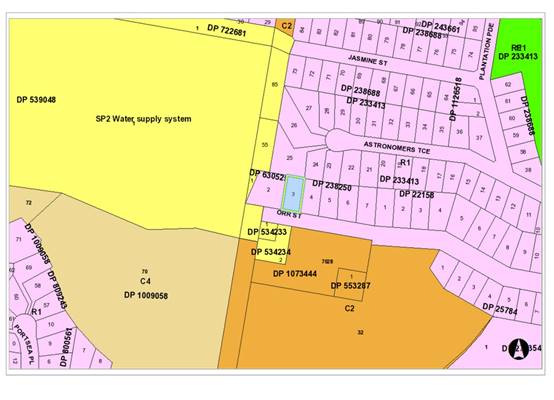
The site has an area of 704.35m2.
The
site is zoned R1 General Residential in
accordance with the Port Macquarie-Hastings Local Environmental Plan 2011, as
shown in the following zoning plan:
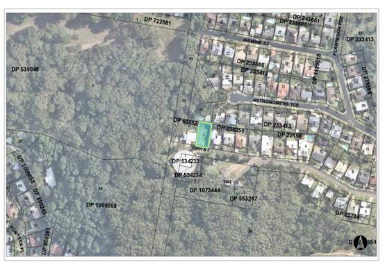
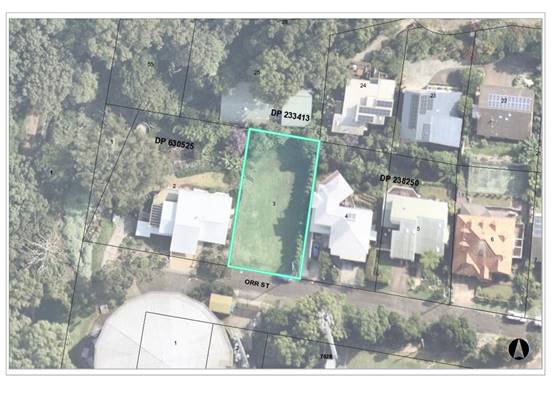
 The existing subdivision pattern and location of existing
development within the locality is shown in the following aerial photograph:
The existing subdivision pattern and location of existing
development within the locality is shown in the following aerial photograph:
2. DESCRIPTION
OF DEVELOPMENT
Key
aspects of the proposal include the following:
· Proposed
Dwelling and Swimming Pool
· Clause
4.6 Objection to Clause 4.3 (Height of Building) of the Port Macquarie Hastings
Local Environmental Plan
· Natural
slope is from the street to the rear and falls approximately 12m.
Refer
to Attachment 2 at the end of this report for plans of the proposed
development.
Application
Chronology
· 08
November 2021 - Application Lodged
· 18
November to 01 December 2021 - Public Notification - 3 submissions received
· 29
November 2021 - Additional information requested
· 22 December 2021 - Further additional information
requested
· 7 January 2022 - Concurrence from RFS received
· 7 February 2022 - Amended Plans and Additional information
received
· 1 March 2022 - Amended clause 4.6 objection and
amended elevations received
· 20 March 2022 - Stormwater drainage and sewer reticulation
strategy received
3. STATUTORY
ASSESSMENT
Section
4.15(1) Matters for Consideration
In
determining the application, Council is required to take into consideration the
following matters as are relevant to the development that apply to the land to
which the development application relates:
(a) The
provisions (where applicable) of:
(i) Any Environmental Planning
Instrument
State Environmental Planning Policy (Koala Habitat
Protection) 2021
Clause 6 - This SEPP applies to all non-rural zoned land
within the Port Macquarie-Hastings Local Government Area.
Clause 12 (other land - no KPoM and less than
1 hectare) - Having considered the SEPP, the application and on completion of a
site inspection, Council is not prevented from granting consent in this case
for the following reasons:
1. The property is not subject to a KPOM, or
2. The site is not considered to be core koala habitat.
State Environmental Planning Policy No. 55 - Remediation
of Land
Following an inspection of the site and a search of Council
records, the subject land is not identified as being potentially contaminated
and is suitable for the intended use.
State Environmental Planning Policy (Coastal Management)
2018
Clause 7, this SEPP prevails over the Port
Macquarie-Hastings LEP 2011 in the event of any inconsistency.
The site is not located within a coastal use area.
State Environmental Planning Policy (Building
Sustainability Index: BASIX) 2004
A BASIX certificate has been submitted demonstrating that
the proposal will comply with the requirements of the SEPP. It is recommended
that a condition be imposed to ensure that the commitments are incorporated
into the development and certified at Occupation Certificate stage.
State Environmental Planning Policy (Infrastructure) 2007
Clause 45 - Development in proximity to electricity
infrastructure - referral to Essential Energy has been completed having regard
for any of the following:
(a) the
penetration of ground within 2m of an underground electricity power line or an
electricity distribution pole or within 10m of any part of an electricity
tower,
(b) development
carried out:
(i) within
or immediately adjacent to an easement for electricity purposes (whether or not
the electricity infrastructure exists), or
(ii) immediately
adjacent to an electricity substation, or
(iii) within
5m of an exposed overhead electricity power line,
(c) installation
of a swimming pool any part of which is:
(i) within
30m of a structure supporting an overhead electricity transmission line,
measured horizontally from the top of the pool to the bottom of the structure
at ground level, or
(ii) within 5m of an overhead electricity power line, measured vertically
upwards from the top of the pool.
Essential Energy have no specific concerns regarding the
development, but have provided some general advice. The advice received from
Essential Energy has been forwarded the Applicant for consideration.
Port Macquarie-Hastings Local Environmental
Plan 2011
The proposal is consistent with the LEP having regard to the
following:
· Clause
2.2 - The subject site is zoned R1 General Residential.
· Clause
2.3(1) and the R1 zone landuse table - The dwelling and ancillary structures to
a dwelling is a permissible landuse with consent.
The objectives of the R1 zone are as
follows:
o To provide for the housing needs
of the community.
o To provide for a variety of
housing types and densities.
o To
enable other land uses that provide facilities or services to meet the day to
day needs of residents.
· Clause
2.3(2) - The proposal is consistent with the zone objectives as it contributes
to the range of housing options in the locality.
· Clause
4.3 - This clause establishes the maximum “height of a building”
(or
building height) that a building may be built to on any parcel of land. The
term
“building height (or height of building)” is defined in the LEP to
mean:
“the vertical distance between ground level (existing)
and the highest point of `the building, including plant and lift overruns, but
excluding communication devices, antennae, satellite dishes, masts, flagpoles,
chimneys, flues and the like”. The term “ground
level (existing)” is also defined in the LEP to mean “the
existing”.
(i)
The building
height limit for the site is identified on the Height of Buildings
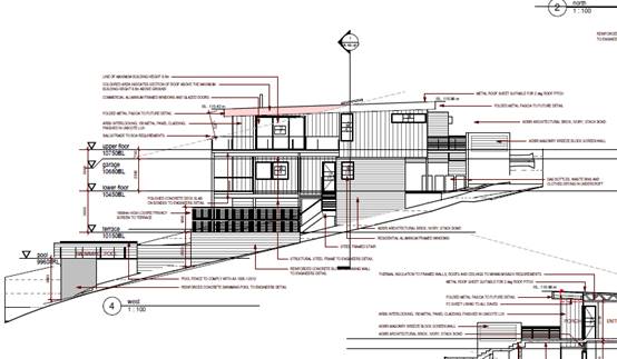
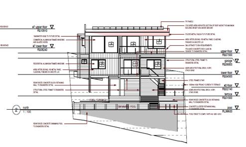
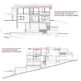
Map as being 8.5m. The proposed development (new works)
exceed the height standard by 1.87m (at the northern covered deck) which
represents a variation of 22%.
The attached
elevation plans, demonstrate the areas of the building that exceed the height
limit. It is noted by the elevations that it is small sections of the roofline
where the land slopes away steeply, that result in the height variation.
In considering the height variation, compliance with the
objectives of Clause 4.3 of the LEP have been considered below:
(a) to ensure that buildings are compatible with the
height, bulk and scale of the existing and desired future character of the
locality,
Comments:
The locality and Orr Street are characterised by a number of other
dwellings with similar heights, due mainly to the steepness of the land.
A key aspect
of this proposal is that it presents as a single storey dwelling to the
street/public domain.
The proposed
variation does not create any additional habitable floor levels above the
height of building provisions.
Based on the above, the proposed height, bulk and scale of
the development is considered compatible with the existing and future character
of the locality.
(b) to minimise visual impact, disruption of
views, loss of privacy and loss of solar access to existing development,
Comment:
The visual impact of the building is considered
satisfactory for the following reasons:
- The
main variations are located behind the front facade of the building and are
therefore less distinctive from Orr Street.
- The
building height is similar to the existing dwellings in the area and will
therefore not be visually dominant.
- The
variation is created by the land sloping steeply away from the street.
- Due
to semi-open nature of the decks along the northern elevation to take advantage
of views and solar access, the adjoining neighbours view is not disrupted by
the height of building variation.
- Shadow diagram demonstrated the proposed variation does not
create adverse any overshadowing.
- Potential privacy impacts are considered under the relevant
DCP provisions below and have been satisfactorily addressed in the building
design.
(c) to minimise the adverse impact of
development on heritage conservation areas and heritage items,
Comment:
The site does not contain or directly adjoin any known
heritage items or sites of significance.
(d) to nominate heights that will provide a
transition in built form and land use intensity within the area covered by this
Plan.
Comment:
The proposed height is consistent with other dwellings in
the area and attempts to balance the site constraints of the topography. The
variation does not compromise this intent of the standard.
In addition to the above, the applicant has lodged a
written request in accordance with Clause 4.6 of the LEP objecting to the 8.5m
building height standard applying to the site, which is established under
Clause 4.3 (see comments below under Clause 4.6).
· Clause
4.4 - The floor space ratio of the proposal is 0.38:1, which complies with the
maximum 0.65:1 floor space ratio applying to the site.
· Clause
4.6 - This clause establishes a degree of flexibility for certain development
standards in certain circumstances which have demonstrated that a better
planning outcome will occur from that flexibility.
In this regard, the proposal seeks a variation to the building height
standard as identified under clause 4.3 of this report. Assistance on the
approach to variation to this standard is also taken from NSW Land and
Environment Court and NSW Court of Appeal decisions in:
1. Wehbe v Pittwater Council (2007)
NSW LEC 827 (Wehbe);
2. Four2Five Pty Ltd v Ashfield
Council (2015) NSWLEC 1009; and
3. Al Maha Pty Ltd v Huajun
Investments Pty Ltd (2018) NSWCA 245
Having regard to specific requirements of clause 4.6(3) and 4.6(4) the
following assessment comments are provided:
(3) Development consent must
not be granted for development that contravenes a development standard unless
the consent authority has considered a written request from the applicant that
seeks to justify the contravention of the development standard by
demonstrating:
(a) that compliance with
the development standard is unreasonable or unnecessary in the
circumstances of the case, and
(b) that there are
sufficient environmental planning grounds to justify contravening the
development standard.
The Applicant has submitted a request in writing -
Refer Attachment 3 - to justify
the contravention of the building height standard for the following reasons (as
summarised):
1. Compliance with the
development standard is unnecessary as the proposal has demonstrated to be
consistent with the objectives of the height of buildings standard.
2. The natural slope of the
site falls 12m over approximately 36m, from the front to the rear. To avoid
extensive cut and fill, an elevated 2 level residence with a garage on a
mid-level was considered an appropriate design solution.
(Above: North and West Elevations)
3. The height variation
would not result in increased overshadowing of the adjoining properties as
compared with a compliant proposal.
4. The height variation
would not result in any additional loss of views across the site compared with
a compliant proposal.
5. The development is
considered to be a good contextual fit for an infill development and is
consistent with the streetscape and bulk and scale outcomes envisaged for the
area.
6. The height exceedance
occurs at the rear of the existing 2-storey building due to the steepness of
the slope and this part of the building will not be highly visible in the
streetscape.
7. The height of building
variation will not have an adverse impact to the public domain.
(4)
Development consent must not be granted for development that contravenes a
development standard unless:
(a) the
consent authority is satisfied that:
(i) the
applicant’s written request has adequately addressed the matters
required
to be demonstrated by subclause (3), Having
regard to: 3(a) that compliance with the development standard is unreasonable or
unnecessary in the circumstances of the case:
In Wehbe ‘five methods’ have been
developed to test whether a compliance with the standard is unreasonable or
unnecessary.
1. The objectives of
the height standard are achieved/not achieved notwithstanding the
non-compliance with the numerical 8.5m height standard.
2. The underlying
objective or purpose of the standard is/not relevant to the development and
therefore compliance is unnecessary.
3. The underlying
object or purpose would be/not be defeated or thwarted if compliance was
required and therefore compliance is unreasonable.
4. The development
standard hasn’t been virtually abandoned or destroyed by the
Council’s own actions in granting a consent to the proposal departing
from the 8.5m standard and hence compliance is unreasonable or unnecessary.
5. The zoning of the
particular land is reasonable or appropriate so that a development standard
appropriate for that zoning is also reasonable and necessary as it applies to
the land.
The
proposed variation relies upon the first test. It is considered that the
Applicant’s written request has satisfactorily demonstrated that the
proposed development will achieve the objectives of the height of building
development standard despite the numerical non-compliance.
While
it is acknowledged that consent has been granted for other buildings in the
precinct that have exceeded the height controls they have been appropriately
tested on merit in accordance with the provisions of Clause 4.6 and found to be
acceptable.
Therefore,
it is not considered that these decisions have abandoned or destroyed the
integrity of the development standard. The decisions do, however, provide some
context for how the development will fit into the locality.
The
first method (1) is sufficient to establish that compliance with the
development standard is unnecessary in the circumstances of the case.
Comments:
On the basis of the above, it is
considered that the Applicant’s clause 4.6 variation
request has adequately addressed the
matters required to be demonstrated by
clause 4.6(3).
(ii) the proposed development will be in
the public interest because it is consistent with the objectives of the
particular standard and the objectives for development within the zone in which
the development is proposed to be carried out,
The consistency of the proposal with the zone objectives has
been discussed above under Clause 2.3. Consideration of the proposal’s
consistency with the objectives of height of buildings standard (Clause 4.3) is
provided as follows: ‘
(a) To ensure that buildings are compatible with the
height, bulk and scale of the existing and desired future character of the
locality.
(ii)
Comments:
In this regard, the proposed
dwelling is similar in height, bulk and scale to other dwellings in the area
and maintains an FSR below the numerical control and commensurate with other
dwellings in the locality.
Although
the variation is 22%, when viewed from the North and Western elevations of the
proposal, the encroachment relates to a small section of the upper storey
verandah roof.
The
locality is characterised by a number of other residential buildings ranging in
height from two to three storeys above ground level, mainly due to the
steepness of the terrain and north-east views.
The
floor space ratio for the proposal is below the maximum of 0.65:1 for the area.
The
proposed height, bulk and scale of the development are considered compatible
with the character of the locality in this regard.
(iii)
(b) to minimise visual
impact, disruption of views, loss of privacy and loss of solar access to
existing development;
(iv) Comments:
The visual impact of the building is considered
satisfactory for the following reason/s:
· Given the topography of the site and orientation of
adjoining dwellings there will be no significant view sharing or overshadowing
impacts.
· The proposal will not result in the disruption of
any significant views. No submissions were received regarding concern for loss
of views in the locality.
(v)
(c) to minimise the adverse impact of development on heritage conservation
areas and heritage items;
(vi) Comments:
The
site does not contain any known heritage items or sites of significance.
(d) to nominate heights that
will provide a transition in built form and land use intensity within the area
covered by this Plan.
(vii)
Comments:
· The site is located within an established locality
maintaining consistent zoning and numerical controls.
· The public benefit of the standard is not
compromised by the proposed development.
· The development is consistent with the zoning and
height objectives of the LEP 2011 and is unlikely to have any implications on
State related issues or the broader public interest.
(b) the
concurrence of the Secretary has been obtained.
(viii) Comments:
In accordance with Planning
Circular PS 20-002, the Secretary’s concurrence can be assumed for
development contravenes a numerical standard by greater than 10%. However, as
the numerical variation being sort is 22%, this Application is required to be reported
to the Development Assessment Panel, which then needs to be referred to an
Ordinary meeting of Council for determination. A public register of variations
is maintained and quarterly reporting made to the Department.
Based on the above, the
development is consistent with the height control objectives and also the
zoning objectives as discussed previously in this report. It is recommended
that the Clause 4.6 variation to Clause 4.3 be supported.
· Clause
7.13 - Satisfactory arrangements are in place for provision of essential
services including water supply, electricity supply, sewer infrastructure,
stormwater drainage and suitable road access to service the development.
(ii) Any draft instruments that apply to the site or are
on exhibition
No draft instruments apply to the site.
(iii) Any Development Control
Plan in force
Port Macquarie-Hastings
Development Control Plan 2013
|
DCP 2013: Part B - General Provisions - B2:
Environmental Management
|
|
DCP Objective
|
Development Provisions
|
Proposed
|
Complies
|
|
3
|
a) Development must comply
with Council’s Developments, Public Place & Events - Waste
Minimisation and Management Policy.
|
Satisfactory arrangements
can be put in place for storage and collection of waste.
Standard condition
recommended for construction waste management.
|
Yes
|
|
Cut and Fill Regrading
|
|
4
|
a) Development shall not
exceed a maximum cut of 1.0m and fill of 1.0m measured vertically above the
ground level (existing) at a distance of 1.0m outside the perimeter of the
external walls of the building (This does not apply to buildings where such
cut and fill is fully retained within or by the external walls of the
building).
|
Minimal earthworks are
proposed. The site falls 12m from front to rear and the proposed retaining
walls are proposed to be fully retaining within the building line, under the
elevated terrace and pool areas.
To transition between to
each level and create level useable private open space areas, elevated
terraces are proposed with reinforced concrete block retaining walls to
create useable level space with minimum cut that could impact adjoining
properties.
The ground floor terrace on
the western side of the dwelling has an area of fill greater than the 1m
standard to 2.8m in height at the highest point directly below the terrace.
The design has minimised
the use of excessive cut and fill by minimising the retaining walls to area
directly below the proposed terraces.
The proposal does not
adversely impacts drainage of adjoining properties and will somewhat reduce
the water existing stormwater runoff.
|
No, but considered
acceptable due to the merits of the site.
|
|
5
|
a) A certified practicing
structural engineer must certify any retaining wall greater than 1.0m.
|
Engineering detail is noted
on proposed plans. A draft condition have also been included to confirm
structural engineering for the retaining walls and footings prior to release
of the Construction Certificate.
|
No, but capable of being
managed with recommended condition.
|
|
b) Where a combination of a
fence and a wall is proposed to be greater than 1.2m high:
- be a
maximum combined height of 1.8m above existing property boundary level;
- be
constructed up to the front boundary for a maximum length of 6.0m or 30% of
the street frontage, whichever is less;
− the
fence component has openings which make it not less than 25% transparent; and
− provide
a 3m x 3m splay for corner sites, and
- provide a
900mm x 900mm splay for vehicle driveway entrances.
|
No Front fence proposed.
|
N/A
|
|
DCP 2013: Part B -
General Provision - B3: Hazards Management
|
|
Bushfire Hazard Management
|
|
18
|
a) APZs are to be located
outside of environmental protection zones and wholly provided within private
land. Note perimeter roads provided as part of a residential subdivision are
classified as being part of the subdivision and not a separate permissible
land use within environment protection zones.
|
APZ not reliant on land
beyond the road reserve. No identifiable adverse impacts.
|
Yes
|
|
Flooding
|
|
19
|
a) Development must comply
with Council’s Floodplain Management Plan and Flood Policies.
|
NA
|
NA
|
|
DCP 2013: Part B- General Provisions- B4: Transport,
Traffic Management, Access and Car Parking
|
|
DCP Objective
|
Development Provisions
|
Proposed
|
Complies
|
|
Parking Provision
|
|
24
|
a) Off-street Parking is
provided in accordance with Table 3:
- 1 parking space per each
dwelling for dwelling-house.
|
Proposal provides a double
garage.
|
Yes
|
|
Parking Layout
|
|
28
|
c) Parking spaces shall
generally be behind the building line but may be located between the building
line and the street when:
− it
is stacked parking in the driveway; or
− it
can be demonstrated that improvements to the open space provided will result;
and
− the
spaces are screened (densely landscaped or similar) from the street by a
landscaping with a minimum width of 3.0m for the entire length of the parking
area.
|
Proposed Garage is behind
the building line. The proposed plans have also been amended to comply with
minimum 4.5m building line front setback. However, the driveway length is
limited to a 4.6m length inside of the front boundary to provide casual
stacked parking opportunities on the driveway.
|
Yes
|
|
d) Parking design and layout
is provided in accordance with AS/NZS 2890.1 - Parking facilities -
Off-street car parking.
|
Capable of complying.
|
Yes
|
|
34
|
a) All parking and manoeuvring
spaces must be designed to avoid concentrations of water runoff on the
surface.
|
Residential driveway only,
capable of complying.
|
Yes
|
|
b) Council will not permit the
discharge of stormwater directly into kerbing and guttering or table drains
for any development other than that of a minor nature.
|
Capable of complying with
appropriate driveway.
|
yes
|
|
DCP 2013: Part B -
General Provisions - B5: Social Impact Assessment and Crime Prevention
|
|
DCP Objective
|
Development Provisions
|
Proposed
|
Complies
|
|
Crime Prevention
|
|
43
|
a) The development addresses
the generic principles of crime prevention:
− Casual
surveillance and sightlines;
− Land use mix
and activity generators;
− Definition of
use and ownership;
− Basic exterior
building design;
− Lighting;
− Way-finding;
and
− Predictable
routes and entrapment locations;
− as described in
the Crime Prevention Through Environmental Design (CPTED) principles.
|
No concealment or entrapment areas proposed. Adequate
casual surveillance available.
|
Yes
|
|
DCP 2013: Part C - Development Specific Provisions -
C1: Low Density Residential Development
|
|
DCP Objective
|
Development Provisions
|
Proposed
|
Complies
|
|
Front Setbacks
|
|
44
|
a) Dwellings may incorporate an articulation zone to a
street frontage at no less than 3m from property boundary. The
following building elements are permitted within the articulation zone:
− an entry
feature or portico;
− a balcony,
deck, patio, pergola, terrace or verandah;
− a window box
treatment;
− a bay window or
similar feature;
− an awning or
other feature over a window;
− a sun shading
feature.
b) These building elements should not extend above the
eave gutter line, other than a pitched roof to an entry feature or portico
that has the same pitch as the roof on the dwelling house.
|
Setback of 3m to elevated front porch.
Note there is a breeze block feature adjoining the
entrance path, this is a balustrade due to the elevation, do not extend above
the eave and somewhat characterised as a fence. This is considered acceptable
based on the merit of the site and safety.
|
Yes
|
|
c) The primary road front setback shall be:
Classified road = any frontage 6.0m
Primary frontage = 4.5m
Secondary frontage = 3.0m
Ancillary Lane = 2.0m
Large lot residential and rural zones = 10.0m
|
The primary setback to a external wall of a habitable room
is 6m and to the proposed garage external facing wall is 4.5m.
|
Yes.
|
|
45
|
a) A garage, carport or car parking space should:
- be
at least 1m behind the building line, where the dwelling(s) has a setback
from a front boundary of 4.5m or more, or
- be
at least 5.5m from a front boundary, where the dwelling(s) has a setback of
less than 4.5m.
|
The garage is setback more than 1m behind the Breeze block
feature and front porch elements of the proposal.
The garage opening however, is only setback 4.6m. see
justification below.
|
No, but considered acceptable based on the site
constraints.
|
|
b) The total width of the garage/carport openings should
not be more than 6m and not more than 50 per cent of the width of the
building.
|
Proposed garage opening is 5.5m and approximately 40% of
the width of the building.
|
Yes
|
|
c) Driveway crossovers are no greater than 5.0m in width.
|
Proposed 5m driveway.
|
Yes
|
|
d) Where a dual occupancy or attached dwelling is proposed
on a corner lot a garage and driveway is provided on each road frontage.
|
NA
|
NA
|
|
Side and Rear Setbacks
|
|
46
|
a) A minimum rear boundary setback of 4m is to be provided
to dwellings (including verandahs, patios and decks).
|
Proposed rear setback of 4m to the elevated pool area.
The proposed rear building line of the dwelling is 16.48m.
|
Yes
|
|
b) A minimum rear boundary setback of 900mm applies to
sheds and swimming pools subject to achieving minimum required private open
space area.
|
Proposed pool is setback 4m.
|
Yes
|
|
c) Council may consider varying rear setback requirements
where it is demonstrated that the private open space could achieve better
solar access between the building and the side setback. In that instance, one
side setback should be a minimum 4m in width (for an equivalent length of
rear boundary, behind building line) and the rear setback may be reduced to
900mm.
|
NA
|
NA
|
|
47
|
a) Ground floors (being <1m above existing ground
level) should be setback a minimum of 900mm from side boundaries.
|
Setbacks
Eastern Boundary - 1.3m
Western Boundary - 3m
|
Yes
|
|
b) First floors and above (including single storey with
floor level >1m) should be setback a minimum of 3m from the side boundary,
or reduced down to 900mm where it can be demonstrated that the adjoining
property’s primary living rooms and principal private open space areas
are not adversely overshadowed for more than 3hrs between 9am - 3pm on 21
June.
|
First floor Setbacks
Eastern Boundary - 3.05m
Western Boundary - 3.08m
Note, the elevated terrace under the lower level is
setback a minimum 190mm to 300mm from the western boundary. This is
considered unacceptable due to bulk and scale, with a maximum height being
4.3m directly adjoining the proposed dwelling. It will be acceptable if the
side setback achieved the minimum setback for a single level development,
providing more separation and access for future maintenance. A condition has
been recommended to amend plans prior to the release of the Construction
Certificate.
|
Acceptable when the western elevation of the terrace is
increased to a 1m side setback.
|
|
c) First floors and above should have building walls that
step in and out at least every 12m by a minimum of 500mm articulation. Where
first floors and above are setback >3m, wall articulation is not required.
|
The external walls of the proposed building are well
articulated with external finishes and no single span of wall exceeding 12m
|
Yes
|
|
Private Open Space
|
|
48.
|
a) All dwellings should have a minimum area of private
open space of 35m2, which includes a principal private open space area
with:
− a minimum
dimension of 4m x 4m, and
− a maximum grade
of 5% for minimum 4m x 4m of the total open space requirement, and
− direct
accessibility from a ground floor living area and orientated to maximise use.
|
Suitable private open space is provided on lower terrace
and pool area. There are multiple terraces that comply with the objectives of
this clause. No adverse concerns.
|
Yes
|
|
|
b) Private open space may include clothes drying areas and
garbage storage.
|
Noted on plans adjoining lower level laundry.
|
Yes
|
|
Public Domain and Fencing
|
|
49
|
a) Front fences built forward of the building line for the
primary road frontage should be detailed on the development application
plans.
|
Note that a breeze block wall is proposed on along the
front porch and entrance path. Due to site constraints the porch is elevated
and a balustrade is required. This is not a front fence for the intent of this
clause.
|
NA
|
|
b) Solid Front fences up to 1.2m high should be:
− Setback 1.0m
from the front boundary, and
− Suitably
landscaped to reduce visual impact, and
− Provide a 3m x
3m splay for corner sites.
|
NA
|
NA
|
|
b) Front fences proposed to be more than 1.2m high should be
a maximum of 1.8m in height, above existing front property boundary level,
and either:
− Include
landscaped recesses having minimum dimensions of 1.8m long x 900mm deep which
occupy no less than 50% of the total length of the fence, or
− be
erected up to the front boundary for a maximum length of 6.0m or 50% of the
street frontage,
|
NA
|
NA
|
|
c) have openings which make it not less than 25%
transparent (no individual opening more than 30mm wide);
|
NA, but the breeze block construction will provide
adequate transparency.
|
NA
|
|
d) provide a 3m x 3m splay for corner sites, and
|
NA
|
NA
|
|
e) provide a 900mm x 900mm splay for vehicle driveway
entrances.
|
NA - adequate separation provided to driveway.
|
Yes
|
|
50
|
a) For tennis courts or other similar areas, chain wire
fences should be black or dark green plastic coated mesh.
|
NA
|
NA
|
|
b) Solid fences enclosing these facilities should not be
permitted over 1.8m.
|
NA
|
NA
|
|
Bulk and Scale
|
|
51
|
a) Direct views between indoor living rooms and principal
private open space of adjacent dwellings, including proposed dwellings
approved on adjoining lots, including possible dwellings on future lots,
should be obscured or screened where:
− Ground and first
floor (and above) indoor living room windows are within a 9m radius.
− Direct views
between principal private open space areas where within a 12m radius.
− Direct views
between indoor living rooms of dwellings into the principal area of private
open space of other dwellings within a 12m radius.
|
The development will not compromise privacy in the area
due to a combination of lack of windows on relevant boundaries, use of
obscure windows, high sill windows, limiting living areas/windows that face
adjoining living areas/open space, compliant separation, fencing and use of
screening to obscure views/direct views towards the rear boundary.
|
Yes
|
|
b) A balcony, deck, patio, pergola, terrace or verandah
should have a privacy screen where there are direct views of:
− Indoor living
room windows of adjacent dwellings, including proposed dwellings approved on
adjoining lots within 9m radius; or
− Principal areas
of private open space of adjacent dwellings, including proposed dwellings
approved on adjoining lots within a 12m radius.
|
From certain areas on the elevated terraces and decks,
some minimal side views into neighbouring open space areas will still be
possible. However, the proposed screening directs the view more to the rear
and such minimal side views would require a specific effort to look into the
neighbouring properties.
Private open space adjoining the rear boundary are further
than 12m from the proposed terrace and decks. The site is naturally more
elevated than the adjoining developments. These areas appear to be screened
for landscaping and there are no adverse impacts.
|
Yes
|
|
c) Privacy protection is
not required for:
− Any Indoor
living room windows with a sill height of greater than 1.5m above the
finished floor level of that room or where fixed non-openable translucent
glass is installed to the same height.
|
Refer to comments on 51(a) above.
|
Yes
|
|
d) Direct views described above may be reduced or obscured
by one of the following measures (details to be submitted with the
development application):
− 1.8m high fence
or wall between ground-floor level windows or between a dwelling and
principal private open space
− Screening of
minimum 1.7m height, that has 25% openings (max), with no individual opening
more than 30mm wide, is permanently fixed and is made of durable materials.
− A
window, the whole of which has translucent glass and is not able to be
opened.
|
Refer to comments on 51(a) above.
|
Yes
|
|
Roof Terraces
|
|
52
|
a) Direct views between roof terraces and indoor living
room windows or principal areas of private open space of adjacent dwellings
should be screened where:
− Ground and
first floor (and above) indoor living room windows are within a 9m radius of
the trafficable area of the roof terrace;
Direct views between roof terraces principal areas of
private open space within a 12m radius of the trafficable are of the roof
terrace.
|
NA
|
NA
|
|
b) Screening should only be considered where:
− the height of
the screen does not exceed the maximum building height; and
− the screening
contributes to the building form, and
− the screening
is integrated into the design of the roof; and
− is constructed
and designed with materials complementary to the building.
|
NA
|
NA
|
|
c) Lighting installations on roof terraces should be:
- contained within the
roof terrace area and located at a low level, and
- appropriately shaded
and fixed in a non-adjustable manner so that light is projected downwards
onto the floor surface of the terrace.
− designed in
compliance with Australian Standards AS4282 - Control of obtrusive effects
of outdoor lighting.
|
NA
|
NA
|
|
Ancillary Development
|
|
56
|
a) For ancillary development in R1 General Residential, R2
Low Density Residential, R3 Medium Density Residential, R4 High Density
Residential, R5 Large Lot Residential and RU5 Village zones:
− The height of
an outbuilding or the alterations and additions to an existing outbuilding on
a lot should not be more than 4.8m above ground level (existing).
− The building
should be single storey construction with a maximum roof pitch of 24 degrees.
− The maximum
area of the building should be 60m2 for lots less than 900m² and maximum
of 100m² for larger lots.
− Ancillary
development that is a garage, or an outbuilding, or a rainwater tank should
not be located in front of the main building line with the exception of
swimming pools.
|
Proposed elevated pool is a maximum 3.02m high from
natural ground level and less than 60m2. Generally, this complies with this
clause.
Rainwater tanks and onsite stormwater detention generally
complies.
|
Yes
|
The proposal seeks to vary Development Provision relating to
clause 45 variation to minimum garage setback.
The relevant objectives are:
· To minimise the
impact of garages and driveways on the streetscape, on street parking and amenity.
· To minimise the
visual dominance of garages in the streetscape.
· To provide safe
and functional vehicular access.
Having regard for the development provisions and relevant
objectives, the variation is considered acceptable for the following reasons:
· The proposed
garage is setback 4.6m from the front setback, creating a front setback
consistent with front building line setback.
· The design was
attempting to minimise the need for engineering and support of an elevated
garage floor.
· The visual
dominance towards the street scape has been minimised with proposed feature
cladding and articulation of the front building line.
· The proposal is in
keeping with the established character of Orr Street with many examples of
garages being forward of the building line due to the site constraints.
· The submitted
plans have been amended to provide a 4.5m setback which now provides casual
stacked car parking between the building and the kerb.
· There are no
residential properties adjoining the site across Orr Street.
· Based on the merit
of the location at the end of Orr Street, the proposed variation will not add
any adverse impacts to the proposed design or if the minimum garage setback of
5.5m was achieved.
Based on the above assessment, the variations proposed to
the provisions of the DCP are considered acceptable and the relevant objectives
have been satisfied. Cumulatively, the variations do not amount to an adverse
impact of a significance that would justify refusal of the application.
(iiia) Any planning agreement that has been entered into under section
7.4, or any draft planning agreement that a developer has offered to enter into
under section 7.4
No planning agreement has been
offered or entered into relating to the site.
(iv) Any matters prescribed by the Regulations
Demolition of buildings AS 2601 - Clause 92
Demolition work on the site is capable of compliance with
this Australian Standard and is recommended to be conditioned.
(b) The likely impacts of that
development, including environmental impacts on both the natural and built
environments, social and economic impacts in the locality
Context and Setting
The proposal will not have any significant adverse impacts
on existing adjoining properties and satisfactorily addresses the public
domain.
The proposal is considered to be compatible with other
residential development in the locality and adequately addresses planning
controls for the area.
The proposal does not have a significant adverse impact on
existing view sharing.
The proposal does not have significant adverse lighting
impacts.
There are no significant adverse privacy impacts.
There are no significant adverse overshadowing impacts. The
proposal does not prevent adjoining properties from receiving 3 hours of
sunlight to private open space and primary living areas on 21 June.
View Sharing
The
overall notion of view sharing is invoked when a property enjoys existing views
and a proposed development would share that view by taking some of it away for
its own enjoyment. Taking all the view away cannot be called view sharing,
although it may, in some circumstances, be quite reasonable.
Having
considered the principles of NSW Land and Environment Court case law - Tenacity
Consulting v Warringah 2004 NSW LEC 140 and following an inspection of the
area, an assessment against the four (4) step process will be provided
below to establish whether the view sharing is acceptable.
The
four (4) steps are also listed below for context.
Step
1
Assessment
of views to be affected. Water views are valued more highly than land views.
Iconic views (e.g. of the Opera House, the Harbour Bridge or North Head) are
valued more highly than views without icons. Whole views are valued more highly
than partial views, e.g. a water view in which the interface between land and
water is visible is more valuable than one in which it is obscured.
Step 2
Consider from what part of the property the views are
obtained. For example, the protection of views across side boundaries is more
difficult than the protection of views from front and rear boundaries. In
addition, whether the view is enjoyed from a standing or sitting position may
also be relevant. Sitting views are more difficult to protect than standing views.
The expectation to retain side views and sitting views is often unrealistic.
Step 3
Assess the extent of the impact. This should be done for
the whole of the property, not just for the view that is affected. The impact
on views from living areas is more significant than from bedrooms or service
areas (though views from kitchens are highly valued because people spend so
much time in them). The impact may be assessed quantitatively, but in many
cases this can be meaningless. For example, it is unhelpful to say that the
view loss is 20% if it includes one of the sails of the Opera House. It is
usually more useful to assess the view loss qualitatively as negligible, minor,
moderate, severe or devastating.
Step 4
Assess the
reasonableness of the proposal that is causing the impact. A development that
complies with all planning controls would be considered more reasonable than
one that breaches them. Where an impact on views arises as a result of
non-compliance with one or more planning controls, even a moderate impact may
be considered unreasonable. With a complying proposal, the question should be
asked whether a more skilful design could provide the applicant with the same
development potential and amenity and reduce the impact on the views of
neighbours. If the answer to that question is no, then the view impact of a
complying development would probably be considered acceptable and the view
sharing reasonable.
On balance, whilst a design change may reduce the perceived
impact from side facing windows of the adjoining development. The part of the
proposed building that is impacting the views enjoyed across the current vacant
land would be potentially blocked by a complying development building envelope
on the subject lot. Note that the height of building variation discussed
earlier in this report does not impact views from the adjoining developments.
The proposal is considered reasonable when reviewing
compliance against key view sharing principle criteria for the immediate
neighbours to the west (1-3 Orr Street). The proposed development complies with
the side and rear setback requirements. It is also common to find 2-3 storey
dwellings in the locality due to the site constraints so the bulk and scale are
also considered reasonable. The proposal will not have any adverse view sharing
impacts that would warrant refusal of the application and the proposal is
considered acceptable.
Access, Traffic and Transport
The proposal will not have any significant adverse impacts
in terms access, transport and traffic. The existing road network will
satisfactorily cater for any increase in traffic generation as a result of the
development.
Water Supply Connection
Service available – details required with Section 68
application.
An appropriate standard condition is recommended in this
regard.
Sewer Connection
The proposed works are to be clear of the existing sewer
junction and main traversing the site. The required distance off the junction
is to be determined in relation to the depth.
The swimming pool is proposed over the sewer main traversing
the site. This has been assessed as being acceptable subject to appropriate
engineering design to be prepared prior to the issue of the Construction
Certificate.
Service available - details required with Section 68
application.
An appropriate standard condition is recommended in this
regard.
Stormwater
Service available - details required with Section 68
application.
An appropriate standard condition is recommended in this
regard.
Other Utilities
Telecommunication and electricity services are available to
the site.
Heritage
This site does not contain or adjoin any known heritage item
or site of significance. The site is considered to be disturbed land.
Other land resources
The site is within an established urban context and will not
sterilise any significant mineral or agricultural resource.
Water cycle
The proposed development will not have any significant
adverse impacts on water resources and the water cycle.
Soils
The proposed development will not have any adverse impacts
on soils in terms of quality, erosion, stability and/or productivity subject to
a standard condition requiring erosion and sediment controls to be in place
prior to and during construction.
Air and microclimate
The construction and/or operations of the proposed
development will not result in any significant adverse impacts on the existing
air quality or result in any pollution. Standard precautionary site management
condition recommended.
Flora and fauna
Construction of the proposed development will not require
any removal/clearing of any native vegetation and therefore does not trigger
the biodiversity offsets scheme. Part 7 of the Biodiversity Conservation
Act 2016 is considered to be satisfied.
Waste
Satisfactory arrangements are in place for proposed storage
and collection of waste and recyclables. No adverse impacts anticipated.
Standard precautionary site management condition recommended.
Energy
The proposal includes measures to address energy efficiency
and will be required to comply with the requirements of BASIX.
Noise and vibration
The construction of the proposed development will not result
in any significant adverse impacts on the existing air quality or result in any
pollution. Standard precautionary site management condition recommended.
Bushfire
The site is identified as being bushfire prone.
The Applicant has submitted a bushfire report prepared by a
Certified Consultant.
As the assessment has determined that a BAL 40/Flame Zone
construction is required, and referral to the Local Rural Fire has been made.
The RFS have reviewed the proposal and made recommendations which will be
required to be imposed via conditions of consent.
Management of bushfire risk is acceptable subject to BAL
construction levels being implemented and APZ being maintained. An appropriate
condition is recommended.
Safety, security and crime prevention
The proposed development will be unlikely to create any
concealment/entrapment areas or crime spots that would result in any
identifiable loss of safety or reduction of security in the immediate area.
Adequate casual surveillance is available.
Social impacts in the locality
Given the nature of the proposed development and its
location the proposal is not considered to have any significant adverse social
impacts.
Economic impact in the locality
The proposal is not considered to have any significant
adverse economic impacts on the locality. A likely positive impact is that the
development will maintain employment in the construction industry, which will
lead to flow impacts such as expenditure in the area.
Site design and internal design
The proposed development design satisfactorily responds to
the site attributes and will fit into the locality. Particularly having regard
to the steep topography of the site.
Construction
Construction impacts are considered capable of being
managed, standard construction and site management conditions have been
recommended.
Cumulative impacts
The proposed development is not considered to have any significant
adverse cumulative impacts on the natural or built environment or the social
and economic attributes of the locality.
(c) The suitability
of the site for the development
The proposal will fit into the locality and the site
attributes are conducive to the proposed development.
Site constraints of bushfire, stormwater and slope have been
adequately addressed and appropriate conditions of consent recommended.
(d) Any submissions made
in accordance with this Act or the Regulations
Following exhibition of the application in accordance with
the Community Participation Plan, three (3) submissions were received. The key
issues raised are addressed below;
|
Submission
Issue/Summary
|
Planning
Comment/Response
|
|
The proposal
in its current form does not comply with building height regulations of
8.5m.
|
As discussed earlier in this report. The applicant submitted
amended plans including a Clause 4.6 exception to Development Standard to
Clause 4.3 (Height of Buildings) of the Port Macquarie-Hastings Local
Environmental Plan 2011
The proposed development (new
works) exceed the height standard by 1.87m (at the northern covered deck)
which represents a variation of 22%. Key issues raised in the clause 4.6
exception is severe sight constraints due to slope, variation is only part of
the roof line, proposed variation is not for additional habitable floor
level, variation does not create adverse overshadow or view loss and is not
out of character for the locality.
Based on the assessment, the
variations proposed to the provisions of the DCP and the LEP 2011 are both
considered acceptable and the relevant objectives have been satisfied.
Cumulatively, the variations do not amount to an adverse impact of a
significance that would justify refusal of the application.
|
|
Variation to Side Setbacks - Western raised terrace is
190mm from the side boundary and elevated a maximum 2.8m.
|
The lower terrace is elevated to create a level usable
space to transition from the Lower level of the dwelling to the proposed pool
area. The proposed terrace is a secondary outdoor area. The proposed elevated
terrace does not have adverse overshadowing impacts, however, there is a
perception of bulk, due to the proposed height of 2.8m and an additional 1.8m
privacy screening.
In terms of the level of the terrace proposed, it is
considered to be consistent with other sites in the area, due to the steep
terrain.
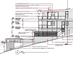
The proposed side setback does appear to be unnecessary
impact to the adjoining development as it is a side setback variation and
will have future issues with regards to maintenance. Due to the size of the
lower terrace, increasing the side setback will not impact the function of
the secondary area.
As a mitigation measure, it is recommended that a
condition be included to requires prior to the release of the construction
certificate that the lower terrace be amended to provide a 1m side setback.
|
|
The bulk and scale of the development along with
inadequate setbacks results in unreasonable impacts on privacy and amenity.
|
The proposed development complies with the floor space
ratio complying to the site.
The height of building variation has been discussed
earlier and is considered not out of character for the locality due to site
constraints with various examples of similar variations.
Privacy impacts have been assessed in the DCP 2013
component of this report and considered compliant. It is considered that
adequate design, implementation of privacy screening, window location and
separation has softened the perceived impacts of an elevated site.
The proposed bulk and scale is considered consistent with
the envisaged development of this locality.
|
|
Access, traffic and manoeuvring
|
The proposed plans have been amended to comply with the
minimum front building line. The proposed garage is now setback 4.6m from the
front boundary and has been considered acceptable earlier in this report.
This provides more appropriate site lines for manoeuvring entering and exiting
the garage.
With regards to site management, the construction
management plan will need to included site access as part of the management.
This should include adequate notification of road closures during
construction.
|
|
Visually prominent to the existing landscape and out of
character
|
Orr Street is one of the highest positioned residential
areas within the locality. The built form of the locality is well established
as buildings appearing to be 2 to 3 storey in height. The proposed
development will not be out of character to the built form of adjoining
residential developments along Orr street. There are no adverse impacts with
regards to visual prominence to support refusal of this application.
|
|
Stormwater disposal
|
As discussed earlier in this report, stormwater management
plans have been provided and provided with concurrence from Council’s
stormwater engineers. The proposed roofline will drain to Orr street and the
remaining catchment will drain to an onsite detention basin at the rear. This
will improve the current overland flows experience.
|
|
Concerned about the proposed development’s proximity
to existing rubble/rock retaining wall on adjoining property. regarding
structural impact and stormwater.
|
The drainage and structure of the adjoining properties
rumble retaining wall appears to have existing issues with regards to
drainage and structural capacity. The proposed development has satisfied
proposed stormwater drainage and overland flows; this should soften some of
the existing issues.
The proposed swimming pool is proposed to be setback 4m
from the rear boundary. Prior to the construction certificate engineering
plans are to confirm the footings over the sewer line to support the elevated
structure. Being over 4m from the boundary it is anticipated that this is
capable of being outside of the zone of influence of the adjoining
landscaping rubble retaining wall on the adjoining site.
Based on the above, the excavation, levels and associated
impacts are acceptable and capable of being managed.
|
(e) The Public
Interest
The proposed development will be in the wider public
interest with provision of appropriate additional housing.
The proposed
development satisfies relevant planning controls and will not have any
significant adverse impacts on the wider public interest.
Ecologically Sustainable Development and Precautionary
Principle
Ecologically sustainable development requires the effective
integration of economic and environmental considerations in decision-making
processes.
The four principles of ecologically sustainable development
are:
· the
precautionary principle,
· intergenerational
equity,
· conservation
of biological diversity and ecological integrity,
· improved
valuation, pricing and incentive mechanisms.
The principles of ESD require that a balance needs to be
struck between the man-made development and the need to retain the natural
vegetation. Based on the assessment provided in the report and with recommended
conditions of consent, it is considered an appropriate balance has been struck.
Climate change
The proposal is not considered to be vulnerable to any risks
associated with climate change.
4. DEVELOPMENT
CONTRIBUTIONS APPLICABLE
The proposed development will comprise a new single dwelling
and does not involve the creation of any additional residential component. As a
result, s7.11 contributions do not apply.
5. CONCLUSION AND
STATEMENT OF REASON
The application has been assessed in accordance with Section
4.15 of the Environmental Planning and Assessment Act 1979.
Issues raised during assessment and public exhibition of the
application have been considered in the assessment of the application. Where
relevant, conditions have been recommended to manage the impacts attributed to
these issues.
The site is considered suitable for the proposed development
and the proposal adequately addresses relevant planning controls. The
development is not considered to be contrary to the public's interest and will
not result a significant adverse social, environmental or economic impact. It is
recommended that the application be approved, subject to the recommended
conditions of consent provided in the attachment section of this report.
|
Attachments
1⇩. DA2021 - 999.1
Recommended Conditions DA2021 - 999.1
Recommended Conditions
2⇩. DA2021 - 999.1 Plans
3⇩. DA2021 - 999.1
Clause 4.6 Variation Report DA2021 - 999.1
Clause 4.6 Variation Report
|
|
ATTACHMENT
|
Development Assessment Panel
20/04/2022
|
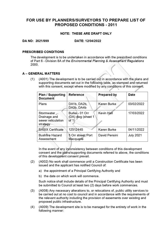
|
ATTACHMENT
|
Development Assessment Panel
20/04/2022
|
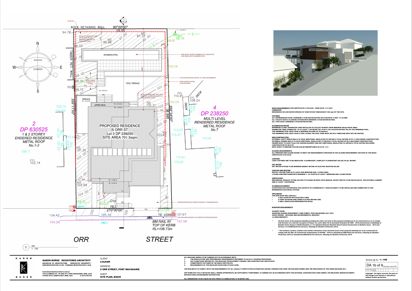
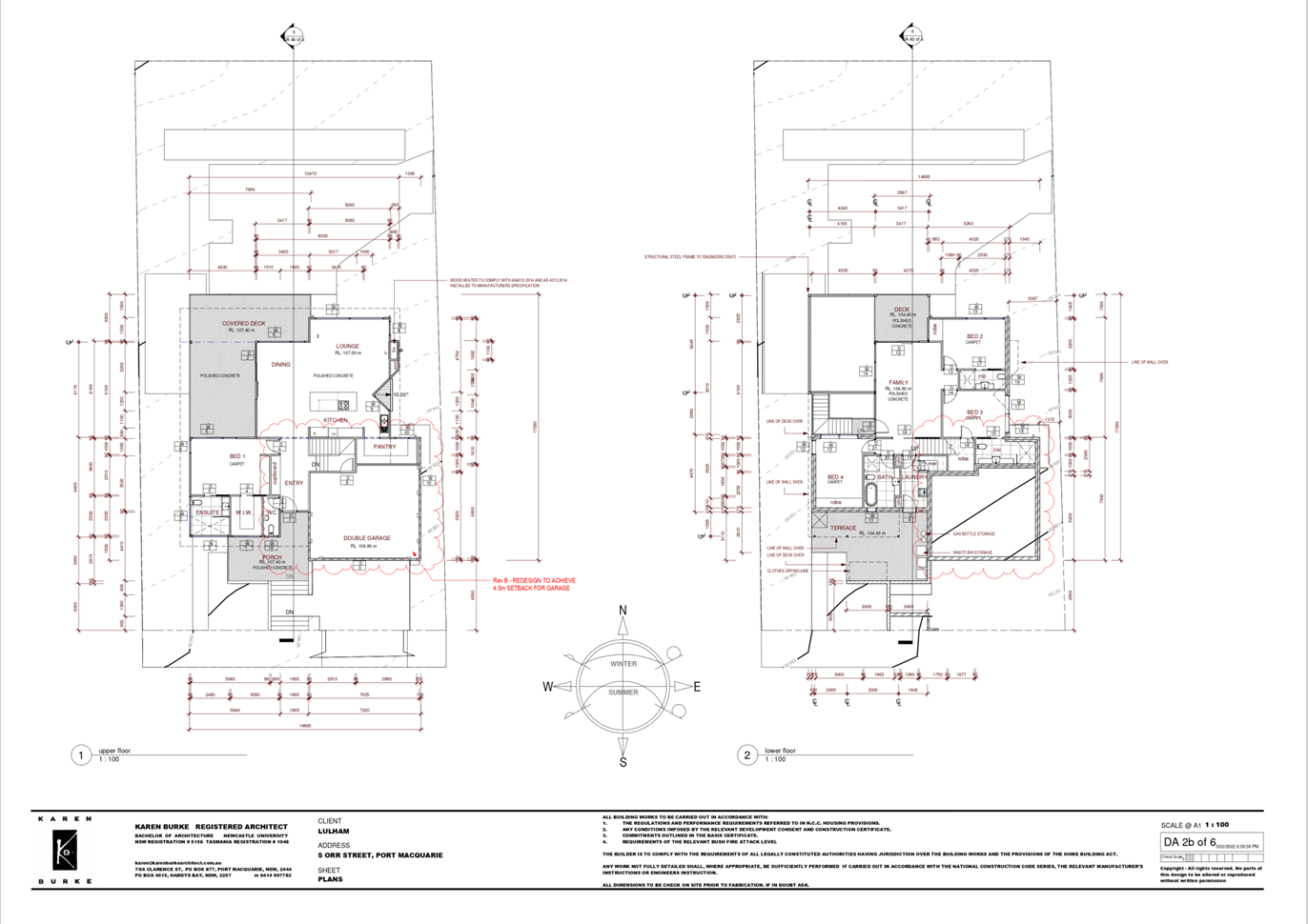
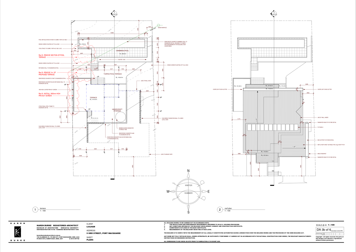
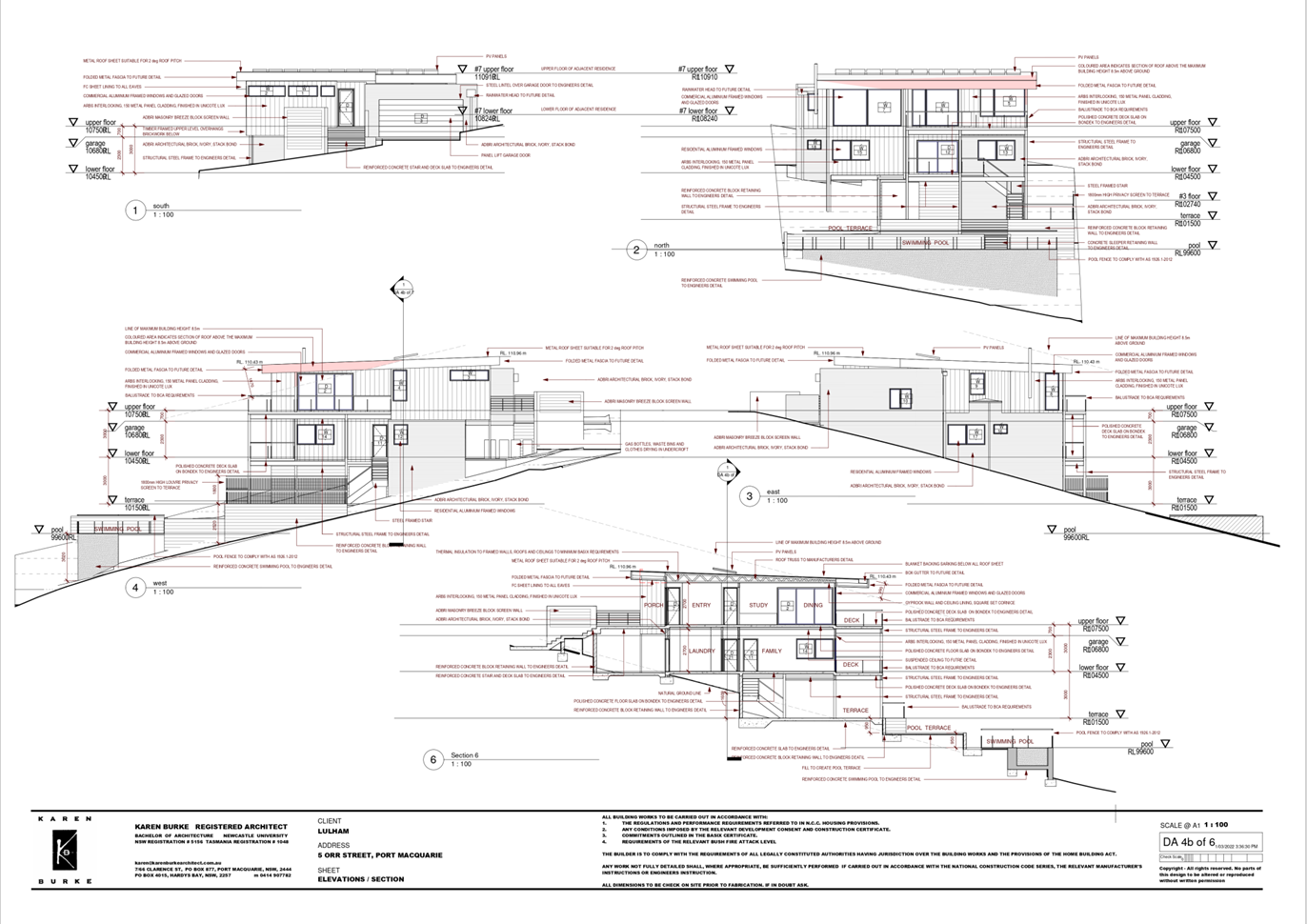
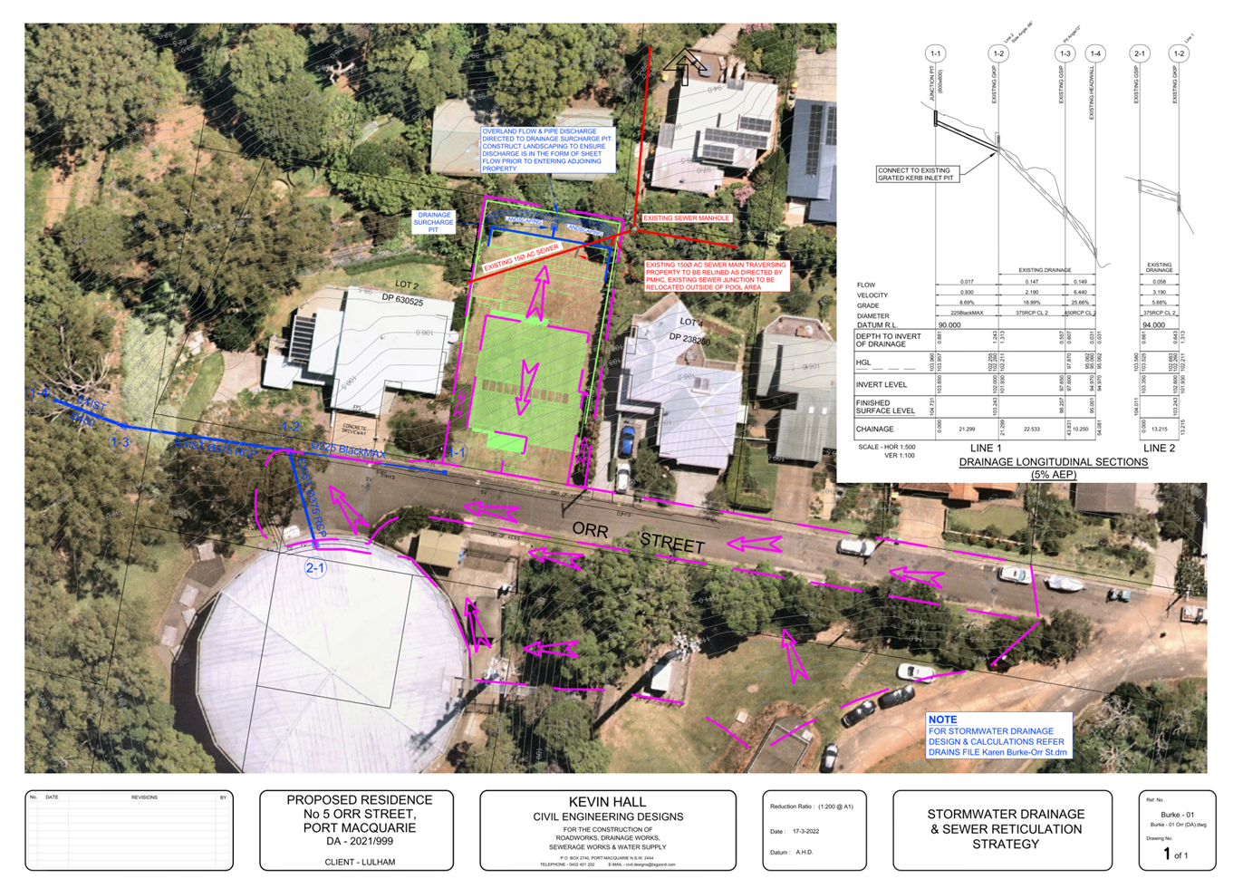
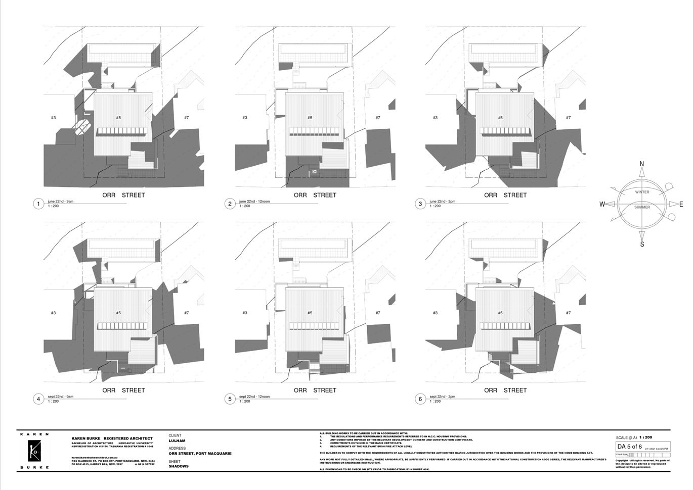
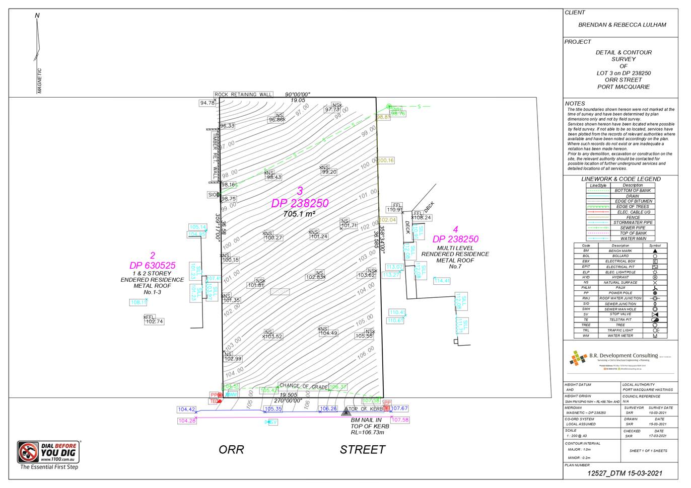
|
ATTACHMENT
|
Development Assessment Panel
20/04/2022
|
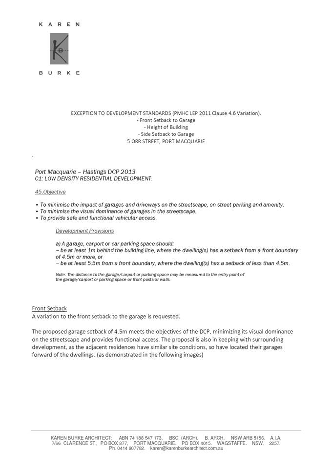
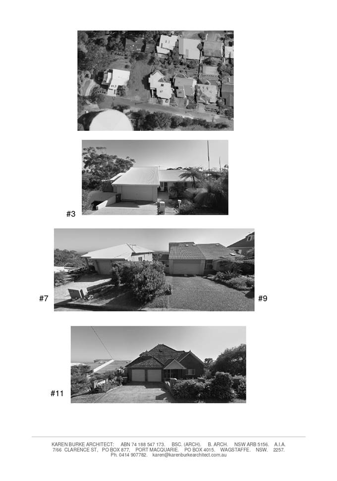
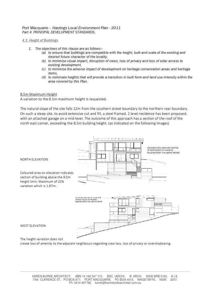
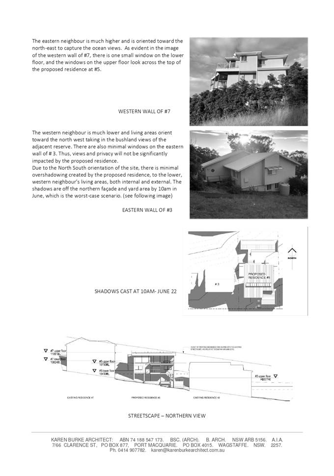
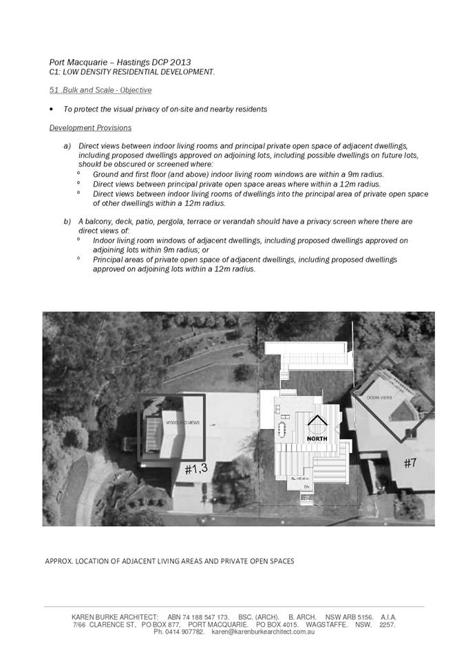
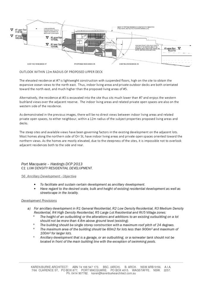
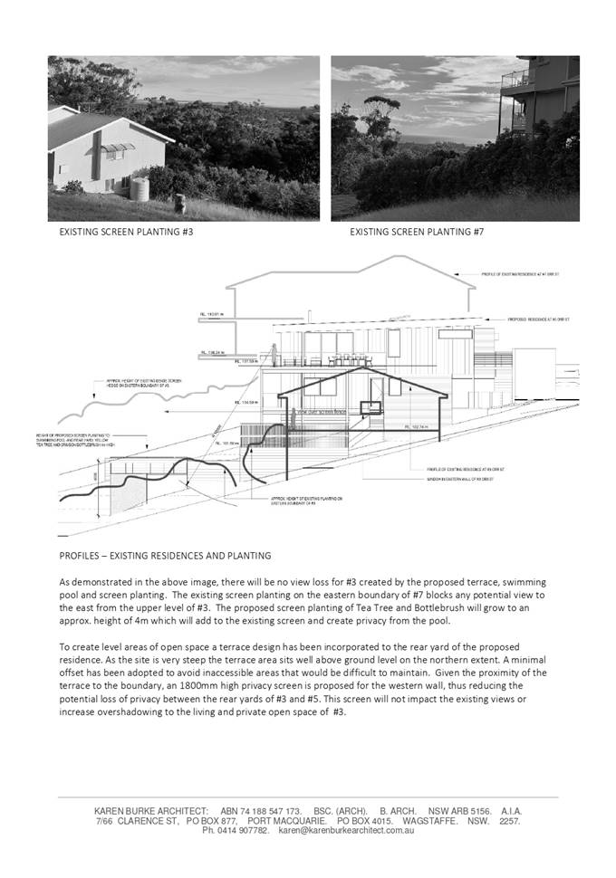
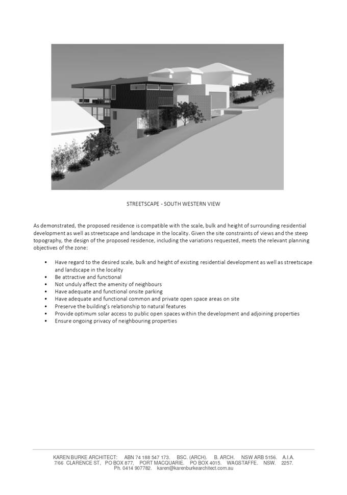
AGENDA Development Assessment Panel 20/04/2022
Item: 06
Subject: DA2021 - 1047.1 Health Services Facility at
Lot 1 DP 1273684, No 11 Ngamba Place, Bonny Hills
Report
Author: Development Assessment Planner, Steven Ford
|
Applicant: Ngamba
Road Pty Ltd
Owner: Ngamba
Road Pty Ltd
Estimated Cost: $4,463,000
Alignment with Delivery Program
4.3.1 Undertake transparent
and efficient development assessment in accordance with relevant legislation.
|
RECOMMENDATION
That
DA2021 - 1047.1 for a Health
Services Facility at Lot 1, DP 1273684, No. 11 Ngamba Place, Bonny
Hills, be determined by granting consent
subject to the recommended conditions.
Executive
Summary
This
report considers a development application for a Health Services
Facility with ancillary pharmacy and kiosk at the
subject site and provides an assessment of the application in accordance with
the Environmental Planning and Assessment Act 1979.
Following exhibition of the
application, ten (10) submissions were
received.
The site is considered suitable for the proposed development
and the proposal adequately addresses relevant planning controls. The
development is not considered to be contrary to the public's interest and will
not result a significant adverse social, environmental or economic impact.
This report recommends that the
development application be approved subject to the attached conditions
in Attachment 1.
The reason for the application being referred to
Council’s Development Assessment Panel (DAP) is because three (3) or more
objections to the proposal have been received. A copy of the DAP Charter
outlining the delegations and functions of the DAP is available on
Council’s website.
1. BACKGROUND
Existing
Sites Features and Surrounding Development
The site has an area of 3,682.9m2.
The
site is zoned R1 General Residential in
accordance with the Port Macquarie-Hastings Local Environmental Plan 2011, as
shown in the following zoning plan:
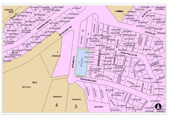
The
existing subdivision pattern and location of existing development within the
locality is shown in the following aerial photograph:
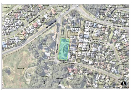
2. DESCRIPTION
OF DEVELOPMENT
Key
aspects of the proposal include the following:
· 2
Storey health services facility with ancillary pharmacy and café
· All
vegetation proposed to be removed is consistent with the existing approval
under DA2018/130.
· Approved
128 student childcare facility and manager’s residence component to
DA2018/130 to be surrendered.
· Intersection
of McGilvary Road and Ngamba Place to be upgraded.
· A footpath and kerb and gutter along the Ngamba Road
frontage, as well as the installation of stormwater infrastructure
Refer
to Attachment 2 at the end of this report for plans of the proposed
development.
Application
Chronology
· 25
November 2021 - Application received
· 08 December 2021 to 14 January 2022 - Public Notification
Period
· 04 January 2022 - Essential Energy comments received
· 28 January 2022 - Request for Information sent to
Applicant
· 08 March 2022 - Amended Plans, Stormwater management report
and additional information received from Applicant
· 05 April 2022 - Tree clearing commenced under DA2018/130
3. STATUTORY
ASSESSMENT
Section
4.15(1) Matters for Consideration
In
determining the application, Council is required to take into consideration the
following matters as are relevant to the development that apply to the land to which
the development application relates:
(a) The
provisions (where applicable) of:
(i) any
Environmental Planning Instrument
State Environmental Planning Policy (Biodiversity and
Conservation) 2021
Chapter 4 Koala Habitat Protection 2021
Clause 6 - This SEPP applies to all non-rural zoned land
within the Port Macquarie-Hastings Local Government Area.
Clause 12 (other land - not subject to Clause
10 or 11) - Having considered the SEPP, the application and on completion of a
site inspection, Council is not prevented from granting consent in this case
for the following reasons:
1. The property is not subject to a KPOM, or
2. The site not considered to be core koala habitat.
3. the
site does not have evidence or signs of a resident Koala, hence the loss of the
current Koala food trees is not likely to lead to stress on any existing local
population. The tree loss will be offset via planting of 6 Tallowwoods and
other natives.
State Environmental Planning Policy No. 55 - Remediation
of Land
Following an inspection of the site and a search of Council
records, the subject land is not identified as being potentially contaminated
and is suitable for the intended use.
State Environmental Planning Policy (Industry and
Employment) 2021
Chapter 3 Advertising and Signage
The proposed development includes proposed advertising
signage in the form of business/building identification on the Northern and
Southern Façade and Driveway entrance.
Clause 7 - This SEPP prevails over the Port
Macquarie-Hastings LEP 2011 in the event of any inconsistency.
The following assessment table provides an assessment
checklist against the Schedule 1 requirements of this SEPP:
|
Applicable clauses for consideration
|
Comments
|
Satisfactory
|
|
Clause 8(a) Consistent with
objectives of the policy as set out in Clause 3(1)(a).
|
Proposed signage is generally
consistent with the aims and objectives of the SEPP.
|
Yes
|
Schedule
1(1) Character of the area.
|
The character of the locality is
primarily residential. The immediate street frontage of Ngamba Place. has
large lot residential properties. No adverse impacts to character can be
identified noting the signage is limited in scale.
|
Yes
|
|
Schedule 1(2) Special areas.
|
NA
|
NA
|
|
Schedule 1(3) Views and vistas.
|
There are no identifiable
significant views or vistas from adjoining residential properties impacted by
the proposed development that would support refusal.
The proposal does not dominate
the skyline or reduce quality vistas
|
Yes
|
|
Schedule 1(4) Streetscape,
setting or landscape.
|
The proposed signs are business
identification purposes. One at the car park entry facing Ngamba Place,
southern façade and northern façade. The signs do not protrude
above the building and cause any adverse impacts. The signs will contribute
to identify the building and land use.
|
Yes
|
|
Schedule 1(5) Site and building.
|
The proposal is sympathetic to
the scale of the building and respects the future character of the R1 land
zoning.
|
Yes
|
|
Schedule 1(6) Associated devices
and logos with advertisements and advertising structures.
|
The signs have been kept minimal,
do not advertise any products and do not require regular maintenance or
safety platforms.
|
Yes
|
|
Schedule 1(7) Illumination.
|
No flashing lights proposed.
Proposed Illumination is capable
of being controlled by standard conditions.
|
Yes
|
|
Schedule 1(7) Safety.
|
There are no adverse impacts to safety identifiable that
could be caused by the proposed signage.
|
Yes
|
State Environmental Planning Policy (Transport and
Infrastructure) 2021
Clause 45 - Development in proximity to electricity
infrastructure - referral to Essential Energy has been completed having regard
for any of the following:
(a) the
penetration of ground within 2m of an underground electricity power line or an
electricity distribution pole or within 10m of any part of an electricity
tower,
(b) development
carried out:
(i) within
or immediately adjacent to an easement for electricity purposes (whether or not
the electricity infrastructure exists), or
(ii) immediately
adjacent to an electricity substation, or
(iii) within
5m of an exposed overhead electricity power line,
(c) installation
of a swimming pool any part of which is:
(i) within
30m of a structure supporting an overhead electricity transmission line,
measured horizontally from the top of the pool to the bottom of the structure
at ground level, or
(ii) within 5m of an overhead electricity power line, measured vertically
upwards from the top of the pool.
Essential Energy have no specific concerns regarding the
development, but have provided some general advice. The advice received from
Essential Energy has been forwarded the Applicant for consideration.
Port Macquarie-Hastings Local Environmental
Plan 2011
The proposal is consistent with the LEP having regard to the
following:
· Clause
2.2 - The subject site is zoned R1 General Residential.
· Clause
2.3(1) and the R1 zone landuse table - The proposed development for a Health
Services Facilities with ancillary uses are permissible landuses with consent.
The Applicant has demonstrated that the ancillary pharmacy and café will
be ancillary to the primary proposed use. These additional facilities will
predominately service clients and staff using the health services facility.
The objectives of the R1 zone are as
follows:
o To provide for the housing needs of
the community.
o To provide for a variety of housing
types and densities.
o To enable other land uses that
provide facilities or services to meet the day to day needs of residents.
· Clause
2.3(2) - The proposal is consistent and achieves the zone objectives
· Clause
4.3 - The maximum overall height of the building above ground level (existing)
is 8.5 m which complies with the standard height limit of 8.5m applying to the
site.
· Clause
4.4 - The floor space ratio of the proposal is 0.5:1, which complies with the
maximum 0.65:1 floor space ratio applying to the site.
1. Note: The site
has an area of 3,683m2 enabling a maximum floor area on
2. site of
2,393.95m2. The proposed building has a total floor area of
3. 1,198.71m2
(including vertical circulation areas).
· Clause
5.10 - Heritage. The site does not contain or adjoin any known heritage items
or sites of significance.
· Clause
7.13 - Satisfactory arrangements are in place for provision of essential
services including water supply, electricity supply, sewer infrastructure,
stormwater drainage and suitable road access to service the development.
Provision of electricity will be subject to obtaining satisfactory
arrangements.
4.
(ii) Any draft instruments that apply to the site or are
on exhibition
No draft instruments apply to the site.
(iii) Any Development Control Plan in force
Port Macquarie-Hastings Development Control Plan 2013
|
DCP 2013: Part B - General
Provisions - B1: Advertising and Signage
|
|
DCP Objective
|
Development Provisions
|
Proposed
|
Complies
|
|
1
|
a) Signs primarily identifying
products or services are not acceptable, even where relating to products or
services available on that site.
|
Application indicates that signs
will be business identification sign only.
|
Yes
|
|
b) Signage is not permitted
outside property boundaries except where mounted upon buildings and clear of
pedestrians and road traffic. No signage is permitted upon light or power
poles or upon the nature strip (the area between the property boundary and
constructed roadway). Limited directional signage and “A” frame
signage may separately be approved by Council under the Roads Act 1993 or
section 68 of the Local Government Act 1993.
|
Signs contained within property
boundaries.
|
Yes
|
|
c) An on-building 'chalkboard'
sign, for the purpose of describing services or goods for sale which vary on
a regular basis generally should not be any larger than 1.5m2, and should
contain a sign written heading indicating the premises to which it refers.
|
N/A
|
N/A
|
|
d) On-premise signs should not
project above or to the side of building facades
|
Signs do not project above or to
the sides of the fence or building facades.
|
Yes
|
|
2
|
a) Where there is potential for
light spill from signage in a non-residential zone adjoining or adjacent to
residential development, illuminated signage is to be fitted with a time
switch to dim by 50% or turn off the light by 11pm each night, depending on
the nature of the development.
|
Signs not proposed to be
illuminated or digital.
|
N/A
|
|
DCP 2013: Part B - General
Provisions - B2: Environmental Management
|
|
DCP Objective
|
Development Provisions
|
Proposed
|
Complies
|
|
3
|
a) Development must comply with
Council’s Developments, Public Place & Events - Waste Minimisation
and Management Policy.
|
The Statement of Environmental
Effects indicates that medical waste will be collected by a private
contractor within the north-west corner of the site.
A standard condition is
recommended regarding the management of construction waste.
|
Yes
|
|
Cut and Fill Regrading
|
|
4
|
a) Development shall not exceed
a maximum cut of 1.0m and fill of 1.0m measured vertically above the ground
level (existing) at a distance of 1.0m outside the perimeter of the external
walls of the building (This does not apply to buildings where such cut and
fill is fully retained within or by the external walls of the building).
|
Site slopes from south to north
by approximately 11m.
The application therefore seeks
to provide a number of retaining walls to ensure suitable levels and grades
for the building, car parking and access in between.
Retaining walls are proposed
within the lot boundary and provide level car parking facilities and
appropriate access circulation.
|
No, but considered acceptable.
See justification below.
|
|
5
|
a) A certified practicing
structural engineer must certify any retaining wall greater than 1.0m.
|
None provided. However, a draft
condition is proposed for structural engineering to be provided prior to the
construction certificate.
|
No, but capable of being managed
by the recommended condition
|
|
b) Where a combination of a
fence and a wall is proposed to be greater than 1.2m high:
- be a maximum combined height of 1.8m above existing
property boundary level;
- be constructed up to the front boundary for a maximum
length of 6.0m or 30% of the street frontage, whichever is less;
− the fence component has openings which make it not less
than 25% transparent; and
− provide a 3m x 3m splay for corner sites, and
- provide a 900mm x 900mm splay for vehicle driveway
entrances.
|
N/A
|
N/A
|
|
DCP 2013: Part B - General
Provision - B3: Hazards Management
|
|
DCP Objective
|
Development Provisions
|
Proposed
|
Complies
|
|
Bushfire Hazard Management
|
|
18
|
a) APZs are to be located
outside of environmental protection zones and wholly provided within private
land. Note perimeter roads provided as part of a residential subdivision are
classified as being part of the subdivision and not a separate permissible
land use within environment protection zones.
|
N/A - No bushfire management
measures required.
|
N/A
|
|
b) Perimeter roads are to be
provided to all urban areas adjoining environmental management areas and
their buffers. Refer to Figure 2.
|
N/A
|
N/A
|
|
Flooding
|
|
19
|
a) Development must comply with
Council’s Floodplain Management Plan and Flood Policies.
|
All works associated with the
proposed development are located above the flood planning level.
|
N/A
|
|
DCP 2013: Part B- General
Provisions- B4: Transport, Traffic Management, Access and Car Parking
|
|
DCP Objective
|
Development Provisions
|
Proposed
|
Complies
|
|
Road Hierarchy
|
|
23
|
a) New direct accesses from a development
to arterial and distributor roads is not permitted. Routes should differ in
alignment and design standard according to the volume and type of traffic
they are intended to carry, the desirable traffic speed, and other factors.
|
No direct access proposed from
arterial or distributor roads proposed.
|
Yes
|
|
b) Existing direct accesses from
a development to arterial and distributor roads are rationalised or removed
where practical.
|
N/A
|
N/A
|
|
c) Vehicle driveway crossings
are minimal in number and width (while being adequate for the nature of the
development), and positioned:
− to avoid driveways near intersections and road bends, and
− to minimise streetscapes dominated by driveways and
garage doors, and
− to maximise on-street parking.
|
Proposed driveways are
considered to be appropriately positioned and do not have any identifiable
adverse impacts to the existing streetscape.
The proposed access crossovers
have been reviewed by Council’s Development Engineers and are
considered suitable.
|
Yes
|
|
Parking Provision
|
|
24
|
a) Off-street Parking is
provided in accordance with Table 3.
Health Facility - 3 per
consultant + 1 per 2 employees for medical centres
Retail premises - 1 space per
30m2
Kiosks - Outside of commercial
zones: 1 per 6m2 serviced floor area.
|
Health service facility - Total
of Nine (9) F/T equivalent consultants.
= 27 spaces
Total of twelve (12)
employees/staff.
= 6 spaces
Tenancy 2 (Pharmacy), total area
of 89.01m2.
= 3 spaces
Tenancy 1 (Kiosk), total area of
65m2.
= 11 spaces
Total required = 47 spaces
The submitted plans provide 47
spaces, including 4 accessible spaces, for the total development. This is
considered to satisfy the objectives of this clause and minimum onsite car
parking.
A condition is recommended
requiring appropriate signposting/line marking to confirm the use of these
spaces, and to ensure that the client parking remains available for use.
|
Yes
|
|
b) Where a proposed development
does not fall within any of the listed definitions, the provision of on-site
parking shall be supported by a parking demand study.
|
N/A
|
N/A
|
|
c) Where a proposed development
falls within more than one category Council will require the total parking
provision for each category.
|
Noted and has been considered
above.
|
N/A
|
|
25
|
a) A development proposal to
alter, enlarge, convert or redevelop an existing building, whether or not
demolition is involved, shall provide the total number of parking spaces
calculated from the schedule for the proposed use, subject to a credit for
any existing deficiency, including any contributions previously accepted in
lieu of parking provision.
|
No parking credits applicable.
|
N/A
|
|
|
|
|
|
|
Parking Layout
|
|
28
|
a) Visitor and customer parking
shall be located so that it is easily accessible from the street.
|
Proposed parking is considered
to be easily accessible. The two car parks have two-way driveway entries off
Ngamba Place appropriately located in the context of the streetscape.
|
Yes
|
|
b) Internal signage (including
pavement markings) should assist customers and visitors to find parking and
circulate efficiently and safely through a car park.
|
The parking area is relatively
small and wayfinding signage is not considered necessary.
|
N/A
|
|
c) Parking spaces shall
generally be behind the building line but may be located between the building
line and the street when:
− it is stacked parking in the driveway; or
− it can be demonstrated that improvements to the open
space provided will result; and
− the spaces are screened (densely landscaped or similar)
from the street by a landscaping with a minimum width of 3.0m for the entire
length of the parking area.
|
Parking spaces are at either
side of the proposed building. The proposed site plans indicate adequate
landscaping is proposed between the car parking area sand the street.
The position of the carparks
provides accessibility to each level and minimises the impact of the proposed
development to the streetscape.
|
Yes
|
|
d) Parking design and layout is
provided in accordance with AS/NZS 2890.1 - Parking facilities - Off-street
car parking and AS 2890.6 - Off-street parking for individuals with a
disability and AS/NZS 2890.2 - Parking facilities - Off-street commercial
vehicle facilities.
|
The proposal is capable of
complying with AS2890. Standard conditions recommended requiring
certification of the design and construction of the parking area.
|
Yes
|
|
e) Stack or tandem parking
spaces will not be included in assessment of parking provision
except where:
− the spaces are surplus to that required;
− in motor showrooms;
− for home business;
− for exhibition homes;
− in car repair stations;
− staff parking spaces are separately identified and
delineated;
− it is visitor parking associated with a dual occupancy
multi dwelling and/or terrace housing, directly in front of the garage with a
minimum depth of 5.5m.
|
N/A
|
N/A
|
|
29
|
a) Parking is provided in
accordance with AS/NZS 2890.1 - Parking facilities - Off-street car parking,
AS/NZS 2890.2 - Parking facilities - Off-street commercial vehicle
facilities, AS 1428 - Design for access and mobility and AS 2890.6 -
Off-street parking for individuals with a disability.
|
The proposal is capable of
complying with AS2890. Standard conditions recommended requiring
certification of the design and construction of the parking area.
|
Yes
|
|
Surface Finishes
|
|
35
|
a) All parking and manoeuvring
areas shall be constructed with a coarse base of sufficient depth to suit the
amount of traffic generated by the development, as determined by Council. It
shall be sealed with either bitumen, asphaltic concrete, concrete or
interlocking pavers.
Preliminary details of
construction materials for access and car parking areas shall be submitted
with the development application. Detailed plans shall be prepared for the
construction certificate by a practising qualified Civil Engineer.
|
Sealed parking indicated on the
plans. Condition recommended confirming this requirement.
|
Yes
|
|
b) In special cases (e.g. where
traffic volumes are very low) Council may consider the use of consolidated
unsealed gravel pavement for car parks. However, this should not be assumed
and will need to be justified by the applicant at the Development Application
stage.
|
N/A
|
N/A
|
|
Drainage
|
|
36
|
a) All parking and manoeuvring
spaces must be designed to avoid concentrations of water runoff on the
surface.
|
Engineering plans provided.
Standard conditions recommended requiring
certification of the design and construction of stormwater drainage.
|
Yes
|
|
b) Council will not permit the
discharge of stormwater directly into kerbing and guttering or table drains
for any development other than that of a minor nature.
|
No discharge to kerb and gutter
proposed.
|
Yes
|
|
37
|
a) Car parking areas should be
drained to swales, bio retention, rain gardens and infiltration areas.
|
All runoff from parking areas to
be directed to on-site detention facilities.
|
Yes
|
|
DCP 2013: Part B - General
Provisions - B5: Social Impact Assessment and Crime Prevention
|
|
DCP Objective
|
Development Provisions
|
Proposed
|
Complies
|
|
Crime Prevention
|
|
43
|
a) The development addresses the
generic principles of crime prevention:
- Casual surveillance and sightlines;
- Land use mix and activity generators;
- Definition of use and ownership;
- Basic exterior building design;
- Lighting;
- Way-finding; and
- Predictable routes and entrapment locations;
- as described in the Crime Prevention Through
Environmental Design (CPTED) principles.
|
The proposal provides for a land use mix and activity
generator, there will be an increase in casual surveillance during business
hours and the building is capable of including security measures for other
times.
The proposed development will be unlikely to create any
concealment/entrapment areas or crime spots that would result in any
identifiable loss of safety or reduction of security in the immediate area.
|
Yes
|
The proposal seeks to vary Development Provision relating to
Clause 4 - earthworks exceeding the 1m standard.
The relevant objectives are:
· Minimise the
extent of site disturbance caused by excessive cut and fill to the site.
· Ensure there is no
damage or instability to adjoining properties caused by excavation or filling.
· Ensure that there
is no adverse alteration to the drainage of adjoining properties.
· Ensure the privacy
of adjoining dwellings and private open space are protected.
· Ensure that
adequate stormwater drainage is provided around the perimeter of buildings and
that overflow paths are provided.
Having regard for the development provisions and relevant
objectives, the variation is considered acceptable for the following reasons:
· Along the eastern
property boundary the site slopes from south to north falling 11.1 metres (SE
corner RL 27.5m AHD down to NE corner RL 16.4m AHD).
· There are a number
of retaining walls across the site to provide suitable grades for car parking,
building footprint, pedestrian access and landscaping.
· The large proposed
retaining wall is up to 3m in height on the southern part of the site between
the boundary and car parking. This is the highest point of the site and the
retaining wall is cut into the slope to provide suitable car parking grades.
· A servicing
strategy has been prepared in support of the proposal ensuring that the
existing and proposed stormwater is managed appropriately and is not impacted
by the proposed retaining walls.
· The site is a
corner allotment, the proposed retaining walls are not considered likely to
detrimentally impact the adjoining properties.
· Setting down the
southern car park will be beneficial to the streetscape, and reduce visibility
of the car park from the adjoining housing to the east and south.
· The retaining
walls are proposed to be set a minimum of 1m from the adjoining boundaries,
providing sufficient room for landscaping treatment and drainage. Engineering
detail will be required to be finalised prior to the Construction Certificate.
Based on the above assessment, the variations proposed to
the provisions of the DCP are considered acceptable and the relevant objectives
have been satisfied. Cumulatively, the variations do not amount to an
adverse impact of a significance that would justify refusal of the application.
(iiia) Any planning agreement
that has been entered into under section 7.4, or
any draft planning agreement
that a developer has offered to enter into under section 7.4
No planning agreement has been
offered or entered into relating to the site.
(iv) Any matters prescribed by the Regulations
N/A
(b) The likely impacts of that
development, including environmental impacts on both the natural and built
environments, social and economic impacts in the locality
Context and Setting
The site is located on the corner of Ngamba Place and
Bundarra Way, Bonny Hills.
The site is located centrally in the context of Bonny Hills.
The site is located in an area that is predominately occupied by residential
dwellings. The immediate locality has undergone considerable development in
recent years with residential development.
The proposal will not have significant adverse impacts to
existing adjoining properties and satisfactorily addresses the public domain.
The setbacks for the proposed building are similar to
residential development setbacks and considered appropriate.
The proposal is considered to be sufficiently compatible
with other development in the locality and adequately addresses planning
controls for the area.
The proposal does not have a significant adverse impact on
existing views sharing.
The proposal does not have significant adverse lighting
impacts.
There are no significant adverse privacy impacts.
There are no significant adverse overshadowing impacts. The
proposal does not prevent adjoining properties from receiving 3 hours of
sunlight to private open space and primary living areas on 21 June between the
hours of 9am and 3pm.
Traffic and Transport
The site has road frontage to Ngamba Place on the West, and
Bundarra Way to the South. Ngamba Place is a Council owned road consisting of
an approximately 6.5m wide spray seal pavement with 0.3m gravel shoulders on
each side. The road reserve is approximately 20m wide, and is classified by PMHC
as a local access street. In accordance with Auspec table D1.5, a local road
typically caters for up to 2000 vehicles per day.
Bundarra Way is a Council owned road consisting of an
approximately 7m wide spray sealed pavement, within a 19m wide road reserve.
Bundarra Way has type SM (rollover) kerb and gutter immediately to the east of
the site and is classified as a local street.
In close proximity to the site, McGilvray Road is a sealed
road approximately 9 metres in width and is classified as a Collector Road. In
accordance with Auspec table D1.5, a collector road typically caters for up to
6000 vehicles per day.
Under a previously approved DA (2018-130), the site was
granted consent to contain a 128 place Childcare Centre. A traffic assessment
was prepared in support of this application, which identified that the
Childcare Centre would generate potential peak vehicle trips of 103 (AM) and 90
(PM). This assessment was based on the RMS’ Guide and included SIDRA
modelling which identified the intersection between McGilvray Road and Ocean
Drive as experiencing the greatest impact from the proposed development.
The applicant noted in their Statement of Environmental
Effects (SOEE) that relevant to the previous traffic assessment, the
RMS’s Guide to Traffic Generating Development (2002) only provides
traffic generation rates for extended hour’s medical centres. This
proposal is not for an extended hour’s medical centre. The SOEE notes
that the previous medical centre surveys carried out resulted in a variance in
generation rates and states:
“The proposed medical
centre will operate via appointment only during typical operating hours and is
therefore considered unlikely to experience peaks similar to the previously
approved childcare centre. Appointments will typically be 15 minutes to half an
hour in length and it is therefore considered that traffic generation will be
more consistent throughout the proposed opening hours.”
The submitted details have been reviewed as being
satisfactory, and considers that the proposal will not have any significant
adverse impacts in terms of access, transport and traffic, the existing road
network will satisfactorily cater for any increase in traffic generation as a
result of the development. It should be noted that the previous Traffic Impact
Assessment of 2018 for the childcare centre, estimated that Ngamba place has
639 daily trips (Vehicles per day), significantly under the maximum of 2000
V/pd considered applicable for a local street.
Conditions have been imposed to construct intersection
improvement works at the intersection of Ngamba Place & McGilvray Road.
These works will help accommodate the safe access of vehicles due to the
increase in traffic associated with the proposed development.
Site Frontage and Access
The proposal seeks to provide two (2) separate two-way
driveway entries off Ngamba Place. (Note, there is a narrow parcel of private
land between the proposed development and Bundarra Way)
The southern car park includes a circular movement pattern
allowing forward in and forward out traffic movements. Similarly, the northern
car park includes a turnaround bay to enable forward in and forward out traffic
movements.
The southern driveway entrance is located approximately 30
metres from the corner of Bundarra Way, whilst the northern driveway entrance
is approximately 75m from Bundarra Way and 90m from the intersection of Ngamba
Place and McGilvray Road. The driveway locations are considered appropriate for
the site. All accesses shall comply with Council AUSPEC and Australian
Standards, and conditions have been recommended to reflect these
requirements.
Due to the type and size of
development, additional works are required to include:
· kerb
and gutter along the full road frontage
· concrete
footpath paving (minimum 1.2m wide) along the full frontage
Site plans submitted in support of the Development
Application indicate above works have been included.
Parking and Manoeuvring
Plans submitted as a part of this application demonstrates
the sites ability to accommodate a total of 47 spaces on-site including 4
disability compliant spaces. An emergency bay has also been provided.
Parking and driveway widths on site can comply with relevant
Australian Standards (AS 2890) and conditions have been imposed to reflect
these requirements.
Due to the type of development, car park circulation is
required to enable vehicles to enter and exit the site in a forward manner
without reversing or exiting the car parking facility whilst looking for a
parking space internally. Site plans show adequate area is available and
conditions have been recommended to reflect these requirements.
Water Supply Connection
The
proposed development site is located at 11 Ngamba Place, Bonny Hills, on the corner of Bundarra way. There is an existing 20mm
metered water service from the 100mm water mains on the same side of Ngamba
Place. An application shall be made to Council to disconnect this service. Minimum
25mm water services are to be provided for Commercial developments and include
an RPZ.
Final water service sizing will need to be determined by a
hydraulic consultant to suit the development as well as addressing fire service
coverage to AS 2419 and backflow protection.
Detailed plans will be required to be submitted for
assessment with the S.68 application.
Appropriate conditions are recommended in this regard.
Sewer Connection
There is existing Council sewer located in the road reserve
of Ngamba Place. This development exceeds 2ET and is required to discharge to a
manhole. Manholes located in driveways shall require trafficable lids and any
alterations to lid levels shall be in accordance with Aus-Spec. Details to be provided on the plans.
Detailed plans will be required to be submitted for
assessment with the S.68 application.
Appropriate conditions are recommended in this regard.
Stormwater
The site naturally grades towards the northern boundary and
is currently (un)serviced. The legal point of discharge for the proposed
development is defined as direct connection into the proposed 375mm pipe along
Ngamba Place.
A detailed site stormwater management plan will be required
to be submitted for assessment with the S.68 application and prior to the issue
of a CC.
In accordance with Councils AUSPEC requirements, the
following must be incorporated into the stormwater drainage plan:
· On
site stormwater detention facilities.
· Water
quality controls
Appropriate conditions are recommended in this regard.
Other Utilities
Telecommunication and electricity services are available to
the site.
Heritage
Following a site inspection (and a search of Council
records), no known items of Aboriginal or European heritage significance exist
on the property. No adverse impacts anticipated.
As a precaution, a condition of consent has been recommended
that works are to cease in the unexpected event heritage items are found. Works
can only recommence when appropriate approvals are obtained for management
and/or removal of the heritage item.
Other land resources
The site is within an established urban context and will not
sterilise any significant mineral or agricultural resource.
Water cycle
The proposed development will not have any significant
adverse impacts on water resources and the water cycle.
Soils
The proposed development will not have any significant
adverse impacts on soils in terms of quality, erosion, stability and/or
productivity subject to a standard condition requiring erosion and sediment
controls to be in place prior to and during construction.
Air and microclimate
The construction and/or operations of the proposed
development will not result in any significant adverse impacts on the existing
air quality or result in any pollution. Standard precautionary site management
condition recommended.
Flora and fauna
The proposed development includes clearing of 3 primary
koala food trees. However, it is noted that these trees have been cleared
during the assessment under an existing approval (DA2018/130). The Biodiversity
Offset Scheme doesn’t apply for the following reasons:
· The land
isn’t identified on the Biodiversity Values Map;
· The extent of
clearing is below the thresholds in Clause 7.2 of the Biodiversity Conservation
Regulation 2017;
· The application of
test of significance (5 Part Test) demonstrates that the development will not
have a significant impact on biodiversity values.
· Offset planting is
proposed with 6 koala food trees.
Conditions have been recommended requiring evidence of
offset planting has been established prior to occupation.
Waste
Satisfactory arrangements are in place for proposed storage
and collection of waste and recyclables. No adverse impacts anticipated.
Standard precautionary site management condition recommended.
Energy
The proposal includes measures to address energy efficiency
and will be required to comply with the requirements of Section J of the
Building Code of Australia. No adverse impacts anticipated.
Noise and vibration
The construction and/or operations of the proposed
development will not result in any significant adverse impacts on the existing
air quality or result in any pollution. Standard precautionary site management
condition recommended.
Noise during the operation of the health care facility will
likely be generated from traffic movement, outdoor areas, patients and staff
during the operating hours.
Noise emitted would be infrequent depending on time of day.
Noise at the boundary of adjoining properties is likely to be acceptable levels
having regard for the residential uses, the typical hours of operation, the
site being within the proximity of a busy road (Ocean Drive).
Acoustic fencing in proposed adjoining the proposed car
parks along the eastern boundary. This is consistent with the mitigation
measure of the previous approval for a Childcare Facility. The plans also
provide for acoustic screening for air conditioning units along the eastern
elevation, to dampen external noise from plant equipment. This will be further
managed by recommended conditions.
Bushfire
The site is identified as being bushfire prone. The site
will be remain predominately cleared and will not require any special asset
protection zones. In this regard, the proposed building is considered an infill
development and Class 5 building, being
used by general medical practitioners and medical
specialists, without leaving patients unconscious or non-ambulatory. The aims
and objectives of the Planning for Bushfire Protection 2019 will be satisfied.
Safety, security and crime prevention
The proposed development will be unlikely to create any
concealment/entrapment areas or crime spots that would result in any
identifiable loss of safety or reduction of security in the immediate
area. Adequate casual surveillance is available.
Social impacts in the locality
Given the nature of the proposed development and its
location the proposal is not considered to have any significant adverse social
impacts.
Economic impact in the locality
The proposal is not considered to have any significant
adverse economic impacts on the locality. A likely positive impact is that the
development will maintain employment, less reliance of travel for general
medical appointments, which will lead to flow impacts such as expenditure in
the area.
Site design and internal design
The proposed development design satisfactorily responds to
the site attributes and will fit into the locality.
Construction
Construction impacts are considered capable of being
managed, standard construction and site management conditions have been recommended.
Cumulative impacts
The proposed development is not considered to have any
significant adverse cumulative impacts on the natural or built environment or
the social and economic attributes of the locality.
(c) The suitability
of the site for the development
The proposal will fit into the locality and the site
attributes are conducive to the proposed development.
Site constraints of bushfire risk, access, slope and
drainage have been adequately addressed and appropriate conditions of consent
recommended.
(d) Any submissions made
in accordance with this Act or the Regulations
Ten (10) written submissions were received following public exhibition of the
application. Copies of the written submissions have been provided separately to
members of the DAP.
Key issues raised in the submissions received and comments
are provided as follows:
|
Submission Issue/Summary
|
Planning Comment/Response
|
|
Consideration
of privacy screening on the staff rooms and verandah to the neighbouring
dwellings to the east.
|
The proposal includes a 3 metre wide verandah off the
eastern elevation of the building to provide an external break out space for
staff only and not for the general public or consultations. Given the nature
it is anticipated that the use of the space will be infrequent.
With respect to screening, the application seeks to
provide a solid 1 metre high balustrade which will ensure that seated views
to the east are obscured.
The proposed 6.9 metre setback of the verandah from the
eastern boundary is considered to suitable separation to the adjoining
dwellings to the east and would generally comply with side and rear setbacks
in the Port Macquarie Hastings Development Control Plan 2013.
The application also seeks to provide a number of trees
between the building and the eastern property boundary. These trees are
detailed external works/planting plan. These trees are considered to provide
suitable visual screening and positively contribute to the amenity once
established.
In addition, the nature of the use of the building is
limited to the hours of operation and it will be unlikely used outside of
these times.
It is considered that that adequate design provisions
have been included and the verandah is unlikely to cause significant adverse
impact to privacy and amenity to adjoining dwellings.
|
|
The
presented plans identify the building structure is situated 9,929mm off the
eastern boundary. This places the eastern consult windows and staff deck
areas within a 12m radius of the principle areas of private open spaces of
our dwelling. Clause 51 bulk and scale development provisions of the DCP 2013
have not been considered.
|
Clause 51 is contained within the Low Density
Residential Development section of the DCP and does not technically apply
to the proposed medical centre.
However, the Applicant notes that due to the nature of
the proposed landuse, doctor/patient confidentiality typically applies to the
medical centre. This includes ensuring consultation discussions are not
overheard by neighbours and client privacy is maintained just as much as
adjoining development.
Further, the intent of Clause 51 of the DCP is to ‘protect
the visual privacy of on-site and nearby residents’. As described
above, the proposed setback coupled with the fencing and landscaping treatment
is considered satisfactory to ensure that the proposed medical centre is
consistent with the objective of this provision.
|
|
Commercial
premises and business premises are not permitted in R1 General Residential
Zoning. A health facility is a “Business” therefore should be
rejected by council. Please provide additional comment to the justification
of a Healthcare Facility within a R1 zone.
|
The subject site is zoned R1 General Residential zone and
the proposed development for a Health Services Facility is a permissible
landuse with consent.
The proposed development is not characterised and
specifically excluded as a business premises by the definition in the Port
Macquarie Hastings Local Environmental Plan 2011.
The Applicant has demonstrated that the Health Care
Facility is the primary use and the Pharmacy and Café will be
ancillary use to this primary use.
|
|
Cafés
and Kiosks are not permissible within R1 zones.
In
addition, outdoor door dining will increase opportunity for noise generation
impacting the amenity of the area.
|
The proposed kiosk is considered an ancillary use to the
primary use, being the Health Services Facility (Medical Centre). The
café and pharmacy is considered small scale will predominately service
patients and staff, all likely to be from the immediate locality.
The kiosk has been positioned not directly adjoining
existing residence, addressing the lower car park and street frontage. The
kiosk is considered unlikely to generate any detrimental noise impacts and
will have limited service times.
The Applicant anticipates the kiosk will be similar to
the mobile food trailer at the Lake Cathie Medical Centre. However, it will
be positioned within the building rather than a exempt mobile food trailer
positioned on private land.
|
|
A development
of this scale this is far from the character of the streetscape with
semi-rural properties fringe and general residential premises. The proposed
development will have adverse impacts on the existing amenity.
|
The bulk and scale if the proposed development is
generally consistent with the childcare centre approved under DA2018/130 with
regards to the building.
The built form is considered less than the Floor Space
Ratio provisions defined by the Port Macquarie Hastings Local Environmental
Plan 2011. All side setbacks are considered consistent with the Port
Macquarie Hastings Development Control Plan 2013.
The proposal is considered to have a reduction in peak
traffic and is considered not to have identifiably more adverse impacts
regarding noise when compared to a childcare centre.
|
|
The
area will become busy and congested due to a major increase in continuous
traffic throughout the day.
|
The application seeks to undertake improvement works at
the intersection of Ngamba Place and McGilvray Road to adequately manage
traffic at the intersection.
The application also seeks to provide kerb and guttering
along the Ngamba Place frontage as well as within Bundarra Way. This will
result in a slight widening of the sealed road surface and therefore improve
traffic flow within the immediate area.
|
|
Additional
traffic will only be detrimental to the existing road surface and traffic
concerns. With the extra traffic due to the
development, and not being completely sealed, the water will continue to
undermine both new and old works making it an ongoing maintenance issue.
|
The Applicant seeks to provides intersection and road
improvements, refer to comments above and earlier in this report.
With respect to drainage and stormwater, the development
seeks to manage stormwater such that pre and post development flows will not
change. This will be managed by installation of kerb and guttering, extension
of existing public piped stormwater network, and onsite detention.
Council’s Stormwater Engineers have reviewed the engineering detail and
support the proposal subject to conditions.
|
|
Has
there been owner’s consent regarding clearing of the narrow strip of
land between the proposed development and Bundarra Way (Lot 102 DP1252124)?
Confirm
whether or not works proposed extend or impact this land
|
The site is currently separated from Bundarra Way by Lot
102 DP1252124, which is a 1m wide allotment running for the full length of
the subject site’s southern boundary. The Applicant is aware of this
concern, advises that previous discussions with the landowner regarding
purchase were not successful. The proposal therefore does not extend onto to
this land.
|
|
The
location of the parking area entry and exit is a traffic safety issue due to
its proximity to Bundarra Way. There are many near misses with the way it is
now, due to sightlines. With the increase in traffic, it makes it unsafe for
the road user along with the patients entering and exiting the facility. What
traffic safety measures have been considered for the corner of Bundarra Way
and Ngamba Place?
|
The site is currently vacant and there are no formal
driveway crossovers.
The proposed driveway to the southern car park is 30m
from the corner of Ngamba Place and Bundarra Way. The location is considered
to have appropriate separation to the intersection with regards to
sightlines. The nature of traffic the traffic is limited to 50km/h speed
limit, and vehicles should slow entering the corner should have enough time
to react to vehicles entering and exiting the proposed development.
As discussed earlier in this report, kerb and guttering
and pedestrian path will be provided for the entire frontage of this site
which will improve road safety.
|
|
Traffic
exiting Bundarra way consistently cross to the wrong side of the road and
travel too fast which is a menace itself. The anticipated overflow of
vehicles from the proposal making it even more dangerous to all road users,
especially those of the immediate neighbourhood.
|
As discussed earlier, the proposed development does not
adjoin Bundarra Way and access to the site is restricted to Ngamba Place.
The proposed development complies with the minimum off
street car parking spaces required when the Health Care Facility is operating
at capacity of health care professionals and ancillary uses. The concern
raised regarding the dangerous corner, appears to be an existing issue which
will not be adversely affected. Following the development of the site and
Ngamba Place, regular road users will become more aware and naturally slow
down.
|
|
The
small upgrades on the proposed healthcare facility side do nothing to
increase the overall long-standing issues of services, fully curbed road,
paths, or lighting. Has there been consideration towards upgrading both sides
of Ngamba Place.
|
The proposed development seeks to provide the following
improvements within the public road reserve:
· Line-marking and raised median at the intersection of
Ngamba Place and McGilvray Road,
· Upgrading of the eastern side of Ngamba Place to include
a wider road surface and upright kerb and gutter,
· Improved piped stormwater network for the full length of
the sites Ngamba Place frontage, and
· Installation of a 1.2m wide concrete footpath for the
full length of the sites Ngamba Place frontage.
It is noted that the other side of Ngamba Place is zoned
R1 General Residential and is capable of being development. At which time the
other side of Ngamba Place will be upgraded with kerb and guttering. The
application does not seek to undertake works to the western side of Ngamba
Place.
|
|
The
off street car parking justification seems to underestimate the number of
consultants. If the centre is fully staffed and tenanted the off street car
parking provided with be insufficient.
|
As discussed earlier in this report, the proposed car
parking proposed complies with the numerical requirements of the Port
Macquarie Hastings Development Control Plan 2013.
|
|
Based
on the proposed use of the tenants on the ground floor a total of 24 car
spaces has been identified as being required, with 11 required for the kiosk
alone. However, the total 4 separate tenancies on the lower ground will be
serviced directly by 11 car spaces only.
The
concern is that patrons would not utilise the car spaces on the southern end
of the site (that provide access to the upper floor of the development) as it
would not be convenient to do so. The concern is that people attending the
premises will opt to park on the street.
|
Both car parking areas will be available for use by all
tenancies and clients. There will be no dedicated or restricted parking
spaces for health care professionals. The number of spaces provided on-site
is consistent with the numerical requirements of the Port Macquarie-Hastings
Development Control Plan 2013.
It is also
noted that the allied health services offered on the lower floor level will
be complimentary to the primary use, being the medical centre. As such, it is
considered likely that the majority of patrons will utilise the larger, upper
level car park and will use the internal lift and stairs to access the lower
level services.
The design
provides access to car parking for both of the proposed levels. If no parking
was provided at the northern end, then it would be likely that people would
park on the street to access the lower level. The proposed plans demonstrate
that suitable access is provided between each level.
Additionally,
the development provisions require a minimum of on-site parking space and
does not require the spaces to be evenly distributed with regards to direct
access.
Refusal of
the application on parking grounds would be unjustifiable.
|
|
There
are many examples of similar healthcare facilities not catering for enough
off street car parking. Concerns regarding overflow car parking will
substantially increase the risk of accidents due to the narrowness of Ngamba
Place and increased on street car parking.
|
As outlined
earlier in this report and in the above comments, the proposed off-street
parking is consistent with the numerical requirements of the Port
Macquarie-Hastings Development Control Plan 2013.
|
|
With
no room available for future expansion of car park in the development, and,
with the current increase in demand for medical services with the increase of
population in the area, it is predicted that vehicle parking will overflow to
Ngamba Place and become a long-term concern.
|
The proposed number of consultants and support staff is
limited and is proposed to be conditioned in the draft consent.
The proposed number of car parking spaces comply with the
requirements of the Port Macquarie Hastings Development Control Plan 2013. No
further consideration is required for future expansion.
|
|
Please
confirm stormwater consideration have been considered in the design and that
it will not undermine properties to the east.
|
An engineering servicing strategy has been provided and
been reviewed by Council’s Development Engineers and Stormwater
Engineers as being acceptable. See additional comments earlier in this
report.
|
|
Issue
of noise emanating from the development will have adverse impacts to
adjoining residential development from air conditioning and plant equipment.
|
The Applicant has amended the proposed plans to indicate
the location of air conditioning units within the eastern portion of the
site.
These units are proposed to be surrounded by an acoustic
screen and located within the landscaped garden area to ensure visual
amenity. This is demonstrated on the plans and will be conditioned to be
installed prior to occupation and standard conditions.
|
|
It is
noted that a condition of the childcare centre D.A. was for acoustic lining
or fencing for the eastern boundary of 11 Ngamba Place and that this would be
beneficial for all interested parties if required on the eastern and northern
boundary of the development site.
|
The provision of acoustic lining or fencing along the
eastern boundary adjacent to the proposed car parks, in a manner similar to
the previous consent, has been accepted by the Applicant.
This is considered to include 15m along the northern-most
portion of the eastern boundary fence (refer Figure 3) and 45m along
the southern-most portion of the eastern boundary fence (refer Figure 4).
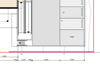 Figure
3: Proposed location of the acoustic lining or fencing (dashed blue line)
along the northern most portion of the eastern boundary fence. Figure
3: Proposed location of the acoustic lining or fencing (dashed blue line)
along the northern most portion of the eastern boundary fence.
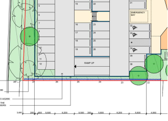
Figure 4: Proposed location of the acoustic lining or
fencing (dashed blue line) along the southern most portion of the eastern
boundary fence. This is proposed to be managed in the recommended conditions
to be clearly demonstrated on the plans prior to the Construction Certificate
and installed prior to Occupation.
|
|
Concern
of noise generation from the proposed coffee shop and outdoor waiting area.
|
The location of the proposed kiosk within the medical
centre is not considered likely to generate any detrimental noise impacts.
The location of the café in the context of the site is not directly
adjoining residential development. The Café is an ancillary use for
patients and staff of the primary use. As discussed earlier, the use of the
café in envisaged to be similar to the mobile food trailer at the Lake
Cathie Medical Centre. The café is not proposed to be a restaurant or
food and drink premises with extended hours. The proposed café is
unlikely to generate any additional adverse impact that have not been
considered as part of the primary proposed use.
|
|
Lighting
impacts to adjoining residential dwellings has not been considered.
|
The proposed business identification signage has no
proposed lighting. The proposal seeks to operate during normal business hours
(Monday to Friday 8am to 5pm and Saturdays 9am to 12noon). It is therefore
considered unlikely that the site would be illuminated outside of these
hours. There are no adverse lighting impacts that cannot be managed or lead
to refusal of this application.
|
|
Has
there been consideration of directional signs and No parking zones.
|
The application does not seek to provide any signage
within Ngamba Place or change the current parking provisions. Internal
directional signage will be provided in accordance with the relevant
Australian Standards.
|
|
Has a
landscaping plan been included? Replaced landscaping with more than the
proposed plan. Native shrubs should also be required. Shrubs such as
Callistemon and Banksias would serve to both encourage native birds, be in
keeping with the surrounds, and better screen an unsightly car park.
|
Landscaping plans have been provided and are considered
consistent with the Port Macquarie Hastings Development Control Plan 2013.
Planting of native vegetation is encouraged and understood to be the intent
of the Applicant.
|
(e) The Public
Interest
The proposed development satisfies relevant planning controls
and will not have any significant adverse impacts on the wider public interest.
Ecologically Sustainable Development and Precautionary
Principle
Ecologically sustainable development requires the effective
integration of economic and environmental considerations in decision-making
processes.
The four principles of ecologically sustainable development
are:
· the
precautionary principle,
· intergenerational
equity,
· conservation
of biological diversity and ecological integrity,
· improved
valuation, pricing and incentive mechanisms.
The principles of ESD require that a balance needs to be
struck between the man-made development and the need to retain the natural
vegetation. Based on the assessment provided in the report and with recommended
conditions of consent, it is considered an appropriate balance has been struck.
Climate change
The proposal is not considered to be vulnerable to any risks
associated with climate change.
4. DEVELOPMENT
CONTRIBUTIONS APPLICABLE
· Development contributions will be required towards
augmentation of town water supply and sewerage system head works under Section
64 of the Local Government Act 1993.
· Development contributions will be required in accordance
with Section 7.12 of the Environmental Planning and Assessment Act 1979.
· A copy of the contributions estimate is included as
Attachment 3.
5. CONCLUSION AND
STATEMENT OF REASON
The application has been assessed in accordance with Section
4.15 of the Environmental Planning and Assessment Act 1979. Issues raised
during assessment and public exhibition of the application have been considered
in the assessment of the application. Where relevant, conditions have been
recommended to manage the impacts attributed to these issues.
The site is considered suitable for the proposed development
and the proposal adequately addresses relevant planning controls. The
development is not considered to be contrary to the public's interest and will
not result a significant adverse social, environmental or economic impact. It
is recommended that the application be approved, subject to the recommended
conditions of consent provided in the attachment section of this report.
|
Attachments
1⇩. DA2021 - 1047.1
Recommended Conditions DA2021 - 1047.1
Recommended Conditions
2⇩. DA2021 - 1047.1
Plans
3⇩. DA2021 - 1047.1
Contributions Estimate
|
|
ATTACHMENT
|
Development Assessment Panel
20/04/2022
|
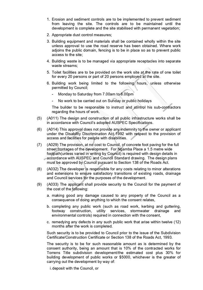
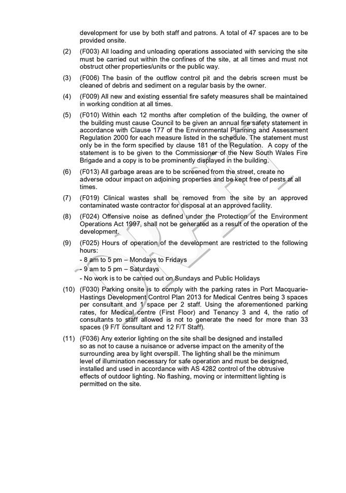
|
ATTACHMENT
|
Development Assessment Panel
20/04/2022
|
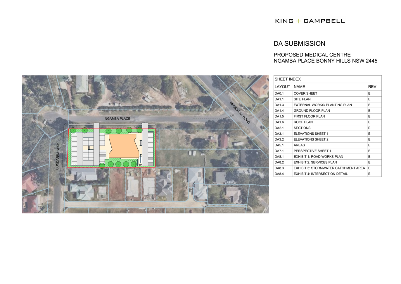
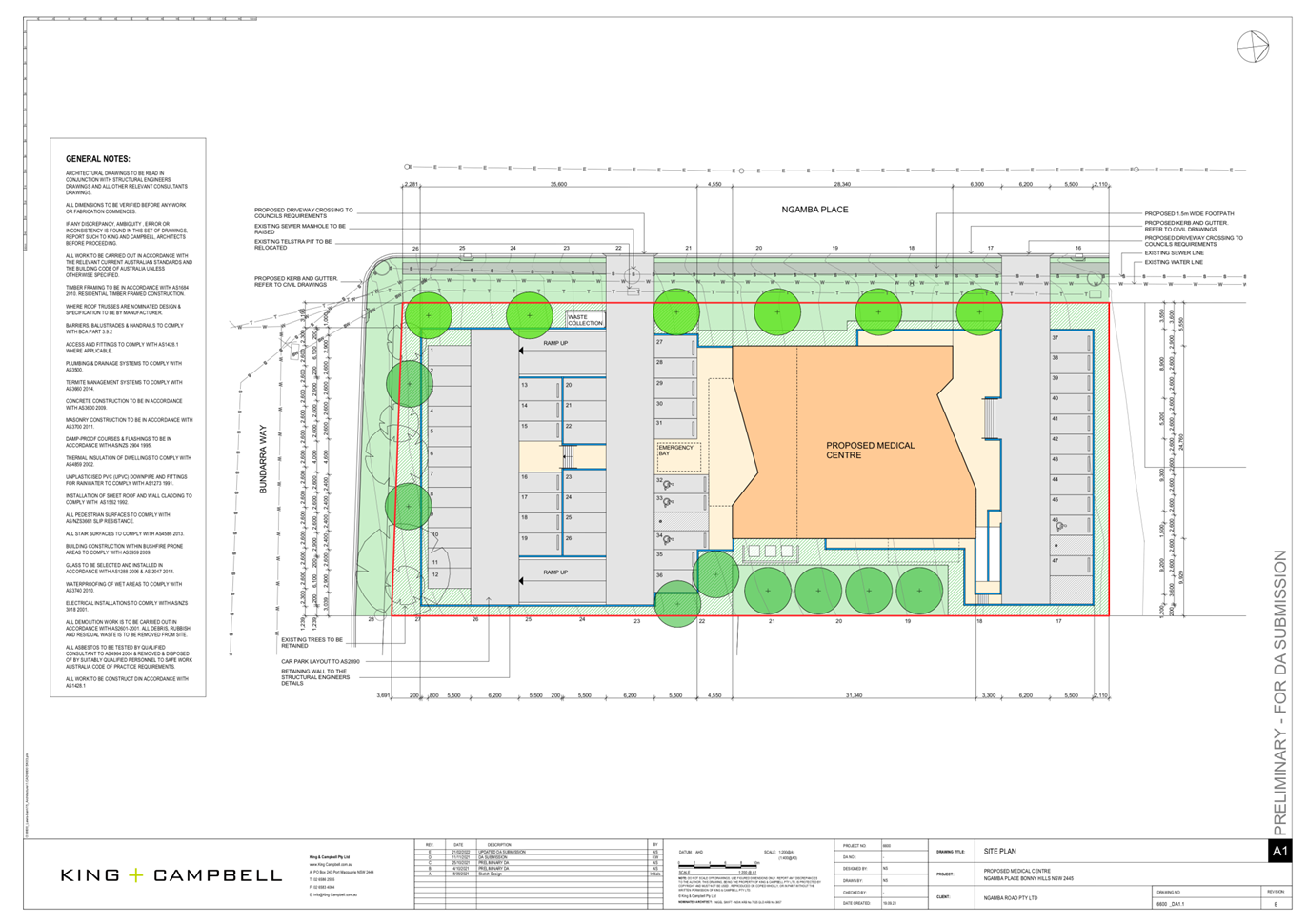
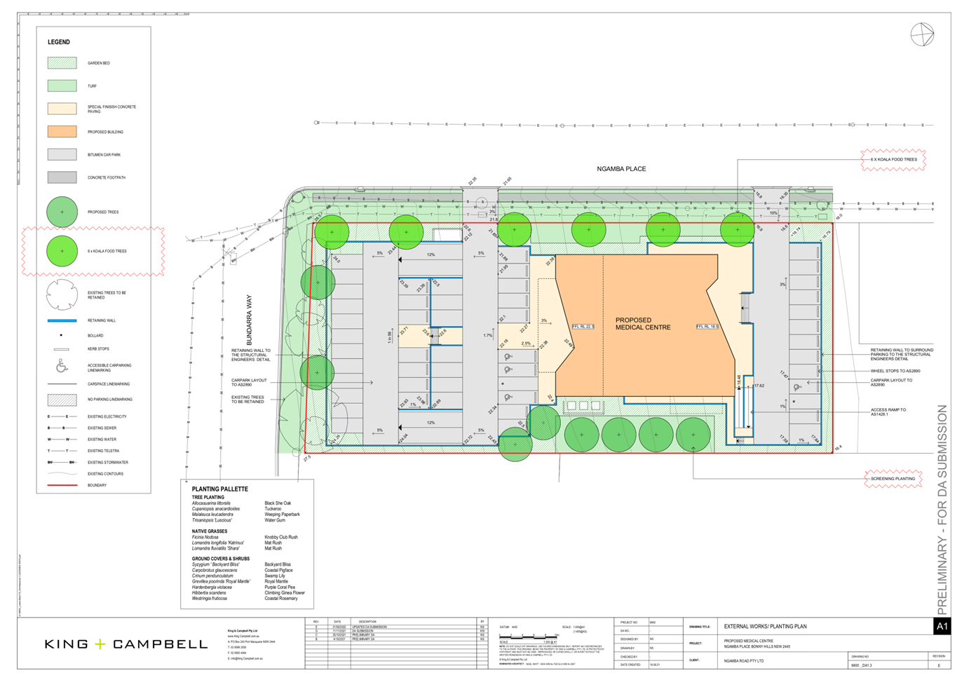
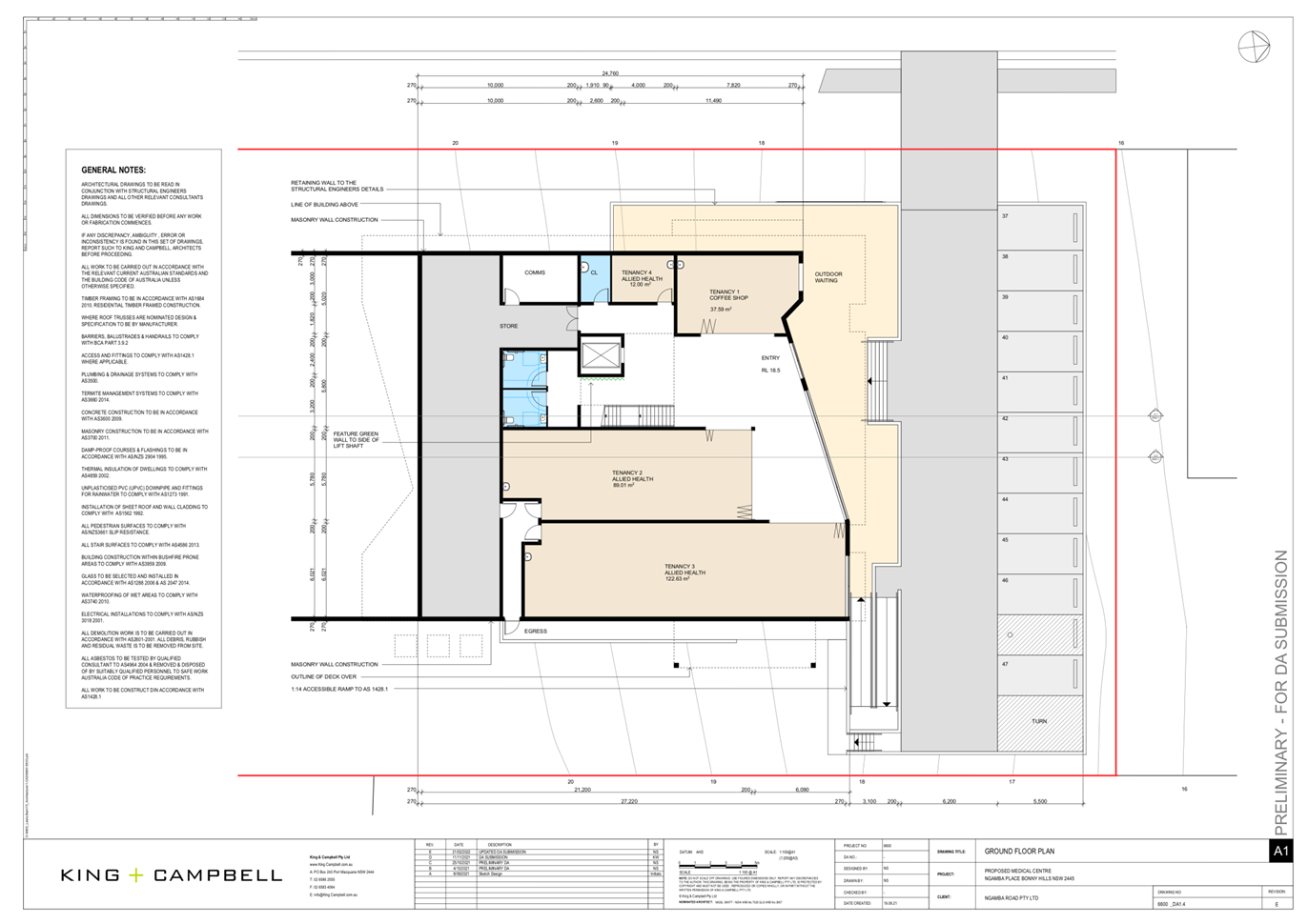
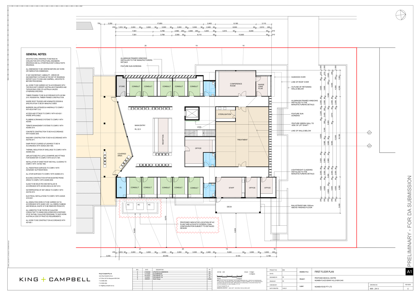
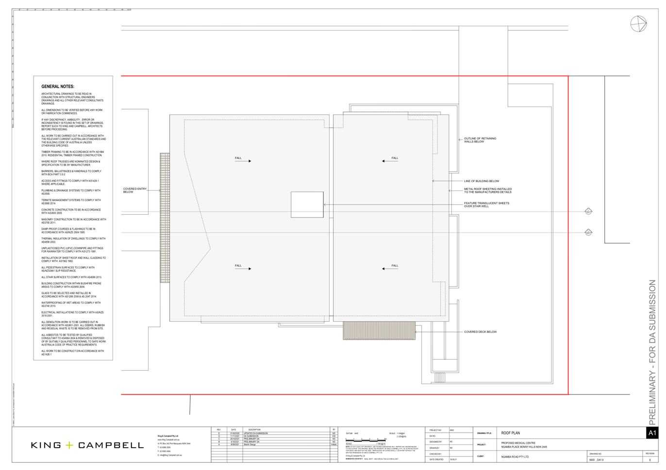
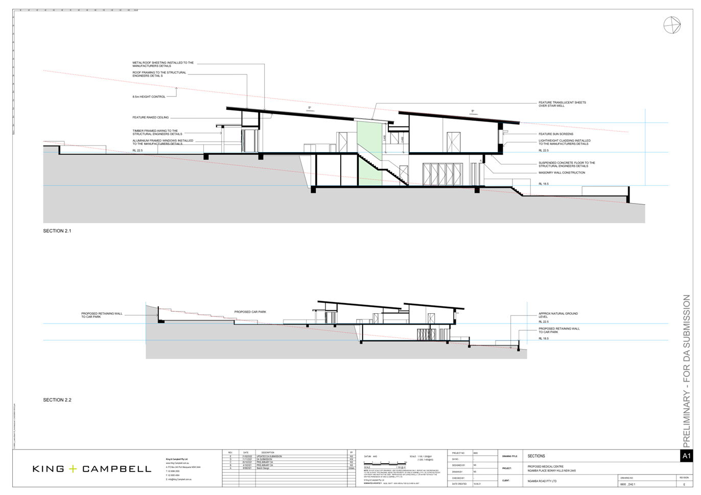

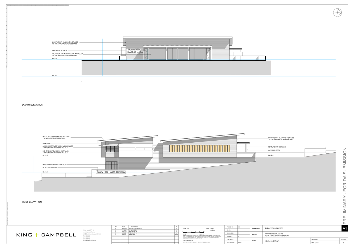
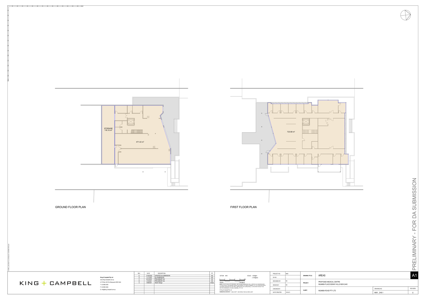
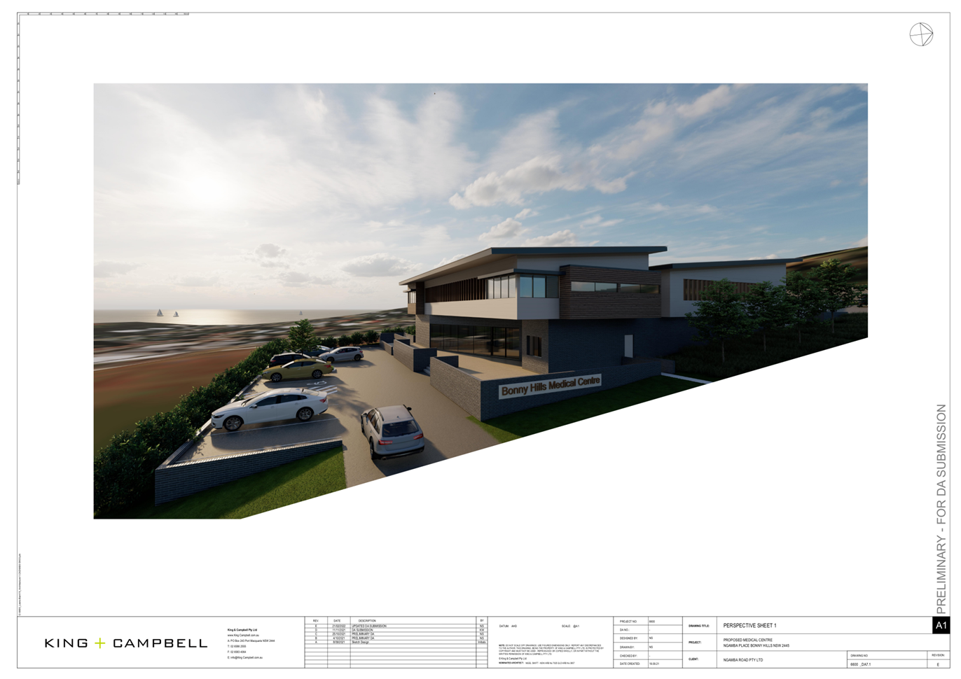
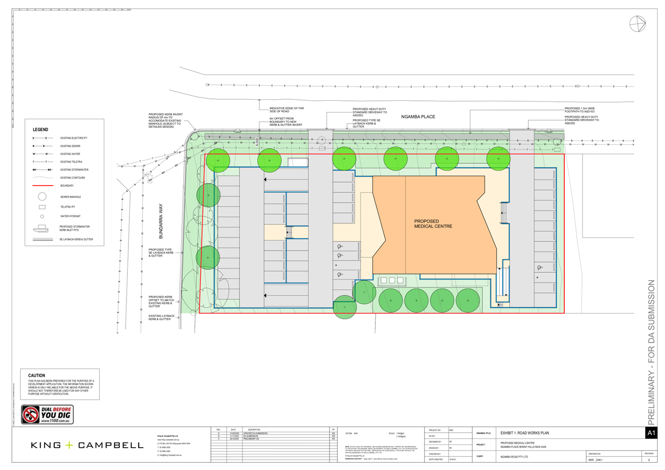
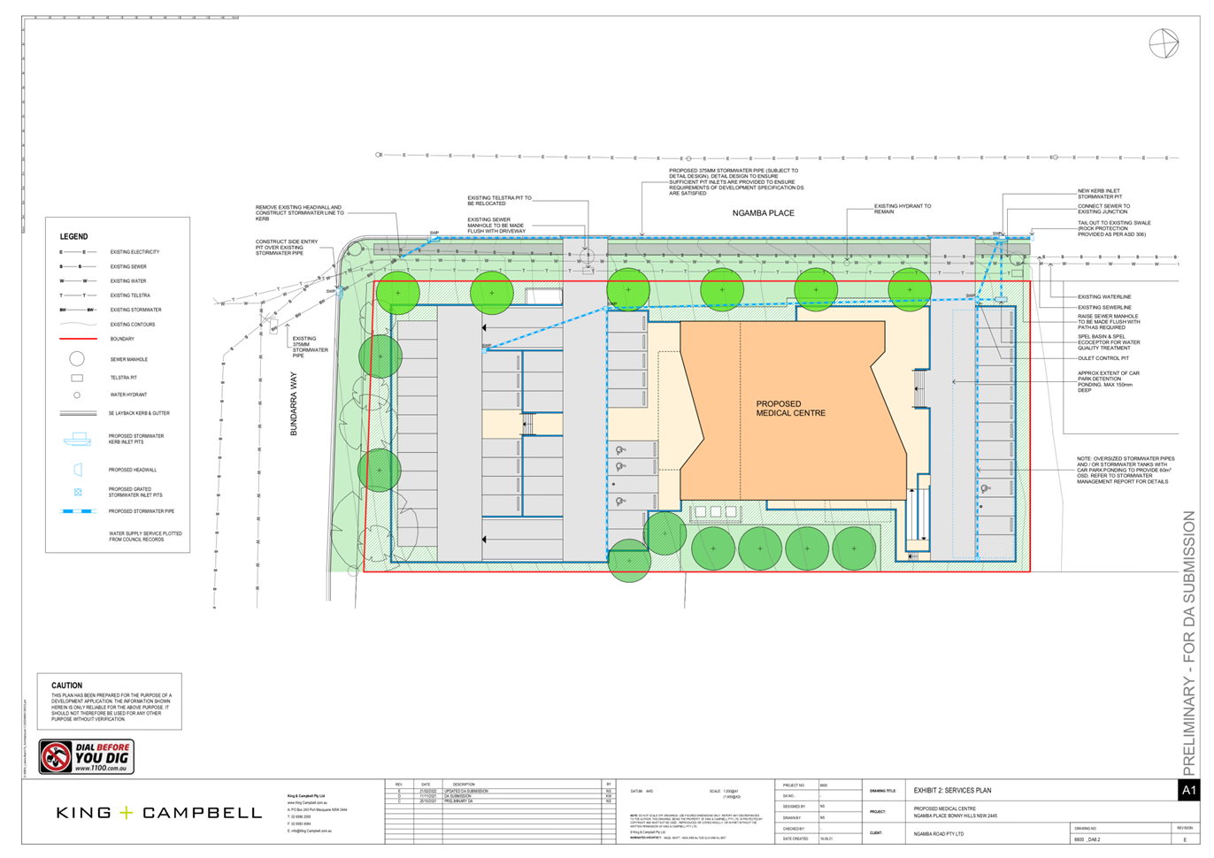
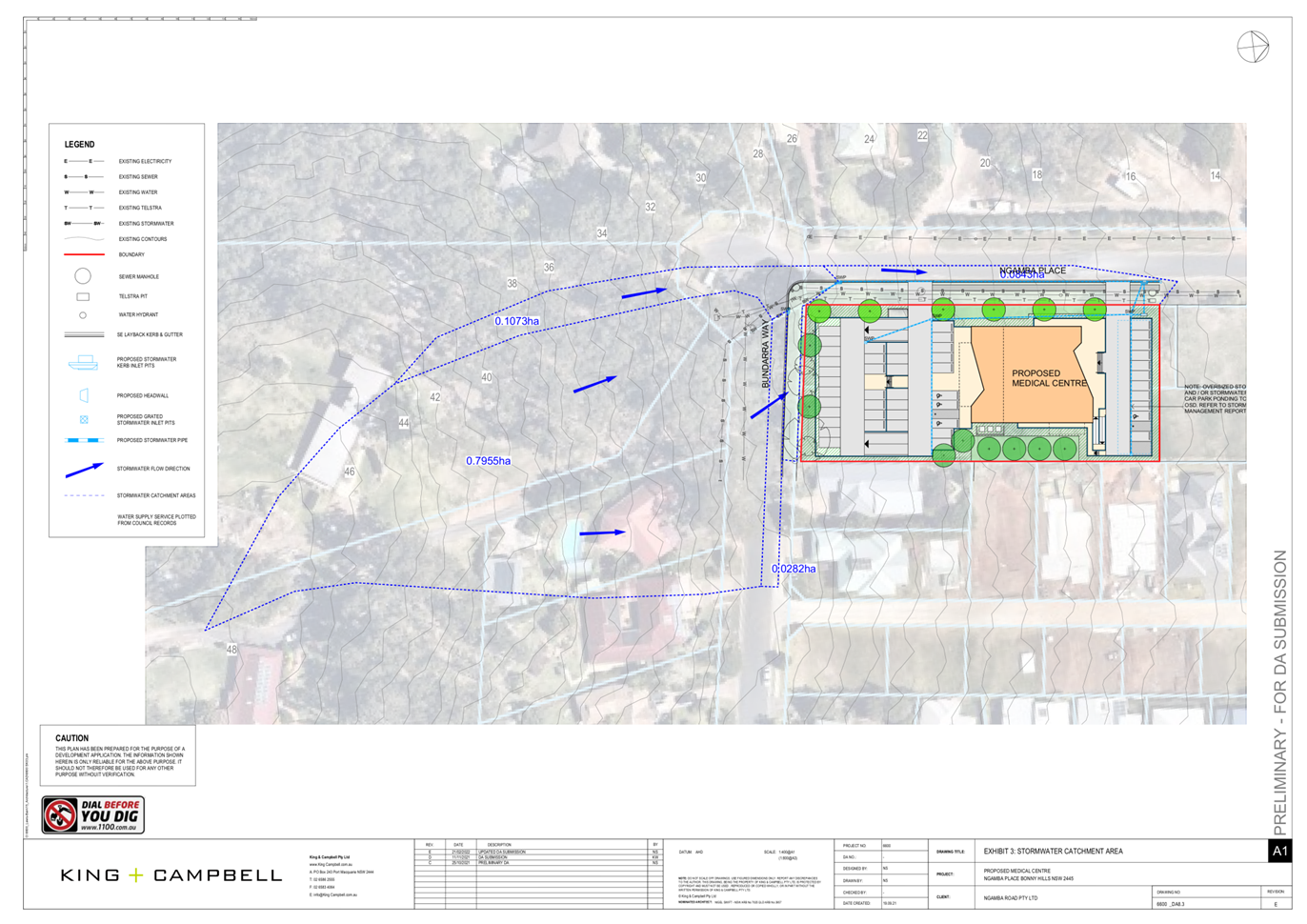
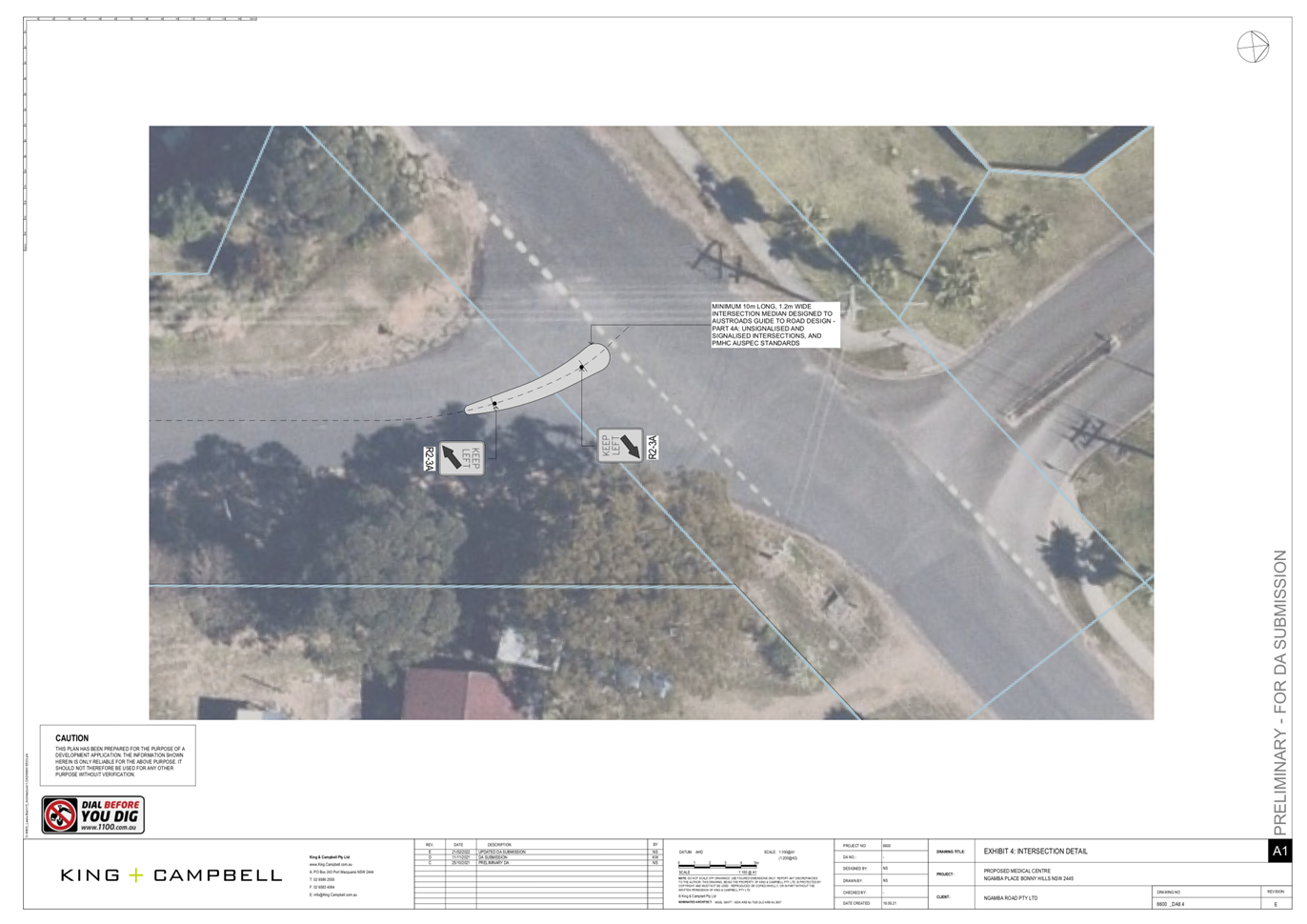
|
ATTACHMENT
|
Development Assessment Panel
20/04/2022
|