Development
Assessment Panel
Business
Paper
|
date of meeting:
|
|
Thursday 8 September
2022
|
|
location:
|
|
Function Room
Port
Macquarie-Hastings Council
17 Burrawan Street
Port Macquarie
|
|
time:
|
|
2:00pm
|
Development
Assessment Panel
CHARTER
1.0 OBJECTIVES
To assist in managing Council's
development assessment function by providing independent, transparent and
expert determinations of development applications that fall outside of staff
delegations.
2.0 KEY FUNCTIONS
·
To review development application reports and conditions.
The focus of the Panel’s review is to be on those issues raised in
submissions received following exhibition of development applications;
·
To determine development applications where
there are 3 or more unique submissions or where an application is outside of
staff delegations;
·
To refer development applications to Council for
determination where necessary;
·
To provide a forum for objectors and applicants
to make submissions on applications
before the Development Assessment Panel (DAP);
·
To maintain transparency in the determination of development
applications.
Delegated Authority of Panel
Pursuant to Section 377 of the
Local Government Act, 1993 delegation to:
·
Determine development applications under Part 4
of the Environmental Planning and Assessment Act 1979 having regard to the
relevant environmental planning instruments, development control plans and
Council policies.
·
Vary, modify or release restrictions as to use
and/or covenants created by Section 88B instruments under the Conveyancing Act
1919 in relation to development applications for subdivisions being considered
by the panel.
·
Determine Koala Plans of Management under State
Environmental Planning Policy 44 - Koala Habitat Protection associated with
development applications being considered by the Panel.
Noting the trigger to escalate
decision making to Council as highlighted in section 5.2.
3.0
MEMBERSHIP
3.1 Voting Members
·
Three (3) independent external members will be
selected for each scheduled DAP meeting from an appointed pool of members. One
of the independent external members to be the Chairperson. Independent members
will be rostered onto meeting on a rotational basis where possible.
·
Group Manager Development Assessment (alternate
- Director Development and Environment or Development Assessment Planning
Coordinator).
The independent external
members shall have expertise in one or more of the following areas:
planning, architecture,
heritage, the environment, urban design, economics, traffic and transport, law,
engineering, government and public administration.
3.2 Non-Voting Members
Not applicable.
3.3 Obligations
of members
·
Members must act faithfully and diligently and
in accordance with this Charter.
·
Members must comply with Council's Code of Conduct.
·
Except as required to properly perform their
duties, DAP members must not
disclose any confidential information (as advised by Council) obtained in connection with the DAP functions.
·
Members will have read and be familiar with the
documents and information provided by Council prior
to attending a DAP meeting.
·
Members must act in accordance with Council's
Workplace Health and Safety Policies and Procedures.
·
External members of the Panel are not authorised
to speak to the media on behalf of Council. Council officers that are members
of the Committee are bound by the
existing operational delegations in relation to speaking to the media.
3.4 Member Tenure
The
independent external members will be appointed for the term of Four (4) years or until such time as an expression
of interest process to source Panel members is completed for the proceeding
four (4) year term.
3.5 Appointment
of members
·
A pool of independent external members
(including the Chair) shall be appointed by the Chief Executive Officer
following an external Expression of Interest process. Previous Panel members
are eligible to be reappointed on the Panel following this expression of
interest process.
·
Independent members will be rostered on to Panel
meetings on a rotational basis where possible to suit Panel member availability
and Panel operational needs.
·
Staff members on the Panel shall be appointed by
the Chief Executive Officer.
4.0 TIMETABLE OF MEETINGS
·
The Development Assessment Panel will generally
meet on the 1st and 3rd Thursday each month at 2.00pm at the Port Macquarie
offices of Council.
·
Special Meetings of the Panel may be convened by
the Director Development and Environment with three (3) days’ notice.
5.0
MEETING PRACTICES
5.1 Meeting Format
·
At all meetings of the Panel the Chairperson
shall occupy the Chair and preside. The Chair will be responsible for keeping
of order at meetings.
·
Meetings shall be open to the public.
·
The Panel will hear from an applicant and
objectors or their representatives. Speakers are required to register to speak
by close of business on the day prior to the Panel meeting.
·
The Panel shall have the discretion to ask the
applicant and objectors questions relating to the proposal and their
submission. There is no ‘right of reply’ for an objector or
applicant.
·
Where there are a large number of persons making
submissions with common interests, the Panel shall have the discretion to hear
a representative of those persons rather than multiple persons with the same
interest.
·
Council assessment staff will be available at
Panel meetings to provide technical assessment advice and assistance to the
Panel.
·
Where considered necessary, the Panel will
conduct site inspections prior to the meeting.
5.2 Decision Making
·
Decisions are to be made by consensus. Where
consensus is not possible on any item, that item is to be referred to Council
for a decision.
·
All development applications involving a
proposed variation to a development standard
greater than 10% under Clause
4.6 of the Local Environmental Plan will be
considered by the Panel and recommendation made to the Council for a decision.
5.3 Quorum
Three (3) members must be present at a meeting to form a quorum.
5.4 Chairperson
and Deputy Chairperson
Independent Chair (alternate - independent member).
5.5 Secretariat
·
The Director Development and Environment is to
be responsible for ensuring that the Panel has adequate secretariat support.
The secretariat will ensure that the business paper and supporting papers are
circulated at least three (3) days prior to
each meeting. Minutes shall be appropriately approved and circulated to each
member within three (3) weeks of a meeting being held.
·
The format of and the preparation and publishing
of the Business Paper and Minutes shall be similar to the format for Ordinary
Council Meetings.
5.6 Recording
of decisions
Minutes will be limited to the recording of decisions only and how
each member votes for each item before the Panel.
6.0 CONVENING OF
“OUTCOME SPECIFIC” WORKING GROUPS
Not applicable.
7.0 CONFIDENTIALITY AND
CONFLICT OF INTEREST
·
Members of the Panel must comply with the
applicable provisions of Council’s Code of Conduct. It is the personal
responsibility of members to comply with the standards in the Code of Conduct
and regularly review their personal circumstances with this in mind.
·
Panel members must declare any conflict of
interest at the start of each meeting or before discussion of a relevant item
or topic. Details of any conflicts of interest are to be appropriately minuted.
Where members are deemed to have a real or perceived conflict of interest, it
may be appropriate they be excused from deliberations on the issue where the
conflict of interest may exist. A Panel meeting may be postponed where there is
no quorum.
8.0 LOBBYING
All members and
applicants are to adhere to Council’s Lobbying policy. Outside of scheduled Development Assessment
Panel meetings, applicants, their representatives, Councillors, Council staff
and the general public are not to lobby Panel members via meetings, telephone
conversations, correspondence and the like. Adequate opportunity will be
provided at Panel inspections or meetings for applicants, their representatives
and the general public to make verbal submissions in relation to Business Paper items.
9.0 CONDUCT AT MEETINGS
All parties in attendance at a DAP meeting shall conduct
themselves respectfully ie. not disrupt the conduct of the meeting, not
interject, act courteously and with compassion and empathy and sensitivity and
will not insult, denigrate or make defamatory or personal reflections on or
impute improper motives to the DAP, Council staff or other members of the
public.
Development Assessment Panel
ATTENDANCE
REGISTER
|
Member
|
18/11/21
|
16/12/21
|
3/2/22
|
17/2/22
|
20/4/22
|
4/5/22
|
1/06/22
|
6/7/22
|
20/7/22
|
17/8/22
|
|
David Crofts
(Independent Chair)
|
P
|
P
|
P
|
P
|
P
|
P
|
P
|
P
|
A
|
P
|
|
Chris Gee
(Independent Member)
|
P
|
|
P
|
|
P
|
|
P
|
P
|
P
|
P
|
|
Michael Mason
(Independent Member)
|
P
|
P
|
P
|
P
|
|
|
|
P
|
P
|
P
|
|
Dan Croft
(Group Manager
Development Services)
|
P
|
P
|
P
|
P
|
P
|
P
|
A
|
P
|
P
|
P
|
|
Tony McNamara
(Independent Member)
|
|
P
|
|
P
|
P
|
P
|
P
|
P
|
P
|
|
|
Other attendees
|
|
|
|
|
|
|
|
|
|
|
|
Mayor Peta Pinson
|
|
|
P
|
P
|
|
P
|
|
|
|
P
|
|
Grant Burge
(Development Engineering
Coordinator)
|
P
|
P
|
P
|
P
|
P
|
|
P
|
P
|
P
|
P
|
|
Patrick
Galbraith-Robertson
(Development Planning
Coordinator)
|
P
|
P
|
P
|
P
|
P
|
P
|
P
|
P
|
P
|
P
|
|
Steven Ford
(Development Assessment
Planner)
|
|
|
|
|
|
|
|
P
|
P
|
P
|
|
Chris Gardiner
(Development Assessment
Planner)
|
|
|
|
|
|
P
|
P
|
P
|
|
|
|
Vanessa Penfold
(Development Assessment Planner)
|
|
|
|
|
|
|
|
P
|
|
|
|
Clinton Tink
(Development Assessment
Planner)
|
|
|
|
|
|
P
|
P
|
|
|
|
|
Jon Power
(Act Development Engineer
Coordinator)
|
|
|
|
|
|
P
|
|
|
|
|
|
Beau Spry
(Development Assessment
Planner)
|
|
|
|
|
|
P
|
|
|
|
|
|
Ben Roberts
(Development Assessment
Planner)
|
|
|
P
|
|
|
P
|
|
|
|
|
|
Councillor Josh Slade
|
|
|
|
P
|
|
|
|
|
|
|
|
Kate Kennedy
(Building Surveyor)
|
|
|
|
P
|
|
|
|
|
|
|
|
Warren Wisemantel
|
|
|
|
P
|
|
|
|
|
|
|
|
Deputy Mayor Adam Roberts
|
|
|
P
|
|
|
|
|
|
|
|
Key: P = Present
A
= Absent With Apology
X
= Absent Without Apology
Meeting Dates for
2022
|
20/01/2022
|
Function Room
|
2.00pm
|
|
3/02/2022
|
Function Room
|
2.00pm
|
|
17/02/2022
|
Function Room
|
2.00pm
|
|
2/03/2022
|
Function Room
|
2.00pm
|
|
16/03/2022
|
Function Room
|
2.00pm
|
|
6/04/2022
|
Function Room
|
2.00pm
|
|
20/04/2022
|
Function Room
|
2.00pm
|
|
4/05/2022
|
Function Room
|
2.00pm
|
|
18/05/2022
|
Function Room
|
2.00pm
|
|
1/06/2022
|
Function Room
|
2.00pm
|
|
15/06/2022
|
Function Room
|
2.00pm
|
|
6/07/2022
|
Function Room
|
2.00pm
|
|
20/07/2022
|
Function Room
|
2.00pm
|
|
3/08/2022
|
Function Room
|
2.00pm
|
|
17/08/2022
|
Function Room
|
2.00pm
|
|
7/09/2022
|
Function Room
|
2.00pm
|
|
21/09/2022
|
Function Room
|
2.00pm
|
|
5/10/2022
|
Function Room
|
2.00pm
|
|
19/10/2022
|
Function Room
|
2.00pm
|
|
2/11/2022
|
Function Room
|
2.00pm
|
|
16/11/2022
|
Function Room
|
2.00pm
|
|
7/12/2022
|
Function Room
|
2.00pm
|
Development
Assessment Panel Meeting
Thursday 8 September
2022
Items of Business
01 Acknowledgement
of Country............................................................................. 9
02 Apologies.......................................................................................................... 9
03 Confirmation
of Minutes..................................................................................... 9
04 Disclosures
of Interest..................................................................................... 13
05 DA2021
- 1051.1 Alterations and additions to motel at Lots 121 and 122 DP 754444 and
Lot 1 DP 393484, No. 5 to 7 The Parade, North Haven.................................................... 17
06 DA2021
- 1237.1 Child Care Centre and Torrens Title Subdivision at Lot 7 DP 262361, No
13 Colonial Circuit, Wauchope............................................................................ 105
07 General
Business
AGENDA Development Assessment Panel 08/09/2022
Subject: ACKNOWLEDGEMENT
OF COUNTRY
"I acknowledge that we are
gathered on Birpai Land. I pay respect to the Birpai Elders both past and
present. I also extend that respect to all other Aboriginal and Torres Strait
Islander people present."
RECOMMENDATION
That the apologies received be
accepted.
Subject: CONFIRMATION
OF PREVIOUS MINUTES
Recommendation
That the Minutes of the Development Assessment Panel Meeting
held on 17 August 2022 be confirmed.
MINUTES
Development Assessment Panel Meeting
17/08/2022
PRESENT
Members:
David Crofts (Independent Chair)
Chris Gee (Independent Member)
Michael Mason (Independent Member)
Dan Croft (Group Manager
Development Services)
Other Attendees:
Mayor Peta Pinson
Grant Burge (Development
Engineering Coordinator)
Pat Galbraith-Robertson
(Development Assessment Planning Coordinator)
Steven Ford (Development
Assessment Planner)
|
The meeting opened at 2:00pm.
|
|
01 ACKNOWLEDGEMENT
OF COUNTRY
|
|
The
Acknowledgement of Country was delivered.
|
|
03 CONFIRMATION
OF MINUTES
|
|
CONSENSUS:
That
the Minutes of the Development Assessment Panel Meeting held on 20 July 2022
were adopted with a correction to note that
Mr George Tattam was a speaker representing the applicant for item 5.
|
|
04 DISCLOSURES
OF INTEREST
|
|
There were no disclosures of interest presented.
|
|
05 BUSINESS
ARISING FROM PREVIOUS MINUTES
|
|
05 DA2019 - 780.6
Modification to Manufactured Housing Estate - Lot 2 DP1263561 South Atlantic
Drive LAKE CATHIE
|
|
Speakers:
Susan Blake (applicant)
Graham Burns (applicant)
Lyn Ford (submitter)
CONSENSUS:
That DA
2019-780.06 for a Modification to
Manufactured Housing Estate at Lot 2, DP 1263561, South
Atlantic Drive, Lake Cathie, be determined
by granting consent subject to the recommended conditions.
Additional
condition in Section E of the consent to read: ‘Prior to the issue of
an Occupation Certificate for the permanent clubhouse, the interim clubhouse
is to be removed and the site restored.’
|
|
06 DA2021 -
1051.1 Alterations and Additions to Motel at Lots 121 and 122 DP 754444 and
Lot 1 DP 393484, No 5 to 7 The Parade, North Haven
|
|
Speakers:
Mitch
Perry (opposing the application)
Chris Jenkins (applicant)
CONSENSUS:
That DA2021
- 1051 be deferred to enable the Panel to inspect
units affected by view loss impacts, where access can be obtained.
|
|
The meeting closed at 3:30pm.
|
………………………………………..
Peta Pinson
Mayor
AGENDA Development Assessment Panel 08/09/2022
Subject: DISCLOSURES
OF INTEREST
RECOMMENDATION
That Disclosures of Interest be presented
DISCLOSURE OF
INTEREST DECLARATION
|
Name of Meeting:
|
|
Meeting
Date:
|
|
Item
Number:
|
|
Subject:
|
|
I,
the undersigned, hereby declare the following interest:
Pecuniary:
 Take no part
in the consideration and voting and be out of sight of the meeting. Take no part
in the consideration and voting and be out of sight of the meeting.
Non-Pecuniary
– Significant Interest:
Take no part
in the consideration and voting and be out of sight of the meeting.
Non-Pecuniary
– Less than Significant Interest:
May
participate in consideration and voting.
|
|
For
the reason that:
|
|
Name:
Signed:
|
Date:
|
|
Please submit to the
Governance Support Officer at the Council Meeting.
|
 (Refer
to next page and the Code of Conduct)
(Refer
to next page and the Code of Conduct)
Pecuniary Interest
4.1
A pecuniary interest is an interest
that you have in a matter because of a reasonable likelihood or expectation of appreciable
financial gain or loss to you or a person referred to in clause 4.3.
4.2
You will not have a pecuniary
interest in a matter if the interest is so remote or insignificant that it
could not reasonably be regarded as likely to influence any decision you might
make in relation to the matter, or if the interest is of a kind specified in
clause 4.6.
4.3
For the purposes of this Part, you
will have a pecuniary interest in a matter if the pecuniary interest is:
(a)
your interest, or
(b)
the interest of your spouse or de
facto partner, your relative, or your partner or employer, or
(c)
a company or other body of which
you, or your nominee, partner or employer, is a shareholder or member.
4.4
For the purposes of clause 4.3:
(a)
Your “relative” is any
of the following:
(b)
“de facto partner” has
the same meaning as defined in section 21C of the Interpretation Act 1987.
4.5
You will not have a pecuniary
interest in relation to a person referred to in subclauses 4.3(b) or (c)
(a)
if you are unaware of the relevant
pecuniary interest of your spouse, de facto partner, relative, partner,
employer or company or other body, or
(b)
just because the person is a member
of, or is employed by, a council or a statutory body, or is employed by the Crown,
or
(c)
just because the person is a member
of, or a delegate of a council to, a company or other body that has a pecuniary
interest in the matter, so long as the person has no beneficial interest in any
shares of the company or body.
Non-Pecuniary
5.1
Non-pecuniary interests are private
or personal interests a council official has that do not amount to a pecuniary
interest as defined in clause 4.1 of this code. These commonly arise out of
family or personal relationships, or out of involvement in sporting, social,
religious or other cultural groups and associations, and may include an
interest of a financial nature.
5.2
A non-pecuniary conflict of
interest exists where a reasonable and informed person would perceive that you
could be influenced by a private interest when carrying out your official
functions in relation to a matter.
5.3
The personal or political views of
a council official do not constitute a private interest for the purposes of
clause 5.2.
5.4
Non-pecuniary conflicts of interest
must be identified and appropriately managed to uphold community confidence in
the probity of council decision-making. The onus is on you to identify any
non-pecuniary conflict of interest you may have in matters that you deal with,
to disclose the interest fully and in writing, and to take appropriate action
to manage the conflict in accordance with this code.
5.5
When considering whether or not you
have a non-pecuniary conflict of interest in a matter you are dealing with, it
is always important to think about how others would view your situation.
Managing non-pecuniary conflicts of interest
5.6
Where you have a non-pecuniary
conflict of interest in a matter for the purposes of clause 5.2, you must
disclose the relevant private interest you have in relation to the matter fully
and in writing as soon as practicable after becoming aware of the non-pecuniary
conflict of interest and on each occasion on which the non-pecuniary conflict
of interest arises in relation to the matter. In the case of members of council
staff other than the Chief Executive Officer, such a disclosure is to be made
to the staff member’s manager. In the case of the Chief Executive Officer,
such a disclosure is to be made to the mayor.
5.7
If a disclosure is made at a
council or committee meeting, both the disclosure and the nature of the
interest must be recorded in the minutes on each occasion on which the
non-pecuniary conflict of interest arises. This disclosure constitutes
disclosure in writing for the purposes of clause 5.6.
5.8
How you manage a non-pecuniary
conflict of interest will depend on whether or not it is significant.
5.9
As a general rule, a non-pecuniary
conflict of interest will be significant where it does not involve a pecuniary
interest for the purposes of clause 4.1, but it involves:
a)
a relationship between a council
official and another person who is affected by a decision or a matter under
consideration that is particularly close, such as a current or former spouse or
de facto partner, a relative for the purposes of clause 4.4 or another person
from the council official’s extended family that the council official has
a close personal relationship with, or another person living in the same
household
b)
other relationships with persons
who are affected by a decision or a matter under consideration that are
particularly close, such as friendships and business relationships. Closeness
is defined by the nature of the friendship or business relationship, the
frequency of contact and the duration of the friendship or relationship.
c)
an affiliation between the council
official and an organisation (such as a sporting body, club, religious,
cultural or charitable organisation, corporation or association) that is
affected by a decision or a matter under consideration that is particularly
strong. The strength of a council official’s affiliation with an
organisation is to be determined by the extent to which they actively
participate in the management, administration or other activities of the
organisation.
d)
membership, as the council’s
representative, of the board or management committee of an organisation that is
affected by a decision or a matter under consideration, in circumstances where
the interests of the council and the organisation are potentially in conflict
in relation to the particular matter
e)
a financial interest (other than an
interest of a type referred to in clause 4.6) that is not a pecuniary interest
for the purposes of clause 4.1
f)
the conferral or loss of a personal
benefit other than one conferred or lost as a member of the community or a
broader class of people affected by a decision.
5.10
Significant non-pecuniary conflicts
of interest must be managed in one of two ways:
a)
by not participating in
consideration of, or decision making in relation to, the matter in which you
have the significant non-pecuniary conflict of interest and the matter being
allocated to another person for consideration or determination, or
b)
if the significant non-pecuniary
conflict of interest arises in relation to a matter under consideration at a
council or committee meeting, by managing the conflict of interest as if you
had a pecuniary interest in the matter by complying with clauses 4.28 and 4.29.
5.11
If you determine that you have a
non-pecuniary conflict of interest in a matter that is not significant and does
not require further action, when disclosing the interest you must also explain
in writing why you consider that the non-pecuniary conflict of interest is not
significant and does not require further action in the circumstances.
5.12
If you are a member of staff of
council other than the Chief Executive Officer, the decision on which option
should be taken to manage a non-pecuniary conflict of interest must be made in
consultation with and at the direction of your manager. In the case of the Chief
Executive Officer, the decision on which option should be taken to manage a
non-pecuniary conflict of interest must be made in consultation with and at the
direction of the mayor.
5.13
Despite clause 5.10(b), a
councillor who has a significant non-pecuniary conflict of interest in a
matter, may participate in a decision to delegate consideration of the matter
in question to another body or person.
5.14 Council committee members are not required to declare
and manage a non-pecuniary conflict of interest in accordance with the
requirements of this Part where it arises from an interest they have as a
person chosen to represent the community, or as a member of a non-profit
organisation or other community or special interest group, if they have been
appointed to represent the organisation or group on the council committee.
SPECIAL
DISCLOSURE OF PECUNIARY INTEREST DECLARATION
This
form must be completed using block letters or typed.
If
there is insufficient space for all the information you are required to
disclose,
you
must attach an appendix which is to be properly identified and signed by you.
|
By
[insert full name of councillor]
|
|
|
In the
matter of
[insert name of environmental planning instrument]
|
|
|
Which is
to be considered at a meeting of the
[insert name of meeting]
|
|
|
Held on
[insert date of meeting]
|
|
|
PECUNIARY
INTEREST
|
|
Address of
the affected principal place of residence of the councillor or an associated
person, company or body (the identified land)
|
|
|
Relationship
of identified land to councillor
[Tick or cross one box.]
|
The councillor has interest in the land (e.g. is owner or has other
interest arising out of a mortgage, lease, trust, option or contract, or
otherwise).
An associated person of the councillor has an interest in the land.
An associated company or body of the councillor has interest in the land.
|
|
MATTER
GIVING RISE TO PECUNIARY INTEREST
|
|
Nature of
land that is subject to a change
in
zone/planning control by proposed
LEP (the
subject land
[Tick or cross one box]
|
The identified land.
Land that adjoins or is adjacent to or is in proximity to the identified
land.
|
|
Current
zone/planning control
[Insert name of current planning instrument and
identify relevant zone/planning control applying to the subject land]
|
|
|
Proposed
change of zone/planning control
[Insert name of proposed LEP and identify proposed
change of zone/planning control applying to the subject land]
|
|
|
Effect of
proposed change of zone/planning control on councillor or associated person
[Tick or cross one box]
|
Appreciable financial gain.
Appreciable financial loss.
|
|
|
|
[If more than one pecuniary interest is to be declared,
reprint the above box and fill in for each additional interest]
Councillor’s Signature:
……………………………….
Date: ………………..
This form is to be retained
by the council’s Chief Executive Officer and included in full in the
minutes of the meeting
Last Updated: 3 June 2019
Important Information
This information is being collected for the purpose of
making a special disclosure of pecuniary interests under clause 4.36(c) of the
Model Code of Conduct for Local Councils in NSW (the Model Code of Conduct).
The special disclosure must relate only to a pecuniary
interest that a councillor has in the councillor’s principal place of
residence, or an interest another person (whose interests are relevant under
clause 4.3 of the Model Code of Conduct) has in that person’s principal
place of residence.
Clause 4.3 of the Model Code of Conduct states that you
will have a pecuniary interest in a matter because of the pecuniary interest of
your spouse or your de facto partner or your relative or because your business
partner or employer has a pecuniary interest. You will also have a pecuniary
interest in a matter because you, your nominee, your business partner or your
employer is a member of a company or other body that has a pecuniary interest
in the matter.
“Relative” is defined by clause 4.4 of the Model
Code of Conduct as meaning your, your spouse’s or your de facto
partner’s parent, grandparent, brother, sister, uncle, aunt, nephew,
niece, lineal descendant or adopted child and the spouse or de facto partner of
any of those persons.
You
must not make a special disclosure that you know or ought reasonably to know is
false or misleading in a material particular. Complaints about breaches
of these requirements are to be referred to the Office of Local Government and
may result in disciplinary action by the Chief Executive of the Office of Local
Government or the NSW Civil and Administrative Tribunal.
This form must be completed by you before the commencement
of the council or council committee meeting at which the special disclosure is
being made. The completed form must be tabled at the meeting. Everyone is
entitled to inspect it. The special disclosure must be recorded in the minutes
of the meeting.
A pecuniary interest may arise by way of a change of
permissible use of land adjoining, adjacent to or in proximity to land in which
a councillor or a person, company or body referred to in clause 4.3 of the
Model Code of Conduct has a proprietary interest
|
ATTACHMENT
|
Development Assessment Panel
08/09/2022
|
Item: 05
Subject: DA2021 - 1051.1 Alterations and additions to
motel at Lots 121 and 122 DP 754444 and Lot 1 DP 393484, No. 5 to 7 The Parade,
North Haven
Report
Author: Development Assessment Officer (Planning), Patrick Galbraith-Robertson
|
Applicant: Chris
Jenkins Architects
Owner: L
F and J M Midgley
Estimated Cost: $1.394M
Parcel no: 23683,
35650, 35651
Alignment with Delivery
Program
4.3.1 Undertake transparent
and efficient development assessment in accordance with relevant legislation.
|
RECOMMENDATION
That
DA2021 - 1051.1 for alterations
and additions to Motel at Lots 121 and
122 DP 754444 and Lot 1 DP 393484, No. 5 to 7
The Parade, North Haven, be determined by granting consent subject to the
recommended conditions.
Executive
Summary
This
report considers a Development Application for alterations and additions
to an existing motel at the subject site and provides
an assessment of the application in accordance with the Environmental Planning
and Assessment Act 1979.
This DA is being reported to the
Development Assessment Panel (DAP) following previous consideration of the DA
by the DAP on 17 August 2022. On the 17 August 2022 the following resolution
was made by the DAP:
Speakers: Mitch Perry (o), Chris
Jenkins (applicant)
Resolution: ‘That DA2021 -
1051 be deferred to enable the Panel to inspect units affected by view loss
impacts, where access can be obtained.’
Site inspections have been
organised for the DAP members on 8 September 2022. This DA is also reported
back to the DAP for determination to occur on the same day following the
inspections. The assessment report and recommendation remain the same as
previously reported.
Following exhibition of the
application, six (6) submissions were
received.
The site is considered suitable for the proposed development
and the proposal adequately addresses relevant planning controls. The
development is not considered to be contrary to the public's interest and will
not result a significant adverse social, environmental or economic impact.
The proposal has been amended during assessment post
exhibition to reduce the extent of the additions at the rear of the site. The
amended plans have been attached to this report.
This report recommends that the
development application be approved subject to the attached conditions - refer
to Attachment 1.
The reason for the application being referred to
Council’s Development Assessment Panel (DAP) is because three (3) or more
objections to the proposal have been received. A copy of the DAP Charter
outlining the delegations and functions of the DAP is available on
Council’s website.
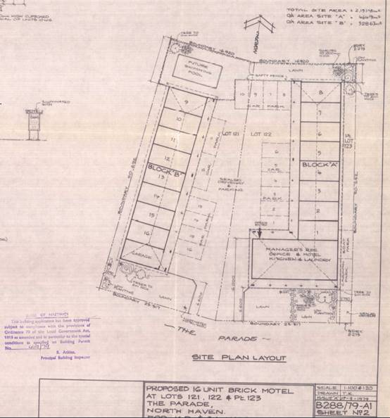
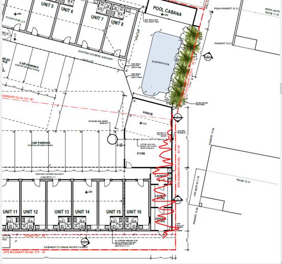
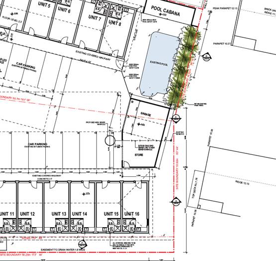
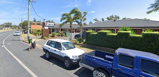
1. BACKGROUND
Existing
Sites Features and Surrounding Development
The site comprises three (3)
allotments with a total combined area of approximately 2,138m2. The site contains an existing single storey motel
comprising 16 units and manager’s residence in two detached buildings.
The site also contains a number of ancillary structures in the form of swimming
pool, at grade parking spaces, sheds and pergola/cabana. The approved historic
site plan is provided below for context:
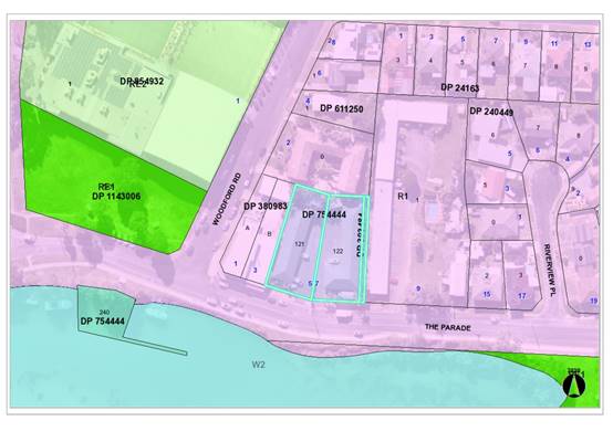
The
site is zoned R1 General Residential in
accordance with the Port Macquarie-Hastings Local Environmental Plan 2011, as
shown in the following zoning plan:
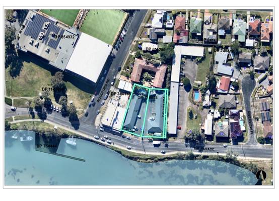
The
existing subdivision pattern and location of existing development within the
locality is shown in the following aerial photograph:
It is
also noted that mixed use redevelopment has been approved on the adjoining
property to the immediate west at No.1 to 3 The Parade under DA2020 - 1170.3
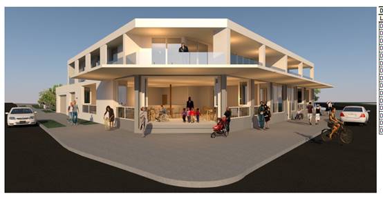
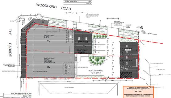
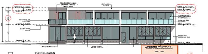
(as modified). Screenshots of parts of the development are shown below:
2. DESCRIPTION
OF DEVELOPMENT
Key
aspects of the proposal, as amended, includes the following:
· Alterations
and additions to the ground floor layout of the existing motel buildings
including new pool cabana and garage and store at rear of site.
· Addition
of first floor along the southern frontage of the site.
· Alteration of at grade parking.
The proposal
has also been amended during assessment towards the end of the assessment
process. The amendments have remove the following components and a comparison
of the 2 plans is shown below:
Original
plans - marked up to show what has been removed:
Current
amended plans showing changed additions at the rear of the site:
Refer
to Attachment 2 at the end of this report for the current amended plans of the
proposed development.
Application
Chronology
· 23
November 2021 - Application lodged.
· 29 November 2021 - Referral to NSW Natural Resource Access
Regulator
· 29 November 2021 - Referral to Essential Energy
· 9 December 2021 to 14 January 2022 - Public exhibition via
neighbour notification and advertising.
· 16 December 2021 - Essential Energy request for additional
information.
· 22 December 2021 - General Terms of Approval received from
NSW Natural Resource Access Regulator - Attachment 4
· 7 January 2022 - Additional information request from
assessing officer following preliminary review.
· 12 January 2022 - Part additional information response from
applicant.
· 1 March 2022 - Hydraulic and stormwater plans provided
lodged by applicant.
· 18 March 2022 - Response to Essential Energy request
lodged.
· 31 March 2022 - Essential Energy request for additional
information.
· 31 March 2022 - Applicant response to Essential Energy
request.
· 4 May 2022 - Essential Energy request for additional
information.
· 26 May 2022 - Applicant response to Essential Energy
request.
· 21 June 2022 - Essential Energy comments received.
· 28 July 2022 - Additional information requested from
applicant including recommending changes to additions proposed within the rear
setback.
· 4 August 2022 - Amended plans received.
3. STATUTORY
ASSESSMENT
Section
4.15(1) Matters for Consideration
In
determining the application, Council is required to take into consideration the
following matters as are relevant to the development that apply to the land to
which the development application relates:
(a) The
provisions (where applicable) of:
(i) Any
Environmental Planning Instrument
State Environmental Planning Policy (Biodiversity and
Conservation) 2021
Chapter 4 Koala Habitat Protection 2021
Clause 4.4 - This SEPP applies to all non-rural zoned land
within the Port Macquarie-Hastings Local Government Area.
Clause 4.10 - Having considered the SEPP, the
application and on completion of a site inspection, Council is not prevented
from granting consent in this case for the following reasons:
1. The property is not subject to a KPOM,
2. No koala food trees are proposed to be removed, and
3. The site not considered to be core koala habitat.
State Environmental Planning Policy (Resilience and
Hazards) 2021
Chapter 2 Coastal Management
Clause 2.5 - This SEPP prevails over the Port
Macquarie-Hastings LEP 2011 in the event of any inconsistency.
Having
regard to clause 2.8 (proximity to mapped coastal wetlands to the north-east of
the site) of this SEPP, the proposed development is not considered likely to
result in any of the following:
(a) identifiable
adverse impacts on the biophysical, hydrological and ecological integrity of
the nearby littoral rainforest/coastal wetland; and
(b) identifiable
impacts to water flows to the nearby littoral rainforest/coastal wetland.
The site is located within both a coastal use and coastal
environment area. Having regard to clauses 2.10 and 2.11 of the SEPP, the
proposed development is not considered likely to result in any of the
following:
a) any
adverse impact on integrity and resilience of the biophysical,
hydrological (surface and groundwater) and ecological environment;
b) any
adverse impacts coastal environmental values and natural coastal
processes;
c) any
adverse impact on marine vegetation, native vegetation and fauna
and their habitats, undeveloped headlands and rock platforms;
d) any
adverse impact on Aboriginal cultural heritage, practices and
places;
e) any
adverse impacts on the cultural and built environment heritage;
f) any
adverse impacts the use of the surf zone;
g) any adverse impact on the visual amenity and scenic qualities of the
coast, including coastal headlands;
h) any adverse overshadowing, wind funnelling and the loss of views from
public places to foreshores; and
i) any
adverse impacts on existing public open space and safe access to
and along the foreshore, beach, headland or rock platform for members of the
public, including persons with a disability.
The bulk, scale and size of the proposed development is
sufficiently compatible with the surrounding coastal and built environment. The
character of the approved mixed use development under DA2020 - 1170.3 (as
modified) to the immediate west is noted. The site is predominately cleared and
located within an area zoned for residential purposes.
Clause 2.12 - The proposal is not likely to cause increased
risk of coastal hazards on the land or other land.
Chapter 4 Remediation of Land
Clause 4.6 - Following an inspection of the site and a
search of Council records, the subject land is not identified as being
potentially contaminated and is suitable for the intended use.
State Environmental Planning Policy (Transport and
Infrastructure) 2021
Clause 2.48 - Development in proximity to electricity
infrastructure - Referral to Essential Energy has been undertaken and the
following comments received for consideration:
“Strictly based on the
revised documents submitted, Essential Energy makes the following comments as
to potential safety risks arising from the proposed development:
1. Essential Energy’s records
indicate that there are existing overhead powerlines located across the street
frontages of the properties:
a. The ASP calculations provided by Stowe
Australia state the closest part of the building to the HV and LV exceeds the
required clearances, under blowout conditions. Based on this report, the
proposal is satisfactory.
b. Minimum safety clearance requirements are to be maintained
at all times for the proposed driveways access and/or exit (concrete
crossovers), as such driveways access will pass under Essential Energy’s
existing overhead powerlines located at the front of the property. The driveway
must comply with clearances for trafficable land, ground clearances must be
maintained. Refer Essential Energy’s policy CEOM7106.25 Minimum Clearance
Requirements for NSW and the latest industry guideline currently known as ISSC 20 Guideline for the Management of Activities
within Electricity Easements and Close to Infrastructure.
c. Any
proposed driveway access and/or exit (concrete crossovers) must remain at least
1.0 metre away from any electricity infrastructure (power pole, streetlight) at
all times, to prevent accidental damage.
d. Any
excavation works in this area or works on the driveway must comply with ISSC 20
Guideline for the Management of Activities within Electricity Easements and
Close to Infrastructure.
e. Any
proposed landscaping or tree planting in this area must comply with ISSC 20
Guideline for the Management of Activities within Electricity Easements and
Close to Infrastructure.
Essential Energy also makes the
following general comments:
1. If the proposed development changes, there
may be potential safety risks and it is recommended that Essential Energy is
consulted for further comment.
2. Any existing encumbrances in favour of
Essential Energy (or its predecessors) noted on the title of the above
properties should be complied with.
3. In addition, Essential Energy’s
records indicate there is overhead and underground electricity infrastructure
located within the properties and overhead electricity infrastructure located
within close proximity of the properties. Any activities within these locations
must be undertaken in accordance with the latest industry guideline currently
known as ISSC 20 Guideline for the Management of Activities within Electricity
Easements and Close to Infrastructure. Approval may be required from Essential
Energy should activities within the properties encroach on the electricity
infrastructure.
4. Prior to carrying out any works, a
“Dial Before You Dig” enquiry should be undertaken in accordance
with the requirements of Part 5E (Protection of Underground Electricity Power
Lines) of the Electricity Supply Act 1995 (NSW).
5. Given
there is electricity infrastructure in the area, it is the responsibility of
the person/s completing any works around powerlines to understand their safety responsibilities.
SafeWork NSW (www.safework.nsw.gov.au) has publications that provide guidance when working close
to electricity infrastructure. These include the Code of Practice – Work
near Overhead Power Lines / Underground Assets.”
The above advice received from Essential Energy has been
forwarded the applicant for consideration. No further actions are required
noting the information submitted by the applicant during the assessment of the
application.
State Environmental Planning Policy (Industry and
Employment) 2021
Chapter 3 Advertising and Signage
The proposed development includes proposed signage in the
form of a business identification signage on the new boundary wall facing the
street. The existing pylon type sign is intended to be removed (refer to below
image).
Clause 3.5 - This SEPP prevails over the Port
Macquarie-Hastings LEP 2011 in the event of any inconsistency.
Clause 3.6 - The following assessment table provides an
assessment checklist against the Schedule 5 requirements of this SEPP:
|
Applicable clauses for consideration
|
Comments
|
Satisfactory
|
Schedule 5(1) Character of the
area.
|
The proposed sign identifying the motel is located on
the new front wall and is considered appropriate to the character of the
area, noting the adjoining motel and commercial uses.
|
Yes
|
|
Schedule 5(2) Special areas.
|
The site is located within a residential locality. The
signage is limited in scale.
|
Yes
|
|
Schedule 5(3) Views and vistas.
|
The sign is proposed to be attached to the new front
wall and would not obstruct any views or vistas.
|
Yes
|
|
Schedule 5(4) Streetscape, setting or landscape.
|
The scale and proportion of the sign is appropriate
for the setting.
|
Yes
|
|
Schedule 5(5) Site and building.
|
The dimensions of the sign is compatible with the
building and wall that it relates to.
|
Yes
|
|
Schedule 5(6) Associated devices and logos with
advertisements and advertising structures.
|
None proposed.
|
Yes
|
|
Schedule 5(7) Illumination.
|
The sign is proposed to be illuminated until midnight
each day. Having regard to the adjoining motel and commercial land uses and
the sign/wall orientation toward the street this is considered acceptable. No
adverse illumination impacts are identified. A condition has been recommended
enforcing the midnight curfew for illumination.
|
Yes
|
|
Schedule 5(8) Safety.
|
The location and design of the sign is not anticipated
to result in any adverse safety impacts.
|
Yes
|
State Environmental Planning Policy (Primary Production)
2021
Part 2.5 Division 4 - The proposed development will create
any identifiable adverse impacts to nearby oyster aquaculture development.
Port Macquarie-Hastings Local Environmental
Plan 2011
The proposal is consistent with the LEP having regard to the
following:
· Clause
2.2 - The subject site is zoned R1 General Residential.
· Clause
2.3(1) and the R1 zone landuse table - The proposal is for alterations and
additions to an existing ‘motel’ and ancillary caretaker’s
‘dwelling’. ‘Dwellings’ are permissible in the R1 zone.
‘Hotel and motel accommodation is defined as follows:
“hotel or motel
accommodation means a building or place (whether or not licensed premises under
the Liquor Act 2007) that provides temporary or short-term accommodation on a
commercial basis and that -
(a) comprises rooms or
self-contained suites, and
(b) may provide meals to
guests or the general public and facilities for the parking of guests’
vehicles,
but does not include
backpackers’ accommodation, a boarding house, bed and breakfast
accommodation or farm stay accommodation.
Note - Hotel or motel
accommodation is a type of tourist and visitor accommodation—see the
definition of that term in this Dictionary.”
‘Tourist and visitor
accommodation’ and more specifically ‘hotel or motel
accommodation’ are both a permissible landuse with consent in the R1
zone.
· The
objectives of the R1 zone are as follows:
o To provide for the housing
needs of the community.
o To provide for a variety of
housing types and densities.
o To
enable other land uses that provide facilities or services to meet the day to
day needs of residents.
· Clause
2.3(2) - The proposal is consistent with the zone objectives as it is a
permissible landuse and the zoning enables the expansion of an existing motel
facility that is sufficiently compatible with the surrounding residential
environment.
· Clause
2.7 - The part demolition work requires consent as it does not fit within the
provisions of SEPP (Exempt and Complying Development Codes) 2008.
· Clause
4.3 - The maximum overall height of the building above ground level (existing)
is 7.34m. This complies with the standard maximum height limit of 8.5m applying
to the site.
· Clause
4.4 - The gross floor area (GFA) of the proposal (as amended) is calculated to
be 853.8m2. The calculated floor space ratio (FSR) is 0.42:1. The FSR complies
with the maximum 0.65:1 FSR applying to the site.
· Clause
5.21 - The site is land located within a mapped “flood planning
area”. In this regard, the following comments are provided which
incorporate consideration of the objectives of Clause 5.21, Council’s
Flood Policy 2018, the NSW Government’s Considering Flooding in Land
Use Planning Guideline 2021 and the NSW Government’s Floodplain
Development Manual (2005):
o The proposal is sufficiently
compatible with the flood function and behaviour on the land particularly
noting the proposal is for alterations and additions to an existing facility;
o The proposal will not result
in any significant adverse effects on flood behaviour that would result in
detrimental increases in the potential flood affectation of other development
or properties;
o The proposal will not result
in any adverse effects on the safe occupation and efficient evacuation of
people along existing evacuation routes for the surrounding area;
o The
proposal will incorporate sufficient measures to minimise and manage the flood
risk to life and property associated with the use of land;
o The
proposal is not likely to significantly adversely affect the environment or
cause avoidable erosion, siltation, destruction of riparian vegetation or a
reduction in the stability of river banks or watercourses;
o The proposal is not likely to
result in unsustainable social and economic costs to the community as a
consequence of flooding;
o The proposal will not result
in any identifiable adverse impacts to flood behaviour as a result of projected
climate change;
o The intended design and scale
of the building additions are sufficiently compatible with the flooding risk on
the property;
o Adequate consideration has
been given to the modifying/altering the existing buildings to respond to the
flooding risk within the locality.
o The application is supported
by a flood impact assessment which has been reviewed by Council’s
Flooding Officer. A number of recommended consent conditions are proposed
having regard to Council’s Flood Policy.
· Clause
7.1 - The site is mapped as potentially containing class 3 acid sulfate soils.
The proposed development does not include any excavation extending 1m below the
natural surface level, therefore no adverse impacts are expected to occur to
the acid sulfate soils found on site.
· Clause
7.13 - Satisfactory arrangements are in place for provision of essential
services including water supply, electricity supply, sewer infrastructure,
stormwater drainage and suitable road access to service the development.
(ii) Any draft
instruments that apply to the site or are on exhibition
No draft instruments apply to
the site.
(iii) Any Development
Control Plan in force
Port
Macquarie-Hastings Development Control Plan 2013
|
DCP 2013: Part B - General Provisions - B1:
Advertising and Signage
|
|
DCP Objective
|
Development Provisions
|
Proposed
|
Complies
|
|
1
|
a) Signs primarily identifying
products or services are not acceptable, even where relating to products or
services available on that site.
|
A new business
identification sign is proposed on the front wall of the site. The sign is
satisfactory in design and scale.
|
Yes
|
|
b) Signage is not permitted
outside property boundaries except where mounted upon buildings and clear of
pedestrians and road traffic. No signage is permitted upon light or power
poles or upon the nature strip (the area between the property boundary and
constructed roadway). Limited directional signage and “A” frame
signage may separately be approved by Council under the Roads Act 1993 or
section 68 of the Local Government Act 1993.
|
Sign is located on the
front wall within the site’s boundary.
|
Yes
|
|
c) An on-building 'chalkboard'
sign, for the purpose of describing services or goods for sale which vary on
a regular basis generally should not be any larger than 1.5m2, and should
contain a sign written heading indicating the premises to which it refers.
|
None proposed.
|
N/A
|
|
d) On-premise signs should not
project above or to the side of building facades
|
The signage does not
project above the building facades.
|
Yes
|
|
2
|
a) Where there is potential
for light spill from signage in a non-residential zone adjoining or adjacent
to residential development, illuminated signage is to be fitted with a time
switch to dim by 50% or turn off the light by 11pm each night, depending on
the nature of the development.
|
The sign is proposed to be
illuminated until midnight each day. Having regard to the adjoining motel and
commercial land uses and the sign/wall orientation toward the street this is
considered acceptable. No adverse illumination impacts are identified. A
condition has been recommended enforcing the midnight curfew for
illumination.
|
Yes
|
|
DCP 2013: Part B - General Provisions - B2:
Environmental Management
|
|
DCP Objective
|
Development Provisions
|
Proposed
|
Complies
|
|
3
|
a) Development must comply with
Council’s Developments, Public Place & Events - Waste Minimisation
and Management Policy.
|
Appropriately sized bin
storage area proposed on the western side of the altered building. Private
waste collection arrangement proposed.
|
Yes
|
|
Cut and Fill Regrading
|
|
4
|
a) Development shall not
exceed a maximum cut of 1.0m and fill of 1.0m measured vertically above the
ground level (existing) at a distance of 1.0m outside the perimeter of the
external walls of the building (This does not apply to buildings where such
cut and fill is fully retained within or by the external walls of the
building).
|
No cut or fill >1m
proposed.
|
Yes
|
|
5
|
a) A certified practicing
structural engineer must certify any retaining wall greater than 1.0m.
|
No retaining walls
proposed.
|
N/A
|
|
b) Where a combination of a
fence and a wall is proposed to be greater than 1.2m high:
- be a
maximum combined height of 1.8m above existing property boundary level;
- be
constructed up to the front boundary for a maximum length of 6.0m or 30% of
the street frontage, whichever is less;
− the
fence component has openings which make it not less than 25% transparent; and
− provide
a 3m x 3m splay for corner sites, and
- provide a
900mm x 900mm splay for vehicle driveway entrances.
|
No retaining wall and front
fence combination proposed.
|
N/A
|
|
DCP 2013: Part B -
General Provision - B3: Hazards Management
|
|
DCP Objective
|
Development Provisions
|
Proposed
|
Complies
|
|
Flooding
|
|
19
|
a) Development must comply
with Council’s Floodplain Management Plan and Flood Policies.
|
Refer to detailed comments
under LEP heading earlier within this report.
|
Yes
|
|
DCP 2013: Part B- General Provisions- B4: Transport,
Traffic Management, Access and Car Parking
|
|
DCP Objective
|
Development Provisions
|
Proposed
|
Complies
|
|
Parking Provision
|
|
24
|
a) Off-street Parking is
provided in accordance with Table 3.
Hotel or motel
accommodation requires 1.1 per unit + 1 per 2 employees (onsite at any one
time) + 1 for on-site manager. If public restaurant/function room included -
see restaurants.
For major development,
coach parking may be provided in lieu of car spaces at a rate of 1 coach
space per 5 car spaces.
|
Calculations for required
off-street parking:
19 units = 20.9 spaces.
1 onsite manager = 1 space.
2 employees (cleaners) = 1
space.
Total required = 23 spaces
(rounded up from 22.9 spaces).
Proposed
parking provided =
22
spaces. 1 space short of current total calculations.
No
restaurant/function room or coach parking proposed or applicable.
|
No - refer to comments
below under Development Provision 25 which establishes an existing shortfall
which offsets the proposed parking shortfall.
|
|
b) Where a proposed
development does not fall within any of the listed definitions, the provision
of on-site parking shall be supported by a parking demand study.
|
N/A
|
N/A
|
|
c) Where a proposed
development falls within more than one category Council will require the
total parking provision for each category.
|
N/A
|
N/A
|
|
25
|
a) A development proposal to
alter, enlarge, convert or redevelop an existing building, whether or not
demolition is involved, shall provide the total number of parking spaces
calculated from the schedule for the proposed use, subject to a credit for
any existing deficiency, including any contributions previously accepted in
lieu of parking provision.
|
The existing and approved
motel provides for 16 units, managers residence and 17 off-street parking
spaces.
18.6 off-street spaces
would be calculated to be required to serve the existing motel. Therefore,
there exists a current 1.6 or 2 parking space (rounded up) deficiency.
Having regard to the 1
space shortfall identified and the proposed increase in off-street parking
from 17 to 22 parking spaces (including disabled spaces) the proposed
development will provide sufficient parking having regard to the existing
parking deficit.
|
Yes
|
|
26
|
a) On street parking, for the
purposes of car parking calculations will not be included unless it can be
demonstrated that:
− there
is adequate on street space to accommodate peak and acute parking demands of
the area;
− parking
can be provided without compromising road safety or garbage collection
accessibility;
− parking
can be provided without jeopardising road function; and
− that
streetscape improvement works, such as landscaped bays and street trees are
provided to contribute to the streetscape.
|
On street parking is not
being relied upon for the proposal. However, it is noted that the two current
driveway crossovers are being consolidated into a single crossover. This will
create an additional on street parking space within The Parade road
reservation.
|
Yes
|
|
b) On street parking is
provided in accordance with AS2890.5.
|
The proposal is not reliant
upon on street parking.
|
N/A
|
|
27
|
a) On street parking will not
be permitted unless it can be demonstrated that:
− parking
does not detract from the streetscape; and
− that
streetscape improvement works, such as landscaped bays and street trees are
provided.
|
The proposal is not reliant
upon on street parking.
|
N/A
|
|
Parking Layout
|
|
28
|
a) Visitor and customer
parking shall be located so that it is easily accessible from the street.
|
Proposed off-street parking
is easily accessible from the proposed driveway crossover directly onto The
Parade.
|
Yes
|
|
b) Internal signage (including
pavement markings) should assist customers and visitors to find parking and
circulate efficiently and safely through a car park.
|
Parking spaces will be
appropriately line marked. Suitable consent conditions recommended.
|
Yes
|
|
c) Parking spaces shall
generally be behind the building line but may be located between the building
line and the street when:
− it
is stacked parking in the driveway; or
− it
can be demonstrated that improvements to the open space provided will result;
and
− the
spaces are screened (densely landscaped or similar) from the street by a
landscaping with a minimum width of 3.0m for the entire length of the parking
area.
|
Parking spaces are located
behind the building line.
|
Yes
|
|
d) Parking design and layout
is provided in accordance with AS/NZS 2890.1 - Parking facilities -
Off-street car parking and AS 2890.6 - Off-street parking for individuals
with a disability and AS/NZS 2890.2 - Parking facilities - Off-street
commercial vehicle facilities.
|
Parking layout capable of
compliance with this Australian Standard. Condition recommended requiring
certification of design prior to Construction Certificate being issued.
|
Yes
|
|
e) Stack or tandem parking
spaces will not be included in assessment of parking provision
except where:
− the
spaces are surplus to that required;
− in
motor showrooms;
− for
home business;
− for
exhibition homes;
− in
car repair stations;
− staff
parking spaces are separately identified and delineated;
− it
is visitor parking associated with a dual occupancy multi dwelling and/or
terrace housing, directly in front of the garage with a minimum depth of
5.5m.
|
No stacked parking proposed
with amended plans.
|
N/A
|
|
29
|
a) Parking is provided in
accordance with AS/NZS 2890.1 - Parking facilities - Off-street car parking,
AS/NZS 2890.2 - Parking facilities - Off-street commercial vehicle
facilities, AS 1428 - Design for access and mobility and AS 2890.6 -
Off-street parking for individuals with a disability.
|
Parking layout incorporates
two disabled spaces and is capable of compliance with AS. Condition
recommended requiring certification of design prior to Construction
Certificate being issued.
|
Yes
|
|
30
|
a) Bicycle and motorcycle
parking shall be considered for all developments.
|
Areas exist onsite to
accommodate bicycle and motorcycle parking should it warranted however it is
noted that the proposal is for alterations and additions to an existing
facility.
|
Yes
|
|
b) Bicycle parking areas shall
be designed generally in accordance with the principles of AS2890.3 - Parking
facilities - Bicycle parking facilities.
|
Yes - capable
|
|
c) Motorcycle parking areas
shall be 1.2m (wide) x 2.5m (long).
|
Yes - capable
|
|
Redevelopment of Heritage
Items - Conservation Incentives
|
|
31
|
a) Council will consider
discounting (i.e. exclude from calculations) the floor space of the heritage
building/item when determining the total number of parking spaces to be
provided on site. This will be considered in line with clause 5.10 of PMH LEP
2011, which requires the variation to be considered in the context of a
heritage conservation management plan. This will only apply if Council is
satisfied that the conservation of the heritage item is dependent upon
Council making that exclusion. If applicants intend to seek such
consideration, a detailed parking analysis of the site is to be submitted
with the development application.
|
No heritage items or
buildings exist on the site.
|
N/A
|
|
Section 7.11 Development
Contributions
|
|
32
|
a)
Section 7.11 of the Environmental Planning and Assessment Act 1979 permits
Council, at its discretion, to accept a monetary contribution in lieu of
on-site parking where it is considered impractical or undesirable to provide
parking facilities on the site of the proposed development. Generally,
contributions will not be accepted for the total amount of parking to be
provided and will only be accepted in the commercial areas of Port Macquarie,
Gordon Street, Laurieton, North Haven and Wauchope, as identified in
Council's Contribution Plan 1993, as amended. Contribution rates are indexed
(CPI) each quarter with variations in the contribution rate for each area.
Applicants are advised to consult Council's staff at the time of preparing
the DA application should a contribution for parking be proposed.
|
The site is not located
within an area to which a parking contributions plan applies which could
require consideration.
|
N/A
|
|
Landscaping of Parking
Areas
|
|
33
|
a) Landscaping areas shall be
provided in the form of large tree planting, understorey plantings, mulch
areas, mounding, lawns and the like
|
Adequate landscaping is
proposed along the street frontage. The main off-street parking is located
behind the main building façade.
|
Yes
|
|
b) Landscaping areas shall be
used throughout the car park and on the perimeters of the property where it
addresses the public domain.
|
Adequate landscaping is
proposed along the street frontage.
|
|
|
c) Garden beds shall be a
minimum of 3m in width between car parking areas and street boundaries.
|
Adequate front wall and
landscaping treatments to the one parking space alongside the manager
residence.
|
Yes
|
|
34
|
a) All plantings on public
lands are to be selected from Council’s Indigenous Street and Open
Space Planting List from the relevant vegetation community adjacent to the
Development.
|
No plantings proposed on
public lands.
|
N/A
|
|
b) Trees are to be grown and
installed in accordance with AS 2303:2015 Tree Stock for Landscape Use and
Council’s AUS-SPEC design specifications.
|
No plantings proposed on
public lands.
|
N/A
|
|
|
Surface Finishes
|
|
|
|
35
|
a) All parking and manoeuvring
areas shall be constructed with a coarse base of sufficient depth to suit the
amount of traffic generated by the development, as determined by Council. It
shall be sealed with either bitumen, asphaltic concrete, concrete or
interlocking pavers.
Preliminary details of
construction materials for access and car parking areas shall be submitted
with the development application. Detailed plans shall be prepared for the
construction certificate by a practising qualified Civil Engineer.
|
Off-street parking to be
concrete finish. Suitable recommended consent condition to reinforce.
|
Yes
|
|
b) In special cases (e.g.
where traffic volumes are very low) Council may consider the use of
consolidated unsealed gravel pavement for car parks. However, this should not
be assumed and will need to be justified by the applicant at the Development
Application stage.
|
N/A
|
N/A
|
|
|
Drainage
|
|
|
|
36
|
a) All parking and manoeuvring
spaces must be designed to avoid concentrations of water runoff on the
surface.
|
Stormwater from parking and
hardstand area is capable of being managed onsite.
|
Yes
|
|
b) Council will not permit the
discharge of stormwater directly into kerbing and guttering or table drains
for any development other than that of a minor nature.
|
Discharge to pit in The
Parade required. Stormwater management plan required prior to issue of a
Construction Certificate.
|
Yes
|
|
37
|
a) Car parking areas should be drained to swales, bio
retention, rain gardens and infiltration areas.
|
Storm water capable of
being managed, noting existing arrangement.
|
Yes
|
|
|
|
|
|
|
DCP 2013: Part B -
General Provisions - B5: Social Impact Assessment and Crime Prevention
|
|
DCP Objective
|
Development Provisions
|
Proposed
|
Complies
|
|
Social Impact Assessment
|
|
42
|
a) A social impact assessment
shall be submitted in accordance with the Council’s Social Impact
Assessment Policy.
|
The redevelopment of the
existing motel to provide 3 additional units does not warrant a separate
social impact assessment.
|
N/A
|
|
Crime Prevention
|
|
43
|
a) The development addresses
the generic principles of crime prevention:
- Casual surveillance and
sightlines;
- Land use mix and
activity generators;
- Definition of use and
ownership;
- Basic exterior building
design;
- Lighting;
- Way-finding; and
- Predictable routes and
entrapment locations;
- as described in the
Crime Prevention Through Environmental Design (CPTED) principles.
|
No concealment or entrapment areas proposed. Adequate
casual surveillance available.
Entrances are clearly defined and manager’s residence
noted to be maintained on the site.
|
Yes
|
|
DCP 2013: PART C - Development Specific Provisions -
C2: Residential Flat Development, Tourist and Visitor Accommodation, and
Mixed Use Development
|
|
DCP Objective
|
Development Provisions
|
Proposed
|
Complies
|
|
Site Design and Analysis
|
|
57
|
a) A site analysis plan is required for all development
and should illustrate:
- microclimate including
the movement of the sun and prevailing winds
- lot dimensions
- north point
- existing contours and
levels to AHD
- flood affected areas
- overland flow patterns,
drainage and services
- any contaminated soils
or filled areas, or areas of unstable land
- easements and/or
connections for drainage and utility services
- any existing trees and
other significant vegetation, including major and significant trees on
adjacent properties, particularly those within 9 m of the site
- the location, height
and use of buildings surrounding the site, and those across any road adjacent
to the site, including their setback distances
- heritage and
archaeological features
- the built form, scale
and character of surrounding and nearby development, including fencing,
boundaries and landscaping
- pedestrian and vehicle
access
- views and solar access
to surrounding residents
- private open space and
windows of habitable rooms of nearby properties which have an outlook to the
site
- difference in levels
between the site and adjacent properties at their boundaries
- street frontage features
including poles, trees, kerb crossovers, bus stops and other services
- heritage features and
buildings of the surrounding locality and landscape
- direction and distance
to local facilities including local shops, schools, public transport and
recreation and community facilities
- characteristics of, and
distance to any nearby public open space
- any nearby bushland or
environmentally sensitive land
- any significant local
noise, odour or pollution sources
- any other notable
features or characteristics of the site
|
Plans, surveys and supporting documentation lodged
provides sufficient site analysis and details.
|
Yes
|
|
Site Layout
|
|
58
|
a) All applications are to include a site plan, which
annotates the manner in which site attributes and constraints have been
considered, as follows:
- appropriateness of
built form and landscape in relation to the site context, topography and
urban character
- building arrangement
and relationship to streets and open space
- access ways within and
beyond the site
- location, function and
opportunities for casual surveillance of open space
- ongoing site management
considerations (i.e. garbage, mail collection, stormwater etc)
- location of existing
and proposed stormwater and sewer pipes
- private open space and
security
- parking arrangements
and reduced dominance of driveways
- heritage and
conservation opportunities and constraints (where relevant)
- energy efficiency in
building design and siting
- solar access to subject
development and adjoining residences
|
Adequate site plan with details provided.
|
Yes
|
|
Streetscape and Front Setback
|
|
59
|
a) In an established street, the primary setback should be
within 20% of the average setback of the adjoining buildings in a R1 General
Residential zone.
|
Adjoining building to the west
On the corner of The Parade and Woodford Road this
building has a zero metre front setback. It is a mixed use commercial
building operating under existing use rights. It is considered that the 20%
control can also be applied to this proposed building notwithstanding is
commercial nature.
Adjoining building to the east
This building is also a motel building which has an
approximate 4.5m front setback.
Proposed front setback
The western-most front setback of the building additions
is proposed at a minimum 3.75m.
The front setback increases for the central and
eastern-most frontages to a maximum 5.218m.
The front setbacks proposed are within 20% of the 4.5m
setback and not dissimilar for the eastern section of the building to front
setbacks of other existing dwelling further to the east.
|
Yes
|
|
b) A minimum setback of 3.0m is required from all street
frontages in a R3 Medium Density Residential and R4 High-Density Residential
zone.
|
The site is within the R1 zone and this control does
therefore not apply.
|
N/A
|
|
c) Where tourist accommodation is proposed a maximum
setback of 9 metres is permitted to allow for a swimming pool within the
front setback.
|
Swimming pool is existing and will remain in the
north-western corner of the site.
|
N/A
|
|
60
|
a) Balconies and other building extrusions may encroach up
to 600mm into the required front setback.
|
Balconies are proposed on the front of the building
however are setback within the 20% recommend provision and this provision
strictly does not require further consideration.
|
N/A
|
|
b) Buildings should generally be aligned to the street
boundary.
|
The building design satisfactorily responds to and aligns
with the angle in the front boundary.
|
Yes
|
|
c) Primary openings on all developments are aligned to the
street boundary or to the rear of the site.
|
Open courtyard and balconies areas are aligned to the
street boundary.
|
Yes
|
|
Side and Rear Setbacks
|
|
61
|
a) The following setbacks (Refer Figure 7) apply to all
sites, except where the side boundary is a secondary street frontage:
- Buildings should be set
back a minimum of 1.5m from side boundaries, for a maximum of 75% of the
building depth.
- Windows in side walls
should be set back 3m from side boundaries.
- Where the site is
adjacent to an existing strata-titled building, buildings should be set back
a minimum of 3m from side boundaries.
|
West side setbacks
Min. 2.34m to main part of building additions.
1.14m west side setback to first floor stair access and
landing.
East side setbacks
Min. 2.8m setback to ground and first floor.
|
Yes
No* minor variation which is acceptable noting the
adjoining mixed use development.
Yes
|
|
b) Side walls adjacent to existing strata-titled buildings
should be articulated and modulated to respond to the existing buildings.
|
N/A
|
N/A
|
|
c) A minimum rear setback of 6.0m from the building and
sub basements is required.
|
North rear setback
The existing motel building has a 3.68m rear setback and a
cabana exists where the proposed garage and store area is proposed.
Additions at the rear are limited to a single storey
garage and storage room area. A minimum 1m rear setback is proposed to the
closest point increasing to a 2.7m rear setback on the north-east corner of
the store room and part of the garage. A pool cabana is proposed in the north-western
corner of the site (relocated cabana).
|
No* Variation considered acceptable for the
reasons/details beside. The objects of the rear setback are achieved.
It is also noted that separate ancillary shed structures
are permitted in a R1 zone with a 0.9m rear setback (refer to section 46b of
the DCP)
|
|
62
|
a) A party wall development may be required if site
amalgamation is not possible and higher density development is envisaged by
these controls.
|
N/A
|
N/A
|
|
63
|
a) Party wall development can occur only with the
agreement and consent of the adjoining property owner. Exposed party
walls should be finished in a quality comparable to front facade finishes
|
N/A
|
N/A
|
|
64
|
a) Corner sites should be consolidated with adjacent
sites, so that the building turns the corner.
|
N/A
|
N/A
|
|
b) If this is not possible, a minimum setback of 6.0m
should extend to the secondary street. Refer Figure 8 and Figure 9.
|
N/A
|
N/A
|
|
65
|
-
a) Where sites adjacent to open space are to be developed, the
edge of the open space should be defined with a public road and buildings
should address the open space.
|
Alterations and additions to existing building fronting a
public road on Camden Haven River foreshore.
|
N/A
|
|
Deep Soil Zone (only applicable to non-SEPP 65
buildings)
|
|
66
|
a) Deep soils zones are to meet the minimum requirements
set out in Table 5.
|
Existing site does not provide for required deep soil
zone. The proposal is for alterations and additions to an existing facility.
|
N/A
|
|
b) Deep soil zones are to be contiguous across sites and
within blocks. Refer to Figure 9.
|
N/A
|
N/A
|
|
67
|
-
a) Deep soil zones should accommodate existing advanced trees,
and allow for advanced tree planting.
|
N/A
|
N/A
|
|
68
|
a) Deep soil zones should be integrated into the
stormwater management measures for the development and the site.
|
N/A
|
N/A
|
|
Energy Conservation and Solar Access (only applicable
to non-SEPP 65 buildings)
|
|
69
|
a) Where practical, sunlight to the principal area of
ground-level private open space of adjacent properties should not be reduced
to less than 3 hours between 9.00am and 3.00pm on June 22. Where existing
overshadowing by buildings and fences is greater than this, sunlight should
not be reduced by more than 20%.
|
Shadow diagrams submitted which satisfactorily demonstrate
no adverse shadowing to neighbouring properties. It is noted that no
properties exist to the south of the site.
|
Yes
|
|
b) Where practical, buildings should not reduce the
sunlight available to the windows of living areas that face north in existing
adjacent dwellings to less than the above specification.
|
N/A
|
|
70
|
a) Apartments are to provide an internal clothes drying
space to discourage the use of mechanical clothes drying. Refer to Figure 10.
|
No new residential apartments proposed
|
|
|
Landscaping (only applicable to non-SEPP 65 buildings)
|
|
71
|
Plans for the design and planting of open space areas
should be submitted with the development application and include:
a) Existing vegetation and proposed general planting and
landscape treatment (including species).
b) Design details of hard landscaping elements and major
earth cuts, fills and any mounding.
|
Landscaping plan submitted is satisfactory particularly
noting that the proposal is for alterations and additions to an existing
motel facility.
|
Yes
|
|
d) Location and design of any communal recreational
facilities, including methods of protecting the privacy of nearby dwellings,
where applicable.
|
N/A
|
N/A
|
|
e) Street trees in accordance with Council's Indigenous
Street and Open Space Planting List.
|
N/A
|
N/A
|
|
72
|
a) Existing vegetation is to be retained and habitat and
ecology enhanced where practical.
|
There is no vegetation on the site with potential habitat
or ecological value. It is noted that the line of established palms at the
rear of the existing swimming pool are to be retained and new satisfactory
landscaping proposed across the street frontage.
|
Yes
|
|
73
|
a) Street trees are to be provided along the full
frontage/s of the site, generally at a rate of 1 per 20m interval, in
accordance with Council's Indigenous Street and Open Space Planting List.
|
No street trees proposed or required.
|
N/A
|
|
Private Open Space (only applicable to non-SEPP 65
buildings)
|
|
74
|
a) All dwellings at ground floor level are encouraged to
have a total minimum area of 15m2 in one area with minimum dimension of 3m:
- have a maximum grade of
5%; and
- be directly accessible
from a ground floor living area.
|
No dwellings proposed however a modified/altered
caretaker’s residence is proposed. Satisfactory private open space is
available to this dwelling.
|
Yes
|
|
b) Private open space may include clothes drying and
garbage storage areas.
|
N/A
|
N/A
|
|
75
|
a) Dwellings located on or above the first floor are to
have balconies with a minimum clear, unobstructed area and width according to
apartment type as follows:
- Studio - 4m2
- 1 bedroom - 8m2,
minimum 2m wide
- bedroom - 10m2, minimum
2m wide
- bedroom - 12m2, minimum
2.4m wide
|
N/A
|
N/A
|
|
76
|
a) Communal open space and private open spaces are
separated by landscaping, fencing or some other means that indicates the
change between public and private realm.
|
N/A
|
N/A
|
|
Fences and Walls
|
|
77
|
a) Solid front fences built on or near boundaries should
be:
- setback 1.0m from the
front boundary;
- suitably landscaped to
reduce visual impact, and.
- provide a 3m x 3m splay
for corner sites.
|
1.2m high rendered and painted walls are proposed across
the frontage of the site setback 1.0m from the southern front boundary.
|
Yes
|
|
b) Front fences proposed to
be more than 1.2m high should:
- be a
maximum of 1.8m in height, above existing front property boundary level and
either:
o include
landscaped recesses having minimum dimensions of 1.8m long x 900mm deep which
occupy no less than 50% of the total length of the fence, or
o be erected up
to the front boundary for maximum lengths of 6.0m or 50% of the street
frontage, whichever is less; and
o have openings which make it
not less than 25% transparent;
o provide a 3m x 3m splay for
corner sites, and
o provide a 900mm x 900mm
splay for vehicle driveway entrances.
|
Front fences limited to 1.2m in height.
|
Yes
|
|
78
|
a) Fences constructed of chain wire, solid timber or
masonry and solid steel are not permitted along the primary road frontage
even if it is consistent with the existing streetscape.
|
Solid fence limited to 1.2m in height which is acceptable.
|
N/A
|
|
Acoustic Privacy
|
|
79
|
a) Buildings are designed so that:
- busy noisy areas within
the apartment face the street; and
- quiet areas face the
rear or side of the lot
- bedrooms have line of
sight separation of minimum 3m from parking areas, streets and shared
driveways.
|
Building additions are primarily orientated towards the
street.
|
Yes
|
|
b) Openings of adjacent dwellings should be separated by a
distance of at least 6m.
|
No new openings on the eastern and west elevations of the
additions on the first floor.
|
Yes
|
|
80
|
a) Uses are to be coupled internally and between
apartments i.e. noisy internal and noisy external spaces should be placed
together. Refer to Figure 11.
|
N/A - motel units proposed
|
N/A
|
|
Visual Privacy (only applicable to non-SEPP 65
buildings)
|
|
81
|
a) Direct views between living area windows of adjacent
dwellings should be screened where:
- ground and first floor
windows are within a 9m radius from any part of the window of the adjacent
dwelling;
- other floor windows are
within a 12m radius;
- direct views from
living rooms of dwellings into the principal area of private open space of
other dwellings should be screened or obscured where they are within a 12m
radius.
|
No direct views from additions to primary living room or
primary outdoor areas of neighbouring residential dwellings within 12m of the
buildings.
|
Yes
|
|
b) Direct views described above may be reduced or obscured
by one of the following measures (details to be submitted with the
development application):
- 1.8m high fence or wall
between ground-floor level windows or between a dwelling and open space;
- Screening that has 25%
openings (max), is permanently fixed and is made of durable materials.
|
No privacy measures required.
|
N/A
|
|
c) A window in a dwelling(s) should have a privacy screen
if:
- It is a window in a
habitable room, other than a bedroom, that has a floor level of more than 1m
above ground level (existing), and
- The wall in which the
window is located has a setback of less than 3 metres from a side or rear
boundary, and
- The window has a sill
height of less than 1.5m.
|
No privacy measures required.
|
N/A
|
|
d) A balcony, deck, patio, pergola, terrace or veranda
should have a privacy screen if it:
- Has a setback of less
than 3m from a side or rear boundary, and
- Has a floor area more
than 3m2, and
- Has a floor level more
than 1 metre above ground level (existing).
|
No privacy measures required.
|
N/A
|
|
Accessibility
|
|
82
|
a) Developments should be designed in accordance with
Australian Standard AS1428.
|
Development is capable of compliance with Australian
Standard AS1428. It is noted that further assessment and detail will be
required at Construction Certificate stage.
|
Yes - capable.
|
|
83
|
a) Barrier free access to at least 20% of dwellings in the
development is provided.
|
No new dwellings proposed. Existing caretakers dwelling
only to be increased in size. Remaining units are for tourist purposes only.
|
N/A
|
|
Social Dimensions and Housing Affordability
|
|
84
|
a) Developments should be located close to areas of open
space, recreation and entertainment facilities and employment areas.
|
Proposal is for alterations and additions to an existing
motel facility which is suitably located.
|
Yes
|
|
b) Where the Local Environmental Plan permits a floor
space ratio greater than 1:1 a ratio of not less than 1:1 should be achieved.
|
The maximum FSR permitted on the site is 0.65:1 which is
less than the prescribed 1:1 provision.
|
N/A
|
|
85
|
a) A variety of apartment types including studio, 1, 2, 3
and 3+ bedroom apartments are provided within the development.
|
Motel units only proposed.
|
N/A
|
|
b) Studios and 1-bedroom apartments are not to exceed 20%
of the total number of apartments within the development.
|
Motel units only proposed.
|
N/A
|
|
c) A mix of 1 and 3 bedroom apartments are provided on the
ground level to cater for improved accessibility for disabled, elderly people
or families with children.
|
Motel units only proposed.
|
N/A
|
|
86
|
a) Developments should consider the principles of the
Council’s Affordable Housing Strategy in any application for a
residential flat building.
|
Motel units only proposed. Caretakers dwelling maintained.
|
N/A
|
|
Roof Form
|
|
87
|
a) Lift over-runs and service plants should be integrated
within roof structures.
|
No lift over-runs or service plant proposed.
|
N/A
|
|
b) Outdoor recreation areas on flat roofs should be
landscaped and incorporate shade structures and wind screens to encourage
use.
|
No rooftop outdoor recreation areas proposed.
|
N/A
|
|
c) Outdoor roof areas should be oriented to the street.
|
N/A
|
|
d) Roof design should generate an interesting skyline and
be visually interesting when viewed from adjoining developments.
|
The design of the additions will be visible particularly
from the properties to the north at No.2 Woodford Road. The roof design
adopted for the first floor additions is of a modern architectural style and
setback approximately 32m from the rear boundary.
The building is 1.16m below the 8.5m standard maximum
building height envelope. Whilst the roof design is relatively flat, the
height and design of the building additions with the rooved terrace areas
provide sufficient relief to the built form to not result in an adverse
skyline or adverse visual impacts to neighbouring properties to warrant
refusal of the application.
There are no roof design precinct character controls in
place.
|
Yes
|
|
Facade Composition and Articulation
|
|
88
|
a) Facade composition should:
- be designed with a
balance of horizontal and vertical elements;
- respond to
environmental and energy needs, such as sun shading, light shelves and bay
windows;
- incorporate wind
mitigation;
- reflect the uses within
the buildings.
- include a combination
of the following design elements:
o defined base, middle and top
levels;
o a mixture of window types;
o variation in floor height
(particularly at lower levels);
o balustrade detail that
reflects the type and location of the balcony;
o setting back the top levels
of the building;
o street level features that
reinforce the human scale; and
o balconies, awnings and
recesses that create shadowing.
|
The applicant has stated that the façade of the
building has been designed to provide a dynamic, attractive addition to the
street whilst responding to the neighbouring buildings.
The building has been designed to provide a satisfactory
mixture of design elements to provide satisfactory street address.
|
Yes
|
|
Entries and Corridors (only applicable to non-SEPP 65
buildings)
|
|
89
|
a) Entrances should be clearly identifiable from street
level.
|
Entrances clearly defined.
|
Yes
|
|
b) Entries should provide a clear line of transition
between the public street, the shared private circulation spaces and the residential
apartments.
|
No residential apartments proposed.
Manager’s residence satisfactorily addresses the
street and is noted to be an alteration and addition to an existing residence
with similar side access arrangements.
|
Yes
|
|
c) Entries should provide clear line of sight between one
circulation space and the next.
|
Altered entrances to the motel are satisfactory.
Appropriate lighting will be provided.
|
Yes
|
|
d) Entries should avoid ambiguous and publically
accessible small spaces in entry areas.
|
Yes
|
|
e) Entries should be sheltered and well lit.
|
Yes
|
|
f) Entries and circulation spaces should be sized
appropriately to encourage adequate area for the movement of furniture.
|
No residential apartments proposed that require assessment
consideration of common circulation areas.
|
N/A
|
|
g) Lobby widths should be a minimum of 1.8m wide and 3.0m
high.
|
N/A
|
|
h) Lobby lengths should be minimised and avoid tight
corners.
|
N/A
|
|
i) Longer lobbies should be articulated by:
- changing the direction
or width of a corridor;
- using a series of foyer
areas;
- providing windows along
or at the end of corridor.
|
N/A
|
|
Balconies (only applicable to non-SEPP 65 buildings)
|
|
90
|
a) A minimum of one balcony (including enclosed balcony or
terrace) is to be provided per apartment.
|
Ground and first floor outdoor terraces proposed for the
caretaker’s residence which are satisfactory.
All other units are motel units.
|
Yes
|
|
b) The main balcony is to be directly accessible from the
living area.
|
Terraces for the caretaker’s unit area accessible
directly from the internal living room areas.
|
Yes
|
|
c) The balconies should be designed to take advantage of
favourable climatic conditions.
|
Terraces for caretaker’s residence satisfactorily
positioned to take advantage of climate.
|
Yes
|
|
d) Balconies and balustrades should be designed to balance
views out of the building while affording adequate privacy to the residents
of the apartment.
|
No adverse privacy impacts from terraces identified.
|
Yes
|
|
91
|
a) Balconies should include sunscreens, pergolas, shutters
and operable walls.
|
No privacy mitigation required.
|
N/A
|
|
b) Balconies should be recessed to provide shadowing to
the facade of the building to create visual interest and articulation.
|
Terrace balconies are recessed into the new first floor
motel units.
|
Yes
|
|
c) Solid balustrades are discouraged but may be considered
where it is demonstrated that outlook and privacy is achieved and that there
is sufficient articulation or visual interest in the building facade to
accommodate the solid element.
|
Glass balustrades proposed.
|
Yes
|
|
Laundries and Clothes Drying Facilities
|
|
92
|
a) Secure open air clothes drying facilities that:
- are easily accessible;
- are screened from the
public domain and communal open spaces; and
- have a high degree of solar
access.
|
There is opportunity for an external clotheslines to be
installed within the eastern side setback for use by the residents of the
caretaker’s residence.
|
Yes - achievable.
|
|
Mailboxes
|
|
93
|
a) Mailboxes should be integrated into building design and
sighted to ensure accessibility and security.
|
Mailbox/es capable of being provided within front setback.
Multiple mailboxes not required as the proposal is predominantly motel units.
|
Yes
|
|
Safety and Security
|
|
94
|
a) Developments should establish a hierarchy of space and
clearly define the transition from public through to private space.
|
Development will satisfactorily establish a hierarchy of
space and clearly define the transition from public through to private space.
|
Yes
|
|
b) Entrances should:
- be orientated towards
the public street and encourage visibility between entrances, foyers and the
street.
- provide direct and
well-lit access between car parks and dwellings, between car parks and lift
lobbies, and to all unit entrances.
- optimise security by
grouping clusters to a maximum of eight, around a common lobby.
|
The
building entry is oriented to the street & is clearly visible from the
street.
Limited
concealment areas and appropriate lighting can be provided.
|
Yes
|
|
c) Surveillance is to be facilitated by:
- views over public open
spaces from living areas where possible.
- casual views of common
internal areas, such as lobbies and foyers, hallways, recreation areas, and
car parks.
- the provisions of
windows and balconies.
- separate entries to
ground level apartments
|
Yes
|
|
d) Concealment should be avoided by:
- preventing blind or
dark alcoves which might conceal intruders particularly near lifts and
stairwells, at the entrance and within indoor car parks, along corridors and
walkways.
- providing appropriate
levels of illumination for all common areas.
- providing graded car
park illumination, with the lighting of entrances higher than the minimum
acceptable standard.
|
Yes
|
|
e) Access to all parts of the building (including,
apartments, different floors, balconies, common areas) is to be controlled.
|
Yes
|
|
Site Storage (only applicable to non-SEPP 65 buildings)
|
|
95
|
a) Accessible storage facilities provided as part of the
basement or garage area should be secure and only accessible to the unit
tenant.
|
No basement storage however nominated storage area located
within rear new combined garage and store building.
|
Yes
|
|
b) One dedicated bike storage space should be provided per
dwelling as part of the basement, garage area or dwelling area.
|
Bicycle parking can be provided for the caretaker’s
dwelling.
|
Yes
|
|
Utilities
|
|
96
|
a) Compatible public utility services are to be
co-ordinated in common trenching in order to minimise excavations for
underground services.
|
Common utilities can be satisfactorily provide for.
|
Yes
|
|
b) Above ground utility infrastructure such as
substations, inspection cabinets are to be integrated into the design of the
building or complementary to the building design in terms of colour,
materials and design.
|
Yes
|
|
c) The site and the individual dwellings are to be
numbered for easy identification by visitors and emergency personnel.
|
Yes
|
|
d) Common aerials and satellite dishes, with signal
amplifiers are provided as appropriate.
|
Yes
|
(iiia) Any planning agreement that has
been entered into under section 7.4, or any draft planning agreement that a
developer has offered to enter into under section 7.4
No planning agreement has been
offered or entered into.
(iv) Any
matters prescribed by the Regulations
Clause
61 - Demolition of buildings AS 2601
The proposed demolition work is
capable of compliance with the standard. Suitable standard demolition consent
condition recommended.
Clause 64 - Fire safety
The proposed development will
need to provide fire safety requirements consistent with the Building Code of
Australia. These matters can be addressed with the application for a
Construction Certificate.
(b) The likely
impacts of that development, including environmental impacts on both the
natural and built environments, social and economic impacts in the locality
Context and Setting
The site has a general street frontage orientation to The
Parade.
Adjoining the site to the north is a two storey unit
building.
Adjoining the site to the east are motel and apartment
buildings comprising single and two storey buildings.
Adjoining the site to the south is a road, being The Parade.
A small inlet and the Camden Haven River is beyond the road.
Adjoining the site to the west is a single and two storey
commercial building which is built over two lots on the corner of The Parade
and Woodford Road.
The proposal will not have any significant adverse impacts
to existing adjoining properties and satisfactorily addresses the public
domain.
The proposal is considered to be compatible with other
development in the locality and adequately addresses planning controls for the
area.
View sharing
Public submissions have been received from neighbouring
properties/units at the neighbouring No.2 Woodford Road (known as Riverview
Court) raising view sharing impacts of the Camden Haven River and foreshore due
to the additions proposed. A summary of the view sharing issues raised is
provided in the submissions section later in this report. The location of 2
Woodford Road relative to the development site is shown in the following aerial
photo. The highlighted yellow areas relate to Units 1, 5, 6 and 10. Units 6 and
10 are located on the top floor level. Units 1 and 5 are located on the level
below:
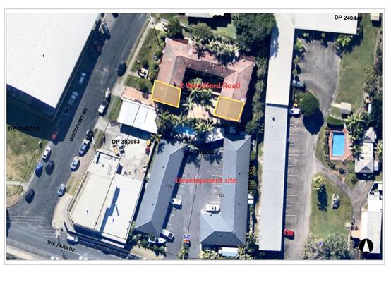
The notion of view sharing is invoked when a property enjoys
existing views and a
proposed development would share that view by taking some of
it away for its own
enjoyment. Taking it all away cannot be called view sharing,
although it may, in some circumstances, be quite reasonable.
NSW Land and Environment Court caselaw in particular the
case Tenacity Consulting v Warringah 2004 NSW LEC 140 sets an
established ‘planning principle’ to provide an assessment
methodology as to what constitutes view sharing and a stepped approach to
identifying whether reasonable view sharing is maintained or achieved. The
following four (4) steps are of relevance and
assessment comments are provided in regards to potential view impacts to the
neighbouring properties at No.2 Woodford Road (under each step):
Step 1 Assessment of views to be affected.
Water views are valued more highly than land views.
Iconic views (e.g. of the Opera House, the Harbour Bridge or North Head) are
valued more highly than views without icons. Whole views are valued more highly
than partial views, e.g. a water view in which the interface between land and
water is visible is more valuable than one in which it is obscured.
Comments: There is an existing 3 level
residential flat building at the northern neighbouring property at No.2
Woodford Road (known as Riverview Court). There are 10 existing units in the
building under a strata ownership arrangement. Several of these units at this
address have been identified to enjoy water views of the Camden Haven River
across the subject site. These views are considered and raised in the
submissions received to be highly valued. The views are not considered to be
iconic views. The views of the Camden Haven River looking south are considered
to be whole views including views of the interface of the river foreshore and
water except for where the existing motel structures currently partly obscure
the land and water interface.
Example photo extracts from submissions received and real
estate photos show the extent of existing views across the site:
View from Unit 10/2 Woodford Road main living space
internally within unit (submission photo):
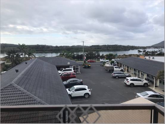
Photo of views more south-west
to North Brother Mountain in the distance from Unit 6/2 Woodford Road (real
estate online):
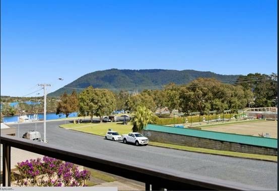
Photo of views across the site
from Unit 6/2 Woodford Road (real estate online):
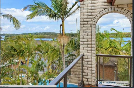
Photo of views more south-west
to North Brother Mountain in the distance from Unit 1/2 Woodford Road (real
estate online):
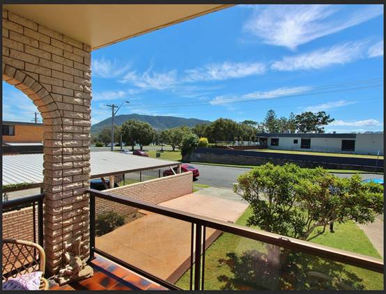
Photo of views across the site
from Unit 1/2 Woodford Road (real estate online):
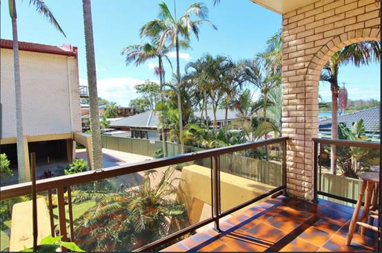
Photo of views across the site
from Unit 5/2 Woodford Road (real estate online):
Photo of views across the site
from Unit 5/2 Woodford Road (real estate online):
Applicant submitted photo of
the site looking back to the subject residential flats with views:
Submission showing photo of the
site looking north from The Parade:
Step 2 Consider from what part of the property the
views are obtained.
For example, the protection of views across side
boundaries is more difficult than the protection of views from front and rear
boundaries. In addition, whether the view is enjoyed from a standing or sitting
position may also be relevant. Sitting views are more difficult to protect than
standing views. The expectation to retain side views and sitting views is often
unrealistic.
Comments: The views from several units at No.2
Woodford Road are orientated across a side boundary of across the development
site. The assumed river views can be achieved based on submission photos and
real estate listings from sitting and standing positions in main living areas
and balconies. The angles of view relative to assumed key living areas in
existing units at No.2 Woodford Road are at a level which any additional
building height on the site would compromise the quality of the whole views of
the Camden Haven River.
Step 3 Assess the extent of the impact.
This should be done for the whole of the property, not
just for the view that is affected. The impact on views from living areas is
more
significant than from bedrooms or service areas (though
views from kitchens are highly valued because people spend so much time in
them). The impact may be assessed quantitatively, but in many cases this can be
meaningless. For example, it is unhelpful to say that the view loss is 20% if
it includes one of the sails of the Opera House. It is usually more useful to
assess the view loss qualitatively as negligible, minor, moderate, severe or
devastating.
Comments: The view loss will be for the
majority of the width of the subject site with the top of the building assumed
to be proposed to just above the sag points in the lower powerlines which can
be seen in the above photo. The view losses of the Camden Haven River and
foreshore qualitatively ‘severe’. It is noted that there will be
some limited views of the Camden Haven River for some units retained further
abroad to the south-west towards North Brother Mountain and limited views south-east
either side of the development site.
Step 4 Assess the reasonableness of the proposal
that is causing the impact.
A development that complies with all planning controls
would be considered more reasonable than one that breaches them. Where an
impact on views arises as a result of non-compliance with one or more planning
controls, even a moderate impact may be considered unreasonable. With a
complying proposal, the question should be asked whether a more skilful design
could provide the applicant with the same development potential and amenity and
reduce the impact on the views of neighbours. If the answer to that question is
no, then the view impact of a complying development would probably be
considered acceptable and the view sharing reasonable.
Comments: The key relevant planning controls
for the site are the 8.5m maximum height limit and 0.65:1 floor space ratio for
the site which are both complied with. It is noted that the objectives of the
height control are to minimise disruption to views and set a desired expected
built form and character for the locality.
The views from several units are No.2 Woodford Road
orientated across a side boundary of the development site. The angles of view
relative to assumed key living areas in existing units at No.2 Woodford Road
which are at a level which any additional height on the site would compromise
the quality of the whole views of the Camden Haven River.
The existing views to the river from 2 Woodford Street
are over the single storey rooves of the existing motel. The building at 2
Woodford Street is located one block back from the river and it is considered
unreasonable to expect that there will be no development of the properties
between it and the river and any consequential loss of views to the
river. The views are across a side boundary which has reduced assessment weight
in any consideration to look at requiring an alternate building design.
It is also noted that there will be some further losses of
sections of the Camden River having regard to the current approved shop-top
housing on the western neighbouring site under DA2020 - 1170.
Following an assessment of the design of the additions and
it positioning, it is considered that there is little opportunity to propose an
alternative skilful design that could reduce the impact on the views of
neighbours in a qualitative way. The orientation of the units has also taken
into consideration of other aspects with other views and obtaining satisfactory
solar access to the north in part. The view sharing impacts whilst being
significant are therefore considered reasonable.
Based upon the above details, the proposal does not warrant
refusal of the application on the grounds of view sharing impacts.
Access, Traffic and Transport
The proposal will not have any significant adverse impacts
in terms access, transport and traffic. The existing road network will
satisfactorily cater for any increase in traffic generation as a result of the
development.
Site Frontage and Access
Vehicle access to the site is proposed though one access
driveway to The Parade. The access shall comply with Council AUSPEC and
Australian Standards, and conditions have been recommended to reflect these
requirements.
Due to the type and size of
development, additional works are required to include:
· Reinstatement
of any redundant driveway crossovers to type SA kerb and gutter, and
· Removal
of any redundant asphalt driveway and reinstatement of concrete footpath and
turf, and
· New
heavy duty driveway crossing to conform with Auspec standard drawing ASD202
specifications.
· New
public footpath section where sections of the existing driveway are removed.
Parking and Manoeuvring
A total of 22 parking spaces
(including 2 disabled spaces) have been provided on-site. Parking and
driveway widths on site can comply with relevant Australian Standards (AS 2890)
and conditions have been recommended to reflect these requirements.
Due to the type of development, car park circulation is
required to enable vehicles to enter and exit the site in a forward manner.
Site plans show adequate area is available and conditions have been recommended
to reflect these requirements.
Water Supply Connection
Council records indicate that the development sites have two
40mm metered water services. Final water service sizing will need to be
determined by a hydraulic consultant to suit the development as well as
addressing fire service coverage to AS 2419 and backflow protection.
Detailed plans will be required to be submitted for
assessment with the S.68 application. Appropriate conditions have been
recommended.
Sewer Connection
Council records indicate that the development site is
connected to sewer via junction to the existing dead end sewer main, to the
north of the development site. Due to the scale of the development and the
increased load on sewer infrastructure, it is necessary to discharge all sewage
to a new or existing manhole.
Detailed plans will be required to be submitted for
assessment with the S.68 application. Appropriate conditions have been
recommended.
Stormwater
The site naturally grades towards
the street frontage and is currently serviced via a direct connection to the
public piped drainage system in The Parade.
The legal point of discharge for
the proposed development is defined as a direct connection to Council’s
stormwater pit within The Parade road reserve.
Council’s stormwater
engineer has reviewed the hydraulic and drainage plans prepared by NAS
Hydraulics and dated 22 February 2022 and provided the following comments:
1) The easement to
drain water that traverses the far eastern portion of the development contains
an existing pipeline. The plans provided by NAS do not appear to show this
pipeline on the drawings. Show this detail on the plans prior to CC / S68.
2) The internal
drainage system for the site is a significant upgrade, which justifies the
legal point of discharge to Councils piped drainage system at the frontage of
no 7. A condition will be drafted on the consent document specifying the
existing junction pit is the legal point of discharge, unless it can be
justified by the applicant this is not feasible.
3) Drainage easements
and interallotment specification drainage is required where internal drainage
crosses into separate Torrens lots i.e. Lot 122 requires an easement where Lot
121 drains into, and where Lot 1 drains back into Lot 122. Will there be a
condition requiring the consolidation of the three lots so that interallotment
/ easements are not required?
4) Da condition to
replace redundant laybacks and existing disused kerb outlets along the frontage
of the development site.
5) Unless it can be
confirmed prior to DA that the 1.8m wide easement noted on SP0030054p has been
created, a condition has been entered to create a drainage easement over the
existing interallotment pipeline benefitting Lot 0 SP0030054.
Subject to further details being
provided as part of section 68 application, stormwater is capable of being
managed onsite for the proposed development. Appropriate consent conditions are
recommended with regard to these comments.
Other Utilities
Telecommunication and electricity services are available to
the site.
Heritage
No known items of Aboriginal or European heritage significance
exist on the property. No adverse impacts anticipated. The site is considered
to be disturbed land.
Other land resources
The site is within an established urban context and will not
sterilise any significant mineral or agricultural resource.
Water cycle
The proposed development will not have any significant
adverse impacts on water resources and the water cycle.
Soils
The proposed development will not have any significant
adverse impacts on soils in terms of quality, erosion, stability and/or productivity
subject to a standard condition requiring erosion and sediment controls to be
in place prior to and during construction.
Air and microclimate
The construction and/or operations of the proposed
development will not result in any significant adverse impacts on the existing
air quality or result in any pollution. Standard precautionary site management
condition recommended.
The immediately adjacent commercial property to the west
contains a ground floor café. There is the potential for odours impacts
from cooking activities of the café upon occupants of the proposed first
floor unit 201. The existing mechanical ventilation system of the café
is located as illustrated in the photo below:
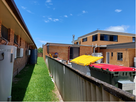
There are no windows in the west facing elevation of unit
201. Having regard to the existing vent height above roof level and lack of
windows in the elevation no adverse odour or air quality impacts are
anticipated.
A development consent was issued on 6 December 2021 for two
storey shop top housing on the adjoining site to the west (DA202/1170). The
development will provide for continuation of a lower floor commercial use
(café) and first floor residential use. The development is approved to
be built to the boundary. While not clear on the approved plans for the shop
top housing development it is assumed the mechanical ventilation will either be
removed or extended through the first floor roof of the redevelopment in the
same location i.e. no closer to the side boundary. There are no openings
proposed in the west facing elevation of proposed motel unit 201 and the
approved first floor residential use on the adjoining site will not result in
any adverse odour impacts.
Flora and fauna
Construction of the proposed development will not require
any removal/clearing of any native vegetation and therefore does not trigger
the biodiversity offsets scheme. Part 7 of the Biodiversity Conservation
Act 2016 is considered to be satisfied.
Waste
Satisfactory arrangements are in place for proposed storage
and collection of waste and recyclables. No adverse impacts anticipated.
Standard precautionary site management condition recommended.
Energy
The proposal includes measures to address energy efficiency
and will be required to comply with the requirements of Section J of the
Building Code of Australia. No adverse impacts anticipated.
Noise and vibration
The construction and/or operations of the proposed
development will not result in any significant adverse impacts on the existing
air quality or result in any pollution. Standard precautionary site management
condition recommended.
The immediately adjacent commercial property to the west
contains a ground floor café. The current approved operational hours of
the café are 7am to 10pm Mondays to Sundays (DA2017/393). There is the
potential for noise impacts from dining activities and the mechanical
ventilation system upon occupants of the proposed first floor motel unit 201.
There are no openings in the west facing elevation of motel
unit 201. The mechanical ventilation system is setback approximately 10m from
the wall of the first floor motel addition. Adequate construction and
separation is proposed and no adverse noise impacts are anticipated with the
existing use on the adjoining property.
A development consent was issued on 6 December 2021 for a
two storey shop top housing development on the adjoining site to the west
(DA2020/1170). The development will provide for continuation of the lower floor
commercial use (café) and first floor residential use. The development
maintains the current hours of operation of the café being 7am to 10pm
Mondays to Sundays. The development is approved to be built to the side boundary.
While not clear on the approved plans it is assumed the mechanical ventilation
will either be removed or extended through the first floor roof of the
redevelopment in the same location i.e. no closer to the side boundary. There
are no openings proposed in the west facing elevation of proposed motel unit
201. Having regard to the current and approved operating hours of the
café use and lack of openings in the building design, the proposal will
not result in any adverse noise impacts.
Bushfire
The site is not identified as being bushfire prone.
Safety, security and crime prevention
The proposed development will be unlikely to create any
concealment/entrapment areas or crime spots that would result in any
identifiable loss of safety or reduction of security in the immediate
area. Adequate casual surveillance is available.
Social impacts in the locality
Given the nature of the proposed development and its
location the proposal is not considered to have any significant adverse social
impacts.
Economic impact in the locality
The proposal is not considered to have any significant
adverse economic impacts on the locality. A likely positive impact is that the
development will maintain employment in the construction industry, which will
lead to flow impacts such as expenditure in the area.
Site design and internal design
The proposed development design satisfactorily responds to
the site attributes and will fit into the locality.
Construction
Construction impacts are considered capable of being
managed, standard construction and site management conditions have been
recommended.
Cumulative impacts
The proposed development is not considered to have any
significant adverse cumulative impacts on the natural or built environment or
the social and economic attributes of the locality.
(c) The
suitability of the site for the development
The proposal will fit into the locality and the site
attributes are conducive to the proposed development.
(d) Any
submissions made in accordance with this Act or the Regulations
Six (6) written submissions were
received following public exhibition of the application. Copies of the written
submissions have been provided separately to members of the DAP.
Key issues raised in the
submissions received and comments are provided as follows:
|
Submission Issue/Summary
|
Planning Comment/Response
|
|
View impacts south to The Parade and adjacent water
views from the neighbouring Unit 6/2 Woodford Road.
|
Refer to view sharing assessment details earlier in
report. View impacts do not warrant recommending refusal of the application.
|
|
Question
validity of Statement of Environmental Effects and timing of neighbour
notification.
|
Statement of
Environmental Effects has been considered and assessed as part of this
report. There is no statutory requirement to have the Statement prepared by a
separate independent specialist.
The
neighbour notification has been carried out in accordance with
Council’s Community Participation Plan and for an extended period from
9 December 2021 to 14 January 2022.
|
|
View impacts
south to The Parade and adjacent water views for many of the 10 units at the
neighbouring 2 Woodford Road.
|
Refer to
view sharing assessment details earlier in report. View impacts do not
warrant recommending refusal of the application.
|
|
Visual
impact statement should have been submitted to gauge height of 8m building at
a distance.
|
|
View impacts
south to The Parade and adjacent water views from the neighbouring Unit 2/2
Woodford Road.
|
|
The view
impacts to units at 2 Woodford Road are not fair and reasonable with
reference made to Tenacity Consulting v Warringah Council Land and
Environment Court case law.
|
|
Impact to
property values with loss of highly valued water views at the neighbouring 2
Woodford Road.
|
Any potential impact of property values is not a matter for
consideration in the assessment of a Development Application under the
Environmental Planning and Assessment Act 1979.
|
|
The proposal
is not providing for the housing needs for the community in accordance with
the R1 general residential zone objectives.
|
The proposal
is for additions to an existing established motel and altered
caretaker’s residence. The additional tourist landuse is a permissible
non-residential landuse in the R1 zone and not explicitly prohibited.
The
provision of tourist accommodation in an appropriate location could also be
considered to plan for catering for short term rental accommodation demand in
difference to existing short term holiday letting of existing housing.
|
|
View impacts
south to The Parade and adjacent water views from the neighbouring Unit 8/2
Woodford Road.
|
Refer to
view sharing assessment details earlier in report. View impacts do not
warrant recommending refusal of the application.
|
|
The proposal
does not meet the objectives of the floor space ratio standard in that the
proposal is not compatible with the bulk and scale of existing and desired
future character of the locality.
|
The proposal
is below the maximum 0.65:1 floor space ratio restriction applying to the
site. The architectural built form complies with the primary planning
controls which set the desired character for the site and locality.
|
|
The positive
impacts of the 3 extra short term tourist accommodation units does not
outweigh the negative impacts of the loss of views from properties at the
neighbouring 2 Woodford Road.
|
View sharing
impacts have been considered to be acceptable in the circumstances as
detailed earlier in this report.
|
|
View impacts
south to The Parade and adjacent water views from the neighbouring Unit 7/2
Woodford Road.
|
Refer to
view sharing assessment details earlier in report. View impacts do not
warrant recommending refusal of the application.
|
|
The
additions will bring the building closer to the street and reduce the open
space appeal of the landscape and impact streetscape.
|
The front
setback alignment chosen is compliant with the desired streetscape character
set by the Development Control Plan 2013 planning provisions. It is also
noted that the mixed use development existing on the western neighbouring
property has a zero setback street alignment.
The
consolidation of the two existing driveways also provides for more
landscaping in the site frontage than the existing arrangements.
|
|
Concern with
glare and reflectivity of replacing the tile roof with colourbond iron roof
sheeting.
|
Council
typically doesn’t regulate roof sheeting materials and colours as these
materials can be installed and changed as exempt development. It is however
noted that the roof sheeting is relatively flat which will assist with
potential for glare issues for neighbours.
|
|
The Gold
Coast or Mediterranean building style chosen is incompatible with the
surrounding coastal and built environment and inconsistent with the R1 general
residential zone desired future character and amenity.
|
The
architectural built form complies with the primary planning controls which
set the desired character for the site and locality. The key controls related
to streetscape, building height and setbacks at the front southern section of
the site are complied with.
|
|
Question if
there is any desired future plan for the character of the immediate
neighbourhood.
|
There are no
precinct specific neighbourhood planning development controls applying to the
site however standard building height, floor space ratio, and other design
controls within Development Control Plan 2013 apply and assist with planned
guidance to expected development outcomes for the locality.
|
|
The proposal
is contrary to the mix of single dwellings. medium density housing and local
shops and cafes envisaged by the R1 general residential zoning.
|
The proposal
is for additions to an existing established motel and altered
caretaker’s residence. The additional tourist landuse is a permissible
non-residential landuse in the R1 zone and not explicitly prohibited.
|
|
View impacts
south to The Parade and adjacent water views from the neighbouring Unit 10/2
Woodford Road.
|
Refer to
view sharing assessment details earlier in report. View impacts do not warrant
recommending refusal of the application.
|
|
Disagree
with submitted justification details that the proposal will mirror approved
extensions to the mixed building use to the west and will not enhance the
existing residential locality.
|
The
additions proposed are noted to have a similar architectural presentation and
form to that approved to the west.
There are no
precinct specific neighbourhood planning development controls applying to the
site however standard building height, floor space ratio, and other design
controls within Development Control Plan 2013 apply and assist with planned
guidance to expected development outcomes for the locality.
|
|
Property was
subject to flooding in March 2021 and the flood risk details submitted do not
address mitigation of flooding risk to occupants and damage to property.
|
Flooding
risk has been satisfactorily assessed and considered noting the proposal is
for alterations and additions to an existing motel and caretaker’s
residence.
|
|
The
alterations will create a more restrictive entrance at the front of the
property with height restrictions for access for fire trucks and emergency
vehicles.
|
The
construction of the building additions will be subject to Building Code
requirements. Vehicles can still enter into the site with the 2.7m assumed
ceiling clearance on top of the new common driveway.
|
|
Reference
made to Land and Environment court case law in the Northern Beaches with 60
years restriction for development on site affected by sea level rises.
|
Unfortunately,
no specific details of the case have been provided, however it is assumed
that the Northern Beaches example could be a site which is much lower in
elevation and subject to more regular inundation potential than the subject
site which is more subject to flooding risk affectation compounded by
potential sea level rises.
|
|
No soft
landscaping proposed or improvements to provide for on-site ecological
habitat.
|
Satisfactory
landscaping is proposed within the front setback area and the existing
established palms in the rear north-west corner near the swimming pool are
proposed to be retained.
|
|
Privacy
concerns for neighbouring units at 2 Woodford Road looking at the box
façade style building.
|
The design of the additions will
be visible particularly from the properties to the north at No.2 Woodford
Road. The roof design adopted for the first floor additions are of a modern
architectural style and setback approximately 32m from the rear boundary.
The building is 1.16m below the
8.5m standard maximum building height envelope. Whilst the roof design is
relatively flat, the height and design of the building additions with the
rooved terrace areas provide sufficient relief to the built form to not result
in an adverse skyline or adverse visual impacts to neighbouring properties to
warrant refusal of the application.
There are no roof design
precinct character controls in place.
|
(e) The Public Interest
The proposed development
satisfies relevant planning controls and will not adversely impact on the wider
public interest.
Climate change
Satisfactory consideration has been given to addressing
flooding risk and climate change implications noting the proposal is for
alterations and additions to an existing motel and caretaker’s residence.
4. DEVELOPMENT
CONTRIBUTIONS APPLICABLE
· The development proposal will result in increased demand on
the water and sewer supply network. Development contributions will be required
towards augmentation of town water supply and sewerage system head works under
Section 64 of the Local Government Act 1993. A suitable consent condition has
been recommended requiring payment.
· The development includes additional residential components
(e.g. 3 extra motel units and increased bedrooms to manager’s residence)
and development contributions will be required in accordance with Section 7.11
of the Environmental Planning and Assessment Act 1979. A suitable consent
condition has been recommended requiring payment.
· A copy of the contributions estimate is included as
Attachment 3.
5. CONCLUSION AND
STATEMENT OF REASON
The application has been assessed in accordance with Section
4.15 of the Environmental Planning and Assessment Act 1979.
Issues raised during assessment and public exhibition of the
application have been considered in the assessment of the application.
The site is considered suitable for the proposed development
and the proposal adequately addresses relevant planning controls. The
development is not considered to be contrary to the public's interest and will
not result a significant adverse social, environmental or economic impact. It
is recommended that the application be approved, subject to the recommended
conditions of consent provided in the attachment section of this report.
|
Attachments
1⇩. DA2021 - 1051.1
Recommended Conditions DA2021 - 1051.1
Recommended Conditions
2⇩. DA2021 - 1051.1
Plans DA2021 - 1051.1
Plans
3⇩. DA2021 - 1051.1
Contributions estimate
4⇩. DA2021 - 1051.1 NRAR
response with GTAs (22122021)
|
|
ATTACHMENT
|
Development Assessment Panel
08/09/2022
|
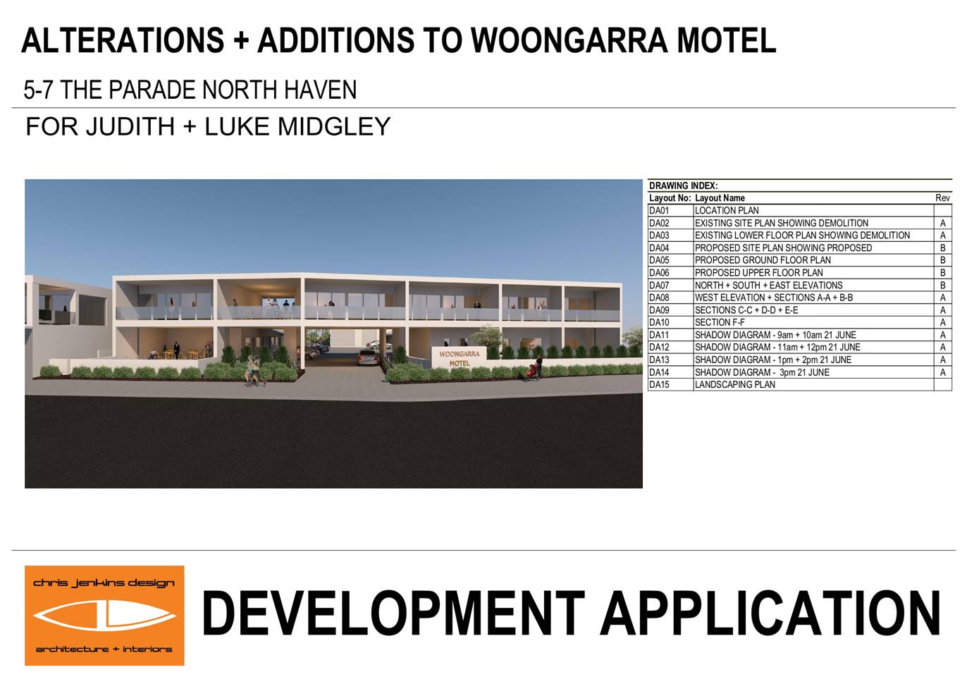
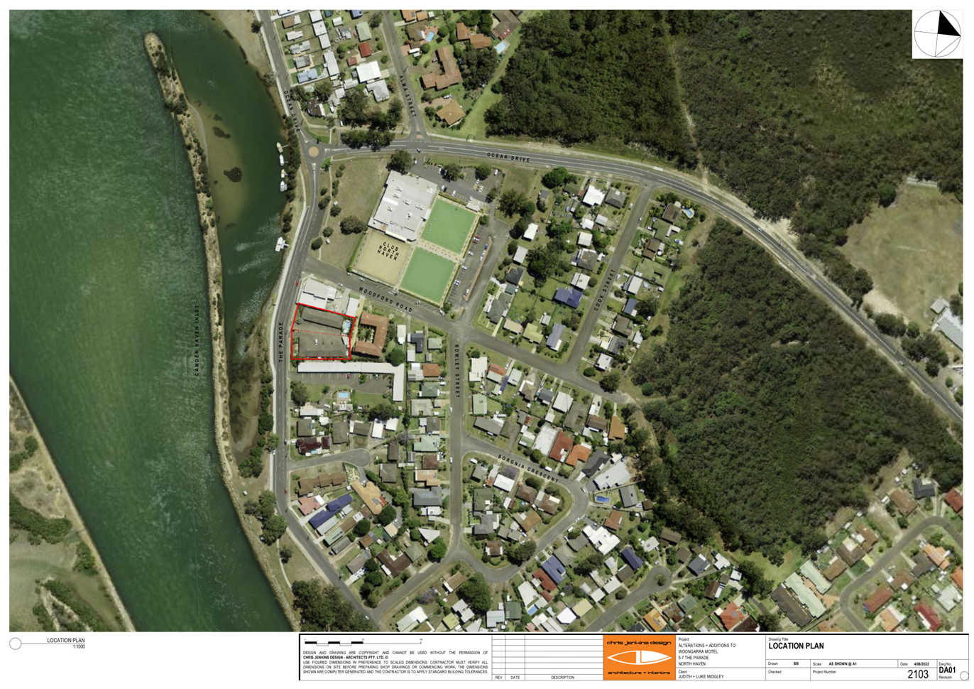
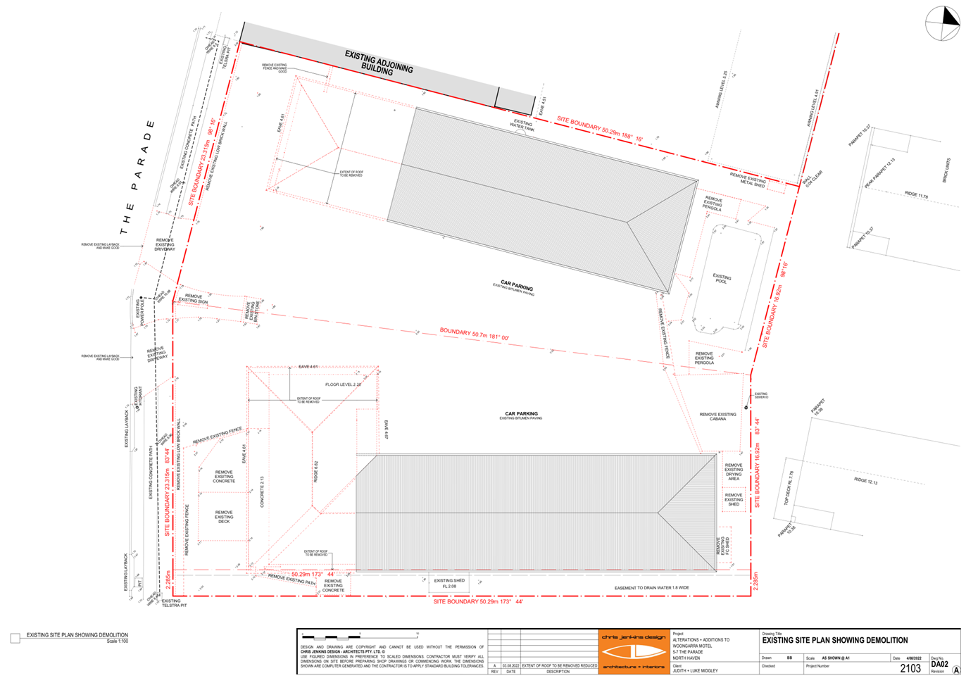
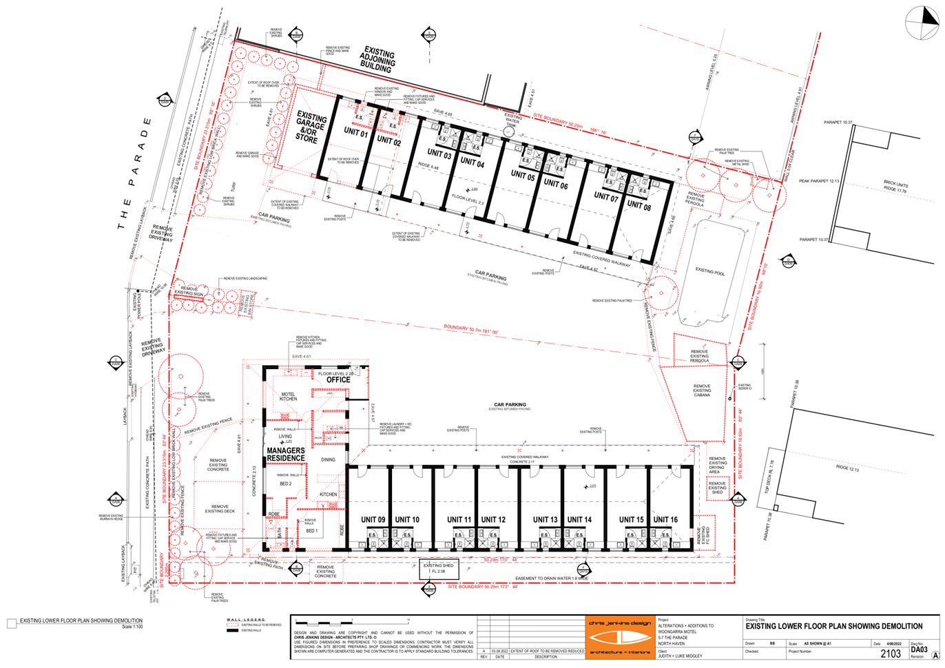
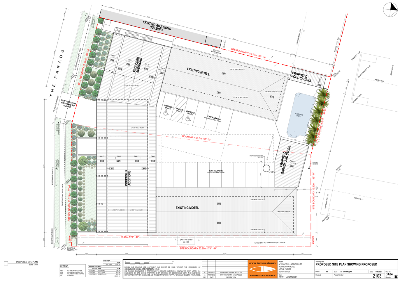
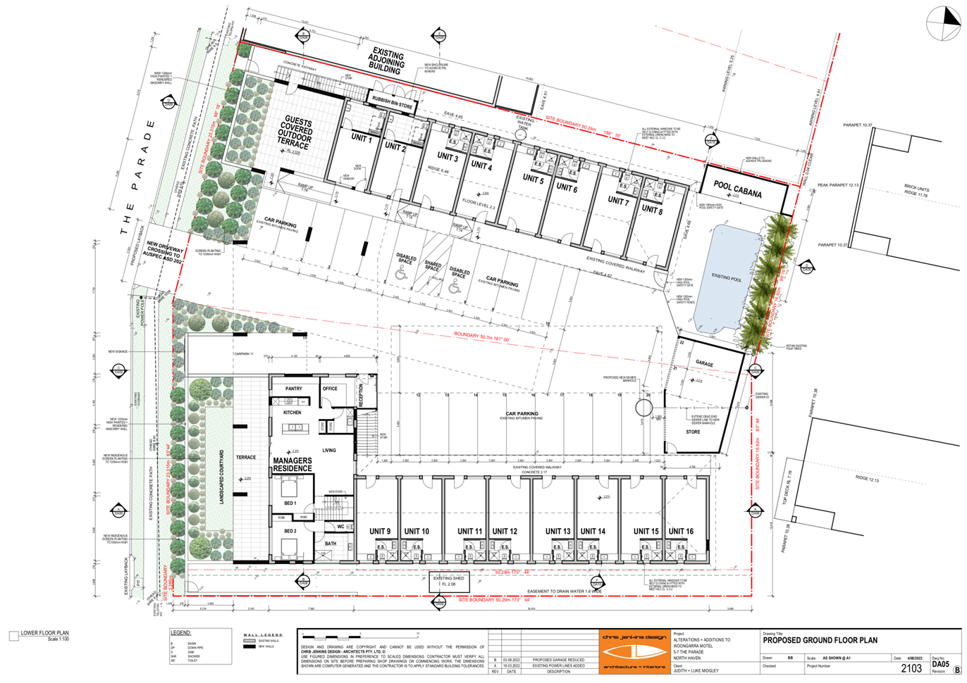
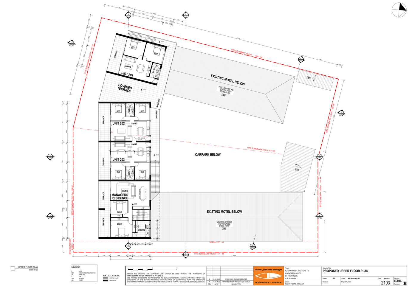
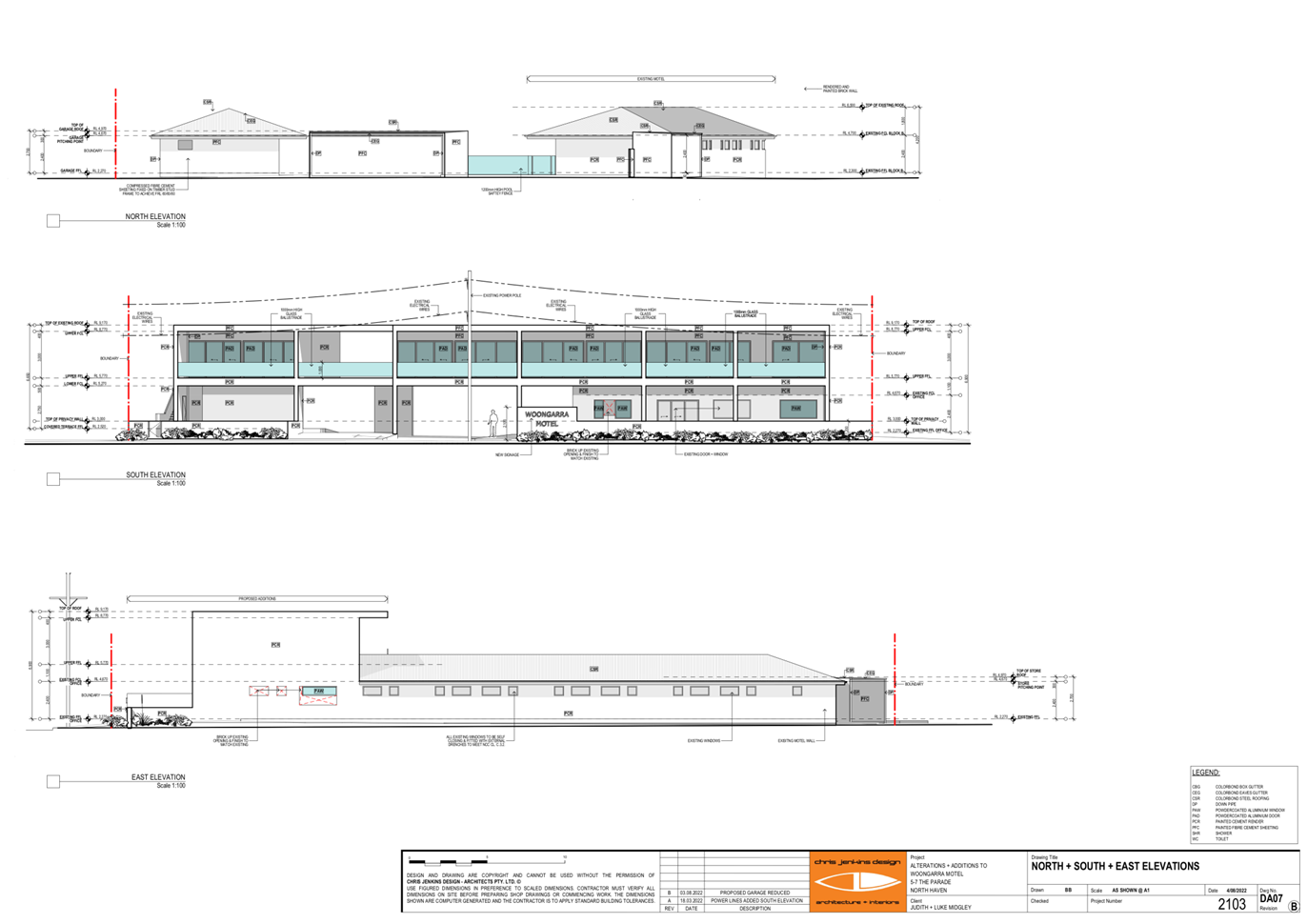
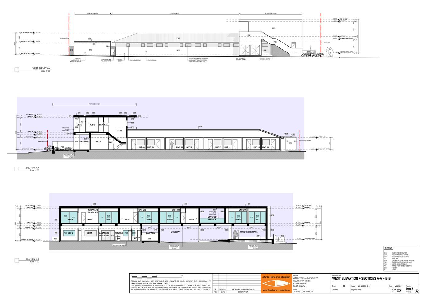
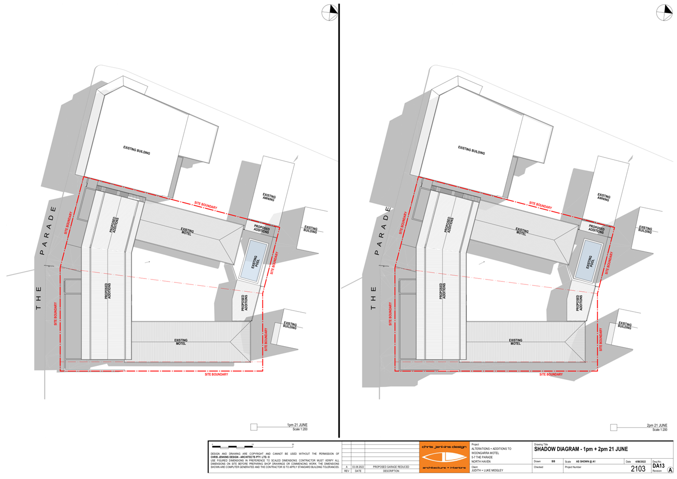
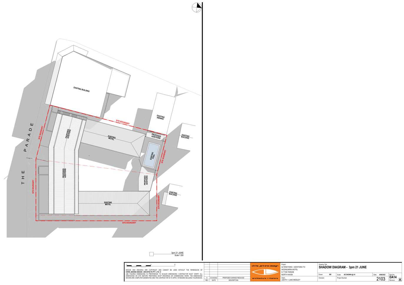
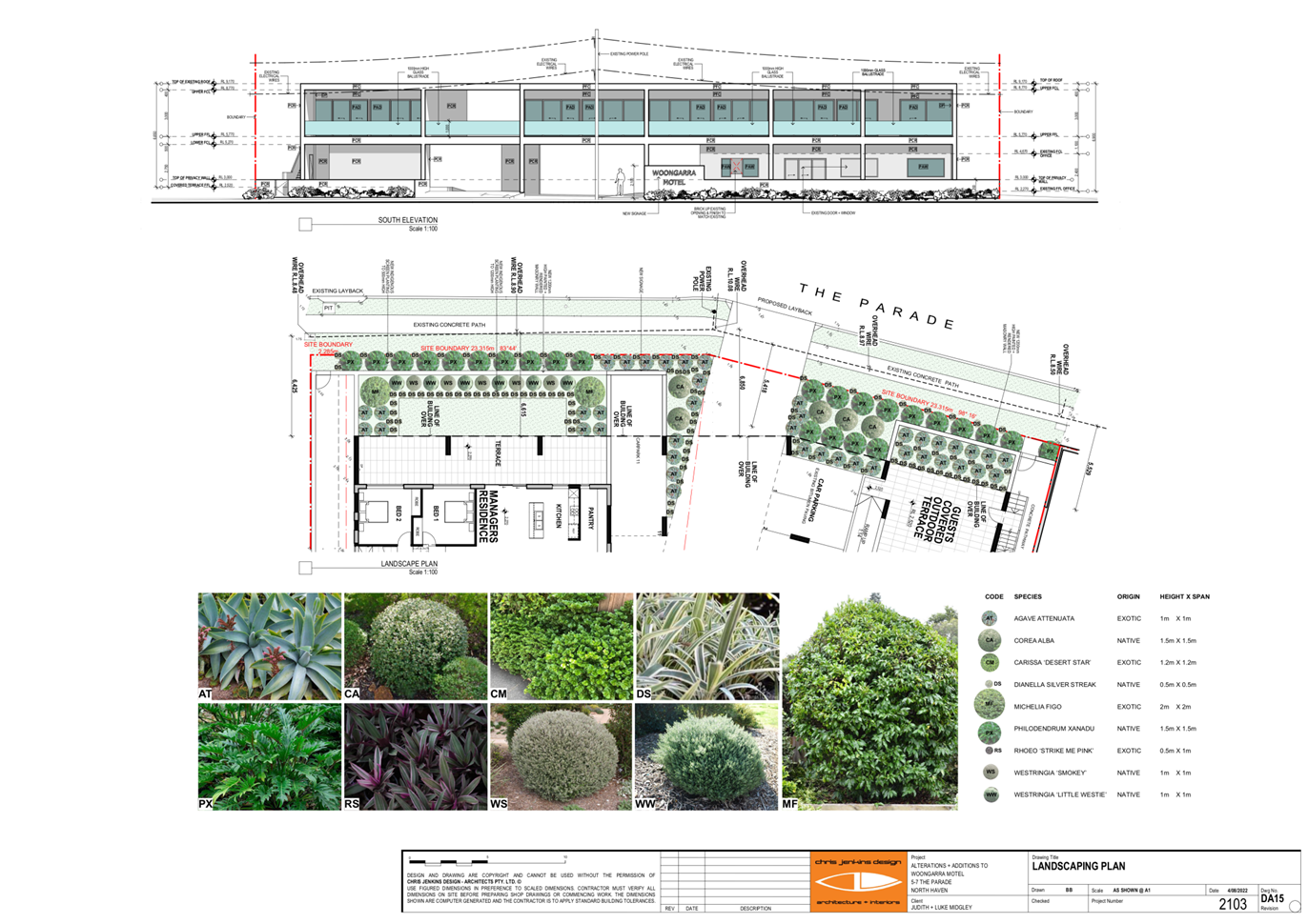
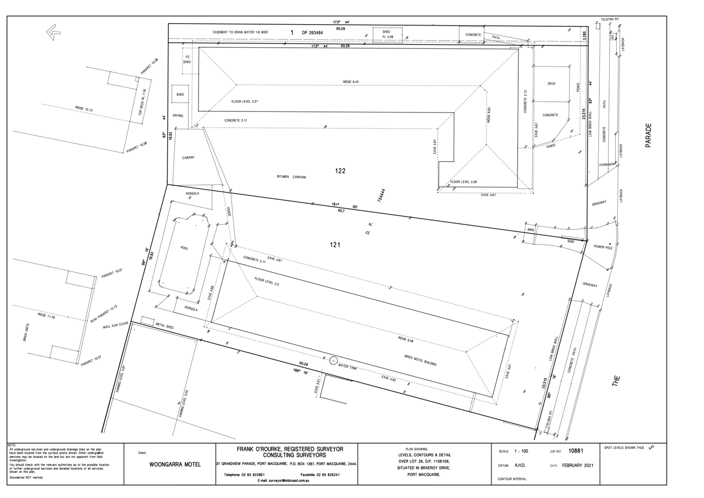
|
ATTACHMENT
|
Development Assessment Panel
08/09/2022
|
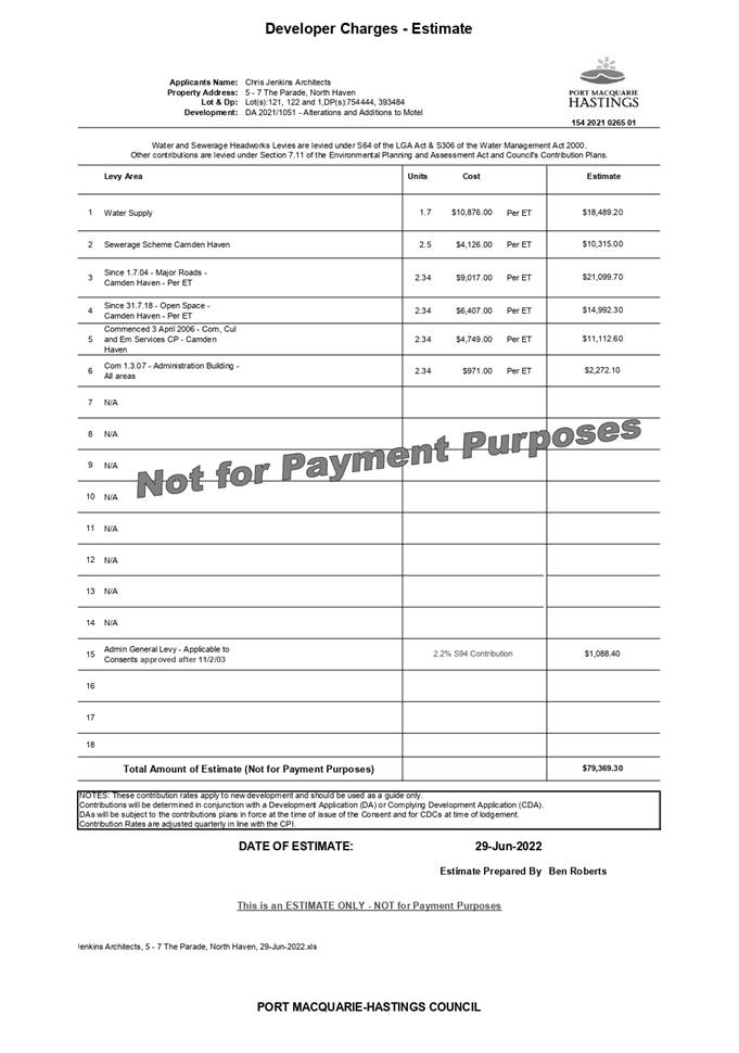
|
ATTACHMENT
|
Development Assessment Panel
08/09/2022
|
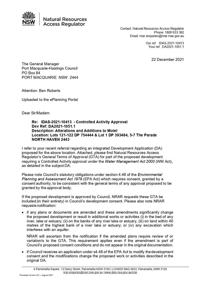
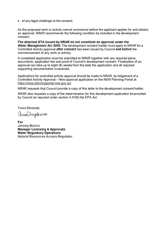
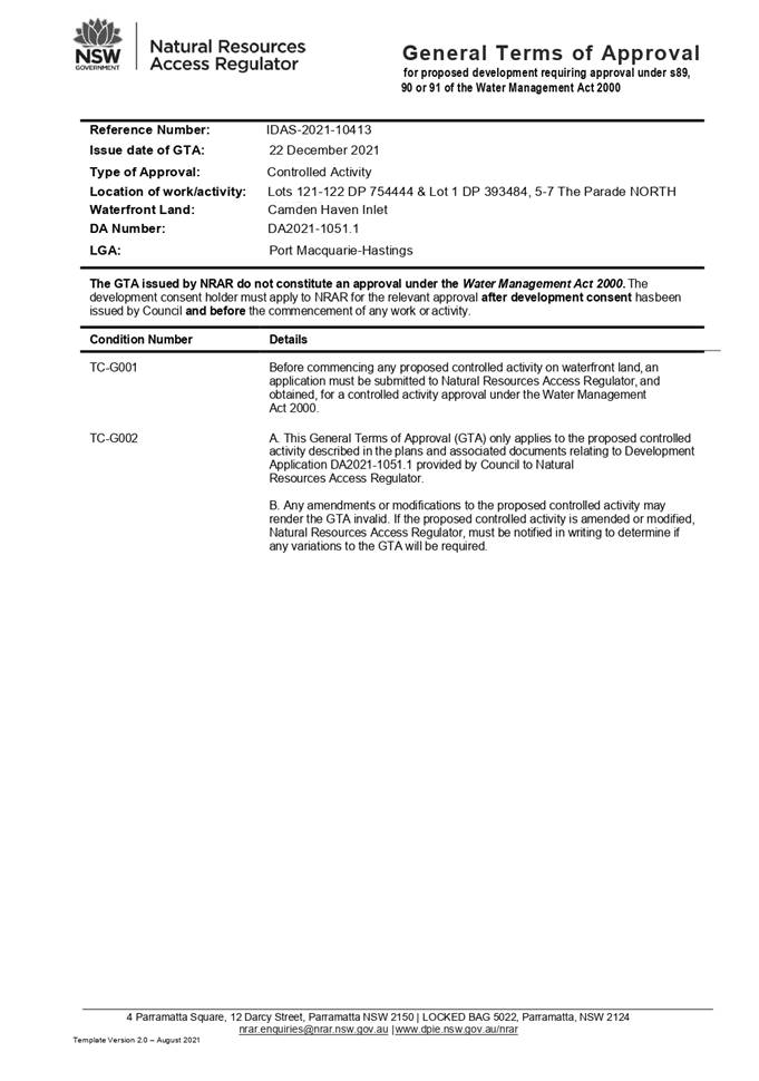
AGENDA Development Assessment Panel 08/09/2022
Item: 06
Subject: DA2021 - 1237.1 Child Care Centre and Torrens
Title Subdivision at Lot 7 DP 262361, No 13 Colonial Circuit, Wauchope
Report
Author: Development Assessment Planner, Clint Tink
|
Applicant: Robert
Smallwood Building Plans & Design
Owner: D
R Edgar
Estimated Cost: $327,000.00
Alignment with Delivery
Program
4.3.1 Undertake transparent
and efficient development assessment in accordance with relevant legislation.
|
RECOMMENDATION
That
DA2021 - 1237.1 for a child care centre
and torrens title subdivision at Lot 7 DP 262361, No. 13 Colonial Circuit, Wauchope, be determined by granting consent subject to the
recommended conditions.
Executive
Summary
This
report considers a development application for a child care centre and
torrens title subdivision at the subject site and
provides an assessment of the application in accordance with the Environmental
Planning and Assessment Act 1979.
Following exhibition of the
application, 57 submissions were received (including a petition).
On balance, the site is considered suitable for the proposed
development and the proposal adequately addresses relevant planning controls.
The development is not considered to be contrary to the overall public's
interest and will not result a significant adverse social, environmental or
economic impact.
This report recommends that the
development application be approved subject to
the attached conditions - Attachment 1.
The reason for the application being referred to
Council’s Development Assessment Panel (DAP) is because three (3) or more
objections to the proposal have been received. A copy of the DAP Charter
outlining the delegations and functions of the DAP is available on
Council’s website.
1. BACKGROUND
Existing
Sites Features and Surrounding Development
The site has an area of 3135m².
The
site is zoned R1 General Residential in
accordance with the Port Macquarie-Hastings Local Environmental Plan 2011, as
shown in the following zoning plan:
 The existing subdivision pattern and location of existing
development within the locality is shown in the following aerial photographs:
The existing subdivision pattern and location of existing
development within the locality is shown in the following aerial photographs:
2. DESCRIPTION
OF DEVELOPMENT
Key
aspects of the proposal include the following:
· Child
care centre for 88 children proposed. Although conditions proposed to reduce
this number down to 76.
· Two (2) lot torrens title subdivision included in the
application. The subdivision will create a lot containing the child care centre
and a vacant residential lot to the rear. An indicative future residence is
shown on the plans to illustrate a dwelling is achievable but does not form
part of the application.
· Hours of operation for the child care centre are proposed
to be 7am to 6pm Monday to Friday.
· A car park comprising 18 spaces and 1 disabled parking
space is proposed to cater for the child care centre.
· 57 submissions (including a petition) have been received
objecting to the proposal.
Refer
to Attachment 2 at the end of this report for plans of the proposed
development.
Application
Chronology
· 24/8/2021 - Applicant had a Pre-lodgement meeting with
Council staff regarding the proposal.
· 28/2/2022
- Application lodged with Council.
· 7/3/2022
- Application referred to Essential Energy and NSW Rural Fire Service.
· 10-23/3/2022 - Notification period.
· 15/3/2022 - NSW Rural Fire Service provided a Bushfire
Safety Authority.
· 17/3/2022 - Council staff requested additional information
on tree removal, ecology, landscaping, signage, waste, loading areas, fencing,
outdoor play times, elevations, access arrangements, sign in counter and
compliance with provisions of the Child Care Planning Guideline.
· 29/3/2022 - Essential Energy provided feedback on the proposal.
Copy provided to applicant for their information.
· 31/3/2022 - Applicant advised that submissions had been
received on the proposal. Applicant requested a copy of the submissions.
Redacted copies were subsequently provided to the applicant on 6/4/2022.
· 13/4/2022 - Council staff requested additional information
on one of the proposed outdoor play areas.
· 14/4/2022 - In terms of the Child Care Planning Guideline,
Council staff requested additional information on the proximity of the
development to Hastings Fuel Depot.
· 28/4/2021 - Applicant provided preliminary response on the
proximity to the fuel depot issue.
· 2/5/2022 - Council staff reiterated the need for more
information on the proximity to the fuel depot issue. Applicant also provided
partial responses to Council’s previous request for additional
information.
· 4/5/2022 - Council staff reviewed the information provided
by the applicant on 2/5/2022 and provided feedback/requested additional
information.
· 5/5/2022 - Discussion with the applicant on the proximity
of the development to fuel depot issue.
· 11/5/2022 - Applicant submitted partial response to
previous additional information requests.
· 16/5/2022 - Applicant submitted partial response to
previous additional information requests.
· 24/5/2022 - Council staff requested further information on
tree removal and proximity of the development to fuel depot issue.
· 26/5/2022 - Discussion with the applicant on the proximity
of the development to fuel depot issue and status of the application.
· 7/6/2022 - Owner provided feedback on the proposal,
additional information requests and submissions.
· 9/6/2022 - Applicant provided additional information on the
proximity of the development to fuel depot issue.
· 17/6/2022 - Council staff acknowledged information provided
on 9/6/2022.
· 20/6/2022 - Applicant provided ecological assessment.
· 22/6/2022 - Council staff requested further information on
the proximity of the development to fuel depot issue.
· 6/7/2022 - Owner requested updated on status of the DA.
· 20/7/2022 - Update on the status of the application
provided to the owner.
· 22-25/7/2022 - Council staff and the owner discussed
additional information request on the proximity of the development to fuel
depot issue.
· 28/7/2022 - Site inspection completed.
· 8/8/2022 - Applicant requested update on the proposal.
· 10/8/2022 - Council staff provided the applicant with an
update on the status of the application.
3. STATUTORY
ASSESSMENT
Section
4.15(1) Matters for Consideration
In determining
the application, Council is required to take into consideration the following
matters as are relevant to the development that apply to the land to which the
development application relates:
(a) The
provisions (where applicable) of:
(i) Any
Environmental Planning Instrument
State Environmental Planning Policy (Biodiversity and
Conservation) 2021
Chapter 4 Koala Habitat Protection 2021
Clause 4.4 - This SEPP applies to all non-rural zoned land
within the Port Macquarie-Hastings Local Government Area. The
site is zoned R1 General Residential so the SEPP requires consideration.
Clause 4.9 - The property is not over 1ha in
size (including adjoining land in the same ownership) and does not have a KPOM
in place. Therefore, Clause 4.9 does not apply.
Clause 4.10 - Having considered the SEPP, the
application, the ecological report and on completion of a site inspection,
Council is not prevented from granting consent in this case for the following
reasons:
1. The property is not subject to a KPOM.
2. The site is not considered to be core koala habitat.
3. The
vegetation removal is not considered to be significant.
State Environmental Planning Policy (Industry and
Employment) 2021
Chapter 3 Advertising and Signage
The proposed development includes proposed advertising
signage in the form of business identification signage on the front
façade of the proposed child care centre building and some ancillary
directional signage.
Clause 3.5 - This SEPP prevails over the Port
Macquarie-Hastings LEP 2011 in the event of any inconsistency.
Clause 3.6 - The following assessment table provides an
assessment checklist against the Schedule 5 requirements of this SEPP:
|
Applicable clauses for consideration
|
Comments
|
Satisfactory
|
|
Clause 3.6(a) Consistent with objectives
of the policy as set out in Clause 3(1)(a).
|
The proposal includes some
standard sized business identification signs on the front façade of
the child care centre building. There are also some standard directional type
signs to be used throughout the carpark.
Overall, the proposed signage is consistent with the aims
and objectives of the SEPP. The sign is compatible with other child care
centre signs and allowable non-residential uses, provides effective
communication, is of quality design, has been kept to a minimum and will not
impact on the amenity of the area.
|
Yes
|
Schedule
5(1) Character of the area.
|
The character of the area is
currently defined my residential housing. However, planning legislation does
allow various non-residential uses with consent in the area, home
occupations/businesses without consent and subsequent signage without
consent. Whilst these non-residential uses/signage may be limited at present
within the area, development pressures and the adoption of home
occupations/businesses will likely see this type of development occur in the
future (as has occurred in other areas throughout the Local Government Area).
The signage is also not excessive in number or size and is required to
identify the non-residential use.
Based on the above, the signage
is considered to be consistent with that allowed in the area and the likely
future character of the area.
|
Yes
|
|
Schedule 5(2) Special areas.
|
The signage will not detract from
the amenity and visual quality of the immediate residential locality noting
it’s limited scale and placement.
|
Yes
|
|
Schedule 5(3) Views and vistas.
|
The signage will not impact on
any views or vistas.
|
Yes
|
|
Schedule 5(4) Streetscape,
setting or landscape.
|
The signage is not excessive in
number or size and creates no adverse impact on streetscape, setting or
landscaping principles.
|
Yes
|
|
Schedule 5(5) Site and building.
|
The signage is compatible with
the site and building scale.
|
Yes
|
|
Schedule 5(6) Associated devices
and logos with advertisements and advertising structures.
|
None proposed.
|
Yes
|
|
Schedule 5(7) Illumination.
|
None proposed.
|
Yes
|
|
Schedule 5(8) Safety.
|
The signage does not create any safety issues.
|
Yes
|
State Environmental Planning Policy (Resilience and
Hazards) 2021
Chapter 2 Coastal Management
Chapter 4 Remediation of Land
Clause 4.6 - Following an inspection of the site, review of
the application by one of Council’s Environmental Health Officers and a
search of Council records, the subject land is not identified as being
potentially contaminated and is considered suitable for the intended use.
State Environmental Planning Policy (Planning Systems)
2021
The development does not trigger any of the clauses or
thresholds under the SEPP.
State Environmental Planning Policy (Primary Production)
2021
Part 2.5 Division 4 - The proposed development will create
no adverse impact on any oyster aquaculture development or priority oyster
aquaculture area.
State Environmental Planning Policy (Transport and
Infrastructure) 2021
Clause 2.48 - Referral to Essential Energy is required for
any of the following:
(a) the
penetration of ground within 2m of an underground electricity power line or an
electricity distribution pole or within 10m of any part of an electricity
tower,
(b) development
carried out:
(i) within
or immediately adjacent to an easement for electricity purposes (whether or not
the electricity infrastructure exists), or
(ii) immediately
adjacent to an electricity substation, or
(iii) within
5m of an exposed overhead electricity power line,
(c) installation
of a swimming pool any part of which is:
(i) within
30m of a structure supporting an overhead electricity transmission line,
measured horizontally from the top of the pool to the bottom of the structure
at ground level, or
(ii) within 5m of an overhead electricity power line, measured vertically
upwards from the top of the pool.
A referral to Essential Energy was carried out with no
objection received. Standard advice about Dial Before You Dig etc was provided,
which was forwarded to the applicant.
Clause 2.119 & 2.120 - The subject Clause refers to
development with frontage to a classified road and the need to consider
potential conflicts. In this case, the development does not have frontage to a
classified road. However, it is noted that High Street/Oxley Highway
(classified road) is within approximately 160m of the child care centre. In
considering traffic data for the Oxley Highway, the 160m separation, the
existing obstructions/buildings and Development Near Rail Corridors and Busy
Roads guideline; a noise assessment on road noise impacts is not required
for the proposed child care centre in this case under the SEPP. In particular,
the most recent traffic data shows the Oxley Highway Annual Average Daily
Traffic (AADT) is just over 10,000 vehicles at the busier Cameron St
intersection. The trigger for a noise assessment would be approximately 15,000
AADT with a 160m setback and that’s assuming there are no
obstructions.
Regardless of the above, the applicant did commission a
noise assessment, which showed the child care centre can operate without being
adversely impacted by external noise sources.
Council’s Engineering staff have also reviewed the
application in terms of traffic impacts in the area with no significant adverse
impacts identified.
Based on the above, there is unlikely to be any significant
adverse conflict between the Oxley Highway and the child care centre use in
terms of noise, vibration and operation.
Clause 2.122 - The development does not trigger any of the
traffic generating development thresholds of Clause 104. In particular,
vehicles per hour are less than the 50 referral trigger.
Being a centre-based child care facility, Chapter 3 of the
SEPP applies to the proposal. In this regard, the following comments are made
in relation to the relevant Clauses from the SEPP.
|
SEPP (Transport and Infrastructure) 2021 - Childcare,
Chapter 3, Assessment Table
|
|
Requirement
|
Proposed
|
Complies
|
|
Clause 3.22 - Development complies with indoor and outdoor
areas.
3.25m²
per child (indoor)
7m²
per child (outdoor)
Note: Concurrence from Department of Education required if
indoor/outdoor area requirements not achieved.
|
Refer to Child Care Planning Guideline assessment
below.
88 children proposed although conditions will restrict to
76 children based on parking. Figures below have been based on the more
onerous 88 children.
286m² indoor required with 286m² provided (Note:
educational kitchen).
616m² outdoor required with 804.17m² provided.
|
Yes
|
|
Clause 3.23 - Development consider Child Care Planning
Guideline
|
Refer to Child Care Planning Guideline assessment
below.
|
|
|
Clause 3.24 - Centre based child care in IN1 and IN2 zone.
- Minimise
land use conflicts.
- Consider
safety of occupants.
- Compatible
with surrounding uses.
- Development
should not sterilise surrounding industrial uses.
|
Not located in IN1 or IN2 zone.
|
N/A
|
|
Clause 3.25 - Development consent must not be granted for
the purposes of a centre-based child care facility in the R2 zone if the FSR
for the building exceeds 0.5:1. The section does not apply if another
environmental planning instrument or DCP sets a maximum FSR for centre-based
child care facility.
|
Not located in R2 zone.
|
N/A
|
|
Clause 3.26 - Non discretionary standards, that if
complied with, prevent the consent authority applying more onerous standards.
a) Location
- the development may be located at any distance to another child care.
b) Indoor/outdoor
spaces comply with Clause 22 above.
c) The
development may be located on a site of any size, over any part of the site
and have any length of street frontage or allotment depth.
d) The
development can use any colour, building materials or shade structures (if
not heritage).
|
Standards noted and not being challenged or more onerous
condition applied.
|
Yes
|
|
Clause 3.27 - Lists DCP provisions that do not apply
(covered by Child Care Planning Guideline)
|
Clause noted and not being challenged by a DCP provision.
|
Yes
|
|
Child Care Planning Guideline – Matters for
Consideration (Chapter 3)
|
|
Matter for Consideration/
Requirement
|
Proposed
|
Complies
|
|
3.1 Site selection and location p9-10
|
|
C1
For proposed developments in or adjacent to a
residential zone, consider:
· the acoustic and
privacy impacts of the proposed development on the residential properties
· the setbacks and
siting of buildings within the residential context
· traffic and
parking impacts of the proposal on residential amenity.
For proposed developments in commercial and industrial
zones, consider:
· potential
impacts on the health, safety and wellbeing of children, staff and visitors
with regard to local environmental or amenity issues such as air or noise
pollution and local traffic conditions
· the potential
impact of the facility on the viability of existing commercial or industrial
uses.
For proposed developments in public or private
recreation zones, consider:
· the compatibly
of the proposal with the operations and nature of the community or private
recreational facilities
· if the existing
premises is licensed for alcohol or gambling
· if the use
requires permanent or casual occupation of the premises or site
· the availability
of on site parking
· compatibility of
proposed hours of operation with surrounding uses, particularly residential
uses
· the availability
of appropriate and dedicated sanitation facilities for the development.
For proposed developments on school, TAFE or university
sites in Special Purpose zones, consider:
· the compatibly
of the proposal with the operation of the institution and its users
· the proximity of
the proposed facility to other uses on the site, including premises licensed
for alcohol or gambling
· proximity to
sources of noise, such as places of entertainment or mechanical workshops
· proximity to
odours, particularly at agricultural institutions
· previous uses of
a premises such as scientific, medical or chemical laboratories, storage
areas and the like.
|
The applicant submitted noise and traffic reports, which
were reviewed by specialist Council staff. Overall, the provisions in the
SEPP were considered and the development/design was deemed acceptable and
compliant. In particular, no significant adverse conflicts between the
development and adjoining areas to occur.
|
Yes
|
|
|
|
|
|
C2
When selecting a site, ensure that:
· the location and
surrounding uses are compatible with the proposed development or use
· the site is
environmentally safe including risks such as flooding, land slip, bushfires,
coastal hazards
· there are no
potential environmental contaminants on the land, in the building or the
general proximity, and whether hazardous materials remediation is needed
· the
characteristics of the site are suitable for the scale and type of
development proposed having regard to:
- size
of street frontage, lot configuration, dimensions and overall size
- number
of shared boundaries with residential properties
- the
development will not have adverse environmental impacts on the surrounding
area, particularly in sensitive environmental or cultural areas
· where the
proposal is to occupy or retrofit an existing premises, the interior and
exterior spaces are suitable for the proposed use
· there are
suitable drop off and pick up areas, and off and on street parking
· the type of
adjoining road (for example classified, arterial, local road, cul-de-sac) is
appropriate and safe for the proposed use
· it is not
located closely to incompatible social activities and uses such as restricted
premises, injecting rooms, drug clinics and the like, premises licensed for
alcohol or gambling such as hotels, clubs, cellar door premises and sex
services premises.
|
Development is permissible and compatible with the site
characteristics and surrounding/future desired uses. In particular, it is
common to see child care centres positioned within residential zoned areas.
Furthermore, specialist traffic, bushfire, noise etc
assessments have been submitted and reviewed by Council staff/NSW Rural Fire
Service and deemed acceptable, subject to conditions.
|
Yes
|
|
C3
A child care facility should be located:
· near compatible
social uses such as schools and other educational establishments, parks and
other public open space, community facilities, places of public worship
· near or within
employment areas, town centres, business centres, shops
· with access to
public transport including rail, buses, ferries
· in areas with
pedestrian connectivity to the local community, businesses, shops, services
and the like.
|
Whilst the development is not located near schools/education
or have pedestrian connectivity, there are still considered to be elements
that complement the use and location selection. In particular, there is
industry, the IGA shopping centre, shops, cafes, Timbertown, bus route/stop
etc all within approximately 1km of the site. The centre will also serve the
local residential population/estate of Colonial Circuit and surrounding
streets.
On balance, the child care centre location is considered
acceptable.
|
Yes
|
|
C4
A child care facility should be located to avoid risks to
children, staff or visitors and adverse environmental conditions arising
from:
· proximity to:
- heavy
or hazardous industry, waste transfer depots or landfill sites
- LPG
tanks or service stations
- water
cooling and water warming systems - odour (and other air pollutant)
generating uses and sources or sites which, due to prevailing land use
zoning, may in future accommodate noise or odour generating uses
- extractive
industries, intensive agriculture, agricultural spraying activities
· any other
identified environmental hazard or risk relevant to the site and/ or existing
buildings within the site.
|
There is a diesel fuel depot approx. 100m away. The
applicant provided additional information on the separation, air quality
impacts and low flammable/explosion potential of diesel fuel. The situation
was also reviewed by Council’s Environmental Health Officer.
Given the screening by structures in between, the large
separation distance and the low flammable/explosion potential of diesel - no
adverse impact or risk will occur.
The site is also bushfire prone. The applicant submitted a
bushfire assessment in support of the proposal. The bushfire assessment was
also reviewed and accepted by the NSW Rural Fire Service, subject to
conditions. Therefore, bushfire is unlikely to create any adverse risks to
the centre.
|
Yes
|
|
3.2 Local Character, streetscape and the public domain
interface p11-12
|
|
C5
The proposed development should:
· contribute to
the local area by being designed in character with the locality and existing
streetscape
· reflect the
predominant form of surrounding land uses, particularly in low density
residential areas • recognise predominant streetscape qualities, such
as building form, scale, materials and colours
· include design
and architectural treatments that respond to and integrate with the existing
streetscape
· use landscaping
to positively contribute to the streetscape and neighbouring amenity
· integrate car
parking into the building and site landscaping design in residential areas.
|
The development will compliment other existing
non-residential uses within 100-500m of the site and the associated built
form will remain similar to that of a residential dwelling, when viewed from
the street. There is also a car park at the front of the premises, which will
be screened by landscaping to offset any visual impact.
|
Yes
|
|
C6
Create a threshold with a clear transition between public
and private realms, including:
· fencing to
ensure safety for children entering and leaving the facility
· windows facing
from the facility towards the public domain to provide passive surveillance
to the street as a safety measure and connection between the facility and the
community
· integrating
existing and proposed landscaping with fencing.
|
Clear transition area provided with suitable fencing,
window placement and landscaping.
|
Yes
|
|
C7
On sites with multiple buildings and/or entries,
pedestrian entries and spaces associated with the child care facility should
be differentiated to improve legibility for visitors and children by changes
in materials, plant species and colours.
|
There are multiple entry points. Signage will be required
to clarify entry procedures.
|
Yes
|
|
C8
Where development adjoins public parks, open space or
bushland, the facility should provide an appealing streetscape frontage by
adopting some of the following design solutions:
· clearly defined
street access, pedestrian paths and building entries
· low fences and planting
which delineate communal/ private open space from adjoining public open space
· minimal use of
blank walls and high fences.
|
Development does not adjoin such areas.
|
N/A
|
|
C9
Front fences and walls within the front setback should be
constructed of visually permeable materials and treatments. Where the site is
listed as a heritage item, adjacent to a heritage item or within a
conservation area front fencing should be designed in accordance with local
heritage provisions.
|
The front side fences are minimal in height (1.2m high)
and still allows an acceptable permeable frontage either side. The fence
design also remains consistent with others in the street.
|
Yes
|
|
C10
High solid acoustic fencing may be used when shielding the
facility from noise on classified roads. The walls should be setback from the
property boundary with screen landscaping of a similar height between the
wall and the boundary.
|
High solid acoustic fencing (2.1m) is limited to side and
rear fencing and does not impact frontage design.
|
Yes
|
|
3.3 Building orientation, envelope and design p12-14
|
|
C11
Orient a development on a site and design the building
layout to:
· ensure visual
privacy and minimise potential noise and overlooking impacts on neighbours
by:
- facing
doors and windows away from private open space, living rooms and bedrooms in
adjoining residential properties
- placing
play equipment away from common boundaries with residential properties
- locating
outdoor play areas away from residential dwellings and other sensitive uses
· optimise solar
access to internal and external play areas
· avoid
overshadowing of adjoining residential properties
· minimise cut and
fill
· ensure buildings
along the street frontage define the street by facing it
· ensure that
where a child care facility is located above ground level, outdoor play areas
are protected from wind and other climatic conditions.
|
Development has been suitably designed to comply or will implement
requirements to ensure compliance.
Fencing, high sill windows, setbacks and suitable window
placement utilised.
|
Yes
|
|
C12
The following matters may be considered to minimise the
impacts of the proposal on local character:
· building height
should be consistent with other buildings in the locality
· building height
should respond to the scale and character of the street
· setbacks should
allow for adequate privacy for neighbours and children at the proposed child
care facility
· setbacks should
provide adequate access for building maintenance • setbacks to the
street should be consistent with the existing character.
|
Development has been suitably designed to comply or will
implement requirements to ensure compliance. Overall, the built form of the
premises retains dwelling elements, bulk and scale that are consistent with
surrounding development.
|
Yes
|
|
C13
Where there are no prevailing setback controls minimum
setback to a classified road should be 10 metres. On other road frontages
where there are existing buildings within 50 metres, the setback should be
the average of the two closest buildings. Where there are no buildings within
50 metres, the same setback is required for the predominant adjoining land
use.
|
Setback remains relatively unchanged and consistent with
surrounding front setbacks.
|
Yes
|
|
C14
On land in a residential zone, side and rear boundary
setbacks should observe the prevailing setbacks required for a dwelling
house.
|
Design consistent with residential setbacks of 4m to rear (or
equivalent area to the north) and 900mm to side.
|
Yes
|
|
C15
The built form of the development should contribute to the
character of the local area, including how it:
· respects and
responds to its physical context such as adjacent built form, neighbourhood
character, streetscape quality and heritage
· contributes to
the identity of the place
· retains and
reinforces existing built form and vegetation where significant
· considers
heritage within the local neighbourhood including identified heritage items
and conservation areas
· responds to its
natural environment including local landscape setting and climate
· contributes to
the identity of place.
|
Development has been suitably designed to comply with
requirements. Overall, the built form of the premises retains dwelling
elements, bulk and scale that are consistent with surrounding development.
|
Yes
|
|
C16
Entry to the facility should be limited to one secure
point which is:
· located to allow
ease of access, particularly for pedestrians
· directly
accessible from the street where possible • directly visible from the
street frontage
· easily monitored
through natural or camera surveillance
· not accessed
through an outdoor play area.
· in a mixed-use
development, clearly defined and separate from entrances to other uses in the
building.
|
The access has been suitably designed to comply with
requirements. In particular, a main access point (NE corner of the building)
has been provided for parents/children. A separate ancillary rear access
point is available for staff entering from the rear car park.
|
Yes
|
|
C17
Accessible design can be achieved by:
· providing
accessibility to and within the building in accordance with all relevant
legislation
· linking all key
areas of the site by level or ramped pathways that are accessible to prams
and wheelchairs, including between all car parking areas and the main
building entry
· providing a
continuous path of travel to and within the building, including access
between the street entry and car parking and main building entrance. Platform
lifts should be avoided where possible
· minimising
ramping by ensuring building entries and ground floors are well located
relative to the level of the footpath. NOTE: The National Construction Code,
the Discrimination Disability Act 1992 and the Disability (Access to Premises
– Buildings) Standards 2010 set out the requirements for access to
buildings for people with disabilities.
|
Development has been suitably designed to comply or will
implement requirements to ensure compliance.
|
Yes
|
|
3.4 Landscaping p15
|
|
C18
Appropriate planting should be provided along the boundary
integrated with fencing. Screen planting should not be included in
calculations of unencumbered outdoor space. Use the existing landscape where
feasible to provide a high quality landscaped area by:
· reflecting and
reinforcing the local context
· incorporating
natural features of the site, such as trees, rocky outcrops and vegetation
communities into landscaping.
|
Landscaping has been suitably designed to comply or will
implement requirements to ensure compliance.
Area also exists onsite for future plantings.
|
Yes
|
|
C19
Incorporate car parking into the landscape design of the
site by:
· planting shade
trees in large car parking areas to create a cool outdoor environment and
reduce summer heat radiating into buildings
· taking into
account streetscape, local character and context when siting car parking
areas within the front setback
· using low level
landscaping to soften and screen parking areas.
|
Landscaping has been suitably designed to comply with
requirements. In particular, the car park is not considered large and
proposed landscaping creates a suitable balance of creating a visual and
aesthetic environment whilst not impacting the safety and operation of the
site.
|
Yes
|
|
3.5 Visual and Acoustic Privacy p15-16
|
|
C20
Open balconies in mixed use developments should not
overlook facilities nor overhang outdoor play spaces.
|
Use of fencing, high sill windows and separation - ensure
no adverse overlooking issues created.
|
Yes
|
|
C21
Minimise direct overlooking of indoor rooms and outdoor
play spaces from public areas through:
· appropriate site
and building layout
· suitably
locating pathways, windows and doors
· permanent
screening and landscape design.
|
Development has been suitably designed to comply with
requirements. Fencing and mirror tint windows will ensure public areas/the
street do not look into indoor or outdoor areas.
|
Yes
|
|
C22
Minimise direct overlooking of main internal living areas
and private open spaces in adjoining developments through:
· appropriate site
and building layout
· suitable
location of pathways, windows and doors
· landscape design
and screening.
|
Development has been suitably designed to comply with
requirements.
Fencing, high sill windows, setbacks and suitable window
placement utilised.
|
Yes
|
|
C23
A new development, or development that includes
alterations to more than 50 per cent of the existing floor area, and is
located adjacent to residential accommodation should:
· provide an
acoustic fence along any boundary where the adjoining property contains a
residential use. (An acoustic fence is one that is a solid, gap free fence).
· ensure that
mechanical plant or equipment is screened by solid, gap free material and
constructed to reduce noise levels e.g. acoustic fence, building, or
enclosure.
|
The applicant submitted a noise report, which was reviewed
by Council’s Environmental Health Officer. Overall, the provisions in
the SEPP were considered and the development/design was deemed acceptable and
compliant. In particular, no significant adverse conflicts between the
development and adjoining areas to occur via use of fencing/screening and
conditions of operation.
|
Yes
|
|
C24
A suitably qualified acoustic professional should prepare
an acoustic report which will cover the following matters:
· identify an
appropriate noise level for a child care facility located in residential and
other zones
· determine an
appropriate background noise level for outdoor play areas during times they
are proposed to be in use
· determine the
appropriate height of any acoustic fence to enable the noise criteria to be
met.
|
The applicant submitted a noise report, which was reviewed
by Council’s Environmental Health Officer. Overall, the provisions in
the SEPP were considered and the development/design was deemed acceptable and
compliant. In particular, no significant adverse conflicts between the
development and adjoining areas to occur via use of fencing/screening and
conditions of operation.
|
Yes
|
|
3.6 Noise and air pollution p17
|
|
C25
Adopt design solutions to minimise the impacts of noise,
such as:
· creating
physical separation between buildings and the noise source
· orienting the
facility perpendicular to the noise source and where possible buffered by
other uses
· using landscaping
to reduce the perception of noise
· limiting the
number and size of openings facing noise sources
· using double or
acoustic glazing, acoustic louvres or enclosed balconies (wintergardens)
· using materials
with mass and/or sound insulation or absorption properties, such as solid
balcony balustrades, external screens and soffits
· locating cot
rooms, sleeping areas and play areas away from external noise sources.
|
Development has been suitably designed to comply with
requirements.
Fencing, high sill windows, setbacks and suitable window
placement utilised.
|
Yes
|
|
C26
An acoustic report should identify appropriate noise
levels for sleeping areas and other non play areas and examine impacts and
noise attenuation measures where a child care facility is proposed in any of
the following locations:
· on industrial
zoned land
· where the ANEF
contour is between 20 and 25, consistent with AS 2021 – 2000
· along a railway
or mass transit corridor, as defined by State Environmental Planning Policy
(Infrastructure) 2007
· on a major or
busy road
· other land that
is impacted by substantial external noise.
|
Development does not adjoin such a noise source.
|
Yes
|
|
C27
Locate child care facilities on sites which avoid or
minimise the potential impact of external sources of air pollution such as
major roads and industrial development.
|
Facility location is acceptable and designed to minimise
impacts from outside sources.
|
Yes
|
|
C28
A suitably qualified air quality professional should
prepare an air quality assessment report to demonstrate that proposed child
care facilities close to major roads or industrial developments can meet air
quality standards in accordance with relevant legislation and guidelines. The
air quality assessment report should evaluate design considerations to
minimise air pollution such as:
· creating an
appropriate separation distance between the facility and the pollution
source. The location of play areas, sleeping areas and outdoor areas should
be as far as practicable from the major source of air pollution
· using
landscaping to act as a filter for air pollution generated by traffic and
industry. Landscaping has the added benefit of improving aesthetics and
minimising visual intrusion from an adjacent roadway
· incorporating
ventilation design into the design of the facility.
|
Development contains a suitable setback to busy
roads/industrial type uses.
|
Yes
|
|
3.7 Hours of operation p18
|
|
C29
Hours of operation within areas where the predominant land
use is residential should be confined to the core hours of 7.00am to 7.00pm
weekdays. The hours of operation of the proposed child care facility may be
extended if it adjoins or is adjacent to non-residential land uses.
|
7:00am to 6:00pm proposed, which complies.
|
Yes
|
|
C30
Within mixed use areas or predominantly commercial areas,
the hours of operation for each child care facility should be assessed with
respect to its compatibility with adjoining and co-located land uses.
|
Location and hours acceptable.
|
Yes
|
|
3.8 Traffic, parking and pedestrian circulation p18-19
|
|
C31
Off street car parking should be provided at the rates for
child care facilities specified in a Development Control Plan that applies to
the land.
Where a Development Control Plan does not specify car
parking rates, off street car parking should be provided at the following
rates:
Within 400 metres of a metropolitan train station:
· 1 space per 10
children
· 1 space per 2
staff. Staff parking may be stack or tandem parking with no more than 2
spaces in each tandem space.
In other areas:
· 1 space per 4
children.
A reduction in car parking rates may be considered
where:
· the proposal is
an adaptive re-use of a heritage item
· the site is in a
B8 Metropolitan Zone or other high density business or residential zone
· the site is in
proximity to high frequency and well connected public transport
· the site is
co-located or in proximity to other uses where parking is appropriately
provided (for example business centres, schools, public open space, car
parks)
· there is
sufficient on street parking available at appropriate times within proximity
of the site.
|
DCP 2013 requires 1 space per 4 children and a set
down/pick up area. It should be noted that the set down/pick up area is not
enforced by Council as modern child care centres require parents to park,
take the child into the facility and sign them in.
88 children/4 = 22 spaces.
19 spaces provided based on a traffic assessment.
The shortfall in spaces is not supported by Council staff.
In residential areas, it is important that child care centres provide
compliant parking so as to not impact on the neighbourhood. Therefore, the
child care centre will be restricted to 76 children (ie 19 spaces x 4
children = 76). The applicant still has the ability to come back and review
or modify the application, especially once operating and there is more site specific
data available.
|
Yes
|
|
C32
In commercial or industrial zones and mixed use
developments, on street parking may only be considered where there are no
conflicts with adjoining uses, that is, no high levels of vehicle movement or
potential conflicts with trucks and large vehicles.
|
No on street parking proposed.
|
N/A
|
|
C33
A Traffic and Parking Study should be prepared to support
the proposal to quantify potential impacts on the surrounding land uses and
demonstrate how impacts on amenity will be minimised. The study should also
address any proposed variations to parking rates and demonstrate that:
· the amenity of
the surrounding area will not be affected
· there will be no
impacts on the safe operation of the surrounding road network.
|
Traffic report done and reviewed by specialist Council
staff as being acceptable, subject to children numbers being amended/reduced
to 76. No significant adverse impacts to occur.
|
Yes
|
|
C34
Alternate vehicular access should be provided where child
care facilities are on sites fronting:
· a classified
road
· roads which
carry freight traffic or transport dangerous goods or hazardous materials.
The alternate access must have regard to:
· the prevailing
traffic conditions
· pedestrian and
vehicle safety including bicycle movements
· the likely
impact of the development on traffic.
|
Development does not front a classified road etc.
|
N/A
|
|
C35
Child care facilities proposed within cul-de-sacs or
narrow lanes or roads should ensure that safe access can be provided to and
from the site, and to and from the wider locality in times of emergency.
|
Council Engineering staff have reviewed and accepted the
proposal on road design/conditions.
|
Yes
|
|
C36
The following design solutions may be incorporated into a
development to help provide a safe pedestrian environment:
· separate
pedestrian access from the car park to the facility
· defined
pedestrian crossings included within large car parking areas
· separate
pedestrian and vehicle entries from the street for parents, children and
visitors
· pedestrian paths
that enable two prams to pass each other
· delivery and
loading areas located away from the main pedestrian access to the building
and in clearly designated, separate facilities
· in commercial or
industrial zones and mixed use developments, the path of travel from the car
parking to the centre entrance physically separated from any truck
circulation or parking areas
· vehicles can
enter and leave the site in a forward direction.
|
Design allows sufficient room for informal pedestrian
paths and provides a slow speed environment.
The car park design has also been reviewed and accepted by
Council Engineering staff.
|
Yes
|
|
C37
Mixed use developments should include:
· driveway access,
manoeuvring areas and parking areas for the facility that are separate to
parking and manoeuvring areas used by trucks
· drop off and
pick up zones that are exclusively available for use during the
facility’s operating hours with spaces clearly marked accordingly,
close to the main entrance and preferably at the same floor level.
Alternatively, direct access should avoid crossing driveways or maneuvering
areas used by vehicles accessing other parts of the site
· parking that is
separate from other uses, located and grouped together and conveniently
located near the entrance or access point to the facility.
|
Development is not a mixed use development.
|
N/A
|
|
C38
Car parking design should:
· include a child
safe fence to separate car parking areas from the building entrance and play
areas
· provide clearly
marked accessible parking as close as possible to the primary entrance to the
building in accordance with appropriate Australian Standards
· include
wheelchair and pram accessible parking.
|
The development incorporates such measures.
The car park has also been reviewed and accepted by
Council Engineering staff.
|
Yes
|
|
Child Care Planning Guideline – National
Regulations (Chapter 4)
|
|
Requirement
|
Proposed
|
Complies
|
|
4.1 Indoor space
· 3.25m² per
child. Areas to exclude outlined in Guideline.
· Verandahs can be
included as indoor space with written approval from Department of Education -
see page 24 of Guideline.
· Cannot double up
on use of verandahs in indoor and outdoor space calculations
· Minimum 0.3m³ external storage per
child.
· Minimum 0.2m³ internal storage per
child.
· Storage of items
such as prams, bikes and scooters should be located adjacent to the building
entrance.
·
|
286m² indoor required with 286m² provided (Note:
educational kitchen).
External storage exceeds 88 x 0.3m³ = 26.4m³
(over 35m³ provided).
Internal storage exceeds 88 x 0.2m³ = 17.6m³
(over 18m³ provided).
Overall, the development has been suitably designed to
comply with requirements.
|
Yes
|
|
4.2 Laundry and hygiene facilities
· Must contain
washer(s), dryer, laundry sinks and storage for soiled items.
· If external
laundry to be utilised, the proposal must address requirements on p25 of
Guideline.
|
Development has been suitably designed and provides such
facilities.
|
Yes
|
|
4.3 Toilet and hygiene facilities
· Designed for use
by children.
· Contain
screening but allow supervision.
· Allow for direct
access to activity and outdoor play areas.
· Minimum number
outlined in BCA.
· A sink and
handwashing facilities in all bathrooms for adults.
· External windows
in locations that prevent observation from neighbouring properties or from
side boundaries.
|
Development has been suitably designed and provides such
facilities. Internal and external bathroom provided.
|
Yes
|
|
4.4 Ventilation and natural light
· Good design
using mixture of natural and mechanical ventilation.
· Consideration of
ceiling heights being adequate when room depth exceeds 2.5 times the ceiling
height.
· Minimise
reliance on artificial lighting.
|
Development has been suitably designed and complies with
such requirements.
|
Yes
|
|
4.5 Administrative Space
· Must provide for
admin functions, consultation with parents, be private, desk and chair areas,
storage and filing area.
|
Development has been suitably designed and complies with
such requirements.
|
Yes
|
|
4.6 Nappy
change facilities
· Properly
constructed nappy change bench.
· Provide a baby
bath within 1m of nappy change.
· Hand cleaning
facilities for adult within vicinity of nappy change.
· Provide storage
for steps.
· Position nappy change
to allow staff to supervise play area.
|
Development has been suitably designed and complies with
such requirements.
|
Yes
|
|
4.7 Premise
designed to facilitate supervision
· Development
allow supervision but dignity of child.
· Requirements on
p30 of Guideline.
|
Development has been suitably designed and complies with
such requirements.
|
Yes
|
|
4.8 Emergency
and evacuation procedures
· Requirements for
multi storey listed on p31.
· Safe haven
provided to count numbers before evacuation.
· Emergency and evacuation
plan submitted with DA in accordance with p31 requirements.
|
The site contains suitable area to manage emergency
situations. Conditions will require an emergency and evacuation plan.
|
Yes
|
|
4.9 Outdoor
space requirements
· 7m² per
child. Areas to exclude outlined in the Guideline.
· Verandahs as
outdoor space see p32 of Guideline.
· Exemptions (ie
including verandah areas, simulated indoor areas etc) allowed and outlined on
p23-25 of Guideline.
|
616m² outdoor required with 804.17m² provided.
|
Yes
|
|
4.10 Natural Environment
· Create a natural
environment using trees, sand, rocks etc.
· Avoid having
unsafe trees/plants.
· Provide a
variety of experiences.
· Avoid elements
that will limit supervision.
· Create an
environment that enhances learning, interaction etc.
|
Development has been suitably designed and complies with
such requirements.
Site also allows for future site specific treatments.
|
Yes
|
|
4.11 Shade
· Provide solar
access to at least 30% of ground area.
· Provide shade to
at least 30% and evenly distributed.
· Not more than
60% of outdoor space should be shaded.
· Planting for
shade and solar access is enhanced by:
- placing
appropriately scaled trees near the eastern and western elevations
- providing
a balance of evergreen and deciduous trees to give shade in summer and
sunlight access in winter.
· Built structures
should not create safety hazards. Support systems such as upright posts
should be clearly visible with rounded edges or padding. Vertical barriers at
the sides of shade structures should be designed to prevent children using
them for climbing. Shade structures should allow adults to view and access
the children’s play areas, with a recommended head clearance of 2.1
metres. The floor area underneath the structure should be of a sufficient
size and shape to allow children to gather or play actively.
|
Development has been suitably designed and complies or is
capable of complying with such requirements.
Site also allows for future site specific treatments.
|
Yes
|
|
4.12 Fencing
· Required around
outdoor areas.
· Design prevent
climbing, going through or under.
· Prevent outside
people gaining access.
· Not create a
sense of enclosure.
· No climbing
points higher than 150mm from the ground.
· No gaps greater
than 100mm between pickets.
· Have self
closing gates as per AS2890.
· Side and rear
fences must be solid, minimum 1.8m high and be non climbable.
|
Development has been suitably designed and complies or is
capable of complying with such requirements.
|
Yes
|
|
4.13 Soil assessment
· Soil assessment
required - see p38 of Guideline.
|
The application has been reviewed by Council’s
Environmental Health Officer. Given the past use of the site for standard
residential purposes, a soil assessment is not required in this case.
|
N/A
|
Port Macquarie-Hastings Local Environmental
Plan 2011
The proposal is consistent with the LEP having regard to the
following:
· Clause
2.2 - The subject site is zoned R1 General Residential. In accordance with
Clause 2.3(1) and the R1 zone landuse table, a centre-based child care facility
and subdivision are permissible with consent.
The objectives of the R1 zone are
as follows:
o To provide for the housing needs
of the community.
o To provide for a variety of
housing types and densities.
o To enable other land uses that
provide facilities or services to meet the day to day needs of residents.
· Clause
2.3(2) - The proposal is consistent with the zone objectives having regard to
the following:
o The proposal is a permissible
landuse;
o The
development will allow a land use that serves the day to day child care needs
of residents.
· Clause
2.7 - The demolition requires consent as it does not fit within the provisions
of SEPP (Exempt and Complying) 2008.
· Clause
4.1 - The lot sizes within the proposed subdivision range from approximately
1,001m² (proposed vacant lot 2) to 2,136m² (proposed child care
centre lot 1). All proposed lots comply with the 450m² minimum lot size
standard identified in the Lot Size Map relating to the site. In addition,
proposed lot 2 complies with the 450m² when excluding the battleaxe handle
area component as per Clause 4.1(3A).
· Clause
4.3 - The maximum overall height of the building above ground level (existing)
is 5.34m, which complies with the standard height limit of 8.5m applying to the
site.
· Clause
4.4 - The floor space ratio of the proposal is approximately 0.18:1, which
complies with the maximum 0.65:1 floor space ratio applying to the site.
· Clause
5.10 - The site does not contain or adjoin any known heritage items or sites of
significance. The site is also disturbed from past residential activities
onsite.
· Clause
7.13 - Satisfactory arrangements are in place for provision of essential
services including water supply, electricity supply, sewer infrastructure,
stormwater drainage and suitable road access to service the development.
Biodiversity Conservation Act 2016
The application and an accompanying ecological assessment
was reviewed by Council’s Natural Resources Section who confirmed that
while the rear of the lot is mapped under the Biodiversity Values Map, the
proposal does not require the clearing of any native vegetation within the
mapped area or create any prescribed impact (as set out in Clause 6.1 of the
Biodiversity Conservation Regulation 2017).
Based on the
above, Council staff are satisfied that the development will not result in a
significant impact and the proposal is considered to comply with the
Biodiversity Conservation Act 2016.
(ii) Any draft
instruments that apply to the site or are on exhibition
No draft instruments apply to the site.
(iii) Any Development
Control Plan in force
Port
Macquarie-Hastings Development Control Plan 2013
|
DCP 2013: Part B - General Provisions - B1:
Advertising and Signage
|
|
DCP Objective
|
Development Provisions
|
Proposed
|
Complies
|
|
1
|
a) Signs primarily identifying
products or services are not acceptable, even where relating to products or
services available on that site.
|
Only business
identification signage and minor ancillary directional signage proposed.
|
Yes
|
|
b) Signage is not permitted
outside property boundaries except where mounted upon buildings and clear of
pedestrians and road traffic. No signage is permitted upon light or power
poles or upon the nature strip (the area between the property boundary and constructed
roadway). Limited directional signage and “A” frame signage may
separately be approved by Council under the Roads Act 1993 or section 68 of
the Local Government Act 1993.
|
No such signage proposed.
|
Yes
|
|
c) An on-building 'chalkboard'
sign, for the purpose of describing services or goods for sale which vary on
a regular basis generally should not be any larger than 1.5m2, and should
contain a sign written heading indicating the premises to which it refers.
|
No such signage proposed.
|
Yes
|
|
d) On-premise signs should not
project above or to the side of building facades
|
Signage does not project
above or to the side of the building facade.
|
Yes
|
|
2
|
a) Where there is potential
for light spill from signage in a non-residential zone adjoining or adjacent
to residential development, illuminated signage is to be fitted with a time
switch to dim by 50% or turn off the light by 11pm each night, depending on
the nature of the development.
|
Signage is not proposed to
be illuminated and will be reinforced via conditions of consent.
|
Yes
|
|
DCP 2013: Part B - General Provisions - B2:
Environmental Management
|
|
DCP Objective
|
Development Provisions
|
Proposed
|
Complies
|
|
3
|
a) Development must comply
with Council’s Developments, Public Place & Events - Waste
Minimisation and Management Policy.
|
Standard conditions will
control waste during construction and operation. Area exits onsite to cater
for operational waste. Kerbside collection is to be used. Where kerbside is
not sufficient, the applicant will need to utilise a private collection
arrangement.
|
Yes
|
|
Cut and Fill Regrading
|
|
4
|
a) Development shall not
exceed a maximum cut of 1.0m and fill of 1.0m measured vertically above the
ground level (existing) at a distance of 1.0m outside the perimeter of the
external walls of the building (This does not apply to buildings where such
cut and fill is fully retained within or by the external walls of the
building).
|
Cut and fill does not
exceed 1m.
|
N/A
|
|
5
|
a) A certified practicing
structural engineer must certify any retaining wall greater than 1.0m.
|
No retaining walls over 1m
proposed.
|
N/A
|
|
b) Where a combination of a
fence and a wall is proposed to be greater than 1.2m high:
- be a
maximum combined height of 1.8m above existing property boundary level;
- be
constructed up to the front boundary for a maximum length of 6.0m or 30% of
the street frontage, whichever is less;
− the
fence component has openings which make it not less than 25% transparent; and
− provide
a 3m x 3m splay for corner sites, and
- provide a
900mm x 900mm splay for vehicle driveway entrances.
|
The development includes a
retaining wall fence combination exceeding 1.8m in height. The combination is
located along the southern boundary with the cut being located within the
subject site. Therefore, any imposing bulk of such a combination does not
face a public area or neighbouring property. Development is considered to
comply with the objectives of the DCP.
|
No, but acceptable.
|
|
6
|
a) Significant land reforming
proposals where >10% gross site area or >1.0ha is to have surface
levels changed by more than 5m or where earthworks exceed an average of
10,000m3 per ha shall:
− identify
the impact of the proposed land reforming on the environment, landscape,
- visual
character and amenity, natural watercourses, riparian vegetation,
topographical features of the environment and public infrastructure;
− demonstrate
compliance with the provisions of Council’s AUS-SPEC design
specification;
− assess
the impacts and benefits of the proposal to all impacted persons and the
general public;
- provide
measures to compensate for and minimise any net adverse impacts.
|
Proposed earthworks do not
trigger the clause.
|
N/A
|
|
b) The use of high earthworks
batters should be avoided.
|
None proposed.
|
N/A
|
|
c) Preliminary plans
indicating the final landform are required to be submitted with any master
plan or subdivision application.
|
Provision applies more to a
major subdivision, not a boundary adjustment.
|
N/A
|
|
d) The subdivision should be
designed to fit the topography rather than altering the topography to fit the
subdivision.
|
Provision applies more to a
major subdivision, not a boundary adjustment.
|
N/A
|
|
Environmental Management
Areas, Buffers and Tree Management
|
|
7-14
|
Environmental management,
buffer and tree management provisions.
|
The site does not adjoin
any environmental management areas or Endangered Ecological Communities
(EECs).
No buffer requirements
triggered.
No significant tree removal
proposed (ie main tree removal relates to planted backyard species). Tree
removal has also factored in a potential building site on the rear proposed
lot.
Based on the above, the
proposal is consistent with the relevant provisions/objectives of the DCP.
|
Yes
|
|
DCP 2013: Part B -
General Provision - B3: Hazards Management
|
|
DCP Objective
|
Development Provisions
|
Proposed
|
Complies
|
|
Bushfire Hazard Management
|
|
18
|
a) APZs are to be located
outside of environmental protection zones and wholly provided within private
land. Note perimeter roads provided as part of a residential subdivision are classified
as being part of the subdivision and not a separate permissible land use
within environment protection zones.
|
The site does not contain
any environmental protection zones and APZs capable of being managed onsite.
|
Yes
|
|
b) Perimeter roads are to be
provided to all urban areas adjoining environmental management areas and
their buffers. Refer to Figure 2.
|
The site does not adjoin
any significant sized environmental management area or require the need for a
perimeter road.
|
N/A
|
|
DCP 2013: Part B- General Provisions- B4: Transport,
Traffic Management, Access and Car Parking
|
|
DCP Objective
|
Development Provisions
|
Proposed
|
Complies
|
|
23
|
a) New direct accesses from a
development to arterial and distributor roads is not permitted. Routes should
differ in alignment and design standard according to the volume and type of
traffic they are intended to carry, the desirable traffic speed, and other
factors.
|
No new direct access to an
arterial or distributor road proposed.
|
Yes
|
|
b) Existing direct accesses
from a development to arterial and distributor roads are rationalised or
removed where practical.
|
No new direct access to an
arterial or distributor road proposed.
|
Yes
|
|
c) Vehicle driveway crossings
are minimal in number and width (while being adequate for the nature of the
development), and positioned:
− to
avoid driveways near intersections and road bends, and
− to
minimise streetscapes dominated by driveways and garage doors, and
− to
maximise on-street parking.
|
Whilst a new access is
proposed, the applicant has submitted a traffic report in support of the
proposal. The report has also been reviewed and accepted by Council
Engineering staff.
Furthermore, the access and
egress locations are considered to contain suitably separation to ensure no
adverse impact on streetscape or on street parking.
|
Yes
|
|
Parking Provision
|
|
24
|
a) Off-street Parking is
provided in accordance with Table 3.
1 space per 4 children and set
down/pick up area.
|
It should be noted that the set down/pick up area is not
enforced by Council as modern child care centres require parents to park,
take the child into the facility and sign them in.
88 children/4 = 22 spaces.
19 provided.
The shortfall in spaces is
not supported by Council staff. In residential areas, it is important that
child care centres provide compliant parking so as to not impact on the
neighbourhood. Therefore, the child care centre will be restricted to 76
children (ie 19 spaces x 4 children = 76). The applicant still has the
ability to come back and review or modify the application, especially once
operating and there is more site specific data available.
|
No, but acceptable based on
a condition reducing child numbers.
|
|
b) Where a proposed development
does not fall within any of the listed definitions, the provision of on-site
parking shall be supported by a parking demand study.
|
Provision not applicable to
proposal.
|
N/A
|
|
c) Where a proposed
development falls within more than one category Council will require the
total parking provision for each category.
|
Provision not applicable to
proposal.
|
N/A
|
|
25
|
a) A development proposal to
alter, enlarge, convert or redevelop an existing building, whether or not
demolition is involved, shall provide the total number of parking spaces
calculated from the schedule for the proposed use, subject to a credit for
any existing deficiency, including any contributions previously accepted in
lieu of parking provision.
|
Provision not applicable to
proposal.
|
N/A
|
|
26
|
a) On street parking, for the
purposes of car parking calculations will not be included unless it can be
demonstrated that:
− there
is adequate on street space to accommodate peak and acute parking demands of
the area;
− parking
can be provided without compromising road safety or garbage collection
accessibility;
− parking
can be provided without jeopardising road function; and
− that
streetscape improvement works, such as landscaped bays and street trees are
provided to contribute to the streetscape.
|
Provision not applicable to
proposal.
|
N/A
|
|
b) On street parking is
provided in accordance with AS2890.5.
|
Provision not applicable to
proposal.
|
N/A
|
|
27
|
a) On street parking will not
be permitted unless it can be demonstrated that:
− parking
does not detract from the streetscape; and
− that
streetscape improvement works, such as landscaped bays and street trees are
provided.
|
Provision not applicable to
proposal.
|
N/A
|
|
Parking Layout
|
|
28
|
a) Visitor and customer
parking shall be located so that it is easily accessible from the street.
|
Development has been suitably designed and complies with
such requirements.
|
Yes
|
|
b) Internal signage (including
pavement markings) should assist customers and visitors to find parking and
circulate efficiently and safely through a car park.
|
Development has been suitably designed and complies or is
capable of complying with such requirements. Conditions to reinforce.
|
Yes
|
|
c) Parking spaces shall
generally be behind the building line but may be located between the building
line and the street when:
− it
is stacked parking in the driveway; or
− it
can be demonstrated that improvements to the open space provided will result;
and
− the
spaces are screened (densely landscaped or similar) from the street by a
landscaping with a minimum width of 3.0m for the entire length of the parking
area.
|
The nature of the use
warrants that the parking be located in front of the building. Regardless,
the parking design remains safe, easy to use, creates no adverse conflicts
and was accepted by Council Engineering staff.
Screening will also be
utilised to minimise any streetscape impacts.
Based on the above, the
objectives of the DCP are not compromised.
|
No, but acceptable.
|
|
d) Parking design and layout
is provided in accordance with AS/NZS 2890.1 - Parking facilities -
Off-street car parking and AS 2890.6 - Off-street parking for individuals
with a disability and AS/NZS 2890.2 - Parking facilities - Off-street commercial
vehicle facilities.
|
Development has been suitably designed and complies or is
capable of complying with such requirements. Conditions to reinforce.
|
Yes
|
|
e) Stack or tandem parking
spaces will not be included in assessment of parking provision
except where:
− the
spaces are surplus to that required;
− in
motor showrooms;
− for
home business;
− for
exhibition homes;
− in
car repair stations;
− staff
parking spaces are separately identified and delineated;
− it
is visitor parking associated with a dual occupancy multi dwelling and/or
terrace housing, directly in front of the garage with a minimum depth of
5.5m.
|
None proposed.
|
N/A
|
|
29
|
a) Parking is provided in
accordance with AS/NZS 2890.1 - Parking facilities - Off-street car parking,
AS/NZS 2890.2 - Parking facilities - Off-street commercial vehicle
facilities, AS 1428 - Design for access and mobility and AS 2890.6 -
Off-street parking for individuals with a disability.
|
Development has been suitably designed and complies or is
capable of complying with such requirements. Conditions to reinforce.
|
Yes
|
|
30
|
a) Bicycle and motorcycle
parking shall be considered for all developments.
|
Development has been suitably designed and is capable of
catering for bicycle/motorcycle parking.
|
Yes
|
|
b) Bicycle parking areas shall
be designed generally in accordance with the principles of AS2890.3 - Parking
facilities - Bicycle parking facilities.
|
Development has been suitably designed and is capable of
catering for bicycle/motorcycle parking.
|
Yes
|
|
c) Motorcycle parking areas
shall be 1.2m (wide) x 2.5m (long).
|
Development has been suitably designed and is capable of
catering for bicycle/motorcycle parking.
|
Yes
|
|
Landscaping of Parking
Areas
|
|
33
|
a) Landscaping areas shall be
provided in the form of large tree planting, understorey plantings, mulch
areas, mounding, lawns and the like
|
Site is capable of
providing a range of landscaping features/species.
|
Yes
|
|
b) Landscaping areas shall be
used throughout the car park and on the perimeters of the property where it
addresses the public domain.
|
Development has been suitably designed to provide adequate
landscaping, including on the perimeter of key public domain areas (ie the
street).
|
Yes
|
|
c) Garden beds shall be a
minimum of 3m in width between car parking areas and street boundaries.
|
Development has been suitably designed to provide adequate
landscaping. Whilst the garden bed is not 3m, it remains large enough to
provide a suitable screened hedge.
|
No, but acceptable.
|
|
34
|
a) All plantings on public
lands are to be selected from Council’s Indigenous Street and Open
Space Planting List from the relevant vegetation community adjacent to the
Development.
|
None proposed.
|
N/A
|
|
b) Trees are to be grown and
installed in accordance with AS 2303:2015 Tree Stock for Landscape Use and
Council’s AUS-SPEC design specifications.
|
No street trees proposed or
required.
|
N/A
|
|
|
Surface Finishes
|
|
|
|
35
|
a) All parking and manoeuvring
areas shall be constructed with a coarse base of sufficient depth to suit the
amount of traffic generated by the development, as determined by Council. It
shall be sealed with either bitumen, asphaltic concrete, concrete or
interlocking pavers.
Preliminary details of
construction materials for access and car parking areas shall be submitted
with the development application. Detailed plans shall be prepared for the
construction certificate by a practising qualified Civil Engineer.
|
Surface finish to be
conditioned to comply.
|
Yes
|
|
b) In special cases (e.g.
where traffic volumes are very low) Council may consider the use of
consolidated unsealed gravel pavement for car parks. However, this should not
be assumed and will need to be justified by the applicant at the Development
Application stage.
|
Provision not utilised.
|
N/A
|
|
|
Drainage
|
|
|
|
36
|
a) All parking and manoeuvring
spaces must be designed to avoid concentrations of water runoff on the
surface.
|
Council’s Stormwater
Engineer has reviewed and accepted the development from a stormwater
perspective. In this regard, no adverse stormwater conditions will be created
as a result of the development.
|
Yes
|
|
b) Council will not permit the
discharge of stormwater directly into kerbing and guttering or table drains
for any development other than that of a minor nature.
|
Council’s Stormwater
Engineer has reviewed and accepted the development from a stormwater
perspective.
|
Yes
|
|
37
|
a) Car parking areas should be drained to swales, bio
retention, rain gardens and infiltration areas.
|
Council’s Stormwater
Engineer has reviewed and accepted the development from a stormwater
perspective. In this regard, no adverse stormwater conditions will be created
as a result of the development.
|
Yes
|
|
|
Loading Bays
|
|
|
|
38
|
a) Off street commercial
vehicle facilities are provided in accordance with AS/NZS 2890.2 - Parking
facilities - Off-street commercial vehicle facilities.
|
Standard car parking has
been provided near the entry to the facility, which will cater for the
loading requirements of the development.
|
Yes
|
|
b) Loading bays should be provided in accordance with the
following requirements;
- Minimum dimensions to
be 3.5m wide x 6m long. (This may increase according to the size and type of
vehicle).
- Vertical clearance
shall be a minimum of 5m.
- Adequate provision
shall be made on-site for the loading, unloading and manoeuvring of delivery
vehicles in an area separate from any customer car parking area.
- A limited number of
‘employee only’ car parking spaces may be combined with loading
facilities.
- Loading areas shall be
designed to accommodate appropriate turning paths for the maximum design
vehicle using the site.
- Vehicles are to be
capable of manoeuvring in and out of docks without causing conflict with
other street or on-site traffic.
- Vehicles are to stand
wholly within the site during such operations.
|
Standard car parking has
been provided near the entry to the facility, which will cater for the minor
loading requirements of the development.
|
Yes
|
|
c) Industrial development
shall provide adequate heavy vehicle access to building entries, or
alternatively, external bays located appropriately for goods distribution.
|
Proposal is not an
industrial development. Therefore, the provision does not apply.
|
N/A
|
|
d) For external bays, one bay
is required for 500m² of floor space or 1000m² of site area.
|
Standard car parking has
been provided near the entry to the facility, which will cater for the minor
loading requirements of the development.
|
Yes
|
|
e) Commercial development
having a floor space less than 500m² need not provide a loading bay.
|
Proposal is not a
commercial development. Therefore, the provision does not apply.
|
N/A
|
|
f) Other commercial
development shall provide one loading bay for the first 1,000m² floor
space and one additional bay for each additional 2,000m².
|
Proposal is not a
commercial development. Therefore, the provision does not apply.
|
N/A
|
|
g) If parcel pickup facilities
are provided on-site they shall be located so as to avoid conflict with
general traffic flow within parking areas. Parcel pickup lanes shall be separate
from through traffic lanes in major shopping developments.
|
Proposal is not a
commercial development with parcel pick up. Therefore, the provision does not
apply.
|
N/A
|
|
39
|
a) The location and design of
loading bays should integrate into the overall design of the building and car
parking areas.
|
Standard car parking has
been provided near the entry to the facility, which will cater for the minor
loading requirements of the development and integrate with the building
design.
|
Yes
|
|
b) Where visible from the
public domain, loading bays are located behind the building.
|
Standard car parking has
been provided, which will cater for the minor loading requirements of the
development. Furthermore, the subject parking/loading area is well setback
from the street and unlikely to be heavily utilised. This negates any
specific loading area having to be located behind the building.
|
Yes
|
|
c) Where loading bays are
located close to a sensitive land use, adequate visual and acoustic screening
is provided.
|
The use of the premises for
loading and unloading vehicles in a typical loading bay scenario is likely to
be minor. Furthermore, there is fencing and vegetation to screen such an
activity and conditions will manage the time such aspects can occur.
It should be noted that
this Clause and the comments provided relate more to standard loading bays
and associated activities and not the process of picking up and dropping off
children.
|
Yes
|
|
|
|
|
|
|
DCP 2013: Part B -
General Provisions - B5: Social Impact Assessment and Crime Prevention
|
|
DCP Objective
|
Development Provisions
|
Proposed
|
Complies
|
|
Social Impact Assessment
|
|
42
|
a) A social impact assessment
shall be submitted in accordance with the Council’s Social Impact
Assessment Policy.
|
Council’s Social
Impact Assessment Policy requires a social impact comment for the subject
development. The applicant subsequently provided a basic comment, which
outlined the positive impact the development would have.
Council staff agree with
the comment and on balance, the development is considered acceptable on
social impact grounds.
|
Yes
|
|
Crime Prevention
|
|
43
|
a) The development addresses
the generic principles of crime prevention:
- Casual surveillance and
sightlines;
- Land use mix and
activity generators;
- Definition of use and
ownership;
- Basic exterior building
design;
- Lighting;
- Way-finding; and
- Predictable routes and
entrapment locations;
- as described in the
Crime Prevention Through Environmental Design (CPTED) principles.
|
The proposed development will be unlikely to create any
adverse concealment/entrapment areas or crime spots that would result in any
identifiable loss of safety or reduction of security in the immediate area.
The development will also provide a level of natural surveillance within the
locality.
Lighting and CCTV can be installed retrospectively by the
owner, should they wish to have further security in the future.
|
|
|
DCP 2013: PART C - Development Specific Provisions -
C5: Subdivision
Note: Certain Provisions from the Subdivision Part
of the DCP have not been included below as they were more relevant to larger
scale greenfield subdivisions and not small scale infill subdivisions such as
this DA.
|
|
DCP Objective
|
Development Provisions
|
Proposed
|
Complies
|
|
Site Analysis
|
|
139
|
a) A site analysis is required for all development and
should illustrate:
- microclimate including
the movement of the sun and prevailing winds;
- lot dimensions;
- north point;
- existing contours and
levels to AHD;
- flood affected areas;
- overland flow patterns,
drainage and services;
- any contaminated soils
or filled areas, or areas of unstable land;
- easements and/or
connections for drainage and utility services;
- identification of any
existing trees and other significant vegetation;
- any existing buildings
and other structures, including their setback distances;
- heritage and
archaeological features;
- fences, boundaries and
easements;
- existing and proposed
road network, including connectivity and access for all adjoining land
parcels;
- pedestrian and vehicle
access;
- views to and from the
site;
- overshadowing by
neighbouring structures; and
- any other notable
features or characteristics of the site.
|
An acceptable site plan has been provided for a
subdivision of this scale (ie 2 lot infill subdivision) and identifies
relevant key elements.
|
Yes
|
|
Urban Structure and Lot Layout
|
|
140
|
a) Any residential allotments created by Torrens title
subdivision should satisfy the following standards:
- A minimum width of 15
metres when measured at a distance of 5.5 metres from the front property
boundary;
- A minimum width of 7
metres measured when side boundaries are extended to the kerb line; A minimum
depth of 25 metres;
- For lots where the
average slope of the development site is equal to, or exceeds 16%, indicative
road and driveway grades are required demonstrating satisfactory access.
|
The lots comply with the relevant standards.
|
Yes
|
|
141
|
a) Battleaxe allotments are discouraged in greenfield
development.
|
Not a greenfield site.
|
N/A
|
|
b) Council may consider permitting Torrens Title battleaxe
allotments for “infill” development where it is demonstrated
that:
- A Torrens Title lot,
that is not a battleaxe lot, cannot be achieved; and
- the number of
crossovers do not reduce the amenity of the street or on street parking; and
- the impact of noise,
dust and headlights on the land owners adjoining the driveway is addressed by
the construction of an acoustic fence for the full length of the driveway;
and
- addresses privacy
between the rear lot and the rear open space of the front lot by the
provision of adequate screening, larger lot size and setbacks; and
- extends utilities to
the end of the axe handle; and
- There is sufficient
space for garbage collection on the frontage.
|
Due to the child care centre, a second non battleaxe shape
lot is not possible. However, the following justification applies:
- The
number of crossovers have been minimised between the two proposed lots.
- Suitable
on street parking is retained.
- Fencing
will manage amenity/privacy impacts.
- The
child care centre will predominately operate during daylight hours so
headlight glare is unlikely to be an issue.
- Suitable
servicing can be arranged.
- The
grassed kerb retains suitable area for garbage collection.
|
Yes
|
|
142
|
a) The subdivision of land with slopes exceeding 25% is
generally discouraged.
|
Slopes do not exceed 25%.
|
Yes
|
|
143
|
a) Wherever possible orientate streets to maximise the
number of east, west and south facing lots and to minimise the number of
narrow north facing lots.
|
No new streets proposed.
|
N/A
|
|
b) Residential street blocks should preferably be
orientated north-south with dimensions generally limited to 60 - 80 metres by
120 - 150 metres.
|
No new streets proposed. Nonetheless, a suitable north
south residential lot is being created.
|
N/A
|
|
c) Lot size and shape are to reflect orientation to ensure
future dwelling construction has optimal opportunity for passive solar
design.
|
A suitable north south residential lot is being created.
|
Yes
|
|
144
|
a) The site analysis, including the lot orientation,
layout, and natural topography should inform and aid the design of the street
pattern.
|
No new streets proposed.
|
N/A
|
|
b) The street plan should provide:
- Street network,
including those existing (adjacent or opposite);
- Cycleways and pathway
network
- Indicative gradients
and cross-sections of roads, cycle ways and pathways, particularly those with
steep slopes that may present access and mobility constraints. Provide
notional road batters for steep areas
- General intersection
traffic dampening, related landscape features and constriction points;
- Notional drainage
pattern and works where affected by road works
- Car parking
- Consideration of
existing and proposed street trees
- Existing and proposed
fire trails
- Street and Service
Plans should need to show how the proposal should integrate with the existing
system.
|
No new streets proposed.
|
N/A
|
|
145
|
a) Subdivision applications close to urban centres should
achieve a high-medium population yield (>35 dwellings per hectare).
|
The development is located close to a commercial area and
will further maximise subdivision yield via the creation of the lot.
|
Yes
|
|
b) Subdivisions along arterial roads and serviced by
public transport should achieve a high-medium population yield
(>35 dwellings per hectare).
|
Whilst the development is not located on an arterial road,
it is located within the vicinity (500m) of a public bus route/stop. The
development will further maximise subdivision yield via the creation of the
lot.
|
Yes
|
|
Infrastructure - Pedestrians and Cycleways
|
|
147-149
|
Provisions for road construction.
|
No new roads proposed.
|
N/A
|
|
Infrastructure - Integrated Water Cycle Management
|
|
150-152
|
Stormwater provisions.
|
The development has been reviewed by Council’s
Stormwater Engineer and deemed acceptable/compliant.
|
Yes
|
|
Infrastructure - Water and Sewer Supply
|
|
153-155
|
Water and sewer requirements.
|
Council’s Water and Sewer Section have reviewed the
application and advised that suitable arrangements exists for reticulated
water and sewer to service the development. Arrangements for connection to be
made at the applicant’s expense.
|
Yes
|
Whilst there are no specific controls for child care centres
in the DCP like there are for commercial, industrial and residential uses; the
setbacks, siting, bulk and scale of the development are considered acceptable
and consistent with the surrounding residential zone and future desired development.
(iiia) Any planning agreement that has
been entered into under section 7.4, or any draft planning agreement that a
developer has offered to enter into under section 7.4
No planning agreement has been
offered or entered into relating to the site.
(iv) Any
matters prescribed by the Regulations
Demolition of buildings AS 2601 - Clause 61
Demolition work on the site is capable of compliance with
this Australian Standard and is recommended to be conditioned.
Fire Safety
Fire Safety and other considerations – Clause 62
This clause applies to a development
application for a change of building use for an existing building where the
applicant does not seek the rebuilding, alteration, enlargement or extension of
a building. In determining the development application, the consent authority
is to take into consideration whether the fire protection and structural
capacity of the building will be appropriate to the building’s proposed
use. Consent to the change of building use sought by a development application
to which this clause applies must not be granted unless the consent authority
is satisfied that the building complies (or will, when completed, comply) with
the relevant fire safety provisions as are applicable to the building’s
proposed use.
Having considered the above, the proposal
involves alterations and additions. As a result, the clause does not apply.
Consent authority may require buildings to be upgraded
– Clause 64
This clause applies to a development
application for development involving the rebuilding or alteration of an
existing building where:
(a) the
proposed building work, together with any other building work completed,
represents more than half the total volume of the building, as it was before
any such work was commenced, measured over its roof and external walls, or
(b) the
measures contained in the building are inadequate.
In determining a development application to
which this clause applies, a consent authority is to take into consideration
whether it would be appropriate to require the existing building to be brought
into total or partial conformity with the Building Code of Australia.
In this case, it is considered that the
building work is significant to require relevant fire safety provisions to be
upgraded/conditioned.
(b) The likely
impacts of that development, including environmental impacts on both the
natural and built environments, social and economic impacts in the locality
Context and Setting
The site has street frontage to Colonial Circuit.
Immediately adjoining the site to the north, south, east and
west is residential housing.
A neighbourhood shopping area comprising various shops and
commercial premises exists approximately 200m to the south west. Additional
industrial and commercial type uses exist approximately 150-250m to the south
and south east.
The proposal will not have any significant adverse impacts
to existing adjoining properties and satisfactorily addresses the public
domain.
The proposal is considered to be compatible with other
existing development in the locality and what is planned/permissible for the
area. Planning controls have also been adequately addressed.
Access, Traffic and Transport
The applicant submitted a traffic impact assessment in
support of the proposal, which was reviewed and accepted in principle by
Council Engineering staff.
The access, parking and manoeuvring was deemed accepted by
Council Engineering staff, subject to conditions and the children numbers being
reduced to match proposed parking numbers. Overall, the proposal will not have
any significant adverse impacts in terms access, transport and traffic. The
existing road network will satisfactorily cater for any increase in traffic
generation as a result of the development.
Water Supply Connection
Council records indicate that the
development lot has an existing service from the 100mm water main located on
the opposite side of Colonial Circuit. This service shall be removed.
A new metered water service will be required for each
allotment as part of the Torrens Title Subdivision.
Final water service sizing will need to be determined by a
hydraulic consultant to suit the development as well as addressing fire service
coverage to AS 2419 and backflow protection.
Detailed plans will be required to be submitted for assessment
with the S.68 application.
Overall, the reticulated system is capable of catering for
the development, subject to conditions.
Sewer Connection
Council
records indicate that the development site has sewer mains parallel to the
front boundary. A manhole shall be constructed over the existing junction with
a junction from the manhole to service the proposed child care. A sewer main
extension shall be required from the new manhole to service proposed Lot 2.
Any
manholes located in proposed driveways shall be fully located in the driveway
and shall require a trafficable lid.
Details
are to be shown on the engineering plans.
Overall, the reticulated system is capable of catering for
the development, subject to conditions.
Stormwater
The site naturally grades towards Colonial Circuit, with the
existing dwelling on site draining to the kerb and gutter.
In accordance with Council’s AUSPEC specifications,
development of the type proposed are required to drain directly to the
underground public piped drainage network in instances where the nearest point
of connection is within 80m of the site frontage. In this scenario, the closest
downstream pit is located approximately 93m to the north, hence the development
will be permitted to discharge to the kerb and gutter.
In this regard, discharge to the kerb is permissible subject
to:
· On-site stormwater detention facilities (or similar) being
incorporated into the design to ensure that the total post development site
stormwater discharge rate does not exceed the pre development discharge rate,
or 55 L/s, whichever the lesser for all storm events up to 1% AEP and
· Discharge to the kerb and gutter being via a council
approved single suitably sized kerb adaptor per lot.
Stormwater
plans have been submitted in support of the application that demonstrate
compliance with the above requirements is achievable.
Appropriate conditions are recommended in this regard.
Other Utilities
Telecommunication and electricity services are available to
the site.
Heritage
Refer to comments on heritage in the LEP 2011 section of
this report.
Other land resources
The site is within an established urban context and will not
sterilise any significant mineral or agricultural resource.
Water cycle
The proposed development will not have any significant
adverse impacts on water resources and the water cycle.
Soils
The proposed development will not have any significant
adverse impacts on soils in terms of quality, erosion, stability and/or
productivity subject to a standard condition requiring erosion and sediment
controls to be in place prior to and during construction.
Air and microclimate
The construction and/or operations of the proposed
development will not result in any significant adverse impacts on the existing
air quality or result in any pollution. Standard precautionary site management
condition recommended.
Flora and fauna
The applicant has submitted an ecological assessment in
support of the proposal. The ecological report was subsequently reviewed by
Council’s Natural Resources Management staff. Overall, the development
was deemed to create no significant adverse impact on flora and fauna, subject
to conditions.
Waste
Satisfactory arrangements are in place for proposed storage
and collection of waste and recyclables. Weekly kerbside collection is proposed
and there is sufficient area available on the kerb for bins to be collected.
Where weekly kerbside collection is unable to cope, the applicant will need to
engage their own private collection. The private collection will be conditioned
to occur between 10am and 2pm so as to negate parking and noise impacts.
Energy
The proposal includes measures to address energy efficiency
and will be required to comply with the requirements of Section J of the
Building Code of Australia. No adverse impacts anticipated.
Noise and vibration
The applicant submitted a noise report that looked at both
external noise impacts created from the development as well as external noise
impacts (ie road traffic noise) on the centre. Subject to conditions, the
report was reviewed and accepted by Council’s Environmental Health
Officer. Overall, the construction and operations of the proposed development
will not result in any significant adverse noise impacts or be adversely
impacted by any external noise sources.
Bushfire
The site is identified as being bushfire prone.
In accordance with Section 100B - Rural Fires Act 1997 - the
application proposes subdivision of bush fire prone land that could lawfully be
used for residential purposes and a child care centre. As a result, the
applicant submitted a bushfire report prepared by a Certified Consultant. The
report was forwarded to the NSW Rural Fire Service who reviewed, accepted the
proposal on bushfire grounds and issued the required Bushfire Safety Authority
(which will be incorporated into the consent).
Safety, security and crime prevention
The proposed development will be unlikely to create any
adverse concealment/entrapment areas or crime spots that would result in any
identifiable loss of safety or reduction of security in the immediate area. The
development will also provide a level of natural surveillance within the
locality.
Lighting and CCTV can be installed retrospectively by the
owner, should they wish to have further security in the future.
Social impacts in the locality
Refer to comments on social impacts in the DCP 2013
assessment table component of this report.
Economic impact in the locality
The proposal is not considered to have any significant
adverse economic impacts on the locality. A likely positive impact is that the
development will maintain employment in the construction and child care
industries, which will lead to flow impacts such as expenditure in the area.
Site design and internal design
The proposed development design satisfactorily responds to
the site attributes and will fit into the locality.
Construction
Construction impacts are considered capable of being
managed, standard construction and site management conditions have been
recommended.
Cumulative impacts
The proposed development is not considered to have any
significant adverse cumulative impacts on the natural or built environment or
the social and economic attributes of the locality.
(c) The
suitability of the site for the development
The proposal will fit into the locality and the site
attributes are conducive to the proposed development.
Site constraints have been adequately addressed and appropriate
conditions of consent recommended.
(d) Any
submissions made in accordance with this Act or the Regulations
57 written
submissions (including a petition) were received following public exhibition of
the application. Copies of the written submissions have been provided
separately to members of the DAP.
Key
issues raised in the submissions received and comments are provided as follows:
|
Submission
Issue/Summary
|
Planning
Comment/Response
|
|
Safety and traffic issues
created by the child care centre vehicles, deliveries etc.
|
The application was reviewed
by Council’s Engineering staff and deemed acceptable on traffic and
safety grounds. In particular, the layout and surrounding road network were
considered capable of supporting the development.
|
|
Increased traffic and associated noise.
|
Traffic and noise impacts were assessed by
Council’s Engineering and Environmental Health staff. Subject to
conditions, the development was considered to create no significant adverse
traffic or noise impacts on the area.
|
|
Inadequate parking, especially for special events (ie
Easter, Mothers Day, Fathers Day etc) and chartered buses.
18 spaces for a centre of 88 children with 12 staff,
leaves 6 spaces for parents. This will lead to parking on the street.
|
Parking has been reviewed by Council staff and considered
acceptable, subject to reducing/conditioning children numbers from 88 down to
76. The reduction is to ensure compliance with Council’s DCP
requirements based on the 19 spaces provided.
The comment on special events is noted but parking
requirements are based on normal operating practices/situations. To require
parking for one off unusual situations is not realistic. Nonetheless, to
minimise such events and their associated impacts, a condition will be imposed
that special one off events such as Mothers Day, Fathers Day etc be limited
to four (4) per year.
|
|
Traffic and congestion at High St, Forest Way and
Colonial Circuit.
|
The application was reviewed by Council’s
Engineering staff and deemed acceptable on traffic and safety grounds. In
particular, the layout and surrounding road network were considered capable
of supporting the development.
|
|
Forest Way is the only entrance/exit, which will create
issues in emergencies.
|
The application was reviewed by Council’s Engineering
staff and deemed acceptable on traffic and safety grounds. In particular, the
layout and surrounding road network were considered capable of supporting the
development.
The application was also considered by the NSW RFS and
considered acceptable on bushfire grounds.
|
|
Proximity of the child care centre to the Hastings Co-op
bulk fuel depot. Site selection for child care centres should have regard to
hazards. There are already two child care centres nears the fuel depot.
|
The applicant provided additional information on the
separation, air quality impacts and low flammable/explosion potential of
diesel fuel. The situation was also reviewed by Council’s Environmental
Health Officer.
Given the screening by structures in between, the large
separation distance and the low flammable/explosion potential of diesel - no
adverse impact will occur and site is considered acceptable.
|
|
Traffic survey was based on a different centre, in a
different location and during Covid lockdown. The outcome would not be
accurate.
|
Comment noted. The application and traffic assessment
were also reviewed by Council’s Engineering staff and considered to
provide a reasonable summary of the development and potential impacts. It
also appears the traffic survey was done on a centre pre-Covid in 2018.
|
|
Centre will operate 7:00am to 6:00 pm weekdays. Given the
residential nature of the area, it is unreasonable to create commercial type
noise activities prior to 7:00am (ie vehicles dropping kids off, staff arriving
at work etc).
|
A noise assessment was submitted with the application and
subsequently reviewed/supported by Council’s Environmental Health
Officer. In summary, no significant adverse noise impacts would occur to the
surrounding areas from the development, subject to conditions being imposed
around fencing, hours of operation etc. Furthermore, with the hours being
restricted to 7:00am to 6:00pm weekdays, any activities prior to 7:00am will
be subject to compliance action.
|
|
Traffic noise and dropping off children was not factored
into the noise assessment.
|
Noise associated with the use of the carpark was factored
into the noise assessment.
|
|
Outdoor play and associated noise occurring 6:30-7:00am.
Noise from kids.
|
Outdoor play and associated noise from kids was factored
into the noise assessment and deemed acceptable, subject to conditions. The
assessment on this aspect was also reviewed/supported by Council’s
Environmental Health Officer.
|
|
Noise from fire drills and assembling of children.
|
These are not considered to be an everyday activity,
which limits any associated impact.
|
|
Noise emissions from constant use of air conditioning not
considered.
|
Noise from plant was factored into the noise assessment
and deemed acceptable, subject to conditions. The assessment on this aspect
was also reviewed/supported by Council’s Environmental Health Officer.
|
|
Noise impacts from existing child care centre on High
Street already occurring.
|
This report is assessing the noise impacts associated
with the proposed development, which have been deemed acceptable. Any noise
impacts being created from another existing child care centre would be
subject to separate consideration and potential compliance action.
|
|
Noise from vehicles using the battleaxe lot handle to
access parking.
|
Noise from vehicles using the site were factored into the
noise assessment and deemed acceptable, subject to conditions. The assessment
on this aspect was also reviewed/supported by Council’s Environmental
Health Officer.
|
|
Impacts of waste. Volume of waste, smell of nappies,
collection arrangements etc.
Once a week collection is not enough.
Health and safety issue.
|
The site contains suitable area to store and collect
waste. Kerbside and/or private collection can be utilised depending on
demand. The application will also be conditioned to maintain waste areas to
ensure no significant adverse odour impacts.
|
|
The operation of the childcare centre in the current
zoning is not appropriate. Council has zoned the area to not allow such a
facility.
There are more appropriate locations that will not
compromise surrounding neighbourhood.
Approving such a development will set a precedent for
developers to place inappropriate development in residential areas.
|
The actual zoning allows child care centres, which are
often found within residential areas - no precedent created.
The development is also considered to be located in close
proximity to other commercial and industrial developments on High Street.
This coupled with expanding residential housing in the locality, provides a
complimentary use for the area and surrounding development.
|
|
There are already traffic issues in the area from cars
parking on the road, truck and forklift movements near the IGA supermarket.
More traffic from the childcare centre will compound the issues and increase
risks to pedestrians, cars reversing out their driveways.
|
The application was reviewed by Council’s
Engineering staff and deemed acceptable on traffic, parking and safety
grounds. In particular, the surrounding road network were considered capable
of supporting the development.
|
|
The road is not built safely to accommodate the added
traffic. Too narrow.
|
The application and surrounding road network were
reviewed by Council’s Engineering staff and deemed capable of
supporting the development, without creating any significant adverse traffic
or safety issues.
|
|
There are no continuous footpaths in the estate so
parents often have to push their prams on the road.
|
Comment is noted. However, the lack of pedestrian
footpaths in the area, on balance, is not a justifiable reason to refuse the
application.
|
|
Cars parked on the road will blocks views of cars
reversing out of their driveways and creates a safety issue.
|
Provided cars park legally on the road, no adverse safety
issue will occur to that which could occur at present.
Where cars park illegally, they can be addressed via a
separate compliance process.
|
|
The development will turn a quiet area into a
commercial/business area.
|
The zoning allows child care centres, which are often found
within residential areas.
The development is also considered to be located in close
proximity to other commercial and industrial developments on High Street.
This coupled with expanding residential housing in the locality, provides a
complimentary use for the area and surrounding development.
|
|
Development will devalue properties.
|
This is not a planning matter for consideration under the
Environmental Planning and Assessment Act.
|
|
Loss of lifestyle.
|
The application and various accompanying reports indicate
that the development will have no significant adverse impact, including on
lifestyle. Review of the application by specialist Council staff also support
this outcome. Whilst the proposal will provide an alternate/different form of
development, the impacts are either acceptable, can be managed via
conditions, the use is permissible in the zone, the use is commonly found in
residential areas and is considered to compliment surrounding uses.
|
|
The development will create a fire trap for
children and carers.
|
Refer to comments on Bushfire above in this report.
|
|
What is a BFA of 12.5?
|
Construction standard for building in bushfire prone
areas.
|
|
Impact on infrastructure e.g. sewerage. Old pipes, small
diameter etc. There are sewerage spills/runoff occurring already.
|
The application and associated water usage/sewer waste
has been reviewed by Council’s Water and Sewer Section. Overall,
Council’s reticulated systems are capable of supporting the application
and additional load, without creating any adverse impact.
|
|
The development will change the character of the street.
Development is not consistent with surrounding development. Large commercial
development in a quiet residential street.
|
The actual zoning allows child care centres, which are
often found within residential areas. There are also other commercial uses
within close proximity on High Street.
Whilst the proposal is not the same type of development
as the majority of single dwellings in the area, the planning controls
envisage a certain degree of change in character.
The proposal
also satisfactorily responds to essential elements that make up the urban
character of the existing built environment in this locality. In particular, the building built form, setbacks, height etc will retain
a residential appearance with the front car park element being screened by
fencing and vegetation.
Based on the above, the development is a change but is
not out of character with the existing surrounding area and what is deemed
permissible with consent.
|
|
There is a new child care centre being built near the
Wauchope Hospital. Do we need another one?
|
The decision on whether there is a need for a child care
centre is a commercial decision by the applicant. However, it is unlikely
that an applicant will go to the expense of building a child care centre,
unless there is a genuine need.
Furthermore, Colonial Circuit and surrounding streets are
noted as creating a reasonable pocket of housing with fringe commercial on
High Street. These uses will create a need for child care facilities.
|
|
88 children is a large number of kids for the building
and yard.
|
The size of the yard exceeds child care standards for a
facility of 88 kids.
|
|
Shift workers will not be able to sleep living next to a
child care centre comprising 88 kids.
|
The applicant submitted a noise report that looked at
both external noise impacts created from the development as well as external
noise impacts (ie road traffic noise) on the centre. Subject to conditions,
the report was reviewed and accepted by Council’s Environmental Health
Officer. Overall, the construction and operations of the proposed development
will not result in any significant adverse noise impacts.
|
|
Council needs to consult with RMS to create a second
entry/egress into the estate.
|
The application and surrounding road network were
reviewed by Council’s Engineering staff and deemed capable of
supporting the development, without creating any significant adverse traffic
issues or need for a second access onto High Street/Oxley Highway.
|
|
Large lots in Colonial Circuit should be protected from
further development, including commercial uses.
|
This assessment can only consider the current legislation
that is in place. It is noted that the current zoning and lot size standard
in Colonial Circuit allow the larger lots to be further developed. It is also
envisaged that the larger lots are likely to come under re-development
pressures in the future. Any decision to down zone the larger lots would need
to go through a separate zoning process, notification process and likely
agreement from all impacted owners.
|
|
Child care centres should be located next to existing
schools.
|
Agree this would be a good outcome where possible.
However, legislation also allows child care centres to be located independent
of schools as well.
|
|
Development does not comply with parking requirements,
especially with the restricted rear parking area.
|
As stated above in this assessment, children numbers are
proposed to be restricted to 76 via conditions. This will result in the
development complying with DCP requirements.
|
|
The development will deter people from exercising as the
streets will become too busy.
|
There will still be opportunities for people to safely
exercise in the area, including along the grassed road verge.
|
(e) The Public Interest
The proposed development
satisfies relevant planning controls and will not adversely impact on the wider
public interest.
Ecologically Sustainable Development and Precautionary
Principle
Ecologically sustainable development requires the effective
integration of economic and environmental considerations in decision-making processes.
The four principles of ecologically sustainable development
are:
· the
precautionary principle,
· intergenerational
equity,
· conservation
of biological diversity and ecological integrity,
· improved
valuation, pricing and incentive mechanisms.
The principles of ESD require that a balance needs to be
struck between the man-made development and the need to retain the natural
vegetation. Based on the assessment provided in the report and with recommended
conditions of consent, it is considered an appropriate balance has been struck.
Climate change
The proposal is not considered to be vulnerable to any risks
associated with climate change.
Additional Comments
Deposited Plan and 88B Instrument - There is a restriction
that the site cannot be subdivided without Council’s consent. The
application follows such a process.
Site inspection date: 28 July 2022
4. DEVELOPMENT
CONTRIBUTIONS APPLICABLE
Section 7.11 Contributions
In assessing s7.11 contributions, Council staff have
reviewed the development in accordance with the Port Macquarie-Hastings Council
Development Contributions Assessment Policy (DCAP) and applicable Contribution
Plans.
The site has been provided contribution credit based on the
existing residential lot.
The proposed development will comprise a child care centre
with a two lot subdivision and contributions have been charged accordingly.
Having considered the above, s 7.11 contributions do not
apply in this case as there is no increase in demand on public amenities/services.
Section 7.12 Contributions
In assessing s7.12 contributions, Council staff have
reviewed the development in accordance with the Port Macquarie-Hastings Council
Development Contributions Assessment Policy (DCAP) and the Port
Macquarie-Hastings Council Section 94A Levy Contributions Plan 2007.
The proposed development will comprise a child care centre
with two lot subdivision. The value of works exceeds $100,000 and contains a
non-residential component. Noting s7.11 contributions are not being levied and
there is deemed to be an increase in demand for public amenities/services,
s7.12 contributions apply.
Section 64 Water and Sewer Contributions
In assessing s64 water and sewer contributions, Council
staff have reviewed the development in accordance with the Port
Macquarie-Hastings Council Development Contributions Assessment Policy (DCAP)
and applicable Development Servicing Plans.
The site has been provided contribution credit based on a
residential lot exceeding 2000m².
The proposed development will comprise a child care centre
with two lot subdivision and contributions have been charged accordingly.
Having considered the above, the proposed development will
increase the demand on water and sewer services.
As a result, s64 contributions apply and a condition of
consent has been imposed to ensure payment.
An estimate for contributions is provided as Attachment 3.
5. CONCLUSION AND
STATEMENT OF REASON
The application has been assessed in accordance with Section
4.15 of the Environmental Planning and Assessment Act 1979.
Issues raised during assessment and public exhibition of the
application have been considered in the assessment of the application. Where
relevant, conditions have been recommended to manage the impacts attributed to
these issues.
The proposed development does not raise any significant
general public interest issues beyond matters already addressed in this report.
Overall, the proposed development is consistent with the provisions and
objectives of the relevant planning controls and will have an acceptable impact
on the surrounding natural and built environment. Approval of the application
is considered to be in the public interest as it achieves the LEP objectives
for development in the zone. No significant adverse environmental, social or
economic impacts on the locality have been identified. Accordingly, the
proposal is considered to be in the public interest.
|
Attachments
1⇩. DA2021 - 1237.7
Recommended Conditions DA2021 - 1237.7
Recommended Conditions
2⇩. DA2021 - 1237.1
Plans
3⇩. DA2021 - 1237.1
Contributions Estimate
|
|
ATTACHMENT
|
Development Assessment Panel
08/09/2022
|
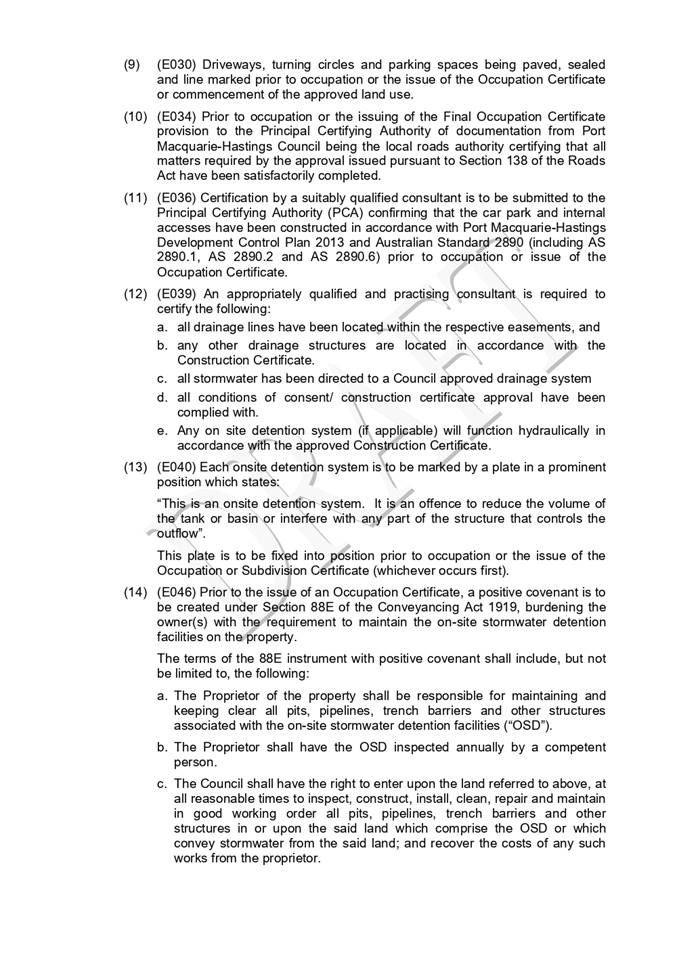
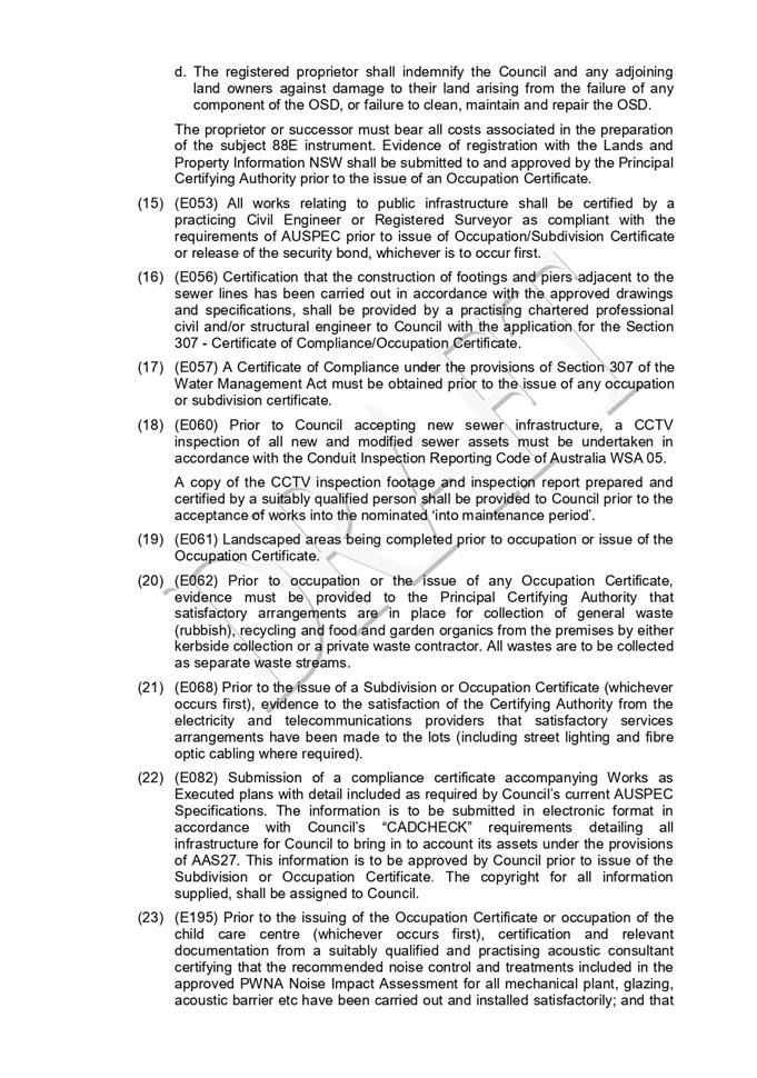
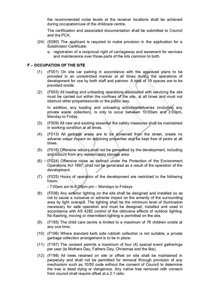
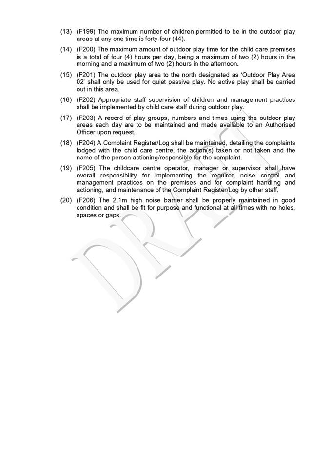
|
ATTACHMENT
|
Development Assessment Panel
08/09/2022
|
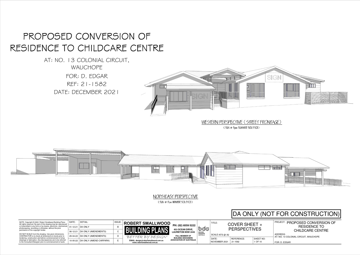
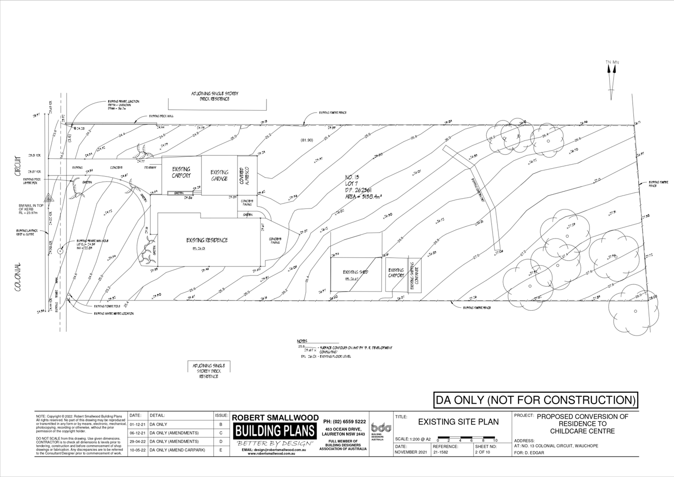
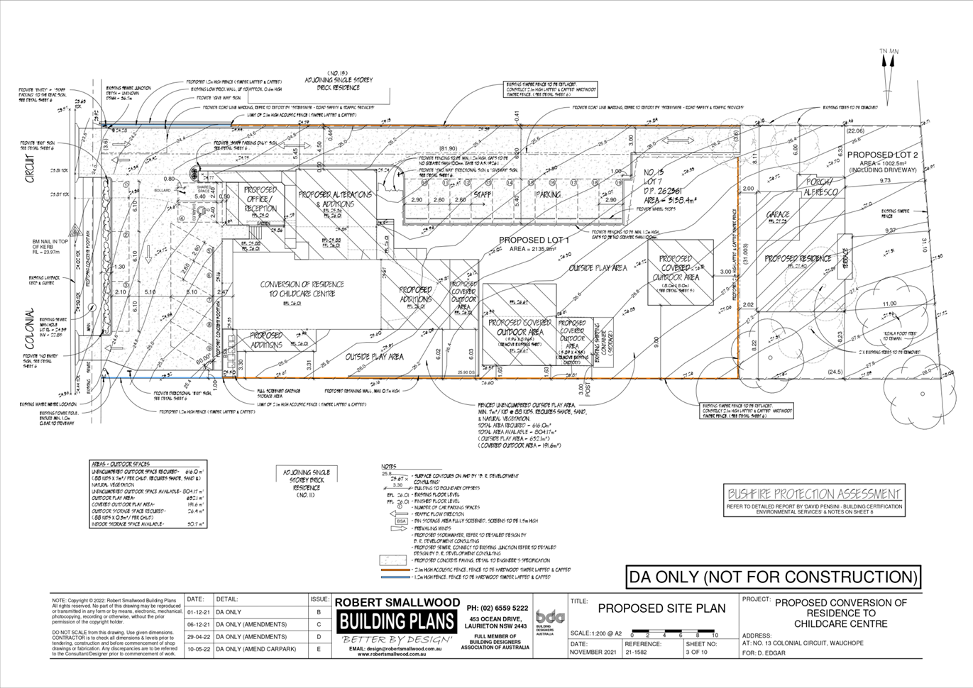
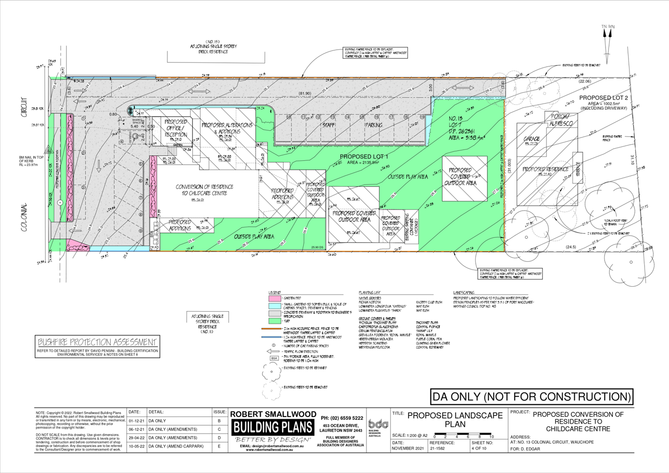
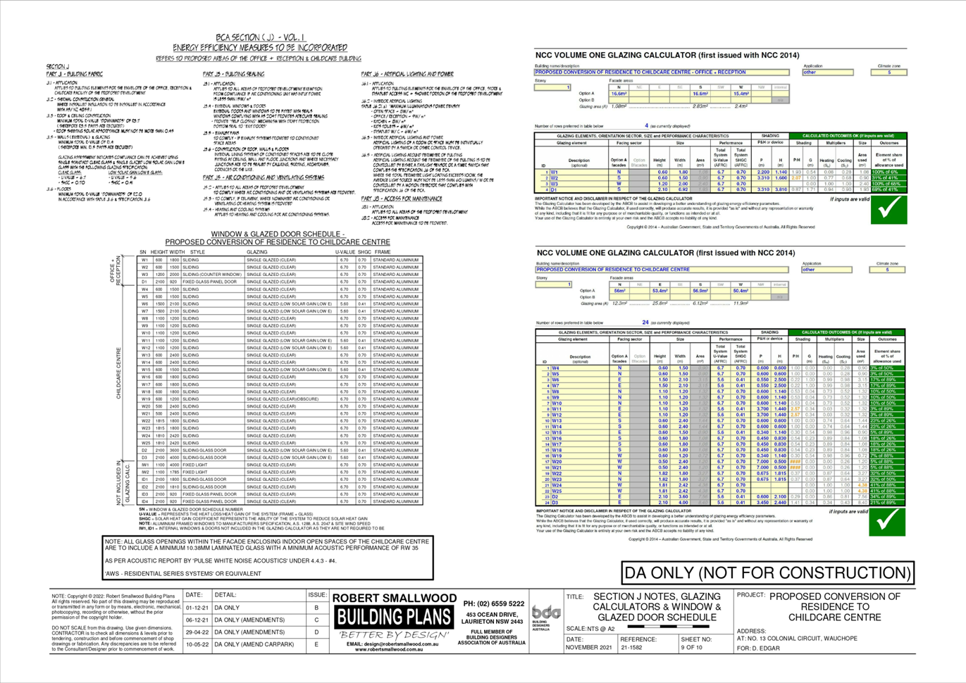
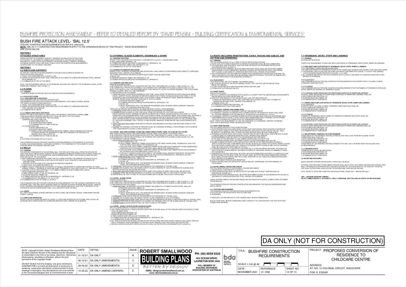
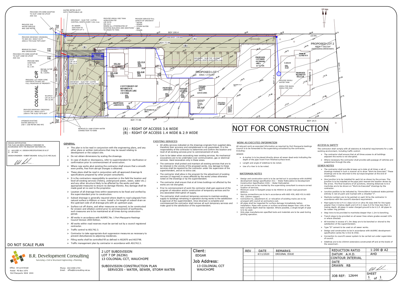
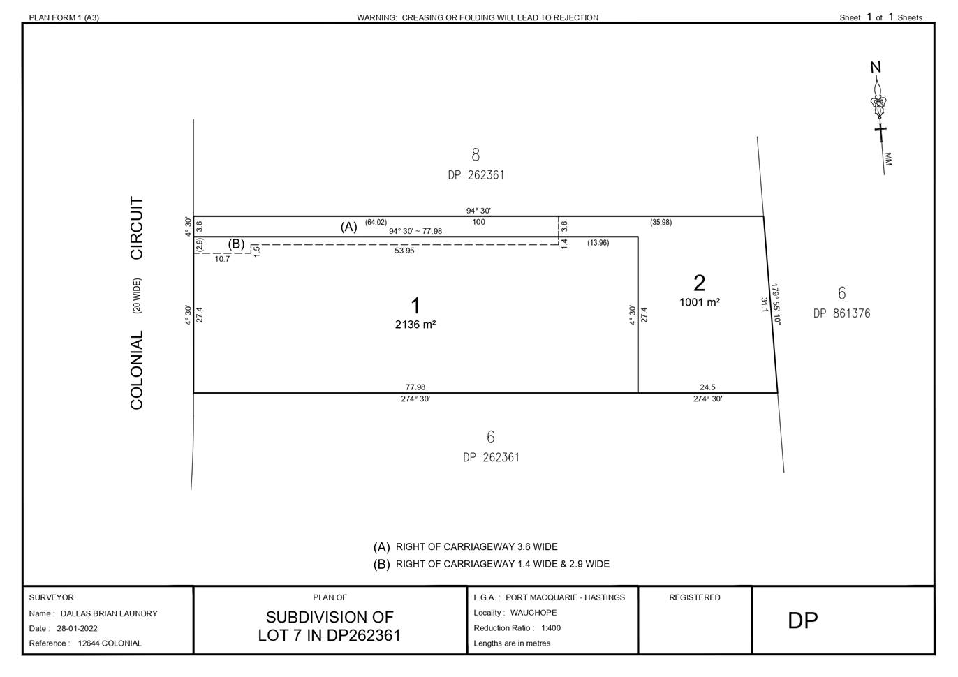
|
ATTACHMENT
|
Development Assessment Panel
08/09/2022
|