Development
Assessment Panel
Business
Paper
|
date of meeting:
|
|
Wednesday 5 April
2023
|
|
location:
|
|
Port
Macquarie-Hastings Council
17 Burrawan Street,
Port Macquarie
Function Room
|
|
time:
|
|
2:00pm
|
 DEVELOPMENT ASSESSMENT PANEL SUB COMMITTEE CHARTER
Adopted: Ordinary
Council 2022 09 15
1.0
OBJECTIVES
To assist in managing
Council's development assessment function by providing independent, transparent and expert determinations of development applications that fall outside
of staff delegations.
2.0
KEY FUNCTIONS
·
To review development application reports and conditions. The focus of the Panel’s review is to be on those issues raised in submissions received following exhibition of development applications;
·
To determine
development applications
where there are 3 or more unique
submissions or where an
application is outside of staff delegations;
·
To refer development applications to Council for determination where
necessary;
·
To provide a forum for objectors
and applicants to make submissions on applications before the
Development Assessment Panel(DAP);
·
To maintain transparency in the determination of development applications.
Delegated Authority of Panel
Pursuant to Section 377 of the Local Government Act, 1993 delegation to:
·
Determine (approve
or refuse) development applications under Part 4 of the Environmental Planning and Assessment Act 1979 having regard to the relevant
environmental planning instruments, development control plans and Council
policies.
·
Vary, modify or release
restrictions as to use and/or covenants created
by Section 88B instruments under the Conveyancing Act 1919 in relation to development applications being considered by the panel.
·
Determine Koala Plans of Management under State Environmental Planning Policy (Biodiversity and Conservation) 2021 associated with development applications being considered by the
Panel.
Noting the trigger to escalate decision
making to Council
as highlighted in section 5.2.
3.0 MEMBERSHIP
3.1 Voting Members
·
3 independent
external members will be selected for each scheduled DAP meeting from an
appointed pool of members. One of the independent external
members to be the
Chairperson. Independent members will be rostered onto meeting on a rotational
basis where possible.
·
Group Manager
Development Services (alternate - Director Community, Planning and Environment or Development Assessment Planning Coordinator).
The independent external
members shall have expertise in one or more of the following areas: planning,
architecture, heritage, the environment, urban
design, economics, traffic
and transport, law, engineering,
government and public administration.
3.2 Non-Voting Members Not applicable.
3.3 Obligations of members
·
Members must act faithfully and diligently and in accordance with this Charter.
·
Members must comply with Council's Code of Conduct.
·
Except as required to properly perform
their duties, DAP members must not disclose
any confidential information
(as advised by Council) obtained in connection with the DAP functions.
·
Members will have read and be familiar with the documents
and information provided
by Council prior to attending
a DAP meeting.
·
Members must act in accordance with Council's Workplace Health and Safety
Policies and Procedures
·
External members
of the Panel are not authorised to speak to the media on behalf of Council. Council officers that are members
of the Committee are bound by the
existing operational delegations in relation to speaking to media.
3.4 Member Tenure
The independent external
members will be appointed for the term of 4 years or until such time as an
expression of interest process to source panel members is completed for the proceeding 4 year term.
3.5 Appointment of members
·
A pool of independent external
members (including the Chair) shall be appointed by the Chief Executive Officer
following an external
Expression of Interest
process. Previous Panel members are eligible to be reappointed on the
Panel following this expression of interest process.
·
Independent members will be rostered on to Panel meetings on a rotational basis where possible
to suit Panel member availability and Panel operational needs.
·
Staff members on the Panel shall be appointed
by the Chief Executive Officer.
4.0
TIMETABLE OF MEETINGS
·
The Development Assessment Panel will generally meet on the 1st and 3rd Wednesday each month at 2.00pm
at the Port Macquarie offices of Council.
Meetings may be conducted on-line or a combination of in person and on-line.
·
Special Meetings
of the Panel may be convened by the Director
Community, Planning and Environment Services with 3 days
notice.
5.0 MEETING
PRACTICES
5.1 Meeting Format
·
At all Meetings of the Panel the Chairperson shall occupy the Chair and preside. The Chair will be
responsible for keeping order at meetings.
·
Meetings shall be open to the public.
·
The Panel will hear from an applicant and objectors or their representatives. Speakers are required to register to speak by close of
business on the day prior to the Panel meeting.
·
The Panel shall have the discretion to ask the applicant and objectors questions
relating to the proposal and their submission. There
is no ‘right of reply’ for an objector or applicant.
·
Where there are a
large number of persons making submissions with common interests, the Panel
shall have the discretion to hear a representative of those persons
rather than multiple
persons with the same interest.
·
Council assessment staff will be available
at Panel meetings
to provide technical
assessment advice and
assistance to the Panel.
·
Where considered necessary, the Panel will conduct site inspections prior to the meeting.
5.2 Decision Making
·
Decisions are to be made by consensus. Where consensus is not possible
on any item, that item is
to be referred to Council for a decision.
·
All development applications involving a proposed variation to a development standard greater than 10% under Clause 4.6 of the Local
Environmental Plan will be
considered by the Panel and recommendation made to the Council for a decision.
5.3 Quorum
3 members
must be present
at a meeting to form a quorum.
5.4 Chairperson and Deputy Chairperson Independent Chair (alternate - independent member).
5.5 Secretariat
·
The Director
Community, Planning and Environment is to be responsible for ensuring that the
Panel has adequate secretariat support. The secretariat will ensure that the
business paper and supporting papers
are circulated at least
3 days prior to each meeting. Minutes
shall be appropriately approved and circulated to
each member within 3 weeks of a meeting being held.
·
The format
of and the preparation and publishing of the Business
Paper and Minutes
shall be similar to the format for Ordinary Council
Meetings.
5.6 Recording of decisions
Minutes will be limited
to the recording of decisions
of the DAP and how each member
votes for each item
before the Panel. Meetings may be recorded via an on-line platform where
practical.
6.0
CONVENING OF “OUTCOME SPECIFIC” WORKING GROUPS
Not applicable.
7.0
CONFIDENTIALITY AND CONFLICT
OF INTEREST
·
Members of the
Panel must comply with Council’s Code of Conduct. It is the personal
responsibility of members to comply with the standards in the Code of Conduct
and regularly review their
personal circumstances with this in mind.
·
Panel members
must declare any conflict of interest at the start of each meeting or before
discussion of a relevant item or topic. Details of any conflicts of interest
are to be appropriately minuted. Where members are deemed to have a real or
perceived conflict of interest, it may be appropriate they be excused
from deliberations on the issue where the conflict of interest may exist.
A Panel meeting may be postponed where there is no quorum.
8.0 LOBBYING
All members and applicants are to adhere
to Council’s Lobbying
policy. Outside of scheduled Development Assessment Panel meetings,
applicants, their representatives, Councillors, Council staff and the general
public are not to lobby Panel members via meetings, telephone conversations,
correspondence and the like. Adequate opportunity will be provided at Panel
inspections or meetings for applicants, their representatives and the general
public to make verbal submissions in relation to Business Paper items.
9.0
CONDUCT AT MEETINGS
All parties in attendance at a DAP meeting shall conduct
themselves respectfully i.e. not disrupt the conduct of the meeting, interject,
act courteously and with compassion and empathy and sensitivity and will not insult, denigrate
or make defamatory or personal
reflections on or impute improper
motives to the DAP, Council staff or other members of
the public.
Development Assessment Panel
ATTENDANCE
REGISTER
|
Member
|
18/01/23
|
15/02/23
|
01/03/23
|
15/03/23
|
|
David Crofts
(Independent Chair)
|
P
|
P
|
P
|
|
|
Chris Gee
(Independent Member)
|
P
|
P
|
P
|
P
|
|
Michael Mason
(Independent Member)
|
|
|
P
|
P
|
|
Dan Croft
(Group Manager
Development Services)
|
|
P
|
P
|
P
|
|
Tony McNamara
(Independent Member)
|
|
P
|
|
P
|
|
Other attendees
|
|
|
|
|
|
Mayor Peta Pinson
|
|
|
|
P
|
|
Grant Burge
(Development Engineering
Coordinator)
|
P
|
|
P
|
P
|
|
Kerrod Franklin
(Acting Development
Engineering Coordinator)
|
|
|
|
|
|
Patrick
Galbraith-Robertson
(Development Planning
Coordinator)
|
P
|
|
P
|
|
|
Steven Ford
(Development Assessment
Planner)
|
P
|
|
|
P
|
|
Chris Gardiner
(Development Assessment
Planner)
|
|
|
|
|
|
Vanessa Penfold
(Development Assessment Planner)
|
|
|
|
P
|
|
Clinton Tink
(Development Assessment
Planner)
|
|
|
|
|
|
Jon Power
(Act Development Engineer
Coordinator)
|
|
|
|
|
|
Beau Spry
(Development Assessment
Planner)
|
|
|
|
|
|
Ben Roberts
(Development Assessment
Planner)
|
|
P
|
|
|
|
Councillor Josh Slade
|
|
|
|
|
|
Councillor Sharon
Griffiths
|
|
|
|
|
|
Kate Kennedy
(Building Surveyor)
|
|
|
|
|
|
Warren Wisemantel
|
|
|
|
|
|
Deputy Mayor Adam Roberts
|
|
|
|
|
|
Bob Slater
(Development Assessment
Planner)
|
|
|
|
|
|
Alton Dick
(Stormwater Engineer)
|
|
|
|
|
Key: P = Present, A
= Absent With Apology X = Absent Without Apology
Development
Assessment Panel
Meeting Dates for
2023
|
18/01/2023
|
Function Room
|
2.00pm
|
|
01/02/2023
|
Function Room
|
2.00pm
|
|
15/02/2023
|
Function Room
|
2.00pm
|
|
01/03/2023
|
Function Room
|
2.00pm
|
|
15/03/2023
|
Function Room
|
2.00pm
|
|
05/04/2023
|
Function Room
|
2.00pm
|
|
19/04/2023
|
Function Room
|
2.00pm
|
|
03/05/2023
|
Function Room
|
2.00pm
|
|
17/05/2023
|
Function Room
|
2.00pm
|
|
07/06/2023
|
Function Room
|
2.00pm
|
|
21/06/2023
|
Function Room
|
2.00pm
|
|
05/07/2023
|
Function Room
|
2.00pm
|
|
19/07/2023
|
Function Room
|
2.00pm
|
|
02/08/2023
|
Function Room
|
2.00pm
|
|
16/08/2023
|
Function Room
|
2.00pm
|
|
06/09/2023
|
Function Room
|
2.00pm
|
|
20/09/2023
|
Function Room
|
2.00pm
|
|
04/10/2023
|
Function Room
|
2.00pm
|
|
18/10/2023
|
Function Room
|
2.00pm
|
|
01/11/2023
|
Function Room
|
2.00pm
|
|
15/11/2023
|
Function Room
|
2.00pm
|
|
06/12/2023
|
Function Room
|
2.00pm
|
Development
Assessment Panel Meeting
Wednesday 5 April
2023
Items of Business
01 Acknowledgement
of Country............................................................................. 8
02 Apologies.......................................................................................................... 8
03 Confirmation
of Minutes..................................................................................... 8
04 Disclosures
of Interest..................................................................................... 13
05 DA2021
- 894.1 Staged Additions to Racecourse Comprising Horse Stables and Walkers at
Lot 653 DP 43940, No.15 Tulloch Road, Port Macquarie......................................... 17
06 DA2022
- 364.1 Demolition of Dwelling and Construction of Residential Flat Building
including Clause 4.6 Variation to Clause 4.3 (Height of Building) & Strata
Subdivision, Lot 200 DP 1289768, No. 30 Waugh Street, Port Macquarie.............................................. 135
07 DA2019
- 934.1 Caravan Park at Lot 5 DP 524972 Parklands Close, Port Macquarie 329
08 General
Business
Development Assessment Panel
05/04/2023
Subject: ACKNOWLEDGEMENT
OF COUNTRY
"I acknowledge that we are
gathered on Birpai Land. I pay respect to the Birpai Elders both past and
present. I also extend that respect to all other Aboriginal and Torres Strait
Islander people present."
RECOMMENDATION
That the apologies received be
accepted.
Subject: CONFIRMATION
OF PREVIOUS MINUTES
Recommendation
That the Minutes of the Development Assessment Panel Meeting
held on 15 March 2023 be confirmed.
MINUTES
Development Assessment Panel Meeting
15/03/2023
PRESENT
Members:
Chris Gee (Independent Member)
Michael Mason (Independent Member)
Tony McNamara (Independent Member)
Dan Croft (Group Manager
Development Services)
Other Attendees:
Mayor
Peta Pinson
Grant
Burge (Development Engineering Coordinator)
Steven
Ford (Development Assessment Planner)
Vanessa
Penfold (Development Assessment Planner)
|
The meeting opened at 2.00pm.
|
|
01 ACKNOWLEDGEMENT
OF COUNTRY
|
|
The
Acknowledgement of Country was delivered.
|
|
02 APOLOGIES
|
|
CONSENSUS:
That the apology received from
David Crofts be accepted.
|
|
03 CONFIRMATION
OF MINUTES
|
|
CONSENSUS:
That the Minutes of the
Development Assessment Panel Meeting held on 1 March 2023 be confirmed.
|
|
04 DISCLOSURES
OF INTEREST
|
|
There were no disclosures of interest presented.
|
|
05 DA2022 -
965.01 Ancillary Building, Lot 19 DP 264398 13 Mahogany Hill Port Macquarie
|
|
Speakers:
Peter Simmons (opposing the
application)
Joanne Bahri (opposing the
application)
Julie Ho (opposing the
application)
Sam Percival (applicant)
CONSENSUS:
That DA2022
- 965.01 Ancillary Building, Lot 19 DP 264398 13
Mahogany Hill Port Macquarie be refused for the following reasons:
1. The
proposal is contrary to Port Macquarie-Hastings Development Control Plan
2013.
2. The
proposal will have an adverse impact on the character and streetscape of the
Mahogany Hill precinct.
3. The
proposal would set an undesirable precedent for structures forward of the
building line.
4. The
proposal has not satisfactorily demonstrated consistency with the C4
Environmental Living zone objectives of the Port Macquarie-Hastings Local
Environmental Plan 2011.
5. There
are alterative options for a carport on the property on the property that
would not have such a significant impact.
|
|
06 DA2022 - 287
Multi-Dwelling Housing for Lot 2 DP1283843, Cnr Platypus Parade and Tiger
Quoll Drive, Lake Cathie
|
|
Speakers:
Mark McCormick (opposing the
application)
Ian Roberts (supporting the
application)
Tracy Frost (applicant)
Michelle Love (applicant)
Brad Mags (applicant)
Ayla Bailey (applicant)
CONSENSUS:
That DA2022
- 287 for Multi-Dwelling Housing at Lot 2, DP 1283843, Cnr Platypus Parade and Tiger Quoll Drive, Lake Cathie be
determined by granting consent subject to the
following changes to conditions of consent:
- Additional condition in Section
B of the consent to read: ‘Prior to release of the construction
certificate the plans are to be amended for units 1, 2 and 3 to provide
suitable privacy screening to the toilet in the garage. Alternatively,
the toilet can be removed from the garage.’
- Additional condition in Section
B of the consent to read: ‘Prior to release of the construction
certificate the landscaping plans are to be amended to remove plantings
within the road reserve.’
|
|
07 DA2022 - 742.1
Alterations and Additions to Dwelling at Lot 1 DP 261189, No. 43 The Summit
Road Port Macquarie
|
|
Speakers:
Jeremy Gray (opposing the
application)
Greg Schwarzel (opposing the
application)
Glen Schwarzel (opposing the
application)
Terrance Stafford (applicant)
Matt Edwards (applicant)
CONSENSUS:
That
DA2022 - 742 for Alterations and Additions to Dwelling at Lot 1, DP 261189, No.
43 The Summit Road, Port Macquarie be
determined by granting consent subject to the following changes to conditions
of consent.
·
Additional condition in Section A of the consent to read:
‘The development must only proceed in accordance with the
approved stages as set out below:
·
Stage 1 - New boxed window to Bedroom 4 (southern elevation),
construction of front second floor balcony and conversion of master bedroom
to lounge room and office.
·
Stage 2 - First and second floor additions including roof
works, conversion of bedroom to study, renovation of existing bathroom,
construction of Bedrooms 2 and 3, with ensuite to bedroom 3, new master
bedroom with walk-in-robe and ensuite.
·
Stage 3 - Ground floor and external works including extension
of garage (gym) and study to create new bedroom, new cellar in subfloor area,
first floor balcony and stairs (rear), new timber deck with roof over and
stairs to ground and outdoor kitchen (BBQ) area.
Unless
specified, the conditions of this consent will apply to all stages, with any
decision on any discrepancy with conditions and associated staging resting
with Council. Any decision to allow a change to staging will rest with
Council along with applicable conditions.’
·
Additional condition in section B of the consent to read:
‘Prior to release of the construction certificate the plans are to be
amended to increase the setback of the north western corner of the rear
timber deck to achieve a minimum 1.5m setback to the rear boundary. The deck
is to then splay back to the north eastern corner. The 1.7m high privacy
screen required along the northern elevation of the rear deck is to
additionally extend a minimum 1m from the northern point along the western
elevation so as to reduce potential overlooking of the rear property.’
|
|
The meeting closed at 5.04pm
|
Development Assessment Panel
05/04/2023
Subject: DISCLOSURES
OF INTEREST
RECOMMENDATION
That Disclosures of Interest be presented
DISCLOSURE OF
INTEREST DECLARATION
|
Name of Meeting:
|
|
Meeting
Date:
|
|
Item
Number:
|
|
Subject:
|
|
I,
the undersigned, hereby declare the following interest:
Pecuniary:
 Take no part
in the consideration and voting and be out of sight of the meeting. Take no part
in the consideration and voting and be out of sight of the meeting.
Non-Pecuniary
– Significant Interest:
Take no part
in the consideration and voting and be out of sight of the meeting.
Non-Pecuniary
– Less than Significant Interest:
May
participate in consideration and voting.
|
|
For
the reason that:
|
|
Name:
Signed:
|
Date:
|
|
Please submit to the
Governance Support Officer at the Council Meeting.
|
 (Refer
to next page and the Code of Conduct)
(Refer
to next page and the Code of Conduct)
Pecuniary Interest
4.1
A pecuniary interest is an interest
that you have in a matter because of a reasonable likelihood or expectation of
appreciable financial gain or loss to you or a person referred to in clause
4.3.
4.2
You will not have a pecuniary
interest in a matter if the interest is so remote or insignificant that it
could not reasonably be regarded as likely to influence any decision you might
make in relation to the matter, or if the interest is of a kind specified in
clause 4.6.
4.3
For the purposes of this Part, you
will have a pecuniary interest in a matter if the pecuniary interest is:
(a)
your interest, or
(b)
the interest of your spouse or de
facto partner, your relative, or your partner or employer, or
(c)
a company or other body of which
you, or your nominee, partner or employer, is a shareholder or member.
4.4
For the purposes of clause 4.3:
(a)
Your “relative” is any
of the following:
(b)
“de facto partner” has
the same meaning as defined in section 21C of the Interpretation Act 1987.
4.5
You will not have a pecuniary
interest in relation to a person referred to in subclauses 4.3(b) or (c)
(a)
if you are unaware of the relevant
pecuniary interest of your spouse, de facto partner, relative, partner,
employer or company or other body, or
(b)
just because the person is a member
of, or is employed by, a council or a statutory body, or is employed by the
Crown, or
(c)
just because the person is a member
of, or a delegate of a council to, a company or other body that has a pecuniary
interest in the matter, so long as the person has no beneficial interest in any
shares of the company or body.
Non-Pecuniary
5.1
Non-pecuniary interests are private
or personal interests a council official has that do not amount to a pecuniary
interest as defined in clause 4.1 of this code. These commonly arise out of
family or personal relationships, or out of involvement in sporting, social,
religious or other cultural groups and associations, and may include an
interest of a financial nature.
5.2
A non-pecuniary conflict of
interest exists where a reasonable and informed person would perceive that you
could be influenced by a private interest when carrying out your official
functions in relation to a matter.
5.3
The personal or political views of
a council official do not constitute a private interest for the purposes of
clause 5.2.
5.4
Non-pecuniary conflicts of interest
must be identified and appropriately managed to uphold community confidence in
the probity of council decision-making. The onus is on you to identify any
non-pecuniary conflict of interest you may have in matters that you deal with,
to disclose the interest fully and in writing, and to take appropriate action
to manage the conflict in accordance with this code.
5.5
When considering whether or not you
have a non-pecuniary conflict of interest in a matter you are dealing with, it
is always important to think about how others would view your situation.
Managing non-pecuniary conflicts of interest
5.6
Where you have a non-pecuniary
conflict of interest in a matter for the purposes of clause 5.2, you must
disclose the relevant private interest you have in relation to the matter fully
and in writing as soon as practicable after becoming aware of the non-pecuniary
conflict of interest and on each occasion on which the non-pecuniary conflict
of interest arises in relation to the matter. In the case of members of council
staff other than the Chief Executive Officer, such a disclosure is to be made
to the staff member’s manager. In the case of the Chief Executive Officer,
such a disclosure is to be made to the mayor.
5.7
If a disclosure is made at a
council or committee meeting, both the disclosure and the nature of the
interest must be recorded in the minutes on each occasion on which the
non-pecuniary conflict of interest arises. This disclosure constitutes
disclosure in writing for the purposes of clause 5.6.
5.8
How you manage a non-pecuniary
conflict of interest will depend on whether or not it is significant.
5.9
As a general rule, a non-pecuniary
conflict of interest will be significant where it does not involve a pecuniary
interest for the purposes of clause 4.1, but it involves:
a)
a relationship between a council
official and another person who is affected by a decision or a matter under
consideration that is particularly close, such as a current or former spouse or
de facto partner, a relative for the purposes of clause 4.4 or another person
from the council official’s extended family that the council official has
a close personal relationship with, or another person living in the same
household
b)
other relationships with persons
who are affected by a decision or a matter under consideration that are
particularly close, such as friendships and business relationships. Closeness
is defined by the nature of the friendship or business relationship, the
frequency of contact and the duration of the friendship or relationship.
c)
an affiliation between the council
official and an organisation (such as a sporting body, club, religious,
cultural or charitable organisation, corporation or association) that is
affected by a decision or a matter under consideration that is particularly
strong. The strength of a council official’s affiliation with an
organisation is to be determined by the extent to which they actively
participate in the management, administration or other activities of the
organisation.
d)
membership, as the council’s
representative, of the board or management committee of an organisation that is
affected by a decision or a matter under consideration, in circumstances where
the interests of the council and the organisation are potentially in conflict
in relation to the particular matter
e)
a financial interest (other than an
interest of a type referred to in clause 4.6) that is not a pecuniary interest
for the purposes of clause 4.1
f)
the conferral or loss of a personal
benefit other than one conferred or lost as a member of the community or a
broader class of people affected by a decision.
5.10
Significant non-pecuniary conflicts
of interest must be managed in one of two ways:
a)
by not participating in
consideration of, or decision making in relation to, the matter in which you
have the significant non-pecuniary conflict of interest and the matter being
allocated to another person for consideration or determination, or
b)
if the significant non-pecuniary
conflict of interest arises in relation to a matter under consideration at a
council or committee meeting, by managing the conflict of interest as if you
had a pecuniary interest in the matter by complying with clauses 4.28 and 4.29.
5.11
If you determine that you have a
non-pecuniary conflict of interest in a matter that is not significant and does
not require further action, when disclosing the interest you must also explain
in writing why you consider that the non-pecuniary conflict of interest is not
significant and does not require further action in the circumstances.
5.12
If you are a member of staff of
council other than the Chief Executive Officer, the decision on which option
should be taken to manage a non-pecuniary conflict of interest must be made in
consultation with and at the direction of your manager. In the case of the Chief
Executive Officer, the decision on which option should be taken to manage a
non-pecuniary conflict of interest must be made in consultation with and at the
direction of the mayor.
5.13
Despite clause 5.10(b), a
councillor who has a significant non-pecuniary conflict of interest in a
matter, may participate in a decision to delegate consideration of the matter
in question to another body or person.
5.14 Council committee members are not required to declare
and manage a non-pecuniary conflict of interest in accordance with the
requirements of this Part where it arises from an interest they have as a
person chosen to represent the community, or as a member of a non-profit
organisation or other community or special interest group, if they have been
appointed to represent the organisation or group on the council committee.
SPECIAL
DISCLOSURE OF PECUNIARY INTEREST DECLARATION
This
form must be completed using block letters or typed.
If
there is insufficient space for all the information you are required to
disclose,
you
must attach an appendix which is to be properly identified and signed by you.
|
By
[insert full name of councillor]
|
|
|
In the
matter of
[insert name of environmental planning instrument]
|
|
|
Which is
to be considered at a meeting of the
[insert name of meeting]
|
|
|
Held on
[insert date of meeting]
|
|
|
PECUNIARY
INTEREST
|
|
Address of
the affected principal place of residence of the councillor or an associated
person, company or body (the identified land)
|
|
|
Relationship
of identified land to councillor
[Tick or cross one box.]
|
The councillor has interest in the land (e.g. is owner or has other
interest arising out of a mortgage, lease, trust, option or contract, or
otherwise).
An associated person of the councillor has an interest in the land.
An associated company or body of the councillor has interest in the land.
|
|
MATTER
GIVING RISE TO PECUNIARY INTEREST
|
|
Nature of
land that is subject to a change
in
zone/planning control by proposed
LEP (the
subject land
[Tick or cross one box]
|
The identified land.
Land that adjoins or is adjacent to or is in proximity to the identified
land.
|
|
Current
zone/planning control
[Insert name of current planning instrument and
identify relevant zone/planning control applying to the subject land]
|
|
|
Proposed
change of zone/planning control
[Insert name of proposed LEP and identify proposed
change of zone/planning control applying to the subject land]
|
|
|
Effect of
proposed change of zone/planning control on councillor or associated person
[Tick or cross one box]
|
Appreciable financial gain.
Appreciable financial loss.
|
|
|
|
[If more than one pecuniary interest is to be declared,
reprint the above box and fill in for each additional interest]
Councillor’s Signature:
……………………………….
Date: ………………..
This form is to be retained
by the council’s Chief Executive Officer and included in full in the
minutes of the meeting
Last Updated: 3 June 2019
Important Information
This information is being collected for the purpose of
making a special disclosure of pecuniary interests under clause 4.36(c) of the
Model Code of Conduct for Local Councils in NSW (the Model Code of Conduct).
The special disclosure must relate only to a pecuniary
interest that a councillor has in the councillor’s principal place of
residence, or an interest another person (whose interests are relevant under
clause 4.3 of the Model Code of Conduct) has in that person’s principal
place of residence.
Clause 4.3 of the Model Code of Conduct states that you
will have a pecuniary interest in a matter because of the pecuniary interest of
your spouse or your de facto partner or your relative or because your business
partner or employer has a pecuniary interest. You will also have a pecuniary
interest in a matter because you, your nominee, your business partner or your
employer is a member of a company or other body that has a pecuniary interest
in the matter.
“Relative” is defined by clause 4.4 of the Model
Code of Conduct as meaning your, your spouse’s or your de facto
partner’s parent, grandparent, brother, sister, uncle, aunt, nephew,
niece, lineal descendant or adopted child and the spouse or de facto partner of
any of those persons.
You
must not make a special disclosure that you know or ought reasonably to know is
false or misleading in a material particular. Complaints about breaches
of these requirements are to be referred to the Office of Local Government and
may result in disciplinary action by the Chief Executive of the Office of Local
Government or the NSW Civil and Administrative Tribunal.
This form must be completed by you before the commencement
of the council or council committee meeting at which the special disclosure is
being made. The completed form must be tabled at the meeting. Everyone is
entitled to inspect it. The special disclosure must be recorded in the minutes
of the meeting.
A pecuniary interest may arise by way of a change of
permissible use of land adjoining, adjacent to or in proximity to land in which
a councillor or a person, company or body referred to in clause 4.3 of the
Model Code of Conduct has a proprietary interest
Development Assessment Panel
05/04/2023
Item: 05
Subject: DA2021 - 894.1 Staged Additions to Racecourse
Comprising Horse Stables and Walkers at Lot 653 DP 43940, No.15 Tulloch Road,
Port Macquarie
Report
Author: Development Assessment Planner, Clint Tink
|
Applicant: Hopkins
Consultants Pty Ltd
Owner: NSW
Trade & Investment - Crown Lands
Estimated Cost: $1,655,000
Alignment with Delivery
Program
4.3.1 Undertake transparent
and efficient development assessment in accordance with relevant legislation.
|
RECOMMENDATION
That
DA2021 - 894.1 for staged additions to
racecourse comprising horse stables and walker yards at Lot 653, DP 43940, 15 Tulloch Road, Port Macquarie, be determined by granting consent subject to the
recommended conditions.
Executive
Summary
This
report considers a development application for staged additions to Port
Macquarie Racecourse comprising horse stables and walker yards at the subject site (Port Macquarie Racecourse) and
provides an assessment of the application in accordance with the Environmental
Planning and Assessment Act 1979.
Following exhibition of the
application, no submissions were initially
received. However, in November 2022 and before the DA was determined, a series
of late submissions were received. In total, four (4) late submissions were
received.
The application was subsequently
reported to Council’s Development Assessment Panel (DAP) on 7 December
2022 where the following resolution was made:
That DA2021 - 894 be deferred
to enable the applicant to address the apparent conflict with the operational
requirements and noise impact of the development noting the acoustic assessment
supporting the application and draft conditions F(15) and F(16).
A copy of the previous DAP report
and conditions are attached for context. (Attachment 4).
Since the DAP meeting on 7
December 2022, the applicant has re-assessed their acoustic assessment
(Attachment 5) based on the operational requirements of the racecourse to come
up with a balanced outcome, subject to conditions. In particular, access via
Tulloch Road and the use of the proposed development, is considered acceptable
on noise grounds, subject to conditions limiting the number of vehicles at
certain times of the night, restrictions on where vehicles park at night etc. The
changes have been incorporated into this updated assessment and draft
conditions of consent.
The development application and
updated acoustic assessment were also re-exhibited with four (4) submissions
being received.
Overall, the site is considered suitable for the proposed
development and the proposal adequately addresses relevant planning controls.
The development is not considered to be contrary to the public's interest and
will not result a significant adverse social, environmental or economic impact.
This report recommends that the
development application be approved subject to the attached conditions
(Attachment 1).
The reason for the application being referred to
Council’s Development Assessment Panel (DAP) is because three (3) or more
objections to the proposal have been received. A copy of the DAP Charter
outlining the delegations and functions of the DAP is available on
Council’s website.
1. BACKGROUND
Existing
Sites Features and Surrounding Development
The subject lot containing the
proposed development/works has an area of 5.31ha. The lot forms part of the
larger Port Macquarie Racecourse precinct, which exceeds 25ha.
The
site is zoned RE2 Private Recreation in
accordance with the Port Macquarie-Hastings Local Environmental Plan 2011, as
shown in the following zoning plan:
 The existing subdivision pattern and location of existing
development within the locality is shown in the following aerial photograph:
The existing subdivision pattern and location of existing
development within the locality is shown in the following aerial photograph:

2. DESCRIPTION
OF DEVELOPMENT
Key
aspects of the proposal include the following:
· DA2005 - 637 approved an arrangement of stables (114
stalls), exercise yards etc in a similar location. The application was later
modified and reduced in scale to 104 stalls. However, no evidence was found to
show the DA commenced and has subsequently lapsed.
· The
application is for a staged development comprising five (5) horse stable
buildings that will house 20 horse stalls per building or 100 stalls total.
Each building will also contain ancillary amenities, office, food storage etc.
In addition to the horse stable buildings, five (5) horse walker yards are also
proposed.
· The
horse stable buildings will comprise colorbond construction on a concrete slab
and measure approximately 11m wide by 53m long and 4.5m high.
· The
application also includes a landscape plan, acoustic, odour, traffic and
parking assessment in support of the proposal.
· Four
(4) late submissions were received objecting to the development during the
original notification period. A further four (4) submissions were received
following the re-notification period.
· Construction
of additional parking areas.
Refer
to (Attachment 2) at the end of this report for plans of the proposed
development.
Application
Chronology
· 16/2/2006
- DA2005 - 637 approved an arrangement of stables etc onsite. DA2005 - 637 was
subsequently modified on 4 May 2009. No evidence was found to show the DA
commenced and has subsequently lapsed.
· 1/9/2020
- Pre-lodgement meeting held to discuss proposal.
· 20/10/2021
- Application lodged with Council.
· 1/11/2021
- Council staff requested additional information from the applicant.
· 2-15/11/2021 - Notification period.
· 17/11/2021 - Applicant requested confirmation of whether or
not any submissions were received during the notification period. Council staff
advised that no submissions were received.
· 18-19/11/2021 - Comments from Essential Energy received and
provided to the applicant.
· 25/3/2022 - Applicant provided partial response to
Council’s previous request for additional information.
· 4/5/2022 - Applicant provided partial response to
Council’s previous request for additional information.
· !7/5/2022 - Council staff requested additional
information from the applicant in relation to the noise impact assessment.
· 24/5/2022
- Applicant provided partial response to
Council’s previous request for additional information.
· 12/7/2022
- Advice received from Crown lands that a requirement
to consolidate the racecourse lots was not required/supported.
· 25/7/2022
- DA status update provided to Racecourse consultant.
Partial response to Council’s previous requests for additional information
was provided.
· 27/7/2022
- Council staff requested clarification on the
acoustic fence and landscaping.
· 4/8/2022
- Further advice provided from Crown lands regarding
the consolidation of the racecourse lots not being supported.
· 6/9/2022
- Applicant sought meeting to discuss outstanding
matters/issues.
· 9/9/2022
- Applicant provided partial response to
Council’s previous request for additional information.
· 20/9/2022
- Applicant provided additional information for
meeting.
· 21/9/2022
- Meeting held with the applicant regarding
outstanding matters.
· 21/10/2022
- Applicant provided partial response to
Council’s previous request for additional information.
· 26/10/2022
- Applicant provided response to Council’s
previous request for additional information and asked for a DA status update.
· 27/10/2022
- Council staff provided update and requested
clarification on staging.
· 31/10/2022
- Council staff requested clarification on traffic
and car parking assessment.
· 1/11/2022
- Applicant consultant clarified the traffic and car
parking assessment.
· 3/11/2022
- Applicant provided clarification on staging in
response to Council’s previous request for additional information.
· 7-10/11/2022 - Four (4) late submissions received. Council
staff advised the applicant of the late submissions and provided a redacted
copy. Applicant acknowledged submissions.
· 14/11/2022
- Applicant requested a DA status updated, which was
provided by Council staff.
· 7/12/2022
- Application was reported to DAP. Resolution was to
defer the matter to enable the applicant to address the conflict between
operational requirements and the acoustic assessment.
· 19/1/2023
- Applicant submitted an updated acoustic assessment.
Correspondence between Council staff and the applicant also occurred regarding
recommendations in the report.
· 6/2/2023
- Council staff sought clarification on the acoustic
assessment.
· 3/3/2023
- Applicant provided an updated acoustic assessment.
Council staff asked for clarification on the acoustic report.
· 7/3/2023
- Applicant provided clarification on the acoustic
assessment.
· 10-23/3/2023
- Application and revised acoustic assessment were re-notified.
3. STATUTORY
ASSESSMENT
Section
4.15(1) Matters for Consideration
In
determining the application, Council is required to take into consideration the
following matters as are relevant to the development that apply to the land to
which the development application relates:
(a) The
provisions (where applicable) of:
(i) Any
Environmental Planning Instrument
State Environmental Planning Policy (Biodiversity and
Conservation) 2021
Chapter 4 Koala Habitat Protection 2021
Clause 4.4 - This SEPP applies to all non-rural zoned land
within the Port Macquarie-Hastings Local Government Area. The property
is zoned RE2 Private Recreation (non-rural zone) so the SEPP applies.
Clause 4.9 - The property is over 1ha in size
(including adjoining land in the same ownership) and does not have a KPOM in
place.
Before consent is granted, Council is required
to assess whether the development is likely to have any impact on koalas or
koala habitat.
In accordance with Clause 4.9(3), Council is
satisfied that the development is likely to have low or no impact on koalas or
koala habitat for the following reasons:
1. The site of the development is
already cleared and not likely to form any key koala habitat.
2. The development will still allow
koala movement throughout the larger racecourse precinct, should a koala move
through the cleared development area to access other trees/habitat on the
larger racecourse precinct or adjoining vegetated areas.
Based on the above, consent to the development
application on koala habitat grounds is supported.
State Environmental Planning Policy (Resilience and
Hazards) 2021
Chapter 2 Coastal Management
Having
regard to clause 2.8 (proximity to coastal wetlands) of this SEPP, the proposed
development is not considered likely to result in any of the following:
(a) identifiable
adverse impacts on the biophysical, hydrological and ecological integrity of
the nearby coastal wetland; and
(b) identifiable
impacts to water flows to the nearby coastal wetland.
In particular, the development is over 70m away from the
coastal wetland area and Council’s Stormwater Engineer has also reviewed/accepted
the proposal on stormwater grounds.
Chapter 4 Remediation of Land
Clause 4.6 - Following an inspection of the site and a
search of Council records, the subject land is not identified as being
potentially contaminated and is suitable for the intended use. The site also
has a history of being used for similar horse industry activities (ie walking
horses, transporting horses, parking of horse floats etc).
State Environmental Planning Policy (Transport and
Infrastructure) 2021
Clause 45 - Referral to Essential Energy is required for any
of the following:
(a) the
penetration of ground within 2m of an underground electricity power line or an
electricity distribution pole or within 10m of any part of an electricity
tower,
(b) development
carried out:
(i) within
or immediately adjacent to an easement for electricity purposes (whether or not
the electricity infrastructure exists), or
(ii) immediately
adjacent to an electricity substation, or
(iii) within
5m of an exposed overhead electricity power line,
(c) installation
of a swimming pool any part of which is:
(i) within
30m of a structure supporting an overhead electricity transmission line,
measured horizontally from the top of the pool to the bottom of the structure
at ground level, or
(ii) within 5m of an overhead electricity power line, measured vertically
upwards from the top of the pool.
A referral to Essential Energy was carried out with no
objection received. Standard advice about Dial before you Dig, working near
powerlines etc was provided, which was forwarded to the applicant.
Clause 2.119 refers to development with frontage to a
classified road (Oxley Highway). In this case, the development does not create
any additional crossovers onto the classified road or substantial increase in
traffic. The development is also suitably setback 90m+ from the Oxley Highway
and is not a use that would be sensitive to the level of traffic noise or
vehicle emissions that may reach the development (ie no residential component
proposed). Therefore, no adverse impact on the road network will occur.
Clause 2.120 refers to noise and vibration impacts from a
classified road on non-road development. The clause only applies to certain
sensitive receivers like residential accommodation, hospitals, educational establishments
and the like. The clause does not apply to additions to a racecourse.
The development does not trigger any of the traffic
generating development thresholds of Clause 2.122. Referral to the NSW Roads
and Maritime Services (RMS) is not required.
Based on the above, the proposed development addresses
relevant clauses in the SEPP and will not to create any significant adverse
conflict in terms of traffic or noise.
State Environmental Planning Policy (Planning Systems)
2021
The development does not trigger any of the clauses or
thresholds in the SEPP.
State Environmental Planning Policy (Primary Production)
2021
Part 2.5 Division 4 - The proposed development will create
no adverse impact on any oyster aquaculture development or priority oyster aquaculture
area.
Port Macquarie-Hastings Local Environmental
Plan 2011
The proposal is consistent with the LEP having regard to the
following:
· Clause
2.2 - The subject site is zoned RE2 Private Recreation. In accordance with
Clause 2.3(1) and the RE2 zone landuse table, additions to the racecourse
(recreation facility major) is a permissible landuse with consent.
The objectives of the RE2 zone are
as follows:
o To enable land to be used for
private open space or recreational purposes.
o To provide a range of recreational
settings and activities and compatible land uses.
o To protect and enhance the natural
environment for recreational purposes.
·
Clause
2.3(2) - The proposal is consistent with the zone objectives having
regard to the following:
o The proposal is a permissible
landuse;
o The
development will complement the existing recreational use onsite.
o The
development is to be located on an already disturbed area and will not impact
on any natural environment.
· Clause
4.3 - There is no maximum building height limit onsite. Nonetheless, the
proposed 4.58m height for the stables is not excessive and remains consistent
with other structures onsite.
· Clause
4.4 - There is no floor space ratio (FSR) for the site. Nonetheless, the bulk
and scale of the stables is not excessive and remains consistent with other
structures onsite.
· Clause
5.10 - The site does not contain or adjoin any known heritage items or sites of
significance. The area being developed is also disturbed from past activities.
· Clause
5.21 - The area of the lot being developed is not within a “flood
planning area”. The “flood planning area” is located to the
west of the development footprint.
· Clause
7.1 - The area of the lot being developed is not mapped as potentially
containing acid sulfate soils. The mapped acid sulfate soils area is located to
the west of the development footprint.
· Clause
7.4 - The area of the lot being developed is not within a floodplain risk
management area. The floodplain risk management area is located to the west of
the development footprint. Furthermore, the type of use proposed is not listed
within the clause as requiring additional consideration of flood impacts.
· Clause
7.7 - The Obstacle Limitation Surface (OLS) for the site is 47.5m. Noting the
existing contours for the site, the proposed stables are unlikely to exceed 20m
and therefore not impact on the OLS.
· Clause
7.13 - Satisfactory arrangements are in place for provision of essential
services including water supply, electricity supply, sewer infrastructure,
stormwater drainage and suitable road access to service the development.
(ii) Any draft
instruments that apply to the site or are on exhibition
None relevant.
(iii) Any Development
Control Plan in force
Port
Macquarie-Hastings Development Control Plan 2013
|
DCP 2013: Part B - General Provisions - B1:
Advertising and Signage
|
|
DCP Objective
|
Development Provisions
|
Proposed
|
Complies
|
|
1
|
Signage provisions.
|
No signage proposed.
|
N/A
|
|
DCP 2013: Part B - General Provisions - B2:
Environmental Management
|
|
DCP Objective
|
Development Provisions
|
Proposed
|
Complies
|
|
3
|
a) Development must comply
with Council’s Developments, Public Place & Events - Waste
Minimisation and Management Policy.
|
The site contains
sufficient area to accommodate storage and collection of waste from the
development. In particular, the applicant will utilise a private collection
arrangement and conditions of consent will cover the location/management.
|
Yes
|
|
Cut and Fill Regrading
|
|
4
|
a) Development shall not
exceed a maximum cut of 1.0m and fill of 1.0m measured vertically above the
ground level (existing) at a distance of 1.0m outside the perimeter of the
external walls of the building (This does not apply to buildings where such
cut and fill is fully retained within or by the external walls of the
building).
|
No major cut and fill
proposed. Only minor levelling will be required to establish the stables.
|
Yes
|
|
5
|
a) A certified practicing
structural engineer must certify any retaining wall greater than 1.0m.
|
No retaining wall over 1m
proposed.
|
Yes
|
|
b) Where a combination of a
fence and a wall is proposed to be greater than 1.2m high:
- be a maximum
combined height of 1.8m above existing property boundary level;
- be
constructed up to the front boundary for a maximum length of 6.0m or 30% of
the street frontage, whichever is less;
− the
fence component has openings which make it not less than 25% transparent; and
− provide
a 3m x 3m splay for corner sites, and
- provide a
900mm x 900mm splay for vehicle driveway entrances.
|
No retaining wall fence
combinations proposed that exceed 1.8m.
|
Yes
|
|
6
|
a) Significant land reforming
proposals where >10% gross site area or >1.0ha is to have surface
levels changed by more than 5m or where earthworks exceed an average of
10,000m3 per ha shall:
− identify
the impact of the proposed land reforming on the environment, landscape,
-
visual character and amenity, natural watercourses, riparian
vegetation, topographical features of the environment and public
infrastructure;
− demonstrate
compliance with the provisions of Council’s AUS-SPEC design
specification;
− assess
the impacts and benefits of the proposal to all impacted persons and the
general public;
- provide
measures to compensate for and minimise any net adverse impacts.
|
No significant land
reforming proposed.
|
Yes
|
|
b) The use of high earthworks
batters should be avoided.
|
No high earthwork batters
proposed.
|
Yes
|
|
c) Preliminary plans
indicating the final landform are required to be submitted with any master
plan or subdivision application.
|
Development does not
involve subdivision or master planning.
|
N/A
|
|
d) The subdivision should be
designed to fit the topography rather than altering the topography to fit the
subdivision.
|
Development does not
involve subdivision.
|
N/A
|
|
Environmental Management
Areas and Buffers
|
|
7
|
a) For coastal floodplain
endangered ecological communities a minimum, fully vegetated buffer of 35m
must be provided.
|
The development is setback
over 70m from the nearest endangered ecological community with
vegetated/grassed areas provided in between.
|
Yes
|
|
b) For Freshwater Wetland on
Coastal Floodplain endangered ecological community a fully vegetated buffer
of 100m is to be provided.
|
The development does not
adjoin any Freshwater Wetland.
|
N/A
|
|
c) For all other endangered
ecological communities, a fully vegetated buffer of 50m must be provided.
|
The development is setback
over 70m from the nearest endangered ecological community with
vegetated/grassed areas provided in between.
|
Yes
|
|
d) Stormwater management
facilities may be considered within buffer areas only where the applicant can
demonstrate the proposal is justified on the basis of practical engineering
related site constraints and where it is adequately demonstrated that the
applicable objectives are achieved.
|
There are existing
stormwater facilities onsite that this development will utilise. Any new
facilities (ie tanks for onsite detention) will not impact on the nearby
endangered ecological communities.
|
Yes
|
|
e) Fully vegetated buffers
cannot contain road infrastructure or an asset protection zone.
|
No roads or asset
protection zones proposed within the buffer areas.
|
Yes
|
|
f) Where different buffers
(including riparian buffers) apply to an area, the greater of the buffer
widths applies.
|
The development setback to
the coastal wetland exceeds buffer requirements.
|
Yes
|
|
8
|
a) Any habitat/vegetation
which will be lost as a consequence of development is to be offset through
the dedication of suitable land utilising expert ecological knowledge to
determine the impact and offset based on the principle of ‘improve and
maintain’.
|
No habitat or vegetation to
be lost. The development is proposed on existing cleared/disturbed areas.
|
Yes
|
|
b) Improvement and maintenance
of existing habitat and corridors and the consolidation of fragmented
bushland are to be considered as the first preference for any development
offset.
|
As per comment on 8(a)
above, no offsets are required.
|
Yes
|
|
c) A Vegetation Management
Plan (VMP) is to be prepared for any environmental land that is to be
retained or used to offset development impacts.
|
As per comment on 8(a)
above, no offsets are required and therefore no VMP triggered.
|
Yes
|
|
d) VMPs are required to
address Council’s VMP “Heads of Consideration”
|
As per comment on 8(a)
above, no offsets are required and therefore no VMP triggered.
|
Yes
|
|
9
|
a) A minimum, fully vegetated
buffer from the top of bank to both sides of a watercourse is to be provided
in accordance with the following:
− 10m
for 1st order streams that flow intermittently.
− 30m
for 1st order streams that flow permanently.
− 40m
for 2nd order streams.
− 50m
for 3rd order streams.
− 65m
for 4th order streams.
|
The development is setback
the required distances from nearby streams.
|
Yes
|
|
b) Stormwater management
facilities may be considered within buffer areas only where the applicant can
demonstrate the proposal is justified on the basis of practical engineering
related site constraints and where it is adequately demonstrated that the
applicable objectives are achieved.
|
There are existing
stormwater facilities onsite that this development will utilise. Any new
facilities (ie tanks for onsite detention) will not impact on the buffer
areas.
|
Yes
|
|
c) Fully vegetated buffers
cannot contain road infrastructure or an asset protection zone.
|
Buffer areas will not
contain any new roads or asset protection zones.
|
Yes
|
|
Tree Management
|
|
10-14
|
Tree management provisions.
|
No tree removal proposed or
required. As a result, tree management provisions do not apply.
|
N/A
|
|
DCP 2013: Part B -
General Provision - B3: Hazards Management
|
|
DCP Objective
|
Development Provisions
|
Proposed
|
Complies
|
|
Bushfire Hazard Management
|
|
18
|
a) APZs are to be located
outside of environmental protection zones and wholly provided within private
land. Note perimeter roads provided as part of a residential subdivision are
classified as being part of the subdivision and not a separate permissible
land use within environment protection zones.
|
APZs/defendable space exist
outside environmentally protection zones and can be contained within the
site.
|
Yes
|
|
b) Perimeter roads are to be
provided to all urban areas adjoining environmental management areas and
their buffers. Refer to Figure 2.
|
Whilst not an
urban/residential development, suitable perimeter roads exist onsite around
the stables.
|
Yes
|
|
DCP 2013: Part B- General Provisions- B4: Transport,
Traffic Management, Access and Car Parking
|
|
DCP Objective
|
Development Provisions
|
Proposed
|
Complies
|
|
Road Hierarchy
|
|
23
|
a) New direct accesses from a
development to arterial and distributor roads is not permitted. Routes should
differ in alignment and design standard according to the volume and type of
traffic they are intended to carry, the desirable traffic speed, and other
factors.
|
No new access to an
arterial or distributor road proposed.
|
Yes
|
|
b) Existing direct accesses
from a development to arterial and distributor roads are rationalised or
removed where practical.
|
No change to existing
access points proposed or required.
|
N/A
|
|
c) Vehicle driveway crossings
are minimal in number and width (while being adequate for the nature of the
development), and positioned:
− to
avoid driveways near intersections and road bends, and
− to
minimise streetscapes dominated by driveways and garage doors, and
− to
maximise on-street parking.
|
No change to existing
driveways proposed or required.
|
N/A
|
|
Parking Provision
|
|
24
|
a) Off-street Parking is
provided in accordance with Table 3.
|
There is no specific
parking rate for racecourses/stables within Council’s DCP. The closest
use would be a recreation area that requires 30 spaces minimum plus any
additional requirement of Council.
The existing racecourse
provides in excess of 30 spaces.
As part of the assessment,
Council staff also requested further information on parking. The applicant
subsequently completed a traffic and parking assessment, which recommended a
number of requirements. In summary, the report recommended 30 spaces for the
stable uses, along with maintaining existing informal parking areas around
the stables.
The assessment and
recommendations were reviewed by Council’s Engineering Section and
deemed acceptable.
|
Yes
|
|
b) Where a proposed
development does not fall within any of the listed definitions, the provision
of on-site parking shall be supported by a parking demand study.
|
Refer to comments on 24(a)
above.
|
Yes
|
|
c) Where a proposed
development falls within more than one category Council will require the
total parking provision for each category.
|
Refer to comments on 24(a)
above.
|
Yes
|
|
25
|
a) A development proposal to
alter, enlarge, convert or redevelop an existing building, whether or not
demolition is involved, shall provide the total number of parking spaces
calculated from the schedule for the proposed use, subject to a credit for
any existing deficiency, including any contributions previously accepted in
lieu of parking provision.
|
Refer to comments on 24(a)
above.
|
Yes
|
|
26
|
a) On street parking, for the
purposes of car parking calculations will not be included unless it can be
demonstrated that:
− there
is adequate on street space to accommodate peak and acute parking demands of
the area;
− parking
can be provided without compromising road safety or garbage collection
accessibility;
− parking
can be provided without jeopardising road function; and
− that
streetscape improvement works, such as landscaped bays and street trees are
provided to contribute to the streetscape.
|
No on street parking
proposed or required.
|
N/A
|
|
b) On street parking is
provided in accordance with AS2890.5.
|
No on street parking
proposed or required.
|
N/A
|
|
27
|
a) On street parking will not
be permitted unless it can be demonstrated that:
− parking
does not detract from the streetscape; and
− that
streetscape improvement works, such as landscaped bays and street trees are
provided.
|
No on street parking
proposed or required.
|
N/A
|
|
Parking Layout
|
|
28
|
a) Visitor and customer
parking shall be located so that it is easily accessible from the street.
|
Proposed parking areas are
easily accessible from the street via the racecourse’s internal road
layout.
|
Yes
|
|
b) Internal signage (including
pavement markings) should assist customers and visitors to find parking and
circulate efficiently and safely through a car park.
|
Some minor user signage
will be required to addressed potential noise impacts (ie signage restricting
the use of certain areas).
|
Yes
|
|
c) Parking spaces shall
generally be behind the building line but may be located between the building
line and the street when:
− it
is stacked parking in the driveway; or
− it
can be demonstrated that improvements to the open space provided will result;
and
− the
spaces are screened (densely landscaped or similar) from the street by a
landscaping with a minimum width of 3.0m for the entire length of the parking
area.
|
Proposed parking areas are
located behind the building lines of existing racecourse structures onsite.
|
Yes
|
|
d) Parking design and layout is
provided in accordance with AS/NZS 2890.1 - Parking facilities - Off-street
car parking and AS 2890.6 - Off-street parking for individuals with a
disability and AS/NZS 2890.2 - Parking facilities - Off-street commercial
vehicle facilities.
|
Council’s Engineering
Section have reviewed the application and consider the proposed formal
parking areas are capable of complying.
|
Yes
|
|
e) Stack or tandem parking
spaces will not be included in assessment of parking provision
except where:
− the
spaces are surplus to that required;
− in
motor showrooms;
− for
home business;
− for
exhibition homes;
− in
car repair stations;
− staff
parking spaces are separately identified and delineated;
− it
is visitor parking associated with a dual occupancy multi dwelling and/or terrace
housing, directly in front of the garage with a minimum depth of 5.5m.
|
Whilst some parking areas
are capable of being used as stacked parking (ie truck bays), the development
does not rely on such an arrangement to meet parking requirements.
|
Yes
|
|
29
|
a) Parking is provided in
accordance with AS/NZS 2890.1 - Parking facilities - Off-street car parking,
AS/NZS 2890.2 - Parking facilities - Off-street commercial vehicle
facilities, AS 1428 - Design for access and mobility and AS 2890.6 -
Off-street parking for individuals with a disability.
|
Council’s Engineering
Section have reviewed the application and consider the proposed formal
parking areas are capable of complying.
|
Yes
|
|
30
|
a) Bicycle and motorcycle
parking shall be considered for all developments.
|
The site contains suitable
areas to accommodate compliant bicycle and motorcycle parking.
|
Yes
|
|
b) Bicycle parking areas shall
be designed generally in accordance with the principles of AS2890.3 - Parking
facilities - Bicycle parking facilities.
|
The site contains suitable
areas to accommodate compliant bicycle and motorcycle parking.
|
Yes
|
|
c) Motorcycle parking areas
shall be 1.2m (wide) x 2.5m (long).
|
The site contains suitable
areas to accommodate compliant bicycle and motorcycle parking.
Motorcycles can utilise car
spaces if required.
|
Yes
|
|
Landscaping of Parking
Areas
|
|
33
|
a) Landscaping areas shall be
provided in the form of large tree planting, understorey plantings, mulch
areas, mounding, lawns and the like
|
A suitable landscape plan
has been provided to screen the development from adjoining residential
areas/Racewyn Close. Whilst not required, the site also contains other areas
onsite that could be used for further landscaping.
|
Yes
|
|
b) Landscaping areas shall be
used throughout the car park and on the perimeters of the property where it
addresses the public domain.
|
Refer to comment on 33(a)
above, which is considered sufficient in this case. Parking areas are also
minimal and well setback from property boundaries.
|
Yes
|
|
c) Garden beds shall be a
minimum of 3m in width between car parking areas and street boundaries.
|
The landscape screen width
exceeds 3m.
|
Yes
|
|
34
|
a) All plantings on public
lands are to be selected from Council’s Indigenous Street and Open
Space Planting List from the relevant vegetation community adjacent to the
Development.
|
No plantings proposed or
required on public land.
|
N/A
|
|
b) Trees are to be grown and
installed in accordance with AS 2303:2015 Tree Stock for Landscape Use and
Council’s AUS-SPEC design specifications.
|
No plantings proposed or
required on public land.
|
N/A
|
|
|
Surface Finishes
|
|
|
|
35
|
a) All parking and manoeuvring
areas shall be constructed with a coarse base of sufficient depth to suit the
amount of traffic generated by the development, as determined by Council. It
shall be sealed with either bitumen, asphaltic concrete, concrete or
interlocking pavers.
Preliminary details of
construction materials for access and car parking areas shall be submitted
with the development application. Detailed plans shall be prepared for the
construction certificate by a practising qualified Civil Engineer.
|
Proposed formal parking
areas will be conditioned to be constructed of standard hardstand materials.
|
Yes
|
|
b) In special cases (e.g.
where traffic volumes are very low) Council may consider the use of
consolidated unsealed gravel pavement for car parks. However, this should not
be assumed and will need to be justified by the applicant at the Development
Application stage.
|
Proposed formal parking
areas will be conditioned to be constructed of standard hardstand materials.
|
Yes
|
|
|
Drainage
|
|
|
|
36
|
a) All parking and manoeuvring
spaces must be designed to avoid concentrations of water runoff on the
surface.
|
The application has been
reviewed by Council’s Stormwater Engineer and considered capable of
providing compliant stormwater measures to ensure no adverse stormwater
runoff.
|
Yes
|
|
b) Council will not permit the
discharge of stormwater directly into kerbing and guttering or table drains
for any development other than that of a minor nature.
|
No discharge to public kerb
and gutter or table drains proposed or required.
|
Yes
|
|
37
|
a) Car parking areas should be drained to swales, bio
retention, rain gardens and infiltration areas.
|
The application has been
reviewed by Council’s Stormwater Engineer and considered capable of
providing compliant stormwater measures to ensure no adverse stormwater
runoff.
|
Yes
|
|
|
Loading Bays
|
|
|
|
38
|
Loading bay provisions and
design.
|
As part of the assessment,
Council staff requested further information on parking. The applicant
subsequently completed a traffic and parking assessment, which recommended a
number of requirements. In summary, the report recommended 30 spaces for the
stable uses, along with some truck/horse float spaces and maintenance of
existing informal parking areas around the stables.
The above requirements are
considered acceptable in managing loading/unloading arrangements for the use.
Furthermore, the assessment and recommendations were reviewed by
Council’s Engineering Section and deemed acceptable.
|
Yes
|
|
39
|
a) The location and design of
loading bays should integrate into the overall design of the building and car
parking areas.
|
Loading areas are
incorporated into the proposed stable precinct design.
|
Yes
|
|
b) Where visible from the
public domain, loading bays are located behind the building.
|
Loading bays/parking spaces
are not readily visible from public areas. Existing vegetation, separation
and proposed landscaping will be used to screen/reduce the impact of such
facilities.
|
Yes
|
|
c) Where loading bays are
located close to a sensitive land use, adequate visual and acoustic screening
is provided.
|
Refer to comments on 39(b)
above.
|
Yes
|
|
|
|
|
|
|
DCP 2013: Part B -
General Provisions - B5: Social Impact Assessment and Crime Prevention
|
|
DCP Objective
|
Development Provisions
|
Proposed
|
Complies
|
|
Social Impact Assessment
|
|
42
|
a) A social impact assessment
shall be submitted in accordance with the Council’s Social Impact
Assessment Policy.
|
Stables that are ancillary
to an existing recreation use (racecourse) are not considered to trigger the
need for any social impact assessment or comment.
|
N/A
|
|
Crime Prevention
|
|
43
|
a) The development addresses
the generic principles of crime prevention:
- Casual surveillance and
sightlines;
- Land use mix and
activity generators;
- Definition of use and
ownership;
- Basic exterior building
design;
- Lighting;
- Way-finding; and
- Predictable routes and
entrapment locations;
- as described in the
Crime Prevention Through Environmental Design (CPTED) principles.
|
The proposed development will be unlikely to create any
adverse concealment/entrapment areas or crime spots that would result in any
identifiable loss of safety or reduction of security in the immediate area.
The development will also provide a level of natural surveillance within the
locality.
Lighting and CCTV can be installed retrospectively by the
owner, should they wish to have further security in the future.
|
Yes
|
(iiia) Any planning agreement that has
been entered into under section 7.4, or any draft planning agreement that a
developer has offered to enter into under section 7.4
None proposed or relevant.
(iv) Any
matters prescribed by the Regulations
None relevant.
(b) The likely
impacts of that development, including environmental impacts on both the
natural and built environments, social and economic impacts in the locality
Context and Setting
The site has a primary frontage to the Oxley Highway and a
secondary access from Tulloch Road via a small section of Crown Road.
Adjoining the site of the proposed stables is the main
racecourse building, track and carpark to the north and west. To the east is
the Oxley Highway and then larger lot residential. South of the stables is
Racewyn Close, which contains a mixture of housing and private horse racing
related structures.
The design and application of conditions, will ensure the
proposal does not have any significant adverse impacts to existing adjoining
properties and satisfactorily addresses the public domain.
The proposal is considered to be sufficiently compatible
with other development in the locality and adequately addresses planning
controls for the area.
The proposal does not have a significant adverse impact on
existing view sharing. In particular, there are no iconic views from adjoining
properties being lost. The main existing view from adjoining properties that
would be impacted/lost is that of a privately owned/run racecourse.
The proposal does not have significant adverse lighting
impacts with conditions being used to manage light spill.
There are no significant adverse privacy impacts. Adequate
building separation and landscape screening is proposed/existing.
There are no significant adverse overshadowing impacts. The
proposal does not prevent adjoining properties from receiving 3 hours of
sunlight to private open space and primary living areas on 21 June between the
hours of 9am and 3pm.
Access, Traffic and Transport
The proposal will not have any significant adverse impacts
in terms access, transport and traffic. The existing road network will
satisfactorily cater for any increase in traffic generation as a result of the
development.
Site Frontage and Access
Vehicle access to the site is proposed though the existing
internal private road network. All accesses shall comply with Council
AUSPEC and Australian Standards, and conditions have been recommended to
reflect these requirements.
The internal road network will require some minor
augmentation as described in the applicant’s Traffic and Carparking
Assessment prepared by Streetwise Road Safety and Traffic Services and dated 26
April 2022. These include the reconstruction of approximately 25m of pavement
to lower a vertical crest to allow for safe clearance of appropriate vehicles.
Parking and Manoeuvring
The applicant’s Traffic and Carparking Assessment
prepared by Streetwise Road Safety and Traffic Services and dated 26 April 2022
identifies that 30 carparking spaces are required to service this development.
These spaces are shown in Figure 2.40 (Indicative parking to be provided as
part of the stable proposal) and an appropriate condition has been included for
this purpose. Additional public overflow and day parking (informal) has also
been identified to the East and North of the proposal however does not
specifically form part of this application.

Water Supply Connection
Council records indicate that the current development site
has several existing metered water services from Councils Water main and
Recycled Water main.
Final water service sizing will need to be determined by a
hydraulic consultant to suit the domestic and commercial components of the
development, as well as fire service and backflow protection requirements in
accordance with AS3500.
Detailed plans will be required to be submitted for
assessment with the S.68 application.
Appropriate conditions are recommended in this regard.
Sewer Connection
The development proposes to connect into the existing
private sewer pump station on the racecourse land. No objection to such an arrangement
has been raised by Council’s Sewer Section and detailed plans will be
required to be submitted for assessment with the S.68 application.
Appropriate conditions are recommended in this regard.
Stormwater
Council’s Stormwater Section have reviewed the
application and raised no objection to the proposal. In particular, the site
naturally grades towards an existing dam within the site. It is proposed that
the development will be drained overland to this existing dam via swales and
piped culverts. The applicant has indicated via the submission that this dam
will provide suitable attenuation to slow the flow of runoff from the site to
meet Council Standards. Furthermore, the service plan shows conceptually that a
GPT will be incorporated into the design to treat runoff from a water quality
perspective. Similarly, to the above and in addition, it would be expected that
the existing dam will also function to remove pollutants from stormwater prior
to discharge from the site.
It is also noted that the site also contains suitable area
to incorporate additional onsite detention via rainwater tanks if required.
Conditions have been added requiring that detailed modelling
be submitted with the s68 application to demonstrate that the works comply with
Council detention and water quality requirements.
Other Utilities
Telecommunication and electricity services are available to
the site.
Heritage
Refer to comments on heritage in the LEP 2011 section of
this report.
Other land resources
The proposal is located within an established racecourse
site and will not sterilise any significant mineral or agricultural resource.
Water cycle
The proposed development will not have any significant
adverse impacts on water resources and the water cycle.
Soils
The proposed development will not have any significant
adverse impacts on soils in terms of quality, erosion, stability and/or
productivity subject to a standard condition requiring erosion and sediment
controls to be in place prior to and during construction.
Air and microclimate
An Air Quality Risk Assessment was carried out by Northstar
Air Quality Pty Ltd. The report concludes that construction air quality amenity
impacts from dust and construction vehicle/plant/equipment exhausts will be
minor.
The operation of the proposed horse stables facility will
require mitigation strategies to reduce potential air quality and odour impacts
from liquid and solid wastes, including urine, faecal matter and stable
bedding.
The assessment and mitigation measures were subsequently
reviewed and accepted by Council’s Environmental Health Officer, subject
to conditions. In summary, the construction and/or operations of the proposed
development will not result in any significant adverse impacts on the existing
air quality or result in any pollution.
Flora and fauna
Construction of the proposed development will not require
any removal/clearing of any native vegetation, does not trigger any clearing
thresholds and is also not located within a mapped Biodiversity Values area.
The site is also heavily disturbed from past activities onsite and unlikely to
contain or impact on any threatened species. Development is considered to be
compliant with the Biodiversity Conservation Act 2016.
Waste
Satisfactory arrangements are in place for proposed storage
and collection of waste and recyclables. Bins will be provided in the stable
buildings and removed daily. No adverse impacts anticipated, subject to
standard precautionary site and operational management conditions recommended.
Energy
No adverse impacts anticipated.
Noise and Vibration
Subsequent to the original Matrix Thornton Noise Impact
Assessment (NIA) considered by Council/DAP, the applicant has provided an
updated assessment.
The NIA assessment concluded that there is potential for
nearby residences in Racewyn Close to be impacted by noise from the
development. However, through the imposition of conditions around hours of
operation, deliveries, possible installation of acoustic fence at later stages
in the development etc, the development would be accepted. Furthermore, the
potential to impact on nearby residences would only occur when the
buildings/structures closest to Racewyn Close are built (ie Stages 3, 4 &
5). In particular, this would be the trigger for the acoustic fence.
Due to the unusual nature of the use and the minimal noise
impact occurring at the above later stages, the acoustic consultant has
suggested that additional noise testing be carried out using further assessment
of noise from the earlier built stages. This would give a more real life
assessment and potentially show that the above acoustic fence is not required.
Conditions are proposed to capture this process.
The NIA, mitigation measures and above review process were
also considered and accepted by Council’s Environmental Health Officer.
In summary, the construction and/or operations of the proposed development will
not result in any significant adverse noise impacts, subject to imposition of conditions.
Bushfire
The site is identified as being bushfire prone.
The Applicant has submitted a bushfire report prepared by a
certified consultant, which confirms the development is capable of complying
with bushfire protection requirements. In particular, the site is capable of
providing safe access to/from the public road system for firefighters providing
property protection during a bush fire and for occupant egress for evacuation,
has suitable area for asset protection zones, has the ability to provide adequate
services of water for the protection of buildings during and after the passage
of bush fire etc.
Based on the bushfire report, the aims and objectives of
Planning for Bushfire Protection are achieved. The development will not be
impacted by bushfire, subject to imposition of conditions regarding asset
protection zones, access etc.
Safety, security and crime prevention
The proposed development will be unlikely to create any
adverse concealment/entrapment areas or crime spots that would result in any
identifiable loss of safety or reduction of security in the immediate area. The
development will also provide a level of natural surveillance within the
locality.
Lighting and CCTV can be installed retrospectively by the
owner, should they wish to have further security in the future.
Social impacts in the locality
Given the nature of the proposed development and its
location the proposal is not considered to have any significant adverse social
impacts.
Economic impact in the locality
The proposal is not considered to have any significant
adverse economic impacts on the locality. A likely positive impact is that the
development will maintain employment in the construction and horse racing
industries, which will lead to flow impacts such as expenditure in the area.
Site design and internal design
The proposed development design satisfactorily responds to
the site attributes and will fit into the locality.
Construction
Construction impacts are considered capable of being
managed, standard construction and site management conditions have been
recommended.
Cumulative impacts
The proposed development is not considered to have any
significant adverse cumulative impacts on the natural or built environment or
the social and economic attributes of the locality.
(c) The
suitability of the site for the development
The proposal will fit into the locality and the site
attributes are conducive to the proposed development.
Site constraints have been adequately addressed and
appropriate conditions of consent recommended.
(d) Any
submissions made in accordance with this Act or the Regulations
Four (4) written submissions were received following the initial public
exhibition of the application. A further four (4) submissions were received
after the re-notification of the application and amended acoustic assessment.
Copies of the written submissions have been provided separately to members of
the DAP.
Key
issues raised in the submissions received and comments are provided as follows:
|
Submission
Issue/Summary
|
Planning
Comment/Response
|
|
There are existing noise
complaints towards the properties in Racewyn Close that have horse related
activities/ infrastructure. The proposed development will only increase such
complaints.
Noise impacts will be created from
horse walkers, including horses and people using the walkers.
|
Refer to comments on Noise and
Vibration above in this report. Through conditions, no significant adverse
noise impacts will occur.
|
|
The area is not suitable for the development as it is used
for parking. The proposal has also not considered parking for the
development.
|
Refer to comments on Clause 24 of the DCP 2013 assessment
above and under the heading Parking and Manoeuvring. The assessment has
considered the impact of the development on existing and proposed parking.
|
|
The development has not shown all the natural water
courses in the area to be built on. The current drainage of the area does not
handle rainfall and has caused one of the adjoining properties to flood.
|
Council staff (including Council’s Stormwater
Engineer) have considered the development, site characteristics and drainage.
The development is considered capable of managing stormwater runoff to
pre-development flows.
|
|
No horse walking machines have been shown on the DA, only
sand rolls. They are not the same thing.
|
The application has been clarified to confirm the
circular areas on the plan are horse walkers. The noise assessment has also
considered the impacts of such structures as horse walkers.
|
|
There is no wall/fence proposed on the application but
the Port Macquarie Race Club has confirmed one is proposed between the
stables and neighbouring properties, inhibiting views of the racecourse. Seek
assurance a fence/wall won’t be built.
|
Through the assessment of the application, it was
identified that a 1.8m high wall/fence is required between the development
and adjoining properties in Racewyn Close. The fence/wall is to mitigate
potential noise impacts. The fence/wall is to be built on the racecourse land
and is not dissimilar to a 1.8m high fence that is often done as exempt
development.
In addition to the above, the wall/fence is not required
with initial stages of the development. As a result, the applicant has
indicated that they will re-do the noise assessment (based on real life/site
specific data) after the initial stages to see if the wall/fence is still
required or can be changed.
Should owners of properties in Racewyn Close wish to
retain direct access to the racecourse land, it is suggested to approach the
Port Macquarie Racecourse to make arrangements. In particular, there is scope
to position/design the acoustic wall/fence to allow access.
|
|
The size of the proposed walkway for all the horse
traffic going to and from the track will create a safety hazard for horses
and humans.
|
Council does not have standards for width of horse
walkways. However, it is noted that the design has been instructed/overseen
by the Port Macquarie Racecourse and the widths also appear to be similar to
other tracks onsite.
|
|
The road into the proposed development is lined with
heavy bushland and the fire hazard is high. There is only one road in and out
of the whole Sherwood area. The logistics of getting livestock out in an
emergency would prove impossible.
|
Refer to comments on Bushfire above in this report. The
impact of bushfires on the development is considered manageable/acceptable.
|
|
The applicant blocked a drain, which resulted in flooding
to an adjoining house.
|
The application was reviewed by Council’s
Stormwater Engineer and considered acceptable on stormwater grounds. Some
works and detention will be required onsite to ensure any runoff does not
create any flows that exceed pre-development.
|
|
Suggest Council visit the existing stable area to see why
it could impact many things.
|
The existing stable area does not form part of the
application. Any works or changes to that area would be subject to separate
assessment.
|
|
Traffic impacts.
|
The application has been reviewed by Council’s
Engineering Section and deemed acceptable on traffic grounds.
|
|
Boundary fencing.
|
Context of issue is not clear. No boundary fencing is
required as part of the development application. Boundary fencing is also
typically a civil matter.
|
|
Pump station where dam was filled.
|
Context of issue is not clear.
|
|
Concern over new noise limitations/potential conditions
not being enforced. For example, who will open/close gates to manage traffic?
|
The applicant will be responsible for complying with
conditions. Any non-compliances/enforcement can be investigated/carried out
by Council’s Compliance Team.
A person potentially not complying with a condition(s) is
not grounds for refusal.
|
|
Noise impacts from truck brakes, horses kicking walls in
the truck etc as they stop to open gates.
|
Refer to comments on Noise and Vibration above in this
report. Through conditions, no significant adverse noise impacts will occur.
|
|
Noise from unloaded horses walking down to the stables on
steep asphalt will create another noise and safety hazard.
|
Refer to comments on Noise and Vibration above in this
report. Through conditions, no significant adverse noise impacts will occur.
In terms of safety, this will be an issue for the Port
Macquarie Racecourse to manage and they are the experts in horse management.
Any changes outside what has been lodged in this application to achieve a
safe environment for horses, trainers etc may be subject to separate
application.
|
|
There is no suggestion on what lighting will be put in
place for unloading operations, stables, horse walkers etc.
Concern regarding lighting impacts on residents.
Has the applicant given a predicted LUX level or required
lighting plan.
|
Comments are noted.
Council has applied conditions around lighting to ensure
it is compliant.
|
|
Stormwater runoff impacts associated with dam being filled
and diverting runoff into the adjoining coastal wetland.
Was the filled in dam factored into the stormwater
assessment?
Recommend a full stormwater site inspection and report be
done, factoring in the filled in dam and coastal wetland.
|
The application was reviewed by Council’s
Stormwater Engineer and considered acceptable on stormwater grounds. Some
works and detention will be required onsite to ensure any runoff does not
create any flows that exceed pre-development. The applicant has advised that stormwater
will be directed to the existing dam within the track (still exists), which
was considered and accepted in principle by Council’s Stormwater
Engineer. More detailed design will occur and be reviewed by Council
Stormwater Engineering staff at the s68 stage but is considered achievable
and will not impact on adjoining coastal wetland areas.
The existing dam onsite that was filled and the
associated impacts would be subject to separate compliance
investigation/action. The filled in dam does not impact on this application
and can be resolved separately if needed. Council’s Compliance Team
will be notified of the issue separate to this DA.
|
|
The filled in dam was used as a dumping ground for waste.
Potential contamination risk?
How does Council know the site is not contaminated?
Recommend a Level 1 Contamination report.
|
The existing dam onsite that was filled and associated
impacts would be subject to separate compliance investigation/action. The
filled in dam does not impact on this application and can be resolved
separately if needed. Council’s Compliance Team will be notified of the
issue separate to this DA.
In terms of contamination, a site inspection, review of
aerial photos and Council records did not give rise to the need for further
investigation. Furthermore, the site is located clear of the filled in dam
area and is not changing to a sensitive residential use that would warrant
additional assessment in this case.
|
|
Could Council be in breach of regulations for not
noticing the environmental oversight.
|
As stated above, the existing dam onsite that was filled
and associated impacts would be subject to separate compliance
investigation/action. The filled in dam does not impact on this application
and can be resolved separately if needed. Council’s Compliance Team
will be notified of the issue separate to this DA. The matter is not an
oversight but rather is not relevant to this application.
|
|
Air quality impacts from horse walkers.
|
The applicant submitted an Air Quality Assessment, which
along with the overall application, was subsequently reviewed and accepted by
Council’s Environmental Health Officer with conditions.
|
|
Development will stop north easterly breezes and
sunlight.
|
Using the Council criteria to assess shadow impacts
within a residential setting (ie development does not overshadow a neighbours
living room or principal private open space for more than 3 hours between 9am
to 3pm on 21 June), the stables/buildings are approx. 4.6m high and located
9m away from the nearest southern neighbours. The criteria was run through a
sun calculation program and showed the development would comply with
Council’s criteria. As an example, between 10am and 2pm on 21 June, the
shadow cast by the stables is predominately less than 9m (doesn’t reach
neighbouring properties).
Using the criteria to assess suitable air circulation
within a residential setting, residential dwellings at 8.5m high can be
setback 4m from a rear boundary. The development is less than 8.5m and
setback 9m.
Based on the above, the development will not adversely
overshadow or restrict air circulation.
|
|
Property values will be impacted.
|
Property values are not a matter for consideration under
s4.15.
|
|
Elevations of horse walkers not shown.
Without the elevation/height being known, how have the
fence heights been determined.
|
An image of the horse walker is shown in the acoustic
assessment as being a light weight, open sided, single storey, round yard
type structure. A 1.8m high fence is a common barrier/height used to reduce
noise from single storey structures. Conditions will also be used to
reinforce the design is consistent with those considered in the acoustic
assessment.
|
|
Sensors for the acoustic assessment were placed near the
houses not near the stables or walkers.
Sensors were also placed behind existing house barriers
and the proposed stables, creating a noise barrier. The only noise being
picked up would be horses on crusher dust not concrete as proposed in the
stables or traffic noise 100m away.
|
The acoustic assessment and sensor/logger location were
reviewed and accepted by Council’s Environmental Health Officer.
The normal approach is that you place the sensor/logger
near the potential impacted use (ie house) to understand background noise
levels.
|
|
Houses on Racewyn have existing barriers far greater than
the proposed acoustic fence and the acoustic assessment still came back with
readings above permissible levels.
We feel it is in Council’s best interests to get a
realistic feel and see them in both physical size and in a working
environment, before making a decision. An inspection is recommended.
|
Refer to comments on Noise and Vibration above in this
report. Noise impacts are considered to have been suitably assessed.
|
|
A reduced complex is more supportable (ie 3 stable blocks
and 2 horse walkers) and should be located in the northern part of the site.
The closest stables and walkers to residents to be taken off the current DA.
Any expansion of the reduced complex can be re-assessed
with more accurate tests/data.
|
Comment is noted. However, Council is assessing the
development as lodged/applied for. The information provided with the
application and subsequent assessment by Council staff, deem there to be no
significant adverse impact and therefore the application is recommended for
approval.
|
|
Air quality assessment and impacts questioned.
Interesting to see mitigation measures.
|
Refer to comments on Air and microclimate above in this
report and recommended conditions of consent.
|
|
Impact from flies.
Will the Race Club provide neighbours with management
techniques they plan to undertake? How will they be enforced?
Conditions should be made available before approval is
given.
|
Refer to comments on Air and microclimate above in this
report and recommended conditions of consent. Compliance with the conditions
will ensure that waste and other odour producing sources are minimised, which
will subsequently minimise fly numbers.
The applicant will be responsible for complying with
conditions. Any non-compliances/enforcement can be investigated/carried out
by Council’s Compliance Team.
A person potentially not complying with a condition(s) is
not grounds for refusal.
|
|
Need for onsite meeting between parties so a happy medium
can be reached.
|
Comment is noted but an onsite meeting between parties is
not a legislated requirement.
|
|
Other previous assessments (ie Air Quality Assessment)
were not updated.
|
The changes made under the amended acoustic assessment
were considered to not warrant upgrading other assessments.
|
|
Air Quality Assessment and other reports not on
Council’s DA Tracker.
|
In terms of the Air Quality Assessment, this (and other
items) were requested by Council staff during the assessment of the
application. The Air Quality Assessment and other items were subsequently
provided after the initial notification period. The DA Tracker was not
updated as no submissions were received on the application (Note: the
original submissions on this DA came in almost a year after the DA was lodged
and outside the original notification period). Nonetheless, the issues raised
in the submissions were still considered and the application was reported to
DAP. The main reason for DAP deferring the DA centred around the operational
requirements of the Port Macquarie Racecourse and the acoustic assessment.
Therefore, when the acoustic assessment was amended, that information was
made available on DA Tracker for consideration via the re-notification
period. The Air Quality Assessment component remained unchanged and was
therefore left as a document that could be obtained on request.
|
|
The car park plan does not work with the topography.
Earthworks and changes to kerb and guttering will be required resulting in
potential stormwater impacts.
How can it comply when no site contour plan or finished
levels have been provided? Suggest long sections and proper measured parking
be provided.
What civil works are required?
Disabled parking?
|
The key with the car parking plan is that only 30 spaces
are required. These spaces are shown in Figure 2.40 of the Traffic &
Carparking Assessment and predominately occupy the flatter sections of the
site, near the existing roads and proposed stables. The parking shown on the
steeper eastern bank are not required by this application and are shown as
informal overflow parking.
The applicant also provided an addendum scaled plan to
show the parking in Figure 2.40 was possible.
Furthermore, Council’s Engineering staff have
reviewed and accepted the proposed parking plan, location of spaces, factored
in potential works to create the spaces etc. The more specific detailed
design for the parking, disabled parking and associated civil works can occur
at the Construction Certificate stage.
|
|
No loading bays for heavy vehicles, trucks and horse
floats shown in stable area.
|
Loading bays for larger vehicles are provided to the
north of the Stage 6 stables - see Figure 2.40 of the Traffic &
Carparking Assessment. Driveway areas can also be used for informal
unloading/loading of larger vehicles, during quieter times.
|
|
The acoustic assessment contains inaccuracies as follows:
- trainer and staff numbers in the noise report are not
consistent with what would occur onsite.
- Horse walker was measured using 1 horse when there are
actually 6-8 horse machines.
- Horse walker noise threshold is incorrect and no way they
can be run under the levels required. Why can’t a test be done on a
machine that is in operation at a local trainer.
- Horse kick is louder than someone yelling.
- Noise report doesn’t account for jockeys, farriers,
vets etc
|
Refer to comments on Noise and Vibration above in this
report. Overall, this assessment relies on the expertise of the noise
consultant and subsequent review of their assessment by Council’s
specialist Environmental Health Officer to determine the acceptability of the
report and potential noise impacts. Conditions of consent will then further
reinforce the outcomes in the report to ensure the applicant/ Port Macquarie
Racecourse is accountable to how the assessment was done. Where they
can’t meet noise requirements or change operations to that shown in the
reports, they will be subject compliance action.
|
|
The stables will house visiting trainers and their
horses. This will increase numbers, noise, traffic etc onsite. Yet the applicant
also say that they have to build walkers instead of sand rolls so that they
can lease a full stable block and walker for a trainer to lease as a whole.
Unfortunately, they don’t know what they are going to do so how can
anyone give accurate assessments?
|
Comment is noted. The impacts of the stables and increase
in traffic, parking, noise etc have been considered throughout this
assessment report.
Overall, this assessment has been carried out on the
development being used as horse stables in general. This can include use by a
local trainer or visiting trainer.
|
|
The volumes in the developer charges do not match what is
proposed. More than 1.4 people will visit the site, 6 days a week.
|
Contributions have been calculated using rates/figures
contained in Council’s Development Contributions Assessment Policy. The
calculations have been further reviewed and accepted by Council’s
Contribution Team as meeting the Policy.
|
(e) The Public Interest
The proposed development
satisfies relevant planning controls and will not adversely impact on the wider
public interest.
Ecologically Sustainable Development and Precautionary
Principle
Ecologically sustainable development requires the effective
integration of economic and environmental considerations in decision-making
processes.
The four principles of ecologically sustainable development
are:
· the
precautionary principle,
· intergenerational
equity,
· conservation
of biological diversity and ecological integrity,
· improved
valuation, pricing and incentive mechanisms.
The principles of ESD require that a balance needs to be
struck between the man-made development and the need to retain the natural
vegetation. Based on the assessment provided in the report and with recommended
conditions of consent, it is considered an appropriate balance has been struck.
Climate change
The proposal is not considered to be vulnerable to any risks
associated with climate change.
Designated Development - Schedule 3 of the Environmental
Planning and Assessment Regulation 2021
Schedule 3, Part 2, Clause 29 identifies certain horse
facilities that trigger designated development provisions as follows:
Development for the purposes of a facility or confined
area operated on a commercial basis for the keeping or breeding of horses is
designated development if the facility or area accommodates more than 400
horses.
The
development is unlikely to accommodate more than 400 horses. In addition to the
above, Clauses 48 and 49 also allow for alterations, additions and ancillary
development without triggering designated development. In particular,
alterations and additions can occur to an existing approved development (ie the
racecourse), where such alterations/additions do not significantly increase the
environmental impacts. Based on the requirements of Clause 48 and assessment
above, the development is considered to meet such requirements.
Clause 49 also allows an ancillary component (ie stables)
to another dominant development (ie racecourse) without triggering designated
development.
Overall, the development is not considered to trigger the
designated development provisions.
4. DEVELOPMENT
CONTRIBUTIONS APPLICABLE
· Development contributions will be required towards augmentation
of town water supply and sewerage system head works under Section 64 of the
Local Government Act 1993.
· Development contributions will be required in accordance
with Section 7.12 of the Environmental Planning and Assessment Act 1979.
-
· A copy of the contributions estimate is included as
(Attachment 3).
5. CONCLUSION AND
STATEMENT OF REASON
The application has been assessed in accordance with Section
4.15 of the Environmental Planning and Assessment Act 1979.
Issues raised during assessment and public exhibition of the
application have been considered in the assessment of the application. Where
relevant, conditions have been recommended to manage the impacts attributed to
these issues.
The proposed development does
not raise any significant general public interest issues beyond matters already
addressed in this report. Overall, the proposed development is consistent with
the provisions and objectives of the relevant planning controls and will have
an acceptable impact on the surrounding natural and built environment. Approval
of the application is considered to be in the public interest as it achieves
the LEP objectives for development in the zone. No significant adverse
environmental, social or economic impacts on the locality have been identified.
Accordingly, the proposal is considered to be in the public interest.
|
Attachments
1⇩. Attachment 1 -
Recommended Conditions Attachment 1 -
Recommended Conditions
2⇩. Attachment 2 - Plans Attachment 2 - Plans
3⇩. Attachment 3 -
Contribution Estimate
4⇩. Attachment 4 -
Previous DAP Report
5⇩. Attachment 5 -
Acoustic Assessment
|
|
ATTACHMENT
|
Development Assessment Panel
05/04/2023
|


|
ATTACHMENT
|
Development Assessment Panel
05/04/2023
|


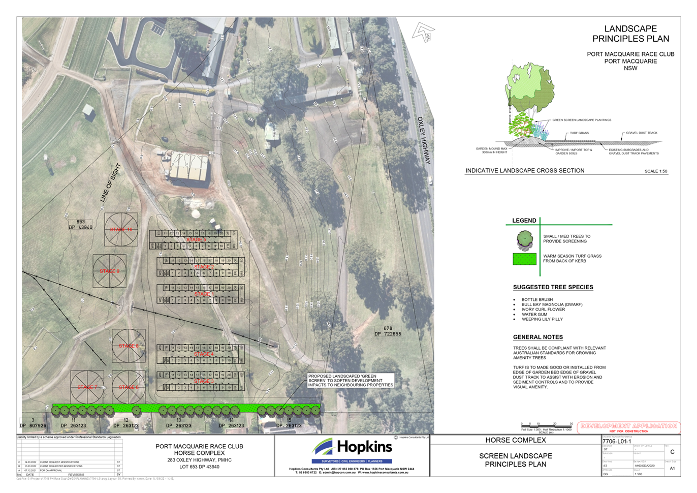

|
ATTACHMENT
|
Development Assessment Panel
05/04/2023
|

|
ATTACHMENT
|
Development Assessment Panel
05/04/2023
|


|
ATTACHMENT
|
Development Assessment Panel
05/04/2023
|


Development Assessment Panel
05/04/2023
Item: 06
Subject: DA2022 - 364.1 Demolition of Dwelling and
Construction of Residential Flat Building including Clause 4.6 Variation to
Clause 4.3 (Height of Building) & Strata Subdivision, Lot 200 DP 1289768,
No. 30 Waugh Street, Port Macquarie
Report
Author: Development Assessment Planner, Steven Ford
|
Applicant: Stewart
Architecture Pty Ltd
Owner: Waugh
Street (Port) Pty Ltd
Estimated Cost: $21,845,303.00
Alignment with Delivery
Program
4.3.1 Undertake transparent
and efficient development assessment in accordance with relevant legislation.
|
RECOMMENDATION
That
DA 2022 - 364 for Demolition of Dwelling
and Construction of Residential Flat Building including Clause 4.6 variation to
Clause 4.3 (Height of Building) under Port Macquarie Local Environmental Plan
2011 & Strata Subdivision at Lot 200, DP 1289768, No. 30 Waugh Street, Port
Macquarie, be determined by granting consent
subject to the recommended conditions.
Executive
Summary
This report considers a
development application for a Demolition of Dwelling and Construction of
Residential Flat Building including Clause 4.6 variation to Clause 4.3 (Height
of Building) & Strata Subdivision at the subject
site and provides an assessment of the application in accordance with the
Environmental Planning and Assessment Act 1979.
Following exhibition of the
application, 8 submissions were received.
The site is considered suitable for the proposed development
and the proposal adequately addresses relevant planning controls. The
development is not considered to be contrary to the public's interest and will
not result a significant adverse social, environmental or economic impact.
This report recommends that the
development application be approved subject to the attached conditions
(Attachment 1).
The reason for the application being referred to
Council’s Development Assessment Panel (DAP) is because three (3) or more
objections to the proposal have been received and the application includes a
Clause 4.6 exception to a development standard under the Port
Macquarie-Hastings Local Environmental Plan 2011. A copy of the DAP
Charter outlining the delegations and functions of the DAP is available on
Council’s website.
1. BACKGROUND
Existing
Sites Features and Surrounding Development
The site has an area of 2,037m2.
The
site is zoned R4 High Density Residential in
accordance with the Port Macquarie-Hastings Local Environmental Plan 2011, as
shown in the following zoning plan:
 The existing subdivision pattern and location of existing
development within the locality is shown in the following aerial photograph:
The existing subdivision pattern and location of existing
development within the locality is shown in the following aerial photograph:

2. DESCRIPTION
OF DEVELOPMENT
Key
aspects of the proposal include the following:
· Demolition
of the existing single storey dwelling and detached garage.
· 5
Storey Residential Flat Building housing 40 dwellings.
· Ground floor landscaping and communal areas.
· Basement car parking with 80 parking spaces.
· Clause 4.6 variation to Clause 4.3 Height of Building
· Strata Subdivision
Refer
to the plans of the proposed development at the end of this report
(Attachment
2).
Application
Chronology
· 29/04/
2022 - Application received
· 16/05/2022 to 30/05/2022 - Public notification
· 22/07/2022 - Amended plans received (Electrical engineering
changes)
· 19/09/2022 - Amended Plans (elevations, engineering,
communal facilities)
· 18/10/2022 to 31/10/2022 - Re-notification of Proposed
Plans
· 24/02/2023 - Amended Basement level plans received.
3. STATUTORY
ASSESSMENT
Section
4.15(1) Matters for Consideration
In
determining the application, Council is required to take into consideration the
following matters as are relevant to the development that apply to the land to
which the development application relates:
(a) The
provisions (where applicable) of:
(i) Any
Environmental Planning Instrument
State Environmental Planning Policy (Biodiversity and
Conservation) 2021
Chapter 4 Koala Habitat Protection 2021
Clause 4.4 - This SEPP applies to all non-rural zoned land
within the Port Macquarie-Hastings Local Government Area.
Clause 4.10 - Having considered the SEPP, the
application and on completion of a site inspection, Council is not prevented
from granting consent in this case for the following reasons:
1. The property is not subject to a KPOM, and
2. The site not considered to be core koala habitat.
State Environmental Planning Policy No. 65 - Design
Quality of Residential Apartment Development
This Policy
applies to development for the purpose of a residential flat building, shop top
housing or mixed use development with a residential accommodation component if:
(a) the
development consists of any of the following:
(i) the
erection of a new building,
(ii) the
substantial redevelopment or the substantial refurbishment of an existing
building,
(iii) the
conversion of an existing building, and
(b) the
building concerned is at least 3 or more storeys (not including levels below
ground level (existing) or levels that are less than 1.2 metres above ground
level (existing) that provide for car parking), and
(c) the
building concerned contains at least 4 or more dwellings.
Based on the above, the SEPP must be considered.
Clause 6A - This clause applies in respect of the
objectives, design criteria and design guidance set out in Parts 3 and 4 of the
Apartment Design Guide for the following:
(a) visual
privacy,
(b) solar
and daylight access,
(c) common
circulation and spaces,
(d) apartment
size and layout,
(e) ceiling
heights,
(f) private
open space and balconies,
(g) natural
ventilation,
(h) storage.
If a development control plan contains provisions that
specify requirements, standards or controls in relation to a matter to which
this clause applies, those provisions are of no effect.
This clause applies regardless of when the development
control plan was made.
Clause 28(2)(b) - The proposal has adequately addressed the
design principles contained in the Apartment Design Guide. The application
includes a design verification from a registered architect addressing the
design quality principles as follows:
|
Requirement
|
Proposed
|
Complies
|
|
Principle 1: Context and neighbourhood character
Good design responds and contributes
to its context. Context is the key natural and built features of an area,
their relationship and the character they create when combined. It also
includes social, economic, health and environmental conditions.
Responding to context involves
identifying the desirable elements of an area’s existing or future
character. Well-designed buildings respond to and enhance the qualities and
identity of the area including the adjacent sites, streetscape and
neighbourhood.
Consideration of local context
is important for all sites, including sites in established areas, those
undergoing change or identified for change.
|
The subject site is located in
Port Macquarie’s Westport neighbourhood at 30 Waugh Street. The site
consists of an amalgamation of two existing residential blocks which are
substantially cleared. There is a single freestanding dwelling currently
located on the site which has no heritage significance.
The site sits within an area
currently undergoing a transformation into a denser residential neighbourhood.
This density is clearly visible at the locality with the established
character. The site directly to the south of the proposal also shows the
transformation that is occurring, with the recent approval of a 6-storey
residential development. The existing neighbouring development to the east,
Pacific Court, its neighbours continuing east along Waugh Street, and various
developments on the opposite side of the street show examples of the higher
density developments that currently exist in the area.
The proposal therefore seeks
to reference the Port Macquarie-Hastings Council’s strategy for this
area to evolve into a vibrant residential neighbourhood. Furthermore, the
proposal is in keeping with current neighbouring developments, as well as future
permissible developments. The site and its immediate context are zoned
‘R4 - high density residential,’ permitting future residential
developments to occur.
|
Yes
|
|
Principle 2: Built form and
scale
Good design achieves a scale,
bulk and height appropriate to the existing or desired future character of
the street and surrounding buildings.
Good design also achieves an
appropriate built form for a site and the building’s purpose in terms
of building alignments, proportions, building type, articulation and the
manipulation of building elements.
Appropriate built form defines
the public domain, contributes to the character of streetscapes and parks,
including their views and vistas, and provides internal amenity and outlook.
|
The building form of the
subject site has been derived generally in keeping with the planning controls
within the Port Macquarie-Hastings Council DCP 2013.
The proposal responds to the
varying desired characters of the street in which it is sited. The proposed
five storey building with two basement levels, compliments the scale and
height of other developments within the immediate vicinity, while also
providing a scale that is in keeping with the desired future character for
the area. The proposal sits within the permissible 17.5 metre height limit
(excluding minor encroachments of lift overrun, rooftop plant and a minor
portion of the roof – refer to Clause 4.6 justification).
All setbacks are generally in
keeping with DCP requirements. The setback continuity reinforces the
character of the area, complimenting the streetscape with active frontages,
articulation, modern design and enhancing the sites orientation to the north.
The side and rear setbacks are
maintained in order to provide side access and landscaping to screen and
buffer the building on all sides.
The building form is split
into two elements connected by a central, green breezeway, which breaks down
the bulk of the building and articulates the entry location along the Waugh
Street frontage. Apartments have been arranged to maximise river views and
solar access to the north. Ground floor landscaping throughout the site
provides outlook and amenity for residents.
|
Yes
|
|
Principle 3: Density
Good design achieves a high
level of amenity for residents and each apartment, resulting in a density
appropriate to the site and its context.
Appropriate densities are
consistent with the area’s existing or projected population.
Appropriate densities can be sustained by existing or proposed
infrastructure, public transport, access to jobs, community facilities and
the environment.
|
The site is zoned R4 High
Density Residential under the Port Macquarie-Hastings Local Environmental
Plan 2011 and is located in the Westport Neighbourhood. This precinct is
supported under the LEP and DCP controls to evolve into a vibrant residential
neighbourhood that provides denser, quality residential accommodation.
Height Limit – 17.5m
FSR – 1.8:1
The development complies with
the LEP 2011 allowable rate for FSR and building heights, excluding minor
height encroachments – refer Clause 4.6 Justification later in this
report. Note no habitable floor levels encroach the height of building
allowance.
|
Yes
|
|
Principle 4: Sustainability
Good design combines positive
environmental, social and economic outcomes.
Good sustainable design
includes use of natural cross ventilation and sunlight for the amenity and
liveability of residents and passive thermal design for ventilation, heating
and cooling reducing reliance on technology and operation costs. Other
elements include recycling and reuse of materials and waste, use of
sustainable materials and deep soil zones for groundwater recharge and
vegetation.
|
The site experiences good
northerly aspect. As a result, 88% of proposed dwellings achieve the minimum
of 3 hours’ direct sunlight between 9am and 3pm in mid-winter, with
100% of proposed dwellings receiving 2.5 hours of sunlight between 9am and
3pm in mid-winter.
70% of the proposed dwellings
are naturally cross-ventilated, which exceeds the minimum 60% stipulated in the
ADG. All dwellings are designed to maximise their aspect.
The proposed materials of the
building have been selected to both ensure robustness and longevity, material
selection has also been considered to minimise maintenance requirements.
Landscaping includes deep soil
planting in excess of the requirement (16.5% instead of the required 15%) and
a mix of native and exotic plant species suitable for the microclimatic
conditions of the site are proposed.
The project will meet the
minimum BASIX requirements.
|
Yes
|
|
Principle 5: Landscape
Good design recognises that
together landscape and buildings operate as an integrated and sustainable
system, resulting in attractive developments with good amenity. A positive
image and contextual fit of well-designed developments is achieved by
contributing to the landscape character of the streetscape and neighbourhood.
Good landscape design enhances
the development’s environmental performance by retaining positive
natural features which contribute to the local context, co-ordinating water
and soil management, solar access, micro-climate, tree canopy, habitat values
and preserving green networks.
Good landscape design
optimises useability, privacy and opportunities for social interaction,
equitable access, respect for neighbours’ amenity and provides for
practical establishment and long term management.
|
The proposal integrates built
form and landscaping to contribute to quality of the surrounding public
domain and provide amenity and outlook to residents. The green, central
breezeway provides opportunity for casual interaction between residents.
Planting is proposed along the street frontage and side and rear boundaries
to provide privacy to lower level dwellings and soften the street interface.
Coastal, native species have
been included in the design to be responsive to place, create contextual fit
and ensure the species are able to flourish given the potentially harsh
coastal conditions.
The landscape includes deep
soil planting in excess of the required 15%, with 16.5% site coverage. The
front landscaping offers a layered garden which creates privacy and a buffer
to the street.
The ground floor apartments
enjoy gardens within or adjacent to their oversized outdoor courtyard spaces.
The site is also bound with perimeter planting to maximise privacy.
|
Yes
|
|
Principle 6: Amenity
Good design positively
influences internal and external amenity for residents and neighbours.
Achieving good amenity contributes to positive living environments and
resident wellbeing.
Good amenity combines
appropriate room dimensions and shapes, access to sunlight, natural
ventilation, outlook, visual and acoustic privacy, storage, indoor and
outdoor space, efficient layouts and service areas and ease of access for all
age groups and degrees of mobility.
|
The proposal has been designed
to provide the maximum amenity to future residents and to protect the amenity
of neighbours. The building layout is efficient, legible and promotes
equitable access.
The proposed 40 apartments are
provided with generous living spaces and master bedrooms. Each dwelling
exceeds the minimum private open space area requirements at all levels. All
balconies and courtyards meet, and in some cases greatly exceed, the minimum
ADG requirements.
Apartments are oriented to
benefit from river views to the north. All dwellings are provided with
storage that exceeds the minimum recommended volume.
Apartment layouts have been
designed to maximise solar access to living spaces, and natural
cross-ventilation.
Visual privacy is provided
through a combination of building separation, angled building facades, the
existing boundary fencing, courtyard walls, screens, and planting around the
site perimeter.
|
Yes
|
|
Principle 7: Safety
Good design optimises safety
and security within the development and the public domain. It provides for
quality public and private spaces that are clearly defined and fit for the
intended purpose. Opportunities to maximise passive surveillance of public
and communal areas promote safety.
A positive relationship
between public and private spaces is achieved through clearly defined secure
access points and well lit and visible areas that are easily maintained and
appropriate to the location and purpose.
|
A range of
strategies have been implemented within the design in order to optimise
safety and security of residents, neighbours and the community. These
include:
· The
building entry is clearly identifiable from the street
· Apartment
layouts and the orientation of balconies encourages passive surveillance of
the premises and street
· Car
parking for residents is located in secure carpark accessed via Waugh Street.
· Secure
access to the carpark, lobby and residential units will be provided in the
form of keys, swipe cards or remote controls. Residents will have access to
their residential floors via lift access or open, communication stairs.
· The
apartment entries, open stairs and lift all address the central breezeway
facilitating casual views and interaction
· Blind
and dark alcoves are avoided on all levels
· All
common areas and car parking will be appropriately lit
|
Yes
|
|
Principle 8: Housing
diversity and social interaction
Good design achieves a mix of
apartment sizes, providing housing choice for different demographics, living
needs and household budgets.
Well-designed apartment
developments respond to social context by providing housing and facilities to
suit the existing and future social mix.
Good design involves practical
and flexible features, including different types of communal spaces for a
broad range of people and providing opportunities for social interaction
among residents.
|
The mix of 2 and 3 bedroom
apartments proposed will contribute to the diversity of housing demand in the
Westport Neighbourhood and contribute to its transformation into a vibrant
residential precinct.
The design offers communal
areas providing opportunities for casual interaction, with communal benches,
paths and wide circulation areas. The location is close proximity to the Port
Macquarie CBD, and public recreation areas.
|
Yes
|
|
Principle 9: Aesthetics
Good design achieves a built
form that has good proportions and a balanced composition of elements,
reflecting the internal layout and structure. Good design uses a variety of
materials, colours and textures.
The visual appearance of a
well-designed apartment development responds to the existing or future local
context, particularly desirable elements and repetitions of the streetscape.
|
The plans provide examples of
the colours, textures and finishes.
The colours and materials
provided indicate a contemporary quality design and finish. It is considered
that the aesthetics of the building will respond appropriately to the
surrounding environment and context of the existing and desired character of
the locality and match the more recently constructed developments.
|
Yes
|
Clause 28(2)(c) - The proposal has
adequately addressed the Apartment Design Guide (ADG). The following table
provides an assessment against the Apartment Design Guide with assessment
comments considering the design criteria and design objectives where
applicable:
|
Apartment Design Guide (ADG)
Objective
|
Design Guidance/Design
Criteria (Italics)
|
Proposed
|
Complies
|
|
3A Site analysis
|
|
3A - 1 Site analysis illustrates
that design decisions have been based on opportunities and constraints of the
site conditions and their relationship to the surrounding context.
|
Each element in the Site Analysis
Checklist should be addressed (Appendix 1 of ADG).
|
Adequate site analysis provided. Refer
to plan number DA002 Site Analysis.
The design has been overseen and
directed by Marcus Graham (NSW Architects Registration 10921), a qualified
designer and primary nominee of Stewart Architecture.
|
Yes
|
|
3B Orientation
|
|
3B - 1 Building types and layouts
respond to the streetscape and site while optimising solar access within the
development.
|
Buildings along the street
frontage define the street, by facing it and incorporating direct access from
the street (see figure 3B.1).
Where the street frontage is to
the east or west, rear buildings should be orientated to the north.
Where the street frontage is to
the north or south, overshadowing to the south should be minimised and
buildings behind the street frontage should be orientated to the east and
west (see figure 3B.2).
|
Dwellings have been oriented to
maximise the northern aspect to living spaces, as well as to capture key
views. Majority of bedroom spaces are positioned to the east or west which
suits their night-time use.
The arrangement of spaces
responds directly to the qualities of the site.
|
Yes
|
|
3B - 2 Overshadowing of
neighbouring properties is minimised during mid-winter.
|
Living areas, private open space
and communal open space should receive solar access in accordance with
sections 3D Communal and public open space and 4A Solar and daylight access.
Solar access to living rooms,
balconies and private open spaces of neighbours should be considered.
Where an adjoining property does
not currently receive the required hours of solar access, the proposed
building ensures solar access to neighbouring properties is not reduced by
more than 20%.
If the proposal will
significantly reduce the solar access of neighbours, building separation
should be increased beyond minimums contained in section 3F Visual privacy.
Overshadowing should be minimised
to the south or downhill by increased upper level setbacks.
It is optimal to orientate
buildings at 90 degrees to the boundary with neighbouring properties to
minimise overshadowing and privacy impacts, particularly where minimum
setbacks are used and where buildings are higher than the adjoining
development.
A minimum of 4 hours of solar
access should be retained to solar collectors on neighbouring buildings.
|
Solar access diagrams demonstrate
living areas, private open space and communal open space receive adequate
solar access satisfying this requirement.
The development will retain
sunlight to adjoining property in accordance with the specifications in 4A of
the ADG.
Solar access will not be reduced
to any solar collectors on neighbouring buildings.
Please refer DA221, which
demonstrates that overshadowing of the proposed residential flat building
adjoining the rear boundary the subject site has been minimised.
|
Yes
|
|
3C Public domain interface
|
|
3C - 1 Transition between private
and public domain is achieved without compromising safety and security
|
Terraces, balconies and courtyard
apartments should have direct street entry, where appropriate.
Changes in level between private
terraces, front gardens and dwelling entries above the street level provide
surveillance and improve visual privacy for ground level dwellings (see
figure 3C.1).
Upper level balconies and windows
should overlook the public domain.
Front fences and walls along
street frontages should use visually permeable materials and treatments. The
height of solid fences or walls should be limited to 1m.
Length of solid walls should be
limited along street frontages.
Opportunities should be provided
for casual interaction between residents and the public domain. Design
solutions may include seating at building entries, near letter boxes and in
private courtyards adjacent to streets.
In developments with multiple
buildings and/or entries, pedestrian entries and spaces associated with
individual buildings/entries should be differentiated to improve legibility
for residents, using a number of the following design solutions:
- architectural
detailing
- changes
in materials
- plant
species
- colours
Opportunities for people to be
concealed should be minimised
|
The proposal provides excellent
public domain interface;
- The main entrance has clear and
direct street access
- Topography and courtyard walls
and fences provide appropriate privacy for the ground level dwellings
- Upper floor dwellings overlook
the public domain without compromising privacy and provide passive
surveillance of the street.
- Walls and screens are
articulated along the frontage and are integrated into gardens and planting
- Carparking servicing and
screening is carefully integrated with the building façade.
- The schedule of proposed
finishes are appropriately durable.
|
Yes
|
|
3C - 2 Amenity of the public
domain is retained and enhanced.
|
Planting softens the edges of any
raised terraces to the street, for example above sub-basement car parking.
Mail boxes should be located in
lobbies, perpendicular to the street alignment or integrated into front
fences where individual street entries are provided.
The visual prominence of
underground car park vents should be minimised and located at a low level
where possible.
Substations, pump rooms, garbage
storage areas and other service requirements should be located in basement
car parks or out of view.
Ramping for accessibility should
be minimised by building entry location and setting ground floor levels in
relation to footpath levels.
Durable, graffiti resistant and
easily cleanable materials should be used.
Where development adjoins public
parks, open space or bushland, the design positively addresses this interface
and uses a number of the following design solutions:
- street
access, pedestrian paths and building entries which are clearly defined
- paths,
low fences and planting that clearly delineate between communal/private open
space and the adjoining public open space
- minimal
use of blank walls, fences and ground level parking.
On sloping sites protrusion of
car parking above ground level should be minimised by using split levels to
step underground car parking
|
Landscape plan confirms adequate
landscaping forward of the sub-basement car parking.
Mail box is located at entrance/outside
of secure entry point door.
The sub-basement carparking
servicing and screening is carefully integrated with the building
façade
Garbage storage areas are
appropriately located within property and not visible to the street.
A ramp for accessibility to the
building is proposed at the main entry and addressed in the accessibility
report.
Substation located within front
boundary and appropriately located and screened from the street.
|
Yes
|
|
3D Communal and public open
space
|
|
3D - 1 An adequate area of
communal open space is provided to enhance residential amenity and to provide
opportunities for landscaping
|
Design Criteria
1. Communal open space has a
minimum area equal to 25% of the site (see figure 3D.3)
2. Developments achieve a
minimum of 50% direct sunlight to the principal usable part of the communal
open space for a minimum of 2 hours between 9 am and 3 pm on 21 June (mid
winter).
Communal open space should be
consolidated into a well-designed, easily identified and usable area.
Communal open space should have a
minimum dimension of 3m, and larger developments should consider greater
dimensions.
Communal open space should be
co-located with deep soil areas.
Direct, equitable access should
be provided to communal open space areas from common circulation areas,
entries and lobbies.
Where communal open space cannot
be provided at ground level, it should be provided on a podium or roof.
Where developments are unable to
achieve the design criteria, such as on small lots, sites within business zones,
or in a dense urban area, they should:
- provide
communal spaces elsewhere such as a landscaped roof top terrace or a common
room
- provide
larger balconies or increased private open space for apartments
- demonstrate
good proximity to public open space and facilities and/or provide
contributions to public open space
|
35% of the site area is designed
as ground level open landscape and circulation spaces which provide:
• landscape character
• opportunities for social
interaction
• passive use and outlook
for residents
The proposal does not provide a
consolidated principal usable communal open space. However, this proposal
achieves the communal open space objectives because:
• The
site is zoned as high density residential and boarders a commercial local
centre zone,
• All
dwellings are provided with greater than the minimum required courtyard or
balcony space.
• The
design caters for a central breezeway on each level, serving as central
vertical space and wide circulation space providing opportunities for social
interaction.
• The
breezeway exceeds the minimum dimension of 3m and will be open on the
northern and southern ends.
• The
development is within close proximity to several public parks or walking
trails.
• The
communal open space is accessible from common areas.
• The
building does not exceed the Floor space ratio of the PMHC LEP 2011.
|
Non-compliance is considered to
be acceptable.
Acceptable with utilisation of
central breezeways as communal space
|
|
3D - 2 Communal open space is
designed to allow for a range of activities, respond to site conditions and
be attractive and inviting
|
Facilities are provided within
communal open spaces and common spaces for a range of age groups (see also 4F
Common circulation and spaces), incorporating some of the following elements:
- seating
for individuals or groups
- barbecue
areas
- play
equipment or play areas
- swimming
pools, gyms, tennis courts or common rooms.
The location of facilities
responds to microclimate and site conditions with access to sun in winter,
shade in summer and shelter from strong winds and down drafts.
Visual impacts of services should
be minimised, including location of ventilation duct outlets from basement
car parks, electrical substations and detention tanks
|
Communal furniture, landscaping
and shelters have been included in the communal open space and circulation
areas.
The development provides a
pathway that meanders the perimeter of the development through landscaped
gardens.
The development also provided a
breezeway, open at both ends, that exceeds the minimum 3m dimension, allowing
the opportunity for individuality of each entrance.
The visual impact of services
from the public domain or adjoining developments is minimised by centrally
locating these elements behind each elevation or in the basement.
|
Acceptable, due to the scale of
the develop-ment, adequate communal spaces have been provided. This is
considered a minor non-compliance to the ADG.
|
|
3D - 3 Communal open space is
designed to maximise safety
|
Communal open space and the
public domain should be readily visible from habitable rooms and private open
space areas while maintaining visual privacy. Design solutions may include:
- bay
windows
- corner
windows
- balconies.
Communal open space should be
well lit.
Where communal open
space/facilities are provided for children and young people they are safe and
contained.
|
Balconies of apartments will
provide passive surveillance of ground level communal open space areas.
The private open space at ground level
has gated access to the communal area and would provide for some supervision
of this space.
|
Yes
|
|
3D - 4 Public open space, where
provided, is responsive to the existing pattern and uses of the neighbourhood
|
The public open space should be
well connected with public streets along at least one edge.
The public open space should be
connected with nearby parks and other landscape elements.
Public open space should be
linked through view lines, pedestrian desire paths, termination points and
the wider street grid.
Solar access should be provided
year round along with protection from strong winds.
Opportunities for a range of
recreational activities should be provided for people of all ages.
A positive address and active
frontages should be provided adjacent to public open space.
Boundaries should be clearly
defined between public open space and private areas
|
N/A
|
N/A
|
|
3E Deep soil zones
|
|
3E - 1 Deep soil zones provide
areas on the site that allow for and support healthy plant and tree growth.
They improve residential amenity and promote management of water and air
quality
|
Design Criteria
1. Deep soil zones are to meet
the following minimum requirements:
a) <
650m², no min dimension, 7% site area deep soil zone.
b) 650-1500m²,
3m dimension, 7% site area deep soil zone.
c) >1500m²,
6m dimension, 7% site area deep soil zone.
On some sites it may be possible
to provide larger deep soil zones, depending on the site area and context:
- 10%
of the site as deep soil on sites with an area of 650m² - 1,500m²
- 15%
of the site as deep soil on sites greater than 1,500m².
Deep soil zones should be located
to retain existing significant trees and to allow for the development of
healthy root systems, providing anchorage and stability for mature trees.
Design solutions may include:
- basement
and sub-basement car park design that is consolidated beneath building
footprints
- use
of increased front and side setbacks
- adequate
clearance around trees to ensure long term health
- co-location
with other deep soil areas on adjacent sites to create larger contiguous
areas of deep soil.
Achieving the design criteria may
not be possible on some sites including where:
- the
location and building typology have limited or no space for deep soil at
ground level (e.g. central business district, constrained sites, high density
areas, or in centres)
- there
is 100% site coverage or non-residential uses at ground floor level.
Where a proposal does not achieve
deep soil requirements, acceptable stormwater management should be achieved
and alternative forms of planting provided such as on structure.
|
The required deep soil zone is
achieved in the rear landscape and is larger than the required 7% of site
area. Achieving the minimum dimensions of 3m along the eastern and western
boundaries and 6m along the rear boundary.
The site does not contain any
existing significant trees that require retention in deep soil zones.
|
Yes
|
|
3F Visual privacy
|
|
3F - 1 Adequate building
separation distances are shared equitably between neighbouring sites, to achieve
reasonable levels of external and internal visual privacy
|
Design Criteria
1. Separation between windows
and balconies is provided to ensure visual privacy is achieved. Minimum
required separation distances from buildings to the side and rear boundaries
are as follows:
a) Building
height up to 12m (4 storey) need 6m setback to habitable and 3m to
non-habitable.
b) Buildings
up to 25m (5-8 storeys) need 9m to habitable and 4.5m to non-habitable.
c) Buildings
over 25m (9+ storeys) need 12m to habitable and 6m to non-habitable.
Note: Separation distances
between buildings on the same site should combine required building
separations depending on the type of room (see figure 3F.2).
Gallery access circulation
should be treated as habitable space when measuring privacy separation
distances between neighbouring properties
Generally, one step in the built
form as the height increases due to building separations is desirable.
Additional steps should be careful not to cause a 'ziggurat' appearance.
For residential buildings next to
commercial buildings, separation distances should be measured as follows:
- for
retail, office spaces and commercial balconies use the habitable room
distances
- for
service and plant areas use the non-habitable room distances.
New development should be located
and oriented to maximise visual privacy between buildings on site and for
neighbouring buildings. Design solutions include:
- site
layout and building orientation to minimise privacy impacts (see also section
3B Orientation)
- on
sloping sites, apartments on different levels have appropriate visual
separation distances (see figure 3F.4).
Apartment buildings should have
an increased separation distance of 3m (in addition to the requirements set
out in design criteria 1) when adjacent to a different zone that permits
lower density residential development to provide for a transition in scale
and increased landscaping (figure 3F.5).
Direct lines of sight should be
avoided for windows and balconies across corners.
No separation is required between
blank walls
|
The rear boundary of the proposal
achieves a 6m separation. This complies with the aims of ADG for the first 4
storeys. A minor non-compliance occurs at the fifth storey, as the building
line of habitable areas does not achieve 9m from the side boundaries.
However, windows in the façades have been sufficiently considered and
minimised to reduce the impact on neighbouring developments.
Side boundaries largely achieve a
building separation of 6m with the adjacent developments. Windows directly
facing side boundaries have typically been setback further than the required
6m. Where this is not the case, the angling of façade walls and
windows to direct views and outlook has been utilised to maintain visual
privacy. A minor non-compliance occurs at the fifth storey, where the
required separation is 9m. The proposed separation achieves reasonable levels
of visual privacy because:
• The primary outlook for
these apartments is towards the north
• The proposal largely
achieves the required separation for the first four floors, and the same
footprint is maintained for the fifth floor to maintain a coherent
architectural form.
• Balustrades are a mix of
opaque and transparent design screening a downward view angle.
|
No, but considered acceptable due
to minimal impacts and minor nature
|
|
3F - 2 Site and building design
elements increase privacy without compromising access to light and air and
balance outlook and views from habitable rooms and private open space
|
Communal open space, common areas
and access paths should be separated from private open space and windows to
apartments, particularly habitable room windows. Design solutions may
include:
- setbacks
- solid
or partially solid balustrades to balconies at lower levels
- fencing
and/or trees and vegetation to separate spaces
- screening
devices
- bay
windows or pop out windows to provide privacy in one direction and outlook in
another
- raising
apartments/private open space above the public domain or communal open space
- planter
boxes incorporated into walls and balustrades to increase visual separation
-
pergolas or shading devices to limit overlooking of lower apartments or
private open space
- on
constrained sites where it can be demonstrated that building layout
opportunities are limited, fixed louvers or screen panels to windows and/or
balconies.
Bedrooms, living spaces and other
habitable rooms should be separated from gallery access and other open
circulation space by the apartment’s service areas.
Balconies and private terraces
should be located in front of living rooms to increase internal privacy.
Windows should be offset from the
windows of adjacent buildings.
Recessed balconies and/or
vertical fins should be used between adjacent balconies
|
Ground level communal open space
is at a lower level than the ground floor apartments and landscaping has been
proposed on top of the podium above the parking level.
Lower level balconies are solid
adjacent to the common building entry.
|
Yes
|
|
3G Pedestrian access and
entries
|
|
3G - 1 Building entries and
pedestrian access connects to and addresses the public domain
|
Multiple entries (including
communal building entries and individual ground floor entries) should be
provided to activate the street edge.
Entry locations relate to the
street and subdivision pattern and the existing pedestrian network.
Building entries should be
clearly identifiable and communal entries should be clearly distinguishable
from private entries.
Where street frontage is limited
and multiple buildings are located on the site, a primary street address
should be provided with clear sight lines and pathways to secondary building
entries.
|
Entry locations address the
street frontage. Ground level apartments have a balcony access from communal
path.
The main building entry is well
defined and clearly identifiable from the street.
|
Yes
|
|
3G - 2 Access, entries and
pathways are accessible and easy to identify
|
Building access areas including
lift lobbies, stairwells and hallways should be clearly visible from the
public domain and communal spaces.
The design of ground floors and
underground car parks minimise level changes along pathways and entries.
Steps and ramps should be
integrated into the overall building and landscape design.
For large developments ‘way
finding’ maps should be provided to assist visitors and residents (see
figure 4T.3).
For large developments electronic
access and audio/video intercom should be provided to manage access
|
Building access point are clearly
visible from the public domain and the access ramp and steps are
appropriately integrated into the design and clear sightlines to central
breezeway to lift and stairs.
The proposal is not of a scale
where wayfinding maps are considered necessary.
|
Yes
|
|
3G - 3 Large sites provide
pedestrian links for access to streets and connection to destinations
|
Pedestrian links through sites
facilitate direct connections to open space, main streets, centres and public
transport.
Pedestrian links should be
direct, have clear sight lines, be overlooked by habitable rooms or private
open spaces of dwellings, be well lit and contain active uses, where
appropriate
|
N/A
|
N/A
|
|
3H Vehicle access
|
|
3H - 1 Vehicle access points are
designed and located to achieve safety, minimise conflicts between
pedestrians and vehicles and create high quality streetscapes
|
Car park access should be
integrated with the building’s overall facade. Design solutions may
include:
- the
materials and colour palette to minimise visibility from the street
- security
doors or gates at entries that minimise voids in the facade
- where
doors are not provided, the visible interior reflects the facade design and
the building services, pipes and ducts are concealed.
Car park entries should be
located behind the building line.
Vehicle entries should be located
at the lowest point of the site minimising ramp lengths, excavation and
impacts on the building form and layout.
Car park entry and access should
be located on secondary streets or lanes where available.
Vehicle standing areas that
increase driveway width and encroach into setbacks should be avoided.
Access point locations should
avoid headlight glare to habitable rooms.
Adequate separation distances
should be provided between vehicle entries and street intersections.
The width and number of vehicle
access points should be limited to the minimum.
Visual impact of long driveways
should be minimised through changing alignments and screen planting.
The need for large vehicles to
enter or turn around within the site should be avoided.
Garbage collection, loading and
servicing areas are screened.
Clear sight lines should be
provided at pedestrian and vehicle crossings.
Traffic calming devices such as
changes in paving material or textures should be used where appropriate.
Pedestrian and vehicle access
should be separated and distinguishable. Design solutions may include:
- changes
in surface materials
- level
changes
- the
use of landscaping for separation
|
The basement car park access is
in the front façade of the building and is proposed to be provided
with a security door at the access point.
Entry is located behind the front
building line.
The access to the basement
parking is via a single two-way driveway with sufficient separation from
street to ensure pedestrian safety.
The driveway length is relatively
short and would not result in any adverse visual impacts.
Car park access is integrated
into the overall façade design and materials palette of the building.
The vehicular entry is clearly
separated from the main pedestrian entry with clear sightlines provided at
pedestrian crossings.
Private waste collection will be
required. These requirements are capable of complying with standards.
|
Yes
|
|
3J Bicycle and car parking
|
|
3J - 1 Car parking is provided
based on proximity to public transport in metropolitan Sydney and centres in
regional areas
Notes
Port Macquarie is a nominated
regional centre.
In terms of using Guide to
Traffic Generating Developments, Port Macquarie is a “sub-regional
centre” as by definition it does not have access to rail.
Medium density is 2 - <20
dwellings.
High Density is 20 or more
dwellings
|
Design Criteria
1. For
development in the following locations:
a) on
sites that are within 800 metres of a railway station or light rail stop in
the Sydney Metropolitan Area; or
b) on
land zoned, and sites within 400 metres of land zoned, B3 Commercial Core, B4
Mixed Use or equivalent in a nominated regional centre
the minimum car parking
requirement for residents and visitors is set out in the Guide to Traffic
Generating Developments, or the car parking requirement prescribed by the
relevant council, whichever is less
The car parking needs for a
development must be provided off street.
Where a car share scheme operates
locally, provide car share parking spaces within the development. Car share
spaces, when provided, should be on site.
Where less car parking is
provided in a development, council should not provide on street resident
parking permits
Guide to Traffic Generating
Developments
Medium density residential flat
buildings require:
- 1
space per unit +
- 1
space for every 5 x 2-bedroom unit +
- 1
space for every 2 x 3-bedroom unit +
- 1
space for 5 units (visitor parking).
High density residential flat
buildings for metropolitan sub-regional centres require:
- 0.6
spaces per 1-bedroom unit
- 0.9
spaces per 2-bedroom unit
- 1.40
spaces per 3-bedroom unit +
- 1
space per 5 units (visitor parking)
|
The site is located within close
proximity of a B2 and B3 zone to the east of the site. Accordingly, car
parking is required to meet the minimum requirements of the Guide to
Traffic Generating Developments or the DCP (whichever is less).
Guide to Traffic Generating
Developments
The proposal includes more than
20 dwellings and is characterised as a high density residential flat building
for the purpose of parking generation.
20 x 0.9 spaces = 18 spaces.
20 x 1.4 spaces = 28 spaces.
40/5 = 8 visitor spaces.
Total parking required = 54
spaces.
DCP
20 x 1 space = 20 spaces.
20 x 1.5 = 30 spaces.
40/4 = 10 visitor spaces.
Total parking required = 60
spaces (including 10 visitors).
The Guide to Traffic
Generating Developments therefore provide the lesser parking requirement
and is the minimum parking required under the ADG. The proposal includes 80
spaces and exceeds the minimum requirement of 20 spaces.
Note that there are only 6
dedicated visitor parking spaces. However, this is considered a minor
variation given the majority of units will have 2 spaces and the total number
of spaces exceed the minimum.
|
No, but considered acceptable
based on the merit of the proposed develop-ment.
|
|
3J - 2 Parking and facilities are
provided for other modes of transport
|
Conveniently located and
sufficient numbers of parking spaces should be provided for motorbikes and
scooters.
Secure undercover bicycle parking
should be provided that is easily accessible from both the public domain and
common areas.
Conveniently located charging
stations are provided for electric vehicles, where desirable
|
Bicycle and car parking is
provided within two levels of basement.
Basement area is behind a secure
entry and not accessible to the public.
|
Yes
|
|
3J - 3 Car park design and access
is safe and secure
|
Supporting facilities within car
parks, including garbage, plant and switch rooms, storage areas and car wash
bays can be accessed without crossing car parking spaces.
Direct, clearly visible and well
lit access should be provided into common circulation areas.
A clearly defined and visible
lobby or waiting area should be provided to lifts and stairs.
For larger car parks, safe
pedestrian access should be clearly defined and circulation areas have good
lighting, colour, line marking and/or bollards.
|
Basement storage areas are
provided on each level of basement car parking. These appear to be easily
accessible and secure.
The lift, plant room, and pump
room are also accessible with clearly defined pedestrian areas.
Garbage room accessible from
central vertical circulation area adjacent to the access ramp.
|
Yes
|
|
3J - 4 Visual and environmental
impacts of underground car parking are minimised
|
Excavation should be minimised
through efficient car park layouts and ramp design.
Car parking layout should be well
organised, using a logical, efficient structural grid and double loaded
aisles.
Protrusion of car parks should
not exceed 1m above ground level. Design solutions may include stepping car
park levels or using split levels on sloping sites.
Natural ventilation should be
provided to basement and sub-basement car parking areas.
Ventilation grills or screening
devices for car parking openings should be integrated into the facade and
landscape design
|
Excavation for the basement car
park will be minimised to two levels and appears to be an efficient
circulation design. See Development Engineer’s comments later in this
report.
Part of the first basement level
will be protruding out of the ground, however this is predominately less than
1m above the finished ground level, allows ventilation and has been well
integrated into the building façade.
Ventilation openings for the car
park have been integrated into the design and will not be visible in the
streetscape or from individual apartments.
|
Yes
|
|
3J - 5 Visual and environmental
impacts of on-grade car parking are minimised
|
On-grade car parking should be
avoided.
Where on-grade car parking is
unavoidable, the following design solutions are used:
- parking
is located on the side or rear of the lot away from the primary street
frontage
- cars
are screened from view of streets, buildings, communal and private open space
areas
- safe
and direct access to building entry points is provided
- parking
is incorporated into the landscape design of the site, by extending planting
and materials into the car park space
- stormwater
run-off is managed appropriately from car parking surfaces •
bio-swales, rain gardens or on site detention tanks are provided, where
appropriate
- light
coloured paving materials or permeable paving systems are used and shade
trees are planted between every 4-5 parking spaces to reduce increased
surface temperatures from large areas of paving
|
At grade car parking has been
avoided. All proposed parking is within basement levels and behind the front
building line.
|
Yes
|
|
3J - 6 Visual and environmental
impacts of above ground enclosed car parking are minimised
|
Exposed parking should not be
located along primary street frontages
Screening, landscaping and other
design elements including public art should be used to integrate the above
ground car parking with the facade. Design solutions may include:
- car
parking that is concealed behind the facade, with windows integrated into the
overall facade design (approach should be limited to developments where a
larger floor plate podium is suitable at lower levels)
- car
parking that is ‘wrapped’ with other uses, such as retail,
commercial or two storey Small Office/Home Office (SOHO) units along the
street frontage (see figure 3J.9).
Positive street address and
active frontages should be provided at ground level
|
Car parking area is enclosed
along the street frontage and integrated into the façade and
landscaping to improve the streetscape presentation.
Sufficient active space, such as
landscaping, entrance and balconies address the street frontage.
|
Yes
|
|
4A Solar and daylight access
|
|
4A - 1 To optimise the number of
apartments receiving sunlight to habitable rooms, primary windows and private
open space
|
Design Criteria
1. Living rooms and private
open spaces of at least 70% of apartments in a building receive a minimum of
2 hours direct sunlight between 9 am and 3 pm at mid-winter in the Sydney
Metropolitan Area and in the Newcastle and Wollongong local government areas.
2. In all other areas, living
rooms and private open spaces of at least 70% of apartments in a building
receive a minimum of 3 hours direct sunlight between 9 am and 3 pm at
mid-winter.
3. A maximum of 15% of
apartments in a building receive no direct sunlight between 9 am and 3 pm at
mid-winter
The design maximises north aspect
and the number of single aspect south facing apartments is minimised.
Single aspect, single storey
apartments should have a northerly or easterly aspect.
Living areas are best located to
the north and service areas to the south and west of apartments.
To optimise the direct sunlight
to habitable rooms and balconies a number of the following design features
are used:
- dual
aspect apartments
- shallow
apartment layouts
- two
storey and mezzanine level apartments
- bay
windows
To maximise the benefit to
residents of direct sunlight within living rooms and private open spaces, a
minimum of 1m² of direct sunlight, measured at 1m above floor level, is
achieved for at least 15 minutes.
Achieving the design criteria may
not be possible on some sites. This includes:
- where
greater residential amenity can be achieved along a busy road or rail line by
orientating the living rooms away from the noise source
- on
south facing sloping sites
- where
significant views are oriented away from the desired aspect for direct
sunlight
Design drawings need to
demonstrate how site constraints and orientation preclude meeting the design
criteria and how the development meets the objective.
|
Sun penetration plans submitted,
which confirm adequate sunlight access to living areas. (Drawing No. DA008)
The Applicant states that the
building was designed to optimise the number of apartments receiving direct
sunlight to living rooms and private open space. Considering the orientation
of the site being north to south, the majority of the units either have an
eastern or western aspect.
100% of dwellings received at
least 2.5 hours, and 88% of dwellings received 3 hours of sunlight between
the hours of 9am and 3pm in mid-winter. As demonstrated by solar access
diagrams.
The design attempts to maximise
the northern aspect by orientating living and private open space to the north
for all dwelling.
All living areas are located to
achieve the best solar access for the proposed building orientation.
All living areas and private open
space achieve greater than 1m2 of direct sunlight measured 1m above the floor
level for more than 15 minutes during the day.
To alleviate any doubt, none of
the apartments will receive no direct sunlight between 9am and 3pm at
midwinter.
The design maximises the number
of north-facing apartments, or north facing aspect of the apartment being
either North-east or North-west.
There are no single aspect
south-facing apartments are proposed.
|
No, variation to 3 hours for some
of the apartments considered acceptable.
|
|
4A - 2 Daylight access is
maximised where sunlight is limited
|
Courtyards, skylights and high
level windows (with sills of 1,500mm or greater) are used only as a secondary
light source in habitable rooms.
Where courtyards are used:
- use
is restricted to kitchens, bathrooms and service areas
- building
services are concealed with appropriate detailing and materials to visible
walls
- courtyards
are fully open to the sky
- access
is provided to the light well from a communal area for cleaning and
maintenance
- acoustic
privacy, fire safety and minimum privacy separation distances (see section 3F
Visual privacy) are achieved.
Opportunities for reflected light
into apartments are optimised through:
- reflective
exterior surfaces on buildings opposite south facing windows
- positioning
windows to face other buildings or surfaces (on neighbouring sites or within
the site) that will reflect light
- integrating
light shelves into the design
- light
coloured internal finishes
|
The design does not rely upon
courtyards, skylights or high level windows to habitable rooms for solar
access..
|
N/A
|
|
4A - 3 Design incorporates
shading and glare control, particularly for warmer months
|
A number of the following design
features are used:
- balconies
or sun shading that extend far enough to shade summer sun, but allow winter
sun to penetrate living areas
- shading
devices such as eaves, awnings, balconies, pergolas, external louvers and
planting
- horizontal
shading to north facing windows
- vertical
shading to east and particularly west facing windows
- operable
shading to allow adjustment and choice
- high
performance glass that minimises external glare off windows, with
consideration given to reduced tint glass or glass with a reflectance level
below 20% (reflective films are avoided)
|
The design incorporates
appropriate passive sun control elements. Most of the northern façade
includes deep balconies for solar shading. Glazing to eastern and western
facades that is not protected by deep balconies has been minimised.
Its considered that appropriate
shading features included in the design.
|
Yes
|
|
4B Natural ventilation
|
|
4B - 1 All habitable rooms are
naturally ventilated
|
The building's orientation
maximises capture and use of prevailing breezes for natural ventilation in
habitable rooms.
Depths of habitable rooms support
natural ventilation.
The area of unobstructed window
openings should be equal to at least 5% of the floor area served.
Light wells are not the primary
air source for habitable rooms.
Doors and openable windows
maximise natural ventilation opportunities by using the following design
solutions:
- adjustable
windows with large effective openable areas
- a
variety of window types that provide safety and flexibility such as awnings
and louvers
- windows
which the occupants can reconfigure to funnel breezes into the apartment such
as vertical louvers, casement windows and externally opening doors
|
Design and orientation of the
building facilitates natural ventilation.
Depth of rooms and corridors
support ventilation.
The majority of apartments have
multiple openings, such as, balcony sliding doors and living area windows
considered large effective openable areas
|
Yes
|
|
4B - 3 The number of apartments
with natural cross ventilation is maximised to create a comfortable indoor
environment for residents
|
Design Criteria
1. At least 60% of apartments
are naturally cross ventilated in the first nine storeys of the building.
Apartments at ten storeys or greater are deemed to be cross ventilated only
if any enclosure of the balconies at these levels allows adequate natural ventilation
and cannot be fully enclosed.
2. Overall depth of a
cross-over or cross-through apartment does not exceed 18m, measured glass
line to glass line.
The building should include dual
aspect apartments, cross through apartments and corner apartments and limit
apartment depths.
In cross-through apartments
external window and door opening sizes/areas on one side of an apartment
(inlet side) are approximately equal to the external window and door opening
sizes/areas on the other side of the apartment (outlet side) (see figure
4B.4).
Apartments are designed to
minimise the number of corners, doors and rooms that might obstruct airflow.
Apartment depths, combined with
appropriate ceiling heights, maximise cross ventilation and airflow
|
The submitted plans show 70% of
apartments to be naturally cross ventilated.
The overall depth of apartments
does not exceed 18m.
Ventilation diagrams provided,
indicate airflow paths being less than 18m.
The apartment floor plans
minimise the number of doorways or corners obstructing ventilation and
airflow.
|
Yes
|
|
4C Ceiling heights
|
|
4C - 1 Ceiling height achieves
sufficient natural ventilation and daylight access
|
Design Criteria
1. Measured from finished
floor level to finished ceiling level, minimum ceiling heights are:
Minimum ceiling height for
apartment and mixed use buildings
Habitable rooms = 2.7m
Non-habitable = 2.4m
For 2 storey apartments = 2.7m
for main living area floor and 2.4m for second floor, where its area does not
exceed 50% of the apartment area
Attic spaces = 1.8m at edge of
room with a 30 degree minimum ceiling slope
If located in mixed use areas
= 3.3m for ground and first floor to promote future flexibility of use
These minimums do not preclude
higher ceilings if desired.
Ceiling height can accommodate
use of ceiling fans for cooling and heat distribution.
|
Ceiling heights of 2.7m are
provided for habitable rooms and 2.4m for non-habitable rooms.
Location is not considered a
mixed use area, therefore no consideration required for future flexibility of
ground and first floors.
|
Yes
|
|
4C - 2 Ceiling height increases
the sense of space in apartments and provides for well-proportioned rooms
|
A number of the following design
solutions can be used:
- the
hierarchy of rooms in an apartment is defined using changes in ceiling
heights and alternatives such as raked or curved ceilings, or double height
spaces
- well-proportioned
rooms are provided, for example, smaller rooms feel larger and more spacious with
higher ceilings
- ceiling
heights are maximised in habitable rooms by ensuring that bulkheads do not
intrude. The stacking of service rooms from floor to floor and coordination
of bulkhead location above non-habitable areas, such as robes or storage, can
assist
|
The proposal includes
well-proportioned rooms with consistent ceiling height.
|
Yes
|
|
4D Apartment size and layout
|
|
4D - 1 The layout of rooms within
an apartment is functional, well organised and provides a high standard of
amenity
|
Design Criteria
1. Apartments are required to
have the following minimum internal areas:
Studio = 35m²
1 bedroom = 50m²
2 bedrooms = 70m²
3 bedrooms = 90m²
The minimum internal areas
include only one bathroom. Additional bathrooms increase the minimum internal
area by 5m² each.
A fourth bedroom and further
additional bedrooms increase the minimum internal area by 12m² each.
2. Every habitable room must
have a window in an external wall with a total minimum glass area of not less
than 10% of the floor area of the room. Daylight and air may not be borrowed
from other rooms.
Kitchens should not be located as
part of the main circulation space in larger apartments (such as hallway or
entry space).
A window should be visible from
any point in a habitable room.
Where minimum areas or room
dimensions are not met apartments need to demonstrate that they are well
designed and demonstrate the usability and functionality of the space with
realistically scaled furniture layouts and circulation areas. These
circumstances would be assessed on their merits
|
All apartment areas exceed the
minimum floor areas.
· 2 bedrooms vary
between 78m2 to 82m2
· 3 bedrooms vary
between 97m2 to 101m2
All habitable rooms have a window
or glass door in an external wall that is at least 10% of the floor area of
the room.
Kitchens are not located in
circulation areas and windows are visible from all habitable rooms.
|
Yes
|
|
4D - 2 Environmental performance
of the apartment is maximised
|
Design Criteria
1. Habitable room depths are
limited to a maximum of 2.5 x the ceiling height.
2. In open plan layouts (where
the living, dining and kitchen are combined) the maximum habitable room depth
is 8m from a window.
Greater than minimum ceiling
heights can allow for proportional increases in room depth up to the
permitted maximum depths.
All living areas and bedrooms
should be located on the external face of the building.
Where possible:
- bathrooms
and laundries should have an external openable window.
- main
living spaces should be oriented toward the primary outlook and aspect and
away from noise sources
|
Room depth complies for all
apartments.
All living rooms and bedrooms are
located on the external face of the building.
Laundries and bathrooms are
mechanically ventilated.
Main living areas are oriented towards
the side boundaries and frontage of the site.
Ceiling heights of habitable
rooms comply.
All bedrooms and living areas are
located on the external face of the building or open onto private balconies.
Open plan living/kitchen/dining
in majority of the apartments comply with the maximum 8m depth from a window.
Note, the front apartments exceeds the maximum depth , however, from the
peninsula of the kitchen bench is 7.3m and the standing area within the
kitchen is approximately 8.5m from a window, which is an acceptable variation
based on the merit of the design.
|
No, but considered acceptable
|
|
4D - 3 Apartment layouts are
designed to accommodate a variety of household activities and needs
|
Design Criteria
1. Master bedrooms have a
minimum area of 10m² and other bedrooms 9m² (excluding wardrobe
space).
2. Bedrooms have a minimum
dimension of 3m (excluding wardrobe space).
3. Living rooms or combined
living/dining rooms have a minimum width of:
• 3.6m for studio and 1
bedroom apartments
• 4m for 2 and 3 bedroom
apartments
4. The width of cross-over or
cross-through apartments are at least 4m internally to avoid deep narrow
apartment layouts.
Access to bedrooms, bathrooms and
laundries is separated from living areas minimising direct openings between
living and service areas.
All bedrooms allow a minimum
length of 1.5m for robes.
The main bedroom of an apartment
or a studio apartment should be provided with a wardrobe of a minimum 1.8m
long, 0.6m deep and 2.1m high.
Apartment layouts allow
flexibility over time, design solutions may include:
- dimensions
that facilitate a variety of furniture arrangements and removal
- spaces
for a range of activities and privacy levels between different spaces within
the apartment
- dual
master apartments
- dual
key apartments Note: dual key apartments which are separate but on the same
title are regarded as two sole occupancy units for the purposes of the
Building Code of Australia and for calculating the mix of apartments
- room
sizes and proportions or open plans (rectangular spaces (2:3) are more easily
furnished than square spaces (1:1))
- efficient
planning of circulation by stairs, corridors and through rooms to maximise
the amount of usable floor space in rooms
|
All bedroom and living room
dimensions comply with the minimum requirements. All bedrooms have a minimum
1.5m length of robe.
Access to bedrooms, bathrooms and
laundries is separated from the living areas.
Rooms are generally of a regular
shape and provide for a variety of furniture layouts.
|
Yes
|
|
4E Private open space and
balconies
|
|
4E - 1 Apartments provide
appropriately sized private open space and balconies to enhance residential
amenity
|
Design Criteria
1. All apartments are required
to have primary balconies as follows:
a) Studio
apartments = 4m²
b) 1
bedroom apartments = 8m² and 2m min depth.
c) 2
bedroom apartments = 10m² and 2m min depth.
d) 3+
bedroom apartments = 12m² and 2.4m min depth.
The minimum balcony depth to
be counted as contributing to the balcony area is 1m.
2. For apartments at ground
level or on a podium or similar structure, a private open space is provided
instead of a balcony. It must have a minimum area of 15m² and a minimum
depth of 3m.
Increased communal open space
should be provided where the number or size of balconies are reduced.
Storage areas on balconies is
additional to the minimum balcony size.
Balcony use may be limited in
some proposals by:
- consistently
high wind speeds at 10 storeys and above
- close
proximity to road, rail or other noise sources
- exposure
to significant levels of aircraft noise
- heritage
and adaptive reuse of existing buildings
In these situations, Juliet
balconies, operable walls, enclosed wintergardens or bay windows may be
appropriate, and other amenity benefits for occupants should also be provided
in the apartments or in the development or both. Natural ventilation also
needs to be demonstrated
|
All balconies and terraces comply
with the minimum areas and dimensions, (all exceeding 12m2 and a
minimum depth of 2.4m).
Ground level balconies are
screened with a barrier to the communal landscaping.
|
Yes
|
|
4E - 2 Primary private open space
and balconies are appropriately located to enhance liveability for residents
|
Primary open space and balconies
should be located adjacent to the living room, dining room or kitchen to
extend the living space.
Private open spaces and balconies
predominantly face north, east or west.
Primary open space and balconies
should be orientated with the longer side facing outwards or be open to the
sky to optimise daylight access into adjacent rooms.
|
Primary private open space areas
are located adjacent to living areas and are oriented to face north, east,
and west. Each unit has been designed to provide private open space
with the best solar access based on orientation.
The balconies are oriented with
the longer edge facing outwards and will maximise sunlight access into the
building.
|
Yes
|
|
4E - 3 Private open space and
balcony design is integrated into and contributes to the overall
architectural form and detail of the building
|
Solid, partially solid or
transparent fences and balustrades are selected to respond to the location.
They are designed to allow views and passive surveillance of the street while
maintaining visual privacy and allowing for a range of uses on the balcony.
Solid and partially solid balustrades are preferred.
Full width full height glass
balustrades alone are generally not desirable.
Projecting balconies should be
integrated into the building design and the design of soffits considered.
Operable screens, shutters, hoods
and pergolas are used to control sunlight and wind.
Balustrades are set back from the
building or balcony edge where overlooking or safety is an issue.
Downpipes and balcony drainage are
integrated with the overall facade and building design.
Air-conditioning units should be
located on roofs, in basements, or fully integrated into the building design.
Where clothes drying, storage or
air conditioning units are located on balconies, they should be screened and
integrated in the building design.
Ceilings of apartments below
terraces should be insulated to avoid heat loss.
Water and gas outlets should be
provided for primary balconies and private open space
|
Balcony and courtyard design is integrated
into the overall architectural form and language of the building and detailed
to avoid opportunities for climbing and falls.
Clothes drying facilities on
balconies are not shown on the plans, but are capable of being accommodated.
|
Yes
|
|
4E - 4 Private open space and
balcony design maximises safety.
|
Changes in ground levels or
landscaping are minimised.
Design and detailing of balconies
avoids opportunities for climbing and falls.
|
All balconies are level and
landscaping does not provide any opportunities for climbing.
|
Yes
|
|
4F Common circulation and
spaces
|
|
4F - 1 Common circulation spaces
achieve good amenity and properly service the number of apartments
|
Design Criteria
1. The maximum number of
apartments off a circulation core on a single level is eight.
2. For buildings of 10 storeys
and over, the maximum number of apartments sharing a single lift is 40.
Greater than minimum requirements
for corridor widths and/ or ceiling heights allow comfortable movement and
access particularly in entry lobbies, outside lifts and at apartment entry
doors.
Daylight and natural ventilation
should be provided to all common circulation spaces that are above ground.
Windows should be provided in
common circulation spaces and should be adjacent to the stair or lift core or
at the ends of corridors.
Longer corridors greater than 12m
in length from the lift core should be articulated. Design solutions may
include:
- a
series of foyer areas with windows and spaces for seating
- wider
areas at apartment entry doors and varied ceiling heights
Design common circulation spaces
to maximise opportunities for dual aspect apartments, including multiple core
apartment buildings and cross over apartments.
Achieving the design criteria for
the number of apartments off a circulation core may not be possible. Where a
development is unable to achieve the design criteria, a high level of amenity
for common lobbies, corridors and apartments should be demonstrated,
including:
- sunlight
and natural cross ventilation in apartments
- access
to ample daylight and natural ventilation in common circulation spaces
- common
areas for seating and gathering
- generous
corridors with greater than minimum ceiling heights
- other
innovative design solutions that provide high levels of amenity
Where design criteria 1 is not
achieved, no more than 12 apartments should be provided off a circulation
core on a single level.
Primary living room or bedroom
windows should not open directly onto common circulation spaces, whether open
or enclosed. Visual and acoustic privacy from common circulation spaces to
any other rooms should be carefully controlled
|
The proposal provides 8
apartments per circulation area on each level which is in keeping with the
ADG recommended number.
Direct and legible access is
provided between circulation spaces and apartment entries through a generous,
open breezeway.
At each end of corridor is stair
access and mid-way use of voids or permanent communal seating will provide
suitable articulation, solar access and ventilation.
It is considered that the
circulation areas will accumulatively achieve reasonable amenity for the end
user.
|
Yes
|
|
4F - 2 Common circulation spaces
promote safety and provide for social interaction between residents
|
Direct and legible access should
be provided between vertical circulation points and apartment entries by
minimising corridor or gallery length to give short, straight, clear sight
lines.
Tight corners and spaces are
avoided.
Circulation spaces should be well
lit at night.
Legible signage should be
provided for apartment numbers, common areas and general wayfinding.
Incidental spaces, for example
space for seating in a corridor, at a stair landing, or near a window are
provided.
In larger developments, community
rooms for activities such as owner’s corporation meetings or resident
use should be provided and are ideally co-located with communal open space.
Where external galleries are
provided, they are more open than closed above the balustrade along their
length.
|
Apartments are directly accessed
off the central corridor on each level.
There are no corners and
identifiable concerns regarding identifying levels or apartments.
Wayfinding and communal seating
provided on each level of the development with eight apartments off the
access core on each level.
|
Yes
|
|
4G Storage
|
|
4G - 1 Adequate, well designed
storage is provided in each apartment
|
Design Criteria
1. In addition to storage in
kitchens, bathrooms and bedrooms, the following storage is provided:
a) Studio
apartments = 4m³.
b) 1
bedroom apartments = 6m³.
c) 2
bedroom apartments 8m³.
d) 3+
bedroom apartments = 10m³.
At least 50% of the required
storage is to be located within the apartment.
Storage is accessible from either
circulation or living areas.
Storage provided on balconies (in
addition to the minimum balcony size) is integrated into the balcony design,
weather proof and screened from view from the street.
Left over space such as under
stairs is used for storage
|
Storage provision for each unit
type has been provided on DA005 – Plan – Site. Areas of storage
in kitchens, bedrooms and bathrooms have been excluded from these
calculations.
Each apartment includes dedicated
storage cage within car parking levels and suitable storage within
apartments.
No storage on balconies proposed,
but capable of being retrofitted and still comply with minimum balcony
dimensions.
Storage is considered to be
located within an accessible location
|
Yes
|
|
4G - 2 Additional storage is
conveniently located, accessible and nominated for individual apartments
|
Storage not located in apartments
is secure and clearly allocated to specific apartments.
Storage is provided for larger
and less frequently accessed items.
Storage space in internal or
basement car parks is provided at the rear or side of car spaces or in cages
so that allocated car parking remains accessible.
If communal storage rooms are
provided they should be accessible from common circulation areas of the
building.
Storage not located in an
apartment is integrated into the overall building design and is not visible
from the public domain.
|
Storage in basement car park is
secure with storage cages on both basement levels.
Separate clear pedestrian access
is provided to the areas.
|
Yes
|
|
4H Acoustic privacy
|
|
4H - 1 Noise transfer is
minimised through the siting of buildings and building layout
|
Adequate building separation is
provided within the development and from neighbouring buildings/adjacent uses
(see also section 2F Building separation and section 3F Visual privacy).
Window and door openings are
generally orientated away from noise sources.
Noisy areas within buildings
including building entries and corridors should be located next to or above
each other and quieter areas next to or above quieter areas.
Storage, circulation areas and
non-habitable rooms should be located to buffer noise from external sources.
The number of party walls (walls
shared with other apartments) are limited and are appropriately insulated.
Noise sources such as garage
doors, driveways, service areas, plant rooms, building services, mechanical
equipment, active communal open spaces and circulation areas should be
located at least 3m away from bedrooms.
|
Doesn’t comply with
separation distances.
Window and door openings are
oriented away from the common driveway and pedestrian accesses.
Bedrooms are located away from
the lifts, but some bedrooms adjoin the lift or adjoining wall are provided
with appropriate acoustic insulation.
Corridors are stacked vertically
throughout the building and the number of party walls is minimised by the
inclusion of the central breezeway
All bedrooms are located greater
than 3m from the vehicle entry.
|
No, acceptable separation
proposed.
|
|
4H - 2 Noise impacts are
mitigated within apartments through layout and acoustic treatments
|
Internal apartment layout
separates noisy spaces from quiet spaces, using a number of the following
design solutions:
- rooms
with similar noise requirements are grouped together
- doors
separate different use zones
- wardrobes
in bedrooms are co-located to act as sound buffers
Where physical separation
cannot be achieved noise conflicts are resolved using the following design
solutions:
- double
or acoustic glazing
- acoustic
seals • use of materials with low noise penetration properties
- continuous
walls to ground level courtyards where they do not conflict with streetscape
or other amenity requirements
|
Apartment layouts separate noisy
and quiet uses.
|
Yes
|
|
4J Noise and pollution
|
|
4J - 1 In noisy or hostile
environments the impacts of external noise and pollution are minimised
through the careful siting and layout of buildings
|
To minimise impacts the following
design solutions may be used:
- physical
separation between buildings and the noise or pollution source
- residential
uses are located perpendicular to the noise source and where possible
buffered by other uses
- non-residential
buildings are sited to be parallel with the noise source to provide a
continuous building that shields residential uses and communal open spaces
- non-residential
uses are located at lower levels vertically separating the residential
component from the noise or pollution source. Setbacks to the underside of
residential floor levels should increase relative to traffic volumes and
other noise sources
- buildings
should respond to both solar access and noise. Where solar access is away
from the noise source, non-habitable rooms can provide a buffer
- where
solar access is in the same direction as the noise source, dual aspect
apartments with shallow building depths are preferable (see figure 4J.4)
- landscape
design reduces the perception of noise and acts as a filter for air pollution
generated by traffic and industry.
Achieving the design criteria in
this Apartment Design Guide may not be possible in some situations due to
noise and pollution. Where developments are unable to achieve the design
criteria, alternatives may be considered in the following areas:
- solar
and daylight access
- private
open space and balconies
- natural
cross ventilation
|
N/A
|
N/A
|
|
4J - 2 Appropriate noise
shielding or attenuation techniques for the building design, construction and
choice of materials are used to mitigate noise transmission
|
Design solutions to mitigate
noise include:
- limiting
the number and size of openings facing noise sources
- providing
seals to prevent noise transfer through gaps
- using
double or acoustic glazing, acoustic louvers or enclosed balconies
(wintergardens)
- using
materials with mass and/or sound insulation or absorption properties e.g.
solid balcony balustrades, external screens and soffits
|
Acoustic treatments to walls,
lifts and openings will be implemented to mitigate noise, in accordance with
relevant NCC requirements are capable of satisfying this clause.
|
Yes
|
|
4K Apartment mix
|
|
4K - 1 A range of apartment types
and sizes is provided to cater for different household types now and into the
future
|
A variety of apartment types is
provided The apartment mix is appropriate, taking into consideration:
- the
distance to public transport, employment and education centres
- the
current market demands and projected future demographic trends
- the
demand for social and affordable housing
- different
cultural and socioeconomic groups
Flexible apartment configurations
are provided to support diverse household types and stages of life including
single person households, families, multi-generational families and group
households.
|
Mix of 2 and 3 bedroom dwellings
are proposed within the development, of vary typologies.
|
Yes
|
|
4K - 2 The apartment mix is
distributed to suitable locations within the building
|
Different apartment types are
located to achieve successful facade composition and to optimise solar access
(see figure 4K.3).
Larger apartment types are located
on the ground or roof level where there is potential for more open space and
on corners where more building frontage is available.
|
The apartment mix is evenly
distributed.
|
Yes
|
|
4L Ground floor apartments
|
|
4L - 1 Street frontage activity
is maximised where ground floor apartments are located
|
Direct street access should be
provided to ground floor apartments.
Activity is achieved through
front gardens, terraces and the facade of the building. Design solutions may
include:
- both
street, foyer and other common internal circulation entrances to ground floor
apartments
- private
open space is next to the street
- doors
and windows face the street
Retail or home office spaces
should be located along street frontages.
Ground floor apartment layouts
support small office home office (SOHO) use to provide future opportunities
for conversion into commercial or retail areas. In these cases provide higher
floor to ceiling heights and ground floor amenities for easy conversion.
|
All ground floor apartments
feature individual access points off the provided landscape pathways, which
are accessible from the street.
|
Yes
|
|
4L - 2 Design of ground floor
apartments delivers amenity and safety for residents
|
Privacy and safety should be
provided without obstructing casual surveillance. Design solutions may
include:
- elevation
of private gardens and terraces above the street level by 1-1.5m (see figure
4L.4)
- landscaping
and private courtyards
- window
sill heights that minimise sight lines into apartments
- integrating
balustrades, safety bars or screens with the exterior design
Solar access should be maximised
through:
- high
ceilings and tall windows
- trees
and shrubs that allow solar access in winter and shade in summer
|
All ground floor apartments
include courtyard walls and raised landscape planters allowing visual and
acoustic privacy.
|
Yes
|
|
4M Facades
|
|
4M - 1 Building facades provide
visual interest along the street while respecting the character of the local
area
|
Design solutions for front
building facades may include:
- a
composition of varied building elements
- a
defined base, middle and top of buildings
- revealing
and concealing certain elements
- changes
in texture, material, detail and colour to modify the prominence of elements
Building services should be
integrated within the overall façade.
Building facades should be well
resolved with an appropriate scale and proportion to the streetscape and
human scale. Design solutions may include:
- well
composed horizontal and vertical elements
- variation
in floor heights to enhance the human scale
- elements
that are proportional and arranged in patterns
- public
artwork or treatments to exterior blank walls
- grouping
of floors or elements such as balconies and windows on taller buildings
Building facades relate to key
datum lines of adjacent buildings through upper level setbacks, parapets,
cornices, awnings or colonnade heights.
Shadow is created on the facade
throughout the day with building articulation, balconies and deeper window
reveals.
|
Building façade will
provide visual interest in the street. The building articulation and
balconies will create shadowing to the façade.
The central breezeway brings
light, air and nature into the heart of the development and enhances the
resort-like feel. A layered pedestrian entry sequence is integrated with the
breezeway and clearly defined.
|
Yes
|
|
4M - 2 Building functions are
expressed by the facade
|
Building entries should be
clearly defined.
Important corners are given
visual prominence through a change in articulation, materials or colour, roof
expression or changes in height.
The apartment layout should be
expressed externally through facade features such as party walls and floor
slabs
|
Building entry is clearly defined
with covered entry, pedestrian path and landscaping.
|
Yes
|
|
4N Roof design
|
|
4N - 1 Roof treatments are
integrated into the building design and positively respond to the street
|
Roof design relates to the
street. Design solutions may include:
- special
roof features and strong corners
- use
of skillion or very low pitch hipped roofs
- breaking
down the massing of the roof by using smaller elements to avoid bulk
- using
materials or a pitched form complementary to adjacent buildings
Roof treatments should be
integrated with the building design. Design solutions may include:
- roof
design proportionate to the overall building size, scale and form
- roof
materials compliment the building
- service
elements are integrated
|
The apartment roof is unobtrusive
and extends to provide shade and shelter to balconies.
|
Yes
|
|
4N - 3 Roof design incorporates
sustainability features
|
Roof design maximises solar
access to apartments during winter and provides shade during summer. Design
solutions may include:
- the
roof lifts to the north
- eaves
and overhangs shade walls and windows from summer sun.
Skylights and ventilation systems
should be integrated into the roof design
|
The roof design incorporates
appropriate shading of windows for the upper floor apartments.
The lift overrun and utilities
will not be visible from the public domain.
|
Yes
|
|
4O Landscape design
|
|
4O - 1 Landscape design is viable
and sustainable
|
Landscape design should be
environmentally sustainable and can enhance environmental performance by
incorporating:
- diverse
and appropriate planting
- bio-filtration
gardens
- appropriately
planted shading trees
- areas
for residents to plant vegetables and herbs
- composting
- green
roofs or walls
Ongoing maintenance plans should
be prepared.
Microclimate is enhanced by:
- appropriately
scaled trees near the eastern and western elevations for shade
- a
balance of evergreen and deciduous trees to provide shading in summer and
sunlight access in winter
- shade
structures such as pergolas for balconies and courtyards
Tree and shrub selection
considers size at maturity and the potential for roots to compete (see Table
4)
Table 4 requires
- For
site area up to 850m² = 1 medium tree per 50m² of deep soil zone
- Between
850 - 1,500m² = 1 large tree or 2 medium trees per 90m² of deep
soil zone
- Greater
than 1,500m² = 1 large tree or 2 medium trees per 80m² of
deep soil zone
|
A landscaping plan has been provided
with the application.
Significant amount of planting in
the frontage and communal open space footpath along perimeter of the site.
The landscape has been designed
with great diversity in planting stock. Landscape zones buffer and provide
separation to the street interface and side boundaries.
|
Yes
|
|
4O - 2 Landscape design
contributes to the streetscape and amenity
|
Landscape design responds to the
existing site conditions including:
- changes
of levels
- views
- significant
landscape features including trees and rock outcrops
Significant landscape features
should be protected by:
- tree
protection zones (see figure 4O.5)
- appropriate
signage and fencing during construction
Plants selected should be endemic
to the region and reflect the local ecology
|
The proposal will contribute to
the streetscape with the proposed landscaping at the site frontage. The site
does not contain any significant existing native vegetation that requires
retention/protection.
|
Yes
|
|
4P Planting on structures
|
|
4P - 1 Appropriate soil profiles
are provided
|
Structures are reinforced for
additional saturated soil weight.
Soil volume is appropriate for
plant growth. Considerations include:
- modifying
depths and widths according to the planting mix and irrigation frequency
- free
draining and long soil life span
- tree
anchorage
Minimum soil standards for plant
sizes should be provided in accordance with Table 5.
Table 5 requires
- Large
trees 12-18m high, up to 16m crown spread at maturity = need 150m³ of
soil at a depth of 1,200mm and area of 10m x 10m or equivalent.
- Medium
trees 8-12m high, up to 8m crown spread at maturity = need 35m³ of soil
at a depth of 1,000mm and area of 6m x 6m or equivalent.
-
Small trees 6-8m high, up to 4m crown spread at maturity = need 9m³ of
soil at a depth of 800mm and area of 3.5m x 3.5m or equivalent.
- Shrubs
need soil depth of 500-600mm
- Ground
cover needs soil depth of 300-450mm
- Turf
needs soil depth of 200mm
|
The proposal incorporates
significant opportunities for planting over the basement and in the
breezeway, contributing to the quality and amenity of the communal spaces and
public domain. Planting zones have been designed to achieve 600 – 800mm
soil depth where planting is proposed above structures.
|
Yes
|
|
4P - 2 Plant growth is optimised
with appropriate selection and maintenance
|
Plants are suited to site
conditions. Considerations include:
- drought
and wind tolerance
- seasonal
changes in solar access
- modified
substrate depths for a diverse range of plants
- plant
longevity
A landscape maintenance plan is
prepared.
Irrigation and drainage systems
respond to:
- changing
site conditions
- soil
profile and the planting regime
- whether
rainwater, stormwater or recycled grey water is used
|
The submitted landscape plan
includes details of establishment, maintenance and irrigation of plantings.
|
Yes
|
|
4P - 3 Planting on structures
contributes to the quality and amenity of communal and public open spaces
|
Building design incorporates
opportunities for planting on structures. Design solutions may include:
- green
walls with specialised lighting for indoor green walls
- wall
design that incorporates planting
- green
roofs, particularly where roofs are visible from the public domain
- planter
boxes
Note: structures designed to
accommodate green walls should be integrated into the building facade and
consider the ability of the facade to change over time.
|
Proposal includes balcony
plantings and planting areas visible from the public domain.
|
Yes
|
|
4Q Universal design
|
|
4Q - 1 Universal design features
are included in apartment design to promote flexible housing for all
community members
|
Developments achieve a benchmark
of 20% of the total apartments incorporating the Liveable Housing Guideline's
silver level universal design features
|
The Applicant states that 25% of
dwellings in the development have been designed to achieve the Liveable
Housing Guideline’s Silver Level design features which exceeds the ADG
minimum recommendation.
|
Yes
|
|
4Q - 2 A variety of apartments
with adaptable designs are provided
|
Adaptable housing should be
provided in accordance with the relevant council policy Design solutions for
adaptable apartments include:
- convenient
access to communal and public areas
- high
level of solar access
- minimal
structural change and residential amenity loss when adapted
- larger
car parking spaces for accessibility
- parking
titled separately from apartments or shared car parking arrangements
|
The Applicant states that 25% of dwellings in the
development have been designed to achieve the Liveable Housing
Guideline’s Silver Level design features which exceeds the ADG minimum
recommendation.
|
Yes
|
|
4Q - 3 Apartment layouts are
flexible and accommodate a range of lifestyle needs
|
Apartment design incorporates
flexible design solutions which may include:
- rooms
with multiple functions
- dual
master bedroom apartments with separate bathrooms
- larger
apartments with various living space options
- open
plan ‘loft’ style apartments with only a fixed kitchen, laundry
and bathroom
|
Apartments are large and provide
flexible layouts.
|
Yes
|
|
4R Adaptive reuse
|
|
4R - 1 New additions to existing
buildings are contemporary and complementary and enhance an area's identity
and sense of place
|
Design solutions may include:
- new
elements to align with the existing building
- additions
that complement the existing character, siting, scale, proportion, pattern,
form and detailing
- use
of contemporary and complementary materials, finishes, textures and colours
Additions to heritage items
should be clearly identifiable from the original building.
New additions allow for the
interpretation and future evolution of the building.
|
N/A
|
N/A
|
|
4R - 2 Adapted buildings provide
residential amenity while not precluding future adaptive reuse
|
Design features should be
incorporated sensitively into adapted buildings to make up for any physical
limitations, to ensure residential amenity is achieved. Design solutions may
include:
- generously
sized voids in deeper buildings
- alternative
apartment types when orientation is poor
- using
additions to expand the existing building envelope
Some proposals that adapt
existing buildings may not be able to achieve all of the design criteria in
this Apartment Design Guide. Where developments are unable to achieve the
design criteria, alternatives could be considered in the following areas:
- where
there are existing higher ceilings, depths of habitable rooms could increase
subject to demonstrating access to natural ventilation, cross ventilation
(when applicable) and solar and daylight access (see also sections 4A Solar
and daylight access and 4B Natural ventilation)
- alternatives
to providing deep soil where less than the minimum requirement is currently
available on the site
- building
and visual separation – subject to demonstrating alternative design
approaches to achieving privacy
- common
circulation
- car
parking
- alternative
approaches to private open space and balconies
|
N/A
|
N/A
|
|
4U Energy efficiency
|
|
4U - 1 Development incorporates
passive environmental design
|
Adequate natural light is
provided to habitable rooms (see 4A Solar and daylight access).
Well located, screened outdoor
areas should be provided for clothes drying
|
The proposal provides adequate
solar access and a balcony/terrace is provided for each apartment for open
air clothes drying.
|
Yes
|
|
4U - 2 Development incorporates
passive solar design to optimise heat storage in winter and reduce heat
transfer in summer
|
A number of the following design
solutions are used:
- the
use of smart glass or other technologies on north and west elevations
- thermal
mass in the floors and walls of north facing rooms is maximised
- polished
concrete floors, tiles or timber rather than carpet
- insulated
roofs, walls and floors and seals on window and door openings
- overhangs
and shading devices such as awnings, blinds and screens
Provision of consolidated heating
and cooling infrastructure should be located in a centralised location (e.g.
the basement)
|
The building incorporates
appropriate design solutions for passive heating and cooling.
|
Yes
|
|
4U - 3 Adequate natural
ventilation minimises the need for mechanical ventilation
|
A number of the following design
solutions are used:
- rooms
with similar usage are grouped together
- natural
cross ventilation for apartments is optimised
- natural
ventilation is provided to all habitable rooms and as many non-habitable
rooms, common areas and circulation spaces as possible
|
All apartments have good natural
cross ventilation.
|
Yes
|
|
4V Water management and
conservation
|
|
4V - 1 Potable water use is
minimised
|
Water efficient fittings,
appliances and wastewater reuse should be incorporated.
Apartments should be individually
metered.
Rainwater should be collected,
stored and reused on site.
Drought tolerant, low water use
plants should be used within landscaped areas
|
The proposed development meets
the BASIX requirements for water efficiency. The building is provided with a
10,000 litre rainwater storage tank, and water collected will be used for
irrigation of landscaped communal areas.
|
Yes
|
|
4W Waste management
|
|
4W - 1 Waste storage facilities
are designed to minimise impacts on the streetscape, building entry and
amenity of residents
|
Adequately sized storage areas
for rubbish bins should be located discreetly away from the front of the
development or in the basement car park.
Waste and recycling storage areas
should be well ventilated.
Circulation design allows bins to
be easily manoeuvred between storage and collection points.
Temporary storage should be
provided for large bulk items such as mattresses.
A waste management plan should be
prepared
|
The basement car park includes
waste storage rooms. The proposal also includes a waste collection room in
the basement and a room for storage of bulky items.
There appears to be adequate
circulation space and level accessibility.
|
Yes
|
|
4W - 2 Domestic waste is
minimised by providing safe and convenient source separation and recycling
|
All dwellings should have a waste
and recycling cupboard or temporary storage area of sufficient size to hold
two days worth of waste and recycling.
Communal waste and recycling
rooms are in convenient and accessible locations related to each vertical
core.
For mixed use developments, residential
waste and recycling storage areas and access should be separate and secure
from other uses.
Alternative waste disposal
methods such as composting should be provided
|
Apartments are capable of
accommodating waste storage sufficient for 2 days. The basement storage areas
are easily accessible from the lift.
|
Yes
|
|
4X Building maintenance
|
|
4X - 1 Building design detail
provides protection from weathering
|
A number of the following design
solutions are used:
- roof
overhangs to protect walls
- hoods
over windows and doors to protect openings
- detailing
horizontal edges with drip lines to avoid staining of surfaces
- methods
to eliminate or reduce planter box leaching
- appropriate
design and material selection for hostile locations
|
The design includes roof
overhangs and for weather protection.
Planter boxes can be designed to
prevent leaching.
|
Yes
|
|
4X - 2 Systems and access enable
ease of maintenance
|
Window design enables cleaning
from the inside of the building.
Building maintenance systems should
be incorporated and integrated into the design of the building form, roof and
façade.
Design solutions do not require
external scaffolding for maintenance access.
Manually operated systems such as
blinds, sunshades and curtains are used in preference to mechanical systems.
Centralised maintenance, services
and storage should be provided for communal open space areas within the
building.
|
Building design includes balcony
areas for the majority of external windows and glass doors, which would allow
for convenient cleaning.
Central services and storage are
provided in common areas of the building.
|
Yes
|
|
4X - 3 Material selection reduces
ongoing maintenance costs
|
A number of the following design
solutions are used:
- sensors
to control artificial lighting in common circulation and spaces
- natural
materials that weather well and improve with time such as face brickwork
- easily
cleaned surfaces that are graffiti resistant
- robust
and durable materials and finishes are used in locations which receive heavy
wear and tear, such as common circulation areas and lift interiors
|
The building generally employs
robust materials which avoid applied finishes where possible. Each floor of
the building can be accessed by maintenance staff.
|
Yes
|
Clause 30(1) - Consent cannot be
refused on the following grounds if the development satisfies the relevant
design criteria:
(a) if
the car parking for the building will be equal to, or greater than, the
recommended minimum amount of car parking specified in Part 3J of the Apartment
Design Guide,
(b) if
the internal area for each apartment will be equal to, or greater than, the
recommended minimum internal area for the relevant apartment type specified in
Part 4D of the Apartment Design Guide,
(c) if
the ceiling heights for the building will be equal to, or greater than, the
recommended minimum ceiling heights specified in Part 4C of the Apartment
Design Guide.
As noted in the above assessment, the proposed development
would satisfy the relevant design criteria for car parking, internal area and
ceiling heights and consent could not be refused on any of these grounds.
Clause 30(2) - Development consent must not be granted if,
in the opinion of the consent authority, the development does not demonstrate
that adequate regard has been given to:
(a) the
design quality principles, and
(b) the
objectives specified in the Apartment Design Guide for the relevant design
criteria.
As noted in the above assessment
table, it is considered that satisfactory regard has been given to the design
quality principles and the objectives specified in the Apartment Design Guide.
In accordance with Clause 143A of the Environmental Planning
and Assessment Regulation 2000, a certifying authority must not
issue a Construction Certificate for the development unless the certifying
authority has received the statement by the qualified designer verifying that
the plans and specifications achieve or improve the design quality of the
development for which development consent was granted, having regard to the
design quality principles.
In accordance with Clause 154A of the Environmental Planning
and Assessment Regulation 2000, a certifying authority must not
issue an occupation certificate to authorise a person to commence occupation or
use of the development unless the certifying authority has received the
statement by the qualified designer verifying that the development achieves the
design quality of the development as shown in the plans and specifications in
respect of which the construction certificate was issued, having regard to the
design quality principles.
Conditions have been recommended requiring the
design verification statements noted above.
State Environmental Planning Policy (Resilience and
Hazards) 2021
Chapter 2 Coastal Management
Clause 2.5 - This SEPP prevails over the Port
Macquarie-Hastings LEP 2011 in the event of any inconsistency.
The site is located within a coastal environment area.
Having regard to clauses 2.10 of
the SEPP the proposed development is not considered likely to result in any of
the following:
a) any
adverse impact on integrity and resilience of the biophysical,
hydrological (surface and groundwater) and ecological environment;
b) any
adverse impacts coastal environmental values and natural coastal
processes;
c) any
adverse impact on marine vegetation, native vegetation and fauna
and their habitats, undeveloped headlands and rock platforms;
d) any
adverse impact on Aboriginal cultural heritage, practices and
places;
e) any
adverse impacts on the cultural and built environment heritage;
f) any
adverse impacts the use of the surf zone;
g) any adverse impact on the visual amenity and scenic qualities of the
coast, including coastal headlands;
h) overshadowing, wind funnelling and the loss of views from public places
to foreshores; and
i) any
adverse impacts on existing public open space and safe access to
and along the foreshore, beach, headland or rock platform for members of the
public, including persons with a disability.
The bulk, scale and size of the proposed development is
compatible with the surrounding coastal and built environment. The site is
predominately cleared and located within an area zoned for Residential
purposes.
Clause 2.12 - The proposal is not likely to cause increased
risk of coastal hazards on the land or other land.
Chapter 4 Remediation of Land
Clause 4.6 - Following an inspection of the site and a
search of Council records, the subject land is not identified as being
potentially contaminated and is suitable for the intended use.
State Environmental Planning Policy (Building
Sustainability Index: BASIX) 2004
A BASIX certificate (number 1294715M) has been submitted
demonstrating that the proposal will comply with the requirements of the
SEPP. It is recommended that a condition be imposed to ensure that the
commitments are incorporated into the development and certified at Occupation
Certificate stage.
State Environmental Planning Policy (Transport and
Infrastructure) 2021
Clause 2.48 - Development in proximity to electricity infrastructure
- referral to Essential Energy has been completed having regard for any of the
following:
(a) the
penetration of ground within 2m of an underground electricity power line or an
electricity distribution pole or within 10m of any part of an electricity
tower,
(b) development
carried out:
(i) within
or immediately adjacent to an easement for electricity purposes (whether or not
the electricity infrastructure exists), or
(ii) immediately
adjacent to an electricity substation, or
(iii) within
5m of an exposed overhead electricity power line,
Essential Energy have no specific concerns regarding the
development, but have provided some general advice. The advice received from
Essential Energy has been forwarded the Applicant for consideration.
Based on the above, the proposed development addresses
relevant clauses in the SEPP and will not to create any significant adverse
conflict in terms of traffic or noise.
Port Macquarie-Hastings Local Environmental
Plan 2011
The proposal is consistent with the LEP having regard to the
following:
· Clause
2.2 - The subject site is zoned R4 High Density Residential.
· Clause
2.3(1) and the R4 zone landuse table - Residential Flat Buildings is a
permissible landuse with consent.
The objectives of the R4 zone are as
follows:
o To provide for the housing needs
of the community within a high density residential environment.
o To provide a variety of housing
types within a high density residential environment.
o To enable other land uses that
provide facilities or services to meet the day to day needs of residents.
o To provide for tourist and
visitor accommodation in key tourist precincts of urban areas of the Council
area, while also encouraging increased population levels.
o To encourage development that has
regard to the desired future character of streets and supports active and safe
uses at pedestrian level.
· Clause
2.3(2) - The proposal is consistent with the zone objectives as the development will contribute to the variety of
housing types and densities to meet the housing needs of the community.
· Clause
4.1 - The site has a minimum standard 1000m2
lot size for subdivision. The proposal however proposes only a strata
subdivision which is not subject to the minimum 1000m2 lot size for subdivision.
· Clause
4.3 - This clause establishes the maximum “height of a building”
(or building height) that a building may be built to on any parcel of land. The
term “building height (or height of building)” is defined in the
LEP to mean “the vertical distance between ground level (existing) and
the highest point of the building, including plant and lift overruns, but
excluding communication devices, antennae, satellite dishes, masts, flagpoles,
chimneys, flues and the like”. The term “ground level
(existing)” is also defined in the LEP to mean “the existing
level of a site at any point”.
The building height limit for the
site is identified on the Height of Buildings Map as being 17.5m. The proposed
development is 17.9m, which exceeds the height by 0.40m. This represents a
variation of 3%. Refer to the massing diagram plan, which demonstrate the areas
of the building that exceed the height limit. It is noted that the variation
only occurs to the small section of the roof area central to the site.
-


Massing Diagram Screenshots from Plan Number D006 - Massing
Diagrams
In considering the height variation, compliance with the
following objectives of Clause 4.3 of the LEP must be considered:
(a) to
ensure that buildings are compatible with the height, bulk and scale of the existing
and desired future character of the locality,
(b) to
minimise visual impact, disruption of views, loss of privacy and loss of solar access
to existing development,
(c) to
minimise the adverse impact of development on heritage conservation areas
and heritage items,
(d) to
nominate heights that will provide a transition in built form and land use intensity
within the area covered by this Plan.
In this case, the variation is compliant with the
Clause 4.3 objectives for the following reasons:
1. The
proposed exceedance relates to the lift overrun, a screened mechanical plant
zone, and the roof to the north-east façade of the proposed development.
2. The
lift overrun is proposed at a height of 17.65 metres above the existing ground
level (at the highest point). An exceedance of the 17.5 metre building height
control by 0.15 metres (at the highest point). This zone has been designed to
be located as close to the centre of the built form as possible to ensure its
impact on the streetscape and adjacent development is minimal.
3. The
mechanical services portion is proposed at a height of 17.9 metres above the
existing ground level (at the highest point). An exceedance of the 17.5 metre
building height control by 0.40 metres (at the highest point). This zone has
been designed to be located as close to the centre of the built form as
possible to ensure its impact on the streetscape and adjacent development is
minimal.
4. The
small portion of front roof is proposed at 17.75 metres above the existing
ground level (at the highest point). An exceedance of the 17.5 metre building
height control by 0.25 metres (at the highest point).
5. The
variation is minor (ie 3%) and the majority of the built form of the dwelling
is well below the height limit.
6. The
proposed height variation does not create any adverse visual impact, view loss,
impact on privacy or loss of solar access to adjoining developments.
7. The
highest portion of the height exceedance represents less than 10% of the
overall building height.
· Clause
4.6 – This clause establishes a degree of flexibility for certain
development standards in certain circumstances, which have demonstrated that a
better planning outcome will occur from that flexibility. In this regard, the
proposal seeks a variation to the building height standard as identified under
Clause 4.3 of this report. Assistance on the approach to a variation is taken
from NSW Land and Environment Court and NSW Court of Appeal decisions in:
1. Wehbe v Pittwater Council
(2007) NSW LEC 827 (Wehbe);
2. Four2Five Pty Ltd v Ashfield
Council (2015) NSWLEC 1009; and
3. Al Maha Pty Ltd v Huajun
Investments Pty Ltd (2018) NSWCA 245
The assessment will now step through and address the
requirements of Clause 4.6(3) and (4).
Clause 4.6(3) states the following:
4.6(3) Development consent must not be granted for
development that contravenes a development standard unless the consent
authority has considered a written request from the applicant that seeks to
justify the contravention of the development standard by demonstrating:
(a) that compliance with the
development standard is unreasonable or unnecessary in the circumstances of the
case, and
(b) that there are sufficient
environmental planning grounds to justify contravening the development
standard.
Comments: In considering the above, the Applicant has
submitted a request in writing (Attachment 3) to justify the contravention of
the building height standard for the following reasons (as summarised):
1. The standard is
unnecessary in the circumstances as there will be minimal impact on the
streetscape or any adjoining properties. The existing single level dwelling is
somewhat underdevelopment for both the existing and future character of the
locality.
2. The
variation only applies to the small pointed section of the overall height, which
is does not have adverse impacts to the overall bulk and scale from the street.
3. The
majority of the built form is below the height limit.
4. The
development still provides adequate natural light and ventilation between
dwellings and open space areas. In particular, no adverse overshadowing will be
created by the proposed variation.
5. The
variation does not create any privacy issues.
6. The
proposal meets the objectives of the Local Environmental Plan.
Clause 4.6(4) states the
following:
4.6(4) Development consent must not be granted for
development that contravenes a development standard unless:
(a) the consent authority is
satisfied that:
i. the
applicant’s written request has adequately addressed the matters required
to be demonstrated by sub clause (3), and
ii. the proposed
development will be in the public interest because it is consistent with the
objectives of the particular standard and the objectives for development within
the zone in which the development is proposed to be carried out, and
(b) the concurrence of the
Secretary has been obtained.
The above components of Clause 4.6(4) are repeated below
with associated comments on compliance.
4.6(4)(a)(i) the applicant’s written request has
adequately addressed the matters required to be demonstrated by sub clause (3)
Comments: It is noted that the applicant has submitted a
written request to vary the height limit. This assessment report will now
consider whether the request satisfies and adequately addresses the matters
required by sub clause 3.
In addressing Clause 3(a), Wehbe established
‘five methods’ to test whether compliance with the standard was
unreasonable or unnecessary. Having regard to the ‘five methods’,
any of which could support consideration of the variation, the following comment
is provided:
1. The objectives of the
height standard are achieved notwithstanding the non-compliance with the
numerical 17.5m height standard - refer to comments on Clause 4.3 above in this
report. Therefore, compliance with the standard would be unnecessary in this
case.
In addressing Clause 3(b) and that there are sufficient
environmental planning grounds to justify contravening the development
standard, the following comments are provided:
1. The proposed
development will meet the objectives of maximum building height - refer to
comments on Clause 4.3 above in this report.
2. The building will not
have any identifiable adverse impacts to adjoining properties.
3. The proposed variation
will not result in a development which is out of character with that envisioned
for the immediate locality.
On the basis of the above, it is considered that the
Applicant’s Clause 4.6 variation, while limited in detail, has adequately
addressed the matters required to be demonstrated by Clause 4.6(3).
4.6(4)(a)(ii) the proposed development will be in the
public interest because it is consistent with the objectives of the particular
standard and the objectives for development within the zone in which the
development is proposed to be carried out, and
Comments: Compliance with the zone and height control
objectives are addressed earlier in this report. In summary, the development
was considered to comply with the relevant zone and height objectives and
therefore have no implications on public interest.
4.6(4)(b) the concurrence of the Secretary has been
obtained.
Comments: As
per the Planning Circular PS20-002, Council via the Development Assessment
Panel can assume the Director’s Concurrence for variations to height
variation. In addition, the variations are less than 10% and able to be
determined. The review and sign off by the Group Manager provides transparency
to the decision. Furthermore, the decision must also be reported to Council for
their information, a public register of variations maintained and quarterly reporting
to the Department.
Having regard
to the above requirements it is recommended that the height variation using
clause 4.6 be supported.
· Clause
4.4 - The floor space ratio of the proposal is 1.8:1 which complies with the
maximum 1.8:1 floor space ratio applying to the site. (See Drawing No. DA010
attached to this report).
· Clause
5.10 - Heritage. The site does not contain or adjoin any known heritage items
or sites of significance.
· Clause
7.13 - Satisfactory arrangements are in place for provision of essential
services including water supply, electricity supply, sewer infrastructure,
stormwater drainage and suitable road access to service the development.
Provision of electricity will be subject to obtaining satisfactory arrangements
certification.
(ii) Any draft
instruments that apply to the site or are on exhibition
No draft instruments apply to the site.
(iii) Any Development
Control Plan in force
Port
Macquarie-Hastings Development Control Plan 2013
|
DCP 2013: Part B - General Provisions - B2:
Environmental Management
|
|
DCP Objective
|
Development Provisions
|
Proposed
|
Complies
|
|
3
|
a) Development must comply
with Council’s Developments, Public Place & Events - Waste
Minimisation and Management Policy.
|
Satisfactory arrangements
can be put in place for storage and collection of waste.
Standard condition
recommended for construction waste management.
|
Yes
|
|
Cut and Fill Regrading
|
|
4
|
a) Development shall not
exceed a maximum cut of 1.0m and fill of 1.0m measured vertically above the
ground level (existing) at a distance of 1.0m outside the perimeter of the
external walls of the building (This does not apply to buildings where such
cut and fill is fully retained within or by the external walls of the
building).
|
The depth of the cut varies
around the perimeter of the basement due to the existing topographic
condition. Due to the depth of excavation structural consideration will be
required to ensure the support of excavated walls. The proposal has been
designed to minimise instances of cut of 1.0m and fill of 1.0m measured
vertically above the ground level (existing) at a distance of 1.0m outside
the perimeter of the external walls of the building.
|
Yes
|
|
5
|
a) A certified practicing
structural engineer must certify any retaining wall greater than 1.0m.
|
No retaining wall greater
than 1m outside of the building footprint proposed, however precautionary
condition recommended.
|
Yes
|
|
b) Where a combination of a
fence and a wall is proposed to be greater than 1.2m high:
- be a
maximum combined height of 1.8m above existing property boundary level;
- be
constructed up to the front boundary for a maximum length of 6.0m or 30% of
the street frontage, whichever is less;
− the
fence component has openings which make it not less than 25% transparent; and
− provide
a 3m x 3m splay for corner sites, and
- provide a
900mm x 900mm splay for vehicle driveway entrances.
|
NA - no fence proposed
along the street frontage.
|
NA
|
|
DCP 2013: Part B - General Provisions - B2:
Environmental Management
|
|
6
|
a) Significant land reforming
proposals where >10% gross site area or >1.0ha is to have surface
levels changed by more than 5m or where earthworks exceed an average of
10,000m3 per ha shall:
− identify
the impact of the proposed land reforming on the environment, landscape,
- visual
character and amenity, natural watercourses, riparian vegetation,
topographical features of the environment and public infrastructure;
− demonstrate
compliance with the provisions of Council’s AUS-SPEC design
specification;
− assess
the impacts and benefits of the proposal to all impacted persons and the
general public;
- provide
measures to compensate for and minimise any net adverse impacts.
|
NA
|
NA
|
|
b) The use of high earthworks
batters should be avoided.
|
NA
|
NA
|
|
c) Preliminary plans
indicating the final landform are required to be submitted with any master
plan or subdivision application.
|
NA
|
NA
|
|
d) The subdivision should be
designed to fit the topography rather than altering the topography to fit the
subdivision.
|
NA
|
NA
|
|
Environmental Management
Areas and Buffers
|
|
7
|
a) For coastal floodplain
endangered ecological communities a minimum, fully vegetated buffer of 35m
must be provided.
|
NA
|
NA
|
|
b) For Freshwater Wetland on
Coastal Floodplain endangered ecological community a fully vegetated buffer of
100m is to be provided.
|
NA
|
NA
|
|
c) For all other endangered
ecological communities, a fully vegetated buffer of 50m must be provided.
|
NA
|
NA
|
|
d) Stormwater management
facilities may be considered within buffer areas only where the applicant can
demonstrate the proposal is justified on the basis of practical engineering
related site constraints and where it is adequately demonstrated that the
applicable objectives are achieved.
|
NA
|
NA
|
|
e) Fully vegetated buffers
cannot contain road infrastructure or an asset protection zone.
|
NA
|
NA
|
|
f) Where different buffers
(including riparian buffers) apply to an area, the greater of the buffer
widths applies.
|
NA
|
NA
|
|
8
|
a) Any habitat/vegetation
which will be lost as a consequence of development is to be offset through
the dedication of suitable land utilising expert ecological knowledge to
determine the impact and offset based on the principle of ‘improve and
maintain’.
|
NA
|
NA
|
|
b) Improvement and maintenance
of existing habitat and corridors and the consolidation of fragmented
bushland are to be considered as the first preference for any development
offset.
|
NA
|
NA
|
|
c) A Vegetation Management
Plan (VMP) is to be prepared for any environmental land that is to be
retained or used to offset development impacts.
|
NA
|
NA
|
|
d) VMPs are required to
address Council’s VMP “Heads of Consideration”
|
NA
|
NA
|
|
9
|
a) A minimum, fully vegetated
buffer from the top of bank to both sides of a watercourse is to be provided
in accordance with the following:
− 10m
for 1st order streams that flow intermittently.
− 30m
for 1st order streams that flow permanently.
− 40m
for 2nd order streams.
− 50m
for 3rd order streams.
− 65m
for 4th order streams.
|
NA
|
NA
|
|
b) Stormwater management
facilities may be considered within buffer areas only where the applicant can
demonstrate the proposal is justified on the basis of practical engineering
related site constraints and where it is adequately demonstrated that the
applicable objectives are achieved.
|
NA
|
NA
|
|
c) Fully vegetated buffers
cannot contain road infrastructure or an asset protection zone.
|
NA
|
NA
|
|
Tree Management - Land to
which State Environmental Planning Policy SEPP (Vegetation in Non-Rural
Areas) 2017 Applies
|
|
10
|
a) Prescribed vegetation for
the purposes of the SEPP (Vegetation in Non-Rural Areas) 2017 is any tree
identified in Table 1 or is a mangrove or cycad and is:
- 3 metres or higher in
height, or
- has a trunk diameter of
100mm measured at 1.0metre above ground level; or
- a hollow bearing tree
|
No hollow bearing tree
assessment was submitted with the assessment.
Two trees greater than 3m
in height to be removed are within 10m of the existing dwelling and appears
removal can be managed by standard conditions, which will create no adverse
issues.
|
No
|
|
b) The above criteria does not
apply to a tree where the nearside trunk is 3 metres from the nearest
external wall of an existing, permanent dwelling or manufactured home and is
located within the same property. Such trees may be removed without a permit
or development consent. This Provision does not apply to areas mapped as Core
Koala Habitat under the LEP. A permit will be required in these instances.
|
Proposed trees are further
than 3m from the external wall of the existing dwelling.
|
NA
|
|
11-13
|
Tree management provisions.
|
No significant tree removal
proposed. Only a couple of small planted palms to be removed, which will
create no adverse issues.
|
Yes
|
|
DCP 2013: Part B- General Provisions- B4: Transport,
Traffic Management, Access and Car Parking
|
|
DCP Objective
|
Development Provisions
|
Proposed
|
Complies
|
|
Road Hierarchy
|
|
22
|
a) In new areas (as distinct
from established areas with a pre-existing road pattern) each class of route
should reflect its role in the road hierarchy by its visual appearance and
related physical design standards, including varying levels of vehicle and
pedestrian access.
|
NA
|
NA
|
|
b) Routes should differ in
alignment and design standard according to the volume and type of traffic
they are intended to carry, the desirable traffic speed, and other factors.
|
NA
|
NA
|
|
c) All new roads are designed
in accordance with Council’s AUS-SPEC design specification documents.
|
NA
|
NA
|
|
23
|
a) New direct accesses from a
development to arterial and distributor roads is not permitted. Routes should
differ in alignment and design standard according to the volume and type of
traffic they are intended to carry, the desirable traffic speed, and other
factors.
|
One vehicle driveway crossing
is proposed to serve the development. It is located at the north-eastern
corner of the site and has been designed to:
• avoid driveways near
intersections and bends
• minimise streetscapes
dominated by driveways and garage doors maximise on-street parking
|
Yes
|
|
b) Existing direct accesses
from a development to arterial and distributor roads are rationalised or
removed where practical.
|
NA
|
NA
|
|
c) Vehicle driveway crossings
are minimal in number and width (while being adequate for the nature of the
development), and positioned:
− to
avoid driveways near intersections and road bends, and
− to
minimise streetscapes dominated by driveways and garage doors, and
− to
maximise on-street parking.
|
On crossover proposed.
Existing crossover will be
removed and Kerb replaced.
|
Yes
|
|
DCP 2013: Part B- General Provisions- B4: Transport,
Traffic Management, Access and Car Parking
|
|
DCP Objective
|
Development Provisions
|
Proposed
|
Complies
|
|
Parking Provision
|
|
24
|
a) Off-street Parking is
provided in accordance with Table 3.
1 parking space per each 1 or
2-bedroom unit + 1 visitor’s space per 4 units.
/
1.5 spaces per each 3 or
4-bedroom unit + 1 visitor’s space per 4 units.
|
2 Bedroom units
20 x 1 space = 20 spaces.
3 Bedroom Units
20 x 1.5 = 30 spaces.
Visitor spaces
40/4 = 10 visitor spaces.
Total parking required = 60
spaces (including 10 visitors).
Note parking considered
earlier under SEPP 65.
Total provided spaces = 80
|
Yes, in total numbers. Note
parking considered in more detail earlier under SEPP 65.
|
|
Parking Layout
|
|
28
|
c) Parking spaces shall
generally be behind the building line but may be located between the building
line and the street when:
− it
is stacked parking in the driveway; or
− it
can be demonstrated that improvements to the open space provided will result;
and
− the
spaces are screened (densely landscaped or similar) from the street by a
landscaping with a minimum width of 3.0m for the entire length of the parking
area.
|
Parking is located within
the basement.
All parking spaces will be
screened from the street frontage.
|
Yes
|
|
d) Parking design and layout
is provided in accordance with AS/NZS 2890.1 - Parking facilities -
Off-street car parking.
|
Capable of complying, See
detailed notes below.
|
Yes
|
|
34
|
a) All parking and manoeuvring
spaces must be designed to avoid concentrations of water runoff on the
surface.
|
Capable of complying.
|
Yes
|
|
b) Council will not permit the
discharge of stormwater directly into kerbing and guttering or table drains
for any development other than that of a minor nature.
|
Capable of Complying.
|
Yes
|
|
|
|
|
|
|
|
|
DCP 2013: Part B -
General Provisions - B5: Social Impact Assessment and Crime Prevention
|
|
DCP Objective
|
Development Provisions
|
Proposed
|
Complies
|
|
Crime Prevention
|
|
42
|
a) A social impact assessment
shall be submitted in accordance with the Council’s Social Impact
Assessment Policy.
|
The applicant provided a social impact comment in
accordance with Council’s Policy.
Overall, the development is considered to have the
following positive social impacts:
· Increase in
housing;
· Increase mix of
accommodation in the area catering for various markets;
· Employment
opportunities during constructions of the facility;
· Development
compatible with the transitioning nature of the area (ie modern higher
density accommodation).
· Further
invigoration of precinct.
Potential negative issues have been considered throughout
this report and either deemed acceptable or can be resolved through
conditions.
|
Yes
|
|
43
|
a) The development addresses
the generic principles of crime prevention:
− Casual
surveillance and sightlines;
− Land use
mix and activity generators;
− Definition
of use and ownership;
− Basic
exterior building design;
− Lighting;
− Way-finding;
and
− Predictable
routes and entrapment locations;
− as
described in the Crime Prevention Through Environmental Design (CPTED)
principles.
|
No concealment or entrapment areas proposed. Adequate
casual surveillance available.
The proposal addresses the principles of crime prevention
through the following methods:
• Windows
and balconies of lower-level apartments provide casual surveillance to street
frontages and communal open spaces
• Clear
sightlines are provided to the main building entry and entrapment locations
are avoided
• Ground
level pathways and landscaping have been designed to maximise natural access
control
• External
gates provide secure to the central breezeway and communal open spaces at
ground level
• Lighting
|
Yes
|
|
DCP 2013: PART C - Development Specific Provisions -
C2: Residential Flat Development, Tourist and Visitor Accommodation, and
Mixed Use Development
|
|
DCP Objective
|
Development Provisions
|
Proposed
|
Complies
|
|
Site Design and Analysis
|
|
57
|
a) A site analysis plan is required for all development
and should illustrate:
- microclimate including
the movement of the sun and prevailing winds
- lot dimensions
- north point
- existing contours and levels
to AHD
- flood affected areas
- overland flow patterns,
drainage and services
- any contaminated soils
or filled areas, or areas of unstable land
- easements and/or
connections for drainage and utility services
- any existing trees and
other significant vegetation, including major and significant trees on
adjacent properties, particularly those within 9 m of the site
- the location, height
and use of buildings surrounding the site, and those across any road adjacent
to the site, including their setback distances
- heritage and
archaeological features
- the built form, scale
and character of surrounding and nearby development, including fencing,
boundaries and landscaping
- pedestrian and vehicle
access
- views and solar access
to surrounding residents
- private open space and
windows of habitable rooms of nearby properties which have an outlook to the
site
- difference in levels
between the site and adjacent properties at their boundaries
- street frontage features
including poles, trees, kerb crossovers, bus stops and other services
- heritage features and
buildings of the surrounding locality and landscape
- direction and distance
to local facilities including local shops, schools, public transport and
recreation and community facilities
- characteristics of, and
distance to any nearby public open space
- any nearby bushland or
environmentally sensitive land
- any significant local
noise, odour or pollution sources
- any other notable
features or characteristics of the site
|
Site analysis plan has been provided satisfying this
clause.
Refer DA002 Plan – Site Analysis & Context and
DA004 Plan – Site.
|
Yes
|
|
Site Layout
|
|
58
|
a) All applications are to include a site plan, which
annotates the manner in which site attributes and constraints have been
considered, as follows:
- appropriateness of
built form and landscape in relation to the site context, topography and
urban character
- building arrangement
and relationship to streets and open space
- access ways within and
beyond the site
- location, function and
opportunities for casual surveillance of open space
- ongoing site management
considerations (i.e. garbage, mail collection, stormwater etc)
- location of existing
and proposed stormwater and sewer pipes
- private open space and
security
- parking arrangements
and reduced dominance of driveways
- heritage and
conservation opportunities and constraints (where relevant)
- energy efficiency in
building design and siting
- solar access to subject
development and adjoining residences
|
Plans provided are considered to satisfy this clause.
The plans provided demonstrate that the proposal has been
designed and responds to site constraints to ensure a pleasant, manageable,
and functional living environment and public amenity.
The proposal responds appropriately to its topographic
condition and considers the neighbouring context and legislative
requirements.
|
Yes
|
|
Streetscape and Front Setback
|
|
59
|
a) In an established street, the primary setback should be
within 20% of the average setback of the adjoining buildings in a R1 General
Residential zone.
|
N/A - area is zoned R4 High-Density Residential
|
N/A
|
|
b) A minimum setback of 3.0m is required from all street
frontages in a R3 Medium Density Residential and R4 High-Density Residential
zone.
|
3.31m front setback to front building line has been
achieved.
See DWG No. DA006 and DA103
|
Yes
|
|
c) Where tourist accommodation is proposed a maximum
setback of 9 metres is permitted to allow for a swimming pool within the
front setback.
|
N/A - no tourist accommodation proposed.
|
N/A
|
|
60
|
a) Balconies and other building extrusions may encroach up
to 600mm into the required front setback.
|
The proposal is wholly sited behind the 3m front setback.
|
Yes
|
|
b) Buildings should generally be aligned to the street
boundary.
|
The proposal is aligned to the street boundary.
|
Yes
|
|
c) Primary openings on all developments are aligned to the
street boundary or to the rear of the site.
|
Opening and communal circulation corridors are aligned to
the street boundary.
|
Yes
|
|
Side and Rear Setbacks
|
|
61
|
a) The following setbacks to all sites, except where the
side boundary is a secondary street frontage:
- Buildings should be set
back a minimum of 1.5m from side boundaries, for a maximum of 75% of the
building depth.
- Windows in side walls
should be set back 3m from side boundaries.
- Where the site is
adjacent to an existing strata-titled building, buildings should be set back
a minimum of 3m from side boundaries.
|
Proposed side setback are of 3m (minimum) to the ground
floor terraces and 6m setback to the building line is proposed.
The objectives of this clause are considered to be
achieved.
|
Yes
|
|
b) Side walls adjacent to existing strata-titled buildings
should be articulated and modulated to respond to the existing buildings.
|
The side walls are considered well-articulated. The
longest straight wall is 10.15m and setback almost 8m from the side boundary.
Each unit has an angled design and deep balcony which provides sufficient
articulation to create visual interest and respond to the existing amenity of
the area.
|
Yes
|
|
c) A minimum rear setback of 6.0m from the building and
sub basements is required.
|
The rear building line achieves a 6m rear setback.
|
Yes
|
|
62
|
a) A party wall development may be required if site
amalgamation is not possible and higher density development is envisaged by
these controls.
|
N/A
|
N/A
|
|
63
|
a) Party wall development can occur only with the
agreement and consent of the adjoining property owner. Exposed party
walls should be finished in a quality comparable to front facade finishes
|
N/A
|
N/A
|
|
64
|
a) Corner sites should be consolidated with adjacent
sites, so that the building turns the corner.
|
N/A
|
N/A
|
|
b) If this is not possible, a minimum setback of 6.0m
should extend to the secondary street.
|
N/A
|
N/A
|
|
65
|
a) Where sites adjacent to open space are to be
developed, the edge of the open space should be defined with a public road
and buildings should address the open space.
|
N/A
|
N/A
|
|
Deep Soil Zone (only applicable to non-SEPP 65
buildings)
|
|
66
|
a) Deep soils zones are to meet the minimum requirements.
|
N/A (only applicable to non-SEPP 65 buildings)
|
N/A
|
|
b) Deep soil zones are to be contiguous across sites and
within blocks.
|
N/A (only applicable to non-SEPP 65 buildings)
|
N/A
|
|
67
|
a) Deep soil zones should accommodate existing
advanced trees, and allow for advanced tree planting.
|
N/A (only applicable to non-SEPP 65 buildings)
|
N/A
|
|
68
|
a) Deep soil zones should be integrated into the
stormwater management measures for the development and the site.
|
N/A (only applicable to non-SEPP 65 buildings)
|
N/A
|
|
Energy Conservation and Solar Access (only applicable
to non-SEPP 65 buildings)
|
|
69
|
a) Where practical, sunlight to the principal area of
ground-level private open space of adjacent properties should not be reduced to
less than 3 hours between 9.00am and 3.00pm on June 22. Where existing
overshadowing by buildings and fences is greater than this, sunlight should
not be reduced by more than 20%.
|
N/A (only applicable to non-SEPP 65 buildings)
|
N/A
|
|
b) Where practical, buildings should not reduce the
sunlight available to the windows of living areas that face north in existing
adjacent dwellings to less than the above specification.
|
N/A (only applicable to non-SEPP 65 buildings)
|
N/A
|
|
70
|
a) Apartments are to provide an internal clothes drying
space to discourage the use of mechanical clothes drying.
|
N/A (only applicable to non-SEPP 65 buildings)
|
N/A
|
|
Landscaping (only applicable to non-SEPP 65 buildings)
|
|
71
|
a) Plans for the design and planting of open space areas
should be submitted with the development application and include:
|
N/A (only applicable to non-SEPP 65 buildings)
|
N/A
|
|
b) Existing vegetation and proposed general planting and
landscape treatment (including species).
|
N/A (only applicable to non-SEPP 65 buildings)
|
N/A
|
|
c) Design details of hard landscaping elements and major
earth cuts, fills and any mounding.
|
N/A (only applicable to non-SEPP 65 buildings)
|
N/A
|
|
d) Location and design of any communal recreational
facilities, including methods of protecting the privacy of nearby dwellings,
where applicable.
|
N/A (only applicable to non-SEPP 65 buildings)
|
N/A
|
|
e) Street trees in accordance with Council's Indigenous
Street and Open Space Planting List.
|
N/A (only applicable to non-SEPP 65 buildings)
|
N/A
|
|
72
|
a) Existing vegetation is to be retained and habitat and
ecology enhanced where practical.
|
N/A (only applicable to non-SEPP 65 buildings)
|
N/A
|
|
73
|
a) Street trees are to be provided along the full
frontage/s of the site, generally at a rate of 1 per 20m interval, in
accordance with Council's Indigenous Street and Open Space Planting List.
|
N/A (only applicable to non-SEPP 65 buildings)
|
N/A
|
|
Private Open Space (only applicable to non-SEPP 65
buildings)
|
|
74
|
a) All dwellings at ground floor level are encouraged to
have a total minimum area of 15m2 in one area with minimum dimension of 3m:
- have a maximum grade of
5%; and
- be directly accessible
from a ground floor living area.
|
N/A (only applicable to non-SEPP 65 buildings)
|
N/A
|
|
b) Private open space may include clothes drying and
garbage storage areas.
|
N/A (only applicable to non-SEPP 65 buildings)
|
N/A
|
|
75
|
a) Dwellings located on or above the first floor are to
have balconies with a minimum clear, unobstructed area and width according to
apartment type as follows:
- Studio - 4m2
- 1 bedroom - 8m2,
minimum 2m wide
- bedroom - 10m2, minimum
2m wide
- bedroom - 12m2, minimum
2.4m wide
|
N/A (only applicable to non-SEPP 65 buildings)
|
N/A
|
|
76
|
a) Communal open space and private open spaces are
separated by landscaping, fencing or some other means that indicates the
change between public and private realm.
|
N/A (only applicable to non-SEPP 65 buildings)
|
N/A
|
|
Fences and Walls
|
|
77
|
a) Solid front fences built on or near boundaries should
be:
- setback 1.0m from the
front boundary;
- suitably landscaped to
reduce visual impact, and.
- provide a 3m x 3m splay
for corner sites.
|
No front fence proposed 1m from front boundary.
Courtyard walls and balustrades adjacent to the front
boundary are setback 3.3m from the front boundary.
|
Yes
|
|
b) Front fences proposed to
be more than 1.2m high should:
- be a
maximum of 1.8m in height, above existing front property boundary level and
either:
o include
landscaped recesses having minimum dimensions of 1.8m long x 900mm deep which
occupy no less than 50% of the total length of the fence, or
o be erected up
to the front boundary for maximum lengths of 6.0m or 50% of the street
frontage, whichever is less; and
o have openings which make it
not less than 25% transparent;
o provide a 3m x 3m splay for
corner sites, and
o provide a 900mm x 900mm
splay for vehicle driveway entrances.
|
No front fence proposed.
The adjoining balustrades are at an appropriate height to
provide security, privacy and comply with BCA requirements for balustrade
heights.
3m setback provides adequate splay dimensions.
|
Yes
|
|
78
|
a) Fences constructed of chain wire, solid timber or
masonry and solid steel are not permitted along the primary road frontage
even if it is consistent with the existing streetscape.
|
Integrated courtyard walls and balustrades are utilised to
define boundaries.
|
Yes
|
|
b) For tennis courts or other similar areas, chain wire
fences should be black or dark green plastic coated mesh.
|
N/A
|
N/A
|
|
c) Solid fences enclosing these facilities should not be
permitted over 1.8m.
|
Integrated courtyard walls and balustrades are utilised to
define boundaries.
|
Yes
|
|
Acoustic Privacy
|
|
79
|
a) Buildings are designed so that:
- busy noisy areas within
the apartment face the street; and
- quiet areas face the
rear or side of the lot
- bedrooms have line of
sight separation of minimum 3m from parking areas, streets and shared
driveways.
|
The proposal has been designed to ensure rooms are appropriately
located in relation to the street and common open spaces to ensure
appropriate acoustic privacy. All bedrooms are located greater than 3m from a
vehicle entry.
Quiet areas within the development generally face the side
boundaries.
|
Yes
|
|
b) Openings of adjacent dwellings should be separated by a
distance of at least 6m.
|
Openings to adjacent dwellings are separated by a distance
of more than 6m.
|
Yes
|
|
80
|
a) Uses are to be coupled internally and between
apartments i.e. noisy internal and noisy external spaces should be placed
together.
|
Apartments have been designed to ensure noisy internal and
noisy external spaces are placed together or appropriately partitioned.
|
Yes
|
|
Visual Privacy (only applicable to non-SEPP 65
buildings)
|
|
81
|
a) Direct views between living area windows of adjacent
dwellings should be screened where:
- ground and first floor
windows are within a 9m radius from any part of the window of the adjacent
dwelling;
- other floor windows are
within a 12m radius;
- direct views from
living rooms of dwellings into the principal area of private open space of
other dwellings should be screened or obscured where they are within a 12m
radius.
|
N/A (only applicable to non-SEPP 65 buildings)
|
N/A
|
|
b) Direct views described above may be reduced or obscured
by one of the following measures (details to be submitted with the
development application):
- 1.8m high fence or wall
between ground-floor level windows or between a dwelling and open space;
- Screening that has 25%
openings (max), is permanently fixed and is made of durable materials.
|
N/A (only applicable to non-SEPP 65 buildings)
|
N/A
|
|
c) A window in a dwelling(s) should have a privacy screen
if:
- It is a window in a
habitable room, other than a bedroom, that has a floor level of more than 1m
above ground level (existing), and
- The wall in which the
window is located has a setback of less than 3 metres from a side or rear
boundary, and
- The window has a sill
height of less than 1.5m.
|
N/A (only applicable to non-SEPP 65 buildings)
|
N/A
|
|
d) A balcony, deck, patio, pergola, terrace or veranda
should have a privacy screen if it:
- Has a setback of less
than 3m from a side or rear boundary; and
- Has a floor area more
than 3m2; and
- Has a floor level more
than 1 metre above ground level (existing).
|
N/A (only applicable to non-SEPP 65 buildings)
|
N/A
|
|
Accessibility
|
|
82
|
a) Developments should be designed in accordance with
Australian Standard AS1428.
|
The proposal is designed in accordance with AS1428.1. A
accessibility compliance report has been provided as part of this
application.
|
Yes
|
|
83
|
a) Barrier free access to at least 20% of dwellings in the
development is provided.
|
All dwellings are accessible via a lift from the basement
car park and the main pedestrian entry.
25% of dwellings in the development are capable of
achieving the Liveable Housing Guideline’s Silver Level design features
which exceeds the ADG minimum recommendation.
|
Yes
|
|
Social Dimensions and Housing Affordability
|
|
84
|
a) Developments should be located close to areas of open
space, recreation and entertainment facilities and employment areas.
|
The proposal is situated close to areas of open space,
Hastings River, Port Macquarie CBD and Gordon street commercial area.
|
Yes
|
|
b) Where the Local Environmental Plan permits a floor
space ratio greater than 1:1 a ratio of not less than 1:1 should be achieved.
|
Proposed FSR is 1.8:1. Which satisfies this clause and
does not exceed the LEP mapping.
|
Yes
|
|
85
|
a) A variety of apartment types including studio, 1, 2, 3
and 3+ bedroom apartments are provided within the development.
|
There are a variety of 2 and 3 bedroom units.
|
Yes
|
|
b) Studios and 1-bedroom apartments are not to exceed 20%
of the total number of apartments within the development.
|
N/A
|
N/A
|
|
c) A mix of 1 and 3 bedroom apartments are provided on the
ground level to cater for improved accessibility for disabled, elderly people
or families with children.
|
Ground floor units consist of 4 x 2 bedroom and 4 x 3
bedroom.
|
Yes
|
|
86
|
a) Developments should consider the principles of the
Council’s Affordable Housing Strategy in any application for a
residential flat building.
|
Noted by Applicant. The mix of 2 and 3-bedroom apartments
proposed will contribute to the diversity of housing choices in the Westport
Neighbourhood. The development will contributed to housing availability in
the area.
|
Yes
|
|
Roof Form
|
|
87
|
a) Lift over-runs and service plants should be integrated
within roof structures.
|
Lift overruns and services plants are minimal and
unobtrusive in nature. These structures will not be visible from the public
domain.
|
Yes
|
|
b) Outdoor recreation areas on flat roofs should be
landscaped and incorporate shade structures and wind screens to encourage
use.
|
No rooftop terrace or communal space proposed.
|
N/A
|
|
c) Outdoor roof areas should be oriented to the street.
|
No rooftop terrace or communal space proposed.
|
N/A
|
|
d) Roof design should generate an interesting skyline and
be visually interesting when viewed from adjoining developments.
|
The proposal has a roof design that responds appropriately
to the DCP and LEP requirements. The roof design is integrated into the
façade and articulated.
|
Yes
|
|
Facade Composition and Articulation
|
|
88
|
a) Facade composition should:
- be designed with a balance
of horizontal and vertical elements;
- respond to
environmental and energy needs, such as sun shading, light shelves and bay
windows;
- incorporate wind
mitigation;
- reflect the uses within
the buildings.
- include a combination
of the following design elements:
o defined base, middle and top
levels;
o a mixture of window types;
o variation in floor height
(particularly at lower levels);
o balustrade detail that
reflects the type and location of the balcony;
o setting back the top levels
of the building;
o street level features that
reinforce the human scale; and
o balconies, awnings and
recesses that create shadowing.
|
The façade design has been carefully articulated
and designed to ensure an interesting and appropriate streetscape is
provided.
A range of materials are employed which respond to the
proposal’s coastal context and are selected with durability in mind.
|
Yes
|
|
Entries and Corridors (only applicable to non-SEPP 65
buildings)
|
|
89
|
a) Entrances should be clearly identifiable from street level.
|
N/A (only applicable to non-SEPP 65 buildings)
|
N/A
|
|
b) Entries should provide a clear line of transition
between the public street, the shared private circulation spaces and the
residential apartments.
|
N/A
|
N/A
|
|
c) Entries should provide clear line of sight between one
circulation space and the next.
|
N/A
|
N/A
|
|
d) Entries should avoid ambiguous and publically
accessible small spaces in entry areas.
|
N/A
|
N/A
|
|
e) Entries should be sheltered and well lit.
|
N/A
|
N/A
|
|
f) Entries and circulation spaces should be sized
appropriately to encourage adequate area for the movement of furniture.
|
N/A
|
N/A
|
|
g) Lobby widths should be a minimum of 1.8m wide and 3.0m
high.
|
N/A
|
N/A
|
|
h) Lobby lengths should be minimised and avoid tight
corners.
|
N/A
|
N/A
|
|
i) Longer lobbies should be articulated by:
- changing the direction
or width of a corridor;
- using a series of foyer
areas;
- providing windows along
or at the end of corridor.
|
N/A
|
N/A
|
|
Balconies (only applicable to non-SEPP 65 buildings)
|
|
90
|
a) A minimum of one balcony (including enclosed balcony or
terrace) is to be provided per apartment.
|
N/A (only applicable to non-SEPP 65 buildings)
|
N/A
|
|
b) The main balcony is to be directly accessible from the
living area.
|
N/A
|
N/A
|
|
c) The balconies should be designed to take advantage of
favourable climatic conditions.
|
N/A
|
N/A
|
|
d) Balconies and balustrades should be designed to balance
views out of the building while affording adequate privacy to the residents
of the apartment.
|
N/A
|
N/A
|
|
91
|
a) Balconies should include sunscreens, pergolas, shutters
and operable walls.
|
N/A (only applicable to non-SEPP 65 buildings)
|
N/A
|
|
b) Balconies should be recessed to provide shadowing to
the facade of the building to create visual interest and articulation.
|
|
N/A
|
|
c) Solid balustrades are discouraged but may be considered
where it is demonstrated that outlook and privacy is achieved and that there
is sufficient articulation or visual interest in the building facade to
accommodate the solid element.
|
|
N/A
|
|
Laundries and Clothes Drying Facilities
|
|
92
|
a) Secure open air clothes drying facilities that:
- are easily accessible;
- are screened from the
public domain and communal open spaces; and
- have a high degree of
solar access.
|
Capable of complying. All dwellings have generous
balconies or courtyards with good solar access to facilitate open air clothes
drying.
|
Yes
|
|
Mailboxes
|
|
93
|
a) Mailboxes should be integrated into building design and
sighted to ensure accessibility and security.
|
Mailboxes will be integrated into the building design in
the front entrance zone.
|
Yes
|
|
Safety and Security
|
|
94
|
a) Developments should establish a hierarchy of space and
clearly define the transition from public through to private space.
|
The proposal has been designed to clearly define the
transition from public through to private space.
|
Yes
|
|
b) Entrances should:
- be orientated towards
the public street and encourage visibility between entrances, foyers and the
street.
- provide direct and
well-lit access between car parks and dwellings, between car parks and lift
lobbies, and to all unit entrances.
- optimise security by
grouping clusters to a maximum of eight, around a common lobby.
|
The main entrance is oriented towards Waugh Street with a
direct line of site from the street to the central breezeway and circulation
area.
The lobby and circulation space has sufficient natural
light and will be provided with additional electrical lighting.
A maximum of 8 apartments are accessed from the common
breezeway on each level.
|
Yes
|
|
c) Surveillance is to be facilitated by:
- views over public open
spaces from living areas where possible.
- casual views of common
internal areas, such as lobbies and foyers, hallways, recreation areas, and
car parks.
- the provisions of
windows and balconies.
- separate entries to
ground level apartments
|
Views over street frontages and communal open spaces from
living room windows and balconies.
The apartment entries, open stair and lift all address the
central breezeway facilitating casual views and interaction.
|
Yes
|
|
d) Concealment should be avoided by:
- preventing blind or
dark alcoves which might conceal intruders particularly near lifts and
stairwells, at the entrance and within indoor car parks, along corridors and
walkways.
- providing appropriate
levels of illumination for all common areas.
- providing graded car
park illumination, with the lighting of entrances higher than the minimum
acceptable standard.
|
Blind and hidden areas have been avoided on all levels.
Common areas and basement level will be well lit and
gated.
|
|
|
e) Access to all parts of the building (including,
apartments, different floors, balconies, common areas) is to be controlled.
|
Ground floor and basement entries are proposed to have
controlled locks.
|
|
|
Site Storage (only applicable to non-SEPP 65 buildings)
|
|
95
|
a) Accessible storage facilities provided as part of the
basement or garage area should be secure and only accessible to the unit
tenant.
|
N/A
|
N/A
|
|
b) One dedicated bike storage space should be provided per
dwelling as part of the basement, garage area or dwelling area.
|
N/A
|
N/A
|
|
Utilities
|
|
96
|
a) Compatible public utility services are to be
co-ordinated in common trenching in order to minimise excavations for
underground services.
|
All services are integrated into the design with no
adverse impact on residents or neighbours. Capable of complying.
|
Yes
|
|
b) Above ground utility infrastructure such as
substations, inspection cabinets are to be integrated into the design of the
building or complementary to the building design in terms of colour,
materials and design.
|
All services are integrated into the design with no
adverse impact on residents or neighbours.
|
Yes
|
|
c) The site and the individual dwellings are to be
numbered for easy identification by visitors and emergency personnel.
|
Appropriate measures included in design.
|
Yes
|
|
d) Common aerials and satellite dishes, with signal
amplifiers are provided as appropriate.
|
Rooftop aerials not visible from street frontage.
|
Yes
|
|
DCP 2013: Part D - Locality Specific Provisions -
D1.3 Westport Neighbourhood
|
|
DCP Objective
|
Development Provisions
|
Proposed
|
Complies
|
|
New Streets and Laneways
|
|
201
|
a) New laneways, park edge streets and through site
pedestrian links are to be provided.
|
N/A
|
N/A
|
|
b) New laneways are to be a minimum 8 metre reserve width
for two way traffic with a 1.5 metre wide planting zone along the residential
interface.
|
N/A
|
N/A
|
|
c) New laneways are to be a minimum 6 metres reserve width
for one way traffic and include a 1.5 metre wide planting zone along one
side.
|
N/A
|
N/A
|
|
d) New park edge streets are to be a minimum 12 metres
reserve width with a footpath along the northern side and parallel parking
bays along the park edge.
|
N/A
|
N/A
|
|
e) New pedestrian through-site links are to be a minimum 2
metres wide.
|
N/A
|
N/A
|
|
f) Lighting, paving, street furniture and street tree
planting are to be provided in accordance with Council specification.
|
N/A
|
N/A
|
|
Lot Size and Frontage
|
|
202
|
a) A minimum lot frontage of 24 metres at the property
line is required for residential flat development.
|
The proposed development has a site frontage of 40.5m
|
Yes
|
|
b) On sites with multiple street frontages, a reduced
frontage of 18 metres may be appropriate,
|
N/A
|
N/A
|
|
c) Where it is demonstrated that adequate on-site parking,
setbacks, separation and deep soil can be achieved.
|
Proposed plans can achieve adequate on-site parking,
setbacks, separation and deep soil zones.
|
yes
|
|
Building Height
|
|
203
|
General
|
|
|
|
a) Buildings do not exceed the maximum height of buildings
shown in the local environmental plan maps.
|
Proposed building height exceeds the LEP height of
building. See Clause 4.6 variation earlier in this report.
|
No, but minor variation considered acceptable.
|
|
b) Setbacks and building alignments are to be consistent.
|
Setbacks are considered consistent and satisfy this
clause.
|
Yes
|
|
Streetscape and Front Setbacks
|
|
204
|
a) Setbacks and building alignments are to be consistent.
|
Front setback is consistent
|
Yes
|
|
b) Where no setback is shown, buildings are to be setback
3 metres from the street.
|
Front balconies are setback 3m from front boundary and the
building line of habitable living areas are well articulated and varied
across the street frontage.
|
Yes
|
|
Side and Rear Setback
|
|
205
|
a) Buildings are setback:
- 3 metres from side
boundaries, and
- 6 metres from the rear
boundary.
|
The proposal is setback 3m from the side boundaries and 6m
from the rear boundary.
|
Yes
|
|
b) South of Gordon Street, where existing residential uses
are located to the rear, the rear setback is 10 metres.
|
N/A - development situated north of Gordon Street.
|
N/A
|
|
c) Party wall development is not appropriate in the
precinct.
|
N/A
|
N/A
|
|
Kooloonbung Creek
|
|
206
|
a) Where possible, buildings are to address Kooloonbung
Creek pedestrian/cycle way with secondary building entries and individual
entries to ground floor units.
|
N/A
|
N/A
|
|
b) Where topography and flood management limit the ability
for units to engage with the pathway, upper level balconies and communal open
space are to overlook and contribute to the surveillance of the creek
corridor.
|
N/A
|
N/A
|
|
Building Separation
|
|
207
|
a) Side and rear walls are to be articulated to achieve
privacy separation with balconies and windows of adjacent buildings.
Separation distances are to be measured from the boundary as:
- Up to 4 storeys/12
metres - 6 metres for habitable rooms and balconies, 3 metres for
non-habitable rooms
- Between 5 and 8
storeys/up to 25 metres - 9 metres for habitable rooms and balconies, 4.5
metres for non-habitable rooms.
|
Internal living areas and balconies generally achieve a 6m
setback.
Note the fifth storey is aligned with the lower levels and
has not been stepped to achieve the 9m requirement.
The non-compliances are proposed for the building
separation distances to the side and rear boundaries. Refer ADG Compliance
Report for detail on proposed separation distances.
· The proposal
achieves the DCP building separation objectives because:
· The scale of the
proposal is in keeping with the desired high-density character of the area
· Good solar
access and natural ventilation is provided within the site.
· Reasonable
levels of visual privacy and outlook are achieved.
· A combination of
courtyard walls, screens and planting are proposed at ground level along the
two side boundaries to maximise visual privacy within the site and to the
adjacent residential developments
|
No, but considered
acceptable
|
|
b) Where an existing strata-titled building adjacent to
the proposed development site does not provide adequate separation, privacy screens
or louvers are to augment the above separation distances.
|
NA
|
NA
|
|
Communal Open Space
|
|
208
|
a) Communal open space is to be at least 25 per cent of
the site area.
|
31.5% of the site area is designed as ground level open
landscape and circulation spaces which provide:
• landscape
character
• opportunities
for social interaction
• passive
use and outlook for residents
|
Yes
|
|
b) Where it is demonstrated that 25 per cent is not
achievable due to site size constraints, provide a minimum 5 square metres per
dwelling unit as consolidated communal open space.
|
N/A
|
N/A
|
|
c) A minimum 2 hours sunlight is provided to the principle
portion of communal open space between 9am and 3pm in mid-winter.
|
No principle communal area provided.
|
N/A
|
|
d) Requirements for communal open space may be reduced
where a development contributes to the enhancement of public open space. In
particular, properties along Gore Street may contribute to the linear park in
lieu of communal open space.
|
N/A
|
N/A
|
|
e) Roof top communal open space is to be setback from
building edges and located to minimise overlooking to adjacent properties.
|
None proposed
|
N/A
|
|
Deep Soil
|
|
209
|
a) Deep soil is to be provided at the following rates:
|
Site area
|
Minimum deep soil zone
(% of site area)
|
|
Less than 650m2
|
7%
|
|
650 to 1 500m2
|
10%
|
|
Greater than 1 500m2
|
15%
|
|
The total proposed deep soil area of 16.5% exceeds the DCP
minimum requirement of 15%.
|
Yes
|
|
b) The deep soil zone is to have a minimum dimension of 6
metres. On small sites, where it can be demonstrated that 6 metres is
unachievable, a 3 metre minimum may be permitted.
Note: As deep soil is typically located along the rear boundary, sites
likely to be constrained include sites under 30 metres deep, with lane way
access and frontage, or where a new lane way is provided.
|
The widths of these zones (in some areas) are less than
the minimum DCP dimension of 6m. However, the rear of the site achieves a
minimum of 6m and the 3m along the side boundaries.
|
Yes
|
|
c) Deep soil zones are to be consolidated on a site and
where possible, co-located with adjoining deep soil zones.
|
The deep soil zone along the street frontage is co-located
with deep soil zones in the verge and adjoining developments.
|
Yes
|
|
d) Up to 10 per cent of a deep soil zone may be paved but
only where paving is specifically designed to allow for tree root growth. For
example, a paving profile of up to 250mm deep or decks with shallow pad
footing.
|
A communal path is proposed through the deep soil zone. No
adverse concerns are anticipated.
|
Yes
|
|
Fences and Retaining Walls
|
|
210
|
a) Fences within 1 metre of the boundary are to follow the
street alignment with a maximum height of 1.2 metres.
|
No front fences are proposed to the Waugh Street boundary.
|
NA
|
|
b) On sites where the ground floor level is above the
ground level at the boundary or in flood affected areas, a secondary higher
fence or balustrade may be appropriate setback 1 metre from the boundary and
up to 2 metres high above the boundary level.
|
Ground level apartments are located above street level and
balcony balustrades are designed to allow passive surveillance of the street.
|
NA
|
|
c) Any fences or retaining walls over 1.2 metres above the
boundary level should be 50 per cent transparent above the 1.2 metre datum.
|
NA
|
NA
|
|
d) Where the site slopes along the street, fencing should
be incrementally stepped to reduce its height
|
NA
|
NA
|
(iiia) Any planning agreement that has
been entered into under section 7.4, or any draft planning agreement that a
developer has offered to enter into under section 7.4
No planning agreement has been offered or entered into
relating to the site.
(iv) Any
matters prescribed by the Regulations
Demolition
of buildings AS 2601 - Clause 92
Demolition work on the site is capable of compliance with
this Australian Standard and is recommended to be conditioned.
(b) The likely
impacts of that development, including environmental impacts on both the
natural and built environments, social and economic impacts in the locality
Context and Setting
The proposal will not have any significant adverse impacts
on existing adjoining properties and satisfactorily addresses the public
domain.
The proposal is considered to be sufficiently compatible
with other residential development in the locality and adequately addresses
planning controls for the area.
The proposal does not have significant adverse lighting
impacts.
There are no significant adverse privacy impacts.
The proposal has impacts to views sharing.
There are no significant adverse overshadowing impacts. The
proposal does not prevent adjoining properties from receiving 3 hours of
sunlight to private open space and primary living areas on 21 June.
View Sharing
The
notion of view sharing is invoked when a property enjoys existing views and a
proposed
development would share that view by taking some of it away for its own
enjoyment.
(Taking it all away cannot be called view sharing, although it may, in some
circumstances, be quite reasonable.)
The
judgement in Tenacity Consulting v Waringah 2004 NSW LEC 140 is an
established
‘planning principle’ which provides an assessment methodology as to
what constitutes view sharing and what constitutes reasonable view sharing. To
that end, Commissioner Roseth SC developed a four step assessment process to
assess the impacts of views. The four steps are as follows:
Step 1
Assessment of views to be
affected. Water views are valued more highly than land
views. Iconic views (e.g. of
the Opera House, the Harbour Bridge or North Head) are
valued more highly than views
without icons. Whole views are valued more highly than partial views, e.g. a
water view in which the interface between land and water is visible is more
valuable than one in which it is obscured.
Step 2
Consider from what part of
the property the views are obtained. For example, the
protection of views across
side boundaries is more difficult than the protection of views from front and
rear boundaries. In addition, whether the view is enjoyed from a standing or
sitting position may also be relevant. Sitting views are more difficult to
protect than standing views. The expectation to retain side views and sitting
views is often unrealistic.
Step 3
Assess the extent of the
impact. This should be done for the whole of the property, not just for the
view that is affected. The impact on views from living areas is more
significant than from
bedrooms or service areas (though views from kitchens are highly valued because
people spend so much time in them). The impact may be assessed quantitatively,
but in many cases this can be meaningless. For example, it is unhelpful to say
that the view loss is 20% if it includes one of the sails of the Opera House.
It is usually more useful to assess the view loss qualitatively as negligible,
minor, moderate, severe or devastating.
Step 4
Assess the reasonableness of
the proposal that is causing the impact. A development that complies with all
planning controls would be considered more reasonable than one that breaches
them. Where an impact on views arises as a result of non-compliance with one or
more planning controls, even a moderate impact may be considered unreasonable.
With a complying proposal, the question should be asked whether a more skilful
design could provide the applicant with the same development potential and
amenity and reduce the impact on the views of neighbours. If the answer to that
question is no, then the view impact of a complying development would probably
be considered acceptable and the view sharing reasonable.
A
submission was received from 32 Waugh Street, with regards to view sharing
impacts. This site contains a two-storey multi dwelling housing development and
detached garage. Along the shared side boundary is the developments driveway,
garages, front doors and on the first level all will Eastern facing balconies
that enjoy views. The adjoining sites have the same development controls of
landuse zoning, height of building and floor space ratio.
Step
1 - At ground level the dwelling enjoys a north east aspect across the
development site. See site photo below for context.
The first level balconies most impacted of the adjoining
development has a northern eastern aspect across the vacant area and rooflines
to the landform interface and ocean. The view across the development site and
impacted by the detached garage, existing single storey dwelling and distant
developments. See photo below for context.

(Pic: Domain website, first level balcony, 3/32 Waugh St and
the roofline of the single storey dwelling to be demolished on the right hand
side of the image).
Step
2 - The orientation of the block and dwellings at 32 Waugh Street results in
the views being enjoyed across the side boundary. The water views for all
dwellings are from the upper level through bedroom windows and bedroom balcony
for each dwelling, with primary living areas being on the ground floor. For
context below are photos taken from ground level standing height of the north
east elevation and view across the side boundary.


Above;
Images of views from standing height at ground level.
Step
3 - Sitting and standing views of the ocean and land interface across the
development
site at ground level are considered insignificant and exist primarily because
the adjoining site is cleared and underdevelopment.
The
standing and sitting views from the upper floor of Unit 2 and 3 towards the
northeast land and ocean interface will be substantially lost due to the first
and second levels of the proposed development. The view loss can be described
as moderate-severe. Views from Unit 1 will be primarily maintained and impacts
described as negligible.
Step
4 - The proposal is compliant and considerably within the applicable building
height, floor space controls and other development controls such as setbacks.
There are no variations that impact on the extent of view loss from this
property.
The established character of the location is medium to high
density development, which is consistent with the R4 High Density Residential
land zoning objectives and established character. Noting the view sharing
principles, the subject view would be given little weight as the proposed
development is considered reasonable in design.
It is noted that the views impacted are from bedrooms and
secondary balconies, the primary living areas of 32 Waugh Street dwellings are
on the ground floor and orientated to the West. The North-East aspect of units
2 and 3 ground floor primary living areas are obscured by Unit 3 detached
garage and boundary fence. It is also observed that a height of a single storey
dwelling with minimum front setback to the street would also have a comparable
impact to the proposed development.
Based on the above, view sharing has been compromised,
however is considered acceptable.
Roads and site frontage
The site has road frontage to Waugh Street, being a sealed
public road under the care and control of Council. Waugh Street at the frontage
of the site has a one-way road formation of approximately 6.5m wide, within a
road reserve width of approximately 30m wide.
Waugh Street is classified as a Local Street, and is a grade
separate, one way, no through road at the frontage of the development site.
Vehicles enter Waugh Street from the eastern intersection with Gore Street,
loop around a cul-de-sac at the western extents near Park Street (a historical
intersection but closed off some time ago), before returning to the Gore Street
intersection at the east. Waugh Street is grade separated along the
frontage, with a varying 1.5 to 2.5m batter down to the opposite side. The
batter is not formalised (gravel shoulders), is sporadically vegetated in
places and with some sections as turf. Along the frontage of this development
site, Waugh Street has upright SA kerb and gutter, and a formation width of
6.5m, with gravel shoulders on the opposite side. Further east and west along
Waugh Street, there are intermittent sections of footpath paving as has been
placed by adjoining developments.
Traffic and transport
The application includes a Traffic Impact & Carparking
Assessment completed by StreetWise Road Safety & Traffic Services Pty Ltd,
dated 22 April 2022
(Attachment 4).
Conclusions and recommendations of this assessment include:
· The additional
vehicle trips to be generated by the development will not have a significant
impact on the efficiency or safety of the local road network.
· The local roads
and nearby intersections have the capacity to cater for the additional trips to
be generated by the development.
Using RMS Guide to Traffic Generating Developments
TDT2013/04a, it is noted that the average trip generation per unit in a
regional area is around 4.58 vehicle trips per unit per day. With 40 units in
this development, this equates to approximately 183 additional daily vehicle
movements within Waugh Street and the nearby local road network.
The additional traffic as outlined within the Traffic Impact
& Carparking Assessment associated with this development is unlikely to
have any significant adverse impacts in terms of transport and traffic within
the locality of this site. The existing road network and intersections will
satisfactorily cater for the increase in traffic generation as a result of the
development.
Access
Vehicle access to the site is proposed though an individual
driveway with direct frontage to Waugh Street, being a council-owned public
road. Due to the type and size of development, additional works are required to
include:
· concrete
footpath paving (minimum 1.2m wide) along the full frontage
Access and footpath paving shall comply with Council AUSPEC
and Australian Standards, and conditions have been recommended to reflect these
requirements. Refer to relevant conditions of consent.
Parking and manoeuvring
A total of 80 parking spaces have been provided on-site.
Parking and driveway widths on site can comply with the relevant Australian
Standards (AS 2890) and conditions have been recommended to reflect these
requirements.
Due to the type of development, car park circulation is
required to enable vehicles to enter and exit the site in a forward
manner. Site plans show adequate area is available and conditions have
been imposed to reflect these requirements.
Refer to relevant conditions of consent.
Water Supply Connection
Council records indicate that the development site has an
existing 20mm metered water service from the water main in the centre of Waugh
Street.
Final water service sizing will need to be determined by a
hydraulic consultant to suit the domestic and commercial components of the
development, as well as fire service and backflow protection requirements in accordance
with AS3500.
Detailed plans will be required to be submitted for
assessment with the Section 68 application.
Appropriate conditions are recommended in this regard.
Sewer Connection
Council records indicate that the development site is
connected to Sewer via two junctions to the existing sewer main, which
traverses the development site. There is a second main that crosses the south
eastern portion of the development site. Due to the scale of the proposed
development and increased load on the sewer infrastructure, the proposed
development shall discharge all sewage to a new or existing sewer manhole.
The proposed finished floor level of the basement is lower
than the existing sewer main invert. As such, relocation of the sewer main
around the building is required. Rerouting of the sewer network upstream of the
development site into Sewer Pump Station Catchment 4 is not supported as the
existing SPS4 is at capacity. Therefore, Council’s preference is to
relocate the sewer main around the building and reconnect the main to the
existing sewer main at the eastern property boundary which gravitates to SPS17
as currently is the case. The main is to be upgraded from 150mm to 225mm to
cater for future loads within the catchment. Controlled fill in the northern
portion of the development site will be required to ensure sufficient cover
over the sewer main.
A sewer strategy and plans are required from a hydraulic
consultant for the whole of the development on the site stage by stage. All
work will need to comply with the requirements of Council’s adopted
AUSPEC Design and Construction Guidelines and Policies.
Stormwater
The site naturally grades towards the street frontage and is
currently serviced via a kerb outlet connection to the existing kerb and gutter.
The legal point of discharge for the proposed development is
a direct connection to Council’s kerb and gutter with the use of an
approved adaptor. Stormwater from the proposed development is planned to be
disposed of in this manner which is consistent with the above requirements.
A detailed site stormwater management plan will be required
to be submitted for assessment with the Section 68 application and prior to the
issue of a Construction Certificate.
In accordance with Councils AUSPEC requirements, the
following must be incorporated into the stormwater drainage plan:
· On
site stormwater detention facilities
· Water
quality controls
Appropriate conditions are recommended in this regard.
Other Utilities
Telecommunication and electricity services are available to
the site. Evidence of satisfactory arrangements with the relevant utility
authorities for provision to each proposed lot will be required prior to
Subdivision Certificate approval.
Heritage
No known items of Aboriginal or European heritage
significance exist on the property. No adverse impacts anticipated. The site is
in a residential context and considered to be disturbed land.
Other land resources
The site is within an established urban context and will not
sterilise any significant mineral or agricultural resource.
Water cycle
The proposed development will not have any significant
adverse impacts on water resources and the water cycle.
Soils
The proposed development will not have any significant
adverse impacts on soils in terms of quality, erosion, stability and/or
productivity subject to a standard condition requiring erosion and sediment
controls to be in place prior to and during construction.
Air and microclimate
The construction and/or operations of the proposed development
will not result in any significant adverse impacts on the existing air quality
or result in any pollution. Standard precautionary site management condition
recommended.
Flora and fauna
Construction of the proposed development will not require
any removal/clearing of any native vegetation and therefore does not trigger
the biodiversity offsets scheme. Part 7 of the Biodiversity Conservation
Act 2016 is considered to be satisfied.
Waste
Satisfactory arrangements are in place for proposed storage
and collection of waste and recyclables. No adverse impacts anticipated.
Private waste collection is proposed. Standard precautionary site management
condition recommended.
Energy
The proposal includes measures to address energy efficiency
and will be required to comply with the requirements of BASIX.
Noise and vibration
The construction and/or operations of the proposed
development will not result in any significant adverse impacts on the existing
air quality or result in any pollution. Standard precautionary site management
condition recommended.
Bushfire
The site is not identified as being bushfire prone.
Safety, security and crime prevention
The proposed development will be unlikely to create any
concealment/entrapment areas or crime spots that would result in any
identifiable loss of safety or reduction of security in the immediate area.
Adequate casual surveillance is available.
Social impacts in the locality
Given the nature of the proposed development and its
location the proposal is not considered to have any significant adverse social
impacts.
Economic impact in the locality
The proposal is not considered to have any significant
adverse economic impacts on the locality. A likely positive impact is that the
development will maintain employment in the construction industry, which will
lead to flow impacts such as expenditure in the area.
Site design and internal design
The proposed development design satisfactorily responds to
the site attributes and will fit into the locality. No adverse impacts likely.
Construction
Construction impacts are considered capable of being
managed, standard construction and site management conditions have been
recommended.
Cumulative Impacts
The proposed development is not considered to have any
significant adverse cumulative impacts on the natural or built environment or
the social and economic attributes of the locality.
(c) The
suitability of the site for the development
The proposal will fit into the locality and the site
attributes are conducive to the proposed development.
(d) Any
submissions made in accordance with this Act or the Regulations
Eight (8) written submissions were received following public
exhibition of the application. Copies of the written submissions have been
provided separately to
members of the DAP.
Key
issues raised in the submissions received and comments are provided as follows:
|
Submission
Issue/Summary
|
Planning
Comment/Response
|
|
Views - particularly from units
at 26 and 32 Waugh Street adjoining the proposed development.
|
View impacts of been addressed
earlier in this report.
The proposed view impacts from
primary living area is considered as moderate to severe, however the proposed
development does not propose any significant variations to the height of
building, floor space ratio provision and meets the objectives of the R4
landuse zoning.
The view lines are over the
side boundary and views that do not capture a significant land mark. The
proposed design provides a balanced outcome regarding amenity to neighbours.
|
|
Solar Access - profoundly
impact the already paucity of natural light of adjoining dwellings.
|
Shadow diagrams have been provided as part of the
supporting documents. All though morning sunlight and afternoon solar access
may be impacted. The plans have indicated compliance with the development
provisions of not preventing 3 hours of natural sunlight to primary living
areas of the adjoining developments. The proposal orientation satisfies the
planning provisions.
|
|
The height of the Building -
Clause 4.6 variation to Clause 4.3 (height of building) of Port Macquarie
Hastings Local Environmental Plan 2011. If approved, this will cause a
precedent in the vicinity for future redevelopments.
|
The clause 4.6 variation to clause 4.3 height of building
has been addressed earlier in this report. It was noted that the variation
will not result in additional floor area above the development provision and
the variation will not be significant from the public domain or provide
identifiable adverse impacts to the locality.
|
|
The Road (Waugh St section) is
a no though road. Accumulative Traffic - the size of the development
(40units) as being excessive for the street. This would significantly
increase traffic is what is otherwise a quiet street which is part of the
appeal and value for residents.
|
A Traffic Impact Assessment was provided as part of the
supporting documents. Council’s development engineers have reviewed to
the documentations and agree that that the existing road has capacity for the
additional traffic. A construction traffic management plan will be put into
place prior to the commencement of construction.
|
|
The dominance of such a
building on the high side of the street would be considerable therefore
exceeding heights and setbacks is not in character to the street scape.
|
Waugh Street and the immediate locality has an
established character of high density development, ranging from single storey
townhouses to 5 storey residential flat buildings. The proposed design has
satisfied the zoning objectives and development provisions. The modern design
of the proposal is considered to address the future desired character of the
area.
|
|
Further impact to on street car
parking experienced from the type housing provided along Waugh street.
|
As addressed earlier in the report, the proposal provides
80 car parking spaces, which exceeds the minimum requirement for the proposed
units by an additional 20 parking spaces.
Based on the number of off street car parking proposed,
refusal cannot be supported.
|
|
If consideration was given to
dropping just one storey off this development, it would be in keeping with
the immediately surrounding area aesthetically.
|
The building height is considered acceptable and detailed
earlier in this report, particularly addressing the Port Macquarie Hastings
Local Environmental Plan 2011.
|
(e) The Public
Interest
The proposed development
satisfies relevant planning controls and will not adversely impact on the wider
public interest.
Ecologically Sustainable Development and Precautionary
Principle
Ecologically sustainable development requires the effective
integration of economic and environmental considerations in decision-making
processes.
The four principles of ecologically sustainable development
are:
· the
precautionary principle,
· intergenerational
equity,
· conservation
of biological diversity and ecological integrity,
· improved
valuation, pricing and incentive mechanisms.
The principles of ESD require that a balance needs to be
struck between the man-made development and the need to retain the natural
vegetation. Based on the assessment provided in the report and with recommended
conditions of consent, it is considered an appropriate balance has been struck.
Climate change
The proposal is not considered to be vulnerable to any risks
associated with climate change.
4. DEVELOPMENT
CONTRIBUTIONS APPLICABLE
· Development contributions will be required towards
augmentation of town water supply and sewerage system head works under Section
64 of the Local Government Act 1993.
· Development contributions will be required in accordance
with Section 7.11 of the Environmental Planning and Assessment Act 1979 towards
roads, open space, community cultural services, emergency services and
administration buildings.
5. CONCLUSION AND STATEMENT
OF REASON
The application has been assessed in accordance with Section
4.15 of the Environmental Planning and Assessment Act 1979.
Issues raised during assessment and public exhibition of the
application have been considered in the assessment of the application. Where
relevant, conditions have been recommended to manage the impacts attributed to
these issues.
The proposed development does
not raise any significant general public interest issues beyond matters already
addressed in this report. Overall, the proposed development is consistent with
the provisions and objectives of the relevant planning controls and will have
an acceptable impact on the surrounding natural and built environment. Approval
of the application is considered to be in the public interest as it achieves
the LEP objectives for development in the zone. No significant adverse
environmental, social or economic impacts on the locality have been identified.
Accordingly, the proposal is considered to be in the public interest.
|
Attachments
1⇩. Attachment 1 -
Recommended Conditions Attachment 1 -
Recommended Conditions
2⇩. Attachment 2 - Plans
3⇩. Attachment 3 -
Clause 4.6 Justification Attachment 3 -
Clause 4.6 Justification
4⇩. Attachment 4 -
Traffic Impact Assessment
|
|
ATTACHMENT
|
Development Assessment Panel
05/04/2023
|


|
ATTACHMENT
|
Development Assessment Panel
05/04/2023
|


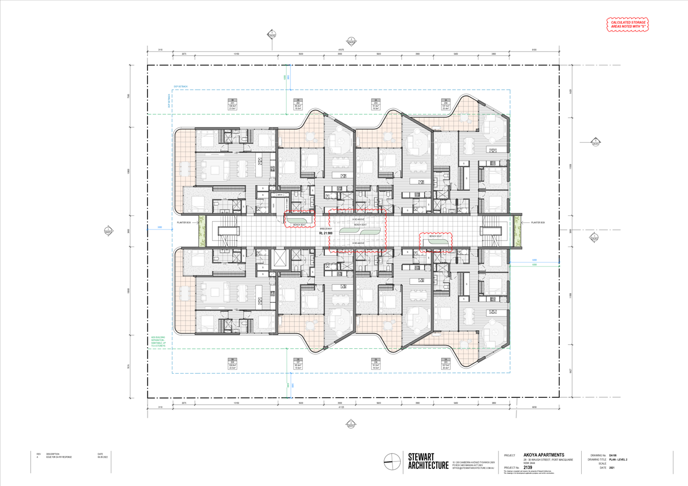

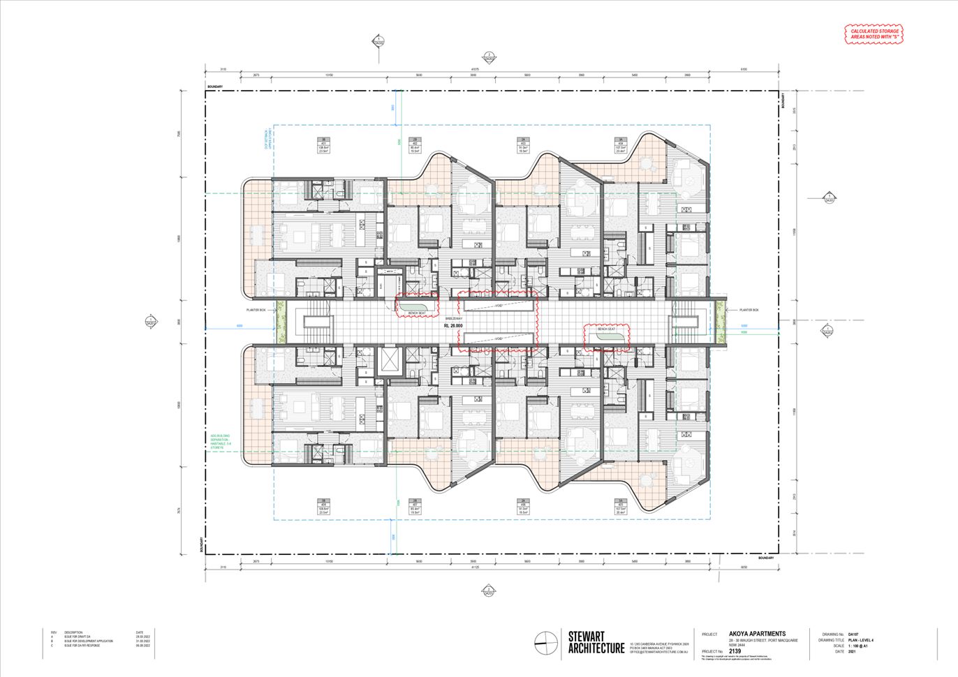
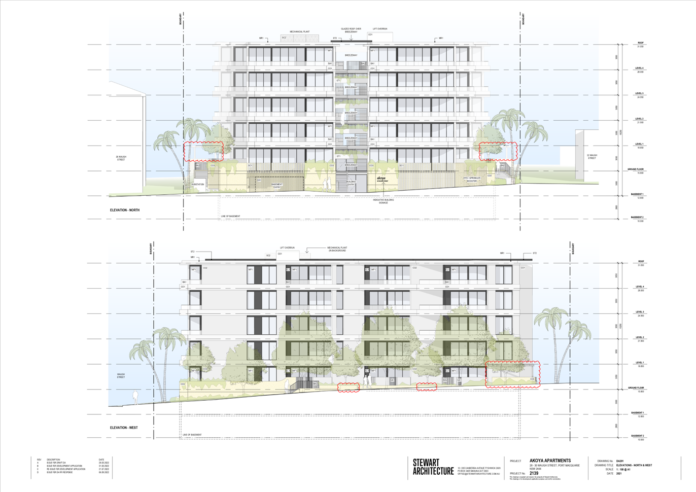
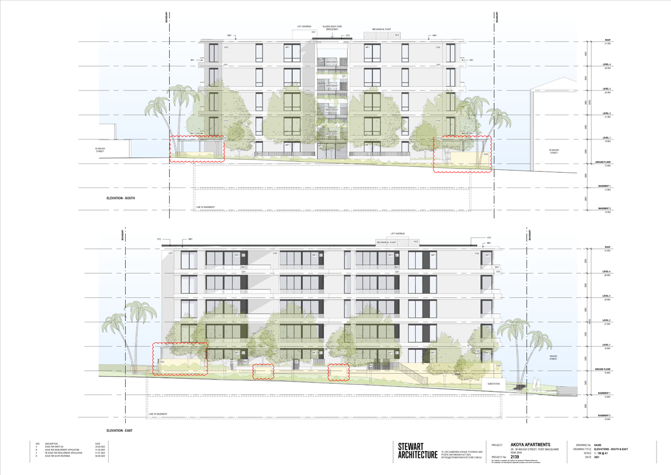
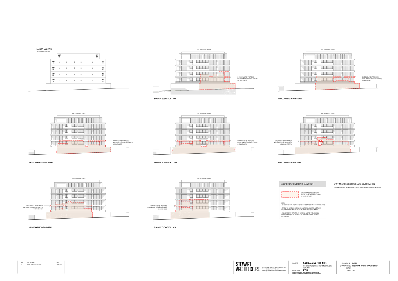
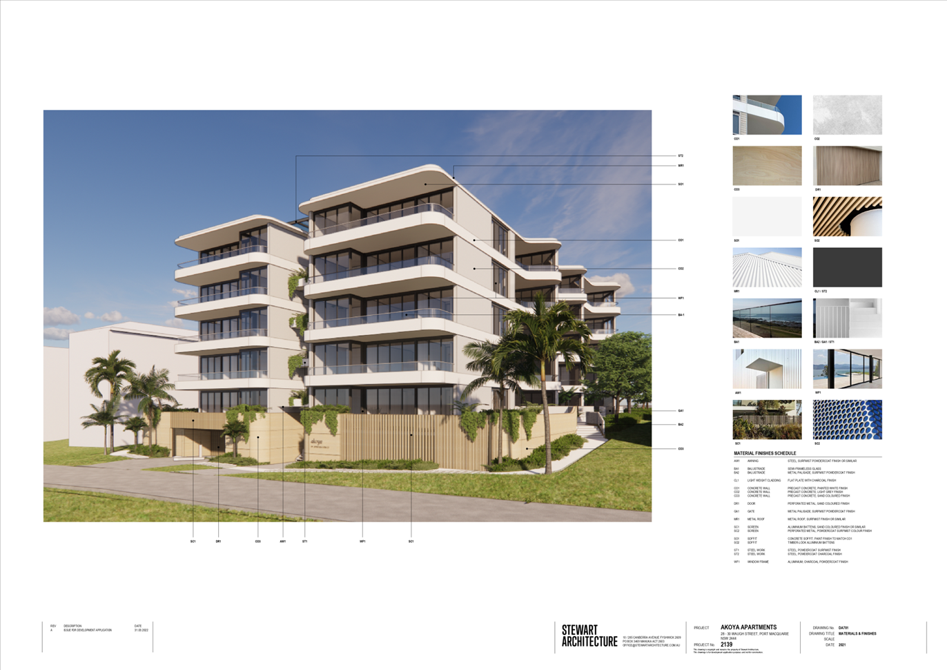


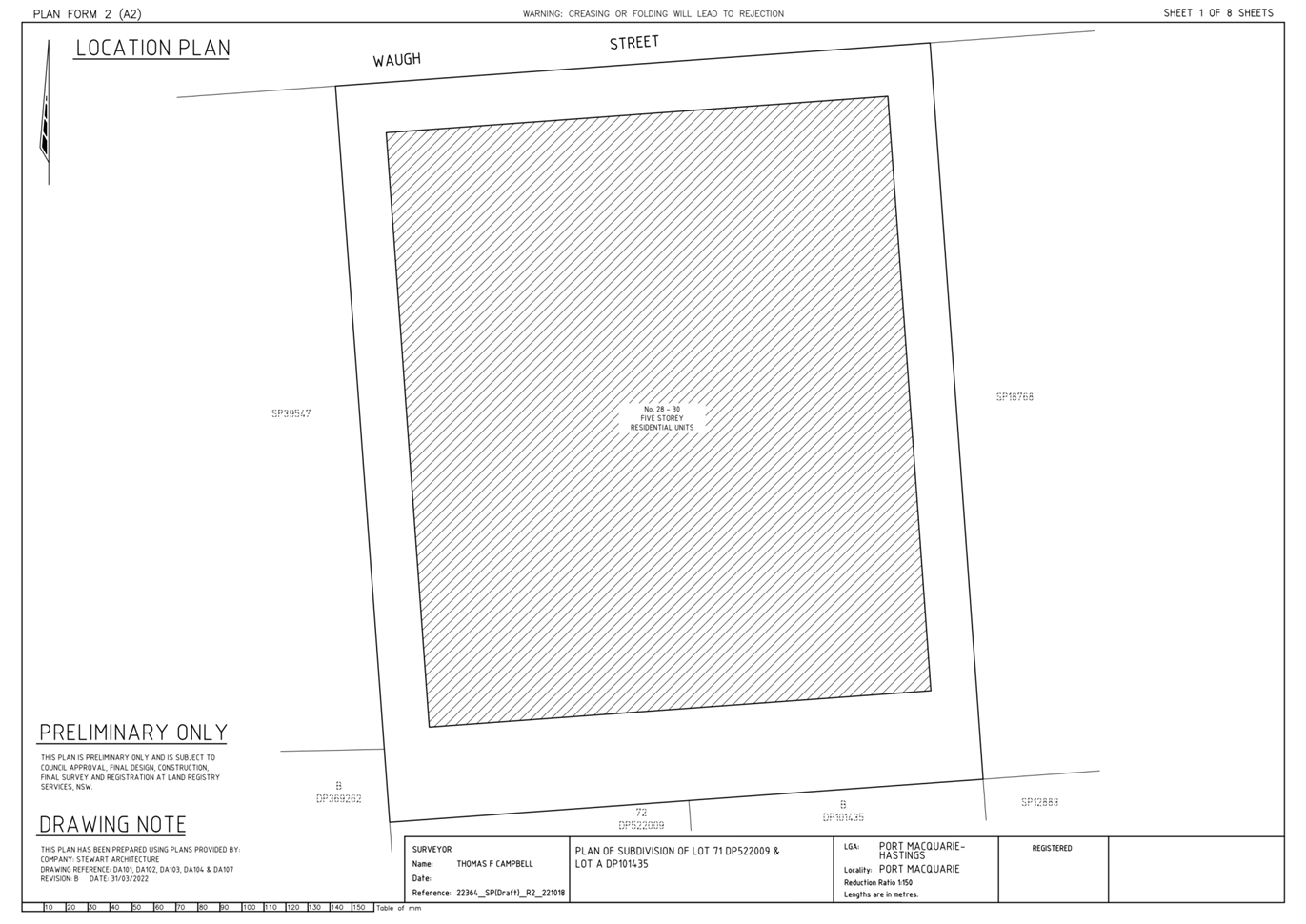


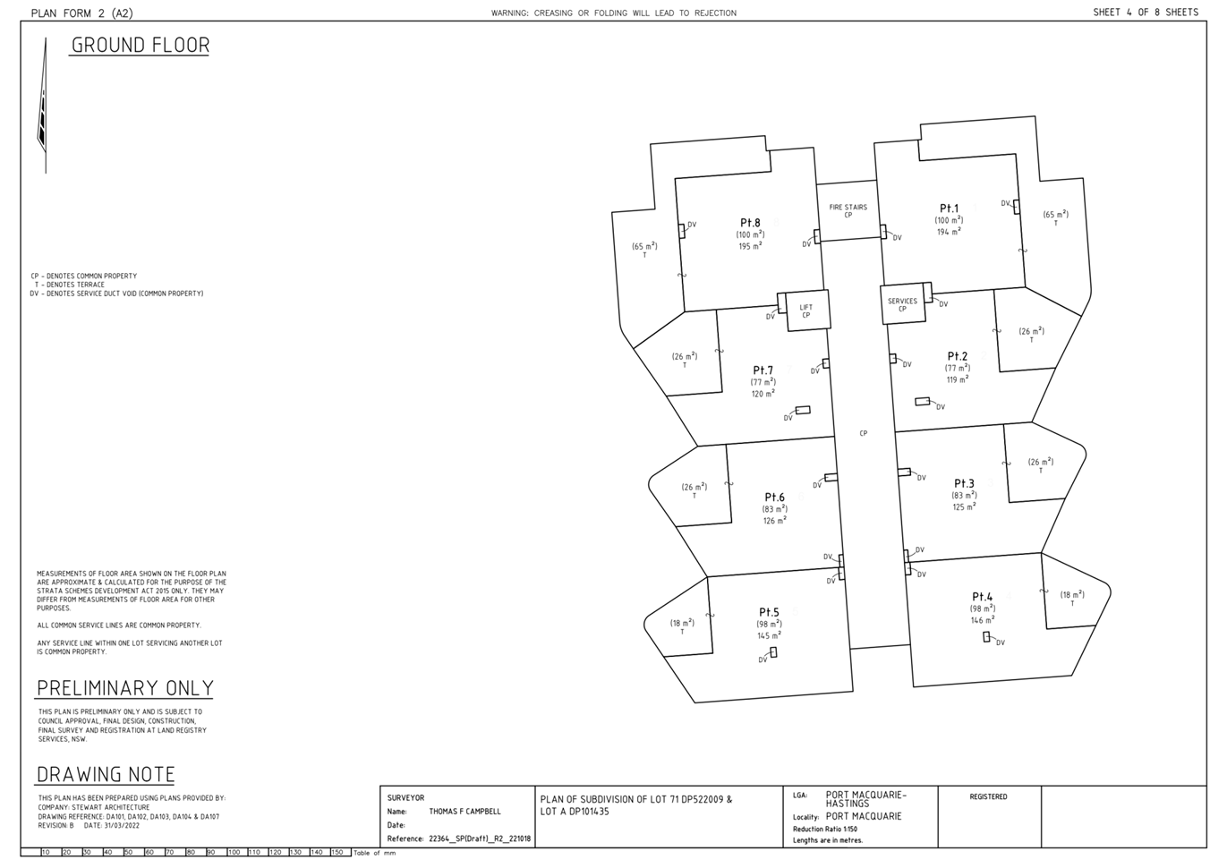
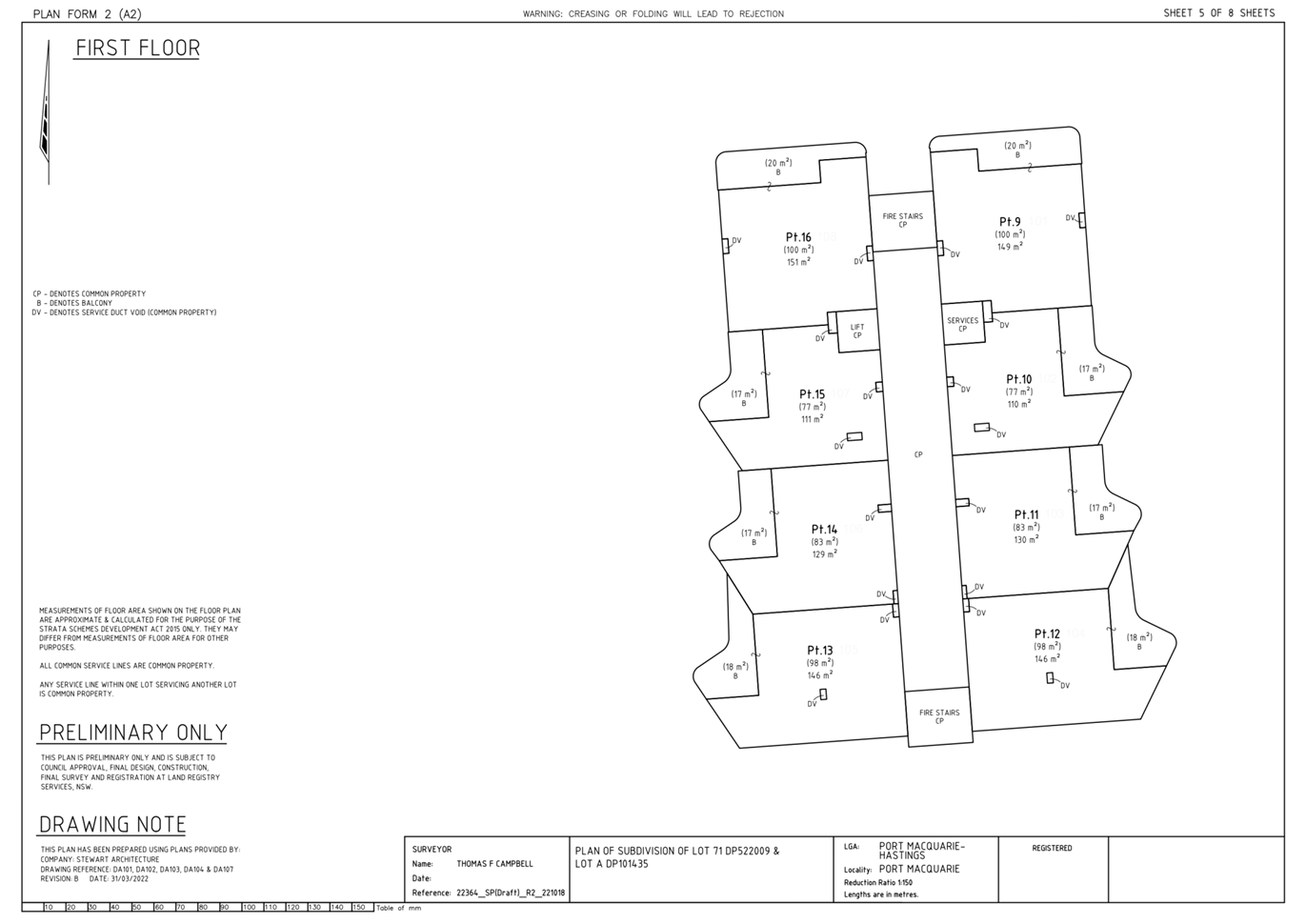


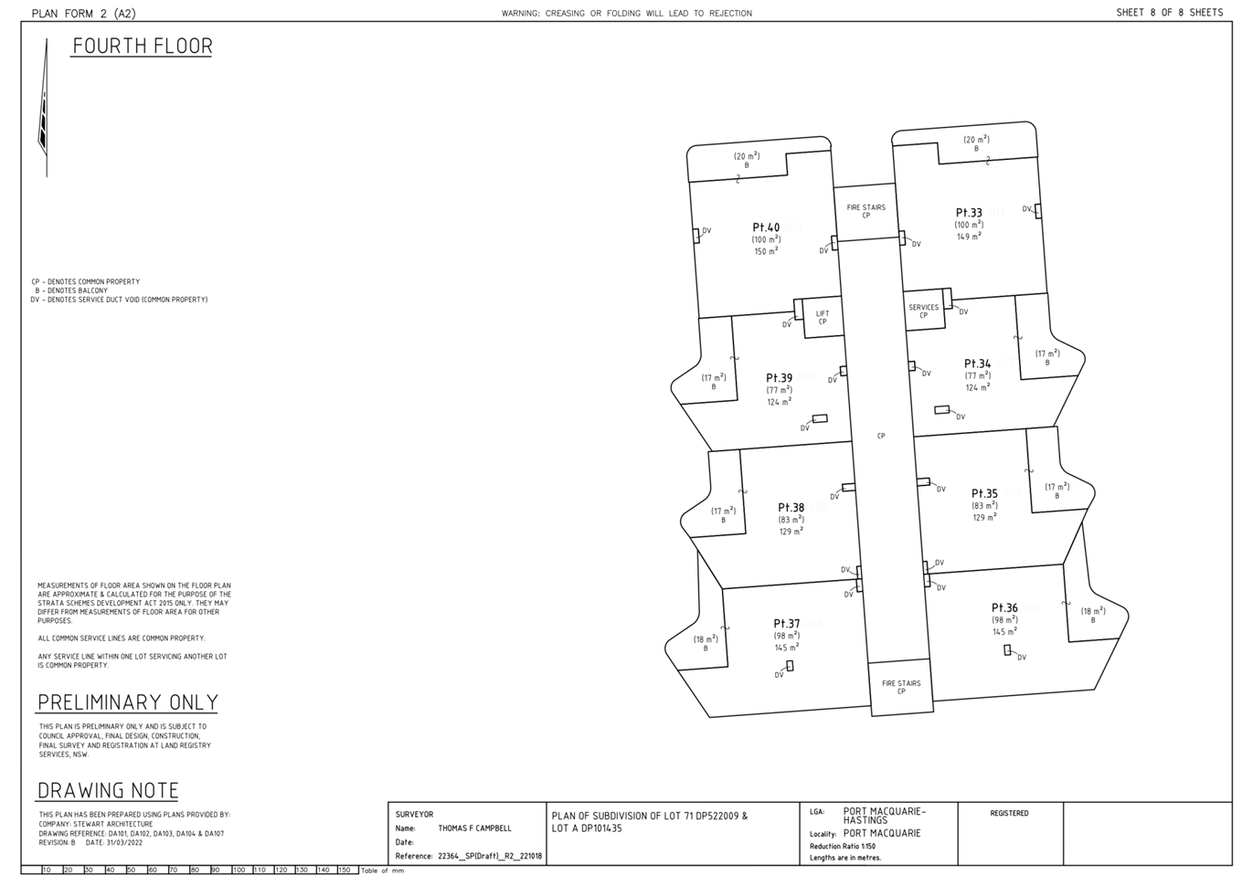
|
ATTACHMENT
|
Development Assessment Panel
05/04/2023
|


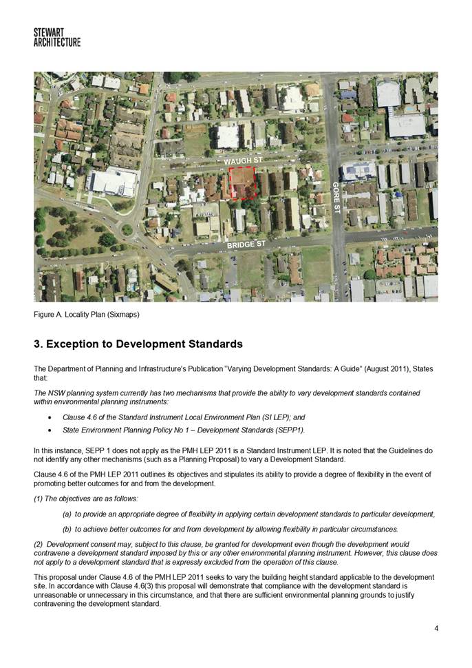


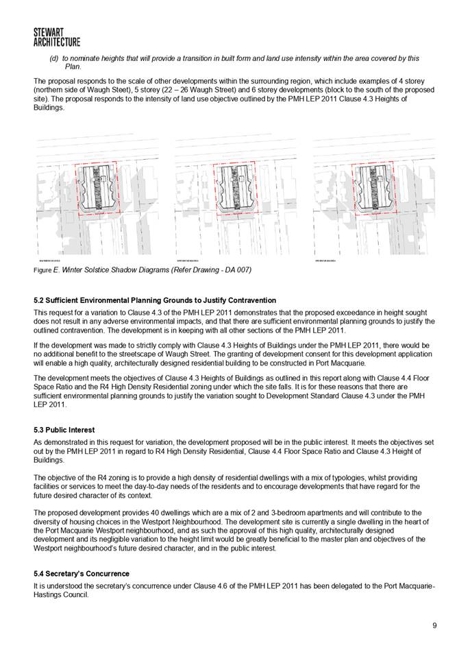


|
ATTACHMENT
|
Development Assessment Panel
05/04/2023
|


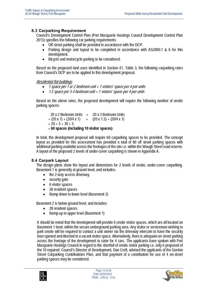


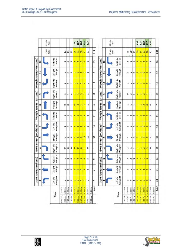


Development Assessment Panel
05/04/2023
Item: 07
Subject: DA2019 - 934.1 Caravan Park at Lot 5 DP 524972
Parklands Close, Port Macquarie
Report
Author: Development Assessment Planner, Chris Gardiner
|
Applicant: J
W Crowe
Owner: J
W Crowe
Estimated Cost: $225,000
Alignment with Delivery
Program
4.3.1 Undertake transparent
and efficient development assessment in accordance with relevant legislation.
|
RECOMMENDATION
That
DA2019 - 934.1 for a Caravan
Park at Lot 5, DP 524972, Parklands
Close, Port Macquarie, be determined by granting deferred commencement consent
subject to the recommended conditions and the following being satisfied within
2 years of the date of the consent:
1. The
proponent shall submit to Council evidence that the extension of Wandella Drive
and internal access road approved under development consent DA2019 - 227 have
been completed to the satisfaction of the roads authority (for works in
Wandella Drive) and the Principal Certifying Authority (for works within the
site).
Executive
Summary
This
report considers a development application for a caravan park at the subject site and provides an assessment of the
application in accordance with the Environmental Planning and Assessment Act
1979.
Following exhibition of the
application on three occasions, 136 submissions and an e-petition with over
31,500 signatures were received objecting to the proposal for various reasons.
Issues raised in the submissions have been considered in the assessment of the
application and are discussed in detail within this report. Where relevant,
conditions have been recommended to address the impacts attributed to these
issues.
The application has been the subject of a lengthy assessment
process in order for several important site suitability matters to be addressed/resolved.
The proposal has been amended through the assessment process including
reduction in the number of sites from 13 to 9, removal of an access road
connection to Parklands Close, improved tree retention and landscaping.
The proposed development is consistent with the provisions
and objectives of the relevant planning controls and it is considered that is
will have an acceptable impact on the surrounding natural and built
environment.
This report recommends that the
development application be granted a deferred commencement consent as
the proposal relies upon completion of an access road approved under separate
development consent DA2019 - 277. The recommended conditions are included in Attachment
1.
The reason for the application being referred to
Council’s Development Assessment Panel (DAP) is because three (3) or more
objections to the proposal have been. A copy of the DAP Charter outlining the
delegations and functions of the DAP is available on Council’s website.
1. BACKGROUND
Existing
Sites Features and Surrounding Development
The site has an area of 1.683
hectares.
The
site is zoned part R1 General Residential, RE2 Private Recreation, and
C2 Environmental Conservation in accordance with the
Port Macquarie-Hastings Local Environmental Plan 2011, as shown in the
following zoning plan:
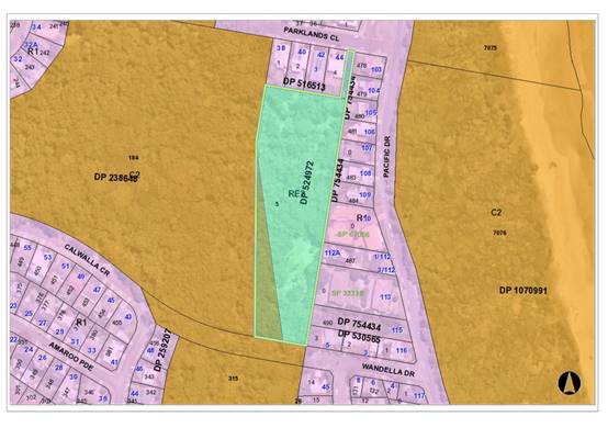
The
existing subdivision pattern and location of existing development within the
locality is shown in the following aerial photograph:

The
site contains a number of existing buildings associated with the former Fantasy
Glades theme park. Consent has been granted under DA2019 - 277 to convert the
former Cinderella’s Castle at the southern end of the site to a
café. The majority of other existing buildings on the site are proposed
to be retained and restored as relics of the former use, but are not intended
to be occupied.
2. DESCRIPTION
OF DEVELOPMENT
Key
aspects of the proposal include the following:
· A
caravan park with 1 short-term site and 8 long-term sites;
· Conversion
of an existing building to a community building containing laundry and storage
facilities;
· Associated
access roads, car parking and landscaping
Refer
to Attachment 2 at the end of this report for plans of the proposed
development.
Application
Chronology
· 18
December 2019 - Application lodged.
· 23
January 2020 to 5 February 2020 - Application advertised and notified to nearby
property owners.
· 12
February 2020 - Additional information requested from Applicant.
· 7
April 2020 - Additional information requested by NSW Rural Fire Service.
· 3
September 2020 - Amended plans and additional information submitted by
Applicant.
· 13
October 2020 - Further additional information requested from Applicant.
· 30 November 2020 - Further additional information requested
by NSW Rural Fire Service.
· 9 April 2021 - Further additional information and amended
plans submitted by Applicant.
· 16 April 2021 to 29 April 2021 - Amended proposal
re-notified.
· 3 June 2021 - Further additional information requested from
Applicant.
· 8 June 2021 - Comments on proposal received from
Biodiversity Conservation Division of NSW Department of Planning and
Environment.
· 20 April 2022 - Further additional information and amended
plans submitted by Applicant.
· 21 July 2022 - Amended Biodiversity Development Assessment
Report submitted by Applicant.
· 29 July 2022 to 11 August 2022 - Amended proposal
re-notified.
· 27 September 2022 - Bush Fire Safety Authority issued by
NSW Rural Fire Service.
· 31 October 2022 - Further additional information requested
from Applicant.
· 10 November 2022 - Comments on amended proposal received
from Biodiversity Conservation Division of NSW Department of Planning and
Environment.
· 12 December 2022 - Additional information submitted by
Applicant.
3. STATUTORY
ASSESSMENT
Section
4.15(1) Matters for Consideration
In
determining the application, Council is required to take into consideration the
following matters as are relevant to the development that apply to the land to
which the development application relates:
(a) The
provisions (where applicable) of:
(i) Any
Environmental Planning Instrument
State Environmental Planning Policy (Housing) 2021
Schedule 7A (Clause 2(1)(a)) - This Policy does not apply to
a development application made, but not yet determined, on or before the
commencement date. As the application was lodged before the commencement date
of the SEPP, former State Environmental Planning Policy No. 21 - Caravan Parks
continues to apply to the proposal. See assessment below.
State Environmental Planning Policy No. 21 - Caravan
Parks
8 Development consent
required for caravan parks
(1) Development for the purposes of a caravan park
may be carried out only with the development consent of the Council.
(2) Before granting development consent to the use
of land for the purposes of a caravan park, a Council must determine:
(a) the number of
sites (if any) within that land that the Council considers are suitable for
long-term residence, within the meaning of the Local Government (Caravan Parks
and Camping Grounds) Transitional Regulation 1993, and
(b) the number of
sites (if any) within that land that the Council considers are not suitable for
long-term residence, but are suitable for short-term residence, within the
meaning of that Regulation.
(3) A Council must not grant development consent to
the use of land for the purposes of a caravan park unless it imposes as a
condition of that consent a condition specifying the maximum number of sites
(if any) within that land that may be used for long-term residence.
(4) The holder of an approval under Part 1 of
Chapter 7 of the Local Government Act 1993
to operate a caravan park or camping ground on land must not, without the
development consent of the Council, allow a person to occupy a site within that
land:
(a) for a
continuous period of more than 3 months, except as provided by paragraph (b),
or
(b) for a
continuous period longer than the period (if any) for which the person is
allowed to be accommodated within the land by an extension that has been
granted under clause 19 (6) of the Local Government (Caravan Parks and Camping
Grounds) Transitional Regulation 1993,
if such a use of that site was not lawful under the Environmental Planning and
Assessment Act 1979 when this Policy commenced.
(4A) Except as provided by subclause (4), nothing in
this Policy or any other environmental planning instrument requires separate
development consent to be obtained for the installation or placement of a
moveable dwelling on land on which development for the purposes of a caravan
park is being lawfully carried out.
(5) This clause does not apply to any land that is
authorised to be used for the purposes of a manufactured home estate by a
development consent granted pursuant to State Environmental Planning Policy
No 36—Manufactured Home Estates or dedicated or
reserved under the National Parks and Wildlife Act 1974.
The proposal seeks consent for eight (8) long-term sites and
one (1) short-term site. A condition is recommended specifying the maximum
number of long-term and short-term sites permitted.
10 Matters to be
considered by Councils
A Council may grant a development consent required by
this Policy only after it has considered the following:
(a) whether, because
of its location or character, the land concerned is particularly suitable for
use as a caravan park for tourists or for long-term residence,
(b) whether there
is adequate provision for tourist accommodation in the locality of that land,
and whether existing or potential tourist accommodation will be displaced by
the use of sites for long-term residence,
(c) whether there
is adequate low-cost housing, or land available for low-cost housing, in that
locality,
(d) whether
necessary community facilities and services are available within the caravan
park to which the development application relates or in the locality (or both),
and whether those facilities and services are reasonably accessible to the
occupants of the caravan park,
(e) any relevant
guidelines issued by the Director, and
(f) the provisions
of the Local Government (Caravan Parks and Camping Grounds) Transitional
Regulation 1993.
The application does not propose to convert any existing
short-term sites and the proposal will not result in the displacement of any
short-term residents or loss of tourist accommodation.
The proposal will provide long-term accommodation in an
environmental setting with satisfactory access to public open space and
facilities. The area has a significant stock of tourist accommodation and it is
not expected that the long-term sites within the proposed caravan park would
displace existing tourist accommodation.
The below table considers the applicable provisions of the
Local Government (Manufactured Home Estates, Caravan Parks, Camping Grounds and
Moveable Dwellings) Regulation 2021:
|
CLAUSE
|
REQUIREMENT
|
COMMENT/COMPLIANCE
|
|
Part 3, Division 1 Operation of caravan parks and
camping grounds
|
|
71 Factors for consideration before approval is granted
|
(1) Council must be satisfied that the estate will be
designed in accordance with Division 3; and
(2) Council must have regard to the Floodplain Development
Manual.
|
(1) Yes- refer to comments on Division 3
(2) Site is flood prone. See comments under clause 5.21 of
LEP.
|
|
72 Matters to be specified in approval
|
Any approval must specify the number, size and location of
the dwelling and camping sites.
|
Section 68 approval to operate will need to specify these
matters.
|
|
73 Conditions of approval
|
The consent must be conditioned to ensure the design,
construction, maintenance and operation of the estate is in accordance with
Division 3.
|
Section 68 approval to operate will need to specify these
matters.
|
|
Part 3, Division 3 Caravan parks and camping grounds
|
|
83 Minimum size of caravan park or camping ground
|
(1) A caravan park must not have an area of less
than—
(a) 1 hectare, or
(b) if a lesser area is permitted on the land
by an environmental planning instrument—the lesser area.
(2) A camping ground is not required to have a minimum
area
|
The overall site has an area of 1.683 hectares. Even
excluding the part of the site proposed to be used as a café, the
caravan park would have an area exceeding 1 hectare.
|
|
84 Community amenities
|
(1) A minimum of 10% of the total land area of a
caravan park or camping ground must be reserved for recreation or other
communal activities.
(2) The council may allow a lower percentage, not
less than 6% of the total land area of the caravan park or camping ground, to
be reserved for recreation or other communal activities.
(3) Before allowing a lower percentage, the council
must consider—
(a) the type and range of amenities to be
provided, and
(b) other matters the council considers
relevant.
|
More than 10% of the site area is available for recreation
and communal activities.
|
|
85 Size of dwelling sites and camp sites
|
(1) A long-term site must have an area of at least
80 square metres.
(2) A short-term site must have an area of at least
65 square metres.
(3) A camp site must have an area of at least—
(a) for a camp site for which a separate
parking space is provided within 30 metres of the camp site—40 square
metres, or
(b) otherwise—50 square metres.
|
The proposal includes 8 long-term sites, with site areas
ranging from 100.3m2 to 144.3m2, and 1 short-term site
with an area of 101.2m2.
|
|
86 Site identification
|
(1) A dwelling site must be numbered or identified
with its site boundaries clearly outlined.
(2) The site identification must be easily
recognised.
|
Capable of complying. Would need to be in place prior to
Section 68 approval to operate.
|
|
87 Dwelling sites to have road frontage
|
A dwelling site must have vehicular access to an access
road.
|
All dwelling sites have vehicular access to an access
road.
|
|
88 Setbacks of community buildings
|
(1) A community building must not be located within
10 metres of the boundary of a caravan park, camping ground, dwelling site or
camp site.
(2) The council may allow the following distances if
satisfied the community building has been or will be properly screened,
fenced, enclosed or otherwise treated—
(a) 3 metres or more from the boundary of a
caravan park or camping ground, and
(b) 5 metres or more from the boundary of a
dwelling site or camp site.
|
Proposed community building is setback approximately 5m from
the property boundary, 6m from site 4, and 9m from site 5. The building has a
small floor area and will predominantly be used for washing and drying
clothes. The entry door is located on the eastern elevation of the building
and is oriented away from sites 4 and 5.
The submitted landscape plan identifies dense screen
planting to the east and north of the building to screen it from neighbouring
residential uses.
A reduced setback is considered acceptable in these
circumstances.
|
|
89 Setbacks of dwelling sites and camp sites from road
frontages
|
(1) A dwelling site or camp site must not be located
closer than—
(a) 10 metres to a public road, or
(b) 3 metres to another boundary of the caravan
park or camping ground.
(2) The council may allow a lesser distance if
satisfied the dwelling site or camp site has been or will be properly
screened, fenced, enclosed or otherwise treated.
|
Sites 5, 6, and 7 have corners located at 2.5m from
northern boundary, with the majority of each of these sites achieving 3m separation.
The submitted landscape plan includes dense screen plantings along the
northern boundary adjacent to these sites. The proposed setback is considered
acceptable.
|
|
90 Use of buffer zones
|
Nothing in this Part prevents land within a required
setback from being used for—
(a) community amenities, access roads, car
parking spaces, footpaths or landscaping, or
(b) a similar purpose allowed by the council.
|
Buffer zones proposed to be used for landscaping and
access roads.
|
|
91 Separation distances
|
(1) A moveable dwelling must not be installed within
the following distance of another moveable dwelling—
(a) if located on a long-term site—3
metres, or
(b) if located on a short-term site or camp
site—2.5 metres.
(2) This section does not prohibit the installation
of semi-detached relocatable homes on adjoining dwelling sites if they are
separated by construction complying with the fire safety and sound insulation
provisions in the Building Code of Australia, Volume Two, section
3.7.1 and 3.8.6 for class 1 buildings.
|
The proposed sites are of adequate dimensions for future
moveable dwellings to be installed with appropriate separation distances.
Compliance would need to be demonstrated prior to the issue of a Section 68
approval to operate.
|
|
92 Entrance and exit roads
|
(1) A road forming an entrance to or exit from a
caravan park or camping ground must be at least 7 metres wide.
(2) For a divided road, the width of the sealed
portion of the road on either side of the median strip must be at least 5
metres.
(3) The council may specify in an approval the way
in which an entrance or exit road must meet the sealed portion of other
access roads.
approval for the caravan park or camping ground.
|
The extension of Wandella Drive to the site access under
DA2019 - 277 is considered to form the entrance road and has a width of at
least 7m. The entrance road tapers to the access road at the divided section
inside the site boundary.
|
|
93 Forecourt
|
A caravan park must have an area—
(a) to accommodate incoming vehicles, and
(b) measuring at least 4 metres by 20 metres.
|
Forecourt 16.5m long x 2.5m wide proposed. The Applicant
has indicated that they are proposing to lodge a Section 82 objection to this
standard with the application for an approval to operate the caravan park.
|
|
94 Width of roads
|
(1) The width of an access road must be—
(a) for a two-way access road—at least 6
metres, and
(b) for a one-way access road—at least 4
metres.
(2) The direction of travel for a one-way access
road must be indicated by means of conspicuous signs.
|
The two-way access road has a width of 5.5m through the
vegetated area and a minimum width of 6m adjacent to the long-term sites. The
Applicant has indicated that they are proposing to lodge a Section 82
objection to this standard with the application for an approval to operate
the caravan park.
There are no one-way roads proposed that require direction
of travel to be marked.
|
|
95 Speed limits
|
The speed limit on an access road must—
(a) not exceed 15 kilometres per hour, and
(b) be indicated by means of conspicuous signs.
|
Capable of complying. Would need to be in place prior to
Section 68 approval to operate.
|
|
96 Resident parking
|
(1) A caravan park or camping ground must contain at
least 1 resident parking space for each dwelling site or camp site.
(2) The parking space for a dwelling site or camp
site may be on-site or off-site.
(3) An off-site parking space must be marked to
identify the dwelling site or camp site to which it relates.
Example—
An off-site space may marked by line marking, marker pegs
or other similar markings.
(4) An off-site parking space for a dwelling site or
camp site must be in the location specified in the approval.
(5) An off-site parking space must have minimum
dimensions of—
(a) for angle parking—5.4 metres by 2.5
metres, and
(b) otherwise—6.1 metres by 2.5 metres.
|
The Statement of Environmental Effects indicates that
parking will be provided on individual sites (likely under elevated homes).
The submitted plans include earthworks and retaining to create a 6.1m deep
parking area at the front of each of the sites.
|
|
97 Visitor parking
|
(1) A caravan park or camping ground must contain at
least 1 visitor parking space—
(a) for every 10 long-term sites in the caravan
park or camping ground, and
(b) for every 20 short-term sites in the
caravan park or camping ground, and
(c) for every 40 camp sites in the caravan park
or camping ground, and
(d) for a remaining part, if any, of a number
of sites specified in paragraphs (a)–(c).
Example—
A caravan or camping ground containing 90 short-term sites
must contain at least 5 visitor parking spaces.
(2) At least 4 visitor parking spaces must be
provided for a caravan park or camping ground.
(3) Each parking space must have minimum dimensions
of—
(a) for angle parking—5.4 metres by 2.5
metres, or
(b) otherwise—6.1 metres by 2.5 metres.
(4) Visitor parking spaces must be clearly
identified.
|
Four (4) visitor parking spaces proposed, which complies
with the minimum requirement.
|
|
98 Visitor parking for people with disabilities
|
(1) A caravan or camping ground must contain—
(a) at least 1 visitor parking space for people
with a disability (a disabled parking space), or
(b) if the caravan or camping ground contains
100 sites or more—at least 1 additional disabled parking space
for—
(i) the first 100 sites, and
(ii) every further 100 sites, and
(iii) a remaining part, if any, of 100 sites.
Example—
A caravan or camping ground containing 235 sites must
contain at least 3 disabled parking spaces.
(2) A disabled parking space must be—
(a) provided in accordance with AS/NZS
2890.1:2004, Parking facilities, Part 1: Off-street parking, and
(b) clearly identified as a disabled parking
space.
(3) A disabled parking space may be counted as a
visitor parking space.
|
One visitor parking space for people with disabilities
proposed.
|
|
99 Road surfaces
|
All access roads, including all passing and parking bays,
must—
(a) have an all-weather sealed or other surface
finish specified in the approval, and
(b) be adapted to the land to enable adequate
drainage and remove excessive grades.
|
Condition recommended requiring access roads to have
sealed surface.
|
|
100 Lighting
|
All access roads must be adequately lit between sunset and
sunrise.
|
Lighting will be required for new access roads. Condition
recommended confirming this requirement.
|
|
101 Water supply
|
(1) A caravan park or camping ground must be—
(a) connected to a mains water supply, or
(b) provided with an alternative water supply
service as specified in the approval.
(2) A dwelling site must be connected to the water
supply service for the caravan park or camping ground.
(3) Each water supply connection must—
(a) be located within 30 metres of the 4 camp
sites, and
(b) include a standpipe and hose tap.
(4) The water supply service must comply with—
(a) the Plumbing and Drainage Act 2011 and
the regulations made under that Act, and
(b) the requirements of a relevant statutory
body.
(5) The water supplied for human consumption or
domestic purposes must comply with the Australian Drinking Water
Guidelines 6 published in October 2011 by the National Health and
Medical Research Council.
|
Water supply will be required for each dwelling site.
Details to be provided with S68 application.
|
|
102 Sewerage
|
(1) A caravan park or camping ground must be—
(a) connected to a main sewer, or
(b) provided with an alternative sewage
disposal system as specified in the approval.
(2) A long-term site must be connected to the sewage
disposal system for the caravan park or camping ground.
(3) Short-term sites and camp sites in a caravan
park or camping ground must be provided with at least 1 soil waste dump
point—
(a) for the disposal of closet waste from caravan
holding tanks, and
(b) located to permit adequate access by
caravans and campervans.
(4) Short-term sites must be provided with a
disposal point—
(a) for the disposal of sullage from a moveable
dwelling installed on the site, and
(b) as specified in the approval.
(5) The sewage disposal system must comply
with—
(a) the Plumbing and Drainage Act 2011 and
the regulations made under that Act, and
(b) the requirements of a relevant statutory
body.
(6) In this section—
sullage means domestic waste from
baths, basins, showers, laundries and kitchens, including floor wastes.
|
All sites and the community building will be required to
be connected to sewer.
|
|
103 Drainage
|
(1) A caravan park or camping ground must be
provided with a stormwater drainage system.
(2) All dwelling sites and camp sites must be
adequately drained.
|
See comments later in this report under Stormwater.
|
|
104 Electricity Supply
|
(1) A dwelling site must be supplied with
electricity from a reticulated electricity service.
(2) For a long-term site, the electricity must be
supplied by means of an electrical circuit connected to a separate
electricity meter.
(3) The electrical circuit must be installed in
accordance with—
(a) for a long-term site—the Electricity
Code of Practice, and
(b) for a short-term site—AS/NZS
3001:2008, Electrical installations—Transportable structures
and vehicles including their site supplies.
(4) If a dwelling site is provided with electricity
otherwise than by a direct connection to the local electricity supply
authority’s electricity main, the occupant of the dwelling site may
only be charged reasonable charges for the supply of the electricity.
|
Condition recommended requiring satisfactory arrangement
certification for provision of electricity supply to the development.
|
|
105 Common trenches
|
A common trench may be used for the installation of
services in accordance with guidelines provided in AMCORD.
|
Noted.
|
|
106 Modification of calculations
|
In calculating the number of facilities under this
Subdivision—
(a) 2 camp sites are taken to be equivalent to
1 dwelling site, and
(b) the following must not be included—
(i) dwelling sites reserved for use by
self-contained moveable dwellings, and
(ii) dwelling sites provided with ensuite
facilities.
|
Noted. See calculations below under clauses 107-109.
The Applicant has noted in the Statement of Environmental
Effects that all sites will have self-contained movable dwellings and these
have been excluded from the calculations.
|
|
107 Number of showers and toilets to be provided.
|
Facilities to be provided in accordance with table.
|
All sites have been noted to be reserved for
self-contained movable dwellings and no communal shower or toilet facilities
are required. A condition is recommended requiring all sites to be restricted
to self-contained moveable dwellings or provide ensuite facilities.
|
|
108 Facilities for people with disabilities
|
Minimum one facility required. Can be disregarded if all
sites proposed to be designated for self-contained moveable dwellings.
|
Not required due to restriction for self-contained movable
dwellings.
|
|
109 Other facilities
|
(1) All showers and handbasins required by this
Subdivision must be supplied with hot and cold running water.
(2) A mirror must be provided—
(a) for each handbasin, or
(b) if 2 or more handbasins are provided
together—for each pair of handbasins.
(3) The following must be provided in a facility
containing toilets for the use of females—
(a) at least 1 sanitary napkin disposal unit,
or
(b) for a facility containing at least 10
toilets for the use of females—at least 1 additional sanitary napkin
disposal unit for—
(i) every 10 toilets, and
(ii) a remaining part, if any, of 10 toilets.
|
N/A
|
|
110 Construction of shower blocks and toilet blocks
|
(1) Except as otherwise provided in an approval, the
shower and toilet facilities in a caravan park or camping ground must be
contained in a shower or toilet block—
(a) constructed of brick or concrete masonry
block, and
(b) with a non-slip floor of tile or other
impervious material adequately drained to outlets, and
(c) with smooth, hard, durable and
water-resistant interior finishes, and
(d) containing shower recesses with tile or
other impervious finishes to a height of at least 1.8 metres, and
(e) with tile or other impervious skirtings
around water closet cubicle walls, and
(f) with tile or other impervious finish around
handbasins, and
(g) with adequate lighting, both inside and
outside, and adequate ventilation at all times, and
(h) with all walls, ceilings and floors,
fixtures, fittings and appliances maintained in a clean and sanitary
condition.
(2) A building containing both male and female
facilities must be divided for the private use of each sex.
(3) Toilets must be provided in individual cubicles
having a minimum floor area of 1.1 square metres and a minimum width of 0.8
metre.
|
N/A
|
|
111 Proximity of dwelling sites to shower blocks and
toilet blocks
|
(1) A long-term site must be located within 75
metres, measured in a straight line, of a shower or toilet block.
(2) A short-term site or camp site must be located
within 100 metres, measured in a straight line, from a shower or toilet
block.
(3) This section does not apply to a dwelling
site—
(a) reserved for use by self-contained moveable
dwellings, or
(b) provided with ensuite facilities.
|
N/A
|
|
113 Washing Machines
|
(1) A caravan park or camping ground must be
provided with at least—
(a) 1 washing machine for every 25 long-term
sites, and
(b) 1 additional washing machine for a
remaining part, if any, of 25 long-term sites exceeding 12, and
(c) 1 washing machine for every 30 short-term
sites, and
(d) 1 additional washing machine for a
remaining part, if any, of 30 short-term sites exceeding 15.
(2) At least 2 washing machines must be provided in
a caravan park or camping ground.
|
Development requires a minimum of 2 washing machines. The
submitted plans show 2 washing machines in the proposed community building.
|
|
114 Laundry Tubs
|
(1) A caravan park or camping ground must be
provided with—
(a) at least 1 laundry tub for every 50
long-term sites, and
(b) at least 1 additional laundry tub for a
remaining part, if any, of 50 long-term sites, and
(c) at least 1 laundry tub for every 60
short-term sites, and
(d) at least 1 additional laundry tub for a
remaining part, if any, of 60 short-term sites.
(2) At least 1 laundry tub must be provided in a
caravan park or camping ground.
|
Development requires a minimum of one laundry tub. The
submitted plans show one laundry tub in the proposed community building.
|
|
115 Clothes dryers
|
(1) A caravan park or camping ground must be
provided with—
(a) at least 1 mechanical clothes dryer for
every 60, and remaining part of 60 greater than 30, long-term sites, and
(b) at least 1 mechanical clothes dryer for
every 80, and remaining part of 80 greater than 40, short-term sites.
(2) At least 1 mechanical clothes dryer must be
provided in a caravan park or camping ground.
|
Development requires a minimum of one mechanical clothes
dryer. The submitted plans show two combined washing machine/dryers in the
proposed community building.
|
|
116 Drying area
|
(1) A caravan park or camping ground must be
provided with clothes line space at the rate of 2 metres of line for each
dwelling site.
(2) At least 50 metres of clothes line space must be
provided in a caravan park or camping ground.
|
Minimum 50m of clothes drying area required. 50m of
clothes line proposed.
|
|
117 Water supply
|
Washing machines and laundry tubs required to be provided
in a caravan park or camping ground must be supplied with both hot and cold
water.
|
Noted. This would need to be confirmed prior to the issue
of a Section 68 approval to operate.
|
|
118 Ironing facilities
|
A caravan park or camping ground must be provided with at
least 1 of each of the following for every 60, and remaining part of 60,
short-term sites—
(a) an ironing board,
(b) an electric iron,
(c) a power point available for connection to
an electric iron.
|
Capable of being provided in the community building. This
would need to be confirmed prior to the issue of a Section 68 approval to
operate.
|
|
119 Construction of laundry blocks
|
Except as otherwise provided in an approval, the laundry
facilities in a caravan park or camping ground must be housed in a laundry
block—
(a) constructed of brick or concrete masonry
block, and
(b) with a non-slip floor of tile or other
impervious material adequately drained to outlets, and
(c) with smooth, hard, durable and water-resistant
interior finishes, and
(d) with adequate lighting, both inside and
outside, and adequate ventilation at all times, and
(e) with walls, ceilings and floors, fixtures,
fittings and appliances maintained in a clean and sanitary condition, and
(f) maintained in a serviceable and safe
condition
|
The community building containing the laundry facilities
is brick veneer construction and the internal finishes are capable of
complying with these requirements.
|
|
126 Garbage removal
|
Arrangements specified in an approval must be implemented
and maintained—
(a) for the removal of garbage, and
(b) to keep garbage receptacles in a clean and
sanitary condition.
|
The Statement of Environmental Effect indicates that the
sites are proposed to have individual waste bins stored on each site and
collected by a private waste contractor. This is considered acceptable given
the long-term tenure of all the sites.
The swept path plans indicate that a waste collection
vehicle can turn around within the development and egress in a forward
manner.
A condition is recommended requiring confirmation of
satisfactory arrangements for a private waste collection service prior to the
issue of a Section 68 approval to operate the caravan park.
|
|
127 Fire hydrants
|
(1) No part of a dwelling site, camp site or
community building within a caravan park or camping ground may be situated
more than 90 metres from a fire hydrant.
(2) Any fire hydrant located within a caravan park
or camping ground must:
(a) be a double-headed as pillar-type fire
hydrant, and
(b) be maintained to the standard specified in
the approval for the caravan park or camping ground.
|
Compliant hydrant coverage will need to be provided prior
to the issue of an approval to operate.
|
|
128 Fire hose reels
|
(1) Fire hose reels must be installed so that each
dwelling site or camp site in the caravan park or camping ground can be
reached by a fire hose.
|
Compliant fire hose reel coverage will need to be provided
prior to the issue of an approval to operate.
|
|
129 Car washing bay
|
A caravan park must be provided with an area for washing
vehicles.
|
Adequate area available. Details would need to be
confirmed with the application for a Section 68 approval to operate the
caravan park.
|
State Environmental Planning Policy (Biodiversity and
Conservation) 2021
Chapter 4 - Koala Habitat Protection 2021
Clause 4.16 - A development application made in relation to
land, but not finally determined before this Chapter applied to the land, must
be determined as if this Chapter had not commenced in its application to the
land. The application was made and not finally determined prior
to the commencement of this policy, and the application is therefore required
to be assessed under the relevant provisions of State Environmental Policy
(Koala Habitat Protection) 2021. See assessment comments below.
State Environmental Planning Policy (Koala Habitat
Protection) 2021
Clause 18 - A development application made,
but not finally determined, before the commencement of this Policy in relation
to land to which this Policy applies must be determined as if this Policy had
not commenced. The application was made and not finally determined prior to the
commencement of this policy, and the application is therefore required to be
assessed under the relevant provisions of State Environmental Policy (Koala
Habitat Protection) 2020. See assessment comments below.
State Environmental Planning Policy (Koala Habitat
Protection) 2020
Clause 5 - This SEPP applies to the Port Macquarie-Hastings
Local Government Area.
Clause 10 - The site is subject to a Koala Plan of
Management (KPoM) approved under DA2019 - 277.1. The table below provides an
assessment of the consistency of the proposed development with the ameliorative
measures in Part 8.0 of the KPoM.
|
Provision
|
Comment
|
Complies
|
|
8.1 General Clearing Measures
|
Conditions are recommended in relation to the required
koala permeable tree protection fencing and general construction management
provisions.
|
Yes
|
|
8.2 Pre-clearing Survey and Clearing Supervision
|
A condition is recommended requiring pre-clearing surveys
by an ecologist in accordance with this provision.
|
Yes
|
|
8.3 Habitat Retention
|
All primary koala food trees listed in the KPoM are
proposed to be retained.
|
Yes
|
|
8.4 Habitat Replacement
|
All secondary koala food trees and other browse species
listed in the DCP are required to be offset at a ratio of 1:1 with
primary/preferred food tree species. The proposed development involves the
removal of 11 DCP listed trees, and 11 offset plantings are proposed.
A Vegetation Management Plan will be required to confirm
details of the establishment and management of the offset plantings.
|
Yes
|
|
8.5 Domestic Animals
|
A condition is recommended prohibiting the keeping of, or
entering the site with, domestic pets.
|
Yes
|
|
8.6 Food Waste Disposal
|
The KPoM requires that all food waste stored outside buildings
to be in lockable bins with the lid firmly sealed. A condition is recommended
requiring the private waste arrangements for the site to accommodate this bin
type or for all food and garden waste to be stored within building/s between
collections.
|
Yes
|
|
8.7 Road Signage and Speed Control
|
Conditions are recommended requiring appropriate koala
warning and speed control signage.
|
Yes
|
|
8.8 Barbed Wire Removal
|
A condition is recommended requiring confirmation of
removal of the barbed wire fencing prior to the issue of an approval to
operate the caravan park.
A condition is also recommended requiring any new fencing
constructed within or around the site is to be designed to allow Koala
movement and is not to provide a barrier or obstruction to fauna. Design options
include providing a minimum 30cm gap at the bottom of the fence or Koala
ladders over the fence.
|
Yes
|
|
8.9 Artificial Lighting
|
Any exterior lighting required for the caravan park is
recommended to be strategically positioned so as to not direct light towards
adjoining vegetation to the west. Such lighting is recommended to be
sensor-based.
|
Yes
|
|
8.10 Disease
|
A condition is recommended requiring the contact details
of the Koala Hospital to be displayed on site during construction and
operation of the development to encourage the reporting of sick or injured
koalas.
|
Yes
|
State Environmental Planning Policy (Resilience and
Hazards) 2021
Chapter 2 - Coastal Management
Clause 2.5 - This SEPP prevails over the Port
Macquarie-Hastings LEP 2011 in the event of any inconsistency.
Clause 2.7 - The proposal does not include any works in the
mapped coastal wetland area, and does not trigger the designated development
provisions.
Clause 2.8 - The subject site includes land in the proximity
area to coastal wetland and littoral rainforest. The application has
demonstrated that there would not be any significant adverse impacts on the
biophysical, hydrological, or ecological integrity of the coastal wetland or
littoral rainforest. The development provides for acceptable vegetated buffers
and the quality and quantity of water flows will be managed with the proposed
stormwater bio-retention basin. It is noted that the part of the site subject
to the development proposal drains away from both the coastal wetland in the north-west
corner of the site and the littoral rainforest on the eastern side of Pacific
Drive.
Clauses 2.10 and 2.11 - The proposed development is not
considered likely to result in any of the following:
a) any
adverse impact on integrity and resilience of the biophysical,
hydrological (surface and groundwater) and ecological environment;
b) any
adverse impacts coastal environmental values and natural coastal
processes;
c) any
adverse impact on marine vegetation, native vegetation and fauna
and their habitats, undeveloped headlands and rock platforms;
d) any
adverse impact on Aboriginal cultural heritage, practices and
places;
e) any
adverse impacts on the cultural and built environment heritage;
f) any
adverse impacts the use of the surf zone;
g) any adverse impact on the visual amenity and scenic qualities of the
coast, including coastal headlands;
h) overshadowing, wind funnelling and the loss of views from public places
to foreshores;
i) any
adverse impacts on existing public open space and safe access to
and along the foreshore, beach, headland or rock platform for members of the
public, including persons with a disability;
The bulk, scale and size of the proposed development is
sufficiently compatible with the surrounding coastal and built environment.
Clause 2.12 - The proposal is not likely to cause increased
risk of coastal hazards on the land or other land.
Chapter 4 – Remediation of Land
Clause 4.6 - Following an inspection of the site and a
search of Council records, the subject land is not identified as being
potentially contaminated and is suitable for the intended use.
State Environmental Planning Policy (Industry and
Employment) 2021
Chapter 3 - Advertising and Signage
The submitted proposal does not include any signage. It is expected
that the operator of the proposed caravan park would want some form of business
identification signage in the future. A condition is recommended requiring
separate consent for any signage that is not Exempt Development.
Port Macquarie-Hastings Local Environmental
Plan 2011
The proposal is consistent with the LEP having regard to the
following:
· Clause
2.2 - The subject site is zoned RE2 Private Recreation, R1 General Residential,
and C2 Environmental Conservation as shown in the map extract below:

The proposed caravan park is located
predominantly in the RE2 zone, but relies on emergency access via R1 zoned land
to Parklands Close. The proposal does not include any works in the C2 zone.
· Clause
2.3(1) - The development has been characterised as a caravan park, which is
permissible with consent in the RE2 and R1 zones.
Caravan park is defined in the LEP as
follows:
caravan park means
an area of land, with access to communal amenities, used for the installation
or placement of caravans, or caravans and other moveable dwellings, but does
not include farm stay accommodation.
While the proposal has been indicated
to be predominantly for manufactured homes, it has been characterised as a
caravan park on the basis that the development includes both caravans and
other moveable dwellings. The Land and Environment Court of NSW has accepted in
Wakefield Planning Pty Limited v Yass Valley Council [2014] NSWLEC 1131
that it is sufficient for a single caravan site in a development containing
other moveable dwellings to satisfy the characterisation of a caravan park.
The private access road to Parklands
Close can be characterised as being for the purpose of the caravan park
(although roads are also permissible in the zone).
The objectives of the R1 zone are as
follows:
o To provide for the housing
needs of the community.
o To provide for a variety of
housing types and densities.
o To enable other land uses that
provide facilities or services to meet the day to day needs of residents.
The objectives of the RE2 zone are as
follows:
o To enable land to be used for
private open space or recreational purposes.
o To provide a range of
recreational settings and activities and compatible land uses.
o To protect and enhance the
natural environment for recreational purposes.
In accordance with Clause 2.3(2),
the proposal is consistent with the zone objectives having regard to the
following:
o The long-term sites would
provide an alternative housing type to provide for the housing needs of the
community.
o The development includes
provisions that adequately protect the important components of the natural
environment on the site.
o The removable nature of
manufactured homes would allow for the land to be reverted to private
recreational use in the future.
· Clause
4.3 - The Height of Buildings Map identifies a maximum building height of 8.5m
for the site. The proposal is for a caravan park and seeks consents for the
sites only, with any future manufactured homes to be installed in accordance
with Section 68 of the Local Government Act 1993. An existing single storey
building having a height of 3.5m will be retained and converted to use as a
community building. A condition is recommended restricting the maximum height
of any future manufactured homes installed in the caravan park to 8.5m. This
will ensure that the character remains compatible with other development in the
locality.
· Clause
5.10 – The site does not contain or adjoin any known heritage items or
sites of significance.
· Clause
5.21 - The site is land within a mapped “flood planning area” (land
subject to flood discharge of 1:100 annual recurrence interval flood event,
plus the applicable climate change allowance and relevant freeboard).

In this regard the
following comments are provided which incorporate consideration of the
objectives of Clause 7.3, Council’s Flood Policy 2015, the NSW
Government’s Flood Prone Lands Policy and the NSW
Government’s Floodplain Development Manual (2005):
o The proposal is compatible
with the flood hazard of the land taking into account projected changes as a
result of climate change;
o The proposal will not result
in a significant adverse effect on flood behaviour that would result in
detrimental increases in the potential flood affectation of other development
or properties;
o The proposal incorporates
measures to minimise & manage the flood risk to life and property
associated with the use of land;
o The proposal is not likely to
significantly adversely affect the environment or cause avoidable erosion,
siltation, destruction of riparian vegetation or a reduction in the stability
of river banks or watercourses;
o The proposal is not likely to
result in unsustainable social and economic costs to the community as a
consequence of flooding;
o The dwelling sites and roads
in the caravan park are located above the relevant flood planning level;
o Some historic buildings from
the former Fantasy Glades use are located at a lower level and close to the
floodway. A condition is recommended preventing the use of the refurbished
historic buildings for habitable purposes due to their location and existing
floor levels.
· Clause
7.4 – Flood risk management – The proposal includes evacuation
routes located above the PMF level.
· Clause
7.13 - Satisfactory arrangements are in place for provision of essential
services including water supply, electricity supply, sewer infrastructure,
stormwater drainage and suitable road access to service the development.
(ii) Any draft
instruments that apply to the site or are on exhibition
No draft instruments apply to
the site.
(iii) Any Development
Control Plan in force
Port
Macquarie-Hastings Development Control Plan 2013
|
DCP 2013: Part B - General
Provisions - B2: Environmental Management
|
|
DCP Objective
|
Development Provisions
|
Proposed
|
Complies
|
|
3
|
a) Development must comply with
Council’s Developments, Public Place & Events - Waste Minimisation
and Management Policy.
|
The Statement of Environmental Effect indicates that the
sites are proposed to have individual waste bins stored on each site and
collected by a private waste contractor. This is considered acceptable given
the long-term tenure of the majority of sites.
|
Yes
|
|
Cut and Fill Regrading
|
|
4
|
a) Development shall not exceed
a maximum cut of 1.0m and fill of 1.0m measured vertically above the ground
level (existing) at a distance of 1.0m outside the perimeter of the external
walls of the building (This does not apply to buildings where such cut and
fill is fully retained within or by the external walls of the building).
|
The proposal includes excavation
of up to 3.25m to provide level parking areas on each site in the caravan
park, and fill of up to 1m on the low side of the access road.
The excavation and retaining
walls within the caravan park sites are likely to ultimately be contained
within the footprint of future manufactured homes. The application included
concept plans indicating the intention for future manufactured homes to be
constructed over the parking areas.
A condition has been recommended
requiring engineering certification of the of the retaining walls to ensure
their structural suitability.
Stormwater drainage is capable
of being managed within the site and the earthworks would not direct any
surface water onto adjoining property.
There would be no adverse
privacy impacts associated with the earthworks.
While the proposal is a
variation to the numerical control, it is considered to be consistent with
the objectives of the provision and an adequate design response to the
existing site topography.
|
No, but acceptable
|
|
5
|
a) A certified practicing
structural engineer must certify any retaining wall greater than 1.0m.
|
A condition is recommended
requiring engineering certification of the proposed retaining walls.
|
Yes
|
|
b) Where a combination of a
fence and a wall is proposed to be greater than 1.2m high:
- be a maximum combined height of 1.8m above existing
property boundary level;
- be constructed up to the front boundary for a maximum
length of 6.0m or 30% of the street frontage, whichever is less;
− the fence component has openings which make it not less
than 25% transparent; and
− provide a 3m x 3m splay for corner sites, and
- provide a 900mm x 900mm splay for vehicle driveway
entrances.
|
No retaining wall and front
fence combination proposed.
|
N/A
|
|
Environmental Management
Areas and Buffers
|
|
7
|
a) For coastal floodplain
endangered ecological communities (EEC) a minimum, fully vegetated buffer of
35m must be provided.
|
Buffer of 25 - 30m including
approximately 20m that is fully vegetated. The ecological assessment has
demonstrated that the buffer will be sufficient to protect an identified EEC
on the site from edge effects in accordance with the objectives of this
provision.
|
No, but acceptable
|
|
b) For Freshwater Wetland on
Coastal Floodplain endangered ecological community a fully vegetated buffer
of 100m is to be provided.
|
N/A
|
N/A
|
|
c) For all other endangered
ecological communities, a fully vegetated buffer of 50m must be provided.
|
N/A
|
N/A
|
|
d) Stormwater management
facilities may be considered within buffer areas only where the applicant can
demonstrate the proposal is justified on the basis of practical engineering
related site constraints and where it is adequately demonstrated that the
applicable objectives are achieved.
|
The proposed bio-retention basin
is located within the buffer to the EEC. The basin location is practical from
an engineering perspective. The basin will improve the quality and quantity
of stormwater entering the EEC and is considered to be consistent with the
objectives of the buffer areas.
|
Yes
|
|
e) Fully vegetated buffers
cannot contain road infrastructure or an asset protection zone.
|
No road infrastructure is
contained within the buffer area, but part of the buffer includes a bushfire
asset protection zone. The maintenance of the APZ will allow for the retention
of existing canopy trees and grass cover, which will protect the EEC from
water quality impacts and edge effects.
|
No, but acceptable
|
|
f) Where different buffers
(including riparian buffers) apply to an area, the greater of the buffer
widths applies.
|
Noted.
|
|
|
8
|
a) Any habitat/vegetation which
will be lost as a consequence of development is to be offset through the
dedication of suitable land utilising expert ecological knowledge to
determine the impact and offset based on the principle of ‘improve and maintain’.
|
Offsets have been proposed in
accordance with the relevant provisions of the DCP and KPoM.
Residual impacts in this case
will also require the settlement of biodiversity credits in accordance with
the Biodiversity Offset Scheme.
|
Yes
|
|
b) Improvement and maintenance
of existing habitat and corridors and the consolidation of fragmented
bushland are to be considered as the first preference for any development
offset.
|
The proposal will retain the
existing corridor along Wrights Creek and provides for the ongoing
maintenance of significant vegetation through a Vegetation Management Plan.
|
Yes
|
|
c) A Vegetation Management Plan
(VMP) is to be prepared for any environmental land that is to be retained or
used to offset development impacts.
d) VMPs are required to address
Council’s VMP “Heads of Consideration”
|
A condition has been recommended
requiring a VMP in accordance with Council’s guidelines to be approved
prior to any vegetation removal or the commencement of works.
|
Yes
|
|
9
|
a) A minimum, fully vegetated
buffer from the top of bank to both sides of a watercourse is to be provided
in accordance with the following:
− 10m for 1st order streams that flow intermittently.
− 30m for 1st order streams that flow permanently.
− 40m for 2nd order streams.
− 50m for 3rd order streams.
− 65m for 4th order streams.
|
Council’s GIS identifies a
2nd order stream running adjacent to the western boundary of the
site. The required 40m buffer is generally provided within the existing C2
zone and would not be impacted by the proposed development footprint.
|
Yes
|
|
b) Stormwater management
facilities may be considered within buffer areas only where the applicant can
demonstrate the proposal is justified on the basis of practical engineering
related site constraints and where it is adequately demonstrated that the
applicable objectives are achieved.
|
N/A
|
N/A
|
|
c) Fully vegetated buffers
cannot contain road infrastructure or an asset protection zone.
|
No asset protection zones or
road infrastructure located in riparian buffer.
|
Yes
|
|
Tree Management –
Private Land
|
|
11
|
c) Where a tree listed in Table
1 is approved for removal it must be compensated with 2 x koala habitat
trees. Significant large-scale development will require an advanced size
koala food tree or habitat tree (primary Koala browse species) that meets
AS2303:2015 Tree Stock for Landscape Use. The compensation tree is to be
planted in a suitable location as determined by the Director of Development
and Environment or their delegate.
|
A Koala Plan of Management (KPoM)
applies to the site and the development will provide offset plantings in
accordance with the KPoM. The DCP provision for offsets is not applicable in
this instance.
|
N/A
|
|
Tree Management - Hollow
Bearing Trees
|
|
13
|
a) All hollow bearing trees
within the development area are to be accurately located by survey and
assessed by an appropriately qualified ecologist in accordance with
Council’s Hollow-bearing tree assessment (HBT) protocol
|
HBT’s have been identified
by survey and shown on the site plan.
|
Yes
|
|
b) Any tree that scores less
than 8 using the HBT assessment protocol may be considered for removal
subject to compensatory measures specified below.
|
Two (2) HBT’s scoring less
than 8 are proposed to be removed and offset with appropriate nest boxes.
|
Yes
|
|
c) Any tree that scores 8-12
using the HBT assessment protocol may be considered for removal if management
measures are ‘impractical to allow retention’
|
Six (6) HBT’s scoring
between 8-12 are proposed to be removed for the development. Their location
makes them impractical for retention due to proximity to caravan sites and
infrastructure. These trees are proposed to be offset with appropriate nest
boxes.
|
Yes
|
|
d) Any tree that scores more
than 12 using the HBT assessment protocol the assessment must be retained and
afforded a development exclusion buffer or located within environmental
lands.
|
All hollow bearing trees scoring
greater than 12 are proposed to be retained.
|
Yes
|
|
e) Where a development exclusion
buffer is proposed it shall have a radius of 1.25 times the height of the
tree measured from its base.
|
It is not possible to provide
development exclusion buffers to the full extent required by this provision.
The majority of hollow bearing trees scoring greater than 12 have their
exclusion buffer compromised by existing residential development to the east
of the site and existing buildings associated with the former Fantasy Glades
theme park. The trees have been provided with Tree Protection Zones in
accordance with AS 4970/2009 Protection of trees on development
sites to ensure that their health is not adversely impacted by the
proposed works. An Arboricultural Impact Assessment has been submitted and
includes appropriate measures to protect these trees.
In the absence of an effective
exclusion buffer, a condition is recommended requiring that the trees be
inspected annually by an appropriately qualified Arborist and appropriate
measures implemented to manage the ongoing risk to residents and buildings.
|
No, but acceptable
|
|
14
|
a) A strategy for tree removal
(timing and methodology) that minimises impacts on native wildlife shall
accompany any development that proposes the removal of HBTs.
|
The submitted Biodiversity
Development Assessment Report includes an appropriate methodology for removal
of the hollow bearing trees.
|
Yes
|
|
b) The removal of HBTs is to be
offset by the retention of recruitment trees. Compensatory recruitment trees
shall be provided at the rate of two for one for trees that scored 8-12,
Development Control Plan 2013 page 25 and at the rate of one for one for
trees that scored less than 8. A tree can be considered to be a compensatory
recruitment tree under the following criteria:
- Does not have any major structural defects or is
suffering from disease that would lead to premature death; and
- Is from the same vegetation community and same genus; and
- Are to be located within environmental lands and managed
in accordance with a VMP; and
- Have a DBH of 50cm or greater and do not possess hollows.
For Blackbutt Eucalyptus pilularis a DBH of 100cm or greater applies.
|
The submitted Biodiversity
Development Assessment Report addresses recruitment trees.
|
Yes
|
|
c) The removal of HBTs are to be
offset by the installation of nesting boxes of similar number and size as
those to be removed.
|
The ecological assessment
recommends installation of a minimum of:
· 4 glider nest boxes;
· 4 microbat boxes nest boxes; and
· 4 small bird nest boxes.
Nest box details will need to be
confirmed in the VMP.
|
Yes
|
|
d) Nesting boxes are to be
installed like for like (both type and number, and host tree to genus level)
and must be located within proposed open space or environmental lands.
|
To be confirmed in VMP.
|
Yes
|
|
e) Nesting Boxes are to be
installed and maintained within environmental lands in accordance with a VMP.
|
To be confirmed in VMP.
|
Yes
|
|
f) Nesting Boxes to be inspected
and maintained by a qualified ecologist.
|
To be confirmed in VMP.
|
Yes
|
|
g) Any HBT that will not afford
protection via an exclusion buffer or within environmental lands will attract
the same offsetting requirements as if it was to be removed.
|
Offsets account for HBT’s
that have not been afforded exclusion buffer.
|
Yes
|
|
DCP 2013: Part B - General Provision - B3: Hazards
Management
|
|
DCP Objective
|
Development Provisions
|
Proposed
|
Complies
|
|
Bushfire Hazard Management
|
|
18
|
a) APZs are to be located outside of environmental
protection zones and wholly provided within private land. Note perimeter
roads provided as part of a residential subdivision are classified as being
part of the subdivision and not a separate permissible land use within
environment protection zones.
|
No asset protection zones proposed on environmental land.
|
Yes
|
|
b) Perimeter roads are to be provided to all urban areas
adjoining environmental management areas and their buffers. Refer to Figure
2.
|
N/A
|
N/A
|
|
Flooding
|
|
19
|
a) Development must comply with Council’s Floodplain
Management Plan and Flood Policies.
|
See comments under Clause 5.21 of the LEP.
|
Yes
|
|
DCP 2013: Part B- General Provisions- B4: Transport,
Traffic Management, Access and Car Parking
|
|
DCP Objective
|
Development Provisions
|
Proposed
|
Complies
|
|
Road Hierarchy
|
|
23
|
a) New direct accesses from a development to arterial and
distributor roads is not permitted. Routes should differ in alignment and
design standard according to the volume and type of traffic they are intended
to carry, the desirable traffic speed, and other factors.
|
Site does not have direct access to an arterial or
distributor road.
|
Yes
|
|
b) Existing direct accesses from a development to arterial
and distributor roads are rationalised or removed where practical.
|
N/A
|
N/A
|
|
c) Vehicle driveway crossings are minimal in number and
width (while being adequate for the nature of the development), and
positioned:
− to avoid
driveways near intersections and road bends, and
− to
minimise streetscapes dominated by driveways and garage doors, and
− to
maximise on-street parking.
|
Single access point to Wandella Drive proposed, with
emergency egress to Parklands Close via an existing crossover. The access
arrangements would not result in any loss of parking.
|
Yes
|
|
Parking Provision
|
|
24
|
a) Off-street Parking is provided in accordance with Table
3.
|
Table 3 specifies that caravan parks are to provide
parking in accordance with the Local Government (Manufactured Home
Estates, Caravan Parks, Camping Grounds
and Moveable Dwellings) Regulation 2021. See comments
earlier in this report regarding compliance with the regulation.
|
Yes
|
|
b) Where a proposed development does not fall within any
of the listed definitions, the provision of on-site parking shall be
supported by a parking demand study.
|
N/A
|
N/A
|
|
c) Where a proposed development falls within more than one
category Council will require the total parking provision for each category.
|
N/A
|
N/A
|
|
25
|
a) A development proposal to alter, enlarge, convert or
redevelop an existing building, whether or not demolition is involved, shall
provide the total number of parking spaces calculated from the schedule for
the proposed use, subject to a credit for any existing deficiency, including
any contributions previously accepted in lieu of parking provision.
|
N/A
|
N/A
|
|
26
|
a) On street parking, for the purposes of car parking
calculations will not be included unless it can be demonstrated that:
− there is
adequate on street space to accommodate peak and acute parking demands of the
area;
− parking
can be provided without compromising road safety or garbage collection
accessibility;
− parking
can be provided without jeopardising road function; and
− that
streetscape improvement works, such as landscaped bays and street trees are
provided to contribute to the streetscape.
|
N/A
|
N/A
|
|
b) On street parking is provided in accordance with
AS2890.5.
|
N/A
|
N/A
|
|
27
|
a) On street parking will not be permitted unless it can
be demonstrated that:
− parking
does not detract from the streetscape; and
− that
streetscape improvement works, such as landscaped bays and street trees are
provided.
|
N/A
|
N/A
|
|
Parking Layout
|
|
28
|
a) Visitor and customer parking shall be located so that
it is easily accessible from the street.
|
Two of the visitor parking spaces have been located
outside the boom gate for convenient visitor access.
|
Yes
|
|
b) Internal signage (including pavement markings) should
assist customers and visitors to find parking and circulate efficiently and
safely through a car park.
|
Internal access roads will require signage and pavement
markings in accordance with the Local Government (Manufactured Home
Estates, Caravan Parks, Camping Grounds
and Moveable Dwellings) Regulation 2021 prior to the issue
of an approval to operate, as recommended in the proposed conditions.
|
Yes
|
|
c) Parking spaces shall generally be behind the building
line but may be located between the building line and the street when:
− it is
stacked parking in the driveway; or
− it can be
demonstrated that improvements to the open space provided will result; and
− the
spaces are screened (densely landscaped or similar) from the street by a
landscaping with a minimum width of 3.0m for the entire length of the parking
area.
|
Parking located behind the building line.
|
Yes
|
|
d) Parking design and layout is provided in accordance
with AS/NZS 2890.1 - Parking facilities - Off-street car parking and AS
2890.6 - Off-street parking for individuals with a disability and AS/NZS 2890.2
- Parking facilities - Off-street commercial vehicle facilities.
|
Parking required to comply with Local Government
(Manufactured Home
Estates, Caravan Parks, Camping Grounds
and Moveable Dwellings) Regulation 2021 rather than the
Australian Standard.
|
No, but acceptable
|
|
e) Stack or tandem parking spaces will not be included in
assessment of parking provision
except where:
− the
spaces are surplus to that required;
− in motor
showrooms;
− for home
business;
− for
exhibition homes;
− in car
repair stations;
− staff
parking spaces are separately identified and delineated;
− it is
visitor parking associated with a dual occupancy multi dwelling and/or
terrace housing, directly in front of the garage with a minimum depth of
5.5m.
|
None proposed.
|
N/A
|
|
29
|
a) Parking is provided in accordance with AS/NZS 2890.1 -
Parking facilities - Off-street car parking, AS/NZS 2890.2 - Parking
facilities - Off-street commercial vehicle facilities, AS 1428 - Design for
access and mobility and AS 2890.6 - Off-street parking for individuals with a
disability.
|
Parking required to comply with Local Government
(Manufactured Home
Estates, Caravan Parks, Camping Grounds
and Moveable Dwellings) Regulation 2021 rather than the
Australian Standard.
|
No, but acceptable
|
|
30
|
a) Bicycle and motorcycle parking shall be considered for
all developments.
|
None proposed.
|
N/A
|
|
b) Bicycle parking areas shall be designed generally in
accordance with the principles of AS2890.3 - Parking facilities - Bicycle
parking facilities.
|
N/A
|
N/A
|
|
c) Motorcycle parking areas shall be 1.2m (wide) x 2.5m
(long).
|
N/A
|
N/A
|
|
Landscaping of Parking Areas
|
|
33
|
a) Landscaping areas shall be provided in the form of
large tree planting, understorey plantings, mulch areas, mounding, lawns and
the like
|
Landscaping satisfactory given that no large-scale parking
areas are proposed.
|
No, but acceptable
|
|
b) Landscaping areas shall be used throughout the car park
and on the perimeters of the property where it addresses the public domain.
|
Landscaping satisfactory given that no large-scale parking
areas are proposed.
|
Yes
|
|
c) Garden beds shall be a minimum of 3m in width between
car parking areas and street boundaries.
|
Parking located at rear of the site.
|
N/A
|
|
34
|
a) All plantings on public lands are to be selected from Council’s
Indigenous Street and Open Space Planting List from the relevant vegetation
community adjacent to the Development.
|
N/A
|
N/A
|
|
b) Trees are to be grown and installed in accordance with
AS 2303:2015 Tree Stock for Landscape Use and Council’s AUS-SPEC
design specifications.
|
N/A
|
N/A
|
|
Surface Finishes
|
|
35
|
a) All parking and manoeuvring areas shall be constructed
with a coarse base of sufficient depth to suit the amount of traffic
generated by the development, as determined by Council. It shall be sealed
with either bitumen, asphaltic concrete, concrete or interlocking pavers.
Preliminary details of construction materials for access
and car parking areas shall be submitted with the development application.
Detailed plans shall be prepared for the construction certificate by a
practising qualified Civil Engineer.
|
Condition recommended requiring access roads and parking
areas to be a sealed surface.
|
Yes
|
|
b) In special cases (e.g. where traffic volumes are very
low) Council may consider the use of consolidated unsealed gravel pavement
for car parks. However, this should not be assumed and will need to be
justified by the applicant at the Development Application stage.
|
Unsealed gravel pavement not considered appropriate for
proposal.
|
N/A
|
|
Drainage
|
|
36
|
a) All parking and manoeuvring spaces must be designed to
avoid concentrations of water runoff on the surface.
|
Concept stormwater management plan demonstrates that roads
and parking areas are capable of draining to bio-retention basins.
|
Yes
|
|
b) Council will not permit the discharge of stormwater
directly into kerbing and guttering or table drains for any development other
than that of a minor nature.
|
No discharge to kerb and gutter proposed.
|
Yes
|
|
37
|
a) Car parking areas should be drained to swales, bio
retention, rain gardens and infiltration areas.
|
Drained to bio-retention basin.
|
Yes
|
|
|
|
|
|
|
DCP 2013: Part B - General Provisions - B5: Social
Impact Assessment and Crime Prevention
|
|
DCP Objective
|
Development Provisions
|
Proposed
|
Complies
|
|
Social Impact Assessment
|
|
42
|
a) A social impact assessment shall be submitted in
accordance with the Council’s Social Impact Assessment Policy.
|
A Social Impact Statement has been submitted with the
application, which is discussed in more detail later in this report.
|
Yes
|
|
Crime Prevention
|
|
43
|
a) The development addresses the generic principles of
crime prevention:
- Casual surveillance and
sightlines;
- Land use mix and
activity generators;
- Definition of use and
ownership;
- Basic exterior building
design;
- Lighting;
- Way-finding; and
- Predictable routes and
entrapment locations;
- as described in the
Crime Prevention Through Environmental Design (CPTED) principles.
|
The proposed development will be unlikely to create any
concealment/entrapment areas or crime spots that would result in any
identifiable loss of safety or reduction of security in the immediate area.
Future homes on the long term sites will provide supervision of the space and
casual surveillance. The resident manager will also provide improved supervision
and security.
|
Yes
|
Based on the above assessment, the variations discussed
above are limited and considered acceptable having regard to the relevant
objectives of the DCP. Cumulatively, the variations do not amount to any
adverse impacts of a significance that would justify refusal of the
application.
(iiia) Any planning agreement that has
been entered into under section 7.4, or any draft planning agreement that a
developer has offered to enter into under section 7.4
No planning agreement has been
offered or entered into relating to the site.
(iv) Any
matters prescribed by the Regulations
Consent authority may require buildings to be upgraded
– Clause 94
The application includes a NCC/BCA Compliance and Fire
Safety Upgrading Report for the existing building that is proposed to be
converted to a community building for the caravan park. The report includes the
following recommendations for making the building safe and suitable for it
intended new use:
i. Any
new building work is to comply with the provisions of the National Construction
Code/Building Code of Australia which are relevant to the building’s
classifications.
ii. Portable
fire extinguishers are to be installed throughout the subject building in
accordance with the requirements of Clause E1.6 of the NCC/BCA and Australian
Standard 2444 – 2001.
iii. The
operation and positioning of the latches on the exit door is to comply with
clause D2.21 of the NCC/BCA.
iv. A
Balustrade complying with NCC/BCA Clause 2.16 is to be provided to the external
verandah/balcony area.
v. Prior
to the use of the subject building as a Community Building the schedule of fire
safety measures is to be updated so as to reflect the presence of all fire
safety measures within the subject building and displayed in a conspicuous
location within the building.
vi. The
fire safety measures are to be maintained in accordance with the annual
maintenance requirements for same.
vii. Given
the age and condition of the building it is recommended that electrical checks
should be conducted every 12 months.
viii. An
Emergency Evacuation Procedures Plan shall be developed and implemented within
the building. The plan shall comply with the applicable requirements of AS 3745
– 2010.
The report has been reviewed by Council’s Building
Surveyor and the recommendations are considered to be generally appropriate. An
additional upgrade to the egress from the building has been recommended to
ensure that there is a compliant path of travel from the building to a road or
open space. Appropriate conditions have been recommended to ensure that the
building upgrades above are detailed in the Construction Certificate
documentation and completed prior to the issue of an Occupation Certificate.
Two other existing buildings from the former Fantasy Glades
theme park are identified as being retained on the western side of the caravan
park access road. It is understood that these buildings are intended to be
retained as a relic of the former use and will be able to be viewed by
residents, but will not be occupied or used for any purpose associated with the
caravan park. These buildings have therefore not been assessed for any fire
safety upgrades. A condition is recommended confirming that the occupation or
use of these buildings is prohibited.
(b) The likely
impacts of that development, including environmental impacts on both the
natural and built environments, social and economic impacts in the locality
Context and Setting
The site has a general southerly street frontage orientation
to an unformed section of Wandella Drive and a northerly frontage to Parklands
Close via an access handle approximately 6m wide.
Adjoining the site to the north is four residential
dwellings, which share their rear boundary with the site.
Adjoining the site to the east is a mix of residential uses
of varying height and density, generally sharing their rear boundary with the
site.
Adjoining the site to the south and west is a public reserve
along the Wrights Creek corridor. A public boardwalk runs along the southern
boundary of the site and connects to Calwalla Crescent to the west.
The proposal is not considered to be imcompatible with other
development in the locality and adequately addresses planning controls for the
area.
The proposal does not have a significant adverse impact on
existing view sharing.
There are no adverse overshadowing impacts. The proposal
does not prevent adjoining properties from receiving 3 hours of sunlight to
private open space and primary living areas on 21 June.
Lighting Impacts
The proposal will involve lighting of all access roads
between sunset and sunrise to comply with the requirements of the Local
Government (Manufactured Home Estates, Caravan Parks, Camping Grounds and
Moveable Dwellings) Regulation 2021. A condition is recommended requiring all
exterior lighting to comply with AS4282 - Control of the obtrusive
effects of outdoor lighting, and the recommendations of the BDAR for
minimising lighting impacts on the retained vegetation.
Roads
The site has road frontage to Parklands Close to the north,
and an unformed section of Wandella Drive to the south. Parklands Close and
Wandella Drive (to the east of the site) both have a pavement width of
approximately 12.5m.
An extension to Wandella Drive to provide access to the site
has previously been approved under DA2019 - 277, and the proposal relies upon
completion of this work. A deferred commencement condition is recommended
requiring completion of the relevant access roads prior to any consent
operating, with a timeframe of 2 years recommended.
Traffic and Transport
The development is expected to generate an average of 4
vehicle trips per day per dwelling site. The proposed caravan park includes 9
sites, and will generate 36 vehicle trips per day, in addition to the traffic
already assumed for the approved café under DA2019 - 277. The additional
traffic is within the capacity of the existing road network within the
immediate locality.
Site Frontage and Access
Vehicle access to the site is proposed via an extension to
Wandella Drive under separate development consent DA2019 - 277, generally as
shown below. A deferred commencement condition is recommended requiring
completion of the relevant access roads prior to any consent operating.

The internal access is proposed to
be extended from the northern end of the car park approved under DA2019 - 277
to the caravan park sites and facilities. An emergency egress is also proposed
to Parklands Close in accordance with the requirements of Planning for Bush
Fire Protection. Internal access roads will be required to be completed prior
to the issue of a Section 68 approval to operate the caravan park. A condition
is recommended confirming that the Parklands Close egress is to be used in
emergencies only.
Parking and Manoeuvring
The development includes four (4) designated visitor parking
spaces (including one disabled space). Parking for the caravan park sites is
proposed to be provided on the individual sites, with the front of each site
intended to be levelled for this purpose. Parking and driveway widths on site
can comply with relevant Australian Standards (AS 2890) and/or the Local
Government (Manufactured Home Estates, Caravan Parks, Camping Grounds and
Moveable Dwellings) Regulation 2021 and conditions have been recommended to
reflect these requirements.
Due to the type of development, car park circulation is
required to enable vehicles to enter and exit the site in a forward manner.
Site plans demonstrate that adequate area is available and conditions have been
recommended to reflect these requirements.
Water Supply Connection
Council records indicate that the
development site currently has a 20mm metered water service.
Final water service sizing will need to be determined by a
hydraulic consultant to suit the development as well as addressing fire service
coverage to AS 2419 and backflow protection.
Detailed plans will be required to be submitted for
assessment with the Section 68 application, and an appropriate condition has
been recommended in this regard.
Sewer Connection
Council records indicate that the
development site is currently connected to the trunk sewer main that traverses
the development site.
As the development will exceed 2ET discharge, sewer
connection is to be made from a manhole.
Detailed plans will be required to be submitted for
assessment with the Section 68 application, and an appropriate condition has
been recommended in this regard.
Stormwater
The site naturally grades towards Wrights Creek and is
largely un-serviced, other than some minor outlets from the existing small scale
structures.
The legal point of discharge for the proposed development is
defined as on site disposal, with discharge ultimately to Wrights Creek.
Stormwater from the proposed development is planned to be
disposed of via a combined detention and water quality basin overland to
Wrights Creek. This approach meets AUSPEC requirements with regard to
stormwater discharge. Detailed plans and specifications of this system will be
required to be submitted with the S68 application.
In addition to the above, the site is currently bordered by
a number of existing residential allotments to the east, which currently have
no formal legal point of discharge. These existing lots presumably currently
drain overland into the subject development site.
It is considered that the development as proposed will make
it more difficult for those existing adjoining upstream lots to obtain an
easement for drainage over the development site in future. Furthermore, the
additional and new hardstand areas proposed, would add complexity and cost to
the construction of an associated future interallotment drainage system. As a
result, a condition has been recommended requiring that an interallotment
drainage system be provided within the development site, to enable those
adjacent upstream lots to be provided with a legal point of discharge to an
interallotment drainage system.
Other Utilities
Telecommunication and electricity services are capable of
being provided to the site and proposal.
Heritage
No known items of Aboriginal or European heritage
significance exist on the property. An AHIMS search by the Applicant
didn’t identify any sites of significance in the locality. The part of
the site subject to the development proposal is relatively undisturbed, with
only a small number of buildings associated with the former Fantasy Glades use
existing.
As a precaution, a condition of consent has been recommended
that works are to cease in the unexpected event heritage items are found. Works
can only recommence when appropriate approvals are obtained for management
and/or removal of the heritage item.
Other land resources
The site is within an established urban context and will not
sterilise any significant mineral or agricultural resource.
Water cycle
The proposed development will not have any significant
adverse impacts on water resources and the water cycle.
Soils
The proposed development will not have any significant
adverse impacts on soils in terms of quality, erosion, stability and/or
productivity subject to a standard condition requiring erosion and sediment
controls to be in place prior to and during construction.
Air and microclimate
The construction and/or operations of the proposed
development will not result in any significant adverse impacts on the existing
air quality or result in any pollution. Standard precautionary site management
condition recommended.
Flora and fauna
The proposed development includes the removal of 0.31
hectares of native vegetation within the development footprint and modification
of 0.33 hectares of native vegetation within the APZ footprint, as shown below.

The Biodiversity Offset Scheme applies for the following
reasons:
· The land is
identified on the Biodiversity Values Map; and
· The extent of
clearing is above the thresholds in Clause 7.2 of the Biodiversity Conservation
Regulation 2017;
The Applicant has submitted a Biodiversity Development
Assessment Report (BDAR) prepared by an accredited assessor. The report has
been reviewed by Council’s Ecologist and the NSW Department of Planning
and Environment and it is considered that adequate measures have been taken to
avoid or minimise biodiversity impacts. Particularly, adequate avoidance has
been demonstrated through the retention of the areas of the site with the
highest environmental value, including the coastal wetland, Swamp Sclerophyll
Forest EEC, primary koala food trees, and high value hollow bearing trees.
An assessment of serious and irreversible impacts for the
Swift Parrot has been included in the BDAR, which concluded that the
development will not result in any serious and irreversible impacts.
The development will require the retirement of the following
ecosystem credits and species credits to offset the impacts of the development:
|
Impacted plant community type
|
Number of ecosystem credits
|
IBRA sub-region
|
Plant community type(s) that can be used to offset the
impacts from development
|
|
PCT 1569 Flooded Gum - Brush Box
- Tallowwood mesic tall open forest on ranges of the lower North Coast
|
8
|
Macleay Hastings, Carrai Plateau,
Coffs Coast and Escarpment,
Comboyne Plateau, Karuah Manning,
Macleay Gorges, Mummel
Escarpment and Upper Manning.
or
Any IBRA subregion that is within 100
kilometres of the outer edge of the impacted site.
|
North Coast Wet
Sclerophyll Forests
This includes PCT's:
487, 613, 661, 684, 686, 692, 693, 694, 695, 699, 747,
748, 752, 812, 826, 827, 1073, 1208, 1217, 1222, 1237, 1244, 1245, 1257,
1259, 1260, 1261, 1265, 1266, 1282, 1284, 1285, 1504, 1561, 1562, 1563, 1566,
1567, 1568, 1569, 1572, 1573, 1575, 1579, 1841, 1843, 1915
|
|
Impacted species
|
Number of species credits
|
IBRA sub-region
|
|
Lathamus
discolour/Swift Parrot (Fauna)
|
14
|
Anywhere in
NSW
|
|
Phascolarctos cinereus / Koala
(Fauna)
|
11
|
Anywhere in
NSW
|
|
Oberonia
titania / Red-flowered King of the Fairies (Flora)
|
11
|
Anywhere in
NSW
|
Conditions have been recommended requiring evidence of
retirement of the relevant credits prior to the commencement of any clearing on
the land.
The BDAR also includes a number of recommendations in Part
5.6 for measures to minimise impacts on biodiversity. A condition has also been
recommended requiring implementation of the recommendations in Part 5.6 of the
BDAR at the relevant stages of the development.
Waste
The Statement of Environmental Effect indicates that the
sites are proposed to have individual waste bins stored on each site and
collected by a private waste contractor. This is considered acceptable given
the long-term tenure of the majority of sites.
Swept path diagrams demonstrate that a waste collection
vehicle can manoeuvre within the development, and enter and exit the site
driving forwards.
Standard precautionary site management condition also
recommended for construction waste.
Energy
The development will provide for future caravans and
manufactured homes that are not currently subject to any energy efficiency
requirements.
Noise and vibration
The proposal is for a tourist/residential use and the
development does not include any commercial of industrial activities
anticipated to generate significant noise. Noise from the development would be
restricted to the activities or the residents and guests, and vehicles entering
and exiting the site (as is the case for neighbouring residential uses). The
proposal includes a resident manager, who will be responsible for managing the
behaviour of residents and guests.
The noise impacts of increased traffic accessing the site
have been considered having regard to the screening tests in the Department of
Planning’s Development near rail corridors and busy road: interim
guideline (see below).

Based on the estimated traffic generation of 36 vehicles per
day at a distance of more than 10m from the nearest dwelling façade, no
acoustic treatment is required to manage vehicle noise. It is noted that the
maximum permitted vehicle speeds in the caravan park would be substantially
lower than assumed in the screen test and this is very conservative.
A standard precautionary site management condition is
recommended restricting construction to standard hours.
Bushfire
The site is identified as being bushfire prone.
In accordance with Section 100B of the Rural Fires Act
1997, the application proposes development for a special fire protection
purpose. The applicant has submitted a bushfire report, which was forwarded to
the NSW Rural Fire Service (RFS).
The RFS have issued a Bush Fire Safety Authority for the
development on 27 September 2022, subject to conditions. The conditions are
recommended to be incorporated into the consent.
Safety, security and crime prevention
The proposed development will be unlikely to create any
concealment/entrapment areas or crime spots that would result in any
identifiable loss of safety or reduction of security in the immediate area.
Future homes on the long-term sites will provide supervision of the space and
casual surveillance.
Social impacts in the locality
The application includes a Social Impact Statement prepared
by Complete Planning Solutions. The report identifies the following anticipated
positive and negative social impacts associated with the proposed development.
Positive Social Impacts
1. Provision
of ‘luxury’ housing in the Port Macquarie area;
2. Development
site is within proximity to commercial, recreation and community services;
3. Increased
economic and social benefits to local businesses;
4. Enrichment
of the local community by supporting a diversity of population;
5. Provision
of housing stock diversity in Port Macquarie; and
6. Plan of
Management promotes/ensures positive social behaviour of residents.
Negative Social Impacts
1. Impacts
on existing social cohesion of the existing community;
2. Risk
perception within the existing community (as identified from the community
survey);
3. Increased
concentration of people in close proximity to each other and other local
residents;
4. Increased
traffic and impact on road safety in local area; and
5. Impact on
the existing character/identity of the local area.
In relation to the suggested positive impacts, it is not
considered likely that the development would result in ‘luxury’
housing in the Port Macquarie area. The proposed caravan park sites would
accommodate manufactured homes with maximum floor areas of between 65m2
and 94m2. It is not considered critical that the housing be
‘luxury’ in order for the development to have an acceptable social
impact, providing that the potential negative impacts can be appropriately
managed.
The identified negative social impacts are largely proposed
to be managed through a Plan of Management for the caravan park, which includes
standards of expected behaviour and interaction between residents and
neighbours. The proposal relies upon a resident manager effectively
implementing the Plan of Management, which is common for this type of
development.
A condition is recommended confirming the requirement for
the caravan park to have a resident manager.
Economic impact in the locality
The proposal is not considered to have any significant
adverse economic impacts on the locality. A likely positive impact is that the
development will maintain employment in the construction industry, which will
lead to flow impacts such as expenditure in the area.
Site design and internal design
The proposed development design satisfactorily responds to
the site attributes and will fit into the locality.
Construction
Construction impacts are considered capable of being
managed, standard construction and site management conditions have been
recommended.
Cumulative impacts
The proposed development is not considered to have any
significant adverse cumulative impacts on the natural or built environment or
the social and economic attributes of the locality.
(c) The
suitability of the site for the development
The proposal will sufficiently
fit into the locality and the site attributes are conducive to the proposed
development.
Site constraints of flooding,
bushfire, and biodiversity values have been adequately addressed and
appropriate conditions of consent recommended.
(d) Any
submissions made in accordance with this Act or the Regulations
136 written
submissions and an e-petition with over 31,500 signatures were received
following public exhibition of the application. Copies of the written
submissions have been provided separately to members of the DAP.
Key
issues raised in the submissions received and comments are provided as follows:
|
Submission Issue
|
Comment
|
|
The proposed tree removal and regular maintenance will
affect habitat and fauna in the area.
|
The ecological impacts of the development have been
appropriately considered in the Biodiversity Development Assessment Report,
as discussed earlier in this report. The application has demonstrated
appropriate avoidance of biodiversity impacts with the most significant parts
of the site including the EEC, coastal wetland, primary koala food trees, and
high value hollow bearing trees being retained and protected.
Residual impacts will require retirement of biodiversity
credits in accordance with the Biodiversity Offset Scheme, as recommended in
the proposed conditions.
|
|
Increased noise impacts on neighbours. No noise assessment
has been submitted with the application.
|
The proposal is for a tourist/residential use and the
development does not include any commercial of industrial activities
anticipated to generate significant noise. The noise impacts associated with
the café approved under DA2019 - 277 have been considered separately
in the assessment of that application and are not relevant to the current
proposal. Noise from the proposed caravan park would be restricted to the
activities of the residents and guests, and vehicles entering and exiting the
site (as is the case for neighbouring residential uses). The proposal
includes a resident manager, who will be responsible for managing the
behaviour of residents and guests.
|
|
The development will result in increased crime and
anti-social behaviour.
|
Crime and anti-social behaviour cannot be prevented
entirely through the planning process for any type of development. However,
the principles of Crime Prevention Through Environmental Design (CPTED) can
assist in minimising these risks. The proposal is consistent with the CPTED
principles in the following ways:
· The development
will increase activity, lighting, and passive surveillance of the site, which
is a deterrent to crime as it increases the risk of offenders being caught.
· The development
will include an on-site manager, who will be able to monitor the activities of
residents and visitors to the site.
· The vehicular
access to the caravan park will be restricted by a boom gate or similar.
· The tourist
component of the development will encourage regular maintenance of the
buildings and grounds.
|
|
The site is a wetland and is not a healthy environment for
human occupation.
|
No public health guidelines have been issued that suggest
that occupation of land in such proximity to a wetland is unhealthy. Much of
the existing housing in the locality is located closer to Wrights Creek than
the sites in this proposal.
|
|
The submitted Biodiversity Development Assessment Report
(BDAR) states that there will be a risk to the koala population of the area
due to vehicle strike, introduction of feral and domestic predators, light spill,
and trampling of threatened flora species.
|
Noted. The BDAR also concludes that with the recommended
mitigation measures these risks can be appropriately managed.
|
|
The proposal is inconsistent with the Port
Macquarie-Hastings Koala Recovery Strategy 2018, which identifies habitat
loss and fragmentation as the principal cause of decline in koala
populations.
|
The Wrights Creek corridor provides for the north-south
movement of koalas and connects to the Sea Acres nature reserve to the south.
The proposed caravan park is located in the north-east corner of the site
where movement of koalas is already obstructed by existing development in
Pacific Drive and Parklands Close. A corridor width of more than 200m would
be retained, which substantially exceeds the width of the corridor north of
Parklands Close and south of Wandella Drive.
The development will retain all primary koala food trees
in accordance with the Koala Plan of Management, and koalas would not be
prevented from moving freely through the proposed caravan park to access the
food resources.
|
|
Development should not be permitted in core koala habitat.
|
State Environmental Planning Policy (Biodiversity and
Conservation) 2021 permits development in core koala habitat providing that
it is carried out in accordance with a Koala Plan of Management that has been
approved by Council and the NSW Department of Planning and Environment.
|
|
Offsetting by planting trees elsewhere is not acceptable
or sufficient.
|
The submitted Vegetation Management Plan provides for all
offset plantings to be accommodated within the site.
|
|
The koala is an international icon and a major drawcard
for Port Macquarie. Council should be doing more to protect koala habitat.
|
Council has a broader role in protecting koala habitat
outside the development assessment process. The consent authority’s
obligations for consideration of development applications are set out in the
relevant legislation, as discussed throughout this report. The consent
authority has no powers to consider purchasing land, or changes to land use
zoning through the development assessment process.
|
|
The development will destroy the forested setting that
makes the Shelly Beach area special.
|
The proposal will remove a limited number of trees, but
overall will retain a forested character.
|
|
Object to the approval of the Applicant’s objection
under Section 82 of the Local Government Act 1993 to various regulations
applicable to caravan parks.
|
The application seeks development consent under the
Environmental Planning and Assessment Act 1979, and there is no scope for the
consent authority to approve an objection under Section 82 of the Local
Government Act 1993. The Section 82 objection could only be considered as part
of a subsequent application for approval to operate a caravan park (if
consent was granted to this proposal).
|
|
The proposed caravan park does not include an amenities
block, as required by the Local Government (Manufactured Home Estates,
Caravan Parks, Camping Grounds and Moveable Dwellings) Regulation 2021.
|
In accordance with Clause 106 of the Local Government
(Manufactured Home Estates, Caravan Parks, Camping Grounds and Moveable
Dwellings) Regulation 2021, communal shower and toilet facilities are not
required for any site set aside for self-contained moveable dwellings or
having ensuite facilities. A condition has been recommended requiring all
sites to be set aside for self-contained moveable dwellings or have ensuite
facilities.
|
|
Object to sites 5, 6, and 7 being setback 2.5m from the
property boundary, rather than the required 3m.
|
The reduced setback applies to only a corner of each of
these site, equating to an area of approximately 0.25m2 of each
site. The variation is not expected to provide any potential for future
manufactured homes to be constructed any closer to the neighbouring property
than would ordinarily be permitted. The Local Government (Manufactured Home
Estates, Caravan Parks, Camping Grounds and Moveable Dwellings) Regulation
2021 provides for the setback to be reduced where Council is satisfied that
the sites will be appropriately screened or otherwise treated. The submitted
landscape plan identifies screen landscaping between these sites and the
property boundary. If Council staff were not satisfied that the screening had
suitably established at the time of an application for approval to operate
the caravan park, the sites could be easily altered to achieve a minimum 3m
setback.
|
|
The minimum road width of 5.5m specified by the RFS should
not take precedence over the 6m width required by the Local Government
(Manufactured Home Estates, Caravan Parks, Camping Grounds and Moveable
Dwellings) Regulation 2021. The increased width is necessary for vehicles
towing caravans to circulate and pass safely.
|
The proposed road widths are discussed earlier in this
report. It is open for the Applicant to make a Section 82 objection to this
standard at the time of the application for approval to operate the caravan
park. If the variation was not supported, the proponent would need to lodge a
modification to the DA to consider the relevant impacts of an increased road
width.
|
|
The approved hours of operation for the proposed
café on the same site under DA2019 - 277 are 7.00am to 6.00pm Monday
to Sunday, with all garbage collection and deliveries to be carried out
within these hours. As the proposed caravan park is only accessible via the
café car park, caravan park vehicles should not be permitted to enter
or exit the site between 6.00pm and 7.00am.
|
The approved hours of operation for the café were
determined having regard to the commercial aspects of the proposed use and
the likely noise impacts. It is not considered reasonable to restrict the
hours that caravan park residents and guest could enter and exit the site via
the Wandella Drive access.
|
|
Site 9 is nominated as a caravan site, but it would be
impossible to manoeuvre a caravan into.
|
Site 9 would be difficult to manoeuvre a large caravan
into. It would likely rely upon the towing vehicle to drive onto the grass at
the end of the turning bay, or multiple manoeuvres in the widened central
area adjacent to Sites 4 and 5. Notwithstanding this limitation, it is not a
requirement of the legislation to provide adequate manoeuvring for all
caravan sizes in a caravan park. It would ultimately be up to the future
residents to determine whether the site dimensions were adequate for their
needs at the time of booking.
|
|
The community building with laundry and storage facilities
is not accessible for people with a disability.
|
The proposed community building is an existing building
and the consent authority can only require the building to be upgraded to
provide essential fire safety measures to protect the building’s
occupants. It is not possible for the consent authority to require existing
buildings to be brought into full compliance with the current accessibility
requirements of the National Construction Code.
The proponent could still potentially be liable to claims
under the Disability Discrimination Act if disabled access was not provided.
|
|
The retained scrub turpentine will be compromised by the
adjacent retaining wall and bio retention basin.
|
The scrub turpentine was damaged in a storm and died
during the assessment process. The tree no longer requires protection through
the development design and layout.
|
|
Other than the parking areas at the front of each site,
Sites 1-8 will have a significant slope, which will result in future
relocatable dwellings being substantially elevated at the front of the sites.
|
Noted. A condition has been recommended restricting the
height of manufactured homes on sites 1-8 to a maximum of 8.5m above finished
ground level, to ensure that the development is consistent with the height
and scale of adjoining residential development.
|
|
The extent of earthworks and height of retaining walls
exceeds the maximum permitted in the DCP.
|
The merits of the proposed DCP variations relating to
earthworks are discussed earlier in this report.
|
|
It is not acceptable to allow a reduction in the dimensions
of the forecourt area. The proposed dimension will not safely accommodate an
average sized caravan.
|
A reduction in the dimensions of the forecourt can only be
approved through a Section 82 objection with an application for an approval
to operate. There is considered to be some merit in investigating a reduction
to the forecourt area dimensions if it can be demonstrated that there would
not be a need for multiple vehicles or caravans to queue while waiting to
check in.
|
|
The proposed community building is too close to the
boundary with residential property.
|
Clause 88 of the Local Government (Manufactured Home
Estates, Caravan Parks, Camping Grounds and Moveable Dwellings) Regulation
2021 provides for a setback of less than 10m from the boundary of the caravan
park where Council is satisfied that it is adequately screened or otherwise
treated. The proposal has limited openings facing the boundaries and includes
landscaping in these locations. It is also noted that the community building
is only intended to be used for laundry facilities and storage and is not
likely to have regular activity.
|
|
Site 9 appears to be located within the 25m APZ and is
inconsistent with the bushfire requirements.
|
Site 9 does not require an APZ as it is proposed to be a
short-term site for caravans and tents, and there will be no buildings on
this site. The RFS have supported this arrangement on the basis that there
will be no occupation of the site during periods of ‘extreme’ or
‘catastrophic’ fire danger rating and the community building is
available as a safe harbourage for the occupants of Site 9 should refuge
onsite be required.
|
|
The application notes two existing buildings from the
former Fantasy Glades use will be retained within the APZ. The future use of
these buildings is not clear.
|
The buildings are proposed to be retained as relics of the
former Fantasy Glades theme park, but they are not intended to occupied or
used for any purpose associated with the caravan park. A condition is
recommended confirming that these buildings are not to be occupied.
Planning for Bush Fire Protection 2019 allows for
non-habitable buildings within an APZ, providing that they are not located
within 6m of a habitable building.
|
|
The plans do not show a car washing bay, as required by
clause 130 of the Local Government (Manufactured Home Estates, Caravan Parks,
Camping Grounds and Moveable Dwellings) Regulation 2005.
|
The regulation does not require a dedicated car washing
bay, it just requires there to be an area available for washing vehicles. It
is considered that there is sufficient area available to accommodate vehicle
washing and details would need to be confirmed with the application for an
approval to operate the caravan park.
|
|
Disagree that the proposal will result in a reduction of
crime through the reactivation of a derelict site.
|
The Crime Prevention Through Environmental Design
principles support the notion that increased activity and passive
surveillance can have a positive impact in deterring crime.
|
|
The development will sever the important wildlife corridor
along Wrights Creek, connecting to the Sea Acres Nature Reserve.
|
The proposed development is at the fringe of the corridor
and will not sever its connection along Wrights Creek or to the Sea Acres
Nature Reserve to the south. The retained corridor adjacent to the proposed
caravan park would be much wider than the majority of the Wrights Creek
corridor.
|
|
The proposal is for a residential development under the
guise of a caravan park, and is not consistent with the LEP zone objectives.
|
The proposal is consistent with the LEP definition of a
‘caravan park’ and has to be assessed accordingly. Caravan parks
are permitted with consent in the RE2 zone and are not contrary to the zone
objectives.
|
|
The development does not provide adequate buffer to the
mapped coastal wetland or E2 (C2) zone.
|
The adequacy of the buffer is discussed earlier in this
report under the relevant DCP provisions.
|
|
The proposal includes multiple sites adjoining the rear
boundary of neighbouring residential dwellings. This will result in
significant light and noise pollution and appropriate acoustic barriers
should be provided.
|
As the proposal is for a tourist/residential use lighting
and noise from future caravans or manufactured homes is likely to be
compatible with adjoining residential uses. The access road is setback from
the boundaries of neighbouring residential property and lighting to meet the
requirements for a caravan park is capable of being provided in a manner that
does not affect the amenity of neighbour (eg sensor lights).
A condition has been recommended requiring all external
lighting to comply with AS 4282. Screen landscaping is also proposed between
sites 5-9 and the northern boundary, which would further reduce lighting
impacts on neighbouring property.
Typical residential fencing is considered appropriate in
this context and acoustic barriers are not warranted.
|
|
The submitted plans do not accurately reflect the
proximity of dwellings on neighbouring property.
|
The site has been inspected and recent aerial photography
reviewed during the assessment to get an accurate understanding of the
context.
|
|
How will the development reduce vehicle strike and dog
attack impacts on the local koala population in accordance with the Koala
Recovery Strategy 2018.
|
The Koala Plan of Management for the site includes
provisions to reduce the risks of vehicle strike and dog attacks. Vehicle
speeds within the proposed caravan park would be restricted to 10km/h and
dogs are prohibited on the premises.
|
|
Disagree with the BDAR comments that the development will
not impede the movement of koalas. With 9 sites so close together, koalas
will not be able to move through the north and north-east of the site.
|
As noted earlier, the proposed development is on the
fringe of the Wrights Creek corridor in a location where movement to the east
and north is already obstructed by existing dwellings in Parklands Close and
Pacific Drive. A significant corridor width would still be retained.
Future manufactured homes on the site are likely to be elevated,
which would allow koalas to move under and between buildings.
|
|
Council should carry out more detailed surveys to confirm
the extent of koala movement through the site.
|
The site has already been confirmed to be core koala
habitat and a Koala Plan of Management adopted. It is not necessary to carry
out further surveys for the purpose of assessing this application.
|
|
The koala food tree offset ratio of 1:1 is not adequate
and Council should require more offset trees, as is typically required in
other locations.
|
The offset ratio is set by the adopted Koala Plan of
Management for the site and there is no scope to require additional offset
plantings.
|
|
Concerns that there is inadequate sunlit space on the site
for the offset plantings to successfully establish and grow to maturity. How
will Council adequately monitor this?
|
A Vegetation Management Plan (VMP) will be required for
the development offsets and will include details of planting locations,
establishment and maintenance programs. The VMP will need to be to the
satisfaction of Council’s Natural Resources Management team. New
VMP’s typically have a 5 year monitoring period with annual reporting
and inspections by Council staff.
|
|
Council should purchase the site as a koala reserve.
|
The consent authority has no role in property
transactions.
|
|
Impacts from road extension in Wandella Drive and
alterations to boardwalk.
|
The roadworks and alterations to the boardwalk at the end
of Wandella Drive have been approved under separate DA2019 - 277 and do not
form part of this application.
|
|
How can the Council guarantee the existing boundary high
barbed wire fence will be removed and a new fence that allows koalas and
other fauna to move freely will be erected along the new boundary?
|
The Koala Plan of Management has a requirement for annual
reporting and audit by Council staff. It is understood that part of the
barbed wire fencing through the EEC has already been removed.
|
|
Impacts on koalas during the lengthy construction and tree
clearing phase of the development. How will Council ensure that this work is
appropriately supervised and any fauna moved on safely.
|
The recommended conditions require clearing to be carried
out in accordance with the methodology identified in the Biodiversity
Development Assessment Report. Conditions of consent are legally enforceable
by Council’s Compliance Team where necessary.
|
|
The BDAR does not address the clearing in Wandella Drive.
|
The clearing in Wandella Drive is subject to a separate
development consent (DA2019 - 277) and is not part of the subject proposal.
It does not need to be considered in the BDAR.
|
|
Could you please inform us as to how the proposed
development protects the Grey-headed Flying Fox and the Little Bent-wing Bat
as this is unclear in the BDAR?
|
The BDAR identifies that as no suitable breeding habitat
exists within the development site for the Little Bentwing
Bat nor the Grey-headed Flying Fox, species credits for
these species are not required under this proposal. Foraging habitat for
these species will be offset through ecosystem credits.
The potential roosting sites for the Little Bent-wing Bat
were identified as existing man-made structures on the site, which are
proposed to be retained in the development.
|
|
The hollow bearing trees must be retained and provided
with an exclusion buffer 1.25 times the height of the tree in accordance with
the DCP requirements.
|
All hollow bearing trees scoring over 12 on the assessment
protocol are proposed to be retained. The exclusion zone is less than 1.25
times the height of the tree, but has been determined to be adequate by a
suitably qualified Arborist. A condition has been recommended requiring
annual inspection and management of the retained hollow bearing trees to
ensure that they are not subsequently removed due to safety risks.
|
|
It is unclear in the BDAR how the rare orchid Red-flowered
King of the Fairies will be protected on the property.
|
The BDAR recommends the following protection measures for
the Red-flowered King of the Fairies:
•
Accurate survey of all threatened flora species on site and location shown on
plan (location of orchids is not to be made available to public)
•
Clearing and construction contractors briefed on presence of threatened
plants and protection measures
•
Clearing limit fenced to ensure no encroachment into adjacent forest and
potential damage to threatened plants
• Trees
are not to be felled into adjacent forest and there is to be no damage to
vegetation beyond the defined clearing limit.
• An
ecologist must carry out checks of tree protection zones and clearing limits
prior to clearing
• The
VMP prepared for the site is to include specific measures for protection of
threatened plants. This is to contain background information on the species
along with specific onsite measures to manage the population during
construction and post development to ensure risks and threats are minimised.
|
|
Concerns about erosion and sedimentation impacts on
remaining bushland.
|
A condition has been recommended requiring appropriate
erosion and sediment control measures during the construction phase. The
bio-retention basin would manage ongoing water quality to protect Wrights
Creek and the retained bushland.
|
|
Concerns that excavation will adversely impact the
stability of neighbouring property if not properly retained.
|
A condition has been recommended requiring engineering
certification for the proposed retaining walls.
With the exception of Site 9, the retaining walls are
located a substantial distance from the boundaries of neighbouring property.
|
|
The development will increase weed invasion into Wrights
Creek and the Calwalla Reserve.
|
The Vegetation Management Plan for the development will
need to incorporate appropriate weed management for the term of the plan
(typically 5 years). The submitted landscape plan also includes a Lomandra
border planting along the edge of the EEC to restrain the spread of weeds
from the caravan park.
|
|
It is misleading to call the proposal a caravan park,
given that only a single caravan site is proposed. The development should be
assessed as a manufactured home estate or residential development.
|
The proposal is consistent with LEP definition of a
caravan park. A review of case law has confirmed that as long as the
development includes both caravans and manufactured homes it can reasonably
be characterised as a caravan park.
|
|
The submitted plans only show 3 visitor parking spaces. A
minimum of 4 are required.
|
The submitted plans provide 4 visitor parking spaces.
|
|
No visitor parking for people with disabilities is shown
on the plans.
|
The plans include 1 visitor parking space for people with
disabilities.
|
|
Adequacy of the proposed turning bays for garbage
collection vehicles.
|
Swept path diagrams have been submitted with the
application, confirming that a garbage collection vehicle can manoeuvre
within the site.
|
|
What is the design of the future manufactured homes on the
sites and how many bedrooms will they have?
|
The application for a caravan park is only required to
provide details of the access roads, sites, and facilities. The design of
future manufactured homes has not been provided in the application. The installation
of manufactured homes would be subject to the requirements of the Local
Government (Manufactured Home Estates, Caravan Parks, Camping Grounds and
Moveable Dwellings) Regulation 2021.
|
|
Will owners be allowed to have dogs on site?
|
No. The Koala Plan of Management prohibits dogs on the
site. A condition has been recommended confirming this restriction.
|
|
Where will the manager’s residence be? The on-site
manager needs to be present to manage, noise, behaviour, disputes, etc
|
The manager would occupy a manufactured home on one of the
long-term sites. A condition has been recommended requiring that the manager
occupies the first manufactured home installed in the caravan park, and that
the manager be residing on the site prior to the installation of any further
manufactured homes.
|
|
Will residents and visitors have access to walk around the
property, and how will this affect the koala population?
|
Residents and visitors will have access to walk around the
site, with the exception of the EEC on the western side of the property,
which will have pedestrian access prevented by removal of existing paths and
installation of a Lomandra border planting. The Koala Plan of Management does
not make any recommendations about restricting pedestrian movements through
the site.
|
|
Can the concerned residents in the area have a tour of the
property and the opportunity to meet with the ecologist who prepared the
BDAR.
|
The concerned residents could request this of the property
owner. Council cannot force a property owner to provide access for this
purpose.
|
|
Concerns that trees have already been removed without
Council consent.
|
Council’s Compliance team have investigated several
complaints regarding tree removal at the premises and there was no evidence
that these activities were unlawful. The instances investigated were
confirmed to relate to removal of storm damaged vegetation or removal of
trees that had been authorised by a separate permit issued by Council.
|
|
Does the development have enough parking for both the
café and visitors to the caravan park?
|
The café parking was considered adequate in the
separate consent issued for that use (DA2019 - 277). Visitor parking for the
caravan park includes 4 spaces, which satisfies the requirements of the Local
Government (Manufactured Home Estates, Caravan Parks, Camping Grounds and
Moveable Dwellings) Regulation 2021.
|
|
Traffic safety will be reduced at the intersection of
Wandella Drive and Pacific Drive with the increased traffic from the
development. There is already limited sight distance to the south.
|
The additional traffic generation associated with the
development will not exceed the AUSTROADS warrants for upgrades to the existing
intersection of Pacific Drive and Wandella Drive.
|
|
Reduction in pedestrian safety for boardwalk at the end of
Wandella Drive.
|
The existing consent for the café under DA2019 -
277 requires the boardwalk to be relocated to the southern side of Wandella
Drive and clear of the site access. The proposal will not affect the safety
of the boardwalk.
|
|
How will regular use of the emergency access to Parklands
Close by residents and visitors be prevented?
|
A condition is recommended requiring a gate, removable bollards,
or other similar treatment to prevent vehicular access other than in
emergencies. Pedestrian use of the Parklands Close access would not be
restricted.
|
|
The emergency access is not wide enough for emergency
services vehicles.
|
The emergency access is capable of complying with the
requirement of the RFS, noting that the community building is setback 4m from
the property boundary and the Bush Fire Safety Authority permits short
constrictions to a width of 3.5m.
|
|
The caravan park dwellings would unreasonably overlook
neighbouring properties and reduce privacy.
|
The rear of the caravan park sites are approximately 1m
below the existing ground level of the neighbouring residential properties.
Single storey manufactured homes are expected to achieve adequate privacy
with normal boundary fencing.
Two storey manufactured homes require approval to install
under Section 68 of the Local Government Act 1993, and there is opportunity
for Council to review potential privacy impacts with such an application.
|
|
The application doesn’t include any architectural or
engineering plan of the future manufactured homes on sites 1-8. Given that
these sites are narrow and steep, it is anticipated that the homes would have
to be significantly elevated and this will not be aesthetically appealing.
|
The application is for a caravan park only and
installation of manufactured homes is subject to a separate process.
|
|
The application significantly understates the number of
people that would be expected to occupy the caravan park.
|
The numbers stated by the Applicant have not been relied
upon in the assessment of the application.
|
|
Don’t believe that it will be possible to
effectively restrict future occupants to people over the age of 50.
|
Agreed. Restrictions on occupants are generally only
effective for genuine seniors housing. No conditions have been recommended in
this regard.
|
|
The development will provide unrestricted access for
people to walk through the site and cause crime, safety, and amenity impacts
on neighbours.
|
The removal of the existing barbed wire fencing, as
required by the Koala Plan of Management, would provide similar opportunity
without any subsequent development of the site. As noted earlier in this
report, increased activity, passive surveillance, and lighting are expected
to reduce the opportunity for crime.
The operator of the caravan park would have the
opportunity to investigate koala friendly fencing options if unauthorised
access became a problem.
|
|
The proposed visitor parking will be used by residents and
visitors will be forced to park in the street in Parklands Close.
|
It cannot be assumed that this would be the case. The
proposal provides the minimum amount of resident and visitor parking required
by the Local Government (Manufactured Home Estates, Caravan Parks, Camping
Grounds and Moveable Dwellings) Regulation 2021.
|
|
There is no internal pedestrian path connection to
Wandella Drive or Parklands Close and residents will have to walk along the
caravan park roads, which is a safety issue.
|
Vehicle speeds within the caravan park will be restricted
to a maximum of 10km/h and the access roads can safely be used as a shared
zone for vehicles and pedestrians.
|
|
Having people permanently living on this site will
increase bushfire risk due to residents smoking.
|
It cannot be assumed that future residents would smoke.
The development will require maintenance of a substantial asset protection
zone adjacent in the north-east corner of the site, which would improve
bushfire safety to neighbouring properties compared to an undeveloped site.
|
|
Can restrictions on lighting fires be put in place for the
property?
|
Council cannot restrict the lighting of fires for the
purpose of cooking, heating, or recreation. However, directions can be issued
in the event that smoke from such a fire is causing justifiable nuisance.
The operator of the caravan park could impose such
restrictions on the residents if they chose to.
Any fire bans issued by the NSW Rural Fire service during
periods of high bushfire danger would also still apply to the premises.
|
|
Increased noise impacts from the Castle Café.
|
Noise impacts associated with the proposed café
have been separately considered under DA2019 - 277 and are not relevant to
the current proposal.
|
|
Impacts of lighting of caravan park roads. The legislation
requires road to be adequately lit between sunset and sunrise.
|
Conditions have been recommended requiring all external
lighting (including lighting of access roads) to comply with AS 4282 and the
recommendations of the BDAR.
|
|
Current boundary fencing with neighbouring property will
not be adequate if the development goes ahead. Existing boundary fencing
should be replaced at the developer’s cost.
|
A suitable dividing fence could be negotiated between the
property owners in accordance with the Dividing Fences Act 1991.
|
|
The extent of clearing for the proposal is considered to
be above the threshold for the Biodiversity Offset Scheme. A BDAR should be
submitted with the application.
|
A BDAR has been submitted.
|
|
The plans do not demonstrate that egress to Parklands
Close is achievable in the space available.
|
The egress to Parklands Close has been amended to be an
emergency egress only. A road to the standards specified in the Bush Fire
Safety Authority is capable of being accommodated in the available space.
|
|
The access road from Parklands Close and hedge planting to
the western side of the access handle will compromise access to the garage of
the dwelling on adjoining Lot 4 DP 516513.
|
During the assessment process a new driveway to the garage
of the dwelling on adjoining Lot 4 DP 516513 has been constructed within the
lot boundaries. There is no longer any conflict with the proposed emergency
egress.
|
|
The submitted application doesn’t address noise
impacts associated with pedestrians and vehicles utilising the access
connection to Parklands Close
|
The egress to Parklands Close will be for emergency
purposes only and is not expected to generate significant vehicle noise.
Pedestrian use of the access is not considered to be a noise generating
activity that would require noise impact assessment.
|
|
The application should demonstrate that a vehicle towing a
caravan can manoeuvre through the caravan park road network.
|
AS 2890 does not have a standard turning template for a
vehicle towing a caravan. It is generally assumed that if the caravan park
roads and comply with the required widths, and the sites comply with the
minimum dimensions that they are suitable for the intended use.
|
|
The turning movements of waste collection and emergency
vehicles has not been shown on the submitted plans.
|
Amended plans have been submitted demonstrating the
functionality of the access road for an 8.8m long service vehicle, which is
the average size of a waste collection or fire fighting vehicle.
|
|
The proposal will affect the visual amenity of Pacific
Drive with the loss of canopy trees to the west of the existing dwellings.
|
The proposal will only involve removal of selected trees
and the retained koala food trees and hollow bearing trees will have canopies
visible from Pacific Drive. It is not considered that the vegetated backdrop
to the existing buildings along Pacific Drive would be substantially altered.
|
|
The social impact assessment has not considered recent
studies that have found that caravan parks can be “hot spots” for
crime in busy holiday coastal regions.
|
The proposed caravan park is of a small scale, with a
resident manager and long-term residents. It is not considered likely to be
subject to the same crime risks as a larger tourist park.
|
|
The proposal to use offsets will result in net
biodiversity loss. Replacement plantings take 10 years to be a viable food
source or habitat.
|
The Koala Plan of Management provides for offset plantings
in the manner proposed.
|
|
Traffic congestion from additional vehicles entering and
leaving Parklands Close.
|
The Parklands Close access will be for emergencies only
and would not result in additional traffic regularly using Parklands Close.
|
|
A bus has previously been driven into the site without
permission via the Council reserve off the end of Parklands Close. There are
concerns that the emergency access will just become an access for heavy
vehicles.
|
A condition has been recommended prohibiting the use of
the Parklands Close access by vehicles, other than in emergencies. The
condition could be enforced in the event that the access was used
inappropriately.
|
|
Pets kept by residents would affect the koala population.
|
The Koala Plan of Management does not permit the keeping
of domestic pets and a condition has been recommended confirming this restriction.
|
|
The development will increase the demand for water supply
and will affect water security during droughts.
|
Council’s Water and Sewer Section have reviewed the
proposal and are satisfied that the development can be provided with adequate
water supply. Council has broader plans to address water security for a
growing population.
|
|
It is unlikely that the development will result in luxury
homes, as stated in the application.
|
Agreed. Manufactured homes in caravan parks typically
provide lower cost accommodation and the application has been assessed on
that basis.
|
|
The proposal is for a gated community style of development
and fencing will create barriers in core koala habitat.
|
The submitted plans do not identify any fencing within the
site that would create barriers for the movement of koalas through the site.
|
|
The splitting of the applications for the proposed
café and caravan park on the site has created the perception of
reduced impacts when each proposal is considered separately. The combined impacts
of the two proposals need to be considered.
|
The consent authority can only consider the individual
proposals as submitted. The relevant impacts of each proposal have been
appropriately considered.
|
|
The bushfire assessment should be reviewed having regard
to the catastrophic 2019 bushfires.
|
The NSW Rural Fire Service have reviewed the proposal
since the 2019 bushfires. Their Bush Fire Safety Authority was issued in
2022.
|
|
Council should obtain an independent ecological assessment
not paid for by the Applicant.
|
The ecological assessment has been independently reviewed
by Council’s Ecologist.
|
|
The Social Impact Assessment notes the need for social
cohesion. The owner currently has barbed wire fencing and ‘Keep
Out’ signs. It is hard to believe that social cohesion will be promoted
following the development.
|
The current security measures at the site are an attempt
to prevent unauthorised access to an unoccupied site. If the development
proceeded and the caravan park sites were occupied, there would be adequate
supervision of the site and security fencing would not be necessary.
|
|
The KPoM states that there will be no increased risk of
vehicle strike. How is this possible when the proposal will result in
additional vehicles and has new roads through core koala habitat.
|
The caravan park would have a speed limit of 10km/h. Data
regarding vehicle strike injuries/deaths suggests that they typically occur
on roads where vehicles are travelling at higher speeds and are unable to
stop in time. In a low speed environment there is very little risk of vehicle
strike.
|
|
The estimated cost of works provided by the Applicant is
understated and would not cover the cost of constructing the manager’s
residence, let alone the other caravan park earthworks and infrastructure.
|
The estimated cost of works only covers the cost of the
caravan park works, including roads, earthworks, services and building
alterations. The cost of installing manufactured homes is not required to be
included.
|
|
The socio-economic benefit of the proposal noted in the
Social Impact Statement relies on the future manufactured homes being larger
‘luxury’ homes that are more likely to attract families. Based on
the proposed sizes of the sites, manufacture homes would likely have a
maximum floor area of approximately 80m2, and could not be
considered luxury family homes.
|
It is agreed that the future manufactured homes are likely
to be of a modest size and are unlikely to be considered ‘luxury’
homes. The assessment of the application has not relied upon this statement.
|
|
Approval of the caravan park would create a precedent for
additional sites to be approved in the future.
|
Any future proposal for expansion would need to be
considered on its merits and any consent to the current application would not
create a precedent for the outcome of a subsequent application. Given the
site constraints, and the fact that the number of site has had to be reduced
as a result of the assessment of the current proposal, it is unlikely that
the site would be suitable for future expansion.
|
|
The development should protect all koala browse species
and all hollow bearing trees. The proposal is only seeking to retain primary
koala food trees and hollow bearing trees scoring over 12.
|
The DCP and Koala Plan of Management do not require all koala
food trees and hollow bearing trees to be retained. They include appropriate
offsets for any such trees removed.
|
|
The density of the buildings is too great for the site and
its environmental values.
|
Based on the area of the proposed caravan park sites, it
is expected that the floor area of future manufactured homes would not exceed
1000m2. In the context of the overall site, this equates to a
floor space ratio of 0.06:1, which is a substantially lower density than the
surrounding residential development.
The environmental values of the site have been carefully
considered in the assessment of the application and the scale of the proposal
has been reduced to appropriately protect significant trees, coastal wetland
and EEC on the site.
|
|
Garbage stored near the amenities building will have
adverse odour impacts on nearby residents.
|
The plans do not identify any waste storage adjacent to
the community building. It has been indicated that waste bins would be stored
on the individual sites.
The community building provides laundry and storage
facilities only and does not include any food preparation or dining areas.
Any waste generated by the use of the community building is unlikely to be of
a type that would generate odour. Waste bins for the community building are
also capable of being stored inside the building.
|
|
The proposed caravan park has an area of less than 1
hectare.
|
The site has an area of 1.683 hectares. Even if the part
of the site approved for use as a café is excluded from the
calculation, the caravan park area still exceeds 1 hectare.
|
|
Object to the short time available to make submissions on
the application.
|
The timeframe for making submissions was consistent with
Council’s Community Participation Plan. Submissions made outside the
exhibition periods were still accepted and considered in the assessment of
the application. The proposal was exhibited on three occasions in amended
forms.
|
|
The accuracy of the data quoted from the community survey
used in preparation of the Social Impact Statement cannot be confirmed and
the stated finding should not be relied upon.
|
Council’s notification process provided the
opportunity for affected property owners in the locality to confirm what
their concerns are in relation to the proposal.
The data in the Social Impact Statement was not relied
upon as being accurate for the purpose of the assessment.
|
|
The proposed Plan of Management for the caravan park has
not been through the relevant process required by the Local Government Act
1993.
|
The provisions in the Local Government Act 1993 relating
to Plans of Management apply to the management of public land by Council and
other public authorities. They do not apply to the operation of a caravan
park on privately owned land.
|
|
The proposed Plan of Management has been written in a way
that it could be changed by the proponent.
|
The Plan of Management is essentially a private set of
rules established by the operator of the caravan park for the residents and
their guest. The content of the Plan could be changed over time to address
management issues.
The Plan of Management cannot be inconsistent with the
conditions of any development consent. The recommended conditions cover
relevant management issues that are deemed necessary for Council to regulate.
|
|
The application suggests that the manager would only be
available on site during business hours, which is inconsistent with the
Social Impact Statement recommendation for a full time on-site manager.
|
The recommended conditions confirm the requirement for an
on-site manager.
|
|
Access to the caravan park relies upon a separate
application (DA2019 - 277), which is yet to be determined.
|
DA2019 - 277 was granted consent on 6 May 2020 and
provides for the construction of an access road from the end of Wandella
Drive to the café car park. As the current proposal relies upon the
completion of these works for access, a deferred commencement condition is
recommended requiring confirmation of the satisfactory completion of the
access road approved under DA2019 - 277 before any consent for the caravan
park could operate.
|
|
The Plan of Management refers to the property being a
‘secure gated site’, but the application suggests that the gate
would be open during daylight hours.
|
The application plans only identify a boom gate at the
southern end of the access road and a boom gate on the Parklands Close
emergency egress. Any other fencing arrangements would require separate
consent.
It would be up to the operator of the caravan park whether
they close the southern boom gate during daylight hours to prevent
unauthorised vehicular access.
|
|
The statement in the Plan of Management regarding the
management of visitors is impractical.
|
Agreed. The assessment has not assumed that visitors to
the site would be prevented from outdoor recreational activities within the
site.
|
|
The content of the questions used in the community survey
were deliberately aimed at gaining support for the proposal and did not cover
many of the key issues of concern for the community.
|
Council’s notification process provided the opportunity
for affected property owners in the locality to confirm what their concerns
are in relation to the proposal.
|
|
There are already many caravan parks and cafes in town.
Council has a duty of care regarding business competition.
|
Competition is generally considered to be positive for the
economy as it promotes innovation, better pricing and service. State policy
prevents Councils from introducing planning controls that prevent/reduce
competition.
|
|
Two or three high end luxury eco cabins would be more
appropriate for the site.
|
The consent authority has to assess the proposal as
submitted and cannot consider the merits of alternative developments on the
subject land.
It is noted that eco tourist facilities are prohibited
under the current RE2 zoning.
|
|
The Parklands Close access will result in headlight glare
to neighbouring living areas.
|
The Parklands Close access would only be used in
emergencies.
|
|
The application has not considered the impact on the leaf
tail gecko, which is regularly found on site.
|
The leaf tail gecko is not listed as a Threatened Species
in Schedule 1 of the Biodiversity Conservation Act 2016 and does not require
consideration in the BDAR.
|
|
Has the Applicant sought comments from the Local
Aboriginal Land Council regarding the cultural significance of the site.
|
The Statement of Environmental Effects does not indicate
that the Applicant has consulted with the Local Aboriginal Land Council. It
is noted that it is not a legislative requirement to do so.
The Applicant has carried out an AHIMS search, which did
not identify any known sites in the vicinity of the property. A standard
precautionary condition has been recommended requiring works to cease and
appropriate investigation carried out if any relics are discovered during
construction.
|
|
The park should have a policy on the type of material and
design required for each
dwelling and that these standards are Certified at final
inspection by the PCA or
Council.
|
The caravan park operator could implement their own
standards for the design and materials of any manufactured homes installed on
the site. Council would not be able to regulate the design or finishes,
noting that further approval would not be required to install single storey
manufactured homes on the caravan park sites.
|
|
Council should take a bond from the developer to ensure
the protection of the trees proposed to be retained.
|
The legislation only permits Council to take a bond in
relation to public infrastructure. It is not legally possible to take a bond
for the protection of trees on private property.
|
|
How is compliance with the Koala Plan of Management
followed up and monitored?
|
The KPoM requires an annual monitoring report for the
first 5 years. The first annual report was provided and audited by Council
staff in July 2022.
|
|
Concerns that the cost of the development will be higher
than planned for and it could be left incomplete.
|
This is a risk with any development proposal.
|
|
The proposal to build manufactured homes on the site,
rather than install pre-built homes will extend the period that the
construction phase will disturb adjoining properties.
|
The provisions of the Local Government (Manufactured Home
Estates, Caravan Parks, Camping Grounds and Moveable Dwellings) Regulation
2021 cannot be varied through a development consent and this is not a
relevant matter for consideration on the development application.
This concern could be considered as part of any future
Section 82 objection to allow manufactured homes to be constructed on site.
|
|
The proposed 11.00pm noise restrictions are inappropriate
in a residential area.
|
The development would be subject to standard noise
controls under the Protection of the Environment Operations Act 1997.
Noise after 10.00pm in residential areas is typically
considered offensive noise.
|
|
Soft plantings adjacent to the boundary will be inadequate
to reduce noise impacts on neighbours.
|
The plantings adjacent to the boundary are intended to
provide visual screening, rather than any noise reduction. Noise barriers are
not considered necessary in this location.
|
|
The intensity of external lighting should be restricted by
a condition.
|
A condition has been recommended requiring all external
lighting to comply with AS 4282 and the recommendations of the BDAR.
|
|
An average sized caravan would not fit on the designated
caravan site. If the caravan was parked diagonally to fit, the vehicle would
be unable to park within the site.
|
Site 9 has a depth of 13.3m to the retaining wall, which
would be sufficient as the maximum legal length of a caravan is 12.5m.
|
|
The proposed road layout will not allow for semi-trailers
to deliver manufactured homes.
|
The developer would need to investigate options for
delivery and installation when the final designs have been determined. There
is scope for buildings to be delivered to the site in multiple parts and
assembled on site. Manufactured homes could also potentially be craned into
the site from Parklands Close.
|
|
The extent of clearing for the development needs to be
more clearly defined on the plans.
|
A tree clearing plan has been provided that clearly
identifies all trees proposed to be removed and retained.
|
|
The proposed retaining walls will affect root zones of
adjacent trees.
|
The proposed retaining walls extend less than 10% into the
Tree Protection Zone of retained trees. This is consistent with AS 4970 Protection
of trees of development sites.
|
(e) The Public Interest
The proposed development
satisfies the provisions or objectives of the relevant planning controls and
will not adversely impact on the wider public interest.
Ecologically Sustainable Development and Precautionary
Principle
Ecologically sustainable development requires the effective
integration of economic and environmental considerations in decision-making
processes.
The four principles of ecologically sustainable development
are:
· the
precautionary principle,
· intergenerational
equity,
· conservation
of biological diversity and ecological integrity,
· improved
valuation, pricing and incentive mechanisms.
The principles of ESD require that a balance needs to be
struck between the man-made development and the need to retain the natural
vegetation. Based on the assessment provided in the report and with recommended
conditions of consent, it is considered an appropriate balance has been struck.
Climate change
Potential
climate change risks have been considered in relation to flood impacts, with
the flood planning level including a climate change allowance and additional
freeboard.
4. DEVELOPMENT
CONTRIBUTIONS APPLICABLE
Section 7.11 Contributions
In assessing s7.11 contributions, Council staff have
reviewed the development in accordance with the Port Macquarie-Hastings Council
Development Contributions Assessment Policy (DCAP) and applicable Contribution
Plans.
No contribution credit applies to the site.
The proposed development will comprise a caravan park
including 8 long-term sites and 1 short-term site. The Applicant has indicated
that all sites will be fully self-contained, and contributions have been charged
accordingly. The contributions estimate has been based each of the long-term
sites containing a 2 bedroom dwelling. Additional contributions would be
applicable for any 3 or 4 bedroom manufactured homes - refer Attachment 3.
Having considered the above, the proposed development will
increase the demand for public amenities/services as listed under the following
Contribution Plans:
1. Port
Macquarie-Hastings Administration Building Contributions Plan 2007
2. Hastings
S94 Administration Levy Contributions Plan
3. Port
Macquarie-Hastings Open Space Contributions Plan 2018
4. Hastings
S94 Major Roads Contributions Plan
5. Port
Macquarie-Hastings Community Cultural and Emergency Services Contributions Plan
2005
As a result, s7.11 contributions apply and a condition of
consent has been recommended to ensure payment.
Section 7.12 Contributions
The proposed development will comprise a caravan park and
does not contain any commercial/industrial component. As a result, s7.12
contributions do not apply.
Section 64 Water and Sewer Contributions
In assessing s64 water and sewer contributions, Council
staff have reviewed the development in accordance with the Port
Macquarie-Hastings Council Development Contributions Assessment Policy (DCAP)
and applicable Development Servicing Plans.
No contribution credit applies to the site.
The proposed development will comprise a caravan park
including 8 long-term sites and 1 short-term site. The Applicant has indicated
that all sites will be fully self-contained, and contributions have been
charged accordingly. The contributions estimate has been based each of the
long-term sites containing a 2 bedroom dwelling. Additional contributions would
be applicable for any 3 or 4 bedroom manufactured homes.
Having considered the above, the proposed development will
increase the demand on water and sewer services.
As a result, s64 contributions apply and a condition of
consent has been imposed to ensure payment.
5. CONCLUSION AND
STATEMENT OF REASON
The application has been assessed in accordance with Section
4.15 of the Environmental Planning and Assessment Act 1979.
Issues raised during assessment and public exhibition of the
application have been considered in the assessment of the application. Where
relevant, conditions have been recommended to manage the impacts attributed to
these issues.
Overall, the proposed
development is consistent with the provisions and objectives of the relevant
planning controls and will not result in an unacceptable impact on the
surrounding natural and built environment. Approval of the application is
considered to be not contrary to the public interest as it achieves the LEP
objectives for development in the zone. No significant adverse environmental,
social or economic impacts on the locality have been identified. Accordingly,
the proposal is recommended to be approved subject to the attached conditions.
|
Attachments
1⇩. Attachment 1 -
Recommended Conditions Attachment 1 -
Recommended Conditions
2⇩. Attachment 2 - Plans
3⇩. Attachment 3 -
Development Contributions Estimate Attachment 3 -
Development Contributions Estimate
|
|
ATTACHMENT
|
Development Assessment Panel
05/04/2023
|


|
ATTACHMENT
|
Development Assessment Panel
05/04/2023
|

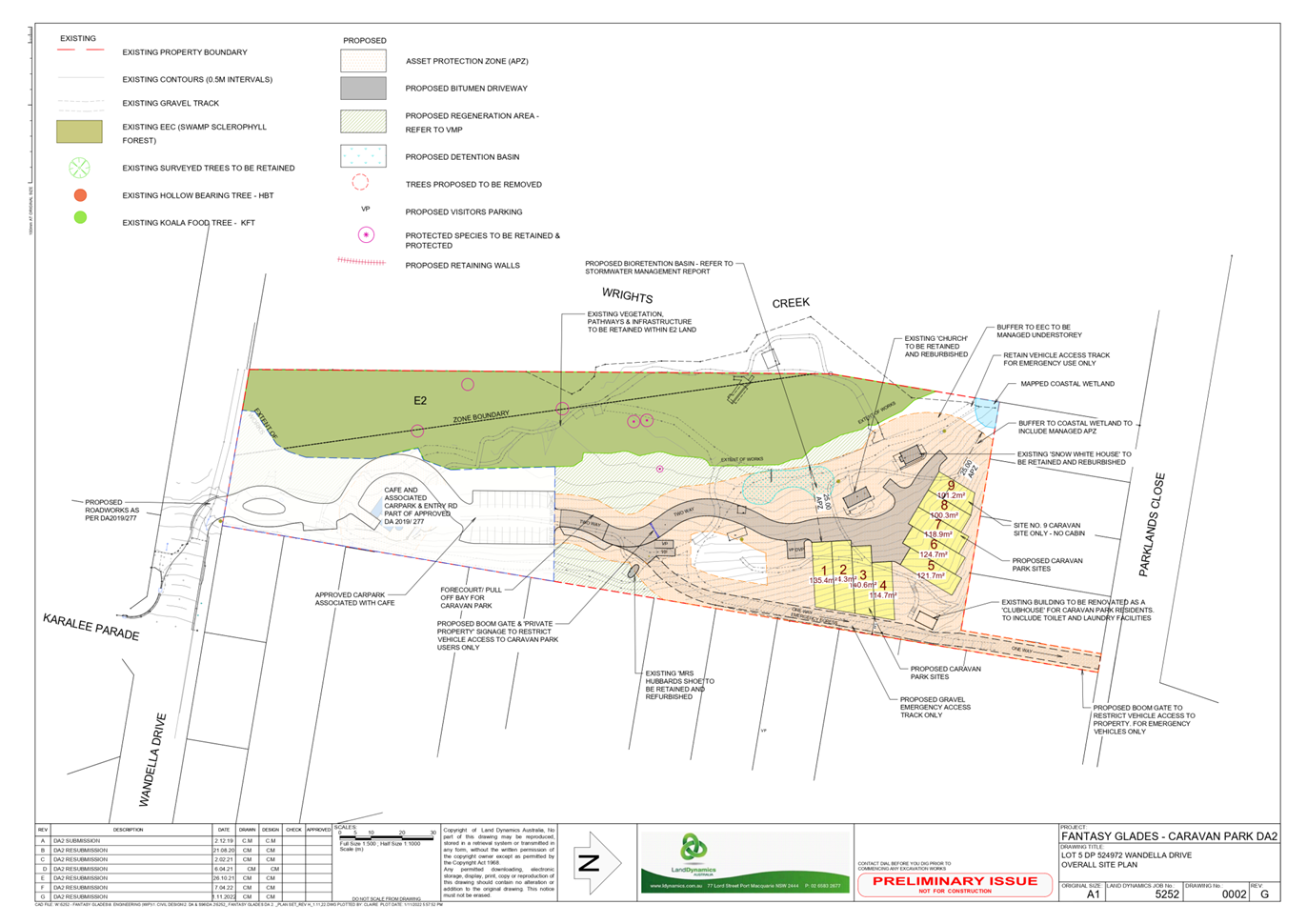

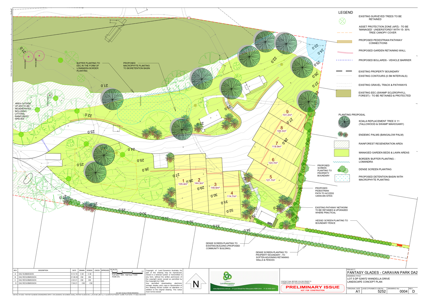
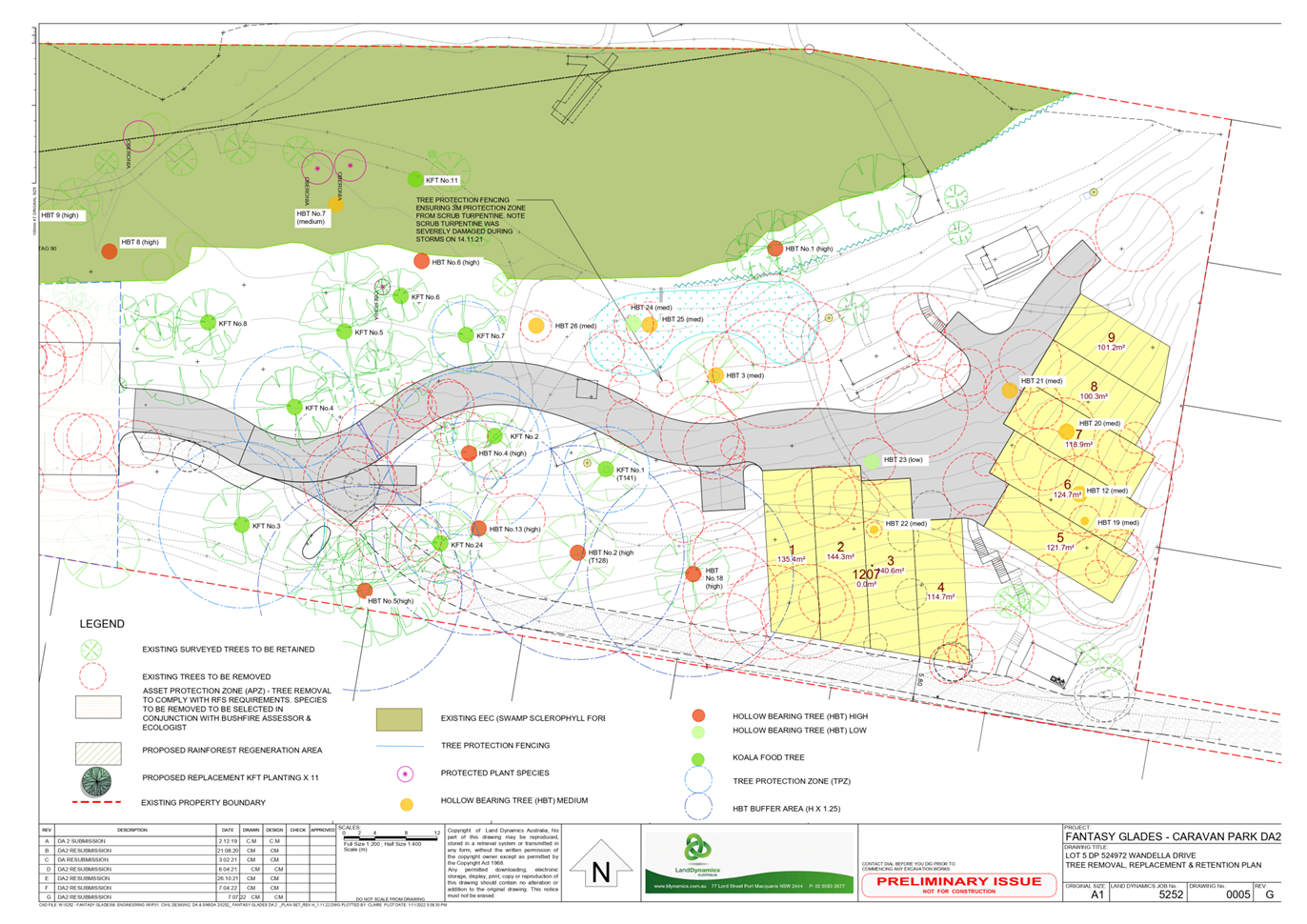
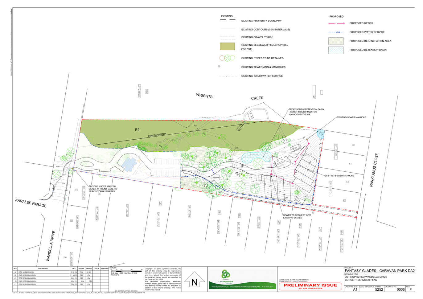
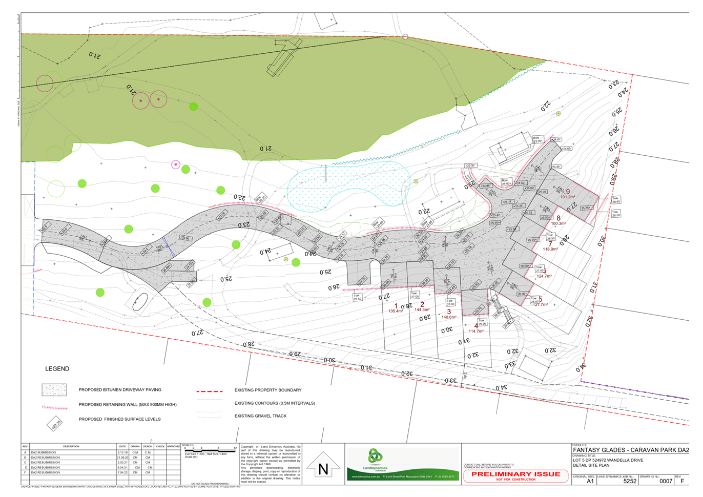

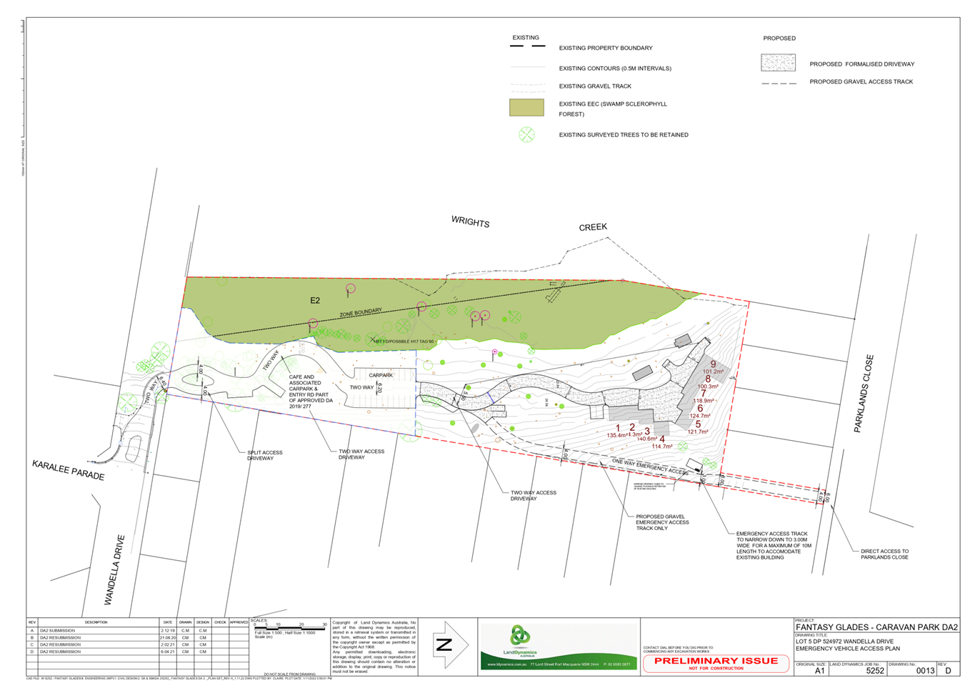

|
ATTACHMENT
|
Development Assessment Panel
05/04/2023
|