Development
Assessment Panel
Business
Paper
|
date of meeting:
|
|
Wednesday 17 May
2023
|
|
location:
|
|
Port
Macquarie-Hastings Council
17 Burrawan Street,
Port Macquarie
Function Room
|
|
time:
|
|
2:00pm
|
 DEVELOPMENT ASSESSMENT PANEL SUB COMMITTEE CHARTER
Adopted: Ordinary
Council 2022 09 15
1.0
OBJECTIVES
To assist in managing
Council's development assessment function by providing independent, transparent and expert determinations of development applications that fall outside
of staff delegations.
2.0
KEY FUNCTIONS
·
To review development application reports and conditions. The focus of the Panel’s review is to be on those issues raised in submissions received following exhibition of development applications;
·
To determine
development applications
where there are 3 or more unique
submissions or where an
application is outside of staff delegations;
·
To refer development applications to Council for determination where
necessary;
·
To provide a forum for objectors
and applicants to make submissions on applications before the
Development Assessment Panel(DAP);
·
To maintain transparency in the determination of development applications.
Delegated Authority of Panel
Pursuant to Section 377 of the Local Government Act, 1993 delegation to:
·
Determine (approve
or refuse) development applications under Part 4 of the Environmental Planning and Assessment Act 1979 having regard to the relevant
environmental planning instruments, development control plans and Council
policies.
·
Vary, modify or release
restrictions as to use and/or covenants created
by Section 88B instruments under the Conveyancing Act 1919 in relation to development applications being considered by the panel.
·
Determine Koala Plans of Management under State Environmental Planning Policy (Biodiversity and Conservation) 2021 associated with development applications being considered by the
Panel.
Noting the trigger to escalate decision
making to Council
as highlighted in section 5.2.
3.0 MEMBERSHIP
3.1 Voting Members
·
3 independent
external members will be selected for each scheduled DAP meeting from an
appointed pool of members. One of the independent external
members to be the
Chairperson. Independent members will be rostered onto meeting on a rotational
basis where possible.
·
Group Manager
Development Services (alternate - Director Community, Planning and Environment or Development Assessment Planning Coordinator).
The independent external
members shall have expertise in one or more of the following areas: planning,
architecture, heritage, the environment, urban
design, economics, traffic
and transport, law, engineering,
government and public administration.Non-Voting Members Not applicable.
3.2 Obligations of members
·
Members must act faithfully and diligently and in accordance with this Charter.
·
Members must comply with Council's Code of Conduct.
·
Except as required to properly perform
their duties, DAP members must not disclose
any confidential information
(as advised by Council) obtained in connection with the DAP functions.
·
Members will have read and be familiar with the documents
and information provided
by Council prior to attending
a DAP meeting.
·
Members must act in accordance with Council's Workplace Health and Safety
Policies and Procedures
·
External members
of the Panel are not authorised to speak to the media on behalf of Council. Council officers that are members
of the Committee are bound by the
existing operational delegations in relation to speaking to media.
3.3 Member Tenure
The independent external
members will be appointed for the term of 4 years or until such time as an
expression of interest process to source panel members is completed for the proceeding 4 year term.
3.4 Appointment of members
·
A pool of independent external
members (including the Chair) shall be appointed by the Chief Executive Officer
following an external
Expression of Interest
process. Previous Panel members are eligible to be reappointed on the
Panel following this expression of interest process.
·
Independent members will be rostered on to Panel meetings on a rotational basis where possible
to suit Panel member availability and Panel operational needs.
·
Staff members on the Panel shall be appointed
by the Chief Executive Officer.
4.0
TIMETABLE OF MEETINGS
·
The Development Assessment Panel will generally meet on the 1st and 3rd Wednesday each month at 2.00pm
at the Port Macquarie offices of Council.
Meetings may be conducted on-line or a combination of in person and on-line.
·
Special Meetings
of the Panel may be convened by the Director
Community, Planning and Environment Services with 3 days
notice.
5.0 MEETING
PRACTICES
5.1 Meeting Format
·
At all Meetings of the Panel the Chairperson shall occupy the Chair and preside. The Chair will be
responsible for keeping order at meetings.
·
Meetings shall be open to the public.
·
The Panel will hear from an applicant and objectors or their representatives. Speakers are required to register to speak by close of
business on the day prior to the Panel meeting.
·
The Panel shall have the discretion to ask the applicant and objectors questions
relating to the proposal and their submission. There
is no ‘right of reply’ for an objector or applicant.
·
Where there are a
large number of persons making submissions with common interests, the Panel
shall have the discretion to hear a representative of those persons
rather than multiple
persons with the same
interest.
·
Council assessment staff will be available
at Panel meetings
to provide technical
assessment advice and
assistance to the Panel.
·
Where considered necessary, the Panel will conduct site inspections prior to the meeting.
5.2 Decision Making
·
Decisions are to be made by consensus. Where consensus is not possible
on any item, that item is
to be referred to Council for a decision.
·
All development applications involving a proposed variation to a development standard greater than 10% under Clause 4.6 of the Local
Environmental Plan will be
considered by the Panel and recommendation made to the Council for a decision.
5.3 Quorum
3 members
must be present
at a meeting to form a quorum.
5.4 Chairperson and Deputy Chairperson Independent Chair (alternate - independent member).
5.5 Secretariat
·
The Director
Community, Planning and Environment is to be responsible for ensuring that the
Panel has adequate secretariat support. The secretariat will ensure that the
business paper and supporting papers
are circulated at least
3 days prior to each meeting. Minutes
shall be appropriately approved and circulated to
each member within 3 weeks of a meeting being held.
·
The format
of and the preparation and publishing of the Business
Paper and Minutes
shall be similar to the format for Ordinary Council
Meetings.
5.6 Recording of decisions
Minutes will be limited
to the recording of decisions
of the DAP and how each member
votes for each item
before the Panel. Meetings may be recorded via an on-line platform where
practical.
6.0
CONVENING OF “OUTCOME SPECIFIC” WORKING GROUPS
Not applicable.
7.0
CONFIDENTIALITY AND CONFLICT
OF INTEREST
·
Members of the
Panel must comply with Council’s Code of Conduct. It is the personal
responsibility of members to comply with the standards in the Code of Conduct
and regularly review their
personal circumstances with this in mind.
·
Panel members must
declare any conflict of interest at the start of each meeting or before
discussion of a relevant item or topic. Details of any conflicts of interest
are to be appropriately minuted. Where members are deemed to have a real or
perceived conflict of interest, it may be appropriate they be excused
from deliberations on the issue where the conflict of interest may exist.
A Panel meeting may be postponed where there is no quorum.
8.0
LOBBYING
All members and applicants are to adhere
to Council’s Lobbying
policy. Outside of scheduled Development Assessment Panel meetings,
applicants, their representatives, Councillors, Council staff and the general
public are not to lobby Panel members via meetings, telephone conversations,
correspondence and the like. Adequate opportunity will be provided at Panel
inspections or meetings for applicants, their representatives and the general
public to make verbal submissions in relation to Business Paper items.
9.0
CONDUCT AT MEETINGS
All parties in attendance at a DAP meeting shall conduct
themselves respectfully i.e. not disrupt the conduct of the meeting, interject,
act courteously and with compassion and empathy and sensitivity and will not insult, denigrate
or make defamatory or personal
reflections on or impute improper
motives to the DAP, Council staff or other members of
the public.
Development
Assessment Panel
ATTENDANCE
REGISTER
|
Member
|
18/01/23
|
15/02/23
|
01/03/23
|
15/03/23
|
05/04/23
|
19/04/23
|
|
David Crofts
(Independent Chair)
|
P
|
P
|
P
|
|
P
|
P
|
|
Chris Gee
(Independent Member)
|
P
|
P
|
P
|
P
|
P
|
P
|
|
Michael Mason
(Independent Member)
|
|
|
P
|
P
|
P
|
P
|
|
Dan Croft
(Group Manager
Development Services)
|
|
P
|
P
|
P
|
P
|
P
|
|
Tony McNamara
(Independent Member)
|
|
P
|
|
P
|
|
|
|
Other attendees
|
|
|
|
|
|
|
|
Mayor Peta Pinson
|
|
|
|
P
|
P
|
|
|
Grant Burge
(Development Engineering
Coordinator)
|
P
|
|
P
|
P
|
P
|
P
|
|
Kerrod Franklin
(Acting Development
Engineering Coordinator)
|
|
|
|
|
|
|
|
Patrick
Galbraith-Robertson
(Development Planning
Coordinator)
|
P
|
|
P
|
|
|
|
|
Steven Ford
(Development Assessment
Planner)
|
P
|
|
|
P
|
P
|
P
|
|
Chris Gardiner
(Development Assessment
Planner)
|
|
|
|
|
P
|
|
|
Vanessa Penfold
(Development Assessment Planner)
|
|
|
|
P
|
|
|
|
Clinton Tink
(Development Assessment
Planner)
|
|
|
|
|
P
|
P
|
|
Jon Power
(Act Development Engineer
Coordinator)
|
|
|
|
|
|
|
|
Beau Spry
(Development Assessment
Planner)
|
|
|
|
|
|
|
|
Ben Roberts
(Development Assessment
Planner)
|
|
P
|
|
|
|
|
|
Councillor Josh Slade
|
|
|
|
|
|
|
|
Councillor Sharon
Griffiths
|
|
|
|
|
|
|
|
Kate Kennedy
(Building Surveyor)
|
|
|
|
|
|
|
|
Warren Wisemantel
|
|
|
|
|
|
|
|
Deputy Mayor Adam Roberts
|
|
|
|
|
|
|
|
Bob Slater
(Development Assessment Planner)
|
|
|
|
|
|
|
|
Alton Dick
(Stormwater Engineer)
|
|
|
|
|
|
|
Key: P = Present, A
= Absent With Apology X = Absent Without Apology
Development
Assessment Panel
Meeting Dates for
2023
|
18/01/2023
|
Function Room
|
2.00pm
|
|
01/02/2023
|
Function Room
|
2.00pm
|
|
15/02/2023
|
Function Room
|
2.00pm
|
|
01/03/2023
|
Function Room
|
2.00pm
|
|
15/03/2023
|
Function Room
|
2.00pm
|
|
05/04/2023
|
Function Room
|
2.00pm
|
|
19/04/2023
|
Function Room
|
2.00pm
|
|
03/05/2023
|
Function Room
|
2.00pm
|
|
17/05/2023
|
Function Room
|
2.00pm
|
|
07/06/2023
|
Function Room
|
2.00pm
|
|
21/06/2023
|
Function Room
|
2.00pm
|
|
05/07/2023
|
Function Room
|
2.00pm
|
|
19/07/2023
|
Function Room
|
2.00pm
|
|
02/08/2023
|
Function Room
|
2.00pm
|
|
16/08/2023
|
Function Room
|
2.00pm
|
|
06/09/2023
|
Function Room
|
2.00pm
|
|
20/09/2023
|
Function Room
|
2.00pm
|
|
04/10/2023
|
Function Room
|
2.00pm
|
|
18/10/2023
|
Function Room
|
2.00pm
|
|
01/11/2023
|
Function Room
|
2.00pm
|
|
15/11/2023
|
Function Room
|
2.00pm
|
|
06/12/2023
|
Function Room
|
2.00pm
|
Development
Assessment Panel Meeting
Wednesday 17 May 2023
Items of Business
01 Acknowledgement
of Country........................................................................... 10
02 Apologies........................................................................................................ 10
03 Confirmation
of Minutes................................................................................... 10
04 Disclosures
of Interest..................................................................................... 11
05 DA2022
- 491.1 Service Station Lot 1 DP 1109997 High Street, Wauchope......... 16
06 DA2022
- 440.1 Residential Flat Building Including Clause 4.6 Variation to Clause 4.3
(Height of Buildings) of the Port Macquarie Hastings Local Environmental Plan
2011 and Demolition of Existing Buildings, Lot 12 & 12A DP 361896 and Lot 1
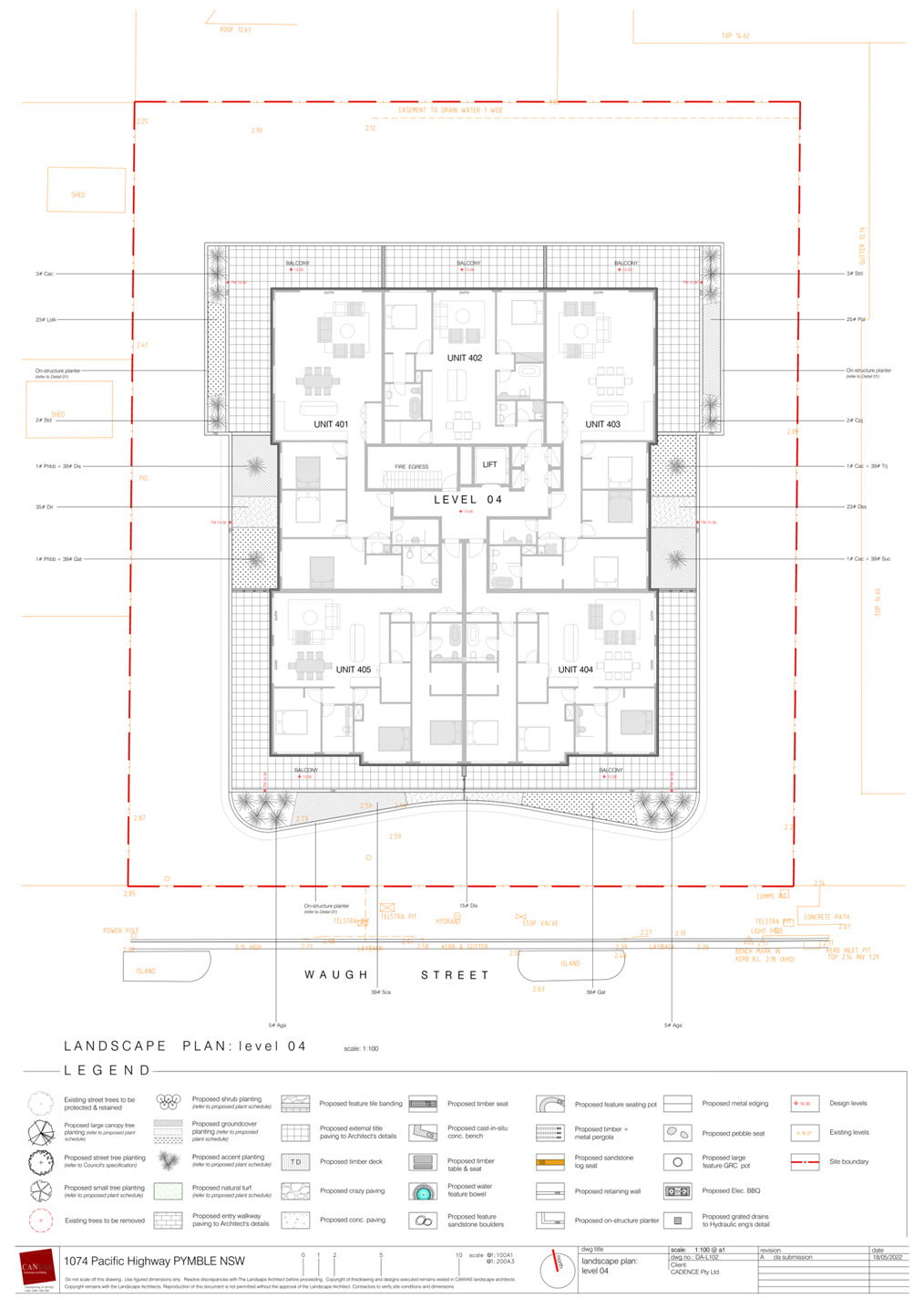
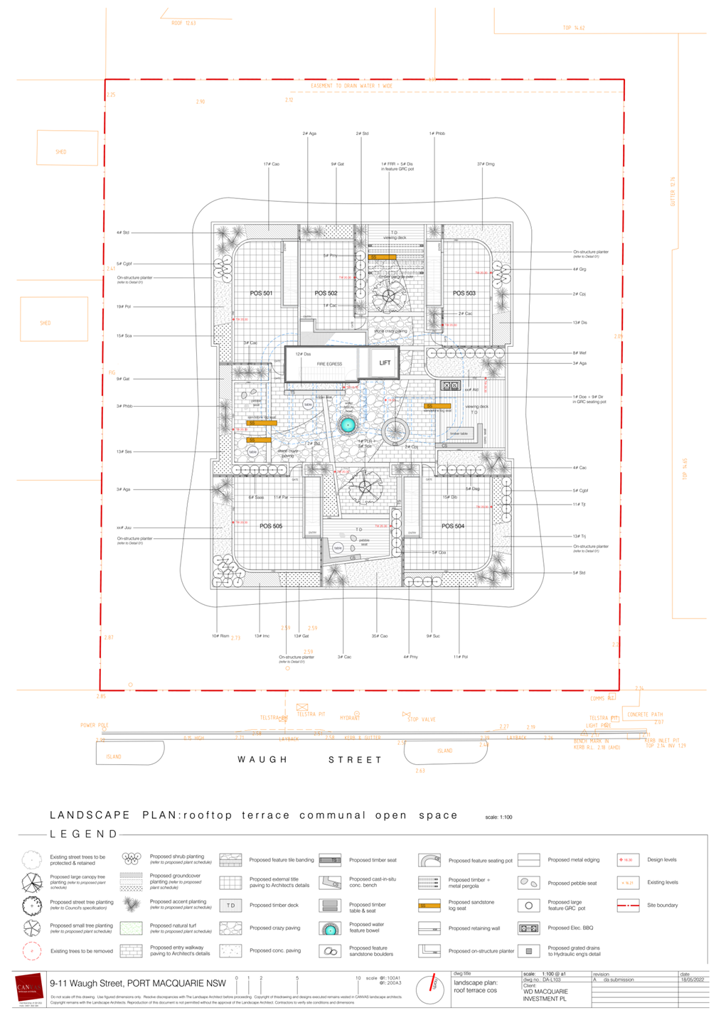
& 3 DP 564518, No 9-11 Waugh Street, Port Macquarie................................................................................................ 79
07 DA2022
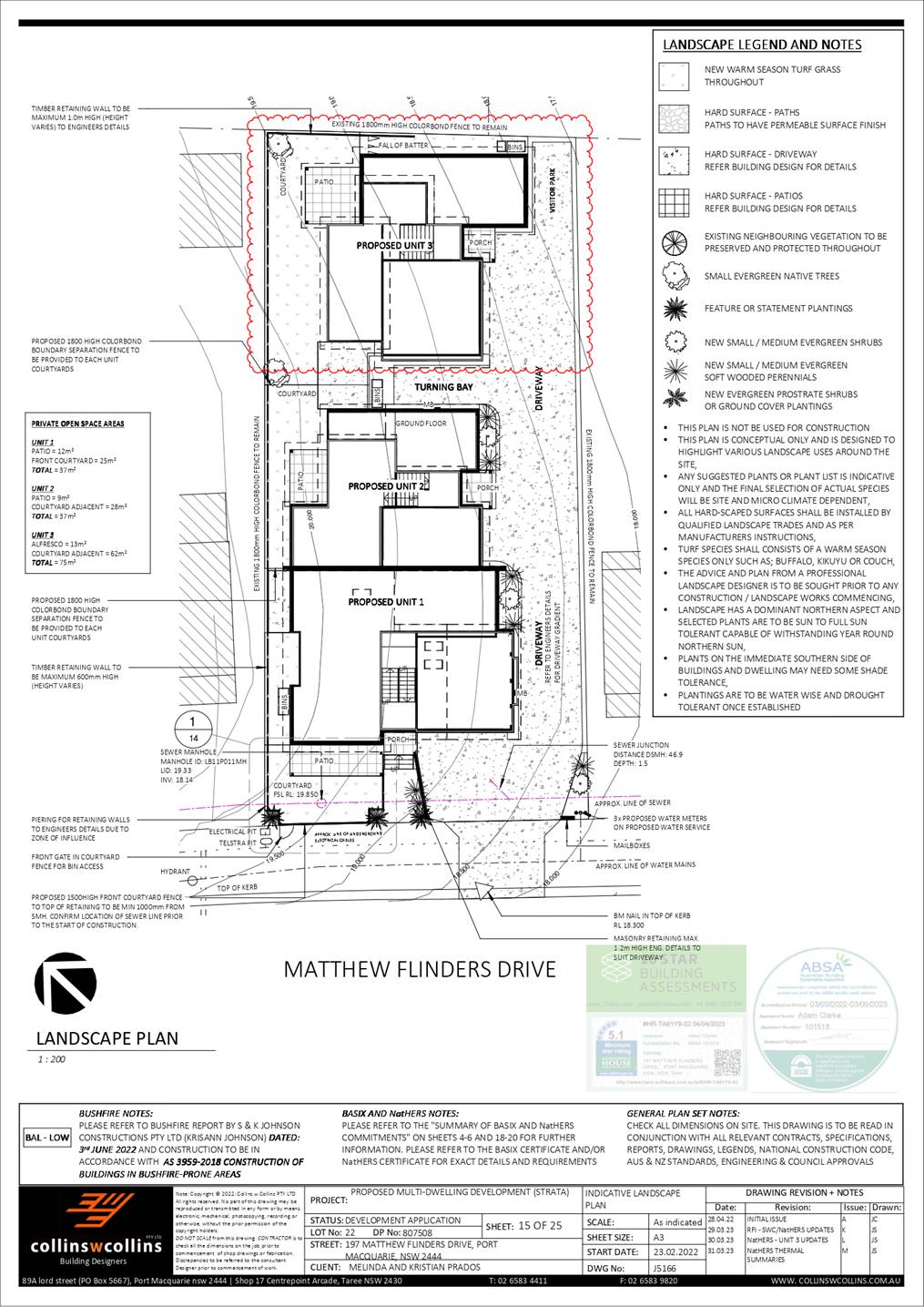
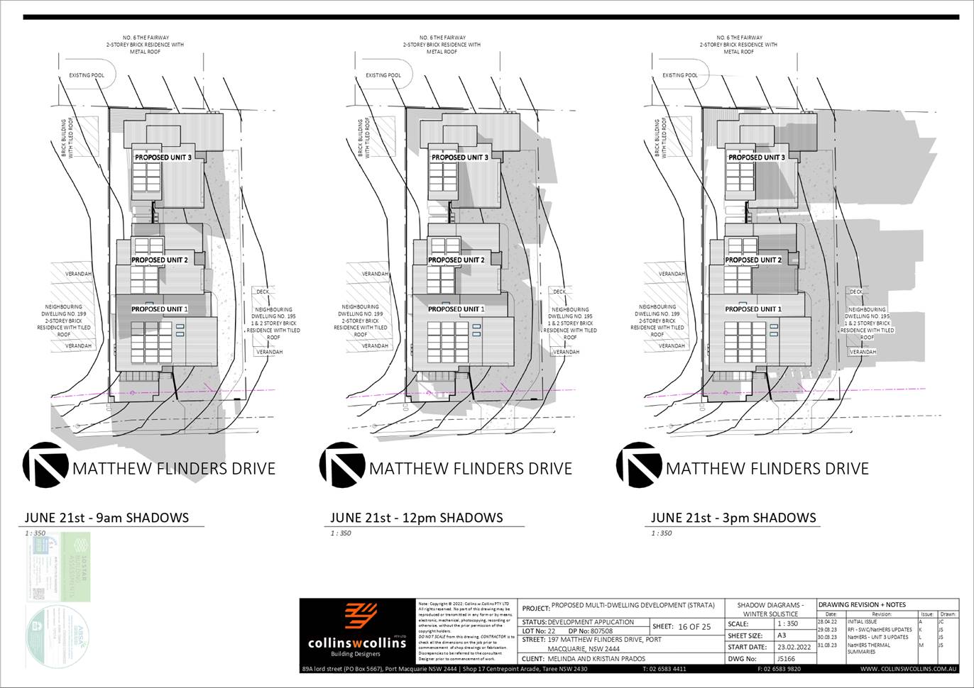
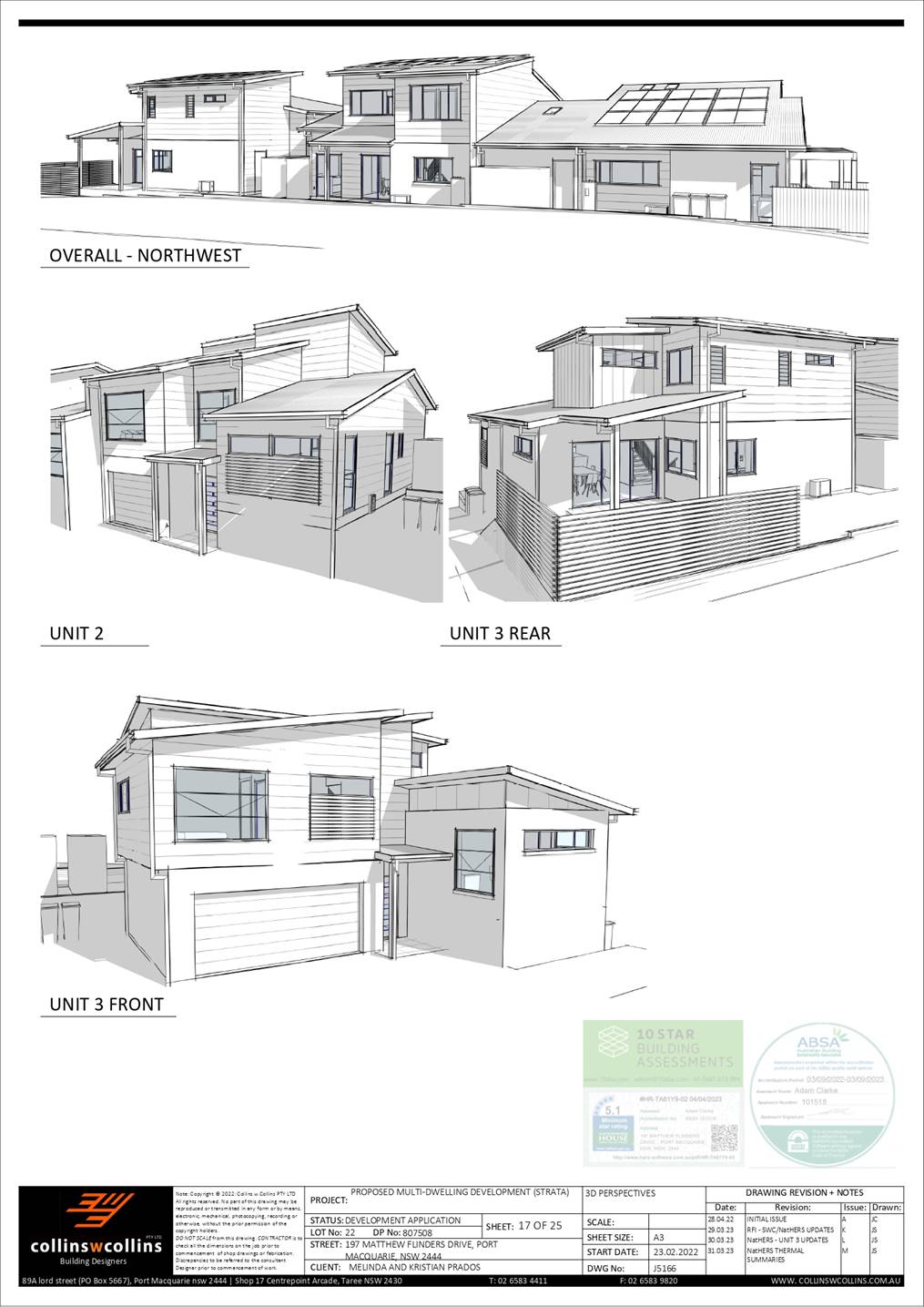
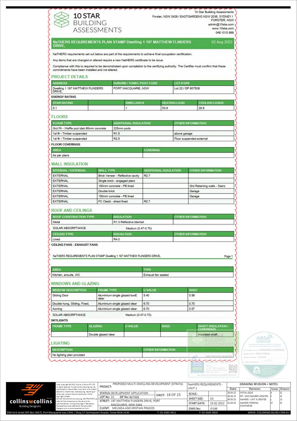
- 756.1 Multi-Dwelling Housing and Strata Title Subdivision at Lot 22 DP807508,
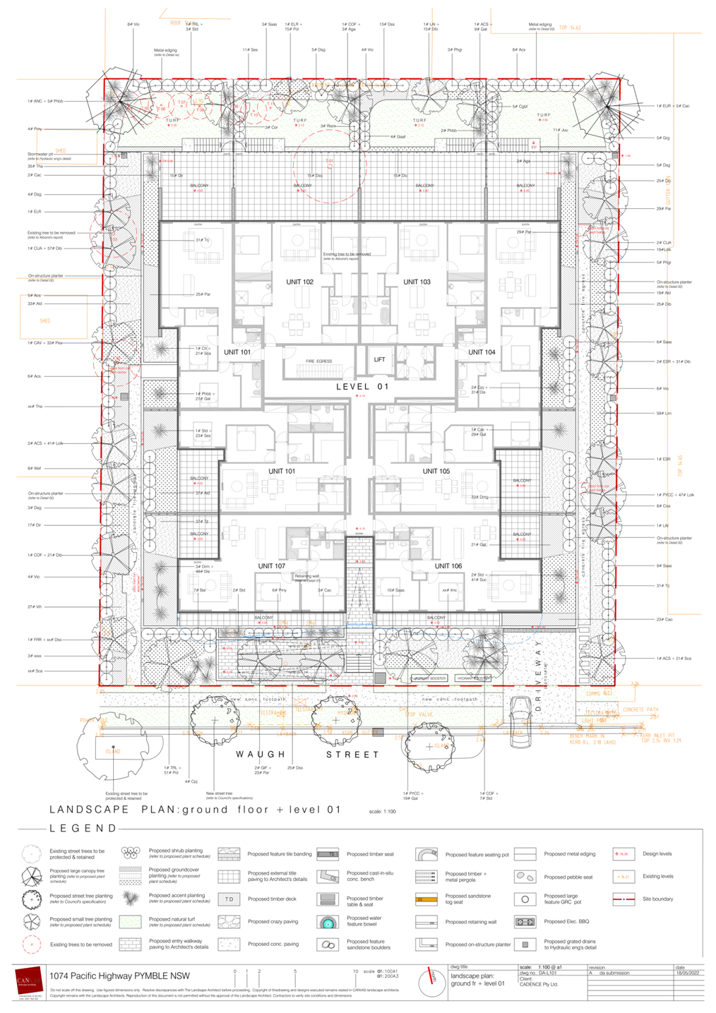
197 Matthew Flinders Drive, Port Macquarie.......................................................... 263
08 General
Business
Development Assessment Panel
17/05/2023
Subject: ACKNOWLEDGEMENT
OF COUNTRY
"I acknowledge that we are
gathered on Birpai Land. I pay respect to the Birpai Elders both past and
present. I also extend that respect to all other Aboriginal and Torres Strait
Islander people present."
RECOMMENDATION
That the apologies received be
accepted.
Subject: CONFIRMATION
OF PREVIOUS MINUTES
Recommendation
That the Minutes of the Development Assessment Panel Meeting
held on 3 May 2023 be confirmed.
Development Assessment Panel
17/05/2023
Subject: DISCLOSURES
OF INTEREST
RECOMMENDATION
That Disclosures of Interest be presented
DISCLOSURE OF
INTEREST DECLARATION
|
Name of Meeting:
|
|
Meeting
Date:
|
|
Item
Number:
|
|
Subject:
|
|
I,
the undersigned, hereby declare the following interest:
Pecuniary:
 Take no part
in the consideration and voting and be out of sight of the meeting. Take no part
in the consideration and voting and be out of sight of the meeting.
Non-Pecuniary
– Significant Interest:
Take no part
in the consideration and voting and be out of sight of the meeting.
Non-Pecuniary
– Less than Significant Interest:
May
participate in consideration and voting.
|
|
For
the reason that:
|
|
Name:
Signed:
|
Date:
|
|
Please submit to the
Governance Support Officer at the Council Meeting.
|
 (Refer
to next page and the Code of Conduct)
(Refer
to next page and the Code of Conduct)
Pecuniary Interest
4.1
A pecuniary interest is an interest
that you have in a matter because of a reasonable likelihood or expectation of
appreciable financial gain or loss to you or a person referred to in clause
4.3.
4.2
You will not have a pecuniary
interest in a matter if the interest is so remote or insignificant that it
could not reasonably be regarded as likely to influence any decision you might
make in relation to the matter, or if the interest is of a kind specified in
clause 4.6.
4.3
For the purposes of this Part, you
will have a pecuniary interest in a matter if the pecuniary interest is:
(a)
your interest, or
(b)
the interest of your spouse or de
facto partner, your relative, or your partner or employer, or
(c)
a company or other body of which
you, or your nominee, partner or employer, is a shareholder or member.
4.4
For the purposes of clause 4.3:
(a)
Your “relative” is any
of the following:
(b)
“de facto partner” has
the same meaning as defined in section 21C of the Interpretation Act 1987.
4.5
You will not have a pecuniary
interest in relation to a person referred to in subclauses 4.3(b) or (c)
(a)
if you are unaware of the relevant
pecuniary interest of your spouse, de facto partner, relative, partner,
employer or company or other body, or
(b)
just because the person is a member
of, or is employed by, a council or a statutory body, or is employed by the
Crown, or
(c)
just because the person is a member
of, or a delegate of a council to, a company or other body that has a pecuniary
interest in the matter, so long as the person has no beneficial interest in any
shares of the company or body.
Non-Pecuniary
5.1
Non-pecuniary interests are private
or personal interests a council official has that do not amount to a pecuniary
interest as defined in clause 4.1 of this code. These commonly arise out of
family or personal relationships, or out of involvement in sporting, social,
religious or other cultural groups and associations, and may include an
interest of a financial nature.
5.2
A non-pecuniary conflict of
interest exists where a reasonable and informed person would perceive that you
could be influenced by a private interest when carrying out your official
functions in relation to a matter.
5.3
The personal or political views of
a council official do not constitute a private interest for the purposes of
clause 5.2.
5.4
Non-pecuniary conflicts of interest
must be identified and appropriately managed to uphold community confidence in
the probity of council decision-making. The onus is on you to identify any
non-pecuniary conflict of interest you may have in matters that you deal with,
to disclose the interest fully and in writing, and to take appropriate action
to manage the conflict in accordance with this code.
5.5
When considering whether or not you
have a non-pecuniary conflict of interest in a matter you are dealing with, it
is always important to think about how others would view your situation.
Managing non-pecuniary conflicts of interest
5.6
Where you have a non-pecuniary
conflict of interest in a matter for the purposes of clause 5.2, you must
disclose the relevant private interest you have in relation to the matter fully
and in writing as soon as practicable after becoming aware of the non-pecuniary
conflict of interest and on each occasion on which the non-pecuniary conflict
of interest arises in relation to the matter. In the case of members of council
staff other than the Chief Executive Officer, such a disclosure is to be made
to the staff member’s manager. In the case of the Chief Executive Officer,
such a disclosure is to be made to the mayor.
5.7
If a disclosure is made at a
council or committee meeting, both the disclosure and the nature of the
interest must be recorded in the minutes on each occasion on which the
non-pecuniary conflict of interest arises. This disclosure constitutes
disclosure in writing for the purposes of clause 5.6.
5.8
How you manage a non-pecuniary
conflict of interest will depend on whether or not it is significant.
5.9
As a general rule, a non-pecuniary
conflict of interest will be significant where it does not involve a pecuniary
interest for the purposes of clause 4.1, but it involves:
a)
a relationship between a council
official and another person who is affected by a decision or a matter under
consideration that is particularly close, such as a current or former spouse or
de facto partner, a relative for the purposes of clause 4.4 or another person
from the council official’s extended family that the council official has
a close personal relationship with, or another person living in the same
household
b)
other relationships with persons
who are affected by a decision or a matter under consideration that are
particularly close, such as friendships and business relationships. Closeness
is defined by the nature of the friendship or business relationship, the
frequency of contact and the duration of the friendship or relationship.
c)
an affiliation between the council
official and an organisation (such as a sporting body, club, religious,
cultural or charitable organisation, corporation or association) that is
affected by a decision or a matter under consideration that is particularly
strong. The strength of a council official’s affiliation with an
organisation is to be determined by the extent to which they actively
participate in the management, administration or other activities of the
organisation.
d)
membership, as the council’s
representative, of the board or management committee of an organisation that is
affected by a decision or a matter under consideration, in circumstances where
the interests of the council and the organisation are potentially in conflict
in relation to the particular matter
e)
a financial interest (other than an
interest of a type referred to in clause 4.6) that is not a pecuniary interest
for the purposes of clause 4.1
f)
the conferral or loss of a personal
benefit other than one conferred or lost as a member of the community or a
broader class of people affected by a decision.
5.10
Significant non-pecuniary conflicts
of interest must be managed in one of two ways:
a)
by not participating in
consideration of, or decision making in relation to, the matter in which you
have the significant non-pecuniary conflict of interest and the matter being
allocated to another person for consideration or determination, or
b)
if the significant non-pecuniary
conflict of interest arises in relation to a matter under consideration at a
council or committee meeting, by managing the conflict of interest as if you
had a pecuniary interest in the matter by complying with clauses 4.28 and 4.29.
5.11
If you determine that you have a
non-pecuniary conflict of interest in a matter that is not significant and does
not require further action, when disclosing the interest you must also explain
in writing why you consider that the non-pecuniary conflict of interest is not
significant and does not require further action in the circumstances.
5.12
If you are a member of staff of
council other than the Chief Executive Officer, the decision on which option
should be taken to manage a non-pecuniary conflict of interest must be made in
consultation with and at the direction of your manager. In the case of the Chief
Executive Officer, the decision on which option should be taken to manage a
non-pecuniary conflict of interest must be made in consultation with and at the
direction of the mayor.
5.13
Despite clause 5.10(b), a
councillor who has a significant non-pecuniary conflict of interest in a
matter, may participate in a decision to delegate consideration of the matter
in question to another body or person.
5.14 Council committee members are not required to declare
and manage a non-pecuniary conflict of interest in accordance with the
requirements of this Part where it arises from an interest they have as a
person chosen to represent the community, or as a member of a non-profit
organisation or other community or special interest group, if they have been
appointed to represent the organisation or group on the council committee.
SPECIAL
DISCLOSURE OF PECUNIARY INTEREST DECLARATION
This
form must be completed using block letters or typed.
If
there is insufficient space for all the information you are required to
disclose,
you
must attach an appendix which is to be properly identified and signed by you.
|
By
[insert full name of councillor]
|
|
|
In the
matter of
[insert name of environmental planning instrument]
|
|
|
Which is
to be considered at a meeting of the
[insert name of meeting]
|
|
|
Held on
[insert date of meeting]
|
|
|
PECUNIARY
INTEREST
|
|
Address of
the affected principal place of residence of the councillor or an associated
person, company or body (the identified land)
|
|
|
Relationship
of identified land to councillor
[Tick or cross one box.]
|
The councillor has interest in the land (e.g. is owner or has other
interest arising out of a mortgage, lease, trust, option or contract, or
otherwise).
An associated person of the councillor has an interest in the land.
An associated company or body of the councillor has interest in the land.
|
|
MATTER
GIVING RISE TO PECUNIARY INTEREST
|
|
Nature of
land that is subject to a change
in
zone/planning control by proposed
LEP (the
subject land
[Tick or cross one box]
|
The identified land.
Land that adjoins or is adjacent to or is in proximity to the identified
land.
|
|
Current
zone/planning control
[Insert name of current planning instrument and
identify relevant zone/planning control applying to the subject land]
|
|
|
Proposed
change of zone/planning control
[Insert name of proposed LEP and identify proposed
change of zone/planning control applying to the subject land]
|
|
|
Effect of
proposed change of zone/planning control on councillor or associated person
[Tick or cross one box]
|
Appreciable financial gain.
Appreciable financial loss.
|
|
|
|
[If more than one pecuniary interest is to be declared,
reprint the above box and fill in for each additional interest]
Councillor’s Signature:
……………………………….
Date: ………………..
This form is to be retained
by the council’s Chief Executive Officer and included in full in the
minutes of the meeting
Last Updated: 3 June 2019
Important Information
This information is being collected for the purpose of
making a special disclosure of pecuniary interests under clause 4.36(c) of the
Model Code of Conduct for Local Councils in NSW (the Model Code of Conduct).
The special disclosure must relate only to a pecuniary
interest that a councillor has in the councillor’s principal place of
residence, or an interest another person (whose interests are relevant under
clause 4.3 of the Model Code of Conduct) has in that person’s principal
place of residence.
Clause 4.3 of the Model Code of Conduct states that you
will have a pecuniary interest in a matter because of the pecuniary interest of
your spouse or your de facto partner or your relative or because your business
partner or employer has a pecuniary interest. You will also have a pecuniary
interest in a matter because you, your nominee, your business partner or your
employer is a member of a company or other body that has a pecuniary interest
in the matter.
“Relative” is defined by clause 4.4 of the Model
Code of Conduct as meaning your, your spouse’s or your de facto
partner’s parent, grandparent, brother, sister, uncle, aunt, nephew,
niece, lineal descendant or adopted child and the spouse or de facto partner of
any of those persons.
You
must not make a special disclosure that you know or ought reasonably to know is
false or misleading in a material particular. Complaints about breaches
of these requirements are to be referred to the Office of Local Government and
may result in disciplinary action by the Chief Executive of the Office of Local
Government or the NSW Civil and Administrative Tribunal.
This form must be completed by you before the commencement
of the council or council committee meeting at which the special disclosure is
being made. The completed form must be tabled at the meeting. Everyone is
entitled to inspect it. The special disclosure must be recorded in the minutes
of the meeting.
A pecuniary interest may arise by way of a change of
permissible use of land adjoining, adjacent to or in proximity to land in which
a councillor or a person, company or body referred to in clause 4.3 of the
Model Code of Conduct has a proprietary interest
Development Assessment Panel
17/05/2023
Item: 05
Subject: DA2022 - 491.1 Service Station Lot 1 DP
1109997 High Street, Wauchope
Report
Author: Development Assessment Planner, Chris Gardiner
|
Applicant: Brown
Commercial Building
Owner: D
P & A M Waite
Estimated Cost: $2,190,180
Alignment with Delivery
Program
4.3.1 Undertake transparent
and efficient development assessment in accordance with relevant legislation.
|
RECOMMENDATION
That
DA2022 - 491.1 for a Service
Station at Lot 1, DP 1109997, High
Street, Wauchope, be determined by
granting consent subject to the recommended conditions.
Executive
Summary
This
report considers a development application for a service station at the subject site and provides an assessment of the
application in accordance with the Environmental Planning and Assessment Act
1979.
Following exhibition of the
application on three (3) occasions, four (4) submissions
were received.
The proposal has been amended
through the assessment process including changes to the access arrangements
from High Street (Oxley Highway), improved landscaping, and improvements to the
interface of the earthworks and acoustic fencing to neighbouring properties to
the east.
The site is considered suitable for the proposed development
and the proposal adequately addresses relevant planning controls. The
development is not considered to be contrary to the public's interest and will
not result a significant adverse social, environmental or economic impact.
This report recommends that the
development application be approved subject to the attached conditions
(Attachment 1).
The reason for the application being referred to
Council’s Development Assessment Panel (DAP) is because three (3) or more
objections to the proposal have been received. A copy of the DAP Charter
outlining the delegations and functions of the DAP is available on
Council’s website.
1. BACKGROUND
Existing
Sites Features and Surrounding Development
The site has an area of 1.5
hectares.
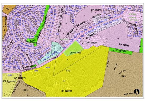
The
site is zoned SP3 Tourist in accordance with
the Port Macquarie-Hastings Local Environmental Plan 2011, as shown in the
following zoning plan:
The
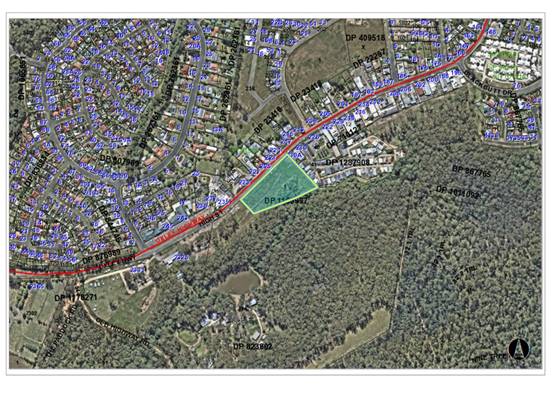
existing subdivision pattern and location of existing development within the
locality is shown in the following aerial photograph:
Development
consent DA2020 - 630 for storage sheds ancillary to the Timbertown tourist park
applied to the land at the time of lodgement of the application. This consent
has been surrendered by the property owner during the assessment process
following agreement with Council regarding satisfactory implementation of the
environmental offsets required by that consent.
2. DESCRIPTION
OF DEVELOPMENT
Key
aspects of the proposal include the following:
· Construction
of a service station including convenience shop, fuelling canopy, and
associated signage.
Refer
to plans of the proposed development at the end of this report (Attachment 2).
Application
Chronology
· 8
June 2022 - Application accepted for lodgement.
· 14 June 2022 to 27 June 2022 - Neighbour notification of
the proposal.
· 29 June 2022 - Comments on proposal provided by Transport
for NSW.
· 30 June 2022 - Comments on proposal provided by Essential
Energy.
· 21 July 2022 - Amended plans submitted by Applicant.
· 17 August 2022 - Comments on amended plans provided by
Transport for NSW.
· 1 September 2022 - Additional information requested from
Applicant.
· 25 October 2022 - Additional information and amended plans
provided by Applicant.
· 3 November 2022 to 16 November 2022 - Application
re-notified.
· 17 November 2022 - Comments on amended plans provided by
Transport for NSW.
· 24 November 2022 - Further additional information requested
from Applicant.
· 22 February 2023 - Amended access plans provided by Applicant.
· 8 March 2023 - Comments on amended plans provided by
Transport for NSW.
· 16 March 2023 to 29 March 2023 - Application re-notified.
· 12 April 2023 - Comments on amended proposal provided by
Essential Energy.
3. STATUTORY
ASSESSMENT
Section
4.15(1) Matters for Consideration
In
determining the application, Council is required to take into consideration the
following matters as are relevant to the development that apply to the land to
which the development application relates:
(a) The
provisions (where applicable) of:
(i) Any
Environmental Planning Instrument
State Environmental Planning Policy (Biodiversity and
Conservation) 2021
Chapter 4 Koala Habitat Protection 2021
Clause 4.4 - This SEPP applies to all non-rural zoned land
within the Port Macquarie-Hastings Local Government Area.
Clause 4.9 - The property is over 1ha in size
(including adjoining land in the same ownership) and does not have a KPOM in
place.
Before consent is granted, Council is required
to assess whether the development is likely to have any impact on koalas or
koala habitat.
In accordance with Clause 4.9(3), Council is
satisfied that the development is likely to have low or no impact on koalas or
koala habitat for the following reasons:
1. Previous DA2020 - 630.1 assessed
the subject site, and determined that the site is not core koala habitat.
2. The land has subsequently been
cleared in accordance with that consent and the proposed development will not
involve any further clearing.
Based on the above, consent to the development
application on koala habitat grounds is supported.
State Environmental Planning Policy (Industry and
Employment) 2021
Chapter 3 Advertising and Signage
The proposed development includes proposed advertising
signage in the form of business identification signs on the eastern elevation
of the service station building, northern, eastern and western elevations of
the canopy, and a pylon sign in the site frontage.
Clause 3.5 - This SEPP prevails over the Port
Macquarie-Hastings LEP 2011 in the event of any inconsistency.
Clause 3.6 - The following assessment table provides an
assessment checklist against the Schedule 5 requirements of this SEPP:
|
Applicable clauses for consideration
|
Comments
|
Satisfactory
|
Schedule
5(1) Character of the area.
|
The character of the immediate
locality is predominantly residential with some small scale signs for nearby
church and childcare uses.
Further to the east and west of
the site are more substantial signage associated with light industrial,
service station and commercial uses.
The proposal is considered to be
compatible with the mixed character of the area.
|
Yes
|
|
Schedule 5(2) Special areas.
|
The site is not in a special
area.
|
N/A
|
|
Schedule 5(3) Views and vistas.
|
The signs would not obstruct and
significant views or vistas.
|
Yes
|
|
Schedule 5(4) Streetscape,
setting or landscape.
|
The scale of the signs is
compatible with the streetscape setting. The pylon sign would not extend
above the tip of the building or the canopy of the trees.
|
Yes
|
|
Schedule 5(5) Site and building.
|
Sign proportions are compatible
with the scale of the service station building and canopy.
|
Yes
|
|
Schedule 5(6) Associated devices
and logos with advertisements and advertising structures.
|
None proposed.
|
N/A
|
|
Schedule 5(7) Illumination.
|
Signage proposed to be
illuminated during trading hours and will be switched off at 10pm.
This is considered to be
acceptable given that the DCP requires illuminated signs to be switched off
or dimmed by 50% from 11pm.
|
Yes
|
|
Schedule 5(8) Safety.
|
The signs would not adversely impact vehicle or pedestrian
safety.
|
Yes
|
State Environmental Planning Policy (Resilience and
Hazards) 2021
Chapter 3 Hazardous and Offensive Development
The subject SEPP was introduced to
clarify the definitions for hazardous and offensive industries and to apply
guidelines for the assessment of industries that have the potential to create
hazards or an offence. In this case, the development has the potential to be
hazardous due to the proposed storage of flammable and combustible petroleum
products.
A risk screening assessment prepared by Hazkem Dangerous
Goods Consulting has been submitted with the application.
Clause 3.12(a) - The following NSW Department of Planning
and Environment guidelines have been considered in the assessment of the
proposal:
· Hazardous and
Offensive Development Application Guideline ‘Applying SEPP 33’.
· NSW Department of
Planning assessment guidelines “Multi Level Risk Assessment”.
· Hazardous Industry
Planning Advisory Paper No 4 ‘Risk Criteria for Land Use Safety
Planning’.
· Hazardous Industry
Planning Advisory Paper No 6 ‘Guidelines for Hazard Analysis’.
Clause 3.12(b) - It is not considered necessary to consult
with any public authorities on the proposal.
Clause 3.12(c) - A preliminary hazard analysis for the
proposal has been prepared by Hazkem Dangerous Goods Consulting.
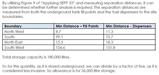
The proposal incorporates 120,000 litres of flammable liquid
and 60,000 litres of combustible liquid in underground tanks. As the diesel
(combustible liquid) is stored together with petrol (flammable liquid Class 3)
is has been considered flammable for the purpose of the risk screening.
The findings of the risk screening are included below:
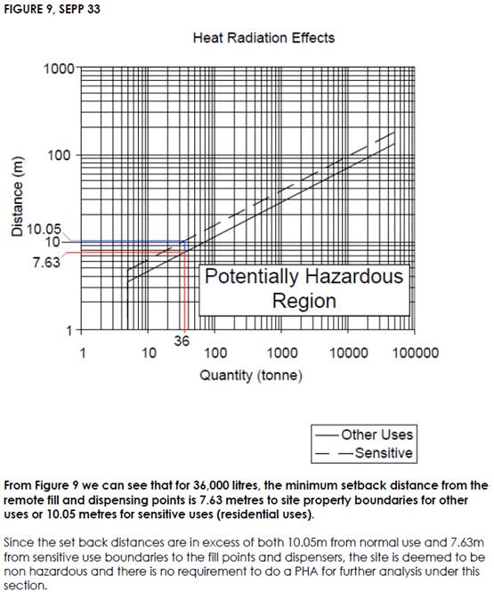
The report also considers the transport screening thresholds
in “Applying SEPP 33”. Deliveries to the premises are expected to
occur 3 times per week on average, or 156 times per year. Up to 45 movements
per week or 750 movements per year for fuel are acceptable prior to becoming
potentially hazardous.
Clause 3.12(d) - Consideration of feasible alternatives is
not considered necessary given that the proposal meets the risk screening
criteria and is therefore not ‘hazardous’.
Clause 3.12(e) - Land to the south and west of the site is
zoned SP3 Tourist and permits a range of tourist oriented uses. DA2020 - 630
granted consent for ancillary storage sheds associated with Timbertown
immediately to the west of the site. Land to the east and north of the site is
zoned R1 General Residential. The preliminary hazard analysis has demonstrated
that the proposal will be compatible from a risk perspective with the existing
and likely future uses in the locality.
Chapter 4 Remediation of Land
Clause 4.6 - Following an
inspection of the site and a search of Council records, the subject land is not
identified as being potentially contaminated and is suitable for the intended
use.
State Environmental Planning Policy (Transport and
Infrastructure) 2021
Clause 2.48 - The proposal has been
referred to Essential Energy in accordance with this clause. Essential Energy
initially raised concerns regarding the height and proximity of the proposed
pylon sign to overhead powerlines in the Oxley Highway frontage. The Applicant
has provided additional survey accurate details of the separation distance of
the proposed pylon sign from electrical infrastructure, along with a blowout
assessment prepared by an electrical consultant. Essential Energy has reviewed
the additional information and confirmed that the safety risks are acceptable.
Additional general advice provided by Essential Energy has been provided to the
Applicant for consideration during the construction phase.
Clause 2.119 - The subject site has frontage to a classified
road (Oxley Highway). The development includes separated entry and exit
driveways to the Oxley Highway. The application includes a traffic impact
assessment addressing traffic volumes, and the efficiency and safety of the
classified road. This assessment is discussed in detail later in this report.
The development is not of a nature that is sensitive to road
traffic noise.
Clause 2.122 - The proposal is traffic generating
development and Transport for NSW (TfNSW) have been consulted in accordance
with the requirements of this clause. The advice received from TfNSW is
discussed later in this assessment.
Port Macquarie-Hastings Local Environmental
Plan 2011
The proposal is consistent with the LEP having regard to the
following:
· Clause
2.2 - The subject site is zoned SP3 Tourist.
· Clause
2.3(1) and the SP3 zone landuse table - The proposed development for a service
station is a permissible landuse with consent.
The objectives of the SP3 zone are as
follows:
o To provide for a variety of
tourist-oriented development and related uses.
Clause 2.3(2) - The proposal is
consistent with the zone objectives as it would provide fuel for tourists
travelling in the area.
· Clause
5.10 - Heritage. The site does not contain or adjoin any known heritage items
or sites of significance.
· Clause
7.13 - Satisfactory arrangements are in place for provision of essential
services including water supply, electricity supply, sewer infrastructure,
stormwater drainage and suitable road access to service the development.
(ii) Any draft
instruments that apply to the site or are on exhibition
No draft instruments apply to
the site.
(iii) Any Development
Control Plan in force
Port
Macquarie-Hastings Development Control Plan 2013
|
DCP 2013: Part B -
General Provisions - B1: Advertising and Signage
|
|
DCP Objective
|
Development Provisions
|
Proposed
|
Complies
|
|
1
|
a) Signs primarily identifying
products or services are not acceptable, even where relating to products or
services available on that site.
|
None proposed.
|
N/A
|
|
b) Signage is not permitted
outside property boundaries except where mounted upon buildings and clear of
pedestrians and road traffic. No signage is permitted upon light or power
poles or upon the nature strip (the area between the property boundary and
constructed roadway). Limited directional signage and “A” frame
signage may separately be approved by Council under the Roads Act 1993 or
section 68 of the Local Government Act 1993.
|
All signs contained within the
site boundary.
|
Yes
|
|
c) An on-building 'chalkboard'
sign, for the purpose of describing services or goods for sale which vary on
a regular basis generally should not be any larger than 1.5m2, and should
contain a sign written heading indicating the premises to which it refers.
|
N/A
|
N/A
|
|
d) On-premise signs should not
project above or to the side of building facades
|
Signs do not project above or
to the sides of the building facades.
|
Yes
|
|
2
|
a) Where there is potential
for light spill from signage in a non-residential zone adjoining or adjacent
to residential development, illuminated signage is to be fitted with a time
switch to dim by 50% or turn off the light by 11pm each night, depending on
the nature of the development.
|
Illuminated signs proposed to
be switched off at 10pm. Condition recommended confirming this requirement.
|
Yes
|
|
DCP 2013: Part B - General
Provisions - B2: Environmental Management
|
|
DCP Objective
|
Development Provisions
|
Proposed
|
Complies
|
|
3
|
a) Development must comply
with Council’s Developments, Public Place & Events - Waste
Minimisation and Management Policy.
|
A satisfactory waste management
plan has been submitted for the proposal. A private waste collection service
is proposed for the development and a condition is recommended confirming
this requirement.
|
Yes
|
|
Cut and Fill Regrading
|
|
4
|
a) Development shall not
exceed a maximum cut of 1.0m and fill of 1.0m measured vertically above the
ground level (existing) at a distance of 1.0m outside the perimeter of the
external walls of the building (This does not apply to buildings where such
cut and fill is fully retained within or by the external walls of the
building).
|
Fill of up to 2.7m proposed in
the south-east corner of the site.
The proposal has been amended
to provide a minimum 1.8m setback from the neighbouring church and caravan
park, with landscaping between the retaining wall and the boundary. An
acoustic fence is proposed at the top of the retaining wall that would
protect the privacy of neighbouring property.
Adequate provision has been
made to ensure the stability of the land and for appropriate stormwater
management.
The proposal is considered to
be consistent with this provision.
|
No, but acceptable
|
|
5
|
a) A certified practicing
structural engineer must certify any retaining wall greater than 1.0m.
|
Condition recommended
requiring engineering certification of retaining walls greater than 1m high.
|
Yes
|
|
b) Where a combination of a
fence and a wall is proposed to be greater than 1.2m high:
- be a maximum combined
height of 1.8m above existing property boundary level;
- be constructed up to
the front boundary for a maximum length of 6.0m or 30% of the street
frontage, whichever is less;
− the fence
component has openings which make it not less than 25% transparent; and
− provide a 3m x
3m splay for corner sites, and
- provide a 900mm x 900mm
splay for vehicle driveway entrances.
|
No front fence and retaining
wall combination proposed.
|
N/A
|
|
DCP 2013: Part B -
General Provision - B3: Hazards Management
|
|
DCP Objective
|
Development Provisions
|
Proposed
|
Complies
|
|
Bushfire Hazard Management
|
|
18
|
a) APZs are to be located outside
of environmental protection zones and wholly provided within private land.
Note perimeter roads provided as part of a residential subdivision are
classified as being part of the subdivision and not a separate permissible
land use within environment protection zones.
|
No APZ proposed in an
environmental zone.
|
Yes
|
|
DCP 2013: Part B-
General Provisions- B4: Transport, Traffic Management, Access and Car Parking
|
|
DCP Objective
|
Development Provisions
|
Proposed
|
Complies
|
|
Road Hierarchy
|
|
23
|
a) New direct accesses from a
development to arterial and distributor roads is not permitted. Routes should
differ in alignment and design standard according to the volume and type of
traffic they are intended to carry, the desirable traffic speed, and other
factors.
|
The proposal includes new
direct access to the Oxley Highway. The site does not have frontage to an
alternative road that could be used for access.
|
No, but acceptable
|
|
b) Existing direct accesses
from a development to arterial and distributor roads are rationalised or
removed where practical.
|
No existing direct access to
Oxley Highway.
|
N/A
|
|
c) Vehicle driveway crossings
are minimal in number and width (while being adequate for the nature of the
development), and positioned:
− to
avoid driveways near intersections and road bends, and
− to
minimise streetscapes dominated by driveways and garage doors, and
− to
maximise on-street parking.
|
Separate entry and exit
driveways proposed of appropriate width to accommodate design vehicles.
|
Yes
|
|
Parking Provision
|
|
24
|
a) Off-street Parking is
provided in accordance with Table 3.
Service stations - 3 per work
bay + 1 per employee + 2
customer (minimum) + any
Restaurant/Take
Away Food requirements
Neighbourhood shop - 1 space
per 30m2 GLFA
|
The proposal includes no work
bays and two employees. With the additional 2 (minimum) customer spaces, the
service station component would require 4 spaces.
The convenience store is
considered to be similar to a neighbourhood shop and would generate parking at
1 space per 30m2 GLFA. The building has a GLFA of 180m2
and requires an additional 6 parking spaces.
Total parking demand is 10
spaces.
The proposal includes 10
parking spaces and satisfies this requirement.
|
Yes
|
|
b) Where a proposed
development does not fall within any of the listed definitions, the provision
of on-site parking shall be supported by a parking demand study.
|
N/A
|
N/A
|
|
c) Where a proposed
development falls within more than one category Council will require the
total parking provision for each category.
|
Noted. Parking determined for
all relevant categories.
|
Yes
|
|
25
|
a) A development proposal to
alter, enlarge, convert or redevelop an existing building, whether or not
demolition is involved, shall provide the total number of parking spaces
calculated from the schedule for the proposed use, subject to a credit for
any existing deficiency, including any contributions previously accepted in
lieu of parking provision.
|
N/A
|
N/A
|
|
Parking Layout
|
|
28
|
a) Visitor and customer
parking shall be located so that it is easily accessible from the street.
|
Customer parking located
adjacent to the service station building in an easily accessible location.
|
Yes
|
|
b) Internal signage (including
pavement markings) should assist customers and visitors to find parking and
circulate efficiently and safely through a car park.
|
Appropriate pavement marking
identified on concept plans.
|
Yes
|
|
c) Parking spaces shall
generally be behind the building line but may be located between the building
line and the street when:
− it
is stacked parking in the driveway; or
− it
can be demonstrated that improvements to the open space provided will result;
and
− the
spaces are screened (densely landscaped or similar) from the street by a
landscaping with a minimum width of 3.0m for the entire length of the parking
area.
|
The majority of the parking is
located to the side of the proposed building. Four of the spaces are forward
of the service station building, but behind the building line of the fuelling
canopy.
|
Yes
|
|
d) Parking design and layout
is provided in accordance with AS/NZS 2890.1 - Parking facilities -
Off-street car parking and AS 2890.6 - Off-street parking for individuals
with a disability and AS/NZS 2890.2 - Parking facilities - Off-street
commercial vehicle facilities.
|
Capable of complying.
Conditions recommended requiring appropriate certification at CC and OC
stages.
|
Yes
|
|
e) Stack or tandem parking
spaces will not be included in assessment of parking provision
except where:
− the
spaces are surplus to that required;
− in
motor showrooms;
− for
home business;
− for
exhibition homes;
− in
car repair stations;
− staff
parking spaces are separately identified and delineated;
− it
is visitor parking associated with a dual occupancy multi dwelling and/or
terrace housing, directly in front of the garage with a minimum depth of
5.5m.
|
Not proposed.
|
N/A
|
|
29
|
a) Parking is provided in
accordance with AS/NZS 2890.1 - Parking facilities - Off-street car parking,
AS/NZS 2890.2 - Parking facilities - Off-street commercial vehicle
facilities, AS 1428 - Design for access and mobility and AS 2890.6 -
Off-street parking for individuals with a disability.
|
Capable of complying.
Conditions recommended requiring appropriate certification at CC and OC
stages.
|
Yes
|
|
30
|
a) Bicycle and motorcycle
parking shall be considered for all developments.
|
No designated bicycle or
motorcycle parking proposed, given the nature of the use. Motorcycles will be
able to use the fuelling facilities and any of the car parking spaces.
|
N/A
|
|
Landscaping of Parking
Areas
|
|
33
|
a) Landscaping areas shall be
provided in the form of large tree planting, understorey plantings, mulch
areas, mounding, lawns and the like
|
Appropriate landscaping
proposed including 3m wide area forward of the service station forecourt.
|
Yes
|
|
b) Landscaping areas shall be
used throughout the car park and on the perimeters of the property where it
addresses the public domain.
|
|
c) Garden beds shall be a
minimum of 3m in width between car parking areas and street boundaries.
|
|
Surface Finishes
|
|
35
|
a) All parking and manoeuvring
areas shall be constructed with a coarse base of sufficient depth to suit the
amount of traffic generated by the development, as determined by Council. It
shall be sealed with either bitumen, asphaltic concrete, concrete or
interlocking pavers.
Preliminary details of
construction materials for access and car parking areas shall be submitted
with the development application. Detailed plans shall be prepared for the
construction certificate by a practising qualified Civil Engineer.
|
Concrete surface proposed.
|
Yes
|
|
b) In special cases (e.g.
where traffic volumes are very low) Council may consider the use of
consolidated unsealed gravel pavement for car parks. However, this should not
be assumed and will need to be justified by the applicant at the Development
Application stage.
|
N/A
|
N/A
|
|
Drainage
|
|
36
|
a) All parking and manoeuvring
spaces must be designed to avoid concentrations of water runoff on the
surface.
|
Concept stormwater management
plan submitted. See detailed comments under stormwater later in this report.
|
Yes
|
|
b) Council will not permit the
discharge of stormwater directly into kerbing and guttering or table drains
for any development other than that of a minor nature.
|
|
37
|
a) Car parking areas should be
drained to swales, bio retention, rain gardens and infiltration areas.
|
|
Loading Bays
|
|
38
|
a) Off street commercial
vehicle facilities are provided in accordance with AS/NZS 2890.2 - Parking
facilities - Off-street commercial vehicle facilities.
|
Loading bay proposed.
|
Yes
|
|
b) Loading bays should be
provided in accordance with the following requirements;
- Minimum
dimensions to be 3.5m wide x 6m long. (This may increase according to the
size and type of vehicle).
- Vertical
clearance shall be a minimum of 5m.
- Adequate
provision shall be made on-site for the loading, unloading and manoeuvring of
delivery vehicles in an area separate from any customer car parking area.
- A limited
number of ‘employee only’ car parking spaces may be combined with
loading facilities.
- Loading
areas shall be designed to accommodate appropriate turning paths for the
maximum design vehicle using the site.
- Vehicles
are to be capable of manoeuvring in and out of docks without causing conflict
with other street or on-site traffic.
- Vehicles
are to stand wholly within the site during such operations.
|
Loading bays 5m wide x 12.9m
long and un-roofed. The submitted plans included swept paths demonstrating
the ability to manoeuvre within the site.
|
Yes
|
|
c) Industrial development
shall provide adequate heavy vehicle access to building entries, or
alternatively, external bays located appropriately for goods distribution.
|
N/A
|
N/A
|
|
d) For external bays, one bay
is required for 500m² of floor space or 1000m² of site area.
|
Proposal includes 186m2
of floor area and a single loading bay is adequate.
|
Yes
|
|
e) Commercial development
having a floor space less than 500m² need not provide a loading bay.
|
Noted. Proposal provides a
loading bay in any case.
|
N/A
|
|
f) Other commercial
development shall provide one loading bay for the first 1,000m² floor
space and one additional bay for each additional 2,000m².
|
N/A
|
N/A
|
|
g) If parcel pickup facilities
are provided on-site they shall be located so as to avoid conflict with
general traffic flow within parking areas. Parcel pickup lanes shall be
separate from through traffic lanes in major shopping developments.
|
N/A
|
N/A
|
|
39
|
a) The location and design of
loading bays should integrate into the overall design of the building and car
parking areas.
|
Loading bay located at the
rear of the building.
|
Yes
|
|
b) Where visible from the
public domain, loading bays are located behind the building.
|
Loading bay located at the
rear of the building.
|
Yes
|
|
c) Where loading bays are
located close to a sensitive land use, adequate visual and acoustic screening
is provided.
|
The loading bay is located in
the south-west corner of the site, which is as far away as possible from the
adjoining residential uses to the north and east. A noise impact assessment
has been submitted addressing noise impacts associated with loading.
|
Yes
|
|
Traffic Generating
Development
|
|
41
|
a) Traffic Generating
Development as defined under SEPP (Infrastructure) 2007 is referred to Roads
and Maritime Services. (Refer to Clause 104 and Schedule 3 of the
SEPP).
|
The proposal is traffic
generating development and has been referred to Transport for NSW. See
comments later in this report regarding the response received.
|
Yes
|
|
DCP 2013: Part B -
General Provisions - B5: Social Impact Assessment and Crime Prevention
|
|
DCP Objective
|
Development Provisions
|
Proposed
|
Complies
|
|
Crime Prevention
|
|
43
|
a) The development addresses
the generic principles of crime prevention:
- Casual
surveillance and sightlines;
- Land use
mix and activity generators;
- Definition
of use and ownership;
- Basic
exterior building design;
- Lighting;
- Way-finding;
and
- Predictable
routes and entrapment locations;
- as
described in the Crime Prevention Through Environmental Design (CPTED)
principles.
|
The development provides for
passive surveillance from the street and the counter is oriented to provide
surveillance of the fuelling canopy. The design includes a secure night
counter and appropriate lighting.
|
Yes
|
Based on the above assessment,
the variations proposed to the provisions of the DCP are considered acceptable
and the relevant objectives have been satisfied. Cumulatively, the
variations do not amount to an adverse impact of a significance that would
justify refusal of the application.
(iiia) Any planning agreement that has
been entered into under section 7.4, or any draft planning agreement that a
developer has offered to enter into under section 7.4
No planning agreement has been
offered or entered into relating to the site.
(iv) Any
matters prescribed by the Regulations
No matters prescribed by the
regulations are applicable to the proposal.
(b) The likely
impacts of that development, including environmental impacts on both the
natural and built environments, social and economic impacts in the locality
Context and Setting
The site has a general northerly street frontage orientation
to the Oxley Highway. Adjoining the site to the north are dwellings and a
childcare centre. Adjoining the site to the east is a church and a caravan park.
Adjoining the site to the south and west is SP3 Tourist zoned land containing
the ‘Timbertown’ tourist park.
High Street (Oxley Highway) further to the east and west of
the site contains commercial uses including a shopping centre and tavern, and a
number of light industrial uses.
The site is within proximity to a planned intersection
upgrade for High Street and Spotted Gum Boulevard as part of the ‘Mill
Estate’ subdivision to the east of the site.
The proposal will not have any significant adverse impacts
to existing adjoining properties and satisfactorily addresses the public
domain. A landscaped setback has been provided between the proposal and the
church and caravan park to the east, as well as appropriate noise mitigation
measures.
The proposal is considered to be compatible with other
development in the locality and adequately addresses planning controls for the
area.
Lighting impacts are capable of being managed subject to a
condition requiring all external lighting and illuminated signage to comply
with AS4282. A lighting assessment has been submitted with the application,
which demonstrates that the proposal is capable of complying with the Australia
Standard.
There are no significant adverse privacy impacts given the
nature of the use and the proposed acoustic fencing to the eastern and southern
boundaries.
There are no significant adverse overshadowing impacts. The
proposal does not prevent adjoining properties from receiving 3 hours of
sunlight to private open space and primary living areas on 21 June between the
hours of 9am and 3pm.
Access, Traffic and Transport
The application includes a Traffic
& Parking Assessment prepared by Intersect Traffic. The traffic surveys in
the report determined that High Street (Oxley Highway) in the site frontage
carries 445 vehicle trips per hour (vtph) in the AM peak hour and 465 vtph in
the PM peak hour. With 10 years of traffic growth it is anticipated that these
volumes would increase to 515 vtph in the AM peak hour and 540 vtph in the PM
peak hour in 2032.
The assessment projects that the proposed development will
generate 132 vtph in the peak hour. However, 70% of these trips are expected to
be passing trade (vehicles already using the Oxley Highway), and therefore the
additional traffic generation has been determined to be 40 vtph. The additional
traffic is within the capacity of the existing road network.
The report recommends that a channelised right turn (CHR)
treatment be provided for vehicles entering the service station from the
eastbound lane, based on the projected traffic volumes and number of turn
movements in each direction.
Transport for NSW (TfNSW) have been consulted during the
assessment process in accordance with the requirements of State Environmental
Planning Policy (Transport and Infrastructure) 2021 as the proposal is for
traffic generating development with frontage to a classified road. TfNSW raised
some initial concerns with the proposed CHR treatment due to a number of
conflicting private accesses on either side of the Oxley Highway in this
location, loss of street parking, and conflicts with a recent Works
Authorisation Deed (WAD) for an intersection upgrade to the east of the site as
part of the Mill Estate subdivision (DA1991 - 485). TfNSW suggested that a
basic right turn (BAR) treatment would be more appropriate in the
circumstances.
The Applicant has amended the access design in response to
the TfNSW advice and the final proposal includes a BAR treatment to the service
station access, with relocation of a pedestrian refuge and bus stops associated
with the nearby intersection upgrade. Concrete footpaths are also proposed to
be extended along both sides of High Street (Oxley Highway) to connect to these
facilities.
TfNSW have reviewed the amended access design and are satisfied
in principle with the concept plans. A Works Authorisation Deed (WAD) with
TfNSW will be required for the works and appropriate conditions have been
recommended requiring evidence that the WAD is in place prior to works
commencing, and for the completed works being to the satisfaction of TfNSW.
Site Frontage and Access
Vehicle access to the site is
proposed via separate entry and exit driveways. All accesses shall comply with
Council AUSPEC and Australian Standards, and conditions have been recommended
to reflect these requirements.
Based on the nature of the proposed development and the
consultation with TfNSW, the following additional frontage works have been
identified as necessary:
· Relocation
of bus stops and a pedestrian refuge to the west of the service station.
· Concrete
footpath paving along the full frontage of the site and extending west to the
relocated pedestrian refuge and bus stop.
· Concrete
footpath paving along the northern side of High Street (Oxley Highway) from the
end of the footpath to be constructed under DA1991 - 485 and extending west to
the relocated pedestrian refuge and bus stop.
These works will be
carried out in accordance with a Works Authorisation Deed (WAD) with TfNSW.
Parking and Manoeuvring
A total of 10 parking spaces
(including one disabled space) have been provided on-site, with an additional
designated parking area for air and water. Parking and driveway widths on site
can comply with relevant Australian Standards (AS 2890) and conditions have
been recommended to reflect these requirements.
Swept path diagrams have been submitted as part of the
application, which demonstrate that vehicles (including fuel tankers) can
circulate through the site driving forwards.
Water Supply Connection
According
to Council records there are two water mains in High Street. There is an
existing 200mm AC water main water located on the southern side of High Street,
and a 250mm PVC water main located on the northern side of High Street. An
under bore connection to the 250mm main on the opposite side of the road shall
provide the potable water service for the development. Final water
service sizing will need to be determined by a hydraulic consultant to suit the
development as well as addressing fire service coverage to AS 2419 and backflow
protection.
Detailed plans will be required to be submitted for
assessment with the Section 68 application.
Appropriate conditions are recommended in this regard.
Sewer Connection
According
to Council records there is a manhole located on the property. The proposed
development shall discharge to this manhole. All manholes and VIS located in
concrete vehicle paths shall be trafficable and kept clear at all times.
A private sewer rising main
serving the Timbertown tourist development traverses the site adjacent to the
front and north-east side boundary. A condition is recommended requiring
engineering certification that the proposed works will not place any load on
the infrastructure.
Detailed plans will be required to be submitted for
assessment with the Section 68 application.
Appropriate conditions are recommended in this regard.
Stormwater
The site naturally grades towards
the rear and is currently vacant. The land is burdened by an easement to drain
water benefiting Council. The kerb inlet pit in High Street drains via this
easement and currently discharges at a headwall near the northern boundary of
the site.
The application includes a concept stormwater management
plan, which proposes the extension of the existing piped drainage in the
easement to the southern side of the development. The proposed buildings are
located clear of the easement, with the exception of part of the canopy roof
connecting to the service station building. The canopy roof has sufficient
vertical clearance and would not compromise future access for maintenance.
A detailed site stormwater management plan will be required
to be submitted for assessment with the Section 68 application and prior to the
issue of a Construction Certificate. In accordance with Councils AUSPEC
requirements, the following must be incorporated into the stormwater drainage
plan:
a) The
design is to be generally in accordance with the stormwater drainage concept
plan on Drawing No 10440 prepared by Eclipse Consulting Engineers and dated 14
October 2022.
b) The
design shall incorporate on-site stormwater detention facilities to limit site
stormwater discharge to pre development flow rates for all storm events up to
and including the 1% AEP event. Summary calculations demonstrating compliance
with the above requirements for the median storm in the critical duration for
the design AEP shall be submitted (20%, 5% & 1% AEP at minimum).
Alternative is to submit an electronic model in DRAINS format for electronic
review. For new works, or alterations and additions resulting in the creation
of greater than 40m2 additional site impervious area, the
pre-development site impervious area conditions shall be assumed to be 20% of
the total site area. In all cases, the existing condition or better is to be
maintained.
c) Where
the proposal is defined as a ‘High Risk” Development as per AUSPEC
D7 D7.11, the design shall include water quality controls designed to achieve
the targets specified within table D7.7 of AUSPEC D7.
d) The
design shall provide details of any components of the existing stormwater
drainage system servicing the site that are to be retained.
e) A
maintenance plan for the water quality control facilities proposed shall be
submitted and shall include all necessary inspections, frequencies and actions
required to maintain the stormwater quality controls to achieve the nominated
standards (AUSPEC D7) for the life of the development.
f) Concrete
bunds and drains shall be used to divert stormwater away from the service
station forecourt into the ‘clean’ stormwater system and to channel
runoff from the fuelling area to the treatment device/s. The size and
effectiveness of the bunds and oil separation system shall be verified for all
storms up to and including 100 year ARI.
g) Detailed
specifications, plans, testing reports and maintenance requirements for the
stormwater pre-treatment system.
Appropriate conditions are recommended in this regard.
Other Utilities
Telecommunication and electricity
services are available to the site.
Heritage
No known items of Aboriginal or
European heritage significance exist on the property.
As a precaution, a condition of consent has been recommended
that works are to cease in the unexpected event heritage items are found. Works
can only recommence when appropriate approvals are obtained for management
and/or removal of the heritage item.
Other land resources
The site is within an established
urban context and will not sterilise any significant mineral or agricultural
resource.
Water cycle
The proposed development will not
have any significant adverse impacts on water resources and the water cycle.
Soils
The proposed development will not
have any significant adverse impacts on soils in terms of quality, erosion,
stability and/or productivity subject to a standard condition requiring erosion
and sediment controls to be in place prior to and during construction.
Air and microclimate
The construction and/or operations
of the proposed development will not result in any significant adverse impacts
on the existing air quality or result in any pollution. Standard precautionary
site management condition recommended.
Flora and fauna
Construction of the proposed
development will not require any removal/clearing of any native vegetation and
therefore does not trigger the biodiversity offsets scheme. Part 7 of the
Biodiversity Conservation Act 2016 is considered to be satisfied.
Waste
A
satisfactory waste management plan has been submitted for the proposal. A
private waste collection service is proposed for the development and a
condition is confirming this requirement.
Standard precautionary site management condition also
recommended for construction activities.
Energy
The proposal includes measures to
address energy efficiency and will be required to comply with the requirements
of Section J of the Building Code of Australia. No adverse impacts anticipated.
Noise and vibration
The Statement of Environmental
Effect indicates that the proposed hours of operation for the service station
would be:
· Monday to
Friday - 5.00am to 10.00pm;
· Saturdays,
Sundays, and Public Holidays - 6.00am to 10.00pm.
All garbage collection is proposed to be carried out between
7.00am and 6.00pm weekdays.
A Noise Impact Assessment prepared by Reverb Acoustics has
been submitted with the application. The noise report shows that the background
noise level is fairly low, and that the proposed attenuation over distance, and
barriers, will be sufficient to meet the recommended criteria.
The report advised that due to the large ambient noise level
at night (this is likely due to the vehicles travelling along the highway) the
2dB exceedance is unlikely to be noticed. Any additional noise to the area is
likely to be perceived as a nuisance by residents depending on their sensitivity
to noise, the 2dB exceedance occurs during the shoulder period between 5-7am,
but the 2dB is not sufficient to rouse from sleep.
The report makes the following recommendations for noise
attenuation:
4.1 The service station may trade from 5am-10pm
Monday to Friday and 6am-10pm Saturday, Sunday and Public Holidays.
4.2 Fuel tanker deliveries are to be restricted to
7am to 8pm Monday to Sunday.
4.3 General store deliveries are to be restricted to
7am to 8pm Monday to Sunday.
4.4 The Service Yard is to be fully enclosed with
solid walls (i.e. Colorbond) to a height of minimum 2100mm above FGL. Access
doors must be similar construction.
4.5 Preference should be given to installing an RFP
Retail Forecourt Inflator with inbuilt compressor, in preference to a separate
compressor. If a separate compressor is preferred it must be located in the
service yard.
4.6 No acoustic modifications are required to plant
that is located within the Service Yard.
4.7 No acoustic treatment is required for individual
items of air conditioning/refrigeration or exhaust plant in exposed locations,
that satisfy the following noise emission limits:
|
|
Lw, dB(A)
|
SPL at 1m dB(A)
|
|
Exhaust plant
|
71
|
65
|
|
Air conditioning
|
70
|
64
|
|
Refrigeration plant
|
70
|
64
|
4.8 If noise emissions from exhaust plant exceed the
limits shown in Item 4.7 above acoustic barriers must be constructed to enclose
the fan discharge. Barriers must fully enclose at least three sides towards any
residence. In our experience, a more efficient and structurally secure barrier
is one that encloses all four sides. The barrier must extend at least 600mm
above and below the fan centre and/or the discharge outlet and must be no
further than 1200mm from the edges of the exhaust. Barrier construction should
consist of either Acoustisorb panels (available through Modular Walls) or
an outer layer of one sheet of 12mm fibre cement sheeting (Villaboard,
Hardiflex), or 19mm marine plywood. The inside (plant side) is to be lined with
an absorbent foam to reduce reverberant sound (fibrous infills are not
recommended as they will deteriorate if wet). Note that variations to barrier
construction or alternate materials are not permitted without approval from the
acoustical consultant. Barrier construction is based solely on acoustic issues.
Visual, wind load issues must be considered and designed by appropriately
qualified engineers.
4.9 If noise emissions from individual items of air
conditioning or refrigeration plant located on the roof exceed the limits shown
in Item 4.7 above, acoustic barriers must be constructed along 3 sides towards
any residences. Barrier construction should consist of either Acoustisorb
panels (available through Modular Walls) or an outer layer of one sheet
of 12mm fibre cement sheeting (Villaboard, Hardiflex), or 19mm marine plywood.
The inside (plant side) is to be lined with an absorbent foam to reduce
reverberant sound (fibrous infills are not recommended as they will deteriorate
if wet), and must be minimum 300mm above the top of the plant item.
4.10 The contractor responsible for supplying and
installing mechanical plant must provide evidence that installed plant meets
this noise emission limit, or that noise control included with the plant is
effective in reducing the sound level to the specified limit. Once the plant
layout has been finalised, details should be forwarded to the acoustic
consultant for approval.
4.11 It is strongly recommended that waste collection
be restricted to weekdays 7.00am to 6.00pm.
4.12 An acoustic fence (Colorbond or similar) 2100mm
above FGL is to be erected along the east and south boundaries. No significant
gaps are permitted in the fence below the recommended height. See Figure 2 for
fence locations.
Figure 2: Acoustic Fence Locations
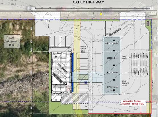
4.13 Construction Certificate documentation must be
forwarded to Reverb Acoustics to ensure all recommendations within this report
have been incorporated into the design of the site.
4.14 For both staff and customers, some form of
education campaign is suggested to ensure satisfactory noise levels at nearby
residences. For staff, the education can be part of in-service training, while
for visitor’s reminders may be included in promotional material and
reinforced with erection of appropriate signage.
Appropriate conditions are recommended requiring
implementation of the noise mitigation measures in the report.
Standard precautionary site management condition also
recommended for construction activities.
Bushfire
The site is identified as being bushfire prone.
The Applicant has submitted a bushfire report prepared by a
BPAD Certified Consultant. The assessment concludes that the proposal will
comply with the requirements of Planning for Bush Fire Protection 2019, subject
to the following recommendations:
· Construction
of the building from non-combustible materials;
· Provision of
a 10m APZ around the building;
· All above
ground water, electricity and gas fittings are to be metal.
Appropriate conditions have been recommended in this regard.
Safety, security and crime prevention
The application includes a Crime
Risk Assessment prepared by Wilson Planning. The report notes that Wauchope
experiences higher than state average instances of crime in terms of non-domestic
assaults, sexual offences, theft, malicious damage to property, disorderly
conduct, and drug offences. As such, the probability of an incident or damage
occurring within or to the proposed development, is higher and the safety of
staff and customers, security of personal property, and protection of the
building itself are key areas to address in the design of the proposal.
The report makes the following crime prevention
recommendations.
1. Single
secured pedestrian access point to the convenience store,
2. Secure
access to the service yard, with pin code system, or equivalent.
3. Trees
are to be underpruned and underplanted with low level plantings and
groundcovers.
4. CCTV
to be provided within the convenience store, under the refuelling canopy, and
covering the entry and exits to the site. CCTV to be designed and installed in
compliance with Australian Standard 806.1: Closed Circuit Television (CCTV)
Management and Operation.
5. Motion-activated
security lighting to be provided in the service yard. Down lighting to be
provided under the refuelling canopy and around the convenience store. All
lighting within the site is to be in accordance with Australian Standard 1158 -
Lighting for roads and public spaces and Australian Standard 4282 - Control of
the obtrusive effects of outdoor lighting.
6. All
surfaces on the building to be maintained regularly, with graffiti removed and
damage repaired immediately to reduce repeat offending and further anti-social
behaviour.
Appropriate
conditions are recommended to require implementation of these items.
Social impacts in the locality
Given the nature of the proposed
development and its location the proposal is not considered to have any
significant adverse social impacts.
Economic impact in the locality
The proposal is not considered to
have any significant adverse economic impacts on the locality. A likely
positive impact is that the development will maintain employment in the
construction industry, which will lead to flow impacts such as expenditure in
the area.
Site design and internal design
The proposed development design
satisfactorily responds to the site attributes and will fit into the locality.
Construction
Construction impacts are considered
capable of being managed, standard construction and site management conditions
have been recommended.
Cumulative impacts
The proposed development is not
considered to have any significant adverse cumulative impacts on the natural or
built environment or the social and economic attributes of the locality.
(c) The
suitability of the site for the development
The proposal will fit into the
locality and the site attributes are conducive to the proposed development.
Site
constraints have been adequately addressed and appropriate conditions of
consent recommended.
(d) Any
submissions made in accordance with this Act or the Regulations
Four (4) written submissions were received following public exhibition of the
application. Copies of the written submissions have been provided separately to
members of the DAP.
Key issues raised in the submissions received and comments
are provided as follows:
|
Submission
Issue/Summary
|
Planning
Comment/Response
|
|
Impacts on sewer line servicing Bethel Church from
retaining wall and reduced access for maintenance.
|
The proposal has been amended
to provide a 1.8m setback for the retaining wall. This would provide adequate
maintenance access to the sewer for the neighbouring property.
A condition has also been
recommended requiring the engineering of the retaining wall to ensure that
there is no load placed on the sewer infrastructure.
|
|
Adverse impacts from loss of street parking associated
with road upgrades. There is significant use of street parking by the
existing church and two child care centres in the locality.
|
The proposal has been amended to provide a basic right
turn treatment (rather than the channelised right turn originally proposed).
This treatment would retain the majority of street parking in the locality.
The only loss of street parking would be for the two new driveway crossovers,
pedestrian refuge, and relocated bus stops.
|
|
Vehicles exiting Bethel Church would have to cross the
hatched area of the intersection to turn right.
|
The plans have been amended to remove the hatched area
adjacent to the Bethel Church access.
|
|
Will children be able to cross the street safely with the
changes proposed in the Oxley Highway.
|
A pedestrian refuge is proposed to be constructed on the
western side of the service station to provide a safer road crossing
location.
|
|
There is no right turn permitted at the exit driveway and
vehicles wanting to leave the site and travel east will have to perform an
illegal U-turn further along the Oxley Highway or use the local road network
to turn around.
|
The proposal has been amended to allow vehicles exiting
the site to turn right.
|
|
Wauchope currently has 6 or 7 fuel outlets. Is an
additional one really needed?
|
The need for the proposed facility is not a relevant
planning consideration.
|
|
Loss of property value.
|
Changes to property value are not a relevant planning
consideration.
|
|
The risk of fire/explosion needs to be considered as there
are a large number of children and elderly in proximity to the site.
|
The application includes a preliminary hazard analysis,
as required by State Environmental Planning Policy (Resilience and Hazards)
2021. The analysis demonstrates that the development will provide adequate
buffer distances to boundaries for the volume and nature of the fuel storage
proposed.
|
|
The documents don’t address the impacts of noise
from the proposed 5.00am opening times. Council must place restrictions on
noise before 7.00am.
|
The Noise Impact Assessment prepared by Reverb Acoustics
considers the proposed 5.00am opening times. The report concludes that
relevant noise criteria can be achieved for the period prior to 7.00am with
the installation of the recommended acoustic fencing to the southern and
eastern boundaries.
Fuel deliveries, general deliveries, and garbage
collection would not be permitted prior to 7.00am.
|
|
Is there going to be trucks parked on the site overnight
with refrigeration units running.
|
The proposed conditions recommend that deliveries be
restricted to between 7am and 8pm Monday to Sunday. Delivery vehicles
would not be permitted to remain on the site overnight.
|
|
Council and RMS rejected a second driveway for a dwelling
at 221 High Street under DA2015 - 961. Why is it possible for a commercial
development with greater traffic generation to have separate entry and exit
driveways?
|
Access arrangements are considered on merit for each
development proposal having regard to the intended use, the number and type
of vehicles that require access, and traffic safety considerations.
It is common for service stations to have separated entry
and exit driveways to reduce traffic conflicts and provide for the
circulation of large delivery vehicles.
Only a single driveway is typically permitted for
residential properties, with the objective being to retain street parking as
far as practical, and to maintain an appropriate residential streetscape.
|
|
The offsetting obligations under DA2020 - 630.1 for the
vegetation previously cleared on the site have not been completed.
|
A Vegetation Management Plan for the offsets under DA2020
- 630.1 has been approved by Council and the auditing process commenced.
The title restrictions for the offset area have also been
submitted to Council for approval.
Granting consent to the proposed service station would
not affect the implementation of these offsets.
|
|
The recommendations in Section 3.2 of the Noise Impact
Assessment and the conclusion in Section 5.1 are very contradictory as an
acoustic fence is recommended to the southern and eastern boundaries, but the
properties directly opposite the site will not find the increased noise
intrusive.
|
The acoustic fences to the south and east of the
development are required due to the development bringing traffic and other
noise sources closer to the residential receivers in this location.
Existing residential properties opposite the site
(northern side of High Street) have much greater separation distance from the
development and the noise has been modelled to be no greater than the
existing road traffic noise from High Street, which is closer to these
properties than the proposed development site.
|
|
The amended plans appear to show a reduced amount of
parking restrictions in High Street adjacent to the neighbouring Bethel
Church. Can it be confirmed that no parking restrictions would apply in this
area?
|
The ultimate design of the access works in High Street
(Oxley Highway) would be approved by Transport for NSW through a Works
Authorisation Deed (WAD). The amendments to the access design sought by
Transport for NSW through the assessment process have been aimed at preserving
as much street parking in the locality as possible, and it is likely that the
parking restrictions will be similar to those shown on the current concept
plan.
|
|
Bethel Church patrons will have to cross double lines in
order to exit the site and turn right.
|
NSW Road Rules permit a vehicle to cross double unbroken
lines to enter or leave the road by the shortest route.
|
|
Other similar businesses east of the site do not have
blisters painted on the road and operate in a normal fashion. The blisters
shown force traffic to the edges of the road and remove side of the road
access for parking and the provision of a safe margin for vehicles entering
the highway from entrances and side roads.
|
The amended proposal does not have painted blisters, and
will retain the parking lanes.
|
|
Where will the B-Double fuel tankers U-turn if they have
to return east after delivering fuel?
|
The amended proposal will allow fuel tankers and other
vehicles to turn right when exiting the site.
|
|
The site is large and some of the vacant land could be
utilised for a better layout and setback from the road edge.
|
The proposed layout has been demonstrated to be
appropriate and it is not necessary to utilise the balance of the vacant
land.
|
(e) The Public Interest
The proposed development satisfies
relevant planning controls and will not adversely impact on the wider public
interest.
Ecologically Sustainable Development and Precautionary
Principle
Ecologically sustainable development requires the effective
integration of economic and environmental considerations in decision-making
processes.
The four principles of ecologically sustainable development
are:
· the
precautionary principle,
· intergenerational
equity,
· conservation
of biological diversity and ecological integrity,
· improved
valuation, pricing and incentive mechanisms.
The principles of ESD require that a balance needs to be
struck between the man-made development and the need to retain the natural
vegetation. Based on the assessment provided in the report and with recommended
conditions of consent, it is considered an appropriate balance has been struck.
Climate change
The proposal is not considered to
be vulnerable to any risks associated with climate change.
4. DEVELOPMENT
CONTRIBUTIONS APPLICABLE
Section 7.11 Contributions
The development does not contain
any residential component. As a result, Section 7.11 contributions do not
apply.
Section 7.12 Contributions
In assessing s7.12 contributions,
Council staff have reviewed the development in accordance with the Port Macquarie-Hastings
Council Development Contributions Assessment Policy (DCAP) and the Port Macquarie-Hastings Council Section 94A Levy Contributions Plan
2007.
The proposed development will comprise a service station and
is deemed to increase the demand for public amenities/services.
As a result, s7.12 contributions apply and a condition of
consent has been recommended to ensure payment.
Section 64 Water and Sewer Contributions
In assessing s64 water and sewer
contributions, Council staff have reviewed the development in accordance with
the Port Macquarie-Hastings Council Development Contributions Assessment Policy
(DCAP) and applicable Development Servicing Plans.
No contribution credit applies to the site.
The proposed development will comprise a service station and
contributions have been charged accordingly based on the following areas:
· Service
station - driveway area 1459m2;
· Service
station convenience store - shops (dry trade) - 186m2.
Having considered the above, the proposed development will
increase the demand on water and sewer services.
As a result, s64 contributions apply and a condition of
consent has been recommended to ensure payment.
An estimate of the applicable development contributions is
provided at the end of this report (Attachment 3).
5. CONCLUSION AND
STATEMENT OF REASON
The application has been assessed in accordance with Section
4.15 of the Environmental Planning and Assessment Act 1979.
Issues raised during assessment and public exhibition of the
application have been considered in the assessment of the application.
Amendments to the proposal have been made and where relevant, conditions have
been recommended to manage the impacts attributed to these issues.
The proposed development does
not raise any significant general public interest issues beyond matters already
addressed in this report. Overall, the proposed development is consistent with
the provisions and objectives of the relevant planning controls and will have
an acceptable impact on the surrounding natural and built environment. Approval
of the application is considered to be in the public interest as it achieves
the LEP objectives for development in the zone. No significant adverse
environmental, social or economic impacts on the locality have been identified.
Accordingly, the proposal is considered to be in the public interest.
|
Attachments
1⇩. Attachment 1 -
Recommended Conditions Attachment 1 -
Recommended Conditions
2⇩. Attachment 2 - Plans
3⇩. Attachment 3 -
Contribution Estimate
|
|
ATTACHMENT
|
Development Assessment Panel
17/05/2023
|
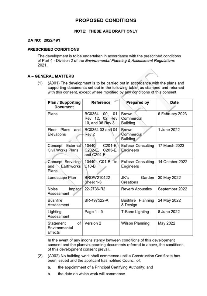

|
ATTACHMENT
|
Development Assessment Panel
17/05/2023
|
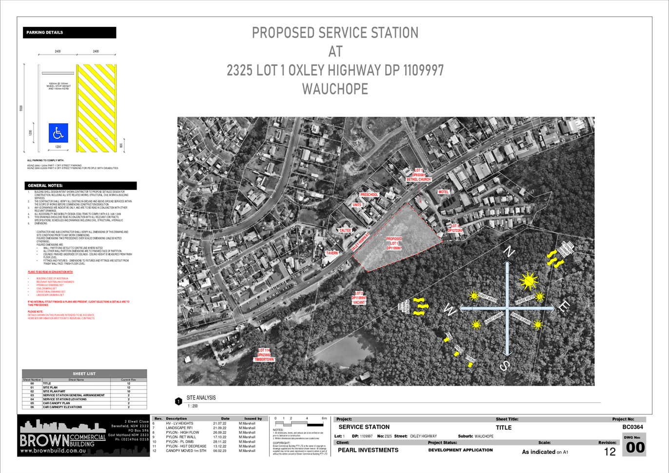
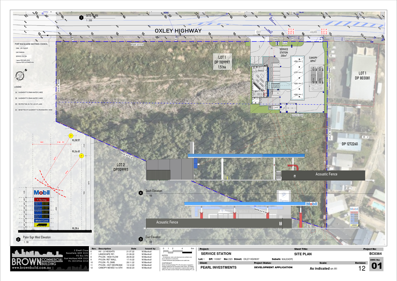
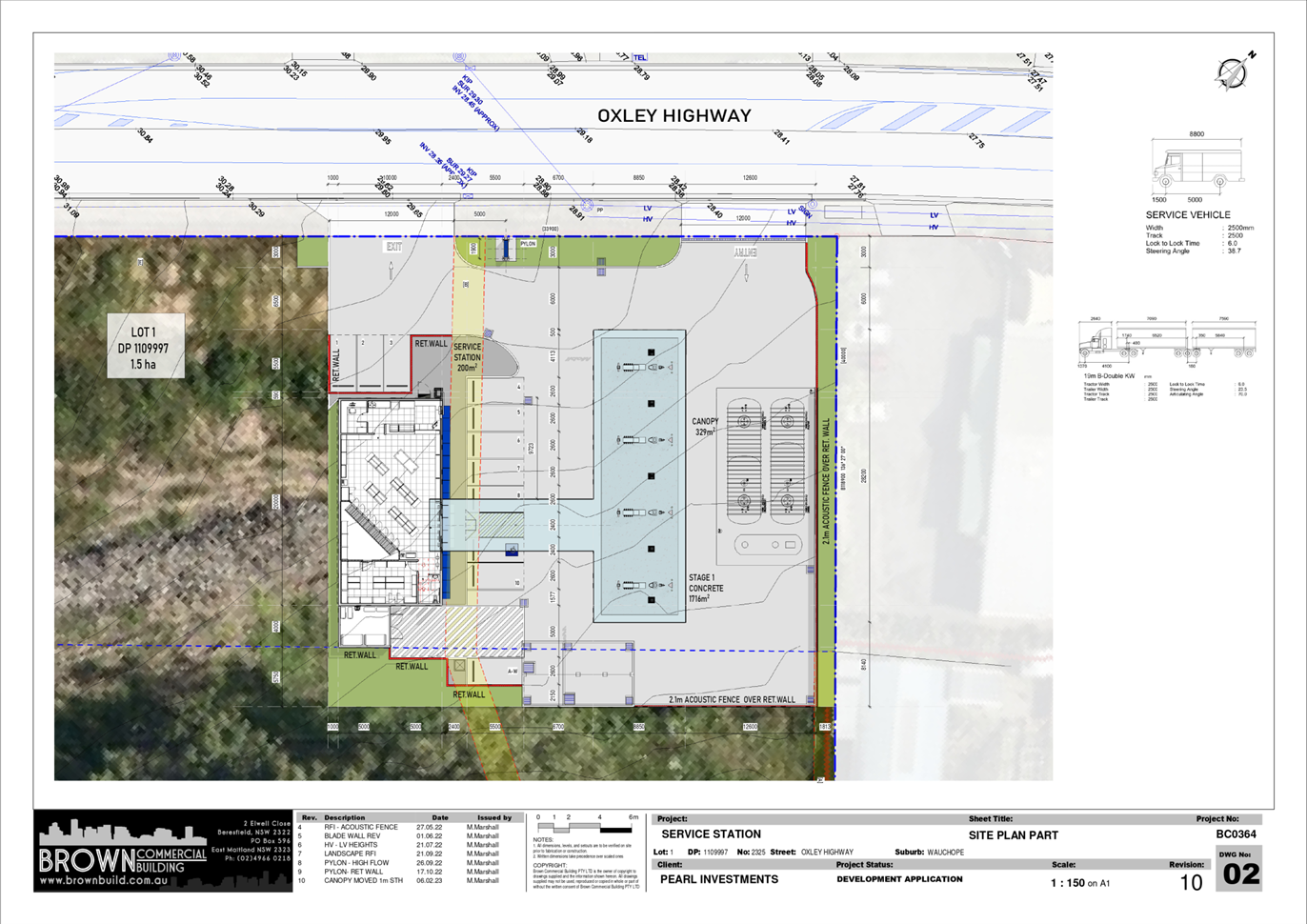
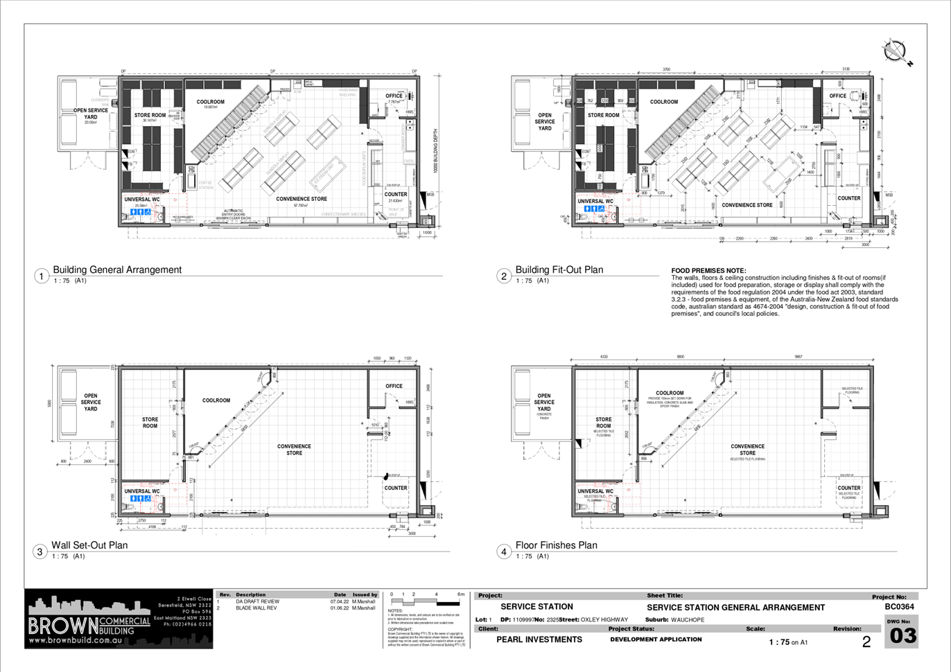
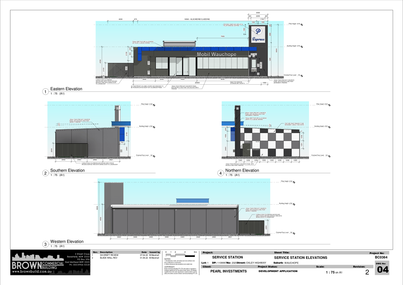
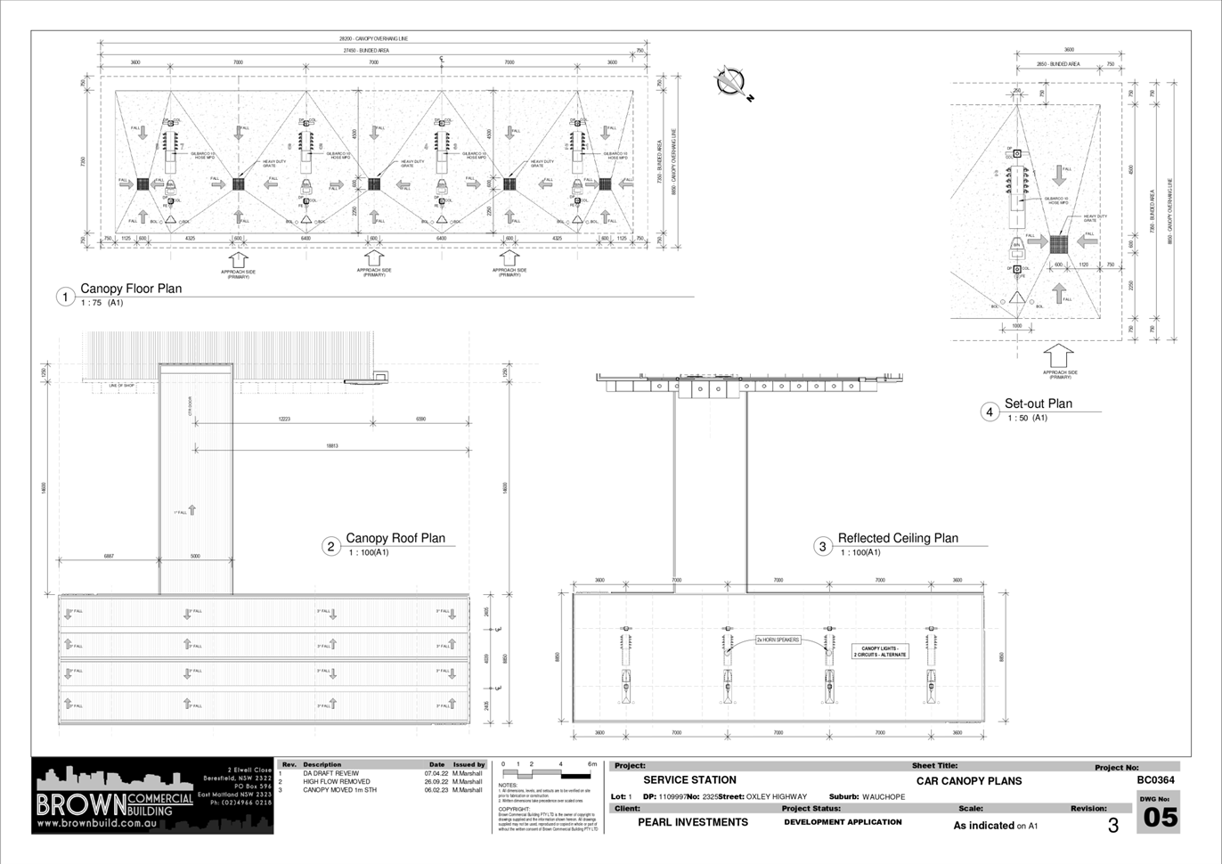
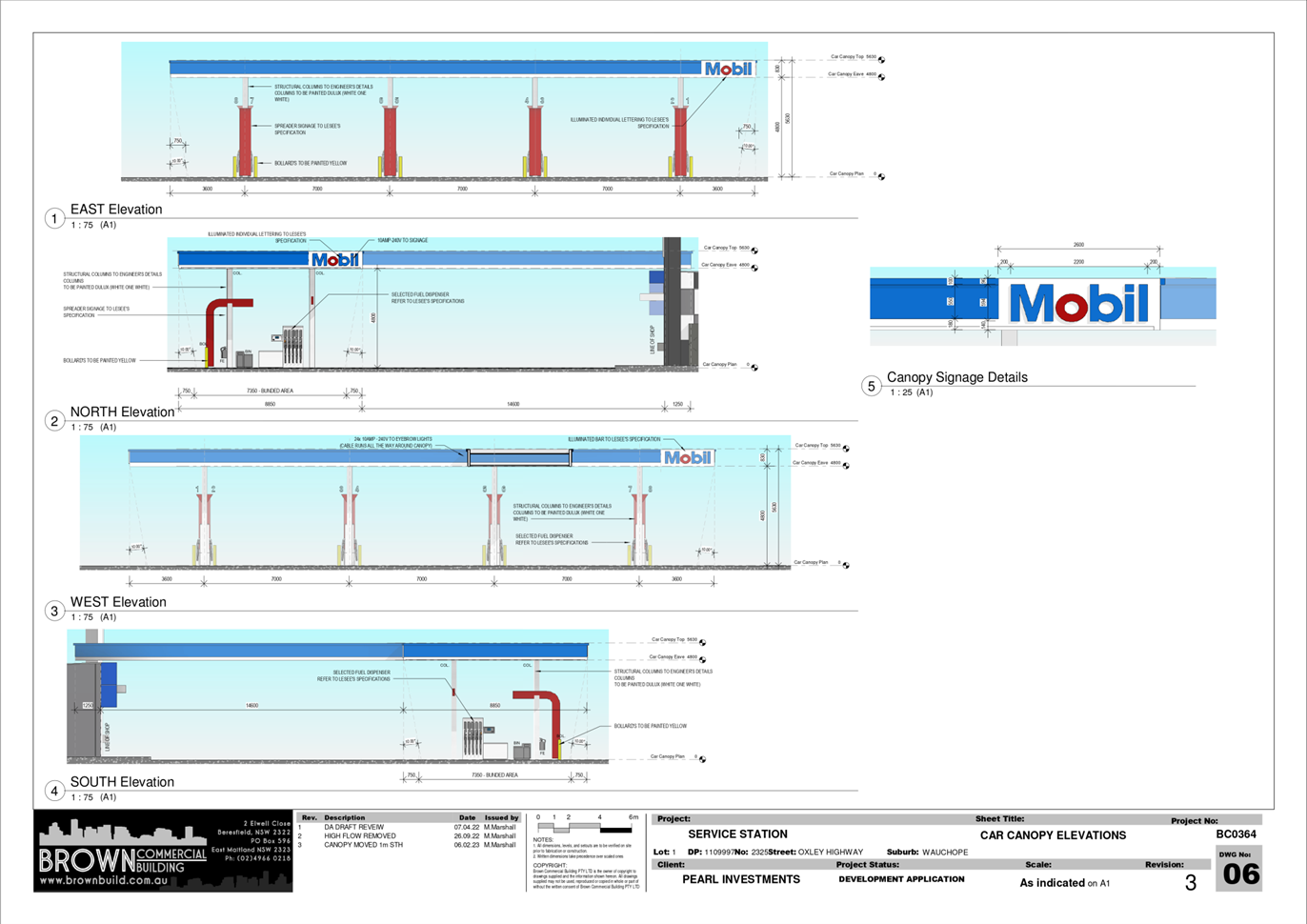
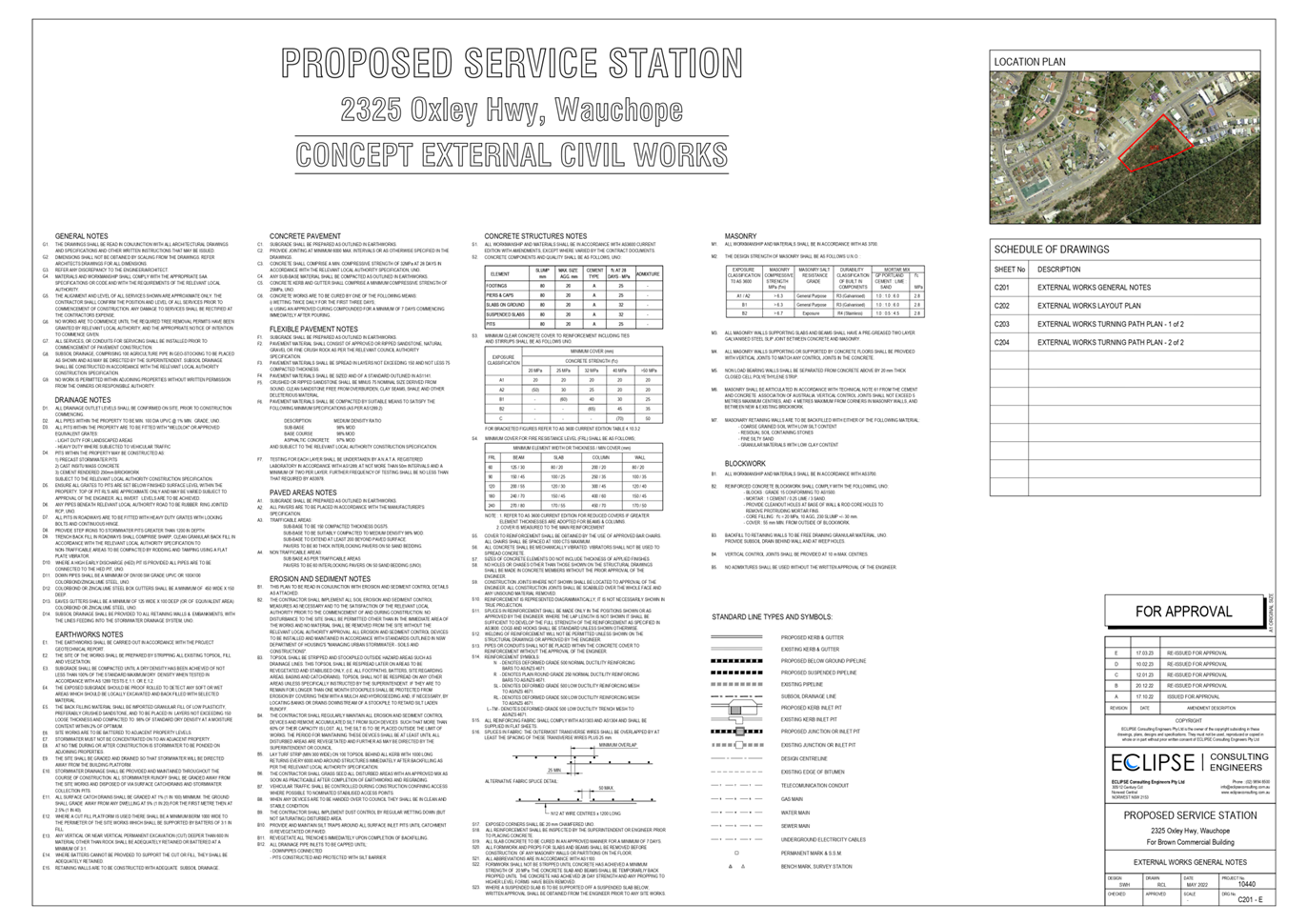
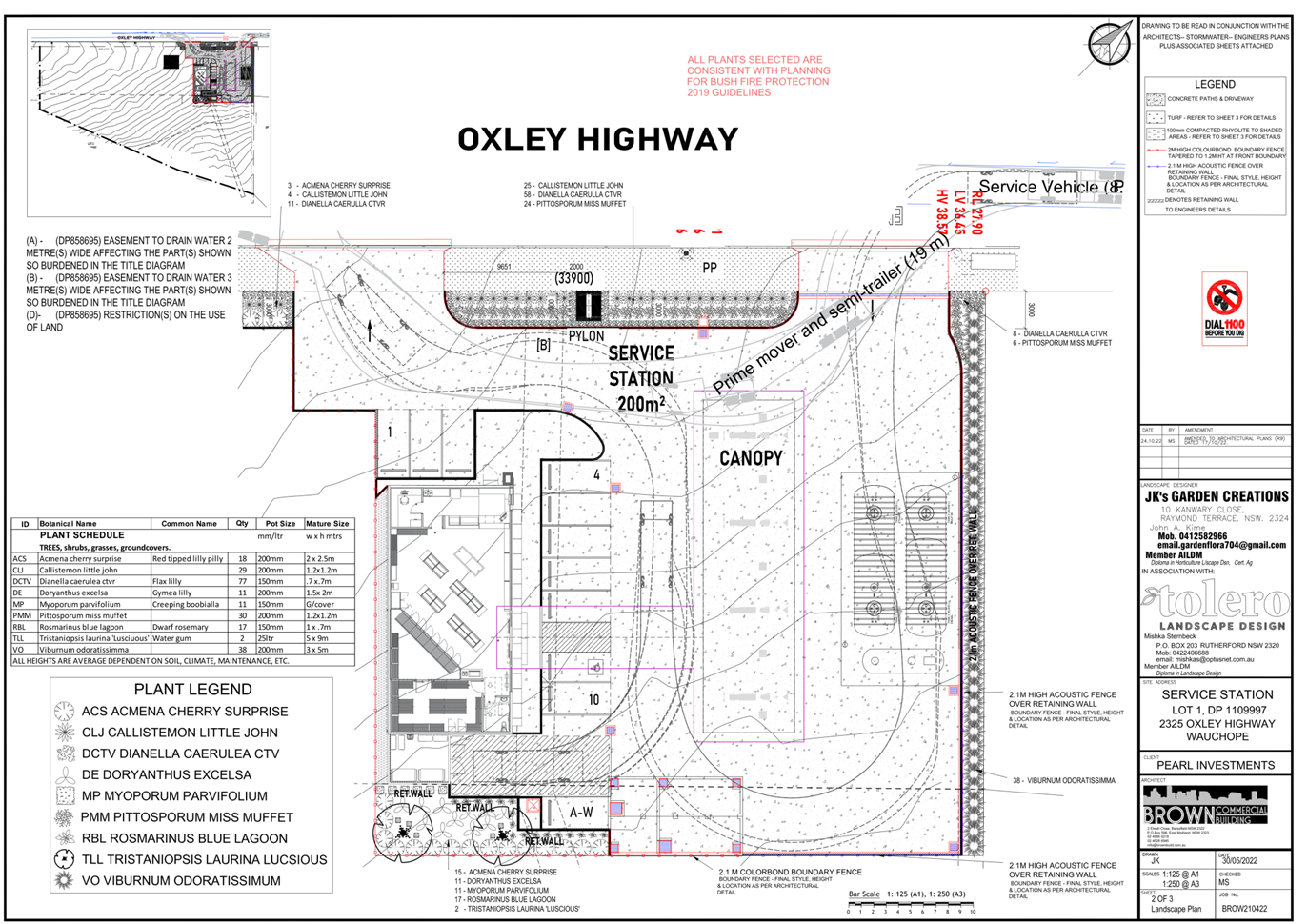
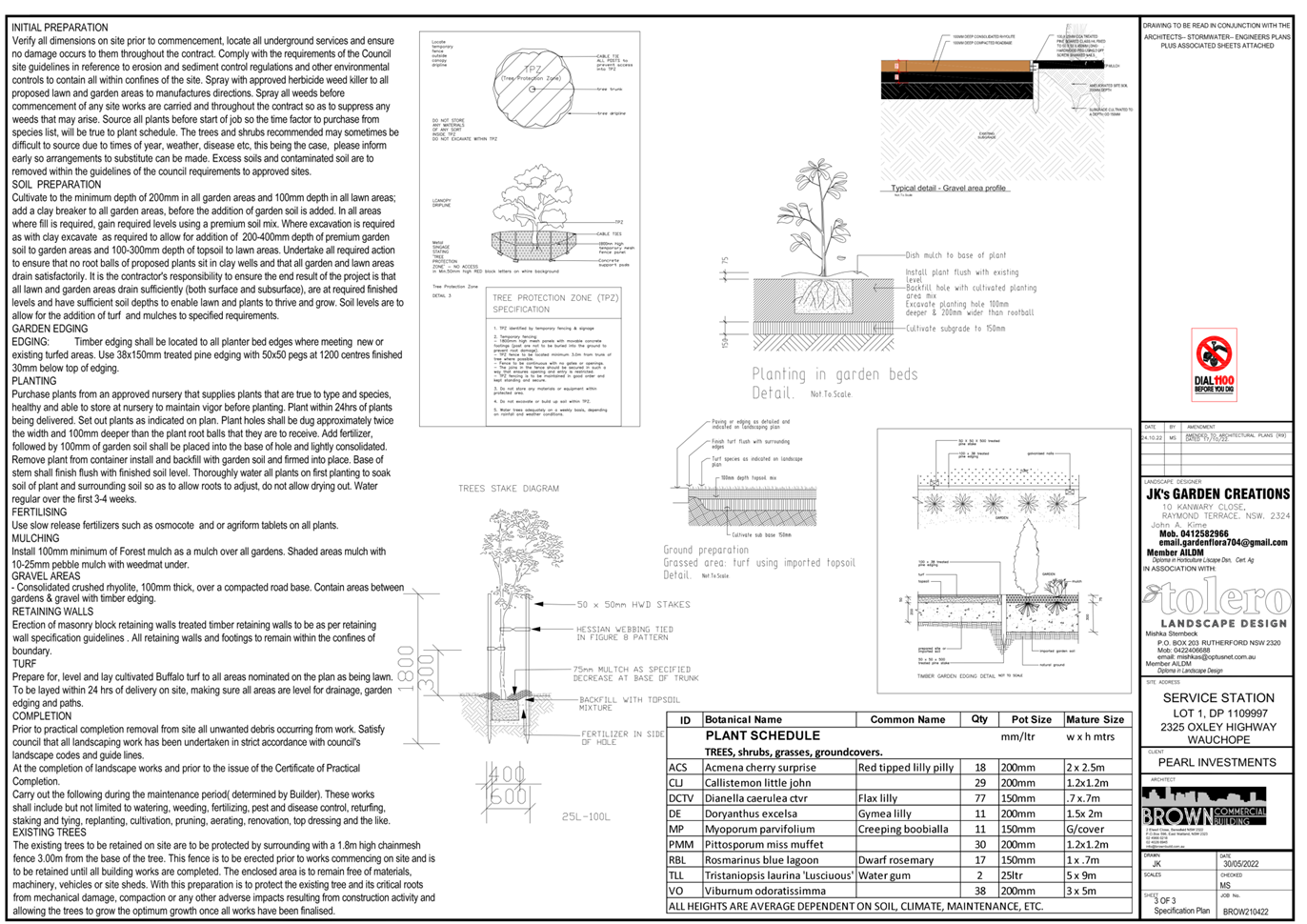
|
ATTACHMENT
|
Development Assessment Panel
17/05/2023
|
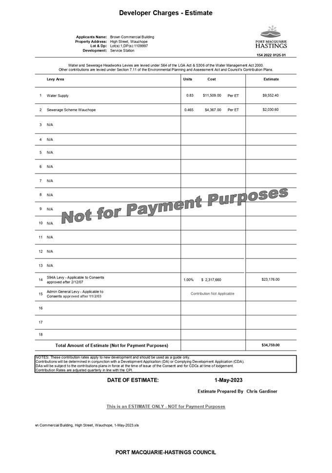
Development Assessment Panel
17/05/2023
Item: 06
Subject: DA2022 - 440.1 Residential Flat Building
Including Clause 4.6 Variation to Clause 4.3 (Height of Buildings) of the Port
Macquarie Hastings Local Environmental Plan 2011 and Demolition of Existing
Buildings, Lot 12 & 12A DP 361896 and Lot 1 & 3 DP 564518, No 9-11
Waugh Street, Port Macquarie
Report
Author: Development Assessment Planner, Chris Gardiner
|
Applicant: IDA
Design Group Pty Ltd
Owner: WD
Macquarie Investments Pty Ltd
Estimated Cost: $12,371,247
Parcel no: 25077,
36678, 36677, 25063
Alignment with Delivery
Program
4.3.1 Undertake transparent
and efficient development assessment in accordance with relevant legislation.
|
RECOMMENDATION
That
it be recommended to Council that DA2022 - 440.1 for a Residential Flat Building Including Clause
4.6 Variation to Clause 4.3 (Height of Buildings) of the Port
Macquarie-Hastings Local Environmental Plan 2011 and Demolition of Existing
Buildings at Lot 12 and 12A DP 361896, and Lot 1 & 3 DP 564518, No. 9-11 Waugh
Street, Port Macquarie, be determined by granting consent subject to the
recommended conditions.
Executive
Summary
This
report considers a development application for a residential flat
building at the subject site and provides an
assessment of the application in accordance with the Environmental Planning and
Assessment Act 1979.
Following exhibition of the
application, five (5) submissions were
received.
The proposal has been amended
through the assessment process, including improved building separation and
privacy, changes to the vehicular access location and improvements to flood
protection.
The site is considered suitable for the proposed development
and the proposal adequately addresses relevant planning controls. The
development will provide additional high density housing close to the Port
Macquarie Town Centre, is not considered to be contrary to the public's
interest and will not result in any significant adverse social, environmental
or economic impact.
The proposal exceeds the Height of Buildings development
standard in Clause 4.3 of the Port Macquarie-Hastings Local Environmental Plan
2011 by more than 10% and the application is required to be determined by
Council following consideration by the Development Assessment Panel. This report recommends that it be recommended to Council
that the development application be approved subject to the attached
conditions (Attachment 1).
The reason for the application also being referred to
Council’s Development Assessment Panel (DAP) is because three (3) or more
objections to the proposal have been received and the application includes a
Clause 4.6 exception to a development standard under the Port
Macquarie-Hastings Local Environmental Plan 2011 by more than 10%. A copy of
the DAP Charter outlining the delegations and functions of the DAP is available
on Council’s website.
1. BACKGROUND
Existing
Sites Features and Surrounding Development
The site has a combined area of 2145.8m2
across four (4) existing lots.
The
site is zoned R4 High Density Residential in
accordance with the Port Macquarie-Hastings Local Environmental Plan 2011, as
shown in the following zoning plan:
The
existing subdivision pattern and location of existing development within the
locality is shown in the following aerial photograph:
2. DESCRIPTION
OF DEVELOPMENT
Key
aspects of the proposal include the following:
· Demolition
of 2 existing dwellings and associated outbuildings;
· Construction
of a residential flat building containing 26 x 2 bedroom apartments, 8 x 3
bedroom apartments.
· Consolidation
of the four existing lots.
Refer
to plans of the proposed development (Attachment 2).
Application
Chronology
· 25
May 2022 - Application accepted for lodgement.
· 3 June 2022 to 21 June 2022 - Neighbour notification.
· 24 June 2022 - Comments on proposal received from Essential
Energy.
· 29 November 2022 to 12 December 2022 - Amended plans
re-notified.
3. STATUTORY
ASSESSMENT
Section
4.15(1) Matters for Consideration
In
determining the application, Council is required to take into consideration the
following matters as are relevant to the development that apply to the land to
which the development application relates:
(a) The
provisions (where applicable) of:
(i) Any
Environmental Planning Instrument
State Environmental Planning Policy (Biodiversity and
Conservation) 2021
Chapter 4 Koala Habitat Protection 2021
Clause 4.4 - This SEPP applies to all non-rural zoned land
within the Port Macquarie-Hastings Local Government Area.
Clause 4.10 - Having considered the SEPP, the
application and on completion of a site inspection, Council is not prevented
from granting consent in this case for the following reasons:
1. The property is not subject to a KPOM, and
2. The site not considered to be core koala habitat.
State Environmental Planning Policy No. 65 - Design
Quality of Residential Apartment Development
This Policy
applies to development for the purpose of a residential flat building, shop top
housing or mixed use development with a residential accommodation component if:
(a) the
development consists of any of the following:
(i) the
erection of a new building,
(ii) the
substantial redevelopment or the substantial refurbishment of an existing
building,
(iii) the
conversion of an existing building, and
(b) the
building concerned is at least 3 or more storeys (not including levels below
ground level (existing) or levels that are less than 1.2 metres above ground
level (existing) that provide for car parking), and
(c) the
building concerned contains at least 4 or more dwellings.
Based on the above, the SEPP must be considered.
Clause 6A - This clause applies in respect of the
objectives, design criteria and design guidance set out in Parts 3 and 4 of the
Apartment Design Guide for the following:
(a) visual
privacy,
(b) solar
and daylight access,
(c) common
circulation and spaces,
(d) apartment
size and layout,
(e) ceiling
heights,
(f) private
open space and balconies,
(g) natural
ventilation,
(h) storage.
If a development control plan contains provisions that
specify requirements, standards or controls in relation to a matter to which
this clause applies, those provisions are of no effect.
This clause applies regardless of when the development
control plan was made.
In terms of lodging an application under SEPP 65, it is
noted that the proposal has provided the verification and detail required by
Clause 29 of the Environmental Planning and Assessment Regulation 2021.
Clause 28(2)(b) - The proposal has adequately addressed the
design principles contained in the Apartment Design Guide. The application
includes a design verification from a registered architect addressing the
design quality principles as follows:
|
Requirement
|
Architect’s
Response
|
Complies
|
|
Principle 1: Context and neighbourhood character
Good design responds and
contributes to its context. Context is the key natural and built features of
an area, their relationship and the character they create when combined. It
also includes social, economic, health and environmental conditions.
Responding to context involves
identifying the desirable elements of an area’s existing or future
character. Well designed buildings respond to and enhance the qualities and
identity of the area including the adjacent sites, streetscape and
neighbourhood.
Consideration of local context
is important for all sites, including sites in established areas, those
undergoing change or identified for change.
|
The existing character of the
precinct is within Port Macquarie town centre. The precinct is undergoing
regeneration and has been rezoned to cater for the type of development
proposed.
The proposed development is a
residential building of 7 storeys including parking at sub-basement level.
The proposed building use
complies with the existing and desired character statement that buildings are
to be primarily residential. The scale of building and type of use are
compatible with the proposed redevelopment of the precinct and recognizes and
complies with requirements and objectives of Port Macquarie - Hastings LEP
2011 and Port Macquarie - Hastings DCP 2013.
|
Yes
|
|
Principle 2: Built form and
scale
Good design achieves a scale,
bulk and height appropriate to the existing or desired future character of
the street and surrounding buildings.
Good design also achieves an
appropriate built form for a site and the building’s purpose in terms
of building alignments, proportions, building type, articulation and the
manipulation of building elements.
Appropriate built form defines
the public domain, contributes to the character of streetscapes and parks,
including their views and vistas, and provides internal amenity and outlook.
|
The scale of the existing
development in the immediate precinct is comprised of buildings of variable
height primarily low to medium rise in height and some recently constructed
buildings of up to 6 storeys. The site is located within Port Macquarie town
centre and has opportunities for using local public transport.
The proposed development
responds and conforms to the height and building form proposed for the
precinct and would allow for future developments on adjoining sites to
achieve their full potential.
The building relates to the
existing built form in the area due to its fenestration, materials, texture
and colour. The building addresses the street with a major façade
which is aligned with the form of the street. The built form of the
development relates to other built forms allowed in the DCP for the precinct.
The overall affect is to create a building that presents a very effective and
architectural presence within the streetscape.
|
Yes
|
|
Principle 3: Density
Good design achieves a high
level of amenity for residents and each apartment, resulting in a density
appropriate to the site and its context.
Appropriate densities are
consistent with the area’s existing or projected population.
Appropriate densities can be sustained by existing or proposed
infrastructure, public transport, access to jobs, community facilities and
the environment.
|
The precinct with in the area
controlled Port Macquarie - Hastings LEP 2011 and is zoned R4 High Density
Residential.
The density of the development
complies with the allowable density for the area in terms of floor space
ratio. Given the location of the development in relation to Port Macquarie
town centre public transport, community facilities and the rising demand for
housing in the area, the proposed density is appropriate and consistent with
the requirements as outlined in Port Macquarie - Hastings DCP 2013.
|
Yes
|
|
Principle 4: Sustainability
Good design combines positive
environmental, social and economic outcomes.
Good sustainable design
includes use of natural cross ventilation and sunlight for the amenity and
liveability of residents and passive thermal design for ventilation, heating
and cooling reducing reliance on technology and operation costs. Other
elements include recycling and reuse of materials and waste, use of
sustainable materials and deep soil zones for groundwater recharge and
vegetation.
|
The proposed development is
consistent in the application of through flow ventilation and solar ingress
to the units. The orientation north south of the building on the site and the
design of the units all contribute substantially to the solar passive design
and energy efficiency of the development.
The proposed development has
been Nathers and BASIX assessed and scores well in all required categories of
water, thermal comfort and energy. Energy efficiency is aided by the use of
water/energy efficient fittings, appliances and lighting.
|
Yes
|
|
Principle 5: Landscape
Good design recognises that
together landscape and buildings operate as an integrated and sustainable
system, resulting in attractive developments with good amenity. A positive image
and contextual fit of well
designed developments is
achieved by contributing to the landscape character of the streetscape and
neighbourhood.
Good landscape design enhances
the development’s environmental performance by retaining positive
natural features which contribute to the local context, co-ordinating water
and soil management, solar access, micro-climate, tree canopy, habitat values
and preserving green networks.
Good landscape design
optimises useability, privacy and opportunities for social interaction,
equitable access, respect for neighbours’ amenity and provides for
practical establishment and long term management.
|
The proposed development forms
part of the Residential town centre precinct.
The current development upon
the site provides many areas of landscaping and deep soil promoting healthy
growth of large tress.
The proposed development
provides 29% (626 sqm) deep soil and a total of 693 sqm (32%) of communal
open space and landscaped open space promoting healthy growth of large trees
pockets. The landscaping provided will contribute to the enjoyment of these
areas.
|
Yes
|
|
Principle 6: Amenity
Good design positively
influences internal and external amenity for residents and neighbours.
Achieving good amenity contributes to positive living environments and
resident well being.
Good amenity combines
appropriate room dimensions and shapes, access to sunlight, natural
ventilation, outlook, visual and acoustic privacy, storage, indoor and
outdoor space, efficient layouts and service areas and ease of access for all
age groups and degrees of mobility.
|
Apartments are a mixture of 2
and 3 bedroom apartments. Cross ventilation is achieved for 60% of the
apartments.
70% of the apartments achieve
the required solar access.
The building complies with the
setbacks as recommended in the SEPP 65 design code and the requirements
outlined in the DCP. Where there are perceived direct observation potentials
the design of the building tries to ensure the windows in conflict have the
required offset.
Each dwelling has its own external
private open space which is more than adequate. Bathrooms/Ensuite are
accessed from the hallways leading to the bedrooms. Kitchens are accessed
from the primary living area.
Visual and acoustic privacy is
acceptable and able bodied access is through entry lobbies at the ground
floor.
Disabled access is gained to
the ground floor via a pedestrian path (which complies with ASNZ 1428.1-2001)
from the street. There are the required number of apartments which are
adaptable these are located on levels 1, 2, 3 and 4 all units within the
development are accessible via the lifts. The car spaces are located on grade
parking with easy access to the lift.
|
Yes
|
|
Principle 7: Safety
Good design optimises safety
and security within the development and the public domain. It provides for
quality public and private spaces that are clearly defined and fit for the
intended purpose. Opportunities to maximise passive surveillance of public
and communal areas promote safety.
A positive relationship
between public and private spaces is achieved through clearly defined secure
access points and well lit and visible areas that are easily maintained and
appropriate to the location and purpose.
|
Public and communal
spaces are overlooked on all sides by balconies, terraces and windows from
primary living rooms of the project. The building addresses the public domain
with glazed doors and balconies.
The communal spaces
will be adequately lit and are void of areas that may be subjectable to
criminal activities.
The building will
have safe and secure access to the carpark. The lifts to the building will be
a security lift providing access to the residential levels. The primary
entrance to the development will have a secure method of entry.
|
Yes
|
|
Principle 8: Housing
diversity and social interaction
Good design achieves a mix of
apartment sizes, providing housing choice for different demographics, living
needs and household budgets.
Well designed apartment
developments respond to social context by providing housing and facilities to
suit the existing and future social mix.
Good design involves practical
and flexible features, including different types of communal spaces for a
broad range of people and providing opportunities for social interaction
among residents.
|
The proposed residential use
is appropriate to the location of this site, as it is located within Port
Macquarie town centre and close proximity to public transport and community
facilities such as local clubs, baby health centre and community centre.
The proposed development has
an appropriate mix of 2 and 3 bedroom apartments of varied size.
Consideration has been given
to the need to have affordable housing within the development as a result it
provides a social mix which is well suited and appropriate to the area.
|
Yes
|
|
Principle 9: Aesthetics
Good design achieves a built
form that has good proportions and a balanced composition of elements,
reflecting the internal layout and structure. Good design uses a variety of
materials, colours and textures.
The visual appearance of a
well designed apartment development responds to the existing or future local
context, particularly desirable elements and repetitions of the streetscape.
|
The form and composition of
this design proposes a satisfactory aesthetic and it will relate well to
existing developments in the precinct in terms of its roof type, modulation
of facade, fenestration, materials, texture and colour. Upper penthouse
floors are designed as pop up individual terraces.
The use of detail and texture
and the high degree of articulation in the façade composition has the
result of creating an interesting and high quality building which sits well
in the precinct and compliments the existing streetscape.
|
Yes
|
Clause 28(2)(c) - The proposal has
adequately addressed the Apartment Design Guide (ADG). The following table
provides an assessment against the Apartment Design Guide with assessment
comments considering the design criteria and design objectives where
applicable:
|
Apartment Design Guide (ADG)
Objective
|
Design Guidance/Design
Criteria (Italics)
|
Proposed
|
Complies
|
|
3A Site analysis
|
|
3A - 1 Site analysis illustrates
that design decisions have been based on opportunities and constraints of the
site conditions and their relationship to the surrounding context.
|
Each element in the Site Analysis
Checklist should be addressed (Appendix 1 of ADG).
|
Adequate site analysis provided.
|
Yes
|
|
3B Orientation
|
|
3B - 1 Building types and layouts
respond to the streetscape and site while optimising solar access within the
development.
|
Buildings along the street
frontage define the street, by facing it and incorporating direct access from
the street (see figure 3B.1).
Where the street frontage is to
the east or west, rear buildings should be orientated to the north.
Where the street frontage is to
the north or south, overshadowing to the south should be minimised and
buildings behind the street frontage should be orientated to the east and
west (see figure 3B.2).
|
The building is aligned to the
street and provides direct access from the street. The street frontage to
Waugh Street is on the southern side of the building, which will minimise
overshadowing due to the width of the street offering separation between the
properties.
|
Yes
|
|
3B - 2 Overshadowing of
neighbouring properties is minimised during mid winter.
|
Living areas, private open space
and communal open space should receive solar access in accordance with
sections 3D Communal and public open space and 4A Solar and daylight access.
Solar access to living rooms, balconies
and private open spaces of neighbours should be considered.
Where an adjoining property does
not currently receive the required hours of solar access, the proposed
building ensures solar access to neighbouring properties is not reduced by
more than 20%.
If the proposal will
significantly reduce the solar access of neighbours, building separation
should be increased beyond minimums contained in section 3F Visual privacy.
Overshadowing should be minimised
to the south or downhill by increased upper level setbacks.
It is optimal to orientate
buildings at 90 degrees to the boundary with neighbouring properties to
minimise overshadowing and privacy impacts, particularly where minimum
setbacks are used and where buildings are higher than the adjoining development.
A minimum of 4 hours of solar
access should be retained to solar collectors on neighbouring buildings.
|
Living areas, private open space
and communal open space receive adequate solar access.
The development will retain
sunlight to adjoining property in accordance with the specifications in 4A of
the ADG.
Solar access will not be reduced
to any solar collectors on neighbouring buildings.
|
Yes
|
|
3C Public domain interface
|
|
3C - 1 Transition between private
and public domain is achieved without compromising safety and security
|
Terraces, balconies and courtyard
apartments should have direct street entry, where appropriate.
Changes in level between private
terraces, front gardens and dwelling entries above the street level provide
surveillance and improve visual privacy for ground level dwellings (see
figure 3C.1).
Upper level balconies and windows
should overlook the public domain.
Front fences and walls along
street frontages should use visually permeable materials and treatments. The
height of solid fences or walls should be limited to 1m.
Length of solid walls should be
limited along street frontages.
Opportunities should be provided
for casual interaction between residents and the public domain. Design
solutions may include seating at building entries, near letter boxes and in
private courtyards adjacent to streets.
In developments with multiple
buildings and/or entries, pedestrian entries and spaces associated with
individual buildings/entries should be differentiated to improve legibility
for residents, using a number of the following design solutions:
- architectural
detailing
- changes
in materials
- plant
species
- colours
Opportunities for people to be
concealed should be minimised
|
The development includes 2
apartments at the street frontage above the parking level. Both apartments
are accessed off the common entry and do not have individual street access.
The level of the ground floor above the street means that individual accesses
would require additional stairs/ramps in the street frontage, affecting the
aesthetics of the building and the ability to provide landscaping to the wall
of the parking area.
The design has incorporated
individual accesses to the front balconies of Unit 106 and Unit 107 from the
main building entry stairs, which is an adequate design response to the site
flooding constraints.
Terraces and balconies overlook
the public domain.
The development provides for
interaction with the public domain with front courtyards adjacent to the
street and public footpath.
There are no significant
concealment opportunities identified.
|
Yes
|
|
3C - 2 Amenity of the public
domain is retained and enhanced.
|
Planting softens the edges of any
raised terraces to the street, for example above sub-basement car parking.
Mail boxes should be located in
lobbies, perpendicular to the street alignment or integrated into front
fences where individual street entries are provided.
The visual prominence of
underground car park vents should be minimised and located at a low level
where possible.
Substations, pump rooms, garbage
storage areas and other service requirements should be located in basement
car parks or out of view.
Ramping for accessibility should
be minimised by building entry location and setting ground floor levels in
relation to footpath levels.
Durable, graffiti resistant and
easily cleanable materials should be used.
Where development adjoins public
parks, open space or bushland, the design positively addresses this interface
and uses a number of the following design solutions:
- street
access, pedestrian paths and building entries which are clearly defined
- paths,
low fences and planting that clearly delineate between communal/private open
space and the adjoining public open space
- minimal
use of blank walls, fences and ground level parking.
On sloping sites protrusion of
car parking above ground level should be minimised by using split levels to
step underground car parking
|
Landscape plan confirms adequate landscaping
forward of the car parking level.
Mail boxes located adjacent to
main building entry.
Garbage storage areas are located
in the car parking level.
A ramp for accessibility to the
building is proposed at the main entry. The level of the entry cannot be
reduced to match the footpath level due to the flood planning requirements.
The schedule of proposed finishes
are appropriately durable.
|
Yes
|
|
3D Communal and public open
space
|
|
3D - 1 An adequate area of
communal open space is provided to enhance residential amenity and to provide
opportunities for landscaping
|
Design Criteria
1. Communal open space has a
minimum area equal to 25% of the site (see figure 3D.3)
2. Developments achieve a
minimum of 50% direct sunlight to the principal usable part of the communal
open space for a minimum of 2 hours between 9 am and 3 pm on 21 June (mid
winter).
Communal open space should be
consolidated into a well designed, easily identified and usable area.
Communal open space should have a
minimum dimension of 3m, and larger developments should consider greater
dimensions.
Communal open space should be
co-located with deep soil areas.
Direct, equitable access should
be provided to communal open space areas from common circulation areas,
entries and lobbies.
Where communal open space cannot
be provided at ground level, it should be provided on a podium or roof.
Where developments are unable to
achieve the design criteria, such as on small lots, sites within business
zones, or in a dense urban area, they should:
- provide
communal spaces elsewhere such as a landscaped roof top terrace or a common
room
- provide
larger balconies or increased private open space for apartments
- demonstrate
good proximity to public open space and facilities and/or provide
contributions to public open space
|
Proposal includes 693m2
of communal open space located at ground level and on the roof top. This
equates to 32% of the site area.
More than 50% of the communal
open space will receive 2 hours of sunlight between 9am and 3pm mid winter.
Communal open space has a minimum
dimension of 3m and is co-located with the deep soil zone.
The communal open space is
accessible from common areas
|
Yes
|
|
3D - 2 Communal open space is
designed to allow for a range of activities, respond to site conditions and
be attractive and inviting
|
Facilities are provided within
communal open spaces and common spaces for a range of age groups (see also 4F
Common circulation and spaces), incorporating some of the following elements:
- seating
for individuals or groups
- barbecue
areas
- play
equipment or play areas
- swimming
pools, gyms, tennis courts or common rooms.
The location of facilities
responds to microclimate and site conditions with access to sun in winter,
shade in summer and shelter from strong winds and down drafts.
Visual impacts of services should
be minimised, including location of ventilation duct outlets from basement
car parks, electrical substations and detention tanks
|
Roof terrace includes seating
areas, water feature, viewing deck and barbeque facilities.
|
Yes
|
|
3D - 3 Communal open space is
designed to maximise safety
|
Communal open space and the
public domain should be readily visible from habitable rooms and private open
space areas while maintaining visual privacy. Design solutions may include:
- bay
windows
- corner
windows
- balconies.
Communal open space should be
well lit.
Where communal open
space/facilities are provided for children and young people they are safe and
contained.
|
Balconies of apartments will
provide passive surveillance of ground level communal open space areas.
The roof terrace would not have
any passive surveillance from apartments, but is located adjacent to the
private open space of 5 of the apartments. The private open space has gated
access to the communal area and would provide for some supervision of this
space.
|
Yes
|
|
3D - 4 Public open space, where
provided, is responsive to the existing pattern and uses of the neighbourhood
|
The public open space should be
well connected with public streets along at least one edge.
The public open space should be
connected with nearby parks and other landscape elements.
Public open space should be
linked through view lines, pedestrian desire paths, termination points and
the wider street grid.
Solar access should be provided
year round along with protection from strong winds.
Opportunities for a range of
recreational activities should be provided for people of all ages.
A positive address and active
frontages should be provided adjacent to public open space.
Boundaries should be clearly
defined between public open space and private areas
|
N/A
|
N/A
|
|
3E Deep soil zones
|
|
3E - 1 Deep soil zones provide
areas on the site that allow for and support healthy plant and tree growth.
They improve residential amenity and promote management of water and air
quality
|
Design Criteria
1. Deep soil zones are to meet
the following minimum requirements:
a) <
650m², no min dimension, 7% site area deep soil zone.
b) 650-1500m²,
3m dimension, 7% site area deep soil zone.
c) >1500m²,
6m dimension, 7% site area deep soil zone.
On some sites it may be possible
to provide larger deep soil zones, depending on the site area and context:
- 10%
of the site as deep soil on sites with an area of 650m² - 1,500m²
- 15%
of the site as deep soil on sites greater than 1,500m².
Deep soil zones should be located
to retain existing significant trees and to allow for the development of
healthy root systems, providing anchorage and stability for mature trees.
Design solutions may include:
- basement
and sub-basement car park design that is consolidated beneath building
footprints
- use
of increased front and side setbacks
- adequate
clearance around trees to ensure long term health
- co-location
with other deep soil areas on adjacent sites to create larger contiguous areas
of deep soil.
Achieving the design criteria may
not be possible on some sites including where:
- the
location and building typology have limited or no space for deep soil at
ground level (e.g. central business district, constrained sites, high density
areas, or in centres)
- there
is 100% site coverage or non-residential uses at ground floor level.
Where a proposal does not achieve
deep soil requirements, acceptable stormwater management should be achieved
and alternative forms of planting provided such as on structure.
|
256m2 of deep soil
zone with minimum dimension of 6m, which equates to 12% of the site area.
The site does not contain any
existing significant trees that require retention in deep soil zones.
|
Yes
|
|
3F Visual privacy
|
|
3F - 1 Adequate building
separation distances are shared equitably between neighbouring sites, to
achieve reasonable levels of external and internal visual privacy
|
Design Criteria
1. Separation between windows
and balconies is provided to ensure visual privacy is achieved. Minimum
required separation distances from buildings to the side and rear boundaries
are as follows:
a) Building
height up to 12m (4 storey) need 6m setback to habitable and 3m to
non-habitable.
b) Buildings
up to 25m (5-8 storeys) need 9m to habitable and 4.5m to non-habitable.
c) Buildings
over 25m (9+ storeys) need 12m to habitable and 6m to non-habitable.
Note: Separation distances
between buildings on the same site should combine required building
separations depending on the type of room (see figure 3F.2).
Gallery access circulation
should be treated as habitable space when measuring privacy separation
distances between neighbouring properties
Generally, one step in the built
form as the height increases due to building separations is desirable.
Additional steps should be careful not to cause a 'ziggurat' appearance.
For residential buildings next to
commercial buildings, separation distances should be measured as follows:
- for
retail, office spaces and commercial balconies use the habitable room
distances
- for
service and plant areas use the non-habitable room distances.
New development should be located
and oriented to maximise visual privacy between buildings on site and for
neighbouring buildings. Design solutions include:
- site
layout and building orientation to minimise privacy impacts (see also section
3B Orientation)
- on
sloping sites, apartments on different levels have appropriate visual
separation distances (see figure 3F.4).
Apartment buildings should have
an increased separation distance of 3m (in addition to the requirements set
out in design criteria 1) when adjacent to a different zone that permits
lower density residential development to provide for a transition in scale
and increased landscaping (figure 3F.5).
Direct lines of sight should be
avoided for windows and balconies across corners.
No separation is required between
blank walls
|
The proposal has separation
distances which generally comply with the minimum requirements in this
provision.
Some habitable room windows and
balconies on Level 4 & 5 of the building have an 8.7m side setback. This
minor reduction is considered acceptable given the relationship to
neighbouring properties.
The building has been designed
with only a single step in built form.
It is noted that the blank wall
on the western elevation at Level 1, 2, and 3, where the building is closer
than the 6m setback, does not require a minimum separation distance.
|
No, but acceptable
|
|
3F - 2 Site and building design
elements increase privacy without compromising access to light and air and
balance outlook and views from habitable rooms and private open space
|
Communal open space, common areas
and access paths should be separated from private open space and windows to
apartments, particularly habitable room windows. Design solutions may
include:
- setbacks
- solid
or partially solid balustrades to balconies at lower levels
- fencing
and/or trees and vegetation to separate spaces
- screening
devices
- bay
windows or pop out windows to provide privacy in one direction and outlook in
another
- raising
apartments/private open space above the public domain or communal open space
- planter
boxes incorporated into walls and balustrades to increase visual separation
-
pergolas or shading devices to limit overlooking of lower apartments or
private open space
- on
constrained sites where it can be demonstrated that building layout
opportunities are limited, fixed louvers or screen panels to windows and/or
balconies.
Bedrooms, living spaces and other
habitable rooms should be separated from gallery access and other open
circulation space by the apartment’s service areas.
Balconies and private terraces
should be located in front of living rooms to increase internal privacy.
Windows should be offset from the
windows of adjacent buildings.
Recessed balconies and/or
vertical fins should be used between adjacent balconies
|
Ground level communal open space
is at a lower level than the ground floor apartments and landscaping has been
proposed on top of the podium above the parking level.
The roof terrace does not adjoin
and apartments and is separated from the Level 5 private open space areas by
appropriate fencing/screening.
Lower level balconies are solid
adjacent to the common building entry.
|
Yes
|
|
3G Pedestrian access and
entries
|
|
3G - 1 Building entries and
pedestrian access connects to and addresses the public domain
|
Multiple entries (including
communal building entries and individual ground floor entries) should be
provided to activate the street edge.
Entry locations relate to the
street and subdivision pattern and the existing pedestrian network.
Building entries should be
clearly identifiable and communal entries should be clearly distinguishable
from private entries.
Where street frontage is limited
and multiple buildings are located on the site, a primary street address
should be provided with clear sight lines and pathways to secondary building
entries.
|
Individual entries to the ground
floor apartments at the street frontage proposed via practical connection to
the common main entrance.
The main building entry is well
defined and clearly identifiable.
|
Yes
|
|
3G - 2 Access, entries and
pathways are accessible and easy to identify
|
Building access areas including
lift lobbies, stairwells and hallways should be clearly visible from the
public domain and communal spaces.
The design of ground floors and
underground car parks minimise level changes along pathways and entries.
Steps and ramps should be
integrated into the overall building and landscape design.
For large developments ‘way
finding’ maps should be provided to assist visitors and residents (see
figure 4T.3).
For large developments electronic
access and audio/video intercom should be provided to manage access
|
Building access points are
clearly visible from the public domain and the access ramp and steps are
appropriately integrated into the design.
The proposal is not of a scale
where wayfinding maps are considered necessary.
|
Yes
|
|
3G - 3 Large sites provide
pedestrian links for access to streets and connection to destinations
|
Pedestrian links through sites
facilitate direct connections to open space, main streets, centres and public
transport.
Pedestrian links should be
direct, have clear sight lines, be overlooked by habitable rooms or private
open spaces of dwellings, be well lit and contain active uses, where
appropriate
|
N/A
|
N/A
|
|
3H Vehicle access
|
|
3H - 1 Vehicle access points are
designed and located to achieve safety, minimise conflicts between
pedestrians and vehicles and create high quality streetscapes
|
Car park access should be
integrated with the building’s overall facade. Design solutions may
include:
- the
materials and colour palette to minimise visibility from the street
- security
doors or gates at entries that minimise voids in the facade
- where
doors are not provided, the visible interior reflects the facade design and
the building services, pipes and ducts are concealed.
Car park entries should be
located behind the building line.
Vehicle entries should be located
at the lowest point of the site minimising ramp lengths, excavation and
impacts on the building form and layout.
Car park entry and access should
be located on secondary streets or lanes where available.
Vehicle standing areas that
increase driveway width and encroach into setbacks should be avoided.
Access point locations should
avoid headlight glare to habitable rooms.
Adequate separation distances
should be provided between vehicle entries and street intersections.
The width and number of vehicle
access points should be limited to the minimum.
Visual impact of long driveways
should be minimised through changing alignments and screen planting.
The need for large vehicles to
enter or turn around within the site should be avoided.
Garbage collection, loading and
servicing areas are screened.
Clear sight lines should be
provided at pedestrian and vehicle crossings.
Traffic calming devices such as
changes in paving material or textures should be used where appropriate.
Pedestrian and vehicle access
should be separated and distinguishable. Design solutions may include:
- changes
in surface materials
- level
changes
- the
use of landscaping for separation
|
The car park access is in the
front façade of the building and is proposed to be provided with a
security door at the access point.
The access to the parking is via
a single two-way driveway with sufficient separation from street
intersections and pedestrian paths.
The driveway length is relatively
short and would not result in any adverse visual impacts.
|
Yes
|
|
3J Bicycle and car parking
|
|
3J - 1 Car parking is provided
based on proximity to public transport in metropolitan Sydney and centres in
regional areas
Notes
Port Macquarie is a nominated
regional centre.
In terms of using Guide to
Traffic Generating Developments, Port Macquarie is a “sub-regional
centre” as by definition it does not have access to rail.
Medium density is 2 - <20
dwellings.
High Density is 20 or more
dwellings
|
Design Criteria
1. For
development in the following locations:
a) on
sites that are within 800 metres of a railway station or light rail stop in
the Sydney Metropolitan Area; or
b) on
land zoned, and sites within 400 metres of land zoned, B3 Commercial Core, B4
Mixed Use or equivalent in a nominated regional centre
the minimum car parking
requirement for residents and visitors is set out in the Guide to Traffic
Generating Developments, or the car parking requirement prescribed by the
relevant council, whichever is less
The car parking needs for a
development must be provided off street.
Where a car share scheme operates
locally, provide car share parking spaces within the development. Car share
spaces, when provided, should be on site.
Where less car parking is
provided in a development, council should not provide on street resident
parking permits
Guide to Traffic Generating
Developments
Medium density residential flat
buildings require:
- 1
space per unit +
- 1
space for every 5 x 2 bedroom unit +
- 1
space for every 2 x 3 bedroom unit +
- 1
space for 5 units (visitor parking).
High density residential flat
buildings for metropolitan sub-regional centres require:
- 0.6
spaces per 1 bedroom unit
- 0.9
spaces per 2 bedroom unit
- 1.40
spaces per 3 bedroom unit +
- 1
space per 5 units (visitor parking)
|
The site is located within 400m
of a B3 zone to the east of the site. Accordingly, car parking is required to
meet the minimum requirements of the Guide to Traffic Generating
Developments or the DCP (whichever is less).
Guide to Traffic Generating
Developments
The proposal includes more than
20 dwellings and is characterised as a high density residential flat building
for the purpose of parking generation.
26 x 0.9 spaces = 23.4 spaces.
8 x 1.4 spaces = 11.2 spaces.
34/5 = 6.8 visitor spaces.
Total parking required = 41.4 spaces
(rounded to 42 spaces).
DCP
26 x 1 space = 26 spaces.
8 x 1.5 = 12 spaces.
34/4 = 8.5 visitor spaces.
Total parking required = 46.5
spaces (rounded to 47 spaces).
The Guide to Traffic
Generating Developments therefore provide the lesser parking requirement
and is the minimum parking required under the ADG. The proposal includes 47
spaces including 9 visitor spaces and exceeds the minimum requirement of 42
spaces, including 7 visitor spaces.
|
Yes
|
|
3J - 2 Parking and facilities are
provided for other modes of transport
|
Conveniently located and
sufficient numbers of parking spaces should be provided for motorbikes and
scooters.
Secure undercover bicycle parking
should be provided that is easily accessible from both the public domain and
common areas.
Conveniently located charging
stations are provided for electric vehicles, where desirable
|
The proposal includes 2
motorcycle/scooter spaces and 6 bicycle spaces in the basement car park.
|
Yes
|
|
3J - 3 Car park design and access
is safe and secure
|
Supporting facilities within car
parks, including garbage, plant and switch rooms, storage areas and car wash
bays can be accessed without crossing car parking spaces.
Direct, clearly visible and well
lit access should be provided into common circulation areas.
A clearly defined and visible
lobby or waiting area should be provided to lifts and stairs.
For larger car parks, safe
pedestrian access should be clearly defined and circulation areas have good
lighting, colour, line marking and/or bollards.
|
Storage space for the majority of
apartments is provided at the end of the associated parking space and can be
accessed without crossing parking areas for other apartments.
The lift, plant room, and pump
room are also accessible with clearly defined pedestrian areas.
A waste room has also been
proposed in the basement area with convenient access from the basement.
|
Yes
|
|
3J - 4 Visual and environmental
impacts of underground car parking are minimised
|
Excavation should be minimised
through efficient car park layouts and ramp design.
Car parking layout should be well
organised, using a logical, efficient structural grid and double loaded
aisles.
Protrusion of car parks should
not exceed 1m above ground level. Design solutions may include stepping car
park levels or using split levels on sloping sites.
Natural ventilation should be
provided to basement and sub basement car parking areas.
Ventilation grills or screening
devices for car parking openings should be integrated into the facade and
landscape design
|
Excavation for the basement car
park will be minimised due to the minimum permissible level of 1.2m AHD in
Council’s Flood Policy. This results in more than 1m of the car park
protruding above ground level. Appropriate landscaping is proposed to soften
the building protrusions.
Ventilation openings for the car
park are not proposed due to the flooding constraints. Mechanical ventilation
will be provided.
|
Yes
|
|
3J - 5 Visual and environmental
impacts of on-grade car parking are minimised
|
On-grade car parking should be
avoided.
Where on-grade car parking is
unavoidable, the following design solutions are used:
- parking
is located on the side or rear of the lot away from the primary street
frontage
- cars
are screened from view of streets, buildings, communal and private open space
areas
- safe
and direct access to building entry points is provided
- parking
is incorporated into the landscape design of the site, by extending
planting and materials into the car park space
- stormwater
run-off is managed appropriately from car parking surfaces •
bio-swales, rain gardens or on site detention tanks are provided, where
appropriate
- light
coloured paving materials or permeable paving systems are used and shade
trees are planted between every 4-5 parking spaces to reduce increased
surface temperatures from large areas of paving
|
N/A
|
N/A
|
|
3J - 6 Visual and environmental
impacts of above ground enclosed car parking are minimised
|
Exposed parking should not be
located along primary street frontages
Screening, landscaping and other
design elements including public art should be used to integrate the above
ground car parking with the facade. Design solutions may include:
- car
parking that is concealed behind the facade, with windows integrated into the
overall facade design (approach should be limited to developments where a
larger floor plate podium is suitable at lower levels)
- car
parking that is ‘wrapped’ with other uses, such as retail,
commercial or two storey Small Office/Home Office (SOHO) units along the
street frontage (see figure 3J.9).
Positive street address and
active frontages should be provided at ground level
|
Car parking area is enclosed
along the street frontage and provided with a sandstone feature cladding and
landscaping to improve the streetscape presentation.
Active uses with a more direct
apartment to street relationship are not able to be provided at street level
due to the flood controls applicable to the site.
|
Yes
|
|
4A Solar and daylight access
|
|
4A - 1 To optimise the number of
apartments receiving sunlight to habitable rooms, primary windows and private
open space
|
Design Criteria
1. Living rooms and private
open spaces of at least 70% of apartments in a building receive a minimum of
2 hours direct sunlight between 9 am and 3 pm at mid winter in the Sydney
Metropolitan Area and in the Newcastle and Wollongong local government areas.
2. In all other areas, living
rooms and private open spaces of at least 70% of apartments in a building
receive a minimum of 3 hours direct sunlight between 9 am and 3 pm at mid
winter.
3. A maximum of 15% of
apartments in a building receive no direct sunlight between 9 am and 3 pm at
mid winter
The design maximises north aspect
and the number of single aspect south facing apartments is minimised.
Single aspect, single storey
apartments should have a northerly or easterly aspect.
Living areas are best located to
the north and service areas to the south and west of apartments.
To optimise the direct sunlight
to habitable rooms and balconies a number of the following design features
are used:
- dual
aspect apartments
- shallow
apartment layouts
- two
storey and mezzanine level apartments
- bay
windows
To maximise the benefit to
residents of direct sunlight within living rooms and private open spaces, a
minimum of 1m² of direct sunlight, measured at 1m above floor level, is
achieved for at least 15 minutes.
Achieving the design criteria may
not be possible on some sites. This includes:
- where
greater residential amenity can be achieved along a busy road or rail line by
orientating the living rooms away from the noise source
- on
south facing sloping sites
- where
significant views are oriented away from the desired aspect for direct
sunlight
Design drawings need to
demonstrate how site constraints and orientation preclude meeting the design
criteria and how the development meets the objective.
|
Sun penetration plans submitted,
which confirm adequate sunlight access to living areas.
None of the apartments will
receive no direct sunlight between 9am and 3pm at midwinter.
The design maximises the number
of north-facing and multiple aspect apartments. No single aspect south-facing
apartments are proposed.
|
Yes
|
|
4A - 2 Daylight access is
maximised where sunlight is limited
|
Courtyards, skylights and high
level windows (with sills of 1,500mm or greater) are used only as a secondary
light source in habitable rooms.
Where courtyards are used:
- use
is restricted to kitchens, bathrooms and service areas
- building
services are concealed with appropriate detailing and materials to visible
walls
- courtyards
are fully open to the sky
- access
is provided to the light well from a communal area for cleaning and
maintenance
- acoustic
privacy, fire safety and minimum privacy separation distances (see section 3F
Visual privacy) are achieved.
Opportunities for reflected light
into apartments are optimised through:
- reflective
exterior surfaces on buildings opposite south facing windows
- positioning
windows to face other buildings or surfaces (on neighbouring sites or within
the site) that will reflect light
- integrating
light shelves into the design
- light
coloured internal finishes
|
Skylights are proposed as the
secondary light source for Unit 504 and 505.
|
Yes
|
|
4A - 3 Design incorporates
shading and glare control, particularly for warmer months
|
A number of the following design
features are used:
- balconies
or sun shading that extend far enough to shade summer sun, but allow winter
sun to penetrate living areas
- shading
devices such as eaves, awnings, balconies, pergolas, external louvers and
planting
- horizontal
shading to north facing windows
- vertical
shading to east and particularly west facing windows
- operable
shading to allow adjustment and choice
- high
performance glass that minimises external glare off windows, with
consideration given to reduced tint glass or glass with a reflectance level
below 20% (reflective films are avoided)
|
Appropriate shading features
included in the design.
|
Yes
|
|
4B Natural ventilation
|
|
4B - 1 All habitable rooms are
naturally ventilated
|
The building's orientation
maximises capture and use of prevailing breezes for natural ventilation in
habitable rooms.
Depths of habitable rooms support
natural ventilation.
The area of unobstructed window
openings should be equal to at least 5% of the floor area served.
Light wells are not the primary
air source for habitable rooms.
Doors and openable windows
maximise natural ventilation opportunities by using the following design
solutions:
- adjustable
windows with large effective openable areas
- a
variety of window types that provide safety and flexibility such as awnings
and louvers
- windows
which the occupants can reconfigure to funnel breezes into the apartment such
as vertical louvers, casement windows and externally opening doors
|
Design and orientation of the
building facilitates natural ventilation. The majority of apartments have
multiple aspects and openable doors and windows.
|
Yes
|
|
4B - 3 The number of apartments
with natural cross ventilation is maximised to create a comfortable indoor
environment for residents
|
Design Criteria
1. At least 60% of apartments
are naturally cross ventilated in the first nine storeys of the building.
Apartments at ten storeys or greater are deemed to be cross ventilated only
if any enclosure of the balconies at these levels allows adequate natural
ventilation and cannot be fully enclosed.
2. Overall depth of a
cross-over or cross-through apartment does not exceed 18m, measured glass
line to glass line.
The building should include dual
aspect apartments, cross through apartments and corner apartments and limit
apartment depths.
In cross-through apartments
external window and door opening sizes/areas on one side of an apartment
(inlet side) are approximately equal to the external window and door opening
sizes/areas on the other side of the apartment (outlet side) (see figure
4B.4).
Apartments are designed to
minimise the number of corners, doors and rooms that might obstruct airflow.
Apartment depths, combined with
appropriate ceiling heights, maximise cross ventilation and airflow
|
The submitted plans show 60% of
apartments to be naturally cross ventilated.
The overall depth of apartments
do not exceed 18m.
|
Yes
|
|
4C Ceiling heights
|
|
4C - 1 Ceiling height achieves
sufficient natural ventilation and daylight access
|
Design Criteria
1. Measured from finished
floor level to finished ceiling level, minimum ceiling heights are:
Minimum ceiling height for
apartment and mixed use buildings
Habitable rooms = 2.7m
Non-habitable = 2.4m
For 2 storey apartments = 2.7m
for main living area floor and 2.4m for second floor, where its area does not
exceed 50% of the apartment area
Attic spaces = 1.8m at edge of
room with a 30-degree minimum ceiling slope
If located in mixed use areas
= 3.3m for ground and first floor to promote future flexibility of use
These minimums do not preclude
higher ceilings if desired.
Ceiling height can accommodate
use of ceiling fans for cooling and heat distribution.
|
All apartments have 2.7m ceilings
throughout.
|
Yes
|
|
4C - 2 Ceiling height increases
the sense of space in apartments and provides for well proportioned rooms
|
A number of the following design
solutions can be used:
- the
hierarchy of rooms in an apartment is defined using changes in ceiling
heights and alternatives such as raked or curved ceilings, or double height
spaces
- well
proportioned rooms are provided, for example, smaller rooms feel larger and
more spacious with higher ceilings
- ceiling
heights are maximised in habitable rooms by ensuring that bulkheads do not
intrude. The stacking of service rooms from floor to floor and coordination
of bulkhead location above non-habitable areas, such as robes or storage, can
assist
|
The proposal includes well
proportioned rooms with consistent ceiling height.
|
Yes
|
|
4D Apartment size and layout
|
|
4D - 1 The layout of rooms within
an apartment is functional, well organised and provides a high standard of
amenity
|
Design Criteria
1. Apartments are required to
have the following minimum internal areas:
Studio = 35m²
1 bedroom = 50m²
2 bedroom = 70m²
3 bedroom = 90m²
The minimum internal areas
include only one bathroom. Additional bathrooms increase the minimum internal
area by 5m² each.
A fourth bedroom and further
additional bedrooms increase the minimum internal area by 12m² each.
2. Every habitable room must
have a window in an external wall with a total minimum glass area of not less
than 10% of the floor area of the room. Daylight and air may not be borrowed
from other rooms.
Kitchens should not be located as
part of the main circulation space in larger apartments (such as hallway or
entry space).
A window should be visible from
any point in a habitable room.
Where minimum areas or room
dimensions are not met apartments need to demonstrate that they are well
designed and demonstrate the usability and functionality of the space with
realistically scaled furniture layouts and circulation areas. These
circumstances would be assessed on their merits
|
All apartment areas exceed the
minimum floor areas.
All habitable rooms have a window
or glass door in an external wall that is at least 10% of the floor area of
the room.
Kitchens are not located in
circulation areas and windows are visible from all habitable rooms.
|
Yes
|
|
4D - 2 Environmental performance
of the apartment is maximised
|
Design Criteria
1. Habitable room depths are
limited to a maximum of 2.5 x the ceiling height.
2. In open plan layouts (where
the living, dining and kitchen are combined) the maximum habitable room depth
is 8m from a window.
Greater than minimum ceiling
heights can allow for proportional increases in room depth up to the
permitted maximum depths.
All living areas and bedrooms
should be located on the external face of the building.
Where possible:
- bathrooms
and laundries should have an external openable window.
- main
living spaces should be oriented toward the primary outlook and aspect and
away from noise sources
|
Room depth complies for all
apartments.
All living rooms and bedrooms are
located on the external face of the building.
Some bathrooms have external
openable windows.
Main living areas are oriented
towards the side and rear boundaries of the site.
|
Yes
|
|
4D - 3 Apartment layouts are
designed to accommodate a variety of household activities and needs
|
Design Criteria
1. Master bedrooms have a
minimum area of 10m² and other bedrooms 9m² (excluding wardrobe
space).
2. Bedrooms have a minimum
dimension of 3m (excluding wardrobe space).
3. Living rooms or combined
living/dining rooms have a minimum width of:
• 3.6m for studio and 1
bedroom apartments
• 4m for 2 and 3 bedroom
apartments
4. The width of cross-over or
cross-through apartments are at least 4m internally to avoid deep narrow
apartment layouts.
Access to bedrooms, bathrooms and
laundries is separated from living areas minimising direct openings between
living and service areas.
All bedrooms allow a minimum
length of 1.5m for robes.
The main bedroom of an apartment
or a studio apartment should be provided with a wardrobe of a minimum 1.8m
long, 0.6m deep and 2.1m high.
Apartment layouts allow
flexibility over time, design solutions may include:
- dimensions
that facilitate a variety of furniture arrangements and removal
- spaces
for a range of activities and privacy levels between different spaces within
the apartment
- dual
master apartments
- dual
key apartments Note: dual key apartments which are separate but on the same
title are regarded as two sole occupancy units for the purposes of the
Building Code of Australia and for calculating the mix of apartments
- room
sizes and proportions or open plans (rectangular spaces (2:3) are more easily
furnished than square spaces (1:1))
- efficient
planning of circulation by stairs, corridors and through rooms to maximise
the amount of usable floor space in rooms
|
All bedroom and living room
dimensions comply with the minimum requirements. All bedrooms have a minimum
1.5m length of robes.
Access to bedrooms, bathrooms and
laundries is separated from the living areas.
Rooms are generally of a regular
shape and provide for a variety of furniture layouts.
|
Yes
|
|
4E Private open space and
balconies
|
|
4E - 1 Apartments provide
appropriately sized private open space and balconies to enhance residential
amenity
|
Design Criteria
1. All apartments are required
to have primary balconies as follows:
a) Studio
apartments = 4m²
b) 1
bedroom apartments = 8m² and 2m min depth.
c) 2
bedroom apartments = 10m² and 2m min depth.
d) 3+
bedroom apartments = 12m² and 2.4m min depth.
The minimum balcony depth to
be counted as contributing to the balcony area is 1m.
2. For apartments at ground
level or on a podium or similar structure, a private open space is provided
instead of a balcony. It must have a minimum area of 15m² and a minimum
depth of 3m.
Increased communal open space
should be provided where the number or size of balconies are reduced.
Storage areas on balconies is
additional to the minimum balcony size.
Balcony use may be limited in
some proposals by:
- consistently
high wind speeds at 10 storeys and above
- close
proximity to road, rail or other noise sources
- exposure
to significant levels of aircraft noise
- heritage
and adaptive reuse of existing buildings
In these situations, juliet
balconies, operable walls, enclosed wintergardens or bay windows may be
appropriate, and other amenity benefits for occupants should also be provided
in the apartments or in the development or both. Natural ventilation also
needs to be demonstrated
|
All balconies and terraces comply
with the minimum areas and dimensions.
|
Yes
|
|
4E - 2 Primary private open space
and balconies are appropriately located to enhance liveability for residents
|
Primary open space and balconies
should be located adjacent to the living room, dining room or kitchen to
extend the living space.
Private open spaces and balconies
predominantly face north, east or west.
Primary open space and balconies
should be orientated with the longer side facing outwards or be open to the
sky to optimise daylight access into adjacent rooms.
|
Primary private open space areas
are located adjacent to living areas and are oriented to face north, east,
and west. Secondary balconies are provided on the southern elevation of some
apartments.
The balconies are oriented with
the longer edge facing outwards and will maximise sunlight access into the
building.
|
Yes
|
|
4E - 3 Private open space and
balcony design is integrated into and contributes to the overall
architectural form and detail of the building
|
Solid, partially solid or
transparent fences and balustrades are selected to respond to the location.
They are designed to allow views and passive surveillance of the street while
maintaining visual privacy and allowing for a range of uses on the balcony.
Solid and partially solid balustrades are preferred.
Full width full height glass
balustrades alone are generally not desirable.
Projecting balconies should be
integrated into the building design and the design of soffits considered.
Operable screens, shutters, hoods
and pergolas are used to control sunlight and wind.
Balustrades are set back from the
building or balcony edge where overlooking or safety is an issue.
Downpipes and balcony drainage
are integrated with the overall facade and building design.
Air-conditioning units should be
located on roofs, in basements, or fully integrated into the building design.
Where clothes drying, storage or
air conditioning units are located on balconies, they should be screened and
integrated in the building design.
Ceilings of apartments below
terraces should be insulated to avoid heat loss.
Water and gas outlets should be
provided for primary balconies and private open space
|
Projecting balconies with solid
and partially solid balustrades proposed for Levels 1 - 4. Level 5 has glass
balustrades.
Clothes drying facilities on
balconies are not shown on the plans, but are capable of being accommodated.
Landscaping to the edge of east
and west facing balconies is proposed on Levels 1 and 4 to provide improved
privacy to the neighbouring property.
|
Yes
|
|
4E - 4 Private open space and
balcony design maximises safety.
|
Changes in ground levels or
landscaping are minimised.
Design and detailing of balconies
avoids opportunities for climbing and falls.
|
All balconies are level and
landscaping does not provide any opportunities for climbing. The Level 1 and
4 balcony landscaping is located behind the balustrade.
Roof terrace landscaping is also
located behind screens or balustrades of the private and communal open space
areas.
|
Yes
|
|
4F Common circulation and
spaces
|
|
4F - 1 Common circulation spaces
achieve good amenity and properly service the number of apartments
|
Design Criteria
1. The maximum number of
apartments off a circulation core on a single level is eight.
2. For buildings of 10 storeys
and over, the maximum number of apartments sharing a single lift is 40.
Greater than minimum requirements
for corridor widths and/ or ceiling heights allow comfortable movement and
access particularly in entry lobbies, outside lifts and at apartment entry
doors.
Daylight and natural ventilation
should be provided to all common circulation spaces that are above ground.
Windows should be provided in
common circulation spaces and should be adjacent to the stair or lift core or
at the ends of corridors.
Longer corridors greater than 12m
in length from the lift core should be articulated. Design solutions may
include:
- a
series of foyer areas with windows and spaces for seating
- wider
areas at apartment entry doors and varied ceiling heights
Design common circulation spaces
to maximise opportunities for dual aspect apartments, including multiple core
apartment buildings and cross over apartments.
Achieving the design criteria for
the number of apartments off a circulation core may not be possible. Where a
development is unable to achieve the design criteria, a high level of amenity
for common lobbies, corridors and apartments should be demonstrated,
including:
- sunlight
and natural cross ventilation in apartments
- access
to ample daylight and natural ventilation in common circulation spaces
- common
areas for seating and gathering
- generous
corridors with greater than minimum ceiling heights
- other
innovative design solutions that provide high levels of amenity
Where design criteria 1 is not
achieved, no more than 12 apartments should be provided off a circulation
core on a single level.
Primary living room or bedroom
windows should not open directly onto common circulation spaces, whether open
or enclosed. Visual and acoustic privacy from common circulation spaces to
any other rooms should be carefully controlled
|
Proposal includes a maximum of 8
apartments on each level off the circulation core.
Lobbies are of acceptable
dimensions to allow for movement of furniture and include a window at the
southern end for natural light.
The common corridors are
articulated so that straight sections do no exceed 12m.
Internally, bathrooms, and
studies adjoin the lobby space and circulation corridors.
|
Yes
|
|
4F - 2 Common circulation spaces
promote safety and provide for social interaction between residents
|
Direct and legible access should
be provided between vertical circulation points and apartment entries by
minimising corridor or gallery length to give short, straight, clear sight
lines.
Tight corners and spaces are
avoided.
Circulation spaces should be well
lit at night.
Legible signage should be
provided for apartment numbers, common areas and general wayfinding.
Incidental spaces, for example
space for seating in a corridor, at a stair landing, or near a window are
provided.
In larger developments, community
rooms for activities such as owners corporation meetings or resident use
should be provided and are ideally co-located with communal open space.
Where external galleries are
provided, they are more open than closed above the balustrade along their
length.
|
Apartments are conveniently
accessible off the lift/stair lobby. No wayfinding or seating considered
necessary for the scale of the development with relatively short corridor
lengths off the access core.
|
Yes
|
|
4G Storage
|
|
4G - 1 Adequate, well designed
storage is provided in each apartment
|
Design Criteria
1. In addition to storage in
kitchens, bathrooms and bedrooms, the following storage is provided:
a) Studio
apartments = 4m³.
b) 1
bedroom apartments = 6m³.
c) 2
bedroom apartments = 8m³.
d) 3+
bedroom apartments = 10m³.
At least 50% of the required storage
is to be located within the apartment.
Storage is accessible from either
circulation or living areas.
Storage provided on balconies (in
addition to the minimum balcony size) is integrated into the balcony design,
weather proof and screened from view from the street.
Left over space such as under
stairs is used for storage
|
Each apartment includes at least
10m3 of storage within apartments and the basement car park.
More than 50% of the minimum
storage requirement is provided within the apartments and in addition to the
storage in bedrooms, kitchens and bathrooms.
No storage on balconies proposed.
|
Yes
|
|
4G - 2 Additional storage is
conveniently located, accessible and nominated for individual apartments
|
Storage not located in apartments
is secure and clearly allocated to specific apartments.
Storage is provided for larger
and less frequently accessed items.
Storage space in internal or
basement car parks is provided at the rear or side of car spaces or in cages
so that allocated car parking remains accessible.
If communal storage rooms are
provided they should be accessible from common circulation areas of the
building.
Storage not located in an
apartment is integrated into the overall building design and is not visible
from the public domain.
|
Storage in the basement car park
is located at the end of each of the individual parking spaces, with
additional storage located adjacent to the lift lobby and pump room.
The application does not include
strata subdivision, but the storage spaces would be capable of being
allocated to individual apartments on any future strata plan.
|
Yes
|
|
4H Acoustic privacy
|
|
4H - 1 Noise transfer is
minimised through the siting of buildings and building layout
|
Adequate building separation is
provided within the development and from neighbouring buildings/adjacent uses
(see also section 2F Building separation and section 3F Visual privacy).
Window and door openings are
generally orientated away from noise sources.
Noisy areas within buildings
including building entries and corridors should be located next to or above
each other and quieter areas next to or above quieter areas.
Storage, circulation areas and
non-habitable rooms should be located to buffer noise from external sources.
The number of party walls (walls
shared with other apartments) are limited and are appropriately insulated.
Noise sources such as garage
doors, driveways, service areas, plant rooms, building services, mechanical
equipment, active communal open spaces and circulation areas should be
located at least 3m away from bedrooms.
|
Proposal includes appropriate
separation distances.
Window and door openings are
oriented away from the common circulation areas.
Lower level apartments on the
southern elevation include solid or partially solid balustrades to reduce
noise impacts from the street.
|
Yes
|
|
4H - 2 Noise impacts are
mitigated within apartments through layout and acoustic treatments
|
Internal apartment layout
separates noisy spaces from quiet spaces, using a number of the following
design solutions:
- rooms
with similar noise requirements are grouped together
- doors
separate different use zones
- wardrobes
in bedrooms are co-located to act as sound buffers
Where physical separation
cannot be achieved noise conflicts are resolved using the following design
solutions:
- double
or acoustic glazing
- acoustic
seals • use of materials with low noise penetration properties
- continuous
walls to ground level courtyards where they do not conflict with streetscape
or other amenity requirements
|
Apartment layouts separate noisy
and quiet uses.
|
Yes
|
|
4J Noise and pollution
|
|
4J - 1 In noisy or hostile
environments the impacts of external noise and pollution are minimised
through the careful siting and layout of buildings
|
To minimise impacts the following
design solutions may be used:
- physical
separation between buildings and the noise or pollution source
- residential
uses are located perpendicular to the noise source and where possible
buffered by other uses
- non-residential
buildings are sited to be parallel with the noise source to provide a
continuous building that shields residential uses and communal open spaces
- non-residential
uses are located at lower levels vertically separating the residential
component from the noise or pollution source. Setbacks to the underside of
residential floor levels should increase relative to traffic volumes and
other noise sources
- buildings
should respond to both solar access and noise. Where solar access is away
from the noise source, non-habitable rooms can provide a buffer
- where
solar access is in the same direction as the noise source, dual aspect
apartments with shallow building depths are preferable (see figure 4J.4)
- landscape
design reduces the perception of noise and acts as a filter for air pollution
generated by traffic and industry.
Achieving the design criteria in
this Apartment Design Guide may not be possible in some situations due to
noise and pollution. Where developments are unable to achieve the design
criteria, alternatives may be considered in the following areas:
- solar
and daylight access
- private
open space and balconies
- natural
cross ventilation
|
N/A
|
N/A
|
|
4J - 2 Appropriate noise
shielding or attenuation techniques for the building design, construction and
choice of materials are used to mitigate noise transmission
|
Design solutions to mitigate
noise include:
- limiting
the number and size of openings facing noise sources
- providing
seals to prevent noise transfer through gaps
- using
double or acoustic glazing, acoustic louvers or enclosed balconies
(wintergardens)
- using
materials with mass and/or sound insulation or absorption properties e.g.
solid balcony balustrades, external screens and soffits
|
Lower level apartments on the
southern elevation include solid or partially solid balustrades to reduce
noise impacts from the street and driveway access.
|
Yes
|
|
4K Apartment mix
|
|
4K - 1 A range of apartment types
and sizes is provided to cater for different household types now and into the
future
|
A variety of apartment types is
provided The apartment mix is appropriate, taking into consideration:
- the
distance to public transport, employment and education centres
- the
current market demands and projected future demographic trends
- the
demand for social and affordable housing
- different
cultural and socioeconomic groups
Flexible apartment configurations
are provided to support diverse household types and stages of life including
single person households, families, multi-generational families and group
households.
|
The proposal includes 26 x 2
bedroom apartments and 8 x 3 bedroom apartments. The apartment mix is
satisfactory.
|
Yes
|
|
4K - 2 The apartment mix is
distributed to suitable locations within the building
|
Different apartment types are located
to achieve successful facade composition and to optimise solar access (see
figure 4K.3).
Larger apartment types are
located on the ground or roof level where there is potential for more open
space and on corners where more building frontage is available.
|
The 3 bedroom apartments are
located on the corners of the building at Level 4 and 5, where there are
multiple aspects and larger balconies wrap around the corners of the
building. Level 5 apartments also have access to additional private open
space on the roof.
|
Yes
|
|
4L Ground floor apartments
|
|
4L - 1 Street frontage activity
is maximised where ground floor apartments are located
|
Direct street access should be
provided to ground floor apartments.
Activity is achieved through
front gardens, terraces and the facade of the building. Design solutions may
include:
- both
street, foyer and other common internal circulation entrances to ground floor
apartments
- private
open space is next to the street
- doors
and windows face the street
Retail or home office spaces
should be located along street frontages.
Ground floor apartment layouts
support small office home office (SOHO) use to provide future opportunities
for conversion into commercial or retail areas. In these cases provide higher
floor to ceiling heights and ground floor amenities for easy conversion.
|
Ground floor apartments include
separate access to the front courtyards off the main entry.
The ground floor apartments are
capable of being used as home offices.
|
Yes
|
|
4L - 2 Design of ground floor
apartments delivers amenity and safety for residents
|
Privacy and safety should be
provided without obstructing casual surveillance. Design solutions may
include:
- elevation
of private gardens and terraces above the street level by 1-1.5m (see figure
4L.4)
- landscaping
and private courtyards
- window
sill heights that minimise sight lines into apartments
- integrating
balustrades, safety bars or screens with the exterior design
Solar access should be maximised
through:
- high
ceilings and tall windows
- trees
and shrubs that allow solar access in winter and shade in summer
|
Elevated front terraces proposed.
Ground floor apartments provide
tall windows to the northern aspect for solar access.
|
Yes
|
|
4M Facades
|
|
4M - 1 Building facades provide
visual interest along the street while respecting the character of the local
area
|
Design solutions for front
building facades may include:
- a
composition of varied building elements
- a
defined base, middle and top of buildings
- revealing
and concealing certain elements
- changes
in texture, material, detail and colour to modify the prominence of elements
Building services should be
integrated within the overall façade.
Building facades should be well
resolved with an appropriate scale and proportion to the streetscape and
human scale. Design solutions may include:
- well
composed horizontal and vertical elements
- variation
in floor heights to enhance the human scale
- elements
that are proportional and arranged in patterns
- public
artwork or treatments to exterior blank walls
- grouping
of floors or elements such as balconies and windows on taller buildings
Building facades relate to key
datum lines of adjacent buildings through upper level setbacks, parapets,
cornices, awnings or colonnade heights.
Shadow is created on the facade
throughout the day with building articulation, balconies and deeper window
reveals.
|
Building façade will
provide visual interest in the street. The building articulation and
balconies will create shadowing to the façade.
The upper two floors provide
additional setbacks to the front and side boundaries.
|
Yes
|
|
4M - 2 Building functions are
expressed by the facade
|
Building entries should be
clearly defined.
Important corners are given
visual prominence through a change in articulation, materials or colour, roof
expression or changes in height.
The apartment layout should be
expressed externally through facade features such as party walls and floor slabs
|
Building entry is clearly defined
with covered entry, pedestrian path and landscaping.
|
Yes
|
|
4N Roof design
|
|
4N - 1 Roof treatments are
integrated into the building design and positively respond to the street
|
Roof design relates to the
street. Design solutions may include:
- special
roof features and strong corners
- use
of skillion or very low pitch hipped roofs
- breaking
down the massing of the roof by using smaller elements to avoid bulk
- using
materials or a pitched form complementary to adjacent buildings
Roof treatments should be
integrated with the building design. Design solutions may include:
- roof
design is proportionate to the overall building size, scale and form
- roof
materials compliment the building
- service
elements are integrated
|
Roof design is appropriate and
incorporates pergola to the roof terrace, landscaping, and glazed roof
accesses.
|
Yes
|
|
4N - 3 Roof design incorporates
sustainability features
|
Roof design maximises solar
access to apartments during winter and provides shade during summer. Design
solutions may include:
- the
roof lifts to the north
- eaves
and overhangs shade walls and windows from summer sun.
Skylights and ventilation systems
should be integrated into the roof design
|
The roof design incorporates
appropriate shading of windows for the upper floor apartments.
|
Yes
|
|
4O Landscape design
|
|
4O - 1 Landscape design is viable
and sustainable
|
Landscape design should be
environmentally sustainable and can enhance environmental performance by
incorporating:
- diverse
and appropriate planting
- bio-filtration
gardens
- appropriately
planted shading trees
- areas
for residents to plant vegetables and herbs
- composting
- green
roofs or walls
Ongoing maintenance plans should
be prepared.
Microclimate is enhanced by:
- appropriately
scaled trees near the eastern and western elevations for shade
- a
balance of evergreen and deciduous trees to provide shading in summer and
sunlight access in winter
- shade
structures such as pergolas for balconies and courtyards
Tree and shrub selection
considers size at maturity and the potential for roots to compete (see Table
4)
Table 4 requires
- For
site area up to 850m² = 1 medium tree per 50m² of deep soil zone
- Between
850 - 1,500m² = 1 large tree or 2 medium trees per 90m² of deep
soil zone
- Greater
than 1,500m² = 1 large tree or 2 medium trees per 80m² of
deep soil zone
|
A landscaping plan has been provided
with the application. The plan incorporates ground level planting in deep
soil zones around the building, on the Level 1 podium, Level 4 balconies, and
the roof terrace.
The site has an area greater than
1500m2 and requires 1 large tree or 2 medium trees per 80m²
of deep soil zone. The deep soil has an area of 256m2 and the
proposal requires 4 large trees or 8 medium trees. The proposed plantings
exceed the minimum number of large and medium trees required.
|
Yes
|
|
4O - 2 Landscape design
contributes to the streetscape and amenity
|
Landscape design responds to the
existing site conditions including:
- changes
of levels
- views
- significant
landscape features including trees and rock outcrops
Significant landscape features
should be protected by:
- tree
protection zones (see figure 4O.5)
- appropriate
signage and fencing during construction
Plants selected should be endemic
to the region and reflect the local ecology.
|
The proposal will contribute to
the streetscape with the proposed landscaping at the site frontage. The site
does not contain any significant existing vegetation that requires
retention/protection.
|
Yes
|
|
4P Planting on structures
|
|
4P - 1 Appropriate soil profiles
are provided
|
Structures are reinforced for
additional saturated soil weight.
Soil volume is appropriate for
plant growth; considerations include:
- modifying
depths and widths according to the planting mix and irrigation frequency
- free
draining and long soil life span
- tree
anchorage
Minimum soil standards for plant sizes
should be provided in accordance with Table 5.
Table 5 requires
- Large
trees 12-18m high, up to 16m crown spread at maturity = need 150m³ of
soil at a depth of 1,200mm and area of 10m x 10m or equivalent.
- Medium
trees 8-12m high, up to 8m crown spread at maturity = need 35m³ of soil
at a depth of 1,000mm and area of 6m x 6m or equivalent.
-
Small trees 6-8m high, up to 4m crown spread at maturity = need 9m³ of
soil at a depth of 800mm and area of 3.5m x 3.5m or equivalent.
- Shrubs
need soil depth of 500-600mm
- Ground
cover needs soil depth of 300-450mm
- Turf
needs soil depth of 200mm
|
Landscaping is proposed on the
Level 1 podium, Level 4 balconies, and the roof terrace. The submitted
landscape plan indicates appropriate soil depth to accommodate the type of
plantings in these locations.
Engineering of the building will
need to accommodate the loadings of the soil and plantings.
|
Yes
|
|
4P - 2 Plant growth is optimised
with appropriate selection and maintenance
|
Plants are suited to site
conditions; considerations include:
- drought
and wind tolerance
- seasonal
changes in solar access
- modified
substrate depths for a diverse range of plants
- plant
longevity
A landscape maintenance plan is
prepared.
Irrigation and drainage systems
respond to:
- changing
site conditions
- soil
profile and the planting regime
- whether
rainwater, stormwater or recycled grey water is used
|
The submitted landscape plan
includes details of establishment, maintenance and irrigation of plantings.
|
Yes
|
|
4P - 3 Planting on structures
contributes to the quality and amenity of communal and public open spaces
|
Building design incorporates
opportunities for planting on structures. Design solutions may include:
- green
walls with specialised lighting for indoor green walls
- wall
design that incorporates planting
- green
roofs, particularly where roofs are visible from the public domain
- planter
boxes
Note: structures designed to
accommodate green walls should be integrated into the building facade and
consider the ability of the facade to change over time.
|
Proposal includes podium,
balcony, and roof top plantings.
|
Yes
|
|
4Q Universal design
|
|
4Q - 1 Universal design features
are included in apartment design to promote flexible housing for all
community members
|
Developments achieve a benchmark
of 20% of the total apartments incorporating the Liveable Housing Guideline's
silver level universal design features
|
7 apartments (Unit 102, 103, 201,
203, 302, 303, and 401) fully adaptable. This provides a higher standard than
the required silver level universal design features.
|
Yes
|
|
4Q - 2 A variety of apartments
with adaptable designs are provided
|
Adaptable housing should be
provided in accordance with the relevant council policy Design solutions for
adaptable apartments include:
- convenient
access to communal and public areas
- high
level of solar access
- minimal
structural change and residential amenity loss when adapted
- larger
car parking spaces for accessibility
- parking
titled separately from apartments or shared car parking arrangements
|
Council does not have a policy
requiring a proportion of adaptable housing.
However, as noted above, the
development provides 20% adaptable apartments.
|
N/A
|
|
4Q - 3 Apartment layouts are
flexible and accommodate a range of lifestyle needs
|
Apartment design incorporates
flexible design solutions which may include:
- rooms
with multiple functions
- dual
master bedroom apartments with separate bathrooms
- larger
apartments with various living space options
- open
plan ‘loft’ style apartments with only a fixed kitchen, laundry
and bathroom
|
Apartments dimensions are
satisfactory and provide flexible layouts.
|
Yes
|
|
4R Adaptive reuse
|
|
4R - 1 New additions to existing
buildings are contemporary and complementary and enhance an area's identity
and sense of place
|
Design solutions may include:
- new
elements to align with the existing building
- additions
that complement the existing character, siting, scale, proportion, pattern,
form and detailing
- use
of contemporary and complementary materials, finishes, textures and colours
Additions to heritage items
should be clearly identifiable from the original building.
New additions allow for the
interpretation and future evolution of the building.
|
N/A
|
N/A
|
|
4R - 2 Adapted buildings provide
residential amenity while not precluding future adaptive reuse
|
Design features should be
incorporated sensitively into adapted buildings to make up for any physical
limitations, to ensure residential amenity is achieved. Design solutions may
include:
- generously
sized voids in deeper buildings
- alternative
apartment types when orientation is poor
- using
additions to expand the existing building envelope
Some proposals that adapt
existing buildings may not be able to achieve all of the design criteria in
this Apartment Design Guide. Where developments are unable to achieve the
design criteria, alternatives could be considered in the following areas:
- where
there are existing higher ceilings, depths of habitable rooms could increase
subject to demonstrating access to natural ventilation, cross ventilation
(when applicable) and solar and daylight access (see also sections 4A Solar
and daylight access and 4B Natural ventilation)
- alternatives
to providing deep soil where less than the minimum requirement is currently
available on the site
- building
and visual separation – subject to demonstrating alternative design
approaches to achieving privacy
- common
circulation
- car
parking
- alternative
approaches to private open space and balconies
|
N/A
|
N/A
|
|
4U Energy efficiency
|
|
4U - 1 Development incorporates
passive environmental design
|
Adequate natural light is
provided to habitable rooms (see 4A Solar and daylight access).
Well located, screened outdoor
areas should be provided for clothes drying
|
The proposal provides adequate
solar access and a balcony/terrace is provided for each apartment for open
air clothes drying.
|
Yes
|
|
4U - 2 Development incorporates
passive solar design to optimise heat storage in winter and reduce heat
transfer in summer
|
A number of the following design
solutions are used:
- the
use of smart glass or other technologies on north and west elevations
- thermal
mass in the floors and walls of north facing rooms is maximised
- polished
concrete floors, tiles or timber rather than carpet
- insulated
roofs, walls and floors and seals on window and door openings
- overhangs
and shading devices such as awnings, blinds and screens
Provision of consolidated heating
and cooling infrastructure should be located in a centralised location (e.g.
the basement)
|
The building incorporates
appropriate design solutions for passive heating and cooling.
|
Yes
|
|
4U - 3 Adequate natural
ventilation minimises the need for mechanical ventilation
|
A number of the following design
solutions are used:
- rooms
with similar usage are grouped together
- natural
cross ventilation for apartments is optimised
- natural
ventilation is provided to all habitable rooms and as many non-habitable
rooms, common areas and circulation spaces as possible
|
60% of apartments have natural
cross ventilation.
|
Yes
|
|
4V Water management and
conservation
|
|
4V - 1 Potable water use is
minimised
|
Water efficient fittings,
appliances and wastewater reuse should be incorporated.
Apartments should be individually
metered.
Rainwater should be collected,
stored and reused on site.
Drought tolerant, low water use
plants should be used within landscaped areas
|
The proposed development meets
the BASIX requirements for water efficiency. The building is provided with a
10,000 litre rainwater storage tank, and water collected will be used for
irrigation of landscaped communal areas.
|
Yes
|
|
4W Waste management
|
|
4W - 1 Waste storage facilities
are designed to minimise impacts on the streetscape, building entry and
amenity of residents
|
Adequately sized storage areas
for rubbish bins should be located discreetly away from the front of the
development or in the basement car park.
Waste and recycling storage areas
should be well ventilated.
Circulation design allows bins to
be easily manoeuvred between storage and collection points.
Temporary storage should be
provided for large bulk items such as mattresses.
A waste management plan should be
prepared
|
A garbage room has been proposed
at the south-west corner of the building with access from within the parking
level.
The room has been designed to
accommodate 3 x 1100L general waste bins, 3 x 1100L recycling bins, and 10 x
240L organics bins based on the recommendations in the Waste Management Plan.
The layout provides for
convenient access from the lift lobby.
A condition is recommended
requiring confirmation of satisfactory arrangements for a private waste
collection service.
|
Yes
|
|
4W - 2 Domestic waste is
minimised by providing safe and convenient source separation and recycling
|
All dwellings should have a waste
and recycling cupboard or temporary storage area of sufficient size to hold
two days’ worth of waste and recycling.
Communal waste and recycling
rooms are in convenient and accessible locations related to each vertical
core.
For mixed use developments, residential
waste and recycling storage areas and access should be separate and secure
from other uses.
Alternative waste disposal
methods such as composting should be provided
|
Apartments are capable of
accommodating waste storage sufficient for 2 days. The basement storage areas
are easily accessible from the lift.
|
Yes
|
|
4X Building maintenance
|
|
4X - 1 Building design detail
provides protection from weathering
|
A number of the following design
solutions are used:
- roof
overhangs to protect walls
- hoods
over windows and doors to protect openings
- detailing
horizontal edges with drip lines to avoid staining of surfaces
- methods
to eliminate or reduce planter box leaching
- appropriate
design and material selection for hostile locations
|
The design includes roof
overhangs and for weather protection.
Planter boxes can be designed to
prevent leaching.
|
Yes
|
|
4X - 2 Systems and access enable
ease of maintenance
|
Window design enables cleaning
from the inside of the building.
Building maintenance systems
should be incorporated and integrated into the design of the building form,
roof and façade.
Design solutions do not require
external scaffolding for maintenance access.
Manually operated systems such as
blinds, sunshades and curtains are used in preference to mechanical systems.
Centralised maintenance, services
and storage should be provided for communal open space areas within the
building.
|
Building design includes balcony
areas for the majority of external windows and glass doors, which would allow
for convenient cleaning.
Central services and storage are
provided in common areas of the building.
|
Yes
|
|
4X - 3 Material selection reduces
ongoing maintenance costs
|
A number of the following design
solutions are used:
- sensors
to control artificial lighting in common circulation and spaces
- natural
materials that weather well and improve with time such as face brickwork
- easily
cleaned surfaces that are graffiti resistant
- robust
and durable materials and finishes are used in locations which receive heavy
wear and tear, such as common circulation areas and lift interiors
|
The exterior of the building will
include extensive glazing and durable building materials, which are expected
to weather well.
|
Yes
|
Clause 30(1) - Consent cannot be
refused on the following grounds if the development satisfies the relevant
design criteria:
(a) if
the car parking for the building will be equal to, or greater than, the
recommended minimum amount of car parking specified in Part 3J of the Apartment
Design Guide,
(b) if
the internal area for each apartment will be equal to, or greater than, the
recommended minimum internal area for the relevant apartment type specified in
Part 4D of the Apartment Design Guide,
(c) if
the ceiling heights for the building will be equal to, or greater than, the
recommended minimum ceiling heights specified in Part 4C of the Apartment
Design Guide.
As noted in the above assessment, the proposed development
would satisfy the relevant design criteria for car parking, internal area and
ceiling heights and consent could not be refused on any of these grounds.
Clause 30(2) - Development consent must not be granted if,
in the opinion of the consent authority, the development or modification does
not demonstrate that adequate regard has been given to:
(a) the
design quality principles, and
(b) the
objectives specified in the Apartment Design Guide for the relevant design
criteria.
As noted in the above assessment
table, it is considered that satisfactory regard has been given to the design
quality principles and the objectives specified in the Apartment Design Guide.
In accordance with Clause 15 of the Environmental
Planning and Assessment (Development Certification and Fire Safety) Regulation
2021, a certifying authority must not issue a Construction
Certificate for the development unless the certifying authority has received
the statement by the qualified designer verifying that the plans and
specifications achieve or improve the design quality of the development for
which development consent was granted, having regard to the design quality
principles.
In accordance with Clause 43 of the Environmental
Planning and Assessment (Development Certification and Fire Safety) Regulation
2021, a certifying authority must not issue an occupation
certificate to authorise a person to commence occupation or use of the
development unless the certifying authority has received the statement by the
qualified designer verifying that the development achieves the design quality of
the development as shown in the plans and specifications in respect of which
the construction certificate was issued, having regard to the design quality
principles.
Conditions have been recommended requiring the
design verification statements noted above.
State Environmental Planning Policy (Resilience and
Hazards) 2021
Chapter 2 Coastal Management
Clause 2.5 - This SEPP prevails
over the Port Macquarie-Hastings LEP 2011 in the event of any inconsistency.
Clauses 2.10 and 2.11 - The site is located within a coastal
use area and coastal environment area. The proposed development is not
considered likely to result in any of the following:
a) any
adverse impact on integrity and resilience of the biophysical,
hydrological (surface and groundwater) and ecological environment;
b) any
adverse impacts coastal environmental values and natural coastal
processes;
c) any
adverse impact on marine vegetation, native vegetation and fauna
and their habitats, undeveloped headlands and rock platforms;
d) any
adverse impact on Aboriginal cultural heritage, practices and
places;
e) any
adverse impacts on the cultural and built environment heritage;
f) any
adverse impacts the use of the surf zone;
g) any adverse impact on the visual amenity and scenic qualities of the coast,
including coastal headlands;
h) overshadowing, wind funnelling and the loss of views from public places
to foreshores; and
i) any
adverse impacts on existing public open space and safe access to
and along the foreshore, beach, headland or rock platform for members of the
public, including persons with a disability.
The bulk, scale and size of the proposed development is
compatible with the surrounding coastal and built environment. The site is
predominately cleared and located within an area zoned for high density
residential purposes.
Clause 2.12 - The proposal is not likely to cause increased
risk of coastal hazards on the land or other land.
Chapter 4 Remediation of Land
Clause 4.6 - Following an
inspection of the site and a search of Council records, the subject land is not
identified as being potentially contaminated and is suitable for the intended
use.
State Environmental Planning Policy (Building
Sustainability Index: BASIX) 2004
A BASIX certificate has been
submitted demonstrating that the proposal will comply with the requirements of
the SEPP. It is recommended that a condition be imposed to ensure that the
commitments are incorporated into the development and certified at Occupation
Certificate stage.
State Environmental Planning Policy (Transport and
Infrastructure) 2021
Clause 2.48 - The proposal has been
referred to Essential Energy in accordance with this clause. Essential Energy
have no specific concerns regarding the development, but have provided some
general advice. The advice received from Essential Energy has been forwarded
the Applicant for consideration.
State Environmental Planning Policy (Primary Production)
2021
Part 2.5 Division 4 - The proposed
development will create no adverse impact on any oyster aquaculture development
or priority oyster aquaculture area.
Port Macquarie-Hastings Local Environmental
Plan 2011
The proposal is consistent with the
LEP having regard to the following:
· Clause
2.2 - The subject site is zoned R4 High Density Residential.
· Clause
2.3(1) and the R4 zone landuse table - The proposed development for a
residential flat building is a permissible landuse with consent.
The objectives of the R4 zone are
as follows:
o To
provide for the housing needs of the community within a high density residential
environment.
o To
provide a variety of housing types within a high density residential
environment.
o To
enable other land uses that provide facilities or services to meet the day to
day needs of residents.
o To
provide for tourist and visitor accommodation in key tourist precincts of urban
areas of the Council area, while also encouraging increased population levels.
o To
encourage development that has regard to the desired future character of
streets and supports active and safe uses at pedestrian level.
·
Clause 2.3(2) - The proposal is consistent with the zone
objectives having regard to the following:
o The proposal is a high density
residential use with a variety of apartment sizes and layouts.
o The development has
appropriate regard to the desired future character of the area and will support
safe uses at pedestrian level.
· Clause
2.7 - The demolition of existing buildings requires consent as it does not fit
within the provisions of SEPP (Exempt and Complying Development Codes) 2008.
· Clause
4.3 - The maximum overall height of the building above ground level (existing)
is 19.73m which exceeds the height limit of 17.5m applying to the site by 2.23m
(12.7%).
 The variation
only relates to the proposed roof terrace accesses, planting structures,
balustrades, and lift overruns. The extent of the variation is shown in the
plan extracts below. Based on the survey plan submitted in the application, the
height variation is slightly greater than the 1.96m shown by the Applicant on
the architectural plans.
The variation
only relates to the proposed roof terrace accesses, planting structures,
balustrades, and lift overruns. The extent of the variation is shown in the
plan extracts below. Based on the survey plan submitted in the application, the
height variation is slightly greater than the 1.96m shown by the Applicant on
the architectural plans.

· Clause
4.4 - The floor space ratio of the proposal is 1.8:1 (3862m2 GFA),
which complies with the maximum 1.8:1 floor space ratio applying to the site.
· Clause
4.6 - This clause establishes a degree of flexibility for certain development
standards in certain circumstances which have demonstrated that a better
planning outcome will occur from that flexibility. In this regard, the proposal
seeks a variation to the building height standard to the extent noted under
Clause 4.3 above. Refer to the Applicant’s written request for an
exception to the development standard at the end of this report (Attachment 4).
Assistance on the
approach to variation to this standard is also taken from NSW Land and
Environment Court and NSW Court of Appeal decisions in:
· Wehbe v Pittwater
Council (2007) NSW LEC 827 (Wehbe);
· Four2Five Pty Ltd v
Ashfield Council (2015) NSWLEC 1009; and
· Al Maha Pty Ltd v
Huajun Investments Pty Ltd (2018) NSWCA 245
Having regard to
specific requirements of clause 4.6(3) and 4.6(4) the following assessment
comments are provided:
(3)
Development consent must not be granted for development that contravenes a
development standard unless the consent authority has considered a written
request from the applicant that seeks to justify the contravention of the
development standard by demonstrating:
(a) that compliance with the development standard is
unreasonable or unnecessary in the circumstances of the case, and
(b) that there are sufficient environmental planning
grounds to justify contravening the development standard.
The
Applicant has submitted a request in writing to justify the contravention of
the building height standard for the following reasons:
· The development achieves the objectives of Clause 4.3 despite the
numerical non-compliance. It is therefore unnecessary to comply with the
standard in the circumstances of the case.
· The
proposed roof terrace above the height limit will provide high quality outdoor
space for residents and improve the visual amenity of the building.
· The
roof terrace will allow for additional landscaping in a high density area,
which will have environmental benefits.
· The
areas of the proposed building height variation would not be readily perceived
when viewed from the street frontage, as the roof terrace has been setback from
the facades.
· The
additional height will not result in any adverse privacy impacts,
overshadowing, or significant loss of existing views.
· The
site is in the flood planning area and Council’s Flood Policy sets
minimum permitted finished floor levels for the basement car par and the
habitable floors of the building. It is not possible to drop the basement level
to reduce the overall height of the building.
(4)
Development consent must not be granted for development that contravenes a
development standard unless:
(a) the
consent authority is satisfied that:
(i) the
applicant’s written request has adequately addressed the matters required
to be demonstrated by subclause (3), and
3(a) that
compliance with the development standard is unreasonable or unnecessary in the
circumstances of the case:
In Wehbe
five methods have been developed to test whether a compliance with the
standard is unreasonable or unnecessary:
1. The objectives of the development standard are achieved
notwithstanding the non-compliance with the numerical standard and therefore
compliance is unreasonable and unnecessary.
2. The underlying objective or purpose of the standard is
not relevant to the development and therefore compliance is unnecessary.
3. The underlying object or purpose would be defeated or
thwarted if compliance was required and therefore compliance is unreasonable.
4. The development standard has been virtually abandoned or
destroyed by the Council’s own actions in granting consents
departing from the standard and hence compliance with the standard is
unnecessary and unreasonable.
5. The zoning of particular land was unreasonable or
inappropriate so that a development standard appropriate for that zoning was
also unreasonable or unnecessary as it applied to that land and that compliance
with the standard in that case would also be unreasonable or unnecessary.
The
Applicant’s written request has adequately demonstrated that it is
unreasonable or unnecessary to comply with the development standard in the
circumstances of the case based on the first test above that the objectives of
the standard are satisfied.
3(b) that
there are sufficient environmental planning grounds to justify contravening the
development standard:
The
environmental planning grounds identified in the Applicant’s written
request are generally supported as providing adequate justification for
contravention of the development standard.
The
flooding constraint affecting the site is particularly relevant to the
justification in this instance. The adopted 17.5m height control envisages 5
storey development above basement car parking. However, Council’s Flood
Policy requires that basement car parking has a minimum finished floor level of
1.2m AHD. In the context of the subject site, this results in the basement
level protruding 1.5m to 2m above existing ground level and significantly
affects the overall height of the building.
(ii)
The proposed development will be in the public interest because it is
consistent with the objectives of the particular standard and the objectives
for development within the zone in which the development is proposed to be
carried out
Consideration of the
proposal’s consistency with the objectives of the height of buildings
standard is provided as follows:
Clause
4.3(1)(a) to ensure that buildings are compatible with the height, bulk and
scale of the existing and desired future character of the locality
Existing
development in the locality includes a mix of building types and uses. To the
east and north of the site is a 3 storey office building.
The west of the site are
older single storey dwellings, which are likely to be redeveloped in the
future.
To the north of the site
is a 3-4 storey residential flat building.
On the southern side of
Waugh Street adjacent to the site are older 2 and 4 storey residential flat
buildings and a more recent 5-6 storey residential flat building.
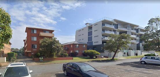
The desired future
character for the area is defined by the adopted building height and FSR
controls and the DCP provisions for the Westport neighbourhood. In the
immediate locality these controls envisage high density residential development
with heights of 5 to 6 storeys. It is also noted that the site to the west has
a maximum 19m height limit.
The proposal is
considered to be sufficiently compatible with the existing and desired
character for the area. The parts of the building exceeding the maximum
building height are not highly visible in the streetscape and would not affect
the overall compatibility of the development with the character of the
locality.
Clause
4.3(1)(b) to minimise visual impact, disruption of views, loss of privacy and
loss of solar access to existing development
Comments: The visual impact of the height variation will not be
significant due to the nature and location of these building elements. The
proposed roof terrace is set back from the building facades and wouldn’t
be visible from street level. The roof terrace would be visible from the upper
floors of some nearby buildings to the south and west, where levels are higher.
The design of the roof form and landscaping would result in an attractive
building element and is not expected to be visually offensive.
View impacts from the
overall proposal are discussed in detail later in this report. It is noted that
the non-compliant parts of the building are generally in the skyline when
viewed from nearby property and therefore would not contribute to any
significant reduction in views compared to a compliant proposal.
Privacy impacts of the
roof terrace have been discussed in the assessment under the DCP and Apartment
Design Guide. Adequate privacy to the residents and neighbouring properties
would be maintained through a combination of building separation and privacy
screens.
Shadow diagrams
submitted with the application demonstrate that the elements of the building
above 17.5m would not result in any increased overshadowing of neighbouring
property between 9.00am and 3.00pm midwinter.
Clause
4.3(1)(c) to minimise the adverse impact of development on heritage
conservation areas and heritage items,
The site does not
contain any known heritage items or sites of significance.
Clause
4.3(1)(d) to nominate heights that will provide a transition in built form and
land use intensity within the area covered by this Plan.
Adjoining land shares
the same R4 High Density Residential zoning and the development does not need
to provide a transition in built form.
The development is
consistent with the zoning and height objectives of the LEP 2011 and is
unlikely to have any implications on State related issues or the broader public
interest.
(b) The
concurrence of the Secretary has been obtained.
Comments: As per
the Planning Circular PS 20-002, Council can assume the Director’s
Concurrence for variations to the height of buildings. In this instance the
extent of the variation is more than 10% and the application is required to be
determined by the Council.
Having regard to the
above requirements it is recommended that the building height variations using
Clause 4.6 be supported.
· Clause
5.10 - The site does not contain or adjoin any known heritage items or sites of
significance.
· Clause
5.21 - The site is land which is considered to be within a “flood
planning area” (refer to NSW Government Floodplain Development Manual
2005). In this regard, the following comments are provided which
incorporate consideration of the objectives of Clause 5.21, Council’s
Flood Policy 2018, the NSW Government’s Considering Flooding in Land
Use Planning Guideline 2021 and the NSW Government’s Floodplain
Development Manual (2005):
o The proposal is sufficiently
compatible with the flood function and behaviour on the land. The site includes
both flood fringe and flood storage areas.
o The proposal will not result in any
significant adverse effects on flood behaviour that would result in detrimental
increases in the potential flood affectation of other development or
properties;
o The proposal will not result in any
adverse effects on the safe occupation and efficient evacuation of people along
existing evacuation routes for the surrounding area;
o The proposal incorporates sufficient
measures to minimise and manage the flood risk to life and property associated
with the use of land. The development provides protection to the driveway
accessing the basement parking for up to the 1:100 flood level. The basement
openings will be protected with automatic flood gates up to the FPL3 level of
3.92m AHD.
o The proposal is not likely to
significantly adversely affect the environment or cause avoidable erosion,
siltation, destruction of riparian vegetation or a reduction in the stability
of river banks or watercourses;
o The proposal is not likely to result
in unsustainable social and economic costs to the community as a consequence of
flooding;
o The proposal will not result in any
identifiable adverse impacts to flood behaviour as a result of projected
climate change. The flood model incorporates an appropriate climate change
allowance.
o The intended design and scale of the
buildings of the proposal is sufficiently compatible with the flooding risk on
the property;
o The development will include the
demolition of two existing dwellings and several outbuildings that are
currently at risk from flooding.
o Appropriate consent conditions are
recommended including recommended minimum finished floor levels having regard
to Council’s Flood Policy.
· Clause
7.1 - Part of the rear of the site is mapped as potentially containing class 3
acid sulfate soils. The proposed development includes excavation for the
parking level and building footings that will be more than 1m below natural
ground level. The application includes an Acid Sulfate Soil Management Plan
prepared by Geotechnical Consultants Australia. The plan has been prepared in
accordance with the Acid Sulfate Soils Manual and includes appropriate
procedures for the testing, storage, treatment, and re-use/disposal of acid sulfate
soils and leachate in groundwater. A condition is recommended requiring the
implementation of the Acid Sulfate Soil Management Plan at the relevant stages
of the development.
· Clause
7.13 - Satisfactory arrangements are in place for provision of essential
services including water supply, electricity supply, sewer infrastructure,
stormwater drainage and suitable road access to service the development.
Provision of electricity will be subject to obtaining satisfactory arrangements
certification as recommended by a condition of consent.
(ii) Any draft
instruments that apply to the site or are on exhibition
No draft instruments apply to
the site.
(iii) Any Development
Control Plan in force
Port
Macquarie-Hastings Development Control Plan 2013
|
DCP 2013: Part B - General
Provisions - B2: Environmental Management
|
|
DCP Objective
|
Development Provisions
|
Proposed
|
Complies
|
|
3
|
a) Development must comply with
Council’s Developments, Public Place & Events - Waste Minimisation
and Management Policy.
|
A Waste Management Plan has been
submitted, which addresses demolition, construction, and operational waste
management. The design includes a waste storage room in the basement suitable
to accommodate 3 x 1100L general waste bins, 3 x 1100L recycling bins,
and 10 x 240L organics bins. The development
includes more than 6 dwellings and will require a private waste collection
service. A conditions is recommended confirming this requirement.
|
Yes
|
|
Cut and Fill Regrading
|
|
4
|
a) Development shall not exceed
a maximum cut of 1.0m and fill of 1.0m measured vertically above the ground
level (existing) at a distance of 1.0m outside the perimeter of the external
walls of the building (This does not apply to buildings where such cut and
fill is fully retained within or by the external walls of the building).
|
Less than 1m of cut and fill
proposed outside the building footprint.
|
Yes
|
|
Tree Management –
Private Land
|
|
11
|
c) Where a tree listed in Table
1 is approved for removal it must be compensated with 2 x koala habitat
trees. Significant large-scale development will require an advanced size
koala food tree or habitat tree (primary Koala browse species) that meets
AS2303:2015 Tree Stock for Landscape Use. The compensation tree is to be
planted in a suitable location as determined by the Director of Development
and Environment or their delegate.
|
The proposal includes removal of
existing garden trees and shrubs including a mango tree, 2 fig trees, and a
group of bottlebrushes. None of the species are listed in Table 1 and compensatory
plantings are not required.
|
Yes
|
|
DCP 2013: Part B - General
Provision - B3: Hazards Management
|
|
DCP Objective
|
Development Provisions
|
Proposed
|
Complies
|
|
Flooding
|
|
19
|
a) Development must comply with
Council’s Floodplain Management Plan and Flood Policies.
|
The following flood planning
information is relevant to the site:
· FPL1 - 2.27m AHD;
· 1%AEP - 2.61m AHD;
· FPL2 - 3.42m AHD;
· FPL3 - 3.92m AHD;
· FPL4 - 5.83m AHD;
· 100 year velocity - 0.09m/s;
· 100 year hydraulic categories - Flood Fringe and Flood
Storage;
· 100 year flood hazard - Low.
The proposal includes
residential development and a basement parking level. The Flood Policy
requires all habitable areas to be at or above FPL3, and the basement parking
to be at a minimum level of 1.2m AHD, with the access ramps and all entry
points at or above FPL2.
The lowest habitable level of
the building is proposed to be at 4.3m AHD, which exceeds the minimum
required level of 3.92m AHD.
The basement parking has a
finished floor level of 1.2m AHD, but the access ramp is at 2.58m AHD, which
is below the FPL2 level of 3.42m AHD. In this instance it is not possible to
achieve an access ramp at FPL2 as the existing road level in Waugh Street is
too low. The Applicant has proposed secondary protection to the openings with
an automatic flood gate to the vehicular entry and flood doors to the three
fire exits.
The building has been amended
through the assessment process to move the vehicle entry to the western end
of the building, where the existing road levels are the highest. The vehicle
ramp is proposed to be at 2.58m AHD, which is only 3mm below the modelled 1%
AEP flood level for the area. This will reduce the number of occasions that
the building relies upon the flood protection systems to the greatest extent
possible. The development only relies upon the flood gate system in extreme
flood events.
A Flood Risk Management Plan has
been submitted with the application in accordance with the Flood Policy
requirements, and demonstrates that flood risks are capable of being managed.
To mitigate against the
increased risk of construction in a flood zone, a condition has been
recommended requiring all new works below FPL3 to be constructed of flood
durable materials.
|
Yes
|
|
DCP 2013: Part B- General Provisions-
B4: Transport, Traffic Management, Access and Car Parking
|
|
DCP Objective
|
Development Provisions
|
Proposed
|
Complies
|
|
Road Hierarchy
|
|
23
|
a) New direct accesses from a
development to arterial and distributor roads is not permitted. Routes should
differ in alignment and design standard according to the volume and type of
traffic they are intended to carry, the desirable traffic speed, and other
factors.
|
No new access to arterial or
distributor roads proposed.
|
Yes
|
|
b) Existing direct accesses from
a development to arterial and distributor roads are rationalised or removed
where practical.
|
N/A
|
N/A
|
|
c) Vehicle driveway crossings
are minimal in number and width (while being adequate for the nature of the
development), and positioned:
− to avoid driveways near intersections and road bends, and
− to minimise streetscapes dominated by driveways and
garage doors, and
− to maximise on-street parking.
|
One driveway crossover of
appropriate width proposed. The development would remove the existing
crossovers to 9 and 11 Waugh Street and result in an increase in street
parking.
|
Yes
|
|
Parking Provision
|
|
24
|
a) Off-street Parking is
provided in accordance with Table 3.
1 parking space per each 1 or 2
bedroom unit, 1.5 spaces per each 3 or 4 bedroom unit + 1 visitor’s
space per 4 units.
|
See parking assessment earlier
under Apartment Design Guide. The proposal can use the parking rates in the Guide
to Traffic Generating Developments instead of the DCP.
|
Yes
|
|
b) Where a proposed development
does not fall within any of the listed definitions, the provision of on-site
parking shall be supported by a parking demand study.
|
N/A
|
N/A
|
|
c) Where a proposed development
falls within more than one category Council will require the total parking
provision for each category.
|
N/A
|
N/A
|
|
Parking Layout
|
|
28
|
a) Visitor and customer parking
shall be located so that it is easily accessible from the street.
|
Visitor parking located in the
basement parking close to the access point.
|
Yes
|
|
b) Internal signage (including
pavement markings) should assist customers and visitors to find parking and
circulate efficiently and safely through a car park.
|
Capable of complying. Plans show
conceptual pavement markings.
|
Yes
|
|
c) Parking spaces shall
generally be behind the building line but may be located between the building
line and the street when:
− it is stacked parking in the driveway; or
− it can be demonstrated that improvements to the open
space provided will result; and
− the spaces are screened (densely landscaped or similar)
from the street by a landscaping with a minimum width of 3.0m for the entire
length of the parking area.
|
Parking located behind building
line.
|
Yes
|
|
d) Parking design and layout is
provided in accordance with AS/NZS 2890.1 - Parking facilities - Off-street
car parking and AS 2890.6 - Off-street parking for individuals with a
disability and AS/NZS 2890.2 - Parking facilities - Off-street commercial
vehicle facilities.
|
Capable of complying. Conditions
recommended requiring certification of design and completed parking area.
|
Yes
|
|
e) Stack or tandem parking
spaces will not be included in assessment of parking provision
except where:
− the spaces are surplus to that required;
− in motor showrooms;
− for home business;
− for exhibition homes;
− in car repair stations;
− staff parking spaces are separately identified and
delineated;
− it is visitor parking associated with a dual occupancy
multi dwelling and/or terrace housing, directly in front of the garage with a
minimum depth of 5.5m.
|
No stack or tandem parking
proposed.
|
Yes
|
|
29
|
a) Parking is provided in
accordance with AS/NZS 2890.1 - Parking facilities - Off-street car parking,
AS/NZS 2890.2 - Parking facilities - Off-street commercial vehicle
facilities, AS 1428 - Design for access and mobility and AS 2890.6 -
Off-street parking for individuals with a disability.
|
Capable of complying. Conditions
recommended requiring certification of design and completed parking area.
|
Yes
|
|
30
|
a) Bicycle and motorcycle
parking shall be considered for all developments.
|
Proposal includes 2 motorcycle
spaces and 6 bicycle spaces. Dimensions of spaces comply.
|
Yes
|
|
b) Bicycle parking areas shall
be designed generally in accordance with the principles of AS2890.3 - Parking
facilities - Bicycle parking facilities.
|
|
c) Motorcycle parking areas
shall be 1.2m (wide) x 2.5m (long).
|
|
Surface Finishes
|
|
35
|
a) All parking and manoeuvring
areas shall be constructed with a coarse base of sufficient depth to suit the
amount of traffic generated by the development, as determined by Council. It
shall be sealed with either bitumen, asphaltic concrete, concrete or
interlocking pavers.
Preliminary details of
construction materials for access and car parking areas shall be submitted
with the development application. Detailed plans shall be prepared for the
construction certificate by a practising qualified Civil Engineer.
|
Concrete surface proposed.
|
Yes
|
|
b) In special cases (e.g. where
traffic volumes are very low) Council may consider the use of consolidated
unsealed gravel pavement for car parks. However, this should not be assumed
and will need to be justified by the applicant at the Development Application
stage.
|
N/A
|
N/A
|
|
Drainage
|
|
36
|
a) All parking and manoeuvring
spaces must be designed to avoid concentrations of water runoff on the
surface.
|
The parking is located in an
enclosed area within the building and will not create any additional
impervious area that requires drainage.
|
N/A
|
|
b) Council will not permit the
discharge of stormwater directly into kerbing and guttering or table drains
for any development other than that of a minor nature.
|
|
37
|
a) Car parking areas should be
drained to swales, bio retention, rain gardens and infiltration areas.
|
|
|
|
|
|
|
DCP 2013: Part B - General
Provisions - B5: Social Impact Assessment and Crime Prevention
|
|
DCP Objective
|
Development Provisions
|
Proposed
|
Complies
|
|
Crime Prevention
|
|
43
|
a) The development addresses the
generic principles of crime prevention:
- Casual surveillance and sightlines;
- Land use mix and activity generators;
- Definition of use and ownership;
- Basic exterior building design;
- Lighting;
- Way-finding; and
- Predictable routes and entrapment locations;
- as described in the Crime Prevention Through
Environmental Design (CPTED) principles.
|
The proposed development will be unlikely to create any
concealment/entrapment areas or crime spots that would result in any
identifiable loss of safety or reduction of security in the immediate
area. Adequate casual surveillance is available.
|
Yes
|
|
DCP 2013: PART C - Development Specific Provisions -
C2: Residential Flat Development, Tourist and Visitor Accommodation, and
Mixed Use Development
|
|
DCP Objective
|
Development Provisions
|
Proposed
|
Complies
|
|
Site Design and Analysis
|
|
57
|
a) A site analysis plan is required for all development
and should illustrate:
- microclimate including
the movement of the sun and prevailing winds
- lot dimensions
- north point
- existing contours and
levels to AHD
- flood affected areas
- overland flow patterns,
drainage and services
- any contaminated soils
or filled areas, or areas of unstable land
- easements and/or
connections for drainage and utility services
- any existing trees and
other significant vegetation, including major and significant trees on
adjacent properties, particularly those within 9 m of the site
- the location, height
and use of buildings surrounding the site, and those across any road adjacent
to the site, including their setback distances
- heritage and
archaeological features
- the built form, scale
and character of surrounding and nearby development, including fencing,
boundaries and landscaping
- pedestrian and vehicle
access
- views and solar access
to surrounding residents
- private open space and
windows of habitable rooms of nearby properties which have an outlook to the
site
- difference in levels
between the site and adjacent properties at their boundaries
- street frontage
features including poles, trees, kerb crossovers, bus stops and other
services
- heritage features and
buildings of the surrounding locality and landscape
- direction and distance
to local facilities including local shops, schools, public transport and
recreation and community facilities
- characteristics of, and
distance to any nearby public open space
- any nearby bushland or
environmentally sensitive land
- any significant local
noise, odour or pollution sources
- any other notable
features or characteristics of the site
|
Adequate site analysis provided.
|
Yes
|
|
Site Layout
|
|
58
|
a) All applications are to include a site plan, which
annotates the manner in which site attributes and constraints have been
considered, as follows:
- appropriateness of
built form and landscape in relation to the site context, topography and
urban character
- building arrangement
and relationship to streets and open space
- access ways within and
beyond the site
- location, function and
opportunities for casual surveillance of open space
- ongoing site management
considerations (i.e. garbage, mail collection, stormwater etc)
- location of existing
and proposed stormwater and sewer pipes
- private open space and
security
- parking arrangements
and reduced dominance of driveways
- heritage and conservation
opportunities and constraints (where relevant)
- energy efficiency in
building design and siting
- solar access to subject
development and adjoining residences
|
Adequate site plan provided.
|
Yes
|
|
Streetscape and Front Setback
|
|
59
|
a) In an established street, the primary setback should be
within 20% of the average setback of the adjoining buildings in a R1 General
Residential zone.
|
Site is not in an R1 zone.
|
N/A
|
|
b) A minimum setback of 3.0m is required from all street
frontages in a R3 Medium Density Residential and R4 High-Density Residential
zone.
|
4.7m front setback to sub-basement and 6m front setback to
apartments, with balconies extending to 3.4m setback.
|
Yes
|
|
c) Where tourist accommodation is proposed a maximum
setback of 9 metres is permitted to allow for a swimming pool within the
front setback.
|
N/A
|
N/A
|
|
60
|
a) Balconies and other building extrusions may encroach up
to 600mm into the required front setback.
|
No encroachment proposed.
|
N/A
|
|
b) Buildings should generally be aligned to the street
boundary.
|
Building is aligned to the street boundary.
|
Yes
|
|
c) Primary openings on all developments are aligned to the
street boundary or to the rear of the site.
|
Primary openings aligned to the street and the rear.
|
Yes
|
|
Side and Rear Setbacks
|
|
61
|
a) The following setbacks apply to all sites, except where
the side boundary is a secondary street frontage:
- Buildings should be set
back a minimum of 1.5m from side boundaries, for a maximum of 75% of the
building depth.
- Windows in side walls
should be set back 3m from side boundaries.
- Where the site is
adjacent to an existing strata-titled building, buildings should be set back
a minimum of 3m from side boundaries.
|
Minimum 3m side setback.
|
Yes
|
|
b) Side walls adjacent to existing strata-titled buildings
should be articulated and modulated to respond to the existing buildings.
|
Design includes appropriate articulation to side walls
above parking level.
|
Yes
|
|
c) A minimum rear setback of 6.0m from the building and
sub basements is required.
|
Minimum 6m rear setback to building. Minor encroachment to
5m for stairs providing access to rear private courtyards considered
acceptable.
|
No, but acceptable
|
|
62
|
a) A party wall development may be required if site
amalgamation is not possible and higher density development is envisaged by
these controls.
|
N/A
|
N/A
|
|
63
|
a) Party wall development can occur only with the
agreement and consent of the adjoining property owner. Exposed party
walls should be finished in a quality comparable to front facade finishes
|
N/A
|
N/A
|
|
64
|
a) Corner sites should be consolidated with adjacent
sites, so that the building turns the corner.
|
N/A
|
N/A
|
|
b) If this is not possible, a minimum setback of 6.0m
should extend to the secondary street.
|
N/A
|
N/A
|
|
65
|
a) Where sites adjacent to open space are to be
developed, the edge of the open space should be defined with a public road
and buildings should address the open space.
|
N/A
|
N/A
|
|
Fences and Walls
|
|
77
|
a) Solid front fences built on or near boundaries should
be:
- setback 1.0m from the
front boundary;
- suitably landscaped to
reduce visual impact, and.
- provide a 3m x 3m splay
for corner sites.
|
No front fence proposed.
|
N/A
|
|
b) Front fences proposed to
be more than 1.2m high should:
- be a
maximum of 1.8m in height, above existing front property boundary level and
either:
o include
landscaped recesses having minimum dimensions of 1.8m long x 900mm deep which
occupy no less than 50% of the total length of the fence, or
o be erected up
to the front boundary for maximum lengths of 6.0m or 50% of the street
frontage, whichever is less; and
o have openings which make it
not less than 25% transparent;
o provide a 3m x 3m splay for
corner sites, and
o provide a 900mm x 900mm
splay for vehicle driveway entrances.
|
N/A
|
N/A
|
|
Acoustic Privacy
|
|
79
|
a) Buildings are designed so that:
- busy noisy areas within
the apartment face the street; and
- quiet areas face the
rear or side of the lot
- bedrooms have line of
sight separation of minimum 3m from parking areas, streets and shared
driveways.
|
Apartment design includes living rooms and bedrooms
fronting the street. Given the southern orientation, it is not desirable to
have all living areas oriented to the street. The design includes solid
balustrades adjacent to the bedroom windows to reduce the impacts of street
noise.
All bedrooms have more than 3m separation from the street,
driveway, and parking areas.
|
No, but acceptable
|
|
b) Openings of adjacent dwellings should be separated by a
distance of at least 6m.
|
Compliant separation provided.
|
Yes
|
|
80
|
a) Uses are to be coupled internally and between
apartments i.e. noisy internal and noisy external spaces should be placed
together.
|
Uses appropriately grouped internally.
|
Yes
|
|
Accessibility
|
|
82
|
a) Developments should be designed in accordance with
Australian Standard AS1428.
|
Capable of complying.
|
Yes
|
|
83
|
a) Barrier free access to at least 20% of dwellings in the
development is provided.
|
Barrier-free access provided to all apartments.
|
Yes
|
|
Social Dimensions and Housing Affordability
|
|
84
|
a) Developments should be located close to areas of open
space, recreation and entertainment facilities and employment areas.
|
The site is located on the fringe of the town centre with
good access to public open space along the Hastings River and Kooloonbung
Creek foreshore.
|
Yes
|
|
b) Where the Local Environmental Plan permits a floor
space ratio greater than 1:1 a ratio of not less than 1:1 should be achieved.
|
Proposal achieves an FSR of 1.8:1
|
Yes
|
|
85
|
a) A variety of apartment types including studio, 1, 2, 3
and 3+ bedroom apartments are provided within the development.
|
Proposal includes a mix of 2 and 3 bedroom apartments.
|
Yes
|
|
b) Studios and 1-bedroom apartments are not to exceed 20%
of the total number of apartments within the development.
|
No studio or 1 bedroom apartments proposed.
|
Yes
|
|
c) A mix of 1 and 3 bedroom apartments are provided on the
ground level to cater for improved accessibility for disabled, elderly people
or families with children.
|
Ground floor includes all 2 bedroom apartments. The podium
design makes this level less accessible for families and the elderly. The
larger 3 bedroom apartments are located on the upper floors with increased
balcony sizes and access to the roof terrace.
|
No, but acceptable
|
|
Roof Form
|
|
87
|
a) Lift over-runs and service plants should be integrated
within roof structures.
|
Lift over-runs integrated into roof terrace design.
|
Yes
|
|
b) Outdoor recreation areas on flat roofs should be
landscaped and incorporate shade structures and wind screens to encourage
use.
|
Appropriate landscaping, shelter and screens proposed on
roof terrace.
|
Yes
|
|
c) Outdoor roof areas should be oriented to the street.
|
Roof terrace utilises the whole roof and includes sections
that are oriented to the street.
|
Yes
|
|
d) Roof design should generate an interesting skyline and
be visually interesting when viewed from adjoining developments.
|
Roof design will add interest.
|
Yes
|
|
Facade Composition and Articulation
|
|
88
|
a) Facade composition should:
- be designed with a
balance of horizontal and vertical elements;
- respond to
environmental and energy needs, such as sun shading, light shelves and bay
windows;
- incorporate wind
mitigation;
- reflect the uses within
the buildings.
- include a combination
of the following design elements:
o defined base, middle and top
levels;
o a mixture of window types;
o variation in floor height
(particularly at lower levels);
o balustrade detail that
reflects the type and location of the balcony;
o setting back the top levels
of the building;
o street level features that
reinforce the human scale; and
o balconies, awnings and
recesses that create shadowing.
|
Appropriate façade composition proposed.
|
Yes
|
|
Laundries and Clothes Drying Facilities
|
|
92
|
a) Secure open air clothes drying facilities that:
- are easily accessible;
- are screened from the
public domain and communal open spaces; and
- have a high degree of
solar access.
|
No shared clothes drying area proposed. Balconies are
capable of accommodating open air clothes drying facilities.
|
Yes
|
|
Mailboxes
|
|
93
|
a) Mailboxes should be integrated into building design and
sighted to ensure accessibility and security.
|
Mail boxes located adjacent to the main building entry.
|
Yes
|
|
Safety and Security
|
|
94
|
a) Developments should establish a hierarchy of space and
clearly define the transition from public through to private space.
|
Public and private spaces clearly defined by the podium
and landscaping at the front of the site. Rear private courtyards will be
defined by fencing. The roof terrace includes fencing/screening between the
private areas associated with the Level 5 apartments and the communal space.
|
Yes
|
|
b) Entrances should:
- be orientated towards
the public street and encourage visibility between entrances, foyers and the
street.
- provide direct and
well-lit access between car parks and dwellings, between car parks and lift
lobbies, and to all unit entrances.
- optimise security by
grouping clusters to a maximum of eight, around a common lobby.
|
Main entrance is oriented to the street and clearly
visible.
|
Yes
|
|
c) Surveillance is to be facilitated by:
- views over public open
spaces from living areas where possible.
- casual views of common
internal areas, such as lobbies and foyers, hallways, recreation areas, and
car parks.
- the provisions of
windows and balconies.
- separate entries to
ground level apartments
|
Balconies and windows will provide passive surveillance of
the street and building entry.
|
Yes
|
|
d) Concealment should be avoided by:
- preventing blind or
dark alcoves which might conceal intruders particularly near lifts and
stairwells, at the entrance and within indoor car parks, along corridors and
walkways.
- providing appropriate
levels of illumination for all common areas.
- providing graded car
park illumination, with the lighting of entrances higher than the minimum
acceptable standard.
|
Design of common areas does not provide any blind spots or
alcoves that would provide concealment opportunities. Common areas and
parking will be appropriately lit.
|
Yes
|
|
e) Access to all parts of the building (including,
apartments, different floors, balconies, common areas) is to be controlled.
|
Access to the building will be controlled.
|
Yes
|
|
Utilities
|
|
96
|
a) Compatible public utility services are to be
co-ordinated in common trenching in order to minimise excavations for
underground services.
|
Capable of complying.
|
Yes
|
|
b) Above ground utility infrastructure such as
substations, inspection cabinets are to be integrated into the design of the
building or complementary to the building design in terms of colour,
materials and design.
|
Hydrant boosters identified on plans and integrated into
front landscaped area.
|
Yes
|
|
c) The site and the individual dwellings are to be
numbered for easy identification by visitors and emergency personnel.
|
Capable of complying.
|
Yes
|
|
d) Common aerials and satellite dishes, with signal
amplifiers are provided as appropriate.
|
Capable of complying.
|
Yes
|
|
DCP 2013: Part D - Locality Specific Provisions -
D1.3 Westport Neighbourhood
|
|
DCP Objective
|
Development Provisions
|
Proposed
|
Complies
|
|
|
New Streets and Laneways
|
|
201
|
a) New laneways, park edge streets and through site
pedestrian links are to be provided as shown in Figure 54.
|
No laneways or park edge streets applicable to the subject
site.
|
N/A
|
|
|
b) New laneways are to be a minimum 8 metre reserve width
for two way traffic with a 1.5 metre wide planting zone along the residential
interface.
|
N/A
|
N/A
|
|
|
c) New laneways are to be a minimum 6 metres reserve width
for one way traffic and include a 1.5 metre wide planting zone along one
side.
|
N/A
|
N/A
|
|
|
d) New park edge streets are to be a minimum 12 metres
reserve width with a footpath along the northern side and parallel parking
bays along the park edge.
|
N/A
|
N/A
|
|
|
e) New pedestrian through-site links are to be a minimum 2
metres wide.
|
N/A
|
N/A
|
|
|
f) Lighting, paving, street furniture and street tree
planting are to be provided in accordance with Council specification.
|
N/A
|
N/A
|
|
|
Lot Size and Frontage
|
|
202
|
a) A minimum lot frontage of 24 metres at the property
line is required for residential flat development.
|
42.67m frontage.
|
Yes
|
|
|
b) On sites with multiple street frontages, a reduced
frontage of 18 metres may be appropriate,
|
N/A
|
N/A
|
|
|
c) Where it is demonstrated that adequate on-site parking,
setbacks, separation and deep soil can be achieved.
|
N/A
|
N/A
|
|
|
Building Height
|
|
203
|
General
|
|
|
a) Buildings do not exceed the maximum height of buildings
shown in the local environmental plan maps.
|
Building exceeds height specified in LEP. See comments under
Clause 4.6 of the LEP earlier in this report.
|
No
|
|
|
b) Setbacks and building alignments are to be consistent
with those shown in Figure 55.
|
Building includes upper floor setback for Level 4 and 5.
|
Yes
|
|
|
Bridge Street south-west of Gore Street
|
|
|
c) Where commercial uses are proposed for ground and first
floor, a 2 storey wall height is to be built to the front boundary with
residential floors above, setback 3 metres.
|
N/A
|
N/A
|
|
|
d) The floor level of the upper-most storey is to be at
least 4.5 metres below the maximum permissible building height in metres.
|
N/A
|
N/A
|
|
|
Gore Street, Bridge Street and William Street
|
|
|
e) Ceiling heights for ground and first levels are to be a
minimum of 3.3 metres to promote flexibility in use over time.
|
N/A
|
N/A
|
|
|
Streetscape and Front Setbacks
|
|
204
|
a) Setbacks and building alignments are to be consistent
with those shown in Figure 55 and Figure 56.
|
Building includes upper floor setback for Level 4 and 5.
|
Yes
|
|
|
b) Where no setback is shown, buildings are to be setback
3 metres from the street.
|
3.4m to balconies.
|
Yes
|
|
|
Side and Rear Setback
|
|
205
|
a) Buildings are setback:
- 3 metres from side
boundaries, and
- 6 metres from the rear
boundary.
|
Minimum 3m side setback.
Minimum 6m rear setback to building and sub-basement.
Minor encroachment to 5m for stairs providing access to rear private
courtyards considered acceptable.
|
No, but acceptable
|
|
|
b) South of Gordon Street, where existing residential uses
are located to the rear, the rear setback is 10 metres (see Figure 58).
|
N/A
|
N/A
|
|
|
c) Party wall development is not appropriate in the
precinct.
|
No party walls proposed.
|
Yes
|
|
|
Kooloonbung Creek
|
|
206
|
a) Where possible, buildings are to address Kooloonbung
Creek pedestrian/cycle way with secondary building entries and individual
entries to ground floor units.
|
N/A
|
N/A
|
|
|
b) Where topography and flood management limit the ability
for units to engage with the pathway, upper level balconies and communal open
space are to overlook and contribute to the surveillance of the creek
corridor.
|
N/A
|
N/A
|
|
|
Building Separation
|
|
207
|
a) Side and rear walls are to be articulated to achieve
privacy separation with balconies and windows of adjacent buildings.
Separation distances are to be measured from the boundary as:
- Up to 4 storeys/12
metres - 6 metres for habitable rooms and balconies, 3 metres for
non-habitable rooms
- Between 5 and 8
storeys/up to 25 metres - 9 metres for habitable rooms and balconies, 4.5
metres for non-habitable rooms.
|
Some habitable room windows and balconies on Level 4 &
5 of the building have an 8.7m side setback. This minor reduction is
considered acceptable given the relationship to neighbouring properties.
|
No, but acceptable
|
|
|
b) Where an existing strata-titled building adjacent to
the proposed development site does not provide adequate separation, privacy
screens or louvers are to augment the above separation distances.
|
N/A
|
N/A
|
|
|
Communal Open Space
|
|
208
|
a) Communal open space is to be at least 25 per cent of
the site area.
|
Proposal includes 693m2 of communal open space
located at ground level and on the roof top. This equates to 32% of the site
area.
|
Yes
|
|
|
b) Where it is demonstrated that 25 per cent is not
achievable due to site size constraints, provide a minimum 5 square metres
per dwelling unit as consolidated communal open space.
|
N/A
|
N/A
|
|
|
c) A minimum 2 hours sunlight is provided to the principle
portion of communal open space between 9am and 3pm in mid-winter.
|
Roof top communal open space will receive more than 2
hours direct sunlight.
|
Yes
|
|
|
d) Requirements for communal open space may be reduced
where a development contributes to the enhancement of public open space. In
particular, properties along Gore Street may contribute to the linear park in
lieu of communal open space.
|
N/A
|
N/A
|
|
|
e) Roof top communal open space is to be setback from
building edges and located to minimise overlooking to adjacent properties.
|
The roof top space includes appropriate setbacks,
landscaping and screening to protect the privacy of adjoining properties.
|
Yes
|
|
|
Deep Soil
|
|
209
|
a) Deep soil is to be provided at the following rates:
|
Site area
|
Minimum deep soil zone
(% of site area)
|
|
Less than 650m2
|
7%
|
|
650 to 1 500m2
|
10%
|
|
Greater than 1 500m2
|
15%
|
|
256m2 of deep soil zone with minimum dimension
of 6m, which equates to 12% of the site area.
An additional 360m2 of deep soil zone with
dimension of 3m or greater is provided to the front and sides of the
building. Total deep soil zone is 26% of the site area.
|
Yes
|
|
|
b) The deep soil zone is to have a minimum dimension of 6
metres. On small sites, where it can be demonstrated that 6 metres is
unachievable, a 3 metre minimum may be permitted.
Note: As deep soil is typically located along the rear
boundary, sites likely to be constrained include sites under 30 metres deep,
with lane way access and frontage, or where a new lane way is provided.
|
|
|
c) Deep soil zones are to be consolidated on a site and
where possible, co-located with adjoining deep soil zones.
|
Deep soil zone is consolidated across the rear and sides
of the site and would provide the opportunity for co-location with deep soil
zones on neighbouring property.
|
Yes
|
|
|
d) Up to 10 per cent of a deep soil zone may be paved but
only where paving is specifically designed to allow for tree root growth. For
example, a paving profile of up to 250mm deep or decks with shallow pad
footing.
|
N/A
|
N/A
|
|
|
Fences and Retaining Walls
|
|
210
|
a) Fences within 1 metre of the boundary are to follow the
street alignment with a maximum height of 1.2 metres.
|
No front fencing proposed.
|
N/A
|
|
|
b) On sites where the ground floor level is above the
ground level at the boundary or in flood affected areas, a secondary higher
fence or balustrade may be appropriate setback 1 metre from the boundary and
up to 2 metres high above the boundary level.
|
The proposal has an elevated ground floor due to flooding
constraints. The front of the podium incorporates a solid balustrade to a
height of 2 - 2.6m above street level. This level is not able to be reduced
further as 1.2m AHD is the minimum finished level permitted under the Flood
Policy for the basement parking.
|
No, but acceptable
|
|
|
c) Any fences or retaining walls over 1.2 metres above the
boundary level should be 50 per cent transparent above the 1.2 metre datum.
|
N/A
|
N/A
|
|
|
d) Where the site slopes along the street, fencing should
be incrementally stepped to reduce its height
|
N/A
|
N/A
|
|
Based on the above assessment, the variations proposed to
the provisions of the DCP are considered acceptable and the relevant objectives
have been satisfied. Cumulatively, the variations do not amount to an
adverse impact of a significance that would justify refusal of the application.
(iiia) Any planning agreement that has
been entered into under section 7.4, or any draft planning agreement that a
developer has offered to enter into under section 7.4
No planning agreement has been
offered or entered into relating to the site.
(iv) Any
matters prescribed by the Regulations
Demolition
of buildings AS 2601 - Clause 92
Demolition of the two existing
dwellings and associated outbuildings on the site is capable of compliance with
this Australian Standard and is recommended to be conditioned.
(b) The likely
impacts of that development, including environmental impacts on both the
natural and built environments, social and economic impacts in the locality
Context and Setting
The site has a general southerly street frontage orientation
to Waugh Street.
Adjoining the site to the east and north is a 3 storey
office building. Also adjoining the site to the north is a 3-4 storey
residential flat building. Adjoining the site to the west are three single
storey dwellings. Adjoining the site to the south are three residential flat
buildings of 2, 4, and 5-6 storeys in height.
The proposal is considered to be compatible with other
development in the locality and adequately addresses planning controls for the
area.
View Sharing
The public notification and advertising of the proposal
identified concerns regarding loss of views from the nearby residential flat
building at 14 Waugh Street to the south of the site.
The notion of view sharing is invoked when a property enjoys
existing views and a
proposed development would share that view by taking some of
it away for its own
enjoyment. Taking it all away cannot be called view sharing,
although it may, in some
circumstances, be quite reasonable.
NSW Land and Environment Court case law, in particular the
case Tenacity
Consulting v Warringah 2004 NSW LEC 140, sets an
established ‘planning principle’
to provide an assessment methodology as to what constitutes
view sharing and a
stepped approach to identifying whether reasonable view
sharing is maintained or
achieved. The following four (4) steps are of relevance and
assessment comments
are provided in regards to potential view impacts to the
neighbouring properties.
Step 1 Assessment of views to be affected
Water views are valued more highly than land views.
Iconic views (e.g. of the Opera
House, the Harbour Bridge or North Head) are valued more
highly than views without
icons. Whole views are valued more highly than partial
views, e.g. a water view in which the interface between land and water is
visible is more valuable than one in
which it is obscured.
Comments: Existing views from 14
Waugh Street include the Hastings River north to Settlement Point, Pelican
Island, and distant hinterland views to the west. Part of the water view
includes land and water interface, with the most visible component of the interface
being along Pelican Island.
Photographs of the extent of the existing views from the
upper floor at the western end of the building are included below.
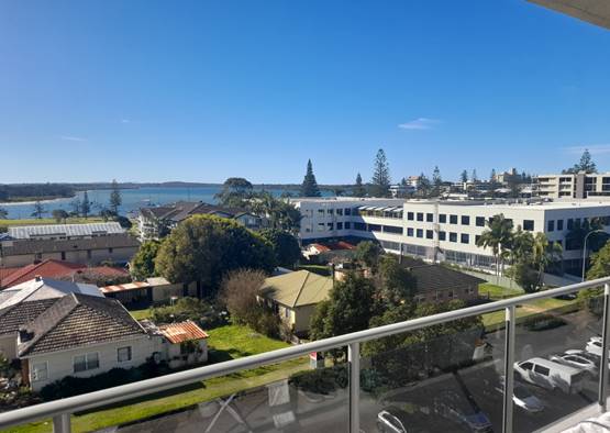
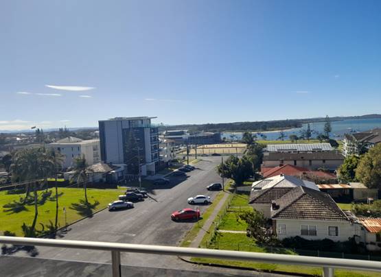
Step 2 Consider from what part of the property the
views are obtained
For example, the protection of views across side
boundaries is more difficult than the
protection of views from front and rear boundaries. In
addition, whether the view is
enjoyed from a standing or sitting position may also be
relevant. Sitting views are
more difficult to protect than standing views. The
expectation to retain side views and
sitting views is often unrealistic.
Comments: The views are obtained from
living areas, kitchens, bedrooms, balconies, and roof terraces. From the upper
two floors of the building, the views are available from both sitting and
standing positions. The views are obtained across the front boundary of the
site.
Step 3 Assess the extent of the impact
This should be done for the whole of the property, not
just for the view that is affected. The impact on views from living areas is
more significant than from bedrooms or service areas (though views from
kitchens are highly valued because people spend so much time in them). The
impact may be assessed quantitatively, but in many cases this can be
meaningless. For example, it is unhelpful to say that the view loss is 20% if
it includes one of the sails of the Opera House. It is usually more useful to
assess the view loss qualitatively as negligible, minor, moderate, severe or
devastating.
Comments: The Applicant has provided an
analysis of the extent of view loss in the architectural plans, and some
extracts are included below:
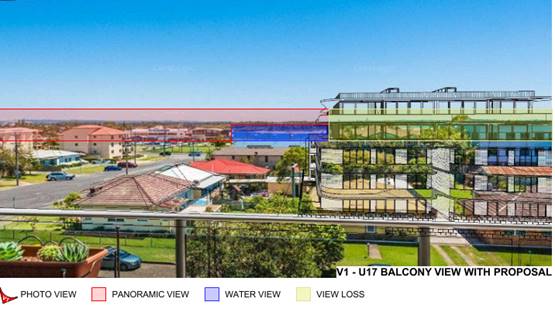
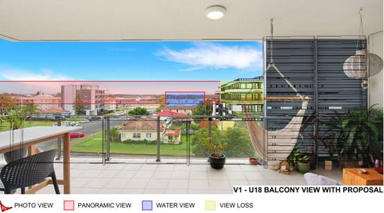
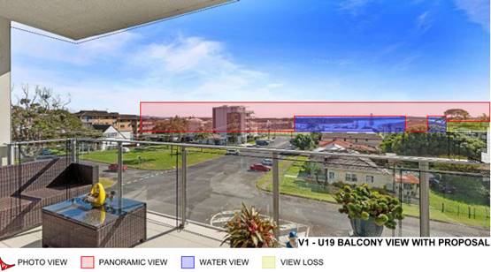
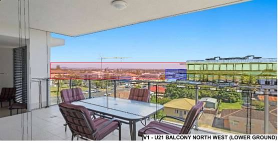
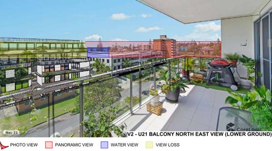
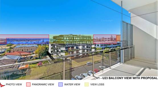
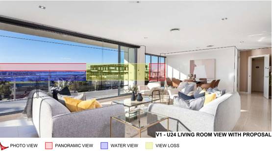
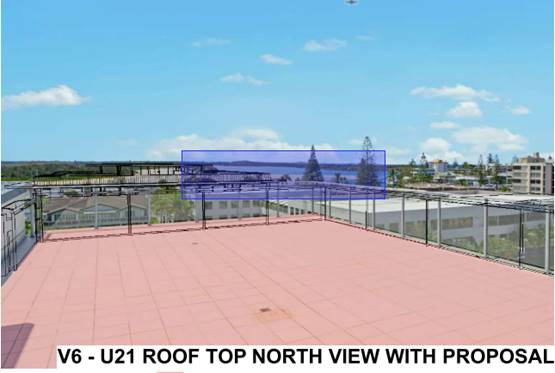
The Applicant’s plans also provide a numerical
analysis of the view loss for each apartment on the top two floors of the
residential flat building at 14 Waugh Street.
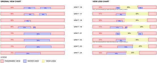
For all apartments assessed, a portion of the existing water
view will be retained. For the majority of apartments, the retained portion of
the view includes the most significant part of the land and water interface
along Pelican Island. Unit 21 at the eastern end of the building is the most
significantly impacted by the proposed development, and would lose the majority
of the land and water interface.
Overall, the view loss is considered to be moderate for
Units 17, 18, 19, 22, 23, and 24. The view loss is considered to be severe for
Units 16 and 21. Unit 16 has not been analysed by the Applicant, but is located
directly below Unit 21, with rooms and views oriented in the same manner. The
impact on Unit 16 would be greater, given that the views are obtained from 3m
lower than Unit 21.
Step 4 Assess the reasonableness of the proposal
that is causing the impact
A development that complies with all planning controls
would be considered more
reasonable than one that breaches them. Where an impact
on views arises as a
result of non-compliance with one or more planning
controls, even a moderate impact
may be considered unreasonable. With a complying
proposal, the question should be
asked whether a more skilful design could provide the
applicant with the same
development potential and amenity and reduce the impact
on the views of
neighbours. If the answer to that question is no, then
the view impact of a complying
development would probably be considered acceptable and
the view sharing
reasonable.
Comments: The proposed development largely
complies with the relevant planning controls for the area. The only
non-compliance of relevance to the consideration of view impacts is the
exceedance of the building height control in Clause 4.3 of the LEP, which is
discussed in detail earlier in this report. The parts of the building above the
height limit would generally be viewed in the skyline and not result in any
additional reduction in views.
The only exception is the views from the roof terrace of 14
Waugh Street, which is located at a higher level. The view analysis indicates
that the parts of the development above the height limit would result in the
loss of views to part of Pelican Island and the Hastings River, including the
land and water interface.
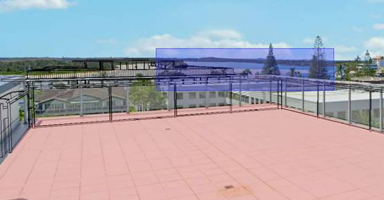
The roof terraces are a secondary area of private open space
for the upper floor apartments, which also have significant balconies at the
same level as the living spaces. A significant water view would still be
retained from the roof terraces.
The building is otherwise compliant with the relevant
setback and floor space ratio controls applicable to the land.
In relation to the proposed design of the building there is
no obvious opportunities for amendments to the design that would achieve the
same development potential and amenity and reduce the impact on the views of
neighbours. The building mass could be shifted towards one of the side
boundaries to improve views from some vantage points, but this would also
reduce views from other locations. Locating the mass of the building centrally
on the site will provide the most equitable view corridors between building as
other properties in the area are redeveloped in the future.
Overall, the proposed development is considered to be
reasonable, and the view sharing acceptable. All apartments in the top two
floors of the neighbouring apartment building would retain at least part of a
water view, with the majority of apartments also retaining the most significant
part of the land and water interface.
Access, Traffic and Transport
The application includes a Traffic & Parking Impact
Assessment prepared by Stanbury Traffic Planning.
The proposed development has been assessed as likely to
generate 0.29 trips per dwelling in the peak hour, in accordance with
TfNSW’s Guide to Traffic Generating Developments. This equates to
10 trips in the peak hour, which is 8 additional trips compared to existing
conditions.
The additional traffic generation is within the capacity of
the existing road network in the area.
Site Frontage and Access
Vehicle access to the site is proposed via a single two-way
driveway to Waugh Street at the western end of the building. Access shall
comply with Council AUSPEC and Australian Standards, and conditions have been
recommended to reflect these requirements.
Two redundant crossovers providing access to the existing
dwellings are required to be removed and the kerb and gutter reinstated.
Due to the type and size of development, additional works
are required to include concrete footpath paving (minimum 1.2m wide) along the
full frontage of the site.
Appropriate conditions are recommended in this regard.
Parking and Manoeuvring
A total of 47 parking spaces (including 3 disabled spaces)
have been provided on-site. Five (5) additional disabled spaces have been
identified on the plans, that are not consistent with AS 2890, and it is
assumed that these spaces are intended to be allocated to the adaptable
apartments. It is noted that the additional disabled spaces are not necessary
to satisfy the minimum requirements of the NCC.
Parking and driveway widths on site can comply with relevant
Australian Standards (AS 2890) and conditions have been recommended to reflect
these requirements.
Due to the type of development, car park circulation is
required to enable vehicles to enter and exit the site in a forward manner.
Site plans show adequate area is available and conditions have been recommended
to reflect these requirements.
Water Supply Connection
Council records indicate that the development site has two
existing 20mm metered water service. Each proposed unit will need to be
separately metered for water. Meters may be either located at the road frontage
or internally with a master meter at the boundary. Internal water meters are to
be located in foyer areas, secure and accessible for meter reading, otherwise a
remote reading display facility shall be provided in an approved central
location that is easily accessible. Details are to be shown on the engineering
plans. All work will need to comply with the requirements of Council’s
adopted AUSPEC Design and Construction Guidelines and Policies.
Final water service sizing will need to be determined by a
hydraulic consultant to suit the relevant components of the development, as
well as fire service and backflow protection requirements in accordance with
AS3500.
Any water fittings located within the proposed driveway,
will need to be relocated at no cost to Council.
Appropriate conditions are recommended in this regard.
Sewer Connection
Council records indicate that the development sites are
connected to sewer via several junctions to the existing sewer main. Due to the
scale of the development and the increased load on sewer infrastructure, it is
necessary to discharge all sewage to a new or existing manhole.
Any abandoned sewer junctions are to be capped off at
Council’s sewer main and Council notified to carry out an inspection
prior to backfilling of this work.
The existing AC sewer main serving No. 10 and 12 Gore Street
will need to be relocated clear of the proposed building and any retained
sections of the main replaced in accordance with Council’s adopted AUSPEC
Design and Construction Specifications.
Footings and/or concrete slabs of buildings adjacent to
sewer lines are to be designed so that no loads are imposed on the
infrastructure.
Appropriate conditions are recommended in this regard.
Stormwater
Stormwater from the proposed development is planned to be
discharged via a piped connection to the kerb inlet pit in the Waugh Street
frontage.
A detailed site stormwater management plan will be required
to be submitted for assessment with the Section 68 application and prior to the
issue of a Construction Certificate. In accordance with Councils AUSPEC
requirements, the following must be incorporated into the stormwater drainage
plan:
a) The
design shall incorporate on-site stormwater detention facilities to limit site
stormwater discharge to pre development flow rates for all storm events up to
and including the 100 year ARI event. Note that pre development discharge shall
be calculated assuming that the site is a ‘greenfield’ development
site as per AUSPEC requirements.
b) The
design shall include water quality controls designed to achieve the targets
specified within AUSPEC D7.
c) The
Stormwater Management Plan must include detail of how subsoil from the proposed
basement will be drained. Pump-out of the subsoil drainage associated with the
basement is not permitted unless it can be demonstrated that groundwater flows
are minimal/ intermittent and subject to direct connection of the site
discharge to Council’s piped drainage system. This option will only be considered
when supported by detailed geotechnical investigation.
d) Where
subsurface waters are permitted to be pumped from the basement, discharge must
be connected directly to Councils piped drainage system No stormwater or
subsoil discharge is permitted to the waterway frontage of the development.
e) A
maintenance plan for the OSD and water quality facilities.
Appropriate conditions are recommended in this regard.
Other Utilities
Telecommunication and electricity services are available to
the site. Evidence of satisfactory arrangements with the relevant utility
authorities for provision to the development and a condition is recommended in
this regard.
Heritage
No known items of Aboriginal or European heritage
significance exist on the property. The site is in an urban context and is
considered to be disturbed land.
Other land resources
The site is within an established urban context and will not
sterilise any significant mineral or agricultural resource.
Water cycle
The proposed development will not have any significant
adverse impacts on water resources and the water cycle.
Soils
The proposed development will not have any significant
adverse impacts on soils in terms of quality, erosion, stability and/or
productivity subject to a standard condition requiring erosion and sediment
controls to be in place prior to and during construction.
Air and microclimate
The construction and/or operations of the proposed
development will not result in any significant adverse impacts on the existing
air quality or result in any pollution. Standard precautionary site management
condition recommended.
Flora and fauna
Construction of the proposed development will not require
any removal/clearing of any native vegetation and therefore does not trigger
the biodiversity offsets scheme. Part 7 of the Biodiversity Conservation
Act 2016 is considered to be satisfied.
Waste
Satisfactory arrangements are in place for proposed storage
and collection of waste and recyclables.
Energy
The proposal includes measures to address energy efficiency
and will be required to comply with the requirements of BASIX. No adverse
impacts anticipated.
Noise and vibration
The construction and/or operations of the proposed
development will not result in any significant adverse impacts on the existing
air quality or result in any pollution. Standard precautionary site management
condition recommended.
Bushfire
The site is not identified as being bushfire prone.
Safety, security and crime prevention
The proposed development will be unlikely to create any
concealment/entrapment areas or crime spots that would result in any
identifiable loss of safety or reduction of security in the immediate area.
Adequate casual surveillance is available.
Social impacts in the locality
Given the nature of the proposed development and its
location the proposal is not considered to have any significant adverse social
impacts.
Economic impact in the locality
The proposal is not considered to have any significant
adverse economic impacts on the locality. A likely positive impact is that the
development will maintain employment in the construction industry, which will
lead to flow impacts such as expenditure in the area.
Site design and internal design
The proposed development design satisfactorily responds to
the site attributes and will fit into the locality.
Construction
Construction impacts are considered capable of being
managed, standard construction and site management conditions have been
recommended.
Given the scale and nature of the work involved in the
construction phase, a condition is also recommended requiring a dilapidation
report for nearby properties.
Cumulative impacts
The proposed
development is not considered to have any significant adverse cumulative
impacts on the natural or built environment or the social and economic
attributes of the locality.
(c) The
suitability of the site for the development
The proposal will fit into the
locality and the site attributes are conducive to the proposed development.
Site constraints have been
adequately addressed and appropriate conditions of consent recommended.
(d) Any
submissions made in accordance with this Act or the Regulations
Five (5) written submissions were received following public exhibition of the
application. Copies of the written submissions have been provided separately to
members of the DAP.
Key
issues raised in the submissions received and comments in response are provided
as follows:
|
Submission
Issue/Summary
|
Planning
Comment/Response
|
|
It is understood that the height limit for the area is 3
storeys and the proposal is for a 5 storey building.
|
The height limit for the site
is 17.5m above existing ground level, which typically equates to 5 storey
development (6 storeys including basement parking).
|
|
Object to any increase in building height above the 17.5m
limit. Even at a compliant height the development would result in a 50%
reduction in views from 24/14 Waugh Street.
|
A detailed view sharing
assessment is provided earlier in this report. The additional height of the
building above 17.5m is viewed in the skyline from the living levels and
balconies of the nearby building at 14 Waugh Street and would not contribute
to any identifiable additional view loss.
|
|
The development will result in a reduction in solar access
to apartments in the neighbouring building at 14 Waugh Street.
|
Shadow diagrams have been
provided in the architectural plans, which demonstrate that the development
would not result in any loss of solar access to 14 Waugh Street between
9.00am and 3.00pm mid-winter.
|
|
The building should be no higher than the Essential Energy
building, or at most 4 storeys.
|
The height controls for the
area permit buildings higher than 4 storeys or the top of the Essential
Energy building.
|
|
Request for dilapidation report for the existing building
at 14-16 Buller Street as a condition of consent.
|
A condition has been
recommended requiring a dilapidation report for all adjoining properties.
|
|
The 3D Model shown in the revised application proves 24/14
Waugh Street will lose at least 80% of views currently enjoyed especially
from the living area balcony, kitchen and dining room and 100% from the
second bedroom.
|
The view analysis identifies an
overall view loss of 20% for the Unit 24 living areas and balcony, which
includes loss of approximately 30% of the existing water view.
The second bedroom has not been
specifically addressed, but the angle of the view from this window would be
similar to the Unit 23 balcony view in the plans. The Unit 23 balcony has
been modelled to lose 22% of the existing view, which includes loss of 40% of
the existing water view.
|
|
The majority of the time residents occupy the living level
of the top floor apartments at 14 Waugh Street and it is preferable to retain
views from this level than have to access the roof terrace to enjoy views.
|
The value of views from the
living levels of the neighbouring apartment building has been considered to
be greater than the roof terrace in the view sharing assessment.
|
|
The construction of a 6 storey flat building will result
in increased pollution in the area and negative impacts on the natural
environment.
|
Appropriate conditions have
been recommended for the management of construction activities to prevent
pollution and amenity impacts in the locality.
The subject site is not
identified as being of high biodiversity value, and no native vegetation is
proposed to be removed for the development.
Adequate waste management
arrangements are proposed for the operational phase of the development.
|
|
The development of the residential flats will disturb the
peacefulness and serenity of the neighbourhood.
|
The subject site is located in
a high density residential area on the fringe of the Port Macquarie town
centre and directly adjoins a substantial office building. The objects of the
zone include provision of high density housing, and the increased activation
of streets.
The proposal is considered to
be compatible with the existing, and desired future, character of the area in
this regard.
|
|
The development will reduce privacy to neighbouring
properties.
|
Privacy impacts have been
considered having regard to the requirements of the Apartment Design Guide
and Council’s DCP. The development provides appropriate separation
distances for habitable room windows and balconies, as well as privacy
screening in some locations.
|
(e) The Public Interest
The proposed development
satisfies the objectives of the relevant planning controls and will not
adversely impact on the wider public interest.
Ecologically Sustainable Development and Precautionary
Principle
Ecologically sustainable development requires the effective
integration of economic and environmental considerations in decision-making
processes.
The four principles of ecologically sustainable development
are:
· the
precautionary principle,
· intergenerational
equity,
· conservation
of biological diversity and ecological integrity,
· improved
valuation, pricing and incentive mechanisms.
The principles of ESD require that a balance needs to be
struck between the man-made development and the need to retain the natural
vegetation. Based on the assessment provided in the report and with recommended
conditions of consent, it is considered an appropriate balance has been struck.
Climate change
The proposal is not considered to be vulnerable to any risks
associated with climate change.
4. DEVELOPMENT
CONTRIBUTIONS APPLICABLE
Section 7.11 Contributions
In assessing s7.11 contributions, Council staff have
reviewed the development in accordance with the Port Macquarie-Hastings Council
Development Contributions Assessment Policy (DCAP) and applicable Contribution
Plans.
The site has been provided contribution credit based on 4
existing lots, 3 of which have areas between 450m2 and 2000m2.
Lot 12A DP 361896 has an area of less than 450m2 and contains a 3
bedroom dwelling.
The proposed development will comprise a residential flat
building containing 26 x 2 bedroom apartments and 8 x 3 bedroom apartments and
contributions have been charged accordingly.
Having considered the above, the proposed development will
increase the demand for public amenities/services as listed under the following
Contribution Plans:
1. Port
Macquarie-Hastings Administration Building Contributions Plan 2007
2. Hastings
S94 Administration Levy Contributions Plan
3. Port
Macquarie-Hastings Open Space Contributions Plan 2018
4. Hastings
S94 Major Roads Contributions Plan
5. Port
Macquarie-Hastings Community Cultural and Emergency Services Contributions Plan
2005
As a result, s7.11 contributions apply and a condition of
consent has been recommended to ensure payment.
Section 7.12 Contributions
The proposed development does not contain any
commercial/industrial component. As a result, s7.12 contributions do not apply.
Section 64 Water and Sewer Contributions
In assessing s64 water and sewer contributions, Council
staff have reviewed the development in accordance with the Port Macquarie-Hastings
Council Development Contributions Assessment Policy (DCAP) and applicable
Development Servicing Plans.
The site has been provided contribution credit based on 4
existing lots, 3 of which have areas between 450m2 and 2000m2.
Lot 12A DP 361896 has an area of less than 450m2 and contains a 3
bedroom dwelling.
The proposed development will comprise a residential flat
building containing 26 x 2 bedroom apartments and 8 x 3 bedroom apartments and
contributions have been charged accordingly.
Having considered the above, the proposed development will
increase the demand on water and sewer services.
As a result, s64 contributions apply and a condition of
consent has been recommended to ensure payment.
Refer to estimate of the applicable development
contributions at the end of this report (Attachment 3).
5. CONCLUSION AND
STATEMENT OF REASON
The application has been assessed in accordance with Section
4.15 of the Environmental Planning and Assessment Act 1979.
Issues raised during assessment and public exhibition of the
application have been considered in the assessment of the application. Where
relevant, conditions have been recommended to manage the impacts attributed to
these issues.
The proposed development does
not raise any significant general public interest issues beyond matters already
addressed in this report. Overall, the proposed development is consistent with
the provisions and objectives of the relevant planning controls and will have
an acceptable impact on the surrounding natural and built environment. Approval
of the application is considered to be in the public interest as it achieves
the LEP objectives for development in the zone. No significant adverse
environmental, social or economic impacts on the locality have been identified.
Accordingly, the proposal is considered to be in the public interest.
|
Attachments
1⇩. Attachment 1 -
Recommended Conditions Attachment 1 -
Recommended Conditions
2⇩. Attachment 2 - Plans Attachment 2 - Plans
3⇩. Attachment 3 -
Contributions Estimate
4⇩. Attachment 4 -
Clause 4.6 Written Request
|
|
ATTACHMENT
|
Development Assessment Panel
17/05/2023
|
|
ATTACHMENT
|
Development Assessment Panel
17/05/2023
|
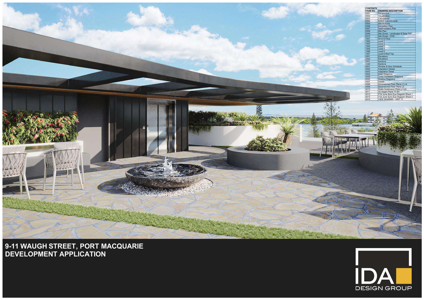
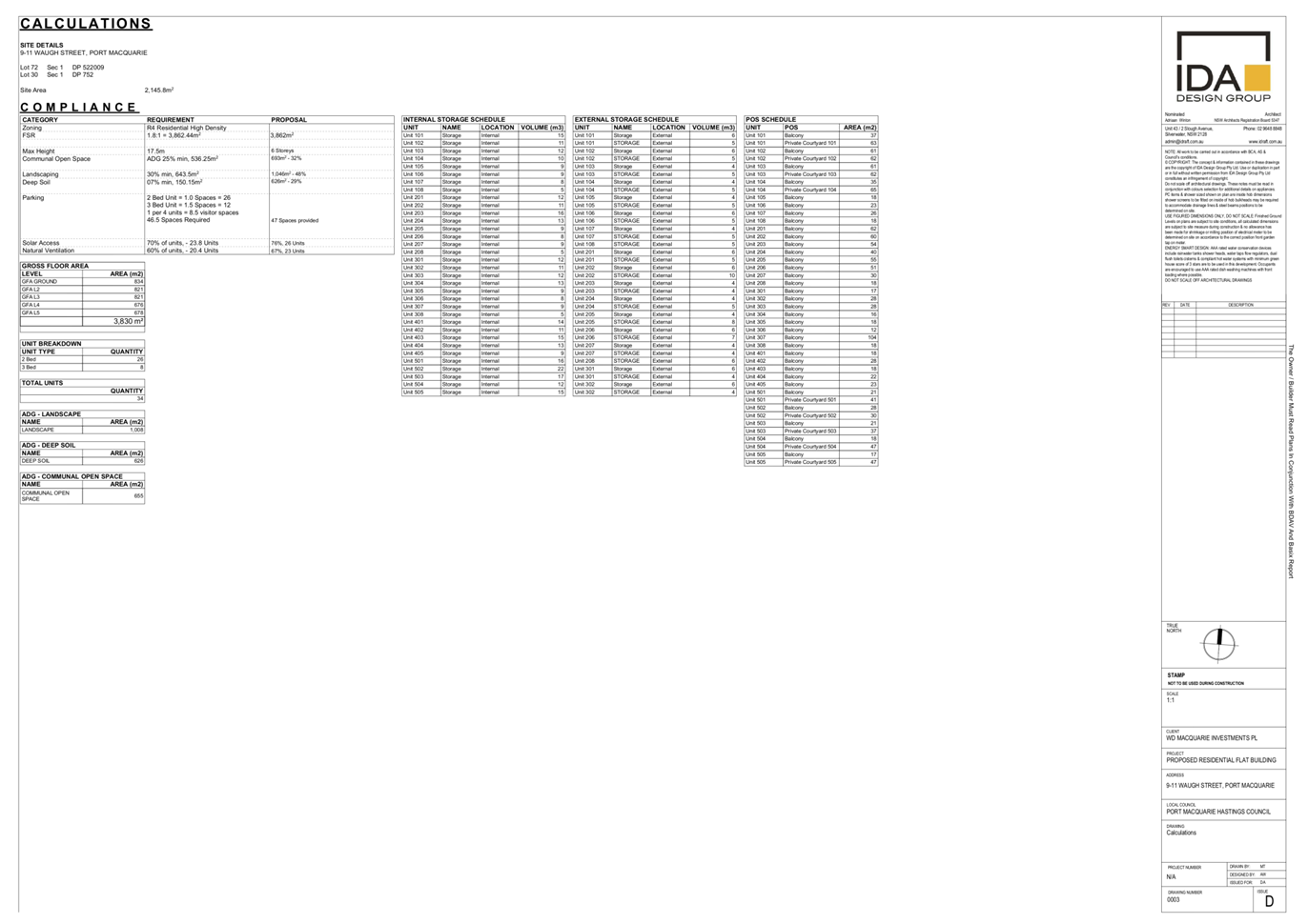
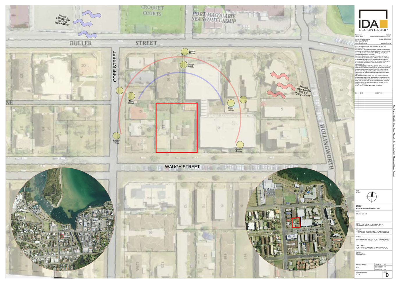
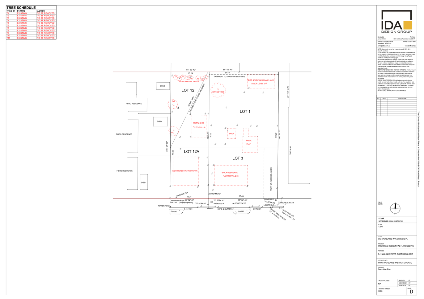
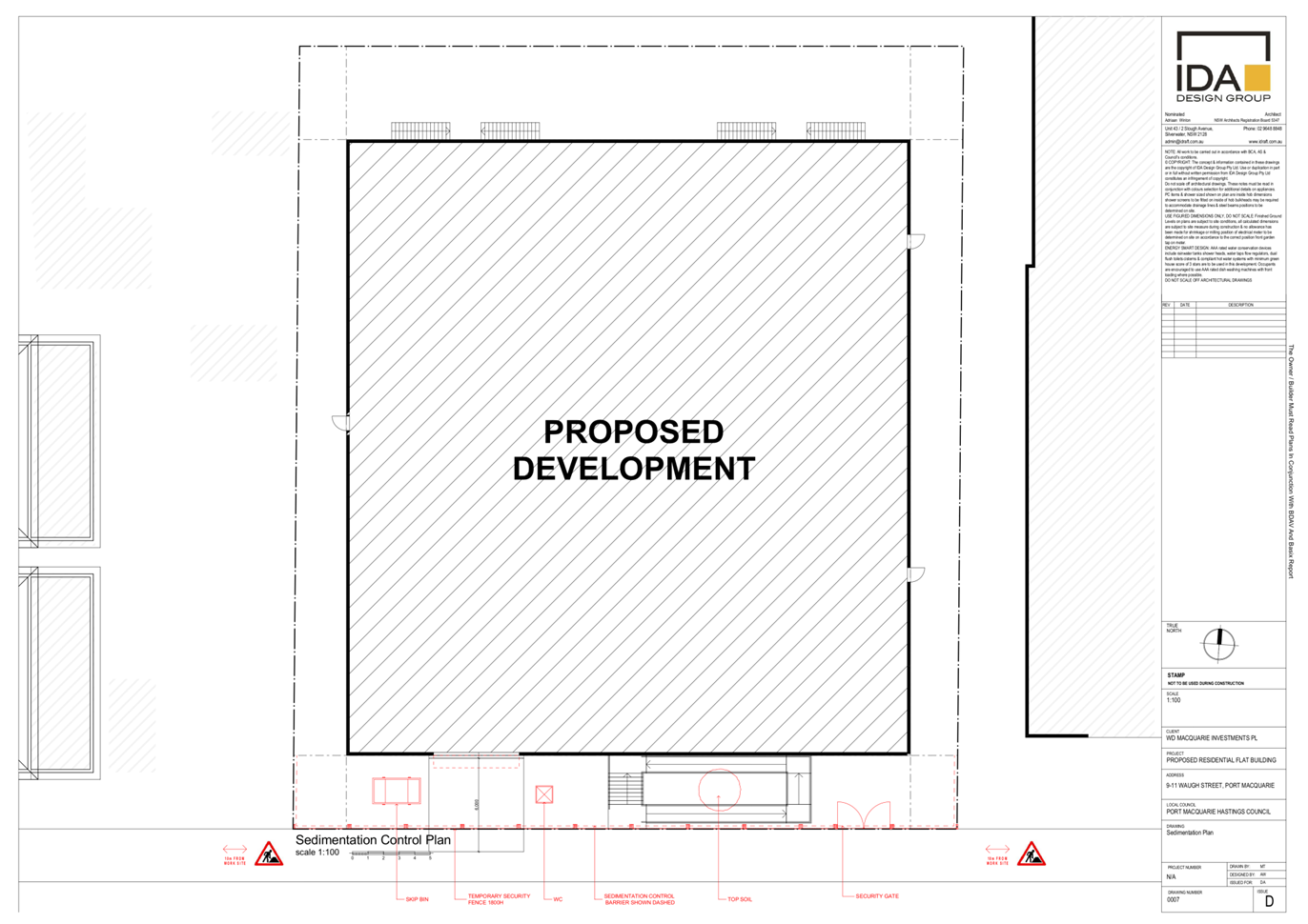
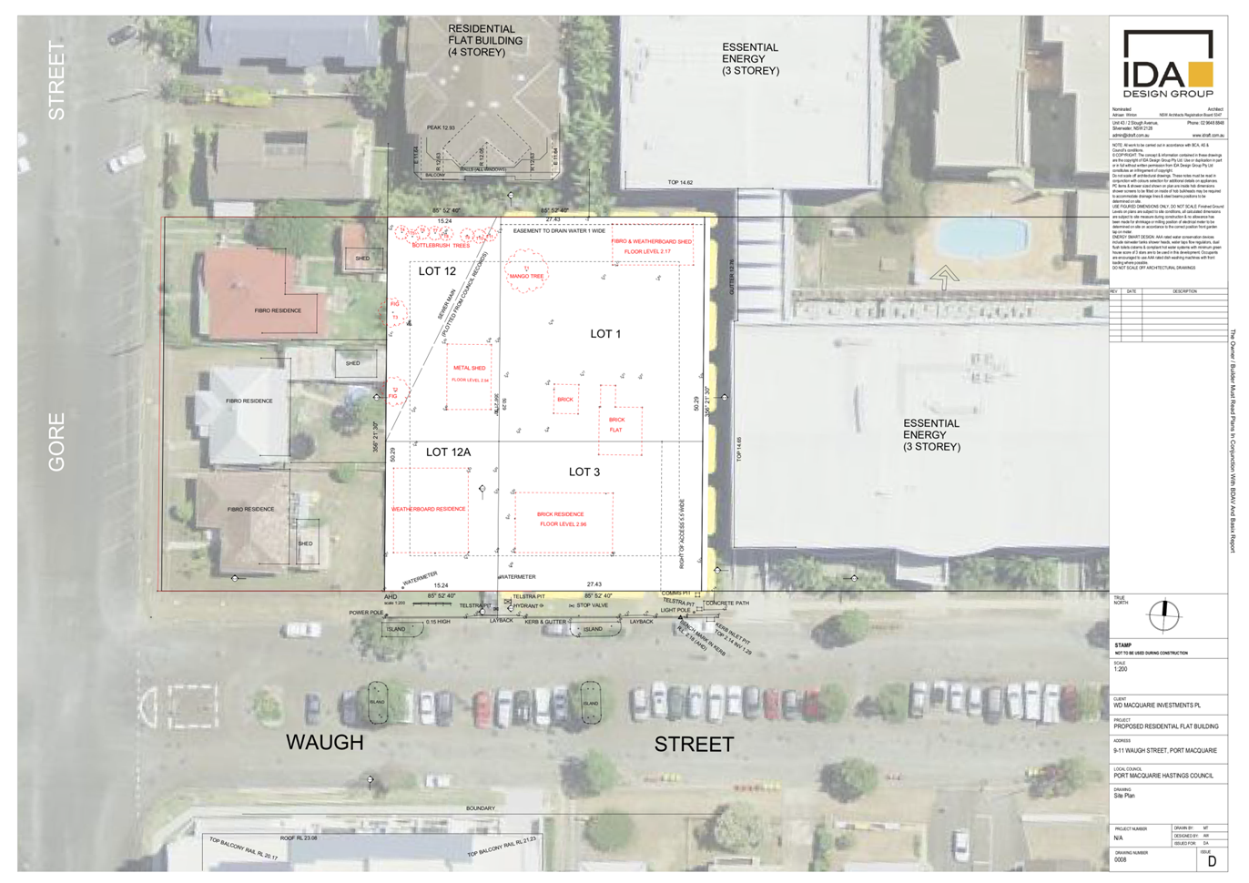
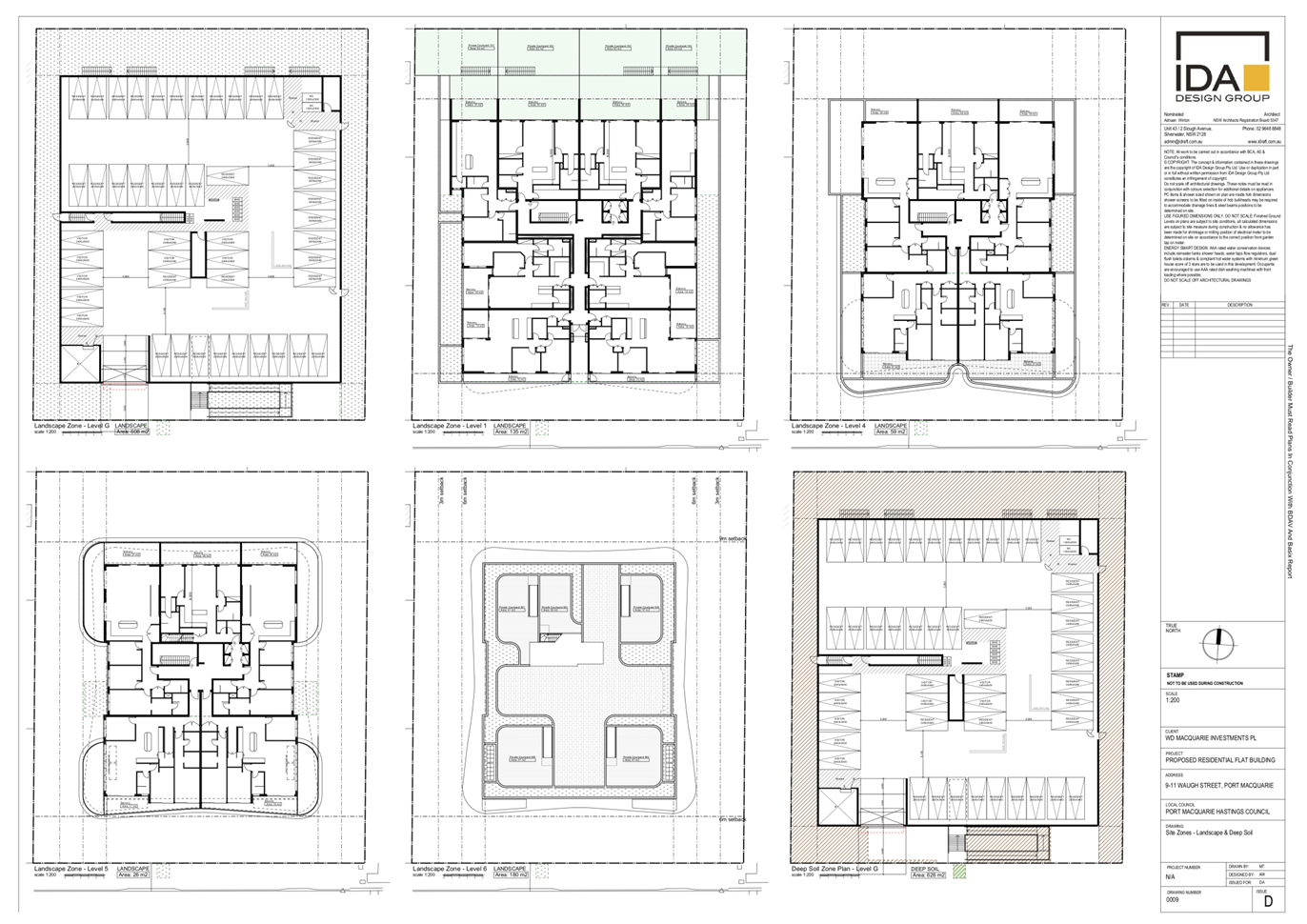
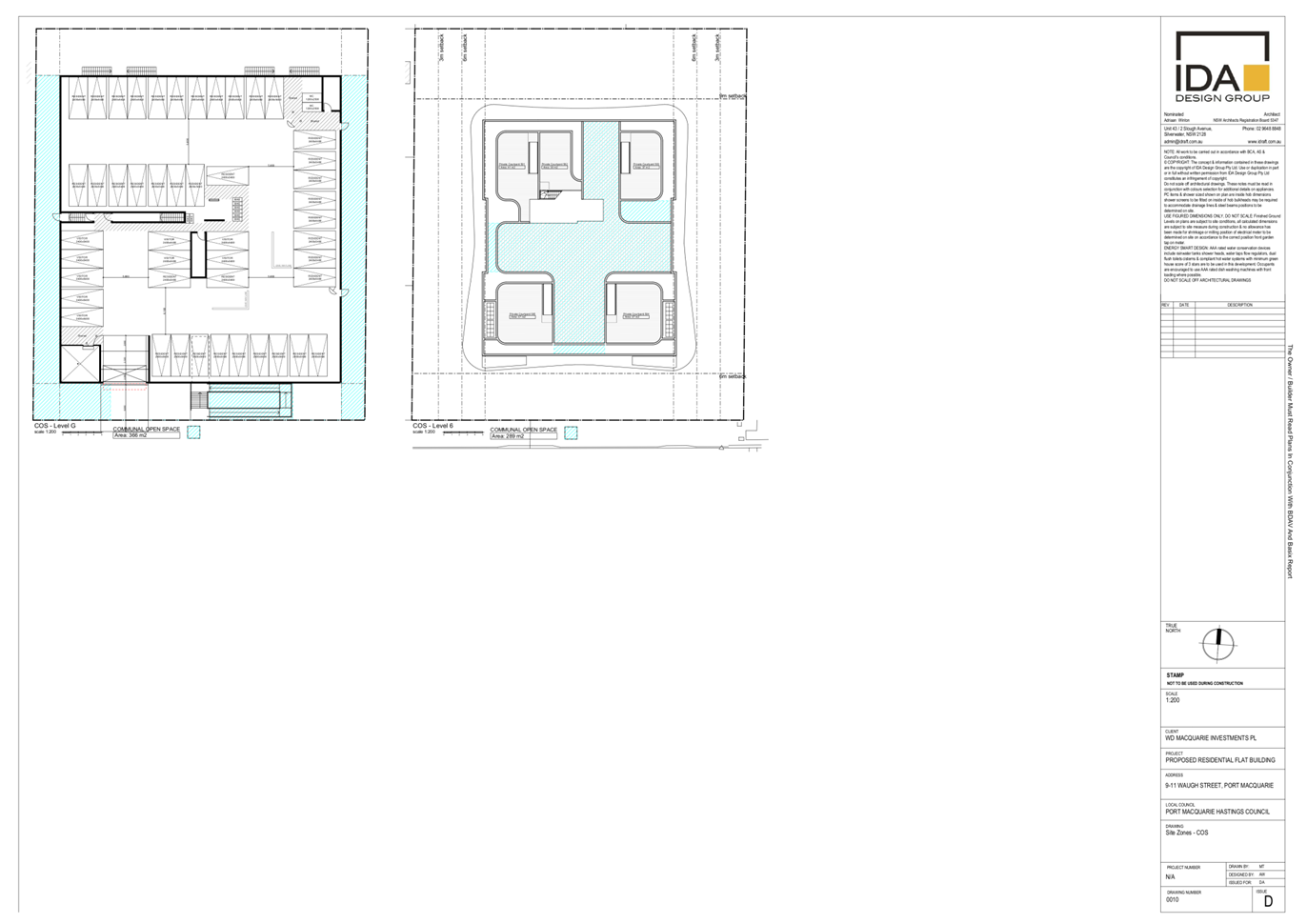
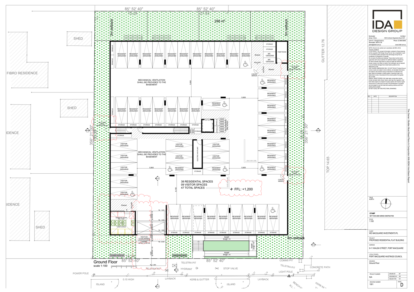
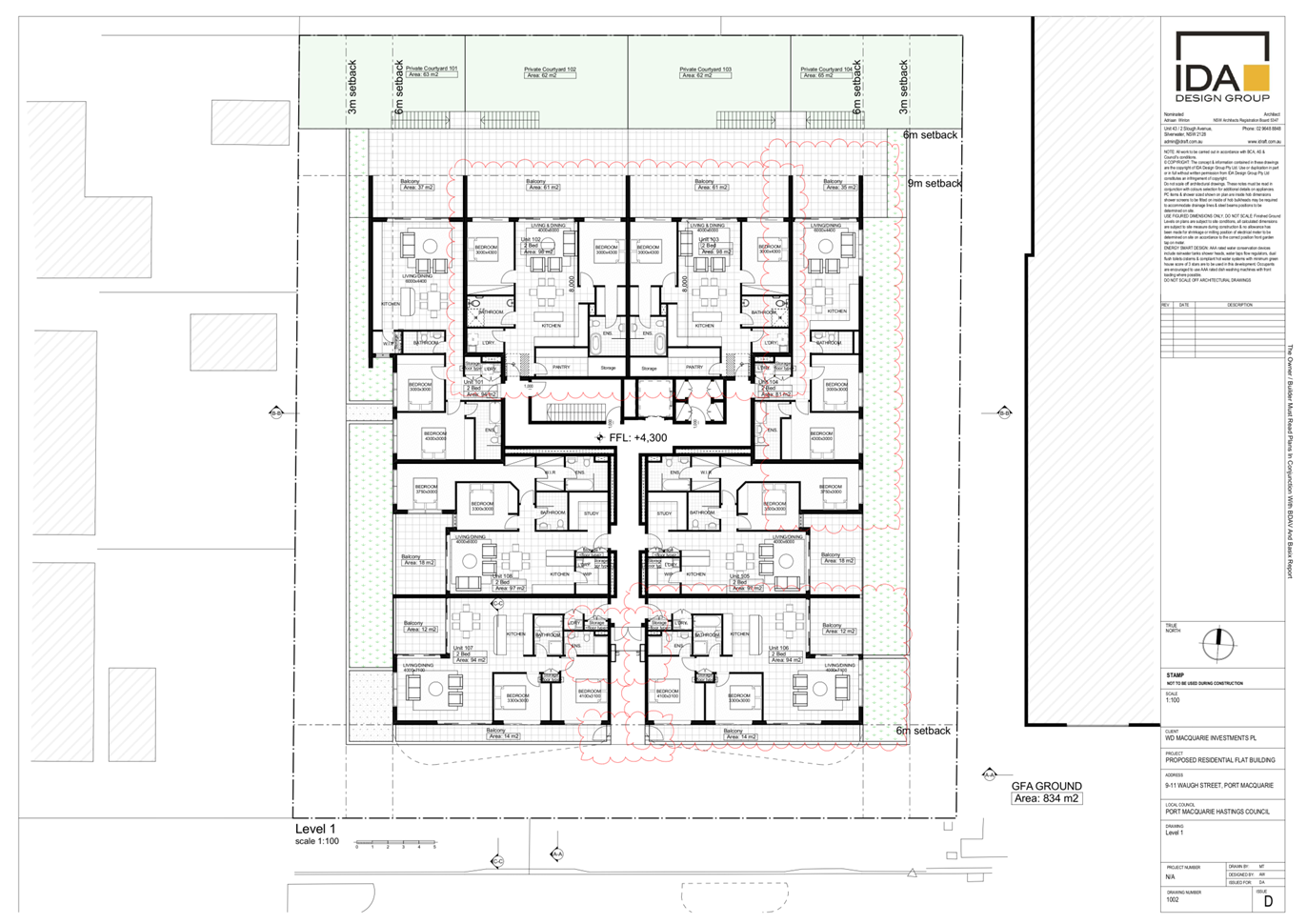
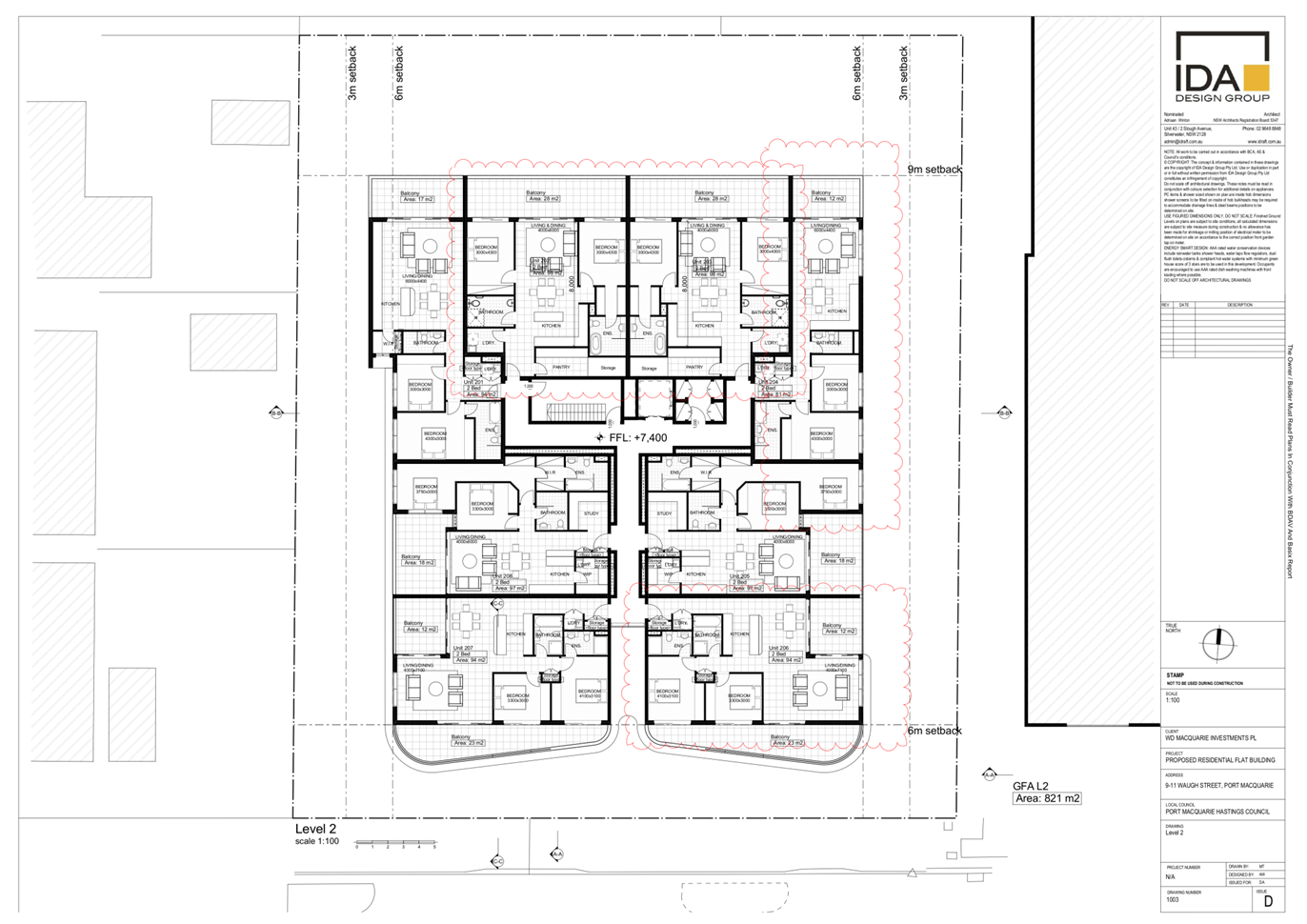
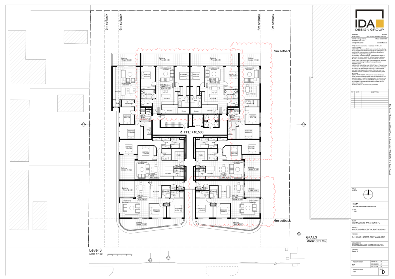
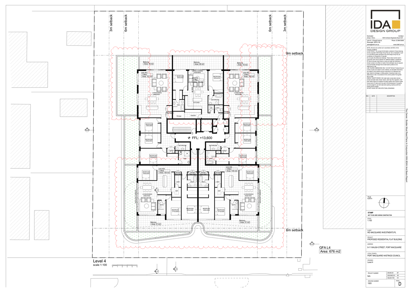
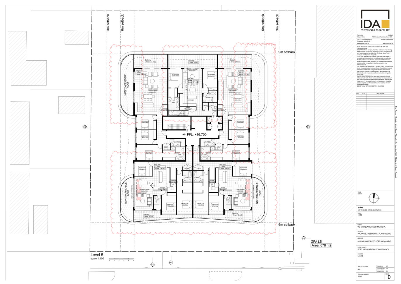
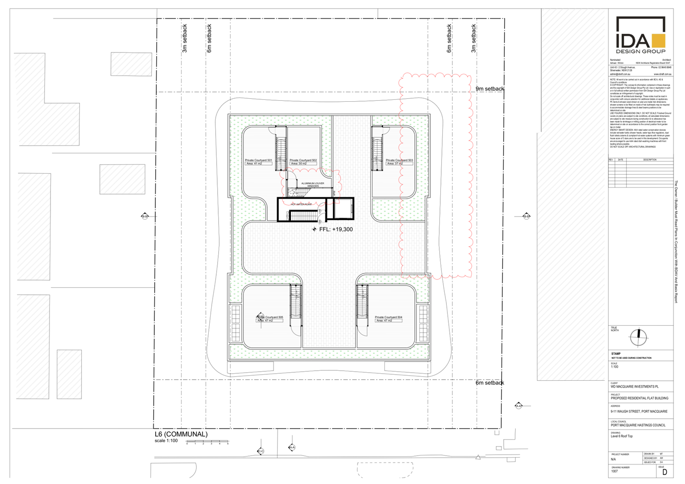
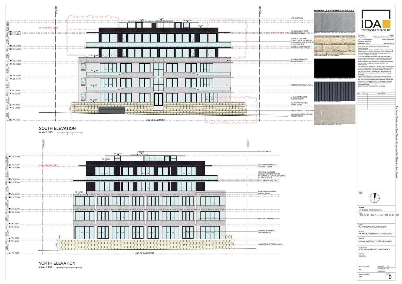
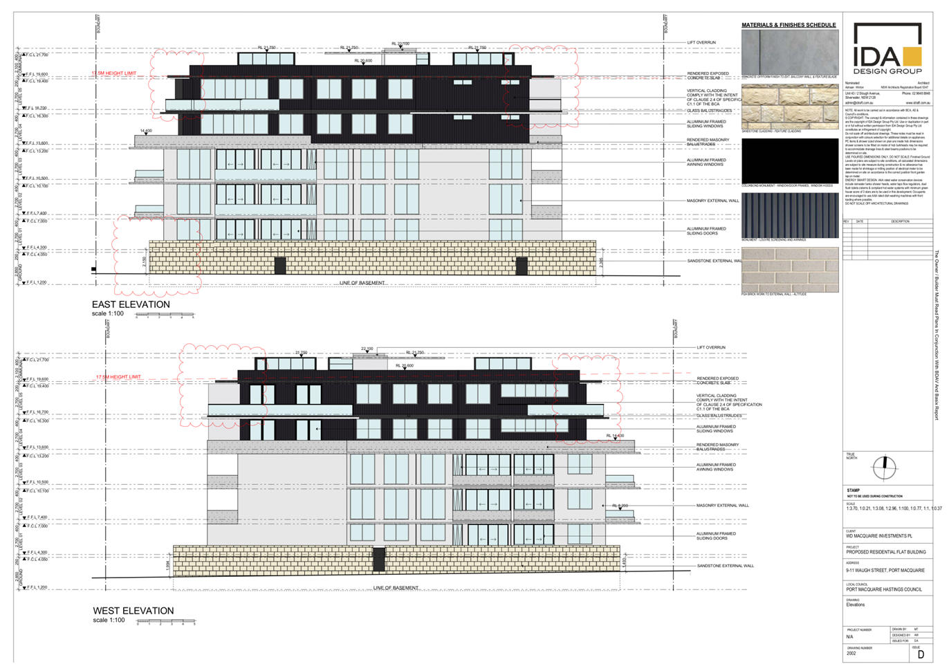
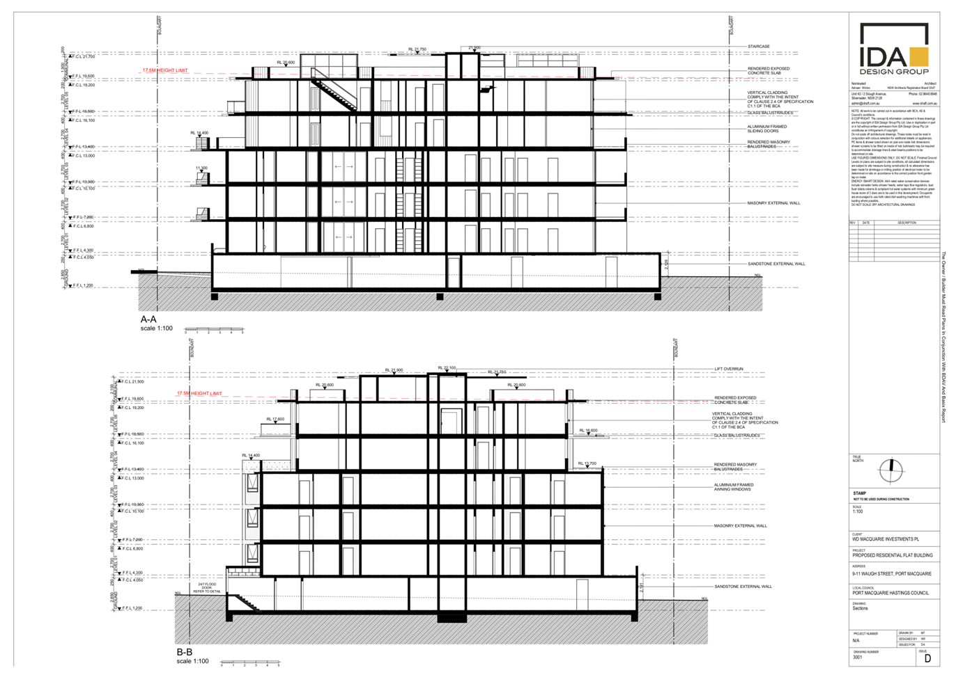
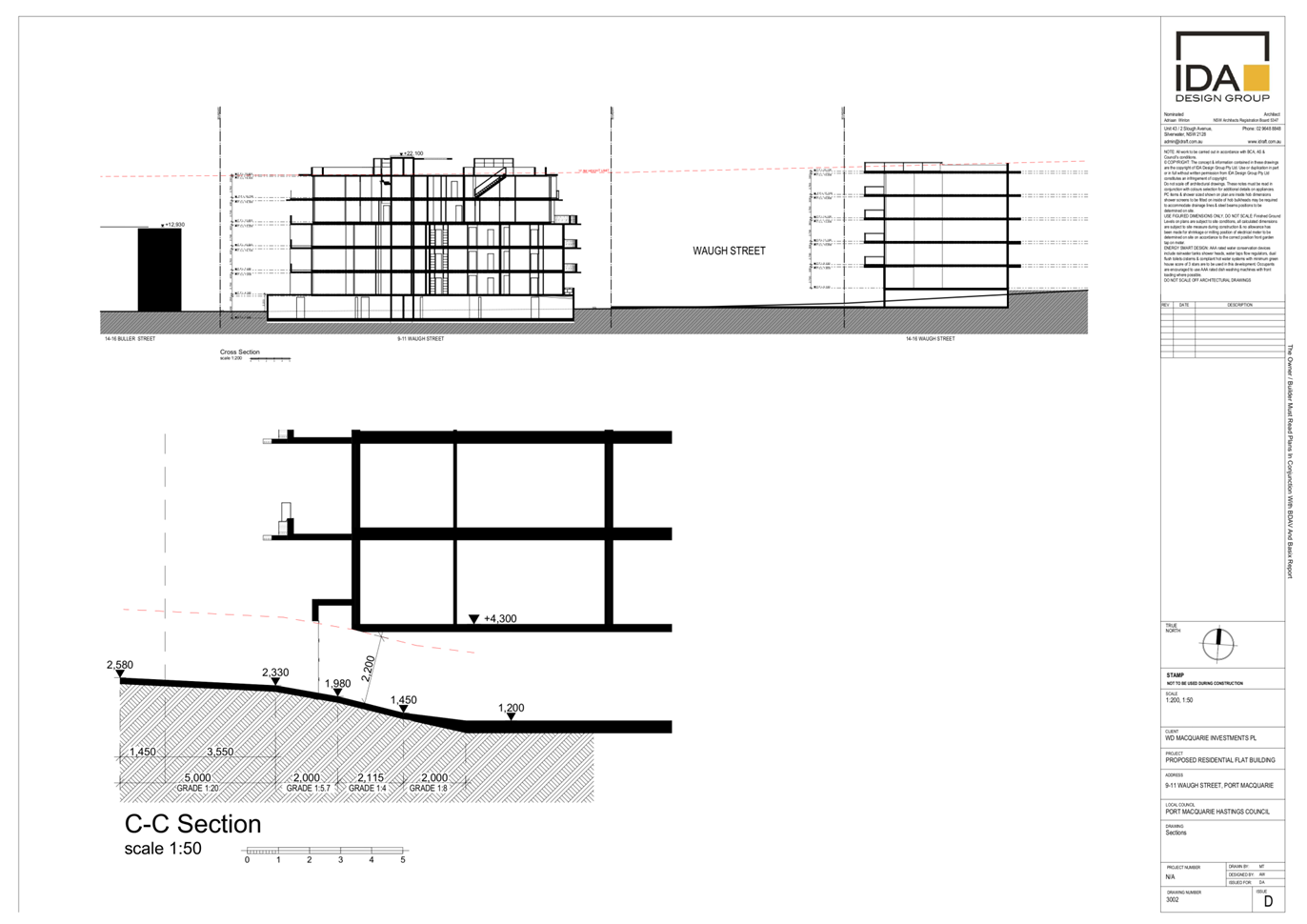
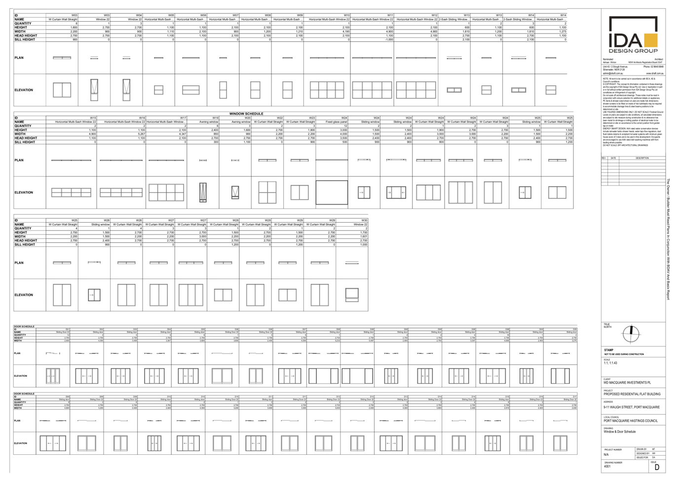
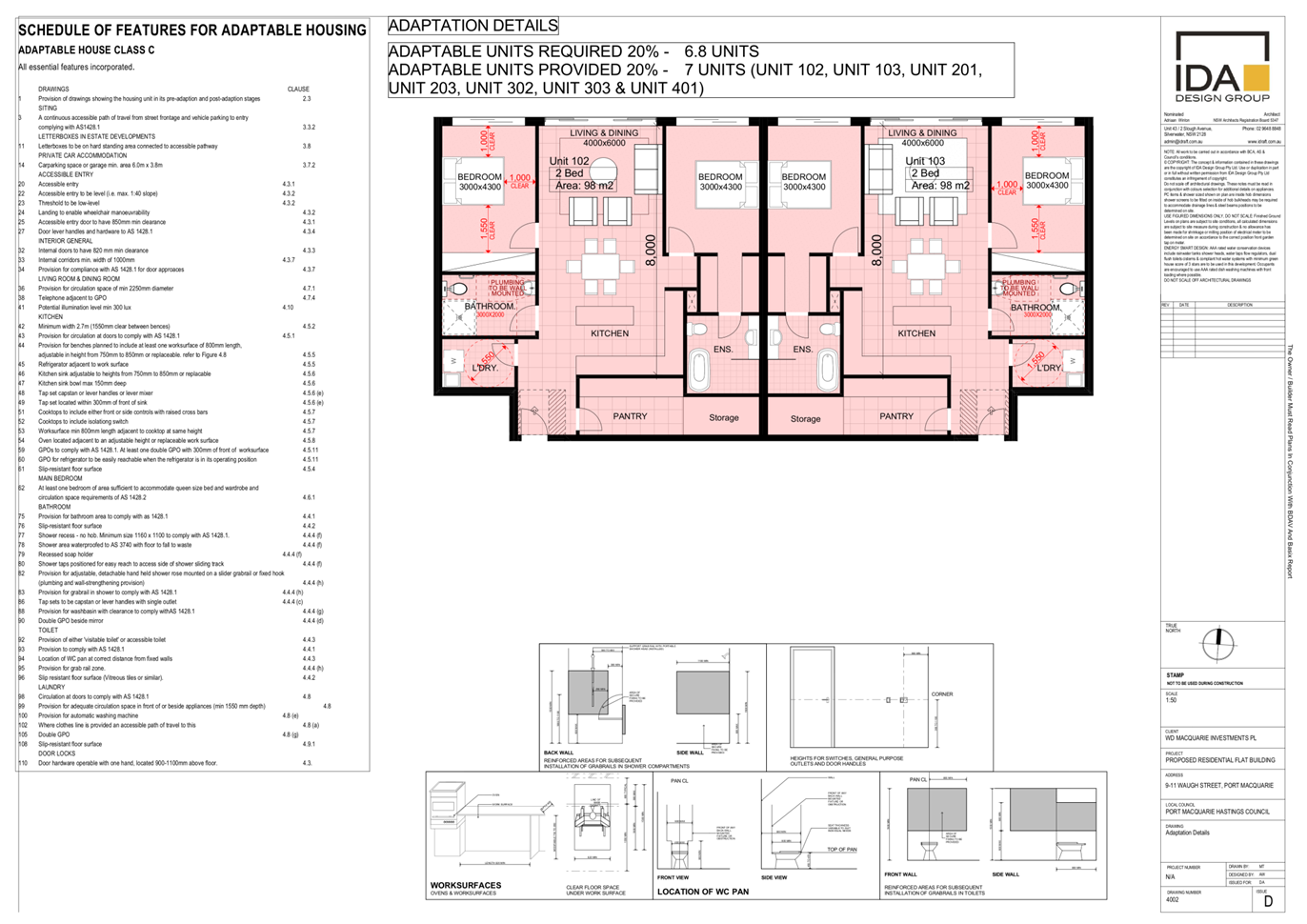
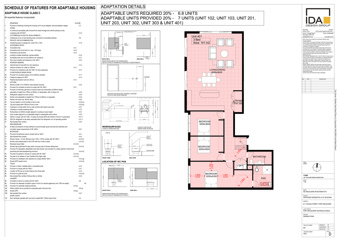
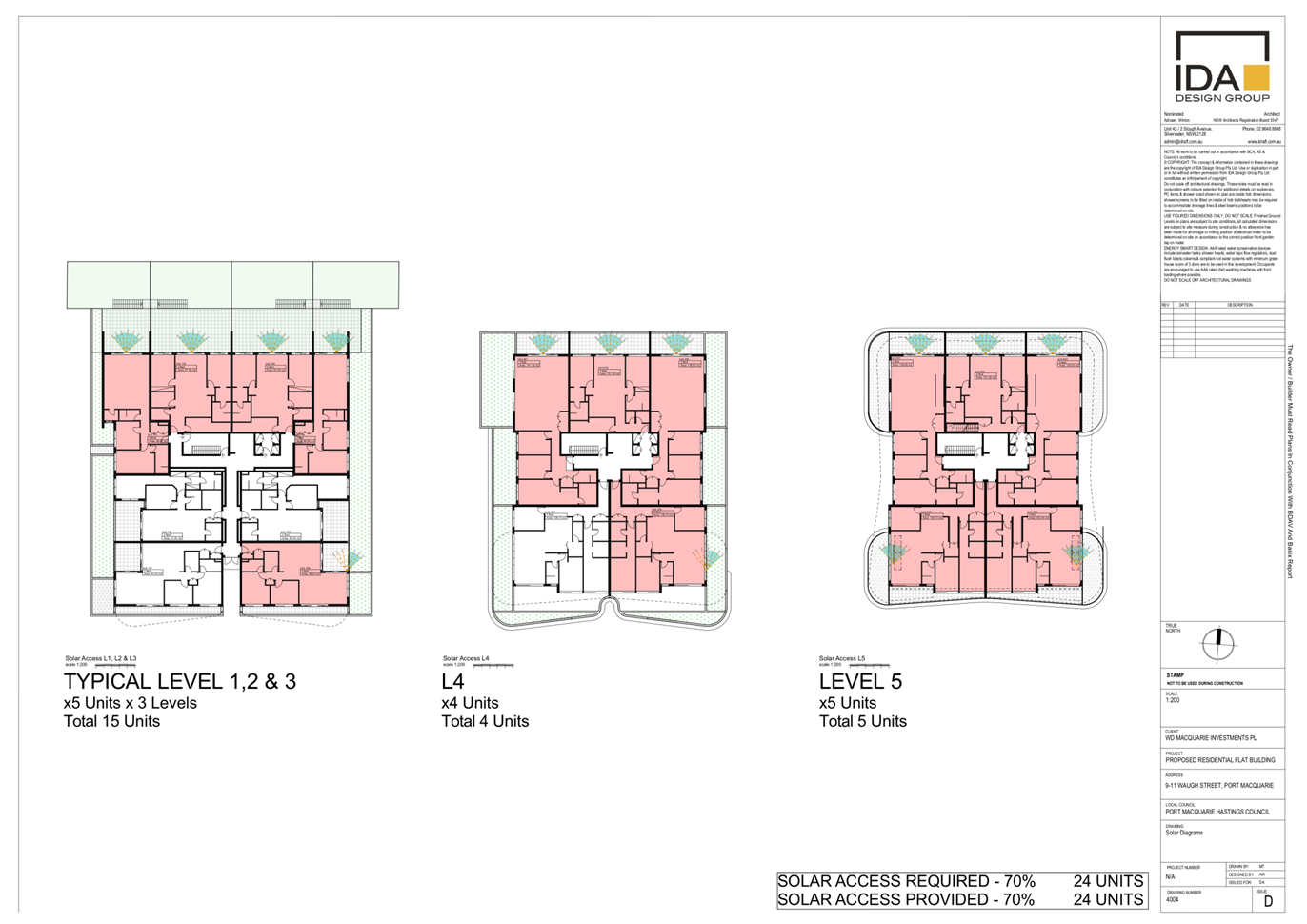
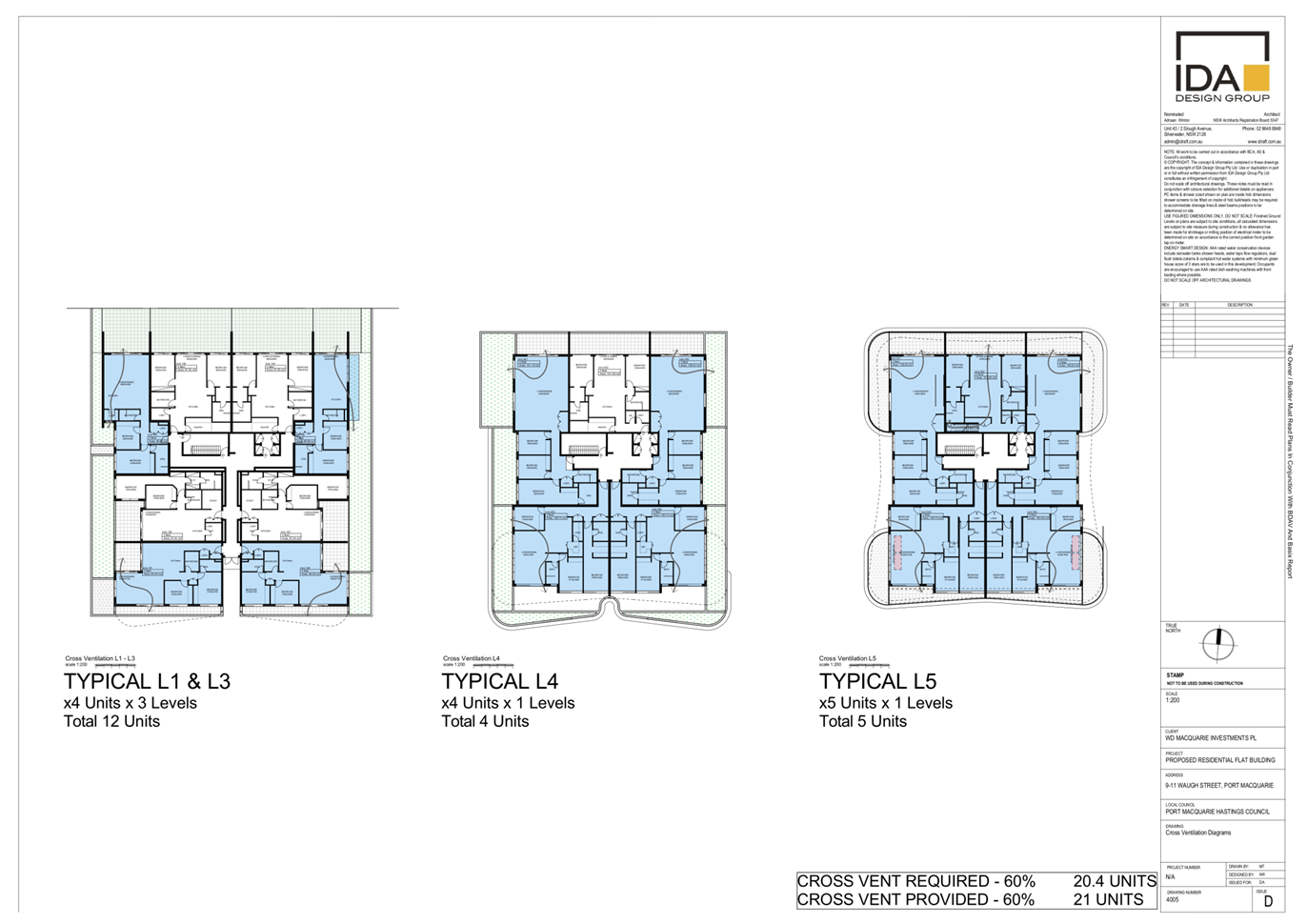
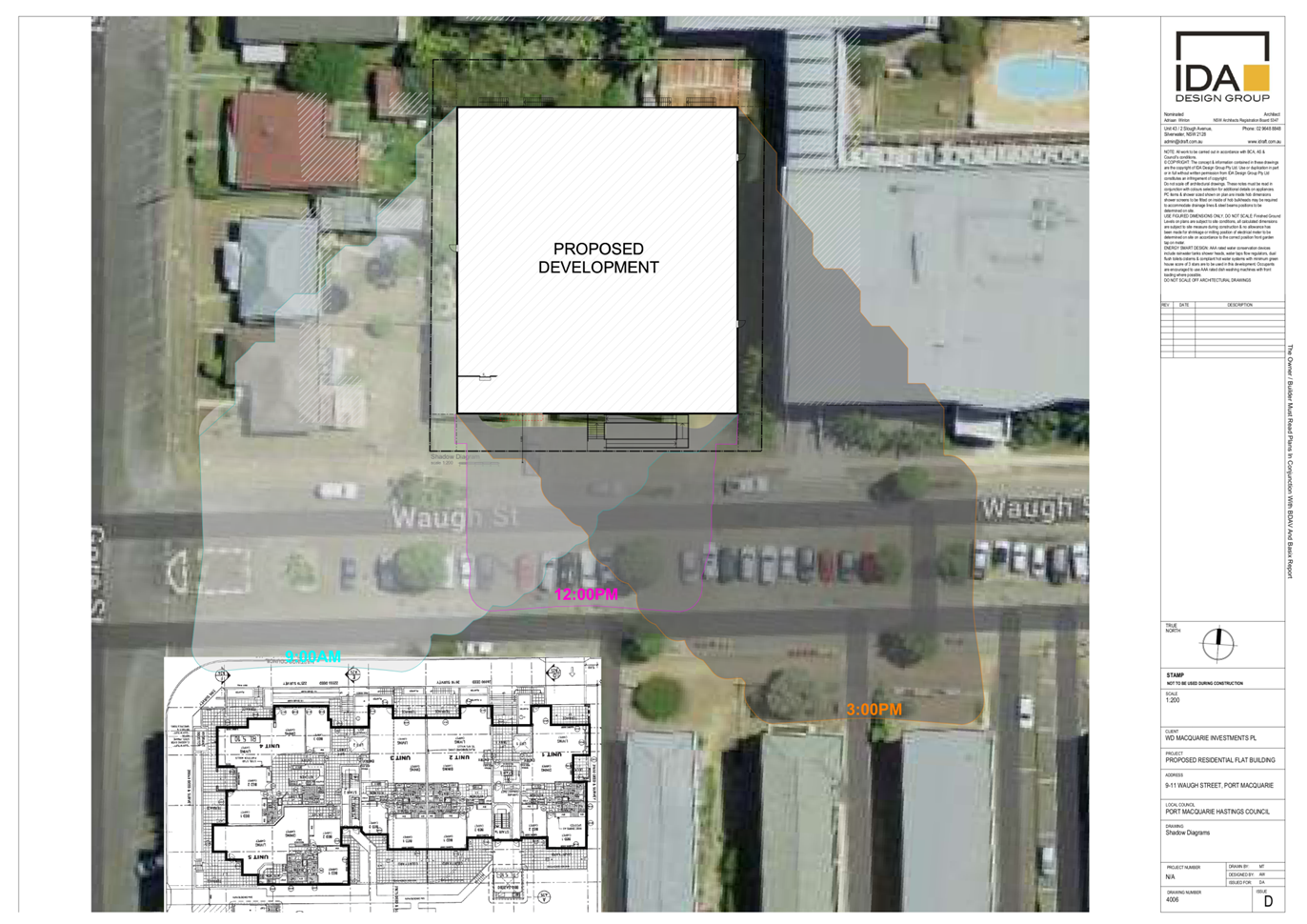
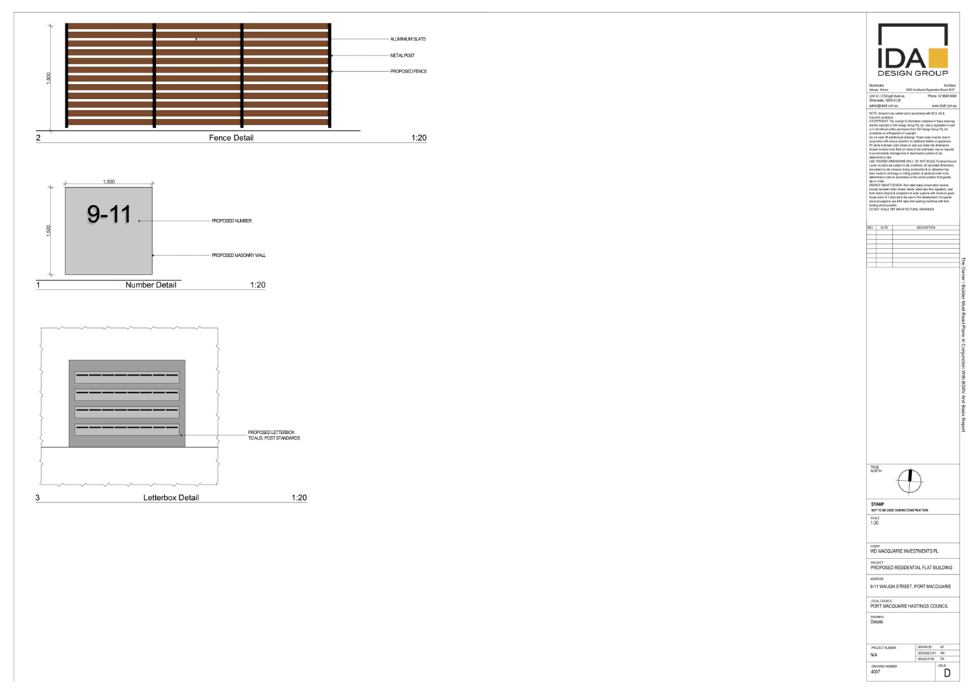
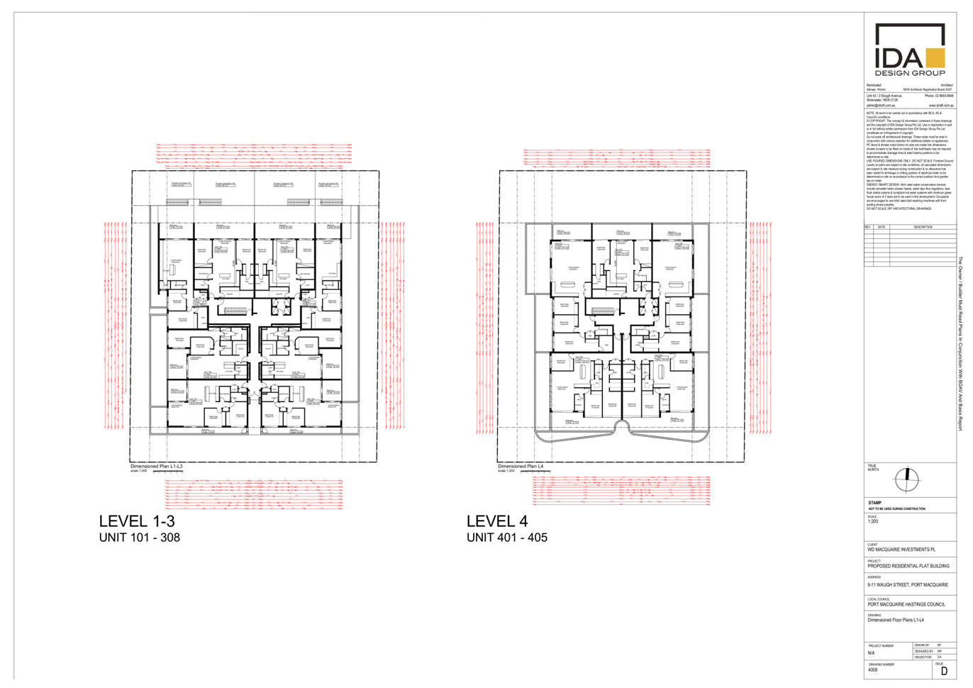
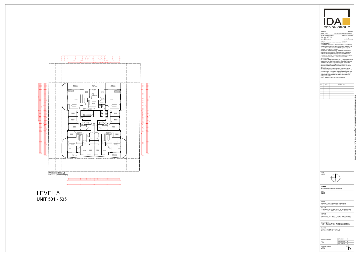
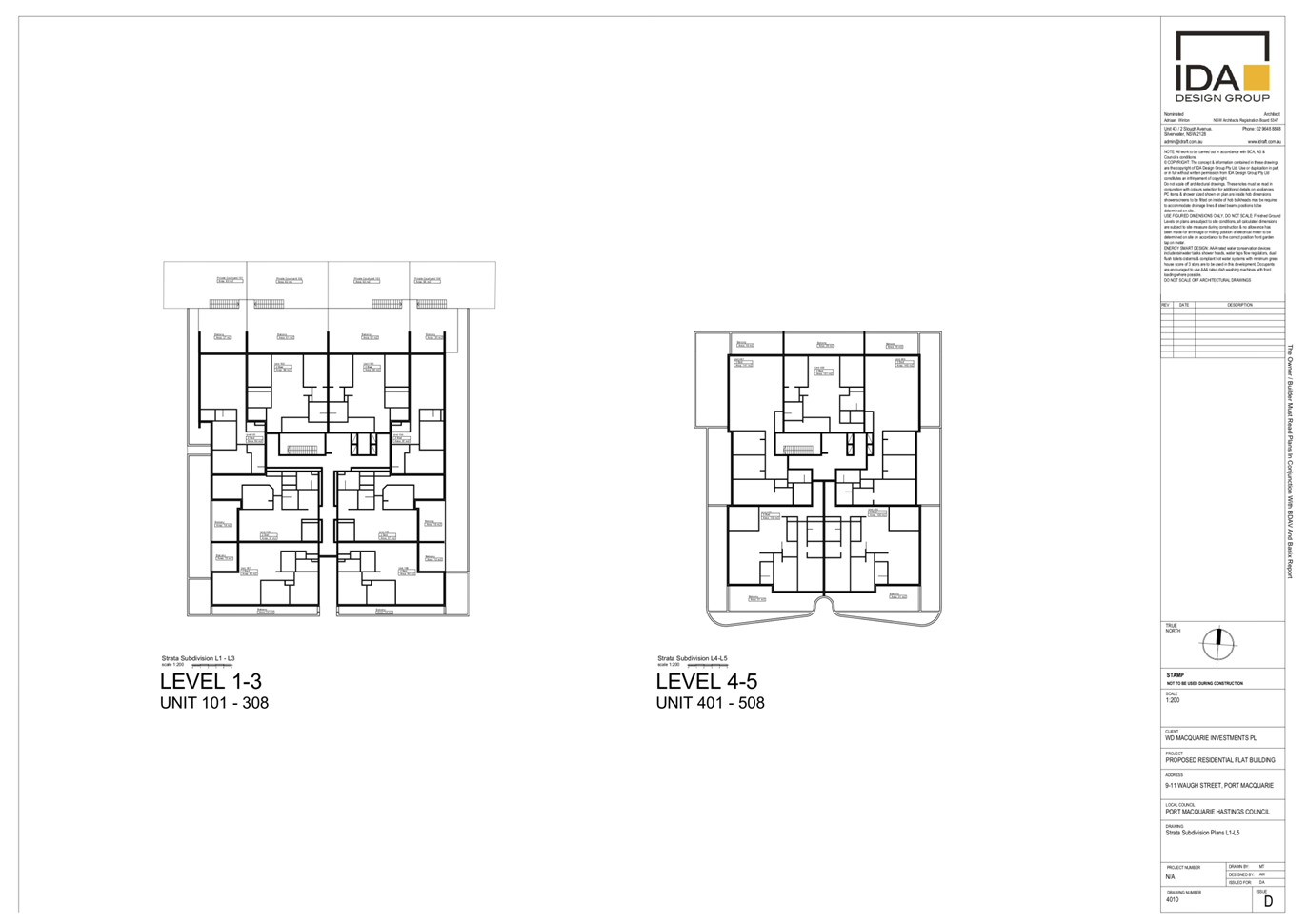
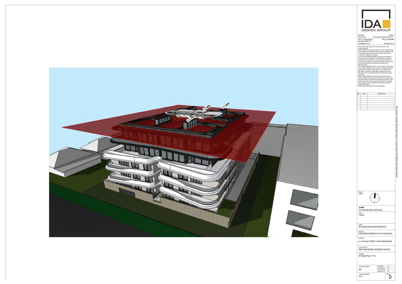
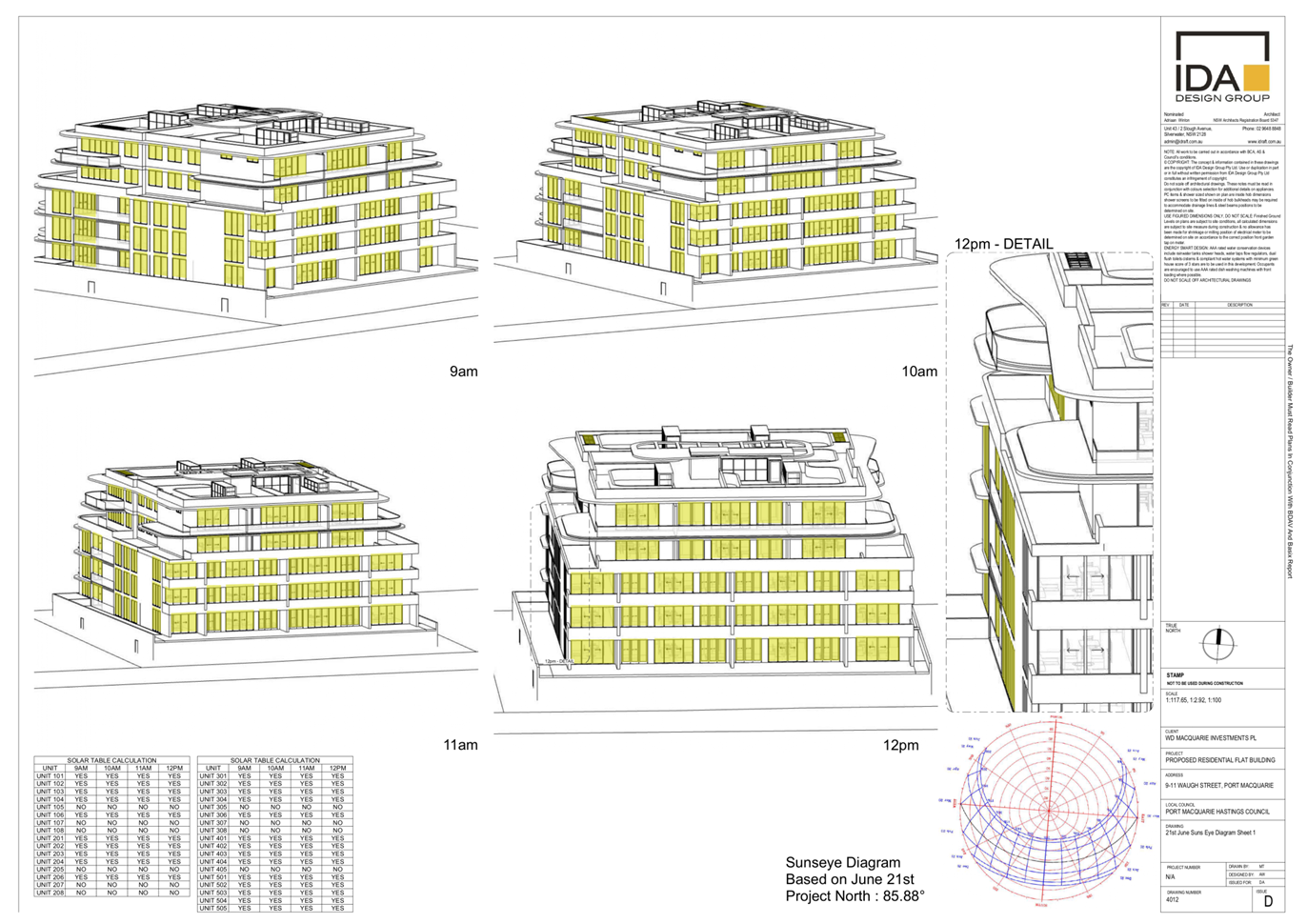
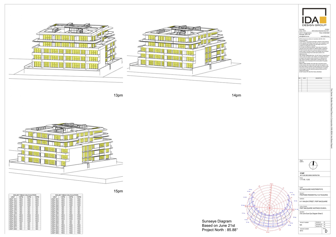
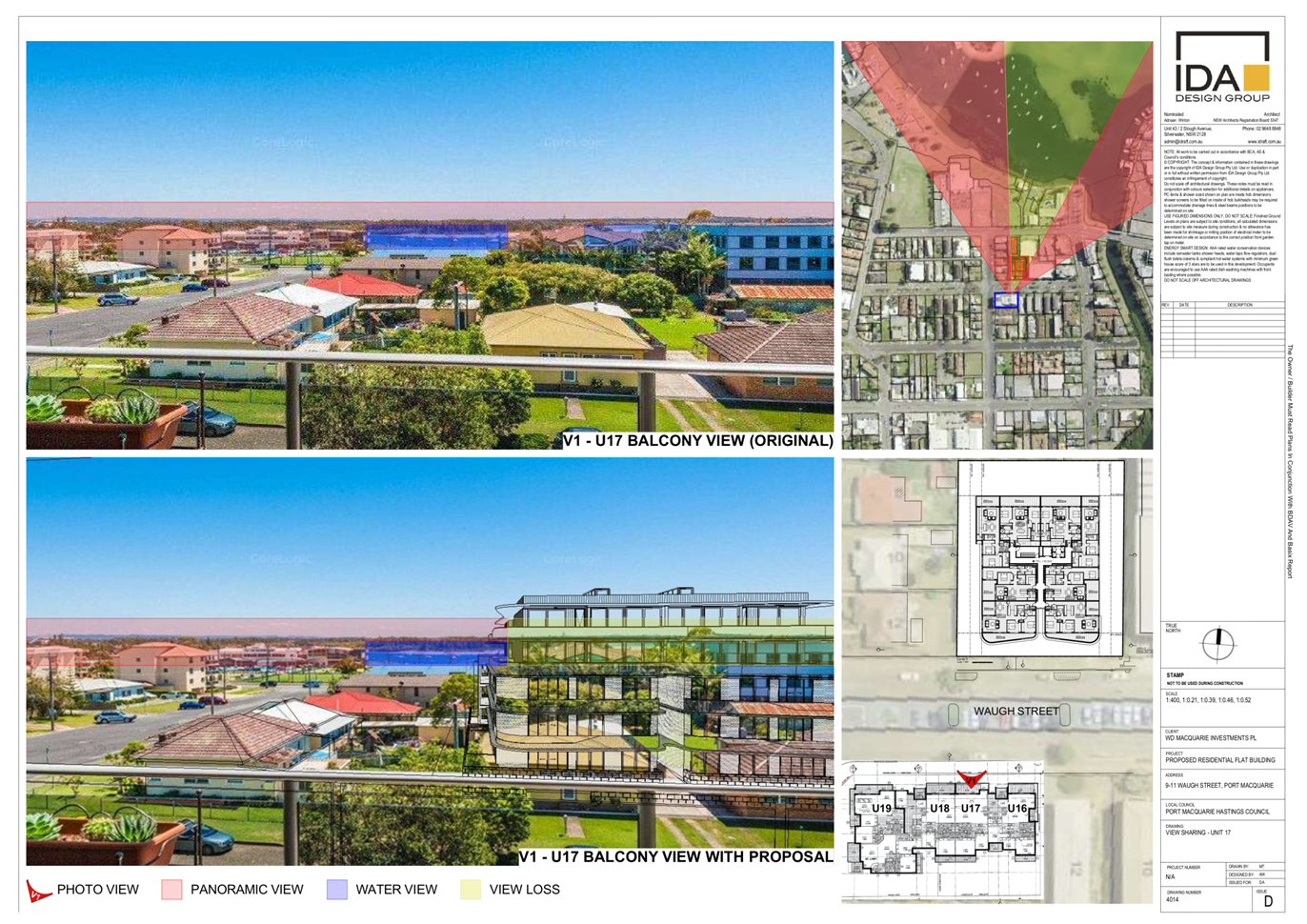
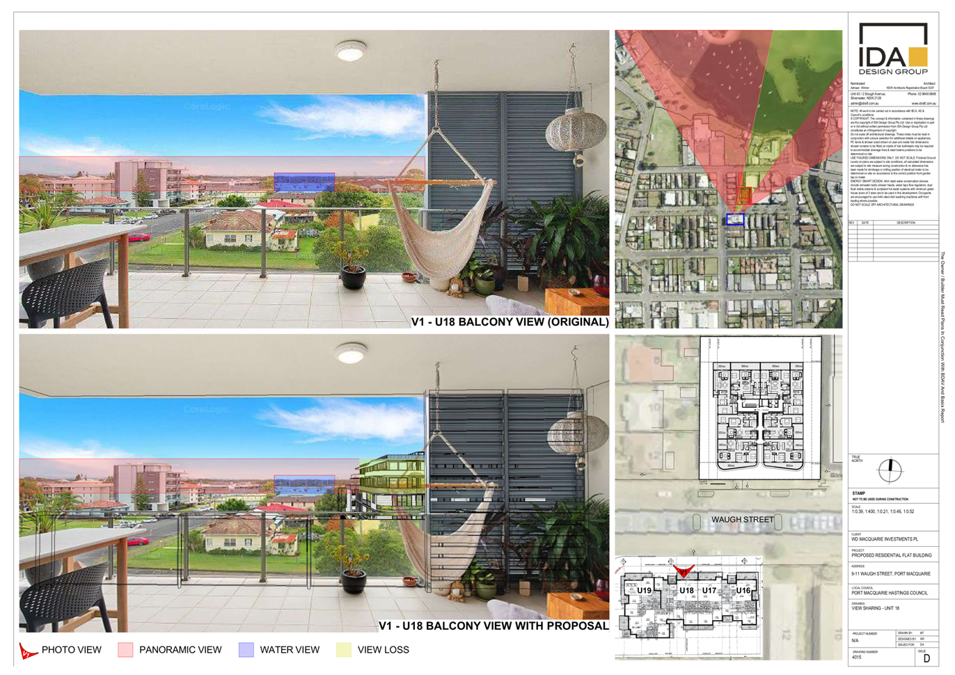
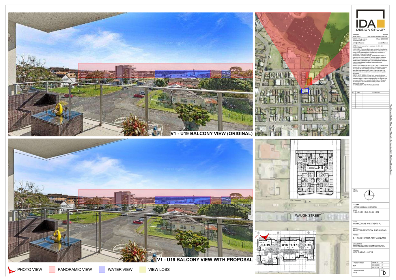
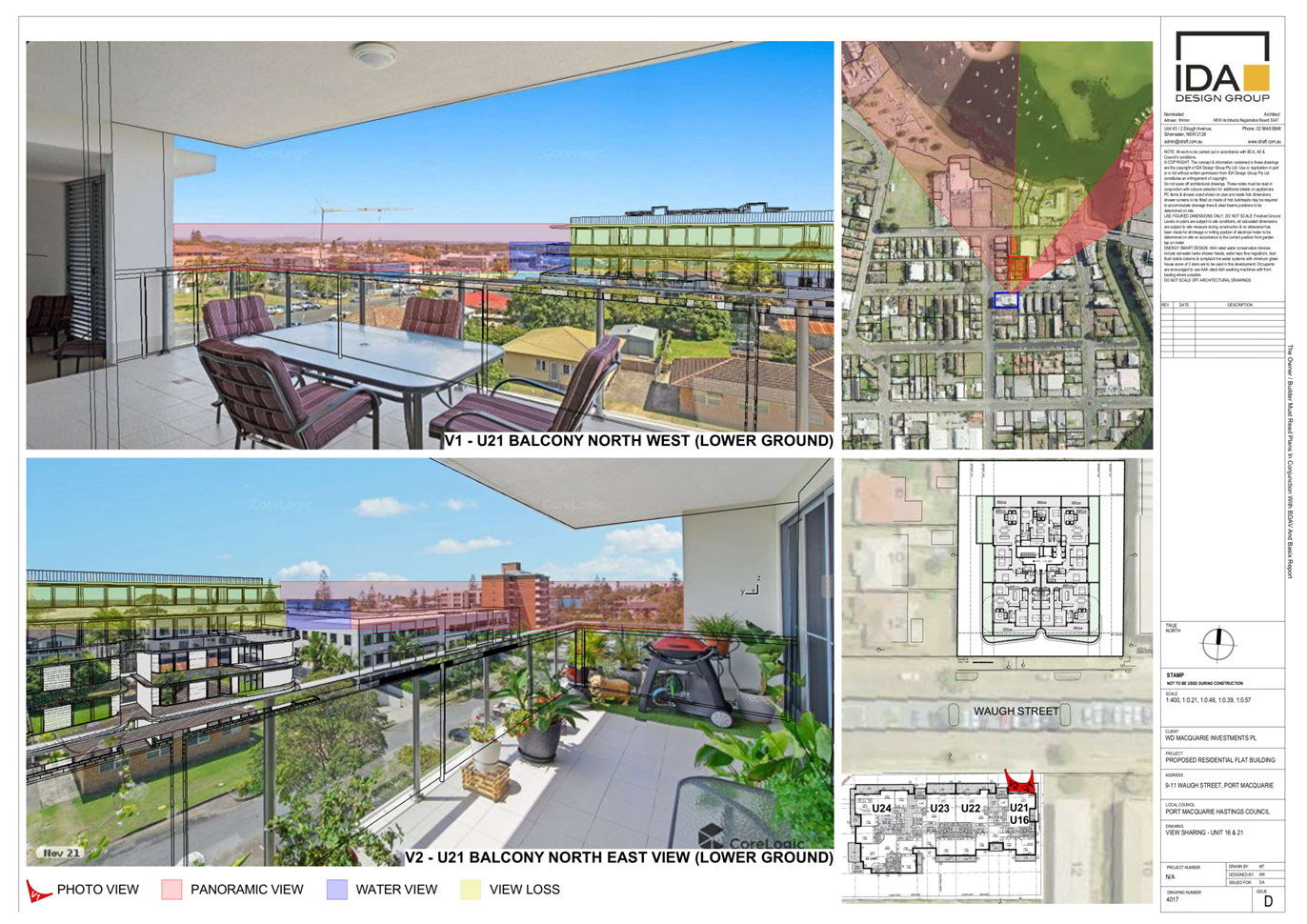
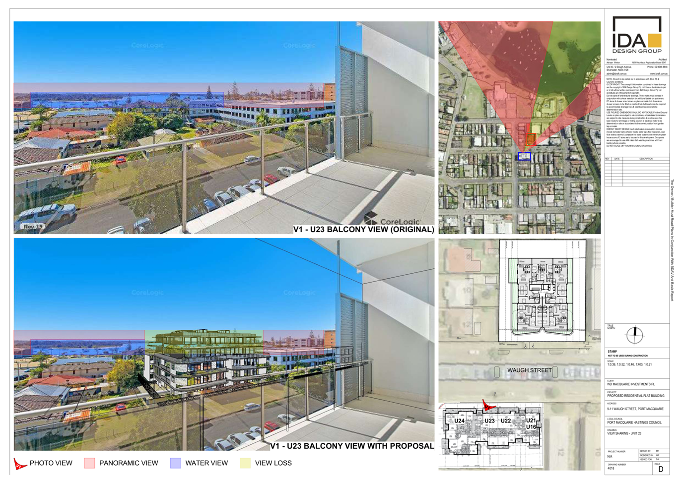
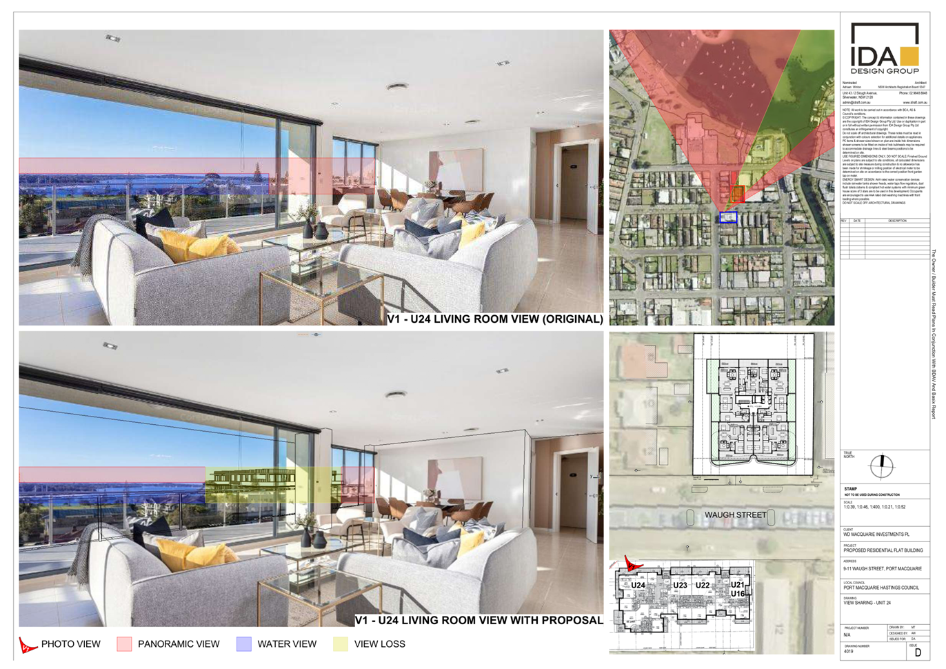
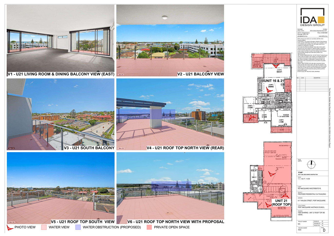
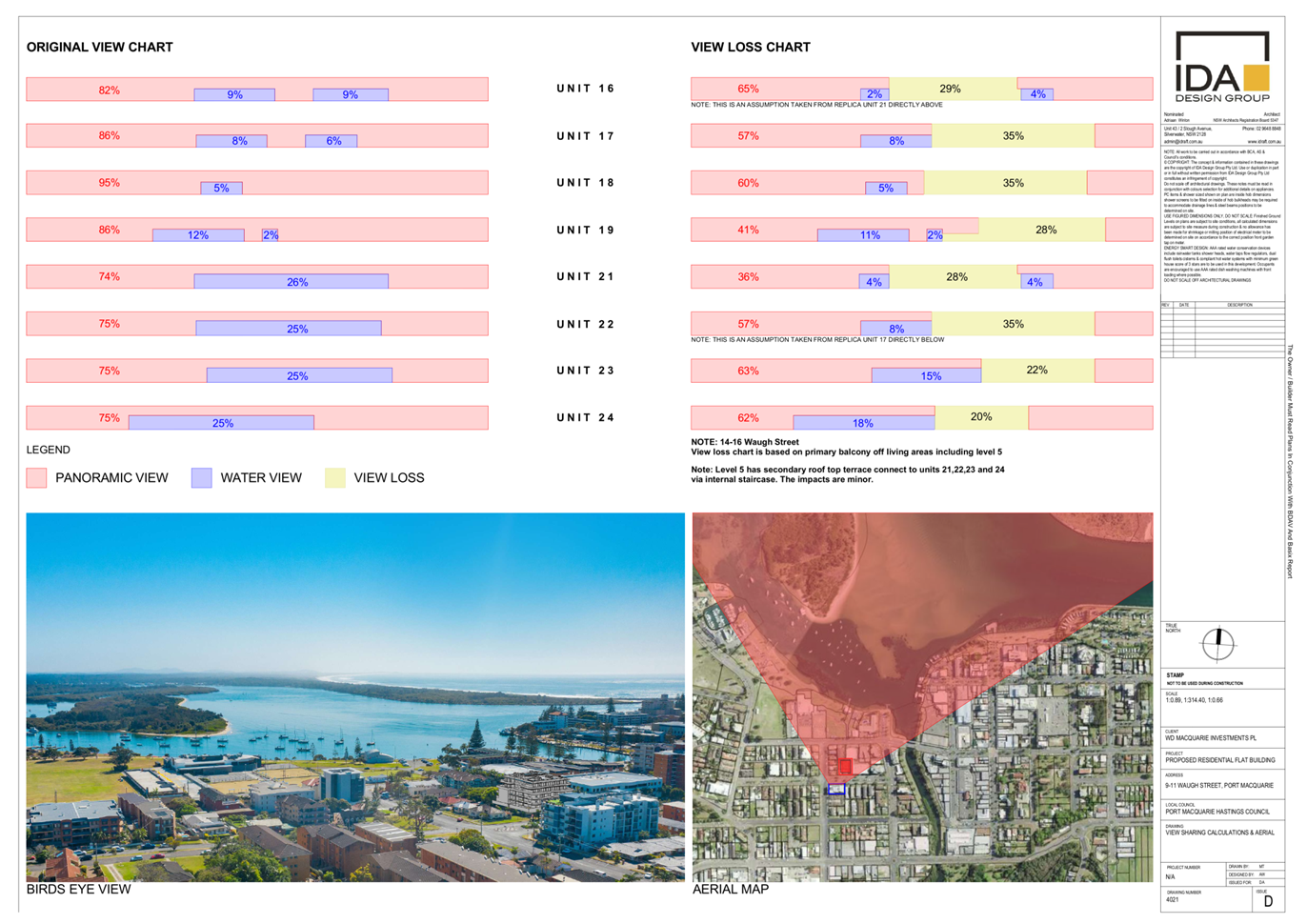
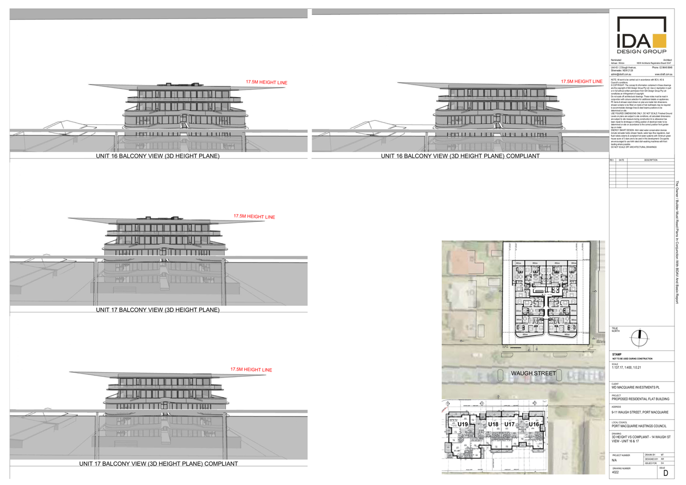
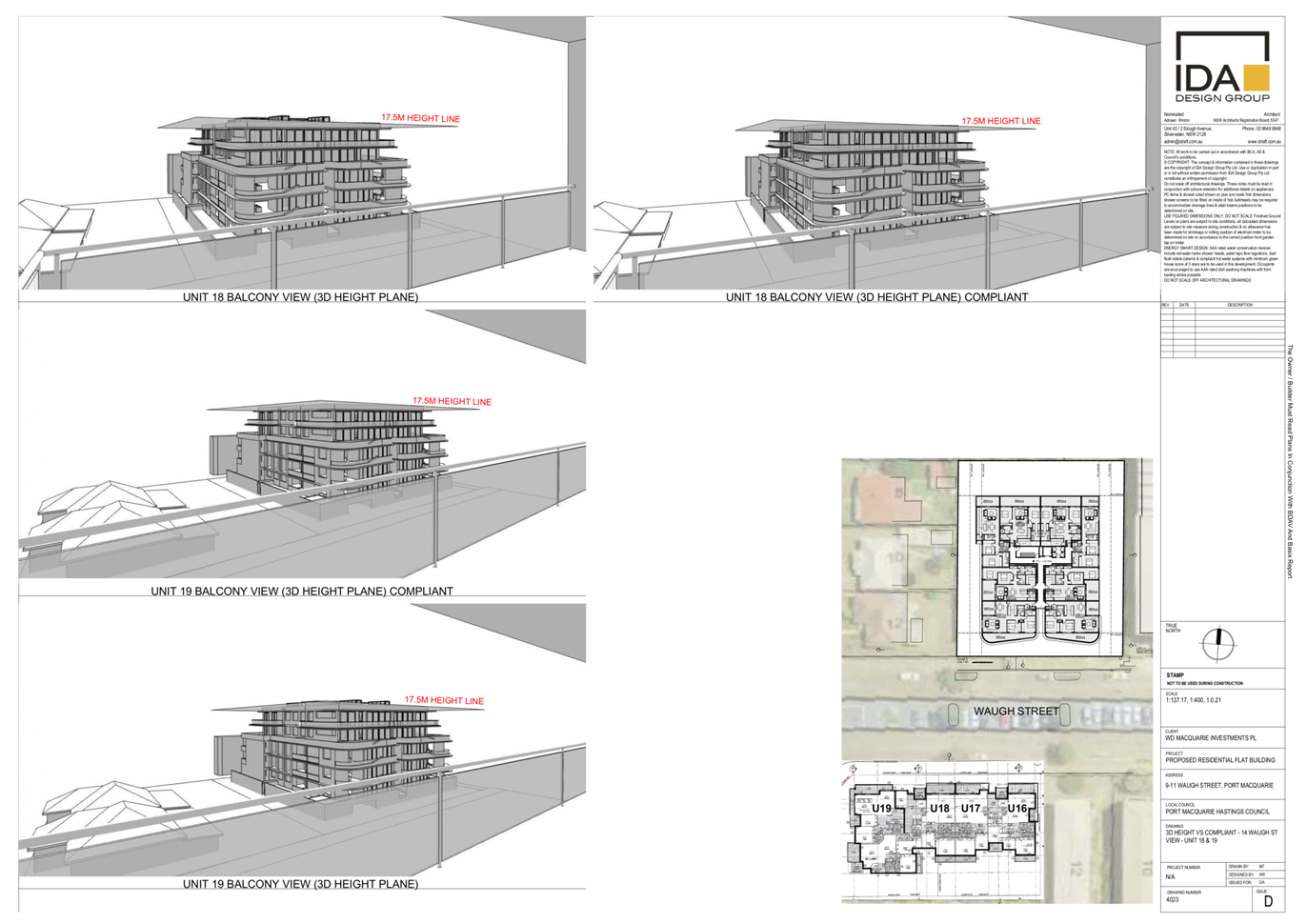
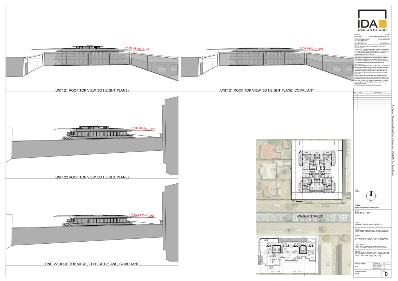
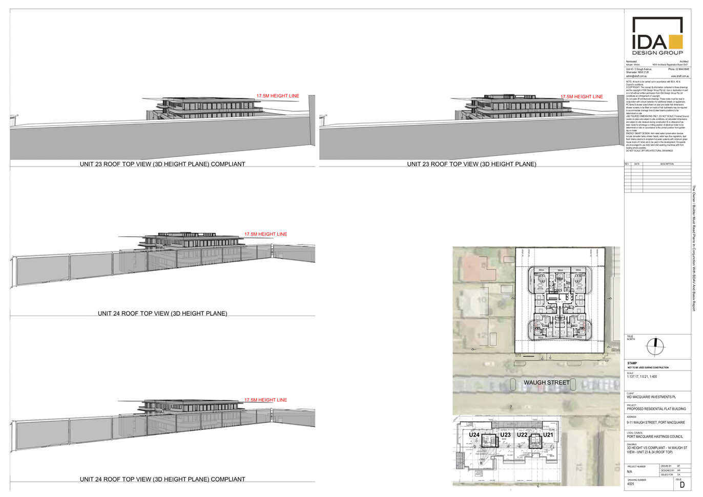
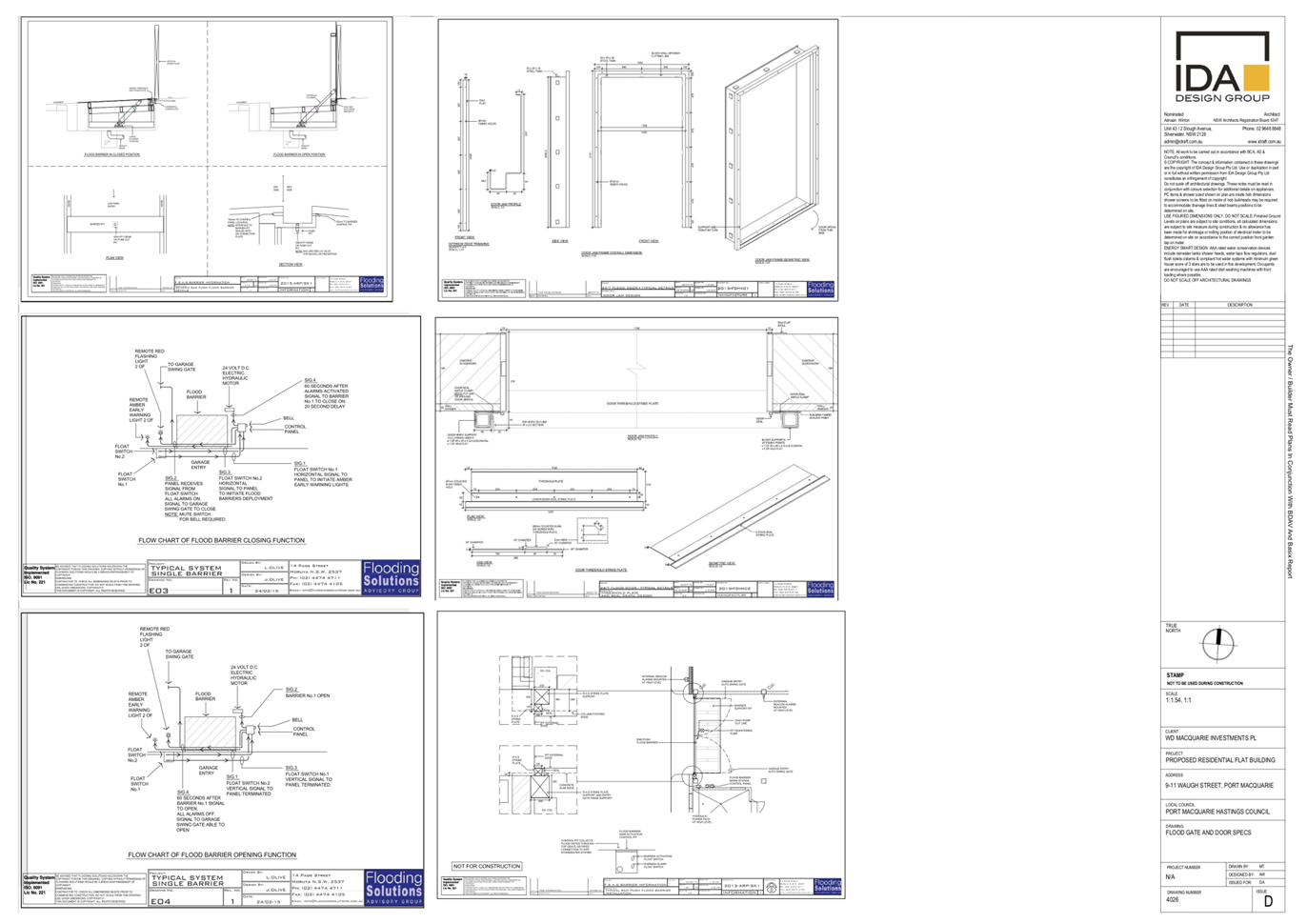
|
ATTACHMENT
|
Development Assessment Panel
17/05/2023
|
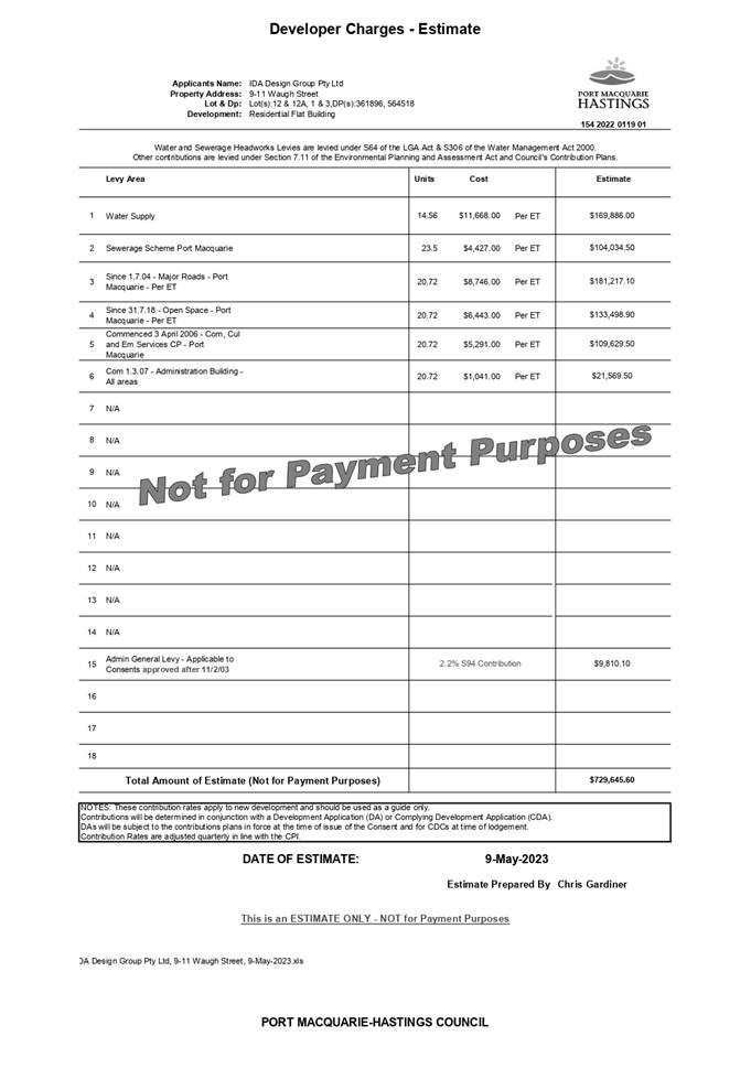
|
ATTACHMENT
|
Development Assessment Panel
17/05/2023
|
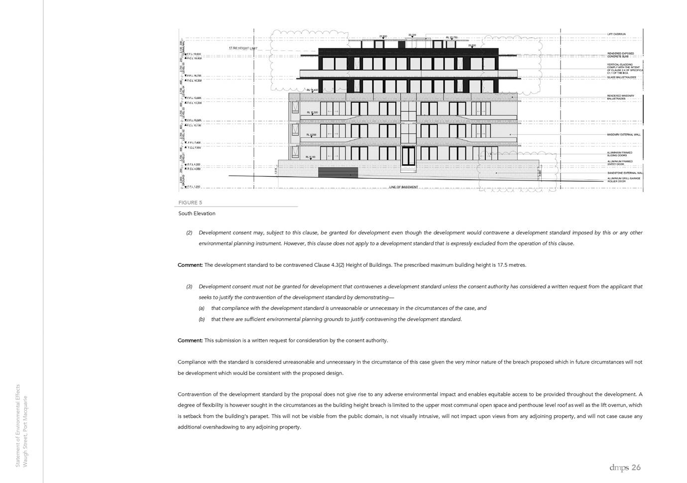

Development Assessment Panel
17/05/2023
Item: 07
Subject: DA2022 - 756.1 Multi-Dwelling Housing and
Strata Title Subdivision at Lot 22 DP807508, 197 Matthew Flinders Drive, Port
Macquarie
Report
Author: Development Assessment Planner, Beau Spry
|
Applicant: M
Prados & K Prados
Owner: Krisprad
Holdings Pty Ltd
Estimated
Cost: $950,000
Alignment with Delivery
Program
4.3.1 Undertake transparent
and efficient development assessment in accordance with relevant legislation.
|
RECOMMENDATION
That
DA 2022-756 for a Multi-Dwelling
Housing and Strata Title Subdivision at Lot 22, DP807508,
No. 197 Matthew Flinders Drive, Port Macquarie,
be determined by granting consent subject to the recommended conditions.
Executive
Summary
This
report considers a development application for a Multi-Dwelling Housing
and Strata Title Subdivision at the subject site and
provides an assessment of the application in accordance with the Environmental
Planning and Assessment Act 1979.
Following exhibition of the
application, 17 submissions were received.
The site is considered suitable for the proposed development
and the proposal adequately addresses relevant planning controls. The
development is not considered to be contrary to the public's interest and will
not result a significant adverse social, environmental or economic impact.
This report recommends that
the development application be approved subject to the attached conditions
(Attachment 1).
The reason for the application being referred to
Council’s Development Assessment Panel (DAP) is because three (3) or more
objections to the proposal have been received. A copy of the DAP Charter
outlining the delegations and functions of the DAP is available on
Council’s website.
1. BACKGROUND
Existing
Sites Features and Surrounding Development
The site has an area of 902.45m2.
The
site is zoned R1 General Residential in
accordance with the Port Macquarie-Hastings Local Environmental Plan 2011, as
shown in the following zoning plan:
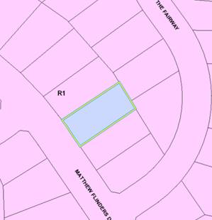
The
existing subdivision pattern and location of existing development within the
locality is shown in the following aerial photograph:
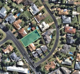
2. DESCRIPTION
OF DEVELOPMENT
Key
aspects of the proposal include the following:
· Multi-Dwelling
Housing comprising 3 semi-detached dwellings.
· Strata
subdivision as part of this application
Refer
to plans of the proposed development at the end of this report (Attachment 2).
Application
Chronology
· 24/08/2022 - Application lodged with
Council.
· 12/09/2022 - 26/09/2022 - Notification
period.
· 29/09/2022 - Council staff requested
additional information.
· 20/10/2022 - Council staff requested
additional information.
· 21/10/2022 - Applicant partially
responded to request for additional information.
· 28/10/2022 - Applicant respond to
submissions additional information and
provide
updated plans.
· 16/11/2022 - Update provided to
applicant.
· 19/12/2022 - Bushfire Safety Authority
received from NSW Rural Fire
Service.
· 20/12/2022 - Council staff request
additional information.
· 01/02/2023 - Applicant provide
response to request for additional information
and
provide updated plans.
· 03/02/2023 - Council staff request
additional information based on the
updated
plans.
· 09/02/2023 - Council staff meet with
applicant to discuss additional
information,
submissions and updated plans.
· 4/004/2023 - Applicant provide updated
plans.
3. STATUTORY
ASSESSMENT
Section
4.15(1) Matters for Consideration
In
determining the application, Council is required to take into consideration the
following matters as are relevant to the development that apply to the land to
which the development application relates:
(a) The
provisions (where applicable) of:
(i) Any
Environmental Planning Instrument
State Environmental Planning Policy (Biodiversity and
Conservation) 2021
Chapter 4 Koala Habitat Protection 2021
Clause 4.4 - This SEPP applies to all non-rural zoned land
within the Port Macquarie-Hastings Local Government Area.
Clause 4.10 (other land - not subject to
Clause 4.8 or 4.9) - Having considered the SEPP, the application and on
completion of a site inspection, Council is not prevented from granting consent
in this case for the following reasons:
1. The property is not subject to a KPOM, or
2. The site not considered to be core koala habitat.
State Environmental Planning Policy (Resilience and
Hazards) 2021
Chapter 2 Coastal Management
Clause 2.5 - This SEPP prevails over the Port
Macquarie-Hastings LEP 2011 in the event of any inconsistency.
Having
regard to clause 2.8 (proximity to coastal wetlands) of this SEPP, the proposed
development is not considered likely to result in any of the following:
(a) identifiable
adverse impacts on the biophysical, hydrological and ecological integrity of
the nearby coastal wetland; and
(b) identifiable
impacts to water flows to the nearby coastal wetland.
The site is not located within a coastal use area or coastal
environment area.
The bulk, scale and size of the proposed development is
compatible with the surrounding coastal and built environment. The site is
predominately cleared and located within an area zoned for R1 General
Residential purposes.
Clause 2.12 - The proposal is not likely to cause increased
risk of coastal hazards on the land or other land.
Chapter 4 Remediation of Land
Clause 4.6 - Following an inspection of the site and a
search of Council records, the subject land is not identified as being
potentially contaminated and is suitable for the intended use.
State Environmental Planning Policy (Building
Sustainability Index: BASIX) 2004
A BASIX certificate (1320832M) has been submitted
demonstrating that the proposal will comply with the requirements of the SEPP.
It is recommended that a condition be imposed to ensure that the commitments
are incorporated into the development and certified at Occupation Certificate
stage.
State Environmental Planning Policy (Transport and
Infrastructure) 2021
Clause 2.48 - Development in proximity to electricity infrastructure
- referral to Essential Energy has been completed having regard for any of the
following:
(a) the
penetration of ground within 2m of an underground electricity power line or an
electricity distribution pole or within 10m of any part of an electricity
tower,
(b) development
carried out:
(i) within
or immediately adjacent to an easement for electricity purposes (whether or not
the electricity infrastructure exists), or
(ii) immediately
adjacent to an electricity substation, or
(iii) within
5m of an exposed overhead electricity power line,
(c) installation
of a swimming pool any part of which is:
(i) within
30m of a structure supporting an overhead electricity transmission line,
measured horizontally from the top of the pool to the bottom of the structure
at ground level, or
(ii) within 5m of an overhead electricity power line, measured vertically
upwards from the top of the pool.
Advice received from Essential Energy has been forwarded to
the Applicant for consideration. A site inspection and the provided plans
indicate that the driveway is in excess of 10m from the closest point to the
service pit located at the front of the property.
The development does not trigger any of the traffic
generating development thresholds of Clause 2.121. Referral to the NSW Roads
and Maritime Services (RMS) is not required.
Based on the above, the proposed development addresses
relevant clauses in the SEPP and will not to create any significant adverse
conflict in terms of traffic or noise.
State Environmental Planning Policy (Primary Production)
2021
Part 2.5 Division 4 - The proposed development will create
no adverse impact on any oyster aquaculture development or priority oyster
aquaculture area.
Port Macquarie-Hastings Local Environmental
Plan 2011
The proposal is consistent with the LEP having regard to the
following:
· Clause
2.2 - The subject site is zoned R1 General Residential.
· Clause
2.3(1) and the R1 zone landuse table - The proposal is best characterised as
multi dwelling housing is a permissible landuse with consent.
The objectives of the R1 zone are as
follows:
o To provide for the housing needs
of the community.
o To provide for a variety of
housing types and densities.
o To
enable other land uses that provide facilities or services to meet the day to
day needs of residents.
· Clause
2.3(2) - The proposal is consistent with the zone objectives as the development will contribute to the variety of
housing types and densities to meet the housing needs of the community.
· Clause
4.1 - The minimum lot size for subdivision is 450m2. However, pursuant to
Clause 4.1(4) this control does not apply to the proposal as strata subdivision
is sought. The existing residential lot has an area of 902.45m2
· Clause
4.3 - The maximum overall height of the buildings above ground level (existing)
is 7.8m which complies and is well below the standard height limit of 11.5m
applying to the site.
· Clause
4.4 - The floor space ratio of the proposal is 0.63:1 which complies with the
maximum 1:1 floor space ratio applying to the site.
· Clause
5.10 - The site does not contain or adjoin any known heritage items or sites of
significance.
· Clause
7.13 - Satisfactory arrangements are in place for provision of essential
services including water supply, electricity supply, sewer infrastructure,
stormwater drainage and suitable road access to service the development.
Provision of electricity will be subject to obtaining satisfactory arrangements
certification prior to the issue of a Strata Certificate as recommended by a
condition of consent.
(ii) Any draft
instruments that apply to the site or are on exhibition
No draft instruments apply to the site.
(iii) Any Development
Control Plan in force
Port
Macquarie-Hastings Development Control Plan 2013
|
DCP 2013: Part B - General Provisions - B2:
Environmental Management
|
|
DCP Objective
|
Development Provisions
|
Proposed
|
Complies
|
|
3
|
a) Development must comply
with Council’s Developments, Public Place & Events - Waste
Minimisation and Management Policy.
|
Satisfactory arrangements
can be put in place for storage and collection of waste.
Standard condition
recommended for construction waste management.
|
Yes
|
|
Cut and Fill Regrading
|
|
4
|
a) Development shall not
exceed a maximum cut of 1.0m and fill of 1.0m measured vertically above the
ground level (existing) at a distance of 1.0m outside the perimeter of the
external walls of the building (This does not apply to buildings where such
cut and fill is fully retained within or by the external walls of the
building).
|
The site slopes west to
east by approx. 2m. Max cut of 1.2m is proposed between Units 2 and 3.
There is compliant fill at
a maximum 1m height at the rear of the site; cut less than 1m along the west
boundary and fill at the front of the site less than 1m in height.
|
No, variation sought below
|
|
5
|
a) A certified practicing
structural engineer must certify any retaining wall greater than 1.0m.
|
Max 1.2m high retaining
wall proposed for west side of driveway/turning bay.
Condition recommended for
all retaining walls to be engineered.
|
Yes
|
|
b) Where a combination of a
fence and a wall is proposed to be greater than 1.2m high:
- be a
maximum combined height of 1.8m above existing property boundary level;
- be
constructed up to the front boundary for a maximum length of 6.0m or 30% of
the street frontage, whichever is less;
− the
fence component has openings which make it not less than 25% transparent; and
− provide
a 3m x 3m splay for corner sites, and
- provide a
900mm x 900mm splay for vehicle driveway entrances.
|
Max 2.1m high part section
of fence and retaining combination proposed for Unit 1 courtyard.
This exceedance is
predominantly owing to the site topography sloping by 1m west-to-east across
the front fence/retaining line. The variation includes recesses for
landscaping.
|
No, variation sought below
|
|
DCP 2013: Part B -
General Provision - B3: Hazards Management
|
|
Bushfire Hazard Management
|
|
18
|
a) APZs are to be located
outside of environmental protection zones and wholly provided within private
land. Note perimeter roads provided as part of a residential subdivision are
classified as being part of the subdivision and not a separate permissible
land use within environment protection zones.
|
An assessment has been completed by an accredited person -
BAL LOW indicated. The report indicates that the required APZ’s can be
maintained within the site.
|
Yes
|
|
Flooding
|
|
19
|
a) Development must comply
with Council’s Floodplain Management Plan and Flood Policies.
|
Site is not identified as
flood prone.
|
N/A
|
|
DCP 2013: Part B- General Provisions- B4: Transport,
Traffic Management, Access and Car Parking
|
|
DCP Objective
|
Development Provisions
|
Proposed
|
Complies
|
|
Road Hierarchy
|
|
23
|
Vehicle driveway crossings are minimal in
number and width (while being adequate for the nature of the development),
and positioned:
− to avoid driveways near
intersections and road bends, and
− to minimise streetscapes
dominated by driveways and garage doors, and
− to
maximise on-street parking.
|
Maximum
driveway width satisfactory at 5.5m width. .
|
Yes
|
|
Parking Provision
|
|
24
|
a) Off-street Parking is
provided in accordance with Table 3.
1 parking space per each 1 or
2-bedroom unit + 1 visitor’s space per 4 units.
1.5 spaces per each 3 or
4-bedroom unit + 1 visitor’s space per 4 units.
|
Proposal is for 2x
3-bedroom units and 1x 4-bedroom unit.
Required:
The parking requirements
are:
|
Unit Type
|
Spaces Req.
|
|
2 x 3bd
|
3
|
|
1 x 4bd
|
1.5
|
|
Visitor (2x 0.25)
|
0.5
|
Total required: 5 spaces.
Proposed:
Unit 1 = 2x spaces with
attached double garage.
Unit 2 = 1x space with
attached single garage.
Unit 3 = 2x spaces with
attached double garage.
Visitor = 1x space.
Total provided = 5x within
dwellings plus 1x visitor plus 1x stacked space in front of Unit 1 garage.
The proposal exceeds the minimum requirements.
|
Yes
|
|
Parking Layout
|
|
28
|
c) Parking spaces shall
generally be behind the building line but may be located between the building
line and the street when:
− it
is stacked parking in the driveway; or
− it
can be demonstrated that improvements to the open space provided will result;
and
− the
spaces are screened (densely landscaped or similar) from the street by a
landscaping with a minimum width of 3.0m for the entire length of the parking
area.
|
Dwelling parking spaces are
contained within attached garages.
Visitor parking is
contained onsite between Units 2 and 3, and stacked arrangement in front of
Unit 1 and not overtly visible from the road.
|
Yes
|
|
d) Parking design and layout
is provided in accordance with AS/NZS 2890.1 - Parking facilities -
Off-street car parking.
|
Complies
|
Yes
|
|
34
|
a) All parking and manoeuvring
spaces must be designed to avoid concentrations of water runoff on the
surface.
|
Complies
|
Yes
|
|
b) Council will not permit the
discharge of stormwater directly into kerbing and guttering or table drains
for any development other than that of a minor nature.
|
The proposed development
will drain to an OSD system before being discharged to the street. Details of
the stormwater system are to be provided to Council for review prior to the
issue of the construction certificate.
|
Yes
|
|
|
|
|
|
|
|
|
DCP 2013: Part B -
General Provisions - B5: Social Impact Assessment and Crime Prevention
|
|
DCP Objective
|
Development Provisions
|
Proposed
|
Complies
|
|
Crime Prevention
|
|
43
|
a) The development addresses
the generic principles of crime prevention:
− Casual
surveillance and sightlines;
− Land use
mix and activity generators;
− Definition
of use and ownership;
− Basic
exterior building design;
− Lighting;
− Way-finding;
and
− Predictable
routes and entrapment locations;
− as
described in the Crime Prevention Through Environmental Design (CPTED)
principles.
|
No concealment or entrapment areas proposed. Adequate
casual surveillance available.
|
Yes
|
|
DCP 2013: Part C - Development Specific Provisions -
C1: Low Density Residential Development
|
|
DCP Objective
|
Development Provisions
|
Proposed
|
Complies
|
|
Front Setbacks
|
|
44
|
a) Dwellings may incorporate an articulation zone to a
street frontage at no less than 3m from property boundary. The
following building elements are permitted within the articulation zone:
− an entry
feature or portico;
− a
balcony, deck, patio, pergola, terrace or verandah;
− a window
box treatment;
− a bay
window or similar feature;
− an awning
or other feature over a window;
− a sun
shading feature.
b) These building elements should not extend above the
eave gutter line, other than a pitched roof to an entry feature or portico
that has the same pitch as the roof on the dwelling house.
|
Unit 1 patio within front articulation zone up to max 3m
front setback.
|
Yes
|
|
c) The primary road front setback shall be:
Classified road = any frontage 6.0m
Primary frontage = 4.5m
Secondary frontage = 3.0m
Ancillary Lane = 2.0m
Large lot residential and rural zones = 10.0m
|
Primary frontage to Unit 1 from Matthew Flinders Drive is
5.02m.
|
Yes
|
|
45
|
a) A garage, carport or car parking space should:
− be at least 1m
behind the building line, where the dwelling(s) has a setback from a front
boundary of 4.5m or more, or
− be at least
5.5m from a front boundary, where the dwelling(s) has a setback of less than
4.5m.
|
Garage setback to Unit 1 from Matthew Flinders Drive is
5.9m and behind the building line.
|
Yes
|
|
b) The total width of the garage/carport openings should
not be more than 6m and not more than 50 per cent of the width of the
building.
|
Unit 1: 5m double garage or 33% total width fronting the
street.
|
Yes
|
|
c) Driveway crossovers are no greater than 5.0m in width.
|
5.5m max driveway crossover to Matthew Flinders Drive.
|
No, minor variation of 0.5m considered acceptable for the
site and streetscape.
|
|
d) Where a dual occupancy or attached dwelling is proposed
on a corner lot a garage and driveway is provided on each road frontage.
|
N/A
|
N/A
|
|
Side and Rear Setbacks
|
|
46
|
a) A minimum rear boundary setback of 4m is to be provided
to dwellings (including verandahs, patios and decks).
|
Minimum 1.124m rear setback
See clause 46(c) below which permits transfer of rear
setback under certain conditions.
|
No, see comments below.
|
|
b) A minimum rear boundary setback of 900mm applies to
sheds and swimming pools subject to achieving minimum required private open
space area.
|
N/A
|
N.A
|
|
c) Council may consider varying rear setback requirements
where it is demonstrated that the private open space could achieve better
solar access between the building and the side setback. In that instance, one
side setback should be a minimum 4m in width (for an equivalent length of
rear boundary, behind building line) and the rear setback may be reduced to
900mm.
|
The plans have been amended during assessment to address
compliance with the DCP.
Unit 3, the rear-most unit, has a ground floor rear
setback that varies from min 1.12m to 1.39m for a max length of 10.9m.
The side setback for Unit 3 to the south-eastern boundary
varies from 3.2m to 6.5m. The setback to the north-western boundary is a
minimum 4.01m for the entire building length of 15m. This facilitates a
private open space and al-fresco area with better solar access that could
alternatively be achieved. It also creates additional space between Unit 3
and the adjoining neighbours.
In this instance, the proposal exceeds the minimum
requirements of clause 46(c).
|
Yes
|
|
47
|
a) Ground floors (being <1m above existing ground
level) should be setback a minimum of 900mm from side boundaries.
|
Ground floors minimum side setbacks:
Unit 1: 1.614m to north-western boundary; 4.3m to
south-eastern boundary.
Unit 2: 1.614m to north- western boundary; 6.4m to
south-eastern boundary.
Unit 3: 2.664m to north-western boundary. 2.8m to
south-eastern boundary.
|
Yes
|
|
b) First floors and above (including single storey with
floor level >1m) should be setback a minimum of 3m from the side boundary,
or reduced down to 900mm where it can be demonstrated that the adjoining
property’s primary living rooms and principal private open space areas
are not adversely overshadowed for more than 3hrs between 9am - 3pm on 21
June.
|
Second storey minimum side setbacks:
Unit 1: 7.4m to north- western boundary; 4.3m to
south-eastern boundary.
Unit 2: 1.764m to north-western boundary; 6.6m to
south-eastern boundary.
Unit 3: 4.01 to north-western boundary. 5.033m to
south-eastern boundary.
Due to the orientation of the lot and the design of the
proposal, shadow diagrams have been updated during assessment which have
demonstrate that the adjoining property’s primary living rooms and
principal private open space areas are not adversely overshadowed for more
than 3hrs between 9am - 3pm on 21 June.
|
Yes
|
|
c) First floors and above should have building walls that
step in and out at least every 12m by a minimum of 500mm articulation. Where
first floors and above are setback >3m, wall articulation is not required.
|
Max unarticulated wall length 8.3m along north-western
boundary wall for Units 1 and 2, and max 10m along the north-eastern boundary
wall.
|
Yes
|
|
Private Open Space
|
|
48.
|
a) All dwellings should have a minimum area of private
open space of 35m2, which includes a principal private open space area
with:
− a minimum
dimension of 4m x 4m, and
− a maximum
grade of 5% for minimum 4m x 4m of the total open space requirement, and
− direct
accessibility from a ground floor living area and orientated to maximise use.
|
Unit 1: 35m2 private open space with min 4x4m dimension
incorporating al-fresco and courtyard accessible off the lower floor living/dining
area.
Unit 2: 39m2 private open space with min 4x4m dimension
incorporating al-fresco, accessible of the lower floor dining area.
Unit 3: 55m2 private open space available within 4x4m area
excluding al-fresco and side courtyards accessible of the lower floor dining
area.
|
Yes
|
|
|
b) Private open space may include clothes drying areas and
garbage storage.
|
Noted
|
Yes
|
|
Public Domain and Fencing
|
|
49
|
a) Front fences built forward of the building line for the
primary road frontage should be detailed on the development application
plans.
|
Front courtyard fence for Unit 1 detailed on the plans.
|
Yes
|
|
b) Solid Front fences up to 1.2m high should be:
− Setback
1.0m from the front boundary, and
− Suitably
landscaped to reduce visual impact, and
− Provide a
3m x 3m splay for corner sites.
|
See 49(b) below
|
-
|
|
c) Front fences proposed to be more than 1.2m high should be
a maximum of 1.8m in height, above existing front property boundary level,
and either:
− Include
landscaped recesses having minimum dimensions of 1.8m long x 900mm deep which
occupy no less than 50% of the total length of the fence, or
− be
erected up to the front boundary for a maximum length of 6.0m or 50% of the
street frontage,
|
Front fence proposed for Unit 1 courtyard fronting Mathew
Flinders Drive.
The site as a whole slopes from north-west down to
south-east from approx. 20m to 18.5.
The fence is max 1.5m high on the south-eastern boundary,
extending to max 2.2m high to the west as the slope falls away (in
combination with a retaining wall at the front).
The fence includes recessed landscaping, min 25%
transparency, and max front boundary length is 5.9m or 29% of the total site
boundary.
|
No, but considered acceptable.
|
|
d) have openings which make it not less than 25%
transparent (no individual opening more than 30mm wide);
|
Complies and indicated on plans.
|
Yes
|
|
e) provide a 3m x 3m splay for corner sites, and
|
N/A
|
N/A
|
|
f) provide a 900mm x 900mm splay for vehicle driveway
entrances.
|
900mm x 900mm landscaped
|
|
|
Bulk and Scale
|
|
51
|
a) Direct views between indoor living rooms and principal
private open space of adjacent dwellings, including proposed dwellings
approved on adjoining lots, including possible dwellings on future lots,
should be obscured or screened where:
− Ground
and first floor (and above) indoor living room windows are within a 9m
radius.
− Direct
views between principal private open space areas where within a 12m radius.
− Direct
views between indoor living rooms of dwellings into the principal area of
private open space of other dwellings within a 12m radius.
|
Direct views between
indoor living rooms and principal private open space of adjacent dwellings
are sufficiently obscured in regards to:
− Ground and first floor indoor living room
windows within a 9m radius of existing dwellings.
− Direct views between principal private open
space areas within a 12m radius.
− Direct views between indoor living rooms of
dwellings into the principal area of private open space of other dwellings
within a 12m radius.
The proposal has been revised during assessment to
increase setbacks in some cases and/or provide for privacy screening.
|
Yes
|
|
b) A balcony, deck, patio, pergola, terrace or verandah
should have a privacy screen where there are direct views of:
− Indoor
living room windows of adjacent dwellings, including proposed dwellings
approved on adjoining lots within 9m radius; or
− Principal
areas of private open space of adjacent dwellings, including proposed
dwellings approved on adjoining lots within a 12m radius.
|
Direct views from al-fresco/patio areas will be obscured
by boundary fencing.
|
Yes
|
|
c) Privacy protection is
not required for:
− Any
Indoor living room windows with a sill height of greater than 1.5m above the
finished floor level of that room or where fixed non-openable translucent
glass is installed to the same height.
|
Living room windows all have
minimum 1.5m sill heights from the ground floor level and/or incorporate
highline or privacy screening.
|
Yes
|
|
d) Direct views described above may be reduced or obscured
by one of the following measures (details to be submitted with the
development application):
− 1.8m high
fence or wall between ground-floor level windows or between a dwelling and
principal private open space
− Screening
of minimum 1.7m height, that has 25% openings (max), with no individual
opening more than 30mm wide, is permanently fixed and is made of durable
materials.
− A
window, the whole of which has translucent glass and is not able to be
opened.
|
No additional privacy screening
is proposed or required in addition to what is detailed on the plans.
|
Yes
|
|
Ancillary Development
|
|
56
|
a) For ancillary development in R1 General Residential, R2
Low Density Residential, R3 Medium Density Residential, R4 High Density
Residential, R5 Large Lot Residential and RU5 Village zones:
− The
height of an outbuilding or the alterations and additions to an existing
outbuilding on a lot should not be more than 4.8m above ground level
(existing).
− The
building should be single storey construction with a maximum roof pitch of 24
degrees.
− The
maximum area of the building should be 60m2 for lots less than 900m² and
maximum of 100m² for larger lots.
− Ancillary
development that is a garage, or an outbuilding, or a rainwater tank should
not be located in front of the main building line with the exception of
swimming pools.
|
A rainwater tank is proposed for
each dwelling which has been suitably located behind the main building line
for each dwelling.
|
Yes
|
The proposal seeks to vary Development Provision relating to
DCP clause 4 relating to site cut and fill. The proposed development would
include 1.2 metres of cut at a distance of 1m between Units 2 and 3.
The relevant objectives are:
· To ensure that
design of any building or structure integrates with the topography of the land
to:
o Minimise the extent of site
disturbance caused by excessive cut and fill to the site.
o Ensure there is no damage
or instability to adjoining properties caused by excavation or filling.
o Ensure that there is no
adverse alteration to the drainage of adjoining properties.
o Ensure the privacy of
adjoining dwellings and private open space are protected.
o Ensure that adequate
stormwater drainage is provided around the perimeter of buildings and that
overflow paths are provided.
Having regard for the development provisions and relevant
objectives, the variation is considered acceptable for the following reasons:
· Owing to the site
topography, the proposed level of cut is required to provide a level visitor
car parking space between Units 2 and 3.
· The proposed cut
would be located away from the lot boundary and would be supported by a masonry
retaining wall constructed to engineers’ details.
· The proposed area
of cut is considered minimal and does not represent excessive cut or site
disturbance, being only between two proposed dwelling and for the size of a car
parking space and bin storage area.
The proposal seeks to vary Development Provision relating to
DCP clause 5(b) relating to combination fence and retaining walls. The proposed
development would include maximum 2.3m high fence within the front articulation
zone. This is not consistent with the DCP provision to provide a maximum of
1.8m high fence and retaining wall combination.
The relevant objectives are:
· To ensure
retaining walls are functional, safe and positively contribute to the
development and/or the streetscape.
Having regard for the development provisions and relevant
objectives, the variation is considered acceptable for the following reasons:
· Unit 1
incorporates a fenced courtyard fronting Matthew Flinders Drive.
· The fence steps
down along the western boundary and maintains a level height along the Mathew
Flinders Drive frontage.
· Owing to the site
topography, this height varies from is min 1.5m high on the eastern boundary
extending to max 2.2m high to the west as the slope falls away.
· This variation is
considered acceptable given the minor nature of the exceedance, the fact that
the majority of the fence sits within the prescribed highly limit, the fence
provides for 25% transparency and incorporates landscaping.
Based on the above assessment, the variations proposed to
the provisions of the DCP are considered acceptable and the relevant objectives
have been satisfied.
Cumulatively, the variations do not amount to an adverse
impact or a significance that would justify refusal of the application.
(iiia) Any planning agreement that has
been entered into under section 7.4, or any draft planning agreement that a
developer has offered to enter into under section 7.4
No planning agreement has been offered or entered into
relating to the site.
(iv) Any
matters prescribed by the Regulations
NA
(b) The likely
impacts of that development, including environmental impacts on both the
natural and built environments, social and economic impacts in the locality
Context and Setting
The site has a mostly south-westerly aspect to Matthew
Flinders Drive. The site is a vacant block within an established urban
locality. Adjoining the site to all sides is further R1 residential. The
locality is a mix of single- and two-storey dwellings, multi-dwellings and
tourist accommodation.
The proposal will not have any significant adverse impacts
on existing adjoining properties and satisfactorily addresses the public
domain.
The proposal is considered to be sufficiently compatible
with other residential development in the locality and adequately addresses
planning controls for the area.
The proposal does not have a significant adverse impact on
existing view sharing.
The proposal does not have significant adverse lighting
impacts.
There are no significant adverse privacy impacts.
There are no significant adverse overshadowing impacts. The
proposal does not prevent adjoining properties from receiving 3 hours of
sunlight to private open space and primary living areas on 21 June.
Traffic and Transport
The proposal will not have any significant adverse impacts
in terms of access, transport and traffic. The existing road network will
satisfactorily cater for any increase in traffic generation as a result of the
development.
Site visits confirmed that the sight distance looking north
(towards Ocean Drive) at the intersection of The Fairway and Matthew Flinders
Drive complies with Ausroads requirements for Safe Intersection Sight Distance,
which is required to be 90m. It is acknowledged that the sight distance at the
intersection does get affected, as confirmed by the submissions, by parked
vehicles (kerbside) on occasion. This is an existing issue with a history of
complaints and the construction of three units 50 meters to the north of the
intersection is not considered to be the cause of, or substantially exacerbate,
this problem.
The issue of parked vehicles obscuring sight distance is a
matter that should be addressed through PMHC’s traffic team.
Site Frontage and Access
Vehicle access to the site is proposed though an individual
driveway with direct frontage to Matthew Flinders Drive, being a Council-owned
public road. Access shall comply with Council AUSPEC and Australian Standards,
and conditions have been recommended to reflect these requirements.
Due to the type and size of
development, additional works are required to include concrete footpath paving
(minimum 1.5m wide) along the full frontage of the development.
Parking and Manoeuvring
A total of 5 parking spaces have been provided on-site
within garages and 1 visitor park. Parking and driveway widths on site
can comply with relevant Australian Standards (AS 2890) and conditions have
been recommended to reflect these requirements.
Due to the type of development, car park circulation is
required to enable vehicles to enter and exit the site in a forward
direction. Site plans show adequate area is available and conditions have
been imposed to reflect these requirements.
Water Supply Connection
Council records indicate there is currently no existing
water service to the site. There is a 100mm AC water main servicing the
locality on the same side of Mathew Flinders Drive.
A new metered water service will be required for each
dwelling.
Final water service sizing will need to be determined by a
hydraulic consultant to suit the development as well as addressing fire service
coverage to AS 2419 and backflow protection.
Detailed plans will be required to be submitted for
assessment with the Section 68 application.
Appropriate conditions are recommended in this regard.
Sewer Connection
Council
records indicate that the development site has an existing 20mm sealed water
service from the water main on the same side of Matthew Flinders Drive. Each
proposed unit will need to be separately metered for water, meters may be
either located at the road frontage or internally with a master meter at the
boundary. Details are to be shown on the
engineering plans. All work will need to comply with the requirements of
Council’s adopted AUSPEC Design and Construction Guidelines and Policies.
Appropriate conditions are recommended in this regard.
Stormwater
The site naturally grades towards the east and is currently
un-serviced.
The legal point of discharge for the proposed development is
defined as a direct connection to Council’s kerb and gutter with the use
of an approved adaptor.
Stormwater from the proposed development is planned to be
disposed via direct connection to Council’s kerb and gutter, which is
consistent/inconsistent with the above requirements.
A detailed site stormwater management plan will be required
to be submitted for assessment with the Section 68 application and prior to the
issue of a Construction Certificate.
In accordance with Councils AUSPEC requirements, the
following must be incorporated into the stormwater drainage plan:
· On
site stormwater detention facilities
Appropriate conditions are recommended in this regard.
Other Utilities
Telecommunication and electricity services are available to
the site. Evidence of satisfactory arrangements with the relevant utility
authorities for provision to each proposed lot will be required prior to Strata
Certificate approval.
Heritage
No known items of Aboriginal or European heritage
significance exist on the property. No adverse impacts anticipated. The site is
in a residential context and considered to be disturbed land.
Other land resources
The site is within an established urban context and will not
sterilise any significant mineral or agricultural resource.
Water cycle
The proposed development will not have any significant
adverse impacts on water resources and the water cycle.
Soils
The proposed development will not have any significant
adverse impacts on soils in terms of quality, erosion, stability and/or
productivity subject to a standard condition requiring erosion and sediment
controls to be in place prior to and during construction.
Air and microclimate
The construction and/or operations of the proposed development
will not result in any significant adverse impacts on the existing air quality
or result in any pollution. Standard precautionary site management condition
recommended.
Flora and fauna
Construction of the proposed development will not require
any removal/clearing of any native vegetation and therefore does not trigger
the biodiversity offsets scheme. Part 7 of the Biodiversity Conservation
Act 2016 is considered to be satisfied.
Waste
Satisfactory arrangements are in place for proposed storage and
collection of waste and recyclables. No adverse impacts anticipated. Standard
precautionary site management condition recommended.
Energy
The proposal includes measures to address energy efficiency
and will be required to comply with the requirements of BASIX.
Noise and vibration
The construction and/or operations of the proposed
development will not result in any significant adverse impacts on the existing
air quality or result in any pollution. Standard precautionary site management
condition recommended.
Bushfire
The site is identified as being bushfire prone.
In accordance with Section 100B - Rural Fires Act 1997 - the
application proposes subdivision of bush fire prone land that could lawfully be
used for residential purposes. As a result, the applicant has submitted a
bushfire report prepared by a Certified Consultant. The report was forwarded to
the NSW Rural Fire Service who have since issued a Bushfire Safety Authority,
which will be incorporated into the consent.
Safety, security and crime prevention
The proposed development will be unlikely to create any
concealment/entrapment areas or crime spots that would result in any
identifiable loss of safety or reduction of security in the immediate area.
Adequate casual surveillance is available.
Social impacts in the locality
Given the nature of the proposed development and its
location the proposal is not considered to have any significant adverse social
impacts.
Economic impact in the locality
The proposal is not considered to have any significant
adverse economic impacts on the locality. A likely positive impact is that the
development will maintain employment in the construction industry, which will
lead to flow impacts such as expenditure in the area.
Site design and internal design
The proposed
development design satisfactorily responds to the site attributes and will fit
into the locality. No adverse impacts likely. It has been identified that the
amendments made to the proposal during assessment will require the strata
subdivision to be updated. An appropriate condition is recommended.
Construction
Construction impacts are considered capable of being
managed, standard construction and site management conditions have been
recommended.
Cumulative Impacts
The proposed development is not considered to have any
significant adverse cumulative impacts on the natural or built environment or
the social and economic attributes of the locality.
(c) The
suitability of the site for the development
The proposal will fit into the locality and the site
attributes are conducive to the proposed development.
Site constraints of bushfire have been adequately addressed
and appropriate conditions of consent recommended.
(d) Any
submissions made in accordance with this Act or the Regulations
17 written
submissions were received following public exhibition of the application.
Copies of the written submissions have been provided separately to members of
the DAP.
Key
issues raised in the submissions received and comments are provided as follows:
|
Submission Issue/Summary
|
Planning Comment/Response
|
|
Increased noise impacts on
neighbours.
|
The proposal is for residential
use and the development does not include any commercial of industrial
activities anticipated to generate significant noise. Noise from the proposed
multi-dwelling housing would be restricted to the expected typical activities
of the residents and guests, and vehicles entering and exiting the site (as
is the case for neighbouring residential uses). The proposal for
multi-dwelling housing is permissible in the zone.
|
|
The density and scale are out of
character for the neighbourhood.
|
The proposal is permissible and
consistent with the locality.
The locality is characterised by a
variety of dwelling types. Two doors to the south-east is a two-storey
multi-dwelling development situated on a smaller block. Diagonally across the
street is two-storey multi-townhouse development. Many of the single
dwellings, including many of the adjoining, are two-storeys.
The locality is zoned R1 General
Residential, has a floor space ratio of 1:1, has an 11.5m height limit, and a
minimum lot size of 450m2.
The proposal currently subceeds what is
permissible on site. The proposal is not at significant odds with the desired
streetscape, noting the street presentation of Unit 1 addressing Matthew
Flinders Drive in particular.
|
|
Traffic safety along Matthew Flinders
Drive, including potential for extra cars parking on the street.
|
The proposal has been reviewed by
Council’s Development Engineers. Traffic and Transport has been
detailed elsewhere in this report but in particular notes that the proposal
will not have any significant adverse impacts in terms of access, transport
and traffic.
The Matthew Flinders Drive/The Fairway intersection has
been carefully reviewed and determined that the proposal is not considered to
adversely impact on the function of the intersection.
With regard to the parking
provision, refer to comments above in this report on Provision 24 of the DCP
2013 assessment table. Each unit is provided with compliant parking and there
are also two (2) compliant visitor parking spaces.
Additionally, in terms of street
parking, it is not owned/reserved by the property it is located in front of.
The relevant road authority/Council owns the road reserve and can often make
changes depending on the needs of the overall road network (i.e. remove
parking to accommodate a second lane of traffic). Likewise, anyone can park
on the street (provided they comply with road rules). As a result, street
parking should not be relied upon as the sole parking space or visitor
parking space for a property/neighbouring property. The key is to provide
compliant parking onsite. In this case, the applicant has provided compliant
parking onsite.
|
|
The proposal contravenes the 88b of
DP807508, namely:
· Item 5, point 7: No more than one (1) main building shall
be erected on any lot burdened be this restriction.
NOTE: it should be noted that this
restriction is incorrectly numbered in the 88b document as Item 5, instead of
the correct Item 6 or sixthly.
|
The matters set out sixthly in the document relate to the
section 88B instrument. Council’s planning provisions specifically set
aside private covenants. It is noted that Council is not party to any of the
s88B matters raised sixthly in the document, and therefore these private
covenant matters are not part of Council’s assessment under the
provisions 4.15. The relevant provision of the Port Macquarie –
Hastings Local Environmental Plan 2011 is set out as follows:
1.9A Suspension of covenants, agreements and instruments
(1) For the purpose of enabling development on land in
any zone to be carried out in accordance with this Plan or with a consent
granted under the Act, any agreement, covenant or other similar instrument
that restricts the carrying out of that development does not apply to the
extent necessary to serve that purpose.
|
|
Privacy concerns
Significant and unreasonable loss of
privacy with multiple windows in the development having unobstructed views
into backyards, rear deck, rear bedrooms and swimming pool areas.
|
The proposal has been modified during
assessment, with Unit 3 in particular being significantly modified to better
improve setback and privacy.
The development incorporates
compliant setbacks or minor variations and locates key living areas on the
ground floor. A 1.8m high fence is then used to screen the living areas from
neighbouring properties. Ground floor windows that exceed 1.8m owing to the
site topography are either highline or incorporate privacy screening.
Up-stairs windows are predominantly low use spaces such as bedrooms or
stairs. Based on the above, the development is compliant with privacy
requirements.
|
|
Concerns the developer will be leasing
these premises after completion.
|
This is not a matter for consideration
with the planning assessment.
Ultimately, renting is a fundamental part
of the property life-cycle. The proposal (and by extension renting) is
permissible in the zoning as it provides for the housing needs of the
community and provides for a variety of housing types and densities.
|
|
Additional bins on a small street
frontage.
|
There is ample room on the street for a
typical garbage collection arrangement that can be managed as part of the
strata.
|
|
The front fence has non-compliant height
and reduced setback which will reduce views from the front.
|
The front fence has been revised as part
of the assessment process.
|
(e) The Public Interest
The proposed development
satisfies relevant planning controls and will not adversely impact on the wider
public interest.
Ecologically Sustainable Development and Precautionary
Principle
Ecologically sustainable development requires the effective
integration of economic and environmental considerations in decision-making
processes.
The four principles of ecologically sustainable development
are:
· the
precautionary principle,
· intergenerational
equity,
· conservation
of biological diversity and ecological integrity,
· improved
valuation, pricing and incentive mechanisms.
The principles of ESD require that a balance needs to be
struck between the man-made development and the need to retain the natural
vegetation. Based on the assessment provided in the report and with recommended
conditions of consent, it is considered an appropriate balance has been struck.
Climate change
The proposal is not considered to be vulnerable to any risks
associated with climate change.
4. DEVELOPMENT
CONTRIBUTIONS APPLICABLE
· Development contributions will be required towards
augmentation of town water supply and sewerage system head works under Section
64 of the Local Government Act 1993.
· Development contributions will be required in accordance
with Section 7.11 of the Environmental Planning and Assessment Act 1979 towards
roads, open space, community cultural services, emergency services and
administration buildings.
Refer
to the contributions estimate at the end of this report (Attachment 3).
5. CONCLUSION AND
STATEMENT OF REASON
The application has been assessed in accordance with Section
4.15 of the Environmental Planning and Assessment Act 1979.
Issues raised during assessment and public exhibition of the
application have been considered in the assessment of the application. Where
relevant, conditions have been recommended to manage the impacts attributed to
these issues.
The proposed development does not
raise any significant general public interest issues beyond matters already
addressed in this report. Overall, the proposed development is consistent with
the provisions and objectives of the relevant planning controls and will have
an acceptable impact on the surrounding natural and built environment. Approval
of the application is considered to be in the public interest as it achieves
the LEP objectives for development in the zone. No significant adverse
environmental, social or economic impacts on the locality have been identified.
Accordingly, the proposal is considered to be in the public interest.
|
Attachments
1⇩. Attachment 1 -
Recommended Conditions
2⇩. Attachment 2 - Plans
3⇩. Attachment 3 -
Contributions Estimate Attachment 3 -
Contributions Estimate
|
|
ATTACHMENT
|
Development Assessment Panel
17/05/2023
|
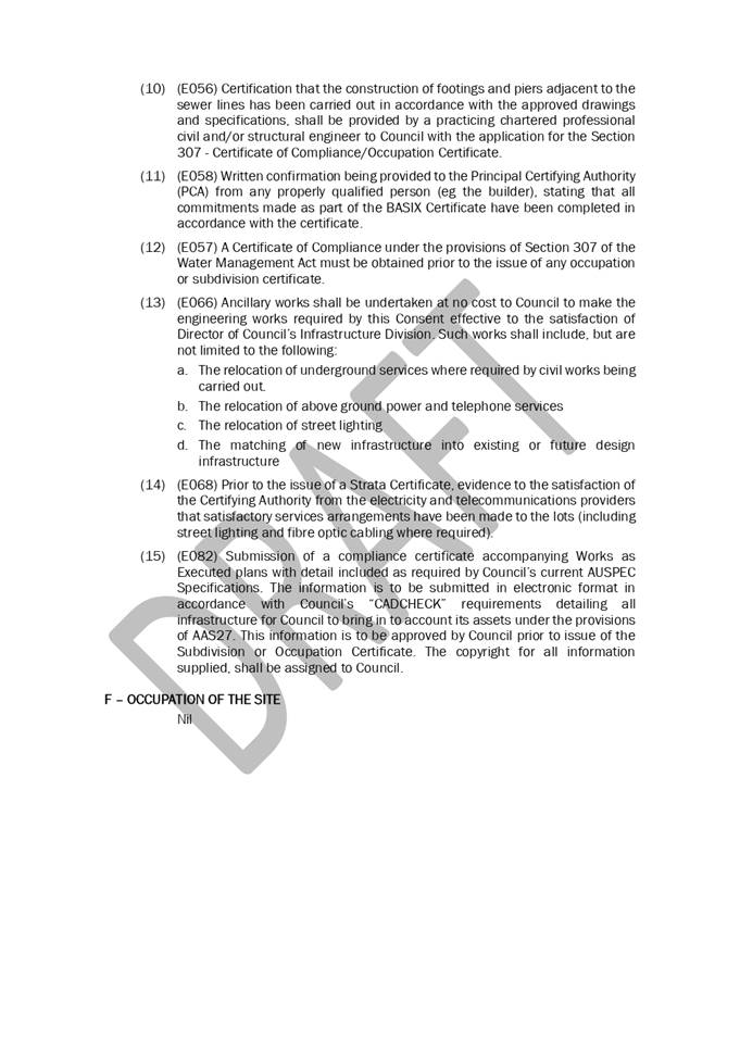
|
ATTACHMENT
|
Development Assessment Panel
17/05/2023
|
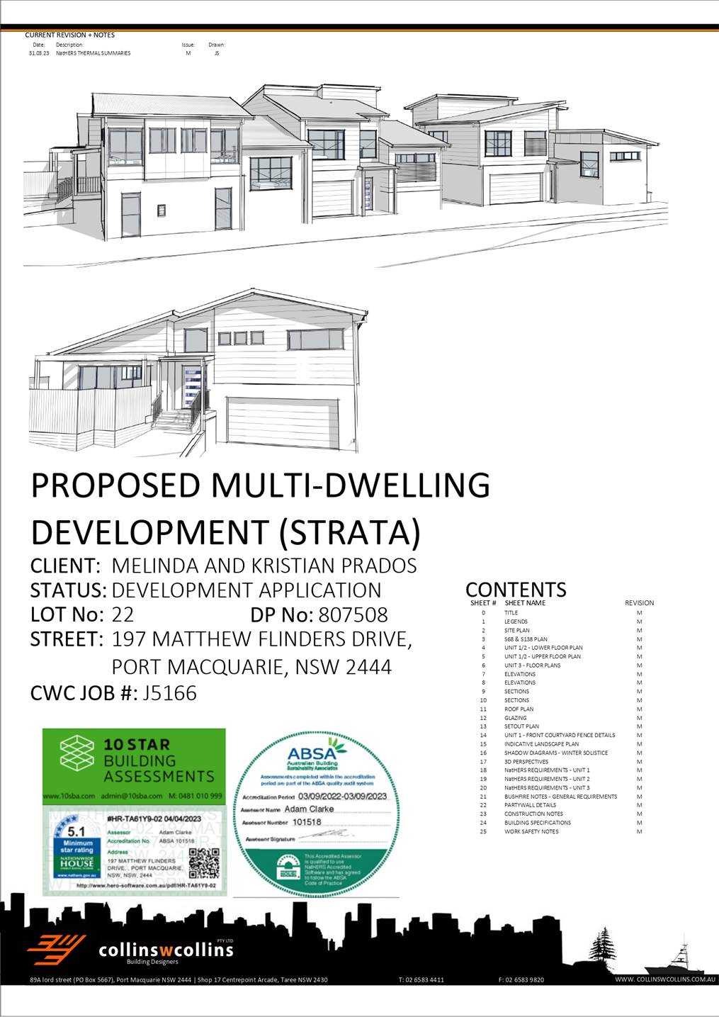
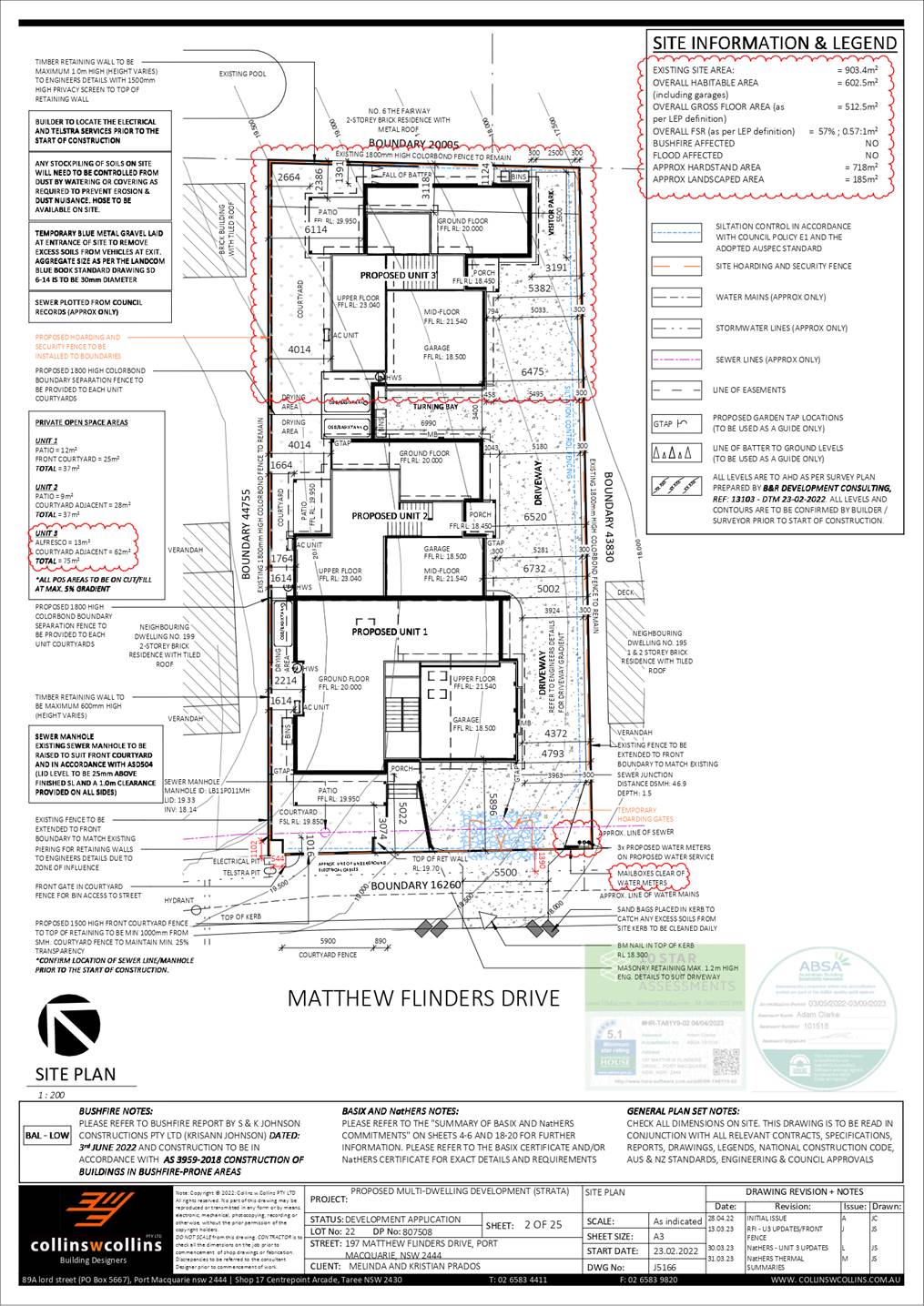
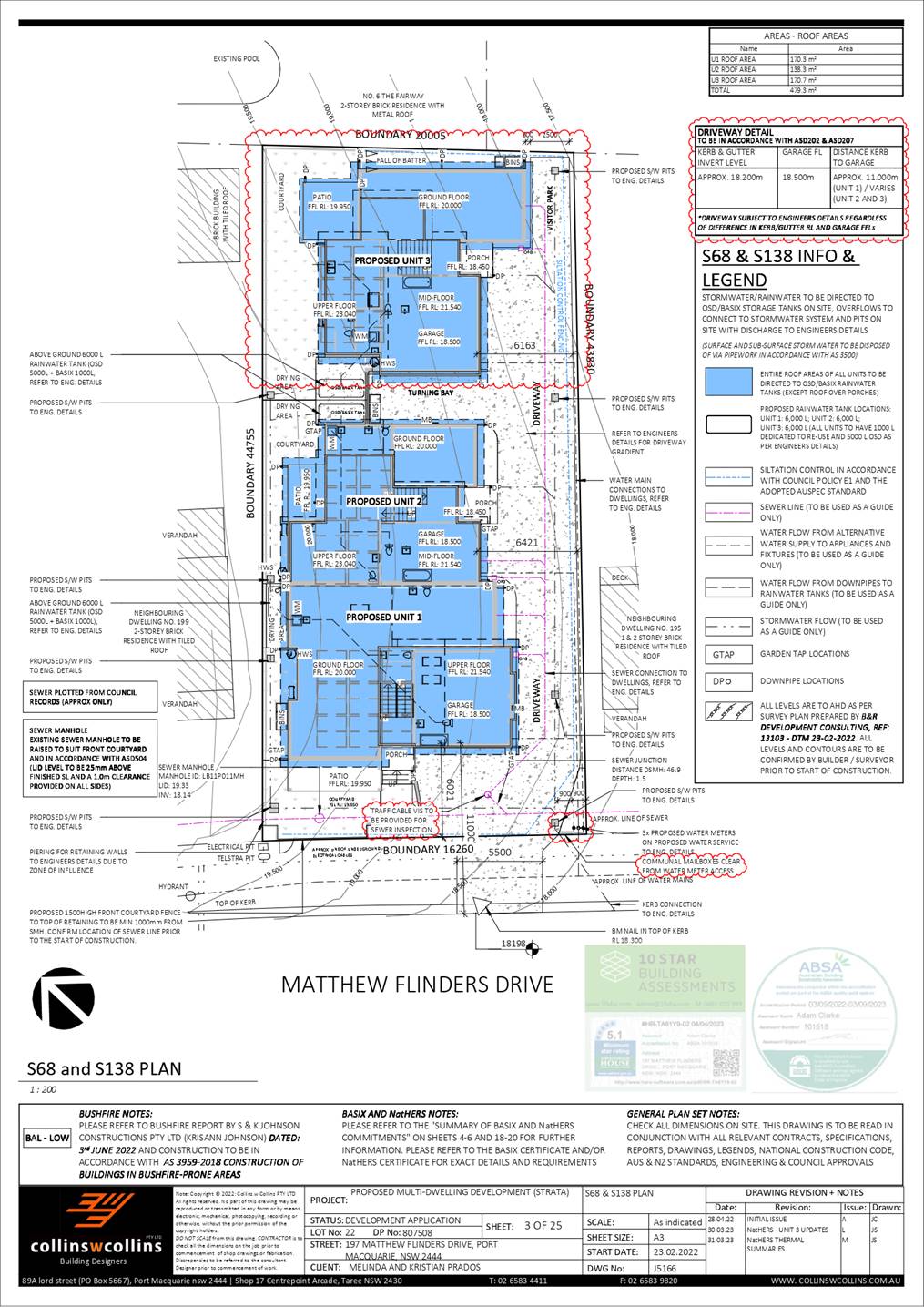
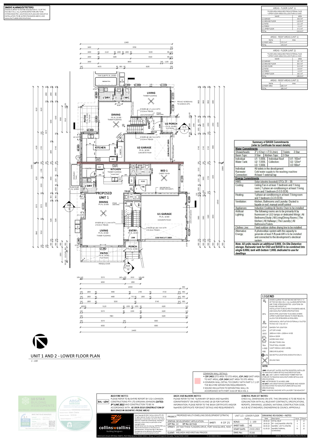
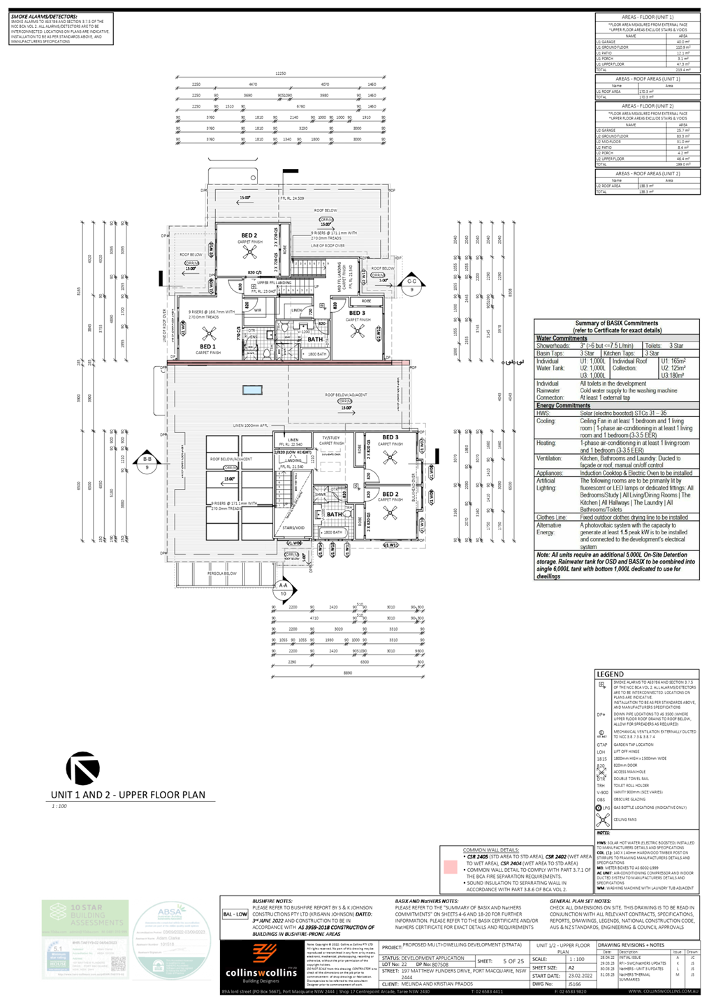
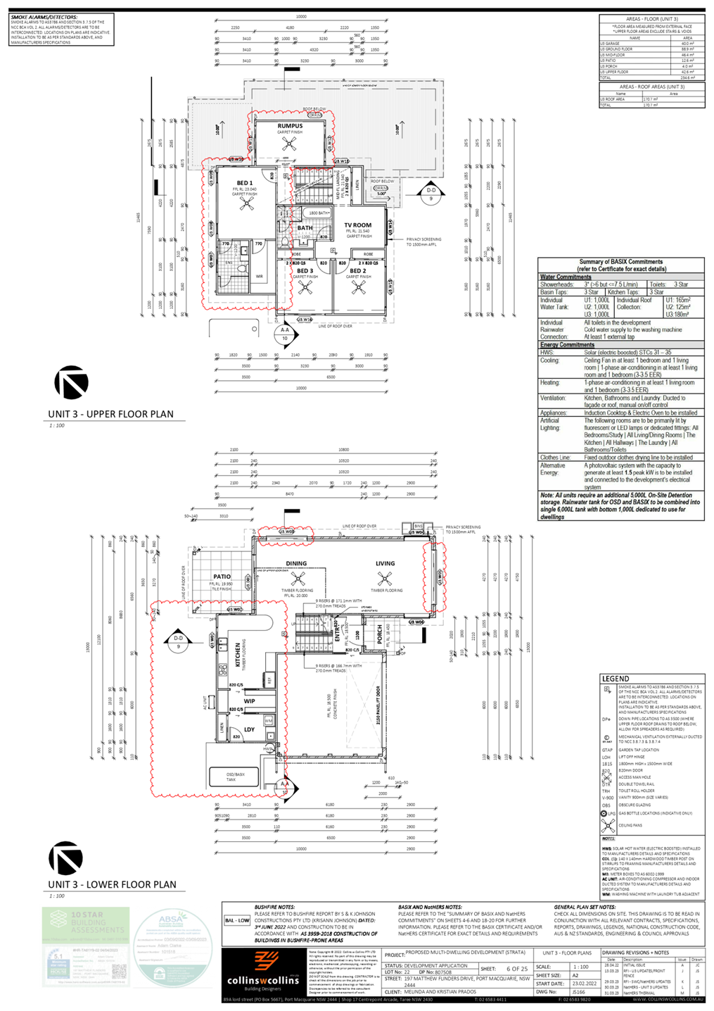
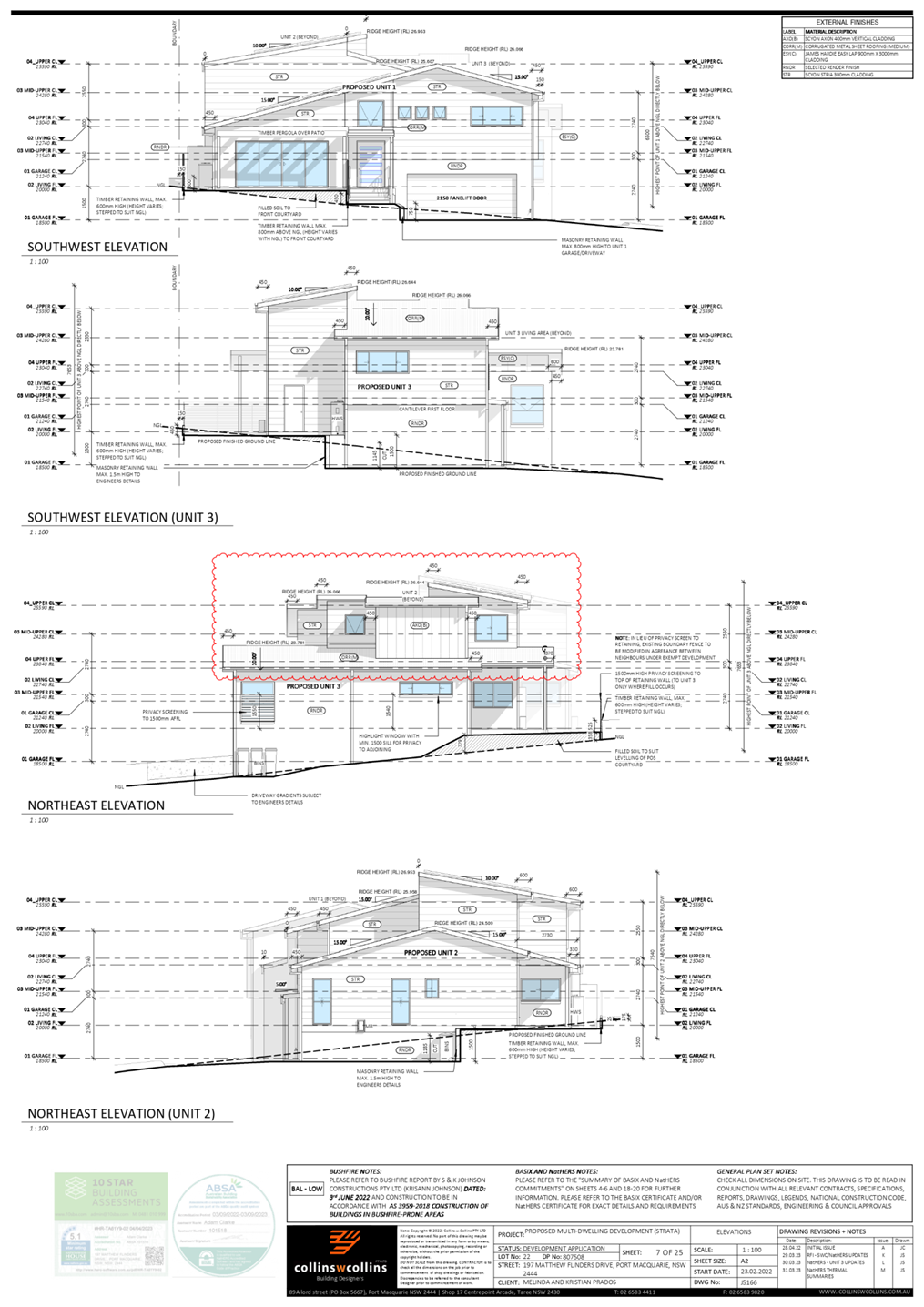
|
ATTACHMENT
|
Development Assessment Panel
17/05/2023
|