Business
Paper
|
date of meeting:
|
|
Wednesday 19 June
2019
|
|
location:
|
|
Council Chambers
17 Burrawan Street
Port Macquarie
|
|
time:
|
|
5.30pm
|
Community Vision A sustainable high quality of life for all
Community Mission Building
the future together
People
Place Health Education Technology
Council’s Corporate Values é Sustainability
é Excellence in Service Delivery
é Consultation and Communication
é Openness and Accountability
é Community Advocacy
Community Themes é Leadership and Governance
é Your Community Life
é Your Business and Industry
é Your Natural and Built Environment
How Members of the Public
Can Have Their Say at Council Meetings
Council has a commitment to providing
members of the public with an input into Council's decision making. The
Council's Code of Meeting Practice provides two (2) avenues for members of the
public to address Council on issues of interest or concern at the Ordinary
Council Meeting. These are:
·
Addressing Council on an Agenda Item (if the
matter is listed in the Council Business Paper)
·
Addressing Council in the Public Forum (if the
matter is not listed in the Council Business Paper)
You can request to address Council by
completing the:
·
‘Request to Speak on an Agenda Item’ form
·
‘Request to Speak in the Public Forum’ form
These can be obtained from Council’s
Offices at Laurieton, Port Macquarie and Wauchope or by downloading it from Council’s website.
Requests can also be lodged on-line at:
http://www.pmhc.nsw.gov.au/About-Us/How-Council-Works/Council-Committee-Meetings/Request-to-speak-on-an-Agenda-Item
http://www.pmhc.nsw.gov.au/About-Us/How-Council-Works/Council-and-Committee-Meetings/Request-to-speak-in-a-Public-Forum
Your request to address Council must be
received by Council no later than 4:30pm on the day prior to the Council
Meeting.
·
Council
will permit no more than two (2) speakers ‘in support of’ and two
(2) speakers ‘in opposition to’ the recommendation on any one (1) Agenda
Item.
·
A maximum of five (5) speakers will be heard in the Public
Forum.
·
There is no automatic right under
legislation for the public to participate in a Meeting of Council or a
Committee of Council.
·
For a member of the public to be
considered to address Council they must agree to strictly adhere to all
relevant adopted Council Codes, Policies and Procedures at all times.
·
Consideration of items for which
requests to address the Council Meeting have been received will commence at
5:30pm.
·
When your name is called, please
proceed to the Council Table and address Council.
·
Each speaker will be allocated a
maximum of five (5) minutes to address Council. This time is strictly enforced.
·
Councillors may ask questions of a
speaker following an address. Each answer, by the speaker to a question,
is limited to two (2) minutes. A speaker cannot ask questions of Council.
·
An Agenda Item will be
debated by Council following the address.
·
Council will not determine any
matter raised in the Public Forum session, however Council may resolve
to call for a future report.
·
If you have any documentation to
support your presentation, provide two (2) copies to Council by 12 noon on the
day of the Meeting.
·
If a speaker has an audio visual
presentation, a copy of the presentation is to be provided to Council by 12
noon on the day of the Meeting.
·
The following will not be
considered in the Public Forum (in accordance with the Code of Meeting
Practice, clause 2.14.14):
-
Proposed or current development
and rezoning applications and related matters.
-
A third (3rd) or subsequent application
by a single member of the public to address Council on the same issue in the
same calendar year. Council, at its discretion, may elect to exempt
representatives or members of community groups from this restriction.
-
Any formal procurement process,
contract negotiation or dispute resolution being undertaken.
-
Any matter the General Manager (or
their delegate) considers inappropriate for discussion in the Public Forum.
·
Council accepts no responsibility
for any defamatory statements made by speakers.
·
Members of the public may quietly
enter and leave the Meeting at any time.
Wednesday 19 June
2019
Items of
Business
01 Acknowledgement
of Country............................................................................. 1
02 Local
Government Prayer.................................................................................. 1
03 Apologies.......................................................................................................... 1
04 Confirmation
of Minutes..................................................................................... 1
05 Disclosures
of Interest..................................................................................... 24
06 Mayoral
Minute
07 Confidential
Correspondence to Ordinary Council Meeting................................. 28
08 Public
Forum - Matters Not On The Agenda ..................................................... 29
09 Public
Forum - Matters On The Agenda............................................................ 30
10 Leadership
and Governance.......................................................................... 31
10.01..... Code of Meeting Practice................................................................... 32
10.02..... Status of Reports From Council Resolutions........................................ 35
10.03..... Mayoral Discretionary Fund Allocations - 2
May to 5 June 2019............ 41
10.04..... Integrated Planning and Reporting (IPR)
Documents .......................... 43
10.05..... Making of Rates and Charges for 2019/2020,
Adoption of the Fees and Charges and Revenue Policy for 2019/2020............................................................ 94
10.06..... Monthly Budget Review - May 2019.................................................. 101
10.07..... Investments - May 2019................................................................... 108
10.08..... Classification of Lands to be Acquired by
Council.............................. 112
10.09..... Notice of Motion - Federal Election -
Congratulations to Federal Members 115
10.10..... Notice of Motion - Emergency Services Levy
Increase....................... 116
11 Your
Community Life................................................................................... 118
11.01..... Notice of Motion - Port Macquarie Police
Station Site......................... 119
11.02..... Recommended Item from Local Traffic
Committee - 2019 Seaview Cycling Classic....................................................................................................... 120
11.03..... Laurieton Sports Complex Master Plan............................................. 121
12 Your
Business and Industry........................................................................ 127
12.01..... Road Closure and Sale of Land - Main
Street, Ellenborough............... 128
13 Your
Natural and Built Environment............................................................ 130
13.01..... Proposed Orbital Road Project ......................................................... 131
13.02..... Land Acquisition - Corner of Lake Road
& Blackbutt Road, Port Macquarie 154
13.03..... Land Acquisition and Road Closure Being
part Thone River Road, Byabarra 156
13.04..... Land Acquisitions - Wingham Road and Main
Street, Comboyne........ 159
13.05..... Creation of Easements for Water Supply -
John Oxley Drive, Thrumster 161
13.06..... Planning Proposal Request PP2011 -
9.3: The Ruins Way and South Blackwood, Port Macquarie....................................................................................... 163
13.07..... Post Exhibition Report - Highway Service
Centre Planning Proposal, Draft Planning Agreement and Draft Highways Gateway
Development Control Plan .. 190
13.08..... DA2018 - 353.1 Commercial Premises and
Tourist and Visitor Accommodation with Clause 4.6 Variation to Clause 4.3
(Height of Buildings) and Clause 4.4 (Floor Space Ratio) of the Port
Macquarie-Hastings Local Environmental Plan 2011 at Lot 123 DP 1219042, No. 17
Clarence Street, Port Macquarie............................. 216
13.09..... Kooloonbung Creek Flying-Fox Camp
Management Plan.................. 249
13.10..... Biodiversity Strategy: Report Following
Close of Public Exhibition Phase 259
14 Items
To Be Dealt With By Exception
15 Confidential Matters
Motion to move into
Confidential Committee of the Whole................................ 270
15.01..... Request for Bad Debt Write-Off
15.02..... Workers Compensation Insurance Premiums
15.03..... Purchase by Property Reserve
15.04..... T-19-09 Supply and Delivery of Ready Mix
Concrete
15.05..... T-19-10 Supply and Delivery of Road
Construction Materials
15.06..... T-19-18 Provision of Insurance, Brokerage
and Risk Management Services
15.07..... T-19-22 Cash Collection Services
15.08..... T-19-02 Lease of the Cafe and Retail Lease
Areas and Other Commercial Opportunities at the Port Macquarie Airport
15.09..... T-19-19 Request for Proposal - Innes
Gardens Memorial Park Crematorium and Lawn Cemetery
15.10..... T-14-06 Operation & Routine Maintenance
of PMHC Vehicular Ferries – Settlement Point & Hibbard Crossings.
15.11..... T-19-20 Provision of Line Marking Services
15.12..... T-19-39 Dunbogan Bridge Rehabilitation -
Construction Stage Support
15.13..... Legal Advice on Water Fluoridation
Adoption
of Recommendations from Confidential Committee of the Whole
AGENDA Ordinary Council 19/06/2019
Subject: ACKNOWLEDGEMENT
OF COUNTRY
"I acknowledge that we are
gathered on Birpai Land. I pay respect to the Birpai Elders both past and
present. I also extend that respect to all other Aboriginal and Torres Strait
Islander people present."
Subject: LOCAL
GOVERNMENT PRAYER
A Minister from the Combined Churches of Port Macquarie will
be invited to deliver the Local Government Prayer.
RECOMMENDATION
That the apologies received be
accepted.
Subject: CONFIRMATION
OF PREVIOUS MINUTES
Recommendation
That the Minutes of the Ordinary
Council Meeting held on 15 May 2019 be confirmed.
MINUTES
Ordinary Council Meeting
15/05/2019
PRESENT
Members:
Councillor Peta Pinson (Mayor)
Councillor Lisa Intemann (Deputy Mayor)
Councillor Rob Turner
Councillor Sharon Griffiths
Councillor Peter Alley
Councillor Justin Levido
Councillor Geoff Hawkins
Councillor Lee Dixon
Other Attendees:
General Manager (Craig Swift-McNair)
Director Corporate Performance (Rebecca Olsen)
Director Development and Environment (Melissa Watkins)
Acting Director Infrastructure (Jeffery Sharp)
Acting Director Strategy and Growth (Holly McBride)
Group Manager Governance and Procurement (Blair Hancock)
Governance Support Officer (Gai Lazarides)
Communications Manager (Andy Roberts)
|
The meeting opened at 5.30pm.
|
|
01 ACKNOWLEDGEMENT
OF COUNTRY
|
|
The Mayor opened the Meeting with
an Acknowledgement of Country and welcomed all in attendance in the Chamber.
|
|
02 LOCAL
GOVERNMENT PRAYER
|
|
Reverend Malcolm Hausler from the Uniting Church
delivered the Local Government Prayer.
|
|
03 APOLOGIES
|
|
RESOLVED: Dixon/Alley
That the apology from Councillor
Cusato be noted.
carried: 8/0
For: Alley, Dixon,
Griffiths, Hawkins, Intemann, Levido, Pinson and Turner
Against: Nil
|
|
04 CONFIRMATION
OF MINUTES
|
|
RESOLVED: Intemann/Griffiths
That the Minutes of the Ordinary
Council Meeting held on 17 April 2019 be confirmed.
carried: 8/0
For: Alley, Dixon,
Griffiths, Hawkins, Intemann, Levido, Pinson and Turner
Against: Nil
|
|
05 DISCLOSURES
OF INTEREST
|
|
Councillor Levido declared a Non-Pecuniary, Significant Interest
in Item 12.03 - Lorne Road Works as Material Public Benefit, the reason being
that Councillor Levido is the principal of the Port Macquarie Law Firm,
Levido Law & Property. The Firm acts for the owner of the property the
subject of the report before Council..
Mayor Pinson declared a
Pecuniary Interest in Item 14.02 - T-19-08 Construction of Lighthouse Road
East Upgrade, the reason being that Mayor Pinson owns a company (Stabilcorp)
who has business dealings with three of the tenderers.
Councillor Levido declared a Non-Pecuniary, Significant
Interest in Item 14.02 - T-19-08 Construction of Lighthouse road East
Upgrade, the reason being that Councillor Levido is the principal of the Port
Macquarie Law Firm, Levido Law & Property. The Firm acts for one the
tenderers as to the tender the subject of the report before Council.
Councillor Levido declared a Non-Pecuniary, Significant
Interest in Item 14.04 - T-19-17 Westport Drainage Study and Detailed Design
of Stormwater Remediation Measures, the reason being that Councillor Levido is
the principal of the Port Macquarie Law Firm, Levido Law & Property. The
Firm acts for one the tenderers as to the tender the subject of the report
before Council.
Councillor Levido declared a Non-Pecuniary, Significant Interest
in Item 14.05 - T-19-17 Provision of Surveying Services, the reason being
that Councillor Levido is the principal of the Port Macquarie Law Firm,
Levido Law & Property. The Firm acts for one the tenderers as to the
tender the subject of the report before Council.
|
|
06.01 Mayoral
Discretionary Fund Allocations
|
|
RESOLVED: Pinson
That the Mayoral Discretionary Fund allocations for the
period 4 April to 1 May 2019 inclusive be noted.
carried: 8/0
For: Alley, Dixon,
Griffiths, Hawkins, Intemann, Levido, Pinson and Turner
Against: Nil
|
|
|
|
07 CONFIDENTIAL
CORRESPONDENCE TO ORDINARY COUNCIL MEETING
|
|
RESOLVED: Levido/Hawkins
That Council determine that the
attachments to Item Numbers 09.04, 09.08, 10.01 be considered as
confidential, in accordance with section 11(3) of the Local Government Act.
carried: 8/0
For: Alley, Dixon,
Griffiths, Hawkins, Intemann, Levido, Pinson and Turner
Against: Nil
|
|
08 PUBLIC
FORUM
|
|
The Mayor advised of applications
to address Council in the Public Forum from:
1.
Mr Philip Lloyd regarding the Orbital Road
proposal
2.
Mr Grant Mitchell, regarding the Airport
primary access road and Orbital community consultation process
3.
Ms Kathy Wonderley, regarding the Orbital Road
proposal for Fernhill Road and the impact on ACES.
RESOLVED: Dixon/Hawkins
That the above requests to speak
in the Public Forum be acceded to.
carried: 8/0
For: Alley, Dixon,
Griffiths, Hawkins, Intemann, Levido, Pinson and Turner
Against: Nil
|
|
08.01 Orbital Road Proposal
|
|
Mr Philip Lloyd addressed Council
regarding the Orbital Road and responded to questions from Councillors.
|
|
08.02 Airport Primary Access Road and Orbital
Community Consultation Process
|
|
Mr Grant Mitchell addressed
Council regarding the Airport primary access road and Orbital community consultation
process and responded to questions from Councillors. Mr Mitchell tabled a
document and provided copies to Councillors.
|
|
08.03 Orbital Road proposal for Fernhill Road and
the impact on ACES
|
|
Ms Kathy Wonderley addressed
Council regarding the Orbital Road proposal for Fernhill Road and the impact
on ACES.
|
|
Request to speak on an agenda item
|
|
The Mayor advised of requests to
speak on an agenda item as follows:
Item 09.01 - Ms Danielle Maltman
in support of the recommendation
Item 12.03 - Mr Michael Mowle in
support of the recommendation.
RESOLVED: Intemann/Alley
carried: 8/0
For: Alley, Dixon,
Griffiths, Hawkins, Intemann, Levido, Pinson and Turner
Against: Nil
|
|
Suspension of Standing Orders
|
|
RESOLVED: Intemann/Alley
That Standing Orders be suspended
to allow Items 09.01, 12.03 to be brought forward and considered next.
carried: 8/0
For: Alley, Dixon,
Griffiths, Hawkins, Intemann, Levido, Pinson and Turner
Against: Nil
|
|
09.01 Notice
of Motion - Submission from Revive Lake Cathie Inc.to PMHC 2019-2020
Operational Plan
|
|
Ms Danielle Maltman addressed
Council in support of the recommendation and responded to questions from
Councillors.
RESOLVED: Hawkins/Griffiths
That Council:
1. Thank the Revive Lake Cathie group for its submission on Lake
Cathie.
2. Note
that Lake Cathie is an asset of the Crown and management of the Lake
Cathie system is the responsibility of a number of stakeholders including:
a) Council;
b) National
Parks and Wildlife Service (NPWS);
c) Office
of the Environment and Heritage (OEH); and
d) NSW
Fisheries and Department of Industry (Lands),
in accordance with the
NSW Coastal Management Act 2016 and the Lake Cathie Opening Strategy
3. Request the General Manager to forward a copy of the Revive
Lake Cathie Group’s submission to:
a) National
Parks and Wildlife Service;
b) Office
of the Environment and Heritage (OEH);
c) NSW
Fisheries and Department of Industry (Lands);
d) NSW
Minister for Water, Property and Housing;
e) NSW
Local Member (and local resident) Leslie Williams;
f) Premier
Gladys Berejiklian;
g) Deputy
Premier John Barilaro;
h) Newly
elected Federal Members for Lyne and Cowper;
i) Newly
appointed Federal Environment Minister.
4. Request
the General Manager to seek advice from the NSW Government referred to
in 3 above as to whether, as a result of the Revive Lake Cathie submission,
the existing Lake Cathie Opening Strategy should be reviewed.
5. Request
the General Manager to make a further request of the NSW Government that if
it deems a review of the Lake Cathie Opening Strategy is required,
that the necessary resources to undertake such a review be provided,
along with any resources required for associated capital works that may be prescribed
by an updated strategy or management plan.
6. Give
consideration to including an allocation in the 2019/20 Operational Budget to
support the initial work required.
7. Request
the General Manager submit an update report to the September, 2019 meeting of
council.
carried: 8/0
For: Alley, Dixon,
Griffiths, Hawkins, Intemann, Levido, Pinson and Turner
Against: Nil
|
|
|
Councillor
Levido left the meeting, the time being 06:43pm.
|
12.03 Lorne
Road Works as Material Public Benefit
|
|
Mr Michael Mowle, Hopkins
Consultants Pty Ltd addressed Council in support of the recommendation.
RESOLVED: Alley/Hawkins
That Council:
1. Approve
the application to undertake construction of road works in Lorne Road,
Kendall on the basis that the work will provide material public benefit pursuant
to s7.11(5)(b) of the Environmental Planning and Assessment Act 1979 (as
amended), subject to the applicant entering into a Works in Kind Agreement.
2. Delegate
authority to the General Manager to execute the Works in Kind Agreement in
item 1 above.
carried: 7/0
For: Alley, Dixon,
Griffiths, Hawkins, Intemann, Pinson and Turner
Against: Nil
|
|
|
Councillor
Levido returned to the meeting, the time being 06:46pm.
|
09.02 Status
of Reports From Council Resolutions
|
|
RESOLVED: Intemann/Hawkins
That Council note the information contained in the Status
of Reports from Council Resolutions report.
carried: 8/0
For: Alley, Dixon,
Griffiths, Hawkins, Intemann, Levido, Pinson and Turner
Against: Nil
|
|
|
Councillor
Hawkins left the meeting, the time being 06:47pm.
Councillor
Hawkins returned to the meeting, the time being 06:49pm.
|
09.03 Draft Code of Conduct and Draft Procedures for the
Administration of the Model Code of Conduct
|
|
RESOLVED:
Intemann/Griffiths
That
Council:
1. Pursuant to Section 440 of the
Local Government Act 1993, adopt the draft Code of Conduct.
2. Pursuant to Section 440AA of
the Local Government Act 1993, adopt the draft Procedures for the
Administration of the Model Code of Conduct.
carried: 8/0
For: Alley, Dixon,
Griffiths, Hawkins, Intemann, Levido, Pinson and Turner
Against: Nil
|
|
|
|
09.04 Legal Fees
|
|
RESOLVED:
Hawkins/Turner
That Council note the
information in the Legal Fees report.
carried: 8/0
For: Alley, Dixon,
Griffiths, Hawkins, Intemann, Levido, Pinson and Turner
Against: Nil
|
|
|
|
09.05 Disclosure of Interest Return
|
|
RESOLVED:
Intemann/Turner
That
Council note the Disclosure of Interest returns for the following positions:
1. Development Engineer.
2. Building Surveyor.
3. Project Manager Infrastructure
Delivery.
carried: 8/0
For: Alley, Dixon,
Griffiths, Hawkins, Intemann, Levido, Pinson and Turner
Against: Nil
|
|
|
|
09.06 A Proposal to Amend the Boundary of the Localities of
Hacks Ferry and Limeburners Creek
|
|
RESOLVED:
Turner/Intemann
That Council make
application to the Geographical Names Board to alter the boundary of the
localities of Hacks Ferry and Limeburners Creek, to incorporate that part of
Hacks Ferry situated on the eastern side of the Maria River into the locality
of Limeburners Creek.
carried: 8/0
For: Alley, Dixon,
Griffiths, Hawkins, Intemann, Levido, Pinson and Turner
Against: Nil
|
|
|
|
09.07 Monthly
Budget Review - April 2019
|
|
RESOLVED: Hawkins/Alley
That Council:
1.
Note the error with the Tables on Page 51 and 52 of the agenda. The
correct figures are as per the second table, but with the addition of the
$300,000 line item to add to the $388,685 total.
2.
Adopt the adjustments in the “Budget Variations – April
2019” section of the Monthly Budget Review – April 2019.
3.
Amend the 2018-2019 Operational Plan to include all budget adjustments
approved in this report.
carried: 8/0
For: Alley, Dixon,
Griffiths, Hawkins, Intemann, Levido, Pinson and Turner
Against: Nil
|
|
|
|
09.08 Quarterly
Budget Review Statement - March 2019
|
|
RESOLVED: Hawkins/Turner
That Council note the Quarterly Budget Review Statement
for the March 2019 Quarter.
carried: 8/0
For: Alley, Dixon,
Griffiths, Hawkins, Intemann, Levido, Pinson and Turner
Against: Nil
|
|
|
|
09.09 2018-2019 Operational Plan - Quarterly Progress Report
as at 31 March 2019
|
|
RESOLVED:
Dixon/Turner
That
Council note the 2018-2019 Operational Plan - Quarterly Progress
Report as at 31 March 2019.
carried: 8/0
For: Alley, Dixon,
Griffiths, Hawkins, Intemann, Levido, Pinson and Turner
Against: Nil
|
|
|
|
09.10 Property
Investment Portfolio - Six Monthly Report
|
|
RESOLVED: Hawkins/Alley
That Council note the update provided on the Property
Investment Portfolio as provided in this report
carried: 8/0
For: Alley, Dixon,
Griffiths, Hawkins, Intemann, Levido, Pinson and Turner
Against: Nil
|
|
|
|
09.11 Development
Activity And Assessment System Performance
|
|
RESOLVED: Turner/Griffiths
That Council note:
1. The
Development Activity and Assessment System Performance report for the third quarter
of 2018-2019; and
2. The
determinations made by staff under Clause 4.6 of the Port Macquarie-Hastings
Local Environmental Plan 2011.
carried: 8/0
For: Alley, Dixon,
Griffiths, Hawkins, Intemann, Levido, Pinson and Turner
Against: Nil
|
|
|
|
09.12 Investments - April 2019
|
|
RESOLVED:
Hawkins/Dixon
That Council note the
Investment Report for the month of April 2019.
carried: 8/0
For: Alley, Dixon,
Griffiths, Hawkins, Intemann, Levido, Pinson and Turner
Against: Nil
|
|
|
|
09.13 2019-2020
Councillor and Mayoral Fees
|
|
RESOLVED: Hawkins/Turner
That in relation to Councillor remuneration for the
2019-2020 financial year, Council:
1. Pursuant to the provisions
of section 248(2) of the Local Government Act 1993, Council set the annual
fee payable to a Councillor for the financial year commencing 1 July 2019 to
be $20,280.
2. Pursuant to the provisions
of section 249(3) of the Local Government Act 1993, Council set the annual
fee payable to the Mayor for the financial year commencing 1 July 2019 to be
$64,530 (this amount includes the fee payable to a Councillor).
3. Request the General Manager:
a. Write to the Local Government
Remuneration Tribunal (Tribunal) to confirm what additional information and
criteria needs to be provided and to what level of detail in order for the
Tribunal to seriously consider an application from Council with regard to
potentially moving Council categories.
b.
Table a report at
a future meeting of Council detailing the response from the Tribunal to the
above question.
carried: 8/0
For: Alley, Dixon,
Griffiths, Hawkins, Intemann, Levido, Pinson and Turner
Against: Nil
|
|
|
|
10.01 2018-2019
Round 2 Community Grant Program for Endorsement
|
|
RESOLVED: Dixon/Griffiths
That Council pursuant to Section 356 of the Local Government
Act 1993, grant financial assistance from the Community Grants 2018-2019
Round 2 for the total amount of $83,421 to the following:
General Community Grants
Bonny Hills Progress Association Covered
Seating $9800
Port Macquarie-Hastings Bridge
Association LED
Lighting Upgrade $2393
Amateur Beekeepers Association Bee
Education and
(Hastings Valley) BioSecurity
Awareness $8678
Comboyne Community Association Community
Website $3770
Motorcycle Friendly Wauchope Motofest
Collateral $9227
Port Macquarie Tennis Club Safety
Fencing $3440
Wauchope Timbertown Tennis Club Facility
Improvements $10,000
Seaside Scavenge Community
Clean Up $3326
Laurieton Men’s Shed Thicknesser $5996
Hastings Orienteering Group Collateral
for Events $7651
Total $64,281
Place Making Grants
Rotary Club Port Macquarie Shade
Sail over Liberty
Sunrise Swing $10,000
Friends of Mrs York’s Garden New
Covered Seat $9140
Total $19,140
carried: 8/0
For: Alley, Dixon,
Griffiths, Hawkins, Intemann, Levido, Pinson and Turner
Against: Nil
|
|
|
|
10.02 Grant Applications Quarterly Report
|
|
RESOLVED:
Alley/Turner
That Council note the
second quarterly Grant Application Report, providing an overview of grants
applied for or obtained in the 2018-19 financial year.
carried: 8/0
For: Alley, Dixon,
Griffiths, Hawkins, Intemann, Levido, Pinson and Turner
Against: Nil
|
|
|
|
10.03 Recommended
Items from the Mayor's Sporting Fund Sub-Committee - April 2019
|
|
RESOLVED: Pinson/Griffiths
That Council, pursuant to Section
356 of the Local Government Act 1993, grant financial assistance from the
Mayor’s Sporting Fund as follows:
1. Madelaine Goodridge receive
$500.00 to assist with the expenses she would have incurred travelling to and
competing at the 2019 Hancock Prospecting Australian Age Swimming Championships
held in Adelaide, South Australia from 15 - 22 April 2019 inclusive.
2. Morgan Jean receive a total of
$800.00 to assist with the expenses he would have incurred travelling to and
competing at both the NSWCHS Swimming Championships held in Sydney from 8 -
10 April 2019 inclusive, and the 2019 Hancock Prospecting Australian Age
Swimming Championships held in Adelaide, South Australia from 15 - 22 April
2019 inclusive.
carried: 8/0
For: Alley, Dixon,
Griffiths, Hawkins, Intemann, Levido, Pinson and Turner
Against: Nil
|
|
|
Councillor
Dixon left the meeting, the time being 07:07pm.
|
11.01 Economic
Development Strategy 2017-2021: Six Monthly Report on Progress
|
|
RESOLVED: Turner/Hawkins
That Council note the six monthly progress report on
implementation of the 2017-2021 Port Macquarie-Hastings Economic Development
Strategy.
carried: 7/0
For: Alley, Griffiths,
Hawkins, Intemann, Levido, Pinson and Turner
Against: Nil
|
|
|
Councillor
Dixon returned to the meeting, the time being 07:11pm.
|
11.02 Recommended
Item from Economic Development Steering Group - Smart Regional City Planning
|
|
RESOLVED: Turner/Hawkins
That Council:
1. Note
the recommendation from the Economic Development Steering Group that
consideration be given to the development of a Smart City Strategy; and
2. Develop
a Smart City Strategy as a replacement action for the development of a
Regional City Strategy in the Draft 19/20 Operational Plan action 3.1.1.1 to
“Implement actions from the 2017-2021 Economic Development Strategy to
lead, create and proactively support an environment that stimulates sustainable
industry, business and investment”
3. Endorse
Councillors Hawkins and Turner to attend the Smart Cities conference in
Melbourne 30 & 31 May 2019.
carried: 8/0
For: Alley, Dixon,
Griffiths, Hawkins, Intemann, Levido, Pinson and Turner
Against: Nil
|
|
|
|
12.01 Classification
of Land Containing Sewer Infrastructure
|
|
RESOLVED: Intemann/Griffiths
That Council classify Lot 11 DP1250178 (land off Botanic
Drive, Kew) as “operational land”.
carried: 8/0
For: Alley, Dixon,
Griffiths, Hawkins, Intemann, Levido, Pinson and Turner
Against: Nil
|
|
|
|
12.02 Question
From Previous Meeting - New Pedestrian Crossing - Bold Street, Laurieton
|
|
RESOLVED: Pinson/Dixon
That Council:
1.
Note the information provided in this report.
2.
Note the tabled Petition of over 600
signatures to locate the pedestrian crossing on Bold Street Laurieton and
investigate the crossing being constructed between the entry and exit of the
Coles Supermarket carpark and the Chemist Shop.
3.
Defer commencement of pedestrian crossing
works in Bold Street Laurieton for the purpose of reviewing the location of
the crossing.
4.
Request the General Manager report to the July
2019 Council Meeting on the feasibility of moving the crossing including the
safety, financial and other impacts of doing so.
5.
Note that this deferral is likely to delay the
project beyond the terms of the current funding agreement.
carried: 8/0
For: Alley, Dixon,
Griffiths, Hawkins, Intemann, Levido, Pinson and Turner
Against: Nil
|
|
|
Item - 12.03 Lorne Road Works as Material Public Benefit - has
been moved to another part of the document.
|
12.04 Recommended Item from Coast, Estuary & Floodplain
Advisory Sub Committee - Hibbard Precinct Flood Study - Draft Report
|
|
RESOLVED:
Intemann/Griffiths
That
Council:
1.
Place the draft Hibbard Precinct Flood Study
(2019) on public exhibition for a minimum of 28 days commencing 20 May 2019;
and
2.
Receive a further report detailing the
submissions received from the public during the exhibition period at the
conclusion of the exhibition.
carried: 8/0
For: Alley, Dixon,
Griffiths, Hawkins, Intemann, Levido, Pinson and Turner
Against: Nil
|
|
|
|
12.05 Recommended
Item from Coast, Estuary & Floodplain Advisory Sub Committee - North
Brother Flood Study Draft Report
|
|
RESOLVED: Intemann/Dixon
That Council:
1.
Place the North Brother Flood Study Draft
Report on public exhibition for a minimum of 28 days commencing 20 May 2019;
and
2.
Receive a further report detailing the
submissions received from the public during the exhibition period at the
conclusion of the exhibition.
carried: 8/0
For: Alley, Dixon,
Griffiths, Hawkins, Intemann, Levido, Pinson and Turner
Against: Nil
|
|
|
|
13 QUESTIONS
FOR NEXT MEETING
|
|
There be no
questions for next meeting.
|
|
CONFIDENTIAL COMMITTEE OF THE WHOLE
|
|
RESOLVED:
Dixon/Alley
1.
That pursuant to section 10A subsections 2 & 3 and 10B of the
Local Government Act 1993 (as amended), the press and public be excluded from
the proceedings of the Council in Confidential Committee of the Whole (Closed
Session) on the basis that items to be considered are of a confidential
nature.
2.
That Council move into Confidential Committee of the Whole (Closed
Session) to receive and consider the following items:
Item 14.01
T-18-58 Supply and Delivery of two
(2) x 20 Tonne Track Mounted Excavators
This
item is considered confidential under Section 10A(2)(d(ii)) of the Local
Government Act 1993, as it contains commercial information of a confidential
nature that would, if disclosed, confer a commercial advantage on a competitor
of the Council.
Item 14.02 T-19-08
Construction of Lighthouse Road East Upgrade
This
item is considered confidential under Section 10A(2)(d(i)) of the Local
Government Act 1993, as it contains commercial information of a confidential
nature that would, if disclosed, prejudice the commercial position of the
person who supplied it.
Item 14.03 T-19-11
Provision of Destination Public Relations Services
This
item is considered confidential under Section 10A(2)(d(i)) of the Local
Government Act 1993, as it contains commercial information of a confidential
nature that would, if disclosed, prejudice the commercial position of the
person who supplied it.
Item 14.04
T-19-17 Westport Drainage Study
and Detailed Design of Stormwater Remediation Measures
This
item is considered confidential under Section 10A(2)(d(i)) of the Local
Government Act 1993, as it contains commercial information of a confidential
nature that would, if disclosed, prejudice the commercial position of the
person who supplied it.
Item 14.05 T-19-24
Provision of Surveying Services
This
item is considered confidential under Section 10A(2)(d(i)) of the Local
Government Act 1993, as it contains commercial information of a confidential
nature that would, if disclosed, prejudice the commercial position of the
person who supplied it.
Item 14.06
Request for Transfer of Land and
Building - Lot 101 DP1147245, 91 Greenmeadows Drive, Port Macquarie
This
item is considered confidential under Section 10A(2)(c) of the Local
Government Act 1993, as it contains information that would, if disclosed,
confer a commercial advantage on a person with whom the Council is conducting
(or proposes to conduct) business.
Item 14.07
Contract Extension Tender T-14-18
Dam Safety Engineer, Dam Surveillance and Annual Dam Safety Inspections
This
item is considered confidential under Section 10A(2)(c) of the Local
Government Act 1993, as it contains information that would, if disclosed,
confer a commercial advantage on a person with whom the Council is conducting
(or proposes to conduct) business.
Item 14.08
Provision of Integrated Water
Cycle Management Phase 2 Supplementary Report
This
item is considered confidential under Section 10A(2)(c) of the Local
Government Act 1993, as it contains information that would, if disclosed,
confer a commercial advantage on a person with whom the Council is conducting
(or proposes to conduct) business.
Item 14.09
Provision of Port Macquarie Water
Treatment Plant Scoping Study
This
item is considered confidential under Section 10A(2)(c) of the Local
Government Act 1993, as it contains information that would, if disclosed,
confer a commercial advantage on a person with whom the Council is conducting
(or proposes to conduct) business.
Item 14.10 Legal
Proceeding
This
item is considered confidential under Section 10A(2)(g) of the Local
Government Act 1993, as it contains advice concerning litigation, or advice
that would otherwise be privileged from production in legal proceedings on
the ground of legal professional privilege.
Item 14.11
T-19-18 Provision of Insurance,
Brokerage and Risk Management Services
This
item is considered confidential under Section 10A(2)(d(ii)) of the Local
Government Act 1993, as it contains commercial information of a confidential
nature that would, if disclosed, confer a commercial advantage on a
competitor of the Council.
3.
That the resolutions made by the Council in Confidential Committee of
the Whole (Closed Session) be made public as soon as practicable after the
conclusion of the Closed Session and such resolutions be recorded in the
Minutes of the Council Meeting.
|
carried: 8/0
For: Alley, Dixon,
Griffiths, Hawkins, Intemann, Levido, Pinson and Turner
Against: Nil
|
Adjourn meeting
|
|
The Ordinary Council Meeting
adjourned at 7.36pm.
|
|
Resume meeting
|
|
The Ordinary Council Meeting
resumed at 7.50pm.
|
|
ADOPTION OF RECOMMENDATIONS FROM THE CONFIDENTIAL
COMMITTEE OF THE WHOLE
|
|
RESOLVED:
Dixon/Griffiths
That the undermentioned
recommendations from Confidential Committee of the Whole (Closed Session) be adopted:
Item 14.01 T-18-58
Supply and Delivery of two (2) x 20 Tonne Track Mounted Excavators
This
item is considered confidential under Section 10A(2)(d(ii)) of the Local
Government Act 1993, as it contains commercial information of a confidential
nature that would, if disclosed, confer a commercial advantage on a
competitor of the Council.
RECOMMENDATION
That Council:
1. In
accordance with the Local Government (General) Regulations 2005 clause
178(1)(b), decline to accept any of the tenders submitted for
T-18-58 for the
supply and delivery of two (2) x 20 tonne track mounted excavators due to the
need to redefine the specification to meet operational and contractual
requirements.
2. In
accordance with the Local Government (General) Regulations 2005 clause
178(3)(a), cancel the proposal for the contract.
3. In
accordance with sect 55(3)(a) of the Local Government Act 1993 and with the
Local Government (General) Regulations 2005 clause 163(1A)(i) invite quotes
through the Local Government Procurement arrangement LGP707-3 from approved
contractors.
4. Request
the General Manager present a further report to a future meeting of Council
on completion of the LGP707-3 quotation process, for Council’s further
consideration.
5. Maintain
the confidentiality of the documents and consideration in respect of Tender
T-18-58.
Item 14.02
T-19-08 Construction of Lighthouse Road East
Upgrade
This
item is considered confidential under Section 10A(2)(d(i)) of the Local
Government Act 1993, as it contains commercial information of a confidential
nature that would, if disclosed, prejudice the commercial position of the
person who supplied it.
RECOMMENDATION
That Council:
1. Accept
the tender from Eire Constructions Pty Ltd for $1,021,682.36 (exclusive of
GST) for the construction of Lighthouse Road East Upgrade.
2. Affix
the seal of Council to the necessary documents.
3. Maintain
the confidentiality of the documents and consideration in respect of Tender
T-19-08.
Item 14.03
T-19-11 Provision of Destination Public
Relations Services
This
item is considered confidential under Section 10A(2)(d(i)) of the Local
Government Act 1993, as it contains commercial information of a confidential
nature that would, if disclosed, prejudice the commercial position of the
person who supplied it.
RECOMMENDATION
That Council:
1. Accept
the proposal from Gate 7 Pty Ltd for $65,000 (exclusive of GST) for the
provision of Destination Public Relations Services for one (1) year
commencing on 16 May 2019, with two (2) options to extend for a further two
(2) year periods, such option(s) to be for the benefit of the Council and may
be exercised only by the Council in its sole discretion.
2. Accept
the schedule of rates from Gate 7 Pty Ltd for the provision of Destination
Public Relations Services.
3. Affix
the seal of Council to the necessary documents.
4. Maintain
the confidentiality of the documents and consideration in respect of RFP
T-19-11.
Item 14.04
T-19-17 Westport Drainage Study and Detailed
Design of Stormwater Remediation Measures
This
item is considered confidential under Section 10A(2)(d(i)) of the Local
Government Act 1993, as it contains commercial information of a confidential
nature that would, if disclosed, prejudice the commercial position of the
person who supplied it.
RECOMMENDATION
That Council:
1. Accept
the Tender from Calibre Professional Services for $178,782.00 (exclusive of GST)
to undertake the Westport Drainage Study and Detailed Design of Stormwater
Remediation Measures.
2. Accept
the Schedule of Rates from Calibre Professional Services for the Westport
Drainage Study and Detailed Design of Stormwater Remediation Measures.
3. Affix
the seal of Council to the necessary documents.
4. Maintain
the confidentiality of the documents and consideration in respect of Tender
T-19-17.
Item 14.05
T-19-24 Provision of Surveying Services
This
item is considered confidential under Section 10A(2)(d(i)) of the Local
Government Act 1993, as it contains commercial information of a confidential
nature that would, if disclosed, prejudice the commercial position of the
person who supplied it.
RECOMMENDATION
That Council:
1. Accept
tenders from the following contractors to be appointed to a panel arrangement
for the provision of Surveying Services for a two (2) year period commencing
1 June 2019, with two (2) options to extend for a further two (2) year
periods, such option(s) to be for the benefit of the Council and may be
exercised only by the Council in its sole discretion:
a) Barker
Ryan Stewart Pty Ltd;
b) Cadence
Consulting Surveyors Pty Ltd;
c) De
Witt Consulting Pty Ltd;
d) Echo
Ecology Pty Ltd;
e) Hopkins
Consultants Pty Ltd;
f) King
& Campbell Trust t/as King & Campbell Pty Ltd;
g) Land
Dynamics Pty Ltd t/as Land Dynamics Australia;
h) Local
Government Engineering Services Pty Limited;
i) McGlashan
& Crisp Pty Limited; and
j) Pacific
Survey Sydney Pty Limited.
2. Accept
the Schedule of Rates for the provision of Surveying Services from:
a) Barker
Ryan Stewart Pty Ltd;
b) Cadence
Consulting Surveyors Pty Ltd;
c) De
Witt Consulting Pty Ltd;
d) Echo
Ecology Pty Ltd;
e) Hopkins
Consultants Pty Ltd;
f) King
& Campbell Trust t/as King & Campbell Pty Ltd;
g) Land
Dynamics Pty Ltd t/as Land Dynamics Australia;
h) Local
Government Engineering Services Pty Limited;
i) McGlashan
& Crisp Pty Limited; and
j) Pacific
Survey Sydney Pty Limited.
3. Affix
the seal of Council to the necessary documents.
4. Maintain
the confidentiality of the documents and considerations in respect of Tender
T-18-24.
Item 14.06
Request for Transfer of Land and Building -
Lot 101 DP1147245, 91 Greenmeadows Drive, Port Macquarie
This
item is considered confidential under Section 10A(2)(c) of the Local
Government Act 1993, as it contains information that would, if disclosed,
confer a commercial advantage on a person with whom the Council is conducting
(or proposes to conduct) business.
RECOMMENDATION
That Council:
1. Note
the request to transfer the land (including improvements) comprising Lot 101
Deposited Plan 1147245, 91 Greenmeadows Drive, Port Macquarie, to the NSW
Minister for Disability Services and Omnicare Alliance Ltd. in accordance
with the proposed Novation and Implementation Deed;
2. Retain
ownership of the property and decline the request to transfer the land as
requested at this time.
3. Request
the General Manager provide a briefing to Councillors on the subject land
options prior to any further decision.
Item 14.07 Contract
Extension Tender T-14-18 Dam Safety Engineer, Dam Surveillance and Annual Dam
Safety Inspections
This
item is considered confidential under Section 10A(2)(c) of the Local
Government Act 1993, as it contains information that would, if disclosed,
confer a commercial advantage on a person with whom the Council is conducting
(or proposes to conduct) business.
RECOMMENDATION
That Council:
1. Extend
the Contract T-14-18 awarded to NSW Public Works Advisory for Part A Dam
Safety Engineer, Dam Surveillance and Annual Dam Safety Inspections for the
extension option period of five years, commencing 1 August 2019.
2. Accept
the revised lump sum from NSW Public Works Advisory of $99,080 (Ex GST) for
the contract extension to Contract T-14-18 Part A Dam Safety Engineer, Dam
Surveillance and Annual Dam Safety Inspections.
3. Note
the total contract sum for Contract T-14-18 Part A and B of $410,709 (ex
GST).
4. Delegate
to the General Manager the authority to sign the contract extension agreement
with NSW Public Works Advisory for five years, commencing 1 August 2019 in
accordance with the terms and conditions specified in the contract.
5. Maintain
the confidentiality of the documents and consideration in respect of Tender
T-14-18.
Item 14.08
Provision of Integrated Water Cycle Management
Phase 2 Supplementary Report
This
item is considered confidential under Section 10A(2)(c) of the Local
Government Act 1993, as it contains information that would, if disclosed,
confer a commercial advantage on a person with whom the Council is conducting
(or proposes to conduct) business.
RECOMMENDATION
That Council:
1. Accept
the quotation from NSW Public Works Advisory of $230,675 (exclusive of GST)
to deliver the Integrated Water Cycle Management Strategy Phase 2
Supplementary Report.
2. Pursuant
to Section 55(3)(b) of the Local Government Act 1993, resolve to not invite
tenders for the Integrated Water Cycle Management Strategy Phase
Supplementary Report due to the entering into a contract by Council with the
Crown.
3. Affix
the seal of Council to the necessary documents.
4. Maintain
the confidentiality of the documents and considerations in respect of the
Integrated Water Cycle Management Strategy Phase 2 Supplementary Report and
NSW Public Works Advisory engagement.
Item 14.09
Provision of Port Macquarie Water Treatment
Plant Scoping Study
This
item is considered confidential under Section 10A(2)(c) of the Local
Government Act 1993, as it contains information that would, if disclosed,
confer a commercial advantage on a person with whom the Council is conducting
(or proposes to conduct) business.
RECOMMENDATION
That Council:
1. Accept
the quotation from NSW Public Works Advisory of $232,480 (exclusive of GST)
to deliver the Port Macquarie Water Treatment Scoping Study.
2. Pursuant
to Section 55(3)(b) of the Local Government Act 1993, resolve to not invite
tenders for the Port Macquarie Water Treatment Scoping Study due to the
entering into a contract by Council with the Crown.
3. Affix
the seal of Council to the necessary documents.
4. Maintain
the confidentiality of the documents and considerations in respect of the
Port Macquarie Water Treatment Scoping Study and NSW Public Works Advisory
engagement.
Item 14.10
Legal Proceeding
This
item is considered confidential under Section 10A(2)(g) of the Local
Government Act 1993, as it contains advice concerning litigation, or advice
that would otherwise be privileged from production in legal proceedings on
the ground of legal professional privilege.
RECOMMENDATION
That the Council:
1. Note
the information contained in this Legal Proceedings Report;
2. Adopt
Option 1 as outlined in this Legal Proceedings Report;
3. Authorise
the General Manager to implement Option 1 as outlined in this Legal
Proceedings Report.
Item 14.11 T-19-18
Provision of Insurance, Brokerage and Risk Management Services
This
item is considered confidential under Section 10A(2)(d(ii)) of the Local
Government Act 1993, as it contains commercial information of a confidential
nature that would, if disclosed, confer a commercial advantage on a
competitor of the Council.
RECOMMENDATION
That Council:
1. In accordance with the Local
Government (General) Regulations 2005 clause 178(1)(b), decline to accept any
of the tenders submitted for RFT T-19-18 for the provision of Insurance
Brokerage and Risk Management Services due to no conforming Tender being
received.
2. Review the requirements for the
provision of Insurance Brokerage and Risk Management Services including
contractual obligations.
3. In accordance with the Local
Government (General) Regulations 2005 clauses 178(3)(e) and 178(4), decline
to invite fresh tenders, and enter into negotiations with all tenderers that
have submitted a Tender in response to RFT T-19-18 with a view to entering into
a contract for provision of Insurance Brokerage and Risk Management Services
for the reason that the Tender Evaluation Panel considers that the tenderers
have demonstrated the experience, capacity and capability to meet the
requirements of the tender.
4. Request the General Manager present
a further report to a future meeting of Council on completion of the
negotiation process, for Council’s further consideration of RFT
T-19-18.
5. Maintain the confidentiality of the
documents and considerations in respect of RFP T-19-18.
carried: 8/0
For: Alley, Dixon,
Griffiths, Hawkins, Intemann, Levido, Pinson and Turner
Against: Nil
|
|
The meeting closed at 7.51pm.
|
………………………………………..
Peta Pinson
Mayor
AGENDA Ordinary Council 19/06/2019
Subject: DISCLOSURES
OF INTEREST
RECOMMENDATION
That Disclosures of Interest be presented
DISCLOSURE OF
INTEREST DECLARATION
|
Name of Meeting:
|
|
Meeting
Date:
|
|
Item
Number:
|
|
Subject:
|
|
I,
the undersigned, hereby declare the following interest:
Pecuniary:
 Take no part
in the consideration and voting and be out of sight of the meeting. Take no part
in the consideration and voting and be out of sight of the meeting.
Non-Pecuniary
– Significant Interest:
Take no part
in the consideration and voting and be out of sight of the meeting.
Non-Pecuniary
– Less than Significant Interest:
May
participate in consideration and voting.
|
|
For
the reason that:
|
|
Name:
Signed:
|
Date:
|
|
Please submit to the
Governance Support Officer at the Council Meeting.
|
 (Refer
to next page and the Code of Conduct)
(Refer
to next page and the Code of Conduct)
Pecuniary Interest
4.1
A pecuniary interest is an interest
that you have in a matter because of a reasonable likelihood or expectation of
appreciable financial gain or loss to you or a person referred to in clause
4.3.
4.2
You will not have a pecuniary
interest in a matter if the interest is so remote or insignificant that it
could not reasonably be regarded as likely to influence any decision you might
make in relation to the matter, or if the interest is of a kind specified in
clause 4.6.
4.3
For the purposes of this Part, you
will have a pecuniary interest in a matter if the pecuniary interest is:
(a)
your interest, or
(b)
the interest of your spouse or de
facto partner, your relative, or your partner or employer, or
(c)
a company or other body of which
you, or your nominee, partner or employer, is a shareholder or member.
4.4
For the purposes of clause 4.3:
(a)
Your “relative” is any
of the following:
(b)
“de facto partner” has
the same meaning as defined in section 21C of the Interpretation Act 1987.
4.5
You will not have a pecuniary
interest in relation to a person referred to in subclauses 4.3(b) or (c)
(a)
if you are unaware of the relevant
pecuniary interest of your spouse, de facto partner, relative, partner,
employer or company or other body, or
(b)
just because the person is a member
of, or is employed by, a council or a statutory body, or is employed by the
Crown, or
(c)
just because the person is a member
of, or a delegate of a council to, a company or other body that has a pecuniary
interest in the matter, so long as the person has no beneficial interest in any
shares of the company or body.
Non-Pecuniary
5.1
Non-pecuniary interests are private
or personal interests a council official has that do not amount to a pecuniary
interest as defined in clause 4.1 of this code. These commonly arise out of
family or personal relationships, or out of involvement in sporting, social,
religious or other cultural groups and associations, and may include an interest
of a financial nature.
5.2
A non-pecuniary conflict of
interest exists where a reasonable and informed person would perceive that you
could be influenced by a private interest when carrying out your official
functions in relation to a matter.
5.3
The personal or political views of
a council official do not constitute a private interest for the purposes of
clause 5.2.
5.4
Non-pecuniary conflicts of interest
must be identified and appropriately managed to uphold community confidence in
the probity of council decision-making. The onus is on you to identify any
non-pecuniary conflict of interest you may have in matters that you deal with,
to disclose the interest fully and in writing, and to take appropriate action
to manage the conflict in accordance with this code.
5.5
When considering whether or not you
have a non-pecuniary conflict of interest in a matter you are dealing with, it
is always important to think about how others would view your situation.
Managing non-pecuniary conflicts of interest
5.6
Where you have a non-pecuniary
conflict of interest in a matter for the purposes of clause 5.2, you must
disclose the relevant private interest you have in relation to the matter fully
and in writing as soon as practicable after becoming aware of the non-pecuniary
conflict of interest and on each occasion on which the non-pecuniary conflict
of interest arises in relation to the matter. In the case of members of council
staff other than the general manager, such a disclosure is to be made to the
staff member’s manager. In the case of the general manager, such a
disclosure is to be made to the mayor.
5.7
If a disclosure is made at a
council or committee meeting, both the disclosure and the nature of the
interest must be recorded in the minutes on each occasion on which the non-pecuniary
conflict of interest arises. This disclosure constitutes disclosure in writing
for the purposes of clause 5.6.
5.8
How you manage a non-pecuniary
conflict of interest will depend on whether or not it is significant.
5.9
As a general rule, a non-pecuniary
conflict of interest will be significant where it does not involve a pecuniary
interest for the purposes of clause 4.1, but it involves:
a)
a relationship between a council
official and another person who is affected by a decision or a matter under
consideration that is particularly close, such as a current or former spouse or
de facto partner, a relative for the purposes of clause 4.4 or another person
from the council official’s extended family that the council official has
a close personal relationship with, or another person living in the same
household
b)
other relationships with persons
who are affected by a decision or a matter under consideration that are
particularly close, such as friendships and business relationships. Closeness
is defined by the nature of the friendship or business relationship, the
frequency of contact and the duration of the friendship or relationship.
c)
an affiliation between the council
official and an organisation (such as a sporting body, club, religious,
cultural or charitable organisation, corporation or association) that is
affected by a decision or a matter under consideration that is particularly
strong. The strength of a council official’s affiliation with an
organisation is to be determined by the extent to which they actively
participate in the management, administration or other activities of the
organisation.
d)
membership, as the council’s
representative, of the board or management committee of an organisation that is
affected by a decision or a matter under consideration, in circumstances where
the interests of the council and the organisation are potentially in conflict
in relation to the particular matter
e)
a financial interest (other than an
interest of a type referred to in clause 4.6) that is not a pecuniary interest
for the purposes of clause 4.1
f)
the conferral or loss of a personal
benefit other than one conferred or lost as a member of the community or a
broader class of people affected by a decision.
5.10
Significant non-pecuniary conflicts
of interest must be managed in one of two ways:
a)
by not participating in
consideration of, or decision making in relation to, the matter in which you
have the significant non-pecuniary conflict of interest and the matter being
allocated to another person for consideration or determination, or
b)
if the significant non-pecuniary
conflict of interest arises in relation to a matter under consideration at a
council or committee meeting, by managing the conflict of interest as if you
had a pecuniary interest in the matter by complying with clauses 4.28 and 4.29.
5.11
If you determine that you have a
non-pecuniary conflict of interest in a matter that is not significant and does
not require further action, when disclosing the interest you must also explain
in writing why you consider that the non-pecuniary conflict of interest is not
significant and does not require further action in the circumstances.
5.12
If you are a member of staff of
council other than the general manager, the decision on which option should be
taken to manage a non-pecuniary conflict of interest must be made in
consultation with and at the direction of your manager. In the case of the
general manager, the decision on which option should be taken to manage a
non-pecuniary conflict of interest must be made in consultation with and at the
direction of the mayor.
5.13
Despite clause 5.10(b), a
councillor who has a significant non-pecuniary conflict of interest in a
matter, may participate in a decision to delegate consideration of the matter
in question to another body or person.
5.14 Council committee members are not required to declare
and manage a non-pecuniary conflict of interest in accordance with the
requirements of this Part where it arises from an interest they have as a
person chosen to represent the community, or as a member of a non-profit organisation
or other community or special interest group, if they have been appointed to
represent the organisation or group on the council committee.
SPECIAL
DISCLOSURE OF PECUNIARY INTEREST DECLARATION
This
form must be completed using block letters or typed.
If
there is insufficient space for all the information you are required to
disclose,
you
must attach an appendix which is to be properly identified and signed by you.
|
By
[insert full name of councillor]
|
|
|
In the
matter of
[insert name of environmental planning instrument]
|
|
|
Which is
to be considered at a meeting of the
[insert name of meeting]
|
|
|
Held on
[insert date of meeting]
|
|
|
PECUNIARY
INTEREST
|
|
Address of
the affected principal place of residence of the councillor or an associated
person, company or body (the identified land)
|
|
|
Relationship
of identified land to councillor
[Tick or cross one box.]
|
The councillor has interest in the land (e.g. is owner or has other
interest arising out of a mortgage, lease, trust, option or contract, or otherwise).
An associated person of the councillor has an interest in the land.
An associated company or body of the councillor has interest in the land.
|
|
MATTER
GIVING RISE TO PECUNIARY INTEREST
|
|
Nature of
land that is subject to a change
in zone/planning
control by proposed
LEP (the
subject land
[Tick or cross one box]
|
The identified land.
Land that adjoins or is adjacent to or is in proximity to the identified
land.
|
|
Current
zone/planning control
[Insert name of current planning instrument and
identify relevant zone/planning control applying to the subject land]
|
|
|
Proposed
change of zone/planning control
[Insert name of proposed LEP and identify proposed
change of zone/planning control applying to the subject land]
|
|
|
Effect of
proposed change of zone/planning control on councillor or associated person
[Tick or cross one box]
|
Appreciable financial gain.
Appreciable financial loss.
|
|
|
|
[If more than one pecuniary interest is to be
declared, reprint the above box and fill in for each additional interest]
Councillor’s Signature:
……………………………….
Date: ………………..
This form is to be retained
by the council’s general manager and included in full in the minutes of
the meeting
Last Updated: 3 June 2019
Important Information
This information is being collected for the purpose of
making a special disclosure of pecuniary interests under clause 4.36(c) of the
Model Code of Conduct for Local Councils in NSW (the Model Code of Conduct).
The special disclosure must relate only to a pecuniary
interest that a councillor has in the councillor’s principal place of
residence, or an interest another person (whose interests are relevant under
clause 4.3 of the Model Code of Conduct) has in that person’s principal
place of residence.
Clause 4.3 of the Model Code of Conduct states that you
will have a pecuniary interest in a matter because of the pecuniary interest of
your spouse or your de facto partner or your relative or because your business
partner or employer has a pecuniary interest. You will also have a pecuniary
interest in a matter because you, your nominee, your business partner or your
employer is a member of a company or other body that has a pecuniary interest
in the matter.
“Relative” is defined by clause 4.4 of the Model
Code of Conduct as meaning your, your spouse’s or your de facto
partner’s parent, grandparent, brother, sister, uncle, aunt, nephew,
niece, lineal descendant or adopted child and the spouse or de facto partner of
any of those persons.
You
must not make a special disclosure that you know or ought reasonably to know is
false or misleading in a material particular. Complaints about breaches
of these requirements are to be referred to the Office of Local Government and
may result in disciplinary action by the Chief Executive of the Office of Local
Government or the NSW Civil and Administrative Tribunal.
This form must be completed by you before the commencement
of the council or council committee meeting at which the special disclosure is
being made. The completed form must be tabled at the meeting. Everyone is
entitled to inspect it. The special disclosure must be recorded in the minutes
of the meeting.
A pecuniary interest may arise by way of a change of
permissible use of land adjoining, adjacent to or in proximity to land in which
a councillor or a person, company or body referred to in clause 4.3 of the
Model Code of Conduct has a proprietary interest
AGENDA Ordinary Council 19/06/2019
Subject: CONFIDENTIAL CORRESPONDENCE TO
ORDINARY COUNCIL MEETING
Presented by:
General Manager, Craig Swift-McNair
Alignment with Delivery Program
1.3.2 Build trust and improve
Council’s public reputation through transparency, good decision making
and living Council’s Values.
|
There are no confidential attachments to reports for
the Ordinary Council Meeting.
|
AGENDA Ordinary Council 19/06/2019
Subject: PUBLIC
FORUM – MATTERS NOT ON THE AGENDA
Residents
are able to address Council in the Public Forum of the Ordinary Council Meeting
on any Council-related matter not listed on the agenda (except those items
listed at clause 4.26 of the Council adopted Code of Meeting Practice.
A maximum
of five speakers in the Public Forum - Matters Not On The Agenda is
allowed at any one Council Meeting.
Each
speaker has five minutes to address the meeting. Council has the opportunity
to ask questions after each address is completed, but speakers cannot ask
questions of Council.
Once an
address in the Public Forum has been completed, the speaker is free to leave
the chambers quietly.
If you wish
to address Council in the Public Forum - Matters Not On The Agenda, you must
apply to address that meeting no later than 4.30pm on the day prior to the
meeting by completing the 'Request to Speak in Public Forum - Matters Not
On The Agenda' form. This form is available at Council's offices or
online at www.pmhc.nsw.gov.au.
AGENDA Ordinary Council 19/06/2019
Subject: PUBLIC
FORUM – MATTERS ON THE AGENDA
Residents
are able to address Council in the Public Forum of the Ordinary Council Meeting
on any Council-related matter listed on the agenda.
A maximum
of two speakers “in support of the recommendation” and two speakers
“in opposition to the recommendation” are allowed on any one agenda
item per Council Meeting.
Each
speaker has five minutes to address the Council. Council has the
opportunity to ask questions after each speaker has finished, but speakers
cannot ask questions of Council.
Once an
address in the Public Forum has been completed, the speaker is free to leave
the chambers quietly.
If you wish
to address Council in the Public Forum - Matters On The Agenda, you must apply
to address that meeting no later than 4.30pm on the day prior to the meeting
by completing the 'Request to Speak in Public Forum - Matters On The
Agenda’ form. This form is available at Council's offices or online
at www.pmhc.nsw.gov.au.
19/06/2019
|
What we are trying to achieve
A community that works
together in decision making that is defined as ethically, socially and
environmentally responsible.
|
|
What the result will be
We will have:
•
A
community that has the opportunity to be involved in decision making
•
Open,
easy, meaningful, regular and diverse communication between the community and
decision makers
•
Partnerships
and collaborative projects, that meet the community’s expectations,
needs and challenges
•
Knowledgeable,
skilled and connected community leaders
•
Strong
corporate management that is transparent
How we will get there
1.1
Inform
and engage with the community about what Council does using varied
communication channels
1.2
Maintain
strong partnerships between all stakeholders - local, state and federal
— so that they are affective advocates for the community
1.3
Demonstrate
leadership
1.4
Use
innovative, efficient and sustainable practices
1.5
Ensure
strong corporate and financial management that is transparent and accountable
|
19/06/2019
|
Item: 10.01
Subject: Code of Meeting Practice
Presented
by: Corporate Performance, Rebecca Olsen
Alignment with Delivery
Program
1.4.3 Build trust and
improve Council’s public reputation through transparency and
accountability.
|
|
RECOMMENDATION
That Council:
1. Pursuant to section 362 of the Local Government Act 1993,
adopt the draft code as its Code of Meeting Practice.
2. Pursuant to section 364 of the Local Government Act 1993,
make the adopted Code of Meeting Practice publicly available.
|
Executive
Summary
A Council, under the Local Government Act 1993 may
adopt a Code of Meeting Practice that regulates the conduct of Council and
committee meetings.
The Draft Code of Meeting Practice
has been developed using the Model Code of Meeting Practice that was prescribed
14 December 2018.
As per the April 2019 Council
resolution, the draft code has been publically exhibited (from 24 April 2019)
and made available to Councillors for review. Feedback has been considered,
with changes made accordingly.
Discussion
A Council, under the Local Government Act 1993 (the
Act) may adopt a Code of Meeting Practice (“Code”) that
incorporates the regulations made for the purposes of the conduct of Council and
committee meetings and may supplement the regulations with provisions that are
not inconsistent.
The relevant regulation is the Local Government (General)
Regulation 2005 (the regulation).
The current Code was last adopted at the March 2016 Ordinary
Meeting of Council.
For clarity, the draft Code applies to Council Meetings and
any Council Committees established for which their membership consists solely
of (any number of) Councillors. Council currently does not have any
“Council Committees” established.
Council Sub-Committees and Working Groups (for which
membership consists of members of the public) can elect to adopt the Code or a
(commonly less formal) alternative process by which to conduct their meetings.
At the April Ordinary Council
meeting, Council resolved to allow the draft Code to be publically exhibited.
The draft Code was publically exhibited from 24 April 2019 for 28 days; there
were no submissions as a result of the public exhibition. Further, Council was
open to submissions for a 42 day perod from 24 April 2019, there were no
submissions provided during this time.
The Code was also made available
to Councillors for review, there has also been three Councilor briefings in
relation to the Code. Councillors provided feedback, the feedback has been
considered, with changes made accordingly.
The following is a summary of the
notable changes from the current adopted Code to the proposed draft Code (at
Attachment 1):
· Mandatory
o Webcast on council websites with an interim obligation for
all Councils to webcast their meetings from 14 December 2019.
o Rules limiting the use of mayoral minutes without notice to
cases of urgency.
o Questions on Notice will replace the current Question For
Next Meeting practice.
· Non mandatory and supplementary (to Council):
o Optional rules for public forums for “matters on the
agenda” and “matters not on the agenda” (supplementary to
Council);
o Optional rules placing time limits on meetings
o Allowing matters to be recommitted to correct an error;
o Dealing with items by exception; and
o Recording in the minutes, the division of resolutions made
in a part of the meeting closed to the public.
1.
For clarity:
· The draft Code has
mandatory clauses that a Council cannot change, these are highlighted in black
text;
· The red text highlights non-mandatory clauses that a
Council may choose to adopt; and
· The green text highlights supplementary clauses
that Council may wish to introduce (either new or carried over from the current
version).
It is proposed that the draft Code
(at attachment 1) replace the current Code.
Note that the document may be reformatted
by internal resources post adoption.
Options
Council is required to adopt a
Code, if a Code is not adopted by Council any provisions of the Council’s
adopted Code that are inconsistent with the mandatory provisions of the Model
Meeting Code prescribed under the Regulation will automatically cease to have
any effect to the extent that they are inconsistent with the mandatory provisions
of the Model Code.
Council received advice from the
Office of Local Government (OLG) in relation to the timing of the
implementation of the Code. Due to the June Council meeting falling after the
14 June 2019 deadline to adopt a Code that is consistent with the porescribed
Model Code, the OLG have suggested that Council adopt the new Code as the first
item of business and that any processes leading up to the June meeting are
aligned to the mandatory clauses of the Model Code.
Community
Engagement & Internal Consultation
Community Engagement
The draft Code was publicly
exhibited from 24 April 2019 for the statutory 28-day period (Local
Government Act 1993 section 361(3)) and Council accepted submissions from
the public from 24 April 2019 for the statutory 42-day period (Local
Government Act 1993 section 361(4)).
Internal Consultation
· Councillors.
· General Manager.
· Director Corporate Performance.
· Group Manager Governance and Procurement.
Councillor briefings relating to
the Draft Code were held on the following dates:
· 27 February 2019;
· 24 April 2019; and
· 5 June 2019.
Planning
& Policy Implications
Adopting the attached Code will
result in changes to how Council will manage Council meetings.
Financial
& Economic Implications
Council will be required to
webcast Council meetings from 14 December 2019, the cost of doing so has not
been ascertained as yet. A further report will be tabled at a future meeting of
Council that will proivide options in relation to webcasting, including costs.
|
Attachments
1View. Draft Code of Meeting
Practice
|
19/06/2019
|
Item: 10.02
Subject: Status of Reports From Council Resolutions
Presented
by: Corporate Performance, Rebecca Olsen
Alignment with Delivery
Program
1.3.2 Build trust and improve
Council's reputation through transparency, good decision making and living
Council’s Values.
|
|
RECOMMENDATION
That Council note the information contained in the Status
of Reports from Council Resolutions report.
|
Discussion
|
Report
|
Date & Item
of
Resolution
|
Status
|
Reporting Officer
|
Previous Anticipated Date/s for Report
|
Current Anticipated
Date for
Report
|
|
Innes Gardens
Memorial Park Crematorium and Lawn Cemetery
|
17/10/18
Item 14.01
|
EOI being
finalised
|
DCP
|
Apr-19
May-19
|
Jun-19
|
|
Vince Inmon
Sporting Complex - Master Plan Development
|
21/11/18
Item 10.04
|
|
DDE
|
|
Jun-19
|
|
Adoption of
2019-20 IP&R documents - post exhibition.
|
20/03/19
Item 09.08
|
|
DCP
|
|
Jun-19
|
|
Operation &
Routine Maintenance of PMHC Vehicular Ferries - Settlement Point &
Hibbard Crossings - negotiated rates / fees accepted for contract extension
|
20/03/19
Item 14.04
|
|
DI
|
|
Jun-19
|
|
Code of Meeting Practice
- post exhibition
|
17/04/19
item 09.04
|
|
DCP
|
|
Jun-19
|
|
Land Acquisition
- Long Flat Sewerage Scheme
|
17/04/19
Item 12.04
|
|
DCP
|
|
Jun-19
|
|
Land Acquisition
- 210 Hastings River Drive, Port Macquarie - post exhibition
|
17/04/19
Item 14.06
|
|
DCP
|
|
Jun-19
|
|
RFP T-19-02
Lease of the Cafe and Retail Lease Areas and Other Commercial Opportunities
at the Port Macquarie Airport - completion of negotiation process
|
17/04/19
item 14.05
|
|
DCP
|
|
Jun-19
|
|
Kooloonbung
Creek Flying-Fox Camp Management Plan - post exhibition
|
17/04/19
Item 12.13
|
|
DDE
|
|
Jun-19
|
|
T-19-18
Provision of Insurance, Brokerage and Risk Management Services
|
15/05/19
Item 14.11
|
|
DCP
|
|
Jun-19
|
|
Orbital Road -
any future decisions on preferred routes.
|
20/02/19
Item 12.09
|
|
DI
|
|
Jun-19
|
|
Planning
Proposal: Proposed Highway Service Centre, 1179 Oxley Highway, Sancrox
– post exhibition
|
16/05/18
Item 12.06
|
|
DSG
|
|
Jun-19
|
|
QFPM -
Enforcement of Unlawful Activity Policy - findings of review
|
18/07/18
Item 09.07
|
Policy being
drafted. Awaiting further advice and discussions with Councillors.
|
DDE
|
Dec-19
Feb-19
Mar-19
Apr-19
Jun-19
|
Jul-19
|
|
Why Local
Government Matters Project - Completion Report
|
12/12/18
Item 09.03
|
Being presented
to JO in June 2019
|
GM
|
Jun-19
|
Jul-19
|
|
Health and
Education Precinct Draft Master Plan - post exhibition
|
21/11/18
Item 11.05
|
Information
still being obtained.
|
DSG
|
May-19
Jun-19
|
Jul-19
|
|
PP:
Bundaleer Aged Care - 67 High Street and 4-8 Johnstone Street, Wauchope -
Gateway Determination
|
15/08/18
Item 12.04
|
Awaiting legal
advice and owner's consent
|
DSG
|
Sep-18
Oct-18
Feb-19
Apr-19
May-19
|
Jul-19
|
|
Tuffins Lane
Sporting Fields - Terms of Agreement
|
14/12/16
Item 06.02
|
Awaiting
Catholic Parish advice
|
GM
|
Oct-18
Mar-19
Apr-19
|
Jul-19
|
|
Review of Policy
(in relation to paragliders)
|
20/03/19
Item 12.01
|
Information
still being obtained.
|
DSG
|
Jun-19
|
Jul-19
|
|
New Pedestrian
Crossing - Bold Street, Laurieton
|
15/05/19
Item 12.02
|
|
DI
|
|
Jul-19
|
|
Hibbard Precinct
Flood Study Draft Report - Post Exhibition
|
15/05/19
Item 12.04
|
|
DDE
|
|
Jul-19
|
|
North Brother
Flood Study Draft Report - Post Exhibition
|
15/05/19
Item 12.05
|
|
DDE
|
|
Jul-19
|
|
Land Acquisition
- 921 Hastings River Drive, Pembrooke - Post Exhibition
|
12/12/18
Item 12.04
|
Valuation
pending.
|
DCP
|
Jun-19
|
Aug-19
|
|
Town Centre
Master Plan Charter Review
|
20/06/18
Item 09.09
|
Still being
discussed
|
DSG
|
Apr-19
May-19
Jun-19
|
Aug-19
|
|
2019-2020
Councillor and Mayoral Fees
|
15/05/19
Item 09.13
|
|
DCP
|
|
Aug-19
|
|
Opportunities
for improving PMHC unsealed road maintenance practices
|
15/08/18
Item 12.02
|
|
DI
|
|
Aug-19
|
|
T-18-58 Supply
and Delivery of two (2) x 20 Tonne Track Mounted Excavators
|
15/05/19
Item 14.01
|
|
DI
|
|
Aug-19
|
|
Port Macquarie
Events Plan and Tastings on Hastings future budget
|
17/04/19
Item 10.02
|
|
DSG
|
|
Sep-19
|
|
Revive Lake Cathie Inc. Submission to PMHC 2019-2020
Operational Plan
|
15/05/2019
Item 09.01
|
|
DDE
|
|
Sep-19
|
|
Future of
Committees following establishment of Cultural Steering Group
|
19/04/17
Item 15.05
|
Item is to be
discussed at a future Cultural Steering Group meeting, following the adoption
of the Cultural Plan
|
DSG
|
Jun-17
Jul-17
Sep-17
Oct-17
Feb-18
Apr-18
Jul-18
Sep-18
Feb-19
Apr-19
May-19
|
Nov-19
|
|
Markets Policy
and local markets
|
21/11/18
Item 11.03
|
|
DSG
|
|
Dec-19
|
|
Hay Street
Forecourt Tuesday Real Food Market Compliance Report
|
20/02/19
Item 11.01
|
|
DSG
|
|
Dec-19
|
|
Canal
Maintenance
|
18/10/17
Item 12.04
|
|
DI
|
|
2018/2019 FY
|
|
2020 Ordinary
Local Government Election
|
20/02/19
Item 09.07
|
|
DCP
|
|
Feb-20
|
|
Biodiversity
Certification Assessment and Strategy - Port Macquarie Airport and
Surrounding Land - viability and implications of the options for securing the
required Blackbutt Tallowwood dry grassy open forest and Koala habitat
credits, prior to the clearing that creates the demand for those credits.
|
10/08/16
Item 12.01
|
|
DDE
|
|
2021
(estimate)
|
|
MOU - Norfolk
Island Regional Council - income and expenditure administration.
|
20/03/19
Item 09.02
|
|
GM
|
|
Feb-21
|
|
Planning
Proposal – Lot 2 DP1091253 Beach Street Bonny Hills
|
19/04/16
Item 12.02
|
|
DSG
|
|
TBA
|
|
Planning Proposal
- Homedale Road Kew - post exhibition
|
14/12/16
Item 13.07
|
Awaiting further
response from proponent prior to public exhibition based on state agency
consultation.
|
DSG
|
Oct-17
Dec-17
May-18
|
TBA
|
|
Planning
Proposal - Lot 14 DP240042, Pioneer Street, North Haven. King And Campbell
Pty Ltd For Rd & Ml Tate And Tate Developments Pty Ltd - Post Exhibition
|
17/05/17
Item 13.05
|
|
DSG
|
|
TBA
|
|
Planning
Proposal PP2016 – 11.1 Mission Terrace Lakewood – post exhibition
|
15/11/17
Item 12.06
|
|
DSG
|
|
TBA
|
|
Trialling Of
Parklets In The Port Macquarie Town Centre
|
16/05/18
Item 10.02
|
|
DSG
|
|
TBA
|
|
Classification
as "Operational" Land - 52 John Oxley Drive, Port Macquarie - post
exhibition.
|
20/06/18
Item 14.05
|
|
DCP
|
|
TBA
|
|
Council owned
lots at North Shore - Progress of Sale
|
19/09/18
Item 09.24)
|
|
DSG
|
|
TBA
|
|
John Henry
Taylor and Mildred Joy Taylor v. Port Macquarie-Hastings Council - results of
cost assessment
|
17/04/19
Item 14.01
|
|
DCP
|
|
TBA
|
|
T-18-53 Design
and Construction of Underbores - Beechwood and Bonny Hills - outcome of
negotiations and confirming value for money
|
21/11/18
Item 14.03
|
Reported to
Council on 20 Feb 2019.
|
DI
|
|
Complete.
|
|
Property
Purchase by Property Reserve – post exhibition
|
16/05/18
Item 14.02
|
Acquisition did
not progress, therefore no further report required.
|
DSG
|
|
Remove.
|
Cyclic Reports
|
Report
|
Reporting
Officer
|
Reporting
Cycle
|
Month
|
|
Mayoral
Discretionary Fund Allocations
|
GM
|
Monthly
|
Every
|
|
Monthly
Financial Update
|
DCP
|
Monthly
|
Every
|
|
Investments
|
DCP
|
Monthly
|
Every
|
|
Recommendations
by the Mayor’s Sporting Fund Sub-Committee
|
DSG
|
Monthly
|
Every
|
|
Development
Activity and Assessment System Performance
|
DDE
|
Quarterly
|
May, Aug, Nov,
Feb
|
|
Operational Plan
– Quarterly Progress
|
DCP
|
Quarterly
|
Nov, Feb, May,
Aug
|
|
Management of
Flying-Fox Colony in Kooloonbung Creek Nature Reserve - Quarterly Progress
Report
|
DDE
|
Quarterly
|
Dec, Mar, June,
Sep
|
|
Legal Fees -
Update Report
(19/09/18 - Item 09.16)
|
DCP
|
Quarterly
|
Feb, May, Aug,
Nov
|
|
Grant
Application Status Report
(17/10/18 - Item 09.07)
|
DCP
|
Quarterly
|
Feb, May, Aug,
Nov
|
|
Glasshouse
Strategic Plan Update
|
DCP
|
Biannual
|
Feb, Aug
|
|
Digital
Technology Project Status
(16/08/17 - Item 09.18)
|
DCP
|
Biannual
|
Feb, Aug
|
|
Delivery Program
– Six Monthly Progress
|
DCP
|
Biannual
|
Mar, Sep
|
|
Update on Site
Specific Planning Proposal Requests
|
DSG
|
Biannual
|
Apr, Oct
|
|
Mayoral and
Councillor Fees (Setting of)
|
GM
|
Annually
|
May
|
|
Long Term Energy
Strategy – Progress
|
DDE
|
Biannual
|
May, Nov
|
|
Economic
Development Strategy - Progress
(20/11/2013 - Item 10.03)
|
DSG
|
Biannual
|
May, Nov
|
|
Performance of
Property Investment Portfolio 6-Monthly
(12/12/17 - Item 09.09)
|
DSG
|
Biannual
|
May, Nov
|
|
Council Policy -
Status
|
DCP
|
Annually
|
Jul
|
|
Recreation
Action Plan – Status
|
DDE
|
Annually
|
Jul
|
|
UGMS - Annual
Progress Report on Implementation and Status of Actions
(20/06/18 - Item 12.07)
|
DSG
|
Annually
|
Jul
|
|
Local Preference
Policy Outcomes
|
DCP
|
Annually
|
Aug
|
|
Annual Report of
the Activities of the Mayor’s Sporting Fund
|
DSG
|
Annually
|
Sep
|
|
Council Meeting
Dates
|
GM
|
Annually
|
Sep
|
|
Creation of
Office - Deputy Mayor
|
GM
|
Annually
|
Sep
|
|
Audit Committee
Annual Report
|
DCP
|
Annually
|
Sep
|
|
Annual Report of
Disability Discrimination Act Action Plan
|
DSG
|
Annually
|
Sep
|
|
Legislative
Compliance Register
|
DCP
|
Annually
|
Sep
|
|
Cultural Plan
2018 - 2021 - Implementation Progress Report
(19/09/18 - Item 10.02)
|
DSG
|
Annually
|
Sep
|
|
Annual
Disclosure of Interest Returns
|
GM
|
Annually
|
Oct
|
|
Council’s
Annual Report
|
DCP
|
Annually
|
Nov
|
|
Update Report -
Impact of cost shifting for the previous financial year including any additional
categories of cost-shifting that have been identified
(21/10/15 - Item 09.04)
|
DCP
|
Annually
|
Nov
|
|
Compliments and
Complaints Annual Report
|
DSG
|
Annually
|
Dec
|
|
Funding Programs
for Koala Recovery Strategy
(19/09/18 - Item 12.05)
|
DDE
|
Annually
|
Dec
|
19/06/2019
|
Item: 10.03
Subject: Mayoral Discretionary Fund Allocations - 2
May to 5 June 2019
Presented
by: General Manager, Craig Swift-McNair
Alignment with Delivery Program
1.5.1 Manage Council’s financial assets and provide
accurate, timely and reliable information.
|
|
RECOMMENDATION
That Council note the allocations from the Mayoral
Discretionary Fund for the period 2 May to 5 June 2019 inclusive.
|
Executive Summary
To advise of the allocations made by the Mayor from the
Mayoral Discretionary Fund for the period 2 May to 5 June 2019 inclusive.
Discussion
The Mayor made the following allocations from the Mayoral
Discretionary Fund in the past month:
|
Donation to Koala Preservation Society of NSW
|
$500.00
|
|
Donation of Glasshouse Vouchers to PMQ Mothers’ Day
Classic Fundraiser
|
$200.00
|
|
Donation to Camden Haven Parkrun
|
$120.00
|
|
Donation of Glasshouse Vouchers to Fawna’s 30th
Anniversary Fundraiser
|
$200.00
|
|
Chocolates for George Wallen’s 101st
birthday morning tea
|
$16.89
|
|
Donation to Camden Haven SLSC
|
$500.00
|
|
Donation of Glasshouse Vouchers to Rotary Club of PMQ
West Changeover Fundraising Dinner
|
$200.00
|
|
Donation to Rotary Club of PMQ Sunrise Big Dig Fundraiser
|
$250.00
|
|
Donation of Glasshouse Vouchers to Bravehearts MNC
Fundraider
|
$200.00
|
|
|
$2,186.89
|
Options
Not applicable - report for noting only.
Community Engagement &
Internal Consultation
Nil
Planning & Policy
Implications
There are no planning and
policy implications in relation to this report. This report is provided
to Council as per the requirements of the Mayoral Discretionary Fund Policy.
Financial & Economic
Implications
There are no financial and
economic implications in relation to this report.
19/06/2019
|
Item: 10.04
Subject: Integrated Planning and Reporting (IPR)
Documents
Presented
by: Corporate Performance, Rebecca Olsen
Alignment with Delivery Program
1.1.4 Provide easy to understand and accessible community
reporting.
|
|
RECOMMENDATION
That Council:
1. Adopt
the following Integrated Planning and Reporting (IPR) documents:
a) Delivery
Program 2017-2021 (Revised 2019); and
b) Operational
Plan 2019-2020
2. Not
opt into the new parking fine concession fee scheme.
3. Undertake
a review of the existing Lake Cathie Opening Strategy
in consultation with the
National Parks and Wildlife Services (NPWS); the Office of Environment and
Heritage (OEH); NSW Fisheries and Department of Industry (DPI - Lands); and
the community including the Revive Lake Cathie community group.
4. Note
the 2019-2020 budget position of a $975,198 shortfall which will be reported
to Council monthly during the financial year.
5. Should
adequate savings to address the shortfall position not be achieved during the
financial year, that the shortfall be funded from the Strategic Priorities
reserve.
6. Enter into
total borrowings of $1.5 million as outlined in the Financial Implications
section of the report for playing fields at Wauchope.
|
Executive Summary
It is a Local Government statutory requirement for NSW
Councils to develop the Integrated Planning and Reporting (IPR) documents, and
for them to be endorsed by Council, by 30 June in the year following a Council
election. The election occurred in September 2016.
Each year Council is required by legislation to review its
four year Delivery Program and create a 12 month Operational Plan. Legislation
(Section 404 and 405 of the Local Government Act (1993)) requires the IPR
documents be placed on public exhibition annually for a minimum of 28 days
before being endorsed by the Council. For the 2019-20 documents the public
exhibition period was from 19 March to 18 April 2019.
At the conclusion of the public exhibition period, a meeting
was held with Senior Council staff and Councillors to review and consider all
submissions, with a view to identifying changes required to the draft plans.
The purpose of this report is to consider the community feedback received
during the public exhibition period and evaluate the changes and alterations
now proposed by staff in order to finalise the planning documents prior to the
start of the new financial year.
Changes recommended to the documents are outlined in detail
in the body of this report. The budget position has altered between March and
June to allow for budget to better align with planned works.
The budget statement now indicates a shortfall position of
$975,198.
Total expenditure, excluding depreciation, developer
provided assets and loss on disposal of assets will be $209.8m, with total
revenues expected to be $195.1m (excluding the developer provided assets
contribution). The difference between the income and expenditure is
funded by a combination of loans and money previously allocated to reserves for
specific purposes. This results in a net cash shortfall position for
2019-2020 of $975k. Further information relating to the 2019-2020 budget
can be found under the Financial & Economic Implications section of this
report, as well as the attached one year 2019-2020 Operational Plan.
The 2019-2020 financial year will see Council continue to
deliver/commence some major infrastructure works such as Lighthouse Road
Upgrade, Bago Road Rehabilitation, Hastings River Drive Upgrade, Dunbogan
Bridge and Kew Main Street. Sporting and recreation works include Lake Cathie
Foreshore skate facility, Rainbow Beach Sports Fields, Playground upgrades at
Riverview Reserve, Scribbly Bark Reserve, Blair Reserve and Rocks Ferry
Reserve, in addition to Playground replacements at Settlement Point Reserve,
Town Beach Skate Park and Reservoir Park. Other projects include Stuart Park
Regional Sporting Precinct upgrades, The Ruins Way reconstruction, Port
Macquarie Foreshore Walkway Project, Hastings Regional Sporting Complex
construction and Kindee Bridge detailed designs.
In addition to delivering some major projects, Council will
continue to deliver other services such as water and sewer services, library
services, cultural services and waste services. Council will also
continue to maintain our $2 billion of assets on behalf of the community.
Whilst there is a shortfall of $975,198 for the 2019-2020
financial year the budget is considered representative of key priorities across
the LGA. Ongoing financial diligence will occur and be reported to
Council to address this position over the coming financial year. Should
the shortfall position not be addressed during the financial year by adequate
savings, it will be funded through the Strategic Priorities reserve. Savings
from 2018-2019 (if any) will be allocated to this reserve in addition to any
dividend payable from Water and Sewer Funds from the 2017-2018 financial year
which is pending approval.
Documents to be endorsed (as attached) are:
· Delivery Program
2017-2021(Revised 2019)
· Operational Plan
2019-2020
The supplementary documents to the Operational Plan
2019-2020 are:
· Fees and Charges;
· Annual statement
of Revenue Policy; and
· Rating Maps.
These documents have been included in a separate report
tabled to this same Council meeting with subject: ‘Making of Rates and
Charges for 2019/2020, Adoption of the Fees and Charges and Revenue Policy for
2019/2020’.
In relation to Council Fees and Charges, Council considered
a report in December 2018 regarding the June 2018 NSW Government announcement
of plans to make parking fines fairer for residents across NSW. As the
first step in this initiative the Government reduced a range of State Government
issued parking fines by 25%.
Council received advice from the Hon Dominic Perrottet MP
NSW Treasurer and Minister for Industrial Relations on 30 November 2018
regarding the regulatory changes necessary to allow Council’s to reduce
their parking fines as well.
Under the new framework, Councils can reduce their parking
fines from $112 to $80. These concessions do not however apply
automatically; Council must opt in to apply these reduced fines.
In considering this report Council resolved as follows:
|
12.15 NSW Parking Fines Concession Scheme
|
|
RESOLVED:
Alley/Intemann
That Council:
1.
Not opt into the new parking fine concession fee scheme at this time.
2.
Give consideration to the implications of opting into the scheme at a later opt
in date in conjunction with development of the draft 2019/20 Operational
Plan.
3.
Request the General Manager undertake community engagement in February 2019
regarding the proposed scheme.
4.
Request the General Manager to advise the NSW Treasurer of Council’s
determination in this matter.
carried:
8/0
For: Alley,
Cusato, Griffiths, Hawkins, Intemann, Levido, Pinson and Turner
Against:
Nil
|
This issue was included in the community engagement period
for the draft 2019-2020 Operational Plan. There were no submissions or
comments received in favour or against a possible reduction in parking
fines. Accordingly, no change to the existing parking fines are proposed
with the 2019-2020 Operational Plan.
Discussion
At the ordinary Council meeting on 20 March 2019 Council
resolved to place the suite of Integrated Planning and Reporting documents for
2019-2020, listed above on public exhibition for a period of 28 days from 19
March to 18 April 2019.
The Integrated Planning and Reporting framework, adopted by
NSW Government in 2009, outlines the important relationship between
Council’s funding priorities, service levels and community expectations.
To comply with legislation Port Macquarie-Hastings Council has completed the
annual review and developed its suite of planning documents.
Port Macquarie-Hastings Council IPR documents consists of:
Draft Delivery Program 2017-2021 (Revised) and 2019-2020
Operational Plan
This combined document includes:
Four Year Delivery Program (DP) 2017-2021 (Revised)
Developed by Councillors for their four year term the DP is
Council’s commitment to undertake principal activities under each of the
community themes as established by the Community Strategic Plan (CSP) within the
resources available under the Resourcing Strategy. The DP includes the intended
outcomes, how performance will be assessed and a four-year financial plan.
The DP is aligned to the adopted Towards 2030 Community
Strategic Plan that commits to the community vision of “A sustainable
high quality of life for all”, and also to the mission “Building
the future together - people, place, health, education and
technology”.
One Year Operational Plan (OP) 2019-2020
Supporting the DP is the one year OP which includes
individual projects and actions which will be undertaken during the 2019-2020
financial year. This document is organised by the community themes that are
consistent throughout the integrated council suite of documents.
The OP includes a budget snapshot providing an overview of
key projects proposed across the region that have been prioritised by the
community, a breakdown of major projects by area.
The proposed 2019-2020 capital works program is included
within the body of the Operational Plan according to Community Themes and
totals $85.57m.
The documents within the framework must align to the
quadruple bottom line addressing civic leadership, social, environmental and
economic issues in an integrated manner.
The Port Macquarie-Hastings CSP, DP and OP are structured
under four community themes that align to the quadruple bottom line:
· Leadership and
Governance;
· Your Community
Life;
· Your Business and
Industry; and
· Your Natural and
Built Environment.
To strengthen Integrated Planning and Reporting, Council has
achieved ‘integration’ across the suite of plans by:
· Clearly linking
the goals in the CSP to the activities in the DP and OP, using colour coding
and alpha/numeric referencing;
· Reflecting asset,
financial, and workforce activities in the Resourcing Strategy in both the DP
and OP; and
· Identifying
activities in Workforce Plan and Asset Plans which will have impact on the
Financial Plans.
Some of the major commitments in capital works and
operational priorities for 2019-2020 include:
Across the region
· Road Resealing
works throughout the Local Government Area - $2,080,077
· Construction of
footpaths in the Local Government Area - $1,000,000
· Local Roads
Proactive Transport Program - $331,273
· Stormwater Renewal
Program $650,000
· Small Towns
Sewerage Scheme Construction - Finalisation of the Small Village Sewerage
Scheme at Long Flat, Comboyne, and Telegraph Point - $18,000,000
Laurieton/Camden Haven and surrounds
· Lake Cathie Foreshore
Reserve - Master plan implementation - Construction of Skate Facility -
$312,000
· Kendall Sports Ground -
Sports facility upgrade - $155,000
· North Haven Beach
Reserve - Pedestrian Facility - Upgrade of North Haven to Bonny Hills walkway -
$104,000
· Rainbow Beach Sports
Fields - Acquisition of Land - $1,707,572
· Rainbow Beach Sports
Fields - Preconstruction works - $290,000
· Rainbow Beach Sports
Fields - District Facilities - $4,165,000
· Riverview Reserve -
Playground Upgrade - $85,750
· Scribbly Bark Reserve,
Scribbly Bark Place - Playground Replacement - $85,750
· Construction of the
Southern Arm Trunk Main (DN750) - Pacific Hwy to Bonny Hills - $200,000
· Continuation of
construction of Kew Sewerage Treatment Plant $5,000,000
· Bold Street Pedestrian
Crossing - Detailed Investigation and Design - $255,000
· Bold Street Pedestrian
Crossing - Construction finalisation $200,000
Port Macquarie
· Blair Reserve -
Playground Upgrade - $85,750
· Flynns Beach -
Seawall Replacement - Stage 1 - $1,622,200
· Red Ochre Park -
Develop new park facilities - Local Facilities - $446,000
· Ruins Way Park -
Develop new park facilities - Local Facilities - $312,000
· Settlement Point
Reserve, Settlement Point Road - Playground Replacement - $85,750
· Stuart Park
– Regional Sporting Precinct - $2,539,586
· Town Beach Park,
Stewart Street - Playground Replacement - $415,000
· Walkways - Various
- Replacement of walkways (Sandhurst Reserve; Blair Reserve; Harry's Lookout) -
$150,000
· Port Macquarie
Aquatic Facility - Design finalisation - $450,000
· Port Macquarie
Airport - Parallel Taxiway Stage 1 and General Aviation Pavement Renewal -
Finalise Detailed Design - $150,000
· Port Macquarie
Airport Terminal Upgrade - Construction finalisation - $2,375,000
· Thrumster Sewerage
Treatment Plant (Area 13) - Phase 1 - $400,000
· Inlet works
replacement for Port Macquarie Sewerage Treatment Plan - $1,000,000
· Koala Street
Upgrade Concept Designs - $150,000
· The Ruins Way
reconstruction - Major Innes Road to Sitella Street - $950,000
· Port Macquarie Foreshore
Walkway Project - $985,000
Wauchope, Rural and surrounds
· Reservoir Park,
High Street - Playground Replacement - $21,000
· Rocks Ferry
Reserve - Playground Upgrade - $102,500
· Hastings Regional
Sporting Complex - Construction - $2,000,000
· Bago Road
Rehabilitation - Milligan's Road to Bluewater Crescent - $2,563,587
· Kindee Bridge -
Detailed designs - $ 300,000
· Pembrooke Road -
Stoney Creek Road Bridge upgrade - $500,000
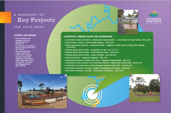
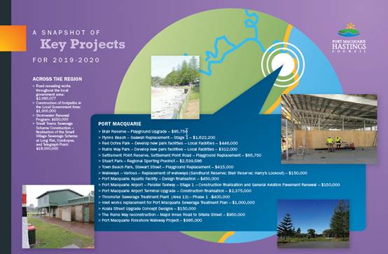
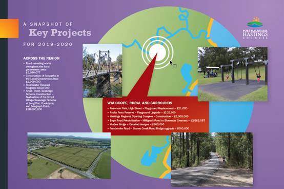
Exhibition Period and Submissions
The draft documents were placed on public exhibition from 19
March to 18 April 2019. The engagement activities undertaken are outlined in
the Community Engagement and Internal Consultation section of this report. A
number of submissions were received during this period and the details of
these, and staff responses, are also outlined in the Community Engagement and
Internal Consultation section of this report.
A workshop was also held between staff and Councillors to
discuss the submissions and any potential changes to the budget and IPR
documentation as a result of the submissions.
Post Exhibition Amendments to the Capital Works Program
The capital works program incorporated in the one-year
Operational Plan 2019- 2020 that was placed on public exhibition was valued at
$67.37m. In the intervening weeks there have been a number of changes to
the program. As a result of these changes the capital works program
outlined in the Operational Plan 2019-2020 is now $85.57m. The following
table lists the specific changes to the program, with the reasons for
adjustment relating to one of the following:
· Deferral:
part or all of project deferred from 2018-2019 to 2019-2020. This is due
to managers undertaking a detailed review of the ability to deliver the
projects in the 2018-2019 plan or where projects are multi-year projects.
· Work program
review: addition or removal of part or all of projects. This
arises where the continuous review of work programs has highlighted a change in
priorities or delivery requirements since the draft program.
· Grant: items
added to allow for the delivery of grant funded projects where additional grant
funding has been received in the intervening period.
· Public
exhibition feedback: items added as a result of feedback received
during the public exhibition period.
|
Item
|
Section
|
Reason for adjustment
|
Amount
|
|
Telegraph Point Pedestrian
Safety Upgrades
|
Asset Design
|
Deferral
|
$560,000
|
|
Westport Stormwater
Management Plan Design
|
Drainage
|
Deferral
|
$270,000
|
|
Calwalla Crescent, Port
Macquarie - Stormwater Remediation
|
Drainage
|
Deferral
|
$200,000
|
|
Rodley Street, Bonny Hills
- Flooding Mitigation Measures
|
Drainage
|
Deferral
|
$400,000
|
|
Diamond Head Road / The
Boulevard Flood Access Stage 1A
|
Natural Resources
|
Deferral
|
$1,390,000
|
|
Illaroo Road - Stormwater
Remediation
|
Natural Resources
|
Deferral
|
$700,000
|
|
Port Macquarie Coastal Walk
|
Parks & Recreation
|
Deferral
|
$780,000
|
|
Flynns Beach Seawall -
Design and Construction
|
Parks & Recreation
|
Deferral
|
$900,000
|
|
Sancrox/Thrumster Sports
Fields
|
Parks & Recreation
|
Deferral
|
$267,000
|
|
Wood Street - Road Upgrade
|
Parks & Recreation
|
Deferral
|
$950,000
|
|
Wayne Richards Park -
Stages 3 & 4
|
Parks & Recreation
|
Deferral
|
$250,000
|
|
Dunbogan Bridge - Reid
Street - Structural Rehabilitation
|
Transport & Traffic
|
Deferral
|
$3,276,000
|
|
Hastings River Drive &
Boundary Street Upgrade
|
Transport & Traffic
|
Deferral
|
$654,000
|
|
Lighthouse Road, Port
Macquarie - East Upgrade - Tourism Connectivity Project
|
Transport & Traffic
|
Deferral
|
$1,470,000
|
|
Ocean Drive, Lake Cathie -
Miala to Orana - Design
|
Transport & Traffic
|
Deferral
|
$145,000
|
|
Bold Street, Laurieton -
Crossing between Seymour and Tunis Streets - Preconstruction
|
Transport & Traffic
|
Deferral
|
$255,000
|
|
John Oxley Drive - Upgrade
Preconstruction
|
Transport & Traffic
|
Deferral
|
$484,000
|
|
Reclaimed Water - Area 14
Trunk Main - Inlet & Outlet
|
Water Supply / Sewerage
Services
|
Deferral
|
$1,300,000
|
|
Trunkmain - Sancrox
Reservoir to Area 13
|
Water Supply
|
Deferral
|
$991,000
|
|
Trunk Main Augmentation -
Sancrox Reservoir to Wauchope
|
Water Supply
|
Deferral
|
$1,133,000
|
|
Sewer Telemetry Radios Port
Macquarie Replacement
|
Sewerage Services
|
Work program review
|
$200,000
|
|
Sewer DNP3 Port Macquarie -
Roll Out
|
Sewerage Services
|
Work program review
|
$250,000
|
|
Lid Replacement Program
|
Sewerage Services
|
Work program review
|
$200,000
|
|
Electrical STP Asset
Replacement Allocation
|
Sewerage Services
|
Work program review
|
($100,000)
|
|
Mechanical STP Asset
Replacement Allocation
|
Sewerage Services
|
Work program review
|
($200,000)
|
|
Sewer Pump Replacement
Program
|
Sewerage Services
|
Work program review
|
($50,000)
|
|
Sewer Relining Works
|
Sewerage Services
|
Work program review
|
($140,000)
|
|
Marbuk Motorised Valve
Relocation
|
Water Supply
|
Work program review
|
$350,000
|
|
Water SCADA Replacement
|
Water Supply
|
Work program review
|
$30,000
|
|
Safety Improvements
Pembrooke Road
|
Transport & Traffic
|
Grant
|
$130,000
|
|
Safety Improvements Rawdon
Island Road
|
Transport & Traffic
|
Grant
|
$150,000
|
|
Scrubby Creek Bridge
Upgrade
|
Transport & Traffic
|
Grant
|
$455,000
|
|
Kew Main Street
|
Transport & Traffic
|
Grant
|
$340,000
|
|
Port Macquarie Town Signage
|
Community Place
|
Public exhibition feedback
|
$150,000
|
|
Beechwood Tennis Courts
|
Parks & Recreation
|
Public exhibition feedback
|
$60,000
|
|
Total
|
|
|
$18,200,000
|
Post Exhibition Amendments to the Operational Budgets
The following items were added to the operational budgets:
|
Item
|
Section
|
Amount
|
|
Swimming Pool Contract
|
Aquatic Facilities
|
$109,598
|
|
Increase in Emergency
Services Levy
|
Emergency Management
|
$104,235
|
|
Increase in General Manager
remuneration (adjusted for overheads)
|
General Manager
|
$9,345
|
|
Preparation of Support
Studies for Fernbank Creek / Sancrox
|
Strategic Planning
|
$150,000
|
|
Preparation of Heritage
Inventory
|
Strategic Planning
|
$60,000
|
|
Total
|
|
$433,178
|
Options
It is a statutory requirement to adopt the Integrated
Planning and Reporting documents by 30 June 2019. Not adopting the documents
cited in the resolution would jeopardise compliance with this legislation.
Council could seek additional information or make other amendments
to the documentation.
Community Engagement and
Internal Consultation
The draft documents were placed on public exhibition from 19
March to 18 April 2019. During this time the following actions were carried out
in order to generate widespread community feedback.
Exhibition Promotion:
· Media release upon
exhibition
· Facebook Posts
· Advertised in
Community Now NOTICES, posters in all offices and libraries;
· Mayoral promotion
through Facebook video, radio spot and Mayor’s column;
· E-news article
sent to all subscribers;
· E-news story to
Have Your Say database;
· Hard copy of all
documents placed at Council Customer Service Offices and Libraries Branches;
· Pop up engagement
stalls at local shopping centres across the region during the exhibition
period.
Exhibition Participation:
Pop up community engagement stalls were held in local
shopping centres across the region during the 28 days public exhibition period.
Conversations were held with the community in the following locations:
· 27 March 2019 -
Wauchope, High Street - (20 conversations)
· 2 April 2019 -
Port Macquarie, Settlement City - (74 conversations)
· 4 April 2019 -
Port Macquarie, Port Central - (71 conversations)
· 9 April 2019 -
Lake Cathie, Woolworths - (66 conversations)
· 11 April 2019 -
Laurieton, Coles - (80 conversations)
· 11 April 2019 -
Port Macquarie, Library - (6 conversations)
· 13 April 2019 -
Port Macquarie, Foreshore Markets - (93 conversations)
The “Have Your Say” online portal activity during
the exhibition period was as follows:
· Total visits -
1,200
· Max visitors per
day - 98
· Engaged visitors
(submissions) - 75
· Informed visitors
(downloaded documents) - 257
· Aware visitors
(read through documents without downloading) - 975
948 submissions were received via letter, e-mail, on-line,
and pop-up engagements and related to a broad range of Council Services
including the Roads, Bridges and Transport, Economic Development, Financial
Management, Stormwater and Drainage, Natural Resource Management, Sports and
Recreation, Sewerage, Waste Management, Water Supply, Glasshouse, Strategic
Land Use Planning and Building Maintenance and Development Assessment.
Of the total 948 submissions, 836 pertain to
‘Management of Lake Cathie’. These 836 submissions included 1
from ‘Revive Lake Cathie’ attached to which there were 787
submissions of support, plus an additional 48 individual submissions. The
following is Council’s position to this concern:
Management of Lake Cathie
Council has received
many submissions regarding the management of Lake Cathie calling for Council to
undertake further studies and action in respect of the opening of the lake and
general management of the lake. Unfortunately, this is a complex issue
for Council, government and the community and not one for Council alone to
resolve.
Lake Cathie is
classified as an ICOLL - an
Intermittently Closed and Open Lake or Lagoon, and is one of about 70 such coastal lakes and
lagoons located along the coast of NSW. ICOLLs are complex systems that have adapted to varying
water levels and varying salinity levels. They are usually highly biodiverse
and support a large range of fauna and flora. They are also very sensitive to
human disturbance. Lake Cathie and Lake Innes are well studied lakes with much
in depth scientific research and modelling completed over the years.
The management of the
Lake Cathie system is the responsibility of a number of stakeholders including:
· Port Macquarie Hastings Council;
· National Parks and Wildlife Services (NPWS);
· Office of Environment and Heritage (OEH); and
· NSW Fisheries and Department of Industry (DPI -
Lands).
Under the NSW Coastal
Management Act 2016, the preference for management of this type of lake is to
maintain natural processes as much as possible.
The opening of ICOLL
entrances is often the subject of much debate and enquiry. While the Coastal
Management Act prefers that no modification of an ICOLL entrance occurs,
sometimes ICOLLs are opened manually to the sea to reduce the impacts of
localised flooding. When water levels rise in a closed ICOLL following
rainfall, flooding of urban and rural development adjacent to the lake or
lagoon foreshore, can occur. Port Macquarie Hastings Council are quick to act
when these flooding issues occur and last opened the entrance to Lake Cathie in
July 2018 when high water levels were reached.
Many NSW ICOLLS are
currently experiencing drought conditions, and as a result many communities,
experiencing the dry-out ICOLL environment, are asking for these lakes to be
opened. Usually, as there are so many stakeholders involved in the management
of these systems, there is an Opening or Entrance Management Policy.
For Lake Cathie any
manual or ‘artificial’ opening of the lake is undertaken according
to the Lake Cathie Opening Strategy. The Strategy has been in place for several
years and has been thoroughly tested by scientific data and a recent
extensive study and hydrological model developed in 2014. This model demonstrated that
the Opening Strategy reflected the best management for the lake. (The
model and research also examined widening Kenwood Drive bridge and separating
Lake Innes to allow it to return to a freshwater lake. None of these conditions
were recommended as they will have a negligible impact on the health of the
lakes).
Notwithstanding, the existing Opening Strategy has been in
place for a number of years and as such it may be timely for the strategy to be
reviewed in line with current best practice in the management of ICOLL’s.
It is therefore recommended that Council undertake a review
of the existing Lake Cathie Opening Strategy in consultation with National Parks and Wildlife Services (NPWS); the
Office of Environment and Heritage (OEH); NSW Fisheries and Department of
Industry (DPI - Lands); and the community including the Revive Lake Cathie
community group.
This action has been
included in the 2019-2020 Operational Plan for completion in the next 12
months. Refer to Operational Plan Action 4.2.1.12 - Undertake a review of
the existing Lake Cathie Opening Strategy in consultation with the National
Parks and Wildlife Services (NPWS); the Office of Environment and Heritage (OEH);
NSW Fisheries and Department of Industry (DPI - Lands); and the community
including the Revive Lake Cathie community group. It is noted that a
number of submissions requested additional funding to be allocated to the
management of Lake Cathie. At this stage additional funding has not been
allocated in the 2019-2020 budget. This is due to the fact that until the
above review is completed, the extent of funding required is not
determined. Once the review of the strategy has been completed and
outcomes identified, further actions and associated funding requirements will
be assessed and incorporated into Council’s Operational Plan as
required. There is an existing allocation of funding within the 2019-2020
budget for the management of Lake Cathie in accordance with the existing Lake
Opening Strategy and maintenance, in addition to the above Operational Plan
action.
Council responses to submissions are in the following
sections of this report.
Submissions response summary
Due to the volume of submissions and supporting
documentation received, it is not practical to include hardcopies with the
attachments to this report, the information and tables below instead summarises
the submissions and Council’s response. Councillors have been provided
with full copies of the submissions prior to the Council meeting.
|
Council Service:
Building Maintenance
|
|
Submitter’s name
|
Submitter’s issue
|
|
Podmore - 6535
|
Request for Public toilets
Crestwood Drive PMQ - Entrance to Googik
|
|
Response
There
are a number of entry points to the Googik Track in Port Macquarie. At this
time Council has no plans to provide public toilets at Crestwood or any of
the other entry points to the Googik Track.
|
|
Maxwell
- 6552
|
Maintenance
of beach shower facilities and dredging of Dunbogan saltwater pool
|
|
Response
Staff
will undertake an inspection of beach showers in the Camden Haven and will
undertake required maintenance as soon as possible.
Staff
will investigate the possibility of dredging Dunbogan Baths. The presence of
protected ribbon grass within the baths is an issue and staff will liaise
with relevant state government agencies to determine what options are
available to Council in being able to improve swimming opportunity at this
facility.
|
|
Jones
- 6603
|
Public
amenities for playgrounds
|
|
Response
Council
currently has 64 playground facilities across the local government area. It
is not practical to provide public toilets at all playground facilities.
Council's focus is on providing and maintaining public toilets at regional
and district level parks.
Council's
interactive playground maps provide a range of information including
playground location and nearby facilities including public toilets. The
community is encouraged to use this resource when planning playground
outings:
https://www.pmhc.nsw.gov.au/Facilities-Recreation/Outdoor-Spaces/Playgrounds-Parks-Reserves/Playgrounds-Parks-and-Reserves-interactive-map
|
|
Jeayes
- 6762
|
Request for no concrete
paths at River Reserve on the North Shore.
New toilets at Coal Wharf
to be considered.
Additional Parking at Coal
Wharf to be considered.
|
|
Response
A number of projects have
been identified through the community planning process as priorities for the
North shore these include:
• Footpath connects
• A amenities
facility at Coal Wharf and
• Extension or
additional car parking at Coal wharf
All
these project will require further investigation as well as community
consultation prior to being ready to be included council planning process
(Operational Plan). Work will continue with the North Shore Community Council
action team (CCAT) to further determine key priorities as well as how they
should be achieved.
|
|
Council
Service:
Commercial
Business Units - Glasshouse
|
|
Submitter’s name
|
Submitter’s issue
|
|
Arts
Mid North Coast - 6785
|
1. Fees and charges for the
Ross Family Studio in the Glasshouse
2. The criteria for discounts
for use of the Ross Family Studio.
|
|
Got
Ya Back Productions - 6798
|
Support
the Fees and Charges for use of Ross Family Studio Glasshouse
|
|
Response
Thank
you for your submission, we acknowledge your support of the proposed
discounted fees for Ross Family Studio hire for 3 or 5 days as listed in the
draft fees and charges. The Glasshouse Strategic Plan is currently
being reviewed with feedback having been sought from the Cultural Steering
Group. Consideration is currently being given through that review to the fees
model for the Studio space, and applicability of the community discount. It
is anticipated that the Glasshouse Strategic Plan will be placed on public
exhibition for comment in the coming months.
|
|
Council Service:
Drainage
|
|
Submitter’s name
|
Submitter’s issue
|
|
Lenehan
- 5277
|
Inadequate
drainage and consequent flooding in Leighton Close North Haven
|
|
Response
Council
is aware of the historic stormwater issues impacting residents of Leighton
Close. The issues at this location form part of a larger known stormwater
‘hotspot’ (or problem area), located generally between Coral
Street and the open drain downstream of the Beachfront Caravan Park on the
south-eastern side of The Parade. Given the scale of the issue, and in order
to efficiently and correctly identify, prioritise and address these
longstanding issues, a whole of catchment stormwater management plan is
required to identify solutions to the large scale stormwater issues impacting
the locality.
This
plan has been previously identified for completion within Council’s
register of pending stormwater upgrades and improvements, however no funding
is currently allocated due to other higher priority stormwater improvement
works.
Whilst
Council has no short term solution to these ongoing stormwater issues,
Council will continue to monitor and maintain the existing drainage system to
ensure that that this system is functioning at maximum capacity. Catchment
management plans provide assessment of a broader area, allowing Council to
prioritise identified hotpot locations for future planning of staged
upgrades, which has proven to be the most effective and efficient use of
resources to address known issues. Prioritisation of works is
determined based upon risk factors to safety, property (private and public),
social and economic impacts to the area, and extent of area affected.
|
|
Council Service:
Drainage - Canal
Maintenance
|
|
Submitter’s name
|
Submitter’s issue
|
|
Black
- 5583
|
Can
you advise what are the plans for dredging of the canals in Port Macquarie?
The older canals have not been dredged in over 10 years and the commitment
was every 5 years. I do not see a financial line item in the draft. If there
is a line item please advise where it is in the draft budget.
|
|
Response
Maintenance dredging of the
Settlement Shores Canals was included in the 2019/20 Operational Plan with
dredging works expected to commence in July 2019, subject to contractor
availability.
The dredging of the
Settlement Shores Canals is listed as item 4.1.6.5 in the 2019-20 DRAFT
Operational Plan.
|
|
Council Service:
Drainage - Stormwater
|
|
Submitter’s name
|
Submitter’s issue
|
|
Chapman
- 6783
|
The
North Shore has a very poor storm water system. Following rain, there is
significant pooling in several areas. This pooling is danger to pedestrians,
causes damage to the roads and contributes to mosquito breeding. I would like
to suggest that monies allocated to flood water measures and the PAMP plan
for the North shore be implemented to address the worst areas. Currently the
PAMP shows two planned footpaths - one along the foreshore that appears to be
to assist school children make their way from the ferry, and one between the
Ferry and the Coal Wharf reserve. I would like to suggest that monies be
directed towards the implementation of the later.
|
|
Response
Council
currently doesn't have any funding allocated to stormwater or pathway
upgrades on the North Shore. Maintenance works will continue to be undertaken
to help alleviate some of the issues associated with water ponding. It is
noted that your preference for any future implementation of the Pedestrian
Access Mobility Plan (PAMP) is for the pathway to Coal Wharf reserve be given
a high priority.
|
|
Council Service:
Economic Development
|
|
Submitter’s name
|
Submitter’s issue
|
|
Mowle
- 5978
|
The
main entry signage for Port Macquarie is long outdated and well overdue for
replacement, it looks like it hails from the 1980's. The southern entry
from Ocean Drive has the same vintage, whilst 'The Gateway' off the Pacific
Hwy has no entry statement at all. The lack of modern, sophisticated
and world class entry statements is something that needs to be addressed
urgently as we move into our Bicentenary Celebrations. A separate Entry
Statement/Signage project needs to be raised to get traction & bring
about delivery in a reasonable timeframe. I suggest that this be given some
consideration.
|
|
Response
Based
on current adopted roll-out program, entrance signage for Port Macquarie is
scheduled for 2020-2021. The proposed Port Macquarie signs includes a range
of suburb signs, as well as a Tier 1 Entrance sign at the Port Macquarie exit
onto the Oxley Highway and Tier 2 signs at the Hastings River Drive and Ocean
Drive entrances.
The
proposed sign design is as per the Strategy adopted by Council in 2014, which
is consistent with the signs rolled out in the Camden Haven etc. The Port
Macquarie signage has been considered during the 2019-2020 budget process and
has been re-prioritised, to bring forward the Port Macquarie entrance signage
installation into the 2019-2020 financial year.
|
|
Submitter’s name
|
Submitter’s issue
|
|
Cooper
- 6503
|
Request
for wheelchair symbol to be put on tourist leaflets
|
|
Response
Council
continually works towards providing more accessibility information on a range
of places and facilities across the region - from our beaches and toilets to
local businesses. Some recent initiatives include new icons on our
destination website for businesses/attractions that are access friendly and
continues to be considered when planning new initiatives such as the Eat See
Do Visitor guide being developed later in the year.
|
|
Greater
Port Macquarie Tourism Association (GPMTA) - 6680
|
The Association request
that consideration be given to including performance measures that are more
meaningful and enable the success of the strategies and actions to be
properly assessed relating to:
3.1.3.2 Implement actions
from the Port Macquarie-Hastings Events Plan and
3.1.4.1 Work with
stakeholders to implement actions from the Destination Management Plan in
accordance with the identified strategic outcomes
The Association notes and
supports the allocation of funds to the Coastal Walk, the Airport Terminal
Upgrade, the Town Centre Master Plan and the Tasting on Hasting Event.
Finally, it was noted that
the Cultural Steering Group was not been referenced on Page 71 of the
Operational Plan under Community Theme 2 ‘Your Community Life’ as
a group that will ‘assist’ Council achieve its goals.
|
|
Response
Council appreciates the
GPMTA support and ongoing engagement for our Destination Management and Major
Events work. Council acknowledges the feedback in relation to key performance
indicators, which Council does strive to ensure outcomes are effectively
measured in relation to both on-going and defined project priorities and will
do so when updating the Destination Management and Events Plan (which are not
yet finalised).
Council plans to report
progress against KPI’s on a quarterly basis in relation to both plans,
which can be shared with GPMTA. With regard to the destination website
visitation growth KPI - this is crucial to monitor success and ensure continuous
improvement. Council has seen greater than 15% year on year growth in the
year to date (due to the change in web platform) and believe that a 15%
growth target moving forward is an ambitious target we would like to aim for.
The feedback provided in
relation to reference of The Cultural Steering Group has been taken on board
and will be included in the finalised document as a group that will assist
Council achieve its goals.
|
|
Jane - 6893
|
1/. Would like an
Information Hub which would include ALL information on our beautiful
Laurieton and surrounding areas
2/. Additional shopping
centre seating
|
|
Response
1/. Having previously
reviewed our visitor/information services, Council does not currently propose
to provide new information outlets/hubs but we do encourage the community to
visit the friendly staff at the Glasshouse Visitor Information Centre (managed
by Council) and iKew (managed by the Camden Haven Chamber of Commerce) and
some of our local businesses which have visitor information displays.
With regard to the
technology support suggestion, unfortunately, education services such as the
delivery of technology training or problem solving are not within the realm
of Council service delivery and we would encourage you to access this type of
assistance via one of our great local training providers (some of whom offer
free/low cost seniors training) or businesses selling and servicing
technology products.
2/. Unfortunately, the
provision of shopping centre seating is not something that council can
control or regulate. It is a matter for the shopping centre management.
Council does however provide and manage seating and pedestrian infrastructure
in public spaces.
|
|
Council Service:
Waste
|
|
Submitter’s name
|
Submitter’s issue
|
|
Hann
- 6200
|
Waste
charges. In our bid to reduce our personal waste footprint on our
property in rural Byabarra, we would like to recycle all items at appropriate
recycling centres and do away with our bins altogether. However, council
informs me that even if we have our bins removed we will still be liable to
pay approx. $385 per annum because the truck runs past our property
|
|
Response
Council provides waste
collection services over the whole Local Government Area extending as far as
Comboyne. These services include the collection of household recycling,
organics and general waste.
The Local Government Act
1993 states that a Council must charge for a domestic waste service if that
service is available, therefore a 'Minimiser' charge will still apply if bins
are removed or not used.
|
|
Boland
- 6316
|
I
would love to see the bins that are at the Dunbogan jetty (across from the
takeaway store) relocated from their current location (to close by) as they
obstruct the view to the water from the picnic table. It would make a huge
difference to the amenity of the area.
|
|
Response
Waste
services will investigate and consider the ability to relocate this bin.
|
|
Anonymous
|
Improved
recycling plant
|
|
Response
Submission
noted.
|
|
Kennedy
- 5611
|
Rubbish
disposal along Hastings River leaving it to be taken by floods
|
|
Response
Illegal
dumping being investigated by the waste section.
|
|
Garett
- 6821
|
I
am beyond angry at the fact we no longer get two free council rubbish pickups
anymore. The so-called "free" tip tickets are useless to people who
don't have tow bars, trailers or a way of accessing the tip.
|
|
Response
Many Councils are now
advising residents that they have 'free tip tickets' rather than 'free
pickups' due to the large cost of collecting waste from residential
homes. Council can organise to come and collect excess waste but it
does come with an additional cost.
Port Macquarie Hastings
Council are trying to incentivise residents and community members to avoid
waste as much as possible. Currently Council pay over $4M in a waste levy to
state government for landfilled waste. Any way we can reduce waste to landfill
is encouraged.
|
|
Council Service:
Natural Resource
Management
|
|
Submitter’s name
|
Submitter’s issue
|
|
Revive Lake Cathie
Incorporated
|
'Revive Lake Cathie’
submission included 787 signed letters of support in seeking funding in the
2019-2020 Operational Plan of $1M for the following items:
$100,000 – towards
allocation of a Port Macquarie-Hastings Council staff member to the role of
implementing strategies to Revive Lake Cathie, in direct consultation with
Revive Lake Cathie Inc.
$250,000 – Completion
of Environment Impact Study (EIS) for Lake Cathie and Lake Cathie Lagoon.
$650,000 – For
commencement of an implementation plan
Suggested solutions from
Revive Lake Cathie incorporated include:
1/. Complete an EIS for
Lake Cathie and Lake Cathie lagoon.
2/. Allocation of Council
Staff Member to the role of implementing strategies to Revive Lake Cathie.
3/. Following the EIS:
3a/. Prepare concept
designs for Kenwood Drive bridge [widening].
3b/. Remove sediment from
Lake Cathie and Innes estuary.
3c/. Sediment barrier
infrastructure to stop sediment moving from Cathie Creek into the lake
system.
3d/. Install remote water
monitoring devices (similar to Hastings River).
3e/. Multiple height
gauges.
3f/. Membership to NSW
Waterwatch.
|
|
Response
1/
An EIS is undertaken when a development proposal is being considered. It is
not a general environmental study. Nevertheless, Port Macquarie-Hastings Council
(PMHC) has undertaken numerous studies and investigations of the Lake
Cathie/Innes estuary system since the 1980s. These studies provide a great
deal of information and all generally point to supporting the current Lake
Opening Strategy and management practices.
2/
PMHC has environmental staff that manage the lake and surrounding
environment.
3a/
PMHC prepared a hydrodynamic model of the Lake Cathie and Lake Innes systems
in 2011 to test this scenario. The results suggest that widening the Kenwood
Drive bridge would have some beneficial impact on water quality between
Cathie Creek and Lake Cathie, however, the report also found that isolating
Lake Innes would provide the greatest impact to tidal flows and water
quality. The report also found these options would additionally pose the
greatest threat to local ecology and/or other social or economic values
through a loss of habitat, increase acidification, fish passage obstruction
and destruction of marine vegetation.
3b/
Lake Cathie (south of Kenwood Drive bridge), Cathie Creek and Lake Innes are
Nature Reserves managed by the National Parks and Wildlife Services (NPWS).
The lower lake/estuary is Crown Land (Waterway) that PMHC manages with
consultation from other stakeholders - NPWS, the Office of Environment and
Heritage (OEH), NSW Fisheries, and Department of Industry (DPI - Crown
Lands). PMHC has a dredging strategy to remove sediment from the lower
estuary to support recreational values.
Given
waterways upstream of Ocean Drive bridge are Nature Reserves, it would be
very unlikely environmental approvals would be provided to dredge in Nature
Reserves. Nevertheless, the hydrodynamic model of the Lake Cathie and Lake
Innes systems prepared in 2011 tested dredging a channel between Ocean Drive
bridge and Kenwood Drive bridge. This scenario was found to have limited
water flow benefits. In addition, historic aerial photos from the 1940s show
only minimal change to overall sediment and sholing in the estuary.
3c/
Historic aerial photos from the 1940s show only minimal change to overall
sediment and sholing in the estuary. The most potential for sediment
transport is from marine sands entering the lower lake. This sediment
transport is increased lake openings (i.e. the more/longer the lake is open
to the ocean the more marine sand enters the lower lake). PMHC seeks to
manage this marine sand through its dredging strategy for the lower lake.
3d/
The gauges proposed for the Hastings river are rainfall and river flow gauges
that will assist in flood warning and modelling. PMHC undertakes monthly
water quality of Lake Cathie. Since the start of 2019, PMHC has undertaken
weekly water quality monitoring. Results are on the web site. Water quality
parameters indicate the water quality is fair to good. PMHC does not propose
to install remote water quality monitoring gauges.
3e/
An automating and manual water level gauge is located on the Ocean Drive
bridge (south-west corner). This water level gauge is managed by Manly
Hydraulics Laboratory. PMHC does not propose to install additional water
level (height) gauges. The water level data can be found at http://new.mhl.nsw.gov.au/Site-207441
3f/
PMHC was a member of Waterwatch for a brief period several years ago, however
found that the Eco health aquatic ecosystem monitoring program provided
better indicators the health of our rivers and estuaries. Eco health reports
on the condition of key environmental indicators including water quality,
riparian (riverbank) vegetation, geomorphology (channel shape), estuarine
zooplankton and macroinvertebrate (waterbug) communities.
|
|
6329 - King
|
Support for the
‘Revive Lake Cathie Incorporated’ submission
|
|
6341 - Curry
|
Support for the
‘Revive Lake Cathie Incorporated’ submission
|
|
6349 - Schneider
|
Support for the
‘Revive Lake Cathie Incorporated’ submission
|
|
6418 - Simoes
|
Support for the
‘Revive Lake Cathie Incorporated’ submission
|
|
6420 - King
|
Support for the
‘Revive Lake Cathie Incorporated’ submission
|
|
6424 - Tenley
|
Support for the
‘Revive Lake Cathie Incorporated’ submission
|
|
6434 - Phillips
|
Support for the
‘Revive Lake Cathie Incorporated’ submission
|
|
6436 - Beedell
|
Support for the
‘Revive Lake Cathie Incorporated’ submission
|
|
6438 - McAnally
|
Support for the
‘Revive Lake Cathie Incorporated’ submission
|
|
6444 - Catherall
|
Support for the
‘Revive Lake Cathie Incorporated’ submission
|
|
6457 - Kent
|
Support for the
‘Revive Lake Cathie Incorporated’ submission
|
|
6459 - Pearse
|
Support for the
‘Revive Lake Cathie Incorporated’ submission
|
|
6463 - Sugden
|
Support for the
‘Revive Lake Cathie Incorporated’ submission
|
|
6466 - Graham
|
Support for the
‘Revive Lake Cathie Incorporated’ submission
|
|
6468 - Aston
|
Support for the
‘Revive Lake Cathie Incorporated’ submission
|
|
6470 - Wood
|
Support for the
‘Revive Lake Cathie Incorporated’ submission
|
|
6473 - Toombs
|
Support for the
‘Revive Lake Cathie Incorporated’ submission
|
|
6477 - Errington
|
Support for the
‘Revive Lake Cathie Incorporated’ submission
|
|
6479 - Medcalf
|
Support for the
‘Revive Lake Cathie Incorporated’ submission
|
|
6481 - Whitton
|
Support for the
‘Revive Lake Cathie Incorporated’ submission
|
|
6483 - Robinson
|
Support for the
‘Revive Lake Cathie Incorporated’ submission
|
|
6491 - Bruce
|
Support for the
‘Revive Lake Cathie Incorporated’ submission
|
|
6536 - Lawless
|
Support for the
‘Revive Lake Cathie Incorporated’ submission
|
|
6542 - Candia
|
Support for the
‘Revive Lake Cathie Incorporated’ submission
|
|
6570 - Norgate
|
Support for the
‘Revive Lake Cathie Incorporated’ submission
|
|
6611 - Teutelink
|
Support for the
‘Revive Lake Cathie Incorporated’ submission
|
|
6613 - Potts
|
Support for the
‘Revive Lake Cathie Incorporated’ submission
|
|
6615 - Field
|
Support for the
‘Revive Lake Cathie Incorporated’ submission
|
|
6619 - Campey
|
Support for the
‘Revive Lake Cathie Incorporated’ submission
|
|
6621 - Field
|
Support for the
‘Revive Lake Cathie Incorporated’ submission
|
|
6636 - Maurer
|
Support for the
‘Revive Lake Cathie Incorporated’ submission
|
|
6638 - Murray
|
Support for the
‘Revive Lake Cathie Incorporated’ submission
|
|
6645 - McGuigan
|
Support for the
‘Revive Lake Cathie Incorporated’ submission
|
|
6659 - Steep
|
Support for the
‘Revive Lake Cathie Incorporated’ submission
|
|
6668 - Donnelly
|
Support for the
‘Revive Lake Cathie Incorporated’ submission
|
|
6676 - Geronimi
|
Support for the
‘Revive Lake Cathie Incorporated’ submission
|
|
6677 - Higgins
|
Support for the
‘Revive Lake Cathie Incorporated’ submission
|
|
6698 - Kent
|
Support for the
‘Revive Lake Cathie Incorporated’ submission
|
|
6708 - Kent
|
Support for the
‘Revive Lake Cathie Incorporated’ submission
|
|
6733 - Reynolds
|
Support for the
‘Revive Lake Cathie Incorporated’ submission
|
|
6759 - Genin
|
Support for the
‘Revive Lake Cathie Incorporated’ submission
|
|
6771 - Maltman
|
Support for the
‘Revive Lake Cathie Incorporated’ submission
|
|
6789 - Drinkwater
|
Support for the
‘Revive Lake Cathie Incorporated’ submission
|
|
6848 - Drinkwater
|
Support for the
‘Revive Lake Cathie Incorporated’ submission
|
|
6421 - Kolder
|
Support for the
‘Revive Lake Cathie Incorporated’ submission
|
|
5398 - Donkin
|
Support for the
‘Revive Lake Cathie Incorporated’ submission
|
|
6321 - Smith
|
Support to the
Revive Lake Cathie volunteer group that supports the restoration of Cathie
Creek and Lake Cathie plus the restoration of Lake Innes to its original
status. To this end, I urge Council to make it a priority to seek government
funding to close the man-made channel (cut in 1933) that has allowed the
ingress of saltwater to Lake Innes and ruined its ecological value. It would
be a fine legacy for future generations if Council could facilitate this
worthy endeavour.
|
|
Response
The Northern
Rivers Catchment Management Authority prepared the Lake Innes Environmental
Assessment in 2013 to consider the reversion back to freshwater. The report
found that:
Although there
are some benefits, the benefits are marginal compared to the negative impacts
and risks posed by such an action. It is almost certain that the isolation of
Lake Innes would lead to the loss of a significant area of coastal saltmarsh
endangered ecological community and result in the loss of the commercial
fishery from the Lake.
There are
significant risks to water quality in both the short and long term and little
in the way of social or economic benefits. Therefore, it is our conclusion
that the isolation of Lake Innes and reversion to freshwater represents too
high a risk to environmental, social and economic values and we recommend
that the action not proceed.
|
|
6323 - Dick
|
Support for
Revive Lake Cathie. The bridge on Ocean Drive and the bridge at Kenwood Drive
Lake Cathie need to be extended to allow proper water flow under both bridges
to reduce the current siltation being observed over the past 15 years or more
bought by the lakes width being reduced by the reduction in width.
The lake also
requires dredging now from the Cut/Drain all the way down to the entrance of
the estuary which has occurred from inaction of the issues presented.
|
|
Response
Council
prepared a hydrodynamic model of the Lake Cathie and Lake Innes systems in
2011 to test this scenario. The results suggest that widening the Kenwood
Drive bridge would have some beneficial impact on water quality between
Cathie Creek and Lake Cathie, however the report also found that isolating
Lake Innes would provide the greatest impact to tidal flows and water
quality. The report also found these options would additionally pose the
greatest threat to local ecology and/or other social or economic values
through a loss of habitat, increase acidification, fish passage obstruction
and destruction of marine vegetation.
|
|
Lake
Cathie Progress Association - 6357
|
1.
$360k was provided in grant funding in August 2018-2019 under the NSW
Government Coastal and Estuary Grants program and need to remain in the
2019-2020 Operational Plan along with any remaining funds Council allocated
to the redirection of the storm water drainage along Illaroo Road.
2.
We acknowledge and thank Council for the $314k funding provided in the
2019-2020 Draft Operational Plan for the construction of the Skate Park as
approved in the Lake Cathie Foreshore Master Plan and urge Council to keep
this funding in the final Operational Plan
3.
We also support the allocation of funding in the Draft Operational Plan for
the design and development of the sporting fields and amenities block to be
built behind the public school in area 14 of Lake Cathie.
|
|
Response
1/ This funding will roll
over in to 2019-2020 FY. The Illaroo Road Stormwater Redirection project is
expected to commence in Mid-2019. Total project cost $720,000. Operational
Plan action 4.2.1.11 CW
2/ and 3/ Your support of
budgetary inclusions for Lake Cathie Skate Park and Rainbow Beach Sports
Fields in the draft Operational Plan is noted. Council will keep LCPA
informed as the projects progress.
|
|
Garett
- 6821
|
I
am sick of seeing notifiable and noxious weeds along roadways and highways
and council does nothing to remove these.
|
|
Response
On an annual basis Council
undertakes weed management on 2,300km of roadside weeds. Work is undertaken
by a number of methods including outreach mowing and pruning, mowing/slashing
and roadside spraying. Council maintains a purpose-built vehicle for
roadside spraying with carefully calibrated equipment allowing for site
specific spray specifications. Council utilises best practice methods in
roadside spraying to minimise spray drift and off-target impact.
Responsible herbicide use leaves a defined strip of dead vegetation on the
road edge with control lasting up to 6 months depending on weather
conditions.
Council also has a
dedicated Biosecurity Officer who monitors and manages Councils
responsibility under the Biosecurity Act. We encourage residents to contact
Council if they see a plant of concern on 6581 8111 to report individual
instances that we can investigate.
|
|
Dirago
- 6827
|
Flying
Fox Problem - Thousands of residents have sought positive action to address
this problem. The draft Plan highlights education and offers little in
practical action. What practical actions are proposed for 2019-2020 and what
are the related performance measures?
|
|
Response
Council have worked
collaboratively with key stakeholders within the community to address
concerns about the Flying Foxes at Kooloongbung Creek. A draft Camp
Management Plan has been developed and was placed on public exhibition in
April and May 2019 seeking community feedback. A final report is being
presented to the Ordinary Council Meeting in June 2019.
Flying Foxes are an
endangered species and Council must work within conservation restrictions and
legislation to ensure they remain protected and unharmed. There are many
practical management options available to Council and the community such as
water spraying and relocation and buffer zone implementation - all of these
are outlined in the Draft Flying Fox Camp Management Plan.
|
|
Council Service:
Financial Management
|
|
Submitter’s name
|
Submitter’s issue
|
|
Rutherford
- 5373
|
I
feel that the cost of living is getting too expensive. Rates are getting out
of control as well as water costs. I think Council should try to reduce rates
down to around $2000 per annum maximum per property. There has to be some
incentive to owning a house.
|
|
Response
Your submission in regard
to the cost of living getting too expensive is noted. Council levies rates in
order to be able to provide a wide range of services to the Community. These
services cover a number of key areas including roads and transport, sewerage,
water, stormwater, waste management, environmental services, community
facilities, sport and recreation facilities and services. The cost to provide
these services is significant with total expenditure in 2019-2020 budgeted to
be $216.3m. Reducing rates would require a reduction in the provision of
these services, however previous community surveys have indicated that our
community does not desire this outcome.
Council is not proposing an
increase to rates for the 2019-2020 financial year beyond the limits placed
on councils in setting rates, (known as rate pegging). The rate peg
determines the maximum amount by which a council may increase its rating
income for the year and is set independently by IPART (Independent Pricing
and Regulatory Tribunal) NSW.
Through an independent
review of Council's financial sustainability (undertaken in late 2017 by the
University of Technology Sydney (UTS) Institute for Public Policy and
Governance Centre for Local Government), the review found that Councils
overall financial sustainability is strong and particularly impressive given
the operating environment of Council. The review also found that in general,
Council has taken important steps in recent years to improve its financial
sustainability and that continuing to focus on areas of potential improvement
will help Council to continue to strengthen its financial sustainability in
the years to come.
The UTS states that
continued prudent management is the best course of action in ensuring the
ongoing financial sustainability of Council and in light of this, we aim to
continue our progress toward continued and improved financial sustainability
in 2019-2020.
|
|
Bray
- 6731
|
Forward Planning and
Financial Control
1/. Balanced budgets
2/. More detailed financial
information
3/. Financial details to be
split by funds
4/. The Capital Works
programs to be individually detailed to show how bulk figures are arrived at
5/. The Capital works
program should be on a priority listed and rolling basis and adjusted
regularly in accordance with variation listed in the monthly Financial
Reports and approved by Council
6/. More details should be
given on possible amounts that could be raised by loans to increase the rate
of Capital Works proposed
7/. Devote as many
resources as possible to the strategic planning for the future
|
|
Response
1/. Balanced Budgets
Council does endeavour to
adopt a balanced budget position at the commencement of the budget cycle.
However due to strategic and operational priorities including giving submissions
from the community due consideration, this is not always possible.
Where a deficit position is
adopted, there is significant analysis and monitoring undertaken by
management during the year with an aim to achieve a surplus position by year
end. These adjustments are reported as recommendations through the monthly
financial report to Council.
2/. More detailed financial
information
The information provided is
in accordance with legislative guidance and importantly does include
Council’s performance measures to allow transparency and clarity on
what Council is planning to deliver.
Management aims to provide
the community with meaningful financial data. There is however
significant detail underlying the financial data provided, which is available
through other reporting mechanisms, such as the annual financial statements.
3/. Financial Details to be
split by funds
Council is required to
follow the Integrated Planning & Reporting Framework. The Towards 2030
Community Strategic Plan has been developed into the four themes that
continue through to the Delivery Program and Operational Plan. This is why
the information is presented via these themes as opposed to by Fund.
The performance of the
Funds is reported through the end of year financial statements which include
the results for the year, balance sheet position and key performance measures
by individual fund.
4/. The Capital Works
programs to be individually detailed to show how bulk figures are arrived at.
The Capital Works programs
are detailed only for the first year in light of Council adopting a one-year
operational plan. Management does however maintain detailed work programs for
the outer years which are rolled up to provide the bulk figures reported.
5/. The Capital works
program should be on a priority listed and rolling basis and adjusted
regularly in accordance with variation listed in the monthly Financial
Reports and approved by Council.
As
noted above, management maintains detailed capital works programs. These
programs are monitored and updated as priorities and circumstances change.
Variances related to adopted budgets are reported to Council through the
monthly financial report.
6/. More details should be
given on possible amounts that could be raised by loans to increase the rate
of Capital Works proposed’
As part of the preparation
of the annual budget and long term financial plan, Council assesses the
requirement for new loans. This assessment focuses not only on funding needs
but the ‘affordability’ of loan funds and the impact of finance
costs moving forward on Council’s long term financial sustainability.
Council has determined at this stage that loan funds are not required to meet
its objectives in the outer years.
Whilst loan repayments are
forecast to increase, this relates to the principal repayment component only.
Interest paid is forecast to decrease.
7/. Devote as many
resources as possible to the strategic planning for the future
As with any service
delivery area, management assesses the delivery requirements, including
community expectations, and associated resourcing requirements, and adjusts
resourcing levels if required. Funding has been included in the 2019-2020
draft budget for additional resources in this area.
|
|
Donkin
- 5398
|
Rate
charges are excessive as I live on a very small parcel of land
|
|
Response
Council levies rates in
order to be able to provide a wide range of services to the Community. These
services cover a number of key areas including roads and transport, sewerage,
water, stormwater, waste management, environmental services, community facilities,
sport and recreation facilities and services.
The cost to provide these
services is significant with total expenditure in 2019-2020 budgeted to be
$216.3m. Reducing rates would require a reduction in the provision of these
services, however previous community surveys have indicated that our
community does not desire this outcome. Whilst it is noted that you live on a
small parcel of land, the calculation of rates is tied to the value of the
property. The value is supplied by the NSW Valuer General.
|
|
Johnston
- 5557
|
Credit
Card surcharge was removed last year, but now has been brought back in, but
much higher than before. Does Council actually get charged this
much?
|
|
Response
The credit card surcharge
has been implemented to cover costs incurred by Council in providing this
payment method. The surcharge has been set at a level which is below the
direct costs of the payment method, in accordance with legislative
requirements.
The direct costs of the
payment method vary month on month, depending on the level of transactions.
However, during the last 12 months, the level of direct costs charged have
been between 0.63% and 0.9%.
|
|
Council Service:
Sports and Recreation -
Aquatic
|
|
Submitter’s name
|
Submitter’s issue
|
|
Hannah
- 5367
|
Rock
pool, you ask what we think about upcoming plans, well I don't see any plans
for promised rock pool, in fact not one word has been said about it.
|
|
Dirago
- 6827
|
Investigation
into an Ocean Pool - Many residents support the feasibility study.
|
|
Garett
- 6821
|
I
would like to see an ocean tidal pool in Port Macquarie.
|
|
Response
Council
acknowledges community support for development of a tidal pool in the Port
Macquarie-Hastings. Council's current focus in relation to swimming
facilities is on the completion of the upgrades to Wauchope Pool, and
planning for a new aquatic facility in Port Macquarie which has commenced
this year. These projects have been prioritised over development of a
tidal pool as both existing facilities were known to have significant
structural issues.
|
|
Council Service:
Parks and Recreation -
Parks
|
|
Submitter’s name
|
Submitter’s issue
|
|
Rotary
Group of Port Macquarie Sunrise Incorporated - 13780
|
Town
Beach Reserve Master Plan - request to include Seniors Exercise Park and
Amphitheatre
|
|
Response
The upgrade of Town Beach
Playground is identified within the draft Operational Plan. The opportunity
to include seniors exercise/play as part of this upgrade is supported in
principle by staff who will engage with your club through the design phase of
project delivery.
Council recognise that the
amphitheatre is an important element of the Town Beach Master Plan. However,
Council is unable to fund this improvement as this time.
|
|
Lake
Cathie - Bonny Hills Lions Club - 5178
|
Acknowledge
and support the Skate Park Project funding for Lake Cathie Foreshore
|
|
Lake
Cathie Skate and Recreation Park Project working group - 6320
|
Lake
Cathie Skate and Recreation Park Project working group would like to thank
Port Macquarie Hastings Council for the inclusion of funding in the 2019-2020
Draft Operational Plan for the Lake Cathie Skate & Rec Park as part of
the Lake Cathie Masterplan.
We
would like to ask Port Macquarie Hastings Council to allocate the funds as
detailed in the Draft Operational Plan, and include said funds in the
finalised 2019-2020 Operational Plan.
|
|
Cooper
- 6494
|
In
support of skate park at Lake Cathie
|
|
Franklin
- 6498
|
In
support of skate park at Lake Cathie
|
|
Tierne
- 6564
|
In
support of skate park at Lake Cathie
|
|
Fitzgerald
- 6608
|
In
support of skate park at Lake Cathie
|
|
Miller
- 6642
|
In
support of skate park at Lake Cathie
|
|
Jolly
- 6792
|
In
support of skate park at Lake Cathie
|
|
Response
Council acknowledges
the support of budgetary inclusions for Lake Cathie Skate Park
|
|
6421
- Kolder
|
Location
of Skate Park at Lake Cathie
|
|
Response
The
location of the skate park within Foreshore has been resolved through the
development and adoption of the Lake Cathie Foreshore Master Plan. This plan
was developed following a comprehensive community engagement process and
there is broad community support for the development of the skate park in
this location.
|
|
Rogers
- 5606
|
Bain
Park Playground - request for shade provision in summer
|
|
Response
The upgrade of this
playground is tentatively scheduled for renewal in 2021-2022. As a district
level playground, this facility will include a shade structure when it is
replaced.
When the current playground
was first designed and constructed shade was provided by existing mature
trees located around the site. The removal of a dead tree since playground
development has reduced the amount of natural shade provided at this
facility. A replacement tree will be planted in coming months.
|
|
Elliott
- 5705
|
Rocks
Ferry Reserve - Riverbank restoration works and request for funding to
allocated to undertake work
|
|
Response
Rocks
Ferry Reserve is recognised as a significant recreational asset for Wauchope
and the broader community. On this basis, it is important to understand the
broader community desire for this area which ideally would be tested through
the development of the Wauchope Community Plan which will commence in
September 2019.
|
|
Member
of the Kew, Kendall, Lorne and Herons Creek CCAT - Conman - 5951
|
Requesting
that Kew Parklands be included in the 2019-2020 Operational Plan.
|
|
Kew
Parklands and Kew Main street Committee - Bignell - 6560
|
Request
the Kew Parklands proposal be considered in the operational plan for the
2019-2020 budget.
|
|
Churnside
- 6411
|
Approval
be given in support of The Parklands project at Kew
|
|
Response
Council acknowledges that
there is a need for open space to service the existing and future community
of Kew. Council's planning recognises this and plans for the provision of a
children's play facility are currently being developed in consultation with
the community. This facility will be constructed later in 2019.
At this time staff are
unable to support the Kew Parklands proposal but recognises that additional
open space will be required to service the community as development continues
to the west of the village.
|
|
McIntosh
- 5956
|
The
allocation of funds to upgrade Vince Inman Sporting fields in Laurieton is
great and further funds needs to be included across the next few years to
enable these well used fields to be maintained and the facilities upgraded to
a satisfactory level. As part of this allocation the lighting at the tennis
courts needs to be included in the lighting system across the ovals. At
present the lights at the tennis courts are not at a recommended standard
|
|
Response
Council
is currently working with the Vince Inmon Sporting Fields user groups to
develop a facility master plan for this sporting precinct. Through this
process staff will work with user groups to prioritise improvements and will
support them to seek grant funding above and beyond the $560,000 included in
the draft Operational Plan to deliver desired upgrades in partnership with
Council.
|
|
Proud
- 5973
|
Coastal
Walkways - access at northern end of Shelly Beach is not easily gained at
high tide and sand being washed away with large rocks exposed and then the
rocks also become slippery.
|
|
Response
Council is aware of the
challenges experienced by some Coastal Walk users during high tides and
periods of large swell. As a result of this access issue, Council has
completed detailed designs for the upgrade of Pacific Drive between Leanda
Street and Parklands Close, including the provision of a shared path to
provide an alternate route when access is difficult at North Shelley Beach.
This project is not
considered a priority at this time. Current focus is on upgrading the
sections of the Coastal Walk between Town Beach and Flagstaff Hill and Oxley
Beach and Windmill Hill. This project will be considered in development
of future budgets.
|
|
Friends
of Mrs Yorks Garden - Davidson - 6243
|
Requesting
at least $50,000 be allocated to continuing the re-creation of the Garden,
incorporating the Master Plan features approved by PMHC at its meeting on
20/3/2019.
|
|
Response
There
will be a balance of funds from the $50,000 included in the current financial
year budget for development of the Mrs York's Garden Master Plan. The scale
of available funding is subject to confirmation but staff are supportive of
this funding being used by FMYG for master plan implementation. Further,
staff will support FMYG in making application for grant funding to undertake
further master planned works.
|
|
Cooper
- 6501
|
Footpath
from Mrs Yorks Garden to Gaol Point
|
|
Response
The
construction of the missing pathway link between Gaol Point and Mrs York's
Garden is a current priority for one of our local service groups. Council is
supporting this group to achieve this outcome.
|
|
Bailey
- 6741
|
Request
for non-slip crossing over stream on Doctors Walk
|
|
Response
The
upgrade of Doctors Walk including the bridging of the stream crossing section
is a current priority project for Council. The detailed design for the
upgrade of this section of the Coastal Walk has commenced and construction
will occur later in 2019.
|
|
Lake
Cathie Bonny Hills Sports Field Committee - Spencer - 6756
|
Support
the adoption of the allocated funding for the Lake Cathie - Bonny Hills
Sporting Fields.
|
|
Williams - 6830
|
Rainbow Beach Sports fields and the adoption of allocated
funding in the budget.
|
|
Response
Lake
Cathie Sports Field Committees support for the Rainbow Beach Sports Fields
project inclusion in the draft 2019/20 Operational Plan is noted. Council
staff will continue to engage with your committee as project plans develop.
|
|
Nalty
- 6797
|
Request
to install children's playground and exercise equipment and upgrade boardwalk
North Haven
|
|
Response
There is strong community
support for this sort of improvements to the Beach to Beach Walk as
identified through the Camden Haven Community Planning process.
Council has identified the
need to replace the Bunnys Corner playground in 2019/20. Staff are engaging
with the Camden Haven CCAT to determine whether this facility could be
relocated to better integrate with the Beach to Beach Walk and other existing
infrastructure.
Other improvements can be
considered through strategic planning for the Beach to Beach Walk and development
of a public art strategy which is currently underway.
|
|
Cook
- 5579
|
Is
there any provision in Council's draft budget plan for the establishment of
an athletics field? There is no year round marked athletic field in Port
Macquarie. For the past 10 years Council has "promised" to create
an athletics field in the Wayne Richards sporting fields complex but nothing
has happened.
|
|
Response
Provision of an athletics
facility in Port Macquarie has been identified in the Council adopted Wayne
Richards Park Master Plan. Detailed design for the athletics facility is a
current Council project.
At this time, Council
engagement with the athletics community has been limited to discussions with
Athletics NSW. However, engagement with local athletics stakeholders will
occur as the planning process develops. A timeframe for construction of
this facility cannot be confirmed at this time.
|
|
Nash
- 6528
|
Is
there money allocated to maintaining the Queenslake walking/shared pathway?
|
|
Response
There
is not a specific maintenance budget for the Queens Lake Walking Trail in
West Haven. There is a centralised area-based budget for maintenance of parks
and reserves including recreational assets such as this walking trail. Staff
will inspect the walking trail and will program maintenance as
required.
|
|
North
Shore Community-Council Action Team (CCAT) - 6796
|
Over the past 3 months the
North Shore CCAT has identified the following as the key short-term
priorities for the North Shore and wish to have these priorities considered
for inclusion in Council’s 2019-2020 Operational Plan:
1/. Erection of a toilet
block to serve the Coal Wharf Reserve area;
2/. Extension of hours for
the Hibbard Ferry from 5:30 am to 8pm and
3/. Erection of a boat ramp
and explore options for a floating jetty to serve the North Shore
|
|
Response
1/. The provision of new
amenities at Coal Wharf Reserve is currently not in our planning.
Amenities were formerly provided at Coal Wharf Reserve but were
decommissioned when a decision was made in consultation with the community to
replace the Coal Wharf amenities at Ferry Reserve.
If there is a proven need,
Staff would consider a community led proposal to install these facilities,
however this would be reliant on community being able to fund construction
and maintenance of this asset.
2/.
Council will work with the current ferry operator to understand the cost
implications of increase the hours of operation of the Hibbard Ferry,
including the potential for a trial of extended hours to analyse the
additional usage and benefit to the community. Information gained from this
investigation will help develop future operating specifications.
3/.
The boat ramp is not considered a current priority for Council in the 19/20
operational plan. However, this project is included in Council’s
10-year recreation works programme and funding will be considered for this
purpose in development of future Operational Plans.
|
|
Johnston
- 5557
|
Wauchope
and Laurieton have a dog park, Port doesn't have one - suggest using the
empty Council land up from Oxley Oval.
|
|
Response
Council
has prioritised provision of a dog off-leash park in Port Macquarie at Stuart
Park Sporting Complex. A range of sites were carefully considered before
confirming Stuart Park as the preferred site, including Oxley Oval. Oxley
Oval was not the preferred site on the basis that is located quite close to
an existing dog exercise area at Nobbys Beach.
At
present all dog exercise areas in Port Macquarie are located at beaches.
Provision of a dog off-leash park at Stuart Park improves accessibility for
dog owners in western parts of Port Macquarie.
|
|
Men
at Work - Cargill - 6175
|
Where
is Red Ochre Park going be located?
|
|
Response
Red
Ochre Park is to be established within Council owned Community land located
in the area of Howell Avenue to The Point Drive and to the east to adjoin the
existing bushland area.
Council
will engage with local residents early in the planning phase of this project
through to completion of the park project.
|
|
Donkin
- 5398
|
1/. Would like an upgrade
to the shower facilities at Barlett
2/. Request clean-up of
overgrown and half dead trees at Bartlett
|
|
1/.
The upgrade of the Bartlett’s Beach amenities block is identified as an
action in the Council adopted Bonny Hills Reserves Master Plan. While not an
immediate priority, the upgrade of this facility will be considered in future
Operational Plans.
2/.
Council’s position regarding termite control on lands it manages is
that they are an important part of the ecosystems, being highly important in
the process of tree hollow formation which provides habitat and nesting dens
for many native animals.
Council
does not treat termite infestations on public lands. With a large local
government area to maintain it is not possible to provide termite management
services with the current level of funding. For this reason, it remains the
responsibility of property owners to ensure their property is suitably
protected against termite infestation and arranging regular inspections to be
carried out by a licensed pest controller.
|
|
Bowmaker
- 6520
|
Would
like a shade area at Laura Place Reserve Lakewood
|
|
Response
Council
currently has 64 playground facilities across the local government area. It
is not practical to provide shade structures at all playground facilities.
Council's focus is on providing and maintaining shade structures at regional
and district level parks where natural shade is not provided.
|
|
Copper
- 6530
|
Compliment
on Westport Park footpath
|
|
Response
Submission
noted and will be included in Council's compliments register.
|
|
Dirago
- 6827
|
Implementing
the approved Tacking Point Master Plan - Council approved this Master Plan
some years ago but no action has been taken to design and construct the
approved access facility for people with disabilities. Why is this the case?
What action is planned for
2019-2020.
What grants will be sought
in 2019-2020.
Which Council Director has
responsibility for the project.
|
|
Response
Melissa Watkins, as
Director of Development and Environment is responsible for implementation of
Tacking Point Lighthouse Master Plan. Council has sought, and will continue
to seek, grant funding for construction of the accessible walkway connection
to Tacking Point Lighthouse. While this connection is considered important,
the current focus for improving facilities for persons with a disability is a
range of other projects including (but not limited to):
• Short Street
Accessible Amenities including an adult change facility
• Provision of
accessible, gender neutral amenities and an accessible 1.9km walking loop as part
of the Stuart Park Regional Sporting Precinct Project
• Construction of
Rainbow Beach Sports Fields including accessible amenities and related
infrastructure
• Construction of new
accessible amenities at Foreshore Reserve, Lake Cathie and Pilot Beach,
Camden Head
• Construction of
Stage 1 of Flynns Beach Seawall including accessible pathways and access ramp
onto the beach
• Upgrade of Blair
Reserve Playground and Town Beach playgrounds to be more inclusive in their
design
On
this basis, no action is planned in regard to the accessible ramp project at
Tacking Point Lighthouse Reserve during 2019/20 unless a suitable grant
opportunity arises and this project is prioritised for application.
|
|
Council Service:
Parks and Recreation -
Trees
|
|
Vollebergh - 6674
|
Trees and Drainage issues
on The Binnacle - Residents of Macquarie Palms
|
|
Response
Council’s geospatial
information system indicates that the stormwater pipes are not located under
these paperbark trees but in fact on the opposite side of the road. Council
has inspected this intersection on several occasions and has deemed the line
marking as appropriate at this intersection.
Removing mature trees in an
urban environment must be significantly justified to counter the
environmental impact this would have, it has been previously assessed by
Arborist and Transport Engineer and determined that the removal of the trees
is not justified. The stormwater system in this area is not known as a
flooding hotspot and the drainage system will continue to be maintained in
line with current level of service.
|
|
Council Service:
Roads, Bridges and
Transport - Footpaths
|
|
Submitter’s name
|
Submitter’s issue
|
|
Schools
to Schools committee - Koeing - 6898
|
Request to include shared
pathways for Schools to Schools and request to have specific footpaths for
schools to schools included in the 2019-2020
1/. Construction of
footpath between Brother Glen and Sirius Drive on northern side of Ocean
Drive
2/. Engineering, Planning
and construction of footpath between Henry Kendall Drive and Bayside Circuit
on northern side of Ocean Drive
3/. Engineering and
Planning of footpath between Laurie Street and Seymore Street on western side
of Lake Road
4/. Engineering and
Planning of footpath between Homedale Drive and Old Bridge Road on north side
of Kendall Road
|
|
Response
Council
has an annual footpath, cycling and pedestrian works program, which covers
the Local Government Area (LGA). As part of this program Council also applies
for funding from the State Government for specific pathway projects. Council
has applied for funding to continue the schools to schools pathway from
Sirius Drive to Brother Glen Drive, which, if successful will also require
Council funding from this program.
Council
has also applied funding to support planning and design of the section from
Homedale Drive to Old Bridge Road. Please be aware that Council receives a
large number of requests annually for the construction of new pathways across
the entire LGA. Due to the limitations of funding it is not possible to
design and construct all of the pathways that are requested by the community
and large allocations of funding to specific projects detracts from providing
improvement works in other areas of the LGA.
Council
allocates priorities to new footpath works on the basis of safety,
construction cost, traffic volume on adjacent road, proximity to town
centres, shops, schools, medical facilities, recreation areas and other
factors.
In
accordance with the Schools to Schools shared pathway strategic alignment
plan, Council will continue to give consideration to this pathway and the
required planning, design and construction works needed in line with other
pedestrian and cycling works priorities across the LGA.
|
|
Lobbon
- 5383
|
Would
like to see more consideration of shared path/cycleways
|
|
Response
Council
receives a large number of requests annually for the construction of new
footpaths but it is not possible to construct all of the new paths that are
requested by the community. Council allocates priorities to new footpath
works on the basis of safety, construction cost, traffic volume on adjacent
road, proximity to town centres, shops, schools, medical facilities,
recreation areas and other factors.
|
|
Davies
- 5386
|
Pilot
Beach Cycle Track - Beach to Beach are carrying out work on the above track
in the future. I would like to see this escalated as I am blind and need to
be able to walk to Pilot Beach. Pilot Beach is narrow and carries some heavy
vehicles which is dangerous. Do you have any plans to work on this access
route?
|
|
Davies - 5954
|
Re: 4.4.1.55 - Beach to
Beach – shared path project at Camden Haven. Request to build a
boardwalk ASAP around the mangroves at the end of the tip road in Dunbogan.
We are not getting a fair share of money allocated in Dunbogan when there are
many non-life threatening projects attracting money from PMHC budgets.
|
|
Response
Council
is currently developing a masterplan for the remaining sections of the Beach
to Beach shared pathway project connecting Dunbogan Bridge to Pilot Beach.
The first stage in the masterplan process, which is currently in progress, is
to determine the environmental approvals required to construct each section
of path. Once this work is complete Council will be able identify the next
sections of the path that are likely to be constructed subject to funding.
This will include consideration of the section of path leading to Pilot
Beach.
|
|
Ritchie
Village Property Pty Ltd - 6779
|
Request for development of
a strategic Pathways Plan to consolidate and construct the B2B, Ck2Ck and S2S
and supplementary pathways network, in alignment with other identified key
linkages to public spaces, reserves, national parks and recreational parks.
Request to include a shared
pathway of approximately 1.7km that links businesses and residents situated
on Diamond Head Road and Beach St to Dunbogan, Laurieton and the greater
Camden Haven.
|
|
Wassell
- 6265
|
Request
for a footpath at Dunbogan - Diamond Head Road. Men's Shed / Diamond Waters
Caravan Park.
|
|
Fay
- 6326
|
Request
for a footpath at Dunbogan - Diamond Head Road. Men's Shed / Diamond
Waters Caravan Park.
|
|
Buchanan
- 6378
|
Request
for a footpath at Dunbogan - Diamond Head Road. Men's Shed / Diamond
Waters Caravan Park.
|
|
Niller
- 6505
|
Request
for a footpath at Dunbogan - Diamond Head Road. Men's Shed / Diamond
Waters Caravan Park.
|
|
Richards
- 6506
|
Request
for a footpath at Dunbogan - Diamond Head Road. Men's Shed / Diamond
Waters Caravan Park.
|
|
St
George - 6512
|
Request
for a footpath at Dunbogan - Diamond Head Road. Men's Shed / Diamond
Waters Caravan Park.
|
|
Burton
- 6514
|
Request
for a footpath at Dunbogan - Diamond Head Road. Men's Shed / Diamond
Waters Caravan Park.
|
|
Miller
- 6518
|
Request
for a footpath at Dunbogan - Diamond Head Road. Men's Shed / Diamond
Waters Caravan Park.
|
|
Tranter
- 6284
|
Request
for a footpath at Dunbogan - Diamond Head Road. Men's Shed / Diamond
Waters Caravan Park.
|
|
Response
Council
is currently developing a masterplan for the remaining sections of the Beach
to Beach shared pathway project connecting Dunbogan Bridge to Pilot Beach.
This alignment study will add to the existing strategic alignment plan for
Schools to Schools. Council will continue to work with the Creek to Creek
committee to identify the best way to develop a master plan for this
particular pathway noting the majority of the alignment is across Crown
Lands.
These
strategic plans along with Council's Pedestrian Access and Mobility Plan form
the overall Strategic Pathways Plan. Council Community Action Teams (CCAT)
will help guide how best to consolidate the plans to show an overall
alignment network plan of the area.
Council
has an annual footpath program and will consider for inclusion the suggested
new path along Diamond Head Road from the Dunbogan Bridge to the Diamond
Waters caravan park.
Please
be aware that Council receives a large number of requests annually for the
construction of new footpaths. However, due to the limitations of this
funding it is not possible to construct all of the new footpaths that are
requested by the community. Council allocates priorities to new footpath
works on the basis of safety, construction cost, traffic volume on adjacent road,
proximity to town centres, shops, schools, medical facilities, recreation
areas and other factors.
Council has received grant
money to upgrade the intersection of Diamond Head Road and The Boulevarde to
improve flood access. This project includes the construction of a pathway
from the Bridge to meet the shared path on The Boulevarde, approximately
270m, a segment of which is on the requested route.
The cost of a new path for
approximately 1.7km along Diamond Head Road from the Dunbogan Bridge to the Diamond
Waters Caravan Park would likely exceed the current annual allocation and
based on the adopted criteria for prioritisation under this program would not
rank highly.
|
|
Groves
- 6448
|
Would
like to see completion of paths and cycleways in Lakewood
|
|
Response
Council
has an annual footpath, cycling and pedestrian works program. As part of this
program Council also applies for funding from the State Government for
specific pathway projects. Council has applied for funding to continue the
schools to schools pathway from Sirius Drive to Brother Glen Drive. Council
will also give consideration to other pathway and pedestrian works in the
Lakewood area, but please be aware that Council receives a large number of
requests annually for the construction of new footpaths. Due to the
limitations of funding it is not possible to construct all of the new
footpaths that are requested by the community. Council allocates priorities
to new footpath works on the basis of safety, construction cost, traffic
volume on adjacent road, proximity to town centres, shops, schools, medical
facilities, recreation areas and other factors.
|
|
McNiece
- 6454
|
Beach
to Beach (B2B) pathways and safety issues in Dunbogan - the
pathway should be on the residential side of the road and not the waters
edge. The ambiance and environment protection of the river are of
utmost importance to the area.
|
|
Response
Council
is currently developing a masterplan for the remaining sections of the Beach
to Beach shared pathway project connecting Dunbogan Bridge to Pilot Beach.
The first stage in the masterplan process, which is currently in progress, is
to determine the environmental approvals required to construct each section
of path.
Key
considerations during this planning work is protecting the environment and
ensuring the path is safe for all users. Once this work is complete
Council will be able identify the next sections of the path that are likely
to be constructed subject to funding. Council is working closely with the B2B
Community Committee and the Community-Council Action Team (a part of the new
community planning incentive) to have input on the pathway planning.
|
|
Scott
- 6455
|
Request
completion of the Beach to Beach footpath from Laurieton to Dunbogan due to
safety concerns
|
|
Response
Council
is currently developing a masterplan for the remaining sections of the Beach
to Beach shared pathway project connecting Dunbogan Bridge to Pilot Beach.
The first stage in the masterplan process, which is currently in progress, is
to determine the environmental approvals required to construct each section
of path.
Key
considerations during this planning work is protecting the environment and
ensuring the path is safe for all users. Once this work is complete
Council will be able identify the next sections of the path that are likely
to be constructed subject to funding. This includes the section of path from
the Tip Road to the Boat Shed. Council is working closely with the B2B
Community Committee and the Community-Council Action Team (a part of the new
community planning incentive) to have input on the pathway planning.
|
|
Lill
- 6508
|
Support
for pedestrian crossing near Real Estate at Bold St in Laurieton
|
|
Response
Noted that this submission
supports the proposed location of the pedestrian crossing on Bold Street in
Laurieton.
|
|
Hamilton
- 6523
|
Request
for a pedestrian refuge for shared path - Sirius Drive Lakewood
|
|
Response
Unfortunately,
due to the configuration of the intersection of Sirius Drive and Ocean Drive
(a requirement to maintain turning lanes) and the significant number of
services adjacent to the road it is not feasible to construction a pedestrian
refuge on Sirius Drive to connect the shared path.
Council's
strategic planning has identified the potential need to upgrade this
intersection to traffic signals, which would include a controlled pedestrian
crossing on Sirius Drive. Consideration will be given to investigation and
design funding in future operation plans.
|
|
Smith
- 6532
|
Footpath
on Hoskie Road West Haven
|
|
Response
Council
has an annual footpath, cycling and pedestrian works program and will
consider for inclusion the suggested new path along Hoschke Road. Please be
aware that Council receives a large number of requests annually for the
construction of new footpaths.
However,
due to the limitations of this funding it is not possible to construct all of
the new footpaths that are requested by the community. Council allocates
priorities to new footpath works on the basis of safety, construction cost,
traffic volume on adjacent road, proximity to town centres, shops, schools,
medical facilities, recreation areas and other factors.
|
|
Lameloise
- 6601
|
Pedestrian
crossing corner of Stewart Street - Grant Street Port Macquarie
|
|
Response
Council
has an annual footpath, cycling and pedestrian works program and will
consider for inclusion investigation and design works to improve pedestrian
safety at the intersection of Grant and Steward Streets.
Please
be aware that Council receives a large number of requests annually for
pedestrian improvement works. However, due to the limitations of this funding
it is not possible to undertake all works that are requested by the
community. Council allocates priorities to works on the basis of safety, construction
cost, traffic volume on adjacent road, proximity to town centres, shops,
schools, medical facilities, recreation areas and other factors. Planning and
design works are an important first step in providing infrastructure
improvements.
|
|
Camden
Haven Community Council Action Team (CCAT) - 6729
|
Camden
Haven CCAT have agreed with the that the most urgent priority, is to create
opportunity for the Camden Haven to be a more connected community. This can
be achieved by completing the planning and construction of the three projects
known as: Beach to Beach, Creek to Creek and Schools to Schools shared
pathways as well as identifying/constructing key pathways across the
community to ensure connectivity between key public spaces, beaches,
waterways, reserves, national parks and recreational parks.
|
|
Response
Council
will work with the CCAT to help identify the best way to utilise the limited
resources to complete the required planning for the Camden Haven pathway
network and the prioritisation of sections for construction.
|
|
Every
- 6791
|
Request
footpath from Hill Street to Roto House Port Macquarie
|
|
Response
Council
has an annual footpath, cycling and pedestrian works program and will
consider for inclusion the suggested new path along Lord Street connecting to
Roto House.
Please
be aware that Council receives a large number of requests annually for the
construction of new footpaths. However, due to the limitations of this
funding it is not possible to construct all of the new footpaths that are
requested by the community. Council allocates priorities to new footpath
works on the basis of safety, construction cost, traffic volume on adjacent
road, proximity to town centres, shops, schools, medical facilities,
recreation areas and other factors.
|
|
Every
- 6794
|
Request
for extension of footpath Emerald Drive and Matthew Flinders Drive from near
the roundabout at Marbuk Ave / Lighthouse Plaza entry through to the path in
the reserve adjoining
|
|
Response
Council
has an annual footpath, cycling and pedestrian works program and will
consider for inclusion the suggested new path along Emerald Drive.
Please
be aware that Council receives a large number of requests annually for the
construction of new footpaths. However, due to the limitations of this
funding it is not possible to construct all of the new footpaths that are
requested by the community. Council allocates priorities to new footpath
works on the basis of safety, construction cost, traffic volume on adjacent
road, proximity to town centres, shops, schools, medical facilities,
recreation areas and other factors.
|
|
Counsell
- 6795
|
Request
for pathway at the north/eastern side of Ocean Drive between Rodley and Beach
Streets and beautification of Bonny Hills
|
|
Response
Council has completed
concept designs for a shared path along Ocean Drive from Rodley Street and
Beach Street. Unfortunately, due to the narrow road and steep terrain in this
area the cost estimate is approximately $1.5Million. While Council does have
funding for an annual footpath, cycling and pedestrian works program this
funding is for the entire Local Government Area. Council will continue to
seek grant funding opportunities that may apply to improving pedestrian
connectivity in Bonny Hills.
Regarding the current
stockpile site to the south of Bonny Hills, this site is critical to road
maintenance operations in the Camden Haven. Council understands the amenity
impacts of having an operational stockpile site located at the entrance to a
town and as such is currently reviewing our stockpiling procedures.
|
|
Woodgate
- 5570
|
1. Footpath needed near
houses at 48 and 50 Currawong Drive - approx. 90 meters long.
2. Major Innes Road to the
school - crossing at the pedestrian safety zone becomes crowded with children
from the bus drop off zone. No lolliepop person or line marking on the road
approaches.
3. Footpath needed near the
bus stop zone on Major Innes Road, near house 25 and 31 Currawong Drive
4. Footpath needed near 21
and 31 Currawong Drive and 48 and 50 Currawong Drive, there is a gap of
several hundred meters.
|
|
Response
Council
has an annual footpath program and will consider for inclusion the three
sections of suggested new path along Currawong Drive.
Please
be aware that Council receives a large number of requests annually for the
construction of new footpaths. However, due to the limitations of this
funding it is not possible to construct all of the new footpaths that are
requested by the community. Council allocates priorities to new footpath
works on the basis of safety, construction cost, traffic volume on adjacent
road, proximity to town centres, shops, schools, medical facilities,
recreation areas and other factors.
Currently
there is no children's crossing zones around St Columba Anglican School. An
application for a children's crossing zone and crossing Supervisor is made by
the School Principal. All applications made are assessed by Transport for NSW
against a set of criteria. Council works closely with all schools across the
Local Government Area to help improve safety for school children.
|
|
Nash
- 6528
|
Of the allocation of
$1,000,000 for new pathways can a large chunk go to Schools to Schools and
Beach to Beach?
|
|
Response
Council
has an annual footpath, cycling and pedestrian works program, which covers
the Local Government Area (LGA). As part of this program Council also applies
for funding from the State Government for specific pathway projects. Council
has applied for funding to continue the schools to schools pathway from
Sirius Drive to Brother Glen Drive, which if successful will also require
Council funding from this program. Please be aware that Council receives a
large number of requests annually for the construction of new footpaths
across the entire LGA.
Due
to the limitations of funding it is not possible to construct all of the new
footpaths that are requested by the community and large allocations of
funding to specific projects detracts from providing improvement works in
other areas of the LGA. Council allocates priorities to new footpath works on
the basis of safety, construction cost, traffic volume on adjacent road,
proximity to town centres, shops, schools, medical facilities, recreation
areas and other factors.
|
|
Council
Service:
Roads
and Transport – Roads
|
|
Submitter’s name
|
Submitter’s issue
|
|
Coman
- 5274
|
The
Kew Main Street has not been included, this has just received federal funding
of $800,000 with a co-contribution of $800,000 from council. I would have
thought this would form part of the Operational Plan?
|
|
Response
The Kew Main Street project
was omitted from the draft 2019-2020 Operational Plan due to the timing and
confirmation of the Federal Government funding application announcement. This
project will be delivered over multiple years commencing 2019-2020.
Therefore, the final Operational Plan will be updated to include this
project. Refer to 4.4.1.34 CW.
|
|
Cleary
- 5292
|
Pappinbarra
Road is dangerous. Corners are difficult to navigate for buses and
large vehicles and the road also has no line marking, is this because of the
width of the road?
|
|
Response
Like
many rural roads, Pappinbarra road has been constructed to best suite the
terrain and as such winds through steep terrain. Council reviews road safety
and crash data across the Local Government area and implements safety
improvements on high priority sites as funding permits.
The
line marking on rural roads is dictated by traffic volumes and road width, if
narrow roads have high volumes of traffic, then a centre line is typically
installed. The eastern section of Pappinbarra Road has higher traffic volumes
therefore further line marking was installed in 2018. The western sections
has lower volumes therefore line marking is not warranted.
|
|
Jones
- 5298
|
The
condition of Lighthouse road is dangerous, need upgrades done immediately.
There is no footpath for children to walk or ride their push bikes on.
|
|
Response
Council
was recently successful in receiving Federal Government grant funding to contribute
towards Council funding enabling the upgrade the eastern section of
Lighthouse Road (from Matthew Flinders Drive to the Lighthouse), with
construction works scheduled to starting in the coming months.
In
the 2019-2020 Operational Plan, Council has an operational task to work with
National Parks and Wildlife Services to adjust road boundaries that go over
National Park boundaries, this includes the western end of Lighthouse Road.
Following the adjustment of the road boundary Council will continue to seek
grant funding to complete the designed upgrades of the western section of
Lighthouse Road.
|
|
Thogersen
- 5355
|
Where
can I find details about the reconstruction of the Ruins Way?
|
|
Response
The
reconstruction of The Ruins Way is currently in the design phase, the project
will include the resurfacing of the The Ruins Way between Major Innes Road
and Sitella Street. Works will include the construction of kerb and gutter on
the eastern side with continuation of the pathway from Sitella Street to
Major Innes Road intersection. Council staff are happy to answer any
specific questions you might have.
|
|
Hicks
- 5379
|
No
curb on both sides of Ocean Drive Lake Cathie with water continually running
from the road to our property, eroding the ground.
|
|
Response
Council's
primary focus is to maintain rather than upgrade existing road
infrastructure. Typically, new kerb and gutter is installed through private
development.
There
have been recent community discussions about future upgrades to Ocean Dr
which is likely to result in new kerb and gutter between Middle Rock Rd and
Tallong Dr however the community have indicated that completion of the
southern end of this project will take priority. Undertaking this project
requires significant investment and partnership with the State and Federal
Governments.
This
project is listed as item 4.4.1.33 in the DRAFT Operational Plan for detailed
design work though unfortunately it concludes short of 1629 Ocean Drive.
|
|
Desouza
- 5393
|
Only
one way into and out of Timbertown estate. Should there be fire, there is no
way to get out. Please build another access road to make it safe.
|
|
Response
Strategic
plans for the area includes a secondary access for the Timber Town estate via
Bushman Drive. There is currently an approved Development Application on the
parcel of land to the west of Timber Estate that includes the extension of
Bushman Drive and a secondary intersection on the Oxley Highway. As this
forms part of a private development any associated timeframes are outside
Council's control.
For
estates across the Local Government area such as Timber Town that currently
have single access points, Council works with the Local Emergency Management
Committee to ensure emergency response provisions are adequate.
|
|
Kennedy
- 5611
|
Forbes
River Road, Cattle grid and weight loading need to be addressed.
|
|
Response
Works
are planned for May 2019 to address the pavement defects surrounding the
cattle grids. The cattle grids are maintained by the adjoining property
owners in accordance with Council Policy and standards. Weight limiting the
road restricts access for all users and without any reasonable detours to
divert traffic, this action is not permitted.
|
|
Whitelock
- 5777
|
Request
for an extension of school bus route on The Ruins Way due to inadequate safe
walking paths from the bottom of the Ruins Way to past the Winery
|
|
Response
Bus
routes are set by Transport for NSW in conjunction with the bus provider
(Busways). Council will refer your request for an extension of the bus route
on The Ruins Way to Transport for NSW for consideration. We are pleased to
advise you that as part of the resurfacing works planned on the Ruins Way in
the 2019-2020 Operational Plan, a pathway will be installed between Sitella
Street and Major Innes Road. Extensions of this pathway will continue toward
Annabella Drive in the future.
|
|
Hutchison
- 5944
|
Would
like to see consideration in the plans to seal some unsealed roads and it
could be achieved with Council’s budget and with support of State or
Federal funding. Particularly Lorne Road up to Comboyne (14.1km).
|
|
Response
Unfortunately,
Council's roads budgets cannot support the sealing of unsealed roads such
Lorne Road as it would significantly affect the level of service for road
maintenance across the Local Government Area. This is reflected in Council's
Unsealed Roads Policy.
Council
does from time to time apply for State and Federal Government grants to
support the upgrade of unsealed roads, a recent example being Maria River
Road. Grant applications are typically supported by investigation and designs
for the upgrades in order to get an accurate estimate of the costs and
outline how the projects meet specific criteria in order to be successful.
Council
will consider undertaking investigation and design works on Lorne Road in
future operational plans in preparation for any grant programs that would be
applicable to such a project. Typically, there has to be a specific grant
funding program on offer from the Government to apply for funding. Until such
time Lorne Road will continue to be maintained as an import arterial road
link.
|
|
Knight
- 6681
|
Sealing
of Batar Creek Road - The unsealed gravel intersection of Batar Creek Rd and
Cedar Loggers Lane is a serious hazard to the community and particularly
school children.
|
|
Response
Unfortunately,
Council's roads budgets cannot support the sealing of unsealed roads such
Batar Creek Road as it would affect the level of service for road maintenance
across the Local Government Area. Council reviews road safety and crash
data across the Local Government area along with traffic volumes and
implements safety improvements on high priority sites as funding permits.
This intersection has a low traffic volume and no recorded crashes. Council
will review this intersection and discuss with Busways regarding the safety
of the school bus stop.
|
|
Dean
- 6747
|
Road
maintenance from the new Bunnings site - debris lying in drains and gutters -
the island looks disgraceful to tourist.
|
|
Response
Council
undertakes a range of road maintenance activities, including vegetation
maintenance, across the entire Local Government Area within the limitations
of the available funding.
|
|
King
and Campbell Pty Ltd - Thorn - 6812
|
Support
for The Ruins Way reconstruction on behalf of St Agnes Parish
|
|
Response
Thank
you for your support of the upcoming construction works to upgrade the Ruins
Way. During finalising the design, consideration will be given to any future
intersection adjacent to Lot 14 and the requirement to minimise any services
in this location.
|
|
McMahon
- 6846
|
Request
for sealing of Batar Creek Road
|
|
Response
Unfortunately,
Council's roads budgets cannot support the sealing of unsealed roads such
Batar Creek Road as it would affect the level of service for road maintenance
across the Local Government Area. Council reviews road safety and crash
data across the Local Government area along with traffic volumes and
implements safety improvements on high priority sites as funding permits.
|
|
Johnston
- 5557
|
1. Do the rest of Lake Road
duplication instead of just saying planning.
2. Herschell Street goat
track needs fixing.
|
|
Response
1/.
Undertaking detailed investigation and
planning for road upgrades is an important first step to any construction
works. Council considers funding for important upgrades like Lake Road
duplication in line with all other services that are delivered to the
Community. The continual upgrade of Lake Road will be considered in future
operational plans.
2/.
The road rehabilitation works on Herschell
have been delayed pending the Wrights Creek Flood Study. The section of
Herschell Street that needs repairing has stormwater culverts beneath it that
affect how the road can be repaired. Any changes to the stormwater culverts
or road levels may lead to flooding of properties up of downstream. The flood
study is nearly complete, and once it is, Council will be able to correctly
design the required upgrades to Herschell Street. It is anticipated this will
occur within the next 3 years.
|
|
Men
at Work - Cargill - 6175
|
1/. Does the Ruins Way
Upgrade between Major Innes Dr and Sitella Street include the addition of a
footpath?
2/. Will the design for
duplication of Lake Road (Ocean Drive to Chestnut Road) be completed the
2019-2020 year?
|
|
Response
1/.
The reconstruction of The Ruins Way is
currently in the design phase, the project will include the resurfacing of
the The Ruins Way between Major Innes Road and Sitella Street. Works will
include the construction of kerb and gutter on the eastern side with
continuation of the pathway from Sitella Street to Major Innes Road
intersection.
2/.
No, the concept designs are currently being
finalised, with the next phase of the project being to adjust the road
boundaries with the Lake Innes Nature Reserve (National Park). Adjusting
boundaries of National Parks is a lengthy process and will likely include an
Act of NSW Parliament. Once Council has in-principle agreement from the
National Parks and Wildlife Services and the concept design is acceptable,
the detailed design can commence. Consideration will be given to funding the
detailed design in future operational plans.
|
|
Garett
- 6821
|
I am against the new road
link proposal that will bulldoze people's houses and go through a koala and
kangaroo colony in Port Macquarie.
I feel like Wauchope misses
out on council funding.
I would like to see bike
lanes and more parking in Wauchope.
|
|
Response
Thank
you for your comments regarding the Orbital Road, Council has recently
completed the public consultation with the consultation report being tabled
at June 2019 Council Meeting. At this meeting, Council will make a decision
whether to proceed with the strategic business case for this project which
will assess all viable options to improve our transport network around the
Ocean Drive, Lake Road and Wrights Road precincts of Port Macquarie.
Wauchope
is a key population area within our LGA. In recent years has received a large
portion of Council’s road maintenance funding with numerous road
resurfacing works carried out around the area. Included in the 2019/20
Operational Plan is funding for the continuation of the Bago Road
rehabilitation project from Milligans Road to Blue Water Crescent. Also,
Council has partnered with RMS to deliver the $2 million Wauchope Main Street
project to improve pedestrian safety and the amenity of the main street.
Smaller
projects that Council has delivered to Wauchope community is the off leash
dog park and improvement works to Rocks Ferry Reserve. Also included in the 2019/20 Operational Plan is
Council’s Parking Strategy which will include Wauchope.
In
the longer term, as part of planning for the continual growth in our region
Council is currently developing a Regional Integrated Transport Strategy to
identify the key transport decisions and actions that will guide Council to
ensure our transport networks are safe, operate efficiently and have adequate
capacity for now and into the future. This strategy will include all modes of
transport including cycling.
In
the interim, Council's planning for cycle lanes and shared pedestrian and
Council’s Bike Plan guides bike paths. Where feasible Council includes
cycle lanes in road upgrade projects.
|
|
Streetwise
Road Safety and Traffic Services Pty Ltd - 6342
|
Request
Council to consider providing funding in the 2019-2020 budget towards
improving cycling facilities in the Port Macquarie area. Cycling in our area
has been ignored by for many years now, and the few existing cycle lanes we
have in the area are becoming an increasing hazard.
The
state of existing on-road cycle lanes is poor, and I suggest that any
proposed funding should focus on addressing existing issues before extending
the local cycling network, including the following:
- Review
and map the location of existing cycling lanes and infrastructure in the Port
Macquarie area.
- Assess
the safety of existing cycle lanes, including widths, signage, intersections,
driveways, poor surfaces, kerb blisters, grated stormwater pits etc. Consider
independent road safety audit.
- Address
the lack of connectivity and lack of direction for cyclists at the end of
existing cycle ways.
- Council
have not given enough consideration to cyclists and Council’s approved
Bike Plan during the following activities: DA assessment, Council roadwork
design, TCPs and traffic management around Council and private roadworks
Traffic Committee.
|
|
Dirago
- 6827
|
Road
Safety – Lighthouse Road (East) - The Mayor and Councillors are
congratulated on providing/obtaining funds in 2018-2019 for safety
improvements to Lighthouse Road (East), benefitting residents and tourists.
When will the work commence and be completed?
|
|
Response
The
project will be completed by the end of the year, favourable weather
permitting.
|
|
Response
Council
has proposed $1,000,000 for the Footpath, Cycleway and Pedestrian works
program for 2019-2020. A portion of this funding will be used for the
cycleway element of the program, including undertaking practical safety
improvements on cycle ways and consideration will be given to reviewing
Council's Bike Plan and identifying the highest priority works for inclusion
in future programs.
|
|
Churnside
- 6411
|
For
pedestrian safety and local amenity, heavy goods vehicles entering and
exiting the newly approved heavy industrial sites on Herons Creek Road Kew,
must be prohibited from travelling through the Kew town centre.
|
|
Response
The
current configuration of the road network and with the Pacific Highway being
a controlled access road, unfortunately there is no alternate access route to
the Kew industrial area. Access from the north via Ron Banks Road is
also limited by the railway under pass bridge having a height restriction of
3.8m.
|
|
Council Service:
Roads, Bridges and
Transport - Ferry Services
|
|
Submitter’s name
|
Submitter’s issue
|
|
Jeayes
- 6762
|
Request
for the Hibbard ferry to be bigger and a third ferry somewhere.
|
|
Response
The
existing level of service provided by the Hibbard and Settlement Point
ferries including road approaches is considered appropriate for the current
level of usage. Should traffic volumes change in the future the level
of service will be reviewed and improvements implemented if deemed necessary.
Heavy vehicles are permitted to use our road network.
|
|
Council
Service:
Sewerage
- Sewer
|
|
Submitter’s name
|
Submitter’s issue
|
|
Hann
- 6346
|
Annual
charges for septic systems mean that properties with septic systems are assigned
into a low, medium or high risk category. Although our property in Byabarra
is assigned in a medium risk category (to be checked once every 3 years), we
are forced to pay an ANNUAL fee for a service that is only provided once
every 3 years! This is unfair and a blatant example of "fees for no
service".
|
|
Response
Council
is legislatively required and has a duty to monitor onsite sewage management
(OSM) systems and issue operational approvals on their performance. Under the
Local Government Act 1993 Council has the ability to recoup or fund the
approvals program through the issuing of an annual fee. The annual approval
to operate is renewed upon payment of the fee. The fee and its incursion does
not directly relate to a specific inspection but the approval.
Inspections
are conducted based on the risk allocated to the OSM systems, which is based
on their location and their proximity to sensitive areas. The current program
and its structure assigns higher fees to those systems on a more frequent
inspection cycle (higher risk) and more moderate fees for those less frequently
inspected (lower risk).
|
|
Dirago
- 6827
|
Waste
Treatment Port Macquarie - Residents have regularly brought to attention the
foul odours from the Koala Street facility. What action is planned by Council
in 2019-2020. What funds have been allocated?
|
|
Response
Council
implemented an odour mitigation dosing unit at the Port Macquarie Wastewater
Treatment Plant in February 2019. The dosing unit sprays a misting
chemical into the air within the treatment plant which binds up odour causing
compounds. Trials are still underway with this unit to optimise its
effectiveness in response to odour complaints received. The system is
planned to be switched to 24 hour / 7 days a week operation in early May 2019
to determine if it is a viable ongoing odour mitigation measure.
It
is hoped that this system can prove to be effective as the alternative odour
control measures will require significant investment of ratepayer money to
construct additional infrastructure at the treatment plant site.
Initial works would involve approximately $750,000 for odour control
equipment with further works to follow. It is anticipated that the
trials and evaluation of the chemical dosing system will be completed by
September 2019 at which point a determination will be made into any further
infrastructure requirements.
|
|
Council Service:
Strategic Land Use
Planning
|
|
|
Submitter’s name
|
Submitter’s issue
|
|
|
Rodgers
- 6205
|
Investigate
the capacity of land at the intersection of Ocean Drive with Bonny View Drive
for light industrial development or for use as a school. It is with major
concern that I read the above. The area along Bonny View Drive has for many
years been rural residential with the intersection being the school bus stop
for the area. I believe that it would be totally inappropriate for this
intersection to be used for light industrial development as this would
destroy the rural amenity of the area. In addition it would result in
increased traffic flows and pose a danger to the many school children who
embark and disembark from school buses.
|
|
|
Response
This
submission correctly notes that land at the intersection of Ocean Drive and
Bonny View Drive has been identified for investigation for light industrial
development or for a school, as Action 17 in the adopted Port Macquarie-
Hastings Urban Growth Management Strategy (UGMS). Figure 40 (Volume 2 p.93)
in the UGMS shows a buffer to existing rural residential development on Bonny
View Drive.
It
is also noted on p.93 that: "The investigation… will include
consideration of the need for visual buffering to main roads and the creation
of an internal access road, from Houston Mitchell Drive to Bonny View Drive.
The proposed Outline Plan for West Bonny Hills will also consider, amongst
other things, the need for light industrial development to serve the Lake Cathie
and Bonny Hills communities."
|
|
|
Dick
- 6210
|
Objection
to the omission of an updated Heritage Study/Heritage Inventory for the Port
Macquarie-Hastings Local Government Area in the draft 2019-2020 Operational
Plan currently on exhibition. My submission primarily relates to
this matter and relies upon the adopted actions from the Urban Growth
Management Strategy.
|
|
|
Response
The submission correctly
notes that Council's adopted Urban Growth Management Strategy includes:
Action 31: A review of the
Port Macquarie-Hastings Heritage Inventory, and Action 2: A review of
planning for the Wauchope CBD and adjoining mixed use area. The indicative
timing for these actions in the UGMS is: Year 1-2 for Action 31 (i.e.
2018-2019 and 2019-2020), and Year 3-4 for Action 2 (i.e. 2020-2021 and
2021-2022). In 2017-2018, Council completed Stage 1 work towards a review of
the 1991 Heritage Inventory.
Australian
Heritage Specialists (AHS) were engaged to review the heritage inventory
contained in Schedule 5 of the Port Macquarie-Hastings Local Environmental
Plan (LEP) 2011and Council's management practices in relation to heritage,
and to make recommendations for aligning them with best-practice frameworks.
It is not feasible to amend the LEP based on the report by AHS because the
report does not contain sufficient detail is relation to the items that are
recommended for further investigation.
The
existing 1991 heritage study and inventory are old and in need of update, and
that there is increased risk in the absence of the Heritage Inventory Review
that decisions will be made that compromise the integrity of existing and
potential heritage items and this action is consistent with the North Coast
Regional Plan.
Council
resolved on 17 April 2019, to "Give consideration to the required
$60,000 funding for the preparation of a heritage inventory as part of the
2019-2020 budget". This consideration has resulted in the $60,000
being funded in the 2019-2020 budget for the works to be carried out.
|
|
|
King
and Campbell Pty Ltd - Thorn - 6817
|
Submission supports
inclusion of the Operational Plan action - 4.5.1.1 - Investigate the capacity
of land at the section of Ocean Drive with Houston Mitchell
Drive for light industrial
use and at the intersection of Ocean Drive with Bonny View
Drive for light industrial
development or for use as a school.
|
|
|
Response
Noted.
Consistent with adopted Urban Growth Management Strategy 2017-2036.
|
|
|
Council Service:
Water Supply - Water
|
|
|
Submitter’s name
|
Submitter’s issue
|
|
|
Wynn
- 6672
|
Water
supply - If Council hadn't allowed so many new houses in our area, we would
have had enough water to carry us through drought conditions. I came here in
2002 and we were on strict water fashioning. The new Cowarra dam was built
soon after to save us from restrictions. Then the building boom started in
Lake Cathie/Bonny Hills/Kendall/Kew/Lakewood. Shame on you Council, you put
us back 17 years in growth.
|
|
|
Response
Port Macquarie Hastings
Council has adopted an approach recommended by the NSW State Government in
determining the capacity of our local water supply. The current design
capacity of both Cowarra Dam and Port Macquarie Dam is based on population
growth and demand projections, and the expected flow that can be drawn from
the Hastings River. The combined total storage for both dams is 12,500 mega
litres.
Council regularly updates
water demand and population projections and develops long term construction
works programs to meet the projected growth and demand. Planned future
capital works include a number of projects that will increase yield potential
and additional redundancy in the network while at the same time ensuring
maintenance and upgrading of existing infrastructure is taking place.
Council also needs to
ensure that new development areas are also adequately serviced. It also
follows that long term financial modelling is required to ensure water
pricing is considered to ensure that future water services are financially
sustainable.
Water supply is under
regular review, with the need to supply a secure, safe and affordable supply
of paramount concern. Council cannot guarantee an unlimited storage capacity
and unlimited supply of water, hence the need for water restrictions during
periods of extreme dry, low water flow or quality - as is the case at present
and throughout much of NSW.
|
|
|
Cook - 5579
|
With the population of Port
Macquarie increasing rapidly what provision is there for water management in
times of drought periods?
|
|
|
Response
Port Macquarie Hastings
Council has adopted an approach recommended by the NSW State Government in
determining the capacity of our local water supply. The current design
capacity of both Cowarra Dam and Port Macquarie Dam is based on population
growth and demand projections, and the expected flow that can be drawn from
the Hastings River. The combined total storage for both dams is 12,500 mega
litres.
Council regularly updates
water demand and population projections and develops long term construction
works programs to meet the projected growth and demand. Planned future
capital works include a number of projects that will increase yield potential
and additional redundancy in the network while at the same time ensuring
maintenance and upgrading of existing infrastructure is taking place. Council
also needs to ensure that new development areas are also adequately serviced.
It also follows that long
term financial modelling is required to ensure water pricing is considered to
ensure that future water services are financially sustainable.
Water supply is under
regular review, with the need to supply a secure, safe and affordable supply
of paramount concern. Council cannot guarantee an unlimited storage capacity
and unlimited supply of water, hence the need for water restrictions during
periods of extreme dry, low water flow or quality - as is the case at present
and throughout much of NSW.
|
|
|
Johnston - 5557
|
20c increase in water usage
is too much. Affordability for people who are already struggling.
|
|
|
Response
The water usage charge has
been increased by 20c per kl, however the access charge for a 20mm meter has
reduced from $205.00 in 2018-2019 to $198.00 in 2019-2020. This change in
billing structure has been implemented over 3 years with the goal that 75% of
water income will be derived from user charges by 2021-2022 as opposed to
access charges.
This is in line with best
practice recommendations and is designed to help drive efficient water use.
Councils overall water income has however not increased above the level it
would have under the previous structure.
|
|
|
Council Service:
Compliance - Beach
Driving
|
|
|
Jeayes - 6762
|
Beach driving problems now
includes quad bikes driving in dunes and teenagers going without helmets
|
|
|
Response
Rangers continue to undertake
regular patrols and will take action on any unlawful behaviour.
|
|
|
Council Service
Governance and
Procurement - Councillors
|
|
|
Dirago - 6827
|
Councillor Availability -
Throughout 2018-2019 we will also continue to take as many opportunities as
possible to engage with our community, as it is these interactions that bring
Council closer to the community” reports the Plan. Will the
Councillors meet with the residents of Port Macquarie even once in 2019-2020?
|
|
|
Response
Councillors are elected to represent
the collective interests of residents, ratepayers and the community and
facilitate communication between the local community and the governing body.
Councillors are available through email and phone and also proactively engage
with the community with 11 Council meetings. Two of these are offsite in
Wauchope and Laurieton with the aim of bringing Council closer to the
community.
|
|
|
|
|
|
Internal Consultation
The following levels of staff
have reviewed, assessed and considered the draft documents throughout the
public exhibition period:
· Councillors
· Executive
· Senior Leadership
Team
· Integrated
Planning and Reporting Development Officer
· Planning and
Reporting Officer
· Staff
Planning & Policy
Implications
This report is aligned with Council’s legislative
obligations under the requirements of the NSW Integrated Planning and Reporting
Framework.
Financial & Economic
Implications
The 2019-2020 Budget
Within the one-year
Operational Plan is an overview of how the proposed activities included in the
plan will be funded, including the budget statement and capital works program.
The 2019-2020 budget
forecasts a budget shortfall (excluding depreciation and loss on disposal of
assets) of $975,198. This compares to the $511,873 shortfall in the
previous (2018-2019) budget.
Budget Summary
|
|
2019-2020 Budget
|
|
Operating Budget
|
|
|
Operating Income
|
195,123,375
|
|
Developer Provided Asset
Contributions
|
6,500,000
|
|
Operating Expenses (excluding depreciation, loss on disposal of assets
and interest expense)
|
(111,644,169)
|
|
Interest Expense
|
(2,464,723)
|
|
Net Operating Budget
|
87,514,483
|
|
|
|
|
Capital Items
|
|
|
Net Transfers from Reserves
|
12,178,103
|
|
New Loans
|
1,500,000
|
|
Purchase of Assets
|
(85,570,344)
|
|
Developer Provided Assets
|
(6,500,000)
|
|
Loan Principal Repayments
|
(10,097,440)
|
|
Net Capital Result
|
(88,489,681)
|
|
|
|
|
Budget Result
Surplus/(Shortfall)
|
(975,198)
|
Council’s projected expenditure for 2019-2020 is
$216.3m which includes the following:
|
|
2019-2020 Budget
|
|
Ongoing Operational Costs (excluding
depreciation, loss on disposal of assets and interest expense)
|
111,644,169
|
|
Capital Works Projects
|
85,570,344
|
|
Developer Provided Assets
|
6,500,000
|
|
Debt Servicing Costs
|
12,562,163
|
|
|
216,276,676
|
Council's projected income for 2019-2020 is $201.6m which
includes the following:
|
|
2019-2020
Budget
|
|
Rates and Annual Charges
|
100,315,591
|
|
User Charges and Fees (for
services such as water, waste management, building and planning, animal
registration, crematorium, airport and library)
|
39,803,585
|
|
Interest Income
|
8,701,024
|
|
Grants and Contributions
(made up primarily of state and federal government grants and developer
contributions)
|
40,862,872
|
|
Developer Provided Asset
Contributions
|
6,500,000
|
|
Other Revenue (such waste
management income, rental of Council facilities and fines)
|
5,440,303
|
|
|
201,623,375
|
To provide for the future needs
of our community, Council borrows money to fund infrastructure and community
assets which cannot be funded out of normal revenue sources.
Total borrowings for 2019-2020 will be $1.5 million.
This includes proposed new borrowings as shown below:
|
New Borrowings by
Project
|
Amount
|
|
Sporting Fields
|
1,500,000
|
|
|
1,500,000
|
In addition to a budget shortfall position of $975k, the
2019-2020 budget forecasts an operating surplus of $3,549k on a consolidated
basis and an operating deficit of $7,506k for Council’s general
fund. The budget position, although a shortfall, is deemed to be
manageable and the consolidated operating result is strong. The general
fund operating result is forecast to be negative, however it is noted that
there are a number of factors impacting this result including:
· a number of
non-recurrent expenditures which have been prioritised and included in the budget
to meet longer term strategic goals. Although contributing to a negative
operating result in 2019-2020, these items are one-off in nature and generally
will not impact the operating result going forward;
· a number of
significant cyclical expenditure items which are forecast to occur in
2019-2020, which however do not impact every financial year;
· impact of cost
shifting from other levels of government where appropriate funding is not
provided. In 2017-2018, the impact was estimated to be $12.9m. This
represents a significant financial impost on Council and highlights a
significant level of funding which could otherwise be utilised on service
delivery.
Although a negative operating result is manageable in the
short-term in light of the above factors and in light of Council’s
overall financial position, the importance of ensuring Council’s ongoing
financial sustainability is recognised. On this basis, Council will
continue to focus on improving the general fund operating result, with the
following focus areas noted:
· completion of 5
service reviews of business critical areas;
· continued focus on
ensuring Council’s fees and charges structure is appropriate;
· review of
depreciation and appropriateness of underlying assumptions.
It should be noted that the 2019-2020 budget includes grant
funding from the Federal Government in the form of a Financial Assistance
Grant. The budget has assumed a small uplift from the 2018-2019 levels.
Any reduction to this funding could impact upon Council’s ability to
deliver services.
It should also be noted that the Federal Government has in
recent years made advance payments of the annual allocation of the Financial
Assistance Grant. Council is required to bring these revenues to account in the
year in which they are received as opposed to the year to which they relate.
The 2019-2020 revenue budget in effect includes the second half of the
2019-2020 annual allocation and the first half of the 2020-2021 annual
allocation (assuming the latter, which will be held in restricted cash until
2020-2021, is paid in advance). Should the Federal Government cease
payment in advance, this will have a significant impact on the monies actually
received in 2019-2020 and therefore on the operating result for this period.
It is noted however that this is a timing issue only and overall monies
received across the 2 years will not be impacted.
|
Attachments
1View. Four Year Delivery Program
2017-2021 (Revised 2019) and One Year Operational Plan 2019-2020
|
19/06/2019
|
Item: 10.05
Subject: Making of Rates and Charges for 2019/2020,
Adoption of the Fees and Charges and Revenue Policy for 2019/2020
Presented
by: Corporate Performance, Rebecca Olsen
Alignment with Delivery Program
1.5.1 Manage Council’s financial assets and provide
accurate, timely and reliable information.
|
|
RECOMMENDATION
That Council:
1. Make
an Ordinary Rate – Residential, pursuant to Section 494 of the Local
Government Act, for 2019/2020 of (0.28605 cents) in the dollar with a Base
Amount of $598.80 for all rateable land in the Port Macquarie-Hastings LGA
categorised as ‘Residential Defined Urban Centres”.
In accordance with Section 537 of the Act the percentage to be raised by the
base amount will be 49.47%.
2. Make
an Ordinary Rate – Residential, pursuant to Section 494 of the Local
Government Act, for 2019/2020 of (0.30300 cents) in the dollar with a Base
Amount of $498.80 for all rateable land in the Port Macquarie-Hastings LGA
categorised as ‘Residential Other”. In accordance with
Section 537 of the Act the percentage to be raised by the base amount will be
39.49%.
3. Make
an Ordinary Rate – Business, pursuant to Section 494 of the Local
Government Act, for 2019/2020 of (0.60371 cents) in the dollar with a Base
Amount of $598.80 for all rateable land in the Port Macquarie-Hastings LGA
categorised as ‘Business Defined Urban Centres”. In accordance
with Section 537 of the Act the percentage to be raised by the base amount
will be 20.28%.
4. Make
an Ordinary Rate – Business, pursuant to Section 494 of the Local
Government Act, for 2019/2020 of (2.35042 cents) in the dollar with a Base
Amount of $598.80 for all rateable land in the Port Macquarie-Hastings LGA
categorised as ‘Business Port Macquarie CBD”. In accordance
with Section 537 of the Act the percentage to be raised by the base amount
will be 5.20%.
5. Make
an Ordinary Rate – Business, pursuant to Section 494 of the Local
Government Act, for 2019/2020 of (0.52490 cents) in the dollar with a Base
Amount of $498.80 for all rateable land in the Port Macquarie-Hastings LGA
categorised as ‘Business Other”. In accordance with Section
537 of the Act the percentage to be raised by the base amount will be 30.51%.
6. Make
an Ordinary Rate – Farmland, pursuant to Section 494 of the Local
Government Act, for 2019/2020 of (0.30327 cents) in the dollar with a Base
Amount of $601.00 for all rateable land in the Port Macquarie-Hastings LGA
categorised as ‘Farmland”. In accordance with Section 537
of the Act the percentage to be raised by the base amount will be 29.75%.
7. Make
a Special Rate – Residential, pursuant to Section 495 of the Local
Government Act, for 2019/2020 of (0.07114 cents) in the dollar for all
rateable land within the Broadwater Special Rate area outlined in the
attached rating maps.
8. Make
a Special Rate – Residential, pursuant to Section 495 of the Local
Government Act, for 2019/2020 of (0.15850 cents) in the dollar for all
rateable land within the Sanctuary Springs Special Rate area outlined in the
attached rating maps.
9. Make
an Annual Charge for Waste Management Services – Domestic, pursuant to
Section 496 of the Local Government Act, for 2019/2020 on all rateable land,
categorised as Residential or Farmland, to which a domestic waste service is
(or able to be) provided. The Domestic Waste Annual Charge will be
based on the type of service received:
|
Type of Service
|
Charge for 2019/20
|
|
Standard service – 240 litre fortnightly general
waste
|
$447.00
|
|
Minimiser service – 140 litre fortnightly general
waste
|
$392.00
|
|
Excess Service – 240 litre weekly general waste
|
$661.00
|
|
Half standard service – 240 litre fortnightly
general waste (multi-unit dwellings only)
|
$246.00
|
|
Half excess service – 240 litre weekly general
waste (multi-unit dwellings only)
|
$354.00
|
|
Half minimiser service - 140 litre fortnightly
general waste (multi-unit dwellings only)
|
$219.00
|
|
Half special weekly service (multi-unit dwellings only)
|
$300.00
|
|
Availability charge on vacant land
|
$77.00
|
|
Availability charge on land not receiving full charge
(multi-unit dwellings only)
|
$139.00
|
|
Additional recycling service – 240 litre
fortnightly
|
$65.00
|
|
Additional organics service – 240 litre weekly
|
$96.00
|
|
Additional weekly garbage service – 240 litre
general waste
|
$347.00
|
|
Additional weekly garbage service – 140 litre
general waste (multi-unit dwellings only)
|
$264.00
|
|
On application only special weekly service – 140
litre weekly general waste
|
$553.00
|
|
Minimum waste charge – single dwellings
|
$392.00
|
10. Make
an Annual Charge for Waste Management Services – Other, pursuant to
Section 501 of the Local Government Act, for 2019/2020 on all rateable land,
categorised as Business, to which a waste service is (or able to be)
provided. The Other Waste Annual Charge will be based on the type of
service received:
|
Type of Service
|
Charge for
2019/20
|
|
Commercial weekly service – 140 litre general
waste
|
$553.00
|
|
Commercial excess Service – 240 litre weekly
general waste
|
$661.00
|
|
Commercial half weekly service – 140 litre
fortnightly general waste (shared)
|
$300.00
|
|
Commercial half excess service – 240 litre weekly
general waste (shared)
|
$354.00
|
|
Availability charge on vacant land – business properties
|
$77.00
|
|
Commercial availability charge on land not receiving
full charge
|
$77.00
|
|
Commercial additional recycling service – 240
litre fortnightly
|
$65.00
|
|
Commercial additional organics service – 240 litre
weekly
|
$96.00
|
|
Commercial additional weekly garbage service – 240
litre general waste
|
$347.00
|
|
Commercial additional weekly garbage service – 140
litre general waste
|
$264.00
|
|
Waste management access charge
|
$30.00
|
11. Make
an Annual Charge for Water Availability and a charge per kilolitre for Water
Usage, pursuant to Section 501 and 502 of the Local Government Act, for
2019/2020 on all rateable land, to which a water service is (or able to be)
provided. The Water Annual Charge will be based on water meter size:
|
Size of water meter connection
|
Charge for 2019/20
|
|
20 mm including vacant properties and equivalent tenants
|
$198.00
|
|
25 mm
|
$315.00
|
|
32 mm
|
$527.00
|
|
40 mm
|
$829.00
|
|
50 mm
|
$1,306.00
|
|
80 mm
|
$3,356.00
|
|
100 mm
|
$5,248.00
|
|
150 mm
|
$11,832.00
|
|
200 mm
|
$21,039.00
|
|
Fire service – 50 mm
|
$653.00
|
|
Fire service – 80 mm
|
$1,678.00
|
|
Fire service – 100 mm
|
$2,624.00
|
|
Fire service – 150 mm
|
$5,916.00
|
|
Fire service – 200 mm
|
$10,519.50
|
|
Step 1 usage charges – per kilolitre
|
$3.06
|
|
Step 2 usage charges – per kilolitre
|
$6.12
|
12. Make
an Annual Charge for Sewer Availability, pursuant to Section 501 of the Local
Government Act, for 2019/2020 on all rateable land, to which a sewer service
is (or able to be) provided. Make a usage charge for sewerage usage,
pursuant to Section 502 of the Local Government Act, for 2019/2020 on Caravan
Parks, Retirement Homes, Motels, Clubs, Hotels, Schools, Backpacker Hostels,
Flats, Major Regional Shopping Centres. The Sewer charges are as
follows:
|
Service
|
Charge for
2019/20
|
|
Pressure Sewer
|
$852.70
|
|
Connected or available (excluding churches and halls)
|
$882.70
|
|
Non-rateable (other than churches & halls S555)
|
$702.70
|
|
Non-rateable (S556)
|
$882.70
|
|
Unconnected (S548a)
|
$566.50
|
|
Non-rateable (churches & halls S555)
|
$566.50
|
|
Usage Charge - per kilolitre
|
$1.32
|
13. Make
an Annual Charge for Reclaimed Water Availability, pursuant to Section 501 of
the Local Government Act, for 2019/2020 on Port Macquarie urban area
business/commercial/council facilities where a reclaimed water service is
provided. Make a usage charge for reclaimed water usage, pursuant to
Section 502 of the Local Government Act, for 2019/2020 where a reclaimed
water service is provided. The reclaimed water annual charges are based
on meter size:
|
Reclaimed Metre size
|
Charge for
2019/20
|
|
20 mm
|
$99.00
|
|
25 mm
|
$157.50
|
|
32 mm
|
$263.50
|
|
40 mm
|
$414.50
|
|
50 mm
|
$653.00
|
|
80 mm
|
$1,678.00
|
|
100 mm
|
$2,624.00
|
|
150 mm
|
$5,916.00
|
|
200 mm
|
$10,519.50
|
|
Usage Charge - per kilolitre
|
$1.53
|
14. Make
an Annual Charge for Stormwater Management Services, pursuant to Section 496A
of the Local Government Act, for 2019/2020 on each parcel of rateable land
for which the service is available. The stormwater annual charges are
as follows:
|
Service
|
Charge for
2019/20
|
|
Residential
|
$25.00
|
|
Residential - Strata
|
$12.50
|
|
Business - Strata
|
$12.50
|
|
Business – 0m2 to 350m2
|
$25.00
|
|
Business – 351m2 to 700m2
|
$50.00
|
|
Business – 701m2 to 1,000m2
|
$75.00
|
|
Business – 1,001m2 to 1,400m2
|
$100.00
|
|
Business – 1,401m2 to 1,750m2
|
$125.00
|
|
Business – 1,751m2 to 2,100m2
|
$150.00
|
|
Business – 2,101m2 to 2,450m2
|
$175.00
|
|
Business – 2,451m2 to 2,800m2
|
$200.00
|
|
Business – 2,801m2 to 3,200m2
|
$225.00
|
|
Business – 3,201m2 to 3,500m2
|
$250.00
|
|
Business – 3,501m2 to 3,850m2
|
$275.00
|
|
Business – 3,851m2 to 4,200m2
|
$300.00
|
|
Business – 4,201m2 to 4,600m2
|
$325.00
|
|
Business – 4,601m2 to 4,900m2
|
$350.00
|
|
Business – 4,901m2 to 5,200m2
|
$375.00
|
|
Business – 5,201m2 to 5,600m2
|
$400.00
|
|
Business – 5,601m2 to 5,950m2
|
$425.00
|
|
Business – 5,951m2 to 6,300m2
|
$450.00
|
|
Business – 6,301m2 to 6,600m2
|
$475.00
|
|
Business > 6,600m2
|
$500.00
|
15. Make
an Annual Charge for Onsite Effluent Services, pursuant to Section 501 of the
Local Government Act, for 2019/2020 on each parcel of rateable land for which
the service is provided. The Onsite Effluent annual charge are based on
the risk of the system:
|
System
|
Charge for
2019/20
|
|
Low risk system
|
$38.00
|
|
Medium risk system
|
$75.00
|
|
High risk system
|
$107.00
|
|
Small commercial
|
$214.00
|
|
Large commercial
|
$267.00
|
16. Adopt
the following Integrated Planning and Reporting (IPR) documents:
a) Fees & Charges
2019-2020
b) Revenue Policy 2019-2020
c) Rating Maps 2019-2020
17. Set
the interest rate on overdue rates and charges at 7.5% from 1 July 2019 in
accordance with the Office of Local Government directive.
|
Executive Summary
The rates and annual charges for 2019/2020 have to be
formally ‘made’ by Council resolution under Section 535 of the
Local Government Act 1993. This report encompasses the rates and annual
charges along with the fees and charges that are included in the 2019/2020
Revenue Policy that require formal adoption by Council.
The full listing of rates, fees and charges, relevant
statutory regulations and the proposed income generated is contained in the
Revenue Policy and the Fees and Charges documents as attached to this report.
Discussion
The Fees and Charges document and Revenue Policy are an
integral part of the Integrated Planning and Reporting (IPR) suite of
documents. These documents outline Council’s rating structure and
the fees and charges to be applied to the 2019/2020 financial year.
Rates and Annual Charges
The Ordinary Rate structure detailed in the recommendation
to this report incorporates an increase in Council’s General Rating
Income of 2.7% for 2019/2020, which is the rate peg increase approved by
IPART. The same increase (2.7%) has been applied to all the annual
charges (excluding stormwater). The base stormwater annual charge has
remained unchanged since its inception in 2006/2007. Some minor
amendments have been made to the annual charges since the Draft Revenue policy
was placed on exhibition, (note that these have also been amended in the Fees
and Charges document). The changes are as follows:
|
Annual Charge
|
Draft
$
|
Revised
$
|
|
Commercial
half excess service – 240 Litre weekly general waste (Shared)
|
364.00
|
354.00
|
|
Commercial
half weekly service – 140 Litre general waste (Shared)
|
301.00
|
300.00
|
|
Commercial
weekly service - 140 Litre weekly general waste
|
555.00
|
553.00
|
|
Commercial
excess service - 240 Litre weekly general waste
|
664.00
|
661.00
|
|
Availability
charge on vacant land
|
79.00
|
77.00
|
|
Commercial
availability charge on land not receiving full charge
|
79.00
|
77.00
|
|
Commercial
additional recycling service – 240 Litre fortnightly
|
67.00
|
65.00
|
|
Commercial
additional organics service – 240 Litre weekly
|
99.00
|
96.00
|
|
Commercial
additional weekly garbage service - 240 Litre general waste
|
348.00
|
347.00
|
|
Commercial
additional weekly garbage service - 140 Litre general waste
|
265.00
|
264.00
|
Fees and Charges
Some minor amendments have been made to the Fees and Charges
since the draft Fees and Charges document was placed on exhibition. In
addition to the annual charges amendments noted above, the Bricks/Concrete fee
at the Cairncross Waste Depot has reduced from $140.00 to $30.00 and the Mixed
Solid Waste fee has reduced from $250.00 to $235.00. A Water Usage
Printout fee for Urgent Delivery of $38.00 has been included in line with the
standard delivery fee.
Council has received advice from the Office of Local
Government that the Section 603 certificate fee will be $85.00 in 2019/20, this
is an increase of $5.00.
Whilst the fees charged have not changed, a note has been
added to the Innes Garden Chapel Hire section clarifying that the minimum hire
period is 1.25 hours. Similarly, additional clarification has been added to
Appendix 2 - Port Macquarie Airport in relation to the ability of Council to
waive or reduce fees.
Options
It is a statutory requirement that
Council adopt its Integrated Planning and Reporting suite of documents by 30
June 2019.
Community Engagement &
Internal Consultation
The draft revenue policy and fees and charges documents were
placed on public exhibition from 19 March to 18 April 2019. The consultation
process undertaken is outlined in the “Integrated Planning and Reporting
(IPR) Suite of Documents” report included in this meeting.
Planning & Policy
Implications
This report is aligned with Council’s legislative
obligations under the requirements of the NSW Integrated Planning and Reporting
Framework.
Financial & Economic
Implications
The making of the rate and
adoption of the fees and charges will allow Council to raise the income that is
required to undertake the works included in the 2019/2020 Operational Plan.
|
Attachments
1View. 2019-2020 Rating Maps
2View. 2019-2020 Fees and Charges
3View. 2019-2020 Revenue Policy
|
19/06/2019
|
Item: 10.06
Subject: Monthly Budget Review - May 2019
Presented
by: Corporate Performance, Rebecca Olsen
Alignment with Delivery Program
1.5.1 Manage Council’s financial assets and provide
accurate, timely and reliable information.
|
|
RECOMMENDATION
That Council:
1. Adopt
the adjustments in the “Budget Variations – May 2019”
section of the Monthly Budget Review – May 2019.
2. Amend
the 2018-2019 Operational Plan to include all budget adjustments approved in
this report.
|
Executive Summary
This report will detail monthly budget adjustments
recommended to be made for the month of May 2019.
The Council adopted budget position as at 1 July 2018 was a
shortfall of $511,873, and as at 30 April 2019 this was revised to a surplus of
$24,077. The budget adjustments contained in this report will maintain that
surplus position.
Discussion
Each month, Council’s budgets are reviewed by Group
Managers and Directors with any required adjustments reported. The
purpose of this report is to provide Council with an up to date view of the
current actual financial position in comparison to the original adopted
2018-2019 budget position along with the proposed movement of funds to
accommodate any changes.
Any budget variations greater than $50,000 and 2% of the
project budget are reviewed and approved by the Executive Group, being their
function to oversee operational activities and approve operational actions.
Monthly Budget Review Summary
|
Original
Budget as at 1 July 2018
|
Shortfall
|
($511,873)
|
|
Plus adjustments:
|
|
|
|
July Review
|
Balanced
|
$0
|
|
August Review
|
Balanced
|
$0
|
|
September Review
|
Balanced
|
$0
|
|
October Review
|
Surplus
|
$147,265
|
|
November Review
|
Balanced
|
$0
|
|
December Review
|
-
|
-
|
|
January Review
|
Balanced
|
$0
|
|
February Review
|
Balanced
|
$0
|
|
March Review
|
Balanced
|
$0
|
|
April Review
|
Surplus
|
$388,685
|
|
May Review
|
Balanced
|
$0
|
|
Forecast Budget Position for
30 June 2019
|
Surplus
|
$24,077
|
May 2019 Adjustments
There are no adjustments in this
report that impact Council’s current budget position.
The following adjustments reflect budget
movements as a result of budget variation reviews, transfers between accounts,
grant funding, transfer from reserves and additional receipts etc. that have no
impact on the budget position (for example additional income has an associated
expenditure budget):
|
Description
|
Notes
|
Funding Source
|
Amount
|
|
Grant Funding
|
1
|
Grant
|
$220,000
|
|
Reserve Transfers
|
2
|
Reserves
|
$0
|
|
Contributions and Other
Revenues
|
3
|
Contributions
|
$27,000
|
|
Section 7.11 Contributions
|
4
|
S7.11 Contributions
|
$0
|
|
Budget Variation Requests
|
5
|
Grant/Reserve/ Section 7.11 Contributions/Revenue
|
$2,815,722
|
|
Transfer Between Projects
|
6
|
Revenue
|
$179,690
|
|
Council Resolutions
|
7
|
Section 7.11 Contributions
|
$455,000
|
|
Project Deferrals
|
8
|
Grant/Reserve/Section 7.11 Contributions/ Revenue
|
$15,099,000
|
|
Total
|
|
|
$18,796,412
|
1. Grant Funding
The total net
increase in grant funding for 2018-2019 is $220,000
|
Council
Project
|
Grant
Provider
|
Grant
Funding
|
Other
Funding*
|
Comment
|
|
Lake
Cathie Master Plan Implementation
|
NSW
Department Premier & Cabinet
|
$120,000
|
$0
|
Construction
of accessible toilets, pathways, new park benches, trees and turfing
upgrades. Funded through the Stronger Country Communities Fund.
|
|
North
of Hastings River Level 3 Timber Bridge Assessments
|
Restart
NSW, Infrastructure NSW
|
$100,000
|
$0
|
Funding
for level 3 timber bridge assessments.
|
|
Total
Grant Funding
|
$220,000
|
$0
|
|
2. Reserve Transfers
Nil
3. Contributions
and Other Revenues
|
Council
Project
|
Received
From
|
Amount
|
Other
Funding*
|
Comment
|
|
Glasshouse
Dinner and Community Day
|
Persons
attending the event
|
$27,000
|
$0
|
As
part of the Glasshouse 10th birthday celebrations they are
undertaking a Dinner and Community Day for which they are collecting income.
|
|
Total
Contributions and other Revenues
|
$27,000
|
$0
|
|
4. Section
7.11 Contributions
Nil
5. Budget
Variation Requests (approved by Executive)
|
Project Name
|
Funding Source
|
Amount
|
Comments
|
|
Hill
Street Power Pole Relocation
|
Reserve
|
$12,000
|
Reserve
funds are required to complete the power pole relocation on Hill Street, Port
Macquarie.
|
|
Strategic
Business Advisory & Valuation Services - Innes Gardens Memorial Park
Crematorium & Lawn Cemetery
|
Reserve
|
$40,000
|
Budget
adjustment required for expenditure on strategic business advisory and
valuation services (Part A) in relation to potential sale/lease of Innes
Gardens Memorial Park & Lawn Cemetery.
|
|
Housing
Choice Planning Review
|
Reserve/
Revenue
|
$70,000
|
Council’s
Strategic Land Use Planning team has issued a brief for the project. Four
responses have been received. The total budget needed is now estimated at
$150,000. It is proposed to make up part of the budget shortfall of $70,000
for the Housing Choice Planning Review by transferring unexpended and
uncommitted funds in the Strategic Land Use Planning UGMS Investigations
budget. It is also proposed to transfer funds from the proposed Planning
Studies Reserve, which contains rezoning fees over that budgeted in 2018/19,
for implementation of major strategic planning projects, such as the Housing
Review. The remaining shortfall of $80,000 is to be transferred from
available funds within the Council-Wide Consultancies budget (see transfer
between projects section)
|
|
Lake
Road - Design of Dual Lanes (Oxley to Ocean)
|
Reserve
|
$34,071
|
This
budget adjustment is required to allow for additional traffic modelling to
be undertaken in order to optimise the proposed design. The estimated costs
to complete the project are projecting a shortfall. The recently completed
upgrades to the Batar Creek Rd and Laurel Street Drainage (Stage 2) project
contains a budget surplus. It is proposed to transfer all of the surplus
funds to the Lake Road works.
|
|
Beechwood
Road Reconstruction (Stage 2) – Riverbreeze Drive to Rosewood Road
|
Section
7.11 Contributions
|
$190,034
|
During
the project preconstruction planning, it was identified that a shortfall of
funding existed between the estimated project construction cost and the
allocated budget. It was acknowledged in the signed project plan that this
shortfall would need to be addressed and was confirmed prior to construction
with the project sponsor. There is sufficient S7.11 contributions available
to enable this adjustment to be completed.
|
|
741
Beechwood Rd - Stormwater Remedial Works
|
Revenue
|
$44,300
|
Budget
adjustment required to reflect the addition of an emerging and reactive
stormwater remedial works project to the TSN works programme.
|
|
Road
Reseal and Rehabilitation Programme
|
Grant/Reserve/Section
7.11 Contributions/ Revenue
|
$2,425,317
|
The
14 road rehabilitation projects, 18 asphalt rejuvenations, 2 microsurfacing
and 34 reseals were funded from 10 separate ledger numbers. The expenditure
was managed on a global scale with funding supplemented from operational
funds to maximise the extent of the works. This adjustment is to align the
budgets to the ledger numbers where the actual expenditure was costed.
|
|
Total
Approved Budget Variations
|
$2,815,722
|
|
6. Transfer
Between Projects
|
Transfer from
|
Transfer To
|
Amount
|
Comments
|
|
Additional
Design Works Funding
|
Kew
Main Street Upgrade - Stage 3
|
$30,000
|
This
is to allow design works to commence for this project that is included in the
2019/20 Operational Plan.
|
|
Consultancies
- Council Wide
|
Housing
Choice Planning Review
|
$80,000
|
So that these projects
can be better tracked through the Operational Plan a separate project has
been created.
|
|
Consultancies
- Council Wide
|
Yippen
Creek Planning Investigations
|
$69,690
|
|
Total
Transfers Between Projects
|
$176,690
|
|
7. Council
Resolutions
|
Description
|
Comment
|
Amount
|
Source
|
|
Land
Acquisition - 210 Hastings River Drive, Port Macquarie
|
To
pay land acquisition costs and associated legal fees as per Council
resolution made at the April 2019 Council meeting, item 14.06.
|
$455,000
|
Section
7.11 Contributions
|
|
Total
Council Resolutions
|
$455,000
|
|
8. Project
deferrals
The following budgets have been deferred to 2019/2020 as the
projects are not expected to be completed this financial year:
|
Project Name
|
Source of Funds
|
Amount
|
|
Diamond
Head Road/The Boulevarde Flood Access Stage 1A
|
Grant/Revenue/Env
Levy
|
$1,390,000
|
|
Illaroo
Road - Stormwater Remediation
|
Grant/Env
Levy
|
$700,000
|
|
Wood
Street - Road Upgrade
|
Grant
|
$950,000
|
|
Wayne
Richards Park - Stages 3 & 4
|
Env
Levy
|
$250,000
|
|
Port
Macquarie Coastal Walk
|
Grant/Reserve/
Section 7.11 Contributions/ Revenue
|
$780,000
|
|
Sancrox/Thrumster
Sports Fields
|
Section
7.11 Contributions
|
$267,000
|
|
Flynns
Beach Seawall - Design and Construction
|
Grant/Env
Levy/ Revenue
|
$900,000
|
|
Westport
Stormwater Management Plan Design
|
Reserve/Revenue
|
$270,000
|
|
Calwalla
Crescent, Port Macquarie - Stormwater Remediation
|
Reserve
|
$200,000
|
|
Rodley
Street, Bonny Hills - Flooding Mitigation Measures
|
Reserve
|
$400,000
|
|
Hastings
River Drive & Boundary Street Upgrade
|
Section
7.11 Contributions
|
$654,000
|
|
Telegraph
Point Pedestrian Safety Upgrades
|
Grant
|
$560,000
|
|
Dunbogan
Bridge - Reid Street - Structural Rehabilitation
|
Loan
|
$2,000,000
|
|
Ocean
Drive, Lake Cathie - Miala to Orana - Design
|
Reserve
|
$145,000
|
|
Bold
Street, Laurieton - Crossing between Seymour and Tunis Streets -
Preconstruction
|
Grant
|
$255,000
|
|
John
Oxley Drive - Upgrade Preconstruction
|
Section
7.11 Contributions
|
$484,000
|
|
Lighthouse
Road, Port Macquarie - East Upgrade - Tourism Connectivity Project
|
Reserve/Revenue/Contributions/S7.11/Grant
|
$1,470,000
|
|
Trunkmain
- Sancrox Reservoir to Area 13
|
S64
Contributions
|
$991,000
|
|
Trunk
Main Augmentation - Sancrox Reservoir to Wauchope
|
Reserve
|
$1,133,000
|
|
Reclaimed
Water - Area 14 Trunk Main - Inlet & Outlet
|
S64
Contributions/ Reserve
|
$1,300,000
|
|
Total
Deferrals
|
|
$15,099,000
|
Options
Council may adopt the
recommendation as proposed or amend as required.
Community Engagement & Internal Consultation
Not applicable.
Planning & Policy Implications
There are no planning and policy implications in relation to
this report.
Financial & Economic Implications
The Attachment to this report contains information of each
individual budget adjustment by Division and Section. The budget movements
within this report maintain the budget position of surplus amount $24,077.
Statement by Responsible Accounting Officer
“The adopted original budget result for 2018-2019
was a shortfall of $511,873. Previous budget adjustments have improved
that position to a surplus of $24,077 with the variations contained within this
report maintaining that position. This position is considered a satisfactory
result for the year.”
|
Attachments
1View. May 2019 Budget Review
|
19/06/2019
|
Item: 10.07
Subject: Investments - May 2019
Presented
by: Corporate Performance, Rebecca Olsen
Alignment with Delivery Program
1.5.1 Manage Council’s financial assets and provide
accurate, timely and reliable information.
|
|
RECOMMENDATION
That Council note the Investment Report for the month
of May 2019.
|
Executive Summary
· Total funds
invested as at 31 May equals $291,779,651.
· Interest for the
month of May was $733,490.
· The year-to-date
investment income of $7,916,170 represents 93% of the total revised annual
investment income budget of $8,472,800.
· Council’s
total investment portfolio performance for the financial year to date was 1.00%
above the benchmark (3.01% against 2.01%). Benchmark being the Bank Bill
reference rate as at 31 May 2019.
Discussion
Council has engaged Imperium Markets to provide both an
investment management platform and investment advisory service. This decision
was based on the need to provide more rigour and transparency around investment
choices and to provide a sound framework to support the need for increased
financial sustainability into the future.
The attached investment report and portfolio provides
detailed information on the performance of council’s investment
portfolio.
Overview
Councils (including Port Macquarie-Hastings Council) provide
a broad range of services and associated infrastructure to their communities.
These services include (but are not limited to) the following:
· Water and Sewer
services;
· Waste services;
· Port Macquarie
Airport;
· Cemeteries;
· Roads and Bridges;
· Various Recreation
and Cultural facilities.
The Port Macquarie-Hastings area is a high growth centre of
the North Coast region and is expected to accommodate a significant proportion
of regional growth over the next two decades. As a consequence of this growth,
Council must not only provide services to the existing community and maintain
existing assets, but Council must also plan for future maintenance and capital
expenditure on the infrastructure that will be needed to support the community,
business and visitors to the area into the future.
An independent analysis was conducted on Council’s
financial reserves. The review found:
· The Port
Macquarie-Hastings local government area has experienced an unprecedented level
of development activity. Whilst this has increased the level of reserves held
through developer contributions, councils experiencing a high level of
development activity require relatively high levels of reserves in order to
adequately cope with the required levels of infrastructure spending.
· Council’s
reserve levels to be broadly appropriate and reasonable in light of
Council’s circumstances. In particular, that Council has successfully
maintained a prudent buffer to prepare against potential financial risks
associated with the predicted high development activity.
The full report is available on Council’s website:
http://www.pmhc.nsw.gov.au/About-Us/What-Council-Does/Corporate-Planning-Reporting-Budgets/Financial-Reports?BestBetMatch=financial%20reserves|cdbad291-68a4-4d81-8aee-b3733958e5ca|bd0cff62-3134-4e81-9f7e-de4e65feb428|en-AU
Current Investments
Council is required to undertake investments in accordance
with section 625 of the Local Government Act 1993. This report provides
details of Council’s investments, and certifies that all funds that
Council has invested as at 31 May 2019, comply with this Act.
All investments have been made in accordance with the Act
and Regulations, and Council’s Investment Policy.
As at 31 May 2019, the investments held by Council totalled
$291,779,651 and were attributed to the following funds:
|
General Fund
|
117,333,351
|
|
Waste Fund
|
17,763,545
|
|
Water Fund
|
95,584,096
|
|
Sewer Fund
|
59,636,843
|
|
Sanctuary Springs Fund
|
37,931
|
|
Broadwater
|
1,423,885
|
|
|
291,779,651
|
Whilst the current level of investments remains high, these
largely relate to funds which have legal restrictions (for example water and
sewer), or for funds held for specific purposes.
These funds may be spent in the shorter or longer term
depending on the required timing of future works. The totals will fluctuate
dependent on the status of individual projects.
Options
This is an information report.
Community Engagement &
Internal Consultation
Council uses the services of
an independent financial advisor, on an ongoing basis with investments. The
investments placed this month were term deposits. At least three quotes were
obtained from financial institutions in line with Council’s Investment
Policy. Council obtains regular updates regarding market activities positions
from various institutions.
Planning & Policy
Implications
There are no planning and
policy implications in relation to this report.
Financial & Economic
Implications
Benchmark and budget levels have been met on a year to date
basis. On an annual basis, if benchmark levels are not reached, then this may
result in budget cuts in other areas to fund the shortfall.
Council’s total investment portfolio performance for the
financial year to date is 1.00% above the benchmark (3.01% against 2.01%) and
year to-date income is 93% of the total revised annual budget.
It should be noted that investment income is noted as a
gross amount. Section 97(5) of the Local Government Act 1993 indicates that any
security deposit held with Council must be repaid with interest accrued. These
security deposits will only relate to bonds held for security to make good
damage done to works.
The overall investment income will be adjusted at financial
year end by the total interest refunded on repayment of bonds. As Council
constantly receives and refunds bonds, it is difficult to accurately determine
the quantum of these refunds.
Certification
I hereby certify that the investments listed within this
report were made in accordance with Section 625 of the Local Government Act
1993, clause 212 of the Local Government (General) Regulation 2005 and
Council’s Investment Policy.
Nicole Spencer
Responsible Accounting Officer
|
Attachments
1View. Port Macquarie-Hastings
Council Monthly Report - May 2019
2View. Port Macquarie-Hastings
Council Portfolio as at 31 May 2019
|
19/06/2019
|
Item: 10.08
Subject: Classification of Lands to be Acquired by Council
Presented
by: Corporate Performance, Rebecca Olsen
Alignment with Delivery Program
1.5.3 Develop, manage and maintain Council Business Units
through effective commercial management.
|
|
RECOMMENDATION
That Council:
1. Classify
Lot 4 Deposited Plan 1246722 (land situated at 31A Henry Street, Long Flat)
as operational land;
2. Classify
Lot 2 Deposited Plan 39064 (land situated at 210 Hastings River Drive, Port
Macquarie) as operational land.
|
Executive
Summary
A report to consider the classification of lands to be
acquired by Council as “operational” land in accordance with the requirements
of the Local Government Act 1993.
Discussion
At the Ordinary Council meeting held on 17 April 2019,
Council considered a report on the acquisition of land for the Long Flat Sewerage
Scheme and resolved as follows:
|
12.04 Land Acquisition - Long Flat
Sewerage Scheme
|
|
RESOLVED: Levido/Cusato
That Council
1. Pay
compensation in the amount of $21,250.00 (GST Exclusive) to the owner of Lot
4 Deposited Plan 713682, S Parker, for the acquisition of that part of Lot 4
Deposited Plan 713682 more particularly described as Lot 4 in plan of
acquisition Deposited Plan 1246722;
2. Pursuant
to Section 59 of the Land Acquisition (Just Terms Compensation) Act 1991, pay
the landowner’s property conveyancing costs;
3. Delegate
authority to the General Manager to sign, electronically or otherwise, all
documents including but not limited to any authorisation form as required,
associated with the acquisition in accordance with the Electronic
Transactions Act 2000;
4. Pursuant
to Section 34 of the Local Government Act 1993 commence the process to
classify Lot 4 Deposited Plan 1246722 as “operational land” by
placing on public exhibition the proposed resolution “It is intended to
classify Lot 4 Deposited Plan 1246722 (land situated at 31A Henry Street,
Long Flat) as operational land” from 24 April 2019 for a minimum period
of 28 days;
5. Note
that a further report will be tabled at the June 2019 Ordinary Council
meeting detailing any submissions received during the exhibition period.
carried: 7/0
For: Alley,
Cusato, Hawkins, Intemann, Levido, Pinson and Turner
Against: Nil
|
At the Ordinary Council meeting held on 17 April 2019,
Council also considered the acquisition of land at 210 Hastings River Drive,
Port Macquarie and resolved as below:
|
ADOPTION OF RECOMMENDATIONS FROM THE CONFIDENTIAL
COMMITTEE OF THE WHOLE
|
|
RESOLVED: Alley/Cusato
That the undermentioned recommendations from
Confidential Committee of the Whole (Closed Session) be adopted:
Item 14.06 Land Acquisition - 210 Hastings River
Drive, Port Macquarie
This item is considered confidential under Section
10A(2)(c) of the Local Government Act 1993, as it contains information that
would, if disclosed, confer a commercial advantage on a person with whom the Council
is conducting (or proposes to conduct) business.
RECOMMENDATION
That Council:
1. Pay
compensation in the amount of $450,000.00 (GST Exclusive) to the owners of
Lot 2 Deposited Plan 39064, WF & PG Schubert and AM Morrow, for the
acquisition of Lot 2 Deposited Plan 39064;
2. Pursuant
to Section 59 of the Land Acquisition (Just Terms Compensation) Act 1991, pay
the landowners’ reasonably incurred legal and financial costs
associated with the acquisition, including valuation fees;
3. Pursuant
to Section 377 of the Local Government Act 1993, delegate authority to the
General Manager to execute, electronically or otherwise, all documents
including but not limited to any authorisation form as required, associated
with the acquisition in accordance with the Electronic Transactions Act 2000;
4. Pursuant
to Section 34 of the Local Government Act 1993 commence the process to
classify Lot 2 Deposited Plan 39064 as “operational land” by
placing on public exhibition the proposed resolution “It is intended to
classify Lot 2 Deposited Plan 39064 (land situated at 210 Hastings River
Drive, Port Macquarie) as operational land” from 24 April 2019 for a minimum
period of 28 days;
5. Note
that a further report will be tabled at the June 2019 Ordinary Council
meeting detailing any submissions received during the exhibition period;
6. Pursuant
to Section 10 of the Roads Act 1993, on completion of the process to classify
Lot 2 Deposited Plan 39064, dedicate that part of Lot 2 Deposited Plan 39064
more particularly described as Lot 27 Deposited Plan 874058, as a public
road.
CARRIED: 7/0
FOR: Alley, Cusato, Hawkins, Intemann, Levido,
Pinson and Turner
AGAINST: Nil
|
In accord with the Resolutions 4 above, the proposed land
classifications were placed on public exhibition. At the conclusion of
the exhibition period no submissions were received.
The Local Government Act 1993 requires these land
parcels to be formally classified following the conclusion of a public
exhibition period.
Options
Nil – the land is required to be classified in
accordance with the provisions set out in the Local Government Act 1993.
Community
Engagement & Internal Consultation
The proposed land classifications were notified in the
weekly Community Now. At the conclusion of the exhibition period no
submissions were received.
Planning
& Policy Implications
There are no planning and
policy implications in relation to this report.
Financial
& Economic Implications
There are no financial and
economic implications in relation to this report.
19/06/2019
Item: 10.09
Subject: Notice of Motion - Federal Election - Congratulations to Federal
Members
Mayor Peta Pinson has given notice
of her intention to move the following motion:
|
RECOMMENDATION
That Council:
1. Congratulate
Dr David Gillespie MP on his re-election as the Federal Member for Lyne.
2. Congratulate
Mr Patrick Conaghan on his election as the new Federal Member for Cowper.
3. Thank
and congratulate all candidates who stood for election in the Federal seats
of Cowper and Lyne, for their participation in our democracy.
|
Comments by Mayor Pinson
At the Federal Election held on 18 May 2019, Dr David
Gillespie was re-elected as the Federal Member for Lyne. With the retirement of
Mr Luke Hartsuyker, Mr Patrick Conaghan was elected the new Federal Member for
Cowper.
Congratulations are extended to Dr Gillespie and Mr Conaghan
on their election and Council looks forward to working with them both for the
betterment of the Port Macquarie-Hastings local government area.
Thanks and congratulations are also extended to all
candidates who stood for election in the Federal seats of Cowper and Lyne, for
their participation in our democracy.
19/06/2019
Item: 10.10
Subject: Notice of Motion - Emergency Services Levy Increase
Mayor Pinson has given notice of her
intention to move the following motion:
|
RECOMMENDATION
That Council:
1. Notes
that last December, the NSW Government enacted laws to provide better workers
compensation coverage for firefighters who are diagnosed with one of twelve
specific work-related cancers.
2. Notes
that in many areas of NSW, fire services are made up of elected and staff
members of local government, and that local governments strongly support this
expanded worker’s compensation scheme.
3. Notes
that as a result of these changes, the State Government has decided to
implement the new scheme by charging local governments an increased Emergency
Services Levy, without consultation.
4. Notes
that the expected increase in costs to local governments will be $19m in the
first year alone, and that there is little or no time to enshrine this charge
in Council’s 2019/2020 budgets.
5. Notes
that Local Government NSW has long advocated for the Emergency Services Levy
to be significantly modified to ensure it is transparent, equitable and
accountable.
6. Supports
Local Government NSW’s calls for:
a) The
NSW Government to cover the initial additional $19m increase to local
governments for the first year and
b) The
NSW Government to work with NSW local governments to redesign the funding
mechanism for the scheme to ensure fairness into the future.
c) Requests
that the General Manager liaise with Local Government NSW to provide
information on:
i) The
impact on Council budgets and
ii) Council
advocacy actions undertaken.
7. Requests
that the General Manager write to the NSW Premier and NSW Interim Opposition
Leader, NSW Minister for Customer Services, NSW Minister for Emergency
Services, Minister for Local Government and Shadow Minister for Local
Government, and local state members to:
a) Call
upon the NSW Government to fund the 12 months of this extra cost rather than
requiring Councils to find the funds at short notice when budgets have
already been allocated.
b) Explain
how this sudden increase will impact Council services / the local community.
c) Highlight
that Councils were not warned of the increased cost until May 2019, despite
the new laws being passed in November 2018
d) Explain
that the poor planning and implementation of the increase is inconsistent
with the Government’s commitment to work in partnership with the
sector.
e) Ask
the Government to work with local government to redesign the implementation
of the scheme to ensure it is fairer for Councils and communities into the
future.
f) Copy
the above letter to Local Government NSW.
|
Comments by Councillor (if
provided)
In May 2019, Local Government NSW
(LGNSW) has launched a campaign encouraging all member Councils to support
advocacy concerning increases to the Emergency Services Levy (ESL) announced in
May 2019. Following is some background and information on the ESL increases as
provided by LGNSW:
Each year, the NSW Government
collects payments from Councils and insurers to fund emergency services
agencies in NSW, with Councils required to pay 11.7 per cent of the budget
required by NSW Emergency Services. These charges are embedded in Council rates
and insurance premiums.
From 1 July 2019, the NSW
Government plans to collect an additional $160 million (in 2019/20) from NSW
Councils, communities and those paying insurance premiums to provide better
workers’ compensation coverage for volunteer and career firefighters who
are diagnosed with one of 12 specific work-related cancers.
Councils were sent bills with a
letter from Revenue NSW in May 2019, saying NSW Council contributions will
increase by $19 million in 2019/20. The letter also foreshadowed increases in
the following year, but not the amount.
Port Macquarie-Hastings Council
received notification that our ESL contributions would increase by $104,000 for
2019-2020. This will mean PMHC, as with other Councils, will need to find
additional funds and/or cut planned initiatives or services.
Council supports career and
volunteer firefighters in NSW, as it does all emergency services workers and
volunteers and in fact, many NSW Council staff and Councillors are volunteers.
However, local government was at no point advised that it would be required to
cover these costs via significant increases to the ESL or what this cost would
be.
Local Government NSW is calling
upon the NSW Government to fund the first 12 months of this extra cost and work
with local governments to ensure the implementation of the funding mechanism is
fairer into the future.
19/06/2019
|
What we are trying to achieve
A healthy, inclusive and vibrant community.
|
|
What the result will be
We will have:
•
Community
hubs that provide access to services and social connections
•
A
safe, caring and connected community
•
A
healthy and active community that is supported by recreational infrastructure
•
A
strong community that is able to identify and address social issues
•
Community
participation in events, programs, festivals and activities
How we will get there
2.1 Create
a community that feels safe
2.2 Advocate
for social inclusion and fairness
2.3 Provide
quality programs, community facilities and public spaces, for example, community
halls, parks and vibrant town centres
2.4 Empower
the community through encouraging active involvement in projects,
volunteering and events
2.5 Promote
a creative and culturally rich community
|
19/06/2019
Item: 11.01
Subject: Notice of Motion - Port Macquarie Police
Station Site
Councillor Turner has given notice
of his intention to move the following motion:
|
RECOMMENDATION
That Council:
1. Note that planning is underway by the NSW
Government for a new Police Station and facilities in Port Macquarie.
2. Recognise that the current Police Station
site, including the historic Police Constable’s cottage and lock-up, is
a community heritage asset of high significance that contributes to the
cultural, heritage, and educational enhancement of the Port Macquarie CBD.
3. Note that there is strong community support to
retain the current Police Station and historic Police Constable’s
cottage in community ownership once a new Police Station has been
commissioned.
4. Request
the General Manager give consideration to requesting Council’s heritage
consultant to prepare a heritage management plan for the Police Station and
the historic Police Constable’s cottage during the 2019-2020 financial
year.
5. Write to the Member for Port Macquarie and the
Member for Cowper to request their support for the retention of the Police
Station and historic Police Constable’s cottage in community ownership.
6. Consider applying for any potential grant
funding from other levels of Government to facilitate the retention of this
important community asset.
|
Comments by Councillor (if
provided)
Nil.
19/06/2019
|
Item: 11.02
Subject: Recommended Item from Local Traffic Committee - 2019 Seaview
Cycling Classic
Presented
by: Infrastructure, Jeffery Sharp
Alignment with Delivery Program
2.3.2 Provide a range of inclusive sporting and
recreational opportunities and facilities to encourage a healthy and active
lifestyle.
|
|
RECOMMENDATION
That Council approve the
2019 Seaview Cycling Classic subject to Police and Roads & Maritime
Services concurrence of the revised Traffic Management Plan and dates.
|
Executive Summary
The Local Traffic Committee met on 24 April 2019, reached
consensus on Item 07 (attached) and now submits the above recommendation for
Council consideration.
|
Attachments
1View. 20190424 LTC Item 07
|
19/06/2019
|
Item: 11.03
Subject: Laurieton Sports Complex Master Plan
Presented
by: Development and Environment, Melissa Watkins
Alignment with Delivery Program
2.3.4 Plan, investigate, design and construct open spaces,
recreational and community facilities.
|
|
RECOMMENDATION
That Council:
1. Note
the information contained within the Laurieton Sports Complex Master Plan
Report;
2. Note
that the development of the Master Plan was based on targeted
stakeholder/user group engagement and will not be placed on formal public
exhibition; and
3. Adopt
the Laurieton Sports Complex Master Plan (Attachment 1) for implementation.
|
Executive Summary
Following consideration of a report at the November 2018
meeting of Council, the General Manager was requested to prioritise development
of a Master Plan for the Vince Inmon Sporting Complex. Staff have now engaged
with sporting user groups of the Complex to develop a facility Master Plan
identifying a range of improvements aimed at contemporising infrastructure and
maximising usage opportunities at this significant recreational complex.
The Master Plan has been developed in collaboration with identified
stakeholders and is presented to Council for consideration. At a high level,
proposed improvements include new and upgraded amenities supporting increased
participation in local sport, drainage upgrades, provision of automatic
irrigation systems, improved spectator facilities and better pedestrian
linkages throughout the complex.
The report provided to Council in November 2018 identified
resourcing implications associated with bringing forward development of a
Master Plan for Laurieton Sports Complex into the current financial year. This
report identified that existing project workload would not allow commencement
of the master planning process until mid-January 2019 and that presentation of
the draft Master Plan to Council in June 2019 could only be achieved if
community engagement requirements were limited to sporting user groups, unless
significant land use changes are proposed through development of the Master
Plan. No such changes have been identified in the draft Master Plan. On this
basis, staff do not propose to exhibit the draft Master Plan to allow for
broader community feedback.
Pending adoption of the Master Plan, Council will partner
with sporting user groups to implement the plan based on their identified
facility priorities.
This report recommends that the Laurieton Sports Complex
Master Plan (Attachment 1) be adopted for implementation.
Discussion
It should be noted that in previous reports regarding this
matter staff have referenced the name of this sporting facility as Vince Inmon
Sports Complex. Through the master planning process staff have been informed by
representatives of the sports committee that Vince Inmon Field forms part of
Laurieton Sports Complex. On this basis, staff have rectified this issue and
this facility has been correctly referenced in this report and the Master Plan
and related attachments.
This matter was last considered at the Ordinary Council
Meeting held on 21 November 2018 where it was:
10.04 VINCE
INMON SPORTING COMPLEX - MASTER PLAN DEVELOPMENT
RESOLVED:
Alley/Dixon
That
Council:
1. Note the information contained in
the Vince Inmon Sporting Complex – Master Plan Development Report.
2. Request the General Manager to
prioritise development of a Master Plan for Vince Inmon Sporting Complex.
3. Request the General Manager to
provide a report to the June 2019 Ordinary Council Meeting presenting the Draft
Master Plan for Vince Inmon Sporting Complex.
CARRIED: 8/0
FOR: Alley, Cusato, Dixon, Griffiths, Hawkins,
Intemann, Levido and Pinson
AGAINST: Nil
In accordance with resolution 2 above, Council staff
commenced early planning works in late January 2019 with development of a basic
concept plan to start the conversation with sporting stakeholders at the first
meeting which was scheduled during late February. The basic concept plan for
Laurieton Sports Complex was based on sporting user group feedback provided to
Councillors and staff at a meeting held in Laurieton on 9 August 2018.
Master Plan Development - Sporting stakeholder meetings
The first meeting with sporting stakeholders to commence the
master planning process was held on 28 February 2019. At this meeting,
Council’s Senior Landscape Architect presented the basic concept plan to
sports committee and user group representatives who provided immediate feedback
about plan elements they liked and shared ideas about what could be done to
further improve the plan. This feedback was further considered by staff and the
plan was further developed for the next scheduled meeting.
The follow up meeting with sporting stakeholders regarding
the master planning process was held on 2 April 2019. At this meeting,
Council’s Senior Landscape Architect presented a first draft Master Plan
which was discussed in detail. Attendees considered the information presented and
requested changes to the plan, which were subsequently made. This modified
Master Plan was then provided to the sports committee for distribution through
to the sporting clubs so that their respective committees could review and
discuss proposed improvements prior to providing overarching feedback at the
next Master Plan meeting.
The third meeting with sporting stakeholders to develop the
Master Plan to final draft stage was held on 2 May 2019. This meeting was well
attended with all clubs in attendance except Camden Haven Netball Club.
The purpose of this meeting was to get feedback from the
clubs following consultation with their respective committees. This feedback
was discussed with the broader group. When a club requested changes to the
Master Plan these changes required the support of the broader group for
inclusion in the final draft Master Plan.
At this meeting clubs were also asked to identify their top
priorities included within the Plan. To do this, each action within the Master
Plan was identified and each club was given three votes to allocate. The
collective priorities were then documented.
Council’s Senior Landscape Architect subsequently made
the changes as agreed by attendees at this meeting with the final draft Master
Plan attached (Attachment 1) to this report for Council consideration.
Council’s Group Manager Recreation and Buildings met
with Camden Haven Netball Club committee members on 11 May 2019 to discuss the
Plan and ascertain their top three priorities for implementation. Those
committee members that were at this meeting endorsed the Plan as presented.
Master Plan Inclusions
The Master Plan identifies a range of improvements for
sporting participants, club volunteers and spectators including:
· New and upgraded
buildings:
o Additional change rooms
required during peak use periods.
o Provision of gender neutral
change rooms to meet the needs of an increasing number of female participants
involved in a broader range of sports being offered locally.
o Provision of more accessible
infrastructure (public amenities, kiosks, elevated viewing points) for
spectators, volunteers and participants.
o Providing storage that meet
contemporary training and competition requirements of sporting user groups.
· Formalisation of
parking around the site providing more efficient use of the space.
· Upgraded
landscaping providing increased shade for spectators and improved visual
aesthetic.
· Improved spectator
seating facilities:
o Terraced seating adjacent to
main soccer field and netball courts.
o Terraced and mounded spectator
seating adjacent to the main oval.
· Construction of
all-weather netball courts.
o Providing local players with
the opportunity to train on the surface that they compete on week in, week out
at Macquarie Park, Port Macquarie.
o Providing opportunity for
establishment of mid-week and social competitions within the Camden Haven area.
· Field
improvements:
o Improved drainage to reduce
field closures associated with wet weather.
o Implementation of soil
improvement programs to improve turf health and vigour resulting in quality
playing surfaces for user groups.
o Provision of irrigation to
maintain turf health and vigour during periods of dry weather, which can result
in field closures.
· Provision of an
improved pathway network:
o Improved wayfinding throughout
the site for persons unfamiliar with this facility.
o Improved accessibility and
connectivity across the site with connection to destinations beyond Laurieton
Sports Complex.
· Upgraded
floodlights at the tennis courts.
· Improved Little
Athletics facilities.
· Provision of an
electronic scoreboard to service the main oval.
Sporting User Group Priorities
As mentioned above, sporting user groups were asked to
prioritise Master Plan actions. The top six priorities in order of importance
are:
|
Master Plan Action
|
Votes
|
|
Upgrading the main sports facility (Sports Facility 1)
|
7
|
|
Upgrading the soccer/netball building (Sports Facility 2)
|
4
|
|
Upgrade Storage Facilities
|
4
|
|
Upgrade the main soccer field (drainage, re-profile and
soil improvements)
|
2
|
|
Upgrade the mini rugby league field (drainage, re-profile
and soil improvements)
|
2
|
|
Improve Little Athletics facilities (i.e. long jump,
discus, etc.)
|
2
|
The full list of sporting user group votes is included
within Laurieton Sports Complex Master Plan - Sporting User Group Priorities
attachment to this report as Attachment 2.
Next Steps
Council staff involved in the master planning process will
be meeting with sporting stakeholders on 27 June 2019 to discuss the outcome of
Council’s consideration of the Plan and Master Plan implementation,
pending adoption by Council.
Options
Council can opt to:
· Adopt the Master
Plan as presented - staff preference.
· Adopt the Master
Plan with amendments.
· Not adopt a Master
Plan for this site.
Community Engagement &
Internal Consultation
As key sporting stakeholders in Laurieton Sports Complex,
the following groups have been heavily involved in development of this Master
Plan:
· Camden Haven
District Sport and Recreation Management Committee
· Camden Haven Touch
Association
· Camden Haven
Junior Rugby League Football Club
· Camden Haven
Bombers Junior AFL Club
· Camden Haven
Cricket Club
· Camden Haven
Netball Club
· Camden Haven
Little Athletics
· Laurieton Tennis
Club
· Laurieton Hotel
Stingrays Rugby League Football Club
There was also internal engagement with:
· Recreation and
Buildings staff to ensure that key operational, maintenance and management
issues were adequately considered in development of the master plan.
· Transport and
Stormwater Network staff in relation to stormwater infrastructure capacity and car
parking improvements identified within the master plan.
Planning & Policy
Implications
The development of Laurieton Sports Complex is aligned with
the following 2018/19 Operational Plan action:
3.3.2.4 Undertake
Regional Master Planning for recreational facilities.
In accordance with implementation of the Crown Land
Management Act, Council is required to develop Plans of Management for Council
Crown Land Managed Reserves across the Local Government Area. Laurieton Sports
Complex is one such site and Council is required to develop a Plan of
Management for adoption by the relevant Minister by 30th June 2021.
Pending adoption, this master plan will be integrated into the Plan of
Management for this site.
Provision of the new building
proposed in the master plan will require Development Consent. All other
improvements are considered Exempt Development or Development permitted without
consent in accordance with Division 12 of State Environmental Planning Policy
(Infrastructure) 2007. Staff will deliver master planned works in accordance
with these planning requirements.
The main building (sports
facility 1) concept is designed in accordance with the National Rugby
League’s preferred Facility Guidelines for Grassroots Rugby League
2014 and addresses accessibility and Safer by Design principles.
Financial & Economic
Implications
Staff have estimated the total cost of implementing the
Laurieton Sports Complex Master Plan at $5.5 million (refer to attachment - Laurieton
Sports Complex Master Plan - Cost Estimate) (Attachment 3). It is important
to recognise that the development of this Master Plan does not obligate Council
to be solely responsible for funding or implementation. This planning process
was born out of user group desire for facility improvements and a long term
strategy to achieve this that they could be strongly involved in delivering.
The development of this Master Plan provides the framework for this outcome.
Sporting clubs have committed to seeking grants and have
suggested that they have capacity to source donated services and materials to
support master plan implementation. Further, the sports committee has appointed
a grants officer to assist clubs with funding applications. The soccer and rugby
league clubs have also suggested that assistance can be provided by Football
Mid North Coast and Country Rugby League in developing funding
applications.
Council has been allocated $239,200 through the Stronger
Country Communities Fund Round 2 program for improvements at Laurieton Sports
Complex. This allocation is for upgrading of floodlighting for the netball
courts and improvements to existing amenities, which has been identified as a
priority through this planning process.
An allocation of $560,000 has also been included in the
draft 2019/20 Operational Plan for upgrading of sports facilities at Laurieton
Sports Complex. It is intended that this contribution could be used to deliver
in part agreed priority works identified within the master plan.
The improvements identified within this Master Plan put
Council and sporting user groups in a good position to secure funding from
other levels of government. As an example, the focus on providing gender
neutral (unisex) change rooms is strongly aligned with key actions in the
recently adopted NSW Government’s Her Sport Her Way 2019 - 2023 Strategy.
This strategy identifies a need for the NSW Government to increase investment
in female friendly facilities and proposes to implement a Female Friendly facility
investment program in the future.
|
Attachments
1View. Laurieton Sporting Complex
Masterplan
2View. Laurieton Sports Complex
Master Plan - Sporting User Group Priorities
3View. Laurieton Sports Complex
Master Plan - Cost Estimate
|
19/06/2019
|
What we are trying to achieve
A region that is a successful place that has vibrant,
diversified and resilient regional economy that provides opportunities for
people to live, learn, work, play and invest.
|
|
What the result will be
We will have:
•
A
strong economy that fosters a culture supportive of business and ensures
economic development of the region
•
Townships,
villages and business precincts that are vibrant commercial, cultural,
tourism, recreational and/or community hubs
•
A
region that attracts investment to create jobs
•
Partnerships
that maximise economic return and create an efficient and effective business
environment
How we will get there
3.1 Embrace
business and a stronger economy
3.2 Create
vibrant and desirable places
3.3 Embrace
opportunity and attract investment to support the wealth and growth of the
community
3.4 Partner
for success with key stakeholders in business, industry, government,
education and the community
|
19/06/2019
|
Item: 12.01
Subject: Road Closure and Sale of Land - Main Street,
Ellenborough
Presented
by: Corporate Performance, Rebecca Olsen
Alignment with Delivery Program
1.5.3 Develop, manage and maintain Council Business Units
through effective commercial management.
|
.
|
RECOMMENDATION
That Council:
1. Proceed
with the closure of that part of Main Street, Ellenborough adjacent to House
Number 6, being the areas depicted as (A) and (B) in the survey plan prepared
by Frank O’Rourke & Associates dated March 2019 Job Reference
10598;
2. Pursuant
to Sections 38B and 38E of the Roads Act 1993, in the Notice of Road
Closure, vest the land within the closed road in Council ownership as
“operational land”;
3. Following
completion of the road closure process, sell the land within the closed road
referred to in Resolution 1 above to the owner of 6 Main Street Ellenborough,
E Delaforce, at a value to be determined by Council’s Consulting
Valuer;
4. Reaffirm
that all costs associated with the road closure and sale are the sole
responsibility of the owner of 6 Main Street, Ellenborough;
5. Pursuant
to Section 377 of the Local Government Act 1993 delegate authority to
the General Manager to sign:
a) Plan
of road closure;
b) Electronically
or otherwise, all documents including but not limited to any authorisation
form associated with the land sale as required in accordance with the Electronic
Transactions Act 2000.
|
Executive Summary
A report to consider the closure and sale of part of a
Council public road situated adjacent to 6 Main Street, Ellenborough (adjacent
to Lots 10 and 11, Deposited Plan 758383).
Discussion
The dwelling situated at 6 Main Street, Ellenborough has
been partly constructed on Council’s road reserve. The landowner
has made application to Council for the closure and sale of part of Main
Street, Ellenborough. That part of Main Street sought for closure and
purchase, comprises the encroachment of the dwelling and established shrubs and
garden. The location of the dwelling, extent of the encroachment and area
of road sought for closure and sale is shown in the attached plan (depicted as
areas (A) and (B)). The total area requested for closure and sale is
136.3m2.
An inspection of the site indicates that the closure and
sale of the land does not impact on the movement of vehicles along Main Street
as the formed road carriageway is a number of metres from the land sought for
closure and sale.
Options
Council has the option to:
1. Proceed
with the road closure and land sale as recommended; or
2. Not
proceed with the road closure and land sale.
Community Engagement &
Internal Consultation
As required by the provisions of the Roads Act 1993 and
Roads Regulation 2018, the proposal to close the road and sell the land
within the closed road to the adjoining land owner was notified to the
community in Council’s Weekly “Community Now” and the
prescribed Statutory Authorities notified.
At the conclusion of the notification period, no objections
to the proposal were received.
Planning & Policy
Implications
There are no planning and
policy implications in relation to this report.
Financial & Economic
Implications
If the road closure is
endorsed by Council and a Notice of Road Closure published in the NSW
Government Gazette, Council may sell the closed road. The value of the
land in the closed road is then determined by Council’s Consulting Valuer
and forms the value payable by the landowner to Council. All costs
associated with the road closure and land sale are to be paid by the landowner.
When a closed road is vested
in Council as operational land it may be sold. Section 43(4) of the Roads
Act 1993 stipulates that money received by a Council from the proceeds of
the disposal of land comprising former public road “is not to be used by
a Council except for acquiring land for public roads or carrying out road work
on public roads”.
|
Attachments
1View. Plan Showing Area of Road
Sought for Closure and Purchase
|
19/06/2019
|
What we are trying to achieve
A connected, sustainable,
accessible community and environment that is protected now and into the
future.
|
|
What
the result will be
We will have:
•
Effective
management and maintenance of essential water, waste and sewer infrastructure
•
A
community that is prepared for natural events and climate change
•
Sustainable
and environmentally sensitive development outcomes that consider the impact on
the natural environment
•
Accessible
transport network for our communities
•
Infrastructure
provision and maintenance that meets community expectations and needs
•
Well
planned communities that are linked to encourage and manage growth
•
Accessible
and protected waterways, foreshores, beaches and bushlands
•
An
environment that is protected and conserved for future generations
•
Renewable
energy options that are understood and accessible by the community
How
we will get there
4.1 Provide
(appropriate) infrastructure and services including water cycle management,
waste management, and sewer management
4.2 Aim
to minimise the impact of natural events and climate change, for example, floods,
bushfires and coastal erosion
4.3 Facilitate
development that is compatible with the natural and built environment
4.4 Plan
for integrated transport systems that help people get around and link our
communities
4.5 Plan
for integrated and connected communities across the Port Macquarie-Hastings
area
4.6 Restore
and protect natural areas
4.7 Provide
leadership in the development of renewable energy opportunities
4.8 Increase
awareness of issues affecting our environment, including the preservation of
flora and fauna
|
19/06/2019
|
Item: 13.01
Subject: Proposed Orbital Road Project
Presented
by: General Manager, Craig Swift-McNair
Alignment with Delivery Program
4.4.1 Plan, investigate, design and construct transport
assets which address pedestrians, cyclist and vehicular needs to cater for
the future growth of the region.
|
|
RECOMMENDATION
That Council:
1. Note
the information provided in:
a) this
Proposed Orbital Road Community Engagement Council report and
b) the
RPS Proposed Orbital Road Community Engagement Report, Attachment 1.
2. Thank
the community for the feedback received during the engagement period in
relation to the proposed Orbital Road and request the General Manager advise
those who made submissions of Council’s determination in this matter.
3. Request
the General Manager to proceed to the next stage of the proposed Orbital Road
process, being the development of a Strategic Business Case, known as
“Gate 1” (incorporating a Needs Confirmation Summary, known as
“Gate 0”) as identified in the NSW Infrastructure Investment
Assurance Framework.
4. Note
that the Strategic Business Case will include a review of (but will not be
limited to):
a) Findings
to date (e.g. Orbital Road Feasibility Study and recent community engagement)
b) Project
specific traffic studies
c) Environmental
impact investigations
d) Social
and economic impact investigations
e) Investigation
of alternate routes
f) Planned
road upgrades to the existing road network
g) Engage
and partner with:
i) Roads
and Maritime Services (RMS)/Transport for NSW (TfNSW);
ii) NSW
Office of Environment & Heritage (OEH);
iii) NSW
National Parks & Wildlife Service (NPWS);
iv) NSW
Department of Planning & Environment (DPE);
5. Request
the General Manager to make this Council report (including any attachments)
and the subsequent Council resolution available to the public, through
appropriate communication channels.
6. Request
the General Manager to make this Council report (including any attachments)
and the subsequent Council resolution available to State agencies as listed
above such as TfNSW, OEH, NPWS, DPE and any others deemed applicable, as well
as to local State and Federal Members of Parliament.
7. Request
the General Manager to establish a Proposed Orbital Road Community Consultative
Committee that will be guided by a Council-adopted Charter (yet to be
determined), with membership of the Committee to be determined via a formal
Expression of Interest process, ensuring that a broad cross-section of
interests are represented on the Committee.
8. Request
the General Manager to develop a communications and engagement plan to cover
the period of the development of the Strategic Business Case, as a way of
keeping the community informed, including via the Community Consultative Committee,
to enable transparently and in a timely manner in relation to progress of the
project.
9. Request
the General Manager to develop a plain English version of the Port
Macquarie-Hastings Council Area Wide Traffic Study, which is then to be made
available to the public via the Council web site.
10. If
Council resolve in line with Item 3 above (i.e. proceed to development of the
Strategic Business Case), request the General Manager to write to the State
member for Port Macquarie, Leslie Williams MP, seeking ongoing support and
$400,000 in grant funding as a co-contribution towards the estimated $800,000
cost to develop the Strategic Business Case, with Council also contributing
$400,000.
11. In
parallel with the commencement of the Strategic Business Case, request the
General Manager to investigate the implications for the overall proposed
Orbital Road project of separating what is known as the flood-free Primary
Airport Access Road from the proposed Orbital Road project (at the
appropriate time), separate to the East-West Link (Ocean Drive to Oxley
Highway) and the North-South Link (Oxley Highway to Boundary Street).
12. Request
the General Manager to table a report at the September 2019 Council meeting
detailing progress on the resolutions of Council as they relate to this
Proposed Orbital Road Community Engagement report.
|
Executive Summary
This report brings together the summary of recent community
engagement regarding the proposed Orbital Road, which consists of the
collective east-west link (Ocean Drive to Oxley Highway), the north-south link
(Oxley Highway to Boundary St) and the flood-free Primary Airport Access Road
(Oxley Highway to Hastings River Drive). It also presents a summary
of the planning and investigation work completed to date on future needs in
terms of our local transport network.
The report also provides detailed information and outcomes
regarding the work undertaken by Council staff in response to the 21 November
2018 Council resolution to "commence community and stakeholder
engagement on the viable route options for the Orbital Road" and
"actively seek external funding for preconstruction activities required
to progress the planning for the Orbital Road". It also follows on
from the May 2015 resolution of Council in which Council resoved to "endorse
the investigation and planning for new road links and upgrades within the Local
Government Area including (a) new North-South and East-West links (b)
additional links to Port Macquarie regional Airport ...".
Council has undertaken a large body of work in recent years
in relation to investigating proposed new links. It has also delivered a large
body of work for road network improvements since 2013 totalling $72.5 million.
As resolved on 21 November 2019, Council engaged the RPS
Group to support an extensive community and stakeholder engagement program
regarding the Proposed Orbital Road from November 2018 - March 2019. In the
attached engagement report (Attachment 1), RPS have aimed to accurately
and fairly capture the feedback provided during the engagement period. As
a single project, this has received the highest level of community engagement
and feedback ever experienced by Council.
The feedback received from the community is extensive and
has been explained under ‘key themes’ in the attached report (Attachment
1). Further, RPS presented twelve recommendations, which have been
considered by Council staff, with the responses, detailed in this
report.
In presenting, the RPS Community Engagement Report Council
is now at the point in this process where it needs to consider whether or not
to proceed to the next step in the project planning process and the development
of a Strategic Business Case.
While not required for Council projects, Council is working
to ensure this project process aligns as closely as possible with the NSW
Infrastructure Investment Assurance Framework. The Framework includes a series
of “gates” as review and decision points. In aligning this project
development and management process to the NSW Government Framework, Council
will ensure that the project may be suitable for consideration for NSW
Government funding or construction support in the future.
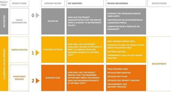
Figure 1 - Snap shot of
Infrastructure NSW Investment Assurance Framework summary
Whilst the initial proposed, Orbital Road engagement program
mapped a draft project process and timeline that focused strongly on the
proposed Orbital investigation area and routes identified from the Engineering
Feasibility Study, Council has listened to the community’s desire to
consider a broader range of options - both other options for new links (some of
which have been received as submissions) and potential further upgrades to the
existing road network. For this reason, this report recommends that
Council proceed to the development of a Strategic Business Case, with the scope
of this work to include a review of options, including but not limited to the
following matters:
- Alternative
link road routes/options - both those presented by Council during the recent
community engagement and those suggested by the community during this time; and
- Council
has continued its upgrade program, including the Lake Road, Ocean Drive
upgrades and working with the Roads and Maritime Services (RMS)/ Transport for
NSW (TfNSW) on improvements to the Oxley Highway, noting this is a State
controlled road.
At the conclusion of the Strategic Business Case, the intent
is that Council will have a more detailed appreciation of the preferred
option(s) to alleviate traffic congestion via better dispersal of traffic
across the network. This may include short, medium and long-term options to
improve the existing Port Macquarie road network (both widening roads and
intersection upgrades) and/or provide new links.
A Communication and Engagement Plan will be developed for
the Strategic Business Case to ensure timely updates to, and engagement with,
the community as work progresses. As recommended by RPS, the
establishment of a Community Consultative Committee will also be part of this
Plan.
This report recommends that Council proceed to the
development of a Strategic Business Case through collaborating with the
community and key state partners.
Discussion
What is the role of Council?
One of the key strategic functions of a Council is to
adequately manage the road network. As an area grows, the demand on the road
network changes, not only the volume of road users but the pattern of travel
and user types. Constructing new roads and upgrading existing roads ensures
that the efficiency, capacity and safety of the network is maintained and where
required improved.
Port Macquarie is identified as a Regional City in the NSW
Government’s North Coast Regional Plan and is one of the fastest growing
regional centres in NSW. The introduction of Charles Sturt University in 2015,
continued expansion of the Base Hospital since 2013, upgrades to the Port
Macquarie airport, growth of the broader education sector, expansion of the CBD
and shopping precincts, and increased residential development have all
contributed to the growth of the Port Macquarie-Hastings area. Continued growth
is expected to see our population reach an estimated 104,000 by the year 2036.
The Port Macquarie road network has limited capacity to
continue to facilitate and respond to a fast rate of growth with critical
elements of the network already experiencing reduced levels of service as
identified in a range of previous studies and traffic assessments. This limited
capacity is centred on the Oxley Highway, Ocean Drive, Lake Road and Hastings
River Drive areas and the need to facilitate effective east-west and
north-south movements and improved access to key areas. Current designed
network upgrades are only likely to provide additional capacity in the short
term (5-10years). This limited capacity will have impacts on the region’s
economic development and the level of service provided to the community as Port
Macquarie continues to grow.
Background/ History of Road network actions to date
Since the 1980’s it has
been recognised that Port Macquarie requires adequate road corridors to connect
current and future urban areas recognising the Lake Innes Reserve as being a
geographical divider. This was further outlined in the 2002 Hastings Roads and
Traffic Study. Many improvements to the existing road network have been
implemented responding to traffic demands experienced due to growth however;
with continued expansion of the urban area, the road network remains largely
incapable of handling current traffic volumes.
Significant upgrades that have
occurred to support the area’s growth since the 2002 traffic study
include the upgrade of the Oxley Highway from the Pacific Highway into Port
Macquarie as the key gateway, duplication and upgrade to Ocean Drive and the
linking of Ocean Drive to Gordon Street.
Upgrades to a number of key
intersections including the intersection of Oxley Highway/Ocean Drive/Gordon
Street/Hastings River Drive and the Hastings River Drive/Boundary Street
intersection have also been completed.
Corridor upgrades that are
continuing include the duplication of Hastings River Drive between Gordon and
Boundary streets and the duplication of Lake Road between Ocean Drive and Oxley
Highway.
Below is a summary of
investigations informing the strategic need and routes for the Orbital Road to
date.
|
Planning for Urban
Growth 1989 - Outer Orbital Link
|
Plan developed for an outer Orbital link as part of the
planning for the beaches and southern areas of Port Macquarie
|
|
The Hastings Road
and Traffic Study (2001)
|
The Hastings Road and Traffic Study was completed
following adoption of the Hastings Urban Growth Strategy (2000) with a major
outcome of the work being the recommendation that the Port Macquarie-Hastings
plan for the provision of an ‘Outer Link Road’ to cater for
future traffic generated from both new and existing development areas. The
conceptual Outer Ring Road was identified as linking Ocean Drive through to
Hastings River Drive via the Oxley Highway.
|
|
Innes Peninsula
Traffic Study (2002)
|
The traffic study indicated the need for road links to the
Oxley Highway and the incorporation of plans for an Outer Ring Road from
Ocean Drive as the existing collector system was inadequate for the expected
growth in traffic.
|
|
Port Macquarie Outer Link Roads route feasibility and
selection study (2005)
|
Building on the recommendations presented in the Hastings
Roads and Traffic Study, Port Macquarie-Hastings Council commissioned
environmental consulting firm ERM to undertake an Outer Link Road route
feasibility and selection study. Preliminary road corridor options assessed
included an East-West route, linking Ocean Drive and the Oxley Highway and a
North-South route, linking between the Oxley Highway and Hastings River
Drive.
|
|
Port Macquarie Outer Link Options – Traffic
Assessment (2006)
|
Following the Outer Link Road route feasibility and
selection study, SMEC undertook traffic network modelling assessment of seven
north-south options, four east-west options and a combined link road option.
Results confirmed the links would
provide travel timesavings across the local road network; however, greater
timesavings would be achieved with the continuous link.
|
|
Port Macquarie Revised Route Options Report (2007)
|
In 2007, ERM prepared a revised route options report for
consideration by Council in its September 2007 determination of preferred
routes to be exhibited for community comment.
|
|
September 2007 Council Resolution - Outer Link Road Route
Options
|
At the 17 September 2007 Ordinary Council meeting, it was
resolved as follows:
ADOPTED: 17/9/07
1. That EW link 3E/3A be the preferred option to cater for
long term traffic relief from Lake Road (Oxley Highway to Ocean Drive) and an
environmental approval and concept design for this route be pursued to
further investigate a link to the industrial area within the next 3 to 5
years, as part of Council's future Transport Infrastructure Works Programme.
2. That the upgrade of Lake Road, Ocean Drive to the Oxley
Highway, be the preferred option to cater for the short to medium term
east/west movement of traffic between Ocean Drive and the Oxley Highway.
3. That the upgrade of Lake
Road be limited to a four (4) lane carriageway (two lanes in each direction
plus kerbside parking lanes) until EW link 3E/3A, or an alternative EW link
is implemented.
4. That in the event of
Council being unable to obtain an environmental approval for EW link 3E/3A
(or an alternative EW link nominated by Council), upgrade of Lake Road to a
six (6) lane carriageway be pursued to cater for long term traffic movements
between Ocean Drive and the Oxley Highway.
5. That NS link 3C be the
preferred link to cater for longer term north/south traffic movements between
Area 13 and Hastings River Drive via the Airport precinct and that the final
alignment of this link reviewed as part of the Area 13 and Airport Precinct
planning.
6. That NS link 4A be the
preferred option to provide a link between Area 13 and Hastings
River Drive and further
development in the Sancrox precinct.
7. That Clifton Drive, Widderson
Street and Findlay Avenue continue to operate as local collector roads and
traffic conditions within these roads be monitored to determine necessary
upgrades to be further considered for inclusion in Council's Transport
Infrastructure Improvement Programme.
8. That copies of ERM
Australia Pty Ltd and all Workshop reports be made available as part of the
public exhibition.
9. That the outcomes of the
public exhibition be reported for Council to resolve a position with respect
to proceeding with the outer link road investigations.
10. That the changes required
to the report, as outlined by the Director of Infrastructure Services, be
adopted.
|
|
Port Macquarie Outer Link Roads Final Route Options Report
(2008)
|
The Outer Link Roads Final Route Options Report updated
the revised route options report with additional traffic modelling results,
updated road and bridge construction costs and revised distribution of future
population.
|
|
May 2008 Council Resolution - Port Macquarie Outer Link
Road Route Options
|
At the 07 May 2008 Ordinary
Council meeting, it was resolved as follows:
ADOPTED: 7/5/2008
1. The Upgrade of Lake Road be
the preferred option to cater for the east/west movement of traffic between
Ocean Drive and the Oxley Highway.
2. A detailed concept design
and strategy for the upgrade of the Lake Road corridor be further reported to
Council during 2009, including opportunities for rezoning of adjoining lands,
improved parking, staging and a funding plan.
3. NS link 3C be the preferred
link to cater for longer term north/south traffic movements between Area 13
and Hastings River Drive via the Airport precinct and that the final
alignment be reviewed and further reported to Council, as part of Area 13 and
Airport Precinct land use planning.
4. NS link 4A be deleted from
further consideration due to the marginal economic impacts of developing this
route and the high environmental impacts that would need to be ameliorated.
5. Clifton Drive, Widderson
Street and Finlay Avenue continue to operate as local collector roads and
traffic conditions within these roads be monitored to determine necessary
upgrades to be further considered for inclusion in Council's Transport
Infrastructure Improvement Programme.
|
|
Port Macquarie-Hastings Infrastructure Gap Analysis (2014)
|
In 2014, PSA Consulting Australia undertook a capacity
assessment of Port-Macquarie Hastings transport and telecommunications
infrastructure. Informed by stakeholder input and strategic analysis of
anticipated needs, the report recommended consideration of new transport
provision from Oxley Drive to Boundary Street and Oxley Highway to Ocean
Drive.
|
|
May 2015 Council Resolution - Road Network Planning
|
At the
20 May 2015 Ordinary Council meeting, it was resolved as follows:
ADOPTED:
20/5/2015
That Council:
1. Endorse
the investigation and planning for new road links and upgrades within the
Local Government Area including:
(a) new
North-South and East-West links
(b) additional
links to Port Macquarie Regional Airport
(c) new
link between Central Road and Acacia Avenue
(d) options for
additional access to the southern section of the Lake Road Industrial area
through to Kingfisher Drive/Wrights Road area
(e) upgrade of Lake Road
to two lanes in each direction between the Oxley Highway and Ocean Drive.
2. Consider
the proposed link road investigations in the preparation of the Urban Growth
Management Strategy (UGMS) review and prior to commencing any investigations
for the future rezoning of land that may be affected by future link roads.
3. Actively
seek external funding for the preconstruction and construction activities
required for the upgrade of Lake Road.
4. Consider
funding the preconstruction activities in 2016 - 2017 budget if other funding
is not forthcoming.
|
|
Port Macquarie Orbital Road Engineering Feasibility
Investigation (2015-2018)
|
An engineering feasibility study for the Orbital Road
commenced in 2016 to determine the most feasible route from an engineering
perspective, looking at environmental constraints, project costs and other more
recent infrastructure and land constraints that have been introduced in the
last 10 years. The investigation identified a viable route for the proposed
Orbital Road, which informed the investigation corridor for the community
consultation undertaken by Council.
|
|
Port Macquarie-Hastings Area Wide Traffic Study
(2015-2018)
|
The Area Wide Traffic Study
undertaken by Council, in partnership with RMS, identified that the proposed
Orbital Road project would remove through traffic from the Inner Port
Macquarie area, and allow easier access for local traffic.
|
Following a period of Administration Council was returned in
September 2012.
Subsequently in March 2013 Council resolved as follows in
relation to priority Roads Infrastructure projects:
|
RESOLVED: Intemann/Levido
That Council, in relation to Roads Infrastructure projects:
1. Allocate the highest priority to the Stingray Creek Bridge
Upgrade; reconstruction of Houston Mitchell Drive; the Hastings River Drive
upgrade to four lanes from Gordon Street to Boundary Street and commence
reconstruction of Beechwood Road.
2. Write to the Minister for Roads and Ports, the Hon. Duncan
Gay, seeking to meet with him regarding traffic congestion and safety program
funding for Hastings River Drive.
3. Allocate appropriate funding in the 2013/14 budget for works
as discussed in the report for the Stingray Creek Bridge Upgrade, Houston
Mitchell Drive, Hastings River Drive and Beechwood Road, as discussed in this
report.
4. Seek assistance from NSW Treasury Corporation (T-Corp) to
review Council’s financial position based on proposed borrowings
outlined in this report.
|
|
CARRIED:
8/0
FOR:
Besseling, Griffiths, Hawkins, Levido, Roberts, Sargeant, Turner and Intemann
AGAINST:
Nil
|
In accordance with that resolution, Council has
substantially completed works as prioritised, from 2013 to 2019, to the value
of approximately $54.5 million, being:
|
Beechwood Road upgrades - 2014-2019
|
Reconstruction and rehabilitation of Beechwood Road (Waugh
Street to Neville Road) completed in stages from 2014 to 2019 at a total cost
of $6.6 million.
|
|
Hastings River Drive/ Boundary Street intersection upgrade
- 2014
|
Intersection upgraded to traffic signals completed in 2014
at a cost of $2.3 million.
|
|
Duplication of Hastings River Drive 2016
|
Duplication of Hastings River Drive (Gordon to Aston
Street) completed in 2016 at a cost of $5.9 million.
|
|
Houston Mitchel Drive upgrade 2017
|
Upgrade of Houston Mitchell Drive completed in 2017 at a
cost of $8.3 million.
|
|
Stingray Creek Bridge upgrade 2017
|
Upgrade of Stingray Creek Bridge completed in 2017 at a
cost of $28.8 million.
|
|
Hastings River Drive / Newport Island Road intersection
upgrade 2018
|
Construction of dual lane roundabout at the Hastings River
Drive / Newport Island Road intersection completed in 2018 at a cost of $2.6
million.
|
In addition to the works identified in the 2013 resolution,
Council has also undertaken a broad program of road network improvements across
the Local Government Area, including works on Lake Road.
Major improvement projects, delivered since 2013, are outlined
below:
|
Saltwater Creek Bridge upgrade - Pembrooke Road 2013
|
The upgrade of a single lane timber bridge on Pembrooke
Road to a dual lane concrete bridge completed in 2013 at a cost of $1.5
million.
|
|
Loggy Creek Bridge upgrade - Pembrooke Road 2014
|
The upgrade of a single lane timber bridge on Pembrooke
Road to a dual lane concrete bridge completed in 2014 at a cost of $1.0
million.
|
|
The Boulevarde and Dunbogan Tip Road upgrade 2015
|
The upgrade of The Boulevarde and Dunbogan Tip Road to
improve flood access for the Dunbogan community completed in 2015 at a cost
of $2 million.
|
|
Lake Road - Blackbutt Road Intersection upgrade
(roundabout) 2016
|
The upgrade of the Lake Road / Blackbutt Road intersection
to a dual lane roundabout completed in 2016 at a cost of $3.2 million. This
project also included minor modifications to the Lake Road / Jindalee Road
roundabout to achieve two west bound through lanes.
|
|
Gordon Street upgrade 2017
|
The upgrade and safety improvements to Gordon Street
(Horton Street to Lake Road) completed in 2017 at a cost of $1.4 million.
|
|
Hyndman’s Creek Bridge upgrade - Comboyne Road 2017
|
The upgrade of a narrow timber bridge to a full dual lane
concrete bridge on Comboyne Road completed in 2017 at a cost of $1.6 million.
|
|
Bulli Creek Bridge upgrade Comboyne Road 2018
|
The upgrade of a single lane timber bridge to dual lane
concrete bridge on Comboyne Road completed in 2018 at a cost of $2.0 million.
|
|
Harty’s Creek Bridge upgrade - Comboyne Road 2018
|
The upgrade of a narrow timber bridge to a full dual lane
concrete bridge on Comboyne Road completed in 2018 at a cost of $1.8 million.
|
|
Albert Street Bridge upgrade 2018
|
The upgrade of a single lane timber bridge to a dual lane
concrete bridge on Albert Street, Kendall, completed in 2018 at a cost of
$0.9 million.
|
|
O’Neill’s Bridge upgrade - Batar Creek Road
2018
|
The upgrade of a narrow timber bridge to a full dual lane
concrete bridge on Batar Creek Road completed in 2018 at a cost of $0.9
million.
|
|
Lake Road Duplication (Toorak Court to Oxley Highway) 2018
|
Duplication of Lake Road (Toorak Court to Oxley Highway)
completed in 2018 at a cost of $1.7 million.
|
These projects were undertaken with funding from
Council and with the support of other levels of government.
Engagement
Due to the complex nature of this
community engagement project, availability of limited internal skills and
experience for engagement at the proposed scale, along with the sensitive
nature of the Orbital Road project, a ‘reverse brief’ style of
proposal was determined as the most appropriate procurement method.
It was determined that the most
effective procurement method in the circumstances. Accordingly, the Local
Government Procurement panel arrangement – Professional Consulting
Services (LGP1208-3), was reviewed and two specialist communication consultants
were identified as suitable.
The benefit of using a Local
Government Procurement panel arrangement directly for procurements over
$150,000. Is that Local Government Procurement has met the requirements of
Section 55(3) of the Local Government Act 1993 (NSW), with Local Government
Procurement being a “prescribed organisation”. As a result,
there is no requirement for Council to undertake a formal Tender process for
these services.
The Request For Quote (RFQ)
documentation was subsequently issued to two appropriately experienced and
qualified consultants seeking detailed proposals on 14 August 2018.
The project delivery was divided
into a two (2) phases, with Phase 1 being a direct appointment based on the
outcomes of the RFQ process. Phase 2 option was the subject of a separate
Council resolution, at its sole discretion. Further information on key
items for each of the Phases is as follows:
Phase 1 – Advice on
commencing the community engagement prior to a Council decision to engage:
· Appropriate
media release statements and supporting visual product as required to inform
the public prior to Council report about the project and Council’s intent
to engage; and
· Appropriate
content for a Council report (public document) to initiate the community
engagement
· The
commencement of a Community Aided Telephone Interview (CATI) Survey
Phase 2 (Subject to
Council decision to proceed) – Plan and lead the community engagement
process for the next stages of planning and development for the Orbital Road
project:
· Produce
a comprehensive engagement plan;
· Produce
appropriate support products - Fact sheets, feedback surveys, map products,
information for Council’s online ‘Have your say’ website,
etc;
· Facilitate
community information sessions;
· Collate
and document feedback and submissions received; and
· Produce
a comprehensive engagement report.
On the 14 September 2018,
RPS/Straight Talk Pty Ltd were engaged to undertake the Phase 1 component of
the project. With Phase 2 being subject of the Council decision at the November
2018 Council meeting.
Council,
with the support of RPS, delivered an extensive community and stakeholder
engagement program for the proposed Orbital Road. The consultation and engagement
period began November 2018 and concluded on 30 March 2019.
The
RPS engagement program was designed to:
· raise awareness about the proposed Orbital Road,
including communicating the history of the project
· invite and encourage submissions from the community and
other stakeholders to inform Council’s
· decision whether to further the progress the project
· provide accurate and timely information about the
proposed Orbital Road and the planning process
· understand and access valuable local knowledge from the
community and stakeholders
· promote a comprehensive and transparent approach
· establish communication channels so stakeholders are kept
informed throughout the corridor planning process
On
21 November 2018 in a Confidential Report to Council, Council resolved to
progress investigations for the proposed Orbital Road as follows:
RESOLVED Alley /Dixon
That Council:
1. Accept
the quote from RPS Manidis Roberts Pty Ltd trading as Straight Talk for Phase 2
of the Orbital Road Communications Strategy and Community Engagement project
for $106,525.00 (inclusive of Project Management Fees- exclusive of GST).
2. Note that
the total cost for engaging RPS Manidis Roberts Pty Ltd trading as Straight
Talk for the Orbital Road Communications Strategy and Community Engagement
project(Phase 1 and Phase 2) will total $181,275.00 (inclusive of Project
Management Fees- exclusive of GST).
3. Pursuant
to Section 55 (3) (a) of the Local Government Act 1993, resolve to not invite
tenders for the Orbital Road Communications Strategy and Community Engagement
project.
4. Affix the
seal of Council to the necessary documents.
5. Maintain
the confidentiality of the documents and consideration in respect of Tender
T-18-43.
6. Request
the General Manager to commence community and stakeholder engagement on the
viable route options for the Orbital Road.
7. Request
the General Manager to actively seek external funding for preconstruction
activities required to progress the planning for the Orbital Road.
The
engagement was required to be undertaken in accordance with advice from RPS and
delivered in a number of stages. All attempts were to be made to engage
with the broader community in addition to those within the investigation area.
However, as is often the case with this type of project, the bulk of the
feedback received has been from the potentially effected community members.
· Engagement process
The engagement process prior to the November 2018 Council
meeting, commenced with a Computer Assisted Telephone Interview (CATI) survey
of 604 residents to gauge the community’s attitudes toward traffic across
Port Macquarie, explore travel habits and behaviours and understand levels of
awareness of the concept for an Outer Orbital Link Road, as it had been
described historically.
The
results from the CATI survey can be found in the RPS Community Engagement
Report - Section 2.3.4 (Attachment 1 and 2). The CATI report was part of
the initial RPS methodology as part of Stage one of the engagement actions.
This was to assist in understanding and awareness of the project in the broader
community, noting the survey questions were not route specific.
Following
the 21 November 2018 Council resolution Council staff commenced doorknocking
414 properties within the investigation corridor to provide initial project
information relating to the proposed Orbital Road.
Communication
material delivered included:
· An addressed letter to the resident/landowner/business
owner
· FAQ document
· A map of the investigation corridor
To coincide with Council’s
decision to progress investigations for the proposed Orbital Road, a project
information webpage was launched on Council’s Have Your Say website.
Community members were encouraged to provide feedback to Council on the
proposed Orbital Road through the website.
During the broader engagement
program, face-to-face and online engagement tools were used to inform community
and stakeholders about the project and to facilitate the expression of their
opinions, concerns and ideas. A range of opportunities
to provide feedback and seek information were available. These included:
· posts on the Port Macquarie-Hastings Council Facebook and
Twitter pages
· video messages from the Mayor and Deputy Mayor
· project information brochure, frequently asked question
sheets and maps were distributed to properties
· within the investigation area, and emails and letters to
stakeholders and directly and indirectly affected landowners.
· key stakeholder and landowner meetings, including
meetings with local action groups
· six community drop-in information sessions and multiple
pop-up information booths, held in a range of locations
· paper-based and online surveys about the proposed orbital
road and broader issues about traffic and transport in the local area
· meetings and telephone conversation with community
members.
During this time period,
property owners, residents and business owners within the investigation
corridor were also able to request a one-on-one meeting with Council’s
project team. Between 22 November and 10 December 2018, 30 requests for
one-on-one meetings were lodged through the Have Your Say website.
A second letter box drop to
property owners, residents and business owners within the investigation
corridor was conducted prior to Christmas 2018. Material delivered included a
project update letter from the Mayor, a project information brochure and fact
sheet. The material was also made available to the community via the Have Your
Say website. During the period from December 2018 through to February 2019
Council staff, the Mayor, Councillors and the General Manager continued to meet
with residents, businesses and other community members.
From 26 February 2019 until 30
March 2019, in response to community feedback, Council developed a series of
additional fact sheets which were made available on the Have Your Say webpage.
The fact sheets included:
· Identifying
a corridor for the Orbital Road
· Corridor
Protection for Future Road Infrastructure
· Environmental
Considerations for the Proposed Orbital Road
During this period, several
community and stakeholder engagement activities were implemented including:
A. Six
community information sessions
B. Eight
stakeholder workshops (i.e. Environmental Groups, Real estate Agents, Business
groups, Community groups etc.)
C. Five
community pop-up sessions
D. Four
meetings with residents and local action groups
During the engagement process,
42 meetings were held with individuals, businesses and residents outside the
formal community engagement sessions. In addition, there were 17,500 unique
visits to the Have Your Say project webpage, with over 46,350 page views, which
is the total times a project page was loaded.
Since the November 2018 Council
meeting there has been a high level of community interest in the project with
eight community members also speaking at the following Council meetings:
· 12
December 2018
· 20
February 2019
· 20
March 2019
· 15
May 2019
Community attendance at the
above-mentioned Council meetings was high.
· Engagement
Feedback
Throughout the engagement
process there was a high level of engagement. A summary of the engagement
outcomes is included in the RPS Engagement Report Section 2.3 (Attachment 1).
In summary this included:
· 1788 community members participated in face to face
sessions 495 submissions received (including emails, letters and submission
feedback forms)
· 604 local residents participated in a randomly-selected
phone survey exploring initial perceptions, ideas and concepts about the
proposed Orbital Road, and general views on traffic and congestion. A CATI
survey was completed 1 – 9 November 2018
· 578 proposed Orbital Road community surveys completed
· clear themes emerged from the feedback received during
meetings, at the community drop-in sessions
· Social media and media coverage
A list of submitters is included in Attachment 3.
Clear themes emerged from the feedback received via
community feedback forms, emails, postal and online submissions and during
community and stakeholder meetings as outlined in the RPS Community Engagement
Report Section 3 (Attachment 1).
Below is an outline of the engagement themes and subthemes
including the number of times the theme was raised through the submissions
received. These are outlined in the RPS Community Engagement Report Section 4 (Attachments
1 and 2). The numbers displayed against each theme indicates the number of
times the theme was raised through the engagement submissions.
1. Project
Planning and decision making - 359
- Benefits of the proposed Orbital Road
- Trust in Council and the decision-making process
- Project planning and decision making
- Project need
- Funding for the proposed Orbital Road
- Project name
- Timelines for the proposed Orbital Road
2. Collective
Impacts - 232
- Infrastructure and growth
- Traffic congestion
- The Health and Education Precinct
- Local infrastructure assets
3. Social
Impacts - 193
- Connections to place, lifestyle and amenity
- Health and wellbeing
- Community impacts
4. Environmental
Impacts - 183
- Flora and vegetation
- Fauna and habitats
- Flooding and evacuation
- Noise and vibration
- Wetlands and waterways
- Acid sulphate soils and contamination
- Geology
- Lake Innes Nature Reserve and Kooloonbung Creek
- Air quality and pollution
5. Infrastructure
- 151
- Impacts on existing infrastructure
- Infrastructure upgrades
6. Community Engagement - 148
- 2007
- 2008 community engagement
- 2018
- 2019 community engagement
7. Property
Acquisition - 128
- Process and timing
- Impacts to property values
- Compensation for directly affected properties
- Compensation for properties adjacent to the proposed
Orbital Road corridor
8. Project
alternatives - 119
- Alternative alignments and recommendations
9. Investigation
and evidence - 77
- Engineering Feasibility Report
- Area Wide Traffic Study
- Calls for evidence to support the need and location of
the proposed Orbital Road
10. Design -
57
- Road design
- Crossing Lake Innes Nature Reserve
11. Planning
Policy - 30
- Local and State planning documents
- Alignment with recent planning decisions
12. Economic
considerations - 29
- Local businesses and organisations
- Tourism
13. Heritage
- 18
- Local heritage buildings
· Recommendations
from RPS Community Engagement Report
The RPS Community Engagement Report made 12 key
recommendations to Council to consider based on key issues raised by the
community and potential ways to mitigate the impacts of a project of this
scale. These can be found in the Executive Summary and Section 5 of the
RPS Community Engagement Report (Attachment 1).
These recommendations have been
carefully considered and the proposed actions in response are detailed
below.
·
Recommendation #1: Council to consider extending the
corridor investigation area to include the area to the south of the golf
course, and alternatives to crossing Lake Innes Nature Reserve.
The current corridor investigation area is of
great concern to many members of the community. Primary concerns include the
amount of development that has occurred within the area since 2008, Council
prescribing a preferred investigation corridor for the Engineering Feasibility
Study and the scale of impact the proposed road would cause on established
communities.
Council staff response: As
part of the Strategic Business Case, a review of alternate options, including
upgrades to the existing road network and options provided by the community
will be undertaken.
Recommendation #2: This
document and its findings are publicly released and easily accessible for the
Port Macquarie community.
It was evident in the findings
that the proposed Orbital Road is of great interest to the local community.
Council staff response: The document will be
publicly released with this Council report and included on Council’s
website.
Recommendation #3: The
findings are shared internally with Council staff, specifically, those working
on the Regional Integrated Transport Strategy
The local knowledge that the
community have regarding their local environments cannot be underestimated.
Feedback received from the community as part of this engagement program is
relevant to other projects that Council is currently working on.
Much of the feedback received
from the community is relevant to the RITS, especially Section 4.1.4, where
comments and suggestions relate to alternate modes of transport including
better public transport connections, improved pedestrian and cycleway
infrastructure and mass transit options.
Council staff response: The
findings will be used internally to assist in the further development of the
Regional Integrated Transport Strategy.
Recommendation #4: The
findings are shared with State Agencies including:
Roads and Maritime Service
(RMS): Information relevant to RMS includes community feedback on the Primary
Airport Access Road link into Fernhill Road and suggested upgrade of the Oxley
Highway.
The Office of Environment and
Heritage (OEH): Information relevant to OEH includes Section 4.4 –
Environmental impacts and 4.13 – Heritage.
National Parks and Wildlife
Service (NPWS): Information relevant to OEH includes Section 4.4 –
Environmental impacts.
Council staff response: Council
will share the findings externally with key agencies including RMS, OEH and
NPWS.
Recommendation #5: Port
Macquarie-Hastings Council investigate establishing a formally recognised
Community Consultative Group for the project. The purpose of this group would
be for community members (through a formal nomination process) to be involved
in the reviewing project information. Members would assist Council in making
informed decisions that draw on local knowledge and expertise. Council could
use the group to assist with communication and information sharing as well as
testing approaches.
Many community members are
concerned that decisions that affect their livelihood are made without their
knowledge or input.
Council staff response: If
the project proceeds as recommended, Council will establish a Community
Consultative Committee, to support the project and act as key information
sharing mechanism. The establishment of this Committee will include the
development of a Charter, an expression of interest process and criteria for
membership to ensure broad representation.
Recommendation #6: It is
recommended that the Port Macquarie-Hastings Council Community Engagement
Strategy and Policy are reviewed. Working with the community through a range of
engagement means, Council should update the key principles of engagement to
address transparency in the decision-making process.
Findings indicate that the
community is concerned about the openness and transparency that Council
proclaims.
Council staff response: Council
routinely reviews it strategies and policies and there are lessons to be learnt
from any engagement process. Council will, over the next 12 months, review its
Engagement Policy and Procedures to ensure there are clear approaches for input
into decision-making.
Recommendation #7: Council consider
developing a positioning statement that addresses transparency in the
decision-making process.
Council staff response: Council
will, as part of the review of our Engagement Policy, consider a statement that
addresses how to increase transparency in the decision making process.
Recommendation #8:
Council evaluate the way that information is shared with the community,
particularly outcomes from Council meetings. The information should be easily
accessible to the community, with consideration that not all community members
are regular users of the internet. It is recommended that Council remind the
community that decisions are published on the website on the Friday following
meetings. Additionally, Council could consider providing hard copy versions of
Council decisions at the Council Administration Office and the local library,
so those members of the community that do not use the internet can have access
and visibility of decisions made by Council.
From the findings, it appears
that many community members were unaware of Council’s unanimous decision
during the May 2015 Council meeting to reinvestigate options for an orbital
road.
Council staff response: Council
will, as part of the review of our Engagement and Communications strategy and
Policy, consider how information is shared with the community, particularly in
relation to Council meetings and decisions. Council currently publishes the
decisions of Council on its website and provides copies of the business papers
at Council’s Customer Service Centres and Libraries. Council will
consider printing the minutes (with decisions) and providing these in our
Libraries and Customer Service Centres.
Recommendation #9: That
Council uses the Area Wide Traffic Study (AWTS) and conducts future traffic
modelling scenarios that include the upgrade of Ocean Drive and Lake Road. This
would enable the community to understand whether the proposed Orbital Road
would still be needed if these works were undertaken.
The upgrade of Lake Road and
Ocean Drive were consistently mentioned across submissions. Considering
previous Council decisions to undertake this work and funding having been
secured for Ocean Drive in 2012, Council need to prioritise the upgrade of
these roads. Many community members who oppose the current proposal believe
that if these projects were completed, the proposed Orbital Road would no
longer be necessary.
Council staff response: Council
intends to use the AWTS to assist in conducting future, more detailed, traffic
modelling scenarios.
Recommendation #10: The
Area Wide Traffic Study examined the road network at an LGA level. It is
recommended that Council build on the AWTS to a comprehensive analysis of the
Port Macquarie road network, with the aim of identifying solutions for future
traffic congestion. This should include the examination of intersection
upgrades.
Many community members suggested
that roundabouts are not designed to handle the volume of traffic on Port
Macquarie roads, particularly during peak periods. It was suggested that traffic
lights would improve traffic flow.
Council staff response: Council
intends to undertake additional traffic modelling at local level to support the
development of future network plans to assist in identifying solutions to our
current congestions and future needs.
Recommendation #11:
Council develop a succinct report written in plain English that explains the
outcomes of the Area Wide Traffic Study. It is recommended that questions
raised in submissions are addressed in the report, specifically those outlined
in Section 4.9.2 – traffic modelling and movements.
The outcomes from the Area Wide
Traffic Study present challenges to those who are unfamiliar with traffic
modelling. Many questions were asked about where traffic is going to and coming
from across the entire Port Macquarie road network.
Council staff response: Council
prepared a plain English explanation as part of the Council report to support
the AWTS that was tabled at the Ordinary Council meeting in February 2019.
However, this may have gotten overlooked in all the information surrounding the
proposed Orbital Road. Council will review the summary to ensure a plain
English, easily understood summary of the AWTS is available for the community
and undertake a communication plan to circulate information broadly through the
community.
Recommendation #12:
Council inform the community about the program of works for road maintenance
across the Local Government Area, specifically, what projects are priorities
for Council. This should also include information regarding planning for growth
and continuing to maintain current assets.
Reference was made to
Council’s road maintenance backlog.
Council staff response: Council
provides regular updates to the community through a variety of channels
including print media and the website regarding the road maintenance program.
Council’s priority projects are also determined through the Operational
Plan process annually.
· Engagement Analysis
As detailed in the RPS Community Engagement Report, the
community engagement program provided avenues for both qualitative (written
submissions) and quantitative (surveys) data to be received by Council. This
presents both benefits and challenges to the outcomes of engagement. High level
analysis of CATI survey data indicates that for the initial telephone survey,
71% of respondents were supportive of the concept of an Outer Orbital Link
Road, however, they were not provided with details of where such a road would
be located.
Results from the proposed
Orbital Road Community Survey indicated a clear division between those who support
(48% of respondents) and those who oppose the project (48% of respondents). 3 %
of respondents neither opposed or supported the project and 1% stated they did
not know.
The 495 written submissions and
feedback delved deeper into why the project was either supported or opposed by
the community. As with many community engagement programs, it is often those
who are likely to be impacted by a proposal, policy or plan that are most
likely to take the time to provide feedback as they have a vested interest in
the outcome. This presents a challenge in ensuring that broad community
responses are received for such proposals.
The proposed Orbital Road
engagement program reflects the nature of community engagement on projects that
have the potential to impact on individuals, communities, and what they value
about their local environment.
The majority of written
submissions received either opposed the project outright or believed the road
is needed and there were several submissions that supported the project. Accordingly,
the RPS Community Engagement Report suggests a new alignment needs to be
identified that minimises impacts to homes, businesses and the environment.
People who support the project
believe it will create better connectivity across Port Macquarie, particularly
for those living in the southern areas, and that the road would redistribute
traffic across the network with the end result being the alleviation of
congestion hotspots during peak periods. Conversely, many community members do
not believe the proposed Orbital Road will alleviate and redistribute traffic
across the region, and call for Council to present the evidence that this would
be the result.
The community engagement program
assisted in identifying the underpinning issues and concerns surrounding the
potential impact the proposed Orbital Road would have on the local community,
the environment and existing infrastructure.
These findings provide Council with a deeper understanding
of the social, cultural and environmental values tied to the local area and the
potential impacts that the proposal will have on the community
Details of the community feedback, CATI Survey, community
survey and all the information that was provided to the community during the
engagement period are contained in the RPS Community Engagement Report and
appendices (refer Attachment 1 and 2). A list of names of people who lodged
submissions is also attached to this report at Attachment 3. The submissions,
with identifying information redacted, are available on the Have Your Say page
on Council’s website.
Next Steps
If Council resolves to proceed to the next
stage of the proposed Orbital Road project, this would be the development of a
Strategic Business Case, known as Gate 1. The development of the Strategic
Business case would also incorporate a Needs Confirmation Summary, known as
Gate 0. This will generally be in line with the Infrastructure NSW Project
Assurance Framework. Indicative project decision points are detailed in the
figure below:
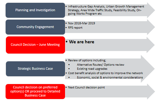
The Strategic Business Case will include a
review of (but will not be limited to):
· Findings to date
(e.g. Orbital Road Feasibility Study and recent community engagement)
· Project specific
traffic studies
· Environmental
impact investigations
· Social &
economic impact investigations
· Investigation of
alternate routes
· Planned road
upgrades to the existing road network
· Engage and partner
with:
· Roads and Maritime
Services/ Transport for NSW (TfNSW);
· NSW Office of
Environment & Heritage (OEH);
· NSW National Parks
& Wildlife Service (NPWS);
· NSW Department of
Planning & Environment (DPE);
The Strategic Business Case
would include further detailed analysis of the
existing road network. This would build on the work completed as part of
Council’s Area Wide Traffic Study and would see the development of a Port
Macquarie-specific traffic model.
The work undertaken as part of a Strategic Business Case
aims to:
- reconfirm
the need for Council, to address traffic congestion and the need to improve our
transport network to respond to and cater for growth;
- consider
the cost benefit analysis of a full range of options and based on that, reduce
the number of options to a preferred option or shortlist; and
- provide
decision-makers with the information they need to determine whether or not to
proceed to future stages of the project.
It is important to note that any
improvements to the network across the short, medium and long term will need to
be assessed with other viable improvements. The interconnected relationship of
the road network means any one improvement may affect others and the timing of
these improvements.
The Strategic Business Case analysis will enable
deficiencies in the existing road network to be further understood and various
improvement options to be tested in terms of their cost and benefit. Key considerations and objectives when reviewing the options
would include:
· maximising traffic
benefits by minimising travel times and delays;
· minimising
construction cost;
· maximising road
safety benefits;
· minimising
environmental impacts;
· minimising social
impacts;
· maximising future regional
economic development opportunities; and
· maximising
improvements to social connectivity.
If Council resolves to proceed to the Strategic Business
Case stage, a specialist consultant will be engaged to complete the Strategic
Business Case in consultation with Councillors, Council staff and relevant
stakeholders such as Transport for NSW and Department of Planning and Industry.
This process can be a lengthy one and is anticipated that it would take up to
24 months to complete. It is acknowledged that such a timeline will not give
any certainty to residents within the current investigation area of a preferred
route for some time. However, it is critical that Council undertake this
detailed work in order to make the most appropriate decision for the future.
On completion, the Strategic Business Case would be reported
to Council for consideration and with a recommendation on whether or not to
proceed to the next stage of the Project and/or to determine a preferred
approach to further address the traffic congestion problem. The intent being
that at the conclusion of the Strategic Business Case, there would be an
improved understanding of the most feasible option (s) (potentially short and
long term) to alleviating traffic congestion via better dispersal of traffic
across our network. It would be at this point in the process that there
would be another decision point for Council to determine whether to proceed to
the next phase (Gate 2) of the project, being determination of the preferred
option(s) and development of a detailed business case on this option(s).
Refer to the fact sheet - Proposed Orbital Road - Strategic
Business Case - Attachment 4.
Options
Council may resolve as per
the recommendations included in this report or Council may choose to resolve in
some other manner.
Community Engagement &
Internal Consultation
A comprehensive community engagement process was undertaken,
as detailed in the report.
In preparing this report, significant internal engagement
has also taken place.
Planning & Policy
Implications
There are no immediate
planning implications arising from this report. However as included in the
recommendations there would be a requirement to review Council’s
Engagement Policy.
Financial & Economic
Implications
Should Council resolve to
proceed to the Strategic Business Case stage, funding of $800,000 is included
in the draft 2019/20 Operational Plan. It is recommended that Council
seek a co-contribution of $400,000 from the NSW government to develop the Strategic
Business Case.
Any major infrastructure works
such as new link roads or major improvements to the existing road network, will
require significant investment from Council and likely, other levels of
government.
|
Attachments
1View. Proposed Orbital Road Engagement
Report
2View. Appendices - Proposed
Orbital Road Engagement Report
3View. Proposed Orbital Road
Project - List of Submitters
4View. Infrastructure - Strategic
Business Case Fact Sheet
|
19/06/2019
|
Item: 13.02
Subject: Land Acquisition - Corner of Lake Road & Blackbutt Road, Port
Macquarie
Presented
by: Corporate Performance, Rebecca Olsen
Alignment with Delivery Program
4.4.1 Plan, investigate, design and construct transport
assets which address pedestrians, cyclist and vehicular needs to cater for
the future growth of the region.
|
|
RECOMMENDATION
That Council:
1. Pay
compensation in the amount of $13,156.00 (GST Exclusive) to the Owners
Corporation of Strata Plan 98553 for the acquisition of part of the Common
Property of Strata Plan 98553 more particularly described as Lot 1 in Plan of
Acquisition Deposited Plan 1230034 being land situated at 146 Lake Road, Port
Macquarie;
2. Pursuant
to Section 59 of the Land Acquisition (Just Terms Compensation) Act 1991,
pay the Owners Corporation of Strata Plan 98553 reasonably incurred legal and
financial costs associated with the acquisition;
3. Pursuant
to Section 377 of the Local Government Act 1993, delegate authority to
the General Manager to execute, electronically or otherwise, all documents
including, but not limited to, any authorisation form as required associated
with the acquisition in accordance with the Electronic Transactions Act
2000;
4. Pursuant
to Section 10 of the Roads Act 1993, on the acquisition of Lot 1
Deposited Plan 1230034, dedicate the land as a public road.
|
Executive
Summary
A report to consider the payment of compensation for the
acquisition of land following the completion of construction of the roundabout
at the intersection of Lake Road and Blackbutt Road, Port Macquarie.
Discussion
Construction of the roundabout at the intersection of Lake
Road and Blackbutt Road, Port Macquarie requires the acquisition of part of the
Common Property of Strata Plan 93225 being land situated at 146 Lake Road. The
location of the land acquisition is shown as the triangular Lot 1 in the
attached plan.
The land to be acquired has been surveyed as Lot 1 in Plan
of Acquisition DP1230034. Lot 1 comprises an area of 40.48m2.
The construction of the roundabout was completed with the
prior written consent of the landowner.
Options
On the basis that construction of the roundabout has been
completed and compensation agreed, there are no alternative options.
Community
Engagement & Internal Consultation
There has been ongoing consultation with the Owners
Corporation legal representative.
Planning
& Policy Implications
There are no planning and
policy implications in relation to this report.
Financial
& Economic Implications
The acquisition of the land
entitles the landowner to the payment of monetary compensation and to the
reimbursement of expenses reasonably incurred arising from the acquisition.
Having regard to the
provisions of the Land Acquisition (Just Terms Compensation) Act 1991,
Council’s Consulting Valuer has assessed compensation for the acquisition
of Lot 1 DP1230034 at $13,156.00 (GST Exclusive). A written offer in this
amount has been made to, and accepted by, the landowner.
Reasonably incurred expenses
by the landowner comprise the legal fees of the landowner’s legal
representative.
Costs, including
Council’s legal expenses in completing the acquisition, and the
compensation for the land to be acquired are estimated at $20,000 (GST
inclusive). There are sufficient funds available in the Lake Road /
Blackbutt Road Roundabout Reserve to fund this acquisition. A budget will be
allocated through the monthly financial reporting process in the new financial
year.
|
Attachments
1View. Location of Land to be
Acquired
|
19/06/2019
|
Item: 13.03
Subject: Land Acquisition and Road Closure Being part Thone River Road,
Byabarra
Presented
by: Corporate Performance, Rebecca Olsen
Alignment with Delivery Program
4.4.1 Plan, investigate, design and construct transport
assets which address pedestrians, cyclist and vehicular needs to cater for
the future growth of the region.
|
|
RECOMMENDATION
That Council:
1.
Proceed to acquire that part of Lot 12
Deposited Plan 136647 of sufficient length and width to enable a public road
to be created over the existing Thone River Road track in use at its
intersection with Comboyne Road;
2.
Subject to Resolution 1 above, pursuant
to Section 10 of the Roads Act 1993, on completion of the proposed
acquisition, dedicate the acquired land as a public road;
3.
Subject to Resolutions 1 and 2 above,
proceed with the closure of that part of Thone River Road, enclosed by the
blue dashed line in the attachment to this report titled “Proposed Road
to be Closed”;
4.
Pursuant to Sections 38B and 38E of the
Roads Act 1993, in the Notice of Road Closure, vest the land within
the closed road in Council ownership as “operational land”;
5.
Pursuant to Section 44 of the Roads
Act 1993, provide the land within the closed road referred to in
Resolution 3 above, to the owner of Lot 12 Deposited Plan 136647, as
compensation for the land acquired from Lot 12 Deposited Plan 136647;
6.
Complete the land acquisition and road
dedication processes referred to in Resolutions 1 and 2 above, either prior
to, or at the same time, as the closure of that part of Thone River Road
referred to in Resolution 3 above;
7.
Pursuant to Section 377 of the Local
Government Act 1993 delegate authority to the General Manager to sign:
a)
Plan of road closure and Section 88B
Instrument;
b)
b. Electronically or otherwise
all documents including but not limited to any authorisation form as required
in accordance with the Electronic Transactions Act 2000.
|
Executive
Summary
Part of the currently constructed and in-use Thone River
Road is not located within the prescribed road reserve where it commences at
Comboyne Road. The road is a constructed gravel track which passes
through private property, Lot 12 DP136647. The owner of this property has
requested this anomaly be addressed by Council. Rectification of the
anomaly will improve address information for service delivery and locating
addresses for emergency services.
The anomaly is able to be rectified through the acquisition
of land for the purposes of a new road reserve, that includes the current
formed gravel track. In lieu of the payment of monetary compensation for
the required land acquisition, the now unused surveyed section of the original
alignment of the Thone River Road road reserve, can be closed and the land
within the closed road provided as compensation to the landowner. In
essence, a land swap occurs. Subject to the final plan of acquisition, it
is intended that the area of the land to be acquired for the new road reserve
will be approximately equivalent to the area of land within the road reserve to
be closed.
Discussion
The initial approximately 160 metres of Thone River Road
from its intersection with Comboyne Road, comprises a formed track across
private land. The location of the public road network in the vicinity of
the intersection is shown by grey shading in the attached aerial image
(Attachment 1).
The owner of the land through which the formed track passes (Lot
12 DP136647) has requested the anomaly between the track in use and the
surveyed section of the Thone River Road road reserve, which is no longer in
use, be remedied. This is able to be achieved by means of acquiring the
land occupied by the formed track. In lieu of monetary compensation for
the land acquisition, the no longer in use section of the surveyed Thone River
Road road reserve, can be closed and provided as compensation to the
landowner. In essence, a land swap takes place. Section 44 of the
Roads Act 1993 allows for such a procedure. The land swap scenario is
shown in the attached plan (Attachment 2).
Should Council proceed with the land swap, to ensure ongoing
legal access to properties along Thone River Road, the land acquisition and
dedication of the acquired land as public road will need to occur prior to, or
at the same time, that the proposed road closure occurs.
Options
Council has the option to:
1. Proceed
as per the recommendations of this report to rectify the road reserve anomaly
and improve address information for service delivery and locating addresses for
emergency services; or
2. Not
proceed with the proposed land acquisition and subsequent land swap and retain
the status quo.
Community
Engagement & Internal Consultation
There has been consultation with the landowner on the
proposed land swap. As required by the Roads Act 1993,
notification of the proposal to close the original alignment of the unused
section of the Thone River Road road reserve and provide the land in the closed
road as compensation for the land to be acquired for road purposes, has been
publicly exhibited in the “Community Now” Notices and notified to
the mandatory Statutory Authorities.
At the conclusion of the notification period, no objections
to the proposal were received. Essential Energy has requested an easement
be created in its favour where overhead power lines traverse the road proposed
to be closed.
Planning
& Policy Implications
There are no planning and
policy implications in relation to this report.
Financial
& Economic Implications
Whilst there is nil monetary
compensation sought for the land to be acquired, survey preparation, survey
plan registration and legal fees will be incurred. These costs are
anticipated to be in the order of $10,000. There is funding available in
the operational plan (OP 1.5.3.8 CW) to meet the anticipated costs.
|
Attachments
1View. Extent of Public Road
Network
2View. Road Proposed to be Closed
(in Blue Dashes)
|
19/06/2019
|
Item: 13.04
Subject: Land Acquisitions - Wingham Road and Main Street, Comboyne
Presented
by: Corporate Performance, Rebecca Olsen
Alignment with Delivery Program
4.4.1 Plan, investigate, design and construct transport
assets which address pedestrians, cyclist and vehicular needs to cater for
the future growth of the region.
|
|
RECOMMENDATION
That Council:
1. Pay
compensation in the amount of $29,132.00 (GST Exclusive) to the owner of Lot
1 Section 1 Deposited Plan 8802, N Matthews, for the acquisition of part Lot
1 Section 1 Deposited Plan 8802 more particularly described as Lot 1 in Plan
of Acquisition Deposited Plan 852232;
2. Pay
compensation in the amount of $9,955.00 (GST Exclusive) to the owner of Lot 2
Deposited Plan 205711, P Newman, for the acquisition of part of Lot 2
Deposited Plan 205711 more particularly described as Lot 2 in Plan of Acquisition
Deposited Plan 852232;
3. Pursuant
to Section 59 of the Land Acquisition (Just Terms Compensation) Act 1991
pay the legal costs reasonably incurred by the landowners associated with the
acquisitions;
4. Pursuant
to Section 377 of the Local Government Act 1993, delegate authority to
the General Manager to execute, electronically or otherwise, all documents
including, but not limited to, any authorisation form as required associated
with the acquisition in accordance with the Electronic Transactions Act
2000;
5. Pursuant
to Section 10 of the Roads Act 1993, on the acquisition of Lots 1 and
2 Deposited Plan 852232, dedicate the land as a public road.
|
Executive
Summary
A report to consider the payment of compensation for the
acquisition of land being part of the road bridge spanning the Thone River at
Comboyne.
Discussion
In the early 1990’s, the road bridge spanning the
Thone River at Comboyne was replaced. The bridge on the new alignment
encroaches onto private lands. With the recent change in ownership of
both properties, the new landowners have requested that acquisitions be
completed.
The area of lands occupied by the realigned bridge have been
surveyed as Lots 1 and 2 in Plan of Acquisition Deposited Plan 852232.
The location and general extent of the lands to be acquired is shown in the
attached plan.
Options
As the existing bridge encroaches onto private lands there
are no alternative options other than to proceed with the proposed
acquisitions.
Community
Engagement & Internal Consultation
There has been consultation with the landowners, their legal
representative and with Council’s Consulting Valuer.
Planning
& Policy Implications
There are no planning and
policy implications in relation to this report.
Financial
& Economic Implications
The acquisition of the land
entitles the landowners to the payment of compensation. Council’s
Consulting Valuer has assessed compensation payable and offers have been made
to the landowners in line with the amounts assessed by Council’s Consulting
Valuer. The landowners have provided their written acceptance of the
offers.
In addition to the payment of
monetary compensation for the land, Section 59 of the Land Acquisition (Just
Terms Compensation) Act 1991 requires that Council meet the landowners
reasonably incurred legal fees. These fees are estimated at $3,000 (GST
Inclusive).
There is funding available in
the operational plan (OP 1.5.3.8 CW) to meet the costs outlined in this report.
|
Attachments
1View. Plan Showing Location of
Land to be Acquired
|
19/06/2019
|
Item: 13.05
Subject: Creation of Easements for Water Supply - John Oxley Drive,
Thrumster
Presented
by: Corporate Performance, Rebecca Olsen
Alignment with Delivery Program
4.1.1 Plan, investigate, design and construct water supply
assets ensuring health, safety, environmental protection and security of
supply for the future growth of the region.
|
|
RECOMMENDATION
That Council:
1. Pay
compensation in the amount of $82,260.00 (GST Exclusive) to the owner of Lots
1, 2 and 3 Deposited Plan 1250669, S.Z.C.J.S.E. Pty Ltd, for the creation of
easements for water supply 4 metres wide and 12 metres wide shown as (J) and
(H) respectively in Deposited Plan 1250669;
2. Pursuant
to Section 59 of the Land Acquisition (Just Terms Compensation) Act 1991,
pay the landowner’s reasonably incurred valuation and legal fees
associated with the creation of the easements;
3. Pursuant
to Section 377 of the Local Government Act 1993, delegate authority to
the General Manager to execute, electronically or otherwise, all documents
including, but not limited to, any authorisation form as required associated
with the easement creation in accordance with the Electronic Transactions
Act 2000.
|
Executive
Summary
A report recommending the payment of compensation for the
creation of easements for water supply at Thrumster.
Discussion
In order to ensure the Sancrox water supply system has
enough water storage to supply the increased population in the zone (especially
with the development in Area 13), a new 20 million litre reservoir has been constructed.
The distribution capacity from the new reservoir now needs to be
augmented to serve Area 13. Council’s 2018/2019 Operation Plan has
adopted the design and construction of approximately 2040 metres of new 750mm
diameter water pipe to provide a larger capacity feed to Area 13 from the new
Sancrox Reservoir. This pipeline requires a new easement east of the
Pacific Highway through Lots 1, 2 and 3 DP1250669. The easements are
depicted as (J) and (H) in DP1250669 and are shown on the attached plan.
Options
Nil.
Community
Engagement & Internal Consultation
There has been ongoing consultation with the landowner and
the landowner’s consultant, and between Council’s Consulting Valuer
and the landowner’s Consulting Valuer.
Internal consultation has been ongoing between the
Infrastructure Division and the Corporate Performance Division.
Planning
& Policy Implications
There are no planning and
policy implications in relation to this report.
Financial
& Economic Implications
The creation of the easements
entitles the landowner to the payment of compensation. Council’s
Consulting Valuer and the landowner’s Consulting Valuer have agreed on
the value of the easements in the amount of $82,260.00 (GST exclusive).
The landowner has provided his written agreement to the amount.
In addition to the payment of
monetary compensation for the easements, Section 59 of the Land Acquisition
(Just Terms Compensation) Act 1991 requires that Council meet the
landowner’s reasonably incurred costs including valuation and legal fees.
There is funding available in
the current Operational Plan - OP 4.1.1.1 CW to meet the compensation and costs
incurred by the landowner.
|
Attachments
1View. Location of Easements for
Water Supply
|
19/06/2019
|
Item: 13.06
Subject: Planning Proposal Request PP2011 -
9.3: The Ruins Way and South Blackwood, Port Macquarie
Presented
by: Strategy and Growth, Holly McBride
Alignment with Delivery Program
4.5.1 Carry out strategic planning to manage population
growth and provide for co-ordinated urban development.
|
|
RECOMMENDATION
That Council:
1. Not
support the Planning Proposal request to amend the Port Macquarie-Hastings
Local Environmental Plan 2011 in relation to the un-subdivided residue land
at Ascot Park and Innes Lake (being Part Lot 340 DP1251842 and Part Lot 399
DP1241278), Port Macquarie, for the following reasons:
a) The
proposed development resulting from the Planning Proposal is considered
unacceptable in terms of environmental impact, specifically:
i) up
to 100% loss of existing Core Koala habitat within the proposed development
precincts to satisfy Planning for Bushfire Protection requirements.
ii) loss
of a significant corridor / habitat linkage between key foraging areas, with
significance for genetic dispersal, and recovering vulnerable species,
including koala.
iii) Incremental
and cumulative habitat and connectivity loss, through ineffective offsets,
barriers to movement, vehicle strike, and increased risk of dog attack and
disease.
b) The
Planning Proposal is inconsistent with North Coast Regional Plan 2036, Urban
Growth Management Strategy 2017-2036, State Environmental Planning for Koala
Habitat Protection and Coastal Management 2018, and the Biodiversity
Conservation Act 2016.
c) The
outcomes of the Planning Proposal do not have strategic merit and the request
proposes development of land which is inconsistent with the Strategic Merit
Test as outlined in the Department of Planning & Environment’s
Guidelines for Strategic and Site-Specific Merit Assessment Criteria for
Planning Proposals.
d) The
request proposes development of land which, if supported, would be
inconsistent with Object (b) and Object (e) of the Environmental Planning and
Assessment Act, 1979.
2. For
the reasons outlined in 1 above, not forward the Planning Proposal to the
Department of Planning & Environment for a Gateway Determination under
Section 3.33 and 3.34 of the Environmental Planning & Assessment Act
1979.
3. Notify
the Proponent of its decision on the matter.
|
Executive
Summary
The purpose of this report is to consider a Planning
Proposal request (PP2011-9.3) from Love Project Management Pty Ltd to rezone
Part Lot 340 DP1251842 and Part Lot 399 DP1241278 at Ascot Park and
Innes Lake, Port Macquarie, and provide a summary of the outcomes of staff
assessment of the request.
The Planning Proposal request originally related to three
separate areas located off The Ruins Way and Blackwood Street, Port Macquarie,
being:
1. The
Ruins Way – East, which is proposed to be gifted to The Point Church
2. The
Ruins Way – West, located to the north of Blue Wren Close
3. South
Blackwood (Lindfield), which was linked to the South Lindfield Urban Release
Area.
The first of these areas has now been removed from the
proposal at the request of the proponent.
The stated aims of the proponent are to permit general
residential development of the land as an extension of existing subdivision
whilst retaining remnant habitat and corridor linkages within an urban setting.
The intended effect of the Planning Proposal request is to amend planning
controls including zone, lot size, floor space ratio and height of building
controls, on land within the proposed development areas.
The land is currently zoned rural (RU1 Primary Production),
and all parts contain high environmental value remnant vegetation and known
koala habitat, which functions as a habitat link.
Council first considered the request in July 2011, resolving
to include the proposal in Council’s 2011-12 Strategic Land Use Planning
program as a site specific Local Environmental Plan (LEP) Amendment proposal,
subject to:
· Satisfactory
resolution of urban design and conservation outcomes, having regard for what
was originally approved for the subject land.
· The need for a
Koala Plan of Management.
· The implications
of the proposed development on the adjoining Nature Reserve.
Since that time, there have been reviews of submitted
information, meetings with the proponent and their representative consultants,
reports to Council on the status of the proposal and site visits. The proponent
has been advised that the information submitted in support of the request does
not address fundamental issues.
Council resolved on 16 August 2017 (Item 12.04) to
discontinue the request if the necessary information has not been submitted for
Council to support preparation of a Planning proposal by 16 February 2018.
The Proponent lodged additional information within the
deadline (Copy as Attachment 2) in February 2018, plus additional studies
submitted in April and May 2018 (copy as Attachment 3).
On review, Council staff have concluded that the information
submitted does not satisfactorily address the outstanding issues which were
summarised to the proponent on 2 and 31 August 2018 (Copies at attachment 4) in
order for Council to determine whether to refer the Planning proposal for
Gateway Determination.
Council’s letter of 31 August 2018 advised the
Proponent that “Council staff have concluded that the proposed
vegetation removal required for asset protection zones etc. cannot be
undertaken without significant impact on the habitat of local populations of
vulnerable species and on habitat connectivity.”
The proponent contends that the majority of the staff
concerns, including detailed and ongoing legislative and environmental concerns
which were outlined in Council’s letter of 31 August 2018 (copy at
Appendix 4), can be considered and addressed at the time of lodgement and
assessment of future development applications (DAs under Part 4 of the EP&A
Act) for the areas in question.
Council staff do not accept this position, concluding that
it is not appropriate to rezone land for residential development where there is
significant doubt that residential development can take place. Council staff
have concluded that based on the information provided, the proposed vegetation
loss and expected further vegetation removal required for asset protection
zones etc, cannot be undertaken without significant impact on the habitat of
local populations of vulnerable species and on habitat connectivity.
Council staff have formed the view that these issues are
significant and it is unlikely that they can be resolved over the majority of
the subject land. While the issues appear to be somewhat detailed for a
rezoning/planning proposal it is the cumulative, overlapping and contradictory
impacts of the issues that necessitate their consideration at this stage in the
process.
The koala population in the Innes Lake area has been
identified as nationally significant and the incremental loss of habitat is
therefore significant in this area.
The possible exception to this
is the South Blackwood (Lindfield) area, which potentially has some development
potential. However, there remain long standing unresolved Council and Office of
Environment and Heritage (OEH) concerns arising from investigation of the area
as part of the South Lindfield Urban Release area, including:
· the width of
buffers to the Lake Innes Nature Reserve,
· retention of
habitat linkages
· vegetation offset
requirements.
These issues have not been resolved in the information
provided by the proponent and it is therefore proposed that Council not support
the proponent’s request to prepare a planning proposal for the
Vilro/Charley land for the reasons recommended.
Background
The
Site
The subject site comprises three separate precincts located
on un-subdivided residue land at Ascot Park and Innes Lake, which at the time
of writing, comprised two (2) lots.
The Ruins Way East and The Ruins Way West precincts form
part of Lot 340 DP 1251842 and South Blackwood (Lindfield) is located within
Lot 399 DP1241278, as shown below.
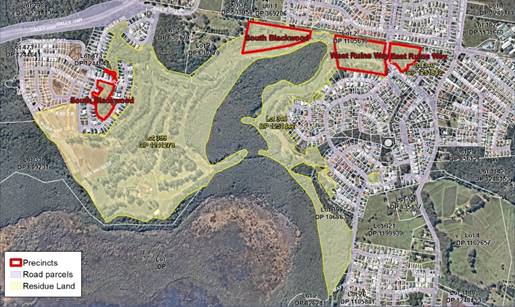
Figure 1. Site context.
Both lots are residue lots following residential
subdivision, including golf course, wetland buffers, and approved koala plans
of management.
Lot 399 DP1241278
Part RU1 Primary Production,
part R1 General Residential, and
part E2 Environmental
Conservation.
This lot comprises the residue area of Ascot Park
subdivision. It is located west of the Nature Reserve. It contains numerous
easements, positive covenants, rights of access, servicing infrastructure, and
commitments relating to existing approvals, including bushfire asset protection
zones, golf course and vegetation retention.
Lot 340 DP1251842
Part RU1 Primary Production,
and part R1 General Residential,
This lot is located to the east of the Lake Innes Nature
Reserve with a land area of approximately 23ha. The lot contains managed
grassland, stands of remnant coastal forest/woodland as well various easements,
positive covenants, bushfire asset protection zones, servicing and stormwater
management facilities associated with adjoining subdivision approvals, and golf
course. Existing vegetation has been retained in connection with existing
approvals, including golf course, wetland buffers, and approved koala plans of
management.
The Proposed Rezoning Precincts
1. The
Ruins Way East
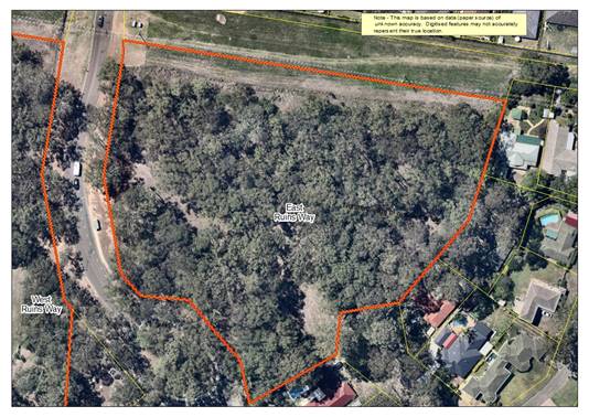
Figure 2 - The Ruins Way – East
This precinct is around 1.8ha. It is located west of The
Ruins Way, forming the north eastern extent of Lot 340. Boundaries are to
existing housing in The Ruins Way, The Stockyard and Coucal Close. The northern
boundary adjoins Council owned land for service easements and Electricity
Transmission, while the western boundary fronts The Ruins Way at the entrance
to the Innes Lake estate. Access is via The Stockyard and The Ruins
Way. The site is known to contain identified koala habitat.
|
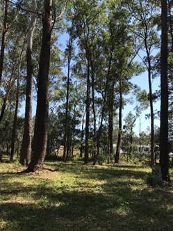
|
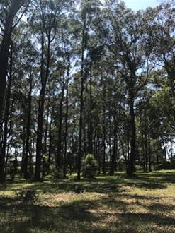
|
|
Figure 3 -
The Ruins Way East: Site images, captured 24 October 2018 at onsite meeting
with proponent.
|
2. The
Ruins Way – West
This area is located west of The Ruins Way at the northern
extent of Lot 340. It also adjoins a Council owned and managed easement for
services and transmission line to the north, neighbouring residential housing
in Blue Wren Close to the south, and The Lake Innes Nature Reserve to the west.
It is approximately 4ha. Access is via The Ruins Way and the road network to
the south.
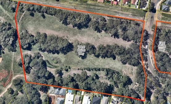
Figure 4 - The Ruins Way West Precinct - Context Image,
NearMap March 2019
The proposed development area contains managed grassland and
remnant strips of mature vegetation retained in accordance with existing
approvals, including approved golf course fairways.
3. Blackwood
Street - South
This area is located at the northern border of Lot 399, west
of Lake Innes Nature Reserve. The site adjoins the recent land release at South
Lindfield to the north, the Port Macquarie Crematorium to the west and Lot 340
to the east. The area comprises around 5.8ha of managed grassland and remnant
vegetation generally confined to narrow strips situated along drainage swales
and peripheral areas including boundary edges and golf course fairways.
At the request of the proponent,
the area has been variously included in, or omitted from, the subject planning
proposal request. In March 2017 Council resolved to omit the area from the
adjacent Lindfield Urban Release Area planning proposal on the basis of Office
of Environment and Heritage concerns and non-resolution of environmental
matters, including:
· the
need for a 35-metre-wide vegetated buffer to protect the Lake Innes Nature
Reserve from direct/indirect impacts associated with any potential future
residential development of the South Blackwood area
· provision
of a viable ecological link for koala habitat connectivity, and offset planting
Approximately 3ha of the precinct is located within North
Coast Regional Plan 2036 Urban Growth Area (UGA) boundary and identified
for urban investigation. (Figure 5).
|
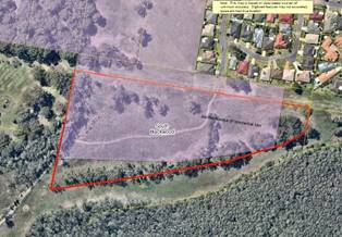
|
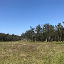
|
|
Figure 5 - The South Blackwood (Lindfield) Precinct
showing Urban Growth Area (Pink shading).
NearMap March 2019.
|
Figure 6 - South Blackwood (Lindfield) site image, view
south from the Utility Easement to Lake Innes Nature Reserve.
|
Chronology
Council has worked with the proponent since 2011 to progress
the planning proposal request. A detailed Chronology of the Planning Proposal
Request is included at Attachment 1. The chronology shows:
· Council resolution
to include the land in question in July 2011, subject to consistency with
Regional and Local planning strategies, and conservation outcomes in The Ruins
Way area having regard to what was originally planned, the need for a Koala
Plan of Management, the relationship to the neighbouring National Park Nature
Reserve and the potential loss of open space associated with the then Innes
Peninsular residential subdivision.
· Multiple staff
requests for information (2011-2019).
· Reports to Council
(2011-2019) advising on the status of the site specific request.
· Determinations to
defer consideration and/or set deadlines for submission of necessary
information (2013-2018).
· Extended
timeframes for submission of information (5 since June 2017).
· Omission and
inclusion of the South Blackwood precinct at varying stages.
· The land
owner’s offer to gift The Ruins Way East area to a local church group,
and representations to staff.
· Omission of The
Ruins Way East (March 2019) at the request of the proponent.
A summary of the information submitted in chronological
order is provided below.
The Planning Proposal Request – February 2018
In February 2018, the proponent lodged revised information
in response to the Council’s resolution of 16 August 2017. The submission
included:
· Planning Proposal Application
Report (February 2018)
· Ecological Survey
and Constraints Assessment Version 4, (February 2018)
· Draft Koala Plan
of Management Version 3, (February 2018)
· Conceptual
subdivision development layouts for three distinct precincts in the north of
the landholding.
· Bushfire Hazard
Assessment (27 November 2013).
· Revised and
updated Bushfire Hazard Assessment (submitted to senior staff 19 July 2018).
The submission did not include
previously requested studies, including:
· Aboriginal Archaeological
and Cultural Heritage Report (received April 2018)
· Drainage and
hydrology report.
· A zoning concept
for the land.
The Planning Proposal documentation submitted by the
Proponent is contained in Appendix 2 of this report.
The request states that “the proposal has been
prepared in response to the need to evaluate and determine the appropriate land
use zones for a large landholding in Port Macquarie which is surrounded by
residential and urban forms of development. The land contains minor strips of
vegetation, some of which have environmental merit for their retention within
an urban setting”.
The request has included the
following “notional” development concepts for the land:
|
Concept Layouts - February
2018 submission
|
Revisions
|
|

South Blackwood (Lindfield)
(Lindfield) – 33 lots
Proponent submission: “West
Lindfield has been assessed as able to accommodate a residential subdivision
for some 33 residential lots and an area in the southern portion of the land
which will be zoned for environment protection to ensure the long term
preservation of a narrow strip of trees which has been retained as a
separation between the approved fairway and the proposed residential
subdivision.”
|
NA
|
|
The Ruins Way – West
– 28 lots
Proponent submission: “The
West Ruins Way land is also proposed to be both residential development and
environmental protection areas. The concept plan provides for 38 residential
allotments and areas of retained vegetation which will be zoned for
environmental protection and enhancement.”
|
|
|
The Ruins Way – East
– Church
Proponent submission: “The
East Ruins Way site requires a long term management plan which will be
achieved through this Planning Proposal. The successful management of large
areas of vegetation within an urban environment will require vegetation
management plans to form part of the future development consents on the
property. The proposal is for this land to become a site owned and managed by
a community group, with the footprint of proposed buildings located to
maximize retention of koala food trees.”
|
Omitted by proponent 1 March
2019.
Note: Council staff have also
worked with the Point Church Group in relation to the site.
|
The Planning Proposal Request, Additional Information
- 1 March 2019
On 1 March 2019, the proponent submitted further information
in response to Council’s letter of 31st August 2018. (Copy at
Appendix 3 of this report).
The details of the submissions are:
· Letter from Love
Project Management to Council removing The Ruins Way – East proposal from
the request, and an amended concept for The Ruins Way – West.
· Att. A –
Love Project Management itemised response to matters raised on pages 4-5 of
Council correspondence of 31st August 2018
· Att. B – JB
Enviro response to matters set out on pages 1-3 of Council correspondence of 31st
August 2018.
· Amended Concept
Plan for West Ruins Way, shown below.
|
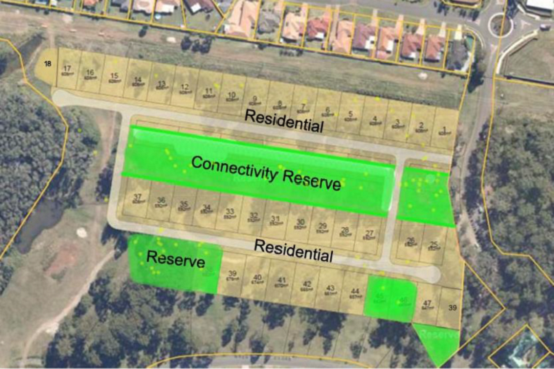
|
|
Figure 7 - The Ruins Way West, Amended Concept, 1 March
2019
|
The Point Church, independent representations to
Council
17 July 2018, 26 March 2019 and 20 May 2019
Separate to the above mentioned submissions from Love
Project Management, representatives of the local church group have met
independently with the Council staff. Key points of discussion focused on:
· The Ruins Way East
site, modified concept layout, compressed building footprint, and areas for
access and parking over the northern Utility Easement.
· The status of, and
need to achieve compliance with NSW RFS Planning for Bushfire Protection
2018 Pre-release guidelines.
· The extent of
vegetation removal (100%) needed to achieve compliance for a ‘Special
Fire Protection Purpose (SFPP) Development’ under the above
guidelines.
· The impact of
vegetation removal/modification, which is known to be ‘Core Koala’
habitat and part of connectivity and habitat corridors shown to be retained in
adopted Koala Plans of Management.
|
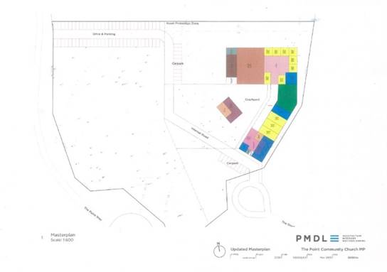
|
|
Figure 8 - The Ruins Way East, Amended Concept, 26 March
2019
|
Existing
Planning Controls
Relevant legislative requirements are:
Environmental
Planning and Assessment Act, 1979
Part 1.3 Objects of the Act. The relevant objectives
of the Act are:
(b) to facilitate ecologically
sustainable development by integrating relevant economic, environmental and
social considerations in decision-making about environmental planning and
assessment,
(c) to promote the orderly and
economic use and development of land,
(e) to protect the environment,
including the conservation of threatened and other species of native animals
and plants, ecological communities and their habitats,
(g) to promote good design and
amenity of the built environment,
(j) to provide increased
opportunity for community participation in environmental planning and
assessment.
Part 3: Planning Instruments, sets out the legal
requirements for preparing and making of environmental planning
instruments, including amending local environmental plans (LEPs).
Associated Government guidelines for preparing planning
proposals and local environmental plans are also applicable.
State
Environmental Planning Policies
Relevant State Environmental Planning Policies (SEPPS)
applying within the Port Macquarie-Hastings Council area are:
I. State
Environmental Planning Policy No. 44 Koala Habitat Protection
This Policy aims
to encourage the proper conservation and management of areas of natural
vegetation that provide habitat for koalas to ensure a permanent free-living
population over their present range and reverse the current trend of koala
population decline.
An assessment of the planning proposal request against the
requirements of the Policy is provided in the Assessment section of the
report.
II. State
Environmental Planning Policy (Coastal Management) 2018
The aim of this
Policy is to promote an integrated and co-ordinated approach to land use
planning in the coastal zone. Clause 10 Development on certain land within coastal
wetlands, and Clause
11 Development on land
in proximity to coastal wetlands of
the policy are relevant to the proposal.
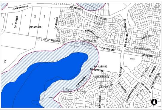
Figure 8 - Extract from SEPP mapping showing Coastal Wetland
(Blue) and Proximity Area for Coastal Wetlands (Hatched). Development within
Coastal Wetland areas is declared to be designated development under
the EP&A Act.
An assessment of the planning proposal request against the
requirements of the Policy is provided in the Assessment section of the
report.
Policy
Directions for Plan Making - Ministerial Directions under Section 9.1
Environmental Planning and Assessment Act, 1979
All Councils must follow certain directions when preparing
planning proposals for new and amending LEPS. Relevant applicable Directions
are:
1.2 Rural Zones
1.5 Rural Lands
2.1 Environment Protection zones
2.2 Coastal Management
3.1 Residential Zones
4.4 Planning for Bushfire Protection
5.10 Implementation of Regional Plans
An assessment of the planning proposal request against the
requirements of the Directions is provided in the Assessment section of
the report.
NSW Rural Fire
Service Planning for Bushfire Protection (PBP) (2006) and (2018, Pre-release)
PBP identifies best practice for developing in bush fire
prone areas. NSW planning law requires all new development on bush fire prone
land to be done in accordance with PBP.
A review has been conducted of Planning for Bush Fire
Protection 2006, and a pre-release version of the document issued in August
2018. The document is applicable to all development on bushfire prone land in
NSW.
North Coast
Regional Plan 2036
This plan encompasses a vision, goals and actions to deliver
greater prosperity for living, working and visiting the region. All levels of
government are required to cooperate to deliver the plan to deliver on-ground
outcomes. Council is required to ensure compliance with the plan prior to
preparing a planning proposal to rezone land.
Relevant Directions are:
Direction 1: Deliver environmentally sustainable growth
Direction 2: Enhance biodiversity, coastal and aquatic
habitats, and water catchments.
Direction 23: Increase housing diversity and choice.
Relevant Planning Principles for guiding growth on the North
Coast are:
Principle 1: Direct growth to identified urban growth areas
i.e. within the UGA.
Principle 2: Manage the Sensitive Coastal Strip
Principle 3: Provide great places to live and work in a
unique environment.
Relevant map layers are detailed here and shown in the below
map. They are:
· Potential High
Environmental Values (Green)
· Coastal Strip
(Hatching)
· Investigation Area
(Orange)
· Urban Growth Area
(UGA) boundary (Red outline).
Note: Around 3ha of the South Blackwood (Lindfield) precinct
is identified for investigation for urban development. The area excludes high
environmental value land and wetland buffers.
|
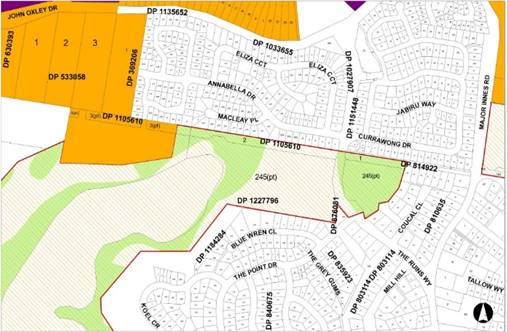
|
|
Figure 9 - Port Macquarie-Hastings Urban Growth Area Map
|
An assessment of the planning proposal request against the
requirements of the North Coast Regional Plan 2036 is provided in the
Assessment section of the report.
Port Macquarie-Hastings Urban Growth Management Strategy
2017-2036
The Port Macquarie-Hastings Urban Growth Management
Strategy 2036 has been endorsed by the NSW State Government.
The strategy aims to achieve well planned growth in the
right places, to create a more diverse and prosperous economy and maintain a
healthy environment and great places to live.
The aims for Our Natural Environment and the Planning
principles for residential growth are relevant to the planning proposal
request. Relevant Strategy map layers are detailed here and shown in the map
extract below:
· High Priority
Koala Habitat.
· Medium-High
Priority Biodiversity Area.
· Urban Growth Area
(UGA) boundary - South Blackwood (Lindfield) is generally located within the
UGA, consistent with the North Coast Regional Plan 2036.
Further detail, including mapping and an assessment of the
planning proposal request against the requirements of the Strategy is
provided in the Assessment section of the report.
Port Macquarie-Hastings Draft Koala Plan of
Management
A draft Coastal Koala Plan of Management has been exhibited
by Council under the provisions of Clause 13 of the State Environmental Plan
No. 44 – Koala Habitat Protection (SEPP 44). Council staff are currently
undertaking a review of submissions and comments.
All remnant stands of vegetation on the subject sites are
identified and mapped as Core Koala Habitat in the draft plan. These areas are
the subject of a proponent sponsored koala plan of management prepared by JB
Enviro and included in the planning proposal request.
An assessment of the proponent’s koala plan of
management is provided in the Assessment section of the report.
Port Macquarie-Hastings Local Environmental Plan 2011
The plan sets out
the local environmental planning provisions for land in Port Macquarie-Hastings
in accordance with the relevant standard environmental planning instrument
under section 33A of the Act.
The current zoning is RU1 Primary Production. Relevant LEP
development standards and controls are discussed in the Assessment section of
the report.
Assessment
of the Planning Proposal Request
The following assessment of the Planning Proposal request
has been based on the information provided by the Proponent in February 2018
and in March 2019, as contained in Appendix 1 and 2 of this report.
Consistent with the Department of Planning and Environment A
Guide to preparing planning proposals, the key factor in determining
whether a proposal should proceed to a Gateway Determination is Strategic
Merit.
The NSW Planning Department has recently strengthened the
strategic merit test and there is now a presumption that proposals that do
not meet the Strategic Merit Test will not proceed to Gateway.
The following Assessment
Criteria have been established by the NSW government to assist in determining
the strategic merit of a planning proposal request, and justification for the
preparation of a planning proposal: -
A -
THE NEED FOR THE PLANNING PROPOSAL
Q1.
Is the planning proposal the result of an endorsed local strategic planning
statement, strategic study or report?
Strategic Planning Statements
for regional councils have not yet been finalised and the planning proposal
request has therefore been assessed for consistency with Council’s UGMS
as follows:
The proposed South Blackwood
(Lindfield) precinct is partly identified for future urban investigation in Port
Macquarie-Hastings Urban Growth Management Strategy 2017-2036. However, the
proposed urban development of the land at The Ruins East and The Ruins West is
not identified as a specific local planning priority, as detailed in the
Strategy.
Council has previously
considered the South Blackwood (Lindfield) area, resolving to not proceed with
this area as part of the South Lindfield area as there was no resolution to concerns
raised by the NSW Office of Environment and Heritage regarding habitat buffers
and linkages.
The South Blackwood area was
reinstated with this proposal. No further substantiative information has been
provided to resolve the concerns of the OEH regarding environmental buffer and
habitat linkages.
Q2.
Is the planning proposal the best means of achieving the objectives or intended
outcomes, or is there a better way?
A change in planning controls
for the subject area as requested by the proponent can only be achieved through
a formal plan making (LEP) process.
B -
RELATIONSHIP TO STRATEGIC PLANNING FRAMEWORK
Q3.
Will the proposal give effect to the objectives and actions of the applicable
regional plan?
The North Coast Regional Plan 2036 is the relevant
plan. The Regional Plan sets out three Planning Principles for Guiding
Growth on the North Coast:
Ø Principle 1: Direct growth to
identified urban growth areas (UGA) – Inconsistent.
The primary focus here
is to ensure a balanced, strategic and coordinated approach to urban growth.
Council has only recently reviewed its strategic planning for growth, which
does not support extending the urban footprint in this location, and/or locate
future housing in areas outside of the UGA, on environmentally constrained
land.
Ø Principle 2: Manage the sensitive
coastal strip – Inconsistent.
Comment: The Ruins Way
West area is identified as being partly within the ‘proximity area to
coastal wetlands’ (SEPP Coastal). Only cursory information is provided in
the request in respect of the application of the SEPP and the consistency of
the proposal with the statutory requirements of the SEPP. The proponent has
been advised of the proposals inconsistencies with the SEPP and staff have
maintained the need for clarity and certainty in respect of any potential
impact from future housing on wetland areas.
Ø Principle 3: Provide great places
to live and work in a unique environment – Inconsistent.
Comment: The
developer’s intent for the Ascot and Innes Lake residential estates has
been to provide residential housing growth within a diverse and natural
setting, which protected and retained important habitat, and threatened
species. However, the natural setting has been significantly modified and
diminished overtime to the extent that the proposed extension of the urban zone
over the subject land will now result in almost certain loss of a significant
functioning habitat corridor at the northern extent of the Lake Innes nature
Reserve.
The Regional Plan also contains 4 Goals and related planning
Directions on a range of matters, including Goal 1 in the Regional Plan: The
most stunning environment in NSW. The focus of the regional Plan in
relation to Goal 1 is to deliver sustainable land use that protects the North
Coast’s biodiversity and environmental values, directs growth to
locations that do not compromise the natural environment, and provides
opportunities for ‘sustainable growth...that protects highly valued
environment for future generations’
The staff assessment of the proposed rezoning is that the
request does not demonstrate that Goal 1 of the Regional Plan can be met.
With the exception of part of the South Blackwood Precinct, it is unlikely that
the proposed residential development can be satisfactorily integrated to retain
important habitat areas.
The proposal is therefore inconsistent with the aims,
objectives and planning principles for growth as detailed in the Regional Plan.
Assessment
Criteria
a. Does
the proposal have Strategic Merit?
|
Will it:
|
Comment
|
|
Give effect to a relevant regional plan?
|
The request is inconsistent with Goal 1 of the Regional
Plan, as discussed above.
|
|
The effect to a relevant local strategic planning
statement or strategy that has been endorsed by the Department or required as
part of a regional or district plan or local strategic planning statement; or
|
The Port Macquarie-Hastings
Urban Growth Management Strategy (UGMS) 2017-2036 was endorsed by the NSW
government on 2 November 2018. The UGMS sets out Council’s planned
approach to the release of land for residential growth.
The request has been assessed
against the Strategy Principles for residential growth. Key to the subject
request are:
· Sufficient
residential land for population growth
· Housing
choice – the right choice in the right location
· Efficient
provision of infrastructure
· Improve our
environment
Excluding approximately 3 ha
within the South Blackwood (Lindfield) precinct, the area is not needed for
housing as there is adequate available vacant land supply within the
established limits to growth in the area in question.
The remainder of the proposed
rezoning would require the removal of Koala Habitat and the loss of a
functioning habitat link in order to address Asset Protection Zone
requirements. The loss of this significant vegetation is unacceptable and can
be avoided if the proposed rezoning does not take place.
The proposal is therefore
inconsistent with the UGMS as it would not improve our environment and would
involve the loss of high environmental value land, which cannot be
satisfactorily addressed using the ‘avoid, ameliorate, offset’
principle in the Regional Plan.
The submitted concepts do not
effectively avoid, mitigate or satisfactorily offset environmental impacts;
improve local biodiversity; or enhance connectivity outcomes.
There are unresolved
environmental issues relating to all proposed precincts and the viability of
infrastructure extension has not been adequately considered.
|
|
Respond to a change in
circumstances, such as the investment in new infrastructure or changing
demographic trends that have not been recognised by existing strategic plans.
|
The proposal is not the result
of unforeseen circumstances. The development of the site is not required to
meet anticipated population growth ahead of planned investigations, or
deliver priority actions, as detailed in the endorsed Port
Macquarie-Hastings Urban Growth Strategy 2017-2036.
Notwithstanding, previous
assessment of the South Blackwood (Lindfield) area under the South Lindfield
Planning Proposal, the current assessment of all three areas, concludes there
is insufficient justification to progress the planning proposal to the next
stage of the plan making process.
|
b. Does the proposal have Site-Specific Merit, having
regard to?
|
|
Comment
|
|
The
natural environment (including known significant environmental values,
resources or hazards),
|
No, the
Proposal does not demonstrate site-specific merit having regard to the above
matters.
Additionally,
the land in question is identified as comprising high environmental value
land’ (North Coast Regional Plan & Port Macquarie-Hastings
Urban Growth Management Strategy 2017-2036); ‘Core Koala
Habitat’ (SEPP 44); and Bushfire Prone Land (NSW RFS)
Staff
assessment of the proposal concludes that any development within the
identified precincts will necessitate significant habitat modification to
achieve compliance with NSW RFS requirements (up to 100% assumed vegetation
removal) for urban lots.
This impact is contrary
to State Environmental Planning Policy No 44 Koala Habitat
Protection aims and objectives, and the degree of habitat loss has been
assessed as triggering the need for assessments under the Biodiversity Conservation Act 2016 and
Coastal Management SEPP 2018, as well as contributing to the current
trend of the decline of the local koala population.
In
summary, the staff assessment is that the resulting ecological impact in this
location is considered significant and unable to be satisfactorily mitigated.
At issue is the potential loss of a strategically important habitat corridor
for the Koala and other vulnerable species.
|
|
The existing uses,
approved uses, and likely future uses of land in the vicinity of the proposal
|
Subdivision of the Innes
Peninsular commenced in 1988. In the ensuing years there have been multiple
modifications of relevant development consents and additional approvals,
resulting in unanticipated impact on the un-subdivided residue, golf course
and environmental offset areas. The cumulative effect of the modifications
and additions needs to be considered by Council.
|
|
The services and
infrastructure that are or will be available to meet the demands arising from
the proposal and any proposed financial arrangements for infrastructure
provision
|
Agreement has not been reached
into infrastructure arrangements or financial commitments to provision of
necessary services.
|
Q4.
Will the planning proposal give effect to Council's endorsed local strategic
planning statement, or another endorsed local strategy or strategic plan?
As noted above, the relevant
strategy is Port Macquarie-Hastings Urban Growth Management Strategy
2017-2036.
The proposal is inconsistent
with the Environmental Aims and Key Planning Principles for Growth, including
to ‘limit growth to existing zoned areas’, ‘concentrate urban
development to areas of least biodiversity sensitivity’, ‘avoid
impacts on areas of high environmental value’, ‘protect and manage
native vegetation to promote landscape connectivity’, to ‘limit the
impact of future urban development’ and to ‘improve local
biodiversity and connectivity’.
Staff have consulted with the
proponent over a number of years but have been unable to find a been unable to
establish that residential development can be achieved without the loss of a
strategically important habitat corridor for the Koala and other vulnerable
species. The planning proposal request cannot be justified.
Q5.
Is the planning proposal consistent with applicable State Environmental
Planning Policies (SEPPs)?
SEPP No. 44 Koala Habitat
Protection
SEPP 44 aims to encourage the
proper conservation and management of areas of natural vegetation that provide
habitat for koalas to ensure a permanent free-living population over their
present range and reverse the current trend of koala population decline.
Consistent with the SEPP a Koala
Plan of Management (KPoM) has been prepared and submitted by the proponent for
staff consideration and Council endorsement.
The draft KPoM study notes that
the Lake Innes-Thrumster population of Koala is considered to be of national
and state significance (Biolink 2013) and confirms the presence of Potential
and Core Koala Habitat on site:
“This and other studies
have determined that the site and the Ruins Way/Lake Innes residential area to
Ascot Park areas contains Core Koala Habitat spread over both the northern
reaches of Lake Innes Nature Reserve and adjacent forested rural land,
supported by a matrix of remnants, roadside trees and an urban woodland”.
The stated aim of the
proponent’s KPoM is “to ensure the study area retains its
ability to support a Koala population, and also to enhance this by increasing
potential carrying capacity and linkages within the broader Core Koala Habitat”.
The proponent’s draft KPoM
has been based on the objectives of the SEPP. The staff assessment of the
draft KPoM is summarised below:
|
KPOM Objectives:
|
Staff Assessment
|
|
“Retaining the majority
of existing mature Koala food trees, and current activity areas”.
|
Unattainable.
While the loss of koala food
trees is approximated in the study, staff assessment is that the proposal
will require up to 100% vegetation loss across all precincts to achieve
compliance with Planning for Bushfire Protection 2006 and 2018 Pre-release
(NSW RFS).
Offset plantings and
mitigation measures, while proposed, are not considered sufficient to enable
the development to proceed. The constraints have been discussed in detail
with the proponent and include the impact of clearing for bushfire, easements
and infrastructure. The proposed mitigation and threat abatement measures
including dog and traffic controls, have been found
to be non-effective in
developments in the Council area, including in subdivisions which have been
developed by the proponent and Charley/Vilro Pty Ltd.
|
|
“Increasing the net
extent of primary browse species to increase carrying capacity and
potentially allow population expansion”;
|
Inconsistent:
Proposed offset areas are
approximated only in the plan, located in National Park Estate, or otherwise
compromised by existing commitments over the Ascot Park and Innes Lake
un-subdivided residue land.
Furthermore,
the suitability, security, long term management of any offset land, and how
this meets the commitments to increase koala habitat and reverse the current
trend of the decline is missing in the KPoM.
|
|
“Maintaining and
enhancing linkages with other habitat known to be required by the local Koala
population”;
|
Unattainable.
The KPoM concedes that the
development designs are ‘nominal at present’ and trees have not
yet been surveyed against any final development layout. Also loss of koala
food trees is approximated.
Staff assessment is that the
proposal will require up to 100% loss of habitat across the precinct/s for
Bushfire Asset Protection Purposes, resulting in an unacceptable short and
long term ecological impact on an important, functioning habitat link. The predicted impact on
the koala population due to habitat loss, connectivity loss through barriers
to movement and genetic dispersal, vehicle strike, risk of dog attack and
disease is greater than acceptable.
|
|
“Effectively mitigate
threats to the viability of Koalas induced by the proposal”
|
Inconsistent.
The
extent of tree loss, including koala food trees, has been underestimated in
the proposed Ecological Assessment and draft Koala Plan of Management.
Proposed mitigation measures
have been assessed as impractical and ineffective, as further fragmentation
and gradual attrition of habitat via residential development in this
location, will contribute overtime to the decline of the broader local
population.
|
From a policy perspective, a plan of management prepared by a person
other than the council has no effect unless it is approved by the Council and
by the Director.
Staff assessment of the KPoM concludes that the
requested development is contrary to the fundamental notion of the SEPP which
is to increase koala habitat and reverse the current trend of decline.
It is therefore recommended that Council not proceed with
the draft Koala Plan of Management, as it poses an unacceptable risk to
a strategically important habitat corridor, and to a nationally significant
Koala population.
Coastal Management SEPP
2018
The Coastal Management SEPP aims
to promote an integrated and co-ordinated
approach to land use planning in
the coastal zone. As such, development consent
for proposals such as this,
which is mapped within the Coastal SEPP proximity
mapping area must not have
consent granted unless the consent authority is
satisfied that the proposed
development will not significantly impact on;
(a) the
biophysical, hydrological or ecological integrity of the adjacent coastal
wetland or littoral rainforest, or
(b) the
quantity and quality of surface and ground water flows to and from the adjacent
coastal wetland or littoral rainforest.
The Ruins West area is
identified as being partly within the “proximity area to coastal
wetlands’” (Coastal SEPP). Council staff have therefore requested
information to address the impact of the proposal in relation to the
SEPP.
The proponent has provided very
little information to address the requirements of the SEPP. In relation
to Clause 10 Development on
certain land within coastal wetlands, the proponent claims that this can be addressed at the
development application stage, utilising existing stormwater management
facilities for existing development in the area.
A preliminary assessment of the proposal by Council staff
shows that a number of existing stormwater facilities within the un-subdivided
residue areas appear to encroach into delineated Coastal Wetland areas
under the SEPP where works trigger the ‘designated development’
provisions under the SEPP.
Clause 11 of the SEPP obligates Council to be satisfied that
any proposed development within the proximity area to coastal wetlands will not
significantly impact on the integrity of the adjacent wetland, or the surface
and ground water flows to and from the wetland. This matter is not addressed in
the request.
Biodiversity Conservation
Act 2016
The Biodiversity Conservation
Act (Bio Con 2016) applies and is relevant to this proposal and any future
development applications resulting from a rezoning of the subject land.
As part of the Act, lands are identified on a values map and
threshold tool. This tool provides information that triggers the Biodiversity
Offsets Scheme threshold and more relevant in this context it exemplifies areas
of high biodiversity significance. On numerous occasions the proponent has been
asked for more detailed information regarding the cumulative impact of the loss
of Koala habitat as a result of the development. No definitive information has
been forthcoming and no references have been made regarding the impact the
proposed development would have on the sensitive area.
In addition, clearing of the Ruins West area for development
will likely trigger the
clearing thresholds in accordance with the Biodiversity
Conservation Act 2016. This
trigger is based on the predicted clearing for asset
protection zones and residential
blocks as well as easements and infrastructure. The clearing
will generate the need
for a biodiversity development report and the subsequent
purchasing of stewardship
credits to mitigate the impacts of the proposed development.
Within the report any areas that are designated as clearing
for APZ will be deemed a
full loss or 100% cleared area of trees leaving no habitat
as per the conditions of the
Biodiversity Conservation Act 2016. The predicted loss of
vegetation on the West
Ruins area (as required to mitigate bush fire risk due to
the connectivity of bushland
on the east to west corridor, provide residential lots, and
area for easements) will
likely - in the opinion of Council’s NRM staff -
result in the investigation of a species impact statement for loss of koala
vegetation leading to large restrictions on the
development site making it non-viable for development.
In addition to the clearing thresholds as per the
Biodiversity Conservation Act 2016, a
portion of each proposed development site, including both
West Ruins and South
Blackwood, will need to have active avoidance of impact on
their sites in order to
meet the requirements of the Act. This avoidance of impact
will mean no clearing
works, easements or management for bushfire will be able to
occur on these lands.
When this constraint is overlaid on the development sites it
greatly limits the land in
which a development footprint is appropriate.
Conclusion
In conclusion, the staff assessment is that the proposal
cannot be supported due to the expected incremental and cumulative loss of key
remnant habitat and a functioning habitat link, which supports the Koala and
other vulnerable species.
The koala population in the Innes Lake area has been
identified as nationally significant and the incremental loss of habitat is
therefore significant in this area.
The Ruins Way East - Not supported.
This area comprises high environmental value vegetation. Up
to 100% of the existing vegetation has been assessed as having to be removed or
significantly modified to achieve the required Asset Protection Zones for a
Special Fire Protection Purpose (‘church’ or ‘place of
worship’) set by the NSW Rural Fire Service. The resultant loss will
contribute to landscape scale contraction of a functioning urban woodland for
species movement, and genetic dispersal, particularly the Koala.
The Ruins Way West - Not supported.
As above, the expected loss of existing vegetation to
achieve the required Asset Protection Zones and infrastructure associated with
the proposed residential development would have an unacceptable impact on
vulnerable fauna including the koala, and would contribute to species
decline.
South Blackwood - Not supported at this time.
Staff have maintained that approximately 3ha of land in the
South Blackwood area may be suitable for future urban development subject to
resolution of Council and OEH concerns regarding habitat connectivity and
buffers to the Lake Innes nature Reserve.
It is open to the proponent to consider a future submission
to Council, requesting preparation of a Planning Proposal for South Blackwood,
subject to satisfactory resolution of the outstanding environmental matters
detailed in this report.
Options
Council’s options are:
1. Do
nothing. The subject land would remain rural zoned land.
2. Resolve
not to prepare a Planning Proposal based on the information contained in this
report. The applicant would be notified of Council’s decision not to
support preparation of the Planning Proposal, triggering an option for the
proponent to seek a Rezoning Review.
3. Resolve
to prepare a Planning Proposal supporting the applicant’s request. There
is a risk that any planning proposal submitted on the basis of current
information may be refused by the State Government if planning and
environmental issues are not satisfactorily addressed.
4. Notify
the proponent that Council may consider a separate future proposal in relation
to the South Blackwood part of the site. This should include a strategic
review of the un-subdivided residue land at Ascot Park and Innes Lake. The
priority of any such request should be considered as part of Council’s
overall strategic planning program.
Option 1 does not provide any scope for development of the
subject sites.
Option 2 is recommended as there is no justification for preparation
of a Planning Proposal having regard for environmental considerations and the
statutory requirements for preparing and amending a local environmental plan.
Option 3 would necessitate submission of the full statutory
requirements for preparing Planning Proposals and Local Environmental Plans. As
discussed in this report, Council staff do not believe that the proposal can be
justified to the government Gateway.
Option 4 allows the proponent to come back to Council with a
new request for South Blackwood if outstanding environmental issues and
concerns can be resolved, subject to a better understanding of the future of
the un-subdivided rural and residential zoned Charley/Vilro land to identify
and appropriately zone areas of high environmental value.
Community Engagement &
Internal Consultation
Community engagement in relation to any Planning Proposal
for the land in question would normally occur later in the rezoning process. At
this stage there have been conversations with representatives of the Point
Church regarding The Ruins Way East site, and NSW Rural Fire Service regarding
timing and implementation of new Planning for Bushfire Protection Guidelines
and reference to the Draft Guidelines issued in August 2017.
Formal Engagement for any supported planning proposal
request is regulated under Part 3 of the EP&A Act.
Planning & Policy
Implications
The Department of Planning
Guidelines for planning proposals and local environmental plans emphasise the
importance of strategic planning in determining whether the land is appropriate
for the identified future use, providing certainty for future landowners and
investors, and ensuring that future users are not exposed to unexpected or
unreasonable development costs.
Under the Guidelines, Council
has a responsibility to provide a level of certainty to the government Gateway.
This means ensuring that the land is suitable and acceptable for the proposed
use and that the identified land can be reasonably and practically developed
for its intended purpose. It is not appropriate to defer assessment of relevant
environmental, social, economic and other site specific merit considerations,
or obligations to later development applications under Part 4 of the EP&A
Act.
Formal Notification of any
request for the preparation of a planning proposal that is not supported by the
Council is regulated under the Environmental Planning and Assessment
Regulation 2000. Council is required to notify a proponent in
writing as soon as practicable after a decision not to proceed.
Financial & Economic
Implications
A Stage 1 rezoning fee of
$6,700 has been paid consistent with 2011/12 Council Fees and Charges.
Resources expended in
pre-lodgement discussions, review and reassessment of revised information,
staff-proponent negotiations, and reporting requirements since 2011 has
significantly exceeded the fee paid by the landowner.
A decision by Council in
favour of Option 4 above would necessitate payment of new Stage 1 rezoning Fee
in accordance with Council’s Fees and Charges Schedule.
|
Attachments
1View. Planning Proposal
PP2011.9.3 Attachment 1 - Chronology
2View. Planning Proposal 2011.9.3
- Attachment 2 Proponent request
3View. Planning proposal 2011.9.3
Attachment 3 - Proponent request March 2019
4View. Planning Proposal 2011.9.3
Attachment 4 - Council Ltrs to LPM August 2018
|
19/06/2019
|
Item: 13.07
Subject: Post Exhibition Report - Highway Service
Centre Planning Proposal, Draft Planning Agreement and Draft Highways Gateway
Development Control Plan
Presented
by: Strategy and Growth, Holly McBride
Alignment with Delivery Program
4.5.2 Plan for infrastructure that supports population
growth.
|
|
RECOMMENDATION
That Council:
1. As
delegate for the Minister for Planning, make the Local Environmental Plan to
amend the provisions of the Port Macquarie-Hastings Local Environmental Plan
2011 to permit the following additional uses on Lot 11 DP 1029846, 1179 Oxley
Highway, Sancrox:
a) Highway
Service Centre, including ancillary hotel or motel accommodation for heavy
vehicle drivers, and
b) Subdivision
to excise the Highway Service Centre site from the balance of the land,
despite the minimum lot size provisions, and
c) A
dwelling house on the residue, following excision of the Highway Service
Centre site, despite the minimum lot size provisions, and
d) Subdivision
of the Highway Service Centre site following its construction, to create
separate titles for individual tenancies despite the minimum lot size
provisions.
2. Delegate
authority to the General Manager to enter into and execute the 1179 Oxley
Highway, Sancrox Planning Agreement in connection with the Highway Service
Centre Planning Proposal, on behalf of Council.
3. Take
the necessary steps under section 3.35 and 3.36 of the Environmental Planning
and Assessment Act 1979 to finalise Local Environmental Plan (Amendment No
53).
4. Adopt
the exhibited draft Highways Gateway Development Control Plan provisions as
an amendment to part 4 of the Port Macquarie-Hastings Development Control
Plan 2013 incorporating the changes referred to in this report, to commence
on notification of the Local Environmental Plan in 1 above, on the NSW
Legislation website.
5. Within
28 days, publish a public notice of Council’s decision to adopt the
Highways Gateway Development Control Plan provisions in accordance with
Clause 21(2) of the Environmental Planning and Assessment Regulation 2000.
6. Delegate
authority to the Director Strategy and Growth to make any minor amendments to
the Planning Proposal and draft Highways Gateway Development Control Plan
provisions in finalising the matter.
7. Notify
all persons who lodged a submission of Council’s decision.
|
Executive Summary
The purpose of this report is to consider the submissions
received in response to the public exhibition of the Highway Service Centre
Planning Proposal, draft Planning Agreement and draft Highways Gateway Sites
Development Control Plan.
In total, 34 submissions have been received addressing a
range of issues including the following:
· The
constructability of the proposed Oxley Highway intersection, its compatibility
with the future local road network and the potential for cost shifting onto
adjoining owners and Council
· Whether the
‘Adjoining Land Access Land’ referred to in the draft Planning
Agreement is suitably located to provide appropriate public road access to
future residential areas to the west
· Whether the
acoustic assessment adequately addresses the potential for noise impact to
existing/future residents particularly regarding noise generated by trucks
entering and exiting the site
· Whether Council
should accept on-site effluent disposal in this case and if so, how long the
temporary on-site works are proposed to be in place
· Whether
‘Sewerage Infrastructure Connection Works’ referred to in the draft
Planning Agreement will provide sufficient capacity to service the HSC site and
adjoining future residential lands, and
· The reasonableness
of the proposed DCP provisions and whether they strike the right balance
between allowing the development to take place and creating a quality gateway
entry to Port Macquarie/Wauchope.
These issues are addressed in the following report.
Key changes to the Planning Proposal and supporting
documents since exhibition are:
· The Oxley Highway
access is to be located at the intersection of Billabong Drive with the Oxley
Highway, and
· The Development
Control Plan has been amended in relation to signage, landscaping, access
arrangements and documentation requirements, with the aim of ensuring that
development can take place in a form that is suitable at the Gateway entry to
Port Macquarie and Wauchope.
In conclusion, it is recommended that Council make the Local
Environmental Plan as described in the Planning Proposal, and concurrently
implement the Highways Gateway Sites Development Control Plan provisions, with
amendments as a result of submissions, to guide future development
assessment. It is also recommended that Council enter into the Planning
Agreement to ensure satisfactory arrangements for infrastructure.
Discussion
BACKGROUND
Council Meeting May 2018
On 16 May 2018, Council considered a proposal to amend the
Port Macquarie-Hastings Local Environmental Plan 2011 to permit a Highway
Service Centre (HSC) on the south western corner of the Pacific and Oxley
Highways and resolved as follows:
RESOLVED: Alley/Cusato
That Council:
1. Prepare
a Planning Proposal pursuant to section 3.33 of the Environmental Planning and
Assessment Act 1979 for the amendment of the provisions of Port
Macquarie-Hastings Local Environmental Plan 2011 to permit development of Lot
11 DP 1029846, 1179 Oxley Highway, Sancrox:
a) To
permit development for the purpose of a Highway Service Centre, including
ancillary hotel or motel accommodation for heavy vehicle drivers, and
b) To
permit subdivision to excise the Highway Service Centre from the balance of the
site, despite the minimum lot size provisions.
c) To
permit subdivision, following construction of the Highway Service Centre,
without being subject to the minimum lot size shown in the lot size map.
d) To
retain a dwelling entitlement on the residue lot.
2. Forward
the Planning Proposal to the NSW Department of Planning and Environment
requesting a Gateway Determination pursuant to section 3.34 of the
Environmental Planning and Assessment Act 1979, upon:
a) Satisfactory
arrangements being demonstrated by the Applicant for a coordinated access point
from the proposed highway service centre to the Oxley Highway, which can
service the southern and northern gateway sites and Billabong Drive, and
b) Written
advice being received from the Roads and Maritime Services that the proposed
highway service centre can be safely and efficiently integrated into the
Pacific and Oxley Highways, and
c) Satisfactory
arrangements being in place for the connection of the site to reticulated
sewer.
3. Request
the General Manager facilitate a meeting between the Applicant, their traffic
consultants and Roads and Maritime Services, to discuss the resolution of
transport planning issues associated with the Planning Proposal, including the
location and design of access from the Highway Service Centre to the Oxley
Highway.
4. Request
that the Secretary of the Department of Planning & Environment issue a
Written Authorisation to Council to Exercise Delegation of the plan making
functions under section 3.36 of the Act in respect of the Planning Proposal.
5. Delegate
authority to the General Manager to prepare a planning proposal in accordance
with this report and to make any minor amendments to the Planning Proposal as a
result of the Section 3.34 Gateway Determination, prior to public exhibition of
the proposal.
6. Undertake
community consultation in accordance with the Gateway Determination.
7. Prepare
a draft Development Control Plan, in respect to the land and the northern
Gateway site, incorporating provisions described in this report accordance with
clause 18 of the Environmental Planning and Assessment Regulation 2000.
8. Receive
a further report providing details of proposed amendments to the Development
Control Plan for approval prior to the Planning Proposal and draft Development
Control Plan being exhibited concurrently.
9. Receive
a report following the public exhibition period to demonstrate compliance with
the Gateway Determination and to assess any submissions received.
CARRIED: 8/0 FOR:
Alley, Cusato, Dixon, Griffiths, Hawkins, Levido, Pinson and Turner AGAINST:
Nil
Following Council’s resolution, the RMS required the
proponent to undertake additional traffic modelling to confirm the suitability
of the proposed access arrangements. The proponent also offered to enter
into a Planning Agreement with Council to ensure satisfactory arrangements for
a co-ordinated access to the Oxley Highway, and for connection of the proposed
HSC to reticulated sewer in the medium to long-term (as required by part 2 a.
& c. of Council’s May 2018 resolution).
Gateway Determination
After consideration of Council’s initial Planning
Proposal, the Department of Planning and Environment issued a Gateway
Determination (29/8/18) to allow the Planning Proposal process to begin, and
along with other matters, specify requirements for consultation with State
agencies and the community.
Following receipt of the Gateway Determination, negotiations
commenced to prepare a draft Planning Agreement (discussed later in this
report).
Draft Highways Gateway Sites Development Control Plan
provisions
In accordance with part 7 of Council’s May 2018
resolution, Council commissioned Envisage Consulting Pty Ltd on 17 September
2018 to provide landscape architect/urban design advice to help inform the
preparation of draft Development Control Plan (DCP) provisions for the Highways
Gateway sites.
Based on visual analysis, the work by Envisage identified
design principles and key viewpoints, and recommended development controls
aimed at achieving good design and visual amenity outcomes. The resultant
draft Highways Gateway Sites DCP included provisions for building setbacks,
landscaping, landform modification, built form, signage and public art.
Council Meeting November 2018
On 21 November 2018, Council considered a report on the
draft Highways Gateway Sites DCP provisions and resolved as follows:
RESOLVED: Cusato/Hawkins
That Council:
1. Endorse the Draft Port Macquarie-Hastings
Development Control Plan 2013 -
1. Highways Gateway Sites for public authority consultation and public
exhibition
2.
together with the Port Macquarie Highway Service Centre Planning
Proposal.
2. Note that prior to the public exhibition, the Draft
Port Macquarie-Hastings Development Control Plan 2013 - Highways Gateway Sites
will be updated to include details of vehicle ingress and egress, as noted in
this report.
3. Proceed with public authority consultation with
RMS, RFS, OEH & EPA in
3.
accordance with the DoP Gateway Determination letter dated 29
August 2018.
4. Request the General Manager to report to the
March 2019 Council Meeting
4.
with an update on the Public Authority consultation with RMS,
RFS, OEH &
5.
EPA.
CARRIED:
8/0
FOR:
Alley, Cusato, Dixon, Griffiths, Hawkins, Intemann, Levido and Pinson
AGAINST: Nil
Following Council’s resolution, the ongoing
negotiations to finalise the preparation of a draft Planning Agreement were
prolonged due to the need to resolve a number of issues regarding the
implementation and funding of sewerage infrastructure and road access with the
proponent and landowner.
Council Meeting March 2019
On 20 March 2019, Council
considered a report on the outcome of consultation with State government
agencies about the Planning Proposal and resolved as follows:
RESOLVED: Intemann/Cusato
1. That the information contained in the Highway Service
Centre Planning Proposal – State Government Agency Consultation report,
be noted;
2. Council proceed to exhibition as soon as the proposed
Voluntary Planning Agreement (VPA) is signed by the proponent and landowner;
3. Noting, if the VPA proposed by the proponent is not
signed to enable Council to proceed to community engagement, a further report
will be prepared at that time so that Council can review the basis for the
Planning Proposal and whether or not it should proceed.
4. That any intersection or road realignment of Billabong
Drive be taken into account in the Sancrox / Fernbank Creek structure planning
process.
CARRIED:
7/2
FOR:
Alley, Cusato, Dixon, Intemann, Levido, Pinson and Turner
AGAINST: Griffiths
and Hawkins
At the March 2019 Meeting, Council also considered a
confidential report on the status of negotiations regarding the draft Planning
Agreement preparation.
Draft Voluntary Planning Agreement
Preparation of the draft Planning Agreement was finalised
and signed by the proponent and the landowner at the start of April 2019.
The draft agreement is an irrevocable offer to guarantee that the key
infrastructure issues associated with a future HSC will be satisfactorily
addressed if the Planning Agreement is signed by Council following
exhibition. It provides for the following:
· Construction of an
intersection and upgrading of the Oxley and Pacific Highways to serve the
development to the requirements of the NSW Roads and Maritime Services (RMS).
· The dedication of
land to provide for road access to the land adjoining the proposed HSC to
ensure that future development of the land could be carried out. Note:
Future development is subject to investigations proposed by Council’s Port
Macquarie-Hastings Urban Growth Management Strategy 2017-2036 (UGMS).
· If the proposed
HSC is serviced by an on-site sewage facility in the short-term there are
requirements for payment of a Sewerage Infrastructure Contribution prior to
release of a Construction Certificate, payment of a Sewerage Services
Development Servicing Plan Contribution (to be determined and paid at the time
of connection to reticulated sewer) and the construction of works to facilitate
the future connection of reticulated sewer to the proposed HSC development.
· Repayment of a
proportion of the costs to connect the facility to reticulated sewer if the
developer carries out sewer works, including sewer pump station and rising
main.
While the VPA does not strictly require the HSC to be
connected to reticulated sewer in the short term, the provisions ensure the
developer pays a reasonable share of the costs of future connection of
reticulated sewer. These issues and the site access issues are discussed in
more detail later in this report.
Public Exhibition
Following finalisation of the draft Planning Agreement,
Council placed the Planning Proposal, draft Highways Gateway DCP provisions and
the Planning Agreement signed by the proponent and landowner on public
exhibition from 10 April to 13 May 2019. Copies of the exhibited draft
documents are provided as Attachments 1-3 to this report.
As a result of the public exhibition, a total of 34
submissions were received. The key issues raised in the submissions relate to:
· The
constructability of the proposed Oxley Highway intersection, its compatibility
with the future local road network and the potential for cost shifting onto
adjoining owners and Council
· Whether the
‘Adjoining Land Access Land’ referred to in the draft Planning
Agreement is suitably located to provide appropriate public road access to
future residential areas to the west
· Whether the
acoustic assessment adequately addresses the potential for noise impact to
existing/future residents particularly regarding noise generated by trucks
entering and exiting the site
· Whether Council
should accept on-site effluent disposal in this case and if so, how long the
temporary on-site works are proposed to be in place
· Whether
‘Sewerage Infrastructure Connection Works’ referred to in the draft
Planning Agreement will provide sufficient capacity to service the HSC site and
adjoining future residential lands, and
· The reasonableness
of the proposed DCP provisions and whether they strike the right balance
between allowing the development to take place and creating a quality gateway
entry to Port Macquarie/Wauchope.
A copy of all submissions is ENCLOSED under separate cover
for the information of Councillors. A summary of the submissions and a
planning response to the issues raised is provided in the Community
Engagement & Internal Consultation section of this report. Key
issues are discussed below.
KEY ISSUES
Oxley Highway access location
The majority of the submissions raise objections to the
exhibited Oxley Highway roundabout location between the Pacific/Oxley Highways
intersection and Billabong Drive to access the proposed HSC. In addition
to traffic safety, specific concerns relate to the potential for cost shifting
to the northern Gateway landowner and/or Council, as a result of the
RMS’s requirement for a fourth leg stub on the proposed roundabout to
ensure a future connection to the north.
The submissions communicate a strong preference for the
proposed roundabout to be relocated to align with the intersection of the Oxley
Highway and Billabong Drive, as recommended by Council’s Traffic
Engineers when the Planning Proposal was reported to the May 2018 Council
Meeting.
King and Campbell requests that before a final decision is
made regarding access, the Planning Proposal be amended to include detailed
comparative analysis of the feasibility of (from engineering &
constructability perspectives) Billabong Drive intersection upgrade and the
current proposed HSC Access and related realignment of Billabong Drive.
Comments from Council’s Strategy & Growth
Division
The exhibited draft Planning Agreement is silent on the
actual location of the access point, requiring only that the access be to a
design approved by the RMS.
Following the exhibition period and discussions with the
proponent, an offer to enter into a further Planning Agreement has been
received that proposes the location of the HSC access at the intersection of
the Oxley Highway and Billabong Drive.
The new offer is subject to the cost of the roundabout
works, and additional site access work costs south of the Oxley Highway, being
subject to allocation of future development contributions to the proponent to
cover the cost of the works.
As noted later in the report it is proposed that the draft
DCP be amended to include a requirement to locate the HSC Oxley Highway access
at Billabong Drive. In view of this provision, the ability of Council to
require the new VPA offer to be a condition of consent for the HSC, and the
provisions of the exhibited VPA, it is considered that there are sufficient
safeguards to allow the finalisation of the new VPA offer to be independent of
the finalisation of the Planning Proposal.
Council has entered into agreements to offset costs incurred
by an initial developer in similar circumstances to that currently proposed.
However, additional costs for site access work would not ordinarily be
approved.
The Draft Greater Sancrox Structure Plan 2015
identified that the Oxley Highway/Billabong Drive Intersection would require
upgrading to a two lane rural roundabout similar to that now proposed for the
HSC. The extent of development for Greater Sancrox however, was largely based
on rural residential development.
Council’s current UGMS now proposes that a large
portion of the Greater Sancrox area be investigated for urban purposes.
Limited planning has been undertaken to determine the type of intersection
facility that will be required should urban development occur, subject to the
investigations now provided in the UGMS.
Accordingly, further discussions will need to be held with
the developer to agree on an appropriate mechanism for any future payment of
contributions to cover the cost of the intersection works. The mechanism will
need to take into account an appropriate component for the HSC funding of the
works, any grant funding received, the design of the intersection taking into
account the likely ultimate development of the Greater Sancrox area, and the
timing of any need for the upgrading to serve the long term development.
It is proposed that this further Planning Agreement be
reported back to Council when negotiations on the content of the agreement are
further advanced.
Adjoining Land Access
A number of submissions question whether the
‘Adjoining Land Access Land’ referred to in the draft Planning
Agreement is suitably located to provide appropriate public road access to
future residential areas to the west and whether or not this access will be
able to be constructed given the landform.
Comments from Council’s Infrastructure Division
The VPA provides for the location of the access to be
amended to a location as agreed between the parties, however to ensure the
access is constructed to an appropriate standard it is proposed that draft DCP
be amended to include an additional provision.
Council’s Transport & Stormwater Network team has
undertaken a preliminary review of a potential public road access (western
collector road) to future residential areas based on very high level concept
designs for the access road into the Highway Service Centre (HSC) coming off a
new roundabout situated at the existing Billabong Drive intersection.
Due to the topography of the site a significant volume of
earthworks is required to facilitate a road of ‘collector’ standard
to the west/south-west of the HSC site, however it appears constructible. The
location, both vertical and horizontal, of the HSC access road influences the
design of the western collector road therefore the two are linked meaning the
design of one should not be done in isolation of the other.
To reduce the volume of earthworks there may be an
opportunity to design the collector road such that it follows the contours,
meaning the road may not be completely perpendicular to the HSC access road.
The ultimate design of the western collector road, how it ties into the HSC
access road, the amount of earthworks, the steepness of batters/retaining
structures and whether it follows the contours will determine its location and
required land dedication. It is realistic that with 1 in 4 batters the road
reserve width to contain the batters and associated cut-off drainage could be
in excess of 100 metres.
It should be noted that no consideration has been given to
any potential lot layout on the adjoining land and the potential need to
coordinate the collector road to optimise any future lot layout. In
addition, at this early design stage it is too difficult to determine an
appropriate location or footprint size for the ‘Adjoining Land Access
Land’.
It is recommended that the appropriate planning controls are
put in place in the DCP and/or development consent conditions to ensure
adequate design work is undertaken on the western collector road in conjunction
with the HSC access road to determine the most feasible location for a
collector road conforming to the current AUS SPEC standards and its associated
footprint to demonstrate that the ‘Adjoining Land Access Land’ is
appropriately sized and located.
It is recommended that the draft DCP be amended to include
an additional provision requiring that detailed information be submitted prior
to development of the proposed HSC, to demonstrate that the ‘Adjoining
Land Access Land’ is appropriately located and can be constructed to
current AUS SPEC standards.
Noise impact
A number of submissions from residents living in proximity
to the site raise concerns about the potential for noise impacts as a result of
HSC operations (24 hours 7 days a week), particularly regarding noise likely to
be generated by trucks entering and exiting the site.
King and Campbell also requests that Council confirm that
potential acoustic impacts associated with the proposed HSC have, or will be
addressed in the Planning Proposal in relation to existing and future
residential within the urban investigation area to the west.
Comments from Council’s Strategy & Growth
Division
Future development of a HSC has the potential to increase
noise impacts on surrounding residents. An acoustic assessment report
submitted with the Planning Proposal concluded that the proposed HSC is not
considered likely to have a significant impact on noise levels to nearest
residents based on the concept plan submitted with the proposal.
An updated acoustic assessment will be required at the
Development Application stage to reflect the more detailed design and siting of
the HSC development including highway access points, and may necessitate
acoustic treatments to mitigate noise impacts from nearest residents.
Sewerage and effluent disposal
Some submissions question whether Council should accept
on-site effluent disposal in this case and if so, how long the temporary
on-site works are proposed to be in place.
King and Campbell also requests that Council confirm that
the sewerage infrastructure connection works (referred to in the draft Planning
Agreement) will provide sufficient capacity for the servicing of the subject
site and adjoining lands, given that the draft Agreement is likely to be
finalised prior to a sewerage infrastructure strategy for the Sancrox investigations.
Comments from Council’s Strategy & Growth
Division
The provisions of the draft Planning Agreement ensure that
the site will be connected to reticulated sewerage in the medium to
long-term. The VPA requires the sewer reticulation works to be (inter
alia) designed ‘to cater for development within the Sewer Catchment as
determined by Council….’.
The timing for connection will depend on the timing of land
release in the surrounding Fernbank Creek/Sancrox area which will be considered
in an Outline Plan for that area in the short-term, in accordance with the
UGMS.
The sewerage infrastructure capacity has been estimated
based on potential dwelling yield using typical residential densities in the
Thrumster area and having regard to environmental constraints. Until more
detailed planning has been undertaken for the surrounding area, as proposed n
the UGMS, a more accurate assessment cannot be completed.
Draft Highways Gateway DCP provisions
Submissions from the proponent and two potential HSC tenants
(McDonalds & KFC) request amendments to a number of the draft DCP
provisions. The proponent also requests that Council defer a decision on
the draft DCP pending further consultation and a decision on the Planning
Proposal at the June 2019 Council Meeting.
The requested amendments are summarised as follows:
Signage - increased height limit for pylon
signs to ensure signage visibility from a further distance. The increase
in height is argued to be essential for prospective tenants and to assist in
road safety as motorists prepare to exit and make directional decisions in
advance. McDonalds and KFC suggest a minimum 20m height limit.
The proponent’s submission requests that Council not
adopt the draft signage provisions, noting that following consultation on the
draft DCP pre-exhibition, further design work has been undertaken to better
respond to Council’s Gateway aspirations.
Drawings attached to the submission show a 30m sign height
adjacent to the Oxley Highway and 20m to the Pacific Highway. The
submission notes that the drawings illustrate that proposed pylon signage will
in the main, be unobtrusive and not a visible eyesore, based on a revised
building pad level approx. 4m below the Oxley Highway and 1m below the Pacific
Highway.
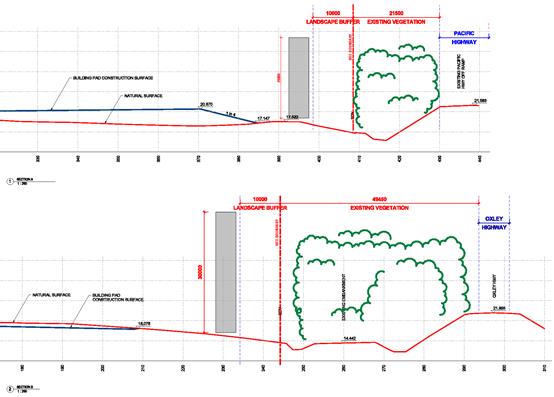
Figure 1: Section drawings - proposed HSC building pad
level and sign heights
Building setbacks - KFC considers that the
proposed building setbacks are excessive and McDonalds seeks a reduced setback
of 20m to the Pacific Highway. The proponent’s submission includes
correspondence dated 23 October 2018 which included earlier objections to
building setbacks raised during pre-exhibition consultation on the draft
DCP. These concerns were considered and revisions made to the draft DCP
prior to public exhibition.
Built form controls - McDonalds and KFC are of
the view that the built form controls are too prescriptive and may limit future
corporate branding requirements. McDonalds suggests that the draft DCP
provisions be amended to be more outcomes based.
Landscaping of front setbacks and parking areas
- KFC and McDonalds suggest that the draft provision for landscaped buffers to
the highway frontages is excessive for exposure of the proposed HSC.
Acknowledging the importance of ensuring that future
development of the site respects the visual prominence as a Gateway entry to
Port Macquarie/Wauchope, McDonalds seeks consideration to the balance required
between vegetation screening and the need for road uses to have clear
visibility of the access arrangements for the site, as well as the available
parking. It is requested that these controls be less prescriptive and
redrafted to promote a more collaborative outcomes-based approach.
The proponent, KFC and McDonalds also consider that the
draft provisions in relation to landscaping of hardstand car and truck parking
areas are excessive. McDonalds suggest that a rate of one tree per 10
spaces would be a more appropriate requirement in relation to landscaping car
parking areas.
Comments from Council’s Strategy & Growth
Division
Following the exhibition period, further input was sought
from Envisage consultants in consultation with staff of Council’s
Development Assessment team on the issues in the submissions. Recognising
the need to take a pragmatic approach for businesses whilst ensuring that
future development is sympathetic to the Gateway status of the southern and
northern Gateway sites, the following is recommended:
Signage - The draft DCP signage provisions
were intended to ensure that the signage does not protrude significantly above
the skyline and therefore relate to the height of existing trees on the Highway
road reserve, noting that the vegetation in the Highway road reserve is likely
to be removed.
Following review of the submissions from the proponent,
McDonalds and KFC it is considered reasonable that the draft signage provision
be amended to allow an increase in the height of signs from 10m to a maximum
15m above the existing road level.
A 15m limit is considered to be satisfactory in the context
of the site and is consistent with the height of pylons approved for the
existing service centre to the east. Capacity remains for higher signs to
be erected where the majority of vegetation in the highways corridors is to be
retained in the long term, provided that the signs are not visible above the
dominant existing tree line (i.e. mature trees in place along the highway
boundaries - at DCP commencement) from key viewpoints.
Additionally, whilst it is outside the scope of
Council’s authority, signage on the highways leading to the proposed HSC
development and identifying its location and the facilities within, will be an
important aspect of encouraging drivers to stop. Recommendations for
advance advisory signage is that they be erected at appropriate spacing (i.e.
5km, 2km, 1km) to announce the proposed HSC, so that drivers can make a timely
and safe decision to stop.
The following images of HSC signage are provided for the
information of Councillors.
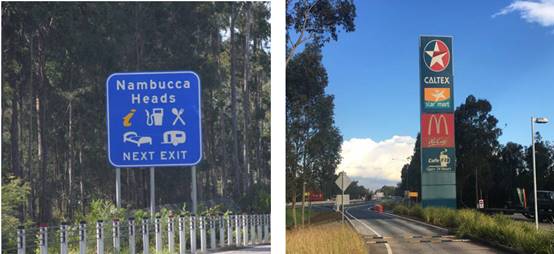
Typical
directional signage 15m pylon signage, twin Caltex HSC at Ourimbah
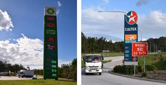
25m
pylon signage, Nambucca HSC pylon
signage, Chinderah HSC
Figure 2: Examples of directional and HSC signage
Building setbacks - The exhibited draft
DCP provides for a 40m minimum setback to all buildings from the Pacific
Highway, and 20m from the Oxley Highway. Where it can be shown that the
RMS can guarantee retention of the majority of large trees within the highway
road reserves in the longer term (i.e. over 20 years) consideration can be
given to a reduced setback of 20m to the Pacific Highway.
Based on the proponent’s concept submitted with the
Planning Proposal, the proposed building setbacks comply with the draft DCP
setback provisions. The proponent’s submission also noted that a
revised building pad level has significantly increased building setbacks
compared to the previous design. Therefore, no change is proposed to the
draft exhibited provision.
Built form controls - The built form of the
proposed HSC should be both functionally efficient and aesthetically pleasing
so as to encourage drivers to stop. The draft DCP provides that the
design of buildings and structures should have a complementary visual
relationship and be of high-quality architecture, particularly as viewed from
the highway frontages. This should include consideration to the roof form
and building articulation.
It is considered reasonable that all buildings with the
proposed HSC development should adopt a unified architectural approach.
The draft DCP does not include prescriptive requirements that specify the
design, finishes, colour and layout of buildings. However, these elements
are important for this key Gateway entry to Port Macquarie/Wauchope and the
draft DCP does encourage that they be addressed having regard to the local
landscape character and visual context of the site. No change is proposed
to the built form provisions.
Landscaping of front setbacks and parking areas -
Within the front setback to the Pacific and Oxley Highways, the draft
DCP requires a corridor of vegetation of at least 15m wide (at ground level)
for the Pacific Highway frontage and 10m wide for the Oxley Highway
frontage. The draft DCP proposed that the vegetated corridor should apply
to at least 75% of the length of the boundary, with coverage of at least one
plant per m2, comprising a mix of canopy trees (20%), mid-storey shrubs/small
trees (30%) and small shrubs/groundcovers (50%).
Following a review of submission, it is recommended that the
DCP retain provisions to ensure that a landscaped buffer is provided between
the proposed HSC and the highways. However, it is considered reasonable
to reduce the extent of the buffer requirement from 75% to 60% in order to
provide some additional opportunity to provide for access points and to
increase visibility of the site. This maintains the importance of
landscaping to create an attractive Gateway entry to Port Macquarie/Wauchope.
Similarly, in relation to landscaping of car and truck
parking spaces, Council staff recommend that the planting requirements be
reduced from one tree per six car parking spaces to one tree every eight car
parking spaces. Also planting requirements be reduced from one tree for
every truck parking space to one tree per three truck parking spaces.
This is intended to balance the need for efficient parking areas and the need
for landscaping to reduce the visual impact of large expansive hardstand areas
at the Gateway entry to Port Macquarie/Wauchope.
Highway Access - In addition to
the above, it is recommended that the draft DCP be amended to ensure that
future Oxley Highway access to the proposed HSC site align with the
intersection of Billabong Drive and designed to be compatible with longer term
needs of development in the area.
A copy of the revised draft DCP provisions incorporating the
proposed post-exhibition amendments as tracked changes, is at Attachment 4
to this report.
It is important that Council establish DCP provisions for
the Gateway sites at the time that any change in zone is made to ensure that
there are guidelines for assessment of Development Applications.
Options
Council’s options are:
1. To
accept the Planning Proposal and DCP as exhibited and resolve to make the Local
Environmental Plan and enter into the Planning Agreement.
2. To
accept the Planning Proposal and DCP with amendments as outlined in this
report, and resolve to make the Local Environmental Plan and enter into the Planning
Agreement.
3. Make
further amendments to the Planning Proposal and or DCP and or Planning
Agreement. Note: if any substantive change is made re-exhibition
will be required.
4. Not
support the Planning Proposal and DCP and Planning Agreement.
Option 2 is recommended.
Community Engagement &
Internal Consultation
The Planning Proposal was exhibited in accordance with the
Department of Planning and Environment’s Gateway Determination up until
13 May 2019. The related draft Planning Agreement and draft Highways
Gateway Sites DCP provisions were exhibited at the same time.
A total of 34 submissions were received. The key
matters identified in these submissions have been considered in the Discussion
section of this report. A summary of the submissions and a planning
response to the matters raised is provided below.
|
Submission/request
|
Issue/comment
|
|
1.
|
Victorian Transport Association
|
Supports the proposal
|
|
Response/
Comment:
|
Noted.
|
|
2.
|
Queensland Trucking Association
|
Supports the proposal
|
|
Response/
Comment:
|
Noted.
|
|
3.
|
Australian Logistics Council
|
Supports the proposal
|
|
Response/
Comment:
|
Noted.
|
|
4.
|
Adam Roelands
|
Supports the proposal
|
|
Response/
Comment:
|
Noted.
|
|
5.
|
Brian Eyre
|
Supports the proposal.
Hopefully the developer will do something about fixing the queuing problems
at the donut.
|
|
Response/
Comment:
|
Noted.
|
|
6.
|
Adnar Pty Ltd
|
Request that Council support the
proposal.
|
|
Response/
Comment:
|
Noted.
|
|
7.
|
ANR Investments Pty Ltd
|
Supports the proposal
|
|
Response/
Comment:
|
Noted.
|
|
8.
|
Scott PDI No. 6 Pty Ltd
|
Request Planning Proposal be
approved at June 2019 Meeting but decision on draft DCP deferred. Concerns
about DCP include:
- Requirement to retain
existing vegetation in RMS road reserve
- Landscape buffers to highway
frontages
- Excessive building setbacks
- Unreasonable retaining walls
& batter requirements
- Requirement for additional
plans, photomontages etc
- Excessive requirements for
landscaping in parking areas
- Unacceptable limits on pylon
signage.
Request further consultation on finalising an acceptable
DCP for the site following a decision on the Planning Proposal.
|
|
Response/
Comment:
|
Support to the Planning Proposal
is noted. Proposed amendments to the draft DCP in relation to most of
matters listed including the request to defer adoption of the DCP are
addressed in the Discussion section of this report.
With respect to the remaining
matters:
· The draft DCP strongly
encourages retention of existing vegetation within the RMS corridor, however
it is not a requirement.
· Given the topography
of the site and need for substantial earthworks to construct a level pad, the
draft DCP retaining walls and batter provisions are considered reasonable and
no change is proposed.
· It is recommended that
the draft DCP documentation provisions be reduced to delete requirements for
submission of Concept Lighting Plan and photomontage showing the existing
situation.
|
|
9.
|
KFC Port Macquarie
|
Supports the Planning Proposal
but has the following concerns in relation to the Draft DCP:
- Height of pylons (20m
suggested)
- Excessive building setbacks
- Excessive landscaping to
highway frontages
- Prescriptive building design
limiting corporate branding.
|
|
Response/
Comment:
|
Support to the Planning Proposal
is noted. Proposed amendments to the draft DCP in relation to the
matters listed are addressed in the Discussion section of this report.
|
|
10.
|
McDonald’s Australia
Limited
|
Supports the Planning
Proposal. Requests changes to the Draft DCP as follows:
- Performance based landscaped
buffers to highway frontages
- Reduced Pacific Highway
setback from 40m to 20m
- Reduced carpark landscaping
requirements
- Outcomes based building
design controls
- Height of pylons (20m suggested)
- Clarification on when public
art is required, i.e. should not apply to individual tenancies.
|
|
Response/
Comment:
|
Support to the Planning Proposal
is noted. Proposed amendments to the draft DCP in relation to the
matters listed are addressed in the Discussion section of this report.
The public art provisions are
proposed to apply at the time of developing the proposed HSC and not to
individual tenancies.
|
|
11.
|
King & Campbell Pty Ltd for
Mr & Mrs M & A Hazenveld
|
· Objects to Oxley
Highway access and potential for cost shifting to northern Gateway
owner. Requests Council commit to Billabong Drive access.
6. Lack of
consultation with the northern gateway owner during the pre-exhibition
Planning Proposal process has been disappointing.
7.
Requests that before a final decision is made regarding access, the
Planning Proposal be amended to include detailed comparative analysis of the
feasibility of (from engineering & constructability perspectives)
Billabong Drive Intersection upgrade and the currently proposed HSC Access
and related realignment of Billabong Drive.
· Requests
Council confirm whether the submitted DA will be amended to include
consideration of the ultimate access arrangements and DCP provisions prior to
notification and assessment.
· Requests
confirmation that the implications for the dedication of land for either road
widening or intersection works on the Oxley Highway does not involve the
northern Gateway site.
· Notes
that the draft Planning Agreement:
- Excludes
reference to RMS required fourth leg access and requests consideration of RMS
requirements for the access, noting this may require a revised Planning
Agreement that recognises the overall impacts with respect to the dedication
of Land for Access.
- Provides
insufficient information to determine how the value of the Sewerage
Contribution and Contribution Reduction have been determined. Given the HSC
is being progressed prior to development of a broader Sancrox sewerage
services strategy, it is important that other owners have the opportunity to
review the methodology applied to the calculations.
- Excludes a
timeframe for implementation of sewer reticulation. Asks whether it is
proposed to impose a timeframe for the connection of the HSC to reticulated
sewer, or if it is intended that the temporary on-site Works are able to be
in place for an indefinite period.
|
|
Response/
Comment:
|
· The location of the
proposed Oxley Highway access is addressed in the Discussion section of this
report.
· The submitted
Development Application has since been withdrawn. A new DA will be
required and is expected to include consideration of the ultimate access
arrangements and DCP provisions prior to notification and assessment.
· It is confirmed that
in connection with the proposed HSC development, the implications for the
dedication of land for either road widening or intersection works on the
Oxley Highway does not involve the northern Gateway site.
· The timeframe for
implementation of sewer reticulation is considered in the Discussion section
of this report.
· The value of the
Sewerage Contribution and Contribution Reduction were determined in
consultation with Council’s Water and Sewer section.
|
|
12.
|
Lyne Fraser
|
Objects to the location of the
proposed Oxley Highway access. Considers the proposed location unfairly
shifts costs to northern landowner and/or ratepayers.
|
|
Response/
Comment:
|
The location of the proposed
Oxley Highway access is addressed in the Discussion section of this report.
|
|
13.
|
Berich Henderson
|
Considers access options 3
(Billabong Dv) or 1 (three-leg roundabout) make more sense.
|
|
Response/
Comment:
|
The location of the proposed
Oxley Highway access is addressed in the Discussion section of this report.
|
|
14.
|
Kylie vanderLay
|
Considers access option 2
(four-leg roundabout) unfairly shifts cost to northern landowner and or
ratepayers. Requests Council require option 3 (Billabong Dv) which
achieves the same objective with minimal impact to northern owner and
ratepayers.
|
|
Response/
Comment:
|
The location of the proposed
Oxley Highway access is addressed in the Discussion section of this report.
|
|
15.
|
Robert Lyne
|
Requests Council require access
option 3 (Billabong Dv) so Billabong zoo has use of it too.
|
|
Response/
Comment:
|
The location of the proposed
Oxley Highway access is addressed in the Discussion section of this report.
|
|
16.
|
Trudy Carlin
|
Considers access option 2
(four-leg roundabout) unfairly shifts cost to northern landowner and or
ratepayers. Requests Council require option 3 (Billabong Dv) which
achieves the same objective with minimal impact to northern owner and
ratepayers.
|
|
Response/
Comment:
|
The location of the proposed
Oxley Highway access is addressed in the Discussion section of this report.
|
|
17.
|
John Mullaney
|
Requests
Council confirm cost of upgrading Billabong Dv intersection vs cost of
proposed four-leg HSC roundabout ($est will do). Considers that it
would be nice to know what approving the HSC is costing ratepayers.
|
|
Response/
Comment:
|
The location of the proposed
Oxley Highway access is addressed in the Discussion section of this report.
|
|
18.
|
Justin Poppleton
|
Considers access option 2
(four-leg roundabout) unfairly shifts costs to northern landowner and/or
ratepayers. Suggests Council require option 3 (Billabong Dv) which
achieves the same objective with minimal impact to northern owner and
ratepayers.
|
|
Response/
Comment:
|
The location of the proposed
Oxley Highway access is addressed in the Discussion section of this report.
|
|
19.
|
Merche Benson
|
Does not support the proposed
Oxley Highway access. Considers that agreement of the northern
landowner is needed, or otherwise another access option identified.
|
|
Response/
Comment:
|
The location of the proposed
Oxley Highway access is addressed in the Discussion section of this report.
|
|
20.
|
V Holmgren
|
Objects to location of proposed
Oxley Highway access. Unfairly shifts costs to northern landowner
and/or ratepayers. Asks why these landowners weren’t
consulted? Considers a roundabout at Billabong Dv is the most logical
position given that it uses existing infrastructure and gives good access to
the growing area of Sancrox.
|
|
Response/
Comment:
|
The location of the proposed
Oxley Highway access is addressed in the Discussion section of this report.
|
|
21.
|
Robbie Wither
|
Objects to location of proposed
Oxley Highway access. Unfairly shifts costs to northern landowner
and/or ratepayers. Considers a roundabout at Billabong Dv is the most
logical position given that it uses existing infrastructure and gives good
access to the growing area of Sancrox.
|
|
Response/
Comment:
|
The location of the proposed
Oxley Highway access is addressed in the Discussion section of this report.
|
|
22.
|
Anne Rhook
|
Objects to location of proposed
Oxley Highway access. Unfairly shifts costs to northern landowner
and/or ratepayers. Requests Council require option 3 (Billabong Dv)
which achieves the same objective with minimal impact to northern owner and
ratepayers.
|
|
Response/
Comment:
|
The location of the proposed
Oxley Highway access is addressed in the Discussion section of this report.
|
|
23.
|
Nicole Mitchell
|
Objects to the location of
proposed Oxley Highway access. Unfairly shifts costs to northern
landowner and/or ratepayers. In addition, the proposed access location
is likely to result in increased congestion and traffic safety issues.
Requests Council require access
option 3 (Billabong Dv) which is a more logical and potentially safer option
which achieves the same objective with minimal impact to northern owner and
ratepayers.
|
|
Response/
Comment:
|
The location of the proposed
Oxley Highway access is addressed in the Discussion section of this report.
|
|
24.
|
Grant Mitchell
|
Objects to the location of
proposed Oxley Highway access. Unfairly shifts costs to northern
landowner and/or ratepayers. Council should require access option 3
(Billabong Dv) which achieves the same objective with minimal impact to
northern owner and ratepayers.
Considers that the HSC needs to
be connected to sewer as based on predicted usage and experience, it is not
believed that onsite sewer will be sufficient.
|
|
Response/
Comment:
|
The location of the proposed
Oxley Highway access and on-site sewer to service the proposed HSC are
considered in the Discussion section of this report.
|
|
25.
|
King & Campbell Pty Ltd for
Expressway Spares Pty Ltd
|
· Requests
Council require reticulated sewerage services to the HSC rather than agreeing
to a temporary and potentially unsuitable on-site effluent management
system.
· Supports
Council’s Traffic Engineers preferred option for Billabong Drive
intersection access on the basis that it:
- provides
a safe and efficient intersection that will cater for future growth in the
Bushland Drive, Sancrox Road and Rawdon Island Road areas
- preserves
suitable access for future development on the northern gateway site
- provides
a direct tie into the existing network without deferring future costs onto
adjoining landowners or Council, and
- provides
the maximum separation to the existing Pacific/Oxley Highway interchange.
· Requests
commitment from Council to completing planning for road infrastructure
improvements required for the broader Precinct in consultation with the RMS,
the HSC developer, the northern gateway owner and other affected stakeholders
in the Sancrox/Fernbank urban investigation area, prior to the approval of
the proposed HSC access.
· Requests
Council complete a broader road infrastructure improvement strategy to inform
the preferred location of the access to the proposed HSC. This approach is
recommended in contrast to agreeing to the current proposed HSC Access which
has been presented without assessing the costs and impacts of that
intersection on the adjoining properties and the broader precinct.
|
|
Response/
Comment:
|
The location of the proposed
Oxley Highway access and installation of on-site sewer to service the
proposed HSC are considered in the Discussion section of this report.
|
|
26.
|
Bruce Gibbs
|
Considers reticulated sewage
should be required as the only option. On-site sewer is not acceptable.
|
|
Response/
Comment:
|
The issue of on-site sewer to
service the proposed HSC is considered in the Discussion section of this
report.
|
|
27.
|
King & Campbell Pty Ltd for
Mr & Mrs D & T Hore and Mr & Mrs A & A Hudson
|
· Requests
Council confirm Adjoining Land Access Land referred to in the draft Planning
Agreement is suitably located to provide appropriate public road access to
the future residential areas to the west.
· Requests
Council confirm Sewerage Infrastructure Connection Works will provide
sufficient capacity for the servicing of the subject site and adjoining lands
given that the draft Planning Agreement is likely to be finalised prior to a
sewerage infrastructure strategy for the Sancrox investigations.
· Requests
Council confirm potential acoustic impacts associated with the HSC have, or
will be addressed in the Planning Proposal in relation to existing
residential (in particular on Lot 1 DP 1175559) and future residential within
the urban investigation area to the west.
|
|
Response/
Comment:
|
These matters are addressed in
the Discussion section of this report.
|
|
28.
|
Requested Confidentiality
|
· Considers
traffic modelling does not take into account increase in local/regional
traffic including:
- Sancrox
Employment Precinct
- Partridge
Creek Industrial Precinct
- Sancrox
Riverpark Rural Residential Estate
- Sovereign
Hills town centre
- Hasting
Regional Sports fields
- Future
Greater Sancrox Area Structure Plan area
- Sovereign
Hills Playing Fields
- Proposed
Sovereign Hills Primary School
- Future
residential on residue HSC site land
- Queuing to
access the Donut off-ramp as a result of the Lake Innes Drive UIA
· Requests
HSC access be aligned with Billabong Dv intersection to also service the
future Sancrox area.
· Concerns
raised about the proposed location of the Pacific Highway ramp in an
Environmental Conservation area and likely difficulty for Lake Innes Drive
residents to access the ramp.
· Suggests
the site be used for future housing rather than a HSC.
· Concerns
that the Acoustic Assessment report does not address:
- Compression
Brake noise on the southern side of the donut, especially at the 100km, 80km
& 60km brake interval
- Noise
impact on the future Lake Inness Drive urban investigation area
- Noise
impact on the future Sovereign Hills Tavern and outdoor eateries from truck
access to the off-ramp on the northern side of the Pacific Highway.
8.
Tweed Shire Council refused an expansion of the Chinderah HSC as the
DA had failed to address ecological, traffic and noise impacts (article from
7/10/2016 Tweed Valley Weekly attached to submission).
· Notes
that the Queensland Department of Transport and Main Roads guidelines were
used instead of NSW RMS guidelines when accessing traffic conditions for the
proposed Chinderah expansion. Asks if the Traffic and Noise assessments
submitted in support of the HSC Planning Proposal accord with NSW
requirements.
· Notes
that this is a Gateway site and considers that a massive truck stop causing
traffic chaos will turn people off coming to PMQ. Also notes that while
every other town is getting environmentally friendly, PMQ is going in the
opposite direction.
|
|
Response/
Comment:
|
· The proponent’s
traffic modelling report was prepared in consultation with the RMS and since
been endorsed by the RMS and does make allowance for future growth in traffic
volumes in the surrounding area.
· The Pacific Highway is
a State road and the RMS is the Road Authority responsible for the approval
of any new access points. Any impact of the proposed exit ramp on
biodiversity values and access by adjacent residents will need to be
addressed as part of RMS’s assessment.
· The site is identified
as a key Gateway Site in the Port Macquarie Hastings Urban Growth
Management Strategy 2017-2036 for tourist uses. In addition, RMS
policy has identified the site as a suitable location for a HSC.
· Consideration to the
proposed Oxley Highway access location and noise impacts are addressed in the
Discussion section of this report.
· The draft Highways
Gateway Sites DCP provisions aim to ensure appropriate visual amenity
outcomes for the site as a result of future development. These
provisions are also considered in the Discussion section of this report.
|
|
29.
|
M Hore
|
· Requests Council
confirm driveway access to the existing dwelling on the site will remain
after HSC commencement.
· Requests that a
statement in the Planning Proposal about providing co-ordinated Oxley Highway
access to service the proposed HSC and lands to the north, be amended to also
include reference to proposed future residential lands to the west of the
HSC.
· Requests Council
confirm that the Planning Proposal and draft DCP provisions only apply to the
proposed HSC site and not to the residue lands.
· Considers master
planning is required to ensure that the ‘Access Dedication Land’
referred to in the draft Planning Agreement is correctly positioned for
proposed future residential to the west of the HSC.
|
|
Response/
Comment:
|
· Based on previous
advice from the RMS, it is understood that the current driveway access
arrangements to service the existing dwelling on the residue land will remain
after HSC commencement, unless development on the residue site is intensified
(i.e. developed for urban purposes).
· The Planning Agreement
makes provision for access to the adjoining land to the west. It is not
appropriate to amend the Planning Proposal as request. The future of
the investigation area to the west o the HSC site is to be the subject of
planning investigations for the Fernbank Creek/Sancrox area. The
outcomes of these investigations are not yet known.
· The Planning Proposal
includes provisions to permit subdivision of the property and a dwelling
entitlement for the residue lot. As such it is advised that the
Planning Proposal applies to the residue lands. The draft DCP
provisions only relate to the proposed HSC site.
· This matter is
considered in the Discussion section of this report.
|
|
30.
|
Patricia Lamont
|
Concerns raised about potential
traffic noise. Requests Council ensure sound barriers or other measures
to mitigate noise impacts.
|
|
Response/
Comment:
|
The potential for noise impacts
to existing/future residents as a result of the proposed HSC operation is
considered in the Discussion section of this report.
|
|
31.
|
John Blomfield
(2 submissions)
|
Concerns raised about potential
traffic noise. Requests Council ensure sound barriers or other measures
to mitigate noise impacts.
Also requests that trees along
Billabong Drive and both sides of the Oxley Highway be retained, noting that
they provide a natural wind beak, shade and sound barrier to the
author’s residence.
|
|
Response/
Comment:
|
The potential for noise impacts
to existing/future residents as a result of the proposed HSC operation is
considered in the Discussion section of this report.
Council can’t guarantee
that existing trees along the Oxley Highway road reserve and Billabong Drive
will be retained into the future.
|
|
32.
|
Mark Holbrook &Sara Mathieson
|
Objects to proposal due to
potential increase in noise (i.e. 24/7 HSC operation) and traffic management
issues re Oxley Highway access.
Requests that if approved,
baseline data be collected to establish current noise levels and options
considered and incorporated into any future DA approval to mitigate noise
impact on residents.
|
|
Response/
Comment:
|
The potential for noise impacts
to existing/future residents as a result of the proposed HSC operation is
considered in the Discussion section of this report.
|
|
33.
|
Elizabeth Keene
|
Requests appropriate sound
barriers to mitigate likely noise impacts from trucks and traffic.
Also requests that trees along
Billabong Drive and both sides of the Oxley Highway be retained, noting that
they provide a natural wind beak, shade and sound barrier to the
author’s residence.
|
|
Response/
Comment:
|
The potential for noise impacts
to existing/future residents as a result of the proposed HSC operation is
considered in the Discussion section of this report.
Council can’t guarantee that existing trees along
the Oxley Highway road reserve and Billabong Drive will be retained into the
future.
|
|
34.
|
Vana Ford
|
Concerns raised about potential
truck noise, loss of trees, loss of rural amenity, and impact of truck noise
on wildlife at Billabong Zoo.
Asks why the HSC can’t be
built in a more appropriate location, for e.g. near Expressway Spares close
to other industrial land uses.
|
|
Response/
Comment:
|
The potential for noise impacts
to existing/future residents as a result of the proposed HSC operation is
considered in the Discussion section of this report.
RMS policy has identified the
site as a suitable location for a HSC.
|
|
|
|
|
Planning & Policy
Implications
The Gateway Determination
authorises Council to exercise delegation of the plan making function under
section 3.36 of the Environmental Planning and Assessment Act 1979 for the
Planning Proposal. Further work is required to finalise the proposed
amendment to the Port Macquarie-Hastings Local Environmental Plan (LEP) 2011,
consistent with the delegation. Strategic land use planning staff will
complete these technical requirements to finalise the LEP following a decision
by Council.
The exhibited Planning Agreement and subsequent offer
relating to the location of the Oxley Highway access are irrevocable offers to
guarantee that the key infrastructure issues associated with a future HSC will
be satisfactorily addressed if the agreements are entered into by
Council.
The draft DCP provisions will
guide developers and Council staff in the preparation and assessment of
applications to develop the Highways Gateway Sites, with aim of ensuring
appropriate visual amenity outcomes. If adopted by Council, the DCP will
take effect on the date of publication of the LEP of the NSW Legislation
website.
Financial & Economic
Implications
Preparation of the Planning
Proposal has been funded by the proponent in accordance with Council’s
Schedule of Fees and Charges for amendments to the Port Macquarie-Hastings LEP
2011. Council’s Strategic Land Use Planning section funded the visual/urban
design analysis by Envisage consultants and prepared the draft Highways Gateway
Sites DCP provisions at no cost to the proponent.
The cost of preparing the
draft Planning Agreement has been funded by the proponent.
|
Attachments
1View. Highway Service Centre Planning
Proposal
2View. Draft Highways Gateway
Sites Development Control Plan
3View. Draft Planning Agreement
4View. Highways Gateway DCP -
Draft Development Control Plan - post exhibition version 20190607 (003)
|
19/06/2019
Item: 13.08
Subject: DA2018 - 353.1 Commercial Premises and Tourist
and Visitor Accommodation with Clause 4.6 Variation to Clause 4.3 (Height of
Buildings) and Clause 4.4 (Floor Space Ratio) of the Port Macquarie-Hastings
Local Environmental Plan 2011 at Lot 123 DP 1219042, No. 17 Clarence Street,
Port Macquarie
Report
Author: Director Development and Environment, Melissa Watkins
|
Applicant: David
Pensini
Owner: Yogi
Bear Holdings Pty Ltd
Estimated Cost: $14,733,000
Alignment with Delivery
Program
4.3.1 Undertake transparent
and efficient development assessment in accordance with relevant legislation.
|
|
RECOMMENDATION
That
DA2018 - 353.1 for a commercial
premises and tourist and visitor accommodation with clause 4.6 variation to
clause 4.3 (Height of Buildings) and clause 4.4 (Floor Space Ratio) of the
Port Macquarie-Hastings Local Environmental Plan 2011 at Lot 123, DP
1219042, No. 17 Clarence Street, Port
Macquarie, be determined by granting consent subject to the recommended
conditions.
|
Executive
Summary
This report considers a
development application for a commercial premises and tourist and
visitor accommodation with clause 4.6 variation to clause 4.3 (Height of
Buildings) and clause 4.4 (Floor Space Ratio) of the Port Macquarie-Hastings
Local Environmental Plan 2011 at the subject site and provides an assessment of
the application in accordance with the Environmental Planning and Assessment
Act 1979.
Following
exhibition of the application, eight (8) submissions have been received.
This
report recommends that the development application be approved subject to
conditions.
1. BACKGROUND
Previous consideration of the
application
In considering the matter, the
Development Assessment Panel on 23 January 2019 was unable to reach consensus
as follows:
Robert Hussey moved the following
motion:
“That DA2018 –
353 be refused on the grounds that:
1. Insufficient on-site car parking has been provided
(deficit of 21 spaces) as required by the Port Macquarie-Hastings Development
Control Plan 2013. In the context of this proposed tourist development located
within an area with time limited parking the public interest would not be well
served by allowing such a significant shortfall in parking spaces on site, or
offsetting this number of spaces via the contribution plan.
2. The proposed turning movements at the reception
area are unreasonably compromised and should be redesigned to avoid regular interruption
to the in-out vehicular movements by the 3-point turn.”
For: Robert Hussey
Against: Paul Drake and Dan Croft.
The dissenting
recommendation was:
“That DA2018 – 353 be deferred to allow
the applicant to readdress non-compliance with development standards and
provide further evidence to support parking provision on site so as to avoid
significant dependence on contribution offsets.”
Given the
Development Assessment Panel was unable to reach consensus at its meeting on 23
January 2019 the matter was reported to Council in accordance with the DAP
charter on 20 February 2019 with the following recommendation from staff:
“That DA2018 - 353 for a
commercial premises and tourist and visitor accommodation with clause 4.6
variation to clause 4.3 (Height of Buildings) and clause 4.4 (Floor Space
Ratio) of the Port Macquarie-Hastings Local Environmental Plan 2011 at Lot 123,
DP 1219042, No. 17 Clarence Street, Port Macquarie, be determined by granting
consent subject to the recommended conditions.”
In considering the matter at its
meeting on 20 February 2019 Council resolved as follows:
RESOLVED: Intemann/Alley
That
DA2018 – 353 be deferred to allow the applicant to readdress
non-compliance with development standards and provide further car parking
provision on site so as to avoid dependence on parking offsets.
CARRIED:
6/1
FOR:
Alley, Cusato, Dixon, Hawkins, Intemann and Turner
AGAINST: Levido
The
applicant subsequently lodged revised plans on 19 April 2019 to include a
further level of basement parking to the proposed development.
The revised application was
re-considered by the Development Assessment
Panel on 22 May 2019 where it was again unable to reach consensus as follows:
The following motion was put to
the panel:
“That
it be recommended to Council that DA2018 - 353.1 for a commercial premises and tourist and visitor accommodation
with clause 4.6 variation to clause 4.3 (Height of Buildings) and clause 4.4
(Floor Space Ratio) of the Port Macquarie-Hastings Local Environmental Plan
2011 at Lot 123, DP
1219042, No. 17 Clarence Street, Port
Macquarie, be determined by granting consent subject to the recommended
conditions.”
For: Paul Drake and Dan Croft
Against: Robert Hussey
The dissenting
recommendation was:
“That
DA2018 - 353.1 for a commercial
premises and tourist and visitor accommodation with clause 4.6 variation to
clause 4.3 (Height of Buildings) and clause 4.4 (Floor Space Ratio) of the Port
Macquarie-Hastings Local Environmental Plan 2011 at
Lot 123, DP 1219042, No. 17 Clarence Street, Port Macquarie, be determined by refusing consent for the
following reason:
1. Insufficient
car parking is provided on site. To vary the Development Control Plan (DCP) car
parking provisions by 18% has significant implications on parking in the CBD,
will lead to an undesirable precedent and undermine the DCP. Council should
consider amending the DCP if such variations are to be considered
acceptable.”
Given the
Development Assessment Panel was unable to reach consensus at its meeting on 22
May 2019 the matter is being reported again to Council in accordance with the
DAP charter. The extent of the Clause 4.6 variation also requires the
application to be determined by Council.
Existing
sites features and Surrounding development
The site has an area of 1518m2.
The
site is zoned B3 Commercial Core in accordance
with the Port Macquarie-Hastings Local Environmental Plan 2011, as shown in the
following zoning plan:
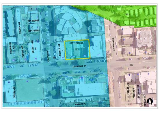
The
existing subdivision pattern and location of existing development within the
locality is shown in the following aerial photograph:
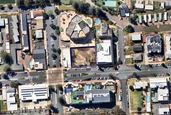
Application
Chronology
· 16
May 2018 – Application lodged.
· 22
May 2018 – Application placed on hold following applicant advice that
revised plans are to be lodged.
· 25
June 2018 – Revised plans lodged.
· 5 July to 3 August 2018 – Public exhibition via
neighbour notification and advertising.
· 3 July 2018 – Additional information request to
applicant. Building height and off-street parking.
· 6 August 2018 – Additional information request to
applicant. Traffic impact assessment required.
· 25 September 2018 – Additional information response
from applicant addressing building height, parking and traffic requests.
· 23 January 2019 - Consideration by Development Assessment
Panel.
· 20 February 2019 - Consideration by Council.
· 19 April 2019 - Revised plans lodged.
2. DESCRIPTION
OF DEVELOPMENT
Key
aspects of the proposal include the following:
· Construction of a seven (7) storey building comprising
basement level parking.
· The building will comprise ground floor commercial and
tourist accommodation over levels 1 to 6. Levels 1 to 6 will contain 47
apartments comprising 4 x 3 bed units (with dual key arrangement), 28 x 2 bed
units (with dual key arrangement), 12 x 2 bed units and 3 x 1 bed units. With
the combination of dual key arrangements, the proposal may provide for up to 79
leasable units.
Refer
to attachments at the end of this report.
3. STATUTORY
ASSESSMENT
Section
4.15(1) Matters for Consideration
In
determining the application, Council is required to take into consideration the
following matters as are relevant to the development that apply to the land to
which the development application relates:
(a) The
provisions (where applicable) of:
(i) Any
Environmental Planning Instrument:
State
Environmental Planning Policy 55 – Remediation of Land
In accordance with clause 7,
following an inspection of the site and a search of Council records, the
subject land is not identified as being potentially contaminated and is suitable
for the intended use.
State
Environmental Planning Policy 62 - Sustainable Aquaculture
In accordance with clause 15C,
given the nature of the proposed development, proposed stormwater controls and
its’ location, the proposal will be unlikely to have any identifiable
adverse impact on any existing aquaculture industries within the nearby
Hastings River approximately 150m to the north-west from the site.
State Environmental Planning Policy 64 - Advertising and
Signage
There is
no signage proposed as part of the application. Suitable condition has been
recommended advising of consent requirements for future signage.
State
Environmental Planning Policy 65 - Design Quality of Residential Flat
Development
In accordance with clause 4 the
policy does not apply to serviced apartments.
State
Environmental Planning Policy (Coastal Management) 2018
The site is located within the mapped coastal environment
area.
In accordance with clause 7, this SEPP prevails over the
Port Macquarie-Hastings LEP 2011 in the event of any inconsistency.
Having regard to clauses 13 and 14 of the SEPP and clause
5.5 of the Port Macquarie-Hastings LEP 2011 the proposed development is not
considered likely to result in any of the following:
a) any
adverse impact on integrity and resilience of the biophysical,
hydrological (surface and groundwater) and ecological environment;
b) any
adverse impacts coastal environmental values and natural coastal
processes;
c) any
adverse impacts on marine vegetation, native vegetation and fauna
and their habitats, undeveloped headlands and rock platforms;
d) any
adverse impact on marine vegetation, native vegetation and fauna
and their habitats, undeveloped headlands and rock platforms;
e) any
adverse impact on Aboriginal cultural heritage, practices and
places;
f) any
adverse impacts on the cultural and built environment heritage;
g) any
adverse impacts the use of the surf zone;
h) any adverse impact on the visual amenity and scenic qualities of the
coast, including coastal headlands;
i) overshadowing, wind funnelling and the loss of views from public places
to foreshores;
The bulk, scale and size of the proposed development is
compatible with the surrounding coastal and built environment. The site is
cleared and located within an area zoned for commercial purposes.
State
Environmental Planning Policy (Building Sustainability Index: BASIX) 2004
In
accordance with clause 7, the proposal is not a BASIX affected building.
Specifically, the definition of a BASIX affected building is as follows:
BASIX affected building means any building that contains
one or more dwellings, but does not include a hotel or motel.
State
Environmental Planning Policy (Infrastructure) 2007
The
proposal is not traffic generating development for the purpose of schedule 3 of
this policy. No referral to Roads and Maritime Services was undertaken.
State
Environmental Planning Policy (State and Regional Development) 2011
The
proposal is not identified as regionally or state significant development. The
capital investment value is $14.7 million. The trigger for regionally
significant development is $30 million.
Port
Macquarie-Hastings Local Environmental Plan 2011
The proposal is consistent with
the LEP having regard to the following:
· Clause 2.2 - The
subject site is zoned B3 Commercial Core.
· Clause 2.3(1) and
the B3 zone landuse table - The proposed development for commercial premises
and tourist and visitor accommodation are permissible landuses with consent.
· Clause 2.3(2) -
The consent authority must have regard to the objectives of a zone when
determining a development application. The objectives of the B3
Commercial Core zone are as follows:
o To provide a wide
range of retail, business, office, entertainment, community and other suitable
land uses that serve the needs of the local and wider community.
o To encourage
appropriate employment opportunities in accessible locations.
o To maximise public
transport patronage and encourage walking and cycling.
o To ensure that new
residential accommodation and tourist and visitor accommodation within the zone
does not conflict with the primary function of the centre for retail and
business use.
o To provide for the
retention and creation of view corridors and pedestrian links throughout the
Greater Port Macquarie city centre.
· Clause 2.3(2) -
The proposal is consistent with the zone objectives having regard to the
following:
o The proposal is a
permissible land use;
o The development would
provide additional ground floor retail and business use;
o The development will
provide suitable tourist and visitor accommodation;
o The proposal is
accessible and will provide employments opportunities.
· Clause 4.1 - It is
noted that no subdivision is proposed as part of the application.
· Clause 4.3 - The
maximum overall height of the proposal above ground level (existing) is 23.65m.
The maximum building height standard applicable to the site is 19m. As a
result, the applicant has submitted a Clause 4.6 variation to the standard. The
variation represents a 24.5% departure from the standard.
In gaining an
appreciation of the extent of building height variation sought it is important
to note the site has been excavated under a prior development consent. The
ground level on site is now below that which previously existed. Specifically,
in the western central portion of the site ground levels are at least 700mm
lower than historic natural ground levels. Also of due consideration is that in
marrying in with Town Centre Master Plan works along the Clarence Street
frontage the finished ground level adjacent to the southern elevation of the
building will be approximately 800mm above the existing ground level along this
frontage.
To this extent the
roof of the proposed building comparative to the existing footpath level along
Clarence Street level will vary between 17.8m in the south-eastern corner and
19.5m in the south-western corner. Whereas within the site, at the excavated
ground level, the building height would be 20.55m in the south-eastern corner
and up to 22.65m in the south-western corner. Along the northern elevation of
the proposed building, at the excavated ground level, the building height
varies from between 22.65m and 23.65m. The height plane plans provided as an
attachment to this report illustrate the extent of the height variation
proposed. The height plane plans also illustrate the height of the previously
approved buildings on the site.
· Clause 4.6(3) -
Consent must not be granted for a proposal that contravenes a development standard
unless the consent authority has considered a written request from the
applicant that justifies the variation by showing that the subject standard is
unreasonable or unnecessary and that there are sufficient environmental
planning grounds to justify the contravening of the standard.
As a result of the
above, the applicant submitted a Clause 4.6 variation to the standard based on
the following reasons:
o The building
design and height is consistent with the existing and future character of the
locality in relation to height, bulk and scale.
o Existing building
designs in the locality provide for lift overruns, roof top access and communal
use rooftop areas in addition to the main building envelopes.
o There will be
negligible impacts in relation to appearance, views, loss of privacy and loss
of solar access.
o The proposal will
have minimal impact on the heritage values of the site.
o The proposal will
continue to provide for a transition in built form and land use intensity.
Having
consideration to the above the applicant has demonstrated the proposal is
consistent with the performance objectives of the height of building clause and
will have limited impact on the environment. In addition, it is also considered
that:
o The proposal is
consistent with the objectives of the LEP and is unlikely to have any
implications on State related issues or the broader public interest.
o When viewed from
the street it will present as a six storey building. The 6th floor
is adequately setback from the perimeter of the main building, add minimal bulk
and will articulate the built form.
o As per Planning
Circular PS 18-003, Council can assume the Director-General’s concurrence
for variations to height limits. The height variation is more than a 10%
deviation from the standard and therefore the application needs to be
determined by full council rather than under staff delegation.
· Clause 4.4 - The
floor space ratio of the proposal is 3.52:1. The maximum floor space ratio
standard applicable to the site is 3.5:1. As a result, the applicant has
submitted a Clause 4.6 variation to the standard. The variation represents a
0.57% variation from the standard. This equates to an additional floor area of
34.03m2 above the standard.
· Clause 4.6(3) - Consent must not be granted for a proposal
that contravenes a development standard unless the consent authority has
considered a written request from the applicant that justifies the variation by
showing that the subject standard is unreasonable or unnecessary and that there
are sufficient environmental planning grounds to justify the contravening of
the standard.
As a result of
the above, the applicant submitted a Clause 4.6 variation to the standard based
on the following reasons:
o The extent of the
floor space variation is minor.
o The building
design is consistent with the existing and future character of the locality in
relation to building height, bulk and scale.
o The proposal is
consistent with the floor space ratio objectives.
Having
consideration to the above the applicant has demonstrated the proposal is
consistent with the performance objectives of the floor space ratio clause. In
addition, it is also considered that the proposal is unlikely to have any
implications on State related issues or the broader public interest.
As per
Planning Circulars PS 18-003, Council can assume the Director-General’s
Concurrence for variations to floor space ratios. The floor space ratio
variation is less than a 10% deviation from the standard and could be
determined by staff under delegation. However, noting the building height
variation proposed the application will be determined by full council in any
event.
· Clause 5.9 - No listed trees in Development Control Plan
2013 are proposed to be removed.
· Clause
5.10 the site is a listed archaeological site (A111). The applicant provided a
preliminary archaeological assessment for a previous application being for the
excavation of basement parking which was referred to the NSW Heritage Council.
The prior consent contained conditions addressing heritage including a further
requirement for a final archaeological report on findings during excavation. A
final archaeological report prepared by I Vetta and J Baloh dated August 2018
supported this application. The application and final report were referred to
the NSW Heritage Council. The heritage Council have reviewed the application
and final report and concluded that no further investigation or approval under
the Heritage Act 1977 is needed. The NSW Heritage Council has
recommended the following consent condition be applied to any consent granted.
The condition forms part of the recommended consent conditions attached to this
report:
“Should
any historical relics be unexpectedly discovered in any areas of the site not
subject to an excavation permit, then all excavation or disturbance to the area
is to stop immediately and the Heritage Council of NSW is to be informed in
accordance with Section 146 of the Heritage Act 1977”.
· Clause 7.3 - The land is above the flood planning area and
no flood related building controls apply to the site.
· Clause 7.4 - The north-western portion of the site is
partly mapped within the flood plain risk management area. The development
provides for adequate emergency evacuation onto Clarence Street and no specific
flood related measures are required.
· Clause 7.7 -
The proposed development does not penetrate the Obstacle Limitation Surface
(OLS) of the Port Macquarie Airport. In particular, the OLS for the site is
approximately 60m. However, if a crane is to be utilised during construction,
care will be required. A condition is recommended to ensure any crane used
onsite does not penetrate the OLS and in the event that it does a controlled
activity approval from the airport operator be obtained prior to works
commencing.
· Clause 7.13
- Satisfactory arrangements are in place for provision of essential public
utility infrastructure including stormwater, water and sewer infrastructure to
service the development.
(ii) Any draft instruments
that apply to the site or are on exhibition:
No draft instruments apply to
the site.
(iii) Any Development
Control Plan in force:
Port
Macquarie-Hastings Development Control Plan 2013
Applicable general provisions
|
Requirements
|
Proposed
|
Complies
|
|
· Advertising & Signage
|
None proposed.
|
N/A
|
|
· Community Participation & Social Impact Assessment
|
Public exhibition undertaken in accordance with the
requirements of this plan. Social Impact Assessment not considered necessary
for the proposal.
|
Yes
|
|
· Crime Prevention
|
Adequate casual surveillance available and principles of
crime prevention through environmental design achieved.
|
Yes
|
|
· Environmental Management
|
· Site is mapped as potential
archaeological site. Refer to comments earlier within report.
· No tree removal proposed.
· Stormwater management
details to be provided.
|
Yes
N/A
Stormwater capable of being managed. Details to be
provided with section 68 application.
|
|
· Off-street
parking in accordance with Table 2.5.1:
- Motel accommodation requires 1.1 per unit + 1 per 2 employees (onsite
at any one time) + 1 for on-site manager.
- Commercial premises require 1 per 30m2 of Gross Leasable
Floor Area (GLFA).
- Function room requires 1 per 30m2 serviced floor area in
commercial zones.
|
Motel accommodation with dual key arrangement:
- 79
units = 86.9
- No
onsite manager = 0
- 6
employees = 3
Total for motel = 89.9 spaces.
Commercial premises:
- 195.3m2
= 6.51 spaces.
Function Room
- 80.22m2
= 2.674 spaces
Total required parking for dual
key arrangement = 99.084 spaces.
Total parking proposed = 81
spaces.
|
No*
|
The proposal seeks a variation to clause 2.5.3 which
requires onsite parking to be provided in accordance with Table 2.5.1. In
accordance with the table above 99.084 (100) spaces are required to serve the
development with 100% occupancy of all units inclusive of 32 dual key units.
The proposal includes 81 spaces. Thus resulting in a parking shortfall of
18.084 spaces.
The DCP provides that Council may consider a reduced level
of parking where it is supported by a parking demand study that assesses the
peak parking demands for the overall development and completed by a suitably
qualified and experienced person.
The relevant objectives of the plan are:
- Adequate
provision is made for off-street parking commensurate with volume and turnover
of traffic likely to be generated by the development.
- To
ensure no adverse impacts on traffic and road function.
The application was supported by a traffic impact assessment
that included a parking demand analysis. The assessment was prepared by TTM
Consulting dated 9 August 2018. The assessment included a dual occupancy (i.e.
dual key) parking sensitivity assessment. The assessment assumed an 80%
occupancy rate and that 20% of guests would arrive via taxi, ride sharing or
public transport. Based on these assumptions it was estimated that the parking
demand for 79 units alone would be approximately 50-51 spaces. With the
addition of the ground floor commercial parking demand of 6.51 spaces, employee
parking demand of 3 spaces and function centre parking demand of 2.674 spaces
the total peak parking demand equates to between 62.184 - 63.184 spaces. Under
this scenario a parking surplus of 17.816 spaces would apply.
It is considered reasonable to assume a reduced occupancy
rate for motel style accommodation. Data obtained from the Destination NSW
website (source being Australian Bureau of Statistics (ABS), survey of Tourist
Accommodation) suggests for the years ending 2014 and 2015 occupancy rates were
62% and 68% respectively for tourist style accommodation in Port Macquarie for
establishments with 15 or more rooms. The adopted 80% occupancy rate is
considered appropriate and probably on the conservative side having regard to
these statistics.
However, assuming 20% of guests will not arrive via private
vehicle is not substantiated within the parking study. No data, survey work or
research has been provided that validates this assumption. In the absence of
such evidence it is considered inappropriate to adopt this assumption. The
traffic study acknowledges that during periods of high occupancy (peak holiday
periods) that the car parking demand may be higher and recommend that a parking
booking system be implemented to manage the available parking. However, this is
considered inappropriate as there will likely be an increased reliance on
on-street parking during these times. It is argued that the adopted parking
demand rate within the DCP for motel style accommodation already accounts for a
portion of guests arriving by alternate means. Council staff also consider that
the assumption of an 80% occupancy ratio further accounts for a portion of
persons arriving by alternate means during peak periods and that a further
discount is not appropriate.
Council staff calculations of parking demand based on 80%
occupancy rate is provided as follows:
· 79 lettable units
at 80% occupancy equates to 63.2 units (i.e. 79 x 0.8 = 63.2). 63.2 units x 1.1
spaces per unit = 69.52 spaces.
· Employees: 6 at 1
per 2 employees (6/2) = 3 spaces.
· Commercial
premises: 195.3m2 (1 per 30m2) = 6.51 spaces.
· Function Room:
80.22m2 (1 per 30m2) = 2.674 spaces.
· Total parking
demand required = 81.704 spaces.
Parking proposed is 81 spaces. Therefore, a parking shortfall
of 0.704 space is a result (i.e. 81.704 spaces required – 81 spaces
proposed).
Having regard to the overall findings of the traffic impact
assessment prepared by a suitably qualified professional, it is considered
reasonable that proposal will not result in any significant adverse impacts to
traffic, parking or road function. Nevertheless, the site is located within the
Port Macquarie-Hastings Contributions Plan 1993 – Part C – Car
Parking and it is considered appropriate that a development contribution be
made under this plan for the identified parking shortfall of 0.704 of a parking
space. A condition has been recommended surrounding the payment of the parking
shortfall contribution.
Part 5
- Area based provisions - Port Macquarie Town Centre
|
Requirements/Objectives
|
Proposed
|
Complies
|
|
Clarence Street precinct
The future heritage and
leisure focus of the town for visitors and residents, Clarence Street will be
a distinctive tree lined pedestrian dominated area with hotels and holiday
apartments above an active street frontage lined with restaurants, heritage buildings
and sidewalk cafés.
The new buildings should
respond to the heritage buildings without mimicking them.
|
7 storey apartment style building with ground floor
commercial.
Ground floor commercial will provide active street
frontage.
Building design considered to be in keeping with the
character of existing flat buildings within the precinct.
|
Consistent with objectives.
|
|
Site amalgamation
- Amalgamations are desired on
land identified in Figure 26.
- If applicants propose a
different amalgamation pattern then they must demonstrate that orderly
development, high levels of connectivity and vehicle access will occur and
that mid-block connections are provided appropriately.
|
Proposal inconsistent with desired amalgamation plan.
Refer to figure below table.
|
Three lots (minus the corner lot) have been amalgamated.
Considered to be a good outcome.
|
|
Active Frontages and Shop Widths
- Maximum shop widths comply
with Figure 27: Maximum shop widths.
|
The ground floor shop front width is less than 30m.
|
Yes.
|
|
Façade Enclosure
Façade enclosure
complies with the block controls.
Block 1:
- Ground
60%
- First
50%
- Second/Third
40%
- Top
floor 40%
|
Façade enclosure considered acceptable.
|
Yes.
|
|
Roof Design
Break
up roofs where possible with hips, gables and changes in materials.
|
Roof broken up with lift
overrun and root top terrace structures.
|
Yes
|
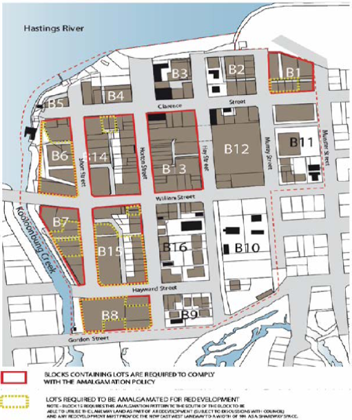
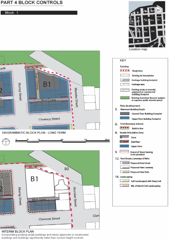
Summary - Block 1 controls
Maximum Building Depth. Ground whole site less setbacks, First/Second/Third/Top
= 20m.
- Building
depth of approximately 22m considered appropriate.
Front Setback (Clarence Street).
Ground/First/Second/Third = 0m. Top Floor = 3m.
- Front
lobby on front boundary 0m consistent. <1m first/second/third/fourth/fifth
with elements within articulation zone. Noting top floor setback 3m.
Rear Setback. Minimum 0m to Block 1 Lane for
Ground/First/Second/Third. Top Floor minimum 3m.
- Proposed
8.7m to rear boundary. Further setback on top floor. Note future laneway not
possible having regard to Macquarie Waters building.
Side Setback. Minimum 0m to Block 1 Pathway for
Ground/First/Second/Third. Top Floor minimum 3m.
- Proposed
0m side boundary setback from ground to 5th level. The top floor
setbacks range between 0m, (approximately 7.6m length of eastern aspect of
building – stair shaft and portion of Unit 604), up to 13.695m
(north-western aspect of building).
- The
side setback variation to the 3m top floor in relation to portions of the top
floor is considered acceptable due to the:
· reasonably
short wall lengths of the proposed building compared to the overall length of
the site.
· the
relationship of the non-compliant length of external wall of the proposed
building with the existing western external wall of the adjoining building to
east.
· the
relationship of the proposed building to the bulk and scale of development to
the east.
· the
significant open area of the proposed development.
· the
overall merits of the proposed development and the practical difficulties
associated with compliance and achieving a viable project.
· the
lack of detrimental overshadowing of the adjoining properties due to the
existing lots orientation to north and south.
· the
minimization of privacy impacts to the adjoining properties due to a lack of
· regular
windows in the proposed side
· elevations,
· the
size and scale of existing adjoining development to the east, west and north.
· the
flow through ventilation for the proposed units which do not need to rely on
side windows to provide ventilation.
· the
use of varying finishes on the side elevations to create additional interest
and relief and to decrease the vertical emphasis on the building as a whole.
· the
non-compliance will result in no loss of primary views for residents of other
buildings.
Façade Enclosure.
Ground 60%, First 50%, Second/Third 40%, Top Floor 40%.
- Façade
enclosure considered acceptable.
Front articulation zone. Ground min 0m. First to fifth
min 1.8m Max 4m. Top Floor N/a
- Articulation
provided to the street considered appropriate.
Rear/Side Articulation 0m.
- Wall
finish treatment is proposed to the western elevation which will provide an
appropriate interim measure until the corner block is developed.
Vehicle entry from streets and paths. Off Block 1 Lane,
Munster or Murray Streets
- Access
directly from Clarence Street.
New Streets, Laneways and Paths. Block 1 Lane. Min 7m
wide – two way vehicle movement and 1m footpath.
- Proposed
level basement car parking. No provision for laneway. Full width footpath
across frontage required.
Arcades
- N/A.
Car Parking Underground, on street, some on grade.
- Proposed
basement car parking and commercial spaces at grade.
Landscaping
- N/A.
Residential Flat Development,
Tourist and Visitor Accommodation, Mixed Use Development Provisions.
|
Objectives/Provisions
|
Proposed
|
Complies
|
|
Site Design & Analysis
- Attributes
and constraints adequately considered in design.
- Consideration
to adjacent and adjoining sites in design.
|
Site analysis provided.
|
Yes.
|
|
Site Layout
- Functional
& integrated with neighbourhood.
- Energy
efficient design.
|
Detailed site plan provided with application demonstrating
integration with potential integration with adjoining sites.
|
Yes.
|
|
Height Limits & FSR
- Complies
with LEP
- Min
floor to ceiling 2.7m.
- FSR
at least 1:1.
|
Variation to height proposed.
Ceiling heights comply.
FSR 3.52:1.
|
No. Refer to LEP clause 4.6 comments.
Yes.
Yes.
|
|
Streetscape & Front Setback
- Front
setback with 20% of average setback of adjoining buildings.
- Tourist
accommodation 9m max setback for pool.
- Balconies
may encroach up to 600mm into setbacks.
- Building
aligned to street boundary.
- Openings
align with street or rear of site.
|
Proposed 0m front setback.
Swimming pool proposed on roof top.
Balconies within setbacks.
Building aligns with street.
Openings face street.
|
Considered acceptable.
N/A
Yes.
Yes.
Yes.
|
|
Side & Rear Setbacks
- Side
setback min 1.5 for max 75% of building depth.
- Windows
in side walls setback 3m from side.
- Adjoins
existing strata building side set back min 3m.
- Rear
setback min 6m to building & sub-basement.
- Party
wall development if site amalgamation not possible and higher density
envisaged.
- Corner
sites consolidated with adjacent sites.
|
0m side setbacks
No windows in side walls.
Adjoins strata title flat building to the east.
8.7m rear setback to building.
Site amalgamation as per DCP not achievable.
Not a corner site.
|
Considered acceptable.
N/A.
Considered acceptable.
Yes.
Noted but considered best achievable outcome.
N/A
N/A
|
|
Building Depth
- Max
18m
|
Building depth of approximately 22m.
|
Building depth considered acceptable. The depth is
reflective of existing similar sized buildings adjoining.
|
|
Energy Conservation & Solar Access
- Adequate
light and ventilation.
- Overshadowing.
- Energy
efficiency.
|
North facing balconies. No adverse shadow impacts given
lot orientation.
|
Yes. Ventilation and solar access considered appropriate
having regard to the short term use proposed.
|
|
Landscaping
|
Landscaping proposed along Clarence Street frontage.
|
Yes
|
|
Deep Soil
- Buildings
should be sited across frontage
- Deep soil
zones should extend width of the site and be minimum depth of 6m.
- Deep soil
zone should accommodate advanced plantings.
- Integration
with stormwater management system
|
No deep soil zone proposed.
|
The site is zoned B3 Commercial and consistent with the
area based provisions above no deep soil zone requirement has been envisaged
for this site.
|
|
Private Open Space
- Ground
floor dwelling min 35m2 with 4mx4m area.
- Areas
<2m in width be excluded from area.
- Balconies
on or above first floor min 8m2 with min 2m width with direct living area
access.
|
No ground floor units proposed. The rooftop terrace area inclusive
of BBQ, gym, pool and toilets facilities provides sufficient communal open
space.
|
Yes. Each unit also contains access to external balconies
of sufficient width and depth.
|
|
Fences and Walls
- None
proposed
|
None proposed
|
N/A
|
|
Acoustic Privacy
- Living
areas to face street
- Parking
and driveways separation >3m from bed windows
- Openings
of adjacent dwellings >3m separation.
- Building
wall design minimise noise transition comply with AS.
|
Noted that some bedrooms at front of building face street.
N/A no ground floor units.
No side wall openings.
Designed to comply with noise transmission requirements.
|
Noise impacts considered to be minimal having regard to
the short term nature of use. Additional glazing to bedroom windows possible.
N/A
Yes
|
|
Visual Privacy
- Direct
views between adjacent living areas screened if with distances.
- Screening
or fence requirements.
- Window
privacy screen requirements
- Balcony
privacy screen requirements
|
No side wall openings.
Privacy walls and screening proposed where necessary.
|
Yes
Yes
|
|
Accessibility
- In
accordance with AS1428
- Barrier
free min 20% of dwellings
- Layout
for variety of groups
- Building
design capable of adaptation to whole of partial changes of use
|
Capable of compliance with AS1428. Details to be provided
with Construction Certificate. Ground flood at grade access with lift
proposed.
|
Yes
|
|
Social Dimensions & Affordability
- Located
close to open space/recreation areas.
- FSR
not less than 1:1
- Variety
of apartment types, 1, 2, 3+ beds.
- Consider
Affordable Housing Strategy
|
Close to Town Green open space and foreshore areas.
FSR greater than 1:1.
1, 2 and 3 bedroom units.
|
Yes.
Yes.
Yes.
|
|
Roof Form
- Variations
in form & materials to be provided
- Lift
overruns & plant integrated within roof structure
|
Roof top structures provided varied roof form.
Overrun and plant incorporated into roof top structures.
|
Yes.
|
|
Façade Composition & Articulation
- Well
balanced
- Consistent
& complimentary to elements & materials of existing buildings
|
Consistent with existing flat buildings within the
locality.
|
Yes
|
|
Entries & Corridors
- Clear
line of transition
- Sheltered
& lit
- Adequate
circulation space
- Corridor
width min 2.5m wide & 3m high
|
Building entry well defined, sheltered and adequate
circulation space.
|
Yes
|
|
Balconies
- Min
one balcony per apartment.
- Main
balcony min 2m width a 8m2.
- Directly
accessible from living area.
- Balconies
recessed, balustrade.
|
Balcony per unit.
Complies.
Off living area.
Recessed and balustrade details provided.
|
Yes
Yes
Yes
Yes
|
|
Emergency Services
- Accessible
|
Capable of access from street hydrant.
|
Yes
|
|
Laundries & Clothes Drying Facilities
|
Rooftop communal laundry proposed.
|
Yes
|
|
Mailboxes
|
Not required.
|
N/A
|
|
Safety & Security
|
Design meets principles of crime prevention through
environmental design.
|
Yes
|
|
Site Storage
|
Adequate storage proposed.
|
Yes
|
|
Waste Management
- Communal
bulk waste facilities to be provided.
- Designated
area at ground or basement
|
Garbage storage on ground floor behind commercial
tenancies.
|
Yes
|
|
Utilities
|
Services available.
|
Yes
|
|
Strata Title Subdivision
|
No subdivision proposed.
|
N/A
|
Business and Commercial Development Provisions
|
Requirements/Objectives
|
Proposed
|
Complies
|
|
Building Heights:
|
Proposed 23.65m.
19m LEP max height limit applies.
|
No. Refer to LEP clause 4.6 comments.
|
|
Setbacks:
· A zero
metre setback to ground floor is preferred in all business zone developments.
|
0m front setback.
|
Yes
|
|
Roof Form:
· Variations
in roof form including the use of skillions, gables and hips are to be
provided in the development.
|
Variation with roof terrace proposed. Lift overrun and
plant incorporated.
|
Yes.
|
|
Building Facades, Materials & Finishes:
· Colours, construction
materials and finishes shall be predominately pale in colour and textured,
tonal and subtle.
|
Proposed colours appear acceptable and consistent with
existing flat buildings within the street.
|
Yes
|
|
· Shopfront
widths are to be between 15 and 20metres.
|
Shopfront widths acceptable.
|
Yes
|
|
· Architectural
detailing is to be provided to promote articulation, character and visual
interest in the streetscape.
|
Architectural detailing provided within the articulation
zone. Incorporates overhangs and recesses.
|
Yes
|
|
Active Frontages:
· Ground
floor levels shall not be used for residential purposes in B1, B2, B3 and B4
zones.
|
Ground floor incorporates shop/retail.
|
Yes
|
|
· A minimum
of 50% of the ground floor level front facade is to be clear glazed.
|
Approx 50% of street frontage clear glazed.
|
Yes
|
|
Arcades
|
No arcade proposed.
|
N/A
|
|
Awnings
|
Awning structure provides coverage for the extent of the
active street frontage.
|
Yes
|
|
· Skylights
may be provided in the awning for a maximum depth of 1/3 of the total awning
depth.
|
None proposed.
|
N/A
|
|
· Under
awning lighting shall comply with AS/NZS1158.
|
Capable of compliance.
|
Yes.
|
|
· Awnings
are designed and constructed to encourage pavement dining in areas identified
for pavement dining, along the foreshore and in piazzas.
|
Awnings designed to encourage outdoor dining
opportunities.
|
Yes.
|
|
Landscaping:
· A
landscape plan shall be submitted with the development application
|
Landscape plan provided.
|
Yes
|
|
Gateways &
landmark Sites:
|
N/A
|
N/A
|
|
Waste management:
· A
waste management plan for the construction and/or occupation of the
development is provided
|
Waste management plan provided.
|
Yes
|
|
Vehicular Access Location
and Design:
· No direct
vehicular access to at grade or basement car parking from the active street
frontage will be permitted in B1 zones.
· The number
of vehicular crossovers shall be kept to a minimum and appropriate sight
lines provided to ensure safe integration of pedestrian and vehicular
movement.
|
B3 Zone. Single crossover proposed. Access to basement car
park from main entrance off Clarence Street.
Single crossover proposed at
grade.
|
Yes.
Yes
|
|
Pedestrian Entries &
Access:
· The
development complies with AS1428—Design for Access and Mobility.
|
Designed to comply with standard.
|
Yes
|
|
Outdoor Dining:
|
None proposed.
|
N/A
|
|
Commercial Development
Adjoining Residential Land uses:
· The
development is designed so that all vehicle movement areas and servicing
areas are located away from adjoining residential areas.
|
Site adjoins residential units located to the east.
Site does not adjoin residential zoned land.
|
Yes
|
|
· Waste
areas are located and managed to minimise pests, noise and odour.
|
Garbage storage located on ground floor behind commercial
tenancy and basement for residential units.
|
Yes
|
(iiia) Any planning agreement that has
been entered into under section 7.4, or any draft planning agreement that a
developer has offered to enter into under section 7.4:
No planning agreement has been
offered or entered into.
iv) Any
matters prescribed by the Regulations:
New
South Wales Coastal Policy:
The proposed development is
consistent with the objectives and strategic actions of this policy. See SEPP
(Coastal Management) 2018 comments for further detail.
(b) The likely
impacts of the development, including environmental impacts on both the natural
and built environments, social and economic impacts in the locality:
Context & Setting
The site was historically three
single Torrens title lots with each containing old unit buildings. The old
units have been demolished and the lots consolidated under a previous
development consent. Site has also been subject
to excavation under a previous development consent and slopes away from south
to north approximately 2m. The site has a frontage of 45.25m to Clarence Street
and an average depth of 33.53m.
Adjoining the site to the north
is the North Point Apartments (9 storeys residential flat building). Adjoining
the site to the east is the Macquarie Waters apartments (six storeys
residential flat building). Adjoining the site to the south is Clarence Street
and beyond is the Port Pacific Resort building. Adjoining the site to the west
is a single storey commercial building fronting Murray Street.
The proposal is considered
appropriate in terms of density and height and will be unlikely to have any
adverse impacts to existing adjoining properties and satisfactorily addresses
the public domain. The proposal is considered to be consistent with other
higher density developments in the locality.
The proposal will not compromise
any important views or view corridors. Impact to views enjoyed from units of
the Port Pacific building would be minimal given the change in grade on
Clarence Street and the subject site, and the location of existing buildings
adjacent to the site.
It is evident that the
orientation of the block, units and subsequent balconies seek to maximise light
and ventilation with the northern orientation. The building has been positioned
in the southern portion of the block. This provides for adequate separation to
the units in the North point apartment building. It is considered that
sufficient spatial separation between the units will be provide for an
acceptable level of privacy.
Roads
The site has road frontage to
Clarence Street. Adjacent to the site, Clarence Street is a sealed public road
under the care and control of Council. Clarence Street is local commercial road
with a 22 metre carriageway within a 30 metre road reserve. The existing road
includes SA kerb and gutter, footpath paving, and combination of parallel
parking and angled parking.
Access, Transport & Traffic
The application was supported by a Traffic Impact Assessment
prepared by TTM Consulting, dated 9 August 2018. The conclusions of the
assessment are provided below:
8 Summary and Conclusions
8.1 Development Summary
The access is proposed to be
via a 6.0m wide Category 2 access crossover.
The development access will
provide an effective queue provision of 4 vehicles between the property
boundary and the security access door.
8.2 Car Parking Arrangements
The car parking provision
generally exceeds Council’s Development Control Plan’s minimum
parking requirements.
The ground level and basement
car park layouts, as a minimum, comply with the Australian Standard
requirements. Overall, TTM considers the proposed car parking arrangements for
this development are adequate.
8.3 Impact on Surrounding
Road Network
Assessment of the proposed
development indicates that the development will not have a significant impact
on the future road network. As such, no further mitigating road works are
required.
8.4 Service Vehicle
Arrangements
Servicing for this development
will be facilitated in the designated loading area on the ground level,
accessed from Clarence Street. The largest design vehicle, a VAN, can enter, manoeuvre,
service and exit the site in a forward gear. Overall, the proposed service
vehicle arrangements are considered adequate to meet the needs of the proposed
development.
8.5 Active Transport
Facilities
The current public transport
infrastructure and proposed site provisions for pedestrian/bicycle facilities
is considered adequate for the development.
8.6 Conclusion
Based on the assessment
contained within this report, TTM see no traffic engineering reason why the
relevant approvals should not be granted.
Key issues or recommendations to be addressed by conditions.
To protect existing road facilities, existing road
conditions shall be evaluated and bond securities held prior to any earthworks
Details shall be provided as part of a Roads Act (Section 138) application.
Site Frontage & Access
Vehicle access to the site is proposed though one access
driveway to Clarence Street. All accesses shall comply with Council AUSPEC and
Australian Standards, and conditions have been imposed to reflect these requirements.
Due to the type and size of
development, additional works are required to include:
· Reconstruction
of kerb and gutter to the east of improvement works (new kern and pavement) to
marry in with works already carried out by Council as part of the Town Centre
Master Plan.
· Concrete
footpath paving (full width) along the full frontage
· A
condition is recommended requiring that prior to the preparation of any
engineering plans or submission of any applications for construction to
Council, the applicant is to contact Councils Engineering Development to ensure
any design accords with Town Centre Master Plan works already carried out on
Clarence Street across subject property. The applicant is advised that works
include altering verge, carriageway and kerb levels to improve surface drainage
conditions for the full frontage of the development.
Parking and Manoeuvring
Parking and driveway widths
on site can comply with relevant Australian Standards (AS 2890) and conditions
have been imposed to reflect these requirements.
Due to the type of development, car park circulation is
required to enable vehicles to enter and exit the site in a forward manner.
Site plans show adequate area is available and conditions have been imposed to
reflect these requirements.
Refer to relevant conditions of
consent.
Pedestrians
In accordance with the Port
Macquarie Town Centre Master Plan, the proposed development will require full
width concrete paving along the frontage of the site with specified materials
and finishes. Suitable conditions recommended.
Public
Domain
No adverse impacts on public
spaces or access thereto.
Utilities
Telecommunication and
electricity services are available to the site.
Stormwater
The proposed preliminary
stormwater design prepared by David Johnson Consulting Engineer, dated May 2014
is acceptable in principle.
The site naturally grades towards the rear and is benefitted
by an easement 1-metre-wide to drain water over SP65485, the development
proposes to extinguish the easement and instead drain to the Council’s
pipe network in Clarence Street.
The legal point of discharge for the proposed development is
defined as a direct connection to Council’s stormwater pit/pipeline in
Clarence Street, which is consistent with the development proposal.
A detailed site stormwater management plan will be required
to be submitted for assessment with the S.68 application and prior to the issue
of a building Construction Certificate.
In accordance with Councils AUSPEC requirements, onsite
detention facilities must be incorporated into the stormwater drainage plan.
Preliminary plans incorporate onsite detention facilities.
The statement of environmental effects (SOEE)
outlines measures to be implemented during construction to manage stormwater.
Details from the SOEE are provided below:
·
“Appropriate controls will be installed to prevent soil
erosion and sediment transport from the site during rainfall during the
construction phase of the project. A variety of erosion and sediment controls
will be used on the site. Strategies to be used on site will include:
· Hay bale
retardation and sediment retention basin. The removal of stormwater from the
excavated area will be via a temporary hay bale structure which will be
provided on site. The size of the structure to be determined via the volume of
water to be treated. In this regard the operation of the structure is to be
inspected on a daily basis and the quality of discharge water monitored.
· Where necessary
the size of the structure will be increased so as to ensure that acceptable
discharge standards are met.
· All stormwater
is to be collected and conveyed to the structure using suitable sized pumps.
The foot valve of the pump is to be fitted with a silt sock. The hay bale
structure will act as a two-stage sedimentation basin. Pumped water will be
discharged into the larger section of the structure where it will be allowed to
settle and seep through the straw bales into the final section where it will be
allowed to settle before draining through the overflow to discharge into the
stormwater drain servicing the site.
· The pond shall
be regularly inspected, and excess sediment removed on a daily or more frequent
basis as required.
· Sediment filter
fencing, or gravel groynes/sausages will be used downstream of the discharge
from the hay bale structure to provide additional treatment.
· Gravel
groynes/sausages for sediment retention will be utilized around stormwater
drains, inlets and pits once constructed.
· Tracking of
sediment from the site by tucks entering and leaving will be controlled by the
provision of a ‘shaker grid’ at the site entry together with the
placing of a gravel driveway at the entry site.
· Discharges from
dewatering operations shall be treated to remove excess suspended matter prior
to discharge from the site. Discharges shall be free of pollutants, shall be
within a pH range of 6.5-8.5 and shall have a maximum non-filterable residue
(NFR) concentration of 50 mg/L to allow for discharge to the stormwater system
within Environment Protection Authority requirements.
·
Removal of suspended matter from dewatering discharges shall
be achieved by treatment of discharges through the hay bale
filtration/sedimentation pond detailed in 6.1 above.”
Detailed plans for the
management of stormwater will be required to be submitted for assessment with
the infrastructure construction certificate and S.68 applications.
Water
Records indicate that the
current development site has an existing 20mm metered water service from the
150mm PVC water main on the same side of Clarence Street.
Each residential and commercial
unit will require individual water metering with the meters either located on
the road frontage or at the unit with remote reading facility located adjacent
to the road frontage or in an easily accessible area such as a foyer.
Final water service sizing will
need to be assessed by a hydraulic consultant to suit the commercial, domestic
and fire service components of the proposed development, as well as backflow
protection requirements. The existing 20mm metered water service is to be
disconnected. There is no charge for this disconnection service.
Detailed plans will be required
to be submitted for assessment with the infrastructure construction certificate
and S.68 applications.
Sewer
Council
records indicate that the development site is connected to sewer via junction
to the existing sewer line that runs along the northern property boundary. A
sewer reticulation strategy is to be provided. A manhole will be required at
the high end of the line as it will be more than 40m long. If the main is
subject to future extension an end of line terminal shaft (poo pit) will be
required.
As the development will exceed
2ET discharge, sewer connection is to be made from a manhole. The hydraulic
designer is to confer with Council sewer section prior to submitting sewer
design plans.
Detailed plans will be required
to be submitted for assessment with the infrastructure construction certificate
application and S.68 applications.
Soils
The proposed development will be
unlikely to have any adverse impacts on soils in terms of quality, erosion,
stability and/or productivity subject to a standard condition requiring erosion
and sediment controls to be in place prior to and during construction.
Air
& Micro-climate
The operations of the proposed
development will be unlikely to result in any adverse impacts on the existing
air quality or result in any pollution.
Flora
& Fauna
Construction of the proposed
development will not require any removal/clearing of any significant vegetation
and therefore will be unlikely to have any significant adverse impacts on
biodiversity or threatened species of flora and fauna.
Waste
Satisfactory arrangements are in
place for proposed storage and collection of waste and recyclables. No adverse
impacts anticipated.
Energy
The proposal is not BASIX
affected building. The proposal will include measures to address energy
efficiency in order to comply with the requirements of section J of the
Building Code of Australia (BCA). No adverse impacts anticipated.
Noise
& Vibration
Having regard to the location of
the site and nature of the development, there will be anticipated short term
noise impacts during construction activities. Consent condition has been
recommended to restrict construction to standard construction hours and a
condition requiring a construction management plan which includes a schedule of
works and approximate timing, contact number of site supervisor and mechanism
for providing notice to adjoining owners for schedule noisy works.
In terms of vibration impacts
and proximity of adjoining sites which are built to boundary a condition has
been recommended to require dilapidation reports prior to work and upon
completion of works to adjoining properties.
In terms of the visitor
accommodation use, it is noted that no onsite manager is proposed. A condition
of consent has been recommended to require a complaints register to be
established by management and this be made available upon request to Council.
The condition also requires that a telephone number be provided on the front of
the building for any complaints.
Having regard to the short term
nature of stays proposed and use of the communal roof top terrace facilities
which includes a BBQ area, swimming pool and outdoor terrace the potential
exists for noise during high activity times. It is noted that these roof top
areas have been located in the north western part of the top floor which will
provide adequate separation between adjoining flat buildings to the north and
east of the site. It still considered that some type of management regarding
the use of this rooftop area is required. A condition has been recommended
requiring a rooftop management plan be development and approved by Council
prior to issue of any occupation certificate. A further condition has been
applied requiring the approved plan to be displayed in a prominent position on
the rooftop area so guests are duly informed.
Natural
Hazards
The site is not mapped as
bushfire prone land. Refer to comments under clause 7.4 of LEP comments for
flood considerations.
Safety,
Security & Crime Prevention
The proposed development will be unlikely to create any
concealment/entrapment areas or crime spots that would result in a loss of
safety or security in the area. The increase in housing density will improve
natural surveillance within the locality and openings from each dwelling
overlook common and private areas.
Social
Impact in the Locality
Given the nature of the proposed
development and its location the proposal is unlikely to result in any adverse
social impacts.
Economic
Impact in the Locality
No adverse impacts. Likely
positive impacts can be attributed to the construction of the development.
Site
Design and Internal Design
The proposed development design is satisfactorily responds
to the site attributes and will fit into the locality. No adverse impacts
likely.
Construction
Having regard to the location of
the site and nature of the development, there will be anticipated short term
inconveniences during construction activities. No significant adverse
construction impacts are identified to neighbouring properties that would
warrant refusal of this application.
Cumulative
Impacts
The proposed development is not
expected to have any adverse cumulative impacts on the natural or built
environment or the social and economic attributes of the locality.
(c) The
suitability of the site for the development:
The proposal will fit into the
locality and the site attributes are conducive to the proposed development.
Site constraints have been adequately addressed and appropriate conditions of
consent recommended.
(d) Any
submissions made in accordance with this Act or the Regulations:
Eight (8) written submissions have been received following public exhibition
of the application.
Key
issues raised in the submissions received and comments in response to these
issues are provided as follows:
|
Submission Issue/Summary
|
Planning Comment/Response
|
|
The proposal provides no
detail on overshadowing impacts. Private open space on the adjoining
Macquarie Waters building is orientated north-west. Shadow diagrams should be
provided to determine the extent of shadow impacts.
|
Having regard to the sites
north south orientation it is evident that the adjoining properties will not
be adversely overshadowed by the development for more than 3 hours between
9am -3pm on 21 June.
|
|
Based on the information lodged it is difficult to
ascertain whether the building height proposed is being taken off
pre-excavated site levels or existing level as excavated.
|
The applicant provided revised plans and clause 4.6
variation confirming building height proposed form existing ground level as
excavated onsite.
|
|
The proposal bases its car parking demand on 47 units and
6 staff. The proposal however contains 79 separately lettable units. The DCP
currently provides no mechanism for reduced parking for a dual key system. A
shortfall of 36 parking spaces is not appropriate for the locality having
regard to existing parking demand experienced.
|
Refer to DCP assessment table within this report.
|
|
The proposal does not propose a 6m wide deep soil zone as
per DCP 2013, specifically provisions 3.3.2.6, 3.3.2.11 and 3.3.2.16.
|
Provision 3.3.2.6 refers to side and rear setbacks. The
rear setback complies. Provision 3.3.2.11 refers to deep soil zone width and
depth. The lack of deep soil is consistent with the area based provisions and
commercial zoning of this site. Provision 3.3.2.16 refers to landscaping
requirements. Having regard to the commercial zoning the minimal landscaping
proposed along the street frontage is considered acceptable.
|
|
The current condition of the site is not acceptable.
Currently stormwater collects and pools in the north-western corner and
leaches into the basement of the north point building. It is requested that
Council instruct the landowner to fix this stormwater problem immediately.
|
Noted Council staff are aware of the existing stormwater
issue and will continue to monitor to ensure that stormwater is managed
accordingly. Stormwater for the proposed development can be adequately
managed.
|
|
The building is excessive in size and height. There is no
good reason for the height variation.
|
Refer to building height comments under LEP 2011 of the
report. The proposed building is considered to be consistent with other
buildings in the locality. The majority of the built form is contained within
the height controls. The elements on the roof add further articulation to
this form and are consistent with similar roof top elements on flat buildings
in the locality.
|
|
There is insufficient parking proposed to accommodate the
proposed development.
|
Refer to parking assessment comments under the table to
DCP 2013 of the report.
|
|
The northern setback is insufficient to the north point
building.
|
Refer to DCP 2013 assessment table within this report.
Rear setback complies.
|
|
No details of expected building construction start and
finish times. Potential noise impact to adjoining residents. Temporary noise
blocking panels should be installed to existing adjoining units.
|
Standard building construction times will apply as per recommended
consent conditions. No significant adverse building construction noise
impacts are anticipated that would warrant refusal of this application.
|
|
No details of cranes have been provided. Safety hazard to
existing adjoining units and traffic blocks likely. During construction items
may fall onto my residence at 2 Murray Street.
|
The placement and management of cranes and any machinery
during construction will be undertaken by construction site managers and
subject to workplace safety measures.
|
|
Service disruptions would occur during construction. How
will I be informed? Is there sufficient services to meet the demand of the
proposed development?
|
Anticipated service disruptions during construction will
be managed by the relevant service provider. Upgrading of services will be
required as deemed appropriate by the relevant service provider.
|
|
Ongoing noise impacts from occupants utilising the open
style communal roof top space with swimming pool.
|
A rooftop management has been provided for this space and
will form part of the consent conditions. No significant adverse noise
impacts are anticipated that would warrant refusal of this application.
|
|
Ongoing noise impacts from air-conditioning plant.
|
Standard noise control regulations apply to management of
noise from such sources. No significant adverse noise impacts are anticipated
that would warrant refusal of this application.
|
|
Open car parking is proposed at ground level with
driveways at same level as North Point level 2 apartments. This will result
in adverse noise and security impact.
|
Adequate building separation is proposed between the
ground level parking and North Point building. The north point building is
setback approximately 13m form the site boundary. No significant adverse
noise impacts are anticipated that would warrant refusal of this application.
|
|
The proposed units will be only 20m from my bedroom and
living space in North Point apartments. This will result in a significant
loss of privacy.
|
The orientation of the block, building and subsequent
balconies seek to maximise light and ventilation with the northern
orientation. The building has been positioned in the southern portion of the
block with the rear balconies setback approximately 8.7m from the rear
boundary. This provides for approximately 20m separation to the units in the
north point building. It is considered that sufficient spatial separation
exists between the units.
|
|
The northern side of the building contains a large amount
of glazing which will direct light and heat into the units of north point.
|
Adequate building separation is proposed. No adverse
reflection or heat impact will result from the glazing proposed.
|
|
There is no discussion about potential liquid trade
wastes that may be generated from the ground floor shop.
|
The proposal is for a ground floor commercial tenancy
only. The use proposed is unknown and likely require further development
consent under which waste management will be considered.
|
|
No details of solar panels or rainwater use provided.
Council should require this as part of all new developments.
|
The proposal is not a BASIX affected building therefore
such measures are optional.
|
|
Having regard to previous failures will Council require
the building to start within a certain timeframe?
|
Planning legislation provides that should development
consent be granted a proponent has 5 years to physically commence work. Once
commenced there is no legal obligation to complete the development within a
set time frame.
|
|
The units in north point will be greatly devalued if approved.
|
Impact upon property values is not a relevant planning
consideration.
|
|
How will dust and debris be managed during construction
noting location of clothes drying facilities adjoining in the north point
building?
|
Standard site management conditions will apply including
dust control.
|
|
The owner is extremely difficult to deal with and has
ignored previous consent conditions and instruction by Council for stormwater
management.
|
Noted.
|
(e) The
Public Interest:
The proposed development
satisfies relevant planning controls and is unlikely to impact on the wider
public interest.
4. DEVELOPMENT
CONTRIBUTIONS APPLICABLE
· Development contributions will be required towards
augmentation of town water supply and sewerage system head works under Section
64 of the Local Government Act 1993.
· Development contributions will be required under Section 94
of the Environmental Planning and Assessment Act 1979 towards roads, car
parking, open space, community cultural services, emergency services and
administration buildings.
5. CONCLUSION
AND STATEMENT OF REASON
The application has been assessed in accordance with Section
4.15 of the Environmental Planning and Assessment Act 1979.
Issues raised during assessment and public exhibition of the
application have been considered in the assessment of the application. Where
relevant, conditions have been recommended to manage the impacts attributed to
these issues.
The site is considered suitable for the proposed development
and the proposal adequately addresses relevant planning controls. The
development is not considered to be contrary to the public's interest and will
not result a significant adverse social, environmental or economic impact. It
is recommended that the application be approved, subject to the recommended
conditions of consent provided in the attachment section of this report.
|
Attachments
1View. DA2018 - 353.1 Recommended
Conditions
2View. DA2018 - 353.1 Clause 4.6
Report (FSR)
3View. DA2018 - 353.1 Clause 4.6
Report (Height)
4View. DA2018 - 353.1 Additional
Information Letter - September 2018
5View. DA2018 - 353.1 Heritage
Office Response Letter
6View. DA2018 - 353.1
Archaeological Report
7View. DA2018 - 353.1 Groundwater
Assessment
8View. DA2018 - 353.1 Traffic
Impact Assessment Report
9View. DA2018 - 353.1 SOEE
10View. DA2018
- 353.1 Contributions Estimate
11View. DA2018
- 353.1 Plans
|
19/06/2019
|
Item: 13.09
Subject: Kooloonbung Creek Flying-Fox Camp
Management Plan
Presented
by: Development and Environment, Melissa Watkins
Alignment with Delivery Program
4.8.2 Increase community awareness and enable access to
the natural environment.
|
|
RECOMMENDATION
That Council:
1. Adopt
the Kooloonbung Creek Flying-fox Camp Management Plan (Attachment 1).
2. Acknowledge
the submissions made during the exhibition period and advise people who made
submissions of the outcome of Council consideration of this matter.
3. Acknowledge
the contribution of the Kooloonbung Creek Flying-fox Camp Management Plan
Consultative Committee in the development of the Management Plan and thank
the members of the committee for their input.
|
Executive Summary
The development of a new Camp Management Plan (CMP) for the
flying fox colony at Koolonbung Creek has now been completed. This process has
included engaging an external consultant to research and develop a CMP with the
community, extensive community consultation in the form of community
consultative meetings, public notification and an online survey.
The final draft CMP is now completed and Council’s
endorsement is now being sort to adopt the Plan. The CMP follows the Office of
Environment and Heritage (OEH) and state legislative guidelines and contains
recommendations, specific to Kooloongbung Creek, for action based on feedback
from the community and in particular local residents. Actions in the plan will
begin immediately upon adoption once endorsed by the OEH.
This report provides a final overview of the process
including a review of the feedback received and one final submission that was
received after conclusion of the exhibition period and seeks endorsement for
the final plan as shown in Attachment 1.
Discussion
Background
The Kooloonbung Creek Nature Park (R97763) was notified as a
Crown land Reserve on 19 April 1985, after a long public campaign to protect
and rehabilitate the land. The Nature Park contains a high proportion of
Threatened Ecological Communities, and a wide range of threatened flora and
fauna species. The reserve was dedicated for the purpose of “Promotion of
the study of native flora and fauna”.
In the mid-1990s, a flying-fox colony established in the
Park. The colony population fluctuates seasonally and inter-annually depending
on regional climatic conditions and seasonal food resources across the coast.
Flying-fox numbers have been shown to vary from 5-10,000 in
winter to up to 165,000 during peak summer seasons. Seasonal fluctuations are
typical of all Flying-fox colonies in Australia, representing migration
patterns across a network of habitat and foraging grounds along the eastern
seaboard of Australia.
Recent summers have seen an increase in the abundance of the
flying-fox colony within the Kooloonbung Creek Nature Reserve with the seasonal
influx of little red flying-foxes. This seasonal influx in summer is a primary
concern of some neighbouring residents. The Flying-fox colony has also remained
at high numbers for longer this year into autumn and winter than previous
years. This is most likely as a result of the scarcity of feeding opportunities
in inland areas, which have been experiencing drought and hot weather.
Grey-headed flying-foxes make up the majority of the
permanent resident population of the colony in Kooloonbung Creek Nature Park.
Despite a possible perception about the ‘abundance’ of this
species, the population is actually in decline, such that the species was
listed as Vulnerable by the NSW government through the Threatened Species
Conservation Act in 2001. This listing was transferred to the Biodiversity
Conservation Act, 2016 when it came into force on 25 August 2017. The
Kooloonbung Creek camp is also identified by the Federal Government to be of
‘national significance’ and is an important maternal camp for
Grey-headed Flying-foxes.
Legislative Context of Flying-Fox Management in the Park
In 2010, Council embarked on engaging the community on the
management of flying-foxes in the reserve, and subsequently prepared a Plan of
Management for the Kooloonbung Creek Nature Park pursuant to the Crown Lands
Act, 1989 to address amongst other things, community concerns around noise,
disease and odour from the flying-foxes within the limits of state and federal
legislation. A series of community fact sheets were also produced to assist
with community engagement.
Following a period of public exhibition in May-June 2012,
Council adopted the Plan of Management at the June 2012 Council meeting with
the following resolutions;
1. Adopt
the amended Kooloonbung Creek Nature Park Plan of Management 2012.
2. Commit
$50,000 from the 2012-2013 Environmental Levy Reserve to assist in the cost of
the removal of vegetation to provide a buffer to the flying-fox Colony.
3. Continue
to look at the option of relocating the flying-foxes from Kooloonbung Creek and
a further report to be brought back to Council by June 2013.
The Plan of Management was subsequently formerly adopted by
the Crown under the Crown Lands Act, 1989 by way notification in the NSW
Government Gazette on 9 November 2012.
In response to the June 2012
Council meeting, a subsequent report was tabled at the February 2013 Council
meeting detailing the progress of implementing the actions in the Plan of
Management and an assessment of relocating the flying-foxes from Kooloonbung
Creek.
Based on extensive review of past
flying-fox relocation attempts around Australia and peer reviewed expert
reports, the Council report recommended not to attempt to relocate the
flying-fox colony on the basis that:
· Relocation would
require multiple attempts over many years and is unlikely to succeed, and may
result in unintentional dispersal of the colony to other residential areas such
as public reserves in Lighthouse Beach locality.
· State and Federal
Government is unlikely to support the proposal as the action would create a
significant impact on a nationally significant population.
· Cost of relocation
and implementation of associated mitigation measures was estimated at the time
to be in the order of $3.9M
· Multiple
relocation attempts are highly likely to increase a stress-related disease in
the population, increasing the risk of disease transfer, such as Hendra virus
to the local horse industry and the local community.
On this basis,
Council resolved at its February 2013 meeting to:
1. Note
the progress on the implementation of the Kooloonbung Creek Plan of Management
2012.
2. Continue
to focus primarily on the in-situ management of flying-foxes.
Council staff then completed the in-situ management actions
listed in the Plan of Management and continued to monitor the population
quarterly as part of the CSIRO National Flying-fox census.
In-situ management actions completed in accordance with the
previous Plan of Management included:
- Population
monitoring
- Signage
and community education
- Removal
of vegetation on the western margin
- A
desktop feasibility assessment for the provision of additional roosting site(s)
In 2015, the NSW Office of Environment and Heritage
published its Flying-fox Camp Management Policy. The stated role of the policy
is to: “empower land managers, primarily local Councils, to work with
their communities to manage flying-fox camps effectively. It provides the
framework within which the OEH will make regulatory decisions”.
In 2018 further concerns were
raised by the community to which Council resolved as follows on the 15 August
2018:
RESOLVED: Intemann/Pinson
That Council:
1. Note
the information contained in the Management of the Flying-fox Colony in
Kooloonbung Creek Nature Reserve report;
2. Establish
a Consultative Committee for Flying-fox Management in Kooloonbung Creek;
3. Invite
nominations for membership on the Committee from the following:
- Affected
residents;
- Representatives
from the Office of Environment and Heritage (OEH);
- Representatives
of the Friends of Kooloonbung;
- Expert
ecologists; and
- Other
interested community representatives.
4. Prepare
a Project Plan for delivery of a Camp Management Plan and associated community
consultation/engagement/education program;
5. Formally
seek OEH and Local Government NSW funding for the development of a Camp
Management Plan and future implementation of the Camp Management Plan;
6. Engage
a suitably qualified consultant to assist in the preparation of a new
Flying-fox Camp Management Plan for Kooloonbung Creek, which takes account of
new camp management options and legislation and to undertake associated
community consultation (including formalised attitudinal surveys, etc.).
7. Ensure
that the Kooloonbung Creek Management Plan fully explores all other options and
outlines the legislative obligations, pros, cons, and costs for management
options including but not limited to:
a) Noise
barriers (e.g. Perspex sheeting);
b) Buffer
landscaping using non-roost trees;
c) Specific
rebates to residents to assist with air-conditioning etc.;
d) (Voluntary)
acquisition of properties for affected residents with these residences leased
back by Council with agreements in place;
e) Other
novel options.
8. Further
considers the draft Camp Management Plan and the options outlined therein at a
future meeting of Council, with further Actions to be based on this work.
9. Request
the General Manager provide quarterly reports to Council on progress in these
matters.
carried: 8/0
For: Alley,
Cusato, Griffiths, Hawkins, Intemann, Levido, Pinson and Turner
Against: Nil
Following Council resolution, a community meeting was held
at Council on 4 September 2018. The meeting was a mix of community
members, OEH state representatives, as well as Council staff. The outcome
of the meeting was to form a community consultative committee that would assist
in drafting a Camp Management Plan for flying-fox in the Kooloonbung Creek
area.
Quotations were sought for assistance from a specialist
external consultant in October 2018. Four companies were approached resulting
in two proposals submitted to Council. Ecosure were chosen as the
consultant of choice based on their experience, price and understanding of the
project brief.
Ecosure commenced working with Council in early November
2018. The timeline for the project and the overall tasks completed to date are
as follows:
|
Project Action
|
Description
|
Due Date
|
|
1
|
Councils General Manager, Mayor & Director Development
& Environment & Natural Resource Management staff met impacted
residents on site
|
COMPLETED – July 2018
|
|
2
|
Minister of Environment Gabrielle Upton and the Local
Member Leslie Williams met with at Koolongbung Creek with Council’s
General Manager, Mayor and Director Development & Environment and a
number of the nearby residents
|
COMPLETED – July 2018
|
|
3
|
Initial community meeting at Council and formation of
Community Consultative Committee
|
COMPLETED – September 2018
|
|
4
|
Procurement of external consultant to undertake
Kooloonbung Creek Flying-fox Camp Management Plan
|
COMPLETED - October 2018
|
|
5
|
Project inception meeting with Ecosure
|
COMPLETED – October 2018
|
|
6
|
Second Community Consultative Committee meeting
|
COMPLETED -November 2018
|
|
7
|
Media release regarding Camp Management Plan
|
COMPLETED - November 2018
|
|
8
|
Online public survey – “Have your Say”
to assess wider community opinions on flying-foxes
|
COMPLETED - November 2018
|
|
9
|
First Draft of the Kooloonbung Creek Flying-fox Camp
Management Plan – provided to Council staff and Community Consultative
Committee for comment
|
COMPLETED -December 2018
|
|
10
|
Draft Kooloonbung Creek Flying-fox Camp Management Plan
– provided to OEH for comment
|
COMPLETED - December 2018
|
|
11
|
2nd Draft Kooloonbung Creek Flying-fox Camp
Management Plan submitted to Council staff and Community Consultative
Committee for comment
|
COMPLETED - January 2019
|
|
12
|
3rd Community Consultative Committee
meeting
|
COMPLETED - February 2019
|
|
13
|
Final Plan produced & agreed by Council staff and OEH
|
COMPLETED - APRIL 2019
|
|
15
|
Public exhibition of the Draft Kooloonbung Creek
Flying-fox Camp Management Plan
|
COMPLETED March-April 2019
|
|
17
|
Results of public consultation and final Kooloonbung Creek
Flying-fox Camp Management Plan submitted to Council for endorsement/adoption
|
June 2019
|
Community Engagement
Extensive engagement has been
undertaken during the development of this Plan as follows:
|
|
Outcomes
|
|
1.
|
Community
Consultative meeting
4
September 2018
|
· Reduce
red tape to allow residents and Council to take action
· Scoping
of alternative roosting sites
· Disperse
the bat colony
· Continue
to achieve the ecological outcomes of Kooloonbung creek
|
|
Response/
Comment:
|
Council has encouraged community
residents to be part of the discussion and development of the Kooloonbung
Camp Management Plan. PMHC staff explained the process of developing a CMP at
the meeting and have subsequently published a new website dedicated to Flying
Foxes on the Council website to explain the environmental and legislative
constraints that need to be adhered to.
Within the report community
concerns such as alternative roosting sties, options to disperse the colony
and how to effectively maintain the ecological outcomes of the colony are
addressed.
|
|
2.
|
Community Consultative meeting
14 November 2018
|
The purpose of this committee
meeting was to identify what is to be included in a Camp Management Plan,
including the hierarchy of actions that can be proposed and the order in
which they can be carried out. It was also to seek feedback from affected and
interested residents regarding priorities which may be included as actions in
the Camp Management Plan, to be written and produced by external consultants
Ecosure.
|
|
Response/
Comment:
|
Residents had the opportunity to
identify and prioritise actions that may be included in the Camp Management
Plan. These submissions have been given to Ecosure for consideration
and will be reflected in the draft Camp Management Plan.
The results from the community
online survey were integrated into the second draft Camp Management Plan.
|
|
3
|
Community Consultative meeting
12 December 2019
|
The purpose of this committee
meeting was to discuss the first draft of the Camp Management Plan.
|
|
Response/
Comment:
|
Open discussion was had regarding
what was to be included in the draft management plan. This included a lengthy
discussion on the viability of undertaking a dispersal of the colony. It was
strongly suggested by the external consultant that dispersal was not only
costly but was also fraught with high failure rates.
Community members were asked to
submit their edits in writing to EcoSure for integration into the draft plan.
This feedback has been incorporated.
|
|
4.
|
Community Survey –
Have your say – Public Exhibition
|
A community survey was published
on the Have Your Say platform of the PMHC website. 39 submissions were
received. The submissions were integrated into the draft Management Plan.
|
|
5.
|
Draft management plan -
Have your say – Public
Exhibition
|
Version 1 of the draft Camp
Management Plan was put on public exhibition on the Have Your Say platform of
the PMHC website between December and February 2019. Four submissions were
received. Information received from these submissions was also integrated into
the draft Camp Management Plan.
|
|
6.
|
Community Consultative meeting
27 February 2019
|
The purpose of this committee
meeting was to discuss the proposed actions that are to be implemented as per
the Camp Management Plan.
|
|
|
Response/
Comment:
|
Residents had the opportunity to
discuss each action in detail including timing, cost and complexity to
implementation. The outcome of the meeting was that the final actions agreed
to at the meeting would be included into Table 8 of the draft Plan.
|
|
7.
|
Have your Say submission - March
2019
|
During this consultative period 1
online submission was received. The issues raised were as follows:
1. Unclear
on short term actions.
2. Require
more succinct action plan.
3. Desires
an executive statement in the management plan.
|
|
|
Response/Comment
|
The planned actions in the short,
medium and long term are detailed in Section 5 of the Camp Management Plan
along with a table version included as Table 8. This table contains both time
frames and clear descriptions of actions to be taken.
As part of the future and ongoing
communications strategy Council staff will publish the Table 8 on the PMHC
website and use social media and other avenues to explain the short, medium
and long term actions that accompany the plan.
An introduction section as well
as objective section at the start of the document outline the aim and purpose
of the plan. A table of contents also provides context as to the information
contained in the plan.
Council acknowledges that the
plan is lengthy because of the requirements to map the camp location, provide
context to the legislation and explain opportunities and constraints placed
on PMHC to undertake actions.
|
Options
Council has the following options available:
- adopt
the Plan; or
- request
amendments to the Plan; or
- not
adopt the Plan.
Where to from here?
Upon endorsement of the final Camp Management Plan Council
will submit the plan to OEH for their final endorsement. Upon this endorsement
Council will begin to implement the actions outlined in Table 8 of the attached
plan.
The Kooloonbung Creek Flying Fox Management has been prepared in
accordance with the NSW Flying-fox Camp Management Policy (2015) framework,
administered by the Office of Environment and Heritage (OEH).
The
objectives of this Plan are to:
· manage community impacts
and concerns associated with the camp, whilst
conserving
flying-foxes and their habitat
· improve community
understanding and appreciation of flying-foxes, including their critical
ecological role
· enable land managers and
other stakeholders to use a range of suitable management responses to
sustainably manage flying-foxes
· effectively communicate
with stakeholders during planning and implementation of management activities
· clearly outline the camp
management actions that have been approved and will be utilised at the camp
· ensure camp management
does not contribute to loss of biodiversity or increase threats to threatened
species/communities
· ensure management
actions are consistent with legislative responsibilities
· ensure flying-fox
welfare is a priority during works
· ensure long-term
conservation of flying-foxes in appropriate locations.
The Plan (Attachment 1)
has outlined 9 actions into short (within 12 months), medium (within 2 years)
and long term (within 3-5 years) action timeframes. These actions are detailed
in Table 8 pg. 48. The management actions are based around a risk approach to management based on:
· potential health,
safety, wellbeing and economic implications for the community
· likelihood of management
success
· potential flying-fox
welfare and conservation impacts
· cost of management, and
who would contribute to these costs
The options provided are intended primarily to provide
relief for residents living
in
close proximity to the camp. Management options have been staged to prevent
exacerbating
issues associated with the camp whilst ensuring the welfare of flying-foxes.
PMHC staff will begin to implement the actions outlined in
the Camp Management plan and included in the 2019/20 Operational Plan once the
Plan is formally endorsed by the OEH. Specifically, this will include a
comprehensive education and awareness campaign, investigating a subsidy program
to offset the costs of water and power usage and dependent on licencing
requirements, the installation of canopy-mounted sprinklers to deter the
Flying-Fox from the edges of vegetation closest to houses.
Planning & Policy
Implications
There are no planning and
policy implications in relation to this report.
Financial & Economic
Implications
Funding for the
implementation of the Flying Fox Camp Management Plan (detailed action plan is
in Table 8) has been incorporated into the draft 2019/20 Operational Plan. PMHC
have also sought out additional funding from the Local Government NSW 2019
Flying-fox Grant Program (FFGP).
Specific actions to be delivered under the 2019/20
Operational Plan will include a comprehensive education and awareness campaign,
investigating a subsidy program to offset the costs of water and power usage
and dependent on licencing requirements, the installation of canopy-mounted
sprinklers to deter the Flying-Fox from the edges of vegetation closest to
houses.
|
Attachments
1View. Draft Kooloonbung Creek
Flying-fox Camp Management Plan
|
19/06/2019
|
Item: 13.10
Subject: Biodiversity Strategy: Report Following
Close of Public Exhibition Phase
Presented
by: Development and Environment, Melissa Watkins
Alignment with Delivery Program
4.6.1 Develop and implement a range of programs for the
environmental management of lands within the local government area.
|
|
RECOMMENDATION
That Council:
1. Adopt
the revised Biodiversity Management Strategy and
mapping (Attachment 1) as detailed in this report for the purpose of further
public consultation for a period of not less than 28 days commencing 27 June
2019.
2. Provide
a further report to Council following the conclusion of the public
exhibition.
|
Executive Summary
The purpose of this Report is to inform Council about the
Draft Biodiversity Strategy and the submissions received during the public
consultation phase. Council staff have reviewed all submissions and have
subsequently made changes to the Strategy where required. Following
exhibition of the Strategy the role of the Strategy and associated mapping was
reviewed and updated. This review has resulted in, amongst other things, a
change to the title of the Strategy from Biodiversity Strategy to Biodiversity
Management Strategy to better reflect the role of the Strategy.
The draft Biodiversity Strategy was developed with extensive
consultation with Councillors, an Expert Panel, a Community Panel and staff.
The purpose of the Strategy is to identify the most important biological assets
and areas within Councils’ Local Government Area (LGA). The Strategy outlines
key risks to those assets and a series of practical actions to mitigate those
risks. As such, the Strategy provides critical ecological information to aid
strategic planning and operational decision-making. It has also been
designed to be an educational resource for the community and Council.
The Draft Biodiversity Strategy (Attachment 2) was
placed on public exhibition during January 2018 for six weeks until 28 February
2018 with community engagement and extensive media promotion undertaken over
this exhibition period.
On 13 Dec 2017, Council resolved to publicly exhibit the
draft Biodiversity Strategy (Attachment 2) for seven
weeks. 99 submissions were received during the exhibition period, with
98% in support of the Strategy. Issues raised included:
· Individual land
holders should not be compelled to verify data at the site level prior to any
decision making processes being completed
· Mapping
inaccuracies and dissatisfaction with models used in this report
· Inconvenience of
having to access maps on a separate online portal than the strategy
· Strategy to be
used as a strategic planning document to rezone land
· Misinterpretation
of definitions
· Lack of community
consultation through the community panel
One submission was received from the Office of Environment
and Heritage (OEH). Issues raised from OEH included:
· Strengthening
the links between the outputs of the Strategy and strategic planning, including
incorporating it with Urban Growth Strategies, and environmental impact assessment
processes.
· Develop actions as
part of the Strategy that strengthen the DCP and also incentivise rezoning of
land
· Mapping
inaccuracies
· Align the
objectives of the Strategy to the priorities of the OEH Save our Species
program.
All submissions and responses are
discussed later in this report.
In response to the public submissions, some changes have
been made to the Strategy. These changes include a refinement of the
original mapping produced by the scientific modelling to ensure their accuracy
and removal of the action plan from the strategy. Actions derived from the
Biodiversity Management Strategy will instead be presented annually to Council
as part of the annual Operational Plan giving these actions a higher order
focus in Council’s Integrated Planning Framework.
Both these changes and others are addressed further in the
Discussion section of this Report and the revisions to the exhibited draft Biodiversity
Strategy are also detailed.
Due to the extent of changes and the lapse of time since the
previous exhibition it is recommended that Council proceed to endorse the
revised Biodiversity Management Strategy (Attachment 1), for the purpose
of one final period of public exhibition and consultation.
Discussion
The Biodiversity Management Strategy has been under
preparation since 2014 with an action within Councils’ Operational Plan
to “Prepare a Draft Biodiversity Management Strategy” for the past
five years. The Strategy has been prepared in close consultation with
Councillors, an Expert Panel; a Community Panel; and staff comprised of a
diverse range of interest groups (development industry, environmental interest
groups and specialist groups). Regular briefings with Council were held
during this period. At the December 2018 Council meeting, Council
resolved as follows:
|
12.06 Biodiversity Strategy
|
|
RESOLVED:
Alley/Turner
That
Council:
1. Place on public exhibition the
draft Biodiversity Strategy commencing from 20 December 2017, for a minimum
of 70 days.
2. Note that a further
report is planned to be tabled at the April 2018 meeting of Council,
detailing the submissions received from the public during the exhibition
period.
carried: 8/0
For: Alley, Cusato,
Griffiths, Hawkins, Intemann, Levido, Pinson and Turner
Against: Nil
|
The Biodiversity Management Strategy seeks to provide
Council with knowledge to facilitate development while simultaneously
protecting the area’s most important biological assets. Scientific
models (‘Zonation’ and ‘Gap ClosR’) were used to
identify the most important areas for biodiversity conservation and
connectivity in the Local Government Area (LGA).
The identified areas produced by the modelling will assist
Council with strategic planning and enable the identification of lands suitable
as ‘offsets’ under the new Biodiversity Conservation Act. The
purpose of this Act is to maintain a healthy, productive and resilient
environment for the well-being of the community, consistent with the principles
of ecologically sustainable development. This new legislation legally enshrines
the principles of “Avoid, Minimise and Offset” to conserve and
protect biological diversity.
For example, to avoid biodiversity impacts a
proponent may change the layout of their proposed development so that less
native vegetation needs to be cleared. To minimise biodiversity impacts
a proponent may propose limiting certain operations during the breeding season
of local threatened species, or reducing use of lighting at night to minimise
impacts on nocturnal threatened species. Any residual impacts will need to be offset
under the Biodiversity Conservation Act.
Identification of local offsets is important as it conserves
local biodiversity, stimulates local investment (particularly for rural
landholders, the development industry and Council itself) by providing
increased certainty about potential offset liabilities and opportunities ahead
of development acquisitions or applications.
Community Engagement &
Internal Consultation
The Biodiversity Strategy was placed on public exhibition
for seven weeks, closing on the 28 February 2018. Throughout the exhibition
phase, Council staff undertook community information sessions at Bonny Hills,
Comboyne, Wauchope and to specific interest groups (e.g. the Council
Sustainability Working Group and the Construction Industry Action Group). The
Biodiversity Strategy Exhibition Phase was also widely communicated in the
media (newspaper and radio interviews) with community feedback welcomed.
In total, the Strategy received
99 submissions from a diverse cross-section of the community. All
submissions received an automatic reply acknowledging their submission through
Councils ‘Have Your Say’ website. All submissions and Council
responses are summarised in Table 1 and have been provided to Councillors under
separate cover. The majority of the submissions strongly supported the Strategy
and/or Council funding for the Strategy.
Many submissions highlighted the
desire of the community for biodiversity offsets to ‘stay local’
and for Council to participate in this market to ensure this occurs
appropriately. This point was also highlighted through the development of
the Strategy by the Expert Panel and Community Panel.
Only one submission was negative
about the Biodiversity Strategy (primarily about the scientific modelling used
and the biodiversity mapping produced). Comments on all submissions are
contained in Table 1 below.
Table 1 Broad
Themes Arising from Submissions, % of submissions with this theme, Issues
raised in the submission & Councils response to the issues raised. A
submission was also received from OEH and is summarised in the grey shaded
area.
|
Theme
|
%
|
Issues raised
|
Council response
|
|
General support for
biodiversity conservation and works
|
71
|
Protect
biodiversity
|
Reflected
sentiment in the Biodiversity Management Strategy
|
|
Natural
environment is greatest asset of this area
|
Reflected
sentiment in the Biodiversity Management Strategy
|
|
Council
are custodians to maintain biodiversity into future
|
Reflected
sentiment in the Biodiversity Management Strategy
|
|
Concerns
about development or rate of development, therefore need to identify high
biodiversity areas and connecting corridors
|
Reflected
sentiment in the Biodiversity Management Strategy and concerns are reflected
in planning documents including the PMHC Urban Growth Strategy.
|
|
Support for Strategy
|
81
|
Congratulations
to Council for comprehensive body of work and strategic environmental
approach
|
Noted
|
|
Strategy
will guide future policy& decision-making
|
Reflected
sentiment in the Biodiversity Management Strategy and concerns are reflected
in planning documents including the PMHC Urban Growth Strategy.
|
|
Strategy
will ensure biodiversity is considered with development
|
Reflected
sentiment in the Biodiversity Management Strategy and concerns are reflected
in planning documents including the PMHC Urban Growth Strategy.
|
|
Strategy
identifies lands suitable for development and lands suitable for conservation
|
Reflected
sentiment in the Biodiversity Management Strategy and concerns are reflected
in planning documents including the PMHC Urban Growth Strategy.
|
|
Sound
strategy modelling gives scientific credibility and confidence
|
Noted
|
|
Funding and Implementation
|
49
|
Council
should supply funding and support Strategy
|
Council
will allocate funds on an annual basis in the annual Council Operational Plan
which will be derived directly from the strategy.
|
|
Please
approve funding for implementation of Strategy
|
Council
will allocate funds on an annual basis in the annual Council Operational Plan
which will be derived directly from the strategy.
|
|
Initiate
project to generate funding for Strategy
|
Council
will allocate funds on an annual basis in the annual Council Operational Plan
which will be derived directly from the strategy.
|
|
Identify
relevant groups in the community with whom collaborative activities may be
built
|
Council
currently actively seeks partnerships in the community to deliver programs
benefiting our community. We will continue to do so in the future.
|
|
Fund
the actions of the Strategy
|
Council
will allocate funds on an annual basis in the annual Council Operational Plan
which will be derived directly from the strategy.
|
|
Councillors
should note the priority of biodiversity to the wellbeing of our community
|
Adoption
and implementation of various strategies including the Biodiversity
Management Strategy, Urban Growth Management Strategy, and Koala Recovery
Strategy provide evidence of Councils ongoing support of biodiversity programing.
|
Increased Support for
Landcare / Community Engagement / Education
|
11
|
Landcare
requires funding
|
Council
will allocate funds on an annual basis in the annual Council Operational Plan
which will be derived directly from the strategy. At that time Council will
consider all funding opportunities each year.
|
|
Council
should help in increasing Landcare volunteers
|
Council
currently actively seeks partnerships in the community to deliver programs
benefiting our community. We will continue to do so in the future.
|
|
Community
education on Biodiversity and environment needed
|
Council
will allocate funds on an annual basis in the annual Council Operational Plan
which will be derived directly from the strategy. At that time Council will
consider all funding opportunities each year.
|
|
Funding
needed for control of pest species and weeds damaging biodiversity
|
Council
will allocate funds on an annual basis in the annual Council Operational Plan
which will be derived directly from the strategy. At that time Council will
consider all funding opportunities each year.
|
|
Council
should support and assist volunteers and volunteer groups and their projects
|
Council
currently actively seeks partnerships in the community to deliver programs
benefiting our community. We will continue to do so in the future.
|
|
The Importance of Local /
Suitable Offsets
|
16
|
Retain
offsets for local development within the LGA
|
Reflected
sentiment in the Biodiversity Management Strategy
|
|
Concern
that offsets do not work /do not conserve biodiversity / do not compensate
for biodiversity
|
Council
continues to seek opportunities for improvement in the delivery of ecosystem
health programs. We are currently and will continue in future, to monitor the
efficacy of our programs.
|
|
Concern
that offsets will go to other areas outside our LGA
|
Reflected
sentiment in the Biodiversity Management Strategy
|
|
Incentive
options for relocation of other LGA offsets to relocate to PMHC LGA
|
Reflected
sentiment in the Biodiversity Management Strategy
|
|
Governance
and registration of offsets by Council suggested to secure future management
|
Reflected
sentiment in the Biodiversity Management Strategy
|
|
Council
should find offset or link developer with the potential offset
|
Reflected
sentiment in the Biodiversity Management Strategy
|
|
Increase density of housing
in existing urban areas rather than the current ‘urban sprawl’
/ better sustainable development / improved strategic planning
|
25
|
Protect
biodiversity and environmentally sensitive land and increase urban density in
CBD areas
|
Reflected
sentiment in the Biodiversity Management Strategy and concerns are reflected
in planning documents including the PMHC Urban Growth Strategy.
|
|
Concern
about urban sprawl and development pace
|
Reflected
sentiment in the Biodiversity Management Strategy and concerns are reflected
in planning documents including the PMHC Urban Growth Strategy.
|
|
Council
should implement more effective control of developers and protect flora and
fauna habitat
|
Reflected
sentiment in the Biodiversity Management Strategy and concerns are reflected
in planning documents including the PMHC Urban Growth Strategy.
|
|
Plan
for more open spaces, natural environment, animal corridors, preservation of
waterways to improve tourism, create jobs and protect natural assets
|
Reflected
sentiment in the Biodiversity Management Strategy and concerns are reflected
in planning documents including the PMHC Urban Growth Strategy.
|
|
Balanced
planning and development is needed to protect our natural environment for
future generations
|
Reflected
sentiment in the Biodiversity Management Strategy and concerns are reflected
in planning documents including the PMHC Urban Growth Strategy.
|
|
Support
for Strategy’s proposals “should have been in place 30 years
ago.”
|
Noted
|
|
Funding is Insufficient
|
5
|
Concern
about lack of funding or inadequacy of resources to produce effective actions
|
Council
will allocate funds on an annual basis in the annual Council Operational Plan
which will be derived directly from the strategy. At that time Council will
consider all funding opportunities each year.
|
|
Concern
about capacity of Council to administer strategy
|
Noted
|
|
Funding
and resource requirements are seriously underestimated
|
Council
will allocate funds on an annual basis in the annual Council Operational Plan
which will be derived directly from the strategy. At that time Council will
consider all funding opportunities each year.
|
|
PMHC
should lobby NSW and Federal Governments
|
Noted
|
|
The Biodiversity Management
Strategy does not do enough to prevent biodiversity loss
|
5
|
Concerns
that Biodiversity Management Strategy values place more importance on
preserving private property rights and land development interests than
environmental protection
|
The
Biodiversity Management strategy aims to balance the needs of both a growing
area and also PMHC’s ecological needs. Council have noted the
submission but feel that the strategy creates balance of the needs of our
community.
It
is also acknowledged that Council continues to seek opportunities for
improvement in the delivery of ecosystem health programs. We are currently
and will continue in future, to monitor the efficacy of our programs.
|
|
The
Actions may not be sufficient
|
It
is also acknowledged that Council continues to seek opportunities for
improvement in the delivery of ecosystem health programs. We are currently
and will continue in future, to monitor the efficacy of our programs.
|
|
No
legislative teeth
|
The
Strategy will be used as a guiding document only not for legislative
purposes.
|
|
|
Strengthen
links between the outputs of the Biodiversity Management Strategy and
strategic planning, including Urban Growth Strategies, and environmental
impact assessment processes (eg. include a clause and associated mapping for
high environmental value/conservation lands in the LEP)
|
The
Strategy will be used as a guiding document only. The role is to provide
context and guidance to future strategic decisions.
|
|
Develop
actions to encourage and/or incentivise the rezoning of high) environmental
value/conservation priority lands to Environment Protection, either E2 or E3,
depending on the attributes present
|
The
Strategy will be used as a guiding document only. The role of the plan is to
inform future actions which will be identified in the annual operational
plan.
|
|
Include
Actions that require consideration of the Biodiversity Management Strategy
Priorities and map outputs in the council’s DCP to address biodiversity
impacts and encourage restoration and rehabilitation, retention of
hollow-bearing trees.. etc
|
The
Strategy will be used as a guiding document which may in future provide
information to guide changes in the DCP.
|
|
Include
Actions that require mapping of corridor linkages and specific actions to
retain and restore corridor linkages in policy documents and the DCP
|
The
Strategy will be used as a guiding document only. The role of the plan is to
inform future actions which will be identified in the annual operational
plan..
|
|
Align
the maps with other mapped conservation priorities such as the OEH High Environmental
Value (HEV) lands mapping, and providing further interpretative information
to assist in understanding the applications and limitations of the
Biodiversity Management Strategy Maps
|
The
maps are aligned with OEH mapping where appropriate. Due to the specific and
detailed nature of information on applications and limitations of
environmental constraints to land- use Council staff have not included this
detail in the strategy. If specific questions arise on a particular area
Council staff will assist on a case by case basis when appropriate and
necessary.
|
|
Dissatisfaction with Models
Used in This Report
|
1
|
Concerns
that mapping and strategy are intended only as a broad guide for individual
sites with data at the site level needed prior to decision-making process.
|
Agree
- Site specific data will be needed to confirm the Biodiversity Management
Strategy model results. The onus will be placed on the landholder, as is
common practice when impacting land use.
|
|
Council
should correct mapping before overlaying on private lands
|
Agree.
Additional aerial photography has been overlaid on the maps to ensure
corrections have been made for accuracy. This includes improvements in
alignment with property boundaries.
|
Amendments to the Strategy
Upon receiving feedback from
various stakeholders and further review and refinement of the Strategy, the
following major changes have been made to the document:
|
Issue
|
Change
|
Reason
|
|
Tittle - Biodiversity
Management Strategy
|
Title - Biodiversity
Management Strategy
|
Improved tittle to better
reflect content and intent and role of the strategy.
|
|
Map inaccuracies
|
Revised Mapping of Priority Action Areas and as a
consequence the reprioritization of the Priority Investment Areas.
This was completed by:
- Removing
all areas which were cleared since publication of the aerial imagery
(2010-2012) which underpinned the Zonation model. This was performed using
the latest Near Map imagery for any area as shown in the figure below.
- Worked
with the modelling software to identify natural features as accurately as
possible.
|
To ensure better accuracy.
|
|
Changes to mapping and PNF
licensing.
|
Areas with a Private Native
Forestry Licences over them were clipped from the initial display of Priority
Action Areas (as seen during the Public Exhibition phase), but this was not
done for the revised mapping.
|
The map of 2016 licences is now outdated and many other
areas have subsequently gained Private Native Forestry Licences.
Changes to the legislation mean that Private Native
Forestry (PNF) does not require a licence- and many additional areas are now
undergoing PNF than indicated on the initial map.
|
|
Changes to Section 3 -
analysis
|
Analysis 3 section has been
rewritten to reflect the above changes.
|
Additional information in Section 3 provides more context
to why areas are included in the Priority Investment Areas.
Many mapped areas have already been captured as areas of
high biological values through other NSW Regulatory maps, such as the Coastal
Wetlands maps, Sensitive and Vulnerable and Lands layer and the Biodiversity
Values mapping associated with the Biodiversity Conservation Act.
|
|
Removal of action plans from
the strategy.
|
Identified actions will be
included in councils’ future Operational Plans and Delivery Program
which will be considered and approved by Council annually.
|
To allow efficiencies and adaptability to changing
circumstances the action plan has been removed from the Strategy. It will be
an ongoing commitment from Council to ensure each annual Operational Plan contains
actions that are informed by the Strategy but does not limit Councils ability
to be flexible in delivering to the needs of the community and for the
environment.
This approach also provides for deter alignment within
Council’s higher order Integrated Planning and Reporting
Framework.
|
|
Monitoring and Review
|
The Strategy will be the subject of review every 5 years
including an assessment of key performance measures.
|
To ensure maps and models provide accurate data.
|
|
Performance indicators
|
Performance indicators have been included to measure
progress.
|
To measure progress and effectiveness.
|
The final draft Biodiversity
Management Strategy is in Attachment 1. Attachment 2
contains the Draft Strategy with the mark-ups of changes, a copy of the
submissions have been provided to Council for consideration separately.
Planning & Policy
Implications
The Planning and Policy implications of this Biodiversity
Management Strategy are outlined and addressed in the “Biodiversity
Guidance/Standards” Program section of the Strategy. This has been
further reviewed since the Draft Biodiversity Management Strategy to account
for comments by OEH in their submission, particularly those that OEH determine
required consideration by Council (see Table 1 for specifics). It is proposed
that these issues be worked through by staff to formulate a Council response
and decision with regards to issues such as local offsetting, DCP revision,
zoning, inclusion of the mapping associated with the Biodiversity Management
Strategy within the High Environmental Value lands layer (referenced by the NSW
Biodiversity Conservation Act).
The adoption of this Biodiversity Management Strategy does
not in itself have planning and policy implications, however it aims to provide
guidance for planning decisions and policy implications associated with the
Biodiversity Conservation Act, and will support Council in meeting its legal
obligations in decision making.
Financial & Economic
Implications
The Biodiversity Management Strategy seeks to provide
Council with knowledge to facilitate development while simultaneously
protecting the area’s most important biological assets. To do this the
Strategy outlines a series of strategies to reduce the threats to the
biological assets of the area. These strategies have been split into themed
programs which are outlined in Section 6 of the strategy. Actions, generated
out of each theme, will be costed and included annually in the annual draft
Operational Plan which will be subject to consideration and endorsement by
Council.
Funding for actions derived
from the Biodiversity Management Strategy will be outlined in each annual draft
Operational Plan. These actions will be brought to the community’s and
Councils attention for consideration and ultimately endorsement by Council each
financial year as part of the Integrated Planning and budget process.
|
Attachments
1View. Final Draft - Biodiversity
Management Strategy
2View. Amended - Biodiversity
Strategy - Final Edits
|
AGENDA Ordinary Council 19/06/2019
Subject: CONFIDENTIAL
COMMITTEE OF THE WHOLE
|
RECOMMENDATION
1.
That Council move into Confidential Committee of the Whole to
receive and consider the following items:
Item
15.01 Request for Bad Debt Write-Off
This item is considered
confidential under Section 10A(2)(a) of the Local Government Act 1993, as it
contains personnel matters concerning particular individuals (other than
Councillors).
Item
15.02 Workers Compensation Insurance Premiums
This item is considered
confidential under Section 10A(2)(c) of the Local Government Act 1993, as it
contains information that would, if disclosed, confer a commercial advantage
on a person with whom the Council is conducting (or proposes to conduct)
business.
Item
15.03 Purchase by Property Reserve
This item is considered
confidential under Section 10A(2)(c) of the Local Government Act 1993, as it
contains information that would, if disclosed, confer a commercial advantage
on a person with whom the Council is conducting (or proposes to conduct)
business.
Item
15.04 T-19-09 Supply and Delivery of Ready Mix Concrete
This item is considered
confidential under Section 10A(2)(c) of the Local Government Act 1993, as it
contains information that would, if disclosed, confer a commercial advantage
on a person with whom the Council is conducting (or proposes to conduct) business.
Item
15.05 T-19-10 Supply and Delivery of Road
Construction Materials
This item is considered
confidential under Section 10A(2)(d(i)) of the Local Government Act 1993, as
it contains commercial information of a confidential nature that would, if disclosed,
prejudice the commercial position of the person who supplied it.
Item
15.06 T-19-18 Provision of Insurance, Brokerage and
Risk Management Services
This item is considered
confidential under Section 10A(2)(d(ii)) of the Local Government Act 1993, as
it contains commercial information of a confidential nature that would, if
disclosed, confer a commercial advantage on a competitor of the Council.
Item
15.07 T-19-22 Cash Collection Services
This item is considered
confidential under Section 10A(2)(d(i)) of the Local Government Act 1993, as
it contains commercial information of a confidential nature that would, if
disclosed, prejudice the commercial position of the person who supplied it.
Item
15.08 T-19-02 Lease of the Cafe and Retail Lease
Areas and Other Commercial Opportunities at the Port Macquarie Airport
This item is considered
confidential under Section 10A(2)(c) of the Local Government Act 1993, as it
contains information that would, if disclosed, confer a commercial advantage
on a person with whom the Council is conducting (or proposes to conduct)
business.
Item
15.09 T-19-19 Request for Proposal - Innes Gardens
Memorial Park Crematorium and Lawn Cemetery
This item is considered
confidential under Section 10A(2)(c) of the Local Government Act 1993, as it
contains information that would, if disclosed, confer a commercial advantage
on a person with whom the Council is conducting (or proposes to conduct)
business.
Item
15.10 T-14-06 Operation & Routine Maintenance of
PMHC Vehicular Ferries – Settlement Point & Hibbard Crossings.
This item is considered
confidential under Section 10A(2)(d(i)) of the Local Government Act 1993, as
it contains commercial information of a confidential nature that would, if
disclosed, prejudice the commercial position of the person who supplied it.
Item
15.11 T-19-20 Provision of Line Marking Services
This item is considered
confidential under Section 10A(2)(d(ii)) of the Local Government Act 1993, as
it contains commercial information of a confidential nature that would, if
disclosed, confer a commercial advantage on a competitor of the Council.
Item
15.12 T-19-39 Dunbogan Bridge Rehabilitation -
Construction Stage Support
This item is considered
confidential under Section 10A(2)(d(i)) of the Local Government Act 1993, as
it contains commercial information of a confidential nature that would, if
disclosed, prejudice the commercial position of the person who supplied it.
Item
15.13 Legal Advice on Water Fluoridation
This item is considered
confidential under Section 10A(2)(g) of the Local Government Act 1993, as it
contains advice concerning litigation, or advice that would otherwise be
privileged from production in legal proceedings on the ground of legal
professional privilege.
2. That
pursuant to Section 10A subsections 2 & 3 and 10B of the Local Government
Act 1993 (as amended), the press and public be excluded from the proceedings
of the Council in Confidential Committee of the Whole on the basis that the
items to be considered are of a confidential nature.
3. That
the recommendations made in Confidential Committee of the Whole be made
public as soon as practicable.
|
Subject: ADOPTION
OF RECOMMENDATIONS FROM THE CONFIDENTIAL COMMITTEE OF THE WHOLE
|
RECOMMENDATION
That the undermentioned
recommendations from Confidential Committee of the Whole be adopted:
Item
15.01 Request for Bad Debt Write-Off
This item is considered
confidential under Section 10A(2)(a) of the Local Government Act 1993, as it
contains personnel matters concerning particular individuals (other than
Councillors).
RECOMMENDATION
Item
15.02 Workers Compensation Insurance Premiums
This item is considered
confidential under Section 10A(2)(c) of the Local Government Act 1993, as it
contains information that would, if disclosed, confer a commercial advantage
on a person with whom the Council is conducting (or proposes to conduct)
business.
RECOMMENDATION
Item
15.03 Purchase by Property Reserve
This item is considered
confidential under Section 10A(2)(c) of the Local Government Act 1993, as it
contains information that would, if disclosed, confer a commercial advantage
on a person with whom the Council is conducting (or proposes to conduct)
business.
RECOMMENDATION
Item
15.04 T-19-09 Supply and Delivery of Ready Mix Concrete
This item is considered
confidential under Section 10A(2)(c) of the Local Government Act 1993, as it
contains information that would, if disclosed, confer a commercial advantage
on a person with whom the Council is conducting (or proposes to conduct)
business.
RECOMMENDATION
Item
15.05 T-19-10 Supply and Delivery of Road Construction Materials
This item is considered
confidential under Section 10A(2)(d(i)) of the Local Government Act 1993, as
it contains commercial information of a confidential nature that would, if
disclosed, prejudice the commercial position of the person who supplied it.
RECOMMENDATION
Item
15.06 T-19-18 Provision of Insurance, Brokerage and Risk Management Services
This item is considered
confidential under Section 10A(2)(d(ii)) of the Local Government Act 1993, as
it contains commercial information of a confidential nature that would, if
disclosed, confer a commercial advantage on a competitor of the Council.
RECOMMENDATION
Item
15.07 T-19-22 Cash Collection Services
This item is considered
confidential under Section 10A(2)(d(i)) of the Local Government Act 1993, as
it contains commercial information of a confidential nature that would, if
disclosed, prejudice the commercial position of the person who supplied it.
RECOMMENDATION
Item
15.08 T-19-02 Lease of the Cafe and Retail Lease Areas and Other Commercial
Opportunities at the Port Macquarie Airport
This item is considered
confidential under Section 10A(2)(c) of the Local Government Act 1993, as it
contains information that would, if disclosed, confer a commercial advantage
on a person with whom the Council is conducting (or proposes to conduct)
business.
RECOMMENDATION
Item
15.09 T-19-19 Request for Proposal - Innes Gardens Memorial Park Crematorium
and Lawn Cemetery
This item is considered
confidential under Section 10A(2)(c) of the Local Government Act 1993, as it
contains information that would, if disclosed, confer a commercial advantage
on a person with whom the Council is conducting (or proposes to conduct)
business.
RECOMMENDATION
Item
15.10 T-14-06 Operation & Routine Maintenance of PMHC Vehicular Ferries
– Settlement Point & Hibbard Crossings.
This item is considered
confidential under Section 10A(2)(d(i)) of the Local Government Act 1993, as
it contains commercial information of a confidential nature that would, if
disclosed, prejudice the commercial position of the person who supplied it.
RECOMMENDATION
Item
15.11 T-19-20 Provision of Line Marking Services
This item is considered
confidential under Section 10A(2)(d(ii)) of the Local Government Act 1993, as
it contains commercial information of a confidential nature that would, if
disclosed, confer a commercial advantage on a competitor of the Council.
RECOMMENDATION
Item
15.12 T-19-39 Dunbogan Bridge Rehabilitation - Construction Stage Support
This item is considered
confidential under Section 10A(2)(d(i)) of the Local Government Act 1993, as
it contains commercial information of a confidential nature that would, if
disclosed, prejudice the commercial position of the person who supplied it.
RECOMMENDATION
Item
15.13 Legal Advice on Water Fluoridation
This item is considered
confidential under Section 10A(2)(g) of the Local Government Act 1993, as it
contains advice concerning litigation, or advice that would otherwise be
privileged from production in legal proceedings on the ground of legal
professional privilege.
RECOMMENDATION
|